© 2014 Kara Murphy Schlichting ALL RIGHTS RESERVED
404
© 2014 Kara Murphy Schlichting ALL RIGHTS RESERVED
-
Upload
khangminh22 -
Category
Documents
-
view
1 -
download
0
Transcript of © 2014 Kara Murphy Schlichting ALL RIGHTS RESERVED

© 2014
Kara Murphy Schlichting
ALL RIGHTS RESERVED

“Among the Ash Heaps and Millionaires”: Shaping New York’s Periphery, 1840-1940
By
Kara Murphy Schlichting
A dissertation submitted to the Graduate School-New Brunswick
Rutgers, The State University of New Jersey
In partial fulfillment of the requirements
For the degree of
Doctor of Philosophy
Graduate Program in History
Written Under the direction of
Dr. Alison Isenberg
And approved by
________________________________________________
________________________________________________
________________________________________________
________________________________________________
________________________________________________
New Brunswick, New Jersey
May 2014

ii
ABSTRACT OF THE DISSERTATION
“Among the Ash Heaps and Millionaires”: Shaping New York’s Periphery, 1840-1940
By KARA MURPHY SCHLICHTING
Dissertation Director:
Dr. Alison Isenberg
“‘Among the Ash Heaps and Millionaires’” offers a new model for understanding the
invention of greater New York. It demonstrates that city-building took place through the
collective work of regional actors on the urban edge. To explain New York’s dramatic
expansion between 1840 and 1940, this project investigates the city-building work of
diverse local actors—real estate developers, amusement park entrepreneurs,
neighborhood benefactors, and property owners—in conjunction with the work of
planners. Its regional perspective looks past political boundaries to reconsider the
dynamic and evolving interconnections between city and suburb in the metropolitan
region. Beginning in the mid-19th
century, annexed territories served as laboratories for
comprehensive planning ideas. In districts lacking powerful boosters, however,
amusement park entrepreneurs and summer campers turned undeveloped waterfront into
a self-built leisure corridor. The systematic decision-making of local actors produced
informal development plans. Estate owners disliked the crowds at nearby working-class
resorts; whites blocked black access to leisure amenities. These episodes of city building,
iii
viewed together, demonstrate how local development provoked debates among
competing social groups about "appropriate" regional growth and waterfront use.
Progressive park planners attempted large-scale structuring of the region through beach
reclamation, parks, and parkways but could not always reverse local exclusionary
practices. Challenging democratic planning ideals, village governments limited public
park access and property owners collectively privatized beaches. These contradictory
impulses of rational growth, environmental reclamation, and exclusionary
decentralization coalesced in the 1939-1940 New York World’s Fair. View
comparatively, the construction of the fair and its futurist city exhibits emerge as
complementary features of the re-planning and re-engineering of the modern urban
environment of the 1930s. This reimagining of city-building practices calls attention to
long-term environmental and urban processes, explores the dynamism of suburban
environments, and brings to light the driving forces of regionalism. In aggregate, local
stakeholders had the power to enhance planners’ visions of growth. But local interests
could also inhibit regional planning. The contradictions inherent in collaborative city-
building explain why, by 1940, New York leaders could celebrate the region’s exemplary
park and highway network while simultaneously predicting the degeneration of
unplanned growth into suburban sprawl.

iv
Dedication
For my mother, Dr. Mary Murphy
v
Acknowledgements
This project would have been impossible without the existence of local archives
and the work of local historians. My research led me to dozens of libraries and archives,
small and large, scattered across greater New York. I am indebted to the staff of the New
York Public Library Lionel Pincus and Princess Firyal Map Division, the New York City
Municipal Library, the Bronx County Court, the Fairfield Museum and History Center,
the La Guardia and Wagner Archives, the Office of the Town Clerk of the Town of North
Hempstead, and the Special Collections Department at Hofstra University. Special
thanks are due to Kaitilin Bingham Griffin of the New York City Parks Library and John
Hammond, Historian of the Town of Oyster Bay. Last but not least, I am indebted to
Emmy Carras, Historian of the Village of Sands Point, for her aid sorting materials, a ride
from the train station, and a village tour. The Graduate School of Arts and Science at
Rutgers and the History Department supplied funds for regional travel. I was also lucky
to receive funding that made possible trips to more distant repositories to work with the
dedicated archivists at the New York State Archives, Rockefeller Archive Center, and the
Lemelson Center for the Study of Invention and Innovation at the National Museum of
American History.
I could not have asked for a better place to undertake my graduate work than the
History Department at Rutgers University. I feel lucky to have had to opportunity to
study in such a welcoming, intellectually vibrant environment. I am particularly thankful
for the instruction of Dorothy Sue Cobble, Paul Israel, Nancy Hewitt, Jennifer
Mittelstadt, and the late Susan Schrepfer, whom I consider to be model teachers and
vi
mentors. A debt is also owed to Dawn Ruskai for her cheerful assistance in all
departmental affairs. I am convinced that the graduate student community at Rutgers is
one of the very best. Thanks are due in particular to Adam Wolkoff for fielding
questions on law cases, as well as for his good company. I was lucky to find a confidante
and fellow urban-environmental history enthusiast in Melanie Kiechle, and offer thanks
for her continued friendship. This project benefited from the feedback of a number of
other people. In particular, I appreciate the thoughtful comments of Adam Zalma and
Kyle Shelton on various chapter drafts, as well as the participants in the New York Metro
Seminar in Environmental History. A version of Chapter Four will appear in the Journal
of Urban History, and I grateful for both the feedback of the anonymous reviewer and
permission to reprint the work here.
I was fortunate to complete this dissertation under the guidance of accomplished
and supportive scholars. Paul Clemens, Neil Maher, Ann Fabian, and Alison Isenberg
supplied invaluable feedback on my work and generously shared their knowledge and
time. Elizabeth Blackmar’s insightful comments made this a more complex and stronger
project than I had originally imagined it. Ann Fabian took on the herculean task of
teaching me the craft of writing. I am thankful for her patience and determination.
Alison Isenberg provided essential encouragement and critical feedback throughout my
graduate experience. Her confidence in the merit of this project and my ability to realize
it proved vital. Any accomplishments I can claim I owe directly to the mentorship of
these scholars.
Researching and writing this dissertation was a satisfying adventure. It was also
an incredible challenge. For the friendship offered by Mary Fowler, Matthew Weaver,

vii
Sarah Lorch, Bethany Cook, and Ashley Bryan, a continual source of personal happiness,
I am thankful. I can never repay my extended family for their generosity in supplying me
with the necessities of food, wine, and excellent company, but I will always try. I am
also thankful for Mike Kochanek, who made me happy during the most challenging
periods of graduate school. I am grateful every day for his friendship, patience, and sense
of fun. My mother, Dr. Mary Murphy Schlichting, and my father, Dr. Kurt Schlichting,
made this experience possible. My twin sister Kerry Schlichting has played every role
imaginable in my life, including editor, traveling companion, hostess, and sympathetic
listener. As always, the thing I want most is to make my family proud. As E.B. White
wrote, “it is not often that someone comes along who is a true friend and a good writer.”
My mother is both these things. For her countless hours, enthusiasm, and crucial support
whenever my nerve wavered, this work is dedicated to her.

viii
Table of Contents
Acknowledgements v
List of Illustrations ix
Introduction: Greater New York and Long Island Sound 1
1. From Bridgeport to the Bronx: City-Building and the Rise of the
Regional City
36
2. “A Blue-Collar Country Club”: Pursuing Leisure on the Upper East
River and Long Island Sound
108
3. Designing a Coastal Playland: Regional Park Planning around Long
Island Sound
180
4. “They Shall Not Pass”: Opposition to Public Leisure and State Park
Planning in Connecticut and on Long Island
246
5. “From Dumps to Glory”: Coastal Reclamation and the Rebirth of
Flushing Meadows for the 1939-1940 New York World’s Fair
302
Conclusion: The Limits of the World of Tomorrow 358
Bibliography 373

ix
Illustrations
Figure 1: The extent of Greater New York. 35
Figure 1-1: To Fill in the Harlem. 97
Figure 1-2: P. T. Barnum, the King of Humbug. 98
Figure 1-3: Iranistan. 98
Figure 1-5: Industry in East Bridgeport. 100
Figure 1-6: Industrial Bridgeport. 101
Figure 1-7: The mature city of Bridgeport. 102
Figure 1-8: Waldemere. 103
Figure 1-9: The trans-Harlem. 104
Figure 1-10: The grid north of the Harlem River. 105
Figure 1-11: The Annexed District. 106
Figure 1-12: Louis A. Risse. 107
Figure 2-1: The informal leisure corridor of the Upper East River. 171
Figure 2-2: The boardwalk at North Beach. 172
Figure 2-3: A day at the beer garden in Queens. 173
Figure 2-4: North Beach. 174
Figure 2-5: The undeveloped East Bronx 175
Figure 2-6: Alongshore at Edgewater Camp 176
Figure 2-7: 1925 aerial view of Rye Beach. 177
Figure 2-8: Rye Beach. 178
Figure 2-9: East Bronx camp colonies. 179
Figure 3-1: Parks in the North Side. 234
Figure 3-2: Greater New York. 235
Figure 3-3: The Bronx River Parkway. 236
Figure 3-4: Westchester’s Parks. 237
Figure 3-5: Walker and Gillette’s rendering of Rye Playland. 238
Figure 3-6: Playland Mall. 239
Figure 3-7: Sanitized Playland in action. 240
Figure 3-8: Keeping order at Playland. 241

x
Figure 3-9: Mullaly’s Bronx Park System. 242
Figure 3-10: Buffer parks for Queens. 243
Figure 3-11: Buffer parks from the LISPC’s perspective. 244
Figure 3-12: The end of patronage in Pelham Bay Park. 245
Figure 3-13: Bathing at Pelham Bay Park, before and after. 245
Figure 4-1: Louis C. Tiffany’s Laurelton Hall. 293
Figure 4-2: Connecticut’s Privatized Beaches. 294
Figure 4-3: The beach at Westport, CT. 295
Figure 4-4: The view of Sherwood Island. 296
Figure 4-5: Sherwood Island Park Association properties map of Sherwood
Island
297
Figure 4-6: The North Shore, Long Island’s Gold Coast. 298
Figure 4-7: Estate Villages. 299
Figure 4-8: The Incorporated Village of Laurelton (Laurel Hollow). 300
Figure 4-9: Parkways for the North Shore. 301
Figure 5-1: The Valley of the Ashes. 351
Figure 5-2: Flushing Meadows. 352
Figure 5-3: Sewerage for Flushing Meadows. 353
Figure 5-4: The proposed plan for Flushing Meadow Park. 353
Figure 5-5: Birdseye View of the New York World’s Fair. 354
Figure 5-6: The Opening of the Bronx-Whitestone Bridge. 355
Figure 5-7: The World of Tomorrow in Queens. 356
1
Introduction
Greater New York and Long Island Sound
In February 1931, nearly 1,000 people packed one of the largest and most
contentious town meeting in Westport, Connecticut's history. Renewal of the village’s
anti-state park platform, an issue that had inflamed regional politics since 1914, was up
for deliberation. The state parks commission had owned Sherwood Island in the Greens
Farms section of town since 1914, but locals had thwarted all efforts to develop the island
as a public beach. The wealthy New Yorkers who owned country estates alongshore,
“the royal families of Greens Farms,” stood accused of barring the general public from
the beach.1 The essence of the disagreement, according to the local press, distilled to
“whether the beauties of nature belong to the public or to millionaires.”2 Cries of “shut
up,” “throw him out,” and “we want to vote by ballot” punctuated the two-hour debate.
Eventually the moderator declared the tumultuous crowd too unruly for a vote and
1 “The Man of Sherwood’s Island,” The Bridgeport Telegram (May 13, 1932), Folder 5, Box VII, Series D:
William H. Burr Jr. Papers pertaining to Sherwood Island State Park, Burr Family Papers, 1752-1940,
Fairfield Museum and History Center, Fairfield, Connecticut (“William H. Burr Jr. Papers”).
2 Clipping, Bridgeport Sunday Post (Feb. 24, 1929), Folder 5, Box VII, William H. Burr Jr. Papers.

2
adjourned the meeting.3 Park supporters would have to wait until the 1932 elections
would park supporter’s demands that private preferences yield to public interest be aired
again.
Picturesque Greens Farms, located 50 miles from New York City on Long Island
Sound, flourished as an estate community for the city’s magnates of industry and finance
during the Gilded Age.4 As commuter railroads, trolleys, and parkways built between
1840 and 1940 increased the availability, speed, and comfort of regional travel, thousands
of square miles of surrounding territory drew “closer” to New York City. This web of
transit focused on the city center, but also shaped a mosaic of estate communities,
suburban neighborhoods, and industrial centers that redefined the larger region. In
Greens Farms, New York business tycoons such as Edward T. Bedford, an associate of
John D. Rockefeller, transformed the rural fishing village’s colonial farms into palatial
summer estates.5 George E. Waring Jr.’s 1886 Report on the Social Statistics of Cities,
compiled for the United States Census Office, announced that the spatial extension and
specialization of land-use in American cities, and New York in particular, heralded the
emergence of a new urban form, “the metropolis.”6 It would be “less than just to New
3 “Westport Votes to Delay Park Action to 1932,” Bridgeport Telegram (Feb.10, 1931), Folder 5, Box VII,
William H. Burr Jr. Papers.
4 On the rise of New York’s industrial barons, see Sven Beckert, The Monied Metropolis, New York City
and the Consolidation of the American Bourgeoisie, 1850-1896 (Cambridge: Cambridge University Press,
2001).
5 Woody Klein, Westport, Connecticut: The Story of a New England Town’s Rise to Prominence (Westport,
CT: Greenwood Press, 2000), 135.
6 George E. Waring, Jr., Report on the Social Statistics of Cities, Part I: The New England and Middle
States (Washington: United States Census Office, 1886), 531-2. “There is no controlling reason why
Flushing, New Rochelle, Yonkers, or Patterson might not be included in the same community,” Waring
explained. “Indeed, the villages and towns strung along the Railways for fifty miles from New York are
very largely made up of persons doing business in the city, or occupied in manufactures which there find
their market.” The metropolitan definition was to an extent arbitrary, and could shift along the factors of

3
York” Waring maintained, “to limit its population, its industries, and its achievements to
what we now find on Manhattan Island…. it is proper that each great metropolis should
be credited with the natural outgrowth of the original nucleus.”7 This growth brought
communities like Greens Farms into the pattern of urban life radiating outwards from
New York City. By 1906, journalist Frederick Coburn declared a “Five-Hundred Mile
City” had sprawled across the eastern seaboard. Between New York and New Haven,
Coburn reported, “the omni-present suburban villas, improved residential parks, beach
properties… clanging trolleys, telephone pay stations, newsboys hawking late editions of
the metropolitan ‘yellows’…assure the traveler that he has not left the city universe
behind.”8
“‘Among the Ash Heaps and Millionaires’: Shaping New York’s Periphery, 1840-
1940” was originally conceived as a study of the evolution of Long Island Sound’s
coastline from a patchwork of farmland, colonial fishing villages, and small
manufacturing ports to a suburbanized hinterland of New York City. The Sound sits just
northeast of New York Harbor, joining New York Bay through the Upper East River.
The Bronx, Westchester County, New York, and Fairfield County, Connecticut, skirt the
river and Sound to the north, while Long Island forms the southern border. Because
these waterways abut New York City, its shores and surrounding territories attracted
analysis—including larger towns allied with New York as their commercial center, towns which transport
their raw material and their products to the port, but also along social networks and ideological visions of
urban reform and growth. Such knotty problems of definition, Waring argued, paled in comparison to the
problem of seeing the urban development around New York Harbor as independent. “To consider New
York as New York [or] Brooklyn as Brooklyn” would be misleading. The region’s prosperity was the
prosperity of the metropolis and could not be dissected. See also Thomas Bender, The Unfinished City:
New York and the Metropolitan Idea (New York: The New Press, 2001), 15.
7 Waring, 532.
8 Frederick Coburn, “The Five-Hundred Mile City,” The World Today 11 (Dec. 1906), 1252.

4
urban population and economic growth. In the 21st century, waterfronts represent some
of America’s most valuable land: in economic terms, for the real estate value of
spectacular views; in ecological terms, for wetlands biodiversity; and in social and
cultural terms, for public recreation. I chose to examine the late-19th
and early-20th
-
century waterfront because, as a finite resource adjacent to North America’s largest
metropolitan center, I expected the convergence of the social, political, and
environmental issues of urbanization would be apparent alongshore. Whereas oystermen
knew the Sound through labor, affluent commuters and tourists came to know the nature
of shore through leisure, designating the waterfront as a place for recreation and
consumption and expelling resource exploitation and productive labor from the coastline.
I looked for urban design, transportation infrastructure, and land-use patterns to create a
distinctive domestic waterfront—a private, residential landscape on the outskirts of the
public metropolis.9 What I found surprised me. The privatization of the waterfront by
wealthy estate owners had in fact inspired debate as to “appropriate” domestic waterfront
development in contrast to a former mosaic of commercial, agricultural, and residential
use. As the Greens Farms story indicates, residents mobilized against regional park
planners who attempted to supply leisure alongshore as a public good, thwarting all
efforts to develop the state-owned beach. But this was only a small part the story. Far
9 My thinking on the waterfront as a space that illuminates social, economic, and political aspects of urban
development is influenced by Charles E. Funnell’s By the Beautiful Sea: The Rise and High Times of That
Great American Resort, Atlantic City (New York: Knopf, 1975), Connie Y. Chiang’s Shaping the
Shoreline: Fisheries and Tourism on the Monterey Coast (Seattle: University of Washington Press, 2011),
and M. K. Heiman, "Production Confronts Consumption: Landscape Perception and Social Conflict in the
Hudson Valley" Environment and Planning D: Society and Space 7, no. 2 (1989). Mart A. Stewart’s
application of cultural geography to “read” the social, cultural, and political implications of production and
consumption alongshore was also influential. See Stewart, “What Nature Suffers to Groe”: Life, Labor, and
Landscape on the Georgia Coast, 1680-1920 (Athens: The University of Georgia Press, 1996), 4-12.

5
more surprising was the fact that substantial stretches of greater New York’s waterfront
remained profoundly undeveloped and ripe for transformation. This project focuses on
just such spaces, the intermediate natural and built environments of the urban periphery.
No precedent of urban growth could prepare New Yorkers for the speed and scale
of metropolitan expansion in the late 19th
century. The story of New York’s urbanization
usually focuses on the intense speculation and commercialism spurred by the 1811 grid
plan for Manhattan Island. As the city’s financial and business markets flourished, the
rise of corporate capitalism, immigration, technological innovation, the commuter
railroad, and rapid transit restructured the city. As New York grew, it became more
diverse, socially divided, spatially segregated, and unwieldy to run. A substantial body
of scholarship exists on the politicians, reformers, and experts who sought to govern,
socially reform, and spatially reshape 19th
-century New York.10
Frederick Law Olmsted
is often the focus of these efforts as they related to urban planning and pastoral parks.
Olmsted is lauded as a visionary for his effort to harmonize the economic and cultural
possibilities of the city with the best of rural life and nature through landscape design.11
10
On the evolution of private property and the municipal government’s role in the city’s real estate market,
see Elizabeth Blackmar, Manhattan for Rent,1785-1850 (Ithaca: Cornell University Press, 1989) and
Hendrik Hartog, Public Property and Private Power: The Corporation of the City of New York in American
Law, 1730-1870 (Chapel Hill: The University of North Carolina Press, 1983). On 19th
-century urbanization
of Manhattan, see David M. Scobey, Empire City: The Making and Meaning of the New York City
Landscape (Philadelphia: Temple University Press, 2003). Stanley K. Schultz argues that the idea of a
regional city and the work of urban officials and civic leaders who thought comprehensively about the
problems of the urban environment were a product of the entire 19th
century, not just its last decade or the
first decades of the 1900s. See Schultz, Constructing Urban Culture: American Cities and City Planning,
1800-1920 (Philadelphia: Temple University Press, 1989), xv. On the evolution of urban park design in
New York City, see Roy Rosenzweig and Blackmar, The Park and the People: A History of Central Park
(Ithaca: Cornell University Press, 1992), David Schuyler, The New Urban Landscape: The Redefinition of
City Form in Nineteenth-Century America (Baltimore: The Johns Hopkins University Press, 1986), and the
more recent work of Mathew Gandy, Concrete and Clay: Reworking Nature in New York City (Cambridge,
Massachusetts: The MIT Press, 2002).
11 The leading overviews of Olmsted’s career include Witold Rybczynski’s A Clearing in the Distance:
Frederick Law Olmsted and America in the Nineteenth Century (New York: Scribner, 1999) and Laura

6
In concert with Olmsted, a collection of city officials, sanitation experts, and civil
engineers struggled to reconcile pastoral ideas of nature and rural life with the crowded,
dirty, and ill-governed industrial city.12
The work of leading urban and intellectual
historians Thomas Bender and David Schuyler is representative of a body of scholarship
on New York and other American cities that employs a top-down approach to
urbanization. Public works of elite citizens and professional planning commissions, such
as Manhattan’s Central Park and Brooklyn’s Prospect Park received great praise.13
The
“new urban landscape” wrought by civic leaders and planning visionaries, Schuyler
argues, was an innovative result of this reform movement, an optimistic attempt to
reconfigure the city’s culture, society, and politics through physical design.14
Wood Roper, F.L.O.: A Biography of Frederick Law Olmsted (Baltimore: The Johns Hopkins University
Press: 1983). Albert Fein’s edited collection offers important introductory notes that trace the evolution of
Olmsted’s landscape design theory through New York City and Brooklyn. See Fein ed., Landscape into
Cityscape: Frederick Law Olmsted’s Plans for a Greater New York (New York: Van Nostrand Reinhold
Company, 1981).
12 An example of some of the excellent scholarship focused on monumental city plans and professional
planners at the turn of the century is Carl Smith’s The Plan of Chicago: Daniel Burnham and the Remaking
of the American City (Chicago: The University of Chicago Press, 2006). The intellectual histories written
by Bender and Schuyler also focus on official city plans and leading citizen reformers, an elite group of
urban visionaries. David C. Hammack’s Power and Society: Greater New York at the Turn of the Century
(New York: Russell Sage Foundation, 1982) is a leading example of this type of scholarship focused on
New York City. Schultz and M. Christine Boyer, Dreaming the Rational City: The Myth of American City
Planning (Cambridge: MIT Press, 1987) offer outstanding national studies of city planning movements that
include New York City. The field of urban environmental history in particular has expanded the cast of
urban actors shaping the built and natural environments of the city. See Harold L. Platt, “The Emergence of
Urban Environmental History,” Journal of Urban History 26, no. 1 (1999): 89-95; Joel Tarr, The Search
for the Ultimate Sink: Urban Pollution in Historical Perspective (Akron, OH: The University of Akron
Press, 1996), Martin Melosi, The Sanitary City: Urban Infrastructure in America from Colonial Times to
the Present (Baltimore: The Johns Hopkins University Press, 2000),
13 Schuyler, The New Urban Landscape, Bender, The Unfinished City, and Bender, Toward an Urban
Vision: Ideas and Institutions in Nineteenth-Century America (Lexington: University Press of Kentucky,
1975).
14 Schuyler, especially pages 6-8. In the 19
th century, park supporters argued that public urban parks could
combat a wide range of physiological and socioeconomic tensions caused by life in the industrial city.
Frederick Law Olmsted’s environmental designs were rooted in a social philosophy. Olmsted extolled the
mental and physical benefits of time spent in pastoral parks, which offered the “most decided contrast to
the confined and formal lines of the city.” Nature, Olmsted argued, was the ideal remedy for the alienation,
tension, and social antagonisms brought by urbanization and industrialization. When balanced by nature,

7
Historians have placed great significance on the ideas and work of elite
visionaries, such as Olmsted’s and civil engineer J. James R. Croes’s 1870s proposal for
suburban development of the future Bronx and the 1907 City Improvement
Commission’s plan.15
Yet the ultimate inability of urban reformers to creatively reshape
the city, according to contemporary and scholarly critics alike, condemned the
metropolitan area to shabby suburban sprawl and degraded natural environments. For
example, Bender concludes his classic study Toward an Urban Vision: Ideas and
Institutions in Nineteenth-Century America (1975) with the lament that “the attempt to
preserve community, spontaneity, and natural beauty in an urban and organizational
society was abandoned in the Progressive Era” in favor of rationalization and
bureaucratic control. By the end of the century, Bender says, “the transformation of the
park ideal into gardens and exhibitions mark[ed] the death” of the tradition of social and
moral reform “for which Olmsted spoke.”16
Schuyler similarly argues that these
visionaries failed to regulate the urban environment through the power of the state and
the city would rise to a higher level of civilization. See Frederick Law Olmsted and Calvert Vaux,
“Description of a Plan for the improvement of the Central Park: Greensward” (1858) reprinted in
Landscape into Cityscape, 64.
15 Scobey and Schuyler come to similar conclusions about the failure of the bourgeois Victorian goals of
moral environmentalism, imperial urban growth, and social and cultural uplift. In The Unfinished City
Bender contends “it is difficult for us to realize how high a priority such an object could have had, or the
price those making such plans were willing to pay for their fulfillment—or even something approaching
fulfillment,” 33-34. In “Cityscape & Landscape in America: Frederick Law Olmsted,” Chapter Seven of
Toward an Urban Vision, Bender first outlined how 19th
century intellectuals, civic leaders, and planning
visionaries “sought to bring city and country, and the values they respectively stand for, into a contrapuntal
relationship.” He argues the city-country contrapuntal relationship “provided, in other words, a viable
symbolic structure for ordering urban experience and for developing urban policies that offer a contrast to
the traditional-bureaucratic ones that came to prevail.” See Bender, Toward an Urban Vision, x.
On Olmsted and Croes’s plan, see “To Replan New York” New York Times (Jan. 11, 1903), 6. On
the 1907 City Improvement Commission plan, see Walter S. Logan, “A World Metropolis,” New York
Tribune (Jan. 30, 1905), 8., and Herbert Croly, “‘Civic Improvements’: The Case of New York,”
Architectural Record 21 (May 1907), 347-352.
16 Bender, Toward an Urban Vision, 192-193.

8
thus failed to balance country and city or bring about a new middle landscape. To do so,
he contends,” the suburb would have to be planned comprehensively, as an integral part
of the modern metropolis rather than an escape from it.”17
Rather than see the unrealized plans of 19th
-century New York as an ending point,
and rather than focusing on plans for growth spreadings outward from the urban core, I
shift the perspective of the story. I contend that the challenges of regional planning are a
window into the emergent metropolitan perspective of the regional city. City, country,
and suburb blurred on the metropolitan periphery. This realization brings attention to a
far more complex story than the existing narrative’s focus on largely unsuccessful plans.
While late-19th
and early-20th
-century New York has been studied extensively, it merits a
new look through the spaces of the periphery and the actors who contributed to the
shaping of the regional city. The unplanned edges of the city provided a setting for
collaborative professional planning alongside unofficial city-building that led to a
regional vision of public space and expansion by the late 1930s.
“‘Among the Ash Heaps and Millionaires’: Developing New York’s Periphery,
1840-1940” recasts the story of New York by demonstrating how contests over public
space and infrastructure on the urban-suburban edge made the city a metropolis. Rather
than a regional perspective of growth situated in the city center looking out towards
encircling suburbs, this project takes a different approach. It explains the process from a
point of view situated on the urban periphery. Before settling on The Great Gatsby, F.
Scott Fitzgerald considered titling his 1925 novel about Long Island’s rich in the roaring
twenties, “Among the Ash Heaps and Millionaires.” This title captures the paradoxes of
17
Schuyler, 4, 166.

9
the urban periphery, a place of carefully curated estate communities but also unregulated
landscapes of marshes and ash dumps. This project investigates the intermediary
territory on the edge of greater New York, specifically the evolving relations between
city and suburb in terms of the metropolitan region.18
The city’s expansion outward
irrevocably linked rural communities of Long Island, mainland New York State, and
southwestern Connecticut to the modernizing metropolis. To realize this project, I
approached greater New York as both a subject of study and as a framework to analyze
urban and environmental change. Since urbanization and suburbanization crossed
municipal, county, and state boundaries, the history of this growth is best understood in a
regional framework.
The metropolitan corridor that developed to the north and east of New York City
is one half of the city’s geographic hinterland. As the authors of the Regional Plan of
New York and Its Environs explained in 1929, greater New York is in effect a “twin
region or two intimately related sub-regions” on the east and west of the Hudson River.
This project’s case studies are drawn from the region to the east, an area of 2,232 square
miles in the State of New York, including a majority of Long Island, and 413 square
18
Richard Harris has been particularly influential and consistent in his call for regional urban histories that
bring to light the diversity of the suburban experience. See Harris, Unplanned Suburbs: Toronto’s
American Tragedy, 1900-1950 (Baltimore: The Johns Hopkins University Press, 1996), Richard Harris and
Peter J. Larkham, eds., Changing Suburbs: Foundation, Form and Function (New York: Routledge, 1999),
and Harris and Robert Lewis, “The Geography of North American Cities and Suburbs, 1900-1950. A New
Synthesis,” Journal of Urban History 27, no. 3 (Mar. 2001), 262-292. In this article, Harris and Lewis
contend that “Americans have persuaded themselves that the distinction between central city and
surrounding suburbs is basic to our understanding of the character of urban growth. In the first half of the
20th
century, this was not true. In terms of employment and social composition, we have argued that
differences between city and the suburbs as a whole were quite minor and were dwarfed by variations
within the city and among the suburbs,” 284.
For an example of a regional study of urban growth, see Peter T. Siskind, “Growth and its
Discontents: Localism, Protest and the Politics of Development on the Postwar Northeast Corridor” (Jan. 1,
2002). Dissertations available from ProQuest. Paper AAI3073053.

10
miles in Connecticut. New York City dominates the sub-region of this study, while the
New Jersey ports of Newark and Jersey City dominate the other.19
This project navigates
various levels of governance of the most complex metropolitan area in the United States,
what noted political scientist Robert C. Wood deemed in 1961 “one of the great unnatural
wonders of the world…a government arrangement perhaps more complicated than any
other that mankind has yet contrived or allowed to happen.”20
The period between 1840
and 1940 captures the 100 years in which annexation, consolidation, and village
government organization turned greater New York into a region of “1400 Governments,”
the 22 counties, 3 states, and hundreds of autonomous general governments and various
legal and functional jurisdictional bodies that shared responsibility over the urban
complex.21
As the city’s markets and transportation system expanded, it incorporated
satellite cities, affluent and working class subdivisions, and rural resort areas, a region
administratively fragmented across county, borough, and state jurisdictions.
Furthermore, corners of New York City were noncontinuous, spanning two islands and
mainland New York, and at times even totally surrounded by unincorporated territory.
(Figure 1). The choice to focus on only half of this region is a concession to the
difficulties of doing regional history. On one hand, too large a definition of a region,
19
The region to the west of the Hudson comprises a total of 2,883 square miles, mostly in the State of New
Jersey, but including Staten Island (57 square miles) and an outlying area of 598 square miles in the State
of New York. This region is dominated not by New York City but the group of cities which include
Newark and Jersey City on the west of the Hudson River. See Regional Plan of New York and Its Environs,
The Graphic Regional Plan; Atlas and Description ..., vol. 1, Regional Plan of New York and Its Environs
(New York: Regional Plan of New York and Its Environs, 1929), 126.
In New York: The Politics of Urban Regional Development Foreward: by Stanley Scott and Victor
Jones (Berkeley: University of California Press, 1983) Michael N. Danielson and Jameson W. Doig explore
how the Hudson River divides the region physically and politically, 58.
20 Robert C. Wood, 1400 Governments: The Political Economy of the New York Metropolitan Region
(Cambridge: Harvard University Press, 1961), 1.
21 Ibid.

11
urban historians Andrew Needham and Allen Dietrich-Ward point out, “risks losing the
sense of a physical and social place shared by residents on a daily basis, while a narrow
definition may leave out important social processes integral to…development.”22
A
middle ground, focused on public space infrastructure, makes possible sustained analysis
of the complexities of local development while also allowing for a collection of
comparative stories that illuminates larger patterns.
For two centuries New York City had been confined to lower Manhattan, but at
the end of the 19th
century, the city jumped the island and ushered in an era of
transformative peripheral growth. The 1873 annexation of the future Bronx and the 1898
consolidation of Greater New York made it the world’s largest city. With consolidation
the outline of modern New York solidified, but expansion and planning were different
and often discordant processes. Only forty percent of the city had been mapped by
the1898 consolidation of the five boroughs. Manhattan had established an official map of
streets and parks in the early 1800s, as had Brooklyn and its surrounding country towns,
but in 1898 Queens and Richmond lacked comprehensive surveys. Street mapping was
one of the most important jurisdictions of the consolidated city, but it grew at such a pace
that officials could not keep up with spatial change. An official map of streets and
parks—opened and planned—for greater New York was commissioned, but the outlying
regions of the boroughs developed so rapidly that the map was consistently outdated.23
22
Andrew Needham and Allen Dieterich-Ward, “Beyond the Metropolis: Metropolitan Growth and
Regional Transformation in Postwar America,” Journal of Urban History 35, no. 7 (Nov. 2009), 948.
Regionalism is a concept and practice that eschews central systems of administration in favor of a longer-
range, comprehensive oversight of a politically, economically functional and geographic balance of a
territory including urban core and undeveloped land.
23 Edward M. Basset, The Master Plan, with a Discussion of the Theory of Community Land Planning
Legislation (New York: Russell Sage Foundation, 1938), 72.

12
The challenge borough presidents faced in mapping street and park plans is a window
into the difficulty New York faced in planning for expansion. If geographic spread and
infrastructure could not be identified before it evolved, how could such growth ever be
controlled?
Expansion forced government leaders, planners, and laypersons alike to regularly
renegotiate where the city ended and hinterland began, and the possibilities for the
shaping of the cityscape and land-use patterns of this border. The divide between the
urban core and this hinterland was fluid, shifting inexorably to the north and east through
the late 1800s and early 1900s. It is important to recognize that terms “center” and
“periphery” connote binaries of old and new, dominance and subordination for a city and
its surrounding region. As geographer John R. Borchert explains, such generalizations
fail to provide a solid foundation for a study of the geographic change of either the whole
region or its individual parts.24
In fundamental ways, these terms fail to convey the
complexity of the sprawling city. The physical location of the periphery shifted
frequently and rapidly. A frame of reference that continually shifts outward during this
expansion maintains the focus on these intermediate margins. On what had once been the
far flung edges of greater New York, a new regional metropolis emerged.
This project answers the call for interdisciplinary research that emphasizes long-
term environmental and urban processes, explores suburban environments overlooked in
previous scholarship, and brings to light the driving forces of regionalism.25
Regional
24
John R. Borchet, “America’s Changing Metropolitan Regions,” Annals of the Association of American
Geographers 62, no. 2 (Jun. 1972), 352-373.
25 See Stephen Mosley, “Common Ground: Integrating Social and Environmental History” Journal of
Social History 39, no. 3, (Spring 2006), 915-933, Joel A. Tarr, “Urban History and Environmental History
in the United States: Complementary and Overlapping Fields,” Environmental Problems in European

13
urban history must take into account the lure of the opportunity to develop the under-
regulated edges, the mutually constructed shared world of the city and suburb. The
intermediary space where these counties met the city were places where diverse actors
experimented with governmental and nonofficial levels of city-building. Suburbanization
and metropolitan expansion did not intrinsically obliterate the division between urban and
rural, since in many places this binary simply did not exist.26
Fringe growth fragmented
and diversified old edge villages, which marked these towns as distinctive from both the
city and farming towns beyond.27
Development often represented the aspirations of local
actors who valued the city’s edges and suburbanizing hinterlands precisely for their
liminal, in-between quality.28
In the process, as early 20th
-century city planner John
Nolen explained, “[a]new inter-relationship between communities [was] born, and the
city woke up to find itself a metropolis.”29
By paying close attention to the material nature of greater New York, this project
unearths a more dynamic pattern of land-use and landscape diversity than a strict
delineation between city and suburb allows.30
As Christopher C. Sellers argues in
Cities of the 19
th and 20
th Century, ed. Christoph Bernhardt (New York: Waxmann, Muenster, 2001), 25-
39, and Christine Meisner Rosen and Tarr, “The Importance of an Urban Perspective in Environmental
History,” Journal of Urban History 20, no. 3 (May 1994), 299-310.
26 For the merging of city and country as a threat to be managed, see Stradling, Making Mountains.
27 On the opportunities afforded by the fringe, see Binford, The First Suburbs, 79, 148.
28 Residential suburbs, Hise contends, were not chaotic sprawl but a coherent prototype for “a distinctively
twentieth-century metropolis” which, through planning, could reshape the modern metropolis along with
positive social and physical ideals. Hise, 10, 35.
29 John Nolen, “New Cities for the New Age, The Planning Foundation of America,” Folder 8, Box 1, John
Nolen Pamphlet Collection John Nolen Papers, 1890-1938, 1954-1960, Division of Rare and Manuscript
Collections, Cornell University Library, Ithaca, New York.
30 The classic story of metropolitan growth, which posits that the “pull” of the rural ideal and the “push” of
the crowded, dirty elements of the urban environment and urban life gave rise “to a city escapist mentality,”
is outlined by Peter Muller in “The Evolution of American Suburbs: A Geographical Interpretation,”
Urbanism Past and Present 4 (Winter/Spring 1977), 1-10. As Paul H. Mattingly shows in Suburban

14
Crabgrass Crucible: Suburban Nature and the Rise of Environmentalism in Twentieth-
Century America (2012), suburbia is neither a monotonous nor a postwar phenomenon.
The suburban landscape is a continuum of places, from densely-built tract homes to
estates nestled among farms and forest, further diversified by regional contrasts of
geography and ecology that first developed in the 19th
century.31
Environmental
historians, led by William Cronon and his groundbreaking work Nature’s Metropolis:
Chicago and the Great West (1991), have explored the commercial networks and actors
that made use of the nature of the hinterland by extracting raw materials and selling them
in urban markets. But this commoditization was only one of the variety of ways citizens
of greater New York interacted with the coastal environment.32
In the 19th
century, a
growing belief in the therapeutic and aesthetic benefits of the sea, along with work of
Landscapes: Culture and Politics in a New York Metropolitan Community (Baltimore: Johns Hopkins
University Press, 2001), after WWI, suburban life featured emergent political divisions, social class sorting
by neighborhood, ethnic and racial diversity, and an increasingly centralized government that were all
masked by the image of genteel socialization and home ownership, “or, in a word, a managed and
harmonizing country landscape.” See Mattingly, 161.
Two works, which have influenced my thinking on the dynamic push and pull of urban growth,
are Henry C. Binford’s The First Suburbs: Residential Communities on the Boston Periphery, 1815-1860
(Chicago: The University of Chicago Press, 1985) and Greg Hise’s Magnetic Los Angeles: Planning the
Twentieth-Century Metropolis (Baltimore: Johns Hopkins University Press, 1997).
31 Christopher C. Sellers, Crabgrass Crucible: Suburban Nature and the Rise of Environmentalism in
Twentieth-Century America (Chapel Hill: The University of North Carolina Press, 2013). This book was
the 2013 recipient of the American Public Works Association’s Abel Wolman Award for the best book in
public works history.
32 William Cronon’s Nature’s Metropolis: Chicago and the Great West (New York: W.W. Norton &
Company, 1991),a finalist for the Pulitzer Prize, of the commercialization of “first nature,” what he terms
“original, nonhuman nature,” into commodities. Cronon, xix. This work has been criticized for ignoring
the actors who drove the networks of exchange at the center of this history. See Peter A. Colcanis, “Urbs in
Horto,” Review of Nature’s Metropolis: Chicago and the Great West, by William Cronon. Reviews in
American History 20 (Mar. 1992), 14-20, and Carl W. Condit, book review, Technology and Culture 33,
no. 3 (Jul., 1992), 591-593. Cronon argues that an analysis of a rural landscape that omits the city, or an
analysis of an urban landscape that omits the country, is incomplete because it misses the mutually
constructed and shared world of the city-hinterland relationship; “city and country are inextricably
connected and…market relations profoundly mediate between them.” Cronon, 48-51, 55. Cronon revisits
this argument in “Foreward: In a City’s Mountain Shadow,” his introductory remark to Stradling’s Making
Mountains. The relationship between city and suburb is central to urban history as well as the history of
planning. I am interested in bringing people, the specific constraints of local environments, and material
nature back into the story of the city’s relationship with the nature of its hinterland.

15
Romantic artists who looked to the shore for spiritual contemplation, transformed the
coast into a landscape of recuperation, artistic inspiration, and recreation.33
By the late
1860s, journalists and travelers waxed poetic that “[t]he Sound gives day and night the
coolest and most refreshing of breezes, and a stroll along shore reveals a panorama of
village beauty.”34
Looking out across the water, “Long Island Sound stretch[ed] away
out in its enchanting distance bewitches the beholder.35
The leisure spaces of social
clubs, residential subdivisions, public and private parks, and money-making resorts
proliferated alongshore. As Coburn observed in 1906 in The World Today, a marked
feature of urbanization of New England and the mid-Atlantic was its tendency to “cling
to the seashore.” Due to the “call of the sea,” urbanites and inland residents made
“sacrifices to become in summer temporary citizens... more inducements are being held
out to them to come; more and more incentives to the all-year citizens of the greater
municipality to stay.” In the process, an increasingly-large percentage of the metropolitan
population came to know the shore through leisure and residency.36
A coastal environment is both an ecological system and a cultural and social
33
In the last thirty years, environmental historians have surveyed river systems, municipal water supplies,
and waterpower to explore the relationship between social and environmental change, yet a critical body of
scholarship on coastal environments is underdeveloped. Environmental histories of New England waters
focus on fresh water resources of reservoirs and water power; see Theodore Steinberg, Nature
Incorporated: Industrialization and the Waters of New England (Cambridge; Cambridge University Press,
1991). John T. Cumbler’s Reasonable Use: The People, the Environment, and the State, New England
1790-1930 (Oxford; New York: Oxford University Press, 2001) is notable for its history of the evolution of
environmental law in New England and the role of recreation in redefining expectations of coastal
environmental health. Landscape historian John Stilgoe’s Alongshore (New Haven: Yale University Press,
1994), while one of the few scholarly works dedicated to shoreline history, is predominately
impressionistic.
34 “Waldemere--Seaside Residence of P. T. Barnum,” Horticulturist and Journal of Rural Art and Rural
Taste 27, no. 316 (Oct. 1872), 288.
35 “The Town of Bridgeport,” New York Times (Feb. 18, 1866), 5
36 Coburn, 1259-1260.

16
landscape. At times greater New York’s residents, politicians, and planners defined the
coast in terms of both its materiality as well as its economic, cultural, and aesthetic
values.37
The idea of healthful coastal nature and ideal of suburban living turned
urbanites into commuters in shore towns. The shores of the Sound and Upper East River
were also valued as recreational spaces. A vibrant leisure corridor developed on this
shoreline, but water pollution destabilized trends of beachfront development after the
1920s. The declining health of the coastal environment brought about increased concern
and attention to water pollution in the region. Grappling with the ramifications of
industrialization in New York Harbor and suburbanization along the Sound, the
metropolis set precedents for coastal planning and development away from polluted,
industrial shorelines and fostered new concepts of waterfront land use. Flushing
Meadows, an environment considered so polluted as to be unhealable, was graded and
landscaped, the shoreline was reconfigured behind a bulkhead, and the Flushing River
channelized and controlled by a tide gate.38
Underlying the professional park building of
the early 20th
century is the idea of re-engineered nature, large-scale sanitation and public
works projects. This environmental reclamation captures the hybrid character of the
natural and built landscape of greater New York.
The regional analytical frame of “‘Among the Ash Heaps and Millionaires’”
unites urban, city planning, and environmental history to offer three major contributions
37
Recent interdisciplinary work in environmental and 20th
century American history has begun to address
the material and cultural aspects of coastal environments, including Stewart’s “What Nature Suffers to
Groe,” Sara Warner’s Down to the Waterline: Boundaries: Nature and the Law in Florida (Athens: The
University of Georgia Press, 2005), and Connie Y. Chiang’s Shaping the Shoreline: Fisheries and Tourism
on the Monterey Coast (Seattle: University of Washington Press, 2011).
38 “Looking Over Fair Progress,” Box 2, Charles Downing Lay Papers, #4477, Division of Rare and
Manuscript Collections, Cornell University Library.

17
to the scholarship on the ordering of the modern metropolis. First, it identifies a
vernacular planning pattern that emerged alongside narrow professional channels of
regional expansion. Second, it underscores that the search by individuals invested in
urban expansion for an effective level of government at which to shape urbanization
impacted regionalism in greater New York. Third, it underscores the importance between
regionalization and private property not just in engendering parochial home rule but in
shaping large-scale development programs.
The rise of large-scale urban planning between 1840 and 1940 fostered
intergovernmental collaboration between planners and park designers looking to structure
the city-hinterland relationship.39
Regional planning organizations proliferated in greater
New York in this period, such as the Department of Street Improvements of the 23rd
and
24th
Wards (est. 1891), Westchester County Park Commission (est. 1922), the Long
Island State Park Commission (est. 1924), and the consolidated New York City
Department of Parks (est. 1934). Planners addressed the interrelated concerns of
coordinating existing and planned infrastructure like bridges and parks, the design of
these improvements, and future land use around these projects. In the process, this cohort
of park planners experienced success with large-scale plans, the limits of state power over
local special interests, and the artificial limitations of political jurisdiction on regional
39
The Port Authority of New York and New Jersey has been the focus of early 20th
-century
intergovernmental collaboration. The authority looked past political boundaries, made for an
intergovmental project of staggering proportions, by the mid-1920s, the region included 3 states and 436
local governments, each with elected officials, department heads, and ward bosses, a profusion of interests
divided along class, ethnic, geographic, party, and economic lines pursing their own conceptions of their
communities futures under differing legal, financial, and administrative constraints. See Keith D. Revell,
Building Gotham: Civic Culture and Public Policy in New York City, 1898–1938 (Baltimore: Johns
Hopkins University Press, 2005), and Jameson W. Doig, Empire on the Hudson: Entrepreneurial Vision
and Political Power at the Port of New York Authority (New York: Columbia University Press, 2002).

18
planning. Existing scholarship on regional planning focuses on Robert Moses’s
achievements building parks, parkways, beltways, and bridges across the metropolis in
the 1930s heyday of public works. This scholarship has not yet investigated his park
projects in relation to the larger cohort of planners and experiments of regional planning
of which Moses was a part.40
The story of collaborative park planning, as well the
challenges which regional park planners faced, significantly reframe scholarly
understanding of Moses.
40
Robert Moses’s career has fascinated the public and historians alike since he rose to prominence in New
York state government in the 1920s. While his work was generally applauded by elected officials and the
press during his first three decades of active public life, the defining history on Moses’s career is Robert
Caro’s scathing biography The Power Broker: Robert Moses and the Fall of New York (New York, Knopf,
1974). In part, Moses’s contributions to regional public recreation have overlooked because of the long
shadow of Caro’s condemnation of Moses as undemocratic, racist, and dismissive of the poor. Political,
social, and urban planning historians began revising Caro’s assessment as early as 1989 with Joann P.
Krieg ed., Robert Moses Single-Minded Genius (Heart of the Lakes Publishing, Interlaken, NY, 1989).
This collection grew out of a conference hosted by the Long Island Studies Institute at Hofstra University.
It challenged a number of Caro’s condemning conclusions and sought to resuscitate Moses’s reputation as
an unmatched planner and visionary. Unfortunately, this well-done collection enjoyed limited circulation.
In a 1990, article Jameson W. Doig advised urbanists to approach Caro’s fixation on Moses’s moral
failings with caution. Doig states “because of Caro's passion toward Moses, it is likely that careful studies
of specific cases will find Moses less influential-and perhaps even less abusive, less despising of others….It
is likely that Robert Moses was as much a captive as he was a shaper of the economic and other social
forces that have determined the rise and decline of American cities and suburbs in the 20th
century.” Doig,
“Regional Conflict in the New York Metropolis: the Legend of Robert Moses and the Power of the Port
Authority,” Urban Studies 27, no. 2 (1990), 226. Joel Schwartz similarly argues that Moses could not have
accomplished what he did if his projects had not aligned with conventional planning wisdom and did not
garner the support of influential New Deal liberals. See Schwartz, The New York Approach: Robert Moses,
Urban Liberals, and Redevelopment of the Inner City (Columbus: Ohio University Press, 1993). The
turning point in Moses scholarship was the publication of Hilary Ballon and Kenneth T. Jackson’s 2008
revisionist edited collection Robert Moses and the Modern City: The Transformation of New York
published in conjunction with the Three-part Exhibition "Robert Moses and the Modern City: Remaking
the Metropolis,” Museum of the City of New York, January 27 through May 6, 2007; “The Road to
Recreation,” Queens Museum of Art, January 28 through May 13, 2007 and "Slum Clearance and the
Superblock Solution,” Miriam and Ira D. Wallach Art Gallery, Columbia University, January 30 through
April 14, 2007. The collection outlines his historical and contemporary context and his legacy of public
works. Even so, Moses’s Long Island projects, particularly his pre-WWII work, have not received
significant reexamination beyond Owen Gutfreund’s “Rebuilding New York in the Auto Age: Robert
Moses and His Highways,” Ballon and Jackson, 86-93.

19
A variety of local actors on the urban edge initiated a congruent pattern of
development in conjunction with the officials who shaped official city-building policy.41
Planning historians continue to broaden the scholarly narrative of the field to include a
range of “activities of independent actors with planning as a complex political process
filled with compromises and incremental accomplishments.”42
City planning did not
follow a linear, progressive evolution, nor does it encompass only the activities of
professional planners. This perspective is inspired by the work of leading urban and city
planning historian Robert Fishman, who challenges planning history’s preoccupation
with official planning as an inherent “common good” and a progressive, force of modern
society.43
It is furthermore crucial to look beyond end-product regulatory devices or their
failure to see such issues as expressions of vested interests. This perspective on planning,
cultural historian Kathryn J. Oberdeck explains, is a way to “investigate contests of
41
Michael Conzen made a compelling call for this kind of research in 1977, arguing that the edge city
phenomenon afforded a new opportunity to introduce a regionalist approach to geospatial social and
economic patterns and metropolitan growth management. Conzen’s call, however, remains largely
unrealized in urban history, even though Raymond Mohl issued a similar call in 1998. Andrew Needham
and Allen Dieterich-Ward recently made a similar compelling argument for regional history in their award-
winning article “Beyond the Metropolis.” See Cozen, “The Maturing Urban System in the United States,
1840-1910,” Annals of the Association of American Geographers 67 (1977), 88-108, Mohl, “City and
Region: The Missing Dimension in U.S. Urban History,” Journal of Urban History 25 (Nov. 1998), 3-21,
and Needham and Dieterich-Ward, 947-8.
42 For an overview of planning scholarship, see Mary Corbin Sies and Christopher Silver, “Introduction:
The History of Planning History,” Planning the Twentieth-Century American City, eds. Mary Corbin Sies
and Christopher Silver (Baltimore: The Johns Hopkins University Press, 1996), 1-36. See also Donald
Krueckenberg, “The American Planner, a New Introduction,” The American Planner: Biographies and
Recollections, ed. Donald A. Krueckenberg, 2nd
ed. (New Brunswick, NJ: Center for Urban Policy, 1994).
43 Robert Fishman, “The Anti-Planners: The Contemporary Revolt Against Planning and its Significance
for Planning History,” Shaping an Urban World, ed. Gordon E. Cherry (London: Mansell, 1980), 243-244,
251. See also Sies and Silver, 11.

20
political and economic power” and the “discursive traditions that shape the way planners
and their clients think of cities.”44
Private efforts of city building often preceded or overwrote the public action of
official urban planning.45
The litany of modest choices by local actors shaped the
undeveloped edges of the city, notwithstanding the schemes presented on official plans.
Fishman argues that “planning histories are strewn with impressive monuments which
often hide from view the more lasting small-scale activities going on around them.”46
For example, Queens County lacked a nucleus of urban development, and large marshes
separated the corners of the county from one another. The region developed under
individual initiatives, like William Steinway’s 1870s piano manufacturing company
town. Local businessmen such as Barnum in Bridgeport dictated the shape and timing of
urbanization on the periphery. Even with such boosters, in the far-flung corners of the
city, development occurred through distinct local initiatives such as summer camp
developments rather than on a comprehensive or consistent scale.47
The East Bronx
similarly developed without the oversight of municipal planners.
Attending closely to the differences between village, city, county, and state
governments, this project emphasizes the ways in which differences in governmental
44
Kathryn J. Oberdeck, “From Model Town to Edge City: Piety, Paternalism, and the Politics of Urban
Planning in the United States,” review essay, Journal of Urban History 26, no. 4 (May 2000), 508.
45 A leading example of the benefits that arise from a close analysis of individual and organizational
behavior and official large-scale plans alongside private development is Marc A. Wiess’s The Rise of the
Community Builders: The American Real Estate Industry and Urban Land Planning (New York: Columbia
University Press, 1987).
46 Fishman, 251.
47 Northern Queens featured a number of planned communities, including the industrial villages of Florian
Gorsjean, who owned a tin cooking utensil manufacturing firm and built a company town at Woodhaven
Village, and Conrad Poppenhusen who opened the Poppenhusen Institute, which led to the development of
College Point around his rubber manufacturing interest.

21
jurisdiction were fundamental to the rise of the regional city. The differences between
local, state, county, and city planning in greater New York are often glossed over or at
times even incorrectly represented in histories of the city’s metropolitan expansion,
illustrating the inattention to governance structure that often obscures the power wielded
by outlying territories over regional growth. For example, Norman T. Newton’s Design
on the Land: The Development of Landscape Architecture (1971) remains the standard
reference text for the development of park planning in the United States. Yet Newton
conflates state and county park planning as the same basic impulse. In doing so, Newton
flattens the variations of funding and home-rule essential to the success of county park
planning versus the difficulties state park commissions faced in New York State in the
1920s and 1930s. The inclusion of the city’s Connecticut hinterlands underscores how
state governments can constrain or forward regional planning. Political boundaries
shaped regional patterns of public and private land use, transportation infrastructure, and
environment resource management.48
By drawing case studies from Fairfield County,
48
Henry Bellows captured the importance of suburbanization in metropolitan life in 1861 when he declared
“Those who have once tasted the city are never wholly weaned from it, and every citizen who moves into a
village-community sends two countrymen back to take his place…Contrary to the old notion, the more
accurate statistics of recent times have proved the city, as compared with the country, the more healthy, the
more moral, and the more religious place.” See Bellows, “Cities and Parks: with Special Reference to the
New York City Park,” Atlantic Monthly 7 (1861), 419, 420. Historian Peter J. Schmitt argues that the
ostensible deluge of city people “back to nature” in the mid-19th
century more reflected an “Arcadian
myth” than a rejection of the city. Instead many excursionists and suburbanites “thought they were going
forward, toward an urbane esthetic country people would never know Schmitt, Back to Nature: The
Arcadian Myth in Urban America, reprint, forward by John R. Stilgoe (Baltimore: The Johns Hopkins
University Press, 1990), xi. See also James L. Machor, Pastoral Cities: Urban Ideals and the Symbolic
Landscape of America (Madison: The University of Wisconsin Press, 1987).
The “new” suburban history has largely dispelled the ahistorical stereotype of postwar suburban
commuters disengaging with the city and sharply rejecting urbanism. Becky M. Nicolaides’s My Blue
Heaven: Life and Politics in the Working-Class Suburbs of Los Angeles, 1920-1965 (Chicago: University
of Chicago Press, 2002) and Andrew Wiese’s Places of Their Own: African American Suburbanization in
the Twentieth Century (Chicago: The University of Chicago Press, 2004) are two excellent examples of this
new work. In their anthology on the “new” suburban history, Kruse and Sugrue argue that the definition of
suburbia and the distinction between city and suburb require reassessment because of postwar development
and decentralization of work to suburbs, they were no longer a middle-class place apart. Postwar suburbs

22
Connecticut, the northeastern corner of the metropolitan area, this project highlights how
the different levels of governmental jurisdiction in New York versus Connecticut
empower or frustrated regional plans.49
Local government is a significant battleground over the meaning and
implementation of state and federal policies. In 1979, urban historian Michael E. Ebner
identified the nature of urban governance as the pivotal issue at “the nexus of
municipalism, urbanism, and the emergent modernization process.”50
Yet surprisingly
little attention has been paid to peeling away the influence of large cities to understand
the various levels of regional organization.51
In “All Politics is Local: The Persistence of
proved to be battlegrounds of racial, economic, and political identities. See Kruse and Sugrue,
“Introduction: The New Suburban History,” The New Suburban History, 5.
49 Norman T. Newton, Design on the Land: The Development of Landscape Architecture (Cambridge:
Belknap Press of Harvard University Press, 1971). In Designing Modern America: Broadway to Main
Street (New Haven: Yale University Press, 2005) Christopher Innes fails to differentiate Robert Moses’s
work as president of the Long Island State Park Commission and Commissioner of New York City’s
Department of Parks. See Innes, 179.
50 Ebner argued that historical research was missing “at the nexus of municipalism, urbanism, and the
emergent modernization process” and reiterated Eric Lampard’s earlier complaint: “[p]recisely what is
lacking is a good pol history of American cities…political in the larger sense, not just elections and running
for office, who governs, but the nature of urban government.” In her survey of the historiography on
suburban government, Ann Durkin Keating cites Ebner’s complaint and adds to it, claiming the larger
challenge of urban and suburban history more broadly conceived, “is to tie the development of
metropolitan government to the modernization and urbanization that transformed 19th
-century society.”
See Ebner, “Urban Government in America, 1776-1876,” Journal of Urban History 5, no.4 (Aug. 1979),
515, cited in Keating, Building Chicago: Suburban Developers and the Creation of a Divided Metropolis
(Columbus, Ohio: Ohio State University Press, 1988), footnote 19, page 6.
51 Cozen contends “the influence of the largest centers has to be ‘peeled away,’ in order to understand the
lower levels of regional organization,” 102. Much of the exiting scholarship on regionalism focuses on
authorities and official plans but does not consider local response and affect on, such as David A. Johnson,
Planning the Great Metropolis, The 1929 Regional Plan of New York and its Environs (E &FN Spon:
Oxford, 1996) and Danielson and Doig. Danielson and Doig follow in the tradition of Wood’s 1400
Government’s judgment of Long Island’s incorporated villages and special districts as a grotesque of home-
rule leading to redundancies, inefficiencies, and preventing well-orchestrated regional growth. They
acknowledge the widespread popularity of localism and home-rule, but do not investigate further in their
study of the complexity of government in greater New York. Since the scope of the system is in essence
overwhelming it inhibits detailed analysis. By focusing on governance through the particular lens of public
property development, I have tried to make evident the structural importance of local government on
regional growth.

23
Localism in Twentieth-Century America” (2002), urban historian Thomas Sugrue
contends that further research in local political mobilization and the proliferation of local
governance promises “a rich and largely untold process of state building and dismantling
from the bottom up.”52
By bringing to light the power of local government to shape regional growth, this
project investigates the extent to which local property regimes, home-rule politics, and
privatization drives helped give rise to the modern metropolitan form. Privatism, as
defined by noted urban historian Sam Bass Warner Jr., is the concentration upon the
individual and his or her search for wealth, allowing the market to arbitrate urban
development, at the price of removing private real estate investments from oversight by
municipal planners. The tradition of privatism, Warner declares, “forbade the city to take
the measures necessary to control its own growth.”53
The privatization argument
dominates scholarship on postwar mass suburbanization, emphasizing constrictions of the
“publicness” of public spaces, spatial segregation of white homeowners in suburbs, and
urban decline.54
The rise of elite estate communities in New York City’s coastal
52
Sugrue called for work like that of social and political historian Lisa McGirr’s Suburban Warriors: The
Origins of the New American Right (Princeton: Princeton University Press, 2002) and Robert O. Self’s
American Babylon: Race and the Struggle for Postwar Oakland (Princeton: Princeton University Press,
2003). See Sugrue, “All Politics is Local; The Persistence of Localism in Twentieth-Century America,”
The Democratic Experiment: New Directions in American Political History, eds. Meg Jacobs, William J.
Novak, and Julian E. Zelizer (Princeton: Princeton University Press, 2003), 305.
53 Sam Bass Warner, Jr., The Private City: Philadelphia in Three Periods of Its Growth, rev. ed.
(Philadelphia: University of Pennsylvania Press, 1987), 213. Building on Warner’s work, John D. Fairfield
argues that the public debate about what the city could and ought to be, as well as the private pursuit of
wealth in urban development, shaped the new metropolitan form. See Fairfield, The Mysteries of the Great
City: The Politics of Urban Design 1877-1939 (Columbus: Ohio State University Press, 1993), 4.
54 The privatization argument is made by Lizabeth Cohen in A Consumer’s Republic: The Politics of
Postwar America (New York: Vintage Books, 2003), which focuses on the relationship between postwar
consumption, the nuclear family, and private homes. See also David Freund’s Colored Property: State
Policy and White Racial Politics in Suburban America (Chicago: University of Chicago Press, 2007). This
framing implicitly posits the turn-of-the-century as the heyday of the democratic ideal of the public sphere

24
hinterlands at the turn of the 20th
century speaks to legal scholar Gerald Frug’s assertion
that “the erosion of public spaces through legal measures that foster exclusion and
privatization” has been “an essential feature” of modern American spaces.55
But this is
only half of the story. Private landowners on the urban edge negotiated geographies of
both proximity and difference. At times laypersons on the periphery defined their
communities in contradistinction to the city, but at other moments made the most of their
new positions in the metropolis.
The variety of private landowners in the region’s assorted resort and suburban
districts, which spanned from the elite estate community of Greens Farms to honky-tonk
amusement parks, complicates the narrative of exclusionary suburban development. This
project focuses on the manner in which environmental amenities such as public parks and
beaches were controlled and regulated to assess the connection between regional growth,
the idea of a regional public, and home-rule activism.56
Development programs
in commercial recreation and leisure. The narrative of the democratic quality of public spaces is based, in
part, on commercialism and the expansion of free time and leisure opportunities in the urban environment.
See Funnell, David Nasaw, Going Out, the Rise and Fall of Public Amusements (New York: Basic Books,
1993), and John Kasson, Amusing the Million: Coney Island at the Turn of the Century (New York: Hill
and Wang, 1978).
55 Gerald
Frug, “The Legal Technology of Exclusion in Metropolitan America,” The New Suburban
History, eds. Kevin H. Kruse and Thomas J. Sugrue (Chicago: The University of Chicago Press, 2006),
205.
56 Jon C. Teaford’s decade-spanning research on home-rule includes City and Suburb: The Political
Fragmentation of Metropolitan America, 1850-1970 (Baltimore: The Johns Hopkins University Press,
1979), The Unheralded Triumph: City Government in America 1870-1900 (Baltimore: The Johns Hopkins
University Press, 1984), and Post-Suburbia: Government and Politics in the Edge Cities (Baltimore: The
Johns Hopkins University Press,1997) and Keating’s Building Chicago are the outstanding examples of the
potential in close analysis of incredibly localized governance. Keating charts the rise of the incorporated
village as the most successful suburban government form through real estate market outside Chicago. She
argues that suburbanites eventually turned to village incorporation rather than annexation to the central city
when incorporation became a viable way to provide services. She concludes that this form of government,
however, ultimately proved a more formidable obstacle to regional planning and to integration in any sense
of the term. Teaford is more critical of the fragmentation caused by turn-of-the-century incorporation
outside of large cities. In Post-Suburbia, he states that in contrast to progressive county government, which
traditionally argued as a conduit to state political authorities, that the “ideal suburban village was a walled

25
forwarded by industrial benefactors who built company towns, local amusement park
entrepreneurs and visitors, working-class summer camp colonists, private club members,
and rich estate owners cumulatively affected regional development through
nonprofessional channels. City leaders often allowed political alliances and racism to
reinstate the spatial segregation of the urban core on the amorphous margins of the city.
At other moments, certain professional planners endorsed exclusionary land use rather
than challenging the effects of the private real estate market. Limitations on public
access to the residential and leisure spaces of greater New York reveal the ways that
regional planning could be employed to bolster privatization.57
The chapters of this project are designed to bring to light the agency of laypersons
on the urban periphery in the process of the region’s formation. The first chapter
contrasts local drives for municipal development with large-scale regional plans. The
following chapters alternate between these two perspectives of localized analysis of
vernacular city building and professional regional programs. The history of the rise of
preserve, protected by zoning ordinances and municipal status from the threatening forces of the world.
The county faced outward; the village looked inward,” 27. Teaford’s argument aligns with Danielson and
Doig’s claim that small municipalities were limited in their ability to command resources and in achieving
goals, particularly when those goals required regional consensus or action. These scholars argue that
localism inherently blocks regionalism, which my findings on the aggregate effects of incorporation
challenge.
57 My understanding of the varying “publicness” of public spaces is informed by M. Christine Boyer’s
Dreaming the Rational City: The Myth of American City Planning (Cambridge: MIT Press, 1987) and
Setha Low and Neil Smith eds., The Politics of Public Space (New York: Routledge, 2006). Publicness is
an inherently political and social contest over the power to determine access to public spaces and how it
can be used, and the interaction between private interests and public institutions in this contest. As
Elizabeth Blackmar argues in “Appropriating ‘the Commons’: The Tragedy of Property Rights Discourse,”
The Politics of Public Space, “exploring the politics of any particular public space sheds light on broader
historical conditions of access, participation, and accountability.” See Blackmar, “Appropriating ‘the
Commons,’” 51.

26
professional planning is told alongside the histories of vernacular city building.58
The
contributions that nonprofessionals made to urban form emerge from the little-used
records of local public works officials, county-level governments, private clubs and
estates, amusement parks, and camp colonies. Small-scale activities of collaborative
public planning, as well as ensuing conflicts over private property, substantiated new
patterns of land-use on the urban edge and shaped the regional city that straddled it.
While local actors did comprise an official planning body and usually did not possess
formal plans, the deliberate, collective action of individuals reordered the intermediate
spaces between city and suburb. The alternating focus of each chapter between the
vernacular work of local actors and that of professional planners on the urban periphery
brings to light how both types of city-building were fundamental to the rise of the
regional city.
Chapter One identifies annexation as an impetus for regional planning in
Bridgeport, Connecticut, and the Bronx, known as the North Side or Annexed District.
For municipal leaders as well as urban investors, new neighborhoods served as
laboratories for comprehensive planning ideas in the second half of the 19th
century. The
Bronx and Bridgeport, the bookends of the metropolitan corridor along the New York
and New Haven rail line, which opened in 1849, attracted ambitious boosters and city
builders interested in experimenting with urban form. Corridors of development grew
between New York City and industrial centers on the railroad like Bridgeport, established
58
Needham and Dieterich-Ward outline the ways in which recent suburban scholarship has successfully
incorporated suburbs into urban historiography, but has “also implicitly reinforced an artificial boundary
that obscures far-reaching effects of metropolitan growth” due to a “singular emphasis on decentralization.”
They furthermore warn urban and suburban historians to beware of reflexively treating “rural areas as
undifferentiated ‘green spaces’ on the map that are of little importance until they are suddenly transformed
into full-fledged members of the metropolis by the arrival of the first subdivision.” See 947-8.

27
development patterns that remain important in the 21st century.
59 In both places, leading
citizens and city officials approached the urban periphery as a space that could and
should be comprehensively planned through street plans and landscape architecture
designs. In Bridgeport, the famous showman P.T. Barnum initiated, as the city’s self-
proclaimed benefactor, a personal planning agenda to balance residential, park, and
industrial land use. I contrast Barnum’s successes with the trials urban boosters faced in
the Annexed District. As the city’s first mainland territory, the Annexed District was the
front line of regional expansion. It bore the brunt of the city’s hopes for comprehensive
planning and reveals the municipality’s failures to address the limitations of the grid or to
manage growth on the periphery. Comparing the projects of renowned figures like
Olmsted, who worked in the North Side, with those of local boosters and benefactors-
cum-planners such as Barnum makes clear the collaborative nature of city-building.
Where comprehensive regional plans failed to take root, lay persons informally
developed the city’s edges and hinterland networks. Urbanites who looked to the
waterfront as a place for leisure and summer living developed a network of modest
amusement parks and camp colonies that flourished from rural Queens to the open
peninsulas of the East Bronx, the islands of the Upper East River, and the suburban
shorefront of Rye in Westchester County, on the Sound. Pleasure gardens and resort
spots, pushed off Manhattan by rising real estate values, moved to the adjacent territory
of the outer boroughs, especially the waterfront of this “summer playground district of
59
Johnson, 17.
28
the great metropolitan zone.”60
In turn, this leisure corridor shaped systems of property
and gave permanence to certain types of vernacular city-building. Inspired in part by
Sam Bass Warner’s “weave of small patterns,” a phrase that captures the aggregate effect
of local real estate speculation, subdivision, and self-built homes as an engine of
suburbanization, Chapter Two examines leisure spaces as localized impulses that
importantly shaped the regional city.61
The affluent, manicured suburbs along the Sound
too often obscure the heritage of the unplanned, mixed-use commercial resorts that once
dotted the region. The history of the outer boroughs along the river focuses on waterfront
industrialization and urban rapid transit networks, while the history of the water
communities focuses on the rise of upper-middle-class commuter suburbs. But the
regional coastline offered a range of socioeconomic, ethnic, and racial communities
access to bathing spots, picnic grounds for beer-drinking, and amusements like Ferris
wheels.
Metropolitan laborers succeeded in carving out affordable and accessible leisure
spaces due to inventive patterns of urban real estate investments. Intensifying
urbanization and increased coastal pollution as well as the internal political and racial
segregation constrained the long-term stability of the corridor.62
This second chapter
60
This leisure zone included the resorts of the New Jersey coast, southern Long Island, and the Hudson
River Valley “Many Fine Seacoast Towns,” New York Tribune (May 24, 1908), 1.
61 This chapter builds on the arguments of Richardson Dilworth’s The Urban Origins of Suburban
Autonomy (Cambridge, Harvard University Press, 2005). Dilworth uses the construction of sewerage,
electricity networks, and other public works infrastructure to examine the process by which suburban
communities remain part of separate from surrounding political entities. He argues that late 19th
century
infrastructure development made possible and largely drove the fragmentation of government and the
shaping municipal boundaries in greater New York.
62 Andrew Kahrl’s The Land Was Ours African American Beaches from Jim Crow to the Sunbelt South
(Cambridge: Harvard University Press, 2012) best represents the possibilities of investigating littoral
property ownership patterns in relation to political history.

29
situates the complicated web of working-class land use patterns as part of
nonprofessional city-building on the periphery. The Upper East River and Sound leisure
corridor reveals that even on the edges of the metropolis, real estate and property
ownership remained powerful tools for structuring the built environment. It reveals the
ways in which property was leveraged by local actors to preserve certain community
groups and exclude others from the vernacular city-building process. Property rights
functioned as a political power to exclude.63
Chapter Three turns from the private, vernacular leisure patterns of local
communities of limited means to explore the rise of powerful regional park planning
commissions in the late-19th
and early-20th
centuries. Although on the geographic edge
of the city, regional park programs represented a fundamental shift in planning’s response
to the mounting recreation needs of a regional public. As Ebner argues in his study of
Chicago’s elite North Shore suburbs, leisure was a “central suburban concern.”64
New
York City once abutted country districts where recreation was fairly accessible via
steamer or trolley, but advances in transportation suburbanized the city edge. Increased
automobility complicated issues of recreation. The more suburbanized the hinterland
became, the greater the desire for urban and suburban residents to find fresh air and large
63
Property regimes are not simply backdrops to urban political life. In “Clean and Safe? Property
Redevelopment, Public Space, and Homelessness in Downtown San Diego,” The Politics of Public Space,
Don Mitchell and Lynn Staeheli draw on Nicholas K. Blomley’s Unsettling the City: Urban Land and the
Politics of Property (New York: Routledge, 2004), to argue that property can only exist in relation to other
properties. The relational aspect of property sets the rules by which exclusions are limited or sanctioned as
well as the reasons that exclusion is advanced. See Mitchell and Staeheli, 149.
64 Michael H. Ebner, Creating Chicago’s North Shore: A Suburban History (Chicago: The University of
Chicago Press, 1988), 194. Ebner frames suburban decentralization, an offset of which was country club
life, as part of the process by which the middle class coalesced around a self-conscious and distinctive set
of shared values. In The Frontier of Leisure, Southern California and the Shaping of Modern America
(New York: Oxford University Press, 2010), Lawrence Culver offers a detailed analysis of the ways in
which leisure was used to bolster socioeconomic status and racial identity and to structure regional
development around Los Angeles in the 20th
century.

30
open spaces.65
But the rich and growing tide of urban motorists busy “converting Long
Island into the back yard of New York,” (in the words of one frustrated estate owner)
expected different things from the city’s leisure hinterland.66
In response, a cohort of
planning professionals with multiple appointments across regional park commissions and
conferences self-consciously circulated a collective vision on the relationship between
parks and regional expansion.
Like the working-class campers of the East Bronx and Rye, regional park
commissions did more than rebuild beaches and provide playfields. The regional
planning outlook that developed along the coastal corridor of Long Island Sound
explicitly linked leisure to regional planning. Park planning ideas propagated from the
Annexed District in the 1880s, into Westchester and across Long Island Sound to Nassau
and Queens Counties in the 1920s, and finally back to New York City in the 1930s. In so
doing, these planners also established high standards for the environmental health of
greater New York’s beaches, rivers, and open spaces, taking the first step toward
comprehensive environmental reclamation.
Regional park planners confronted substantial challenges as they looked to
reshape the edges of the city. Chapter Four examines how local landowners rejected
inclusion in or responsibility to a regional public.67
In some corners of the region,
65
Long Island State Park Commission, First Annual Report of the Long Island State Park Commission to
the Governor and the Legislature of the State of New York, May 1925 (Albany, N.Y.: The Long Island
State Park Commission), 12.
66 Henry M. Earle, “A Protest Against the Construction of a Certain Proposed Boulevard in a Section of the
North Shore of Long Island,” 3, Reel 88, New York (State), Governor Smith, Central Subject and
Correspondence Files, 1919-1920, 1923-1928 New York State Archives, Albany, New York.
67 For a larger discussion of the traditional role of county government as an intermediary between state and
local government and the way in which incorporated villages challenged state or state-endorsed county

31
political boundaries, governance traditions, and the corresponding organization and
financing of public services constrained regional planning. Regionalism demands the
treatment of city and hinterland growth jointly and in consideration of a shared public
interest while localism rejects this perspective. For all the interest shared by urban
historians on the topic of real estate, there is surprisingly little analysis of the competing
pressures of local and regional property interests on city planning decisions. Home-rule
opponents are too often dismissed as parochial in the laudatory narrative of Progressive-
era public works.68
But landowners in the elite estate community of Greens Farms in
Westport, Connecticut, and across the North Shore of Long Island, successfully
mobilized home-rule government to insulate their communities from regional park
planning.
Estate owners emphasized private use of environmental amenities over a larger
public good and made calculated decisions that cumulatively fostered a private leisure
landscape. These personal decisions had public implications. Landowners fought
inclusive, state-sponsored public recreation in the 1910s and 1920s. They systematically
exploited ineffective county and state government, using home-rule to translate
preferences for privacy into a regionally comprehensive pattern of exclusionary laws.69
planning see, Teaford, Post-Suburbia, 27. Low and Smith build on the work of architects, geographers,
planners, anthropologists, and urbanists to consider in explicitly spatial terms “the ways in which social and
political, and economic and cultural processes and relations make specific public places and landscapes,
and the ways in which, in turn, these geographies reaffirm, contradict, or alter their constituent social and
political relations.” Low and Smith, 5.
68 The lack of a formal plan for the Gold Coast’s incorporated villages does not mean a comprehensive
vision for the region did not exist. In Building Chicago Keating argues that village government was
popular because it provided exactly for local wants but ultimately proved a formidable obstacle to regional
planning. I argue, however, that village government was a powerful regional development tool.
69 Fishman contends that planning history traditionally focused on government agencies and assuming that
official planning was an inherent “common good.” He points out that by assuming professional planning to
be one of the progressive forces of modern society, planning historians devalue the work of individuals

32
The park protests on the North Shore and in Connecticut exemplify the power of local
politics to shape the nature of urban growth. This pattern of estate building earned the
support of powerful regional planners and functioned as a regional development tool,
albeit rooted in exclusivity rather than the progressive reform traditionally associated
with regionalism.
The final chapter examines the massive waterfront reclamation project of
Flushing Meadows and the subsequent 1939-1940 Queens world’s fair. The infamous
ash dump at Flushing Meadows stood as stark proof of the dire consequences of an
unplanned periphery. But this blighted waterfront and undeveloped marshland had no
place in the modern city. The fair filled Queens’s industrial wasteland with a vision of the
“World of Tomorrow.” The construction of the world’s fair site was the largest
reclamation project ever attempted to date in the eastern United States. The
environmental cleanup projects that accompanied fair construction restructured New
York City’s refuse disposal, sewerage, and water treatment programs. The World of
Tomorrow encapsulated the profound changes in the city-hinterland relationship wrought
by a century of regional growth, bringing automobility as well as a new, manmade nature
to Queens. In fact, fair officials frequently declared that construction of “the Fair itself
contribute[d] to the building of the World of Tomorrow.”70
Viewed comparatively, fair
construction and the World of Tomorrow’s most important exhibits on the utopian city of
the future emerge as complementary narratives of replanning and re-engineering of the
who challenged planning theories and prevented planning practices. Such actors, Fishman says, are too
often dismissed as being blinded by ignorance, unwillingness to adapt to change, corruptly self-interested
and uncaring as to the plight of the disadvantaged, and their contributions to urban form are overlooked.
Fishman, 244.
70 Your World of Tomorrow (Rogers Kellogg Stillson, Inc., 1939), Folder 3, “Trylon and Perisphere-
Democracity,” Subseries B (2) Theme Center, Series 3, NYWF Records, Edward J. Orth, NMAH.

33
urban environment. Ultimately, the contemporary planning forces that made possible the
World of Tomorrow also forecasted the privatization and suburbanization that came to
dominate the postwar landscape of greater New York.
“‘Among the Ash Heaps and Millionaires’” underscores the role of hinterland
development in New York’s evolution from city to metropolis. By the 1930s, the city
was home to more than 6 million residents. Ten million more people lived in its
hinterlands. The metropolitan area was home to more people than any other single
state.71
Greater New York’s scale and complexity make it a unique, extreme example of
American urban growth, but its features were also the essential characteristics of urban
growth writ large. As an amplification of national trends, greater New York is a starting
point for understanding the contradictions between Progressive-Era confidence in
government oversight in urban development and the developing home-rule localism that
came to dominate the anti-government politics of postwar privatism.72
This history of innovative city-building on the edge challenges the lingering, false
binary that posits city-centered views of growth against suburban history and suburban
separatism.73
Historians swept up by the juggernaut of “imperial” New York City and its
71
For New York City’s population dwarfing all other states, see Revell, 229.
72 Sarah S. Elkind takes this perspective in her study of business and governmental power in the
development of Los Angeles, but takes the Progressive Era as a starting point, tracing the rise of the private
sector and anti-government politics in Los Angeles from WWII through the end of the 20th
century. See
Elkind, How Local Politics Shape Federal Policy: Business, Power, and the Environment in Twentieth-
Century Los Angeles (Chapel Hill: University of North Carolina Press, 2011).
73 Kenneth Jackson’s Crabgrass Frontier: The Suburbanization of the United States (New York: Oxford
University Press, 1985), along with Sam Bass Warner Jr.’s Streetcar Suburbs established the early narrative
of suburbanization. Robert Fishman's Bourgeois Utopias: The Rise and Fall of Suburbia (New York: Basic
Books, 1987) and Dolores Hayden’s Building Suburbia work in this tradition. Binford called for a more
encompassing definition of suburbs and suburbanization when he concluded that “the history of suburban
particularism must be explored and explained, not taken for granted or passed off as a function of middle-

34
power brokers have missed the important contributions nonprofessionals made to urban
form.74
No individual, planner or layperson, could accept responsibility for any small
corner of the city without participating in the joint shaping of the region. Expanding the
meaning of planning itself in the development of suburbia, I do not mean to suggest that
formal and written plans existed across all of greater New York. Instead, I identify and
examine the ways in which self-conscious, purposeful, and systematic decision-making
produced informal development plans. Residents in tributary counties and officials alike
actively pursued local development agendas that in aggregate embraced the region as the
basic element of city building. Such work makes visible the collaborative process by
which a wide range of actors, both consciously and reflexively, reshaped the natural and
built environment.
In 1907, New Yorker Henry James understood the complexity and utter
originality of the emerging regional city that planners and residents faced together. In
The American Scene, he observed that New York City appeared “as an heir whose
expectations are so vast and so certain,” a moment in which “her whole case must change
and her general opportunity, swallowing up the mainland, become a new question
class chauvinism. If one thinks of suburbs solely as residential adjuncts to the city or as solutions to
problems arising in the city or the larger economy, one overlooks the complex process of community
building that created suburbs in the first place. Such a conception overstates the residential homogeneity of
the suburbs, oversimplifies the outlook of suburban leaders on the metropolis, and ignores many of the
forces that shaped suburban politics. In the end, city-centered views provide a flimsy and partial basis for
understanding suburban history and suburban separatism.” See Binford, The First Suburbs, 228.
74 In Making Mountains and The Nature of New York: An Environmental History of the Empire State
(Ithaca: Cornell University Press, 2010) David Stradling attempts to challenge city-centric views, framing
his work in terms of the cultural and environmental linkages between New York City and New York State.
The most persuasive examples of this type of reframing, in New York City scholarship, remain Gandy’s
Concrete and Clay and the more recent work of David Soll, Empire of Water: An Environmental and
Political History of the New York City Water Supply (Ithaca: Cornell University Press, 2013).
Environmental historian Michael Rawson has done similar exemplary work for greater Boston in Eden on
the Charles: The Making of Boston (Cambridge: Harvard University Press, 2010).

35
altogether.”75
This project provides an analytical framework that integrates pieces of the
region seen as disparate as interdependent pieces of metropolitan growth. James’s
observation was part of a growing recognition that New York was more than a single
urban center but the civic heart of a great system of industrial and commercial centers
and suburbs. This perspective, which first developed in the late 1800s, made possible the
realization of a modern regional city by the middle of the 20th
century.
75
Henry James, The American Scene (New York: Harper and Brother Publishers, 1907), 139-140.

36
Figure 1: The extent of Greater New York and the metropolitan corridor along Long
Island Sound by the 20th
century.76
76
Map by author.

Chapter 1
From Bridgeport to the Bronx:
City-Building and the Rise of the Regional City
In the 1860s and 1870s, riverfront landowners and commercial boosters aspired
to develop the 9.3-mile Harlem River.1 The river separated northern Manhattan Island
from mainland New York. Andrew Haswell Green, the guiding spirit of the Board of
Commissioners of the Central Park and a staunch proponent of regional development
around New York Harbor, maintained that the Harlem passed “through the heart of New
York…something more should be made of it.”2 But mudflats and low drawbridges
obstructed travel down the narrow river, which varied from just 200 to 450 feet in width.3
The Harlem had tidal patterns more conducive for trade and a longer waterfront than
London’s Thames, but according to Green, it had “been almost ignored in discussing the
1 James D. McCabe, Jr., New York by Sunlight and Gaslight: A Work Descriptive of the Great American
Metropolis (Philadelphia: Douglass Brothers, Publishers, 1881), 83.
2 Daniel Van Pelt, Leslie’s History of the Greater New York, vol. 1, New York to the Consolidation (New
York: Arkell Publishing Company, 1898), 466.
3 Andrew H. Green, “Communication of the Comptroller of the Park Relative to Westchester County,
Harlem River, and Spuyten Duyvil Creek,” Thirteenth Annual Report of the Board of Commissioners of the
Central Park, for the Year Ending December 31, 1869, Board of Commissioners of Central Park (New
York: Evening Post Steam Presses, 1870), 151.

38
immediate future of New York.”4 As North Side booster Fordham Morris irritably noted,
the river, ridiculed as “a ditch and mud hole [italics original],” had garnered the name
“Harlem sewer” from the Evening Sun.5 The Port Morris Land and Improvement
Company, looking to attract industry to the mainland ports of Mott Haven and Port
Morris at the Harlem’s confluence with the East River, and influential topographical
engineer for the Parks Department General Egbert L. Viele joined Green and Morris to
demand progress on plans to improve the navigability of the river.6
But real estate developers and transportation boosters debated the merits of
facilitating traffic between Manhattan Island and mainland New York State versus along
the river.7 In 1891, a New Yorker by the name Simon Stevens proposed closing the
4 The tides of the Thames varied by up to twenty-one feet at high and low tide, greatly inconveniencing the
construction of storehouses and the loading and unloading of goods. See Green, “Communication of the
Comptroller of the Park Relative to Westchester County,” 149-50.
5 First proposed in 1874, the canal project was authorized in 1876, but the canal did not open until June 17,
1895. In 1871 the State authorized the Parks Department the authority (under the insistence of Green) to
develop harbor lines and the parks department filed a map with improvement suggestions. In 1874
Congress made a survey, and in 1875 the first government appropriation for funds for improvements; see
“Address of Mr. Fordham Morris.” According to a 1987 Department of Docks report, progress was
hindered because New York State Legislature had delegated authority over the project to both the Docks
and Parks departments. Even after the Legislature granted permission to the federal government to
improve the Harlem River and Spuyten Duyvil Creek in April 1876, construction did not begin until 1889.
Although the canal opened in 1895, it was not completed until 1938. See Address of Mr. Fordham Morris,
delivered at the banquet in the pavilion at Oak Point on the Occasion of Celebrating the Opening of the
Harlem Ship Canal….(New York: North Side Board of Trade,1895), 8. See also “The Harlem Ship Canal,”
reproduced in Harlem River Ship Canal, Letter from Simon Stevens to the Commissioners of The Sinking
Fund of The City Of New York….(New York: C.G. Burgoyne, 1892).
6 Charles Stoughton, a wealthy resident of Morrisania, doggedly lobbied for a private contract to build a
canal starting in 1876, but like the earliest canal proposals of the 1820s, the city and residents rejected
private control over the public waterway. See “The Harlem River Canal,” New York Times (Feb. 16,
1880), 5; Charles Stoughton, “Waterways Around New-York,” New York Tribune (Sept. 7, 1895) 9;
“Harlem Kills Canal Bill,” New York Times (Apr. 16, 1897), 11; and “A New Highway For Trade,” New
York Tribune Nov. 8, 1886), 2. On Viele, see “Death of Gen. E. L. Viele,” New York Times (April 23,
1902), 9.
7 The Harlem Ship Canal.” See also “The Filling in of the Harlem,” The New York Sun (Mar. 3, 1892)
reproduced in Stevens, Harlem River Ship Canal, 28. Gina Pollara, “Transforming the Edge: Overview of
Selected Plans and Projects,” The New York Waterfront: Evolution and Building Culture of the Port and
Harbor, ed. Kevin Bone (New York: Monacelli Press, Inc., 1997), 165-6.

39
Harlem River. According to Stevens, the slow-moving Harlem River drawbridges
divided New York “just where it ought to be bound as closely together as possible.”8
Stevens lobbied the state legislature to connect Manhattan with mainland New York State
between 3rd
and 8th
avenues, reducing the Harlem into a 60-foot wide covered waterway.9
(Figure 1-1). A New York Times reporter concurred that this section of the river was a
“positive civic nuisance [and] clearly would be better as land”; if the Harlem "could be
wholly obliterated it would be an advantage.”10
Stevens said filling the river would
geographically unify the island with mainland neighborhoods like Morrisania, save over
8 million dollars in bridge and dock improvements, and create 235 acres worth at least
$10,000,000 for taxable purposes.11
When Stevens sent letters to Washington, D.C. to
request the federal government oversee his land-making plan, the House of
Representatives and Board of Engineers of the War Department rejected the proposal.
8 The Board of Trade argued Manhattan Island’s waterfront offered more than enough communication and
commercial access and the Harlem would never conduct sufficient trade to compensate for the difficulties
in crossing the Harlem. Proponents of traffic on the river worried over the height of bridges blocking
boats, while proponents of traffic across the river argued that draw bridges slowed commerce; "The
'Annexed District,'" New York Times (Jan. 4, 1891), 4; “Crossing the Harlem,” New York Times (May 27,
1890), 4; and “The Harlem River Question," New York Times (Feb. 8, 1891), 4.
9 “Harlem River Ship Canal.”
10 A New York Times editorial declared tunnels and high bridges (required to avoid draw bridges) took too
much approach and widened the barriers between the two sides of the city as bad as the divide between
Jersey City and New York; "The 'Annexed District.'" The New York Sun proclaimed any plan that would
“do away with the Harlem River and give relief to the city on its northern boundary deserves earnest
attention;” see “The Filling in of the Harlem.” See also “The Plan to Close the Harlem,” New York Times
(Feb.10, 1891), 8.
11 For quote see “Harlem River Ship Canal.” The New York Times supported Stevens’s proposal. See “The
Harlem River,” New York Times (Mar. 3, 1892), 4. There was also some support in Congress. Senator
Hawley from Connecticut claimed “what New York needed was standing room. Wherever the mud flats
had been filled up they had been built upon, and if the HR and flats were filled up they would be built
upon….no big waterway through the heart of a big city had ever existed or ever would, it is purposes could
be accomplished otherwise; see “Disposes Of The River and Harbor Bill,” New York Times (Aug. 17,
1890), 5.

40
While Stevens failed in his campaign to fill in the Harlem River, officials and reporters
embraced the notion of regional growth with seriousness and enthusiasm.
The Harlem River, the northern boundary of the island, appears but briefly in
scholarship on New York City’s 19th
-century expansion. Yet the imaginative plans for
Harlem River development introduce a new model for understanding the invention of
Greater New York. The development of the river and its adjacent territories reveals that
the process of urban growth was always regional in scale, a give and take between city
and hinterland interests. The undeveloped territories of the urban edge figured centrally
in the rise of regional growth. This regional vision proved essential as politicians,
industrial interests, local trade groups, government commissions, and residents
collaboratively shaped the relationship between the urban periphery and city center.
Historians often remark on the failures of professional planners to rationalize and
guide New York City’s extraordinary urbanization in the mid- to late-19th
century. The
story of New York City’s 19th
century growth, the transformation of the modest port of
1800 into the consolidated city of Greater New York in 1898, is traditionally told from
the point of view of Manhattan Island. But this exclusive focus overlooks the fascinating
features of the larger urban world that municipal officials, as well as local and private
investors, built together. Boosters labored to obtain municipal funds and develop the
annexed territories of the Bronx in New York City and East Bridgeport in Bridgeport,
Connecticut. Records from benefactors, landscape architects, municipal engineers, and
street commissioners reveal the ways these territories served as laboratories for
comprehensive planning ideas in contradistinction to laissez-faire city-building. From
the successes and failures of planning experiments on these urban edges emerged the

41
perspective that modern metropolitan form could and should be planned. A comparison
of the alternative visions for the landscape around greater New York brings to light the
totalizing perspective fostered by spreading commercial networks that linked hinterland
communities to New York City. Such a comparison also reveals the rise of a regional
vision of planning and metropolitan growth. Literature on 19th
-century New York
positions the rise of regional planning as the exclusive project of city officials.12
The
story of late-19th
century annexation and comprehensive planning—the coordination of
land-use regulation and infrastructure—reveals the importance of cooperative and
collective aspects of city-building in greater New York.
The rise of the metropolitan corridor around New York Harbor coincided with the
growth of regional trading centers along Long Island Sound.13
Small manufacturing
centers and resorts ran like pearls along the shoreline of the New York and New Haven
Railroad. In the words of a regional guidebook, by the 1860s this metropolitan corridor
“well nigh” represented “a continuous extension of New York City.”14
Case studies on
12
The standard narrative of metropolitan planning in nineteenth-century New York City tells the tale of the
municipal authority behind the 1811 Commissioner’s Grid, the ascendancy of landscape architecture in
Central Park, the story of Broadway and, across the East River, Brooklyn’s park system. David Scobey,
Empire City: The Making and Meaning of the New York City Landscape (Philadelphia: Temple University
Press, 2003) and David Schuyler The New Urban Landscape: The Redefinition of City Form in Nineteenth-
Century America (Baltimore: The Johns Hopkins University Press, 1986) are leading examples of this body
of literature. Scobey and Schuyler acknowledge Olmsted’s work in lower Westchester County (which is
underrepresented in scholarly work on New York City), but neither locates the work in the larger project of
defining the truly regional city that went on from the late 1860s to the 1898 consolidation of Greater New
York. For the idea of the metropolitan corridor as a distinct urban environment, I am indebted to John
Stilgoe, Metropolitan Corridor, Railroads and the American Scene (New Haven: Yale University Press,
1983).
13 Shipping on the Sound saved close to 30 miles of travel and avoided the tidal constraints of lower New
York Harbor’s Sandy Hook entrance. See Charles Harvey Townshend, The Commercial Interests of Long
Island Sound in General, and New Haven in Particular (New Haven: O. A. Dorman, Printer, 1883), 7.
14 Walling, 8. Western Connecticut’s numerous ports, of which Bridgeport was preeminent, starkly
contrasted neighboring Long Island’s largely undeveloped waterfront. Henry F. Walling, Taintor’s Route
and City Guides, New York to the White Mountains via the Connecticut River, (New York: Taintor
Brothers, 1867), 3.

42
Bridgeport, Connecticut, and the territory north of the Harlem River illuminate how
peripheral growth instigated new city-hinterland relationships. The Bronx, known in the
19th
century as the Annexed District, and Bridgeport, an eastern satellite city of New
York, framed the development corridor on the west and east, respectively. In Bridgeport
the famous showman P.T. Barnum, the city’s self-proclaimed benefactor, spearheaded a
personal planning agenda to balance residential, park and industrial land use. In contrast
with Barnum’s successes, the trials urban boosters faced in the Annexed District reveal
the challenges of managing growth on the urban edge. As the city’s first mainland
territory, the Annexed District was the front line of regional expansion. There, north of
the Harlem River, park planners and home-rule politicians expanded municipal
jurisdiction beyond the city’s legal limits, while also implementing singularly effective
local public works programs. Where city government failed to plan land-use, local
boosters affected the physical aspects of the urban scene directly. Residents of
Bridgeport and the Annexed District employed park plans, waterfront redevelopment, and
street systems to extend the urban landscape into rural hinterlands.
The physical transformations wrought along the Harlem waterfront capture the
essential tensions between local and regional visions of development, as well as the
collaborative work that led to the rise of greater New York and its metropolitan
hinterlands. Bridgeport and the Annexed District bookended the emerging coastal
metropolitan corridor northeast of Manhattan. The plans proposed for the edges of these
urbanizing centers reveal an optimistic desire to reconfigure city and hinterland as a
unified metropolitan landscape and the simultaneous projects to balance land-use on the
urban periphery. The early history of these urban spaces reveals the role of individuals

43
and home-rule development in regional processes, as well as the influence of municipal
versus private visions of growth. In the late 19th
century, a period before official,
professional city planning existed, New Yorkers witnessed a wide range of local and
amateur projects as well as those forwarded by leading citizens and municipal officials,
all of which looked to shape the emerging metropolitan form.
The City on the Sound
Barnum’s city-building in Bridgeport makes visible the power of individuals to
shape the form and function of the mid-sized 19th
-century city. While the focus on
Barnum’s international celebrity is warranted, his investments in greater Bridgeport and
his advocacy of public amenities illuminate an important yet overlooked aspect of both
Bridgeport and of the showman’s career. In 1866 a local historian commented on the
importance of foresight and comprehensiveness in building successful cities but lamented
“Bridgeport grew up without a plan or in spite of one.”15
By this decade, Bridgeport’s
publically funded infrastructure—parks, municipal highways, sewer and water systems,
streetlights, and paving—was at best piecemeal.16
The municipality failed to create
centralized, powerful departments to organize rational and long-term plans for
urbanization. Yet Bridgeport did not grow “without a plan.” At a time when
professional city planning did not exist as a distinct area of city governance, P.T. Barnum
created a nonprofessional but nonetheless comprehensive city plan for greater Bridgeport.
15
Samuel Orcutt, A History of the Old Town of Stratford and the City of Bridgeport, Connecticut, vol. 2
(New Haven: Tuttle, Morehouse, and Taylor, 1886), 585.
16 In his annual report of September 3, 1859, Bridgeport’s Mayor Silas C. Booth urged “it is our duty to do
all that we can to aid [the city’s future prosperity] by laying out and opening streets”—he particularly
looked to lay out and open the city below State Street to the waterfront;"see George Curtis Waldo, Jr.,
History of Bridgeport and Vicinity, vol. 1 (New York: S. J. Clarke Publishing, 1917), 100.
44
In the mid-19th
-century, the King of Humbug P.T. Barnum fashioned himself as
Bridgeport, Connecticut’s ultimate booster. Born in Bethel, Connecticut, in 1810,
Barnum began his career in 1841 when he opened his American Museum and captured
the nation’s imagination. (Figure 1-2). New Yorkers and tourists alike thronged
Barnum’s American Museum on Broadway in lower Manhattan. They attended moral
lectures and concerts, viewed unusual museum artifacts, and gaped at Barnum’s famous
freak show exhibits. The America Museum intrigued, titillated, deceived, and outraged;
Barnum’s brand of entertainment heralded the 19th
-century emergence of mass culture
and commercial entertainment in America.17
Barnum often bragged of his celebrity,
repeating a comment from President Ulysses S. Grant that he was “the best known man in
the world.”18
Existing scholarship, which identifies Barnum, his circus, and the American
Museum as formative to American urban popular culture, has overlooked Barnum’s
career in Bridgeport. Barnum’s investments in Bridgeport reveal an extraordinary, yet
little-discussed, facet of the showman—his career as a city planner. Barnum moved to
Bridgeport in 1848 and undertook a city improvement campaign on the city’s waterfront
and legal limits, in East Bridgeport and then the South End. Both projects motivated
17
On Barnum’s influence on 19th
century America, see Neil Harris, Humbug: The Art of P.T. Barnum
(Boston: Little, Brown and Co., 1973), James W. Cook, The Arts of Deception: Playing with Fraud in the
Age of Barnum (Cambridge: Harvard University Press, 2001), and P.T. Barnum, The Colossal P.T. Barnum
Reader: Nothing Else Like It In The Universe, ed. James W. Cook (Urbana: University of Illinois Press,
2005).
18 P. T. Barnum, “Present and Past,” Murray’s Magazine (London) 7 (Jan.-Jun., 1890), 103. This story is
also reprinted in Barnum’s Funny Stories Told by Phineas T. Barnum (London: George Routledge and
Sons, Limited: 1890), 361. In the introduction to edited collection The Colossal P.T. Barnum Reader,
Cook uses this tale of celebrity as part of his larger claim that Barnum “built much of what scholars now
call the ‘culture industry.’” See Cook, “Introduction: The Architect of the Modern Culture Industry,” The
Colossal P.T. Barnum Reader, 1.

45
annexation and led directly to economic and industrial progress. While he garnered some
criticism for attempting to “open and people a New-York Broadway through a
Connecticut wilderness," Barnum moved to Bridgeport because he grasped that the city
was poised to become a satellite of greater New York.19
As a benefactor-cum-planner
Barnum spent more than forty years dedicating his personal and political power and
formidable financial resources to building democratic public spaces in Bridgeport.
In 1800, the city of Bridgeport did not exist. Only an estimated 250 farmers and
fishermen populated the modest rural community at the mouth of the Pequonnock River
on Long Island Sound. The territory featured a good tidal harbor free of swamp and
marsh, bordered with well-drained sandy soil. Behind the fertile farmland alongshore, a
series of terraces rose fifty feet above sea level and presented commanding panoramic
views of the Sound. In 1836, the rural community, having found its borough government
“was too limited for their needs” as the port grew, incorporated their district as a city.20
Incorporation occurred in the midst of and contributed to the community’s transformation
into one of Connecticut’s leading cities—between 1800 and 1840 its population increased
by 180 percent.21
During this period, Bridgeport became the eastern anchor of the
growing New York coastal hinterland. Bridgeport is located 59 miles east of New York
City and 18 miles west of New Haven.22
Its position “within easy distance of the greatest
distributing market of the country” and at the terminus of three railroads—the Housatonic
19
For quote see Phineas Taylor Barnum, Struggles and Triumphs, or Forty Years' Recollections of P. T.
Barnum (New York: American News Co., 1871), 762. See also Barnum, The Life of P. T. Barnum (New
York: Redfield, 1855), 401.
20 Waldo, History of Bridgeport and Vicinity, vol. 1, 37-38.
21 Orcutt, 695.
22 “Bridgeport, Conn.,” New York Tribune (Jul. 18, 1872), 3.

46
(opened 1840), the New York and New Haven (opened 1848), and the Naugatuck
(opened 1849)—endowed the port with a thriving industrial economy without parallel
within fifty miles of New York City.23
As one Connecticut resident observed in 1886,
“[i]f inquiry is made as to what has caused this city to be what it is, and that, too, in the
short span of fifty years…the answer is given…Railroads and Manufacturing.”24
The railroad fostered economic ties between the port of Bridgeport and
Manhattan that spurred rapid industrial expansion. Bridgeport’s location furthermore
made it the natural market for central Connecticut farm products as well as the
manufactured goods produced in the Housatonic and Naugatuck river valleys, the hubs of
Connecticut industry. Norwalk, Connecticut’s foundries and hatting concerns prospered
and Port Chester, New York, blossomed as a manufacturing town and financial center,
but neither port matched Bridgeport’s pace and scale of urbanization and
industrialization.25
Bridgeport enjoyed national renown in late-19th
-century as a manufacturing center
of saddles, carriages, and hoop skirts. The most significant contribution to Bridgeport’s
fame, however, was P.T. Barnum’s presence in the city. Beginning in 1848, Barnum split
his time between New York City and Bridgeport.26
Newspapers from Milwaukee,
23
George Curtis Waldo Jr., The Standard’s History of Bridgeport (Bridgeport: Standard Association,
1897), 44.
24 Orcutt, 695.
25 George E. Waring Jr., Report on the Social Statistics of Cities, Part I: New England and Middle States,
A: New England (Washington: Department of Interior Census Office, 1885), 388. Colonial growth of
Bridgeport was due to extensive trade with the West Indies. On Port Chester’s status as a residential city
rather than industrial, see “Cities of Westchester and Her County Seat,” New York Times, (May 3, 1903),
31.
26 Hamlin Hill, “Barnum, Bridgeport and The Connecticut Yankee” American Quarterly 16 (Winter 1964),
615.

47
Wisconsin, to Fayetteville, North Carolina, regularly reported on Barnum’s doings in
Bridgeport. Moreover, Barnum invested a significant portion of his fortune in municipal
infrastructure, public parks, industrial, and residential development in Bridgeport. The
showman often spoke of his dedication to “doing whatever lay in my power to extend and
improve” Bridgeport.27
Bridgeport became the ultimate advertisement for Barnum’s celebrity. In turn, his
success became linked to the city’s prosperity.28
In 1848, Barnum built Iranistan, a villa
crowned by domes and minarets.29
(Figure 1-3). Woodcuts of his extravagant
Bridgeport home, patterned on George IV’s oriental Brighton Pavilion, circulated in the
impresario’s autobiographies and in popular magazines. Frank Leslie’s Illustrated
Weekly lauded the home as a “thing of beauty…a marvel of wonder and an honor to all
America.”30
Barnum’s mid-century arrival was “the first great boom for the celebrity of
Bridgeport”: because of him, the New-York Tribune claimed, “people of wealth and
culture wanted to live in Bridgeport, and they came.”31
He boasted that he commissioned
27
Barnum, Struggles and Triumphs, 758, 772.
28 Barnum, Struggles and Triumphs, 454; and “Mr. Barnum's Life Story.”
29Frank Leslie’s proclaimed no single individual had “been more thoroughly impressed upon the masses”
since Andrew Jackson’s death. “Iranistan, Bridgeport, Connecticut,” Frank Leslie’s Illustrated Newspaper
(Jan. 2, 1858). For nationwide coverage see, for example, the Missouri St. Louis Globe-Democrat no. 96
(Aug. 24, 1880), 9; “The Home Residence of P. T. Barnum, the Showman, is in Bridgeport, Conn.;” North
Carolina Fayetteville Observer no. 107 (Feb. 26, 1885); “Barnum’s Burning The Great Showman’s Winter
Quarters at Bridgeport in Flames,” The Milwaukee Sentinel (Wisconsin) (Oct. 20, 1884), 2; and “Iranistan,
Bridgeport, Connecticut.”
30 George Curtis Waldo, Jr., History of Bridgeport and Vicinity, vol. 2 (New York: S. J. Clarke Publishing,
1917), 7. The famous Swedish singer Jenny Lind claimed she came to the United States, after denying
multiple invitations, as she was not inclined to cross the 3,000 of water or did not like the applicants. When
Barnum wrote her on letterhead with engraving of Iranistan on the letterhead, it was popularly recounted,
Lind decided that any person successful enough to build such a home was not a “mere adventurer.” See
“Mr. Barnum's Life Story,” New York Times (Apr. 8, 1891), 1.
31 Waldo, History of Bridgeport and Vicinity, vol. 2, 7; and “Bridgeport, Conn.”

48
“buildings of a novel order” in hopes they would “indirectly serve as an advertisement of
my various enterprises” in Bridgeport.32
Barnum was a consummate showman. He deliberately oriented Iranistan in full
view of the New York-New Haven Railroad tracks and scheduled one of his circus
elephant keepers, dressed in “oriental costume,” to plow a six acre plot according to
commuter timetables.33
(Figure 1-4). This plowing, he crowed, was a “capital
investment” in his brand of entertainment and personal fame. He further used his circus’s
fame to publicize his “pet” city with various publicity spectacles. In 1881, while his 500-
man and 70-traincar circus wintered in town, he donated elephants to push a derailed
engine back on track. In December 1888, the circus man assisted the Bridgeport Public
Works Department in “testing” the new Stratford Avenue Bridge with 12 elephants
weighing 36 tons and a crowd of 200 spectators.34
An avalanche of newspaper coverage
gleefully reported the spectacle. The image of Barnum and his elephants on the Stratford
Avenue Bridge exemplifies Barnum’s merging of city events and personal celebrity to
advertise his circus and his adopted city.
Barnum often fondly claimed he had “Bridgeport on the Brain” and proclaimed
himself as the city’s greatest benefactor. He declared that he had dedicated his
“unremitting and earnest efforts to promote whatever would conduce to the growth and
improvement of [the] charming city.”35
Owing to the small scale of the city at its 1836
32
Barnum, The Life of P. T. Barnum, 403.
33 Joel Benton, “P.T. Barnum, Showman And Humorist,” Century Illustrated Magazine 64 no. 4 (Aug.
1902), 580, and “Bridgeport, Conn.”
34 Mary K. Witkowski and Bruce Williams, Bridgeport on the Sound (Charleston, SC: Arcadia Publishing,
2001), 35; and “Barnum’s Memory Honored,” New York Tribune (Jul. 5, 1893), 8.
35 Barnum, Struggles and Triumphs, 767.

49
incorporation, opportunity existed for experimenting in urban form beyond municipal
boundaries when Barnum arrived in 1848. As far away as Missouri, newspapers praised
his “nature as an organizer of men and systems,” as the reason for Barnum's significant
influence over urban growth.36
The popular press echoed and endorsed Barnum’s
assessment of his personal importance in Bridgeport. "He could not live in a town
without being the source and center of the forces that uprise [sic] to improve it,” Century
Illustrated Magazine declared. “If ever a city can point to one man as its preeminent
benefactor, that city is Bridgeport, and that benefactor was P.T. Barnum.”37
Barnum was an early voice for rational urban development as a way to stabilize
and encourage economic growth. Barnum did not differentiate between public and
private improvement projects. The entrepreneur forwarded projects as a leading citizen,
powerful real estate investor, and a municipal official.38
He was elected four times to the
Connecticut General Assembly in the 1860s and 1870s. He subsequently served as
Bridgeport’s mayor in 1875. Elected on a strong reform platform, he worked for the
36
For quote “nature as an organizer” see “P. T. Barnum as Mayor of Bridgeport, Conn.,” St. Louis Globe-
Democrat (Missouri) no. 61 (Jul. 19, 1875), 3. See also “The Town of Bridgeport,” New York Times (Feb.
18, 1866), 5, “Bridgeport’s Great Benefactor” New York Times (Apr. 8, 1891), 2, and “P. T. Barnum
Buried,” New York Tribune (Apr. 11, 1891), 7.
37 Waldo, History of Bridgeport and Vicinity, vol. 2, 9, and Benton, 586.
38 Barnum owned extensive real estate holdings in every ward of the city, from commercial buildings to
multiple estates, workers housing, factory complexes, and a winter camp for his circus. See Waldo, The
Standard’s History of Bridgeport, 98. See also “Mr. Barnum's Life Story” and “Bequests by Barnum,”
New York Times (Apr. 11, 1891), 1. Barnum’s real estate holdings included commercial buildings
downtown around State Street; multiple estates in the exclusive Golden Hill district, including his first
Bridgeport home, Iranistan; swaths of East Bridgeport where he speculated in workers housing and factory
complexes; and the South End along Long Island Sound where he invested again in worker’s subdivisions
and factories and also established an elite waterfront estate neighborhood. Barnum also built the
Recreation Hall on Main Street in 1883, which featured business space as well as community spaces
including a theater, gymnasium, and skating rink. Atlases best identify Barnum’s extensive landholding
interests in Bridgeport. See H. G. Scofield’s Atlas of the City of Bridgeport Connecticut from Actual
Surveys (New York: J. B. Beers and Co., 1876), and Atlas of the City of Bridgeport, Conn, From Official
Records and Actual Surveys (Philadelphia: G. M. Hopkins, 1888). These atlases also reveal the extent to
which Barnum subdivided and sold off or donated land to the city during the later part of this life.

50
prevention of sale of adulterated food, the construction of public baths, and improved city
water supply and drainage system.39
Following his term as mayor, Barnum joined the
city’s Park Commission, advocating for large parks with beaches and bandstands.
“Conservatism may be a good thing in the state, or in the church,” Barnum
argued, “but it is fatal to the growth of cities.”40
According to Barnum, Bridgeport’s
advantages as a port and railway hub needed only to be supplemented by intelligent
development projects. The showman envisioned and funded widespread geographic,
economic, and social planning, including a citywide water system, harbor improvements,
parks and rapid transit horse railroads.41
Barnum insisted this regulation of city form
through the rational development of municipal infrastructure was essential to economic
growth. Because the showman arrived in Bridgeport in the 1840s, before the population
and industrial booms that led to urbanization, large sections of Bridgeport remained
undeveloped territory in which Barnum could experiment in urban planning.
Barnum began his city building career as an unofficial street planner around
Iranistan in the estate district of Golden Hill. The elite residential district featured a
uniform aesthetic of estate landscaping. Barnum perceived “there was other work to do”
in laying out public infrastructure to advance his real estate investments. He opened
Iranistan Avenue and connecting streets and straightened and widened others, including
39
During the Civil War Barnum became a Republican. His mayoral reforms targeted municipal a private
gas corporation for exorbitant prices and denounced the management of a water-works corporation, of
which he was the 2nd
largest stockholder. See “Mr. Barnum's Life Story,” New York Times (Apr. 8, 1891),
1. In his first message as mayor he recommended improving drainage, pure water, prevention of sale of
adulterated food, public baths, see “Barnum as Mayor,” The Daily Inter-Ocean (Apr. 23, 1875), 4.
40 Barnum dismissed his critics for their short-sighted views of economic investment and for their inability
to see that public improvements and personal gains could go hand in hand,” Barnum, Struggles and
Triumphs, 759.
41 Waldo, The Standard’s History of Bridgeport, 39; and Waldo, History of Bridgeport and Vicinity, vol. 1,
284-5.

51
Hanover Street, at his own cost. In the process he criticized local private interests who he
said blocked “my way, his own way, and the highway.”42
In his autobiography, Barnum
characterized his neighbors as “old fogys” as saying "We don't believe in these
improvements of Barnum's. What's the use of them…The new street will cut the pasture
or mowing-lot in two…It was bad enough to have the railroad go through…but this new
street business is all bosh!" In claiming local property owners “looked upon me as a
restless, reckless innovator, because I was trying to remove the moss from everything
around them, and even from their own eyes,” Barnum built a reputation for himself as
Bridgeport’s foremost progressive booster.43
He presented his street opening in
distinction to “grasping farmers,” who encroached on and fenced off public land. But as
an unofficial street-builder Barnum achieved only piecemeal development.44
To fulfill his vision of a model industrial city, Barnum needed to be able to
exercise direct control over the physical aspects of the urban environment. To do so, he
set his sights beyond Bridgeport’s municipal boundaries. In 1851 prominent Bridgeport
landowner, the lawyer William H. Noble, partnered with Barnum to develop 124 acres of
Noble’s family’s estate on the east side of the Pequonnock River—a section they called
New Pasture Lots. The investors set out to establish the nucleus of a new city where they
had no “conservatives” to battle. Noble first invested in New Pasture Lots for its
proximity to the port’s existing industrial core. Barnum, however, recognized an
opportunity to create a new perspective on urban life—a concentrated, integrated
industrial and residential community desirable to manufacturing enterprises and working-
42
Barnum, Struggles and Triumphs ,770-771
43 Barnum, Struggles and Triumphs, 758, 772.
44 Barnum, Struggles and Triumphs 769-770, 771.

52
class residents, artisans and tradesmen, as well as wealthy manufacturers.45
“I wanted to
build a city,” he said; “I ‘had East Bridgeport on the brain.’”46
Barnum and Noble laid out 26 blocks in a wide-spaced grid-like design for their
model town. With a charter from the state legislature, Barnum and Noble constructed
and made free additional bridges across the Pequonnock and established a horse railroad.
This accessibility, in addition to the filling of stinking, malarial tidal flats, established the
area as a second commercial district as well as model working-class residential
neighborhoods for Bridgeport.47
Barnum and Noble offered every inducement to attract a working-class
population.48
East Bridgeport’s wide streets, reminiscent of suburban neighborhoods,
contrasted favorably with the narrow streets and dense commercial blocks of downtown
Bridgeport. Barnum and Noble also controlled land sales to regulate density, selling
alternate lots to prevent overcrowding. The investors built a worker housing
development and hired Pallisser, Pallisser, and Company to design the single and multi-
45
Waldo, The Standard’s History of Bridgeport, 43.
46 Barnum reflected “[t]he greatest pleasure which I then took, or even now take, was in driving through
those busy streets, admiring the beautiful houses and substantial factories, with their thousands of
prosperous workmen, and reflecting that I had, in so great a measure, been the means of adding all this life,
bustle and wealth to the City of Bridgeport.” Struggles and Triumphs, 550.
47 The existing bridges were inconveniently located toll and foot bridges, so Mr. Noble built a new one,
Barnum rented it, and then regardless of the price reduced the toll to ‘almost nothing,” see “Bridgeport,
Conn.” With a charter from the state legislature, Barnum and Noble constructed and made free additional
bridges across the Pequonnock and established a horse railroad. According to Barnum, this accessibility
marked “the real beginning of East Bridgeport’s prosperity.” Barnum, Struggles and Triumphs, 389.
Barnum claimed he turned the eastern city line, a “filthy, repulsive, mosquito-inhabited and malaria-
breeding marsh into a charming sheet of water,” Struggles and Triumphs, 553.
48 Barnum, Struggles and Triumphs, 1873, 553. Barnum and William H. Perry, a large landowner in East
Bridgeport, donated the land to the city in 1865 on the condition that Bridgeport maintain the space as the
city’s first public park. The land was given on the condition that $500 be appropriated by the city, which
sum, in addition to $2,500 raised by private subscription, should be used for this purpose. Waldo, The
Standard’s History of Bridgeport, 277.

53
family homes. The low-cost houses were to be sold on weekly, monthly, or quarterly
installments. Monthly payments equaled local rents.49
Advertising in the Bridgeport
Standard, Barnum promised to loan anyone who could furnish in cash, labor, or material
one-fifth of construction costs the remaining funds necessary, at 6% interest, to buy a
home. This payment scheme made home-ownership possible for industrial workers
earning modest wages.
As the centerpiece of the model town, Noble and Barnum laid out Washington
Park. Gracious, high-quality Italianate and Queen Anne villas ringed the well-tended
green space, increasing neighborhood desirability and land values. Across the river,
Bridgeport proper had no official parks. The only official public space had been created
as a public highway in 1807 since the borough charter lacked any provision to create a
park or square.50
Barnum deemed East Bridgeport “far in advance of Bridgeport proper
in providing a prime necessity for the health and amusement of the people.”51
The
investors also donated land to churches and built a school to ensure a vibrant community
life. In July 1859, real estate in Barnum and Noble’s subdivision, not including territory
donated as streets, parkland, and school and church property, was valued at $1,200,000,
almost four times its 1851 worth.52
Barnum was a savvy investor-benefactor. He tied the
pursuit of wealth to social uplift as well as economic growth. He was known to say,
49
“When land was dull and people did not seem disposed to buy, a street or avenue was laid out; then
everybody rushed in to get corner lots.” See “Bridgeport, Conn.” And Waldo, The Standard’s History of
Bridgeport, 140.
50 The open space ran along long Golden Hill Street; see Waldo, History of Bridgeport and Vicinity, vol. 1,
276-277.
51 P. T. Barnum, How I made Millions: or, The Secret of Success (New York, Belford, Clark, 1884), 272.
52 Benton, 586.

54
“with a twinkle in his eye,” that his real estate speculation in East Bridgeport “may
properly be termed a profitable philanthropy.”53
After realizing his vision of ideal industrial worker housing, Barnum persuaded
manufacturing concerns to relocate nearby. Barnum and Noble built and leased the first
factory in the district in 1852. In 1856, Nathaniel Wheeler and Allen B. Wilson moved
the headquarters of their sewing machine operation from Watertown, Connecticut, to East
Bridgeport. The Wheeler & Wilson Manufacturing Company became the anchor of the
Crescent Avenue industrial district.54
In 1863, Elias Howe established a suburban
campus for his sewing machine company on the east bank of the Pequonnock. The
waterfront complex featured a beautiful domed factory, green manicured lawns, a
fountain, and a private dock.55
In 1867, the Union Metallic Cartridge Company and the
New Haven Arms Company opened factories nearby. Wheeler and Wilson, directors of
the company, rented a portion of their sewing machine factory to facilitate the transfer of
production to East Bridgeport.56
Within a decade, Noble’s formerly empty farmland
filled with neat homes and prosperous factories. (Figures 1-5 and 1-6).
In the two decades following the Civil War, East Bridgeport came of age as an
industrial city, famous nation-wide for its sewing machine and firearms manufacturers.
53
Benton, 586.
54 In 1852, in his first attempt to draw business to Bridgeport, Barnum was overly enthusiastic and was
swindled by the Jerome Clock Factory. Both Barnum and his fortune recovered, however, with the arrival
of Wheeler and Wilson Sewing Machine Company in 1856. Barnum said “The arrival of Wheeler and
Wilson “was a fresh impulse towards the building up of the new city and the consequent increase of the
value of the land belonging to my estate.” Barnum, Struggles and Triumphs, 415.
55 “Whoever approached me with a project which looked to the advancement of my new city touched my
weak side and found me an eager listener;” Barnum, Struggles and Triumphs, 391. For the Howe factory,
see Taintor’s Route and City Guides, New York to Boston Via the Shoreline Route (New York: Taintor
Brothers, 1867), 9.
56 The company was soon renamed the Winchester Repeating Arms Company. See Thomas Henshaw, The
History of Winchester Firearms 1866-1992, 6th
ed. (Clinton, NJ: New Win Publishing Company, 1993), 8.

55
Barnum’s comprehensive city-plan for East Bridgeport earned national renown.57
The
press praised Barnum and the industrialists Hotchkiss, Wheeler and Wilson, and Howe
for “working as a unit” to attract a large working-class population. In turn, of course,
population growth increased the demand for Barnum’s property and rental units and
increased his profits.58
Between 1850 and 1860, Bridgeport’s population nearly doubled,
increasing from 7,558 to 13,299. By 1880 nearly 20,000 people lived in Bridgeport and
10,000 in East Bridgeport.59
A New York Times reporter exclaimed, “If there is any law
of growth which changes the town into the city, Bridgeport must soon be an applicant for
the title.”60
East Bridgeport’s rise coincided with the spread of New York City’s economic
and financial networks across southern New York State and southwestern Connecticut.
By the late 1860s New York papers routinely included Bridgeport in surveys of city
wholesale businesses and manufacturers, financial investments, suburban news, and day-
trips.61
The Times declared “to a large extent Bridgeport is a suburb of New-
57
“Waldemere--Seaside Residence of P. T. Barnum,” Horticulturist and Journal of Rural Art and Rural
Taste 27, no. 316 (Oct. 1872), 288, and “Bridgeport, Conn..”
58 “The Town of Bridgeport.” See also National Register of Historic Places, East Main Street Historic
District, Bridgeport, Fairfield County, Connecticut, National Register # 95001342, 8-1.
59 Waring, 388. Unlike the other Connecticut industrial towns, Bridgeport was not tied in to the state’s
major sources of capital, Hartford and New Haven. It was also removed from the centers of innovation in
mass-production technology in the Connecticut Valley, the advanced precision machining center of clock,
hardware and armament industries in the state. This changed in the 1850s as Bridgeport entrepreneurs
lured capitalists to relocate there, aided by the advantages of Bridgeport Harbor, the new railroad network,
and the proximity to New York City’s manufacturing and financial networks, Bridgeport developed a
thriving industrial economy without parallel in the state.
60“The Town of Bridgeport.”
61 “Local Intelligence,” New York Times (Jul. 11, 1866), and “Vacation Letters,” Christian Inquirer (New
York) 17, no. 50 (Sept. 12, 1863), 2.

56
York…Wherever the visitor turns he is met full in the face by…the fundamental shops of
some of New-York’s vaster interests.”62
East Bridgeport demonstrated Barnum’s personal ideal of balanced worker
housing and industry. But the benefactor did not confine his planning projects to streets,
model homes, and factories. He looked beyond the built environment, and even beyond
municipal boundaries, and endeavored to reshape Bridgeport through the preservation of
the port's natural environment. An article in the Horticulturalist praised Barnum’s “love
for rural ornament and disposition to add, both in a public and private way some lasting
contributions to the subject of rural art and decoration” in Bridgeport.63
Between 1850
and1890, he donated two parks and planted trees—anywhere from 3,000 to 10,000,
contemporaries claimed. In 1849, Barnum opened 80-acre Mountain Grove Cemetery.
Mountain Grove is part of the mid-century phenomenon of the rural cemetery movement.
Urban residents used these park-like spaces on the edges of American cities as public
pleasure grounds.64
Barnum oversaw the laying out of ornamental trees and shrubs
across the rolling hills. Burial plots were ornamented with copings, fences, and hedges.65
Although the wealthy comprised the majority of Mountain Grove Cemetery Association
membership, Barnum donated free plots for members of the Bridgeport Fire Department,
Civil War veterans, and the poor, specifying that they should be scattered across the
62
“The Town of Bridgeport.”
63 “Waldemere—Seaside Residence of P. T. Barnum,” 288.
64 For two classic overviews of the popularity of rural cemeteries in the mid-19
th century, see Thomas
Bender, “The ‘Rural’ Cemetery Movement: Urban Travail and the Appeal of Nature,” New England
Quarterly 47, no. 2 (June 1947), 196–211, and Schuyler. For a more recent environmental history framing
of the movement, see Aaron Sach’s Arcadian America: The Death and Life of an Environmental Tradition
(New Haven: Yale University Press, 2013).
65 Mountain Grove Cemetery, Lots about Lots; Or, The Great Fair, and what Preceded it: Sold for the
Benefit of the Mountain Grove Cemetery (Farmer Office Presses, 1879), 5.

57
cemetery “not grouped like a potter’s field.”66
Mountain Grove underscores Barnum’s
dedication to preserving a democratic spirit in Bridgeport’s open spaces, but the best
articulation of his democratic vision of public planning is his final project along
Bridgeport’s waterfront.
Barnum’s park work exemplified the blurring of distinctions between public and
private that characterized his approach to park planning and city beautification. Due to
the showman's efforts Bridgeport became a vanguard in the parks movement to reconnect
urban ports to their maritime environmental amenities. Barnum frequently lamented the
lack of initiative towards public parks in Bridgeport: “how many similar opportunities for
benefiting the public and posterity…are carelessly thrown away in every town, through
the mere stupidity of mole-eyed land-owners.”67
Until the 1860s, the city’s Long Island
Sound beachfront west of the public wharves was largely undeveloped farmland,
privately owned and inaccessible due to its rocky shore. Barnum dwelled on the
“absurdity, almost criminality, that a beautiful city like Bridgeport, lying on the shore of
a broad expanse of salt water, should so cage itself in.”68
This setting had created
Bridgeport’s economic success, but as of yet the shore’s recreational potential remained
untapped. In 1863, after surveying the waterfront by horse, Barnum proposed a public
park to extend from the foot of Broad Street, Bridgeport, west over the Fairfield line to
66
On donated plots, see Bangor Daily Whig & Courier (Maine) no.145 (Jun. 19, 1883), col. C, and
“Bridgeport, Conn.”
67 Barnum, Struggles and Triumphs, 760-1.
68 Barnum, Struggles and Triumphs, 760-1.

58
Black Rock Harbor.69
Barnum ignored municipal boundaries and outlined a park
covering the entire peninsula of beach southwest of downtown. Ironically, Bridgeport's
lack of comprehensive municipal planning proved fortuitous in the creation of the
waterfront park. In 1853, the Common Council had surveyed the city south of State
Street for industrial development, but the mayor failed to sign the street plan and the
project stalled. If the streets had been laid out, they would have made it impossible to
build Barnum’s proposed park.70
Barnum organized the financing of Seaside Park in the South End and gathered
the support of prominent, public-spirited citizens including Nathaniel Wheeler and
William Noble, with whom he had developed the industrial core in East Bridgeport. In
1865, Barnum orchestrated both public purchase and private donations of 35 acres along
the South End shore. The donors presented the land to the city on the condition that city
officials develop the territory as a public beach and park. The 35 acres straddled the
city's western municipal boundary: 13 acres lay in Bridgeport, the rest in Fairfield. The
park was developed in three sections from east to west between 1865 and 1918.71
69
Barnum’s 1850s plea for a waterfront park was blocked by Bridgeport landowners unwilling to sell land
and rejected by town of Fairfield in 1850s. Struggles and Triumphs, 759. See also “Waldemere--Seaside
Residence of P. T. Barnum,” 288.
70 The extension of Lafayette Street, Lambert Street (Warren Avenue), and Myrtle Avenue to the shore and
a dozen cross streets were laid out but never finished. Waldo, History of Bridgeport and Vicinity, vol. 1,
99. See also Waldo, The Standard’s History of Bridgeport, 81.
71 Donors also included Frederick Wood James Loomis, Francis Ives, Captain John Brooks, and Captain
Burr Knapp. The land was acquired in three distinct sections. See National Register of Historic Places,
Seaside Park, Bridgeport, Fairfield County, Connecticut, National Register # 82004373, 7-1. Barnum
himself bought out the holdout, a farm of 30 acres for $12,000 and presented the required front to the
park—in addition to the $1,400 towards purchasing other land and improving the park. In July 1869,
Barnum gave the city several acres of land which now makes the west end of the park. See Barnum,
Struggles and Triumphs, 767.
Harbor land along the inner breakwater was donated by Barnum, George Mallory, and Nathaniel
Wheeler. Wheeler nearly matched Barnum in his public presence in the city and his work as a benefactor
and investor. He lived in Golden Hill, was part of the development of Mountain Grove and the city's street

59
Barnum took credit for the park’s design of winding drives and open pastoral lawns.72
He maintained that such an "aristocratic arrangement" would benefit not just the wealthy
but the city's working classes, due to the park’s accessibility via a horse railroad that ran
through a section of cheaper land, which would therefore allow for lower rents, for
laborers who wished to live nearby.73
National newspapers and landscape architecture
periodicals lauded Seaside as an example that New York City, San Francisco, and
Charleston should emulate in their treatment of waterfront public spaces.74
New England
travel guides remarked on the fine public grounds, charming views of the city skyline, the
impressive villas behind the park, and the Sound’s broad expanse and fresh breezes and
perpetual panorama of sails and steamers.75
In 1869, Barnum moved to the center of the South End across from Seaside Park.
His first show home there, Waldemere—Woods by the Sea—abutted Seaside on the
north; directly to the west stood Wavewood, Petrel’s Nest, and Cottage Grove, which
Barnum built for his daughters. Waldemere underscores the showman’s dedication to
providing beautiful spaces for public leisure. Barnum treated his private property as
railroad lines. He served on the Common Council of City of Bridgeport and represented Bridgeport in the
House of Representatives between 1866 and1872 and in the Senate in 1873. See Waldo, History of
Bridgeport and Vicinity, vol. 1, 284-5.
72 The Daily Standard for January 15, 1867, reported that Olmstead, Vaux & Company were to plan the
park, linking Bridgeport’s the new park with nationally lauded Central Park. Waldo, History of Bridgeport
and Vicinity, vol. 1, 278. While Seaside, with winding drives and open pastoral lawns is a classic rural
park akin to Central Park, nothing in Frederick Law Olmsted’s papers at the Library of Congress suggests
he worked on Seaside.
73 Bridgeport Standard (Oct.7 1865), quoted in National Register of Historic Places, Barnum/Pallisser
Historic District, National Register # 82000995,8-3.
74 These waterfront towns had “enviable opportunities for seaside pleasure grounds, and they should not
neglect to cultivate them, as Bridgeport” according to Sylvester Baxter, “Seaside Parks for the People,”
New York Observer and Chronicle 76, no. 27 (Jul. 7, 1898), 22.
75 Barnum, Struggles and Triumphs, 766-767. Guidebooks remarked on Bridgeport’s fine public grounds
of Washington and Seaside Park, see Appleton’s Hand-Book of American Travel, Northern and Eastern
Tour 1870 (New York: D. Appleton and Co., 1870), 146-7.

60
public space, opening the grounds of Waldemere, as he had Iranistan, to the public.
[Image 9]. Through the landscaping around his home, Barnum created functional and
visual continuity between the blossoming South End villa district and the park’s public
landscape. He laid out the grounds with vases, statuary, and fountains and maintained
large grassy lawns. His stables and vegetable gardens sat opposite the mansion, on
another property, so as to not break the estate’s pastoral landscaping. As a result,
Waldemere appeared a seamless extension of Seaside. The large flag hoisted from
Waldemere’s tower signaled Barnum was home and that any Bridgeport citizen was
welcome to call; he held court in this prominent locale as mayor in 1875. This
accessibility, a national landscape journal noted, was an act of “real good-hearted
beneficence:” “very few rich men we know ever offered their suburban grounds free to
public use and enjoyment like this.”76
Barnum forwarded a unique, democratic approach
to land-use.77
As a journalist for Frank Leslie’s Illustrated Newspaper observed, “the
line between the public and private development and access [was] very faint.”78
(Figures
1-7 and 1-8).
Barnum opened Marina Park, a 30-acre subdivision of grand villas along Seaside
Park, in 1886. He built the home Marina for his second wife on two acres there. To
secure the area as a leading residential district in Fairfield County, Barnum stipulated that
no houses over three stories and no barns could be built on the properties.79
The homes
76
“Waldemere--Seaside Residence of P. T. Barnum,” 288.
77 “Our Sea-Side Park,” Bridgeport Standard (Aug. 21, 1865), quoted in Barnum, Struggles and Triumphs,
764.
78 “‘Waldemere,’ Mr. Barnum’s Residences at Bridgeport, Conn.,” 397.
79 In the summer of 1867, Barnum lived along shore in Bridgeport. The following summer he purchased
the Mallett farm, adjoining Seaside Park. A section of the farm’s large hickory grove became part of
61
surrounding Seaside were said to “give the whole scene the appearance of a grand art
design, with a rich border of lace work gliding into purity itself in the natural and sublime
picture of the coming and receding tides.”80
The New York Times declared the beauty of
Barnum's landscape design "a rich tribute to the better wishes of the people who live
here.”81
The Bridgeport Standard championed Barnum’s speculative development,
declaring it to be among the premier coastal communities of New York City’s
hinterlands. The paper’s editors claimed the South End villas and Seaside Park would
together attract and retain “much of the wealth and intelligence, refinement and virtue of
the great metropolis, which now sequesters itself along the banks of the Hudson, or
among the sand-knolls of New Jersey.”82
Park and ocean views and stately homes did
attract leading residents in addition to Barnum—Nathaniel Wheeler; William A. Grippin,
the president and principal owner of the Bridgeport Malleable Iron Company and a
director of Century State Bank of New York; and William D. Bishop, a state official and
president of the New York New Haven Railroad.83
Barnum’s planning efforts beyond the city boundary underscore the multiple
levels of regionalism at work in Bridgeport. The benefactor approached Bridgeport's
development in relation to the growth of the surrounding territory into which it could
expand. Barnum had first moved to the City on the Sound for its nearness to New York
Seaside Park. See Barnum, Struggles and Triumph, 768, 775, and Witkowski and Williams, 116. In 1885,
Barnum gave 33 acres of salt marsh to the city on the condition that the city maintain the land for public
use only, that the city preserve the unobstructed view of the water from the avenue, and maintain the lawns,
plantings and walks on the grounds.
80 “The Town of Bridgeport.”
81 Ibid.
82 Barnum, Struggles and Triumphs, 765.
83 National Register of Historic Places, Marina Park Historic District, National Register # 82004382.

62
and daily transit by rail and steamer to the metropolis —what he believed to be
Bridgeport’s two essential “elements of prosperity.”84
Bridgeport’s growth and its role in
the metropolitan corridor, when compared to the development of the modern-day Bronx,
reveals how local actors on the urban edge participated in city growth. These locations
furthermore illuminate the successes and challenges between private and professional,
localized and city-wide planning. Yet, even Barnum could not spark an official,
comprehensive planning perspective in city government.85
At his death in 1891 the city
was left to piece-meal arrangements for public space. While boosters nicknamed
Bridgeport the “Park City,” Barnum’s Washington Square and Seaside remained
independently run by separate commissions, and the city only acquired additional parks,
such as the Frederick Law Olmsted-designed Beardsley Park, through the largess of
leading citizens. Bridgeport’s municipal government shied away from large-scale public
works. Barnum’s work in greater Bridgeport illuminates the potential of imaginative city
building on the urban periphery to spur urban growth. The evolution of lower
Westchester County from a rural district into the Bronx makes visible these limits. As
New York City’s first territory beyond Manhattan Island, it bore boosters’ hopes for
comprehensive city planning. The territory also became a place wherein locals and
municipal officials struggled with the city’s new magnitude of scale.
84
Bridgeport, Barnum said, “seemed to be about the proper distance from the great metropolis.” See
Barnum, The Life of P. T.Barnum, 401 and Struggles and Triumphs, 559. In the 1860s,Bridgeport could be
reached daily from New York by the New Haven Railroad or by boats from Pier No. 35 east in New York
City, or Port Jefferson. See “Local Intelligence.”
85 In 1878, James W. Beardsley deeded 50 suburban acres of land to the city on condition that it remain a
public park. In 1881 the park was laid out by Frederick Law Olmstead. Waldo, The Standard’s History of
Bridgeport, 66, and History of Bridgeport and Vicinity, vol. 1, 278.

63
The Future Bronx: Laying Out the Trans-Harlem City
Unprecedented immigration, extensive manufacturing, commercial growth, and
population dispersal along rapid transit lines impelled growth north up Manhattan Island
in the 1860s. To keep pace with this development, city officials shifted their geographic
frame of reference to consider Manhattan’s relation to its surrounding territories.
Between 1865 and 1898, New York City officials expanded municipal oversight of
public works across the territories of upper Manhattan and lower Westchester, on either
side of the Harlem River. This planning and building up of the territory north of the
Harlem River transformed the built environment of the urban periphery and expanded
New York City’s municipal boundaries. In the process, a new perspective of the regional
city emerged in a vision of a “trans-Harlem” city.
Real estate speculators, industrial investors, and local business interests employed
the term “trans-Harlem” to describe the urban periphery of upper Manhattan and lower
Westchester.86
Using this perspective to investigate late-19th
-century parks projects,
home-rule development innovations, and annexation illuminates how city institutions
penetrated and organized the territory of lower Westchester, as well as how
Westchesterites responded to and managed urbanization. Despite extensive research on
19th
-century New York, the development of the territory known variously as the North
Side and the Annexed District between annexation and consolidation has been
overlooked. The trans-Harlem perspective illuminates the contestations and
collaborations between lay and governmental interest groups who imagined New York’s
imperial destiny to spread beyond Manhattan Island. As a writer for the Architectural
86
“Call it 'Trans-Harlem,’” New York Times (May 12, 1893), 11.

64
Review and American Builder’s Journal observed in 1869, trans-Harlem development
transformed the relationship between city and environs. In the near future, this critic
claimed, Central Park would be “the South Park” and “the Harlem river [would] yet be
the centre of the ambitious city.”87
Harlem Canal supporters, municipal park planners
and engineers, and local boards of trade fostered a regional perspective on metropolitan
form which linked Manhattan Island with adjacent mainland territory. The term “trans-
Harlem” carried with it a sense of a growing awareness of the expanding geographic
reach of the urban environment. (Figure 1-9).
Trans-Harlem boosters demanded a systematic, coordinated approach to urban
improvements in advance of urban expansion. City newspapers insisted, “No piecemeal
improvement wanted.”88
Yet no municipal office existed to comprehensively plan the
nascent regional city. At the same time, a vocal contingent of leading citizens and city
officials declared war on New York City's existing street plan. While the grid had
fostered unparalleled and unprecedented growth, it had failed as a framework of urban
design. In 1868 the editor of the New York Evening News, William Cullen Bryant,
87
Samuel Sloan, Architectural Review and American Builder’s Journal, II (1869), 7-8, quoted in Scobey,
85. See also “City Railroad Traffic,” New York Times (Oct. 3, 1895), 4, and “Seek Another Driveway,”
New York Times (Mar. 8, 2011), 9.
88 For quote, see Edwin G. Burrows and Mike Wallace, Gotham: A History of New York City to 1898 (New
York: Oxford University Press, 1999), 949. Henry Bellows argued cities could no longer be pardoned for
the sins of organic growth such as overcrowding like Old World capitals—the modern city required self-
conscious “building.” Bellows, “Cities and Parks: With Special Reference to the New York Central Park,”
Atlantic Monthly 7 (1861), 416-29.
In 1870 Leonard Kip called for “a great comprehensive design;” planning historian John W. Reps
identifies Kip as anticipating the twentieth-century appreciation of a comprehensive scale as “fundamental
basis for municipal planning. I argue, however, that Kip stood for a growing and increasingly vocal
nineteenth-century constituency that concretely connected expansion and comprehensive planning in New
York. See Kip, “The Building of Our Cities,” Hours at Home; A Popular Monthly of Instruction and
Recreation 11 (July 1870), 206-212, reproduced at John W. Reps ed., Urban Planning, 1794-1918: An
International Anthology of Articles, Conference Papers, and Report (27 November 2002),
<http://www.library.cornell.edu/Reps/DOCS/homepage.htm> (22 Jan. 2012), (“Reps”).

65
evaluated the existing cityscape and dismissed the grid as a form of planning. He
observed that London grew along “the chance perpetuation of country roads; the winding
ways of Boston are old cow paths; a sheet of paper ruled into rectangles, without any
regard to the nature of the ground or the direction of traffic, is the plan of Philadelphia;
and the three lack-thoughts combined have laid out New York.” 89
When the grid was first introduced in 1811, however, New Yorkers embraced it.
The grid had appeared to Manhattan interests to be the most effective and economical
way to ensure their seaport's growth and future greatness. The 1811 Commissioner’s
Plan projected a geometric grid of eleven avenues, 155 cross streets, and 2,000 blocks
across 11,000 acres. New York grew from the Dutch colonial outpost of 17th
-century
New Amsterdam, which huddled like a medieval city south of the wall on Wall Street.
By the end of the 18th
century, the unplanned colonial cityscape had been only minimally
extended north through three mid-century subdivisions. In 1807, the state appointed a
commission to develop a street plan for Manhattan. After four years of study, the
commissioners concluded that a grid would facilitate the quick division of land and
private real estate development. In theory, the grid's uniformity and continuity would
guarantee that all parts of the city would be equally and rationally treated and accessible
89
William Cullen Bryant, “Can a City be Planned?” New York Evening Post (Mar. 16, 1868), 2. For the
best overview of the rise of planning in New York City (and the difficulty of), see Scobey. New York
City’s attempt to comprehensively plan for urban growth was part of a nation-wide trend to manage the
spatial changes of urbanization and industrialization. Chicago is often identified as the first city to devise a
comprehensive plan under the leadership of David Burnham. The Columbian Exposition of 1893 is often
cited as the birthplace of the American city planning movement. Sources on urban planning in New York’s
newspapers and popular magazines and city reports show New York grabbled to control growth and the
importance placed on planning well before the popularity of the aesthetic design in Chicago in the 1890s.
For the impact of Chicago’s plan on New York, see David A. Johnson, Planning the Great Metropolis, The
1929 Regional Plan of New York and its Environs (E & FN Spon: Oxford, 1996), 53.

66
to all citizens.90
Once set, development would self-perpetuate; the grid removed the need
to plan for growth.91
When city officials instituted the design, they could imagine neither
the density of the built environment nor the speed or scale of growth the grid would
facilitate. For example, Gouverneur Morris, one of the grid’s creators, concluded, “it is
improbable that for centuries to come the grounds north of Harlem flat will be covered
with houses.”92
A hundred years later, however, New York native Henry James would be
moved to condemn the grid as the city's “original sin,” an “old inconceivably bourgeois
scheme” sprung from “minds with no imagination of the future.”93
The grid, originally
seen as a pragmatic solution and the social basis of economic freedom and political
equality, had, according to its critics, left the city without any useful instruments to
monitor and adjust to spatial expansion.94
Just fifty years after the grid's creation, city
90
Hans Meyer, City and Port: Urban Planning as a Cultural Venture in London, Barcelona, New York,
and Rotterdam: Changing Relations Between Public Urban Space and Large-Scale Infrastructure (Utrecht,
Netherlands: International Books, 1999), 185, and Daniel Schaffer, “Introduction,” Two Centuries of
American Planning, ed. Daniel Schaeffer (Baltimore: Johns Hopkins University Press, 1988), 6- 9.
91 Elizabeth Blackmar, Manhattan for Rent, 1785-1850 (Ithaca: Cornell University Press, 1989), 150.
Colonial New York did not officially accommodate growth or the differentiation and separation of land
use. As a result, at first the grid seemed a great improvement, but it was limited in its powers to evolve.
The 1807 commission did “not attempt to regulate population densities, land usage, or the heights and
volumes of buildings, nor did they make any effort to guide the development of New York’s two
waterfronts” and failed to create an agency to guide the grid’s implementation or allow for evolution; For
an excellent analysis of the creation of the grid and responses to it through the 19th
-century see Edward K.
Spann, “The Greatest Grid: The New York Plan of 1811,” in Two Centuries of American Planning, 22-23,
53.
92 Gouverneur Morris quoted in “The Development of the Plan of New York,” New York Times (May 10,
1873), 6.
93 Henry James, The American Scene (New York: Harper and Brothers, 1907), 97-98.
94 James Howard Kunstler argues that the grid was primarily concerned with the squares of private property
that lay within the gradients, not with the gradients themselves (the streets), or how the two related with
one another. This dictated a way of thinking about the community in which private property was
everything and the public realm—namely, the streets that connected all the separate pieces of private
property—counted for nothing. See The Geography of Nowhere: The Rise of America’s Man-Made
Landscape (New York: Simon and Schuster, 1993), 30.

67
leaders and residents rejected its perpetuation in favor of charting a new course for urban
growth.
The trans-Harlem presented an opportunity to reshape the cityscape. If the
undeveloped territory could escape the grid, perhaps the trans-Harlem city could
overcome Manhattan’s moral and environmental failings. In 1865, Reform Democrat
Andrew Haskell Green, a member of the Board of Commissioners of Central Park, first
fully articulated this idea that the potential of New York lay in the planning of its
northern environs.
In 1865 Green initiated the charge for trans-Harlem development by declaring
that the appropriate unit for city building was no longer Manhattan Island. Green is best
known as the father of Greater New York for his orchestration of the consolidation of
Brooklyn, Manhattan, Queens, Staten Island, and the Bronx in 1898. This achievement
culminated Green's thirty-year campaign for regional expansion. As Parks Commissioner
and then city Comptroller, Green played a crucial role in developing a long-term and
comprehensive city-planning outlook more than a generation before the
professionalization of the field.95
While Green is the best remembered of the trans-
Harlem boosters, in the late-19th
century a litany of local developers and city employees
participated in the building of the trans-Harlem city. Park designers Frederick Law
Olmsted and General Egbert L. Viele, topographical engineers like Louis A. Risse and J.
James R. Croes, park promoter John Mullaly, State Senator William Cauldwell, and
95
As an advisor to New York’s mercantile and real estate elites, a commissioner of Central Park, and
Comptroller, Green united public and private development interests and forwarded a radical vision of large-
scale city-building. As one contemporary admirer remarked, Green had “large views of what New York
should grow to be and what the future would require.” See The Father of Greater New York: Official
Report of the Presentation to Andrew Haswell Green of a Gold Medal… (New York: Historical and
Memorial Committee of the Mayor’s Committee on the Celebration of Municipal Consolidation, 1899), 16.

68
Commissioner of Street Improvements Louis F. Heintz and his successor Louis F. Haffen
collectively shaped New York's northern periphery.
The territory north of the Harlem River figured centrally in Green’s ambitious
improvement plans for the emerging metropolis.96
In a prophetic 1868 report to the
Commissioners of Central Park, Green proposed annexation and city planning of the
future Bronx, the territory from the Harlem River and Spuyten Duyvil Creek north to
Yonkers and from the Hudson east to the East River. Green believed that the population
density along the Harlem River would reach that of London on the Thames or Paris on
the Seine and that the city needed to facilitate communication across this municipal
boundary. London boasted 11 bridges within three miles; Paris boasted 26 bridges within
seven and a half miles.97
New York would have to construct more than a dozen bridges
along the 8-mile river to equal the accessibility of the European capitals.98
Green looked
to use the park board to forward a comprehensive plan for urban development on a scale
equal only to the Commissioner's Grid of 1811. As the head of the park board, a state-
empowered authority that enjoyed relative independence from local politics, Green held
an ideal position from which to order the spatial relationship between the city's center,
periphery, and territory outside of the city's municipal limits. He declared that the future
96
The Father of Greater New York, 16, 29-30. For “essential part” quote see Andrew H. Green, Public
Improvements in the City of New York, Communication from Andrew H. Green to Wm. A. Booth, Esq., and
Others. Sept. 28th
, 1874 (New York?: 1974), 9, 23.
97 The average distance between bridges for general traffic in London is 2,100 feet, and in Paris, 1,500 feet,
according to Green in “Communication of the Comptroller of the Park Relative to Westchester County,
Harlem River, and Spuyten Duyvil Creek,” 156.
98 Ibid.

69
of the trans-Harlem was “so intimately connected with and dependent upon the City of
New York, that unity of plan for improvements on both sides of the river is essential."99
Green hoped to synchronize land-use and a comprehensive range of public works
for the trans-Harlem, including transportation networks, sewage and water systems, and
parks, in advance of growth under the authority of the Commissioners of Central Park.
He anticipated the future needs of land-use planning to balance upper-income residential
districts, commercial and wholesale markets, and nuisance industries. Synchronized
growth would benefit both private property interests and the public interest of the trans-
Harlem at large.100
Green looked at the coastal territory of New York Harbor around Manhattan as
the natural receptacle of New York City’s expansion. He declared that rather than seeing
the waterways surrounding Manhattan as barriers or division lines, city officials should
consider them to be "the means by which communities met and mingled.” Nature, he
explained “took the first step” priming the territory for a sprawling city “when she
grouped Manhattan, Staten and Long Islands in indissoluble relations at the mouth of a
great river.”101
The threat of pollution necessitated a regional point of view, not just
management within political borders. Local communities were unable to remedy such
99
Green also saw an economic benefit in annexation: “[m]ore than one and a half million of people are
comprehended within the area of this City and its immediate neighborhood, all drawing sustenance from
the commerce of New York, and many of them contributing but little towards the support of its
government.” See “Communication of the Comptroller of the Park Relative to Westchester County,” 159.
100 David C. Hammack argues Green’s 1865 and 1869 backing of land use segregation is particularly
impressive when compared to the standard history of city planning, which locates the earliest effort to
legislate for such a purpose in 1885, and the first comprehensive zoning in the nation in New York in 1916.
See Power and Society: Greater New York at the Turn of the Century (New York: Russell Sage
Foundation, 1982), 150-151.
101 For “the means by which” and “took the first step in this direction” see The Father of Greater New York,
35 and 26, respectively. The Times agreed annexation was “the natural and logical outcome" of the parks
commission work laying out the trans-Harlem “The Real Estate Field,” New York Times (Jun. 9, 1895), 23.

70
problems financially, technically, or politically.102
In extending park commission
jurisdiction into the trans-Harlem, Green planned to control nuisance industries along the
Harlem and Bronx Rivers. In this way he hoped to keep pollution out of the drainage
basin of the city’s water supply.103
Green’s first annexation proposal in 1868 reflected
his faith in the eventual formation of a common municipal government around the harbor.
According to Green, only comprehensive planning could rationalize and
coordinate central and peripheral growth, preserve the natural environment of the city’s
hinterlands, help the city avoid useless expenditure and duplication, and increase real
estate value. When Green surveyed lower Westchester for the park commission, he
discovered a confusion of street plans. He found at least seven independent
commissions, all authorized by the state legislature, attempting to devise plans for lower
Westchester in the 1860s. He pointed out that individual town authorities exercised local
control over the laying out and grading of the remaining streets "without reference to
these several Commissions.”104
Furthermore, feuds between New York City and lower
Westchester municipalities over costs hindered the locating and construction of Harlem
102
On the role of sanitation engineers in the rise of regional urban planning, see Stanley K. Shultz and Clay
McShane, “To Engineer the Metropolis: Sewers, Sanitation, and City Planning in Late-Nineteenth-Century
America,” Journal of American History 65, no. 2 (Sept. 1978), 406, and Keith D. Revell, Building
Gotham: Civic Culture and Public Policy in New York City, 1898–1938 (Baltimore: Johns Hopkins
University Press, 2005).
103 Land use controls could prevent nuisance industries from rendering the headwaters of the Bronx unfit
for use or force the city to shoulder the “great expense of buying off this class of occupancy.” See Green,
“Communication of the Comptroller of the Park Relative to Westchester County,” 162. See also Martha
Rogers, “The Bronx Parks System: A Faded Design” Landscape 27, no. 2 (1983), 13-21.
104 Green, “Communication of the Comptroller of the Park Relative to Westchester County,” 160-1, and
William Cauldwell, “Annexation,” The Great North Side; Or, Borough Of The Bronx, ed. Bronx Board of
Trade (New York: The Knickerbocker Press, 1897), 22.

71
River bridges and approaches.105
Green feared such piecemeal planning was stagnating
trans-Harlem growth.
In 1869, Green acquired the authority from the state legislature for Board of
Commissioners of Central Park to execute a system of streets, avenues, and parks north
of 155th
Street and across lower Westchester.106
This legislation transformed the Board
of Commissioners of Central Park into a vanguard city-planning authority. The
commission gained the authority to locate cemeteries, fair grounds, race courses, and
parks. In addition to oversight over public space, the commission was empowered to
105
Green, Public Improvements in the City of New York, 9, and Green, Communication to the
Commissioners of Central Park, Relative to the Improvement of the Sixth and Seventh Avenues…and Other
Subjects (New York: William Cullen Bryant, 1865), 36, and “Communication of the Comptroller of the
Park Relative to Westchester County,” 148, 161. Green pointed to feuding between the city and
Westchester County over the location and funding of the Central Park Avenue Bridge across the Harlem as
a reason for the expedient of comprehensive planning of both the New York City and Westchester sides of
the Harlem River. See also William R. Martin, “The Growth of New York,” Real Estate Record and
Builder’s Guide 15, no. 368, Supplement (Apr. 3, 1875), 91.
Under chapter 568 of the laws of 1865 and chapter 697 of the laws of 1867, the Board of
Commissioners of Central Park laid out and adopted a plan of streets and avenues for that part of the city of
New York extending from 155th
Street to the north end of the island, and new pier and bulk-head lines in
the Hudson river from 55th
Street to Spuyten Duyvil Creek, and on both sides of the creek and Harlem
River from the Hudson to the line of Third Avenue. In 1869, the board extended its authority over lower
Westchester County. The Park Commissioners were authorized to survey and lay streets out across the
region west of the New York and Harlem Railroad south of Yonkers. An act in 1871 extended the district
eastwardly to include all of Westchester lying south of Yonkers east to the Hutchinson River and Long
Island Sound. See “Report of the Board of Commissioners of the Department of Public Parks of the City of
New York, in Conformity ‘With an Act of the Legislature, Passed April 15, 1871, Relating to
Improvements of Portions of the Counties of Westchester and New York, the Improvement of Spuyten
Duyvil Creek and Harlem River…’” State of New York, No. 72, Documents of the Senate of the State of
New York. Ninety-Fifth Session-1872, vol. 4, nos. 56-93 (Albany: The Argus Company, Printers, 1872), 2,
9. See also Twelfth Annual Report of the Board of Commissioners of The Central Park… (New York:
Evening Post Steam Presses, 1869), 57. For Green’s dissatisfaction with the 1869 survey limitations see
Green, “Communication of the Comptroller of the Park Relative to Westchester County,” 151-3.
106 The BCCP was designed to seize patronage from Tammany Hall politicians and place city management
in the hands of appointed officials appointed by the state legislature; Hammock, 146. In 1865, state
legislature first empowered the commission to draft a new plan for northern Manhattan and coordinate
public works between 59th
and 155th
streets. The Parks Department also received the power to acquire the
necessary land which they were to grade regulate and improve. See Green, Public Improvements in the
City of New York, 9, and Green, Communication to the Commissioners of Central Park, Relative to the
Improvement of the Sixth and Seventh Avenues…, 36-7. The work was done jointly and expenses were split
between Westchester and New York County. See "Surveying, Laying-out and Monumenting the Twenty-
Third and Twenty-Fourth Wards and Part of the Twelfth Ward of New York City, I," Engineering News 8
(Feb. 12, 1881), 62.
72
improve transportation infrastructure. It gained authority over the locating and
construction of piers and bulkhead lines along the Harlem, and bridges, tunnels, and rapid
transit lines across it. Perhaps more importantly, the commission also gained control of
municipal infrastructure of water, sewerage, and gas systems for Yonkers, West Farms,
Morrisania and East Chester.107
Under the city charter of 1871, Green was appointed to the powerful position of
city Comptroller, which he held from 1871-1876. He ran the new city parks department
concurrently. As Comptroller, Green controlled the allocation of municipal finances and
enjoyed expansive power to fund projects he agreed with and obstruct the funding of
those projects which deviated from his vision of regional growth.108
In 1869 the state
legislature had authorized New York City's park commissioners’ oversight over public
works in the towns of Yonkers, West Farms, Morrisania and East Chester. Two years
107
The surveys set the groundwork for street design, public spaces, sewerage and water supply, the
improvement of the Harlem River and Spuyten Duyvil Creek, and planning for transportation across and
under the same. See “Report of the Board of Commissioners of the Department of Public Parks of the City
of New York, in Conformity ‘With an Act of the Legislature, Passed April 15, 1871,”19-20.
108 In 1879, the Tweed Ring, a group of corrupt Tammany Hall politicians named after William "Boss"
Tweed, took over New York City government and embezzled millions. The charter of 1871 ended
Tweed’s Ring's reign, however, and subsequently expanded Green's planning powers. Charter reform
attacked the home-rule charter of 1870 in which Tweed had reallocated control of comprehensive
development to the new Tammany-run departments of Public Works and Public Parks. Tweed himself
became head of Public Works. The key to Tweed’s success lay in gaining control of the legislature, for the
city had few home-rule powers. For a revisionist interpretation of Boss Tweed as a “pioneer spokesman for
an emerging New York,” a type of unofficial planner who influenced the reshaping of the city, see
Raymond Mohl, “Part Two: The Industrial City, Introduction,” The Making of Urban America, ed.
Raymond Mohl, 2nd
ed. (Lanham, MD: SR Books, 1997), 340. See also Samuel P. Hays, “The Social
Analysis of American Political History, 1880-1920,” Political Science Quarterly 80 (Sept. 1965), 373-94.
Fragmented administration had previously limited decision-making capacities by constitutional
and statutory restrictions. See Irving D. Fisher, Frederick Law Olmsted and the City Planning Movement
in the United States (Ann Arbor, Michigan: UMI Research Press, 1986). The 1870 home-rule city charter
created strong mayors, school boards, centralizing authority. Comptroller Green did face difficulties
forwarding his planning vision due to the city’s “labyrinthine administrative structure,” but his power to
obstruct projects he disagreed with—by obstructing financing—was almost absolute. See Laura Wood
Roper, F.L.O.: A Biography of Frederick Law Olmsted (Baltimore: The Johns Hopkins University Press:
1983), 349.

73
later, it expanded this territory to additionally include the nearly 25,000-acres between
the Hudson and Long Island Sound south of Yonkers.109
The department undertook
topographical surveys, as well as the groundwork for street design, public spaces,
sewerage and water supply and waterfront improvements. In this way, the department
speculated in the city’s future northern expansion.
Westchesterites took an active role in regional growth, both collaborating in and
challenging the development of the district as an urban space. New York City’s
expansion was not a juggernaut. According to the city's newspapers, residents of the
subdivisions around Woodlawn Cemetery and the Jerome Park Racetrack assumed that
these mainland communities would eventually join the northward-expanding city.110
Morrisania, in fact, courted “Manhattanization” in May 1868. Morrisanians, optimistic
of future growth, transposed the grid onto their rural district because it embodied
Manhattan’s economic success.111
(Figure 1-10). Morrisania’s representatives
successfully proposed an act in the state Legislature that facilitated the reproduction of
the city grid across 200 acres of its farmland. The scale and orientation of the grid
aligned with New York's street layout, anticipating that one day the city government
would extend the grid across the entirety of the trans-Harlem. This street building was
109
Thirteenth Annual Report of the Board of Commissioners of Central Park, 65.
110 “The Yonkers Railway Scheme,” New York Times (Dec. 21, 1859), 4.
111 This goes directly against Pluntz’s argument that the grid was applied without a questioning of the
standards it represented, the different era and forces that had created it, or the context that had created it.
See Richard Plunz, “Reading Bronx Housing, 1890-1940,” Building a Borough: Architecture and Planning
in the Bronx 1890-1940, ed. The Bronx Museum of the Arts (New York: Bronx Museum of the Arts,
1996), 44.

74
proof, a resident claimed, of the town’s “general belief…in the upward extension of the
city.”112
Residents of the trans-Harlem embraced the prospect of annexation. The
fragmented local governments of the 44 villages of lower Westchester could not institute
large-scale improvements. For example, residents of West Farms and Kingsbridge
wanted financing for bridges and streets and city water that only New York could
provide. Annexation, as long as locals had a say in the process, appeared the best way to
spur urban development.113
Cornelius Corson, a resident of Mount Vernon, and William
"Boss" Tweed presented the first annexation bill in the state legislature in 1869. Corson
held investments in Mount Vernon real estate and along with Tweed, a partner of
Corson’s Eastchester National Bank, hoped to profit from the increased land values and
investments they assumed annexation would bring. Corson, however, forwarded the bill
without consulting other his fellow representatives. When Corson presented the bill in
the legislature, the surprised but quick-thinking Senator William Cauldwell, a leading
citizen of Morrisania and representative of southern Westchester, rose from his chair in
the Senate and demanded democratic local participation. He retorted that he would
present a “bill to annex the City of New York to the town of Morrisania.” Cauldwell
noted that his sarcasm “hit the nail on the head”—stopping the Corson bill until regional
interests could be represented.
112
“Report of the Board of Commissioners of the Department of Public Parks of the City of New York, in
Conformity ‘With an Act of the Legislature, Passed April 15, 1871,” 4, and Cauldwell, 7, 20-22. For the
term “Manhattanization,” see Plunz, 44.
The enhancement of real estate under the plan was linked to the progress o the city. The grid
guaranteed streets and secure boundaries of uneven and unorganized island terrain, provided an important
subsidy and incentive for private land developers, and a stable basis for private planning and development.
See Spann, 26.
113 “Advantages of the Great North Side,” New York Times (Mar. 24, 1895), 20.

75
In rejecting Tweed and Corson's annexation bill, Morrisania, West Parks, and
Kingsbridge’s municipal leaders demanded the opportunity to shape the terms of
annexation. The 1871 election of pro-annexation Judge William H. Robertson, the
Republican leader of Westchester, to the state legislature and Cauldwell's alliance with
Green made possible a local drive for annexation.114
In 1872, property owners in these
towns prepared an annexation bill that was subsequently passed in a binding referendum
in late 1873.115
On December 31, revelers crowded the Morrisania Town Hall to see the
old year and old town out and celebrate their new status as citizens of New York City.
As the clock struck midnight, the cheers from Town Hall and booming of guns across the
territory demonstrated residents’ enthusiasm for annexation.116
On January 1, 1874, the
towns of Morrisania, West Farms, and Kingsbridge and surrounding unincorporated
territory became the 23rd
and 24th
wards of New York City. The Department of Public
Parks took control of the new wards' 12,317 acres.117
(Figure 1-11).
114
Why was Robertson willing to give large chunk of the county and its 35,000 inhabitants, more than a
quarter of the county population away? Annexation eliminated “three populous, Democratic towns from the
county…and also eliminated three Democratic supervisors from the county Board of Supervisors and ended
their demands for expensive projects, like Central Park Avenue.” Neil Martin argues that with these
Democrat leaders gone, it would be easier for the Republican Party to dominate Westchester County. See
Martin, “Westchester as an Evolving Suburb, in Westchester County: The Past Hundred Years, 1883-1983,
ed. Marilyn E. Weigold (Valhalla, New York: The Westchester County Historical Society, 1983), 93-4.
115 In the city proper, 55,319 people voted for annexation and only 8,380 against it. In the towns of
Morrisania, Kingsbridge and West Farms, the vote for annexation was 4,230 and only 109 against it. In the
balance of Westchester County the vote for annexation was 9,023 and against it 2,643. See Cauldwell, 25.
116 Cauldwell, 19.
117 The future Bronx was annexed to the City of New York over a period of 15 years in two sections. The
new territory covered approximately twenty square miles. In 1874, the town of Morrisania became the 23rd
Ward; from West Farms and King's Bridge south became the 24th
Ward; see "Annexation of Towns in
Westchester to New-York," New York Times (May 1, 1873), 5; for a list of the villages which comprised
the Town of West Farms, Morrisania, and Kingsbridge when they were annexed in 1874. The West Bronx,
bounded on the east by the Bronx River, was annexed in 1874, and the area east of the Bronx River in
1895. See The Bronx Board of Trade, The Bronx, New York City’s Fastest Growing Borough… (The
Bronx: The Warontas Press, 1924), 9, and James W. Shepp and Daniel B. Shepp, Shepp's New York City
Illustrated: Scene and Story in the Metropolis of the Western World (Chicago: Globe Bible Publishing
Company, 1894), 24.
76
Annexation fundamentally shifted the meaning of New York City. For two
centuries New York was coextensive with Manhattan Island. Limited to the island, the
city encompassed 12,576 acres, or 22 square miles. Annexation nearly doubled the size
of the city. The unprecedented expansion of first the Parks Department and then
municipal government into Westchester shifted the perspective with which local residents
and Manhattan-based municipal officials envisioned the nature of municipal
boundaries.118
Following annexation, the Department of Public Parks commissioned five
separate plans to lay out the 23rd
and 24th wards in advance of urbanization. Yet all the
plans proposed extending the grid across the Harlem River to the mainland.119
The
department’s incoming president William Martin, however, saw the district as the ideal
opportunity to demonstrate that the modern cityscape could respond to varied topography
The Bronx first assumed a distinct legal identity as a borough in 1898 when Greater New York
was consolidated. By virtue of Chapter 548 of the Laws of 1912, Bronx County came into being.
118 On the relationship between evolving transportation technology and residential development patterns,
see Peter Muller’s “The Evolution of American Suburbs: A Geographical Interpretation,” Urbanism Past
and Present 4 (Winter/Spring 1977), 1-10. Muller argues that commercial strip developed alongside
transportation arteries, followed by gridded residential streets paralleling tracks for a few block on either
side, and finally open space, market gardening farms framed development corridors. The early movement
of middle class families to horsecar and streetcar suburbs as a reaction to the growing urban density of the
industrializing city, a process in which the uniformity of pedestrian life moved toward stratification and
segregation of economic classes has been well documented and discussed in suburban studies of the 19th
century. the progression of first affluent urban residents—and by the 1890s, the middle-class—out of the
city along main transit arteries, with residential neighborhoods growing fingerlike corridors of suburbia in
the countryside, became the dominant narrative of early suburb development with Sam Bass Warner Jr.’s
Streetcar Suburbs: The Process of Growth in Boston, 1870-1900 (Cambridge: Harvard University Press:
1978), Kenneth Jackson’s Crabgrass Frontier: The Suburbanization of the United States (New York:
Oxford University Press, 1985) and Henry Binford’s The First Suburbs: Residential Communities on the
Boston Periphery, 1815-1860 (Chicago: The University of Chicago Press, 1985). This body of literature
has been influential in my thinking about the impetus and structure of early suburbanization. I find in New
York, however, that the 1811 grid fostered continuous urbanization along the North-South axis of
Manhattan Island that contrasts, for example with suburban development in cities like Chicago or Boston
which were less constrained by their geography.
119 Frederick Law Olmsted and J. James R. Croes, “Report of the Landscape Architect and the Civil and
Topographical Engineer, Accompanying a Plan for Laying Out that part of the Twenty-Fourth Ward Lying
West of the Riverdale Road,” reproduced in Landscape into Cityscape: Frederick Law Olmsted’s Plans for
a Greater New York, ed., Albert Fein (New York: Van Nostrand Reinhold Company, 1981), 359. For the
fighting between Green and Martin, see Roper, 348-356.

77
with low-density development, varied street plans, and parks. Martin rejected all five
proposals as un-executable plans that would result only in “undecided, procrastinating,
obstructive policy.”120
Instead he assigned Frederick Law Olmsted, the head of the
department's Bureau of Design and Superintendence, and topographical engineer J. James
R. Croes to undertake an “aesthetic study” of the new wards and offer a more innovative
plan.121
Olmsted first outlined his theories of suburban planning in his reports on
Brooklyn and Riverside, Illinois, but his reports on the Annexed District offer the most
complete articulation of his theory on the differentiation of residential land-use.122
Olmsted and Croes proposed a comprehensively designed suburb for the 23rd
and 24th
wards. The new wards represented an opportunity to secure residential districts as
120
Martin declared the plans supplied only “great collections of undigested information” which offered no
practical solutions and misled the public by posing as the best possible results of thorough investigation.
See William R. Martin, “The Growth of New York,” Real Estate Record and Builder’s Guide15, no. 368,
Supplement (Apr. 3, 1875), 8.
121 Martin, “The Growth of New York,” 6, and Haight, 96. Mary Corbin Sies and Christopher Silver argue
Olmsted’s work is the antecedent to the environmental determinism rooted in reform tradition of
Progressive Era. On this reform tradition, see Sies and Silver, “Introduction: The History of Planning
History,” Planning the Twentieth-Century American City, eds. Mary Corbin Sies and Christopher Silver
(Baltimore: The Johns Hopkins University Press, 1996).
122 Olmsted and Vaux had largely created the modern urban park in their work on Central Park in the
1850s. Even before construction was complete, their design was lauded for its unification of nature and
city. It became a symbol as well as a practical blueprint for the distinctly separate yet managed
environment of nature and the city. For an analysis of the influence of Olmsted’s ideology in the
establishment of 19th
-century urban planning, see Thomas Bender, The Unfinished City: New York and the
Metropolitan Idea (New York: The New Press, 2001), 175-9.
Olmsted and Vaux began their collaboration on a design for the Central Park competition in 1857.
Beginning with the appointment Olmsted, often working with Vaux, developed a number plans for the New
York region. In the fall of 1865, the men were appointed to design Prospect Park, Brooklyn, for which they
published reports in 1866 and 1868. Olmsted and Vaux published residential plans for Washington Heights
and Morningside Heights in 1866. Olmsted was appointed to the Commission for the Improvement of
Staten Island in 1870, the report for which was published in 1871. In November of 1875, as landscape
architect to the New York Department of Public Parks, he prepared a plan for the newly annexed 23rd
and
24th
wards with Croes. Olmsted and Croes submitted reports in 1876 and 1877. In July of 1879, Olmsted
prepared a private report on the development of Rockaway Point as an amusement resort. Olmsted’s final
plan for the New York Department of Public Parks was the General Plan for the Improvement of
Morningside Park (1887), which he wrote with Vaux. Throughout his career, Olmsted continued to
publish reports and commentary on Central Park.

78
integral urban elements. Olmsted reasoned that no city could “long exist without great
suburbs” and set aside residential areas to counter migration from the city and secure
New York’s preeminence. The New York Times agreed that a considerable number of
New Yorkers would embrace suburban life in the new wards.123
Olmsted and Croes
made three important interventions in the debate on long-term planning on the urban
periphery: they challenged the grid, outlined a pattern for subdivisions within the city,
and called for comprehensive improvements for the city as a whole.
The resulting 3-part plan, published in 1876 and 1877, presented the area as a
residential suburb and elevated planning as essential to the spatial order of urban
expansion.124
The reports outlined a district-wide system of streets, small parks, and a
new steam railroad rapid transit loop. Morrisania, with its grid, was to be the area's
modest business center. Rather than replicating the grid wholesale, however, Olmsted
and Croes looked to keep street plans dynamic and platted in relation to the region’s
topography. They reoriented streets in Morrisania’s new sections so the long side of the
grid ran north south to capitalize exposure. Moderate- and low-density suburbs were set
for the northern sections around West Farms via a patchwork of variously orientated
123
Olmsted, Vaux, & Co., “Preliminary Report upon the Proposed Suburban Village at Riverside,”
reproduced in Civilizing American Cities: Writings on City Landscapes, ed. S.B. Sutton (New York: Da
Capo Press, 1997), 295. See also Olmsted and Croes, “Preliminary Report of the Landscape Architect and
the Civil and Topographical Engineer, upon the Laying Out of the Twenty-third and Twenty-fourth
Wards,” reproduced in Landscape into Cityscape, 352, and "The Future Suburbs of New-York," New York
Times (Feb. 25, 1877), 6.
124 Croes and Olmsted presented the report as an general consideration in advance of any set plans to
persuade the Commission of the merits of the design, since it diverged so sharply from the city’s
established grid system. The region’s topography, the reports consistently argued, would never support
great commerce or industry. Olmsted and Croes, “Preliminary Report of the Landscape Architect and the
Civil and Topographical Engineer…,” 351.

79
grids that created variety in the streetscape. The heights to the west were set aside as an
exclusive villa district of large lots and curvilinear streets.
Olmsted and Croes’s first report represents the most systematic and persuasive
attack on the grid’s deficiencies of Olmsted’s career. Olmsted objected that the grid's
rigidity was monotonous and optimized private development over equity.125
He argued
that the grid was to blame for the city’s filth and crowds and its insular, corrupt ward
politics. Olmsted believed a street system provided the framework of the metropolis, a
way to define a variety of land uses within a comprehensive whole.126
He and Croes
proceeded on the conviction that either division of labor or differentiation between public
and private spaces in the home could be applied to the city to rearrange metropolitan
geography and improve the interrelation of its parts.127
“If a house to be used for many
different purposes must have many rooms and passages of various dimensions and
variously lighted and furnished,” they urged, “not less must such a metropolis be
specially adapted at different points to different ends.”128
Olmsted and Croes furthermore
decried the grid as an apparatus of speculation. In “an attempt to make all parts of a great
125
Olmsted told an apocryphal story that the grid was a chance occurrence of a mason’s sieve slid across
the map of Manhattan. With the question “what do you want better than that?” Olmsted disparaged, “no
one was able to answer;”see Frederick Law Olmsted and J. James R. Croes, “Preliminary Report of the
Landscape Architect and the Civil and Topographical Engineer…,”352.
126 Fisher, 143.
127 Frederick Law Olmsted and J. James R. Croes, “Report of the Landscape Architect and the Civil and
Topographical Engineer…,” 359. Roper says the reports of 1876 and 1877 “bear the stamp of Olmsted’s
thought and style and appear to have been written largely by him,” 355. Olmsted advocated planning not
as an end in itself or an abstract public value but as a means to demonstrate that the modernizing form of
the city, the unnatural conditions of alienation fostered by antagonisms of commerce and impersonal
interactions, could be rationally reconstructed to balance commercial and social interests and morality
psychological happiness. Frederick Law Olmsted, “Public Parks and the Enlargement of Towns,” Journal
of Social Science, no. 3 (1871) 13-14, 21, 24, reproduced in Civilizing American Cities, 52-100.
128 Olmsted and Croes, “Preliminary Report of the Landscape Architect and The Civil And Topographical
Engineer…,” 352.

80
city equally convenient for all uses,” they argued, the grid actually disallowed the
functional differentiation of city districts and made all districts equally inconvenient for
residential developments. The “constant increasing distinctness” between domestic and
commercial spaces represented one of the laws of civilized progress. Innovations in
street design and land-use and housing controls were needed to secure such progress in
the 23rd
and 24th
wards.129
Yet, rather than “leading, directing or resisting” development,
city government had allowed speculative market forces to define expansion up to the
1870s.130
Rejecting laissez-faire city building, Olmsted and Croes elevated the role of the
public agency, in this case the Department of Public Parks, to institute active long-range
planning for the Annexed District.131
Olmsted and Croes reimagined the cityscape in the trans-Harlem and outlined a
sophisticated treatise on the importance of regional planning and suburban districts for
the growing city. But land owners favored unrestricted private development and the
city's administrators shied away from costly plans.132
Both Comptroller Green and
129
For quote “an attempt to make all parts of a great…” see Olmsted and Croes, “Preliminary Report of the
Landscape Architect and the Civil and Topographical Engineer…,” 356. For quote “constant increasing
distinctness” see “Report to the Staten Island Improvement Commission of a Preliminary Scheme of
Improvements (1871),” reproduced in Landscape into Cityscape, 183.
130 Frederick Law Olmsted and Calvert Vaux, “Report of the Landscape Architects and Superintendents to
the President of the Board of Commissioners of Prospect Park, Brooklyn,” reproduced in Landscape into
Cityscape, 186.
131 The planners also urged that streets be constructed selectively, to leave room for future spatial
innovation, rather than covering the entire region with a static road plan. Croes and Olmsted prepared but
never completed a plan for a park system in the district; Scobey, 262. In his 1868 report on Prospect Park
with Vaux, Olmsted established his philosophy on the evolution of urban form. Olmsted envisioned
Brooklyn as a planned suburb integrated in the greater metropolitan area by a park and parkway network.
The New York Times claimed this report was “the first successful application…of the idea that the growth
of American cities can be judiciously guided.” See Olmsted and Vaux, “Report of the Landscape
Architects and Superintendents to the President of the Board of Commissioners of Prospect Park,
Brooklyn,” 129-164.
132 “To Replan New York,” New York Times (Jan. 11, 1903), 6. The Times blamed “the mistaken greed of
the property-holders on the one side, and such judges of art as the Park Commissioners and the Aldermen

81
Olmsted recognized that the municipalities collected around New York were functionally
one and hoped to integrate the region. Yet Green and his allies on the Park Commission
believed the city could not afford to finance such experiments in suburban form. Faced
with severe economic limitations due to Tweed Ring fallout and the depression that
followed the panic of 1873, Green rejected Olmsted and Croes’s plans as expensive,
“inexpedient,” and “fanciful” and deemed the designation of parkland sufficient social
planning.133
Green declared the city “finished” and circumscribed city-building projects
for the rest of the century.134
Historians lament that often the most innovative city plans
on the other.” “The Future Suburbs of New-York," New York Times (Feb. 25, 1877), 6. Olmsted publically
rebuked the Park Department’s decision in a letter to the Tribune, claiming it “condemned the city by
popular prejudice”—blind allegiance to the grid and private speculation—to bad housing. Olmsted, "The
Future of New York," The New York Daily Tribune (Dec. 28, 1879), 5.
As Olmsted’s son remarked in 1914, his father’s “conception of town planning [was] at least a
whole generation in advance of the public opinion of the day.” Frederick Law Olmsted Jr. reviewed his
father’s proposal for the Annexed District in 1914 as an essential part of the town planning movement in
America. He concluded it was one of the earliest—if not the first—instances of an official public
perspective that recognized the planning of transportation, particularly railroads, “was an essential part of a
large city.” Up to that time—and after the rejection of Croes and Olmsted’s plan—street railways and
rapid transit and long distance lines were laid out by transit companies focused on profit, not
comprehensive planning. See Frederick Law Olmsted, Jr., “The Town-Planning Movement In America,”
Town Planning And Housing: Annals Of The American Academy Of Political And Social Science, 1914,
reproduced at Reps.
133Andrew H. Green, “Communication to the Commissioners of the Central Park,” Tenth Annual Report of
the board of Commissioners of the Central Park, (New York, 1867); for Green’s rejection of the design see
Fein, Landscape into Cityscape, 220, 329. For a detailed discussion of the politics between Olmsted,
Green, and Martin, see Scobey, 261-3.
134 To maximize profits and patronage, pro-development Tammany Democrats continued large-scale
improvements Tammany in fact backed a far more comprehensive agenda for parks, docks, streets and
sewer, water, and gas infrastructure than previous Republican plans. Historians Edwin G. Burrows and
Mike Wallace contend Tammany embraced “a far more comprehensive and centralized approach to
wielding municipal power and in his own way, Tweed was a master planner in line with Green.” Tweed,
along with Mayor A. Oakey Hall and Comptroller Rickard Connolly constituted the Board of Supervisors
that controlled city finances, and Mayor Hall appointed colleagues to high offices as well. Tweed became
head of the Department of Public Works, a consolidation of the former Street department and the Croton
Aqueduct Board. One of Tweed’s closest advisors, Peter Sweeny, took charge of the powerful Central Park
Commission, now part of the Department of Public Parks. Spending in the Parks Department mounted
over $45 million in uptown improvements alone under the Tweed Ring. Green became Comptroller during
a period of economic stagnation in the United States between 1873 and 1878, and New York’s public
works were chopped to save money. See Burrows and Wallace, 927, 1011. For an overview of Green’s
political alliances and approach to city finances, see Roper 251, 356.

82
of the late-19th
century, such as those for the 23rd
and 24th
Wards, were never realized.135
Yet while the dismissal of Olmsted and Croes and rejection of their plan constrained
future land-use in the trans-Harlem to the fate of a uniform grid, the region nevertheless
became a laboratory for innovative, neighborhood-based city building.
Local North Side actors—real estate developers, street commissioners, and
taxpayers' alliances—as well as municipal engineers experimented with localized city-
building in the trans-Harlem. This work fostered an ambitious home-rule planning effort
in the 23rd
and 24th
Wards and adjacent territory.136
Residents north of the Harlem River
eschewed the “misnomer” the Annexed District as negating the vitality and importance of
the wards to New York. To chart a new course of progress, the district was renamed the
North Side. The creation of street plans, public improvements, and a unified park system
marked the coming-of-age of the trans-Harlem in 1874-1898. These projects bring to
light the story of home-rule planning in New York City.
In 1871, New York State authorized the city Parks Department to develop harbor
lines and create an improvement plan for the riverfront, but for five years, the city’s
departments of docks and public parks fought each other for control of Harlem River
improvements. In April 1876, the state turned the project over to the federal government
and the Army Corps of Engineers, which embarked on a 12-year legal process to acquire
135
Thomas Bender laments this abandonment as the final failed attempt “to preserve community,
spontaneity, and natural beauty in an urban and organizational society” in 19th
-century New York City. See
Bender, Toward an Urban Vision: Ideas and Institutions in Nineteenth-Century America (Lexington,
Kentucky: The University Press of Kentucky, 1975), 189-94.
136 Louis F. Haffen, “Department of Street Improvements,” in The Great North Side, 39, “Advantages of
the Great North Side,” and “How Commuters Divide,” New York Times (Aug. 5, 1890), 8.

83
property alongshore.137
Workers removed 550,000 tons of rock, dredged 1 million cubic
yards of earth, and built a 7-mile retaining wall along the Harlem's mudflats, to
channelize the shallow Harlem River.138
The Harlem River Ship Canal opened with great
fanfare on June 17, 1895.139
The North Side Board of Trade sponsored a lavish formal
celebration. Steam launches, tugs, rowboats, scows of all sizes, and military floats
traversed the canal from the Hudson to the East River. Warship guns saluted in
celebration. Mayor Strong oversaw the ceremonial meeting of waters wherein Lake Erie
water was introduced into the East River. This ceremony was meant to symbolize the
improved navigability between the Great Lakes and North Side ports made possible by
the channelization of the Harlem. Mayor Strong told the crowd that while the canal had
spoiled his favorite fishing spot, “I am willing to do away with another fishing ground
upon account of the city of New York.” Strong declared that the promise of commercial
productivity along the Harlem and increased awareness in the city of “the importance and
the extent of the great uptown district” justified his lost contact with nature.140
Annexation made booster prophecies of the North Side’s growth seem imminent.
But Parks Department management left the region with much to be desired in terms of
137
“Big Day In Gotham,” Chicago Daily Tribune (Jun. 18, 1895), 2. See also North Side Board of Trade,
Official Program of the Opening of the Harlem Ship Canal, June 17th
, 1895 (New York: Freytag Press,
1895). The canal project is underrepresented in literature about New York planning and waterfront
engineering. The best available overview is Gary Hermalyn’s “The Harlem River Ship Canal,” The Bronx
County Historical Society 20, no. 1 (1983), 1-23.
138 Gina Pollara, “Transforming the Edge: Overview of Selected Plans and Projects,” The New York
Waterfront: Evolution and Building Culture of the Port and Harbor, ed. Kevin Bone (New York:
Monacelli Press, Inc., 1997), 165-6.
139 “Big Day in Gotham” and North Side Board of Trade of the City of New York.
140 “Harlem’s Union of the Waters,” New York Herald (Jun. 18, 1895), 3.

84
complete, large-scale improvements.141
Locals complained that the region suffered from
inferior treatment “as a mere suburban locality, more to be tolerated than recognized as a
part of the City.”142
Businessmen worried that the Parks Department’s neglect drove
potential new residents, and their tax dollars, to the more developed commuter regions of
Brooklyn and northern New Jersey. Following annexation, the department had platted
parks totaling 450 acres, but through the following decade obtained only a fraction of this
land. Bronx resident John Mullaly founded the New York Parks Association to demand
action. In 1884 the New York Legislature read the reports of the New York Parks
Association and sided with Mullaly. The Legislature censured the Parks Department for
failing to complete the promised "rural suburban parks” that it deemed “a metropolitan
necessity.”143
The subsequent North Side park plan was unprecedented. The June 1884
New Parks Act marked the first time the government—city or state—authorized park
building in advance of settlement, in a unified system, for an entire geographic district.
The system included seven parks and three connecting parkways.144
It also proved the
141
McCabe, 74, 82.
142 The Bronx Board of Trade, 10.
143 The Commissioners Map of 1811 made no plans for parks, although it did set aside a modest amount of
public space; see “Report to the New York Legislature of the Commission to Select and Locate lands for
Public Parks in the Twenty-Third and Twenty-Fourth Wards of the City of New York,” 16, 20.
144 The system included Bronx, Crotona, Claremont, St Mary's, Pelham Bay and Van Cortland parks. The
Mosholu, Bronx and Pelham, and Crotona parkways linked the four largest parks. The City also acquired
from the state legislature the right to condemn any Westchester land needed for water, New Croton Dam
and Aqueduct. The system was created under Chapter 253 of the Laws of 1883 and signed in law by
Governor Grover S. Cleveland in 1884, but the land acquisition process was not finalized until 1888
because of legal battles over land acquisition; see John Mullaly, The New Parks Beyond the Harlem (New
York: Record and Guide, 1887), 49. See also Anita Inman Comstock, “Rural Westchester to the Turn of
the Century: Farmers, Squires and Just Plain Folk,” in Westchester County, 31.
M. Christine Boyer contends Boston planned the first metropolitan system of parks in 1891, but
the suggestions of Olmsted in Brooklyn, upper Manhattan, and the North Side as well as the 1884 park
system in the 23rd
and 24th
wards should be seen as important antecedents to Boston’s comprehensive plan,
especially since Olmsted’s firm largely authored Boston’s plan. Boyer, Dreaming the Rational City: The
Myth of American City Planning (Cambridge: MIT Press, 1987), 35.

85
power of locals to demand urban improvements, a lesson that North Side residents
learned well and used to secure street improvements.
Legislative action and the New Parks Act forced the city to complete a park
system for the 23rd
and 24th
Wards. Yet the Parks Department’s street-building efforts
continued to lag. Since streets remained a fundamental concern to local interests, the
efforts to lay out and build streets reveal the frictions between local and official
municipal control of North Side development. The local Taxpayer Alliance said the
Parks Department had failed to build and maintain roads; the ones that it did manage to
complete were too narrow or ran without reference to main avenues, and benefited only
interested politicians and landowners.145
To find the “best” form of local growth in
relation to Manhattan’s commercial core, North Siders carved out a role for unique, local
self-government over mapping and street building. In 1887, the 23rd
Ward Property
Owners’ Association convinced the State Senate to investigate charges against Parks
Department negligence.146
Following a public hearing, committee members toured the
district and received “very practical introduction to the celebrated mud of the district by
having their carriages break down and in having been compelled to wade ankle-deep in
their shiny patent leathers to terra firma.”147
The resulting proposal to create a North Side
street authority was so popular it earned the nickname the “People’s Bill.” Reflecting the
145
"In the Annexed District" New York Times (Jan. 2, 1892), 8; “Greater New York,” New York Times
(Apr. 12, 1891), 4; and "The New Street Commissioner," New York Times (Nov. 2, 1890), 4.
146 Mayor Hugh J. Grant endorsed the bill but it failed to pass in 1889. See “Advantages of the Great North
Side.” Leading North Side Citizen James L. Wells advocated the commission after his work for the parks
bill for the region. He was one of the members of the Citizen’s committee that escorted the Senate
Committee over the district and one of the witnesses for the public investigation. See “James L. Wells,”
The Bronx and Its People, A History 1909-1927, eds. James L. Wells, Louis F. Haffen, and Josiah Briggs
(New York: The Lewis Historical Publishing Company, 1927).
147 Haffen, 41.

86
neighborhood-focused nature of the street improvement movement, the People’s Bill
required the Department head to reside in the North Side. On January 1, 1891, the new
Department of Street Improvements of the 23rd
and 24th
Wards stripped the Parks
Department of any power over mainland projects outside its park holdings.148
The creation of the Department of Street Improvements marked the first time the
city granted a neighborhood local control over municipal infrastructure. The
commissioner had the authority to lay out all streets and establish their width and grade
and to devise and prepare plans for sewerage and drainage, locate all bridges and tunnels,
and to make contracts for all public improvements, excepting those relating to parks and
parkways. The Citizen’s Local Improvement Party elected engineer Louis F. Heintz
commissioner. Heintz was a well-respected businessman with property interests in the
district. The nonpartisan party was in fact created specifically to support his nomination
without the interference of Tammany politicians.149
In his first year, Commissioner
Heintz supervised more street layouts and built more sewers in the upper wards than had
been completed since annexation in 1874. In the 17 years following annexation, the
Parks Department had adopted 231 public improvement ordinances, an average of 14 per
year. From January 1, 1891, to September 30, 1897, Heintz adopted 471 ordinances, a
148
“North Side Men Rejoice,” New York Times (Mar. 27, 1896), 3.
149 The Annexed District was Democratic, but not a Tammany district—the political machine never had a
majority in the field. Heintz’s opponent, John R. Shea, had been hand-picked by Tammany district leader
Henry D. Purroy. When Shea was derided, Louis F. Haffen was nominated by Purrory. See “Louis J.
Heintz is Dead,” New York Times (Mar. 13, 1893), 1.
The commission had no power over park plans or any streets adjacent to parks or parkways or
over improvement of Sputyen Duyvil or the Harlem River. The extent of the department’s work is evident
in its quarterly reports from 1891-1897, published by the City Record, and in the Real Estate Record and
Builders Guide. Nevertheless, the commissioner was made a member of the Board of Street Opening and
Improvement of the City of New York but could only vote in the board on questions relating to his
territory. “Advantages of the Great North Side” and Matthew P. Breen, Thirty Years of New York Politics
(New York: Privately Published, 1899), 726-29, quoted in Evelyn Gonzalez, “From Suburb to City: the
Development of the Bronx, 1890-1940,” in Building a Borough, 9.

87
yearly average of nearly 68 public works projects. With such active public works, the
number of building plans filed increased by forty percent—real estate values and building
activity kept pace with the improvements made.150
The Department of Street Improvements played a pivotal role in the North Side's
integration into the city of New York. In 1891, the “Father of the Bronx” James L.
Wells, a real estate investor, demanded the completion of an official district map. The
maps available, as Heintz declared, were “so full of errors as to make them practically
worthless, while the best of them do not escape very serious flaws of a dangerous and
misleading character.” Bad maps led to bad development. For example, the twenty-foot
grade difference between Eagle Avenue and 161st Street had been ignored in municipal
topographical surveys and the street plans based on them. As a result, the Department of
Street Improvements had had to build a flight of stairs to connect the streets.151
Up-to-
date topographical surveys were essential to the grading and paving of streets and laying
sewers and water mains across the almost twenty square mile North Side. Building the
infrastructure presented an enormous challenge of economy and scale.152
Only by
recording local knowledge of topography could planners address existing confusions of
overlapping infrastructure and plat future land-use.
150
In 1874, the total assessed value of the real estate of the new wards was about $23,000,000. Seventeen
years later in 1890, it was $44,448,914, and in 1895 it was $65,885,155, an increase in five years of
$21,436,241. See The Great North Side, vi, 55, 176, and “Addenda, The Growth of the North Side.” See
“Advantages of the Great North Side” for these statistics done in 1894, on the eve of the second annexation
of Westchester. It has a different set of real estate valuations—the same general millions, but differing at
the details. This article claims that in the ten years between 1880 and 1890, the assessed valuation of the
23rd
Ward increased 112%. This was a greater rate than the increase in any other ward of the city except
the 12th
. At this time, the 24th
Ward’s assessed value increased by 69%, greater than that of all wards
except the 12th
, 22nd
, and 23rd
wards. On real estate valuation increases following Heintz’s appointment,
see “North Side Men Rejoice” and Stevens, 19.
151 “In the Annexed District” New York Times (Jun. 14, 1891), 16.
152 Timothy Rub, “The Institutional Presence in the Bronx,” in Building a Borough, 79.

88
As Chief Engineer of the Department of Street Improvements Louis A. Risse
observed, surveys and corresponding street plans could impose a sense of spatial mastery
over the North Side. A street plan could transform the “great area of farm into city lots
and to make exact working plans upon which could be built the foundations of the great
city of the future.”153
In 1879 Risse had presented the first in a series of proposals of
innovative park and street plans for the North Side. Risse had proposed superimposing a
Grand Concourse parkway design and following grand traffic circle and diagonal
boulevards network across the North Side’s grid.154
Builders and property owners
protested such imaginative, large-scale street designs and Heintz ignored Risse’s
suggestions. Heintz assured local real estate investors that he would continue to establish
street lines and grades “with a view to the requirements of the vast population which in
the near future must inevitably flow into these wards.”155
The Real Estate and Builders
Guide voiced skepticism that population growth in the district would ever warrant grid
formatting.156
Ironically, after 50 years of critique of the grid by city leaders, local
interests reproduced it across the trans-Harlem. But North Siders, like their early-19th
-
153
Haffen, 39.
154 The Grand Concourse was to be a wide, tree-lined thoroughfare, with carriage drives, bridle paths, and
sunken cross-streets, at regular intervals to link the park and boulevard systems of the North Side and
Manhattan and to deal with a high ridge that ran the length of the North Side. After Heintz’s death, Louis
F. Haffen continued to champion the concourse project and as a borough president supervised its
construction between 1902 and1909. For publicity on the Grand Concourse see “Plan’s Approved In the
Main,” New York Times (Feb. 1, 1893), 9, and “The Big Boulevard Scheme,” New York Times (Mar. 26,
1897), 4.
Risse’s boulevard plan was similar to Burnham’s plan for Chicago; it was never implemented,
however, because of objections from large land owners and the succeeding city administration. For an
overview of the plan see “Street Plan for the Addition of 1895,” Real Estate Record and Guide (Dec. 25,
1897), 992. Evelyn Gonzalez points out “The plan adopted in 1903 was far less imaginative; it modified
the grid slightly and eliminated the circles and diagonal roads,” Gonzalez, 11-12.
155 “Board of Street Openings,” New York Times (Sept. 16, 1892), 10, and Department of Street
Improvements in the 23rd
and 24th
Wards Quarterly Report (Dec. 31, 1891), quoted in Gonzalez, 10.
156 Real Estate Record and Guide (Oct. 17, 1891), 467.

89
century Manhattan counterparts, valued the grid as a long-term investment in business
and industry. For North Side real estate speculators, the grid rationalized the cityscape
and made speculation profitable by guaranteeing street infrastructure layout well in
advance of development. Furthermore, the grid would encourage rapid subdivision and
soundly tie the environs to the city.157
In 1896, the Department of Street Improvements published an official
comprehensive street map. (Figure 1-12). City newspapers touted the result as the first-
ever accurate mapping of the North Side. Realtor J. Clarence Davis identified the official
maps as the "foremost factor" in late-1890s growth. Commissioner Louis F. Haffen,
Heintz's successor, and Chief Engineer Risse optimistically predicted that the maps,
along with the Harlem River Canal, would transform the North Side into the premier
residential garden spot of the city as well as a commercial center to rival lower
Manhattan.158
The Department of Street Improvements, alongside Harlem River Canal boosters,
fostered a trans-Harlem metropolitan reality that pushed city officials to rethink New
York City's municipal boundaries. With the development of the North Side the meaning
of “regional” shifted. From the meetings of New York City's Architectural League to its
Municipal Art Society and in the pages of Municipal Affairs, Architectural Record, and
Municipal Journal and Engineer, urban residents discussed public improvements in
157
Non-gridded streets were adopted only for the roughest of the territory; Haight, 123.
158 For Davis quote, see Gonzalez, 11. For Risse’s view on Port Morris as a transportation hub of the New
York Central, New York, New Haven’s and Hartford, and New England lines, see “North Side
Attractions,” New York Times (Mar. 31, 1895), 25.

90
relation to the spatial reality of the expanding city.159
For example, in the North Side
Board of Trade brochure for the opening of the Harlem Ship Canal, a resident proclaimed
“New York has moved and the people with it…Do not mistake…and believe that
Manhattan Island is New York…it is New York, but only a slice of it.”160
Sanitation and healthful public recreation—the central issues attending the
preservation of natural landscapes in the 19th
century city—contributed to visions of how
to shape greater New York. In both park planner and park advocate roles, Frederick Law
Olmsted and J. James R. Croes, John Mullaly, and Andrew Haswell Green urged
municipal leaders and the state legislature to consider New York City based on
environmental and topographic boundaries rather than political boundaries. For example,
Olmsted and Croes first proposed linear parks to protect the Bronx River, the eastern
border of the Annexed District, from pollution in the 1870s. They presented such parks
as both environmental and transportation improvements. Parkways would facilitate
travel between the Annexed District and Manhattan, while linear parks along the bottom
of the river valley could preserve the scenic riverbed for recreation. In addition to
preserving the Bronx River, Olmsted and Croes had designed their proposed street plan
and water and sewer lines to facilitate drainage and prevent further water pollution. To
achieve this regional level of environmental management, the city would need extra-
159
See “The Growth of the City—The Utilization of Public Property,” New York Times (May 27, 1866), 4,
“The Shaping of Towns,” American Architect and Building News 2 (Jun. 16, 1877), 186, (June 23, 1877),
195-96; and (June 30), 203-04, reproduced at Reps.
On the increase in literature regarding planning, see Olmsted, Jr.; and Lewis M. Haupt, “Planning
the Site for a City,” The Engineering Magazine 8 (Jan. 1895), 626-637. For a detailed critique of the grid
in relation to the effect of street planning on the relations between city sectors, see F. Stubben, “Practical
and Aesthetic Principles for the Laying Out of Cities,” trans. By W. H. Searles, prepared for the
International Engineering Congress of the Columbian Exposition, 1893. All three articles are reproduced at
Reps.
160 Daniel Browne, “Knickerbocker and his Island,” North Side Board of Trade of the City of New York.

91
municipal powers to abate industrial nuisances along the streams and higher ground in
Westchester County that drained into the Bronx and East rivers.161
Such cleanup work
was necessary to make recreation possible on East River islands. Since the city had
largely ignored its municipal and coastal edges, a string of potters fields, city hospitals,
asylums, and prisons, literal dumping grounds of the city's social refuse, lined the East
River. But like the Harlem, the East River’s central location and its islands' geographical
and environmental advantages needed to be regulated and reincorporated into the
regional cityscape.162
Green’s program of synchronized, complementary development
for upper Manhattan and lower Westchester County could secure just such regional
environmental preservation.163
Green objected that each community around the port of New York was doing
“full duty to itself in injecting its smoke, stenches and sewage into another province or
mayorality, so that some of our people live in the interchange of reciprocal nuisances."164
Under existing fragmented municipal jurisdiction, protection of the area’s single greatest
asset, the navigable water system—the concern of all—had become the duty of none.
Green foretold “serious embarrassments" concerning sewage and water supply because of
artificial municipal boundaries.165
In 1884 the commission to locate parks in the 23rd
and
24th
wards had remarked on the importance of acquiring for the city as parkland the
161
Stanley K. Schultz, Constructing Urban Culture: American Cities and City Planning, 1800-1920
(Philadelphia: Temple University Press, 1989), 3.
162 Julius F. Harder, “The City's Plan,” Municipal Affairs 2 (March 1898):25-45, reproduced at Reps.
163John Foord, The Life And Public Services Of Andrew Haswell Green (Garden City, New York:
Doubleday, Page & Company, 1913), 176.
164 The Father of Greater New York, 35.
165 For quote see Green, Public Improvements in the City of New York, 17.

92
eastern bank as well as “the upper waters of the Bronx, preserving it from contamination
along that portion of its course also."166
Even after Comptroller Green rejected his co-
authored plans for the Annexed District, Croes continued to advocate for linear parkways
to control river pollution in the territory. At the turn of the century, he finally met with
success. Croes joined the Bronx River Valley Sewer Commission's investigation of
cesspool, privies, farmyard and industrial waste leeching polluting the river. In the
commission's visionary sanitation report on the Long Island Sound waterfront in 1896,
Croes again advised that the city assert control over river pollution on the urban
periphery. This report marked the beginning of the nearly three-decade reclamation of
the river—degraded by this time to little more than an open sewer—as part of the
celebrated Bronx River Parkway. Seen in the long view, the North Side’s park system,
and even Croes and Olmsted's rejected plans for the Annexed District, were steps toward
reworking municipal boundaries along natural topography to protect environmental
systems.167
Even as the city sprawled and its urban functions decentralized, the city-building
work of park and street commissions on the urban edge acted as centripetal forces that
drew formerly distant, localized communities into closer contact with New York City’s
metropolitan government. The 1895 annexation was the first successful vote in the
166
“Report to the New York Legislature of the Commission to Select and Locate Lands for Public Parks in
the Twenty-Third and Twenty-Fourth Wards,” 109.
167 “Report to the New York Legislature of the Commission to Select and Locate lands for Public Parks in
the Twenty-Third and Twenty-Fourth Wards of the City of New York,” 32. The constitutionality of
annexing land outside of the city’s municipal boundaries for parks was challenged in the state Court of
Appeals but upheld. See Ann Schnitz and Robert Loeb, “‘More Public Parks’: The First New York
Environmental Movement,” Bronx County Historical Society Journal 21, no. 2 (Fall 1984), 60.

93
decade-long process to consolidate Greater New York.168
In 1895, the city annexed the
26,620-acre territory east of the Bronx River around Pelham Bay Park, extending
municipal jurisdiction across an area first managed by the parks department.169
Annexation, the North Side Board of Trade declared, heralded “the manifest destiny of
the district and make it in fact as well in fancy the Greater New York beyond the
Harlem.”170
Greater New York officially came into existence on January 1, 1898,
creating a regional municipal authority of unprecedented scale.171
The new city ranked
first in the world in size, covering over 300 square miles and America's most populated
city, its population increasing overnight from 2 to 3.4 million persons.172
168
“The Trans-Harlem City,” New York Times (Mar. 28, 1896), 4. On consolidation, see Charles B. Todd,
A Brief History of the City of New York (New York: American Book Company, 1899), 278-286, and Arthur
Ludington, “The Relation of County to City Government in New York,” The American Political Science
Review, Proceedings of the American Political Science Association at Its Eighth Annual Meeting 6, no. 1,
Supplement (Feb. 1912), 73-88. For a detailed discussion of consolidation politics see Hammack, chapter
7. Green first presented a plan for consolidation in his report to the Board of Commissioners of the Central
Park in 1868; the plan was endorsed by the state Chamber of Commerce and Mayor Abram S. Hewitt in
1888. In May 1890, the state legislature created a commission of eleven from across the towns of Long
Island, Brooklyn, and Westchester to explore consolidation. This was the first tangible step toward
municipal consolidation. Rebuffed in this approach, Green changed tactics and got a nonbonding
consolidation referendum on the ballot. In 1893, the commission presented a bill to the legislature, but the
bill was not acted upon until the legislature of 1894. When passed by the public of the areas concerned,
Mount Vernon, the town of Westchester, and the township of Flushing voted against the bill. The bill
bounced between public referendums and the legislature until 1895, when a smaller area of Westchester
was successfully annexed under Chapter 934 of the Laws of 1895. The eastern portion of Bronx annexed
as a result. In the same year Republican Party Boss Thomas C. Platt embraced Green’s consolidation plan
and pushed the measure through the legislature in 1896. A charter of the greater city was issued by a state
commission and approved in 1897, and greater New York officially came into existence on January 1,
1898.
169 The completed North Side was twice the area of Manhattan. The area of the city below the Harlem
covered 12,570 acres, and the old 23 and 24th
wards covered 12,320 acres; “North Side Men Rejoice.” For
a list of the towns and villages annexed in 1895, see The Bronx Board of Trade, 9.
170 North Side Board of Trade of the City of New York.
171 By virtue of Chapter 378 of the Laws of 1897, the cities of New York and Brooklyn consolidated. At
the same time Richmond County—Staten Island—and Queens were annexed to the greater city,
constituting the five boroughs. The territories within the annexed districts of 1874 and 1895 became the
Borough of the Bronx, on January 1, 1898. The city covered only 60 square miles before consolidation.
172 Greater New York was the second most populated city in the world, its 3,389,753; London had 74,672
acres and 4,463,169 residents in 1899; Todd, 286. Green said the municipal authority of Greater New York

94
Just as it was for the Department of Street Improvement, the mapping of streets
was of central concern to the new municipal officials of the consolidated city. Manhattan
had established an official map early in the nineteenth century, as had greater Brooklyn,
but on the eve of consolidation Queens and Richmond lacked comprehensive surveys.173
An official map of streets and parks—opened and planned—was commissioned
immediately following consolidation but the outlying regions of the boroughs developed
at such a rate that municipal offices could not keep up and the map was consistently
outdated.174
Surveying the five boroughs was only the first, technical step toward
rationalizing expansion. The challenge borough presidents faced in mapping street and
park plans is a window into the difficulty New York faced in planning: if geographic
spread and infrastructure could not be identified before it evolved, how could such
growth ever be controlled? How could the city imagine a new form? Unable to complete
an accurate survey, the city was at a loss to oversee land-use on the urban edge. While
city maps represented the grid as extending all the way east to Pelham Bay Park, in
reality these streets did not exist. The power to shape East Bronx land use remained in
the hands of local residents.
was unprecedented, an “experiment in the science of politico-economics so far advanced beyond anything
hitherto attempted,” The Father of Greater New York, 7-8.
173 Jean Schopfer, “Art in the City. The Plan of a City. The Furnishing of a City,” Architectural Record,
12 (Nov. 1902), 573-583; (Dec. 1902), 693-703, and 13 (Jan. 1903), 42-48, reproduced as at set at Reps.
On the challenge of the new, large-scale city unit, see John R. Borchert, “America’s Changing Metropolitan
Regions,” Annals of the Association of American Geographers 62, no. 2 (Jun. 1972), 373, and Lucy E.
Hewitt, “Towards a Greater Urban Geography: Regional Planning and Associational Networks in London
During the Early Twentieth Century,” Planning Perspectives 26, no. 4 (Oct. 2011), 551.
174 Edward M. Basset, The Master Plan, with a Discussion of the Theory of Community Land Planning
Legislation (New York: Russell Sage Foundation, 1938), 72.

95
From the Bronx to Bridgeport: “Visual Confirmation of the Story of Growth and
Unification”
Through the late 19th
century New York City's parks commissioners and the North
Side's street planners attempted to rationalize land-use and experimented in new forms of
home-rule government on the urban periphery. Green first called for a regional
perspective and the “new responsibility of the state” to structure urban growth through
municipal infrastructure in the 1860s. Nearly thirty years later, his ideas had gained
widespread support.175
These efforts mirrored those of P.T. Barnum in greater
Bridgeport. As Bridgeport grew from a rural outpost to a manufacturing center and
railroad hub, Barnum had personally secured public parks, semi-public residential spaces,
and street improvements for the benefit of the area's leading citizens, manufacturers, and
the growing working-class population. Bridgeport’s growth illuminates how the city’s
modest size made it possible for an individual like Barnum to translate economic goals
into structural development and drive urban growth.
Public works led to annexation of the North Side. The same was true of Barnum's
investments in Bridgeport. When Barnum began his East Bridgeport and South End
projects, both territories lay on the urban periphery. East Bridgeport was located
completely outside of the city while half of the South End lay in Fairfield to the west.
This work spurred a period of annexation which unified the east and west shores of the
port city under a single government. Annexation underscored the extent to which
Bridgeporters and their neighbors embraced Barnum’s vision of urban growth. When it
incorporated in 1836, Bridgeport encompassed the territory on both sides of the
175
The Father of Greater New York, 36-40.

96
Pequonnock River. The residents of what became East Bridgeport seceded from the City
of Bridgeport in 1839, fearing financial hardship due to the $150,000 bonds the city had
sold to fund a municipal horsecar street railroad. The railroad venture ended in disaster,
occurring as it did during a period of nationwide financial panic: citizens were compelled
to pay interest on their bonds. In 1864, however, East Bridgeport residents voted to
combine resources and reincorporate. The rest of the seceded district followed with the
annexation of West Stratford in 1889; in a landslide election 344 of 367 voters supported
annexation.176
A similar pattern unfolded in the South End. Residents of Black Rock Harbor and
southwestern Fairfield followed suit and voted to become part of Bridgeport in 1870.
Fairfield attempted to keep pace with Bridgeport, authorizing new roads and work on its
section of Seaside Park. By the late 1860s the town had already lost its courthouse,
customs house, and a good portion of its prominent citizens to the growing port. Fairfield
residents embraced annexation despite the protests town officials lodged with the
Connecticut General Assembly. In Black Rock and southern Stratford neighborhoods,
owners of 1,340 of the 2,000 acres voted for annexation in June 1870. Bridgeporters
176
The Housatonic Railroad bonds floundered in the national economic crisis of the late 1830s and the city
ended up in debt and attempted to pay back the money with property taxes. It was not until 1856 that a
sinking fund was established, which enabled the city to eventually free herself from the burden; Waldo, The
Standard’s History of Bridgeport, 221-222. The reincorporation drew opposition from critics who labeled
it a scheme to gain advantage of municipal improvements. Standard newspaper man Waldo condemned
residents for sidestepping “their just proportion” of government expenses while retaining “all the
advantages of their proximity to the same.” Bridgeport residents called for a public vote, but the city
refused. In 1889, the Court of Burgesses of West Stratford on the far side of East Bridgeport petitioned for
annexation to Bridgeport and was annexed by Bridgeport in April of that year. Waldo, History of
Bridgeport, vol. 1, 91, 93-6, and Waring, 388.

97
celebrated the landslide annexation votes of Black Rock and West Stratford as proof of
Barnum's progressive city-building and Bridgeport’s corresponding prosperity.177
Trans-Harlem boosters and North Side residents met the 20th
century armed with a
new “New York idea” of the regional city and large-scale pattern of urban expansion. To
the east, Bridgeport boosters watched with anticipation as urban development
incorporated the surrounding counties of the Long Island Sound metropolitan corridor.
For forty miles east of New York City, journalist Frederick Coburn reported, “the omni-
present suburban villas, improved residential parks, beach properties, trolley car stations
and clanging trolleys, …assure the traveler that he has not left the city universe
behind.”178
In Coburn’s words this metropolitan corridor—stretching from the Bronx to
Bridgeport—was a “visual confirmation of the story of growth and unification.” By the
20th
century, overflowing towns reached toward each other across this “greatest New
York.”179
P.T. Barnum’s progressive city-planning, local improvements drives on the North
Side and Green’s realization of first the trans-Harlem city and then Greater New York
fostered planning strategies and a regional perspective in the hinterlands of New York
City. Yet the ingredients of urban growth included small-scale projects on the urban
177
Fairfield was unable to compete with Bridgeport’s rapid progress. Thomas J. Farnham, Fairfield: The
Biography of a Community 1639-2000 (West Kennebunk, ME: Phoenix Publishing: 2000), 181. The local
Fairfield paper the Chronicle urged residents to rally around the cry “down with the division.” Southport
Chronicle (June 15, 1870), quoted in Farnham, 183. The paper said “old Fairfield has already been
sufficiently sliced. We don’t want to be shaved down to nothing.” Advocates of annexation argued it
would increase property values in the area—although there was no basis for this claim, and it values did not
rise appreciably. In Black Rock and the southern Stratford section of Fairfield, owners of 1,340 of the
2,000 acres annexed favored joining Bridgeport the owners of 269 acres expressed their opposition, while
the other property owners were indifferent.
178 Frederick Coburn, “The Five-Hundred Mile City” The World Today 11 (Dec. 1906), 1252.
179 Ibid.
98
periphery, as seen in East Bridgeport model workers' housing and Morrisania’s grid and
annexation campaign. Such small-scale projects and unrealized plans are often invisible
from or overlooked by a central city perspective. Localized city building initiated a
regional planning vision in new city districts in the late-19th
century, but failed to result in
municipally planned suburban hinterlands. From Barnum in Bridgeport to the park
planners, canal boosters, and home-rule advocates in the North Side, powerful individuals
and local interests spearheaded efforts to reimagine the form of the regional city. Yet in
contrast to Barnum's successes building greater Bridgeport, trans-Harlem development
reveals the priority city leaders placed on a regional perspective on growth, the difficulty
in achieving comprehensive plans, and the ultimate failure of New York City to escape
the limitations of the grid in managing growth on the periphery.
The story of the North Side nevertheless reveals that the grid was not an imperial
tool or decentralization juggernaut. Local communities on the urban edge pulled
development to the city’s municipal boundaries and beyond. The development of
Bridgeport and the North Side demonstrate how urban growth occurred not merely as
changes within the city center, but also on the metropolitan edge where urban, suburban,
and rural land use intertwined.180
The work of metropolitan figures such as Green must
be balanced with that of home-rule boosters like Commissioner Heintz and situated in
comparison to the work of individual benefactors-cum-planners such as Barnum. Only
then does the collaborative nature of city building become apparent. In Bridgeport,
individual interests and official city policy merged under Barnum. In the North Side,
180
In this way my work contributes to the calls for regional analysis of urban growth, albeit in an earlier
time period, made by Andrew Needham and Allen Dieterich-Ward in “Beyond the Metropolis:
Metropolitan Growth and Regional Transformation in Postwar America,” Journal of Urban History 35, no.
7 (Nov. 2009), 943-969.

99
however, these interests conflicted. Yet the consolidation of Greater New York
evidences such conflict as well as collaboration of actors on the urban periphery to be
essential to the rise of the regional city and the solidification of its hinterlands.
Figure 1-1: To Fill in the Harlem. This map of the Harlem River and Spuyten Duyvil
Creek between the Hudson River on the west (left) and the East River on the east (right)
illustrates Simon Stevens’s proposed “Covered Water-Way." The proposed infill is
shown in orange. Stevens argued this was essential to unify the city and extend the streets
of avenues of Harlem into Morrisania, which had laid out its streets in exact alignment
with the grid over thirty years earlier in a more symbolic alignment with the city. 181
181
Harlem River Ship Canal.

100
Figure 1-2: P. T. Barnum, The King of Humbug.182
Figure 1-3: Iranistan. Barnum used the exoticness of his first home in Bridgeport as a
marketing tool. The estate was widely incongruous with the colonial style of the town of
Fairfield, directly to the west, and Bridgeport’s small downtown known for Queen Anne,
Italianate, and Gothic homes. Nonetheless, Bridgeport residents celebrated Barnum’s
ostentatious home, perhaps in part because of the attention it brought the growing city in
182
“P. T. Barnum.” Negative, Glass, Wet Collodion. (c. 1855-1865). Library of Congress Prints and
Photographs Online Collection < http://hdl.loc.gov/loc.pnp/cwpbh.02176 > (12 Jan 2012).)

101
the national press.183
Figure 1-4: Capturing the Public’s attention. The NYNH&H Railroad can be seen
steaming by in the background.184
183
“Iranistan, an oriental ville.” Lithograph. (New York: Sarony & Major, c.1852-1854), Library of
Congress Prints and Photographs Online Collection < http://www.loc.gov/pictures/resource/pga.04090/>
(12 Jan 2012).
184 “Barnum’s Elephant Ploughing in 1855,” reproduced in Orcutt, 843.

102
Figure 1-5: Industry in East Bridgeport. Crescent Avenue paralleled the New York, New
Haven, and Hartford Railroad tracks through the center of East Bridgeport, clearly visible
curving east across the Pequonnock River in atlas enlargement to the left. Crescent
Avenue reflects Barnum’s increasing focus on industrial development and urban
population density. Barnum owned substantial land to the north and west of Washington
Square Park. Departing from earlier investments in Golden Hill, Barnum focused
explicitly on city-building in East Bridgeport. The scale and urban character of the
development reflects Barnum’s trend toward comprehensive planning. 185
185
Enlargement of East Bridgeport, from “City of Bridgeport, Fairfield County, Connecticut.” F.W. Beer’s
Atlas of New York and Vicinity (New York: F.W. Beers, 1867).

103
Figure 1-6: Industrial Bridgeport. This 1882 print of Bridgeport showcases both the
city’s established industrial skyline, as seen in the central panorama, as well as its
surrounding still-undeveloped Connecticut farmland. The city’s position on Long Island
Sound is also highlighted by the southwest perspective. The framing images highlight
Bridgeport’s greatest assets, industrial and residential, and famous: the winter quarters of
Barnum’s circus and Waldemere (bottom row, first 2 images from the left) and the
famous and sprawling Wheeler and Wilson factory (bottom row far right), and Howe
sewing machine manufactory’s waterfront campus (second row from the top, second
image from the left).186
186
“Bridgeport, Connecticut,” by W.O. Laughna, Art Publishing Co (1882) The Connecticut Historical
Society, Graphics Collection, Connecticut History Online < http://www.cthistoryonline.org/cdm-
cho/item_viewer.php?CISOROOT=/cho&CISOPTR=18420&CISOBOX=1&REC=1> (2 Jan. 2012).

104
Figure 1-7: The mature city of Bridgeport in 1875. Seaside Park, with P.T. Barnum’s
Waldemere, is in the bottom left corner of this aerial, fronting Long Island Sound.187
187
O.H. Bailey & Co., “View of Bridgeport, CT. 1875” (Milwaukee: American Oleograph Co., 1875),
Library of Congress, American Memory <http://memory.loc.gov/cgi-
bin/query/h?ammem/gmd:@field(NUMBER+@band(g3784b+pm000773)> (12 Jan. 2012).

105
Figure 1-8: Waldemere. Waldemere was the last of the four homes Barnum occupied in
Bridgeport. When Barnum moved into the seaside villa in 1869, he established himself
and his home as a very visible centerpiece to thriving Bridgeport. His arrival, along with
the completion of Seaside Park across the street, marked the beginning of an elite villa
district. But as the print to the left suggests, Barnum consciously integrated his home
with Seaside. In the image, the park and estate lawn treatment is similar and a walkway
connects the two greens. Barnum landscaped his lawn with fountains and statuary that
drew strollers from the park. In addition, Barnum had his estate’s barns built across the
street on adjacent property so they would not interrupt the flow of “public” space
between Seaside and Waldemere.188
188
Left Image: “Residence of P.T. Barnum,” Plate 16. Right image: Residence of P.T. Barnum,” Plate 13,
Views of Bridgeport and Vicinity, Albumen Print. (c.1875). Robert N. Dennis Collection of Stereoscopic
Views. Stereoscopic Views of Bridgeport, Connecticut, Photography Collection, Miriam and Ira D.
Wallach Division of Art, Prints and Photographs, New York Public Library (25 Mar. 2011) <
http://digitalgallery.nypl.org/nypldigital/id?g90f067_016zf> (12 Jan. 2012).

106
Figure 1-9: The trans-Harlem. While not an official district, can be understood as the
southerly-most section of Westchester County. South of Yonkers, the trans-Harlem
stretched east from the northern panhandle of Manhattan Island towards Long Island
Sound. The district was corrugated by three long northeast-trending rocky ridges and
three rivers—the Saw Mill, the Bronx, and the Hutchinson, from west to east. As New
York City acquired lower Westchester—particularly the towns of Mott Haven,
Morrisania, and Port Morris, the meaning of the trans-Harlem grew to also include the
territory east of the Bronx River. Eventually the city would also set its sights on
acquiring for the trans-Harlem the land bordered by the Bronx River on the west and
Pelham Bay on Long Island Sound to the east.189
189
Enlargement showing the Trans-Harlem, David H. Burr, Map of the County of Westchester (Albany:
Clark and Co, 1829).

107
Figure 1-10: The grid north of the Harlem River. Morrisania plans for the future date that
New York City’s grid will traverse the Harlem and cover the Annexed District.190
190
Plate 6: Plan of New York and Brooklyn (1868), in F. W. Beers, Atlas of New York and Vicinity: From
Actual Surveys (New York: F.W. Beers, A.D. Ellis and G.G. Soule, New York, 1868).

108
Figure 1-11: The Annexed District. Beyond the industrial riverfront of Mott Haven and
Port Morris, the 20 square miles of the new 23rd
and 24th
Wards were sparsely populated.
The area’s 36,000 residents averaged roughly 3 people per acre. At annexation the typical
village encompassed a few blocks, separated from neighboring villages by empty lots,
farmland and orchards, and meadows. With the annexation of 1874, the Bronx River
became the eastern boundary of mainland New York. From even before annexation,
Andrew H. Green had argued that such a boundary was unnatural, and that to ensure the
drainage area for the districts drinking water and control of the Bronx River the city

109
needed to control the entire peninsula of lower Westchester.191
Figure 1-12: Louis A. Risse posed in front of the newly finished North Side map. The
creation of official maps for the mainland wards represented an enormous expenditure
and at times more than forty teams of surveyors working simultaneously to triangulate
and lay out the nearly twenty square miles of the 23rd
and 24th
wards. The completion of
the maps, the product of five years of labor, was met with great fanfare and public
exhibition and banquets by the board of trade in the North Side in 1896; the plans
represented the success of emerging ‘professional’ city planners and business interests to
define city growth in mainland New York City.192
191
“Map of the 23rd
and 24th
Wards, New York, compiled for an index to volumes of Important Maps,”
Atlases of New York City Certified copies of important maps appertaining to the 23rd and 24th wards, City
of New York, filed in the Register's office at White Plains, County of Westchester, New York (New York: E.
Robinson, 1888), The Lionel Pincus and Princess Firyal Map Division, New York Public Library (25 Mar.
2011) <http://digitalgallery.nypl.org/nypldigital/id?1524169> (13 Mar. 2014).
192 Photograph reproduced in The Great North Side, 161.

Chapter 2
“A Blue-Collar Country Club”:
Pursuing Leisure on the Upper East River and Long Island Sound
At the tip of Rye’s Milton Point in Westchester County, American Yacht Club
featured a panoramic vista of southwestern Long Island Sound. Financier Jay Gould
founded the American Yacht Club in 1883 after being scandalously blackballed and
refused membership to the New York Yacht Club, the apogee of Gilded Age sporting
clubs. Built in 1887-8, American’s ornate shore station sponsored races complete with
full naval welcomes and held galas catered by Delmonico’s of New York City.1 Rye
boasted the best beaches fronted by some of the grandest estates in Westchester.
American Yacht Club adjoined the estate community of Milton Point. The sparsely
populated point served as a retreat for private club members and New Yorkers like
Simeon Ford, the co-owner of the Grand Union Hotel, who summered there in a 48-room
manor. Journalists waxed poetic that “[t]he Sound shore, between New Rochelle and
1 Selective nominations, initiation fees, and annual dues kept country clubs exclusive. Clubs became a vital
marker of genteel social life across the United States after the founding of Brookline, Massachusetts’s
County Club. On the rise of country clubs in the United States, see Kenneth T. Jackson, Crabgrass
Frontier: The Suburbanization of the United States (New York: Oxford University Press, 1985), 93, and
Michael H. Ebner, Creating Chicago’s North Shore: A Suburban History (Chicago: The University of
Chicago Press, 1988), 97.

111
Port Chester,” which included Rye, was “almost an unbroken line of beautiful private
estates.”2
While the landscape of country manors and yacht clubs constitutes an archetype
of Gilded Age coastal living in Westchester’s estate enclaves, in fact the Sound hosted a
mosaic of working and middle-class waterfront resorts and summer colonies. As one
Connecticut newspaper proclaimed, “every body [sic] pants for the free air, the bracing
breeze, and the out-door life” that the Sound’s shores offered.3 Just east of Milton Point,
a mile-long strip of Rye beachfront lured these eager excursionists. In 1872, the first
commercial resort at Rye Beach opened. Hotels, restaurants, bathhouses, and shooting
gallery, roller coaster, and carousel amusements followed. By the early 1900s, Beck's
Rye Beach Hotel and Edward's Beach Hill catered immensely popular “Rhode Island”
clambakes for the Plug Hat Association of New York and the Hoosier Kicking Club
hosted parties up to 2,000 persons.4 The resort district attracted trolley-riding
excursionists from the Bronx and southern Westchester’s small industrial centers of Port
Chester and White Plains. At the turn of the century, July 4th
crowds reached an
estimated 30,000 people. In 1913 the New York Times concluded Rye Beach was "one of
the best beaches along the Sound. From expensive restaurant service to hot roasted
peanuts from a plebeian stand, you can find whatever refreshment suits your taste. You
2 “Westchester Road Opening New Areas,” New York Times (May 1, 1910), XX7.
3 “Editorial Article,” Hartford Daily Courant (Jan. 30, 1859), 2.
4 “Clambakes are Popular,” New York Tribune (Jul. 31, 1902,), 6, and “A Westchester Clambake” New
York Tribune (Jul. 30, 1902) 4. The James S. Merritt Association held some of the best known clambakes.
At a bake in August of 1903, guests consumed upwards of 2,000 lobsters count of lobsters with 600
pounds of bluefish, 50 bushels of potatoes, 4,000 ears of green corn, 1,000 chickens, 300 eels, and 200
pounds of tripe. Merritt, the Port Chester postmaster, and local Republican leader lead a parade to the
shore, accompanied by the local police, drum corps of St. Mary’s bands, and bagpipers. See “Many at
Merritt Bake,” New York Tribune (Aug. 21, 1903), 5.

112
can go for a dip…You can fish or you can row. You can disport yourself to the dulcet
measures of the merry-go-round, or you can lie on the sand and let the world go."5 While
less than a mile from the southwestern tip of Milton Point, Rye Beach was nevertheless a
world away from the social prestige of Gould’s world.
Rye Beach is a window into the wide spectrum of quotidian leisure pursuits along
greater New York’s coastal hinterlands. The narrative of Gilded Age estates and private
clubs, of places like American Yacht Club on Milton Point, erases the history of the
working-class leisure network on the Sound. This erasure is compounded by the 20th
century industrialization, pollution, and large-scale public works projects that buried so
many of these resorts. Yet leisure-based land-use patterns first initiated intensive
development on the urban fringe and its coastal environs. The story of the leisure
corridor of the Upper East River and Sound unearths the dynamics of leisure as an
informal space-structuring tool. Attending closely to the built environment of the
region’s coastal edges, brings to light the interrelated amusement models and
landownership strategies under which the city’s coastal margins were first integrated into
the metropolitan real estate market.
In 1912, the New York Times declared that greater New York’s waterfront
supplied “sunburn for everybody.”6 Expanding transportation networks, the creation of a
large middle class, and an increase in disposable income and free time democratized
5 “One-Day Trip to Greenwich," New York Times (July 6, 1913), X4.
6 “City Leads World in Beach Resorts,” New York Times (Jul. 28, 1912), X5. For the framing of the leisure
corridor I am indebted to Andrew W. Kahrl, particularly his study of the black recreational network along
the Potomac in Chapter 2, “Corporate Ventures,” in The Land was Ours: African American Beaches from
Jim Crow to the Sunbelt South (Cambridge: Harvard University Press, 2012). Roger Panetta, “Westchester,
the American Suburb: A New Narrative,” Westchester: The American Suburb, ed. Roger Panetta (New
York: Fordham University Press, 2006).

113
vacationing.7 In the late 1800s, the resort business grew into open territory just outside of
northeastern seaboard cities, spaces previously overlooked by the wealthy vacationers
who summered at Saratoga or Newport. In 1860, a city newspaper reporter remarked, “it
is strange how few New Yorkers appear to be aware of the charming little villages that
dot the shores of Long Island Sound between New York and New Haven.”8 While this
coastline lacked surf frontage, its shores still offered “healthful and picturesque
surroundings” and the benefits of “easy commuting distance.”9 Just beyond the urban
core, on rocky beaches and pungent tidal marshes, prudent leisure-seekers also carved out
affordable and accessible leisure space. Entrepreneurs interested in the untapped leisure
markets of the city’s minorities and laborers, such as Harlem real estate investor Solomon
Riley and piano manufacturer William Steinway, developed resorts in Queens and the
Bronx. Vacationing has been explored as to the class status, economic standing, and
personal aspirations of the vacationer, as well as the role of powerful entrepreneurs in
large-scale resort-building. The often unassuming and self-built leisure venues of the
Upper East River and Sound enabled urban workers to access the natural scenery and
healthfulness of the coast. These land-use patterns are an untold chapter of the history of
vacationing that importantly links leisure to the structuring of urban property systems.
While informal, leisure land-use patterns functioned as building blocks of property
development, urban infrastructure, and the piecing together of the regional city.10
7 See Cindy Aron’s Working at Play: A History of Vacations in the United States (New York: Oxford
University Press, 1999), 3.
8 “The Watering Places,” The New York Herald (Jul. 30, 1860), 2.
9 “Many Fine Seacoast Towns,” New York Tribune (May 24, 1908), 12.
10 For the development of the “summering” tradition among America’s Victorian elite, see Jon Sterngass,
First Resorts: Pursuing Pleasure at Saratoga Springs, Newport, and Coney Island (Baltimore: Johns

114
In the 19th
century, marshland, tidal mills, and fading estates lined the upper East
River. Even after consolidation of Greater New York in 1898, this territory remained
disconnected from the urban economy and undeveloped. Farms, interspersed by estate
lawns, lined the shores of nearby Long Island Sound. In these spaces resorts flourished.
The stories of the German resort life at Bowery Bay, Queens, from 1886-1919, the
evolution of summer camps in the East Bronx in the 1910s-1920s, and the 1925 political
clash over the amusement district at Rye Beach, make visible the amusement ventures
and property ownership patterns that enabled the urban working-class to recreate
alongshore. While these activities opened the waterfront to urbanites, it is important to
note that the participants of this leisure corridor limited its publicness. The politics of
informal, municipal, and private property use extended the social inequities of public
space to the periphery. The exclusionary practices at Orchard Beach, Hart Island, and
Weir Creek bring to light the debates among competing social and racial groups about
"appropriate" or “legitimate” crowds for the leisure corridor’s amenities. When told
together these stories capture the diverse communities and geographic range of the leisure
corridor northeast of New York City. They furthermore reveal how leisure, translated into
land use practices, expands the definitions of what qualifies as an urban or suburban
landscape. The story of summer camps in particular challenges the stereotypical
Hopkins University Press, 2001). Aron’s Working at Play explores the ways in which the middle-class
made the privilege of vacationing a middle-class entitlement. On the rise of mass commercial amusements
for the working class, see John Kasson, Amusing the Million: Coney Island at the Turn of the Century
(New York: Hill and Wang, 1978).

115
dichotomy that confines laborers to the city, and defines the suburbs as preserves of the
affluent.11
(Figure 2-1).
This story could simply resurrect the forgotten resorts of the Upper East River on
the city edge and the middle-class enclaves in the city’s hinterlands of Westchester
County. But this narrative overlooks how localized leisure-based development
functioned as engines of metropolitan growth in greater New York. This perspective
underscores the fact that official city plans often remained unrealized, and sections of the
city developed without reference to surveyors’ plots. In the city’s coastal recreation
hinterlands, a patchwork of owner-built single-family summer camps, picnic grounds,
and amusement parks overrode official parks and public works plans in favor of
localized, leisure-based coastal capitalism.12
The story of the informal leisure network
that crisscrossed the Sound and the Upper East River furthermore challenges the
nostalgic and a historical ideal of a golden era of public amusements in New York City
by revealing how issues of racism, political networks, and access to property ownership
constrained access to the environmental amenities of coastal recreation spaces. Situating
working-class land-use patterns within the urbanization of the outer boroughs reveals the
centrality of local growth and nonprofessional actors to effect a vernacular framing of the
regional city in the early 1900s.
11
Richard Harris and Robert Lewis, “Economic and Class Diversity on the Early Suburban Fringe,” The
Suburb Reader, eds. Becky M. Nicolaides and Andrew Wiese (New York: Routledge, 2006), 99-100.
12 For the term “coastal capitalism” I am indebted to Kahrl.

116
Beer Gardens and German Community Building on the Queens Waterfront
Fireworks in the shape of a gigantic stein topped by a twinkling cascade of beer
foam drew spectators to the shores of the East River at the close of the 19th
century.
Spinning white pyrotechnics frequently crackled through the nighttime sky above
Bowery Bay Beach. The bright electric lights of the area’s amusements and dance halls,
among the first electrified buildings in Queens, reflected cheerily on the dark water
below. Friday firework displays often ended with red, white, and blue sparklers in the
shape of an American flag or the popular beer stein spectacle, symbolizing the resort’s
German culture.13
The amusement district along Bowery Bay reflected piano-manufacturer William
Steinway’s financial and personal investment in community planning and urban
infrastructure in northwestern Queens. Queens encompasses the northwestern corner of
Long Island, across the East River from Manhattan’s Upper East Side on the west and
across the Upper East River from the East Bronx. Throughout the 19th
century the county
lacked a nucleus of urban development and large marshes separated the corners of the
county from one another. The county additionally lacked a Parks Department to preserve
open land or provide parks. As a result, development occurred under distinct local
initiatives of planned suburban enclaves, leisure entrepreneurs, and industrial booster
initiatives, rather than on a comprehensive or consistent scale across borough.14
In 1870-
1871, Steinway bought 400 acres of farmland and vacant lots in the neighborhood of
13
William Kells, oral history # 03.001.1.009, interview by Jeffrey Kroessler, Jan. 8, 1982, Transcript Side
B, #527, Queens Local History Collection, La Guardia and Wagner Archives, Long Island City, New York.
14 Northern Queens featured a number of planned communities, including the industrial villages of Florian
Gorsjean, who owned a tin cooking utensil manufacturing firm and built a company town at Woodhaven
Village, which later became Ozone Park, and Conrad Poppenhusen who opened the Poppenhusen Institute,
which led to the development of College Point around his rubber manufacturing interest.

117
Astoria on Bowery Bay. These bucolic shores offered isolation from the labor politics of
the central city, plenty of space for an expanded factory, and undeveloped property on
which Steinway could build a company town and workers’ housing.15
In the 1870s and 1880s, Bowery Bay was a popular destination for bathing and
picnicking parties, but the undeveloped waterfront lacked bathhouses and the closest
horse trolley stop was nearly a mile from the beach. Sensing opportunity in the potential
leisure market, Steinway went about building a resort extension of his company town.16
In April 1886, Steinway and George Ehret, the owner of the prosperous Hell Gate
Brewery, formed the Bowery Bay Building and Improvement Company to build a trolley
park at Bowery Bay.17
Ehret hoped to realize a profit by selling his beer in the resort
district’s dance halls and beer gardens. A “beneficial enjoyment grant,” a proprietary
grant from the state Land Board, authorized Steinway to privately develop tidelands of
Bowery Bay, including 57 acres of lands under water.18
Steinway recorded in his diary
15
Planned residential communities associated with industrial enterprises have a long history in the United
States. The long-standing practice has roots in late 18th
century Lowell, Massachusetts’s partially planned
housing connected to the mills. When Georg Pullman opened his company town of Pullman in the 1880s,
he set a new standard with his attempts at total design, social, and production control. On Pullman, see
Stanley Buder’s Pullman, An Experiment in Industrial Order and Community Planning, 1880- 1930 (New
York: Oxford University Press, 1967) and Carl Smith’s Urban Disorder and the Shape of Belief: The Great
Chicago Fire, the Haymarket Bomb, and the Model Town of Pullman, rev. ed. (Chicago: University of
Chicago Press, 2007). An example of more recently scholarship on labor negotiations with paternalistic
management in company towns beyond Pullman is Alison K. Hoagland, Mine Towns: Buildings for
Workers in Michigan's Copper Country (Minneapolis: University of Minnesota Press, 2010).
16 “Features of Greater New York, North Beach, Steinway, Long Island,” New York Times (Jul. 12, 1896,
25). On the distance to the trolley stop, see Kroessler, 142.
17 See Long Island City Star (Jun. 11, 1886), 1:6, cited in Jeffrey Kroessler, “North Beach: The Rise and
Decline of a Working-Class Resort,” in Long Island Studies, Evoking a Sense of Place, introduction by
Natalie A Naylor, ed. Joann P. Krieg (Interlaken NY: Heart of the Lakes Publishing, 1988), 144. For a
biography of Ehret, see George Ehret, Twenty-Five Years of Brewing: With an Illustrated History of
American Beer (New York: The Gast Lithograph & Engraving Company, 1881).
18 Steinway and his brothers C.F. Theodore and Albert applied to the Land Board of the State of New York
on May 3, 1871, as joint tenants. See C.F. Theodore, William Steinway, and Albert Steinway, “Application
for Use of Land Under East River,” (Mar.3, 1871), Folder 38, Box 00203, Legal Papers Sub Series,

118
that soon after Bowery Bay Beach opened, investors became “very enthusiastic to
increase capital and annex neighboring ground.”19
In the 1890s, the company leased the
empty blocks south of Grand Boulevard to private concessionaires like George W.
Kremer, who ran the Silver Spring Carousel.20
Ehret personally leased land from his
corporation, built wooden concession stands, and leased them to small-time theater and
restaurant managers, often on condition that they sell his beer exclusively.21
Bowery Bay Beach proved immensely popular. Of its June 19, 1886, opening
Steinway wrote in his diary: “[i]mmense crowds of respectable People … my R.R. is
unable to carry half the people.”22
Visitors overflowed street railcars, hanging off the
sides to get to the resort. On a typical summer day half a million New Yorkers bathed,
drank, and danced alongside Bowery Bay.23
On a single day, Steinway, who owned
controlling interests in local street railroads and ferry lines, could realize a profit of
nearly $3,000 from transit fares alone.24
The park was a precursor, albeit in a much more
William Steinway Business Ventures Series, The Steinway and Sons, LaGuardia and Wagner Archives,
Long Island City, New York
19 William Steinway Diary Aug 26
th Thursday 1886, The William Steinway Diary Project, 1861-1891,
Smithsonian Institution National Museum of American History. <
http://americanhistory.si.edu/steinwaydiary> (15 Mar. 2013) (“The William Steinway Diary Project”).
20 A Day's Outing at Bowery Bay Beach, and “Ads for Articles on North Beach Airport/Boardwalk…”
Folder 2, Box 030024, Series: Local Residents, Queens Local History Collection, LaGuardia and Wagner
Archives, Long Island City, New York.
21As the son of one concessionaire remembered, Ehret's rental properties were of a high quality: “[h]e did
things in a nice way.” William Kells, transcript, Side A, #482.
22 William Steinway Diary, June 20
th Sund. 1886, The William Steinway Diary Project.
23 William Steinway Diary, Aug 29
th Sund.1886. The William Steinway Diary Project. On Sunday August
7th
1887, Steinway wrote in his diary “Immense crowd of people at Bowery Bay all day, the biggest day
yet, cars and steamers being unable to carry all.” For an overview of William’s monopolization of public
rapid transit see Richard K. Lieberman, Steinway and Sons (New Haven: Yale University Press, 1995), 72
and 105.
24 On Sunday, July 14, 1889, Steinway wrote in his diary: “My new road from easterly end of Flushing
Ave to Bowery Bay…commences to run and does splendidly. The cars and the boats from Harlem are
literally packed with people all day.” That day Steinway realized nearly $1,300 on railroad receipts and

119
modest form, to the grand amusement epoch ushered in by the Midway of the 1893
World’s Columbian Exposition in Chicago and most famously replicated at Coney Island
in Brooklyn. Steinway’s amusement resort developed in a piecemeal fashion over a
period of 20 years. The Grand Boulevard, which ran along the bay and featured a
waterfront esplanade, became the resort’s unofficial midway.25
By the 1890s, the resort
was a nearly-mile long strip of independently-run bandstands, pools, Ferris wheels, ice
cream booths, and photo galleries.26
South of the waterfront and amusements, flat
farmland spread open and grassy, devoid of surveyed streets and urban infrastructure like
sewers. This assortment of concessions, which lacked aesthetic unity and reflected
independent interests rather than a cohesive physical plan, became Queens’ largest
resort.27
(Figure 2-2).
Steinway’s resort was a money-making venue, a scheme to improve worker
morale and productivity, and an investment in the German community at large. Distance
from the city allowed a German beer garden culture to flourish in largely undeveloped
northwestern Queens. The centrality of beer gardens in the leisure culture of Steinway
Village distinguished the piano manufacturing town from contemporary paternalistic
company towns, such as Pullman outside of Chicago, which barred alcohol as part of the
over $1,400 on steamer tickets; see William Steinway Diary, July 15
th Mond. 1889, The William Steinway
Diary Project.
25 During the resort’s first seasons the Bowery Bay Building and Improvement Company ran Grand
Boulevard concessions like the Hotel Tivoli, maximizing profits and exerting direct control over resort
development. See Kroessler, 143.
26 “Ads for Articles on North Beach Airport/Boardwalk.…” See also “Queens Plate No. 4,” Atlas 148, vol.
10 (New York: Sanborn Map Company, 1914) Sanborn Maps, 1867-1970 Collection, New York Public
Library, New York, New York.
27 Vincent F. Seyfried and William Asadorian, Old Queens, N.Y. in Early Photographs (New York: Dover
Publications, Inc., 1991), 102.

120
town’s strict moral regulations.28
The New York German community faced intolerance
for the centrality of Sunday beer garden excursions specifically and its beer-drinking
culture generally.29
The city’s upper and middle-class Protestants stereotyped and
condemned beer drinking as the pastime of poverty-stricken immigrants in the Bowery’s
dives and deteriorating theaters.30
On Sundays in Kleindeutschland, east of the Bowery
in the Lower East Side, observers critically declared Germans devoted themselves not to
a puritanical Sabbath but Bacchus, the Roman god of wine and intoxication, and
Terpsichore, the Greek muse of dancing.31
One critic argued that “[g]ood men do not
28
Company towns varied considerably in their policies towards labor. Pullman built a company town so as
to control all aspects of worker life, from factory conditions to housing to social activities to the books
available in the library. Pullman understood industriousness, temperateness, cleanliness and order to be
mutually constitutive, and the key to avoiding conflict between works and management. The town of
Pullman quickly garnered renown and praise. Supplying factory, housing, stores, a church, and theater,
Pullman assumed that workers would appreciate the values on display and work more efficiently. The
town was not a philanthropic endeavor. It was an exercise in industrial control. As part of his social
control, Pullman eliminated the aspects of popular culture, such as drinking, of which he disapproved. The
town furthermore lacked an vestiges of self-government. The paternalism of Pullman, particularly the lack
of homeownership, came under fire with the violent strike of 1894. See Buder.
29 Beginning with an increase in German immigration in the 1850s, Germans in New York City faced
condemnation for their beer culture, and the fight between New York’s Protestant endured through the rest
of the 19th
century. The fight gained steam in the Sunday saloon battles of the 1880s and 1900s, before
WWI dealt a death blow to German beer manufacturing and beer culture and was covered frequently in the
New York Times. For example, see “Sunday Walks in the German Quarter,” New York Times (Dec. 27,
1858), 8, and “A German View of the Anti-Lager-bier on Sunday Memorial,” New York Times (Jul. 23,
1859), 8. For an overview the nativism of mainstream protestant reformers in specific regard to German
immigrant culture of the “continental Sunday” in Chicago, see Thomas R. Pegram, Partisans and
Progressives: Private Interest and Public Policy in Illinois, 1870-1922 (Urbana, Ill.: University of Illinois
Press, 1992), 105-112.
30 Manhattan’s notorious vice district garnered its reputation for squalor from the missions and cheap
housing, opium dens and dram shops, peep shows and brothels that opened under the 3rd
Avenue El
following its 1878 construction. See Theodore L. Cuyler, “The Sunday Saloon and The Germans: A Note
from Dr. Cuyler,” New York Times (Dec. 21, 1901), 8. For a brief overview of beer gardens and the
Bowery, Mike Wallace and Edwin G. Burrows’ Gotham: A History of New York City to 1898 (Cambridge:
Oxford University Press, 1999), is a good starting point. On the New York City German community and
Police Commissioner Teddy Roosevelt’s war on vice, see 1202-3. For an overview of Bowery’s reputation
for depravity in the late-19th
century, see Timothy J. Gilfoyle, A Pickpocket's Tale: The Underworld of
Nineteenth Century New York (New York: W. W. Norton & Company), 111.
31 “Sunday Walks in the German Quarter.”

121
grow out of the boys who spend their Sundays at Volks Gartens and Volks Theatres.”32
Letters to the editor of the New York Times frequently lamented the alleged depravity of
the “Sunday saloon.”33
“The fact that the laboring man is at leisure on Sunday, and has
his week’s wages to spend, makes the dram shop especially dangerous; he squanders the
money there which is needed for wife and children.” It was outrageous, one reverend
concluded, “to sacrifice the authority of God’s Day and the moral interests of multitudes
simply that a German can have his lager fresh.”34
While critics decried the “German Sunday” as a Sabbath-breaking vice, the
majority of Germans distinguished beer gardens as respectable, well-kept places that
hosted community events such as singing competitions.35
“The common German voter
and laborer,” a sympathizer explained to the New York Times, “wants his glass of beer on
Sundays, not for the sake of the beer as such, but because that glass of beer symbolizes
‘Gemuethlichkelt,’[Gemütlichkeit] good fellowship,” and release from “the dull grind of
the week’s work.”36
Steinway’s resort welcomed German beer-drinking culture and
promoted this Gemütlichkeit, a word that evokes feelings of unhurried cheerfulness and
peace of mind within a sphere of social acceptance. The uniquely Teutonic character of
Bowery Bay Beach is evident in the resort’s beer gardens and traditional ethnic
restaurants and German concessionaires: George W. Kremer ran Silver Spring Carousel;
32
Ibid.
33 Cuyler.
34 Ibid.
35 “A German Sunday,” New York Times (Sept. 28, 1873), 2.
36 A.R., “The German Laborer’s Beer,” New York Times (Oct. 22, 1903), 8.

122
Paul Steinhagen and Julius Kelterborn operated “Villa Steinhagen” on the Grand Pier.37
Across the street sat Heicht’s picnic grove. Sundays after church, German men joined
women, children, and extended families in what beer garden proprietors and patrons alike
described as cheerful recreation untainted by disorder, indecorum, or drunkenness.38
On the 1886 opening of Bowery Bay Beach, Steinway observed that while
decorous, the immense crowd nevertheless drank the resort dry: “At 5 P.M. all the beer is
gone, and people overflow Steinway village and drink all the beer there.”39
In the 1890s
and 1900s more brewers opened beer gardens and saloons along the bay. The well-
patronized beer gardens at Bowery Bay sold over 100 half-barrels of beer on a typical
weekend.40
To bolster the resort’s reputation, and particularly to distance it from the
debauched reputation of the dram shops of the Bowery, Steinway and his fellow investors
renamed it North Beach in early 1891. Steinway observed, “It certainly was a happy Idea
[sic] to change the name to North Beach, as people would persist in connecting Bowery
Bay Beach to the “Bowery” in New York.”41
The German benefactor was determined to
market the resort as a reputable, if also lager-filled, destination.
William Steinway and his compatriots belonged to a well-off German community
who frequented the higher-end establishments of North Beach. Patrons with the time and
money to enjoy the district, such as the Geipel family from Astoria, often bought season
37
Seyfried and Asadorian,146.
38 For quote see “Sunday Beer and The Germans,” New York Times (Nov. 27, 1901), 8. Arguments for the
respectability of German beer gardens were consistently made throughout the late 19th
century as
politicians periodically proposed excise laws to close beer halls on Sundays. See “Lager-Beer on Sunday,”
New York Times (July 7, 1873), 2; Poultney Bigelow, “On Sunday, In This City: Shall It Be ‘Drink Secretly
and Be Drunk,’ or ‘Drink Openly and Be Decent’?” New York Times (Oct 23, 1895), 1.
39 William Steinway Diary, June 20
th Sund. 1886, The William Steinway Diary Project.
40 William Kells, transcript, Side A, #45.
41 William Steinway Diary, Septbr. 20
th Sund. 1891, The William Steinway Diary Project.

123
passes to specific amusements. In 1897 the Giepels purchased a pass to Frederick
Deutschmann’s Silver Spring Bathing Pavilion. The $4 season pass was a modest cost
for the middle-class family, who also could afford the transit costs of frequent trips to the
pool.42
Steinway also entertained friends and his sons at the resort.43
He often joined
Ehret and other acquaintances on late summer afternoons, often most at Astoria
Schuetzen Park or Steinhagen’s, where he celebrated the wedding of close friends in the
summer of 1891: “We are 16 persons sitting on Piazza roof of Villa Steinhagen, it is a
most pleasant affair.”44
North Beach fostered cross-class recreation. The resort created
the potential for, if not total fruition of, a rapport between manufacturers and workers that
diverged from the non-accommodation of labor that characterized Steinway’s swift
suppression of worker strikes.45
North Beach entrepreneurs catered to blue-collar patrons. Visitors with limited
funds took in the sights from the boardwalk along the Grand Boulevard and enjoyed free
concerts. Discount group tickets also accommodated visitors on modest budgets. Unions
and fraternal organizations held annual outings, selling excursion tickets that typically
42
For a copy of a pool pass see “Ads for Articles on North Beach Airport/Boardwalk….”On the Geipel
family, see Kroessler, 148.
43 On June 6, 1886, William Steinway went to North Beach with his sons, noting in his diary “Have a good
deal of fun with the children.” See William Steinway Diary, June 6th
Sund. 1886, The William Steinway
Diary Project.
44 In July of 1886, Steinway spent the afternoon to Bowery Bay, where he meet Ehret, Schultheiss and Fritz
Beringer to eat and talk. In July of 1891, he wrote in his diary “Take 6 P.M. boat to Grandpier up to
Steinhagens where Wedding festival of H. A. Cassebeer and Julia Schmidt takes place they having been
married by the Rev. Steinführer bet 5-6 P.M. We are 16 persons sitting on Piazza roof of Villa Steinhagen,
it is a most pleasant affair, I make a fine speech and Ernst Bilhuber also speaks nicely at 11½ P.M. a special
car takes the party to the Ferry to 92d street. William Steinway Diary, July 2nd 1886 and July 27
th Mond,
The William Steinway Diary Project.
45 For examples of other company towns that deviated from the extreme standards set by Pullman, see
Garner as well as Thomas A. McMullin, “Lost Alternative: The Urban Industrial Utopia of William D.
Howland,” The New England Quarterly 55, no. 1 (Mar., 1982), 25-38.

124
included transportation, entertainment and refreshments. For example, at a 1901 Retail
Butchers Association outing, the $1 fee for union members offered savings over going
independently: the 20-cent steamer excursion fare, the ten- or five-cent trolley trip, and
nickel charges for individual amusements and beers easily added up, particularly for
families.46
Less-expensive venues clustered behind the Grand Boulevard’s high-end
dance halls. Pine Grove, for example, sat to the back of Hotel Tivoli and advertised itself
as a picnicking place where “the entire absence of any attempt at extortionate rates is a
notable feature.”47
(Figures 2-3 and 2-4).
Northern Queens remained largely undeveloped, and unpretentious attractions
spread across the open farmland south of the shore. Day-trippers on a budget also
picnicked on the open fields on the east side of Ehret Street and on the large farm behind
Daufkirch’s lavish waterfront dance hall and the other upscale amusements on
Kouwenhoven Street. As William Kells, whose father ran an early-1900s concession
explained, a good number of venues were simply fenced-off grassy spaces or tents with
“just tables and chairs, and you’d see, someone would have a sign that’d say ‘Picnic
Parties Welcome.’”48
“The German Castle,” Kells recalled, “let people buy half a keg,
would take it outside to open land and tap it for you.”49
The dance hall run by Kells’s
father, for example, was a simple affair with a four-piece band: a piano, drum, and horns.
William recalled that compared to Daufkirch’s palatial dance hall, “ours was just a little
46
“Ads for Articles on North Beach Airport/Boardwalk….” For the estimation of total costs, see Kroessler,
147.
47 A Day's Outing at Bowery Bay Beach.
48 Kells, Transcript, Side B, #070.
49 Kells, Transcript, Side B, #101.

125
thing.” When Kells was a teenager his father converted the dance hall into a bare-bones
theater, a room with loose chairs. “We only had four reels, and by the time a half hour
would go by, a nice place to sit down…Whole families would just walk in.”50
Admission
was free. The Kells sold whiskey or Ehret’s beer and lemon or sarsaparilla soda to
realize a profit. At Coney Island in the early 1900s, competing entrepreneurs crowded
each other to vie for patrons. Bowery Bay Beach, however, developed in isolation. Open
farmland and undeveloped property owned by Steinway and the beach improvement
company ringed the amusement park. Patrons turned to this grassy territory as an
informal, common extension of the resort.
North Beach marked the start of a working-class leisure corridor, a network of
modest entertainment and camping venues, which catered to laborers who sought
convenient, inexpensive leisure activities. On the shores of Bowery Bay German-
Americans, both laborers and elites, enjoyed the fruits of William Steinway’s efforts to
provide a place to enjoy a “German Sunday” without censure as part of his company
town. The undeveloped character of greater North Beach, where day trippers could
unfold picnics and tap kegs, allowed such excursionists to shape German beer-drinking
culture to individual economic needs. While the German cultural focus of North Beach
made the resort unique in the working-class leisure corridor, William Steinway and
George Ehert were just two of many investors who built leisure spaces on the open land
of the Upper East River and Sound. North Beach marked the southwestern corner of this
informal leisure corridor closest to New York’s commercial and industrial districts.
Beyond North Beach, working-class excursionists settled in summer camps adjacent
50
Kells, Transcript, Side A #667.

126
amusement parks and along rocky beaches.
The highly localized development of the transitional waterfront of North Beach,
the East Bronx, and Rye Beach, considered comparatively, suggests an emerging
unifying pattern of informal leisure planning at the turn of the 20th
century. At Rye, tent
colonies opened alongside bathhouses, amusement parks, and dance halls. Rye Beach
Pleasure Park abutted the large marsh where the village of Rye built a sewage treatment
plant in the early 20th
century. A similar amusement district opened on Clason Point in
1887. In the late 1890s, Thomas Higgs bought nearly 100 acres of high land south of the
swamps on the end of the point. Through the early 20th
century Higgs ran a beach,
picnic, and campground area at the end of the point. Kane’s Amusement Park and
Clason Point Amusement Park grew to occupy the remainder of the point. Into the 1920s
a formal gate gaily decorated with flags welcomed revelers to Kane’s, but beyond the
mechanical amusements waist-high grass covered the flat, open point. Picnic tables sat
scattered under large, leafy field trees, and the roads beyond remained unpaved.51
(Figure 2-5).
Amusement parks were a quintessential feature of 19th
-century urban life. But
these bog-surrounded and modestly-scaled resorts are difficult to characterize as urban,
and although located along open shores, are not rural. These parks capture the diverse
land usage around cities on the urban edge, the transition zone where the divides between
rural, suburban, and urban remained fluid. The coastal resorts of the Upper East River
are distinctive from North Beach because of the property-ownership strategies that
51
Percy Loomis Sperr, “Bronx: Cornell Avenue - Newman Avenue.” Photograph (1928). Bronx,
Photographic views of New York City, 1870's-1970's, Irma and Paul Milstein Division of United States
History, Local History and Genealogy, New York Public Library Digital Galleries (25 Mar. 2011)
<http://digitalgallery.nypl.org/nypldigital/id?700778f> (4 Mar. 2013).

127
excursionists and local entrepreneurs developed to turn resort destinations into permanent
summer colonies. Dismantled and packed away each Labor Day, the camp colony
communities of the East Bronx left few marks on the coastal environment. Over time,
however, these ephemeral spaces became self-built summer colonies. The informal,
common nature of this land contrasts markedly with the privatized urban landscape of
gridded lower Manhattan, and promised excursionists new opportunities to participate in
property development. Such patterns of leisure land-use make visible summer colonist’s
collective reordering of urban property through common use of marginal real estate.
Summer Camp Life on the Upper East River
Life on the open marshes, farms, and fading estates of the East Bronx peninsulas
of Clason Point, Ferryboat Point, and Throgs Neck diverged from urban land use patterns
on Manhattan Island and even in the central Bronx. The city annexed the territory east of
the Bronx River in 1895, finishing the expansion work begun with the 1884 creation of
the North Side park system. Pelham Bay Park, while owned by the city of New York, lay
completely beyond its geographic boundaries. In 1895, the city annexed the territory
between the Bronx River and Pelham Bay Park. The Park became the easternmost edge
of mainland New York City. In 1823 Timothy Dwight had observed that from Throgs
Neck to New York “a succession of handsome villas is seen at little distances on both
shores… embellishing the landscape, and exhibiting decisive proofs of opulence in their
proprietors.”52
By the end of the century, however, the rich had abandoned the Bronx for
52
Timothy Dwight, Travels in New-England and New-York, vol. 3 (London: William Baynes and Son,
1823), 504, 329.

128
country places farther afield in Westchester and on Long Island. Mansions crumbled and
once landscaped grounds reverted, in the words of a local, to “just dirt pathways and
some tar rounds, and swamps….[I]t was like going through the central part of the jungles
just to find [Clason Point]…”53
It was not uncommon to see cows grazing along
Soundview Avenue into the 1920s.54
Throgs Neck, the easternmost Bronx peninsula,
remained positively remote. If not for Fort Schuyler, built at the tip of the Neck to
protect the Sound entrance to New York Harbor in the War of 1812, no urban
infrastructure existed to remind visitors that this territory was part of the nation’s largest
city.55
Improvements in rapid transit spurred the development of Bowery Bay and Long
Island Sound beach resorts, but the lack of rapid transit preserved the East Bronx’s
rurality and allowed for its subsequent resort development.
The undeveloped marshy shores of the East Bronx did not make particularly good
farmland. But the extensive waterfront offered panoramic views of northern East River
and Queens waterfront, and the location was accessible by steamer. While overlooked by
New Yorkers seeking the status of summer colonies like Milton Point in Rye, this
shoreline became a working-class summer resort district. In the early 20th
century,
summer colonies developed like a string of pearls along the rocky beaches and reedy
inlets between the Bronx River and Throgs Neck, where the Upper East River meets
Long Island Sound. At Orchard Beach, campers enjoyed orderly-spaced tents in grassy
53
Arthur Seifert, interviewed by Yoland Zick, #26, April 23, 1982, transcript, 16. The Bronx Institute Oral
History Project, Special Collections, Lehman College Library of the City University of New York
(CUNY), The Bronx, New York (“The Bronx Institute Oral History Project”).
54 Claude Hyman, “Oh Memories,” The Bronx in the Innocent Years, 1890-1925, eds. Lloyd Ultan and
Gary Hermalyn, reprint (New York: Harper and Row, 1985).
55 Hyman.
129
fields fringed with apple trees and blackberry bushes and framed by Pelham Bay.56
At
the summer community Silver Beach on Throgs Neck, bungalows' porches cantilevered
over the nearly-thirty-foot bluff. From this vantage residents enjoyed breathtaking
panoramic views of Manhattan and Queens to the southwest. Higgs Beach campers, who
shared this view, additionally took pleasure in the dancing pavilions, mechanical rides,
and restaurants of Clason Point’s resorts. At all three camps, a rocky beach for bathing
and clamming lay just steps away.
Within the municipal boundaries of the city, Clason Point, Throgs Neck, and
Pelham Bay Park remained importantly disconnected from urban life. The East Bronx
was an in-between space, a fading rural estate landscape not yet transformed by
urbanization. Real estate speculation flew along the trolley lines and gridded urban lots
replaced farmland directly to the north of Manhattan, but the East Bronx remained
beyond the edge of development, as empty as industrialized Hunt’s Point on the Harlem
River was crowded.57
In 1910, the population of the Bronx centered on the neighborhood
of Crotona Park, three miles east of Clason Point and nearly six miles from Throgs Neck.
Three-fourths of the borough was parkland, under agricultural use, or else remained open
fields and marshland.58
Two years later, a consultant for the city succinctly articulated
the intermediary quality of the region: "there are factories in some places and in others
56
Eugene O’Kane interviewed by Tabitha Kirin, #309, Aug. 18, 1987, Side 2, transcript 36, The Bronx
Institute Oral History Project. See also the Annual Report of the Dept of Parks of the Borough of the Bronx
City of New York for the Year 1920 (New York: Clarence S. Nathan Press, 1921), 24.
57 Lloyd Ultan, The Beautiful Bronx, 1920-1950 (New Rochelle, NY: Arlington House Publishing, 1979),
14.
58 Sewerage and Sewage Disposal in the Metropolitan District of New York and New Jersey, Report of the
New York Metropolitan Sewerage Commission, April 30, 1910 (New York: Martin B. Brown Press, 1910),
266.

130
some residential districts are situated close to the water. For the most part, the shores are
in a transition stage of development. The land is no longer desirable for large country
estates and has not yet been utilized for purposes of commerce and manufacture."59
Residents of the East Bronx recognized and valued the intermediate quality of the
region’s waterfront. Compared to the streetcar and railroad-fueled suburbanization of
greater New York’s tributary counties, the East Bronx remained disconnected from the
processes of urban growth: “Long Island and Westchester got all the suburban buildings,”
an inhabitant of Clason Point explained, but “they bypassed this area.”60
Local
stakeholders took advantage of the as-of-yet undeveloped, intermediate nature of the East
Bronx waterfront and built an informal network of summer communities. The collective
history of Clason Point, Throgs Neck, and Rye Beach summer camp colonies illuminates
the process of self-building, vernacular neighborhood development, and unique land-
ownership strategies that cumulatively created a comprehensive land-use and
development plan for the East Bronx waterfront. While the Bronx Home News decried
the “Unnecessary Isolation of [the] East Bronx,” it was exactly this lack of growth and
transportation infrastructure that made it possible for East Bronx camps to organically
develop neighborhood design, streetscapes, and community services.61
In 1898, the New York City Board of Public Improvements created the first street
plan for the East Bronx. The plan was recorded on official city maps but in the East
59
Present Sanitary Condition of New York Harbor and the Degree of Cleanness Which is Necessary and
Sufficient for the Water Report of the Metropolitan Sewerage Commission of New York (New York:
Wynkoop, Hallenbeck, Crawford Co., 1912), 19.
60 Seifert, 16.
61 “Residents of Unionport Impatient at Delay in Grading Tremont Avenue,” Bronx Home News (Aug. 16,
1907), 1.

131
Bronx these streets were not actually surveyed or opened.62
In fact very few official
roads cut through the farms, marsh, and old estate grounds. For example, Throgs Neck
Road, eventually replaced with Harding and Pennyfield Avenues, was the only public
road through Clason Point. Across all three colonies, camp ground proprietors rented
small plots along narrow streets and short rectangular blocks. Camp lots measured from
25x40 feet to 30x60 feet, smaller than the average 90-foot-deep city lot. The resulting
street plan produced a smaller-scaled and more compact built environment than would
have developed under the Board of Improvement’s official plan.63
At Higgs Beach, tents
stood just twenty feet apart and offered residents very little privacy, but an unspoken rule
kept people from building fences.64
Since traffic consisted primarily of pedestrians and
horse-drawn wagons, street building was minimal. The roads of Silver Beach Gardens
tapered into footpaths as they stretched south along Throgs Neck; at Orchard Beach they
simply remained grassy paths. Edgewater Camp on Throggs Neck lacked even an
unofficial road system. The curving lanes of Edgewater developed only as frequent
traffic created ruts in the earth. These vernacular streets remained unnamed. Edgewater
residents identified their bungalows by neighborhood section and number, such as “B-
6.”65
Even once formalized as year-round communities, the official Bronx borough map
ignored the street plans of East Bronx summer colonies. The 1925 map presented
62
“East Bronx Street System,” New York Times (Aug. 3, 1898), 12.
63 George W. and Walter S. Bromley, Atlas of the City of New York Borough of the Bronx Annexed District
From Actual Surveys and Official Plans by George W. and Walter S. Bromley Civil Engineers, vol. 3
(Philadelphia: G.W. Bromley and Co., 1927), Plate 41.
64 Benjamin Waring, interviewed by Yolanda L. Zick, # 130, Sept. 17, 1983, transcript 5. The Bronx
Institute Oral History Project.
65 Bromley, Atlas of the City of New York Borough of the Bronx Annexed District. For a history of the
development of Edgewater’s built environment, see Bill Twomey, “Childhood Memories of Edgewater
Park,” Bronx County Historical Society Journal 33, no. 1 (Mar. 1996), 83-85.

132
undifferentiated regular-sized lots across the East Bronx; none of the camp and bungalow
communities appeared on the official borough president’s map until well after World War
II.66
Bronx campers valued their summer resorts for their position as intermediary
spaces between city and country. Camps offered both proximity to the city and the
environmental amenities of rural living. North Beach catered to German-Americans and
to laborers looking for an inexpensive day trip. Summer colonies catered to a class of
workers with the means to establish family retreats for the full summer season. In 1909,
the New York City Board of Heath celebrated the fact that informal resorts had sprung up
along the Upper East River. The board reported “there can be no question that these
summer camps are of great value” for urbanites looking to escape crowded tenements and
“liv[e] in the open air during the summer months.”67
Removed from the city the camps
were nevertheless accessible enough that tenants were still, in the words of one camper,
“within a short distance of everything that the City provide[d].”68
Working fathers often
remained in the city during the week, joining their wives and children alongshore for the
weekend. The ferry from Queens and Manhattan to Clason Point, the Harlem River Line
of the New York, New Haven, and Hartford Railroad, and the trolley from the central
Bronx, built in the 1910s, made such travel possible. Margaret O’Shaughnessy recalled
that as a girl at Orchard Beach in the early 20th
century “we spoke of our homes as being
66
City of New York Office of the President of the Borough of the Bronx, Bureau of Engineer, General Map
of the Borough of the Bronx, New York, April 1st 1935 (New York: Hagstrom Map Company Inc., 1935).
67 Annual Report of the Board of Health of the Department of Health of the City of New York For the Year
Ending December 31, 1908, vol. 1 (New York: Martin B. Brown Co., 1909), 43.
68 Marjorie O’Shaughnessy, “Childhood Summers at Orchard Beach,” Bronx Historical Society Journal 12,
no. 1 (Spring 1975), 20.

133
‘in the city,’ of our fathers as working ‘in the city,’ although, Orchard Beach was, of
course, itself part of the city.”69
Rather than see a territory awaiting urban development,
campers reoriented city officials’ and developers' expectations for urban land-use,
delineating their communities as suburban-esque hinterlands of the city center. Upper
East River camp colonies were an act of local redefinition of the periphery and the
distance—geographic as well as aesthetic—between leisure, labor, and residence.
Camps across the Upper East River and Sound offered a rare chance at affordable
suburban waterfront living. At the camps, rents were uniformly reasonable. At Orchard
Beach May-September rents cost only ten dollars, and although rates doubled in the
1920s, tenants continued to consider them reasonable.70
Proprietors crowded renters
together, but modest costs and the promise of an escape from the city made their summer
colonies successful.
Through the 1910s, campers formalized the built environment and infrastructure
of their summer communities. Renters at Orchard Beach replaced canvas sides with
screens and wood and added front porches and wooden back annexes to serve as post-
swim changing rooms.71
“It is a pleasing sign of the advance made” in camp conditions,
the Department of Health observed in 1916, “that the old style tent is vanishing and being
replaced by the more substantial bungalow with its individual….sewer or cesspool
connected plumbing fixtures.”72
By 1915, the Parks Department collected trash twice
69
Ibid.
70 Annual Report of the Dept of Parks of the Borough of the Bronx City of New York For the Year 1921
(New York: Herald Square Press, 1922), 29.
71 O’Shaughnessy, 20.
72 Annual Report of the Department of Health of the City of New York for the Calendar Year 1915 (New
York: N.B. Brown Printing and Binding Company, 1916), 45.

134
daily, emptied toilets three times a week, and supplied mail delivery, electricity, and
water taps for every five campsites.73
Tents still remained, but a large portion of the
campsites had been fortified into bungalows. Keeping with the Parks Department
regulations, every Labor Day Orchard Beach campers dismantled their abodes and
packed walls and roofs into rental space on City Island, leaving only the wooden plank
floor in place through the winter. (Figure 2-6).
Orchard Beach, located as it was on city-owned land, remained a summer colony.
But working-class renters at the other East River camps of Higgs Beach, Silver Beach,
and Edgewater converted tents into permanent homes, particularly during the housing
shortage that began during and continued after World War I.74
Built from second-hand
lumber the bungalows lacked insulation as well as basements, erected as they were on
wooden tent platforms. Over time camp proprietors installed electricity to replace
kerosene lamps and gas and replaced the old communal water spigots with piped water
and outhouses with a sewage drainage system.75
Born in the Bronx in1909, Benjamin
Waring lived as a young boy in a rental apartment just south of Jerome Park.76
The
Warings vacationed at Clason Point, Sea Cliff, Long Island, and the Jersey Shore, but
eventually chose to establish a permanent camp on the East River rather than a farther-
73
On mail delivery, see Catherine A. Scott, City Island and Orchard Beach (Portsmouth, NH: Arcadia,
1999), 90.
74 WWI drained manpower and materials from the housing market. Resulting inflation in the cost of
construction led to a steep decline in tenement building construction and an increased demand for existing
apartments. The housing shortage led landlords to raise rents, which spurred strikes among tenants. See
Robert M. Fogelson, The Great Rent Wars: New York, 1917-1929 (New Haven: Yale University Press,
2013), Chapter 1 “The Postwar Housing Shortage,” 17-39.
75 Tim Robbins, “In Rem Village on Bronx River,” City Limits (Nov. 1980) 12.
76 Waring, 3.

135
flung vacation home. This choice proved economically prudent.77
In 1917, the Warings
moved permanently to their camp, Higgs Beach Tent 82, as a matter of economy.
Benjamin P. Waring, the head of the household, worked as a laborer and with two of his
sons serving in WWI, the move to their inexpensive camp helped conserve funds.78
Over
time, when money was available, the family winterized their property. Waring senior
replaced former canvas walls with siding made of a mix of wooden boards and lattice
panels. He added a roof and extended the overhang on one side to form a protected
walkway. The family placed stones in the dirt in front and down the side to create a
small patio. A flagpole and neat garden edged in whitewashed stones completed the
decorations on the short front lawn.79
Campers and year-round residents built a vibrant community life of clubs and
neighborhood organizations for their remote resort communities. Residents coordinated
community service organizations to fill the remaining gaps in municipal services such as
volunteer fire-fighting, since the bungalow communities remained isolated from city
services and their unusually narrow and winding streets made it difficult for large fire
trucks to navigate.80
Clason Point resident Arthur Seifert valued the nearby amusement park as a
fundamental impetus to community-building. Seifert contended that a resort-mentality,
77
Waring, 14.
78 In his interview, Waring claimed to have moved to Clason Point by in 1917, but in 1920 the family was
still recorded in the census as renters on University Avenue. See Waring, 3, and “Bronx Assembly District
8, Bronx, New York”; Roll: T625_1142; Page: 10B; Enumeration District: 440; Image: 901, Bureau of the
Census, Fourteenth Census of the United States, 1930 (Washington, D.C.: National Archives and Records
Administration, 1930) Ancestry.com (1997-2003) <http://www.Ancestry.com> (6 May 2013).
79 #19.8 Higgs Beach Tent 82, Bronx Regional and Community History Project, Photo Record, The Bronx
Institute Oral History Project.
80 Twomey, 54.

136
and positive frame of mind that first lured campers to the point, remained when people
became fulltime residents. “The original good natured comradery [sic] they had on the
weekends and on the holidays,” he concluded, “followed through into their everyday
life.”81
Like the volunteer life-saving companies at Orchard and Higgs Beach, volunteer
fire companies enabled and encouraged residents to participate in the community.
Edgewater Park residents ran beach-cleaning parties, raking seaweed and debris from the
beach, and then digging clams from Weir Creek for community bakes.82
Social clubs like
the Higgs Beach Campers Association also fostered neighborliness through annual
events. The culmination of the summer season was the Labor Day carnival, with parades
of jury-rigged floats, dances, foot races, and the crowning of a camp king and queen.83
Private club membership functioned to enhance the sense of community among
East Bronx recreationalists. Locals claimed the respectability that yacht and country club
life signified while consistently reaffirming their working-class identity.84
By the late
1920s, Clason Point was the headquarters of four modest yacht clubs. Of the Point Yacht
Club, Arthur F. Seifert, who grew up on the point and joined the club in the 1940's,
explained it “was never a fancy yacht club.…It was always a blue-collar thing.''85
Starlight Park, a popular 1920s resort located on the Bronx River north of Clason Point,
81
Seifert, 28.
82 Twomey, 54.
83 Aviation Volunteer Fire Co., Aviation Volunteer Fire Co., Bronx, N.Y., 1923-1973: 50
th Anniversary
Featuring a Picture History of Clason Point and it's People (New York: Aviation Volunteer Fire Co.,
1973), Special Collections, Lehman College Library of the City University of New York (CUNY), The
Bronx, New York.
84 See Aron, 5, for a discussion on vacations and leisure as a critical marker of middle-class status.
85 The point’s yacht clubs included the Bronx Motor Boat Club, Clason Point Yacht Club, Westchester
Motor Boat Club, and Point Yacht Club. See “Yacht Clubs on Cruising Routes,” Motor Boating 44, no. 6
(Dec. 1929), 18.

137
opened in 1918 as an unsuccessful and little-known science and art exposition.
Resurrected as an amusement park, its 105,000 square-foot coliseum and manmade beach
drew large crowds. Starlight Park’s pool was the first public pool in the Bronx.86
Renting a locker for the season, working-class residents used the pool as they might a
private club, but for a much more modest price. On a typical summer weeknight “the
fathers would come after work, sweating, their jackets hooked by one finger behind them,
and the mothers would feed them chicken and boiled beef out of the pots lugged from
home.”87
“To my family, the Schwartzes, and the other working class, mostly Jewish
families who went there,” recalled a Bronxite who frequented the park during its heyday
in the 1920s, “the park was a blue-collar country club.”88
The working-class leisure
venues of the East Bronx offered laborers a modest, residential, and community-focused
alternative to Coney Island’s rejection of normative societal demands. On the
undeveloped and overlooked corners of the East Bronx, campers and bungalow owners
carved out a modest version of the waterfront living and country club culture more often
associated with the likes of Jay Gould’s American Yacht Club.89
The carousels, swings, and mechanical amusements of Clason Point Amusement
86
“‘Figure 8’ and Slides Attract Crowds as City’s Amusement Parks Open,” New York Tribune (May 23,
1920), B8.
87 Judith Dunford, “Remembrances Of A War's End; The Real Starlight Park,” New York Times (Aug. 13,
1995), 015.
88 Ibid.
89 On the south shore of Brooklyn, Coney Island became a resort destination in the late 19
th century. The
exclusive summer community of Sea Gate and the Brighton Beach Hotel lured the first wealthy tourists to
the area. In the early 1890s, the amusement strip that developed in the center of the peninsula, between
these two resorts, gained notoriety as Sodom by the Sea. New investors in the local amusement
community, led by the developer of Steeplechase Park George C. Tillyou, transformed the vice district into
a more wholesome resort and ushered in Coney’s heyday of mass consumerism. Bounded by the
peninsula’s narrow geography and due to the park’s fame, face-paced development barred the development
of modest camp communities that developed in the Rockaways and the East Bronx. On the evolution and
cultural significance of Coney Island, See Kasson, 41.

138
Park and Kane’s first attracted vacationers to the point. But the history of the leisure
corridor that developed around the resorts is more than just a nostalgic recollection of a
golden age of trolley parks. Like the beer garden parties that moved off the Grand
Boulevard to relax in the fields behind North Beach, East Bronx campers carved out
leisure spaces on their own terms. Urbanites who ventured as far as the East Bronx
treated the territory as common land. Untouched by street builders’ surveying lines and
where abandoned estates meant little chance of trespassing prosecution drew campers to
the region’s scenic peninsulas. As recreationalists established summer communities,
however, they also erected social and spatial controls over access to the leisure corridor.
Using Property to Limit Leisure
Working-class opportunities on the city’s fringe blossomed in the 1910s-1920s.
Yet even during this heyday of summer colonies, resorts along the Upper East River and
Sound remained racially segregated and easily manipulated by the political machine. At
Orchard Beach, city officials under the influence of Tammany Hall effectively turned the
camp into a private resort that the Bronx Supreme Court deemed was not, “in any way[,]
even remotely connected with park purposes.”90
At the same time New Yorkers fought
the efforts of black real estate investor Solomon Riley to secure a place for African-
American excursionists in this leisure corridor. These stories reveal the efforts to limit
the working-class corridor that stood in contrast to the free-wheeling, unregulated growth
of East River camp colonies.
Orchard Beach was unique among East River tent colonies because the camp sat
90
Tobin v. Hennessy 129 Misc. 756, 223, N.Y.S. 618 WestLaw (N.Y.Sup. 1927).

139
on public land. The Bronx Park Department established the tent colony at Pelham Bay
Park to provide a public version of the popular beach camps. The story of Orchard Beach
balances the nostalgic reflections of East Bronx campers who painted shore life as a
utopian working-class community. Due to Tammany interference, the summer colony
failed to function as a true public amenity. Eugene O'Kane, a camper in the 1910s whose
family ran a prominent Mott Haven pharmacy, recollected that Jim Brown of Mott Haven
was “one of the gentlemen who went up there, he was the brother-in-law of [Harry
White] the leader of the political district there. So they had one or two tents up there.”91
Tammany Hall controlled city park development and reputedly rented Orchard Beach
camps to important Bronx County Democrats.
Once installed at Orchard Beach, these favored renters came to see their public
camps as personal property, not municipal concessions. To circumvent the law
forbidding permanent campsite licenses on parkland, tenants received permits running
from June through mid-September each year. When families left in the fall, the Parks
Department issued a second permit running from September to June the following year;
when this lease expired the department issued new summer permits to affect year-round
leases. In the twenties, the Flynn, Rathe, La Rocca, and Golino families returned to the
same camps for four and five consecutive years.92
Jerry Golino treated his camp as
personal property. In 1926 he advertised his bungalow for sale for $1,100 and assured
potential buyers that his permit could be easily transferred. This was not an isolated case.
91
The practice of reselling permits for exorbitant speculative sums surpassing $1,000, which went to the
pockets of renters, not the Parks Department, meant only a privileged few could afford to frequent Orchard
Beach. For quote, see O’Kane, Side 2, 41-42. Robert Caro also notes Tammany influence at Orchard
Beach. See Caro, The Power Broker: Robert Moses and the Fall of New York (New York, Knopf, 1974),
363.
92 Tobin v. Hennessy, 621.

140
Bronx newspapers frequently contained advertisements of camps “for sale” at Orchard
Beach. Sixty-six ads appeared during June and July alone in 1926. Furthermore, having
secured long-term access to campsites, Orchard Beach campers formed civic associations
to supply community programming and which campers used to regulate bathing to
members only.93
Daily park visitors, as many as six or several hundred on busy
weekends, were forced to scramble to find bathing space in the undeveloped portions of
the park.94
Under Tammany control, Orchard Beach deviated from its original purpose to
offer New Yorkers equal access to the Upper East River leisure corridor. In May 1927
City Island resident James J. Tobin began a taxpayer’s action against Bronx Park
Commissioner Joseph P. Hennessy in protest. Tobin looked to enjoin the commissioner
from licensing parkland for residential purposes. Testifying before the Bronx Supreme
Court, he charged that Hennessy’s permit-issuing policy prevented true public use of the
camp. Orchard Beach was a permanent private settlement for over 530 families totaling
3,500 residents on public land.95
The city charter allowed the municipal corporation to
permit individuals to erect summer homes on park lands under temporary licenses on
undeveloped land unused for park purposes. The court declared the rental activities at
Orchard Beach revealed a “subterfuge of temporary permits to circumvent the law.”96
93
“Pelham Bay Park Squatters,” New York Times (May 31, 1927), 20; see also Scott, 93.
94 Annual Report of the Dept of Parks of the Borough of the Bronx City of New York For the Year 1921
(New York: Herald Square Press, 1922), 7-8.
95 Tobin v. Hennessy. On yearly populations at Orchard Beach see the annual reports of the Department of
Parks, Department of Parks of the City of New York Annual Reports. Parks Annual Reports, Press Releases
Archives and Minutes, City of New York Parks and Recreation <
http://www.nycgovparks.org/news/reports/archive> (2 February 2013).
96 Tobin v. Hennessy, 620.

141
Permits were unfairly issued and, as far as licensees were concerned, vested them with
permanent rights.97
In May 1927 Justice Mitchell concluded, “There is no claim
whatever that this large area is being used for any public purpose” and issued a temporary
injunction against Hennessy.98
Even though Tobin v. Hennessy exposed the corruption in the licensing of
Orchard Beach camps, the political machine ultimately triumphed in Pelham Bay Park.
The Supreme Court directed the removal of existing structures and the cancellation of all
licenses, but Commissioner Hennessy successfully appealed the ruling on the provision
that he would adopt a new, more democratic plan for camp rentals. The appeal gave
Hennessey’s political associates on the Bronx Municipal Assembly enough time to enact
Local Law No. 11 of 1927. The law empowered Hennessy to “collect rental for the
temporary use and occupation of….Orchard Beach, between the present time and the
time when said Orchard Beach shall be actually laid out, regulated, beautified and
utilized for the purposes of the park.”99
The law made Tobin’s action against Hennessy a
mute point. Tammany Mayor Jimmy Walker signed the law, which effectively declared
the camp lease process legal, and preserved the political machine’s control of it.100
The
triumph of camper interests in the undeveloped corner of Pelham Bay Park was a moment
in which local interests, even if discriminatory, overrode the official narrative of the
publicness of park space.
97
Ibid.
98 Tobin v. Hennessy, 619.
99 Tobin v. Hennessy, 677. See also New York Local Laws 1927, No. 10, adding to Greater New York
Charter [Laws 1901, c. 466], § 612–e.)
100 “Wants ‘Squatters’ Ousted,” New York Times (May 31, 1927), 23.

142
Tobin v. Hennessy reveals how blue-collar New Yorkers used political
connections to control access to recreational environmental amenities like bathing
beaches and camps. In controlling the beach, local interests built an exclusive private
resort on municipal land, securing city services and upkeep for what amounted to a
private club. Tammany’s success at controlling camp licenses exposes the limits as to
who could access the Upper East River leisure corridor. At Orchard Beach the political
machine made public accessibility a fiction. The restrictions African-American New
Yorkers faced, regardless of their wealth, bring to light how racial discrimination further
eroded the idea of the public’s ability to access leisure on the metropolitan periphery. It
also underscores the ways in which the manipulation of public and private ownership
structured social inequality on the city’s peripheral spaces.
In the early 20th
century, African-American New Yorkers in search of beaches
and sea breezes were routinely excluded from the informal waterfront leisure corridor by
prejudice and segregation.101
In 1925 a black real estate investor by the name of
Solomon Riley first announced he would open a bungalow community and amusement
park expressly for the growing black population of Harlem on remote Hart Island, located
18 miles northeast of 23rd
Street in the East River near City Island. Riley looked to
change the fact that in greater New York there was “no shore” or bungalow community
where black vacationers “would possibly be welcome.”102
Inspired by reports of racism
101
Victoria W. Wolcott, in Race, Riots and Roller Coasters, The Struggle over Segregated Recreation in
America (Philadelphia: University of Pennsylvania Press, 2012) and Kahrl offer excellent histories of 20th
century black leisure culture at coastal resorts.
102 Bronx County Supreme Court, In the Matter of Acquiring Title by the City of New York to Certain
Lands, Lands Under Water and Premises at the Southerly End of Harts Island in the Borough of the Bronx,
City of New York, as a Site to be Used for Municipal Purposes, Under the Jurisdiction of the Commissioner

143
at Rye Beach and the “grab of a negro recreation plot” for a whites-only beach on the
Hudson River, Riley endeavored to open an amusement park and summer colony on Hart
Island and a bathing beach at Throgs Neck for black New Yorkers.103
Greater New York’s beaches, camps, and amusement parks did not legally impose
segregation, but neither did their owners or patrons welcome blacks recreationalists.
Entrepreneurs sanitized amusement parks and tempered fears of breakdowns of social
and sexual mores by gating and policing parks, banning alcohol, and prohibiting
“undesirables,” a category that included black patrons.104
At North Beach, for example,
even though black church groups attended vaudeville shows at College Inn, other
establishments refused black patronage.105
One black employee of a Chute-the-Chute
ride was denied service at an Irish-owned dance hall. When he insisted on ordering a
beer, the bartender stood over him while he drank, smashed the glass on the floor when
he finished, and forced him to leave.106
At Hart Island and Weir Creek on Throgs Neck,
Solomon Riley endeavored to claim for the African-American community the
respectability that accompanied full participation in New York’s leisure market as part of
a larger claim to equal status in American society.107
Riley fought racial segregation in
of Correction of the City of New York, According to Law, Before: Mr. Justice Hatting, Specialty Term for
Trials Supreme Court of the State of New York Bronx County (Feb. 14, 1927), 22.
103 “War Park Builder to Obtain License,” New York Times (June 4, 1925), 10; “Harlem Coney Island
Lacks a License to Operate,” New York Evening Post, Old Fulton History < http://www.fultonhistory.com>
(3 Mar. 2013).
104 Wolcott, 9, 20. For regulations at parks see David Nasaw, Going Out, the Rise and Fall of Public
Amusements (New York: Basic Books, 1993), 86-88.
105 Kells, Transcript, Side A, #152.
106 Kells, Transcript, Side A, #379.
107 For this idea of leisure and the claim to equal citizenship, I am indebted to Wolcott. Barred from
amusement parks and beaches, Wolcott argues, minorities were also barred from acting “as consumers on
equal basis, and could not fully inhabit the cities and towns in which they lived.” See Wolcott, 3.

144
commercial leisure spaces as well as stereotypes that devalued black leisure in general.
A diverse collection of civic groups, municipal employees, and neighborhood
organizations rejected such claims and attempted to block Riley’s ventures through
property condemnation, nuisance injunctions, and the blocking of city licenses. Riley’s
plans, and the reaction of residents and municipal government to them, illuminate the
segregated quality of greater New York’s working-class leisure waterfront.
In 1925, a New York Evening Post reporter incisively observed that the lack of
good recreation facilities was “part of the problem in Harlem,” in other words, part of the
segregation-induced overcrowding that pressured the boundaries “of New York’s colored
city.” Harlemites, the paper declared, required “air and resorts and recreation like the rest
of the Six Million.”108
Riley believed a strong market existed for high-class black
resorts: “there are 3,000,000 affiliated negro brethren in the country, and most of them
long have wanted a summer home on Long Island Sound.”109
Riley secured a slice of the
East River waterfront to tap into an underutilized market.
In the 1920s, Hart Island lay on geographic fringe of the city. Nearly 20 miles
distant from Manhattan, Hart Island sits northeast of City Island in Eastchester Bay.
Since 1868 the city’s Department of Charities and Correction had run a public burial
ground for the city’s indigent and unknown, a women’s correctional hospital and
workhouse, and a jail on the northern half of the island.110
Such undesirable neighbors
108
“Jail Escapes Feared as Harlem ‘Coney’ on Hart Island Rises” New York Evening Post (June 1, 1925),
Old Fulton History < http://www.fultonhistory.com> (3 Mar. 2013).
109 “Negro Coney Rises $500,000 in Price as City Delays Buying," New York Evening Post (July 18, 1925)
1.
110 In 1924, 860 prisoners squeezed into the 800-person capacity dormitories on Hart Island. For an
overview of the facilities on Hart Island, see Prison Association of New York, A Study of the Conditions

145
made Hart Island affordable and an ideal location for a African-American resort since
minorities were uniformly blocked from using and purchasing premier waterfront sites.111
As one Bronx real estate investor observed, Harlem’s residents eagerly awaited the
scheduled July 4th
, 1925, opening of Riley’s Hart Island amusement park “because it is an
isolated spot for colored people, and there are very few places of that character that they
can utilize.”112
The isolation of Hart Island would insulate black recreationalists from the
prejudices of white proprietors and crowds that they faced at other recreation centers. In
April 1923 Riley had purchased four acres at the extreme southern end of the island from
the John Hunter estate. Surrounded by Long Island Sound on westerly, southerly and
easterly sides, the spot offered panoramic views of Long Island. To the north, however,
was an overcrowded prison. The island’s prison, declared by the press to be “the human
dump heap of New York,” and “250,000 skeletons as neighbors,” were not ideal
neighbors for an amusement park, but in the very least kept real estate values low and
within Riley’s budget.113
The Department of Correction refused Riley’s request to
connect to the municipal water, sewerage and electric systems on the island. As a result,
Riley built urban infrastructure for his park from scratch, making land, planting lawns,
and supplying water reserves and an electricity generator. Confined to less-desirable real
Which Have Accumulated Under Many Administrations and now Exist in the Prisons of Welfare
Island…(New York: The Prison Association of New York, 1924), 38.
111 In his history of black waterfront property ownership in the Sunbelt South, Kahrl argues blacks were
systematically relegated to grossly degraded waterfronts near dumps, heavy industry, and nuisance trades,
the fact that blacks lived and played in such places added to “self-perpetuating stigmas that served to justify
blacks’ second-class citizenship and wove notions of race into the land itself.” See Kahrl, 15.
112 Bronx County Supreme Court, In the Matter of Acquiring Title by the City of New York to Certain
Lands, 235.
113 “Grab For Negro Vote Charged to Hylan in Hart’s Island Coney,” New York Evening Post (Jun. 13,
1925), 1.

146
estate, Riley nevertheless challenged the racial stereotypes embedded in recreation sites
by attempting to build a respectable, healthful recreation venue for Harlem’s black
population.114
The “hard-won recreation resort” was to be an important first step towards
full black participation in greater New York’s leisure economy.115
Riley took out a $25,000 mortgage on the property and began construction in
1924. By the spring of 1925 Riley employed upwards of 100 workers. Construction of a
bathing pavilion, eight boarding bungalows, a dance hall, a 200-foot-wide boardwalk,
and ferryboat landing progressed quickly for a July 4th
opening.116
In 1924 the Prison
Association, a civic reform group, requested that the Department of Licenses refuse Riley
the commercial license he needed to open the resort. The association’s secretary E. R.
Cass wrote “it is easy to imagine [the prison warden’s] problem with a crowded
amusement park within view of the prisoners as they work, a park visible from the
windows of the dormitories.”117
Limits existed, the association argued, as to the
appropriate locations for leisure. As the July 4th
opening drew near, the Prison
Association joined the Parks Conservation Association to launch a publicity campaign to
force the city to condemn the resort. William Bradford Roulstone, president of the Parks
Conservation Association, led the campaign in the city’s newspapers. Roulstone told the
New York Times that due to an innate “susceptibility” to immoral and illegal behavior, the
city’s African-American population should be kept far away from criminal influences.
114
“New Hitch Develops in Harts ‘Coney Ban,” New York Evening Post (Jul. 22, 1925), 8.
115 “‘Hylan Folly’ Loses $20,000 Hart’s Tract, Now $160,000 ‘Coney,’” New York Evening Post (Jun. 2,
1925), 1.
116 “Secret Money Backs ‘Hart’s Coney,’ says Broadway Merchant,” New York Evening Post (Jul. 25,
1925), 1.
117 Prison Association of New York, 40.

147
Riley’s park “would not only make trouble between the visitors to the resort and the
inmates of the juvenile reformatory…but could in the long run react upon the feelings
and sensibilities of our colored people who might be tempted to visit the place.”118
An amusement park on Hart Island would corrupt black patrons; even worse this
corruption would occur uncomfortably close to the exclusive North Shore. The New York
Evening Post insinuated concern about the uncomfortable proximity of black persons to
the elite playground, reflecting the pervasive assumption in early 20th
century America
that spaces where African-Americans were allowed to recreate were considered de facto
immoral.119
This prejudice underlay the Evening Post’s observation that “Great Neck lies
on the other side, the beach pompous with rich estates. In sight…are the towers of
August Belmont's place. It is a swim to the homes of actors and artists.”120
New York’s
industrial magnates had established palatial private playgrounds beyond the city
expressly to insulate themselves from the teeming urban underclasses. A black
amusement park was an unthinkable neighbor for the exclusively white estate
communities of Great Neck and Sands Point.
On June 16, 1925, the New York City Board of Alderman caved to the growing
newspaper campaign of the Park Conservation Association and Prison Association and
condemned Riley’s property. The board announced that civilian use of the island was “a
continual source of trouble to the department and a constant interference with the
118
“Says Hyland Held up Hart's Island Sale," New York Times (Jun. 9, 1925), 23.
119 Wolcott, 4, 9.
120 “Jail Escapes Feared as Harlem ‘Coney’ on Hart Island Rises.”

148
management of prison properties;” it denied race was a factor in the decision.121
Throughout condemnation proceedings Riley's amusement park sat vacant; excursionists
never visited the island pleasure ground.
In July 1929, Solomon Riley again invested in a black shore resort, this time a
cabaret with an expired license at the mouth of Weir Creek on the western side of Throgs
Neck. The beach club’s white neighbors lodged complaints with the city Department of
Licenses to prevent Riley from receiving the necessary permits.122
In the summer of
1930, Riley’s application was denied based on complaints that his beach was polluted and
unfit for bathing. Riley appealed on the grounds that the charges masked racial hostilities
to derail his venture because it brought African-Americans to the neighborhood.123
Nevertheless License Commissioner James F. Geraghty, a Bronx Tammany district
leader previously suspected of graft, withheld Riley’s permit pending Health Department
inspection. But Riley remained unperturbed.124
A veteran of bureaucratic delays due to
his Hart Island experience, Riley had devised a strategy to sidestep license filibustering.
“I won’t need a license,” Riley had told the New York Evening Post in 1925 when he was
developing Hart Island, “to rent my land and bungalows and bathing facilities to the
121
Committee of Finance, “Report of the Committee on Finance in Favor of Adopting an Ordinance
Selecting a Site on Harts Island for the Use of the Department of Correction,” The Municipal Assembly of
the City of New York, Aldermanic Branch, (Jun. 9, 1925), 1015; Committee of Finance, “Report of the
Committee on Finance in Favor of Adopting an Ordinance Selecting a Site on Harts Island for the Use of
the Department of Correction,” The Municipal Assembly of the City of New York, Aldermanic Branch (Jun.
16, 1925), 1058-59; and “Warned Builder to Obtain License," New York Times (Jun. 4,1925), 10:1.
122 Denied a license renewal to continue to operate the space as a dance hall, Riley applied instead for a
permit to maintain a public bathing beach. He was then summarily denied a beach license as well. Crolius
v. Douglas Boat Club 139 Misc. 29, 247, N.Y.S. 1 WestLaw (N.Y. Sup. 1930).
123 Injunction Hits Throggs Neck Beach,” New York Amsterdam News (Sept. 3, 1930), 1.
124 All public bathing establishments in the city required a permit from the Department of Health. New
York Legislative Documents One Hundred and Forty Fifth Session, 1922, 20, nos. 95 to 108 Incl. (Albany:
J.B. Lyon Co., 1922), 248-9.

149
lodges.”125
While Riley waited for a verdict from the Department of Health and a license he
incorporated a membership organization, the Intra Fraternity Counsel, which operated his
Weir Creek beach as a private club during late July and August, 1930. However, to
prevent expected large Labor Day crowds, in late August, George C. Crolius spearheaded
a new legal offensive against the club, behind which he lived. Crolius abandoned
pollution charges to allege instead that the depraved conduct of club patrons threatened
the morality of the surrounding community and constituted a public nuisance.126
Due to
these charges, Riley’s license application was again shelved, his property closed, during
the ensuing trial.127
The press referred to Crolius’s cohort as the Throgs Neck
“Vigilantes Committee.”128
In bringing Riley to court, Crolius represented a group of
local white residents, working-class office clerks, steamfitters, contractors, chauffeurs,
and electricians who owned modest self-built homes worth around $6,000. Crolius
charged that the Intra Fraternity Counsel’s club was a public nuisance because it brought
an “undesirable element” to Throgs Neck. The prosecution accused Riley’s patrons of
everything from harassing local women and children to illegal drinking, to shouting and
revving car engines in the early hours of the morning. Twenty-four neighbors and
125
“Negro Coney Rises.”
126 On August 29
th, Riley was enjoined from using the property because of an Order to Show Cause, which
mandated he prove in court why the temporary injunction the order engendered should not be made
permanent. Bronx County Supreme Court, George C. Crolius v. Elizer Reality Corp., Intrafraternity
Council., and Solomon Riley, Special Term, Pt 1, Sup Ct Bronx County. Nov. 12, 1931. Index. No. 6545.
127 Crolius v. Douglas Boat Club.
128 Crolius owned one of the most valuable homes in the neighborhood, valued at $15,000 in 1930.
“Bronx, Bronx, New York”; Roll: 1476; Page: 7A; Enumeration District: 807, Bureau of the
Census, Fifteenth Census of the United States, 1930 (Washington, D.C.: National Archives and Records
Administration, 1930) Ancestry.com (1997-2003) <http://www.Ancestry.com> (8 May 2013).

150
witnesses submitted affidavits bolstering his claim.129
Patrons of the beach club painted a starkly different picture. The defense
submitted over twenty affidavits denying charges of misconduct. Intra Fraternity
Counsel members, largely professional men from Harlem—surgeons, dentists, lawyers,
and religious leaders—testified to the outstanding quality of club membership and patron
behavior. Jacob Grant, the club’s caretaker, declared, “[n]othing about the premise
would constitute a menace to morals.”130
A. F. Harding of West 135th
Street agreed. The
sole motive for the nuisance injunction, Harding told the court, was “to oust colored
people from the premises.”131
William T. Andrews, Riley’s attorney and NAACP
activist, declared the prosecution had no legal right to secure an injunction since the club
had previously operated as a white-run cabaret without complaint. Crolius’s charges
were purely racist. “The fact about the entire matter,” Andrews asserted, “is that the
premises is owned and controlled by Negroes and they are the users thereof while all the
persons complaining are white persons.”132
In December of 1930, the Bronx Supreme Court avoided addressing Andrews’s
accusations of discrimination by ruling not on morality charges but on the bathing
beach’s status as a private club. The special admission ticket that Crolius produced
helped persuade the court that the Weir Creek beach was in fact a public, commercial
129
In affidavits, neighbors averred that drunken “dissolute characters” harassed neighborhood women and
children and disrupted the neighborhood late into the night. See Crolius v. Douglas Boat Club and George
C. Crolius v. Elizer Reality Corp.
130 Jacob Grant, Aff. (Sept. 25, 1930), 2. Bronx County Supreme Court, George C. Crolius v. Elizer
Reality Corp.
131 A. F. Harding, Aff. (Sept. 25, 1930), 1. Bronx County Supreme Court, George C. Crolius v. Elizer
Reality Corp.
132 Andrew T. Williams, Closing Stmt., 1. Bronx County Supreme Court, George C. Crolius v. Elizer
Reality Corp.

151
establishment. Moreover, Riley was vice president of the management fraternity and
president of Elizer Realty Company, which owned the property. “It might fairly be
inferred from this situation,” Justice Hatting said, “that the Intra Fraternity Counsel, Inc.,
was created as a membership corporation for the purpose of avoiding the necessity of
obtaining licenses from the local authorities to operate a public resort.” To avoid
operation licenses, the court explained, a “bona fide membership corporation must own
as well as operate a property.”133
Riley’s beach did not come within the license
exception. The court’s ruling was only a partial victory for Crolius. It had been
determined that Riley’s resort was commercial in nature. Riley could operate the beach
as long as the Department of Health affirmed the healthfulness of Weir Creek for bathing.
Since the Department had declared Riley’s beach fit for bathing in 1930, the court forced
Commissioner Geraghty to issue Riley a license in May 1932.134
Riley, however, did not
ultimately secure a lasting permit. Geraghty back-dated the license to when the Health
Department first deemed the beach fit for bathing. Since licenses required annual
renewal, Riley’s license expired less than a month after it was issued, and additional
injections, filed by none other than Crolius, again suspended Riley’s license pending yet
another investigation.135
Riley battled for nearly a decade to build a space for black
leisure on the Upper East River without success. In the battle over Throgs Neck, blacks
133
Crolius v. Douglas Boat Club, 3. In the final decision of the Appellate Court, Justice Hatting ruled
“[p]ut aside from the disputed question of whether the demeanor of the persons who visited the premises
was proper, the added feature that the defendants are operating the premises without the requisite licenses is
sufficient in itself to compel the injunction which is here sought,” 2.
134 “Riley May Receive Bath Beach Permit,” The New York Amsterdam News (Jul. 23, 1930), 11, and
“Riley Wins Permit for Bronx Resort,” The New York Amsterdam News (Nov. 4, 1931), 1. In late October
1931, the Appellate Court issued a preemptory mandamus, a writ that legally insisted License
Commissioner Geraghty to issue Riley a license. Elizer Realty Company v. Geraghty, 234 A.D. 682, 252,
N.Y.S. 950 WestLaw (N.Y.A.D. 1 Dept. 1931).
135 “Riley Fights New Ban on His Beach,” The New York Amsterdam News (May 18, 1932), 1.

152
were denied a space in the leisure corridor of the Upper East River with no less than, in
the words of the editors of The New York Amsterdam News, “the consent of the Supreme
Court of the State.”136
Continual delays, the Great Depression, and Riley’s failing health
contributed to the collapse of the Throgs Neck beach plan.137
The Upper East River
remained a segregated space.
While Tammany influence on camp permits limited the extent of public use of
Orchard Beach, the challenges Riley faced reveal the race-based structural inequalities
and what amounted to legal sabotage, which effectively barred black enterprises from the
leisure corridor. By restricting Riley’s ability to use his private property as he saw fit,
locals and officials segregated the leisure community. At Hart Island municipal
condemnation law prevented Riley from running a bungalow community and amusement
park. At Throgs Neck the city could not intervene in the real estate market, but nuisance
injunctions and license suspensions in court permanently stalled Riley’s venture. At both
Hart Island and Throgs Neck critics attacked Riley’s ventures in particular for taking
place in unhealthy and immoral spaces. Racial stereotypes that defined black leisure
practices as inherently immoral were in turn used to justify the legal methods that denied
African Americans access to the Bronx’s leisure waterfront.
Amusement Park Politics in Rye
Estate owners abandoned the East Bronx waterfront in the late 19th
century, and
the region remained profoundly isolated from the rest of the city; as a result campers
136
“Prejudice Rears Its Ugly Heat [sic] at Throgs Neck,” The New York Amsterdam News (Sept 3, 1930), 1.
137 After several years of poor health, Riley died in 1936. “Solomon Riley Dies in Bronx,” The New York
Age (Apr. 25, 1936).

153
transformed summer colonies into blue-collar suburbs without protest. The same was not
true for working-class summer colonists in the little village of Rye, New York. Rye
Beach developed tent colonies in much the same way as the East Bronx. These
communities had in common modest rents and small, tightly packed rental properties that
slowly evolved into permanent bungalow communities. The 1920s political fight over
the Rye Beach amusement district brings to light the divergent opinions on appropriate
waterfront land-use and the limitations wealthy land owners attempt to impose on public
leisure. Wealthy commuters and estate owners embarked on a crusade to erase the
modest, jerrybuilt amusement parks and summer colony from Rye’s shore. The staying
power of Rye Beach amusements challenges both lingering biases in scholarly literature
and contemporary elites' assumptions that the Sound and its adjacent suburbs were and
should remain a playground for the wealthy.138
(Figure 2-7).
Amusement parks often competed with wealthy country estates for waterfront
property in the suburbanizing hinterlands of the New York metropolis. At the turn of the
20th
century, amusement parks proliferated on the fringes of American cities; most parks
had similar histories, maturing from individual concessions into impressive midways
lined with a similar assortment of rides, games and casinos. Similar to North Beach in
Queens, the resorts along the Sound at Roton Point in Norwalk, Connecticut, and Rye
Beach were the region’s principal trolley and steamer parks.139
Westchester’s Sound
138
For a review of recent literature on the varied class experiences of suburbia, which has significantly
revised Robert Fishman, John Stilgoe, and Kenneth Jackson’s early analysis of well-off commuters
imitating an idealized country life, see Harris and Lewis and Becky M. Nicolaides, My Blue Heaven: Life
and Politics in the Working-Class Suburbs of Los Angeles, 1920-1965 (Chicago: University of Chicago
Press, 2002).
139 In 1908, The Street Railway Journal reported that the New York, New Haven, and Hartford Railway
Company, having consolidated the electric railways of greater New York along Long Island Sound

154
waterfront is best known for the wealthy residential suburbs of Rye and Larchmont, but
middle-class Mamaroneck and the satellite cities of New Rochelle and Port Chester
included mixed-use, blue-collar suburbs. The socially and economically diverse
populations of these communities frequented Sound beaches.140
On Fairfield County’s
nearby beaches, the developments of Little Danbury and Little Bridgeport, bungalow
communities named for their inhabitants’ permanent homes, speak to the urban
populations that frequented shore resorts.141
What emerges from a close examination of
the development of Rye Beach is how the working class established residential
communities within elite suburban waterfront communities alongside the parks, an aspect
of turn-of-the-century mass leisure overlooked in existing scholarship. Rye amusement
parks shaped the development of shore communities. Wealthy vacationers tended to buy
property as far removed from established amusement parks as possible. Between the
shore and these neighborhoods an intermediary zone of modest bungalow blocks mixed
with commercial establishments developed.
Beginning in the 1880s, Westchesterites flocked to Rye Beach, where “the ting-
aling-aling of the merry-go-round, the toot-toot-toot of the switchback railroad, the crack-
crack-rack of the shooting galleries” echoed gaily across the Sound on summer
maintained “undoubtedly the largest aggregation of parks under one management in the country, if not in
the world.” See “The Park Circuit of the New York, New Haven, and Hartford Railroad Company,” The
Street Railway Journal (Feb. 29, 1908), 9, 31. This unsuccessful fight against public transportation can be
traced in New York City’s newspapers. See "Opposition to Extension," New York Tribune (Apr. 9, 1899),
7, "Trolley Defies Courts," New York Tribune (Jul. 11, 1899) 1, and “Now You Can ‘Trolley’ All The Way
From New York To Boston,” New York Times (Dec. 4, 1904), SM7.
140 Sociologist George Lundberg studied the leisure patterns of Westchesterites and identified types of
suburban experience in the county. George A Lundberg, Mirra Komarovsky, and Mary Alice McInery,
Leisure, a Suburban Study (New York: Columbia University Press, 1934).
141 Bess Liebenson, “Fairfield, Bridgeport, and the Trolley Shared,” New York Times (Jul. 7, 1996), CN17.
On Little Danbury, see Beth Love, Fairfield and Southport in Vintage Postcards (Charleston, SC: Arcadia
Publishing, 2000), 82.

155
evenings.142
A carnival atmosphere pervaded the district. Political party parades
frequently took place down Beck Avenue, which backed the beach, and Norwalk and
Port Chester manufacturers sponsored annual excursions and clambakes for thousands of
laborers. By the early 1900s it was possible to “trolley” along the entire shore of
Westchester and Fairfield Counties, and formerly sleepy agricultural and fishing villages
came into the purview of day-trippers.143
In 1908 the Brooklyn Eagle could declare that
“the democracy of the trolley car” had transformed the rolling hills, fields and beaches of
Westchester into “everybody’s” playground.144
Nearby estate owners of Milton Point
disliked the amusement district, however, and regularly complained to the Rye Board of
Health of “impending nervous prostration” due to “the strain of listening” to mechanical
rides at Rye Beach Pleasure Park and its 1920s competitor Paradise Park.145
“Our homes
are getting hateful to us,” exclaimed a witness in a 1920s Supreme Court investigation of
roller coaster noise and crowds. “We no longer own our souls, not to speak of our front
lawns—both belong to the visitors that come by thousands every Saturday and
Sunday.”146
(Figure 2-8).
At Rye Beach, bungalow renters mixed with estate owners but the two
communities embraced different ideas of shorefront land-use and leisure practices. New
142
“Rye Beachers Tell Woes,” New York Times (Jun. 25, 1905), 7.
143 F.D.R., “Connecticut Revisited: Town, Trolley, And Shore,” New York Times (Sept. 10, 1895), 4, and
“Old Boston Post Road: Its Beauties And Attractions In Lower Westchester,” New York Times (Jun. 21,
1896), 16.
144 Trolley Exploring Around New York City and Beyond (New York: Brooklyn Eagle, 1908), 62, quoted in
Panetta, “Westchester, the American Suburb,” 38.
145 “Rye Beachers Tell Woes.”
146 In the twenties, Supreme Court Justice George H Taylor Jr. listened to 100 witnesses regarding roller
coaster noise. See “Judge Favors Paradise Park,” (newspaper clipping) reproduced in Colin Dunne, John
Dunne, Beth Griffin, Ted M. Levine, Robin Russell and Arlene Weiss, Rye in the Twenties (New York:
The Rye Historical Society, Arno Press, 1978); and Burke, 14.

156
Yorkers looking for a quiet, domestic waterfront engaged in a political fight against the
blue-collar bungalows and rides, restaurants and bathhouses of Rye Beach.147
The Rye
town government controlled Oakland Beach to the west of the amusement parks while
the exclusive shore club of Westchester Country Club owned the waterfront to the east.
The populations that frequented these spots expressed displeasure that public amusements
sat squarely between these more-genteel locales. Conflict over amusement parks
dominated Rye village politics in the 1920s. The fight pit long-time merchants and
bungalow and amusement proprietors against summer estate owners and the new well-off
commuter class of New York professionals.
In 1912, the editors of the Rye Chronicle proclaimed “bungalow fever” had
overtaken American summer places and Rye Beach in particular.148
The previous decade
had seen the creation of the exceedingly popular Rye Town Park directly west of the
commercial resorts of Rye Beach.149
Augustus Halsted, a major Rye landowner and
businessman, developed 200 camps on 62-acres fronting Rye Beach on two former
family estates. Rye’s park commission condemned Halsted’s colony to build Rye Town
Park and Oakland Beach, but many of the bungalows were simply relocated to nearby
147
Report of the Westchester County Park Commission, April 30, 1925 (White Plains, NY: Westchester
County Park Commission, 1925), 10, Record Group 25, Parks, Recreation, and Conservation Department,
Westchester County Archives, Elmsford, New York.
148 “The Beaches,” The Rye Chronicle (Mar. 12, 1910), 1, Knapp House Archives, Rye Historical Society,
Rye, New York.
149 Rye Beach County Park,” New York Tribune (Mar. 10, 1901), B2; “Park Notes,” Park and Cemetery
and Landscape Gardening (Feb. 01, 1901) 10-2, 285. Mayhew Wainwright first proposed the Oakland
Park Bill in the New York Legislature in March of 1907. In Chapter 711 of the Laws of 1907 of New York
State, Rye's Town Park Commission was created. Governor Hughes signed the bill authorizing Rye Town
Park on May 3, 1908. See Alvah P. French, The History of Westchester County (New York: Lewis
Historical Pub. Co., 1925), 46.

157
streets, such as Flanagan’s Alley.150
The first public beach on Westchester’s Sound
waterfront, 34-acre Oakland Beach, was both marketed and embraced as a neighborhood
amenity for the bungalow community. The Spanish Mission Revival-style bathing
pavilion evoked a European resort experience free of charge for laborers for whom
holidays meant Sound beaches, not the Mediterranean.151
A band entertained beach-
goers from the pavilion's second-story balcony adding to the resort atmosphere. Local
businesses opened to cater to these communities: at Rye grocers and druggists opened
shops on the strip to meet the commercial needs of bungalow residents.
The commercial resort district was a selling point for the many bungalow
communities that thrived in Rye. Where resorts flourished, former farms and estates
were often subdivided into modest properties to attract working-class renters and buyers
already drawn to the area by its commercial leisure amenities. Local property owners
like Halsted built numerous colonies of simple, nonwinterized bungalows alongshore.
The 7th
Regiment from New York City owned twelve permanent tent platforms in
Halsted’s camp for the use of members of the Regiment.152
Flanagan's Alley and the
handful of bungalows of Buckley Manor that abutted Rye Beach Amusement Park further
150
Although the camp was condemned to create the a town beach in 1909, Halsted’s bungalows were
relocated directly behind the new park and more bungalow colonies opened behind the amusement parks
after the town beach proved popular. As a result, the resort community grew. Josiah Bulkley ran Buckley
Manor on seven acres adjacent to his home. Bellchamber’s Bungalows and Dewani Bungalows filled in
the area between Beck and Wainwright avenues. Ward’s Park cottages developed around Beck Avenue
behind Rye Beach Amusement Park. See Eugene McGuire, “Rye Historical Society Walking Tour Script,”
unpublished script in author’s possession, 10. See also National Register of Historic Places, Rye Town
Park, Bathing Complex and Oakland Beach, Rye, Westchester County, New York, National Register
#3000252, 8-1.
151 “Oakland Beach Bathing Pavilion, Rye, New York," Architects' and Builders' Magazine 12 (1910-11),
283.
152 “Bungalows for Oakland Beach,” New York Tribune (Jul. 19, 1914), C2. See also National Register of
Historic Places, Rye Town Park, Bathing Complex and Oakland Beach, 8-1.

158
catered to excursionists. Individual proprietors often owned only a block or two of rental
properties but in aggregate, bungalow summer communities covered a substantial portion
of Rye’s 5.5 mile shore.
Bungalows, the editor of the Rye Chronicle William A. Darcey pronounced, were
ideal housing for people of average means to enjoy Rye Beach, small and cheap to
construct but nevertheless attractive. “Those who build bungalows for permanency need
not, in our opinion, fear that they will ever be ashamed to live in it,” Darcy assured his
readers. The bungalow had “certain durable and useful qualities, and sensible persons
need not bother about fashion, anyway.”153
Like the bungalow colonies of the East
Bronx, Rye Beach offered affordable rental properties. In the early years waterfront sites
featuring canvas tents cost around $60 for the summer season, while the more substantial
six-or-seven room furnished rentals of Bellchamber Bungalows started at $200 a month
and the $250 a month accommodations on Forest Avenue facing the town park catered to
better-off renters.154
At 30 Redfield, George Mansell, a gas station manager, housed two
153
“The Bungalow Spread,” The Rye Chronicle (May 4, 1912) 6, Knapp House Archives, Rye Historical
Society, Rye, New York. For example, Robert C. Morrow rented 594 Forest Avenue, which faced onto the
town park, for $250 a month. Homes on Redfield Avenue across the street from Rye Beach Pleasure Park
rented for $75-$100. “Rye, Westchester, New York”; Roll: 1664; Page: 1A; Enumeration District: 339,
Bureau of the Census, Fifteenth Census of the United States, 1930 (Washington, D.C.: National Archives
and Records Administration, 1930) Ancestry.com (1997-2003) <http://www.Ancestry.com> (6 May 2013).
154 Advertisements, The Rye Chronicle (Mar. 7, 1908), interior of front cover, 6, Knapp House Archives,
Rye Historical Society, Rye, New York. Across the street from Pleasure Park, rentals costing $75-$100 sat
among privately-owned residences valued from $15,000 to $30,000, as was the case of the rentals adjacent
to the privately-owned home at 592 Forest Avenue. Two blocks north of the park, the Halsteds' Oakland
Gardens homes rented monthly for $50 to $90. See “Rye, Westchester, New York”; Roll: 1664; Page: 1A-
1B, and 8B; Enumeration District: 339, Bureau of the Census, Fifteenth Census of the United States, 1930
(Washington, D.C.: National Archives and Records Administration, 1930) Ancestry.com (1997-2003)
http://www.Ancestry.com (6 May 2013).

159
lodgers to offset his $90 monthly rent.155
Darcey celebrated the bungalow as a self-built
vehicle to respectable, if modest, suburban living in Rye.
The population density, raucous amusements, and the mix of commercial and
residential property along Rye Beach differed sharply from surrounding ring estates and
high-end subdivisions. These differences in built-environment and leisure practices set
the foundations for the political battle that grew over “appropriate” use of Rye’s coastal
property in the 1920s. Significantly more stratified high-end suburban and estate
communities, and their private clubs, encircled the amusement district to the southwest
and northeast. Beyond the amusement district, which stretched from Blind Brook and
Milton Avenue on the west, Dearborn Avenue and the estate district beyond it to the
southwest, Apawamis Avenue to the north, and the Sound to the east, Rye remained a
village of farms and country estates. Across Dearborn Avenue from the bungalow and
amusement strip, Milton Point developed as one of Westchester’s premier waterfront
estate districts. In 1864 John Howard Wainwright, financier and husband to Margaret
Livingston, a direct descendent of the Dutch governor Peter Stuyvesant, bought 100
acres on Milton Point for a family compound. In the 1920s his son J. Mayhew
Wainwright, a senator, congressman, and Assistant Secretary of War, built a chateau
inspired by his WWI headquarters in a 17th
-century French chateau. A second son
Stuyvesant lived nearby in a $100,000 mansion; his third surviving son Richard,
Commodore of the point’s American Yacht Club, owned the $80,000 Coveleigh near the
155
“Rye, Westchester, New York”; Roll: 1664; Page: 1B; Enumeration District: 336, Bureau of the
Census, Fifteenth Census of the United States, 1930 (Washington, D.C.: National Archives and Records
Administration, 1930) Ancestry.com (1997-2003) <http://www.Ancestry.com> (6 May 2013).

160
clubhouse.156
Two socioeconomic groups comprised the point’s population: estate
owners and their immigrant servants who lived in either inexpensive rentals or on the
estates.157
The point’s fifteen manors ranged in value from $60,000 to $250,000. The
most expensive homes were located at the west end of Forest Avenue, furthest removed
from Rye Beach and fronting the Sound. Milton Point was a preserve of the well-to-do,
offering idyllic rurality and scenic nature unspoiled by evidence of laborers at work or at
play.
In the 1920s, the trickle of elite summer estate owners into Rye became a tide of
wealthy commuters. Rye speculators lured new buyers who could not afford a sprawling
estate to the intermediary land beyond the working-class bungalows adjacent to the
amusements. Wealthy newcomers moved to Soundview Park (1892), Lounsbury Park
(1901), and Ryan Park (1910), commuting to the city on the New York, New Haven, &
Hartford Railroad. These 2-3 acre plots came with deed restrictions that ensured the
subdivisions would remain expensive, noncommercial, and aesthetically uniform.158
Soundview Park, an old colonial farm, boasted the first paved streets and sidewalks in
156
Rye, Westchester, New York; Roll: 1664; Page: 10A; Enumeration District: 339, Bureau of the
Census, Fifteenth Census of the United States.
157 Servants worked as gardeners, servants, caretakers, and chauffeurs. For example, Frederick Lux, a
contractor, owned a $60,000 home. Next door Edmund C. Stanton’s $100,000 home had a staff of five,
Irish, Scottish, and Welsh servants 3 and 2 caretakers who paid $60 monthly rent to Stanton. See “Rye,
Westchester, New York”; Roll: 1664; Pages 10A, 11B, 12A, 12B, 13A, and 13B; Enumeration
District: 339, Bureau of the Census, Fifteenth Census of the United States, 1930 (Washington, D.C.:
National Archives and Records Administration, 1930) Ancestry.com (1997-2003)
<http://www.Ancestry.com> (6 May 2013).
158 The developments of Soundview Park and Oakland Beach Park both included deed restrictions,
Soundview Park required houses cost no less than $4,000, could not include commercial buildings or be
used for manufacturing or a variety of nuisance industries. While marketed as “cottages,” these homes
often sat in 2-3 acre plots and came with deed restrictions that ensured expensive, noncommercial,
aesthetically pleasing homes for well-off buyers. The larger subdivisions of Soundview Park and Ryan
Park also opened to offer gracious homes in Rye. By 1896, there were six “cottages” in Soundview Park,
which had cost from $6,000 to $12,000 to build. By 1910, all of the houses in Soundview Park along
Forest Avenue had been built. Lounsbury Park (1901) and Ryan Park (1910) followed. See McGuire, 21.

161
Rye, and by1896 half a dozen “cottages” costing $6,000-$12,000. Newly-arrived
commuters’ expectations of propriety and the suburban environment did not include
densely-packed bungalow colonies and amusement parks. Having gained a critical mass,
in the 1920s estate owners and Rye’s new wealthy commuter class joined together to
wage war on the plebian bungalows and amusements at Rye Beach.
Milton Point estate owners and the newcomers of Ryan Park, Soundview Park,
and Lounsbury Park joined the Rye Citizen’s Committee and Rye Welfare League and
lobbied to close Rye Beach amusements. Opponents characterized Rye Beach patrons as
pickpockets, drunks, and gamblers lacking propriety. Such lowlifes allegedly infringed
on the private domesticity of gracious Milton Point estates. Fred Calabrese complained
to village President Theodore Fremd that bathhouse patrons disrobing in cars in front of
his home offended his wife.159
While the Bronx Record Times complimented Rye’s
bathhouses and commanding views, a 10-piece jazz orchestra, and popular chicken
dinners at the Beach Hill Inn, opponents deemed the ubiquitous bungalows “shacks” and
the beach a hodgepodge of “cheap ramshackle hotels, shanties, and cheap, rundown bath
houses very little above the level of city slums.”160
In Rye’s Board of Trustees election
of March 1925, Livingston Platt of the New York City law firm Platt, Field & Taylor and
John M. Morehead, engineer of the New York City-based Union Carbide Company,
created the Village Welfare ticket to translate the platforms of these civic organizations
into a political agenda. Morehead himself lived in a stately Forest Avenue manor with a
159
“Rye Beach Woman Wishes She Was a Man at Trustees Meeting” and “Undressing in Cars,”
reproduced in Dunne et al.
160 Bronx Record Times (July 1923), quoted in Kathryn W. Burke, Playland, Foreword by Andrew J. Spano
(Charleston, SC: Arcadia Publishing, 2008). For “city slum” quote, see Leon N. Gillette and Gilmore D.
Clarke, “Playland-An Amusement Park at Rye, Westchester County, N.Y.,” American Architect 132, no.
2555 (Oct. 20, 1928), 492.

162
staff of five Dutch servants.161
To earn the votes of the Rye Citizen’s Committee and
Rye Welfare League, Platt and Morehead pledged to abolish amusements and purify the
beach.162
Local businessmen dubbed themselves “the Poor Man’s Party” and ran in defense
of the amusement district’s cross-class leisure community and mixed-use built
environment. Ernest W. Elsworth, a contractor, and John H. Halsted, a lifelong Rye
resident who owned substantial property and several garages in town, headed the party.
The Poor Man’s Party characterized Platt and Morehead as interloping commuters
unaware of and uninterested in the health of Rye’s economy. The New York Times
observed the battle to be “of ‘the rich against the poor;’” the Rye Tribune deemed it “a
bitter fight between commuters and townspeople.”163
Both evaluations give insight into
the dynamics of the opposing parties. The Poor Man’s Party was also dubbed the “Old-
Timer Party,” and drew support from the long-time local businessmen who owned and
ran the majority of the beach amusements and bungalow colonies.164
Halsted himself
rented a bungalow near the beach. Elsworth and Halsted claimed to represent Rye Beach
entrepreneurs and village storekeepers who depended on revenues generated by
excursionists.165
The Poor Man’s Party declared the Village Welfare ticket represented a
minority of outsiders uninterested "in the welfare of the village, being in it practically
161
Views of Rye (New York [?]:Blakeman Quintard Meyer, 1917), 8.
162 “Fight New Yorkers at Election in Rye,” New York Times (Mar. 15, 1925), 6.
163 “Rye Starts Summer Bans on Buses and Boats,” Tribune (May, 9 1925), Park Department Clippings,
Series 98, Westchester County Archives, Elmsford, New York (“Park Department Clippings”).
164 See “Fight New Yorkers at Election in Rye.” Frank Hardy of Rye leased Rye Beach Amusement Park
from local Charles E. McManus; Paradise Park was built by Rye investors Fred H. Ponty and Joseph
Haight. Ponty lived on Rye Beach Avenue and ran a photography studio in Port Chester. See Burke, 107.
165 “‘Blue Laws’ Are Obsolete Owners of Parks Contend,” Rye Reporter (May 20, 1925), Park Department
Clippings.

163
only long enough to sleep.”166
Despite the Poor Man’s Party’s campaign, the Village Welfare ticket won the
spring 1925 Board of Trustees election and commenced their “crusade to keep crowds
from Rye Beach.”167
Platt and Morehead immediately turned down three applications for
licenses to operate bus lines to the shore. The new board aimed in particular to keep New
York City urban crowds out of Rye; it did not object to ferry boats from Long Island, but
specifically legislated against excursion boats from the city.168
They additionally
prohibited parking on Forest Avenue in front of Milton Point’s estates as well as along
Rye Beach Avenue fronting the parks, a move directed at day-trippers who arrived by
automobile. In a final blow, the board instituted Sabbath laws that shuttered amusements
on Sundays.169
Rye Beach proprietors fought to preserve Rye’s mixed-use shore district from the
surrounding influential estate owners who hoped to make Rye’s shoreline uniformly
genteel and noncommercial. Fred H. Ponty, owner of Paradise Park, and Colonel Austin
I. Kelly, proprietor of Rye Beach Pleasure Park, the leading attractions at Rye Beach,
sued the Village Board over the parking bans and Sabbath law.170
Kelly not only made
his living at Rye’s resort district, he lived at the beach near the bungalows along Forest
166
“Fight New Yorkers at Election in Rye.”
167 “Trustees Commerce Crusade to Keep Crowds From Rye Beach,” reproduced in Dunne et al
168 “Excursions from New York City,” reproduced in Dunne et al.
169 “Rye Refuses License to Amusement Park,” New York Times (Apr. 16 1925), 16 “Bluest of Sundays,”
New York Times (May 8, 1925), 10; “Seek Writ to Halt Rye Sabbath Ban,” New York Times (May 10,
1925), 3; and “Stop Everything, Why Not?” White Plains Reporter (May 11, 1925), Park Department
Clippings.
170 “Trustees Commerce Crusade to Keep Crowds From Rye Beach,” reproduced in Dunne et al; “Rye
Tradesmen See Park Fight Victory,” New York Times (May 21, 1925), 15.

164
Avenue.171
Kelly was thus doubly invested, as a resident of the mixed-class beach
community and a businessman, to fight Platt and Livingston. In May of 1925 Justice
George H. Taylor, Jr. issued a temporary injunction in Ponty and Kelly’s favor
restraining the Board of Trustees from arresting persons who operated amusements on
Sundays.172
Two hundred residents, largely shopkeepers and business owners who
benefited from tourist crowds and who opposed blue laws for fear that their trade would
be injured, filled the courtroom in support of the injunction.173
Ponty and Kelly
additionally brought a conspiracy suit against village President Theodore Fremd and the
Board of Trustees, for applying Sabbath laws discriminatorily to amusements while
nearby clubs such as the Apawamis, Westchester Biltmore, and the Manursing Island
Beach Club remained open.174
The court ruled that the town’s behavior toward the parks
was oppressive and that the 1877 Sabbath law did not reflect modern modes of
entertainment.175
Residents of Darien’s Butler’s Island, a well-off summer community
171 “
Rye, Westchester, New York”; Roll: 1664; Page: 9A; Enumeration District: 336, Bureau of the
Census, Fifteenth Census of the United States, 1930 (Washington, D.C.: National Archives and Records
Administration, 1930) Ancestry.com (1997-2003) <http://www.Ancestry.com> (8 May 2013).
172 “Rye Hearing Put Off,” New York Times (May 13, 1925) 3, and “Judge Favors Paradise Park”
reproduced in Dunne et al.
173 Rye merchants said the amusement parks increased business and that only a small minority of residents
opposed the parks; “Injunction Halts Moves to Close Rye Beach Amusements on Sundays,” Statesman
(May 11,1925), and “A Blessing as Yet Disguised,” Port Chester Daily Item (June 11, 1928), Park
Department Clippings.
174 The amusement park owners threatened to turn the Sabbath laws on golfing at private clubs. See “Rye
Starts Summer Bans on Buses and Boats” and “Rye Tradesmen See Park Fight Victory,” and “Seek Writ to
Halt Rye Sabbath Ban.”
175 “Charge Rye Uses Persecution in Fight on Parks,” Reporter (Jul. 15, 1925); “‘Blue Laws’ Can’t Close
Rye Parks, Judge Seeger Says,” New Rochelle Star (nd); and “Rye Parking Law Upset by Court in Parks
Fight,” White Plains Register (Jun. 27, 1925), Park Department Clippings.
165
near Roton Point, fought and lost a similar battle against noisy mechanical
amusements.176
That upper-class residents failed to close Rye Beach amusements reveals the
success with which amusement parks cleared geographic space for blue-collar suburbs in
elite waterfront communities. Merchants fought to preserve the amusement park district
because excursionist crowds sustained local businesses. The preservation of the mixed-
use resort district also assured a place for working class merchants within Rye’s economy
to own rental properties, businesses, and also to play, on a waterfront best known for and
generally devoted to private estates and elite clubs.
The transformation of amusement districts into working-class suburbs occurred
not just at Rye Beach, but across the East Bronx. Amusement parks and bathing beaches
on Clason Point and Throgs Neck became the centerpieces around which recreationalists
informally instituted development plans for the urban periphery. The option to gradually
build one’s own home in the East Bronx’s summer colony differed markedly from the
tenement building rental system of the urban center. This freedom established the
distinctiveness of life in the bungalow communities of the undeveloped metropolitan
periphery.
In making summer camps permanent homes, campers and camp proprietors
collaborated on a unique type of home ownership that distinguished Rye Beach and the
East Bronx camps from surrounding urban and suburban property development. The
176
In the 1880s, amusement proprietors acquired Roton Point in Norwalk’s quiet Rowayton neighborhood
and built, a collection of midway games, a Ferris Wheel, roller coaster, and other carnival rides. See
“Roller Coaster Will Run at Roton Point,” The Hartford Courant (Jul. 18, 1914), 6, and Karen Jewell, A
History of the Rowayton Waterfront: Roton Point, Bell Island, and the Norwalk Shoreline (Charleston:
History Press, 2010), 44.

166
range of inexpensive year-round living options in the East Bronx, with its numerous
peninsulas and miles of open shoreline, included houseboat colonies. For example,
Charles Jones’s family initially camped at Higgs Beach, but eventually moved to the
houseboat community on Pugsley Creek behind Kane’s Amusement Park.177
Houseboat
owners hoisted their flat-bottomed homes up onto cribs of railroad ties and pilings just
above the high tide line and laid drains directly out into the bay, only electrifying and
connecting to water lines in the 1940s.178
Similar to the way houseboat owners avoided
taxes, bungalow owners continued to rent their lots but owned the structures they built on
them. At Higgs Beach, renamed Harding Park in 1924, the Warings winterized camp
was worth $500.179
Alvin Simon, a milk driver, owned a bungalow nearby where he
lived with his wife and daughter.180
City employees such as policemen lived next door to
bookkeepers, desk clerks, telephone operators, and a wide range of manual laborers.
“There was nobody that you could consider rich, some firemen, laborers,” Benjamin
Waring reflected.181
By 1930, second-generation Italian, German, and Irish-Americans
owned the majority of the winterized camps as primary residences, although renting
continued at each.182
For example, back lots at Silver Beach rented annually for $175 for
177
“Kane’s Park Resort Recalled by Oldtimer of Clason Point” in Aviation Volunteer Fire Co.
178 Aviation Volunteer Fire Co.
179 “Bronx, Bronx, New York”; Roll: 1475; Page: 3B; Enumeration District: 378; Image: 684, Bureau of
the Census, Fifteenth Census of the United States, 1930 (Washington, D.C.: National Archives and Records
Administration, 1930) Ancestry.com (1997-2003) <http://www.Ancestry.com> (6 May 2013).
180 “Bronx, Bronx, New York”; Roll: 1475; Page: 3B; Enumeration District: 378; Image: 684.
181 Waring, 8.
182 Monthly renters generally paid between $25 and $40, For Harding Park see “Bronx, Bronx, New
York”; Roll: 1475; Page: 3B; Enumeration District: 378; Image: 684. For Silver Beach, see
“Bronx, Bronx, New York”; Roll: 1476; Page: 2B; Enumeration District: 800; Image: 67.0, Bureau of the
Census, Fifteenth Census of the United States, 1930 (Washington, D.C.: National Archives and Records
Administration, 1930) Ancestry.com (1997-2003) <http://www.Ancestry.com> (6 May 2013).

167
a five-year lease, although waterfront property rents were higher.183
The Kanskis rented
their Harding Park cottage for $34 a month in 1924 and $36 a month in 1926.184
In
Harding Park, Silver Beach, and Edgewater Park winterized bungalows ranged in value
from $200-$700 to $1,200-1,500, reflecting the slow process of improvement of the basic
summer camps through the 1920s. (Figure 2-9).
While piecemeal, self-built, and gradual, the continuous process of improvement
and the possibility of home-ownership were driving forces that led to collective
community investment in property. By 1930, of the available 284 residential lots at
Silver Beach Gardens, only 46 interior lots remained unoccupied.185
Harding Park
included 250 residences, while more than 650 cottages made up the 40-acre community
of Edgewater.186
Seven years earlier Edgewater residents incorporated the stock
corporation Park of Edgewater, Inc., to purchase their campground from the
representatives of the old Adee Estate. Richard Shaw, who had originally leased the
property from the estate, formed the new corporation and became its head. Through this
collective organization the community secured protection for local property patterns.
This ownership-rental combination guaranteed the bungalow communities inexpensive to
live in for decades to come, since property taxes reflected only the land’s value, not the
183
Bronx County Supreme Court, In the Matter of Acquiring Title by the City of New York to Certain
Lands, 232.
184 Rent was paid to Mary Helen Tompkins and Charles H. Leland who took over the development from the
Higgs family in the mid-twenties. See #1.20--Harding Park Rent Receipts, Bronx Regional and
Community History Project, Photo Record, The Bronx Institute Oral History Project.
185 George W. and Walter S. Bromley, Atlas of the City of New York Borough of the Bronx Annexed District
From Actual Surveys and Official Plans by George W. and Walter S. Bromley Civil Engineers, vol. 3
(Philadelphia: G.W. Bromley and Co., 1927), Plate 44.
186 “Park of Edgewater,” John McNamara, History in Asphalt: The Origin of Bronx Street and Place Names
(Harrison, NY: Harbor Hill Books, 1978), 179.

168
building’s worth.187
Into the 1980s monthly rents remained between $35 and $125.188
One leading Bronx real estate investor, when asked about Silver Beach, dismissed the
community because of its self-built nature and minor role in Bronx real estate market. “I
have heard of it very often, but personally I am not interested in it—in these community
centers, because I am not in the –well, I don’t know how to phrase it…”189
In other
words, the self-built bungalow colonies did not fit the speculators' expectations of either a
suburban resort enclave or urban neighborhood. Yet working-class migration to the East
Bronx camps between 1900 and 1930 paralleled patterns of residence and leisure in elite
Westchester suburbs, albeit on a more modest economic scale and limited geography.
Laborers lived in free-standing single-family homes that they often owned and they
belonged to clubs. They furthermore understood the experience as a removal from the
urban environment to a more healthful rural space. Yet renters and owners alike valued
winterized camps precisely because of the uniqueness of the self-built communities. The
possibility of gradually acquiring a camp and turning it into a permanent residence made
waterfront bungalow homes attractive and affordable to the working-class. The gradual
winterization of camps reveals the dynamic relationship between leisure, community
building, and land-use. Winterization enabled campers to transform their investments in
leisure into single-family home ownership in a suburban neighborhood within city limits.
187
“Private House Sales,” New York Times (Apr.14, 1923), 22. See also, Gary D. Hermalyn, “Silver
Beach,” The Encyclopedia of New York City, ed. Kenneth T. Jackson (New Haven; Yale University Press,
1995), 1070-1, and Robbins.
188 “Good Life on a Pittance in the Bronx,” New York Times (Aug. 5, 1985), B3.
189 Bronx County Supreme Court, In the Matter of Acquiring Title by the City of New York to Certain
Lands, 243.

169
The Threat of Pollution
The Upper East River leisure corridor developed in a moment in time when the
outer boroughs remained neither suburban nor urban, a space passed over by the
developing suburban corridor along commuter railroads, as of yet undeveloped and
unpolluted. These parameters allowed a blue-collar leisure network to flourish on the
urban edge. The dynamism and malleability of the periphery, however, nearly
guaranteed that leisure patterns there would evolve. During the twenties and thirties the
built-up edge of the city spread outward, undermining the liminality of the corridor, a
characteristic essential to its existence. A sanitation engineer astutely captured the
transitional nature of the built environment, open bays, and resort communities of the
Upper East River in 1912: “districts now residential in character, skirted perhaps by
bathing beaches, will undoubtedly give way to the march of commerce and industry, the
isolated residences being replaced by blocks and manufactories and the beaches by piers
and slips.”190
The recreation patterns of the urban periphery were constrained by the
environmental change wrought by urbanization and industrialization of the outer
boroughs. The creep of pollution along the Upper East River and new uses of the open
land for dumps challenged the permanence of the blue-collar leisure in this intermediary
space. Water pollution and the municipal trash-removal and landfill programs
contributed to the deterioration of the Upper East River and destabilized local blue-collar
leisure patterns on the city’s edge. In the 20th
century, the city opened dumps on Rikers
Island off Bowery Bay and in the marshes of Clason Point and Ferry Point, across
190
Present Sanitary Condition Of New York Harbor, 143.

170
Pugsley Creek. Dump disposal techniques were crude, and foul orders from
decomposing matter, rat colonies, and insects plagued landfills.191
Scum and trash
floated on the tide from Rikers Island to pollute the bathing beaches of North Beach on
Bowery Bay.192
The Clason Point dump directly north of Harding Park similarly caused
unpleasantness for bungalow residents.193
As Hunt’s Point and Long Island City
underwent intensive industrialization, sewage inundated the Upper East River and
polluted its shores.
As early as 1907, the president of the Metropolitan Sewage Commission reported
that there was not “a square foot of the waters” surrounding New York City that
remained free from sewage. On the east side of Clason Point, the confluence of the
Harlem, Bronx, and East Rivers off Hunt's Point produced “turbid and greasy” waters and
fields of sewage extending “over 50 acres or more.”194
Adding to the degradation, when
East Bronx campers winterized their bungalows the corresponding piecemeal sewerage
expansion overloaded the antiquated camp sewers, which discharged untreated sewage
directly offshore.195
The pool at Clason Point Amusement Park took its water from the
191
A Study of the Conditions Which Have Accumulated Under Many Administrations and now Exist in the
Prisons of Welfare Island… (New York: The Prison Association of New York, 1924), 34. In 1938 the city
instituted regulations such as the covering of waste with soil to reduce odor and the spraying of waste with
chemicals to kill insects and reduce disease outbreaks at Rikers; see Daniel C. Walsh, “The History of
Waste Landfilling in New York City,” Ground Water 29 (July-Aug. 1991), 591-3.
192 “Fight on Rikers Island,” New York Times (Aug. 12, 1903), 2; and “North Beach Unique as an
Amusement Resort,” New York Times (Jul. 2, 1905), X5.
193 Aviation Volunteer Fire Co.
194 “Typhoid from Oysters” New York Tribune (Oct. 8, 1907), 11, and New York Metropolitan Sewerage
Commission, Present Sanitary Condition of New York Harbor, 29-30.
195 Helena Orchuizzo, interviewed by Yolanda L. Zink, #17, Mar.26, 1982, The Bronx Institute Oral
History Project. See also New York Metropolitan Sewerage Commission, Sewerage and Sewage Disposal
in the Metropolitan District of New York and New Jersey, 45, 268.

171
East River; it became so dark and dirty that it garnered the nickname “the Inkwell.”196
Vivan Cavilla, a young girl who lived in the Fordham section of the Bronx, recalled that
by the 1920s the “rivers were filthy.”197
The histories of the amusement parks fit a declension narrative. The amusement
parks of Clason Point and North Beach similarly faded from popular culture through the
20th
century. North Beach declined due to the double prejudices of WWI-era anti-
German sentiment and Prohibition. German-born Ehret, Steinway’s partner, was visiting
his birthplace when hostilities broke out and he was caught abroad for nearly the entire
war. Although Ehret was a naturalized citizen, during his wartime absence the federal
government confiscated his estimated 40-million dollar business as alien property.
Ehret’s loyalty was never questioned, but the confiscation of his property underscores the
ferocious prejudice Germans faced in New York City during WWI.198
Jacob Ruppert Jr.,
of one the city’s leading German beer-making families, told a reporter in 1917 that the
prohibition movement rode on “a wave of clamor, hysteria and mistaken patriotism.”199
The 1919 Volstead Act dealt a deathblow to what remained of Ehret’s brewery empire
and destroyed the German beer garden trade and North Beach.200
William Kells, whose
father ran a concession there, recalled, “as soon as signs of Prohibition came, “pfft” The
Beach Company walked away from it.”201
In the 1930s, the WPA workers tore down the
196
Ultan, The Beautiful Bronx, 150.
197 Vivan Cavilla, interviewed by Raymond C. Schloss, #241, May 22, [yr], The Bronx Institute Oral
History Project.
198 Gray, “Where the Streets Smelled Like Beer.”
199 “Prohibition as Seen by a Maker of Beer,” New York Times (Dec. 30, 1917), XX4.
200 Kells, Transcript, Side B, #112.
201 Ibid.

172
remains of North Beach to build the municipal LaGuardia airport. Pollution and
deterioration brought the closure of Clason Point resorts. Through the 1920s, attendance
at Clason Point Amusement Park declined and attractions were shuttered, particularly
after a 1922 freak wind storm that wrecked the 100-foot-tall Ferris wheel and killed half a
dozen people.202
Next door Kane’s Amusement Park fell into similar disuse as proprietor
Patrick Kane aged.203
By the mid-thirties, squatters in the crumbing Historic Inn had
replaced crowds of revelers at the abandoned parks.204
The space reverted once again to
an informal commons, an undeveloped margin of the borough’s real estate market.
Among the forgotten resorts of the East Bronx and Queens, Solomon Riley’s Hart
Island amusement park and Bronx bathing beach are the most thoroughly obscured in the
historical record. But the story of Riley’s disenfranchisement contributes to the
dismantling of the nostalgic, ahistorical tale of the public’s claiming of the waterfront for
community recreation. Riley’s frustrations to acquire property that could be used by a
black public at Hart Island and Weir Creek reveal the concerted efforts to limit access.
Restrictions on property use and leisure practices maintained a racial and spatial divide
on greater New York’s waterfront. The racism that shaped the leisure network as a
white-only space also contributed to the erasure of Solomon Riley’s efforts from the
narrative of East River development.
202
“Havoc by Wind at Clason’s Point Amusement Park,” The Hartford Courant (Jun. 12, 1922), 1.
203 Aviation Volunteer Fire Co.
204 Percy Loomis Sperr, “Bronx: Stephens Avenue - Bronx River Avenue.” Photograph (1906, 1935).
Bronx, Photographic Views of New York City, 1870's-1970's, Irma and Paul Milstein Division of United
States History, Local History and Genealogy, New York Public Library Digital Galleries (25 Mar. 2011) <
http://digitalgallery.nypl.org/nypldigital/id?701864f> (15 Apr. 2013).

173
The story of the leisure corridor is more complicated than a declension narrative
of an ahistorical golden era amusement parks of democratic urban public space. In some
cases, like Clason Point and North Beach, amusement parks did disappear. But the
collective history of leisure on the Upper East River and Sound includes more than just
amusement parks. Resorts on the edge developed without formal plans and in contrast to
“official” city plans. When viewed collectively, the effects of nonofficial, local leisure
patterns come into focus as informal space-structuring tools. Along the Upper East
River, the land-use patterns of amusement parks, picnic grounds, and summer colonies
dictated the shape of the first wave of building on the urban periphery. The beach
bungalow suburbs of Rye and the East Bronx ultimately proved to be far more resilient
than the amusement parks that spawned them. Summer colony development brought
sewer and water systems, electrification, trolley and ferry lines, and roads to the city’s
remote corners long before official public works projects reached these areas. They also
fostered property regimes that downplayed privatization in favor of community-based
land-ownership strategies. Eventually even the East Bronx camps, which had flourished
in the informal commons of the region’s abandoned estates, had to address the local real
estate market. Harding Park, Edgewater Park, and Silver Beach residents owned their
winterized camps but only rented the land; this ownership-rental status kept bungalow
communities inexpensive. In Rye, the mixed-use bungalow and amusement park district
preserved a section of the Sound for public recreation in the face of widespread
privatization by wealthy landowners. The rental configurations of East Bronx camps and
the buffer district of mixed-use suburbs in Rye shaped a remarkably successful

174
suburbanization method that challenged the stereotype that suburbs were the preserves of
the wealthy and underscores the complex mosaic of land use in the outer boroughs.
The amusement district of Rye Beach underwent a different type of
transformation in the twenties. Supporters of a domestic, quiet, and elite Rye waterfront
failed to close amusements but found the Westchester County Park Commission
(established in 1922) a vehicle to exert control over the waterfront. Rye’s amusement
park opponents successfully lobbied the commission to condemn the amusement district.
In the 1920s, Westchester County Park Commission embarked on a comprehensive park
and parkway development program. One of the first areas targeted for redevelopment
was Rye Beach. In 1926, the commission condemned the amusement strip and a large
portion of the adjacent bungalow community. The marsh behind the Rye Beach
amusements was reclaimed and converted into a salt-water lake with sandy beaches. The
piecemeal informal resort amusements and bungalows were finally razed and replaced
with a professionally designed and planned public amusement park. County officials
billed the new “sanitized Playland” and bathing beach as "America's Premier
Playground," a harbinger of the modern regional park planning that would transform the
public leisure landscape of the regional city in the 1920s and 1930s.205
205
For “Sanitized Playland” quote, see William C. Wright, Biography of V. Everit Macy, Chapter 16, page
4. Manuscript. Folder 1, Series 187, V. Everit Macy Papers, Westchester County Archives, Elmsford, New
York.

175
Figure 2-1: The informal leisure corridor of the Upper East River. This 1902 U.S.
Geological Survey map captures the undeveloped, marshy character of the shoreline.
1. North Beach (Bowery Bay Beach) 2. Higg’s Camp (Harding Park) 3. Silver
Beach (Silver Beach Gardens) 4. Edgewater Camp (Edgewater Park) 5. Weir Creek
6. Orchard Beach 7. Hart Island.206
206
U.S. Geological Survey, Topographic Sheet (Tarrytown), New York, New Jersey, Harlem Quadrangle,
New York City Folio, 83 (U.S: Department of the Interior, United States Geological Survey, 1902).

176
Figure 2-2: The boardwalk at North Beach in 1902. The boardwalk ran between the
waterfront, where this pavilion is located, and Grand Boulevard, the unofficial midway of
the resort. The trolley ran north up Steinway Avenue through the company town and
then east along the water to the Grand Pier on the eastern edge of the resort district. This
view looks east, toward Sanford Point, the location of the Grand Pier. A Ferris wheel and
toboggan slide are visible in the background.207
207
“Boardwalk, North Beach Long Island, Grand Boulevard, Looking East,” Photograph. 1902. Box 2,
Queens Local History Collection, La Guardia and Wagner Archives, Long Island City, New York. For a
description of the Grand Boulevard, see Illustrated Pamphlet on the Founding and Development of
Steinway, N.Y. (Long Island City: Steinway and Sons, n.d.), The William Steinway Diary Project.

177
Figure 2-3: A day at the beer garden in Queens, circa 1910. The openness of the territory
is evident in the orchard-like setting of these picnic grounds.208
208
“Men Enjoying Food and Beer at Long Picnic Tables in Outdoor Scene, Perhaps at Schuetzen Park in
Astoria or North Beach” (ca. 1910). Box 1, Cradle of Aviation Museum Collection, La Guardia and
Wagner Archives, Long Island City, New York.

178
Figure 2-4: North Beach in 1903. The amusement park’s built environment had matured
by the turn of the 20th
century. Between 1903 and 1914, private concessionaires filled in
a few surrounding lots, and a general reshuffling of rides occurred, but the density of the
built environment stayed the same. For example, the fields around Kouwenhoven
Avenue, in the southwest corner, remained open in 1914.209
209
Sanborn Map Company, Queens V. 5, Plate No. 2 [Map bounded by Broadway, Jackson Blvd., Bowery
Bay] Queens, Atlas 141. vol. 5, 1903, Insurance Maps of New York, (Sanborn Map Co., 1903), The Lionel
Pincus and Princess Firyal Map Division, New York Public Library, New York, New York. (25 Mar. 2011)
http://digitalgallery.nypl.org/nypldigital/id?1957114 (3 Mar. 2013). For a first person recollection of the
region, see Kells, #152 Transcript, Side A.

179
Figure 2-5: The undeveloped East Bronx. This image from July 29, 1928, shows the
roller coaster within Clasons Point Amusement Park. The dancing pavilion is seen on the
extreme right.210
This photograph captures the flat openness of the East Bronx. Margaret
Callan, who grew up in the 1930s and 1940s in the South Bronx, recalled the East Bronx
and Throggs Neck in particular “was like God’s country. There were very few homes
around and it was under developed.”211
210
“Bronx: Soundview Avenue - Pugsley Avenue,” Photograph. c. 1941. Photographic Views of New York
City, 1870’s-1970’s, Irma and Paul Milstein Division of United States History, Local History and
Genealogy, New York Public Library, New York, New York. (Mar. 25, 2011) <
http://digitalgallery.nypl.org/nypldigital/id?700779f> (20 Aug. 2012).
211 Margaret Callan, interviewed by Marion Huvane, #239, Apr. 13, 1989, The Bronx Institute Oral History
Project.

180
Figure 2-6: Alongshore at Edgewater Camp c. 1912 (left) and c. 1915 (right). The image
on the left conveys the openess of the camp in its early years. Thogether, these images
capture the transition from canvas tents to more permanent bungalows. They also show
the proximity of camps to one another. 212
As camps matured into bungalow suburbs, the
essential shops that developed in New York’s commuter suburbs developed in these
bungalow communities. Edgewater had its own butcher and vegetable grocer in a central
commercial cluster, which grew to include a barber, shoemaker, bakery, and stationary
shop. A large dance hall functioned as a community center at the center of the park
directly east of the store complex. The pharmacy’s doctor made house calls.213
212
Left Image: “Edgewater Camp,” Photograph. (c.1912), Museum of the City of New York Digital
Collections Portal <http://collections.mcny.org> (13 Feb 2014). Right Image: “Edgewater Camp”
Photograph of Postcard. (ca. 1915) Museum of the City of New York Digital Collections Portal
<http://collections.mcny.org> (13 Feb 2014).
213 Twomey.

181
Figure 2-7: 1925 aerial view of Rye Beach. This aerial looks south along Long Island
Sound. Manursing Island, with its private country clubs and estates, dominates the
foreground. In the 1920s, a roller coaster stood on stilts at the far end of the marsh, but is
not visible in this image. South across the marsh in the center of the image is the location
of the curving beachfront of Rye Beach and amusement district. The point in the
background of the image is Milton Point. American Yacht Club sits at the very southern
tip at the top of the image.214
214
“Manursing Island” Photograph. (Oct. 15, 1925). Park Commission Photograph Collection, Westchester
County Archives (July 2009)
http://collections.westchestergov.com/cdm/singleitem/collection/ppc/id/1335/rec/40 (3 Feb. 2014).

182
Figure 2-8: Rye Beach. This bustling entertainment strip extended for nearly a mile near
the Oyster Bay ferry landing at the end of Dearborn Avenue. The ferry landing is just out
of the frame at the far end of this image. Behind the narrow beach is the entrance to Rye
Beach Amusement Park.215
215
“Rye Beach” Photograph (July 4, 1924), Park Commission Photograph Collection. Westchester County
Archives. (July 2009) http://collections.westchestergov.com/cdm/singleitem/collection/ppc/id/1114/rec/5 (4
Apr. 2012).

183
Figure 2-9: East Bronx camp colonies. This 1927 street atlas shows Clason Point and
Kane’s Amusement Parks on either side of Soundview Avenue, which runs diagonally
across the tip of Clasons Point. Harding Park Bungalows are labeled. This map captures
the way in which the camp’s vernacular street plan ignored the official city map for the
territory. The narrow streets of the bungalow community are presented on top of the
official street plan, which were never built.216
216
George W. and Walter S. Bromley, Atlas of the City of New York Borough of the Bronx Annexed District
From Actual Surveys and Official Plans by George W. and Walter S. Bromley Civil Engineers, vol. 3
(Philadelphia: G.W. Bromley and Co., 1927), Plate 38 inset.
Chapter 3
Designing a Coastal Playland: Regional Park Planning around Long Island
Sound
To 1920s landowners of Westchester County or Long Island, a holiday crowd was
a source of trepidation; the picnicker was a roving threat. Lured by quaint roads, wooded
valleys, and rocky beaches, urbanites from New York City roamed the nearby
countryside by motor. In 1929 the Russell Sage Foundation's Committee on the Regional
Plan of New York completed a regional recreation survey. The report confirmed
suburban fears. City-dwellers trespassed, injured fences, bushes, and trees, started fires,
polluted roadsides, and sometimes became “such nuisances that landowners [were] in a
mood to keep them off with shot guns.”1 The countryside needed protection, and the
public at large needed space beyond the city where they were welcome to pursue leisure.
Leisure was intimately connected to urbanization and the rise of regional planning
in greater New York. The widespread turn-of-the-century movement toward outdoor life
and increased automotive transportation made leisure a central concern of professional
planners. “Instead of being faced with a small leisured class,” planner Lewis Mumford
would observe in The Urban Prospect (1968), by the 1920s American cities faced the
1 Lee F. Hanmer, Public Recreation: A Study of Parks, Playgrounds, and Other Outdoor Recreational
Facilities, vol. 5, Regional Survey of New York and its Environs (New York: Regional Plan of New York
and its Environs, 1928), 88.

185
challenge of providing “recreational facilities for a whole leisured population.”2 Yet no
governing body existed to regionally structure recreation, and New York’s infamous grid
failed to make room for public parks in relation to the city’s unprecedented expansion.
How could leisure spaces be ensured in the city and beyond? Such administration, while
often associated with the singular influence of New York State official and master builder
Robert Moses, could only come about from a cooperative, regional perspective on public
leisure. Large regional parks required collaborative and cooperative planning. The
reporter for the New York Times who declared that residents in search of land use controls
and public parks “on the suburban edge of the city suffered from “a universal malady,
which must be treated as a whole before it can be cured in any part” captured the regional
scope of the challenge.3 At the turn of the 20
th century, public leisure facilities became
the skeleton for the orderly growth in the metropolitan area and the solidification of land-
use patterns in the intermediate territory of the urban fringe.
The need for parks in the New York metropolitan area ushered in a transformative
period of large-scale, regional planning on the suburban edges of Westchester and, across
the Sound, on Long Island. This process originated in The New Parks Association’s civic
drive for a comprehensive park system for the North Side (1884) and evolved through the
creation of the powerful Westchester County Park Commission (1922), the New York
State Council of Parks (1924), the Long Island State Parks Commission (1924), and
finally the consolidated New York City Department of Parks (1934). Building on the
2 Lewis Mumford, The Urban Prospect (New York: Harcourt, Brace & World, 1968), 81, quoted in Hilary
Ballon and Kenneth Jackson eds., Robert Moses and the Modern City: The Transformation of New York
(New York: W. W. Norton & Company, 2007).
3 “Regional Park Planning,” New York Times (Jan. 11, 1926), 26.

186
New York Park Association’s early success, these powerful 20th
-century commissions
cooperatively translated the growing desire for popular leisure into a regional
improvement policy. A comparative, regional analysis of these authorities illuminates
the significant impact of county and inter-jurisdictional commissions on the creation of
regional planning ideology in New York State. The germination of regional planning
principles across Westchester, Long Island, and the Bronx in the 1880s-1930s
additionally reveals both the success and frustrations of county, state, and advisory
planning commissions in effecting open access to regional parks.
By the turn of the 20th
century, the growth of a metropolitan corridor along the
railroad commuter towns lining the Sound, according to the journalist Frederick Coburn,
formed a “continuous series of well built suburbs of the metropolis.”4 The Sound
bounded a domestic and recreational area for greater New York. When New York City’s
first regional parks opened in the 1880s in the 23rd
and 24th
Wards of the North Side,
trans-Harlem boosters were still grappling to understand and shape the emergent regional
city. By the 1920s, the automobile had transformed greater New York, making possible
the suburbanization of once remote communities. As planner John Nolan explained,
metropolitan sprawl erased the boundaries of the 19th
century city and wrought a “radical
change” in planning by making the county, rather than the city, “the logical planning
unit.”5 In the 1920s and 1930s, New York’s park planners’ progressive park experiments
embraced the suburbs of Westchester and Long Island along Long Island Sound. The
4 Frederick Coburn, “The Five-Hundred Mile City,” The World Today 11 (Dec. 1906), 1252.
5 John Nolan, “March 27, 1930, to News Editor, for Immediate Release,” Folder 8, Box 1, John Nolen
Papers, 1890-1938, 1954-1960, Division of Rare and Manuscript Collections, Cornell University Library,
Ithaca, New York.

187
circulation of planning ideas through this hinterland helped to link suburbs along the
Sound to the sprawling metropolis. Although on the geographic edge of the city, regional
park programs in the suburbs represented a fundamental shift in politicians’ and city
planning’s response to the growing recreation needs of the urban public. Consequently,
the Sound’s southeastern shore provides an opportunity to study the evolving relations
between city and suburb in the emerging metropolitan region of New York.
Park plans, landscape design, and policy reflected planners’ judgments about
metropolitan New York’s relationship with its suburban hinterlands. Greater New York’s
park planners circulated new ideas on park accessibility and “buffer” parks across the
suburban fringe that reshaped the scale of the debate and proposed solutions for the city’s
recreation crisis. Their use of the term “buffer” underscored planners’ long-standing
concern over the impact of urbanites’ search for leisure on the suburban communities that
ringed New York. From the 1880s through the 1930s, park planners in Westchester, New
York City, and Long Island’s Nassau County labored to build modern, evenly distributed,
and accessible large public parks. In greater New York, Columbia University sociologist
George A. Lundberg declared, municipal officials had learned the hard way that public
recreation opportunities and facilities “could not be adequately achieved by individual
effort or by sporadic informal cooperation among casual groups (italics original).”6 The
desire to systematize, professionalize, and modernize park building and park
environments coalesced with the new demands of greater New York’s growing leisure
6 George A. Lundberg, Mirra Komarovsky, and Mary Alice McInery, Leisure, a Suburban Study (New
York: Columbia University Press, 1934), 346, 352-55.

188
population. The result was an improvement policy that reconfigured both park design
and the shape of the metropolitan periphery.
The commissioners, engineers, and landscape architects of New York’s new park
commissions self-consciously assumed responsibility for bringing land development on
the urban fringe under official oversight. In doing so, they reimagined its leisure spaces
and its leisure public as part of a larger, undifferentiated, universal public that shares
common recreation desires and needs. Efforts to restrict leisure behavior would become
an essential aspect of evolving park design ideology.7 Social control emerged as an
essential hallmark of park design in the 1850s. By the early 20th
century the civil
reformer, social scientist, and the newly professionalized urban planner came to see
leisure as “a public problem,” which required government oversight.8 “There is no
problem before the world today,” the statesman Elihu Root declared, “more important
than the training in the right use of leisure.”9 Leisure on the city’s undeveloped edges
had been left to the informal initiatives of lay persons in search of natural scenery or
mechanical amusements in private commercial establishments. As the city expanded,
however, planners reconfigured the city’s leisure landscape and debated the difference
7 An excellent body of scholarship uniting geography, sociology, history and urban planning exists on the
meaning of “the public” in urban public spaces. I have found Galen Cranz’s The Politics of Park Design: A
History of Urban Parks In America (Cambridge: MIT Press, 1982), Roy Rosenzweig and Elizabeth
Blackmar’s The Park and the People: A History of Central Park (Ithaca: Cornell University Press, 1992),
Don Mitchell’s The Right to the City: Social Justice and the Fight for Public Space (New York: The
Guiford Press, 2003), Susan Currell’s The March of Spare Time: The Problem and Promise of Leisure in
the Great Depression (Philadelphia: University of Pennsylvania Press, 2005), and Setha Low and Neil
Smith’s edited collection The Politics of Public Space (New York: Routledge, 2006) especially useful in
thinking about the behavioral prescriptions of park design in general and Progressive-era park building in
particular.
8 Lundberg, 346. In The March of Spare Time, Currell offers an excellent analysis of the ways in which
social scientists convinced government officials that mass leisure should be controlled.
9 Quoted in Lundberg, 345.

189
between good and bad uses of leisure. In building a regional park network, civil
engineers, landscape architects, and political leaders negotiated ideas of the respectability
of the recreating public and appropriate uses of new public space designed for
recreationalists from across the metropolitan area.
Pelham Bay Park and the Bronx Park System
The open territory north of Manhattan Island, annexed in sections in 1873 and
1895 to New York City, once comprised the southernmost promontory of lower
Westchester County, between the Hudson River and Long Island Sound. A series of
three ridges running north-south serrated the varied terrain of steep hillsides on the west,
a rugged a territory that Frederick Law Olmsted deemed “wooded and wild.”10
The
Bronx River bisects the territory. East of the river, the region’s elevation declined as the
territory rolled gradually to the shores of the Upper East River and Long Island Sound. A
series of points and necks created substantial mileage of expansive marshes and rocky
inlets. Along the shore, wealthy New Yorkers established rural estates of twenty-five to
fifty acres as private summer seats in the late 18th
and early 19th
centuries.11
Timothy
Dwight had celebrated the Sound waterfront as a continuous landscape of handsome
waterfront villas at the opening of the century. In 1851, a visitor to the territory worried
that residents of the city’s poorer wards had never heard of the pretty, nearby Bronx
10
Frederick Law Olmsted and J. James R. Croes, “Report of the Landscape Architect and the Civil and
Topographical Engineer, Accompanying a Plan for Laying Out that part of the Twenty-Fourth Ward Lying
West of the Riverdale Road. City of New York, Department of Public Parks, 21st Nov., 1876,” reproduced
in Landscape into Cityscape: Frederick Law Olmsted’s Plans for a Greater New York, ed. Albert Fein
(New York: Van Nostrand Reinhold Company, 1981), 360.
11 “Westchester County Proper” New York Times (May 31, 1874), 4.

190
River because it had been so thoroughly and “aristocratically fenced up.”12
But by the
1880s, the region’s once elegant mansions had faded into various states of decay, and
many had been completely abandoned to rot. The Lorillard estate’s old water-powered
snuff mill made a picturesque tableau of decay on the wooded riverbank. In the same
decade John Mullaly, editor of the New York Herald Tribune, organized the New York
Park Association to secure the open land of these fading estates, wooded hills, and
marshland in New York City’s first comprehensively planned park system.
The North Side park system opened the city’s aristocratic estate hinterland to city
dwellers. A North Side booster pamphlet declared the new public lands of the 23rd
and
24th
Wards “great suburban parks.”13
The imagining of far-flung Pelham Bay Park as a
city park was a step toward the conceptualization of greater New York as a regional city.
Both the character of the environment North Side Parks offered and the expectations of
public use that its boosters prescribed are revealing of the concerns of the unregulated
quality of the urban fringe. New York City’s mainland parks heralded the fundamental
shift in urban development in the 20th
century in which the region, rather than the city,
would become the logical unit of planning.
Advocates of a North Side park system justified the project as an extension of
Manhattan’s environmental and recreational amenities in the 1880s. The map that the
New York Park Association, the civic group that lobbied for mainland parks, submitted
to the state legislature illuminated this regional, trans-Harlem orientation. The city’s
12
Nathaniel Parker Willis, Hurry-Graphs; Or Sketches of Scenery, Celebrities, and Society Taken From
Life (London: Henry G. Bohn, 1851), 83.
13 Fordham Morris, “Settlement and Early History,” The Great North Side; Or, Borough Of The Bronx, ed.
Bronx Board of Trade (New York: The Knickerbocker Press, 1897), 1.

191
parks department had platted parks totaling 450 acres for the annexed mainland territory,
but failed to obtain the majority of the land. The New York Park Association demanded
immediate action. A table in the corner of the map proclaimed: “Important statistics! The
Population of the City of New York increases by 117 per cent every twenty years…What
shall be done for the People?”14
The map explicitly linked Manhattan population growth
with North Side Parks. The commission to select and locate public parks in the 23rd
and
24th
Wards justified Annex District parks by arguing that they would be regional parks
fulfilling the needs of Manhattan’s tenement renters.15
(Figure 3-1).
A North Side park system was created under Chapter 253 of the Laws of 1883
and signed into law by Governor Grover S. Cleveland in 1884, although legal battles
extended the land acquisition process until 1888. The system included Bronx, Crotona,
Claremont, St. Mary's, Pelham Bay and Van Cortland Parks. The Mosholu, Bronx and
Pelham, and Crotona Parkways linked the four largest parks. The parkways ranged from
200 to 400 feet wide, which exceeded the widest boulevards south of the Harlem River
by 50 feet, and were intended to function as both connecting links between the parks and
extensions of them.16
This innovative design, first suggested for greater New York in
14
Parks Board minutes reproduced in “Our discussion on Centennial’s worthy of note,” (Oct. 26, 1983)
Memorandum, Department of Parks and Recreation, “Bronx Parks, General” file, Parks Library, New York
City Department of Parks, New York, New York (“Parks Library”).
15 During the 1880s, visiting the park was all day affair. To get to Pelham Bay Park from Manhattan,
excursionists had to take the NYNH&H railroad. The train stopped at Bartow Station in the park and at the
Baychester Station nearby. In 1884, the elevated rail and single fare were introduced in the borough, and
IRT subway 10 years later, City’s northern resorts became more accessible. Access additionally improved
when the Bronx and Pelham Parkway was completed in 1911. See Luis Pons, Official History of Pelham
Bay Park, 8, Parks Library.
16 John Mullaly, New Parks Beyond the Harlem (New York: Record and Guide, 1887), viii. For a detailed
chronology of the debates surrounding the New Parks Act, see Ann Schnitz and Robert Loeb, “‘More
Public Parks!’: The First New York Environmental Movement,” Bronx County Historical Society Journal
21, no. 2 (Fall 1984), 51-66, and Martha Rogers, “The Bronx Park System, A Faded Design,” Landscape
27, no. 2 (1983), 13-21.

192
Olmsted and Vaux’s 1866 Prospect Park plan, meant visitors could experience North
Side parks with few visual or physical breaks. The park plan marked the first time the
city of New York successfully secured a uniform system of public space in advance of
settlement.
The North Park system was the city’s first comprehensive park system. Until this
time parks had been built individually, often by independent commissions. The
comprehensive plan was a geographically expansive, regional-scaled response to the need
to ensure public access to a wider range of scenic natural environments.17
In a report to
the state legislature, the commission to select parks for the 23rd
and 24th
Wards declared
the coastal environment of Manhattan unhealthy. “The tens of thousands of dwellers on
our water-front, …who breathe the air which sweeps over the fetid outpour of sewers and
the poisonous refuse of factories and gas houses, filth, and abominations that are ever on
the increase would, if consulted on the subject, soon dispel” any illusion that Manhattan’s
two rivers might still provide fresh air and bathing beaches.18
Industry made the lower
Hudson and East Rivers unlikely spots for waterfront parks. Furthermore, while guides
to the city continued to celebrate the charms of rowing on the Harlem, the river was no
longer suited to recreation due, in large part, to foundry owner Jordan L. Mott’s
aggressive development campaign. Foundries, textile mills, and dye works had
17
In New York City, Olmsted and Vaux's system for Brooklyn's Prospect Park and Ocean and Eastern
parkways had come closest to a park system prepared in advance of development, but were only partially
realized. Starting in the 1860s, the Parks Department, led by Andrew H. Green, forwarded projects such as
Riverside Drive and the Grand Concourse, a link between the boulevards of upper Manhattan and the
Bronx Park, to unify parks in the trans-Harlem. Manhattan’s exponential uptown growth, however,
hampered the implementation of a large-scale system on the island.
18 “Report to the New York Legislature of the Commission to Select and Locate Lands for Public Parks in
the Twenty-Third and Twenty-Fourth Wards of the City of New York, and in the Vicinity Thereof…,”
Documents of the State of New York, One Hundred and Seventh Session, 1884, vol. 3, nos. 26-56 (Albany:
Weed, Parsons and Company, Legislative Printers: 1884), 61.

193
“foredoomed” the shore of the Harlem and East Rivers from Port Morris north to Throgs
Neck to purely industrial uses. The 1883 commission concluded “any park situated there
would soon be environed with the smoke of furnaces and forges, and the noise of the
triphammer.”19
The best remaining waterfront for a great public park in advance of urbanization
lay north of the city at Pelham Bay. Although Pelham Bay Park stood a half-mile beyond
the city until the annexation of 1895, it was included in the 1880s park system as a way to
ensure green spaces and open public land in a territory destined to undergo urbanization.
More than three times larger than Manhattan’s Central Park, the 2,772-acre Pelham Bay
Park stood out for its sheer scale and natural beauty. The bay’s tidal patterns were further
conducive to park development. Tidal patterns prevented sewerage and industrial
effluent from the East River from polluting Pelham Bay. Tidal waters that passed
through the East River collected Manhattan’s pollution. Ocean tides entering from the
Sound met the tides that ran up the East River from New York Bay just below Throgs
Neck and blocked polluted tides from traveling north into Pelham Bay. “This
consideration,” the park investigative committee pointed out, “is certainly of great
importance in selecting a site for a park where the waters bordering it, and forming, so to
speak, a marine extension of it.”20
Pelham Bay was the ideal location for New York
City’s first waterfront park.21
19
“Report to the New York Legislature of the Commission to Select and Locate Lands for Public Parks in
the Twenty-Third and Twenty-Fourth Wards,” 117.
20 “Report to the New York Legislature of the Commission to Select and Locate Lands for Public Parks in
the Twenty-Third and Twenty-Fourth Wards,”118.
21 “It is not until one passes over the Harlem and wanders through the miles of forests and meadows …[or]
follows the clear and silvery waters of the Bronx to the wide green levels of Pelham Bay Park…[and]

194
The Parks Department cobbled together estates, mills, marshes and riversides to
finalize the North Side park system in 1888. The decline of the region’s desirability as an
estate district made the purchase of a generous park system economically feasible. Little
landscape redesign took place beyond the North Side parkways.22
Van Cortlandt Park
incorporated 45 estates and outbuildings; Pelham Bay Park was an amalgam of 53,
judged to be “little more or less than a succession of fine old estates along the shore.”23
In the 1870s, Frederick Law Olmsted and J. James R. Croes had presented a plan for the
23rd
and 24th
Wards to secure the North Side as a district of curving subdivisions, well-
landscaped universities and seminaries, and bucolic scenery preserved in parks and
botanical gardens.24
Olmsted and Croes' plan was rejected, but the preservation of estate
grounds as parks evoked the lingering vision of the North Side as a suburban district for
Manhattan.
The 1898 edition of the popular Leslie's History of New York championed the new
parks as an unusual dedication of urban land to improving health and good taste in
leisure. These were not “ends usually …emphasized where commerce reigns supreme.”25
Van Cortlandt Park was the ideal destination for a tramp through the “country.” Pelham
Bay Park offered ample waterfront for rowing and yachting clubs, swimming matches,
views of the Sound, that one appreciates the greatness of our park system.” Charles B. Todd, A Brief
History of the City of New York (New York: American Book Company, 1899), 290.
22 The fact that the North Side parks system needed little redevelopment before use stands in stark contrast
to the total environmental reconstruction that Olmsted and Calvert Vaux oversaw to create Central Park.
See “The New Parks Bills,” New York Times (Apr. 3, 1885), 2.
23“Hints for a Day’s Outing,” New York Times (Jul. 20, 1890), 20.
24 On this utopian vision for the Annexed District, see David Scobey, Empire City: The Making and
Meaning of the New York City Landscape (Philadelphia: Temple University Press, 2003), 155, 249-55.
25 Daniel Van Pelt, Leslie’s History of the Greater New York, vol. 1, New York to the Consolidation (New
York: Arkell Publishing Co., 1898), 546.

195
and fishing parties.26
Park supporters dubbed Pelham Bay Park the “Newport of the
Toilers,” evoking the social cachet and pristine beaches of the nation’s premier Gilded
Age seaside resort. “The classes” could go to Newport for fresh air and leisure but “the
masses” could find quality seashore recreation on half-day or Sunday trips to Pelham
Bay.27
In New Parks Beyond the Harlem, a 1887 booster pamphlet about the North Side
park system, Mullaly suggested Pelham Bay Park would offer a surrogate suburban
experience for its urban visitors. From the shores of Pelham Bay, visitors enjoyed views
of a collection of small islands and the moving panorama of traffic passing up and down
the Sound. Across the water, Mullaly pointed out that the North Shore of Long Island
featured “handsome private residences built at unequal distances from the water,
according to the taste or fancy of the owner, with smiling skies above and dancing waters
below.”28
The public could enjoy beautiful Long Island estates, the privacy of which
owners carefully guarded, from Pelham Bay Park. The Park Department used former
estates as the building blocks of the Annexed District’s park system, and in doing so
provided former private landscapes as public amenities for the urban masses.
The Parks Department went to great efforts to advertise the new publicness of the
former estate district along the Upper East River. The transition from private homes to
public parks unfolded slowly. The City Club and Metropolitan Park Association
complained to the New York Tribune that holdout tenants and park policemen occupied
26
“Hints for a Day’s Outing,” 20.
27 Mullaly consistently compares Pelham Bay Park to the amenities of Newport. For example, see Mullaly,
16, 26, 76.
28 Mullaly, 78.

196
estates in Van Cortlandt and Pelham Bay Parks to “the effect of living on their own
country estates.”29
The Parks Department, however, countered that rent helped defray
park upkeep costs. Department officials were furthermore quick to assure the public that
tenants with monthly leases on park land lacked any proprietary rights to surrounding
territory.30
While visitors might still find fences and lawns that looked like private
grounds, “there is absolutely not a foot of private ground in the park and not a fence that
one is not at perfect liberty to jump over or crawl under.” The New York Times
proclaimed “the public has as much right on the lands about as it has on Union or
Madison Square…if any tenant of the big house tells you to keep off his grass you can
gayly (sic) sing a song of defiance.”31
Pelham Bay Park was the first urban waterfront park in New York City, and, in
the greater metropolitan area, second only to P. T. Barnum’s Seaside Park in Bridgeport,
Connecticut. When the park opened in 1886, the surrounding waterfronts of Ferry Point,
Throgs Neck, and Clason Point offered a similar open landscape far removed from any
sign of urban life. It offered a type of informal natural commons open for the enjoyment
of all, or at least to those individuals willing to trek to their remote shores. The purchase
of Pelham Bay Park, however, ultimately proved a prescient preservation move, as
formerly open beaches and bays underwent privatization and development in the
following decades.
29
“To Rid Parks of Private Tenants,” New York Tribune (June 1, 1908), C8.
30 “Hints for a Day’s Outing,” 20. By creating parks from private estates, the Parks Department entered
into an unprecedented period of “heavy real estate business,” and it struggled to dispose of the buildings in
a timely and economically efficient manner. To turn a profit the department rented some of the estates, but
faced criticism. Buildings with clear titles were sold for raw material, demolished, or temporarily tenanted
with renters or park workers.
31 Ibid.

197
From the opening of Pelham Bay Park in 1888, John Mullaly encouraged
urbanites to make the most of the park’s remote locale and bucolic landscape. He invited
settlement houses and philanthropic organizations to make use of the old estates and
lawns as retreats from the crush of urban life on Manhattan. The New York City Parks
Department rented estates and issued camping permits along Pelham Bay Park to aid
those suffering from mental or physical exhaustion. Mullaly declared that the Fresh Air
Fund could find no better place to help the poor or infirm than Pelham Bay, where a
“great reservoir” of invigorating breezes blew across the “purifying waters of the
Sound.”32
For a nominal annual fee of a dollar, the Society of Little Mothers
philanthropy, the Working’s Girls’ Association, the Guild for Crippled Children, and the
Riis Neighborhood Settlement leased estate lawns as camp territories and former estates
as boarding houses from the Parks Department. In 1889, however, the North Side park
system’s restorative benefits were threatened when Mayor Hugh J. Grant proposed to
open the park to a wider range of the city’s unfortunates.
In early 1889, Mayor Grant had endorsed two bills pending in the state legislature
that looked to empower the Department of Parks and Commissioners of the Sinking Fund
to lease park lands to public or private institutions. Passage of these bills would make
legal the repurposing of the park as a city headquarters for the city’s public charity
hospitals, asylums, and penal institutions.33
Grant’s proposal to move the public
institutions of Blackwell’s Island to Pelham Bay aligned with the contemporary belief
that clean, well ventilated, and curative asylums required appropriately healthful and
32
Mullaly, 38.
33 “A Newport for Toilers,” New York Times (Mar. 12, 1889) 5, and “To Rid Parks of Private Tenants.” See
also Schnitz and Loeb, 51-66.

198
restful pastoral environments.34
Blackwell’s Island Lunatic Asylum treated New York’s
most impoverished asylum patients. In 1887 Nellie Bly's blistering exposé, Ten Days in
a Mad-House, had exposed the wretched conditions of Blackwell's, augmenting extensive
coverage by The World and the New York Times on the public institutions of Blackwell’s,
Hart, and Ward’s Islands.35
Pelham Bay Park was not intended for the type of people
confined to these asylums. The East River islands had become repositories of the city’s
indigent, insane, felonious, and dead.
The New York Park Association deemed public institutions, asylums and
orphanages as an invasion of public space. In her investigation of 19th
-century insane
asylums, architectural historian Carla Yanni argues that Victorian Americans removed
the mentality ill to asylums to preserve the celebrated sanctity of the home.36
Madness
was a threat to the family unit. In turn, its introduction into the park was a threat to larger
public whom the New Parks Association expected to recreate there. Mullaly claimed he
spoke for the “workers and toilers, for whom this great pleasure ground was intended”
when he condemned Grant’s suggestion as a “perversion” of public space.37
Pelham Bay
was not to be a peripheral dumping ground for the city’s unwanted social elements but an
introduction to an undeveloped, genteel environment. Due to the protests of the New
34
Carla Yanni, The Architecture of Madness, Insane Asylums in the United States (Minneapolis: University
of Minnesota, 2007), 58-9. Yanni argues that as environmental determinists, lunacy reformers and the
architects behind asylums, as well as prisons, universities, and medical hospitals “expected the human-
made environment to determine behavior.” Americans believed natural landscapes could cure social,
mental, and physical ills associated with crowded, unsanitary, and fearfully diverse urban environments.
35 Nellie Bly, Ten Days In a Mad-House (New York: Ian L. Munro, Publisher, 1887), and “The City
Workhouse,” New York Times (Aug. 18, 1887), 4.
36 Industrialization and urbanization altered community patterns of care for the mentally ill; during the 19
th-
century, institutionalization rather than home care came to dominate. See Yanni, 6.
37 “A Newport for Toilers.”

199
Parks Association, Mayor Grant abandoned his suggestion to erect asylums in the 24th
Ward. The North Side park system was the first official step towards reclaiming the
urban periphery as valuable property and part of the city’s public infrastructure. Bringing
social outcasts to Pelham Bay Park would hinder, not advance, the development of the
metropolitan edge.
The North Side’s pioneering vanguard park system linked city dwellers to the
countryside of the city’s eastern territory and beyond. The system ignored existent
municipal boundaries, setting out an urban park system that anticipated that the city
would one day reach the rural territory of southern Westchester. These country parks
underscore the profoundly undeveloped character of the urban periphery. Until 1920,
when the IRT subway line was extended to the park, Pelham Bay remained a long trip
from the urban core. The trip from Manhattan to Pelham Bay Park was an all day affair
in 1880s. Visitors rode the Harlem Line of the New York, New Haven, and Harford
Railroad to either the Bartow Station in the park or the nearby Baychester Station. Hack
drivers or the horse trolley line to Marshall's Corner on Rodman's Neck, near the bridge
to City Island, brought excursionists to the shore. As a result, the park remained a local
rather than a city-wide park. Nevertheless, city officials celebrated the park system to
which Pelham Bay Park belonged for conceiving of the urban park needs of the future
expanded city. The system helped build support for consolidation. In 1895, the city
annexed the territory east of the Bronx River. The park system was the first step toward a
regional approach to securing public space for the expanding city.
The 1880s comprehensive park system for the North Side was a forerunner to
regional land-use planning. The parks and parkways of the North Side anticipated many

200
of the land utilization techniques that would come to be essential features of 20th
-century
regional planning. The New York Park Association’s prescriptions for public use of the
fading gentility of old estate lands presaged debates on early 20th
-century suburban park
use. It also presaged the time in which park planners would be accepted as having a much
broader responsibility than the designated job of providing public parks. In the 20th
century progressive public park commissions and professional landscape architects and
civil engineers replaced local civic organizations as the builders of large-scale parks.
Powerful permanent commissions redeveloped the urban fringe suburban territory, not to
improve the private lives of the elite but to provide modern, public spaces. (Figure 3-2).
Westchester County and the Origins of Regional Recreation Planning
The origins of modern regional recreation planning in greater New York can be
traced to suburbanization in Westchester County in the early 20th
century. Fifteen miles
north of New York City, Westchester’s river valleys and Hudson River waterfront first
attracted wealthy New Yorkers to build suburban retreats in the 1840s. Much of its 448
square miles remained estates and farmland through the turn of the century. The county’s
population, however, doubled every twenty years between 1850 and 1910 as railroad
commuter suburbs sprouted in the southern towns of Pelham, Eastchester, New Rochelle,
and Mount Vernon.38
By the 1920s, county officials and city planners agreed that
Westchester was essentially tied to New York City. Its residents commuted daily to do
business in the city. Westchester was no longer a rural hinterland but a suburbanizing
38
On population growth in lower Westchester, see Michael Botwinick, “Introduction,” Westchester: The
American Suburb, ed. Roger Panetta (New York: Fordham University Press, 2006), vii.

201
edge of greater New York. This realization spurred county officials to undertake planning
to shape the integral connections of transportation, recreation, and land use along the
urban-suburban periphery. In Westchester, the planning of a county-wide park and
parkway system, and the creation of a county-run amusement park at Rye Beach,
heralded a new era in regional development. Just as the North Side parks system played
a role in 19th
century annexation, Westchester’s parks set new standards for professional
oversight of leisure landscapes.
The Bronx River Parkway was the first great public recreational space in
Westchester, a response to concerns of pollution and slums along the river. The parkway
was authorized by the state legislature and built jointly by New York City and the county
between 1906 and 1925. The Bronx River Parkway Commission, like many
organizations that date from the Progressive era, was created by the state legislature,
tightly controlled, and run by appointed leading citizens and planning professionals. The
commission synthesized city and country landscapes on a grand scale. The Bronx River
parkway cleaned up the polluted river valley and set a standard for innovative landscape
design of picturesque ribbon parks. The parkway became a pastoral screen against the
creep of urbanization, helping to preserve the county’s bucolic suburban landscape. At
the same time, the parkway increased neighboring property values and the prestige of
nearby suburbs, while opening the county to even more suburban commuters.39
(Figure
3-3).
39
Built between 1906 and 1925, the reservation covered 1,155 acres, was on average 600 feet wide. The
project cost over 16.5 million dollars, and was paid for by New York City and Westchester County, with
the city footing three-quarters of the bills. A substantial body of scholarship exists on early 20th
-century
parkway design in general and the Bronx River Parkway in particular. For an overview of the development
of the parkway idea from its origins in Olmsted and Vaux’s 1860s park plans for Brooklyn, see Norman T.

202
While Westchester County had immediately endorsed the Bronx River Parkway,
former chief executive and engineer of the Bronx River Parkway Jay Downer recalled
that New York City had been reluctant to do so, due to the project’s cost.40
Downer
likened the growth of the parkway’s popularity to the way in which P.T. Barnum secured
popular interest in the development of Bridgeport. Downer told the story of how, when
initial excitement over Barnum’s new circus elephant faded, he “took it up to his farm in
Connecticut adjoining the New York, New Haven, & Hartford Railroad, and every time a
train went by a Hindoo was busy ploughing [sic] with the elephant. Agricultural societies
had papers read about the possibilities of elephants as farm animals in America.” In just
such a way, “people learned about the Bronx River Parkway.”41
New Yorkers and
Westchesterites alike became enthusiastic about the utility and aesthetics of large-scale
public works as they rode over the parkway in automobiles. The parkway’s popularity
was often overwhelming; in May 1924, a total of 17,629 cars passed by Bronxville in a
thirteen-hour period.42
As Downer concluded, “it wasn’t necessary to argue with the
Newton, Design on the Land: The Development of Landscape Architecture (Cambridge: Belknap Press of
Harvard University Press, 1971), Chapter 39, “Parkways and Their Offspring.” Randall Mason offers an
excellent analysis of the ways in which the Bronx River Parkway’s commissioners turned to environmental
reclamation project into a social engineering project to clear mixed-use working-class communities from
the riverbed to build a suburban environmental amenity. See Mason, The Once and Future New
York: Historic Preservation and the Modern City (Minneapolis, Minn: University of Minnesota Press,
2009), Chapter 4 “Bronx River Parkway: Modern Highway, Environmental Improvement, Memory
Infrastructure.”
40 Of the investigative committee created in 1895, the only tangible result was the appointment in 1905 of
the Bronx Valley Sewer Commission. A parkway commission was appointed to create the Bronx River
Parkway in 1907, but funds were not forthcoming until June 1911, and the city Board of Estimate did not
give its final approval to the project until June 1913. See Hanmer, 41.
41 “Downer Tells City Park Convention About This County,” Park Department Clippings, Series 98,
Westchester County Archives, Elmsford, New York (“Parks Department Clippings”).
42 Barbara Troetel, “Suburban Transportation Redefined, America’s First Parkway,” Westchester: The
American Suburb, 278.

203
people of Westchester that planning and parkways are a good thing. They were like the
babies and a famous brand of soothing syrup. They cried out for it.”43
The popularity of the Bronx River Parkway inspired bipartisan support for
additional large-scale projects and confidence in county-level planning. While the
parkway had not been laid out as part of a comprehensive city plan, Downer argued that
the parkway itself constituted “a large item of planning, and provides a main axis, or
backbone, for the development scheme of the important city and suburban territory which
it serves.”44
The parkway primed the county for further large-scale regional public works
that improved transportation and reclaimed the environment in advance of suburban
growth. When the Bronx River Parkway Commission disbanded, Westchester County
hired a number of its designers, including Downer and civil engineer and landscape
architect Major Gilmore D. Clarke. Through the 1920s, Clarke and Downer lead a
talented team of designers and engineers, comprehensively reshaping the city-hinterland
relationship in terms of public park and parkway infrastructure.45
Westchester became a national vanguard in regional-park planning. In 1922,
Westchester’s Board of Supervisors formed New York State’s first county park
43
“Downer Tells City Park Convention About This County.”
44 “How Westchester Got Her Parks,” New York Tribune (Apr. 8, 1926), Parks Department Clippings, and
Jay Downer, “The Bronx River Parkway,” The Proceedings of the Ninth National Conference on City
Planning Kansas City, MO. May 7-9, 1917 (New York: 1918), 91. For secondary literature on the national
prestige of the WCPC, see Marilyn E. Weigold, “Pioneering in Parks and Parkways: Westchester County,
New York, 1895-1945,” Essays in Public Works History no. 9 (Feb. 1980), 22-23.
45 Management of the county’s segment of the Bronx River Parkway also transferred to the new WCPC.
See Bronx Parkway Commission, Final Report, December 31, 1925 (Bronxville, NY: Bronx Parkway
Commission, 1925), 78, and Jay Downer and James Owen, Public Parks in Westchester County, 1925
(New York, Lewis Historical Pub. Co., 1925), 22.

204
commission.46
In creating the Westchester County Park Commission (WCPC), the
county government acknowledged the increasingly metropolitan character of the county.
As the governing body for the county’s 46 municipalities, the Board of Supervisors
wielded the power to effect home-rule development, rather than depending on state
approval. The powerful WCPC represented a new form of county-level governance, a
body able to plan and act on a regional scale, with the ability to concentrate resources,
both funds and technical skill, to achieve development goals.47
Appointed to the new
park commission, Downer recognized Westchester as a chance to plan for orderly growth
structured “wholly in terms of a connected system of parks and parkways.”48
Downer
declared, “Westchester County isn’t going to be caught as New York was, when in 1851
it belatedly realized the importance of parks and set aside Central Park. It is planning
now…for the sprawling city of tomorrow.”49
With a specific vision for the county’s future, a team of talented professionals,
and empowered by public support, the WCPC achieved an ambitious park plan in less
46
Essex County, New Jersey created the nation’s first county park commission in 1895. See Frederick
Wallace Kelsey, The First County Park System: A Complete History of the Inception and Development of
the Essex County Parks of New Jersey (New York: J.S. Ogilvie Publishing Company, 1905).
47 The county was traditionally a unit of rural government charged with maintaining courts, repairing
country roads and operating the local jail. County form of government not traditionally engaged “in
expansive provision of services characteristic of America’s largest municipalities. Jon C. Teaford, Post-
Suburbia: Government and Politics in the Edge Cities (Baltimore: The Johns Hopkins University Press,
1997), 27. During the 1920s, Republican County Chairman William L. Ward instituted a powerful county
government system that included charter reform and the creation of the WCPC. See Edwin G. Michaelian,
‘Governing Westchester County,” Westchester County: The Past Hundred Years, 1883-1983, ed. Marilyn
E. Weigold (Valhalla, New York: The Westchester County Historical Society, 1983), 156-163. An
overview of the types of regional governance that developed in greater New York in the 20th
century is
available in Michael N. Danielson and Jameson W. Doig, New York: The Politics of Urban Regional
Development (Berkeley: University of California Press, 1983). On the “Westchester approach” in
particular, see Danielson and Doig, 79.
48 Downer quoted in Mann Hatton, “Westchester County Sees What’s Coming and is Putting 22 Million
into Future,” Philadelphia Ledger (May 8, 1925), Parks Department Clippings, and Report of the
Westchester County Park Commission, April 30, 1924 (Albany: [np], 1924), 45.
49 Downer quoted in Hatton.

205
than a decade.50
In 1921, parks covered less than one percent of Westchester, which left
the county’s 361,000 residents with a meager ratio of 4 acres of parks per thousand
residents. By 1927, Westchester’s population reached 448,000. Yet, owing to the
WCPC’s $40 million investment in parks and parkways, the county had acquired over
16,000 acres of parkland, which constituted 13.4 % of the county. The park system
created a stunning ratio of 85.4 acres of parks per 1,000 residents, or one acre for every
28 persons.51
(Figure 3-4). Manhattan Island could offer only one acre of parkland to
every 1,304 persons. Nassau County, Long Island, home to a suburban and estate district
similar to Westchester’s, had just one acre for every 1,179 people.52
From its inception,
county officials hailed the WCPC as “the largest public improvement program ever
undertaken by the county.”53
Westchester received national praise as a vanguard of
progressive politics.54
In 1923, before the creation of the WCPC, the total assessed
valuation of taxable property was just under $750,000,000; four years later that value had
doubled. WCPC officials declared parks and parkways had created this wealth.55
50
“More Good Advertising,” Tarrytown News (May 19, 1927) and “The Opening of Playland,” The
Reporter (May 25, 1928), Parks Department Clippings.
51 Hanmer, 42, 238.
52 Thomas Adams, “A Plan for Nassau County, Long Island, May 18, 1925,” 4, Reel 88, New York (State).
Governor Smith, Central Subject and Correspondence Files, 1919-1920, 1923-1928 New York State
Archives, Albany, New York.
53 “Downer Tells City Park Convention About This County.”
54 “More Good Advertising,” and “The Opening of Playland.”
55 Property near parkways reportedly increased in worth from 20 to 50 cents a square foot to $2 to $3. See
“Swelling Sales Lead Westchester Realty Activity,” New York Times (Mar. 26, 1933), RE1. For total
assessed valuations, see John Nolen and Henry V. Hubbard, Parkways and Land Values (Cambridge:
Cambridge University Press, 1937). One of the most frequently cited statistics on Westchester’s park and
parkway development noted that from the establishment of the county in 1683 to 1922, the total assessed
valuation of taxable property had risen to $733,007,069. In the seven years between 1922 and 1929 the
figure increased to $1,644,114,324, or more than double the accumulated total of the 239 years prior to the
creation of the park commission. “It is generally conceded,” V. Everit Macy, president of the WCPC,
observed, “that a considerable proportion of this unprecedented increase was due to the park program.”
206
Westchester’s new park system featured wooded reserves, three golf courses, six
swimming centers, offering beaches as well as pools, and Playland, its famous
amusement Art-Deco amusement park in Rye. The WCPC proudly billed its amusement
park as “America's Premier Playground.” The creation of the county’s park system
Playland illuminates how local communities and regional commissions renegotiated what
constituted “appropriate” public spaces in New York’s suburbs. In 1925, Rye’s wealthy
residents had elected a village Board of Trustees who promised to close the amusement
district at Rye Beach, but the efforts had failed, in part because it became clear that
“Sabbath law” would halt Sunday golf games at private clubs as well as shutter
amusements. At the same time, however, the county park commission had already begun
planning a public beach in Rye. In its first year, the WCPC made a public beach a
priority, Downer explained, due to the fact that private ownership increasingly shut off
public access to the shore. The WCPC looked to replace what it disdained as an outdated
hodgepodge and environmentally degraded beach resort with a modern, planned
facility.56
Westchesterites welcomed county control of Rye Beach, confident in the park
commission’s progressive vision.57
Between1923 and 1927, the commission condemned
See Macy, “Parks in the Modern Manner,” Survey (Jul. 1, 1930), 304. In the 1920s, landscape architects
and civil engineers agreed that parkways increased land values, but also acknowledged this increase had
not been empirically studied. In 1937 Nolen and Hubbard, distinguished figures in the planning field,
completed the first in-depth study on the topic. Hubbard and Nolen chose Westchester’s county system as
one of the three examples for specific study. They carefully broke down valuation increases in areas
adjacent to and removed from Westchester parkways and overall caution planners from simplistic reduction
and from concluding that any and all valuation increases are a direct result of parkway construction. See
Nolen and Hubbard, 85-100, 123-4.
56 Lundberg, 78.
57 “County Classes as Pioneer in Recreation Plan at Playland,” [np] (Mar. 20, 1928) and “Coney Island of
the Future,” The Rye Chronicle (Aug. 17, [nd]), Parks Department Clippings. In June 1923, Governor
Alfred E. Smith signed a new law which made it possible for a park extension at Rye Beach—through
purchase or condemnation of land. In the spring of 1926 took down 12 failing structures and the following
October Paradise Park suffered 2 fires which damaged the park beyond repair.

207
54 acres of land around Paradise Park and Rye Beach Pleasure Park. It also purchased
and reclaimed 160 acres of salt marsh around Manursing Island—an area considered the
only available undeveloped beach of consequence along the Sound in Westchester.
Preserving Rye and Westchester’s reputation as a high-class residential
community was a central goal in coastal redevelopment. The park commission’s papers
and its commissioners’ publications in professional design journals identified Rye
Beach’s patrons and built environment as a “double plague” festering on beautiful Long
Island Sound.58
The county park board looked to address what it deemed to be the dual
pitfalls of private ownership and the “kinds of human blight that can infect public
places.” In other words, the unplanned leisure landscape of Rye Beach had no place in
the modern suburb.59
Playland exemplified the WCPC’s vision for suburban parks, exhibiting for
greater New York’s recreationalists the benefits of clear spatial organization and
environmental form. The park’s architect Leon Gillette and landscape architect Major
Gilmore D. Clarke declared that most amusement parks were visually chaotic—their
architecture “sometimes tawdry, but always cheap, uninspiring and even depressing—
having grown haphazardly over time without unifying architectural elements.”60
The
park’s designers argued that the “certain classes of patrons that [had] been lost to
amusement parks in recent years” would return if they were “certain of modern methods
58
“Playland, How it Pays!” #42, Hufenland Pamphlet Collection, Westchester Historical Society
Collection, Westchester County Archives, Elmsford, New York.
59 William C. Wright, Biography of V. Everit Macy, chapter 16, page 4, Manuscript. Folder 1, Series 187,
V. Everit Macy Papers, Westchester County Archives, Elmsford, New York.
60 Leon N. Gillette and Gilmore D. Clarke, “‘Playland’—An Amusement Park at Rye, Westchester County,
N.Y.,” American Architect 132, no. 2555 (Oct. 20, 1928), 491.

208
of entertainment, modern and artistic decorations, and up-to-date systems of operation.”61
In the words of the WCPC’s chairman V. Everit Macy, “what might be termed a social
reclamation was also carried out by converting a haphazard seaside resort…into a
unified, publically operated amusement park of …wholesome moral standards.”62
The
WCPC spent over $6 million dollars to make the new “sanitized Playland” physically
beautiful, to signal immediately to the visitor that Playland was a new type of amusement
park.63
The award-winning architectural firm Walker & Gillette designed Playland’s
distinctive Art Deco plan to be wholesome, moral, and, “appealing to the finer
aesthetics.”64
Playland was the nation’s first municipally-run and comprehensively-
designed amusement park. Three parks in one, Playland featured a swimming park with
a boardwalk, bathhouse, beach, and fresh-water pool, a naturalistic lake and walking
trails, and amusements like the Tumble Bug, Derby Racer, 1,001Troubles, and a
carousel.65
(Figure 3-5). The midway’s 1,000-foot-long colonnade and grassy mall and
120-foot-tall music tower provided a central axis for the park. Walker & Gillette
rationalized the amusement park district with a simple, geometric layout, creating a
unified and precisely controlled leisure environment. The designers installed a colonnade
61
“Playland, Utmost in Parks,” Amusement Park Management 1, no. 4, Playland issue (Mar.1928), 127.
See also “County Classes as Pioneer in Recreation Plan at Playland.”
62 Macy, 303-4.
63 Wright, 4.
64 Gillette and Clarke, 492.
65 Friezes depicting paraded figures from children’s rhymes, and cowboys, dancers, and dragons paraded
decorated structures in the park. These friezes and colorful lighting were meant, according to a bulletin of
the National Association of Amusement Parks, to “slay though art...inhibition, and arouse in its stead a
spirit of joy and carelessness.” National Association of Amusement Parks Bulletin, Playland no. (Aug. 15,
1929), 3.

209
pavilion, embellished with decorative friezes depicting children’s nursery rhymes, to
screen the heterogeneous amusements that flanked it. In contrast to the garish colors of
former amusement parks, the pastel palette of Playland’s electric lights and friezes were
chosen specifically to create a fantasyland that was both charming and soothing. Clarke’s
landscaping unified the park with manicured lawns and expansive, colorful flower beds
that gave the appearance of a sophisticated garden.66
Design and construction supervisor
Frank W. Darling, a nationally renowned expert in amusement park administration,
declared of the expansive landscaping, “oh! How it pays!”67
Clarke’s landscape design,
Darling said, attracted a “fine class of people” and had “much to do with the orderly and
beautiful spirit exhibited by the patrons.”68
(Figure 3-6).
Through both its landscape and marketing, the WCPC prescribed new behavior
standards for amusement park patrons. In a 1933 report on leisure in Westchester
County, sociologist George A. Lundberg compared Playland to the cultural theme parks
Skansen in Stockholm and the Park of Rest and Culture in Moscow.69
Lundberg
characterized Playland as a type of theme park, an idealized modern vision of sanitized
leisure culture and suburban lifestyles emerging in greater New York. Playland’s
sophisticated and manicured landscape contrasted with the urbanity and aesthetic
confusion of older amusement parks. Through its parks, Westchester could provide
environmental amenities for its commuter population and also prescribe new behavior
standards for the regional public. A 1928 volume of Amusement Park Management
66
“A Super-Park in the Making,” 134, and Gillette and Gilmore, 496.
67 National Association of Amusement Parks Bulletin, 3.
68 Ibid.
69 Lundberg, 79.

210
dedicated to Playland explicitly connected park design and the middle-class propriety of
patrons. The “‘class’ was the same as at any public place; a cross section of the great
republic.” Playland’s visitors “were only ‘classy’ in their orderliness, because they were
stimulated to harmonize with their surroundings.”70
While the WCPC expressed a desire to create “a sophisticated park” that would
appeal to and welcome “people of all walks of life,” the commission nonetheless focused
particularly on new standards of behavior that would ensure a family atmosphere.71
In
this way the commission looked to remake the amusement park crowd, the plebeian
throng enthralled by Coney Island-style bally-hoo and barkers. Playland was to be a
middle-class family park. The official creed of Playland, published in promotional
booklets, celebrated the new clean, ordered landscape and vowed “to provide clean, safe,
wholesome outdoor recreation for everybody…to imbue our employees with the true
spirit of Playland, which is courtesy and harmony.”72
The WCPC barred barkers hawking
wares, gambling, and chance games at Playland.73
Police signs warned visitors to
maintain proper attire when off the beach—offenders who changed in the parking lot to
avoid bathhouse fees risked arrest. The concept of Kiddyland and its uniformed nurses to
70
“A Super-Park in the Making.”
71 “The Opening of Playland,” Reporter (May 25, 1928), Parks Department Clippings.
72 Westchester County Park Commission, “Play at Playland, Rye, New York,” Pamphlet, Rye #36,
Hufenland Pamphlet Collection, Westchester Historical Society Collection, Westchester County Archive,
Elmsford, New York.
73 “No wheels or flashers will be allowed, nor any games which have the semblance of anything but skill,”
declared Frank Darling. See Darling, “The Future of Playland,” Amusement Park Management 1, no. 4,
Playland issue (Mar.1928), 133. See also “Rye Beach Gambling,” [np] (Jun. 13, 1927) Parks Department
Clippings.

211
safeguard children underscored the family orientation of the new park.74
One visitor
quipped that the WCPC operated playland Playland “like Spotless Town.”75
(Figure 3-
7).
Westchester took an additional step towards regulating behavior through directed
play in its public spaces with the creation of the county Recreation Commission in 1924.
In the words of the New York Times, the county’s leading citizens were “to teach a county
to play.”76
Westchester’s Superintendent of Recreation believed the county had special
recreation needs because of its proximity to the city. In Manhattan, the county’s
recreation commissioner was sure Westchesterites found “the wrong sort of enjoyment in
commercialized recreation.” The county Recreation Board, the first of its kind in the
state and only the second in the country, worked with the WCPC to establish “ethical
standards of play, [and] clean, wholesome bodies” at all county parks.77
The Recreation
Board offered art and acting classes, and summer camps where working-class citizens
could, the Recreation Commissioner explained, “be induced, or even coaxed ever so
gently, into the formation of new desires, new abilities, new tastes.”78
The Recreation
74
On the 1920s transformation of the amusement park crowd “into family clusters focused on children and
child-like fantasies,” see Gary S. Cross, “Crowds and Leisure: Thinking Comparatively Across the 20th
Century,” Journal of Social History 39, no. 3 (Spring 2006), 643.
75 Robert F. Duncan, A Cruising Guide to the New England Coast (New York: David Kemp and Company,
1937), 21.
76 “5 Women to Teach a County to Play,” New York Times (Jan. 27, 1924), E4. Also quoted in Marilyn E.
Weigold, People and the Parks: A History of Parks and Recreation in Westchester County (White Plains,
NY: Westchester County Dept. of Parks, Recreation and Conservation, 1984), 9.
77 “5 Women to Teach a County to Play.” Mrs. Chester Geppert Marsh, the former Assistant
Superintendent of Recreation in Middletown Ohio, was Westchester’s first Superintendent of Recreation.
78 Meyer, quoted in Weigold, People and the Parks, 22.

212
Commission explicitly articulated an agenda of cultural uplift that runs through literature
on Playland and its physical design and aesthetics.79
Designing modern public spaces in accord with the commission’s vision of a
respectable suburban community—and to in turn assimilate county residents to this
ideal—was a central task of Playland’s designers. This meant, however, that beyond the
WCPC’s rhetoric of a democratized public, the publicness of Playland had limits.
Playland’s General Manager Frank Darling relied on the exclusion of non-whites to
create a vision of a classless, unified, integrated public. Darling saw black bodies as a
liability to the carefully constructed leisure spectacle at Playland and rebuffed black
attempts to assert their right to leisure at Rye. His concern drove him to instruct ticket
takers to pass out instructional pamphlets to black visitors that admonished the black
patron “that he conduct himself at Playland as he would in the parlor of his own home.”80
Darling was accused of overcharging black visitors for concessions, denying outing
permits to community groups, and threatening hack companies and ferry operators who
transported black patrons. More than one employee was arrested for allegedly following
Darling’s orders to bar blacks from the park pool and restaurants.81
79
As Board of Supervisor representative James McCarthy of White Plains pithily observed, “Playland was
built for” for the upper middle class, Upper East Side New Yorkers, “and country folks ought to know
enough to keep away.” See “Crowd Figures Greatly Exaggerated, Prices Not Too High, Reports State,”
Daily Item (Jul. 17, 1928), Parks Department Clippings.
80 “Probe Discrimination at Playland,” New York Amsterdam News (Feb. 15, 1933), 3. Reverend F.N.
Bythewood of the A.M.E. Zion Church of Elmsford testified that Darling attempted to dissuade him from
accessing the beach by requiring a permit issued only to Westchester residents. When Bythewood
explained he was a resident Darling claimed “that the man who issued the cards was gone to Connecticut
for the day.” He returned for two consecutive days but was told the permit-issuer was still away. One his
third trip he asked after Darling he “was advised to promenade up and down [the boardwalk] until I found
him. Needless to say, I didn’t find him.” “New Charges Hurled at Playland,” New York Amsterdam News
(Feb. 22, 1933), 2.
81 Thomas Woodward, beach and pool manager of Playland, and Irene Engstrom, a ticket seller, were found
guilty of discrimination for refusing to sell Maggie Rogers of New Rochelle, a prominent leader of the

213
New Rochelle’s NAACP chapter fought racial discrimination at Playland and was
responsible for the 1933 special county commission that investigated charges against
Darling. Benjamin Levister of Mount Vernon, a young black lawyer and investigator for
the NAACP, testified that Darling had told him in 1929 that Playland represented “too
large an investment to be jeopardized by depreciation through the admission of
Negroes.”82
In 1935 the Westchester County Committee Against Racial Discrimination,
an organization working with the NAACP, won civil action suits against Playland for
denying black patrons access to the pool. The NAACP considered the win a turning
point in the fight against discrimination at Playland, as black patrons claimed the
respectability that accompanied full participation in New York’s leisure market and
public spaces.83
The NAACP reported improved race relations at the park through the end
of the decade.84
women’s division of the New York Elks, a ticket to the pool. “Playland Manager Arrested,” New York
Amsterdam News (Sept. 7, 1935), 1. While public leisure spaces became battle grounds for desegregation
in blacks’ fight for equality in the 20th
century, the visual and physical intimacy that accompanied
swimming made pools intensely contested civic spaces. See Jeff Wiltse, Contested Waters: A Social
History of Swimming Pools in America (The University of North Carolina Press, 2007) and Victoria W.
Wolcott, in Race, Riots and Roller Coasters, The Struggle over Segregated Recreation in America
(Philadelphia: University of Pennsylvania Press, 2012).
82 “Probe Discrimination at Playland.” Dr. Persey Richardson, Dr. Caesar B. McCland, and others testified
that Frederick Wneck’s ferry between Hudson Park, New Rochelle and Playland carried a sign “requesting
Negroes not patronize the craft” in the summer of 1931 until the mayor intervened. “Negroes Barred at
Boat for Playland,” New York Amsterdam News (Aug. 19, 1931), 7. The WCPC papers at the Westchester
County Archives completely ignore any issues of racial discrimination at Playland.
83 For this idea of leisure and the claim to equal citizenship, I am indebted to Wolcott. Barred from
amusement parks and beaches, Wolcott argues, minorities were also barred from acting “as consumers on
equal basis, and could not fully inhabit the cities and towns in which they lived.” See Wolcott, 3.
84 “Playland Aide Seized For Ban on Negroes,” New York Times (Sep. 5, 1935), 24. The series of charges
against Playland can be traced in the New York Amsterdam News. See “County Appeals Playland Cases,”
New York Amsterdam News (Nov. 16, 1934), 16; “Start Crusades Against Beaches,” New York Amsterdam
News (Aug. 24, 1935), 1; “Cashier Fined $150,” New York Amsterdam News (Sept. 28, 1935), 1. On the
NAACP’s success at Playland, see G. James Fleming, “New Rochelle NAACP Active All Year,” New York
Amsterdam News (Nov. 14, 1936), 23, and “Right to Playland” New York Amsterdam News (Jul. 4, 1936),
12.

214
The WCPC formulated a progressive park program that recognized and
responded to the emerging regional nature of public recreation in greater New York. But
not everyone in Westchester was thrilled by the park’s success. In its early years an
estimated 90 percent of visitors hailed from Westchester on weekdays but county
residents made up only half of the park’s weekend population. A faction of the Board of
Supervisors expressed indignation at New York City residents’ use of county parks, to
whom Westchester was forced “to play the role of a gracious if embarrassed host,” and
some supervisors called for restrictions on non-resident park use.85
“Westchester for
westchesterites!” proclaimed the Mamaroneck Times. “If the New Yorker is to enjoy all
of our privileges, let him come here and live. Let him pay his taxes and help foot the bill
for the upkeep of all these things.”86
The WCPC defended its public county parks against
local opposition. When thunderstorms had threatened on a crowded Fourth of July,
Darling contacted licensed hack companies to send extra buses, but Rye village police
promptly arrested the drivers for lacking the necessary permits to operate in town.
Outraged, Playland’s General Manager wrote to the local paper to, in his own words,
“explain to the individual citizens of Rye why any and all promises of cooperation I have
ever made them, either as individuals or committees, are herby withdrawn.” Darling
announced that in the future he would direct Playland “solely out of consideration for
those thousands who come here for wholesome recreation, whether or not their pleasure
85
“The Beautiful and the Damned,” Tarrytown News (Aug. 30, 1928), Parks Department Clippings.
Compared to other parts of the metropolitan region, the state of Connecticut maintained open access to its
state beaches, but across the Sound North Shore communities on Long Island kept almost everyone off the
shore by refusing to buy land or run recreation sites.
86 “Westchester for Westchesterites!” Mamaroneck Times (Jun. 11, 1928), Parks Department Clippings.

215
runs counter to the demands and complaints of Rye citizens.”87
The commission had
built Westchester’s parks with a regional public in mind and in fact depended on a
regional public for profits. In doing so it set a standard of open space for public recreation
and the generous provision of environmental amenities for the region as a whole. The
WCPC’s inclusive vision of a regional public and model of comprehensive regional
planning became the standard for park planning in New York City’s suburbanizing
hinterlands.
“Buffer” Parks for the Queens-Nassau Border
New York State officials looked to export Westchester's large-scale framework
for growth across the Sound to rapidly developing Long Island and secure a unified
network of public recreation facilities for the New York metropolitan area. Public
officials’ desire for large regional parks to structure Long Island growth ushered in an era
of collaborative park planning that further solidified the recreation and planning ideals
developed by Westchester’s planning professionals. In Queens, park planners would
confront the limitations of New York City’s decentralized parks department and the ways
in which local communities and purely advisory planning roles could retard
comprehensive planning.
In 1922 the New York State Association, a citizens group dedicated to
progressive civic reform, published A State Park Plan for New York by its secretary
Robert Moses. The report, which drew heavily on the WCPC’s model of regional-park
planning, was widely read by park planners across the nation and quickly hailed as a
87
“Director of Playland Revokes Promises Made Rye People,” reprinted in Dunne et al.
216
seminal document in American park planning.88
Two years later, with the support of
Governor Alfred E. Smith, Moses translated this report, and the new leisure patterns it
exemplified, into state policy when he wrote the legislation behind the State Council of
Parks. With the creation of the State Council of Parks, New York became the first state
to develop a centralized park planning agency and action plan.89
Named president of the
council, Moses used the organization to “advise as to the connections and relations
between state and local parks.”90
In 1924, the State Council of Parks successfully lobbied for the creation of the
Long Island State Park Commission (LISPC). Governor Alfred Smith appointed Moses
as its president. Moses looked to codify the ideal, as articulated by architect and planner
Charles Downing Lay, that “more or less all of Long Island…was regarded as a
playground.”91
Unlike Westchester, the island was not subject to metropolitan traffic and
lacked any significant manufacturing centers. Long Island seemed destined to support
88
Committee on State Park Plan, New York State Association, A State Park Plan for New York, With A
Proposal For The New Park Bond Use (New York: M.B. Brown Printing, 1922), 5. For the significance of
this report see Kathleen LaFrank, “Real and Ideal Landscapes along the Taconic State Parkway,”
Perspectives in Vernacular Architecture vol. 9, Constructing Image, Identity, and Place (2003), 248, and
Robert Caro, The Power Broker: Robert Moses and the Fall of New York (New York, Knopf, 1974), 167.
89Committee on State Park Plan, 5. See also New York State Council Of Parks First Annual Report…To the
Governor and Legislature of the State of New York, Folder 4, Box 1, Series 13915: Calendars and Minutes
of Meetings of the State Council of Parks, 1925-1933, New York State Archives, Albany, New York
(“State Council of Parks”).
90 “Suggested Letter From the Mayor-Elect to Government Lehman,” 7, Folder: Fiorello LaGuardia, Box
#10, Series 1: Personal, Robert Moses Papers, New York Public Library Manuscripts and Archives
Division, New York, New York (“Robert Moses Papers”).
91 Charles Downing Lay, A Park System for Long Island: A Report to the Nassau County Committee
(privately printed, 1925), 1. Governor Smith declared Long Island to be the natural outlet for the city's
recreational needs. See “1929 Related Items,” Folder 2, Box 3, State Council of Parks.

217
the city’s recreation needs, as Governor Smith often claimed, but that potential remained
untapped.92
Following the First World War, economic and population booms encouraged real
estate speculators to eye Long Island as ripe for suburbanization, particularly the woods
of northern Queens and western Nassau County. Lacking a unified public park plan and
basic urban infrastructure, less developed northeastern Queens found itself in a precarious
position of insufficient public spaces for its new residents. Between 1900 and 1920, the
borough’s population increased by over 200%, a rate of suburbanization that inspired a
journalist to drolly advocate the lawnmower as the symbol of Queens.93
But park
development did not keep pace with this growth. The borough did not even create its own
parks commission until 1911, and by the 1920s, parks comprised only 1.9 % of the
rapidly developing borough.94
Across the city line in Nassau public parks were equally
rare. By 1920 most of North Shore’s “Gold Coast” was divided into nearly 600 estates
on the hills overlooking the Sound.95
Unlike the sandy, flat South Shore, where barrier
92
“Notes by Thomas Adams: How We See Long Island,” A Plan for Nassau County, Long Island May 18,
1925, 7, Reel 88, New York (State). Governor Smith, Central Subject and Correspondence Files, 1919-
1920, 1923-1928, New York State Archives, Albany, New York.
93 In 1900, Queens’s had a population of 152,999. In 1910, this number reached 152,999, and in 1920 it
reached 469,042. New York Population of Counties by Decennial Census: 1900 to 1990, ed. Richard L.
Forstall (Washington, D.C.: Population Division US Bureau of the Census, 1995), Queens County (Queens
Borough), New York QuickLinks, United States Census Bureau <
http://quickfacts.census.gov/qfd/states/36/36081lk.html> (6 Jan, 2014). On the housing boom of eastern
Queens, see “History Promises to Repeat Itself in Sale of Corona-Flushing Subway Lots,” New York Times
(Oct. 5, 1924), RE2.
94 Queens lacked a park department entirely until 1911. It is important to note that a large portion of Queens
was developed in cemeteries. While the Committee on the Region Plan acknowledged that cemeteries
could provide a type of public recreation space, they worried that with the incredible population growth
underway in the borough that cemetery land, as private space, might eventually be sold off to developers,
although this never came to pass. Hanmer, 64.
95 Rosalyn Baxandall and Elizabeth Ewen, Picture Windows: How the Suburbs Happened (New York:
Basic Books, 2000), 6.

218
islands formed wide beaches, a series of fjord-like bays off Long Island Sound deeply
serrated northern Nassau and the resulting narrow, rocky beaches offered little space for
recreation. No public parks “worthy of the name” existed.96
The problem of
metropolitan growth on Long Island and of recreation in relation to this growth required a
broad geographic approach without regard to political boundaries.97
Both Moses and
Governor Smith pointed to John Mullaly’s 19th
-century North Side park program as an
exemplar of the type of forward-thinking and comprehensive planning needed on Long
Island.98
(Figure 3-8). As both the chairman of the State Council of Parks and president
of the LISPC, Robert Moses followed in the footsteps of Mullaly by situating city park
development in a regional context that acknowledged increased suburban growth.
In 1924, the state called for public parks in both Queens and Nassau County.
While the State Council of Parks lacked jurisdictional power within New York City,
which had a municipal park system, it enthusiastically endorsed the application of
Westchester’s regional approach to public space on the Queens-Nassau border to
reincorporate the untended urban edge into official city plans. That year Governor Smith
authorized the Metropolitan Conference of City and State Park Authorities to address the
city’s inadequate park program. The conference, the first of its kind in greater New
York, reflected recognition of the need for inter-jurisdictional park planning to connect
96
First Annual Report of the Long Island State Park Commission to the Governor and the Legislature of
the State of New York, May 1925 (Albany, NY: The Commission,1925), 15, 18.
97 Hanmer, 22.
98 Robert Moses, The Expanding New York Waterfront (New York: Triborough Bridge and Tunnel
Authority, 1964), 1.

219
city and suburban recreation facilities.99
The conference brought together members of
the New York State Association, borough park commissioners, their engineer and
landscape architect staffs, and park commissioners from Long Island and Westchester
and the Taconic and Palisades Interstate Park Commissions. As head of the State Council
of Parks, Moses chaired the conference. The official mission of the conference was “to
advise as to connections and relationship between State and Local Parks in the
metropolitan region.”100
Past experience had shown there was little hope of solving
greater New York’s park problem on “a local or borough basis or by any method of local
assessment. It is a city-wide problem which must be passed on and financed on a city-
wide basis.”101
Following two years of research the conference outlined two inter-related
park concerns in Queens. First, urban recreationalists might spill into Nassau, wreaking
havoc on private land and overwhelming small communities unprepared and unwilling to
open local parks to a regional public. Second, suburbanization in Queens between
Hillside Avenue and Long Island Sound could potentially gobble up all remaining open
space within the year.102
99
“Statement of Mayor La Guardia as to City Park Bill,” 1, Folder: Fiorello LaGuardia, Box 10, Series 1:
Personal, Robert Moses Papers.
100 Metropolitan Conference on Parks, Program For Extension of Parks and Parkways in the Metropolitan
Region…as to Suggested Projects Within the City and to The Governor and Legislature of the State as to
State Recommendations (Feb. 25, 1930), Folder 970, Box 108, Series E: Cultural Interests Park Ass. Of
New York City, 1926-1961, Record Group 2: Office of the Messrs. Rockefeller General Files, 1858-(1879-
1961), Rockefeller Family Archives, Rockefeller Archive Center, Sleepy Hollow, New York.
101 Memorandum on Proposed City Park and Parkway Extensions Prepared by the Metropolitan
Conference of City and State Park Authorities… (New York: The Metropolitan Conference of City and
State Park Authorities, 1925), Folder 4, Box 1, State Council of Parks.
102 Memorandum on Proposed City Park and Parkway Extension. For quote see “Park Boards Ready with
City-Wide Plan,” New York Times (Jan. 10, 1926), E1. The city acquired Alley Pond Park and the abutting
right of way in mid-1929, although the Board of Estimate had approved the $1.3 million dollar park
purchase in July of 1927. In 1935 Hillside and Alley Pond, together 1,100 acres with connecting corridor,
were officially opened to supplement Forest Park, the only large park in the rapidly-suburbanizing borough;

220
The solution lay in the formation of a “buffer system” for Long Island. A buffer
“bearing the same relation to Nassau County that the park system of the Bronx bears to
Westchester,” the Long Island State Park Commission said, would solve concerns
associated both with recreation and suburbanization.103
Not only did Queens lag
significantly behind the Bronx in total park area—Mullaly’s 1880s park system covered
16 percent of the borough—the additional benefits of Westchester’s park network was
glaringly absent from Nassau.104
The conference proposed a comprehensive peripheral
buffer park system, including 20,000 acres around Alley Pond and Creedmoor State
Hospital in northeastern Queens.105
Buffer parks linked by parkways could constitute a
conspicuous bulwark against urbanization, delineating the edge between city and suburb.
As an editor at the New York Times explained “city dwellers complain because they have
so far to go in reaching the countryside. Residents of the surrounding country complain
that excursionists jam the roads, litter the wayside and invade the privacy of their estates.
A buffer park takes up the shock.”106
No district, the Times further declared, “needs a
buffer more sorely than that where the Borough of Queens empties its tides of traffic into
the region of private estates in Wheatley Hills.”107
(Figures 3-9 and 3-10).
The park situation on the Queens-Nassau border had reached a crisis point. The
potential buffer park at Alley Pond had been on the official city map for years but the
Robert Dunbar Bromley, “The New Deal for the Parks Outlined by Their Director,” New York Times (Feb.
11, 1934), XX3.
103 First Annual Report of the Long Island State Park Commission, 18.
104 Hanmer, 64.
105 State Council of Parks, New York State Parks, Annual no. 2, Folder 2, Box 3, State Council of Parks.
106 “Land for Buffer Parks,” New York Times (Dec. 11, 1925), 22.
107 Ibid.

221
land had not been purchased. In 1925 over half the territory was bought for subdivisions
at public auction, as was the land adjoining Creedmoor State Hospital for the Insane.
State park authorities worried “it requires little imagination to visualize the problem
which will result if houses are built all over this area up to the Nassau border even
surrounding and hemming in an institution for the insane…with inadequate grounds for
the inmates.”108
A successful park system funneled the public into “appropriate”
recreation and buffered disparate suburban land uses, like estate colonies and asylums,
from each other. The buffer park was an integral component of successful, controlled
peripheral growth.109
The proposed buffer park system for Long Island could also
importantly knit the borough and county together in a regionally-comprehensive land use
program.
As participants of the Metropolitan Conference on Parks, LISPC officials
endorsed a buffer park plan for northeastern Queens. The commission looked to
complement this city program with a system of arterial highways and parkways to
alleviate traffic and make North Shore beaches accessible to urbanites. The LISPC was
the first truly regional planning body in metropolitan New York, wielding more power
and employing a larger scope than its forerunner the WCPC. The LISPC addressed the
deficiencies of parks and parkways in Nassau and Suffolk counties, the entire island
outside of Brooklyn and Queens. The commission represented the increasing awareness
on the part of state government that urbanization had profound regional land-use effects
108
Metropolitan Conference of City and State Park Authorities, Memorandum on Proposed City Park and
Parkway Extension.
109 “Regional Park Planning,” New York Times (Jan. 11, 1926), 26, and “Park Boards Ready with City-
Wide Plan.”

222
and park planning required a scope unhampered by municipal boundaries.110
Unlike the
WCPC, which relied on county legislation and budgets, the Long Island commission was
created by the state and unbeholden to county politics. Before 1924, state bonds for
parklands had been restricted to land acquisition, reflecting the state’s turn-of-the-century
conservationist approach to parks as primarily undeveloped preserves. In contrast, the
$15 million bond funding for the State Council of Parks and LISPC made permanent
improvements possible. The bond allowed the state council to fund public recreation
facilities such as pools, bathhouses, and amphitheaters on Long Island. In addition, when
Moses wrote the legislation creating the LISPC, he included a loophole that greatly
extended the LISPC’s power. Moses defined park construction as inclusive of parkways,
boulevards, as well as entrances to bridges, piers, and approaches. The State Department
of Highways, which stringently guarded highway planning and state highway law, said a
county could veto the location of highways within its borders. But parkways fell outside
the department’s purview. In this move, the LISPC sidestepped local and state checks on
road planning.111
The LISPC attempted to convince North Shore communities of the benefits of a
regional planning perspective. Long Islanders, the LISPC said, had wrongly assumed the
region would remain publically accessible to recreation needs. The commission lamented
that park development on Long Island had “been left to chance with the result that there
is not even the nucleus of an existing system upon which to build.”112
The island's only
state park at the time, Fire Island, was nearly inaccessible on a southern barrier beach,
110
Hanmer, 22.
111Caro, 175.
112 First Annual Report of the Long Island State Park Commission, 8.

223
and the rest of the shore was increasingly privatized. The commission believed local
governments and real estate interests ignored the regional park needs of greater New
York and failed to see that discrimination against non-residents only fostered greater
irritation.113
The LISPC proposed a parkway circuit and a string of waterfront parks on
the North and South shores of Nassau County to complement the parks and parkways
proposed in Queens.114
The proposed Northern State Parkway reflected the LISPC’s
attempt to replicate Westchester’s extensive parkway system, which by the late 1920s
included the Bronx River, Saw Mill, and Hutchinson River Parkways. These parkways
funneled recreationalists to large regional parks rather than allowing them access to
small, local spaces. A regional park could relieve the locality of the burden of
maintaining roads, public utilities, and a police force within its boundaries. When unable
to access public parks, excursionists touring the country by automobile simply carved out
recreation spaces alongside the road, damaging private property and leaving a wake of
litter. A regional park plan could relieve local spaces of the pressure of out of town
excursionists. “If properly administered,” recreation planner Lee Hammer argued, a
regional park could “assist the local community to protect its roadsides and its privately
owned lands.”115
113
First Annual Report of the Long Island State Park Commission, 15.
114 This circuit was first proposed in the Second Annual Report of the Long Island State Park Commission
…to the Governor and Legislature of the State of New York. Dec 1926 (Albany, N.Y.: The Long Island
State Park Commission).
115 Hanmer, 193-194.

224
The LISPC opened sprawling Jones Beach on August 4, 1929, which in its first
three summers hosted 4 million visitors.116
The 1920s plan for a network of parkways
between northern Nassau and Queens, however, remained unfilled. Not only did North
Shore barons successfully shift the route of the proposed Northern State Parkway south
of their elite estate district, but the LISPC was unable to establish a single state park on
Nassau’s North Shore until the 1970s.117
In Westchester, residents celebrated county-
level park rule as an example of progressive home rule. In the exportation of the
Westchester model to Long Island, the critical link between local support and regional
park planning was severed. Even though the LISPC expanded and finessed the WCPC’s
approach, Nassau County’s resistance to a state-imposed park plan reveals the power of
local support for regional planning. The setbacks that Moses faced in northern Nassau did
not derail the germination and maturation of regional planning ideology through the
metropolitan periphery. In 1934 Moses took control of the New York City Parks
Department and with the role acquired the tools necessary to facilitate comprehensive
rehabilitation of the city’s aging park system. Completing a full circle through the region,
Moses returned to Pelham Bay Park, the site of greater New York’s first regional park
network, to reestablish the city’s commitment to innovative park planning.
116
Moses, “Hordes from the City,” 90. Historians of city planning often identify the LISPC and Jones
Beach, as setting a standard for public architecture and amenities and as a harbinger of modern park and
highway planning But Jones Beach, like Playland, which had opened the year prior, represented the long,
collaborative maturation of region, modern recreation amenity planning in greater New York. For an
overview of Jones Beach, see Ballon and Jackson, 158-60.
117 Construction on the NSP began in July of 1931. The first section of the parkway to Roslyn was
completed in 1933, the same year Grand Central Parkway in Queens, which it connected to.
225
Robert Moses and City Parks
In 1934, Mayor Fiorello H. LaGuardia appointed Moses Parks Commissioner of
the new citywide Parks Department. In theory a centralized park board coordinated park
development, but in reality park work had occurred in each borough independently. This
decentralization had hampered park modernization.118
By 1932, a member of the WCPC
surveyed New York’s municipal parks and declared “[w]hat we cannot understand, is
why the city of New York cannot provide parks for its own people. They have the parks
down there, but evidently they don’t know how to develop them so that people will like
to use them.”119
The 1920s collaborative work that resulted in Long Island’s park plan,
however, gave the region’s planners, and in particular Moses, “sufficient confidence
[and] sufficient public support…to move into the city and begin building” modern
parks.120
The consolidated city parks department provided a means to this end. Governor
Smith secured an amendment in the state legislature allowing Moses to hold leadership
positions in the city parks department, Long Island State Park Commission, and State
Council of Parks simultaneously. As a result he wielded incredible power over public
land-use and public landscape design in greater New York. As Commissioner, Moses
could link the municipal program with his LISPC projects, the first descendant of the
WCPC’s design and aesthetic vision, an opportunity that an admirer of his declared to be
118
In 1920, a commissioner was named for Staten Island, the first time each borough had a separate
commissioner. The Queens park department had been created in 1911; until then, the borough’s parks had
been under Brooklyn’s jurisdiction.
119 “New York Crowds Irk Westchester,” New York Times (Jul. 12, 1932), 11.
120 Robert Moses, “The Public Parks and Parkways of New York City and Long Island,” (Apr. 8, 1936)
Folder: Robert Moses Park Work, Box 11, Series 1: Personal, Robert Moses Papers.

226
“one of the most exciting and pleasing items in years to a student of administration and of
regional planning.”121
As chairman of the Metropolitan Conference on Parks, Robert Moses had begun
planning city parks in 1924. By the end of the decade, as city parks commissioner, Moses
oversaw the purchase and construction of Cunningham, Alley Pond, Kissena, and
Flushing Meadow parks between 1928 and 1939. These parks completed the buffer park
system for the Nassau-Queens border.122
In addition, inspired by the success of
Westchester’s Playland and the LISPC’s Jones Beach, Moses looked to reconfigure New
York City’s antiquated waterfront recreation spaces. A rehabilitated park system for the
city would become the keystone linking the modern recreation and environmental
amenities of Westchester to the north and Long Island to the east in a continuous system.
A product of the Progressive era, the park commissioner saw himself as guardian
of large open public spaces in the face of municipal officials’ “neglect, indifference,
[and] stupidity.”123
Private interests and the City Real Estate Department, Moses said,
promoted speculation and wanted to “put the City in the subdivision business.”124
Moses
saw the city’s waterfront as being “infused with a paramount and inalienable public
interest,” property that should be reclaimed from private control and held by the city in
121
Letter from John M. Gaus to Robert Moses (Jan. 22, 1934), Folder: Letters of Congratulation City Park
Commissionership, Box 10, Series 1: Personal, Robert Moses Papers.
122 Kissena Corridor, a combination sewer, recreation and highway project, transformed a problematic
wetland along an abandoned railroad right-of-way into a link between Kissena Park and the future Flushing
Meadow Park, developed as a fair ground for the 1939-1940 New York World’s Fair. “Plan to Link Parks
Furthered by Moses,” New York Times (Aug. 19, 1940), 17.
123 Robert Moses, “New York Reclaims its Waterfront,” New York Times (Mar. 7, 1948), SM 16.
124 Moses, The Expanding New York Waterfront. Moses was a committed conservationist, an aspect of his
career that has been minimized by his critics. For a reevaluation of Moses’s environmentalism Long Island
see Lawrence Kaplan and Carol P. Kaplan, Between Ocean and City: The Transformation of Rockaway,
New York (New York: Columbia University Press, 2003), 79.

227
trust for the public.125
Few of the world’s cities possess waterfronts equal to New York
City’s191-mile coastline. In the 1930s, however, the city owned less than 5 miles of
public beach.126
Long Island could boast of Jones Beach, and Westchester of Playland,
but New York City lacked modern beach facilities. Commercial amusement parks and
bathing venues privatized the city’s beachfront.
Following his appointment as Parks Commissioner in January 1934, Moses set
about redeveloping Pelham Bay Park, the city’s largest maritime park. Moses had little
appreciation for the camps of the Upper East River working-class leisure corridor. He
did not see the value of such self-built recreation spaces. Moses considered all East
Bronx camps as nuisances similar to beachside amusement parks. When Moses
investigated the former Bronx Parks Department’s files, he found the Orchard Beach
permit records to be unorganized and incomplete. “We have tried to find out on what
basis the leases were originally awarded,” Moses told the city newspapers, “and there is
nothing in the Parks Dept files to give us this information.” “From now on,” Moses
declared in early February, “the camps and cottages are out.”127
Bungalow owners
petitioned the mayor, protested at City Hall, and even received a temporary restraining
125
Moses, “New York Reclaims its Waterfront.” Moses became Parks Commissioner after a charter
revision that removed land acquisition and improvements from borough president control in favor of the
parks department in 1938.
126 See Gina Pollara, “Transforming the Edge: Overview of Selected Plans and Projects,” The New York
Waterfront: Evolution and Building Culture of the Port and Harbor, ed. Kevin Bone (New York:
Monacelli Press, Inc., 1997), 176. No public beaches existed in Staten Island, Manhattan, or the Bronx. By
the late twenties, the city had established Jacob Riis Park, the Coney Island boardwalk, and a few small
waterfront parks in Brooklyn and Queens. The RPA measured the waterfront at 191 miles by measuring at
bulkhead lines, and not the island and numerous small indentations and banks of streams, which would all
make this much greater.
On pollution see Hanmer, 15-16. An estimated 1,100,000,000 gallons of sewage daily enter
Hudson East and Harlem rivers (making waters unfit or bathing) and some places offense for nearby
residential areas and parks.
127 “Park Camps to Go, Moses Announces,” New York Times (Mar. 7, 1934), 21.

228
order against eviction, but Moses prevailed.128
(Figure 3-11). When some campers
refused to leave, city police officers evicted them, escorting former tenants from the
shore. One reporter enthused that Moses removed parks from past political patronage
“which is a notorious park squatter, and restored them to their rightful owners”: the
masses.129
Pelham Bay Park had deteriorated under both privatization and neglect. The
recent removal of the naval camp had carved “great gashes” into the ground and strewn
about slabs of concrete pavement.130
Depression-era cutbacks in park spending had left
park roads in need of repair. The 1932 Civil Works Administration project, which had
been designed to enlarge Orchard Beach, was nothing less than “a monstrosity,
atrociously and inadequately planned.” The bathhouse lacked proper ventilation and the
poorly designed seawall submerged most of the beach at high tide. Overall, the park was
mismanaged and neglected. “We will see to it,” the Parks Commissioner promised, “that
Orchard Beach is a real beach.”131
Parks Department crews tore down everything at
Orchard Beach and started from scratch.
128
Campers launched a lawsuit claiming the relationship of landlord and tenant exists rather than that of
licensor and licensee. Justice Levy held that the so-called lease was actually a permit revocable at any
time; see “Mayor Backs Moses on Orchard Beach” New York Times (Apr.10, 1934), 25. Joseph Frank, a
Bronx resident who occupied a bungalow at the beach for 12 years, applied for the order of mandamus,
claimed under Local Law 10, that the Park Commissioner must continue to issue permits until the beach
was actually laid out for park purposes. See “Moses Wins Again in Row over Camps,” New York Times
(Jun. 12, 1934), 25 and “Mayor Backs Moses on Orchard Beach,” New York Times (Apr. 10, 1934), 25.
129 L.H. Robbins, “Our Parks Creator Extraordinary,” New York Times (Mar. 20, 1938), 118.
130 Department of Parks, Memorandum of 1935 Budget Request of the Department of Parks, Parks Library.
131 “New ‘Jones Beach’ Planned in Bronx,” New York Times (Feb. 28, 1934), 21.

229
New York State’s park professionals promulgated a singular ideal of public park
access and leisure behavior for the entire metropolitan population.132
Where this ideal
diverged from popular practices, as was the case of Pelham Bay Park’s tent colony,
planning officials assumed it would be only a matter of time until those with divergent
views realigned their recreative tastes.133
Moses hoped the unprecedented public
facilities—with high-standard materials and design, and attention to detail—would
provide a popular alternative to private amusement parks. The new Pelham Bay Park
signaled a new approach to beaches in New York City. At Orchard Beach Moses
replaced the privatized summer colony with a landscape dedicated to moral play and
physical betterment. Moses pronounced, “I believe it is the function of the parks to
provide recreation, as distinguished from amusement.”134
As a playground advocate,
Moses believed beachfront amusement parks tricked the urban populace into accepting
morally degenerate recreation, degraded the waterfront, and overrode the basic purpose
of beach-going: healthful rejuvenation in a clean environment. The new Orchard Beach
would reintroduce urbanites to the healthful benefits of a trip to the beach.
132
By characterizing the entire metropolitan population as a unified leisure class, park planner and historian
Galen Cranz argues, officials could affect an image of a community without class hierarchy and thus
without conflict. Park planners build parks for an ideal public in which everyone could access leisure
without depending on income, power or prestige. See Cranz.
133 “From the beginning,” Moses said regarding the LISPC’s mission, “we knew that we wanted to
distinguish between recreation and mere amusement.” Moses, “Hordes From the City,” 92. See also Letter
from Moses to E. F. Chester, Chester-Polland Amusement Co. (Jan. 6, 1933), Folder, Box 4, State Council
of Parks.
Through the early 1930s, Thomas Dolen, Park Commissioner of the Bronx, and Bronx Borough
President James Lyon campaigned for an amusement park for the borough. Dolan argued the city could
recreate Playland in the city and bring in revenue, but when he took control of the Parks Department,
Moses rejected the proposal. See “Bronx Park Needs Stressed on Tour” New York Times (Jul. 24, 1931),
14, and “Moses Bars City Amusement Park in Bronx As Improper Enterprise for Municipal Board,” New
York Times (Jun. 1, 1935), 17.
134 Bromley.

230
Pelham Bay Park inherited its design from the collaborations between park
planners in Westchester and Long Island.135
Like Playland, Orchard Beach was
“conceived as a complete experience,” from the massive parking lot lined with flower
beds, to the 1,400 foot mall, to the grand bathing pavilion.136
Accomplished architect
Aymar Embury II, whom Moses also hired to design the Henry Hudson and Triborough
bridges, planned the bathhouse. Architects and landscape architects who had previously
worked for the LISPC assisted him in the work.137
Major Gilmore D. Clarke of the
Westchester County Park Commission designed the dramatic entrance parkway,
replicating the landscaped parkway of Rye Playland’s entrance mall. By hiring many of
the same architects and landscape architects who had designed Westchester and Long
Island’s new large-scale public parks, Moses further ensured a unified aesthetics of
metropolitan New York’s public leisure landscape.
Orchard Beach opened in July 1936. When fully completed in 1938, the hugely
popular “Bronx Riviera” featured a mile-long crescent-shaped white beach of imported
sand connecting Rodman’s Neck and the former Twin Islands. The dramatic oak and
poplar-lined axial approach from Shore Road stretched along a grassy 250-foot-wide,
1,400-foot-long mall. At the head of the mall towered Embury’s million-dollar, 90,000-
square foot colonnaded terra-cotta pavilion evoking the grand Trocadero in Paris.
(Figure 3-12). The complex included changing rooms, baseball fields and tennis courts,
play areas for children, picnic groves, and concessions.
135
“Moses Bars City Amusement Park in Bronx.”
136 Moses, The Expanding New York Waterfront, 23.
137 Herbert Magoon and W. Earle Andrews worked on the project as designers. Moses wanted another
grand bathhouse for Pelham, like the one at Jones Beach. See Caro, 366-7.

231
Moses frequently declared his intent to provide New Yorkers with healthful and
wholesome public leisure environments. “Orchard Beach was planned for the families of
the Bronx, and I will see that they enjoy the full use of it without interferences from
rowdies,” Moses told Mayor LaGuardia.138
In its second summer, in response to crowds,
which numbered close to 2 million, Moses convinced the Mayor to assign extra police to
monitor Orchard Beach. From 1937 until 1942, patrons faced sanctions for flower
picking, littering, walking on lawns, faking drowning, and, like at Playland, undressing in
the parking lot. A seasonal court at the Barkley Avenue Police Station was opened so
that park patrons charged with misconduct could face a judge immediately, even on
Saturdays and Sundays.139
Moses also barred noisy amusement devices and “bally-hoo”
loudspeakers. While the Parks Commissioner expressed his dislike for both privately and
publically run amusement parks, his focus on supplying the public with healthful
recreation options free of the garishness that was assumed to encourage vulgar behavior
clearly parallels the concerns of Playland’s designers. For example, Orchard Beach
visitors, like those at Playland, were encouraged to exercise in daily group calisthenics
led by park staff.
Pelham Bay Park showcased Moses’s ability to complete large-scale and well-
built recreational facilities. While Moses’s view of the public was by no means all
encompassing or unproblematic, he steadfastly championed the public’s right to high-
138
Due to such regulations, some beachgoers preferred long ride to Coney Island over Orchard Beach: “for
poor youth the games, rides, and vendors at Coney Island guaranteed cheap entertainment, while Orchard
Beach was perceived as stodgy and boring;” for quote, see Ballon and Jackson, 162.
139 “Rowdyism Fought at Orchard Beach,” New York Times (July 17, 1934), 17.
232
caliber recreation facilities.140
Pelham Bay Park’s design emulated the upper-class leisure
landscape of greater New York—the landscape of the golf and shore clubs.141
Moses
restored the 1901 Pell Golf Course and opened Split Rock Golf Course adjacent to it.
When Pelham Bay Park first opened in 1888, its former estate landscape offered
urbanites access to the idealized, genteel leisure landscape of the country manor. By the
1930s, the golf course and the affluent suburb was the apogee of class, and Moses offered
urbanites a public version of that landscape. The Pelham -Split Rock clubhouse featured
details of a modern, private club and made the exclusive suburban experience of the
private golf course, and particularly its low-density recreation landscape, available to the
masses.142
Marble pilasters faced a circular drive and an even a grander façade fronted on
the golf course, a patio with six square white marble columns. The interior, with its
leather club chairs, was just as ornate. These golf courses exemplified Moses's
commitment to providing “luxurious accommodation” as a standard of public parks. The
use of marble, even as an accent, was unusual on a Depression-era public building.143
Golf fees helped fund the maintenance costs of these superior facilities. A “less
ambitious, cheaper plan, poor design and flimsy construction,” Moses said, would have
reduced the need for charges on certain amenities but also sacrificed excellence.144
Even
140
In part his contributions to regional public recreation have been overlooked because of the shadow of
Caro’s condemnation of Moses as racist and dismissive of the poor. For a revision of this analysis, see
Marta Gutman, "Race, Place, and Play: Robert Moses and the WPA Swimming Pools in New York City,”
Journal of the Society of Architectural Historians 67, no. 4 (Dec. 2008), 532-561.
141 Rogers, 13-21.
142 “Park Camps To Go, Moses Announces.”
143 Ballon and Jackson, 161.
144 “Extract from Affidavit of Sidney Solomon, Sworn Nov. 23, 1934 and Submitted in Support of
Plaintiff’s Motion for an Examination Before Trial of James A Sherry, Chief Clerk of the Department of
Parks and W. Earle Andrews, General Superintendent of Dept of Parks of the City of New York,” 34-35.

233
architectural critic Lewis Mumford, who frequently criticized Robert Moses, praised the
new aesthetic of his city parks. “The very spot that his architects and planners touched
bears the mark of highly rational purpose, intelligible design, and aesthetic form. No spot
is too mean, no function too humble to exist without the benefit of art.”145
The Limits of Regional Park Planning
Although on the geographic edge of the city, regional park programs in
Westchester and on Long Island represented a central shift in urban recreational policy.
Engineers and landscape architects who worked on the Bronx River Parkway and for the
WCPC fostered a shared, regional vision of public parks between park commissions.
Moses came to power in and as part of the germination of regional hinterland park
planning across Westchester, Long Island, and New York City. Commission leaders,
architects, and engineers often held multiple positions in or were hired consecutively by
the various regional park organizations. Major Gilmore D. Clarke supervised the
construction of the Bronx River Parkway, designed Playland for the WCPC, and worked
on numerous city parks as consulting landscape architect to the New York City parks
department under Moses.146
Most famously, Moses headed the State Council of Parks,
Folder: New York City Park Department, Box 97, Series 6: New York City Dept. of Parks, Robert Moses
Papers.
Revenues from private swim lessons, golf fees, or bathhouse locker rentals helped fund
maintenance costs of these superior facilities.”Moses Plans Park Sports Fees to Support Recreation
Centers,” New York Times (Mar. 2, 1936), 1. On Orchard Beach fees see Bromley.
145 Lewis Mumford, “Report on Honolulu,” City Development, Studies in Disintegration and Renewal
(New York: Harcourt, Brace and Co., 1945), 133-34, quoted in Ballon and Jackson, 159.
146 Thomas J. Campanella, a scholar of urban design and planning, contends that while Moses received the
praise for the modern parkways and recreation landscape that the Parks Department built during the New
Deal, it was Clarke who deserves the credit for the modern, public landscape dedicated to recreation and
automobility. Campenella, “American Curves: Gilmore D. Clarke and the Modern Civil Landscape,”
Harvard Design Magazine (Summer 1997), 40-43.

234
the LISPC, and the New York City Department of Public Parks, and additional public
infrastructure authorities simultaneously. The overlap of planners in positions of power
across regional and state jurisdictions also kept localism at bay. For example, WCPC
officials feared that if they banned New York City residents from county parks Moses, as
head of the State Council of Parks, might retaliate on behalf of the city and exclude
Westchester from future state funding programs.147
Regional park commissions and conferences fashioned a cohesive regional
planning ideology through the process of preserving large parks on the urban periphery
and creating buffer parks around New York City.148
Planners defined these new large-
scale parks as inherently regional. Greater New York’s parkways have been critiqued
because of the class-bias of automobile-centered transportation. Furthermore, during the
Depression, the fees that the WCPC and LISPC leveled on amenities such as golf courses
and pools, which commissioners justified as essentially upkeep fees, limited who could
participate in this leisure public. One angry Playland customer argued that on top of the
taxes county residents paid, visiting the public park cost at least $2. Parking alone cost
fifty cents on Sundays, and the new roller coaster a quarter.149
Frank Darling denied that
Playland’s costs were exclusionary and said they were more reasonable than comparable
private parks, but even moderate concession prices kept a portion of the public away
from Playland. It is important to recognize, however, that in the 1920s-1930s the WCPC,
the LISPC, and the State Council of Parks, forwarded development programs on the
147
Funds from the state mattered since the WCPC had joined the State Council of Parks. See Weigold,
“Pioneering in Parks and Parkways," 39.
148 “Westchester is Spending 47,000 on Park Development,” New York Times (Mar. 18, 1928), 171.
149 “Westchester Protests Unfairness,” Yonkers Herald (Jul. 8, 1928) and “A High Parking Charge,” [np]
(Jun. 3, 1928), Parks Department Clippings.
235
urban-suburban edge that focused on public interests in a way other government funding
in suburbia, particularly the Federal Housing Authority, did not.150
Recreation and
regional planning in greater New York was transformed by a county-level and border-
crossing analytical perspective situated not in the city center at the New York Department
of Parks but on the city edge. Park and parkway construction additionally tightened the
relationship between city and countryside by luring residents and spurring
suburbanization.151
Regional planners imagined a suburban hinterland of well-balanced
recreation, industry, and residential land use united by automobile transportation. The
story underscores the importance of county and state commissions in defining an
inclusive urban public and expansive vision of public recreation in the 1920s in advance
of the great public works of the New Deal.
Yet both the design of these new parks and expectations of public behavior in
them dictated the character of both regional parks and the regional public. In building
parkways and buffer parks, regional park planners did not so much merge city and suburb
but create self-contained recreational outlets in New York’s environs through limited-
access parks.152
Carefully chosen routes and entrance points limited truly open access to
the region at large. “Which would you rather have,” Moses claimed to have asked a
millionaire opponent of the Long Island parkway plan, “another hot-dog alley…or a
150
Hans Meyer, City and Port: Urban Planning as a Cultural Venture in London, Barcelona, New York,
and Rotterdam: Changing Relations Between Public Urban Space and Large-Scale Infrastructure (Utrecht,
Netherlands: International Books, 1999), 226.
151 Meyer, 209.
152 In the twenties and thirties, Moses approved and oversaw the construction of over 400 miles of
parkways extending out of the city in Westchester—the Mosholu, Sprain Brook, Cross County, and
Hutchinson—and on Long Island—the Grand Central, Cross Island, Interborough, Northern and Southern
State Parkways. David Stradling, The Nature of New York: An Environmental History of the Empire State
(Ithaca: Cornell University Press, 2010), 171.

236
chute which will carry people swiftly through without your even having to see them?”153
The thousands of acres of Pelham Bay Park insulated Orchard Beach from nearby East
Bronx and Westchester communities in a similar fashion. In Rye, Playland Parkway
connected the new park with Boston Post Road, alleviated traffic on Rye’s narrow,
residential approach streets, buffered traffic noises, and prevented intensive public use
that might damage suburban streets or bother locals.154
Rye residents had exclusive
access to Rye Town Park directly west of Playland, which restricted outsiders by
requiring identification cards.155
Playland’s waterfront effectively cordoned off
amusement park crowds and insulated local beachgoers from the greater public at play
next door.
Park planners subscribed to Progressive-era park ideology that environment could
be used to institute controls on behavior. The problem of “training” urbanites “in the right
use of leisure” in the city’s suburbs and on its metropolitan edges drove the park planning
initiative that transformed the public landscape of greater New York in the 1920s and
1930s.156
When Sociologist Edward Ross coined the term “social control” in 1901, he
underscored this increasingly institutionalized aspect of park planning.157
Landscaping,
153
Moses, “Hordes from the City,” 90.
154 Playland Parkway opened to traffic in 1929, but the planned extension of Playland parkway as a “Cross
County Parkway” from Forest Avenue to Yonkers never materialized. In the late twenties, the county
purchased land to create a parkway greenbelt through New Rochelle and Mamaroneck for the extension,
but the Depression and war delayed construction, and while the road remained on county plans it was never
built.
155 In the 1930s, where non-residents required to pay higher fees, many avoided by equipping automobiles
with Westchester license plates, and at Rye Town park, where IDs card required to use the beach, cards
rented or sold to non-residents. See “Coney Island of the Future,” and Weigold, People and The Parks, 34.
156 Elihu Root, quoted in Lundberg, 345.
157 Progressive-era professional playground and social planners believed in social reform through
environment. Cranz, 236. Substantial scholarship exists on the Progressive-era play and recreation reform
movements that emerged alongside other city-focused Progressive health and welfare movements. For an

237
architectural designs, and crowd psychology explicitly prescribed family-oriented
middle-class behavior in greater New York. Promotional materials and park
commissions’ records underscore the goal of “training” the metropolitan population to
proper recreation patterns at public facilities.158
Moses emphasized police power over the
behavior of visitors. On Long Island, state police had the authority to confront parties
suspected of rowdiness and suggest they were going “to the wrong place for their outing”
or arrest the “ringleader” of a boisterous group to maintain decorum.159
Moses, like
Playland’s designers, believed modern park design would alter recreation behavior
patterns. In 1931 Moses recounted a story in the Saturday Evening Post to prove the
LISPC’s strict new expectations for public behavior. A state trooper had visited the
apartment of a New York City woman to return a bag of chicken bones, tomato skins, and
half-eaten hard-boiled eggs, which she had thrown from her car on a LISPC parkway.
The policeman had tracked down the litterer from an old letter amidst the trash to issue
her a fine. Moses declared the publicity of such incidents helped teach the
“unappreciative, messy or rowdy, element, which constitutes a minority in the park
system,” appropriate behavior.160
By giving people well built parks, “something
attractive and worth preserving,” and monitoring behavior to ensure “quiet, respectable
and leisurely” crowds, Moses said state parks could foster an atmosphere “of a great
extended analysis of parks, planning ideology as a discourse to exert control over the city and urban
populations, see M. Christine Boyer, Dreaming the Rational City: The Myth of American City Planning
(Cambridge: MIT Press, 1987), 37. For the rise of sociological studies and governmental oversight of
leisure during the New Deal, see Susan Currell.
158 Low and Smith, 9.
159 Moses, “Hordes from the City,” 92. Moses often related stories about city folk stealing shrubs or
throwing trash, and being tracked down and disciplined. In Long Island, he noted, through “constant
vigilance…we are gradually educating the public to respect the parks.”
160 Moses, “Hordes from the City,” 13-14.

238
public club and the patrons behave like club members.”161
Just as planners looked to
merge the geography of city and country to form a metropolis, they also looked to control
parkgoers' behavior to provide for the entire metropolitan population as a unified, but
abstract, leisure class.
In Nassau County, however, New York City’s regional park planners ran up
against the limits of state power in the face of powerful home-rule politics. Nassau’s
influential North Shore landowners rebuffed attempts to open state beaches on Long
Island Sound near Queens. They also rejected the LISPC’s expansive definition of a
regional public. Powerful local constituents declared the state park commission cared
little for local communities’ development goals. Robert Moses pointed out that as head
of the LISPC he was painted as “a menace to Long Island…a carpet bagger and disturber
of the local peace.”162
Nassau’s home rule advocates viewed the LISPC as an invading
foreign agency uninterested in local values. Ironically, the LISPC also aspired to emulate
Westchester’s approach to park planning, but for very different reasons. Challenging
democratic planning ideals, village governments and property owners doggedly fought
inclusive, state-sponsored public recreation. These divergent evaluations of the WCPC
made glaringly visible limits of progressive park planning in greater New York.
161
Moses, “Hordes from the City,” 92. Joann P. Krieg, ed., Robert Moses Single-Minded Genius (Heart of
the Lakes Publishing, Interlaken, NY, 1989) offers extended analysis of Caro's biography. In Krieg's edited
collection, George Stevens observes Caro focused on Moses’s arrogance, and characterized his vision of
society essentially anti-democratic: “if he disregarded and intimidated men who should have been his peers,
Robert Moses’s attitude toward the lower classes, especially the non-white lower classes, can be summed
up in a single word: disdain.” Jackson's more recent, and more important revision reconsiders Moses as
more a man of his time than extraordinarily racist or dismissive of working and lower classes. See Stevens,
“Robert Caro’s Moses: a Historian’s Critique,” 37.
162 “The Future of Nassau County, Address by Robert Moses Before the Members of the Nassau Bar at
Mineola on Saturday Evening, June 30, 1945, on the Occasion of the Award of the Medallion of the
Association,” Nassau Box, Series B1772: Pamphlets and Articles Relating to Local History and Historic
Sites [ca. 1899-1976], New York State Archives, Albany, New York.

239
Figure 3-1: Parks in the North Side. The circles on the map represent miles distant from
Grand Central Depot (rebuilt as the Grand Central Terminal in 1913). The green coloring
that bisects the North Side represents the Bronx River, the municipal boundary of New
York City on the mainland. From west to east, the three large parks at the top of the map
are Van Cortlandt Park, The Bronx Park (along the Bronx River) and Pelham Bay
Park.163
163
Map reprinted in Mullaly.

240
Figure 3-2: Greater New York. This 1909 birds eye view highlights the undeveloped
territories of the east Bronx, Westchester, and Long Island, including Queens and Nassau
County farther east. These are the spaces that greater New York’s park commissioners
looked to frame in parks and parkways.164
164
C.S. Hammond & Co., Birds Eye View Map Of New York And Vicinity (New York: C.S. Hammond &
Co., 1909). The Lionel Pincus and Princess Firyal Map Division, New York Public Library (25 Mar. 2001)
< http://digitalgallery.nypl.org/nypldigital/id?1692561> (2 Aug. 2011).

241
Figure 3-3: The Bronx River Parkway. The parkway stretches north across the lower
peninsula of Westchester County. Rather than emphasize the political boundaries
between the Bronx and county, the map brings out the uniform hilly topography,
emphasizing the cohesiveness of the region, suggesting that the area be viewed as an
integrated whole.165
165
“A General View of the Bronx River Parkway Reservation” Photograph of Map. (1930). Parks Lantern
Side Collection, Westchester County Park Commission Photograph Collection, Westchester County
Archives (Oct. 2010) <http://collections.westchestergov.com/cdm/singleitem/collection/pls/id/17/rec/2>
(18 Oct. 2012).

242
Figure 3-4: Westchester’s Parks. Westchester’s parkways garnered praise for their
variety and beautify in design, and landscaping of the right of away, the lack of
billboards, and the even the distinctively designed service stations, signage, and light
posts that were “distinctively design and carefully places to add convenience without
detracting from the beauty of the roadside.”166
166
Edward Van Altena, “Parks and Parkways of Westchester County,” Photograph of Lantern Slide.
(1935). Parks Commission Lantern Slide Collection, Parks Commission Photograph Collection,
Westchester County Archives (May 2010)
<http://collections.westchestergov.com/cdm/singleitem/collection/pls/id/49/rec/1> (20 Oct. 2013). For
quote, see Nolen and Hubbard, 81.

243
Figure 3-5: Walker and Gillette’s rendering of Rye Playland in 1927, the year before it
opened. The park proved instantly popular. In its first year open, 2,800,000 visitors came;
by 1932, attendance rose to 3,823,000.167
167
“Architect's Rendering of Playland Park,” Drawing. Westchester County Parks Commission Map
Collection, Westchester County Archives, Elmsford, New York. For visitor statistics see Weigold, People
and the Parks, 15.

244
Figure 3-6: Playland Mall. This photograph captures the manicured landscaping for
which Playland was famous. Flowerbeds frame the central mall, with the music tower to
the north. The colonnade brings unity to the diverse amusements that it screens. Just the
top of the Areoplane Coaster is visible. If the photographer were to turn around, they
would enjoy a view of Long Island Sound to the southwest. The WCPC published
numerous promotional brochures with similar images in the 1920s and 1930s. These
brochures described the mall and colonnade as “More than one-half a mile of well
selected amusement facilities meet every desire of Playland’s patrons for safe,
wholesome recreation.”168
168
“Playland Mall,” Photograph. (n.d.). Playland Photograph Collection, Westchester County Archives
(Jul. 2008) <http://collections.westchestergov.com/cdm/singleitem/collection/ppl/id/2879/rec/8> (18 Oct.
2012). For quote, see “Playland: Rye, N.Y.”

245
Figure 3-7: Sanitized Playland in action. In this image of the mall, one Playland worker
changes one of the colonnade’s decorative light bulbs, while another, to the left in the tie,
sweeps up litter. Both employees are in uniform. Promotional material never failed to
comment on “the order and cleanliness which feature Playland’s operation.”169
169
“Playland Employees,” Photograph. Playland Photograph Collection, Westchester County Archives (Jul.
2008) <http://collections.westchestergov.com/cdm/singleitem/collection/ppl/id/1597/rec/2> (18 Oct.,
2012). For quote, see “Playland: Rye, N.Y.,” WCPS (HOC p. v. 20, no. 3), Westchester Historical Society
Collection, Westchester County Archives, Elmsford, New York

246
Figure 3-8: Keeping order at Playland. The sign at the parking lot entrance reads
"Undressing In Cars Against The Law, $5.00 Fine”170
170
“Parking Lot Entrance.” Photograph. (1930). Playland Photograph Collection Westchester County
Archives (Apr. 2004)
<http://collections.westchestergov.com/cdm/singleitem/collection/ppl/id/3566/rec/4>(18 Oct. 2012).

247
Figure 3-9: Mullaly’s Bronx Park System. This map, produced in the 1920s, represents
the standard to which contemporary regional park commissioners of greater New York
aspired. Pelham Bay Park, covering more than 2,000 acres, is on the top, covering the
northeastern corner of the borough.171
171
Metropolitan Conference of City and State Park Authorities, Memorandum on Proposed City Park and
Parkway Extension.

248
Figure 3-10: Buffer Parks for Queens. The darkest shading represents existing parks, and
the lighter grey the Metropolitan Conference on Parks’ suggestions. This map, paired in
the commission’s report with the proceeding map of the Bronx’s parks, showed the extent
to which Queens had neglected to preserve public spaces for its residents.172
172
Ibid.
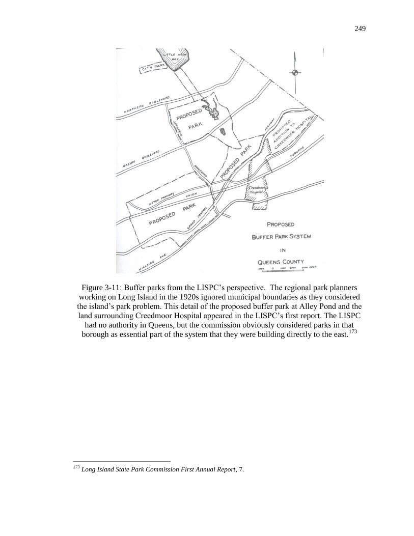
249
Figure 3-11: Buffer parks from the LISPC’s perspective. The regional park planners
working on Long Island in the 1920s ignored municipal boundaries as they considered
the island’s park problem. This detail of the proposed buffer park at Alley Pond and the
land surrounding Creedmoor Hospital appeared in the LISPC’s first report. The LISPC
had no authority in Queens, but the commission obviously considered parks in that
borough as essential part of the system that they were building directly to the east.173
173
Long Island State Park Commission First Annual Report, 7.

250
Figure 3-12: The end of patronage in Pelham Bay Park. This woman is being evicted
from her bungalow at Orchard Beach in the summer of 1934, soon after Robert Moses
announced he would tear down the bungalow camp there and rebuilt the beach.174
Figure 3-13: Bathing at Pelham Bay Park, before and after. The image on the left, circa
1914, shows one of the two bathing beaches the Parks Department maintained at Pelham
Bay. The beach is narrow and extremely crowded. On the right, Aymar Embury II’s
imposing bathhouse and pavilion in 1937. The new beach, covered in sand imported from
New Jersey, stretches for a mile.175
174
Alajos Schuszler, “Woman Evicted from Bungalow, Inspection Tour, Orchard Beach, Pelham Bay Park,
the Bronx,” Photograph. (Jun. 11, 1934) #3332, New York City Parks Photo Archive, Parks Library.
175 Left Image: “Bathing Beach and Bathhouses at Baychester, Pelham Bay Park, the Bronx.” Photograph.
(c. 1914) #AR803, New York City Parks Photo Archive, Parks Library. Right Image: Gottscho-Schleisner,
Inc. “Orchard Beach Catering Corp., Orchard Beach, Bronx,” Photograph of Acetate Negative. (18 Aug.
1937) Museum of the City of New York Digital Collections Portal <http://collections.mcny.org> (2 Feb.
2014).

Chapter 4
“They Shall Not Pass”:
Opposition to Public Leisure and State Park Planning in Connecticut
and on Long Island
In the summer of 1916, wealthy artist and designer Louis Comfort Tiffany found
little rest at his Long Island retreat. He was angry. A new public bathhouse tarnished the
panoramic view of Cold Spring Harbor from the hilltop patio of Laurelton Hall, his
fantastic Moroccan palace set among 60 acres of luxurious gardens. Laurelton Hall was
meant to be a place of privacy and artistic inspiration. The fifty-foot long bathhouses,
built by the Town of Oyster Bay, were a dark, plebian smear at the base of Tiffany’s
work of art. Since June, as many as 100 people had frequented the bathhouses daily. As
a further provocation, the town beach cut off Tiffany’s home from the water. Outraged
that the town would build its only public beach at the foot of his property, Tiffany
ordered employees to dynamite the underwater groin that supported the sandy stretch of
land. In response, the town instigated legal proceedings against him. This was one of
five times the township and wealthy landowner met in court between 1910 and 1922.
Laurelton Hall epitomized the dreams of exclusivity of the North Shore millionaire
colony of which it was a part. Tiffany would not relinquish his vision of a private
waterfront playground without a fight. His battle illuminates strategies with which New
252
York City barons safeguarded proprietary interests and endeavored to conserve the shore
as a private playground.1 (Figure 4-1).
Tiffany’s efforts reveal the essential concerns of Greater New York’s elite estate
communities in the larger contest between private rights and public power during the
Progressive Era. In this fight, estate interests manipulated traditions of property law and
local government to challenge the extension of public space across the suburbanizing
districts beyond the city. In 1902, Tiffany had purchased over 550 acres stretching two-
thirds of a mile along Cold Spring Harbor, a stretch of beach frequented by local
clammers and picnickers. The area also boasted a fashionable summer hotel and casino,
owned by a local whaling family, although the hotel had recently burned and closed.2
Lawsuits began when Tiffany closed the territory to the public, successfully
petitioning the state Land Office for a “beneficial enjoyment grant” that extended his
property line across land under water 400 feet into the bay.3 His plan to build a private
beach required this grant; the foreshore, land exposed during low water and submerged at
high tide, was considered state-owned public property unless granted to an individual.
The grant awarded Tiffany private ownership of the entire accessible shore in the
1 Tiffany v. Town of Oyster Bay, 192 A.D. 126 WestLaw (N.Y. App. Div.1920).
2 The closing of Laurelton Hall brings to the 21
st century the issues of democratic leisure and privatization
of recreation spaces for elite use investigated in Paul E. Johnson’s history of spinner-turned waterfall
daredevil Sam Patch. Johnson unpacks how the 1827 bridge-opening ceremony in Paterson, New Jersey,
was a contest over recreational space, a contest that regularly pitted the noise and physicality of working
class recreations against the privatized, contemplative leisure pursuits of the middle class. See Johnson,
Sam Patch: The Famous Jumper (New York: Hill and Wang, 2003), 51.
3 Land under water grants convey the foreshore, the land between mean high and low tide, as well as the
bay or harbor bottom as far out as it could be feasibly possessed by private individuals. See Frank B.
Williams, “Foreshore and Rights in Land Under Navigable Waters in the New York Region,” in Lee F.
Hanmer, Public Recreation: A Study of Parks, Playgrounds, and Other Outdoor Recreational Facilities,
vol. 5, Regional Survey of New York and its Environs (New York: Regional Plan of New York and its
Environs, 1928), 202, 241.

253
Laurelton area, leaving only a 20-foot wide public beach at the end of a right-of-way.4
But the Town of Oyster Bay claimed ownership of the beach. The state Supreme Court
originally supported Tiffany’s grant, but in 1913 it reversed its decision, recognized the
town’s title, and ruled Tiffany’s claims to the shore void.5 Thanks to Tiffany’s land-
making, Oyster Bay gained the new beach on which it installed the very bathhouse that
angered Tiffany to the point of employing dynamite. Yet the beach remained.6 Tiffany
returned to court and switched arguments to protest that the existence of his former beach
was in fact a nuisance that compromised navigation.7 After five injunctions and appeals,
the court ultimately sided with Tiffany and restrained Oyster Bay from erecting buildings
on the shore.
Tiffany remained unsatisfied by the conclusion of his twelve-year court battle
with Oyster Bay. The beneficial enjoyment grant had only temporarily fulfilled his
personal preference for a private beach. Since the town had reclaimed the foreshore,
Tiffany set out to redefine the terms of local government ownership. In 1926, under State
4 Tiffany v. Town of Oyster Bay 104 Misc. 445 WestLaw (N.Y. Supp. 1918).
5 Tiffany ignored the town’s claim to the foreshore, built a groin to support landfill for a beach, and then
took the town to court when it tried to dismantle his improvements. Tiffany v. Town of Oyster Bay 141
A.D. 720 WestLaw (N.Y. App. Div. 1910) at **912-913, and Tiffany v. Town of Oyster Bay 209 N.Y. 1
WestLaw (N.Y. 1913).
6 “Court Decision Defied, Town Property Destroyed Flagrant Attempt to Defeat Justice,” Oyster Bay
Guardian (Jun. 9, 1916) and “The Tiffany Case,” Oyster Bay Guardian (Jun. 16, 1916), Clippings. John
Hammond email to author, Jan. 27, 2012, Town of Oyster Bay official historian’s collection.
7 “Justice Callaghan Dismisses Injunction, Mr. Tiffany Can Not Stop Bath House Building,” Oyster Bay
Guardian (Jun. 16, 1916), Clipping. John Hammond email to author, Jan. 27, 2012, Town of Oyster Bay
official historian’s collection. On Tiffany’s nuisance claim see Tiffany v. Town of Oyster Bay 104 Misc.
445 WestLaw (N.Y. Supp. 1918). The final case between Tiffany and the Town of Oyster Bay in 1922
declared “The town may not fill in, occupy, and obstruct with buildings the foreshore, under the pretext of
providing for the public enjoyment, so as to interfere with the rights of owners of the upland, although they
may still be able to reach the water. Their rights pass along the whole frontage of their property….The fill
does not enlarge the rights of the town in this regard.” Tiffany v. Town of Oyster Bay 234 N.Y. 15 WestLaw
(N.Y. 1922) at **226.

254
Village Law, he oversaw the uncontested incorporation of Laurel Hollow from a group of
contiguous estates surrounding his Cold Spring Harbor property. The new municipality
immediately restricted beach use to village residents, excluding the larger population of
the Town of Oyster Bay, the easternmost of Nassau County’s three townships. Twenty-
one years after he first purchased his Cold Spring Harbor property, Tiffany finally settled
the question of public access to the adjacent beach.
Tiffany’s beneficial enjoyment grant and subsequent village incorporation
introduce a early 20th
-century regional development battle in greater New York in which
the rich transformed preferences for exclusivity into law. Few estate owners took to
dynamiting public improvements, but quarrels similar to Tiffany's ran up and down both
sides of Long Island Sound. Tiffany belonged, in the words of Lewis Mumford, to “a
small leisured class” that sought to seclude itself from the recreational needs of the
“whole leisured population” emerging in Greater New York in the early 1900s.8
Connecticut and New York responded to the growing demand for public recreation and
created park commissions to build a regional network of beaches. But estate owners
drew on traditions of New England home-rule and weak county government to challenge
the expansive visions of public rights forwarded by the Connecticut State Park
Commission (est. 1914) and the Long Island State Park Commission (est. 1924).
The preservation of elite leisure landscapes through local politics is an important
yet-unexplored chapter of New York metropolitan growth. For all the scholarship on
Progressive-era park planning in greater New York, particularly due to popular interest in
8 Lewis Mumford, The Urban Prospect (New York: Harcourt, Brace & World, 1968), 81, quoted in Hilary
Ballon and Kenneth Jackson, eds., Robert Moses and the Modern City: The Transformation of New York
(New York: W. W. Norton & Company, 2007).

255
master builder Robert Moses, little attention has been paid to the role of private
landowners in regional planning. Formidable home-rule opponents, often dismissed as
parochial, effectively implemented a vision of private leisure on the metropolitan
periphery.9 Uncovering the park protests on the North Shore—and parallel protests
across Long Island Sound in Connecticut—makes visible the struggle to define the
spatial, governmental, and cultural relationship between localism and regionalism and the
nature of urban growth. Regionalism demands the treatment of city and hinterland jointly
and in consideration of a shared public interest. Regional park planners did not think in
terms of localized community identity or values but in terms of a rational and balanced
park network to service a generalized public. Localism, well-captured in Tiffany’s story,
rejects this perspective in favor of a multiplicity of small, autonomous publics. Estate
communities defined recreation as a private commodity rather than as a public right. The
story of property owner mobilization against parks reveals the contest between private
rights and public power at the center of regional development.
The wealthy residential communities of southwestern Long Island Sound provide
an opportunity to study a variety of localism espoused by estate owners and the shared
strategies with which they fought public recreation programs. A comparison of two
9 Recent scholarship on regional planning has resuscitated Robert Moses’s career by focusing on his
achievements building parks, parkways, beltways, and bridges across the metropolis in the 1930s heyday of
public works. See Owen Gutfreund’s essay “Rebuilding New York in the Auto Age: Robert Moses and
His Highways,” Robert Moses and the Modern City: The Transformation of New York, eds. Hillary Ballon
and Kenneth T. Jackson (New York: W.W. Norton and Co., 2008), 86-93.
For an overview of greater New York public works, see Mathew Gandy’s urban environmental
survey Concrete and Clay: Reworking Nature in New York City (Cambridge, Massachusetts: The MIT
Press, 2002). For Westchester County park and parkway planning, see Randall Mason, The Once and
Future New York: Historic Preservation and the Modern City (Minneapolis: The University of Minnesota
Press, 2009) and the work of Marilyn E. Weigold, “Pioneering in Parks and Parkways: Westchester
County, New York, 1895-1945, Essays In Public Works History no. 9 (Feb. 1980), as the Long Island
highway summaries in Ballon and Jackson.

256
contemporary contests over beach control on Long Island and in Connecticut in the first
three decades of the 20th
century makes visible the role of the legal rights of property
owners and the relevance of government forms in regional development. The estate
enclave of Greens Farms, Westport, in Fairfield County, Connecticut, and the estate
region of Long Island’s North Shore, which included Tiffany’s Oyster Bay estate,
successfully blocked state park planning. The commonalities between Greens Farms and
the North Shore allow for a comparison that unveils the way in which local communities
privatized land traditionally open to public recreation and shaped regional land-use
patterns.
Greens Farms and North Shore estate districts emerged as homogeneous, tightly-
knit, highly-restricted communities in the early 20th
century. New York City's wealthiest
families established country retreats in both locales to segregate themselves from the
urban public sphere. Class privilege, manifest in landscape tastes and leisure preferences,
framed these communities' elite social identities.10
Estate owners shared a fundamental
disregard for the general public and public infrastructure that catered to it. This shared
animus, manifested as opposition to regional planning and state intervention in local
land-use through parks, justifies their comparison. Greens Farms is located 50 miles
from New York City in the commuter corridor of the New York, New Haven, and
Hartford Railroad (NYNH&H). The North Shore is a territory of serrated hills and
harbors stretching 20 miles east from Queens to western Suffolk County and south to the
Hempstead Plains in central Long Island. Formerly rural fishing and farming centers,
10
For a detailed examination of the connection between conservationism, elite suburban aesthetics, and the
politics of exclusion, see James S. Duncan and Nancy G. Duncan, Landscapes of Privilege: the Politics of
the Aesthetic in an American Suburb (New York: Routledge, 2004).

257
both locations became Gilded Age estate districts for New York City industrial leaders
and magnates in emerging banking and investment industries.11
Yet the size differences
of these enclaves shaped protest strategies. While Greens Farms, a coastal district of just
four square miles, boasted a collection of powerful New York City businessmen, the
North Shore was home to the largest geographic concentration of power in America.
None other than the nation’s sixty richest men constructed estates there, including J. P.
Morgan, William Randolph Hearst, Vincent Astor, Henry Clay Frick, Jay Gould, Henry
Ford, Pierre DuPont, William Whitney, Charles Pratt, and William K. Vanderbilt.12
Furthermore, variations in local government resulted in different strategies against
regional planning. Whereas Greens Farms exploited the New England town tradition and
the corresponding vacuum of regional county power to challenge state park planning,
North Shore millionaires used village incorporation to aggregate their interests across 100
square miles.
Estate owners brought shared cultural priorities into the local political arena to
block social change and develop park planning alternatives. Localism has roots in the
long tradition of home-rule based on participatory decision-making in local democratic
forms of governance. Such autonomy protects local prerogatives on the assumption that
state government cannot know what is best for a locality. On Long Island and in
Connecticut, albeit for different reasons, counties lacked the power to mediate between
state and entrenched home-rule local politics. The localized politics of exclusion
11
On the rise of New York’s industrial barons, see Sven Beckert, The Monied Metropolis, New York City
and the Consolidation of the American Bourgeoisie, 1850-1896 (Cambridge: Cambridge University Press,
2001).
12 Anthony Baker, Robert B. MacKay, Carol A. Traynor, and Brendan Gill, eds., Long Island Country
Houses and Their Architects, 1860-1940 (New York: W. W. Norton & Company, 1997).

258
common to Greens Farms and the North Shore coalesced around the maintenance of
elitism and exclusivity. Residents depended on geographic isolation to maintain fantasy
landscapes dedicated to leisure and free from the industry and class conflict of nearby
urban centers. This secluded lifestyle came into conflict with the regionalism forwarded
by new planning professionals who expanded the scope of park planning from city to
metropolitan scales in the early 20th
century.13
Residents of these estate enclaves shared a fierce determination to privatize the
environment amenities of their communities. Tiffany and his rich neighbors expanded to
a regional scale the expectations for privacy and leisure exhibited at Greens Farms. From
1910 to 1932, North Shore barons incorporated local municipal governments with the
power to wield power over public land-use and made the territory inaccessible to
outsiders. Across the Sound, the privileged localism of Greens Farms landowners
remained paramount until 1937 when Connecticut finally managed to complete its long-
planned state beach at Sherwood Island in Westport. For the first two decades of
Sherwood Island State Park’s existence, adversaries thwarted all efforts to develop state-
owned beach as a public park. From 1914 to 1937, the island was the focus of hostilities
13
On the rise of regionalism see Robert E. Ireland, “Conservation, Resource Management, and Regional
Planning: The Pioneering Role of Joseph Hyde Pratt,” Planning the Twentieth-Century American City, eds.
Mary Corbin Sies and Christopher Silver (Baltimore: The Johns Hopkins University Press, 1996).
Mathew Dalbey explains that a range of professional landscape architects, zoning experts and
intellectuals vied to define regionalism. In the nascent profession of city planning, regionalists of the
RPAA (est. 1923) Benton MacKaye, Clarence Stein, and Lewis Mumford supported the theories of British
planner Patrick Geddes and rejected existing urban patterns in favor of new structures for future social and
economic development, such as Garden City suburbs. In contrast the Russell Sage Foundation’s
Committee on the Regional Plan of New York and its Environs, which became the RPA, worked within
existing market limitations to mitigate congestion and sprawl. In greater New York, this academic debate
overcame polemics and was instituted in practice, as seen in the regional plan’s acceptance of existing land
use patterns on Long Island. Dalbey, Regional Visionaries and Metropolitan Boosters: Decentralization,
Regional Planning, and Parkways During the Interwar Years (Boston: Kluwer Academic Publishers:
2002).

259
between “vested wealth and public rights” in which property owners mobilized against
Connecticut's state park commission.
Sherwood Island and the Connecticut Shore
In 1914 Albert M. Turner identified 230-acre Sherwood Island as the best site for
a state beach in Fairfield County, setting the stage for a showdown between the
Connecticut State Park Commission (CSPC) and nearby estate-owners who recoiled at
the idea of thronging holiday crowds in their midst. Turner knew the Connecticut shore
intimately. He knew the rocky beaches of the narrow southwestern Sound, the modest
sand dunes of its Rhode Island border, and the omnipresent pungent mud of its salt
marshes at low tide. For three months in 1914 he hiked the coast from New York to
Rhode Island. Hired by newly-minted CSPC, Turner surveyed Connecticut’s 245 mile
coastline for a large, scenic beach well-removed from the pollution pouring from the
industrial ports of New Haven and Bridgeport. Turner's report, one of the first state park
surveys in America, became a foundational document of American state park ideology.14
Of the 245 miles Turner walked, approximately 45 were inside city or borough limits,
including a frontage of 6.5 miles of city parks. Turner found 70 miles of the shore tightly
packed with private beach cottages and an additional 40 of large, costly residences. Only
90 miles remained available for state beaches.15
14
For remarks by Turner’s contemporaries on the importance of his report see Herbert Evison, ed., A State
Park Anthology (Washington, D.C.: National Conference On State Parks, 1930), 195.
15 Turner additionally recommended Hammonasset Beach, Rocky Neck, and Bluff Point, all in eastern
Connecticut. Albert M. Turner, “Report of Field Secretary,” State of Connecticut Public Document No. 60,
Report of the State Park Commission to the General Assembly for the Fiscal Year Ended September 30,
1914 (Hartford: Hartford Printing Company, 1914).

260
The park commission prioritized a state beach program because the majority of
Connecticut’s population lived in the state’s somewhat narrow and rolling coastal plain.16
In 1914, the state’s average density was 231 persons per square mile, but along the Sound
this ration reached 529 persons per square mile. Fairfield County's coastal commuter
corridor along the NYNH&H already housed a quarter of the state’s 1,114,756 residents.
The CSPC hoped to establish five evenly-spaced 2.5-mile-long beaches. “From the date
of the first meeting of the Commission it has been plainly evident that the field most
urgently demanding attention,” the CSPC observed in 1914, was the “shore of Long
Island Sound. Its popularity for purposes of recreation is almost universal, there can
never be any more of it, and the rapid development of the last two decades has left very
little of it accessible to the public.”17
Turner identified 230-acre Sherwood Island in
Westport, a former farmers’ collective and tide mill site, as the only potential state beach
in developing southwestern Connecticut.
Turner faced significant obstacles in his search for a state beach site in Fairfield
County. First, state law privileged private use of the beach over common public use.
Connecticut allowed owners of upland property to use the foreshore for docks and other
purposes without specific grants.18
Connecticut courts furthermore ignored recreation as
part of the public’s right to use tidelands and limited these public rights to only
16
Turner, “Report of Field Secretary,” (1914), 17.
17 Turner, “Report of Field Secretary,” (1914). See page 31 for goal of five beaches, and 30 for “From the
date” quote.
18 In Connecticut, the law of land under water was found entirely in the decisions of the courts, with the
exception of bulkhead and pier-head lines. The state’s courts traditionally favored riparian owners over
public claims to access rooted in traditional, unofficial land use. The state rejected English doctrine of pub
easements by local custom, Graham v. Walker, 78 Conn., 130, 133-34, 61 A. 98, 99 (1905), see Jack H.
Archer et al., The Public Trust Doctrine and the Management of America’s Coasts (Amherst: University of
Massachusetts Press, 1994), 104.

261
unobstructed access for navigation.19
Second, property values were skyrocketing. As
late as 1898, Connecticut’s beaches had often been included free in the sale of adjacent
property or priced by acre. By the 1910s beachfront was priced more expensively by
foot; land that had recently sold for $400-$1,000 dollars an acre now sold for $15 to $40
a foot, or $3,000 to $10,000 an acre.20
Increasing real estate values threatened the
preservation of Connecticut’s shoreline. “Natural scenic beauty and the unrestricted
private ownership of land are things apart, and quite incompatible," Turner concluded.
“[T]he small landowner fairly clogs the landscape with his wooden dreams, and the big
one walls it up."21
The field secretary acknowledged that “[t]o the fortunate few who
may have a country house or a shore cottage with an automobile or so,” a public beach
was unnecessary. Without state beaches, however, Turner worried the majority of the
public would soon face only “[t]he dusty highway and the No Trespass sign.”22
(Figure 4-
2).
Turner told the state park commission that Connecticut had a responsibility to
protect the shoreline from privatization. Turner positioned Connecticut's need for state
beaches in comparison to Bridgeport's city park program and the state's responsibility to
host recreationalists hailing from beyond Connecticut. To convince the state park
commission Turner evoked the memory of P. T. Barnum. He referred to the statue of
Barnum in Seaside Park, the popular park Barnum personally built in the heart of
19
Town of Orange v. Resnick 94 Conn. 573 (Conn. 1920), cited in Williams, 204.
20 Turner, “Report of Field Secretary,” (1914), 37-8.
21 Turner’s 1917 “Report of the Connecticut State Park Commission to the Governor” was reproduced as
Turner, “The Price of Procrastination,” A State Park Anthology, 61.
22 Turner, “Report of Field Secretary,” (1914), 23.

262
Bridgeport, to garner support for a public beach. “There in his armchair, watching the
rising and falling tides and the passing of the generations, sits the man who can best
answer the question ‘What is it for?’”23
For Turner, Seaside Park encapsulated Barnum’s
prescient public park planning and his insistence that Bridgeporters deserved an
accessible shore in developing Fairfield County. Furthermore, Turner’s vision of the
public was not limited to Connecticut. The state was lucky, he said, to have a waterfront:
27 states had none at all and four very little. Of the remaining 17, only four had a
waterfront proportionally equal to Connecticut’s. “We are, in a sense,” Turner told the
state, “trustees for those less fortunate States.”24
Turner advocated park design to serve the collective public and included
recreation in his definition of the public good in 1914, nearly a decade before these ideas
gained nation-wide credence. At the end of World War I, 55 years after the
establishment of the nation's first state park at Yosemite, two-thirds of states lacked state
parks. Not one had successfully developed a comprehensive state park system.25
Turner’s philosophy that Connecticut had a responsibility to protect public beach use
from privatization proved unpopular in exclusive Greens Farms. Estate owners there
23
Turner, “Planning a System of State Parks for Connecticut,” A State Park Anthology, 82.
24 This percentage reflected the 995,475 people living in the coastal lowlands of the state in 1910. Turner,
“Report of Field Secretary,” (1914), 17.
25 For a contemporary analysis of the emergence of state park planning in the United States, see Evison. At
the end of World War I, only New York, Indiana, Wisconsin, Connecticut, and California had something
approaching established state park organization. Only after Secretary of the Interior Stephen T. Mather’s
1920s reorganization of the nation park system the establishment of strong state park authorities in New
York and California did an identifiable state park movement coalesce. A scholarly overview of state parks
is available in Norman T. Newton’s classic, comprehensive Design on the Land: The Development of
Landscape Architecture (Cambridge: Harvard University Press, 1971), 555-575. Newton’s monograph
remains the standard reference the development of state park planning. I argue, however, that Newton’s
conflation of state and county park planning is simplistic. It detrimentally flattens the variations of funding
and home-rule essential to the success of county park planning versus the difficulties state park
commissions faced in New York State in the 1920s and 1930s.

263
defined access to the shore as a specialized local prerogative and took a stand against
accessibility for the larger public. In 1914, Turner reported that a substantial section of
Connecticut’s tidelands had already passed into private hands and was “more jealously
guarded each year as its value increases.”26
His fear proved a reality in Greens Farms,
where park opponents successfully stalled state beach development for nearly a quarter
century.
Picturesque Greens Farms, located 50 miles from New York City in the
developing corridor of the NYNH&H railroad, flourished as an estate community for
industrial, banking, and investment magnates during the Gilded Age. In the late-1800s,
Westport, home to scarcely 4,000 people, developed as a summer resort for New
Yorkers. Business tycoons such as Edward T. Bedford, an associate of John D.
Rockefeller, transformed former colonial farms into palatial summer estates—Bedford
became Westport’s largest taxpayer—and forwarded a powerful vision of privileged
localism.27
The keystone parcel of the CSPC’s park plan was the high ground between
the mill pond and the NYNH&H tracks. In 1921, however, George W. Gair, an executive
of a Brooklyn-based paper goods firm, had purchased a 53-acre parcel that included this
site. Gair moved to Green Farms knowing the state intended to create a park but quickly
acquired local influence to challenge the plan.28
Gair acquired large sway in local
26
Turner, “Report of Field Secretary,” (1914), 31.
27 Woody Klein, Westport, Connecticut: The Story of a New England Town’s Rise to Prominence
(Westport, CT: Greenwood Press, 2000), 135.
28 Three deeds were filed between George W. Gair and the estate of Henrietta A. Jennings, Ester Sherwood
Minor, and Dorothy Sherwood Minor July 12, 1921, Town of Westport Land Records, Book 38, 94- 95,
Connecticut Town Portal- Land and Indexed Records (2007 – 2013) <https://connecticut-townclerks-
records.com/User/Login.aspx> (15 December 2012). See also “George W. Gair Resents William H Burr’s
Criticisms and Returns the Attack,” (Mar. 21, 1929), William H. Burr, Jr. papers, MS B112, Folder 5, Box

264
politics due to the half-million dollars he paid in yearly taxes and his appointment as
Chairman of Westport’s Board of Finance in the 1920s. Determined to preserve the
seclusion of his new Greens Farms estate, he organized an anti-park constituency of
powerful Republican estate owners, including his neighbor Edward T. Bedford.29
Bedford lived just north of the railroad and owned multiple properties in Greens Farms.
His Italianate villa and gardens overlooking the Sound was a popular tourist attraction.
The Greens Farms community occupied a small geographic range of just four square
miles. Park opponents lived in close proximity to each other and Sherwood Island. They
were also all taxpayers and voters in Westport. The members of the public who lived
outside of Greens Farms' socioeconomic, spatial, and jurisdictional boundaries were seen
as invaders. Gair mobilized this community with "jaws set, teeth clenched, and one
slogan, ‘They Shall Not Pass.’”30
Based on Turner’s suggestion, the CSPC first purchased acreage on Sherwood
Island in 1914. By the close of 1917, however, the commission owned just 30 piecemeal
acres. Only visitors willing to ford New Creek at low tide could enjoy state-owned
Alvord Beach, a narrow strip of sand back by a large marsh.31
The lack of signage,
accessible roads, and clearly marked parking made locating public holdings akin, an early
VII, Series D: William H. Burr Jr. Papers pertaining to Sherwood Island State Park, Fairfield Museum and
History Center, Fairfield, Connecticut (“William H. Burr, Jr.”).
29 For the top ten individuals on Westport’s Grand List, see the 1917 Westporter-Herald article cited in
Joseph Elwood Betts’s The Sherwood-Elwood Connection: Story of the Transition of the Sherwood Elwood
Farm to the Sherwood Island State Park (Westport, CT: El-Lo Press, 2011), 6.
30 “Militant,” “Act for the Island,” Folder 5, Box VII, William H. Burr Jr.
31 See Turner, “Report of Field Secretary on Acquisition of Land,” State of Connecticut Public Document
No. 60, Report of the State Park and Forest Commission to the Governor for the Fiscal Term ended June
30, 1924 (Hartford: Hartford Printing Company, 1924), 12.

265
visitor complained to a local newspaper, to searching for “a light hid under a bushel.”32
The narrowness of Sherwood Island Lane made it impossible for a large car to turn
around or park except by using private driveways. Out-of-towners reported that when
they “politely” asked for directions they received stony stares and silence, or else locals
feigned ignorance and sent interested parties to town hall for further inquiries.33
Due to
these limitations, the CSPC considered the park useless until further development.
(Figures 4-3 and 4-4).
Greens Farms residents envisioned an exclusive patrician estate community
incompatible with a plebian public park. The prestigious Sturges family complained that
visitors built fires on their beach and lawn at the foot of Pine Creek.34
Gair found such
behavior appalling and issued a call-to-arms to preserve the sanctity of the private,
domestic waterfront of Greens Farms. Locals bathed at the town-owned Burial Hill and
Compo Beaches and had no need of a park at Sherwood Island. “Home sanity,” he
claimed, was at risk due to out-of-towners, “with the usual ‘don’t-care-a-damn’ spirit for
the locality,” who Gair predicted “would change Greens Farms, with all its unique charm
and quiet home life, into a Coney Island and kill many places like mine.”35
It was
inappropriate of the state, in the words of Gair’s constituent Harry R. Sherwood, to
“come into Westport and ruin a good part of [Greens Farms] property.”36
To Greens
32
“State Should Put Up Road Signs Leading to Island and Mark Off Parking Spaces Says Reader.”
Clipping. Folder 5, Box VII, William H. Burr Jr.
33 “Official Would Have Town Take Over Sherwood Island,” Folder 5, Box VII, William H. Burr Jr.
34 “Mean Water, Mean Crowds,” Folder 5, Box VII, William H. Burr Jr.
35 “Proposed State Park Deal May Be Blocked By Residents.” Clipping. Folder 3, Box VII, William H.
Burr Jr.
36 “Sherwood Island Park Dispute Is Aired at Capitol,” The Hartford Courant (Feb. 13, 1931), 19.

266
Farms residents, localism meant exclusive neighborhood control of development and use
of the shore. Gair’s insistence on privatism overshadowed the traditional rural range of
actors who used the shore. He did not represent local interests, which had traditionally
included oystermen, tide mill operators, onion shippers, and the farmers’ cooperative that
shared the beach. For Greens Farms landowners, the country estate represented a concept
of privacy that diverged from more inclusive, regional perspectives on town resources
and which did not take into account traditional coastal land use in Westport.37
In rejecting the idea of a regional public, Greens Farms localism exacerbated the
park crisis in Fairfield County that had inspired the CPSC’s plan for Sherwood Island. In
the 1920s Fairfield failed to meet the ideal of an acre of park for every 100 persons, a
ratio identified by the planners of the Regional Plan for New York and its Environs, and
lagged behind its neighbors. Southwestern Fairfield County provided one acre of parks
for every 332 residents, while the Bronx provided one acre per every 209 persons and
Westchester provided a stunning one acre for every 28.38
In Fairfield County cities the
situation was even worse. Bridgeport, for example, possessed only one park acre for
every 401 persons.39
As an idealized category, a region is defined by a shared geography
and structural political and economic processes within which residents find
commonalities in political, economic, and social trends. Greens Farms localism,
37
Duncan and Duncan, 60.
38 The statistics for the Bronx used by the Regional Plan for New York and Its Environs were from1927
rather than 1928; Hanmer, 64. On the ideal ratio of country and city parks in greater New York, see
Hanmer, 127.
39 To the west the city of Stamford’s situation was dire: the city had one acre of park for every 508 persons.
In 1928, Norwalk was home to 30,500 and had 110.5 acres of parks, or one acre of park for every 276
residents. To the east, Bridgeport had a population of 165,000 and had 411 acres of parks. Stamford had
84.3 acres of parks for 43,000 persons; Hanmer, 241.

267
however, reveals the extent to which residents drew internal boundaries that segmented
the region.40
To Greens Farms residents, the regionalism that drove state planning was
synonymous with public access and outsider control. Both were unwanted. Greens
Farms fought these dual aspects of regionalism--the influence of outsider state planners
and broadly-defined recreational public. For example, Frederick M. Salmon, an
influential Westport representative in the state legislature, did not believe his hometown
had any responsibility to provide parks for a regionally-scaled public. He dismissed park
support exactly because it emanated from Norwalk and Bridgeport. “Let those cities
clean their own polluted harbors,” Salmon said, “and they won’t have to depend on
Westport for clean bathing waters.”41
The Greens Farms philosophy of isolation led
residents to deny any regional responsibility to address the public recreation needs of
nearby cities.
Following Sherwood Island State Park’s inception in 1914, Westport’s Town
Clerk predicted nearby landowners “would try to put the State in an embarrassing
position” by holding up the purchase or transferring or developing the property.42
He
was right. Arthur Sherwood restricted his 39 acres in the center of the island for
residential use through covenants, while other anti-park allies engaged in a flurry of real
estate transactions to subdivide nearly 2,000 feet of shore, including the area informally
40
Andrew Needham and Allen Dieterich-Ward, “Beyond the Metropolis: Metropolitan Growth and
Regional Transformation in Postwar America,” Journal of Urban History 35, no. 7 (Nov. 2009), 949.
41 “State Park Plan Before Committee,” The Hartford Courant (Mar. 27, 1925), 2. Greens Farms is an
example of localism challenging the state’s attempt to make the region the focus of public policy by
providing parks. On the formation of the region as a concept, see Thomas Adams, Harold M. Lewis, and
Theodore T. McCrosky, Population, Land Values, and Government [1929] (New York: Arno Press, 1974),
204, quoted in Keith D. Revell, Building Gotham: Civic Culture and Public Policy in New York City,
1898–1938 (Baltimore: Johns Hopkins University Press, 2005), 11, n18.
42 William H. Burr to Edward E. Bradley, May 1, 1916, Folder 1, Box VII, William H. Burr Jr.

268
used by recreationalists as parking.43
Between August and December 1924 three real
estate companies incorporated, bought Sherwood’s land, and platted the center of the
island for restricted residential use. These subdivisions, combined with the nearly fifty
acres Bedford sold to the Gair family, secured almost 100 acres from state reach.44
(Figure 4-5).
Sherwood Island residents doggedly policed property boundaries to prevent the
few excursionists who found the public beach from spilling onto private property. They
installed concrete walls and high wooden fences. Frustrated visitors found “most of the
beach from high to low water mark fenced off in the interest of private owners, with a
high barrier of railroad ties and guarded by a big yellow dog, unmuzzled.”45
One
excursionist angrily concluded that the typical Sherwood Island resident “has the
advantage, due to greater wealth, of being able to own land bordering the beach and
thereby thinking he is owner of the beach and the water in front of his property."46
Estate
owners effectively, in the words of the Bridgeport Sunday Post, “claim[ed] the foreshores
for their own.”47
Greens Farms did not stop at intimidation and physical barriers to isolate state-
owned Alvord Beach. The community's elite localism functioned as a political strategy
43
Turner, “Report of Field Secretary on Acquisition of Land,” (1924), 20.
44 Turner, “Report of Field Secretary on Acquisition of Land,” (1926), 12; “Westport- On the Sound,” New
York Times (Jul. 12, 1925), W5, and Sherwood Island Park Association, properties map of Sherwood
Island, Folder 3, Box VII, William H. Burr Jr.
45 “Official Would Have Town Take Over Sherwood Island.” Clipping. William H. Burr Jr. Such
defensive measures took place at both the state-owned Alvord Beach and the town beach at Burial Hill
across New Creek. For a time state park visitors frustrated in their attempts to reach Alvord Beach used
Burial Hill Beach, but the town eventually restricted Burial Hill Beach use to residents.
46 “Not a Mean Property Owner” and “Beaches and Public.” Clippings. Folder 5, Box VII, William H.
Burr Jr.
47 “Bridgeport Sunday Post 2/24/1929, 3 of 3.” Clipping. Folder 5, Box VII, William H. Burr Jr.

269
that Gair and his allies mobilized through local politics. At an October 27, 1924, town
meeting, Gair fathered and ushered through an aggressive anti-park resolution:
“Resolved: That the town of Westport does not desire the state of Connecticut to acquire
additional land at Sherwood Island for park purposes. Resolved further that the town of
Westport does not desire a state park at Sherwood Island. Resolved, that the
representatives from this town to the next General Assembly do their best to prevent an
appropriation for any such purpose.”48
This resolution made Gair’s opinions municipal
policy, as seen in the town’s 1929 dredging of New Creek. Gair and cottage tenants on
the western tip of the island complained to the town executive board that the mud and
stagnant water of New Creek at low tide bred swarms of insects. In the summer of 1929
Westport’s selectmen approved and contracted out the dredging of the creek on the
grounds of mosquito control. New Creek became a twelve-foot channel extending 450
feet.49
Since fording the creek was the only way to reach Alvord Beach, the dredging
effectively disrupted access to the state-owned waterfront. Outraged park supporters
castigated Westport and “Gair’s ditch” as a blatant attempt to thwart public access to the
beach.50
Demonstrators from inland Redding, Ridgefield, and New Canaan Hill forded
the creek to protest the physical and social barriers preventing public use of the shore.51
Nothing came of the protest.
48
Copy of resolutions reprinted in “Town Meeting Called Oct. 27th
1924,” Folder 3, Box VII, William H.
Burr Jr.
49 “Westport Dredged Creek to Isolate Park,” The Hartford Courant (Aug. 4, 1929) A4.
50 “Bridgeport Editor Sees Nothing but Ulterior Motive in Town Dredging at Sherwood’s Island.”
Clipping. Folder 5, Box VII, William H. Burr Jr.
51 Jamie Eves, “Beyond the Dry Highway and the No Trespass Sign: Albert Milford Turner, William H.
Burr, Elsie Hill, and the Creation of Connecticut’s First Oceanfront State Parks, 1914-1942,” Connecticut
League of History Organizations Bulletin 57, no. 2 (May 2004), 12.

270
Gair not only aligned local politics with personal interests but established his
community’s privileged localism in the state legislature to wield private power over
public property. Gair’s Greens Farms constituency enjoyed substantial influence in the
state Republican Party. Comptroller Frederick M. Salmon, the chief fiscal administrator
of state accounting from 1923-1932, and fellow Republicans in control of the
Appropriations Committee of the General Assembly allied with park opponents.52
By the
early 20th
century the Republican Party, drawing votes from white, Protestant
suburbanites and rural residents, controlled the state legislature.53
The state assembly
honored Westport’s anti-park resolution and consistently denied the CPSC the funds
necessary to finish purchasing land at Sherwood Island. In 1921, the General Assembly
denied the park commission their entire $535,000 request; by 1924 the CPSC had held
139 meetings and submitted plans to five successive sessions of the General Assembly
without successfully securing additional financial support to finish Sherwood Island State
Park.54
The substantial progress at Hammonasset State Beach in eastern New Haven
52
“Public Beach for Fairfield County Asked,” The Hartford Courant (Apr. 24, 1931), 3; see also “Politics:
Maneuvering for Political Advantage in 1932,” The Hartford Courant (May 24, 1932), A8.
53 By the early 20
th century, white, Protestant suburbanites and rural farmers comprised the main voting
blocks of the Republican Party that controlled Connecticut state politics. The state’s growing industrial
centers such as New Haven, Norwalk, and Bridgeport housed increasing ethnic immigrant populations that
tended to support the minority Democratic Party. In Fairfield County, for example, Norwalk housed a
growing immigrant population that tended to support the minority Democratic Party but faced
obstructionism from Republican bosses who additionally dominated urban borough politics. See Deborah
Wing Ray and Gloria P. Stewart, Norwalk: Being an Historical Account of That Connecticut Town
(Canaan, New Hampshire: Phoenix Publishing, 1979), 161-3.
54 Between July 1, 1925 and June 30, 1926, for example, no funds from the park commission’s
appropriations budget of over $130,000 were spent on Sherwood Island. From the cash account, the SPC
spent only $27 dollars at Sherwood Island. “Report of the Treasurer,” State of Connecticut Public
Document No55-60, Report of the State Park and Forest Commission to the Governor for the Fiscal Term
ended June 30, 1926 (Hartford: Hartford Printing Company, 1926), 57.
From the beginning the State Park Commission faced funding obstacles. During World War I, the
state allocated minimal funds to the SPC and for a time the federal government took over Alvord Beach as
a potential military site. Due in part to the lack of funds available for non-war related programs in 1915,
the SPC received $20,000, a meager two percent of the million dollar appropriation it requested as essential

271
County underscored the state’s persistent evasion of funding for Sherwood Island. By
1924, three years after its opening, the state had spent $130,960 for 565 acres and the
construction of first-aid and lifeguard stations and a 1,400 locker bathhouse at
Hammonasset and only $12,959 for the acquisition of 48 noncontiguous acres at
Sherwood Island.55
In contrast to Hammonasset, the CSPC deemed its Westport beach a
failure.56
In April 1923, Park Commissioner George A. Parker had resigned to protest the
legislature’s inaction. William H. Burr, one of the only Greens Farms residents who
supported the park, commented on the obstructionism and subsequent resignation to
Turner, “Sorry Mr. Parker resigned, but now we know what we are up against."57
Having successfully blocked the completion of Sherwood Island State Park for a
decade and a half, in 1931 Republicans in Hartford went as far as attempting to totally
depower the state park commission. In that year, the Republican-controlled General
Assembly created a special subcommittee to relieve the park commission (renamed the
State Park and Forest Commission (SPFC)) of its control of parks in Fairfield County.58
The subcommittee toured Sherwood Island under the care of Gair and Westport’s First
Selectman King W. Mansfield, a proponent of beach relocation; the subcommittee
subsequently recommended abandoning the territory in favor of a new park at Roton
for park development. Over the next four years and two successive appropriation requests the commission
failed to secure additional funds to develop Sherwood Island.
55 Turner, “Report of Field Secretary on Acquisition of Land,” (1924), 12.
56 Turner, “Report of the Field Secretary,” (1920), 14.
57 William H. Burr to Devo, Jan. 10, 1923, Folder 2: 1920-1923 SISP Acquisition, William H. Burr Jr.
58 “Current Comment: The Fairfield Shore Park,” The Bridgeport Times-Star, reprinted in The Hartford
Courant (May 15, 1931), 14, and “The Fairfield Park Commission,” The Hartford Courant (May 12, 1931),
12.

272
Point, Norwalk.59
Protest erupted in Fairfield’s cities and from its planning
organizations. The editor of the Bridgeport Post condemned the state for considering the
$700,000 Roton Point project and abandoning property that it had owned for seventeen
years. The president of the Fairfield County Planning Association accused the
subcommittee of neither visiting Roton Point nor appraising the land before issuing a
“flabby” and “amorphous” report that served only Greens Farms' anti-park agenda. Due
to the uproar the bill was recalled and effectively killed.60
Nevertheless, that the General
Assembly created such a subcommittee underscores the power of Republican Greens
Farms elites to block state-sponsored regionalism.61
Throughout the 1920s, the state legislature acknowledged Westport’s
obstructionism and its own “policy of inaction.”62
This inaction, secured by Republican
interests, was exacerbated by the fact that Connecticut counties lacked the power to
mediate between state and local politics. The state’s New England town tradition situated
governmental authority in local jurisdictions. When Connecticut was founded in 1636, a
59
Since 1925, park opponents had variously argued to switch the state park to Great Marsh in Westport,
Stratford Point to the east of Bridgeport, Cockenoe Island off Norwalk, and Calf Pasture at East Norwalk.
See “Sherwood Island and what it Means to- Connecticut-Fairfield County-The Town of Westport”
(Connecticut Forestry Association and the Fairfield County Planning Association, 1925), Folder 3, Box
VII, William H. Burr Jr. See also “Voters Decide Against Park for Westport,” Times Star (Feb. 10, 1931),
Folder 5, Box VII, William H. Burr Jr.
60 Sanford estimated Roton Point would cost $70,000. “Public Parks Along the Shore,” The Hartford
Courant (Apr. 30, 1931) 14. This debate can be traced through Connecticut’s major newspapers. See
“Current Comment: The Fairfield Shore Park;” “A Veto called For,” The Hartford Courant (May 19,
1931), 12; “Politics: Maneuvering For Political Advantage in 1932 Campaign;” and “Sherwood Island and
Roton Point,” Bridgeport Post Clippings. Folder 5, Box VII, William H. Burr Jr.
61 The Secretary of the Connecticut Forest and Parks Association Robert M. Ross observed this explicitly.
Robert M. Ross to William H. Burr, Jan. 7, 1931, Folder 4: 1930-1937 SISP Acquisition, William H. Burr
Jr.
62 For the state’s “policy of inaction” see “State Provides no Accommodations not Even the Most
Primitive,” Folder 5, Box VII, William H. Burr Jr. The range of complaints against Greens Farms
isolationism aired in editorials are captured in “Officials Violate Law, Levitt Holds,” “Sherwood Island
Park Dispute Is Aired at Capitol,” and “Showdown on Sherwood Island" Folder 5, Box VII, William H.
Burr Jr.

273
system of town government was established for the colony, but county government was
not created until the 1660s. As a secondary form of government, the county lacked a
chief executive who could forward a regional development program.63
Law professor
Albert Levitt accused Westport town officials of violating the Constitution by denying
public use of park land that had been paid for with tax dollars for the benefit of the entire
Connecticut population.64
The state held the land on behalf of the public, but had failed
to uphold the public trust. Inland residents of Fairfield County were left with no effective
county authority to demand recourse; they could do little more than write angry letters to
the editor condemning the state’s pandering to the “guard of New York commuters” to
keep the “common herd from the back towns” off the beach.65
For over two decades the state failed to guarantee the rights of the public in the
face of privileged localism at Greens Farms. In the words of Field Secretary Turner “the
constantly increasing burden” of beach acquisition and development had “been
persistently evaded.”66
New park planners in greater New York, led by the SPFC’s
63
Due to the importance of town government in Connecticut, county government never acquired the
significance that it did in the rest of the country, including in New York State. In Connecticut, the county
had neither direct taxing power nor the authority to create its own budget. The county did not have a chief
executive authority and the three-person board of commissioners had no exclusive authority over any single
activity. The county never wielded substantial authority and could not compete with towns as a source of
government. Local government was lay in the New England town. This form of local government
possesses powers like cities in other states but was governed by town meeting. This governance structure
was firmly established by the time county government was created in Connecticut and as a result remained
the source of political power and decision making authority. Over time, the county level of government
was stripped of its limited powers. Through the 19th
and 20th
centuries new state agencies took over county
functions. As of October 1, 1960, county government formally ceased to exist in the state. See Rosaline
Levensen, County Government in Connecticut, Its History and Demise (Storrs, Conn: Institute of Public
Service, Extended and Continuing Education, University of Connecticut, 1966), chapters 5 - 8.
64 “Officials Violate Law, Levitt Holds,” Folder 5, Box VII, William H. Burr Jr.
65 For “guard” quote, see “Militant.” For “common herd” quote, see A. Jonstone, Letter to the Editor (Sept.
1, 1924). Clipping. Folder 3, Box VII, William H. Burr Jr.
66 Turner, “Report of Field Secretary on Acquisition of Land,” (1924), 11.

274
Turner, forwarded the idea that Connecticut had a responsibility to provide beaches to the
regional public and called for a regional perspective at the same time Gair and his
constituents mobilized against Sherwood Island State Park. Gair’s cohort both protested
this regionalism and articulated an alternative vision of a privatized shore. Greens Farms
estate owners romanticized the coast as a stretch of small villages and estates dispersed
across open land. Their privileged strain of localism bolstered this fantasy by rejecting a
regional conception that linked their enclave with industrializing centers like Bridgeport
and the right of a broad public to recreate alongshore, even though the state held
Sherwood Island in trust for the public. Planners predicted Fairfield would become a
county of large cities woven together by intensive suburban development. “What
Westchester County is today Fairfield County will be tomorrow,” the Fairfield County
Planning Association urged. “What Bridgeport is today, the other cities of the County
will be tomorrow.”67
Prosperous Bridgeport boasted the state’s largest park system;
suburbanizing Westchester boasted the nation’s most-celebrated comprehensive county
park system. Each was an example of growth and successful park planning. Greater
Fairfield County subscribed to Turner’s vision, but Greens Farms rejected a regional
planning vision that defined leisure alongshore as a general public right. While the SPFC
successfully built parks across the state, through home-rule Greens Farms rejected state
parks as well as this vision of regional planning for the coastal corridor.68
67
“Sherwood Island and What it Means to- Connecticut-Fairfield County-the Town of Westport,” 9.
68 “Sherwood Island and What it Means to- Connecticut-Fairfield County-the Town of Westport,” 4-5.

275
Long Island’s Gold Coast
In the same years that Greens Farms estate owners challenged an inclusive vision
of public recreation in Connecticut, on Long Island’s North Shore wealthy individuals
sought seclusion and private leisure on an even greater scale. Louis Comfort Tiffany’s
fantasy retreat was unique on the North Shore only in its Moroccan design. When
Tiffany established his Cold Spring Harbor estate, the North Shore epitomized the
wealth, display, and exclusivity of the Gilded Age. Tiffany and Walter Jennings on Cold
Spring Harbor both closed former popular resorts. At Glen Cove, Standard Oil co-
founder Charles Pratt built a stunning 1,100-acre family compound and privatized three-
quarters of a mile of waterfront and over 40 adjacent acres of land under water. In
addition, as Tiffany’s privatization strategies reveal, beneficial enjoyment grants became
stepping stones to even greater privatization as estate owners looked to control not just
riparian beaches but the nearly forty miles of shoreline. Greens Farms localism was
rooted in spatial proximity and neighborhood homogeneity. North Shore resistance to
state parks, however, occurred on a much larger geographic scale. Due to the palatial
scale of individual estates and their aggregation across northern Long Island, the region's
elite anti-park coalition spanned nearly 100 square miles, a collection of homogenous
municipalities. Futhermore, differences between state and county power structures in
Connecticut and New York offered Long Island landowners different tools to exert
control over local public recreation. North Shore barons cumulatively employed
beneficial enjoyment grants and home-rule governance to secure their private
playground.

276
The concentration of Gilded Age wealth on the North Shore gained the region the
nickname the “Gold Coast” by the first years of the 20th
century. Nick Carraway’s
cheeky summary, “I had a view of the water, a partial view of my neighbor’s lawn, and
the consoling proximity of millionaires” in F. Scott Fitzgerald’s The Great Gatsby (1925)
captured the region’s defining characteristics.69
The 110-square mile Gold Coast was
definable due to its hilly topography, its waterfront of deep fjord-like bays, and the
homogeneity of its millionaire population. Home to the largest concentration of wealth
and power in the United States, the district encompassed over 600 estates virtually
undisturbed by industry, public parks, schools, or subdivisions.70
In 1902 the New York
Herald proclaimed, “[n]where else certainly in America, possibly in the world, are to be
found so many landed estates in any similar area.”71
Gold Coast barons built a landscape
of private leisure and display comprised of extravagant estate compounds including
greenhouses, casinos, pools, and personal polo fields and golf courses. Utilities magnate
John E. Aldred summarized, [t]hat part of Long Island was inaccessible. We, Mr.
Guthrie and I, the Pratts and the Morgans wanted to keep it so.”72
(Figure 4-6).
The snobbery and obstructionism of Gold Coast millionaires who strove to
preserve their privileged playground dominate the narrative of North Shore development.
The popular attention to Robert Moses’s incendiary battle with millionaires over state
69
F. Scott Fitzgerald, The Great Gatsby [1925] (Oxford: Cambridge University Press, 1991), 8.
70 The decade spanning 1905 and 1915 was a particularly active period of estate building; see Dennis P.
Sobin, Dynamics of Community Change: The Case of Long Island’s Declining “Gold Coast” (Port
Washington, NY: Ira J. Friedman, Inc., 1968), 4, 40.
71 New York Herald quote as cited in Rosalyn Baxandall and Elizabeth Ewen, Picture Windows: How the
Suburbs Happened (New York: Basic Books, 2000), 5.
72 Helen Worden, “Where Are the Rich? Aldred Lost $3,000,000 L.I. Estate,” New York World Telegram
(Oct. 20, 1942), 17.

277
parks and the Northern State Parkway, as told in Robert Caro’s damning The Power
Broker: Robert Moses and the Fall of New York (1972), directs the reader away from a
more nuanced understanding of Moses's conflict with New York City’s industrial
aristocracy in Long Island development. By the end of his career in the early 1970s,
Moses faced popular and scholarly condemnation for his personal ambitions and the
institutional failure of urban renewal. Until recent revisionist scholarship, this criticism
overrode the fact that Moses had enjoyed widespread popularity as a Progressive-era park
planner.73
Yet his popularity eclipsed shortcomings in park plan execution, specifically
on the North Shore: neither wholesale criticism nor praise adequately addresses the Gold
Coast battle between regionalism and localism of which Moses was a part. Reckoning
with the obstacles mounted by private property interests refocuses the narrative of Long
Island development on the power of elitist home-rule to shape public land-use patterns.
This point of view reveals the limits of regionalism—and Moses’s power—in the New
York metropolis.
Long before Robert Moses unveiled his 1924 plan to make Long Island a public
playground for New York City urbanites, beneficial enjoyment grants like Tiffany’s
proliferated along the North Shore. These grants, which empowered riparian landowners
to privatize and build on tidelands, were the first step landowners took to insulate beaches
from public use. In 1850 the New York State Land Board, which managed state-owned
public land, created beneficial enjoyment grants. Due to the Public Trust Doctrine, a
legal trust established at the nation's founding, the government is required to preserve
73
Robert Caro’s classic The Power Broker has largely defined the narrative of North Shore development
under Moses.

278
public use of the shore.74
Establishing the high water line as the public-private boundary
provided for the public status of the beach.75
While under Public Trust Doctrine, the state
could legally divest and make private the shore, in theory the public’s rights remained
paramount. Between 1880 and 1920, however, the Land Board effectively managed
state-owned foreshore as property liable to divestment. On the North Shore grants
encompassed nearly the entire western shore of Hewlett’s Point north of Little Neck Bay;
the majority of the eastern shore of Hempstead Harbor; and nearly all of the western
shores of Oyster Bay and Cold Spring Harbor.76
In aggregate, the number of beneficial
enjoyment grants challenged public access to North Shore beaches. Beneficial enjoyment
grants, overlooked by urban and planning history, epitomize the proprietary hegemony
over leisure landscapes that had inspired the creation of the millionaire colony. Gold
Coasters extended the privacy of the estate first across public beaches with beneficial
enjoyment grants and then across contiguous estates through village incorporation. Such
legal mechanisms fostered an extraordinary period of hinterland growth in which local
proprietary interests effectively barred the public from the entire North Shore.
74
Carol M. Rose, Property and Persuasion: Essays on the History, Theory and Rhetoric of Ownership
(Oxford: Westview Press, 1994), 115.
75 Richard K. Norton, Lorelle A. Meadows, and Guy A. Meadows, “Drawling Lines in Law Books and on
Sandy Beaches: Marking Ordinary High Water on Michigan’s Great Lakes Shorelines under the Public
Trust Doctrine,” Coastal Management 39 (2011), 143.
76 Until 1850, New York State had made only grants concerning commercial waterfronts to promote
commerce in urbanized ports. Between 1850 and 1940, the state made over 110 grants for land under water
on the Gold Coast. Only four were to town or village governments for public parks, not counting utility
company easements. The majority of the grants were commercial and beneficial enjoyment grants to
individuals. It is impossible to give an exact statistic on the number of beneficial enjoyment grants from
the map records of the Land Board since not all the grants are identified by type. For example, Tiffany
received a beneficial enjoyment grant but the Land Office maps do not identify it as such. Map of the
Shore Line of Nassau County, N.Y. Showing the Grants of Land Under Water Made by the Commissioners
of the Land Office…Prepared for the Commissioners of the Land Office Under the Direction of Edward A.
Bond, State Engineer and Surveyor 1901, Series 119116, Maps of Grants of Lands Under Water, [ca. 1777-
1970], New York State Archives, Albany, New York.

279
In 1910, Louise and Roswell Eldridge pioneered estate incorporation in New
York State in Great Neck, Long Island. Speculators developed subdivisions in the
southern section of Great Neck peninsula near the Eldridge estate Udalls, which sat on
hill overlooking Long Island Sound, in the early 1900s. These new residents, largely of
modest means, called for the incorporation of villages and special districts drawn to
include estates, such as Udalls, whose high property taxes could be exploited to cover the
majority of the costs of new municipal services.77
Faced with increased taxation, the
Eldridges preemptively incorporated the territory around Udalls as the Village of Saddle
Rock on October 26, 1910. The estate made up all but ten percent of the new village’s
territory. Village status sheltered their estate from inclusion in any special districts,
removed it from the Town of North Hempstead’s tax roll, and gave the Eldridges legal
oversight of village public works.78
Until 1910, state Village Law required a minimum
population of 200 persons over a square mile or less, constraining incorporation to
77
An estate could be included in a special district without its owner’s consent as long as the special district
petition was signed by the owners of at least half of the assessed valuation of taxable property in the
proposed district. Sobin, 60.
78 See Laws of the State of New York 1910 Chapter 258, Section 33, Laws of the State Of New
York, Passed At The One Hundred And Thirty-Third Session Of The Legislature, Begun January Fifth,
1910, And Ended May Twenty-Seventh, 1910…, vol. 1 (Albany: J.B. Lyon Company, State Printers, 1910),
416. See also "Movement to Abolish Great Neck," North Hempstead Record (May 24, 1928), 1. Nassau
County Museum Reference Library Collection, Special Collections Department, Hofstra University,
Hempstead, New York.
To incorporate a village, residents simply submitted a petition with the signatures of a certain
percentage of taxpayers owning three-fourths of the value of the district and needed three-quarts of the
votes of the district to secure incorporation. See Village Law, Laws of the State of New York 1909
Chapter 64 Section 2, The Consolidated Laws of New York, Annotated, as amended To the Close of the
Regular and Extraordinary Sessions of the Legislature of1917…Book 63. Village Law (Northport, NY:
Edward Thompson Company, 1918), 11.
In 1932, New York Village law was amended to halt the incorporation of estate villages. The
amendment raised the minimum population from fifty to 500 and set a maximum area of three square
miles. This population-area ratio meant that only densely populated areas could incorporate—a collection
of contiguous estates could never meet this population density. When law changed still some North Shore
estates remained unincorporated and thus defenseless. As a result, a new device was invented to make
areas eligible for incorporation: expansion of existing villages. The new law only said a new village had fit
within with 3 square miles but did not say anything about older incorporated estate villages expanding
beyond this geographic range. Sobin, 103.

280
territories with moderate or high population densities; on May 7, however, the legislature
had amended the law to allow the incorporation of districts less than one square mile with
50 to 200 persons. The amendment made possible the transformation of the 126-acre
Udalls and its approximately 50 servants and family members into a municipal entity.
Roswell Eldridge’s influence in state politics probably enabled the passage of this
amendment. The incorporation of Saddle Rock empowered the Eldridges to dictate use
of nearby public land.79
Beginning with the Eldridges in 1911, Gold Coast estate owners constructed
village boundaries in service of particular ideological and material interests, namely the
community's leisure and aesthetic preferences and privacy expectations. The intensive
incorporation of estates or groups of estates as villages created, in aggregate, a
millionaires’ district across the North Shore between 1911 and 1932, the period during
which it was possible to incorporate small areas with populations over 50 persons.
Sociologist Dennis Sobin employs the term “estate village” to define incorporated
villages primarily or exclusively comprised of contiguous large estates that generally
lacked traditional village centers. More than 24 estate villages were incorporated
between 1911 and 1932, including Lake Success, Laurel Hollow, Old Westbury, Saddle
Rock, and Sands Point.80
(Figure 4-7). Incorporated villages removed large sections of
79
Saddle Rock included only two large homes in addition to Udalls, one of which was occupied by the
Treadwell family, Louise Eldridge’s cousins. After her husband’s death in 1927, Louise was elected
Mayor and held the position into the late 1930s. Sobin, 100.
80 For an extended definition estate villages see Sobin, 99-100. The 24 estate villages on the North Shore
were Asharoken, Bayville, Brookville, Centre Island, Cove Neck, East Hills, Flower Hill, Huntington Bay,
Kings Point, Lake Success, Lattingtown, Laurel Hollow, Lloyd Harbor, Matinecock, Mill Neck,
Muttontown, North Hills, Old Brookville, Old Westbury, Oyster Bay Cove, Roslyn Harbor, Saddle Rock,
Sands Point, and Upper Brookville in Nassau and Suffolk. For a comprehensive list of estate village
incorporation and dates see Sobin, Table VII, 176.

281
land from a township tax base and formed, in the words of a local newspaper, a multitude
of “independent ‘little kingdoms’” that blocked comprehensive development by town
government.81
Incorporation did not service regional community-building. Estate
villages emerged as exclusive spaces where like-minded industrialists did not so much
interact but maintained parallel lives in gracious seclusion. As a form of government, the
incorporated village epitomized the privileged, exclusionary localism of estate owners.
Estate interests achieved political hegemony through the fragmentation and the spatial
exclusion of potential resistance from middle-class property owners. Of the service
communities that supplied estates with labor and provisions and the commuter railroad
stops at Great Neck, Glen Head, Locust Valley, Oyster Bay, and East Norwich, all except
Great Neck remained unincorporated.82
In the 19th
century, incorporation was generally
employed to supply suburbanizing districts with urban municipal infrastructure of streets
and sewerage. In contrast, estate owners incorporated exclusive villages to avoid
suburbanization and the ensuing public works taxes and assessments.83
As one state park
commissioner observed, incorporated villages preserved North Shore isolation “by
keeping the local roads unpaved, rough and winding.”84
By 1925, for example, private
gates and general disrepair made public roads difficult to traverse. In addition private
81
“Movement to Abolish Great Neck.”
82 Stephen Richard Higley, Privilege, Power, and Place: the Geography of the American Upper Class
(Lanham, Maryland: Rowman & Littlefield Publishers, Inc., 1995), 37
83 Jon C. Teaford, “Nassau County: A Pioneer of the Crabgrass Frontier,” Nassau County: From Rural
Hinterland to Suburban Metropolis, eds. Joann P. Krieg and Natalie A. Naylor (Interlaken, NY: Empire
State Books, 2000), 31. For example, the town of Morrisania aligned its public works with the city in
hopes of eventual annexation. On Long Island, the villages of Hempstead and Sea Cliff incorporated in
1853 and 1883, respectively, to finance roads and sewers and encourage local development.
84 Robert Moses, “Hordes from the City,” Saturday Evening Post (Oct 31, 1931), 90.

282
property made the state-owned beach at Lloyd’s Neck, in the incorporated as the village
of Lloyd Harbor, inaccessible.85
Incorporation formalized societal fragmentation and abetted the North Shore’s
elitist localism. Not only did estate villages skirt developing suburban districts, they
stretched to embrace contiguous estates to further solidify a homogenous population of
Gold Coast barons. In 1926, Tiffany and his neighbor the prominent lawyer Henry W.
DeForest sponsored the incorporation of Laurel Hollow. (Figure 4-8). The two families
comprised seven of the fifteen people who voted on the incorporation of the less-than-
square-mile community. Laurel Hollow village government developed under Tiffany’s
thumb. DeForest’s son-in-law became mayor; DeForest and Tiffany’s son-in-law
received two of the three village trustee positions; and Tiffany’s architect became road
commissioner.86
Working with like-minded neighboring estate owners, Tiffany finally
achieved control over development.
Land transfers between estate-holding families were a common practice on the
Gold Coast. Property owners sliced parcels from their estates and sold them within their
cohort to create the minimal population required by law for incorporation without having
to include subdivisions. Leading up to the vote for the consolidation of the villages of
Barkers Point and Motts Point into the village of Sands Point, a local reporter observed,
“[f]rom the real estate transfers recorded in the County Clerk’s office…one would think a
boom had struck the Point section. But it was only to create a few more freeholders…as
85
“Inspect the Route of Proposed Parkway,” New York Times (Jun 2, 1925), 2.
86”Laurelton Long Island Becomes an Incorporated Village,” Oyster Bay Guardian 28, no. 23 (Jul. 16,
1926), 1, reproduced in Donald Glenn Nelson, “The Incorporated Village of Laurel Hollow: An Historical
Essay,” 6-7, History, Village of Laurel Hollow. Website. (2013)
(<http://laurelhollow.org/content/History>) (12 Dec. 2012).

283
will be readily understood by a careful reading” of the records.87
To enable
consolidation, the Guggenheims, Kingsburys, and Laidlaws sold family members land.
Of the twenty real estate transactions all but four unfolded within families. All
transactions carried only nominal prices. Howard Kingsbury was president of Barkers
Point and James Laidlaw was the attorney who had overseen the village’s incorporation:
both had explicit vested interests in a successful consolidation. Representatives of the
excluded subdivisions speculated, with probable accuracy, that school tax avoidance
drove the land transfers for incorporation. The three villages successfully consolidated in
July 1912.
Gold Coast incorporation took on a distinctive pattern. The fact that
incorporation often appeared to be a charade of democratic voting underscored the power
of estate owners in the creation of a typical “millionaire municipality.” Estate owners
spearheaded incorporation to serve personal goals and ran, usually uncontested, for
positions on the new village boards. Charles E. Ransom, the town clerk of Oyster Bay
who conducted ten incorporation elections in the twenties recalled, “[i]n most
comparatively few home owners were eligible to vote…On several occasions the entire
vote was cast in the first hour…in almost every instance the election was held in
luxurious surroundings and the hosts did everything possible to make the hours pass
87
Guggenheim sold C. Guggenheim a 50 by 20 plot for a nominal fee; L.G. H. Greene sold one acre to F.S.
Green; F.M. Hoffstot sold J.G. Hoffstot a parcel; F.C. Hicks sold G. L. Hicks a parcel; R. Hoe sold E.J.
Hoe 5.5 acres; F. Hawkes sold A.L. Hawkes a parcel; H.T. Kingsbury sold A.C.B. Kingsbury a parcel; E.C.
Laidlaw sold E.C. R. Laidlaw seven acres; S.E Lippincott, sold J.T. Lippincott a parcel 100 by 25 feet; J. L
Laidlaw sold H.B. Laidlaw a parcel; C.N Nelson sold C.N Nelson 6 acres; C.W. Sloane sold to W.B.
Sloane; L.W. Sherman sold to F.D Sherman; C.M. Thayer sold to F.K. Thayer; W.D.J. Wright sold to E.H.
Wright. Between families Mott sold Fraser, McDonald sold to Lyon, Thayer sold to Plunkett, and Van
Haeflen sold to Hatch. See “The Hearing Held,” Sands Point, New York, clipping, vol. 3, Port Washington
News Index, Port Washington Public Library, Port Washington, New York; “Certification of Consolidation
of Village of Sands Point With Villages of Barker’s Point and Motts Point into one Village by the name of
‘Sands Point,” (Jul. 23, 1912). Clipping. Town Clerk Records, Village of Sands Point, New York.

284
pleasantly.”88
Ransom generally oversaw the vote and Winslow S. Coates usually acted
as the attorney for the petitioners. Contestation was rare. Local businessmen who
depended on estate business tended to vote with estate owners, as did the large portions
of the village population employed on estates. Estate owners were simultaneously
voters’ employers, campaigning politicians, and election hosts, providing refreshments.
Voting against such figures would have been at the least uncomfortable. In Saddle Rock,
for example, Roswell Eldridge was mayor from incorporation in 1911 to his 1927 death,
when his wife Louise succeeded him—in an election on Eldridge property. She
subsequently held the office through the 1930s.89
In the words of a New York Times
headline, estate village incorporation could be easily summarized: “Millionaire Village
Born as Iced Drinks Clink; 13 Voters Create Muttontown, L.I., Unanimously.”90
Exclusionary laws ensured privacy through spatial and social distance, the
inherent purpose of estate village governance. Incorporation withdrew land from town
oversight; this home-rule made local prerogative over-land use largely untouchable.91
Villages across greater New York passed ordinances to ban outsiders from local beaches.
In Westchester County, New York, across the Sound, Rye’s efforts to restrict parking on
local roads were overturned by the county’s progressive Board of Supervisors. In
88
Quoted in Sobin, 103.
89 “Saddle Rock Re-elects Mrs. Eldridge; 9 Votes Cast in Old Mill on Her Estate,” New York Times (Mar.
17, 1937), 18.
90 “Millionaire Village Born as Iced Drinks Clink; 13 Voters Create Muttontown, L.I., Unanimously,” New
York Times (Jul. 30, 1931), 21.
91 In the American system of municipal government, home-rule, in contradistinction to centralized power,
is celebrated as the traditional defense of local autonomy. Jon C. Teaford traces the origins of home rule
in the depression of the 1870s, pioneered in Missouri and California, Saint Louis and San Francisco,
against special-interest bills and leg jobbery as evils corrupting city. Home rule limited a state’s
lawmaking powers in favor of municipally-generated laws. See Teaford, The Unheralded Triumph: City
Government in America 1870-1900 (Baltimore: The Johns Hopkins University Press, 1984), 106, 121.

285
contrast, the Gold Coast villages of Lake Success, Kings Point, and Sands Point all
passed ordinances restricting parking near parks and swimming spots to restrict users to
residents within walking distance. Following incorporation, Tiffany’s Laurel Hollow
immediately restricted beach use to residents. Lake Success prohibited “meeting on
sidewalks.”92
As one Sands Point local who sought to close the road to Beacon Hill
Beach summarized, “[w]e’re trying to stop having outsiders come in.”93
Estate owners
additionally used municipal status to bar industrial and commercial land-use through
zoning.94
Cove Neck banned the erection of “amusement concessions and ‘hot-dog’
stands” on the peninsula in its first official ordinance.95
When incorporation was
proposed for Lake Success in 1927, one resident complained the proposed village zoning
was “so rigid…as to deprive the property owners therein all the free use of their
property.” A majority of the area’s residents, however, welcomed restrictions that could
bar city recreationalists, and approved incorporation.96
92
Quoted in Kate Van Bloem, History of the Village of Lake Success (Lake Success, New York:
Incorporated Village of Lake Success, 1968), 31-2.
93 “Refuse to Renew Bar Beach Leases,” North Hempstead Record (Apr. 6, 1927), Nassau County Museum
Reference Library Collection, Special Collections Department, Hofstra University, Hempstead, New York.
At Beacon Hill Beach, “squatters” erected bathhouses and charged for parking along a defunct town road
fronting on the water’s edge. The North Hempstead Town Board suggested closing the road would remove
squatters and prohibit parking. "Squatters Take Over Old Roadway" North Hempstead Record (Jul. 14,
1926), 1. Nassau County Museum Reference Library Collection, Special Collections Department, Hofstra
University, Hempstead, New York.
94 For a brief overview of the evolution from property restrictions from covenants and deed restrictions to
zoning, see Lawrence M. Friedman, A History of American Law, 3rd
ed. (New York: Simon and Schuster,
2005), 315-16, 554. For an in-depth analysis, see Charles M. Harr and Jerold S. Kayden, eds., Zoning and
the American Dream: Promises to Keep (Chicago: Planners Press, American Planners Associating, 1989),
and the more recent Michael Allan Wolf, The Zoning of America: Euclid v. Ambler (Lawrence: University
Press of Kansas, 2008).
95 “Wealthy Villagers Will Hold Election,” New York Times (Apr. 2, 1927) 17.
96 “Record of the Public Hearing held at Town Hall, Manhasset New York, by the Town of North
Hempstead on June 27, 1927, 1,” Office of the Town Clerk, Town of North Hempstead, Manhasset, New
York.
286
Beneficial enjoyment grants and restrictive village ordinances enclosed
traditionally public beaches without substantial challenges until the 1920s. The New
York Attorney-General’s 1911 worry that the proliferation of the grants had engendered a
“radical departure” in the preservation of public beaches was never critically examined.97
Estate villages’ legal closure of old rights-of-way and unlawful private encroachment
compounded waterfront privatization. After its initial survey of the shore in 1924, the
Long Island State Park Commission (LISPC) concluded that lax government oversight
and “pre-emption by private owners and the closing up of old rights of way” that had
provided beach access between estates made the shore practically inaccessible.98
In a
1925 speech to the legislature, Democrat Governor Alfred E. Smith lamented that the
state’s tradition of selling public waterfront had occurred with “apparently no thought of
the future on the part of [the Land Board] directed towards retaining in the public
possession for recreation, health and numerous other public purposes.”99
Having
abdicated its sovereign trust of the foreshore, the state was in danger of squandering an
essential public amenity.
Restrictive village laws designed to exclude the wayfaring public rankled the
regional public and politicians, outrage echoed by the powerful State Council of Parks
97
As one example, the Town of Oyster Bay failed to convince the state Supreme Court of the existence of a
public way along Cold Spring Harbor; “Fight Hard For Beach,” New York Tribune (May 9, 1912), 5.
98 First Annual Report of the Long Island State Park Commission Organized Under Chapter 112 of the
Laws of 1924, to the Governor and Legislature of the State of New York. May 1925(Albany: Long Island
State Park Commission, 1925), 37. See also J. Lance Mallamo, “Building the Roads to Greatness: Robert
Moses and Long Island’s State Parkways,” Robert Moses Single-Minded Genius, 160.
991925 New York State Council Of Parks First Annual Report, Organized Under Chapter 189 Of The Laws
Of 1924 As Amended By Chapter 195 Of The Laws Of 1925 (Article 4-A Of The Conservation Law).

287
and LISPC, both established by Robert Moses in the 1920s.100
In June 1925, a riot
erupted in the village of Huntington when local police barred non-residents access to the
beach.101
In response, Governor Smith called a special summer session of the legislature.
Broadcast statewide on the radio, Smith criticized Gold Coast barons for monopolizing
the waterfront. “After you leave the city line…you can ride in an automobile about fifty
miles and you cannot get near the water.” The governor went on to condemn local
government for parochial isolationism of restricted park and beach access.102
Hailing
from the Irish slums of Manhattan’s Lower East Side, Smith reportedly told Nassau’s
landed elites who complained parks would bring “the rabble" to the North Shore, “I am
the rabble!”103
For nearly a decade Smith, a well-known urban machine Democrat, was
the principal figure of New York State’s powerful Progressive Party. Smith implemented
widespread civil service and social reform in his four terms as state governor between
1918 -1926. His staunch support of urban working-class rights included the right to
public recreation.104
New York State, Smith declared, would not bend to wealthy
100
New York State Association, A State Park Plan for New York (New York: MB Brown Printing, 1922),
5; see also 1925 New York State Council Of Parks First Annual Report… To the Governor and Legislature
of the State of New York, Folder 4, Box 1, Series 13915: Calendars and Minutes of Meetings of the State
Council of Parks, 1925-1933, New York State Archives, Albany, New York.
101 Caro, 194.
102 People who “stood back, with all the arrogance that comes with great wealth, and said: 'I don’t care
whether it takes any of my land or not. I don’t want to even see it from the porch of my house.’” Smith
declared, were not the people the state was going to serve; “Governor Smith’s Address to the Legislature
on Parks,” New York Times (Jun 23, 1925), 2.
103 A version of this quote is often attributed to Smith by his biographers. See Caro, 187, and Frank
Graham, Al Smith, American: An Informal Biography (New York: G.P. Putnam's Sons, 1945), 140.
104 Smith began his career fighting for the rights of urban ethnic laborers and gained prominence in state
government for his work in centralized administrative reform. Smith's popularity as governor is generally
attributed to his support of the state government reform and Robert Moses’s state park plan for Long
Island. For an analysis of Smith’s park stance as a strain of working-class environmentalism, see Robert
Chiles, “Working-Class Conservationism in New York: Governor Alfred E. Smith and ‘The Property of the
People of the State’” Environmental History 18, no. 1 (Jan. 2013), 157-183.

288
residents who deemed the general public “undeserving of the superior views” of the
North Shore. By concluding “private rights must yield to the public demand,” Smith
effectively declared war on Gold Coast localism.105
Estate villages and beneficial enjoyment grants predated state park plans, yet in
1924 North Shore privatization became the LISPC’s main target in a fight that revealed
this phenomenon to the region. The 1924 creation of the LISPC was part of Smith’s
sponsorship of public recreation and regional planning. Smith declared that “the cure for
the evils of democracy is more democracy” to which Robert Moses added, “when rich
and poor can play side by side at a state-controlled resort, that theorem is
demonstrated.”106
Governor Smith and Moses, the first president of the LISPC, claimed
Long Island’s expansive waterfront was a natural playground for New York City.107
The
LISPC sited parkways along the northern and southern sides of the island as well as parks
and beaches.108
According to the commission, the Northern State Parkway through
Wheatley Hills would do little damage to local aesthetics or property values, since the
right of way represented only a fraction of the average estate. Governor Smith
rationalized, “the same boulevard which carries the millionaire from his office to the
threshold of his golf club or estate should carry the City man in his small car out to parks
105
"For Release in the Morning Papers of Tuesday, Jan 27, 1925," Reel 88, New York (State). Governor
Smith, Central Subject and Correspondence Files, 1919-1920, 1923-1928 New York State Archives,
Albany, New York.
106 Moses, “Hordes from the City,” 92.
107 “Notes by Thomas Adams: How We See Long Island,” A Plan for Nassau County, Long Island May 18,
1925, 7, Reel 88, New York (State). Governor Smith, Central Subject and Correspondence Files, 1919-
1920, 1923-1928, New York State Archives, Albany, New York. See also “Gov. Smith Thanks DeForest
for Land,” New York Times (May 7, 1928), 9.
108 Moses, “Hordes from the City,” 90.

289
and the shorefront in the open country.”109
But Gold Coast millionaires valued the North
Shore’s uniform inaccessibility. The LISPC’s proposed Northern State Parkway through
Wheatley Hills, although platted along the southernmost section of the Gold Coast, was
thus seen as a threat to the entire region.
Gold Coast barons wielded their influence in both local and county government to
fight state park planning. Paralleling the way Greens Farms exploited Connecticut's
feeble county government, the Nassau County Republican Party, the party of estate
owners, rendered the potentially powerful county government of New York toothless.
The towns of North Hempstead, Hempstead and Oyster Bay had voted against
consolidation into Greater New York and formed Nassau County in 1899; as John C.
Teaford points out, Nassau owed “its very existence to a desire to remain apart.”110
Nassau’s birth ushered in an era of autonomous local suburban government on Long
Island.111
In the early 20th
century, Boss Wilbur Doughty’s Republican machine took
control of Nassau and fostered a decentralized, one-party system that let county powers
lie fallow while incorporated villages dictated regional policies, in which estate villages
functioned as a homogeneous political block in country politics.112
Having depowered
109
Second Annual Report of the Long Island State Park Commission…to the Governor and Legislature of
the State of New York. December 1926 (Albany: Long Island State Park Commission, 1926). For Smith
quote see "Governor Smith's Comment on Action of Legislative Leaders on the State Park Program on
Long Island."
110 Natalie A. Naylor, “Introduction,” Nassau County, 15.
111 Teaford roots the fragmentation of postwar Long Island in the jurisdictional battles between townships
and unincorporated areas to control taxes through incorporation or annexation that gained momentum in the
1930s. See Teaford, Post-Suburbia and the particularly insightful review by Howard Gillette, Jr., “In
Assessing New Suburban Forms, Politics Matter,” Reviews in American History 25, no. 3 (Sept. 1997),
516.
112 Nassau came into existence in 1899 when the three easternmost towns of Queens voted against
consolidation with Greater New York and as comparatively new government lacked any strong political
traditions. For a discussion of the rise of the Republican machine in Nassau, see Teaford, Post-Suburbia,

290
county government, in 1924 and 1925, Nassau’s Republican representatives moved to
subordinate all state park land acquisitions, and thus all LISPC plans, to approval by the
state Land Board.113
The LISPC enjoyed complete independence in state government,
free from checks and balances by any other municipal or state bureau. Of the Land
Board’s two appointed appraisers one was brand new, formerly the owner of a paint shop
in Buffalo, and neither had experience in park planning; the board seemed a likely forum
in which Nassau Republicans could place individuals willing to block LISPC plans.
Governor Smith condemned this attempt to subject park planning to local “influence and
manipulation" and summarily vetoed the bill.114
Unlike Greens Farms, however, Gold
Coasters failed to block parks at the state level.
When efforts to block the LISPC park plan failed in the legislature, estate owners
organized the Nassau County Committee (NCC) to co-opt regional planning to support
North Shore isolation. The committee declared that its 264 members, who owned in
aggregate 18,000 acres, spoke for regional residents who resented “interference of the
state in local affairs” and wished to be “freed from the LISPC” that made park and
parkway plans “without regard…to local needs.”115
In 1925, the NCC hired respected
landscape architect Charles Downing Lay to complete an independent survey of Long
Island’s beach and parkway needs. Lay recommended, “[t]he whole territory of the
19-29; Teaford, “Nassau County: A Pioneer of the Crabgrass Frontier,” Nassau County, eds. Krieg and
Naylor, 29-36.
113 “How Westchester Got Her Parks,” New York Herald Tribune (Apr. 8, 1926), Park Department
Clippings, Series 98, Westchester County Archives, Elmsford, New York. For a detailed overview of the
Land Board controversy in regards to the North State Parkway plan, see Caro 192-198.
114 “Governor Smith’s Address to the Legislature on Parks.”
115 Nassau County Committee, 6. Charles Downing Lay, A Park System for Long Island: A Report to the
Nassau County Committee (privately printed, 1925), 1.

291
northerly part of Nassau County be omitted from any plans for parks or parkways” until
the district was “ripe” for development—an unspecified and distant future date.116
(Figure 4-9). An impressive range of park planners and landscape architects echoed
Lay’s call to preserve the Gold Coast and offered an alternative to the LISPC’s plan.117
Regional planning and localism were not mutually exclusive—regionalism, as Lay's A
Park System for Long Island reveals, could forward local community goals.118
Wholly
local struggles over public versus private amenities repeated across the territory's
contiguous estate villages and shaped the regional development of the North Shore. Far
from merely parochial, the state park battle profoundly shaped the estate district's
government and its residents' lifestyles.
In 1929 the landmark Regional Plan for New York and its Environs, which on the
whole stressed the importance of a comprehensive public park network, also omitted
regional parks and parkways from the North Shore.119
Celebrated Scottish planner
Thomas Adams, director of the plan, argued that the Gold Coast should be preserved
116
Lay, 8, 11.
117 Johnson, 227. Edward Basset, the Committee’s legal counsel, looked into the legislation that created the
park commission and determined the LISPC did not have the authority to build the Northern State Parkway.
He reasoned, according to Johnson, “that taking land for a parkway without providing rights of access to
adjacent owners would amount to a taking of property rights which would cost the state dearly in awards.”
Basset and the Regional Plan members regarded the NSP as a boulevard, not a parkway, and that the Long
Island Motorway made it superfluous. The New York State Association, which first proposed a state park
commission in 1922, similarly disagreed with the LISPC’s Northern State Parkway. Nelson Lewis, a
vanguard of the city planning and zoning movement and leading municipal engineer in New York City,
endorsed Lay’s argument for a mid-island parkway.
118 For example residents, in East Hills and Old Westbury, together owning 26 square miles, organized a
lobbying fund to hire H. V. Hubbard, a former partner of Olmsted Brothers and head of the School of City
Planning at Harvard, to speak against the Northern State Parkway. Hubbard reported that the best parkway
plan for the North Shore was to upgrade the antiquated Island Motor Parkway. First Annual Report of the
Long Island State Park Commission, 23.
119 The Graphic Regional Plan: Atlas and Description…, vol. 1, Regional Plan of New York and Its
Environs (New York, Regional Plan of New York and Its Environs, 1929), 281.

292
because its lack of development had a public value. “Wealthy citizens inclined to use
their money in developing and preserving the natural landscape,” the Committee on the
Regional Plan said, “are creating for the Region…something that may be as valuable
from a cultural point of view as any collection of works of art.”120
Private estates
preserved beautiful landscapes at no cost to the public and indirectly contributed, the
recreation specialist for the plan said, “to the health and enjoyment of all citizens.”121
Adams acknowledged that the estates were generally closed to the public but claimed
they nevertheless allowed the passer-by to enjoy beautiful landscapes at no cost to the
state.122
Adams valued the landscape's uniform beauty but did not acknowledge that its
aesthetic could be ideological in and of itself—a manifestation of the Gold Coast's
politics of exclusion. He agreed with Lay that North Shore parks were unnecessary since
the gracious landscaping of far-flung estates veritably constituted parkland.123
Estate village zoning ordinances preserved the North Shore from parks as well as
from industry and subdivision sprawl. The NCC and Thomas Adams of the Regional
Plan codified estate village exclusionary laws as good land-use planning. Adams
celebrated the estate landscape as “open” development that essentially balanced the dense
120
The Graphic Regional Plan, 378. The Committee on the Regional Plan formed in 1922 to study and
plan metropolitan growth in greater New York. In 1929 the Regional Plan Association (RPA) formed to
implement the Committee on the Regional Plan’s Regional Plan of New York and Its Environs (1929). In
1931 the two organizations merged. See Melissa A. Smith, “Russell Sage Foundation,” The Encyclopedia
of New York City ed. Kenneth T. Jackson (New Haven: Yale University Press, 1995),1029.
121 The Graphic Regional Plan, 282. Hanmer, 94.
122 The Graphic Regional Plan, 282.
123 For a discussion of suburban landscape aesthetics and politics of exclusion see Duncan and Duncan.
They argue “people from similar social and regional backgrounds develop common sensibilities and
aesthetic appreciations; shared taste is mobilized as the basis of group belonging and equally as the basis of
social distinction or exclusion,” 56.

293
“closed” development of New York's urbanizing outer boroughs.124
This theory of open
development grew from and contributed to the planning debates of the 1920s and 1930s
on the best way to control growth. Cities, leading planners Lewis Mumford and Frank
Lloyd Wright said, had grown too big, too congested, and too polluted.125
Estate villages,
however, mitigated sprawl. Penetration of closed development into the Gold Coast,
Adams warned, would constitute nothing less than “a public misfortune.”126
Adams
deemed valuable estate villages’ restrictive land-use patterns and lack of development
intellectually defensible.
While Gold Coasters' localism appears at first glance contradictory to regional
planning goals, estate owners easily enlisted regional planners to secure elite estate land-
use. Thomas Adams tried to convince Moses and the LISPC that his assessment of the
North Shore was not a challenge to the commission’s mission but a legitimate alternative
perspective and an important land preservation technique.127
Unlike Greens Farms
residents, Gold Coasters did not reject regional planning outright. They did, however,
insist that it occur on self-serving terms that flattered their sense of importance. The
NCC used regional planning theory to validate their exclusive claim to the region's best
environmental amenities and neutralize the regionalism and authority of planners who
124
Thomas Adams, “A Plan for Nassau County, Long Island, May 18, 1925,” quoted in Johnson, 232.
125 For an overview of the intellectual debates on planning in this period see Dalbey.
126 The Graphic Regional Plan, 378.
127 Even though Adams pledged the support of the Russell Sage Foundation to both Moses and Governor
Smith and offered to collaborate in the preparation of plans for developing Long Island's park system,
Moses approached the Committee on the Regional Plan as an adversary on Long Island. In his definitive
history of the Regional Plan of New York and its Environs, David Johnson argues the Russell Sage
Foundation at most participated indirectly in the fight for special privileges. Johnson 234-5.

294
advocated overriding village priorities through a regional public recreation program.128
The RPA accommodated and ultimately sanctioned elite privacy created by the mutually
reinforcing decisions of aggregate estate villages. Neither Moses, in his role as park
planner, nor Governor Smith, with his reputation as a champion of the urban masses,
could forgive North Shore residents for walling off the shore and leaving the public with
only “dust and dirt.”129
Henry M. Earle of Old Westbury said it was difficult to disagree
with the LISPC due to the “almost irresistible opportunity for the retort” of undemocratic
snobbery. Earle made the point that the rampant criticism obscured the fact that not all
professional planners agreed with the Northern State Parkway plan.130
To Moses and
Smith, however, estate village politics of exclusion and anti-development land-use
patterns could not be excused, even if they did consequently aid the overall balance of
land-use in New York’s hinterlands. No matter the alternative plans presented, the
LISPC continued to call for North Shore parks and parkways.
Limiting Regionalism
A shared taste for elitist, private recreation and residential patterns became the
basis of group and social distinction in Greens Farms and on the North Shore. Localism
enabled landed elites to secure such preferences from state-sponsored public recreation.
128
Sam Bass Warner Jr. defines privatism as the concentration upon the individual and their search for
wealth wherein the market arbitrates urban development, at the price of removing private investments in
land from oversight by municipal planners. Warner, The Private City: Philadelphia in Three Periods of Its
Growth, rev. ed. (Philadelphia: University of Pennsylvania Press, 1987), 213.
129
“Governor Smith’s Address to the Legislature on Parks.”
130 Henry M. Earle, “A Protest Against the Construction of a Certain Proposed Boulevard in a Section of
the North Shore of Long Island,” 3, Reel 88, New York (State). Governor Smith, Central Subject and
Correspondence Files, 1919-1920, 1923-1928 New York State Archives, Albany, New York.

295
Historians who dismiss localism as a multitude of autonomous, small publics
unconcerned with any large, shared project miss the power of hinterland actors to
collectively shape metropolitan growth.131
A vernacular regionalism emerged from the
choices of North Shore magnates-turned estate village leaders. Individuals made
calculated decisions that cumulatively created a homogeneous private leisure
landscape.132
While the Committee on the Regional Plan celebrated Gold Coast open
development, good government advocates deemed the multiplication of local governance
a grotesque of home rule that prevented large-scale projects.133
Incorporation did function
as a powerful regional development tool, albeit rooted in exclusivity rather than the
progressive reform traditionally associated with regionalism. Gold Coast regionalism
preserved its community's taste for sparse residential development. In 1930 Nassau’s
population density per acre was 12 persons, and the RPA predicted no substantial change
for the coming decade.134
131
This is the classic interpretation of Long Island’s fragmented government, first presented by Robert C.
Wood in 1400 Governments: The Political Economy of the New York Metropolitan Region (Cambridge:
Harvard University Press, 1961) and repeated in Michael N. Danielson and Jameson W. Doig’s New York:
The Politics of Urban Regional Development (Berkeley: University of California Press, 1983), 27-30.
132 Warner calls such work a “weave of small patterns,” see Sam Bass Warner Jr., Streetcar Suburbs: The
Process of Growth in Boston, 1870-1900, 2nd
ed. (Cambridge: Harvard University Press, 1978). Here I
challenge the conclusions reached by Wood’s classic overview of government fragmentation in 1400
Governments. Wood contends that Long Island’s system of local governments, small special-purpose
districts, and units of general jurisdiction was “ineffective in the aggregate principally because its parts tend
to cancel one another out,” Wood, 173.
133 Nassau’s 1920 tally of 171 local governments included 19 villages. The number of governmental bodies
increased to a staggering 63 villages and 173 special districts by 1933. See Thomas H. Reed, The
Government of Nassau County: A Report Made to the Board of Supervisors (Mineola: Nassau County,
1934), 58.
134 Regional Plan Association, “Requirements for Residential Land in the Region Analyzed by Counties,”
Information Bulletin no. 19 (Jun. 18, 1934), cited in Reed 2, n3.
For this idea that systematic concerted choices can accumulate into an unofficial plan I am
indebted to Mary Corbin Sies and Christopher Silver, “Introduction: the History of Planning History,”
Planning the Twentieth-Century American City, 11.
296
Neither the eventual creation of Sherwood Island State Park in Connecticut nor
the park and parkway plan for Long Island were entirely successful endeavors for their
corresponding park commissions. The New York Times encouraged estate communities
to see the Northern State Parkway as “an essential part of the ‘circulation’ of the region
as a whole.”135
But the Times and the LISPC failed to convince incorporated villages that
their attempts “to secure isolation from their city and suburban neighbors” would be best
served by regional parks to contain urban recreationalists.136
After four years of
rancorous negotiations, in December 1929 the commission acquiesced to a five-mile
detour around Wheatley Hills.137
Not only did Gold Coasters successfully reroute the
parkway south of their estate region, the LISPC was unable to establish a single state
beach in the region until the 1970s.138
In Connecticut, the legislature refused to
appropriate to the state park the nearly half a million dollars necessary to complete land
acquisitions on Sherwood Island until 1937, following the Democrats’ capture of the state
135
“An Object-Lesson in Parks,” New York Times (Aug. 5, 1925), 16.
136 First Annual Report of the Long Island State Park Commission, 15. Hanmer, 193-194.
137 By 1929, the state had acquired three-fourths of the necessary rights-of-way for the parkway. Robert W.
DeForest and Otto Kahn exemplify the influential role Gold Coast barons played in the final location of the
parkway. Donating $10,000, Otto Kahn preserved his private golf estate and the route shifted south to run
through the DeForest estate. DeForest then negotiated to shift the route a second time; he dedicated 50
acres of his West Hills and Dix Hills properties to locate the parkway on the edge of his holdings.
"Press Release in the Morning Papers of Monday, May 7," Reel 88, New York (State). Governor
Smith, Central Subject and Correspondence Files, 1919-1920, 1923-1928 New York State Archives,
Albany, New York. See also “Gov. Smith Thanks DeForest For Land,” New York Times (May 7, 1928), 9,
Report of the Long Island State Park Commission, For the Year 1930 (Albany: Long Island State Park
Commission, 1930),10. See also “Conference Held by Former Governor A.E. Smith on a Proposed
Settlement of the Northern State Parkway Controversy” (Dec. 1929), and “Joint statement by Robert
Moses, President of the LISPC and Greenville Clarke, Counsel for the Nassau County Citizen’s
Committee,” (Dec. 18, 1929), Folder 2, Box 3, Series 13915: Calendars and Minutes of Meetings of the
State Council of Parks, 1925-1933, New York State Archives, Albany, New York. On the resulting detour,
see Caro 185, 277-80, 301.
138 Construction began in July of 1931. The first section of the parkway to Roslyn was completed in 1933,
the same year Grand Central Parkway, which it connected to, extended west to Kew Gardens. Long Island
State Park Commission, Report of the Long Island State Park Commission, For the Year 1930.

297
government during the Depression. The delay forced the state to spend large sums on
property subdivided expressly to block the park.139
The NCC envied Westchester’s county-level jurisdiction over park planning. In a
1925 pamphlet, the committee railed “Westchester County has Home rule in Park
Matters. Why should Nassau be exploited by the State?”140
Home-rule boosters viewed
the LISPC as a foreign, invasive state agency uninterested in local needs. Yet the LISPC
also set Westchester as a model, only it celebrated the county’s powerful park
commission. In Connecticut, William H. Burr, one of the only local supporters of
Sherwood Island State Park, echoed the LISPC’s praise of the Westchester’s progressive
park planning. In contrast, he deemed Connecticut’s acquiescence to Greens Farms
obstructionists nothing less than a miscarriage of democracy.141
“Some want our shore
exclusive,” Burr declared, “but the state should be larger than a few individuals.”142
Burr
championed the state park at Sherwood Island as the first step in following Westchester’s
lead. Progress should not stop at the state border; rather Connecticut needed to
139
In 1931, the SPFC had leased 50 acres of the Elwood farm, including 300 acres of beachfront, with a
five year option to buy between Gair’s estate and the subdivisions on Sherwood Point. The property was
only accessible to state-owned Alvord Beach at low tide; “Shore Park in Fairfield County Sure,” The
Hartford Courant (May 12, 1932), 1, and “Sherwood Island Bill for 435,000 signed by Cross,” Bridgeport
Post (April 29, 1937), accessed at Friends of Sherwood Island State Park: The 23-Year War
<http://friendsofsherwoodisland.org/history/the-23-year-war/> (3 Dec. 2012).
Only one upland holding of about 15 acres was free of restrictive encumbrances. For an overview
of the restrictions the SPFC had to untangle, see Turner, “Report of the Field Secretary,” State of
Connecticut Public Document No. 60, Thirteenth Biennial Report of the State Park and Forest Commission
to the Governor for the Fiscal Term Ended June 30, 1938 (Harford: Hartford Printing Company, 1938), 10.
140 Charles Downing Lay, “The Raid on Hempstead Town!” Folder 63, Box 2, Series VII: Writings,
Charles Downing Lay Papers, 1898-1956, # 4477, Division of Rare and Manuscript Collections, Cornell
University Library, Ithaca, New York.
141 W. H. Burr, "Effort for Parks Urged," Folder 5, Box VII, William H. Burr Jr.
142 William H. Burr to Devo.

298
coordinate its park system with New York’s to secure truly regional development.143
The
multiple interpretations of Westchester County Park Commission across greater New
York underscore the variety of ways interest groups construed home-rule, regional
definitions of the public, planning, and a responsibility to provide services for the public.
In thwarting Progressive-era state beach programs, Greens Farms and the North
Shore communities valued private privilege over the public good. Park protest in these
estate districts makes visible the comparative powers of local versus regional
governmental units to dictate public land-use and the extent to which traditions of
decentralized government empowered local challenges to regionalism. This story reveals
the importance for urban history scholarship to step beyond the city to examine
metropolitan growth and regional planning from the perspective of local players on the
periphery.
The resulting beach battles led to three important and mutually reinforcing
lessons. First, park obstruction underscores the exclusionism inherent in these estate
communities. In Greens Farms, localism meant private consumption of the shore. On
the Gold Coast, it meant collective consumption by a narrowly defined community.
Estate community identity depended on keeping the public at large out. Such a vision of
the public was particularly narrow given the extent to which high property values limited
community entry to the wealthy. Estate communities felt no compunction to provide
outsiders access and rebuffed CSPC and LISPC attempts to do so. Second, the failure of
state government to ensure public access to the shore in both places reinforced localism.
Finally, home-rulers rejected state park planners as foreign invaders and endeavored to
143
Burr, "Effort for Parks Urged.”

299
disable the state’s power to affect regional plans. The lack of powerful county-level
governance to balance local and metropolitan recreation needs augmented the ability of
elites to block regional planning. In Greens Farms and on the Gold Coast, Progressive
state park planners and the recreating public at large represent threats to localism that
would not be borne.

300
Figure 4-1: Louis C. Tiffany’s Laurelton Hall. On the top, the front elevation showing the
belltower and veranda. On the bottom, the fountain overlooking Cold Spring Harbor.144
144
David Aronow, “Front Elevation Showing Belltower And Projecting Veranda - Laurelton Hall, Laurel
Hollow & Ridge Roads, Oyster Bay, Nassau County, NY,” and “Fountain Overlooking Cold Spring Harbor
- Laurelton Hall, Laurel Hollow & Ridge Roads, Oyster Bay, Nassau County, NY” Photographs. (c. 1924),
Historic American Buildings Survey, Library of Congress Prints and Photographs Division Washington,
D.C < http://www.loc.gov/pictures/item/ny0340.photos.117878p/> (3 Mar. 2013).

301
Figure 4-2: Connecticut’s Privatized Beaches. "The shore of Long Island Sound,"
Turner reported, had become "an almost endless row of individual vagaries, nondescript
caricatures of habitations, alternating with miles of sea-walls, land-walls, and hedges"
concealing expensive estates. This photograph, which the Field Secretary included in his
first report to the CSPC captures the privatization that so worried Turner. The sign says
“$10 REWARD for the correction of any person caught trespassing upon these primise
[sic] day or night with or without dog or gun.” Turner captioned the image “One good
reason for State Parks.”145
145
Turner, “The Price of Procrastination,” 61. This image accompanied Turner’s first report as field
secretary. Turner, “Report of Field Secretary,” (1914), 55.

302
Figure 4-3: The beach at Westport, CT. This 1890 topographical map of Greens Farms
shows the large amount of low-lying marshland that comprised Sherwood Island State
Park.146
146
U.S. Geological Survey, Connecticut, Norwalk Sheet, (Danbury), New England Topographic 15 Minute
Series, Scale 1:2500 (U.S: Department of the Interior, USGS, 1889-1890).

303
Figure 4-4: The view of Sherwood Island, facing southwest, in 1914. Beyond the
Sherwood farm homestead and a modest colony of beach cottages near the old mill pond,
just visible on the horizon, Sherwood Island remained open land. In this photograph the
beach is empty, and New Creek, what would in 1929 be channelized and subsequently
nicknamed “Gair’s Ditch,” separates the photographer from Alvord Beach.147
147
Report of the State Park and Forest Commission to the Governor for the Fiscal Term ended June 30,
1932 (Hartford: Hartford Printing Company, 1924), Plate 3.

304
Figure 4-5: Sherwood Island Park Association properties map of Sherwood Island. While
this map was commissioned in 1932, These private parcels came out of the 1920s
scramble to block the state park.148
148
Sherwood Island Park Association, Properties Map of Sherwood Island, Folder 3, Box VII, William H.
Burr Jr.

305
Figure 4-6: The North Shore, Long Island’s Gold Coast. Just east of the Queens county
line, the Gold Coast stretched nearly twenty miles. “More of the so-called captains of
industry are represented there than on any other spot in the country,” Robert Moses once
observed. “It is a fantastic homeland of wealth.”149
The history of Lattington captures
well the power of New York’s industrialists on the North Shore. In 1910, utilities
magnate John E. Aldred and William D. Guthrie, lawyer to the Rockefellers, had bought
and demolished sixty homes on 400 waterfront acres north of Glen Cove to create space
enough for two large estates. As Aldred later recalled, “Mr. Guthrie and I destroyed the
village of Lattingtown to get the view we wanted.”150
149
Map of Nassau County, Long Island, Pocket Edition (New York: E. Belcher Hyde, 1925), The Lionel
Pincus and Princess Firyal Map Division, New York Public Library, New York, NY. For quote see Moses,
“Hordes from the City,” 90.
150 Aldred quoted in Worden, 17. This quote also appears in Robert B. MacKay, “Long Island Country
Houses and Their Architects,” The Long Island Historical Journal 6, no. 2 (Spring 1994), 179.

306
Figure 4-7: Estate Villages. The development of Douglaston and Little Neck, Queens, in
the bottom left, serves to underscore the extent to which estate villages used local politics
to block suburban development from Nassau County. The Village of Saddle Rock sits on
west side of Little Neck Bay. Golf clubs make up nearly half of the Village of Lake
Success.151
151
Hagstrom’s Street, Road and Property Ownership Map of Nassau County, Long Island New York, Map
No. 2140A (New York: Hagstrom Company, 1939), Plate 2, The Lionel Pincus and Princess Firyal Map
Division, New York Public Library, New York, NY.

307
Figure 4-8: The Incorporated Village of Laurelton (Laurel Hollow). The village sits at
the mouth of Cold Spring Harbor on the west. The estate grounds are detailed on this
map, which serves to highlight the extent to which Laurel Hollow was little more than a
collection of adjacent estates. In 1926, Tiffany and his neighbor the prominent lawyer
Henry W. DeForest ushered through the incorporation of Laurel Hollow. The pocket-
sized community consisted of only a dozen estates and Tiffany and DeForest owned
nearly the entire northern half of the village. The new government was firmly under
Tiffany’s thumb. Beverley Duer, DeForest’s son-in-law, became mayor; Deforest and
Gurden S. Parker, Tiffany’s son-in-law, received two of the three village trustee

308
positions; John E. Terwillinger, Tiffany’s architect, became road commissioner.152
Figure 4-9: Parkways for the North Shore. Charles Downing Lay proposed an alternative
Middle Parkway on behalf of the Nassau County Committee in 1925. The Middle
Parkway would have run at the base of the hills that form the North Shore. Lay
calculated that the Northern State Parkway was an inappropriate use of state funds since
the North Shore was home to less than half the population of the South Shore. Rather
than an under-used highway through the sparsely populated Gold Coast, Lay
recommended the state build parks to the south near the center of population.153
152
Hagstrom’s Street, Road and Property Ownership Map of Nassau County. For quote see “Laurelton
Long Island Becomes an Incorporated Village,” Oyster Bay Guardian 28, no. 23 (Jul. 16, 1926), 1,
reproduced in Nelson, 6-7.
153 Lay, A Park System for Long Island, 11.

309
Chapter 5
“From Dumps to Glory”: Coastal Reclamation and the Rebirth of Flushing
Meadows for the 1939-1940 New York World’s Fair
For decades the Brooklyn Ash Removal Company dumped refuse across Flushing
Meadows in north central Queens. During the early 1900s, the company turned the
marshland adjoining Flushing Bay into a mile-wide, three-mile long eyesore along the
borough’s expansive waterfront. Smoldering refuse burned brightly at night, and sooty
clouds frequently shrouded the area. Railroad yards and a jumble of automobile junk
shops littered the shore of Flushing Creek. In 1925, author F. Scott Fitzgerald described
the meadows as a “desolate area of land…where ashes grow like wheat into ridges and
hills and grotesque gardens.”1 To juxtapose the spoiled shoreline against the splendor of
North Shore estates, Fitzgerald considered entitling his novel The Great Gatsby, in which
crucial scenes unfold in the wasted meadowlands, “Among the Ash Heaps and
Millionaires.”2 Fitzgerald’s valley of ashes was New York City’s most conspicuous
1 F. Scott Fitzgerald, The Great Gatsby. Reprint. Preface and notes, Matthew J. Bruccoli (New York:
Scribners, 1992), 27.
2 Matthew J. Bruccoli, “Explanatory Notes,” The Great Gatsby, F. Scott Fizgerald, repr. (New York:
Scribners, 1992), 207.

310
wasteland, a noxious chasm of “gray land” and “bleak dust” cleaving western Queens
from the celebrated beauty of Nassau’s Gold Coast.3
On a late June day in 1936, city officials and reporters braved boggy ground to
gather in Brooklyn Ash Removal Company’s dump for the launching of a redevelopment
program. The inhospitality of the territory was captured in a Whitmanesque poem as
“limp miles of swamp, dump-flower, shack,/At dead end of distance and gutter: or mud-
trough/ Sucking at soft mouth of sound and bulrush cut….”4 (Figure 5-1). With Mayor
LaGuardia at the throttle, a steam shovel clawed into a ten-foot tall butte of ash.
Attendees and cameramen crowding the abutting hills endured noxious odors emanating
from three-decades-worth of ripening excavated trash.5 The highest mound, nicknamed
Mount Corona, towered nearly 100 feet tall above the crowd, but not for much longer.
The year 1939 promised the “Dawn of a New Day” at the world’s fair slated for the site.6
In the 1930s, Depression doldrums trapped the nation in economic uncertainty,
but a cohort of New York City business magnates and civic leaders looked to reinvigorate
national morale. In contrast to the dreary present, a world’s fair could offer the nation a
bright, hopeful vision of America’s future. As an obvious benefit, a fair would bring
investment and prosperity back to New York City. Former Manhattan borough president
and head of the Regional Plan Association George McAneny approached Parks
Commissioner Robert Moses to discuss a location for the fair. Moses seized on the
3 Fitzgerald, 27.
4 Pearl E. Levison, “World of Tomorrow” The Official Poem of the New York World’s Fair, 1939 And
Other Prize Winning Poems (New York: The Academy of American Poets, 1939), 5, Special Collections
World's Fairs Collection, Archives Center, National Museum of American History, Washington, D.C.
(“Special Collections World's Fairs Collection”).
5 “World’s Fair Set-up Completed,” World’s Fair Bulletin 1, no. 1 (Aug. 1936), 1.
6 1939 Dawn of a New Day (New York?: s.n., 1939?), Special Coll. World's Fairs Collection.

311
public-private venture of the fair as the means to fund coastal reclamation during the
Depression. Moses promised the Parks Department would fully cooperate in the fair
project if it meant the redevelopment of Flushing Meadows.7 In October 1935, the
powerful nonprofit corporation, the New York World’s Fair 1939, Incorporated,
organized.8 Business magnates joined municipal officials to implement a model program
of regional planning, city-building, and environmental cleanup for the largest reclamation
project ever attempted to date in the eastern United States.
The World of Tomorrow was at once an exercise in international fraternity, an
amusement park, a utopian community, and a trade show for American industry and
technology. Scholarship on the fair has focused primarily on the fair’s celebration of
corporate capitalism and consumer society. Substantial scholarly attention has been paid
to the futurist decentralized cities of the Democracity and Futurama exhibits, but analysis
of the exhibits and message of the fair remains totally disconnected from the
technological innovations and city-building that made possible Flushing Meadows’s
transformation into a fairground. Meanwhile, the history of Queens remains largely
7 Belgian engineer and northern Queens resident Joseph Shadgen was credited with the original idea for a
world’s fair at Flushing Meadows. When Shadgen proposed the fair to George McAneny, McAneny took
up the idea and sold it to New York City’s businessmen. McAneny additionally approached Moses about
Flushing Meadows as a potential fair site, and found Moses heartily in agreement. Moses was one of the
original incorporators and board of directors of the fair, but he resigned early on as to avoid accusations of
competing interests. See “Men Behind the New York World’s Fair 1939,” World’s Fair Bulletin 1, no. 1
(August 1936). 1. For details regarding original members of steering committee see Frank Monaghan, New
York World’s Fair 1939: “The Fairs of the Past and the Fair of the Future,” rev. ed. (Chicago;
Encyclopaedia Britannica, Inc., 1939) Special Coll. World's Fairs Collection.
8 On September 17, 1935, a preliminary fair steering committee outlined a plan for a New York world’s fair
at a New York Civic Club dinner at the Ritz-Carlton Hotel. The Executive Committee included the
chairmen of the boards of Chase Manhattan Bank, the New York Trust Company, and Consolidated Edison
as well as influential politician John J. Dunnigan, the majority leader of the state Senate. Grover A.
Whalen, former New York City Commissioner and head of President Roosevelt's New Recovery
Administration, became the corporation’s president and public spokesperson. Official Guide Book New
York World’s Fair, The World of Tomorrow (New York: Exposition Publications Inc., 1939) Folder 1, Box
15, Collection # 60, World’s Expositions 1851-1965, National Museum of American History Archives
Center, National Museum of American History, Washington, D.C. (“World’s Expositions 1851-1965”).

312
overlooked in the extensive scholarly literature on New York City. Yet Queens’s World
of Tomorrow is a touchstone that unites the regionalization of the city, local ambitions of
the outer boroughs, and the maturing pattern of suburban decentralization with
contemporary urban design theory. Construction was an exercise in comprehensive
utilities planning, road building, environmental cleanup, and aesthetic design on an area
equivalent to more than 200 New York City blocks.9 That the fair corporation officials
frequently made this point and declared that construction of “the Fair itself contribute[d]
to the building of the World of Tomorrow” makes this scholarly oversight even more
remarkable.10
The transformation of Flushing Meadows centered on the re-engineering of the
natural environment through large-scale infrastructure projects. Fair construction wove
together the environmental infrastructure of parkland with the technological
infrastructure projects of highways and utility systems, and the political and economic
frames in which they developed. The redevelopment of Flushing Waterfront unique
moment of collaboration among scientists, designers, planners, city businessmen and
officials from nearly every level of government, from the Queens Bureau of Sewers to
federal New Deal agencies. This public-private coalition resolved what had previously
appeared as strictly local environmental and public utility problems. The corporation
declared that “[i]n its scope, its implications and its results,” the fair was a great public
works project that would secure New York’s position at the forefront of modern
9 “Facts About the New York World’s Fair 1939,” Folder 3:“Trylon and Perisphere-Democracity,”
Subseries B(2): Theme Center, Series 3: NYWF Records, Edward J. Orth Memorial Archives of the New
York World’s Fair, Archives Center, National Museum of American History, Washington, D.C. (“Edward
J. Orth”).
10 Your World of Tomorrow (Rogers Kellogg Stillson, Inc., 1939), Folder 3, “Trylon and Perisphere-
Democracity,” Subseries B (2) Theme Center, Series 3, NYWF Records, Edward J. Orth.

313
metropolitan planning.11
“Building the World of Tomorrow,” the official theme of the
fair, captures particularly well the overarching regional planning program that
crystallized in the decade preceding the fair. Viewed comparatively, fair construction
and the World of Tomorrow’s most significant exhibits emerge as complementary
narratives of peripheral land-use and regional planning for the modern city.
Fair construction epitomized emerging trends of coastal land reclamation and
arterial and park planning in the pursuit of balanced urban land use. Since the
meadowlands lacked even the most basic infrastructure, city and state officials in charge
of improvements were forced to build wholesale the urban infrastructure necessary to
address pollution and control growth. The building process initiated an unprecedented
focus on environmental cleanup. Flushing Bay opens onto the Upper East River across
from Hunt’s Point in the Bronx. Portions of the northern Queens waterfront remained
open mudflats and salt hay fields, but dumps and the poorly built private airport that
replaced North Beach constituted a patchwork of blight. Dump fires spewed ash and
rotting refuse contributed to air pollution, while piecemeal infrastructure development
turned the surrounding waters into sinks for sewage. As the city’s planners and fair’s
builders understood it, reclamation did not connote the return of Flushing Meadows to
some ecologically natural state. Rather, it stood for the creation of an artificial
environment, the re-engineering of the meadowlands from its natural drainage patterns on
out, to its flora and terrain. Flushing Meadows Park was to be an exemplar of modern
environmental engineering and landscape design.
11
Official Guide Book New York World’s Fair, 25.

314
Seen through the perspectives of city planning and environmental reclamation, the
fair site emerges as an artifact of regionalist urban design and the key component of the
large-scale reshaping of New York City in the 1930s. The fair brought automobility and
technological rationalism as well as a new, manmade nature to Queens. In 1932,
preeminent city planner John Nolen summarized his profession’s vision of metropolitan
growth when he explained “the future city will be spread out, it will be regional,” the
“natural product” of modern roads and the automobile.12
Viewed comparatively, fair
construction and the World of Tomorrow’s most significant exhibits emerge as
complementary narratives of peripheral land-use and regional planning for the modern
city. While the fair is most often characterized in terms of its futurist theme, the
redevelopment of the Flushing Meadows fairsite was grounded in the very real,
contemporary planning forces of Progressive land-use planning and made possible a new
regional approach to reclamation, reclamation planned in advance through public private
cooperation in advent of the regional city of tomorrow.
Corona Dump
The World of Tomorrow was the finale in a series of 20th
century transformations
of Flushing Meadows. Until the first decades of the century the immense meadow, one
and a half times the size of Central Park, remained largely in its natural state. At
Flushing Bay, a bar of hard material deflected tidal ingress. Silt accumulated in the
former inner harbor to form the 1,000 acre U-shaped marsh. As the natural drainage
12
Tom Daniels, When City and Country Collide: Managing Growth on the Metropolitan Fringe
(Washington, D.C.: Island Press, 1999), 19.

315
basin for the surrounding highlands, the territory remained wet, soft, and nearly
impossible to build on. For over a hundred years local farmers harvested salt hay and
shellfish, traversing the boggy land by scow and light draft boat.
The instability of the meadowlands, its ill-constructed causeways, and locals’
dependence on ferries for access to Manhattan retarded urban growth in greater Flushing
through the 19th
century.13
The Army Corps of Engineers dredged a channel between
Rikers Island and Flushing Creek on the west side of the bay in 1881, but the channel’s
relatively shallow depth of 10 feet and lack of docking facilities kept industrial concerns
off the bay.14
At the start of the 20th
century, a number of investors envisioned a great
industrial port on Flushing Bay, inspired by the growth of Long Island City to the west.
In 1909, prominent Long Island City developer Michael J. Degnon and the president of
Degnon’s subsidiary the Flushing Bay Improvement Company wrote the House of
Representatives in Washington to solicit federal coastal improvements. The men
proposed a canal between the East River and Jamaica Bay on Long Island’s southern
shore via Flushing Creek. The canal was part of a larger plan to develop both Flushing
Bay and Jamaica Bay as modern industrial seaports, but nothing came of the well-
publicized proposal.15
Through the first three decades of the 20th
century, potential
13
Strong’s Causeway, a rickety series of embankment roads and bridges, was the main route between the
small colonial villages of Flushing, which fronted the bay east of the creek, College Point up the bay, and
points west.
14 “Rehabilitation of Flushing Bay,” Flushing Meadow Improvement 2, no. 4 (Jun. 1937), 27.
15 Walter I. Willis, Queens Borough; Being a Descriptive and Illustrated Book of the Borough of Queens...
Issued by the Manufacturing and Industrial Committee of the Chamber of Commerce of the Borough of
Queens (Brooklyn: Brooklyn Eagle Press, 1913), 62. For letters to Congress, see 61st Congress, 3
rd
Session, House of Rep Doc. no. 13333, Flushing Bay New York, from House Documents, 61st Congress 3
rd
Session, Dec. 5 1910 –March 4, 1911, vol. 20 (Washington DC: Government Printing Office, 1911), 8-9.
This was not the first channelization proposal involving the industrialization of Flushing Creek. In
1895, a ship canal was proposed between Newton Creek and Flushing Bay, provide a bypass route around
Hells Gate, and stimulate the local Queens economy. Nothing came of the proposal. See “Long Island

316
investors proposed a range of development plans, from a railroad passenger terminal to
an aviation field and dirt track speedway, but like the Flushing River Canal, they too
remained unrealized.
The most successful development in Flushing Meadows was the ash dump
associated with Michael J. Degnon’s plan to construct a port complex on the bay.
Degnon enjoyed renown for his contracting work on the Williamsburg Bridge and the
Interborough Subway and his Long Island City industrial park.16
Degnon looked to
replicate this success on Flushing Bay, but to do so he would have to stabilize the
marshland with fill. Degnon contracted with the city sanitation department and the
Brooklyn Rapid Transit Company to collect Brooklyn’s ashes for landfill.17
In 1907,
when the transit company’s subsidiary the Brooklyn Ash Removal Company began
transporting ash to Degnon’s landfill, the New York Times complimented the work as “a
model arrangement” that simultaneously removed the worst of the ash pollution from
downtown neighborhoods and reclaimed “acres of land long looked upon as worthless.”18
By 1916, the construction of two miles of bulkhead and substantial land-making were
underway. With the nation’s entry into WWI in 1917, however, the project lost
Ship Canal,” New York Times (Feb. 5, 1895), 10. For the history of Flushing Meadows prior to fair
construction, see New York City Landmarks Preservation Commission, “The Unisphere,” Designation List
263 LP-1925 (May 16, 1995), The Unisphere Designation Report,
<http://www.nyc.gov/html/lpc/downloads/pdf/reports/unisphere.pdf> (May 12, 2013).
16 On the success of Degnon’s Long Island City terminal, see “M. J. Degnon Dies; Builder of Bridges,”
New York Times (Apr. 23, 1925), 21; and “Michael J. Degnon Built New York City’s Subway”
advertisement, New York Times (Sep. 21, 1924), RE3.
17 In 1913, Degnon received authorization from the state to dredge channels and build bulkheads along
Flushing Creek. A detailed overview of Degnon’s various business subsidiaries is available in Vincent F.
Seyfried, Corona: From Farmland to City Suburb, 1650-1935 (S.I.: Edgian Press, Inc., 1986?), 66-70.
18 In fact, McCarthy’s dump was seen as a positive solution for Brooklyn’s ash problem. The increase of
coal-burning furnaces in late 19th
century created a sanitation crisis. “Brooklyn’s Plan for Ash Removal,”
New York Times (Mar. 10, 1907), 6.
317
momentum and Degnon eventually defaulted on his loans.19
Even after Degnon lost his
property, the Brooklyn Ash Removal Company continued filling operations under the
direction of Tammany man John “Fishhooks” McCarthy.20
As the BARC expanded its dumping operations, a Gasoline Alley developed
under the “ash plague” that the dump cast to the west, a strip of junk yards and
automobile service stations on Roosevelt Avenue and the Long Island Railroad rail
yard.21
Excepting the municipal asphalt plant at the tidewater and a handful of industrial
buildings teetering on stilts, the marsh remained empty.22
Over 26 years, the BARC
deposited an estimated 50 million cubic yards of ash across 300 acres.23
The territory,
covered with shifting hills of ash and piles of rusting boilers, baby carriages, and car
bodies took on a surreal moonscape quality. As the dump grew, public opinion shifted
from the early praise bestowed by the New York Times. Dumping had come to function,
in the words of one observer, as “a man-made glacier…spreading death and destruction,
depositing a moraine of ashes, the waste of civilization. While not recorded by
geologists, these deposits came to rival in majesty the efforts of the Wisconsin ice
19
In 1924, the property was sold in 1,800 lots at public auction. Corona-Flushing Lots Sell For Over
$1,000,000” New York Times (Nov. 16, 1924), RE2. See also Queensborough [monthly magazine of
Queens Chamber of Commerce] (May 16, 1924) cited in Seyfried, 318.
20 New York City Landmarks Preservation Commission.
21 For “ash plague,” see Francis Cormier, “Flushing Meadow Park: The Ultimate Development of the
World’s Fair Site,” Landscape Architecture 29 (Jul. 1, 1939), 168.
22 Cormier, 166-182.
23 The BARC built a bulkhead and piers along the creek to dock scows and laid 14 miles of railroad track to
move ash. Its dump was bounded by the Long Island Railroad, Rodman Street, Strong’s Causeway and
111th
Street. Rebecca B. Rankin, ed., New York Advancing: The Result of Five Years of Progressive
Administration in the City of New York, F.H. La Guardia….with an Official Guide to the City of New York
Exhibit Building (New York: Publishers Print. Co., 1939), 246-8, Folder, 1939-40 Theme Center and
Surrounding Area, New York City Building, Subseries B(2): Theme Center, Series 3:NYWF Records,
Edward J. Orth.

318
elsewhere on the island.”24
Ash landfill destroyed the healthfulness of Flushing Meadow.
Twenty years after the BARC opened Corona Dump, Fitzgerald declared the area “a
dismal scene.”25
From the perspective of 19th
and early 20th
century city officials, marshes made
ideal landfill sites. Since marshland development often resulted in sinking buildings,
marsh was some of the most marginal and thus inexpensive real estate in the city. But the
smells and soot from Corona Dump as well as the nearby dump on Rikers Island bothered
Queens residents. Odors from the Rikers Island dump, which the Department of
Sanitation opened in 1895, carried up to 10 miles.26
Ashy smoke tormented the
communities of College Point to the northeast, Corona and Corona Heights to the west,
and Forest Hills to the southwest, depending on the direction of the wind. Even
communities farther afield such as Jackson Heights and Woodside up to five miles west
suffered from the smoke and stink of these dumps on Flushing Bay.27
Geographic
distance, undeveloped marshland, the bay, and municipal ward boundaries separated
these communities. As a result, protests against the dump remained localized, and
coalition-building did not arise to turn complaints into collective action. The frequent but
discrete lawsuits leveled against the dump by groups such as the Corona Community
24
“Permanent Plan for Park After Fair,” Flushing Meadow Improvement 1, no. 3 (Dec. 1936), 2-4.
25 Fitzgerald, 28.
26 Soper, “Great Sanitation Questions That Now Confront the City.”
27 “Appeals to Connolly in Letters Opposing Ash Contract Renewal,” The Daily Star, Queens Borough
(Dec. 15, 1921), 10. See also “Flatlands Protests Against Another Ash Removal Plant,” The Brooklyn Daily
Eagle (Jun. 9, 1922), 5. The Health Department responded at least once to Elmhurst and Corona neighbors’
complaints about rats at the dump. See “War Declared Upon Rats,” New York Times (Nov. 4, 1920), 13.

319
Council and Flushing-United Associations, which accused the BARC of compromising
locals’ comfort and health, failed to block the renewal of the company’s lease.28
When brought to court for alleged sanitation violations, the BARC’s lawyer
argued that ash fill rid the neighborhood of stagnant pools and mosquitoes and served a
common good.29
In fact, in the 1920s and 1930s, the BARC embarked on a publicity
drive to characterize the dump as an innocuous rather than a polluted environment.
Dump superintendent R. Sutherland acquired rat catching dogs and claimed a 14-man
firefighting force patrolled the dump seven days a week.30
The BARC also pointed to the
large quantities of coal oil byproduct, which gave off a pine smell, spread to offset
odors.31
To further quell local opposition, on November 14, 1930, the BARC’s president
Colonel G. R. Van Etten announced the company would build three golf courses. The
first of these, the 9-hole Corona Park Golf and Country Club, opened the following
September.
The BARC continued dumping operations in Flushing Meadows with only minor
changes until the mid-thirties, when dump protests and growing demand for machine
politics reform finally spurred action.32
On January 1, 1934, Mayor LaGuardia’s fusion
government placed waste disposal under municipal operation and ended Tammany’s 20-
28
“Indict Queens Dump Owners for Nuisance,” Brooklyn Daily Eagle (Nov. 25, 1931), L.1.
29 “Smoke Nuisance Charged,” New York Times (Sept. 14, 1923), 19.
30 “Dogs Killing Off Rats at Dump, Supervisor Says,” The Daily Star, Queens Borough (Oct. 2. 1925), 6.
31 “History of ‘Mt. Corona,” Flushing Meadow Improvement 2, no. 1 (Mar. 1937), 15. This article appeared
in nearly identical form as “The Rise and Fall of ‘Mt. Corona,’” The American City 52 (Aug. 1937), 64-65.
32 In 1924 and 1931 the Queens Grand Jury indicted the BARC for violating the Sanitary Code. “Civic
Workers Sincere in Effort to Stop Corona Meadows Smoke Nuisance,” The Newton Register (Feb. 2,
1924), 5, and “Indict Queens Dump Owners for Nuisance,” Brooklyn Daily Eagle (Nov. 25, 1931), L.1. On
Tammany politics see “Hand of Tammany in Corona Dump Fight?” The Daily Star, Queens Borough (Dec.
14, 1923), 1, and “This Dump Seems to be an Official Pet,” The Daily Star, Queens Borough (Jun. 14,
1929), 1.
320
year monopoly on Brooklyn refuse removal.33
Surveying the property that the city had
acquired from the BARC, officials lamented the company had dumped ash “without any
planning or grading, without the slightest idea of what would happen.” Mount Corona
towered over the polluted meadowland as a “monument of indifference and careless city
management.”34
On the unplanned periphery, where land was cheap and regulatory
oversight minimal, Flushing’s marshland became more valuable as a dumping site than as
developable real estate or a clean environment. But intervention by Manhattan's business
elites and public works officials could chart a new course for the urban periphery.
In early 1936, New York City and the New York World’s Fair 1939 Incorporated
agreed to jointly develop Flushing Meadows.35
The city arranged to buy and condemn
over 1,000 acres, including the 300-acre dump, and lease the territory to the corporation
for the exposition.36
James J. Halleran, Public Works Commissioner of Queens,
complained that the court set unfairly low prices on condemned land.37
Rebuffing
33
“City Ash Removal Halted by Court,” New York Times (Dec. 30, 1933), 14. The company fought for
over a year in court to retain their contract. In May 1934, the city purchased the 320-acre tract of land, the
disposal plants which the company had put up for the city, and settled for equipment, from the BARC for
$4,457,364.03. See “Citizens Union Fights Bid for Ash Removal,” New York Times (Oct. 18, 1927), 31;
“Oppose Contract For Ash Removal,” New York Times (Jan. 26, 1933), 24; “City Defers Decision on
Refuse Disposal,” New York Times (Feb. 1, 1933), 15; and “Ash Removal Suit Ordered to Trial,” New York
Times (May 5, 1933), 10.
34 Rankin, xxii-xxiii.
35 The state Department of Public Works constructed the highways and bridges on plans prepared by the
Parks Department. The Queens Bureau of Highways oversaw local road development, while the Bureau of
Sewers did their own work. In total, New York City donated $26.7 million to the Fair, the federal
government $3 million, New York State $6.2 million, and foreign governments over $30 million.
36 “History of ‘Mt. Corona,’” 15. See also “Official Guide Book New York World’s Fair, The World of
Tomorrow, 28. The city agreed to lease the park property to the NYWF 1939 Inc. on June 29, 1936. A
preliminary plan was proposed in late February 1936. The World’s Fair Board of Design was organized
that following spring. The February plan served as the basis for agreements between fair and park
authorities that comprised the lease signed on June 29, 1936. See Cormier, 166-182, and “Site Virgin
Land,” World’s Fair Bulletin 1, no. 1 (Aug. 1936), 11.
37 Halleran valued his land on Nassau Boulevard at Rodman Street at $5 a square foot, fifty times the 11
cents a square foot allowed in condemnation. Nassau Boulevard had not yet been built. His own appraisers

321
Halleran, Corporation Counsel Paul Windells explained that the property had “never been
useful for any purpose. It is swamp land in the Flushing Meadow and, unless filled in as
planned by the Park Commissioner, the only things that will grow there are cat-tails and
mosquitoes.”38
In fact, the lack of infrastructure and the pollution of Flushing Meadows
led one journalist in 1924 to declare the area “one of the most formidable barriers to the
further growth and development of the Borough of Queens.”39
The marsh was not virgin
land, but it was often described as such, due to its shocking lack of basic urban
infrastructure, such as modern roads and sewerage. But the undeveloped character of
Flushing Meadows was the basis of both the territory’s current disfiguration and its
prospects for improvement. For the open marshland, despite Corona Dump, was also
“the last great open space left anywhere near the geographical center of New York
City.”40
This second perspective points to the ideological reframing of the meadows
underway in the 1930s. This reframing redefined the wasteland as an opportunity for
experiments in city-building technology, environmental reclamation, and urban design.
(Figure 5-2).
had set the value from 57 to 85 cents a square foot. “Halleran Attacks Lockwood Awards,” New York
Times (Jun. 15, 1936), 13.
38 For an overview of Halleran’s fight on condemnation awards, see “Halleran Attacks Lockwood
Awards,” New York Times (Jun. 15, 1936), 13; “Windels Defends ‘Low’ Land Awards,” New York Times
(Jun. 16, 1936), 23; and “Halleran’s Profits at Fair Site Shown,” New York Times (Jun. 17, 1936), 11.
39 “Corona-Flushing Lots Sell For Over $1,000,000” New York Times (Nov. 16, 1924), RE2.
40 For “unhealable” quote see New York World’s Fair Preview April 29-30-May 1
st (New York: Junior
League of New York, in Conjunction with New York World’s Fair 1939 Preview, 1939), Special
Collections World's Fairs Collection. For “the last great open space,” see L.H. Robbins, “It Begins to Look
Like a Great Fair,” New York Times (May 1, 1939), 119.

322
Environmental Reclamation along the Upper East River
The powerful coalition effectively pioneered the first comprehensive
environmental cleanup in New York City. “The lease between the fair corporation and
the city," Park Commissioner Robert Moses explained, "reflects the predominant idea of
reclamation.”41
For Moses and his cohort, large-scale reclamation captured the efficiency
and utilitarian drives of New Deal natural resource management. “Reclaiming” the shore
did not mean returning Flushing Meadows to a former, untouched state, but the reshaping
of the marshland to meet the city’s contemporary needs of its natural resources,
specifically clean park space. Scholarship on Moses’s career in the 1930s focuses on his
great arterial highway projects, but Moses and his cohort of public officials understood
these projects as being as much about reclaiming the city’s peripheral waterfronts as they
were about transportation. Moses blamed “corporate and individual selfishness” and
“planless and feeble government” for the city’s polluted beaches and obsolete waterfront
infrastructure.42
But Moses was uniquely empowered to reestablish New York City’s
shores as places of public leisure. It was precisely the regionally-scaled work done to
prepare for the fair that facilitated large-scale environmental reclamation.43
41
Robert Moses, “From Dump to Glory,” Saturday Evening Post (Jan. 15, 1938), 2.
42 Robert Moses, A Half-Century of Achievement: Triborough Bridge and Tunnel Authority Links the Five
Boroughs, Parks, Beaches, and Suburbs (New York: Triborough Bridge and Tunnel Authority, 1948), 4.
This quote also appears in “Moses Asks Steps to End Pollution,” New York Times (May 24, 1937), 21.
43 Environmental reclamation became popular as part of the Progressive-era drive for increased efficiency
in land use and natural resource management, a drive is most often associated with the work of federal
agencies like the Tennessee Valley Authority and the U.S. Army Corps of Engineers. Despite the
importance of environmental planning to the nation’s economic vitality in this period, in 2001 Paul S.
Sutter observed that the history of 1920s and 1930s conservation remained “terra incognita.” In 2013,
Robert Chiles revisited Sutter’s claim, as part of his exploration of working class conservationism in this
period. Chiles points out that in just over a decade environmental historians have rectified this oversight.
See Sutter, “Terra Incognita: The Neglected History of Interwar Environmental Thought and Politics,”

323
When the plan to reclaim Flushing Meadows first gained publicity, reporters
declared it an impossible, foolish project and nicknamed the site the “Mad Meadows.”44
No park building precedent existed in New York City. Pieced together from old country
estates, the creation of the city’s largest park, the nearly 2,000 acre Pelham Bay Park, had
required literally no landscaping. Central Park’s 843 acres had been totally
reconstructed, but at least the territory had been solid land. Moses himself recognized the
challenge of turning the marshland and dump into a modern park accessible along
attractive parkways.45
He had previously attempted to clean up the meadowland and
Flushing Bay coastline through a road project. In the mid-1930s, he used TBA funds to
extend the Grand Central Parkway west as an approach road to the Triborough Bridge.46
While the road ran directly through the Corona Park Golf and Country Club grounds,
Moses declared this brief visual and olfactory oasis offered only “the pathetic beauty and
Reviews in American History 29 (June 2001): 289–97, and Chiles, “Working-Class Conservationism in
New York: Governor Alfred E. Smith and ‘The Property of the People of the State’” Environmental
History, 18 (Jan. 2013), 157–83. Chiles’s article, Neil M. Maher’s Nature's New Deal: The Civilian
Conservation Corps and the Roots of the American Environmental Movement (Cambridge: Oxford
University Press, 2007), and Sarah T. Phillips’s This Land, This Nation: Conservation, Rural America, and
the New Deal (New York: Cambridge University Press, 2007) represent the recent work in 1920s and
1930s conservation history. Phillips examines agricultural conservation in the South as a central New Deal.
Philips’s argues that economic reform resource management became central to federal planning during this
period. But her insistence that New Deal conservation was new and distinct from Progressive-era
conservation due to its locus in agricultural landscapes seems less convincing in comparison to the coastal
reclamation of New York City, which united Progressive and New Deal reformers. As Sutter observes in
“Terra Incognita,” William Deverell and Greg Hise’s Eden By Design: The 1930 Olmsted-Bartholomew
Plan for the Los Angeles Region (Berkeley: University of California Press, 2000) underscores that large-
scale plans uniting urban and environmental planning were central to the interwar period.
44 Meyer Berger, “At the World’s Fair,” New York Times (Jul. 21, 1939), 10.
45 “‘Beauty for Ashes:’ A Statement by the Executive Committee of the New York World’s Fair 1964-
1965,” (Jun. 3, 1967), Folder: 230, Box 8, Malcolm Wilson Papers, Rockefeller Archive Center, Sleepy
Hollow, New York.
46 Moses, “From Dump to Glory,” 72. On Moses’s reallocation of Triborough Bridge funds to build the
Grand Central Parkway Extension see, “Parkways and Expressways in Brooklyn and Queens,” Ballon and
Jackson, 221.

324
fragility of a single rose in a dung heap.”47
Nonetheless, the Depression-strapped city
refused to allocate additional funds to reclaim the land abutting the parkway through the
rest of the meadows. The publicity and the substantial funding afforded by the fair would
make possible, in Moses’s words, “[t]he long awaited dream of a clean, unpolluted
waterfront in the vicinity of Flushing Bay.”48
Collaboration characterized the entire organizational partnership that made fair
construction possible. Division of labor and overlapping jurisdictional appointments of
the fair builders facilitated this cooperation. Parks Commissioner Moses wrote the four-
year lease between the city and fair corporation. The lease gave the Parks Department,
and thus Moses, the power to vet fair construction.49
General Superintendent of the Parks
Department W. Earle Andrews’s appointment as general manager of the fair further
insured cooperation. In December 1936, the fair corporation created the Construction
Department. Its director, Colonel John P. Hogan of the Army Corps of Engineers,
oversaw site design, soil engineering, and foundation load testing. Hogan supervised
thousands of federal, state, and city engineering and construction workers, corporation
employees, and private consultants from the city’s leading research institutions and
engineering firms. The city organized a parallel supervisory committee that brought
together engineers from the state-run Department of Public Works and the Long Island
47
“Plan Golf Courses in Corona Meadows,” New York Times (Jul. 22, 1929), 35; and Moses, “From Dump
To Glory,” 13.
48 “North Queens Sewage Disposal Problem,” The Flushing Meadow Improvement 3, no. 6 (Oct. 1938), 2,
7-8, Box: Cue 1941–Family Circle 1939, Subseries 1: Magazines, 1937-1948, Series 9: Publications
Relating to the World’s Fair, Edward J. Orth.
49 George Elighton, “World’s Fairs, From Little Egypt to Robert Moses” Harper’s Magazine (July 1960),
27, Folder 10, Box 15, World’s Expositions 1851-1965.

325
State Park Commission and local Queens Topographical Bureau.50
The geographic scale
and topographical and environmental challenges demanded innovation in soil, civil, and
sanitary engineering and brought such work to the attention of regional planners. Due to
this cooperation, the project’s scale, and innovative land-making, the fair corporation
declared the construction of the World of Tomorrow to be nothing less than “a romantic
saga of modern engineering.”51
The successful cleanup of “long-neglected” Flushing Bay hinged on the ability of
sanitary experts and civil engineers to reclaim both polluted waterways and land.52
In
1933, sanitary expert Dr. George A. Soper declared water supply (both drinking water
and waste water disposal), refuse disposal, and smoke abatement to be the three “great
sanitation questions” confronting the city.53
All three pollution concerns plagued
northern Queens and the Upper East River. The combination of sewage pollution and
refuse dumping in Flushing Meadows epitomized the failings of the city’s increasingly-
obsolete industrial waterfront, land use patterns that elevated economic and industrial
uses at the detriment of ecological health and recreation.54
Green pastures, clean beaches,
and grassy marshland had once lined the Upper East River but could increasingly be
50
“Fair to Cost Millions,” World’s Fair Bulletin 1, no. 1 (Aug. 1936), 9. Allyn R. Jennings, General
Superintendent of the Park Department, chaired the Coordinating and Progress Committee that reported to
Moses on construction progress. The Committee’s members included William H. Lathan, Park Engineer,
Major Irving V.A. Huie, representing Madigan & Hyland, engineering consultants to the Parks Department,
Henry F. Lutz, Director of State Parks; Joseph J. Darcy, District Engineer of the State Department of
Public Works; Arthur E. Howland, Chief Engineer of the Long Island State Park Commission, Charles U.
Powell, Chief Engineer of the Queens Topographical Bureau, representing the Borough President of
Queens, and George E. Spargo, assistant to the Park Commissioner.
51 Souvenir View Book: New York World’s Fair The World of Tomorrow (New York: Tichnor Brothers,
Inc., 1939) Special Collections World's Fairs Collection.
52 “4 Agencies Speed Bay Improvement,” 14.
53 George A. Soper, “Great Sanitation Questions That Now Confront the City,” New York Times (May 7,
1933), XX3.
54 “4 Agencies Speed Bay Improvement,” 14.

326
found only in the residential communities fronting Long Island Sound, such as nearby
Sands Point, Long Island. Reclamation required a three-fold cleanup program.55
It first
involved the related projects of making dumps less objectionable and regulating future
disposal so that existing conditions would not continue. It also included cleanup of air
polluted by dump fires and the water polluted by sewage, and finally aesthetic
redevelopment of the shoreline. The environmental problems of trash disposal, dump
management, and sewage treatment ignored jurisdictional boundaries. Only a large-
scale, geographically comprehensive, public intervention into the existing patterns of
coastal land use could reclaim the nature of the urban periphery on the Upper East River.
Sewage treatment plants were the first step forward in the Department of Public
Work’s long-term plan to improve the sanitary conditions of New York Harbor. Sewage
migrated through Flushing Bay and the Upper East River on the tide. Harbor pollution
most obviously necessitated a comprehensive rather than local perspective. Into the 20th
century, effluent ran off New York City streets, poured unabated from sewage lines, and
was released into waterways without regard to proper distribution and diffusion.56
The
city’s existing inconsequential screening plants treated only a very small proportion of
municipal sewage.57
In a 1928 speech Mayor Jimmy Walker deplored that New Yorkers
55
On the mileage of the northern Queens waterfront, see Willis, 3, 59. See also “Purifying Flushing Bay”
Flushing Meadow Improvement 3, no. 3 (Jan. 1938), 29, Box: Cue 1941–Family Circle 1939, Subseries 1,
Magazines, 1937-1948, Series 9: Publications Relating to the World’s Fair, Edward J. Orth.
56 In 1894, only 20 sewage treatment works were in operation in the entire country, treating the sewage of
under 500,000 people. Sewage treatment was in infancy in the early 20th
century. See Martin V. Melosi,
The Sanitary City: Urban Infrastructure in America from Colonial Times to the Present (Baltimore: Johns
Hopkins University Press, 2000), 172. On the lack of infrastructure in New York City in particular, see
“Main Drainage and Sewage Disposal Works Proposed for New York City,” Report of the Metropolitan
Sewerage Commission of New York April 30, 1914 (New York: Wynkoop, Hallenbeck, Crawford, Co.
1914).
57 Soper, “Great Sanitation Questions.”

327
“in their anxiety to live in Queens have rushed ahead of civilization itself. In some
districts they are living on dirt streets, and in large sections they have no sewer
connections.” Walker questioned whether New York could be considered the greatest
city in the world as long as the infrastructure of outlying sections remained woefully
inadequate.58
Building a wholesale sewerage system for greater Flushing was an unprecedented
challenge. In the words of the fair’s Chief Sanitary Engineer Benjamin Eisner, the work
amounted to “planning sewers, drains and water distribution” of “an unknown number of
pipes to serve an unknown population with an unknown amount of water supply and
sewage disposal, at an unknown cost.”59
Sewer infrastructure in the borough had until
the 1930s been designed to serve only for a limited period, built to provide just half, or
even just a fourth of the ultimate required capacity, so as to avoid heavy tax assessments
on nearby landowners.60
As a result of such piecemeal construction, by the 1930s, 37
million gallons of minimally-screened and raw sewage entered Flushing Bay daily.61
The
58
“Walker Deplores Queens Conditions,” New York Times (Oct. 31, 1928), 32.
59 Benjamin Eisner, “Modern Sanitation Protects New York World’s Fair,” Municipal Sanitation vol. 10
(Apr. 1939), 173.
60 “Modifying Sewer Sections Produces Savings in Construction Costs of Flushing Meadow Park Storm
Water Trunk Sewer,” Flushing Meadow Improvement 2, no. 3 (May 1937), 20.
61 The bay received some 15 million gallons of raw sewage daily from the neighborhoods of Flushing,
Auburndale, Bayside, and College Point to the east. Communities on the west discharged about 12 million
gallons of raw sewage daily. Sewage from the North Beach section of Queens underwent only simple
screening without sterilization which resulted in the daily release of an additional 10 million gallons of
minimally-treated waste into the Upper East River. The improvements were estimated to cost over 6
million dollars in total. On the lack of sewerage and sewage treatment that resulted in the dumping of raw
sewage into the bay, see “Sewage Disposal Plants to be Constructed by the Dept. of Sanitation,” Flushing
Meadow Improvement 1, no. 2 (Nov. 1936), 6, and “Purifying Flushing Bay,” 29.
For a summary of the sewage infrastructure constructed for the fair, see New York World’s Fair
Bulletin Construction Edition (Oct. 1936), 3, Folder 41: New York World’s Fair 1939, Box 2, Series VI.
Architecture, Planning, etc.: Housing, Parks, Committees and Other, Charles Downing Lay Papers, 1898-
1956, Division of Rare and Manuscript Collections, Cornell University Library, Ithaca, New York.

328
fair spurred the Sanitation Department to restructure and modernize north central
Queens’s sewerage and wastewater treatment program.
The Department of Sanitation had proposed modern waste-treatment centers for
northern Queens before the fair was conceived, but the exposition spurred the department
to make good on its plans. To clean the Upper East River, the department built new
treatment plants at Rikers Island, North Beach, and Tallman’s Island at the mouth of
Flushing Bay, the first of the 38 plants slated for construction to modernize the city waste
treatment system.62
Sewage from North Beach formerly underwent only simple
screening without sterilization before release into the Upper East River. All three new
plants featured chlorination and an activated sludge procedure, a bacteriological process
that removed the majority of suspended and colloidal matter as well as a portion of
dissolved organic matter. The department replaced outmoded technology at North
Beach, which lacked the pumping equipment necessary to discharge sewage at high tide.
The North Beach and Tallman’s Island plants were positioned to take advantage of deep
water tidal currents for wastewater disposal.63
Fair builders predicted that surrounding
waters would noticeably improve within a year. Raw sewage would no longer collect on
tidelands and the decomposition of existing sludge on the bay bottom would progress so
62
Sewage from North Beach formerly only underwent simple screening without sterilization before release
into the Upper East River. The Tallman’s Island new treatment plant processed sewage from a 26-square
mile area, including formerly untreated waste from Bayside, Auburndale, Flushing, Whitestone, and
College Point. During the fair the plant would also treat an estimated 10.9 million gallons of sewage
delivered daily from the fairsite. See “North Queens Sewage Disposal Problem,” “The Tallman’s Island
Sewage Treatment Works,” Flushing Meadow Improvement 3 no. 4 (Apr. 1938), 25-27, and “North Beach
Screen Plant,” Flushing Meadow Improvement 3, no. 1 (Sept. 1937), 17. For estimates of fair site daily
sewage see Sewage Disposal Plants to be Constructed by the Dept of Sanitation,” Flushing Meadow
Improvement 1 no. 2 (Nov. 1936), 6.
63 Due to the Tallman’s Island plant’s disposal of treated water into the tidal currents of the Upper East
River, the effect of treated water on the bay was expected to be negligible. “The Tallman’s Island Sewage
Treatment Works,” Flushing Meadow Improvement 3, no. 4 (Apr. 1938), 25.

329
that the “generation of gas” would “be at least greatly diminished, if not eliminated, and
the “strong blast of hydrogen supplied” at low tide would no longer greet travelers on the
Grand Central Parkway Extension.64
The Queens Sewer Bureau had planned to use Flushing Creek as an outlet for
storm water, but the decision to close the river and build two lakes for the fair site
necessitated a new drainage system.65
The bureau flanked the fairground with two of the
largest water drains in the world, each equal in diameter to the Holland Tunnel. (Figure
5-3). The drainage system kept sewage and storm water from inundating the fairsite and
provided additional stability for construction, keeping the former marsh dry. Chief
Sanitary Engineer Eisner triumphantly declared, “modern sanitation protects New York
World’s Fair.”66
Technological modernization was vital to the larger reinvention of the
Flushing environment on which the fair depended.
Sanitary infrastructure could fix water pollution. But something also had to be
done about the city’s use of marshes as dump sites. Flushing Meadows’s trash dump was
not unusual. The fact that marshland could absorb more fill than solid land, since refuse
sank and settled into boggy land, made it even more appealing for dumping. Such
practices, however, curtailed the capacity of the coastal environment to absorb pollution
from adjacent water bodies, removing salt marshes that yearly absorbed hundreds of
64
“Sewage Disposal Plants to be Constructed by the Dept of Sanitation” Flushing Meadow Improvement 1,
no. 2 (Nov. 1936), 6.
65 “Mammoth Sewers Drain Park Area,” 3; “Park Plans for Sewers, Water and Lights,” Flushing Meadow
Improvement 1, no. 4 (Jan. 1937), 37; and “Description of Drainage For area Surrounding World’s Fair
Site,” Flushing Meadow Improvement 2, no. 1 (Mar. 1937), 23.
66 Eisner, “Modern Sanitation Protects New York World’s Fair,” 173.

330
pounds of heavy metals and thousands of pounds of hydrocarbons and nitrates.67
Fair
builders had to address the sanitation issues of both refuse and sewage disposal.
Marshland pollution and landfill practices were two sides of the same problem. The City
Parks and Sanitation departments collaborated with the fair’s Construction Department to
clean up the dumps on the Upper East River and orchestrate a new program of refuse
disposal at Corona Dump and the nearby Rikers Island dump which, since it sat directly
at the mouth of Flushing Bay, would be seen by all fairgoers arriving by water.
New York City produced a prodigious amount of solid waste. In 1932, the
quantities amounted to 10,877,170 cubic yards of garbage and 8,497,090 cubic yards of
ash. The city burned about 6,000,000 cubic yards of garbage, and an equal amount of
refuse entered landfills. The city additionally daily dumped another 1,500 cubic yards at
sea, but the practice had to stop.68
In 1933, the U. S. Supreme Court ruled in favor of
New Jersey that New York City created a public nuisance by dumping refuse at sea that
eventually polluted regional beaches. The court ordered the practice discontinued by July
1, 1934. The city had under construction two garbage incinerators of 750 tons daily
capacity each, but without offshore dumping, trash disposal simply overwhelmed the
existing sanitation infrastructure.69
In the absence of adequate modern incinerators, the
city expanded its practice of disposing of waste in low-lying lands on the city’s fringes,
opening a dump at Sound View north of Harding Park on Clason Point and intensifying
67
Marit Larson and Paul Mankiewicz, “Restoring Soundview Park, HEP Priority Restoration Site L110,”
The Tidal Exchange (Spring 2006), 1.
68 Soper, “Great Sanitation Questions.”
69 “Delay to July 1 Given on Garbage,” New York Times (Dec. 5, 1933), 5.

331
dumping at Rikers Island.70
By the mid-1930s an estimated 6 million cubic yards of
waste arrived at Rikers yearly.71
Due to trash the original 60-acre island increased in size
to over 330 acres while its original elevation of 5 feet rose to120.72
The dump had long
been a nuisance to locals, but now city officials agreed that dumping was a nuisance to
north central Queens and thus a liability for the success of the fair.
Reclamation work on Rikers began in November 1935, just one month after the
New York World’s Fair 1939 Incorporated was organized and seven months before the
city and corporation finalized the fairsite lease. That November, Moses reported to
Mayor LaGuardia that the Sanitation Department approached waste disposal on Rikers
“from the point of view of finding the easiest and most inexpensive way of meeting their
disposal problems.” Moses recommended the city reconsider the island from the point of
view of the coming exposition and begin “the gradual reclamation of the island.”73
The
work was two-fold: to ameliorate air pollution emanating from the dump fires of the
“notorious East River Vesuvius” while improving the aesthetic appearance of the island
from the water.74
The ash and smells from dump fires would not be allowed to cast an
unsavory pall over the fair.
70
New York City Department of Parks, The Reclamation of Park Areas by Sanitation Fill and Synthetic
Topsoil (New York: Comet Press, 1950), 1.
71 “Fair Site Menaced by Rikers Island,” New York Times (Dec. 20, 1935), 27. See also “The New Plan for
Riker’s Island,” Flushing Meadow Improvement 3, no. 1 (Sept. 1937), 18.
72 “End of Vesuvius: Smoking Riker’s Island to Be Beautified for Fair,” Flushing Meadow Improvement 1,
no. 1 (Oct. 1936), 4. The rubbish dumped on Rikers Island received trash from lower Manhattan was to be
largely absorbed by the city’s under-construction incinerators; see Soper, “Disposal of Waste an Urgent
Problem,” New York Times (Mar. 18, 1934), XX2.
73 Robert Moses to Fiorello LaGuardia, Nov. 1, 1935, 1-2, Folder: New York Parks Dept. 1935, Box 97,
Series 6, New York City Dept. of Parks, Robert Moses Papers, New York Public Library Manuscripts and
Archives Division, New York, New York (“Robert Moses Papers”).
74 “End of Vesuvius,” 4-5.

332
The city suspended dumping and in 1936 Commissioner Carey of the Department
of Sanitation, aided by the Department of Correction, which ran a prison on the
northwestern corner of the island, undertook a plan provided by the Department of Parks
to create an “outer landscape rim” of “green knolls and meadows.”75
This work entailed
considerable difficulty since the landfill reeked and was often on fire.76
The removal of
four million cubic yards of fill, used to construct the 220-acre municipal airfield at nearby
North Beach, reduced the smoldering refuse heaps to a uniform ten-foot elevation.
Depression relief forces under the direction on the Department of Sanitation reshaped the
shoreline to hide the dump, while inmate squads took on the responsibility of seeding and
planting the island’s new shores. In 1938, landscapers planted hardy perennial grasses to
provide economical, quick, and permanent groundcover. Rapid-growing and drought-
resistant black locust, gray birch, and poplar were planted to “soften [the island’s] bleak
appearance and effectively screen visible evidences of dumping in the interior.”77
The
Department of Sanitation’s landscape architect R. L. Fowler Jr. oversaw similar
landscaping at Tallman’s Island. These landscaping projects marked the department’s
first beautification work.78
Due to sewage treatment and aesthetic cleanup of the
treatment plants and dumps that lined the shore, Flushing Bay would be returned to the
public for enjoyment.
75
“The New Plan for Riker’s Island,” Flushing Meadow Improvement 3, no. 1 (Sept. 1937), 20, and “Fair
Site Menaced by Rikers Island,” New York Times (Dec. 20, 1935), 27.
76 “The New Plan for Riker’s Island,” 20.
77 “End of Vesuvius,” 4-5.
78 “Sewage Disposal Plants to be Constructed by the Dept of Sanitation” Flushing Meadow Improvement 1,
no. 2 (Nov. 1936), 6.

333
The redevelopment of Rikers and Tallman’s islands, while important to the East
River cleanup, were merely corollary to the central project of land-making in Corona
Dump. The building of the New York World’s Fair was the largest reclamation project
ever attempted to date in the eastern United States. The fair’s builders declared the
rehabilitation of Flushing Meadow nothing short of a “war against stubborn nature, to
wrest from the meadowlands, the gem” of a modern park.79
Reclamation required the
redistribution of ash to establish an even grade on which to build. As Chief Sanitary
Engineer Eisner pointed out, some areas immediately adjacent to the river were bare of
ashes.80
In other places 30 feet of fill and refuse lay atop the original surface of the
marsh. Over 1,000 acres of meadowland required draining, filling, stabilizing and
grading.
In the battle to reclaim the meadowland, the area’s unstable terrain proved to be
fair builders’ most formidable challenge. The meadows developed in the former inner
harbor of Flushing Bay. Protected from tidal wash, sediment settled on the valley floor,
eventually deep enough to support shallow-water cattails, salt marsh grasses, and reeds.
Fine silt, clay, and decomposing organic material overlaid the root network of these
plants. This crust, known as meadow mat, ranged between one and six feet deep.
Underneath lay original tidal deposits, which in the center of the marsh measured up to
80 feet deep. Engineers would need to dig through ash fill, meadow mat, and tidal
deposits to anchor foundations in the firm sand and gravel below. Due to the unstable,
79
“Modifying Sewer Sections Produces Savings in Construction Costs of Flushing Meadow Park Storm
Water Trunk Sewer,” Flushing Meadow Improvement 2, no. 3 (May 1937), 21.
80 Benjamin Eisner, “Water Problems at the New York World’s Fair,” Journal of the American Water
Works Association 31, no. 2 (Feb. 1939), 190.
334
uneven ash layer and the “peculiar nature” of the meadow mat and the softness of
underlying silt deposits, foundation problems plagued grading and construction work.81
Consulting engineer Carlton W. Proctor addressed the challenges of this unstable
terrain. A nationally renowned foundation engineer, Proctor was well-positioned to assess
the construction challenges of Flushing Meadows. Proctor and his partner Daniel Moran
built the foundations and piers of some of the nation’s most important bridges, including
the George Washington Bridge in New York Harbor. Proctor declared it unwise to “fight
the ground” at Flushing Meadows. Proctor was part of the first generation of soil
engineering. In the early 20th
century theories in soil mechanics had practically no
influence on engineering practice in the United States until the 1920s.82
Proctor was a
part of the professionalization of the field of soil and foundation engineering that began
in that decade. Proctor assessed the construction challenges of the marsh in collaboration
with civil engineer Donald M. Burmister of Columbia University. Proctor and Burmister
oversaw subsoil borings and calibrated a range of soil characteristics, including moisture
content, grain-size distribution, and plasticity.83
Understanding plasticity turned out to be
crucial to the success of land-making in the meadowland. Soil plasticity measures the
stability of soil as it absorbs or loses water. Gravel or granular soils lose very little if any
81
Donald M. Burmister, “Laboratory Investigations of Soils at Flushing Meadow Park,” Transactions of
the American Society of Civil Engineers vol. 107 no. 2 (Jan. 1942), 187.
82 This scientific disconnect was made obvious when the Massachusetts Institute of Technology opened its
"New Technology" campus in Cambridge 1916, and the new buildings began to sink. This embarrassing
failure at none other than one of the nation’s premier engineering institutions, underscored the poor state of
existing knowledge of soil and foundation engineering. Karl Terzaghi, “Origin and Functions of Soil
Mechanics,” Transactions of the American Society of Civil Engineers. Centennial Transactions (1953),
669, cited in Ben H. Fatherree, “The Rise of Geotechnology Through 1936,” The History of Geotechnical
Engineering at the Waterways Experiment Station 1932-2000 . US Army Corps of Engineers, Engineer
Research and Development Center. Website. (2006) <http://gsl.erdc.usace.army.mil/gl-history/> (2 Mar.
2014).
83 Brumister, 188.

335
of their shear, or resistance to sliding, when water is added. Significantly plastic soils,
however, can become putty and ultimately fluid-like when mixed with water. In Flushing
Meadows, Proctor identified the “semi-liquid character of the silt and its tendency to flow
laterally under unequal superimposed loads” as the cause of previous building failures in
the area.84
As one of the project’s engineers reported, remolding the mat crust could
trigger mud waves, and neither information nor precedent existed “to indicate how far
this influence would extend.”85
The nature of the meadowlands, however, presented not only a problem but a
solution to grading and construction challenges. Tests revealed that while in some
respects volatile, the meadow mat had considerable inherent strength due to its densely
woven root system. Due to the work of Proctor and Burmister, the fair’s builders realized
that the mat was strongest in its natural state. Additional soil tests revealed that a
uniform blanket balancing the weight of ash fill would cause the least possible
disturbance of the mat and the underlying strata of mud and preserve the structural
integrity of the building surface. Uniform surface tension would furthermore gradually
press water out of underlying sediment and the resulting settlement would beneficially
reduce the meadow’s plasticity. As a result, the Construction Department adapted
building techniques to carefully control subsurface movements.86
On Proctor’s
recommendation, supports for major structures were carried to underlying firm material
84
Carlton S. Proctor, “Address Before the Columbia Engineering Association and Engineering Faculty
Annual Dinner at the Columbia Club….” Flushing Meadow Improvement 2, no. 2 (Apr. 1937), 16.
85 “Mammoth Sewers Drain Park Area” Flushing Meadow Improvement 1, no. 2 (Nov. 1936), 3.
86 Burmister, 198-99.

336
on thousands of fir and spruce pilings, some up to 80 or 100 feet long.87
Pile drivers
delivered 15,000-pound blows to hammer the timbers through the jelly-like muck,
securing foundations for railroads, the dam, and buildings.88
More than five hundred
piles supported the reinforced concrete ring supporting the 4,650-ton Perisphere, the
fair’s enormous iconic orb.89
Steel sheet piling for the boat basin bulkhead was designed
to withstand the lateral movement of not just mud and silt in the bay bottom but the
pressure and movement of the gravel and ash fill behind it.90
The grading of the ash dump and filling of the ash are part of a long history of
land making in New York City. For the majority of the city’s history landfill occurred
only in localized projects by private waterfront landowners, like the Brooklyn Ash
Removal Company, without oversight of planners or engineers. The comprehensive
work at Flushing Meadows was unprecedented in its scientific studies and municipal
oversight. Proctor proudly pointed to Flushing Meadows reclamation as a demonstration
of the value and necessity of soil analysis prior to substructure design and the practical
applications of the “relatively new engineering expedient” of soil mechanics.91
Like Proctor and Burmister, landscapers faced challenges due to the physical
makeup and chemistry of the meadow mat. The usual practice in park and parkway
87
Proctor, 16.
88 “Life Beings at 8:00 A.M.,” Flushing Meadow Improvement 2, no. 1 (Mar. 1937), 2-3.
89 Henry Welles Durham, “Construction of the New York World’s Fair,” The Military Engineer vol. 31 no.
179 (Sept.-Oct. 1939), 361. The Perisphere weighed 9,300,000 pounds. See Gohnny Johns, “International
Phases of the New York World’s Fair,” World Affairs 101, no. 2 (June 1938), 92.
90 Excavated sand from Gravesend Bay on Long Island’s South Shore were loaded on scows, sent up the
East River, and deposited with hydraulic suction dredges behind the bulkhead. See “Flushing Bay Boat
Basin,” 13. On importing fill from Gravesend, see “History of Dredging in Flushing Bay,” Flushing
Meadow Improvement 2 no. 2 (Apr. 1937), 8, 10.
91 Proctor, 18.

337
construction was to strip existing topsoil, preserve it, and replace it after grading and
construction. In cases like that of Flushing Meadows where topsoil did not exist, it was
often purchased. But the estimated cost of topsoil for the 1,216.5-acre fairsite far
exceeded available funds. The fair’s builders needed to manufacture topsoil onsite.
Good top soil requires specific acidity ranges and percentages of sand, clay, and organic
matter. As a landscaper employed at the site explained, “just any soil, stripped from the
nearest sand lot, will not do.”92
While the meadow mat supported a variety of plants, it
differed greatly from upland mineral topsoil. Soil reclamation teams reported that the
area's excavated material was “practically sterile since most bacteria [could not] tolerate
such highly acid conditions.”93
In the summer of 1936, soil engineers began a year of experiments to reclaim the
fertility of excavated meadow mat. Since the available 7 million cubic yards of ash was
insufficient to uniformly grade the meadow, the 146-acre Meadow and Willow lakes
were planned to provide, along with excavation from the Flushing Creek channelization,
an additional 800,000 cubic yards of wet fill. Excavated mat frequently came away in
chunks up to a cubic yard in size, and the handling of wet excavated material had left it in
an impervious condition. These conditions prevented the proper circulation of air and
moisture.94
Under Parks Department supervision, contracted teams spread excavated
92
“Top Soil Reclamation for Flushing Meadow Park,” Flushing Meadow Improvement 1, no. 4 (Jan. 1937),
23.
93 “Top Soil Reclamation for Flushing Meadow Park,” 29.
94 Frank B. Kemp, “The New York World’s Fair,” Technical Engineering News 17-18 (Apr. 1937), 73.
This article exists in nearly the exact form as “Top Soil Reclamation for Flushing Meadow Park” in
Flushing Meadow Improvements 1 no. 4 (Jan. 1937), 23-29. On the amount of excavated mat, see Allyn R.
Jennings, “Landscape Features of New York’s World’s Fair of 1939,” Parks and Recreation 22, no. 8
(Apr.1939), 6.

338
material to expose large surface areas to weathering through the winter and spring. The
application of hydrated lime, which contains the antacid calcium carbonate, reduced
acidity and eliminated harmful chemical toxins such as polysulphides and active
aluminum.95
Along with manure application, hydrated lime encouraged physical and
chemical breakdown of the mat. Mechanical aeration reduced remaining lumps of mat,
further distributed lime and organic material, and improved soil structure by making it
more granular, open, and friable.96
Detailed soil analysis and treatment enabled the
conversion of the salt marsh into rich soil and solid land.
On this new canvas the Parks Department planned a grand public space that
would eventually become the Versailles of city parks. Major Gilmore D. Clarke,
America’s foremost public works landscape architect, wielded substantial artistic
influence over greater New York in the 1920s and 1930s. He had earned national praise
for his work for the Bronx River Parkway and Westchester County Park Commission.
Clarke worked with landscape architect Francis Cormier, famous for her work on
Westchester and Gold Coast private estates, and consulting architect Aymar Embury II,
an architect celebrated for both his country estates and public works like the Triborough
Bridge and Orchard Beach. The team planned formal European-style gardens, a Japanese
Garden, a bird sanctuary, and facilities for active recreation, including golf and boating
facilities, bridle and bicycle paths. Once the fair closed, the 10,000 trees planted for the
site would constitute the basic landscape of Flushing Meadow Park. Clarke belonged to
the cohort of landscape designers and engineers who collectively fostered a shared vision
95
Kemp, 73, and “Top Soil Reclamation for Flushing Meadow Park,” 28-29.
96 The final step was the application of humus of well-digested organic matter. See “Top Soil Reclamation
for Flushing Meadow Park,” 29.

339
of regional park planning across Westchester, Long Island, and New York City beginning
in the 1920s. Flushing Meadows constitutes the final triumph of this evolution. (Figure
5-4).
The structural demands of the tidal deposits below the mat, which were largely
invisible, took place in conjunction with the reconfiguration of the nature of the mat
itself. The environment of Flushing Meadows was remade through new understandings
of the meadow mat’s soil mechanics. This physical transformation of the space marked
the evolution of the marsh into a huge manmade artifact. Sewer construction and the
reclamation of unstable marsh into usable real estate proved the enmeshed and mutually
supportive work of environmental and technological innovation in city building. Having
supplied the site with modern technologies of sewage disposal, and having rationalized
the meadows into usable real estate, the next step was to open this space to the greater
metropolitan public.
“All Roads Lead to the Fair”
The city and fair corporation agreed that the New York World’s Fair success
depended on improving the accessibility of Queens. Bridging the East River was the first
step to making Queens accessible automobile traffic. From the start of the 20th
century,
New York City’s leaders looked to improve transportation across the East River between
Brooklyn and Queens on Long Island, Manhattan, and the mainland Bronx. Traffic
plagued the Queensboro Bridge, the only automobile route off Long Island north of the
Williamsburg Bridge in the Lower East Side. City engineers had first proposed a tri-
borough bridge between Queens, Manhattan, and the Bronx in 1916. The date the city

340
finally began such a structure, however, was October 25, 1929, Black Friday.97
In the
Depression that followed, bridge construction ground to a halt.98
The bridge remained
incomplete until early 1933, when Robert Moses successfully forwarded legislation to
create the Triborough Bridge Authority to finish the project. When the Triborough
opened on July 11, 1936, it became the largest bridge complex in the world. The
mammoth three-mile bridge sifted traffic from the three boroughs and two islands and
sixteen miles of approach road and viaducts.99
Looking beyond the geographical and
jurisdictional divides between state and city public works, Moses oversaw the
construction of highways and bridges to unify the metropolitan edge in anticipation of the
fair. The Triborough was the keystone of this system.
Various bridge and road-building schemes had been proposed before Moses rose
to power in city and state government. It was Moses’s opportunistic resource-gathering
and eye for regionally-scaled development, however, which made possible the
construction of a comprehensive, modern traffic network. Large, overlapping objectives
were the key to regional road development. By 1935, Moses helmed the TBA, the
97
The idea for the bridge was first suggested in 1916 by Edward A. Bryne, chief engineer of the
Department of Plant and Structures. The Board of Estimate revived the project in the spring of 1927 and
appropriated funds for plans, surveys, and borings. Approach land acquired and anchorages were
constructed for the main suspension bridge over Hell Gate between Astoria and Ward’s Island in 1929, but
the city had no money or bonds or corporate stock to undertake the project during the economic collapse
which followed Black Friday. See Victor H. Bernstein, “New Triumph of Engineering,” New York Times
(Jul. 5, 1936), XX1.
98 The Authority was created by the state to have power to issue bonds secured by tolls which would not
involve the credit of the city. The city was authorized to contribute toward cost of land. Lehman appointed
the members of the commission, and Moses became chairman. The reorganization of the city’s government
under the LaGuardia administration included the reorganization of the authority. See The Triborough
Bridge Authority Fifth Anniversary July 11, 1941 (New York: np, 1941), 22, Box 2, Series 12: New York
Tourism, Edward J. Orth.
99 The Triborough Bridge Authority Fifth Anniversary, 13. Patterned after the Port of New York Authority,
the Triborough Bridge Authority was a stand-alone government agency empowered to build, own operate,
and maintain facilities through toll receipts.

341
consolidated City Parks Department, the LISPC, and the State Council of Parks
concurrently.100
As a result, Moses became the post powerful non-elected official in New
York’s City’s history. Moses argued he played a crucial role as a liaison between the
various agencies responsible for park and road-building. The TBA, in Moses’s words,
“provided the warp on the metropolitan loom” that allowed him “to weave together the
loose strands and frayed edges of New York’s metropolitan arterial tapestry.”101
Refinanced bonds and surpluses from Triborough Bridge toll fees became a self-
perpetuating funding source. When New Deal relief became available, New York City
effectively became the 49th
state for Depression-era relief under Moses.102
Between
March 1934 and February 1935, for example, he directed the expenditure of more than
$32,000,000 of relief funds in the city. In a 1934 speech, Moses approvingly reflected
that after taking on the city park commissionership and executive direction of the
100
In 1927-28, Moses held the position of Chairman of Committee on Public Improvements, which had
charge of state public improvements under Governor Smith. In 1933, he became chairman of State
Emergency Public Works Commission, appointed by Governor Lehman. On January 19, 1934, Mayor
LaGuardia appointed him City Parks Commissioner in which capacity Moses consolidated and reorganized
city park and playground and recreation systems. As such he also became head of the Henry Hudson and
Marine Parkway authorities. On February 10, 1934, LaGuardia appointed him a member of the TBA, and
he became its chief executive officer. In 1938, Moses took over the Queens Midtown Tunnel and later the
Brooklyn-Battery Tunnel and merged its administration. On February 8, 1940, the TBA merged the New
York City Parkway Authority, bringing the Henry Hudson, Marine and Cross Bay parkways and the
Triborough and Bronx-Whitestone bridges under a single authority. For a listing of his park and road-
building appointments see “Robert Moses Park Work,” Folder: Robert Moses Park Work, Box 11, Series 1:
Personal, Robert Moses Papers. The Triborough Bridge Authority Fifth Anniversary, 6.
101 For “metropolitan loom” quote see The Triborough Bridge Authority Fifth Anniversary, 6. For “arterial
tapestry” quote see Robert Moses, “New York Opens Bottlenecks,” New York Times (Oct. 13, 1940,) 151.
102 “Moses’s Many Projects are All Tied Together,” E11. The federal government supplied the majority of
these funds, supplemented by the state and city. On New York functioning as the 49th
state, see Moses,
Public Works, 687. Prior to the New Deal, as head of President Hoover’s Reconstruction Finance
Corporation and appointed by Governor Lehman to the state’s Emergency Public Works Commission,
Moses was able to allocate funds to his road projects. For details on Moses’s role in federal relief agencies,
see Caro, 345.
For a contemporary, laudatory overview of Moses’s New Deal-funded public works in New York City see
“Robert (Or-I’ll-Resign) Moses,” Fortune 17, no. 6 (1938), 71-79, 126-128.

342
Triborough Bridge in addition to his state park and state relief work, “then at last it was
possible to get something accomplished on a great scale, because little plans and
accomplishments are of no use in the metropolitan community.”103
Regional highway projects underway in the metropolitan corridor of Westchester
and Fairfield County paralleled the highway advancements on Long Island. The Henry
Hudson Parkway and the expressway between the Grand Concourse and the bridge, later
renamed after its architect Major William Francis Deegan, eliminated the bottleneck of
traffic in the south central Bronx. New Bronx roads linked to the WCPC’s extensive
arterial parkway system. In adjacent Fairfield County, the easternmost corner of New
York City’s suburbanizing coastal corridor along Long Island Sound, a similar regional
infrastructure program was overdue.
In the mid-thirties a break in Republican obstructionism against regional public
works allowed the completion of Fairfield County’s Sherwood Island State Beach and
made the state more amenable to the construction of a modern parkway to meet the needs
of the county’s commuters. Through the first decades of the 20th
century, Connecticut’s
legislature had been reluctant to allocate funds to public works. The state government,
headquartered in Hartford, was particularly reluctant to fund projects associated with
suburbanization in Fairfield County’s metropolitan coastal corridor since it comprised
only 12% of the state. The pervasive tradition of New England town-rule and lack of
county jurisdictional and funding power meant no county-level organizations existed to
fund highway improvements in relation to those under construction to the west in
103
Robert Moses, “Speech of Robert Moses at Jamaica, Queens County,” (Oct. 31, 1934), 6, Folder 1, Box
10, Series 1: Personal, Robert Moses Papers.

343
Westchester and the Bronx. The Fairfield County Planning Association, formed in the
twenties, advocated for regional planning in the state’s fastest growing county. Fairfield
needed but look to Westchester’s singularly advanced parkway system for a blueprint to
accommodate commuters and make the metropolitan growth it was experiencing an asset
rather than a detriment to the county.104
Drawing on newly available federal public works
funds, the General Assembly approved the construction of a park named in honor of
Schuyler Merritt, a Republican congressman and an early supporter of the FCPA.105
After a series of shelved reports, delayed funds, and an administrative scandal, in 1934
the state finally began construction.106
The first 18.5 miles of the Merritt Parkway
opened on June 29, 1938. When the second half of the “Gateway to New England”
opened to traffic on September 2, 1940, 54,163 automobiles traveled the four-lane route
in a single day, proving the parkway’s immediate popularity. The roadway received wide
104
Pledge of the Membership of the Fairfield County Planning Association, Folder 3, Box VII, Series D:
William H. Burr Jr. Papers Pertaining to Sherwood Island State Park, Burr Family Papers, 1752-1940,
Fairfield Museum and History Center, Fairfield, Connecticut.
105 The parkway’s namesake Congressman Schuyler Merritt of Stanford helped secure federal aid to offset
state bonds for construction in the mid-1930s. “Planning for Fairfield County,” Hartford Courant (Aug. 15,
1933), 8. On the politics surrounding the Merritt see Matthew Dalbey, Regional Visionaries and
Metropolitan Boosters: Decentralization, Regional Planning, and Parkways During the Interwar Years
(Boston: Kluwer Academic Publishers, 2002), 78-9.
106 The state highway department studied the possible construction of a truck- route in 1922, but discarded
the idea due to high costs and impact on shoreline property. In 1926, engineers from Connecticut Highway
Department consulted with Jay Downer of the WCPC to build a Connecticut extension of the Hutchinson
River Parkway, which the WCPC was in the process of building. In 1931, the state legislature created the
Merritt Highway Commission but bonds to fund the project were not approved until 1935. The project
endured a speculation scandal in which the land purchased appointed by the state inflated and then pocked
real estate commissions, and Commissioner MacDonald, accused of gross mismanagement, was replaced.
See “Connecticut Plans New Scenic Highway,” New York Times (Apr. 23, 1926), 3. A full history of the
Merritt Parkway is available in Bruce Radde’s The Merritt Parkway (New Haven: Yale University Press,
1996), and Larry Larned’s Traveling the Merritt Parkway (Charleston, S.C.: Arcadia Publishing, 1998), a
photographic history of the road.

344
acclaim from landscape architects and civil engineers for its 1,370 acres of landscaping
and elaborate Art Deco overpasses.107
Westchester County's Park Commission had first conceived of an automobile-
based regional transportation network in the 1920s. Moses had subsequently codified
this park and parkway network across Long Island through his positions in the LISPC and
State Council of Parks. In the 1930s, the TBA allowed him to build a city highway
system that linked the parkways of Nassau to those of Westchester and Fairfield counties.
New radial and circumferential highway routes provided a comprehensive city-wide and
intra-regional circulation.108
By the fair’s April 1939 opening, modern parkways, expressways and bridges
crisscrossed greater New York.109
Queens had long been considered “an immense buffer
State between Brooklyn and Nassau, challenging the advance of motorist armies from
both borders.”110
New roads like the Grand Central Parkway and its extension, however,
made Queens accessible to greater New York’s car-owning public.111
In 1938, the LISPC
opened the Northern State and Wantagh State parkways, finishing a 43-mile chain of
highways between the Triborough Bridge and Jones Beach on the South Shore. In the
next two years, the Belt Parkway around Brooklyn and Queens opened to complete a full
loop around western Long Island. Municipal highways seamlessly linked Nassau
107
Larned, 14, 34.
108 “Recent Highway Developments in New York City and Their Relation to Flushing Meadow Park,”
Flushing Meadow Improvement 3, no. 5 (Jul. 1938), 21.
109 “Recent Highway Developments,” 21.
110 James Wechsler, “To Queens the Fair’s a Coming-Out Party,” New York Times (Sept. 11, 1938), 148.
111 The first section of Grand Central Parkway, which ran from the city line to Kew Gardens, was built
1931933 with state funds allocated through the Temporary Emergency Fund that Moses oversaw. Moses,
“From Dump to Glory,” 72.

345
parkways to those of Westchester County’s extensive parkway system via the
Triborough.112
The fair corporation boasted “All roads lead to the Fair in ’39.”113
The
Parks Department estimated Flushing Meadows Park to be within a 15 minute drive of 5
million people and an hour drive of 10 million along the “modern parkways leading to its
doors.”114
In February 1937, Helen Keller observed from her home in Forest Hills the
great changes underway in her neighborhood. “The vast marsh…is being transformed
into a beautiful parkway…the World's Fair…will be almost at our door in 1939.
Certainly our little house will no longer be the quiet spot only fourteen minutes by train
from the Pennsylvania Station…!”115
(Figure 5-5).
To further prepare for expected traffic from New England, the TBA built a second
Upper East River crossing east of Flushing Meadows, the Bronx-Whitestone Bridge.
Moses declared the bridge and its approaches “a logical and inevitable part of the great
Belt Parkway program of the City.”116
The Bronx-Whitestone Bridge opened on April
29, 1939, the day before the fair.117
(Figure 5-6). These extensive local public works in
Queens and regionally-scaled public works that knit the edges of greater New York
112
“Recent Highway Developments in New York City and Their Relation to Flushing Meadow Park,”
Flushing Meadow Improvement 3, no. 5 (Jul. 1938), 21.
113 Official Guide Book New York World’s Fair, 15.
114 For these estimates, see “Flushing Meadow Park Site of Early Colonization,” Flushing Meadow
Improvement 2, no. 5 (Jul. 1937), 16. For the quote, see “Plan of New York State World’s Fair
Commission for a Water Amphitheatre on the Meadow,” Flushing Meadow Improvement 1, no. 2 (Nov.
1936), 12.
115 Helen Adams Keller, Diary of Helen Adams Keller, February, 13, 1937, 194, in Helen Keller's Journal
1936-1937 (London, England: Michael Joseph, 1938), 296. North American Women’s Letters and Diaries
Colonial–1950 (4 Jun. 2013).
116 Bronx-Whitestone Bridge, Published on the Occasion of the Opening of the Bronx-Whitestone Bridge
April 29, 1939 (New York: The Moore Press, Inc., 1939), 1.
117 In 1937, the Triborough Bridge Act was amended to provide refinancing and construction of Bronx-
Whitestone Bridge. The Bronx-Whitestone cost nearly 18 million dollars and was completed in just 23
months. Moses, Public Works, 191.

346
closer together marked a new chapter in the history of world’s fairs and created a modern
geography for greater New York. The official poem of the World of Tomorrow captured
this achievement: “Here on island (O connect here for all points of your travel)/With
many bridges extending: Triborough, Queensboro/ Brooklyn, Manhattan, Whitestone,
iron harps suspended: Here at hub of island with many spokes converging:/…This is the
achievement: this is tomorrow:” the “island no longer insular.”118
During 1930s, New
York’s waterfront emerged from 100 years of marginal use in sewer outfalls and garbage
dumps. The fair’s planners and civil engineers created a modern urban form
characterized by arterial infrastructure, automobility, and remade nature, a vision
mirrored in the World of Tomorrow.
Conclusion: The Future at Flushing Meadows
The New York World's Fair opened on April 30, 1939, the 150th
anniversary of
George Washington's presidential inauguration on Wall Street. A statue of the president
stood on the site’s central mall, but beyond its anniversary opening and this towering
plaster Figure, the fair paid little attention to the past. Instead, it proudly and self-
consciously looked toward the future. Visitors arriving by subway disembarked onto a
wide wooden boardwalk lined with flags that led to various entrance gates. “If under the
flags, close to the railing, you stop and look down,” one observant visitor explained, “you
will see a remnant of the original marsh, thick slime and green springing grass, from
which all else has been at one time redeemed. ‘From Dumps to Glory’ is the phrase of
118
Levison, 8.

347
the guide-book. Before me lies the World of Tomorrow.”119
The New York World’s Fair 1939 Incorporated funded the fair, but industrial
designers, not businessmen, were its true planners.120
As the last and largest of
America’s six Depression-era world’s fairs, the World of Tomorrow stands out for its
synthesis of regional planning, futurist industrial design, and new consumer goods.121
Stephen A. Voorhees, president of the American Institute of Architects, helmed the
Board of Design for the World of Tomorrow, which included a second industrial
designer, Walter Dorwin Teague, as well as architect Robert D. Kohn, a member of the
reform-focused Regional Planning Association of America. Gilmore D. Clarke, Jay
Downer, and architect William A. Delano rounded out the board.122
Due to this Board of
Design, the exposition functioned as a brainstorming platform for the nation’s leading
industrial designers, who looked to expand their profession into the realm of social
engineering.123
As a result, the fair took on a vision grander than economic stimulation.
It became a means to experiment in streamlined modernist design and regional
119
John Peale Bishop, “World’s Fair Notes,” The Kenyon Review 1, no. 3 (Summer 1939), 239.
120 In December 1935, a dinner at the City Club of New York themed “Progressives in the Arts” was held
to discuss potential fair themes. The end result of the dinner formation of “Fair of the Future” committee,
a group of industrial designers who worked with the fair corporation to forward a design agenda. An
analysis of the resulting vision for the fair is available in Helen A. Harrison, ed., Dawn of A New Day: The
New York World’s Fair 1939-40 (Flushing, N.Y: Queens Museum, 1980), 4.
121 During the thirties, no less than six major American cities hosted world’s fairs and entertained
Depression-weary crowds with exhibits of utopian escapism and American economic power. Chicago
(1933-34), San Diego (1935-36), Dallas (1936), Cleveland (1936-37) and the concurrent San Francisco fair
of 1939-40 similarly displayed the nation’s industrial growth and commercial technological innovations.
122 “Building the ‘World of Tomorrow,’” American Builder and Building Age 60, no. 6 (Jun. 1938) 44,
Series 9: Publications Relating to the World’s Fair, American Builder 1937-American City 1959, Edward J.
Orth.
123 For an overview of industrial design, see Jeffrey L. Meikle, Twentieth Century Limited: Industrial
Design in America 1925-1939 (Philadelphia: Temple University Press, 1979).

348
planning.124
The fair’s industrial designers’ great faith in total urban and environmental
planning was captured in the exposition’s most popular exhibits, Democracity and
Futurama.
The fair revolved thematically and spatially around the Trylon, a 600-foot-tall
obelisk, and Perisphere, a giant globe, the official symbols of the World of Tomorrow.
(Figure 5-7). The Perisphere housed Democracity. Democracity was distinctive from
most fair exhibits in that it did not house a visiting nation or corporation; it represented
the official vision of the Board of Design. From revolving balconies suspended inside
the Perisphere visitors looked down on the metropolis of 2039. (Figure 5-8).
Democracity’s designer Henry Dreyfuss was one of the celebrity industrial designers of
the 1930s and 1940s. He dramatically improved the look, feel, and usability of dozens of
consumer products, from toasters to pencil sharpeners. Dreyfuss took the same scientific
approach to design problems in consumer projects and urban form. As Dreyfuss
explained, Democracity was an urban environment “built in greenery, with a perfect
traffic system” with a strictly controlled system of population distribution in surrounding
farm communities, mill towns, and residential suburbs.125
General Motor’s Highways and
Horizons pavilion, Norman Bel Geddes’s Futurama presented a remarkably similar,
124
Michael Robertson, “Cultural Hegemony Goes to the Fair: The Case of E. L. Doctorow’s World’s
Fair,” American Studies 33, no. 1 (Spring 1992), 33.
125 “Centeron” dominated the diorama, a wheel-shaped city about two miles in diameter, Centeron housed
the business and cultural institutions of the city. “Centerton” was a business, cultural, and social center,
without residences. Its 250,000 workers commuted daily. Greenbelts and beltways bounded the hub,
separating it from the feeder industrial and residential towns as well as farmland beyond. Forty
“Pleasantvilles" of 10,000 residents sat within 60 miles of Centerton. Circling the suburbs were thirty
“Millvilles,” centers of light industry home to about 25,000 persons. A ring of farms ran around the entire
system. For a detailed description of the Theme Center see “Theme Focal Exhibit” (Feb. 25, 1939) and
“Trylon and Perisphere, Democracity Stat Sheet” (May 30, 1940), in Folder 3, “Trylon and Perisphere-
Democracity,” and “Visit the Perisphere and See Your ‘World of Tomorrow,’” Folder 3: “Trylon and
Perisphere-Democracity,” Subseries B(2): Theme Center, Series 3: New York World’s Fair Records,
Edward J. Orth.

349
corporate-sponsored vision of the future. The large-scale diorama simulated the
experience of traveling by airplane through the world of 1960. It dramatized the
American traffic problem and presented modern highways as the solution.126
Futurama and Democracity presented the futurist city and its surrounding area
viewed as an integrated whole. While based on differing scales of the future—Futurama
predicted America in thirty years, while Democracity presented a far-off future—these
exhibits shared the defining characteristics of bounded urbanism, large well-regulated
highway systems, and suburban decentralization. GM’s film To New Horizons, an
accompaniment to Futurama, explained that thanks to comprehensive planning, fresh air,
sunshine, and green parkways characterized both the center city and the surrounding
residential districts of Futurama. Democracity similarly boasted that ‘air-light-
movement” could all be successfully obtained “in a planned city,” in particular the garden
city scheme it presented.127
Both Futurama and Democracity rejected the unplanned and patchwork
development that characterized the urban peripheries of American cities. As one
guidebook explained, contemporary Americans thought “of cities stopping abruptly
where the country begins, allowing blight to occur along the city’s “unstudied fringes.”128
As in Democracity, in Futurama exploitive urban growth had become a thing of the
126
Futurama was the most popular exhibit according to the Gallop Poll. More than 13 million people
entered the fair and 5,100,000 viewed Futurama. “GM Press Release (for 1940 season),” Folder: GM,
Subseries L: Transportation Zone, Budd Manufacturing –General Motors, Series 3: New York World’s Fair
Records, Edward J. Orth.
127 Your World of Tomorrow.
128 For “unstudied fringes,” see Norman Bel Geddes, Magic Motorways (New York: American Book-
Stratford Press, Inc., 1940), 239.

350
past.129
Geddes focused on the revamped metropolitan edge by 1960. Planless
“fringeland,” a jumbled landscape of shabby realty, marginal farms with streams polluted
by “outlying factories, auto graveyards, dumps, and the roadside shanties,” had once
marked city approaches. In the future, however, the city center and fringe would be
‘“entirely replanned together—the first built up, and the second built down.”130
The
planned suburban community could offer a new hybrid landscape on the metropolitan
periphery—the garden suburb.
While the press and exhibit designers alike insisted on the groundbreaking
futurism of these exhibits, greater New York was an exhibit of the promise of
automobility and redevelopment of the urban edge writ large.131
As Lewis Mumford
noted in his critique of the fair for the New Yorker, “[i]f you combined Mr. Dreyfuss’
clouds, which are fine, and Mr. Geddes’ landscape, which is marvelously good, you
would have a pretty faithful model of the real world.”132
The piecemeal local roads and
lack of modern arterial highways that had hindered the borough’s development were a
thing of the past. So too were the ramshackle junk yards and malodorous dump that had
blighted Flushing Meadows and bothered suburban homeowners of greater Flushing.
Democracity and Futurama celebrated comprehensive planning and redevelopment of the
urban edge that mirrored the work done to prepare northern Queens for the fair. Both the
fair Board of Design and fair builders presented a profound faith in the highway and the
car as the keys to future prosperity. A car-centric present had been realized through the 129
Bel Geddes, 212.
130 Bel Geddes, 239.
131 Bel Geddes himself acknowledged that Futurama “could be built today” with available modern
engineering; Bel Geddes, 4.
132 Lewis Mumford, “The Sky Line in Flushing Genuine Bootleg,” The New Yorker (Jul. 29, 1939), 38.

351
innovative, comprehensive network of roads of greater New York that converged on
Flushing Meadows.
The fair closed on October 26, 1940. The following day, 1,200 workers swarmed
the grounds to begin demolition. Nearly 400 buildings needed razing, from the pavilions
of European nations to souvenir stands, to prepare the site for its scheduled 1942
reopening as Flushing Meadow Park. Bethlehem Steel purchased the four thousand tons
of steel which comprised the Trylon and Perisphere to make armor plate, ships, shell
cases, and gun forgings. The new naval stations being built along the east coast inherited
the plumbing fixtures of the fifty-nine Fair Corporation buildings.133
But Moses’s
promise that Corona Dump would become an American Versailles, complete with
pastoral lawns, tree-lined allées, and water basins, remained unfulfilled.134
The debris of
dismantled buildings, such as the leftover girders of the Trylon and the plowed-up
pavement of the former Court of Peace, remained amidst dying landscaping into April of
1941.135
The fair corporation’s first $2 million in revenue had been earmarked for park
construction, but the fair failed to realize a profit and these funds never materialized.136
Furthermore, the New Deal reserves that Moses had previously tapped for public works
were funneled to the war effort.137
133
Kinkead, “Goodbye Folks,” The New Yorker (May 31, 1931), 41.
134 “Fair Site to Cost the City $11,333,812,” New York Times (Oct. 2, 1936,) 27.
135 August Loeb, “Fine Park From Fair,” New York Times, (Oct. 27, 1940), 141. See also, Sidney M.
Shalett, “Memory of ‘Tomorrow,’” New York Times (Apr. 27, 1941), SM15.
136 The fair failed to realize a profit. Each dollar invested returned only 40 cents by the end of the 1940
season Marco Duranti, “Utopia, Nostalgia and World War at the 1939-1940 New York World’s Fair,”
Journal of Contemporary History 41, no. 4 (Oct. 2006), 663-683.
137 As a result, roughly two-thirds of the site stood idle. In the 1960's a new World's Fair Corporation
formed to sponsor a sequel to 1939 fair. Moses spearheaded the 1960s fair a second attempt to use a fair as
the means with which to finish the park. He himself headed the fair corporation.

352
While funds never materialized to fully develop Flushing Meadow Park, the $59
million invested in permanent improvements funded the remaking of the meadowland
environment.138
The regional planning and environmental reclamation which
Democracity and Futurama expected would rebuild urban “fringelands” into modern
parks and suburbs had been actualized by the fair's sanitary and civil engineers. The
restructured nature of the fairsite and future park, rather than appearing as a component
of regional infrastructure, obscured the technological innovation that had recreated
Flushing Meadows. The corporation and Parks Department collaborated on a 133-acre
arboretum devoted to native plant material for the site.139
City and state officials pointed
to the reappearance of shore birds along the fair site’s beaches, lagoon, and flats as proof
of its success. Birdwatchers spied American egrets, little blue herons, and a variety of
dowitchers, sandpipers, and terns in the blueberry bushes and swamp azalea along
Meadow and Willow lakes.140
An environment once described as “unhealable” had
become a wildlife sanctuary. In turn, fair construction demanded and made possible
innovations in sanitary engineering, landfill programs, and coastal reclamation. The
coordinated construction of environmental and technological infrastructure in Queens
reveals how urban spaces seen as “natural,” like a waterfront or a park, are mediated or
even wholly created by human activities in the fields of politics, planning, and
138
The federal government spent $377,044; the fair corporation spent $2,606,228; the State of New York
spent $7,536,484; and the city spent $48,322,496 for a total of $58,842,252. See “Beauty for Ashes.”
139 “Largest Willow Grove,” Flushing Meadow Improvement 1, no. 1 (Oct. 1936), 8.
140 “136 Acres of Lakes and Their Use After the Fair” Flushing Meadow Improvement 1, no. 2 (Nov.
1936), 18. For specific bird species, see “Wild Life Sanctuaries,” Flushing Meadow Improvement 3, no. 7
(Jan. 1939), 14.

353
engineering. As a hybrid landscape, the World of Tomorrow fairsite blurred distinctions
between nature and culture and technology and art.
New York’s was not the first world’s fair to construct permanent civic
improvements in its host city. Filled swamps, dredged waterways, and municipal parks
frequently accompanied fair construction. For example, Chicago’s expositions of 1893
and 1933 drove the redevelopment of the city’s waterfront. Yet the Queens fair stood
apart from its predecessors in the scale of operations and the fact that permanent civic
improvements had been planned in advance and codified by legislation and contract.141
City officials and fair designers deliberately used the fair as an instrument of regional
planning. As an official guidebook pointed out, the fair’s theme ‘Building the World of
Tomorrow” was “nobly exemplified by the City itself in its planning.” “[C]ombining
vision with practical planning for the City’s future growth” the fair made the urban
fringe, once fit only for dumps, the centerpiece of the modern city. “Not only is a
permanent city plan to be the result, but facilities in highways, sewers, water mains,
airport, water transportation, and transit facilities have been realized as well in the course
of the construction of the Fair.”142
Following Moses’s appointment as head of the city-wide Parks Department, the
new commissioner relocated department headquarters to Randall’s Island in the East
River, at the base of the Triborough Bridge. This move underscored the bridge’s
keystone position in his jurisdictional empire and the centrality of waterfront
redevelopment to his roadway program. From his office in the center of the East River,
141
Robert Moses makes this point in “From Dump to Glory,” 13.
142 Rankin, 246.

354
Moses coordinated the reclamation of East River islands and the construction of a
continuous public waterfront from Randall’s Island to Flushing Meadows. In April 1933,
the state legislature had approved a 10-year plan to replace the penitentiaries and public
asylums on 266-acre Wards Island and 285-acre Randalls Island with park space, a plan
Moses first recommended as part of the Metropolitan Conference on Parks in 1930.143
Lining a substantial portion of the Upper East River shore between these bridges, the
TBA built the Grand Central Parkway extension and replaced formerly odorous, sewage-
polluted mud flats with a waterfront promenade.144
In addition to Parks Department
projects alongshore, the TBA built recreation facilities in lands left over from parkway
and bridge construction. Both the Triborough and Bronx-Whitestone bridges, completed
in 1936 and 1939, respectively, featured waterfront parks at both approaches. The TBA
reported that such work served to open up far-flung edges of the city “hitherto neglected
or inaccessible, restor[ing] sections which [had] become dumps and eyesores, and
set[ting] a standard of usefulness and appearance.”145
The chief topographical engineer
of the city Topographical Bureau’s short-lived Board of Improvements had platted a
143
In the 19th
century, the city established a potter’s field and the Manhattan State Hospital for the Insane.
The asylum was established in 1863 by city, transferred to state in 1899. On Randall’s Island and the House
of Refuge, for juvenile delinquents, and a hospital for mentally ill children; Kenneth A. Jackson, “Randall’s
and Wards Islands,” Ballon and Jackson, eds., 200. “Parkway to Reach Triborough Span,” New York Times
(Apr. 1, 1934), N1 and “Jackson’s Creek Boat Basin,” Flushing Meadow Improvement 2, no. 2 (Apr.
1937).
144 The Grand Central Parkway extension ran between the Steinway section of Queens and the new
municipal airport at North Beach. Southeast of the airport it skirted the shore of Flushing Bay. At the head
of the bay at its intersection with Northern Boulevard, the parkway extension ran inland along the western
edge of Flushing Meadow fairsite. The boulevard continued alongshore abutting the boat basin. Between
the basin’s new bulkhead and the boulevard, land formerly under water was reclaimed to provide an
attractive entrance to the fair from the bay. See “Flushing Bay Boat Basin,”13.
145 “Triborough Bridge a Symbol to Moses, New York Times (July 11, 1941), 17, and The Triborough
Bridge Authority Fifth Anniversary.

355
similar redevelopment plan for the west side of Flushing Bay as early as 1900, but only
the broad collaboration of the 1930s made it a reality.146
The public-private partnership behind the fair made possible systematic
development that both linked formerly isolated corners of the metropolis and addressed
the reciprocality of regional environmental issues. Toward the end of his career, Moses
declared reclamation had been a primary objective of his career. On the Upper East
River and Flushing Bay, Moses recalled, “we were busy…salvaging the environment.”147
This environmental reclamation took place thirty years before the rise of ecology as a
field of scientific study and environmental planning, which would later come to value the
ecological processes and coastal resiliency provided by marshes. The land-making
projects on the Upper East River's marshy shore reflected officials' valuation of
environmental amenities for recreation as the most “useful” and utilitarian function of the
shore, an environmental solution to previous problems of coastal degradation.
The 1939-1940 Queens world’s fair is most often remembered in terms of its
futurist theme, but the creation of the Flushing Meadows fairsite was grounded in the
very real, contemporary forces of Progressive land-use planning, urban infrastructure
systems, and federal investment in civil engineering experiments. Seen from this
perspective, the exposition emerges as an artifact of city building design and technology.
The history of the fair building process underscores the importance of engineering and
planning innovations in the story of what is most often seen as a cultural phenomenon. It
146
Board of Public Improvements, Topographical Bureau, Map or Plan Showing a General Design for a
System of Streets, Avenues, Public Squares, and Places, Parks, Bridges, etc., in that Part of the 2nd
Ward
(Formerly Town of Newton) in the Borough of Queens….As Authorized by…Chapter 378 of the Laws of
1987 (New York, 1900).
147 Robert Moses, “The Heritage of the New York World’s Fairs 1939-1940, 1964-1965” (Feb 1972),
Folder 248, Box 9, Malcolm Wilson Papers, Rockefeller Archive Center, Sleepy Hollow, New York.

356
makes visible how urban planners, public works officials, and engineers merge the city’s
technological and environmental infrastructure to build the World of Tomorrow.
Flushing Meadows’s transformation from dump to symbol of the future
underscores the way in which regional planning, first developed in Westchester and Long
Island, was brought into the city to modernize its edges. As the city’s hinterlands
matured, city planners and officials could no longer afford to overlook the intermediate
territory between city and suburb. In fact, this in-between space was giving way to a
new landscape. The erasure of the gritty industrial city, as captured in the ash heaps of
Corona, made space for a new vision of suburban growth on Flushing Bay. Instead of the
industrial future that Michael J. Degnon had imagined for the space, new parkland and
strict residential zoning would restructure a once-unplanned periphery.
New York’s journalists enthusiastically proclaimed the fair Queens’s “Coming-
Out Party.”148
Mayor LaGuardia declared the fair a “great boon” and an invaluable
“producer of permanent municipal improvements” for local communities.149
No less than
14 separate population studies of the future Flushing Meadow Park district predicted “a
Cinderella-like” boom in residential development.150
The Queens World’s Fair
Committee, appointed by Queens Borough President George U. Harvey, had even
sponsored an elaborate beautification drive that included a contest for the most beautiful
148
Wechsler.
149 Marshall Sprague, “Clean City for Fair,” New York Times (Sept. 18, 1939), 167. See also “Recent
Highway Developments in New York City,” 17.
150 “Future Population Growth and Distribution, Flushing Meadow Park District,” Flushing Meadow
Improvements 1, no. 5 (Feb. 1937), 16.

357
back yards along the LIRR right-of-way through Elmhurst, Corona, and Flushing.151
Condemnation and zoning ensured that the Flushing-Corona district would undergo only
quality real estate development.152
Some vocal Queens real estate investors pushed back
against the zoning plan, declaring “Whose Park, Whose Property!”153
Temporary zoning
rules gave the city control of business property and signage in a radius upwards of a mile
from the fair. “We are against Mr. Moses,” angry property owners explained, “in his
audacious proposal of a temporary zoning authority that would isolate the people of
Queens from the World’s Fair in their own park…[W]e want no despotic control of
private property.”154
As this conflict reveals, not everyone in Queens subscribed to the
new vision of modern suburban growth, but it remained the vision that city officials
propagated for the borough. The zoning Robert Moses eventually secured banned
billboards, private commercial parking fields, commercial side shows, and tourist camps,
and limited adjacent land-use to low-density residential development.155
A new era of
suburbanization was at hand, and furthermore on display at the World of Tomorrow.
151
The association also presented “Merit Award” emblems to 50 automobile filing stations on region’s
highways to recognize their attractiveness and cleanliness. Sprague, “Clean City for Fair.”
152 George McAneny helmed the Regional Plan Association and served as Chairman of the Board of the
Fair Corporation. McAneny pushed for comprehensive planning for Flushing-Corona through both
organizations. The World’s Fair enabling act of 1936 provided the city’s Board of Estimate and
Apportionment with the power to zone adjacent territory, and before the fair opened the territory included
was expanded. “No Hot Dog Stands: Area about Site Protected by City Zoning Rules,” Flushing Meadows
Improvement 1, no. 1 (Oct. 1936), 8; “Zoning the Area Around the World’s Fair” Flushing Meadow
Improvement 1, no. 2 (Nov. 1936), 3.
153 “Whose Park, Whose Property!” Worlds Fair News 1, no. 10 (Apr. 1937), 1, Folder 7, Box 16, World’s
Expositions 1851-1965.
154 Ibid.
155 “Oct. Progress of New York’s World’s Fair” Worlds Fair News 1, no. 5 (Nov. 1936), Folder 2, Box 16,
World’s Expositions 1851-1965. See also, “World’s Fair Zoning” Flushing Meadows Improvement 1, no.
4 (Jan. 1937), 3.

358
The fair synthesized a cohesive message on the merits of mass suburbanization.
A pamphlet handed out in the New York State fair building, funded in part by Long
Island homebuilders and the Long Island Railroad, assured potential new homeowners
that Long Island was “not only the breathing spot of the extremely well-to-do with great
estates along the shore line, as has often been inferred, but is populated to a large degree
by the man of moderate means.”156
Beyond the World of Tomorrow, eastern Queens and
Nassau sat poised to become the locus of a new type of regional growth singularly
focused on single-family suburban homes and automobility. In fact in just seven years, in
the spring of 1947, the building firm Levitt and Sons would announce its 2,000-home
suburb Levittown for Nassau. In The Great Gatsby, Fitzgerald had judged Long Island
Sound to be “the most domesticated body of salt water in the Western hemisphere,”
designating the Sound as “that great wet barnyard,” a catchall for the enormous human
population of greater New York on its southern shores. 157
A little over a decade later, as
Long Islanders could testify, Fitzgerald’s judgment proved prescient.
156
Long Island: The Sunrise Homeland Brooklyn, Queens, Nassau and Suffolk Counties (New York: Long
Island-at-the-Fair Committee, 1940), Special Collections World's Fairs Collection.
157 Fitzgerald, 5.

359
Figure 5-1: The Valley of the Ashes. Robert Moses includes this image from the Parks
Department files, which looks north across Flushing Meadows to show the ash dump and
meadowland at Horace Harding Boulevard, in The Saga of Flushing Meadows with the
caption “Valley of the Ashes.”158
158
An official New York World’s Fair Corporation publication captured the scene: “the Flushing River
sluggishly meandered through swamps and bogs primeval to Flushing Bay, where noxious stenches rose
high to heaven and formed a pall that beclouded the entire area.” Moses, The Saga of Flushing Meadow,
the Valley of Ashes (New York: Triborough Bridge and Tunnel Authority, 1966). This image is part of the
New York World’s Fair1939 Inc.’s papers. See “Fairgrounds - Pre-Construction - Aerial view of site,”
VIII.B.6. Photographs / Fairgrounds / Pre-Construction, VIII.B. News Dissemination, VIII. Promotion &
Development Division, New York World's Fair 1939-1940 Records, 1935-1945, Manuscripts and Archives
Division, New York Public Library. (Mar. 25, 2011) <
http://digitalgallery.nypl.org/nypldigital/id?1670567> (Jan. 4, 2014).

360
Figure 5-2: Flushing Meadows. This aerial photograph shows the scale of the marsh and
the reimagining underway in the 1930s. It was taken before the construction of the
Bronx-Whitestone Bridge, which replaced the ferry to the east of Flushing Bay at College
Point.159
159
“Fairgrounds - Views - Aerial - Queens with site demarcated,” Photograph. VIII.B.6. Photographs /
Fairgrounds / Views / Aerial (Oversize), VIII.B. News Dissemination, VIII. Promotion & Development
Division, New York World's Fair 1939-1940 records, 1935-1945, Manuscripts and Archives Division, New
York Public Library, New York, NY. (Mar.25, 2011) <
http://digitalgallery.nypl.org/nypldigital/id?1670905> (Jan. 4, 2014).

361
Figure 5-3: Sewerage for Flushing Meadows. This illustration, printed in fair builders’
internal publication Flushing Meadow Improvement, underscores the stunning scale of
the sewerage infrastructure build for the fair. The larger circle represents the sewers
flanking the fair site. The interior six-chambered sewer pipe dwarfed the Holland
Tunnel.160
Figure 5-4: The proposed plan for Flushing Meadow Park.161
160
“Mammoth Sewers Drain Park Area,” Flushing Meadow Improvement 1, no. 2 (Nov. 1936), 4.
161 VIII.B.6. Photographs / Fairgrounds / Sketches, Maps and Plans (Oversize), VIII.B. News
Dissemination, VIII. Promotion & Development Division, New York World's Fair 1939-1940 records,
1935-1945,Manuscripts and Archives Division, New York Public Library, New York, NY. (Mar. 25,
2011). http://digitalgallery.nypl.org/nypldigital/id?1670719 (Feb. 2, 2014).

362
Figure 5-5: Birdseye View of the New York World’s Fair. This rendering of the fair
site captures the comprehensive nature of the arterial road network underway in the
1930s in preparation for the fair. The round white Perisphere sits in the center of the park.
Rikers Island, to the west of the mouth of Flushing Bay, has become an invisible part of
the infrastructure and environmental reclamation required for the fair. The seven
thematic sectors radiating from the Theme Center denoted the fair's definition of the
divisions of modern American life: amusement, communications, community interests,
food, government, production and distribution, and transportation. The corporation's
president Grover Whalen proclaimed that this zoning saved visitors from experiencing a
"hodge podge of unrelated and confusing impressions," presenting instead "a simple
story, clearly told.”162
In using the language of zoning, the fair’s designers evoked
contemporary planning theories on scientifically regulated land-use. These same theories
were also on display in the World of Tomorrow’s most popular exhibits: Democracity
and Futurama.163
162
“New York Looks at Tomorrow” World’s Fair News 1, no. 5 (1936), 5 Folder 2, Box 16, Collection #
60, World’s Expositions 1851-1965.
163 Map of the New York World’s Fair and Surroundings. Map. Folder, Maps of the Fairground and
Schedule of Events, New York World’s Fair Collection, 1939.

363
Figure 5-6: The Opening of the Bronx-Whitestone Bridge.-This promotion for a local
community party in honor of the opening of both the Bronx-Whitestone Bridge and the
New York World’s Fair depicts the boroughs of the Bronx and Queens greeting each
other. The Bronx-Whitestone Bridge, rushed to completion in time for the fair, was the
easternmost bridge off the island, seen as a link between Queens and greater New
England.164
164
“Whitestone’s Bridge and World’s Fair Celebrations-Parade Reception Ball. Whitestone Naval
Academy, April 29, 1939.” Poster. Museum of the City of New York, New York, NY.

364
Figure 5-7: The World of Tomorrow in Queens. Part of the fair corporation’s
promotional materials, this photo was taken from a 5th
Avenue office building. It looks
east across the Queensborough Bridge to “The Trylon and Perisphere theme symbols of
the fair looming over the East River, Queens and Nassau’s North Shore.” According to
promotional material, exposition buildings were kept “predominantly horizontal,”
expecting the Theme Center, “by way of contrast” with Manhattan’s skyscrapers.165
165
Fair View from Fifth Avenue. Photograph. (International News Photo Slug). Folder, Aerial Views of the
Fair Binders 1-3, Box (no number), Series 4 Photographic Materials Photos, NYWF Records, Edward J.
Orth. For “by way of contrast,” see Gordon W. Gilkey, Etchings New York World’s Fair ‘Building the
World of Tomorrow,’ forward, Grover A. Whalen, introduction, George McAneny (New York: Charles
Scribner’s Sons, 1939).

365
Figure 5-8: Inside the Perisphere at Democracity, or “Tomorrow’s World in
Miniature.”166
166
Tomorrow’s World in Miniature. Photograph. Folder: Photographs: Theme Center, “Democracity”
Exhibit, Box (no number), Series 4: Photographic Materials Photos Binders 1-3, Edward J. Orth.

366
Conclusion
The Limits of the World of Tomorrow
At the 1939-1940 Queens world’s fair, General Motor’s Futurama exhibit
celebrated automobility as the mark of modernity in America. In the exhibit, designer
Norman Bel Geddes dramatized congestion as America’s essential problem and offered
superhighways as the solution that would lead to national prosperity. The diorama
featured vast 7-lane highways, designated for travel at speeds of 50, 75, and 100 miles
per hour.1 For the ride’s finale, the gradually increasing scale of the model gave the
impression that visitors descended from the air for a close-up of skyscrapers and GM
vehicles in a frozen moment of metropolitan traffic. Exiting the ride with an “I Have
Seen the Future” button in hand, visitors found themselves on a life-size replica of the
intersection. Bel Geddes aimed to make the ending of the show “so gentle that you could
1 General Motors Corporation, “Futurama: A Comprehensive Description of the GM Highways and
Horizons Exhibit at the New York World’s Fair,” 3, Subseries L: Transportation Zone, Budd
Manufacturing–General Motors, Series 3: New York World’s Fair, Edward J. Orth Memorial Archives of
the New York World’s Fair, Archives Center, National Museum of American History, Washington, D.C.
(“Edward J. Orth”).

367
not draw the line between the dream city and the real world.”2 One visitor described
Futurama’s finale as designed so “that you didn't have to wake up from the dream…You
stepped out from your chairs and found yourselves on the elevated sidewalks of the
'same' street corner you had just seen a moment ago….this part was continuous with the
rest of the World's Fair and thence with the rest of the world.”3 The transformation of
Queens through the construction of parks and highways extended this dream across the
metropolitan area.
Futurama did not explicitly sell automobiles. It sold the transportation
infrastructure system on which GM’s automobile customers depended. Walter
Lippmann, a reporter for the New York Herald Tribune, pithily captured the irony of
Futurama: “General Motors has spent a small fortune to convince the American public
that if it wishes to enjoy the full benefit of private enterprise in motor manufacturing it
will have to rebuild its cities and its highways by public enterprise.”4 In 1940, Bel
Geddes published Magic Motorways summarizing his road-building theory, which
aligned with Lippmann’s observations. The designer wrote “Federal road building might
be considered as part of the Federal government’s obligation to develop the country… [it]
2 Buwei Yang Chao, Memoir of Buwei Yang Chao, 1947, in Autobiography of a Chinese Woman, tr.
Yuenren Chao (New York: John Day Co., 1947), 327, North American Women’s Letters and Diaries
Colonial – 1950 [S9366].
3 Ibid.
4 Walter Lippmann, New York Herald Tribune (Jun. 6, 1939), quoted in Robert W. Rydell, World of Fairs:
The Century-of-Progress Expositions (Chicago: The Chicago University Press, 1993), 134-35. For a
discussion of Bel Geddes career as a road pitchman, see Christopher Innes, Designing Modern America:
Broadway to Main Street (New Haven: Yale University Press, 2005), and Dolores Hayden, “‘I Have Seen
the Future’: Selling the Unsustainable City,” Journal of Urban History 38, no. 1 (Jan. 2012), 4-5. Bel
Geddes and GM shared an interest in promoting a public highway program. GM’s president Sloan had
formed the powerful lobby the National Highway Users Conference in 1932 to encourage federal
construction of highways. Bel Geddes had sold road development to Americans in his 1939 Shell Oil “city
of tomorrow” advertising campaign.
368
is the only agency constitutionally responsible for general welfare in its broadest sense.”5
Modern highways would naturally improve the lives of Americans. Bel Geddes pointed
to the work of the Bronx River Parkway’s engineer and executive secretary Jay Downer,
the person responsible for eliminating grade crossings and preventing unattractive
roadside encroachments, as an antecedent to Futurama.6 Employing the popular
argument first used by Westchesterites to celebrate the parkway, Bel Geddes claimed
expressways guaranteed increased commerce and land values and thus benefited any
community through which they traveled.7 Regional park planners had already
successfully exported this ideal across the landscape of greater New York. Queens was
both host to the fair and proof of the benefits of highway construction.
Lewis Mumford disagreed that the decentralization on display in Futurama would
be good for the American city. He declared, “planning for indefinite expansion is now
wasteful and obsolete.”8 Uncontrolled decentralization, rather than offering a better
suburban landscape, would cause aimless drift. Mumford explained to a GM official
unhappy with his criticism of Futurama that he did not reject the exhibit’s expressways as
much as the centripetal effects of the highway system.9 Mumford had first made public
5 Norman Bel Geddes, Magic Motorways (New York: American Book-Stratford Press, Inc., 1940), 181.
6 Bel Geddes, 36.
7 Bel Geddes and GM officials predicted postwar development of interstate highway system that
reconfigured American transportation, energy, industry, and residence around private automobile
ownership. For the designer’s justifications of the future as presented at Futurama, see Magic Motorways.
He explained “where the highways of a national system go, commerce and higher land values and free
movement will go. Increase a country’s roads, and you increase its wealth.” Bel Geddes believed road-
building as crucial to the health of the nation as national defense, conservation, education, and
unemployment. Bel Geddes, 261.
8 Lewis Mumford, “Whither the City?” The American City (Nov. 1939), 60.
9 Lewis Mumford to Mr. Branch, 15 Aug.1939, Subseries L: Transportation Zone, Budd Manufacturing –
General Motors, Series 3: New York World’s Fair Records, Edward J. Orth.

369
his disapproval of such highway systems when the Russell Sage Foundation published
the Regional Plan for New York and Its Environs in 1929. Mumford had condemned the
plan for assuming continuous population growth and expansion along highways, rather
than reimagining a new relationship between city and hinterland that knit disparate parts
of the region more tightly together.10
Despite the Board of Design’s communitarian
intentions, through exhibits like Futurama, the fair ultimately set a path toward suburban
dispersion, not cooperative suburban living.11
Critics declared the fair simply catered to
existing patterns of white, middle-class suburban home ownership, failing to address the
injustices of this pattern of growth that socially and economically diverse city residents
faced.12
Mumford regretted that early in the fair-planning process the “hopes and
proposals for a major contribution to urban design [had been] progressively defeated.”
Neither Futurama nor Democracity managed to avoid “the old-fashioned Renaissance
city plan” of the monumental city center.13
Mumford deemed the World of Tomorrow a
missed opportunity for the reimagining of urban form, nothing but “a melancholy might-
have-been.”14
Mumford advocated cooperative social planning. The World of Tomorrow in
10
For Mumford’s critic of the Regional Plan of New York and Its Environs see Mumford, “The Plan of
New York,” The New Republic (Jun. 15, 1932) 121-126, and Mumford, “The Plan of New York: II,” The
New Republic (Jun. 22, 1932), 146-154.
11 Joseph P. Cusker, “The World of Tomorrow: Science, Culture and Community at the New York World’s
Fair,” Dawn of a New Day: The New York World’s Fair, 1939/40, ed. Helen A. Harrison (New York
University Press, 1980), 14, and Howard Gillette, Jr., Civitas by Design: Building Better Communities,
From the Garden City to New Urbanism (Philadelphia: University of Pennsylvania Press, 2010), 39-44.
12 Francis V. O’Connor, “The Unusable Future, the Role of Fantasy in the Promotion of a Consumer
Society,” Dawn of a New Day, 62.
13 Lewis Mumford, “The Sky Line in Flushing, Genuine Bootleg,” The New Yorker (Jul. 29, 1939), 39.
14 Mumford, “The Sky Line in Flushing,” 38. An in-depth analysis of the limitations of Futurama and
Democracity to creatively imagine a new type of city is available in Jeffrey L. Meikle, Twentieth Century
Limited: Industrial Design in America 1925-1939 (Philadelphia: Temple University Press, 1979), 190-209.

370
general, and its model town in particular, subverted these beliefs. The 10-acre Town of
Tomorrow exhibited the homes and material goods that would come to dominate the
post-World War II suburban lifestyle in America. The town winnowed suburban
community planning ideology until only the single-family home on a suburban lot
remained. Fifteen homes displayed modern building materials, designs, and decoration.
An America Builder and Building Age reporter described the town layout as designed to
“solve the traffic problem of today and provide an ideal small community.”15
While this
description appears to have been extracted wholesale from Democracity, promotional
material for the model neighborhood explicitly disassociated the town from the
Perisphere’s social planning exhibit. The Town of Tomorrow was neither “an actual
‘Planned’ community,” the Official Guide Book explained, nor “intended to represent a
model neighborhood plan.”16
What was lost in this suburban vision was the emphasis on
the public realm and comprehensive land use planning, which originally stood at the
center of garden city planning philosophy.17
Forest Hills Gardens in nearby Queens
exemplified for Mumford “the pitfalls of isolated suburban community planning” on
15
“Building the ‘World of Tomorrow,’” American Builder and Building Age 60, no. 6 (Jun. 1938) 44,
Series 9: Publications Relating to the World’s Fair, American Builder 1937-American City 1959, Edward J.
Orth.
16 For “an actual ‘Planned’” quote see Department of Feature Publicity New York World’s Fair, 1939, “The
Town of Tomorrow and the Home Building Center, New York World’s Fair 1939,” 12, Subseries F:
Community Interest Zone, Home Building Center, Series 3: New York World’s Fair Records, Edward J.
Orth. For “intended to represent” quote see Official Guide Book New York World’s Fair, The World of
Tomorrow (New York: Exposition Publications Inc., 1939), 100, Folder 1, Box 15, Collection # 60,
World’s Expositions 1851-1965, Center, National Museum of American History, Washington, D.C.
(“World’s Expositions 1851-1965”).
17 William Fulton, “The Garden Suburb and the New Urbanism,” From Garden City to Green City: the
Legacy of Ebenezer Howard, eds. Kermit C. Parsons and David Schuyler (Baltimore: The Johns Hopkins
University Press, 2002), 169.

371
display at the Town of Tomorrow.18
Despite having been designed by the celebrated
town planner Frederick Law Olmsted, Jr. as a philanthropic project of the Russell Sage
Foundation, Forest Hills Gardens lacked a greenbelt. Speculative builders had
unfortunately surrounded the gracious Tudor homes and garden apartments and park-like
district with uninspired row housing. The real estate speculator, Mumford warned, would
always “creep up to the very door of the community and fatten himself on the values
created by good planning.”19
The Town of Tomorrow and Forest Hills Gardens
confirmed for Mumford that the “result of this innocence, or negligence” was
uncontrolled suburban sprawl—“just the usual suburban wilderness.”20
The World of Tomorrow and early 20th
suburbanization on Long Island together
presaged the suburban living and automobile culture that came to define postwar
American living.21
The Trylon of the World of Tomorrow was visible from the golf
course of Pomonok County Club in Flushing. That the fair literally cast a shadow over
Long Island’s elite country club landscape portended the decline of the Gold Coast’s
landed gentry tradition and increased suburbanization.22
The story of this decline unites
the histories of regional infrastructure planning and elite localism with the
suburbanization displayed at the fair and underway on Long Island. In the 1920s,
wealthy barons had successfully blocked the state’s program of large public parks and
18
Mumford, “The Sky Line in Flushing,” 39.
19 Ibid.
20 Mumford, “Whither the City?” 61.
21 Paul Mason Fotsch, “The Building of a Superhighway Future at the New York World’s Fair,” Cultural
Critique no. 48 (Spring 2001), 63-97.
22 Christy Walsh, “Pomonok and the World’s Fair,” PGA 1939 Championship Souvenir Program, Subseries
K: Production and Distribution Zone, Equitable Life Assurance—Petroleum Industry Exhibition Inc.
(Oversized), Series 3: New York World’s Fair Records, Edward J. Orth.

372
beaches in their elite playground. Estate owners and professional regional planners had
charted divergent land-use programs for the picturesque North Shore. In the late 1930s
and 1940s, however, it became clear that speculative subdivision of former estates was
rending asunder Gold Coaster’s hard-won open development program. By 1947, when
Levittown’s first residents moved in, intensive real estate development would finally
integrate the territory, in its new form as a commuter suburb, more closely to the
metropolis.
As early as the 1920s, Gold Coast barons faced new challenges including the
extraordinary costs of estate maintenance, staffing challenges as suburbanization and
industrialization brought more job opportunities to Long Island, and rising taxes. In the
early 20th
century, no standardized methods for property value—the basis of tax rates—
existed for Nassau County. Towns and villages assessed property independently,
creating subjective and inaccurate assessments.23
In 1916, utilities magnate John E.
Aldred paid only $2,000 in taxes on Ormston, his $3 million property near Glen Cove.
Tax records revealed that the majority of Gold Coast properties were under-assessed,
allowing land owners to pay lower taxes.24
Between 1900 and 1932, the federal
government created a modern income tax system.25
During the Depression, the falling
23
Dennis P. Sobin, Dynamics of Community Change: The Case of Long Island’s Declining “Gold Coast”
(Port Washington, NY: Ira J. Friedman, Inc., 1968), 49-51.
24 “Offer Park Plan in Place of State’s,” New York Times (Jun. 19, 1925), 10. The LISPC commission
reported that many estates were assessed to only 35% of their value, an average assessment of $500 to
$1000 an acre. In 1926, the newly incorporated Village of Lake Success had an assessed valuation of
$800,000, but the tax rate was a mere fifty cents per every $100. Well into the 1930s, North Hempstead
property was assessed at 72.62% of its value, Glen Cove property was assessed at only 40.17%, and Oyster
Bay only 69.96 %. See also Kate Van Bloem, History of the Village of Lake Success (Lake Success, New
York: Incorporated Village of Lake Success, 1968), 31.
25 The Revenue Act of 1916 introduced a national income tax, According to the 1916 law, after an
exemption of $50,000, tax rates started at 1%, reaching 10% on taxpayers with incomes above $5 million.

373
national income and tax revenues destroyed the federal budget, spurring Congress to
approve steeper rates and lower exemptions for personal income taxes. The combined
pressures of income tax modernization and the Depression strained the finances of even
North Shore barons. By the mid-1930s, Aldred’s taxes had risen to $25,000. The
increasing cost of upkeep on Ormston rose to more than $100,000 annually.26
During the
Depression, Aldred lost his fortune and, in 1940, his Gold Coast mansion.27
The Gold Coast’s isolationism and home-rule had frustrated Long Island State
Park Commission (LISPC) planners who had hoped to build a park and parkway system
across the region in the 1920s and 1930s. These planners had looked forward to the
downfall of the North Shore’s barons. As head of the LISPC, Robert Moses had
advocated for an extensive park and parkway plan based on his reasoning that North
Shore villages would inevitably grow larger and closer, fox hunting and “imitation
English squires” would fall from favor, and estates would be subdivided.28
At a dinner
held in his honor in 1937, Moses expressed satisfaction with the fading influence of
North Shore barons. He spoke of 1920s fights with estate owners about the route of the
Northern State Parkway (NSP) and gleefully concluded “[n]ow it would seem there is no
one left to quarrel with.”29
In the 1950s, the proposal for the Long Island Expressway
nearly duplicated the original NSP route, which had been shifted south due to protests
The new tax structure included an estate tax, which taxed an individual’s wealth at their death. Estate taxes
contributed to the fall of the Gold Coast during the Depression by saddling heirs with substantial taxes.
26 Helen Worden, “Where Are the Rich? Aldred Lost $3,000,000 L.I. Estate,” New York World Telegram
(Oct. 20, 1942), 17.
27 Ibid.
28 Robert Moses, “Hordes from the City,” Saturday Evening Post (Oct. 31, 1931), 90.
29 “Long Island Pays Tribute to Moses,” New York Times (Apr. 4, 1937), 12.

374
from estate owners. While protests were raised against the expressway, the elite localism
of the Gold Coast’s heyday had waned significantly.30
The only concessions made to the
remaining estate owners were the depression of the roadway and the limitation of access
roads.
When the Gold Coast crumbled, regional planners faced unanticipated new
problems of what Mumford termed “suburban wilderness.” In the 1920s, the Committee
on the Regional Plan of the Russell Sage Foundation had celebrated the Gold Coast as an
essential preserve of open space against the suburbanization advancing across Long
Island. The Regional Plan Committee supported the LISPC mission for comprehensive
planning on Long Island but had spoken against the NSP that the LISPC had attempted to
route through Wheatley Hills. As one NSP opponent explained, estate owners did not
mean to shirk their civic duty to provide public necessities like parkways, but that “to
destroy these places can only be justified by a great public necessity, otherwise it is
reckless and useless.”31
To NSP supporters, the lost possibility of comprehensive park
planning on the North Shore reflected the “undemocratic snobbery” of the millionaire
colony.32
But the antidevelopment stance of estate owners in the 1910s and 1920s
functioned as unofficial regional planning and delayed the suburbanization process.
For the first three decades of the 20th
century, estate villages largely mitigated
sprawl. As late as 1930, the Regional Plan Association expected suburbanization would
bypass the region, predicting no substantial changes in Nassau’s population density of 12
30
Sobin, 10.
31 Henry M. Earle, “A Protest Against the Construction of a Certain Proposed Boulevard in a Section of
the North Shore of Long Island,” 3, Reel 88, New York (State), Governor Smith, Central Subject and
Correspondence Files, 1919-1920, 1923-1928, New York State Archives, Albany, New York.
32 Mildred Adams, “Long Island has its Own Land Boom,” New York Times (Jun. 20, 1926), SM6.

375
persons per acre.33
In the mid-twenties, however, subdivisions first sprouted on old estate
grounds, presaging the suburbanization that would explode on Long Island after WWII.
Since he had no heirs, at his death in 1925 prominent newspaper publisher Frank A.
Munsey left his fortune and Long Island property to the Metropolitan Museum of Art.
The museum subdivided his 600-acre Gold Coast estate grounds. By 1940, 1,456 people
lived on what had been the landscaped grounds of Munsey’s country home.34
In the
twenty years after the war Suffolk and Nassau were the nation’s fastest growing
counties.35
Yet the rise of suburbs in Nassau was not inevitable. Wealthy landowners
and county and state agencies looked to realize separate visions of Long Island. The
appearance of large-scale suburbanization marked the end of Gold Coast localism.
The politics of planning in the metropolitan region, the interaction of state, local,
and regional agencies, make visible the levers of political power that shaped the
metropolitan landscape. Suburbanization disconnected newly-minted commuters from
the social and economic problems of urban life, problems often best suited to a regional
solution.36
The fights over the regional public’s use of the beaches in Fairfield County
represented the parochialism of hinterland communities. The political and economic
power that attended control over planning and development shaped the way planners,
33
Regional Plan Association, “Requirements for Residential Land in the Region Analyzed by Counties,”
Information Bulletin no. 19 (Jun. 18, 1934).
34 The sale of the Munsey estate was covered by the New York Times (Apr. 29, 1928), section 12, page 17,
and (May 1, 1927), section 11, page 2, as cited in Jon C. Teaford, Post-Suburbia: Government and Politics
in the Edge Cities (Baltimore: The Johns Hopkins University Press, 1997), 14.
35 Lee E. Koppelman and Pearl M. Kamer, “Anatomy of the Long Island Economy: Retrospective and
Prospective,” Long Island Historical Journal 6, no. 2 (Spring 1994), 146.
36 Mary Corbin Sies and Christopher Silver, “Planning History and the New American Metropolis,”
Planning the Twentieth-Century American City, eds. Mary Corbin Sies and Christopher Silver (Baltimore:
The Johns Hopkins University Press, 1996), 455.

376
their municipal clients, and citizens thought of metropolitan New York. In aggregate,
such initiatives functioned as a regional development mechanism, although local
development politics did not necessarily align with the progressive reform traditionally
associated with regionalism. In 1929, the authors of the Regional Plan for New York and
Its Environs had counseled village and town government leaders to think “of the totality
rather than the parts.” Small communities, these planners explained, needed “to
recognize that the great whole is a living thing, with a certain spirit of its own, a sort of
anatomy, and something like a functional physiology.”37
Greens Farms and Gold Coast
responses in the state park battles underscore that the sheer size and diversity of the
landscape could challenge experts who looked to conceptualize the region. The formal
political institutions that mediate between the neighborhood and larger community levels
could bolster but also hinder comprehensive regional development. On Long Island local
governments flourished. In 1933, a staggering 63 villages and 173 special districts
governed Nassau County. In the most jurisdictionally complicated corner of the county,
as many as 24 government units exercised authority over a single tract of 120 acres, or
one government for every 5 acres of ground.38
Such suburban home-rule government
functioned as a powerful tool to shape the metropolitan landscape.
The landscape features that are often associated with New York’s emergence as a
modern city in the 1930s, the comprehensive highway network and high-caliber large-
37
Regional Plan of New York and Its Environs, Frederic Adrian Delano, Thomas Adams, The Graphic
Regional Plan: Atlas and Description…., vol. 1, Regional Plan (New York: Regional Plan of New York
and Its Environs, 1929), 125.
38 Thomas H. Reed, The Government of Nassau County: A Report Made to the Board of Supervisors
(Mineola: Nassau County, 1934), 4, 58-60.

377
scale public parks, came about through regional planning on the urban edge. Regional
planners attempted to make the region of greater New York a more concrete concept.
Delineating the boundaries between city and suburb was far less important to regional
planners than conceptualizing environmental amenities and urban public works for an
integrated regional system.39
In the mid-twenties, bottlenecks developed on the Queens-
Nassau border, where city boulevards met rural roadways. The right-of-way in Queens
was on average 700 feet wide and the paved parkway averaged almost 70 feet. Across
the county line, county roads often measured only 18 feet wide.40
That such a
discrepancy had been allowed to develop left the LISPC in disbelief.41
The LISPC built
the Southern State Parkway in 1925-1933 and the Northern State and Parkways and
1931-1933, with subsequent extensions. These roads aligned with the construction
underway in Queens in advent of the New York World’s Fair to modernize the road
network of western Long Island. The story of regional park planning challenges the
vision of urban development as a unstoppable force advancing from the urban core on
undeveloped territory. As a result of planning beyond municipal boundaries, New York
City and the LISPC successfully addressed the inconsistencies in the transportation
infrastructure between Nassau and Queens.
Large-scale professional plans undeniably shaped the New York metropolis. But
39
For the ideal of the region becoming concrete, see Keith D. Revell, Building Gotham: Civic Culture and
Public Policy in New York City, 1898–1938 (Baltimore: Johns Hopkins University Press, 2005. I approach
the regional both a unit of analysis and a category that historical actors are actively defining. In Building
Gotham, Revell uses case studies of railroad planning, subway building, zoning law, and regional planning
to explore the rise of regional public policy.
40 This is the average total width in feet right of way of 11 different highways. See “Statement by
Governor smith Accompanying Map Showing Proposed Solution of the Highway Traffic Problem of Long
Island,” First Annual Report of the Long Island State Park Commission to the Governor and the
Legislature of the State of New York, May 1925 (Albany, NY: The Commission, 1925), 60-63.
41 Ibid.
378
focus on this work alone obscures the diversity of actors and prevents close analysis of
the regional development work of ordinary residents and local benefactors and boosters.
A myriad of local actors participated in regional development at the interface of city and
suburb. The case studies of this project make clear both the history of large-scale
transformation of space as well as local city-building on the metropolitan edge. While
the agency of local hinterland actors can appear limited when compared to the expansive
power of urban officials like Moses, the personal decisions of the region’s estate owners
and recreationalists significantly shaped the pattern of city-building and public space
infrastructure. The lasting contributions of localized city-building provide a
counterweight to what urban historian Robert Fishman terms planning history’s
“persistent fascination…with ‘the grand design” and the vision of planning as an
inexorable modernizing force.42
Locals successfully shaped the urban environment. As
the history of incorporated estate villages makes clear, local government policy
profoundly shaped regional public infrastructure.43
The land-use patterns of recreation in the New York metropolitan area linked
leisure to the structuring of urban property systems. While informal and often grassroots,
leisure land-use patterns of the East Bronx, Rye, and northern Queens functioned as
building blocks of property development and urban infrastructure. Recreation spaces led
to the development of suburbia on the city’s edges and the piecing together of the
regional city. Including overlooked histories such as Solomon Riley’s African-American
42
Robert Fishman, “The Anti-Planners: The Contemporary Revolt Against Planning and its Significance
for Planning History,” Shaping an Urban World, ed. Gordon E. Cherry, (London: Mansell, 1980), 251.
43 I am responding here to the question on urban development “does government policy at the local and
metropolitan level make a significant difference?” posed by Stanley Scott and Victor Jones. See Stanley
Scott and Victor Jones, Forward, New York: The Politics of Urban Regional Development, Michael N.
Danielson and Jameson W. Doig (Berkeley: University of California Press, 1983), xvi.

379
beaches and East Bronx camps brings to light the ways in which the working-class
mobilized the resources of the shore. In turn, professional planners’ decisions about the
“best” use of space, meaning the individual or collective value judgments about the
quality of leisure activities by an idealized public, helped define the new idea of a
regional public for these new leisure spaces.44
Planners’ preoccupation with leisure time
activities was not entirely new in the 1930s, but in this decade the effect of this interest
was cumulative.45
New professional planning ideas about modern park environments
circulated through the Bronx, Westchester and Fairfield counties, and Long Island. The
construction of large parks evenly-distributed across the metropolitan area made once-
distant recreation spaces accessible to a regional public.
Both nonofficial land-use and professional planning unified the region but also
supplied a diverse array of public spaces. The issue of accessibility was central to the
rise of regional planning. Hinterland communities established social distinction in the
ways in which they shaped metropolitan space. Leisure shaped the way planners and
residents thought of the city-suburb relationship and how public space would (or would
44
Schultz frames the study of urban culture around the idea that “countless past decisions about ‘best’ use
of space—‘best’ means those individual or collective values and judgments about the quality of life made
by citizens in the past, judgments that affect the lives of those in the present—and the future.” See Schultz,
xiii.
Victoria W. Wolcott offers a nuanced consideration of the variety of public accommodations in
her study of civil rights battles over public recreation. Wolcott frames three broad categories of recreation
accommodations. “The first is the most heavily impacted by state and federal civil rights statutes: public rec
facilities owned and run by municipalities or other government entities. Municipal swimming pools, state
parks, and picnic grounds all fall under this category. In order to avoid desegregation orders, however, such
accommodations at times leased their facilities to private individuals or organizations…these private clubs,
the second category, were most impervious to legal challenges. The third… are commercial recreation
facilities” such as amusement parks, which are “generally owned by private individuals but are considered
forms of ‘public accommodations’ because they are open to the general public.” Woolcott, Race, Riots
and Roller Coasters, The Struggle over Segregated Recreation in America (Philadelphia: University of
Pennsylvania Press, 2012), 2, n1.
45 Galen Cranz, The Politics of Park Design: A History of Urban Parks In America (Cambridge: MIT Press,
1982), 106.

380
not) be part of the suburban experience. Waterfront camps, amusement parks, and lavish
private beaches, when viewed together, demonstrate how local development provoked
debates among competing social groups about “appropriate” regional growth. Estate
owners disliked the crowds at nearby working-class resorts; whites blocked black access
to leisure amenities. The socioeconomic, cultural, and racial constraints on public access
to leisure served to extend and perpetuate certain types of urban spatial inequality into the
regional landscape.
As the process of leisure-based city building makes clear, the history of the region
requires the recognition and explanation of the geographic, socioeconomic, and political
boundaries that separated communities as well as the structural processes that knit the
region together.46
Yet contradictions arose from the often conflicting interests of private
property and municipal infrastructure needs.47
The paradoxes inherent to collaborative
city-building explain why, by 1940, New York leaders celebrated the region’s exemplary
park network while simultaneously predicting the degeneration of unplanned growth into
suburban sprawl.
46
For this framing of how a region can be defined by historical actors and historians as both a geographic
area and an “invented community,” I am indebted to Andrew Needham and Allen Dieterich-Ward,
“Beyond the Metropolis: Metropolitan Growth and Regional Transformation in Postwar America,” Journal
of Urban History 35, no. 7 (Nov. 2009), 943-969.
47 M. Christine Boyer, Dreaming the Rational City: The Myth of American City Planning (Cambridge: MIT
Press, 1983), 67.
BIBLIOGRAPHY
PRIMARY SOURCES
Archives
Archives Center, National Museum of American History, Washington, D.C.
Special Collections World's Fairs Collection
World’s Expositions 1851-1965
Edward J. Orth Memorial Archives of the New York World’s Fair
Division of Rare and Manuscript Collections, Cornell University Library, Ithaca, New
York
John Nolen Papers, 1890-1938, 1954-1960
Charles Downing Lay Papers, 1898-1956
Fairfield Museum and History Center, Fairfield, Connecticut
William H. Burr, Jr. papers
Knapp House Archives, Rye Historical Society, Rye, New York
La Guardia and Wagner Archives, Long Island City, New York
Queens Local History Collection
The Steinway and Sons Collection
Cradle of Aviation Museum Collection
Museum of the City of New York, New York, New York
New York City Parks Library. New York, New York
New York Public Library, New York, New York
Manuscripts and Archives Division
Robert Moses Papers
New York World's Fair 1939 and 1940 Incorporated Records 1935-1945
Miriam and Ira D. Wallach Division of Art, Prints and Photographs
The Lionel Pincus and Princess Firyal Map Division
New York State Archives, Albany, New York
Maps of Grants of Lands Under Water, [ca. 1777-1970]
Calendars and Minutes of Meetings of the State Council of Parks, 1925 1933
Governor Smith, Central Subject and Correspondence Files, 1919-1920, 1923-
1928
382
Pamphlets and Articles Relating to Local History and Historic Sites [ca. 1899-
1976]
Office of the Town Clerk, Town of North Hempstead, Manhasset, New York
Rockefeller Archive Center, Sleepy Hollow, New York
Rockefeller General Files, 1858-(1879-1961)
Rockefeller Family Archives
Malcolm Wilson Papers
Special Collections Department, Hofstra University, Hempstead, New York
Nassau County Museum Reference Library Collection
Special Collections, Lehman College Library of the City University of New York
(CUNY), The Bronx, New York
The Bronx Institute Oral History Project
Bronx Regional and Community History Project Photo Record
Town Clerk Records, Village of Sands Point, New York
Town of Oyster Bay official historian’s collection, Oyster Bay, New York
Westchester County Archives, Elmsford, New York
Everit Macy Papers
Parks, Recreation, and Conservation Department Papers
Park Department Clippings
Westchester Historical Society Collection, Elmsford, New York
Hufenland Pamphlet Collection
Periodicals
American Architect
The American City
Amusement Park Management
Bridgeport Standard
The Brooklyn Daily Eagle
Bronx Home News
The Daily Star, Queens Borough
Engineering News
Flushing Meadow Improvement
Fortune
Hartford Daily Courant
Landscape Architecture

383
The Military Engineer
Municipal Sanitation
New York Amsterdam News
The New York Daily Tribune
New York Evening Post
New York Herald
New York Times
New York Tribune
The New Yorker
Park and Cemetery and Landscape Gardening
Real Estate Record and Builder’s Guide
Saturday Evening Post
World Affairs
World’s Fair Bulletin
Government Reports
Board of Commissioners of Central Park Annual Report
Board of Health of the Department of Health of the City of New York Annual Report
Connecticut State Park and Forest Commission Biennial Report
Department of Parks of the Borough of the Bronx Annual Report
Department of Public Parks of the City of New York Annual Report
Fifteenth Census of the United States
Fourteenth Census of the United States
Long Island State Park Commission Annual Report
New York State Council of Parks Annual Report
Westchester County Park Commission Annual Report
Autobiographies, Atlases, and Other Books and Articles
Address of Mr. Fordham Morris, delivered at the banquet in the pavilion at Oak Point on
the Occasion of Celebrating the Opening of the Harlem Ship Canal….New York:
North Side Board of Trade, 1895.
Appleton’s Hand-Book of American Travel, Northern and Eastern Tour 1870. New York:
D. Appleton and Co., 1870.
Atlas of the City of Bridgeport, Conn, From Official Records and Actual Surveys.
Philadelphia: G. M. Hopkins, 1888.
Barnum, Phineas Taylor. How I made Millions: or, The Secret of Success. New York,
Belford, Clark, 1884.
———. The Life of P. T. Barnum. New York: Redfield, 1855.
———. Struggles and Triumphs, or Forty Years' Recollections of P. T. Barnum. New
York: American News Co., 1871.

384
———. The Colossal P.T. Barnum Reader: Nothing Else Like It In The Universe, ed.
James W. Cook. Urbana: University of Illinois Press, 2005.
Basset, Edward M. The Master Plan, with a Discussion of the Theory of Community Land
Planning Legislation. New York: Russell Sage Foundation, 1938.
Beers, F. W. Atlas of New York and Vicinity: From Actual Surveys. New York: F.W.
Beers, A.D. Ellis and G.G. Soule, New York, 1868.
Benton, Joel. “P.T. Barnum, Showman And Humorist,” Century Illustrated Magazine 64
no. 4 (Aug. 1902), 580.
Bel Geddes, Norman. Magic Motorways. New York: American Book-Stratford Press,
Inc., 1940. Bly, Nellie
. Ten Days In a Mad-House. New York: Ian L. Munro, Publisher, 1887.
Bishop, John Peale. “World’s Fair Notes.” The Kenyon Review 1, no. 3 (Summer 1939):
239-250.
The Bronx Board of Trade. The Bronx, New York City’s Fastest Growing Borough….
The Bronx: The Warontas Press, 1924.
———. The Great North Side; Or, Borough Of The Bronx. New York: The
Knickerbocker Press, 1897.
Bromley, George W. and Walter S. Bromley. Atlas of the City of New York Borough of
the Bronx Annexed District From Actual Surveys and Official Plans. Vol. 3.
Philadelphia: G.W. Bromley and Co., 1927.
Bronx County Supreme Court. In the Matter of Acquiring Title by the City of New York to
Certain Lands, Lands Under Water and Premises at the Southerly End of Harts
Island in the Borough of the Bronx, City of New York, as a Site to be Used for
Municipal Purposes, Under the Jurisdiction of the Commissioner of Correction of
the City of New York, According to Law, Before: Mr. Justice Hatting. Specialty
Term for Trials Supreme Court of the State of New York Bronx County. Feb. 14,
1927.
Bronx-Whitestone Bridge, Published on the Occasion of the Opening of the Bronx-
Whitestone Bridge April 29, 1939. New York: The Moore Press, Inc., 1939.
City of New York Office of the President of the Borough of the Bronx, Bureau of
Engineer, General Map of the Borough of the Bronx, New York, April 1st 1935.
New York: Hagstrom Map Company Inc., 1935.
Committee on State Park Plan, New York State Association. A State Park Plan for New
York, With A Proposal For The New Park Bond Use. New York: M.B. Brown
Printing, 5.
Downer, Jay, and James Owen. Public Parks in Westchester County, 1925. New York,
Lewis Historical Pub. Co., 1925.
Duncan, Robert F. A Cruising Guide to the New England Coast. New York: David Kemp
and Company, 1937.
Dwight, Timothy. Travels in New-England and New-York. Vol. 3. London: William
Baynes and Son, 1823.
Evison, Herbert ,ed. A State Park Anthology. Washington, D.C.: National Conference On
State Parks, 1930.

385
The Father of Greater New York: Official Report of the Presentation to Andrew Haswell
Green of a Gold Medal…. New York: Historical and Memorial Committee of the
Mayor’s Committee on the Celebration of Municipal Consolidation, 1899.
Fitzgerald, F. Scott. The Great Gatsby. Reprint. Oxford: Cambridge University Press,
1991.
Foord, John. The Life And Public Services Of Andrew Haswell Green. Garden City, New
York: Doubleday, Page & Company, 1913.
French, Alvah P. The History of Westchester County. New York: Lewis Historical Pub.
Co., 1925.
Funny Stories Told by Phineas T. Barnum. London: George Routledge and Sons,
Limited: 1890.
The Graphic Regional Plan: Atlas and Description…, vol. 1, Regional Plan of New York
and Its Environs. New York, Regional Plan of New York and Its Environs, 1929.
Green, Andrew H. Communication to the Commissioners of Central Park, Relative to the
Improvement of the Sixth and Seventh Avenues…and Other Subjects. New York:
William Cullen Bryant, 1865.
———.Public Improvements in the City of New York, Communication from Andrew H.
Green to Wm. A. Booth, Esq., and Others. Sept. 28th
, 1874. New York?: 1974.
Hagstrom’s Street, Road and Property Ownership Map of Nassau County, Long Island
New York. New York: Hagstrom Company, 1939.
Hanmer, Lee F. Public Recreation: A Study of Parks, Playgrounds, and Other Outdoor
Recreational Facilities. Vol. 5. Regional Survey of New York and its Environs
New York: Regional Plan of New York and its Environs, 1928.
Harlem River Ship Canal, Letter from Simon Stevens to the Commissioners of The
Sinking Fund of The City Of New York….New York: C.G. Burgoyne, 1892.
James, Henry. The American Scene. New York: Harper and Brothers, 1907.
Lay, Charles Downing. A Park System for Long Island: A Report to the Nassau County
Committee. Privately printed, 1925.
Lundberg, George A., Mirra Komarovsky, and Mary Alice McInery. Leisure, a Suburban
Study. New York: Columbia University Press, 1934.
Ludington, Arthur. “The Relation of County to City Government in New York.” The
American Political Science Review, Proceedings of the American Political
Science Association… 6, no. 1, Supplement (Feb 1912): 73-88.
McCabe, Jr., James D. New York by Sunlight and Gaslight: A Work Descriptive of the
Great American Metropolis. Philadelphia: Douglass Brothers, Publishers, 1881.
Mountain Grove Cemetery. Lots about Lots; Or, The Great Fair, and what Preceded it:
Sold for the Benefit of the Mountain Grove Cemetery. Farmer Office Presses,
1879.
Moses, Robert. A Half-Century of Achievement: Triborough Bridge and Tunnel Authority
Links the Five Boroughs, Parks, Beaches, and Suburbs. New York: Triborough
Bridge and Tunnel Authority, 1948.
Mullaly, John. The New Parks Beyond the Harlem. New York: Record and Guide, 1887.
New York City Department of Parks. The Reclamation of Park Areas by Sanitation Fill
and Synthetic Topsoil. New York: Comet Press, 1950.

386
New York State Association. A State Park Plan for New York. New York: MB Brown
Printing, 1922.
Nolen, John, and Henry V. Hubbard. Parkways and Land Values. Cambridge: Cambridge
University Press, 1937.
North Side Board of Trade. Official Program of the Opening of the Harlem Ship Canal,
June 17th
, 1895. New York: Freytag Press, 1895.
Orcutt, Samuel. A History of the Old Town of Stratford and City of Bridgeport
Connecticut, vol. 2. New Haven: Tuttle, Morehouse & Taylor, 1886.
Present Sanitary Condition of New York Harbor and the Degree of Cleanness Which is
Necessary and Sufficient for the Water Report of the Metropolitan Sewerage
Commission of New York. New York: Wynkoop, Hallenbeck, Crawford Co.,
1912.
Prison Association of New York. A Study of the Conditions Which Have Accumulated
Under Many Administrations and now Exist in the Prisons of Welfare Island….
New York: The Prison Association of New York, 1924.
Reed, Thomas H. The Government of Nassau County: A Report Made to the Board of
Supervisors. Mineola: Nassau County, 1934.
Report of the Metropolitan Sewerage Commission of New York April 30, 1914. New
York: Wynkoop, Hallenbeck, Crawford, Co. 1914.
Sanborn Map Company. Queens, Insurance Maps of New York. Atlas 141. Vol. 5, 1903.
Sanborn Map Co., 1903.
Scofield, H.G. Atlas of the City of Bridgeport Connecticut from Actual Surveys. New
York: J. B. Beers and Co., 1876.
Sewerage and Sewage Disposal in the Metropolitan District of New York and New
Jersey, Report of the New York Metropolitan Sewerage Commission, April 30,
1910. New York: Martin B. Brown Press, 1910.
Shepp, James W. and Daniel B. Shepp. Shepp's New York City Illustrated: Scene and
Story in the Metropolis of the Western World. Chicago: Globe Bible Publishing
Company, 1894.
Taintor’s Route and City Guides, New York to Boston Via the Shoreline Route. New
York: Taintor Brothers, 1867.
Todd, Charles B. A Brief History of the City of New York. New York: American Book
Company, 1899.
Townshend, Charles Harvey. The Commercial Interests of Long Island Sound in General,
and New Haven in Particular. New Haven: O. A. Dorman, Printer, 1883.
U.S. Geological Survey. Connecticut, Norwalk Sheet, (Danbury), New England
Topographic 15 Minute Series, Scale 1:2500. Department of the Interior, USGS,
1889-1890.
———.Topographic Sheet (Tarrytown), New York, New Jersey, Harlem Quadrangle,
New York City Folio, 83. Department of the Interior, United States Geological
Survey, 1902.
Van Pelt, Daniel. Leslie’s History of the Greater New York. Vol. 1, New York to the
Consolidation. New York: Arkell Publishing Company, 1898.
Views of Rye. New York [?]:Blakeman Quintard Meyer, 1917.
387
Waldo Jr., George Curtis. The Standard’s History of Bridgeport. Bridgeport: Standard
Association, 1897.
———. History of Bridgeport and Vicinity. 2 vols. New York: S. J. Clarke Publishing,
1917.
Walling, Henry F. Taintor’s Route and City Guides, New York to the White Mountains
via the Connecticut River. New York: Taintor Brothers, 1867.
Waring Jr., George E. Report on the Social Statistics of Cities, Part I: New England and
Middle States, A: New England. Washington: Department of Interior Census
Office, 1885.
Wells, James L., Louis F. Haffen, and Josiah Briggs, eds. The Bronx and Its People, A
History 1909-1927. New York: The Lewis Historical Publishing Company, 1927.
Willis, Nathaniel Parker. Hurry-Graphs; Or Sketches of Scenery, Celebrities, and Society
Taken From Life. London: Henry G. Bohn, 1851.
Willis, Walter I. Queens Borough; Being a Descriptive and Illustrated Book of the
Borough of Queens, City of Greater New York... Issued by the Manufacturing and
Industrial Committee of the Chamber of Commerce of the Borough of Queens.
Brooklyn: Brooklyn Eagle Press, 1913.
Law Cases
Crolius v. Douglas Boat Club 139 Misc. 29, 247, N.Y.S. 1 WestLaw (N.Y. Sup. 1930).
Elizer Realty Company v. Geraghty, 234 A.D. 682, 252, N.Y.S. 950 WestLaw (N.Y.A.D.
1 Dept. 1931).
George C. Crolius v. Elizer Reality Corp., Intrafraternity Council., and Solomon Riley,
Special Term, Pt 1, Sup Ct Bronx County. Nov. 12, 1931. Index. No. 6545.
Tiffany v. Town of Oyster Bay, 192 A.D. 126 WestLaw (N.Y. App. Div.1920).
Tiffany v. Town of Oyster Bay 141 A.D. 720 WestLaw (N.Y. App. Div. 1910).
Tiffany v. Town of Oyster Bay 209 N.Y. 1 WestLaw (N.Y. 1913).
Tiffany v. Town of Oyster Bay 104 Misc. 445 WestLaw (N.Y. Supp. 1918)
Tiffany v. Town of Oyster Bay 234 N.Y. 15 WestLaw (N.Y. 1922).
Tobin v. Hennessy 129 Misc. 756, 223, N.Y.S. 618 WestLaw (N.Y.Sup. 1927).
Websites
Connecticut History Online (2008) < http://www.cthistoryonline.org/>
Connecticut Town Portal- Land and Indexed Records (2007 – 2013)
<https://connecticut-townclerks-
records.com/User/Login.aspx?ReturnUrl=%2fIndex.aspx>
The William Steinway Diary Project, 1861-1891, Smithsonian Institution National
Museum of American History. <http://americanhistory.si.edu/steinwaydiary>

388
National Register of Historic Places Database (Apr. 9, 2014)
<http://www.nps.gov/nr/research/>
John W. Reps, ed., Urban Planning, 1794-1918: An International Anthology of Articles,
Conference Papers, and Report (Nov. 27, 2002)
<http://urbanplanning.library.cornell.edu/DOCS/homepage.htm>
Friends of Sherwood Island State Park: The 23-Year War
<http://friendsofsherwoodisland.org/history/the-23-year-war/>
SECONDARY SOURCES
Aron, Cindy. Working at Play: A History of Vacations in the United States. New York
: Oxford University Press, 1999.
Archer, Jack H. et al. The Public Trust Doctrine and the Management of America’s
Coasts. Amherst: University of Massachusetts Press, 1994.
Ballon, Hilary and Kenneth Jackson, eds. Robert Moses and the Modern City: The
Transformation of New York. New York: W. W. Norton & Company, 2007.
Baker, Anthony, Robert B. MacKay, Carol A. Traynor, and Brendan Gill, eds. Long
Island Country Houses and Their Architects, 1860-1940. New York: W. W.
Norton & Company, 1997.
Baxandall, Rosalyn and Elizabeth Ewen. Picture Windows: How the Suburbs Happened.
New York: Basic Books, 2000.
Beckert, Sven. The Monied Metropolis, New York City and the Consolidation of the
American Bourgeoisie, 1850-1896. Cambridge: Cambridge University Press,
2001.
Bender, Thomas. “The ‘Rural’ Cemetery Movement: Urban Travail and the Appeal of
Nature.” New England Quarterly 47, no. 2 (June 1947): 196–211.
———. Toward an Urban Vision: Ideas and Institutions in Nineteenth-Century America.
Lexington, Kentucky: The University Press of Kentucky, 1975.
———. The Unfinished City: New York and the Metropolitan Idea. New York: The New
Press, 2001.
Binford, Henry. The First Suburbs: Residential Communities on the Boston Periphery,
1815-1860. Chicago: The University of Chicago Press, 1985.
Blackmar, Elizabeth. Manhattan for Rent, 1785-1850. Ithaca: Cornell University Press,
1989.
Bone, Kevin ed. The New York Waterfront: Evolution and Building Culture of the Port
and Harbor. New York: Monacelli Press, Inc., 1997.
Borchert, John R. “America’s Changing Metropolitan Regions.” Annals of the
Association of American Geographers 62, no. 2 (Jun. 1972): 353-373.
Boyer, M. Christine. Dreaming the Rational City: The Myth of American City Planning.
Cambridge: MIT Press, 1987.
The Bronx Museum of the Arts, ed. Building a Borough: Architecture and Planning in
the Bronx 1890-1940. New York: Bronx Museum of the Arts, 1996.

389
Burke, Kathryn W. Playland. Foreword by Andrew J. Spano. Charleston, SC: Arcadia
Publishing, 2008.
Burrows, Edwin G. and Mike Wallace. Gotham: A History of New York City to 1898.
New York: Oxford University Press, 1999.
Campenella, Thomas J. “American Curves: Gilmore D. Clarke and the Modern Civil
Landscape.” Harvard Design Magazine (Summer 1997): 40-43.
Caro, Robert. The Power Broker: Robert Moses and the Fall of New York. New York,
Knopf, 1974.
Chiles, Robert. “Working-Class Conservationism in New York: Governor Alfred E.
Smith and ‘The Property of the People of the State/’” Environmental History 18,
no. 1 (Jan. 2013): 157-183.
Cook, James W. The Arts of Deception: Playing with Fraud in the Age of Barnum.
Cambridge: Harvard University Press, 2001.
Cranz, Galen. The Politics of Park Design: A History of Urban Parks in America.
Cambridge: MIT Press, 1982.
Cross, Gary S. “Crowds and Leisure: Thinking Comparatively Across the 20th
Century.”
Journal of Social History 39, no. 3 (Spring 2006): 643.
Currell, Susan. The March of Spare Time: The Problem and Promise of Leisure in the
Great Depression. Philadelphia: University of Pennsylvania Press, 2005.
Dalbey, Mathew. Regional Visionaries and Metropolitan Boosters: Decentralization,
Regional Planning, and Parkways During the Interwar Years. Boston: Kluwer
Academic Publishers: 2002.
Daniels, Tom. When City and Country Collide: Managing Growth on the Metropolitan
Fringe. Washington, D.C.: Island Press, 1999.
Danielson, Michael N. and Jameson W. Doig. New York: The Politics of Urban Regional
Development. Berkeley: University of California Press, 1983.
Duncan, James S. and Nancy G. Duncan. Landscapes of Privilege: the Politics of the
Aesthetic in an American Suburb. New York: Routledge, 2004.
Dunne, Collin, John Dunne, Beth Griffin, Ted M. Levine, Robin Russell and Arlene
Weiss. Rye in the Twenties. New York: The Rye Historical Society, Arno Press,
1978.
Duranti, Marco. “Utopia, Nostalgia and World War at the 1939-1940 New York World’s
Fair.”Journal of Contemporary History 41, no. 4 (Oct. 2006): 663-683.
Ebner, Michael H. Creating Chicago’s North Shore: A Suburban History. Chicago: The
University of Chicago Press, 1988.
Eves, Jamie. “Beyond the Dry Highway and the No Trespass Sign: Albert Milford
Turner, William H. Burr, Elsie Hill, and the Creation of Connecticut’s First
Oceanfront State Parks, 1914-1942.” Connecticut League of History
Organizations Bulletin 57, no. 2 (May 2004): 9-12.
Farnham, Thomas J. Fairfield: The Biography of a Community 1639-2000. West
Kennebunk, ME: Phoenix Publishing: 2000.
Fein, Albert ed. Landscape into Cityscape: Frederick Law Olmsted’s Plans for a Greater
New York. New York: Van Nostrand Reinhold Company, 1981.

390
Gutman, Marta. “Race, Place, and Play: Robert Moses and the WPA Swimming Pools in
New York City.” Journal of the Society of Architectural Historians 67, no. 4
(Dec. 2008): 532-561.
Hammack, David C. Power and Society: Greater New York at the Turn of the Century.
New York: Russell Sage Foundation, 1982.
Harris, Neil. Humbug: The Art of P.T. Barnum. Boston: Little, Brown and Co., 1973.
Harrison, Helen A. ed. Dawn of A New Day: The New York World’s Fair 1939-40.
Flushing, N.Y: Queens Museum, 1980..
Hays, Samuel P. “The Social Analysis of American Political History, 1880-1920.”
Political Science Quarterly 80 (Sept. 1965): 373-94.
Henshaw, Thomas. The History of Winchester Firearms 1866-1992. 6th
ed. Clinton, NJ:
New Win Publishing Company, 1993.
Hewitt, Lucy E. “Towards a Greater Urban Geography: Regional Planning and
Associational Networks in London During the Early Twentieth Century.”
Planning Perspectives 26, no. 4 (Oct. 2011), 551-568.
Hermalyn, Gary. “The Harlem River Ship Canal.” The Bronx County Historical Society
20, no. 1 (1983):1-23.
Higley, Stephen Richard. Privilege, Power, and Place: the Geography of the American
Upper Class. Lanham, Maryland: Rowman & Littlefield Publishers, Inc., 1995.
Hill, Hamlin. “Barnum, Bridgeport and The Connecticut Yankee.” American Quarterly 16
(Winter 1964): 615-616.
Jackson, Kenneth. Crabgrass Frontier: The Suburbanization of the United States. New
York: Oxford University Press, 1985.
———, ed. The Encyclopedia of New York City. New Haven: Yale University Press,
1995.
Johnson, David A. Planning the Great Metropolis, The 1929 Regional Plan of New York
and its Environs. E & FN Spon: Oxford, 1996.
Kahrl, Andrew W. The Land was Ours: African American Beaches from Jim Crow to the
Sunbelt South. Cambridge: Harvard University Press, 2012.
Kaplan, Lawrence and Carol P. Kaplan. Between Ocean and City: The Transformation of
Rockaway, New York. New York: Columbia University Press, 2003.
Kasson, John. Amusing the Million: Coney Island at the Turn of the Century. New York:
Hill and Wang, 1978.
Klein, Woody. Westport, Connecticut: The Story of a New England Town’s Rise to
Prominence. Westport, CT: Greenwood Press, 2000.
Krieg, Joann P. and Natalie A. Naylor, eds. Nassau County: From Rural Hinterland to
Suburban Metropolis. Interlaken, NY: Empire State Books, 2000.
Krieg, Joann P., ed. Long Island Studies, Evoking a Sense of Place. Interlaken NY: Heart
of the Lakes Publishing, 1988.
———, ed. Robert Moses Single-Minded Genius. Heart of the Lakes Publishing,
Interlaken, NY, 1989.
Kunstler, James Howard. The Geography of Nowhere: The Rise of America’s Man-Made
Landscape. New York: Simon and Schuster, 1993.

391
LaFrank, Kathleen. “Real and Ideal Landscapes along the Taconic State Parkway.”
Perspectives in Vernacular Architecture vol. 9, Constructing Image, Identity, and
Place (2003): 247-260.
Larned, Larry. Traveling the Merritt Parkway. Charleston, S.C.: Arcadia Publishing,
1998.
Levensen, Rosaline. County Government in Connecticut, Its History and Demise. Storrs,
Conn: Institute of Public Service, Extended and Continuing Education,
University of Connecticut, 1966.
Lieberman, Richard K. Steinway and Sons. New Haven: Yale University Press, 1995.
Love, Beth. Fairfield and Southport in Vintage Postcards. Charleston, SC: Arcadia
Publishing, 2000.
Low, Setha and Neil Smith, eds. The Politics of Public Space. New York: Routledge,
2006.
MacKay, Robert B. “Long Island Country Houses and Their Architects.” The Long
Island Historical Journal 6, no. 2 (Spring 1994), 168-190.
Mason, Randall. The Once and Future New York: Historic Preservation and the Modern
City. Minneapolis: The University of Minnesota Press, 2009.
McNamara, John. History in Asphalt: The Origin of Bronx Street and Place Names.
Harrison, NY: Harbor Hill Books, 1978.
Meikle, Jeffrey L. Twentieth Century Limited: Industrial Design in America 1925-1939.
Philadelphia: Temple University Press, 1979.
Meyer, Hans. City and Port: Urban Planning as a Cultural Venture in London,
Barcelona, New York, and Rotterdam: Changing Relations Between Public Urban
Space and Large-Scale Infrastructure. Utrecht, Netherlands: International Books,
1999.
Mitchell, Don. The Right to the City: Social Justice and the Fight for Public Space. New
York: The Guiford Press, 2003.
Mohl, Raymond ed. The Making of Urban America. 2nd
ed. Lanham, MD: SR Books,
1997.
Moses, Robert. The Expanding New York Waterfront. New York: Triborough Bridge and
Tunnel Authority, 1964.
Muller, Peter. “The Evolution of American Suburbs: A Geographical Interpretation.”
Urbanism Past and Present 4 (Winter/Spring 1977):1-10.
Nasaw, David. Going Out, the Rise and Fall of Public Amusements. New York: Basic
Books, 1993.
Needham, Andrew and Allen Dieterich-Ward. “Beyond the Metropolis: Metropolitan
Growth and Regional Transformation in Postwar America,” Journal of Urban
History 35, no. 7 (Nov. 2009): 943-969.
Newton, Norman T. Design on the Land: The Development of Landscape Architecture.
Cambridge: Harvard University Press, 1971.
Norton, Richard K., Lorelle A. Meadows, and Guy A. Meadows. “Drawling Lines in Law
Books and on Sandy Beaches: Marking Ordinary High Water on Michigan’s
Great Lakes Shorelines under the Public Trust Doctrine.” Coastal Management
39 (2011): 133-157.

392
O’Shaughnessy, Marjorie. “Childhood Summers at Orchard Beach.” Bronx Historical
Society Journal 12, no. 1 (Spring 1975): 19-23.
Panetta, Roger, ed. Westchester: The American Suburb. New York: Fordham University
Press, 2006.
Radde, Bruce. The Merritt Parkway. New Haven: Yale University Press, 1996.
Ray, Deborah Wing and Gloria P. Stewart. Norwalk: Being an Historical Account of That
Connecticut Town. Canaan, New Hampshire: Phoenix Publishing, 1979.
Revell, Keith D. Building Gotham: Civic Culture and Public Policy in New York City,
1898– 1938. Baltimore: Johns Hopkins University Press, 2005.
Robertson, Michael. “Cultural Hegemony Goes to the Fair: The Case of E. L. Doctorow’s
World’s Fair.” American Studies 33, no. 1 (Spring 1992): 31-45.
Rogers, Martha. “The Bronx Park System, A Faded Design.” Landscape 27, no. 2 (1983):
13-21.
Roper, Laura Wood. F.L.O.: A Biography of Frederick Law Olmsted. Baltimore: The
Johns Hopkins University Press: 1983.
Rose, Carol M. Property and Persuasion: Essays on the History, Theory and Rhetoric of
Ownership. Oxford: Westview Press, 1994.
Rosenzweig, Roy and Elizabeth Blackmar. The Park and the People: A History of
Central Park. Ithaca: Cornell University Press, 1992,
Sachs, Aaron. Arcadian America: The Death and Life of an Environmental Tradition.
New Haven: Yale University Press, 2013.
Schaffer, Daniel, ed. Two Centuries of American Planning. Baltimore: Johns Hopkins
University Press, 1988.
Schuyler, David. The New Urban Landscape: The Redefinition of City Form in
Nineteenth-Century America. Baltimore: The Johns Hopkins University Press,
1986.
Schnitz, Ann and Robert Loeb. “‘More Public Parks!’: The First New York
Environmental Movement.” Bronx County Historical Society Journal 21, no. 2
(Fall 1984): 51-63.
Scobey, David. Empire City: The Making and Meaning of the New York City Landscape.
Philadelphia: Temple University Press, 2003.
Scott, Catherine A. City Island and Orchard Beach. Portsmouth, NH: Arcadia, 1999.
Seyfried, Vincent F. Corona: From Farmland to City Suburb, 1650-1935. S.I.: Edgian
Press, Inc., 1986?.
——— and William Asadorian. Old Queens, N.Y. in Early Photographs. New York:
Dover Publications, Inc., 1991.
Shultz, Stanley K. and Clay McShane. “To Engineer the Metropolis: Sewers, Sanitation,
and City Planning in Late-Nineteenth-Century America.” Journal of American
History 65, no. 2 (Sept. 1978): 389-411.
Schultz, Stanley K. Constructing Urban Culture: American Cities and City Planning,
1800-1920. Philadelphia: Temple University Press, 1989.
Sies, Mary Corbin and Christopher Silver, eds. Planning the Twentieth-Century
American City. Baltimore: The Johns Hopkins University Press, 1996.
Smith, Carl. The Plan of Chicago: Daniel Burnham and the Remaking of the American
City. Chicago: The University of Chicago Press, 2006.
393
Sobin, Dennis P. Dynamics of Community Change: The Case of Long Island’s Declining
“Gold Coast.” Port Washington, NY: Ira J. Friedman, Inc., 1968.
Stradling, David. The Nature of New York: An Environmental History of the Empire
State. Ithaca: Cornell University Press, 2010.
Stilgoe, John. Metropolitan Corridor, Railroads and the American Scene. New Haven:
Yale University Press, 1983.
Sutton. S.B., ed. Civilizing American Cities: Writings on City Landscapes. New York: Da
Capo Press, 1997.
Teaford, Jon C. Post-Suburbia: Government and Politics in the Edge Cities. Baltimore:
The Johns Hopkins University Press, 1997.
———. The Unheralded Triumph: City Government in America 1870-1900. Baltimore:
The Johns Hopkins University Press, 1984.
Twomey, Bill. “Childhood Memories of Edgewater Park.” Bronx County Historical
Society Journal 33, no. 1 (Mar. 1996): 83-85.
Ultan, Lloyd. The Beautiful Bronx, 1920-1950. New Rochelle, NY: Arlington House
Publishing, 1979.
——— and Gary Hermalyn, eds. The Bronx in the Innocent Years, 1890-1925. Reprint.
New York: Harper and Row, 1985.
Van Bloem, Kate. History of the Village of Lake Success. Lake Success, NY:
Incorporated Village of Lake Success, 1968.
Walsh, Daniel C. “The History of Waste Landfilling in New York City.” Ground Water
29 (July-Aug. 1991): 591-3.
Warner Jr., Sam Bass. Streetcar Suburbs: The Process of Growth in Boston, 1870-1900.
Cambridge: Harvard University Press: 1978.
———. The Private City: Philadelphia in Three Periods of Its Growth. Rev. ed.
Philadelphia: University of Pennsylvania Press, 1987.
Weigold, Marilyn E., ed. Westchester County: The Past Hundred Years, 1883-1983.
Valhalla, New York: The Westchester County Historical Society, 1983.
———. People and the Parks: A History of Parks and Recreation in Westchester
County. White Plains, NY: Westchester County Dept. of Parks, Recreation and
Conservation, 1984.
———. “Pioneering in Parks and Parkways: Westchester County, New York, 1895-
1945.” Essays In Public Works History no. 9 (Feb. 1980).
———, ed. Westchester County: The Past Hundred Years, 1883-1983. Valhalla, New
York: The Westchester County Historical Society, 1983.
Wiltse, Jeff. Contested Waters: A Social History of Swimming Pools in America. The
University of North Carolina Press, 2007.
Witkowski, Mary K. and Bruce Williams. Bridgeport on the Sound. Charleston, SC:
Arcadia Publishing, 2001.
Wolcott, Victoria W. Race, Riots and Roller Coasters, The Struggle over Segregated
Recreation in America. Philadelphia: University of Pennsylvania Press, 2012.
Wood, Robert C. 1400 Governments: The Political Economy of the New York
Metropolitan Region. Cambridge: Harvard University Press, 1961.
Yanni, Carla. The Architecture of Madness, Insane Asylums in the United States.
Minneapolis: University of Minnesota, 2007.


![308 PARTS 83–84 [RESERVED] - GovInfo.gov](https://static.fdokumen.com/doc/165x107/631ee2ee17cd32be4e046b9b/308-parts-8384-reserved-govinfogov.jpg)