

Bahasa
Halaman
Hukum


INTERNATIONAL UNION FOR QUATERNARY RESEARCH
XIV INTERNATIONAL CONGRESS August 3- 10, 1995, Berl in, Germany
Quaternary field trips in Central Europe
Wolfgang Schirmer (ed .)
Addendum
Verlag Dr. Friedrich Pfeil München 1995
ISBN 3-923871-91- 0 (complete edition) • ISBN 3-923871-96- 1 (Addendum)
~

!ünchen : Pfeil.
Research.
; 14)
lV
"CI in any form or by any 01' the copyright owner. production, should be liinchen, Germany.
INQUA 1995
Quaternary field trips in Central Europe
Wolfgang Schirmer (ed.)
17 Southwestern Traverse
Burkhard Frenzel
with contributions by
P. Ambert, J.-L. de Beaulieu, J. Biel, G. Bosinski , D. Ellwanger, B. Frenzel, S. Gaudzinski , S. Leroy, T. Litt,
D. Mania, M. Rei lle, P. Roiron, D.-K. Schäfer, W. Schirmer, H. Schlichtherle, G. Seret, M. Street, J. P. Suc, M. Thomae,
E. Turner, E. Wagner, A. Wätzel, L. Zöller
17. Southwestem Traverse, B. Frenzel. In: W. Schirmer (ed.): Quatemary field trips in Central Europe, Add., p.1425-1543
n, Germany © 1995 by Verlag Dr. Friedrich Pfeil, München, Germany ISBN 3-923871-91-D (complete edition) - ISBN 3-923871-96-1 (Addendum)
:
1430
"~ .. '., .....
......
". ":.., ..... ,' . .'
.'
.... " .
.. ...... ..... .'
. 1 0 , '.: ' • •••• .... .. .. .. 0. I .
...... " t" •••••
... .. .......... ...... ..:... ........ 1'_,.
'" " ... , ........
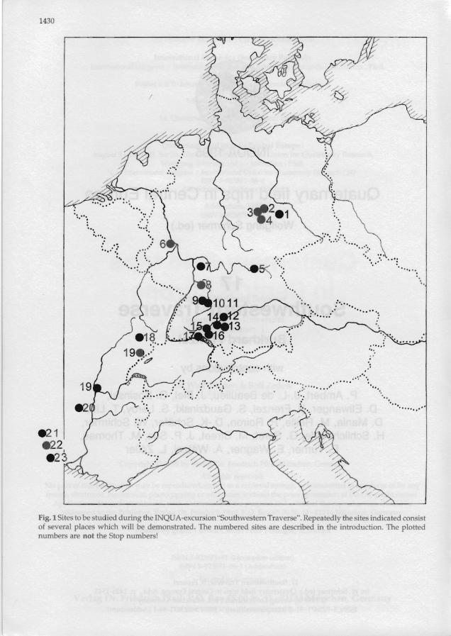
Fig. 1 Sites to be studied during the INQUA-excursion "Southwestern Traverse". Repeatedly the sites indicated consist of several places which will be demonstrated. The numbered sites are described in the introduction. The plotted numbers are not the Stop numbers!
Foreword (w. SCHIRMER) .............. ..
Introduction (B. FRENZEL) ... ... ........ ......
Glacial-interglacial seq in eastern Germany
Stop 1: The warm-clima of Neumark-Nord, Geis< (D. MANIA & M . THOM,.:
Stop 2: Bilzingsleben .' (D. M ANlA) .... ... .............. .
Stop 3: Loess sequence • former brickyard Körne (A. WÄTZEL) ..... .............. .
Stop 4: Weimar-Ehrings Travertine quarry (D . SCHÄFER) ........... ......._
Stop 5: Main River example for valley botte (W. SCHIRMER) ............ _.. .
Middle and Upper PIei occupation in the Neu\' (5. GAUDZINSKI, M . STRI
Stop 6: The Kärlich clay
Stop 7: Middle Palaeolit from the Penultimate ar in the Neuwied Basin ...
Late Middle Pleistocene
Stop 8: Upper PleistoceJ
Stop 9: Evidence for lat and human activities co by Laacher See tephra: ' Miesenheim 3, Miesenh Bassenheim , OchtendUIl and Nickenich ................
Interglacials and man in southwestern Germ.
Stop 10: Upper Quate and river development area. Museum Darmst (B. FRENZEL) ....... .. ........ .
Stop 11: The Palaeolithi (1. ZÖLLER & G. A. W

1431
~ /
."
0°0: :' •• - •••••• •
'..' '" 0.':' ., .': ... ....
: ° 0 .°. .......
,0':'·
"'0.,
" ... ,... ...... .
, /
ly the sites indicated consist ~ introduction. The plotted
Contents
Foreword (W. SCHIRMER) ... ........ .. ......... .. ......... ... .... .... ........ 1432
Introduction (B. FRENZEL) ........................................................ 1433
Glacial-interglacial sequences in eastem Germany
Stop 1: The warm-climate period of Neumark-Nord, Geiseltal (D. M ANIA & M. THOMAE) ...... .. ....................... 1434
Stop 2: Bilzingsleben (Northern Thuringia) (D. MANlA) ................ .... ............................. .. ....... 1439
Stop 3: Loess sequence in the former brickyard Körner /Thuringia (A. WÄTZEL) ........................................................ 1441
Stop 4: Weimar-Ehringsdorf Travertine quarry (D. SCHÄFER) ................... .................................... 1444
Stop 5: Main River example for valley bottom development (W. SCHIRMER) .................................................... 1447
Middle and Upper Pleistocene hominid occupation in the Neuwied Basin (Rhineland)
Stop 6: The Kärlich d ay pit .......................... ... 1449
(S. GAUDZINSKI, M. STREET & E . TURNER)
Stop 7: Middle Palaeolithic sites from the Penultimate and Last Glacial in the Neuwied Basin .................................... .. . 1452
Late Middle Pleistocene vo1cano sites ........... 1455
Stop 8: Upper Pleistocene vo1cano sites ....... 1462
Stop 9: Evidence for late Allemd ecology and human activities conserved by Laacher See tephra: Miesenheim 2, Miesenheim 3, Miesenheim 4, Thür, Bassenheim, Ochtendung, Po1ch, Kobern and Nickenich .................... .... .. .............. ........ .... 1469
Interglacials and man in southwestern Germany
Stop 10: Upper Quaternary stratigraphy and river development in the Oberrheingraben area. Museum Darmstadt (B. FRENZEL) .. ............ .... ...... ................................ 1475
Stop 11: The Palaeolithic site of Mauer (L. ZÖLLER & G. A. WAGNER) .......................... 1478
Stop 12: Museum at Eberdingen-Hochdorf, Kr. Ludwigsburg, Baden-Württemberg O. BIEL) .. ............ ........ .... ...... ................ ...... .......... 1481
Stop 13: A palaeolithic site in Middle Pleistocene travertines of Stuttgart-Münster (E. WAGNER) ...... .. .. .. ...... ...... .... .. .... .. .... ............... 1485
Stop 14: Holocene his tory of the river Danube in the vicinity of Ulm: Human impact versus d imatic change (B. FRENZEL) ............ ...... ...................................... 1487
The Riss valley longitudinal section (D. ELLWANGER) .............. ...... .. ...... ..................... 1491
Stop 15: Gravel pit near Baltringen ............... 1491
Stop 16: Riß type locality, gravel pit Scholterhaus to the north of Biberach ........ ... 1491
Stop 17: Sequence of Würmian deposits near Wattenweiler, Riß valley (Oberes Rißtal), south of the Riß type locality .......................... 1492
Stop 18: Würm Supermaximum at Ingoldingen, gravel pit a & b .... .......... ....... 1492
Stop 19: Viewpoint "Äußere Jungendmoräne", main moraine ridge of the Rheingletscher, near Ingoldingen/Steinhausen .................... ... 1492
Rhein glacier basin
Stop 20: Is the Eemian interglacial the equivalent of the Riß/Würm warm period? The Krumbach site (B. FRENZEL) ........................................................ 1492
Stop 21: Glacial basin of Hoßkirch (D. ELLWANGER & W. BLUDAU) .... .... ............... 1496
Stop 22: Deckenschotterplateau of Höchsten / Heiligenberg, fluvial, glacial and lacustrine deposits of the Deckenschotter complex of the Rheingletscher (D. ELLWANGER) .................. ...... .. .... .......... ........ . 1496
Stop 23: Settlement and landscape change in the Neolithic and Bronze Age times of the Southwest German Alpine Foreland (H. SCHLICHTHERLE) ........ .................................. 1497
Glacial-interglacial sequences in eastem France
Stop 24: The Grande Pile peat bog and its paleodimatic environment (G. SERET) ............................................................ 1504

1432
Stop 25: The Jura range (Besan<;on-Les Eehets): The internal morainie eomplex (H. RrCHARO, M. CAMPY, M. MAGNY & P. PETREQUlN) ..................................................... 1507
Stop 26: The lake of Chalain (H. RrCHARO, M. CAMPY, M. MAGNY & P. PETREQUIN) ......................... .. .......................... 1508
Stop 27: Lake of Onoz (H. RICHARO, M. CAMPY, M. MAGNY & P. PETREQUIN) .............. ................. ......... ............. 1509
Stop 28: Les Echets peat-bog and the eastern Lyon region a,-L. OE BEAULIEU, P. MANDIER & M. REILLE) ......................................................... .. 1511
Stop 29: Lae de St-FRONT (V. ANORIEU, E. BONIFAY, M. REILLE, A. RHOUJJATI & N. THOUVENY) ....................... 1513
Stop 30: Lac du Bouchet a.-L. OE BEAULIEU, E. BONIFAY, M. REILLE & N. THOUVENY) ..... ........... ............. .................. ..... 1518
Stop 31: Praclaux maar a.-L. OE BEAULIEU, M. REILLE & N. THOUVENY) ................. ................. .. .. ......... ..... 1522
Stop 32: The signifieance of the present role of Pinus sylvestris in Margeride and throughout the upper basin of the Loire (M. REILLE) .................................. ........................ 1524
Stop 33: Brameloup. The last glaeiation and vegetation history in Aubrac from the Würm Pleniglacial to the present a.-L. OE BEAULIEU, A. DE GOER OE HERVE & M. REILLE) ............. ...... ......... ............................... 1526
Late Pliocen e to Early Pleistocene evolution of Languedoc environments (P. AMBERT, S. LEROY, P. ROIRON & J. P. Suc) .. ............................ ............. ..... .............. 1530
Stop 34: Millau travertine sequences ............. 1530
Stop 35: Late Pliocene pollen and leaf floras from the Bernasso paleolake ........................... 1535
Stop 36: Saint-Maeaire, a Lower Pleistocene glacial phase in the Languedoe coastal plain ....................... 1538
General conclusions (B. FRENZEL) .................................. ..... ............... .. 1541
Addresses ....................... .... .... .. ...................... .... 1543
Foreword (W. SCHIRMER)
It was the intention of the INQUA Berlin 1995 exeursion to visit central Europe as eomplete as possible. Aetually, it presents one of the most detailled pateh work of natural and eultural landscapes in the world.
Thus I am glad that the manuscript of a 17th
field trip, the Southwest Traverse, submitted in the very last minute, ean be added this edition as an Addendum while the whole edition is right now in the proeedure of printing. The Southwest Traverse
runs during the congress as post-Congress exeursion C 10.
All in all, 17 central European field trips presented in this field guide (vol. 1,2 and Addendum) pass 18 European eountries. Together with the 45 excursions of the Berlin area (vol. 3/4) the whole opus involves 377 individual authors.
I hope that interest in eentral European Quaternary scienee and processes will be fed and stimulated by this edition.
The main problems to be exeursion are:
1) How do the Quaternary former Scandinavian inland ie merly non-glaciated areas of those of the peri-Alpine region possible to correlate these stra of the deep sea stages?
2) How ean the various p ment of old and middle Paleo into the stratigraphie sehemes various Central and Southwes
3) Whieh faetors and pr Lateglaeial and Holoeene de\' European rivers?
4) Sinee what time dates th enee of man on his environm
These problems will be <hl given in Fig.1. From the geo these sites it will be clear that e mentioned will be studied re the end of the exeursion a s after having seen at some len peets of these problems.
The regions to be investigated 1) Brown-coal openeast J
Nord to the southwest of MeISE problems of Upper or Middle climate phases of interglacial ar biostratigraphy; problems of a geology.
2) Stratigraphie position ( zingsleben site (north-northwe history, paleoecology.
3) Loesses and fossil soils, stratigraphieal position in the pit, some kilometers to the weben site.
4) Paleoecology and stratig the travertine site Weimar-Ehri archeologieal museum in Weil
5) Lateglacial and HoloceJ the upper river Main to the no
6) Quaternary stratigraph~ the Neuwied-Basin and the E.' the northwest of Koblenz: Stra fossil soils, tephra layers, preru etation history; Laacher See.
7) Upper Pleistoeene Quat, and river development of the ( the Darmstadt area: Quaterna the Darmstadt Museum.
8) Stratigraphie position a

1433
e of the present role argeride and basin of the Loire ········· ······ .· ... · ............... .. 1524
elast glaeiation m Aubrae !acial to the present )E GOER OE HERVE & , ........... , .. ,.. .... ............... 1526
Pleistocene evolution m.ents >. ROIRON & .. ·.. ·.... .. ..... .. .... ....... ...... . 1530
ne sequenees .. .... ...... . 1530
JOllen and leaf floras Jlake ................ .... .... .. . 1535
cial phase i! plain ....................... 1538
........... , ........................ 1541
...· ...... ·., ....................... 1543
as post-Congress exeur-
European field trips pre(\'01. 1,2 and Addendum) ries. Together with the 45 area (vol. 3/4) the whole ldual authors. central European Quater
will be fed and stimu-
Introduction (8. FRENZEL)
The main problems to be diseussed during this exeursion are:
1) How do the Quatemary stratigraphies of the former Seandinavian inland iee area, those of formerly non-glaciated areas of Central Europe and those of the peri-Alpine region fit together and is it possible to eorrelate these stratigraphies with that of the deep sea stages?
2) How ean the various phases in the development of old and middle Paleolithie cultures be fit into the stratigraphie sehemes of the Quatemary of various Central and Southwest European regions?
3) Whieh factors and processes govemed the Lateglacial and Holoeene development of Central European rivers?
4) Sinee what time dates the oldest strong influenee of man on his environment?
These problems will be diseussed at the sites given in Fig.I. From the geographieal position of these sites it will be dear that eaeh of the problems mentioned will be studied repeatedly and only at the end of the exeursion a summary ean be given after having seen at some length the regional aspeets of these problems.
The regions to be investigated are (Fig. 1): 1) Brown-eoal opencast mining Neumark
Nord to the southwest of Merseburg: Stratigraphie problems of Upper or Middle Pleistoeene warmdimate phases of interglaeial and interstadial rank; biostratigraphy; problems of applied Quatemary geology.
2) Stratigraphie position of the famous Bilzingsleben site (north-northwest of Weimar): prehistory, paleoecology.
3) Loesses and fossil soils, their eharacter and stratigraphieal position in the former Körner d ay pit, some kilometers to the west of the Bilzingsleben site.
4) Paleoecology and stratigraphie al position of the travertine site Weimar-Ehringsdorf; visit to the areheologieal museum in Weimar.
5) Lateglacial and Holoeene development of the upper river Main to the north of Bamberg.
6) Quatemary stratigraphy and prehistory in the Neuwied-Basin and the Eastem Eifel Mts., to the northwest of Koblenz: Stratigraphy of loesses, fossil soils, tephra layers, prehistorie sites and vegetation history; Laaeher See.
7) Upper Pleistoeene Quatemary stratigraphy and river development of the Oberrheingraben in the Darmstadt area: Quatemary paleontology in the Darmstadt Museum.
8) Stratigraphie position and paleoecologieal
setting of Homo erectus heidelbergensis in the Mauer gravel and sand pit, some kilometers to the east of Heidelberg.
9) Paleoeeologieal situation of the Iron Age settlement of Hochdorf, to the north-west of Stuttgart.
10) Middle Pleistoeene prehistorieal site Stuttgart-Münster, travertine quarry Lauster, prehistory, paleontology, Quatemary stratigraphy, development of the valley of river Neekar during the Quatemary; eomparison with the Bilzingsleben site.
11) Lateglacial and Holoeene development of vegetation in southwestem Germany, demonstrated in the Hohenheim Botanieal Garden; dendrodimatology and dendroehronology; Botanisches Institut der Universität Hohenheim.
12) Holoeene development of the river Danube in the vieinity of Ulm: Human impact versus history of dimate.
13) Quatemary stratigraphy along the river Riß, between Biberach and Ulm: The problem of the stratigraphie position of the Riß and Würm glaeiations.
14) Krumbaeh site to the west of Federsee: Is the Eemian interglaeial the equivalent of the RißWürm warm period?
15) Middle and Upper Pleistocene sequenee of interglacials and cold-climate phases in the Hoßkireh area to the north of Konstanz: The problem of the stratigraphieal division of the time between the Hoisteinian and the Eemian in terglacials.
16) Quatemary stratigraphy of the Old and Middle Pleistocene in the Höchsten area.
17) Prehistoric man and his environments during Lateglacial and Holocene times in the Bodensee area: Hemmenhofen to the west-northwest of Konstanz.
18) Quatemary stratigraphy and the history of glaciations in the southwestem part of the Vosges Mts., Grande Pile, France.
19) Upper Quatemary of the French Jura; pile dwelling in the Lae de Chalain; Holocene lake-level changes; interglacial site Les Eehets near Lyon.
20) Middle and Upper Pleistocene stratigraphy in existing and fossil maar lakes of the French Plateau Central in the surroundings of Le Puy.
21) Lower and Middle Pleistocene travertines at Millau.
22) Late Pliocene floras in the Bemasso paleolake near Lodeve/Herault.
23) Lower Pleistocene glacial steppe vegetation in the Languedoc coastal plain at Saint-Macaire, northwest of Agde.

1444
SE
caCcClt"'r ous o$O,.,c/ ® Li,hf yeilo 'v'
® calcareous
SClndy cloy . . . . . ..............cold moUu.JC$ fOUhCl
Molluscs aJsemblages sen.suLOiEKJjM/lNIA
woodlal1d.J Q.f~ c;ve"'.s'dfl l?7eadol-t's c.alca"-eouJ mud
wetlwoodecJ 1:.:. :1 woody .sf~ppeC;:;:= moisf® greeh '3,"e)' sWj
o u6;qui.s!s ~watet"to"na '1~ "0
U/n, dares BRUNNACKER (1987) Fig. 10 Körner loess pit II
Becken und dessen Randgebiet. - Warszawa, 227234.
WOILLARD, G. (1978): Grande Pile peat bog: A continuous pollen record for the last 140000 years. - Quatem. Res., 9: 1-21
WOILLARD, G. (1979): Abrupt end at the Last Interglacial s. s. in North-East France. - Nature, 282: 558-562.
Stop 4: Weimar-Ehringsdorf Travertine quarry
(0 . SCHÄFER)
TK 25: 5033 Weimar, 5034 Magdala
Since the beginning of this century the travertine quarries of Weimar-Ehringsdorf belong to the classical Middle European sites of research for Pleistocene archaeology. The site is situated in the middIe of the Thuringian basin ("Thüringer Becken") in a rift valley named "Umtalgraben".
Travertine was caused by springs that drained through the karst, in this case that of the Muschelkalk.
The spring water was rather warm, i. e. 8 to 12
interglacial sequence.
degrees centigrade, so the places at the side of the springs were attractive both for man and for the Pleistocene animals. Nevertheless scientists could not find any sites with places where animals have been slaughtered so far ('killing sites').
Resting places with fireplacesl charcoal, artefacts and bones have been floated by karstic water, as the springs changed their places very often. Because of this the so-called "Brandschichten" developed.
Finally hardened travertine (sometimes travertine sand) covered the site. Sediments up to 20 m in thickness were formed. Usually paleolithic settlements were found at places w here springs floated a wider area in which travertine could be accumulated (= the area of the former quarries owned by KÄMPFE and FISCHER).
Based on former and his own research SOERGEL (1926) was able to give a standard profile that was valid for more than 50 years. New exposure conditions were the reason for the Upper Travertine being investigated in more detail by STEINER (1974;
Fig. 11 WeimarEhringsdorf - Standard profile (R. -D. KAHLKE 1994, after STEINER 1977)
Fig.11). Nontheless one cannot (
stratigraphical episodes 01
could enlighten only wea graphical interpretation.
The finds of imprints 0
molluscs and rnicro- I macro specific (H. D. KAHLKE 197STEINER 1979; HEINRICH 1 R.-D. KAHLKE 1994).
The basis of the travertin of the river Um and sediIr facies. Those sediments seel sitional time from glacial t (findings of Mammuthus pn. bicularis within stratigrapt (R. D. KAHLKE 1994: 364).
The Lower Travertine . 15 m thick) is the archeolo part, up to 9 layers of "Bran found in the fischer-quarT}' SCHÄFER 1987).
An industry of rather s side scrapers and points I these layers, the amount of retuschen") is overrated in
Different finds of ho . the time between 1908 and least 6 different individuals logically the individuals ar derthaloid or sapientoid h
.. . • • -""C"I:

1445
SE- Bereich Zenlralbereich W-und NW Bereich
Lö~lehm
GehönQelohm
Ob. Traverttn
Pseudopariser n Ob. Travertin B
Pseudoporlser I
Ob. Trovertin A
Pariser
Unterer Travertin
.............. Auelehm'--..,
--
------::C" :1 T ,li"-- i'O~e
-I-
• ~lm'ChOtler0 ..•. K"d.·,a~,«~.. . . • •• 10. ,
Sollfluktlonaschutt
Fig. 10 Körner loess pit II interglacial sequence.
.e places at the side of the both for man and for the :ertheless scientists could laces where animals have ('killing sites'). fueplaces / charcoal, arte
floated by karstic water, their places very often. ed "Brandschichten" de
'ertine (sometimes travere. Sediments up to 20 m in Csually paleolithic settleces where springs floa ted
'a\'ertine could be accumu-ormer quarries owned by
his own research SOERGEL tandard profile that was
ears. New exposure condifor the Upper Travertine re detail by STEINER (1974;
Fig. 11 WeimarEhringsdorf - Standard profile (R.-D. KAHLKE 1994, after STEINER 1977)
Fig. 11). Nontheless one cannot deny the fact that short
stratigraphical episodes of the whole sequence could enlighten only weakly the chronostratigraphical interpretation.
The finds of imprints of plants (e. g. leaves), molluscs and micro-/macromammals are rich and specific (H. D. KAHLKE 1974, 1975; ZEISSLER 1975; STEINER 1979; HEINRICH 1981a, b; SCHÄFER 1991; R-D. KAHLKE 1994).
The basis of the travertine are fluviatile gravels of the river Um and sediments of the overbank facies. Those sediments seem to point to the transitional time from glacial to interglacial periods (findings of Mammuthus primigenius and Emys orbicularis within stratigraphical neighbourhood) (R D. KAHLKE 1994: 364).
The Lower Travertine (in the W /NW area up to 15 m thick) is the archeologically most important part, up to 9 layers of "Brandschichten" have been found in the Fischer-quarry (BEHM-BLANCKE 1969; SCHÄFER 1987).
An industry of rather small silex artefacts with side scrapers and points (rarely) are specific for these layers, the amount of face retouch ("Flächenretuschen") is overrated in literature.
Different finds of hominids have been made in the time between 1908 and 1925; they belong to at least 6 different individuals (Ehr. A-I). Anthropologically the individuals are interpreted as neanderthaloid or sapientoid human beings (VLCEK
1993, see also GRIMM 1993). The surroundings of the "Brandschichten" give
evidence of an interglacial dimate with an oakand mixed forest and an antiquus-fauna. The following animals are found rather often: Dicerorhinus kirchbergensis, Bison priscus mediator, Ursus arctos, Equus, Palaeoloxodon antiquus, Cervus elaphus etc.
In the middle part of the Lower Travertine the antiquus fauna becomes rare. Dicerorhinus kirchbergensis is replaced by Dicerorhinus hemitoechus and Palaeoloxodon antiquus is found rarely. Those pieces of horses, whose stratigraphy is dear, are found a bit lower than the Pariser, as weH as a possible molar of Mammuthus (R-D. KAHLKE 1994).
Heterogene finds of micromammals (continental and warm/temperate types) are found here as weIl (HEINRICH 1981b).
The layer in between, called Pariser, is built up of dayey loam often rich in carbonate and sometimes in gravels.
The top most sediments of the Pariser are transformed into a parabraunerde or rendzina. It could be shown that the Pariser was formed in a warm period, as new finds of small mammals prove evidence too (STEINMÜLLER 1974; BÖHME & HEINRICH, in press; contradicting observations on the pollenflora: FRENZEL 1974).
Many findings point to a warm dimate and an open vegetation when the Upper Travertine was

1446
formed (molluses, plants and several mammals). Stra tified micromammals lying in the lower parts of the Upper Travertine point to warm climates (HEINRICH 1981a). O ther animals do not eorroborate this , h ke followin g continental species: Mammuthus primigenius (only shortly above the Pariser), Dicerorhinus hemitoechus, sometimes Coelodonta antiquitatis, Alces latifrons, ?Rangifer (H.-D. KAHLKE 1974, 1975) . Probably some of the m istakes of interpretation orginate in the s tra tigraphical research, sin ce three 'Pseudopariser ' layers in the Upper Travertine w ere unknown d uring a long period of travertine research .
On the other h and there should be discussed more the 'ecological plasticity' problem of seasonally sympatry of several taxa.
New finds of a colluvium chernozem with thousands of rnicromammals, birds and rests of a H erpetofauna, found in karstic hollows w ithin the Upp er Travertine, favour the view th at the formation of this colluvium d ates from the Early Weichsehan (BÖHME & HEINRICH, in press).
Only a few ar tefacts and some isolated finds of tools are known from the only "Brand schicht" of the Upper Travertine (STEINER & STEINER 1975).
A specific feature in the travertine are 20 burnt pieces of Cornus mas L. (SCHÄFER & JÄGER 1984).
Loess, soils and periglacial horizons from the layers on top of the Upper Travertine. These layers ha ve not been investigated completely so far (GUENTHER 1958, BEHM-BLANCKE 1960) . Single finds of tools are not specific, but a piece of a leaf point (Blattspitze) at the basis of the loess (SCHUSTER 1928, after SOERGEL 1919) points to sediments
. of the last glacial period on top of the layers of the Upper Travertine.
For the Lower Travertine some groups of mammals and new radiom etrie data seem to give evidence of a pre-Eemian age (JÄGER & HEINRICH 1982; ZÖLLER 1994).
Technological research of 2,400 artefacts from the Lower Travertine shows on the other hand a high sirnilarity to exactly dated Eernian and Early Weichselian collections (SCHÄFER 1993).
BÖHME, G. & HEINRICH, W.-D.: Zwei neue Wirbeltierfaunen aus der pleistozänen Schichtenfolge des Travertins von Weimar-Ehringsdorf. - EthnographischArchäolog. Zeitsehr. [in press]
FRENZEL, B. (1968): Pollenanalysen an Material aus dem "Pariser" von Weimar-Ehringsdorf. - In: III. Internationales Paläontologisches Kolloquium 1968, Abh. zentr. geol. Inst., 21: S. 343-35l.
GRIMM, H. (1993): Zur Geschichte und zum Stand der Forschung an den Hominidenresten. - In: VLCEK, E.: Fossile Menschenfunde von Weimar-Ehringsdorf. Weimarer Mongr. Ur- u. Frühgesch., 30.
GUENTHER, E.-W. (1958): Feinstratigraphische Untersu
chungen einer Zwischenschicht und der Deckschichten der Traqvertine von Ehringsdorf. - Alt-Thüringen, 3: 1-15.
HEINRICH, W.-D. (1981a): Systematische Zusammenstellung der in den thüringischen Interglazialtravertinen von Burgtonna, Taubach und Weimar-Ehringsdorf nachgewiesenen Kleinsäugerarten. - Quartärpaläontologie, 4: 127-130.
HEINRICH, W.-D. (1981b): Fossile Kleinsäugerreste aus dem Unteren Travertin von Weimar-Ehringsdorf (Thüringen, DDR) (Vorläufige Mitteilung). - Quartärpaläontologie, 4: 131-143.
JÄGER, K.-D. & HEINRICH W.-D. (1982): The travertine at Weimar-Eh rings dorf - an interglacial site of Saalian age? Project 73-1-24, 'Quaternary glaciations in the Northern Hemisphere' Report 7: 98-114.
KAHLKE, H.-D. [ed.] (1974): Das Pleistozän von WeimarEhringsdorf, Teill. - Abhandl. Zentr. Geol. lnst., 21; Berlin.
KAHLKE, H.-D. [ed.] (1975): Das Pleistozän von WeimarEhringsdorf, Teil 2. - Abhandl. Zentr. Geol. Inst., 23; Berlin.
KAHLKE, R.-D. (1994): 2.3. Exkursionspunkt B 2/2: Travertinbrüche Weimar-Ehringsdorf. - In: KAHLKE, R.D. & D. MANlA (1994): Komplexe Interglazialfundstellen Thüringens (Exkursion B2). Altenburger naturwiss. Forsch., 7: 362-366.
SCHÄFER, D. (1988): Merkmalanalyse mittelpaläolithischer Steinartefakte. - unpubl. Diss. HumboldtUniv.; Berlin.
ScHÄFER, D. (1991): Weimar-Ehringsdorf: Diskussionsstand zur geochronologischen und archäologischen Einordnung sowie aktuelle Aufschlußsitutation. Quartär, 41142: 19-43.
ScHÄFER, D. (1993): Grundzüge der technologischen Entwicklung und Klassifikation vor-jungpaläolithischer Steinartefakte in Mitteleuropa. - Berichte Röm.Germ. Komm., 74: 49-193.
ScHÄFER, D. & K.-D. JÄGER (1984): Verkohlte Steinkerne der Kornelkirsche (Cornus mas L.) aus dem Paläolithikum des Oberen Travertins von Weimar-Ehringsdorf. - Alt-Thüringen, 20: 15-22.
ScHUSTER, E. (1928): Die altsteinzeitliche Kultur von Ehringsdorf. - In: WEIDENREICH, F.: Der Schädelfund von Weimar-Ehringsdorf: 139-204; Jena.
SüERGEL, W. (1919): Löße, Eiszeiten und paläolithische Kulturen. Eine Gliederung und Altersbestimmung der Löße. - Jena.
SüERGEL, W. (1926): Exkursion ins Travertingebiet von Ehringsdorf. - Paläontologische Zeitschrift, 8: 7-33; Berlin.
STEINER, W. (1974): Die neue Gliederung des Oberen Travertins von Ehringsdorf bei Weimar. - In: H.-D. KAHLKE [ed.]: Das Pleistozän von Weimar-Ehringsdorf, Teill. Abhandl. Zentr. Geol. Inst., 21: 153-156; Berlin.
STEINER, W. (1979): Der Travertin von Ehringsdorf und seine Fossilien. - Die neue Brehm-Bücherei, 522; Lutherstadt Wittenberg.
STEINMÜl lER, A. (1974): Der Pariser-Horizont von Ehringsdorf. - In: H.-D. KAHLKE [ed.]: Das Pleistozän von Weimar-Ehringsdorf, Teil 1. Abhandl. Zentr. Geol. Inst., 21: 175-198; Berlin.
VLCEK, E. (1993): Fossile. 1 Ehringsdorf. - Weimare 30.
ZEISSLER, H. (1975): Konch. stozän. - In: H.-D. Weimar-Ehringsdorf, T Inst., 23: 15-90; Berlin.
ZÖLLER, L., KARELIN, P. & neszenz-Datierung in d lichkeiten, Grenzen und len aus Süd-und Ostd DEUQUA, Leipzig.
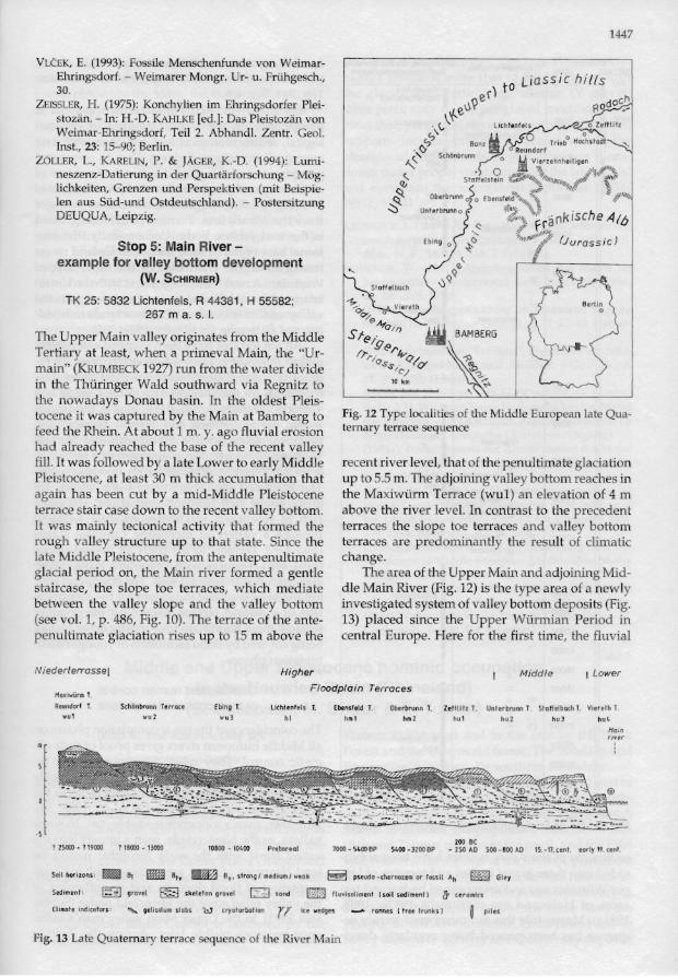
Stop 5: M example for valley
(W. Sc
TK 25: 5832 Lichtenfe 267 m j
The Upper Main valley 0 .
Tertiary a t least, when a I main" (KRUMBECK 1927) in the Thüringer Wald sc the nowadays Donau ba tocene it was captured by feed the Rhein. At about 1 had a lready reached the fill. It w as followed by a la Pleistocene, at least 30 m again has been cut by a terraee stair ca se down to It w as mainly tectonical • rough valley structure uF late Middle Pleistocene, fr glacial period 011, the Ma s taircase, the slope toe t between the valley slope (see val. 1, p . 486, Fig. 10 penultimate glaciation ris
Niederlerrasse l
Hoxi...Ürm T.
Rtundorf T. Schönbrvnn Te".•.
wu ' wu 2
·5
? 2S0c0 - ? 19000 ? 18000 - 13000
Soil hor izo ns : BII11III m:m S,.
Sedimen t: ~ grovel ~
Fig. 13 Late Quaternary tem
enschicht und der Deckschich'on Ehringsdorf. - Alt-Thürin-
Systematische ZusammensteIngischen Interglazialtravertinen
,ach und Weimar-Ehringsdorf Insäugerarten, - Quar tärpaläon
· Fossile Kleinsäugerreste aus ~tin von Weimar-Ehringsdorf orläufige Mitteilung). - Quar
131-143. i W.-D. (1982): The travertine at - an interglacial site of Saalian 'Quatemary glaciations in the
re' Report 7: 98-114. : Das Pleistozän von Weimar
•Abhandl. Zentr. Geol. Inst., 21;
· Exkursionspunkt B 2/2: Tra-Ehringsdorf. - In: KAHLKE, R.
Komplexe Interglazialfund xkursion B2). Altenburger na2- 366. kmalanalyse mittelpaläoIithi- unpubl. Diss. Humboldt-
r-Ehringsdorf: Diskussionsischen und archäologischen
tuelle Aufschlußsituta tion.
~üge der technologischen Ent~tion vor-jungpaläolithischer
teleuropa. - Berichte Röm .193. U984): Verkohlte Steinkerne
ws mas L.) aus dem Paläolithi\'ertins von Weimar-Ehrings20: 15-22. altsteinzeitliche Kultur von
;REICH, F.: Der Schädelfund orf: 139-204; Jena. • Eiszeiten und paläolithische
enmg und Altersbestimmung
Gliederung des Oberen Traorf bei Weimar. - In: H.-D.
l'6tozän von Weimar-Ehrings-Zentr. Geol. Inst., 21: 153-156;
~ra\'ertin von Ehringsdorf und e neue Brehm-Bücherei, 522;
Der Pariser-Horizont von Eh(AHLKE [ed.]: Das Pleistozän
>dorf, Teil 1. Abhandl. Zentr. ; Berlin.
1447
VLCEK, E. (1993): Fossile Menschenfunde von WeimarEhringsdorf. - Weimarer Mongr. Ur- u. Frühgesch., Liassie hilfs 30. to
er) dach ZEISSLER, H . (1975): Konchylien im Ehringsdorfer Plei u~ RO~ stozän. - In: H .-D. KAHLKE [ed. ]: Das Pleistozän von \'f.e
. ~ 0Weimar-Ehringsdorf, Teil 2. Abhandl. Zentr. Geol. C,\ U Tr iebo Hochstadt
Inst., 23: 15-90; Berlin. t::::r" Bonz It 0 Reundort ~, Schön brunn 0 U Vi erze hnhei lJ genZÖLLER, L., KARELlN, P. & JÄGER, K.-D. (1994): Lumi
neszenz-Datierung in der Quartärforschung - Mög ~ . 0 Il~V '\ i~~:;~~<.. Staffelstein ~'".,\\\\\\ 1q,,%jlllllllJll/l/ltt/t,,~'*''* '\
lichkeiten, Grenzen und Perspektiven (mit Beispie q, 1 111111 :t;~tf' \ ~ tU/IIII,~ Obe rbrunn 0 0 Ebensfeld II~/b ~ len aus Süd-und Ostdeutschland). - Postersitzung ~ ~ \1 . hDEUQUA, Leipzig. ~ Unt" brunn o . '!k .... nk JSC e Alb
ra ~11 1\\\\\\\\\\~:§ (J u r a 5 sie)
Stop 5: Main River Iexample for valley bottom development
(w. SCHIRMER) "'
TK 25: 5832 Lichtenfe ls , R 44381, H 55582; ~O::267 m a. s. I. 0
<:>'/ & ..!fa/ I)
The Upper Main valley originates from the Middle Sfeige/,/yTertiary at least, when a primeval Main, the "Ur
frr/os . Ql'omain" (KRUMBECK 1927) rW1 from the water divide S l c/
10 kmin the Thüringer Wald southward via Regnitz to the nowadays Donau basin. In the oldest Pleistocene it was captured by the Main at Bamberg to Fig. 12 Type localities of the Middle European late Qua
ternary terrace sequence feed the Rhein. At about 1 m. y. ago fluvial erosion had already reached the base of the recent valley fil!. It was followed by a la te Lower to early Middle recent river level, that of the penultimate glaciation Pleistocene, at least 30 m thick accumulation that up to 5.5 m. The adjoining valley bottom reaches in again has been cut by a mid-Middle Pleistocene the Maxiwürm Terrace (wu1 ) an elevation of 4 m terrace stair case down to the recent valley bottom. above the river level. In contrast to the precedent It was mainly tectonical activity that formed the terraces the slope toe terraces and valley bottom rough valley structure up to that state. Since the terraces are predominantly the result of climatic late Middle Pleistocene, from the antepenultimate change. glacial period on, the Main river formed a gentie The area of the Upper Main and adjoining Midstaircase, the slope toe terraces, which mediate die Main River (Fig, 12) is the type area of a newly between the valley slope and the valley bottom investigated system of valley bottom deposits (Fig. (see vo!. 1, p . 486, Fig. 10). The terrace of the ante 13) placed since the Upper Würmian Period in penultimate glaciation rises up to 15 m above the central Europe. Here for the first time, the fluvial
Niederlerrassel Higher Middle 1 Lower
F loodplain Terraces HOlCiwürm T.
Reundorf T. Schönbrunn fe rroce Ebi ng T. Lichtenfels Ebensfeld T.· Obe rbrunn T. Ze ttllh T. Unfer brunn T. Sfo ffelboth 1. Vie relh T. wul wu 2 wu 3 hml hu l hu3 hl hm Z hu2 hu l.
Hain
· 5 200 BC
? 25(0) - ? 19CXXJ ? 18000 - 13000 10800 - 10400 Prtbore ol 7000- S400BP S400- 3200BP - 2S0AO SOO- 800AO 1S. -t7. tent. eorly19.cenf.
Soil horizons : 111 Bt mH:Jj Bt" ~ B", s lrOl"lgl medium 1 weok ~ pseudo - cher nozem or fossil Ah ~ Gley
Sediment : ~ grovel ~ skeleton grevel ~ sand ~ ftuvisoli ment (soil sed imen t) Ö' (er e rni cs
(limo te ind icotors : '- gelisolum ~obs bJ cryoturbo fion rI' Ice wl!dgl!!s -... rannes (IrH trunks ) ~ piles
Fig. 13 Late Quaternary terrace sequence of the River Main
Top Related
Copyright © 2022 FDOKUMEN

