


Bahasa
Halaman
Hukum

Sedimentary Geology 316 (2015) 13–25
Contents lists available at ScienceDirect
Sedimentary Geology
j ourna l homepage: www.e lsev ie r .com/ locate /sedgeo
Compositional trends through the Holocene mud succession of thesouthwestern Black Sea shelf: Implications for sedimentary provenanceand water-level history
Christopher J. Lister a, Richard N. Hiscott a,⁎, Ali E. Aksu a, Peta J. Mudie a,b
a Earth Sciences Department, Memorial University of Newfoundland, St. John's, NL A1B 3X5, Canadab Geological Survey of Canada-Atlantic, Box 1002, Dartmouth, NS B2Y 4A2, Canada
⁎ Corresponding author. Tel.: +1 709 5791932.E-mail addresses: [email protected] (C.J. Lister), r
[email protected] (A.E. Aksu), [email protected]
http://dx.doi.org/10.1016/j.sedgeo.2014.11.0040037-0738/© 2014 Elsevier B.V. All rights reserved.
a b s t r a c t
a r t i c l e i n f oArticle history:Received 25 September 2014Received in revised form 19 November 2014Accepted 20 November 2014Available online 27 November 2014
Editor: J. Knight
Keywords:ProvenanceHoloceneX-ray diffraction analysisClay mineralsBlack SeaLoess
Cores MAR02-45 and MAR05-03 were raised from 68–69mwater depth on the SW Black Sea shelf and indicatetransgression and submergence beneath several tens ofmetres of water before 11.0 cal ka. Thosewho postulate aBlack Sea lowstand below −100 m until the approximately 9.1 cal ka reconnection with the world ocean havesuggested that sites like MAR02-45 and MAR05-03 must have been located in perched lakes on what is nowthe modern shelf. However, the silt- and clay-fraction mineralogy of samples from MAR02-45 provides no evi-dence for a shift in provenance at 9.1 cal ka, with earlier input from local rivers and later input from a broaderregion. Sedimentary abundances of Sc, Fe, Co, Ce, La, Th and Y also show no significant downcore trends. Theseelements likely reside in aluminosilicatemineral grains shed from terrestrial sources, so negligible downcore var-iation suggests long-term continuity in the composition of the detrital supply. More critically, the volume of pre-9.1 cal ka sediment around the MAR02-45 and MAR05-03 sites is N25 times the expected yield from local riversover a 5000 year period, so other more substantial sources are required. The predominant silt size of the recov-ered sediments, the configuration of late Holocene currents in thewestern Black Sea, and analogieswith dispersalsystems elsewhere suggest that the bulk of the fine-grainedmuds at these sites likely came from the Danube andKamchiya drainage basinswhere thick deposits of unconsolidated Pleistocene loess have been strongly dissected.To reach core sites on the SW Black Sea shelf, this material must have been advected from the Danube andKamchiya deltas by unobstructed marine currents. Only thin event beds (tempestites) of fine sand and silt inthe lower part of coresMAR02-45 andMAR05-03 are interpreted to have a local source in the StrandjaMountainsof Thrace. Comparison of the palynology of surface samples from the Danube Delta and its associated coastal la-goons with the pre-9.1 cal ka sediments of core MAR02-45 confirms that the hypothesis of deposition in aperched ancient lake is untenable.
© 2014 Elsevier B.V. All rights reserved.
1. Introduction
Almost two decades have passed since the proposal by Ryan et al.(1997) and Ryan and Pitman (1999) that the Black Sea was catastroph-ically inundated by Mediterranean waters when global sea level roseabove the floor of the Bosphorus Strait (~ −40 m elevation ‘relative tomodern sea level’, hereafter rmsl). This proposed flooding event ismost recently dated by Ryan et al. (2003) at 8400 conventional radio-carbon years before present (14C yr BP; uncalibrated to calendar yearsand with no marine reservoir correction), equivalent to ~9.1 cal kausing the Marine09 calibration curve and ΔR = −105 years (reservoirage ~300 years) consistent with Soulet et al. (2011) and Mertenset al.(2012). Immediately prior to the inundation, adherants to the
[email protected] (R.N. Hiscott),.ca (P.J. Mudie).
scenario of a catastrophic flood propose that the level of the Black Seawas below −100 m rmsl (Ballard et al., 2000; Ryan et al., 2003;Lericolais et al., 2007; Nicholas et al., 2011), implying a large deficit ofriver runoff and precipitation relative to evaporation, unlike today(Özsoy et al., 1995).
Other researchers have argued that the pre-reconnection level of theBlack Seawas near or above the level of the floor of the Bosphorus Straitby the time that the first Mediterranean waters penetrated into theBlack Sea (Hiscott et al., 2007a, 2007b; Yanko-Hombach, 2007; Giosanet al., 2009; Yanko-Hombach et al., 2013; Mudie et al., 2014). A criticalpiston core that has provided support for this view is MAR02-45, raisedfrom a water depth of−69m rmsl on the southwestern Black Sea shelfnear the border between Turkey and Bulgaria (41° 41.17′N, 28° 19.08′E;Fig. 1). This core is 9.5 m long with a continuous, high-resolution sedi-mentary record in its lower 6.8 m, spanning 10.3–5.5 cal ka (Mertenset al., 2012) and, thus, the entire time of the reconnection betweenthe Black Sea and the world ocean. In many other parts of the
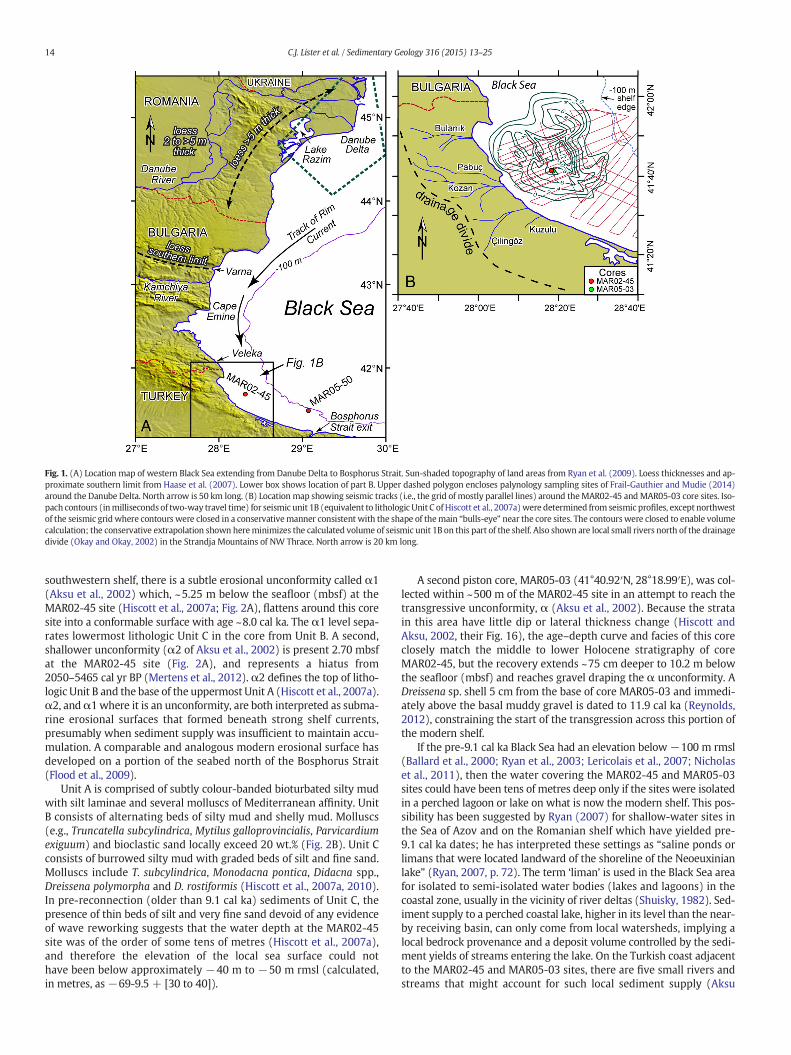
Fig. 1. (A) Location map of western Black Sea extending from Danube Delta to Bosphorus Strait. Sun-shaded topography of land areas from Ryan et al. (2009). Loess thicknesses and ap-proximate southern limit from Haase et al. (2007). Lower box shows location of part B. Upper dashed polygon encloses palynology sampling sites of Frail-Gauthier and Mudie (2014)around the Danube Delta. North arrow is 50 km long. (B) Location map showing seismic tracks (i.e., the grid of mostly parallel lines) around theMAR02-45 andMAR05-03 core sites. Iso-pach contours (inmilliseconds of two-way travel time) for seismic unit 1B (equivalent to lithologic Unit C of Hiscott et al., 2007a)were determined from seismic profiles, except northwestof the seismic grid where contours were closed in a conservativemanner consistent with the shape of themain “bulls-eye” near the core sites. The contours were closed to enable volumecalculation; the conservative extrapolation shown hereminimizes the calculated volume of seismic unit 1B on this part of the shelf. Also shown are local small rivers north of the drainagedivide (Okay and Okay, 2002) in the Strandja Mountains of NW Thrace. North arrow is 20 km long.
14 C.J. Lister et al. / Sedimentary Geology 316 (2015) 13–25
southwestern shelf, there is a subtle erosional unconformity called α1(Aksu et al., 2002) which, ~5.25 m below the seafloor (mbsf) at theMAR02-45 site (Hiscott et al., 2007a; Fig. 2A), flattens around this coresite into a conformable surface with age ~8.0 cal ka. The α1 level sepa-rates lowermost lithologic Unit C in the core from Unit B. A second,shallower unconformity (α2 of Aksu et al., 2002) is present 2.70 mbsfat the MAR02-45 site (Fig. 2A), and represents a hiatus from2050–5465 cal yr BP (Mertens et al., 2012). α2 defines the top of litho-logic Unit B and the base of the uppermost Unit A (Hiscott et al., 2007a).α2, andα1where it is an unconformity, are both interpreted as subma-rine erosional surfaces that formed beneath strong shelf currents,presumably when sediment supply was insufficient to maintain accu-mulation. A comparable and analogous modern erosional surface hasdeveloped on a portion of the seabed north of the Bosphorus Strait(Flood et al., 2009).
Unit A is comprised of subtly colour-banded bioturbated silty mudwith silt laminae and several molluscs of Mediterranean affinity. UnitB consists of alternating beds of silty mud and shelly mud. Molluscs(e.g., Truncatella subcylindrica, Mytilus galloprovincialis, Parvicardiumexiguum) and bioclastic sand locally exceed 20 wt.% (Fig. 2B). Unit Cconsists of burrowed silty mud with graded beds of silt and fine sand.Molluscs include T. subcylindrica, Monodacna pontica, Didacna spp.,Dreissena polymorpha and D. rostiformis (Hiscott et al., 2007a, 2010).In pre-reconnection (older than 9.1 cal ka) sediments of Unit C, thepresence of thin beds of silt and very fine sand devoid of any evidenceof wave reworking suggests that the water depth at the MAR02-45site was of the order of some tens of metres (Hiscott et al., 2007a),and therefore the elevation of the local sea surface could nothave been below approximately −40 m to −50 m rmsl (calculated,in metres, as−69-9.5 + [30 to 40]).
A second piston core, MAR05-03 (41°40.92′N, 28°18.99′E), was col-lected within ~500 m of the MAR02-45 site in an attempt to reach thetransgressive unconformity, α (Aksu et al., 2002). Because the stratain this area have little dip or lateral thickness change (Hiscott andAksu, 2002, their Fig. 16), the age–depth curve and facies of this coreclosely match the middle to lower Holocene stratigraphy of coreMAR02-45, but the recovery extends ~75 cm deeper to 10.2 m belowthe seafloor (mbsf) and reaches gravel draping the α unconformity. ADreissena sp. shell 5 cm from the base of core MAR05-03 and immedi-ately above the basal muddy gravel is dated to 11.9 cal ka (Reynolds,2012), constraining the start of the transgression across this portion ofthe modern shelf.
If the pre-9.1 cal ka Black Sea had an elevation below −100 m rmsl(Ballard et al., 2000; Ryan et al., 2003; Lericolais et al., 2007; Nicholaset al., 2011), then the water covering the MAR02-45 and MAR05-03sites could have been tens of metres deep only if the sites were isolatedin a perched lagoon or lake on what is now the modern shelf. This pos-sibility has been suggested by Ryan (2007) for shallow-water sites inthe Sea of Azov and on the Romanian shelf which have yielded pre-9.1 cal ka dates; he has interpreted these settings as “saline ponds orlimans that were located landward of the shoreline of the Neoeuxinianlake” (Ryan, 2007, p. 72). The term ‘liman’ is used in the Black Sea areafor isolated to semi-isolated water bodies (lakes and lagoons) in thecoastal zone, usually in the vicinity of river deltas (Shuisky, 1982). Sed-iment supply to a perched coastal lake, higher in its level than the near-by receiving basin, can only come from local watersheds, implying alocal bedrock provenance and a deposit volume controlled by the sedi-ment yields of streams entering the lake. On the Turkish coast adjacentto the MAR02-45 and MAR05-03 sites, there are five small rivers andstreams that might account for such local sediment supply (Aksu
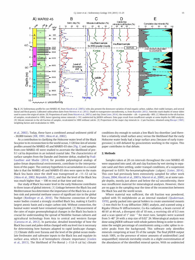
Fig. 2. (A) Sedimentary profile for core MAR02-45, from Hiscott et al. (2007a) who also present the downcore variation of total organic carbon, sulphur, their stable isotopes, and severalfaunal and floral genera. Calibrated radiocarbon dates fromMertens et al. (2012). Depth to transgressive unconformity, α, from Reynolds (2012). Asterisks mark depths of smear slidesused to assess the origin of calcite. (B) Proportions of sand (fromHiscott et al., 2007a) and clay (from Lister, 2014); the remainder – silt – is generally N80%. (C)Minerals in the silt fractionof samples, recalculated to 100%, hence ignoring minor minerals (b5%) undetected by JADE® software. Data gaps result from insufficient sample at some depths for XRD analysis.(D) Silicate minerals in the silt fraction of samples, recalculated to 100% without calcite. (E) Proportions of the major clay minerals in b2 μm fractions, obtained using Biscaye (1965)weighting factors and recalculation to 100%.
15C.J. Lister et al. / Sedimentary Geology 316 (2015) 13–25
et al., 2002). Today, these have a combined annual sediment yield of~30,000 tonnes (EIE, 1991; Aksu et al., 2002).
As a contribution to clarifying the Holocene water level of the BlackSea prior to its reconnection to theworld ocean, 1120 line-kmof seismicprofiles around theMAR02-45 andMAR05-03 sites (Fig. 1) and samplesfrom core MAR02-45 were studied to ascertain the likelihood of pre-9.1 cal ka deposition in an isolated coastal lake. The characteristics ofsurface samples from the Danube and Dneister deltas, studied by Frail-Gauthier and Mudie (2014) for possible palynological analogs ofpaleo-liman depositional environments, contribute to the interpreta-tions of this paper. The contrary hypothesis to accumulation in a coastallake is that the MAR02-45 and MAR05-03 sites were open to the mainBlack Sea basin since the shelf was transgressed at ~11–12 cal ka(Aksu et al., 2002; Reynolds, 2012), and that the level of the Black Seawas much higher than −100 m rmsl at that time and since.
Our study of Black Sea water level in the early Holocene contributesto three issues of global interest. (1) Linkage between the Black Sea andMediterranean Sea determines the importance of the Black Sea as a car-bon sink and potential methane source of significant size in the globalbudget (Riedinger et al., 2010). The Holocene connection of thesewater bodies created a strongly stratified Black Sea, making it Earth'slargest anoxic basin and a major carbon sink. Without connection, thebasinal water would have remained oxygenated. (2) Measurement ofthe rates of major geomorphological changes in the Black Sea basin iscrucial for understanding the spread of Neolithic human cultures andagricultural technology from Asia to central and western Europe(Carozza et al., 2012). In particular, detailed knowledge of how theBlack Sea coast and paleo-deltas changedwith sea level rise is necessaryfor determining how humans adapted to rapid landscape changes.(3) Climate shifts over Eurasia and the level of the global ocean modu-late freshwater and saltwater inputs to the Black Sea and regulate itssurface area, which is of hemispheric climatic importance (Coolenet al., 2013). The likelihood of Pre-Boreal (~11.6–9 cal ka) climate
conditions dry enough to sustain a low Black Sea shoreline (and there-fore a relatively small surface area) versus the likelihood that the earlyHolocene water body had a large surface area (because of early trans-gression) is still debated by geoscientists working in the region. Thispaper contributes to that debate.
2. Methods
Samples taken at 20 cm intervals throughout the core MAR02-45were separated into sand, silt and clay fractions by wet sieving to sepa-rate sand and then settling, under tranquil conditions, of a suspensiondispersed in 0.05% Na-hexametaphosphate (calgon) (Lister, 2014).This core had previously been extensively sampled for other work(Evans, 2004; Hiscott et al., 2007a; Marret et al., 2009), so at some sam-ple depths, mostly just above and below the α2 unconformity, therewas insufficient material for mineralogical analyses. However, thereare no gaps in the sampling near the time of the reconnection betweenthe Black Sea and the world ocean.
Where material was sufficient, the silt fraction was powdered,spiked with 5% molybdenite as an internal standard (Quakernaat,1970), gently packed into special holders to create unoriented mounts~2 mm thick for X-ray diffraction (XRD) analysis, and scanned using aRigaku Ultima IV diffractometer, Cu-Kα radiation, a beam current of40 kV at 44 mA, a divergent slit of 10 mm, a receiving slit of 0.3 mmand a scan speed of 1° min−1 for most runs. Samples were scannedfrom 5–40° 2θ with a step size of 0.02° 2θ. Mineralogical analysis wasdone using JADE® softwarewithwhole pattern fitting in order to deter-mine the weight percentage of constitutents using a cubic spline to re-solve peaks from the background. This software only identifiesminerals comprising at least 5% of the sample. The final JADE® outputtotals 100%, so the presence of minor amounts of unidentified (andunquantified) minerals inevitably results in a slight overestimation ofthe abundances of the identified mineral species. With no undetected
16 C.J. Lister et al. / Sedimentary Geology 316 (2015) 13–25
minerals present in test mixtures of pure minerals, the accuracyachieved by JADE® is ±5% of the true abundances.
Clay fractions were spiked with 5% molybdenite, and mixed into ahomogeneous paste with sparse amounts of a 0.2 M solution of MgCl2.This paste was then smeared onto an acrylic slide using the thin edgeof a piece of photographic film (Gibbs, 1965). Oriented clay mountswere run three times using the Rigaku Ultima IV diffractometer: once‘glycolated’ and twice ‘air dried’. The glycolated analyses were per-formed after the samples had been exposed to ethylene glycol for atleast 8 h at ~60 °C; in this case, the diffractometer scanned between 5and 17° 2θ. The first ‘air-dried’ scan provided data from 5–40° 2θusing a speed of 1° 2θ min−1 and a step size of 0.02° 2θ. The secondrun focused on the 25–28° 2θ range and scanned using a step size of0.005° 2θ to resolve the areas of partly overlapping chlorite and kaolin-ite peaks (Biscaye, 1964). Spectra for runs on clay minerals wereanalysed using MacDiff freeware (Petschick, 2000) to determine theareas of diagnostic mineral peaks in the b2 μm fraction after fitting abackground baseline. JADE® software was not used to analyse data fororiented mounts because that software only identifies a mineral if theXRD spectrum contains all diagnostic peaks for the particular mineral,with the relative intensities of the peaks matching those in the proprie-tary mineral database. This is not the case for XRD scans of orientedphyllosilicate minerals, because non-basal reflections are suppressedor absent.
Spectra from the three separate runs on oriented clay mounts werealigned, scaled to one another, and corrected for ‘displacement errors’(Pérez-Arrieta and Tabares-Muñoz, 2002) using the position and areaof the 0.615 nmmolybdenite peak. Diagnostic peaks for minerals iden-tified in the clay-sized fractions are: smectite, 1.7 nm after glycolation;illite, 1.0 nm; chlorite, 0.7 nm; kaolinite, 0.7 nm; quartz, 0.4257 nm; cal-cite, 0.3034 nm; dolomite, 0.288 nm.Mixed-layer clays were not identi-fied. Approximately 10% of the samples had too little clay to prepareoriented mounts, and downcore plots reflect this. In some cases, theoverlapping chlorite and kaolinite peaks were too weak for trustworthydeconvolution, and in those cases the apportionment of the 0.7 nmpeakwas based on results from adjacent samples.
The relative proportions of minerals in each b2 μm sample were ob-tained in an iterative fashion (details in Lister, 2014), and then at thevery endwere recalculated to 100%. First, the proportion of quartz rela-tive to total clay minerals was quantified using normalization factors ofUnderwood et al. (2003, their Table 4). For reasons explained below, theindividual clay mineral proportions obtained using the Underwoodet al. (2003) factorswere not retained, and instead the relative amountsof smectite, illite, kaolinite and chlorite were obtained from their char-acteristic peak areas and the factors of Biscaye (1965), followed by scal-ing of their total to match the previously quantified total clayabundance. The amount of calcite relative to the amount of quartz wasquantified using a relationship (Eq. 1) derived from data for these min-erals in unoriented powder mounts (Underwood et al., 2003, theirTable 3), based on an assumption that the relative peak areas of non-platy quartz and calcite should be the same in both oriented andunoriented preparations.
quartz wt%calcite wt%
¼ 1:2723� quartz 0:4257nm peak areacalcite 0:3034nm peak area
ð1Þ
Finally, the relative proportion of dolomite to calcite was quantifiedusing their peak intensities (Royse et al., 1971).
Initially, an attempt wasmade to apply the individual quantificationfactors of Underwood et al. (2003) to obtain abundances of smectite, il-lite and chlorite. The result was a significant number of small negativeabundances for chlorite, and smectite estimates ~20% higher (as a per-centage of clay minerals) than abundances determined using Biscaye(1965) scaling factors. A linear regression between smectite assessedin MAR02-45 samples using the two scaling procedures yields the rela-tionship y = 0.9753x − 20.65, where y = smectite as a percentage of
clayminerals using Biscaye (1965) factors, and x=smectite percentageusing Underwood et al. (2003) factors. x and y are strongly correlated,with R2 = 0.872. Underwood et al. (2003) advise that their factors areonly valid for the mineral compositions, diffractometer, and instrumentsettings which they employed. The Memorial University instrumentuses different slit sizes and current, and it is unlikely that the BlackSea clay minerals are identical to the Underwood et al. (2003) standardminerals. The ~20% discrepancy in estimates for smectite abundance in-duced the authors to look at other clay mineral data sets for sites in thewestern Black Sea (Table 1). These were all quantified using Biscaye(1965) factors. It is clear that estimates of smectite abundance areonly similar to the values in this paper if Biscaye (1965) factors areused for theMAR02-45 data. Since the primary use of theMAR02-45 re-sults is to assess stratigraphic variability and similarity to other pub-lished work, it was decided to use the same factors preferred by otherBlack Sea workers. Even if the clay mineral abundances reported inthis paper are not strictly accurate, they are internally consistent andsuitable for the determination of temporal changes in composition atthe MAR02-45 site.
The same XRD techniques were applied to the silt and clay fractionsof five samples from shallow embayments and channels on the top ofthe Danube Delta (water depths b12 m; 45° 9.535′N, 29° 38.341′E;44° 56.949′N, 29° 30.200′E; 44° 53.779′N, 29° 34.902′E; 45° 24.509′N,29° 32.658′E; 45° 23.166′N, 29° 35.411′E). Four additional sampleswere collected from the banks of local small rivers on the Turkishcoast adjacent to the MAR02-45 and MAR05-03 sites, but these provedto be too sandy for clay-mineral studies and so are not discussed in thispaper. Because of damming of these small rivers, there are no deltas toact as repositories for finer detritus.
A commercial laboratory (Activation Laboratories, Ancaster, Ontario,Canada) was used for geochemical analysis of powdered b63 μm sam-ples taken each 10 cm in core MAR02-45 (thus at twice the frequencyof the XRD sampling), and from the five sites on the Danube Delta.The Activation Laboratories four-acid digestion procedure, employinginductively coupled plasma optical emission spectroscopy (ICP-OES)and instrumental neutron activation (INAA), is designed to providedata on six major elements, four minor elements, twenty-nine trace el-ements and ten rare-earth elements. Detection limits are available fromlaboratory on-line documentation (Actlabs, 2010). The acid extractionsfor Al and S are partial, so results for those elements are not used here.Fourteen elements (Au, Ag, Cd, Mo, Be, Bi, Br, Hg, Ir, Se, Ta, W, Sn andTb) had multiple samples below detection limits and are eliminatedfrom further consideration. Nine certified standards were analysed byICP-OES, and two internal laboratory standards were analysed byINAA to confirm the accuracy of the geochemical data.
ICP-OES determinations were replicated four or six times for sixMAR02-45 samples to assess precision, and two or three times forINAA determinations on the same six samples. Each replicate determi-nation used a fresh aliquot of powder and independent processing.Four of the six replicated samples have six independent ICP-OES deter-minations (for the elements Cu, Pb, Ni, Zn, Ca, K, Mg, Mn, P, Sr, Ti, V,Y) and three independent INAA determinations (for As, Ba, Br, Co, Cr,Cs, Eu, Fe, Hf, Na, Rb, Sb, Sc, Ta, Th, U, La, Ce, Nd, Sm, Yb, Lu). For theICP-OES determinations, precision is only considered acceptable if thesample standard deviation divided by the sample mean, averagedacross the six samples, is b10% (hence uncertainty is b10% of theamount present). For several elements (Ni, Ca, Mg, Mn, Sr, V, Y) this sta-tistic is b5%. For the INAA set of elements, reproducibility based on onlythree replications is harder to judge, and is calculated as±1/2 the rangefor each set of replicates, divided by their average. Using this statistic, anuncertainty of b15% of the amount present is deemed acceptable, withthe exception of Hf, U and Yb for which uncertainties of b20% of theamount present are accepted because the numerical values are general-ly b5 ppm, so small differences result in rather large percentage discrep-ancies from one run to the next. Twenty-four elements were judged tohave acceptable precision: Na, Mg, K, Ca, Sc, V, Cr, Mn, Fe, Co, Ni, Cu,
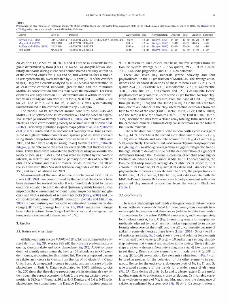
Table 1Percentages of clay minerals in Holocene sediments of the western Black Sea, estimated from downcore plots in the listed sources. Clay minerals are scaled to 100%. The Bayhan et al.(2005) gravity cores only sample the middle to late Holocene.
Source Core(s) Position Water depth Size Normalization Smectite Illite Chlorite Kaolinite
Bayhan et al. (2005) GBK12, GBK13 41.6125°N, 28.22167°E; 41.72000°N, 28.10333°E ~50 m b2 μm Biscaye (1965) 25–30 40–50 15–20 5–10Major et al. (2002) BLKS9810 44.0673°N, 30.8447°E 378 m b2 μm Biscaye (1965) 5–10 50–55 20–25 ~20Stoffers and Müller (1978) DSDP 380 42.0090°N, 29.6137°E 2107 m b2 μm Biscaye (1965) 20–30 50–60 ~10 ~10This paper MAR02-45 41.6862°N, 28.3180°E 69 m b2 μm Biscaye (1965) 10–25 50–70 5–10 5–20
17C.J. Lister et al. / Sedimentary Geology 316 (2015) 13–25
Zn, As, Sr, Y, La, Ce, Sm, Yb, Hf, Pb, Th, and U. For the six elements in thisgroup determined by INAA (Co, Cr, Fe, Na, Sc, La), analysis of two labo-ratory standards during client runs demonstrated accuracy within 5%of the certified values for Fe, Na and Sc, and within 8% for Co and Cr.Lawas systematically overestimated by ~1.5 ppm (~10% of the certifiedvalues). Only ten elements analysed by ICP-OES had a concentration, inat least three certified standards, greater than half the minimumMAR02-45 concentration and less than twice the maximum. For theseelements, accuracy based on 5–13 determinations is within 5% of certi-fied values for Mg and Mn, within 10% for Sr, Ni, K and Cu, within ~12%for Zn, and within ~20% for Pb, V and Y. Y was systematicallyunderestimated in the certified standards by ~3–8 ppm.
The pre-9.1 cal ka sediments around core sites MAR02-45 andMAR05-03 lie between the seismic marker α1 and the older transgres-sive surface (α unconformity of Aksu et al., 2002) on the southwesternBlack Sea shelf, corresponding closely to seismic unit 1B of Aksu et al.(2002). Previously published isopach maps (Aksu et al., 2002; Hiscottet al., 2007a), contoured inmilliseconds of two-way travel time asmea-sured in high-resolution boomer and sparker profiles, were checkedusing Huntec deep-towed boomer profiles from cruises in 2002 and2005, and then were analysed using ImageJ freeware (http://rsbweb.nih.gov/ij/) to determine the areas enclosed by different thickness con-tours. Travel times were converted to thicknesses using an acoustic ve-locity of 1500 m s−1. Measured areas were multiplied by the contourinterval, in metres, and reasonable porosity estimates of 60–70% toobtain the volume and mass of mineral solids in seismic unit 1B onthe southwestern Black Sea shelf between longitudes 28° 00′E and 28°35′E, and south of latitude 42° 20′N.
Measurements of the annual sediment discharges of local Turkishrivers (EIE, 1991) are compromised by the fact that these rivers havebeen dammed for several decades. It was therefore decided to use anempirical equation to estimate latest Quaternary yields before humanimpact on the environment. Without human impact or hinterland gla-ciers, and with a substrate of sedimentary rocks (Okay, 2008) and un-consolidated alluvium, the BQART equation (Syvitski and Milliman,2007) is based entirely on measured or estimated riverine water dis-charge (EIE, 1991), drainage basin area (EIE, 1991), maximum drainagebasin relief (captured from Google Earth® scenes), and average annualtemperature (estimated to have been ~15 °C).
3. Results
3.1. Texture and mineralogy
All lithologic units in coreMAR02-45 (Fig. 2A) are dominated by silt-sized detritus (Fig. 2B; average 88% silt) that consists predominantly ofquartz, K-mica, calcite and sodic plagioclase (Fig. 2C). JADE® softwaredoes not identify minor minerals, having b5% abundance in XRD pow-der mounts, accounting for this limited list. There is an upward declinein calcite, an increase in K-mica from the top of lithologic Unit C intoUnits B and A, an upward increase in quartz, and an increase of sodicplagioclase in Unit A. Data recalculated to 100% without calcite(Fig. 2D) show that the relative proportions of silicate minerals vary lit-tle through the cored succession. InUnit C, the average calcite-free com-position is 68.0± 4.1% quartz, 26.6± 4.4% K-mica, and 5.4± 0.4% sodicplagioclase. For comparison, the Danube Delta silt fraction contains
9.0 ± 0.8% calcite. On a calcite-free basis, the five samples from theDanube system average 59.7 ± 8.5% quartz, 29.7 ± 9.2% K-mica,7.3 ± 2.6% sodic plagioclase, and 3.3 ± 4.2% dolomite.
There are seven key minerals (three non-clay and fourphyllosilicate) in the b2 μm fraction of MAR02-45. The average abun-dances and standard deviations of these minerals are 12.2 ± 5.6%quartz, 26.4±16.7% calcite, 6.3± 3.0% dolomite, 12.7±10.4% smectite,36.0 ± 12.0% illite, 3.2 ± 2.8% chlorite, and 3.2 ± 3.7% kaolinite. Hence,phyllosilicates only comprise ~55% of the b2 μm fraction. Average clay-sized quartz abundance increases from the base of Unit C (10.9%)through Unit B (13.7%) and into Unit A (14.1%). As in the silt-sized frac-tion, calcite abundance in the clay-sized fraction decreases from thebase to the top of the core (Unit C, 34.9%; Unit B, 21.7%; Unit A, 10.0%)and the same is true for dolomite (Unit C, 7.5%; Unit B, 6.0%; Unit A,3.7%). Because the data form a closed array totaling 100%, increases inthe carbonate minerals automatically cause decreases in the total ofthe silicate minerals.
Illite is the dominant phyllosilicate mineral with a core average of67.1 ± 14.3%. Smectite is the second most abundant mineral (21.7 ±13.7%) while chlorite and kaolinite account for 5.8 ± 4.7% and 5.4 ±5.7%, respectively. Thewithin-unit variation in clay-mineral proportionsis high (Fig. 2E), so although average values suggest stratigraphic trends,the high standard deviations rule out the demonstration of significantdifferences through the Holocene succession, other than some higherkaolinite abundances in the more sandy Unit B. For comparison, theDanube delta-top samples average 45.8% illite, 25.0% smectite, 1.3%chlorite, 1.8% kaolinite, 13.8% quartz, 8.9% calcite and 3.4% dolomite. Ifphyllosilicate minerals are recalculated to 100%, the proportions are62.0% illite, 33.8% smectite, 1.8% chlorite, and 2.4% kaolinite. Both theMAR02-45 and Danube Delta results are broadly consistent with otherpublished clay mineral proportions from the western Black Sea(Table 1).
3.2. Geochemistry
To assess relationships and trends in the geochemical dataset, corre-lation coefficients were calculated for those twenty-four elements hav-ing acceptable precision and abundances (relative to detection limits).This was done for the entire MAR02-45 succession, and then separatelyfor lithologic units A, B and C (Fig. 3), omitting results for samples im-mediately adjacent to the α1 seismic marker (equivalent to an uncon-formity elsewhere on the shelf) and the α2 unconformity because ofspikes in some elements at these levels (Lister, 2014). Since the 24 ×24 matrices are large, Fig. 3 only shows rows and columns for elementswith at least one R value ≥ 0.8 or ≤ −0.8, indicating a strong relation-ship between that element and another in the matrix. These relation-ships are clearly shown in Venn-style diagrams (Fig. 4) like those usedin set theory. Rings encircle elements with moderate (|R| ≥ 0.8) tostrong (|R| ≥ 0.9) co-variation. Key elements (white font in Fig. 4) canbe used as proxies for the behaviour of the other elements in eachgroup. Hence, for the entire core, downcore plots of Ni, Zn, Th and Scgive a good summary of the trends for a wider range of elements(Fig. 5A). Considering all units, Sc, La and to a lesser extent Zn are usefulguiding elements to understand cross-correlations. Ca invariably corre-lates with one or more of Mg, Sr and Mn, and tracks the abundance ofcalcite, as confirmed by a cross-plot (Fig. 6) of (a) Ca concentration in
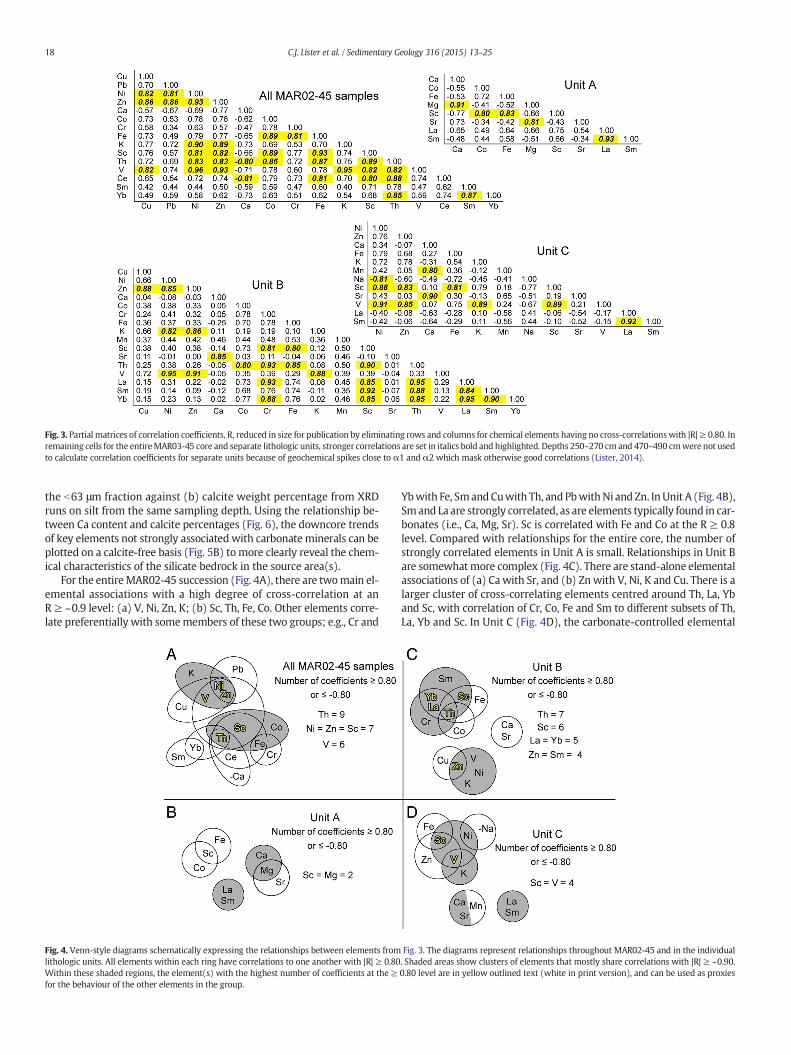
Fig. 3. Partial matrices of correlation coefficients, R, reduced in size for publication by eliminating rows and columns for chemical elements having no cross-correlationswith |R|≥ 0.80. Inremaining cells for the entireMAR03-45 core and separate lithologic units, stronger correlations are set in italics bold and highlighted. Depths 250–270 cmand 470–490 cmwere not usedto calculate correlation coefficients for separate units because of geochemical spikes close to α1 and α2 which mask otherwise good correlations (Lister, 2014).
18 C.J. Lister et al. / Sedimentary Geology 316 (2015) 13–25
the b63 μm fraction against (b) calcite weight percentage from XRDruns on silt from the same sampling depth. Using the relationship be-tween Ca content and calcite percentages (Fig. 6), the downcore trendsof key elements not strongly associated with carbonate minerals can beplotted on a calcite-free basis (Fig. 5B) to more clearly reveal the chem-ical characteristics of the silicate bedrock in the source area(s).
For the entireMAR02-45 succession (Fig. 4A), there are twomain el-emental associations with a high degree of cross-correlation at anR ≥ ~0.9 level: (a) V, Ni, Zn, K; (b) Sc, Th, Fe, Co. Other elements corre-late preferentially with somemembers of these two groups; e.g., Cr and
Fig. 4. Venn-style diagrams schematically expressing the relationships between elements fromlithologic units. All elements within each ring have correlations to one another with |R| ≥ 0.80Within these shaded regions, the element(s) with the highest number of coefficients at the ≥for the behaviour of the other elements in the group.
Ybwith Fe, SmandCuwith Th, and PbwithNi and Zn. InUnit A (Fig. 4B),Sm and La are strongly correlated, as are elements typically found in car-bonates (i.e., Ca, Mg, Sr). Sc is correlated with Fe and Co at the R ≥ 0.8level. Compared with relationships for the entire core, the number ofstrongly correlated elements in Unit A is small. Relationships in Unit Bare somewhatmore complex (Fig. 4C). There are stand-alone elementalassociations of (a) Ca with Sr, and (b) Zn with V, Ni, K and Cu. There is alarger cluster of cross-correlating elements centred around Th, La, Yband Sc, with correlation of Cr, Co, Fe and Sm to different subsets of Th,La, Yb and Sc. In Unit C (Fig. 4D), the carbonate-controlled elemental
Fig. 3. The diagrams represent relationships throughout MAR02-45 and in the individual. Shaded areas show clusters of elements that mostly share correlations with |R| ≥ ~0.90.0.80 level are in yellow outlined text (white in print version), and can be used as proxies
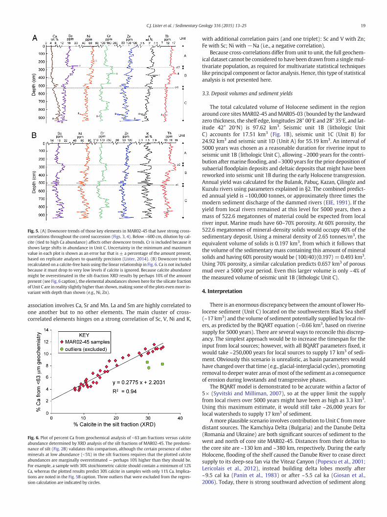
Fig. 5. (A) Downcore trends of those key elements in MAR02-45 that have strong cross-correlations throughout the cored succession (Figs. 3, 4). Below ~600 cm, dilution by cal-cite (tied to high Ca abundance) affects other downcore trends. Cr is included because itshows large shifts in abundance in Unit C. Uncertainty in the minimum and maximumvalue in each plot is shown as an error bar that is ± a percentage of the amount present,based on replicate analyses to quantify precision (Lister, 2014). (B) Downcore trendsrecalculated on a calcite-free basis using the linear relationship in Fig. 6. Ca is not includedbecause it must drop to very low levels if calcite is ignored. Because calcite abundancemight be overestimated in the silt-fraction XRD results by perhaps 10% of the amountpresent (see Fig. 6 caption), the elemental abundances shown here for the silicate fractionof Unit C are in reality slightly higher than shown,making some of the plots evenmore in-variant with depth than shown (e.g., Ni, Zn).
19C.J. Lister et al. / Sedimentary Geology 316 (2015) 13–25
association involves Ca, Sr and Mn. La and Sm are highly correlated toone another but to no other elements. The main cluster of cross-correlated elements hinges on a strong correlation of Sc, V, Ni and K,
Fig. 6. Plot of percent Ca from geochemical analysis of b63 μm fractions versus calciteabundance determined by XRD analysis of the silt fractions of MAR02-45. The predomi-nance of silt (Fig. 2B) validates this comparison, although the certain presence of otherminerals at low abundance (b5%) in the silt fractions requires that the plotted calciteabundances are marginally overestimated — perhaps 10% higher than they should be.For example, a sample with 30% stoichiometric calcite should contain a minimum of 12%Ca, whereas the plotted results predict 30% calcite in samples with only 11% Ca. Implica-tions are noted in the Fig. 5B caption. Three outliers that were excluded from the regres-sion calculation are indicated by circles.
with additional correlation pairs (and one triplet): Sc and V with Zn;Fe with Sc; Ni with −Na (i.e., a negative correlation).
Because cross-correlations differ from unit to unit, the full geochem-ical dataset cannot be considered to have been drawn froma singlemul-tivariate population, as required for multivariate statistical techniqueslike principal component or factor analysis. Hence, this type of statisticalanalysis is not presented here.
3.3. Deposit volumes and sediment yields
The total calculated volume of Holocene sediment in the regionaround core sites MAR02-45 andMAR05-03 (bounded by the landwardzero thickness, the shelf edge, longitudes 28° 00′E and 28° 35′E, and lat-itude 42° 20′N) is 97.62 km3. Seismic unit 1B (lithologic UnitC) accounts for 17.51 km3 (Fig. 1B), seismic unit 1C (Unit B) for24.92 km3 and seismic unit 1D (Unit A) for 55.19 km3. An interval of5000 years was chosen as a reasonable duration for riverine input toseismic unit 1B (lithologic Unit C), allowing ~2000 years for the contri-bution aftermarineflooding, and ~3000 years for the prior deposition ofsubaerial floodplain deposits and deltaic deposits that might have beenreworked into seismic unit 1B during the early Holocene transgression.Annual yield was calculated for the Bulanık, Pabuç, Kazan, Çilingöz andKuzulu rivers using parameters explained in §2. The combined predict-ed annual yield is ~100,000 tonnes, or approximately three times themodern sediment discharge of the dammed rivers (EIE, 1991). If theyield from local rivers remained at this level for 5000 years, then amass of 522.6 megatonnes of material could be expected from localriver input. Marine muds have 60–70% porosity. At 60% porosity, the522.6 megatonnes of mineral-density solids would occupy 40% of thesedimentary deposit. Using a mineral density of 2.65 tonnes/m3, theequivalent volume of solids is 0.197 km3, from which it follows thatthe volume of the sedimentary mass containing this amount of mineralsolids and having 60% porosity would be (100/40)(0.197)= 0.493 km3.Using 70% porosity, a similar calculation predicts 0.657 km3 of porousmud over a 5000 year period. Even this larger volume is only ~4% ofthe measured volume of seismic unit 1B (lithologic Unit C).
4. Interpretation
There is an enormous discrepancy between the amount of lower Ho-locene sediment (Unit C) located on the southwestern Black Sea shelf(~17 km3) and the volume of sediment potentially supplied by local riv-ers, as predicted by the BQART equation (~0.66 km3, based on riverinesupply for 5000 years). There are several ways to reconcile this discrep-ancy. The simplest approach would be to increase the timespan for theinput from local sources; however, with all BQART parameters fixed, itwould take ~250,000 years for local sources to supply 17 km3 of sedi-ment. Obviously this scenario is unrealistic, as basin parameters wouldhave changed over that time (e.g., glacial-interglacial cycles), promotingremoval to deeperwater areas ofmost of the sediment as a consequenceof erosion during lowstands and transgressive phases.
The BQART model is demonstrated to be accurate within a factor of5× (Syvitski and Milliman, 2007), so at the upper limit the supplyfrom local rivers over 5000 years might have been as high as 3.3 km3.Using this maximum estimate, it would still take ~26,000 years forlocal watersheds to supply 17 km3 of sediment.
Amore plausible scenario involves contribution to Unit C frommoredistant sources. The Kamchiya Delta (Bulgaria) and the Danube Delta(Romania and Ukraine) are both significant sources of sediment to thewest and north of core site MAR02-45. Distances from their deltas tothe core site are ~130 km and ~380 km, respectively. During the earlyHolocene, flooding of the shelf caused the Danube River to cease directsupply to its deep-sea fan via the Viteaz Canyon (Popescu et al., 2001;Lericolais et al., 2012), instead building delta lobes mostly after~9.5 cal ka (Panin et al., 1983) or after ~5.5 cal ka (Giosan et al.,2006). Today, there is strong southward advection of sediment along
20 C.J. Lister et al. / Sedimentary Geology 316 (2015) 13–25
the shelf from the Danube Delta to Bulgarian and Turkishwaters (Paninand Jipa, 2002), driven by longshore wind-driven currents and the geo-strophic Rim Current (Oğuz and Beşiktepe, 1999) which tracks alongthe upper slope and shelf edge, interacting with non-stationary eddiesnear the shelf break (Ginzburg et al., 2002; Yankovsky et al., 2014).
Sediment discharge rates for the Kamchiya River (Jaoshvili, 2002) in-dicate a possible contribution to the shelf setting of ~7.1 km3 of 70% po-rosity mud over 5000 years, a portion of which might have movedfarther southeastward along the shelf. There are other smaller riversalong the Bulgarian and Romanian coastline that might have addedsome of their sediment load to the longshore current system and thecounterclockwise-flowing Rim Current leading to the SW shelf(e.g., drainage into the Varna and Veleka estuaries and their adjacentshelf areas). In the vicinity of Cape Emine just downdrift of the KamchiyaDelta, the Holocene shelf succession reaches thicknesses of ~50 m(Dimitrov et al., 1998; Filipova-Marinova et al., 2004). This location isthe usual terminus of the present-day migration of mesoscale slopeeddies which entrain sediment from the Danube outflow (Ginzburget al., 2002), but under some circumstances the eddies and low salinitywater migrate further south, even beyond the Bosphorus Strait(Yankovsky et al., 2014). A significant contribution from river systemsin general is supported by the preponderance of terrestrial organic carbon(Hiscott et al., 2007a) and the considerable amount of coarse plant debris,pollen and fern spores in palynology samples fromUnit C in coreMAR02-45. In addition, Unit C has relative abundances of aquatic pollen taxa, algalspores, Pediastrum ceonobia, and fungal remains (Table 2) which charac-terize modern sediments of the Danube delta front and prodelta (Hiscottet al., 2007a; Frail-Gauthier and Mudie, 2014). Along-shelf advection ofsediment from major river deltas is able to provide significant materialover distances greater than those noted above, for example up to600–800 km from the mouths of Asian deltas (Liu et al., 2009).
During the latest Pleistocene lowstand of the Black Sea, the DanubeRiver emptied directly into the Viteaz Canyon, feeding all of itssuspended sediment to the Danube submarine fan (Winguth et al.,2000; Panin and Jipa, 2002; Popescu et al., 2004; Lericolais et al.,
Table 2Summary of selected environmental parameters, palynological remains (from Frail-Gauthier alimans, deltaic and shelf environments comparedwith results for lithologic Unit C in coresMARet al., 2010).
Coastal region
Environmentd Liman Estuary L L L D
Sample stationa Saskia Chilia2 StGeorghe
R02 R06 R21 9
Depositional water depth (m) 6 9 5 2.8 1.6 1.8 17.4Approximate distance fromland (km)
0 0 0 0 0 0 3
Surface salinity during deposition 2 2 2 1.8 2 2.04 5.5Kerogen typec L L L L L L+W APollen+spore (P+S) (% of total) 49.0 44.9 49.4 61.1 59.2 50.0 60.5
Aquatic (% of P+S) 30.0 10.8 10.2 20.4 8.0 17.4 12.1Fern+moss (% of P+S) 4.0 6.0 1.56 0 0.88 0 8.9Fungal (% of P+S) 10.9 49.7 64.1 12.8 11.6 22.6 36.3Number Glomus (soil fungus) 2 25 28 8 8 6 0
Algal spores (% of total) 15.0 5.0 8.1 4.9 9.3 6.5 2.4Number Pediastrum 0 0 1 5 14 1 1
Dinocysts (% of total) 1.8 0.5 0 1.4 0.8 1.3 6.8Ratio pollen:dinocysts 24.5 76.5 128 41.4 126.7 38.33 8.86
Microfauna (% of total) 25.5 11.2 10.8 17.7 23.8 27.2 3.5Insects (% of microfauna) 18.5 9.5 7.1 3.7 2.4 3.3 0Number Thecamoebians 1 7 3 0 0 0 1Number Bosmina (water flea) 0 6 3 12 19 6 0
Total palynomorphs 106 372 259 345 380 230 205
a Danube Delta locations from Frail-Gauthier and Mudie (2014) and bracketed in Fig. 1A; Sab Pre reconnection salinities from Mertens et al. (2012)c Kerogen types: L=leaf; A=amorphous; I=indeterminated Column abbreviations are L = Lagoon, D = Delta front, P = Prodelta, S = Shelf.
2012). The canyon heads in a water depth of −110 m and incises26 km into the shelf edge (Popescu et al., 2004), but the shelf is~140 km wide in this area, so with a sea-level rise to even the present−50 m bathymetric contour, the canyon would cease to capture theriver sediment discharge. Today, the outer shelf is starved of terrigenoussediment (Panin and Jipa, 2002). According to Major et al. (2002), thedecline in sediment supply to the slope adjacent to the upper DanubeFan occurred in two steps, at ~15 14C ka and ~8.4 14C ka (~9.1 cal ka).The more recent of these steps is associated with reconnection of theBlack Sea to the global ocean. Major et al. (2002) estimated the timeof the latest drop in accumulation rate by joining points on an age–depth curve for core BLKS9810, with the data points being uncalibratedconventional radiocarbon dates supplemented by an age of 8.4 14C kafor the Sr-isotopic shift to open-ocean values and an age of 7.16 14C kawidely accepted for the beginning of sapropel deposition in the deepbasin (Fig. 7A). Instead, the authors believe it is more reasonable touse calendar ages, and to extrapolate neighbouring straight-line seg-ments of approximately constant accumulation rate to a common inter-section point (Fig. 7B). This is justified because the decline in sedimentsupply (presumably caused by transgression across the shelf) mighthave occurred any time between 9.1 cal ka and the next oldest calibrat-ed date. This approach (Fig. 7B) predicts a significant sea-level rise andtransgression by ~10.8 cal ka. Of course there are uncertainties associat-ed with the original radiocarbon dates, marine reservoir ages, and cali-bration to calendar years. Nevertheless, the result is consistent with aswitch from predominant sediment delivery to the deep basin (via theViteaz Canyon) to sediment retention on the shelf by the onset of depo-sition of Unit C at core sites MAR02-45 and MAR05-3.
There are two other canyons in the northwestern Black Sea associat-edwith theDniester andDnieper rivers. TheDnieper (or Dnepr) Canyonheads in ~70 m of water (Gulin et al., 2013) and so also would haveceased its capture of most of the river detrital supply after transgressionto approximately the−50m bathymetric contour. Because the Danubedetrital load exceeds the Dniester and Dnieper loads by ~20–25 times(Panin and Jipa, 2002), the potential role of these more distant systems
nd Mudie, 2014), and the dominant kerogen type(s) found in modern coastal freshwater02-45 andMAR05-50 (PJMpreviously unpublished data gathered usingmethods inMudie
Lithologic unit C
D D P P P P S S S MAR02-45 MAR05-50
10 16 8 7 15 18 6 5 1 6 sampleaverage
8.3 mbsf
20.7 24.3 33.6 45.7 49.7 33.1 54.8 65.1 58.5 40–50 60–704 13 15 35 26 28 50 65 68 18 25
5.7 7.6 10.4 13.6 7.6 16.6 15.5 16.5 16.1 14–15b 14–15b
A A A A A+W A W W W+I I I50.0 60.9 43.7 32.8 41.1 58.8 26.5 34.8 25.0 87.0 52.514.4 2.6 4.3 4.2 5.5 5.3 5.9 2.6 3.2 6.6 15.49.6 1.3 5.2 3.4 0 0 0.9 5.3 0 6.0 11.960.2 19.2 10.4 4.2 11.5 6.4 12.8 1.4 25.8 18.4 15.60 1 3 0 1 1 0 0 11 10 66.0 4.4 9.5 4.9 7.8 9.5 9.1 7.9 6.8 2.9 9.30 1 0 0 1 1 0 0 0 4 51.8 10.4 34.6 58.1 41.2 13.3 61.9 48 48.4 6.2 4.48.3 5.7 1.26 0.57 0.9 4.4 0.43 0.71 0.48 6.19 12.16.4 10.2 7.6 2.8 9.8 13.2 6.3 6.4 8.5 10.7 16.80 0 5 0 8.3 0 3.6 4.8 4.8 1.9 11.10 0 6 3 3 0 0 1 1 0.5 0.00 0 0 0 1 0 0 0 0 0.5 2166 248 263 362 486 158 441 327 248 241 160
skia Liman is in western Ukraine.
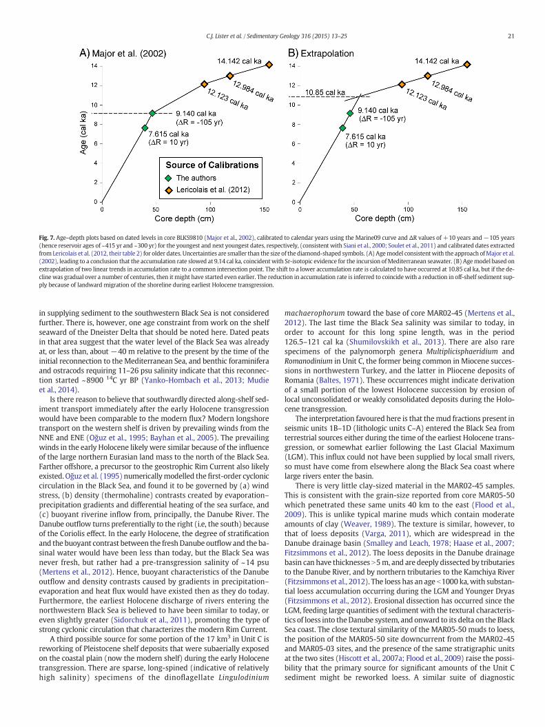
Fig. 7. Age–depth plots based on dated levels in core BLKS9810 (Major et al., 2002), calibrated to calendar years using the Marine09 curve and ΔR values of +10 years and−105 years(hence reservoir ages of ~415 yr and ~300 yr) for the youngest and next youngest dates, respectively, (consistent with Siani et al., 2000; Soulet et al., 2011) and calibrated dates extractedfrom Lericolais et al. (2012, their table 2) for older dates. Uncertainties are smaller than the size of the diamond-shaped symbols. (A) Agemodel consistentwith the approach ofMajor et al.(2002), leading to a conclusion that the accumulation rate slowed at 9.14 cal ka, coincidentwith Sr-isotopic evidence for the incursion ofMediterranean seawater. (B) Agemodel based onextrapolation of two linear trends in accumulation rate to a common intersection point. The shift to a lower accumulation rate is calculated to have occurred at 10.85 cal ka, but if the de-cline was gradual over a number of centuries, then itmight have started even earlier. The reduction in accumulation rate is inferred to coincidewith a reduction in off-shelf sediment sup-ply because of landward migration of the shoreline during earliest Holocene transgression.
21C.J. Lister et al. / Sedimentary Geology 316 (2015) 13–25
in supplying sediment to the southwestern Black Sea is not consideredfurther. There is, however, one age constraint from work on the shelfseaward of the Dneister Delta that should be noted here. Dated peatsin that area suggest that the water level of the Black Sea was alreadyat, or less than, about −40 m relative to the present by the time of theinitial reconnection to the Mediterranean Sea, and benthic foraminiferaand ostracods requiring 11–26 psu salinity indicate that this reconnec-tion started ~8900 14C yr BP (Yanko-Hombach et al., 2013; Mudieet al., 2014).
Is there reason to believe that southwardly directed along-shelf sed-iment transport immediately after the early Holocene transgressionwould have been comparable to the modern flux? Modern longshoretransport on the western shelf is driven by prevailing winds from theNNE and ENE (Oğuz et al., 1995; Bayhan et al., 2005). The prevailingwinds in the early Holocene likely were similar because of the influenceof the large northern Eurasian land mass to the north of the Black Sea.Farther offshore, a precursor to the geostrophic Rim Current also likelyexisted. Oğuz et al. (1995) numericallymodelled thefirst-order cycloniccirculation in the Black Sea, and found it to be governed by (a) windstress, (b) density (thermohaline) contrasts created by evaporation–precipitation gradients and differential heating of the sea surface, and(c) buoyant riverine inflow from, principally, the Danube River. TheDanube outflow turns preferentially to the right (i.e, the south) becauseof the Coriolis effect. In the early Holocene, the degree of stratificationand the buoyant contrast between the freshDanube outflowand the ba-sinal water would have been less than today, but the Black Sea wasnever fresh, but rather had a pre-transgression salinity of ~14 psu(Mertens et al., 2012). Hence, buoyant characteristics of the Danubeoutflow and density contrasts caused by gradients in precipitation–evaporation and heat flux would have existed then as they do today.Furthermore, the earliest Holocene discharge of rivers entering thenorthwestern Black Sea is believed to have been similar to today, oreven slightly greater (Sidorchuk et al., 2011), promoting the type ofstrong cyclonic circulation that characterizes the modern Rim Current.
A third possible source for some portion of the 17 km3 in Unit C isreworking of Pleistocene shelf deposits that were subaerially exposedon the coastal plain (now the modern shelf) during the early Holocenetransgression. There are sparse, long-spined (indicative of relativelyhigh salinity) specimens of the dinoflagellate Lingulodinium
machaerophorum toward the base of core MAR02-45 (Mertens et al.,2012). The last time the Black Sea salinity was similar to today, inorder to account for this long spine length, was in the period126.5–121 cal ka (Shumilovskikh et al., 2013). There are also rarespecimens of the palynomorph genera Multiplicisphaeridium andRomanodinium in Unit C, the former being common in Miocene succes-sions in northwestern Turkey, and the latter in Pliocene deposits ofRomania (Baltes, 1971). These occurrences might indicate derivationof a small portion of the lowest Holocene succession by erosion oflocal unconsolidated or weakly consolidated deposits during the Holo-cene transgression.
The interpretation favoured here is that themud fractions present inseismic units 1B–1D (lithologic units C–A) entered the Black Sea fromterrestrial sources either during the time of the earliest Holocene trans-gression, or somewhat earlier following the Last Glacial Maximum(LGM). This influx could not have been supplied by local small rivers,so must have come from elsewhere along the Black Sea coast wherelarge rivers enter the basin.
There is very little clay-sized material in the MAR02-45 samples.This is consistent with the grain-size reported from core MAR05-50which penetrated these same units 40 km to the east (Flood et al.,2009). This is unlike typical marine muds which contain moderateamounts of clay (Weaver, 1989). The texture is similar, however, tothat of loess deposits (Varga, 2011), which are widespread in theDanube drainage basin (Smalley and Leach, 1978; Haase et al., 2007;Fitzsimmons et al., 2012). The loess deposits in the Danube drainagebasin can have thicknesses N5m, and are deeply dissected by tributariesto the Danube River, and by northern tributaries to the Kamchiya River(Fitzsimmons et al., 2012). The loess has an age b1000 ka, with substan-tial loess accumulation occurring during the LGM and Younger Dryas(Fitzsimmons et al., 2012). Erosional dissection has occurred since theLGM, feeding large quantities of sediment with the textural characteris-tics of loess into theDanube system, and onward to its delta on the BlackSea coast. The close textural similarity of the MAR05-50 muds to loess,the position of the MAR05-50 site downcurrent from the MAR02-45and MAR05-03 sites, and the presence of the same stratigraphic unitsat the two sites (Hiscott et al., 2007a; Flood et al., 2009) raise the possi-bility that the primary source for significant amounts of the Unit Csediment might be reworked loess. A similar suite of diagnostic
22 C.J. Lister et al. / Sedimentary Geology 316 (2015) 13–25
palynomorphs indicative of fluvial transport also characterize the Unit Csediments of MAR05-50; in addition, there are common remains ofCladocera (water fleas, e.g. Bosmina) which today dominate in acoastal lagoon Lake Razim, south of the Danube Delta. However, inmodern samples from the Danube Delta front and prodelta, the dino-flagellate percentages typical of Unit C are only found in the deltafront samples with surface salinity below 10 psu (Table 2).
Mineralogy of the silt fraction does not point to particular sourceareas, or to a changing provenance since the latest Pleistocene to earlyHolocene transgression began. There is an ~6% decrease in quartz andan increase in K-mica content (~5%) upwards through the core, butthe large standard deviations for these components prevent a conclu-sive statement about changing provenance. The XRD results for clay-sized fractions also do not implicate a single dominant source. Thereare a few relatively clay-rich samples (N20% clay) in Units B and C(4.30, 6.20, 7.00, 7.70 and 8.90mbsf). In Unit C, only the 8.90mbsf sam-ple showsmineral abundances different from the unit average. Smectiteis 2.5 times more abundant in this sample, at the expense of the non-clay minerals (quartz, calcite and dolomite). The increase in smectiteand chlorite content suggest igneous and metamorphic sources forthese muds. Local rivers along the coast of Thrace are likely sources forsmectite based on the presence of mafic igneous and meta-igneousrocks (e.g., amphibolite) in the hinterland (Bayhan et al., 2005;Natal'in et al., 2012; Bedi et al., 2013).
The only case for which unit averages and their standard deviationsfor clay-sized components do not overlap is an upcore increase in illiteabundance. The illite/smectite ratio has been proposed as a tracer forsource areas in the Black Sea (Hay, 1987), with a Danube ratio of ~5and ratios ~1 or less from Anatolian sources. The illite/smectite ratiofor the five Danube samples analysed for this paper is 1.83. The averageratio for MAR02-45 samples is 2.85, and for Unit C is 2.46. These ratiosare interpreted to rule out Anatolia as a source; however, there is insuf-ficient data on the mineralogy of clay-sized detritus from northernThrace to exclude some supply from local rivers near the MAR02-45site. Although a single source cannot be identified with the data avail-able, neither is there evidence for a change in provenance from~10.3 cal ka to the present.
The provenance implications of the silt- and clay-sized calcite andmore minor dolomite remain uncertain. Five standard smear slideswere prepared from b62 μm fractions at 140, 460, 710, 810 and 910 cmcomposite depths in core MAR02-45 (Fig. 2A). In the two deepest sam-ples, a few strongly recrystallized juvenile planktonic foraminifera arepresent, but otherwise all of the calcite in the five samples consists of an-gular, clear monocrystalline particles with no biogenic textures or fabrics.In the uppermost smear slide from Unit A, no coccoliths could be foundeven though Emiliania huxleyi migrated into the Black Sea at ~2.7 cal ka(Jones and Gagnon, 1994). There is a striking similarity between the oc-currence of silt-sized calcite described here and the silt-sized calcite de-scribed by Major et al. (2002) from cores collected on the Romanianslope outboard of the Danube Delta, except that they describe the calciteas euhedral crystals. Major et al. (2002) indicate an abundance of N60%silt-sized calcite in sediment with an age of ~11–9.1 cal ka.
There are no calcareous algae (e.g., Charaphycean algae) or indige-nous calcareous dinoflagellates living in the modern Black Sea thatmight account for 10–30% calcite in the MAR02-45 succession. Plank-tonic foraminifera do not live in the Black Sea today, and were lastpresent as juvenile immigrants during the Eemian (Marine IsotopicStage 5e; Quan et al., 2013). As argued above for rare, long-spined spec-imens of Lingulodinium machaerophorum, the planktonic foraminferasuggest minor recycling of older Pleistocene detritus into the basalpart of Unit C. It is hypothesized that the calcite and minor dolomitemight be detritus from carbonate bedrock or from calcareous loess inriverwatersheds, which can contain asmuch as 40% carbonate – both cal-cite and dolomite – with the calcite formed mainly by pedogenetic pro-cesses (Smalley and Leach, 1978; Újvári et al., 2010). Major et al. (2002)interpreted silt-sized calcite of essentially the same age as an inorganic
precipitate formed under evaporative conditions during the early Holo-cene. The absence of euhedral crystals in the MAR02-45 smear slidesdoes not support this type of interpretation for sediments on the south-western shelf, and the evidence presented in this paper for an early Holo-cene transgression is inconsistent with evaporative conditions. If thecalcite and dolomite were eroded from carbonate rocks, these likely didnot include the Eocene–Oligocene limestones of northern Thrace becausethey are highly fossiliferous (Varol et al., 2009) and detritus would cer-tainly include recognizable fossil fragments.
Within each lithologic unit, strongly cross-correlated chemicalelements can serve as proxies for one another. Sc and Fe are correlatedat the R ≥ 0.80 level in all units, presumably because Sc, Fe (and Al) arepresent in clay minerals and other phyllosilicates (Das et al., 1971). Be-yond the shelf edge, it has been shown that Co, Ce, La, Th and Y tend toreside in detrital aluminosilicates (Dean and Arthur, 2011). In theMAR02-45 samples, Unit B in particular shows a strong association offour of these five elements with Sc and Fe. Hence, Sc, Fe, Co, Ce, La, Thand Y are considered to have a detrital origin. Ce is included in this listbecause for the entire core it is closely correlated with Sc, Th and Fe.Sm is closely tied to La in Units A and C, so is believed to have a detritalorigin.
V, Ni, Zn and Cu tend to be concentrated in organic-rich Black Sea sed-iments (Kıratlı and Ergin, 1996; Dean andArthur, 2011), either because ofbiogenicfixationor adsorption under reducing conditions in the sediment(i.e., earliest diagenesis). However, in some circumstances V andNi can betied to the detrital supply (Dean and Arthur, 2011). Unit B in particularshows a strong cross-correlation of these elements, and K. In Unit C, V,Ni and Zn are correlated with one another, but also with Sc, Fe and K.The partial mingling of elements which are commonly found in detritalcomponents (i.e., Sc, Fe, K, Th) with those known to accumulate frompore water and on organic components is interpreted to indicate adsorp-tion onto fine-grained phyllosilicates during early diagenesis. Hence, it isbelieved that V, Ni, Zn, Cu and probably Pb cannot be used to track chang-es in the nature of detrital supply (i.e., provenance). Instead, they areviewed as elements incorporated from seawater and pore water duringearly diagenesis.
A prominent feature of Unit C is elevated Cr values from 8.0–7.0 mbsf(~9.4 cal ka) that do not correlatewith peaks in other elements. Cr is gen-erally attributed to the weathering of mafic or ultramafic source rocks(Kıratlı and Ergin, 1996). This sample depth range is associated withsandy horizons in core MAR02-45 (Fig. 2A). Samples were taken toavoid the sandy layers, but it is possible that bioturbation had introducedCr into adjacent muds. The sandy horizons have been interpreted as tur-bidites or tempestites sourced from the nearby coast or rivers in flood(Hiscott et al., 2007a), and the contrast between the chemistry of thesemud samples and other parts of Unit C might indicate sediment supplyfrom more than one provenance, one local (i.e., the event beds), andone more distant.
There is a caveat to any geochemical comparison of core samples tomodern detritus from potential source areas. Modern and near-surfacegrab samples are prone to contamination from industrial pollution andagricultural runoff. Cu, Ni, Zn, and As values are known to be influencedby anthropogenic input (Dinescu and Duliu, 2001; Oreščanin et al.,2005). Fe, Co,Mg,Mn and Cr are potentiallymore reliable source indica-tors, but even these elements can be industrial pollutants in floodplainsoils and surficial marine sediments. Modern palynological samples ofmicroplankton in the outer Danube Delta and offshore may sufferfrom the same anthropogenic bias but the characteristics of the refrac-tive particulate matter (kerogen) are more robust and typify all largefluvio-deltaic systems (e.g. Yanko-Hombach et al., 2013).
Based on information in the literature and results presented in thispaper, it does not seem possible to track the source(s) of Fe, Co, Cu, Sr,Ni, Mg, and Pb. The exception is perhaps Cr, because of its expected der-ivation frommafic rocks and their presence in the Strandja Massif (syn-onym= Istranca Massif) of northern Thrace (Natal'in et al., 2012; Bediet al., 2013).
23C.J. Lister et al. / Sedimentary Geology 316 (2015) 13–25
5. Discussion
The geochemistry and mineralogy of Black Sea sediments are exam-ined in many publications (Hirst, 1974; Stoffers and Müller, 1978;Trimonis and Ross, 1978; Hay, 1987; Kıratlı and Ergin, 1996; Majoret al., 2002; Bayhan et al., 2005; Dean and Arthur, 2011; Piper andCalvert, 2011), but published work has emphasized the anoxic portionsof the basin and previously did not extend into the earliest, pre-reconnection transgressive deposits on the shelf. Before the last transgres-sion, the Black Seawas not an anoxic basin (Deuser, 1974) so processes ofmetal transport and fixationwere different than today. Thewater columnon the modern shelf is oxygenated, although sulphate reduction in sur-face muds depletes the pore-water oxygen in Unit A (Hiscott et al.,2007a).
The primary aim of this paper has been to assess whether the prov-enance of the fine fractions (silt and clay) of the Holocene sediments onthe southwestern Black Sea shelf might have changed since the earliestHolocene. Hiscott et al. (2007a) have claimed that themiddle part of thesouthwestern shelf was fully open and connected to the deep Black Seabasin, and hence regional sediment sources, since ~10.3 cal ka, whereasRyan et al. (2003) and Lericolais et al. (2007) maintain that the centralBlack Sea had a level below the modern shelf edge until ~9.1 cal ka sothat earliest Holocene mud deposits on the southwestern shelf wouldhave had to accumulate in a perched coastal lake.
Neither geochemistry nor XRD mineralogy require a different sedi-ment provenance before and after the ~9.1 cal ka reconnection betweenthe Black Sea and theMediterranean Sea. Although some detritus in theoldest Unit C appears to have come from nearby coastal areas (e.g., Cr-enriched muds associated with very fine sand and coarse silt eventbeds) or transgressive reworking of the shelf at the α unconformity(e.g., exotic dinoflagellate cysts and rare planktonic foraminifera), thevolume of sediment in seismic unit 1B (equivalent to lithologic UnitC) far exceeds the expected yield of local drainage basins even whensummed over a 5000 year interval. Holocene muds of equal or greaterthickness along parts of the Bulgarian coast (Dimitrov et al., 1998)than those surrounding core sites MAR02-45 and MAR05-03, the coun-terclockwise track of the Rim Current around the margins of the BlackSea (Oğuz and Beşiktepe, 1999; Flood et al., 2009), and the southwarddirection of longshore currents (Panin and Jipa, 2002) are consistentwith the hypothesis that the southwestern shelf was open to the mainBlack Sea basin since the onset of deposition of Unit C andwas receivinga significant supply of sediment from large rivers like the Danube andKamchiya to the northwest. The silt-dominated texture of the muds atsites MAR02-45, MAR05-03 and MAR05-50 (Flood et al., 2009) raisesthe possibility that the thick, now extensively dissected loess blanketin the Danube drainage basin (Smalley and Leach, 1978; Haase et al.,2007; Fitzsimmons et al., 2012) might account for a strong flux of siltinto the western and southwestern Black Sea during the Holocene.Other authors (Ross and Degens, 1974; Bahr et al., 2005; Piper andCalvert, 2011) have noted a dramatic ~10-fold decrease in sediment de-livery from the Danube system to the deep portions of the Black Seaafter the last transgression, with the river load instead being advectedalongshore (Piper and Calvert, 2011).
New palynological data from the Danube Delta and limans in thenorthwestern Black Sea (Frail-Gauthier and Mudie, 2014) additionallyshow that the presence of brackish water dinoflagellate cysts, as inUnit C on the southwestern shelf, is characteristic of mixed fluvial andmarine waters like those seaward of the modern delta, as opposed toliman environments where only freshwater dinocysts occur (Table 2).A perched coastal lake would have similar fauna and flora to the fresh-water limans of today, distinctly different to the fossil remains found inUnit C. Transport of Pediastrum, bisaccate pollen and fern spores downriver systems, into the marine environment, and then long distancesfrom the points of fluvial input is a well-known phenomenon (Yanko-Hombach et al., 2013) that easily explains the presence of these compo-nents in Unit C at the MAR02-45 core site. Our palynological data are
generally consistent with the paleome (genetic marker) data ofCoolen et al. (2013, their Unit C1 in a core from the Danube Deltaslope at−971m rmsl) but indicate a greater amount of terrigenousma-terial on the shelf at site MAR02-45 than at the deep water site of thoseauthors.
Potentially surprising features of the clay mineralogy are fluctua-tions by a factor of ~2–3× in smectite abundance throughout coreMAR02-45, one major spike in smectite abundance in Unit C, andsome large swings in kaolinite abundance in Unit B (Fig. 2E). If thebulk of the mud was derived from distant sources, as hypothesized,then why would the composition not be more uniform? There are afew possible explanations. First, the b2 μm fraction is actually quitesmall (Fig. 2B) and, on average, ~45% of that size fraction is quartz andcarbonate minerals, so that a minor additional amount of one clay min-eral can rapidly skew the proportions of the other three clays. This couldbe the case for smectite, since it has been argued that sandy and siltyevent beds in Unit C likely were derived from coastal Thrace wheresmectite is likely more prevalent than in northern sources, based onthe presence of mafic igneous and meta-igneous rocks in Thrace(Natal'in et al., 2012; Bedi et al., 2013). Secondly, it is well known thatthere is a grain-size influence on claymineral content, so that higher rel-ative amounts of kaolinite in Unit Bmight simply reflect the coarser tex-ture at this level (Fig. 2B, E), since kaolinite crystallites tend to be largerthan those of other clay minerals (Gibbs, 1977). Thirdly, it is to be ex-pected that floods in one drainage basin (e.g., Kamchiya River) orheavy rainfall or spring melt in one tributary of the Danube Rivercould introduce a pulse of sediment having a composition somewhatdifferent to the core average. Alternative, storms might introducesmall but variable amounts of material from local sources to modifythe bulk clay mineral composition. Finally, all clay mineral analysesare to some extent semi-quantitative. Downcore plots in the studieslisted in Table 1 show sample-to-sample fluctuations similar to thosein Fig. 2E. Some of this variability must be ascribed to slight inaccuraciesand imprecision inherent in the XRD method, and must be taken intoaccount during interpretation of the data.
6. Conclusions
There are three strong arguments for an unimpeded connection of atransgressed southwestern shelf to the open Black Sea since at least10.3 cal ka and perhaps as early as ~12 cal ka.
1) There is a serious discrepancy between the volume (ormass) of sed-iment available from local small rivers of northwestern Turkey andthe actual amount of sediment forming seismic unit 1B (=lithologicUnit C). For sources outside the immediate area to have contributeda majority of the sediment, the southwestern shelf would need tohave been accessible to major currents capable of advecting sedi-ment from larger rivers, and to significantwind fetches to periodical-ly redistribute sediment from coastal areas and the transgressiveunconformity, α.
2) There is a lack of significant mineralogical variation from the earlyHolocene to the present day in core MAR02-45, which implies thatthe predominant highstand sources today, the Danube River andperhaps the Kamchiya River, were delivering detritus to the coresite since at least 10.3 cal ka.
3) Sc, Fe, Co, Ce, La, Th and Y, interpreted to represent the contributionof aluminosilicates from a terrestrial source, show no significantupcore variation that might suggest a switch from local to regionalsources at the time of reconnection of the Black Sea to the worldocean. Instead, continuity in the composition of the detrital supplyis indicated.
These points do not rule out a contribution to Unit C from north-western Turkey (i.e., Thrace). However, this contribution appears tohave been small. It is largely masked by a more voluminous regionalsupply, but is inferred from Cr peaks associated with storm events
24 C.J. Lister et al. / Sedimentary Geology 316 (2015) 13–25
that affected coastal areas, from a small number of reworked olderpalynomorphs and planktonic foraminifera that were derived eitherfrom coastal erosion or transgressive reworking of the formerly exposedshelf, and from fluctuations in smectite content.
Other researchers have questioned the persistence of a lowBlack Sealevel until ~9.1 cal ka as advocated by Ryan et al. (2003), Ryan (2007)and others. This paper adds weight to the view that the Black Sea roseby increased riverine inflow centuries to millennia before the initiationof water exchange with the Mediterranean Sea through the BosphorusStrait. The consequences of a much earlier rise in water level must beconsidered by archeologists concerned with human adaptation in theregion, paleoceanographers investigating the development of basin-wide anoxia, paleoclimatologists wishing to explain increased early Ho-locene precipitation over watersheds leading to the Black Sea basin andthe impact of basin-wide anoxia on global carbon budgets, and re-searchers working in the Marmara and Aegean seas, which mighthave experienced earlier Black Sea outflow than previously thought.
Acknowledgments
The authors thank the officers, crew and scientific staff of the R/VKoca Piri Reis for their assistance in data acquisition. Lister thanksMemorial University of Newfoundland for the award of a graduatefellowship. Aksu, Hiscott and Mudie acknowledge research grants(RGPIN42760, RGPIN6088, and RGPIN55408, respectively) and ship-time grants (RGPIN228436, RGPIN250825 and RGPIN313115) fromthe Natural Sciences and Engineering Research Council of Canada(NSERC). H. Gillespie and W. Aylward are thanked for assistance withsediment preparation, palynology processing, magnetic susceptibilitymeasurements and XRD analysis. Drs. G. Oaie and D. Jipa (Romania)are thanked for providing five surficial sediment samples from the Dan-ube Delta; Prof. Valentina Yanko-Hombach (Ukraine) kindly providedDanube prodelta samples for palynology studies. Colleague Dr. JoeMacquaker first alerted the authors to the possibility that erosion ofcentral European loess might account for the predominance of silt onthe SW Black Sea shelf.
References
ActLabs, 2010. 2010 Canadian schedule of services and fees. http://www.actlabs.com (p.1–32).
Aksu, A.E., Hiscott, R.N., Yaşar, D., Işler, F.I., Marsh, S., 2002. Seismic stratigraphy of LateQuaternary deposits from the southwestern Black Sea shelf: evidence fornoncatastrophic variations in sea-level during the last 10,000 Years. Marine Geology190, 61–94.
Bahr, A., Lamy, F., Arz, H., Kuhlmann, H., Wefer, G., 2005. Late Glacial to Holocene climateand sedimentation history in the NW Black Sea. Marine Geology 214, 309–322.
Ballard, R.D., Coleman, D.F., Rosenberg, G.D., 2000. Further evidence of abrupt Holocenedrowning of the Black Sea shelf. Marine Geology 170, 253–261.
Baltes, N., 1971. Pliocene dinoflagellata and acritarcha in Romania. In: Farinacci, A. (Ed.),Proceedings of the 2nd Planktonic Conference, Rome, 1970. Edizioni Tecnoscienza,Rome, Italy, pp. 1–16 (plates 1–5).
Bayhan, E., Ergin, M., Temel, A., Keskin, S., 2005. Mineralogy of Holocene sediments fromthe southwestern Black Sea shelf (Turkey) in relation to arovenance, sea-level andcurrent regimes. Journal of the Geological Society of China 79, 552–563.
Bedi, Y., Vasilev, E., Dabovski, C., Ergen, A., Okuyucu, C., Doğan, A., Tekin, K., Ivanova, D.,Boncheva, I., Lakova, I., Sachanski, V., Kuşçu, I., Tuncay, E., Demiray, G.D., Soycan, H.,Göncüoğlu, M., 2013. New age data from tectonostratigraphic units of the Istranca“Massif” in NW Turkey: a correlation with SE Bulgaria. Geologica Carpathia 64,255–277.
Biscaye, P.E., 1964. Distinction between kaolinite and chlorite in recent sediments.American Mineralogist 49, 1282–1289.
Biscaye, P.E., 1965. Mineralogy and sedimentation of recent deep-sea clay in the AtlanticOcean and adjacent seas and oceans. Geological Society of America Bulletin 76,803–832.
Carozza, J.-M., Micu, C., Mihail, F., Carozza, L., 2012. Landscape change and archaeologicalsettlements in the lower Danube valley and delta from early Neolithic to Chalcolithictime: a review. Quaternary International 261, 21–31.
Coolen, M.J.L., Orsi, W.D., Balkema, C., Quince, C., Harris, K., Sylva, S.P., Filipova-Marinov,M., Giosan, L., 2013. Evolution of the plankton paleome in the Black Sea from thedeglacial to anthropocene. Proceedings of the National Academy of Science 110,8609–8614.
Das, H.A., Zonderhuis, J., van der Marel, H.W., 1971. Scandium in rocks, minerals and sed-iments and its relation to iron and aluminum. Contributions to Mineralogy and Pe-trology 32, 213–244.
Dean, W.E., Arthur, M.A., 2011. Geochemical characteristics of Holocene laminatedsapropel (Unit II) and underlying lacustrine Unit III in the Black Sea. United StatesGeological Survey Open-File Report 2010-1323, pp. 1–29.
Deuser, W.G., 1974. Evolution of anoxic conditions in Black Sea during Holocene. In:Degens, E.T., Ross, D.A. (Eds.), The Black Sea — Geology, Chemistry, and Biology.American Association of Petroleum Geologists Memoir 20, pp. 133–136.
Dimitrov, P., Michova, E., Peytchev, V., 1998. Palaeoecological reconstructions of westernpart of the Black Sea during the Quaternary. Proceedings of the Institute of Oceanol-ogy 2, 127–139 (in Bulgarian with English summary).
Dinescu, L.C., Duliu, O.G., 2001. Heavy metal pollution of some Danube Delta sedi-ments studied by neutron activation analysis. Applied Radiation and Isotopes54, 853–859.
EIE, 1991. Water Year Discharges, Elektrik İşleri Etüd İdaresi Genel Müdürlüğü. Ankara,Turkey.
Evans, J.M., 2004. Noah's Flood: fact or fiction? A palaeoenvironmental study of HoloceneBlack Sea ostracoda. M.Sc. Micropalaeontology project report. University College,London, UK.
Filipova-Marinova, M., Christova, R., Bozilova, E., 2004. Palaeoecological conditions in theBulgarian Black Sea area during the Quaternary. Environmental Micropaleontology,Microbiology and Meiobenthology 1, 136–154.
Fitzsimmons, K.E., Marković, S.B., Hambach, U., 2012. Pleistocene environmental dynam-ics recorded in the loess of the middle and lower Danube basin. Quaternary ScienceReviews 41, 104–118.
Flood, R.D., Hiscott, R.N., Aksu, A.E., 2009. Morphology and evolution of an anastomosedchannel network where saline underflow enters the Black Sea. Sedimentology 56,807–839.
Frail-Gauthier, J., Mudie, P.J., 2014. Laboratorymesocosms and geological studies formon-itoring wetlands diversity. Proceedings of the 2nd Annual Conference on Water Re-sources and Wetlands, Tulcea (Romania) Sept. 11–13, 2014, pp. 391–403.
Gibbs, R.J., 1965. Error due to segregation in quantitative clay mineral X-ray diffractionmounting techniques. American Mineralogist 50, 741–751.
Gibbs, R.J., 1977. Clay mineral segregation in the marine environment. Journal of Sedi-mentary Petrology 42, 237–243.
Ginzburg, A.I., Kostianoy, A.G., Nezlin, N.P., Soloviev, D.M., Stanichny, S.V., 2002. Anticy-clonic eddies in the northwestern Black Sea. Journal of Marine Systems 32, 91–106.
Giosan, L., Donnelly, J.P., Constantinescu, S., Filip, F., Ovejanu, I., Vespremeanu-Stroe, A.,Vespremeanu, E., Duller, G.A.T., 2006. Young Danube delta documents stable BlackSea level since the middle Holocene: morphodynamic, paleogeographic, and archae-ological implications. Geology 34, 757–760.
Giosan, L., Filip, F., Constationescu, S., 2009. Was the Black Sea catastrophically flooded inthe Early Holocene? Quaternary Science Reviews 28, 1–6.
Gulin, S.B., Artemov, Y.G., Egorov, V.N., Evtushenko, D.B., 2013. The Dnepr Canyon: evi-dence for a continuous submarine channel link between the outer shelf and thedeep-sea basin of the northwestern Black Sea. Geo-Marine Letters 33, 319–324.
Haase, D., Fink, J., Haase, G., Ruske, R., Pécsi, M., Richter, H., Altermann, M., Jäger, K.-D.,2007. Loess in Europe — its spatial distribution based on a European loess map,scale 1:2,500,000. Quaternary Science Reviews 26, 1301–1312.
Hay, B.J., 1987. Particle Flux in thewestern Black Sea in the Present and over the last 5,000years: temporal variability, sources, transport mechanisms. Ph.D. Thesis Cornell Uni-versity, Ithaca, NY.
Hirst, D.M., 1974. Geochemistry of sediments from eleven Black Sea cores. In: Degens, E.T.,Ross, D.A. (Eds.), The Black Sea — Geology, Chemistry, and Biology. American Associ-ation of Petroleum Geologists Memoir 20, pp. 430–455.
Hiscott, R.N., Aksu, A.E., 2002. Late Quaternary history of the Marmara Sea and Black Seafrom high-resolution seismic and gravity-core studies. Marine Geology 190, 261–282.
Hiscott, R.N., Aksu, A.E., Mudie, P.J., Marret, F., Abrajano, T., Kaminski, M.A., Evans, J.,Çakıroğlu, A.I., Yaşar, D., 2007a. A gradual drowning of the southwestern Black Seashelf: evidence for a progressive rather than abrupt Holocene reconnection withthe eastern Mediterranean Sea through the Marmara Sea Gateway. Quaternary Inter-national 167–168, 19–34.
Hiscott, R.N., Aksu, A.E., Mudie, P.J., Kaminski, M., Abrajano, T., Yaşar, D., Rochon, A.,2007b. The Marmara Sea Gateway since ~16 ka: non-catastrophic causes ofpaleoceanographic events in the Black Sea at 8.4 ka and 7.15 ka. In: Yanko-Hombach, V., Gilbert, A.S., Panin, N., Dolukhanov, P.M. (Eds.), The Black Sea FloodQuestion: Changes in Coastline, Climate and Human Settlement. Springer, Dordrecht,pp. 89–117.
Hiscott, R.N., Aksu, A.E., Mudie, P.J., Marret, F., Abrajano, T., Kaminski, M.A., Evans, J.,Çakıroğlu, A.I., Yaşar, D., 2010. Corrigendum to “A gradual drowning of the south-western Black Sea shelf: evidence for a progressive rather than abrupt Holocene re-connection with the eastern Mediterranean Sea through the Marmara SeaGateway” [Quaternary International, 167–168 (2007) 19–34]. Quaternary Interna-tional 226, 160.
Jaoshvili, S., 2002. Rivers of the Black Sea. European Environment Agency Technical Re-port 71.
Jones, G.A., Gagnon, A.R., 1994. Radiocarbon chronology of Black Sea sediments. Deep-SeaResearch Part I 41, 531–557.
Kıratlı, N., Ergin, M., 1996. Partitioning of heavymetals in the surface Black Sea sediments.Applied Geochemistry 11, 775–788.
Lericolais, G., Popescu, I., Guichard, F., Popescu, S.M., 2007. A Black Sea lowstand at8500 yr B.P. indicated by a relict coastal dune system at a depth of 90 m below sealevel. In: Harff, J., Hay, W.W., Tetzlaff, D.M. (Eds.), Coastline Changes: Interrelationof Climate and Geological ProcessesGeological Society of America Special Paper.426. Allen Press Inc., pp. 171–188.
25C.J. Lister et al. / Sedimentary Geology 316 (2015) 13–25
Lericolais, G., Bourget, J., Popescu, I., Jermannaud, P., Mulder, T., Jorry, S., Panin, N., 2012.Late Quaternary deep-sea sedimentation in the western Black Sea: new insightsfrom recent coring and seismic data in the deep basin. Global and Planetary Change103, 232–247.
Lister, C.J., 2014. Compositional trends through the Holocene mud succession of thesouthwestern Black Sea shelf, and implications for sedimentary provenance andwater-level history. M.Sc. Thesis Memorial University of Newfoundland, St. John's,Canada.
Liu, J.P., Xue, Z., Ross, K., Wang, H.J., Yang, Z.S., Li, A.C., Gao, S., 2009. Fate of sediments de-livered to the sea by Asian large rivers: long-distance transport and formation of re-mote alongshore clinothems. The Sedimentary Record 7 (4), 4–9.
Major, C., Ryan, W., Lericolais, G., Hajdas, I., 2002. Constraints on Black Sea outflow to theSea of Marmara during the last glacial–interglacial transition. Marine Geology 190,19–34.
Marret, F., Mudie, P., Aksu, A., Hiscott, R.N., 2009. A Holocene dinocyst record of a two-step transformation of the Neoeuxinian brackish water lake into the Black Sea. Qua-ternary International 193, 72–86.
Mertens, K.N., Bradley, L.R., Takano, Y., Mudie, P.J., Marret, F., Aksu, A.E., Hiscott, R.N.,Verleye, T.J., Mousing, E.A., Smyrnova, L.L., Bagheri, S., Mansor, M., Pospelova, V.,Matsuoka, K., 2012. Quantitative estimation of Holocene surface salinity variation inthe Black Sea using dinoflagellate cyst process length. Quaternary Science Reviews39, 45–59.
Mudie, P.J., Marret, F., Rochon, A., Aksu, A.E., 2010. Non-pollen palynomorphs in the BlackSea corridor. Vegetation History and Archaeobotany 19, 531–544.
Mudie, P.J., Yanko-Hombach, V., Kadurin, S., 2014. The Black Sea dating game and Holo-cene marine transgression. Open Journal of Marine Science 4, 1–7.
Natal'in, B., Sunal, G., Satir, M., Toraman, E., 2012. Tectonics of the Strandja Massif, NWTurkey: history of a long-lived arc at the northern margin of Paleo-Tethys. TurkishJournal of Earth Sciences 21, 755–798.
Nicholas, W.A., Chivas, A.R., Murray-Wallace, C.V., Fink, D., 2011. Prompt transgressionand gradual salinisation by amino acid racemization and radiocarbon dating. Quater-nary Science Reviews 30, 3769–3790.
Oğuz, T., Beşiktepe, Ş., 1999. Observations on the Rim Current structure, CIW formationand transport in the western Black Sea. Deep-Sea Research I I-46, 1733–1753.
Oğuz, T., Malanotte-Rizzoli, P., Aubrey, D., 1995. Wind and thermohaline circulation of theBlack Sea driven by yearly mean climatological forcing. Journal of Geophysical Re-search 100, 6845–6863.
Okay, A., 2008. Geology of Turkey: a synopsis. Anschnitt 21, 19–42.Okay, N., Okay, A.I., 2002. Tectonically induced Quaternary drainage diversion in the
northeastern Aegean. Journal of the Geological Society, London 159, 393–399.Oreščanin, V., Lulić, S., Medunić, G., Mikelić, L., 2005. Granulometric and chemical compo-
sition of the Danube River sediments, Batina Village, Croatia. Geologica Croatica 58,185–194.
Özsoy, E., Latif, M.A., Tuğrul, S., Ünlülata, Ü., 1995. Exchanges with the Mediterranean,fluxes and boundary mixing processes in the Black Sea. In: Briand, F. (Ed.), Mediter-ranean Tributary Seas. Bulletin de l'Institut Océanographique, CIESME Science Series1, pp. 1–25.
Panin, N., Jipa, D., 2002. Danube River sediment input and its interaction with the north-western Black Sea. Estuarine, Coastal and Shelf Science 54, 551–562.
Panin, N., Panin, S., Herz, N., Noakes, J.E., 1983. Radiocarbon dating of Danube delta de-posits. Quaternary Research 19, 249–255.
Pérez-Arrieta, L., Tabares-Muñoz, C., 2002. Considerations about the variability of theBragg's law fulfillment. Revista Mexicana de Fisica 50, 96–98.
Petschick, R., 2000. MacDiff 4.2.2 freeware and manual. http://www.geol-pal.uni-frankfurt.de/Staff/Homepages/Petschick/classicsoftware.html (accessed 19/08/2014).
Piper, D.Z., Calvert, S.E., 2011. Holocene and Late Glacial palaeoceanography andpalaeolimnology of the Black Sea: changing sediment provenance and basin hydrog-raphy over the past 20,000 years. Geochimica et Cosmochimica Acta 75, 5597–5624.
Popescu, I., Lericolais, G., Panin, N., Wong, H.K., Droz, L., 2001. Late Quaternary channelavulsions on the Danube deep-sea fan, Black Sea. Marine Geology 179, 25–37.
Popescu, I., Lericolais, G., Panin, N., Normand, A., Dinu, C., Le Drezen, E., 2004. The Danubesubmarine canyon (Black Sea): morphology and sedimentary processes. Marine Ge-ology 206, 249–265.
Quakernaat, J., 1970. Direct diffractometric quantitative analysis of synthetic clay mineralmixtures with molybdenite as orientation-indicator. Journal of Sedimentary Research40, 506–513.
Quan, T.M., Wright, J.D., Falkowski, P.G., 2013. Co-variation of nitrogen isotopes and redoxstates through glacial–interglacial cycles in the Black Sea. Geochimica etCosmochimica Acta 112, 305–320.
Reynolds, R., 2012. Correlation of two sediment cores recovered from the SW Black Seashelf using carbon and sulfur elemental and isotopic geochemistry: implications forpaleoceanographic communication between the Black Sea and eastern Mediterra-nean Sea during the last 12,000 years. Honours B.Sc. Thesis Memorial University ofNewfoundland, St. John's, Canada.
Riedinger, N., Brunner, B., Lin, Y.-S., Voßmeyer, A., Ferdelman, T.G., Jørgensen, B.B., 2010.Methane at the sediment–water transition in Black Sea sediments. Chemical Geology274, 29–37.
Ross, D.A., Degens, E.T., 1974. Recent Sediments of Black Sea. In: Degens, E.T., Ross, D.A.(Eds.), The Black Sea— Geology, Chemistry, and Biology. American Association of Pe-troleum Geologists Memoir 20, pp. 183–199.
Royse Jr., C.F., Wadell, J.S., Petersen, L.E., 1971. X-ray determination of calcite–dolomite:an evaluation. Journal of Sedimentary Petrology 41, 483–488.
Ryan, W.B.F., 2007. Status of the Black Sea flood hypothesis. In: Yanko-Hombach, V.,Gilbert, A.S., Panin, N., Dolukhanov, P.M. (Eds.), The Black Sea Flood Question: Chang-es in Coastline, Climate and Human Settlement. Springer, Dordrecht, pp. 63–88.
Ryan, W.B.F., Pitman III, W.C., 1999. Noah's Flood: the New Scientific Discoveries AboutEvents That Changed History. Simon and Schuster, New York.
Ryan, W.B.F., Pitman III, W.C., Major, C.O., Shimkus, K., Moskalenko, V., Jones, J.A.,Dimitrov, P., Görür, N., Sakınç, M., Yüce, H., 1997. An abrupt drowning of Black SeaShelf. Marine Geology 138, 119–126.
Ryan, W.B.F., Major, C.O., Lericolais, G., Goldstein, S., 2003. Catastrophic flooding of theBlack Sea. Annual Review of Earth and Planetary Sciences 31, 525–554.
Ryan, W.B.F., Carbotte, S.M., Coplan, J.O., O'Hara, S., Melkonian, A., Arko, R., Weissel, R.A.,Ferrini, V., Goodwillie, A., Nitsche, F., Bonczkowski, J., Zemsky, R., 2009. Globalmulti-resolution topography synthesis. Geochemistry, Geophysics, Geosystems 10,Q03014. http://dx.doi.org/10.1029/2008GC002332.
Shuisky, Y.D., 1982. Limans and liman coasts. In: Schwartz, M. (Ed.), Encyclopedia ofBeaches and Coastal Environments, Vol. 15 of the Encyclopedia of Earth Sciences.Hutchinson Ross Publishing Co, Stroudsburg, Pennsylvania, pp. 516–518.
Shumilovskikh, L.S., Marret, F., Fleitmann, D., Arz, H.W., Nowaczyk, N., Behling, H., 2013.Eemian and Holocene sea-surface conditions in the southern Black Sea: organic-walled dinoflagellate cyst record from Core 22-GC3. Marine Micropaleontology 101,146–160.
Siani, G., Paterne, M., Arnold, M., Bard, E., Métivier, B., Tisnerat, N., Bassinot, F., 2000. Ra-diocarbon reservoir ages in the Mediterranean Sea and Black Sea. Radiocarbon 42,271–280.
Sidorchuk, A.Yu., Panin, A.V., Borisova, O.K., 2011. Surface runoff to the Black Sea from theEast European Plain during Last Glacial Maximum–Late Glacial time. In: Buynevich,I.V., Yanko-Hombach, V., Gilbert, A.S., Martin, R.E. (Eds.), Geology andGeoarchaeology of the Black Sea Region: Beyond the Flood Hypothesis. Geological So-ciety of America, Special Paper 473, pp. 1–25.
Smalley, I.J., Leach, J.A., 1978. The origin and distribution of the loess in the Danube basinand associated regions of east-central Europe: a review. Sedimentary Geology 21,1–26.
Soulet, G., Ménot, G., Garreta, V., Rostek, F., Zaragosi, S., Lericolais, G., Bard, E., 2011. BlackSea ‘lake’ reservoir age evolution since the Last Glacial — hydrologic and climatic im-plications. Earth and Planetary Science Letters 308, 245–258.
Stoffers, P., Müller, G., 1978. Mineralogy and lithofacies of Black Sea sediments. Initial Re-ports of the Deep Sea Drilling Project 42, Part 2. U.S. Government Printing Office,Washington, pp. 373–411.
Syvitski, J.P.M., Milliman, J.D., 2007. Geology, geography and humans battle for domi-nance over the delivery of fluvial sediment to the coastal ocean. Journal of Geology115, 1–19.
Trimonis, E.S., Ross, D.A., 1978. Mineral composition of coarse-silt fraction of the Black SeaLate Cenozoic sediments. Initial Reports of the Deep Sea Drilling Project 42, Part 2.U.S. Government Printing Office, Washington, pp. 413–426.
Újvári, G., Kovács, J., Varga, G., Raucsik, B., Marković, S., 2010. Dust flux estimates for thelast glacial period in east central Europe based on terrestrial records of loess deposits:a review. Quaternary Science Reviews 29, 3157–3166.
Underwood, M.B., Basu, N., Steurer, J., Udas, S., 2003. Normalization factors for semiquan-titative X-ray diffraction analysis, with application to DSDP Site 297, Shikoku Basin.Data report. In: Mikada, H., Moore, G.F., Taira, A., Becker, K., Moore, J.C., Klaus, A.(Eds.), Proceedings of the Ocean Drilling Program, Scientific Results 190/196, pp.1–28.
Varga, G., 2011. Similarities among the Plio–Pleistocene terrestrial aeolian dust depositsin the world and in Hungary. Quaternary International 234, 98–108.
Varol, B., Baykal, M., Ayyıldız, T., 2009. Sedimentological–stratigraphical evaluation of Ter-tiary carbonates (Sogucak Formation) of Thrace Basin (Bozcaada – Kıyıköy). MineralResource Exploration Bulletin 139, 1–15.
Weaver, C.E., 1989. Clays, Muds, and Shales. Developments in Sedimentology 44. Elsevier,Amsterdam.
Winguth, C., Wong, H.K., Panin, N., Dinu, C., Georgescu, P., Ungureanu, G., Krugliakov, V.V.,Podshuveit, V., 2000. Upper Quaternary water level history and sedimentation in thenorthwestern Black Sea. Marine Geology 167, 127–146.
Yanko-Hombach, V., 2007. Controversy over Noah's Flood in the Black Sea: geological andforaminiferal evidence from the shelf. In: Yanko-Hombach, V., Gilbert, A.S., Panin, N.,Dolukhanov, P.M. (Eds.), The Black Sea Flood Question: Changes in Coastline, Climateand Human Settlement. Springer, Dordrecht, pp. 149–203.
Yanko-Hombach, V., Mudie, P.J., Kadurin, S., Larchenkov, E., 2013. Holocene marine trans-gression in the Black Sea: new evidence from the northwestern Black Sea shelf. Qua-ternary International 345, 100–118.
Yankovsky, A.E., Lemeshko, E.M., Ilyin, Y.P., 2014. The influence of shelfbreak forcing onthe alongshelf penetration of the Danube buoyant water, Black sea. ContinentalShelf Research 24, 1083–1098.
Top Related
Copyright © 2022 FDOKUMEN

