


Bahasa
Halaman
Hukum


UNDER DIBRUGARH UNIVERSITY
BA/Sc. GEOGRAPHY SYLLABUS
(HONORS COURSE)
SYLLABUS FOR BA/B.Sc. IN GEOGRAPHY HONORS
COURSE
(UNDER CBCS SYSTEM)
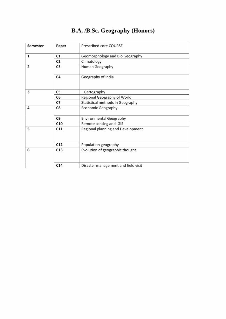
B.A. /B.Sc. Geography (Honors)
Semester Paper Prescribed core COURSE
1 C1 Geomorphology and Bio Geography
C2 Climatology
2 C3 Human Geography
C4 Geography of India
3 C5 Cartography
C6 Regional Geography of World
C7 Statistical methods in Geography
4 C8 Economic Geography
C9 Environmental Geography
C10 Remote sensing and GIS
5 C11 Regional planning and Development
C12 Population geography
6 C13 Evolution of geographic thought
C14 Disaster management and field visit
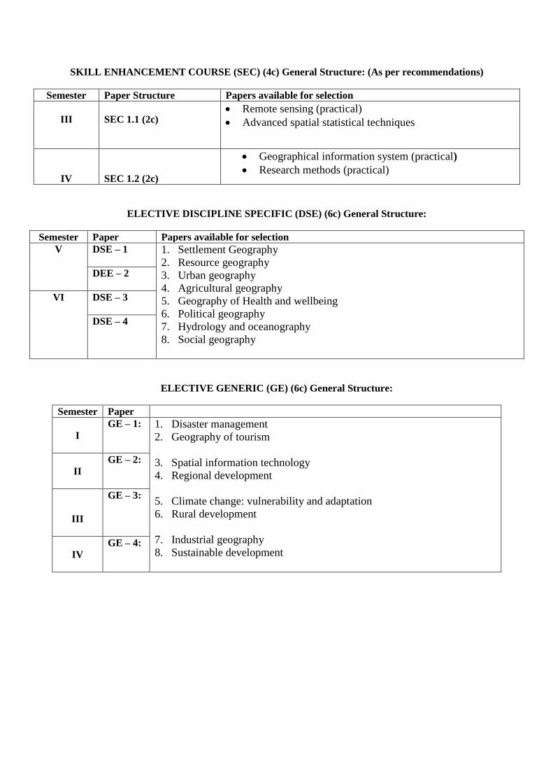
SKILL ENHANCEMENT COURSE (SEC) (4c) General Structure: (As per recommendations)
Semester Paper Structure Papers available for selection
III
SEC 1.1 (2c) Remote sensing (practical)
Advanced spatial statistical techniques
IV
SEC 1.2 (2c)
Geographical information system (practical)
Research methods (practical)
ELECTIVE DISCIPLINE SPECIFIC (DSE) (6c) General Structure:
Semester Paper Papers available for selection
V DSE – 1
1. Settlement Geography
2. Resource geography
3. Urban geography
4. Agricultural geography
5. Geography of Health and wellbeing
6. Political geography
7. Hydrology and oceanography
8. Social geography
DEE – 2
VI DSE – 3
DSE – 4
ELECTIVE GENERIC (GE) (6c) General Structure:
Semester Paper
I
GE – 1:
1. Disaster management
2. Geography of tourism
3. Spatial information technology
4. Regional development
5. Climate change: vulnerability and adaptation
6. Rural development
7. Industrial geography
8. Sustainable development
II
GE – 2:
III
GE – 3:
IV
GE – 4:
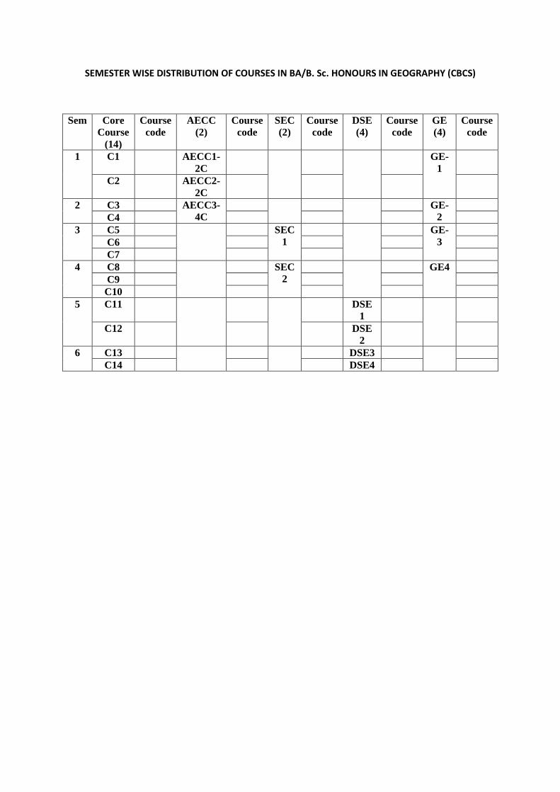
SEMESTER WISE DISTRIBUTION OF COURSES IN BA/B. Sc. HONOURS IN GEOGRAPHY (CBCS)
Sem Core
Course
(14)
Course
code
AECC
(2)
Course
code
SEC
(2)
Course
code
DSE
(4)
Course
code
GE
(4)
Course
code
1 C1 AECC1-
2C
GE-
1
C2 AECC2-
2C
2 C3 AECC3-
4C
GE-
2
C4
3 C5 SEC
1
GE-
3
C6
C7
4 C8 SEC
2
GE4
C9
C10
5 C11 DSE
1
C12 DSE
2
6 C13 DSE3
C14 DSE4
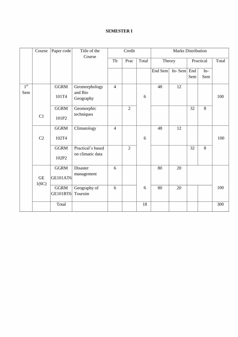
SEMESTER I
Course Paper code Title of the
Course
Credit Marks Distribution
Th Prac Total Theory Practical Total
End Sem In- Sem End
Sem
In-
Sem
1st
Sem
C1
GGRM
101T4
Geomorphology
and Bio
Geography
4
6
48 12
100
GGRM
101P2
Geomorphic
techniques
2 32 8
C2
GGRM
102T4
Climatology 4
6
48 12
100
GGRM
102P2
Practical’s based
on climatic data
2 32 8
GE
1(6C)
GGRM
GE101AT6
Disaster
management
6
6
80 20
100 GGRM
GE101BT6
Geography of
Toursim
6 80 20
Total 18 300
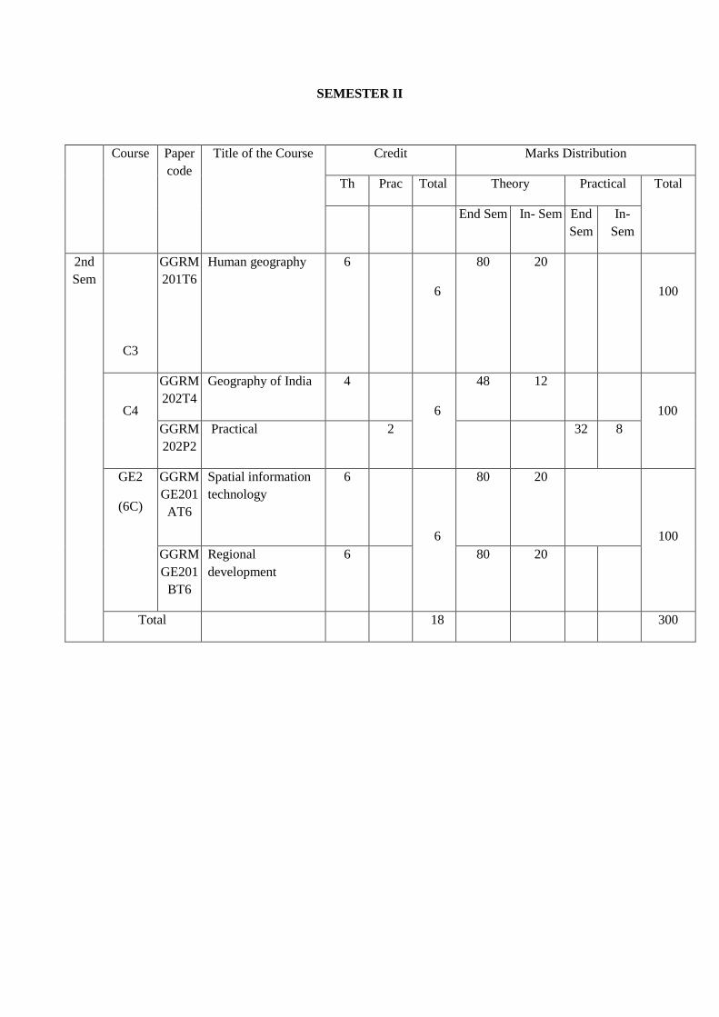
SEMESTER II
Course Paper
code
Title of the Course Credit Marks Distribution
Th Prac Total Theory Practical Total
End Sem In- Sem End
Sem
In-
Sem
2nd
Sem
C3
GGRM
201T6
Human geography 6
6
80 20
100
C4
GGRM
202T4
Geography of India 4
6
48 12
100
GGRM
202P2
Practical 2 32 8
GE2
(6C)
GGRM
GE201
AT6
Spatial information
technology
6
6
80 20
100
GGRM
GE201
BT6
Regional
development
6 80 20
Total 18 300
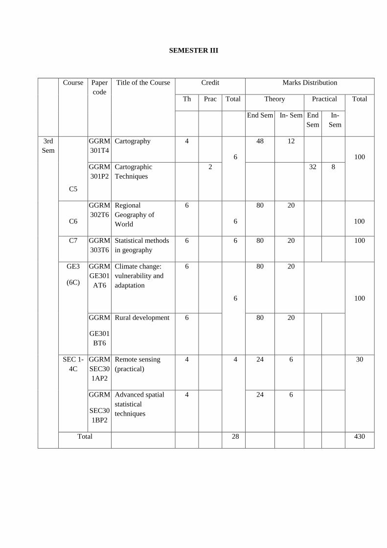
SEMESTER III
Course Paper
code
Title of the Course Credit Marks Distribution
Th Prac Total Theory Practical Total
End Sem In- Sem End
Sem
In-
Sem
3rd
Sem
C5
GGRM
301T4
Cartography 4
6
48 12
100
GGRM
301P2
Cartographic
Techniques
2 32 8
C6
GGRM
302T6
Regional
Geography of
World
6
6
80 20
100
C7 GGRM
303T6
Statistical methods
in geography
6 6 80 20 100
GE3
(6C)
GGRM
GE301
AT6
Climate change:
vulnerability and
adaptation
6
6
80 20
100
GGRM
GE301
BT6
Rural development 6 80 20
SEC 1-
4C
GGRM
SEC30
1AP2
Remote sensing
(practical)
4 4
24 6 30
GGRM
SEC30
1BP2
Advanced spatial
statistical
techniques
4 24 6
Total 28 430
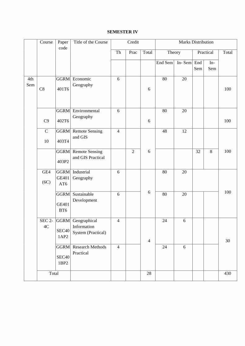
SEMESTER IV
Course Paper
code
Title of the Course Credit Marks Distribution
Th Prac Total Theory Practical Total
End Sem In- Sem End
Sem
In-
Sem
4th
Sem
C8
GGRM
401T6
Economic
Geography
6
6
80 20
100
C9
GGRM
402T6
Environmental
Geography
6
6
80 20
100
C
10
GGRM
403T4
Remote Sensing
and GIS
4
6
48 12
100 GGRM
403P2
Remote Sensing
and GIS Practical
2 32 8
GE4
(6C)
GGRM
GE401
AT6
Industrial
Geography
6
6
80 20
100
GGRM
GE401
BT6
Sustainable
Development
6 80 20
SEC 2-
4C
GGRM
SEC40
1AP2
Geographical
Information
System (Practical)
4
4
24 6
30
GGRM
SEC40
1BP2
Research Methods
Practical
4 24 6
Total 28 430
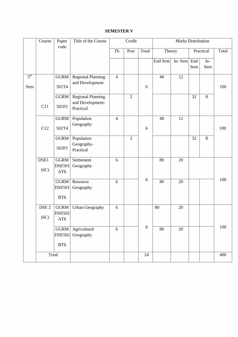
SEMESTER V
Course Paper
code
Title of the Course Credit Marks Distribution
Th Prac Total Theory Practical Total
End Sem In- Sem End
Sem
In-
Sem
5th
Sem
C11
GGRM
501T4
Regional Planning
and Development
4
6
48 12
100
GGRM
501P2
Regional Planning
and Development-
Practical
2 32 8
C12
GGRM
502T4
Population
Geography
4
6
48 12
100
GGRM
502P2
Population
Geography-
Practical
2 32 8
DSE1
(6C)
GGRM
DSE501
AT6
Settlement
Geography
6
6
80 20
100
GGRM
DSE501
BT6
Resource
Geography
6 80 20
DSE 2
(6C)
GGRM
DSE502
AT6
Urban Geography 6
6
80 20
100
GGRM
DSE502
BT6
Agricultural
Geography
6 80 20
Total 24 400
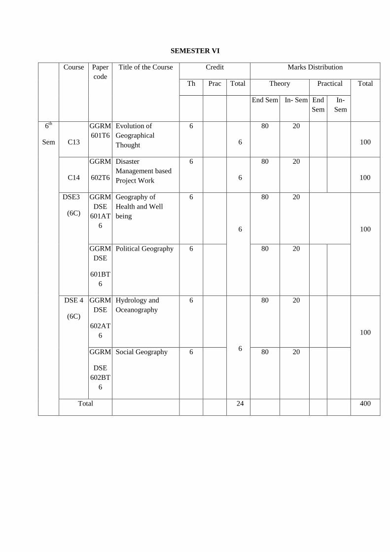
SEMESTER VI
Course Paper
code
Title of the Course Credit Marks Distribution
Th Prac Total Theory Practical Total
End Sem In- Sem End
Sem
In-
Sem
6th
Sem
C13
GGRM
601T6
Evolution of
Geographical
Thought
6
6
80 20
100
C14
GGRM
602T6
Disaster
Management based
Project Work
6
6
80 20
100
DSE3
(6C)
GGRM
DSE
601AT
6
Geography of
Health and Well
being
6
6
80 20
100
GGRM
DSE
601BT
6
Political Geography 6 80 20
DSE 4
(6C)
GGRM
DSE
602AT
6
Hydrology and
Oceanography
6
6
80 20
100
GGRM
DSE
602BT
6
Social Geography 6 80 20
Total 24 400
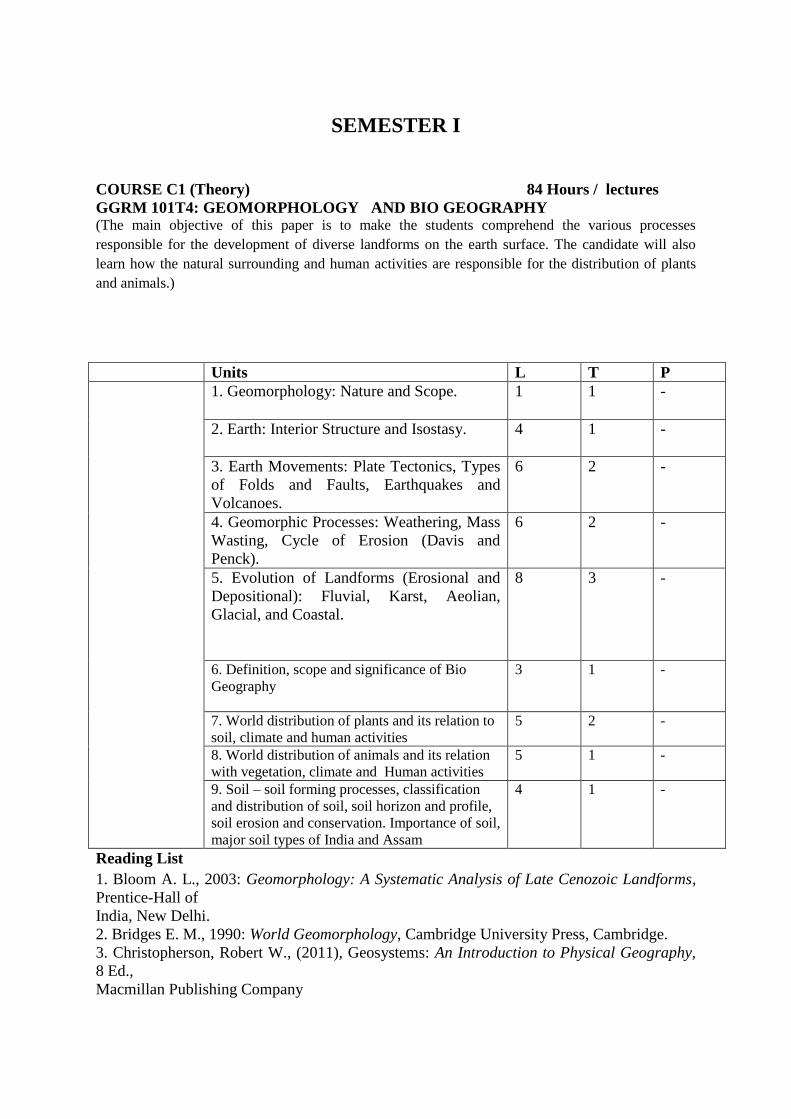
SEMESTER I
COURSE C1 (Theory) 84 Hours / lectures
GGRM 101T4: GEOMORPHOLOGY AND BIO GEOGRAPHY (The main objective of this paper is to make the students comprehend the various processes
responsible for the development of diverse landforms on the earth surface. The candidate will also
learn how the natural surrounding and human activities are responsible for the distribution of plants
and animals.)
Units L T P
1. Geomorphology: Nature and Scope.
1 1 -
2. Earth: Interior Structure and Isostasy.
4 1 -
3. Earth Movements: Plate Tectonics, Types
of Folds and Faults, Earthquakes and
Volcanoes.
6 2 -
4. Geomorphic Processes: Weathering, Mass
Wasting, Cycle of Erosion (Davis and
Penck).
6 2 -
5. Evolution of Landforms (Erosional and
Depositional): Fluvial, Karst, Aeolian,
Glacial, and Coastal.
8 3 -
6. Definition, scope and significance of Bio
Geography
3 1 -
7. World distribution of plants and its relation to
soil, climate and human activities
5 2 -
8. World distribution of animals and its relation
with vegetation, climate and Human activities
5 1 -
9. Soil – soil forming processes, classification
and distribution of soil, soil horizon and profile,
soil erosion and conservation. Importance of soil,
major soil types of India and Assam
4 1 -
Reading List
1. Bloom A. L., 2003: Geomorphology: A Systematic Analysis of Late Cenozoic Landforms,
Prentice-Hall of
India, New Delhi.
2. Bridges E. M., 1990: World Geomorphology, Cambridge University Press, Cambridge.
3. Christopherson, Robert W., (2011), Geosystems: An Introduction to Physical Geography,
8 Ed.,
Macmillan Publishing Company

4. Kale V. S. and Gupta A., 2001: Introduction to Geomorphology, Orient Longman,
Hyderabad.
5. Knighton A. D., 1984: Fluvial Forms and Processes, Edward Arnold Publishers, London.
6. Richards K. S., 1982: Rivers: Form and Processes in Alluvial Channels, Methuen, London.
7. Selby, M.J., (2005), Earth’s Changing Surface, Indian Edition, OUP
8. Skinner, Brian J. and Stephen C. Porter (2000), The Dynamic Earth: An Introduction to
physical Geology,
4th Edition, John Wiley and Sons
9. Thornbury W. D., 1968: Principles of Geomorphology, Wiley.
10.Gautam, A (2010): Bhautik Bhugol, Rastogi Punlications, Meerut
11. Tikkaa, R N (1989): Bhautik Bhugol ka Swaroop, Kedarnath Ram Nath, Meerut
12. Singh, S (2009):Bhautik Bhugol ka Swaroop, Prayag Pustak,Allahabad
13. Bhattacharyya, N.N. : Biogeography
14. Mahanta, A. P. : Biogeography
Course C1
GGRM 101P2: GEOMORPHIC TECHNIQUES (PRACTICAL) 28 Hours
(The main objective of this paper is to make the students understand the various morphometric
techniques used in drainage analysis. The students will also about the various slope analysis
techniques and uses of different types of scale.)
Title Contents L T P
Geomorphic
Techniques
1. Cartography – Nature and Scope. 2 - 1
2. Scales – Concept and application;
Graphical Construction of Plain, Comparative
and Diagonal
Scales.
3 - 2
3.Topographical Map – Interpretation of a
Mountain area with the help of Cross and
Longitudinal Profiles.
3 - 4
4.Morphometric Analysis: Drainage ordering,
basin area demarcation, drainage density,
Bifurcation ratio.
3 - 4
5. Slope Analysis – Wentworth’s method and
Smith’s Method.
2 - 4
Practical Record: A Project File in pencil, comprising one exercise each, on scale, map
projection, interpretation of topographic sheet and slope analysis.
Reading List
1. Anson R. and Ormelling F. J., 1994: International Cartographic Association:
BasicCartographic Vol. Pregmen Press.
2. Gupta K.K. and Tyagi, V. C., 1992: Working with Map, Survey of India, DST, New Delhi.
3. Mishra R.P. and Ramesh, A., 1989: Fundamentals of Cartography, Concept, New Delhi.
4. Monkhouse F. J. and Wilkinson H. R., 1973: Maps and Diagrams, Methuen, London.
5. Rhind D. W. and Taylor D. R. F., (eds.), 1989: Cartography: Past, Present and Future,
Elsevier, International Cartographic Association.
6. Robinson A. H., 2009: Elements of Cartography, John Wiley and Sons, New York.
7. Sharma J. P., 2010: Prayogic Bhugol, Rastogi Publishers, Meerut.
8. Singh R. L. and Singh R. P. B., 1999: Elements of Practical Geography, Kalyani
Publishers.
9. Sarkar, A. (2015) Practical geography: A systematic approach. Orient Black Swan Private
Ltd., New Delhi
10. Singh R L & Rana P B Singh(1991) Prayogtmak Bhugol ke Mool Tatva, Kalyani
Publishers, New Delhi
11. Sharma, J P (2010) Prayogtmak Bhugol ki Rooprekha, Rastogi Publications, Meerut
12. Singh, R L & Dutta, P K (2012) PrayogatmakBhugol, Central Book Depot, Allahabad
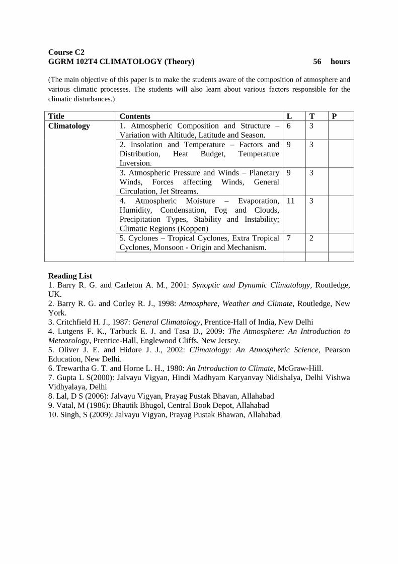
Course C2
GGRM 102T4 CLIMATOLOGY (Theory) 56 hours
(The main objective of this paper is to make the students aware of the composition of atmosphere and
various climatic processes. The students will also learn about various factors responsible for the
climatic disturbances.)
Title Contents L T P
Climatology 1. Atmospheric Composition and Structure –
Variation with Altitude, Latitude and Season.
6 3
2. Insolation and Temperature – Factors and
Distribution, Heat Budget, Temperature
Inversion.
9 3
3. Atmospheric Pressure and Winds – Planetary
Winds, Forces affecting Winds, General
Circulation, Jet Streams.
9 3
4. Atmospheric Moisture – Evaporation,
Humidity, Condensation, Fog and Clouds,
Precipitation Types, Stability and Instability;
Climatic Regions (Koppen)
11 3
5. Cyclones – Tropical Cyclones, Extra Tropical
Cyclones, Monsoon - Origin and Mechanism.
7 2
Reading List
1. Barry R. G. and Carleton A. M., 2001: Synoptic and Dynamic Climatology, Routledge,
UK.
2. Barry R. G. and Corley R. J., 1998: Atmosphere, Weather and Climate, Routledge, New
York.
3. Critchfield H. J., 1987: General Climatology, Prentice-Hall of India, New Delhi
4. Lutgens F. K., Tarbuck E. J. and Tasa D., 2009: The Atmosphere: An Introduction to
Meteorology, Prentice-Hall, Englewood Cliffs, New Jersey.
5. Oliver J. E. and Hidore J. J., 2002: Climatology: An Atmospheric Science, Pearson
Education, New Delhi.
6. Trewartha G. T. and Horne L. H., 1980: An Introduction to Climate, McGraw-Hill.
7. Gupta L S(2000): Jalvayu Vigyan, Hindi Madhyam Karyanvay Nidishalya, Delhi Vishwa
Vidhyalaya, Delhi
8. Lal, D S (2006): Jalvayu Vigyan, Prayag Pustak Bhavan, Allahabad
9. Vatal, M (1986): Bhautik Bhugol, Central Book Depot, Allahabad
10. Singh, S (2009): Jalvayu Vigyan, Prayag Pustak Bhawan, Allahabad

Course C2 GGRM 102P2: PRACTICALS BASED ON CLIMATIC DATA 28 hours
(The main objective of this paper is to make the students gain knowledge of the various weather
symbols and to prepare graphs based on climatic data. The students will also find out the variability in
the distribution of rainfall and the factors responsible for such variation in the pattern of rainfall.)
Contents L T P
Practical’s Based
On Climatic Data
1.Study of weather symbols 2 4
2. Indian daily weather map interpretation
for the summer and winter seasons.
4 4
3.Representation of climatic data:
(a) Preparation of Climograph,
Hythergraph and Ergograph and their
interpretation
(b) Preparation of rainfall variability map
of Assam
6 8
Course C3
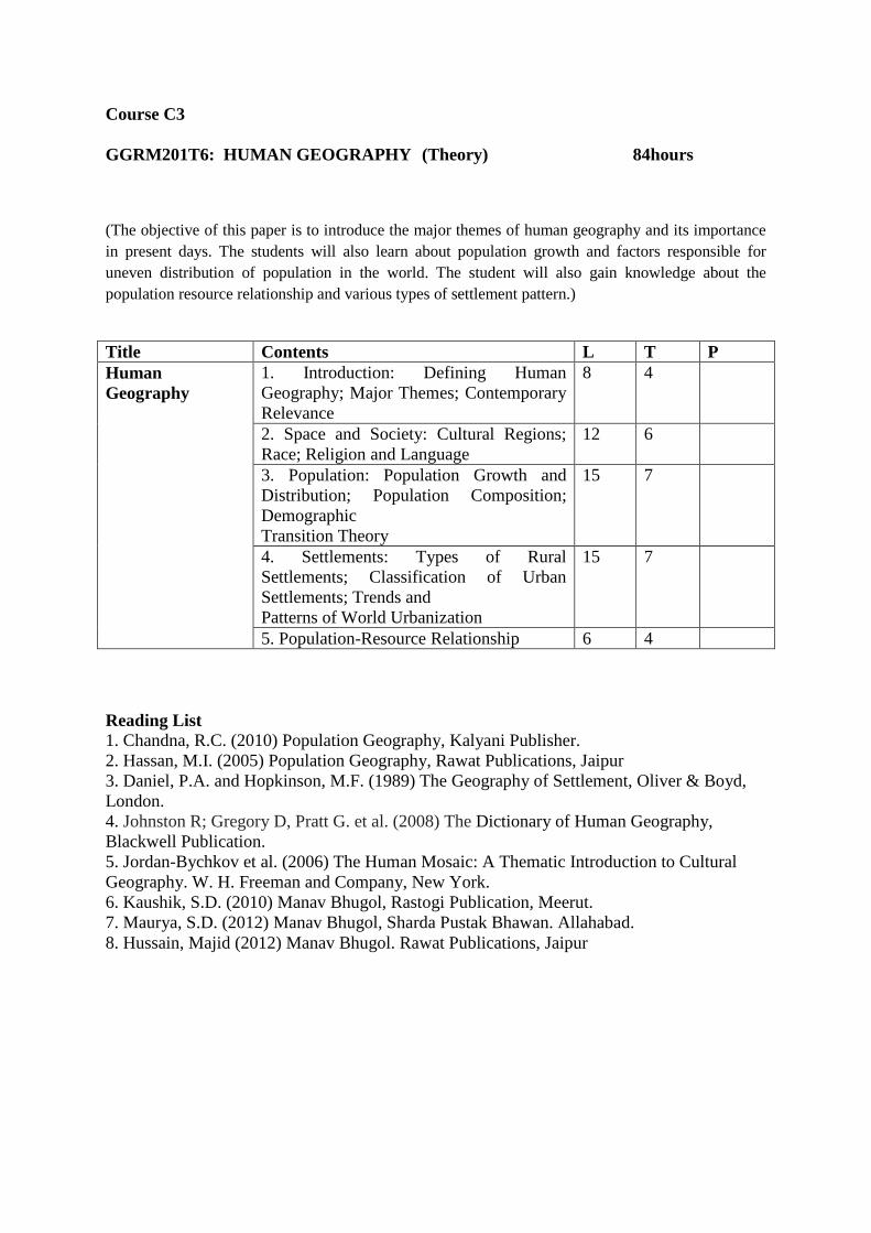
GGRM201T6: HUMAN GEOGRAPHY (Theory) 84hours
(The objective of this paper is to introduce the major themes of human geography and its importance
in present days. The students will also learn about population growth and factors responsible for
uneven distribution of population in the world. The student will also gain knowledge about the
population resource relationship and various types of settlement pattern.)
Title Contents L T P
Human
Geography
1. Introduction: Defining Human
Geography; Major Themes; Contemporary
Relevance
8 4
2. Space and Society: Cultural Regions;
Race; Religion and Language
12 6
3. Population: Population Growth and
Distribution; Population Composition;
Demographic
Transition Theory
15 7
4. Settlements: Types of Rural
Settlements; Classification of Urban
Settlements; Trends and
Patterns of World Urbanization
15 7
5. Population-Resource Relationship 6 4
Reading List
1. Chandna, R.C. (2010) Population Geography, Kalyani Publisher.
2. Hassan, M.I. (2005) Population Geography, Rawat Publications, Jaipur
3. Daniel, P.A. and Hopkinson, M.F. (1989) The Geography of Settlement, Oliver & Boyd,
London.
4. Johnston R; Gregory D, Pratt G. et al. (2008) The Dictionary of Human Geography,
Blackwell Publication.
5. Jordan-Bychkov et al. (2006) The Human Mosaic: A Thematic Introduction to Cultural
Geography. W. H. Freeman and Company, New York.
6. Kaushik, S.D. (2010) Manav Bhugol, Rastogi Publication, Meerut.
7. Maurya, S.D. (2012) Manav Bhugol, Sharda Pustak Bhawan. Allahabad.
8. Hussain, Majid (2012) Manav Bhugol. Rawat Publications, Jaipur
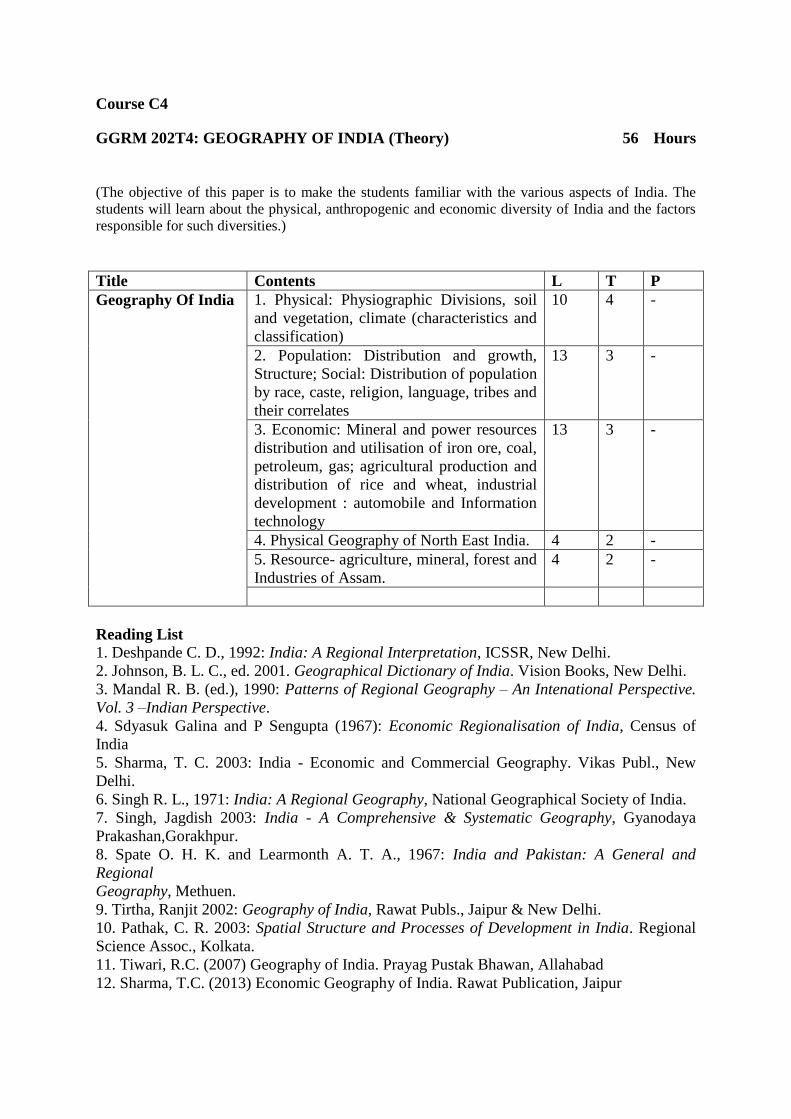
Course C4
GGRM 202T4: GEOGRAPHY OF INDIA (Theory) 56 Hours
(The objective of this paper is to make the students familiar with the various aspects of India. The
students will learn about the physical, anthropogenic and economic diversity of India and the factors
responsible for such diversities.)
Title Contents L T P
Geography Of India 1. Physical: Physiographic Divisions, soil
and vegetation, climate (characteristics and
classification)
10 4 -
2. Population: Distribution and growth,
Structure; Social: Distribution of population
by race, caste, religion, language, tribes and
their correlates
13 3 -
3. Economic: Mineral and power resources
distribution and utilisation of iron ore, coal,
petroleum, gas; agricultural production and
distribution of rice and wheat, industrial
development : automobile and Information
technology
13 3 -
4. Physical Geography of North East India. 4 2 -
5. Resource- agriculture, mineral, forest and
Industries of Assam.
4 2 -
Reading List
1. Deshpande C. D., 1992: India: A Regional Interpretation, ICSSR, New Delhi.
2. Johnson, B. L. C., ed. 2001. Geographical Dictionary of India. Vision Books, New Delhi.
3. Mandal R. B. (ed.), 1990: Patterns of Regional Geography – An Intenational Perspective.
Vol. 3 –Indian Perspective.
4. Sdyasuk Galina and P Sengupta (1967): Economic Regionalisation of India, Census of
India
5. Sharma, T. C. 2003: India - Economic and Commercial Geography. Vikas Publ., New
Delhi.
6. Singh R. L., 1971: India: A Regional Geography, National Geographical Society of India.
7. Singh, Jagdish 2003: India - A Comprehensive & Systematic Geography, Gyanodaya
Prakashan,Gorakhpur.
8. Spate O. H. K. and Learmonth A. T. A., 1967: India and Pakistan: A General and
Regional
Geography, Methuen.
9. Tirtha, Ranjit 2002: Geography of India, Rawat Publs., Jaipur & New Delhi.
10. Pathak, C. R. 2003: Spatial Structure and Processes of Development in India. Regional
Science Assoc., Kolkata.
11. Tiwari, R.C. (2007) Geography of India. Prayag Pustak Bhawan, Allahabad
12. Sharma, T.C. (2013) Economic Geography of India. Rawat Publication, Jaipur
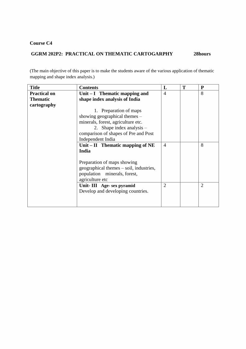
Course C4
GGRM 202P2: PRACTICAL ON THEMATIC CARTOGARPHY 28hours
(The main objective of this paper is to make the students aware of the various application of thematic
mapping and shape index analysis.)
Title Contents L T P
Practical on
Thematic
cartography
Unit – I Thematic mapping and
shape index analysis of India
1. Preparation of maps
showing geographical themes –
minerals, forest, agriculture etc.
2. Shape index analysis –
comparison of shapes of Pre and Post
Independent India
4 8
Unit – II Thematic mapping of NE
India
Preparation of maps showing
geographical themes – soil, industries,
population minerals, forest,
agriculture etc
4 8
Unit- III Age- sex pyramid
Develop and developing countries.
2 2

Course C5
GGRM 301T4: CARTOGRAPHY (Theory) 56 hours (The main objective of this paper is to make the students aware about the history of map projection
and uses of different types of map projection. An attempt is also made to enlighten the students about
the various surveying methods and the instrument used in it.)
Title Contents L T P
Cartography 1. History of development of map
projections, classification and use of
different types of map projections,
Choice of map projection
8 4 -
2. Basic principles of surveying and
their necessity in Geography : Vertical
and horizontal controls
10 5 -
3. Surveying and leveling:
i) Plane table surveying –
different methods
ii) Prismatic compass
surveying – closed and open traverse,
calculation of included angles, correction
of bearing, omitted measurement
iii) Theodolite traversing –
measurement of heights
iv) Levelling – different types
24 5 -
Reading List
1. Kanetkar, T.P. and Kulkarni : Surveying and Levelling Part – I & II
2. Zamir, A : A Text book of surveying
3. Steer J.A. : Map Projection
4. Mishra, R.P. and Ramesh : Fundamentals of Cartography
5. Singh and Patel : Principles of Remote Sensing
6. Panda, B.C. : Remote sensing – Principles and applications
7. Singh, R.L.: Fundamentals of Practical Geography, DVS Publication, Ghy
8. Singh, G.: Map Work & Practical Geography, DVS Publication, Ghy
9. Curren, P.J. : Principles of Remote sensing
10. Robinson, : Elements of cartography, DVS Publication, Ghy
11. Arnoff S.(1989) Geographic Information System: A Management Perspective , DDL
Publication,Ottawa
12. Star J and Estes (1994) Geographic Information System, An Introduction,Prentice
Hall,Englewood Cliff,New Jersey

C5
GGRM 302P2: CARTOGRAPHIC TECHNIQUES (PRACTICAL) 28 Hours
(The main objective of this paper is to enlighten the students with the different types of map
projection and its uses.)
Title Units L T P
Cartographic
Techniques
Projection: Conical
One Standard,
Bonne’s and
Polyconic
Cylindrical; Equal
Area, Equidistant,
Galls Stereography
and Mercator
projection.
10 - 18
RECOMMENDED TEXT BOOKS:
1. Singh, R.L.: Fundamentals of Practical Geography, DVS Publication, Ghy
2. Singh, G.: Map Work & Practical Geography, DVS Publication, Ghy
3. Singh, R.L.: Elements of Practical Geography, DVS Publication, Ghy
4. George P. Kellaway : Map Projection
5. J.A. Steers : Map Projection
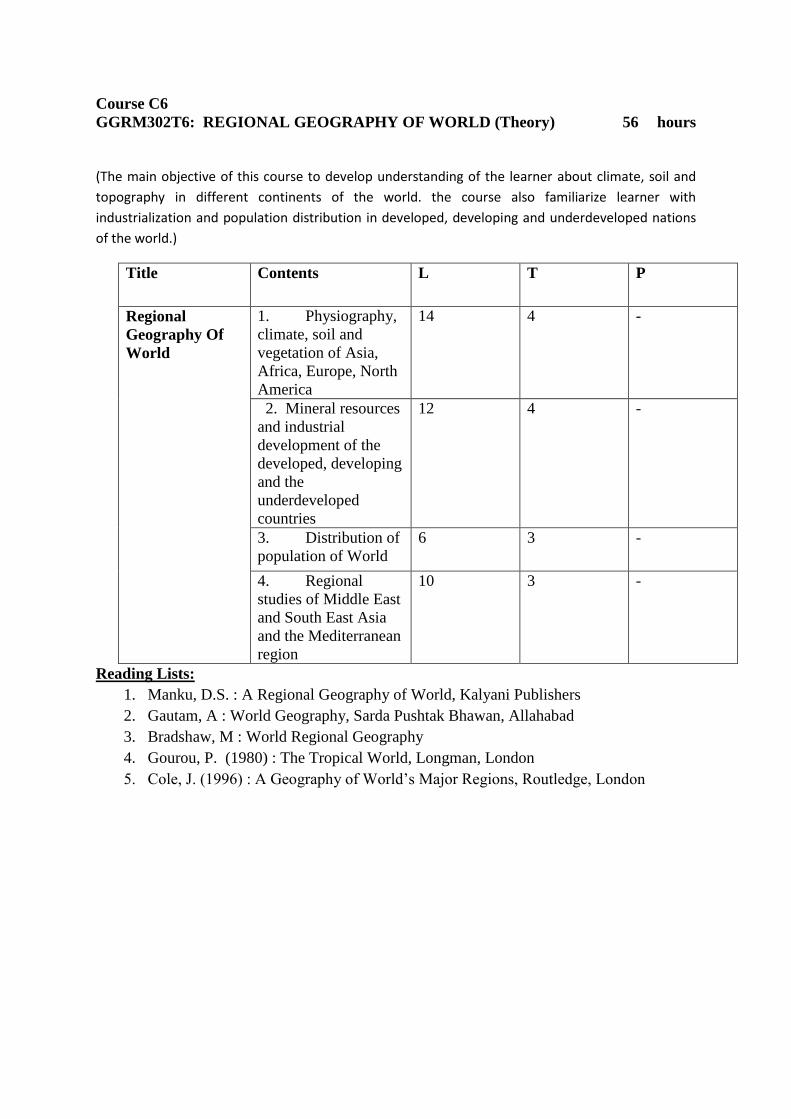
Course C6
GGRM302T6: REGIONAL GEOGRAPHY OF WORLD (Theory) 56 hours
(The main objective of this course to develop understanding of the learner about climate, soil and
topography in different continents of the world. the course also familiarize learner with
industrialization and population distribution in developed, developing and underdeveloped nations
of the world.)
Title Contents L T P
Regional
Geography Of
World
1. Physiography,
climate, soil and
vegetation of Asia,
Africa, Europe, North
America
14 4 -
2. Mineral resources
and industrial
development of the
developed, developing
and the
underdeveloped
countries
12 4 -
3. Distribution of
population of World
6 3 -
4. Regional
studies of Middle East
and South East Asia
and the Mediterranean
region
10 3 -
Reading Lists:
1. Manku, D.S. : A Regional Geography of World, Kalyani Publishers
2. Gautam, A : World Geography, Sarda Pushtak Bhawan, Allahabad
3. Bradshaw, M : World Regional Geography
4. Gourou, P. (1980) : The Tropical World, Longman, London
5. Cole, J. (1996) : A Geography of World’s Major Regions, Routledge, London
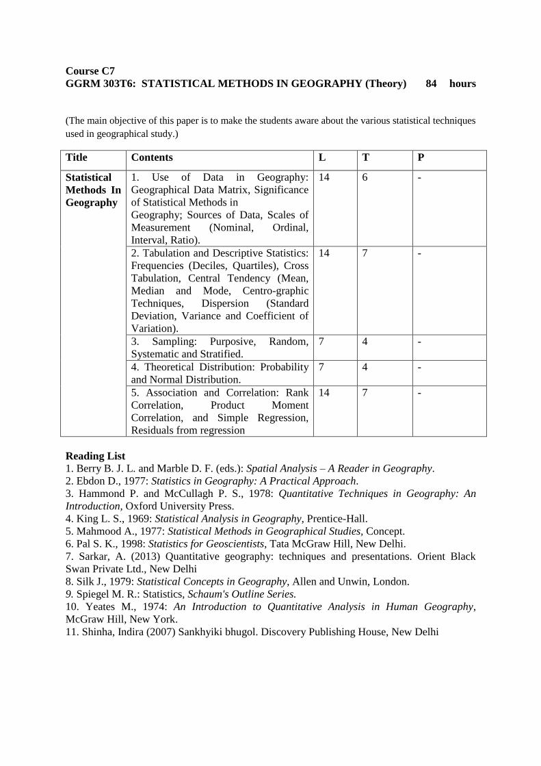
Course C7
GGRM 303T6: STATISTICAL METHODS IN GEOGRAPHY (Theory) 84 hours
(The main objective of this paper is to make the students aware about the various statistical techniques
used in geographical study.)
Title Contents L T P
Statistical
Methods In
Geography
1. Use of Data in Geography:
Geographical Data Matrix, Significance
of Statistical Methods in
Geography; Sources of Data, Scales of
Measurement (Nominal, Ordinal,
Interval, Ratio).
14 6 -
2. Tabulation and Descriptive Statistics:
Frequencies (Deciles, Quartiles), Cross
Tabulation, Central Tendency (Mean,
Median and Mode, Centro-graphic
Techniques, Dispersion (Standard
Deviation, Variance and Coefficient of
Variation).
14 7 -
3. Sampling: Purposive, Random,
Systematic and Stratified.
7 4 -
4. Theoretical Distribution: Probability
and Normal Distribution.
7 4 -
5. Association and Correlation: Rank
Correlation, Product Moment
Correlation, and Simple Regression,
Residuals from regression
14 7 -
Reading List
1. Berry B. J. L. and Marble D. F. (eds.): Spatial Analysis – A Reader in Geography.
2. Ebdon D., 1977: Statistics in Geography: A Practical Approach.
3. Hammond P. and McCullagh P. S., 1978: Quantitative Techniques in Geography: An
Introduction, Oxford University Press.
4. King L. S., 1969: Statistical Analysis in Geography, Prentice-Hall.
5. Mahmood A., 1977: Statistical Methods in Geographical Studies, Concept.
6. Pal S. K., 1998: Statistics for Geoscientists, Tata McGraw Hill, New Delhi.
7. Sarkar, A. (2013) Quantitative geography: techniques and presentations. Orient Black
Swan Private Ltd., New Delhi
8. Silk J., 1979: Statistical Concepts in Geography, Allen and Unwin, London.
9. Spiegel M. R.: Statistics, Schaum's Outline Series.
10. Yeates M., 1974: An Introduction to Quantitative Analysis in Human Geography,
McGraw Hill, New York.
11. Shinha, Indira (2007) Sankhyiki bhugol. Discovery Publishing House, New Delhi

Course C8
GGRM401T6 : ECONOMIC GEOGRAPHY (Theory) 84 hours
(The goal of this course is to enhance the learner with the basic ideas of primary, secondary and
tertiary activities and its spatio-temporal pattern. The learners will also acquire the knowledge of
some economic development models in relation to agriculture and industry.)
Title Contents L T P
Economic
Geography
1. Introduction: Concept and
classification of economic
activity
4 2 -
2. Factors Affecting location
of Economic Activity with
special reference to
Agriculture (Von Thunen
theory), Industry (Weber’s
theory).
12 6 -
3. Primary Activities:
Subsistence and
Commercial agriculture,
forestry, fishing and mining.
14 7 -
4. Secondary Activities:
Manufacturing (Cotton
Textile, Iron and Steel),
Concept of Manufacturing
Regions, Special Economic
Zones and Technology
Parks.
16 7 -
5. Tertiary Activities:
Transport, Trade and
Services.
10 6 -
Reading List
1. Alexander J. W., 1963: Economic Geography, Prentice-Hall Inc., Englewood Cliffs, New
Jersey.
2. Coe N. M., Kelly P. F. and Yeung H. W., 2007: Economic Geography: A Contemporary
Introduction, Wiley-Blackwell.
3. Hodder B. W. and Lee Roger, 1974: Economic Geography, Taylor and Francis.
4. Combes P., Mayer T. and Thisse J. F., 2008: Economic Geography: The Integration of
Regions and Nations, Princeton University Press.
5. Wheeler J. O., 1998: Economic Geography, Wiley..
6. Durand L., 1961: Economic Geography, Crowell.
7. Bagchi-Sen S. and Smith H. L., 2006: Economic Geography: Past, Present and Future,
Taylor and Francis.
8. Willington D. E., 2008: Economic Geography, Husband Press.
9. Clark, Gordon L.; Feldman, M.P. and Gertler, M.S., eds. 2000: The Oxford
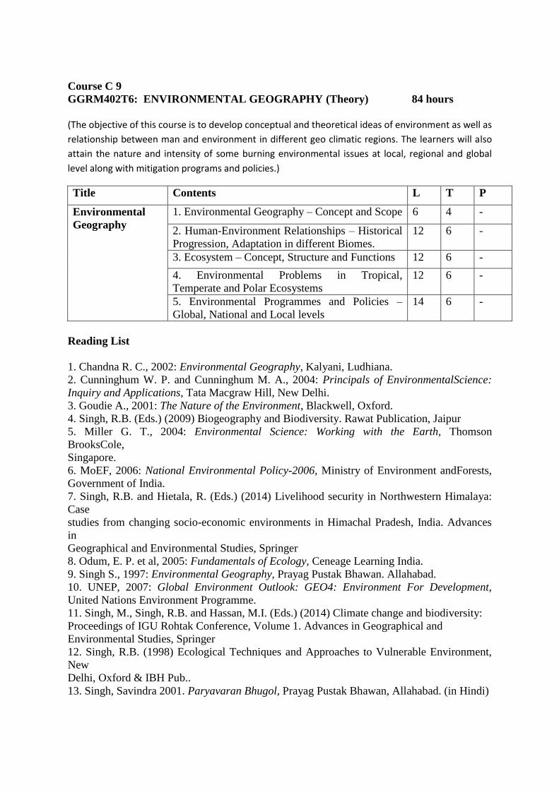
Course C 9
GGRM402T6: ENVIRONMENTAL GEOGRAPHY (Theory) 84 hours
(The objective of this course is to develop conceptual and theoretical ideas of environment as well as
relationship between man and environment in different geo climatic regions. The learners will also
attain the nature and intensity of some burning environmental issues at local, regional and global
level along with mitigation programs and policies.)
Title Contents L T P
Environmental
Geography
1. Environmental Geography – Concept and Scope 6 4 -
2. Human-Environment Relationships – Historical
Progression, Adaptation in different Biomes.
12 6 -
3. Ecosystem – Concept, Structure and Functions 12 6 -
4. Environmental Problems in Tropical,
Temperate and Polar Ecosystems
12 6 -
5. Environmental Programmes and Policies –
Global, National and Local levels
14 6 -
Reading List
1. Chandna R. C., 2002: Environmental Geography, Kalyani, Ludhiana.
2. Cunninghum W. P. and Cunninghum M. A., 2004: Principals of EnvironmentalScience:
Inquiry and Applications, Tata Macgraw Hill, New Delhi.
3. Goudie A., 2001: The Nature of the Environment, Blackwell, Oxford.
4. Singh, R.B. (Eds.) (2009) Biogeography and Biodiversity. Rawat Publication, Jaipur
5. Miller G. T., 2004: Environmental Science: Working with the Earth, Thomson
BrooksCole,
Singapore.
6. MoEF, 2006: National Environmental Policy-2006, Ministry of Environment andForests,
Government of India.
7. Singh, R.B. and Hietala, R. (Eds.) (2014) Livelihood security in Northwestern Himalaya:
Case
studies from changing socio-economic environments in Himachal Pradesh, India. Advances
in
Geographical and Environmental Studies, Springer
8. Odum, E. P. et al, 2005: Fundamentals of Ecology, Ceneage Learning India.
9. Singh S., 1997: Environmental Geography, Prayag Pustak Bhawan. Allahabad.
10. UNEP, 2007: Global Environment Outlook: GEO4: Environment For Development,
United Nations Environment Programme.
11. Singh, M., Singh, R.B. and Hassan, M.I. (Eds.) (2014) Climate change and biodiversity:
Proceedings of IGU Rohtak Conference, Volume 1. Advances in Geographical and
Environmental Studies, Springer
12. Singh, R.B. (1998) Ecological Techniques and Approaches to Vulnerable Environment,
New
Delhi, Oxford & IBH Pub..
13. Singh, Savindra 2001. Paryavaran Bhugol, Prayag Pustak Bhawan, Allahabad. (in Hindi)

Course C10
GGRM403T4: REMOTE SESING AND GIS (Theory) 56
Lectures
(The goal of this course is to enhance of the ability of the learners in the field of latest satellite based
technology and data source such as remote sensing.)
Title Contents L T P
Remote Sensing And
GIS
1. Historical Development
of remote sensing as a
technology-Relevance of
remote sensing in
Geography.
10 4 -
2. Concept and basics:
Energy source, energy and
radiation principles
10 3 -
3. Energy interactions in
the atmosphere and earth
surface features.
10 3 -
4. Remote sensing systems:
platforms, sensors and
radiations records.
12 4 -
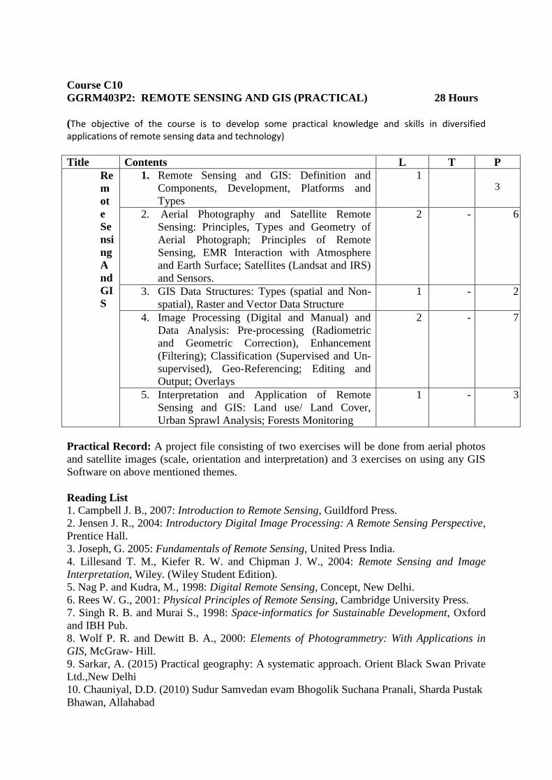
Course C10
GGRM403P2: REMOTE SENSING AND GIS (PRACTICAL) 28 Hours
(The objective of the course is to develop some practical knowledge and skills in diversified applications of remote sensing data and technology)
Title Contents L T P
Re
m
ot
e
Se
nsi
ng
A
nd
GI
S
1. Remote Sensing and GIS: Definition and
Components, Development, Platforms and
Types
1
3
2. Aerial Photography and Satellite Remote
Sensing: Principles, Types and Geometry of
Aerial Photograph; Principles of Remote
Sensing, EMR Interaction with Atmosphere
and Earth Surface; Satellites (Landsat and IRS)
and Sensors.
2 - 6
3. GIS Data Structures: Types (spatial and Non-
spatial), Raster and Vector Data Structure
1 - 2
4. Image Processing (Digital and Manual) and
Data Analysis: Pre-processing (Radiometric
and Geometric Correction), Enhancement
(Filtering); Classification (Supervised and Un-
supervised), Geo-Referencing; Editing and
Output; Overlays
2 - 7
5. Interpretation and Application of Remote
Sensing and GIS: Land use/ Land Cover,
Urban Sprawl Analysis; Forests Monitoring
1 - 3
Practical Record: A project file consisting of two exercises will be done from aerial photos
and satellite images (scale, orientation and interpretation) and 3 exercises on using any GIS
Software on above mentioned themes.
Reading List
1. Campbell J. B., 2007: Introduction to Remote Sensing, Guildford Press.
2. Jensen J. R., 2004: Introductory Digital Image Processing: A Remote Sensing Perspective,
Prentice Hall.
3. Joseph, G. 2005: Fundamentals of Remote Sensing, United Press India.
4. Lillesand T. M., Kiefer R. W. and Chipman J. W., 2004: Remote Sensing and Image
Interpretation, Wiley. (Wiley Student Edition).
5. Nag P. and Kudra, M., 1998: Digital Remote Sensing, Concept, New Delhi.
6. Rees W. G., 2001: Physical Principles of Remote Sensing, Cambridge University Press.
7. Singh R. B. and Murai S., 1998: Space-informatics for Sustainable Development, Oxford
and IBH Pub.
8. Wolf P. R. and Dewitt B. A., 2000: Elements of Photogrammetry: With Applications in
GIS, McGraw- Hill.
9. Sarkar, A. (2015) Practical geography: A systematic approach. Orient Black Swan Private
Ltd.,New Delhi
10. Chauniyal, D.D. (2010) Sudur Samvedan evam Bhogolik Suchana Pranali, Sharda Pustak
Bhawan, Allahabad
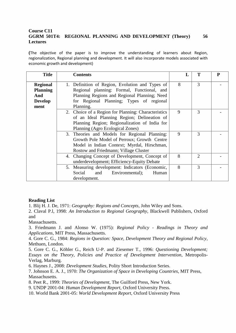
Course C11
GGRM 501T4: REGIONAL PLANNING AND DEVELOPMENT (Theory) 56
Lectures
(The objective of the paper is to improve the understanding of learners about Region, regionalization, Regional planning and development. It will also incorporate models associated with economic growth and development)
Title Contents L T P
Regional
Planning
And
Develop
ment
1. Definition of Region, Evolution and Types of
Regional planning: Formal, Functional, and
Planning Regions and Regional Planning; Need
for Regional Planning; Types of regional
Planning.
8 3 -
2. Choice of a Region for Planning: Characteristics
of an Ideal Planning Region; Delineation of
Planning Region; Regionalization of India for
Planning (Agro Ecological Zones)
9 3 -
3. Theories and Models for Regional Planning:
Growth Pole Model of Perroux; Growth Centre
Model in Indian Context; Myrdal, Hirschman,
Rostow and Friedmann; Village Cluster
9 3 -
4. Changing Concept of Development, Concept of
underdevelopment; Efficiency-Equity Debate
8 2 -
5. Measuring development: Indicators (Economic,
Social and Environmental); Human
development.
8 3 -
Reading List
1. Blij H. J. De, 1971: Geography: Regions and Concepts, John Wiley and Sons.
2. Claval P.l, 1998: An Introduction to Regional Geography, Blackwell Publishers, Oxford
and
Massachusetts.
3. Friedmann J. and Alonso W. (1975): Regional Policy - Readings in Theory and
Applications, MIT Press, Massachusetts.
4. Gore C. G., 1984: Regions in Question: Space, Development Theory and Regional Policy,
Methuen, London.
5. Gore C. G., Köhler G., Reich U-P. and Ziesemer T., 1996: Questioning Development;
Essays on the Theory, Policies and Practice of Development Intervention, Metropolis-
Verlag, Marburg.
6. Haynes J., 2008: Development Studies, Polity Short Introduction Series.
7. Johnson E. A. J., 1970: The Organization of Space in Developing Countries, MIT Press,
Massachusetts.
8. Peet R., 1999: Theories of Development, The Guilford Press, New York.
9. UNDP 2001-04: Human Development Report, Oxford University Press.
10. World Bank 2001-05: World Development Report, Oxford University Press
Course C11
GGRM 501P2: REGIONAL PLANNING AND DEVELOPMENT (Practical)
28 hours
The basic objective of the course is to enhance the learner in the field of demarcation and
distribution of resources
Title Contents L T P
Regional Planning
And Development
1. Methods of regionalization:
a) Simple ranking method
b) Mean method
c) Z- Score standardization.
4 - 10
2. Resource disparity map:
a) Power resource (Hydel,
Thermal, Nuclear)
b) Mineral resources (coal,
iron ore )
3 - 11
Course C12
GGRM502T4: POPULATION GEOGRAPHY (Theory) 56
Lectures
(The objective of this course is to enhance the learner with the basic ideas of
population size, composition, growth and distribution along with its determinants.
The course will also incorporate contemporary issues of population.)
Title Contents L T P
Population
Geography
1. Defining the Field – Nature and Scope;
Sources of Data with special reference to India
(Census, Vital Statistics and NSS).
8 3
2. Population Size, Distribution and Growth –
Determinants and Patterns; Theories of Growth –
Malthusian Theory and Demographic Transition
Theory.
10 3
3. Population Dynamics: Fertility, Mortality
and Migration – Measures, Determinants and
Implications.
10 4
4. Population Composition and Characteristics
– Age-Sex Composition; Rural and Urban
Composition; Literacy.
8 2
5. Contemporary Issues – Ageing of
Population; Declining Sex Ratio; HIV/AIDS.
6 2
Reading List
1. Barrett H. R., 1995: Population Geography, Oliver and Boyd.
2. Bhende A. and Kanitkar T., 2000: Principles of Population Studies, Himalaya Publishing
House.
3. Chandna R. C. and Sidhu M. S., 1980: An Introduction to Population Geography, Kalyani
Publishers.
4. Clarke J. I., 1965: Population Geography, Pergamon Press, Oxford.
5. Jones, H. R., 2000: Population Geography, 3rd ed. Paul Chapman, London.
6. Lutz W., Warren C. S. and Scherbov S., 2004: The End of the World Population Growth in
the 21st Century, Earthscan
7. Newbold K. B., 2009: Population Geography: Tools and Issues, Rowman and Littlefield
Publishers.
8. Pacione M., 1986: Population Geography: Progress and Prospect, Taylor and Francis.
9. Wilson M. G. A., 1968: Population Geography, Nelson.
10. Panda B P (1988): Janasankya Bhugol, M P Hindi Granth Academy,Bhopal
11. Maurya S D (2009) Jansankya Bhugol, Sharda Putak Bhawan, Allahabad

Course C12
GGRM 502P2: POPULATION GEOGRAPHY (Practical) 28 Hours
The main objective of the course is to develop the cartographic ideas for the representation of major
Demographic data.
Title Contents L T P
POPULATION
GEOGRAPHY 1. Statistical Data
representation Part I
a) Near neighbour analysis
b) Principle component analysis – Water, Fisher and Nelson
c) Traffic flow and isochronic cartograms
2 - 6
2. Statistical Data representation Part II
a) Location quotient analysis
b) Lorenz curve
2 - 7
3. Distribution of
population
a) India, Assam( by
simple dot
method)
2 - 4
4. Density of
population
a) India and Assam
( choropleth
method)
1 - 4
Course C 13
GGRM601T6: EVOLUTION OF GEOGRAPHICAL THOUGHT (Theory) 84
Lectures
(The objective of the course is familiarizing the learner towards the development of geographic
ideas during the era of ancient, pre-modern and modern period. The course will also enlighten the
learners with the contemporary issues and approaches of development of the discipline. )
Title Contents L T P
Evolution Of
Geographical
Thought
1. Paradigms in Geography 4 2
2. Pre-Modern – Early Origins of
Geographical Thinking with reference
to the Classical and Medieval
Philosophies.
13 6
3. Modern – Evolution of Geographical
Thinking and Disciplinary Trends in
Germany, France, Britain, United States
of America.
13 7
4. Debates – Environmental Determinism
and Possibilism, Systematic and
Regional, Ideographic and
Nomeothetic.
13 7
5. Trends – Quantitative Revolution and
its Impact, Behaviouralism, Systems
Approach, Radicalism, Feminism;
Towards Post Modernism – Changing
Concept of Space in Geography, Future
of Geography.
13 6
Reading List
1. Arentsen M., Stam R. and Thuijis R., 2000: Post-modern Approaches to Space, ebook.
2. Bhat, L.S. (2009) Geography in India (Selected Themes). Pearson
3. Bonnett A., 2008: What is Geography? Sage.
4. Dikshit R. D., 1997: Geographical Thought: A Contextual History of Ideas, Prentice– Hall
India.
5. Hartshone R., 1959: Perspectives of Nature of Geography, Rand MacNally and Co.
6. Holt-Jensen A., 2011: Geography: History and Its Concepts: A Students Guide, SAGE.
7. Johnston R. J., (Ed.): Dictionary of Human Geography, Routledge.
8. Johnston R. J., 1997: Geography and Geographers, Anglo-American Human Geography
since 1945, Arnold, London.
9. Kapur A., 2001: Indian Geography Voice of Concern, Concept Publications.
10. Martin Geoffrey J., 2005: All Possible Worlds: A History of Geographical Ideas, Oxford.
11. Soja, Edward 1989. Post-modern Geographies, Verso, London. Reprinted 1997: Rawat
Publ., Jaipur and New Delhi.
Course C14
GGRM602T6: DISASTER MANAGEMENT BASED PROJECT WORK 84 Hours
(The main objective of the field work is to conduct an extensive survey over an area to evaluate the nature, intensity, frequency and impact of a Hazard/ disaster and suggesting possible mitigation measures)
L T P
Unit –I: Disaster Management based Project work
(Practical)
6 - 54
Unit- II : Field Survey 4 - 20
Reading List
1. Government of India. (1997) Vulnerability Atlas of India. New Delhi, Building Materials
&
Technology Promotion Council, Ministry of Urban Development, Government of India.
2. Kapur, A. (2010) Vulnerable India: A Geographical Study of Disasters, Sage Publication,
New Delhi.
3. Modh, S. (2010) Managing Natural Disaster: Hydrological, Marine and Geological
Disasters,
Macmillan, Delhi.
4. Singh, R.B. (2005) Risk Assessment and Vulnerability Analysis, IGNOU, New Delhi.
Chapter 1, 2 and 3
5. Singh, R. B. (ed.), (2006) Natural Hazards and Disaster Management: Vulnerability and
Mitigation, Rawat Publications, New Delhi.
6. Sinha, A. (2001). Disaster Management: Lessons Drawn and Strategies for Future, New
United Press, New Delhi.
7. Stoltman, J.P. et al. (2004) International Perspectives on Natural Disasters, Kluwer
Academic
Publications. Dordrecht.
8. Singh Jagbir (2007) “Disaster Management Future Challenges and Oppurtunities”, 2007.
Publisher- I.K. International Pvt. Ltd. S-25, Green Park Extension, Uphaar Cinema Market,
New Delhi, India (www.ikbooks.com).

SKILL ENHANCEMENT COURSE (Any 2)
SEC 1(4C)
GGRM SEC301AP2: REMOTE SENSING (PRACTICAL) 56 Hours
(The objective of the course is to develop some practical knowledge and skills in diversified applications of remote sensing data and technology)
Title Contents L T P
Remote Sensing 1. Remote Sensing: Definition and
Development; Platforms and Types;
Photogrammetry.
3 8
2. Satellite Remote Sensing: Principles, EMR
Interaction with Atmosphere and Earth
Surface; Satellites (Landsat and IRS); Sensors
3 10
3. Image Processing (Digital and Manual): Pre-
processing (Radiometric and Geometric
Correction); Enhancement (Filtering);
Classification (Supervised and Un-supervised)
3 10
4. Satellite Image Interpretation. 2 7
5. Application of Remote Sensing: Land Use
Land Cover.
3 7
Practical Record: A project file consisting of 5 exercises on using any method on above
mentioned themes.
Reading List
1. Bhatta , B. (2008) Remote Sensing and GIS, Oxford University Press, New Delhi.
2. Campbell J. B., 2007: Introduction to Remote Sensing, Guildford Press
3. Chauniyal, D. (2010) Sudur SamvedanaAvam Bhaugolik Suchna Pranali, Sharda Pustak
Bhawan, Allahabad.
4. Jensen, J. R. (2005) Introductory Digital Image Processing: A Remote Sensing
Perspective, Pearson Prentice-Hall.
5. Joseph, G. 2005: Fundamentals of Remote Sensing, United Press India.
6. Lillesand T. M., Kiefer R. W. and Chipman J. W., 2004: Remote Sensing and Image
Interpretation, Wiley. (Wiley Student Edition).
7. Li, Z., Chen, J. and Batsavias, E. (2008) Advances in Photogrammetry, Remote Sensing
and Spatial Information Sciences CRC Press, Taylor and Francis, London
8. Mukherjee, S. (2004) Textbook of Environmental Remote Sensing, Macmillan, Delhi.
9. Nag P. and Kudra, M., 1998: Digital Remote Sensing, Concept, New Delhi.
10. Singh R. B. and Murai S., 1998: Space-informatics for Sustainable Development, Oxford
and IBH Pub.
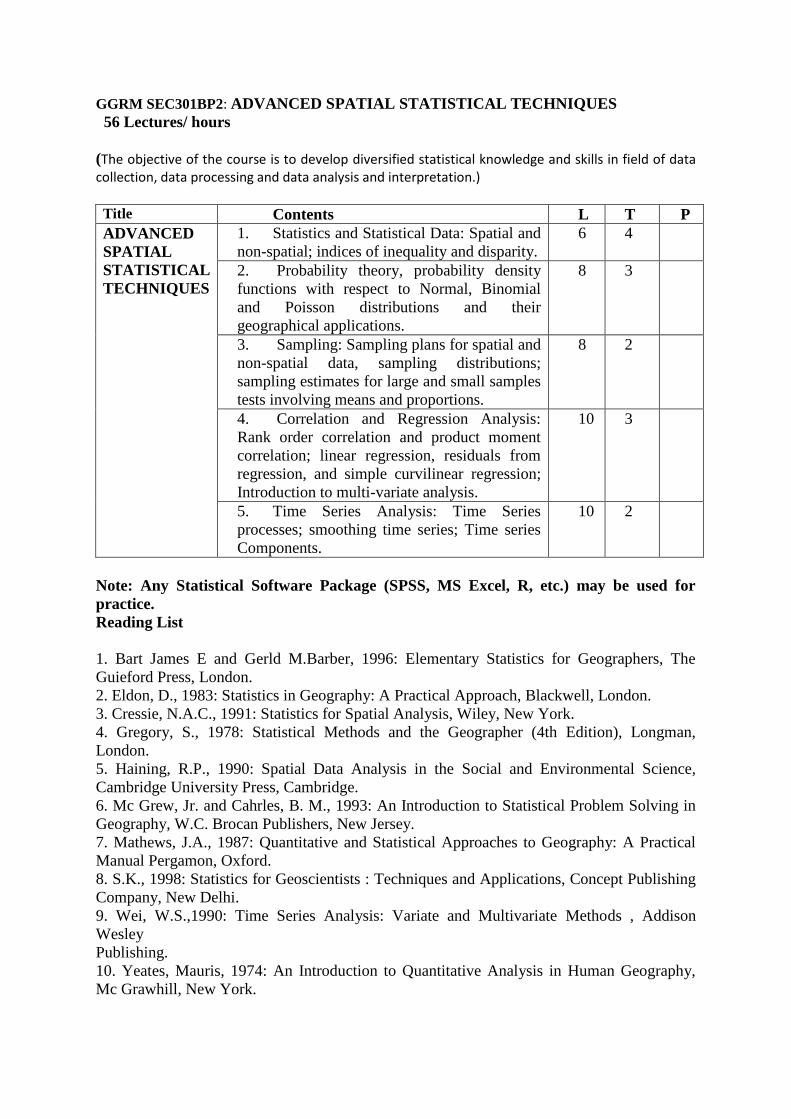
GGRM SEC301BP2: ADVANCED SPATIAL STATISTICAL TECHNIQUES
56 Lectures/ hours
(The objective of the course is to develop diversified statistical knowledge and skills in field of data collection, data processing and data analysis and interpretation.)
Title Contents L T P
ADVANCED
SPATIAL
STATISTICAL
TECHNIQUES
1. Statistics and Statistical Data: Spatial and
non-spatial; indices of inequality and disparity.
6 4
2. Probability theory, probability density
functions with respect to Normal, Binomial
and Poisson distributions and their
geographical applications.
8 3
3. Sampling: Sampling plans for spatial and
non-spatial data, sampling distributions;
sampling estimates for large and small samples
tests involving means and proportions.
8 2
4. Correlation and Regression Analysis:
Rank order correlation and product moment
correlation; linear regression, residuals from
regression, and simple curvilinear regression;
Introduction to multi-variate analysis.
10 3
5. Time Series Analysis: Time Series
processes; smoothing time series; Time series
Components.
10 2
Note: Any Statistical Software Package (SPSS, MS Excel, R, etc.) may be used for
practice.
Reading List
1. Bart James E and Gerld M.Barber, 1996: Elementary Statistics for Geographers, The
Guieford Press, London.
2. Eldon, D., 1983: Statistics in Geography: A Practical Approach, Blackwell, London.
3. Cressie, N.A.C., 1991: Statistics for Spatial Analysis, Wiley, New York.
4. Gregory, S., 1978: Statistical Methods and the Geographer (4th Edition), Longman,
London.
5. Haining, R.P., 1990: Spatial Data Analysis in the Social and Environmental Science,
Cambridge University Press, Cambridge.
6. Mc Grew, Jr. and Cahrles, B. M., 1993: An Introduction to Statistical Problem Solving in
Geography, W.C. Brocan Publishers, New Jersey.
7. Mathews, J.A., 1987: Quantitative and Statistical Approaches to Geography: A Practical
Manual Pergamon, Oxford.
8. S.K., 1998: Statistics for Geoscientists : Techniques and Applications, Concept Publishing
Company, New Delhi.
9. Wei, W.S.,1990: Time Series Analysis: Variate and Multivariate Methods , Addison
Wesley
Publishing.
10. Yeates, Mauris, 1974: An Introduction to Quantitative Analysis in Human Geography,
Mc Grawhill, New York.
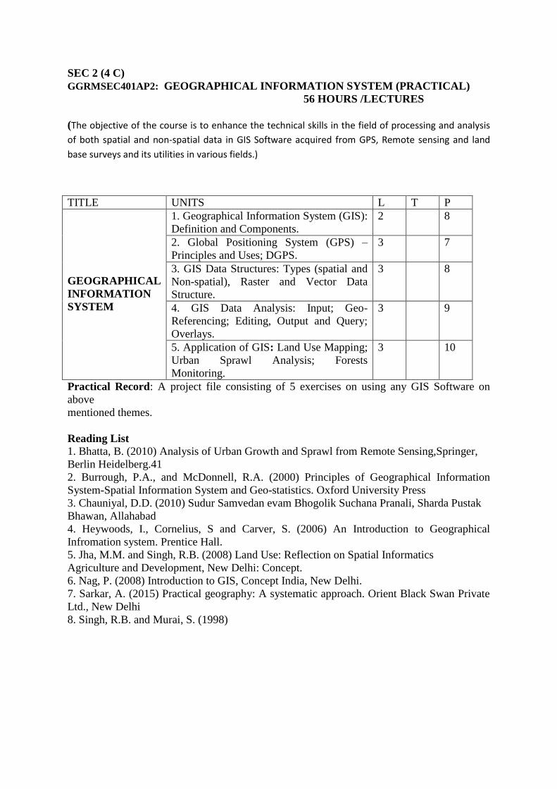
SEC 2 (4 C)
GGRMSEC401AP2: GEOGRAPHICAL INFORMATION SYSTEM (PRACTICAL)
56 HOURS /LECTURES
(The objective of the course is to enhance the technical skills in the field of processing and analysis
of both spatial and non-spatial data in GIS Software acquired from GPS, Remote sensing and land
base surveys and its utilities in various fields.)
TITLE UNITS L T P
GEOGRAPHICAL
INFORMATION
SYSTEM
1. Geographical Information System (GIS):
Definition and Components.
2 8
2. Global Positioning System (GPS) –
Principles and Uses; DGPS.
3 7
3. GIS Data Structures: Types (spatial and
Non-spatial), Raster and Vector Data
Structure.
3 8
4. GIS Data Analysis: Input; Geo-
Referencing; Editing, Output and Query;
Overlays.
3 9
5. Application of GIS: Land Use Mapping;
Urban Sprawl Analysis; Forests
Monitoring.
3 10
Practical Record: A project file consisting of 5 exercises on using any GIS Software on
above
mentioned themes.
Reading List
1. Bhatta, B. (2010) Analysis of Urban Growth and Sprawl from Remote Sensing,Springer,
Berlin Heidelberg.41
2. Burrough, P.A., and McDonnell, R.A. (2000) Principles of Geographical Information
System-Spatial Information System and Geo-statistics. Oxford University Press
3. Chauniyal, D.D. (2010) Sudur Samvedan evam Bhogolik Suchana Pranali, Sharda Pustak
Bhawan, Allahabad
4. Heywoods, I., Cornelius, S and Carver, S. (2006) An Introduction to Geographical
Infromation system. Prentice Hall.
5. Jha, M.M. and Singh, R.B. (2008) Land Use: Reflection on Spatial Informatics
Agriculture and Development, New Delhi: Concept.
6. Nag, P. (2008) Introduction to GIS, Concept India, New Delhi.
7. Sarkar, A. (2015) Practical geography: A systematic approach. Orient Black Swan Private
Ltd., New Delhi
8. Singh, R.B. and Murai, S. (1998)
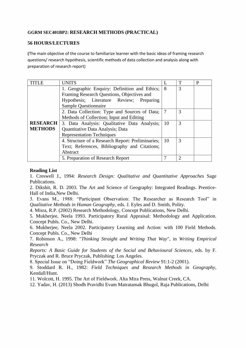
GGRM SEC401BP2: RESEARCH METHODS (PRACTICAL)
56 HOURS/LECTURES
(The main objective of the course to familiarize learner with the basic ideas of framing research
questions/ research hypothesis, scientific methods of data collection and analysis along with
preparation of research report)
TITLE UNITS L T P
RESEARCH
METHODS
1. Geographic Enquiry: Definition and Ethics;
Framing Research Questions, Objectives and
Hypothesis; Literature Review; Preparing
Sample Questionnaire
8 3
2. Data Collection: Type and Sources of Data;
Methods of Collection; Input and Editing
7 3
3. Data Analysis: Qualitative Data Analysis;
Quantitative Data Analysis; Data
Representation Techniques
10 3
4. Structure of a Research Report: Preliminaries;
Text; References, Bibliography and Citations;
Abstract
10 3
5. Preparation of Research Report 7 2
Reading List
1. Creswell J., 1994: Research Design: Qualitative and Quantitative Approaches Sage
Publications.
2. Dikshit, R. D. 2003. The Art and Science of Geography: Integrated Readings. Prentice-
Hall of India,New Delhi.
3. Evans M., 1988: “Participant Observation: The Researcher as Research Tool” in
Qualitative Methods in Human Geography, eds. J. Eyles and D. Smith, Polity.
4. Misra, R.P. (2002) Research Methodology, Concept Publications, New Delhi.
5. Mukherjee, Neela 1993. Participatory Rural Appraisal: Methodology and Application.
Concept Publs. Co., New Delhi.
6. Mukherjee, Neela 2002. Participatory Learning and Action: with 100 Field Methods.
Concept Publs. Co., New Delhi
7. Robinson A., 1998: "Thinking Straight and Writing That Way", in Writing Empirical
Research
Reports: A Basic Guide for Students of the Social and Behavioural Sciences, eds. by F.
Pryczak and R. Bruce Pryczak, Publishing: Los Angeles.
8. Special Issue on “Doing Fieldwork” The Geographical Review 91:1-2 (2001).
9. Stoddard R. H., 1982: Field Techniques and Research Methods in Geography,
Kendall/Hunt.
11. Wolcott, H. 1995. The Art of Fieldwork. Alta Mira Press, Walnut Creek, CA.
12. Yadav, H. (2013) Shodh Pravidhi Evam Matratamak Bhugol, Raja Publications, Delhi
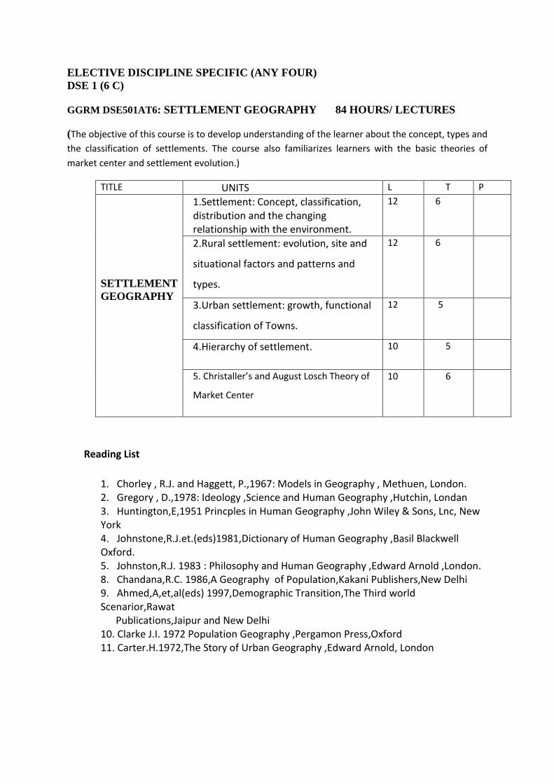
ELECTIVE DISCIPLINE SPECIFIC (ANY FOUR)
DSE 1 (6 C)
GGRM DSE501AT6: SETTLEMENT GEOGRAPHY 84 HOURS/ LECTURES
(The objective of this course is to develop understanding of the learner about the concept, types and
the classification of settlements. The course also familiarizes learners with the basic theories of
market center and settlement evolution.)
TITLE UNITS L T P
SETTLEMENT
GEOGRAPHY
1.Settlement: Concept, classification, distribution and the changing relationship with the environment.
12 6
2.Rural settlement: evolution, site and
situational factors and patterns and
types.
12 6
3.Urban settlement: growth, functional
classification of Towns.
12 5
4.Hierarchy of settlement. 10 5
5. Christaller’s and August Losch Theory of
Market Center
10 6
Reading List
1. Chorley , R.J. and Haggett, P.,1967: Models in Geography , Methuen, London. 2. Gregory , D.,1978: Ideology ,Science and Human Geography ,Hutchin, Londan 3. Huntington,E,1951 Princples in Human Geography ,John Wiley & Sons, Lnc, New York 4. Johnstone,R.J.et.(eds)1981,Dictionary of Human Geography ,Basil Blackwell Oxford. 5. Johnston,R.J. 1983 : Philosophy and Human Geography ,Edward Arnold ,London. 8. Chandana,R.C. 1986,A Geography of Population,Kakani Publishers,New Delhi 9. Ahmed,A,et,al(eds) 1997,Demographic Transition,The Third world Scenarior,Rawat Publications,Jaipur and New Delhi 10. Clarke J.I. 1972 Population Geography ,Pergamon Press,Oxford 11. Carter.H.1972,The Story of Urban Geography ,Edward Arnold, London

DSE 1
GGRM DSE501B T6: RESOURCE GEOGRAPHY 84 HOURS/ LECTURES
(The main objective of the course to develop the concept of recourse, utilization pattern, classification and its distribution over the earth. The course also focuses on significances of resource management and sustainable development.)
TITLE UNITS L T P
RESOURCE
GEOGRAPHY
1. Natural Resource: Concept,
Classification and Techniques
10 6
2. Distribution, Utilization, Problems and
Management of Land Resources and
Water Resources
12 6
3. Distribution, Utilization, Problems and
Management of Forests and Energy
Resources
12 6
4. Appraisal and Conservation of Natural
Resources
12 5
5. Sustainable Resource Development 10 5
Reading List
1. Cutter S. N., Renwich H. L. and Renwick W., 1991: Exploitation, Conservation,
Preservation: A Geographical Perspective on Natural Resources Use, John Wiley and Sons,
New York.
2. Gadgil M. and Guha R., 2005: The Use and Abuse of Nature: Incorporating This Fissured
Land: An Ecological History of India and Ecology and Equity, Oxford University Press.
USA.
3. Holechek J. L. C., Richard A., Fisher J. T. and Valdez R., 2003: Natural Resources:
Ecology,
Economics and Policy, Prentice Hall, New Jersey.
4. Jones G. and Hollier G., 1997: Resources, Society and Environmental Management, Paul
Chapman,London.
5. Klee G., 1991: Conservation of Natural Resources, Prentice Hall, Englewood.
6. Mather A. S. and Chapman K., 1995: Environmental Resources, John Wiley and Sons,
New York.
7. Mitchell B., 1997: Resource and Environmental Management, Longman Harlow, England.
8. Owen S. and Owen P. L., 1991: Environment, Resources and Conservation, Cambridge
University Press, New York.
9. Rees J., 1990: Natural Resources: Allocation, Economics and Policy, Routledge.London
DSE 2 (6 C)
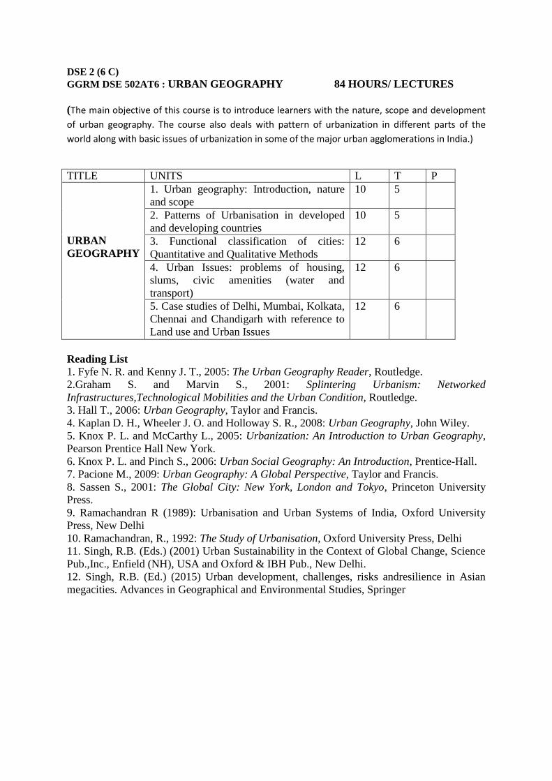
GGRM DSE 502AT6 : URBAN GEOGRAPHY 84 HOURS/ LECTURES
(The main objective of this course is to introduce learners with the nature, scope and development
of urban geography. The course also deals with pattern of urbanization in different parts of the
world along with basic issues of urbanization in some of the major urban agglomerations in India.)
TITLE UNITS L T P
URBAN
GEOGRAPHY
1. Urban geography: Introduction, nature
and scope
10 5
2. Patterns of Urbanisation in developed
and developing countries
10 5
3. Functional classification of cities:
Quantitative and Qualitative Methods
12 6
4. Urban Issues: problems of housing,
slums, civic amenities (water and
transport)
12 6
5. Case studies of Delhi, Mumbai, Kolkata,
Chennai and Chandigarh with reference to
Land use and Urban Issues
12 6
Reading List
1. Fyfe N. R. and Kenny J. T., 2005: The Urban Geography Reader, Routledge.
2.Graham S. and Marvin S., 2001: Splintering Urbanism: Networked
Infrastructures,Technological Mobilities and the Urban Condition, Routledge.
3. Hall T., 2006: Urban Geography, Taylor and Francis.
4. Kaplan D. H., Wheeler J. O. and Holloway S. R., 2008: Urban Geography, John Wiley.
5. Knox P. L. and McCarthy L., 2005: Urbanization: An Introduction to Urban Geography,
Pearson Prentice Hall New York.
6. Knox P. L. and Pinch S., 2006: Urban Social Geography: An Introduction, Prentice-Hall.
7. Pacione M., 2009: Urban Geography: A Global Perspective, Taylor and Francis.
8. Sassen S., 2001: The Global City: New York, London and Tokyo, Princeton University
Press.
9. Ramachandran R (1989): Urbanisation and Urban Systems of India, Oxford University
Press, New Delhi
10. Ramachandran, R., 1992: The Study of Urbanisation, Oxford University Press, Delhi
11. Singh, R.B. (Eds.) (2001) Urban Sustainability in the Context of Global Change, Science
Pub.,Inc., Enfield (NH), USA and Oxford & IBH Pub., New Delhi.
12. Singh, R.B. (Ed.) (2015) Urban development, challenges, risks andresilience in Asian
megacities. Advances in Geographical and Environmental Studies, Springer

DSE 2 (6 C)
GGRM DSE502BT6: AGRICULTURAL GEOGRAPHY
84 HOURS/ LECTURES
(The objective of this course to enhance the concept of agricultural activities, its determinants and types under different geo- environmental condition of the world. The course also introduces learners with some Land use and cropping intensity models)
TITLE UNITS L T P
AGRICULTURAL
GEOGRAPHY
1. Defining the Field: Introduction, nature
and scope; Land use/ land cover definition
and classification.
12
6
2. Determinants of Agriculture: Physical,
Technological and Institutional
10 6
3. Agricultural Regions of India: Agro-
climatic, Agro-ecological & Crop
Combination Regions.
12 6
4. Agricultural Systems of the World
(Whittlesey’s classification) and
Agricultural Land use model (Von
Thuenen, modification and relevance).
12 5
5. Agricultural Revolutions in India: Green,
White, Blue, Pink.
10 5
Reading List
1. Basu, D.N., and Guha, G.S., 1996: Agro-Climatic Regional Planning in India, Vol.I & II,
Concept Publication, New Delhi.
2. Bryant, C.R., Johnston, T.R, 1992: Agriculture in the City Countryside, Belhaven Press,
London.
3. Burger, A., 1994: Agriculture of the World, Aldershot, Avebury.
4. Grigg, D.B., 1984: Introduction to Agricultural Geography, Hutchinson, London.
5. Ilbery B. W., 1985: Agricultural Geography: A Social and Economic Analysis, Oxford
University Press.
6. Mohammad, N., 1992: New Dimension in Agriculture Geography, Vol. I to VIII, Concept
Pub., New Delhi.
7. Roling, N.G., and Wageruters, M.A.E.,(ed.) 1998: Facilitating Sustainable Agriculture,
Cambridge University Press, Cambridge.
8. Shafi, M., 2006: Agricultural Geography, Doring Kindersley India Pvt. Ltd., New Delhi
9. Singh, J., and Dhillon, S.S., 1984: Agricultural Geography, Tata McGraw Hill, New Delhi.
10. Tarrant J. R., 1973: Agricultural Geography, David and Charles, Devon.
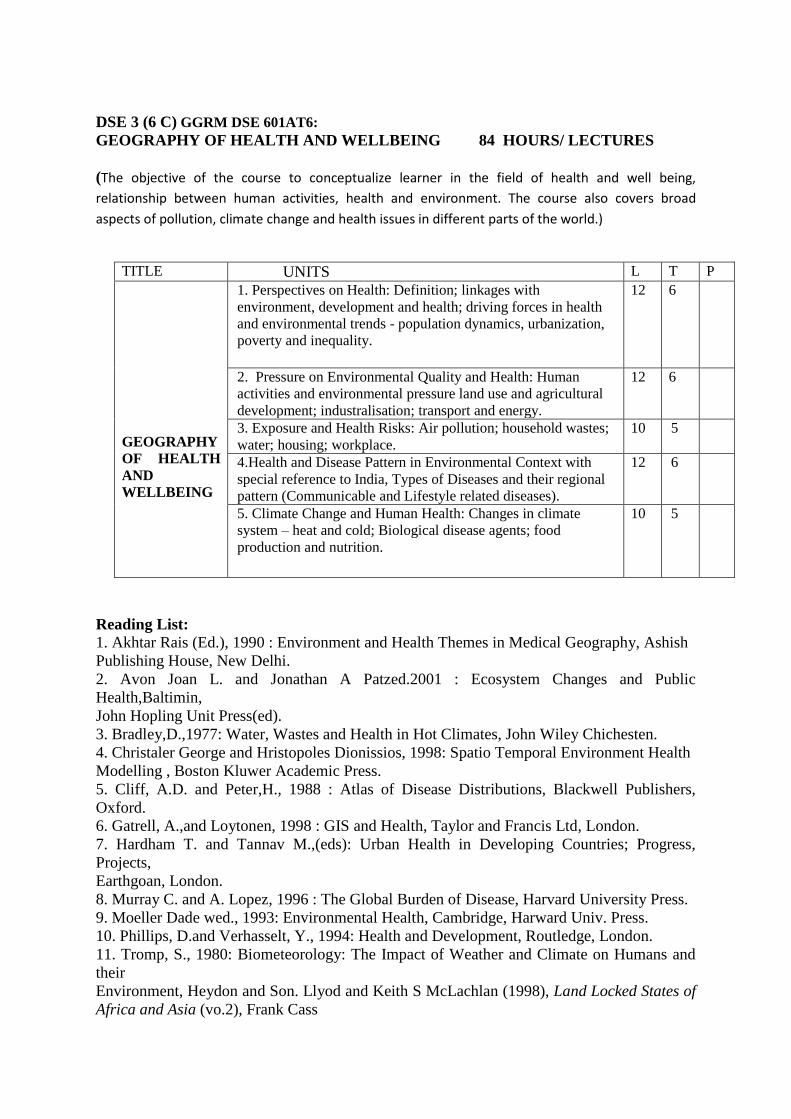
DSE 3 (6 C) GGRM DSE 601AT6:
GEOGRAPHY OF HEALTH AND WELLBEING 84 HOURS/ LECTURES
(The objective of the course to conceptualize learner in the field of health and well being,
relationship between human activities, health and environment. The course also covers broad
aspects of pollution, climate change and health issues in different parts of the world.)
TITLE UNITS L T P
GEOGRAPHY
OF HEALTH
AND
WELLBEING
1. Perspectives on Health: Definition; linkages with
environment, development and health; driving forces in health
and environmental trends - population dynamics, urbanization,
poverty and inequality.
12 6
2. Pressure on Environmental Quality and Health: Human
activities and environmental pressure land use and agricultural
development; industralisation; transport and energy.
12 6
3. Exposure and Health Risks: Air pollution; household wastes;
water; housing; workplace.
10 5
4.Health and Disease Pattern in Environmental Context with
special reference to India, Types of Diseases and their regional
pattern (Communicable and Lifestyle related diseases).
12 6
5. Climate Change and Human Health: Changes in climate
system – heat and cold; Biological disease agents; food
production and nutrition.
10 5
Reading List:
1. Akhtar Rais (Ed.), 1990 : Environment and Health Themes in Medical Geography, Ashish
Publishing House, New Delhi.
2. Avon Joan L. and Jonathan A Patzed.2001 : Ecosystem Changes and Public
Health,Baltimin,
John Hopling Unit Press(ed).
3. Bradley,D.,1977: Water, Wastes and Health in Hot Climates, John Wiley Chichesten.
4. Christaler George and Hristopoles Dionissios, 1998: Spatio Temporal Environment Health
Modelling , Boston Kluwer Academic Press.
5. Cliff, A.D. and Peter,H., 1988 : Atlas of Disease Distributions, Blackwell Publishers,
Oxford.
6. Gatrell, A.,and Loytonen, 1998 : GIS and Health, Taylor and Francis Ltd, London.
7. Hardham T. and Tannav M.,(eds): Urban Health in Developing Countries; Progress,
Projects,
Earthgoan, London.
8. Murray C. and A. Lopez, 1996 : The Global Burden of Disease, Harvard University Press.
9. Moeller Dade wed., 1993: Environmental Health, Cambridge, Harward Univ. Press.
10. Phillips, D.and Verhasselt, Y., 1994: Health and Development, Routledge, London.
11. Tromp, S., 1980: Biometeorology: The Impact of Weather and Climate on Humans and
their
Environment, Heydon and Son. Llyod and Keith S McLachlan (1998), Land Locked States of
Africa and Asia (vo.2), Frank Cass
DSE 4 (6 C)
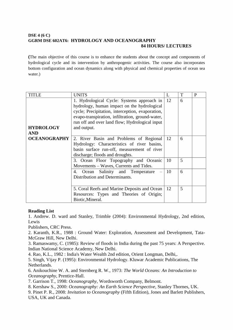
GGRM DSE 602AT6: HYDROLOGY AND OCEANOGRAPHY
84 HOURS/ LECTURES
(The main objective of this course is to enhance the students about the concept and components of
hydrological cycle and its intervention by anthropogenic activities. The course also incorporates
bottom configuration and ocean dynamics along with physical and chemical properties of ocean sea
water.)
TITLE UNITS L T P
HYDROLOGY
AND
OCEANOGRAPHY
1. Hydrological Cycle: Systems approach in
hydrology, human impact on the hydrological
cycle; Precipitation, interception, evaporation,
evapo-transpiration, infiltration, ground-water,
run off and over land flow; Hydrological input
and output.
12 6
2. River Basin and Problems of Regional
Hydrology: Characteristics of river basins,
basin surface run-off, measurement of river
discharge; floods and droughts.
12 6
3. Ocean Floor Topography and Oceanic
Movements – Waves, Currents and Tides.
10 5
4. Ocean Salinity and Temperature –
Distribution and Determinants.
10 6
5. Coral Reefs and Marine Deposits and Ocean
Resources: Types and Theories of Origin;
Biotic,Mineral.
12 5
Reading List
1. Andrew. D. ward and Stanley, Trimble (2004): Environmental Hydrology, 2nd edition,
Lewis
Publishers, CRC Press.
2. Karanth, K.R., 1988 : Ground Water: Exploration, Assessment and Development, Tata-
McGraw Hill, New Delhi.
3. Ramaswamy, C. (1985): Review of floods in India during the past 75 years: A Perspective.
Indian National Science Academy, New Delhi.
4. Rao, K.L., 1982 : India's Water Wealth 2nd edition, Orient Longman, Delhi,.
5. Singh, Vijay P. (1995): Environmental Hydrology. Kluwar Academic Publications, The
Netherlands.
6. Anikouchine W. A. and Sternberg R. W., 1973: The World Oceans: An Introduction to
Oceanography, Prentice-Hall.
7. Garrison T., 1998: Oceanography, Wordsworth Company, Belmont.
8. Kershaw S., 2000: Oceanography: An Earth Science Perspective, Stanley Thornes, UK.
9. Pinet P. R., 2008: Invitation to Oceanography (Fifth Edition), Jones and Barlett Publishers,
USA, UK and Canada.

10. Sharma R. C. and Vatal M., 1980: Oceanography for Geographers, Chaitanya Publishing
House, Allahabad.
11. Sverdrup K. A. and Armbrust, E. V., 2008: An Introduction to the World Ocean, McGraw
Hill, Boston.
12. Singh, M., Singh, R.B. and Hassan, M.I. (Eds.) (2014) Landscape ecology and water
management. Proceedings of IGU Rohtak Conference, Volume 2. Advances in Geographical
and
Environmental Studies, Springer
DSE 4 (6 C)
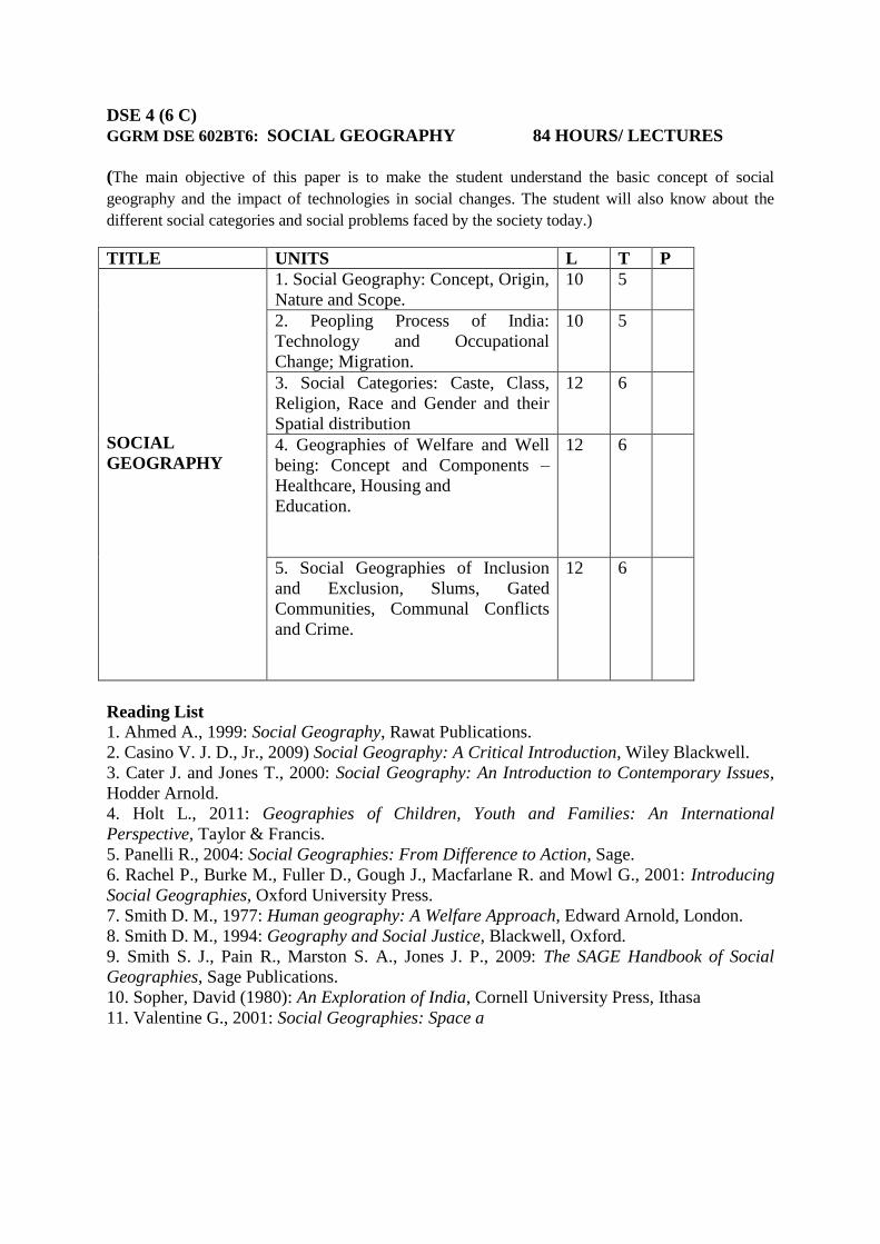
GGRM DSE 602BT6: SOCIAL GEOGRAPHY 84 HOURS/ LECTURES
(The main objective of this paper is to make the student understand the basic concept of social
geography and the impact of technologies in social changes. The student will also know about the
different social categories and social problems faced by the society today.)
TITLE UNITS L T P
SOCIAL
GEOGRAPHY
1. Social Geography: Concept, Origin,
Nature and Scope.
10 5
2. Peopling Process of India:
Technology and Occupational
Change; Migration.
10 5
3. Social Categories: Caste, Class,
Religion, Race and Gender and their
Spatial distribution
12 6
4. Geographies of Welfare and Well
being: Concept and Components –
Healthcare, Housing and
Education.
12 6
5. Social Geographies of Inclusion
and Exclusion, Slums, Gated
Communities, Communal Conflicts
and Crime.
12 6
Reading List
1. Ahmed A., 1999: Social Geography, Rawat Publications.
2. Casino V. J. D., Jr., 2009) Social Geography: A Critical Introduction, Wiley Blackwell.
3. Cater J. and Jones T., 2000: Social Geography: An Introduction to Contemporary Issues,
Hodder Arnold.
4. Holt L., 2011: Geographies of Children, Youth and Families: An International
Perspective, Taylor & Francis.
5. Panelli R., 2004: Social Geographies: From Difference to Action, Sage.
6. Rachel P., Burke M., Fuller D., Gough J., Macfarlane R. and Mowl G., 2001: Introducing
Social Geographies, Oxford University Press.
7. Smith D. M., 1977: Human geography: A Welfare Approach, Edward Arnold, London.
8. Smith D. M., 1994: Geography and Social Justice, Blackwell, Oxford.
9. Smith S. J., Pain R., Marston S. A., Jones J. P., 2009: The SAGE Handbook of Social
Geographies, Sage Publications.
10. Sopher, David (1980): An Exploration of India, Cornell University Press, Ithasa
11. Valentine G., 2001: Social Geographies: Space a

ELECTIVE GENERIC PAPERS
GE 1 (6 C) GGRM GE 101AT6: DISASTER MANAGEMENT
84 HOURS/ LECTURES
(The main objective of this paper is to make the students aware about the concepts of hazards,
disasters, risk and vulnerability. In this paper an attempt has been made to prepare the students about
the Do’s And Don’ts during and post disaster.)
TITLE UNITS L T P
DISASTER
MANAGEMENT
1. Disasters: Definition and Concepts:
Hazards, Disasters; Risk and
Vulnerability;
Classification
10 5
2. Disasters in India: (a) Flood: Causes,
Impact, Distribution and Mapping;
Landslide:
Causes, Impact, Distribution and
Mapping; Drought: Causes, Impact,
Distribution and
Mapping
12 6
3. Disasters in India: (b) Earthquake and
Tsunami: Causes, Impact, Distribution
and
Mapping; Cyclone: Causes, Impact,
Distribution and Mapping.
12 6
4. Manmade disasters: Causes, Impact,
Distribution and Mapping
10 5
5. Response and Mitigation to Disasters:
Mitigation and Preparedness, NDMA and
NIDM;
Indigenous Knowledge and Community-
Based Disaster Management; Do’s and
Don’ts
During and Post Disasters
12 6
Reading List
1. Government of India. (1997) Vulnerability Atlas of India. New Delhi, Building Materials
& Technology Promotion Council, Ministry of Urban Development, Government of
India.
2. Kapur, A. (2010) Vulnerable India: A Geographical Study of Disasters, Sage Publication,
New Delhi.
3. Modh, S. (2010) Managing Natural Disaster: Hydrological, Marine and Geological
Disasters, Macmillan, Delhi.
4. Singh, R.B. (2005) Risk Assessment and Vulnerability Analysis, IGNOU, New Delhi.
Chapter 1, 2 and 3

5. Singh, R. B. (ed.), (2006) Natural Hazards and Disaster Management: Vulnerability and
Mitigation, Rawat Publications, New Delhi.
6. Sinha, A. (2001). Disaster Management: Lessons Drawn and Strategies for Future, New
United Press, New Delhi.
7. Stoltman, J.P. et al. (2004) International Perspectives on Natural Disasters, Kluwer
Academic Publications. Dordrecht.
8. Singh Jagbir (2007) “Disaster Management Future Challenges and Oppurtunities”, 2007.
Publisher- I.K. International Pvt. Ltd. S-25, Green Park Extension, Uphaar Cinema
Market, New Delhi, India (www.ikbooks.com).
GE 1
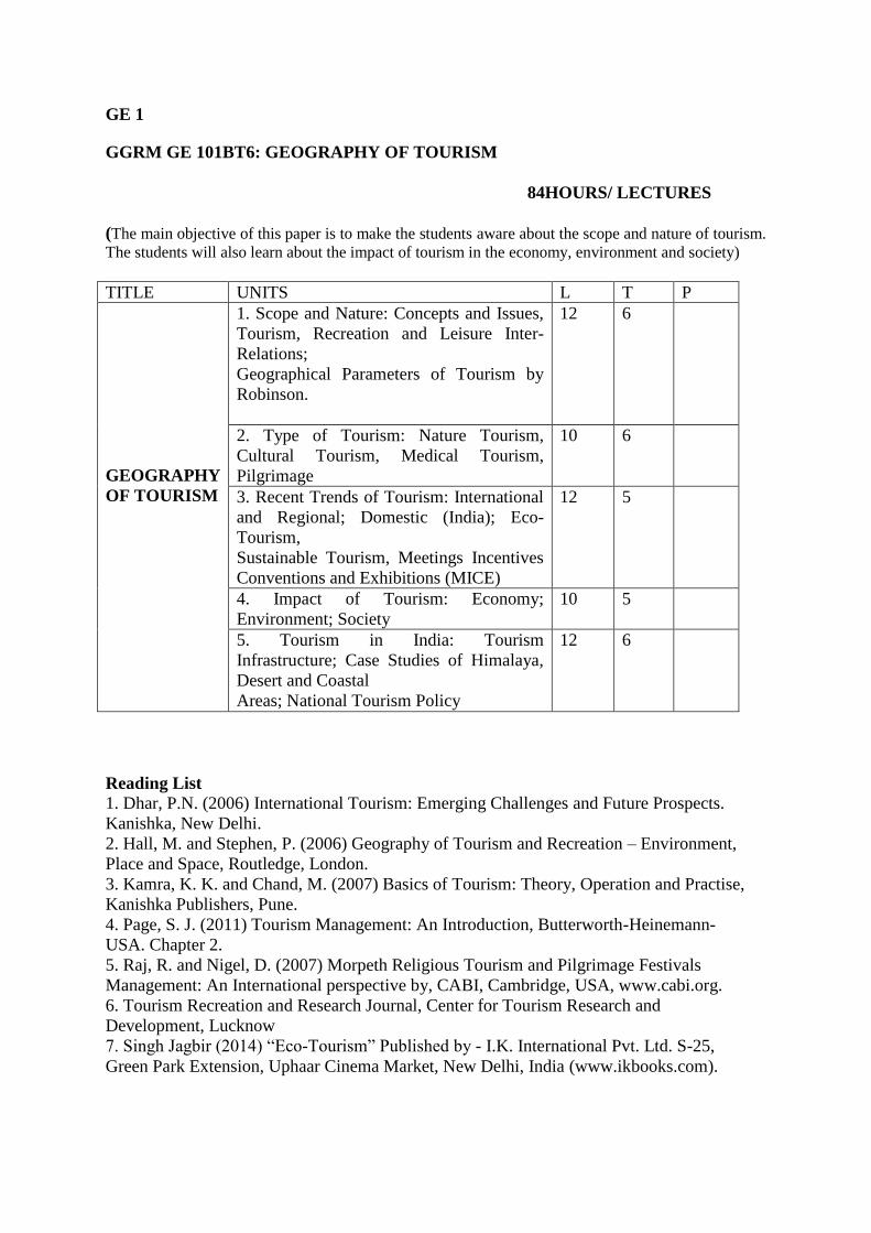
GGRM GE 101BT6: GEOGRAPHY OF TOURISM
84HOURS/ LECTURES
(The main objective of this paper is to make the students aware about the scope and nature of tourism.
The students will also learn about the impact of tourism in the economy, environment and society)
TITLE UNITS L T P
GEOGRAPHY
OF TOURISM
1. Scope and Nature: Concepts and Issues,
Tourism, Recreation and Leisure Inter-
Relations;
Geographical Parameters of Tourism by
Robinson.
12 6
2. Type of Tourism: Nature Tourism,
Cultural Tourism, Medical Tourism,
Pilgrimage
10 6
3. Recent Trends of Tourism: International
and Regional; Domestic (India); Eco-
Tourism,
Sustainable Tourism, Meetings Incentives
Conventions and Exhibitions (MICE)
12 5
4. Impact of Tourism: Economy;
Environment; Society
10 5
5. Tourism in India: Tourism
Infrastructure; Case Studies of Himalaya,
Desert and Coastal
Areas; National Tourism Policy
12 6
Reading List
1. Dhar, P.N. (2006) International Tourism: Emerging Challenges and Future Prospects.
Kanishka, New Delhi.
2. Hall, M. and Stephen, P. (2006) Geography of Tourism and Recreation – Environment,
Place and Space, Routledge, London.
3. Kamra, K. K. and Chand, M. (2007) Basics of Tourism: Theory, Operation and Practise,
Kanishka Publishers, Pune.
4. Page, S. J. (2011) Tourism Management: An Introduction, Butterworth-Heinemann-
USA. Chapter 2.
5. Raj, R. and Nigel, D. (2007) Morpeth Religious Tourism and Pilgrimage Festivals
Management: An International perspective by, CABI, Cambridge, USA, www.cabi.org.
6. Tourism Recreation and Research Journal, Center for Tourism Research and
Development, Lucknow
7. Singh Jagbir (2014) “Eco-Tourism” Published by - I.K. International Pvt. Ltd. S-25,
Green Park Extension, Uphaar Cinema Market, New Delhi, India (www.ikbooks.com).
GE 2 (6 C)
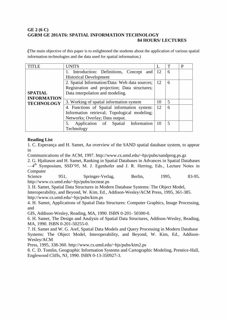
GGRM GE 201AT6: SPATIAL INFORMATION TECHNOLOGY
84 HOURS/ LECTURES
(The main objective of this paper is to enlightened the students about the application of various spatial
information technologies and the data used for spatial information.)
TITLE UNITS L T P
SPATIAL
INFORMATION
TECHNOLOGY
1. Introduction: Definitions, Concept and
Historical Development
12 6
2. Spatial Information/Data: Web data sources;
Registration and projection; Data structures;
Data interpolation and modeling.
12 6
3. Working of spatial information system 10 5
4. Functions of Spatial information system:
Information retrieval; Topological modeling;
Networks; Overlay; Data output.
12 6
5. Application of Spatial Information
Technology
10 5
Reading List
1. C. Esperança and H. Samet, An overview of the SAND spatial database system, to appear
in
Communications of the ACM, 1997. http://www.cs.umd.edu/~hjs/pubs/sandprog.ps.gz
2. G. Hjaltason and H. Samet, Ranking in Spatial Databases in Advances in Spatial Databases
—4th
Symposium, SSD’95, M. J. Egenhofer and J. R. Herring, Eds., Lecture Notes in
Computer
Science 951, Springer-Verlag, Berlin, 1995, 83-95.
http://www.cs.umd.edu/~hjs/pubs/incnear.ps
3. H. Samet, Spatial Data Structures in Modern Database Systems: The Object Model,
Interoperability, and Beyond, W. Kim, Ed., Addison-Wesley/ACM Press, 1995, 361-385.
http://www.cs.umd.edu/~hjs/pubs/kim.ps
4. H. Samet, Applications of Spatial Data Structures: Computer Graphics, Image Processing,
and
GIS, Addison-Wesley, Reading, MA, 1990. ISBN 0-201- 50300-0.
6. H. Samet, The Design and Analysis of Spatial Data Structures, Addison-Wesley, Reading,
MA, 1990. ISBN 0-201-50255-0.
7. H. Samet and W. G. Aref, Spatial Data Models and Query Processing in Modern Database
Systems: The Object Model, Interoperability, and Beyond, W. Kim, Ed., Addison-
Wesley/ACM
Press, 1995, 338-360. http://www.cs.umd.edu/~hjs/pubs/kim2.ps
8. C. D. Tomlin, Geographic Information Systems and Cartographic Modeling, Prentice-Hall,
Englewood Cliffs, NJ, 1990. ISBN 0-13-350927-3.
GE 2
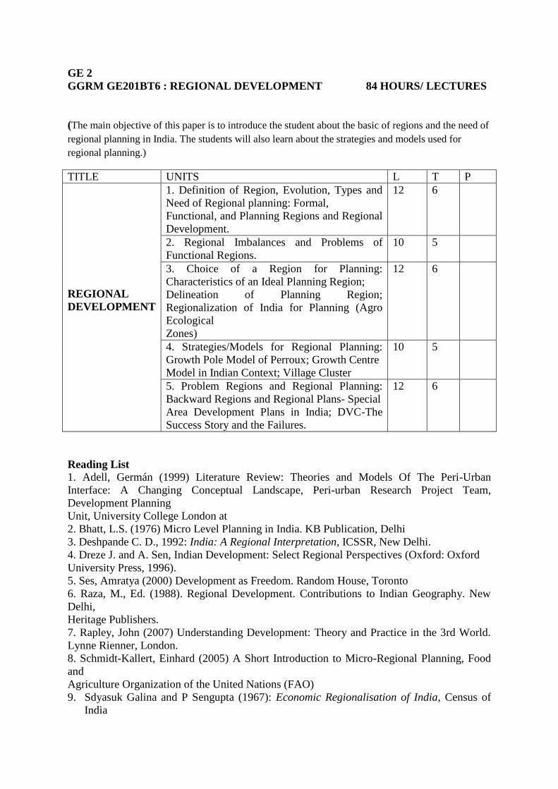
GGRM GE201BT6 : REGIONAL DEVELOPMENT 84 HOURS/ LECTURES
(The main objective of this paper is to introduce the student about the basic of regions and the need of
regional planning in India. The students will also learn about the strategies and models used for
regional planning.)
TITLE UNITS L T P
REGIONAL
DEVELOPMENT
1. Definition of Region, Evolution, Types and
Need of Regional planning: Formal,
Functional, and Planning Regions and Regional
Development.
12 6
2. Regional Imbalances and Problems of
Functional Regions.
10 5
3. Choice of a Region for Planning:
Characteristics of an Ideal Planning Region;
Delineation of Planning Region;
Regionalization of India for Planning (Agro
Ecological
Zones)
12 6
4. Strategies/Models for Regional Planning:
Growth Pole Model of Perroux; Growth Centre
Model in Indian Context; Village Cluster
10 5
5. Problem Regions and Regional Planning:
Backward Regions and Regional Plans- Special
Area Development Plans in India; DVC-The
Success Story and the Failures.
12 6
Reading List
1. Adell, Germán (1999) Literature Review: Theories and Models Of The Peri-Urban
Interface: A Changing Conceptual Landscape, Peri-urban Research Project Team,
Development Planning
Unit, University College London at
2. Bhatt, L.S. (1976) Micro Level Planning in India. KB Publication, Delhi
3. Deshpande C. D., 1992: India: A Regional Interpretation, ICSSR, New Delhi.
4. Dreze J. and A. Sen, Indian Development: Select Regional Perspectives (Oxford: Oxford
University Press, 1996).
5. Ses, Amratya (2000) Development as Freedom. Random House, Toronto
6. Raza, M., Ed. (1988). Regional Development. Contributions to Indian Geography. New
Delhi,
Heritage Publishers.
7. Rapley, John (2007) Understanding Development: Theory and Practice in the 3rd World.
Lynne Rienner, London.
8. Schmidt-Kallert, Einhard (2005) A Short Introduction to Micro-Regional Planning, Food
and
Agriculture Organization of the United Nations (FAO)
9. Sdyasuk Galina and P Sengupta (1967): Economic Regionalisation of India, Census of
India
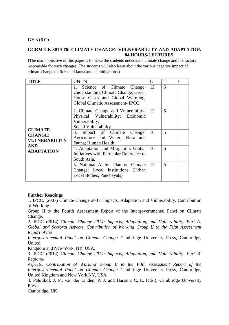
GE 3 (6 C)
GGRM GE 301AT6: CLIMATE CHANGE: VULNERABILITY AND ADAPTATION
84 HOURS/LECTURES
(The main objective of this paper is to make the students understand climate change and the factors
responsible for such changes. The students will also learn about the various negative impact of
climate change on flora and fauna and its mitigations.)
TITLE UNITS L T P
CLIMATE
CHANGE:
VULNERABILITY
AND
ADAPTATION
1. Science of Climate Change:
Understanding Climate Change; Green
House Gases and Global Warming;
Global Climatic Assessment- IPCC
12 6
2. Climate Change and Vulnerability:
Physical Vulnerability; Economic
Vulnerability;
Social Vulnerability
12 6
3. Impact of Climate Change:
Agriculture and Water; Flora and
Fauna; Human Health
10 5
4. Adaptation and Mitigation: Global
Initiatives with Particular Reference to
South Asia.
10 6
5. National Action Plan on Climate
Change; Local Institutions (Urban
Local Bodies, Panchayats)
12 5
Further Readings
1. IPCC. (2007) Climate Change 2007: Impacts, Adaptation and Vulnerability. Contribution
of Working
Group II to the Fourth Assessment Report of the Intergovernmental Panel on Climate
Change.
2. IPCC (2014) Climate Change 2014: Impacts, Adaptation, and Vulnerability. Part A:
Global and Sectoral Aspects. Contribution of Working Group II to the Fifth Assessment
Report of the
Intergovernmental Panel on Climate Change Cambridge University Press, Cambridge,
United
Kingdom and New York, NY, USA.
3. IPCC (2014) Climate Change 2014: Impacts, Adaptation, and Vulnerability. Part B:
Regional
Aspects. Contribution of Working Group II to the Fifth Assessment Report of the
Intergovernmental Panel on Climate Change Cambridge University Press, Cambridge,
United Kingdom and New York,NY, USA.
4. Palutikof, J. P., van der Linden, P. J. and Hanson, C. E. (eds.), Cambridge University
Press,
Cambridge, UK.

5. OECD. (2008) Climate Change Mitigation: What Do we Do? Organisation and Economic
Cooperation and Development.
6. UNEP. (2007) Global Environment Outlook: GEO4: Environment for Development,
United Nations Environment Programme.
7. Singh, M., Singh, R.B. and Hassan, M.I. (Eds.) (2014) Climate change and biodiversity:
Proceedings of IGU Rohtak Conference, Volume 1. Advances in Geographical and
Environmental Studies,Springer
8. Sen Roy, S. and Singh, R.B. (2002) Climate Variability, Extreme Events and Agricultural
Productivity in Mountain Regions, Oxford & IBH Pub., New Delhi.
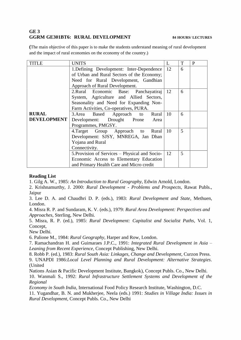
GE 3
GGRM GE301BT6: RURAL DEVELOPMENT 84 HOURS/ LECTURES
(The main objective of this paper is to make the students understand meaning of rural development
and the impact of rural economies on the economy of the country.)
TITLE UNITS L T P
RURAL
DEVELOPMENT
1.Defining Development: Inter-Dependence
of Urban and Rural Sectors of the Economy;
Need for Rural Development, Gandhian
Approach of Rural Development.
12 6
2.Rural Economic Base: Panchayatiraj
System, Agriculture and Allied Sectors,
Seasonality and Need for Expanding Non-
Farm Activities, Co-operatives, PURA.
12 6
3.Area Based Approach to Rural
Development: Drought Prone Area
Programmes, PMGSY.
10 6
4.Target Group Approach to Rural
Development: SJSY, MNREGA, Jan Dhan
Yojana and Rural
Connectivity.
10 5
5.Provision of Services – Physical and Socio-
Economic Access to Elementary Education
and Primary Health Care and Micro credit
12 5
Reading List
1. Gilg A. W., 1985: An Introduction to Rural Geography, Edwin Arnold, London.
2. Krishnamurthy, J. 2000: Rural Development - Problems and Prospects, Rawat Publs.,
Jaipur
3. Lee D. A. and Chaudhri D. P. (eds.), 1983: Rural Development and State, Methuen,
London.
4. Misra R. P. and Sundaram, K. V. (eds.), 1979: Rural Area Development: Perspectives and
Approaches, Sterling, New Delhi.
5. Misra, R. P. (ed.), 1985: Rural Development: Capitalist and Socialist Paths, Vol. 1,
Concept,
New Delhi.
6. Palione M., 1984: Rural Geography, Harper and Row, London.
7. Ramachandran H. and Guimaraes J.P.C., 1991: Integrated Rural Development in Asia –
Leaning from Recent Experience, Concept Publishing, New Delhi.
8. Robb P. (ed.), 1983: Rural South Asia: Linkages, Change and Development, Curzon Press.
9. UNAPDI 1986:Local Level Planning and Rural Development: Alternative Strategies.
(United
Nations Asian & Pacific Development Institute, Bangkok), Concept Publs. Co., New Delhi.
10. Wanmali S., 1992: Rural Infrastructure Settlement Systems and Development of the
Regional
Economy in South India, International Food Policy Research Institute, Washington, D.C.
11. Yugandhar, B. N. and Mukherjee, Neela (eds.) 1991: Studies in Village India: Issues in
Rural Development, Concept Publs. Co., New Delhi
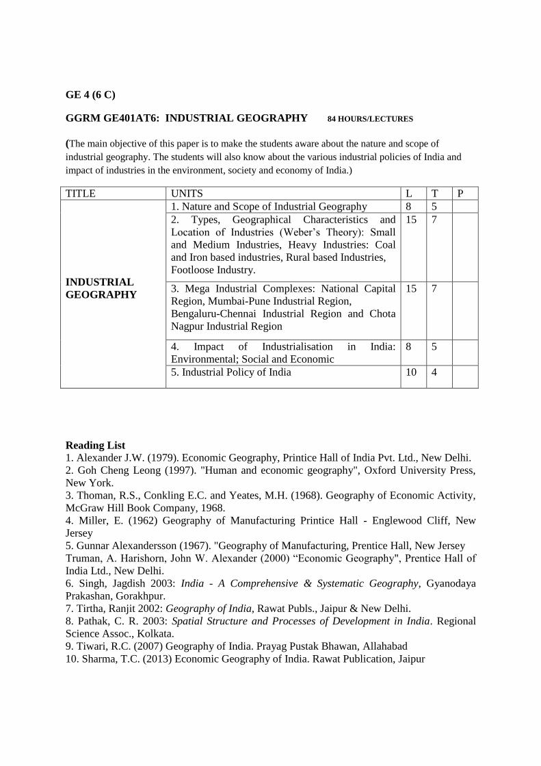
GE 4 (6 C)
GGRM GE401AT6: INDUSTRIAL GEOGRAPHY 84 HOURS/LECTURES
(The main objective of this paper is to make the students aware about the nature and scope of
industrial geography. The students will also know about the various industrial policies of India and
impact of industries in the environment, society and economy of India.)
TITLE UNITS L T P
INDUSTRIAL
GEOGRAPHY
1. Nature and Scope of Industrial Geography 8 5
2. Types, Geographical Characteristics and
Location of Industries (Weber’s Theory): Small
and Medium Industries, Heavy Industries: Coal
and Iron based industries, Rural based Industries,
Footloose Industry.
15 7
3. Mega Industrial Complexes: National Capital
Region, Mumbai-Pune Industrial Region,
Bengaluru-Chennai Industrial Region and Chota
Nagpur Industrial Region
15 7
4. Impact of Industrialisation in India:
Environmental; Social and Economic
8 5
5. Industrial Policy of India 10 4
Reading List
1. Alexander J.W. (1979). Economic Geography, Printice Hall of India Pvt. Ltd., New Delhi.
2. Goh Cheng Leong (1997). "Human and economic geography", Oxford University Press,
New York.
3. Thoman, R.S., Conkling E.C. and Yeates, M.H. (1968). Geography of Economic Activity,
McGraw Hill Book Company, 1968.
4. Miller, E. (1962) Geography of Manufacturing Printice Hall - Englewood Cliff, New
Jersey
5. Gunnar Alexandersson (1967). "Geography of Manufacturing, Prentice Hall, New Jersey
Truman, A. Harishorn, John W. Alexander (2000) “Economic Geography", Prentice Hall of
India Ltd., New Delhi.
6. Singh, Jagdish 2003: India - A Comprehensive & Systematic Geography, Gyanodaya
Prakashan, Gorakhpur.
7. Tirtha, Ranjit 2002: Geography of India, Rawat Publs., Jaipur & New Delhi.
8. Pathak, C. R. 2003: Spatial Structure and Processes of Development in India. Regional
Science Assoc., Kolkata.
9. Tiwari, R.C. (2007) Geography of India. Prayag Pustak Bhawan, Allahabad
10. Sharma, T.C. (2013) Economic Geography of India. Rawat Publication, Jaipur
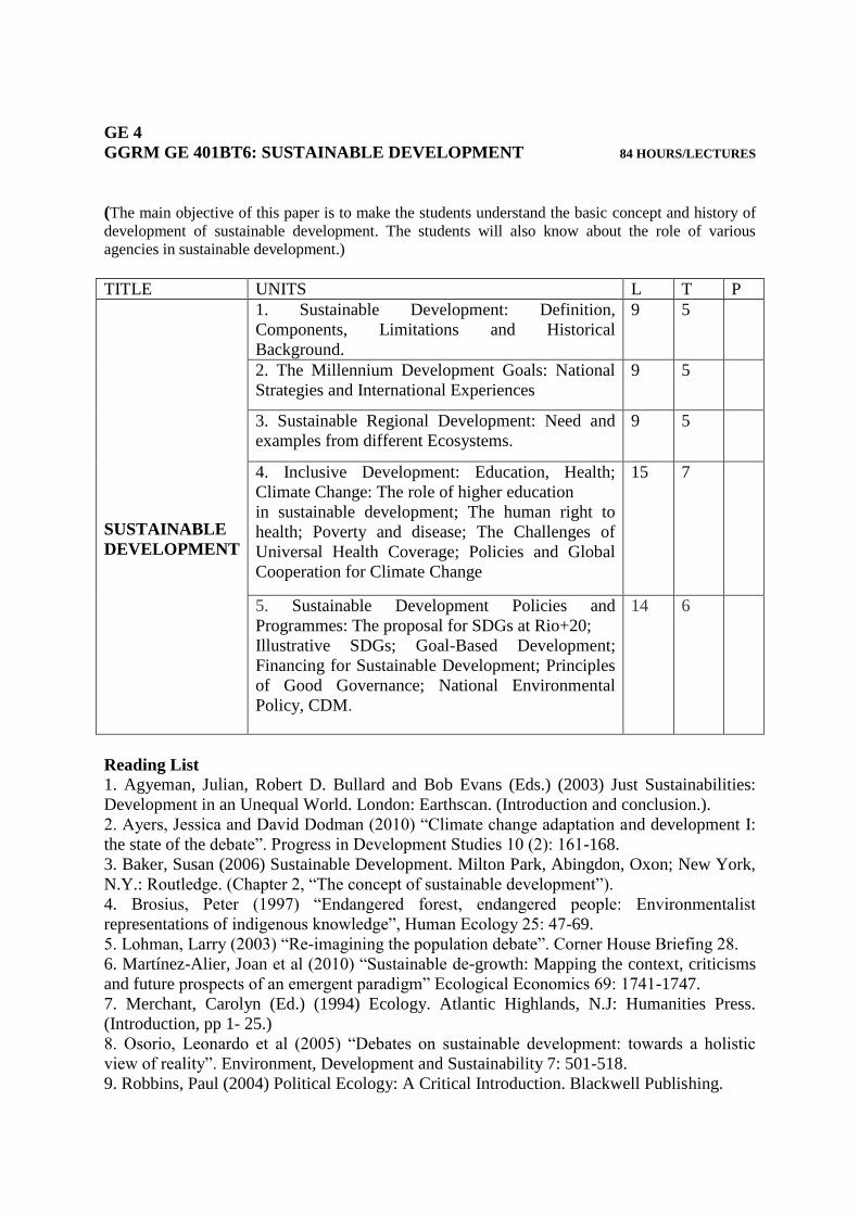
GE 4
GGRM GE 401BT6: SUSTAINABLE DEVELOPMENT 84 HOURS/LECTURES
(The main objective of this paper is to make the students understand the basic concept and history of
development of sustainable development. The students will also know about the role of various
agencies in sustainable development.)
TITLE UNITS L T P
SUSTAINABLE
DEVELOPMENT
1. Sustainable Development: Definition,
Components, Limitations and Historical
Background.
9 5
2. The Millennium Development Goals: National
Strategies and International Experiences
9 5
3. Sustainable Regional Development: Need and
examples from different Ecosystems.
9 5
4. Inclusive Development: Education, Health;
Climate Change: The role of higher education
in sustainable development; The human right to
health; Poverty and disease; The Challenges of
Universal Health Coverage; Policies and Global
Cooperation for Climate Change
15 7
5. Sustainable Development Policies and
Programmes: The proposal for SDGs at Rio+20;
Illustrative SDGs; Goal-Based Development;
Financing for Sustainable Development; Principles
of Good Governance; National Environmental
Policy, CDM.
14 6
Reading List
1. Agyeman, Julian, Robert D. Bullard and Bob Evans (Eds.) (2003) Just Sustainabilities:
Development in an Unequal World. London: Earthscan. (Introduction and conclusion.).
2. Ayers, Jessica and David Dodman (2010) “Climate change adaptation and development I:
the state of the debate”. Progress in Development Studies 10 (2): 161-168.
3. Baker, Susan (2006) Sustainable Development. Milton Park, Abingdon, Oxon; New York,
N.Y.: Routledge. (Chapter 2, “The concept of sustainable development”).
4. Brosius, Peter (1997) “Endangered forest, endangered people: Environmentalist
representations of indigenous knowledge”, Human Ecology 25: 47-69.
5. Lohman, Larry (2003) “Re-imagining the population debate”. Corner House Briefing 28.
6. Martínez-Alier, Joan et al (2010) “Sustainable de-growth: Mapping the context, criticisms
and future prospects of an emergent paradigm” Ecological Economics 69: 1741-1747.
7. Merchant, Carolyn (Ed.) (1994) Ecology. Atlantic Highlands, N.J: Humanities Press.
(Introduction, pp 1- 25.)
8. Osorio, Leonardo et al (2005) “Debates on sustainable development: towards a holistic
view of reality”. Environment, Development and Sustainability 7: 501-518.
9. Robbins, Paul (2004) Political Ecology: A Critical Introduction. Blackwell Publishing.
Copyright © 2022 FDOKUMEN

