


Bahasa
Halaman
Hukum

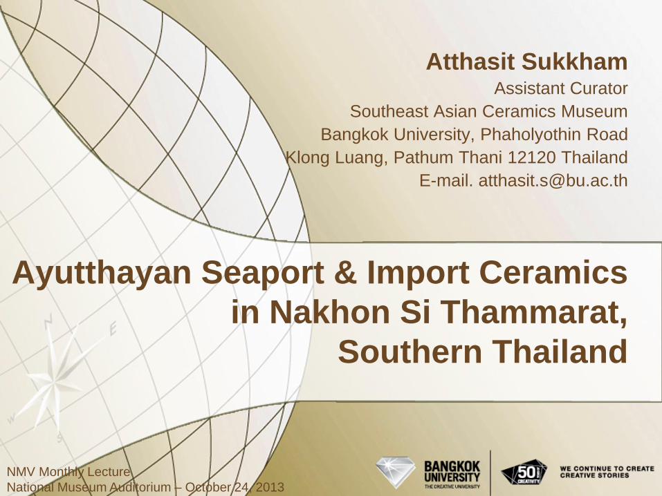
Ayutthayan Seaport & Import Ceramics
in Nakhon Si Thammarat,
Southern Thailand
Atthasit Sukkham Assistant Curator
Southeast Asian Ceramics Museum
Bangkok University, Phaholyothin Road
Klong Luang, Pathum Thani 12120 Thailand
E-mail. [email protected]
NMV Monthly Lecture
National Museum Auditorium – October 24, 2013
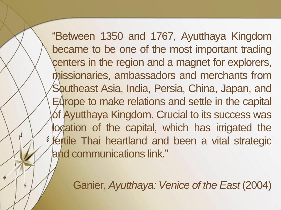
“Between 1350 and 1767, Ayutthaya Kingdom
became to be one of the most important trading
centers in the region and a magnet for explorers,
missionaries, ambassadors and merchants from
Southeast Asia, India, Persia, China, Japan, and
Europe to make relations and settle in the capital
of Ayutthaya Kingdom. Crucial to its success was
location of the capital, which has irrigated the
fertile Thai heartland and been a vital strategic
and communications link.”
Ganier, Ayutthaya: Venice of the East (2004)

AYUTTHAYA KINGDOM
& THE CAPITAL
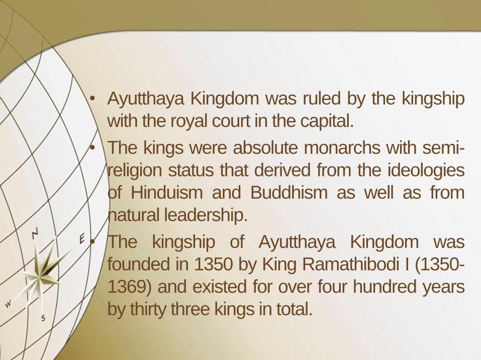
• Ayutthaya Kingdom was ruled by the kingship
with the royal court in the capital.
• The kings were absolute monarchs with semi-
religion status that derived from the ideologies
of Hinduism and Buddhism as well as from
natural leadership.
• The kingship of Ayutthaya Kingdom was
founded in 1350 by King Ramathibodi I (1350-
1369) and existed for over four hundred years
by thirty three kings in total.

List of the Kings of Ayutthaya and China
Ayutthaya Ming
King Ramathibodi I*
1350-1369
Hongwu Emperor #
1368-1398
King Ramesuan*
1369-1370
King Boromarachathirat I*
1370-1388
King Thong Lan*
1388
King Ramesuan*
1388-1395
King Ramracha*
1395-1409
Jianwen Emperor#
1399-1402
King Nakharindrathirat*
1409-1424
Yongle Emperor#
1403-1424
* Early Ayutthaya, # Ming Gap Shortage
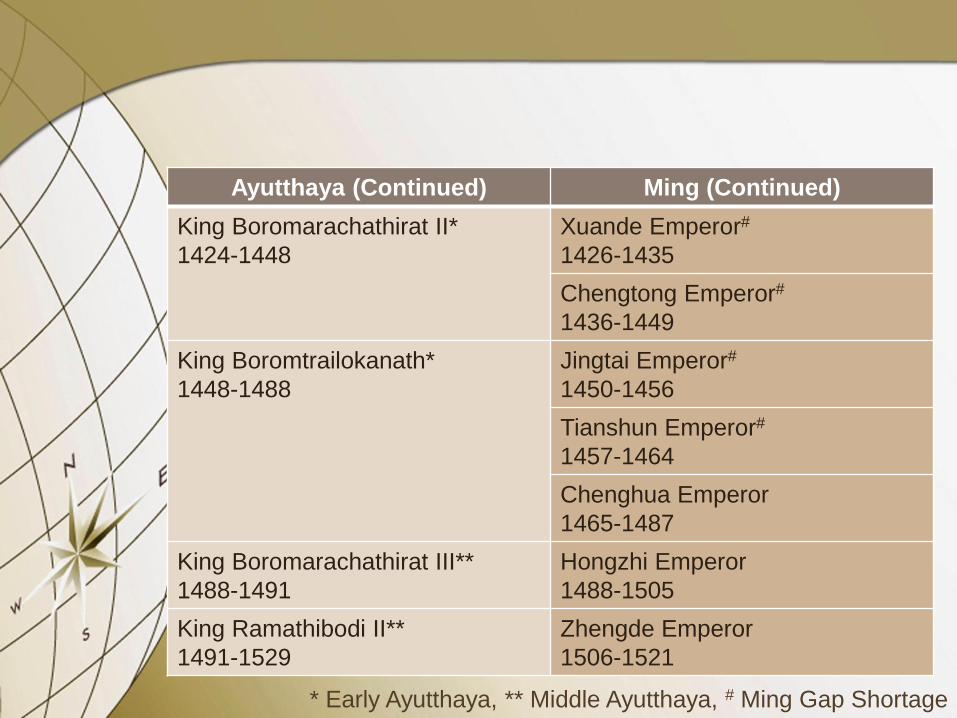
Ayutthaya (Continued) Ming (Continued)
King Boromarachathirat II*
1424-1448
Xuande Emperor#
1426-1435
Chengtong Emperor#
1436-1449
King Boromtrailokanath*
1448-1488
Jingtai Emperor#
1450-1456
Tianshun Emperor#
1457-1464
Chenghua Emperor
1465-1487
King Boromarachathirat III**
1488-1491
Hongzhi Emperor
1488-1505
King Ramathibodi II**
1491-1529
Zhengde Emperor
1506-1521
* Early Ayutthaya, ** Middle Ayutthaya, # Ming Gap Shortage

Ayutthaya (Continued) Ming (Continued)
King Boromarachathirat IV**
1529-1533
Jiajing Emperor
1522-1566
King Ratsadathirat**
1533-1534
King Chairacha**
1534-1546
King Kaew Fa**
1546-1548
King Mahachakkraphat**
1548-1568
King Mahindrathirat**
1568-1569
Longqing Emperor
1567-1573
King Mahathammaracha**
1569-1590
Wanli Emperor
1573-1619
** Middle Ayutthaya
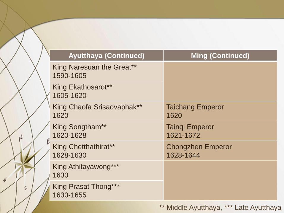
Ayutthaya (Continued) Ming (Continued)
King Naresuan the Great**
1590-1605
King Ekathosarot**
1605-1620
King Chaofa Srisaovaphak**
1620
Taichang Emperor
1620
King Songtham**
1620-1628
Tainqi Emperor
1621-1672
King Chetthathirat**
1628-1630
Chongzhen Emperor
1628-1644
King Athitayawong***
1630
King Prasat Thong***
1630-1655
** Middle Ayutthaya, *** Late Ayutthaya
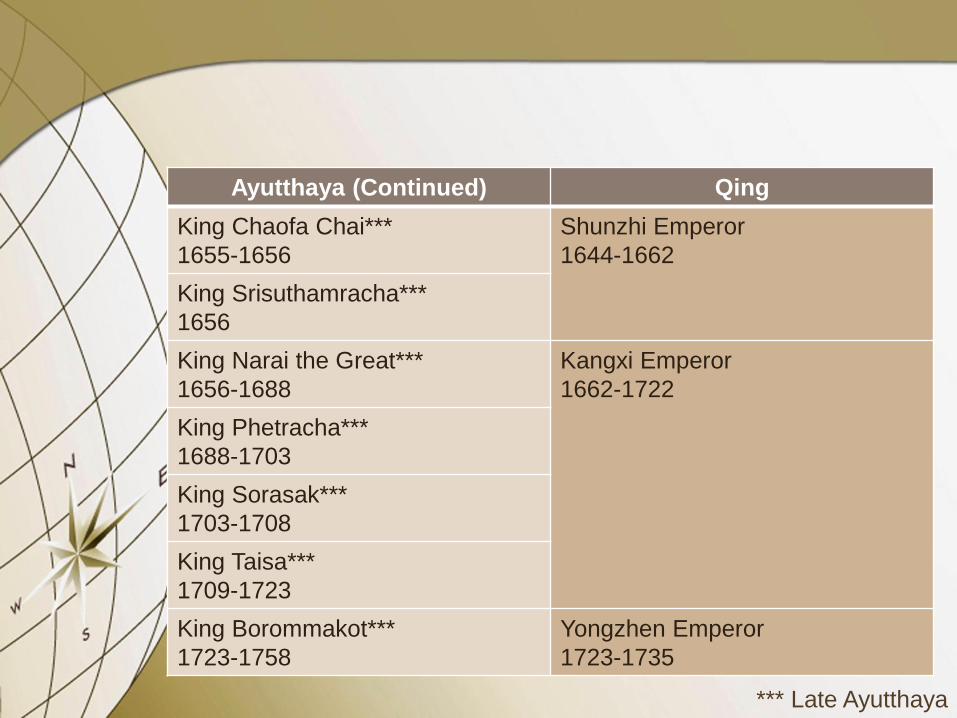
Ayutthaya (Continued) Qing
King Chaofa Chai***
1655-1656
Shunzhi Emperor
1644-1662
King Srisuthamracha***
1656
King Narai the Great***
1656-1688
Kangxi Emperor
1662-1722
King Phetracha***
1688-1703
King Sorasak***
1703-1708
King Taisa***
1709-1723
King Borommakot***
1723-1758
Yongzhen Emperor
1723-1735
*** Late Ayutthaya
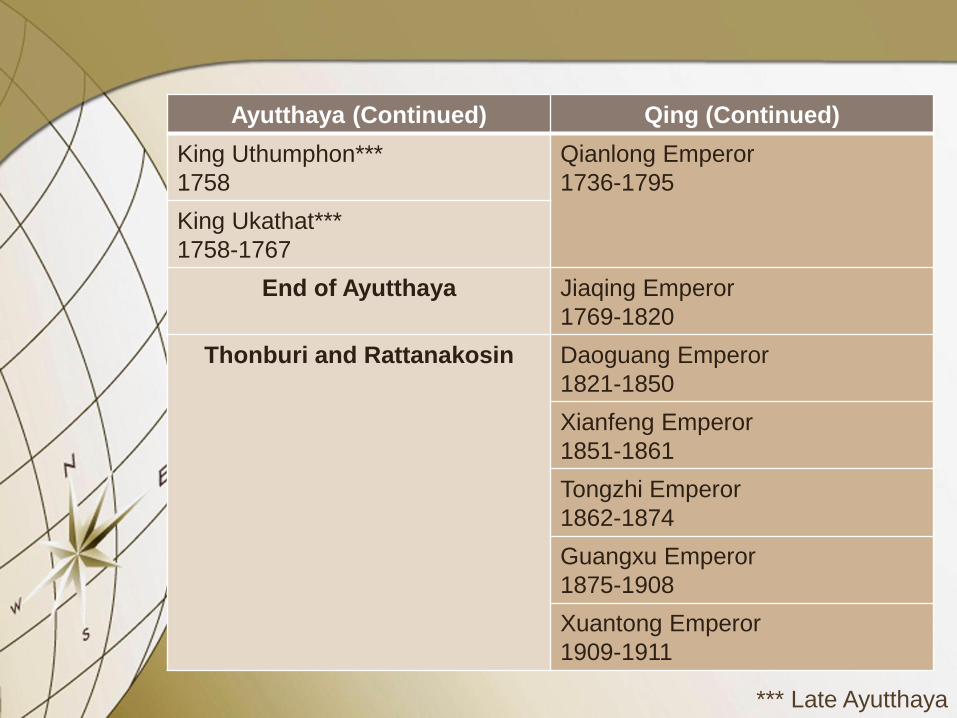
Ayutthaya (Continued) Qing (Continued)
King Uthumphon***
1758
Qianlong Emperor
1736-1795
King Ukathat***
1758-1767
End of Ayutthaya
Jiaqing Emperor
1769-1820
Thonburi and Rattanakosin Daoguang Emperor
1821-1850
Xianfeng Emperor
1851-1861
Tongzhi Emperor
1862-1874
Guangxu Emperor
1875-1908
Xuantong Emperor
1909-1911
*** Late Ayutthaya
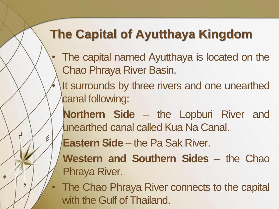
The Capital of Ayutthaya Kingdom
• The capital named Ayutthaya is located on the
Chao Phraya River Basin.
• It surrounds by three rivers and one unearthed
canal following:
Northern Side – the Lopburi River and
unearthed canal called Kua Na Canal.
Eastern Side – the Pa Sak River.
Western and Southern Sides – the Chao
Phraya River.
• The Chao Phraya River connects to the capital
with the Gulf of Thailand.
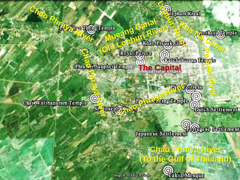
The Capital
Chao Phraya River
(To the Gulf of Thailand)

The Town Conditions of the Capital of
Ayutthaya Kingdom
• Royal Palace – is situated on the northern
riverside of the capital and is believed to use
since the first reign until the last reign, excepted
King Narai the Great (1656-1688) who stayed
at the royal place in Lopburi (formerly called
Lavo or Louvo) that he also designated there to
be the second capital.
• Phra Sri Sanphet Temple – is a place for
performing royal ceremonies and religious
practices for the kings and royal families in the
royal palace.

Ancient Map of Ayutthaya, Vincenzo Coronelli
(Italian), 1698 Source: Suarez, Early Mapping of Southeast Asia (1999)
Royal Palace and Phra Sri Sanphet Temple
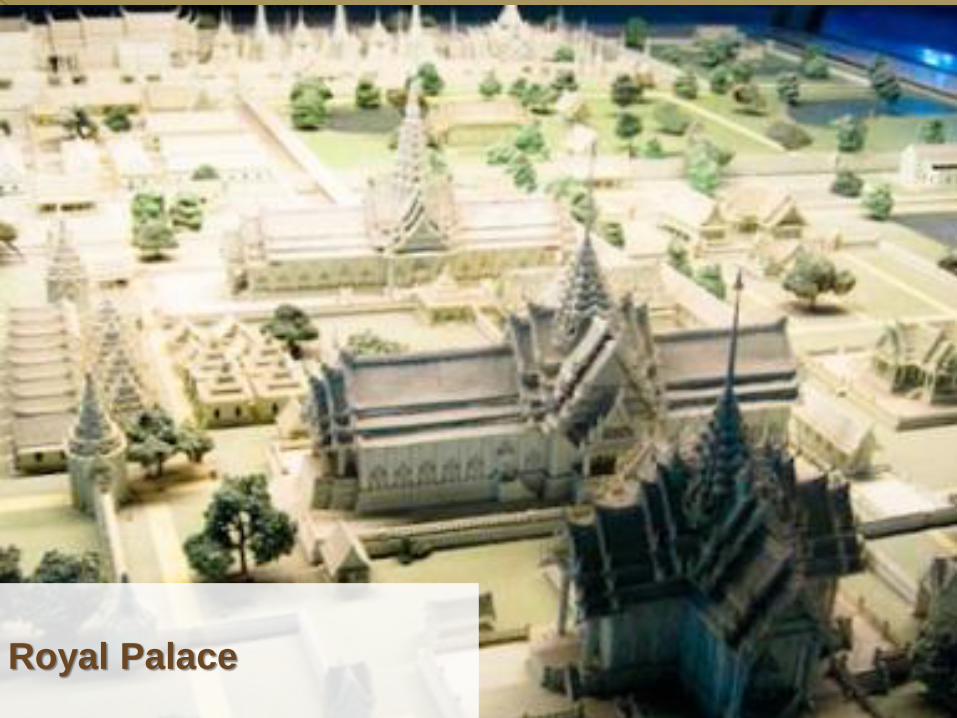
Royal Palace

Phra Sri Sanphet Temple

Ancient Map of Lopburi, Nicolas Bellin (French),
1747 Source: Suarez, Early Mapping of Southeast Asia (1999)
Royal Palace

Outer Court
(Depositories) of
the King Narai’s Palace

Middle Court (throne-halls
and state buildings) of
the King Narai’s Palace

Dusit Sawan Thanya
Mahaprasat Throne-hall
in the Middle Court of the
King Narai’s Palace
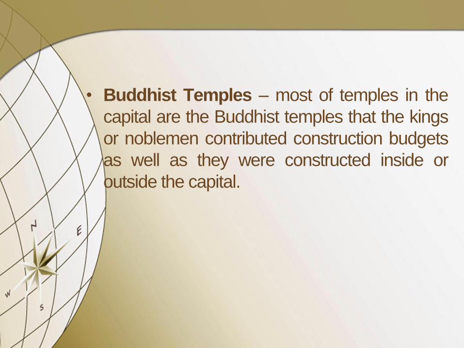
• Buddhist Temples – most of temples in the
capital are the Buddhist temples that the kings
or noblemen contributed construction budgets
as well as they were constructed inside or
outside the capital.

• The important Buddhist temples inside the
capital comprise of Ratchaburana, Mahathat,
Lokaya Sutta, Phra Ram, and Suwan Dararam
Temples, for instance.
• The important Buddhist temples outside the
capital comprise of Phu Khao Thong, Na Phra
Main, Chai Watthanaram, Phutthai Sawan,
Phanancherng, Yai Chaimongkhol, Maheyong,
Kudidao, and Ayotthaya Temples, for instance.
• Their architectures are Indian, Khmer, Chinese,
and European influences.
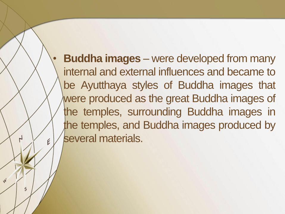
• Buddha images – were developed from many
internal and external influences and became to
be Ayutthaya styles of Buddha images that
were produced as the great Buddha images of
the temples, surrounding Buddha images in
the temples, and Buddha images produced by
several materials.

• Church – is constructed when the European
people and dissemination of Christianity had
arrived and permitted by the kings especially St.
Joseph Church, which was built around 1656-
1688 and located on the southern outside of the
capital.
• Mosque – many Arabian, Persian, Indian,
Melayu, and Tani Muslim people had also
permitted by the kings and they built the
mosque especially Takia Mosque, which was
built around 1620-1628 and located on the
southern outside the capital.

• Gates, Fortresses, and Town Walls – some
part was destroyed because of the land
developments but some of them still survived
and restored, specifically Khao Pleuak Gate
and Phet Fortress, for instance.
• Elephant Corral and Kraal – previously used
on the northeastern corner of the capital close
to Kua Na Canal and then changed to the
northern outside of the capital close to the
Lopburi River since the reign of King
Mahachakkraphat (1548-1568).

The Capital

Foreigners in
the Capital of Ayutthaya Kingdom
• Chinese
• Vietnamese
• Indian
• Persian
• Portuguese (since 1511)
• Japanese (since 1563)
• Dutch (since 1605 or 1620)
• British (since 1612)
• French (since 1683)

International Port in
the Capital of Ayutthaya Kingdom
• The anchorage for international ships is
situated at the confluence of the Chao Phraya
and the Pa Sak Rivers in front of the Phet
Fortress in the southern side of the capital.
• Foreigners have got permission by the kings to
settle and set up villages in the southern
outside of the capital and to operate the trading
stations as well.

Phet Fortress with the Confluence of
the Chao Phraya and the Pa Sak Rivers
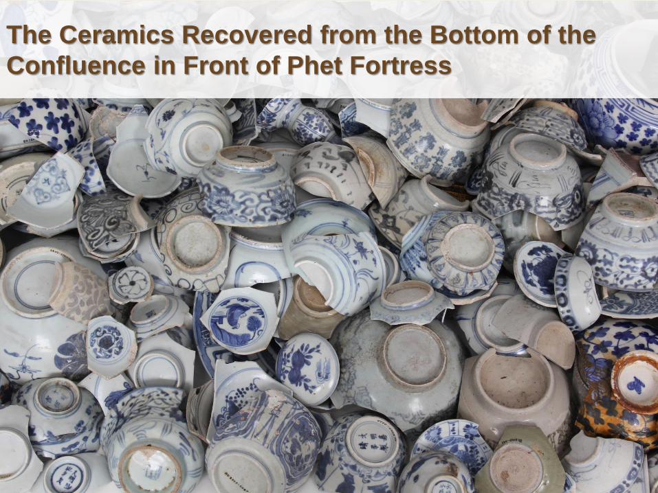
The Ceramics Recovered from the Bottom of the
Confluence in Front of Phet Fortress

The Capital
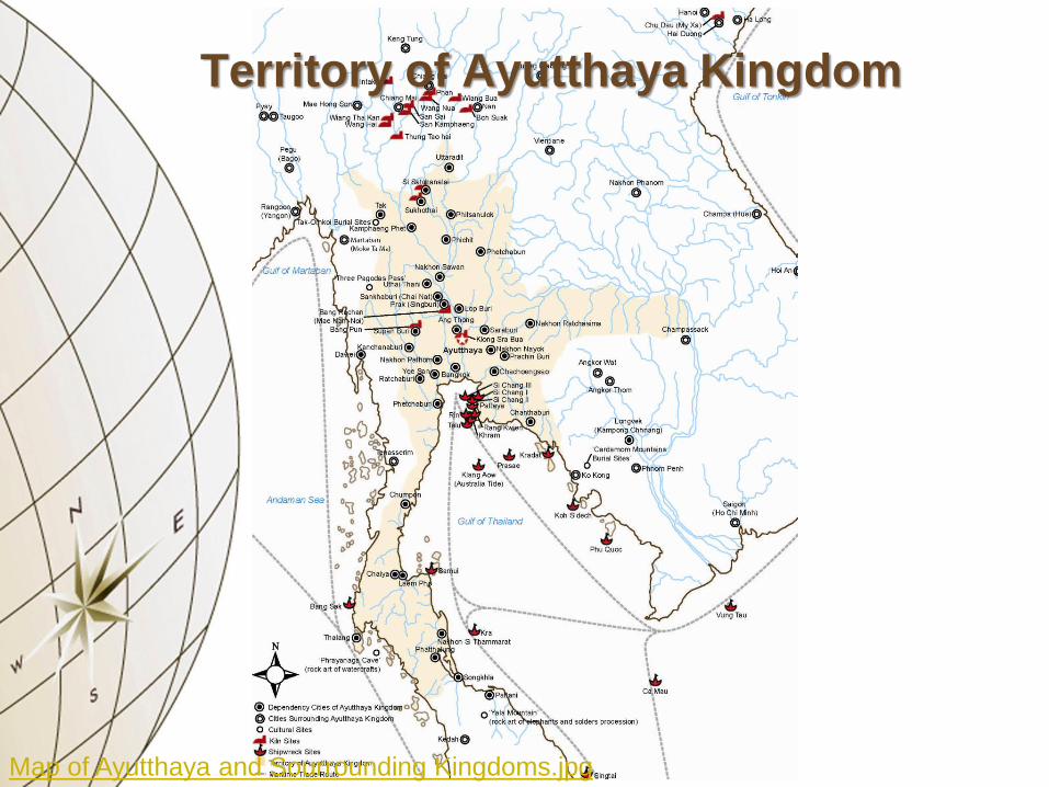
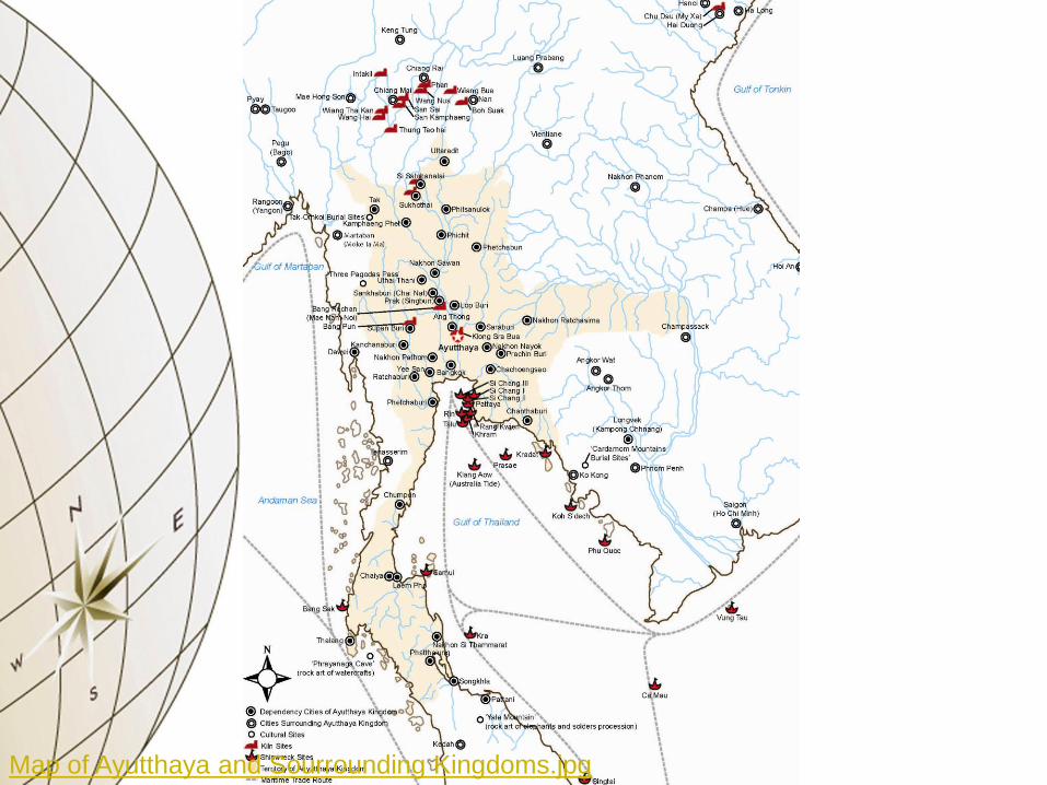
Map of Ayutthaya and Sourrounding Kingdoms.jpg
Territory of Ayutthaya Kingdom

Ancient Map of Mainland Southeast Asia and Siam,
Andreas and Metellus, 1596 Source: Suarez, Early Mapping of Southeast Asia (1999)

Ancient Map of Insular Southeast Asia, Jodocus
Hondius (Dutch), 1606 Source: Suarez, Early Mapping of Southeast Asia (1999)

Ancient Map of India and Southeast Asia, Willem J.
Blaeu (Dutch), 1635 Source: Suarez, Early Mapping of Southeast Asia (1999)

Ancient Map of Southeast Asia, Dudley, 1665 Source: Suarez, Early Mapping of Southeast Asia (1999)
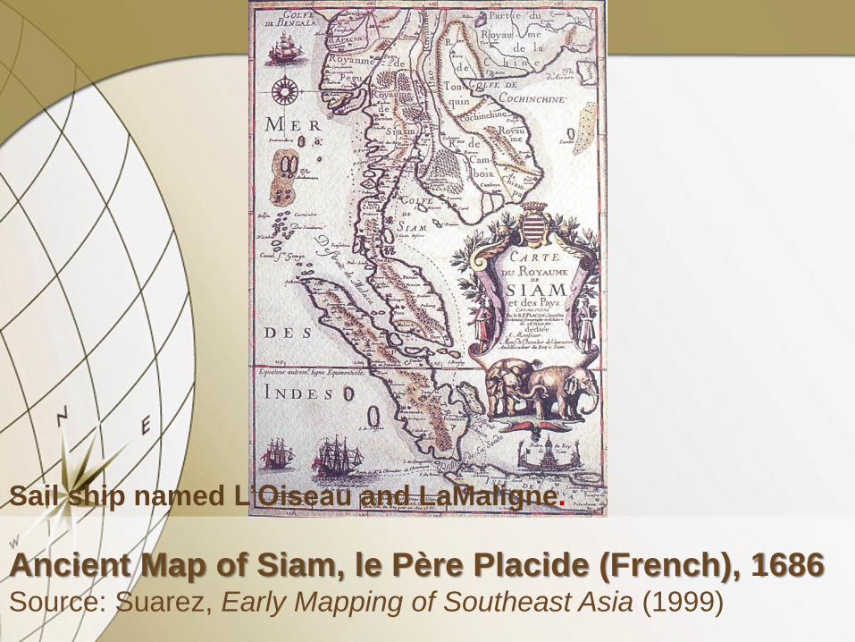
Ancient Map of Siam, le Père Placide (French), 1686 Source: Suarez, Early Mapping of Southeast Asia (1999)
Sail ship named L’Oiseau and LaMaligne.

Ancient Map of Siam, Jean Dominique Cassini
(French), 1688 Source: Suarez, Early Mapping of Southeast Asia (1999)

GEOGRAPHY OF
MALAY PENINSULA

Indian Ocean
Bay of Bengal
Gulf of Martaban South China Sea
East China Sea
Gulf of Thailand A
nd
am
an
Sea
A BRIEF HISTORY & FORMATION OF
TAMBRALINGA, LIGOR
TILL NAKHON SI THAMMARAT
According to a few historical records specifically
legends, scriptures, inscriptions, and chronicles
written in several languages and even local
languages including the results of archaeological
research by the Fine Arts Department of Thailand
and foreign researchers, the middle part of Malay
Peninsula formulated since the 1st century.
Between the 1st and 7th Centuries
• This region was first connected to international
maritime routes and the cultural exchanges
were began since then, specifically with India,
Persia, and China even Southeast Asia. They
transmitted the religious beliefs and brought
several kinds of cultural materials to this region.
• Satavahana bronze coins, Hindu images,
Buddha images, Indian rouletted ceramics,
Han ceramics, and various kinds of bead, for
instance, are the diagnostic artifacts that have
been found in this region.

Between the 8th and 13th Centuries
• Many cities and temples were formulated in the
region as Srivijaya Kingdom covering on the
modern countries of the southern Thailand,
Malaysia, and Indonesia. By many
archaeological researches, some cities were
recorded their old name even a brief history of
politics, trades, and wars in a few Chinese,
Arabian, and Sanskrit chronicles. Tang
ceramics including a lot of domestic and non-
domestic cultural materials have been found
there as well.

• Those evidences represented Srivijaya
Kingdom as a complex and powerful kingdom
by many religious activities, cultural
exchanges, trades, fleet of warships, trans-
peninsula routes, and maritime routes.

“Tambralinga”
• Tambralinga was a kingdom located on
the Malay Peninsula that at one time came
under the influence of Srivijaya and was
believed to be Nakhon Si Thammarat.
Early records are scarce while estimations
range from the 7th to 14th centuries. The
word “Tambralinga” is Sanskrit language
meant “Red Linga (the Hindu phallic
symbol of Siva)” that usually recorded in
different words of the Indian and Sri Lanka
chronicles.

• The history of Tambralinga was also recorded
in the King Sri Dhammasokaraja of Nakhon Si
Thammarat’s inscription that dated around the
13th century. The inscription mentioned about
Tambralinga as a thriving Buddhist city.

Between the 13th to 14th Centuries
• Some cities in southern region that formulated
since Srivijaya had established new relation
with Sukhothai Kingdom in the northern region
especially Nakhon Si Thammarat.
• They also established the relation with Sri
Lanka especially for religious purposes. The Sri
Lanka Buddhist including its architectures of
Polonnaruwa round bell-shaped stupa
transmitted to Nakhon Si Thammarat then
spread to Sukhothai and Ayutthaya.

• According to other Nakhon Si Thammarat’s
chronicle, a great stupa of the temple called
Phra Borommatrat Chedi (the Great Noble
Relics Stupa and recently called Phra Mahatrat
Temple) was built prior to other religious
architectural buildings in the temple by King Sri
Dhammasokaraja of Nakhon Si Thammarat in
approximately the early 13th century in order to
establish the Theravada Buddhist symbol in the
region.
• Nakhon Si Thammarat’s legend also
mentioned about twelve dependency cities of
Nakhon Si Thammarat during the early 13th to
mid-14th centuries that called “the Twelve
Zodiac” with animal symbols of the city
following:

The Twelve Zodiac
under Nakhon Si Thammarat
Sai (Sai Buri)
rat
Tani (Pattani)
cow
Kelantan
tiger
Pahang
rabbit
Si
big snake
Phatthalung
small snake
Trang
horse
Chumpon
goat
Banteay Smo
(Chaiya)
monkey
Sra U-rao
(Tathong)
chicken
Takua Pa
dog
Kra (Kra Buri)
pig

Between 1350 and 1767
• Ayutthaya desired to conquer the mainland
Southeast Asia and developed to be the
strongest and wealthy kingdom. Ayutthaya
began its hegemony by conquering northern,
western, eastern, and especially southern
regions for territory expansions, population
increases, the occupations of an important
resource, and economic development.

“Nakhon Si Thammrat”
• The word “Si Thammarat” was first appeared in
the King Ram Kamhaeng’s inscription no. 1 of
Sukhothai Kingdom that assumed to be
Nakhon Si Thammarat.
• Ayutthaya chronicles always recorded as
“Nakhon Si Thammarat” but the spelling was
various.
• Only one European map that recorded the
word “Nucaon” is the map of Southeast Asia
and Siam or “Regnvm Sian”, which drawn by
Andreas and Metellus in 1596.
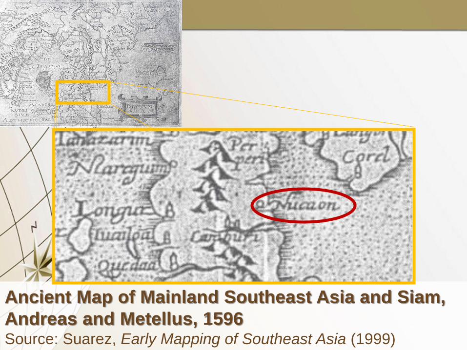
Ancient Map of Mainland Southeast Asia and Siam,
Andreas and Metellus, 1596 Source: Suarez, Early Mapping of Southeast Asia (1999)

“Ligor”
• In fact, Portuguese merchants arrived to this
region around the early 16th century and they
could not pronounced “N” and distorted to be
“L” instead.
• The words “Ligor” “Ligoral” and “Lugu” were
used to record the location of Nakhon Si
Thammarat in many European maps during
the 16th to 17th centuries that represented the
port towns along their journeys to the capital of
Ayutthaya Kingdom.

Ancient Map of Siam, Jean Dominique Cassini
(French), 1688 Source: Suarez, Early Mapping of Southeast Asia (1999)

NAKHON SI THAMMARAT AS
A CHIEF CITY & A SEAPORT OF
AYUTTHAYA KINGDOM IN THE SOUTH

• King Ramathibodi I (1350-1369), who founded
Ayutthaya Kingdom, sent troops to conquer the
northern, western, eastern, and especially
southern regions.
• Nakhon Si Thammarat defeated and was ruled
by Ayutthaya since then.
•

• The reforms in the reign of
King Boromtrailokanath (1448-1488) adopted a
Mandala-style tributary (circle of power) system
and developed new local government
organizations for the dependency cities
systematically.

Local Government Organization
Ayutthaya
Inner Cities
Outer or Chief Cities (Phraya Maha Nakhon)
Tributary City-states
Independent City-states

• Nakhon Si Thammarat was listed to be chief
city (Phraya Maha Nakhon) in southern territory
of Ayutthaya Kingdom to control other four
cities, specifically Phatthalung, Chaiya,
Chumpon, and Thalang.
• After that, there was changed to be primary-
rank outer city with high level of security and
transferred all dependency cities under it to
control from the capital directly to protect the
rebellion.


• Since the reign of King Boromtrailokanath
(1448-1488), the restoration of Buddhist
temples, which were built since previous
periods, and religious promotion on the
Buddhism became to be a tradition for every
kings of Ayutthaya Kingdom.
• Especially at the main temples as the center of
the cities, such as Phra Borommatrat Temple
as the center of Chaiya and Phra Mahatrat
Temple as the center of Nakhon Si Thammarat,
for instance.

Phra Borommatrat Temple as the Center of Chaiya

Phra Mahatrat Temple as the Center of
Nakhon Si Thammarat

• The town wall was believed to construct since
the reign of King Sri Dhammasokaraja of
Nakhon Si Thammarat in approximately the
early 13th century.
• In Ayutthaya period, they were repaired several
times, such as in the reigns of King Ramesuan
(1388-1395), King Ramathibodi II (1491-1529),
and King Naresuan the Great (1590-1605).

• As well as King Narai the Great (1656-1688)
ordered to Monsieur de la Mare, a French
engineer, to surveyed for designing and
construction of the town walls of Nakhon Si
Thammarat, Phatthalung, Songkhla, Bangkok,
Lopburi, In Buri, and Myeik officially.

Ancient Plan of Nakhon Si Thammarat’s Town Wall,
de la Mare (French), 1686 Source: Fine Arts Department, GIS Database (2013)
Phra Mahatrat Temple
Can
al
Canal
Coastline


• In fact, Nakhon Si Thammarat is situated far
from the bay around 13 kilometers that
connected between them by many rivers.

• The map by Monsieur de la Mare recorded a
canal in the southern outside the town.
• The 14th Regional Office of Fine Arts
Department has reported that the villagers
have been found a few fragments of Chinese
ceramics of Tang to Qing Dynasties along the
waterside in Klong Ta Rua sub-district but
some villager called that canal as the Ta Rua
Canal, which connected with the area in front of
southern gate.
• The southern side of town is possible to be
the port at the time.
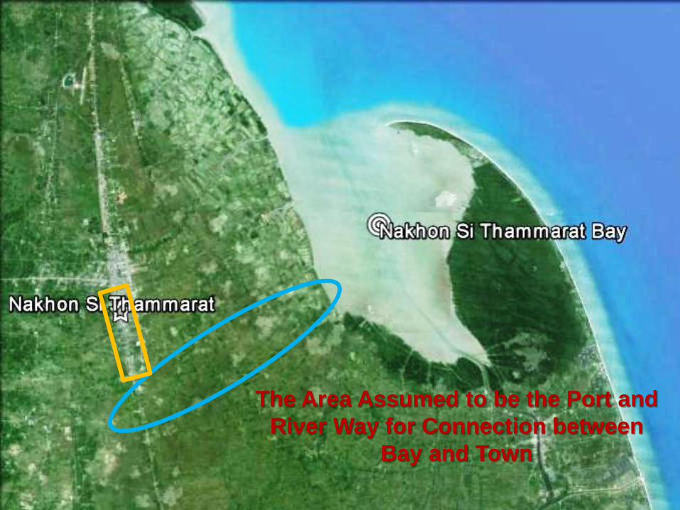
The Area Assumed to be the Port and
River Way for Connection between
Bay and Town

• Peppers and tins are local products that were
popular and supplied for Far Eastern and
European markets.
• Since the reign of King Ekathosarot (1605-
1620), Dutch got permission to open trading
stations in Nakhon Si Thammarat and Pattani
since 1612 as well as British got permission to
open a trading station in Nakhon Si Thammarat
since 1621.

CERAMICS FOUND IN
NAKHON SI THAMMARAT

• The ceramics were used to be religious
purpose that have usually been found as
several archaeological contexts including
around the pedestal of stupa, inside stupa, and
around temple but have no human remains
inside.
• They were also used to be architectural
decoration.

1280-1368 1368-1424 1426-1505 1506-1521 1573-1644 1644-1911
Chinese
(Yuan Dynasty)
- celadon
Chinese
(Ming Dynasty)
- celadon
- blue-and-white
- overglaze enameled
Chinese
(Qing Dynasty)
- white glazed
- blue glazed
- blue-and-white
- overglaze
enameled
Vietnamese
(Le Dynasty)
- blue-and-white
Si Satchanalai
- classic celadon
Si Satchanalai
- underglaze
black
- two-color
glazed


1280-1368
Chinese Ceramics of Yuan Dynasty
Vietnamese Ceramics of Tran Dynasty
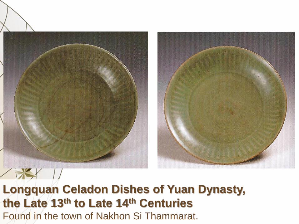
Longquan Celadon Dishes of Yuan Dynasty,
the Late 13th to Late 14th Centuries Found in the town of Nakhon Si Thammarat.
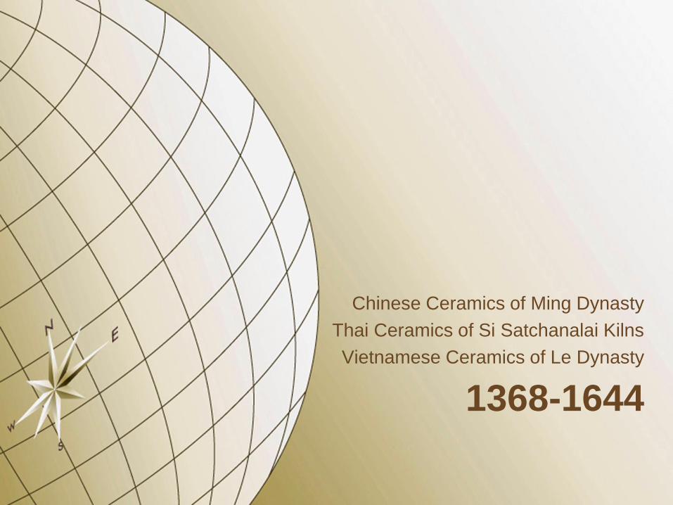
1368-1644
Chinese Ceramics of Ming Dynasty
Thai Ceramics of Si Satchanalai Kilns
Vietnamese Ceramics of Le Dynasty

Longquan Celadon Dishes of Early Middle Ming
Dynasty, the first half of 15th Century Stuck on pillars in the great hall of Chai Na Temple.

The Maha Ut Great Hall of Chai Na Temple, Dated in
the Early Ayutthaya Period (1350-1488)

Late Si Satchanalai Underglaze Black Jarlet, the Late
15th to Mid-16th Centuries Found around pedestal of the stupa of Chediyak Temple.
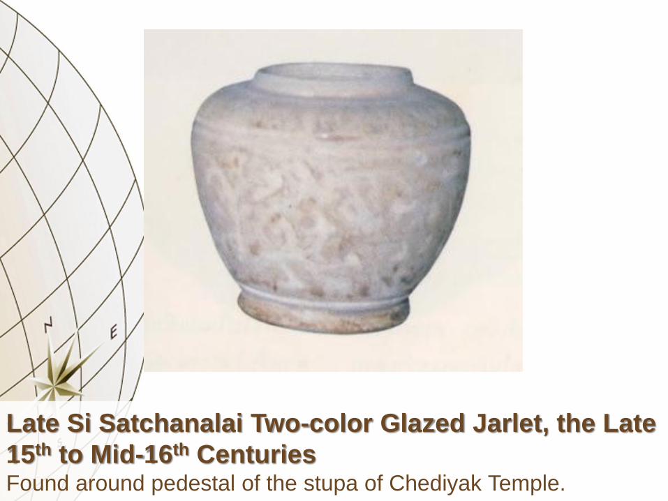
Late Si Satchanalai Two-color Glazed Jarlet, the Late
15th to Mid-16th Centuries Found around pedestal of the stupa of Chediyak Temple.
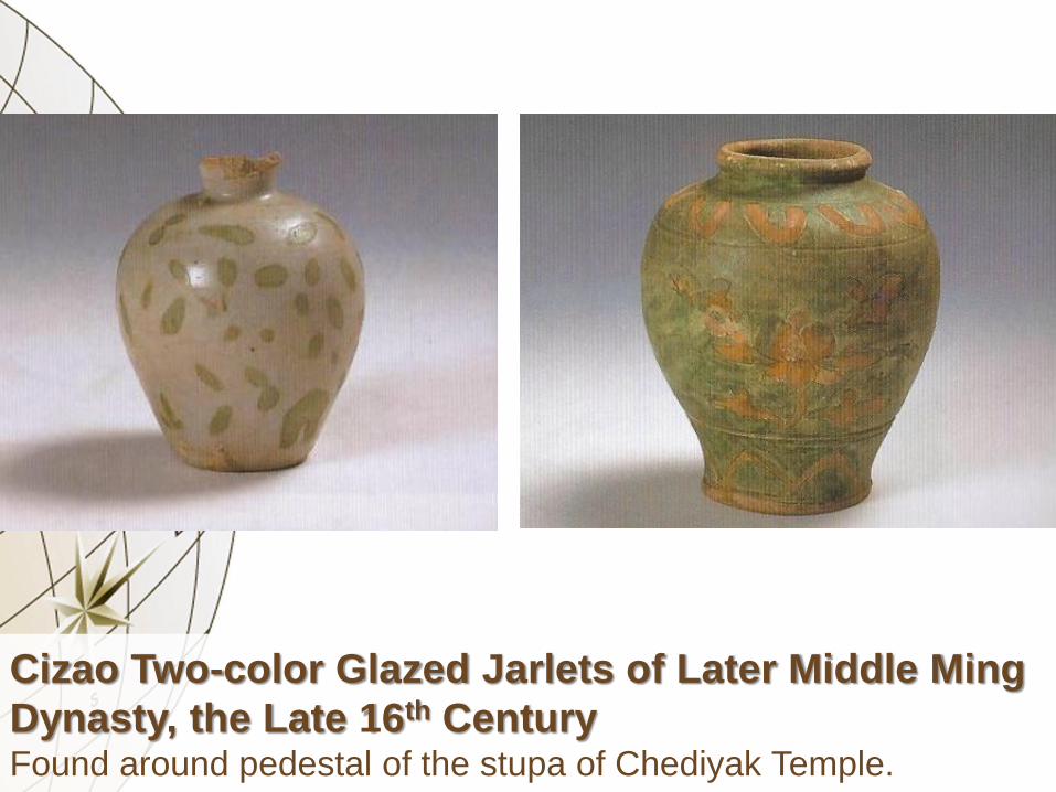
Cizao Two-color Glazed Jarlets of Later Middle Ming
Dynasty, the Late 16th Century Found around pedestal of the stupa of Chediyak Temple.

Chediyak Temple
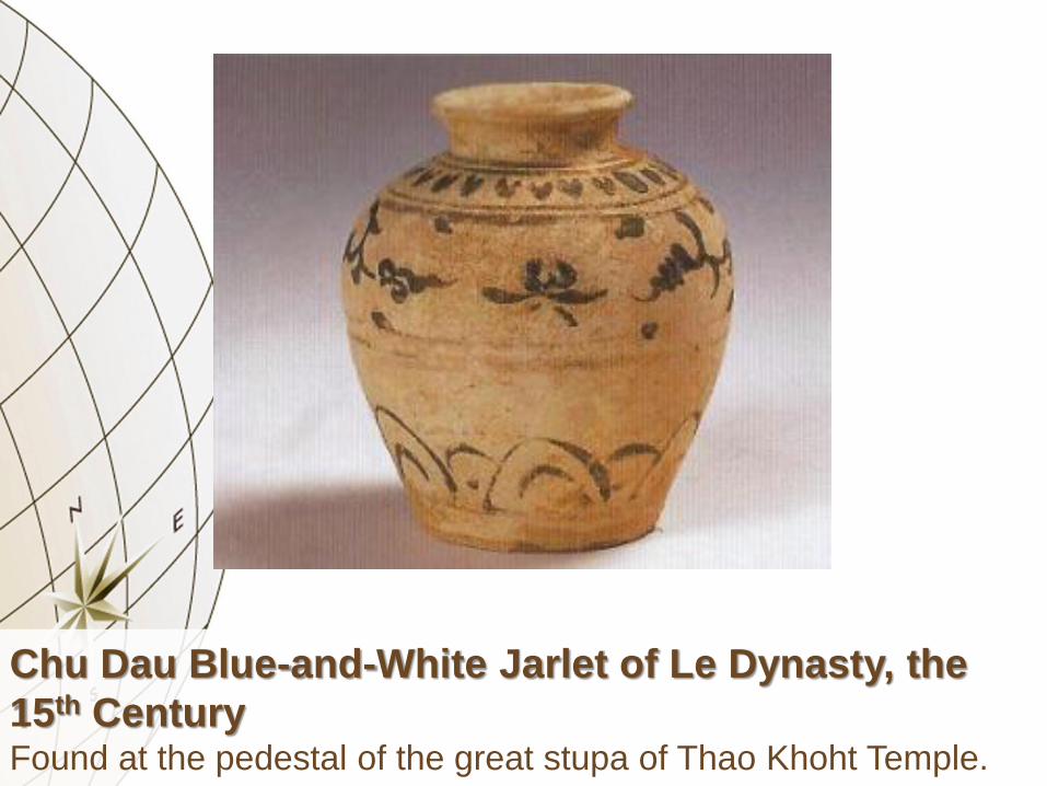
Chu Dau Blue-and-White Jarlet of Le Dynasty, the
15th Century Found at the pedestal of the great stupa of Thao Khoht Temple.

Chu Dau Blue-and-White Covered Box of Le
Dynasty, the 15th Century Found at the pedestal of the great stupa of Thao Khoht Temple.

Jingdezhen Blue-and-White Jarlet of Early Middle
Ming Dynasty, the Late 15th to Early 16th Centuries Found at the pedestal of the great stupa of Thao Khoht Temple.

Jingdezhen Blue-and-White Jarlets of Early Middle
Ming Dynasty, the Late 15th to Early 16th Centuries Found at the pedestal of the great stupa of Thao Khoht Temple.
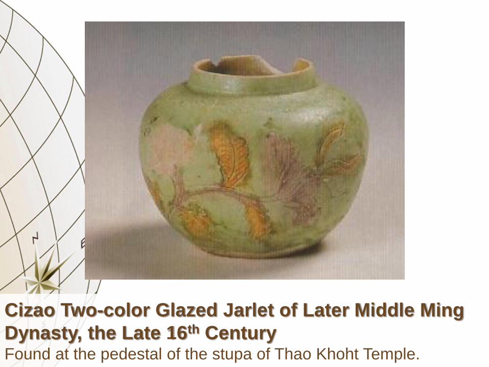
Cizao Two-color Glazed Jarlet of Later Middle Ming
Dynasty, the Late 16th Century Found at the pedestal of the stupa of Thao Khoht Temple.

The Great Stupa of Thao Khoht Temple.

Go Sanh Brown Glazed Jar, the 15th Century Found inside the stupa of Khao Trat Temple.
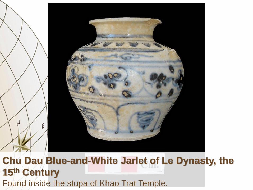
Chu Dau Blue-and-White Jarlet of Le Dynasty, the
15th Century Found inside the stupa of Khao Trat Temple.
Late Si Satchanalai Two-color Glazed Jarlet, the Late
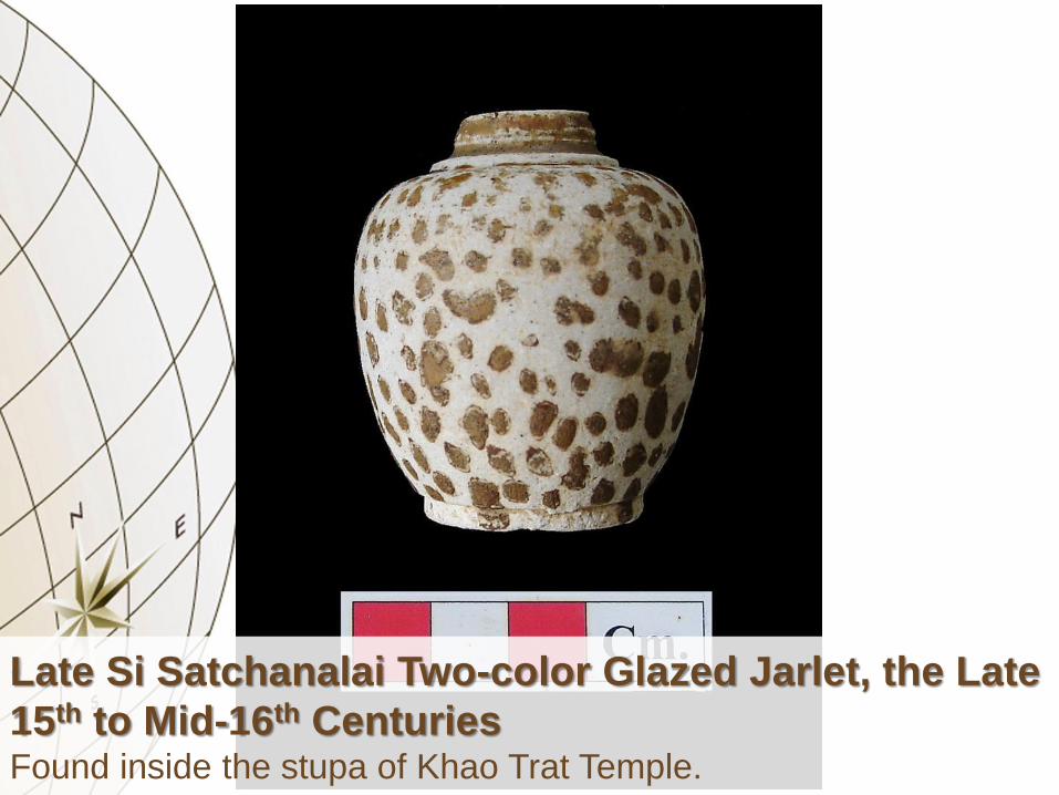
15th to Mid-16th Centuries Found inside the stupa of Khao Trat Temple.

The Stupa of Khao Trat Temple

Chu Dau Blue-and-White Jarlet of Le Dynasty, the
early 15th Century Found in Nangtra Temple.

Middle Si Satchanalai Celadon Dishes, the first half
of 15th Century Found in the town of Nakhon Si Thammarat.

Cizao Green Glazed Jarlet of Later Middle Ming
Dynasty, the Late 16th Century Found in the stupa of Phra Khien Temple.

Cizao Green Glazed Jarlet of Later Middle Ming
Dynasty, the Late 16th Century Found in the town of Nakhon Si Thammarat.

Pinghe Blue-and-White Jarlet of Later Middle Ming
Dynasty, the Late 16th to Early 17th Centuries Found in the town of Nakhon Si Thammarat.

Pinghe Blue-and-White Kendi of Later Middle Ming
Dynasty, the Late 16th to Early 17th Centuries Found in the town of Nakhon Si Thammarat.
PHRA MAHATRAT TEMPLE
Chinese Ceramics of Later Middle Ming Dynasty
Chinese Ceramics of Qing Dynasty


Jingdezhen Blue-and-White Dish of Qing Dynasty,
the Mid-17th Century Stuck on the great stupa of Phra Mahatrat Temple.

Jingdezhen Blue-and-White Dish of Qing Dynasty,
the Late 17th to Early 18th Centuries Stuck on the great stupa of Phra Mahatrat Temple.

Jingdezhen Overglaze Enameled Dish of Qing
Dynasty, the Late 17th to Early 18th Centuries Stuck on the great stupa of Phra Mahatrat Temple.

Jingdezhen Blue-and-White Dish of Qing Dynasty,
the Early 18th Century Stuck on the great stupa of Phra Mahatrat Temple.

Jingdezhen Blue-and-White Dish of Qing Dynasty,
the Early 18th Century Stuck on the great stupa of Phra Mahatrat Temple.

Dehua Blue Glazed Dish of Qing Dynasty, the Early
18th Century Stuck on the great stupa of Phra Mahatrat Temple.
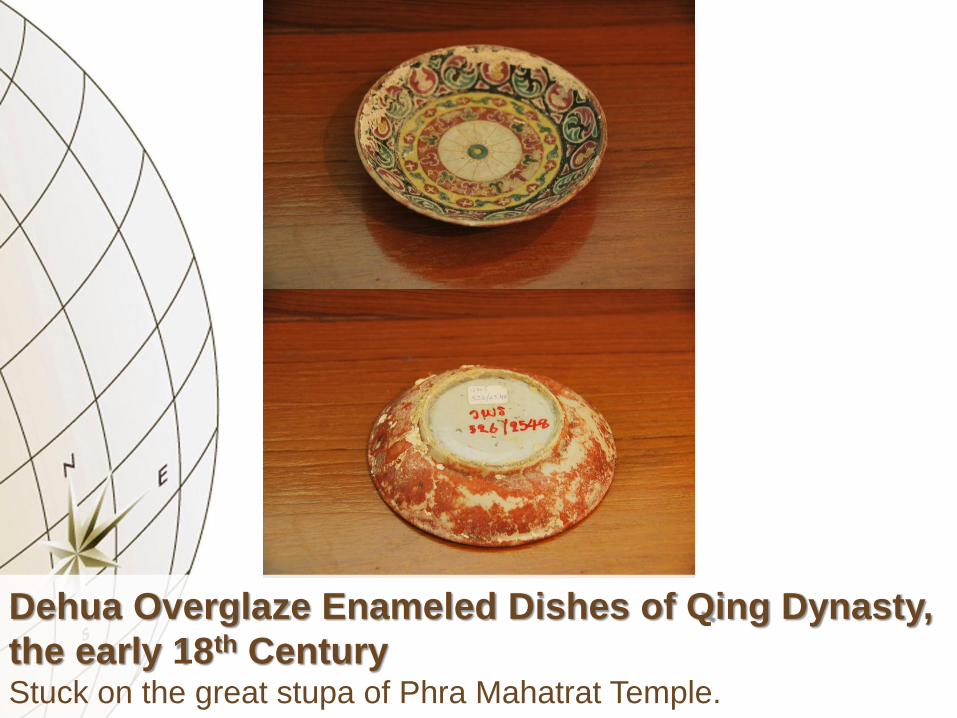
Dehua Overglaze Enameled Dishes of Qing Dynasty,
the early 18th Century Stuck on the great stupa of Phra Mahatrat Temple.

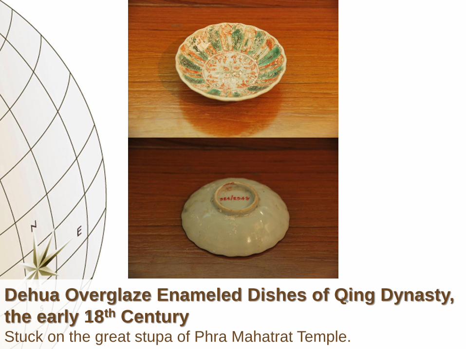
Dehua Overglaze Enameled Dishes of Qing Dynasty,
the early 18th Century Stuck on the great stupa of Phra Mahatrat Temple.
Dehua Overglaze Enameled Dishes of Qing Dynasty,
the early 18th Century Stuck on the great stupa of Phra Mahatrat Temple.

Dehua Overglaze Enameled Dishes of Qing Dynasty,
the early 18th Century Stuck on the great stupa of Phra Mahatrat Temple.

Dehua Overglaze Enameled Dishes of Qing Dynasty,
the early 18th Century Stuck on the great stupa of Phra Mahatrat Temple.

Dehua Overglaze Enameled Dishes of Qing Dynasty,
the early 18th Century Stuck on the great stupa of Phra Mahatrat Temple.

Dehua Overglaze Enameled Dishes of Qing Dynasty,
the early 18th Century Stuck on the great stupa of Phra Mahatrat Temple.

Jingdezhen Blue-and-White Dish of Qing Dynasty,
the 19th Century Stuck on the great stupa of Phra Mahatrat Temple.

SINGKORN TEMPLE
Chinese Ceramics of Late Ming Dynasty
Chinese Ceramics of Qing Dynasty
Chinese Ceramics of Republic

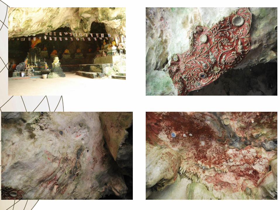

Jingdezhen Blue-and-White (Kraak) Dish of Late
Ming Dynasty, the Early 17th Century Stuck on the cave ceiling of Singkorn Temple.

Jingdezhen Blue-and-White (Kraak) Dish of Late
Ming Dynasty, the Early 17th Century Stuck on the cave ceiling of Singkorn Temple.

Jingdezhen Blue-and-White Dish of Late Ming
Dynasty, the Early 17th Century Stuck on the cave ceiling of Singkorn Temple.

Jingdezhen Blue-and-White Dish (?) of Qing
Dynasty, the Mid-17th to Late 18th Centuries Stuck on the cave ceiling of Singkorn Temple.

Jingdezhen Blue-and-White Dish of Qing Dynasty,
the Late 17th to Early 18th Centuries Stuck on the cave ceiling of Singkorn Temple.

Jingdezhen Overglaze Enameled Dish of Qing
Dynasty, the Late 17th to Early 18th Centuries Stuck on the cave ceiling of Singkorn Temple.
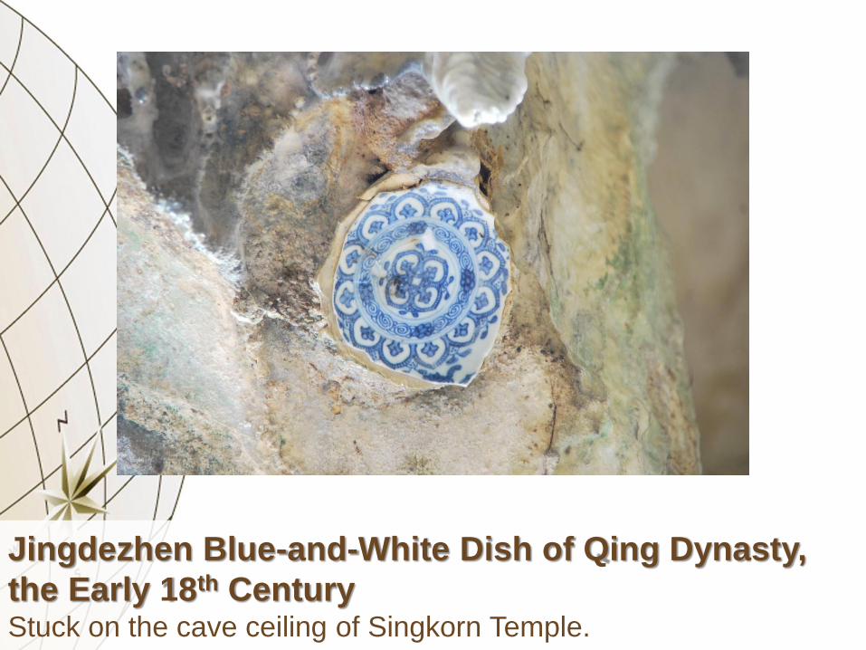
Jingdezhen Blue-and-White Dish of Qing Dynasty,
the Early 18th Century Stuck on the cave ceiling of Singkorn Temple.

Jingdezhen Blue-and-White Dish of Qing Dynasty,
the Early 18th Century Stuck on the cave ceiling of Singkorn Temple.

Jingdezhen Blue-and-White Dish of Qing Dynasty,
the Early 18th Century Stuck on the cave ceiling of Singkorn Temple.
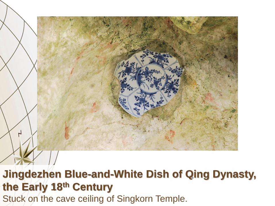
Jingdezhen Blue-and-White Dish of Qing Dynasty,
the Early 18th Century Stuck on the cave ceiling of Singkorn Temple.

Jiucun Blue-and-White Dish (?) of Qing Dynasty, the
Late 18th to Early 19th Centuries Stuck on the cave ceiling of Singkorn Temple.

Jiucun Blue-and-White Dish (?) of Qing Dynasty, the
Late 18th to Early 19th Centuries Stuck on the cave ceiling of Singkorn Temple.

Dehua Blue-and-White Dish of Qing Dynasty, the 19th
Century Stuck on the cave ceiling of Singkorn Temple.

Dehua Blue-and-White Dish of Qing Dynasty, the 19th
Century Stuck on the cave ceiling of Singkorn Temple.


Tonqi Blue-and-White Dish of Qing Dynasty, the
Second Half of 19th Century Stuck on the stupa in front of Singkorn Temple.

Jiucun and Dehua Blue-and-White Dishes of Qing
Dynasty, the Second Half of 19th Century Stuck on the stupa in front of Singkorn Temple.

Dabu Blue-and-White Stem Dishes of Republic of
China, the 20th Century Stuck on the stupa in front of Singkorn Temple.

SHIPWRECK ASSEMBLAGES
& MARITIME TRADE ROUTES

The Rock Arts of
Phrayanaga (Viking) Cave
• This cave is situated at Phi Phi Leh Island and
close to Thalang, which was one of the
dependency of Nakhon Si Thammarat and
was covered on the modern province of
Phuket.


Chinese Junks in Yuan, Ming and Qing
Dynasties or Probably Thai Junks

Arabian Somali Dhow and
Indonesian Perahu Makassar

European Carracks

European and American
Paddle Steamer Ship
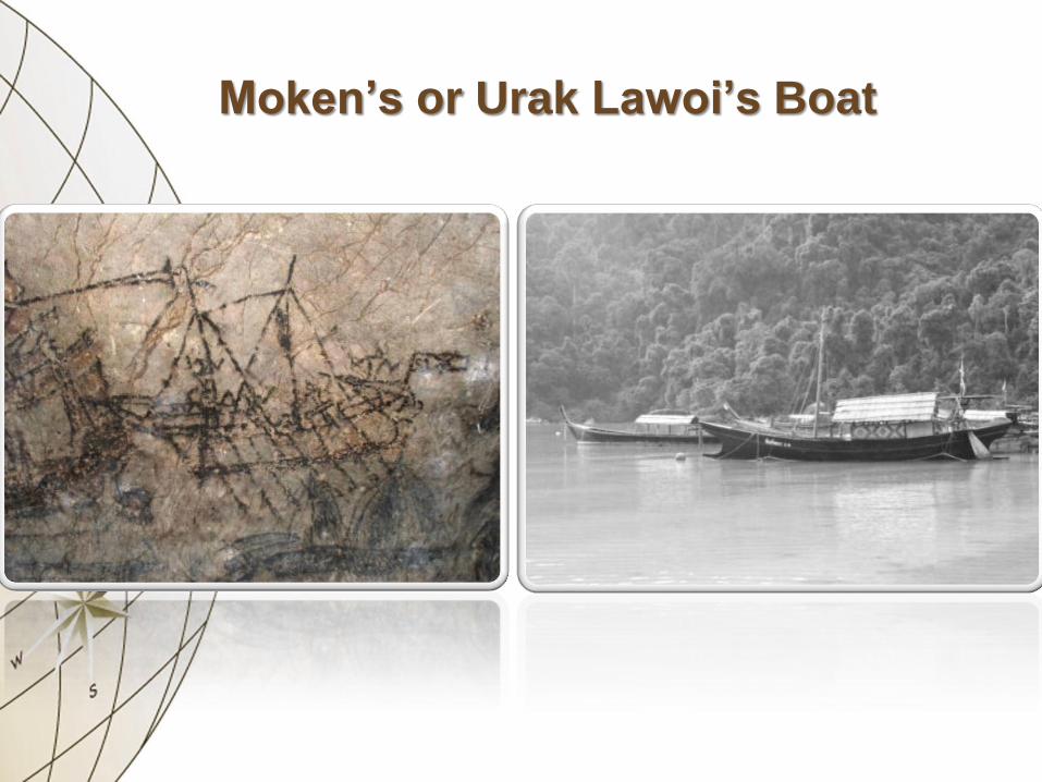
Moken’s or Urak Lawoi’s Boat

Songdoc Shipwreck
The Late 14th Century

Nanyang Shipwreck
The 15th Century

Royal Nanhai Shipwreck
The 15th Century

Samui Shipwreck
The Early 16th Century

Xuande Shipwreck
The Mid-16th Century

San Diego Shipwreck
The Late 16th Century
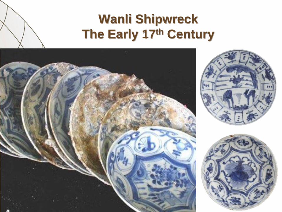
Wanli Shipwreck
The Early 17th Century

Desaru Shipwreck
The First Half of 19th Century

Diana Shipwreck
The First Half of 19th Century

CONCLUSION

• Ayutthaya Kingdom ruled Nakhon Si
Thammarat as the good location to control
other dependency cities in the middle part of
Malay Peninsula and to be the halfway house
of maritime trade routes between the western
and eastern worlds during 1350-1767.
• There also benefited to Ayutthaya Kingdom for
local product supplier, territory expansion and
trading.
• The ceramics trading represented that
Ayutthaya Kingdom including Nakhon Si
Thammarat established the foreign relations
with China in Yuan (1280-1368), Ming (1368-
1644) and Qing (1644-1911) Dynasties by the
ports of Fuzhou and Quanzhou as well as
Vietnam in Le (1428-1788) Dynasty by the
ports of Ha Long and Van Don.
• There also connected with the capital and
northern territory by maritime trade routes that
have been found Si Satchanalai wares there
and they related to the ceramics recovered
from many shipwrecks.


• By the rock arts of Phrayanaga (Viking) Cave
and the excavation of shipwrecks, the Chinese
or Southeast Asian styles of sail ships were
used to transport the goods especially
ceramics.
• The ceramics at the point of destination in
Nakhon Si Thammarat also related the many
ship cargo that travelled around the Gulf of
Thailand and South China Sea for trading
especially on ceramics.

• The ceramics were used to be luxury goods in
religious purposes, specially for offering and
architectural decoration in many Buddhist
temple inside and outside the town wall of
Nakhon Si Thammart.
Thank You for Your Attention
• I would like to acknowledge to the 13th, 14th,
and 15th Regional Office of Fine Arts
Department at Songkhla, Nakhon Si
Thammarat, and Phuket, for helpful data.
• I would like to acknowledge to Bangkok
National Museum Volunteers, for organizing
the lecture.
Top Related
Copyright © 2022 FDOKUMEN

