Zonation of flora and vegetation of the Northern declivity of the Karakoram/Kunlun mountains (SW...
20
Geodoumal 25.2/3 265-284 © 1991 (Oct/Nov) by Kluwer Academic Publishers 265 Zonation of Flora and Vegetation of the Northern Declivity of the Karakoram/Kunlun Mountains (SW Xinjiang China) Dickord, Wolf Bernhard, Dipl. Biol., Universitiit GOttingen, Systematisch- Geobotanisches Institut, Untere Karspiile 2, 3400 GOttingen, Germany ABSTRACT: Botanical results of the "Sino-German Joint Expedition to K2, 1986" are presented with remarks on vegetation of SW Kashgaria, the W Kunlun Shan and the N declivity of the central Karakoram mountains. The vertical and horizontal zonation of the vegetation and flora of a cross-section of the Karakoram/Kunlun N declivity from the edge of the Tarim basin to the summit-pyramid of K2 is outlined. The transect covers altitudes between c. 1300 and 5200 m. Altitudinal vegetation belts distinguished along the transect, their extension, and characteristic species are: I Colline belt 1300-2100 m Zygophyllum xanthoxylon II Montane belt 2100-3700 m Sympegma regelii III Subalpine belt 3000-4400 m Krascheninnikovia ceratoides IV Alpine belt 4200-4900 m Ajania tibetica V Subnivale belt 4800-5200 m Sibbaldia tetrandra An annotated list of 301 species collected (1 Charophyta, 2 Pteridophyta, 6 Gymnospermae, 292 Angiospermae) is given. Floristical and vegetation features of the Karakoram/Kunlun N declivity are discussed in connection with environmental factors and their variation, and in relation to pleistocene glaciation. Introduction The N Declivity of the Karakoram/Kunlun Shan mountain system, from the world's second highest peak K2 (Mt. Godwin-Austen, Chogori, Qogir Feng, 8611 m), down to the edge of the central asiatic Tarim basin (below the altitude of 2000 m) comes off at a distance of only c. 200 kin. Phytogeographically, this section of High Asia, which connects the Pamirs with Tibet can be considered a "key position" due to its central continental situation and its enormous relief energy. Bordering to species-rich and very different floristical regions, the area is inhospital to most life forms. But a peculiar and ecologically highly adaptable flora, though only poor in species, was to be expected along steep gradients in the environment and under generally dry-cold climate conditions associated with glacial activity. However, the flora of the central N slope of the Karakoram mountains between the Kunjerab- and the Karakoram passes remained almost unknown up to now. During the "3rd Sino-German Joint Expedition" from August 15 to November 2, 1986, the author had the opportunity to carry out floristical and phytoecological investigations in the Karakoram/Kunlun N declivity and in the adjacent lowland of the Tarim basin. Some results of this expedition shall be summarized here. The present paper deals only with the collection of Charophyta, Pteridophyta, and Spermatophyta made by the German expedition party, mainly by the author and enriched somewhat by J. P. Jacobsen and K. Lechner. The full set of this, totalling about 900 numbers of 301 species, is stored in the Herbarium of G6ttingen University (GOET). The Expedition Area The path of the 1986 expedition (Fig 1) can be thought of as a cross-section or transect of the Karakoram/Kunlun N declivity (= KKND, Fig 2) from the periphery (Tarim basin, Kashgarian mountains,
-
Upload
lmu-munich -
Category
Documents
-
view
0 -
download
0
Transcript of Zonation of flora and vegetation of the Northern declivity of the Karakoram/Kunlun mountains (SW...

Geodoumal 25.2/3 2 6 5 - 2 8 4 © 1991 (Oct/Nov) by Kluwer Academic Publishers
265
Zonation of Flora and Vegetation of the Northern Declivity of the Karakoram/Kunlun Mountains (SW Xinjiang China)
Dickord, Wolf Bernhard, Dipl. Biol., Universitiit GOttingen, Systematisch- Geobotanisches Institut, Untere Karspiile 2, 3400 GOttingen, Germany
ABSTRACT: Botanical results of the "Sino-German Joint Expedition to K2, 1986" are presented with remarks on vegetation of SW Kashgaria, the W Kunlun Shan and the N declivity of the central Karakoram mountains. The vertical and horizontal zonation of the vegetation and flora of a cross-section of the Karakoram/Kunlun N declivity from the edge of the Tarim basin to the summit-pyramid of K2 is outlined. The transect covers altitudes between c. 1300 and 5200 m. Altitudinal vegetation belts distinguished along the transect, their extension, and characteristic species are:
I Colline belt 1300-2100 m Zygophyllum xanthoxylon II Montane belt 2100-3700 m Sympegma regelii III Subalpine belt 3000-4400 m Krascheninnikovia ceratoides IV Alpine belt 4200-4900 m Ajania tibetica V Subnivale belt 4800-5200 m Sibbaldia tetrandra
An annotated list of 301 species collected (1 Charophyta, 2 Pteridophyta, 6 Gymnospermae, 292 Angiospermae) is given. Floristical and vegetation features of the Karakoram/Kunlun N declivity are discussed in connection with environmental factors and their variation, and in relation to pleistocene glaciation.
Introduction
The N Declivi ty of the K a r a k o r a m / K u n l u n Shan mounta in system, from the world ' s second highest peak K2 (Mt. Godwin-Aus ten , Chogori , Qogir Feng, 8611 m) , down to the edge of the central asiatic Tar im basin (below the al t i tude of 2000 m) comes off at a distance of only c. 200 kin. Phytogeographical ly , this section of High Asia , which connects the Pamirs with Tibe t can be considered a "key posi t ion" due to its central cont inenta l si tuation and its enormous rel ief energy. Border ing to species-rich and very different floristical regions, the area is inhospital to most life forms. But a pecul iar and ecologically highly adaptab le flora, though only poor in species, was to be expected along s teep gradients in the envi ronment and under general ly dry-cold cl imate condit ions associated with glacial activity. However , the flora of the central N slope of the K a r a k o r a m mounta ins be tween the Kunje rab- and the K a r a k o r a m passes remained almost unknown up to now.
Dur ing the "3rd S ino-German Joint Exped i t ion" from Augus t 15 to November 2, 1986, the au thor had the oppor tun i ty to carry out floristical and phytoecological invest igat ions in the K a r a k o r a m / K u n l u n N declivi ty and in the ad jacent lowland of the Ta r im basin. Some results of this expedi t ion shall be summar ized here. The presen t pape r deals only with the collect ion of Charophy ta , P te r idophyta , and Spe rma tophy ta made by the G e r m a n expedi t ion par ty , mainly by the au thor and enr iched somewhat by J. P. Jacobsen and K. Lechner . The full set of this, total l ing about 900 numbers of 301 species, is s tored in the H e r b a r i u m of G6t t ingen Univers i ty ( G O E T ) .
The Exped i t ion A r e a
The pa th of the 1986 expedi t ion (Fig 1) can be thought of as a cross-section or t ransect of the K a r a k o r a m / K u n l u n N declivity ( = K K N D , Fig 2) f rom the per iphery (Tar im basin, Kashgar ian mounta ins ,

266 GeoJournal 25.2/3/1991
Kunlun Shan) to the centre of the mountain system (Aghil Shan, central Karakoram, K2-N-slope).
The transect generally runs in a SSW direction, from N 37 ° 53' E 77 ° 25' (Yecheng) to N 35 ° 52' E 76 ° 30' (K2). Kashgar (N 39 ° 28' E 75 ° 59'), lying to the NW, and the E-W-running intramontane valley stretches of the Yarkand (N 36 ° 26' E 77 ° 00' - N 36 ° 23' E 76 ° 41') and Shaksgam rivers (N 36 ° 07' E 76 ° 39' - N 36 ° 09' E 76 ° 25') were included in the area of investigation. Thus, the transect covers altitudes between 1280 m (Kashgar) or 1400 m (Yecheng), and 5060 m (highest directly- investigated locality with plants) or 5200 m (highest location where plants have been seen), close to the north- wall of the ice-covered summit-pyramid of K2.
A geographical division of the transect used for the recording of plant species, is given in Tab 1.
Fig 1 Itinerary of the expedition and geographic-floristical division of the transect
38° N
76% 77 ° to ~, Kashgar 78 ° \
Ye c he ng"n7 /0 z,
, e4so/ "%. , .., /ze'qez
3~
eo #
y Oor 3.270 m ~ l t t S
KUNL~
' . _ . ' - - - - ' - KZ g611n e . , .
M80 m
[__ to Xaidulla ~.
Y A R K A N D V.
3 A M V.
I I 50 km
............ Itinerary
Previous Botanical Investigations
Logistically, the N slope of the Karakoram mountains was almost inaccessible for a long time. Although the famous botanist T. Thomson was the first European to reach the Karakoram Pass in as early as 1847, the area to the N and to the NW subsequently has been entered only by a few botanical expeditions: The Schlagintweit- brothers 1856, Henderson and Cayley 1870, Dutreuil de Rhins and Grenard 1892, Nowitzky 1898, Dainelli and Marinelli 1914, and Clifford 1926.
"La flora del Caracorflm" (Pampanini 1930) is the only comprehensive study of the flora of the area and records some 200 species of higher plants from the N slope of Karakoram ("versante settentrionale'), by far the largest subarea of this flora. Unfortunately, many of the plants cited cannot, without a doubt, be identified according to recent taxonomic concepts. Furthermore, the herbarium material concerned often either does not refer clearly to the N slope of Karakoram or only to marginal areas. Our expedition in 1986 was apparently the first botanical investigation of the central N slope of Karakoram.
On the other hand, the S slope of the Karakoram mountains can be considered fairly well-known today, as several expeditions have worked there. Recent contributions to the flora have been given by Gilli (1957), Kitamura (1964) and, vegetation included, by Hartmann (1966, 1968, 1972, 1984).
There is very little information in literature relating to the flora of Kunlun Shan and the Tarim basin. The first extensive description including a species list was gathered from a journey across the Karakoram pass and the Kunlun Shan to Kashgaria and was published by Henderson & Hume (1873). Another detailed account from a similar route, also E of our expedition area, is given by Schmid in Bosshard (1932)• Further important data from the E Pamirs, the W Kunlun Shan, and N Tibet can be found in Ostenfeld in Hedin (1922). Hemsley (1894) and Hemsley's "Flora of Tibet or High Asia" (1902) summarized early botanical knowledge of the vast high plateau adjacent to the SE.
Climate
Physical factors are, to a high degree, varied over the KKND because of extreme differences in altitude, exposition, and geomorphological structure.
The climate generally is strongly continental and extremely arid. Only in the highest altitudes can cold subhumid conditions be expected. The climate diagrams of Kashgar (Western Tarim basin) and Geer (W Tibet), given as examples for "temperate deserts" and "cold mountain deserts" by Song Yongchang (1983), may provide us with a framework for much of our area (Tab 2). However, the extremely low amount of precipitation (c. 60 mm at the altitude of 4300 m annuallyt) is not representative of the highest elevations, where there are
GeoJournai 25.2/3/1991 267
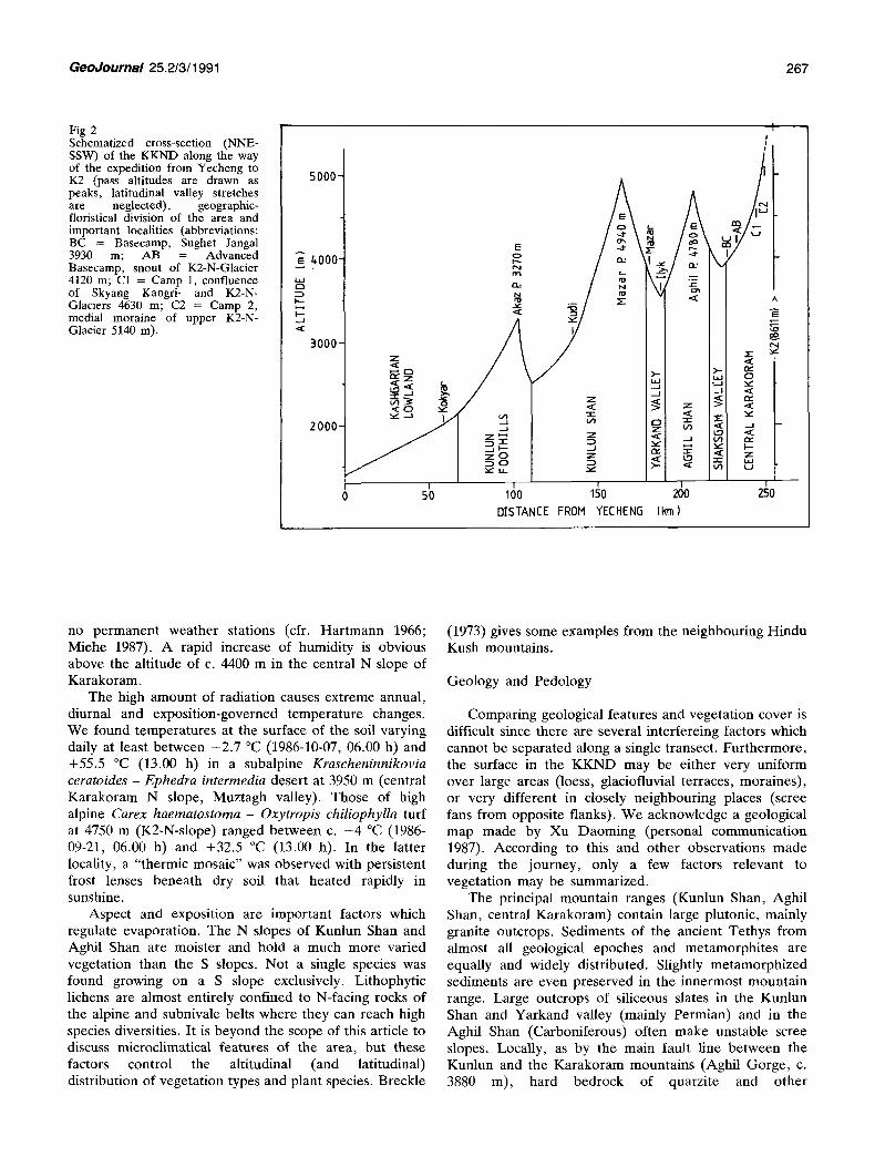
Fig 2 Schematized cross-section (NNE- SSW) of the KKND along the way of the expedition from Yecheng to K2 (pass altitudes are drawn as peaks, latitudinal valley stretches are neglected), geographic- floristical division of the area and important localities (abbreviations: BC = Basecamp, Sughet Jangal 3930 m; AB = Advanced Basecamp, snout of K2-N-Glacier 4120 m; C1 = Camp 1, confluence of Skyang Kangri- and K2-N- Glaciers 4630 m; C2 = Camp 2, medial moraine of upper K2-N- Glacier 5140 m).
5000-
m 4.000 LI-I D
I'--- I " - . .J
3000-
2000-
E
~ -~ / I z ~ ( ~ ) ~ " / I
I I I
0 50 100 150 DISTANCE FROH YECHEN5
l #
k) /
A E
~ 0
e q
> - - t.LI
. . - I
n - 1 -
z tn
t ~ i
I
200 gO (km)
no permanent weather stations (cfr. Hartmann 1966; Miehe 1987). A rapid increase of humidity is obvious above the altitude of c. 4400 m in the central N slope of Karakoram.
The high amount of radiation causes extreme annual, diurnal and exposition-governed temperature changes. We found temperatures at the surface of the soil varying daily at least between - 2 . 7 °C (1986-10-07, 06.00 h) and +55.5 °C (13.00 h) in a subalpine Kraschen inn ikov ia ceratoides - Ephedra intermedia desert at 3950 m (central Karakoram N slope, Muztagh valley). Those of high alpine Carex haematos toma - Oxytropis chil iophylla turf at 4750 m (K2-N-slope) ranged between c. - 4 °C (1986- 09-21, 06.00 h) and +32.5 °C (13.00 h). In the latter locality, a "thermic mosaic" was observed with persistent frost lenses beneath dry soil that heated rapidly in sunshine.
Aspect and exposition are important factors which regulate evaporation. The N slopes of Kunlun Shan and Aghil Shan are moister and hold a much more varied vegetation than the S slopes. Not a single species was found growing on a S slope exclusively. Lithophytic lichens are almost entirely confined to N-facing rocks of the alpine and subnivale belts where they can reach high species diversities. It is beyond the scope of this article to discuss microclimatical features of the area, but these factors control the altitudinal (and latitudinal) distribution of vegetation types and plant species. Breckle
(1973) gives some examples from the neighbouring Hindu Kush mountains.
Geology and Pedology
Comparing geological features and vegetation cover is difficult since there are several interfereing factors which cannot be separated along a single transect. Furthermore, the surface in the KKND may be either very uniform over large areas (loess, glaciofluvial terraces, moraines), or very different in closely neighbouring places (scree fans from opposite flanks). We acknowledge a geological map made by Xu Daoming (personal communication 1987). According to this and other observations made during the journey, only a few factors relevant to vegetation may be summarized.
The principal mountain ranges (Kunlun Shan, Aghil Shan, central Karakoram) contain large plutonic, mainly granite outcrops. Sediments of the ancient Tethys from almost all geological epoches and metamorphites are equally and widely distributed. Slightly metamorphized sediments are even preserved in the innermost mountain range. Large outcrops of siliceous slates in the Kunlun Shan and Yarkand valley (mainly Permian) and in the Aghil Shan (Carboniferous) often make unstable scree slopes. Locally, as by the main fault line between the Kunlun and the Karakoram mountains (Aghil Gorge, c. 3880 m), hard bedrock of quarzite and other

268 GeoJournal 25.2/3/1991
Region Altitude (from N to S) (m)
Investigation dates 1986
Kashgarian lowland 1280-2150 Kunlun foothills (Kashg. mountains) 2150-3300 Kunlun Shan (main ridge) 3000-4950 Yarkand valley 3520- 3900 Aghil Shan (N Karakoram) 3550-483(I Shaksgam vatley 3870 - 4100 Central Karakoram (main ridge) 3870- 5200
15.-18.8., 29.10.-2.11.
18.8., 29.10. 18.-20.8., 22.8., 27.-29.10.
20.-28.8., 23.-27.10. 28.-30.8.,20. 23.10. 30.8.-1.9., 19.-20. t0.
1.9.-19.10.
c.% of flora
3O
30 50 90 70 80
90
Tab 1 Regions / transect sections, altitudinal extension, dates of investigation and estimated degree of completeness of the registered flora.
metamorphites provide better conditions for a richer flora. The summit-pyramid of K2 itself (above the upper limit of vegetation) consists of an extremely hard and heavy, fine-grained striate gneiss.
Limestone is especially apparent in the Aghil Shan, where there are calcareous outcrops ranging from Carboniferous to Jurassic, towered by huge dolomit cliffs. These form the complete mountain range west of the Aghil Pass of more than 2 km in height. This special geological situation (i. e. the better water supply on the foot of these cliffs) might be responsible for a comparatively rich flora noted on the N side of Aghil pass. Smaller calcareous outcrops in the subalpine belt of the Shaksgam and Muztagh valleys (mainly Carboniferous) and other palaeozoic limestone areas of the Kunlun foothills apparently have no special floras.
Extensive loess accumulations almost cover the Kunlun-foothills totally, and are to a lesser extent also distributed in the N slope of Kunlun Shan up to 4400 m. South of the Kunlun Shan main ridge; loess is entirely wanting.
Glacial activity is one of the most important factors determining geomorphology and vegetation of the area. We found a strictly "periglacial flora" only by the K2- North Glacier (4100-5200 m), while actual glaciers of the outer mountain ridges lie much higher. However , extensive pleistocene glaciation must have had dramatic
effects on the flora of the Karakoram and certainly is - beneath recent climatic conditions - one of the main reasons for the poverty in species. On the other hand, local glacial water supply makes a relatively rich "arctic- alpine" flora possible.
Regarding the wide-spread glacial relief and substrate features, they are often unsuitable for plant growth under the present climatic conditions. Unstable scree slopes, which often almost entirely cover the valley flanks, glaciofluvial deposits and moraines are, where not somewhat stabilized and watered, often devoid of vegetation. Accordingly, extensive steep walls of bedrock along of glacial U-valleys only occasionally have a better developed chasmophytic flora. Usually, vegetation is restricted to narrow strips by the bot tom of the walls of rock and slightly inclined, sheltered places of the uppermost scree slopes below them.
Soils generally are poorly developed. Even in the lower altitudes hardly any horizons are to be distinguished. Dominat ing soil types are Yermosols (desert soils of lower altitudes), Lithosols and Gelosols (high altitudes). Solonchaks locally occur by rivers. Notable accumulations of humus (rarely more than 2-5 cm) were found only in the higher alpine belt under cushions of Sibbaldia tetrandra and under spots of alpine turf (Stipa concinna p.e.) . Fen peat (Carex, Kobresia) is restricted to very local situations by springs and flushes.
Locality Kashgar (Kashi) Geer (Gar) Coordinates N 39028 ' E 75°59 , N 32030 , E 85°05 ' Altitude 1288~7 m 4278,0 m
Precipitation meanannual 61,4mm maximum (month) May
60,4 mm August
Temperature mean annual 11,7 °C abs. maximum 38,6 °C abs. minimum -24,2 °C
0,2 °C 25,7 °C
- 3 3 , 4 °C
Tab 2 Climate dates Yongchang 1983).
(from Song
Vegetation period c. 7 months c. 2 months

GeoJournal 2 5 . 2 / 3 / 1 9 9 1 2 6 9
Fig 3 Generalized vertical belts and latitudinal zones of vegetation (cfr. Fig 2; text)
(m)
5 0 0 0 -
gO00-
3 0 0 0 -
2000 -
N37O53 ' E77O25 '
rT1
m l
121
: 1112
Iz<
NNE < ; " SSW
m
V1
m
113
V2
I N35 ° 52' E76 °30 '
A more or less pronounced salinization is evident almost everywhere below of the alpine belt. Soda effiorescences are frequent up to c. 4200 m. The pH- values (H20) of soils under vegetation (alpine turf and subalpine desert) in the central Karakoram N slope (only measured here) are remarkably high and vary between pH 7.5 and 8.4. Alluvial sands (Myricaria-thicket) and the water of glacial rivers gave maximum values of pH 8.9 to 9.1.
Hartmann (1968, 1972) should be refered for a detailed analysis of soil chemistry in the S declivity of Karakoram.
Altitudinal Belts of Vegetation and their Zonation
Altitudinal limits of vegetation types are governed by drought and temperature in 'the KKND. Although trees are almost totally absent from the area (Populus diversifolia s.l., Elaeagnus angustifolia and Juniperus turkestanica, single specimens each), vertical vegetation belts can be clearly defined on floristical grounds and on vegetation physiognomy (cf. Miehe 1988). However, definition, delimitation and altitudinal extension of these may differ considerably from classifications based on geomorphology and from vegetation belts of humid mountains as well. We try to define altitudinal belts by single monitor species, which are easily recognized, wide- spread and frequent in the area, and of clear vertical distribution types. These are Sympegma regelii (montane), Krascheninnikovia ceratoides (subalpine),
Ajania tibetica (alpine) and Sibbaldia tetrandra (subnivale).
The altitudinal vegetation belts are closely interlaced with different latitudinal zones from the periphery to the central mountain ridges, which complicates the definition of both. A distinct rise of altitudinal limits towards the inner mountain ranges, dependent on relative height of the surface and exposure ("elevation effect") appears in the montane and subalpine belts, less so in the higher ones (Fig 3).
Zhang et al. (1981) gave examples of altitudinal vegetation belts of various regions a r o u n d the Tibetan plateau. Those summarized by Wang Jinting (1987) for the dry parts of the Tibetan plateau largely correspond to the differentiation of the subalpine and alpine belts of the KKND. However, the borderline between these runs approximately 200 m lower in the central Karakoram N slope than in Tibet. Hou (1984) provided a very detailed vegetation map of China. Due to its scale, of course this can give only a rough approximation on the latitudinal differentiation of the vegetation of our area.
The central Takla Makan desert, which we did not enter properly, might represent the lowest (planare) vegetation belt, or another different latitudinal zone as well. The Takla Makan is the largest desert of China. According to Walter (1974) and Hou (1984), this is a vast dune area almost devoid of vegetation, or with scattered Tamarix-scrubs in dune valleys and alluvial woods (Populus diversifolia s.1.) on the few rivers that run into the desert.
270 Geodournal 25.2/3/1991
Colline Belt (Lowland of SW Kashgaria)
The colline belt, which can also be considered a latitudinal zone of its own, comprises the flat to somewhat hilly land on the margin of the Takla Makan desert up to the foot of the bordering mountains. The zonal vegetation of temperate deserts mainly consists of gobis, which are covered with deflation pavements and exceedingly poor in plant species. Where not entirely devoid of plants, Chenopodiaceous and Zygophyllaceous (sub-)shrubs (Haloxylon ammodendron, Zygophyllurn xanthoxylon) dominate.
Diluvial loess- and sand deserts occur more locally. In reach of surface- or groundwater, the flora is more diverse and has a few succulent summer-therophytes (Halogeton glomeratus, Bassia dasyphylla, Zygophyllum lehmannianum) and perennial (herbaceous) plants such as Launaea sp., Calligonum mongolicum s.l., Inula amrnophila, Alhagi pseudalhagi, which include a few morphologically distinct endemics (Apocynum hendersonii, Myricaria pulcherrima). Phragmites australis is a common indicator of groundwater (Fig 4).
Large oases, of which we saw those of Kashgar- Yengisar and Yarkant-Yecheng at the old Silk Road and Kokyar-Pusha in the lower Kokyar valley, profit by extensive resources of ground- and riverwater which run from the marginal mountains. Inside of the oases fields of cotton, maize and wheat, vineyards, different fruit trees, shelterbelts of pyramid poplars (mainly Populus alba s.1.) and urban structures are reminding one of a south-central
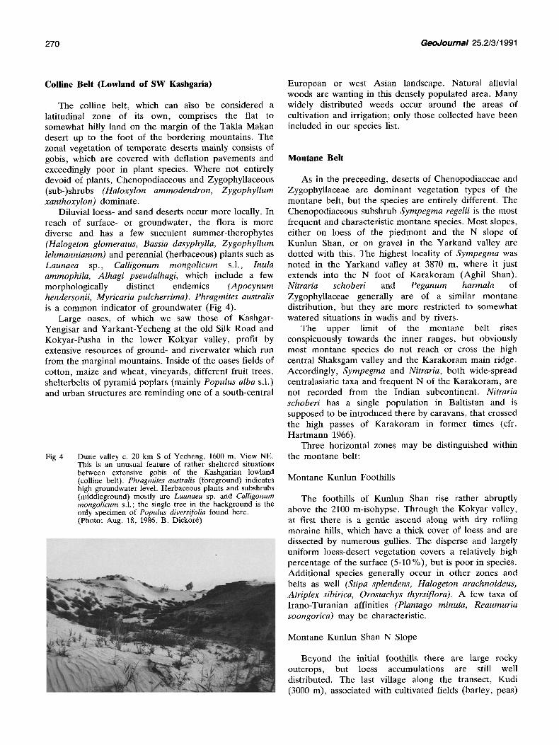
Fig 4 Dune valley c. 20 km S of Yecheng, 1600 m. View NE. This is an unusual feature of rather sheltered situations between extensive gobis of the Kashgarian lowland (colline belt). Phragmites australis (foreground) indicates high groundwater level. Herbaceous plants and subshrubs (middleground) mostly are Launaea sp. and Calligonum mongolicum s.l.; the single tree in the background is the only specimen of Populus diversifolia found here. (Photo: Aug. 18, 1986, B. Dickort)
European or west Asian landscape. Natural alluvial woods are wanting in this densely populated area. Many widely distributed weeds occur around the areas of cultivation and irrigation; only those collected have been included in our species list.
Montane Belt
As in the preceeding, deserts of Chenopodiaceae and Zygophyllaceae are dominant vegetation types of the montane belt, but the species are entirely different. The Chenopodiaceous subshrub Sympegma regelii is the most frequent and characteristic montane species. Most slopes, either on loess of the piedmont and the N slope of Kunlun Shan, or on gravel in the Yarkand valley are dotted with this. The highest locality of Sympegma was noted in the Yarkand valley at 3870 m, where it just extends into the N foot of Karakoram (Aghil Shan). Nitraria schoberi and Peganum harmala of Zygophyllaceae generally are of a similar montane distribution, but they are more restricted to somewhat watered situations in wadis and by rivers.
The upper limit of the montane belt rises conspicuously towards the inner ranges, but obviously most montane species do not reach or cross the high central Shaksgam valley and the Karakoram main ridge. Accordingly, Sympegma and Nitraria, both wide-spread centralasiatic taxa and frequent N of the Karakoram, are not recorded from the Indian subcontinent. Nitraria schoberi has a single population in Baltistan and is supposed to be introduced there by caravans, that crossed the high passes of Karakoram in former times (cfr. Hartmann 1966).
Three horizontal zones may be distinguished within the montane belt:
Montane Kunlun Foothills
The foothills of Kunlun Shan rise rather abruptly above the 2100 m-isohypse. Through the Kokyar valley, at first there is a gentle ascend along with dry rolling moraine hills, which have a thick cover of loess and are dissected by numerous gullies. The disperse and largely uniform loess-desert vegetation covers a relatively high percentage of the surface (5-10 %), but is poor in species. Additional species generally occur in other zones and belts as well (Stipa splendens, Halogeton arachnoideus, Atriplex sibirica, Orostachys thyrsiflora). A few taxa of Irano-Turanian affinities (Plantago minuta, Reaumuria soongorica) may be characteristic.
Montane Kunlun Shan N Slope
Beyond the initial foothills there are large rocky outcrops, but loess accumulations are still well distributed. The last village along the transect, Kudi (3000 m), associated with cultivated fields (barley, peas)

GeoJournal 25.2/3/1991 271
and t imber plantat ions of shrubby willows (Salix cf. sericocarpa) and a few poplars (Populus sp.) under irr igat ion, was to be noted here.
The vegeta t ion is highly contrac ted and almost confined to the valley bo t toms (Fig 5). Never theless , the flora is relat ively rich in species. C o m m o n deser t plants (Stipa splendens, Nitraria, Sympegma, Kalidium cuspidatum) grow on the lower dry slopes. A few other halophytes and many species reminding of the "arctic- a lpine" e lement (Oxyria digyna, Gentianella spp. , Primula pamirica, Leontopodium nahum) were found in meadows (Leymus secalinus, Poa poophagorum) by natural watercourses and i rr igat ion channels.
This pecul iar composi t ion is s trange to an European botanis t , but a common feature to the arid mounta ins of Central As ia (Wal ter 1974). The boundary be tween the Mongol ian and the Tibetan vegeta t ion provinces (Grubov et al. 1977), or be tween the regions of " t empera te deser ts" and "cold mounta in deser ts" (Song Yongchang 1983) p robab ly fall into this zone.
Montane Yarkand Val ley
This differs mainly from the proceeding in the absolute height and the absence of loess beyond the main r idge of Kunlun Shan. Many of the common montane species ascend in the Yarkand Val ley to the vicinity of Mazar (3800 m), but do not p ro t rude far into Karakoram. Subalpine species are widely dis t r ibuted over the whole section of Yarkand under invest igat ion (down to Ilyk, 3520 m). The upper limit of the montane belt is supposed to lie a round 3700 m. This however is a rough approximat ion , and certainly is also subject to great f luctuations in space and t ime when climatical changes affect this large longitudinal valley.
The lower slopes of the Yarkand valley hold a monotonuous and very loose deser t vegeta t ion (Sympegma, Ephedra intermedia, Krascheninnikovia ceratoides). Myricaria bracteam - thickets are abundant on b road alluvial plains a round Mazar , less so and almost confined to narrow strips by the river downs t ream, where the Yarkand has cut into a narrow gorge. The large shrubs of Myricaria elegans inhabi t higher terraces and alluvial fans. Most of this is more characteris t ic of the subalpine belt (see below). Possible differential montane species are Clematis tangutica, the only woody liana of the K K N D , and Hippophae rhamnoides ssp. turkestanica. The la t ter is strictly confined to river banks and attains a height of 4 m in the lower section of Yarkand (c. 3580 m), while only 30 cm tall shrub of this mark the upper limit of the species at 3780 m.
Several fens and moist grassy places by flushes and springs, usually small and strictly de l imi ta ted (Fig 6), proved ra ther rich in species. Many of these might belong to a wide-spread fen and meadow flora (Kobresi deasyi, K. royleana, Carex orbicularis, C. microglochin, Blysmus sinocompressus, Eteocharis quinqueflora ssp. meridionalis, Primula pamirica, Gentianella vvedenskyi),
Fig 5
Fig 6
Kunlun Shan N slope, view S from 3020 m, c. 0.5 km S of Kudi upwards the Kudi valley; montane belt. Loess is still well distributed on the valley bottoms and the more gentle slopes of this glacial landscape. The extensive walls of rock, at this altitude are almost devoid of plants. The valley bottom has a rich flora in places, consisting of common desert plants (Stipa splendens: foreground) and species-rich meadow and turf vegetation by watercourses (Leymus secalinus below of an irrigation channel: foreground right). (Photo: Aug. 18, 1986, B. Dickor6)
Mazar Fen, on the mouth of a lateral valley c. 3 km W of Mazar. View S from 3780 m towards Yarkand valley and Aghil Shan N slope; montane/subalpine belt. This fen is a small (c. 2000 mZ), strictly delimitated patch of vegetation by a spring, which shows a distinct zonation towards the surrounding desert. The central part (1) is a tufted moor of Kobresia deasyi, the margin (2) is a species rich fen (Carex orbicularis, C. melanantha). Myricaria bracteata - thickets (3) occur on the alluvial gravel plains. The extensive steep rock and scree slopes of the central subalpine belt are pioneered by Krascheninnikovia ceratoides, or almost devoid of vegetation. (Photo: Aug. 25, 1986, B. Dickor6)

272 GeoJournal 25.2/3/1991
Fig 7 Upper Muztagh valley, gully from the N-facing slope c. 2 km below of the tongue of Crevasse glacier view S from 3980 m. The typical (lower) subalpine vegetation of the inner mountain zone consists of c. 60 m high shrub of Krascheninnikovia ceratoides (1) and Ephedra intermedia (2). Large shrub (c. 2.5 m) of Myricaria elegans (3) is confined gullies. The higher slopes hold Krascheninnikovia ceratoides - Stipa caucasica ssp. glareosa - deserts (4). (Photo: Oct. 14, 1986, B. Dickor6)
which is more or less azonal. Remarkable species seen only on the valley bottom of Yarkand include Dactylorhiza hatagirea, Potamogeton pectinatus, Polygonum pamiricum, Equisetum ramosissimum and Carex melanantha.
A few abandoned fields at 3710 m are the last remnants of former agriculture in the upper Yarkand valley. However, the valley is an important thoroughfare. The highway Yecheng-Tibet runs from the relais station Mazar up, while a modern road down the valley is again destroyed by violent erosion and rock fall, nevertheless used by caravans. It is therefore not surprising to find a pronounced anthropo-zoogenous flora there. This includes Cirsium arvense and Lactuca tatarica, frequently growing by the river and not necessarily adventive, and a number of annual species found by caravan resting places (Chenopodium glaucurn, Ch. schraderianum, Ch. prostratum, Senecio krascheninnikovii, Zygophyllum lehmannianum, and others).
Subalpine Belt
Krascheninnikovia ceratoides, another Chenopodiaceous shrub, which in the KKND attains a maximum height of 1 m, often less, characterizes the subalpine belt. The upper limit of this does not show a large elevation effect (Kunlun N slope 4200, Karakoram N slope 4400 m), but is strongly depending on exposition.
Thus determined and deviating from conditions of humid mountains, the potential timberline runs within of the subalpine belt, not on its upper margin. On the piedmont slope, a shrub belt of Juniperus pseudosabina which does not descend below of 3200 m, may give an idea of the drought-controlled lower limit for zonal tree growth. Accordingly, the only tree of Juniperus turkestanica, found in the N slope of central Karakoram standing at 3980 m, might well reflect the combined effects of coldness and drought, which in a way reduced the forest belt to a single point.
Some important subalpine shrub species (Ephedra intermedia, Myricaria elegans, Myricaria bracteata) normally do not ascend higher than 4100-4200 m, but even this makes no distinct change in vegetation physiognomy towards the alpine belt, which happens still higher (see below). However, a lower subalpine Krascheninnikovia ceratoides - Ephedra intermedia belt of the inner mountain region can be distinguished. This generally is exceedingly barren and over vast areas these two species are the only plants to be found.
There is a considerable diversity between the subalpine belts of the outer slopes, while the inner zone is very uniform:
Subalpine Kunlun Foothills
Rich shrub steppes which cover as much as 40 % and more of the surface occur around the height of Akaz pass (3270 m). Shrubby species of loess slopes include Krascheninnikovia ceratoides, Kalidium cuspidatum, Reaumuria soongorica, Caragana polourensis; Juniperus pseudosabina grows by rocky outcrops. Thickly loess- incrusted cushions (Androsace squarrosula, Acantholimon diapensioides) are apparent on the more gentle slopes and in sheltered depressions. These indicate recently progressing loess accumulation in the summit-region of the Kunlun foothills.
Subalpine Kunlun Shan N Slope
Desert communities of strongly grazed, cushion-like Krascheninnikovia ceratoides (not to be confused with K. compacta!) colonize dry loess and gravel slopes and are generally very loose and poor in species. Close to streams, this is interspersed with rich fen and turf spots, which have some floristic elements of the N central- asiatic mountains (Thermopsis alpina, Braya rosea, Stellaria irrigua).
Subalpine Central Zone (Yarkand, Aghil Shan, Shaksgam, Central Karakoram)
The central subalpine belt largely consists of monotonous shrub deserts with a vegetation cover rarely exceeding 15 % and average species numbers only around 4-6/100 m 2. Typical species are: Krascheninnikovia ceratoides, Ajania fruticulosa, Stipa caucasica ssp.

GeoJournal 25.2/3/1991 273
Fig 8 Muztagh valley and The Crown Massif. View W from 4400 m on the W-facing slope of the ridge between Muztagh- and K2-N- valleys; subalpine and higher belts. The almost inaccessible and unexplored compact granite massif of The Crown (7265 m) may prove an interesting former Nunatak system. The pleistocene maximum extent of the Muztagh glacier is indicated by the upper edge of scree-fans and polished rocks ( - - ) which runs around the same height as the present borderline between subalpine and alpine vegetation on the opposite flank (c. 4400 m). The almost flat, gravelly bottom of the Muztagh valley is c. 2 km broad, descends very slightly from the tongues of Crevasse glacier (4000 m: background left) and Sarpo Laggo glacier (outside left) to the Shaksgam valley (3870 m: right; background: Aghil Shan). The valley bottom is almost devoid of vegetation. Only the E side of the valley bottom above the alluvial fan of K2-N-River (middleground right) has a large area of Myricaria-thickets (1. dark dots). The Muztagh fen (2) borders a small rivulet. Salix pycnostachya occurs from here to K2-Basecamp, situated half way between Muztagh fen and the mouth of K2-N-River. (Photo: Oct. 9, 1986, B. Dickor6)
glareosa and Oxytropis microphylla. A few additional shrubs usually are confined to special situations such as walls of bedrock, boulder-rich slopes, gullies and scree- fans (Ephedra intermedia, Berberis ulicina, Rharnnus prostrata, Myricaria elegans, Potentilla salesoviana; Fig 7). Young fiuvioglacial terraces and moraines of the K2- N-Valley hold a very loose, but highly characteristic pioneer-association (Corydalis adiantifolia s.l., Crepis flexuosa).
The gravelly bottoms of the large intramontane valleys are almost devoid of vegetation, or pioneered by single plants of Arnebia guttata, Elyrnus nutans, Chamaerhodos sabulosa, and others. Particularly barren is the c. 800 m broad bot tom of the Shaksgam valley. Along the 25 km long valley section crossed, we found only 14 plant species somewhat more regularly. Myricaria bracteata-thickets and meadow spots (Blysmus sinocompressus, Calamagrostis pseudophramites, Leymus secalinus) only locally occur in sheltered basins less subject to substrate-shift by wind, frost and hydration changes, or flood events. The largest patch of Myricaria- thickets (c. 2 km 2) borders the E Muztagh valley above the alluvial fan of the K2-North River (Fig 8; basecamp).
Moors (alkaline fens) are very rare features in the central subalpine belt. Only two examples were found in the upper Shaksgam valley and just S of the basecamp in the Muztagh valley. The Shaksgam moor (c. 4060 m) lies on the margin of the alluvial fan descending from the Aghil pass gully. This is a sharply delimitated rounded
patch (c. 1000 m 2) of damp turf (Carex orbicularis, C. cf. pycnostachya, Triglochin maritima) surrounded by bare ground. The Muztagh moor (called "Sughet Jangal", i .e. wood of willows) is a relatively large (c. 0.05 km 2) oblong patch of rich vegetation associating a spring below of a gully from the ridge between the Muztagh- and K2-N- valleys. This is the only locality seen, where Salix pycnostachya occurs. It forms a dense "forest", up to c. 4 m tall and consisting entirely of this species. The zonation along the watered area comprises flushes (Dilophia salsa), tufted "Naka" moor (Kobresia stenocarpa), species-rich fens (Carex orbicularis, C. microglochin), damp sandy (Puccinellia kashmiriana), and dry sandy places (Potentilla virgata), which form narrow transitional zones to the surrounding desert.
Alpine Belt
A distinct species-change associated with a considerable increase of species-number and percentage of vegetation cover happens on the upper fringe of the subalpine belt. This is most pronounced in the central mountain part, where species composition changes almost totally around 4380 m within c. 20 m of altitude (K2-N- Slope). On the N slopes of Aghil and Kunlun Shah alpine species descend further down and are more intermixed with subalpine desert species.
274 Geodournal 25.2/311991
4.9
4..B
~.7
~ 4 . 6
~ 4.5 ~ t,..4
-~ 4.2
$.1
¢'- Aghit Pass
0 0 0
t 0 0
0 o o
' " ' - - I
0
8 0
Shaksgam Valtey I l
5 10 15 SPECIES NUMBER OF 100m 2 PLOTS
0 0
O0 0
0 0
0 0 8
O
I 20
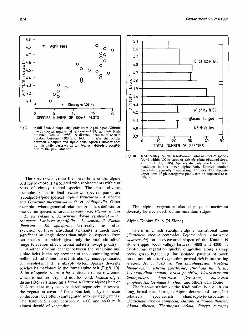
Fig 9 Aghil Shan S slope, dry gully from Aghil pass: Altitude versus species number of randomized 100 m z plots (data obtained Oct. 20, 1986). A distinct increase of species number between 4300 and 4400 m marks the border between subalpine and alpine belts. Species number does not distinctly decrease at the highest altitudes, possibly due to the pass situation.
The species-change on the lower limit of the alpine belt furthermore is associated with replacements within of pairs of closely related species. The most obvious examples of altitudinal vicarious species pairs are (subalpine-alpine species): Ajania fruticulosa - A. tibetica and Oxytropis microphylla - O. cf. chiliophylla. Other examples, where genetical relationships is less definite, or one of the species is rare, may comprise: Elymus nutans - E. schrenkianus, Krascheninnikovia ceratoides - K. compacta, Lonicera asperifolia - L. semenovii, Rheum tibeticum - Rh. spiciforme. Generally, the mutual exclusion of these altitudinal vicariants is much more significant on single slopes than might be expected from our species list, which gives only the total altitudinal range (elevation effect, azonal habitats, swept plants).
Another obvious change between the subalpine and alpine belts is the replacement of the dominating wind- pollinated subalpine desert shrubs by insect-pollinated chamaephytes and hemikryptophytes. Species diversity reaches its maximum in the lower alpine belt (Fig 9, 10). A lot of species seem to be confined to a narrow zone, which is not too dry and not too cold. Festuca olgae, distinct from its large tufts forms a (lower alpine) belt on N slopes that may be considered separately. However, the vegetation cover of the alpine belt is by no means continuous, but often disintegrated into isolated patches. The Kunlun S slope between c. 4000 and 4800 m is almost devoid of vegetation.
S.1
5.0
4.9
4..8
4.7
~4.6
~4.5
~ 4.4 I-. .-
~ 4.3
4.2
4.1
4.0
3.9
I I
I I
10
E of K2-N-I3[.
I I
I W of K2-N-fi[.
- - gtacier-tongue
l K2-N-Vattey
I I t 0 20 30 40 50
TOTAL NUMBER OF SPECIES
Fig 10 K2-N-Valley, central Karakoram: Total number of species found within 100 m steps of altitude (data obtained Sept. 2 to Oct. 12, 1986). Species diversity reaches a clear maximum in the lower alpine belt. Species number decreases apparently linear at high altitudes. The absolute upper limit of pbanerogamic plants can be expected at c. 5500 m.
The alpine vegetation also displays a maximum diversity between each of the mountain ridges:
Alpine Kunlun Shan (N Slope)
There is a rich subalpine-alpine transitional zone (Krascheninnikovia ceratoides, Festuca olgae, Androsace squarrosula) on loess-covered slopes of the Kunlun N slope (upper Kudi valley) between 4000 and 4200 m. Continuous vegetation quickly diminishes along a steep rocky gorge higher up, but isolated patches of block scree- and initial turf vegetation proved rich in interesting species. At c. 4380 m, Poa poophagorum, Koeleria litwinowiana, Rheum spiciforme, Rhodiola himalensis, Leontopodium nanum, Braya pamirica, Pleurospermum lindleyanum, Androsace flavescens, Saussurea gnaphalodes, Gentiana karelinii, and others were found.
The highest section of the Kudi valley is a c. 10 km long, broad glacial trough. Alpine deserts and loose, but relatively species-rich chamaephyte-associations ( Krascheninniko via compacm, Dasiphora dryadanthoides, Ajania tibetica, Thermopsis inflata, Parrya exscapa)

GeoJournal 25.2/3/1991 275
dominate around 4600 m. Between 4600-4800 m, there are some larger patches of (high-) alpine turf; but no closer examination could be done here.
Alpine Aghil Shan
Many alpine species descend to the Aghil gorge (c. 3880 m) of the Aghil Shan N slope, where there are shaded bedrock-cliffs, abounding in species (Artemisia compacta, Lonicera asperifolia, Poa poophagorum, Ajania tibetica, Dasiphora dryadanthoides, Dolomiaea macrocephala). The subalpine-alpine transitional flora, species-rich in places, ascends to c. 4200 m. Stable terraces of a broad valley section above the gorge have cushions and spots of dry turf (Oxytropis ampullata, O. microphylla, Orostachys thyrsiflora, Ephedra gerardiana, Stipa purpurea, Poa poophagorum, Potentilla agrimonioides); shrubby species include Krascheninnikovia ceratoides, Berberis ulicina and Lonicera asperifolia.
At 4150 m, a single stone hut built on a calcareous rock-wall and serving as summer-habitation of a family of Kirghiz herdsmen, marked the last human settlement towards the inner mountain system. Microula tibetica, Axyris prostrata and Chenopodium prostratum were growing on goatdung. More or less grazed and dwarfed specimens of alpine species found in crevices of limestone rocks include Viola biflora, Draba altaica and Potentilla saundersiana.
Higher up, the flora of the ascent to Aghil pass, although heavily grazed, proved rich in plant species. It would well repay a closer and more prolonged examination. A diverse but scanty vegetation grows on the more stable calcareous (Oxytropis ampullata, O. densa, O, pagobia, Astragalus strictus, Tanacetum pyrethroides) and granite scree slopes (Potentilla bifurca, Rhodiola fastigiata, Artemisia stricta, Ptilotrichum canescens), which alternatively come down from short lateral valleys and rock-walls.
Above of 4500 m and up to the height of Aghil pass (4780 m), the valley broadens to a gently ascending glacial trough. This has an exceptionally rich alpine flora with an almost 100% vegetation cover in places. Species found in loose dry alpine turf include Stipa concinna, St. purpurea, St. subsessiliflora, Poa poophagorum, Calamagrostis holciformis. Flushes and watered places on the stream's edge have a dense growth of small turf sedges and grasses (Carex montis-everestii, C. atrofusca ssp. minor, C. pseudofoetida, Poa calliopsis) and other species (Polygonum viviparum, Gentiana karelinii, Gentianella azurea, G. pygmaea). Tall forbs (Carex nivalis, Delphinium brunonianum) are thinly distributed on the Aghil N slope, but there are large patches of tufted "Naka" (frost-broken) moor (Kobresia deasyi, K. royleana).
Higher up, Primula macrophylla and Saxifraga hirculus are distinctive species of small streams and flushes within of and on the margin of moors. An
association of flat cushions, or sort of frost-cracked dry highalpine turf (Kobresia capillifolia, Oxytropis chionobia, Potentilla pamirica) grows on relatively stable granite scree slopes with stone-polygons (Fig 11). Both communities, the first resembling those of "snow- valleys", the latter of wind-blown Elynetea-communities of the European Alps, we saw only in the upper alpine belt of the Aghil Shan N slope.
The steep, dry S slope of Aghil Shan has a scanty vegetation. Nevertheless, alpine desert-steppes (Carex stenocarpa, Stipa subsessiliflora, Allium carolinianum, Oxytropis densa, Ajania tibetica) down to c. 4400 m are relatively rich in species (cf. Fig 9).
Alpine Central Karakoram N Slope
A pronounced species-change and increase of species number happens above of a steep ascent along the lateral moraine W of K2-N-Glacier at c. 4380 m (see above, cf. Fig 10). This generally is similar on the E slope of Muztagh valley, where there is a distinct Festuca olgae- belt on more gentle slopes.
The lateral moraine W of K2-N-Glacier broadens above. From c. 4400 to 4500 m, chamaephyte- communities (Astragalus webbianus, Oxytropis cf. chiliophylla, Ephedra monosperma, Pleurospermum govanianum, Ajania tibetica, Rhodiola fastigiata, Poa poophagorum, Elymus schrenkianus) grow on the boulder-strewn slopes. These are rich in species, but the vegetation cover is not very dense and interrupted by several gullies and rapidly moving rock-streams, which are devoid of vegetation. Tall Carex nivalis - meadows (with Delphinium brunonianum and various other species) cover relatively large areas. These indicate rather sheltered and moist conditions, but true alpine turf
Fig 11 Aghil Shan, just N of Aghil pass, 4780 m. High alpine turf cracked by frost heaves on slightly inclined NE-facing granite scree slope with Kobresia capillifolia (1), Oxytropis chionobia (2) and Potentilla pamirica (3). (Photo: Aug 30, 1986, B. Dickorr)

276 GeoJournal 25.2/3/1991
Fig 12
Fig 13
W of K2-N-Glacier, 4550 m. Alpine "rock-garden" below of steep E-facing wails of granite bedrock with Thylacospermum caespitosum (1), Dasiphora dryadanthoides (2), Oxytrop& cf. chiliophylla (3), Rhodiola fastigiata (4), Lonicera semenovii (5) and Rheum spiciforme (6). A recently fallen boulder (centre) caused notable damage on the frost-shattered soil and vegetation. (Photo: Sept. 14, 1986, B. Dickor6)
View SSW from 4580 m over the K2-N-Glacier towards K2 summit (8611 m, in 15 km distance); upper alpine and higher belts. Almost the whole landscape is devoid of vegetation. Only the N slope of the glacier-smoothed foot- hill of the Nunatak (1) between K2-N-Glacier (middle) and Skyang-Kangri glacier (to the left) has a fairly species- rich high alpine and subnivale vegetation. The highest vegetation spots have been found beyond this, approximately where the projection of the NW-spur of K2 meets the foothill on the photo.
The transgressing monsoon occurred shortly before bad weather with average day temperatures dropping below of 0 °C at the end of the vegetation period. The actual snowline approximately coincides with the absolute upper limit of vegetation. (Photo: Sept. 8, 1986, B. Dickor6)
(Leontopodium nanum, Lagotis decumbens, Viola kunawurensis) is restricted to very local situations. Between c. 4450 and 4550, vegetation of granite block- scree (Rheum spiciforme, Lonicera semenovii, Rhodiola fastigiata, Nepeta longibracteata, Cystopteris dickieana) and chasmophytes of the steep flanks above (Thylacospermum caespitosum, Saxifraga pulvinaria, Viola biflora, Dolomiaea macrocephala) become dominant vegetation features. Beautiful small "rock- gardens" below of very steep rock-walls at 4550 m probably are among the highest localities for any plants W of K2-N-Glacier (Fig 12). Higher up on this side of the glacier, the rock-walls are inaccessible, and apparently devoid of vegetation as well.
Large tracts of mobile scree E of the K2-N-Glacier equally are devoid of higher plants and lichens. However , a species-rich flora (Festuca olgae, Stipa purpurea, St. subsessiliflora, Rhodiola fastigiata, Leontopodium nanum, Dracocephalum heterophyllum, Lonicera semenovii, Dasiphora dryadanthoides) occurs again on a small isolated patch of alpine turf at the mouth of a lateral gully (4590-4620 m). Higher up along the glacier, there are extensive rock-walls, which have a scattered, but still relatively rich flora. Thylacosperum caespitosum is characteristic of sunny rocks, while the other species which forms dense cushions, Saxifraga pulvinaria, is strictly confined to N-facing shaded cliffs. Additional species seen between boulders below of the rock-walls include Oxytropis cf. chiliophylla, Nepeta longibracteata and Waldheimia tomentosa. Camp 1 (4630 m) was situated on moraine-gravel just NE of the confluence of the Skyang Kangri- and the K2-N-Glaciers; the only species growing here was Ajania tibetica.
S of Camp 1 and across the Skyang Kangri glacier, there is a glacier-smoothed rolling hill. This is part of a Nunatak, completely encircled by glaciers (Fig 13). A spot of dense turf with Oxytropis cf. chiliophylla on a small rocky plateau c. 50 m above of the K2-N-Glacier (4750 m) may be considered the highest location for alpine vegetation (see below).
Subnivale Belt
The delimitation of the subnivale vegetation belt is difficult, although the species composition is very characteristic. Sibbaldia tetrandra and Saussurea gnaphalodes are frequent cushion-like species on superficially thawing permafrost slopes of the free gelifluction belt, common to all three major mountain ridges. Usually, plants are confined to slightly inclined (<5 ° ) slopes, whereas only exceptionally any higher plants or lichens can withstand the rapid debris movement of the abundant 35 ° slopes.
The lower limit of the subnivale belt approximately runs around 4800 m on each N slope of the area, but this largely depends on (micro-) exposition. Characteristic dicotyledonous cushion-like species may descend below

GeoJournal 25.2/3/1991 277
of 4500 m and, on the other hand, fairly closed and species-rich (high) alpine turf (Stipa concinna, Kobresia pusilla) locally can be found above 5000 m.
The subnivale flora seems to be somewhat different on each mountain ridge, but less so than in the alpine belt. Owing to lack of data and the generally low species numbers on the upper limit of vegetation, the following distinctions must remain tentative:
Subnivale Kunlun Shan
Around the height of Mazar pass (4940 m) seedlings of Sibbaldia, Saussurea, Silene gonosperma, Draba oreades and Lagotis decumbens locally occur on slightly inclined frost debris slopes.
Subnivale Aghil Shan
Sibbaldia, Saussurea and Draba oreades also grow around Aghil pass (4780 m). Nepeta longibracteata is another characteristic species found in steep, exposed, dry scree. A variety of (high) alpine species ascend to the height of the pass (see above); higher localities have not been investigated here.
Subnivale Central Karakoram N Slope
There is an area of c. 0.6 sqm and between 4720-5040 m of altitude with high alpine and subnivale vegetation on the N slope of the hill towards K2-N-Glacier (5046 m, 11 km NNW of K2 summit) of the Nunatak E of K2-N- and S of Skyang Kangri glacier. Although close to the upper limit of vegetation, the plant cover is rather dense. 37 species of phanerogams have been found here, including 9 species not found elsewhere along the transect ( Oxytropis sp., Carex haematostoma, Draba winterbottomii, Lagotis globosa, Potentilla gelida, Saxifraga oppositifolia, Sibbaldia olgae, Stellaria cf. decumbens and Waldheimia tridactylites). The lichen and moss flora of the Nunatak seems to be rich too. Sibbaldia tetrandra and Saussurea gnaphalodes are common on free gelifluction slopes. Sibbaldia was not found elsewhere lower down in the K2-N-Valley. A very steep (35 °) scree- slope held an exceptionally rich version of this association, where many species apparently slided down from higher slopes. Highalpine or subnivale turf spots with a vegetation cover up to 90 % are confined to the more gentle slopes and shallow depressions, but they do ascend nearly to the top of the hill. Characteristic species are Stipa concinna, Carex haematostoma, Viola kunawurensis and Gentianella azurea. Carex montis- everestii, Kobresia pusilla and Potentilla pamirica inhabit the edges of the turf-spots towards the free gelifluction slopes. Cushions of Thylacospermum can be found between rocky outcrops and on relatively stable slopes. At 4900 m, the largest, somewhat disintegrated cushion of Thylacospermum had a diameter of 2.4 m. This should correspond to a high age (of several hundred years?).
Fig 14 The largest cushion of Thylacospermum caespitosum at 5060 m on a SW-facing wall of rock of a lateral gully E of and c. 100 m above of the upper K2-N-Glacier (c. 9 km NNW of K2 summit). Ice-axe 80 cm. (Photo: Sept. 11, 1986, B. Dickor6)
Higher up along the K2-N-Glacier, there are extensive scree slopes, which are devoid of vegetation, except for a small place of a few m 2 around 4950 m (Sibbaldia, Saussurea, Elymus schrenkianus). The highest location where we could reach any vegetation was a steep rocky gully E of K2-N-Glacier (5060 m, 9 km NNW of K2- summit). The S-facing rock-wall of this had 4 species of higher plants (Thylacospermum, Nepeta longibracteata, Silene gonosperma and Waldheirnia tomentosa), whereas the N-facing rocks had a fairly rich cover of lichens. The Thylacospermum-cushions were of a considerable size here, but sterile (Fig 14). From a distance (Camp 2 on the medial moraine close to the north-wall of K2), we could observe Thylacospermum-cushions at least up to the altitude of 5200 m (7 km NNW of K2-summit).
Flora of the Transect
The annotated list (Tab 3) includes all species of Charophyta, Pteridophyta, and Spermatophyta collected by the German expedition party during the 1986 expedition between Kashgar (Tarim basin) and K2 (Karakoram). Regarding local and altitudinal distribution, additional field observations have been included, so far as misidentification is likely to be excluded. Some important synonyms are given, including a few supposed, but not checked synonyms ("?"). An informal aggregate conception ("s.l.") for uncertainty of species delimitation, or the formula "auct. non . . ." for frequent misidentification is used especially in "arctic- alpine" species complexes.
278 GeoJournal 25.2/3/1991
T a b 3 A n n o t a t e d list of plants collected in the Nor thern Declivity of the K a r a k o r a m / K u n l u n Mounta ins (Charophyta , Pter idophyta , Spermatophyta)
Table key
1st column: names of taxa (synonyms)
2nd column (facultative): abbreviat ion of specialist 's de terminat ion or confirmation of part or all of the material concerned: 1. W. Krause = W K 8. P. Cribb = PC 2. H. Frei tag & 9. G. Wageni tz = G W
G. Maier-Stolte = FM 10, C. Jeffrey = CJ 3. A . O . Chater = A C 11. R, Doll = R D 4. K. Lewejohann = KL 12. D. Podlech = D P 5. T . A . Cope = T C 13. M. Liddn = M L 6. H. Freitag = H F 14. C. Grey-Wilson = C G 7. W . T . Stearn = WS 15, J. Soj~k = JS.
3rd column: altitudinal distribution of the taxon indicated by the lowest and the highest record along the transect,
4th column: Occurence ("x"), resp. no evidence ( " . ' ) of the taxon in the subdivisions of the transect: left to right (= north-south) : l ) Kashgar ian Lowland (Ksg) 5) Aghil Shan (Agh) 2) Kun lun Foothills (Ksm) 6) Shaksgam Valley (Sha) 3) Kunlun Shah (main ridge) (Kun) 7) Central Ka rako ram N slope (Kar). 4) Yarkand Valley (Yar)
i Charophyta Characeae
Chara contraria A.BRAUN ex KOTZ. (ch. vulgaris s.l.) WK 3770 m ...x...
2 Pteridophyta 2.1 Sphenopsida
~uuisetaceae Equisetum ramosissimum DESF. 3520 m ...x...
2.2 Pteropsida Athvriaceae
Cystopteris dickieana R.SIM 4420-4550 m ...... x
3 Spermatophyta 3.1 Gymnospermae
CuDressaceae Juniperus pseudosabina FISCHER & MEYER 3200-3400 m .x ..... Juniperus turkestanica KOMAROV 3980 m ...... x
3.2 Gnetatae Enhedraceae
Ephedra fedtschenkoae PAULSEN FM 3850-4420 m .... x.x Ephedra intermedia SCHRENK & MEYER in
C.A.MEYER var. intermedia FM 3520-4160 m ..xxxxx Ephedra intermedia
var. glauca (REGEL) STAFF FM 3550-4050 m ..xxx.. Ephedra monosperma J.G.GMELIN ex C.A.MEYER FM 4380-4510 m ...... x Ephedra regeliana FLORIN FM 3100-4520 m ..x.x.x
3.3 Angiospermae 3.3.1 Monocotyledonae
Cvneraceae Blysmus sinocompressus TANG & WANG Carex atrofusca SCHEUHR
ssp. minor (BOOTT) T.KOYAMA Carex haematostoma NEES in WIGHT
var. submacrogyna K~KENTHAL Carex melanantha C.A.MEYER in LEDEB. Carex microglochin WAHLENB. Carex montis-everestii KOKENTHAL
(C. borii NELMES) Carex nivalis BOOTT
(C. griffithii BOOTT) Carex orblcularis BOOTT Carex pseudofoetida KOKENTHAL
(C. incurva auct. non LIGHTF.) Carex cf, pycnostachya KAR. & KIR. Carex stenocarpa TURCZ, ex V,KRECZ.
(? C. macrogyna auct. non TURCZ.) Carex stenophylla WAHLENB.
(incl. C. stenophylloides V.KRECZ.) Eleocharis quinqueflora (F.X.HARTMANN)
O.SCHWANZ ssp. meridionalis (ZINSERL.) EGOROVA
Kobresia capillifolia (DECNE.) C.B.CLARKE Kobresia deasyi C.B.CLARKE
(K. tibetica auct. non MAXIM.) Kobresia pusilla IVANOVA Kobresia royleana (NEES) BOECK. Kobresia stenocarpa (KAR. & KIR.) STEUDEL
Graminea~(Poaceae) Bromus japonicus THUNB. Calamagrostis cf. epigeios (L.) ROTH Calamagrostis holciformis JAUB. & SPACH
(Deyeuxia compacta MUNRO ex HOOKER f.)
3520-4060 m ..,X.XX
AC 3740-4780 m ..x.x..
4750-4920 m ...... x AC 3760-3850 m ...x.., KL 3760-3950 m ...x..x
AC 4420-5030 m .... x.x
4380-4750 m .... x.x AC 3760-4060 m ...x.xx
3930-4820 m .... x.x 4060 m ..... x.
4440-4760 m .... x.x
4090 m ...,..x
3050-4060 m .,xxxxx
4560-4820 m .... x..
3600-4780 m ...xx.. 4380-5030 m ...... x 3000-4780 m ..xxx., 3930-4060 m ..... xx
TC 3000 m ..x .... 4100 m ...... x
TC 3900-4900 m ...xxxx
Calamagrostis pseudophragmites (HALLER f.) KOELER
Cynodon dactylon (L,) PERS, Echinochloa crus-galli (L.) P.BEAUV. El!rmus cf. dentatus (HOOKER f.) COPE
Elymus nutans GRISEB. (E. sibiricus auct. non L.)
Elymus schrenkianus (FISCHER & MEYER) TZVELEV
Eremopoa altaica (TRIN.) ROSHEV. in KOM. ssp. songorica (scHRENK) TZVELEV
Festuca olgae (REGEL) KRIVOT. (Leucopoa albida auct. non V.KRECZ. & BOBROV)
Festuca tibetica (STAFF) ALEXEEV (F. valesiaca auct. non GAUDIN)
Hordeum brevisubulatum (TRIN.) LINK ssp. turkestanicum (NEVSKI) TZVELEV
Koeleria litwinowii DOMIN Leymus secalinus (GEORGI) TZVELEV Phragmites australis (CAV.) TRIN. ex
STEUDEL Phragmites cf. humilis DE NOT, Poa calliopsis LITW. ex OVCZ. Poa litvinoviana OVCZ. Poa poophagortrm HOR Polypogon monspeliensis (L.) DESF. Puccinellia distans (W~d~LENB.) pARL. Puccinellia kashmiriana BOR Puccinellia tenuiflora (TURCZ.) SCRIENER
& MERR. Setaria glauca (L.) p.BEAUV. stipa caucasica SCH~H- ssp. glareosa
(SMIP~OV) TZVELEV Stipa concinna HOOKER f. Stipa orientalis TRIN. in LEDEB. Stipa purpurea GRISEB- Stipa splendens TRIN. in SPRENGEL Stipa subsessiliflora (RUPR,) RosHEV.
Juncaceae Juncus ambiguus GUSS.
(J. ranarius SONG. & PERR. in BILLOT) Juncus articulatus L. Juncus membranaceus ROYLE ex DON Juncus thomsonii HUCHENAU Juncus triglumis L.
Juncaainaceae Triglochin maritima L. Triglochin palustris L.
(T. himalensis ROYLE)
Lili~ceae Allium carolinianum DC. in REDOUT~ Allium filifolium REGEL Allium cf. humile KUNTH Allium sp. Asparagus cf. angulofractus ILJIN Lloydia serotina (L,) REICHENB.
Orchidaceae Dactylorhiza kafiriana RENZ in RECH.f.
(D. umbrosa auct. non NEVSKI)
Potamoaetonaceae Potamogeton pectinatus L.
(incl. P. filiformis var. tibetanus HAGSTR.)
TC 3000-3980 m ..xxxxx 1300 m x ......
1300,1400 m x ...... TC 3720-3850 m .... x..
TC 3000-4200 m ..xxxxx
TC 3850-5030 m ..x.x.x
TC 3600 m ...x...
TC 3990-4630 m ..x.x.x
TC 4340-5020 m ..x.x.x
TC 3600-4060 m ..xx.xx 4380 m ..x ....
TC 3000-4560 m .xxxxxx
1600-3900 m x.xx... 1280 m x ......
4000-4660 m ..x.x.. 4370-4420 m ..x...x
TC 3050-5020 m ..x.x.x TC 3000 m ..x .... TC 1280-3050 m x.x .... TC 3930,3980 m ..... xx
3520-4820 m ..xxxxx 1400 m x ......
MF 3600-4520 m ..xxxxx HF 4560-5000 m .... x.x HF 3630 m ...X... HF 3990-4640 m ..x.x.x HF 1600-4130 m xxxxx.x HF 4130-4660 m ,°x.x.x
3000 m ..x .... 1280 m x ......
3700 m .... x.. 4620 m .x.
3740,4210 m ..x ....
3850-4060 m ...x.x.
3000-4060 m ..xxxxx
WS 4360-4520 m .... x.x WS 3050-4000 m .xx.x.. WS 3970 m ...... x
2280 m .x ..... 2540 m .x ..... 4550 m ..... x
PC 3760-3850 m .,.x...
KL 3770 m .,.x...

GeoJournal 25.2/3/1991 279
3 • 3.2 Dicotyledonae
Amaranthus graecizans L.
Apocvnace~@ Apocynum hendersonii HOOKER f. in
HENDERSON & HUME (Poacynum hendersonii (HOOKER f. ) WOODSON)
Asclenia~eae Cynanchu~ acuttum L.
Berberidaceae Berberis ulicina HOOKER f. & THOMSON
(B. kaschgarica RUFR. )
Borauinace~¢ Arnebia guttata BUNGE
(A. tibetana KURZ, Lithospermum guttatum (BUNGE) I.M.JOHNSTON)
Eritrichium rupestre s.1. (incl. : ) E. cf. rupestre BUNGE
E. Sp. Eritrichium spathulatum (BENTHAM in
ROYLE ) C.B. CLARKE Hackelia cf. pamirica (B.FEDTSCM.) BRAND Microula tibetica BENTHAM in BENTHAM &
HOOKER f.
CaDrifoliaceae Lonicera asperifolia (DECNE.) HOOKER f.
& THOMSON Lonicera semenovii REGEL
(L. glauca HOOKER f. & THOMSON, non HILL)
Carvonhvllaceae Lepyrodlclis holosteoides (C.A.MEYER)
FENZL ex FISCHER & MEYER Silene gonosperma (RUPR.) BOCQUET
ssp. himalayensis (ROHRB.) BOCQUET (Melandrium apetalum auct. non (L.) FENZL)
Silene moorcroftiana WALL. ex BEHTHAM in ROYLE
Stellaria cf. decumbens HOOKER f. & THOMSON
Stellaria irrigua BUNGE (St. umbellata TURCZ. , St. subumbellata EDGEW. )
Thylacospermum cnespitosum (CAMBESS.) SCHISCHK. (Arenaria caespitosa (CAMBESS.) KOZHEVN. )
ChenoDod~ac@ae Atriplex sibirica L.
(incl. A. centralaslatica ILJIN) Axyris prostrata L. Axyris cf. sphaerosperma FISCHER & MEYER Bassia dasyphylla (FISCHER & MEYER)
O.KUNTZE (Echinopsilon divaricatum KAR. & KIR. )
Chenopodium ac%Lminatum WILLD. Chenopodium nlbu/~ L. Chenopodium glaucum L. Chenopodium cf. prostratum BUNGE Chenopodium schraderianum SCHULTES
in ROENER & SCHULTES (Ch. foetidum SCHRADER, non LAM. )
CorispermtLm tibeticum ILJIN Malogeton arachnoideus MOQ. in DC. Halogeton glomeratus (M.BIEB.) C.A.MEYER
in LEDEB. Haloxylon ammodendron (C.A.MEYER) BUNGE Haloxylon cf. persicum B~NGE
ex BOISS. & BUHSE Kalidium cuspidatum (UNG.-STERNB.) GRUBOV Kochia melanoptera BUNGE Kochia scoparia (L.) SCHRADER Krascheninnikovia ceratoides (L.)
GUELDENST. s.l. (Eurotia ceratoides (L.) C.A.MEYER, Ceratoides latens (J.F.GMELIN) REVEAL & HOLMGREN, C. papposa (PERS.) BOTSCH. & IKONN. )
Krascheninnikovia compacta (LOSINSK.) GRUBOV (Eurotia compacta LOSINSK., Ceratoides compacta (LOSINSK.) TSIEN & C.G.MA)
Salsola collina PALLAS Salsola cf. pestifer NELSON in COULTER Salsola sp. (aff. S. chinghaiensis A.J.LI) Spinacia oleracea L. Suaeda corniculata (C.A.MEYER) BUNGE Sympegma regelii BUNGE
Compositae (Asteraceae) Acroptilon repens (L.) DC. Ajania fruticulosa (LEDEB.) POLJAK.
(Tanacetum fruticulosum LEDEB., incl. T. gracilis HOOKER f. & THOMSON)
Ajanla tibetica (HOOKER f. & THOMSON) TZVELEV (Tanacetum tibeticum HOOKER f. & THOMSON)
Artemisia compacta FISCHER ex DC.
Artemisia pamirica WINKLER (A. dracunculus s.l.)
1300 m x ...... Artemisia santolinifolia TURCZ. ex KRASCH. in KRYLOV
Artemisia cf. scoparia WALDST. & KIT. Artemisia stricta EDGEW.
(incl. A. demissa KRASCH.) 1600 m x ...... Artemisia tournefortiana REICHENB.
(A. biennis auct. non L.) Artemisia wellbyi HEMSLEY & PEARSON
1300,1600 m x ...... (A. salsololdes auct. non WILLD.) Aster flaccidus BUNGE ssp. fl~ccidus Aster tripolium L. Brachyactis ciliata (LEDEB.) LEDEB.
3000-4300 m ..xxxxx Brachyactis roylei (DC.) WENDELBO Cirsium arvense (L.) SCOP. Crepis flexuosa (DC.) C.B.CLARKE Dolomiaea macrocephala ROYLE
(Jurinea dolomiaea BOISS.) 3600-4300 m -..xxxx Inula salsololdes (TURCZ.) OSTENF. 3050-4400 m ..xxx.x in HEDIN 3050-4400 m ..xxx.x Lactuca tatarica C.A.MEYER
420D m .... x.. Launaea sp. (Chondrilla polydichotoma OSTENF. in HEDIN)
4610 m ...... x Leontopodium cf° brachyactis GANDOGER 3700 m .... x.. Leontopodium nahum (HOOKER f. & THOMSON)
HANDEL-MAZZ, 4160,4570 m ..x.x.. Saussurea gnaphalodes (ROYLE) SCHULTZ BIP.
Scorzonera songorica (KAR. & KIR.) LIPSCH. & VASSILCZ.
Senecio krascheninnikovii SCHISCHKIN 3850-4440 m .... x.x Tanacetum pyrethroides (KAR. & KIR.)
SCHULTZ BIP.
4100-4910 m ...... x Taraxacum asiaticum DAHLST. Taraxacum himalaicum V.SOEST Taraxacum kashmirense V.SOEST Taraxacum ludlowii V.SOEST
3000 m ..x .... Taraxacum luridum HAGLUND Taraxacum stenolepi~%m HANDEL-MAZZ. Taraxacum wendelboanum V.SOEST Waldheimia tomentosa (DECNE.) REGEL
4380-5050 m ..x.x.x Waldheimia tridactylites MAR. & KIR. ssp. tridactylites
3880-4460 m .... x.x Xanthium stru~arium L. (incl. X. sibiricum PATR. ex WIDDER,
4750-4770 m ...... x X. japonicum WIDDER)
3740 m ..x .... Convolvulac~a@ Convolvulus arvensis L.
4100-5200 m ...... x Crassulaceae Orostachys thyrsiflora (DC.) FISCHER
ex SWEET Rhodiola fastigiata (HOOKER f.) FU
2280-3600 m .xxx... Rhodiola himalensis (D.DON) FU 4160 m .... x.. 4570 m .-x .... Cruciferae(Hrassicaceae)
Braya pamirica (KORSH.) O.FEDTSCH. Braya rosea (TURCZ.) BUNGE
2100,3930 m x ..... x Braya thomsonii HOOKER f. 1300 m x ...... Braya tibetica HOOKER f. & THOMSON 1300 m x ...... Cardaria pubescens (C.A.MEYER) ROLLINS
1300-3800 m x..x... Christolea crassifolia CAMBESS. in 3520-4570 m ..xxx.. JACQUER.
Christolea cf. linearis N.BUSCH Dilophia salsa THOMSON in HOOKER f.
3 6 0 0 m ...X... Draba altaica (C.A.MEYER) BUNGE 3740 m ...x... Draba glomerata ROYLE
2280-3930 m .x.x..x Draba oreades SCHRENK in FISCHER & MEYER Draba winterbottomii (HOOKER f. & THOMSON)
1400-3100 m xxx .... POHLE 1350 m x ...... Hedinia tibetica (THOMSON) OSTENF.
in HEDIN 1350 m x ...... Hymenolobus pauciflorus (KOCH) SCHINZ
3020,3300 m .xx .... & THELL. (? Draba tenerrima O.E.SCHULZ) 3100 m ..x .... Lepidium apetaltlm WILLD. 1300 m x ...... Lepidium latifolium L.
Malcolmia africana (L.) R.BR. Malcolmia cf. behboudiana RECH.f. & ESF. Malcolmia intermedia C.A.MEYER Parrya exscapa LEDEB.
3100-4400 m .xxxxxx Ptilotrichum canescens (DC.) C.A.MEYER in LEDEB.
Torularia cf. brevipes O.E.SCHULZ Torularla humilis (C.A.MEYER) O.E.SCHULZ
4570-4720 m ..x.x.. Elaeaonacea@ 1600-3600 m x..x,.. Elaeagnus an~ustifolia L. 1400,1900 m x ...... Hippophae rhamnoides L. ssp. turkestanica
3930 m ...... x ROUSI 1300 m x ......
3000,3870 m ..xx... Gentianaceae 2150-3870 m .xxx... Gentiana aquatica s.l°
(incl.:) G. leucomelaena MAXIM. G. cf. pseudoaquatica KUSNEZ.
Gentiana karelinii GRISEB. in DC. (G. prostrata s.l.)
Gentianella azurea (BUNGE) H.SMITE Gentianella falcata (TURCZ. ex
KAR. & KIR.) H.SMITH Gentianella pulmonaria (TURCZ. ex LEDEB.)
V.ZUEV Gentianella pygmaea (REGEL & SCHMALH°)
H.SMITH (Gentiana thomsonii C.B.CLARKE in HOOKER f.)
GW 1300 m x ......
CJ 2540-4370 m .xxxxxx
CJ 3880-4980 m ..x.x.x
(A. maritima s.l.) CJ 3270-4150 m .x..x.. Artemisia macrocephala JACQUEM. ex 8ESSER CJ 3000-3930 m .xxxx.x
3550-4570 m ..xxx.x
CJ 3620-4370 m ...xx.x 3000 m ..x ....
CJ 3700-4350 m .... x..
GW 1300 m x ......
CJ 3680-5980 m .... XXX 4380 m ..X ....
GW 1280 m X ...... CJ 1280 m x ......
3000 m ..x .... 3520-4060 m ..xxxx. 3000-4500 m ..xxxxx
CJ 3920-4550 m .... x.x
1400 m x ...... 1300-3940 m x.xxx.x
CJ 1280-2150 m x ...... CJ 3050 m ..x ....
CJ 3100-5000 m ..x.x.x 4380-5030 m ..x.x.x
1280 m x ...... CJ 3000,3800 m ..xx...
CJ 3850-4610 m .... x.x
RD 3930 m ...... x RD 4260 m .... x.. RD 4380,4780 m ..X.X.. RD 3020,3600 m ..XX... RD 2980 m ..X .... RD 4620 m .... x.. RD 3930 m ...... X
4200-5050 m ..x...X
4940 m ...... x
GW 1300 m x ......
1300,1400 m x ......
2280-4520 m .xx.x.. 4250-5020 m .... x.x 4050-4380 m ..x ....
4380 m ..x .... 3000-3740 m ..x ....
4380 m ..x .... 3700-4620 m ..x.x..
3520 m ...x...
3560-4450 m ..xxxxx 4220 m ...... x
3620-4620 m ..xxxxx 4150-4820 m .... x . X
4610 m ...... X 478014950 m ..x.x..
4790 m ...... X
4570 m ..x ....
3940 m ...... X 3000-4160 m .xxxx.. 3000-3870 m ..xxx..
3270 m .x ..... 3600 m ...x... 3000 m ..x ....
3940-4760 m .x.x.x
4170-4520 m .... x.x 3 8 0 0 m ...x...
3880-4620 m ..x.x..
2100 m x ......
3500-3740 m ...x...
3000-4100 m ..x..x~ 3000,4100 m ..x .... 3930,4060 m ..... xx
4260-4560 m ..x.x.. 4260-5030 m ...x.x
4780-4820 m .... x..
3000 m ..x ....
3740-5000 m ..xxx.x
280 GeoJournal 25.2/3/1991
Gentianella cf. stoliczkae (C.B.CI~RKE) TOYOKUNI (G. aurea s.l.)
Gentiamella wedenskyi (GROSSH.) H.SMITH (G. detomaa e.l.)
Lomatogonium brachyantherum (C.B.CLARKE) FERNALD
Lomatogonium thmmsonii (C.B.CLARKE) FERNALD (L. carinthiacum auct. non (WULFEN) REICHENB.)
Geraniaceae Geranium collinum STEPH. ex WILLD.
Grossularlaceae Ribes cf. villosum WALL. in ROXB.
(R. orientale s.l.)
Labiatae(Lamiaceae) Dracocephalum heterophyllum BENTHAM Dracocephalum stamineumKAR. & KIR. Nepeta iongibracteata BENT~L%M
Deuumimosae(Fabaceae) Alhagi kirghisorum SCHRENK Astragalus densiflorus KAR. & KIR. Aetragalus melanocarpus BUNGE Astragalus nivalis KAR. & KIR. Astragalus strictus GRA~L%Mex BENTHAM Astragalus tibetanus BENTHAM ex BUNGE
(incl.:) A. cf. chadjanensis FRANCHET A. tibetanus s.atr.
Astragalus webbianus GRA~L%Mex BENTHAM in ROYLE
Caragana polourensis FRANCHET Cicer songoricum STEPH. ex DC.
Oxytropis ampullata (PALLAS) PERS. Oxytropis cf. chiliophylla ROYLE ex
BENTHAM (O. microphylla auct. non (PALLAS) DC., O. hedinii ULBRICH, ? O. de-filippii PAMP.)
Oxytropis chionobia BUNGE Oxytropis densa BENTHAM ex BUNGE Oxytropis glabra s.l.
(incl.:) O. glabra (LAM.) DC. O. hirsutiuscula FREYN O. hypoglottoides (BAKER) ALI
Oxytropis humifusa KAR. & KIR. Oxytropia i~Lmersa (BAKER ex AITCH.) BUNGE
ex FEDTSCH. Oxytropis microphylla (pALLAS) DC. Oxytropis pagobia BUNGE Oxytropls sp. Thermopsis alpine (pALLkS) LEDEB. Thermopsie inflate CAMBESS. in JACQUEM.
Orobanchaceae cistanche salsa (C.A.MEYER) G.BECK
in ENGLER & PRANTL Orobanche cernua LOEPL.
Panaveraceae Corydalis adiantifolia HOOKER f. &
THOMSON s.1. (? C. n.sp.) Corydalis crassiseima JACQUEM. ex CAMBESS.
in JACQUEM. (C. crassifolia auct. non ROYLE)
Parnaesiaceae Parnassia laxmanni PALLAS ex SCHULTES
Plantaoinaceae Plantago gentianoides SIBTH. & 8M.
ssp. griffithii (DECNE.) RECH.f. Plantago minute PALLAS
Acantholimon diapensioides BoIse. in DC.
~olvoonaceae Calligonum mongolicum TURCZ. s.l.
(? incl. C. roborowskii LOSINSK., ? C. yenqisaricum Z.M.MAO)
Oxyria digyna (L.) HILL Polygomum gracilius (LEDEB.) KLOKOV
(p. bellardii s.l.) Polygonum cf. oxyepermum C.A.MEYER
& BUNGE ex LEDEB.
Polygonum pamiricum KORSH. (P. sibiricum LAXM. sap. thomeonii (MEISHER) RECH.f. & SCHIMAN-CZEIKA)
Polygonum viviparum L. Rheum spiciforme ROYLE Rheum tibeticum MAXIM. ex HOOKER f.
(? Rh. fedtschenkoi MAXIM. ex REGEL) Rheum sp. (aff. Rh. racemiferum MAXIM.) Rumex angulatus RECH.f.
(R. longifolius a.l.)
Primulaceae Androsace flavescens MAXIM. Androsace squarrosula MAXIM. Glaux maritima L. Primula macrophylla D.DON
(P. nivalis s.l.)
3000 m ..x ....
3000-3850 m ..xx...
4370-4420 m ...... x
3000-4560 m ..xxxxx
3000 m ..x ....
Primula pamirica pEDOROV (p. sibirica s.1.)
1400-2100 m x ...... DP 4380 m ..x .... DP 3740 m ..x .... DP 4350-4700 m ..x.x.x DP 3000-4620 m ..x,x.x DP 3050-3930 m .xxx..x
Ranunculaceae Clematis tangutica (MAXIM.) KORSH.
(C. orientalis s.l.) Delphinium brunonianum ROYLE Ranunculus pulchellus C.A.MEYER s.l.
(incl.:) R. cf. krasnovii OVCZ. R. longicaulis C.A.MEYER R. cf. pamiri KORSH. R. cf. pseudohirculus SCHRENK
Ramunculus sarmentosus ADAMS (R. salsuginosus auct. non GREEN)
3970 m ...... x Rhamnaceae
Rhamnus prostrata JACQ. ex PARKER 3920-4620 m ..x.x.x 3570-4550 m ..xxx.x Rosaceae 4400-5050 m .... x.x Chamaerhodos sabulosa BUNGE in LEDEB.
Dasiphora dryadanthoides JUZ. (Potentilla fruticosa var. pumila HOOKER f. p.p.)
Potentilla agrimonioides M.BIEB. Potemtilla bifurca L. sap. orientalis
(JUZ.) SOJAX (P. moorcroftii WALL.) Potentilla gelida C.A.MEYER ssp. borissii
(OVCZ. & KOCZK.) SOJAK 3050,3270 m .xx .... Potentilla multifida L. 3620-3930 m ...x..x Potentilla pamirica WOLF X P. sino-nivea
HULT~N (incl.:) P. cf. pamirica WOLF
P. cf. pamiroalaica JUZ. P. cf. saundereiana ROYLE P. cf. thomsonii HANDEL-MAZZ.
Potentilla salesoviana STEPH. (Comarum salesovianum (STEPH.) ASC~ERSON & GRAEBNER)
3700-4800 m ...xx.x Potentilla virgata LEHM. 4780-4820 m .... x.. (P. dealbate BUNGE in LEDEB.) 4150-4560 m .... x.. Sibbaldia olgae JUZ. & OVCZ. 3000-4060 m ..xx.xx Sibbaldia tetrandra BUNGE 3000-3850 m ..xx... Sibbaldianthe adpressa (EUNGE) JUZ. 3000-4060 m ..x..xx
3850 m ...x... 4380 m ..x .... Rubiaceae
Rubia tibetica HOOKER f.
4380,4570 m ..x...x 3550-4440 m ..xxxxx Salicaceae 4150-4820 m .... x.. Populus diversifolia SCHRENK 4750-5030 m ...... x (incl. P. litwinowiana mODE)
3740 m ..x .... Salix pycnoetachya ANDERS. 4570 m ..x .... Salix cf. sericocarpa AMOERS.
Saxifraoaceae Saxifraga cernua L.
2280-3020 m .xx .... Saxifraga hirculus L. var. alpina ENGLER 1600 m x ...... Saxifrage oppositifolia L. ssp. asiatica
(HAYEK) ENGLER & IRM. Saxifraga pulvinaria H.SMITH
(s. imbricata ROYLE, non LAM.)
Scromhulariaceae Euphrasia cf. schlagintweitii WETTST. Lagotis decumbens RUPR. Lagotis globosa (KURZ) HOOKER f. Pedicularis cheilanthifolia SCMRENK Scrophularia scmparia PENNELL
Solanaceae Lycium ruthenicum MURRAY Solanum luteum MILLER Solanum nigrum L.
Tamaricaceae Myricaria bracteata ROYLE
(M. alopecuroides SCHRENK, M. germanica s.l.)
Myricaria elegans ROYLE Myricaria pulcherrima BATALIN Reaumuria soongorica (PALLAS) MAXIM.
1350.,1600 m x ...... (Mololachne soongcric~ PALLAS, 3050 m ..x .... H. shawiana HOOKER f. in HENDERSON
& HUME) 3000 m ..x .... Tamarix chinensis LOUR.
Tamarix ramosissima LEDEB. 1400 m x ......
Umbelliferae(Apiaceae) Carum cf. carvi L.
3770 m ...x... Eriocycla thomsonii (C.B.CLARKE) WOLFF in
3740-4620 m ..x.x.. ENGLER 4150-4790 m ..x.x.x Heracleum pinmatum C.B.CLARKE in HOOKER f.
Pachypleurum mucronatum (SCHRENK) 3790-4040 m .... x.x SCHISCHKIN in KOM. (Neogaya mucronata 3870-3950 m ..... x. SCH~K)
Pleurospermum govanianum (DC.) C.B.CLARKE 3000 m ..X .... (Hymenolaena govaniena DC.)
Pleurospermum lindleyanum (KLOTZSCH) DIELS (P. stellatum auct. non (D.DON) BENTHAM)
3050-5000 m ..x.x.x 3000-4100 m .xx .... Violaceae 3520-3930 m ..xx..x Viola biflora L.
Viola kunawurensis ROYLE 4620-4780 m .... x.. Viola cf. tianschanica ~XIM.
DP 4320-4500 m ...... x 2540-3300 m .x ..... 3650-4380 m .... x.x
3650-4780 m .... x..
ML 3570-4400 m ..xxxxx
ML 4310-4740 m ...... x
3000 m ..x ....
3740 m ..x .... 2540,2650 m .x .....
3270-3300 m .x .....
3000-4060 m ..xx.xx
3000-3870 m ..xxx.. CG 4380-5000 m .... X.X
3740-4820 m ..x.x.. 4780-4820 m .... x..
3740 m ..x .... 4260,4460 m .... x..
4620 m .... x..
3 0 0 0 m ..x ....
3820-4160 m .... x.x
JS 3650-4520 m .... xxx
JS 3850-5020 m ..x.x.x JS 3990-4520 m .... x..
JS 3000-4750 m ..xxx.x
JS 4750 m ...... x JS 3000-4720 m .xxxx.x
JS 4150-5030 m ..x.x.x 4590-5030 m .... x.x 4780-4820 m .... x.. 4150-4620 m .... x..
4380 m ..x ....
JS 3620-4380 m ..xxxxx
JS 3930,4060 m ..... xx JS 4760 m ...... x JS 4560-5030 m ..x.x.x JS 4520 m .... x..
3870--4300 m ...x.xx
1600 m x ...... 3920-5950 m ...... x 3000,3800 m ..xx...
4780 m .... x.. 4620-4820 m .... x..
4780 m ...... x
4070-4810 m .... x.x
3050-3950 m ..xx..x 4380-4960 m ..x.x.x 4760-4810 m ...... x 3000-4820 m ..x.x.x 3570-4390 m ..xxx.x
2100-2150 m .x ..... 1300 m x ......
1300,1400 m x ......
3200-4360 m ..XXXXX 3550-4130 m ...xx.x
1400 m x ......
2540-3300 m .x ..... 3550 m .... x.. 1280 m x ......
3000 m ..X ....
3050 m ..X .... 3600-4380 m ...xxxx
3740 m ..x ....
4350-4610 m ...... x
4380-4960 m ..x.x..
4150-4610 m .... x.x 4460-5000 m ...... x
3740 m ..x ....
GeoJournal 25.2/3/1991 281
ZVaODhVllaceae Nitraria schoberi L. Peganum harmala L. Zygophyllum lehmannianum BUNGE Zyqophyllum xanthoxylon (BUNGE) MAXIM.
Pachypleurum mucronatum (SCHRENK) SCHISCHKIN in KOM, (Neogaya mucronata
2 0 5 0 - 3 7 4 0 m X X X X . . . 2 0 5 0 - 3 7 1 0 m X X X X . . . 1 6 0 0 , 3 5 2 0 m x . . x . . . 1350,1600 m x ......
There is no modern taxonomic list to be taken as a basis for determination of our material. We used as standard floras, although often incomplete and diverging in many respects: Flora Reipublicae Popularis Snicae (eds., 1978-); Grubov et al. (1966-1977); Hara, Williams et al. (1978-1982); Hooker (1875-1897); Komarov et al. (1934-1964); Nasir, Ali et al. (1970-); Ov~innikov et al. (1957-); Rechinger et al. (1963-); Tutin et al. (1964-1980). Monographical studies were included as far as available; these are not cited separately. Herbarium material was compared from the herbaria of G6ttingen (GOET) and Berlin-Dahlem (B). However, the most successful work on the examination of critical material could be done in London, where I stayed for two weeks at Kew (K), and visited also the British Museum, Natural History (BM).
Apart from the material that has been kindly determined by specialists, there remained a lot of uncertainty. For this, the author might be excused by the often insufficient material, which had been collected rather late in the year and with many species rare or even found in single specimens. Additionally, much of the flora of the KKND belongs to some of the largest and most difficult holarctic genera, that often display very complex radiation and differentiation patterns around the Tibetan Plateau.
Chorology
We desist from giving calculations on geoelements present in the flora of the KKND, since there are numerous ambiguities caused by lack of data, confusion or contradictionary application of phytogeographical terms, or delimitation and assignement of each species. Zheng Du (1983) provided a valuable phytogeographical analysis of the Tibetan plateau. Most recently, Huang Rongfu (1988) presented a chorological subdivision on generic level of the flora of the W Mt. Everest area. According to Zheng Du (1983), the flora of the NW projection of the Tibetan plateau entirely consists of Centralasiatic, Tibetan and Northern geoelements.
The flora of the KKND generally is characterized by the dominance of wide-spread Holarctic taxa with only very few (neo-) endemics. With reference to the classification outlined by Clayton&Cope (1980), and
other frequently used systems, most of the flora of the KKND would fall into the following categories:
Cosmopolitic, Pantemperate/Holarctic, Circumpolar, Eurasiatic, Central Asiatic and Saharo-Mongolian ("Tethys elements", cf. Huang Rongfu 1988), Tibetan (see below).
Interesting is the almost perfect exclusion of Irano- Turanian and Sino-Himalayan elements from the flora of the KKND. This is only slightly modified in the outer mountain ranges. Tropical elements are completely lacking. Characteristic large Irano-Turanian genera are represented in our area only by single (Acantholimon, Nepeta) or comparatively few species (Astragalus), while others lack completely (Cousinia, Dionysia). Sino- Himalayan elements, according to numerous examples provided by Meusel&Schubert (1971), are completely absent from the KKND. However, much of the holarctic "arctic-alpine" genera exhibit maximum species diversities in the Sino-Himalayan/SE Tibetan area. Of such genera, only Kobresia, Braya and Gentianella (Sect. Comastoma) are somewhat better represented in the KKND, while there occur only single species of other large genera of similar distribution types (Corydalis, Saxifraga, Primula, Gentiana, Leontopodium, Saussurea).
The different floristic character and higher species diversities of high mountain regions closely adjoining to the west, south and south-east, generally corresponds to a better representation of Irano-Turanian and Sino- Himalayan elements there. Numerous examples can be found, when the flora of the KKND is compared to floras or vegetation descriptions and related works, for example, from the Pamirs (Ov6innikov et al. 1957-), Wakhan (Kitamura 1964; Grey-Wilson 1974; Podlech & Anders 1977), Hindu Kush (Breckle 1974), the Karakoram S Slope (Pampanini 1930; Gilli 1957; Kitamura 1960; Hartmann 1966, 1968, 1972), Chitral (Wendelbo 1952), Zanskar (Seybold&Kull 1985) and Ladakh (Hartmann 1984).
"Tibetan elements" certainly do not represent a homogenous group. None of the genera endemic to SE Tibet (cf. Ni Zhi-Cheng&Cheng Shu-Zhi 1987) occur in the Karakoram/Kunlun N declivity. On the other hand, some of the few local genera endemic to High Asia (Dilophia, Thylacospermum, Microula, Waldheimia), which have been mentioned by Hemsley (1902), do occur. Species common to the dry NW Tibetan plateau or distributed over large parts of High Asia seem to comprise the largest group of the flora of the KKND.
282 GeoJournal 25.2/3/1991
Conclusions
Assumed that the flora and vegetation of the KKND, as documented above, reflect actual climatic conditions as well as the environmental history, some conclusions may be made.
Human influence generally is low in the KKND, but locally evident to the N of the Aghil Shah ridge, less so, but already detectable, in the Shaksgam valley and in the central Karakoram N slope. Floristically, the distribution of loess, which extends S to the alpine belt of the Kunlun Shan N slope, probably is most distinctive. The Kunlun Shan main ridge has also been considered an important borderline on thermoclimatical (Zhang et al. 1981) and palaeobotanical (Hsti Jen 1984) grounds.
The vegetation history of the Tibetan plateau, as evident from fossil floras and summarized by Hs~ Jen (1982, 1984), is that of a gradual impoverishment of a rich Tertiary flora towards present wide-spread steppe, semi-desert and desert conditions during the uplift of the area; followed by cyclic large-scale glaciation (Kuhle 1988) during the Pleistocene. This generally applies also to the Karakoram/Kunlun mountains, where moraines descend to c. 1900 m on the edge of the Tarim basin. However, the extreme relief energy and the marginal position of the KKND against the Tibetan plateau should have enabled the survival of nunatak floras, as well as a certain migration activity of plant species, corresponding to the fluctuation of glaciers and climatical conditions. The farreaching effects of the Tibetan plateau on the actual climatic and vegetational situation and division of E Asia have been summarized by Chang (1984).
As a product of former and recent conditions, the species-poor flora of the KKND is an essentially Holarctic-Centralasian-Tibetan one, of an extremely marginal position within the Holarctic/Pantemperate Kingdom, but almost completely excluding elements of closely neighbouring geobotanical division units (Tropical, Irano-Turanian, Sino-Himalayan). Thus, the KKND may be considered part of a "filter" in a migration path between the Sino-Himalayan and other northern hemisphere mountain floras, and, on the other hand, as a barrier between the palaeotropic Saharo- Sindian and the holarctic Centralasian-Mongolian desert floras.
According to the orographical structure, five horizontal vegetation zones can be extracted. These reflect features of widely distributed vegetation units, but are extremely narrowed in the KKND:
1) Kashgarian lowland
This is equivalent to the colline zone up to the foot of the mountains. Temperate stone-, more rarely alluvial loess- and sand-deserts, and oases comprise the westernmost extension of the Mongolian vegetation- province. The Kashgarian flora is exceedingly poor in species compared to the E Mongolian, as well as to the
Middle Asiatic floras W of the bordering mountains. Beneath of wide-spread desert shrubs (Haloxylon ammodendron, Calligonum mongolicum s.l.), endemics are few (Myricaria pulcherrima, Apocynum hendersonii).
2) Kunlun foothills
The zone includes montane and subalpine loess- deserts and -steppes. It is part of a vegetation belt, which borders much of the central Asiatic high mountains and which interruptedly extends along the N rim of Tibet E to the large loess plateau area of Gansu. Common Centralasiatic species (Sympegma regelii, Juniperus pseudosabina) and a few Irano-Turanian elements (Reaumuria soongorica, Acantholimon diapensioides) occur in the W part.
3) Kunlun Shan N slope
Along the KKND, this is the richest in species, including Central- and N Asian elements, possibly also the (relatively) highest concentration of Sino-Himalayan elements (Braya thomsonii, Rhodiola himalensis). The border between the Mongolian and the Tibetan vegetation provinces (Grubov et al. 1977) can be drawn over the Kunlun N slope. There are some endemics (Braya pamirica, Koeleria litwinowiana) and additional species indicating a certain role of the Kunlun N slope as a glacial refuge and inter-glacial migration path (Thermopsis alpina, Th. inflata). Thus, the "Kunlun- Corridor" on the N margin of Tibet may be set against the Himalayan-Corridor (Tabata 1988) on the S rim of Tibet. However, since forests are absent and the comparatively poor flora includes only a few extant endemics, the "Kunlun-Corridor" is by far less important and conspicuous than the Himalayan.
4) Aghil Shan N slope/intramontane Yarkand valley
This can be considered a transitional zone between NW central Asian and Tibetan high mountain vegetation or part of a "Circumtibetan Zone". Similar vegetation features seem to be wide-spread around the extremely dry and high interior of Tibet. Accordingly, many of the species are widely distributed at least over NW Tibet and extend variously into adjacent mountain ranges such as the Tian Shan, the Pamirs, the Hindu Kush and more distant systems. Typical species possibly are Kobresia deasyi and Primula macrophylla, for certain groups within large holarctic genera such as Oxytropis, Potentilla, Gentianella sect. Comastoma this zone may represent a centre of diversity.
5) Central Karakoram N slope/Shaksgam valley
This displays vegetation features of the most central high mountains and the interior valleys of the Parnir- Karakoram-Himalaya-S Tibet system. Carex montis-
GeoJournal 25.2/3/1991 283
everestii, Oxytropis cf. chiliophylla, Potentilla pamirica and Thylacospermum caespitosum may be considered characteristic for the innermost section of the Karakoram N slope. Obviously, there is a strong similarity within the flora of the highest mounta in ranges on earth, along of a more than 2000 km long, but narrow and interrupted tract, which extends from the highest Pamir peaks at least to the Everest region. On the other hand, the poor flora of the central Tibe tan high plateau (Changtang) does not seem to be positively represented in that of the Karakoram N slope; but the isolated ice-peaks of central Tibet may hold floras similar to that of the dry side of the extended Himalayas.
In contrary to the lati tudinal zones, the alti tudinal vegetation belts should reflect actual climatic condit ions fairly accurate. However, in younger geological history both glaciation and extensive fluctuation of climate conditions versus elevation, must have had a certain effect of impoverishment on the flora. It is thus interesting, that the few species ment ioned by Ha r tmann (1968) as pioneering the tongue basin only 20 m from the Biafo glacier of the Karakoram S slope, all are frequent in the Karakoram N declivity. On the other hand, most of those occuring only in greater distances from the Biafo glacier tongue, we did not find in the N declivity at all. As already emphasized above, the border between the subalpine and alpine vegetation belts (4380 m) is particulary well marked in the central Karakoram N slope. Since changes within species pairs occur, as well as isolated species confined to a narrow transition zone, we could tend to interpret this as an important climatical borderline, rather than a historical relic or edaphically
determined. We suppose this being identical with the altitude of the mean annual 0 °C - isotherme, which under extremely dry situations should have the most distinctive effect on flora and vegetation. On the other hand, the subalpine-alpine borderl ine locally may coincide with the maximum extent of pleistocene valley glaciation.
Acknowledgements
I wish to express my gratitude and sincere thanks to all those who helped with the expedition, the naming of the plant collections and the preparation of this article. First, I am indebted to Prof. Dr. G. Wagenitz (Systematisch-Geobotanisches Institut, Universitat G6ttingen), who made my participation in the expedition and the following examination possible, and helped to sort out many problems. The author had the opportunity to take part in the "Sino- German Joint Expedition 1986" by kind permission of the expedition leaders, Prof. Dr. M. Kuhle (Geographisches lnstitut, Universit~it G6ttingen) and Prof. Xu Daoming (Institute for Glaciology and Cryopedology, Lanzhou). The expedition was financed by the Deutsche Forschungsgemeinschaft, Max Planck Gesellschaft, and Academia Sinica, and supported by the Chinese and German authorities.
I would like to thank all members of the expedition for the good cooperation in the field, and the following taxonomists for the time- consuming naming of (major) parts of the collections: Dr. A. O. Chater, Dr. T. A. Cope, Dr. P. Cribb, Dr. C. Grey-Wilson, Mr. C. Jeffrey, Prof. W. T. Stearn (all London), Dr. M. Lid6n (G6teborg), Dr. R. Doll (Greifswald), Prof. Dr. H. Freitag and Dr. G. Maier- Stolte (both Kassel), Prof. Dr. D. Podlech (Miinchen), Prof. J. Sojfik (Praha), Dr. W. Krause (Aulendorf), Mr. K. Lewejohann and Prof. Dr. G. Wagenitz (G6ttingen).
For additional support and kind help with various problems, thanks are due to Dr. U. Hofmann, Dr. G. Miehe, Mr. I. Barrenscheen, Mr. M. Kessler, Mr. U. Winter, Mrs. I. Baumann, Mrs. M. Volkmer (all G6ttingen), Prof. Dr. P. Hiepko (Berlin- Dahlem), Prof. Huang Rongfu (Xining), Prof. Dr. J. Poelt (Graz), Mrs. A. Decker (Louisville, KY), and to the keepers and members of the staff of Royal Herbarium Kew (K) and the British Museum, Natural History (BM) at London.
References
Breckle, S.-W.: Mikroklimatische Messungen und 6kologische Beobachtungen in der alpinen Stufe des afghanischen Hindukusch. Bot. Jahrb. Syst. 93, 25-55 (1973)
Breckle, S.-W.: Notes on alpine and nival flora of the Hindu Kush, East Afghanistan. Bot. Notiser 127:278-284 (1974)
Chang, D. H. S.: The Tibetan Plateau in relation to the vegetation of China. Ann. Missouri Bot. Gard. 70:564-570 (1984)
Clayton, W.D.; Cope, T.A.: The chorology of Old World species of Gramineae. Kew Bull. 35:135-171 (1980)
Flora Reipublicae Popularis Sinicae: (numerous volumes published) Beijing. 1978-. (In Chinese)
Gilli, A.: Beitr~tge zur Flora des Karakorum. Osterr. Bot. Z. 104, 303-312 (1957)
Grey-Wilson, C.: Some notes on the flora of Iran and Afghanistan. Kew Bull. 29, 1, 19-81 (1974)
Grubov, B.I. (ed.): Rastenija central'noj Azii/Plantae Asiae Centralis 2-7. Leningrad. 1966-1977. (In Russian)
Hara, H.; Williams, L.H.J. et al.: An enumeration of flowering plants of Nepal. London I, & W.T. Steam, 1978.2, 1979. 3, & A.O. Chater, 1982.
Hartmann, H.: Beitr/ige zur Kenntnis der Flora des Karakorum. Bot. Jahrb. Syst. 85. 259-328, 329-409 (1966)
Hartmann, H.: l)ber die Vegetation des Karakorum. I. Teil: Gesteinsfluren, subalpine Strauchbest~inde und SteppengeseUschaften im Zentral-Karakorum. Vegetatio 15,297- 387 (1968)
Hartmann, H.: lJber die Vegetation des Karakorum. II. Teil: Rasen- und Strauchgesellschaften im Bereich der alpinen und der h6heren subalpinen Stufe des Zentral-Karakorum. Vegetatio 24, 91-157 (1972)
Hartmann, H.: Neue und wenig bekannte Bliitenpflanzen aus Ladakh mit einem Nachtrag zur Flora des Karakorum. Candollea 39, 507-537 (1984)
Hartmann, H.: Pflanzengesellschaften trockener Standorte aus der subalpinen Stufe im siidlichen und 6stlichen Ladakh. Candollea 42, 277-326 (1987)
Hemsley, W.B.: On two small collections of dried plants from Tibet. Journ. Linn. Soc., Bot. 30, 101-140 (1894)
Hemsley, W.B.: The flora of Tibet or High Asia. Journ. Linn. Soc., Bot. 35, 124-265 (1902)
Henderson, G.; Hume, A.O.: Lahore to Yarkand. London 1873.
Hooker, J.D.: Flora of British India 1-7. London & Ashford 1875-1897.
Hou, Hsioh-Yu: Vegetation of China with reference to its geographical distribution. Ann. Missouri Bot. Gard. 70, 509-548 (1984)

284 GeoJournal 25.2/3/1991
Hsii Jen: The uplift of the Qinghai-Xizang (Tibet) Plateau in relation to the vegetational changes in the past. Acta Phytotax. Sinica 20, 4, 385-391 (1982) (In Chinese, English summary)
Hsti Jen: Late cretaceous and cenozoic vegetation in China, emphasizing their connections with North America. Ann. Missouri Bot. Gard. 70, 490-508 (1984)
Huang Rongfu: The Vascular Flora of the Qomolangma- Xixabangma Region, Tibet. GeoJournal 17, 4, 625-633 (1988)
Huang Rongfu; Miehe, G.: An annotated list of plants from Southern Tibet. Willdenowia 18, 81-112 (1988)
Kitamura, S.: Flora of Afghanistan. Results of the Kyoto University Scientific Expedition to the Karakoram and Hindukush, 1955. II. Kyoto University, 1960.
Kitamura, S.: Plants of West Pakistan and Afghanistan. Results of the Kyoto University Scientifc Expedition to the Karakoram and Hindukush, 1955. III. Kyoto University, 1964.
Komarov, V.L. (ed.): Flora SSSR/Flora Unionis Rerum- publicarum Socialisticarum Sovieticarum 1-30. Moskva & Leningrad 1934-1964.
Kuhle, M.: The Pleistocene Glaciation of Tibet and the Onset of Ice Ages - An Autocycle Hypothesis. GeoJournal 17, 4, 581-595 (1988)
Meusel, H.; Schubert, R.: Beitr~ige zur Pflanzengeographie des Westhimalayas. Flora 160, 137-194, 373-432, 573-606 (1971)
Miehe, G.: An annotated list of vascular plants collected in the valleys south of Mt Everest. Bull. Brit. Mus. (Nat. Hist.), Bot. 16, 3, 225-268 (1987)
Miehe, G.: Geoecological Reconnaissance in the Alpine Belt of Southern Tibet. GeoJournal 17, 4, 635-648 (1988)
Nasir, E.; Ali, S.I. (eds.): Flora of (West-) Pakistan 1-189 (1988). Karachi 1970-.
Ni Zhi-Cheng; Cheng Sbu-Zhi: On genera endemic to China and occuring in Xizang Plateau flora. Acta Phytotax. Sinica 25, 6, 417-429 (1987) (In Chinese, English summary)
Ostenfeld, C.H.: A list of flowering plants from Inner Asia. In: Hedin, S., Southern Tibet 6 (3), 25-100. Stockholm 1922.
Ov6innikov, P.N. (ed.): Flora Tad~ikskoj SSR 1-8 (1986). Moskva & Leningrad 1957-. (In Russian)
Pampanini, R.: La Flora del Caracorfim. In: Spedizione Italiana De Filippi nell'Him~laya, Caracorfim e Turchest~n Cinese (1913-1914). Ser. 2, 10. Bologna 1930.
Podlech, D.; Anders, O.: Florula des Wakhan (Nordost- Afghanistan). Mitt. Bot. Staatss. Miinchen 13, 361-502 (1977)
Rechinger, K.H. (ed.): Flora Iranica 1-163 (1988). Acad. Druck- u. Verlagsanstalt, Graz 1963-.
Schmid, E.: Pteridophyta, Gymnospermae, Angiospermae. In: Bosshard, W. (ed.), Botanische Ergebnisse der Deutschen Zentralasien-Expedition 1927-1928. Rep. spec. nov. 31, 1-76 (1932)
Seybold, S.; Kull, U.: A contribution to the floristics and vegetation of Zanskar (Kashmir). Bot. Jahrb. Syst. 105, 263-277 (1985)
Song Yongchang: Die r/iumliche Ordnung der Vegetation Chinas. Tuexenia 3:131-157 (1983)
Tabata, H.: On the Himalayan Corridor. Acta Phytotax. Geobot. 39:13-24 (1988) (In Japanese, English summary)
Tutin, T. G. et al. (eds.): Flora Europaea 1-5. Cambridge University Press, Cambridge 1964-1980.
Walter, H.: Die Vegetation Osteuropas, Nord- und Zentralasiens. G. Fischer, Stuttgart 1974.
Wang Jinting: Steppe and desert of Xizang (Tibet) Plateau. - XIV International Botanical Congress, Abstracts No. 6-07-4. p. 346. Berlin 1987.
Wendelbo, P.: Plants from Tirich Mir. A contribution to the flora of the Hindukush. Nytt. Mag. Bot. 1, 1-69 (1952)
Zhang Jingwei; Wang Jinting; Chen Weilie; Li Bosheng: On latitudinal zoning of vegetation in the Qinghai-Xizang (Tibet) Plateau. Scientia Sinica 24, 8, 1154-1165 (1981)
Zheng Du: Untersuchungen zur floristisch-pflanzengeographischen Differenzierung des Xizang-Plateaus (Tibet), China. Erdkunde 37, 34-47 (1983)