*WRAC? - ERIC
261
`secs .2 .41 rinettoit SPOTS assiev. 14 DATE 41011 AVAILABLE FROM 1- spas PRICE laSCRIPTORS *WRAC? The activities included in-this publication were 404cted and developed to give teachers ideas and examples of ways to Ugosest land use management instruction in the classroom. One of the primary objectives of this compilation is to demonstrate that -*basii now in existence a variety of materials that focus on land **concerns: The activities, designed for student use, in grades II throng* 12, are *action-oriented* and involve student,participation *hieighout the school community. Each activity has been classified by $04tiors -according to the most appropriate gradiv1411014 subject Ittir land use concept involved. In addition to.bitint,ilassitiod 40e:categories, each activity contains: (1) sstatelOtLef oft on how the activity may be used; and (2) a reference:to a' F.#6000 Where the activity may be found in more detailOD:00 *a rietions. The subject areas encompassed by thist4otiviiiii include 4004 mathematics, social studies, language arti,'Sid give arts. oar typical activities are planting trees, examining son; and iscussing newspaper articles. (Author/BB) 11001112111 IOUs SI 024 054 Bowman, Nary Lynne; Disinger, John P. Laid Use Nanagenent Activities for the Classroom. *RIC Infornation Analysis Center for Science, Nethenatics, and Environmental Education, Columbus, .Ohio. National Inst. of Education (DBES) , Washington, D.C. Jan 77 264.; Contains occasional light and broken type Information Reference Center (ERIC/IRC), The Ohio State University, 1200 Chambers Rd., 3rd Floor, Columbus, Ohio 43212 (MOO) 510-50.83 BC-S14.05 Plus Postage. *Class Activities; Classroom Materials; Conservation Education; Elementary Secondary Education; *Enwironiental Education; *Land Use; Management Education; *Science Activities; Science Ededation; *Teaching Guides *********************************************************************** Reproductions supplied by EARS are the best that can be made from the original document. ***********************************************************************
-
Upload
khangminh22 -
Category
Documents
-
view
0 -
download
0
Transcript of *WRAC? - ERIC

`secs.2
.41rinettoit
SPOTS assiev.
14 DATE41011AVAILABLE FROM
1- spas PRICElaSCRIPTORS
*WRAC?The activities included in-this publication were
404cted and developed to give teachers ideas and examples of ways toUgosest land use management instruction in the classroom. One ofthe primary objectives of this compilation is to demonstrate that
-*basii now in existence a variety of materials that focus on land**concerns: The activities, designed for student use, in grades IIthrong* 12, are *action-oriented* and involve student,participation*hieighout the school community. Each activity has been classified by$04tiors -according to the most appropriate gradiv1411014 subjectIttir land use concept involved. In addition to.bitint,ilassitiod
40e:categories, each activity contains: (1) sstatelOtLefoft on how the activity may be used; and (2) a reference:to a'
F.#6000 Where the activity may be found in more detailOD:00*a rietions. The subject areas encompassed by thist4otiviiiii include4004 mathematics, social studies, language arti,'Sid give arts.oar typical activities are planting trees, examining son; andiscussing newspaper articles. (Author/BB)
11001112111 IOUs
SI 024 054
Bowman, Nary Lynne; Disinger, John P.Laid Use Nanagenent Activities for the Classroom.*RIC Infornation Analysis Center for Science,Nethenatics, and Environmental Education, Columbus,.Ohio.National Inst. of Education (DBES) , Washington,D.C.Jan 77264.; Contains occasional light and broken typeInformation Reference Center (ERIC/IRC), The OhioState University, 1200 Chambers Rd., 3rd Floor,Columbus, Ohio 43212 (MOO)
510-50.83 BC-S14.05 Plus Postage.*Class Activities; Classroom Materials; ConservationEducation; Elementary Secondary Education;*Enwironiental Education; *Land Use; ManagementEducation; *Science Activities; Science Ededation;*Teaching Guides
***********************************************************************Reproductions supplied by EARS are the best that can be made
from the original document.***********************************************************************

LAND USE MANAGEMENT ACTIVITIES
FOR THE CLASSROOM
Selected and Developed by
Mary Lynne BowmanJohn F. Disinger
ERIC Center for Science, Mathematics,and Environmental Education
College of EducationThe Ohio State University
1200 Chambers Road, Third FloorColumbus, Ohio 43212
June 1977
100
0 4,.
N
U S. CISPARTMENT OF HEALTH.EDUCATION &WELFARENATIONAL INSTITUTE OF
TDUCATION
THIS DOCUMENT HAS BEEN REPRO.DUCED EXACTLY AS RECEIVED FROMTHE PERSON OR ORGANIZATION ORIGIN.*TING IT POINTS OF VIEW OR OPINIONSSTATED DO NOT
NECESSARILY REPRE-SENT OFFICIAL NATIONAL INSTITUTE OFEDUCATION POSITION OR POLICY

ENVIRONMENTAL EDUCATION INFORMATION REPORTS
Environmental Education Information Reports are issued to analyze andsummarize information related to the teaching and learning.of environ-
mental education. It is hoped that these reviews will provide informationfor personnel involved in development, ideas for teachers, and indicationsof trends in environmental education.
Your comments and suggestions for these publications are invited.
John F. DisingerAssociate DirectorEnvironmental Education
Sponsored by the Educational Resources Information Center of the NationalInstitute of Education and The Ohio State University.
This publication was prepared pursuant to a contract with the NationalInstitute of Education. Contractors undertaking such projects underGovernment sponsorship are encouraged to express freely their judgmentin prOfessional and technical matters. Points of view or opinions donot, therefore, necessarily represent official National Institute ofEducation position or policy.

ABOUT THE AUTHORS
Mary Lynne Bowman is an Assistant Professor of Environmental Educa-tion in the School of Natural Resources and a Research Associate atERIC Center for. Science, Mathematics and Environmental Education atThe Ohio State University. Dr. Bowman teaches Natural History,Natural Resource Education Programs in the Urban Setting, andEnvironmental Education in the Park Setting. Her publicationsinclude Environmental Education 1975: A State-by-State Report andEnvironmental Education in the Urban Setting: Rationale and Teach-ing Activities.
John D'singer is Associate Director for Environmental Education,ERIC Information Analysis Center for Science, Mathematics, andEnvironmental Education, and Associate Professor of EnvironmentalEducation, School of Natural Resources, The Ohio State University.He teaches courses in Environmental Simulations, Natural ResourceManagement Interactions and Natural Resource Inventories. His mostrecent publication was Environmental Education in Action-I: CaseStudies of Selected Public School and Public Action Programs withClay Schoenfeld.

PREFACE
"When we see land as a community to which we belong, we maybegin to use it with love and respect. There is no otherway for land to survive the impact of mechanized man, norfor us to reap from it the esthetic harvest it is capable,under science, of contributing to culture."
-- Aldo Leopold
The activities included in this publication were selected anddeveloped to give teachers ideas and examples of ways to implementland use management instruction in the classroom. One of the pri-mary objectives of this compilation is to demonstrate that thereare now in existence a variety of materials that focus on land useconcerns.
The activities, designed for student use in grades K through 12, are"action-oriented" and involve student participation throughout theschool community. Each activity has been classified by the authorsaccording to the most appropriate grade level, subject matter andland use concept involved. In addition to being classified in thesecategories, each activity contains (1) a statement of purpose on howthe activity may be used, and (2) a reference to a source where theactivity may be found in more detail or with variations. (A completelist of all activity references plus additional resource materialsincluding ERIC document numbers for those materials currently avail-able through the ERIC system is found beginning ou page 255.)
Documents bearing ED numbers have been abstracted in Resources inEducation, and generally may be located in ERIC microfiche collec-tions, or may be ordered in microfiche or hard (paper) -copy from:
ERIC Document Reproduction Service (EDRS)P.O. Box 190Arlington, Virginia 22210
(703) 841-1212
EDRS prices are based on page counts, as indicated in current issuesof Resources in Education.
Documents bearing SE numbers are in the local collection of the Infor-mation Reference Center for Science, Mathematics, and EnvironmentalEducation, and have not been announced through Resources in Educationas this volume went to press. Persons wishing to secure such mater-ials should locate them from other sources: in most cases, this willbe the listed publisher or organization.
iv
O./
It is hoped that the teachers who use these materials will recognizethat the classified categories and statement of purpose serve onlyas a guide in selecting appropriate activities and should not beconsidered a fixed structure. In fact, it is recommended thatteachers check for activities in the other grade level sectionsthat may be appropriate for use or to adapt for use for their ownparticular set of learners.
Mary Lynne BowmanJohn F. Disinger
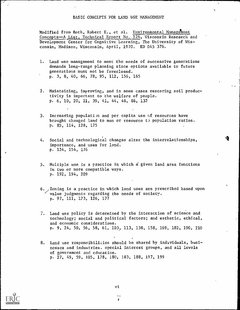
BASIC CONCEPTS FOR LAND USE MANAGEMENT
Modified from Roth, Robert E., et al. Environmental Managetnent
Concepts--A List Technical Report No. 126, Wisconsin Research andDevelopment Center for Cognitive Learning, The University of Wis-consin, Madison, Wisconsin, April, 1970. ED 045 376.
1. Land use management to meet the needs of successive generationsdemands long-range planning since options available to futuregenerations must not be foreclosed.p. 3, 8, 40, 66, 78, 95, 112, 156, 165
2. Maintaining, improving, and in some cases restoring soil produc-tivity is important to the welfare of people.
P. 6, 10, 20, 21, 39, 41, 44, 48, 86, 132
3. IncreaSing populatim and per capita use of resources havebrought changed land to man or resource t) population ratios.p. 85, 114, 128, 175
4. Social and technological changes alter the interrelationships,importance, and uses for land.p. 124, 154, 176
5. Multiple use is a practice in which given land area functionsin two or more compatible ways.p. 192, 194, 209
6. ,Zoning is a practice in which land uses are prescribed based uponvalue judgments regarding the needs of society.p. 97, 111, 123, 126, 177
7. Land use policy is determined by the interaction of science andtechnology; social and political factors; and esthetic, ethical,and economic considerations.p. 9, 24, 50, 56, 58, 61, 103, 113, 138, 158, 169, 182, 190, 210
8. Land use responsibilities should be shared by individuals, busi-nesses and industries, special interest groups, and all levelsof government and education.p. 27, 49, 59, 105, 178, 180, 183, 188, 197, 199
vi
9. We have "legal" ownership of some land resources like real estateand control over others during our lifetime, but ethically we are"stewards" rather than owners of the land.p. 25, 80, 219
- 10. Natural resources are unequally distributed with respect to landareas and political boundaries thus, conflicts emerge betweenprivate land use rights and the maintenance of environmentalquality for the general public.p. 53, 55, 101, 104, 120, 228
11. Esthetic resources and recreational facilities of economic andnon-economic value are becoming increasingly important in ldisure-time activities.p. 64, 84, 108, 119, 221
12. Physical characteristics of the natural environment are of majorimportance in determining land uses.p. 15, 29, 33, 43, 67, 75, 91, 92, 127, 149, 160, 212
13. Man has developed techniques useful in describing land and its uses.p. 1323, 26., 35, 37, 42, 62, 63, 76, 116, 130, 142, 152, 167, 186,205, 224

CLASSIFICATION OF LAND USE MANAGEMENT ACTIVITIES
Grade Level: K - 34 - 67 - 9
10 - 12
Subject Area: Science
Mathematics
Social Studies
Language Arts
Fine Arts
including health, nature studies,home economics, etc.
including arithmetic, geometry,industrial arts, etc.
including geography, population,
history, etc.
including reading, creativewriting, etc.
including music, art, theater, etc.
BREAKDOWN .OF ACTIVITIES BY CATEGORY(Some activities fall into more than one subject area.)
Grade Level:
Category
K - 34 - 67 - 9
10 - 12
Subject Area: ScienceMathematicsSocial StudiesLanguage, Arts
Fine Arts
viii
Number of Activities
1523
32
32
56
14
736
8

Grade Level K - 3
TABLE OF CONTENTS
Activities Page
ScienceScience-Social StudiesSocial StudiesSocial Studies-Fine Arts
9
2
1
Science -Math -Art 1
Fine Arts-Social Studies-Language Arts 1
Grade Level 4 - 6ScienceScience-Social Studies
°Social Studies
10
1
7
1
31
Math 1Math-Science 1
\ Language Arts-Social Studies 1
\
Language Arts-Social Studies-Fine Arts 1
Fine Arts-Science-Math 1
\ Grade Level 7 - 9 73
\
Science 3
science- Social Studies 7
Social Studies 15
Math-Science-Social Studies 1
Math-Science-Social Studies-Industrial Arts 2
Fine & Graphic Arts, Language Arts-Science-Social Studies 1
Grade Level 10 - 12 147Science 3
Science-Social Studies 6
Social Studies 19
Social Studies - Language Arts
Social Studies-MathSocial StudiesMath-Science 2
1
Appendices 231
A. Federal Laws Related to Land Use
B. Federal Agencies Having Responsibilities withRespect to Land Use Management
C. Types of Data for Land Cse StudiesD. Land Capability Classification
References 255
ix
1 it

c
LAND USE MANAGEMENT
ACTIVITIES
FOR THE CLASSROOM
Grades K-3
1 1

PURPOSE: To develop understanding of the importance of forests in ourcountry and how to select and plant trees.
LEVEL: K-3
SUBJECT: Science
CONCEPT: Land use management to meet the needs of successive generationsdemands long-range planning since options available to futuregenerations must not be foreclosed.
REFERENCE: Foster, Albert B. & Fox, Adrian C. Teaching Soil and WaterConservation: A Classroom and Field Guide. U.S. Department!of Agriculture, Soil Conservation Service, August, 1970. EDI067 218.
ACTIVITY: Forests have played a big part in building and maintaining ourcities, States, and Nation. As our young Nation grew, timberwas needed in greater and greater quantities until much of theorfginal woodlands were harvested.
We are now cutting about 7 percent more sawtimber than we aregrowing. About 22 percent more softwood sawtimber (Douglasfir, cedar, piqe) is harvested annually than we are growing,mostly old growth in the West. Hardwood sawtimber growthexceeds removals by nearly one-third. But if.all growing stockvolume (cubic foot volume in trees 5 inches in diameter atbreast height and larger) is considered, growth of both soft-wood and hardwood growing stock exceeds removals.
The Nation's timbe:land is owned by the forest industries; bycounty, State, and Federal governments; and by farmers, ranchers,businessmen, housewives, professional people, and many others.It is necessary that each owner see that trees are properlymanaged and replaced as they are harvested.
More than 245 million cords pulpwood were required to meetall paper needs between 1964 and 1968 or an average of nearly50 million cords a year. .
Another function of the forest--one of the most important--isto protect watersheds. The headwaters of nearly all the majorrivers lie in forests, Good management of these forests isone way,of pritecting the source of water.
Forests are ho-->s for many kinds of wildlife--deer, bear, elk,beaver, squirrels. Small woodlands are natural homes fc: suchfur bearers as the skunk, opossum, mink, raccoon, fox, andweasel.
3
12

One out of 3 acres of the entire United States is forest land.This totals about 762 million acres. Of this total 510 million
acres is commercial forest land. Nearly 142 million acres of
this is in various types of public ownership.
To keep such a large acreage in continuous production requiresenormous planting operations. If left alone long enough most
forests would replant themselves. But man cannot afford towait and has, therefore, learned how to do the planting himself.
Spacing of the trees is important. A spacing of 6 by 6 feet
requires 1,210 trees an acre. Closer spacing requires more
trees. If planted too thick, the trees either must be thinnedlater or allowed to thin themselves through crowding andstunting. But closely spaced trees cover the ground more
completely during the early years aftei planting and stoperosion sooner. In a thick stand,wider choice can be allowedin thinning; if some of the trees die the result is not so
serious.
Foresters estimate that about 26 million acres of commercialforest land in the United States are nonstocked,and needplanting if they are to become productive within a reasonabletime.
This activity is best suited to springtime in the North andto fall in the South. It may be made a pa'rt of an Arbor Day
observance.
Plan in advance the kind of trees you are going to plant and
where they will be planted. Soil and maSture conditions-milldetermine to a great extent the kind of trees to plant. How
the trees will be used will also have a bearing on the kind of
trees selected.
Check with local specialists about the best time to plant andthe kinds of trees best suited to the soil and location.
In addition to the seedlings or transplants, you Will needbuckets for carrying the seedlings, water, grub hoes or mat-tocks, spades, and chovels or specially constructed dibbles or
planting bars. The size of planting stock will help determineplanting method and tools needed.
If the area is covered with grass sod, use the grub hoe tostrip the sod away from a spot 12 to 18 inches square. If the
ground is hard, dig it up and crumble the clods.
Carry the seedling trees in a 12- to 14-quart pail half filledwith water, or in boxes containing wet moss or burlap.

1. Take only one tree at a time from the container andleave the roots exposed no longer than necessary.
2. Set the tree in the hole no deeper than it grew in thenursery.
3. Do not put pieces of sod or undecomposed trash in thehole where it will be in contact with the roots.
4. Tamp the soil thoroughly around the roots; do notleave any air pockets.
5. Water thoroughly.
You will need to water the tree frequently if the groundis dry.
Also, the young trees will need cultivation one or moreyears in many sections of the country to eliminate grassand weed competition for moisture. A straw or grass mulchspread one to two feet around the tree will,'in areas ofhigh rainfall, eliminate-or reduce the need for cultivation.For information on the best way to plant and care for treesin your area, see your county agent, extension forester, orsoil conversation technician.

PURPOSE: To demonstrate the amount of sediment a stream carries.
LEVEL: K-3
SUBJECT: Science
CONCEPT: Maintaining, improving, and in some cases restoring soilproductivity is important to the welfare of people.
REFERENCE: Foster, Albert B. & Fox, Adrian C. Teaching Soil and Water
Conservation: A Classroom and Field Guide. U.S. Departmentof Agriculture, Soil Conservation Service, August, 1970. ED
067 218.
ACTIVITY: You will need three tall, narrow bottles, such as olive bottles,with tight stoppers for this experiment.
PASTURE. WOODS
.
CULTWATEDFIELD
After a heavy rain, fill one of the bottles from a small streamthat gets at least a part of its water from cultivated fields.
Then find one stream where all the water comes from woodlandand one where the water comes from good pasture or meadow. Fill
the other two bottles from these streams.
Allow all three of these samples to settle for a few days. Lookat them daily and make notes on what you see.
There is an important story in these three bottles--the storyof how sediment washed from farmland harts the farmer and citydweller in many ways.
Sediment carried by streams hurts the farmer first because itis a part of his farm that is being carried away. Much of it
is topsoil--the best soil he has. But a lot of it. comes from
gullies and roadside ditches, too.
6
1j

After the sediment leaves the farm some of it gets into streamsand begins to affect everyone. More than 3,200 water-supplyreservoirs are losing water-storage capacity each year to sedi-ment. Water bills are higher because the water must be filtered.
Seventeen percent if the electric power generated in the UnitedStates comes from hydroelectric plants. The storage reservoirsserving these plants are gradually filling with sediment.
Sediment fills road and railroad ditches, plugs culverts, andclogs stream channels so they must be cleared or the bridgesraised. All this increases taxes.
Many harbors must be dredged annually to allow ships to enter.
Floods are more frequent and more serious, partly because thestreams are choked with sediment, resulting in less capacity tocarry floodwaters.
Silt harms fish by covering up their spawning grounds and shadingout light. Many fish actually die during floods when theirgills are clogged with silt.
Sediment is a national problem. The national sediment damageamounts to millions of dollars annually.
Soil and water conservation measures applied to farm and ranchland will greatly reduce sediment. Erosion that causes sedimentdeposition can be reduced up to 90 percent with soil- and water-conservation measures. Growing grass and trees will reduceerosion greatly. This is true because they give protective coverrnd add organic matter which helps the soil-take in water morereadily. Contour farming, contour striperopping, and terracingalso reduce erosion.
7
16

PURPOSE: To become aware of the importance of soil and participate ina soil conservation project.
LEVEL: K-3
SUBJECT: Science
CONCEPT: Land use management to meet the needs of successive generationsdemands long-range planning since options available to futuregenerations must not be foreclosed.
REFERENCE: Conserving Our Natural Resources: A 4-H Readers Guide. Federal
Extension Service, Forest Service, and Soil Conservation Service,U.S. Department of Agriculture. .
ACTIVITY: Ask your students to think of ten things they use every day-- -paper, pencil, shoes, etc. List on
this
chalkboard. Help theclass determine how many items on this list come from the soileither directly or indirectly. They will find thac most comefrom plants or from animals that feed on plants, and thus fromthe soil. Thus, it is important to employ conservation practicesto conserve the soil. The following are suggestions for a soilconservation project that might be carried out by young' children.,Demonstration projects may be-carried out nn a lawn, in acommunity garden or on a vacant lot.
It may be possible to demonstrate several conservation practiceson one plot. Terracing, cross-slope cultivation, grassed water-ways, windbreaks of trees or tall-growing annuals, composting,mulching, fertilizing, grass seeding, and many other practicesmay fit into your class' plan.
For example: You can make a garden plan and use grass clippings,leaves and other vegetable or animal refuse to build up thesoil's organic matter and make it more productive. You may chooseto plant grass or other ground cover on-bare spots to controlsoil erosion. Many eroded areas can be corrected by preventingexcessive use and by planting grass and trees.
4
Wind and water erosion projects can also be carried out on sanddunes, highway roadsides, stream banks, ponds, and lakeshores.
8
1

PURPOSE: To identify land use practices utilized on your school grounds.
LEVEL: K -3
SUBJECT: Science
CONCEPT: Land use policy is determined by the interaction of scienceand technology; social and political factors; and esthetic,ethical, and economic considerations.
ACTIVITY: Take your class for a walk around your school grounds to observeand list (1) things man built and (2) things nature "built".Now ask the class what things man might have removed from thearea in order to build. (Trees, grass, rocks, flowers, animalhomes, other buildings.) What things may man have replaced?(Trees, grass, flowers.) Discuss reasons man wants and needsthings nature built around him.
To demonstrate reasons man wants natural objects in his working/living environment ask the class to remember a hot day whenthey were playing in the sun. Where did they go outside whenthey wanted to cool down? (Under or near trees where there wasshade.) If man cuts 'down all trees near buildings, how doesthis effect the ?nvironment in buildings both in summer andwinter? (Trees can provide insulation from heat in summerand serve as windbreakers in winter.)
Compare grassy areas, bare soil and blacktopped areas. Whatare the advantages and disadvantages of each? For examplegrass is cooler, prettier and softer but can be destroyed ina heavy play area. Bare soil quickly becomes mud during arainy season. Blacktop doesn't,wear out as fast but is veryhot in the sun and can be a hazard if you fall on it.
9

PURPOSE: To demonstrate how mulch prevents soil loss.
LEVEL: K-3
SUBJECT: Science
CONCEPT: Maintaining, improving, and in some cases restoring soil produc-tivity is important to the welfare of people.
REFERENCE: Foster, Albert B. & Fox, Adrian C. Teaching Soil and Water..:onservation: A Classroom and Field Guide. U.S. Departmentof Agriculture, Soil Conservation Service, August, 1970. ED067 218.
MATERIALS: Two boxes about 16" long, 12" wide & 4" deep, two flower sprink-lers, two half gallon fruit jars, two sticks of wood about1" thick, plastic material, tin or tar paper and straw.-
ACTIVITY: Water impact puddles the bare soil, clogging the surface pores.The result is that the soil cannot take in water. In a field,most of the water would run off rather than enter the soil.
By protecting the pores at the surface of the soil with amulch, water enters and moves down througl3 the soil.
A mulch, such as straw, grass, or shavings, prevents the pud-dling or "running together" of the surface soil under theimpact of raindrops. Dead plant materials protect the soilfrom being detached by raindrops. As long as the soil isgranulated water will soak in rapidly. However, water soonsoftens the binding material that holds the granules together,and then the granules and clods disintegrate. The impact ofraindrops separates the fine particles, splashing them intothe air. Then these particles accumulate on the soil surfaceand fill the, spaces between larger particles and granules.The result is a "seal" over the surface that permits water toenter the soil very slowly, if at all. Water must then runoff. If the land is sloping, it causes erosion during hard,beating rains.
Mulches also reduce evaporation by shielding the soil fromthe wind and from the direct rays of the sun. In addition tomulches, high organic-matter content of the soil itself isneeded.
Line the boxes with the plastic material, tin or tar paperto make them watertight. Fill both with the same kind of soil.
Set them on the stable, placing the sticks under one end to makea slope.
10
19
C,

Cover one box of soil with a thin layer of straw, grass,wood shavings, or sawdust; leave the other one bare.Sprinkle water on both boxes, using the same amount ofwater and pouring at the same rate from an equal height.
Note how much and how fast water runs off into each fruitjar.
(
11
20

rr
1
Another way to study the protection of mulches on the soilis to drop water from a short height on soil that is notprotected and on soil that is protected with a mulch.
For this you will need two small tin cans. With an 8-penny nail, punch a hole in the bottom of each can andfill the hole loosely with cotton.
Put one-half inch of soil in two small fruit jars or waterglasses. Put a light layer of dry grass clippings on oneof the soil samples. Leave the other one bare.
Arrange the tin cans so that they are about 4 feet abovethe jars of soil. Put about one-half inch of water in thecans. Large drops of water will form through the holes inthe cans and drop on the soil in the jars. Note the amountof soil that is splashed on the sides of the glass.
6
6
0
.r.....A. , ,I;th
0
12
21

PURPOSE: To observe the abilities of different kinds of soils to growplants.
LEVEL: K-3
SUBJECT: Science
CONCEPT: Han has developed techniques useful in describing land and
its uses.
REFERENCE: Exploring The World of Plants and Soils: Unit II-B; Soils.National 4-H Plant and Soil Science Program DevelopmentCommittee.
MATERIALS: Peas, beans, corn or other'seeds, four 5-quart oil cans, fourkinds of soil as described in the activity.
ACTIVITY: Explain to your class that soils vary in their ability to growplants. Desired soil qualities include anchorage for the roots,storage capacity for water and for nutrients and a porous con-dition so the roots can get air.
In this activity we are going to look at and try to explaindifferences in plant growth from the view of the plant'srequirements.
Get four 5-quart oil cans or other suitable containers of equal
size. The bottom 8 inches of a cut-off gallon milk carton issatisfactory as a container.
Punch several holes in the bottom of each with a large nail toallow drainage.
Label 111, #2, #3 and 114.
Fill .#1 with surface soil from a field or garden,
Fill #2 with subsoil from the same area, taken from a depthbelow an observable change such as color, texture or structure.
Fill 113 with sand.
Fill 1/4 with a soil from the garden or a well fertilized area.(The garden soil should be typical of one that has had goodtreatment with fertilizer added.)
Be sure the soil in each container has been crumbled and brokenup into small particles. Remove stones and trash.
Plant six peas, beans, corn or otherseeds 1-1/2 inches deepin each container. Set containers in a warm, well-lightedplace.
13
Keep moist and covered with a wet paper towel until the
seed sprouts (germinates).
Observe any differences you see in the number of seedsgerminating, and on the rates of plant growth and appear-ance.
Keep soil moist. Record the height of the plants in each
container once a week for at least six weeks.
At the end of a six-week period there should be noticeabledifferences in plant growth among the containers.
Since moisture was ample in all cages, any inferior growthmust be due to something else deficiency of nutrients orair. Under equal watering, plants on sandy soils shouldsuffer first because sand stores so little water. 'Darksoils, rich in organic matter, store much more. .
A follow-up activity might be'to walk with your class on athot dry day and find a field with "patches" of wilted plants.Compare the soil in these'spots with nearby soil where thereis no wilting.

PURPOSE:
LEVEL:
SUBJECT:
CONCEPT:
REFERENCE:
MATERIALS:
ACTIVITY:
To experience one type of land use management by processingmaple syrup.
K-3
Science
Physical characteristics of the natural environment are ofmajor importance in determining land uses.
William F. Cowen, Jr., Extension Forester, The Ohio StateUniversity, Columbus, Ohio.
Carpenter's brace with 7/16 or 3/8-inch bit, spile--metalcollection spout--available at hardware stores or farm equip-ment stores, metal or plastic bucket (large tin cans or bleachbottles can be used), large pan and heat source for boilingdown sap (the size or number of pans will depend on the amountof sap involved), thermometer with an easily read scale in therange of 200°F to 235°F (some candy thermometers are.adequate),a piece of clean wool, orlon or other type material to use tofilter the finished syrup while it is.still hot, a few mapletrees at least 10" in diameter.
Maple syrup production began with North American Indiaris whodiscovered thr process of converting sap to syrup or sugarfor use as a sweetener. Early Indian methods involved cuttinga gash in the base of the tree, collecting the sap in bark orwood vessels, and boiling the sap to syrup by dropping heatedstones into containers filled with sap.
Although there have been many changes in maple syrup produc-tion, the basic process of converting sap to syrup remains
the same evaporation of water to increase the sugar concen-tration in the remaining liquid.
The maple syrup industry in the United States averages about$12,000,000 a year. Rising sugar costs in recent years havecreated more interest in the "mini-production" of maple syrupsince with a little inexpensive equipment and some maple treesavailable, people can enjoy a few quarts or gallons of highquality maple syrup.
"Sweet water" or, sap can be obtained from sugar, black, redor silver maples.
Maple trees will produce sap at any time after the leaves dropoff the trees in the fall. Good sap ilows (called "runs")usually occur when a period of below-freezing weather isfollowed by periods of warn weather. Nights with bel)w-freezing temperatures followed by a rapid-warming trend fromearly t,) mid - morning the next day will usually result in a
good sap run.
15
24

Stop collecting sap just prior to or at the very early stagesof bud expansion and development in late March or early April
4depending on weather conditions. Sap collected and pro-cessed into syrup when buds are expanding will result in"buddy" syrup, which has a distinctly unpleasant flavor.
Make tapholes by boring into the trees, using a carpenter's
brace and a 3/8 or a 7/16-inch fastcutting wood bit. Borethe/holes to a depth of 3 inches (not counting bark) intosound wood, from 2 to 5 feet above the ground. Slant the
hole slightly to allow the sap to run out. O trees that
have been tapped before, locate new tapholes 6 inches toone side and 4 inches higher than the old tapholes.
When possible, space tapholes evenly around the tree, withthe number of tapholes depending on the diameter of the tree.Do not tap trees under 10 inches in diameter. Use one tap
for 10-15 inch trees, two taps for 16-20 inch trees, threetaps for 21-25 inch trees, and no more than four taps ontrees over 25 inches in diameter..
If weather conditions are right, sap may start to flow as soon
as you bore the tapholes. Do not leave chips or wood shavings
in the tapholes.
When sap begins to flow from the hole, you will need a, device
to convey the sap from the taphole to a sap container`..- In
commercial production, such devices are called "tpiles" or
"spouts". Some hardware and farm equipment stores have these
for sale.
Taphole with spile.
Spouts usually have a tapered shoulder which forms a water-tight seal with the bark and outer sapwood, when they aredriven into position in the taphole. The part of the spout:
inside the sealed area is more heavily tapered so that thereis free space left within the taphole between the spout and the
16

sapwood. This allows sap to move from the wood into the tap-hole and from there though the hole in the spout and out overthe lip of the spout, from there it drops into a bucket, plas-tic bag or other receiving equipment.
In the early days, hollow reeds were used as spouts. Anothertype of spout used was hollowed-out wooden dowels that wereslightly larger in diameter than the tapholes and were beveledat the point of taphole seat:!mg.
The amount of sap flowing from a taphole is highly variableduring the season and usually varies with weather conditions.In most years, a single taphole will produce from a quart to2 gallons of sap per run, with seesonr.1 production of 10 to15 gallons. Sap production per taphole varies over a widerange and may be as low as 5 gallons or as much as 40 gallonsin a season.
Collect sap and boil it down as quickly as possible to producegood-tasting syrup. Collect sap often. Buckets should havecovers to keep out rain and other foreign materials.
Good sanitation and rapid handling of the sap from tree throughevaporation anti packaging is extremely important in producinggood quality syrup. Bacteria and other microorganisms canbuild up in sap that is kept in buckets or storage tanks formore than a few hours when the air temperature is warm.
Keep buckets, storage tanks and/or other collecting and pro-cessing equipment thoroughly washed between runs. Washing witha solution made of 1 part commercial liquid bleach (5.25%solidum hypoclorite by weight) and 9 parts of water will usuallymaintain collecting vessels in clean condition.
Woodland-type sugar maples produce sweet water that averagesaround 2% sugar content: The problem is to remove enough waterto get a sugar concentration of about 66%. Actual sap-sugarconcentration varies widely from tree to tree. For exampleyou would need 43 gallons of sap with a 2% sugar concentrationto produce 1 gallon of finished syrup, containing 65.5% sugar.
Maple producers use a rule-of-thumb in estimating totalreyrupproduction over a season, based on the number of tapholes, andusually figure 1 gallon of finished syrup (65.5% sugar con-centration) for every 4 tapholes.
You can concentrate sap to syrup by boiling it in an open pan.For boiling at home, it is important to have a device forremoving the water vapor to some point outside the home, ordo the actual boiling outside. The boiling process produceslarge quantities of steam that may damage wallpaper and/orpairited surfaces.
17
26
H
The evaporating container may be a large open pan filled with
sap and exposed heat. As boiling begins, foaming may occur.
You may need a pan with fairly high sides so that the sap does
not boil or foam over the sides.
During the boiling process, be careful not to burn or scorch
the sap. Liquid levels deep enough to prevent scorching must
be maintained over the pan bottom. A teflon coated pan is
highly acceptable. If much foaming occurs, skim off the foam
or reduce foaming by using a commercial defoaming preparation.
Some producers have used small amounts of cream or butter fordefoaming, even though these two substances may, in some cases,impart a slight off-flavor to the syrup.
The key to high quality syrup is cleanliness and rapid boiling.As boiling begins and water evaporates, add more sap to the pan.Continue this process until a suitable amount of concentrated
sap is left in the pan. Concentrating the "batch" to an accept-
able density is a process called "finishing off."
Finished syrup of acceptable density will boil at 7 1/4°F.
above the boiling point of water. It should be noted that the
boiling point of water varies with elevation above sea level,and with baromeeric pressure. Therefore, you must determine
the boiling point of water before adding the 7 1/4 degrees as
a basis for the boiling point of finished syrup. Knowing this
boiling point is a must for good syrup.
Some candy thermometers are suitable for measuring the temper-ature of the boiling liquid. Any thermometer used should have
an easily read scale'with a temperature range to at least 15
degrees above the boiling point of water. A thermometer with
a temperature range of 200°F. to 235°F. will cover most situ-
ations.
As the temperature of the boiling liquid approaches the syrupfinishing point, take extreme care to prevent the boiling
process from burning, scorching or overheating the liquid.
Once the syrup has reached the desired boiling point, it isready for filtering and packaging. Filter the hot syrup
through clean filters of wood or orlon. The filtering process
helps to remove sugar sand and other suspended particles, andimproves the appearance of the syrup. After filtering the
hot syrup, package it in tightly sealed, clean containers.Syrup temperature should be at least 180°F. at the time ofpackaging to assure good keeping qualities.
Although processing methods in this activity are intended tohelp persons who want to produce small quantities of maple syrupfor home use, but not for sale, weight standards applying to
18
27

4
producers who sell syrup may be of interest to you. The netweights for standard-density syrup, exclusive of containerweight, are 1 gallon (231 cubic inches) weighs 11 pounds, 1quart weighs 2 pounds and 12 ounces; 1 pint weighs 1 poundand 6 ounces. Syrup having the standard density of 11 poundsper gallon contains 65.5% solids as sugar.
19
28

PURPOSE:
LEVEL:
SUBJECT:
CONCEPT:
REFERENCE:
ACTIVITY:
To develop understandings of the capabilities of local soils.
K-3
Science
Maintaining, imprOving, and in some cases restoring soil-productivity is important to the welfare of people.
A Handbook of Environmental Encounters, Oregon Department ofEducation, Instruction Division, pp. 23-24 ED 113 151.
A primary, though not the only, factor in determining capa-bility of land (i.e., what its potential uses are) is thetype of soil present. Any study of land use, therefore,appropriately includes a consideration of its soils, whatthey are, and how they are properly utilized.
1. COMPARISON OF SOIL COLORS
Take students on a walk around the school yard or a nearbyfield or woodland and collect soil samples. Look for soilcolors. If variations cannot be found, have students bringsoil samples to class to compare with those taken on thewalk. Discuss factors that influence color of soil.
2. COMPARISON OF SOIL TEXTURE
Take the class outside to the school soil bank--or a placewhere soil is observable. Have each student take a handfulof soil and work it in his hand. Discuss the feel or tex-
ture. (Encourage use of good descriptive. words.)' Then
moisten samples. Does this change the feel? Does it stick'
together? Is it like sand? Is it like clay? Discuss the
particles. What are they like? Would the soil soak upwater or let it run through? Would it be good for a garden?
3. OBSERVATION OF PLANT GROWTH AND DECAY
On a walk around the school ground name or "touch and des-cribe" all the growing plants. Sit down and talk about what
conditions plants need in order to grow. Elicit the under-standing that plants get nutrients and water from the soil.Walk to an area where theTe is decaying material such as arotten log or rotting leaves. Ask what is happening here.
Are these things alive? Where do they go as they decay? Do
they change the soil?
On a cardboard, have the. students draw a picture showing thecycle of plant growth and decay.

PURPOSE: To show how contour farming can help prevent erosion.
LEVEL: K-3
SUBJECT: Science
CONCEPT: Maintaining, improving, and in some cases restoring soilproductivity is important to the welfare of people.
REFERENCE: Foster, Albert B. & Fox Adrian C. Teaching Soil and WaterConservation: A Classroom and Field Guide. U.S. Departmentof Agriculture, Soil Conservation Sixvice, August, 1970.ED 067 218.
MATERIALS: Two boxes about 16 inches long, 12" wide & 4" deep or tworound dishpans, two sprinklers, two fruit jars, plasticmaterial, tin or tar paper.
ACTIVITY: Contour farming is one of the easiest and most widely acceptedconservation practices. It is the use of implements acrossthe slope of the land; that is, on the contour. When afarmer farms on the contour he disregards the usual straightfield boundaries and straight-rows and follows curved lineswhenever necessary to stay on the contour.
Contour farming should be used in combination with croprotations, grass waterways, fertilizers, and returning organicmatter to the soil. Contouring alone will not stop erosion.But it reduces soil erosion as much as 50 percent on a widerange of soil and slope conditions. Steepness and lengthof slope are important, as well as the crop grown and thecondition of the soil.
There are other advantages of contour farming. In low-rainfall areas it helps hold and conserve rainfall. Farmershave found that it saves power, time, and wear on machinerybecause the equipment is working at peak efficiency all thetime instead of being overloaded going uphill and under-loaded coming downhill.
Cultivation on the contour helps prevent erosion and savesrainfall in gardens on sloping land.
Fill both boxes with soil taken from the same place. Makethem watertight by lining them with plastic material, tinor tar paper.
Set them on a table and place the sticks under the end tomake a slope. Place fruit jars below the spouts of theboxes. Using your finger or a.pencil, make furrowsacross the soil in one box and up and down the soil in theother.
21.
30

Fill two sprinklers with water and slowly sprinkle the twoboxes at the same time. Hold the sprinklers the same height
above the soil and pour at the same rate. Compare the rateof flow into the two jars and note the difference in theircontents.
Another way to do this is to put mounds of soil in the middleof the boxes or in two large round low dishpans. With a pen-cil or your finger make furrows up and down one of the moundsand circles around the other mound. Sprinkle an equal amountof water on each mound and observe the water. Remember though,
that such mounds probably have much steeper slopes than mostcultivated land.
You can do this in the yard if you have a sloping area wherethere is no grass or where the grass is badly worn by walkingor playing. By doing this outdoors, you can use a larger area.Make two plots 3 feet wide and 5 feet long with 1 or 2 feetbetween them.
With a regular garden hoe cut grooves 4 inches apart and about2 inches deep across the slope on one plot and up and down the
slope on the other. Notches cut in the edge of a 1- by 12-inchboard (as shown in the drawing) can make the grooves.
Lay a perforated lawn-sprinkling hose between the two plotsand turn it on so that a steady shower falls on both plotswith equal intensity.
Make careful notes of what happens on both plots.
31

PURPOSE: To survey school land use problems and suggest correctivemeasures.
LEVEL: K-3
SUBJECT:. ScienceSocial Studies
CONCEPT: Han has developed techniques useful in describing land andits uses.
,REFERENCE: Roller, Lib. Using the School and Community: An Environ-mental Study. Area. Nashville Metro Schools, Nashville,Tennessee, 1972. Title III, ESEA. ED 071 917.
ACTIVITY: Divide your class into groups of four or five students. Giveeach group the following list of problems that you bight haveon your school site. Instruct each group to check any theysee; then as a group try to figure out how they might correct'the problem. Compare lists and suggestions among groups andtry the suggestions to see if the problems are improved.
School Site Problems
low wet places
soil erosion
no grass cover
What To Do
overflowing trash
cracked sidewalks
holes in street
broken street lights
peeling paint
old odors
car or bike ruts
gravel getting on grass
broken windows
no trees
others
23
32

PURPOSE: To experience considerations such as those that land use
managers have in planning.
LEVEL: K-3
SUBJECT: Social Studies
CONCEPT: Land use policy is determined by the interaction of scienceand technology; social and political factors; and esthetic,ethical, and economic tonsiderations.
REFERENCE: Stehney, Virginia A. Environmental Curiosity Sampler.Illinois Institute for Environmental Quality, Chicago,Open hands Project, Nov. 1974. ED 103 339.
ACTIVITY: The classroom is an important environment where students andteachers spend a great deal of time. With your studentstry to plan a better way to arrange the classroom and thentry out your plan. The following questions may be appro-priate to begin this activity:-
1. Would a different physical set-up of our roombe better?
2. Are books, materials, science equipment and supplieseasily accessible? 1
3. Could the room be better arranged for small group) .
work?
Now survey the class and make a list on the chalkboaLd ofthe most important; i.e. most valued arrangements you andyour class need. Also list things you do not like and wishchanged. Divide .into groups and have each group plan andsketch possible room arrangements that include the "mostimportant list." (You may find that in order to, get onething the group wants, another might have to be given up.)As a group, select a plan and try it out. Note: a goodplan should reflect the values and priorities of the groupand allow for change if something does not work out asexpected.
Point out to your class,that people who plan neighborhoods,housing developments, farms, etc. go through a process similarto the one you and your class did. Choices must be madeto pick out the most important things that can work in theavailable space.
24
33
...

PURPOSE: To demonstrate that people must share space (land) in orderto do many of the things they need to do or want to do.
LEVEL: K-3
SUBJECT: Social Studies
CONCEPT: We have "legal" ownership of some land resources like realestate and control over others during our lifetime, butethically we are "stewards" rather than owners of the land.
REFERENCE: Clark, Richard C. (Project Director). Environmental Values
Action Cards, Minnesota Department of Education, 1976.
MATERIALS: Several jump ropes
ACTIVITY: Give several students a jump rope. Either in the gym or out- -
side, instruct the students to use the jump ropes to makethe boundaries of an individual room for themselves. Now,ask them to try to jump, run, hop, twist, sit, tumble,skip in their rope room space. Could they each live intheir room? Now allow them to join their room with someoneelse's by tying the ropes together'or overlapping them.Repeat the activities; i.e. jump, run,-etc.
When the rooms are shared can they do more or fewer of theactivities? When the rooms are share&do they have to doanything differently then when they each had their own room?Do'you need rules? Who ..should make the rules?
25
34

PURPOSE: To identify types of land use described in well known songs.
LEVEL: -1C-3
SUBJECT: Fine ArtsSocial Studies
CONCEPT: Man has developed techniques useful in describing land andits uses,
ACTIVITY: Discuss the meanings of the following type ,f land use:open land, residential, commercial, agricultural, indus-trial, recreational and transportation. Take the first verseof the song "America The Beautiful" and identify the varioustypes of land use described. You may wish to point out ona map of the`United States the area described in the song,and have the class do a mural with land use types identified.
Think of other well known songs that mention types of landuse such asl
"This Land Is Your Land""Home on the Range""Oats, Peas, Beans and Barley Grow""Country Roads""I've Been Working On the Railroad""Dixie""Don't Fence Me In" \
26
35

PURPOSE: To participate in a problem-solving land use managementproject involving playground improvement.
LEVEL: K - 3
SUBJECT: Fine ArtsSocial StudiesLanguage Arts
CONCEPT: Land use responsibilities should be shared by individuals,businesses and industries, special interest groups, and alllevels of government and education.
Bennett, Dean B. & Willink, Wesley H. Grade Three Environ-mental Education Teacher's Guide: The Neighborhood.
Yarmouth Maine School Department, 1975. Title III, E.S.E.A.(Activity by Pat Driscoll) ED 121 568.
REFERENCE:
ACTIVITY: With your class, take a walk around the play area notingnumber of improvement areas in terms of recreation.
Have students make a mural of their play area before improve-,
ment.
Have the children bring in magazines and cut out pictures ofplaygrounds or things they would like to see on their play-,ground, i.e., tires, culverts, balance beam, painting board,all types of gym equipment, swings, climbing equipment.
Using the pictures, make a mural of the "Perfect Playground."(A trip to other school sites may help them to realiie differ-ent ways to solve their problems. If there has been animprovement recently at a certain school site, a speakercould relate the solution to the children.)
Discuss how your class might campaign for their "perfect play-ground". What actions are necessary such as finding out whatnew equipment would cost, what permission is needed,..how longit would take to make the improvements, how hard it would be,etc.?
Use the following list as a guide:
1. Survey the student body as co use, likes and dislikes,suggestions for improvement.
2. Decide whether or not a new plan should be adopted oradditions should be made to the original plan.
3. Vote: balloting, campaigning, speeches. Poster con-tests, etc.
4. Get permission
27
36

#.15. Bring in materials
6. Divide into groups
7. Set time schedule
8. Delegate duties
9. Promote other student body members to help inmonitoring
10. With the necessary help, have the equipment placedin pre-planned spots and have old equipment moved asneeded
11. _Discuss success
37
28

PURPOSE: To investigate types of vegetation that are appropriate toplant around buildings and become aware of reasons forthese choices.
LEVEL: K-3
SUBJECT: ScienceMathArt
CONCEPT: Physical characteristics of the natural environment are ofmajor importance in determining land use.
ACTIVITY: Take your class for a walk around the school building andwith permission from the owners around a few of the lawnsof homes nearby. With a meter stick/yard stick measure theheights of plants growing within three feet of.the buildings.Are they tall plants? Are there many big trees? What wouldhappen if large trees were planted right next to a building?Are there different types of plants growing on the northside of the building than are growing on the south side?If so, why? Now look for examples of plantings that arepoor choices; such as, trees planted too near the sidewalk,flowers planted in an area that is heavily walked on, treesplanted under wires, flowers requiring'a lot a sunlightplanted in shady areas. What are the bad effects of.thesepoor choices? Why do people plant ground cover such asbluegrass instead of flowers in their lawn?
Upon your return to the classroom, ask your students todraw a picture of their dream home anduplant" good choicesof vegetation in their yards. Have each student sharehis/her picture with the rest of the class and point outwhere and why he/she placed certain types of plants inhis/her yard.
29/30
38

LAND USE MANAGEMENT
'ACTIVITIES
FOR THE CLASSROOM
Grades 4-6
PURPOSE: To describe the value of vacant lots in providing plantsand animal habitats.
LEVEL: 4-6
SUBJECT: Science
CONCEPT: Physical characteristics of the natural environment are ofmajor importance in determining land use.
REFERENCE: Project Learning Tree Supplementary Curriculum Guide forKindergarten Through Grade 6. Copyright 1977 1 AmericanForest Institute. Reprinted with permission of AFI.
ACTIVITY: Locate a vacant lot and get permission from the owner foryour students to conduct a study project there. Divide yourclass into teams of three to five students each and haveeach team stake out a plot 12 feet (4 meters) square.
Ask each team to examine its plot for signs of animal life,such as burrows, tracks, anthills, and spider webs. Suggestthat they also inventory the kinds of plant life they find.Using the data collected, ask each team to draw a map whichindicates locations of plants and animals (or their signs)on its plot, Later, these maps could be combined to createa map of the vacant lot.
During the period of time the students are observing andinventorying their plots, suggest that they:
1. Find evidence of use by some animals that don't livethere.
2. Find evidence of some animals preying on others.
3 "Prove" that certain plants grow better in certainlocations.
4. Find evidence that certain animals stay in the vicinityof certain plants.
5. "Prove" that there have been changes in the plant andanimal populations. from previous times, including changesin their numbers and ratios to each other.
Working in small groups or individually, ask the students toprepare presentations to illustrate the value of vacant lotsin providing plant and animal habitats. Their presentationsmight take the form of guided tours for younger students;oral reports to adults in the community, complete with theirplant and animal maps; or even recommendations to city offi-cials for care of vacant lots in the community.
33
40

2.--EXTENSION: For more extended study of vacant lots, see ",Vacant Lot
Studies" in the National Wildlife Federation's Environ-mental Discovery Units.
34
41

PURPOSE: To observe how rain drops wash the soil.
LEVEL: 4-6
SUBJECT: Science
CONCEPT: Man has developed techniques useful in describing land andits uses.
REFERENCE: Exploring the World of Plants and Soils: Unit II-B; Soils.National 4-H Plant and Soil Science Program DevelopmentCommittee.
MATERIALS: Two white stakes, sprinkler can or hose, box or step ladder,50 cent piece.
ACTIVITY: In those places where the soil was deposited again as allu-vial or bottomland and wind-laid soils, we often find therichest land. There are two lessons here:
1. erosion robs us of the best elements of soil;
2. there is no predicting exactly when or 1.4.ere it willbe laid down again.
Erosion is caused in large measure by disturbance of thenatural landscape. Raindrops falling on unprotected soilloosen the particles which are then carried away by runningwater. Erosion occurs in three forms--sheet, rill and gully.
Sheet erosion is a more or less uniform removal of soil asin sheets, by water or wind. No obvious channels develop.It is perhaps the least noticeable form in the early stages.
Rill erosion results from development of small channels. Itranks in importance between sheet and gully erosion. Thenumerous channels usually are brushed over by normal fieldoperations.
Gully erosion is the most conspicuous form of water erosion.It can be spectacular but is destructive and cancerous tothe land. Gullies grow with the concentration of runoff.
Soil Erosion is Important
Erosion is a selective process by which the finer and morefertile soil elements are lost first. The surface soil isgenerally the richest part of the soil. Eroded soils arenot only less productive, they are more difficult to work.
Generally, erosion is more serious on land with shallow sur-face soils and unfavorable subsoils. Much of the sloping
35
42
cultivated land in the United States has been affected by
sheet erosion. Cully erosion has taken its toll, particularlyon steep areas frequently cultivated and lacking vegetativecover.
1. Drive a white stake 3 inches wide into bare soil (novegetation) deep enough to stand. Lay a 50 cent piecenear the stake.
2. Drive a second white stake in a good sod or lawn.
3. Fill a sprinkler can with water or use a hose with anozzle set to sprinkle.
4. Place a box or step ladder near one of the stakes.
5. Stand on the box or step ladder and sprinkle aroundthe first stake. Let the water fall from,the can orhose to the ground.
6. Repeat steps 4 and 5 at the other stake.
7. Observe splashing of soil on the white stakes. Partic-ularly watch for any effect of the 50 cent piece on thewashing of the soil. Discuss reasons for any differencesbetween the sod and the bare soil.
Expand on this activity by taking the class to visit a barefield after a rain. Note how small rocks were left suspended.Also look for places where running water has deposited thesoil removed from upslope,
36
43

PURPOSE: To test the ability of surface soil and subsoil to hold waterthat might be usable to plants later.
4-6
Science
Man has developed techniques useful in describing land andits uses.
LEVEL:
SUBJECT:
CONCEPT:
REFERENCE:
MATERIALS:
ACTIVITY:
Exploring the World of Plants and Soils: Unit II-B; Soils.National 4-H Plant and Soil Science Program DevelopmentCommittee.
Two flat heat resistant pans, two empty pint jars, twofunnels, two pts. of water.
1. Select a soil from a pasture or fence row.
2. Collect a quart of soil from the surface soil* (relativelycoarse layer). Label this "Surface Soil". Collect aquart of subsoil* (the finer textured layer, usually 12to 24 inches deep). Label this "subsoil."
*NOTE: If you are going to do Exercise 7 and 8 also,you should get three quarts of surface soil and threequarts of "subsoil." Be sure to label them.
3. Get two flat, heat resistant pans. Label one "surfacesoil" and the other, "subsoil."
4. Spread surface soil and subsoil thinly and evenly in thepans as labeled.
5. Place both pans of soil in an oven at 200° F. for 24hours or place them in the sun for several days.
6. Stir soil occasionally, to ensure thorough drying.
7. Place small pieces of cheese cloth over the spout of twofunnels. Hold the cheese cloth in place with rubberbands.
8. Place the funnels in empty pint jars.
9. Gently fill one funnel with surface soil to 1/2 inchfrom the top. Do not crush the soil.
10. Place the pan of surface soil behind this jar.

11. Repeat steps 9 and 10 using subsoil, rather than surfacesoil.
12. Fill two pint jars with water.
13. Gently and slowly pour all of the water from a fullpint jar over the surface soil sample. Let the waterrun through the funnel into the jar beneath.
14. In the same way, pour water from the other full pintjar over the subsoil sample.
15. Now, note which jar has the most water?
16. Therefore, which soil held the most water?
Explain why one soil held more water than the other.If you were growing plants in these two soils, which onewould be able to hold the more rain water for later useby the plants?
SubsoilSurface Soil

PURPOSE: To learn techniques to keep an area suffering from erosionfrom eroding further.
LEVEL: 4-6
SUBJECT: Science
CONCEPT: Maintaining, improving, and in some cases restoring soilproductivity is important to the welfare of people.
REFERENCE: Fox, Charles E. Conservation Activities For Young People.Forest Service, U.S. Department of Agriculture, March, 1969.SE 010 359.
ACTIVITY: Locate a gully near the school. What caused it? Find outfrom technical advisors (soil technicians, county agents,foresters) how to keep it from increasing in size. (By
building check dams, by sowing grass, and by planting shrubsand small trees.) Let the pupils do the necessary work.Drive stakes to mark present limits of the gully and observeover a period of a year or longer to see what is happening.Keep class record.

PURPOSE: To study the effects of grazing in woodlands.
LEVEL: 4-6
SUBJECT: Science
CONCEPT: Land use management to meet the needs of successive genera-tions' demands long-range planning since options availableto future generations must not be foreclosed.
REFERENCE: Fox, Charles E. Conservation Activities for Young People.Forest Service, U.S. Department of Agriculture, March 1969.SE 010 359.
ACTIVITY: Visit woods that have been grazed. Look for absence ofyoung seedlings, browsing damage of leaves and twigs, injuryto soil and roots by trampling, start of erosion caused bytrailing of stock to salt or water, bare and hard-packedground. Dig down and note depth of topsoil. Compare thiswith depth in cultivated field and in an ungrazed woods.
Wa
What is effect of grazing this woodland? Now? Ultimately?
l
4()
4;

PURPOSE: To investigate a land use practice; i.e., a large pastureor natural range used by domestic livestock.
LEVEL: 4-6
SUBJECT: Science
CONCEPT: Maintaining, improving, and in some cases restoring soilproductivity is important to the welfare of people.
REFERENCE: Fox, Charles E. Conservation Activities for Young People.Forest Service, U.S. Department of Agriculture, March, 1969.SE'010 359.
ACTIVITY: Visit a large pasture or natural range used by domestic live-stock.
1. How many head of stock are run, and what is the seasonof use?
2. What kinds of plants are growing?
3. Which species appear to be normally grazed? Which grazedtoo heavily'? Which are ungrazed?
4. Are there sizable areas of bared ground?
5. Are there any gullies, broken sod, grazed trees orshrubs, plants on "pedestals," accumulations of washedsoil at the base of plants?
6. Is there evidence of rodents? What damage do they do?Are they being controlled? How?
7. Dig down and note depth of topsoil. Compare with top-soil depth in a hayfield and in an ungrazed woods.
8. Do you think the pasture is being used properly? Whatwould increase production of forage?
41

PURPOSE: To investigate how organic matter affects soil.
LEVEL: 4-6
SUBJECT: Science
CONCEPT: Man has developed techniques useful in describing land andits uses.
REFERENCE: Exploring the World of Plants & Soils: Unit II B, Soils.National 4-H Plant & Soil Science Program DevelopmentCommittee.
MATERIALS: Water, quart of clay, quart of saw dust, 2 paper plates.
ACTIVITY: As a group, collect a quart of clay soil and a quart ofsawdust. Label a paper plate "sawdust" and another "no saw-dust:' Moisten 1 cup of soil until it will make a mud cake.(If the soil does not hold together, get a soil with moreclay.)
Place the mud cake on the plate labeled "no sawdust."
Moisten and mix thoroughly 1/2 "up of soil and 1/4 cup ofsawdust until they make a mud cake.
Place the mud cake on the plate labeled "sawdust."
Place both plates in the sun and let the mud cakes dry.
When they are completely dry, break the mud cakes with yourhands. Which cake crumbled easier? Why? Which soil do you
think would be more likely to erode? Now compare the soil onthe bare school play yard with the soil along a fence or wallthat is covered with grass. How could you improve the physicalcondition of the bare soil?
Cultivating a soil affects it somewhat like opening the drafton a furnace. More heat is given off but more fuel (nutrientsand organic matter) must be added to keep the fire alive.
Loss of organic matter causes clay soils to become tighterand more cloddy. They soak up rain less readily and thus morewater runs off. This leads to increased erosion. Sandysoils become less firm with the loss of organic matter; theyare removed more easily by wind or water.
It is important to get as much organic material into the soilas practical each year. Upon decomposing it aids in preservinggood physical conditions of the soil .and supplies some nutrients.
List things a farmer could do if he wished to improve his cropyield, Example: return crop residue and manure to soil.
42
4 9
PURPOSE:' To illustrate that differing soil types support differenttypes of plant growth.
LEVEL: 4-6
SUBJECT: Science
CONCEPT:
REFERENCE:
ACTIVITY:
Physical characteristics of the natural environment are ofmajor importance in determining land use.
A Handbook of Environmental Encounters. Oregon Departmentof Education, Instruction Division, p. 24. ED 113 151.
The teacher suggests, "Let's build a small world of our own.What do you think we'll need to make this world?" (Students
suggest soil, plants, animals, water, air.)
Equip the class with trowels, buckets, plastic bags and takethem out to collect materials for their terrarium. They should
find gravel or sand, charcoal, wood soil containing humus,small plants and tree seedlings, mosses, ferns, lichens, andan interesting rock or two.
Assemble the terrarium, having the students decide what shouldbe put in first (1 or 2 inches of gravel-or sand--to store theexcess water). What should come next? (Charcoal--to keep the
soil from getting sour.) Then add the soil 3 or 4 inches deep.Plant the small plants, covering the remaining soil with moss.
Sink a small container or saucer into the soil. Put water inthe dish and also sprinkle the plants. Place rocks in posi-tion and cover the container with glass cover or plasticsecured with a large rubber band.
Have students find animals after the terrarium has been assem-bled. Suggest they look for such creatures as snails, grass-hoppers, frogs, lizards, beetles, and caterpillars.
Observe from day to day:
1. The growth of the plants.
2. "Rain" in the terrarium.
3. Animals eating.
Have the students bring from home some containers (glass candydishes or wide-mouthed peanut butter jars) and make their ownterraria. Set them up with different types of soil (sandy,
clayey, silty). Let them find as many of their materials aspossible. Review procedures for assembling the terrarium,which may he the desert, semiarid, or "rainy" type. Use largejars, plastic bags, or whatever is available. Whether theterrarium flourishes or not, it should provide a good learningsituation.
43
50

PURPOSE: To undertake a conservation project to slow down erosion.
LEVEL: 4-6
SUBJECT: Science
CONCEPT: Maintaining, improving, and in some cases restoring soilproductivity is important to the welfare of people.
REFERENCE: Roller, Lib. Using the School and Community: AnEnvironmental Study Area, Nashville Metro Schools, Nashville,
Tenn., 1972, Title 1II, ESEA. ED 071 917.
ACTIVITY: Take an "Erosion walk" around the school.neighborhood.Watch for bare soil, exposed tree roots, gullies, holes, etc.Try to find, out what might have caused the erosion. What canbe done about them.? If they are not fixed what might happenin the future?
If there are erosion areas on the school site a conservationproject can be done by the students.
The following are some suggestions for erosion projects:
Wattling:
Type of Project: building rip-rap to hold back or slow downeroding hillsides.
Implications: a. Keeps hillside from washing or blowing away.b. Often times it provides area for planting
trees, brush, or grasses.c. Usually last long enough for plants, etc.,
to get a good enough start to hold backthe soil on their own.
d. Beautifies site.e. Protects hillside trails.f. Can prevent undermining of building founda-
tions.g. Allows the water to seep Into soil instead
of running off.h. May prevent the rolling of rocks.
4 4
51

Cautions: a. Start wattling at top of slope.b. Use long, flexible twigs.c. Drive stakes as deep as possible.d. Do not put stakes too far apart.e. Do not remove any vegetation or other natural
obstacles already there.f. Avoid wattling in areas where there is a danger
to human safety, across trails and soforth.
g. Do not allow wattling to run down from lack ofrepair.
h. Allow wattling to remain-until the soil isstable enough to support itself, i.e., whenyoung trees, grasses and the like have established themselves..
i. Do not attempt wattling on too steep a slope.
Retaining Wall:
4e
WOOL
/01~11,%
Type of Project: Designed to slow down erosion on hillsides.May be made either with rocks or logs. Very practical whereeroding area is too steep to wattle. May be one wall or aseries of small ones.
Implications: (Same as for Weeding)
Cautions: a. Avoid soft, decomposing rocks and logs.b. Do not start base with small rocks or logs.c. Do not build too high and lose stability.d. Select rocks and logs easily managed by boys
and girls.e. Watch to see that, as work proceeds, the rocks
are not becoming too small preventihg iuplanned.
f. Avoid "stacking." Rocks and logs must be fitted.g. Be sure base is broad enough to support height
planned.h. Be sure wall has a slight slope toward hillside
for added strength.
45

Retaining Wall (I): ROCK
A rock retaining wall can be constructed with a minimum oftools. A simple rock retaining wall can be built withoutthe use of cement. Large rocks are to be used at the basewith ,ize decreasing as they near the top. Small rocksor stones can be used as wedges or plugs behind the wall.The base rocks should be sunk about fciur to eight inches intothe soil at the base of the wall
Retaining Wall (II): TERRACED ROCK
Stairway-like arrangement on a hill or slope. Same type ofconstruction as in the larger rock retaining walls. Thesewalls are only built to a height of about three to four feet.
Retaining Wall (III): LOG
This type of log construction can be made by setting fourlogs upright, twd at each end, leaving a space between themwhere other logs can be set in horizontally to the desiredheight of the wall.
On this type of'wall, end logs should be set with one endburied in the embankment. The retaining logs should be setalternately between these logs and the spaces between shouldbe plugged with large rocks.
Gully Control:
Type of project.: The pilling of brush in deep gullies (rock
also may be used dam style.)
46
53

Implications: a. Brush piles slow down erosion.
b. Brush provides shelter for wildlife.c. Catches soil behind each pile.d. After gully is almost filled, trees, plants
or grasses that are adaptable to the areamay be planted.
e. Decomposing vegetation adds to topsoil.f. Supplies an area for disposal of bramble.
g. Prevents the rain from making direct contactwith the soil.
h. Slows water, allowing for better seepage.
Cautions: a. Do not use materials that will comb:stspontaneously.
b. Do not allow it to become a "trap" people
walking in the area.c. Sharp objects should not point upward.
a. Do not use good material for fill-in thatcan be better used elsewhere for otherprojects.
Gully Control (I)
Start at the top of the gully and fill with brush or rock.Gully may also be filled with soil and planted.
Gully Control (II)
Where gullies are large, where slope of land is ideal, andwhere a large amount of water passes each year, a water pondof this type may serve for fishing, as a watering pond forwildlife or livestock, and/or the surrounding area may beplanted to provide shelter and furnish food for wildlife.
PURPOSE: To determine how different soil types are related to plantgrowth.
LEVEL: 4-6
SUBJECT: Science
CONCEPT: Maintaining, improving, and in some cases restoring soilproductivity is important to the welfare of people.
A Handbook of Environmental Encounters. Oregon Department
of Education, Instruction Division, p. 29. ED 113 151.REFERENCE:
ACTIVITY: 1. COLLECTING SOIL SAMPLES:
Walk around the school grounds or its vicinity and observe thetypes of plants growing in the area. Determine the kinds ofsoils that three different varieties of plants are growing in.
By observation learn how the soils differ and how they arealike. Are they sandy, silty or clayey? Base your judgment
on color and texture.
2. DESCRIPTION OF SOIL:
If the three kinds of soil texture cannot be located aroundthe school area, have students bring samples of each to classand describe the texture and colors which they believe arebest for growing different kinds of plants.
3. GROWING SEEDS IN DIFFERENT SOILS:
Have the students plant three bean seeds in three types ofsoil. Before planting, soak the seeds overnight in water.Water the plants for three weeks with an identical amount ofwater, and see that they obtain the same amount of sunlight,Observe changes (if any) daily at a given time and record themon a student-designed chart.
4. SUMMARIZING OBSERVATIONS:
After observing and recording the growth of the plants, havethe students record in written form what they learned aboutsoil texture. Which soil holds water best? Which soilproduced the best growing plant? Why? Which soil would bebest for garden use? How should the soils be used in orderto make the best use of the land?
Using the information on the three types of soil, describewhat could be done to increase its potential. If possible,
a field trip should be arranged to a nearby farm to see ifland is being utilized to its fullest potential.
48
J,)
PURPOSE: To encourage students to share in the responsibility of caringfor public property.
LEVEL: 4-6
SUBJECT: Social Studies
CONCEPT: Land use responsibilities should be shared by individuals,businesses and industries, special interest groups, and alllevels of government and education.
REFERENCE: Kohuth, Barbara J. and Marsh, Boyd T. An Educational Guidefor Planning an Improved Human Environment. Inner CirclePress, Inc. Hudson, OH, 1974. SE 022 539.
ACTIVITY: Begin by asking your class the following:
1. Why waste land on parks and playgrounds? Who maintainsand pays for them?
2. If adults don't use playgrounds why should they pay forthem?
Point out to the class that care of public properties is theresponsibility of the public and that the "public" includesall people including youth. Thus, it is every student'sresponsibility to care for public property.
Now, ask how students might help do their part.
Select a park or playground site near the school. Explore
ways that students might beautify and/or maintain "theirsite". For example: students may survey their site to seeif there are enough litter containers. If more are needed,obtain oil drums from area service stations. Clean andpaint the drums with ecologial messages. Use as litter bas-kets.
49
5E;

PURPOSE: To develop understandings of land use practices in urbanareas and in the school community.
LEVEL: 4-6
SUBJECT; Social Studies
CONCEPT: Land use policy is determined by the interaction of scienceand technology; social and political factors; and esthetic,ethical, and economic considerations.
REFERENCE: Roller, Lib. Using the School and Community: An Environ-mental Study Area, Nashville Metro Schools, Nashville, Tenn.,1972. Title III, ESEA. ED 071 917.
ACTIVITY: Land use and waste pollution go hand-in-hand but the idea ofland use goes beyond that of pollution problems. It strikesat the everyday increase in building, in taking up farm andwilderness land for other purposes and the sprawl and blightof the urban communities. Some discussion and ideas wereincluded in Section III under Vacant Lot Studies but thissection of the handbook will include suggestions for conserva-tion projects as well as questions and discussions on the roleof land in the environmental pollution cycle. It is importantthat the students understand that one type of environmentalpollution invariably leads to another.
About three-fourths of all the people in our country now livein urban areas. Each urban area must provide the peopleliving there with stores providing many services and goods.There must be places for entertainment and cultural areas.There must be jobs for the people and industry to furnishmaterials and supplies.
Along with the many benefits of living in an urban area thereare also many problems. Land becomes very valuable and there-
fore, there is a shortage of parks and open spaces.
One of the most difficult problems is the fact that most urbanareas have grown without much thought about how it shouldbe built. Unplanned development can cost more for the peopleliving there and the people can also experience many inconven-iences and hazards. This is often called urban sprawl.Traffic congestion, old buildings not repaired and all of theresulting pollution problems are merely part of this problem.As the city grows the land pollution causes include erosion,indiscriminate clearing, removal, filing in, mining, drillingand paving of land. The effects of this can be seen inunsightliness, loss of valuable top soil for food production,the destruction of wildlife habitats in field, forest andmarsh, the extinction or near extinction of hundreds of speciesand in the city, a growing concern for better planning for allliving things.
50
J 7'

Many areas today are in Urban Renewal areas. If the school
is located in such an area,a valuable lesson for the childrenwould be to study the pro and con issues of such projects.Too often our students live in areas that have man) problemsbut they are not aware of what can be done or what they andtheir families can do to change many of the problems.
Questions for discussion:
Many cities have museums, theatres and other cultural centers.What advantage would they serve for people? (Recreation)
How is money obtained to build and maintain such places?(Taxes, grants, admission charge.)
Is it fair for all people to pay taxes for this type ofrecreation? What other recreation might appeal to otherpeople that are built or maintained this way? (Racetracks,
Amusement parks, Community parks.)
How would the city benefit, money wise? (Tourists)
There are several kinds of living places in a city. Apartments
and private houses are two types. What are the advantages of
each? (Apartment-rno worry about yards, more people around,usually more convenient) - Small house (more privacy, more room
to play, less noise.)
Which type is considered better for cities? (Apartments--take
up less room, live near jobs, newer.)
What happens as parts of the city grow old? (Crowded, dirty,
waste in the streets, crime increases.)
What happens to a city that grows old? (People try to move
out, industry moves away, empty buildings.)
What does Urban Renewal try to do? (Replace unsafe structureswith new buildings, repair better structures, clean up area.)
What are some of the problems in this? (No place for peopleliving there to go, no services left in area, unused landthat may become a hazard.)
Make a survey of the school community. See how many types ofservices are within walking distances of the school. Find
vacant lots nearby. Check the "zones" of the area around the
school. Is the property being taken care of? Is there open
land? If so, what use night it he put to in the future?If the community needs services, what would be the most neededone? Make a list back in the classroom.
51

See how natural land and water features have influencedthe growth of the city. See what has happened in theschool community that has affected it. What man-made
things have changed the community? (Highways, bridges,
etc.)
What things did you discover that you didn't know were inthe community? Where were the traffic signals? Were
there other places they were needed? What services forchildren were there in the community? For adults? What
services were needed that were not there? Which should beput in first? Were there enough parks and play areas? If not,
where could some be placed? Were there places to get food?
Clothes? Hardware? Gas? If not, where was the nearest
place? If there were no nearby stores and someone did nothave a car, how would he get these needed items? Are there
factories in the neighborhood? Is it creating a hazardfor the people living there? Smell? Smoke? Other
dangers? Are the houses old or new? Are there any apart-ments? From this the children can make a land usesurvey and a future plan for land use.

PURPOSE: To understand conflicts in land use priorities.
LEVEL: 4-6
SUBJECT: Social Studies
CONCEPT: Natural resources are unequally distributed with respect toland areas and political boundaries thus, conflicts emergebetween private land use rights and the maintenance ofenvironmental quality for the general public.
REFERENCE:
ACTIVITY:
Project Learning_Tree. Supplementary Curriculum Guide forKindergarten Through Grade 6. Copyright 1977 by American
Forest Institute. Reprinted with permission of AFI.
Choose a piece of forested land with which your students arefamiliar and which is located near your community. Present
this hypothetical situation: The community has acquired thisland because the owner has not paid the property taxes. The
city council is uncertain whether to keep or sell the land.If council members decide to sell the land, they must alsodecide to whom it should be sold.
Depending on the size of your class, ask each individual stu-dent or group of students to assume one of a variety ofpossible roles:
Housing development contractorRealtorWood products industry representative or tree farmerRecreation directorEnergy firm representativeMining firm representativeCattle rancherConservation group representativePrivate business personIndustry representativeGolf course managerHomeownerLand speculatorGrain farmerGovernment representative for city, state and federallevels
The exercise is often of most value to students if they candevelop their own list. In any case, ask them to suggestadditions to the list and select from any of those suggested.
Ask each individual or group to research the part they chooseby interviewing a counterpart in the community. Assist thestudents in the preparation of their interview questions.
53
60

Once the research is completed, each could prepare awritten document stating the reasons the land shouldbecome his or hers. Points to consider in developingthe position statements arc:
The price each interest group is willing to pay.For each interest group, the social, aesthetic,psychological, and ecological advantages of acquir-ing the land.
The long-range effects of each use on the land'sproductivity.The economic advantages of each land use to thecommunity.
Are these advantages short-run or long-term?
When all the statements are ready, ask each student orgroup to make an oral presentation before a mock citycouncil of four to six students. The council, afterhearing and considering all the testimay, should decidewhether the land will be sold and if so to whom and at
what price. Afterward, the class can question the councilon the reasons for its decision. A general discussion byall class members should then be held to consider theimplications of such a decision, and possible implicationsof those actions not taken.
PURPOSE: To illustrate a societal conflict relating to land use manage-ment.
LEVEL: 4-6
SUBJECT: Social Studies
CONCEPT: Natural resources are unequally distributed with respect toland areas and political boundaries thus, conflicts emergebetween private land use rights and the maintenance of environ-mental quality for the general public.
ACTIVITY: Pose the following situation to your class: Mr. A and Mr.B are neighbors. Mr. A is unemployed -due to a physicalhandicap. He does, however, earn income from keeping severalbee-hives and producing honey. Mr. B and his family aresensitive to mosquito bites. Their city will provide foggingservices during the mosquito season for those citizensrequesting the service. However, fogging kills Mr. A's beesas well as Mr. B's mosquitos. Thus, if the area is fogged,Mr. A loses his income; if it is not Mr. B's family may bebitten by mosquitos. Who has the right to make the foggingdecision in this situation? After a class discussion, checkwith local authorities to determine how this problem wouldbe handled in your community.
55
62

PURPOSE: To learn how group decisions affecting private citizens andfree public are made.
LEVEL: 4-6
SUBJECT: Social Studies
CONCEPT: Land use policy is determined by the interaction of scienceand technology; social and political factors; and esthetic,ethical, and economic considerations.
REFERENCE: Project Learning Tree. Sumlementary Curric-Aum Guide forKindergarten Through Grade 6. Copyright 1977 by American
Forest Institute. Reprinted with permission of AFI.
ACTIVITY: Prepare a scenario describing a hypothetical situation fordistribution to students:
-:,
There are 50 summer cabins on Lincoln National Forest land.along Bear Creek. The sites for these cabins were leasedto private citizens 30 years ago. At that time there wasvery little forest recreation in this area.
Since then, the, nearest city has grown tenfold. Recreation in
the Bear Creek area is almost 20 times what it was 30 yearsago.
Some people feel that those 50 cabins should no longer bepermitted to dominate that area of Bear Creek and that theland belongs to all of the people.
Should 50 families have Bear Creek to themselves or shouldtheir leases be terminated and the cabins removed? Should
the cabin owners be allowed to remove the cabins? Should they
be reimbursed for their value?
Divide the class into these three groups;
1. Three or four members to represent the Forest ServiceAdvisory Board. They will conduct a hearing and arriveat a decision.
2. Half of the remainder of the class will role-play thecabin owners.
3. The other half of the remaining students will representthe general public.
Allow the "cabin owners" and "general public" time to preparetestimony stating their reasons for either renewing the leases.
or abolishing them. During this period the U.S, Forest ServiceAdvisory Board should plan the hearing procedures, specifyingwho testifies, for how long, and in what order.
56
63
When all groups feel they are ready, the hearing should be
convened. After the testimony has been presented and oppor-tunity for rebuttal provided, the Advisory Board should meetbriefly to reach a decision. They should then return andreport their decision to the entire class, explaining thereasons for their decision.
Following this simulation, discuss with the students the meansby which such land-use decisions are made in your local region.
Note: It is useful to have the classroom arranged as a hearingroom for the meeting or to find an available auditorium.

PURPOSE: TO describe the effects of industry locating in a town.
LEVEL: 4-6
SUBJECT: Social Studies
CONCEPT: Land use policy is determined by the interaction of scienceand technology; social and political factors; and esthetic,ethical, and economic considerations.
REFERENCE: All Around You: An Environmental Study Guide. U.S. Depart-ment of the Interior, Bureau of Land Management, 1971.ED 064 131.
ACTIVITY: One of the main reasons for people moving to the cities inthis century has been the location of jobs. People in thecity depend upon their job for an income which will buyfood produced in the rural area as well as other goodsservices. Both good and bad effects result from an industrylocating in a town. Jobs are created and income flows inthe town, but negative effects can also occur.
What is the main industry (or industries) in your town?
About how many people in town depend on this industry fortheir living?
How might the climate affect the types of industries locatedin your town and their operations?
Think of the effects (both good and bad) that this industryhas on:
land animals people
air water you
the town
Give some examples:Good Bad
land
air
animals
town
keople
I.1111
PURPOSE: To demonstrate that people in a community can either managetheir environment and improve their neighborhood or let it
decay.
LEVEL: 4-6
SUBJECT: Social Studies
CONCEPT: Land use responsibilities should be shared by individuals,businesses and industries, special interest groups, and all
levels of government and education.
REFERENCE: Kohuth, Barbara J. and Marsh, Boyd T. An Educational Guide
for Planning An Improved Human Environment. Inner Circle
Press, Inc., Hudson, Ohio, 1974. SE 022 539.
ACTIVITY: Set the stage for this activity by discussing various neigh-borhoods in the school locale. 'Ascertain why one area may be
much better cared for than another. (For example: A merchant
anxious to attract and please customers might enhance hisproperty whereas an industrial area may be apathetic to thegrounds around the buildings.) List positive resident atti-
tudes.
In an effort to prompt your students to exert control overtheir environment by improving conditions, form a "ClassCommittee Yard Survey and Spruce Up Organization." Divide
class into committees of four. Each group of four arrangesto survey the yard conditions of each committee member. (You
may wish to notify parents of this activity and solicit their
cooperation.) Use the following survey sheet to record obser-
vations:
COMMITTEE YARD SURVEY
Inspect the yard closely. Discuss your observations with therest of the committee.
1. Is there evidence of litter, papers,tin cans, etc. in the yard?
2. Is there rubbish (wood, tires, oldappliances, etc.) in the yard?
3. Are the garbage cans tightly covered?
4. Are there sufficient garbage cans?
59
66
Yes No

5. Is there evidence of rats, raccoons,
or stray dogs?
If "yes", where do they hide?
Can they get into the house?Where?
6. Are there:
-broken basement windows-holes in the foundation-doors not tight-fitting
7. Are any environmental improvementsneeded?
If "yes", what do you suggest?
Yes No
Discuss survey results and.pruce-Up" ideas for students andparents to jointly work on.
After two weeks, the committees should re-survey each yard.Hopefully, an improvement in conditions will be noted.
"Before" and "After" photographs might graphically tell astory in terms of environmental action or inaction.

PURPOSE: To discuss land use conditions home builders/buyers shouldconsider%
LEVEL:
SUBJECT:
CONCEPT:.
REFERENCE:
4 -6
Social StudiesScience
Land use policy is determined by the interaction of scienceand technology; social and political factors; and esthetic,ethical, and economic considerations.
-Kohuth, Barbara J. and Marsh, Boyd T. An Educational GuideFor Planning An Improved Human Environment. HIA:ion, Ohio:
Inner Circle Press, Inc., 1974. SE 022-539.
ACTIVITY: Ask your students to pretend they are real estate agentscrying to sell the same exact netistrouse under each of the
following conditions:
- in a suburban housing development- in an industrial area of town- next to a nuclear power plant- in an area ,.;th cesspools not sewers- in a rural community- downtown in a large city- in awooded area with large swamp white oaks- next to a discotheque- near an open dump- near an airport- on a flood plain- next to'a poultry plant- near a freeway
Why might they have a difficult time selling the house ineach case?. Make a list of the conditions under which ahouse should not be built. Where should we build houses?(Be sure to keep in mind "different strokes for differentfolks.")
61
68

0
,
PURPOSE: To estimate the amount of space used by automobiles in oneblocit.
LEVEL: 4-6
SUBJECT: Math
CONCEPT: Man has developed techniques useful in describing land andits uses.
REFERENCE: Fielder, Erica and Shaffer, Carolyn. Ecology For City Kids.San Francisco Ecology Center, 13 Columbus Avenue, S.F. 94111.
ACTIVITY: As a class, measure the perimeter of one city block. Figureout the approximate area of the block. Divide your classinto four teams, each stationed on one perimeter line of thechosen block. Ask each team to record the following:
1. Number of cars parked either in the street or in driveways
2. Number of garages
el.-3. Number of driveways and alleys
4. Number of parking lots
5. Estimated amount of space cars take on each perimeter line:1/4, 1/2, 3/4. This could be done by pacing and measuring.
Back in the classroom, record each group's findings and estimatethe amount of space used by cars for the entire block. Now,imagine that all the people on this block switched from carsto bicycles. What might they do with the extra space?Remember that private automobiles are no longer available fortransportation.
62
69

PURPOSE: To closely examine construction considerations of a streetor road and sidewalks.
LEVEL: 4-6
SUBJECT: MathScience
CONCEPT: Man has developed techniques useful in describing land andits uses.
REFERENCE: Roller, Lib. Using the School and Community: An Environ-mental Study Area, Nashville Metro Schools, Nashville, Tenn.,1974. Title III, ESEA. ED 071 917.
MATERIALS: Level
ACTIVITY: Sidewalks and streets are so commonplace that we really neverthink about how they are constructed.
Many people and heavy vehicles use the sidewalks and streets.Temperature changes affect the surface and can cause crackingand upheaval which can be dangerous to people and cars aswell as costly to repair. Usually a street is made of con-crete and asphalt. Asphalt used to be imported from theBritish West Indies but now most of it is made in our country.Its tar-like substance is what is left after other chemicalshave been boiled out of petroleum. Asphalt is easy to workwith and it will expand and contract in the summer and winterwithout too much cracking. Some roads are made of asphaltand small chunks of stone. This is macadam. Concrete makesa better surface for roads but it costs more. Since concreteexpands on hot days, the roads usually have spaces filled withtar. Cement walks are the same. The cracks also help keepcracks in the blocks from spreading.
Take your class outside and closely examine the streets andsidewalks in your neighborhood. Look at the center of thestreet. Does it appear to be level? (The "crown" is higherthan the area near the gutter so the water can run into thesewer.) Use a level to demonstrate this and figure theslant. Notice the sewers. Ask the class why all streets havegutters and sewers. Even on dirt roads, drainage ditcheshave been provided. What happens if sewers are not largeenough after a heavy rain? (Basements and streets will flood.)What is the purpose of curbs? Look at a corner. Is itbanked differently? Why?

PURPOSE:
LEVEL:
SUBJECT:
To describe "the ideal recreation area."
4-6
Language ArtsSocial Studies
CONCEPT: Esthetic resources and recreational facilities of economicand non-economic value are becoming increasingly importantin leisure-time activities.
REFERENCE: Project Learning Tree. Supplementary Curriculum Guide for
Kindererten Through Grade 6. Copyright 1977 by American
Forest Institute. Reprinted with permission of AFI.
ACTIVITY: Ask your students to write descriptions of their ideal recre-ation areas. Each student's essay might include details ofthe imaginary area's plants, animals, recreation facilities,geographic location, and geologic characteristics. Drawingsor photographs may be used to illustrate the essay.
Encourage the students to share their essays in class, mak-ing lists of the characteristics included in these descrip-tions of "ideal" places. Through group discussion, identify:
-Characteristics most often included by students intheir descriptions.
-Unique characteristics of any of the recreation areas.-Any existing outdoor recreation areas that meet anystudent's or group of students' ideal criteria. Of
the existing recreation areas that meet students' cri=teria, you and they could select one to visit. Plan
the visit and go there!
EXTENSIONS
1. After students have completed their essays, ask them tostudy the accompanying list which gives general charac-teristics of the different types of outdoor recreationareas established by federal legislation. Then, suggest
that each student attempt to decide which designationbest fits his or her ideal area.
National Parks and Monuments: Spacious land and/or waterareas so outstandingly superior in quality and beautythat it is imperative they ar. preserved by the federal
government for the enjoyment, education and inspirationof all people. They provide a wide range of recreationsuch as camping, picnicking, hiking, horseback riding,sightseeing, and river floating in a natural setting, con-sistent with the preservation of the characteristics orfeatures tha: merited their establishment. No hunting,
specimen hunting, or other resource harvest is permitted,with some occasional and specified exceptions.
up,
64

National Recreation Areas: Spacious land and/or water areas,including within their perimeter an aggregate gross area ofnot less than 20,000 acres (8100 hectares), except riverways,narrow coastal strips, or areas where total population withina radius of 250 miles (402 kilometers) is in excess of 30million people. Outdoor recreation is the dominant manage-ment purpose of these areas, and they are designed forcomparatively high-density recreation such as power boating,developed campsites and facilities, snow and water skiing.Timber and other resource management is permitted so long asrecreational values are not impaired.
Notional Forests: Federal lands administered by the ForestService, U.S. Department of Agriculture, under a multiple-use policy for outdoor recreation, range, timber, watershed,wildlife and wilderness purposes. The National Forestscontain not only forested lands but grasslands as well.Recreation is only one of the management concerns; forinstance, National Forests must also provide 1/3 or more of
our softwood timber supply. Forest recreational opportunities_include scenic drives, wilderness travel, picnicking, camping,hiking, skiing, swimming, boating, hunting, and fishing.
National Wilderness Areas: An area of public or Indian land(1) at least 5,000 acres (2,025 hectares) in extent, or ofsufficient size to make possible its preservation and use inan unimpaired condition, (2) containing no roads usable by
the public, (3) within a reasonably unified boundary con-figuration, and (4) showing no significant ecological distur-bance from on-site human activity. These criteria permitprimitive camping, hiking, horseback riding, mountaineering,snowshoeing, and cross-country skiing. Motorized machinery,
resource harvesting (except some fishing and hunting) anddevelopments are prohibited.Note: Some of these designations overlap; for example, landsmanaged as wilderness areas may also be within Nationalforests and parks.
State designations generally follow the pattern of the federalguidelines except that the areas usually contain features ofstate or regional interest and the area is smaller.
2. Each student or groups of students can research to deter-mine the history of a recreation area, before and leading toits designation as a federal or state recreation area. They
might also include consideration of changes since its desig-nation as a federal or state recreation area and identifyany problems now involved in its management and use.
65
72

PURPOSE: To compare short-term gains and long-term effects of forestmanagement.
LEVEL: 4-6
SUBJECT: Language ArtsSocial StudiesFine Arts
CONCEPT: Land use management to meet the needs of successive genera-tions demands long-range planning since options available tofuture generations must not be foreclosed.
REFERENCE: Warpinski, Robert, Director. A Supplementary Program ForEnvironmental Education, Project I-C-E, Green Bay Wisconsin.Title III ESEA. ED 055 919.
ACTIVITY: Discuss with your class a hypothetical situation where maplelumber is suddenly in great demand for some new product.Ask your students to pretend that they own a large mapleforest and have a chance to make a great deal of money if.,,.
they harvest the maple trees in their woods. Their neighborsare convinced of the same thing so everyone in the area con-tracts to logging firms to cut down all the maple trees andall plan to become rich. Is it likely if all the maple ownerscut down all their maple trees at the same time that all ofthem will become rich? Why? Why not? What might be long-range effects of such a procedure? List other industries thatmight be affected. Write a "before and after" account of thearea and include a sketch of the way the area looks for eachaccount.
66
73

PURPOSE: To construct a model of a farm, ranch or suburb utilizinggood land use practices.
LEVEL: 4-6
SUBJECT: Fine ArtsScienceMath
CONCEPT: Physical charEzteristics of the natural environment are ofmajor importance in determining land use.
REFERENCE: Foster, Albert B. & Fox, Adrian C. Teaching Soil and WaterConservation: A Classroom and Field Guide. U.S. Departmentof Agriculture, Soil Conservation Service, August, 1970.ED 067 218.
ACTIVITY: Building a model of a farm, ranch or suburb utilizing goodland use management practices can be an excellent culminatingactivity following the study of land use management.
If the farm or ranch model can be based on local land useproblems and conservation needs, it will be most effectivein helping children relate conservation to their own home andcommunity welfare. Teachers in city schools can relate wiseuse of soil and water to the everyday lives of urban childrenby pointing out that food, lumber, wool, cotton, and othernecessities come from the soil.
Your model farm can represent the conservation plan on thefarm you are studying.
The successful conservation farmer follows a plan that wasdesigned for his particular farm much the same way a tailorcuts and fits a suit to a particular man.
The first step in preparing this conservation plan is to finda good use for each acre on the farm. The physical character-istics of the land, in combination with the climate, limithow the land can be used safely.
No two acres of land are alike. The differences includevariations in slope, soil depth, inherent productivity,stickiness, wetness, texture, amount of erosion, and manyother features.
Some soils may be so shallow that'cultivated crops will notyield enough for profit. This kind of soil is naturallybest suited to grass or trees.
67
74

Some soils are sticky when wet and form hard clods when dry.Such soils are hard to farm and may take more work to preparefor seeding and cultivating. They let water in slowly andgive it up to plants slowly. This characteristic may deter-mine what the use should be.
How much soil has been lost by erosion has a lot to do withhow land can be used safely. Severely eroded slopes willneed maximum plant-cover protection. Grass and trees orshrubs for wildlife are usually the best use here, althoughsome eroded land can be reclaimed for cultivated crops ifthe soil is weep enough and if the slope is not too steep.
Some land slopes so much that any cultivation of the soilwill result in serious erosion in spite of all ti, farmercan do to protect it with mechanical measures. E justa little too much grazing or too heavy cutting of timber willhave bad effects. Steep slopes will be more profitable tothe farmer in the long run if used for grass or trees.
Gentle slopes, provided the soil is satisfactory in otherways, can be safely cultivated and used for crops like corn,cotton, and truck crops.
Level land that is well drained, does not overflow, has deepsoil, and has no physical impediments like outcropping rockmakes the best land for growing cultivated crops. Such landcan be worked frequently without serious erosion hazard.Even this land needs good management to keep it productive.
After a careful study of the land and soil characteristicsthe farmer makes a plan to use each part of his farm withinits capability as imposed by nature. This plan becomes thefarmer's blueprint for his farming operations. It includesa field arrangement that puts each acre of land to work ata safe use. The field arrangement takes into considerationconvenience of work for the farmer. It provides for separatingcropland from grassland and from woodland. Some wildlifemay be separated but all the land on the farm will be usedby wildlife in some way.
After the farmer plans for the safe use of each acre of landhe then plans the necessary supporting conservation practiceslike crop rotations, terraces, grass waterway,4, striperopping,contour farming, pasture rotation, and woodland protection.
Such planning as this makes a soil conservation plan for afarm - -a plan that fits the farm because it was made accordingto the physical nature of the land and a plan that suits, thefarmer's needs and abilities.

A model is the kind of activity in which all pupils in aschoolroom can participate. It should be planned in detailunder your guidance as teacher. Decide what constructionmaterials are needed, what soil and water conservationmeasures are to be applied, and how structures such as dams,terraces, bridges, fences, and buildings are to be modeled.The assignment of various construction details on the basisof age and grade makes it possible for all the children toshare in the work.
In making plans for this project consider the sources ofoutside information and assistance. Where can you find outwhat the local soil-erosion problems are and what conserva-tion measures are in use? What visual aids and referencesare available? Local representatives of State and Federalconservation agencies and organizations, including conserva-tion farmers and ranchers, can be helpful.
The model can be a replica of the general terrain of thecommunity in which the school is located. Or you can selecta nearby farm or ranch that the class can study firsthand.Let the students see the erosion problems, then build a modelshowing the land as it should be used.
Models are usually built of fiber insulation board, papiermache, or a salt-flour mixture on a sturdy base. One goodmethod is to use pieces of thick fiberboard cut to match theoutlines of the different contours of the land. The piecesare stacked in the order of succeeding elevations and gluedtogether. The edges of the layers are then filed off with awood rasp to make the slopes smooth and even.
It you want to make a model of an actual farm or ranch, yourfirst step is to get a contour map of it. You can see thelocal Soil Conservation Service technician for sample mapsof local farms. He can also give you suggestions aboutreproducing the contours to scale on the model. If theterrain is flat you may need to exaggerate the steepness 2or 3 times.
Make a base for the model from 1-inch lumber the size andshape of the farm. An 80-acre farm could be 2 feet by 4feet. The first layer of insulation board should be the samesize as the base.
Then cut the succeeding layers according to the contour linesand glue them together. You may be able to save materialand reduce the weight of the model by having the layers over-lap only a little so that the inside is hollow.
69
76

Plastic crack filler or papier mache may be useful during thefinal shaping. You may want to make some minor cuts and fillsfor roads, gullies, and other physical features.
As the first step in decorating the model, paint it withglue. While the glue is still tacky, sprinkle screened sandover it. This surface has a texture that will makes it looklike fields and pastures when painted suitable colors.
In deciding on the scale for the other items on the model,it is a good idea to start with the buildings. They neednot be the same scale as the land; usually they can be some-what larger. But other items such as fences, machinery, andlivestock should be in scale with the buildings.
Buildings--Cut buildings from balsa or other softwood. Youcan do some carving but windows and doors can be painted in.
Fences--Drive dark nails or pins for fence posts and cut themoff at a suitable height. For barbed wire, use fine wirefastened by a loop around each post. For woven wire cutstrips of screen and push them into the modeling material;fasten with airplane glue.
Clover, alfalfa, and grass--The best way to simulate thesecrops is to paint the areas and sprinkle sawdust of appro-priate colors over them. Sawdust coming from different kindsof machines, such as sanders, saws, chippers, and jointers,has different textures. The texture can be altered byscreening. Coarse-textured sawdust is best for crops likealfalfa and clover; fine sawdust would be best for grass.Color the sawdust with a mixture of about one-fourth paintand three-fourths turpentine. Pour this over the sawdust andthen spread it out to dry.
Bare soil--Fine sawdust, or the modeling material itselfwill give about the right texture if painted the right color.
Terraces--Loosely twisted heavy cord or small rope can beglued to the model. The areas above and below the cord orrope can be filled with crack filler shaped to give the formdesired,
Corn--You can represent young corn by gluing strips of stiffburlap vertically in rows. After the glue has set, pull outthe horizontal threads. Then split and curl the remainingvertical threads.
Shrubs--Cut sections from colored sponge and glue them inplace. You can make isolated trees in the same way, but torepresent a woodlot treat the whole area as a mass, usingcolored sponge.
70

. Models of farms can also be made with papier mache. On asturdy base make the shape of the farm you want by bendingand shaping chicken wire. Then cover it with layers of paperdipped in paste, until you have the right amount for strengthand form. Add the buildings, fences, and crops as explainedabove.
For younger children, don't overlook the sandbox. It offersa good opportunity to make a less elaborate mouel. Evenwith sand, it is best to copy an actual farm even though youwill need to exaggerate the topography.

LAND USE MANAGEMENT
ACTIVITIES
FOR THE CLASSROOM
Grades 7-9
73/71/79

PURPOSE; To learn the usefulness of land capability classification asa land use management tool.
LEVEL; 7-9
SUBJECT; Science
CONCEPT: Physical characteristics of the., natural environment are of
major importance 1,11 determining land use.
REFERENCE: Klingebiel, A, A. and Montgomery, P. H.,.Land CapabilityClassification. U. S. Department of Agriculture, Soil Con-servation Service, Agriculture Handbook No. 210, 1961.Dasmann, Raymond F., Environmental Conservation. New York:
John Wiley and Sons, 1968, pp, 126-128. SE 008 955.
ACTIVITY: Perhaps the most serioussRroblem in land use management isin utilizing land according to its capabilities. In many
locales, marginal land has been cultivated in attempts towring P living from lands not appropriate to such uses. This
damages the land, leads to environmental problems such asthose related to soil erosion, and produces poor crops.
The U. S. Soil Conservation Service has developed a detailed .
land classification system, in an attemp to encourage use ofland according to its capabilities (See Appendix D). Factorsconsidered in the development of the system include soil types,slope and drainage characteristics, erodibility of the soil,and other factors which may influence land capability.
Agencies such as the Soil Conservation Service and AgriculturalExtension Service often will assist in working out a landclassification and use plan for individuals making the request.
Depending on local circumstances, it may be possible for stu-dents to work out a land classification scheme on the schoolgrounds, or in the vicinity of the school. Such an activitymight also be conducted through use of topographic maps orsoil maps, though an in-the-field component would likely bemore meaningful. If possible, enlist the aid of SCS or AESpersonnel in completing a local survey.
75
so

PURPOSE: To study the effect of wind on sand dunes.
LEVEL: 7-9
SUBJECT: Science
CONCEPT: Man has developed techniques useful in describing land andits uses.
REFERENCE: Marine and Environmental Studies Manual. Cranston ani Warwick,Rhode Island Public Schools, Sept., 1973. Title III, ESEA.
SE 022 700.
MATERIALS: Large stream table or sand box, large box or sheet to catchsand, fan or vacuum cleaner (reversed) for wind source.
ACTIVITY: Hurricane Carol of 1954 caused great damage to Rhode Island's- shoreline. Houses were torn apart. Large buildings wereweakened by water washing the ground from under them. Roads
were destroyed.
6
Why. was damage from this storm so great? Many engineers said
that man had removed some of the natural protection. Thisnatural protection was in the form of sand dunes. When thesand dunes were smoothed out, the wind and high water hadnothing to stop them. This caused more damage to propertythan there should have been.
What are sand dunes? How are they formed? These are questionsman has to answer if he is to understand the oceans and theirshores.
Sand is made up of small chips of rock. These chips are sosmall that they are easily carried by both wind and water.As the wind blows across the sand it picks up pieces of sand.A strong wind can carry a lot of sand. If the wind slowsdown it drops the sand. A dune may be formed in this manner.
Make a number of hills and valleys in the stream table, keepingthe land sloping upward toward the box.
Place a large cardboard box, open at one end, on the landportion of the stream table. Use fine, dry sand to represent
sand dunes. Place a stone and a small bushy plant on thesand. Create wind by locating a fan at the end of the streamtable, facing the open end of the box. Have students observe
how the wind affects the dune shapes and locations. Ask the
following questions:
What is happening to the sand on the front of the dune?
What is happening to the sand at the top of the dune?
76
81
L

What is. happening to the sand' on the far side of the-dune?
What is happening to the sand around the stone?
What is, happening to the sand around the bush?
.Do sand dunes move?
Sketch a cross-section of a coastal terrace on the chal:-board. Ask students how such a coastal line might have beenformed. Summarize all' suggestions on the chalkboard and askthe class which suggestions seem most logical.
71
8')

PURPOSE: To compare manipulated and nonmanipulated habitats preservedfor wildlife and consider how land can be preserved forwildlife and at the same time provide education and recreationfor man.
LEVEL: 7-9
'SUBJECT: Science
CONCEPT: Land use management to meet the needs of successive genera-tions demands long-range planning since options available tofuture generations must not be foreclosed.
REFERENCE: Environmental Education Curriculum Infusion Units. GeneralEducation and Curriculum Services,bany, New York. ED
137 056.
ACTIVITY: Discuss the role of the state government in the establishmentand continuation of game preserves. Have students plan andarrange field trips to manipulated and nonmanipulated wild-life refuges.
r.
During the field trip to a nonmanipulated wildlike refuge,enlist a teacher-naturalist to instruct the students concerningthe importance of a habitat, the methods employed in thisstate to preserve various habitats, and the need for devel-oping new game preserves and nature centers. Ask thenaturalist to also discuss problems and possible soluti:nsregarding peoples use of wildlife refuge areas.
Repeat the same field trip procedure to a manipulated wild-life refuge, noting in particular the differences betweennonmanipulated and manipulated habitats,
Upon return to the classroom, direct students to write asummary of their observations and experiences on the twofield trips,
The following questions might also be discuSsed:
Why is it important to consider the type(s) of habitat priorto the development of a game preserve cr wildlife managementarea?
What roles do local, state, and federal governmental agenciesplay in the establishment and continuation of game preserves?
- How can natural areas be preserved for wildlife and still
provide recreation and education for man?
- Should humans or wildlife have priority over the use of theland inhabited by wildlife? Explain.
78
83

-How can we hope to balance local land use priorities forourselves end wildlife as well?
-As a class, prepare a topographic map or scale model of an"ideal" manipulated or nonmanipulated wildlife refuge.

PURPOSE:
LEVEL:
SUBJECT:
To participate in wildlife management projects.
7-9
ScienceSocial Studies
CONCEPT: We have "legal" ownership of some land resources like realestate and control over others during our lifetime, butethically we are "stewards" rather than owners of the land.
REFERENCE: Fcrz, Charles E. Activities for Teaching Forest Conservation;
Grades 5 though 9. Forest Service, U.S. Department of Agri-culture, January, 1958.
ACTIVITY: The activities suggested require detailed information whichcan be obtained from the habitat - improvement bulletins issuedissued by the conservation department of your state. Otheruseful bulletins are:
"Improving the Farm Environment for Wildlife," Fish and Wild-life Service, U.S. Dept. of the Interior, Washington, D.C.;and "The Farmer and Wildlife," Wildlife Management Institute,Washington, D.C1 A local conservation officer hould also beconsulted. In any rural or city-perimeter school, the fol-lowing projects can be carried out close at hand, making itpossible for pupils to participate and check on results:
1. Wildlife foodpatch. A patch of food for use in winter bywildlife may be eith( planted specially, or a portion ofa farm crop may be left unharvested and protected fromdomestic livestock for use by wildlife. To be effective,the patch must be at least 1/4 acre in size, and a betterminimum is 1/2 acre. Corn and soybeans are the staplefoods. sure the food lasts through the winter; birdswill learn to be dependent upon your supply.
80

2. Feeding stations. When little natural food is availableas during sleet storms, heavy snows, and in depleted areas,artificial feeding stations are needed for songbirds; forgamebirds such as bobwhite quail, pheasants, and grouse;and for rabbits and squirrels. These stations providefood, shelter, and protection from predators. There are
various types: lean-tos, boxes, tepees, brush piles,down-timber. Food may be provided in a number of ways --scattered in chaff or straw, ear corn impaled on spikesor placed in a hogwire basket, etc. Grit (quartz frompoultry feed store or fine gravel) should always besupplied along with the food. Feeding should be startedin November as "bait" so that the animals will know whereto find food when "hard times" come in winter or earlyspring.
3. Wildlife_planting. Improve an existing windbreak orforest plantation by adding plants for wildlife food andcover. Useful shrubs are grape, viburnum, highbush cran-berry, dogwood, mulberry, elderberry, and hazelnut. Ahelpful reference is .t Book of Wayside Fruits by MargaretMcKenney, Macmillan Co. Consult local game warden orforester, for advice on species, when to plant, source ofplanting stock. Most state conservation departmentsfurnish wildlife-planting material free or at cost. Road-side plantings, natural timber patches, forest plantations,and farm windbreaks are usually inadequately stocked withuseful wildlife plants. There is sure to be an area nearany school waiting fkir just such a development -- exceptpossibly a school in the heart of a big city, and eventhere,parks may provide an opportunity. Trees and shrubstogether will provide an excellent combination. If thetrees aro all hardwoods, the planting of conifers shouldbe included in the plan.
8l
86

4. Impro,re the school grounds. Obtain permission from schoolofficals to plant a wildlife cover of trees and shrubs,plant a multiflora-rose hedge, a windbreak of conifers, amemorial grove in honor of a school or community conser-vation leader, or something similar. Consult conservationofficers for information on species, when and how to plant.If possible, arrange for a little dedication ceremonyafter the area is planted.
THREE IMPORTANT %RULES FOR PLANTING
t. WATER
4.."'z 411 Keep rootsLi) covered with water
2. PLANT SEEDLINGS THE PROPER DEPTH
kJ. 1'4 PIN.
Li/
Co rrect Too low Too high

3. TAMP SOIL ty
ff tai
With hand. With foot
PLANTING WITH A SHOVEL
Wedge holeScrape back
sod
id, 44rRemove wedge
of soil
<,..4
Spread rootsflat cf- deep,
tamp firmly

PURPOSE:
LEVEL:
SUBJECT:
CONCEPT:
To investigate littering as a negative land use.
7-9
ScienceSocial Studies
Esthetic resources and recreational facilities of economicand non-economic value are becoming increasingly importantin leisure-time activities.
REFERENCE: Jungias, Mary, et al. Environmental Learning Experiences:
Biophysical, Junior High School. Center for the Development
of Environmental Curriculum, Willoughby-EastlaKe CitySchools, Willoughby, Ohio, 1974, p. 57. Title III, ESEA.
ED 099 229.
ACTIVITY: Quite often, land that is not maintained for a specific usebecomes "used" in a negative sense; that is, it becomes a
dumping ground for trash.
Have students search for vacant lots that attract trash.Give descriptions of these lots, particularly of the kinds
of things found there. Look for areaswhere dumping occurs.Map all areas of dumps and littered lots.
Questions:
1. Who owns these vacant lots?
a. What does the city do about landowners that do not
correct these situations?
b. How strict are the laws and how much are they enforced?
c. How often is trash picked up?
2. How dangerous are objects found there to youngsters whoplay in these areas? What about the aesthetic valuessuch lots have on the environment?
3. How is dumping controlled?
a. What effect do abandoned cars have on this area of trash?
b. How do junkyards control their situation?
c. Is there any kind of forceful upkeep by the city for
j unkyards?
Gather data relevant to vacant lot: litter:
1. Location of lot2. Physical condition of property3. Description of trash4. Owner of property5. Past history of the uses of the prop rty6. Past hintGry of legal prosecutions (if any)
84
8:')

PURPOSE:
LEVEL:
SUBJECT:
CONCEPT:
REFERENCE:
To investigate a land-fill.
7-9
ScienceSocial Studies
Increasing population and per capita use of resources havebrought changed land to manor resource to population ratios.
Junglas, Mary R., et al. Environmental Learning Experiences:
Bio-Physical; Junior high School. Center for the Development
of Environmental Curriculum, Willoughby-Eastlake City Schools.
1974. Title III, ESEA. ED 099 229.
ACTIVITY: Landfills are most often studied from an environmental pollu-tion point of view. gowever, they also present interestingimplications for land use, partly in that they themselvesare land users and partly because their presence has an
influence on land use patterns in their vicinities.
Ask your students the following questions:
Where is garbage taken?
How is it disposed of?
Is incineration used?
If so, how complete isthe incineration?
Is garbage taken to alandfill?
If so, where is it located?
What are the techniquesused here?
How is it handled?
What precautions are used?
What is the life of alandfill?
...
........,:,
...,_.4k .,!*).4-'-.7i1:.. .....--,......;- I I.- '..17...'. i
fy. -1,,,,,,..... .1,7,-:;,.::,,(\:', ....QMVI' /....,,... ,-/- 1,
ffrsLin% ...;`...,4",;51:Crezi :, -7',..ei: ::::.4.1. ,,..e., .. ,........_........,...1.
.'1"-..".....:.,.-SIG:44.'Gi=A"-...-f":4......,:,-'
Contact. a company that maintains a landfill. Ask about pro-
cedures followed at the site. Chart all cities using the
fill. Get estimates of proportional amounts deposited byeach client. Look for evidence of environmental influencessuch as run-off, changes of terrain, damage to streams andtrees, and air pollution. Determine if any local environ-
mental groups have researched the landfill. Analyze deposi-
tion samples for constituent make-up. Sample for presence of
diseases and amount of transmittable bacteria. Observe other
landfills as to how they were developed for use after thefilling was completed and the structure covered and closed.
85
PURPOSE:
LEVEL:
To understand the importance of soils in determining appro-priate land use.
7-9
SUBJECT: ScienceSoctal Studies
CONCEPT: Maintaining, improving, and in some cases restoring soilproductivity is important to the welfare of peop1,3.
REFERENCE: Gail, Peter A., et al. A Curriculum Activities Guide toWatershed Investigations and Environmental Studies, pp. 59-
63. ED 104 651.
ACTIVITY: Soil is the substrate on which all else rests. Many landuse problems and water pollution problems arise from mis-use of soil resources. Yet, people are often surprisedwith the soils used for consideration in land use planning.In all the talk about water, noise and air pollution, littleattention is sometimes accorded to soils.
Subdivisions, shopping centers, highways and many other man-made structures are often built with very little regard forthe characteristics of the soil they are built upon. The
results include major changes in drainage patterns, erosion,inadequate treatment of septic wastes, broken asphalt,flooded basements, majOr flooding, filling of ponds andlakes and destruction of trout streams. These tragedieshappen because planning and zoning boards often have verylittle appreciation of their opportunities to minimizeenvironmental damage during building.
Activities for teachers use to involve their students withlocal soils follow.
A. Sean Reilly's Approach to Soils Mapping and Land UsePlanning
Step 1. Have students bring in a bag of soil from theirbackyards or from predetermined locations in town. Mark
the locations on a reference map. Have them dig a pit 2
to 4 feet deep. Ask them to notice, when digging, whetherthere are distinct Layers, and determine how wide each layeris. Have them record this on a sketch map.
Step 2. In class, discuss the general characteristics ofsoils and explain the various soil classes (silts, clays,loams, sands, and the intermediates between them). Then
divide the class into small groups. Place the soils theyhave brought into numbered buckets. Wet them, if necessary,
so that soil in all buckets is moist, but not soupy. Start
each group (5 or 6 members) with one bucket of soil. Have
86
91
them feel it, smell it, do anything they want, and come toa consensus about which soil class it belongs to. Record
this on paper. The buckets are passed between groups untilall groups have worked with each soil and recorded theirfindings. The groups report their findings. The teacherthen takes each bucket, determines its class by feel, andexplains the reasons for classifying it as he does. Students then see if they can, by feel, come to the sameconclusion as the teacher. Questions, such as "what kindsof rocks and materials did these soils come from?"; "Whatis each soil good for?"; and "Are there limitations on soiluse, or critical soils areas?" might follow, and lead intoStep 3.
Step 3. Mapping soils
Alternative 1. Have students
a. draw a map of a local open area (it should be in anarea of heterogeneous topography and vegetationtypes, including a stream or other wetlands areaif possible).
b. sample soils in each area and plot the characteristicson the map.
Alternative 2. If no such area is available, studentscan draw a map of the watershed, and draw in local featuressuch as mountain ridges, swamps, local streams, hills, etc.and predict the types of soils they would expect-. to findin each area.
Step 4. Once this map is made and predictions recorded,students then can go into the watershed or local area,sample the soils, and determine how accurate their predictions were.
Step 5. Have students, preferably in small groups, discusswhat uses they think each soil could support (i.e., farming,heavy buildings, light buildings, roads, buildings withcellars, parks, football fields, etc.). The teacher shouldmeet with each group and help them with their discussions.
Step 6. Have each group present its decisions to the class.They should state what they decided to use each soil forand why (e.g., no buildings should he placed on silty orclay soils because they usually flood over, or are soft.Heavy buildings should go on rocky or firm soil areas.Farms should be on rich loamy soils, etc.).
Step 7. Have students find out if the town has used soilsinformation on its zoning and planning. They can contactthe local environmental commission or planning board andask for a member to come and speak to the class aboutcritical soils, areas in town.
87
92

A critical soils area is one which should be usedonly for parks or recreational land and not developed.Examples include soils on steep, erosion-prone slopes,flood plains, swamp or wetland soils, heavy clay soils,etc.
Step 8. If soils information is not now used by the localzoning board, students can plot critical soils areas with-in the watershed on their map using SCS Soil Survey mapsand present their report to local officials. They canthen follow-up by watchdogging projects proposed bydevelopers for these areas.
B. Kaye Widmer's Approach to Soil Studies
The intent of this section is to give the teacher and stu-dents a series of activities with which they can investigatethe relationship of the soil to the water cycle.
UNIT 1 WHAT AFFECTS HOW FAST THE WATER ENTERS THE SOIL?
Step 1. Discuss how does the type of soil (clay, sand, loam,gravel, etc.) affect the rate of infiltration, and designexperiments to test the ideas that are presented. How does
adding organic matter to the top of sandy soil alter therate of infiltration? How would the rate of infiltrationaffect the amount of ground water in the area? How wouldinfiltration affect runoff? What could be done to improvethe infiltration rate of a soil?
Step 2. Students investigate infiltration rate of soils underdifferent types of vegetation (pines, oaks, grasses, etc. todetermine if vegetation changes the infiltration rate ofsoils. The soils may also be chemically analyzed Lnd corre-lations made with vegetation and infiltration rate.
Step 3. Investigate the infiltration rate of subsoil. How
does this compare with the infiltration rate of topsoil?What happens to the topsoil when a housing development isbuilt in an area?
Step 4. Using soil and topographic maps determine wherethe rate of infiltration is low in the watershed. Wh; is itlow in these places? How would the low infiltration rateaffect the amount of runoff in these areas? The ground
water? What are some ways the infiltration rate could beincreased so the runoff from an area is decreased? How
could we find answers to these questions?
88
9:3

UNIT 2--INVESTIGATING THE PERCOLATION RATE OF THE SOIL.
Step 1. Students investigate how particle size of the soilaffects percolation rate by timing percolation rates indifferent types of soils sand, gravel, etc. How does parti-
cle size of the soil affect the amount of hygroscopic waterretained by the soil? How would the amount of water retainedby the soil affect the type of vegetation in the area?
Step 2. Students investigate how the addition of varyingamounts of organic matter affects the percolation rate andthe amount of hygroscopic water retained by the soil. How
would different types of vegetation affect the amount oforganic matter in the soil? How would this affect the hygro-scopic water in the soil?
Step 3. Students compare the percolation rate of dry andwet soils of the same kind. How would this affect theamount of runoff from the soil?
Step 4. Students determine the percolation rate of the
soils in their own yards. They put the percolation rates ona map of the town, then put in the maps where houses arethat have constant trouble with their septic system or base-ment flooding.' This can then be compared to soil type maps
of the area. Why is the percolation test required before ahouse can be built in areas where individual septic systemsare used to dispose of sewage? If the percolation rate werevery poor, how might the percolation rate be improved in aparticular area?
Step 5. How might the per-mlatiori rate and amount of hygro-scopic water in the soil affect the type of plants whichcan be successfully grown in an area? How might this affectthe types of plants you might choose to plant in a particu-lar area?
Step 6. Students determine the amount of water and solublechemicals such as salt that will dissolve and percolatethrough the soil. The water recovered from the plasticcolumn and the amount of chemical weighed should be comparedto the original amount. If different water soluble chemicalsare stored on top of the soil, how much of the chemical perco-lates through the soil for a given amount of water?_ How mightthis affect the quality of the ground water? Are there areas
in the community where there are water soluble chemicalsstored on the ground?
SUGGESTED TECHNIQUES FOR THE ACTIVITIES ABOVE (modified fromCurriculum Activities Guide to Water Pollution and Environ-mental Studies).

A. Soil Infiltration
Equipment: coffee can, water
Remove both ends of a large can (2-3 lb. coffee can) andset the can into the ground. Pour a known quantity ofwater into the area enclosed by the can and calculate thetime for the water to enter the ground.
B. Soil Percolation
Excavate a hole 15 cm. in diameter and 30 cm. deep. Dig
Groaner holes around this hole at varying distances fromit. Fill the first hole with water that has a tracer dyein it. Periodically check the smaller surrounding holeswith blotter or other absorbent paper to check for waterflow and the appearance of the dye.
C. Soil Percolation and Infiltration Inside
Set up a plastic column 3/4 filled with the type of soilbeing tested. Pour a known quantity of water into the topof the tube and determine how long it takes for the waterto reach the bottom of the tube and start to drain out.This time would be the percolation rate of the soil typebeing tested. The time it takes for the water to enterthe soil would be the infiltration rate of the soil type.If the water which has drained through the soil is collectedand the amount measured, the amount of water (hygroscopicwater) remaining behind in the soil can be found by sub-tracting the amount drained from the amount poured in.
Resources:
The local office of the Soil Conservation Service can provideyou with a great amount of help. You will find their addressin the Yellow Pages under Federal Government, Department ofAgriculture. Among the information they can provide are:
a. Soil survey information on your watershed. Maps andinterpretation sheets.
b. The pamphlets, .Know the Soil You Build On, SCS Bulletin11320, Controlling Erosion on Construction Sites, SCSBulletin #347, Conservation Plans for Developing anArea, SCS Program Aide #1029, are all available free.
c. Demonstrations by the district soil ,conservationiston how to do a soil survey.
d. Help in developing specific recommendations for erosioncontrol for projects tha class may wish to undertakewithin the watershed.
In add;' ion, resources IT, universities include soil
scientists in th,.: agrioultural school and civi engineers.
90

,Y
PURFOSE:' To identify factors related to non-development of land inmetropolitan areas.
LEVEL: 7-9
SUBJECT: ScienceSocial Studies
CONCEPT: Physical characteristics of the natural environment are\ofmajor importance in determining land use.
c.,
REFERENCE: An Environmental Syllabus: Grades 10, 11, 12. New YorkState Education Department, p. 91. SE 022 615.
ACTIVITY: Secure aerial photographs of a metropolitan area; the closerto home the better. If aerial photographs are not available,it may oe appropriate to use U.S. Geological Survey(USGS)topographic maps. Methods of securing either aerial photo -
graphs or topographic map's are indicated in Appendix C.
Investigate thethe photos or maps: attempt to locate areaswhich are apparently unused, despite the overall populati:mdensity. Discuss why Such areas are unused. Among possiblereasons will be land capability (see p. 254), zoning, etc;Are there aavantages to the lack of development of suchareas? What are the disadvantages? What might it take tomake them usable? Should this be done? Why, or why not?
,
91
9E;
)

PURPOSE: To evaluate the compatibility of existing land uses withnatural conditions.
LEVEL: 7-9
SUBJECT Science
Social Studies
CONCEPT: Physical characteristics of the natural environment are ofmajor importance in determining land use.
REFERENCE: Bennett, Dean B. & Willink, Wesley H. Junior High SchoolEnvironmental Education Teacher's Guide: The Human Environ-ment. Yarmouth, Maine School Dept. 1975. Title III, ESEAED 121 567.
ACTIVITY: You will need the following overlays for this activity:
OVERLAYS
\TOPOGRAPHY (20-ft. contour intervals)
FLOOD HAZARD AREAS (100-year flood plain)
92
9 7

LAND SUITABILITY
slopes over 15%
unsuitable soils; i.e.,tidal marsh
severe limitations fordevelopment
suitable for develop-ment with sewer
suitable for septic tank
:
D SEWERAGE FACILITIES
and the Human Settlement Map (below) (locations of existing structures).
93
96

With your class, use the following procedures to evaluatethe compatability of existing land uses with natural conditions:
1. Topography Analysis
Locate three (3) slopes which are the highest and steepestby placing the Topographic Map overlay on the Human Settle-ment Map. Mark them (S). Also, locate the highest areaon the map and label the general location (11). Summarizeon the overhead transparency and discuss the effects ofthe highest and steepest areas on land uses.
2. Flood Hazard Analysis
Place the Flood Hazard Area Map overlay on the HumanSettlement Map. Are there any buildings in the floodplain? If so, mark them with an (F). Discuss the effectson land use planning.
3. Land Suitability Analysis
Place the Land Suitability Map overlay on the Human Settle-ment Map.
1) Are there any buildings on slopes over 15%?If so, how many?
2) Are there any buildings on unsuitable soils, such astidal marsh?
If so, how many?
3) How many buildings are there on soils having severelimitations for development?
4) How many buildings are there on soils suitable onlyfor development with sewer which are currentlyunsewered?
To check for this, place Sewerage Facilities Map over-lay together with the Land Suitability overlay map andplace both over the Human Settlement Map. Count theunscwered home., which are already in areas suitablefor development only with public sewer.
Locate potential pollution problem areas and label thesewith the symbol (P).
Summarize on overhead transparency and discuss.
94
9j

PURPOSE: To consider the environmental factors involved in growing andusing live Christmas trees vs. artificial Christmas trees.
LEVEL:
SUBJECT: ScienceSocial Studies
CONCEPT: Land use management to meet the needs of successive gener-ations demands long-range planning since options available tofuture generations must not be foreclosed.
REFERENCE: William F. Cowen, Jr. Extension Forester, The Ohio StateUniversity, Columbus, Ohio.
ACTIVITY: Christmas tree farms are a multi-million dollar industry inthis country. In recent years, there has been publicitycriticizing the use of the land and the cutting of live treesfor this purpose when there are artificial trees available.This activity is designed to help students look at severalfactors that should be considered before arriving at such"environmental decisions."
Survey your class to determine how many of their families useor cut live trees for Christmas, how many usa artificial treesand how many do not have a tree of any kind. Discuss whichthey believe to be the most un-wise use of our natural resources.
Point out the following factors for consideration: A standardsize pine tree takes a 6' by 6' area (36 sq. st.) and approx-imately seven years to grow. It can be grown on unused landand may even Lqlp prevent erosion. A natural energy supply(the sun) is utilized during the tree's growing years. If the
land becomes needed for another use (growing food, industry,recreation, etc.) it is a relatively easy process to clearand convert it.
Artificial trees are made of aluminum and/or plastic. Alumi-
num comes from bauxite, a finite resource. It must be minedand the process of mining consumes a large amount of electri-city --- an expensive factor during the current energy crisis.
Plastic has either a petroleum or coal base --- another energyconcern --- and, converting these finite resources to plasticis also a very costly process.
An artificial tree may be used for several years. People that
use live trees replace them yearly.
95
U

i
Some people may drive a considerable distance to pick out alive tree. The amount of gas used in the family car is anotherfactor.
Thus, the controversy of live vs. artificial trees has environ-mental trade-offs on both sides. Ask your class to think ofother environmental controversies and name the trade-offs on
all sides of the question considered.
96
101

PURPOSE: To investigate regulations and practices concerning, sub-
division development.
LEVEL: 7-9
SUBJECT: ScienceSocial Studies
CONCEPT: Zoning is a practice in which land uses are prescribed basedupon value judgments regarding the needs of society.
REFERENCE: A Place to Live: The Yearbook of Agriculture 1,963. UnitedStates Government Printing Office, 1963, pp. 469-473.
ACTIVITY: Attempts to bring order into urban growth and development havegenerally been through initiation and application of zoningand subdivision regulations that specify, mostly in negativeterms, the location and manner in which land might be cut upinto individual lots and parcels for row houses, apartments,and one-family homes. These efforts have been aimed primarilyat separating non-compatible land uses, such as keeping indus-try out of residential areas, etc. They are generally viewedas methods of guaranteeing the integrity of suburban residen-tial development, of keeping "undesirable" development outof "preferred" residential areas.
However, zoning and subdivision regulations often are notdeveloped with environmental considerations in mind. In manylocales, such factors as soil capabilit, topographic anddraina;,e considerations, and the like have not receivedthe attention needed, leading to inappropriate development.A separate, but equally important, consideration is theremoval of prime agricultural cropland from production asit is replaced by housing, industry, or commerce.
Also, legal stipulations of uniformity within any one zoningdistrict may produce repetitive patterns of monotony andaesthetic sterility. For example. rectilinear development
(Fivces 1 and 2) based 'on minimum lot sizes "hasabsorbed land at accelerated races without producing increasedamenity, desirable living, economy of layout, convenienceof access, or preservation of rapidly diminishing open space."
Two modifications in subdivision planning furnish at leastpartial answers to the problems generated by rectilineardevelopment: curvilinear, or contour, development, andcluster development.
Students should investigate the types of developments foundin their own localities, perhaps in their own neighborhoods,and compare them co contrasting types nearby, if there are any.

An appropriate investigation would be to find out the zoningand subdivision regulations under which development tookplace, what allowances have been, or might be, made for"cluster" development, etc.
A particularly interesting investigation in many localities'involves the determination of how land and the neighborhoodwas utilized prior to development, what environmuntal con-siderations were taken into account during development, andwhat environmental problems currently exist which might havebeen prevented, had appropriate planning been conducted.Appropriate resource persons who might be contacted for infor-mation include city and county planners, zoning officials,Soil Conservation Service personnel, landscape architects,and local developers.
"The cluster principle contemplates the arrangement of dwell-ings in groups, courts, or clusters on smaller sites thanthose required by conventional subdivision planning or zoningspecifications. The resulting differential in lot areas isthen consolidated into open space for conservation and recrea-tional uses for the common benefit of the adjacent residentswith the overal3. density--that is, the total number of familiesto the acre in the development--remaining substantially thesame as in a conventional layout."
"The principal advantages include flexibility in arrangingbuilding and open-space areas to fit the physical characteris-tics of the site; variety and diversity of site and architec-tural grouping; preservation of natural and topographicfeatures; economy in the length of streets and utilities;and freedom from through traffic."
"Obviously, if this type of development i3 to be realized inareas where regulations of public land us: are in effect, pro-visions permitting cluster planning must be present in zoning
and subdivision codes."
"The cluster concept seeks to realize the objectives by groupinghomes within and around common open space, with greater economyin streets and utilities and with substantial increase in theattractiveness and livability of the entire development. Thus,
the zoning code needs to be based essentially on density--maxi-mum number of families on an acre of development, rather thanminimum dimensions or size of the single lot."
98
103

Figure 1.
It i _ .-.1 ; .- - 1 : . I I e II!, 01, .1
I. , so le if, 015 s is II 1!ill '..t1 5 si ,s:1 : s' , 8.15 . ,s 8; Is 81 til 1: '1 I ii '11: !
, st le .I is II 5
1
177 ' ' II: Ii , I
t's:1. i.:" i :: :: ij s: ese { : :e ii iI.
*,,s : : s7. .;. 1.,: / \..... ....N.4.; 74 :;;;/ r :;
1i , : I. ,,,'.....V5 ` '7,,, f- 'NZ:. k:?..,,,,.. :,..,., . ,
7- ji 7 1 ',5 ":5 "0 1.5 il ;8 --"S *, ! 1 ", 8 s' 1 5s 1
.- 4.; 117"......7.;:e .;4/,,,j.....e:'...-1\ v\i---:: :
I I'''''' ....s...:: , :`",1 -. b...' *%...,
sl , . el je ' 8 8, 11, el je 81,8,s , sT 5 t Ts ,, 8: 4 5, 5 8..5I.11 '1 5 11 l' . i' . '. il 5! Is ', l'
iI
; g 1.i , 1 ,
:r1 Id: :It", ;
II. : Ill :' 11: l' '1; '
Ili II 1 , 11,1 I' 5: [1 IIII ei 15 ' s 5 ,11 1 II. . d :I I ti.l." ...tow t N ..%..N.',
5,` 5. '.5115 ,I I I 1. :1 i II s '., 5 ie 5: is , c I\ s \ A I ,...-' i's \ \ ."'
.il ei s 81,8 I '. 1, .5 s' Is 8; ,5 !1 . .----.'5 1°05. ''''' \ lit . ....-'1 . `.."...; 's Is `A 1.8', /-+ .
I 8 5 1 : ..4 j."-,*s 's %#.;-, 1. \,......./ t
I c ts 5,, 5 s: Is e s c , 5 1 ';'--;,-. \ s' % '- 1 ' 1
. ./ '. %,1".." -...: 4.` , % , d . :`. :54 ' ' ",i5 51 g g'.5 8 s is el Is 5 ,5 I
'`,'%r-:- '.', ',.
,.....;.....1 it.. . . , . . . . . ..._,...... . . ._..... t. ., . ..,...,...1,,
_, .:. , -.-. . - ;; ', i
....-- I . !,--- ; ' , 5 I ' 1 al .,iis; ! e i"i I ---2- rrr -------- %) < .
1. ,;is 1,:i 1!, 1 Ai Ii1"11'12 --\A'.\ si,,--4'... / :,...- ;-,,,,..z.,. ;
,. ,h, s,,, gill 8.'5 1, is e'', . -.; .; ..;:- .7:-..----2:i t8/^...\i.skts f Ir.) ;',,, --..-?4/ 4 f..:fari ,..-, ..,
is 8, , , ',8 s 18 si 1 8 '1 5, .1
, t, Vi,l5.7.: .:4 ..... f,,
s 1:!1 s' , ti t 5 ts III e 5 15'. _ 1 1 \ 11", 7 "4
- I ::'' ':. ----, ...., , .*,,I.)' ' 1Vim. : %i I, i le
f
1.1 tile I 1 111 . II , II II 8111 .j '11 11. ft 1
I 1,s,. .
. !i' 1 '' - 1.: 0 t0 0 i is 5: I' 5.1I.
1,.: . -7-- -."-' -r-t-.2 1! . I '-- i_ti......2?____;')%\.____\:_".._'-''r\'' "-''s ;
(b)(a) (c)
The diagrams illustrate three treatments of a site of approx-
imately 70 acres: (a) Traditional "grid-iron"; (b) curvi-
linear or "contour"; and (c) cluster, with surrounding common
areas. The same number of families is maintained in each
layout.

Figure 2.
Laj.1,24; ' -.61.4
vs if4-
ice`4.,;.
U 1I
tt
C==.
toS1
117%.°A77*--T59V*1..aa-hrAsii:o4a
RE fr7T7nr7I i I
Alternative treatments of an actual site with hilly
terrain. Conventional gchemes provide for 94 lots of 1
acre each. Cluster lots were reduced to three-fourthsacre so that about 24 acres of common area remained.Savings clairpl for the cluster plan Include 6 thousandlineal feet of street and improved circulation and stormdrainage, compared to 12 thousand lineal foot and 11,600Jincal feet for time rectilfnear and curvilinear schomos,
respectively.

PURPOSE: To help the students understand the problems involved inmaking decisions concerning wise use of land.
LEVEL: 7-9
SUBJECT: ScienceSocial Studies
CONCEPT: Natural resources are unequLlly distributed with respect tcland areas and political boundaries thus, conflicts emergebetween private land use rights and the maintenance ofenvironmental quality for the general public.
REFERENCE: Larry Steider, General Science Teacher, Highland Jr. High,Sparta, Ohio.
ACTIVITY: There is little disagreement about the fact that our popula-tion is increasing and will continue to do sn. Accompanyingthis increase in population will be the increased need forgoods and services. There are times when decisions have tobe made concerning how our resources are to be .used toprovide these goods and services.
The following role-playing situation will help students makedecisions as to the wise use of land. Mr. Jones is a farmerwho owns a farm of 500 acres at the outskirts of a rapidlyexpanding.city of 100,000 people. Half of his farm is coveredwith forest, the rest is very productive agriculturally. Mr.
Jones enjoys his work as a farmer very much. Recently, Mr.Jones has been receiving much pressure from many sides to
sell his farm.
Mr. Allen, a 1oCal contractor, would like to buy the propertyto build a housing development that would provide housing fora rapidly rising population. Mr. Bates, the mayor, feels thesite would be perfect for a much-needed sewage treatment plantbecause of the location next to a river and its proximity tothe growing part of the community. A group of businessmen,headed by Mr. Smith, feel that this area, which is easilyaccessible to a main highway, would'be a perfect place for ashopping center. A civic action group led by Ms. Fields wouldlike to see the county or city buy the farm and utilize theforest and water resources as a camping and recreation area.The president of the state univeristy is very much interestedin procuring the site for a branch campus.
Due to the fact that his farm is taxed on market value, whichis very high, and the fact that prices for farm products areso low, Mr. Jones is forced to sell his farm. He has set hisprice and is aware of all the prospective buyers. Mr. Jones,being civic-minded, wants to make a decision which will most
101
106

benefit his community both now and in the future. Iii) and his
lawyer call a meeting of all the groups that are interested
in purchasing the farm.
As a class, set up this meeting and act out the various roles.
Select a person to represent the mayor, the building contractor,the businessman, Ms. Fields, the university president, and
Mr. Jones' lawyer. (Note: There may be other rules you would
like to include.)i
Have the lawyer conduct a meeting with all the abode. He must
allow time for each participant to state his case as to why he
thinks the farm should be sold to him, The remainder of the
class will represent Mr. Jones. They can be permitted to ask
questions after each participant has stated his case. When
the discussion has ended, have each student decide privately
who he thinks the land should be sold to.
You may later want to divide the class into groups of 4 or 5
and discuss their decisions. Have them come to a consensus of
opinion.
This case may be highly simplified and not represent the way
these types of -decisions are usually made but it does help
students make decisions about land use management,
P
102
1 0 i
\
I

PURPOSE: To understand that the characteristics of prime agriculturalland also make it valuable for competing land uses.
LEVEL: 7-1
SUBJECT: So4al Studies
CONCEPT: Land use'policy is determined by the interaction of scienceand technology; social and political factors; and esthetic,ethical, and economic considerations.
REFERENCE: Klingebiel, A. A. and Montgomery, P. H., Land Capability
Classification. U.S". Department of Agriculture, Soil Con-servation Service, Agriculture Handbook No. 210, 1961.Dasmaan, Raymond F., Environmental Conservation. New York:
John Wiley and Sons, 1968, pp. 128-129. SE 008 955.
ACTIVITY: The land capability classification scheme presented inAppendix D is framed in terms of agriculture and related landuses; litt'.e attention is given to industrial, commercial,transportation, and housing uses.
As populations continue to grow, such uses are increasinglycompetitive with the more "traditional" agricultural uses,and for economic reasons often remove prime agricultural lands
from such uses. Topics worthy of discussion or investigationinclude:
1. Why are prime agricultural lands often taken up for non-
agricultural uses? (Relate this to land capabilitiesdesired for industry, commerce, transportation, andresidential development).
2. Locate in the community areas that were at one timeutilized for agriculture; how and why have land uses
changed? --
A3. Locally, what uses are made of land classified as VII or
VIII? Why is this so?
103
108
.PURPOSE: To learn how local zoning decisions are made.
LEVEL: 7-9
SUBJECT: Social Studies
CONC T: Naitural resources are unequally distributed with respect toland areas and political boundaries thus, conflicts emergeLetween private land use rights and the maintenance of'environmental quality for the general public.
REFERENCE: Garalasco, Chris, Local Implementation and Land Use DecisionMaking, Area Cooperative Educational Services, New Haven, CT,Environmental Education Center, ED 133 216.
ACTIVITY:i As a "starter" to involve students in a study of local zoning,the following simple worksheet may be of use.
Are you familiar with your community's zoning ordinances andthe people responsible for enforcing the regulations out-lined in the ordinance? To be a successful land use decisionmaker, you must have this information at hand. Take time tocomplete this sheet now.
1. Has your town adopted a zoning ordinance?
2. How many members preside on your zoning commission?
3. Who is responsible for zoning enforcement in your munici-pality?
4. Dies the Zoning Board of Appeals hold hearings on certaindays of the month? If so, when?
t15What right does you community have to adopt a zoningordinance?
6. Do you know how your neighborhood is zoned?What are the types of development permitted in this zone?
. What type of zone is adjacent tothe zone in which you live? . Areyou satisfied with this arrangement?
104
109

PURPOSE: To discover examples of good and poor planning in the neigh-7
borhood.
LEVEL: 7-9
SUBJECT: Social. Studies
CONCEPT: Land use responsibilities should be shared by individuals,businesses and industries, special interest groups, and alllevels of government and education.
REFERENCE: Environmental Education Curriculum Infusion Units, General
Education and,Curriculum Services, Albany, New York.
ED 137 056.
ACTIVITY: This activity is designed for pupils with limited readingability, but can be adapted for all ability levels. It is
intended for small committees of pupils- interested in the
topic and in the-use of photography as a reporting media.
This mini-project can be used as an introduction to a largerunit on neighborhood, block, or town planning., Consider
the following understandings:
"Expansion of the metropolitan area has created seriousproblems."
-deterioration in the central city: physical decay and
and mounting problems
-antiquated planning
"Urban planning is basic to the future of the metropolitanregion."
"Metrop-aitan areas have simlar basic problems."
-meaningful use of space-adequate and decent housing
Discuss the present condition of the neighborhood.
What factors or conditions could be used to define well-
maintained properties?
Are there any.instances of poorly-kept buildings? ; Of
poorly-kept grounds around hones and apartment buildings?
Give examples.
Are there any instances of particularly well-kept buildingsand well-cared-for properties? Give examples.
.105

Form a committee of two or three pupils to investigate andphotograph well-maintained and/or well-planned and poorly-maintained and/or poorly-planned properties in the neighbor-hood surrounding the school. (Committee members should ownor have access to the photographic equipment needed for theproject. One camera/photographer is sufficient for eachcommittee.)
Form a committee of two or three pupils who live in a neigh-borhood away from the school to investigate and photographwell-maintained and/or well-planned and poorly-maintainedand/or poorly-planned properties within their own neighbor-hood. (These committees may be formed along geographicallines. The members of each committee would live in the sameneighborhood.)
Before the committees go out to take pictures, take them ona walking tour of the school's neighborhood.
-Which areas are well planned? Which properties arepoorly planned? Which properties are well maintained?Which are poorly maintained?
-How would you go about photographing these properties toillustrate their condition?
Once the committees have completed their photographic investi-gations, evaluate and edit the results.
-In what order should the slides be projected to bestexpress the committee's point of view about what is goodand bad in the planning and care-of the neighborhoodinvestigated?
-Do the Slides actually depict well-planned, poorly-planned, well-maintained, or poorly-maintained properties?
Explain.
-How could the poorly-planned areas have been improvedin their original planning? How could they be improvednow?
-What might explain why properties in the same neighborare so markedly different in planning and mainte-
nance?
-What tactful ways could be found to persuade propertyowners to provide better maintenance for their property?
This activity might he expanded as follows:
-Plan a class symposium on the topic, "Our neighborhoodshould have a' master plan."
106
111

-Have students plan and conduct a clean-up project forpoorly-maintained, pubilicly-owned property in the
neighborhood.
-Have students conduct research to determine which publicagencies should be contacted about poorly-maintained,publicly-owned property in the neighborhood. Writeletters to these authorities registering complaintsabout the condition of these properties.
0
107
112

r
PURPOSE: To determine whether locril recreation facilities areadequate to meet the 'community's needs.
LEVEL: 7-9
SUBJECT: Social Studies
CONCEPT: Esthetic resources and recreational facilities of economicand non-economic value are becoming increasingly importantin leisure-time activities.
REFERENCE:
ACTIVITY:
0
Environmental Education Curriculum Infusion Units. General
Education and Curricular Services, Albany, New York (P.L.91-516). ED 137 056.
Ask,student!, tdi list the recreational activities in which
they personally engage. Classify these activities as:(a) active or spectator; (b) school related or nonschoolrelaLcd; (c) activities that can be pursued upon comple-tion of school. When lists. are complete, rank order theactivities according to participation and to the pfiori.tywhich students assign each. Discuss.
-How may each of the most frequently mentioned sportsactivities affect the health and safety of societyand of the individual?
-How may each interrelate with the condition of theenvironment?
Survey community agencies such as local government, commun-ity'centers, settlement houses, "Y's," religious centers, -
etc., to determine the location, size, and type of recre-ational facilities available in the community. Using these
data, map their locations. List the recreational oppor-tunities available, classifying them as'active or passive.
Have students develop a questionnaire for the communityto determine (a) involvement in each recreational pursuit;and (b) projected ipvolvement if additional facilitieswere available.
108
113
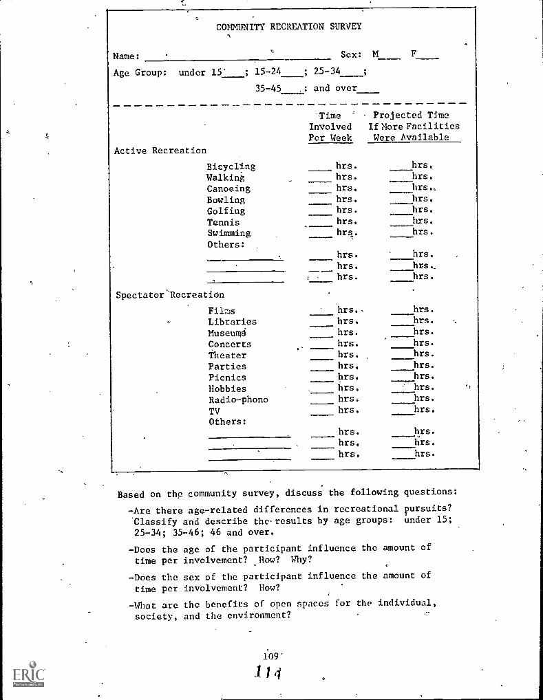
Name:
COMMUNITY RECREATION SURVEY
Sex: M F
Age Group: under 15' ; 15-24 ; 25-34
35-45 ,: and over
Active Recreation
Time Projected TimeInvolved If ?fore Facilities
Per Week Were Available
Bicycling hrs. hrs.
Walking hrs.
Canoeing hrs. hrs,
Bowling hrs. hrs.
Golfing hrs. hrs.
Tennis hrs. hrs.
Swimming hrs. hrs.
Others:
Spectator Recreation
,..
hrs. hrs.
hrs. hrs,hrs. hrs.
Films hrs., hrs.
Libraries hrs. hrs.
Museumd hrs.
Concerts hrs. hrs.
Theater hrs. hrs.
Parties hrs. hrs.
Picnics hrs. hrs.
hrs.Hobbies . hrs. ''
Radio-phono hrs.hrs.
TV hrs. hrs.
Others:hrs. hrs.
hrs. hrs.
hrs. hrs.
Based on the community survey, discuss the following questions:
-Are there age-related differences in recreational pursuits?
Classify and describe tho.results by age groups: under 15;
25-34; 35-46; 46 and over.
-Does the age of the participant influence the amount oftime per involvement? How? Why?
-Does the sex of the participant influence the amount of
time per involvement? How?
-What are the benefits of open spaces for the individual,
society, and the environment? .7-
109'
1 14
-Are the recreational needs of the communitygenerally being met?
-If not, what type of facility would be themost appropriate addition?
-Where in thd community should it be placed?
-Is there now space or would something have tobe eliminated or moved?
110
115
PURPOSE: To determine the effectiveness of zoning as a land use manage-
ment tool.
LEVEL: 7-9-
SUBJECT: Social Studies
CONCEPT: Zoning is a practice in which land uses are prescribed basedupon value judgments regarding the needs of society.
REFERENCE: Junglas, Mary, et al. Environmental Learning Experiences.
Socio-cultural Junior High School. Center for Development ofEnvirohmental Curriculum, Willoughby-Eastlake City Schools,Willoughby, Ohio, 1974, p. 42, Title III, ESEA, ED 099 231.
ACTIVITY: After a preliminary introdUction to the topic of zoning, havethe students investigate the zoning regulations and determinethe names and defilitions of the various zoning categories, suchas commercial, heavy industry, light industry, single family,
and multi-family designations. Have the students locate on a
zoning map their homes and school. Pick. and appropriate area
near the school and conduct a visual survey of the area.Students should be alerted to note any land use which does notconform to the zoning regulations affecting the. area. If non-
conforming uses are noted, the following questions could be
introduced.
1. Was the property being used in the same manner before the,passage of the current zoning regulations and therefore
exempt?
2. Was the use of.the property a result of spot zoning or had
a variance been granted?
Caution should be taken not to be overly technical with respectto zoning'(it is all too easy to bog down here), but to keepconsiderations on an elementary level, particularly with respectto the interests and abilities of the group.
111
.116

O
PURPOSE: To determine how community land use planning influences indi-vidual life styles in the future.
LEVEL: 7-9
SUBJECT: Social Studies
CONCEPT: Land use management to meet the needs of successive gener-ations demands long-range planning since options available tofuture generations must not be foreclosed.
REFERENCE: Junglas, Mary, et al. Environmental Learning Experiences.Socio- cultural, Junior High School. Center for the Develop-ment of Environmental Curriculum, Willoughby-Eastlake CitySchools, Willoughby, Ohio, 1974, pp. 41-42, Title III, ESEA,ED 099 231.
ACTIVITY: Have students contact local government officials or the localplanning agency and acquire a copy of the community's masterplan and any accompanying maps as well as zoning regulationsand maps. Have the students analyze and interpret the reportsregulations, and maps. The teacher can lead the exercise byasking the following questions:
1. What areas of the community are destined for a differentland use in the future?
2. What will happen to people and structures in existing areasthat will experience land use changes?
3. Where will new expressways, bypasses, bridges, and othernew roads be constructed?
4. Toward what areas is the growth of the community headed?
'5. Have areas been 'designated for the following?a. -New schools
b. Libraries and other cultural sitesc. Parks, open spaces, and recreation areasd. Industrial development sitese. Commercial shopping centersf. Low-income housing areasg. Police, fire, and Ether municipal service areash. Mass transit facilities
6. What are the projected population statistics for the future?On what are they based?
7. What are the estimated costs for expanding existing facil-ities? Who will pay for these improvements? How much of
the funds will come from the local, state, and federallevels?
112
1 1 7 7,

PURPOSE: To determine the status of land use patterns in the localcommunity.
LEVEL: 7-9
SUBJECT: Social Studies
CONCEPT: Land use policy is determined by the interaction of scienceand technology; social and political factors; and esthetic,ethical, and economic considerations.
REFERENCE: Junglas, Mary, et al. Environmental Learning Experiences.Socio-cultural, Junior High School. Center for the Develop-ment of Environmental Curriculum, Willoughby-Eastlake CitySchools, Willoughby, Ohio, 1974, p. 41, Title III, ESEA,ED 099 231.
ACTIVITY: Have the students prepare a large map showing present land usepatterns in the community. A completed map should contain ,thefollowing:
- Major physical features
- Limits of urban settlement.
- Residential areas
- Commercial areas
- Light and heavy industry areas
- Public land use areas (schools, municipal facilities,parks, etc)
- Major transportation routes and facilities
Supplemental maps or overlays may also be produced by thestudents, showing population density; ethnic -and minoritygroups; high, average, and low income distribution; housing A
conditions; decaying commercial and residential areas, etc.
113
118

PURPOSE: To investigate the evolution of land use practices in thelocal community.
LEVEL: 7-9
SUBJECT: Social Studies
CONCEPT: Increasing population and per capita use of resources havebrought changed land to man or resource to population ratios.
REFERENCE: Jungles, Mary, et al. Environmental Learning Experiences.Socio-cultural, Junior nigh School. Center for the Develop-
ment of Environmental Curriculum, Willoughby-Eastlake CitySchools, Willoughby, Ohio, 1974, Title III, ESEA, pp. 40-41.ED 099 231.
ACTIVITY: Done in detail, this activity presents the danger of beingoverly time-consuming, to the point. where it could be treated
as a separate unit in'itself, The teacher must make a judg-ment, based on the local situation and on the values whichhe sees in the activity, about how far to carry it. One
recommendation is to sub - divide the activity into a seriesof) small-group. activities.
1830
1930
I1890
1970
Have the students tram: the growth or lack of growth of thecommunity since its founding. It may be appropriate toselect certain years (1790, 1830, 1910, 1950) and have stu-dents investigate the stage of growth at each period.Students should be encouraged to identify the major changesand factors which affected the growth of the community.
114

Some of the following factors may be identified:
1. discovery of new resources (minerals, oil, salt, stone,etc.)
2. development of new types of transportation and new routes(roads, canals, steamships, railroads, airplands, etc.)
3. developmcnt.of new industries
4. commercial expansion
5. natural disasters
6. war
7. development of new technology
8. expanding job opportunities
Students should also be encouraged to develop a series ofmaps and graphs showing the growth of the community at the
various stages. Population growth, agricultural vs. nonagricultural jobs, ethnic and minority groups, transporationroutes, population density, and community land use are justa few. examples of types of data that can be researched.
URBAN LAND -USE Sal= Railways
Residential . wag Highways
[M] Commercial lilt Industrial
115
x.J

PURPOSE: To investigate local and regional land use patterns, using theline-transect method.
LEVEL: 7-9
SUBJECT: Social Studies
CONCEPT: Man has developed techniques useful in describing land and itsuses.
REFERENCE: Jungles, Mary, et al. Environmental Learning Experiences.Socio-cultural, Junior High School. Center for the Develbp-ment of Environmental Curriculum, Willoughby-Eastlake CitySchools, Willoughby, Ohio, 1974, pp. 10-11, Title III, ESEA,ED 099-231.
ACTIVITY: A line transect is an method of obtaining data about a community,usually in the ecological sense in "natural" communities. In
this activity, that methbd is adapted as a technique for.'investigation of land use.
1
1., Using road maps, air photos, topographic maps', or any other(
pertinent sources, try to determine the location of varioustypes of land uses in your area. This can encompass thediversity in one community or.cover'a wide variety of com-munities.
2. Select the communities or community to be studied..
3. Determine a route (transect) that crosses the greatestdiversity of land use types. A macro-community mightinclude a farming area, a farm town, a city satellite, arural area, a new suburb, an old suburb, a residential area,or an affluent,area. A micro-transect could include withinone community the business section, residential area,industrial park, affluent residential area, new housing area,and a poor area.
4. Determine the feasibility of the route of the transect.Consider such factors as availability of sites for randomsampling, traffic conditions, industrial hazards andcommunity hostility. If any factor renders the transectinfeasible, seek a solution to the problem or find a newtransect route. Although the transect is the _base for thesampling, allow latitude and flexibility to include closeby sites for sampling.
5. Determine the sites for sampling. At some of the sites,the students may want to record only their own impressions;at other sites they may want to interview residents, mer-chants, workers, other students, etc. If any of the sitesare on private property (i.e. a supermarket), explain to
116
121C

the manager 4f the property what the activity is about.
While sampling sites are being determined, slide photoscan be taken of the sampling areas. The slides willbeused to introduce thd students to the activity.
6. Set the dates for the activity, and secure permissionand transportation if needed.
7. Discuss with the class the objective of the activity.
8. Have tha-class form task groups for the sampling.
Tha tasks: Eye Balling -- Recording visual impressicihs',i
with cameras, video tape recorders, sketches, prose, orpoetry.
Ear Drumming -- Recording how the site sounds, using taperecorders or writing.
Interviewing -- Recording what other people feel aboutthe sampling sites and the environment.
,The tasks can be rotated at each sampling site.
9. Develop the questionnaire to be used at each site.
10. Practice interview techniques, emphasizing not only whatto ask but how to ask it. Practice your teachings andquestionnaires on other students and teachers. Be surestudents f011ow throughon statements made by the personbeing interviewed.
11. Have t/he students become familiar with any equipment
they will be using.
12. Conduct your line-transect and organize the informationgathered. The students may want to devise a system totabulate the interviews, looking for key words or phrasesthat can provide clues to the trend of the interviews.The Ear Drum snd Eye Ball material could be put togetherinto some sort of display or multi-media presentationand be shown to the class or other groups.
13. Repeat the pre-trip slide presentation. Have the studentscompare their before and after viewpoints of the variousland uses.
1r7
12,E
1".

c,
.
118
123.

PURPOSE: To study a variety of concerns contained in a specific recre-ation area.
LEVEL: 7-9
SUBJECT: Social Studies
CONCEPT: Esthetic resources and recreational facilities of economicand non-economic value are becoming increasingly important inleisure-time activities.
REFERENCE: Fox, Charles E. Activities for Teaching Forest Conservation:Grades 5 through 9. Forest Service, U.S. Department of Agri-culture, January 1958.
ACTIVITY: Visit a recreation area and study it from the standpoint of:
What public agency administers the area?
List the attractions of the area.
List the types of conveniences installed for comfort, safety,and sanitation.
Do conveniences appear adequate for the demand?
List the jobs that must be done each year to maintain thearea in an attractive condition. (This can be a revealinglist if all work, such as transplanting shrubs, spraying forinsect control, etc. is included.)
Estimate the number of persons required to maintain the area(1) yearlong; (2) extra workers during the active summer sea-son based on the list of jobs.
Assume yearly salaries and daily wages; compute the cost ofmaintaining this area for one year.
119
124
r:
PURPOSE: To identify beneficial and detrimental effects of various landuses and to evaluate the compatibility of the land use areas.
LEVEL: 7-9
SUBJECT: Social Studies
CONCEPT: Natural resources are unequally distributed with respect toland areas and political boundaries thus, conflicts emergebetween private land use rights and the maintenance of environ-mental quality: or the general public.
REFERENCE: Bennett, Dean B. & Willink, Wesley H. Junior High School
Environmental Education Teacher's Guide: The Human Enl, ron-
ment. Yarmouth,Maine School Department, 1975. Title III,
ESEA. ED 121 567.
ACTIVITY: Through class discussion list the beneficial and detrimentaleffects on people and the environment which might be asso--ciated with each of the ten land use areas. (Note: Effectson the natural environment might relate to habitat for wild-life, soil erosion, vegetation, water and air quality, etc.Effects on people might relate to safety, durability, conve-nience, efficiency, usefulness, aesthetics, social relations,etc.)
Using this list, vote on the degree Of compatibility of side-by-side land uses. Use the chart on the transparency to recordthe rating for each land use combination. This chart will
...
help the class to make judgments on the compatibility of landuses in an orderly way. (See Figure 1 for transparency master.)
120
125/
=

.., FIGURE 1
INDUSTRIAL
FOREST/FIELD-FARM
GRAVEL PITS C
COMMERCIAL
RESIDENTIAL
ci
EDUCATION/INSTITU.
OPEN SPACE
HIGHWAYS/R.R.
REC.- FIELDS/TRACKS
POWER LINES
-J
=a
tL
CCO
Li
1-
F-U)
CDa
a
tr
4
LAND USES
tr
\,M M0 W
z
=_
LAND USE COMPATIBILITY RATINGS
LEGEND
Good Combination = 3
Neither Good nor Bad Combination = 2
Dad Combination =
121.

To use the chart, start by comparing industrial (at the bottomof column'a') with each of the other land uses listed up anddown.along the left side of the chart. Going'up from the bottom,
compare industrial with power lines, first. If industrialareas and power lines take a good combination place a '3' in
the box.
If there are no serious objections (neither particular* goodnor bad) give it a '2'. If it is a bad combination, give it
a tit. Make the decision and rating after considering thebeneficial and detrimental effects listed in Part A.
Going up the list next, compare industrial with Recreation-Fields/Tracks. Continue until industrial at the top of the listis reached. There is no box here since the same uses cannotbe compared.
Continue until all land uses along the bottom of the charthave been rated with uses listed on the side.
To find out which uses are most compatible with all otheruses, add the scores in column 'at upward to the last box in
the column. For columns 'b' through tit, not only add thenumbers in the columns but add all numbers in the horizontalrow to the left of the top shaded box to the score. For columntjt add all the scores across in the bottom horizontal row.Rank order the land uses according to the scores; the landuse with the highest is most compatible with all other uses.The land use with the lowest score..presents the most problems.What does this mean to planners?
Obtain an cereal photograph of\your community. Using the num-
bers in the completed chart, .label all the "bad combinations"by drawing a circle around each bad combination area. (This
may be demonstrated by the teacher on an overhead transparency.)
122

PURPOSE: To trace zoning legislation in your school community and'deter-mine its effects.
LEVEL: 7-9
SUBJECT: Social Stddies"
CONCEPT: Zoning is a practice in which land uses are prescribed basedupon value judgments regarding the needs of society.
ACTIVITY: Contact your city manager's office and ask for the history of
and current zoning regulations in your local area. Give eachstudent a map of the area surrounding the school. Divide the
class into groups and assign each group a portion. Have each
group outline its area on the individual maps. Using historical
resources such as long-time residents and the historicalinformation provided by the city manager, ask each group tosketch on one map how their area must have looked during thefirst decade the area became?populated. On another map(s)have the groups identify city ordinances related to zoningand resulting changes in their area. Based. on the information,/
gained from the previous maps and current land uses, ask.theclass to make predictions about the direction of future legis-/lation and sketch on another map the way the area might look /
in the future. Have each gibup report their work to the rest/of the class. Check for similatities and inconsistenciesamong groups. As a culminatihg activity, the class could dr0a series of mini-murals to demOnatrate advances in land use /
practices.
123
12&..
PURPOSE: To learn how land use patterns in the local community change.
LEVEL: 7-9
SUBJECT: Social Studies
CONCEPT: Social and technological changes alter the interrelationships,importance, and uses for land.
REFERENCE: Jungles, Mary, et al. Environmental Learning Experiences,Socio-Cultural, Senior High School. Willoughby-Eastlake City
Schools, pp. 42-44, Title III, ESEA, ED 099 232.
ACTIVITY; Changing land use patterns within the local community oftenprovide an appropriate topic of study, and are' particularlyuseful in developing students' understandings of land useplanning concepts and problems.
Have students investigate shifting patterns Of land use withinthe local community over time. An appropriate approach is ,t
through mapping exercises, whereby students make their ownmaps based on available historical data of their own community,showing changds with time. The intention here is not for atopographic mapping exercise, but a street/building/businessarea/ industry/ housing/recreation/ open space/agricultureseries of maps, showing changes over time. It may be appro-
priate also to include increases in suburbanizatiorr. One -
approach might be to use twenty-year time interval maps,making use of data available from local historical societies,planning agencies, county or city office buildings, and the like.
A useful supplement, or alternative, to this activity wouldbe the preparation of a series of wall or bulletin board dis-plays of maps and accompanying photographs and/or drawingskeyed to the maps, indicating how land use within the community,and the community itself, have changed.
Secure an aerial photograph of the community, perhaps fromcity hall, a local planning agency, or other source (seeAppendix C for possible sources). Such photos are normallyavailable at small cost. Use the photograph to make such mapsas may be needed or useful for various activities related toland use studies, such as those discussed above. Use the aerial
photograph as a bulletin board. Use it to locate, by means.of map tacks, features of particular interest or concern.
A few representative study activities are discussed below:
1. How is land within the community currently used? Use acommunity map to determine locations and extent of parkand recreation areas within and near the community; deter-mine what segments of the community are served hy each park,
124
129

c
what facilities are available in each park, and what use
patterns are evident.
2. Make a community map showing legal zoning patterns; mark
any variances on it. Find out why these variances weregranted (such information comes from city hall and the
county clerk's office). Also find out why zoning wasinstituted in the first place. Find out what the zoninglaws are in the community, why they were established asthey were, how they have been changed, and what additional.changes may be projected. Also find out how variances may
be secured.
. ,,,
T
ti

PURPOSE: To identify the negative effects of lack of zoning.
LEVEL: 7-9
SUBJECT: Social Studies
CONCEPT: Zoning is a practice in which land uses are ptescribed basedupon value judgments regarding the needs of society.
REFERENCE: Junglas, Mary, et al. Environmental Learning Experiences,Socio-cultural, Junior Rich School. Center for the Develop-ment of Environmental Curriculum, Willoughby-Eastlake CitySchools, Wilzioughby, Ohio, 1974, p. 42. Title III, ESEA.ED 099 231.
ACTIVITY: Identify one or more_areas within the community whose growthand development suffered from the lack of effective zoningregulations. Have the students discuss and determine theundesirable aspects of the development of these areas. Whatzoning regulations would have been necessary to prevent thepresent conditions? What can be done to correct the situa-tion at the present time? What better types of land usecould the area be utilized for? Are private groups or .
governmental agencies concerned about these areas? What.proposals have been made to improve the situation? How couldthese areas be improved by private developments, the PublicHousing Au.t.hority, urban renewal F ojects, beautification
projects, public condemnation, and conversion of the areainto parks, open spaces, recreation areas, etc.?
126
13i
PURPOSE: To id,ntify the geographical factors encouraging developmentof human settlements.
LEVEL: 7-9
SUBJECT: Social Studies
CONCEPT: Physical characteristics of the natural environment are ofmajor importance in determining land use.
REFERENCE: An Environmental Syllabus: Grades 102_11, 12. New York StateEducation Department, pp. 86-87. SE 022 615.
ACTIVITY: Why people settle in the places they do is basically decidedby an array of geographical factors, not the least of whichis land capability.
Develop a list of geographical factors which influenced thelocation of early American settlements, and the lifestyles andoccupations of settlers in early American settlements, and theylifestyles and occupations of settlers in early Americanhistory." Consider specific regions and areas whose develop-ment reflects these factors (e.g., New York City, Boston, NewOrleans, San Francisco, Cleveland, Chicago, St. Louis, etc.)
Consider questions such as these:
1. Do today's population density figures continue to evidencethese early settlement patterns? Explain with specifics.
2. 141-0t specific factors cause changes in settlement patterns,once initial settlement has occurred?
Probably the most effective way to make the point of thisactivity is to apply the question to the local community.'Several of the activities in this volume relate to such studies.However, it is appropriate to consider these questions inrelation to several specific cases in addicion to the localcommunity, so that there is appropriate basis for general-ization.
127
1.32

PURPOSE: To develop an understanding of the land use implications ofdevelopment of transportation systems.
LEVEL: 7-9
SUBJECT: Social Studies
CONCEPT: Increasing population and per capita use of resources havebrought changed land tonan or resources' population ratios.
ACTIVITY: A major determinant of changes in land use patterns in theUnited States, and elsewhere, has been the-development oftransportation systems. The truth of this statement is readilyverified through considerations of the effects of.the auto-mobile and highway systems on land use in general, and onsettlement patterns in particular.
One expression of such patterns is the emergence of commercialstrip development along main streets and highways; oftenaccompanied by zoning changes to legalize such development inareas which were previously residential or rural. Manycities evidence the development of commercial and industrialcenters outside their historic "downtown" and/or industrialareas, utilizing the convenience of arterial highways, outer-belts, etc., to facilitate such development.
In many communities, the most obvious expression of the influ-ence of highway systems is in the development of suburbanhousing patterns, wherein land that was previously rural(perhaps agricultural, perhaps "unused") is converted intoresidential tracts, primarily for those who can afford them.
Students should look for local examples of the types ofdevelopment mentioned above and consider implications, such as:
1) What has happened to business, industry, and housing inthe inner city as a result of outward movement?
2) How have land uses changed in areas developed outsidethe central city?
3) What evidences are there of "good" or "poor" land useplanning in connection with such development?
4) What local environmental problems may be traced, orrelated, to commercial, industrial, or residential develop-ment of areas outside the central city?
5) How have these shifts created or accentuated environmentalproblems in the central city?
6) What are the energy implications of relying on highwaytransportatibn between inner and outer cities?
128
133

1 4J
7) As our energy supplies become increasingly scarce, whatpossible alternatives might we face with respect tourban-suburban sprawl?
8) Develop a scenario as to the possible effects of criticalshortages of energy for private transportation on localcommunities.
12 9
134
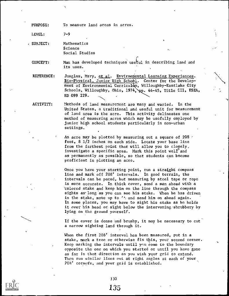
PURPOSE:
LEVEL:
SUBJECT:
CONCEPT:
REFERENCE:
ACTIVITY:
To measure land areas in acres.
7-9
MathematicsScienceSocial Studies
Man has developed techniques usetful in describing land andits uses.
Junglas, Mary, et al. Environliental Learning Experiences.Bio-Physical, Junior High School. Center for the Develop-ment of Environmental Curricu*, Willoughby-Eastlake CitySchools, Willoughby, Ohio, 1974,NR.44-45, Title III, ESEA,
ED 099 229.
Methods of land measurement are many and varied. In theUnited States, a traditional and useful unit for measurementof land area is the acre. This activity delineates onemethod of measuring acres which may be usefully employed byjunior high school students particularly in non-urbansettings.
An acre may be plotted by measuring out a square of 208feet, 8 1/2 inches on each side. Locate your base linefrom the farthest point that will allow you to closely.investigate a specific area. Mark this point well' andas permanently as possible, so that students can becomeproficient in plotting an acre.
Once you have your starting point, run a straight compassline and mark off 208' intervals. In good terrain, theintervals can be paced, but measuring by steel tape or ropeis more accurate. In thick cover, send a man ahead with acolored stake and keep him on the line through the compasssights as-long as you can see his stake. When he has drivenin the stake, move up to and send him on ahead again.In some places, you may have to sight his stake as he holdsit over his head or sight below the intervening. shrubbery bylying on the ground yourself.
If the cover is dense 'and brushy, it may be necessary to cuta narrow sighting land through it.
When the first 208' interval has been measured, put in astake, mark a tree or otherwise fix this, your second corner.Keep marking the intervals until ye:u come to the boundaryopposite the one on which you started or until you have goneas far in that direction as you wish your grid to extend.Then run sinilar lines out at right angles at each of your208' corners, and your grid is established.
l 30
135

C
B
A
-.I
,
208'
Intervals\
81/2 ,, I
-----\NJL
.
2 3 4 5
I
This representative grid would cover 10 acres. The gridlines may be inked in. All other lines or field notes are
pencil notations. An acre is a convenie ; area to use in ae
rural community, but not in an urban or suburban community,although this method of developing a grid may be valuablewhether the area in concern is large or small.
1
t"

PURPOSE: To investigate soil profiles, relating them to landcapability.
LEVEL: 7-9
SUBJECT: ScienceSocial StudiesLanguage ArtsFine and Graphic Arts
CONCEPT: Maintaining, improving, and in some cases restoring soilproductivity is important to the welfare of people.
REFERENCE:
ti
A Handbook of Environmental Encounters. Oregon Depart-ment of Education, Instruction Division, pp.C5-28.ED 113 151.
ACTIVITY 1 STUDYING A SOIL PROFILE
Locate or dig a soil pit on or near the school grounds.Identify the three soil horizons or layers. Usually a
pit may be prepared by digging a hole approximately 21/2feet deep (the depth is d.termined by each soil horizon).Enlarge the pit in width and length to accommodate theinvestigating team.
After a soil pit has been prepared, have each student takea handful of soil and describe it in as many ways as hecan, involving as many senses as possible. Discuss withstudents their soil descriptions and formulate a workingdefinition of soil, either in written.or oral form.
Using the soil pit as the study area, ask each student tolook at it for three or four minutes and then write downall the things he observes. Share these observationswith the group and compare them. The following questionsare designed to aid in the analysis:
What color differences were seen?
How did the soil look at the three levels?
Why isn't the soil the same at each level?
How far down do plant roots go?
What happens to the humus level?
132

ACTIVITY 2 RECORDING DATA
At the soil pit divide the students into small work teamsand have each record the depth of every horizon. This isdone by measuring the distance of each layer with a tapemeasure, ruler or yardstick. Have each team determine andrecord the color of every layer. Have students feel thesoil to determine the texture, and record it accordingto classification--sand, silt, or clay. As the soil
breaks apart, ask if it is platey, blocky, granular orcolumnar. Platey soil breaks into flat sections likeslate; blocky soil breaks into chunks; granular soilcomes apart in small particles like gravel; columnarsoil breaks into vertical sections.
Have each student collect a specimen from every soilhorizon. Fill a jelly cup with soil, stapling the lid(a piece of cardboard 3 inches by 7 inches) on the cup;place it upside down, marking the horizons A, B and C.Soil samples may be wrapped in plastic wrap, labeled andglued onto cardboard if jelly cups are not available.This display is called a micromonolith. What does the
soil color indicate? Why is it important t know the
texture-of the soil? What does the depth of each horizon
tell the observer?
ACTIVITY 3 RECORDING DATA
1. Using a metal-tipped thermometer, have each teamrecord the air temperature and then predict if the soil
temperature will be cooler or warmer, and why. Have
each group note the temperature of the three horizons, andrecord each on the chart. Compare the results verbally
and discuss why temperatures vary in the soil. Why is it
important to know the soil temperature?
2. With a soil pH kit, have each team test the soil foracidity or alkalinity and compare the results for each
horizon. Follow the directions given in the kit and usethe color comparison chart to check if the soil tends to
be acid or alkaline. Record the information on the chart.
What can be done to a soil that is too acid or too alkaline?
What plants like to live in acid or alkaline soil? How can
you tell?
133
136

Appraisal Using the charts (pp. 135-137), have each student interpretthe data he gathered from the study of soil horizons. The
interpretation should be written and then discussed andcompared with-others in the class. Such questions as thefollowing might be asked:
How do texture and structure affect the movementof water and air through the soil?
Do you think the soil is fertile? Why?
CURRICULUM RELATIONSHIPS
Social Investigate the problem of soil conservation in theStudies state, or in your county. Information may be obtained
from the county extension agent. What are the effectsof soil erosion? How is soil erosion created? Whatdoes the federal government offer-in the way of aid tofarmers to combat soil erosion? Contact the StateDepartment of Agriculture if you need more information.
/ .
Science Find out what means scientists have developed toalance soils too acid or too alkaline. Develop an
experiment to demonstrate the effects of soil pH onplant life.
Language // Write a few paragraphs about the importance of soil to
Arts j human and animal life. Express the meaning of soil toyou in a poem. Personification might prove interesting.
FineGrail
Ar
Draw a diagram of the soil, using crayon. Match texture
and structure, if possible.
(1) Information on Soil Profile
Sketch your soil profile, label the horizons andrecord the data.
134
139

4
PROFILE SKETCH
Contents of ruff:
DATA
, Depth " toII
A. Horizon
Topsoil:
Texture:
Depth
Sand
" to " Color
,Silt , Clay
, Blocky
Granules
Structure: Columns
Platey
PH , Temp.
2
eF, Plant Roots
B. Horizon
Subsoil:
Texture:
Structure:
PH
C. Horizon
Depth " to " Color
Sand , Silt , Clay
Columns , Blocky
Platey , Granules
Temp. el?, Plant RO'dits
Parent : Depth "to is, Color
Material
Texture: Sand , Silt
Structure: Columns
p11
Clay
, Blocky
Platey , Granules
, Temp. °F, Plant Roots
Type of rock in the bedrock:
(2) Analyzing Soil Data
The following information will help you interpret thedata collected from the soil profile and enable youto answer the questions in Section 2.
A. Effects of soil depth on plant growth and waterstorage.
Deep (42" and over)excellent plant growth and waterstorage.
Moderately deep (20"-42")good plant growth andwater storage.
Shallow (20" and under)pool plant, growth and waterstorage.
135
140

B. Effects of color on soil (use Munsell Color Chart)
Soil Surface ColorA Horizon
Amount of Or-
y.anic Material.
Excellent
ErosionFactor
Low
Aeration
Excellent
AvailableNitrogen
Excellent
,.
Fertility
ExcellentDark (dark grey, greyish ;
brown to hl ark)
Moderately Dark(darkgrey, dark brown;to dark yellow-brown)
Good
Low
Medium
High
Good
Low
Good
Low
Good---,
'.-,,,
LowLight (tale brown, yellow:
brown to yellow)
Subsurface Soil Color (8 Horizon) Condition
Dull Grey(low rainfall soils)
ater-logged soils, poor aerati-)n
Yellow, red-brown, black(forest soils)
WS; drained soils
Mottled grey, brown or yellow(humid soils)
omewhat poorly drained soils
(3) Effects'of Soil Texture
Water-holding capacity Looseness
Sand Poor Good
Silt Best.
'Good
Clay High Poor
(low availability to plants)
(4) Effects of Soil Structure
Type Penetrationof Water Drainage Aeration
columns good good vertical good
blocky good moderate moderate
granular good best best
platey (low rainfall soils) moderate moderate moderate
(5) Effects of pH on Soil
Plants need many food elements in order to grow well.These include nitrogen, phosphorus, potash and sulphur.The amount of pH determines how readily plants can getthese elements.
136
141.

I 4.5 6.5 7 8.5 14
I 1 I I
(1 to 4.5. is too (Most plants (8.5 to 14 is too alkaline
acid for most plants) do, best here) for most plants)
Example of plants in pH range:
pH 4.0-5.0: rhododendrons, camellias, azaleas, blueberries, fern
pH 5.0-6.0: pines, firs, holly, daphne, spruce, oaks, birch, willow
pli 6.0-7.0: maple, mountain ash, pansies, asters, peaches, carrotts,
lettuce
pH 7.0-8.0: beech, mock orange, asparagus
(6) Effects of Temperature on Plant Growth
Plants do not grow well when the soil is too cold or hot
during the growing season. The fbllowing chart applies
to most of the soil temperature zones.
Soil Temperature Growing Conditions
Less than 40°F No growth, soil bacteria and fungi
not very active
40°F to 65°F S6me 'growth
65°F to 70 °F Fastest growth
70°F to 85°F SomrowthAbove 85°F No growth
137
14

PURPOSE: To design and build a "1:!odel City of the Future".
LEVEL: 7-9
SUBJECT: Social StudiesScienceMathIndustrial Arts
CONCEPT: Land use policy is determined by the interaction of scienceand technology; social and political factors; and esthetic,ethical, and economic considerations.
REFERENCE: Junglas, Mary R. & others. Environmental Learning Experiences:Bio-Physical: Junior High School, Center for the Developmentof Environmental Curriculum, Willoughby-Eastlake Schools,1974, Title III, ESEA. ED 099 229.
MATERIALS: Scrap tin cans, egg cartons, milk cartons, straws, tooth-picks, popsicle sticks, cottage cheese and sour cream con-tainers, paper, glue and paint, styrofoam used for packingfragile items, throw-away flower pots.
Note: Suggestions for city so that teacher may give explanations.'
.
ACTIVITY: Suggest to your class that they design and build amodel City of the Future according to the following criteria:
1. Dwellings will probably have to be high-rise apartments.On the roofs put recreation areas, green houses, swimmingpools, and tennis courts. Use bicycles for individual
transportation and bicycle paths. You must have grass
138
II 3

and trees and very little concrete. Water runs off con-
crete. Without grass and trees there is no absorption of
carbon dioxide or generation of oxygen. Provide electric
vehicles, a mono-rail system, a subway system for trans-portation, and a travel center outside the city to rent
cars, boats, motorcycles, recreational vehicles or to
take a plane. Provide areas for each person to do per-
sonal gardening.
2. Building the City
Students make all the parts of the city as individual
units. Do not try to put them all on a base. They
usually turn out too big to'do this. Set up the whole
city on as large a space as is available. Then examine,
criticize, and complement it.
3. 'Criteria for the Cite
Select a site for a city of 1/2 million people, largeenough to be able to provide government, cultural,recreational, and educational services, but not too
big to be unwieldy. Select a climate conducive to humancomfort, one which provides raw materials available forheavy industry and a location at least 100 miles from any
other metropolitan area. Remember to find a means of
generating electricity and/or other power sources avail-
able. Existing transportation should be nearby, as shouldrecreation facilities for outside recreation which needslarge spaces, such as boating and skiing. A water supply
should be available. The city must be contained within
100 square kilometers.
4. All specifications must be written in metric units.
Specifications must include the following:
Housing allotment (size and types of homes)
How people are grouped (age, interests, family?)
Where everything is located in the city according
to the most efficient plan
Distances between things in the city
Amounts of waste water whiCh will be produced
Building materials which are available on or near site
Exact location of the city (latitude and longitude)
139
14 1

Climate of the location; waterways and mountainsnearby; elevations
5. Model City of the Future must include the following features:
-Heavy density for dwellings, high convenience transpor-
tation
-Large amounts of open spaces within boundaries
-Many parks and plantings (plantings to suit location
of site)
- Selection of major industries and subsidiary industries
to fit site
-A means of transporting the required materials if theyare not available
-No streets; only walking paths and small vehicle paths
in concrete
-Some type of futuristic transportation system which isconvenient
-No internal combustion engines for transportation within
the city
- Buildings which are made of materials which suit the site
-Water supply unpolluted; sewage disposal plant; solid
waste use; recycling or disposal means
- Governmental agencies; fire control, government, law
enforcement
-Occupations to employ at least one-third of the population
- Cultural areas; recreation areas; hotels for visitors;
restaurants
-Elementary; high school; middle school; college educa-tional plan (describe the educational system and the
locations)
-Libraries and other learning centers for those not.in
school
-Shopping areas convenient to homes, larger central shop-
ping area (consider computer shopping)
-Computer system
- I:idividual garden areas, patio and/or outdoor areas for all
- Parking area on outskirts of city for visitors
-Travel center to use in leaving city or returning
- Outside large space--recreation areas
-Communications system within city; outside of city
-Energy sources for heat, light, to be futuristic if possible
140
1451

As a class, examine Atlases to choose the site forthe city.
Now divide class into groups to research the followingspecific topics: transportation, water supply includ-ing sewage disposal, housing, cultural areas, energy,industry and open spaces and recreation. Each groupwill be responsible to write up the specification ontheir particular topic.
The following resources may be of help for this portionof the project:
a. Division of Housing and Urban Development (HUD),Washington, D.C. Request information and statis-tics on present programs on city planning,development, and rejuvenation.
b. Environmental Protection Association (EPA), Rock-ville, Maryland. Request information aboutcontrol of ecological problems.
c. NASA, Lewis Research Center, Brookpark Road,Cleveland, Ohio. Request information on techno-logical utilization.
d. Chamber of Commerce, Reston, Virginia. Requestinformation about their modern transit system toWashington, D.C.
e. Mayor of the City, Chicago, Illinois. Requestinformation about new apartment buildings aboveswitching station of Illinois Central Railroad.-
f. I.B.M. Public Relations Department, Utica, NewYork. Request student kits on how a computerworks.
g. NASA, Lewis Research Center, Brookpark Road,Cleveland, Ohio. Request information or bookleton computer programming of software.
After the topics have been researched, help the studentsdraw a plan for their city on a large sheet of whitepaper, include everything that will be in the city,and color key the drawing to be sure that they know whateach item is. Use metric units for distances.
Students can now build parts of the city separately andpaint or'color them if necessary. Use only throwawayitems to build the city; no commercial items are per-mitted (e.g., those little houses and trees that areused in model railroad layouts) .
141
146
PURPOSE: To construct simple topographic maps.
LEVEL: 7-9
SUBJECT: ScienceSocial StudiesMathematicsIndustrial Arts
CONCEPT: Man has developed techniques useful in describing land andits uses.
ACTIVITY: It should be apparent that, in order to consider land use,it is appropriate to master basic techniques of land des-cription. None is more basic than the simple topographicmap. Students will better understand maps aftei they havehad experience in making them.
ll
Field mapping exercises may be as simple or complex as ateacher wishes to make them, in keeping with course objec-tives, teacher objectives, and student abilities and/orobjectives. The description here calls for a relativelyadvanced mapping activity, using the "metes and bounds"system as a model, but it is readily modified for lesscomplex objectives and/or for younger or less able students.
A map is nothing more than a representation of some segr,entof the earth's surface, or of something on that surface.Three basic elements are involved in developing such arepresentation; all must be measured in some way if a "com-plete" map is to be made. They are: direction, distance
and elevation. It is possible, and in many cases desirable,-to eliminate from consideration the elevation pArameter anddeal strictly with direction and distance.
1. Measurement of direction the compass
The most meaningful way to determine direction is by use ofa compass as a matter of fact, it's the only way that isworkable in a school setting. Brunton compasses are notneeded; the Boy Scout variety is more than sufficient, asis any other that is marked off in degrees and is not broken.
Depending on student background, it will probably be neces-sary to spend some time on how to read a compass. One is
diagrammed below for your reference. Students should make
all readings in degrees, from their current position to thenext position of interest. If they can read compass direc-tion to within two degrees, they will do well enough thereis no point in agonizing over more precise readings.
142

2. Measurement of distance pace
Ai
a
The easiest way, and in most school situations the mostmeaningful way, to determine distance is by pacing. Eachstudent should determine the length of his own pace by walk-ing in a normal (not exaggerated) stride in a measured dis-tance such as 100 feet, then computing his normal walkingpace in feet per stride. If a student takes 30 paces towalk 100 feet, his pace is 3.3 feet per stride (100 feetdivided by 30 paces). Once a student knows this, he candetermine a distance on the earth's surface by counting thenumber of paces from one point to another, then multiplyingthe number of paces by the number of feet per stride.
3. Measurement of elevation Jacob staff
A simple device for measuring elevation, actually a rudi-mentary "Jacob staff," may be made as an industrial artsproject or at home. Needed are a length of 1" x 2" or 2"x 4" lumber, a protraCtor, and a simple plumb line (seebelow).

a--
Protractor
' J, Plumb line
::.
Procedures
...,---........0
Sightingsurface
taff
There are a number of alternative procedures which may beused in developing a mapping activity. The proceduie belowis one which works.
After orientation concerning the use of the compass and deter-mination of pace, students should be given an opportunity tomake simple, "flat" maps of an area (perhaps the school yard).A simple technique is to assign them in pairs an area to map.Begin at (practically) any point, but one which can be easilyrelocated, and develop a perimeter measurement. This may beaccomplished by sighting along one edge of the area to bemapped, noting the compass direction along that line andmeasuring the distance to a specific point in paces. From
the new point, a second "edge" is measured, etc. Notes shouldbe kept in a field notebook, vis:
From To DistanceStation Station Direction (Paces) (Feet)
1- -Large oak
2
2 - -Bird feeder 105° 52 172
3--Small fir 200° 78 257
144
I T3

Students progress from one "station" to the next, describinga perimeter, until they return to theiroriginal starting
point. When the perimeter is completed, they may make tra-verses across the enclosed area from any of the identified
stations around the perimeter, again measuring direction anddistance, and noting points of interest.
No map is made until students return to the classroom, orwherever they have a flat surface on which to work. Then a
scale is determined (by the students or, if necessary, by theteacher), distances are re-computed into inches, and protrac-tors are used for angle measurements.
A number of "crises" develop here:
1) If the teacher does not furnish 'a scale, students may(will) make a number of false starts until they finallycome up with a scale that works. How much frustrationthe teacher wishes to allow, encourage, or toleratedepends on both teacher and students, as well as objec-tives of the activity.
2) Compasses read up to 3600; protractors generally go onlyto 180°. Also, protractors must be re-oriented constantly.How much help the teacher wishes to give here is anotheropen point.
3) Invariably (even with professionals), maps made in thisfashion do not "close." How to deal with lack of closure
presents another problem. Suggested here is distributionof error across a number of points rather than remeasur-ing, assuming that no gross errors are noted.
4) No matter how detailed the measurements, it will benecessary to "eyeball" in some detail for example,the location of a path; the margins of a pond, etc.
With many students or groups, this may be as far as onemight wish to go. However, if thercis reason to intro-duce contour lines:
Students, working In teams of about four, utilize the. samegeneral procedures as for the "flat"' map but use the "Jacobstaff" to determine elevations relative to some base point.If the staff is 5 feet high, a 5-foot contour interval isobviously practical. Students then determine direction,distance, and 5-foot changes in elevation from one stationto the next.
145
130

CAUTIONS:
1) It becomes necessary--at the very least, advisableto choose stations with 5-foot changes in eleva-tion.
2) Going uphill is a lot easier than going downhill(think about that!) but there is no way to avoidgoing both up and down hill without changing thebasic parameters of the exercise. Ingenious stu-dents (or teachers) may discover a way to go onlyuphill, but students capable of doing that probablywill be able to determine mapping procedures fordownhill without undue problems.
Again, the map itself is made indoors. The more stations
described the better, but also the'more complex. When com-
pleting maps, students must construct contour lines, usinginformation provided by their field notes; a good deal ofinterpolation is necessary.
The mapping activity, if carried to the point of consideringelevations, is quite a complex activity and may well resultin frustration for all. However, there is little excuse for
not trying it with junior-senior high students unless (1) it
does not "fit" with course or program objectives, or (2) the
teacher is chicken. A teacher who has not tried it himself
is well-advised to be chicken.
Any, or all, of the above may be embellished upon by considera-tion of map coloring, labeling, etc. What to do with respect
to such embellishments again comes back to course/teacher/
student/objectives.
146
151I

LAND USE MANAGEMENT
ACTIVITIES
FOR THE CLASSROOM
Grades 10-12
Pir/ /Aa52
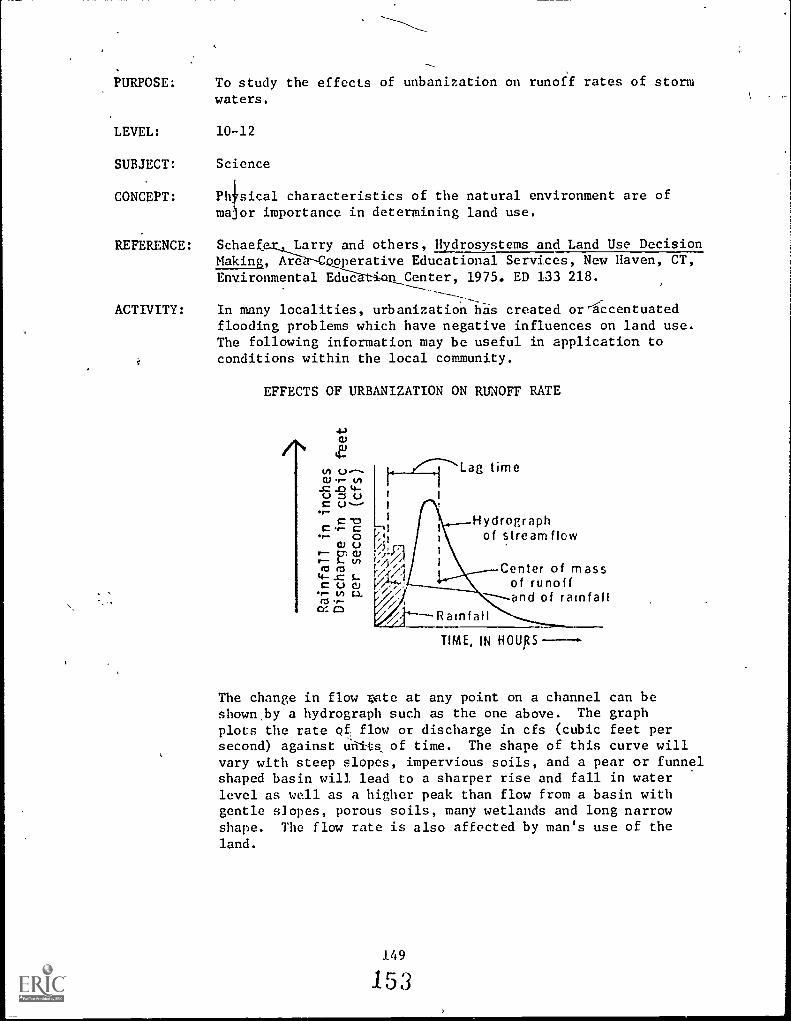
PURPOSE: To study the effects of unbanization on runoff rates of storm
waters.
LEVEL: 1012
SUBJECT: Science
CONCEPT: Phisical characteristics of the natural environment are ofmajor importance in determining land use.
REFERENCE: Schaef Larry and others, Hydrosystems and Land Use DecisionMaking, Are operative Educational Services, New Haven, CT,Environmental Educ Center, 1975. ED 133 218.
---- -ACTIVITY: In many localities, urbanization has created or-accentuated
flooding problems which have negative influences on land use.The following information may be useful in application toconditions within the local community.
EFFECTS OF URBANIZATION ON RUNOFF RATE
u 6.3
/-.0 .0 4-U UC U-11
Lag time
Hydrographof stream flow
Center of massof runoff
----and of rainfall
TIME, IN HOURS
The change in flow gate at any point on a channel can beshown.by a hydrograph such as the one above. The graphplots the rate of flow or discharge in cfs (cubic feet persecond) against Urii-ts of time. The shape of this curve willvary with steep slopes, impervious soils, and a pear or funnelshaped basin will lead to a sharper rise and fall in waterlevel as well as a higher peak than flow from a basin withgentle slopes, porous soils, many wetlands and long narrowshape. The flow rate is also affected by man's use of theland.
149
153

4-)C)
4-A VI (..3
0.) t- V).0 te-
U :3C
C-oC C
""- 00; 0r- 5-
(4- 5-C (-) ofts
Lag timeafter urbanization
Original
\ After urbanization
TIME, IN
Lag time (the time between the storm and peak runoff) maybe materially altered by the effects of urbanization ina watershed. Waf'er runs off faster from streets and roofsthan from natural vegetated areas. This tnds to decreasethe lag time. The construction of artificial channels,especially 'Storm sewers, also dedreases lag time. As thetime required forNa given amount of water to runoff shortens,the peak rate of runoff (flood peak) increase.
A study* by Luna 13,.. Leopold, the U.S. Geological Survey,indicated that if 50% of a b'asin area is made imperviousthrough development, and 50% is sewered, a given flood will be2.7 times more severe and will occur almost four times asoften.
qtydroloily for Urban Land Planning: A Guidebook on theEy&olo(qc Meets ol Laud Use by Luna B. Leopold. GeologicalSurvey Circular #554.
150
J
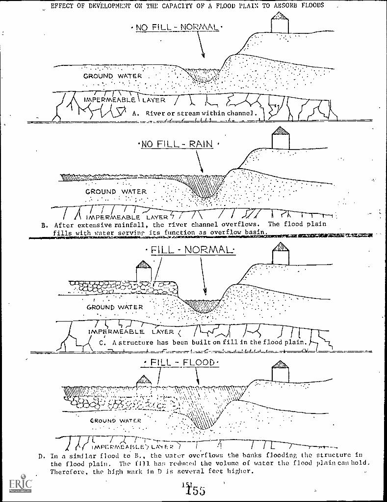
EFFECT OF DEVELOPMENT ON THE CAPACITY OF A FLOOD PLAIN TO ABSORB FLOODS
GROUND WATER .
IMPERMEABLE LAYER
A. River or stream within channel
NO FILL- RAIN
GROUND WATER .
AIMPERMEABLE LAYER 7 /B. After extensive rainfall, the river channel overflows. The flood plain
fills with water servin$ its function as overflow basin.riaceurizerr.AM13202=CIZZiliga 17.3Z=VII
FILL NORMAL.
IMPERMEABLE LAYER /i . .-N
r( C, A structure has been built on fill in the flood plain.--1.._, t ___.c- 4. ___,-- -I ..111-1 _ -- A .....v._
FILL - FLOOD
rn.7" rr":"Tf*,';',, ?:"." -.. 1,-1-4,.....,,,,..\",',', '"\\11.2?,`.7-\'`I`;\\77,7..\-\77.
\.'-i',,:\'.'.:,..'; '', ;\--"--) \ \
. t--).. . .... . \ .0 \ >I%
'..` J TX'? ":" =1/-:,-'i..( ---- '':- 1 \ \ ': \ ''_........- . .
,/ .7-:-----....____. - - . . . . ,s\ \ A \, ,
GRot . 1 NE> w A r e:R.. . ..\x\k \
. . . . .
. . . . .
v ...
(/t;\ E A P, E L A"Y
D. In a similar flood to B., the water overflows the banks flooding the structure in
the flood plain. The f Il l. has reduced the volume of water the flood plain can hold.
Therefore, the high mark in D is several feet higher.
0 J

PURPOSE: To demonstrate some causes of floods.
LEVEL: 10-12
SUBJECT: Science
CONCEPT: Man has developed techniques useful in describing land andits uses.
REFERENCE: Fox, Charles E. Activities for Teaching Forest Conservation:Grade 102nd year College, Forest Service, U.S. Departmentof Agriculture, June, 1958.
ACTIVITY: Weigh a kitchen flour sifter carefully on scale in lab.,grocery store, or meat counter. Record weight. Fill sifterto within an inch of the top with fine woods litter from thetop 2 inches of soil just below the mat of raw litter.Weigh sifter with contents and record. Using a graduateshowing fluid ounces (or it not available, a kitchen mea-suring cup), apply water steadily and very slowly to thelitter. What measured volume of water are you able to addbefore it first starts to drip from the bottom of the sifter?Record the volume. This action is known as "priming" the soil.
O
As soon as drip stops, measure out the amount of water foundnecessary for priming, and empty it quickly onto the samelitter in the sifter. Catch the drip in a container andmeasure the volume.
How did the rate of flow from the sifter the second timecompare with that in the priming?
Explain observations in terms of effect of gentle rain orslow snowmelt on floods as compared with heavy rain or rapidsnowmelt.
A common figure used for the weight of accumulated litteron a forest floor is 6 tons pe,: acre. KnoWing the weight

of the litter in the sifter and the fluid ounces of waternecessary to prime it, how many gallons of water would berequired to prime similar litter in a forest of one acre?
In a forest of 100 acres? What is the significance in termsof possible floods originating in such a forest?
Litter SurfacePartially decayed soillitter "A" horizonHumus layer
Subsoil "B"horizon
Soil materialor
nonsoll"C" horizon
Select an ungrazed woods and a bare unplowed field in the
same general area. In mid-winter, chop and dig down throughthe soil in each location and determine the depth in inches
to which the soil is frozen. Record these depths.
In which location would spring snowmelt be delayed longer?
Why? Considering the factor of frozen soil alone, in whichlocation would late winter and early spring rains be absorbed
more readily? Why? Which soil would begin storing water
first in the spring?

PURPOSE: To investigate advantages and disadvantages of a sanitary
landfill.
LEVEL:
SUBJECT:
CONCEPT:
10-12
Science
Social and technological changes alter the interrelation-ships, importance, and uses for land.
REFERENCE: Operation Survival Through Environmental Education: Senior
High, Idea I, Land flanual. Environmental Education ProjecZ:,
Grafton, Illinois, Title III, ESEA. SE 014 502.
ACTIVITY: Population growth, convenience packaging and the projectedincrease of solid waste in the next ten years are contributorsto a serious land use problem; i.e., solid waste. One of
the most common methods of disposal is the open dump. This
is not an acceptable method for many obvious reasons.
A better method than open dumping, that is becoming very
popular, is the sanitary landfill. This method involves
compacting the solid waste and covering it with a thinlayer of dirt each day.
There are advantages and disadvantages of this type opera-tion.- Instruct your class that you are going to run anexperiment to determine what materials should be placed in a
landfill.
Cut four strips, one by three inches, of one of the following
items: /a
//e%
Saran wrapCellophaneEnvelope "window"Candy wrappingHard plasticStyrofoamRubberCarbon paperVarious food itemsTin can
154
15S
Facial tissuePaper towelTyping paperDitto paper (with purplewax)'
Notebook paperGlossy magazine coverCorrugated cardboardLabel paper from tin canAluminum foil

Collect garden soil in a deep tray, bread pan, or milk carton
cut lengthwise. You might want to experiment with different
types of soil. You will also need four markers, such as ice
cream sticks.
Keep the soil moist but do not allow water to stand. Keep
the samples at room temperature.
/-ZZ4 tit 17
Observe and record on a data sheet, the characteristics of
the material used. Then bury and mark the four items in your
garden soil. After each week, dig up one item and observe
its appearance. CAUTION: do not disturb the other buried
items. Look for the roughness of the surface as well as
tiny holes or Swiss cheese-like holes, and complete disinte-gration.
After completion of this activity, answer the following
questions:
1. Which samples disintegrate rapidly? Which show very
slow disintegration?
2. Make a list of the samples going from the most activelydisintegrated to the least easily disintegrated.
3. From the above list, what material should be recycled
by salvage?
4. List some problems that occur at a landfill operation.
5. List problems to consider before a community initiatesa landfill operation.
(Problems that should be considered are: pest control; i.e.
rodents, flies pathogenic bacteria; odor; air and waterpollution; appearance; i.e. windblown litter; economics.)

PURPOSE:
LEVEL:
SUBJECT:
CONCEPT:
REFERENCE:
ACTIVITY:
To illustrate how decisions regarding land use affect eco-systems, and have limiting effects on other uses.
10-12
ScienceSocial Studies
Land use management to meet the needs of successive gener-ations demands long-range planning since options availableto future generations must not be foreclosed.
A Handbook of Environmental Encounters. Oregon Department
of Education, Instruction Division, pp. 110-111.ED 113 151.
Components in an ecosystem are so complexly interrelatedthat the change of any one of 'them may have far reachingramifications for other components and for the entire system.For example, aerial fertilizers are spread to increase treegrowth, but the water receiving the run-off may becomechoked with algae. A dam is constructed to provide powerto encourage new industry, but an important salmon resourcemay be destroyed. A marsh is filled in to build a shoppingcomplex, and the water table may be perilously affected.
Planners must study the possible effects of manipulating anyone component of an ecosystem. Only in this way can intelli-gent and responsible decisions be made about such things asland use. Students can benefit by assuming as an analyticalrole in the study and discussion of land use.
ACTIVITY 1: FIELD TRIP-HIGHWAY LOCATION,
Select an area being consiGered as the site of an inter-
state highway. (Instead of a highway it can be the proposedsite of a nuclear plant, a factory or a subdivision.) Arrange
a field trip to the area under the guidance of an engineerand/or planning official so that students can learn the social,economic, and ecological considerations involved in selectionof the site. Data might be obtained on costs of construction,extent of land acquisition, relocation of families, and otherfactors.
From the data, the class should draw up a report on whathappens when a major construction site is appropriated. The
report should list both the positive and negative impact of
such an action.
156
I tm

ACTIVITY 2: LAND USE SIMULATION
Have the class simulate the selection of a highway route.A teacher and student might explain Ule simulation as followsand then act as referees.
Objective: The "Planning Commission" is to make a decisionregarding the Highway Commission's proposal to construct ahighway through a marshy area.
Phase T. The Planning Commission (four people) is electedby the class. The election process should include classnomination of candidates and short speeches by the candidates.
Phase II. Lobbying groups should be set up, for and againstthe project. Brainstorming sessions should be held with theteacher or student at the blackboard in order to list asmany groups as possible in 15 minutes. Be sure to includethe Highway Commission as one of the groups. After allpossible-groups are included, attempt to combine them so thatonly four or five will participate in the simulation. Thesegroups should be listed on the board, and each student shouldjoin the group that interests him most. Make an attempt tobalance group sizes within limits.
Phase III. The Planning Commission and lobbying groups shouldmeet individually for 20 minutes in order.to get acquainted.Each group should elect a chairman or spokesman and plotstrategy.
Phase JV. All groups take their places in the hearing room,which is arranged as it might be in a planning meeting.Call the meeting to order. An opening statement should be
delivered by the Planning Commission. This might be followedby the highway engineer's presentation to the commission.Open the ..paring the statements from the floor. A time limit
should be set. A decision should then be made by the PlanningCommission.
157
161

PURPOSE: To understand the watershed concept of land use management.
LEVEL: 10-12
SUBJECT: Social Studies
CONCEPT:
REFERENCE:
ACTIVITY:
Science
Land use policy is determined by the interaction of scienceand technology; social and political factors; and esthetic,ethical, and economic considerations.
Gail, Peter A., et al. A Curriculum Activities Guide toWatershed Investigators and Environmental Studies, p. 8.
ED 104 651.
John Wesley Powell, statesman and explorer, noted in the late1800's that watersheds are the only logical geographicalland use planning units. His wisdom had been overlooked by
most planners until recently. Political boundaries cut acrosswatershed boundaries, often dissecting a single watershedinto many political units, each autonomous from the others.Counties often use major rivers as boundaries, creating asplit down the middle of the watershed, in which those withauthority on each side of the river have different ideasabout how to use it. Development or regional planning dis-tricts often include parts of many watersheds but seldom theentire watershed of any major stream. Under these conditions,it is obvious that any attempt to clean up water in a towndownstream would have, without equal commitmmt from alltowns upstream, little chance to succeed.
Watershed studies are investigations of the use and misuse
of the land which drains into a stream. Water quality in
the stream draining the land is an index of land use quality,and as such is only part of a watershed analysis. It is
important that a watershed study begin with a general over-view of the entire watershed - its land use, people, potentialproblems, and stream survey, not just the latter. The water-
shed is ageographical region in which you begin. Once the
problems are identified and understood, the search for answersmay extend well beyond the boundaries of the watersheds,
possibly into studies of,
-laws and potential lows that could alleviate the problemsat the local, county, state and federal level;
-the processes in society that create the problems andalternatives available to solve them;
-costs and benefits of alternative solutions;
-history of the problems and peoples' attitude toward
them;
158
162

i"
-ways of stiMdlating people to correct the problems;
all of which involve social sciences and none of whichare concerned with water pollution per se.
1. Using topographic maps, determine the boundaries of thewatershed(s) in your community. Locate your home and/oryour school within the watershed(s). (NOTE: This isoften extremely difficult, perhaps impossible, in urbanareas).
2. Make a watershed map of your community and its surroundings.Superimpose on it political subdivisionsztounty lines,city limits, township boundaries, and the like. .Deter-
^ mine why, or speculate as to why, political boundarieswere drawn as they were, and how they relate to watershedboundaries.
3. Consider these questions:
a. What advantages might there have been, had watershedboundaries been used locally in determining politicalboundaries?
b. How does land use in an upstream area have implica-tions for those living downstream? Extend this toenvironmental considerations, such as water pollution.
c. If political boundaries were identical with watershedboundaries, what advantages might exist for communityland use management?
This activity might be used as a "starter" for a more thoroughwatershed study, or as a starter activity in itself. Teachers
wishing to pursue this topic further will readily relate itto other activities in this volume, and may 'wish to considerthe references listed above.
159
163

a
PURPOSE: To identify some possible uses for one square mile ofcounty farmland near a city.
LEVEL: 10-12
SUBJECT: Social StudiesScience'
CONCEPT: Physical characteristics of the natural environment areof major importance in determining land use.
REFERENCE:
ACTIVITY:
Teaching Materials for Environmental Education: Investi-
gating Your Environment. Forest Service, U.S. Department
of Agriculture, July, 1973. SE 016 922.
Instruct your class that they are goi-.7 to participate in
a simulation game concerning land us in a hypothetical
community. The problem involves id,ntifying some possi-ble uses for a one square mile (640 acres or 259 hectar:ts)of county farmland four miles northeast of the hypothetical
city of Centerpiece, population 250,000.
BACKGROUND INFORMATION FOR CENTERPLACE CITY
-The population is 250,0G,' and rapidly increasing.-The city's boundaries are being extended, but the t3.7.04; /:$1.4suburban fringe is expanding even more rapidly.
-The rapid population growth is accompanied by
Pfl:1:1;:14 e"..,
.,.'..' ( .n &DS &))7,::'a ,,,, ....
....
demands for more housing, more jobs, aduitional :/city services, and recreational areas. ..
-he power for industrial uses, adequate public , r,AA,SE
transportation, '-and skilled labor force are ...
available.-The city is located near forests,'to the north.
.t,t:11..rcRi:LALC26c.Cce-The land to the east is devoted mainly tofarming.
-The Pipe River is unpolluted and is the sourceof irrigation water as well as the municipal'water supply.
-The river is too small for freight transporta-tion, but logs could be floated on it.
-The gravel bed of the river is appropriate rawmaterial for concrete manufacture.-The present sewage treatmer: plantand.garbagedisposal area are at maximum capacity.
-The citizens of Centerpiece are concernedabout the maintenance of a scenic regionalenvironment.
-The County Board of Commissioners is theauthority for land zoning, and many citizens'groups are being formed o influence zoning
decisions.
160
1 6,1
N4
. I 0" st.1,6% v us0 J 1 10 I) 4
...

c
1. Ask your class as a group to suggest some possible usesfor the undeveloped land. As they respond, write on thechalkboard all comments just as they are stated. (Instead
of paraphrasing if they arc too Wordy, ask: "How shall I
write that on the board?") List all suggestions, specificor general. (Number the items as you go along to simplify
identification later.)
2. When you feel you have enough material, ask "Which ofthese possible uses are similar?" Designate similaruses by letters, symbols, or colors. When most aredesignated, or the group seems to run out of thoughts,
stop. Change items among categories if the partici-pants change their minds. Do not get bogged down in the
details of grouping. For example, if some people thinkone use should be in another category, then put that usein both categories.
3. Next, determine labels that are appropriate for all itemsin each category such as recreation, industrial, utili-ties, housing, commercial, etc.
4. Divide the class into the number of land use categoriesidentified, with not more than eight persons per section.Assign one of the categories to each group for them torepresent. (One way to set up groups is to have thetotal group count off by the number of categories identi-fied.)
Inform t::e groups that. they have 10 minutes to list andanalyze the advantages and disadvantages of possibleuses for the vacant land in the assigned category. They
may consider those listed on the board plus any otherpossible uses they can think of in their category. (It
is important to stress that this task is to just analyzethe uses of the land.)
5. After about 10 minutes, announce: "We have just receivedword that because of the current workload from readingenvironmental impact statements, the members of the Boardof County Commissioners have all resigned. Each group
has one minute to elect one member to represent them onthe Board."
After the new board members have been selected, give themthe following information sheet and assign them to aseparate meeting place to (1) elect a chairperson, (2)review the information, (3) read announcements at thebottom of the information sheet, and (4) select a time-
keeper. (See Information Sheet on following page.)
161
163

INFORMATION SHEET (County Board Members Only)
"One square mile (640 acres or 259 hectares) of unused county farmland, four
miles northeast of the city, is now available for the city's use.",
Using this information, your task is to:
1. Develop criteria to evaluate the proposals.
2. Develop a system to record your evaluation of each proposal.
Background Information for Centerplace City
-The population is 250,000 and rapidly increasing.
-The city's boundaries are being extended, but the suburban fringe is expanding
even more rapidly.-The rapid population growth is accompanied by demands for more housing, more
jobs, additional city services, and recreational areas.
-The power for industrial uses, adequate public transportation, and a skilled
labor force are available.-The city is located near forests, to the north.
-The land to the east is devoted mainly to farming.
-The Pipe River is unpolluted and is the source of irrigation water as well as
the municipal water supply.-The river is too small for freight transportation, but logs could be floated
on it.-The gravel bed of the river is appropriate raw material for concrete manufacture.
-The present sewage treatment plant and garbage disposal area are at maximum
capacity.-The citizens of Centerplace are concerned about the maintenance of a scenic
regional environment.-The County Board of Commissioners is the authority for land zoning, and many
citizens' groups are being formed to influence zoning decisions.
Group Making Presentation (use category) Criteria to Evaluate Proposal
4 r5
(Rating)'
;1 2 3 6
.
Elect a chairperson to preside during the presentations to the group and to run
the meeting in an orderly manner (5 minutes). Announcements to be madc by the
chairperson:
-Because of Limo constraints, there will be no rebuttal after presentations.
-The Board may ask two or three clarifying questions of each group after all
the presentations.-You have 3 minutes to give your presentation. You will be given a warning
when you have I minute left.
111;1.)

6. After the Board leaves the room,.make this announcement to
the groups:
"You have about 15 minutes to finish your plan anddevelop a 3-minute presentation to be made to the
County Board of Commissioners. Your 3-minutepresentation must include a visual display, such asa land use map, as a part of your presentation, and
more than one person in each group must participatein making the presentation."
7. When all groups are ready, have the Board enter the room and
sit at the front. The chairperson makes the announcementsfrom the Information Sheet and sticks to them, in order to keep
the process moving. The timekeeper is to stop all presenta-
tions at 3 minutes and give 1-minute warnings.
8. When the presentations are finished, the Board retires for5 to 10 minutes to select the best proposal.
While the Board is meeting, each group is to develop a listof criteria that they think should be used in evaluating the
plans submitted. Pass out additional Information Sheets to
use in developing the criteria.
9. The County Board re-enters the room, reads their criteria
aloud, announces their decision, and reads criteria used in
making the decision. Board adjourns.
10. The following questions and discussions are suggested toconclude the activity:
A. "What additional data would you have liked to have hadfor planning your group's proposal?"
As examples, list on board: Topography, vegetation,
economy of area, railroad, shopping center, adjacentland, climate, soil survey, historical information,flood plain, wildlife, interest of board of control,
money available, educational needs, regulations by
State, existing zoning, political climate, populationinformation (age needs, race, jobs).
B. "Where would you go to collect information on thesetopics?"
C. Point out to the class that this is one of the mostimportant parts of the activity because it emphasizesthat we need a variety of information and data beforewe can intelligently make a land management orenvironmental decision to best meet the needs of people
and their environment.
163
1 6."
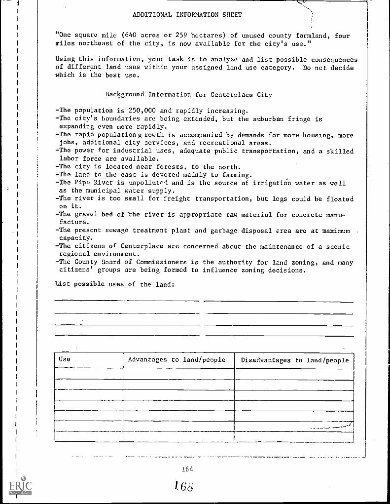
ADDITIONAL INFORMATION SHEET
"One square mile (640 acres or 259 hectares) of unused county farmland, fourmiles northeast of the city, is now available for the city's use."
Using this information, your task is to analyze and list possible consequencesof different land uses within your assigned land use category. Do not decidewhich is the best use.
Background Information for Centerplace City
-The population is 250,000 and rapidly increasing.-The city's boundaries are being extended, but the suburban fringe isexpanding even more rapidly.
-The rapid population g rowth is accompanied by demands for more housing, morejobs, additional city services, and recreational areas.
-The power for industrial uses, adequate public transportation, and a skilledlabor force are available.
-The city is located near forests, to the north.- The land to the east is devoted mainly to farming.-The Pipe River is unpollutPrl and is the source of irrigation water as wellas the municipal water supply.
-The river is too small for freight transportation, but logs could be floatedon it.
-The gravel bed of "the river is appropriate raw material for concrete manu-facture.
- The present sewage treatment plant and garbage disposal area are at maximum .
capacity.
-The citizens of Centerplace are concerned about the maintenance of a scenicregional environment.
- The County Board of Commissioners is the authority for land zoning, and manycitizens' groups are being formed to influence zoning decisions.
List possible uses of the land:
Use Advantages to land/people Disadvantages to land/people
. _. _ - -- . --- '
164
I 6 6

PURPOSE:
LEVEL:
SUBJECT:
CONCEPT:
REFERENCE:
To identify factors involved in land use planning.
10-12
Social StudiesScience
Land use management to meet the needs of successive gener-ations demands long-range planning since options availableto future generations must not be foreclosed.
An Environmental Syllabus: Grade 10, 11 12. New York StateEducation Department, pp. 89-90. SE 022 615.
ACTIVITY: Good land use planning is an important aspect of environmentalconservation and improvement. Conduct a class discussion onplanning practices with the aid of the map and questionsbelow.
SANITARY,FILL
SEWAGE 4:11:tc,e?),11iitt:7:16\0111ClyTREATMENT SUBURB(!PLANT
r
waste discharge treatedwaste discharge untreateddirection of water flowtrees
0 10 2011111kilometers
1. Which landscape region has probably been altered least
by human activities? Explain.
2. Describe the likely rates of surface water runoff duringa 1-hour light rain on the four areas (forest preserve,suburban, city, and farmland) by arranging them in order
from most to least runoff. Explain.
3. What effect might a second industrial park have upon theenvironment? Where might it be located?
165
163
NA

4. Shduld people living here support legislation to rezonethis land to allow for a second industrial park? Why or
why not? Give some advantages and disadvantages.
5. Does the map represent a well-planned area? Explain.
What changes could be made to improve the area's environ-mental quality?
166
I '/O

PURPOSE: To study land use patterns through remotely sensed data.
LEVEL: 10-12
SUBJECT: Social StudiesScience
CONCEPT: Man has developed techniques useful in describing land andits uses.
REFERENCE: T!hat's the Use of. Land? Jefferson County, Colorado. PublicSchools. ED 138 538.
ACTIVITY: This activity describes considerations appropriate to per-forming a rural survey for the purpose of s !dying
agricultural land use, as an example of how remotely senseddata may be of use in land use studies. More detail, andmore thoroughly developed land use studies employinf remotelysensed data, are presented in What's the Use of Land?, pre-pared by Jefferson County, Colorado, Public Schools, andpublished by the National Aeronautics and Space Administra-tion.
To perform such a study using remotely sensed information,the following data should be obtained: a local "gas station"map, aerial photographs, multispectral space photographs,and U.S. Geological Survey maps. (See Appendix C for
information as to how these items may be obtained).
First, the students should study the area of concern on each
of the above data. Each set of data would then be relatedto the others to obtain a thorough understanding of the area
of the survey. The gas station map will present the areain a large scale and in a format familiar to the user. It will
generally orient the area in relation to streams, lakes,cities, highways, and railroads. The aerial photographsreveal the study area in a scale so the user can recognizeall major features--buildings, fields, structures, rivers,vegetation, etc. The aerial photographs can be obtained inapproximately the same scale as the USGS maps that definegeological features. Space photographs are valuable in thistype of study because they show the watershed areas, streams,
/Y
valleys, and general land formatiots in a large area. Multi-spectral photographs from aircraft or spacecraft can be usedfor crop identification and detection of crop disease.
After students are familiar with the data collected and havecombined the essential featureS on a single layout, a fieldtrip should be made to the study area to compare actualconditions to those indicated on the maps and photographsand ensure that the layout is up to date. To identify the
crops that were in each field at the time thc. multispectral
167
71

pictures were obtained, the user must identify at least onefield of each crop in the area. This will make it possibleto establish the "spectral signature" of that crop as derivedfrom the multispectral pictures and then to identify everylike crop in the area by merely analyzing the multispectralphotographs taken during that same growing season. Refer to
Observing Earth from Skylab, NF-56/1-75, and the SkylabEarth Resources Data Catalog for more information regardingthe interpretation of multispectral photographs. The tech-nique consists of'comparing the gray tones in the photographswith a graduated gray scale, such as is marketed by Kodak,and recording the set of tonal values for each field. All
fields with the same combination of-tonal values (spectralsignature) should have the same crop in the same state of
growth.
To determine the total area planted to each crop in the scene,students can measure the area of all the fields with thesame "spectral signature." Also, by similar analysis ofmultispectral photographs of the same scene taken through-out the growing season, the relative health of the plantscan be determined, thereby allowing students to estimatethe yields of the crops.
High resolution and infra-red photographs can be used to locateirrigation ditches and to differentiate between the irrigatedand dry-land farming areas.
After the spectral signatures have been established for theentire area, a field trip should be taken to fields notvisited previously to verify the accuracy of the survey.The final results should be coordinated with the local farmbureau office where these types of data are gratefullyreceived. Here, students can get an appreciation of the
reasons for rural surveys.

PURPOSE: To describe some of the procedures involved in the preparationof our environmental impact statement for a given site andproject.
LEVEL: 10-12
SUBJECT: Social StudiesScience
CONCEPT: Land use policy is determined by the interaction of scienceand technology; social and political factors; and esthetic,ethical, and economic considerations.
REFERENCE: Project Learniny, Tree. Supplementary Curriculum Guide forGrade 7 Through Grade 12. '-ryright 1977 by American ForestInstitute. Reprinted with permission of AFI.
ACTIVITY: On January 1, 1970 the United States National EnvironmentalPolicy Act (NEPA) came into being. It created a new preventivemechanism for dealing with environmental problems. The heartof NEPA is found in Section 102. This section requires thatall federal agencies prepare a "detailed statement" on"every recommendation or report on proposals or legislationand other federal actions significantly affecting the qualityof the human environment." Specifically, these statements,now known as Environmental Impact Statements (EIS), are requiredfor all projects directly undertaken by federal agencies;supported in whole or in part by federal agencies, contracts,grants subsidies, loans, or other forms of assistance; orrequiring a federal lease, permit, license, or certificate,which meet the "significance" test.
Since EIS's are intended to assess the impact of a proposedaction, a draft statement must be prepared at least 90 daysbefore the proposed action for review by appropriate federal,state, and local agencies as well as the public. Once astatement has been prepared and reviewed, comments receivedduring the review process must be answered. A final state-ment, incorporating all comments and objections and theirresolutions, must then be made public at least 30 days priorto the proposed action.
If any of the reviewing agencies or members of the generalpublic feel that the prepared statement is inadequate, theymay file a court suit to require further research into theproject's environmental impact. The adequacy and completenessof the EIS is then determined through traditional judicialprocedures. If the EIS is found inadequate, it may be revisedand resubmitted. If the statement is deemed adequate, theproposed action may proceed. However, if the predictedconsequences are seriously detrimental, further litigation maybe brought to prohibit the proposed action.
1".II-)l j
169

Environmental Impact Statements are not intended to be justifi-cation for proposed funding or action. They are simplydetailed presentations of the environmental impacts of,andalternatives to the proposed project. The EIS are not intendedto screen alternatives solely on the basis of environmentalimpact. They are prepared to ensure that environmentalamenities as well as technical and economic considerationsand public desires are equitably considered.
In this activity students are asked to use the following datato prepare Efivironmental Impact Statements according to guide-lines suggested by the Environmental Protection Agency. Thecompleted statements are then reviewed at a simulated publichearing held by the agency that wrote the statement.
Initial Procedure
As a class, study the attached suggested guidelines for pre-paring an EIS. It would be helpful to obtain several actualEIS reports prepared for projects in or near your community.Students could examine these as they review the guidelines.
Divide the class into teams of three to five students each.Then ask each team to prepare an EIS for the Picnic PointPark proposal from the data provided here.
Data
1. The situation: A point .of land on nearby Balsam Lake (afederal water impoundment), has been a favorite informalbeach for many years. The point is easily accessiblealthough a railroad track on private property must becrossed to get to the beach. It has considerable usebecause it is one of the few public beach areas lefteasily reached by residents of the surrounding area.Last year it received 30,000 visitor-days of use.
After several meetings, the Bureau of Reclamation whichadministers the area, has decided that Picnic Point shouldbe proposed as a recreational beach site. An EIS must besubmitted because the proposed action willbe funded byfederal money. Responsibility for preparing the EIS restswith those making the proposal, in this case the Bureau ofReclamation. The EIS which is prepared will be reviewed ata public hearing held by the Bureau to meet NEPA's require-ments.
2. The existing environment: Physical features of PicnicPoint include a sandy-gravel beach; a creek running throughthe park area and emptying into Balsam Lake; and an areagraded, but not yet surfaced, for a parking lot.
170

Biological characteristics to be considered relate to ,the
lake, the land, and the creek. Balsam Lake is a large, quite
deep, manmade lake. It is now relatively unpolluted andcontains several kinds of fish with trout the most.abundant.However, the water quality is beginning to show some signsof deterioration, possibly because untreated sewage entersthe lake from homes and summer cabins on the shore. The lake's
edge has algae attached to large pebbles and boulders whichattract algae-eating animals and their predators. -Theshallows serve as a breeding area and habitat for several
kinds of animals. Water birds also are lake residents.
The land area once was covered with a forest of western red
cedar and hemlock. Sigce these trees were logged off 50years ago, bigleafomaple, red alder, a few Douglas firs, and
a wide variety of berry and flowering plants have grown up
to cover the site.
Picnic Creek is a fast-flowing stream, not very wide or deep.When it floods, it carries silt from bank cuts, sand, and somelarger debris into the lake. The water generally is clear
and of high quality except for excess numbers of coliformbacteria; the bacteria count is two to three times the number
safe in water for human use.
3. Proposed park development: The development of Picnic
Point would include these features:
Construction and maintenance of an asphalt parking lot for 48
cars, with a bus stop and turn-around; concrete restrooms;
a pedestrian railroad underpass 35 feet long, 10 feet wide,
8 feet high and 4 feet below (12 meters long, 3 meters wide,
2.75 meters high, and 1.5 meters below) the tracks; a picnicarea on,the sandy land between the beach and the railroad;
a gravel fill to protect existing trees along the railroad
track; walkways; landscaping for shade and sand and soilstabilization; and a settling basin for Picnic Creek located
just east of the railroad tracks.
Rules prohibiting camping; horseback riding; motor vehicles;
log cutting; fires except in designated facilities; unleasheddogs; excessive noise or congregating of groups; pop-open cans;and damage to vegetation, soil, sand, facilities, or native
animal life.
4. DeQi_zn considerations: The development must have plans
for sewage disposal from restrooms. Ideally this wouldbe accomplished by building a lift station and forcemain to transfer sewage to the community's new treatmentplant now under construction about 3600 feet (1200 meters)
from the restroom location.
171
175

The design also must allow for sealed catch basins in the
parking lot to prevent hydrocarbon run-off into Picnic Creek
and consider the flow increment added to the creek by water
run-off from the new asphalt parking lot. Although a large
flow is not expected, actual data are unavailable.
The development of the beach area is expected to increase its
use from about 30,000 vi'itor-days annually to 47,000.
Facilities must be designed to meet the needs of this greater
use.
Concluding Procedure
After the students have completed their EIS reports, thedocuments should -be compared.
Ask the students to discuss:
How the statements differ in their assessment of the
significance of the environmental impact, the alternativesthey propose, and the evaluation of the short- and long-
term benefits of the proposal.
Whether each group considered the project's impact differ-
ently. Whether you might have expected all the groups to
reach the same conclusion. Why or why not?
Select one member from each of the teams to serve on asimulated Department of Ecology panel which is holding public
hearings to receive comments on the EIS prepared. In this
hearing, panel members will question the consultants who
prepared each EIS to clarify ambiguities or conflicts in
conclusions. Students serving on the panel will have the
benefit of participating in the process of writing the EIS.
Once on the panel, however, they should no longer speak as
if they had Lrepared the statements. They are now "respectedcitizens" questioning consultants about the EIS they have
prepared. Another group of students might want to assume the
role of interested citizens for the purpose of testifying
at the hearing.
I
Variation
In 'his activity students will prepare an EIS for a hypothetical
or actual study site in your community, using either the federal
guidelines or their state's statutes.
Here is the hypothetical situation:
An area in your community has been selected as the site
for a 100-unit, two-story condominium housing development.
172

The site has sewer and water lines within easy access.All existing trees on the land must be removed, but the
developers agree to landscape the site when the building
is completed. An excavation for the basement also is
necessary.
Through class discussion, try to determine:
An appropriate location for the proposed condominium develop-
ment. (If an actual project which has filed an EIS state-
ment is underway locally, you may prefer to use this for
class study.)
Is a site study (EIS) necessary before development may
be approved? If so, why?
What are the important environmental factors which should
be measured before preparing an EIS? In other words, what
data must be collected? How would these factors be measured?
What is meant by "short-term impact" and "long-term
impact"?a
How long is "long"?
Divide the class into several consultant teams. Each team
is to collect part of the necessary data as suggested in the
following EIS guidelines and/or according to your state'senvironmental protection statutes, and write a report.
While doing their research, students could consider:
1. A description of the physical and biological resources of
the site.
2. How the existing biotic (life-related) community has
adapted to the physical environment.
3. Soil characteristics.
4. Air and water quality.
5. Climatic conditions including average rainfall, seasonaltemperature extremes and averages, number of sunny days.
6. Accessibility of utility lines and transportation links
to the site.
7. Unique or unusual characteristics of the site.
After the, data have been collected, follow the procedureoutlined in the firgt activity. Teams can prepare EIS reports
from the same data and present them at a public hearing.
173
"

Environmental Impacts
1. .Discuss impacts which may occur to water quality, airquality, noise, solid waste disposal, and pesticide use.
2. Discuss the impacts the project will have on the physicalenvironment such as soils, Nologic formations, hydrology,drainage.patterns, etc.
3. Discuss methodology to be used to minimize adverse environ-
mental impacts. Where abatement measures can reduceadverse impacts to an acceptable level, the basis forconsidering these levels acceptable must be outlined.
4. Discuss the economic impacts of the proposed action.
Alternatives
1. Discuss the full range of management alternativgs consideredin the couise of planning the action. The null alter-native (the alternative of taking no action) most also be
evaluated..
2. Discuss why the propo4d alternative was chosen.,
3. Discuss alternatives in sufficient detail so others mayrealize secondary or long-term environmental impacts.
Short-Term Use VS Long-Term ,Ptoductivity
1: Discuss environmental impact and economic costs andbenefits as thcy relate to short-term uses and long-term
productivity.
2. Discuss how actions taken now will (or will not) limitthe number of choices left for future generations.
Irreversible and Irretrievable Commitment of Resources
Discuss resourc':_; to be utilized and what the replacement
potential of these resources is.
174
17a

PURPOSE: To consider the question of exercising selection over who
may or may not move into a community.
LEVEL: 10-12
SUBJECT: Social Studies
CONCEPT: Increasing population and per capita use of resources havebrought changed land to man or resource to population ratios.
REFERENCE: Jamason, Barry W. Environmental Quality: A Community
Concern. New York State Department of Education.
ACTIVITY: Discuss the following newspaper excerpts with the class.
The new "land ethic" has implications that reach far beyondland itself. It is already affecting millions ofpeople--what they can do with their property, where they crn buildor buy new homes, how close they will be living to industry,
power plants and shopping centers, where they spend vacations,
and in countless other ways. It involves the development of
new governmental mechanisms: altered local-state and state-
federal relationships; and, above all, concerned publicconsideration of how people want the country to look andfunction in years to come.
"Public Control Growing in Land Use Revolution"
New York Times, September 3, 1973.
A number of communities have already begun thinking aboutestablishing population ceilings. While this is logical,
in practice it is on a collision course with the constitu-tional provision that citizens have the right of free traveland inferentially the right of settlement among the states.
"New Land Ethic: Its Spread Raises Politicaland Legal Issues to be Resolved by Public"
New York Times, September 4, 1973.
Have a committee develop a report on the question of whetheror not communities may cake the next step beyond zoning
(planning and shaping their own characteristics),' that oflimiting or excluding population growth which results frominmigration (exercising selection over the characters who
may live there.) A recent court fight concerning the community
of Petaluma, California centered on this very issue.
If you lived in a location that was judged extremely desir-able by significant numbers of people, many of whom werepotential migrants to your locality, would you wish to beable to decide how many people should share your content -ment? Explain, citing a real or hypothetical locality, -itsattract ions, and your reasons for either sharing or main-
taining exclu,:ivity.
175
PURPOSE: To understand how technologic innovation influences the useof land.
LEVEL: 10-12(
SUBJECT: SOcial Studies
CONCEPT: Social and technological changes alter the interrelationships,importance, and uses for land.
REFERENCE:
ACTIVITY:
An Environmental Syllabus: Grades 10, 11, 12. New York State
Education Department, p. 87. SE 022 615.
A major factor in changing patterns of land use during ournation's history has been the success of technology in thedevelopment of the country. Numerous examples are possible;this activity will lead to the identification and consider-ation of many of them.
Using the periods 1790-1860, 1865-1930, and 1945-1970 in ournation's history, have each student list ten major techno-logical advances or discoveries in each, describing thedirect or indirect impacts which these advances or inventionshad upon the way land was used. Examples might include:
Automobile --- highway construction....
Locomotive --- railway construction....
Telegraph --- instantaneous communication....
Drag line --- strip mining....
If each student makes his own listing, a "pooled" listingby the class will likely lead to an in-depth consideration ofthe effects of technologic advance on land use.

PURPOSE: To understand how land use decisions are made within thelocal community.
LEVEL: 10-12
SUBJECT: Social Studies
CONCEPT: Zoning is a practice in which land uses are prescribed basedupon value judgments regarding the needs of society.
REFERENCE: An Environmental Syllabus: Grades 10, 11 12. New York State
Education Department, p. 95. ED 022 615.
ACTIVITY: Invite a member of the town board planning staff to the classto discuss the serious priorities, zoning laws, and problemsrelated to land development in responses to a list of questionscarefully developed in advance. Of particular interest willbe the planner's explanation of land use priorities.
Questions might include:
1. Who is responsible for determining land use prioritiesfor the local community?
2. Who is responsible for carrying out land use policy
locally? How is this accomplished?
.177
181

PURPOSE: To learn how governmAntal agencies organize and interact for
land use planning and improvement.
LEVEL: 10-12
SUBJECT: Social StUdies
CONCEPT: Land use responsibilities should be shared by individuals,businesses and industries, special interest groups, andall levels of government and education.
REFERENCE: An Environmental Curriculum: Grades 10, 11, 12. New YorkState Education Department, pp. 86, 90-91. SE 022 615.
ACTIVITY: Land use planning and management are currently subject toa variety of regulations and policies, determined at manylevels of government--Federal, State, and local. There isno governmental body charged with overall responsibilityfor determination of land use planning and management.Rather, a number of governmental agencies share responsi-:,71ites, sometimes coorratively, sometimes competitively,because their specific missions have land use implications.
1. Study the organization and functions of appropriateFederal, State, and local governmental agencies to deter-mine what responsibilities they have with respect toland use management. A list of Federal agencies havingland use management and planning functions is reproducedin Appendix B, pp. 528-531; no such list is supplied forstate and local governments because they vary from stateto state, locality to locality. What are the specific,land-use-related functions Of such agencies, at alllevels of government?
2. Research the policies of such agencies which govern, orinfluence, the use of land. For what reasons do theyhave such policies?
3. How do governmental agencies at all levels pork cooper-atively, or competitively, with respect to land useplanning and management? (This question will he a difficultone; it may be impossible for students, unless they cansecure information from agency personnel. Local officesof any of the federal agencies should be contacted forassistance, while local planning agencies will be support-ive of student requests for assistance in varying degrees.)
4. Explain how popular opinion and private interest grouppressure can or does influence the policies of govern-mental agencies with respect to land use. In many
localities, such organizations as the Sierra Club, the
178
182

League of Women Voters, and the Nature Conservancy(for examples only) have had great influence onlocal land use.
5. How will land use patterns in the United States,in your own state, in your own locality be changingin the next decade, in light of what you havelearned about the activities of federal, sta e,and local agencies in land use planning and manage-ment?

PURPOSE: To investigate the land management concerns of conservation-oriented private organizations.
LEVEL: 10-12
SUBJECT: Social Studies
CONCEPT: Land use responsibilities should be shared by individuals,businesses and industries, special interest groups, and alllevels of government and education.
REFERENCE: An Environmental Syllabus: Grades 10, 11, 1.2. New York State
Education Department, p. 92. SE 022 615.
ACTI'iITY: Over time, a number of private, non-profit organizationshave been formed by individuals seeking to promote preserva-tion and/or conservation objectives. Many of them pre-datethe environmental concerns of the recent past, but many havefound new support and added incentive from the "environmentalmovement." One of the common threads among their objectivesis a concern for conservation with respect to land use manage-ment.
Among such oranizations are the Nature Conservancy, Friendsof the Earth, the Sierra Club, and the National AudubonSociety, to mention a few. Similar organizations exist onstate and local levels.
Assign reports on the history, structure, objectives, and-successes and/or failures of such organizations. Amongquestions appropriate for consideration are:.
1. What have been the impacts of these organizations uponland use planning, preservation, ,and conservation?
2. How are the land use objectives of these organizationsrelated to their overall objectives?
3, What specific programs or activities have these organiza-tions supported, relative to land use management?
4. How do these organizations operate on the local level?(For example, have they been active in the local area,and if so, how?)
5. Should such organizations be publicly supported withgovernmental funds? Why or why not?
6. How do such organizations work cooperatively with govern-mental agencics7
180

It is often possible to solicit the support of such organiza-tions for local school programs, including guest speakers forassemblies or classes, etc.; they are likely to be quitewilling to discuss their organizations, objectives, and thelike, with students. Invite a member of such an organizationto talk with the class.

PURPOSE: To observe land use issues in the local community.
LEVEL: 10-12
SUBJECT: Social Studies
CONCEPT: Land use policy is determined by the interaction of scienceand technology; social and political factors; and esthetic,ethical, and economic considerations.
REFERENCE: An Environmental Syllabus: Grades 10, 11, 12. New York
State Education Department, p. 90. SE 022 615.
ACTIVITY: Over a short period of time, students should compile acollection of news items which deal with specific localissues of land use (e.g., the construction of apartments;a new road; urban redevelopment, etc.). Discuss thesespecific incidents in class, weighing or ranking them inorder of significance according to: size of the land areainvolved; impact on population; short- and long-range con-sideration of public services, etc.
Class members should assume the roles of interested partiesin a specific land use issue (real estate agent, land developer,banker,, average citizen, tax collector, mayor, Chamber ofCommerce president, environmentalist, fire chief, etc.)dramatize the vested interests involved, and try to settlethe issue for the sake of the greatest number of people.An outcome could be a master plan for land use.
182
186

PURPOSE: To experience laud use decision-making activities.
LEVEL: 10-12
SUBJECT: Social Studies
CONCEPT: Land use responsibilities should be shared by individuals,businesses and industries, special interest groups, and all
levels of government and education.
REFERENCE: An Environmental Syllabus: Grades 10, 11, 12. New York State
Education Department, pp. 92-95. SE 022 615.
ACTIVITY: The tract of land illustrated on the accompanying map (next
page) represents a rural area given to the town of Hillcrestby a family which, for generations, owned the land. Several
specific conditions were stipulated in the agreement:
-No more ti:an 20 percent of the land might be sold by the
town for single family residences.
-No more than 20 percent of the land might be sold by the
town for commercial establishments,
-No more than 10 percent of the land might be sold by the
town for apartments and condominiums (each building shall
consist of no more than eight units.)
-The remaining 35 percent of the land might be used for
commercial recreational areas.
The former owners further directed that the town board appoint
a committee of nine local residents to serve on an advisory
committee to develop plans for implementing their conditions.
Instruct nine members of the class to serve as members of the
advisory committee. The committee should develop plans and
ordinances to implement the agreement. Some preliminary
calculations should be made before planning begins.
-How many square miles are there in this tract of land?
How many square kilometers?
-How many acres are there in the tract of land?
-What is the contour interval?
-Where is there a steep slope? ... a gentle slope?
-Where is the area level?
-What is the elevation of the highest point? the lowest
point?
183
18;

rtv - ,11
V: :j
,MQLERPOND
I 2IMO= MOM 11111111 OMB 111=1111111111111111
SCALE OF MILES

-Where is the location of a hilltop? ... a depression? ...
a swamp?
-What is O^ depth of the depression?
-flow do contour lines indicate streamflow?
-How are directions indicated?
-What is the gradient of each of the streams?
Construct several profiles through various areas of theregion.
Have the class develop maps of proposed, alternative landuses for the tract which can be made into a coordinatedset of overlays for overhead projection and discussion.
The suggestions, compromises, amd trade-offs which resultfrom this discussion should be prepared as a report to besubmitted to the student "advisory committee." The committeewould then either act upon the plans or suggest amendmentswhile returning the plans to the class. (This step must berepeated several times.)
Assign responsibility for preparing a complete, written reportof the experience.
185
8(.):

PURPOSE: To learn what professionals consider as important tools in
land use decision making.
LEVEL: 10-12
SUBJECT: Social Studies
CONCEPT: Man has developed techniques useful in describing land and
its uses.
REFERENCE: Garlasco, Chris and others, Local Implementation and LandUse Decision Making, Area Cooperative Educational Services,New Haven, CT, Environmental Education Center, 1975. ED
133 216.
ACTIVITY: The information on the following page will be usefulin framing an approach to land use management studies. It
may be particularly appropriate as an introductory presenta-tion for senior high school students, in that it sets forthkey parameters necessary for consideration in land usedecision making. Care must be taken that students are no,:overawed by the variety of topics of concern, but thatthey see them as indicators of the types of expertiseneeded. Students must realize that it is unrealistic toexpect them to develop such diverse expertise at this
point in their studies.
In October 1974, over two hundred individuals directlyinvolved in land use decision making in Connecticut weresurveyed to obtain their perspective on the prioritiesfor citizen information about land use. The following
table summarizes results by giving the percentage ofrespondents indicating each choice.
The information presented in the following table will beuseful in framing an approach to land use managementstudies. It may be particularly appropriate as an intro-ductory presentation for senior high school students, inthat it sets forth key parameters necessary for considera-tion in land use decision making. Care must be taken thatstudents are not overawed by the variety of topics of con-cern, but that they see them as indicators of the types ofexpertise needed. Students must realize that it is unreal-istic to expect them to develop such diverse expertise atthis point in their studies.
186
!p)

General map reading skills
VeryImportant Important
Of LimitedImportance
100% -- --Ability to interpret:
*topographic maps+bedrock-geology maps 26% 54% 20%
.surficial geology amps 15%' 45% 40%
*zoning maps 87% 11% 2%
+aerial photographs 14% 65% 21%
*soil survey maps 822 12% 6%
unconsolidated material maps 9% 25% 66%
Knowledge of:+basic soil types 17% 80% 3%
+percolation rates 167 747 10%
historical landmarks 13% 37% 50%
+unique habitat 26% 62% 12%
*flood prone areas 80% 17% 3%
+unique vistas 10% 707 10%
*wetland regulations 78% 20% 2%
*available ground water 81% 17% 2%
+zoning ordinances 31% 65% 4%
condemnation procedures 0% 18% 82%
the taking issue 0% 26% 74%
Riparian rights 0% 9% 91%
+air quality regulations 23% 64% 13%
+water quality regulations 21% 64% 15%
health regulations 61% 35% 4%
tax laws 36% 34% 40%
*septic systems regulations 61% 35% 4%
benefit-cost analysis 0% 25% 75%
+development costs 0% 70% 30%
+recreation needs 25% 75% 0%
Familiarization with:195% 5% 0%*water inventories
*land use inventories 94% 6% 0%.
+zoning inventories 21% 69% . 10%
+census data 15% 60% 25%
+population growth data 1 11% 65% 24%
Over 90% of the respondents indicated that ,they believed citizensshould be involved in land use decision making by attending publichearing;, by joining advisory committee's and by maintaining inter-est in the functioning of local goVernmentS.
*Over 507. of the respondents considered topic very important
+Over 50% of the respondents ccnsidered topic important
187
9 .1

PURPOSE: To Participate In group processes that are necessary to
solve land-related environmental problems.
LEVEL: 10-12
SUBJECT: Social Studies
CONCEPT: Land use responsibilities should be shared by individuals,businesses and industries, special interest groups, and all
levels of government and education.
REFERENCE: Project Learning Tree. Supplementary Curriculum Guide forGrade 7 Through Grade 12. Copyright 1977 by Ameridan Forest
Institute. Reprinted with permission of AFI,
ACTIVITY: This activity uses a simulation technique to involve studentsin decision making related to mining on the:forest and
rangelands surrounding a'small community.
C.
elsk the students first to prepare a map of an area 10,000acres (4,000 hectares) in size, including 25 percent-forestand mountains, 25 percent bottomland, 25 percent mounta4:1sabove the timberline, and 25 percent rangeland. Locate a
small community (population 2500) at the foot of the mountains
on a stream.
Give your students this background information:
The community of Wildwood is dependent economically upona small- lumber mill, local tourist trade from forestrecreation, and a few small farms and cattle ranches.Its water supply comes from Rimrock Creek which flows past
the town. The flow of Rimrock Creek/meets the presentwater needs of the town. Additional water for communityexpansion could be provided by treating a reservoir, butthere are no funds available now to do this.
Coal and oil shale recently were discovered in the foothills,in the forested area, and 9n some of the best rangeland
around Wildwood. Some of this rangeland is a part of a largeIndian reservatim. A large energy company would like todevelop these sources of energy. A committee of` local citizenshas been chosen to decide whether it would be in the hestinterest of the community to develop these resources.
Now ask your students to brainstorm a list of individualswhom they believe should be appointed to this committee.Though these people may be given fictitious names, make aneffort to f,enerate list- of committee members representingdiverse points of view and.interest.
188
192

Committee members might include:
Rancher who-holds the mineral rights to some of the coal
and oil shale deposits
Sawmill owner'
Chamber of Commerce member0
Timberland owners, some of whom own the mineral rights ontheir land and some who do not
Newspaper editor
Banker
Conservation-group representative
Local Native American Indian tribe council member
Others?
One group of students is to assume the roles ofscommitteemembers; another should serve as research staff'for thecommittee; the third and remaining group (the rest of theclass) should serve as a city council. Limit the city councilgroup to an odd-numbered size, possibly including a mayor as
tie-breaker.
Each student committee member should research and prepare aposition statement, stating reasons for supporting or notsupporting resource development. Varying degrees of develop=ment, as opposed to an all -or -none stand, also may be proposed.
The committee's research staff should be asked to piimikleinformation on various issues such as the economic impacton the community; water requirements for oil shale and coalprocessing; trade-offs involved in committing forest- andrangeland to strip-mining; effects on wildlife; prOblemsinvolved when the surface rights to the land are held'bysomeone other than the owner of the mineral rights.
The city council should research legal implications of possibledecisions they could' anticipate' the committee to recommend.
The simulation exercise cultinates when-the committee and itsstaff reports to the city council with its recommendationsand plans for resource development for Wtldwobd...and the citycouncil "decides."
189
19.3

PURPOSE: To identify advantages and disadvantages related to differentmethods of land' allocations.
LEVEL: 10-12
SUBJECT: Social Studies
CONCEPT: Land use policy is determined by the interaction,ofescienceand technology; social and political factors; and esthetic,ethical, and economic considerations.
1 .
REFERENCE: Project Learning Tree. Supplementary Curriculum Guide for N
Grade-7 Through Grade 12. Copyright 1977 by Ameican ForestInstitute. Reprinted with permission of AFI. 1
1
ACTIVITY: Ask your students to make a large-scale map ofa.'publiclyowned forest which contains 120 acres (approximately 50hectares) and these features: a scenic area such as .a canyon
or meadow; a two-lane highway; a prominent stream with a`smaller, tributary creek; a stand of old-growth timer.
Ask each student to.assume the role of one of the followingindividuals or groups who wish tolease a portion of the landf
Timber company executive (40"acres; 15 hectares)
Seven owners of summer cabins (2-1/2 to 3,acres each; 1hectare each)
Private campground developer (12 acres; 5 hectares)
Mining company executive (20 acres; 10 hectares)
General store and service station owner (2 acres; 1 hectare)
Railroad company executive (a 100-foot-wide right-of-way;30 meter right-of-way)
Ski resort owner (30 acres; 15 hectares)
Dude ranch operator (15 acres; 5 hectares)'
Scenic preservation. society (amount of land to be decidedby the class after the map is drawn)
Each student, either in a predetermined or random pick-a-cumberorder, chooses a site and marks off the area on the map.
As the land is claimed for each use, students with laterchoices will find the remaining area insufficient or inappro-priate for their needs. Some forest users may be left out
entirely. .
Ask the class to talk about how the land might be allo-cated in a better way among those who wish to .use it.Attempting to use concensus processes, the class maywork out a land-use-plan to meet the needs of everyoneinvolved. They might also consider whether there is aneed to look beyond the people directly'involved ln thisissue. Are there other possible uses and users not yet
represented? What seems to be the most just long-terMsolution? Have some people given up more than others?What does each person or group give up? What does eachgain individually or'collectively?
Discuss the merits and)drawbacks of the two methods ofland allocation: "fyst come, first serve" or concensus.
Variation
Assume that the forest land is privately owned and eachpotential user must bui. the land he or. she-requires..(In the first exercise, the land. was publicly owned andleased.) Follow the procedures described in the firstactivity, except when the land "runs out" ask thestudents to try tore- allocate the amount using a freemarket system. Land .can be exchanged or sold. Some
Users may decide to sell out and locate elsewhere.
Compare the two methods of allocation identifying theadvantages and disadvantages of each. Discuss suchideas as:
Which method seems to create the most controversy,the planning system whereby the land is allocated onthe basis of the consensus of the majority' or thevoluntary system whereby land is alloCated on thebasis of the individual's ability to pay?
Which system appears to leave the individual ownermost satisfied?' Explain your response.
Which system appears to be the best for society asa whole? Explain your response.
191
195

PURPOSE: ' To identif compatible kinds of land uses and describecriteria for judging compatibility.
LEVEL: 10-12
SUBJECT: Social Studies
CONCEPT: Multiple use is a practice in which a given land area functionsin two or more compatible ways.
REFERENCE: Project Learning Tree. Supplementary CUrriculum'Guide for Grade
7 Through Grade 12. Copyright 1977 by American ForestInstitute. Reprinted with permission of API.
ACTIVITY: Hold a brainstorming session with your class with the objectiveof developing four lists relating to land use.'
The first list should include personal uses, such as fishing,hunting, hiking, camping, rock climbing, and snowmobiling,which can take place-in a forest environment.
The second list should include commercial uses, such aslogging and mining.
The third list should include and reflect community values,such as watershed protection, wildlife habitat, and aesthe-tics, which the same forest might provide.
Focus the fourth list on identifying.interest'groups thatwould be likely to represent or promote each of the'uses orvalues mentioned in the first three categories. Examples aremotorcycle clubs,. environmental groups, hunting and fishingclubs, forest industry organizations, skiresort owners anddevelopers, and real estate brokers. Ask students to role-play members of these groups as they construct a "conflict'matrix."
After conflicts have been identified by the matrix, groupswith incompatible self-interests can meet to attempt to-Workout a solution. While attempting_to reconcile their conflicts,students could consider:
Are any of the activities always in conflict or does theincompatibility vary with time and in intensity?
What characteristics of the conflicting activities makethem incompatible?
What criteria are you using to determine incompatibility?
Do you believe these conflicts will become more or lessfrequent in the future? Why?
192
196

<,
What must ach group be willing to sacrifice in order toyea4h a,sco romise? x
What' are the enefits of each compromise to the interestgroins, the individual, the community, the rest of thenation?
Extensio
Groups which haye worked out solutions to their conflictsmay submit\theWrecommendations to actual groups in thecommunity c4hich are experiencing similar conflicts "forreal." Askthe community organizations to read and commenton the students' proposals.
Does the students' solution appear to be realistic? If it
'does not, wha are the reasons it won't work?
Students then might revise and resubmit their solutiowon thebasis of these comments.
193
197

PURPOSE: To describe some of the complex factors that go into deter-mining land values.
LEVEL: 10-12
SUBJECT: Social Studies .
'CONCEPT: Multiple use is a practice in which a given land area functionsin two or more compatible ways.
Protect Learnink Tree. Supplementary Curriculum Guide forGrade 7 Throu h Grade 12. Copyright 1977 by American ForestInstitute. Repri ted with permission of AFI.
REFERENCE:
,ACTIVITY:0 -
O
In this activity, tudents Will attempt to attach values ofdifferent kinds (ec nomic,aesthetic,genetic, etc.) to aparticular area of 'orest land. .
DiVide'your class into'groups. Ask each group to do researchto-determine a land value in one of these categories:
Lumber Value - Choose an area of foiest land and count thenumber of trees. Find out from a local resource agency orforest industrysrepresentative how to make a rough estimateof the number of board feet yielded per tree and the number,that could be obtained froM 100 acreA kor 100 hectares)-.-
Check with a lumberyard to determine the retail price oflumber per 1,000 board feet. Contact a timber company, and-ask-theCost of converting trees to 1,000 board feet of lumberand transporting the product to the lumberyard. Subtract thisamount ftom the retail price quoted by the lumberyard. Matmight this 100 acres (or 100 hectares) of forest be worth indollars for lumber? Note: This figure does not take intoaccount marketable byproducts; for example, particle boardor pressed wood logs. v
What might be the value of this forest land and its lumberother than as measured in chillers; for example, ask sourceof inspiration and solitude.
Watershed Value - Discuss the concept of a watershed and theways in which a forest affects the amount of water availablein an area.
Using the same 100 acres (or 100 hectares) as the sample,check the amount of rainfall in that area and calculate therainfall on 100 acres (or 100 hectares). Amount of rain infeet X 43,560 square feet/acre = cubic feet of water/acreX 7.5 gallons/cubic feet of water = gallons of water fallingon.1 acre. Amount of rain (in meters) X 10,000 square meters =cubic meters of water/hectare 100 = water falling on 1
194
198

hectare. From the local water come. y. find out the moneyvalue of 1,000 gallons of water (or cu. c meters). What isthe money value of the amount of water th fell on the sampleplot?
From the U.S. Weather Service or your local Soil Con vationService find out what percent of the rainfall they estim. e-doles do into sources (aquifers, streams, etc.) available forhuman consumption. flow would this compare with the sameamount, of rainfall, falling on a plot of the same size in openprairie, for example?
Calculate approximately what the forest is worth economicallyto people as a watershed. Attempt to calculate what the forestis worth as a watershed to living things other than people.
Wildlife Value - Find out what types of wildlife inhabit thisforest land. How many animals and birds? Are there any,such as deer, turkey, or quail, which are hunted by humans?Determine how much money hunters spend locally on license-S;guns, ammunition, equipment, lodging, travel, and guides.Include any forms of nonconsuming uses related- to wildlife(photography and bird watching, for instance) that generateeconomic income in this area. What is the total wildlifevalue (as measured in dollars) of this land? Describe thewildlife value of this land other than in dollars; for example,as a gene pool for future generations.
Recreational Value - Determine what forms of recreation takepla:e in the forest. Find'out what camping or parking chargesare levied per day. How many people use this forest forcamping or other recreation, and how much money do they spendin the area? What is the total recreational value measuredin dollars? What recreational value in the forest are ncteasily measured.in dollars? Note: The forest's intangiblevalues of wildlife, meteorological influences, and aestheticsmay be harder to calculate but are nonetheless real andworthy of consideration. In each of the sections above, ask thestudents to invent other ways to determine value other than dollar income.
Forage Value - Determine whether cattle or sheep could usethis land for grazing. How many animals could it support?How much are the animals worth on today's market? What arethe total forage values? Economic and other values?
After all the information has been collected, researched,and shared by the class, lead a discussion. Students maynot be able to resolve the issues involved, but they maybecome aware of the complexities of land-use management.Consider specific questions such as:
195
193

f
If the community wanted to clear this 100 acres (or 100hectares) of forest in order to build homes, providefarm sites, or put in a highway, how would the proposalinfluence the land's value? Decide which uses make theland more valuable. To whom? Specify how you are measuring
value. Find another way to measure value. Does youranswer change?
Decide whether the various values determined for this 100acres (or 100 hectares) could be applied to other areasof the same size but of different forest types. SpecifyWhat variables might make a difference in the economic,or the "intangible," values of the area, and from whoseviewpoint.
Decide which uses make the land more valuable in the longrun, specifying from whose point of view, and by what f
means the value is measured..
What trade-offs are involved when we convert forest landfrom multiple use or a few dominant uses? Society needshouses, farms, and roads, but we also need forests. Decide
whether and how we can have'them all. Find out who
determines the uses of forest land.
*Students may find any of the following to be useful in theirresearch:
Newspaper advertisements
Water company/municipal waterworks
Local lumber businesses and foresters
U. S. Soil Conservation Service
U. S. Weather Service
State Department of Wildlife or a similar agency
U. S. Forest Service
State Department of Recreation/Parks or a similar agency
Citizen conservation groups
196
200

PURPOSE; To consider the role of state legislatures in determiningland uSe management policies.
LEVEL: 10-12
SUBJECT: Social
CONCEPT:
Studies
CP
Land ubusinelevels
e responsibilities should be shared by individuals,ses and industries, special interest groups, and allof government and education.
REFERENCE: Shaefe , Larry. State and Federal Implementation, AreaCooper tive Educational Services, New Haven, CT, Environ-mental Education Center, 1975, ED 133 217; A Legislator'sGuide o Land Management, The Council of State Governments,Iron W rks Pikd, Lexington, KY 40511, 1974.
ACTIVITY: What a e the important legislative issues in landuse manage-ment? Should the concern be with the process? Should policy
be a major consideration?
There are no set answers. Each State has its own unique.situation providing th.-.t light under which the proposal should
be vidwed. However, there are certain questions which willilluminate the consideration of any proposal. In attempting
to offer a word of guidance, the.. following questions areoffergd:
Wh6 establishes policy at the various levels ofgovernment?
How far dOes the Legislature go in dictating policy?
Who is responsible for coniferting that policy into a workingplan?
What role should the legislator play in molding publicopinion in respect to land use?
What state efforts for improvement will be acceptable tothe citizens of the State?
Will the proposed legislation resolve the inadequacy ofexisting laws?
Does the proposed legislation fulfill all legal require-ments-state, federal and constitutional?
Which is the proper agency to administer the program?
Will there be sufficient funds available to support theprogram?
197
201

Will there be a&quate manpower available to accomplish the
job?
Is the.proposed'inechanismiadequate to anticipate futureneeds so that. potential problems are resolved before they
happen?. 1
What alternatives have been cInsidered, and by whom?
What irrgversible environmental changes will be made tO--
the land? r,
,,
,
Should land be SPecifically's t aside and preserved intact
1for future generationW
marls usesiiktiNth of the land
hra ramfsu capetr:41.1P )14
t<1.1l,y ;A
198
202
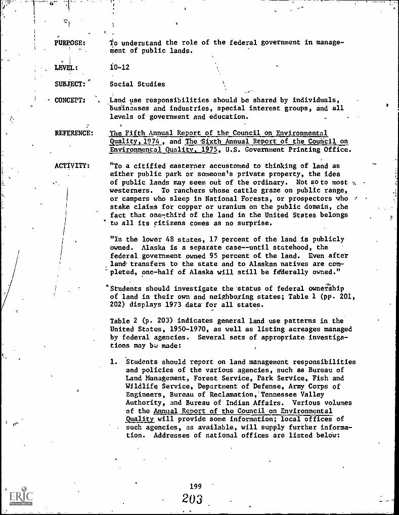
PURPOSE: To understand the role of the federal government in manage-] - ment of public lands.
LEVEL: 10 -12
SUBJECT:' Social Studies
CONCEPT: Land use responsibilities should be shared by individuals,businesses and industries, special interest groups, and alllevels of government and education.
REFERENCE: The Fifth Annual Report of the Council on EnvironmentalQuality, 1974 , and The 'Sixth Annual Report of the Couricil on
Environmental Quality, 1975, U.S. Government Printing Office.
ACTIVITY: "To a citified easterner accustomed to thinking of land aseither public park or someone's private property, the ideaof public lands may seem out of the ordinary. Not so to most N
westerners. To ranchers whose cattle graze on public range,or campers who sleep in National Forests, or prospectors whostake claims for copper or uranium on the public domain, thefact that one7third of the land in the United States belongsto all its citizens comes as no surprise.
"In the lower 48 states, 17 percent of the land is publiclyowned. Alaska is a separate case--until statehood, thefederal government owned 95 percent of the land. Even afterland,transfers to the state and to Alaskan natives are com-pleted, one-half of Alaska will still be fdderally owned."
"Students should investigate the'status of federal ownershipof land in their own and neighboring states; Table 1 (pp. 201,202) displays 1973 data for all states.
Table 2 (p. 203) indicates general land use patterns in theUnited States, 1950-1970, as well as listing acreages managedby federal agencies. Several sets of appropriate investiga-tions may bu made:
1. Students should report on land management responsibilitiesand policies of the various agencies, such as Bureau ofLand Management, Forest Service, Park Service, Fish andWildlife Service, Department of Defense, Army Corps ofEngineers, Bureau of Reclamation,' Tennessee ValleyAuthority, and Bureau of Indian Affairs. 'Various volumesof the Annual Report of the Council on EnvironmentalQuality will provide some information; local offices ofsuch agencies, as available, will supply further informa-tion. Addresses of national offices are listed beldw:
199
203

ft
Bureau of Land ManagementDepartment of the InteriorWashington, DC 20240
U.S. Forest ServiceDepartment of AgricultureWashington, DC 20202
National Park ServiceDepartment of the InteriorWashingtor., DC 20240
U.S. Fish and Wildlife ServideDepartment of the InteriorWashington, DC 20240
Departmentivf DefenseThe PentagonWashington, DC 20301
Corps of EngineersDepartment of. the ArmyWashington, DC 20314
Bureau of ReclamationDepartment of the InteriorWashington, DC 20240
Tennessee Valley AuthorityNorris, Tennesslee 37828
Bureau of Indian AffairsDepartment of the InteriorWashington, DC 20240
2. Investigations of federal land holdings and landmanagement policies within the class' home statemay be made. How the federal governffient, and its
agencies, came to own the land, why they retain it,and for what purposes it is managed are all perti-nent areas of concern.
oDeterminations of which agencies manage what acreages,and where, within the state presents an appropriatemapping exercise. Such information is generallyavailable from local offices of federal agencies, orfrom state agencies such as Departments of NaturalResources, etc.
200
204
a
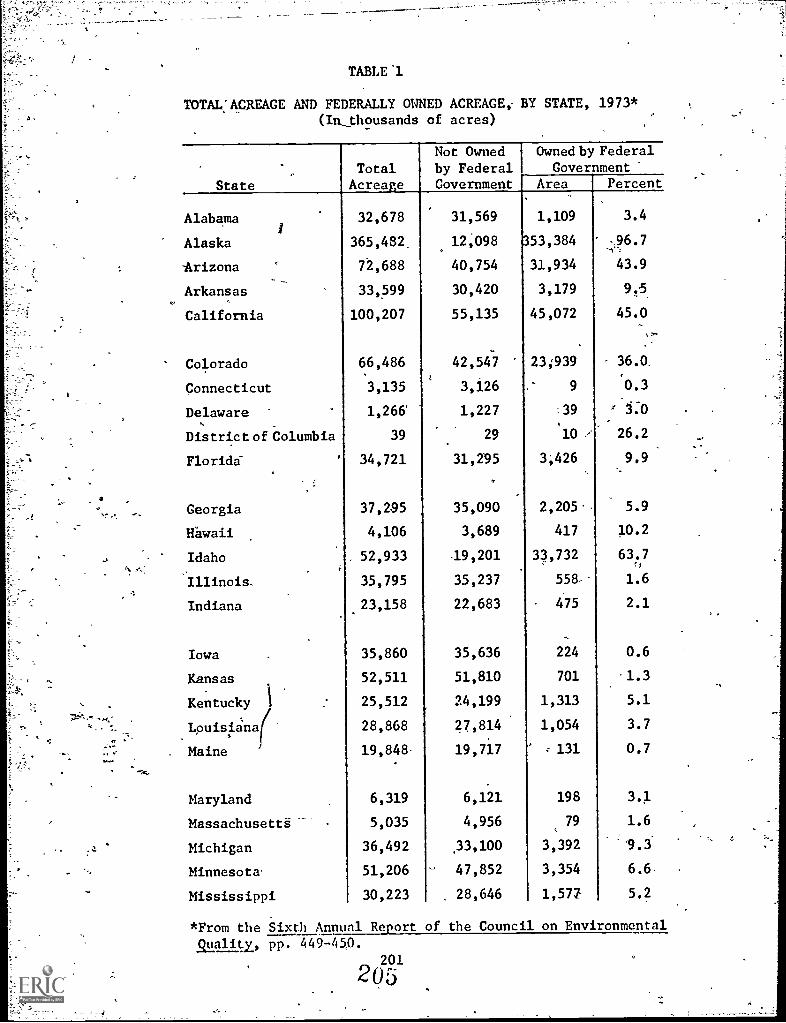
V
TABLE 'l
TOTAL:ACREAGE AND FEDERALLY OWNED ACREAGE; BY STATE, 1973*(In_thousands of acres)
State
TotalAcreage
Not Ownedby FederalGovernment
Owned by Federal
GovernmentArea Percent
Alabama
Alaska
32,678
365,482
31,569
12,098
1,109
3 53,384
3.4
96.7
Arizona 72,688 40,754 31,934 43.9
Arkansas 33,599 30,420 3,179 9.5
California 100,207 55,135 45,072 45.0
Colorado 66,486 42,547 23939 36.0.
Connecticut 3,135 3,126 9 0.3
Delaware 1,266 1,227 39 -r 3:0
District of Columbia 39 29 10 / 26.2
Florida 34,721 31,295 3,426 9.9
Georgia 37,295 35,090 2,205' 5.9
Hawaii 4,106 3,689 417 10.2
Idaho 52,933 .19,201 33,732 63.71" I
Illinois, 35,795 35,237 558- 1.6
Indiana 23,158 22,683 475 2.1
Iowa 35,860 35,636 224 0.6
Kansas 52,511 51,810 701 1.3
Kentucky 25,512 24,199 1,313 5.1
Lpuisiana f(28,868 27,814 1,054 3.7
Maine 19,848- 19,717 131 0.7
Maryland 6,319 6,121 198 3.1
Massachusett&---- 5,035 4,956 79 1.6
Michigan 36,492 ,33,100 3,392 9.3
Minnesota' 51,206 47,852 3,354 6.6.
Mississippi 30,223 28,646 1,577 5.2
*From the Sixth Annual Report of the Council on Environmentalalit, pp. 449-450.
201
205

TABLE 1--Continued
,..
StateTotal
Acreage
Not Ownedby FederalGovernment,
Owned by FederalGovernment'
Area Percent
Missouri 44,248 42,189 . 2,059 4.7
Montana 93,271 65,523 27,648 29.6
Nebraska 49,032 48,340 692 1.4
Nevada 70,264 9,432 60,832 86.6
New Hampshire, 5,769 5,059 .710 12.3
New Jersey 4,813 4,683 130 2.7
New Mexico 77,766 51,899 25,867 33.3
New York 30;681 30,452 229 0.7
North Carolina 31,403 29,458 '1,941' 6.2
North Dakota 44,452 42;157 2,295 5.2
,
Ohio 26,222' 25,895 ,327 1.2-'
Oklahoma 44,088 42;574 1,514 3.4
Oregon 61,599 29,376 32,223 52.3
Pennsylvania 28,805 28,154 651 2.3
Rhode Island '677 669 ' .73 1.2
South Carolina 19,374 18,233 1,141. 5.9
South...Dakota 48,882 45,598 3,284 6.7
Tennessee 26,728 24,954 1,774 6.6
'Takes 168,218 165,044 3,174 1.9
Utah 52,697 17,831 34,866 66.2
Vermont 5,937 5,667 270 4.5
Virginia :, . 25,496 23,153 , 2;343 9.2
Washington . 42,694 30,118 12,576 29.5
West Virginia_ 15,411 14,356 1,055 6.8
Wisconsin 35,011 33,204 1,807 5.2
Wyoming 62,343 32,275 30,068 .48.2
: United States 2,271,343 1,510,344 760,999 33.5'
-.3-Excludes trust properties.
Source: .General Services Administration, Inventory Reporton Real Property Owned by the United States Throughout the Worldas of June 30, 1973 (Washinon D.C.: Government Printing Office,1974). 0;
202

4
TABLE .2
U.S. LAND USE AND GOVERNMENT OWNERSHIP, 1950-70*(in acres)
Land Use '
Land Area (million)Total , ,4:-.:,
FarmGrazing landForest rand not grazed.Other
2,2731,162
402402
368',
341
-;.-.2,2711
1,1241319
.438390
1
1
22,26431,0643
2883
4753
437
Park-Area (thousands)'
s-' Total 29,137 32,321 38,064National Parks 23,836 25,704 28,543State ParksS 4,657 5,602 ' 8,555County and municipal parks 644 1,015 966
Federally owned land (million)Total6 , 754
7I.:772 762
Bureau of Land Management NA 500 - 474Forest Service 180 . 116 187Park ServiceFish and Wildlife Service
23.87
25.716
28.528
DepartZent of Defense8 30 31 - 31Civil Works9 .NA 15 16
Otherl° NA 7 8
11959 data.21969 data.
3Includegrassfands, arid woodlands, and other forested land grazed.
4lncludes urban, industrial, and residential areas, rural parks,wildlife refiiges, highways, railroad rights of way, ungrazed desert,rocky barren and swamp land, tundra and other land.
5Excludes state forests, wildlife refuges, and waysides not
administered by state park agencies.6Excludes outlying area beginning in 1960.
71955 data.
8Army (excluding Corps of Engineers), Navy and Air Force.
9' .
Corps of Engineers and Bureau of Reclamation.10
Atomic Energy Commission, Tennessee Valley Authority and Bureauof"Indian Affairs.
NA: not available
*From The Fifth Annual Report of the Council on EnvironmentalQuality, p. 340.
203
20-4

Sources: U.S. National Park Services, Areas Administered bythe National Park Service, semiannual; U.S. Bureau of OutdoorRecreation, State Outdoor Recreation Statistics -1962 (1963);National Recreation and Park Association, Arlington, Va.,State Park Statistics, 1970, Parks and Recreation (1971), andIlcreation and Park Yearbook; General Services Administration,Inventory Report onthe Real Property Owned by the U.S.Throughout the orld, annual; and U.S ; Department of Agricul-ture, Economic esearch Servibic Agricultural Statistics,annual, as cite in U.S. Bureau of the Census, StatisticalAbstract of the United States, 1973 (1973), Tables 323, 328,329, and 983.
204
208

PURPOSE: To determine the historical influence of survey systems onland use.
LEVEL: 10-12
SUBJECT: Social Studies
CONCEPT: , Man has developed techniques useful in describing land andits uses.
ACTIVITY: A determining factor in development of land use patterns has"been the type of land survey system employed in descriptionof property ownership, particularly in termsof governmentaldisposal of public lands. The two basic systems employed inthe United States are the Township and Range System and theMetes and Bounds System.
The Township And Range. System was adopted by the federalgoVernment in 1735 to facilitate descriptionand:aisposal ofpublic lands, and was used primarily in those areas riotsettled at. that time. Land is described in.refeience to anetwork of north-south lines' (principal meridians) and east-west lines (base parallels). In effect, the land is dividedinto north-south strips six miles wide, numbered east iandwest of-the most convenient (predetermined) principal '1'1:eft-dimn. These are called ranges. The ranges are divided intotownships.by east-west lines, six miles apart, beginning atthe most convenient (also predetermined) base parallel. (SeeFigure 1). Thus, a township is 36 square miles in. area.
T.2N.,
R.2W.
T.2N.,
R.1.W.
T.2N.,\,,
R.1E.
T.2N.,
R.2E-
T.1N.,
R.2W.
T.1N.,
R.1W.
T.1N.,,
R.1E:
T.1N.
R.2E.
T.1S.,
R.2W.
T.1S.,
R.1W.
T.1S.,
R.1E.
T.1S.,
R.2E.
T.2S.,
R.2W.
T.2S.,r
R.1W.
T.2S.,
R.1E.
T.2S.,
R.2D.
-Principal Meridian.
Figure 1,--The Township and Range System.
205
203
4
Base Parallel
A

By this system, any township may be located by referenceto its township and range numbers (viz., township 3 north,range 5 east, normally abbreviated T. 3 N., R. '5 E.).Because meridians converge to the north, because somebase lines are not true east-west, because errors may ,
occur in surveying, and because lakes and streams maybe present at critical points, corrections and allowancesmutt sometimes be made.
Townships are divided-in t:9 36 sections, each one squaremile (640 acres) in area. The numbering system for sec-tions is shown in Figure 2. To provide more detailedlocation and description, each section may be dividedinto quarters, each having an area of 160 acres. Thequarter sections are subdivided into "quarter-quarters"of 40 aereseach, commonly called "forties,,"
"I
RANGE 1. EAST
Crri
0w(,)
-.4
m
6 5 4 3
Eigoz.-1
04
5
riclH
.7" 8 9 , 10 11 12
18 17-. 16 15 14-
13
19 20 21' 22 23 24
30 29 28 27 26 25
31 32 33 34 35 36-BASE PARALLEL
----
Figure 2 . --The 36 sections of T.1 N., R.1 E.
.206
210

A
To describe a specific forty, one might say that itis.the SW 1/4 of NW 1/4 of Sec. 7, T. 4 S., R 6 W.( Figure 3).
cr
Sk1/4
640 acres
SEA
0 660 1320 2640J t 1
Feet
Figure 3. - -The descripti9n and location of partsof sections under the rectangular sur-vey, is by quarter sections, and withinthese, by 40-acre tracts, designated bythe compass position of each within itsquarter section.
207
211

O
The Metes and Bounds System describes land parcels in stateswhere the original land 'grants and surveys werenade before -the township and range system was adopted; this includes theAtlantic Coast states and Texas; An arbitrary starting pointis selected, such as a tree, a boulder, or a significantpoint onthe edge of a body of water. Boundaiy lines aredetermined along a measured line in any compasS 'directiondeemed appropriate to a second key point, from which anothercompass direction is struck to a third point, and so an ,around to the point of origin. Among complications of thissystem are frequent loss of markers of key points, inexact .
measurement of distances, and lack of consistent patterns ofshape with reference to the cardinal points of the compass.
Parcels identified under the metes and bounds system may berectangular, but are generally long and narrow. The narrow:frontage is often on a river, with the length often at right,angles ta the river, regardless of river direction. Thia-iSan indication of the value associated with river.frantage4and the lesser value of interior lands, at the times7of theoriginal surveys. Variants of the metes and bounds SYstem e,
are still common in'much of Europe, as.in most of the rest/S( of the world.
A determination 'should be made of which of these systeTs wasutilizedin the original description of local lands. (Publi-catiansof state geological surveys, or similar agencies, arevery'helpful.) Certain evidence of the 'type of system may be . 4.
readily apparent; for example, road pattefns under the town-ship and range system generally follow property lines, andthus are at right angles to one another, whereas, under themetes and bounds system they are more.likely to be Irregular.
' "Topographic maps, 011'company map's or Segal photographs maybe of-help here.' ,
List and discuss'advantages,and disadvantages of each system. 0
How did the system employed in the local area aid in itsdevelopment? How did it hinder development,if it did?
Why was the metesand bounds System appropriate to its time inAmerican history? Why is it still used in much of the rest ofthe world?
4
1
For what reasons was the township and range system institutedby the newlyformed American government in 1785? 0llas4historydemonstrated that it was the appropriate-choice? Why, or whynot?
Aninteresting set of conjectures may be developed around aconsideration of what might have happened in terms of develop-ment of the local area, had the other system been the oneemployed in the original surveys. Would the other system havebeen "better?" or "worse?" Why?
212,E
Ey

, PURPOSE: To investigate cemeteries from a land use perspective.
LEVEL; 10-12
SUBJECT: Social. Studies
CONCEPT: Multiple use is a practice in which a given land areafunctions in two or more compatible ways.
REFERENCE: Jungles, Nary, et al. Environmental Learning Experiences,'Bio-Physical, Senior High School. Center for the Develop-ment of Environmental Curriculum, Willoughby-Eastlake CitySchools, Willoughby, Ohio, 1974. ED 099 230.
ACTIVITY: 1. Class might determine the total acreage in thecommunity devoted to burying the dead. Comparisonsmay be made with past acreages, and projections madeinto the future.
2. Interview cemetery managers. -Determine the follow-'ing:
a. Who is bukied wherb--wealthy, poor, white, black?
b. HQw is the cemetery used now, besides for burial?
c. Would the managers be receptive to other uses?Recreation, wildlife sanctuary, biking paths?
3. What values clashes are apparent in attempts to usecemeteries in other ways? Discuss how they might beresolved.
209
213

PURPOSE: To understand the influences of land disposal and conser-vation policies on our nation's history.
LEVEL: 10-12
SUBJECT: Social Studies
.CONCEPT: Land use policy is determined by the interaction of scienceand technology; social and political factors; and esthetic,ethical, and economic considerations.
REFERENCE: An Environmental Syllabus: Grades 10, 11, 12, New YorkState Education Department., ED 139 671. 111 SignificantFederal Laws Concerning Natural Resources and Environmentand the Creation of Federal Agencies, School of NaturalResouices, The-Ohio State University. (Abstracted in
Appendix A, pp. 233-237.)
ACTIVITY: During the first century, and well into the second, ofAmerica's existence as a nation, disposal of federally-owned lands was a major goal, the objectiveof developmentbeing a major fadtor. Many different laws were enacted:-providing for various means of disposal. It has sometimesbeen said that there are more than five thousand land laws.There are indeed a relatively large number of land disposallaws, but the great majority of them are private landmeasures in the sense that each relates to &,specific trait
..of land, But there are perhaps a hundred di more land lawsof more-or-less general applicability_ still on the statute
books. (A standard reference is Digest of Public Land Laws, ,
U.S. Government Printing Off ice.)
Students should out -line and explain the significant legis-lation in United States history which has affected the usean,disposal of public land. A "short," and necessarilyincomplete, list of..such-laws includes: \.
1. HomesteadNLaw of 1862-2. Agricultural College Act Land Grant-in-Aid of
Colleges, 1862 (The Morrill Act)34. -Yellowstone Park Protective Act of 1872
4. General Mining Law of 18725. Desert I,andAct of 18776. Timber and Stone Act of 18787. Geologic Survey Act of 1879
8. Forest Reserve Act of 1891
9. Antiquities Act of 190610. Mineral Leasing Act of 1920
11. Wheeler-Howard Act of 1934
12. Taylor Grazing Act of.193413. Historic Sites Act of 1935
14. Wildeiness Act of 1864
210
214

15. Land and Water Conservation Fund Act of 1964
16. Public Land Law Review Commission Act. Classification andand Multiple Use Act, Public Sale Act of the 88th Con-
gress, 1964.
Among focal points for discussion are:
1. Do these legislative acts reflect a national commitmentto wise use of the nation's landS? Explain.
2. How has the nation, during its history, used disposal ofpublic lands as a device to encourage the nation'sdevelopment?
3. How have federal policies with respect to land disposalreflected our national commitment to "manifest destiny"?
4. How have national policies with respect to federal landdisposal and use shifted over time?
211
c.
PURPOSE:
LEVEL:
SUBJECT:
CONCEPT:
REFERENCE:
ACTIVITY:
To develop ideas and opinions about planning for wise use ofland in a given community.
10 -12
Social Studies
Physical characteristics of the natural environment are ofmajor importance in determining land'use.
Jamason, Barry W. Environmental Quality: A Community Con-cern, New York State Department of Education.
You will need copies of the four worksheets (found at the endof the activityfor each student.
Provide class members with copies of Worksheet 1. This work-sheet contains important facts and generalizations concerningland use in the United States. The information will be usefulas studenis.develop the ideas and opinions aboutplanning for wise use of the land.
Obtain a map of -the community which illustrates' among other.,things, remaining vacant land. Duplicate and provide copiesto the students.-Introduce the planning activity of thisseminar by describing the following hypothetical situation:
Our community, faced with a rapidly-increasing rate ofgrowth in the coming years, has decided it must make somedecisions about the best use of remaining vacant land.You are part of a committee which is evaluating new zoninglaws apd planning for local land use regulations. You areparticularly interested in considering the best uses forone undeveloped piece of land in your community which hasbecome the center of controversy over future use.
Divide the class into groups, each assigned to pick a differentuse for the same parcel of land. Assign an adversary role toone or more members of each group. For example, if the groupdecides to build a park, assign one member of the group tobe the "owner" of the land who wants to-sell it to a developerso that he can retire from his job; or, one member to be aninner city.resident-whe needs public housing that can bebuilt on that spot.
Distribute Worksheet 2 among the small groups in order thateach group may develop its findings in an independent yetparallel fashion. The gist and sequence of the questionswill give form and substance to each small group's set ofconclusions.
212
216
O
As each grOup reaches its conclusions about wise use of itsland parcel, suggest that the members consider what will bethe impact of their decision. A brief examination of Work-sheet 3 will enable them to anticipate -some of the questionsthat might be asked in an authentic land-use planning situ-ation. In this connection, appoint a review committee,selecting a member from each group, to evaluate each group'sdecision in the light of the impact of each decision.
How many of these land use plans would the committeeapprove,giVen these impact, considerations?
An alternative, more objective means of assessing impactwould be to use the chart which is provided as Worksheet 4,using the-following instructions:
Use-he-chart to emphasize the concept of environmentalimpact.
Substitute .project descriptions across the top of thechart as necessary. Areas of impact are listed in theleft-hand column., Ask Students to fill in the chartusing the symbols as in the examples below:
+ = a beneficial effect is anticipated for the environ-mental characteristic noted; e.gl, improved trans-portation (11.) under .column (H), airport expansion.
- = an adverse environmental effect is anticipated; e.g.,noise levels (3.) increase and thus are adversely '
affected under column (H), airport expansion.
0 = no appreciable change anticipated; e.g., water tableundek. column (H), airport expansion.
Once decisions have been made for every impact feature in aproject column, a simple comparison of + and - responses will
, suggest whether ornot the project seems feasible. Manystudents will wish to qualify some of-their decisions,particularly those using the symbol O. Comments of thisnature may be added on another sheet by simple referencessuch as H.11., H.3., H.81
C
213
217

Pr
LAND .USE WORKSHEET 1 - LAND USE DATA
Like all advanced nations, the United States is using landmore extensively than ever before. Certain kinds of landresources are becoming scarce--land within a reasonable dis-tance of urban centers available for housing, recreation,and waste disposition; land within cities that can be usedfor transportation, networks, parks and open space; and landto accommodate commercial facilities, housing, and centersof higher education. At the same time, we must conservevalUable farm lapd in.order to provide food, feed., and fiberfor our still expanding population and world markets.
Some salient facts:
--4 billion tons of sediment are washed into streams annually,as a result of land misuse.
--1,687,288 acres of wildlife habitat have been destroyedby surface mining ` .1 4; c
--3,187,825 acres of land have been despoiled by surfacemining.
--17,197,531 acres of wetlands have been destioYed in sevenstates alone. (45.7 percent of the wetland area ofArkans'as, California, Florida, Illinois, Indiana, Iowa-,
and Missouri).--25 million tons of logging debris are left in forests
every year.--4 million acres of right-of-way are traversed by over300,000 miles of overhead transmission lines.
million (approximately) acres of forests'are clear-cutannually.
--4 billion tons 'of raw materials are consumed annually in.S. production, most of whiCh are eventually disposedof aswaste on the land.
Our intensive and consumptive use of the land is expectedto escalate dramatically in the next 27 years. In fact, allthat has been built in the history of this Nation may haveto be duplicated. That is, the equivalent of every schoolspipeline, power7plant, office building, airport, shopping',"center, factory, home, and highway that has been built duringour first 200 years may have to be matched to accommodatepopulation and market demands projected for the year 2000.
Here areLsome conservative projections for land use in theU.S. over the next generation. .t
--19.7 million acres may be consumed by urban sprawl by:2000--an area equivalent to the states of New. Hampshire,Vermont, Massachusetts, and Rhode Island.
--3.5 million acres may be paved over for highways andairports by 2000.
214
218

;4-
--7 million Acres may be taken from agricultural use fort recreation and wildlife areas by 2000.*ci--5
.
million acres may be lost to agriculture for publicfacilities, second home development, and'waste controlprojects by 2000.
--492 power stations may be built be 1990many of themrequiring cooling ponds of 2,000 acres or more.
--2 million acres of the right-of-way may be required by1990 for 200,000 additional miles of power lines.
It will be up to the people and their elected representativesto decide whether the land is to be employed in this way,but presently there is no adequate mechanism to plan or con-trol land use.
A
215
219

T.,
LAND USE WORKSHEET 2 - PLANNING CHECKLIST
What is the projected population growth rate in your community?
What is the anticipated industrial and commercial growth?.What planning is being done to provide for.this growth?
Has your community inventoried and/or controlled any specialareas thaewould'be particularly damaged by 'high densityoccupancy? For example, historic sites, cultural assets,unique ecological' community, etc.
,Is your community benefitting from your state's AgriculturalDistricting Law, by which'a farmer can apply, for an agricul-tural value assessment on his land, thus reducing his taxes,and relieving the pressure tosell to develdpers? Does your
-state have such a law?
Does your community have a comprehensive land use plan? Is
this plan adhered to? Whose responsibility is it to' implement
the plan? What are the qualifications of the planning commis-sion?
Is there at-least one qualified' environmentalist on this board?
What specific laws Are in effect to prevent building in floodplains; tb control land erosion; to prevent unnecessary clear-..ing of trees and other vegetation;,and, to control diversion -and other tampering with streams?
Does the Zoning Board consult the Watershed Association involved,or the County Planning Board, as to the effect of its decision
on the watershed. If not, why not?
Does the zoning law encourage "cluster housing?
What provisions have been made, or are pending, to ensure thecontinued,existence of open land areas in your community?
Does the present tax structure "discriminate" against ownersof open lands
-Has any consideration been given to tax relief for ownersof open land, in order to make it easier to retain it asopen land?
-Cobld such tax relief be considered?-When and how could such a proposal be initiated?
Are there laws or regulations controlling the extent to whichland may be covered with impermeables? Who is charged with
enforcement?
What flood control measures exist? How are these maintained
Wand by whom?
216
220

LAND USE WORKSHEET 3 = LAND USE IMPACT DISCUSSION
Use. the following questions as a guide for considering someof the impact'your plans will have upon the adjacent land,the community at large,.and nearby-communities. Consider
both short-term and long-term impact. Be as specific as
possible. Consider what resources in your community you
could use to find the answers to difficalt questions.
Air Pollution
Will this use cause additional air pollution in your community?Consider the immediate concentration of the air pollution as
well as overall air quality.
Who will be affected by this air pollution?
Is the area in which the land is located already affected by
air pollution problems?
Water Quality'and Management
Will this use affect the water table and/or long-term watersupply needs of'the area?
How will this use affect water quality?
Will this use have any effect on flooding?
Is any area going to be paved over, thus causing run-off andflooding, rather than seepage into the water table? '
Transportation
Are current transportation facilities suffiCient for peopleto get to the land in question?
Will this cause an increase in traffic congestion?
Can a mass transit mode be used?
Noise
Will this use cause increased noise pollution during and after
its construction?
Growth
Will this use encourage residential, commercial and/or%indus-
trial growth in your community? How?
217
221

LAND USE WORKSHEET 4 = PROJECT IMPACT
Project.
c.
,
A. SewageTreatment
Plant
r,
8. Highway.
Construction
.
C. ApartmentComplex
D. TractHousing
.
E. ShoppingCenter
F. NuclearPowerPlant
,
G. ZoningChange: .
Commercial .
to Agricultural
, .
H. Airport1 Expansion
.
.
1. AirQuality
.
.
,
,
2. WaterQuality
.
. .
3. Noise Levels .
4. NaturalHabitats .
I
__
/ .
S. MineralDeposits
:i.
6. Solid Waste .
7. Contaminants(radioactive;chemical,
'qt.) - .,
- -
.
.
8. Water Table ..
,
,
9. Topography.
10. AestheticQuality
...
11. Transportation. .
.
12. Scenic Areas
13. EconomicCondition
. ,.
i
14. PopUlationDensity I ,
IS. "Quality ofLife"
.
.
.
222
SQ
223
PURPOSE:
LEVEL:
SUBJECT:
'CONCEPT:
REFERENCE:
ACTIVITY:
4
To,understand the "conservation ethic."
10-12
Social StudiesLanguage Arts
0
We have "legal" ownership of some land resources like realestate and Control over others during our lifetime butethically we are'"stewards" rather than owners of the land.
An Environmental Syllabus: Grades 10,'11i 12. New YorkState Education Department, pp. 86-87. ED 139 671.
A major concern relating to environmental quality in general,and certainly to land use, is the consideration of the"ecological conscience"---that is, over and above requirementand legality, what are the ethical aspects of use and misuseof environment? The question has been explored on many levels,from Congress to classrOoM to pulpit. One of the problems'confronting the educator is, "How might the necessity of anenvironmental ethic be'communicated without preaching'orbrainwashing?"':
A number of writers have developed clear statements of theneed for a land use ethic which will be meaningful reading forthe high school student. Among them are:
Garrett Hardin, 1968, "The Tragedy of the Commons," Science162:1243-1248.
Aldo Leopold, 1949, A Sand County Almanac, Oxford, New York.
Stewart L. Udall, 1963, The Quiet Crisis, Holt, Rinehart,and Winston, New York.
All three of the aboYe, and a number,of other titles discussing--lithe conservation ethic," are available in reprint and paper-
back from several sources.
Using readings such as these as background, questions such asthe following may be addressed:
1. How did early American Indians demonstrate a lifestylecompatible with the, environment?
2. Contrast, the uses of land by American Indians beforeEuropedn settlement of the New World with the land usepractices of early American settlers. What general-.izations might be drawn?
219
224

, rr. _ _- Ar , 7.
,:.
;
3. How did differences in land use practices and "cons-:rvationethics" contribute to conflict between early Americansettlers and Native American Indians?
4. Does a conservation ethic currently. axist in this country,to the extent that sound land use planning and managementuilloccur? Explain.
5. How can privately owned land be managed in the publicinterest? Should it be?
si
J,Qb
,

tF
PURPOSE: To make a plan for a recreation area.
LEVEL: 10-12
SUBJECT: MathSocial Studies
CONCEPT: Esthetic resources and recreational facilities of economicand non-economic'value are becoming increasingly importantin leisure-time activities.
REFERENCE: Fox, Charles E. Activities for Teaching Forest Conservation:Grades 10-2nd Year College, Forest Service, U.S. Departmentof,Agriculture, June; 1958. -
ACTIVITY: Thisroject is a constructive activity in that_recreationpolicy\must be formulated and problems of objectives, popula-tion growth, etc., considered in practical terms. The ideais to "start from scratch" with an hypothetical area, makea simple map, and develop a planfor use. Begin with adiscussion of recreation objectives, different types ofdevelopments, needs of the future, analysis of specific areasknown to the class, either locally or encountered on vacationtrips.
a. Select an area in the vicinity, that has potential fordevelopment as a public picnicground and campground, and--ifsuitable water is present--for bathing, boating, and fishing.Assume that funds are available for purcha&e, or that theland can be obtained by donation. One area can be selected
as a proje t for the whole group, or individuals or "commit-
tees" can elect their own,
b. It mig t be well for the "planner" first to 'ask himselfcertain or entation questions: Who will use the area? When?Will timbeii be cut, and if so, how much, where, and with whatprotection of recreation and scenic values? How much roadconstructi9n0 What structures? Of the many uses to which theArea may beout, which shall receive priority? Swimming?
Picnickingr Baseball? Shall any portions -be left undisturbed?
Where? As such questions are considered, the planner willdevelop the general feeling that he believes should be caughtand preserved in the development. He is then ready to make thepreliminary map and writeup.
-c. Map. A map on the scale of at least 8 inches to the mile,will be necessary in order to shOW the necessary detail. Some
of the students will understand the use of plane table orcompass and pacing, .and if it is decided to use one area forthe whole class, perhaps these "mappers" could lead the groupin making a hap which could be used as A-base by the entire .class; as a substitute, a sketch map approXimately to scale;with distances estimated, will have to do.
221
226

ti
,/
Prepare a rough working copy of a map on which changes canbe freely made. A simple legend for topographic and culturalfeatures is a necessity. Probably the best source for alegend is the sheet "Topographic Nap. Symbols," free on ,appli-cation to the Director, U.S. Geological Survey, Washington
D.C. 20025. One copy will do for the class. For area develop-ments such as tent sites, float, campfire circle, not found inconventional legends, use original symbols that suggest thesubject. The accompanying map of a recreation area should behelpful (Figure 1).
Improvements thatmight be shown on the map and in the plan:roads (main, secondary, and service); bridges; trails; campareas; 'picnic areas; beaches; trailer sites; summer'homesites; organization campsites; store, other ccncessions;observation tower; docks; playground area; sanitary facil-ities; water supply facilities; fences; entrance signs;bulletin boards; shower and wash houses. (There may be atendency to include too.much.)
After the final draft of the following written sattion ("d")is prepared, the final map can be dram.
d. Written section of plan. This will consist of 2 parts:
(1) General policy; (2) Discussion of individual units orimprovements. A preliminary draft should be made first.
(1) General Policy
Purpose of area; objectives; policy regarding timbercutting, livestock grazing, signs, road construction;priority of types of use; fire protection; cooperationwith other agencies;' hunting and fishing; open fires;`length of stay; fees charged; others not listed.
(2) Individual units or improvements
For each type of improvement, seperatelyandbrie'ffy)aiscu'ssstandards of construction; number of units andlicapacity,if applicable; sanitary precautions; restrictions; plansfor maintenance, garbage removal, etc.'; patrdlman orsupervisory guard. .If initial construcC.an isz-only fora portion of the total planned, indicate which units willbe completed first, and which later, assigning appropriateyears.
e. Discussion and evaluation. Compare the different plansas to practicality, effectiveness in meeting the needs, inno-vations in approach. Let the planners'defend their proposals.Summarize by bringing together the best features introduced.Are there any opportunities for new recreation areas, or forimproving existing areas in your community?
222
227o

.."
E,Eiticr.) FIREPLACE
El WELLI::/ BULLETIN BOARDX SIGN7"-C TAB% E.
11. TOL LET0 REFUSE RECEPTACLE
Figure 1. -- PROPOSED PLAN fOR..
WOOD LAKE f?ECREATION. AREA..Cc 0 Ze - /A : hop ile.
-228
Asi
r.,
. 4
2.29 .

* PURPOSE: To conduct an investigation of the land use practices employedin your local community.
LEVEL: 10-12
SUBJECT: Social StudiesScience
Math
CONCEPT: Man has developed techniques useful in describing land and/ its uses.
REFERENCE: Teaching Materials For Environmental Education: InvestigatingYour Environment. Forest Service, United'States Department ofAgriculture, July, 1973. SE 016 922.
ACTIVITY: To set the stage for this activity, pick a topic other thana traditional land use subject to illustrate a possible-pro-cedure for investigating land use management in your localcommunity.
0 .0
For 'example:- Transportation
On the chalkboard make three columns as follows:
Column 1 --- What We Want To Find OutColumn 2 --- How To CollectColumn 3 --- How To Record
Solicit class responses and list the items in the appropriatecategories.
Here is what a chart might look like after doing it with theclass.
Three-Stage, Data-Collecting ChartSubject: Transportation-
Column 1What we want to find out
Column 2 Column 3How to collect How to record
Location of major arterials Observation GraphsKinds of transportation Interview people StatisticsWhat is needed Existing studies PicturedHow much is available Count number of cases FilmAccessibility of terminals at certain place Tape recordersLand topography Count types of Questionnaire -
Is it working r vehicles MapWhat is being used now TablesGrowth patternTraffic flow patternPeak traffic needsAttitude of people
224
?:30

Now, ask your class to help you make a list on thechalkboard of major land use categories found in most
communities. Your list should such topics as
commercial, residential, recreation, industrial, etc.
Divide your class into study groups covering each of the
land use categories listed. Give each student a map of
the local community being studied. (The area should be
within walking distance of the school.) Also give eachstudent a Three-Stage Data Collecting and Analyzing Ohart
as follows:
THREE-STAGE DATA COLLECTING AND ANALYZING CHART
Land Use Category(Have'each group identify its topic in thii space)
Column 1 1 Column
What we want to find How to collect
out about our land use the information
category, in the area"
Column 3How to recordthe information
Instruct each study group to fill out the land use categoryand Column 1 on the chart using the procedure demonstrated
through the example of the transportation topic.
Now ask each study group to,identify one or two items from
Column 1 of its chart that they want to find out.moreabout from actual observations, in the area to be investiga-ted, and construct a data-collecting and recording deviceto use in collecting and recording their-observations. The
items selected must deal with data that are observable,collectible, and recordable in the area during the actualfield investigation and within the time constraints. Fill-
ing out Columns 2 arid 3 may help in planning.
Following are sample data-collecting and recording charts
. to hand up as sample displays.
225
231
X
Use of Parks by Age Groups No o! People in Cars a, Intersection Location of Pahl:; Surv'on.
Age Group
yri
1321
7-12
21.30
30.40
40+
c. Walk Bike Other (4:00.405 p.m.)
No. of Cars
30
20
10
0 1111.1 1
2 3 4 .5 6No. of Occupants
X
L.11
40.0 41
X
legend:A fire hydrapt
telephone pole
restrooms
0 fire station
When the groups have almost finished making the data-collectingcharts, tell them to develop a plan of action tc investigatetheir part of the environment using the data-collecting andrecording defices in the allotted field time. (Consider dividingresponsibilities for collecting and recording information, whogoes where, other tools needed, etc.) Data must be observable,collectible, and recordable.
Before going out to do the investigation, have each group makea short presentation to describe the procedures and to displaythe recording devices to be used in the investigation. If youhave a large class, have groups pair up and critique each other'splans instead of each small group presenting it to the total group.
'Lou are now ready to conduct the investigation.
Tell groups: "You now have hours to do your fieldwork. Beback here at (time). You will then have one hour to prepare a5-10 minte report about your investigation."
The following list of instructions for the presentation issuggested:
Instructions for the Presentation
1. Describe your task.2. Report on what you did, how you did it, and what it meant.3. Describe how you modified your procedure, methods, recording
devices,'etc.4. Use more than one person as spokesperson.
226
232

5. Use visual displays.6. Limit report to 5-10 minutes.7r This is to be a report about the investigation process and
not the content or solutions to problems, unless itrelates to the process.
8. Do not report on all the minute details.
Each group should give its presentation. Stick to timelimits and to the process of the investigation.
A culminating discussion could include the following ques-tions:
How does each land use affect the other land uses ofthe area?
What problems exist because of certain land uses?
What land use problems in this area are related toregional environmental problems?
What things are being done to the land that arecompatible with the:
Characteristics of the land?Needs of the people?
Which land uses are changing?
What proposed projects could affect land use patternsin this area?
Something to Think About
For each of the land uses yiou irivestigate, ask yourself:
Is it in a good loc-ation- tO__serve its purpose?What does it do to the environment?What kind of an environment dOes.it produce?
227
233

PURPOSE:
LEVEL:
SUBJECT:
To understand how development of wetlands increases probability'of flooding downstream.
1Q-12
ScienceMathematicsSocial Studies
CONCEPT: Natural resources are unequally distributed with respect to landareas and political boundaries 'thus, conflicts emerge betweenprivate land use rights and the maintenance of environmentalquality for the general public.
REFERENCE:
ACTIVITY:
Inland Wetlands, Area Cooperative Educational Services, NewHaven,CT, Environmental Education Center. ED 133 219.
When wetlands are used for the development of industrial sitesor shopping centers, arrangements must be made to handle therun off that occurs during rain storms. Wetlands have theability to store large quantities of water, on the other hand,impervious surfaces generate large quantities of storm waterrun off. To illustrate this point, study the\following problem.
SCENARIO; You have a parcel of marginal wetland that:hes 800feet of frontage on a major highWay and is 1,099 feet,deep_A development group has made an attractive:Offer-for-idle pro '-perty, with the intent of filling the area arid building ashopping center on the site.
Neighbors downstream for the site have expressed concern aboutthe flooding of a small stream that runs across the back of theproperty.
TASK: Calculate the gallons of run off created during atwo -inch rainfall if the parcel is covered by an impervioussurface (i.e., parking lot and buildings).
PROCEDURE: (To calculate cubic feet of water we must multiplylength of site in feet X width of site in feet X depth of water
in feet).
1. Calculate the square footage of the area:1,009 feet X 800 feet = 871,200 sq. ft.
2. Convert 2 inches of rainfall to a fraction of one foot:2 inches/12 inches = 1/6 of a foot of rain.
3. To calculate the number of cubic feet of run off fromthis area, multiply:871,200 sq. ft. X 1/6 ft. of rain = 145,200 cu. ft. of runoff.
228
234

4. One cubic foots of water = 7.48 gallons, so to convert145,200 cu. ft, to gallons we must multiply by 7.48gallons per cubic foot. 145,200 cu. ft. x 7.48 gallonsper' cu. ft = 1,086,096 gallons.
If this quantity of water drains into the stream as direct runrunoff, it will raise the height of the stream significantly.Frequently, improper planning for runoff from, these kinds ofdevelopments have led to serious downstream flooding.
Although the case you have just studied is hypothetical, theproblem of increased runoff from development and subsequentpollution does exist. There are many cases of once naturalstreams becoming severely eroded' or flooding because of con-struction activity in their watersheds. By instituting asound program of stormwater management, runoff can be retainedtemporarily and the degree of discharge can be effectivelymaintained in a range that existed prior to development. Thefollowing graph compares the quantity of runoff frOm a sitebefore, during and after development. The dashed line indi-cates the way in which potentically damaging runoff can becontrolled through a stormwater management program.
14.0(500)
.11 11.2
.(400).
11
% 80
VI(14 I 8.4
44 0ri4 fa, (300)
0 (D.,Z t,'
5.6.5 (200)
UU
2.8(100)
Unit hydrograph (dashed-line) showingstotmwater management applied to study area
After development
During development
Stormwater managernent
Pre-development
0 10 80 90 10u 110 120TIME FROM START OF STORM (In minutes)
Source: Processes and Methods to Control) PollutionResulting from All Construction Activity, EPA Bulletin 430-5'1-73-
007, p. 109. 23

As you study the graph, there are several important factorswhich you should observe. in the predevelopment state thepeak runoff period occurred about.40 minutes after the startof the storm at a level of about 80 cubic feet per second.During development, runoff peaked at about 30 minutes afterthe start of the storm of a rate of about 270 cubic feet persecond. After development runoff peaked at about 25 minutesafter the start of the storm at about 540 cubic feet persecond. With a stormwater management program the runoff peakwas reached at about 45 minutes at 110 cubic feet per secondand stayed at the level until approximately 90 minutes after,the start of the storm.
230
236

AETENDICES

Appendix A
Federal Laws Related to Land Use*
1. Homestead Law of 1862,
The first Homestead Act marked the era of disposal by opening up the
Western public domain for settlement. Under this law, the government
offered 160 acres of farm land free to settlers if they would live onit and cultivate the land for five_years. Various modifications wereafterwards adopted for desert lands that the settler could irrigate,and later for lands irrigated.by the government.
Homestead entries, in'which title to the land passes. to the applicant
upon his paying a filing fee and satisfying the requirements of settlement, residence, and cultivation may now be made under provisions of
the Homestead Act. However, the land must be classified as suitablefor the particular type of hOmestead before entries will be permitted.,
'2. Agricultural College Act--Land Grant in Aid of Colleges, 1862(Amended 1882) Also called Morrill Act.
Land and land script of 30,0.00 acres each to states to constitute aperpetual ..fund for rssupport of-a College of Agriculture and Mechanical
Arts in each state.
3. Yellowstone 'ark Protective Act of 1872
The first major exception to the policy of complete disposal, implicitin the Homestead Act of 1862, was the reservation of YellowstoneNational Park in 1872 with the purpose of preserving it from private
exploitation. The park was reserved as a "pleasuring ground," the
beginning of the National Park System. Yellowstone is also a Wildlife
preserve.
4. General Mining Law of 1872
The General Mining Law opened up the public lands to prospecting thethe extracting of hard rock minerals. (See also Mineral Leasing Act.)
5. Desert Land Act of 1877
This Act recognized the aridityof the Western lands by permittinghomesteading on lands susceptible to irrigation with local water supplies.supplies.
*Excerpted from One Hundred Eleven Significant Federal Laws Concerning;Natural Resources and Environment and the Creation of Federal Agencies,School of Natural Resources, The Ohio State University, 1974.
233
238

6. Timber and Stone Act of 1878
Under this Act, any citizen could buy 160 acres of nonagriculturalland for $2.50 an acre without having to live on it but he did haveto swear that he would use the land himself and was not buying it forsomeone else. This law resulted in a gieat deal of false swearing and"settlers" selling their land to early lumber companies for timber,cutting.
7. Geologic Survey Act of 1879
This Act provided for the "classification of-the public lands and theexamination of the geologic structure, mineral resources and productsof the national domain." This Act also created the U.S, GeologicSurvey.
8. Forest Reserve Act of 1891
This Act marked the beginning of the national forest system and thefirst change in the policy that the public domain was available to thefirst comer with little regard for the general public. The President
was given the power to establish forest serves from the publicdomain and legal authority for manageme t of the forest reserves wasprovided for. The first reserve was t e Yellowstone Timberland Reserve.No plan of operation was passed by Co gress at this time; the reserveswere simply closed areas.
9. Antiquities Act of 1906
Authorized the President to set aside national monuments by proclamation.Their administration is under the National Park Service which annuallypublishes a report of such areas.
10. Mineral Leasing Act of 1920
With this Act began the system of leasing public lands for mineral andoil extraction, amended several times since but not altered in itsbasic assumption that the lands involved were going to remain'ingovernment hands. The purpose was to stop the sale of mineral landsfrom the public domain and, instead, grant leases as proposed by theconservationists.
11. Wheeler-Howard Act of 1834
Also called the Indian Reformation Act, established the Bureau ofIndian Affairs, for the purpose of administering the federal landsheld in trust for the Indian tribes with provisions for the conservationand development of the land resources.
234
21)

12. Taylor Grazing Act of 1934
The Taylor Grazing Act was passed "to stop injury to public grazinglands by preventing overgrazing and soil deterioration; to providefor orderly use, improvement and development; to stabilize the live-stock industry dependent upon the public range." It applied to rangelauds inthe public domain that had not been taken up for homesteadsor reserved in national forests.
The Act also gave the Department of the Interior the right to divide,the open range into districts for regulated grazing. In addition,
the leasing system applied under the Act, to all intents and purposes,ended the period of disposal and settled us in the policy of localmanagement under federal ownership. It also established, for the firsttime, general land classification authority.
13. Historic Sites Act of 1935 (P.L. 89-249, Amended 1965)
Provided for an Advisory Board of,National Parks, Historic Sites,Buildings and Monuments to be formed. A National Survey was establishedunder the Secretary of the Interior for the listing of exceptionalhistoric and archaeological sites the commemorate the history of theUnited States. In 1960, a Registry of National Historic Landmarkswas established through which federal, state, and local groups cancall attention to sites of value which should be preserved.
In 1964; a National Registry of Natural History Landmarks was estab-lished to complement the Registry of Historic Sites. This gave rise
to the preservation of natural areas. Congress chartered the NationalTrust for Historic Preservation in the United States in 1949 as aquasi-public body to receive donations of sites, buildings, andobjects--including gifts of money and securities--significant inAmerican history.
14. Wilderness Act of 1964 (P.L. 88-577)
Approval of this Act sets in motion a plan whereby appropriate unitsof land in Federal ownership may be brought into a National WildernessPreservation System. The Act directly incorporates approximately9,000,000 acres of Federal lands into the Wilderness System andprovides machinery whereby 50,000,000 or more additional acres may beso classified. Each land-holding agency reviews lands'under its con-trol and makes recommendations to the President concerning suitabilityfor Wilderness classification. Congressional approval of Presidentalrecommendations is necessary before Wilderness classifications areeffective.
15. Land and Water Conservation Fund Act of 1964 (P.L. 88-578)
This Act is intended to provide funds to Federal, state, and localagencies for acquisition of public lands for recreational purposes.Normally, 60% of appropriations under the Act will be allocated to
235
240

the states on a matching basis. Not more than 50% of state projectcosts are to be met from Federal sources. An estimated $90 million
are to be available for the program annually. The authorization is
for a 25-year period.
. The Federal funds for this program are to be reimbursed from several
sources. These include:
(1) Admission and user fees for certain Federal .areas.
(2)- Net proceeds from the sale of Federal surp]us real property.
(3) Proceeds from Federal taxes on motorboat fuels.
The formula for allocating funds among states is as follows:
Two-fifths to be allotted among the fifty states equally. The re-
mainingthree-fifths to be allotted on the basis of need. In deter-mining need, primary attention is to be given to population, use ofpresent recreation facilities by other states, and the extent ofFederal recreation programs within the state. No state may receivemore than 7% of the total allotment in any given year.
This fund is to be administered through the Bureau of Outdoor Recre-ation. Implementation of the program marks a sharp departure fromgovernment retrenchment from public land acquisition which hasprevailed since World War II.
16. Public Land Law Review Commission Act. Classification and Multiple
Use Act. Public Sale Act of the 88th Congress, 1964
Collectively, these acts are intended to fulfill the following fiveobjectives:
(1) To study the varied and complex land laws and recommended actionsto insure that public lands serve America's future generations.
(2) To classify public lands for retention or disposition by theSecretary of the Interior. The Multiple-Use Act provides "thatthe public lands of the United States shall be (a) retained andmanaged, or (b) disposed of, all in a manner to provide themaximum benefit for the general public."
(3) To meet the needs of local communities and individuals interesteJin acquiring public lands for local'expansion. Presumably,knowing which public lands are available for acquisition willenable communities and individuals adjacent to these lands toplan for orderly growth.
(4) To provide for optimum multiple-use. The Classification andMultiple-Use Act commits the Bureau of Land Management to a
236
241

policy of implementing multipleuse on all public lands under itsjurisdiction.
(5) To increase the effectiveness of resource management on public'lands through the identification of resource management areasand the channeling of management resources to these areas.
The Land Law Review Commission completed its report and ceased toexist on December 31, 1970. Its final report, "One Third of theNation's Land," is a landmark document.
237

Appendix B
Federal Agencies Having ResponsibilitiesWith Respect to Land Use Management*
Land 4e Changes:, Planning and Regulation of Land Development.
Departmht of Agriculture-- -Forest Service (forest lands)Agricultural Research Service (agricultural lands)
Departmentof Housing and Urban DevelopmentDepartment (4 the Interior-- -
Office of Land Use and Water PlanningBureau of Land Management' (public lands)Bureau of Indian Affairs (Indian lands)Bureau of Sport Fisheries and Wildlife (wildlife refugei)Bureau of Outddor Recreation(recreation lands)Fish and Wildlife ServiceNational Park Service (NPS units)
Department of TransportationEnvironmental Protection Agency (pollution effects)National Aeronautics and Space Administration (remote sensing)River Basins Commissions (as, geographically appropriate).
r -1 '
Public Land Management
Department of Agriculture-- -Forest Service (forests)
Department of DefenseDepartment of the Interior - --
. Bureau of Land ManagementBureau of Indian Affairs (Indian lands)Bureau of Outdoor Recreation (recreation lands)Fish and Wildlife Service (wildlife refuges)National Park Service (NPS units)
Federal Power Commission (project lands)General Services AdminstrationNational Aeronautics and Space Administration (remote sensing)Tennessee Valley Authority (project lands)
Protection of Environmentally Critical Areas-=Floodplains, Wetlands, Beachesand Dunes, Unstable Soils, Steep Slopes, Aquifer Recharge Areas, etc.
Department of Agriculture-- -Agricultural Stabilization and Conservation ServiceSoil Conservation ServiceForest Service
*From The Fifth Annual Report of the Council on)Environmental Quality,1974, U. S. Government Printing Office, pp. 528-531.
238
243
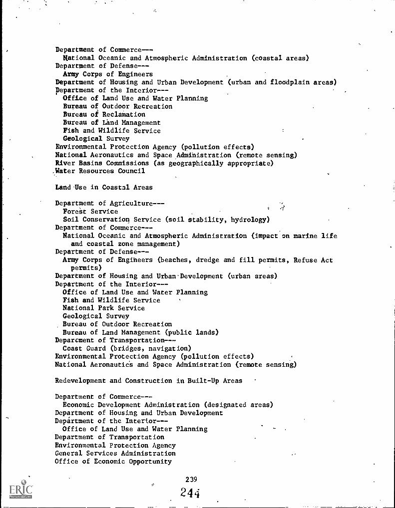
Department of Commerce-- -
National Oceanic and Atmospheric Administration (coastal areas)Department of Defense-- -
Army Corps of EngineersDepartment of Housing and Urban Development (urban and floodplain areas)Department of the Interior--Office of Land Use and Water PlanningBureau of Outdoor RecreationBureau of ReclainationBureau of Land ManagementFish and Wildlife ServiceGeological Survey
Environmental Protection Agency (pollution effects)National Aeronautics and Space,Admihistration (remote sensing)River Basins Commissions (as geographically appropriate)-Water Resources Council
LandUse in Coastal Areas
Department of Agriculture---ForeSt ServiceSoil Conservation Service (soil stability, hydrology)
Department of Commerce-- -National Oceanic and Atmospheric Administration (impact on marine life
and coastal zone management)Department of Defense--Army Corps of Engiheers (beaches, dredge and fill permits, Refuse Act
permits)Department of Housing and Urban. Development (urban areas)Department of the Interior-- -Office of Land Use and Water PlanningFish and Wildlife ServiceNational Park ServiceGeological SurveyBureau of Outdoor RecreationBureau of Land Management (public lands)
Deparcment of Transportation- --Coast Guard (bridges, navigation)
Environmental Protection Agency (pollution effects)National AeronauticS and Space Administration (remote sensing)
Redevelopment and Construction in Built-Up Areas
Department of Commerce--Economic Development Administration (designated areas)
Department of Housing and Urban DevelopmentDepartment of the Interior-- -Office of Land Use and Water Planning
Department of TransportationEnvironmental Protection AgencyGeneral Services AdministrationOffice of Economic Opportunity
239
244

Density and Congestion Mitigation
Department of Health, Education, and WelfareDepartment of Hoysing and Urban DevelopmentDepartment of the Interior-- -
Office of Land Use'and PlanningBureau of"Outdoor Recreation
Department of TransportationEnvironmental Protection Agency
Neighborhood Character and Continuity
DeiSartment of Health, Education, and WelfareDepartment of Housing and Urban DevelopmentNational Endowment for the ArtsOffice of Economic Opportunity
Impacts on Low-Income Populations. -
Department of Commerce-- -Economic Development Administration (designated areas)
Department of Health, Education, and WelfareDepartment of Housing and Urban DevelopmentOffice of Economic Opportunity
Historic, Architectural, and'Archeological Preservation
Advisory Councilon Historic PreservationDepartment of Housing and Urban Development.Department of the Interior
National Park ServiceBureau of Land Management (public lands)Bureau of Indian Affairs (Indian lands)
General Services AdministrationNational Endowment for the Arts
Soirand Plant Conservation and Hydrology
Department of Agriculture-- -Soil Conservation ServiceAgricultural ServiceForest Seriice
Department of Commerce-- -National Oceanic and Atmospheric Administration
Department of Defense--AxmyCorps of Engineers (dredging, aquatic plants)
Department\of Health, Education, and WelfareDepartinent of the Interior--
of Land ManagementFish and Wildlife ServiceGeolosical SurveyBureau of Reclamation
240
245

Environmental Protection AgencyNational Aeronautics and Space Administration (remote sensing)River Basin Commissions (as geographically appropriate)Water Resources Council
Outdoor Recreation
Department of Agriculture-- -Forest ServiceSoil Conservation Service
Department of Defense-- -Army Corps of Engineers
Department of Housing and Urban Development (urban areas)Department of the'Interior---Bureau of Land ManagementNational Park ServiceBureau of Outdoor RecreationBureau of Indian AffairsFish and Wildlife Service
Environmental Protection AgencyNational Aeronautics and-Space Administration (remote sensing)River:Basin Commissions (as geographically appropriate)Water Resources Council
241
246

Appendix C
Types of Data for Land Use Studies*
After a student survey has been selected and the objectives are clearlydefined, the ne,:t step is to apply the available data. In almost allsurveys, maps are required for land use studies involving remotely senseddata.
In general, two types of maps are mandatory -- U.S. Geological Survey Mapsand aerial photographs. For surveys to be conducted within the boundaryof a city, a current "gas_station"city map will add information. For largesurveys, a.current "gas station" state map may be helpful. Sometimesspecial survey maps, such as Corps of Engineers plans or Bureau of Reclama-tion plans, are necessary.
,
U.S. Geological Survey mapsor from some sporting goodscenter can be obtained from"United States Government." !
expect are given below.
are available from any regional federal centerstores. The address of the nearest federalthe telephone directory listing entitledMore details on what to order and what to
Other types of data include direct observations of features re-corded in
photographs or in notebooks; measurements made in the field by means ofsurveyors tools such as measuring tape:" levels, and transits; or dataobtained by "remote sensors.",
In this publication, the term "remote sensor" is applied to systems thatrecord information from above the ground by, instruments in aircraft or inSpacecraft, i.e., the camera, an altimeter, or a spectrometer. Thesedata are available as photographic images or as electronic information onmagnetic tape.
Three general methods are or have been used to obtain remotely sensed datagathered from above the surface of the Earth--by aircraft, by earth re-sources satellites, and by NASA's Skylab spacecraft. The Space Shuttle,scheduled for launch in the late 1970's will also obtain remote sensordata.
4
Aerial photographs of all areas of the United States are available in severaldifferent forms. Aerial photographs have been taken from altitudes of12,000 to 25,000 feet of areas,from about 4.5 miles square to 9 miles sqUarerespectively. The classical application of data obtained by aircraft isfor map-making. The information is generally obtained as photographs thatare used to update existing maps, to make new maps of unmapped areas, andto provide accurate contour information through analysis of stereo photo-graphs (see Why Survey From Space, NASA Facts NF-57/1-75).
Aerial photographs are available from the U.S. Geological Survey Photo-Mapping Service, the U.S. Department of Agriculture, NASA and from theNational Oceanic and Atmospheric Administration.
*Reprinted with slight modification from: Jefferson County, ColoradoPublic Schools, What's the Use of Land?, pp. 31-4.
242.
Z4

Remote sensor information is provided by ERTS-1, the first Earth ResourcesTechnology Satellite, that was launched by NASA in July 1972 and is stillproviding information to the ground.
ERTS-1 orbits the Earth at an altitude of about 920 kilometers (570 miles)in an orbit that passes close to the North and South Poles. This was thefirst of a series of satellites with the primary purpose of demonstratingthe usefulness of remote sensor'data in the study of surface conditionsof the Earth. This unmanned satellite completes one complete cycle ofscanning the Earth's surface every 18 days. Information obtained by instru-ments scanning a 185-kilometer (115-mile) square area is transmitted to theground electronically and converted to photographic images in four differentwavebands: two in the visible light frequency and two in infrared.
When the second satellite in this series was launched in January 1975,the program name was changed to LANDSAT. ERTS-1 became LANDSAT 1 and thenew satellite is LANDSAT 2, which has design life of two years. A thirdLANDSAT launch is planned for 1977.
Remotely sensed data were obtained from Skylab in three manned missionsfrom May 1973, to February 1974. Earth resource data were obtained asphotographs and as electronically produced images. Some areas were photo-graphed at the same time by two camera systems. One was a combination ofcameras that produced photographs in six different wavebands--three in thevisible and three in infrared--all obtained at exactly the same time.The other was a high, resolution camera that obtained photographs in either-the visible or infrared wavelengths. Electronic data were obtained foraltimeter applications, for determining surface brightness temperature,and for recording the reflected radiance of the Earth's surface in many/different wavebands. Observing Earth From Skylab (NF-56/1-75) containsmore information on these instruments and the data they obtained.
Where to Obtain Remotely Sensed Data
The following-paragraphs give detailedinformation on the types of dataavailable from different sources and show how to obtain it.
1. EARTH RESOURCES OBSERVATION SYSTEM (EROS)
Earth resource data can be obtained by writing to the EROS Data Center,a division of the Department of the Interior. The address is:
EROSData Management CenterSioux Falls, South Dakota 57190
The EROS Data Center, will assistsuit the particular needs of theand retrieval system is based onlongitude), the date and time ofthe scale of the photographs.
in locating imagery and photography touser. The center's computerized storagegeographical coordinates (latitude andday the photographs were obtained, and
243
243

The requestor may provide the center with the latitude and longitude ofthe point of interest, or may define an area by giving latitude and longi-tude of a maximum of eight perimeter points. On receipt of a request thecenter staff will locate the area of interest and will prepare a listingof photographs from which the requestor can make the final selection.
EROS stocks Skylab photographs_inyour.study, it is possible to helpEROS speed up your order by quoting the specific photograph numbers ofthe scene you need. You can write to the following address for help.
Lyndon B. Johnson Space CenterResearch Data FacilityMail Code TF-8Houston, Texas
Include the names of rominent features in the area. City names, rivers,and mountains should b included as well as latitude and longitude.Res arch Data Facility personnel will check through their catalogs andpro 3de you with photograph identification numbers that you can send toEROS to obtain the copies\you need.
At the time of writing the prices of EROS photographs are:
ERTS/LANDSAT
PaperPrints Scale
Black&White Color
Area ofPhotograph
70 mm square 1:3,369,000 $1.25 -- 149 mi sq
9x9 in. 1:1,100,000 $1.25 $ 7.00 140 mi sq
13x18 in. 1: 500,000 $3.50 $15.00 140 mi sq
36x36 in. 1: 250,000 $9.00 $25.00 140 mi sq
Film positives are available at two to three times the above costs.
SKYLAB
Image
SizePrintPrice
Black & White
Transparency Scale
Area ofPhotograph
2.2 in. sq $2.00 ' 1:2,850,000 100 mi sq
6.4 in. sq $ 2.00 -- 1:1,000,000 100\mi sq
12.8 in. sq $ 5.00 -- 1: 250,000 100 mi sq
25.6 in. sq $12.00 -- 1: 250,000 100 mi sq
244
24:)

Color reproductions cost about three times as much as black and white,For more details write to EROS at Sioux Falls, South Dakota.
Another outlet for EROS services is located in Bay St. Louis, Mississippi.At the National Space Technology Laboratories, anyone can obtain a widevariety of Earth resources information and order photographs by writing tothe following address:
National Space Technology LaboratoriesBay St. Louis, Mississippi 37520
2. U.S. GEOLOGICAL SURVEY
U.S. Geological Survey (USGS) maps are available from any regional FederalCenter,and from certain commercial stores such as sporting goods stores.The nearest address should be listed in the telephone book under "UnitedStates Government--U.S. Geological Survey."
The most common USGS maps are of an area 7 1/2 minutes square or 15 minutessquare--that is, 7 1/2 or 15 minutes of latitude and 7 1/2 or 15 minutesof longitude. The scales of these maps are 1:24,000 and 1:62,500 respec-tively. Both are sold for 75 cents each at the time of writing.
Other maps are available. Check with the USGS office for more details.
3. SKYLAB EARTH RESOURCES DATA CATALOG
The Skylab Earth Resources Data Catalog (GPO-3300-00586), prepared byNASA, provides a complete index of Skylab earth resources photographs andother data, plus direction on how copies can be obtained. It also providesa discipline- by-discipline review of possible uses of the Skylab photographsand data with appropriate illustrations. It is intended as a basic referencework, or tool, for farmers, scientists, engineers, students, mineral devel-opers, or anybody else who has a specific need to obtain, interpret, and useremotely sensed information.
The catalog is divided into six major subject areas:
1) Land resource management--This term encompasses familiar issues ofpublic policy related to such matters as population growth, economicdevelopment, land use, depletion of natural resources, urban planning,transportation, and environmental impact. To meet dynamic mapping andmonitoring requirements, satellite data are currently being used byseven states (Alabama, Alaska, Arizona, California, Iowa, New York,and Ohio) and three interstate planning agencies in the Midwest, NewEngland, and the Middle Atlantic regions.
2) Water resources--Skylab and other space data are well suited to:exploring for new sources of water; making inventory of existing watersupplies in lakes, reservoirs, rivers, and snowfields; and assessingwater quality in terms of turbidity, sedimentation, and temperature
(by thermal scanning). Depths of shallow bodies of water can also be

estimated with some precision. Space observation can establish thearea of a watershed and facilitate study of stream channels in relationto an entire drainage system, runoff patterns, and possibility of flood-
.
ing. River ice,' crucial to transportation and flood prediction in someparts of the country, can be watched. Coastal lands, estuaries, andwet-lands--with their ecological as well as economic significance--can be delineated for analysis..
a) Marine resources--From seeking to establish patterns of movement ofschools of fish to measuring degrees of roughness of the open-sea,Skylab data have increased our knowledge of the world's oceans andhelped point to operational marine satellite systems. Better weatherforecasts and charts of ocean currents and ice conditions are expectedas direct results. To measure oceanic roughness or sea state, amatter of vast practical importance to shippers, Skylab successfullytested a combination of instruments (radar scatterometer, microwaveradiometer, and altimeter) that provided oceanwide readings startingat small-scale roughness. Channels, shallow areas, river dischargesof sediment, and other features of waterways often show up better fromspace than by any other means.
4) Geology and mineral resources--Obviously, space photography and dataacquisition are made to order for geologic investigators in every facetof their work from theory to actual mineral prospecting. In exploringfor minerals and hydrocarbons, the cost per mile of space coverage islower than for any other method. Major mineral exploration organize-tionshave been working with Skylab and LANDSAT 1 data while incorpo-rating use of space data in plans for the future. Space sensing, itis pointed out, should be seen as, one basic step in the overall pro-specting program. After reviewing satellite data, mineral explorationtarget maps can be constructed with a rating system to indicate therelative likelihood of deposits in each target area. Decisions onfurther exploration--such as aircraft remote sensing, seismic profiling,geochemical analysis, ,or field testing--can then be made with a fargreater chance of success.
5) Agriculture, forest, and range resources--Survey of the world's ricecrops and battling Black Hills beetles are only the beginning in thesefields. Potential space applications are enormous: crop and timberinventories, yield estimates, comparative analyses of crops, detectionof diseases or insect infestations of vegetation, reconnaissance forpotential logging operations, location and mapping of forest and rangefire damage, determination of animal-sustaining capacity of range forage,and multiple use planning for forest and range lands. Skylab andLANDSAT 1 data and experience have made major contributions, and noware pointing the way to further hardware and techniques.
6) Environment--In a broad sense, all Skylab effort deals with man'senvironment. The data also proved particularly useful regarding spe-cific environmental problems. Sources of water and air pollution oftencan be located and the spread of contaminants traced for long distances
246
251

in a single photograph. Looking ahead, Skylab demonstrates the advan-tages of an Earth resources package, including both high resolutioncameras and electronic sensors, complementing each other's capabilitiesto perform a four-part environmentalNpission in space: detection,determination of source and extent, direction of aircraft surveysand extent, direction of aircraft surveys and ground measurements, andmonitoring changes.
The Skylab Earth Resources Data Catalog is obtainable from the Super-intendent of Documents, U.S. Government Printing Office, Washington, D.C.20402 (Price $12.50). The book-number is GPO-3300-00586.
4) AGRICULTURAL STABILIZATION AND CONSERVATION SERVICE (ASCS)
Three different types of Earth resource data are available from the U.S.Department of Agriculture ASCS--ERTS/LANDSAT data, Skylab data, and aerialphotography.
The ERTS/LANDSAT and Skylab data can be ordered from ASCS in a similarmanner and similar cost as from EROS. The aerial photographs can be orderedby state and county, and by symbol, roll, and exposure number as listedin the state ASCS office. These photographs can be ordered from eitherthe Eastern or Western ASCS offices. The addresses are listed below:
Eastern Aerial Photography LaboratoryASCS - USDA45 South French Broad AvenueAshville, North Carolina 28801
Western Aerial Photography LaboratoryASCS - USDA2505 Parley's WaySalt Lake'City, Utah 84109
If the state ASCS office is not convenient, either laboratory above. willassist in identifying the numbers of the desired photographs. Typical costsof the photographs are:
Size of PrintsApproximate
ScaleCost of
Paper PrintsCost of FilmPositives
911x9li in. 1:20,000 $ 2.00 $3.00(1 in. = 1667 ft) ,
12x12 in. 1:15,840 $ 4.00 $4.50(1 in.= 1320 ft)
17x17 in. 1:12,000 $ 5.00 $5.50(1 in. = 1000 ft)
24x24 in. 1:7920 $ 6.00 $7.50(1 in.= 660 ft)
38x38 in. 1:4800 $12.00 $6.00(1 in. = 400 ft)
247252

5. FOREST SERVICE
The Forest Service, a division of the U.S. Department of Agriculture canprovide aerial photographs of numerous locations in the United States.Black and white, or color prints' can be obtained of.scenes photographed invisible light or infrared wavelengths. The prints are in a range of scales,predominantly 1:15,840 and 1:80,000.
Requests should be sent to the Regional Forester in your area. Theaddress should be listed in the telephone book under "United States Govern-ment--U.S. Department of Agriculture." Alternatively you can write to:The Forest Service, U.S. Department of Agriculture;.Washinitofi; D.C. 20250.
248
253
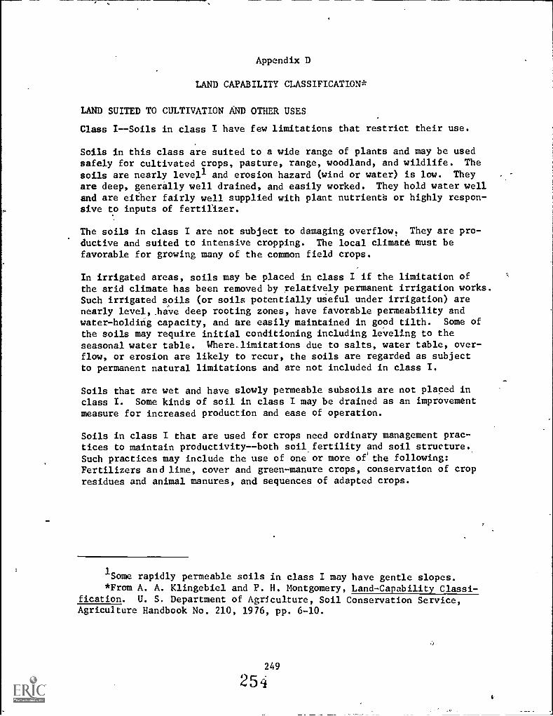
Appendix D
LAND CAPABILITY CLASSIFICATION*
LAND SUITED TO CULTIVATION AND OTHER USES
Class I--Soils in class I have few limitations that restrict their use.
Soils in this class are suited to a wide range of plants and may be usedsafely for cultivated crops, pasture, range, woodland, and wildlife. The
soils are nearly levell and erosion hazard (wind or water) is low. They
are deep, generally well drained, and easily worked. They hold water welland are either fairly well supplied with plant nutrients or highly respon-sive to inputs of fertilizer.
The soils in class I are not subject to damaging overflow. They are pro-
ductive and suited to intensive cropping. The local climate must befavorable for growing many of the common field crops.
In irrigated areas, soils may be placed in class I if the limitation ofthe arid climate has been removed by relatively permanent irrigation works.Such irrigated soils (or soils potentially useful under irrigation) arenearly level, have deep rooting zones, have favorable permeability andwater-holding capacity, and are easily maintained in good tilth. Some of
the soils may require initial conditioning including leveling to theseasonal water table. Where,limitations due to salts, water table, over-flow, or erosion are likely to recur, the soils are regarded as subjectto permanent natural limitations and are not included in class I.
Soils that are wet and have slowly permeable subsoils are not placed inclass I. Some kinds of soil in class I may be drained as an improvementmeasure for increased production and ease of operation.
Soils in class I that are used for crops need ordinary management prac-tices to maintain productivity--both soil fertility and soil structure.Such practices may include the use of one or more oe the following:Fertilizers and lime, cover and green-manure crops, conservation of cropresidues and animal manures, and sequences of adapted crops.
1Some rapidly permeable soils in class I may have gentle slopes.
*From A. A. Klingebiel and P. H. Montgomery, Land-Capability Classi-fication. U. S. Department of Agriculture, Soil Conservation Service,Agriculture Handbook No. 210, 1976, pp. 6-10.
249
254

Class II--Soils in class II have some limitations that reduce the choiceof plants or require moderate conservation practices.
Soils in class II require careful soil management, including conservationpractices, to prevent deterioration or to improve air and water relationswhen the soils are cultivated. The. limitations are few and the practicesare easy to apply. The soils may be used for cultivated crops, pasture,range, woodland, or wildlife food and cover.
Limitations of sbils in class II may include singly or in combination theeffects of (1) gentle slopes, (2) moderate susceptibility to wind or watererosion or moderate adverse effects of past erosion, (3) less than idealsoil depth, (4) somewhat unfavorable soil structure and workability, (5)slight to moderate salinity or sodium easily corrected but likely to recur,(6) occasional damaging overflow, (7) wetness correctable by drainage butexisting permanently as a moderate limitation, and (8) slight climaticlimitations on soil use and management.
The soils in this class provide the farm operator less latitude in the choiceof either crops or management practices than soils in class I. They mayalso require special soil-conserving cropping systems, soil conservationpractices, water-control devices, or tilage methods when used for cultivatedcrops. For example, deep soils of this class with gentle slopes subjectto moderate erosion when cultivated may need one of thl following practicesor some combination of two or more: Terracing, striperopping, contourtillage, crop rotations that include grasses and legumes, vegetated water -disposaP areas, cover or green-manure crops, stubble mulching, fertilizers,manure,and lime. The exact combinations of practices vary from placeto place, depending on the characteristics of the soil, the lJcal climate,and the farming system.
Class III--Soils in class III have severe limitations that reduce thechoice of plants or require special conservation practices, orboth.
Soils in class III have more restrictions than those in class II and whenused for cultivated crops the conservation practices are usually more diffi-cult to apply and to maintain. The' may be used for cultivated crops,pasture, woodland, range, or wildlife food and cover.
Limitations of soils in class III restrict the amount of clean cultivation;timing of planting, tillage, and harvesting; choice of crops; or somecombination of these limitations. The limitations may result from theeffects of one or more of the following: (1) Moderately steep slopes;(2) high susceptibility to water or wind erosion or severe adverSe effectsof past erosion; (3) frequent overflow accompanied by some crop damage;(4) very slow permeability of the subsoil; (5) wetness or some continuingwaterlogging after drainage; (6) shallow depths to bedrock, hardpan,fragipan, or claypan that limit the rooting zone and the water storage;(7) low moisture-holding capacity; (8) low fertility not easily corrected;(9) moderate salinity or sodium; or (10) moderate climatic limitations.
250
0Or4,0

When cultivated, many of the wet, slowly permeable but nearly level soilsin class III require drainage and a cropping syitem that maintains orimproves the Structure and tilth of the soil. To prevent puddling andto improve permeability it is commonly necessary to supply organic materialto such soils and to avoid working them when they are wet. In some irri-gated areas, part of the soils in class III have limited use because of highwater table; slow permeability, and the hazard of salt or sodic accumula-tion. Each distinctive kind of soil in class III has one or more alterna-tive combinations of use and practices required for safe use, but thenumber of practical alternatives for average farmers is less than that forsoils in class II.
Class IV--Soils in class IV have very severe limitations that restrictthe choice of plants, require very careful management of both.
The restrictions in use for soils in class IV are greiter than those in (class III and the choice of plants is more limited. When these soils arecultivated; more careful management is required and conservation practicesare more difficult to apply and maintain. Soils in class IV may be usedfor crops, pasture, woodland, range, or wildlife food and cover.
Soils in class IV may be well suited to only two or three of the commoncrops or the harvest produced may be low in relation to inputs over along period of time. Use for cultivated crops is limited'as a resultof the effects of one or more permanent features such as (1) steep slopes,(2) severe susceptibility to water or wind erosion, (3) severe effects ofpast erosion, (4) shallow soils, (5) low moisture-holding capacity, (6)frequent overflows accompanied by severe crop damage, (7) excessive wetnesswith continuing hazard of waterlogging after drainage, (8) severe salipityor sodium, or (9) moderately adverse climate.
Many sloping soils in class IV in humid areas are suited to occasionalbut not regular cultivation. Some of the poorly drained, nearly levelsoils placed in class IV are not subject to erosion but are poorly suitedto intertilled crops because of the time required for the soil to dry outin the spring and because of low productivity for cultivated crops. Somesoils in class IV are well suited to one or more of the special crops,such as fruits and ornamental trees and shrubs, but this suitability it,
lself is not sufficient to place a soil in class IV.
In subhumid and semiarid areas, soils in class IV may produce good yieldsof adapted cultivated crops during years of above average rainfall; lowyields during years of average rainfall; and failures during years ofbelow average rainfall. . During the low rainfall years the soil must bepiotected even though there can be little or no expectancy of a marketablecrop. Special treatments and practices to prevent soil blowing, conservemoisture, and maintain soil productivity are required. Sometimes cropsmust be planted or emergency tillage used for the primary purpose ofmaintaining the soil during years of low rainfall. These treatments' must
be applied more frequently or more intensively than on soils in class III.
256256

LAND LIMITED IN USE -- GENERALLY NOT SUITED TO CULTIVATION*
Class V--Soils in class V have little or no erosion hazard,but have otherlimitations impractical to remove that limit their use largelyto pasture, range, woodland, or wildlife food and cover.
Soils in class V have limitations that restrict the kind of plants thatcan be grown and that prevent normal tillage of cultivated crops. They arenearly level but some are wet, are frequently overflowed by streams arestony, have climatic limitations, or have some combination of these limita-tions. Examples of class V are (1) soils of the bottoth lands subject tofrequent overflow that prevents the normal production of cultivated crops,(2) nearly level soils with a growing season that prevents the normal pro-duction of cultivated crops, (3) level or nearly level stony or rockysoils, and (4) ponded areas where drainage for cultivated crops is notfeasible but where soils are suitable for grasses or trees. Because ofthese limitations cultivation of the common crops is not feasible butpastures can be improved and benefits from proper management can be ex-pected.
Class VI--Soils in class VI have severe limitations that make them generallyunsuited to cultivation and limit their use largely to pastureor range, woodland, or wildlife food and cover.
Physical conditions: -of soils placed in class VI are such that it is prac-tical to apply range or pasture improvements, if needed, such as seeding,liming, fertilizing, and water control with contour furrows, drainageditches, diversions,_or water spreaders. Soils in class VI have continuinglimitations that cannot be corrected, such as (1) steep slope, (2) severeerosion hazard, (3) effects of past erosion, (4) stoniness, (51 shallowrooting zone, (6) excessive wetness or overflow, (7) low moisture capacity,(8) salinity or sodium, or (9) severe climate. Because of one or more ofthese limitations these soi;.s are not generally suited to cultivated crops.But they ma:" be used for pasture, range, woodland, or wildlife cover orfor some combination of these.
Some soils in class VI can be safely used for the common crops providedunusually intensive management is used. Some of the soils in this classare also adapted to special crops such as sodded orchards, blueberries,e, the like, requiring soil conditions unlike those demanded by the commoncrops.. Depending upon soil features and local climate the soils maybe well or poorly suited to woodlands.
*Certain soils grouped into classes V, VI, VII, and VIII may bemade fit for use for crops with major earthmoving or other costly reclama-tion.
252
257

Class VII--Soils in class VII have very severe limitations that make themunsuited to cultivation and that restrict their use largely tograzing, woodlands or wildlife.
Physical conditions of soils in class VII are such that it is impracticalto apply such pasture or range improvements as seeding, liming, fertilizing,and water control with contour furrows, ditches, diversions, or waterspreaders. Soil restrictions'are more severe than those in class VIbecause of one or more continuing limitations that cannot be corrected,such as (1) very steep slopes, (2) erosion, (3) shallOw soil, (4) stones,(5) wet soil; (6) salts or sodium, (7) unfavorable climate, or (8) otherlimitations that make them unsuited to common cultivated crops. They canbe used safely for grazing or woodland or wildlife food and cover or forsome combination of these under proper management.
Depending upon the soil characteristics and local climate, soils in thisclass may be well or poorly suited to woodland. They are not suited toany of the common cultivated crops; in unusual:instances, some soils inthis class may be used for special crops under unusual management prac-tices. Some areas of class VII may need seeding or planting to protectthe soil and-to prevent damage to adjoining areas.
Class VIII--Soils and landforms in Class VIII have limitations which pre-clude their use for commercial plant production and restricttheir use to recreation, wildlife, or water sipply or to estheticpurposes.
Soils and landforms in class VIII cannot be expected to return significanton-site benefits from management for crops, grasses, or trees, althoughbenefits from wildlife use, watershed protection, or recreation may bepossible.
Limitations that cannot be corrected may result from the effects of oneor more of the following: (1) Erosion or erosion hazard, (2) severe cli-mate, (3) wet soil, (4) stones, (5) low moisture capacity, and (6) salinityor sodium.
. .
Badlands, rock outcrop, sandy beaches, river wash, mine tailings, andother nearly barren lands are included in class VIII. It may be necessaryto give protection and management for plant growth to soils and landformsin class VIII in order to protect other more valuable soils, to controlwater, or for wildlife or esthetic reasons.
253
256

. 2
. ..e
CLASS VII LAND
4..........404.,7
CLASS VII LAND
CLASS VIfl L
CLASS VI LAND
CL: all LAND s;?.
4.
r," ....,..e.".
es.- ; z
.
,,,,,,II
A.Z7A S S L A.
,
I,
:t\i ::7-7:77". ".'.e, * '1/4 -
", fo CL Y L AN .
,
;.r -..,CLASS I LAND.
.
.S.
; Z ,, 1. " . It 1 el , . 1..; ..:" A r. : i ..:: . fr. "-.%, _, -
.0;7* 44 .(..
4 '''s .x...4, .7...:4...... .. 4,. . Is:',... "'.. '''. ...r..... .....,: ... 4 ....`e 014''''' ..."'.' .....' .7:4'. -41i414.:i4....1A:"\'' "."..`.4" .>"..
' . 1..4... ..
a 7 _t .../q ....ff ^ .* 1.0- . S... S. - . , - '''' .,,,,,' .-Y 5 4:...0 r-. ,, .. f: ,i, '. r . , ,,...i ,,,:. -. . i s- 1,7* .....% 41.4.7,,,,r21thr..). . -a. 4;1°4 Nan, i. -.... (7.1, ir.n ,?... -- 'so: ,, .
.4 . ':s 4N. ". 4, 4 . . ,111.- - A ,,,,,,, .: N e,...,..:-7- .4. t 44.. ' 40. ,.. ...
7...... .. r ... ... .. ,..,,
.,.. ,,c.... ...44 ..
...4,, '.' .
. t. ...I Nit; ..: .., ., ... ... k "N. ' .` "."" . 4..4..:"'",-r.-,)'''''''''t 4. 46' 14.'1. ..."/ tv.,...... :1414 4,.........L.L1 7binr.a...:.:: ,I...',....f.,,:7.11......4,,'":.".....:.......14,:::TI:.1.....4...)".
.` .. . . ..,,,,'-? .,..,. IA: 4 .....'11 1"
P.4S11V .1 7. ...".4.s.94t1
.4'1.7:
'16.
.. . -........- r,,"..:.,..," It 't....
..
4 -.' * . -...b.et-r...; .1--;Je.. ..
s, . lit.. 0
.... ... .4 r a /, 40 ..1 lit., Ir 8."...:.:;\ 4 +.' ift":-.. \.... ..,...T. ... ''''' i .e S.
- t d- 1.-
-. - ., , . ' 7.4? ,I. ,....4-1.4-4. - Pt - .....*.t . .. ..t....-. 1.(,,, 4,.: ..glir. 7--- `' '... "..A- :::-::s::::.
4,.. ' . -
Tr- 1 * . W V....1 )..
r...... .6 , . L.',. ....6.464. fl. Ogre ',' e 7.*
-
.,.... .; ' 4 . 7 .- .1 ..1:"...' .'! C LASS ill -L. A i'l. r)" i- . ., :,, - -ei: ;`..."Zr*- I, < , .4 . / '''' Otr ' .7
7,.. 41/7 , ' : ... . ... .r 4 t. .. ..e 4 ...
-.4. . "'", -- . ,.
. . , ,. _ _ . _ ....... ..... 4..
..r. it -IP , .' ''''t.%, 4 . 4 4. :
....--:
- .,-.4, "6.
251
-a
. `260
4. - /.. ....ay.,

REFERENCES
All Around You An Environmental Study Guide. Bureau of Land Manage-ment, United States Department of Interior, March, 1973. (Bulkorders available from Superintendent of Documents, U.S. Govern-
, ment Printing Office, Washington, D.C. Stock No. 2411-00043.)ED 083 117.
Annual Reports of the Council on Environmental Quality, The
The First Annual Report, 1970.
The Second Annual Report, 1971, USGPO Stock Number 4111-0005The Third Annual Report, 1972, USGPO Stock Number 4111-0011The Fourth Annual Report, 1973, USGPO Stock Number 4111-00020The Fifth Annual Report, 1974, USGPO Stock Number 4000-00327The Sixth Annual Report, 1975, USGPO Stock Number 040-000-00337-1The Seventh Annual Report, 1976, USGPO Stock Number 041-010-00031-2
Bennett, Dean B. and Willink, Wesley H. Grade Three EnvironmentalEducation Teacher's Guide: The Neighborhood. Yarmouth, MaineSchool Department, 1975. Title III, ESEA, ED 121 568.
Bennett, Dean B. and Willink, Wesley H. Junior High'School Environ-mental Education Teacher's Guide: The Human. Environment.Yarmouth, Maine School Department, 1975. Title III, ESEA,ED 121 567.
Bosselman, Fied and Callies, David. The Quiet Revolution in Land UseControl. Prepared for the Council on Environmental Quality.Washington, D.C.: U.S. Government Printing Office, 1971, StockNumber 4111-0006.
Citizen's Guide to Information on Land Use Decision Making, A. NewHaven, Connecticut: Area Cooperative Extension Service, 1975.ED 133 207.
Clark, Richard C. (Project Director). "Environmental Values ActionCards." Minnesota Department of Education, 1976.
Coastal Wetlands. New Haven, Connecticut: Area Cooperative EducationServices, 1975. ED 133 220.
Conserving Our Natural Resources: A 4-11 Reader's Guide. FederalExtension Service, Forest Service, and Soil ConservationService, U.S. Department of Agriculture.
Cowen, William F., Jr. Extension Forester, The Ohio State University,Columbus, Ohio.
Cranston and Warwick, Rhode Island, Public Schools. Marine and Environ-mental Studies Manual. September, 1973. Title III, ESEA, SE 022700.
255
261

Dasmann, Raymond F. Environmental Conservation. New York: John Wileyand Sons, Inc., 1968.
Digest of Public Land Laws. Prepared for the Public Land Law ReviewCommission by,Shepard's Citations, Inc. Washington, D.C.: U.S.Government Printing Office, 1968.
Environmental Education Curriculum Infusion Units. Albany, New York:General Education and Curriculum Services. ED 137 056.
Environmental Syllabus: Grades 10, 11,12, An. Albany, New York: NewYork State Education Department. ED 139 671.
Exploring The World of Plants and Soils: Unit II-B; Soils. National4-H Plant and Soil Science Program Development Committee.
Fielder, Erica and Shaffer, Carolyn. Ecology For City Kids. SanFrancisco, California: San Francisco Ecology Center, 13 ColumbusAvenue, 94111.
Flood-Prone Areas and Land-Use-Planning. Selected examples from theSan Francisco Bay Region, California, Geological Survey Profes-sional Paper 942. Washington, D.C.: U.S. Government PrintingOffice, 1977.
Foster, Albert B. and Fox, Adrian C. Teaching Soil and Water Conserva-tion: A Classroom and Field Guide. U.S. Department of Agriculture,Soil Conservation Service, August, 1970. ED 067 218.
Fox, Charles E. Activities for5 thru 9. Forest Service,1958.
Fox, Charles E. Activities for70 thru 2nd Year College.Agriculture, June, 1958.
Teaching Forest Conservation: GradesU.S. Department of Agriculture, January,
Teaching Forest Conservation: GradesForest Service, U.S. Department of
Fox, Charles E. Conservation Activities for Young People. ForestService, U.S. Department of Agriculture, March, 1969. SE 010 359.
Gail, Peter A., et al. A Curriculum Activities Guide to WatershedInterpretation and Environmental Studies. New Jersey: SouthBrunswick'Board of Education, 1974. ED 104 651.
Garlasco, Chris; Dauchy, Chuck; and Shaefer, Larry. Geosystems. NewHaven, Connecticut: Area Cooperative Educational Services, 1975.ED 133 210.
Garlasco, Chris; Haakonsen, Harry; and Shaefer, Larry. LocalImplementation. New Haven, Connecticut: Area CooperativeEducational Services, 1975. ED 133 216.
256,
262L
0

Pyles, Hamilton K. What's Ahead for Our Public Lands? A Summary Reviewof the Activities and Final Report of the Public Land Law ReviewCommission, compiled for the Natural Resources Council of America.Washington, D.C.: Natural Resources Council of America, 1970.
o
Handbook of Environmental Encounters, A. Oregon Department of Education,Instruction Division. ED 113 151.
Healy, Robert G. Land Use and the States. Baltimore: Johns HopkinsUniversity Press, for Resources for the Future, 1976, 233 pages.
How Will America Grow?: A Citizen Guide To Land-Use Planning. Washing-ton,D.C.: Citizens' Advisory Committee on Environmental Quality,1700 Pennsylvania Avenue, N.W 20006, April, 1976.
Inland Wetlands. New Haven, Connecticut: Area Cooperative EducationalService, 1975. ED 133 219.
Jamason, Barry W. Environmental Quality: A Community Concern. Albany,New York: New York State Department of Education.
Junglas, Mary, et al. Environmental Learning Experiences: Bio-Physical;Junior High School. Willoughby, Ohio: Center for the Developmentof Environmental Curriculum, Willoughby-Eastlake Schools, 1974,Title III, ESEA. ED 099 229.
Junglas, Mary, et al. Environmental Learning Experiences: Bio-Physical;Senior High School. Willoughby, Ohio: Center for the. Developmentof Environmental Curriculum, Willoughby-Eastlake City Schools, 1974,Title III, ESEA. ED 099 230.
Junglas, Mary, et al. Environmental Learning Experiences: Social-Cultural; Junior High School. Willoughby, Ohio: Center for theDevelopment of Environmental Curriculum, Willoughby-Eastlake CitySchools, 1974, Title III, ESEA. ED 099 231.
Junglas, Mary, et al. Environmental Learning Experiences: Social-Cultural] Senior High School. Willoughby, Ohio: Center for theDevelopment of Environmental Curriculum, Willoughby-Eastlake CitySchools, 1974, Title III, ESEA. ED 099 232.
Kohuth, Barbara J. and Marsh, Boyd T. An Educational Guide for PlanningAn Improved Human Environment. Hudson, Ohio: Inner Circle Press,Inc., 1974. SE 022 539.
Land: The Yearbook of Agriculture, 1958. Washington, D.C.: The U.S.Department of Agriculture, 1958.
Land Use: Tough Choices In Today's World. Proceedings of a NationalSymposium.., Ankeny, Iowa: Soil Conservation Society of America,7515 Northeast Ankeny Road, 50021, 1977.
26:3257
Leopold, Luna B.; Clarke, Frank E'.; Hanshaw, Bruce B.-; and Balsey,James R. A Procedure for Evaluating Environmental Impact.Washington, D.C.: U.S. Geological Survey Circular 645, 1971.
National Land Use Policy: Objectives, Components, Implementation.The proceedings of a special conference sponsored by the SoilConservation Society of America, November 27-29, 1972, in DesMoines, Iowa. Ankeny, Iowa: Soil Conservation Society ofAmerica, 1973.
111 Significant Federal Laws Concerning Natural Resources and Environ-ment and the Creation of Federal Agencies. Columbus, Ohio: TheOhio State University, School of Natural Resources, 1974.
Operation Survival Through Environmental Education: Senior High, Idea/Land Manual. Grafton, Illinois: Environmental Education Project,Title III, ESEA. SE 014 502.
Place To Live, A: The Yearbook of Agriculture 1963. Washington, D.C.:U.S. Government Printing Office, 1963.
Pressman, Robert. Synthesis: Part I: Buildability. New Haven,Connecticut: Area Cooperative Educational Services, 1975,ED 133 211.
Pressman, Robert. Synthesis: Part II: Land Use Attractiveness. NewHaven, Connecticut: Area Cooperative Educational Services, 1975.ED 133 212.
Project Learning Tree Supplementary Curriculum Guide for KindergartenThrough Grade 6. American Forestry Institute, 1977.
Rohrbough, Malcolm. The Land Office Business. New York: OxfordUniversity Press, 1968.'
Roller, Lib. Using the School and Community:' An Environmental StudyArea. Nashville, Tennessee: Nashville Metro Schools, 1972,Title III, ESEA. ED 071 917.
Schneider, William J.; Rickert, David A.; and Spieker, Andrew M. Roleof Water in Urban Planning and Management. Washington, D.C.:U.S. Geological Survey Circular 601-H, 1973.
Shaefer, Larry. Economics of Land Use. New Haven, Connecticut: AreaCooperative Educational Services, 1975. EP 133 208.
Shaefer, Larry; Altman, James; and Dauchy, Chuck. Hydrosystems. NewHaven, Connecticut: Area Cooperative Educational Services, 1975.ED 133 218.
Shaefer, Larry and Ferguson, Charles. Aerial Photography and Maps, Map Reading. New Haven, Connecticut: Area Cooperative Educa-
tional Services, 1975. ED 133 209.
Shaefer, Larry and Pressman, Rob. Cultural Systems and Land Use Deci-sion Making. New Haven, Connecticut: Area Cooperative Educa-tional Services, 1975. ED 133 215.
258
26q