Workshop II Report - International Union for Conservation of ...
28
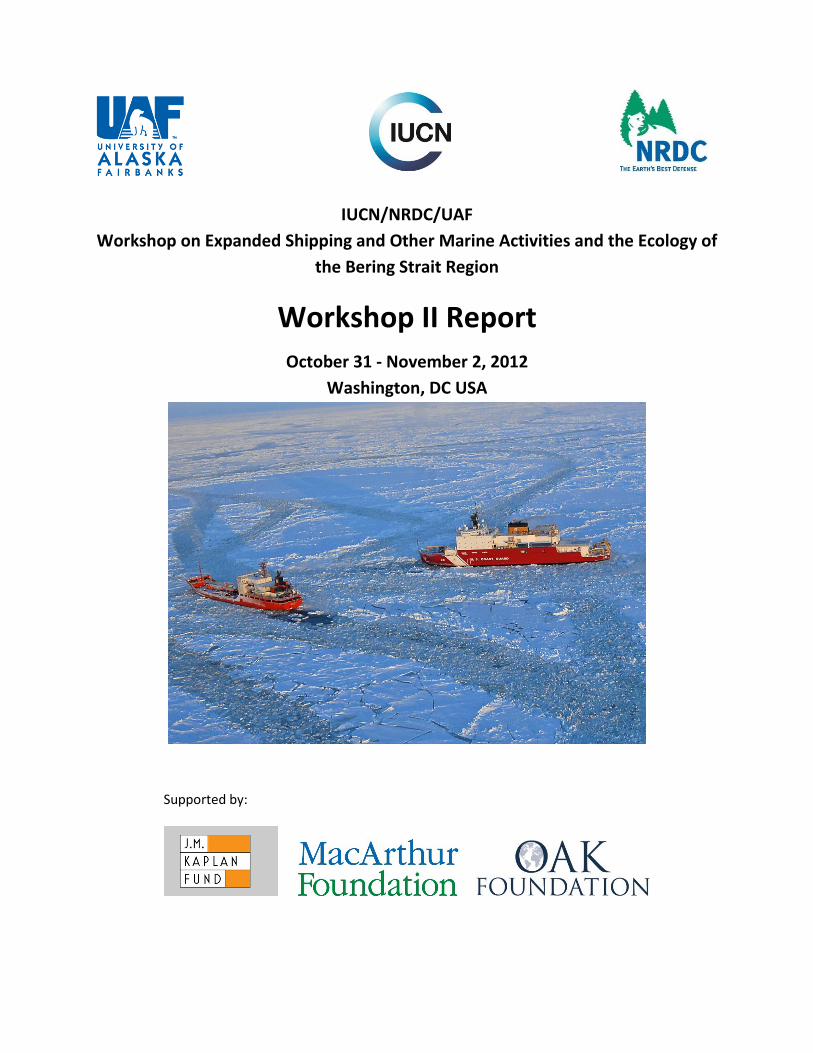
IUCN/NRDC/UAF Workshop on Expanded Shipping and Other Marine Activities and the Ecology of the Bering Strait Region Workshop II Report October 31 - November 2, 2012 Washington, DC USA Supported by:
-
Upload
khangminh22 -
Category
Documents
-
view
3 -
download
0
Transcript of Workshop II Report - International Union for Conservation of ...
1
IUCN/NRDC/UAF
Workshop on Expanded Shipping and Other Marine Activities and the Ecology of
the Bering Strait Region
Workshop II Report
October 31 - November 2, 2012
Washington, DC USA
Supported by:

2
3
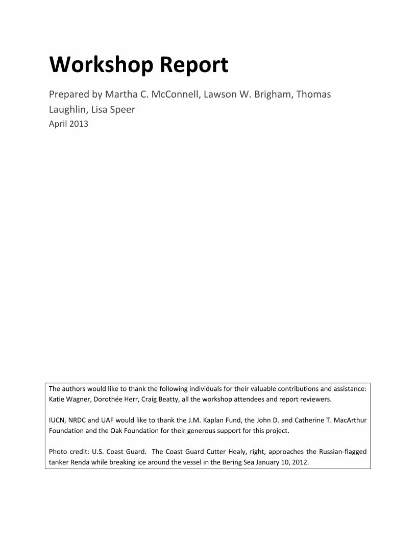
Workshop Report Prepared by Martha C. McConnell, Lawson W. Brigham, Thomas
Laughlin, Lisa Speer
April 2013
The authors would like to thank the following individuals for their valuable contributions and assistance:
Katie Wagner, Dorothée Herr, Craig Beatty, all the workshop attendees and report reviewers.
IUCN, NRDC and UAF would like to thank the J.M. Kaplan Fund, the John D. and Catherine T. MacArthur
Foundation and the Oak Foundation for their generous support for this project.
Photo credit: U.S. Coast Guard. The Coast Guard Cutter Healy, right, approaches the Russian-flagged
tanker Renda while breaking ice around the vessel in the Bering Sea January 10, 2012.

4
5
Table of Contents
1. Introduction .............................................................................................................................................. 7
2. Background ............................................................................................................................................... 9
2.1 Ecological Characteristics of the Bering Strait Super EBSAs ................................................................... 9
2.2 Subsistence Use of the Bering Strait Region ......................................................................................... 10
2.3 Shipping in the Bering Strait Region ..................................................................................................... 11
3. Workshop Outcomes .............................................................................................................................. 13
3.1 Voluntary Measures for Shippers ......................................................................................................... 14
3.2 Communications Infrastructure ............................................................................................................ 16
3.3 International Cooperation .................................................................................................................... 19
Annexes ....................................................................................................................................................... 24
Annex 1 – Workshop attendance ........................................................................................................... 24
Annex 2 – Workshop Agenda ................................................................................................................. 26

6
7
1. Introduction Warming ocean temperature and the dramatic loss of ice cover is opening Arctic waters to new and
expanded shipping, fishing, research, offshore oil development, tourism, and other economic activities.
Trans-Arctic and “destinational” shipping voyages will likely grow substantially in number as summer sea
ice continues to retreat. All trans-Arctic and much destinational shipping will necessarily transit the
Bering Strait, a 53 mile wide passage which provides the only connection between the Pacific and Arctic
Oceans. The region is defined legally as an international strait, bordered by the United States and
Russia, and ringed by numerous small communities and indigenous populations. The region is also
physically and biologically dynamic as sea ice conditions of all types are found seasonally within this
natural bottleneck.
The growth in Arctic marine operations is due in large part to natural resource development within the
region and greater economic ties of the Arctic to the global economy. Bering Strait transits increased
from 245 in 2008 to 325 in 2012. Ships include tankers, cargo ships, container ships, tugs, offshore
supply vessels, landing craft, fishing vessels, passenger vessels, offshore drill ships, oil spill response
vessels, and cruise ships of various size. While vessel activity is light compared to other regions of the
world, the capacity to provide aid and support for these vessels is extremely limited. For example, only
7-8 % of the Arctic Ocean has been charted to international navigation standards. There are limited aids
to navigation and Automatic Identification System (AIS) coverage. Arctic waters lack deep water ports
or refuge for large ships, and real-time weather and ice flow forecasts are limited. For the U.S. Arctic,
the nearest Coast Guard facilities are Kodiak and Dutch Harbors, 800nm and 1000nm, respectively, from
the Arctic Circle. While sea ice loss is accelerating during summer months due to warmer global
temperatures, the regional weather includes dense fog, extreme cold, severe storms, and unpredictable
ice flows. This is evidenced by the challenge faced with respect to the January 2012 delivery of fuel to
Nome, AK1. More recently, the tug Aiviq lost the Arctic-class drilling unit, the Kulluk, in December 2012,
which later ran aground by violent weather on the southeast shoreline of Sitkalidak Island carrying
approximately 143,000 gallons of diesel and 12,000 gallons of other oil products. In addition, challenges
have been met in the Northwest Passage when the tanker MV Nanny ran aground in Simpson Strait
September 2010 carrying 9.5 million liters of diesel. That same year the cruise ship Clipper Adventurer
struck an uncharted rock in the waters of western Nunavut. While these examples did not lead to
environmental damage they demonstrate that the Arctic still remains a challenging environment for any
shipping operations.
Given these challenges, the International Union for Conservation of Nature (IUCN), the Natural
Resources Defense Council (NRDC), and the University of Alaska Fairbanks (UAF) have undertaken a
cooperative project to identify measures that could be adopted to protect important areas of the Bering
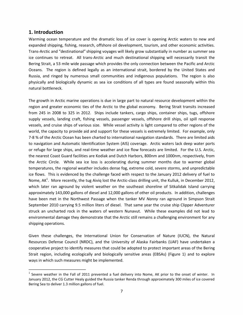
Strait region, including ecologically and biologically sensitive areas (EBSAs) (Figure 1) and to explore
ways in which such measures might be implemented.
1 Severe weather in the Fall of 2011 prevented a fuel delivery into Nome, AK prior to the onset of winter. In
January 2012, the CG Cutter Healy guided the Russia tanker Renda through approximately 300 miles of ice covered Bering Sea to deliver 1.3 million gallons of fuel.
8
Figure 1. A depiction of “Super EBSA” in this region 1) St. Lawrence Island, 2) Bering Strait, 3) Chuckchi Beaufort Coast, 4) Wrangel Island (IUCN-NRDC Workshop, 2010).
The project involves two workshops. The first workshop, held 26-28 June 2012 in Nome, Alaska, with 35
local, governmental, scientific, indigenous and environmental experts focused on identifying a range of
potential measures to manage and protect important areas. These measures, presented in a report2,
were grouped in four broad categories, 1) Communications/Outreach, 2) Tools for Area Protection, 3)
U.S./Russia bilateral opportunities, and 4) The polar code for ships being developed by the International
Maritime Organization (IMO).
Building off the first meeting, the second workshop, hosted in Washington, DC on 31 October - 02
November focused on possible means of implementing the measures identified. The meeting agenda
and list of attendees are attached as annexes to this report. Views expressed at the workshop were not
for attribution. This report reflects a meeting summary prepared by IUCN/NRDC/UAF. Although
workshop attendees had the opportunity to review and comment on a draft report, the final report does
not necessarily reflect the views of individuals who attended the workshop.
2 Nome workshop report 2012:
http://www.iucn.org/about/work/programmes/marine/marine_resources/?11649/nomereport “Workshop to Identify Several Viable Options for the Protection of Ecologically and Biologically Significant areas (EBSAa) for the Possible Negative Effects of Shipping and other Marine Activities in the Bering strait Region”
9
2. Background
2.1 Ecological Characteristics of the Bering Strait Super EBSAs
A workshop3 held in November 2010, organized by IUCN and NRDC, identified four “super-EBSAs”
(Ecologically or Biologically Significant Areas)4 in the Bering Strait region (Figure 1) using criteria
developed under the auspices of the Convention on Biological Diversity (CBD). The workshop identified
the Bering Strait region as perhaps the single most productive and diverse marine area in the Arctic. The
region provides critical habitat for walrus, seals, fish, several types of whales, and immense numbers of
birds. It has an ancient human history and enduring cultural heritage significance for all, especially the
indigenous peoples who live there.
The geographical focus of this project is on three of the super EBSAs of the Bering Strait region: St.
Lawrence Island; The Bering Strait and Wrangel Island.
1. St. Lawrence Island: The polynyas south of St. Lawrence Island likely support nearly the total
world population of spectacle eiders for six months of each year. The polynyas also provide key
habitat for alcids, kittiwakes, shearwaters, overwintering Pacific walrus, bowhead whales, ice
seals and polar bears, and are an important subsistence hunting area. This area is partially
protected by the Saint Lawrence Island Habitat Conservation Area.
2. Bering Strait: This area met all CBD criteria, as it exhibits the highest levels of productivity and
diversity in the Arctic. This narrow strait is the only connection between the Pacific and Arctic
Oceans, making it a biological hotspot of global significance. The Bering Strait/Anadyr Current
region provides key breeding, pupping, feeding, and/or migratory habitat for many species of
marine mammals, including bearded, ringed and spotted seals; Pacific walrus; gray, bowhead,
and beluga whales, all of which pass through the Strait twice per year when migrating between
the Bering and Chukchi Seas. Arctic cod and other species of forage fishes are abundant and
important to many marine predators, and the region supports populations of whitefishes and
char which are seasonally important for native community subsistence. The region also
supports vast seabird populations for breeding, migration, and/or foraging during most of the
year. Other notable species include the least and crested auklets; tufted and horned puffins,
black-legged kittiwakes; short-tailed shearwaters, spectacled and king eiders, thick-billed and
common murres; ivory and ross’s gulls; black guillemot, and at least 30 additional, abundant
species of seabirds, sea ducks, geese, loons and phalaropes; and the only nesting sites of Little
auks, which are endemic to the Northwest Atlantic, in the Western Arctic.
3. Wrangel Island: The polynyas, leads and coastal waters around Wrangel Island provide
important spring and summer feeding habitat for polar bears, migratory and feeding habitat for
3 Workshop report can be downloaded at http://data.iucn.org/dbtw-wpd/edocs/Rep-2011-001.pdf.
4 The workshop defined “super-EBSA” as an area meeting at least six of the seven CBD EBSA criteria.
10
Pacific walrus, and breeding and feeding habitat for extensive seabird colonies including thick-
billed and common murres, black-legged kittiwakes, horned puffins and black guillemots.
Wrangel Island is one of the three most important biological areas of Russian Beringia. It was
established as a Regional Wildlife Reserve in 1960 and as a Republic Wildlife Reserve in 1968. In
1976, the island was designated as a State Strict Nature Reserve (Zapovednik).
Twelve nautical miles of the marine area around the island were included in the Wrangel Island
State Nature Reserve in 1997, adding 1.4 million hectacres to the Reserve. This was
supplemented in 1999 with the addition of a 24 nautical mile buffer zone. In 2004, the area
(without the buffer zone) was designated as a World Heritage Site. In 2009, the buffer zone was
abolished by the regional government, but was recently re-established in December 2012 (see
Box 1).
2.2 Subsistence Use of the Bering Strait Region
The regional indigenous culture and its subsistence hunting and fishing traditions continue to be vibrant
today. The ocean waters in the Bering Strait region are some of the most biologically productive waters
in the world. Fish, seals, walrus and whales are key components of indigenous diets, as they have been
for over 1000 years. The presence of these animals is dependent on the rich primary productivity
associated with sea ice and the confluence of major oceanographic currents through the Bering Strait. In
spring, hunters may have to go long distances (up to 50-80 nautical miles from shore) in small boats to
find prey. Certain key areas, such as marine mammal haul out areas, ice edges, nutrient upwellings and
coastal wetlands and surrounding waters support healthy populations of fish, birds and marine
mammals. The spring subsistence harvest is key to the survival of indigenous communities in the area.
During this period, both hunters and passing ships are likely to use the same open water areas. An
increase in shipping activity has the potential to negatively impact the natural environment. The noise
and speed of boats can drive off animals and compromise the safety of hunters in small boats. In
addition, marine pollution has negative effects on human, animal and ecosystem health.
Critical to developing mitigation measures for Arctic marine traffic is having a spatial and temporal
understanding of the patterns of indigenous marine use. The Bering Sea Sub Network (BSSN), a U.S.
National Science Foundation-funded project gathering local observations on the environment and
subsistence harvest in coastal Russian and U.S. communities around the Bering Sea, utilizes the density
mapping method to develop spatial data of subsistence areas. These maps show aggregated data by
species and season. They can be correlated with other types of data, such as ice extent (see Nome
workshop report, 2012).
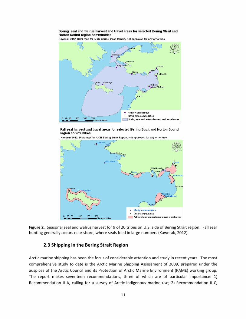
In addition to the BSSN, Kawerak Inc. is conducting a major study to prepare maps showing seasonally
defined habitat and subsistence use areas for seals and walrus on the U.S. side of the Bering Strait. The
study involves collaboration with nine federally recognized tribes. Examples of these seasonal maps
(Figure 2) are given here and, when finalized, may help inform decisions on appropriate protective
measures.
11
Figure 2. Seasonal seal and walrus harvest for 9 of 20 tribes on U.S. side of Bering Strait region. Fall seal hunting generally occurs near shore, where seals feed in large numbers (Kawerak, 2012).
2.3 Shipping in the Bering Strait Region
Arctic marine shipping has been the focus of considerable attention and study in recent years. The most
comprehensive study to date is the Arctic Marine Shipping Assessment of 2009, prepared under the
auspices of the Arctic Council and its Protection of Arctic Marine Environment (PAME) working group.
The report makes seventeen recommendations, three of which are of particular importance: 1)
Recommendation II A, calling for a survey of Arctic indigenous marine use; 2) Recommendation II C,
12
calling for identification of areas of heightened ecological and cultural significance and 3)
Recommendation II D, asking Arctic States to explore the need for internationally designated areas for
the purpose of environmental protection of the Arctic Ocean.
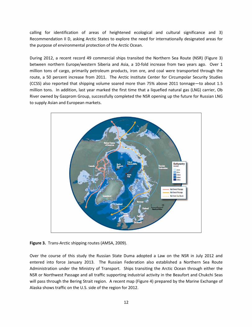
During 2012, a recent record 49 commercial ships transited the Northern Sea Route (NSR) (Figure 3)
between northern Europe/western Siberia and Asia, a 10-fold increase from two years ago. Over 1
million tons of cargo, primarily petroleum products, iron ore, and coal were transported through the
route, a 50 percent increase from 2011. The Arctic Institute Center for Circumpolar Security Studies
(CCSS) also reported that shipping volume soared more than 75% above 2011 tonnage—to about 1.5
million tons. In addition, last year marked the first time that a liquefied natural gas (LNG) carrier, Ob
River owned by Gazprom Group, successfully completed the NSR opening up the future for Russian LNG
to supply Asian and European markets.
Figure 3. Trans-Arctic shipping routes (AMSA, 2009).
Over the course of this study the Russian State Duma adopted a Law on the NSR in July 2012 and
entered into force January 2013. The Russian Federation also established a Northern Sea Route
Administration under the Ministry of Transport. Ships transiting the Arctic Ocean through either the
NSR or Northwest Passage and all traffic supporting industrial activity in the Beaufort and Chukchi Seas
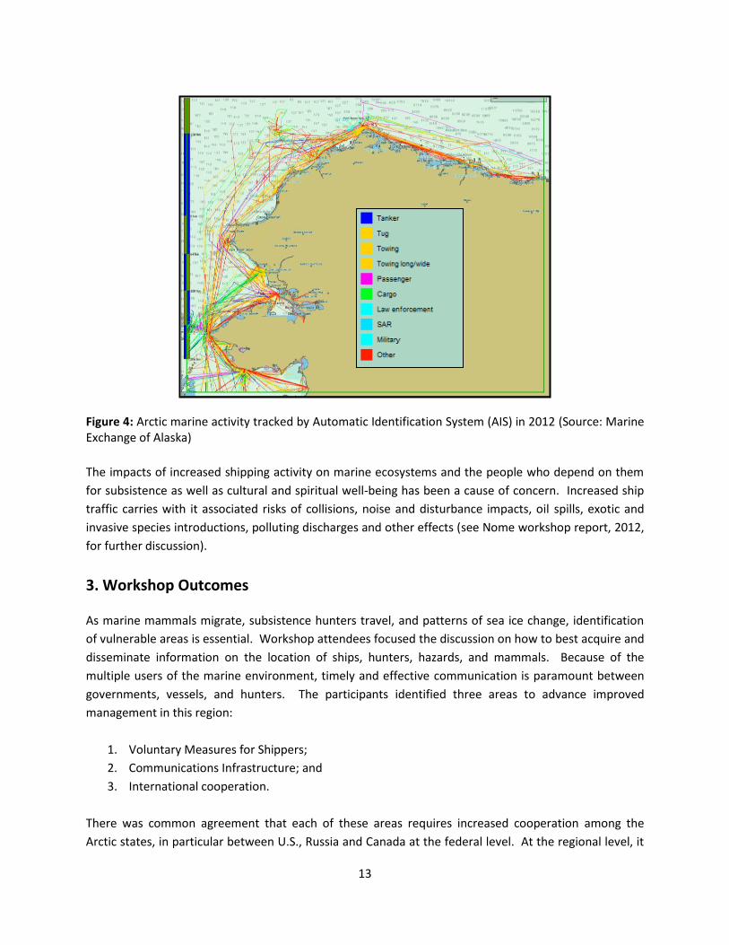
will pass through the Bering Strait region. A recent map (Figure 4) prepared by the Marine Exchange of
Alaska shows traffic on the U.S. side of the region for 2012.
13
Figure 4: Arctic marine activity tracked by Automatic Identification System (AIS) in 2012 (Source: Marine Exchange of Alaska)
The impacts of increased shipping activity on marine ecosystems and the people who depend on them
for subsistence as well as cultural and spiritual well-being has been a cause of concern. Increased ship
traffic carries with it associated risks of collisions, noise and disturbance impacts, oil spills, exotic and
invasive species introductions, polluting discharges and other effects (see Nome workshop report, 2012,
for further discussion).
3. Workshop Outcomes
As marine mammals migrate, subsistence hunters travel, and patterns of sea ice change, identification
of vulnerable areas is essential. Workshop attendees focused the discussion on how to best acquire and
disseminate information on the location of ships, hunters, hazards, and mammals. Because of the
multiple users of the marine environment, timely and effective communication is paramount between
governments, vessels, and hunters. The participants identified three areas to advance improved
management in this region:
1. Voluntary Measures for Shippers;
2. Communications Infrastructure; and
3. International cooperation.
There was common agreement that each of these areas requires increased cooperation among the
Arctic states, in particular between U.S., Russia and Canada at the federal level. At the regional level, it
14
was noted that representatives from the State of Alaska and the Chukotka Autonomous District have
cooperated in the past and that dialogue should continue between governments on marine activities in
this region. Representatives from the Global Environment Facility (GEF) at the meeting also expressed
that the GEF-Russian Federation Partnership on Sustainable Environmental Management in the Arctic
(or “Arctic Agenda 2020”) initiative, which aims to improve environmental governance in the region, is
an opportunity for cooperation.
It was noted that while some stakeholders responsible for marine use and traffic in this region already
engage with regional indigenous populations, a more comprehensive and coordinated effort to work
with these communities would be beneficial. One such avenue could be through the newly formed
Arctic Marine Mammal Coalition5 which represents hunters from five Alaska Native Organizations and
regional political bodies. Participants also discussed that an increase in information exchange among
the indigenous communities in Alaska and Chukotka may also stimulate a shared understanding of the
impacts of shipping in this region. A workshop held in Moscow or the Chukotka region could also
provide an opportunity to address the mutual concerns for safe shipping and stewardship in this region.
3.1 Voluntary Measures for Shippers
Following discussion from the first workshop, participants discussed the development of voluntary
measures for shippers transiting in this region. Even as the International Maritime Organization (IMO)
proceeds with the development of the mandatory Polar Shipping Code, the identification of voluntary
measures for shippers in specific areas such as the Bering Strait and Bering Sea could be explored to
better protect the marine environment, ensure the resilience of the marine ecosystems for subsistence
hunters and communities, and to promote safe shipping in this region. Such measures may be used by
government agencies within the two Bering Strait States, and may also form the basis of future
cooperative agreements and standards in the region. While not legally enforceable, experience has
shown a high level of compliance with voluntary measures within the shipping community. A relevant
example is found in Santa Barbara Channel, California, and nearby waters where speed restrictions are
broadcast to vessels transiting the area. Thus, the development of voluntary measures is a promising
way forward.
Participants discussed different types of measures that could be developed and concluded that
measures vary depending on the risk and the season. For example, mainland hunters commonly follow
the coastline before heading out to sea, therefore, concentrating small boat traffic closer to shore. In
addition, important seasonal migratory corridors, such as the west coast of St. Lawrence Island might be
considered. Measures could include:
Buffer zones (Box 1);
Areas to be avoided (ATBAs);
5 AMMC is comprised of the Alaska Eskimo Whaling Commission (AEWC), Alaska Beluga Whale Committee (ABWC),
the Eskimo Walrus Commission (EWC), the Ice Seal Committee (ISC), and the Alaska Nanuuq Commission (ANC).

15
Ship routing;
Ship speed;
Ship reporting with respect to location of hazards such as sea ice.
The Arctic community has significant information about Arctic ship traffic, indigenous marine use,
animal migratory patterns and the location of ecological-biological significant areas. With advanced
spatial and temporal information on indigenous marine use and migratory patterns, a process to
integrate this information could begin examining the interactions of these components in the Arctic
marine environment.
In addition to federal agencies in the U.S., Russia, and Canada, as well as the indigenous populations,
workshop participants identified other stakeholders that might have an interest in the development of
voluntary measures for shippers. These include the shipping industry, trade associations, experts
engaged at the IMO and the Arctic Council, Marine Mammal Commission, and intergovernmental bodies
such as the International Whaling Commission (IWC). An American, Russian, and Canadian cooperative
venture in the development of voluntary measures for regional shippers, may have a significant impact,
even if the measures are voluntary in nature. Developing voluntary measures may have other benefits
such as increasing our knowledge of gaps in socio-environmental data, and improving our shared
understanding of the risks for operating in this region.
A first step could be:
Explore coordination between relevant U.S., Russian, Canadian federal agencies on the process
for developing voluntary measures, and identify knowledge gaps.
Host a multi stakeholder workshop to facilitate cooperation and information exchange to
develop a set of possible voluntary measures for shipping in the Bering Strait region.
Collectively, the various experts might also consider:
BOX 1. Wrangel Island and Herald Island Buffer Zones Re-established
In December 2012 a 24 nautical mile buffer zone around Wrangel Island and Herald Island was re-established by Russian Prime Minister Dmitry Medvedev. These islands lie just north of the Northern Sea Route (NSR). The buffer zone has been expanded from the original buffer zone delineated in 1999 to include the southern part of Wrangel Island between the mouth of the Predator River and Cape Hawaii. The buffer zone will aid in the protection of this sensitive area from marine activities, as it will allow better control of ships transiting this portion of the NSR. The 12-mile zone around the islands falls within Russia's territorial waters, while the entire area between the islands and the Russian mainland, between which the narrowest distance is 87 miles, form part of the country's exclusive economic zone. The Ministry of Transport of the Russian Federation will help manage the buffer zone and will post "Notice to Mariners" in regards to navigation in these protected waters.
16
Identifying how voluntary measures will be communicated to shippers and other stakeholder
groups.
How the region might effectively monitor compliance.
How measures might evolve as the environment changes and ship traffic increases.
Each of these requires advances in communications infrastructure throughout this region.
3.2 Communications Infrastructure
As vessel traffic increases the Bering Strait will need supporting infrastructure such as aids to navigation,
port facilities to harbor emergency tow service vessels, increased AIS coverage, and communication
protocols. New infrastructure will require expenditures by the U.S. and Russia. In addition, the U.S.
Interagency Committee on the Maritime Transportation System (CMTS) recommendations for improving
an Arctic maritime transportation system (MTS) include expanded sea ice/weather forecasts, and
improved charts of navigatable U.S. Arctic waters.
Governments and private industry could explore partnering on such investments and working with the
State of Alaska and indigenous populations to accomplish improvements in communications
infrastructure. A number of different communication tools were discussed at the workshop.
a. Regional Communication Centers (RCC)
Small boats can be anywhere, particularly
during springtime when hunters travel large
distances looking for walruses in this region.
In addition, ice can be anywhere as
evidenced in 2012 when sea ice was slow to
break up in areas just north of the strait in
the Beaufort and Chuckchi Seas. Increasing
communications equipment in indigenous
hunting villages and exploring protocols with
shipping industry and governments would
aid in the dissemination of information on
the location of ships, location of hunters,
location of hazards, and location of marine
mammals.
As discussed in the Nome workshop report (2012), the key to creating a multi-functional
communications network to enhance marine safety, emergency response, and environmental
monitoring is to expand the reach of the Automatic Identification System (AIS). The IMO requires larger
commercial vessels to be equipped with AIS transponders that transmit information on the vessel (i.e.
speed, course, type, position, and destination). The application of communication and vessel tracking
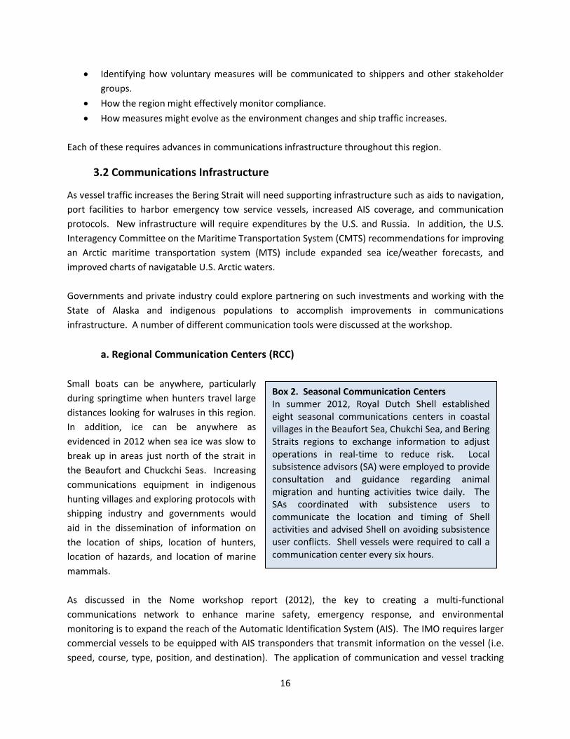
Box 2. Seasonal Communication Centers In summer 2012, Royal Dutch Shell established eight seasonal communications centers in coastal villages in the Beaufort Sea, Chukchi Sea, and Bering Straits regions to exchange information to adjust operations in real-time to reduce risk. Local subsistence advisors (SA) were employed to provide consultation and guidance regarding animal migration and hunting activities twice daily. The SAs coordinated with subsistence users to communicate the location and timing of Shell activities and advised Shell on avoiding subsistence user conflicts. Shell vessels were required to call a communication center every six hours.
17
equipment can provide information to vessels and shore based communications stations on both sides
of the Bering Strait (U.S. and Russia) to aid the prevention of maritime accidents, pollution incidents,
and collision between ships and marine mammals and subsistence hunters. For example, a ship
transiting this region could call a RCC to exchange information on location of hunters, marine mammals,
or ice. The capabilities needed for shore based stations might include:
AIS position reports from vessels;
Satellite transponder position reports from subsistence hunting vessels;
Ability to communicate to AIS equipped vessels, over the AIS network, the location an nature of
hazards such as ice, locations of marine mammals, locations of subsistence hunters as well as
non-compliance with risk reduction measures; and
Ability to communicate with subsistence hunters, possibly over VHF Digital Select Calling, the
locations of vessels transiting the area that may present a risk of collision.
Workshop participants also identified a variety of activities that could help advance a more integrated
system of communications in this region to build off investments to date. These include:
A multilateral workshop to explore possible communications protocols, and communication
timelines for reporting vessels, hazards, mammals, or conflict situations;
A pilot program that provides equipment and training for regional subsistence hunters operating
on small boats in the Bering Strait‘s Region to monitor the location of their subsistence hunting
parties and commercial vessels in the region and communicate the presence of commercial
vessels that present a risk of collision; and
Explore the use of online tools to aid decisions and response management (Box 3).
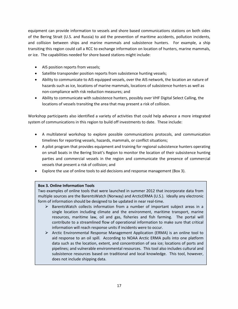
Box 3. Online Information Tools Two examples of online tools that were launched in summer 2012 that incorporate data from multiple sources are the BarentsWatch (Norway) and ArcticERMA (U.S.). Ideally any electronic form of information should be designed to be updated in near real-time.
BarentsWatch collects information from a number of important subject areas in a single location including climate and the environment, maritime transport, marine resources, maritime law, oil and gas, fisheries and fish farming. The portal will contribute to a streamlined flow of operational information to make sure that critical information will reach response units if incidents were to occur.
Arctic Environmental Response Management Application (ERMA) is an online tool to aid response to an oil spill. According to NOAA Arctic ERMA pulls into one platform data such as the location, extent, and concentration of sea ice; locations of ports and pipelines; and vulnerable environmental resources. This tool also includes cultural and subsistence resources based on traditional and local knowledge. This tool, however, does not include shipping data.

18
b. Coast Pilot for the Bering Strait Region
One of the greatest challenges is how to disseminate more detailed environmental, geographic and
marine use information into the pilot houses of the international and U.S. ships that are navigating in
this sensitive and complex region. Timely information would enhance marine safety, improve marine
environmental protection and mitigate the interactions between ships and indigenous users and marine
life. The U.S. Coast Pilot provides a variety of information important to navigators that may not be
included on nautical charts. However, the chapters that address the Bering Strait region currently lack
information on the presence of subsistence hunters or marine mammals.
Select information for a Coast Pilot in the Bering Strait region could include:
Seasonal routes and areas of concentration of marine mammals and seabirds;
Regional sea ice conditions and other unique oceanographic and meteorological conditions;
Regional indigenous/traditional marine use on a seasonal basis (with highlighted regions of
significant hunting and fishing activities by coastal communities);
Seasonal ship traffic in the BSR;
Locations of coastal communities and the areas of their hunting and fishing;
Voluntary measures or marine routes when developed;
Future areas designated as special areas;
Locations of communication centers in the BSR once established;
Coastal community contact list, if established.
Ideally the development of such a Coast Pilot would be a shared maritime effort between the Russian
Federation and the U.S. The Sailing Directions produced by the U.S. National Geospatial-Intelligence
Agency (Pub. 155, 11th Edition, 2011) also produces information on coastal and port approach, and
locations of native communities, but lacks information on seasonal subsistence use and presence of
marine mammals. Information generated from the Arctic Regional Hydrographic Commission (ARHC)
could be of use in this effort (Box 4). Resources that may also be used for this development are the
Marine Environmental Handbook – Arctic Northwest Passage and the Northern Canada Sailing Directions
both of which are compiled by the Canadian Hydrographic Service. These documents provide
information on physical characteristics (i.e. geographic, oceanographic, and atmospheric) of the region,
ice characteristics, special areas (i.e. wildlife sanctuaries, national parks, etc), land use, traditional
hunting and the annual harvest cycle, and the environmental impacts of ship operations (including
various mitigation measures). Both are models for what could be developed for the Bering Strait region.
19
3.3 International Cooperation
a. Bilateral efforts
An environmental risk assessment in this area can be used as an analytical tool to aid decisions. There is
currently no systematic collection of data about shipping traffic in this region and no official sharing of
shipping data between Arctic states, although this was a recommendation of AMSA (see Box 5). If a
collision or accident were to occur in the Bering Strait region, the impacts could be catastrophic. An
assessment of environmental impact(s) in this region, including ice covered waters, would require better
data about ship traffic, the cargo the ships are carrying, and socio-environmental information that may
have an effect on the probability of accidents and the consequences if accidents should occur (i.e.
seasonal subsistence maps).
There was broad agreement among participants that a
preliminary environmental risk assessment in this region,
led by governments, would be a step forward to better
guide the uses of the marine and coastal environment,
protect human safety and culture, and the ecological and
biological diversity of this region. Such an assessment
would aid decisions on location of search and rescue
services, sea lanes, and emergency preparedness against
oil spills, among other things. A preliminary risk
assessment may also inform near-term development of
voluntary measures and improve monitoring.
An effective assessment will require bilateral cooperation with multi stakeholder input. In addition,
indigenous knowledge and use of the region should be taken into account during such a process. The
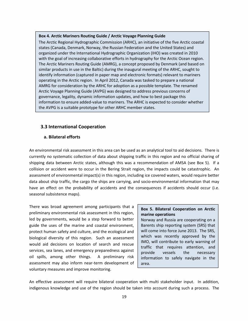
Box 4. Arctic Mariners Routing Guide / Arctic Voyage Planning Guide
The Arctic Regional Hydrographic Commission (ARHC), an initiative of the five Arctic coastal states (Canada, Denmark, Norway, the Russian Federation and the United States) and organized under the International Hydrographic Organization (IHO) was created in 2010 with the goal of increasing collaborative efforts in hydrography for the Arctic Ocean region. The Arctic Mariners Routing Guide (AMRG), a concept proposed by Denmark (and based on similar products in use in the Baltic) during the inaugural meeting of the ARHC, sought to identify information (captured in paper map and electronic formats) relevant to mariners operating in the Arctic region. In April 2012, Canada was tasked to prepare a national AMRG for consideration by the ARHC for adoption as a possible template. The renamed Arctic Voyage Planning Guide (AVPG) was designed to address previous concerns of governance, legality, dynamic information updates, and how to best package this information to ensure added-value to mariners. The ARHC is expected to consider whether the AVPG is a suitable prototype for other ARHC member states.
Box 5. Bilateral Cooperation on Arctic marine operations Norway and Russia are cooperating on a Barents ship reporting system (SRS) that will come into force June 2013. The SRS, which was recently approved by the IMO, will contribute to early warning of traffic that requires attention, and provide vessels the necessary information to safely navigate in the area.

20
Bering Strait Port Access Route Study (PARS) being led by the U.S. Coast Guard provides a foundation of
information essential to such an assessment. The goal of the PARS is to help reduce the risk of marine
casualties and increase the efficiency of vessel traffic in the strait. In doing so, and in order for
recommendations to be considered by the IMO, the study is required to evaluate navigational hazards,
traffic patterns, environmental conditions, aids to navigation, and hydrography of the study region. In
discussion of the PARS process, some attendees noted:
Continued engagement with indigenous communities in the region is essential to ensure the
future of subsistence hunting;
Expanding the PARS to bilateral cooperation is a good step forward for IMO consideration; and
Exploring opportunities for increased cooperation through the Shared Beringian Heritage
program connecting parks in Alaska and in Chukotka, Russia.
A discussion on finalizing a Memorandum of Understanding (MOU) between the U.S. and Russia on a
linkage between the national parks in Beringia continues. The U.S. State Department officials are
working with National Park Service to consult with interested domestic stakeholders such as the State of
Alaska, Alaska Native organizations, and NGOs. The American embassy in Moscow is similarly engaging
communities in Chukotka to gauge their interest and support. A version of the MOU is expected to be
provided to stakeholders soon. However, any MOU on Beringia will not include the marine waters of
the Bering Strait region.
It was noted that a preliminary risk assessment is not necessarily a preamble to an IMO-designated
particularly sensitive sea area (PSSA) but may help inform future efforts in this area. A PSSA designation
can augment domestic protective measures and appears on international navigation charts. A PSSA is a
long-term tool for States to regulate foreign vessels transiting in a region and includes specific
associated protective measures (Table 1). The Bering Strait is an international strait and bordering
States must guarantee that "all ships and aircraft enjoy the right of transit passage, which shall not be
impeded"6. A specific risk assessment and further approval of associated protective measures by the
IMO is required prior to the establishment of a PSSA (see Nome workshop report, 2012, for further
discussion). Participants discussed the potential lessons to be learned from the PSSA process in other
parts of the world including:
Torres Strait - a bilateral process that considers indigenous use in the area. Two associated
protective measures include a new two-way shipping route and an extension of the pilotage
system that had been applied in the Great Barrier Reef since 1990, and
Baltic Sea - a multilateral process in a seasonally, ice covered region.
6 UNCLOS, article 38.

21
Table 1. IMO PSSA as of 2012
Area Associated Protective Measure Year
Great Barrier Reef, Australia * pilotage system * mandatory ship reporting system
1990
Torres Strait, Australia, Papua New Guinea
* two way route * mandatory pilotage system
2005
Sabana-Camagüey Archipelago, Cuba
* traffic separation schemes * area to be avoided * discharge prohibitions
1997
Malpelo Island, Colombia * area to be avoided 2002
Florida Keys, United States * four areas to be avoided * three mandatory no anchoring areas
2002
Wadden Sea, Denmark, Germany, Netherlands
* mandatory reporting and traffic surveillance * traffic separation schemes * deep water route * recommended and mandatory pilotage * MARPOL Special Area
2002
Paracas National Reserve, Peru * area to be avoided (ships ≥ 200 gt carrying hydrocarbons and hazardous liquids in bulk)
2003
Western European Waters (Belgium, France, Ireland, Portugal, Spain, United Kingdom, Canary Islands, Spain)
* reporting obligations for single hull tankers carrying heavy grades of fuel oil
2004
Canary Islands, Spain * five areas to be avoided * two recommended routes * mandatory ship reporting system
2005
Baltic Sea Area (Denmark, Estonia, Finland, Germany, Latvia, Lithuania, Poland, Sweden)
* traffic separation schemes (new and amendments to existing) * deepwater route * areas to be avoided * reporting and pilotage systems * MARPOL Special Areas (I, V, VI-Sox)
2005
Galapagos Archipelago, Ecuador * area to be avoided 2005
Papahānaumokuākea Marine National Monument, United States
* six areas to be avoided * mandatory & recommendatory ship reporting system
2007
Strait of Bonifacio, France and Italy
* recommended pilotage7 2011
Saba Bank, in the North-eastern Caribbean area of the Kingdom of the Netherlands
* mandatory no anchoring area * area to be avoided (ships ≥ 300 gt)
2012
7 An IMO resolution does not provide an international legal basis for mandatory pilotage for ships in transit in any
strait used for international navigation including the Strait of Bonifacio and the Bering Strait
22
It was stressed that the numerous reports that have been generated for this region provide a foundation
of information to easily proceed with a preliminary risk assessment.
b. Multilateral efforts
IMO Polar Shipping Code
Several of the Arctic states have taken the lead at the International Maritime Organization to develop a
mandatory Polar Code of Navigation; such a code at its core will include Arctic ship structural standards,
required Arctic marine safety equipment, and mandatory training/experience required for the ice
navigator in the pilot house. The process involves the global maritime community including key sectors
of the maritime industry operating in the Arctic marine environment (for example, bulk carriers, tankers
and passenger vessels). Workshop participants were encouraged to learn that measures include the
development of polar operating manuals for individual vessels to operate in polar waters. The target
completion date for a Polar Code is summer 2014, and work on environmental protection measures of
the Polar Code began in earnest in March 2013. There was broad agreement that Arctic states
collectively could engage with non-Arctic states to ensure the development of an effective, mandatory
polar shipping code. The Polar Code would apply to the region of the Bering Strait.
International Convention for the Prevention of Pollution from Ships (MARPOL)
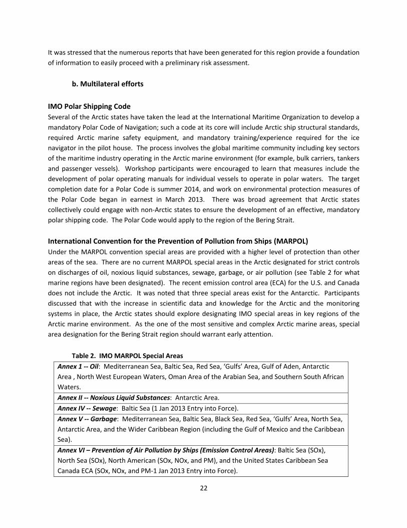
Under the MARPOL convention special areas are provided with a higher level of protection than other
areas of the sea. There are no current MARPOL special areas in the Arctic designated for strict controls
on discharges of oil, noxious liquid substances, sewage, garbage, or air pollution (see Table 2 for what
marine regions have been designated). The recent emission control area (ECA) for the U.S. and Canada
does not include the Arctic. It was noted that three special areas exist for the Antarctic. Participants
discussed that with the increase in scientific data and knowledge for the Arctic and the monitoring
systems in place, the Arctic states should explore designating IMO special areas in key regions of the
Arctic marine environment. As the one of the most sensitive and complex Arctic marine areas, special
area designation for the Bering Strait region should warrant early attention.
Table 2. IMO MARPOL Special Areas
Annex 1 -- Oil: Mediterranean Sea, Baltic Sea, Red Sea, ‘Gulfs’ Area, Gulf of Aden, Antarctic
Area , North West European Waters, Oman Area of the Arabian Sea, and Southern South African
Waters.
Annex II -- Noxious Liquid Substances: Antarctic Area.
Annex IV -- Sewage: Baltic Sea (1 Jan 2013 Entry into Force).
Annex V -- Garbage: Mediterranean Sea, Baltic Sea, Black Sea, Red Sea, ‘Gulfs’ Area, North Sea,
Antarctic Area, and the Wider Caribbean Region (including the Gulf of Mexico and the Caribbean
Sea).
Annex VI – Prevention of Air Pollution by Ships (Emission Control Areas): Baltic Sea (SOx),
North Sea (SOx), North American (SOx, NOx, and PM), and the United States Caribbean Sea
Canada ECA (SOx, NOx, and PM-1 Jan 2013 Entry into Force).

23
Convention on Biological Diversity
Workshop participants discussed how Arctic shipping activities relate to the Convention on Biological
Diversity. It was noted that Article 8(j) in the convention is relevant to the Bering Strait region as it
considers Traditional Knowledge, Innovations and Practices stating “Subject to national legislation each
contracting Party shall respect, preserve and maintain knowledge, innovations and practices of
indigenous and local communities embodying traditional lifestyles relevant for the conservation and
sustainable use of biological diversity and promote their wider application with the approval and
involvement of the holders of such knowledge, innovations and practices and encourage the equitable
sharing of the benefits arising from the utilization of such knowledge innovations and practices.” It was
noted that Russia and Canada are parties the CBD, the United States is not.
24
Annexes
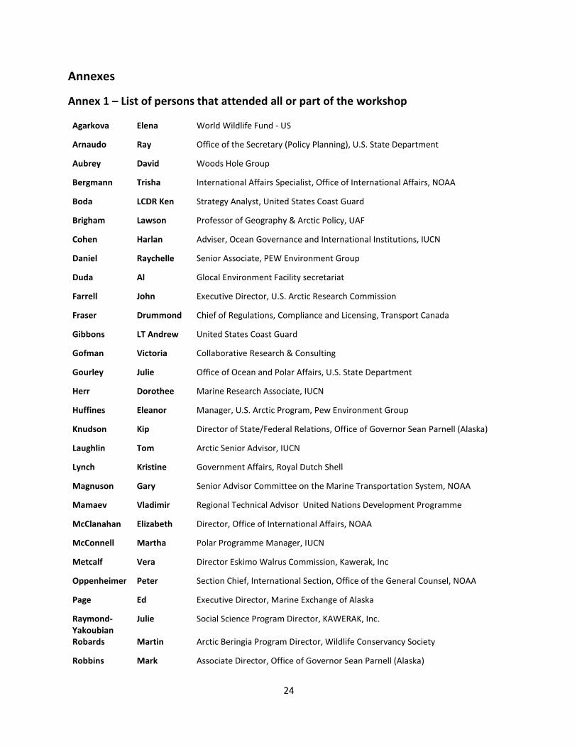
Annex 1 – List of persons that attended all or part of the workshop
Agarkova Elena World Wildlife Fund - US
Arnaudo Ray Office of the Secretary (Policy Planning), U.S. State Department
Aubrey David Woods Hole Group
Bergmann Trisha International Affairs Specialist, Office of International Affairs, NOAA
Boda LCDR Ken Strategy Analyst, United States Coast Guard
Brigham Lawson Professor of Geography & Arctic Policy, UAF
Cohen Harlan Adviser, Ocean Governance and International Institutions, IUCN
Daniel Raychelle Senior Associate, PEW Environment Group
Duda Al Glocal Environment Facility secretariat
Farrell John Executive Director, U.S. Arctic Research Commission
Fraser Drummond Chief of Regulations, Compliance and Licensing, Transport Canada
Gibbons LT Andrew United States Coast Guard
Gofman Victoria Collaborative Research & Consulting
Gourley Julie Office of Ocean and Polar Affairs, U.S. State Department
Herr Dorothee Marine Research Associate, IUCN
Huffines Eleanor Manager, U.S. Arctic Program, Pew Environment Group
Knudson Kip Director of State/Federal Relations, Office of Governor Sean Parnell (Alaska)
Laughlin Tom Arctic Senior Advisor, IUCN
Lynch Kristine Government Affairs, Royal Dutch Shell
Magnuson Gary Senior Advisor Committee on the Marine Transportation System, NOAA
Mamaev Vladimir Regional Technical Advisor United Nations Development Programme
McClanahan Elizabeth Director, Office of International Affairs, NOAA
McConnell Martha Polar Programme Manager, IUCN
Metcalf Vera Director Eskimo Walrus Commission, Kawerak, Inc
Oppenheimer Peter Section Chief, International Section, Office of the General Counsel, NOAA
Page Ed Executive Director, Marine Exchange of Alaska
Raymond-Yakoubian
Julie Social Science Program Director, KAWERAK, Inc.
Robards Martin Arctic Beringia Program Director, Wildlife Conservancy Society
Robbins Mark Associate Director, Office of Governor Sean Parnell (Alaska)
25
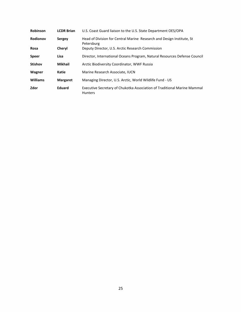
Robinson LCDR Brian U.S. Coast Guard liaison to the U.S. State Department OES/OPA
Rodionov Sergey Head of Division for Central Marine Research and Design Institute, St Petersburg
Rosa Cheryl Deputy Director, U.S. Arctic Research Commission
Speer Lisa Director, International Oceans Program, Natural Resources Defense Council
Stishov Mikhail Arctic Biodiversity Coordinator, WWF Russia
Wagner Katie Marine Research Associate, IUCN
Williams Margaret Managing Director, U.S. Arctic, World Wildlife Fund - US
Zdor Eduard Executive Secretary of Chukotka Association of Traditional Marine Mammal Hunters
26
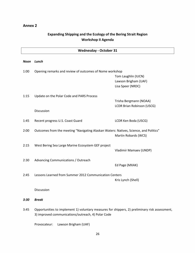
Annex 2
Expanding Shipping and the Ecology of the Bering Strait Region
Workshop II Agenda
Wednesday - October 31
Noon Lunch
1:00 Opening remarks and review of outcomes of Nome workshop
Tom Laughlin (IUCN)
Lawson Brigham (UAF)
Lisa Speer (NRDC)
1:15 Update on the Polar Code and PARS Process
Trisha Bergmann (NOAA)
LCDR Brian Robinson (USCG)
Discussion
1:45 Recent progress U.S. Coast Guard LCDR Ken Boda (USCG)
2:00 Outcomes from the meeting “Navigating Alaskan Waters: Natives, Science, and Politics”
Martin Robards (WCS)
2:15 West Bering Sea Large Marine Ecosystem GEF project
Vladimir Mamaev (UNDP)
2:30 Advancing Communications / Outreach
Ed Page (MXAK)
2:45 Lessons Learned from Summer 2012 Communication Centers
Kris Lynch (Shell)
Discussion
3:30 Break
3:45 Opportunities to implement 1) voluntary measures for shippers, 2) preliminary risk assessment,
3) improved communications/outreach, 4) Polar Code
Provocateur: Lawson Brigham (UAF)
27
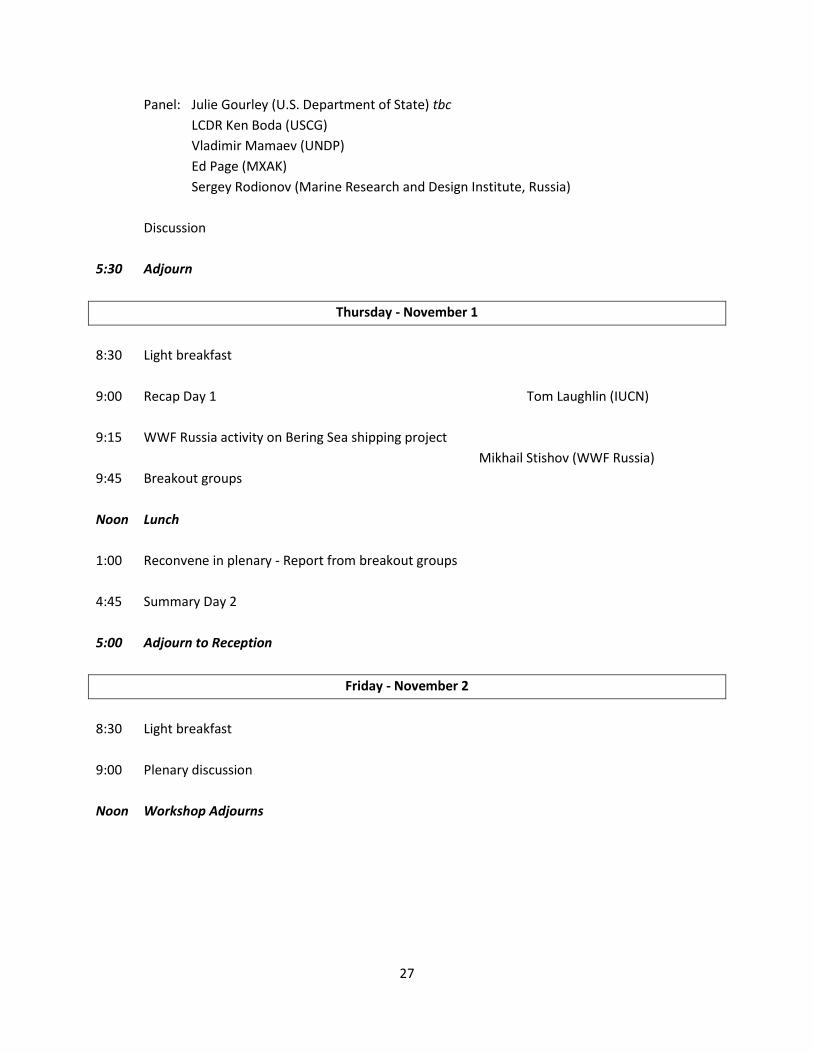
Panel: Julie Gourley (U.S. Department of State) tbc
LCDR Ken Boda (USCG)
Vladimir Mamaev (UNDP)
Ed Page (MXAK)
Sergey Rodionov (Marine Research and Design Institute, Russia)
Discussion
5:30 Adjourn
Thursday - November 1
8:30 Light breakfast
9:00 Recap Day 1 Tom Laughlin (IUCN)
9:15 WWF Russia activity on Bering Sea shipping project
Mikhail Stishov (WWF Russia)
9:45 Breakout groups
Noon Lunch
1:00 Reconvene in plenary - Report from breakout groups
4:45 Summary Day 2
5:00 Adjourn to Reception
Friday - November 2
8:30 Light breakfast
9:00 Plenary discussion
Noon Workshop Adjourns
1
IUCN Washington, D.C.
1630 Connecticut Ave NW, Ste 300
Washington, DC 20009
Natural Resources Defense Council
40 West 20th Street
New York, NY 10011
University of Alaska Fairbanks
505 South Chandalar Fairbanks
AK 99775, United States