Culture, Values, And The Environment In Central Africa - DUNE

at SciVerse ScienceDirect
Quaternary International 289 (2013) 24e35
Contents lists available
Quaternary International
journal homepage: www.elsevier .com/locate/quaint
Wood charcoal from an inland dune complex at Joldelund (Northern Germany).Information on Holocene vegetation and landscape changes
D. Jansen a,b,*, U. Lungershausen b,c, V. Robin a,b, Y. Dannath a,b, O. Nelle a,b
a Institute for Ecosystem Research, University Kiel, 24118 Kiel, GermanybGraduate School “Human Development in Landscapes”, University Kiel, 24098 Kiel, Germanyc Institute of Geography, University Kiel, 24098 Kiel, Germany
a r t i c l e i n f o
Article history:Available online 10 February 2012
* Corresponding author. Institute for Ecosystem ReKiel, Germany.
E-mail address: [email protected] (D. Ja
1040-6182/$ e see front matter � 2012 Elsevier Ltd adoi:10.1016/j.quaint.2012.02.010
a b s t r a c t
The charcoal content of an inland dune complex close to Joldelund in Northern Germany was analysed aspart of a project which aims to reconstruct Holocene aeolian activity in high spatial and temporal reso-lution. The eleven investigated profiles contained numerous charcoal-enriched layers, providing evidencefor the potential of inland dunes as palaeoarchives for anthracology. Earlier studies have found Late RomanIron Age settlement activity and iron ore productions in the research area and in its vicinity. Charcoalassemblages date to Roman Iron Age as well as Early, High and Late Medieval Times, according to radio-carbon dating of single, species-identified charcoal fragments and the stratigraphic correlation of sedi-mentary units. The dominance ofQuercus (oak) and significant proportions of Ericaceae-charcoal (probablyCalluna vulgaris, heather) especially in the Early and High Medieval samples indicate the presence ofa heathland with Quercus trees, which was managed by fire. In the younger layers of sand, a greaterdiversity of taxa were found, including the dominant Quercus, Fagus (beech), Alnus (alder), Betula (birch),Corylus (hazel), Fraxinus (ash), Salix (willow), Populus-Salix (poplar-willow-type), Acer (maple), Pinus(pine), Maloideae (apple subfamily), Tilia (lime), as well as some Ericaceae. The diversity of species indi-cates that some charcoals were transported by wind together with the sand from the surrounding areas,and do not represent the local vegetation on the dunes, but rather a nonspecific regional input. Thedifferences in the charcoal assemblages and thus the possible correlation of aeolian units support thestratigraphic correlation of the sedimentary aeolian units. The comparison with the available pollen datafrom nearby mires showed a good agreement of the proportions of woody taxa, with only few exceptions.
� 2012 Elsevier Ltd and INQUA. All rights reserved.
1. Introduction
Pedoanthracology, i.e. the analysis ofwoodcharcoal from soils andsediments of Holocene and Pleistocene formation is a powerful toolfor the reconstruction of the occurrence ofwoody species in time andspace (Carcaillet and Thinon, 1996; Carcaillet et al., 2006; Haesaertset al., 2010). While the analysis of archaeological charcoal, alsocalled archaeo-anthracology (Vernet, 2002) has a long history, theinvestigation of charredwood remains in soils and sediments becameincreasingly important in the last 30 years with the development ofpedoanthracology or geoanthracology (Vernet, 2002). To date, manystudies have used charcoal from soil profiles to reconstruct fire andvegetation history (e.g. Poschlod and Baumann, 2010; Talon, 2010;Robin et al., 2011). However, there is relatively little scientific litera-ture where charcoal from sand sediments were analysed
search, University Kiel, 24118
nsen).
nd INQUA. All rights reserved.
taxonomically, especially from dunes (Keit and Mothes, 1942). Thus,the application of charcoal analysis as part of dune investigations isnot yet developed, although charcoal layers were mentioned inpublications on dune development (Seppälä, 1995; Schlaak, 1999),and charcoals are routinely used for radiocarbon dating of layerswithin profiles (Seppälä, 1995; Kowalkowski et al., 1999; Schirmer,1999; Loope and Arbogast, 2000; Ivester and Leigh, 2003). The useof bulk samples from dunes is even more difficult, because furtherfactors as incorrect calculation due to the hardwater effect have to beconsidered. These may cause large dating errors, up to several thou-sand years (Yang and Scuderi, 2010; Yang et al., 2011), which meansthat charcoals are essential to date thedunehistory if their origins canbe identified. Occasionally, microscopic charcoal is quantified incombination with pollen studies in the framework of dune research(De la Vega Leinert et al., 2000; Franco-Mugica et al., 2005).
As a part of a project which addresses the Late Holocene aeolianactivity triggered by human and their impact on the landscapeand dune development in Northern Germany (PhD-project ofU. Lungershausen), large profiles in an inland dune complex near to

D. Jansen et al. / Quaternary International 289 (2013) 24e35 25
Joldelundwere examined. An exceptional number of black, charcoal-rich layers were observed in these dune profiles and led to furtherexamination. Thus, samples were taken in order to quantify thecontent of charred plant material, as well as for performing taxo-nomic analysis of wood charcoal. The goal of this work is to gaina better understanding of the processes of dune development, and totest the potential of aeolian sediments as archives of former occur-rences of woody species.
This paper presents the first study that uses taxonomic informa-tion of dune charcoal, to (1) support geomorphological interpretationby anthracological correlation of the dune profiles, and (2) gain local,small-scale information of past vegetation composition, which ispreviously only known from pollen analysis on a less detailed spatialresolution in the area (Dörfler, 2000). Given the widespread distri-bution of coastal and inland dune systems within the European SandBelt (Koster, 2005), not to speak globally (e.g. Yang et al., 2012), it isnecessary to figure out the possibilities of using charcoal research inthis geological context. Which species can be found in the dunesediments? Is it possible to locate the origins of charcoal, and thus thepotential provenance of the dune sand? Did the vegetation coverchange during the course of dune accumulation? Can taxonomiccharcoal assemblages support the sedimentological/geomorphological interpretation and interconnection of several neighboringprofiles?
2. Study area
2.1. Present situation
Kuhharder hill is a small inland dune complex covering an area ofapproximately 2 ha southwest of Joldelund, North Frisia, Germany(54�3804500N, 9�701400E). The area is located in the Weichselianoutwash plain of northern Europe and consistsmainly of glaciofluvial
Fig. 1. Study area. (a) overview; (b) location of the study area in Central Europe; (c) g1: Hörrmoos, 2: “Mire covered by dunes” (from Dörfler, 2000, modified).
sands, periglacial reworked Saalian moraines, and aeolian and orga-nogenic sediments (Fig. 1). The Kuhharder hill dunes form thewesternmost part of an 80 ha large inland dune field which in turncovers an old Saalian moraine. The research area has a height ofapproximately 30 m asl. The region’s cover sand and inland duneswere formed predominantly during the Older and Younger Dryas(Müller, 1999, 2000; Koster, 2005; Mauz et al., 2005). Remobilizationof these aeolian sediments was triggered during the Holocene byhuman activities, such as intensive deforestation, agricultural landuse and timber production.
The climate is temperate oceanic, with about 8 �C mean annualtemperature and around 800 mm mean annual precipitation(climatological data of the station Leck for the period 1975e2002,obtained from the German Weather Service, DWD). The soils areparticularly prone to erosion. Sandy light soils (podzols) witha high proportion of fine to medium sand are dominant in aeoliansediments (Duttmann et al., 2004). In lower elevations,predominantly gleys have developed under the influence ofgroundwater.
The natural vegetation of the area on minerogenic sites wascomposed of oak-beech forests (Fagus sylvatica, Quercus robur,Quercus petraea) with Lonicera periclymenum, Deschampsia flexuosa,Vaccinium myrtillus and Ilex aquifolium. On sites close to thegroundwater table, Atlantic-subAtlantic birch-pedunculate oakforests (Q. robur, Betula pubescens) with Frangula alnus, Moliniacaerulea, and partly Myrica gale and Carex nigra (Bundesamt fürNaturschutz, 2000) would prevail in a mosaic with alder-pedunculate oak forests onminerotrophic peatlands (Dierßen, 2004).
In the 1950s, the inland dune field was forested mainly withspruce (Piceaabies, Picea sitchensis, Picea glauca), pine (Pinus sylvestris,Pinus nigra, Pinus mugo) and larch (Larix kaempferi) (Nielsen, 1970).The adjacent areas are nowadays used as pastures and meadows fordairy farming and corn production for the extraction of biogas.
eological situation within municipal boundaries of Joldelund (Schleswig-Holstein),

D. Jansen et al. / Quaternary International 289 (2013) 24e3526
2.2. Previous studies
During the afforestation in the 1950s, several archaeological siteswere discovered, the basis for further archaeological investigationsat the end of the 20th century (Fig. 1). Special emphasis was placedon botanical and anthracological analysis of iron ore production sites(Dörfler, 2000; Dörfler and Wiethold, 2000). Settlement activitiesand iron ore production are dated to the 4th and 5th century AD. Atthat time, changes in landscape and vegetation are considered to beremarkable, albeit the local effect solely resulted in moderate sanddrifts.
Intensive deforestation and agricultural land use duringMedieval Times led to at least three phases of dune development,and considerable changes in the morphology of the dunes. TheMedieval dune development was interrupted by at least twoperiods of stability and soil development, which are preserved ashumic horizons. Pollen analyses of an adjacent buried peat bog(Dörfler, 2000; “Mire covered by dunes”, Fig. 1) coincide with theKuhharder hill dune record. Historical sources of the churchregister of Schleswig point out that in the 15th century AD, overmore than 30 years, no tax payments were received from theMedieval village of Joldelund (Richter, 1965). Dramatic degrada-tion of agricultural land due to wind erosion processes wererecorded in the neighboring communities. Despite some localactivities for prevention of wind erosion damages since the 16thcentury (Duttmann et al., 2004), a comprehensive protectionprogram was not established before the end of the 19th century.Since 1950, the governmental-initiated “Programm Nord”promoted a systematic afforestation of wastelands and planting ofhedge rows in the area. The wind erosion protection measuresresulted in a relative morphological stability of Kuhharder hill fora period of 60 years.
Although the main periods of aeolian activity are known,estimations about the frequency of wind erosion events duringthese periods remain elusive. Thus, an interdisciplinary PhD-research project carried out by U. Lungershausen aims to recon-struct historical wind erosion and the development of theKuhharder hill dune complex in a high spatial and temporalresolution.
3. Methods
3.1. Field methods
Eleven profiles with up to 25m in length and up to 2.5m in depthwere excavated at the study site on the area of 2 ha. In the centralpart, seven profiles (Fig. 2) were opened within a maximum spacingof 50 m. Profile 1 and 2 constitute a cross-section of the Kuhharderhill dune with 35 m in length and up to 2.3 m in depth. Four profilesare situated in a greater distance to Kuhharder hill dune, the profiles4 and 5 being the furthest away (w200 m).
Each profile was documented with scaled drawings and photo-graphs. Samples for pedological analyses such as grain size, bulkdensity, organicmatter, pH-value and iron contentwere takenwithinvertical sections in eight profiles (Lungershausen, unpublished data).The basal Saalian moraine was reached in nine profiles by usinga hollow auger, in order to determine the thickness of aeolian sedi-mentary record. Samples for charcoal analysis and radiocarbondatingwere taken according to the givendune stratigraphy.Within theduneprofiles, numerous thin charcoal and humic layers were observed,intercalating with the aeolian deposits (Fig. 3). These charcoal andhumic layers were sampled for charcoal analysis in the verticalsections and in the immediate periphery. Samples were taken byfilling material of 1000 ge2000 g into plastic bags. In addition,approximately 150 auger cores were obtained to gather spatial data
from the fossil dune surfaces, which allow the subsequentquantification of deposit volumes (Lungershausen, unpublisheddata).
3.2. Dating methods
Radiocarbon dating of 15 charcoal samples were carried out bythe Leibniz-Laboratory for Radiometric Dating and Isotope Researchat Kiel University and ages were calibrated according to Reimer et al.(2009) using IntCal09.
Aeolian sediments, with their embedded charcoal layer, providedthe possibility of radiocarbon dating. However, the 14C age of thecharcoal indicates only the maximum age of the dated aeoliandeposit. It is assumed that the fire event was closely related to theerosion event or took place in the immediate vicinity of the studysite. At least two charcoal samples were dated in the respectiveaeolian sediment in order to ensure the reliability of the chronology.If 14C ages differ widely within a single dune phase, the charcoal wasreworked as a consequence of wind erosion.
Prior to the radiocarbon dating, the charcoal taxon was deter-mined to avoid the old wood effect and the dating of modernconifers, i.e. Picea. Therefore, short-lived species such as Ericaceae,Populus/Salix, and Betula were preferred. Fagus was chosen tocheck the history of its immigration and dispersal which starts,according to the available pollen profiles, after c. 400 AD (Dörfler,2000). Pinus was not used since it also occurs in modernplantations.
3.3. Charcoal analysis
For charcoal analysis, 49 samples were taken from the charcoaland humic layers of the profiles 1e6, 8 and 11. The samples weredry-sieved (mesh 630 mm) in the laboratory. The taxonomic iden-tification of the very small wood charcoal (1 to several millimeters,very rarely up to 1 cm) was carried out using a stereoscope withmagnification up to �112 (Nikon SMZ 1500) and an incident-lightmicroscope with magnification up to �500 (Nikon ME 600, lightand dark field) following Schweingruber (1990a, b) and the refer-ence collection of charred wood of the Palaeoecology ResearchGroup of the Institute for Ecosystem Research, Kiel. DifferentiationbetweenQuercus and Castanea is often not possible due to the smallsize of fragments. Castanea is highly improbable, since the studyarea is well away from the natural range of chestnut trees, and theclimate is not suitable even for introduced individuals. Hence, thesecharcoals were added to the Quercus values. Charcoal fragmentswere manually broken under the stereoscope (�7.5e10) to attainfractured surfaces of transversal, tangential and radial orientation.The identified fragments wereweighed for each species to calculatepercentage on the number and weight. A wood diametermeasurement, which is possible when analysing larger charcoalfragments, on the basis of the visible growth ring curvatures incombination with the angles of wood rays (Nelle, 2002, 2003;Ludemann et al., 2004), was not possible due to the small size of thecharcoal. For each charcoal sample, a minimum of 30 pieces wereanalysed, apart from a few samples which contained less than 30pieces.
3.4. Pollen analysis
From an organic rich infill of a ditch/pit structure in profile 5,a vertical section with a special sample box (“Stechkasten”) wastaken, which cuts out an undisturbed sediment bloc of30 � 15 � 10 cm. From that, eight samples of 1 cm3 from theorganic rich layers were taken for pollen analysis. The sampleswere treated according to standard procedure (Faegri and Iversen,

Fig. 2. Left side: location of the profiles and vertical section on the dune complex with detail of Kuhharder hill; right side: Simplified cross-section of Kuhharder hill dune (profiles 1 and 2) with vertical sections (1e5). Assemblages ofcharcoal samples of section 1, 3 and 5 is exemplarily depicted. Numbers of taxa-identified charcoal per sample are given.
D.Jansen
etal./
Quaternary
International289
(2013)24
e35
27

Fig. 3. (a) Profile A2 with at least eight charcoal-rich layers; (b) sieved charcoal sample; (c) detailed photo of sample, abrasion of charcoal pieces visible.
D. Jansen et al. / Quaternary International 289 (2013) 24e3528
1989), using potassium hydroxide to dissolve organic matter,fluoric acid to get rid of sand material, and acetolysis. Pollen andpalynomorphs were counted with a Nikon Eclipse light micro-scope with �400 and �1000 magnification, up to 500 arborealpollen grains per sample. Percentages are based on the total landpollen sum, including Calluna. Alnus was categorized as a wetlandplant, and excluded from the calculation sum. Calculations anddiagram was done with the software Tilia 1.7.14 (Eric Grimm,1999e2011).
4. Results
4.1. Summary of the geomorphological dune development
The stratigraphic sequence of the Kuhharder hill dune complexreveals at least six phases of sand deposition, which are describedby the following aeolian units. The basal aeolian unit is character-ized by brownish yellow, medium-to-fine grained sands witha thickness of about 0.6 m (aeolian unit 1). It is covered by a paleyellow, medium-to-fine sand layer, on which a fossil podzoldeveloped (aeolian unit 2). The thickness of this unit ranges fromc. 1.0e2.5 m. A charcoal remain from two thin charcoal-rich layersfrom the uppermost part of aeolian unit 1 yielded a 14C age of
11,628e8946 cal. BC (Table 1). Accordingly, the age in connectionwith the results of Müller (1999) indicates that early dune forma-tion probably occurred during the Older Dryas (aeolian unit 1) andYounger Dryas (aeolian unit 2). The fossil aeolian surface on top ofunit 2 shows a relatively flat terrain. Traces of iron ore productionand ore processing such as cinder pits with slag fragments werefound in the northern profiles close to the archaeological excava-tion sites showing the use of this area during the Roman Iron Age.Clearly preserved ploughing structures on the surface of the unitindicate that the Kuhharder hill area was used for agriculture(aeolian unit 2a). Dating of Ericaceae charcoal indicates that thisusage took place during Early Medieval Times.
Three distinct phases of sand deposition overlie the fossil aeoliansurface. The lowest layer is characterized by dark, yellowish-brownand mainly fine grained sands with a maximum thickness of 0.2 m(aeolian unit 3). One 14C-measured charcoal of this unit yielded anEarly Medieval date. The overlying unit 4 consists of medium-to-finegrained sand which alternate with charcoal enriched layers. Amaximum thickness of 2.5 m was recorded for this deposit. Radio-carbon dating of embedded charcoal provides evidence for a duneformation during High Medieval Times, although one 14C sampledated to the Late Iron Age (369e547 cal. AD). The uppermost sedi-ments consist of similar grain size distribution and brownish-yellow

Table 1Radiocarbon dates calibrated according to Reimer et al. (2009) using IntCal09. Abbreviations of matter type: C, Charcoal.
Samplingsite/exposure
Lab. ref. Matter Taxon Context Depth (cm) d13C Radiocarbonage (BP)
cal. BC/AD (2sigma)
Profile 5 KIA40624 C Populus/Salix Ditch, aeolian unit 5 90 �31.41 � 0.51 510 � 90 1283e1631 cal. ADProfile 2 KIA39157 C Quercus Aeolian unit 5 40 25.70 � 0.15 365 � 20 1452e1631 cal. ADProfile 2 KIA40623 C Quercus Aeolian unit 5 80 �25.16 � 0.15 1780 � 20 140e332 cal. ADProfile 2 KIA40620 C Ericaceae Aeolian unit 5 80 �26.32 � 0.33 1620 � 20 391e534 cal. ADProfile 2 KIA45182 C Fagus Aeolian unit 5 100 �29.08 � 0.08 965 � 25 1018e1155 cal. ADProfile 1 KIA39154 C Fagus Aeolian unit 4 70 �27.41 � 0.20 980 � 25 995e1154 cal. ADProfile 2 KIA39155 C Populus/Salix Aeolian unit 4 70 �28.54 � 0.26 1595 � 35 396e547 cal. ADProfile 8 KIA45183 C Fagus Aeolian unit 4 80 �25.06 � 0.17 925 � 25 1029e1165 cal. ADProfile 8 KIA45184 C Fagus Aeolian unit 4 140 �28.26 � 0.12 900 � 25 1041e1211 cal. ADProfile 2 KIA40621 C Populus/Salix Basis of aeolian unit 4 135 �26.00 � 0.18 930 � 20 1035e1158 cal. ADProfile 2 KIA41023 C Betula Aeolian unit 3 200 �28.35 � 0.12 1265 � 25 668e809 cal. ADProfile 3 KIA39156 C Ericaceae Aeolian unit 2a
(ploughing mark)115 �22.59 � 0.17 1610 � 25 403e536 cal. AD
Profile 8 KIA38361 C Ericaceae Aeolian unit 2a 70e90 �25.83 � 0.11 1140 � 25 782e981 cal. ADProfile 3 KIA38360 C Ericaceae Aeolian unit 2a 110e120 �26.83 � 0.22 1135 � 35 781e988 cal. ADProfile 6 KIA40619 C c.f. Alnus Aeolian unit 1/2 110 10,600 � 500 11,628e8946 cal. BC
D. Jansen et al. / Quaternary International 289 (2013) 24e35 29
color (aeolian unit 5) forming a layer of up to 1.5 m in thickness.Charcoal pieces are present but appeared speckled, sometimesribbon-shaped. Despite two Iron Age dated charcoals, the dates showthat this unit was formed during Late Medieval/Early Modern Times.A sedimentation discontinuity separates the High Medieval layerfrom the younger deposits. In most profiles, a podzol has developedon the youngest sediment.
In profiles 4 and 5, three nearly parallel ditch structures wereobserved, which cut the A-horizon of the fossil podzol. One 14Csample of the youngest charcoal layer which was cut by the ditchstructure yielded an age corresponding to Late Medieval/EarlyModern Times (1284e1631 cal. AD). Underneath a ditch in profile 5,a pit structurewas found, approximately 120 cm in length and 20 cmin depth.
4.2. Overall charcoal data
The amount of charcoal differed significantly in the sampledcharcoal-enriched layers. In some samples, only single or few char-coal pieces were found, but most of the samples contained 15e40pieces, and occasionally more than 40. A total of 1333 pieces(4.59 g) were taxonomically identified, and 121 remainedundetermined (indet) mainly because they were too small foridentification and/or the wood’s anatomical characteristics werepoorly visible. The total charcoal spectrum is composed of 13 taxa(Table 2). It is dominated by Quercus (oak; 64%). Ericaceae (heather;25%) are present inmany samples, albeit usually with low values, butthree samples from aeolian unit 2a show exceptionally high values ofEricaceae. However, Calluna vulgaris is assumed to be an importantspecies, as it is one of the characteristic plants of the northwesternEuropean heathland. Fagus (beech; 4%) has a relatively highfrequency, and is present in most samples. Further woody taxa areBetula (birch; 2%), Alnus (alder; 1%), Populus/Salix-type (poplar/wil-low; Salix was determined in some cases; 1%) and species with lessthan 1%: Corylus (hazel), Fraxinus (ash), Pinus (pine), Acer (maple),Tilia (lime), Maloideae (the apple subfamily, including Pirus, Malus,Crataegus and Sorbus), and Lonicera (honeysuckle). Most samples aredominated by Quercus, some by Ericaceae, other species occur in lownumbers per sample (Table 2, Fig. 2). In several samples, a consider-able number of charcoal pieces have a rounded shape (see Fig. 3c).
4.3. Charcoal assemblages of aeolian units
In total, five different aeolian units were identified. Aeolian unit 1was exposed only in profile 6, and one charcoal sample was taken. It
contains a few small charcoal pieces identifiable as Betula, Alnus,Salix and Pinus. Charcoal samples of the fossil podzol (aeolian unit 2)corresponding to the Roman Iron Age show high values of Quercusand only a few pieces of other taxa (Fagus, Alnus, Corylus and Populus/Salix, Fig. 4). Aeolian unit 2a which is related to the Early MedievalTimes (ploughing horizon) is dominated by Ericaceae. Only oneother taxon was identified (Quercus). In aeolian units 3e5, Ericaceaeare still present, but they never reach again such a high level as inaeolian unit 2a. Nevertheless, Ericaceae are still numerous in aeolianunit 3 and occur together with the dominant Quercus and somepieces of Fagus and Betula. The charcoal assemblages of aeolian units4 and 5 are dominated by Quercus, but species such as Fagus, Betula,Alnus and Corylus are commonly found in the samples. Comparableresults are given by samples from the ditch structure of profile 5.
4.4. Pollen analysis
The ditch which was sampled for pollen analysis was dug downfrom theMedieval soil surface, according to radiocarbon dating andstratigraphy. The ditch with its organic sediment was later, prob-ably in the 15th or 16th century, refilled and covered by drift sand.Thus, the uppermost sediment of the “Stechkasten” profile formedduring Late Medieval Times, and the pollen assemblages date tothis period. The following part of the pollen section reflects thefilling of the pit structure. The pit with its organic sediments isestimated to be Medieval, based on the stratigraphy. The eightsamples from the small profile show high values of Calluna andCorylus, with significant amounts of Betula, Alnus and Fagus (Fig. 5).Quercus is less abundant than Fagus, which shows an increase alongthe profile. All samples contained high quantities of microscopiccharcoal, indicating fire activities at the site. Arboreal to non-arboreal pollen (AP/NAP) ratio is between 6:4 and 3:7.
5. Discussion
5.1. Formation and provenance of charcoal
The origin of charcoal plays an important role for the interpreta-tion of anthracological assemblages. In soils and sediments, charcoalfragments might have several origins, which are usually difficult toassess. Charcoal might be formed by natural forest fires, as well asanthropogenic fires such as campfires or intentional burning ofwood- and heathland for agricultural and pastoral purposes.At Joldelund, iron ore production and early human settlement areknown in the vicinity of the dune complex, which have occurred

Table 2Results of charcoal analysis from dune context of Joldelund. n: number of charcoal; W: weight [g]; dec.: deciduous wood; conif.: coniferous wood; id.: not determinable. In the column “other”, taxa with only one fragment persample are mentioned. Analysis: Y. Dannath, D. Jansen, O. Nelle, V. Robin.
Verticalsection
Aeolianunit
Quercus Ericaceae Fagus Betula Alnus Corylus PopulusSalix
Salix Fraxinus Pinus Other Indeterminata Sums No. oftaxa/sample
dec. conif. id.
n W [g] n W [g] n W [g] n W [g] n W [g] n W [g] n W [g] n W [g] n W [g] n W [g] Taxon:n ¼ 1(W [g])
n n n n W [g]
Profile 1 1 4/5 32 0.15 3 0.01 5 0.02 2 0.01 . . 1 <0.001 . . . . . . . . . 2 . . 45 0.198 51 4/5 11 0.02 3 0 4 0 . . 1 0 . . . . . . . . 1 <0.001 Acer
(0.003). . 4 25 0.026 6
1 4 20 0.03 . . 1 <0.001 . . 1 <0.001 . . . . . . . . . . Tilia(<0.001)
2 . 5 30 0.033 4
1 4 10 e . . . . . . . . . . . . . . . . . . . 1 . 4 15 0.006 11 2 17 0.05 . 3 0 . . . . 1 0.01 . . 1 <0.001 . . . . . . . 3 25 0.068 41 2 14 0.04 . . 1 <0.001 . . 1 0.01 . . . . . . . . . . . 2 . . 18 0.054 31 2 13 0.05 . . . . . . . . . . . . . . . . . . . 1 . 1 15 0.059 11 2 9 0.01 . . . . . . . . . . . . . . . . . . . 3 . . 12 0.010 11; singlefinds
2, 3 12 0.1 . . . . . . . . . . . . . . . . . . . . . . 12 0.098 1
2 4 17 0.06 . . . . . . 1 0 . . . . . . . . . . . 1 . 1 20 0.061 2Profile 2 3 5 27 0.07 . . 1 0.01 . . 1 0 . . . . . . . . . . . 1 . 1 31 0.083 3
3 4/5 13 0.04 . . . . . . . . 1 <0.001 . . . . 1 <0.001 . . . 2 . 3 20 0.044 33 4 26 0.08 1 0 1 <0.001 . . . . . . . . . . . . . . Maloideae
(0.004)1 . . 30 0.082 4
3 5 2 e . . . . . . . . . . . . . . . . . . . . . . 2 e 14 5 18 0.03 . . . . . . 1 0 . . . . . . . . . . . 1 . . 20 0.034 24 5 28 0.23 2 0 . . . . . . . . . . . . . . . . . . . . 30 0.229 24 5 20 0.09 2 0.01 . . . . . . . . . . . . . . . . . . . . 22 0.088 24 5 31 0.12 . . . . . . . . . . . . . . . . . . . . . . 31 0.124 14 4 26 0.04 . . 4 0 1 0 . . . . . . . . . . . . . . . . 31 0.048 34 3 16 0.03 1 e . . 4 0.01 . . . . . . . . 2 0 . . . . . 2 25 0.038 44 3 18 0.02 1 0 1 0 1 0 . . 1 0 . . . . . . . . Tilia
(0.001). . 2 25 0.030 6
5 4/5 36 0.21 1 0.01 2 0.02 1 0 . . . . 1 0.01 . . . . . . . . . . 41 0.257 55 4 35 0.13 . . 1 0 1 0.01 3 0 . . 1 e . . . . . . . . . . 41 0.143 55 4 44 0.22 1 <0.001 2 0.01 . . 3 0.01 . . . . . . . . . . . . . . 50 0.235 45 4 32 0.078 1 e 1 0 3 0.01 . . 1 0 . . . . . . . . . . . 2 40 0.092 55 4 23 0.10 . . 1 0.01 3 0.03 . . 1 0 . . . . . . 1 0 Lonicera
(0.001). . . 30 0.144 6
5 3/4 11 0.01 . . . . . . . . . . . . . . . . . . . . . 4 15 0.010 15 3 . . 10 0.01 . . . . . . . . . . . . . . . . . . . . 10 0.009 1
Profile 3 6 4/5 24 0.05 1 0 2 0 1 <0.001 . . 1 <0.001 . . . . 1 <0.001 . . . . . . 30 0.059 66 3 2 <0.001 . . 1 <0.001 . . . . . . . . . . . . . . . 1 . 1 5 <0.001 26 3 2 0.01 2 0 1 0 . . . . . . . . . . . . . . . 1 . 1 7 0.010 36 2a . . 1 e . . . . . . . . . . . . . . . . . . . . 1 e 16 2a . . . . . . . . . . . . . . . . . . . . . 3 . . 3 e .6 2a 3 <0.001 114 0.36 . . . . . . . . . . . . . . . . . 2 . 1 120 0.365 26 2a . . 78 0.37 . . . . . . . . . . . . . . . . . . . . 78 0.371 1
Profile 4 12 3 8 0.01 5 0.01 . . . . . . . . . . . . . . . . . 3 . 4 20 0.023 212 4/5 24 0.1 2 0.01 2 0 2 . 1 0.01 1 <0.001 . . . . . . . . . 1 . 2 35 0.112 6
Profile 5 13 ditch 1 <0.001 2 0 . . . . . . . . . . . . . . . . . 3 . . 6 0.003 213 ditch 24 0.07 2 0 . . 1 0 . . . . . . . . . . . . . 2 . 1 30 0.069 313 4/5 22 0.02 1 <0.001 . . . . . . . . 1 e . . . . 1 <0.001 . . . 3 28 0.020 4
Profile 6 8 1 . . . . . . 5 e cf. e . . . . 1 e . . 1 e . 5 3 1 17 e 48; pit 2 5 0.06 . . . . . . . . . . . . . . . . . . . . . . 5 0.064 5
D.Jansen
etal./
Quaternary
International289
(2013)24
e35
30

Profi
le8
94/5
120.03
..
20.01
..
10
..
..
..
..
..
..
.2
170.03
43
94
160.07
30.02
10
10
..
..
..
10
..
..
Acer(0.006
)3
.2
280.09
76
94
250.12
..
50.02
10
..
..
..
..
..
..
Maloidea
e(0.002
)3
..
350.14
44
94
210.13
30.01
40.03
..
..
..
10.01
..
..
..
..
.1
300.18
04
94
160.06
1<0.00
13
0.02
..
..
10
..
..
20
..
Acer(0.003
),Maloidea
e(<
0.00
1)
3.
230
0.07
97
93
..
50.01
..
..
..
..
..
..
..
..
.5
..
100.01
11
92a
380.12
840.44
..
..
..
..
..
..
..
..
..
..
122
0.56
32
Profi
le11
75
2<0.00
1.
.2
0.
..
..
.6
01
<0.00
1.
..
.Bark(0.001
)3
.2
170.00
84
74/5
230.06
20
10
1<0.00
1.
.2
<0.00
1.
..
..
..
..
1.
.30
0.05
75
74
160.05
..
..
..
..
10.00
3.
..
..
..
.Maloidea
e(0.001
)1
..
190.05
63
74
120.01
1<0.00
1.
..
.1
<0.00
1.
..
..
..
..
.Tilia
(<0.00
1)5
..
200.00
94
Totalsu
m:
857
2.97
333
1.28
520.15
280.09
160.03
120.02
100.02
40
60.01
40
11;0.02
162
355
1454
4.63
713
%of
taxa
-iden
tified
:64
.264
.725
.027
.93.9
3.3
2.1
1.9
1.2
0.7
0.9
0.4
0.8
0.5
0.3
<0.1
0.5
0.1
0.3
0.1
0.9;
0.40
1333
4.58
5
D. Jansen et al. / Quaternary International 289 (2013) 24e35 31
during the Roman Iron Age (Jöns, 1997). As different processes oftransport of charcoal after their formation are possible, a distinctionis made between primary distribution at the time of the fire event,and secondary dispersal, i.e. reworking of charcoal by wind erosionprocesses. The dispersal during fire events depend on various factorssuch as particle size, wind speed and openness (wind fetch) of thelandscape. A survey with charcoal traps in an experimentally burntboreal forest showed that almost no charcoal >0.5 mm was foundoutside the burnt area (Ohlson and Tryterud, 2000). Trapping ofcharcoal in Switzerland, after a fire caused by an arsonist, showeda dispersal of charred remains (>1.4 mm) of more than 5 km (Tinneret al., 2006). Primary dispersalmight have occurred due to burning ofwoodlands or heathlands on the dunes; nevertheless, in this case thesecondary dispersal of charcoal probably plays an important role.Human triggered remobilization of dune sediments e due to defor-estation and intensificationof agriculturee resulted in the reworkingof charcoal with the drifting of sand. In contrast to soil erosion bywater, wind erosion is not a slope-dependent, spatially orientedprocess, but occurs omnidirectional. Thus, the localization of thecatchment area ismoredifficult to characterize, anddepends onwinddirection, wind speed and landscape properties (Strehl, 1999;Duttmann et al., 2004). Scott et al. (2000) stated that small charcoal(<4 mm) can be transported by strong wind similar to the transportof sand. Many of the Joldelund charcoals showed signs of abrasion(rounding) which were probably caused by longer transport. Singlecharcoal could have been displaced several times before they werefinally deposited, potentially bymoving together with sandmaterial.
The ecological characteristics of the woody species indicatedifferent origins. Quercus, Ericaceae and Pinus probably grewwell onsandy soils and are naturally dominant on the dune complex. If thesite conditions becomemore favorable in the course of soil formationand increasing nutrient and water availability, Quercus will thenoutcompete Pinus and Betula. Though Fagus proves its superiorityonly on sites with a moderate water supply and an at least moderatenutrient availability, it can grow on nutrient-poor sandy sites.Therefore, Fagus charcoal might have been blown in from the directvicinity as well as from further away. Other species found in theassemblages, Corylus and especially Alnus, need soils with at leasta larger water storage capacity and especially in the case of Corylusalso a reasonable nutrient availability. Alnus possibly grew on siteswith a high ground-water table near the dunes. Hence, some woodyspecies have been transported as charcoal from locations withdifferent growing conditions around the dunes. Additionally, some ofthe Quercus pieces were rounded and seem to be transported overa longer distance. Quercus charcoal might also originate in part fromricher and wetter soils near the dunes. In conclusion, two sourceareas can be considered: 1) a local origin,wherefire events took placeon the dune complex,with subsequent local charcoal deposition; and2) an extra-local source of unknown distance, charcoal rolled alongthe surface with wind as the transport agent. In the single charcoallayerswithin thedune complex, both sources canbemixedehence itis difficult to distinguish between local and extra-local/regionalsources. However, Ericaceae is mostly derived from local sources(Scott et al., 2000), whereasAlnus and Populus/Salix-type donot growon the dune itself and must be transported together with the sand.
Another taphonomic aspect to consider is a potential bias in theassemblages due to different charcoalification processes. Scott et al.(2000) found no evidence of such a difference, and their charredremains well represent the vegetation of a contemporary heathlandfire.
5.2. Vegetation history
The charcoal assemblages represent the wood spectra fromdifferent burning events. Charcoal is mainly formed during
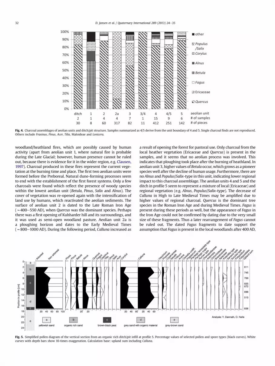
Fig. 4. Charcoal assemblages of aeolian units and ditch/pit structure. Samples summarized as 4/5 derive from the unit boundary of 4 and 5. Single charcoal finds are not reproduced.Others include Fraxinus, Pinus, Acer, Tilia, Maloideae and Lonicera.
D. Jansen et al. / Quaternary International 289 (2013) 24e3532
woodland/heathland fires, which are possibly caused by humanactivity (apart from aeolian unit 1, where natural fire is probableduring the Late Glacial; however, human presence cannot be ruledout, because there is evidence for it in the wider region, e.g. Clausen,1997). Charcoal produced in these fires represent the current vege-tation at the burning time and place. The first two aeolian units wereformed before the Preboreal. Natural dune-forming processes seemto end with the establishment of the first forest systems. Only a fewcharcoals were found which reflect the presence of woody specieswithin the lowest aeolian unit (Betula, Pinus, Salix and Alnus). Thecover of vegetation was re-opened again with the intensification ofland use by humans, which reactivated the aeolian sediments. Thesurface of aeolian unit 2 is dated to the Late Roman Iron Age(w400e550 AD), when Quercus was the dominant species. Perhapsthere was a first opening of Kuhharder hill and its surroundings, andit was used as semi-open woodland pasture. Aeolian unit 2a isa ploughing horizon and dates to the Early Medieval Times(w800e1000 AD). During the following period, Calluna increased as
Fig. 5. Simplified pollen diagram of the vertical section from an organic rich ditch/pit infillcurves with depth bars show 10-times exaggeration. Calculation base: upland sum includin
a result of opening the forest for pastoral use. Only charcoal from thelocal heather vegetation (Ericaceae and Quercus) is present in thesamples, and it seems that no aeolian process was involved. Thisindicates that ploughing took place after the burning of heathland. Inaeolian unit 3, higher values of Betulaoccur,which grows as a pioneerspecieswell after the decline of humanusage. Furthermore, there areno Alnus and Populus/Salix-type in this unit, indicating lower regionalimpact to this charcoal assemblage. The aeolian units 4 and 5 and theditch in profile 5 seem to represent amixture of local (Ericaceae) andregional vegetation (e.g. Alnus, Populus/Salix-type). The decrease ofCalluna in High to Late Medieval Times may be amplified due tohigher values of regional charcoal. Quercus is the dominant treespecies in the Roman Iron Age and during Medieval Times. Fagus ispresent during these periods as well, but the appearance of Fagus inthe Iron Age could not be confirmed by dating due to the very smallsize of these fragments. Thus a later rearrangement of Fagus cannotbe ruled out. The dated Fagus fragments to date support theassumption that Fagus is present in the localwoodlands after 400AD,
at profile 5. Percentage values of selected pollen and spore types (black curves). Whiteg Calluna.

D. Jansen et al. / Quaternary International 289 (2013) 24e35 33
as seen in pollen diagrams (Dörfler, 2000). Whether Fagus immi-grated earlier, possibly around 500 BC, remains to be tested by datingof macroremains. Pollen values during this time are low and cannotbe interpreted as a clear local presence of the species.
Charcoal, analysed by Dörfler and Wiethold (2000), from thenearby investigated iron ore production sites, was dominated byQuercuswithhighvalues ofAlnus and single recordsof Corylus,Betula,Fraxinus, Populus/Salix-type, Acer, Carpinus and Hedera. However, noFagus occurred. The charcoal assemblages of Dörfler and Wietholdrepresentmixed oak forests onwetter soils. In the dune samples, taxasuch as Alnus are very rare. If reworking of Roman charcoal from thesettlement took place in higher quantity, then more Alnus wouldoccur. Further, Dörfler (1995) presented amodel for calculation of thewood consumption of the iron ore production in Joldelund. He pointsout that a high amount of woodwas required, but compared to otherwood consuming activities such as the construction of houses ortools, the wood demand for iron ore production was moderate, anddid not cause deforestation.
The charcoal data can be compared to palynological evidencefrom the nearby mire Hörrmoos, which is situated 1 km east ofKuhharder hill (Fig.1). Dörfler (2000) showed that amixed oak forestwas typical for the region since at least 6000BP, the start of the pollenrecord. The woodland was mainly composed of Quercus, Corylus,Betula and Alnus. Tilia, Ulmus, Fraxinus and Salix seem to be contin-uously present, while Acer and Populus occur with very low values.Acer is insect-pollinated, and Populus pollen grains are very sensitiveto degradation. The curves of Fagus and Carpinus rise after 400 AD,givingmuchdiscussion aboutwhether this is an indication of thefirstoccurrences of the late immigrating trees at the local scale, orwhether single trees, that were already present, spread on a largerscale. Human indicators such as Rumex and Plantago appear around2600 BC togetherwith the first cereal grains. Since 1300 AD, a changeto more intensified agriculture is visible in the diagram, resulting inlower values of tree pollen and higher values of cereals. Hereafter,sand layers are visible in the core. Before 1300 AD, deforestation tookplace only on a locally restricted dimension. During Medieval Timesintensive land use connected with a broad woodland cutting and anincrease of heathland happened (Dörfler, 2000). A second mireanalysed by Dörfler (2000) is situated approximately 500 m east ofthe Kuhharder dune (“Mire covered by dunes”, Fig. 1). The pollenrecord stretches from 400 BC until 1200 AD, when the mire wasoverlaid by sand. While the overall vegetation recording is compa-rable to the Hörrmoos, a higher local pollen input is visible due to thesmall size of the mire, as can be seen in very high values for Calluna.Further, a change due to the Roman Iron Age settlement is visible,resulting in very low values of trees and shrubs.
In this broader palynological context, the newly analysed smallditch pollen profile provides a very local, on-site impression of thevegetation composition. The finding of a Fagopyrum (buckwheat)pollen grain in the lower part of the profile supports the geomor-phological dating of the sediment formation. Buckwheat was intro-duced toNorthernGermany in the 14th century AD (Wiethold,1998).With high proportions of non-arboreal pollen and considerablevalues of Calluna, the assemblages indicate the openness of the siteduringMedieval/LateMedieval Times. However, the increase of Fagusin the upper part of the diagram might be connected to a period ofless intense landuse in the15th centuryAD,which is also reported byDörfler (2000). Surprisingly high values of Corylus contradict itsgeneral scarceness in the charcoal record.
5.3. Linking geomorphology and anthracology
For this study, scientists from botany as well as geomorphologyworked closely together, initiated by the geomorphological work.One important aspect was the taxonomic identification of wood
charcoal prior to radiocarbon dating. The unexpectedly largenumber of charcoal-rich layers provided an abundant amount ofdatable material. It turned out that the taxonomical selection ofdatable charcoal was indispensable for the development of thedune stratigraphy. In this respect, charcoal was excluded fromdating which could be assumed to result in erroneous ages, such asconiferous species which were introduced in recent times. The useof relatively short-living woody taxa such as Ericaceae and Populus/Salix makes the date more reliable by reducing the potential“inbuilt age” (Gavin et al., 2003), which is for Quercus possibly up to300e400 years. For this reason, Quercus was chosen only excep-tionally for dating (see Table 1). Charcoal analysis thus helps toestablish a more precise chronostratigraphy of dune formation.
The comparison of charcoal assemblages from correlated aeolianunits in different neighboring profiles can support or contradict thestratigraphic assumptions. In this respect, the dating of aeolian unit 1was supported by thewoody species assemblage. The layers inprofile3 and 8 which are related as aeolian unit 2a showed similarly highvalues of Quercus and Ericaceae, which support the geomorphologicinterpretation as well. The correlation of aeolian units 4 and 5 isneither really supported nor contradicted by taxa spectra, but issupported by the number of taxa per sample,which is higher in theseaeolian units compared to the underlying ones. Another aspect ofsynergy concerns the interpretation of charcoal assemblages for thereconstruction of past vegetation. Without the stratigraphic context,taxonomic data are impossible to interpret. This is particularly thecase if charcoal pieces are rearranged over time. Of the total of datedcharcoal samples, four measurements cannot be connected with thedune activity itself and are from relocated charcoals. With theexception of one sample, the relocated charcoal dated to the RomanIron Age.
Vegetation cover is the main factor which controls aeoliansediment transport. Thus, charcoal analysis contributes to thereconstruction of local vegetation of the different past dunesurfaces and gives an insight into the wood species compositionin prior erosional events. Additionally, the assumption of poten-tial wood provenances can assess plausibility of the potentialsource areas for the aeolian sediment. For example, local charcoalsources of Alnus as well as Salix and Populus are most likely sus-pected to the north-northeast as well as west-southwest ofKuhharder hill, where these species possibly grew in respectivestands in the low lying wetlands, which are influenced bygroundwater. During the Roman Iron Age, the areas of Saalianmoraine were favored for agricultural land use, and thus consti-tute potential areas for sand and charcoal origin. As bothminerogenic as well as peatland sites are suitable for Calluna,potential catchment areas of heathland are in the surroundinglowlands and at the dunes itself. Quercus was intensively usedduring the Roman Iron Age. It is assumed that local charcoaltransport occurred from settlement and iron production sites, butthis was only slight. Due to the broad site conditions under whichQuercus can possibly grow, ranging from dry sandy soils to wetsoils with higher nutrient availability, Quercus can grow almosteverywhere on and around the dunes.
6. Conclusion
Sandy deposits forming dunes serve as palaeoarchives andcontain taxonomically identifiable wood charcoal. These can be usedto obtain information on the occurrences of woody taxa, for thereconstruction of vegetation and dune dynamics. Due to variousfactors influencing the charcoal spectra, including particularly thereworking processes during the dune accumulation, the interpreta-tion of the results is complicated. Therefore, an interdisciplinarycollaboration is an essential basis, in this respect: geomorphological

D. Jansen et al. / Quaternary International 289 (2013) 24e3534
work on dune formation makes these archives accessible throughprofiles, and provides stratigraphic hypotheses which can be cross-checked by the charcoal assemblages. This is supported by physicaldating to establish a chronostratigraphy, which is then used tointerpret thewoody taxa occurrences through time. As a counterpart,vegetationandhumanactivity trigger thedunedevelopment. For thisreason, the knowledge about the causing processes is essential tocomprehend former sedimentation events.
In the case of the Joldelund dune complex previous archaeologicalandespecially palaeobotanical analysis complete thepicture. The twotypes of botanical recordse pollen and charcoale show someminordifferences, which can be explained by the varying catchment areas,and the proportion of species in the records is linked to botanicalfactors like pollen production of single species. A further factor thatshould not be ignored is that charcoals in the dune context mostlyoriginated from fires caused by human. Even if no selection of woodfor any purpose is reflected in the samples, lighting a fire in specialareasmay affect the results. Despite this, the results demonstrate thedevelopment of the dune area near to Joldelund. In contrast to thevegetation today (coniferous forestation) the dune was formerlyforested with a mixed deciduous oak forest. In times of humaninfluence, a heathlandwith Ericaceae developed. In summary, amoreprecise landscape history scenario can be formulated based on thisintegrated approach, compared to a single discipline approach.
Acknowledgements
The research was made possible by grants from the GraduateSchool “HumanDevelopment in Landscapes” at the University of Kieltowards Uta Lungershausen, Doris Jansen and Vincent Robin. Wethank Rainer Duttmann and Hans-Rudolf Bork for their valuablescientific support. Mathias Bahns, Rolf Gabler-Mieck, Claus-ChristianHinrichs and Carina Hörtdörfer supported fieldwork at Kuhharderhill. A great advantage for our work was the support of Marie-JoséeNadeau, Pieter M. Grootes and their team from the Leibniz-Laboratory for Radiometric Dating and Isotope Research at KielUniversity. Thanks for proofreading and correcting the English go toJohn Rapaglia, and to the anonymous reviewers for their valuablecomments.
References
Bundesamt für Naturschutz, 2000. Karte der natürlichen Vegetation Europas/Mapof the Natural Vegetation of Europe. BfN-Schriften, Münster.
Carcaillet, C., Thinon, M., 1996. Pedoanthracological contribution to the study of theevolution of the upper treeline in the Maurienne Valley (North French Alps):methodology and preliminary data. Review of Palaeobotany and Palynology 91,399e416.
Carcaillet, C., Richard, P.J.H., Asnong, H., Capece, L., Bergeron, Y., 2006. Fire and soilerosion history in East Canadian boreal and temperate forests. QuaternaryScience Reviews 25, 1489e1500.
Clausen, I., 1997. Neue Untersuchungen an späteiszeitlichen Fundplätzen derHamburger Kultur bei Ahrenshöft, Kr. Nordfriesland (ein Vorbericht). Arch-äologische Nachrichten aus Schleswig-Holstein 8, 8e49.
De la Vega Leinert, A.C., Keen, D.H., Jones, R.L., Wells, J.M., Smith, D.E., 2000. Mid-Holocene environmental changes in the Bay of Skaill, Mainland Orkney, Scot-land: an integrated geomorphological, sedimentological and stratigraphicalstudy. Journal of Quaternary Science 15 (5), 509e528.
Dierßen, K., 2004. Vegetation Schleswig-Holsteins. EcoSys Supplement 41, 36e60.Dörfler, W., 1995. Versuch einer Modellierung des Energieflusses und des Roh-
stoffverbrauchs während der römisch-kaiserzeitlichen Eisenverhüttung inJoldelund, Ldkr. Nordfriesland. Probleme der Küstenforschung im südlichenNordseegebiet 23, 175e185.
Dörfler, W., 2000. Palynologische Untersuchungen zur Vegetations- und Land-schaftsentwicklung von Joldelund, Kr. Nordfriesland. In: Haffner, A., Jöns, H.,Reichstein, J. (Eds.), Frühe Eisengewinnung in Joldelund, Kr. Nordfriesland. EinBeitrag zur Siedlungs- und Technikgeschichte Schleswig-Holsteins. Teil 2: Natur-wissenschaftliche Untersuchungen zur Metallurgie- und Vegetationsgeschichte,vol. 59. Universitätsforschungen zur prähistorischen Archäologie, pp. 147e208.
Dörfler, W., Wiethold, J., 2000. Holzkohlen aus den Herdgruben von Rennfeueröfenund Siedlungsbefunden des spätkaiserzeitlichen Eisengewinnungs- und Sied-lungsplatzes am Kammberg bei Joldelund, Kr. Nordfriesland. In: Haffner, A.,
Jöns, H., Reichstein, J. (Eds.), Frühe Eisengewinnung in Joldelund, Kr. Nord-friesland. Ein Beitrag zur Siedlungs- und Technikgeschichte Schleswig-Holsteins. Teil 2: Naturwissenschaftliche Untersuchungen zur Metallurgie- undVegetationsgeschichte, vol. 59. Universitätsforschungen zur prähistorischenArchäologie, pp. 217e262.
Duttmann, R., Fleige, H., Horn, R., Bach, M., 2004. Landschafts- und Bode-nentwicklung im Raum Goldelund (Schleswiger Geest) unter Berücksichtigungder Winderosion. EcoSys Supplement 41, 131e151.
Faegri, K., Iversen, J., 1989. In: Faegri, K., Kaland, P.E., Krzywinski, K. (Eds.), Textbookof Pollen Analysis, fourth ed. Wiley, Chichester.
Franco-Múgica, F., García-Antón, M., Maldonado-Ruiz, J., Morla-Juaristi, C., Sainz-Ollero, H., 2005. Ancient pine forest on inland dunes in the Spanish northernmeseta. Quaternary Research 63, 1e14.
Gavin, D.G., Brubaker, L.B., Lertzman, K.P., 2003. An 1800-year record of the spatialand temporal distribution of fire from the west coast of Vancouver Island,Canada. Canadian Journal of Forest Research 33, 573e586.
Haesaerts, P., Borziac, I., Chekha, V.P., Chirica, V., Drozdov, N.I., Koulakovska, L.,Orlova, L.A., van der Plicht, J., Damblon, F., 2010. Charcoal and wood remains forradiocarbon dating Upper Pleistocene loess sequences in Eastern Europe andCentral Siberia. Palaeogeography, Palaeoclimatology, Palaeoecology 291 (1e2),106e127.
Ivester, A.H., Leigh, D.S., 2003. Riverine dunes on the Coastal Plain of Georgia, USA.Geomorphology 51, 289e311.
Jöns, H., 1997. Frühe Eisengewinnung in Joldelund, Kr. Nordfriesland. Ein Beitrag zurSiedlungs- und Technikgeschichte Schleswig-Holsteins. Teil 1. Einführung,Naturraum, Prospektionsmethoden und archäologische Untersuchungen. Uni-versitätsforschungen zur Prähistorischen Archäologie 40, Bonn.
Keit, E., Mothes, K., 1942. Pollen- und Holzkohlenanalysen alter Waldhorizonte derKurischen Nehrung 6. Beitrag zur Bestandesgeschichte ostpreußischer Wälder.Botanisches Archiv 44 (2), 155e171.
Koster, E.A., 2005. The Physical Geography of Western Europe. Oxford UniversityPress, Oxford.
Kowalkowski, A., Boles1aw, N., Okuniewska-Nowaczyk, I., 1999. Chronosequence ofbiogenic deposits and fossil soils in the dune near Jasie�n, Western Poland. In:Schirmer, W. (Ed.), Dunes and Fossil Soils. GeoArchaeoRhein 3, pp. 107e125.
Loope, W.L., Arbogast, A.F., 2000. Dominance of an w150-year cycle of sand-supplychange in Late Holocene dune-building along the Eastern Shore of LakeMichigan. Quaternary Research 54, 414e422.
Ludemann, T., Michiels, H.-G., Nölken, W., 2004. Spatial patterns of past woodexploitation, natural wood supply and growth conditions: indications of naturaltree species distribution by anthracological studies of charcoal-burningremains. European Journal of Forest Research 123, 283e292.
Mauz, B., Hilger,W.,Müller,M.J., Zöller, L., Dikau, R., 2005.Aeolianactivity in Schleswig-Holstein (Germany): landscape response to Late Glacial climate change andHolocene human impact. Zeitschrift für Geomorphologie 49 (4), 417e431.
Müller, M.J., 1999. Genese und Entwicklung schleswig-holsteinischer Binnendünen.Berichte zur dt. Landeskunde 73, 129e150.
Müller, M.J., 2000. Altersbestimmung an schleswig-holsteinischen Binnendünenmit Hilfe von Paläoböden. Trierer Bodenkundliche Schriften 1, 23e31.
Nelle, O., 2002. Charcoal burning remains and forest stand structure e examplesfrom the Black Forest (south-west Germany) and the Bavarian Forest (south-east Germany). In: Thiébault, S. (Ed.), Charcoal Analysis. MethodologicalApproaches, Palaeoecological Results and Wood Uses. Proceedings 2nd Int.Meeting of Anthracology, Paris, Sept. 2000. BAR Int. Series 1063,pp. 201e207.
Nelle, O., 2003. Woodland history of the last 500 years revealed by anthracologicalstudies of charcoal kiln sites in the Bavarian Forest, Germany. Phytocoenologia33 (4), 667e682.
Nielsen, M., 1970. Der Gemeindewald von Joldelund. Jahrbuch für die SchleswigscheGeest 18, 66e72.
Ohlson, M., Tryterud, E., 2000. Interpretation of the charcoal record in forest soils:forest fires and their production and deposition of macroscopic charcoal. TheHolocene 10, 519e525.
Poschlod, P., Baumann, A., 2010. The historical dynamics of calcareous grasslands inthe central and southern Franconian Jurassic Mountains: a comparativepedoanthracological and pollen analytical study. The Holocene 20, 13e23.
Reimer, P.J., Baillie, M.G.L., Bard, E., Bayliss, A., Beck, J.W., Blackwell, P.G., BronkRamsey, C., Buck, C.E., Burr, G.S., Edwards, R.L., Friedrich, M., Grootes, P.M.,Guilderson, T.P., Hajdas, I., Heaton, T.J., Hogg, A.G., Hughen, K.A., Kaiser, K.F.,Kromer, B., McCormac, F.G., Manning, S.W., Reimer, R.W., Richards, D.A.,Southon, J.R., Talamo, S., Turney, C.S.M., van der Plicht, J.,Weyhenmeyer, C.E., 2009.IntCal09 andMarine09 radiocarbon age calibration curves, 0e50,000 years cal BP.Radiocarbon 51 (4), 1111e1150.
Richter, G., 1965. Bodenerosion. Schäden und gefährdete Gebiete in der Bundesre-publik Deutschland. Forschungen zur Deutschen Landeskunde, Bad Godesberg.
Robin, V., Rickert, B.-H., Nadeau, M.J., Nelle, O., 2011. Assessing Holocene vegetationand fire history by a multiproxy approach: the case of Stodthagen Forest(Northern Germany). The Holocene. doi:10.1177/0959683611423687.
Seppälä, M., 1995. Deflation and redeposition of sand dunes in Finnish Lapland.Quaternary Science Reviews 14, 799e809.
Schlaak, N., 1999. Typical aeolian sand profiles and palaeosols of the Glien till plainin the northwest of Berlin. In: Schirmer, W. (Ed.), Dunes and Fossil Soils. Geo-ArchaeoRhein 3, pp. 97e105.
Schirmer,W.,1999. Dunes phases and soils in the European sand belt. In: Schirmer, W.(Ed.), Dunes and Fossil Soils. GeoArchaeoRhein 3, pp. 11e42.

D. Jansen et al. / Quaternary International 289 (2013) 24e35 35
Schweingruber, F.H., 1990a. Mikroskopische Holzanatomie. Formenspektren mit-teleuropäischer Stamm- und Zweighölzer zur Bestimmung von rezenten undsubfossilen Material. Eidg. Anstalt für das forstl, Versuchswesen, Birmensdorf/Schweiz.
Schweingruber, F.H., 1990b. Anatomie europäischer Hölzer. Haupt, Bern, Stuttgart.Scott, A.C., Cripps, J.A., Collinson, M.E., Nichols, G.J., 2000. The taphonomy of charcoal
following a recent heathland fire and some implications for the interpretation offossil charcoal deposits. Palaeogeography, Palaeoclimatology, Palaeoecology 164,1e31.
Strehl, E., 1999. Erläuterungen zur Geologischen Karte von Schleswig-Holstein 1: 25000, Drelsdorf, Jörl, Blatt 1320, 1321, Flintbek.
Talon, B., 2010. Reconstruction of Holocene high-altitude vegetation cover inthe French southern Alps: evidence from soil charcoal. The Holocene 20,35e44.
Tinner, W., Hofstetter, S., Zeugin, F., Conedera, M., Wohlgemuth, T., Zimmermann, L.,Zweifel, R., 2006. Long-distance transport of macroscopic charcoal by an
intensive crown fire in the Swiss Alps e implications for fire history recon-struction. The Holocene 16, 287e292.
Vernet, J.-L., 2002. Preface to: charcoal analysis. Methodological approaches,palaeoecological results and wood uses. In: Thiébault, S. (Ed.), Proceedings 2ndInt. Meeting of Anthracology, Paris, Sept. 2000. British Archaeological ResearchInternational Series 1063, pp. vevi.
Wiethold, J., 1998. Studien zur jüngeren postglazialen Vegetations- und Siedlungsge-schichte im östlichen Schleswig-Holstein (mit einem Beitrag von H. Erlenkeuser),vol. 45. Universitätsforschungen zur prähistorischen Archäologie, Habelt, Bonn.
Yang, X., Scuderi, L., 2010. Hydrological and climatic changes in deserts of Chinasince the Late Pleistocene. Quaternary Research 73, 1e9.
Yang, X., Scuderi, L., Paillou, P., Liu, Z., Li, H., Ren, X., 2011. Quaternary environmentalchanges in the drylands of China e a critical review. Quaternary ScienceReviews 30, 3219e3233.
Yang, X., Li, H., Conacher, A., 2012. Large-scale controls on the development of sandseas in northern China. Quaternary International 250, 74e83.
Copyright © 2022 FDOKUMEN