
William Shakespeare's 'New Place', Stratford upon Avon. DBA and Eval
70
birmingham archaeology IFA R E G I S T E R E D O R G A N I S A T I O N PN2000 New Place, Stratford Upon Avon ARCHAEOLOGICAL DESK-BASED ASSESSMENT and EVALUATION 2009
Transcript of William Shakespeare's 'New Place', Stratford upon Avon. DBA and Eval

birmingham archaeology
IFA
RE
GISTEREDO
RGANISATION
PN2000
New Place, Stratford Upon Avon
ARCHAEOLOGICAL DESK-BASED ASSESSMENT
and EVALUATION
2009

PN: 2000 New Place, Stratford upon Avon, Warwickshire
Archaeological Desk-based Assessment and Evaluation
birmingham archaeology i
New Place, Stratford upon Avon, Warwickshire
Archaeological Desk-Based Assessment and Evaluation, 2009
TABLE OF CONTENTS
1 INTRODUCTION ...............................................................................................1
1.1 Background to the Project .................................................................................1
2 SITE LOCATION AND GEOLOGY..........................................................................1
2.1 Site Location....................................................................................................1 2.2 Statutory Designations......................................................................................1 2.3 Geology ..........................................................................................................2
3 AIMS AND OBJECTIVES.....................................................................................2
4 METHODOLOGY................................................................................................2
4.1 Archaeological desk based assessment................................................................2 4.2 Archaeological Evaluation ..................................................................................2
5 THE HISTORIC DEVELOPMENT OF NEW PLACE .....................................................3
5.1 Introduction.....................................................................................................3 5.2 New Place before William Shakespeare................................................................3 5.3 William Shakespeare’s New Place .......................................................................4 5.4 New Place after William Shakespeare..................................................................5
6 HISTORIC MAP REGRESSION and PICTORIAL HISTORY .........................................7
6.1 Introduction.....................................................................................................7 6.2 Early Maps.......................................................................................................7 6.3 Ordnance Survey Maps .....................................................................................8 6.4 Pictorial History................................................................................................9
7 VICTORIAN EXCAVATIONS ..............................................................................10
7.1 Introduction...................................................................................................10 7.2 New Place Phase 1 c.1483 ...............................................................................10 7.3 New Place Phase 2 c.1702 ...............................................................................11 7.4 New Place Phase 3 19th century (‘modern date’) ................................................12
8 EVALUATION RESULTS....................................................................................12
8.1 Introduction...................................................................................................12 8.2 Test Pit 1 (Figure 13, Plate 25) ........................................................................12 8.3 Test Pit 2 (Figure 13, Plate 26) ........................................................................13 8.4 Test Pit 3 (Figure 14, Plate 27) ........................................................................14 8.5 Test Pit 4 (Figure 14, Plate 28) ........................................................................15 8.6 Test Pit 5 (Figure 15, Plate 29) ........................................................................16 8.7 Test Pit 6 (Figure 15, Plate 30) ........................................................................17 8.8 Test Pit 7 (Figure 15, Plate 31) ........................................................................17
9 DISCUSSION .................................................................................................19
9.1 Archaeological Potential of New Place................................................................19

PN: 2000 New Place, Stratford upon Avon, Warwickshire
Archaeological Desk-based Assessment and Evaluation
birmingham archaeology ii
10 ACKNOWLEDGEMENTS....................................................................................22
11 SOURCES ......................................................................................................23
APPENDIX A: Glossary of Terms.................................................................................26
APPENDIX B: The Finds.............................................................................................28
List of Figures
Figure 1 Site and Trench Location
Figure 2 Location and zone plan
Figure 3 Aerial view of site (courtesy of Google Earth maps)
Figure 4 1834 Board of Health map
Figure 5 Captain Saunders plan 1850
Figure 6 Halliwell’s 1864 map
Figure 7 1886 1:500 Ordnance Survey map
Figure 8 1889 1:2500 1st Edition Ordnance Survey map
Figure 9 1904 1:2500 1st Edition Revision Ordnance Survey map
Figure 10 1914 2nd Edition Ordnance Survey map
Figure 11 1938 Ordnance Survey map
Figure 12 1967 Ordnance Survey map
Figure 13 Test pits 1 and 2 plans and sections
Figure 14 Test pits 3 and 4 plans and sections
Figure 15 Test pits 5, 6 and 7 plans and sections
Figure 16 Phased plan of New Place buildings taken from Halliwell’s plans of 1864 and
excavations of 1900
Figure 17 Areas of potential buried structures
Figure 18 Areas of potential buried deposits/artefacts
Figure 19 Proposed locations for 2010 excavations
List of Plates
Plate 1 Vertue’s New Place (Late 18th century)
Plate 2 J. Jordan’s New Place 1780 from a drawing in the margin of an ancient survey
Plate 3 Samuel Ireland’s New Place and Gild Chapel c.1792
Plate 4 Wheeler’s view of New Place and Guild Chapel 1806.
Plate 5 J. Sharp’s Sketch of New Place 1784
Plate 6 J. Jordan’s New Place c.1790
Plate 7 Captain Saunder’s drawing of New Place 1850
Plate 8 New Place c. 1860 Rook & co. London
Plate 9 Graf’s View of New Place and the Gild Chapel 1851
Plate 10 New Place before the excavations 1856
Plate 11 Excavations at New Place Shakespeare’s Residence in Stratford-on-Avon, Rook and
Co. 1864
Plate 12 Willis’s Pencilling of New Place 1890
Plate 13 Josiah Whymper’s engraving of The Foundations of New Place, The Guild Chapel, and
Falcon Tavern 1864
Plate 14 Photograph of excavations at New Place 1862
Plate 15 Photograph of excavations at New Place 1864
Plate 16 Photograph of excavations at New Place 1864

PN: 2000 New Place, Stratford upon Avon, Warwickshire
Archaeological Desk-based Assessment and Evaluation
birmingham archaeology iii
Plate 17 New Place following excavation 1870
Plate 18 New Place following excavation 1874
Plate 19 New Place following excavation 1877
Plate 20 New Place following excavation 1882
Plate 21 New Place following excavation 1904
Plate 22 Engraving of New Place following excavation 1864
Plate 23 Foundations of ‘bay window’ discovered during excavations 1864
Plate 24 Engraving of New Place post-excavation 1864
Plate 25 Test pit 1, looking west
Plate 26 Test pit 2, looking east
Plate 27 Test pit 3, looking west
Plate 28 Test pit 4, looking west
Plate 29 Test pit 5, looking south
Plate 30 Test pit 6, looking south
Plate 31 Test pit 7, looking east
Plate 32 Shakespeare Birthplace Trust Reconstruction of New Place at the time of Shakespeare.

PN: 2000 New Place, Stratford upon Avon, Warwickshire
Archaeological Desk-based Assessment and Evaluation
birmingham archaeology iv
New Place, Stratford upon Avon, Warwickshire
Archaeological Desk-Based Assessment and Evaluation, 2009
SUMMARY
Birmingham Archaeology was commissioned in October 2009 by The Shakespeare Birthplace Trust to undertake an archaeological desk-based assessment and evaluation in respect of the site of New Place, Stratford upon Avon, Warwickshire (centred on NGR SP 2010 2547). The archaeological work was undertaken in order to increase our understanding of the historic development of the New Place site to help inform proposed future archaeological works. The archaeological desk-based assessment comprised a documentary search of all readily available published and unpublished sources at the Shakespeare Centre Library and Archive, Stratford upon Avon, and the libraries of the University of Birmingham. Following completion of historic research, a site visit was made in order to assess topography and above-ground archaeology, including standing buildings. The archaeological evaluation consisted of seven test pits strategically placed to answer specific questions on the sites past layout and achieve as much coverage of the site as possible. The archaeological desk-based assessment has revealed the interesting and varied history of New Place, tracing its development from its original construction in c.1483 as the ‘grete house’ of Hugh Clopton, a wealthy merchant and future Lord Mayor of the City of London, through to it being the final residence of William Shakespeare from its purchase in 1597 to his death in 1616 and the turbulence of the 18th century, which first saw the original New Place pulled down and rebuilt around 1702 only to be razed to the ground in a dispute over the payment of rates in 1759. The assessment also examines and illustrates cartographic and pictorial evidence which provides us with an understanding of the subsequent development of the site and of the nature and results of antiquarian excavations carried out in the early 1860s. The archaeological evaluation revealed archaeological deposits in each of the seven test pits. The site was predominantly characterised by levelling layers, some of which were associated with the period of backfilling subsequent to the 1862 excavations. Other significant levelling layers predating the 19th century were present, these may provide undisturbed archaeological deposits. Test pits 1, 3 and 4 all contained structural remains which relate to the structure of New Place. Test pits 5 and 6 also contained the possible remains of foundation trenches, perhaps associated with the outbuildings constructed along Chapel Lane. The artefactual evidence was consistent with the distinctive levelling episodes and the later usage and history of the site.

PN: 2000 New Place, Stratford upon Avon, Warwickshire
Archaeological Desk-based Assessment and Evaluation
birmingham archaeology
1
New Place, Stratford upon Avon, Warwickshire
Archaeological Desk-Based Assessment and Evaluation, 2009
1 INTRODUCTION
1.1 Background to the Project
1.1.1 Birmingham Archaeology was commissioned in November 2009 by The Shakespeare
Birthplace Trust, to undertake an archaeological desk-based assessment and
evaluation in respect of the site of New Place, Stratford upon Avon, Warwickshire,
centred on NGR SP 2010 2547 (Figure 1). The archaeological desk-based assessment
and evaluation were commissioned in order to increase our understanding of the
historic development of the New Place site to help inform proposed future
archaeological works.
1.1.2 This report outlines the results of the archaeological desk-based assessment, which
has been carried out in line with guidance included within Planning Policy Guidance 16 (PPG16): Archaeology and Planning, Section B, paras. 19-20 (DoE, 1990), and has been prepared in accordance with the Institute for Archaeologists Standard and Guidance for Archaeological Desk-Based Assessment (IFA, 2008a).
1.1.3 The report also outlines the results of the archaeological evaluation, which was carried
out in accordance with the Institute for Archaeologists Standard and Guidance for archaeological field evaluation (IFA, 2008b).
1.1.3 This report has been prepared based upon information current and available as of
10/11/2009. Details of archaeological terms used in this report are given in the
glossary appended as Appendix A.
2 SITE LOCATION AND GEOLOGY
2.1 Site Location
2.1.1 New Place occupies a parcel of land formed by the junction of Chapel Lane and Chapel
Street (Figures 2 and 3). To the south of the site is the Guild Chapel and the King
Edward IV school buildings, the Falcon Inn is located to the west. The site lies in an
area of relatively flat ground except at the west of the site and within the Knott
garden, where the ground has been reduced.
2.2 Statutory Designations
2.2.1 The study area does not include or form part of any Scheduled Ancient Monuments
(SAMs); however it is located within the Stratford upon Avon Conservation Area (CA).
Zones 1, 2, 3 and 4 also form part of a Registered Park and Garden; whilst Nash
House is a Grade I listed building (LB).

PN: 2000 New Place, Stratford upon Avon, Warwickshire
Archaeological Desk-based Assessment and Evaluation
birmingham archaeology
2
2.3 Geology
2.2.1 The underlying geology of New Place comprises bedrock consisting of West Mercian
Mudstone which is overlaid by Wasperton sand and gravel of the Warwickshire Avon
Valley Formation (British Geological Survey).
3 AIMS AND OBJECTIVES
3.1.1 The general aim of the archaeological desk-based assessment and evaluation was to
collate existing archaeological and historic information relating to New Place and its
immediate environs, and to establish their historical context and archaeological
potential.
3.1.2 More specifically, the principal aim of the evaluation was to determine the character,
state of preservation and the potential significance of any buried remains. The results
will allow a mitigation strategy for the project work to be completed.
Other specific aims were to:
• Establish the extent to which Halliwell’s excavations of 1862 have affected
the below ground remains.
• Recover and interpret any re-deposited artefactual material relating to New
place from the backfilled excavations of 1862.
• Attempt to confirm the hypothetical notions of the layout of New place which
are currently based upon fragmentary documentary sources.
4 METHODOLOGY
4.1 Archaeological desk based assessment
4.1.1 A search was made of all relevant and readily available published and unpublished
documentary source material, including historic maps and photographs of the study
area, held by the Shakespeare Centre Library and Archive, Stratford upon Avon, and
the libraries of the University of Birmingham. In addition, a walkover assessment of
the site was undertaken in order to assess the topography and any above ground
archaeology, including any standing buildings.
4.2 Archaeological Evaluation
4.2.1 A total of 7 test pits were excavated across the site totalling 7.7m². All but two of
these test pits were 1m x 1m (the other two were 2m x 1m and 0.7m x 0.7m). These
test pits were located to provide a sample coverage of the total area and investigate
different areas within the hypothetical historical layout of the site.
4.2.2 The test pits were excavated to the first archaeological horizon or to a depth that was
reasonably practicable within a 1m x 1m test pit. Archaeological deposits were not
completely excavated unless it was deemed unavoidable. The depth of archaeological
deposits across the site was assessed, although the test pits were not excavated down
to natural due to health and safety implications.
4.2.3 The test pits were surveyed-in using an EDM total station and located on the Ordnance
Survey National Grid.

PN: 2000 New Place, Stratford upon Avon, Warwickshire
Archaeological Desk-based Assessment and Evaluation
birmingham archaeology
3
4.2.4 All turf/ topsoil removal and subsequent excavation and cleaning was done was done
by hand. All archaeological features and deposits encountered were manually sample
excavated, within the reasonable health and safety restrictions of the test pits. This
was done to sufficiently define their character and to obtain suitable dating evidence.
4.2.5 All stratigraphic sequences were recorded, even where no archaeology was present.
Features were planned at a scale of 1:20, and sections drawn of all significant vertical
stratigraphy and building elevations at a scale of 1:10. A comprehensive written
record was maintained using a continuous numbered context system on pro-forma cards. Written records and scale plans were supplemented by photographs using black
and white monochrome, colour slide and digital photography.
4.2.6 Recovered finds were cleaned, marked and remedial conservation work undertaken as
necessary. Treatment of all finds conformed to guidance contained within the
Birmingham Archaeology Fieldwork Manual and First Aid for Finds (Watkinson and Neal 1998).
4.2.7 The full site archive includes all artefactual remains recovered from the site. The site
archive will be prepared according to guidelines set down in Appendix 3 of the
Management of Archaeology Projects (English Heritage, 1991), the Guidelines for the
Preparation of Excavation Archives for Long-term Storage (UKIC, 1990) and Standards
in the Museum Care of Archaeological collections (Museum and Art Galleries
Commission, 1992). The paper archive will be deposited with the appropriate
repository subject to permission from the landowner.
5 THE HISTORIC DEVELOPMENT OF NEW PLACE
5.1 Introduction
5.1.1 New Place is best known as the retirement home of William Shakespeare, where he
lived from c.1610 until his death in 1616. The site has had quite an interesting history; in addition to its association with Shakespeare, some significant and controversial
characters occupied New Place before and after the Bard’s residency at the house. This
varied and interesting history serves to ameliorate and provide further historic interest
and texture to the legacy of Shakespeare at New Place, the house where he spent the
last years of his life.
5.2 New Place before William Shakespeare
5.2.1 It is understood that New Place was constructed in 1483 by Hugh Clopton, an
important benefactor in Stratford upon Avon, who also built the bridge bearing his
family name which spans the River Avon in the town (Wood 2003, 214). Hugh Clopton
is also believed to have funded the restoration of the nearby Guild Chapel. At the time
of its construction New Place is thought to have been the second largest residence in
Stratford upon Avon (after the college in Old Town), and the only house to have been
built using brick as a significant building material, which was a new innovation not only
in Stratford upon Avon but within most of the wider landscape. In 1540, John Leland,
the antiquary, described New Place as a “praty house of bricke and tymbre wherm he (i.e. Hugh Clopton) lived in his latter dayes and dyed” (q. Halliwell 1864, 3). The use of brick is perhaps indicative of Clopton’s status as a wealthy merchant and future
Lord Mayor of the City of London (1491-1492). The scale of the New Place is perhaps
best understood from an excerpt in Hugh Clopton’s will, where he describes it as his

PN: 2000 New Place, Stratford upon Avon, Warwickshire
Archaeological Desk-based Assessment and Evaluation
birmingham archaeology
4
“grete house” (q. Halliwell 1864, 1) upon leaving it to William Clopton, whilst later
accounts note that it was half-timbered with brick infilling, that it had, three storeys,
five gabled bays and a frontage of c.60 feet (c.18m, Wood 2003, 214). The scale of Hugh Clopton’s ‘Grete House’ is further emphasised by the fact it benefitted from “a well and ten fireplaces, and most important a garden 180 feet long (c. 55m)” (Wood 2003, 214). Contemporary accounts note that the property was accessed via a “front gate which led on to a courtyard, then a rear block and a barn” (Wood 2003, 214).
5.2.2 Hugh Clopton died in 1496 and New Place was retained within the Clopton family until
it was sold it in 1563 for the then expensive sum of £140, it was later sold to the
Underhill family in 1567 for the lesser sum of £110 (Wood 2003, 214). The Underhill
family, headed by William Underhill, were a Catholic family with quite an interesting
history. William Underhill’s son William inherited New Place upon his coming of age in
1575. William Jr was a staunch Romanist which inevitably led to he and his family
being accused of recusancy1 in the fall out from the Somerville Plot in 15832. It would
seem that the Underhill family abandoned New Place following this unfortunate period
in their history as the New Place that William Shakespeare purchased from them in
1597 has been described as semi-derelict, it had not been lived in for a while, and it
was in need of major renovation (Wood 2003, 214).
5.3 William Shakespeare’s New Place
5.3.1 As noted above, William Shakespeare purchased New Place from the Underhill family
in 1597. It is unclear what exact price he paid for New Place, the deed of purchase
notes that it sold for £60, however it is more likely to have sold for at least double that
figure when considered with the previous purchase prices (see Section §5.22 above,
Wood 2003, 214). In addition to the house and gardens, it would seem that he also
purchased other land in the vicinity by separate negotiation (Wood 2003, 214). The
purchase of New Place followed c.9 months after the death of his son Hamnet, an event which perhaps spurred Shakespeare into planning for his retirement in the town
of his birth. However, Shakespeare did not take up residence at New Place
immediately, preferring to spend much of his time working in London until his eventual
retirement in 1610. The exact status of New Place in the interim period between
purchase and Shakespeare’s retirement is not entirely clear, however it would seem
that renovations and improvement works began almost immediately and took at least
a year to complete as there are accounts of the corporation purchasing surplus stone
from Shakespeare in 1597-8 (Wood 2003, 214). It is believed that his wife and
daughters took New Place as their main residence whilst William was still working in
London. However, it would also seem that Shakespeare was renting out part of the
house to his relations; this is attested to by the fact that his cousin Thomas Greene
was still living at New Place in 1609 (Wood 2003, 214). Letting out part of the
property would seem a plausible notion as the house, which contained at least ten
rooms, would have catered for far more than Shakespeare’s small family and any
servants they would have required. In addition, it must have been reassuring to The
Bard that trusted members of his own family were in close proximity to his wife and
daughters whilst he was away in the capital. By the time he retired Shakespeare had
1 Recusancy was the term used to describe the statutory offence of not complying with and conforming to the Established Church, i.e. the Church of England. 2 On 25th October 1583 John Somerville, the 23 year old Catholic heir of Edstone, five miles north of Stratford, and husband of Margaret Arden whose father Edward Arden was the head of Shakespeare’s mothers family, allegedly set out to London with the intention of shooting the Queen, who he described as the bane of the Catholic Church, with a hidden pistol. On his arrest he accused several persons as his co-conspirators including his father-in-law. Despite being clearly out his mind the incident was used to effectively purge Warwickshire of its influential Catholic families including the Underhills.

PN: 2000 New Place, Stratford upon Avon, Warwickshire
Archaeological Desk-based Assessment and Evaluation
birmingham archaeology
5
planted two orchards, one of which contained the famous mulberry tree, two gardens
and erected two barns (Shapiro 2006, 267). Whilst in possession of New Place,
Shakespeare wrote a number of his most famous and popular works including The
Winters Tale, The Tempest and Henry VIII.
5.3.2 William Shakespeare died at New Place in 1616 after allegedly taking ill on an evening
entertaining Ben Jonson and Michael Drayton (www.onlineshakespeare.com/nash). His
wife Anne Hathaway later died at New Place in 1623.
5.4 New Place after William Shakespeare
5.4.1 On Shakespeare’s death, like much of his estate, New Place came into the possession
of his elder daughter Susanna, who had married a local physician John Hall in 1607. It
is thought that Susanna entertained Charles I queen at New Place. Upon her death in
1645, Susanna bequeathed New Place to her daughter Elizabeth, born in 16083, who
married Thomas Nash, owner Nash House next-door and member of the Manor and
Lordship of Shottery. Thomas Nash died in 1647 leaving Nash House to Elizabeth, who
married her second husband Sir John Barnard thus becoming Lady Barnard. Elizabeth
died in 1670 leaving New Place to her husband, upon whose death in 1674 New Place
was sold to Sir Edward Walker. Upon Sir Edward Walker’s death the house was left to
his daughter Barbara, the wife of John Clopton meaning that effectively after a period
of over one hundred years the ownership of the property had reverted back into the
hands of the descendents of its original occupants (Halliwell 1864).
5.4.2 New Place, now over one hundred years old would have been seen as old fashioned,
and not befitting a well-to-do early 18th century family. Consequently the timber-
framed New Place of Shakespeare and Hugh Clopton before him was either radically
altered or rebuilt in brick and stone by John Clopton in 1702. Excavations in the 19th
century revealed that the “house was a strong edifice built chiefly of brick” (Halliwell 1864, 183).
5.4.3 There is little surviving documentary evidence as to the nature of the original New
Place. Perhaps the most informative source is a pen and ink sketch made by George
Vertue in the late 18th century (reproduced in Wood 2003, 215). This sketch (Plate 1),
which is based on the memory of others, depicts a two storey-with attic, half-timbered
building with close studing and diagonal braces, comprising five gabled bays,
characterised by a central ground floor doorway with what appears to be a shouldered
arch head, and large mullioned and transomed first floor windows. The sketch is
accompanied by a site plan and a description which appears to suggest that this half
timbered structure, which faced onto Chapel Street was not the actual dwelling house
of New Place, but rather formed more of a gatehouse containing a long gallery and
servants quarters.
“This something by memory and is description of Shakespeare’s House which was Stratford upon Avon. Where he livd and dyed with his wife after him 1699.
This outward appearance towards the street, the gate and entrance (at the corner of the Chappel Lane/the Chappel founded by 1ST Hu(gh) Clopton who built it and the bridge over Avon. Besides this front or outward gate there was before the house itself (that Shakespeare lived in) within a little court yard grass growing there, before the
3 Elizabeth was the only grandchild that Shakespeare ever knew, as her cousins were born after his death.

PN: 2000 New Place, Stratford upon Avon, Warwickshire
Archaeological Desk-based Assessment and Evaluation
birmingham archaeology
6
real dwelling house. The outside being only a long gallery for servants” – George Vertue
5.4.4 The site plan accompanying this sketch shows the long and thin ‘gatehouse’ running
north-south along Chapel Street; this appears to form a courtyard with two east-west
running wings and ‘The House’ to the east. Excavations in the 19th century (see
Section §7 below) note that Shakespeare’s residence “occupied a more extensive space than Sir Hugh Cloptons’s subsequent edifice” (Halliwell 1864, 184), which suggests that the later house did not stretch as far eastwards as the original structure.
5.4.5 Another account of the layout of the early house was noted by Rev. Joseph Greene
and preserved in Halliwell’s text. In this, Greene states that on “October the 24th, 1767, I visited Richard Grimmitt, formerly a shoemaker in Stratford, who was born in the later end of January, 1682-3. This Richard said he in his youth had been a playfellow with Edward Clopton, senior eldest son of Sir John Clopton Knight, and had been often with him in the Great House near the Chapel in Stratford call’d New Place; that to the best of his remembrance there was a brick wall next to the street, with a kind of porch at that end of it next the Chapel, when they cross’d a small kind of green court before they enter’d the house, which was bearing to the left and fronted with brick, with plain windows, consisting of common panes of glass set in lead, as at this time” (Greene in Halliwell 1864, 181-2).
5.4.6 John Clopton appears to have gifted the use of New Place to a relative Hugh Clopton
and his new wife in 1702, with the house then being described as “one new house standing and being in Stratford upon Avon, which house is intended for them the said Hugh Clopton and Elizabeth his intended wife to live in, but the same having been lately built is not finished, or fitted up, and made convenient for them the said Hugh Clopton, his intended wife to inhabit in” (q. Halliwell 1864, 186). Further contemporary references provide us with an excellent insight into the character and finish of the
house, for example Halliwell refers to a covenant with Lady Day to complete the
“finishing both as to glaseing, wainscoating, painteing, laying of flores, making the starcase, doors, walls, and pertitions in and about the said house, brewhouse, stables, coachhouse and other buildings, and alsoe wallinge the garden, and layeing gravell walkes therein, and doeing all other things proper and reasonable in and about the said house to make the same inhabitable” (q. 1864, 190). Halliwell also notes that some of the ancient materials were used in the construction of the new house,
however he also notes that John Clopton clearly “rebuilt the house, substituting underground kitchens in the place of the ancient cellars and erecting the new house on a different ground plan” (1864, 190). A testimony of 1785 notes that the house was rebuilt in “a more modern and superb style” and that “the top of the roof was flat surrounded with wooden balustrades with seats for company to sit and regale themselves in the summer evenings” (q. Halliwell 1864, 191, an examination of contemporary and later representations of this house is given in Section §6 below).
5.4.7 John Clopton later sold this new manifestation of New Place to Rev. Francis Gastrell,
who, to put it mildly, was quite unappreciative of the house’s association with William
Shakespeare. Firstly, on becoming tired of the constant Shakespearean pilgrims
visiting the house, in a fit of rage “attacked and destroyed the mulberry tree in the garden” (www.wikipedia.org/wiki/newplace) which was popularly known to have been planted by Shakespeare himself. In retaliation the townsfolk are said to have

PN: 2000 New Place, Stratford upon Avon, Warwickshire
Archaeological Desk-based Assessment and Evaluation
birmingham archaeology
7
destroyed New Place’s windows. In a final act of ‘Shakespearean sacrilege’4, in 1759
Gastrell, who lived for part of the year in Lichfield, argued with the rate assessors that
he was not liable to pay the full rate to the Stratford parish. On failure of this claim
Gastrell vowed that New Place should never be assessed again, and set about razing
the house to the ground. For this sacrilegious act Gastrell was effectively banished
from the town and anybody bearing his surname was barred from owning land in the
town again (www.onlineshakespeare.com/nash).
5.4.8 When Gastrell died his widow sold the remains of his estate, including the site of New
Place to a Mr William Hunt, who eventually sold the plot to a firm of bankers. In 1827
a Miss Smith purchased the site of New Place and the adjacent Nash House. Miss
Smith later sold the plot to a Mr Edward Leyton and his daughter Mrs Loggin
(Bensusan, in Project Gutenberg Ebook), who in turn, in 1861 sold it to Mr J O
Halliwell, an enthusiastic student of Shakespeare, who established a Trust by raising
the money for the purchase by public subscription (www.presscom.co.uk.nationfd).
5.4.9 Halliwell conducted excavations at New Place in 1862 in an attempt to reveal
Shakespeare’s house. He also purchased the nearby theatre in 1872, demolished it
and “threw the site into New Place Gardens” (www.britishhistoryonline.org). In 1891
The Shakespeare Birthplace Trust purchased New Place and Nash’s House.
5.4.10 Soon after World War One the New Place Gardens were redesigned into a geometrical
knott garden immediately to the rear of New Place.
6 HISTORIC MAP REGRESSION AND PICTORIAL HISTORY
6.1 Introduction
6.1.1 The wealth of historic cartographic evidence provides an excellent insight into the
development of New Place from the early 19th century. In the same way, the survival
of a number of etchings and sketches aids our interpretation of the post-1700 house
at New Place, whilst photographic and drawn records of the 1860s excavations
contribute to our understanding of the extent of survival.
6.2 Early Maps
6.2.1 The earliest available detailed map of the area is the 1834 Board of Health map
(Figure 4). This depicts that much of the study area (i.e. zones 1, 2, 3 and 4) was left
over for use as gardens or as a leisure area. The area is marked ‘Site of New Place the
Home of William Shakespeare’. It would appear that a circular/oval shaped walk had
been laid out within zones 1, 2 and 3; this was accessed via a path from Chapel Lane,
and appears to have contained some elements of formal planting. The northern
portion of zone 1 and part of the northern portion of zone 2, i.e. adjacent to Nash House, was occupied at this time by a building which has since been removed. The
shape and aspect of this structure would suggest that it was an annex to Nash House
containing a viewing window over the gardens. Zone 4 also appears to have been
formally planted at this time and was characterised by a number of pathways running
both east-west and north-south. A portion of the southeast corner of this zone was
4 It is quite interesting to note that Halliwell observes that it was Sir John Clopton in 1700, and not Gastrell in 1759, who pulled down Shakespeare’s New Place, and that we ought to be glad that the later Clopton structure has been removed as we now have the opportunity to reveal the remains of the “poets own house” (1864, 220).

PN: 2000 New Place, Stratford upon Avon, Warwickshire
Archaeological Desk-based Assessment and Evaluation
birmingham archaeology
8
occupied by a building which formed the western terminal of a row buildings running
along Chapel Lane. 6.2.2 A block plan of the area produced by Captain Saunders in 1850 (Figure 5) is not very
detailed; however, it does show the then extents of the New Place site, depicting that
the area now occupied by zones 1 to 4 was owned by a Miss Smith. Incidentally, it
also shows the theatre further to the east along Chapel Lane to the north of which is a
bowling green and an area marked ‘mulberry tree’, which was assumedly an inn or
public house. 6.2.3 A more detailed map of 1864 (Figure 6) shows that the annex to Nash’s House was
still present at this time as was the building in the southeast corner of zone 4, whilst
zone 1 is marked ‘Site of New Place’. A more detailed plan of antiquarian excavations
of New Place carried out at this time will be discussed in more detail in Section §7
below.
6.3 Ordnance Survey Maps
6.3.1 The 1886 1:500 Ordnance Survey map (Figure 7) provides an excellent insight into
the character and nature of New Place following the excavations of the 1860s. The site
is now marked ‘New Place’ (Remains of) and it is quite clear that remains uncovered
during the excavations have been left exposed, presumably as a public attraction.
Zone 1 contains a number of features, including a number of walls abutting the
boundary walls to Chapel Street and Chapel Lane. This map also shows a clear slope
along these boundaries and to the south of Nash House. Other items in this zone
include a square-shaped feature of an unknown nature. The annex to the south of
Nash House also appears to have been truncated by this time and an ephemeral
structure (possibly a covered viewing platform) has been constructed to the east.
6.3.2 Zone 2 contains the remains of a well which is set in the middle of a pathway which
provides access via steps to Nash House and to the gardens to the east. The
southeast corner of this zone contains what appear to be exposed foundations which
straddle both this zone and zone 3 to the east. These remains appear to consist of at
least two individual cells or rooms and appear to be at the summit of a slope which
sweeps down westwards towards Chapel Street. In addition to these, there are other
remains in this zone including a section of walling which runs from northwest to
southeast (unlike any other of delineated remains) and an ‘L’ shaped section of wall
abutting the boundary to Chapel Lane.
6.3.3 Zone 3 contains further excavated remains. These include the continuation of
foundations from zone 2, a ‘C’-shaped exposed section towards the centre of the zone,
and a long east-west running rectangular section towards the north of the zone. The
northeast corner of this zone is characterised by planting and a small rectangular
section of exposed remains. The centre of this zone is occupied by what is or may
have been the precursor of the present mulberry tree.
6.3.4 Zone 4 does not appear to contain any exposed archaeology and appears to be
occupied by gardens.
6.3.5 The 1889 1st Edition 1:2500 Ordnance Survey map (Figure 8) is far less detailed than
the preceding map. This marks the site as New Place (Remains of) and does not
provide any further information than seen on the previous map; in fact it does not

PN: 2000 New Place, Stratford upon Avon, Warwickshire
Archaeological Desk-based Assessment and Evaluation
birmingham archaeology
9
provide any clue or insight into the fact that there were exposed remains present at
that time.
6.3.6 However, the 1st revision of this map in 1905 (Figure 9) does show a rough outline of
the nature of these remains. Incidentally, this map also shows an exposed area on the
western boundary of Zone 4 which is not seen on the 1886 map. The presence of
which corroborates the information currently displayed at this point noting that this
was the well and foundations of the eastern wall of “The Great House” built by Hugh
Clopton and discovered in November 1900.
6.3.7 The 2nd Edition Ordnance Survey map of 1914 (Figure 10) is similar in detail to the
previous map.
6.3.8 By the time of the next detailed survey of the site in 1938 (Figure 11) major places
had taken place within the study area. Firstly, the remains of the annex to Nash
House, first seen on the 1834 map had been removed; in addition the covered area to
the east of this first seen on the 1886 map had also been taken away. Nash House
was now marked as ‘Museum’ and some of the previously exposed remains appear to
have been covered over. The two wells on the site are marked ‘W’, and garden
pathways and the current knott garden had been laid out.
6.3.9 The next available map, which was published in 1967 (Figure 12), provides little
insight to any changes (if any) to the site in the intervening years.
6.4 Pictorial History
6.4.1 A number of historic etchings provide us with an excellent idea of the outward
appearance of the second house at New Place. Interestingly, two early, i.e. late 18th century, representations of the house appear to depict a completely different structure
to the rest (Plates 2 and 3). It is likely that the first of these is depicting a completely
different house, perhaps another New Place or another of the Clopton homes such as
an early manifestation of Clopton House, or may simply be an incorrect artists
impression of Shakespeare’s New Place based on contemporary or later descriptions.
This depiction, which has two storeys with attic set in three gables, has five bay
windows and a central porch, which may be a misinterpretation of the five bays of
Shakespeare’s house. The later use of this image, which shows the house in its
context with the Guild Chapel, is perhaps a copy of this earlier work.
6.4.2 The numerous more accurate representations (Plates 4 to 8) of the second house at
New Place depict a very fine residence, which in outward appearance seems to be very
much of its time, in the pre Queen Anne and Georgian William and Mary style which
was partly inspired by French Baroque architecture and the architecture of the
Netherlands. It appears to be of brick with stone quoins, it had two storeys-with attic
and basement, seven bays with the central three incorporating a dentilled pediment
containing a coat of arms consisting of a bird displayed affronté standing on a scrolling bearing a motto which appears to say “Loyarte Mon Honneur” the Clopton family
motto. The window heads consisted of gauged brickwork with stone keystones, whilst
the roof appears to have been mansard-esque in conception with balustrading around a flat platform summit. The house was accessed from Chapel Street via a large
doorway up number of steps which were flanked by elegant but imposing iron railings.

PN: 2000 New Place, Stratford upon Avon, Warwickshire
Archaeological Desk-based Assessment and Evaluation
birmingham archaeology
10
6.4.3 A later illustration (Plate 9) shows a mid 19th century street scene. This shows Nash
House in its pre-restoration stone clad state, and it also shows the site of New Place
which is surrounded by a high wall which incorporates what appears to be the annex
to Nash House seen on the 1834 Board of Health map (Figure 4).
6.4.4 In addition to historic illustrations illuminating the appearance and character of John
Clopton’s New Place, a number of photographs and sketches have shed some light
upon the extent and nature of Halliwell’s excavations in the 1860s. Firstly a
photograph shows the site prior to the excavations shows the area as gardens
surrounded by a hedge border (Plate 10). Various other photographs/illustrations
(Plates 11 to 31) show the comprehensive nature of the excavations and the extent of
archaeological survival (a more detailed analysis of these excavations is provided in
Section §7 below).
7 VICTORIAN EXCAVATIONS
7.1 Introduction
7.1.1 Excavations on the site of New Place were undertaken during the years 1862 and 1863
by J.O. Halliwell principal member of the trust and an enthusiastic student of
Shakespeare’s history. The main purpose of Halliwell’s excavations was to expose the
layout of New Place and recover any significant finds relating to the period of
Shakespeare’s occupancy.
7.1.2 These antiquarian excavations and subsequent publication (published in 1864)
succeeded in revealing and interpreting both the 15th and 18th century phases of New
Place. Halliwell’s interpretations were however based upon 19th century knowledge
and the archaeological techniques employed were very different from today. It is likely
that many of the more subtle interpretative features would have been missed and it is
known that artefactual evidence such as broken sherds of pottery, bone, and building
materials would have been neglected and little mention is made of these in Halliwell
Phillip’s report.
7.1.3 Halliwell wrote his report making reference to the sources available to him in his day
and he combined these with his excavation results to create a comprehensive
discussion of the history of New Place. More emphasis was placed upon the historical
sources than to the archaeological results and is often unclear as to the extent and
nature of these excavations. He included various perspective drawings and plans of
the archaeological areas within his plans. A phased plan based upon Halliwell’s plans
and descriptions is included within this report (Figure 16). Halliwell exposed, what he
interpreted as, three phases of construction, these are as follows;
7.2 New Place Phase 1 c.1483
7.2.1 The primary phase of New Place, constructed in c.1483 and the house that
Shakespeare would have known was identified at several locations across the site
however;
“With the exception of a considerable number of bricks, pieces of brickwork, small portions of the foundations, and the ancient quoining of the well, hardly any relics of the old structure have yet been discovered. Three ancient mullions have been found, and there is a bit of leaden piping apparently of considerable antiquity, as also a plate to a lock” Halliwell, 164.
PN: 2000 New Place, Stratford upon Avon, Warwickshire
Archaeological Desk-based Assessment and Evaluation
birmingham archaeology
11
7.2.2 What was clear though was that the house of this period occupied a larger area than
the subsequent building erected in 1702 by John Clopton.
7.2.3 Part of a groined cellar arch and cellar walls were identified at the corner of Chapel
Street and Chapel Lane. The south west corner of the building went beneath the
present footpath as Chapel Lane was once narrower than at present. These
foundations were constructed of roughly cut ‘Wilmecote stone’ laid in clay or dirt,
without mortar. A well belonging to this period was located to the north of the area
along the boundary of Nash’s house, the stone quoining of which was seven feet deep.
7.2.4 There were structures to the east of these cellars, including a possible bay window
(constructed of rough stones and clay, without mortar) a structure with stone flooring
interpreted as a ‘brewhouse’ and a sunken feature interpreted as a pantry.
7.2.5 A lone wall orientated north to south in the central southern part of site was
considered to be a partition wall between New Place and its gardens. A wall running
approximately east to west at the eastern end of site was interpreted as the boundary
wall between the gardens of Nash’s house and New place.
7.2.6 Excavations in 1900 in the central part of site exposed a further wall oriented north to
south and a third well. This wall was interpreted by the excavators as the eastern wall
on New Place.
7.2.7 The only find which Haliwell attributes to the Shakespearean period is a knife;
‘The only personal relic of any description possessing strong claims to have belonged to the house in the poet’s time is a knife found on July 21st, 1862, amongst the rubbish’ Halliwell, 165
7.3 New Place Phase 2 c.1702
7.3.1 Sir John Clopton pulled down the original buildings and completely rebuilt a new
residence in its place in a William III style. Some of the materials of the original
building were used in the construction of the new one. The cellars were substituted
with underground kitchens and the new house was erected on a different ground-plan.
The foundations of the parts of the house not containing cellars were levelled to a
depth of about fifteen inches.
7.3.2 The remains of the foundations of the cellars with its room divisions, fire-places ash-
pits, dust-bin and indications of former windows were all exposed. When these were
first exposed the whitewashings and black streaks representing the washboards were
still preserved. A well found within the one of these cellar rooms was interpreted for
the use of an indoor pump for the kitchens of this period. Several walls and structures
dating to this period and interpreted as outbuildings, were exposed along Chapel Lane.
7.3.3 The bricks of this phase differed from that of the earlier phase being larger, sharper
edged and more regularly-fashioned. Many tiles, plaster and stone ornaments were
found in the backfilled cellars. The rooms would have been adorned with stuccoed
ornaments. Stone pilasters, vases and other relics were also found.

PN: 2000 New Place, Stratford upon Avon, Warwickshire
Archaeological Desk-based Assessment and Evaluation
birmingham archaeology
12
7.3.4 There were also numerous finds of tobacco pipes of the later seventeenth century,
these bore the names of their manufacturers (William Legg, Richard Legg and Ralph
Harper).
7.4 New Place Phase 3 19th century (‘modern date’)
7.4.1 It is likely that not much emphasis would have been placed upon the buildings
apparently modern in date, i.e. 19th century. However, fragments of walls along
Chapel Lane and a loop of brickwork along the northern edge of site were interpreted
as belonging to this period as was a northeast to southwest orientated boundary wall
at the far eastern edge of site.
8 EVALUATION RESULTS
8.1 Introduction
8.1.1 Full details of the individual test pits are available in the project archive. The following
section is arranged in trench order and both feature (cut) and context numbers are
highlighted in bold. A representative selection of test pit plans and sections are
illustrated. For a location of the test pits please refer to Figure 1. Full details of the finds
are included as an Appendix (Appendix B) and tables of quantified finds are included at
the end of each test pit description. For the purposes of report completion, further
specialist identification of the finds was not necessary during this phase of works.
8.2 Test Pit 1 (Figure 13, Plate 25)
8.2.1 Test pit 1 was 2m x 1m and excavated to a depth of 1.05m below ground level. It was
located within zone 1, to the east of site near to Chapel Street and was orientated east
to west. The natural subsoil was not reached.
8.2.2 At the base of the test pit was a brick wall (108), orientated northeast to southwest.
The wall was constructed of orangey-red, handmade, unfrogged, 9? x 4 x 2 inch bricks
set in a random bond. The wall had been capped with limestone (lias) slabs and
appeared to have been re-pointed with a cement- based mortar. The location of the
wall corresponds to one of the central cellar dividing walls of the New Place of 1702,
identified in Halliwell’s excavations of 1862. It is likely that subsequent to these
excavations, this wall was conserved, to preserve its structural stability during a
period of public viewing.
8.2.3 The test pit was characterised by backfill layers, imported to cover and landscape the
excavations post- 1862. Overlying and surrounding wall 108 was an orangey brown
sandy-silt deposit (103), overlain by a light- brownish grey, silty- sand (101) which
contained frequent inclusions of broken mortar and building rubble. These backfill
layers are probably consistent with the spoil from the original excavations being placed
back in.
8.2.4 In the northwest corner of the trench, layer 101 had been cut by a shallow feature
(104) into which a large quantity of building rubble had been deposited (105). A
further vertical cut for a removed tree was identified in the centre of the trench (106).
This cut layers 101 and 103 and was filled with loose silty- sand and tree roots (107).
8.2.5 A ceramic foul water drain (102) ran diagonally northwest to southeast through the
trench just beneath the topsoil.

PN: 2000 New Place, Stratford upon Avon, Warwickshire
Archaeological Desk-based Assessment and Evaluation
birmingham archaeology
13
8.2.6 The test pit was sealed by a 0.15m thick layer of topsoil/ turf (100).
Cntxt Material Wght/cnt Spot date Comments
101 Bone 19.5g animal
101 Clay pipe 15.1g Stem & bowl frag
101 Fe 37.6g
101 Glass 187.5g 18thC-19thC Vessel & window
101 Mortar 33.6g
101 Pottery 682g / 36 Late18thC-Early19thC
101 Vitrified brick/slag 216.7g
101 Brick 49Kg
101 Tile 10kg
102 Bone 4.5g
102 Clay pipe 1.5g Stem
102 Fe nail 7.6g
102 Pottery 25g / 6 Early 19thC
102 Shell 16.5g
Finds quantification table- test pit 1
8.3 Test Pit 2 (Figure 13, Plate 26)
8.3.1 Test pit 2 was 1m x 1m and excavated to a depth of 0.9m below ground level. It was
located within zone 2, in the centre of site close to Nash’s House. The natural subsoil
was not reached.
8.3.2 At the base of the test pit was a compact dark reddish- brown, silty- sand layer (204).
This layer was mottled and contained inclusions of charcoal flecks but no finds. A
sondage excavated in the southwestern corner failed to identify the extent of this
layer.
8.3.3 Cutting this layer were two features. A steep sided circular post- hole (205) 0.21 in
diameter and 0.27m in depth, was identified in the northeast corner of the test pit.
This was filled with mid reddish- brown silt (206) and a dark organic lense which may
have been degraded wood. This post-hole was partially cut on its southern edge by a
shallow bowl shaped feature (207). This was 0.75m in width and 0.3m in depth and
was filled with red sand and gravel (208). No dating evidence was identified in either
of these features.
8.3.4 The test pit was sealed with successive build up/ levelling layers. Features 205 and
207 were overlain by a thin dark brown, silty- soil (203), a light brown/ grey, sandy-
silt (202) and a black/ brown silt layer (201). Layers 202 and 203 were very similar
to those identified in test pit 1 (102, 103), suggesting that Halliwell’s excavations had
reached this part of site.
8.3.5 The test pit was sealed by a 0.15m thick layer of topsoil/ turf (200).
Cntxt Material Wght/cnt Spot date Comments
201 Bone 1g
201 Charcoal -
201 Fe nail 12.9g

PN: 2000 New Place, Stratford upon Avon, Warwickshire
Archaeological Desk-based Assessment and Evaluation
birmingham archaeology
14
201 Painted Plaster/mortar 174.2g
201 Pottery 7g / 1 13thC- early 14thC
202 Bone 22.5g Animal
202 Clay pipe 2.6g
202 Glass 5.1g Vessel
202 Plaster/mortar 5g
202 Pottery 73g / 7 18thC
202 Shell 17.7g
202 Brick 3kg
Finds quantification table- test pit 2
8.4 Test Pit 3 (Figure 14, Plate 27)
8.4.1 Test pit 3 was 1m x 1m and excavated to a depth of 0.6m below the surface. It was
located within zone 3, towards the east of site, close to the rear of Nash’s house. The
natural subsoil was not reached.
8.4.2 At the base of the test pit was a brick structure (304), which was likely to have been a
surface. This surface was constructed of worn dark orangey-red, handmade,
unfrogged, 9 x 4 x 2 inch bricks. The bricks around the outside of the structure were
laid on bed and those within the core were laid on edge. The bricks were un-mortared
and the structure continued into the western and southern sections. Based upon the
type of bricks used this structure probably dated to the 17th/ 18th century.
8.4.3 This surface was set into a dark reddish- brown, silty- sand layer (307). This layer
was similar to that identified in test pit 2 (204). As it was devoid of artefactual
evidence but was mottled and contained flecks of charcoal.
8.4.4 Cutting this layer in the northern half of the test pit was a linear cut (305) probably
representing a foundation/ robber trench. This was in line with one of Halliwell’s
exposed foundations which can also be identified in the documentary sources. It is
likely that this cut is a buried example of Halliwell chasing foundation walls. The cut
had been backfilled with a mixed yellow/ brown, silty- sand with inclusions of mortar
and building rubble (306).
8.4.5 These features were sealed by a mixed mid greyish- brown, silty- sand layer (301).
This layer was likely to have been a levelling or build up layer associated with the
reconstructions of new place during the 18th century. The finds were primarily 18th
century in nature, there were however intrusive 19th century finds. This is explained by
the mixed nature of the deposit, on the northern side of the test pit, where there was
later truncation.
8.4.6 A shallow linear cut (302) and fill (303) for an electricity cable ran through the
northeast corner of the test pit. This electricity supply fed the garden lights.
8.4.7 The test pit was sealed by a 0.2m thick layer of topsoil/ turf (300).
Cntxt Material Wght/cnt Spot date Comments
300 Bone 10.6g
300 Clay pipe 3.7g
300 Glass 37.5g

PN: 2000 New Place, Stratford upon Avon, Warwickshire
Archaeological Desk-based Assessment and Evaluation
birmingham archaeology
15
300 Pottery 19g / 9 Late 18thC
300 Slag 27.5g
301 Bone 176.7g
301 Clay pipe 61.9g Late17thC-Early 18thC
Stems & complete bowls, Markers stamp IP
301 Fe nail 11.6g
301 Glass 11.6g Vessel & window
301 Mortar 2.5g
301 Pottery 125g / 16 18thC
301 Shell 33.2g
301 Brick 1.5kg
301 Tile 1kg
Finds quantification table- test pit 3
8.5 Test Pit 4 (Figure 14, Plate 28)
8.5.1 Test pit 2 was 1m x 1m and excavated to a depth of 0.9m below ground level. It was
located within zone 3, in the centre of site close to Nash’s House. The natural subsoil
was not reached.
8.5.2 At the base of the test pit was a reddish- brown, sandy- silt layer (403) similar to the
basal layers identified in trenches 2 and 3 (204 & 307). Again no artefactual evidence
was found within this layer.
8.5.3 Set into this layer was the corner of a brick structure (404). This was constructed of
orange, hand-made, unfrogged, 8 ¼ x 4 ¼ x 2 ¾ inch bricks bonded with lime based
mortar. This structure continued into the southern and western sections and was
heavily truncated. It probably dated to the 18th century.
8.5.4 This was overlain by a mixed red/ orange– brown, sandy- silt with inclusions of gravel
and numerous finds, predominantly building rubble (402) and a dark brown, sandy-
silt layer (401).
8.5.5 The test pit was sealed by a 0.15m thick layer of topsoil/ turf (400).
Cntxt Material Wght/cnt Spot date Comments
400 Pottery 33g / 1 17thC
401 Bone 37.6g
401 Charcoal -
401 Clay pipe 1.5g
401 Fe nail 10.5g
401 Glass 5.5g
401 Mortar 2.6g
401 Pottery 6g / 2 18thC
401 Shell 6.6g
401 Brick 3kg
401 Tile -
Finds quantification table- test pit 4

PN: 2000 New Place, Stratford upon Avon, Warwickshire
Archaeological Desk-based Assessment and Evaluation
birmingham archaeology
16
8.6 Test Pit 5 (Figure 15, Plate 29)
8.6.1 Test pit 5 was 1m x 1m and excavated to a depth of 1m below the surface. It was
located within zone 4, towards the east of site close to Chapel Lane. The natural
subsoil was not reached.
8.6.2 At the base of the test pit was a mid orangey-brown, silty- sand layer (502). This
contained flecks of charcoal and ceramic building material, its thickness was not
identified
8.6.3 Along the southern side of the trench and parallel with chapel lane was a linear cut
(503). This had been cut vertically from a high level and could be associated with the
construction of the terracing and hedge planting along Chapel Street or may represent
the remains of a removed structure. It had been backfilled with large fragments of
building and architectural rubble (504).
8.6.4 Overlying the base layer was a light greyish- brown, mixed levelling layer (502). It
was unclear weather 503 had cut this layer.
8.6.5 The test pit was sealed by a 0.2m thick layer of topsoil/ turf (500).
Cntxt Material Wght/cnt Spot date Comments
500 Bone 0.5g
500 Fe nail 20.7g
500 Glass 12.2g Vessel
500 Pottery 42g / 12 Late 18thC-Mid 19thC
501 Bone 79.5g
501 Ceramic drain pipe 49.5g
501 Clay pipe 8.6g Stems
501 Fe 158.6g Nails & object
501 Glass 167.3g Late18thC-early 19thC Vessel, bottle & window
501 Pottery 675g / 61 18thC
501 Shell 4.5g
501 Slag 67.2g
501 Brick 3kg
501 Tile 3.5kg
504 Bone 34.7g
504 Glass -
504 Pottery 95g / 7 18thC
504 Shell 33.7g
504 Slag 44.5g Clinker
504 Vitrified Brick 11kg
504 Brick -
504 Tile 1kg
504 Architectural stone -
Finds quantification table- test pit 5

PN: 2000 New Place, Stratford upon Avon, Warwickshire
Archaeological Desk-based Assessment and Evaluation
birmingham archaeology
17
8.7 Test Pit 6 (Figure 15, Plate 30)
8.7.1 Test pit 6 was 1m x 1m and excavated to a depth of 1.15m below the surface. It was
located within zone 4, at the far east of site close to Chapel Lane. The natural subsoil
was not reached.
8.7.2 At the base of the test pit was a mid brown, sandy silt layer (605). This was similar to
the levelling layers found elsewhere on site, as it was mottled in appearance and
contained flecks of charcoal.
8.7.3 A further thin greyish-brown, sandy- silt levelling layer (602) overlay this deposit.
This deposit again contained charcoal flecks and ceramic building material.
8.7.4 A linear cut (603) orientated north to south truncated these deposits. This cut was
vertical with a u-shaped base and was likely to have been a robber trench and the
foundation cut for a structure. The backfill of this cut contained large quantities of
fragmented mortar and building rubble (604).
8.7.5 A dark grey, sandy- silt layer (601) containing a large quantity of fragmented building
rubble sealed these underlying deposits. This was similar in composition to the
levelling layer identified in test pit 5 (502).
8.7.6 The test pit was sealed by a 0.2m thick layer of topsoil/turf (600).
Cntxt Material Wght/cnt Spot date Comments
600 Glass 5.5g Vessel
600 Pottery 20g / 7 19thC
601 Clay pipe 11.6g 19thC
3 stems, 1 stamped with W.SOUTHORN BROSELEY
601 Fe nails 31g
601 Glass 0.3g
601 Mortar 23.1g
601 Pottery 55g / 11 Late 18thC-Mid 19thC
601 Brick 5kg
601 Tile 1.5kg
601 Architectural stone -
603 Fe nails 8.1g
604 Bone 4.5g
604 Pottery 11g / 1 18thC
604 Brick -
Finds quantification table- test pit 6
8.8 Test Pit 7 (Figure 15, Plate 31)
8.8.1 Test pit 7 was 0.7m x 0.7 and excavated to a depth of 0.7m below the surface. It was
located within zone 4, in the southwest corner of the Knott garden at the east of site.
The natural subsoil was not reached.

PN: 2000 New Place, Stratford upon Avon, Warwickshire
Archaeological Desk-based Assessment and Evaluation
birmingham archaeology
18
8.8.2 At the base of the test pit was a reddish- brown, sandy deposit (702), which
contained inclusions of fragmented building rubble. It was unclear if this was a build
up or deliberately levelled layer.
8.8.3 Overlying this was a brownish-grey, sandy- silt deposit (701), containing numerous
19th century finds and inclusions of fragmented building rubble.
8.8.4 The test pit was sealed by a 0.2m thick layer of topsoil (700).
Cntxt Material Wght/cnt Spot date Comments
700 Pottery 26g / 8 Late 18thC-Mid 19thC
700 Slag 2g
701 Charcoal -
701 Clay pipe 0.5g Stem
701 Glass 26.5g Vessel
701 Pottery 39g / 10 17thC-18thC
701 Slag 7.5g
701 Brick 1.5kg
701 Slate -
702 Brick 3.5kg
Finds quantification table- test pit 7

PN: 2000 New Place, Stratford upon Avon, Warwickshire
Archaeological Desk-based Assessment and Evaluation
birmingham archaeology
19
9 DISCUSSION
9.1 Archaeological Potential of New Place
• Can we be sure of the location and layout of Shakespeare’s house?
9.1.1 The layout of the house Shakespeare owned is unclear, and the sources upon which
historical (Plates 1, 2 and 3) and modern (Plate 32) reconstructions are based are
contradictory, incomplete and non-contemporary. Some of the details of the house are
very likely to be accurate. It is undisputed that it was a grand timber- framed, brick
courtyard house with barns and gardens, however the locations of these features is, at
present, only speculative. George Vertue’s plan and description (Section §5.4) is
similar but not identical to the description of the site by Joseph Greene (Section §5.4),
neither of which are contemporary, being compiled after its demolition.
9.1.2 Parts of the house were exposed by Halliwell, however much had been destroyed
during the construction of the new house in 1702. The research has highlighted the
possibility that the house occupied a larger area than Halliwell’s interpretation and the
discovery of the further substantial wall during 1900 suggests there are structures
further east than Halliwell had excavated.
• Does the site have other historic/archaeological potential outside of the
Shakespearean period?
9.1.3 New Place is best known for its association with Shakespeare; however the site has
further potential to reveal archaeological evidence of other periods. Stratford upon
Avon’s history can be traced as far back as the Bronze Age (Palmer 1997) however the
first known proper settlement was is believed to be Iron Age in date (Palmer 1997).
Sporadic Roman settlement is known (Palmer 1997), and there was a large Anglo
Saxon presence. The name Stratford comes from an Anglo-Saxon word for Roman
paved road ‘Streat’. This combined with ford becomes ‘Streatford’ or ‘where the
Roman road crosses the river’ (Palmer 1997). A large angle-Saxon cemetery at nearby
Alveston Manor confirms their presence (Fox 1953).
9.1.4 Stratford became a significant market town during the medieval period and it is well
documented from the period of the 12th century onwards. The town developed during
the medieval period on a grid plan system conceived around 1196 (Slater 1997).
Significant secular and religious buildings were constructed at this time such as the
stone bridge over the River Avon (1492) the Guildhall (15th century) and the Holy
Trinity Church and Guild Chapel (13th century, both rebuilt 15th century).
9.1.5 Stratford continued to develop during the post-medieval period and the history of New
Place during this period is well documented here. Further extensive fieldwork may
provide evidence relating to any of these periods.
• What remains of Halliwell’s excavations? Can we be sure about how much was
excavated at the time?
9.1.6 According to Halliwell’s book, the frontage cellars were fully excavated revealing their
construction and phasing. Away from the frontage, Halliwell engaged in further
excavation, but was he chasing walls, or did he excavate a larger area? It is not clear
from his text or the other surviving evidence as to what extent he continued with the
excavations. He certainly exposed some of the foundations to the rear of the frontage

PN: 2000 New Place, Stratford upon Avon, Warwickshire
Archaeological Desk-based Assessment and Evaluation
birmingham archaeology
20
and along Chapel lane, but it appears from the 18th century levelling layers in test-pit
3 that he stopped short of completely stripping the entire area. It is very unlikely that
he fully excavated in the areas highlighted as the garden backplots at the very rear of
the property. See Figure 16 for a phased plan of the New Place buildings adapted from
Halliwell’s plans of 1864.
9.1.7 The buried levelling layers observed in test pits 2, 3 and 4 confirm non-disturbed
levels remain extent across the central part of the site.
9.1.8 Despite the fact that the cellar foundations that Halliwell exposed were left on display
until only 1864, the remainder of the excavated foundations have remained in situ and
are still partially exposed (Figures 7-12). Shallow brick walls were constructed around
them and grills were placed upon these so they could be viewed by the public. The
cellars were backfilled and landscaped. A feature was made of the central well, which
was built back up to ground level and the part of the cellar arch identified as 15th
century in date. Contemporary photographs and the Ordnance Survey mapping from
onwards confirm this.
9.1.9 These foundations are still present on the site. Today they are covered by planting
which has been allowed to grow over them since the 1950’s.
9.1.10 Further structures were exposed at the rear of garden in during 1900. A well and
sandstone foundations were exposed. These may represent the furthermost eastern
extent of New Place. The excavation of these foundations may have coincided with the
reduction of ground in preparation for the planting of the Knott garden in the early
1900s.
• Would a re-excavation of Halliwell’s backfill layers be productive?
9.1.11 As mentioned above, the frontage buildings and cellars of New Place were
comprehensively excavated and three phases including the primary construction were
identified. The excavation report concentrated on the background history of New Place
and not the results of these excavations. Drawings and brief descriptions of the
exposed foundations give an idea as to the extent of preservation. Test pit 1
confirmed that these foundations are still in situ and that these cellars had been
backfilled with material containing artefactual evidence. This backfilled material will
provide a large assemblage of material, which, once analysed, will provide significant
information relating to a long period in the sites history.
9.1.12 It appears that Halliwell’s work concentrated on exposing the layout of the buildings
and on the recovery of significant artefacts, neglecting broken sherds of pottery, bone,
tile, glass etc. Modern archaeological techniques such as analysis of stratigraphy,
pottery dating and reconstruction, scale drawing and the excavation of negative
features (such as pits and post holes) were neglected. Re-excavation would
compensate for these inadequacies and allow for modern reinterpretation.
• What are the main results of the evaluation test pits?
9.1.13 The results of the test pits combined with an advanced knowledge of the extent of
Halliwells’ excavations have enabled a clearer characterisation of the sites buried
archaeology.

PN: 2000 New Place, Stratford upon Avon, Warwickshire
Archaeological Desk-based Assessment and Evaluation
birmingham archaeology
21
9.1.14 Structural evidence was identified in test pits 1, 3 and 4. The wall identified in test pit
1 (108), was exposed during Halliwell’s excavations and subsequently reburied. The
structures identified in test pits 3 and 4 (304 and 404) are likely to be previously
unexcavated.
9.1.15 Layers dating to the period of backfilling post- 1864 were present in test pits 1 and 2
(102, 103, 202 and 203). These layers confirmed the extent to which the western
end of the site, have previously been excavated.
9.1.16 A levelling layer dating to the 18th century was exposed in test pit 3 (301). This
appeared to be an undisturbed layer from the rebuilding of New Place during 1702.
The raising to the ground of ‘Shakespeare’s’ New Place and construction of John
Clopton’s New Place meant contemporary levelling at the rear of his house.
9.1.17 Buried levelling layers were observed in test pits 2, 3 and 4 (204, 307 and 403;
these were undated but not natural). It appears that there may have been a period of
significant ground levelling prior to the construction of the New Place of 1702.
9.1.18 Cut features were identified within layer 204 (post-hole 205 and bowl- shaped feature
207). Although these were undated, they were good evidence of the presence and
preservation of this type of archaeological feature, which may exist elsewhere on site.
9.1.19 There were significant levelling layers (401, 402, 502 and 601) and possible
structural evidence (503 and 603) within the test pits 5 and 6 located along Chapel
Lane. It is very likely that there were structures along this southern part of site
covering a long period in the sites history. There were also layers of levelled material
within the sunken Knott garden (701 and 702).
9.1.20 The artefactual evidence covered a long period in the sites history. One residual sherd
of 13th/14th century pottery was found within a 19th century deposit (301) and sherds
from the period immediately following Shakespeare’s occupation were present (late
17th century). Other finds included large quantities of building rubble (brick, tile and
glass), animal bone and clay pipe.
• What are the areas of the most undisturbed nature and therefore the most
archaeological potential?
9.1.21 The site can be split into different areas of potential; structural potential and deposit/
artefact potential. These areas are highlighted in figures 17 and 18. The highlighted
areas are based upon the results of the desk based research and fieldwork.
9.1.22 A complete re-excavation of Halliwells’ excavations would;
-enable a thorough re-interpretation of the buried remains and expose substantial
structural features
-recover any material re-deposited in the backfill layers for modern analysis
-expose any features not picked out at the time (eg non- structural features such as
pits and post-holes).
An excavation of the deposits outside of Halliwells’ excavations is likely to;

PN: 2000 New Place, Stratford upon Avon, Warwickshire
Archaeological Desk-based Assessment and Evaluation
birmingham archaeology
22
-provide undisturbed archaeological deposits
-recover stratified material, to enable greater understanding of the development of
site including the period of Shakespeare’s occupation
9.1.23 The main areas of interest for the recovery of undisturbed deposits and artefacts are
those areas that have not received any intervention from any previous excavation or
landscaping.
• What are the key proposals for the first season of archaeological excavation?
9.1.24 The historic and archaeological research has highlighted the areas of potential and the
significance of these areas. The first season of work would consist of further hand- dug
trenches located at key positions across the site. These trenches would be larger than
those of the evaluation and strategically placed to avoid removing the extant
vegetation as far as possible, whilst further extensively evaluating each of the
highlighted areas. The proposed areas of excavation are highlighted in figure 19.
9.1.25 The work would involve volunteers, groups and societies from the local community
and students from the University of Birmingham during their fieldwork training
module.
9.1.26 Outside of the immediate grounds on New Place, the commissioning of topographical
and geophysical surveys within the grounds of the Great Garden, would identify any
surviving outbuildings and the 19th century theatre, highlighted in the cartographic
evidence. This site would provide the ideal training location for the student
excavations.
9.1.27 The key archaeological aims of the 2010 excavations would be to;
-expose more of the structural remains
-increase artefact typology (in particular, to recover additional artefacts associated
with the period of Shakespeare)
-exceed the depths of the evaluation test pits to confirm the presence of underlying
deposits and the natural ground.
- mitigate the large scale excavation proposed for 2011 and provide a more detailed
archaeological coverage.
10 ACKNOWLEDGEMENTS
10.1 The project was commissioned by The Shakespeare Birthplace Trust; thanks are due
to Mr Richard Kemp for help and cooperation throughout the course of the project.
Thanks are also the staff of the Shakespeare Centre Library and Archive. The help and
cooperation of the staff at Nash House is gratefully acknowledged.
10.2 Historical research and site investigation were undertaken by Mr William Mitchell AIFA
and Mr Shane Kelleher AIFA who also wrote, collated and illustrated (in collaboration
with Miss Helen Moulden and Nigel Dodds) the current report.

PN: 2000 New Place, Stratford upon Avon, Warwickshire
Archaeological Desk-based Assessment and Evaluation
birmingham archaeology
23
10.3 The evaluation was undertaken by Mr William Mitchell, Miss Laura Whitehouse and Mr
Dave McNicol. Thanks also go to Mr Shane Kelleher.
10.4 The final report was reviewed and edited for Birmingham Archaeology by Mr Kevin Colls
MIFA (Project Manager) who also managed the project.
11 SOURCES
(a) Cartographic Sources (in chronological order)
• 1834 Stratford upon Avon Board of Health Map.
• 1850 Captain Saunder’s Plan of New Place.
• 1864 Halliwell’s Map of New Place and its Surroundings.
• 1886 1st Edition Ordnance Survey 1:500 map.
• 1889 1st Edition Ordnance Survey 1:2500 map.
• 1904 1st Edition Revision Ordnance Survey 1:2500 map.
• 1914 2nd Edition Ordnance Survey 1:2500 map.
• 1938 Ordnance Survey Map.
• 1967 Ordnance Survey Map.
(b) Primary Sources
• Halliwell, J. O. 1864. An Historical Account of the New Place, Stratford-upon-Avon, the Last Residence of Shakespeare. J.E. Adland, London.
(c) Pictorial Sources (in plate order, majority available at the Shakespeare Centre Library
and Archives) • Late 18th Vertue’s New Place (Wood 2003, 215)
• 1780 J. Jordan’s New Place 1780 from a drawing in the margin of an ancient
survey
• 1792 Samuel Ireland’s New Place and Gild Chapel (from R. Faulder’s
Picturesque Views of the Avon)
• 1806 Wheeler’s view of New Place and Guild Chapel (From Wheeler’s History of
Stratford upon Avon)
• 1784 J. Sharp’s Sketch of New Place
• 1790 J. Jordan’s New Place (from John Hughes’ notebook)
• 1850 Captain Saunder’s drawing of New Place
• 1860 New Place (printed by Rook & co. London)
• 1851 Graf’s View of New Place and the Gild Chapel (Published by Edward
Adams)
• 1856 New Place before the recent excavations
• 1864 Excavations at New Place Shakespeare’s Residence in Stratford-on-Avon,
(Published by Rook & co, London).
• 1890 Willis’s Pencilling of New Place No. 409
• 1864 Josiah Whymper’s engraving of The Foundations of New Place, The Guild
Chapel, and Falcon Tavern
• 1862 Photograph of excavations at New Place
• 1864 Photograph of excavations at New Place
• 1864 Photograph of excavations at New Place
• 1870 New Place following excavation
• 1874 New Place following excavation
• 1877 New Place following excavation

PN: 2000 New Place, Stratford upon Avon, Warwickshire
Archaeological Desk-based Assessment and Evaluation
birmingham archaeology
24
• 1882 New Place following excavation
• 1904 New Place following excavation
• 1864 Engraving of New Place prior to excavation (Halliwell 1864).
• 1864 Foundations of ‘bay window’ discovered during excavations (Halliwell
1864)
• 1864 Engraving of New Place post-excavation (Halliwell 1864)
• Recent Shakespeare Birthplace Trust Reconstruction of New Place at the time of
Shakespeare.
(d) Secondary Sources
Bensusan, S.L. 1872-1958. William Shakespeare. Project Gutenberg Ebook.
Department of Environment, 1990. Planning Policy Guidance 16 (PPG16): Archaeology and Planning.
Department of the Environment 1990 Planning Policy Guidance Note 16: Archaeology and Planning. HMSO: London
English Heritage 1991 The Management of Archaeological Projects. English Heritage: London
Fox, L. 1953, ‘The Borough Town of Stratford-upon-Avon’. Corporation of Stratford-upon-Avon.
Institute of Field Archaeologists 2008, Standard and guidance for archaeological desk-based assessment; Standard and guidance for archaeological field evaluation; Standard and guidance for an archaeological watching brief; Standard and guidance for archaeological excavation; Standard and guidelines for finds work, IFA blue folder of policy, standards and guidance. IFA
Institute for Archaeologists, 2008a. Standard and Guidance for Archaeological Desk-Based Assessment. University of Reading, IFA.
Institute for Archaeologists, 2008b. Standard and Guidance for archaeological field evaluation. University of Reading, IFA.
Palmer, N, 1997. ‘origins: the Romano-British and Anglo-Saxon settlements’ in Bearman R (ed.) ‘The History of an English Borough, Stratford-upon-Avon 1196-1996’. Sutton.
Shapiro, J. 2006. 1599: A Year in the Life of William Shakespeare. Faber and Faber, London.
Slater. T, 1997, ‘Doomsday Village to Medieval Town: the topography of Medieval Stratford-
upon-Avon’ in Bearman (ed.) ‘The History of an English Borough, Stratford-upon-Avon 1196-1996’. Sutton.
UKIC (Walker, K.) 1990 Guidelines for the preparation of excavation archives for long-term storage, Archaeology Section of the United Kingdom Institute for Conservation
Watkinson, D, and Neal, V, 1998 First Aid for Finds (3rd edition), RESCUE and the Archaeology Section of the United Kingdom Institute for Conservation
Wood, M. 2003. In Search of Shakespeare. BBC Worldwide, London.

PN: 2000 New Place, Stratford upon Avon, Warwickshire
Archaeological Desk-based Assessment and Evaluation
birmingham archaeology
25
(e) Online sources
http://www.onlineshakespeare.com/nash.htm
http://www.wikipedia.org/wiki/newplace.htm
http://www.presscom.co.uk.nationalfd.html
http://www.british-history.ac.uk/report.aspx?compid=57017

PN: 2000 New Place, Stratford upon Avon, Warwickshire
Archaeological Desk-based Assessment and Evaluation
birmingham archaeology
26
APPENDIX A: Glossary of Terms
Archaeological Periods and Date Ranges
Period Date Range
Prehistoric
Paleolithic 500,000 BC – 10,000 BC
Mesolithic 10,000 BC – 4,000 BC
Neolithic 4,000 BC – 2,400 BC
Bronze Age 2,400 BC – 700 BC
Iron Age 700 BC – AD 43
Historic
Roman AD 43 – AD410
Early Medieval AD410 – AD 1066
Medieval AD 1066 – AD1539
Post Medieval AD 1540 – AD 1900
Modern AD 1901 - present
Statutory Designations
Scheduled Ancient Monument (SAM) 'Scheduling' is the process through which nationally important sites and monuments are given legal
protection. A schedule has been kept since 1882 of monuments whose preservation is given priority over
other land uses.
Conservation Area (CA) Conservation Areas are any areas of ‘special architectural or historic interest, the character or appearance of which it is desirable to preserve or enhance' and are designated by Local Authorities. Designation introduces a general control over the demolition of unlisted buildings and provides the basis for policies
designed to preserve or enhance all the aspects of character or appearance that define an area's special interest.
Listed Building (LB) A ‘Listed Building’ is a structure that has been placed on the statutory lists of buildings of 'special architectural or historic interest'. When a building is listed, it is listed in its entirety, which means that both the exterior and the interior are protected. In addition, any object or structure fixed to the building,
and any object or structure within the curtilage of the building, which although not fixed to the building, forms part of the land and has done so since before 1 July 1948, are treated as part of the listed building.
Locally Listed Building (LLB) A Locally Listed Building is a building, structure or feature which, whilst not Statutorily listed by the
Secretary of State, a local authority feels makes a significant contribution to the local environment and an important part of an area’s heritage due to its architectural, archaeological significance or historical
associations. Inclusion on a Local List does not extend any statutory protection to a building.
The Archaeological Process
The Principle Stages for handling archaeology within the planning process are as follows:
• Pre-determination: desk-based assessment, archaeological evaluation
• Post-determination: preservation in situ, preservation by record (excavation)
PN: 2000 New Place, Stratford upon Avon, Warwickshire
Archaeological Desk-based Assessment and Evaluation
birmingham archaeology
27
Stages of Archaeological Work Written Scheme of Investigation (WSI) Any programme of archaeological work will normally be undertaken in accordance with a Written Scheme
of Investigation (WSI), clearly stating the scope and extent of work, the aims and objectives, and the
methodology to be employed during the course of work. The WSI will be prepared by the contracted archaeological organisation and approved in advance of work by the archaeological officer of the relevant
LPA.
Archaeological Desk-Based Assessment (DBA)
An archaeological desk-based assessment (DBA) constitutes a first stage, non-invasive assessment of the archaeological potential of a site, undertaken in advance of any development. Research will normally
comprise a search of all readily available documentary and archival sources pertaining to a site combined
with an on-site ‘walkover’ survey to assess surviving archaeological remains / built heritage of the area.
Archaeological Evaluation An archaeological evaluation is a limited programme of intrusive or non-intrusive fieldwork undertaken to
establish the extent of survival of archaeological deposits within a site and to determine the character, date, state of preservation and potential significance of any buried remains. An evaluation is often
required prior to the determination of a planning application for development and will normally be
undertaken subsequent to a desk-based assessment. A variety of techniques may be employed including geophysical survey, fieldwalking, trial trenching and test pitting. The results of evaluation will be used to
establish the necessity for and determine the requirements of any further stage of archaeological work.
Archaeological Excavation An archaeological excavation is a programme of controlled, intrusive fieldwork, normally undertaken by
means of open area excavation, with the purpose of examining and recording archaeological deposits,
features and structures identified by documentary research and/or archaeological evaluation. Archaeological excavation will normally lead on to a programme of post-excavation analysis and
publication.
Archaeological Watching Brief An archaeological watching brief is a formal programme of observation and investigation conducted
during any operation carried out for non-archaeological reasons within an area or site where there is a
possibility of archaeological deposits being disturbed or destroyed. Groundworks will normally be undertaken by a principal contractor under the supervision of an attending archaeologist.
Preservation in-situ
Foundation design to avoid or minimise impact on archaeology may be sought. This might include
locating buildings to avoid archaeology; display of remains; sympathetic location of piled foundations and
piling techniques; raising floor or ground beam levels; the routing of services; management of ground
water. Landscaping and planting may also be constrained. Monitoring over a number of years after completion may be needed to assess if the preservation techniques have been successful.
Historic Building Recording (HBR)
A Historic Building Record (HBR) is a programme of work intended to establish the character, history,
dating, form and archaeological development of a specified building, structure or complex and its setting.
A programme of historic building recording will often be required as a condition of planning consent / listed building consent, to be taken in advance of (pre-determination) and/or during building
refurbishment / alterations / demolitions (post determination). HBR can be undertaken to a range of different levels dependent upon the significance of the building under consideration and the extent of the
proposed works.

PN: 2000 New Place, Stratford upon Avon, Warwickshire
Archaeological Desk-based Assessment and Evaluation
birmingham archaeology
28
APPENDIX B: The Finds
Context Mid
lan
ds P
urp
le
Yello
ww
are
Bla
ckw
are
Co
ars
ew
are
Mo
ttle
d-w
are
Slip
-deco
rate
d w
are
Slip
-co
ate
d w
are
Mo
ttle
dw
are
Wh
ite s
alt
-gla
zed
sto
new
are
Bro
wn
salt
-gla
zed
sto
new
are
Lu
ste
rou
s b
row
n s
alt
-gla
zed
sto
new
are
Gre
y sa
lt-g
lazed
sto
new
are
Cre
am
ware
Pearl
ware
Blu
e+
Wh
ite t
ran
sfe
r p
rin
t
wh
ite g
lazed
eart
hern
ware
Yello
w g
lazed
eart
hern
ware
Po
rcela
in t
yp
ew
are
Ind
ustr
ial S
lip
ware
Flo
werp
ot
Earliest Latest
101 1 2 2 1 1 29 17thC 19thC-20thC
102 1 1 1 2 1 17thC-18thC Early 19thC
201 1 15thC-16thC -
202 1 1 1 1 3 17thC-18thC Late 18thC-Mid 19thC
300 1 1 1 6 17thC-18thC Late 18thC-Mid 19thC
301 8 1 1 1 1 4 Mid 17thC - Early 18thC Mid 18thC - Early 19thC
400 1 17thC -
401 1 1 17thC-18thC 18thC
500 2 1 2 1 6 17thC-18thC Late 18thC-Mid 19thC
501 3 15 1 6 4 5 3 24 17thC-18thC 19thC
504 1 1 2 1 1 1 17thC-18thC Late 18thC-Mid 19thC
600 1 1 1 1 1 2 17thC-18thC 19thC-20thC
601 1 3 1 1 1 2 1 1 17thC Late 18thC-Mid 19thC
604 1 18thC -
700 2 1 5 Late 18thC-Mid 19thC 19thC-20thC
701 2 8 17thC-18thC -
Total 1 3 17 9 3 1 1 1 20 1 4 1 11 7 13 5 2 4 2 89
Pottery Types and date range

PN: 2000 New Place, Stratford upon Avon, Warwickshire
Archaeological Desk-based Assessment and Evaluation
birmingham archaeology
29
Context number Weight Description Brick size
101 49kg 1 x complete,
unfrogged red-
brown brick with
moulded line along
centre of one edge
9" long, 4¼"
wide, 2⅜" thick
202 3kg 1 x dark orange
brick fragment
2 7/16" thick
301 1.5kg
401 3kg 1 x red brick
fragment
4" wide, 2⅛"
thick
501 1.5kg 1 x redbrick
fragment, unfrogged
1 ⅞" thick
504 11kg 3 x vitrified brick
fragments
3⅜" thick –
only one
fragment
complete
enough to
measure
dimensions
504 1 x grey-brown brick
fragment,
unfrogged. Mortar
adhering on one
side.
3 ⅞" wide, 2"
thick
601 5kg 1 x vitrified brick
fragment, pale
orange-brown in
centre, but vitrified
to dark brown on
outer surface
2⅜" thick, 4
5/16 wide
604 1 x orange brick
fragment
2½" thick
701 1.5kg 7 x fragments, all
unfrogged
One fragment is
2" thick, other
fragments not
complete
enough to
measure
702 3.5kg 3 x fragments, all
unfrogged
Fragment 1: 4"
wide x 2⅝"
thick.
Fragment 2:
3⅞" wide x 2⅛"
thick.
Fragment 3: 4"
wide x 2⅜"
thick
Description and total weight of brick assemblages

PN: 2000 New Place, Stratford upon Avon, Warwickshire
Archaeological Desk-based Assessment and Evaluation
birmingham archaeology
30
Context number Weight Description Tile size
101 10kg 2 x flat tile 1 fragment
20mm thick, 1
fragment 17mm
thick
301 1kg 1 x flat tile 13mm thick
401 1 x flat tile 17mm thick
501 3.5kg 2 x flat tile, 1
fragment has a nib
Both fragments
16mm thick
504 1kg 1 x flat tile fragment 15mm thick
601 1.5kg 2 x flat tile
fragments, 1
fragment has mortar
attached
Both fragments
16mm thick
Description and total weight of tile assemblages

Warwick
STRATFORD
A422
A439
R i v e rA v o
n
A4390
A422
A439
0
Stratford
Railway
www.barch.bham.ac.uk
PN: 2000New Place, Stratford
Figure 1: Site and trench location
Reproduced from the 1998 OrdnanceSurvey 1:50,000 map with the
permission of the Controller of HerMajesty's Stationery Office,
c Crown Copyright
Licensee : Field Archaeology UnitUniversity of Birmingham
EdgbastonBIRMINGHAM
B15 2TT Licence No. AL 51303A
SITE
0 500m
Tp7
Tp6Tp5
Tp4
Tp3
Tp2
Tp1
Location ofNew Place
Nash’s House
C h
a p
e l
S t
r e e
t
C h a p e l L a n e
0 20m
GuildChapel

www.barch.bham.ac.uk
PN: 2000New Place, Stratford
Figure 2: Location and zone plan
Tp7
Tp6Tp5
Tp4
Tp3
Tp2
Tp1
Location ofNew Place
Nash’s HouseC
h a
p e
l S
t r e
e t
C h a p e l L a n e
0 20m
GuildChapel
Zone 1
Zone 2
Zone 3
Zone 4
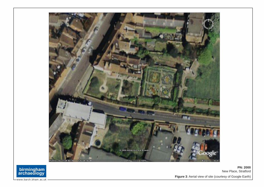
www.barch.bham.ac.uk
PN: 2000New Place, Stratford
Figure 3: Aerial view of site (courtesy of Google Earth)

www.barch.bham.ac.uk
PN: 2000New Place, Stratford
Figure 4: 1834 Board of Health map
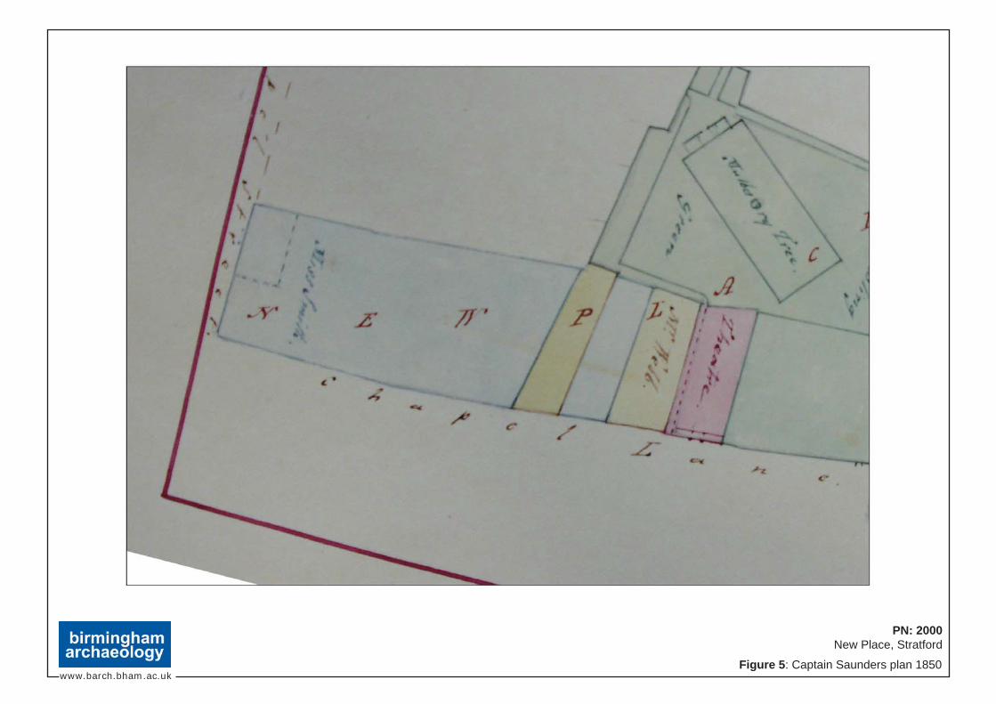
www.barch.bham.ac.uk
PN: 2000New Place, Stratford
Figure 5: Captain Saunders plan 1850

www.barch.bham.ac.uk
PN: 2000New Place, Stratford
Figure 6: Halliwell’s 1864 map

www.barch.bham.ac.uk
PN: 2000New Place, Stratford
Figure 7: 1886 1:500 Ordnance Survey map

www.barch.bham.ac.uk
PN: 2000New Place, Stratford
Figure 8: 1889 1:2500 1st Edition Ordnance Survey map

www.barch.bham.ac.uk
PN: 2000New Place, Stratford
Figure 9: 1904 1:2500 1st Edition Revision Ordnance Survey map

www.barch.bham.ac.uk
PN: 2000New Place, Stratford
Figure 10: 1914 2nd Edition Ordnance Survey map
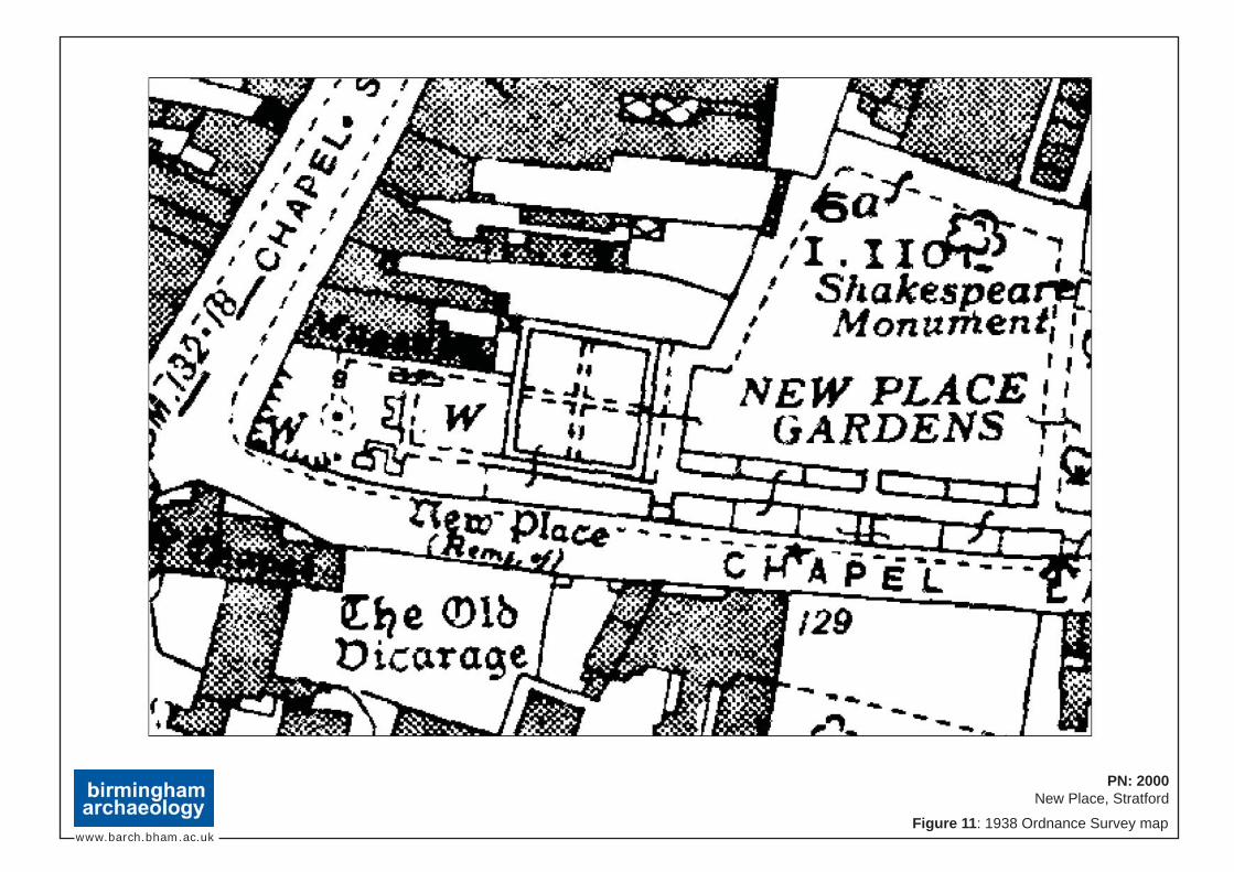
www.barch.bham.ac.uk
PN: 2000New Place, Stratford
Figure 11: 1938 Ordnance Survey map

www.barch.bham.ac.uk
PN: 2000New Place, Stratford
Figure 12: 1967 Ordnance Survey map

Tp1
[106]
103
S1
[104]
105
103
107101101
100
103
108
E2
Elevation 2SW NE
108
101
108
103
102
Section 1E W Section 3 Section 4
[205]
S4
Tp2
E W
[207]
S3
N S
200
201
202
203
204
200
201
202
203
206204208
[205][207]
204
0 1m
www.barch.bham.ac.uk
PN: 2000New Place, Stratford
Figure 13: Test pits 1 and 2 plans and sections

300
301
303
[302]
300
301
307
[305]
306
304
Tp3S5
S6
Section 5 Section 6S N W E
Tp4
E WNS
400
401
402
404
400
401
402
403
404
403
S7
S8
404
Section 7 Section 8
www.barch.bham.ac.uk
PN: 2000New Place, Stratford
Figure 14: Test pits 3 and 4 plans and sections
Cable
Cable
0 1m

0 1m
Tp6S11
E W
600
601
602604
[603]
605
605
602
[603]
604
502
[503]
504
502
S9
S10Tp5
Section 9 Section 10
500
501
504
500
501
502
504 [503]
SW N
S12
702
Tp7
Section 12
700
701
702
N S
www.barch.bham.ac.uk
PN: 2000New Place, Stratford
Figure 15: Test pits 5, 6 and 7 plans and sections
E
Section 11

www.barch.bham.ac.uk
PN: 2000New Place, Stratford
Figure 16: Phased plan of New Place buildings taken from Halliwell Phillips’ plans of 1864 & excavations of 1900 superimposed over current mapping
C h
a p
e l
S t
r e e
t
C h a p e l L a n e
0 10m
GuildChapel
19th Century (‘Modern Date’)
Site Boundaries c.1864
Test pit locations
New Place c.1483
New Place c.1702 onwards
Possible location of Chapel Lane entrance porch
Partition wall
OUTBUILDINGSTP5TP6
TP7
TP4
NEW PLACE GARDENS
Boundary wall
Well(1900)
TP3
Courtyard?Entrance?
Bay window
Pantry
‘Brewhouse’
Stoneflooring
NEWPLACE
NASH’SHOUSE
Former windows
Former windows
Underground kitchens& cellars
Fireplace
‘Dust-bin’
(1863)
Part ofcellar arch
TP1
Well
(1862)
Fireplace& ashpit
Entrance way& steps
Wall ofNash’s House
TP2
Halliwell’s plan of 1864

www.barch.bham.ac.uk
PN: 2000New Place, Stratford
Figure 17: Areas of potential buried structures
Tp7
Tp6Tp5
Tp4
Tp3
Tp2
Tp1
Nash’s HouseC
h a
p e
l S
t r e
e t
C h a p e l L a n e
0 10m
GuildChapel
High potential
Medium potential
Low potential
New Place

www.barch.bham.ac.uk
PN: 2000New Place, Stratford
Figure 18: Areas of potential buried deposits/artefacts
Tp7
Tp6Tp5
Tp4
Tp3
Tp2
Tp1
Nash’s HouseC
h a
p e
l S
t r e
e t
C h a p e l L a n e
0 10m
GuildChapel
High potential
Medium potential
Low potential
New Place

www.barch.bham.ac.uk
PN: 2000New Place, Stratford
Figure 19: Proposed locations for 2010 excavations
Nash’s HouseC
h a
p e
l S
t r e
e t
C h a p e l L a n e
0 10m
GuildChapel
New Place

www.barch.bham.ac.uk
Plate 1: Vertue’s New Place (Late 18th century)
Plate 2: J. Jordan’s New Place 1780 from a drawing in the margin of an ancient survey
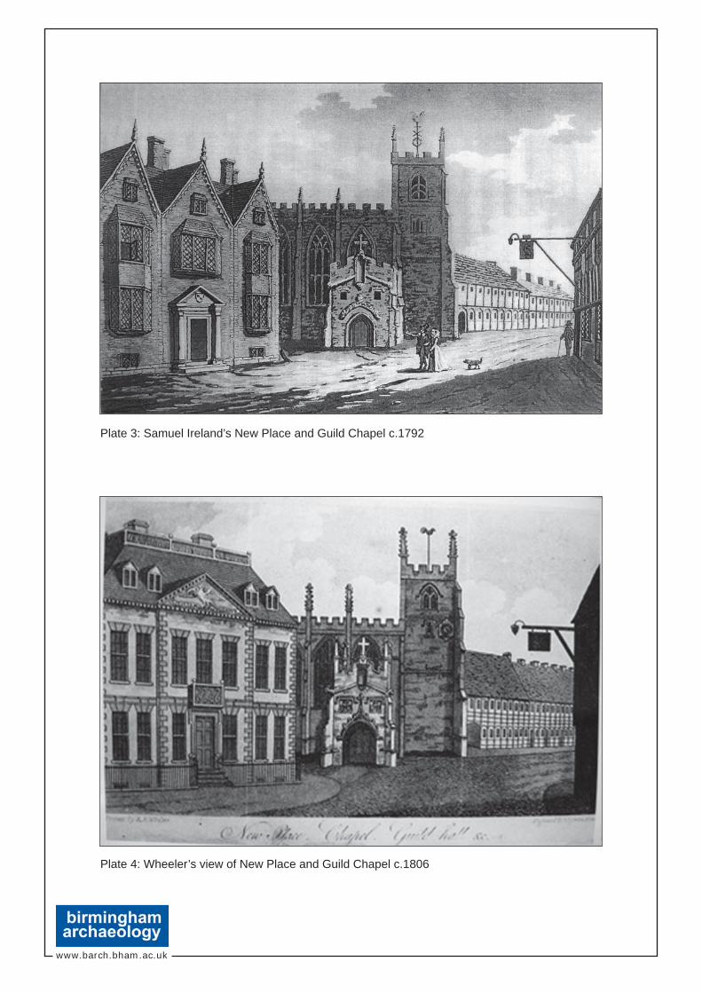
www.barch.bham.ac.uk
Plate 3: Samuel Ireland’s New Place and Guild Chapel c.1792
Plate 4: Wheeler’s view of New Place and Guild Chapel c.1806

www.barch.bham.ac.uk
Plate 5: J. Sharp’s sketch of New Place c.1784
Plate 6: J. Jordan’s New Place c.1790
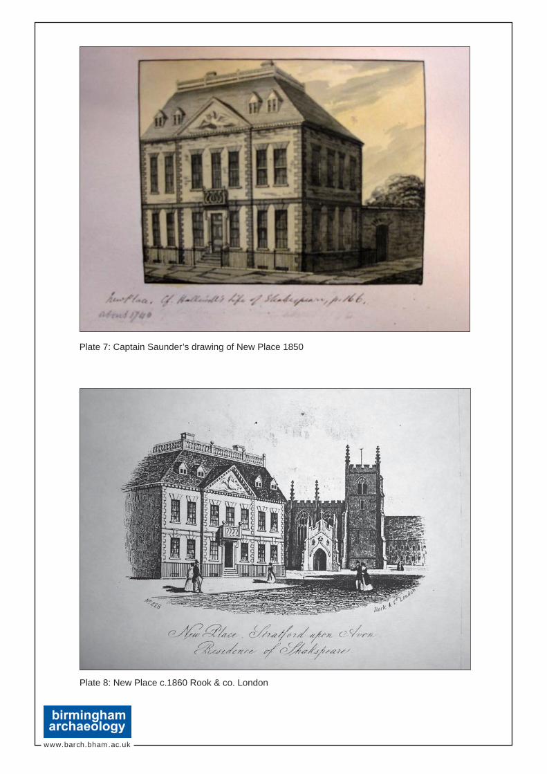
www.barch.bham.ac.uk
Plate 7: Captain Saunder’s drawing of New Place 1850
Plate 8: New Place c.1860 Rook & co. London

www.barch.bham.ac.uk
Plate 9: Graf’s View of New Place and the Guild Chapel 1851
Plate 10: New Place before the excavations 1856

www.barch.bham.ac.uk
Plate 11: Excavations at New Place Shakespeare’s Residence in Stratford-on-Avon,Rook and Co. 1864
Plate 12: Willis’s Pencilling of New Place 1890

www.barch.bham.ac.uk
Plate 13: Josiah Whymper’s engraving of The Foundations of New Place, The Guild Chapel,and Falcon Tavern 1864
Plate 14: Photograph of excavations at New Place 1862

www.barch.bham.ac.uk
Plate 15: Photograph of excavations at New Place 1864
Plate 16: Photograph of excavations at New Place 1864

www.barch.bham.ac.uk
Plate 17: New Place following excavation 1870
Plate 18: New Place following excavation 1874

www.barch.bham.ac.uk
Plate 19: New Place following excavation 1877
Plate 20: New Place following excavation 1882
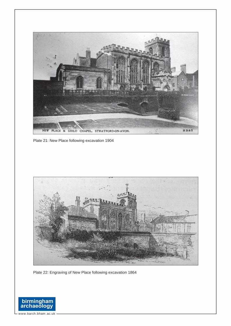
www.barch.bham.ac.uk
Plate 21: New Place following excavation 1904
Plate 22: Engraving of New Place following excavation 1864

www.barch.bham.ac.uk
Plate 23: Foundations of ‘bay window’ discovered during excavations 1864
Plate 24: Engraving of New Place post-excavation 1864

www.barch.bham.ac.uk
Plate 25: Test pit 1, looking west
Plate 26: Test pit 2, looking east

www.barch.bham.ac.uk
Plate 27: Test pit 3, looking west
Plate 28: Test pit 4, looking west

www.barch.bham.ac.uk
Plate 29: Test pit 5, looking south
Plate 30: Test pit 6, looking south

www.barch.bham.ac.uk
Plate 31: Test pit 7, looking east
Plate 32: Shakespeare Birthplace Trust Reconstruction of New Place at the timeof Shakespeare