Whitsunday national parks - Environment, land and water
28
Whitsunday national parks Queensland National Parks
-
Upload
khangminh22 -
Category
Documents
-
view
2 -
download
0
Transcript of Whitsunday national parks - Environment, land and water

Whitsundaynational parks
Queensland National Parks

ContentsParks at a glance .........................................................................2
Welcome .....................................................................................3
Map of the Whitsundays..............................................................4
Plan your getaway .......................................................................6
Outdoor adventures ....................................................................8
Whitsunday Islands National Park ...............................................9
Whitsunday Ngaro Sea Trail ......................................................12
Molle Islands National Park .......................................................13
For a more comprehensive guide of the parks listed above, visit qld.gov.au/NationalParksPhotos: (front cover) Stunning view from Whitsunday Peak, looking over Cid Harbour, the top of Whitsunday Island and further afield to Hook Island. Justin Heitman © Qld Govt; (this page) Adam Creed © Qld Govt
Wh
eelc
hai
r ac
cess
Cam
pin
g
Toile
ts
Day
-use
ar
ea
Look
out
Pub
lic
moo
ring
Anc
hor
age
Sw
imm
ing
and
snor
kelli
ng
Div
ing
Bu
shw
alki
ng
Mou
ntai
n
bik
e ri
din
g
Conway NP
Dryander NP
Gloucester Islands NP
Holbourne Island NP
Lindeman Islands NP
Molle Islands NP
Repulse Islands NP
Whitsunday Islands NP
Parks at a glance
Lindeman Islands National Park ................................................16
Conway National Park ...............................................................18
More top spots .........................................................................22
About the parks ........................................................................22
Boating in the Whitsundays ......................................................24
Journey wisely ...........................................................................26
Further information ...................................................................28
2

... from the Gia people of the Conway Ranges
We ask that you respect our beautiful and significant
places and join us in caring for Country—a place to
treasure and enjoy for now, and for our future generations.
Welcome to
The Whitsundays ...
Abandon daily life for a tropical island paradise, leaving
nothing but footprints in the sand.
Explore landscapes of wind-swept grasstree
heaths and far-reaching vistas of the
tropical Whitsunday coast.
Drift from island to island
fanned by the balmy
Whitsunday breezes.
Treasure ancient rock art and middens
of one of Australia’s earliest-
recorded First Nations groups,
the Ngaro people.
Dive into an underwater
world of vibrant
colour in the Great
Barrier Reef World
Heritage Area.Photos (clockwise from bottom right): Justin Heitman © Qld Govt; © Tourism and Events Qld; Justin Heitman © Qld Govt; Justin Heitman © Qld Govt; Lisa Scott © Qld Govt
The Whitsundays is a stunning area filled with views of
unspoilt islands, powdery sand beaches, and turquoise
waters. It has endless spots to find your own private beach
to relax, go for a snorkel, have a fish or take a bushwalk.
The magical Whitsundays is just waiting to be explored!
Ranger Kay on behalf of the Park Rangers of the Whitsundays
Photos below: (left) © Qld Govt; (right) Justin Heitman © Qld Govt
... from the Ngaro peopleThe Whitsunday area is the traditional land and sea Country
of the Ngaro people. The Traditional Custodians maintain a
strong and ongoing spiritual connection to their homelands,
and ask that you tread with care and respect when visiting
this amazing place.
3
Welcome

HaymanIsland
Henning Is
Whitsunday Island
Tongue Point
Hill Inlet
Hook Island
GloucesterIsland
Saddleback Island
Armit Island
Langford Island
ProserpineRiver
Conway Beach
Border Island
Deloraine Island
Midge Point
Pentecost Island
ShawIsland
LongIsland
Hamilton Island
HaslewoodIsland
LindemanIsland
Dent Island
EastRepulseIsland
SouthRepulseIsland
NorthRepulseIsland
North Molle Island
South Molle Island
Bruce Highway
Gregory–Cannon Valley Road
Shu
te H
arbo
ur Roa
d
ConwayNational Park
DryanderNational Park
ProserpineState Forest
DryanderState Forest Whitsunday
IslandsNational Park
Gloucester IslandsNational Park
AndromacheState Forest
AndromacheConservation Park
Proserpine
AirlieBeach
ShuteHarbour
DingoBeach
Lindeman IslandsNational Park
Repulse IslandsNational Park
G1
G2
G3
G4
D1
C2
W15
W20
W14
W9
W13
W16
W18
W10
W19
W7
W3 W6
W5
L1
L4
R1
L5
M5M1
M6
M7
Whitehaven Beach
Dingo B
each R
oad
Molle Islands NP
M4
W1
W2
W4
C1
M3
M2
L2
L3
W8
W12
W11
W17
5 10kmScale0
To Bowen
To Mackay
Map of the Whitsundays
4

HaymanIsland
Henning Is
Whitsunday Island
Tongue Point
Hill Inlet
Hook Island
GloucesterIsland
Saddleback Island
Armit Island
Langford Island
ProserpineRiver
Conway Beach
Border Island
Deloraine Island
Midge Point
Pentecost Island
ShawIsland
LongIsland
Hamilton Island
HaslewoodIsland
LindemanIsland
Dent Island
EastRepulseIsland
SouthRepulseIsland
NorthRepulseIsland
North Molle Island
South Molle Island
Bruce Highway
Gregory–Cannon Valley Road
Shu
te H
arbo
ur Roa
d
ConwayNational Park
DryanderNational Park
ProserpineState Forest
DryanderState Forest Whitsunday
IslandsNational Park
Gloucester IslandsNational Park
AndromacheState Forest
AndromacheConservation Park
Proserpine
AirlieBeach
ShuteHarbour
DingoBeach
Lindeman IslandsNational Park
Repulse IslandsNational Park
G1
G2
G3
G4
D1
C2
W15
W20
W14
W9
W13
W16
W18
W10
W19
W7
W3 W6
W5
L1
L4
R1
L5
M5M1
M6
M7
Whitehaven Beach
Dingo B
each R
oad
Molle Islands NP
M4
W1
W2
W4
C1
M3
M2
L2
L3
W8
W12
W11
W17
5 10kmScale0
To Bowen
To Mackay
Island and site name
Map reference
Whitsunday Islands National Park
Whitsunday Island Dugong Beach
W1
Sawmill Beach W2
Naris Beach W3
Joes Beach W4
Chance Bay W5
Whitehaven Beach W6
Cairn Beach W7
Hook Island Maureens Cove
W8
Steens Beach W9
Curlew Beach W10
Crayfish Beach W11
Manta Ray Bay W12
Butterfly Bay W13
Black Island W14
Langford Island Langford Spit
W15
Border Island Cateran Bay
W16
Haslewood Island Stockyard/Chalkies
W17
Henning Island Northern Spit
W18
Deloraine Island W19
Hayman Island Blue Pearl Bay
W20
Conway National Park
Mount Rooper C1
Conway circuit C2
Island and site name
Map reference
Molle Islands National Park
South Molle Island Sandy Bay
M1
Paddle Bay M2
North Molle Island Cockatoo Beach
M3
Planton Island M4
Denman Island M5
Tancred Island M6
Long Island Sandy Bay
M7
Lindeman Islands National Park
Lindeman Island Boat Port
L1
Seaforth Island Orchid Beach
L2
Esme Beach L3
Thomas Island Naked Lady Beach
L4
Shaw Island Neck Bay
L5
Gloucester Islands National Park
Gloucester Island Bona Bay
G1
East Side Bay G2
Saddleback Island G3
Armit Island G4
Repulse Islands National Park
South Repulse Island R1
Dryander National Park
Grimston Point D1
Legend for publication
National park
State forest
Conservation park
Ocean
Waterway
Highway
Sealed road
Unsealed road
Walking track
Mountain
Town/city
Distance marker
Bridge
Pictograms
Camping
Toilets
Viewpoint
Picnic table
Sheltered table
Walking track
Snorkelling/diving
Fishing
Public mooring
Anchorage
Parking
QPWS office
Information
Information shelter
Interpretive walk
Barbecue—wood
5

Plan your getaway
Phot
o: ©
Tou
rism
and
Eve
nts
Qld
No matter which way you look at it, the Whitsundays are a glorious getaway.
Best timeIt’s pleasant all year in the Whitsundays,
but April to September are the best
months when daytime temperatures are
milder (21–26°C) and nights are cooler
(16–22°C). Water temperatures in the
ocean vary throughout the year from
22–27°C. It can rain any time, but the
heaviest rains fall between January and
March. Cyclones are more likely to occur
between November and April, so make
sure you read any emergency advice
(bom.gov.au) before you visit.
Top: Setting out on a canoe adventure on the Whitsunday Ngaro Sea Trail.
Above: Play about in the waters off Daydream Island. Right: The Whitsunday’s world famous Heart Reef is best seen from the air.
Global treasureThe Whitsunday islands, and their
surrounding waters, are protected in the
Great Barrier Reef World Heritage Area,
Australia’s first and the world’s largest
World Heritage Area. After stupendous
rifting and ripping of the earth’s crust,
the Whitsundays islands—remnants of
ancient volcanic calderas—remain as a
group of more than 90 green gems now
dotted in the aquamarine Coral Sea.
This remarkable ecosystem, one of the
world’s largest barrier reefs, is home to
thousands of different species of plants
and animals. Come and see for yourself!
Find out more at gbrmpa.gov.au
Experience a holiday to remember in the heart of Queensland’s Great Barrier Reef. Discover dazzling white secluded beaches, ancient Aboriginal rock art, sweeping grasslands and rocky shores fringed with coral reefs. The Whitsundays offers an endless choice of natural adventures.
Photos: (top) Justin Heitman © Qld Govt; (above and right) © Commonwealth of Australia (GBRMPA)
6

Best way The Whitsunday coast is about two
thirds of the way along Queensland’s
coast between Brisbane and Cairns.
Drive 1,120km (12hr) north from Brisbane,
or 630km (7hr) south from Cairns, to
Proserpine on the Bruce Highway.
Follow signs to Airlie Beach—30km along
Shute Harbour Road. Plane flights from
Brisbane take about 1.5hr. Plane flights
are also possible from Proserpine and
Hamilton Island.
Mainland parksYou can reach Conway National Park
by 2WD and enjoy many options for
walking or mountain-bike riding around
the coastal fringe or up in the range.
You’ll need a boat to get over to
Dryander National Park’s secluded
Grimston camping area.
Island parksYou can reach the Whitsunday islands
by joining a tour or private charter, using
your own kayak or vessel or hiring a tinnie
or a bareboat—no skipper or crew.
Add some local flavourTime your holiday with a local event.
There’s the annual music festival in
November or sailing, fishing and
triathlon events throughout the year.
Find out more at qld.com.au and
tourismwhitsundays.com.au
Guided toursGet on board a guided tour with
an experienced and friendly local.
Enjoy sailing and snorkelling day
trips or overnight camping where
tourism operators take you away
from the crowds. Commercial
water taxis from Shute Harbour
can drop you at island camp sites,
where you can walk, snorkel,
dive and fish, or just relax. Visit
tourismwhitsundays.com.au
for tour details.
Top: Take in staggering views from any of the lookouts in the Whitsundays.
Above: Get a bird’s eye view of the reef. Below: Stop, breathe and enjoy the views from the walks on the Whitsunday Ngaro Sea Trail.Photos: (top) Justin Heitman © Qld Govt; (above) © Tourism and Events Qld; (below) Dave Harper © Qld Govt
7

Phot
o: D
arre
n Je
w ©
Tou
rism
and
Eve
nts
Qld
Come face to face with some big beauties of the reef.
Outdoor adventuresEmbark on a sea venture to an island national park—there are many to choose from. Or explore inland, where the rugged range provides a perfect place for exploration on foot or mountain bike.
Pull on your shoesWalk a little or a lot, choosing from easy
short walks to longer full-day or multi-
day hikes. See p27 for track classifications
and choose the right walk for you.
Get on your bike Peddle on South Molle Island or
around the many shared trails in
Conway National Park.
Float your boatThe best way to see most of the
Whitsundays is to float! Take your own
boat, hire one or let a tour operator look
after everything. If paddle power suits
your style, grab your kayak and island-
hop on the Whitsunday Ngaro Sea Trail,
staying at a different camp site each night.
Explore underwaterDive bommies, crevices and caves along
the reef slopes. Cool off and snorkel
around rocks and reefs. Ask the locals
for some top spots to dive and snorkel.
Watch whalesWitness awe-inspiring acrobatics by
majestic humpback whales visiting
between May and September to calve
in the warmer waters.
Discover an ancient storyThe Ngaro and Gia people have a spiritual
and unbroken connection to this land and
sea country spanning more than 9,000
years. Visit the stone-tool quarry on South
Molle Island and the Ngaro Cultural Site
in Nara Inlet on Hook Island.
Pitch your tent Camp over at one of 28 camping areas
across the islands or mainland parks.
Some island camping areas have only
one site, so you’ll have the whole place
to yourself! Remember to book your
national park camping online at
qld.gov.au/Camping
There’s lots to do in the Whitsundays whether you’re walking, on wheels or on the water.
Photos (top left to bottom right): Tim Payne © Qld Govt; Justin Heitman © Qld Govt; © Tourism and Events Qld; © Commonwealth of Australia (GBRMPA)
8

Phot
o: ©
Tou
rism
and
Eve
nts
Qld
Whitsunday Islands National Park
Must dos• Snorkel or dive to see a stunning
underwater world.
• Climb to Hill Inlet lookout.
• Visit the Ngaro Cultural Site.
Getting there Whitsunday Islands National Park,
25km east of Airlie Beach, protects
30 islands, including Whitsunday,
Black, Hook and Langford islands.
Visit by private or commercial
boat, helicopter or sea plane from
Airlie Beach or Shute Harbour.
Some companies drop off and
collect campers.
Wildlife spottingThe Whitsundays are alive with wildlife.
You’ll be delighted at the wondrous
complexity of life around you.
Fishing and walkingEither cast a line off Dugong Beach or
take a short, easy walk over to Sawmill
Beach. Pack extra food and water and
tackle a longer uphill hike (2.5km) up to
Whitsunday Peak and be rewarded with
incredible views.
Discover a slice of paradise on jewel-green isles surrounded by turquoise blue waters.
Walk along the squeaking, white sands of famous Whitehaven Beach.
Take in fantastic views when you walk the Whitsundays.
Hill Inlet, a stunning swirl of sea and shifting sands.
Marvel at the swirling sands of Hill
Inlet, an area rich with links to the
Ngaro people’s past. Relax on world-
famous Whitehaven Beach, then, take
a short walk to view the stunning Solway
Passage. See the Whitsundays, as if
from the roof of the world from the
best lookouts in the Whitsundays.
Things to do
Snorkelling and scuba divingSnorkel the reef at high tide or explore
coral bommies, crevices and caves
along the reef at Whitsunday, Hook,
Black, Langford, Haslewood and
Deloraine islands.Photo: Justin Heitman © Qld Govt
Ranger tip Manta Ray Bay is an awesome spot to
see some really big fish, such as the big,
beautiful and protected Maori wrasse,
some cheeky trevallies and millions of
smaller reef fish.
Ranger Kay
Photo: Tim Payne © Qld Govt
9

Bettys Beach
LookoutBeach
Beachtrack
Tongue Bay
Hill Inlet lookout
track
TonguePoint
500m250mScale0
Places to go
Whitsunday Island
Whitehaven Beach lookout
Headland track
970m return. Allow 30min. 400m headland track. Allow 30min.
This is a premier walk. You’ll see Whitehaven Beach’s 7km shoreline with uninterrupted views. And get a closer look at the enthralling Solway Passage. There’s fascinating rock formations and wonderful views of the Whitsunday Island peaks and the islands dotted in a sparkling sea.
Hill Inlet lookout Beach track
50
0 500 1000 1500
Ele
vatio
n (m
)
Distance (m)
Whitsunday Cairn track profile
150100
200250300
Cairn Beach
WhitsundayCairn
Whitsunday Cairn track
1.5km
1km0.5Scale0
Solway circuit
Chance Baytrack
Chance Bay
Whitehaven Beach
500mScale0
Solway circuit Chance Bay track
LegendWhitsunday Ngaro Sea Trail walking track
Whitsunday Cairn and Whitsunday Peak tracks are difficult to traverse and can be
slippery in wet weather. You must be well prepared, take plenty of water, have a good
level of fitness and wear ankle-supporting footwear to safely complete these tracks.
SawmillBeach
Whitsunday Peak
1.5k
m
2.5k
m
Dugong Beach
1km0.5Scale0
100
0 500 1000 1500
Ele
vatio
n (m
)
Distance (m)
Whitsunday Peak track profile
200
300
400
Solway circuit
1.2km return. Allow 40min.
Wander along this one-way circuit from
Whitehaven Beach uphill to a natural
rock platform with spectacular views
over Solway Passage and the
surrounding islands.
Chance Bay track (off Solway circuit)
3.6km return. Allow 2.5–3hr.
Follow this track through some of
Whitsunday Island’s more secluded areas
to peaceful Chance Bay. This delightful
walk branches off the Solway circuit.
Hill Inlet lookout track
1.4km return. Allow 40min.
Take an uphill wander to multiple lookouts
for stunning vistas over Hill Inlet’s
turquoise waters and white, sweeping
sands—a highly-significant area to the
Ngaro people. Access the track from
Hill Inlet or Tongue Bay.
Beach track
500m return. Allow 20min.
Branch off the Hill Inlet lookout track
and head downhill to the bright-white,
quartz sands of Hill Inlet and across to
Whitehaven Beach, considered one of
the top 10 beaches in the world.
Dugong-Sawmill track
3km return. Allow 1hr.
Walk under stands of giant rainforest
trees and solitaire palms before entering
what seems a fairyland of mosses, lichens
and fungi on this semi-shaded walk from
Dugong Beach to Sawmill Beach.
Whitsunday Peak track
5km return. Allow 4hr.
Walk uphill from Sawmill Beach day-use
area to windblown heaths, for impressive
vistas from the ‘roof of the Whitsundays’.
Whitsunday Cairn track
4km return. Allow 3hr+.
Walk from Cairn Beach—Whitsunday
Island’s most northerly beach—up to
a ridge covered with giant grasstrees.
It’s steep and challenging, but what a
view—simply breathtaking.
Langford Island
Langford Island lookout
300m one way. Allow 20min.
Stroll the mangrove lined shore before
gently walking uphill through mixed tall
trees, small ferns and orchids. Marvel at
the remarkable Whitsunday bottle trees
and enjoy views along the island’s spit
to nearby Black and Hook islands.
Whitsunday Peak and Dugong-Sawmill tracks
Whitsunday Island
Whitsunday Cairn track
10

Hook Island
Ngaro Cultural Site
340m return. Allow 20min.
Protected from the elements in a once-
hidden cave, the Ngaro people adorned
the fragile rock surface with their artwork
over the last 9,000 years. Clamber up
a short, and initially steep track with
steps, to a viewing platform at the
cave’s entrance.
Haslewood Island
Haslewood Island lookout
300m one way. Allow 20min.
Leave Chalkies Beach behind as you
walk uphill to the island’s rocky headland.
Passing through a natural gully of shady
eucalypts and grasstrees, you are
Island and site name
Map ref. (p4) Facilities and activities
Beach type Further information
Whitsunday Islands National Park
Whitsunday Island Dugong Beach
W1 Sand
Camping area backed by rainforest and connected by a 1km walking track to Sawmill Beach. Dugong Beach has better anchorage than Sawmill Beach, but is suitable for shallow draft vessels only. Care must be taken to avoid coral bommies, particularly at low tide.
Sawmill Beach W2 SandPicnic area nestled in vine forest. Walking tracks lead to Dugong Beach and Whitsunday Peak.
Naris Beach W3 SandCamping area sits under rainforest canopy, tucked against a steep hill. It has outstanding views of Cid Island. Reef line close to shore with good access at mid to high tide.
Joes Beach W4 SandSecluded camping area with outstanding views of Cid Island. Fringing reef exposed at low tide. Boat acces at mid -high tide.
Chance Bay W5 SandElevated camping area with views extending to Pentecost Island, Lindeman group and Cape Conway. Boat access at mid to high tide. Difficult to access in south-easterly winds but is good anchorage during northerly winds.
Whitehaven Beach
W6 SandSpectacular white sands with camp sites nestled in lowland vine forest and eucalypt woodland. Has views to Haslewood Island. Boat access at all tides.
Cairn Beach W7 Rubble
Surrounded by mountains and excellent views from the Whitsunday Cairn track to Border and Dumbell islands. A large intertidal sand and rock flat is fed by a winding creek behind the beach. Shallow draft boat access. Poor anchorage; use public moorings. Kayaks are perfect.
Hook Island Maureens Cove
W8 Rubble
Camping area sheltered by pandanus and backed by small creek. Bay offers excellent snorkelling and anchorage. Anchoring is not permitted inside the cove’s reef protection markers. Shallow draft boat access at mid to high tide. Poor anchorage. Perfect for kayaks.
Steens Beach W9 SandCamping area set behind the beach and overlooks Hayman Island. A small reef flat provides good snorkelling. Restrictions apply 1 Oct to 31 Mar each year.
Curlew Beach W10 SandCamping area backed by rainforest. Accessible at mid to high tide by shallow draft vessels only. Sheltered anchorage next to camping area.
Crayfish Beach W11 SandOutstanding beauty with extensive reef flat. Camping area sheltered by large rocky headland. Accessible at mid to high tide by shallow draft vessels only. Sheltered anchorage next to camping area.
Manta Ray Bay W12 RubbleExcellent diving from boat, small beach with no camping. Use public moorings. Anchoring prohibited in the bay.
Butterfly Bay W13 SandExcellent snorkelling/diving from boat. Use public moorings. Anchoring prohibited in the bay.
Black Island W14 Sand This is a popular site for snorkelling/diving, especially at high tide.
Langford Island Langford Spit
W15 Sand Good snorkelling/diving and short walking track with view. All tide access.
Border Island Cateran Bay
W16 Sand Popular snorkelling/diving site and walking track with great views. All tide access.
Haslewood Island Stockyard/Chalkies
W17 Sand White sands. Poor anchorage. Moorings may assist.
Henning Island Northern Spit
W18 SandBacked by closed forest canopy. Accessible at all tides, very poor anchorage though moorings assist.
Deloraine Island W19 Rubble A more remote day-visit site that is popular for snorkelling.
Hayman Island Blue Pearl Bay
W20 Rubble Good snorkelling/diving site.
Hook Island Boat up to and camp over at Hook Island’s
Maureens Cove, Steens, Curlew or
Crayfish beaches. Stay a couple of days
to snorkel the island’s fringing reefs and
spend an hour or so at the Ngaro Cultural
Site. Start at Nara Inlet—an excellent deep
overnight anchorage, accessible at mid
to high tide—and leave at least an hour
to immerse yourself in the stories of
the past.
Henning Island Picnic on the sandy beach, near the
Northern Spit camping area, and enjoy
views of Whitsunday and Hamilton
islands. The Spit is accessible by boat
at all tides, but is a poor anchorage.
Use the public moorings here.
rewarded with spectacular island
and sea views from the lookout.
Border Island
Border Island
1.2km return. Allow 1hr.
Explore ashore and enjoy Cateran Bay
from above on this short walk. After an
initial steep ascent, meander along the
island’s saddle of native grassland and
enjoy views from 2 lookouts.
Places to camp
Whitsunday IslandDugong Beach is a great place to take the kids and can accommodate larger groups, while Joes Beach is secluded, but offers great views across to Cid Island. Cairn Beach is a kayaker’s camping delight.
11

Sandy Bay Shute Bay
North MolleIsland
South MolleIsland
ShuteIsland
TancredIsland
DaydreamIsland
ConwayNational Park
Spion Kop
Mount Jeffreys
LongIsland
Pioneer Bay
PioneerRocks Almora
Islet
EastRock
ShuteHarbourAirlie Beach
WhitsundayIsland
CidIsland Whitsunday
Peak
Tongue Point
WhitehavenBeach
DentIsland
HenningIsland
HaslewoodIsland
DugongBeach
CockatooBeach
JoesBeach
SandyBeach
SawmillBeach
NarisBeach
PeterBay
ChanceBay
HillInlet
SolwayPassage
TongueBay
HamiltonIsland
HookIsland
Bird Island
Langford Island
NgaroCultural Site
WhitsundayCairn
CairnBeach
SteensBeach
CrayfishBeach
MaureensCove
BorderIsland
CurlewBeach
StonehavenAnchorage
NaraInlet
HaymanIsland
Arkhurst Island
BlackIsland
ButterflyBay
Manta RayBay
WhitsundayPassage
Coastal waters of the Great Barrier Reef
CidHarbour
Legend
Whitsunday NgaroSea Trail
Walking track
Seaway
5 10kmScale0
Whitsunday Ngaro Sea TrailSail, kayak or cruise to islands with pure-white sands and stroll through windswept grasslands up to rugged headlands for breathtaking views.
Start your Whitsunday Ngaro Sea Trail
adventure from Airlie Beach or Shute
Harbour and travel an extraordinary
blend of seaways and walks spanning
Whitsunday, South Molle and Hook islands.
You can book your national park camping
online at qld.gov.au/Camping
Take in the Whitsunday beauty from tiny everlasting daisies to the grand views from
the Molle Islands’ walking tracks.
Pulling up on Whitehaven’s shore after an exquisite morning’s paddle. Phot
o: Ju
stin
Hei
tman
© Q
ld G
ovt
Trip plannerDistances provided are approximate and
apply if travelling the Whitsunday Ngaro
Sea Trail in an anti-clockwise direction.
No allowance is made for
tides, bad weather or
possible drift.
Dugong Beach
Ngaro Cultural Site
15km (8.1nm)
Curlew Beach
6km (3.2nm)
10km (5.4nm)
Whitsunday Cairn
6km (3.2nm)
11km (5.9nm)
11km (5.9nm)
9km (4.9nm)
15km (8.1nm)
20km (10.8nm)
20km (10.8nm)
Tongue Bay 16km (8.6nm)
22km (11.9nm)
27km (14.6nm)
27km (14.6nm)
Whitehaven Beach
9km (4.9nm)
25km (13.5nm)
31km (16.7nm)
36km (19.4nm)
36km (19.4nm)
Chance Bay 8km (4.3nm)
17km (9.2nm)
33km (17.8nm)
39km (21.1nm)
44km (23.8nm)
44km (23.8nm)
Henning Island
15km (8.1nm)
23km (12.4nm)
32km (17.3nm)
48km (25.9nm)
54km (29.2nm)
59km (26.5nm)
59km (31.9nm)
Paddle Bay 15km (8.1nm)
30km (16.2nm)
38km (20.5nm)
47km (25.4nm)
63km (34nm)
64km (34.6nm)
74km (40nm)
74km (40nm)
Sandy Bay 3 km (1.6nm)
12km (6.5nm)
27km (14.6nm)
35km (18.9nm)
44km (23.8nm)
60km (32.4nm)
66km (35.6nm)
71km (38.3nm)
71km (38.3nm)
Shute Harbour
5 km (2.7nm)
8 km (4.3nm)
17km (9.2nm)
32km (17.3nm)
40km (21.6nm)
49km (26.5nm)
65km (35.1nm)
71km (38.3nm)
76km (41nm)
76km (41nm)
Directly from Shute Harbour(travelling in a clockwise direction)
49km (26.5nm)
32km (17.3nm)
31km (16.7nm)
36km (19.4nm)
21km (11.3nm)
Photos: (above left) Mick Barrett © Qld Govt; (above) Justin Heitman © Qld Govt
12

Molle Islands National ParkHead over to this bushwalkers’ paradise with superb views over picturesque island landscapes.
Pull on your boots and wander through
South Molle’s grasstree-studded
grasslands or past ancient Ngaro stone
quarry relics up to Spion Kop. Start
a mountain-bike adventure on 14km
of tracks catering for beginners and
intermediate riders. Go snorkelling off
the beach on South Molle’s Sandy Bay or
grab the fishing gear and head to the large
camping area near Cockatoo Beach on
North Molle Island.
Places to campSet up camp, then stroll on long sandy
beaches, relax with a good book or
just doze the afternoons away at one
of the many camping areas on the
Molle Islands. Relish quiet camping on
Must dos• Cruise along the mountain bike
trails, then walk to the lookout at
Spion Kop.
• Walk up to Mount Jeffreys.
• Look for passing whales.
Getting thereMolle Islands National Park is 10km
east of Shute Harbour. Access is by
private or hire boat from Airlie Beach
or Shute Harbour. Some companies
drop off and collect campers,
bushwalkers and mountain-bike
riders. Walking tracks and shared
trails on South Molle Island can be
accessed from Bauer Bay or Sandy
Bay camping area. Access from
Paddle Bay is by walking only. Long
Island walking tracks are accessed
from either Happy Bay or Palm Bay.
Look out for passing whales.Photo: Justin Heitman © Qld Govt
Phot
o: ©
Tou
rism
and
Eve
nts
Qld
View the Molle Islands—verdant dots amid the ocean blue.
Island and site name
Map ref. (p4) Facilities and activities
Beach type Further information
Molle Islands National Park
South Molle Island Sandy Bay M1 Rubble
Good open camping area for bushwalkers with a pleasant beach fringed with casuarinas. Site readily accessible at mid to high tides.
Paddle Bay M2 RubbleCamping area backed by rainforest and overlooking Daydream Island. Access to track system only possible at low tide. Access site via boat at mid to high tides.
North Molle Island Cockatoo Beach M3 Sand
A number of large camp sites around the forest edge. Tides limit access. Anchorage off the beach is not recommended.
Planton Island M4 RubbleSecluded camping area set in dry rainforest behind the beach. Access is by boat at all tides, but anchorage off the beach is not recommended as it is exposed to winds and currents. You must pull your boat up onto, and anchor on, the beach.
Denman Island M5 RubbleSmall, quiet camping area set in dry rainforest above the shore. Set in a marine park green zone, so look but don’t take or disturb anything. Pull your boat up onto and anchor on the beach. Offshore anchorage is risky due to winds and currents.
Tancred Island M6 SandA very private camping area with Shute Harbour hidden from view by Repair Island. Accessible by small boat though care should be taken on the fringing reefs at mid to low tide. Pull boats up onto and anchor on the beach.
Long Island Sandy Bay M7 Sand
A small secluded beach lined with mangroves and backed by rainforest. Walking track departs from the camp site, allowing you to explore Long Island. Only shallow draft small craft can access the beach during mid to high tide.
Denman Island or Planton Island, where
only one group with up to 6 people are
allowed at one time. Be self-sufficient on
Tancred Island with no facilities, where
it’s quiet camping and quite wonderful.
13

Places to go
South Molle Island
Sandy Bay
4.2km one way. Allow 2hr walking,
30min riding.
A fantastic outing through patches
of native grasslands studded with
grasstrees and a beach lined with
weeping, coastal casuarinas.
Mount Jeffreys
4km one way from Sandy Bay.
Allow 2hr walking, 30min riding.
3km one way from Bauer Bay.
Allow 1–1.5hr walking, 30min riding.
Take this gradual slope to Mount Jeffreys,
South Molle’s highest point, and enjoy
a sensational 360 degree view of the
Whitsunday islands and mainland.
Spion Kop
4.2km one way from Sandy Bay.
Allow 2hr walking, 50min riding.
2.3km one way from Bauer Bay.
Allow 2hr walking, 30min riding.
Walk or mountain-bike ride to lookouts
over Whitsunday Passage. Walking access
only from the set of stairs leading to
Spion Kop.
Balancing Rock
2km return. Allow 1hr.
Walk through to Balancing Rock, perched
in eucalpyt forest, for views across South
Molle’s vegetation patchwork.
It’s all about walking, riding and views, views, views on South Molle Island.
You’ll love this view from Spion Kop. It’s worth every uphill step you take to get there.
Photo: Justin Heitman © Qld Govt
Map title?
Paddle Bay
Mid MolleIsland
LamondHill
Oyster Bay
Brauer Bay
Sandy Bay
Planton Island
MountJeffreys
Denman Island
BalancingRock
Spion Kop
Don't get caught out!You can only get to andfrom Mid Molle Island 2hr either side of LOW TIDE.
Stairs
Main intersection
0.5 1kmScale0
Legend Walking track
Shared trails (walking and riding)
South Molle Island
Tracks 1, 2 and 3 are part of the Whitsunday Ngaro Sea Trail
65
5
4
6
2
3
1
Molle Islands National Park
Photo: Adam Creed © Qld Govt
14
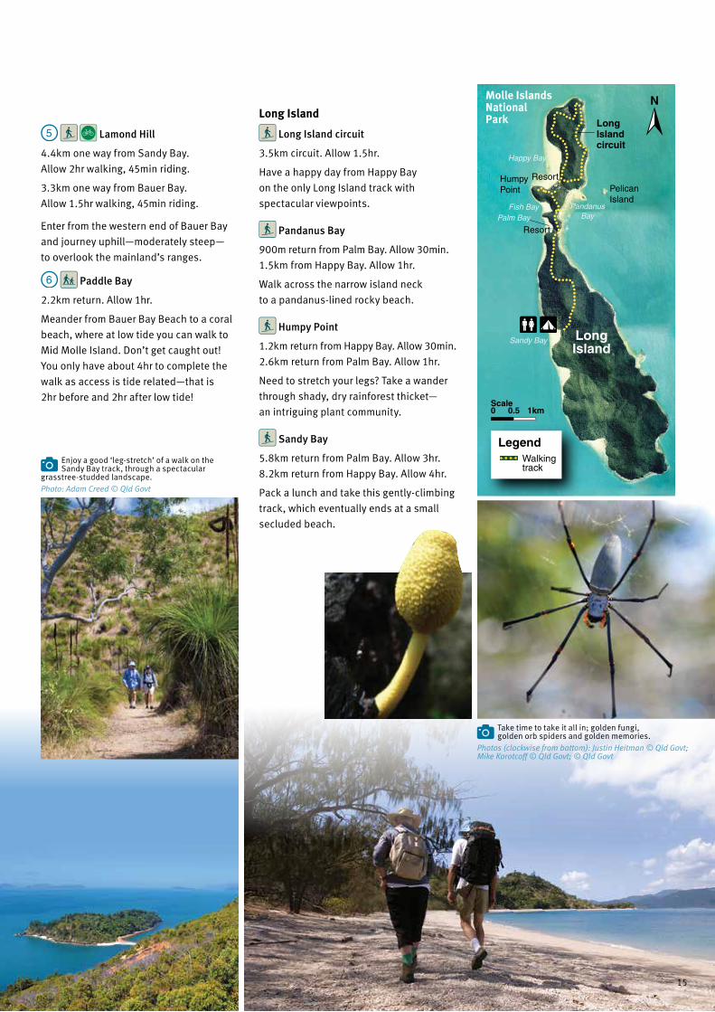
Lamond Hill
4.4km one way from Sandy Bay.
Allow 2hr walking, 45min riding.
3.3km one way from Bauer Bay.
Allow 1.5hr walking, 45min riding.
Enter from the western end of Bauer Bay
and journey uphill—moderately steep—
to overlook the mainland’s ranges.
Paddle Bay
2.2km return. Allow 1hr.
Meander from Bauer Bay Beach to a coral
beach, where at low tide you can walk to
Mid Molle Island. Don’t get caught out!
You only have about 4hr to complete the
walk as access is tide related—that is
2hr before and 2hr after low tide!
Long Island
Long Island circuit
3.5km circuit. Allow 1.5hr.
Have a happy day from Happy Bay
on the only Long Island track with
spectacular viewpoints.
Pandanus Bay
900m return from Palm Bay. Allow 30min.
1.5km from Happy Bay. Allow 1hr.
Walk across the narrow island neck
to a pandanus-lined rocky beach.
Humpy Point
1.2km return from Happy Bay. Allow 30min.
2.6km return from Palm Bay. Allow 1hr.
Need to stretch your legs? Take a wander
through shady, dry rainforest thicket—
an intriguing plant community.
Sandy Bay
5.8km return from Palm Bay. Allow 3hr.
8.2km return from Happy Bay. Allow 4hr.
Pack a lunch and take this gently-climbing
track, which eventually ends at a small
secluded beach.
Enjoy a good ‘leg-stretch’ of a walk on the Sandy Bay track, through a spectacular
grasstree-studded landscape.
Take time to take it all in; golden fungi, golden orb spiders and golden memories.
Pelican Island
Happy Bay
Resort
LongIslandcircuit
PandanusBay
Resort
HumpyPoint
Fish Bay
Sandy Bay
Palm Bay
0.5 1kmScale0
LegendWalking track
Long Island
Molle Islands National Park
Photo: Adam Creed © Qld Govt
Photos (clockwise from bottom): Justin Heitman © Qld Govt; Mike Korotcoff © Qld Govt; © Qld Govt
15

Lindeman Islands National Park
This is ‘Country’ for the Ngaro people, who
named Lindeman Island ‘Yara-kimba’—the
place of snapper-bream fish. The island
group includes 13 other islands including
nearby Seaforth, Thomas and Shaw islands,
and features the 212m high Mount Oldfield.
Set sail for this picturesque group of islands formed from ancient volcanic origins, now settled into a serene landscape.Must dos
• Enjoy an early morning walk
up Mount Oldfield for endless
island views.
• Go for a snorkel, a dive or
just splash about in the
waters offshore.
Getting thereLindeman Islands National Park is
35km south-east of Shute Harbour.
Access to the islands is by private
boat from Airlie Beach or
Shute Harbour. Turtle Bay
Gap Beach
Airstrip
MountOldfield
Lindeman Island
SeaforthIsland
Plantation Bay
Coconut Beach
Boat Port
LegendWalking track1km0.5
Scale0
Sit under a cool forest canopy or splash about in the inshore shallows around Lindeman Island.
Breathtaking views from Lindeman Island across to Neck Bay and Shaw Island. Phot
o: ©
Tou
rism
and
Eve
nts
Qld
Lindeman Islands National Park
Photos: (above right) Justin Heitman © Qld Govt; (below) © Tourism and Events Qld
16

Things to doHit the water for a swim or snorkel off one
of the many beautiful island beaches.
Cast a line off Lindeman, Seaforth or
Thomas islands and catch dinner fresh
from the sea. Head to the wetlands of
Lindeman Island to see lots of birds or
catch a glimpse of a shy bush stone
curlew around the beaches.
Places to campEnjoy remote camping at Lindeman
Island’s Neck Bay—a vegetated sand spit
between 2 former islands—especially if
you’re kayaking, or camp on the beach
at Boat Port overlooking a bay once
used to clean sailing vessels. Remember!
Book your national park camping online
at qld.gov.au/Camping
Places to go
Lindeman Island
Mount Oldfield track, 7.2km return. Allow 3.5hr.
Start this steady climb near the jetty
and walk through open eucalypt forest,
thick vine forest and grassland. You’ll be
staggered by the magnificent views in
every direction.
View a dusky dawn over the islands after an early morning walk up to Mount Oldfield.
Island and site name
Map ref. (p4) Facilities and activities
Beach type Further information
Lindeman Islands National ParkLindeman Island Boat Port
L1 SandQuiet camping area backed by rainforest. Boat access at mid to high tide, with good anchorage.
Seaforth Island Orchid Beach
L2 SandA 500m track joins Orchid Beach to Esme Beach. Tunnel through open vine forest before emerging from beach scrub to take in views to Lindeman Island.
Esme Beach L3 SandQuaint windswept beach faces southeast. Walking track to headland offers scenic views.
Thomas Island Naked Lady Beach
L4 Sand Protected by its northerly aspect, enjoy views to Shaw Island’s rocky outcrops.
Shaw Island Neck Bay
L5 SandThis site is sheltered by dry rainforest and has wonderful views and sunsets over Lindeman Island. Access limited to mid to high tide. Access to beach and restrictions to behaviour apply from 1 October to 31 March every year.
Photo: © Tourism and Events Qld
Clockwise from below left: Bush stone curlew and chick trying hard to blend into their
surroundings. Staggering view to Shaw Island from Lindeman’s Mount Oldfield track. Pitch your tent on Lindeman and stay a few days.Photos (clockwise from below left): Lisa Scott © Qld Govt; Adam Creed © Qld Govt; Sue Olsson © Qld Govt
17

Ranger tip Don’t rush! Plan your day to allow
enough time to relax and enjoy the views.
You’ll need sturdy footwear, big-brimmed
hat, high-energy food and at least 2 litres
of water for each person if you’re tackling
any of the uphill tracks.
Conway National Park
Rising above the busy coastal strip,
Conway Range’s rainforests have provided
a valuable refuge for 23 rare, threatened
and endemic wildlife species. Conway,
and its conservation parks, protect
the State’s largest remnant of tropical
rainforest outside the Wet Tropics of
Queensland World Heritage Area.
Things to doTake a stroll to Coral Beach or give
your legs a workout on uphill hikes
for picturesque island views. Get the
mountain bike ready and explore the
Coastal Fringe circuit or, for a real
work-out, the Conway circuit with
overnight camps.
Wildlife is everywhere you look, from
the iridescent blue flash of the exquisite
Ulysses butterfly to orange-footed
scrubfowls raking through the leaf litter.
Listen for the descending trill of the
buff-breasted paradise-kingfishers.
They’re only around from November
to March, coming here to nest in
termite mounds.
Must dos• Walk the Kingfisher circuit and
Wompoo way and spot some
brilliant rainforest birds.
• Absorb the views over the
azure waters of Whitsunday
passage from Coral Beach and
The Beak lookout.
• Save a day for the island parks
off Airlie Beach or choose a tour
that suits you best. Your choice is
almost unlimited—plane charter,
boat tour, jet-ski tours, fishing
tours and canoe tours.
Getting thereConway National Park is 30km
east of Proserpine, between Airlie
Beach and Shute Harbour. Turn
off the Bruce Highway just north
of Proserpine, or 45km south of
Bowen, then travel 26km to Airlie
Beach on the Gregory–Cannon
Valley Road. There is no national
park access from Conway Beach
township. From Airlie Beach, follow
Shute Harbour Road south-east to
Conway National Park day-use area.
Explore this peaceful part of the coastal mainland featuring secluded beaches and panoramic outlooks over the scenic Whitsunday area.
Coral Beach looking out to North Molle Island.
Yes, it really is all crushed coral.
Take in excellent views over Shute Harbour to a part of Conway National Park. Phot
o: ©
Kim
Fin
lay
Ulysses butterfly
Photo: © Tourism and Events Qld
Photo: Adam Creed © Qld Govt
18

Places to camp
Conway circuit camping areas
Repulse Creek and Bloodwood are
simple bush camps on either side of the
Conway circuit track. Walking and riding
is difficult due to the steep gradients in
parts. Bloodwood offers good views of
the islands. Water tanks are 200m past
Bloodwood camp.
Places to go
Coastal tracks
Coastal Fringe circuit
1.2km circuit.
Allow 45min walking, 15min riding.
Start at Conway National Park day-use
area and walk or ride around the circuit
track. There’s a small tidal creek to cross.
Hayward Gully
3.2km return.
Allow 1.5hr walking, 30min riding.
Follow the Hayward Gully circuit, off the
Coastal Fringe circuit to lowland rainforest
and rocky gullies.
Swamp Bay
4.2km return.
Allow 1.5hr walking, 30min riding.
From Mount Rooper car park, walk around
the foot of Mount Rooper to Swamp Bay.
It’s beautiful at high tide and in mid-
winter, when there’s fewer mosquitoes
and midges. Bring lots of drinking
water and energy snacks, as it’s a hot,
hard walk.
Tracks around Mount RooperThe Mount Rooper track junction—200m
along the Swamp Bay track—provides
4 walking options. Be prepared—sturdy
shoes, heaps of water, insect repellent
and sun protection.
Mount Rooper lookout
4.6km return. Allow 2.5hr.
Take a challenging uphill walk through
woodland plant communities. Soak up
the panoramic vista of the Whitsunday
Passage and islands. Return the same
way you came.
Mount Rooper circuit
5.4km circuit.
Allow 3.5hr walking, 1hr riding.
Continue on from Mount Rooper lookout
and catch incredible views to Daydream
and North Molle islands. Head downhill
to join the Swamp Bay track, then turn
left to return to the car park.
Mount Rooper circuit
and Swamp Bay
7.2km circuit.
Allow 1 day walking, 1.5hr riding.
Spend a whole day walking on both the
Mount Rooper circuit and Swamp Bay
tracks. Swamp Bay is best
at high tide and mid-winter.
Coral Beach
2.2km return. Allow 1.5hr walking.
Enjoy a fantastic, family day walk to
Coral Beach, with glorious views across
the Whitsunday Passage. To get there,
drive towards Shute Haven and park just
off the road near the Coral Beach track
entrance. The beach is exposed and
on hot days can be sweltering.
The Beak lookout
3.4km return from Coral Beach track
car park. Allow 2.5hr.
Take the Coral Beach track and head
towards the eastern end of the beach.
Continue on a moderate climb for 600m
to The Beak lookout.
View from Mount Rooper overlooking Long Island with Conway National Park (middle right).
Tracks around the Conway Range
Kingfisher circuit
2km return. Allow 45min–1.5hr.
This is a great walk for the family,
although strenuous, and is a Ranger’s
favourite. It starts at the Forestry Road car
park. After many stairs, you’ll rejoin the
main track—a shared-use track (walkers
and riders)—to return to the car park.
Wompoo way
7km return.
Allow 3.5hr walking, 45min riding.
Start at the Forestry Road car park,
then follow the Conway circuit for 2.3km
before turning left onto Wompoo way.
Wander past a trickling creek to reach
a beautiful waterhole.
Honeyeater lookout
8.2km return.
Allow 3–4hr walking, 2hr riding.
This rugged track is a favourite for those
up for a fitness challenge, both walking
and riding. Known as a good ‘leg-stretch’
of a walk, with some gradients being up
to 35° within the first 2km, it’s strenuous
in parts, exposed and hot, but the views
are worth every step. Start at the Conway
circuit track entrance near Kara Crescent
in Airlie Beach. The turn-off to the lookout
is 2.3km along this track and it leads
to a ridge and lookout with views over
Cannonvale and the Whitsunday islands.
Photo: Adam Creed © Qld Govt
19

Lew
is
Wat
erso
n W
ay
Main Street
Shute
Har
bo
ur Rd
Kar
a Cre
s Lamond St
700m
Begley St
St
National parktrack end
Airlie Beach
250mScale0
Fla
me
Tree
Repulse Creek camp
Bloodwoodcamp
Honeyeater lookout
ShuteHarbour
SwampBayAirlie
Beach
See inset
9am–4pm Mon−Fri (excluding public holidays)
Cannonvale
RooperInlet
Shute Bay
Port ofAirlie
Abel Pointmarina
Conway Range
Conway WestConservation Park
ConwayNational
Park Conwaycircuit
Forestry Roadcarpark
Wompooway
Kingfishercircuit
Repulse Creek
Impulse Creek
Little Impulse Creek
Little RepulseCreek
Conway Conservation Park
Tancred Island
RepairIsland Shute Island
Shute Haven
CoralBeach
Gunn Island
Mount Rooper
Mount Maclear
High Mountain
Mount Conway
MountHayward
The Beaklookout
Gregory–Cannon
Brandy Creek
Valley Road
Road Forestry
Road
Cre
ek
Shute Harbour Road
To Conway Beach Roadand Cedar Falls
MountRoopercircuit
Coastal Fringecircuit
HaywardGully track
CoralBeach track
SwampBay track
Shute Harbour
R
oad
To Proserpine
To BowenTo Dingo Beach
1 2kmScale0
Conway circuit
27.1km one way.
Allow 3 days walking, 4hr riding.
Pack up for 3 days of serious walking or
riding and 2 nights of camping-in-the-
rough and under the stars. There are
2 entry points—Forestry Road car park
and near the top of Kara Crescent in
Airlie Beach.
Forestry Road–Impulse Creek section4.5km one way.
Allow 1.5hr walking, 40min riding.
9km return.
Allow 2.5hr walking, 1hr riding.
Walkers! Why not include the Kingfisher
circuit, a delightful deviation that only
extends your walk by 45min. Another side
track, well worth the effort, is Wompoo
way, but you must return along the
same track to rejoin the Conway circuit.
The track gets considerably rougher
after Impulse Creek crossing, so if
you’re only doing a day walk head
back from here.
Impulse Creek–Repulse Creek camp section 3.5km one way.
Allow 1hr walking, 20min riding.
Go carefully as the track is somewhat
rougher with many steep sections and
crosses minor creeks. Enjoy the walk,
but leave enough time to get to Repulse
Creek camp well before nightfall.
Repulse Creek camp–Bloodwood camp section11.5km one way.
Allow 5–6hr walking, 3hr riding.
Follow the coastal ridge towards
Airlie Beach and tackle a long, steep,
challenging climb to reach Hayward
lookout near the summit of Mount
Hayward. Stop for some great views
and cool breezes from here, but continue
along the ridge to Bloodwood camp.
Water tanks are 200m past the camp.
Bloodwood camp– Airlie Beach section 8.5km one way.
Allow 3.5–4.5hr walking, 3hr riding.
This is the steepest and most difficult
section of all. On a clear day, it is well
worth adding an extra 1.5hr walking
on a side track—not as steep—to the
Honeyeater lookout with views beyond
Cannonvale to the Dryander Range and
out to Whitsunday Islands. Go back to
the Conway circuit and walk downhill
through sections of grasstrees, cycads
and eucalypts to Airlie Beach. The track
actually ends near Kara Crescent, but
check the map insets and continue
another 700m downhill into Airlie Beach.
Above: Cool off at Repulse Creek and sit a while. Right: Buff-breasted
paradise-kingfisher.Photos: (above) © Qld Govt; (right) © Ray Viljoen
Important things to know• This walk is only suitable for fit,
well-prepared walkers, campers
or mountain-bike riders, as the
many long, steep sections
are strenuous.
• Choose the cooler months
of the year.
• Bike riders; expect many steep
sections on each leg of this track.
• Drink plenty of water! There are
4 water tanks along the track; fill
your water containers at every
opportunity, but please ensure
taps are turned off and treat the
water before drinking.
• Campfires are prohibited.
Carry a fuel stove for cooking.
• Carry all rubbish out with you.
• Get your camping permit online
at qld.gov.au/Camping
20

Lew
is
Wat
erso
n W
ay
Main Street
Shute
Har
bo
ur Rd
Kar
a Cre
s Lamond St
700m
Begley St
St
National parktrack end
Airlie Beach
250mScale0
Fla
me
Tree
Repulse Creek camp
Bloodwoodcamp
Honeyeater lookout
ShuteHarbour
SwampBayAirlie
Beach
See inset
9am–4pm Mon−Fri (excluding public holidays)
Cannonvale
RooperInlet
Shute Bay
Port ofAirlie
Abel Pointmarina
Conway Range
Conway WestConservation Park
ConwayNational
Park Conwaycircuit
Forestry Roadcarpark
Wompooway
Kingfishercircuit
Repulse Creek
Impulse Creek
Little Impulse Creek
Little RepulseCreek
Conway Conservation Park
Tancred Island
RepairIsland Shute Island
Shute Haven
CoralBeach
Gunn Island
Mount Rooper
Mount Maclear
High Mountain
Mount Conway
MountHayward
The Beaklookout
Gregory–Cannon
Brandy Creek
Valley Road
Road Forestry
Road
Cre
ek
Shute Harbour Road
To Conway Beach Roadand Cedar Falls
MountRoopercircuit
Coastal Fringecircuit
HaywardGully track
CoralBeach track
SwampBay track
Shute Harbour
R
oad
To Proserpine
To BowenTo Dingo Beach
1 2kmScale0
LegendShared trailEasy mountain bike
Shared trail Intermediate mountain bike
Shared trailDifficult mountain bike
Walkers only tracks
Walkers’ route to town
Water tanks—treat before drinking
See page 27 for track classifications.Conway circuit track profile
Distance (km)
500
400
300
200
100
021.710.2 30
Hayward lookout
Repulse Creek campE
leva
tio
n (
m)
For
estr
y
Roa
d ca
r pa
rk
Hayward water tank
Airliewater tank
Airl
ie B
each
Bloodwood camp
21

More top spots
Must dos• Splash about in the year-round
warm, aqua waters of Bona Bay
on Gloucester Island.
• Swim with manta rays feeding
along the islands, generally
May to September.
• Boat slowly and catch a glimpse
of dolphins or dugong.
The Whitsundays. What a place! Home to Proserpine rock-wallabies
on land and graceful manta rays under water.
About the parksGloucester Islands National ParkThe mainland locals say this is a ‘must-
see’ stop-over. Choose from camping
areas on Armit, Saddleback and
Gloucester islands. Gloucester Island
is the largest island in the group and,
like Dryander National Park, is home to
endangered Proserpine rock-wallabies.
Getting there Gloucester Islands National Park lies
directly north of Cape Gloucester, 37km
north-west of Airlie Beach. Access is only
by private boat from Airlie Beach or
Dingo Beach.
Escape to small uninhabited tropical locations and relax on golden sand, with not another soul in sight.
Repulse Islands National Park Despite the name, this is a beautiful group
of islands. The three-island group was
named by Lieutenant James Cook in 1770,
when he felt repulsed to find the bay was
not, as he suspected, a passage north.
Seabirds love nesting here, so there’s
an annual closure from 1 October to
31 March, to protect them. There is a
small, no-facilities camping area on South
Repulse Island. With only 12 campers
allowed per night, you’ll enjoy a quiet
camping experience.
Capture dream views like this one looking over to Gloucester Island. Phot
o: A
dam
Cre
ed ©
Qld
Gov
t
Photos: (above) Kay Kunze; (right) © Mark Simmons
22
Getting thereRepulse Islands National Park is 35km
south-south-east of Airlie Beach.
The islands are close to the mainland
with several boat ramps nearby, including
Shute Harbour and Abel Point Marina.
Access to the park is by private boat only.
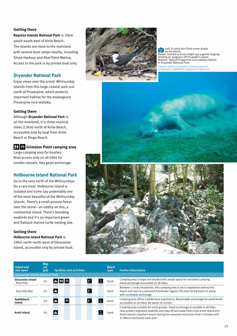
Dryander National ParkEnjoy views over the scenic Whitsunday
islands from this large coastal park just
north of Proserpine, which protects
important habitat for the endangered
Proserpine rock-wallaby.
Getting there Although Dryander National Park is
on the mainland, it is three nautical
miles (13km) north of Airlie Beach,
accessible only by boat from Airlie
Beach or Dingo Beach.
Grimston Point camping areaLarge camping area for boaties.
Boat access only on all tides for
smaller vessels. Has good anchorage.
Holbourne Island National ParkGo to the very north of the Whitsundays
for a rare treat. Holbourne Island is
isolated and some say undeniably one
of the most beautiful of the Whitsunday
islands. There’s a small pisonia forest
near the shore—an oddity on this, a
continental island. There’s breeding
seabirds and it’s an important green
and flatback marine turtle nesting site.
Getting there Holbourne Island National Park is
29km north-north-west of Gloucester
Island, accessible only by private boat.
Left: A sooty tern finds some shade on the beach.
Below: Snorkel and you might spy a gentle dugong feeding on seagrass off Dryander’s shore. Bottom: Typical Prosperine rock wallaby habitat in Dryander National Park.
Island and site name
Map ref. (p4) Facilities and activities
Beach type Further information
Gloucester Islands National Park
Gloucester Island Bona Bay
G1 SandCamping area is large and shaded with ample space for secluded camping. Good anchorage accessible on all tides.
East Side Bay G2 SandBetween 2 rocky headlands, this camping area is set in vegetation behind the beach and next to a seasonal freshwater lagoon.The east-facing beach is steep with unreliable anchorage.
Saddleback Island G3 Sand
Camping area offers a wilderness experience. Reasonable anchorage for small boats accessible on all tides. Be aware of current.
Armit Island G4 Sand
Camping area suitable for small groups. Good anchorage accessible in all tides. Help protect migratory seabirds and stay off and away from Little Armit Island and Armit Island’s southern beach during the seasonal restriction from 1 October and 31 March (inclusive) each year.
Photos: (left and below) © Commonwealth of Australia (GBRMPA); (bottom) © Qld Govt
23

Boating in the WhitsundaysSet sail with the wind in your hair, then plunge into turquoise waters to swim, snorkel and dive. To help protect the Whitsundays, follow these guidelines and restrictions during your boating visit.
Use public mooringsPublic moorings are provided throughout
the Whitsundays to help protect fragile
reefs. There are 5 mooring classes
marked by colour-coded bands that
cater for different vessel lengths and
wind speeds. Always use a public
mooring where available.
Above: Snorkeling is a great way to see the underwater beauty.Right: You might be lucky
to see a whale mother and calf scooting past.
Set sail for a boating adventure in the beautiful Whitsundays. Phot
o: ©
Tou
rism
and
Eve
nts
Qld
Maximum vessel length
Maximum wind speed
6m - tender only 24 knots
10m - monohull 9m - multihull
24 knots
20m - monohull 18m - multihull
34 knots
25m - monohull 22m - multihull
34 knots
35m - monohull 30m - multihull
34 knots
Reef protection marker (RPM)
Observe ‘no anchoring areas’Some Whitsunday reefs are particularly
vulnerable to anchor damage and are
protected in ‘no anchoring areas’.
White pyramid-shaped reef protection
markers indicate most locations.
Never anchor inside a ‘no anchoring area’
or inshore of the buoy line, and
never attach your vessel to a reef
protection marker.
Go slow for those belowThe islands and surrounding reefs are
home to marine animals, such as turtles,
dugong, dolphins and whales.
• Always watch out for marine animals
and avoid boat strike.
• If you see a sick or dead marine animal
please call the Wildlife Hotline
1300 130 372.
Photo: (above) © Tourism and Events Qld; (right) Adam Creed © Qld Govt
The Whitsundays has a wonderful
public moorings set-up. It means, if you
are coming to the area with your own
vessel, you can help to protect the corals
from anchor damage by using the free
public moorings. And as an added bonus,
you can sleep soundly and not worry
about your anchor during the night.
Ranger Kay
24

Watching whalesHumpback whales visit the Whitsunday
area between May and September
during their annual breeding migration.
Calving and mating is a particularly
vulnerable time for these charismatic
creatures, and special rules are in
place to limit potential tourist impacts.
For their safety and yours, vessels
must not approach closer than 300m
of a whale in the Whitsundays Whale
Protection Area, as marked on a marine
park zoning map.
Know your zonesThe Whitsundays are in a marine park
zone, which allows certain activities in
some areas—with or without a permit—but
prohibits them in others. Zoning maps are
available from many local outlets, from
Queensland Parks and Wildlife Service
(QPWS) offices and online at gbrmpa.gov.au/zoning-permits-and-plans/zoning/zoning-maps
The maps include public moorings and
anchoring areas. You must always check
for regulations, and specifically note the
‘designated water sports areas’ and the
pink zone—i.e. no-go and no-take rules
all year—that covers Eshelby and Little Eshelby islands.
Significant site protection—access restrictions
Island Period of restriction
Bird Island
East Rock
Edwin Rock
Eshelby Island (pink zone: no-go and no-take)
Little Eshelby Island (pink zone: no-go and no-take)
All year
Armit Island (south beach)
Double Cone Island (west island)
Grassy Island (south beach)
Little Armit Island
Olden Rock (south of Olden Island)
Shaw Island (beach east of Burning Point)
South Repulse Island (west beach, excluding campsite)
Whitsunday Island, Steens Beach
Between 1 October and 31 March (inclusive)
Significant site protection—regulations• You must keep to a six knot speed
approximately within 200m of the
low water mark.
• No aircraft are allowed below
1,500 feet (above ground or water),
or to approach within 1,000m.
• Stay out of the boat-free zones—that
is approximately 200m around the
following islands between
1 October and 31 March each year.
— East Rock
— Edwin Rock
— Olden Rock (south of Olden Island)
• Stay out of intertidal beaches that
are closed temporarily to protect
endangered wildlife.
Protect nesting coastal birds and sea turtlesFrom October to April, sea turtles
and thousands of coastal birds
migrate to the Whitsundays to breed.
Observe restrictions to nesting sites
and activities to help protect them.
Go slow for those below. Dugong mother and calf spend at least 2 years together.
Photo: © Commonwealth of Australia (GBRMPA)
Nesting or roosting sea birds are easily disturbed, depleting their energy reserves
vital for their successful return migration.Photo: © Kay Kunze
25

Stinging treesTiny, hollow, needle-like hairs on
their heart-shaped leaves pierce
your skin, break off and release
an irritant poison. There’s intense,
often long-lasting pain at the
site and some effects can last
for months. Rubbing the site
and pouring water over it makes
it worse! Seek treatment if
badly affected.
This shrub—Gympie-Gympie (Dendrocnide moroides)—is one
of the 2 north Queensland stinging trees that really do pack a ‘sting’.
The shifting sands around Hill Inlet and Whitehaven Beach offer different views almost every day. Ph
oto:
Dav
e H
arpe
r© Q
ld G
ovt
Camping• Book well in advance. Camp sites in
popular parks book out quickly, especially
in peak periods.
• Book online at qld.gov.au/Camping or over-the-
counter at QPWS office, corner of Mandalay
and Shute Harbour Roads, Airlie Beach
(open 9am–4.30pm Mon–Fri).
• No generators.
• No ash-producing barbecues.
• Bring fuel stoves for cooking.
• Treat any water collected from tanks or watercourses,
before drinking.
Journey wisely
Photo courtesy Queensland Herbarium: Jeanette Kemp © Qld Govt
Packing checklist• Adequate drinking water, food and
emergency supplies.
• Complete first-aid kit suitable for remote
and/or marine situations.
• Detailed maps showing travel routes
and distances.
• GBRMPA zone map MPZ10 for boaties.
• Sturdy rubbish bags and/or sealable, animal-
proof containers. No bins are provided.
• Topographic map, compass and personal
location beacon (PLB) for long distance walking.
Be safe
In an area surrounded by water, swimming is a
much-loved activity. If you choose to swim, you are
responsible for your own safety. There are dangers.
Be croc-wise! Estuarine crocodiles live in some
areas of the Whitsundays. Always stay alert, stay with
your children, secure food and rubbish and camp away
from the water. Take care particularly around near-shore
islands, such as the Molle island group.
Be shark-wise! Cid Harbour, on the western side
of Whitsunday Island, is a known site for shark attacks.
But sharks are present at all times of the year in the
open ocean, estuaries, freshwater canals and streams.
Search for ‘Swimmer safety’ on daf.qld.gov.au
Seek medical attention if stung by marine stingers.
They are prevalent from November to May but may
be present all-year. Wear suitable protective clothing
(stinger suit) and carry vinegar as first aid
to treat a sting.
Never swim alone and stay out of strong currents.
There are no lifesavers at any Whitsunday beaches.
Avoid touching stinging trees.
Brushing up against stinging tree leaves
or fruit is extremely painful.
26

Cyclones, storms and tides• Stay informed of the weather—
cyclone season is November to
April; storms anytime.
• Never set out walking, riding,
swimming or boating if a storm
(or cyclone) is close.
• Be prepared—islands may be
evacuated well in advance of a
cyclone making land.
• Tides and currents affect various
passage and channel crossings
differently—don’t take risks, use
maps and get local information.
Be responsible• Be pest-free! Make sure all camping
equipment, backpacks, clothes, shoes
and supplies are free of seeds, cane
toads, geckoes, insects (including ants
and their eggs) and soil.
• Leave nothing behind. Take plastics,
food scraps, cigarette butts, sanitary
and hygiene items, out
of the parks and off
islands and dispose of
them responsibly.
• Bush toileting? Bury
and cover waste and
used paper.
• Stay away from
nesting shorebirds.
• Never clean fish or throw fish waste
overboard or from the beach.
Did you know?• Never feed or leave food
available for wildlife.
Penalties apply.
• Domestic animals are
prohibited in all island
and mainland national
parks and beaches, and
intertidal areas adjacent
to island national parks
in the Whitsunday area.
Penalties apply.
• Careless anchoring and
kicking damages corals.
Don’t touch corals with
fins. Anchor and stand on
sand next to corals.
• Boaties, go slow for
those below—boat strike
can kill turtles, whales and dugong.
Know your limits
Track and trail classifications
Grade Symbol Suits Track description
2Families with young children
Track has a hardened or compacted surface and may have a gentle hill section or sections and occasional steps.
3People with some bushwalking experience
Track may have short steep hill sections, a rough surface and many steps.
4Bushwalking experience essential
Tracks may be long, rough and very steep. Directional signs may be limited.
EasyNovice riders with basic skills and fitness
Wide trail with a gentle slope and a relatively obstacle-free, hardened natural slope.
Intermediate
Experienced riders with moderate skills and fitness
Trail with obstacles, variable surface and moderate slope. May include steep sections.
DifficultExperienced riders used to physically-demanding routes
Challenging and variable trail with long steep climbs or descents, loose surfaces and unavoidable obstacles.
Below left: Keep a watch on the weather. Below middle: Have fun but know your
limits. Below right: Get local advice.Photo: (below left) Mick Barrett © Qld Govt; (below middle) © Tourism and Events Qld; (below right) Justin Heitman © Qld Govt
Be careful• Never walk or bike ride alone.
• Plan everything you do according
to your fitness level.
• Wear sturdy boots, sun protective
clothing and insect repellent.
• Travel light and pack smart.
• Don’t let the tides or time catch
you out.
• Always inform family or friends
of your planned itinerary.
• Carry navigation and communication
equipment—mobile phone (although
reception is limited), satellite phone,
marine radio and/or a Personal Locator
Beacon (PLB).
• Drink plenty of water and eat energy
foods to sustain you on the more
strenuous tracks.
27

Further informationqld.gov.au/NationalParks
qld.gov.au/Camping
qld.gov.au/ParkAlerts (access, closures and conditions)
qldnationalparks
@QldParks; #QldParks
This brochure is also available online
at qld.gov.au/ParkBrochures
For help planning your holiday visit
queensland.com and tourismwhitsundays.com.au
Useful contactsFor all emergencies: Call Triple Zero (000)
Road conditions: Visit the Department of Transport and
Main Roads at qldtraffic.qld.gov.au or phone 13 19 40.
Shark information: Visit the Department of Agriculture
and Fisheries at daf.qld.gov.au
Marine park information: Visit the Great Barrier Reef
Marine Park Authority at gbrmpa.gov.au
Weather conditions: Visit bom.gov.au
• Reef Zoning Map App (free download)
‘Eye on the Reef’ App: gbrmpa/gov/au
• Triple Zero (000) emergency App (free download):
emergencyapp.triplezero.gov.au
Sense the magic of a Whitsunday afternoon. Photo: Peter Lik © Tourism and Events Qld
©State of Queensland 2019. Queensland Parks and Wildlife Service, Department of Environment and Science. BP1882 December 2019. Printed on eco-friendly paper to save energy and resources.
Scan to check park alerts