Where was it?- Locating Earthquakes Fig. 18.18 Understanding Earth
6
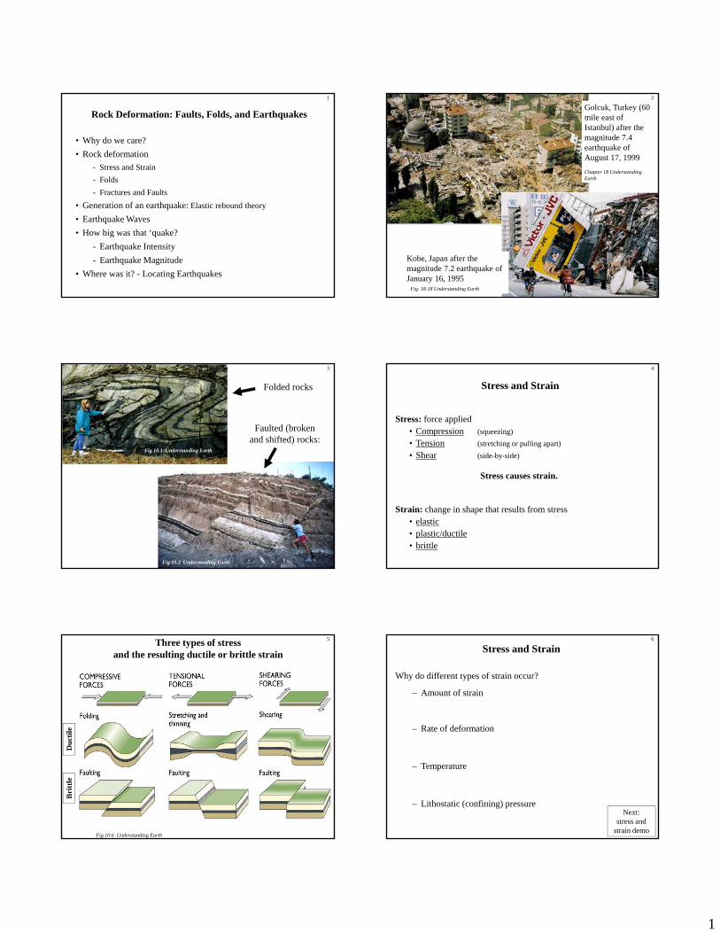
1 Rock Deformation: Faults, Folds, and Earthquakes • Why do we care? • Rock deformation - Stress and Strain - Folds - Fractures and Faults 1 • Generation of an earthquake: Elastic rebound theory • Earthquake Waves • How big was that ‘quake? - Earthquake Intensity - Earthquake Magnitude • Where was it? - Locating Earthquakes Golcuk, Turkey (60 mile east of Istanbul) after the magnitude 7.4 earthquake of August 17, 1999 Chapter 18 Understanding Earth 2 Kobe, Japan after the magnitude 7.2 earthquake of January 16, 1995 Fig. 18.18 Understanding Earth Folded rocks Fig 10.1 Understanding Earth Faulted (broken and shifted) rocks: 3 Fig 10.2 Understanding Earth Stress and Strain Stress: force applied • Compression (squeezing) • Tension (stretching or pulling apart) • Shear (side-by-side) 4 Strain: change in shape that results from stress • elastic • plastic/ductile • brittle Stress causes strain. tile Three types of stress and the resulting ductile or brittle strain 5 Fig 10.6 Understanding Earth Brittle Duct Stress and Strain Why do different types of strain occur? – Amount of strain – Rate of deformation 6 – Temperature – Lithostatic (confining) pressure Next: stress and strain demo
-
Upload
periyaruniversity -
Category
Documents
-
view
0 -
download
0
Transcript of Where was it?- Locating Earthquakes Fig. 18.18 Understanding Earth
1
Rock Deformation: Faults, Folds, and Earthquakes
• Why do we care?• Rock deformation
- Stress and Strain- Folds- Fractures and Faults
1
• Generation of an earthquake: Elastic rebound theory
• Earthquake Waves• How big was that ‘quake?
- Earthquake Intensity- Earthquake Magnitude
• Where was it? - Locating Earthquakes
Golcuk, Turkey (60 mile east of Istanbul) after the magnitude 7.4 earthquake of August 17, 1999Chapter 18 Understanding Earth
2
Kobe, Japan after the magnitude 7.2 earthquake of January 16, 1995
Fig. 18.18 Understanding Earth
Folded rocks
Fig 10.1 Understanding Earth
Faulted (broken and shifted) rocks:
3
Fig 10.2 Understanding Earth
Stress and Strain
Stress: force applied• Compression (squeezing)• Tension (stretching or pulling apart)• Shear (side-by-side)
4
Strain: change in shape that results from stress• elastic• plastic/ductile• brittle
Stress causes strain.
tile
Three types of stressand the resulting ductile or brittle strain
5
Fig 10.6 Understanding Earth
Bri
ttle
Duc
t
Stress and Strain
Why do different types of strain occur?
– Amount of strain
– Rate of deformation
6
– Temperature
– Lithostatic (confining) pressureNext:
stress and strain demo

2
Effect of pressure and temperature on the type of strain
Fig 10. Understanding Earth
7
Brittle strain: Joints and Faults
Joints: cracks or fractures along which no movement has occurred.
Faults: fractures along which rocks have moved.
Types of faults:d d ( i l)
8
Dip slip - up and down (vertical) movementnormal - related to extensional stressreverse - related to compressional stressthrust - related to compressional stress
Strike-slip - side-to-side movementleft lateral or right lateral - related to shear stress
Oblique - a combination of strike-slip and dip-slip
Joints in sedimentary rockOther examples of joints include columnar jointing in lava flows and exfoliation fractures in intrusive igneous rocks.
9
Geologists often can use the 3-dimensional orientations of joints and faults to learn about the directions of the stresses which created them.Fig 10.20 Understanding Earth
Dip slip
normal fault
reverse fault (or thrust)
stretching
10
(or thrust)
Strike-slip right lateralleft lateral
squeezing
shearing
Fault with sideways movement (strike-slip)
Close-up of an offset curb along 5th Street in Hollister, California (about 75 km south-southeast of San Jose).
11
This Dynamic Earth - USGS
Which is type of fault is this?
right-lateralor
left-lateral
What kind of fault is this?12
Fault in the Blue Mountains of northeastern
Oregon

3
Fault breccia in basalt - Blue Mountains, NE Oregon
13
S. Kuehn
Slickensides in serpentinite, Sierra foothills along Hwy 70 in California
Slickensides - Blue Mountains, OR
14
15
Squeezing
USGS Next: basin and range animation
Making an earthquake: Elastic Rebound Theory 16
1. Elastic strain accumulates over time as a result of applied stress
Fig. 18.1 Understanding Earth
17
2. Eventually the rocks break and released stored energy in an earthquake
Fig. 18.1 Understanding Earth
Next: elastic rebound animations
Epicenter and focus of an earthquakeThe energy released by an earthquake radiates outward from the focus in the form of earthquake waves (vibrations).
Which is
18
Fig. 18.3 Understanding Earth
type of fault is this?
normal or reverse
4
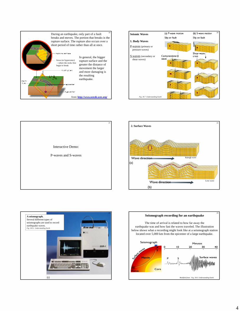
During an earthquake, only part of a fault breaks and moves. The portion that breaks is the rupture surface. The rupture also occurs over a short period of time rather than all at once.
focus (or hypocenter)– where the rocks first b i t b k
In general, the bigger rupture surface and the greater the distance of
19
begin to break
from: http://www.scecdc.scec.org/
greater the distance of movement the larger and more damaging is the resulting earthquake.
Seismic Waves
1. Body Waves
P-waves (primary or pressure waves)
S-waves (secondary or shear waves)
20
Fig. 18.7 Understanding Earth
Interactive Demo:
P waves and S waves
21
P-waves and S-waves
2. Surface Waves22
Love wave
Raleigh wave
A seismograph.Several different types of seismographs are used to record earthquake waves.Fig. 18.5c Understanding Earth
23
Seismograph recording for an earthquake
The time of arrival is related to how far away the earthquake was and how fast the waves traveled. The illustration
below shows what a recording might look like at a seismograph station located over 5,000 km from the epicenter of a large earthquake.
24
Modified from: Fig. 18.6 Understanding Earth

5
How big was that earthquake?Earthquake Intensity and Magnitude
Intensity:
• amount of surface shaking
• varies with location and distance
M it d
25
Magnitude:
• related to the amount of energy released by the earthquake
• Richter magnitude is based on seismic wave amplitude (height) corrected for distance and other factors
More information:http://pubs.usgs.gov/gip/earthq4/severitygip.htmlhttp://earthquake.usgs.gov/learning/topics/measure.phphttp://earthquake.usgs.gov/learning/topics/mag_vs_int.php
Modified Mercalli Intensity ScaleMMI Value
Shaking Severity
Summary Damage Description
I. . Not felt.
II. . . Felt by persons at rest, on upper floors, or favorably placed.
III. . . Felt indoors. Hanging objects swing. Vibration like passing of light trucks. May not be recognized as an earthquake.
IV. . . Hanging objects swing. Vibration like passing of heavy trucks; or sensation of a jolt like a heavy ball striking the walls. Windows, dishes, doors rattle.
26
,
V. Light Pictures Move Felt outdoors. Sleepers wakened. Liquids disturbed, some spilled. Small unstable objects displaced or upset. Doors swing, close, open. Shutters, pictures move.
VI. Moderate Objects Fall Felt by all. Many frightened and run outdoors. Persons walk unsteadily. Windows, dishes, glassware broken. Knickknacks, books, etc., off shelves. Pictures off walls. Furniture moved or overturned. Weak plaster and masonry cracked.
VII. Strong Nonstructural Damage
Difficult to stand. Noticed by drivers of motor cars. Hanging objects quiver. Furniture broken. Damage to masonry including cracks. Weak chimneys broken at roof line. Fall of plaster, loose bricks, stones, tiles. Waves on ponds. Small slides and caving in along sand or gravel banks. Concrete irrigation ditches damaged.
Modified Mercalli Intensity Scale - ContinuedMMI Value
Shaking Severity
Summary Damage Description
VIII. Very Strong
Moderate Damage
Steering of motor cars affected. Fall of stucco and some masonry walls. Twisting, fall of chimneys, elevated tanks. Frame houses moved on foundations if not bolted down; loose panel walls thrown out. Branches broken from trees. Changes in flow or temperature of springs and wells. Cracks in wet ground and on steep slopes.
IX. Violent Heavy Damage General panic. General damage to foundations. Frame structures, if not bolted, shifted off foundations. Frames racked. Serious damage to reservoirs Underground pipes broken Conspicuous
27
damage to reservoirs. Underground pipes broken. Conspicuous cracks in ground. In alluvial areas sand and mud ejected, earthquake fountains, sand craters.
X. Very Violent
Extreme Damage
Most masonry and frame structures destroyed with their foundations. Some well-built wooden structures and bridges destroyed. Serious damage to dams, dikes, embankments. Large landslides. Water thrown on banks of canals, rivers, lakes, etc. Sand and mud shifted horizontally on beaches and flat land. Rails bent slightly.
XI. . . Rails bent greatly. Underground pipelines completely out of service.
XII. . . Damage nearly total. Large rock masses displaced. Lines of sight and level distorted. Objects thrown into the air.
Intensity map for the 1994 Northridge earthquake
The epicenter is marked by a star symbol.
28
star symbol.
Fig. 7.17 Keller, Environmental Geology
(original source: U.S. Geological survey)
Earthquake Magnitude
- a measure of the total energy released- can be related to the amplitude of the seismic waves
29
Fig. 18.10 Understanding Earth
30Magnitude vs. Frequency
Modified from Fig. 18.11 Understanding Earth
More earthquakes

6
Where did that earthquake happen?
The recordings from at least three seismograph stations may be used to find out.
31
Fig. 18.9a Understanding Earth
Travel times of P- and S-waves The amount of time between the arrival of P-waves and S-waves is used to calculate the distance between the seismograph and the epicenter.
32
Fig. 18.9b Understanding Earth
Finding the epicenter of an earthquake A minimum of three seismograms is needed to locate an epicenter.
33
Fig. 18.9c Understanding Earth
Next:
Exercise on magnitude and
location
Major earthquakes typically are followed by many smaller earthquakes called aftershocks.
By plotting the locations of the main
34
gs E
arth
quak
e of
July
, 198
6, M
ag 5
.6nd
ex/n
palm
spr.h
tml
earthquake and its many aftershocks it is possible to locate the fault underground.
from: http://www.scecdc.scec.org/
Exam
ple
show
n: N
orth
Pal
m S
prin
ght
tp://
ww
w.da
ta.sc
ec.o
rg/c
hron
o_in