What's new in GIS - NCAR Research Applications Laboratory ...
41
What’s new in GIS RAL Retreat Oct 5, 2005
-
Upload
khangminh22 -
Category
Documents
-
view
0 -
download
0
Transcript of What's new in GIS - NCAR Research Applications Laboratory ...

What’s new in GIS
RAL Retreat Oct 5, 2005
Overview
GIS Initiative milestonesMajor activities in 2004 - 2005
GALEON – UNIDATA OGC project
New functionality in ESRI software

GIS Initiative Team
Olga Wilhelmi – PI
Terri Betancourt – PI 2004
Jennifer Boehnert – UCAR GIS Coordinator

Integrates knowledge across disciplines and social groups
Promotes and supports the use of GIS as both an analysis and an infrastructure tool in atmospheric research and
Addresses broader issues of data management and geoinformatics within atmospheric and related geo- and social sciences

GIS Initiative Program ElementsGIS Initiative Program Elements
GIS Program with five program elements:
DataIntegration
&Distribution
ResearchIn GIS
Technology
ResearchEnabled by
By GIS
Education,Training &
UserSupport
BuildingCommunity

GIS Lab
Distributed GIS service center has been in effect since December 2002
July 2004 GIS lab officially opened as a resource for all UCAR employees
Education,Training &
UserSupport
GIS coordinator
Hardware
GIS and image processing software
Data
Reference materials

Atmospheric Data Modeling (ADM)
ResearchIn GIS
Technology
Leading atmospheric special interest group (>100 members from government, universities, the private sector)ADM - Community-based initiative and a working dialog between ESRI and atmospheric sciences community regarding atmospheric data representation and analysis challenges Conducted two data modeling workshops In process of developing a Conceptual Document (ArcGIS Atmospheric Data Model)Our collaboration with ESRI resulted in support for NetCDFfiles in ArcGIS
ADM Workshop 1 - Seattle, WA, January 16-17, 2004 at NOAA PMEL Lab
ADM Workshop 2 - San Diego, CA, January 14, 2005 at the Marriott Hotel & Marina

The thematic layers (draft)
Weather Satellite Measurements
Weather Radar Measurements
Weather Point Measurements
Weather Events
Atmospheric Mobile Measurements
Atmospheric Boundaries
Climate Point Measurements
Numerical Models
Human Elements
Earth Surface Characteristics

ResearchEnabled by
By GISNCAR Science with GIS
Schimel, et al. Airborne Carbon in the Mountains Experiment (ACME)
CGDMMM
Glantz Aral Seas Flip Book ISSE
Asim and Morss Hurricane impacts ISSE
Wiedinmyer, Emissions modeling ACD

Aral Sea Flip Book

Aral Sea

Focus on Interoperability, Focus on Interoperability, Data, Tools and Models
DataIntegration
&DistributionData, Tools and Models
GIS Climate Change Scenarios Project
http://www.gisClimateChange.org

GIS Climate Change Scenarios GIS Climate Change Scenarios ProjectProject
Goal: open NCAR’sclimate modeling work to:
Educators and studentsResource managers and plannersPolicy makersGeographers and other social scientistsClimate impacts researchersOther “GIS community”
Since February 2005 GIS data portal had:
7242 hits2846 files downloaded

GIS Climate Change Scenarios Data GIS Climate Change Scenarios Data PortalPortal
Complimentary to other data distributing centersCollaboration with NCAR Community data Portal Dynamic converter translates NetCDF files into shapefile format.Step-by-step process for on-line data accessCurrently available datasets
include atmospheric and land variables for
IPCC A1BIPCC A2IPCC B1IPCC 20th century constant Present Day Control 1870 Control

GIS Climate Change Scenarios GIS Climate Change Scenarios
Preview and exploration of data on-line
The map shows mean surface temperature for July 2099 (A1B scenario)

GIS Climate Change Scenarios GIS Climate Change Scenarios
Data analysis in ArcGIS
100-year (2000-2099) change in mean July surface temperature
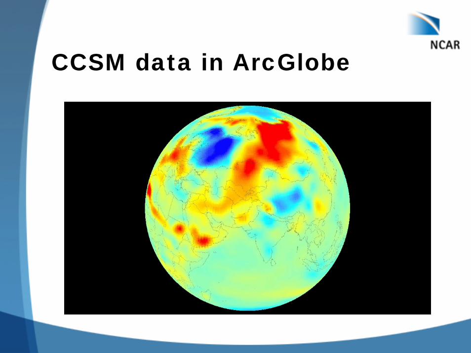
CCSM data in ArcGlobe

Users of GIS data portalUsers of GIS data portal
To date we have more than 700 registered users from 60 countries70 percent of users are from the United States

Climate Change Demo

New Develops in the GIS Industry
Open GIS Consortium Web Coverage ServernetCDF as an encoder
ESRI New functionality New applications

OGC - UNIDATA - GALEON
GALEON (Geo-interface for Air, Land, Earth, Oceans NetCDF)Interoperability Experiment
Stefano Nativi, John Caron, Lorenzo Bigagli, Ben Domenico
Standards based gateway needed between existing “AIS” data systems and traditional GIS world

Client Application
THREDDS
Catalog.xml
NetCDF IOsp
GRIB
GININIDS
HTTP
… …
ADDE
GRID
StationAREA
…
OPeNDAP
Jgoffs
DMSPNetCDF-3
…
Existing Technology In Oceans/Atmosphere
Communities
HDF5

WFS
Application
OGC Data Service with NetCDF Dataset
Protocols
DTED
HDF-EOS
WCS
Static GIS Features
GML
NITF
GeoTIFF
NetCDF Interface
ADDEOpenDAP netCDF file
…
Main Gateway Objectives
Make communities aware of one another
Build standard interface to the many netCDF/OPeNDAP data servers already in operation
Allow traditional atmospheric data providers to migrate toward one standards-based service
Allow traditional GIS clients to access netCDF/OPeNDAP datasets via standards-based interface
Evaluate netCDF/OPeNDAP as WCS data transport (encoding) mechanism … suggest extension if warranted

ParticipantsUnidata/UCAR*University of Florence*NASA Geospatial Interoperability Office*George Mason UniversityCadCorpESRIJPLIMAA-CNRInteractive InstrumentsUniversity of Applied SciencesInternational University BremenNERC NCAS/British Atmospheric Data CenterUniversity of Alabama HuntsvilleResearch Systems, Inc. (IDL)Texas A&M University
*Initiating institutions
What’s new in ESRI products
Desktop ArcGIS ApplicationsNetCDF functionality
ServerArcEngine

ArcGIS Applications
Data exploration
Map making
Data analysis

ArcScene
Interactive “Fish tank” view
Good for a small scale range
Best at rendering geometry
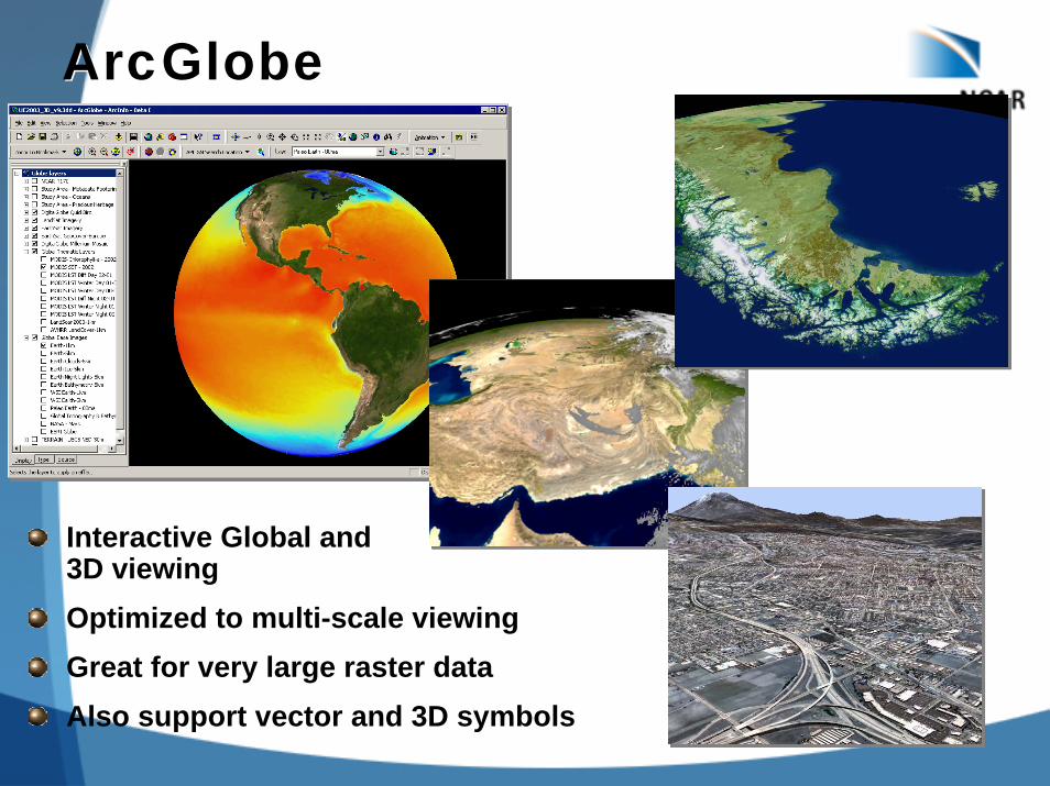
ArcGlobeArcGlobe
Interactive Global and3D viewingOptimized to multi-scale viewingGreat for very large raster dataAlso support vector and 3D symbols

Multidimensional ArcGIS 9.2Extend existing functionality to support time and multidimensional data
Animation manager learns how to use a variable such as time to set the animation sequence.Improve quality and interaction of charting and include as an animation object.Add support for the NetCDF data format building on existing layer capabilities.

Example animation

New Charting PackageScatter
3D Scatter
Combine Multiple Charts

LinkingLinking
Select a feature in the map, record in the table, or element in the graph and see it highlighted in the other windows.

BrushingBrushing
Drag a selection box around features in the map, records in the table, or element in the graph and see it interactively highlighted in the other windows.

NetCDF in ArcGIS
NetCDF data can be accessed throughRasterFeatureTable
Direct Read – no scratch files

NetCDF Tools in ArcGISMake NetCDF Raster Layer
Make NetCDF Feature Layer
Make NetCDF Table View
Raster to NetCDF
Feature to NetCDF
Table to NetCDF
Select by Dimension

Using NetCDF Layer/Table
Behaves the same as any layer or table in:Display
• Same display tools for raster and feature layers will work on netCDF raster and netCDF feature layers.
Charting• Driven by the table just like any other chart.
Animation• Multidimensional data can be animated through a
dimension (e.g. time, pressure, elevation)Geoprocessing Tool
• A netCDF raster layer will work just like any other raster layer, same for feature layers and tables.

ArcEngine
Developer product for creating custom GIS desktop applicationsBuild stand-alone applications or extend existing applications to provide focused spatial solutionsProgramming interfaces:
.NETJAVAC++

ArcEngine Demo

ArcGIS Server
A framework to build centralized GIS applications and services
Provide browser-based access to GIS
Develop advanced GIS Web Services
Develop custom applications using .NETJAVA

Summary
GIS Initiatives future projectsMMM WRF weather forcast data server with social datasetsAtmospheric Data ModelingClimate change and weather tools and symbolsOngoing UCAR project support
http://www.gis.ucar.edu