WEST LAS VEGAS PLAN
88
WEST LAS VEGAS PLAN The West Las Vegas Plan was adopted by City Council on April 5, 2006 (Resolution #14-2006) and amended on July 1, 2009 (GPA-33721)
-
Upload
khangminh22 -
Category
Documents
-
view
7 -
download
0
Transcript of WEST LAS VEGAS PLAN

WEST LAS VEGAS PLAN
The West Las Vegas Planwas adopted by City Council on
April 5, 2006 (Resolution #14-2006) and amended on July 1, 2009
(GPA-33721)

CITY OF LAS VEGAS WEST LAS VEGAS PLAN ii
Tab
le o
f C
onte
ntsTable of Contents
Executive Summary . . . . . . . . . . . . . . . . . . . . . . . . . . . . . . . . . . 1Land Use . . . . . . . . . . . . . . . . . . . . . . . . . . . . . . . . . . . . . . . . . . . . 1
Infrastructure . . . . . . . . . . . . . . . . . . . . . . . . . . . . . . . . . . . . . . . . . 1
Public Facilities . . . . . . . . . . . . . . . . . . . . . . . . . . . . . . . . . . . . . . . . 2
Economic Development . . . . . . . . . . . . . . . . . . . . . . . . . . . . . . . . . . 2
Historic Preservation. . . . . . . . . . . . . . . . . . . . . . . . . . . . . . . . . . . . 2
Introduction . . . . . . . . . . . . . . . . . . . . . . . . . . . . . . . . . . . . . . . . 4Description Of The Area. . . . . . . . . . . . . . . . . . . . . . . . . . . . . . . . . . 4
Planning Process . . . . . . . . . . . . . . . . . . . . . . . . . . . . . . . . . . . . . 12
Background Information . . . . . . . . . . . . . . . . . . . . . . . . . . . . . . 18Existing Land Uses . . . . . . . . . . . . . . . . . . . . . . . . . . . . . . . . . . . . 18
Residential Land Uses. . . . . . . . . . . . . . . . . . . . . . . . . . . . . . . . . . 18
Single-family Residential . . . . . . . . . . . . . . . . . . . . . . . . . . . . . . . . 18
Multi-family Residential . . . . . . . . . . . . . . . . . . . . . . . . . . . . . . . . . 21
Vacant Land . . . . . . . . . . . . . . . . . . . . . . . . . . . . . . . . . . . . . . . . . 21
Public And Community Facilities . . . . . . . . . . . . . . . . . . . . . . . . . . . 22
Commercial Uses And Industrial Land Uses . . . . . . . . . . . . . . . . . . 26
Land Use Goals, Objectives, And Policies. . . . . . . . . . . . . . . . . . 46Las Vegas Master Plan 2020. . . . . . . . . . . . . . . . . . . . . . . . . . . . . 46
Las Vegas Redevelopment Plan . . . . . . . . . . . . . . . . . . . . . . . . . . . 50
West Las Vegas Neighborhood Plan . . . . . . . . . . . . . . . . . . . . . . . . 51
Land Use Plan Strategy. . . . . . . . . . . . . . . . . . . . . . . . . . . . . . . 60Downtown Redevelopment Plan . . . . . . . . . . . . . . . . . . . . . . . . . . . 60
West Las Vegas Neighborhood Plan . . . . . . . . . . . . . . . . . . . . . . . . 61
Implementation . . . . . . . . . . . . . . . . . . . . . . . . . . . . . . . . . . . . 73Land Use . . . . . . . . . . . . . . . . . . . . . . . . . . . . . . . . . . . . . . . . . . . 73
Infrastructure . . . . . . . . . . . . . . . . . . . . . . . . . . . . . . . . . . . . . . . . 76
Public Facilities . . . . . . . . . . . . . . . . . . . . . . . . . . . . . . . . . . . . . . . 79
Economic Development . . . . . . . . . . . . . . . . . . . . . . . . . . . . . . . . . 80
Historic Preservation. . . . . . . . . . . . . . . . . . . . . . . . . . . . . . . . . . . 81
Urban Design/Visual Image . . . . . . . . . . . . . . . . . . . . . . . . . . . . . . 83
TablesTable 1 – Total General Land Uses . . . . . . . . . . . . . . . . . . . . . . . . . 18
Table 2 – Existing Residential Land Uses . . . . . . . . . . . . . . . . . . . . 18

CITY OF LAS VEGAS WEST LAS VEGAS PLAN iii
Tab
le o
f C
onte
ntsTable 3 – Housing Sales and Prices since 1999 . . . . . . . . . . . . . . . 20
Table 4 – Vacant Land in West Las Vegas . . . . . . . . . . . . . . . . . . . . 21
Table 5 – Arterial Levels of Service . . . . . . . . . . . . . . . . . . . . . . . . 31
Table 6 – Number of West Las Vegas Businesses . . . . . . . . . . . . . . 41
Table 7 – West Las Vegas Building Permits . . . . . . . . . . . . . . . . . . . 43
Table 8 – Public Investment . . . . . . . . . . . . . . . . . . . . . . . . . . . . . . 44
Table 9 – Neighborhood Services Department Funded Improvements . . . . . . . . . . . . . . . . . . . . . . . . . . 45
ChartsChart 1 – Population Trends . . . . . . . . . . . . . . . . . . . . . . . . . . . . . 36
Chart 2 – Race and Ethnicity . . . . . . . . . . . . . . . . . . . . . . . . . . . . . 36
Chart 3 – Age Distribution . . . . . . . . . . . . . . . . . . . . . . . . . . . . . . . 36
Chart 4 – Educational Attainment. . . . . . . . . . . . . . . . . . . . . . . . . . 38
Chart 5 – Household Composition . . . . . . . . . . . . . . . . . . . . . . . . . 38
Chart 6 – Crime Statistics – Calls for Service . . . . . . . . . . . . . . . . . 38
Chart 7 – Median Household Income . . . . . . . . . . . . . . . . . . . . . . . 39
Chart 8 – Income Sources. . . . . . . . . . . . . . . . . . . . . . . . . . . . . . . 39
Chart 9 – Occupation . . . . . . . . . . . . . . . . . . . . . . . . . . . . . . . . . . 40
Chart 10 – Unemployment. . . . . . . . . . . . . . . . . . . . . . . . . . . . . . . 40
Chart 11 – Commuting to Work . . . . . . . . . . . . . . . . . . . . . . . . . . . 40
MapsMap 1 – West Las Vegas Aerial View . . . . . . . . . . . . . . . . . . . . . . . . 3
Map 2 – West Las Vegas Location Map . . . . . . . . . . . . . . . . . . . . . . 5
Map 3 – Fault Lines and Flood Zone Map . . . . . . . . . . . . . . . . . . . . . 6
Map 4 – Historic Places Map . . . . . . . . . . . . . . . . . . . . . . . . . . . . . . 9
Map 5 – Existing Land Use Map. . . . . . . . . . . . . . . . . . . . . . . . . . . 19
Map 6 – Vacant Land Map . . . . . . . . . . . . . . . . . . . . . . . . . . . . . . . 23
Map 7 – Public and Community Facilities Map. . . . . . . . . . . . . . . . . 25
Map 8 – Existing Religious Facilities Map . . . . . . . . . . . . . . . . . . . . 27
Map 9 – West Las Vegas Plan Master Plan of
Streets and Highways . . . . . . . . . . . . . . . . . . . . . . . . . . . . 30
Map 10 – West Las Vegas Plan Road Improvement. . . . . . . . . . . . . 33
Map 11 – Trails Map . . . . . . . . . . . . . . . . . . . . . . . . . . . . . . . . . . . 35
Map 12 – West Las Vegas Census Tracts Map . . . . . . . . . . . . . . . . 37
Map 13 – Redevelopment Area Map. . . . . . . . . . . . . . . . . . . . . . . . 62
Map 14 – Current Future Land Use . . . . . . . . . . . . . . . . . . . . . . . . 66
Map 15 – Current Zoning Map . . . . . . . . . . . . . . . . . . . . . . . . . . . . 67
Map 16 – Inconsistent General Plan and Zoning Designations . . . . . 70
Map 17 – Proposed Future Land Use . . . . . . . . . . . . . . . . . . . . . . . 72

CITY OF LAS VEGAS WEST LAS VEGAS PLAN 1
Exe
cuti
ve S
um
mary
1
Executive Summary TasksLAND USE
-
mercial areas, while maintaining medium-low and medium-high residential
designations to serve as buffers between single-family homes and commer-
cial development.
and commercial infill development opportunities, including potential loca-
tions for neighborhood serving commercial development that is within walk-
ing distance of residences.
-
ties (Church, House of Worship per Title 19) on economic development op-
portunities in West Las Vegas.
amend where appropriate.
INFRASTRUCTURE
and opportunities for infrastructure improvements, including: sidewalks,
streetlights, pedestrian overpasses, bus turnouts along major arterials and
the provision of covered bus shelters and trash receptacles at all stops.
Vegas on traffic and land uses in West Las Vegas.
-
vices to discourage non-residential traffic and assist in slowing down traffic
in high pedestrian areas.
Community Input Meeting.
New Cox Communications building.

CITY OF LAS VEGAS WEST LAS VEGAS PLAN 2
Exe
cuti
ve S
um
maryPUBLIC FACILITIES
(including community centers, fire stations, police stations, social services,
parks and trails, performing and fine arts).
police protection services to ensure the public welfare of all residents.
ECONOMIC DEVELOPMENT
-
aging the development of commercial and office space.
-
ties in housing development, cultural institutions and neighborhood commer-
cial, in the Las Vegas Redevelopment Plan area within the West Las Vegas
Plan area.
HISTORIC PRESERVATION
and preserve existing historic, cultural and architectural resources.
URBAN DESIGN/VISUAL IMAGE
Vegas through streetscape improvements.
Community Input Meeting.
Lubertha Johnson Park.


CITY OF LAS VEGAS WEST LAS VEGAS PLAN 4
Intr
odu
ctio
nIntroductionThe West Las Vegas Plan area is experiencing dynamic changes within its boundaries,
both positive and challenging. This up-to-date version of the West Las Vegas Plan
depicts the challenges, strengths and weaknesses of the area. The Las Vegas 2020
residents of West Las Vegas and the Departments of Planning and Development,
Office of Business Development, Public Works and Neighborhood Services. This
Plan reflects the vision that emerged through a series of community meetings.
DESCRIPTION OF THE AREA
The West Las Vegas area is centrally located within the City of Las Vegas and
total land area of the City. West Las Vegas is located north of U.S. 95, south of
Carey Avenue and Lake Mead Blvd, east of Rancho Drive and west of Interstate 15.
West Las Vegas is convenient to major employment areas; has convenient access
to the regional freeways (U.S. 95 and I-15); and is within close proximity to the
Downtown and the Downtown North areas.
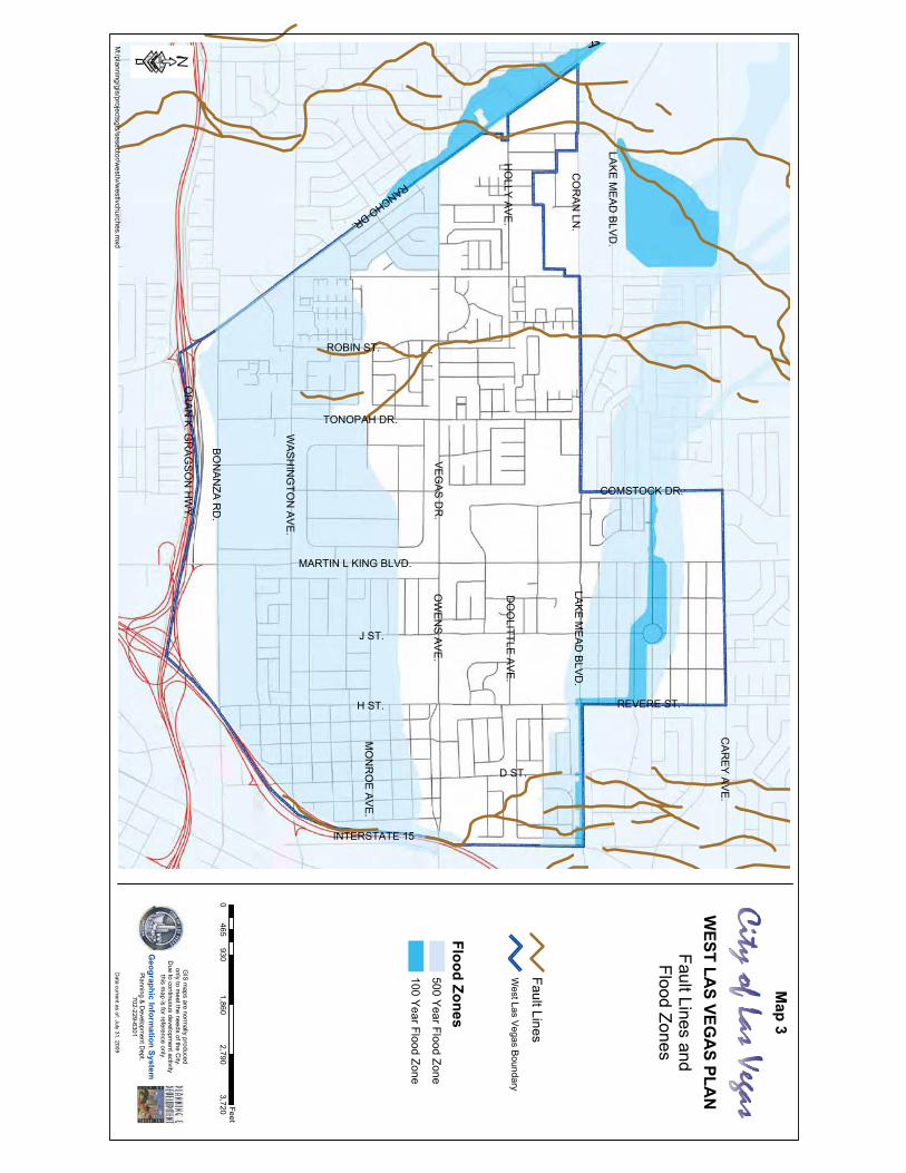
MAP 2 – WEST LAS VEGAS LOCATION MAP (SEE PG. 5).
Physical Setting
the Las Vegas valley, with several small areas of subsidence-induced fissures. This
fissuring is not unusual in Las Vegas and is typically related to the removal of ground
water in the Las Vegas Valley.
areas of 100-year shallow flooding with depths between one and three feet; Zone C
is an area of minimal flooding. Through scheduled and completed improvements by
the Regional Flood Control District in West Las Vegas and other nearby areas, the
potential problem of flooding is diminishing. Such projects include: the construction
of a storm drain under Owens Avenue from Rancho Drive to Interstate-15; and a
The approximate locations of two inactive faults that run through West Las Vegas
are also identified. The faults are the result of shifts in the earth’s crust millions
of years ago.
MAP 3 - FAULT LINES AND FLOOD ZONES MAP (SEE PG. 6).
VA Hospital on Martin L.King Boulevard.

SAH
AR
AA
VE.
TENAYAWY.
BRADLEYRD.C
HEYEN
NE
AVE.
ALE
XAN
DER
RD
.
GO
WA
NR
D.
CR
AIG
RD
.
LON
EM
OU
NTA
INR
D.
AN
NR
D.
TRO
PICA
LPK
WY.
DEER
SPR
ING
SW
Y.
ELKH
OR
NR
D.
HO
RSE
DR
.
IRO
NM
OU
NTA
INR
D.
LOG
CA
BIN
WY.
MO
CC
ASIN
RD
.
DECATURBLVD.
JONESBLVD.
RAINBOWBLVD.
KYLE
CA
NY O
NR
D.
CH
AR
LESTON
BLVD
.
TOWN CENTERDR.
SAH
AR
AA
VE.
DESER
TIN
NR
D.
HUALAPAI WY.
DURANGO DR.
CIMARRON RD.
BUFFALO DR.
TENAYA WY.
RAINBOW BLVD.
TORREY PINES DR.
JONES BLVD.
LINDELL RD.
DECATUR BLVD.
LAS VEGAS BLVD.
EASTERN AVE.
BOULDERHWY.
PECOS RD.
LAMB BLVD.
NELLIS BLVD.
MARION DR.
OW
ENS
AVE.
SANDHILL RD.
MOJAVE RD.
LAK
EM
EAD
BLVD
.
CA
REY
AVE.
MARTIN L.KING BLVD.
RANCHODR.
U.S.95
CH
EYE NN
EA
VE.
US 95
I-215
TORREY PINES DR.
GR
AN
DTETO
ND
R.
FAR
MR
D.
WA
SHB
UR
NR
D.
WA
SHIN
GTO
NA
VE.
BO
NA
NZA
RD
.
STEWA
RT
AVE.
CH
AR
LESTON
BLVD
.
MARYLAND PKWY.
U.S. 93
VALLEY VIEW BLVD.
FORT APACHE RD.
I - 215
U.S.95
DURANGODR.
BUFFALODR.
CIMARRONRD.
EL CAPITANWY.
FORT APACHE RD.
HUALAPAI WY.GRANDCANYON
DR.
U.S.95
PULI RD.
LAK
EM
EAD
BLVD
.
S UM
ME
RLIN
PRK
WY
WEST LA
S VEGA
S PLAN
Location Map
MARTIN L KING BLVD.
TONOPAH DR.
CA
REY
AV
E.
INTERSTATE 15
BON
ANZA R
D.
WAS
HIN
GTO
N AV
E.
LAKE
ME
AD
BLV
D.
CO
RAN
LN.
VEG
AS D
R.
OW
ENS
AVE
.
RANCHODR.
OR
AN
K. G
RAG
SO
N H
WY
.
H ST. REVERE ST.
COMSTOCK DR.
LAKE
ME
AD
BLV
D.
DO
OLITTLE
AVE.
MO
NR
OE A
VE.
HO
LLY AVE
.
J ST.
D ST.
ROBIN ST.
95
J
15
H
D
F
I
CA
RE
Y
E
G
A
C
UP RRB
VE
GA
S
RANCHO
LAK
EM
EA
D
BO
NA
NZ A
WA
SH
ING
T ON
N
MAIN
MARTIN L KING
MILLE
R
CO
RA
N
OW
EN
S
SIMMONS
TONOPAH
ROBIN
HO
LLY
K
4TH
REVERE
AD
AM
S
CA
RTIE
R
BA
LZAR
MO
NR
OE
LOSEE
L
CITY
ME
SQ
UITE
OG
DENWEST
COMMERCE
1ST
CLAYTON
VALLEY VIEW
ALLEN
RAM
PN
I15N
US
95
LA SALLE
MC
WILL IA
MS
PYRAMID
OP
HIR
AV
ALO
N
GILD
AY
RAM
PS
US
95S
I15
SU
TRO
BA
RTLE
TT
M
CITIZE
N
MA
DIS
ON
SHADOW
HE
LEN
LAW
RY
SHARON
RIVERSIDE
BL U
F F
DU
CH
ES
S
GO
LDH
ILL
CORP LIMIT
KIEL
COMSTOCK
HA
RR
ISO
N
DATE
DU
KE
ENGLESTAD
PA
UL
KINGS
CA
RV
ER
TURQUOISE
FREM
ONT
JIMM
Y
ME
L OD
Y
SILVERLAKE
ALE
XA
ND
ER
DIKE
BAKER
RAMP N US95 S I15
3RD
SUNNY
FERRELL
TRAVISFRE
DE
RIC
K
BLA
NK
EN
SH
IP
CASINO CENTER
FAIR
DU
NE
GO
LD
HAR
T
RALSTON
HA
SS
ELL
LUNING
CYPRESS
SP
RIN
G
LUDWIG
SU
NLA
ND
TAMERACK
SA
ND
SA
GE
NYE
STEWART
OAK TREE
WOODBRIDGE
MILLS
STELLALAKE
LEONA
VA
N E
RT
VIRGINIA CITY
COUNT
SYCAMORE
MEZPAH
NE
LSO
N
LANGTRY
BENNETT
NAVAJO
RAM
PN
I15S
US95
ROYAL
CANYON
RE
CC
O
GR
AN
ITE
IVY
ARROWHEAD
TWIN LAKES
GRANDCENTRAL
CO
LLINS
RO
SS
MO
YN
E
LAN
TER
N
REJOICE
DE
NB
Y
PREVAIL
TUMBLEWEED
SYMPHO
NYPAR
K
BELROSE
KA
SP
ER
STARKS
CENSUS TRACT BDRY
SM
OK
ETR
EE
WEA
VE
R
PRINCESS
CLARKWAY
ALWILL
GO
LF
AN
DE
RS
ON
MORTON
AP
AC
HE
DR
IFTWO
OD
GREGORY
MO
RG
AN
MAGNOLIA
WY
ATT
HAZARD
WALKER
HAU
SE
LEXINGTON
BY
RN
ES
NO
BILITY
ZOE
ELAN
GD
ON
MANHATTAN
SCENIC
JAC
KS
ON
NIBLICK
WILLOW
FRE
EM
AN
BU
RG
OS
RA
MP
RAN
CH
ON
US
9 5
ROSEMARY
WIM
BLE
DO
N
ONYX
LAM
AR
K
EM
BR
EY
RAM
PN
I15M
LK
LAH
AR
VE
FOR
TUN
E
PIONEER
ER
NE
ST
MA
Y
KING HILL
SUZY N
AG
LE
PATRIOTIC
EAST
ELLI O
TT
VERO
NIC
A
GE
OR
GE
IRONWOOD
MAENPAH
GE
RS
ON
CRYSTAL GEM
REED
RIV
IER
A
CAMPBELL
SUNSET
HEROIC HILLS
JEF FE
RY
CHEROKEE
FON
TAN
A
AD
EL A
NT E
RA
MP
SU
S95
RA
NC
HO
PO
RT
MC
DO
NA
LD
BO
CA
RIV
ER
RO
SE
CO
RA
L
MOUNTAIN
ON
AM
AR
IE
WO
OLY
RO
SE
PL E
AS
AN
T
VA
NB
UR
EN
JEFFE
RS
ON
DOWN
ALLEGIANCE
LOG
SD
ON
VA
LLEY
SUE
PO
NTIA
C
RA
NC
HO
BE
LA
IR
RA
MP
NU
S95
VAL
VIE
W
CINDYSUE
RA
MP
SI15
NU
S95
BO
WM
AN
TALLO
WTR
EE
LEVY
CUNNINGHAM
WINDCHIME
HO
LL AN
D
GLO
RY
VIE
W
ME
AD
OW
S
LIVIN
G R
OC
K
ROSEMEADE
ELIZEBETH
GRASS PALM
SANGALLO
ARTESIA
ANGEL FIELD
RAMPD
STS
I15
RAMP S I15 WASH
FRED BROWN
NORTH
EX
UL TE
DV
ALLE
Y
SAPHIR
E STO
NE
MA
RC
ELLA
TAMERINDJADE
BANGLE
VERNON
RAYMOND
INDIAN
PRIMROSE
WOODLEY
LEO
NA
RD
GA
RN
ET G
AB
LE
WILD JAN
WIN
DJA
MM
ER
AUSTIN
ELE
AN
OR
CARSON
DESERT VIEW
MO
UN
TM
AR
IAH
HA
ND
NORLEN
CONCORD
MATHESON
GR
AN
DP
RIZE
DA
ISY
HIL L
RAMP MLK S I15
CA
NA
RY
PALM
SLE
EP
Y
CA
L MS
EA
SH
AD
YH
I LL
RAMSEY
PR
IME
AD
VA
NT A
GE
WIN
DS
TOR
M
ORCHID
LIDIA
TRA
VIS
JAS
ON
CHAMBERLAIN
THU
ND
ER
STO
RM
CO
NN
ER
S
PE
AC
EFU
LH
ILLS
DALMATIAN DU
NK
EE
WI LS
ON
DAHLIAOASIS
ZIRCON
SAHARA
JAD
E H
ILLS
WILLOWBROOK
RAMPN
US95 NI15
STANTON
YA
NK
EE
RANCHOVISTA
CADILLAC
WINDHURST
RA
INY
SK
Y
MIN
ER
AL
WE
ND
ELL
WILLIA
MS
PAGE
WILDROSE
QUAIL HILL
ROSE
COUNTRY ORCHARD
KE
ND
ALL
HILL
RIFF
FAI R
WA
Y
ELLIN
GS
ON
PE
AC
HH
ILL
KR
IS
BARON
SIDNEY SPRING
CARTER
PINK ROSE
NOBLE
CA
MD
EN
YARD
BR
IAR
GLE
N
LILAC
MCNULTY
GO
LDE
NS
EA
SIDNEY
ABBOTT
CO
RP
LIMIT
HA
SS
ELL
G
M
N
CORP LIMIT
JAC
KS
ON
UP RR
F
PR
INC
ES
S
SUNSET
CO
RP
LIMIT
DUNE
NYE
SU
TRO
VA
NB
UR
EN
KIN
GS
1ST
BLUFF
M
MO
RG
AN
MEZPAH
WILS
ON
NE
LSO
N
BO
NA
NZA
ENGLESTAD
WY
ATT
15
JEFFE
RS
ON
CORP LIMIT
95CORP LIMIT
COMSTOCK
I
HELEN
CA
RTIE
R
3RD
LEXINGTON
E
MES
QU
ITE
GO
LDH
ILL
FRE
EM
AN
MA
DIS
ON
LAW
RY
HA
RT
CORP LIMIT
MO
RG
AN
LEXINGTON
LEO
NA
RD
West Las V
egas Boundary
·D
ata current as of: July 31, 2009
GIS
maps are norm
ally producedonly to m
eet the needs of the City.
Due to continuous developm
ent activitythis m
ap is for reference only.
Geographic Inform
ation SystemPlanning &
Developm
ent Dept.
702-229-6301
Map 2
MARTIN L KING BLVD.
TONOPAH DR.
CA
REY
AVE.
INTERSTATE 15
BON
ANZA
RD
.
WA
SHIN
GTO
N AV
E.
LAKE M
EAD
BLVD
.
CO
RA
N LN
.
VEG
AS D
R.
OW
ENS
AVE.
RANCHODR.
OR
AN
K. GR
AGSO
N H
WY
.H ST. REVERE ST.
COMSTOCK DR.
LAKE M
EAD
BLVD
.
DO
OLITTLE
AVE.
MO
NR
OE
AVE.
HO
LLY AVE.
J ST.
D ST.
ROBIN ST.
A
M:/planning/gis/projectsgis/sesector/w
estlv/westlvchurches.m
xd
WEST LA
S VEGA
S PLAN
Fault Lines andFlood Zones
0930
1,8602,790
3,720465
Feet
West Las V
egas Boundary
Fault Lines
Flood Zones500 Y
ear Flood Zone
100 Year Flood Zone
Map 3
Data current as of: July 31, 2009
GIS m
aps are normally produced
only to meet the needs of the C
ity.D
ue to continuous development activity
this map is for reference only.
Geographic Inform
ation SystemP
lanning & D
evelopment D
ept.702-229-6301
·

CITY OF LAS VEGAS WEST LAS VEGAS PLAN 7
Intr
odu
ctio
nHistory
The history of West Las Vegas is intimately intertwined with the beginning of
location on the west side of the railroad tracks. The boundaries for this townsite
McWilliams Townsite 1904
when the railroad completed its connection to Las
Vegas in 1905. The McWilliams townsite served as
a transportation center for goods and supplies from
which freight was transported by wagons to outlying
areas. Additionally, the first business district in the
Las Vegas Valley was established here, including the
first bank, blacksmiths, wholesale houses, a drug and
general store along with several restaurants. During
these prosperous times the townsite population was
approximately 1,500.
The boom did not last, however, when in May of 1905,
the railroad, owned by the Las Vegas Land and Water
Co., began to auction lots in the Clark’s Las Vegas
townsite to the southeast across the tracks. The Las
Vegas Land and Water Co. owned the majority of the
water rights in the valley, forcing many residents of
McWilliams townsite to relocate across the tracks,
resulting in a rapid decline of the area.
Many of the early pioneers that settled the Las Vegas
Valley, and the McWilliams townsite in particular,
were African Americans. As early as the 1930s, they
purchased land and started their own businesses
Laws, which established segregation in the valley. Although African Americans had
a successful established community in Las Vegas, they were forced to move to
West Las Vegas, including the McWilliams townsite. Until the construction of the
cut off by the railroad tracks. Segregation resulted in overcrowded conditions and
tent subdivisions sprang up next to the McWilliams townsite to accommodate the
growth. Residents were forced to live in overcrowded situations due to low wage

CITY OF LAS VEGAS WEST LAS VEGAS PLAN 8
Intr
odu
ctio
njobs, and the high cost of land on the east side, thus many families either shared
one house or lived on one lot with several structures.
The African American population for Las Vegas and West Las Vegas increased
significantly during WWII when many came to work for the Las Vegas Army Air Gunnery
Range (now Nellis Air Force Base), Basic Magnesium, Inc. in Henderson, Nevada,
and the hotel casino industry, which was experiencing a boom in southern Nevada.
and casinos were built in West Las Vegas to provide entertainment for African
Americans, including the former Carver House and Moulin Rouge, and the still
As African American entertainers performing on the Strip were not allowed to stay
the former Harlem Club, Brown Derby, and the Ebony Club prospered. This trend
continued until the advent of civil rights legislation in the 1960s.
MAP 4 – HISTORIC PLACES MAP (SEE PG.9).
When integration became an established policy during the 1960s, African
very little of the white population reciprocating. The resulting economic
decline discouraged investment by financial institutions.
On March 2, 1994, the West Las Vegas Plan was adopted by City
Council. The Plan’s purpose was to
It was also intended to be a
guide for
Since the adoption of the previous Plan, the area has seen a notable
amount of physical change in terms of the projects approved and built in the
area. Some projects include residential subdivisions under construction;
the continuing development of Enterprise Park; and commercial
developments such as fast-food restaurants and pharmacies.
Aerial of Westside School, now site of KCEP radio
Historical photo of women at work in a diner.
Carver House.
Moulin Rouge.
AU
TO
JUN
K Y
AR
D
AUTO
JUN
K Y
AR
D
SHOP
CHURCH
SH
OP
CA
SIN
O
CH
UR
CH
SHOPS
SHOPS
CH
UR
CH
CH
UR
CH C
HU
RC
HC
HU
RC
H
CH
UR
CH
CH
UR
CH
PA
RK
ING
LOT
CH
UR
CH
CH
UR
CH
PA
RK
GA
Y
TRE
ATM
EN
TC
TR.
E. O
.B.
CH
UR
CH
CH
UR
CH
SH
OP
CH
UR
CH
SH
OP
SH
OP
SH
OP
S
SH
OP
S
SH
OP
S
SH
OP
SH
OP
SH
OP
SH
OP
SH
OP
S
SH
OP
S
SH
OP
S
SH
OP
S
ETH
EL
PE
AR
SO
N
PA
RK
CH
UR
CH
CALIF
ORN
IAR.V
.PA
RK
EW
ING
BR
OTH
ER
S
AU
TO
BO
DY
&
TOW
ING
WHSE.
W
WHSE .SHO P
WHSE.
SHO PS
WHSE.
SHO
P
VALLEY
STA
TION
HO
TEL
&C
ASIN
O
MA
INSTR
EET
CALIFO
RNIA
PA
RK
ING
LOT
PA
RK
ING
EW
ING
BR
OTH
ER
S
LOT
PA
RK
ING
LOT
PA
RK
ING
PARKING LOT
LOT
PA
RK
ING
CH
UR
CH
EW
ING
BR
OTH
ER
S
CH
UR
CH
STE
EL
EN
GI N
EE
RS
INC
.
NE
VA
DA
RE
AD
YM
IX
NE
VA
DA
RE
AD
YM
IX
23
24
23
CH.
3
PA
RK
ING
LOT
PA
RK
ING
LOT
LOT
PARK
FITZGE RALD
6
LOT
PA
RK
ING
PA
RK
ING
LOT
6
PA
RK
ING
PARKING
PARKING
PARK
6
6
7
PARKIN
G
CALIFO
RNIA
PARKIN
G
CALIFO
RN
IAP
ARKIN
G
CALIFO
RNIA
PARKIN
G
CALIFO
RNIA
PARK
ING
CALIFO
RNIA
PARK
ING
AU
TO
CALIFOR
NIA
PARKIN
G
EO
B
PA
RK
ING
PA
RK
ING
CH
UR
CH
CHURCH
CHURCH
SH
OP
S
CH
UR
CH
SHOPS
SHOP
LOT
PA
RK
ING
DA
YC
AR
ES
TAT
EO
FN
EV
AD
AJO
BS
ER
VIC
E
SH
OP
WHSE.
CH
UR
CH
WA
RE
HO
US
ES
WA
RE
HO
US
ES
WH
SE
.W
HS
E.
SH
OP
EW
ING
BR
OTH
ER
S
AU
TO
RE
PA
IR&
BO
DY
SH
OP
PA
RK
ING
GA
RA
GE
STORAGE
SH
OP
S
SH
OP
SH
OP
SH
OP
S
SH
OP
WHSE.
STORAGESHO
P
CHURCH
CHURCH
MA
RK
ET
3
DA
YC
AR
E
LOT
PA
RK
ING
CHURCH
LOT
PA
RK
ING
CHURCH
PA
RK
ING
LOT
CH
UR
CH
VACANT
DAY CARE
COMM .
CENTER
PA
RK
ING
LOT
CH
UR
CH
CH
UR
CH
PA
RK
ING
2
RE
S. MARKE T
VA
CA
NT
CH
.
7
JAM
ES
RE
ST
.
4
SHO P
VCT.
SHO P
IRS
AU
TO
CHURCH
VA
C.
SH
OP
SH
OP
CH
MO
LAS K
Y
CE
NTE
RC
OR
PO
RA
TE
OFF.
2
PAR
KI N
G
CALIF
OR
NIA
HO
TEL
&C
ASIN
O
TOW
ER
LUCK
LADY
HOR
SESHO
EPA
RKING
GAR
AGE
CALIFO
RN
IAP
ARKIN
GG
ARAG
E
LOT
PARKIN
G
VEG
AS
CLU
B LAS
LOT
PARK
ING
LG
AR PAR
KING
PARK
ING
LOT
T
HORSE
SHO
EPA
RKIN
GGA
RAG
E
SHO
VACA
N
L.V.V
.W.D
.
PUMP
STATION
GRO
UP HO
ME
CA
MIN
AR
MO
BILE HO
ME PAR
K
CHURC
H
L.V.H.A.
AID
A B
RE
NT
S
GA
RD
EN
S
25 UNITS
TREES
WILLO
WUNITS35
APTS.
GARDE
N
OFF.
7-11
BAR
V ET
SHOPS
VEGAS DR
IVESELF STO
RAG
E
OLLIE DETW
ILER
ELEMEN
TARY SC
HOO
L
UN
DE
R C
ON
STR
UC
TION
APARTMEN
TS
SHEPHERD
HILLS
SHOPS
LOT
CH
.
SHOP
RO
SE
WO
OD
CO
ND
OS
148 UN
ITS
MINI - W
HSES.
SHOP
SHOP
AU
TOALL-STAR
CO
MM
ER
CIA
L
AUTOM
OTIVE
CENTER
RENTA
LPARKIN
G&
STOR
AG
E
LEVIT
ZF
UR
NITU
RE
DONR
EY
SE
AR
S S
ER
VIC
E C
EN
TE
R
PARKING
SHOP &
WHSE.
OFFICE
KE
EN
AN
PIP
E &
SUPPLY CO.
STO
RA
GE
AR
EA
TRU
CK
SH
OP
SHOP
UN
ITED
PA
RC
EL S
ER
VIC
E
PARKING
56U
NIT
S
WE
STW
OO
DP
AR
KA
PA
RTM
EN
TS
WHSES.
OF
FIC
E
MO
ULIN
RO
UG
E
MO
TEL
20A
PT
S.
8 APTS.
REST.
DESERT C
ACTUS
COND
OS
59 UN
ITS
2
MA
RB
LE
MA
NO
R
1
1
MA
RB
LE
MA
NO
R
21
MA
RB
LE
MA
NO
R
235 UN
ITS
L.V.H.A.
MA
RB
LE
MA
NO
R
APTS.
75 UNITS
TRUC
KREN
TALS
24
16
16
16
RA
CQ
UE
T C
LUB
AP
AR
TM
EN
TS
264 UNITS
REC.
24
CHURCH
PARKING
CHURC
H
HOG
GARD
ELEMEN
TARY
SCHOO
L
SH
OP
CO
UR
TS
TEN
NIS
R-J ANNE
X
OFFICESUPPLY
WHO
LESALE
STD.
E.O
.B.
CO
MM
UN
ITY C
EN
TER
A.D
. GU
Y
AUTO
SH
OP
OF
FIC
E
WH
SE
SHOP
RENTALS
AHERN
REC.
OF
F.
CHURCH
CHURC
H
CHURC
H
SHOP
CHURC
H
MART
MINI
NE
VA
DA
PO
WE
R
PLA
YG
RO
UN
D
COM
MUN
ITY CEN
TER
A.D
. GU
Y
TEN
NIS
CO
UR
TS
NEWSPAP
ER PLANT
RE
VIE
W-JO
UR
NA
L
CHURC
H
CHURC
H
CHURCH
T
UHUAL
SHOPS
RE
ST
.
MINI M
ART
PARKING
GARAG
E
STO
RA
GE
LOT
OFF.
OFF.
ROCK SALES
CAR WASH
MINI
MART
VA
C
OFFICESHO
P
WEND
EL P. WILLIAM
S
SC
HO
OL
ELE
ME
NTA
RY
H
& S
TOR
AG
E
RENTAL
PARKING
3
LODG
E
DAY CARE
ME
D.
SHOPS
CHUR.
AUTO PAINT SH
OP
CH
SHOP
SHOP
16
16
1SUN
WEST APTS.
369 UNITS
REC.
BLDG.
1 616
1616
16
1616
16
1616
16
16
1616
1616
16
OFF.SHO
PS
AMANA
PR
IME
CA
BL
E
DO
OLIT
TLE
PA
RK
2
2
PARK
JOH
NS
ON
COUNSELING
CENTER
E.O.B.
OP
PO
RT
UN
ITY
EC
ON
OM
IC
BOARD
E.O.B.
CHURC
H
CHURC
H
CHURC
H
10 UNITS
10 UNITS
CHURC
H
CHURCH
CHURC
H
CHURC
H
CH
UR
CH
T
T
TT
T
CH
UR
CH
CHURC
H
SHOP
CHURCH
CHURC
H
CHURCH
CH
UR
CH
CHURC
H
CH
UR
CH
DO
OLIT
TLE
CENTER
SIX
TH G
RA
DE
CE
NT
ER
MATT KELLY
CHURC
H
V. F.W.
CHURCH
160 UN
ITS
2
22
2
2
2
2
2
2
2
22
2
22
22
2
2
2
2
22
22
2
2
222
2
2
2
2
2
2
2
22
222
2
2
2
2
2
22
2
2
22
22
22
22
22
22
2
2
22
2
2
2 2
2
22
2
CH
UR
CH
T
PA
RK
ING
LOT
OF
F.
2
2
MAIN
T.
AN
NE
X
SH
ER
MA
N G
AR
DE
NS
2
NUCLEU
S PLAZA
CHURC
H
CO
MM
UN
ITY
CENTER
BAR
40 APTS
AUTOSHO
P
CLV
PA
RK
ING
CLV
PA
RK
ING
CLV PA RKING
CH
CHILDCAR
E
LAS VEGAS
LIBRARY
WEST
THEATER
CHURC
H
CH
UR
CH
CHURC
H
SHOPS
APARTMEN
TS60 U
NITS
VILLA
CA
PR
I
SHERM
AN G
ARDENS
AP
AR
TM
EN
TS
60 UN
ITS
6
40 AP
TS
PA
RK
/BA
LLF
IELD
S
OFFICE
CE
NTE
L
SW
ITCH
ING
STATION
CH
AR
LES
I WE
ST
MIDD
LE SCHO
OL
REST
MA
RK
ET
PARK/BALLFIELDS
56 AP
TS
SU
NS
ET P
ALM
S
CO
MM
.
CE
NTE
R
DOO
LITTLE
10 UN
ITS
888
8
8
8
OF
F.
SU
NS
ET
PA
RK
FAM
ILYA
PT
S.
48U
NIT
S
CHURC
HPARKIN
GLO
T
CHURC
H
PARKING
PARKING
LOT
THRIFTSHOP
PA
RK
ING
LOT
PARK
COM
MUN
ITY
HEALTH CENTER
OF S.N.
METRO
SUB STATION
CHURC
HP
AR
KIN
G
PARKING
SHOP
WAREH
OUSE
100U
NIT
S
1414
44
10
810
SE
NIO
RA
PT
S
VACANT
WELFARE
CH
AM
BE
R
COM
M.
OF
L.V.H
.A.
RES.
PARKING
CHURC
H
PARKING
CH
AUTO
SHOPS
CH
UR
CH
LIQUO
R
MIN
I
SHOPS
SHOPS
CHCH.
CH
UR
CH
CHURC
H
CH
UR
CH
FBI
CH
UR
CH
CHURC
H
OF
FIC
E
SHOPS
SH
OP
REST.
CVSAND
REA
GA
SS
IPREPAR
ATOR
YSCH
OOL
SHOPS
SHOP
REST.CH.
CH
.
SHOPS
CHILDCAR
E
SHOPS
OFFICESHO
P
SHOP
STA
TE
OF
NEVADA O
FFICE
SHOP
CH
.
KE
RM
IT BO
OK
ER
ELE
ME
NTA
RY
SC
HO
OL
COM
MUN
ITY CEN
TER
DR
. WILLIA
M U
. PE
AR
SO
N
CHILDHOOD
DEVELOPMENT CENTER
SH
OP
S
CH.
CH
UR
CH
OFF.
RU
BY
DU
NC
AN
MA
NO
R
AP
TS.
SHOP
TOW
ER
KIT C
AR
SO
N
SIX
TH G
RA
DE
CE
NT
ER
PLAYGRO
UND
MARKE T
GA
SS
TAT
ION
LODG
E
IB POE O
F WP
AR
AM
SHOP
WHSEAUTO
OF
F.
CHURCHOFFICE OFFICE
APTS.
SHOP
4
TT
TT
T
TT
TT
TT
TT
T
2
CHURC
H
1 4T RAILERS
WELL
SHOP
THEATER
TEXAS HOTEL & C
ASINO
WHSE.
CHILDC
AR
E
STOR
AGE
MINI-
US
ED
CA
RS
SHOP
SHOP
18
12
SHOPS
M.H.P.
21 UNITS
BA R
6 APTS.
10APTS.
SHOPAUTO
CHUR
CH
ZOO
PARKIN
G&
STOR
AGE
CH
UR
CH
OFFICE
STOR
AGE
SMO
G
SHOP
THRIFT
STOR
E
SHOP
PARKINGCASIN O
PA
RK
ING
OF
F.
STOR
AGE
12
OFF.
OF
F.
LOR
EN
ZI PA
RK
SUNSHIN
E
VILLA
GE
APTS.
GA
RD
EN
CLUB
NE
VA
DA
ST
ATE
MU
SE
UM
&
HIS
TO
RIC
AL S
OC
IET
Y
SH
OP
S
OF
F.
PA
RK
ING
CH
UR
CH
TRA
CK
& FIE
LD
MINI -WHSES.
L.V.H.A.
REST.
LAS VEG
AS
ART
MUSEU
M
LOREN
ZI
AD
AP
TIV
E
CENTER
BO
NA
NZA
PA
RK
CO
ND
OM
INIU
MS
DAYCARE
REST.
REST.
REST.
FIRE
STATION
WELFARE
DIVISION
OFFICE
NEVADA STATE
HE
ALT
H S
ER
VIC
ES
NE
VA
DA
ST
ATE
DE
PT
. OF
R EST.
BANK
SHOP
REST.
SHOPS
REST.
REST.
IND
IAN
L.V.
CE
NTE
R
SHOP
ZELZ
AH
SH
RIN
E
TEMPLE
MASO
NIC
TEMPLE
OFF.
L.V.V.W.D
.
SH
OP
S
STATE OF
NE
VA
DA
OF
FIC
E C
OM
PL
EX
CH
ILD &
FAM
ILY
SERVICES M
INI-M
AR
T
2
BLD
G.
OFFICE
GARAG
EPARKIN
G
MIN
I-MA
RT
SOB
SHOP
SHOP
MIN
I-MA
RT
A.T.C
.
JR H
IGH
SC
HO
OL
JR/SR HIG
H SCH
OO
LFA
ITH
LUT
HE
RA
N
DE
VE
LOP
ME
NT
EA
RLY
CH
ILDH
OO
D
CE
NTE
R
CH
UR
CH
DAYCAR
E
SHOP
AUTO
SHOP
REST
HA
RR
Y LE
VY
GA
RD
EN
S
150 UNITS
132 UN
ITS
FES
TIV
AL P
LAZ
A
SA
MM
Y D
AV
IS JR
.
WEST LAS VEG
AS
REST
CHURC
H
48
54
E LEM
EN
TAR
Y
SC
HO
OL
TWI N
LAK
ES
TEN
NIS
CO
UR
TS
SO
FT
BA
LL FIE
LD
S
SO
FT
BA
LL FIE
LD
S
AUTOSHOP
STATE NEVADA
RESOU
RCES
HU
MA
N
PAWN
RA
NC
HO
SW
AP
TM
EE
T
AUTO
AUTO
SHOPS
DR
UG
ST
OR
E
OFF.
192 UN
ITS(BU
DGET SUITES)
90
SHOP
OFFICEVAC
COXCEN
TERPAYM
ENT
MEDICAL
REST.
PA
RK
PARKPARK
PARK
PARKPARK
REST
SHOP
SH
OP
S
CASHLO
AN
CASHLO
AN
BAR
REST.
ME
RC
AD
O
PUEBLODEL SHO
PS
CASH LO
AN
CASH LO
AN
CASH LO
AN
SHOPS
CASH LO
AN
MARKE
T
COX C
OMM
UNIC
ATION
CAR
WASH
MINI
STO
RA
GE
HOUSE
CLUB
SHOP
SHOP
SHOP
LOA
NCASH
SUPER SAVER
REST.
SHOPS
OFF.
CHURC
H
OFF.
SMO
GBUSTER'S
WAREH
OUSE
CH
UR
CH
PLAY AREA
PR
E-S
CH
OO
L
CHARLESTO
N HEIGH
TSPUM
PING STATIO
N
95
J
H
D
15
F
I
E
G
CA
RE
Y
A
C
B
VE
GA
S
LAK
EM
EA
D
RANCHO
BO
NA
NZA
WA
SH
ING
TON
N
MARTIN L KING
MILLE
R
CO
RA
N
OW
EN
S
TONOPAH
SIMMONS
ROBIN
HO
LLY
K
UP RRMAIN
AD
AM
S
BA
LZAR
MO
NR
OE
REVERE
L
CITY
ME
SQ
UITE
LOSEE
ALLEN
RA
MP
NI15
NU
S95
LA SALLE
COMMERCE
MC
WI LLIA
MS
PYRAMID
OP
HIR
AV
ALO
N
GILD
AY
RA
MP
SU
S9 5
SI1 5
SU
TR
O
CLAYTON
BA
RTLE
TT
M
MA
DIS
ON
HE
LEN
LAW
RY
VALLEY VIEW
SHARON
RIVERSIDE
BL U
FF
GO
LDH
ILL
CORP LIMIT
COMSTOCK
HA
RR
ISO
N
DATE
WEST
ENGLESTAD
OG
DEN
PA
UL
CA
RV
ER
TURQUOISE
JIMM
Y
SILVERLAKE
ALE
XA
ND
ER
DIKE
BAKER
SUNNY
FERRELL
TRAVIS
FRE
DE
RIC
K
BLA
NK
EN
SH
IP
FAIR
DU
NE
GO
LD
HAR
T
RALSTON
HA
SS
ELL
LUNING
CYPRESS
DO
OLIT
TLE
LUDWIG
RAMP N US95 S I15
TAMERACK
SA
ND
SA
GE
NYE
OAK TREE
WOODBRIDGE
MILLS
1ST
STELLALAKE
LEONA
VA
N E
RT
VIRGINIA CITY
COUNT
ME
LOD
Y
MEZPAH
NE
LSO
N
BENNETT
NAVAJO
RE
CC
O
GR
AN
ITE
IVY
ARROWHEAD
TWIN LAKES
CO
LLINS
REJOICE
PREVAIL
TUMBLEWEED
BELROSE
KA
SP
ER
KIN
GS
RA
MP
MLK
SU
S95
CENSUS TRACT BDRY
SM
OK
ETR
EE
WEAVER
CLARKWAY
ALWILL
AN
DE
RS
ON
MORTON
GREGORY
MO
RG
AN
STARKS
SHADOW
MAGNOLIA
AP
AC
HE
WY
AT
T
HAZARD
WALKER
HAU
SE
LEXINGTON
CONCORD
BY
RN
ES
NO
BILITY
Z OE
E
LANG
DO
N
MANHATTAN
SCENIC
JAC
KS
ON
WILLOW
FRE
EM
AN
BU
RG
OS
SUNSET
RA
MP
RA
NC
HO
NU
S95
WIM
BLE
DO
N
ONYX
LAM
AR
K
LAH
AR
VE
FOR
TUN
E
PIONEER
STEWAR
T
ER
NE
ST
MA
Y
KING HILL
RA
MP
SU
S95
MLK
SP
RIN
G
PATRIOTIC
RAM
PN
I15S
US95
EAST
ELLIO
TT
VE
RO
NIC
A
GEORGE
IRONWOOD
MAENPAH
GE
RS
ON
CRYSTAL GEM
REED
RIV
IER
A
HEROIC HILLS
CHEROKEE
AD
ELA
NTE
RA
MP
SU
S95
RA
NC
HO
PO
RT
MC
DO
NA
L D
BO
CA
RIV
ER
RO
SE
CO
RA
L
MOUNTAIN
ON
AM
AR
IE
WO
OLY
RO
SE
VA
NB
UR
EN
RAMP S US95 N I15
JEFFE
RS
ON
DO
WN
ALLEGIANCE
RAM
PR
AN
CH
OS
US95
LOG
SD
ON
VA
LLEY
PO
NTIA
C
RAM
PN
I15M
LK
RAMP WASH N I15
RA
MP
NU
S95V
AL
VIEW
CINDYSUE
RA
MP
SI15
NU
S95
BO
WM
AN
TALLO
WTR
EE
LEVY
RA
MP
NU
S95
RA
NC
HO
CUNNINGHAM
GO
LF
BE
ATTY
WINDCHIME
RA
MP
RA
NC
HO
SI15
HO
LLAN
D
GLO
RY
VIE
W
LIVIN
G R
OC
K
ELIZEBETH
GRASS PALM
SANGALLO
ARTESIA
RAMP
DST
SI15
RA
MP
MLK
NU
S95
RAMPS I15 WASH
RIS
ING
LEG
EN
D
PETERBUOL
PR
INC
ES
S
FRED BROWN
NORTH
EX
ULTE
DV
ALLE
Y
SA
PH
IRE
STO
NE
MA
RC
ELLA
ANGEL FIELD
JESSE SCOTT
JADE
BANGLE
VERNON
RAYMOND
INDIAN
PRIMROSE
LEO
NA
RD
SUSAN
GA
RN
ET G
AB
LE
WILD JAN
RAM
PN
US
95M
LK
AU
ST IN
WHEELER
PEAK
ELE
AN
OR
MO
UN
TM
AR
IAH
DE
SE
RT
SE
NN
A
HA
ND
NORLEN
ARROW
MATHESON
GR
AN
DP
RIZ E
SP
RU
CE
PURPLESAGE
DA
ISY
HI LL
SA
XTO
NH
ILL
CA
NA
RY
HAZELCROFT
PALM
SLE
EP
Y
RAM
PM
LKN
I15
ORANGE
CA
LMS
EA
CURRAN
SH
AD
YH
ILL
EM
ER
ALD
GR
EE
N
GRANT
RE
D S
OX
RAMSEY
PR
IME
AD
VA
NTA
GE
CRYSTAL CHIMES
WIN
DS
TOR
M
ORCHID
GOLDEN SKY
HOLMES
THU
ND
ER
STO
RM
MESA WIND
CAMBRIDGE ELMS
PE
AC
EF
UL
HILLS
AS
TRO
DU
NK
EE
RA
MP
VA
LV
IEW
SU
S95
CASINO CENTER
HEWITT
SUE
DELAMAR
WIL S
ON
AMBER
LEN
RA
MP
SU
S95
CA
SINO
S
DAHLIA
OASIS
ELM
WO
OD
TRIUMPH HILLS
GLASTONBURY THORN
RAM
PC
ASIN
ON
US95
GRANDCENTRAL
WINNING
ZIRCON
SAHARA
RAM
PS
I15M
LK
JAD
E H
ILLS
WILLOWBROOK
RA
MP
NU
S95
NI15
SIN
GS
ON
G
LILLY
RAMP
SI15
SUS95
CADILLAC
WINDHURST
MIN
ER
AL
WIN
TER
SN
OW
PE
RK
INS
WE
ND
ELL W
ILLIAM
S
OTT
OM
ER
IDA
ROCKY BROOK
TAYLOR HILL
ALISE
RAMP
SI15
US95M
LK
WILDROSE
QUAIL HILL
CH
IPP
L EG
ATE
ROSE
COUNTRY ORCHARD
PIN
K IC
E
GOODWILL
KE
ND
ALL
HILL
RIFF
PAGE
PERIDOT POINT
OPPONENTS RIDGE
DIAMOND
ELLIN
GS
ON
HYACINTH
WINDY GAPP
EA
CH
HILL
KR
IS
MONTROSE
MARIONBENNET
SUPERIOR POSITION
FIELDS
MARIGOLD
ALLIE
D
PL E
AS
AN
T
DE
SE
RT S
ON
GTESSA
DEBRA
SIDNEY SPRING
CARTER
MO
RS
EA
RB
ER
RY
PINK ROSE
UN
ITED
RAMS
NU
GG
ET
EK
AN
GE
R
NOBLE
CA
MD
EN
YA
RD
BE
EC
HW
OO
D
HIBISCUS
NARCISSUS
WAYNE
HELYNE
MOTHER-OF-PEARL
BR
IAR
GLE
N
HA
VE
NH
ILL
DW
AY
NE
STE
DM
AN
ZIPCODEBDRY
RAMP
NUS95
RANCHON
LILAC
SANJUAN
VE
LVE
TH
ILL
RA
MP
MLK
SI15
HOLLYHOCK
WH
ISTLIN
G V
INE
S
MCNULTY
PEARL HATPIN
ZIRCON RIDGE
HILLPATH
TUSKEGEE
PA
DR
E FIE
LD
END RUN
WINTER HILL
CA
RE
YG
RO
VE
WA
RR
EN
SIE
RR
ALU
NA
WO
OD
LAN
D
RAMONA
STAR SAPPHIRE
GRACEWOOD
VICTOR
COOL RIVER
ASHWELL
STEED
ELDORADO CANYON
RAMPW
ASHD
ST
GARDENIA
FUCHIA
SO
LDIE
R C
RE
EK
SPICE CACTUS
LIDA
AZALEA
DU
CK
AR
RO
W
RA
MP
S U
S95 R
AN
CH
O S
CO
UN
TR
YG
RO
VE
BAILEY
KINGSWINFORD
EVERBACK
CO
FFEE
PO
T
ABBOTT
GERLACH
MO
RN
ING
SID
E
DALMATIAN
FLOWER HILL
MIKE
RA
MP
NU
S95
RA
NC
HO
S
ROSEMEADE
CHAMBERS
OVERTHERE
GERMANDER
VISTA MALAGA
CR
UTC
HFIE
LD
RYE PATCH
MCNEIL
PE
RR
YV
I LLE
BRANBURY
JADE PLANT
SIE
RR
AS
EC
O
KA
PLA
N
VILLA
OW
LS E
YE
S
LASS
DESERT VIEW
FAIR
WA
Y
EXODUS
BE
AD
VIN
E
POPPY HILL
SKOGLUND
CH
AR
LEV
IL LE
JUANITA
SUMMERVILLE
SIE
RR
AB
ELLO
SUMMIT HILL
BETH
UL TIM
AT
EP
RIZE
RA
INS
TOR
M
BO
TTLE P
ALM
TOURMALINE BLUE
WA
LNU
TH
ILL
COUNTRY VALLEY
FLAXEN
CHAPEL COVE
VO
NB
US
CH
GARY REESE
WINTER LILY
CLARET CUP
CA
LICO
HE
AR
TS
RIVER CREST
RAMP WASH E N I15
POMEGRANATE
GROVEWOOD
HA
ILS
TOR
M
BE
AU
T YV
AL LE
Y
PE
AR
SO
N
RA
INB
OW
CA
CTU
S
RO
SE
GLE
N
HILLS
DA
LE
BLUE SONG
WO
OD
GLE
N
MO
SS
RO
SE
CITR
US
WO
OD
AM
ETH
YS
TG
LEN
TEXAS STAR
CH
IN C
AC
TU
S
PLA
ID C
AC
TUS
DU
TCH
MA
NS
PIP
E
FEA
THE
R C
AC
TUS
GH
OS
T PLA
NT
KIN
GS
CO
RP
LIMIT
NE
LSO
N
NYE
AD
AM
S
G
CO
RP
LIMI T
I
L EO
NA
RD
ENGLESTAD
HA
SS
ELL
NE
LSO
N
MEZPAH
F
LEXINGTON
PRINCESS
MO
RG
AN
WY
AT
T
JEFF E
RS
ON
UP RR
FAIR
CORP LIMIT
MAENPAH
GO
LDH
ILL
CORP LIMIT
15
FERRELL
MO
RG
AN
WIL SO
N
ME
SQU
ITE
M
BO
NA
NZA
E
CH
AR
LEV
IL LE
GRASS PALM
FAIR
LEXINGTON
VA
NB
UR
EN
LAW
RY
HE
LEN
AU
STIN
CORP LIMIT
HE
L EN
AU
STIN
CO
RP
LIMIT
CORP LIMIT
95
CORP LIMIT
HO
LLY
JAC
KS
ON
N
SU
TR
O
HA
RT
MAENPAH
HA
RR
ISO
N
FAIR
M
MA
DIS
ON
CORP LIMIT
CORP LIMIT
NYE
DU
NE
MC
DO
NA
LD
BLUFF
CO
RP
LIMIT
1ST
CORP LIMIT
COMSTOCK
CONCORD
ME
SQU
ITE
FRE
EM
AN
M:/planning/gis/projectsgis/w
estlv/westlvhistoric.m
xd
WEST LA
S VEGA
S PLAN
Historic S
ites
MC
WILLIA
MS
TOW
NS
ITE (1905)
WE
STSID
E S
CH
OO
L (1922)
CH
RIS
TIEN
SON
HO
ME (1932)
BE
NN
Y BIN
ION
HO
US
E (1940)
MO
ULIN
RO
UG
E (1955)
Map 4
Pioneer Trail
Data current as of: July 31, 2009
GIS m
aps are normally produced
only to meet the needs of the C
ity.D
ue to continuous development activity
this map is for reference only.
Geographic Inform
ation SystemP
lanning & D
evelopment D
ept.702-229-6301
·
West Las V
egas Boundary

CITY OF LAS VEGAS WEST LAS VEGAS PLAN 10
Intr
odu
ctio
nRedevelopment
A portion of the Downtown Las Vegas Redevelopment Area, established in 1986,
is within the West Las Vegas Plan Area. The governing body for the Redevelopment
Area is the Las Vegas Downtown Redevelopment Agency Board (Mayor and City
Council) and the authority for the Redevelopment Area is derived from the Nevada
Revised Statutes, Sections 279.382 to 279.680. The Redevelopment Agency has
dispose of it for public and private development, to assist property owners in the
rehabilitation and development of their properties, to undertake and pay for public
improvements, and to finance its activities through the issuance of bonds or other
forms of borrowing.
The Redevelopment Agency board members are the City Council members. The
Redevelopment Agency’s goal is to work with the community and private sector to
reverse the physical, economic and social decay within its designated boundaries.
The redevelopment area encompasses 3,079 acres; the portion within the West Las
Vegas area encompasses 508.8 acres, 16.5% of the total redevelopment area.
On April 5, 1992, an updated Las Vegas General Plan was adopted. On October 1,
2003, the City Council adopted a new Downtown Redevelopment Plan map, which
consolidated many of the land use categories into four general land use categories:
Mixed Use; Commercial; Industrial; Public Facility. The Plan provides the flexibility
to facilitate improvements by allowing a variety of land use.
Listed below are recent redevelopment projects in West Las Vegas, including
completed, current and future projects:
1995
Las Vegas Enterprise Park
site to facilitate economic development. Enterprise Park has since become
home to several federal offices and private businesses, with a few development
parcels remaining.
Magic’s Westland Plaza
feet, including a Vons grocery store and in-line retail on 22 acres. Las Vegas
Redevelopment Agency contributed.
Enterprise Park.

CITY OF LAS VEGAS WEST LAS VEGAS PLAN 11
Intr
odu
ctio
n1998
Las Vegas Business Center
the City. Includes office space with shared amenities and has the Small Business Administration
Business Information Center on site.
McDonalds Restaurant - First fast food chain franchise to return to West Las Vegas, Enterprise
Park, and has now spurred other retail around that intersection.
Veterans Administration Ambulatory Clinic
stories, owned and managed by a private for-profit operator, on 12.5-acre site at Las Vegas
Enterprise Park.
1999
Hair Unlimited
Redevelopment Agency contributed.
2000
Community Health Center
care in Las Vegas Enterprise Park.
2002
Metropolitan Police - Bolden / West Las Vegas Area Command
neighborhood sub-station, located in Las Vegas Enterprise Park.
2003
Unique Enterprises
located in Las Vegas Enterprise Park.
Edmond Town Centre
pad retail.
2004
Moreland Building, Las Vegas Office
Enterprise Park. This project is currently vacant and the developer is marketing for users.
Federal Bureau of Investigation (FBI) has selected the Las Vegas Enterprise Park as the site

CITY OF LAS VEGAS WEST LAS VEGAS PLAN 12
Intr
odu
ctio
nApproval of the Redevelopment Visual Improvement Program to assist businesses in
improving the curb appeal of their sites through matching grant funds.
2005
Redevelopment Area Expansion and rewrite of the Redevelopment Plan– Previous expansions
were approved in 1988 and 1996. The Redevelopment Agency is continually seeking ways to
allow developers to build a more complex and desirable urban environment.
Planning Process.
A staff committee, composed of staff of the Department of Planning and Development, the
Neighborhood Services Department, and the Ward 5 Council office, was formed to oversee
development of the Plan. A number of community meetings were held to gain input for the
development of the Plan. Representatives from various neighborhood groups, business owners,
and other interested parties were also contacted to provide input. These groups and agencies are
listed as follows:
* WLV Neighborhood Plan Planning Team
* Neighborhood Associations
* Ward 5 Business Owners Association
* Interested parties

CITY OF LAS VEGAS WEST LAS VEGAS PLAN 13
Intr
odu
ctio
nA series of community meetings were held:
11/13/03 Kickoff Meeting
A kick-off meeting with community residents and local business
owners was held to discuss the proposed West Las Vegas
Plan update. City Planning staff presented key reasons for
the update, changes that have occurred in West Las Vegas,
past successes of the original West Las Vegas Plan and the
West Las Vegas Neighborhood Plan as well as outstanding
issues. Recent development within the last five years in West
Las Vegas was also discussed. During the meeting, West Las
will assist in the Plan update effort.
02/11/04 Second Community Meeting
A second community meeting for the West Las Vegas Plan was co-hosted by
the Planning and Development Department and the Neighborhood Services
Department at Doolittle Community Center. A meeting to discuss historic
preservation was planned prior to the community meeting, however due to low
attendance, the meeting was rescheduled. The focus of the community meeting
was three-fold: a Zoning and Land Use Educational, Presentation of the Draft
Outline, and discussion of the Executive Summary Action Item list. There was
and business owners on the notification list were mailed the Action Item list to
make comments on.
04/01/04 Third Community Meeting
A third community meeting for the West Las Vegas Plan was held at the West
Las Vegas Arts Center. The primary focus of the meeting was to discuss and
items from the Action Item list were discussed in detail. There was discussion,
included a discussion of the status of the Pioneer Trail and brief update on the
status of the West Las Vegas Plan, including a synopsis of each section of the
draft, and the next steps for the Draft Plan.
05/06/04 Fourth Community Meeting
A fourth community meeting for the West Las Vegas Plan took place at the
Doolittle Community Center. The primary focus of the meeting was to have
break-out group discussions to review the current future land use maps and to
have residents make comments for General Plan land use changes. The first

CITY OF LAS VEGAS WEST LAS VEGAS PLAN 14
Intr
odu
ctio
nprevious community meeting on April 1 were incorporated into this list. To better
illustrate the meaning and intent of the Action items, photos were taken within
West Las Vegas. The second item discussed was the General Plan Land Use
classifications. Photos taken from the West Las Vegas Plan area demonstrated
each type of land use. The land use map break out session was the third
item on the agenda. Meeting attendees recommended General Plan land use
changes by marking on Plan maps.
08/03/04 Fifth Community Meeting
A fifth community meeting for the West Las Vegas Plan was held at Doolittle
Community Center. The primary focus of this meeting was to discuss the proposed
addition of a portion of the West Las Vegas Plan into the Redevelopment Plan
area. Three primary items were discussed: the Redevelopment Plan land use
categories – Mixed Use, Commercial, Public Facility and Industrial; the process
of the Redevelopment Plan expansion by the Office of Business Development;
and the meeting concluded with two land use break-out sessions to discuss
appropriate Redevelopment Plan land use designations for the two proposed
Corridor and the Old Westside area.
11/07/05 Sixth Community Meeting
A sixth community meeting for the West Las Vegas Plan was held at Doolittle
Community Center. The promary focus of this meeting was to present a final draft
of the West Las Vegas Plan and discuss the proposed General Plan designation
changes with property owners. Staff determined that current General Plan
use of specific properties and proposed General Plan designation changes. In
addition, the thirteen items from the Action Item list were discussed in detail.
01/26/06 Planning Commission
03/01/06 City Council Adoption of Plan

CITY OF LAS VEGAS WEST LAS VEGAS PLAN 15
Intr
odu
ctio
n04/27/08 APA Community Planning Workshop
On April 27, 2008, the Historic West Las Vegas community was selected as the
site for the 2008 APA Planning Workshop. The one-day workshop engaged an
propose specific solutions to urban planning challenges. The workshop resulted
in a list of the following recommendations for the area:
. Consider the development of a strategic implementation plan comprised of a
community vision with strategies to build successes and drive momentum
.homeownership
. Examine methods to provide a mix of housing types to attract young adults
. Study ways to increase density and develop mixed-use with housing on the
Avenue and D Street
.
. Provide attractive streetscapes with tree lined, narrow streets, lighting,
crosswalks and sidewalks for pedestrians
. Examine the establishment a main thoroughfare connecting Union Park to
Historic West Las Vegas
. Study methods to revamp the community’s image and perception
. Consider renaming streets to celebrate and support community achievement
and foster a positive image
. Examine the placement of signage to promote the Historic West Las Vegas
Community
. Consider an expansion of the Redevelopment Area and the incorporation Tax
Increment Financing (TIF) funds
. Investigate the creation of community development corporations. Encourage
housing and partnership opportunities
.community
. Examine streamlining the planning and approval process for new
development
. Include current landowners, especially churches in the strategic plan
development

CITY OF LAS VEGAS WEST LAS VEGAS PLAN 16
Intr
odu
ctio
n04/02/09 First Neighborhood Meeting (GPA-33721)
The first neighborhood meeting was held at Doolittle Community Center and
57 members of the public participated. The primary focus of the meeting was
to present proposals to amend the West Las Vegas Plan. The amendment
encouraged the implementation of streetscape and median improvements,
community identity markers and improved neighborhood livability.
Comments were received and proposals were revised for presentation at the
following meeting.
04/30/09 2009 Second Neighborhood Meeting (GPA-33721)
The second neighborhood meeting was held at Doolittle Community Center
and 45 members of the public participated. The primary focus of the meeting
was to present revised proposals from comments received at the 04/02/09
neighborhood meeting. Comments were received and incorporated into the
document.
05/28/09 Planning Commission
07/01/09 City Council Adoption of Plan

CITY OF LAS VEGAS WEST LAS VEGAS PLAN 17
Intr
odu
ctio
n

CITY OF LAS VEGAS WEST LAS VEGAS PLAN 18
Back
grou
nd
In
form
ati
onBackground Information
EXISTING LAND USES
The existing land uses in the West Las Vegas area are classified in five primary land
use categories: Residential; Vacant; Public and Community Facilities (Non-Profit);
Commercial; and Industrial as shown in Table 1. Each land use category will be
distinguished in the table for illustrative purposes and discussed more specifically.
Land Use Type Acres Percent
Residential 949.9 59.2%
Vacant 248.2 15.5%
Public and Community
Facilities 219.7 13.7%
Religious Facilities* 46.6* 2.9%*
Commercial 97.3 6.1%
TCPU** 54.7 3.4%
Industrial 33.5 2.1%
TOTAL 1,603.3 100.0%
Table 1 - Total General Land
Residential Land Use
TypeLots Acres Percent*
Single Family Residential 3,965 677.0 71.3%
Apartment 61 140.6 14.8%
Duplex, Triplex, Fourplex 325 80.6 8.5%
Townhome/Condominium 106 33.5 3.5%
Group Quarters 7 16.4 1.7%
Mobile Home 3 1.8 0.2%
TOTAL 4,467 949.9 100.0%
Table 2 – Existing Residential Land Uses
Source: City of Las Vegas.* Based on number of acres.
Source: City of Las Vegas.* Included in Public and Community Facilities Category.** Transportation, Communication Public Utilities
RESIDENTIAL LAND USES
The largest existing land use category is residential.
Table 2 profiles the number of units and acreage of
the residential land uses. Note that mobile homes
are classified as single-family homes and are
separated for comparison purposes.
MAP 5 - EXISTING LAND USE MAP (see pg. 19)
SINGLE-FAMILY RESIDENTIAL
The largest residential category is single family
residential, which consists of detached homes on
individual lots, accounting for 71.3% of all properties
designated as residential within West Las Vegas.
Single-family dwellings are currently located in more
than thirty subdivisions. There are a few newly
constructed subdivision developments in the West
Las Vegas area, including Whispering Timbers located
near Lake Mead and Martin Luther King Boulevards;
and Cactus Springs located at the northwest corner
of Robin Street and Washington Avenue.
The existing subdivisions vary largely in number of
Las Vegas is home to one of the oldest residential
subdivisions in Las Vegas, the McWilliams Townsite
(a.k.a Las Vegas Original Townsite – Second
Amendment), established in 1905. A majority of the

SIMMONS ST
CA
RE
YA
VE
CLAYTON ST
CA
RE
YA
VE
SIDNE
LIDIA DR
HAY
WO
RTH
AVE
CO
NS
TANC
E AVE
CAR
TIER
AVE
OW
EN
SA
VE
INTERSTATE ROUTE 15
INTERSTATE ROUTE 15
WA
SH
ING
T ON
AV
E
INTERSTATEROUTE
15
GR
AN
DC
ENTR
AL
PK
WY
OR
ANK
GR
AGS
ON
EX
PY
MAIN ST
MAIN ST
MAIN ST
CASINO CENTER BLVD
MESQ
UITE
AVE
A STA ST
U.P.R.R.
U.P.R.R.
H STH ST
U.P.R.R.
U.P.R.R.
OR
AN
KG
H ST
BO
NA
NZA
RD
INTERSTATE ROUTE NO 15
INTERSTATEROUTE
15
STEWART
AVE
BILTMOREDR
VERDY
LN
FIRST ST
G ST
F ST
E ST
HAR
RIS
ON
AVE
VAN
BUR
EN
AV E
JACKS
ON
AVE
D ST
C ST
B ST
B ST
C ST
B ST
JE FFE RSO
NA V
E
MA
DIS
ON
AVE
E ST
ADA
MS
AV E
G ST
F ST
G ST
E ST
MC
WILL IA
MS
AV E
D ST
C ST
ME
SQU
IT EA
VE
CITY PKWY
MO
NR
OE
AVE
D ST
MO
RG
AN
A VE
TERANSMEMORIALDR
FIRST ST
F ST
WILS O
NAV
E
GRANDCENTRAL PKW
Y
OG
DENAVE
STEWART
AVE
FREM
ONT
ST
STE
CASINO CENTER BLVD
FOURTH ST
OG
DENAVE
U.P.R.R.
FR
CASINO CENTER BLVD
FIRST ST
THIRD ST
MAIN ST
CARSO
NAV
CAR
TIER AV
E
CO
RA
NLN
CA
RE
YA
VE
ALLEN LN
USHIGHWAYNO95
RANCHODR
SIMMONS STSIMMONS ST SIMMONS ST
LAKE
MEA
DB
LVD
LAK
EM
EA
DB
LVD
SIMMONS ST
CO
RA
NLN
CA
RE
YA
VE
HO
LLY AVE
VEGAS D
RVEG
AS DR
CARVERAVE
HASSELAVE
LAWRY
AVE
CINDYSUE ST
ALWILL ST
FERRELL ST
GOODWILL ST
EAST LN
FERRELL ST
BLUESONGWAY
WINDCHIME DR
HIGH BREEZE
GOLDEN SKY DR
CT
LIDA
LUNINGWAY
WAY
LUNING DR
MANHATTEN DR
LUDWIG DR
ROBIN ST
RISINGLEGENDWY
WINDCHIME DR
WILLOWBROOK DR
CRYSTAL CHIMES DR
DR
WILD JAN
RIS
ING
LEG
EN
DW
Y CO
FFEE
P OT
CT
PEAC
EFU
LHILLS
AVE
VICTORY
HILLS WY
PRIM
EAD
VAN
T AGE
AVE
ULTIM
ATE
PR
IZ EW
Y
GR
AN
DP
RIZ
EA
VE
OPPONENTS RIDGE ST
SUPERIORPOSITIONST
AVE
CITR
US
HILLS
HILL LNSUMMIT
SAXTO
NH
ILLAV
E
WINTERHILLST
PEA
CH
HILL
AVE
SHA
DY
HIL
LA
VE
DAIS
YH
ILLAV
E
FLOWER HILL ST
POPPY HILL ST
WA
LNU
TH
ILL
AVE
KINGHILLST
LONE HILL ST
OVERTHERE LN
EXU
LTED
VA
LLE
YAV
E
END RUN LN
WINNING WAY
TRIUMPH HILLS LN
LANG
DO
NW
AY
CH
IPPLE
GATE
WA
Y
CAMBRIDGEHEIGHTSWAY
GRACEWOODST
KINGSWINFORDDR
WINDY GAP ST PRIVATE DR
KEN
DA
LLH
ILL
AVE
PRIV
ATE
DR
POR
TA
VE
TAYLOR HILL ST PRIVATE DR
CAL
MS
EAAV
EPR
IVAT
ED
R
TONOPAHDR
FIELDS ST
LOG
SDO
ND
R
WINDHURSTST
HILLSCROFTCT
HAZELCROFTWAY
DEV
OTED
WY
VICTORWY
ALLIEDLN
UN
ITEDLN
HEROICHILLSLN
GLO
RY
VIEW
LN
PATRIOTIC LN
ALLEGIANCE DR
PREVAIL DR
REJOICE DR
NO
BILITY
AVE
RAIN
STOR
MC
T
CLAYTONST
TALL
OW
TRE
EA
VE
ON
AM
AR
IEAV
E
CLAYTON ST
THU
ND
ERS
TOR
MAV
E
CAMBRIDGEELMSST
AVE
BALZA
R
AND
ERSO
N LN
VALLEY
LN
MO
RN
ING
SIDE A
VE
WO
OD
LAND
AVE
WH
ISTLIN
G V
INES
AVE
HO
LLY AVE
BEATTY LN
HO
LLY AVE
ELLING
SO
N D
R
DU
CK A
RR
OW
CIR
SOLD
IER
CR
EEK
CT
WIN
DSTO
RM
AVE
DES
ERT
SON
GD
R
SON
GW
YSIN
G
GLEN
CT
AME
T HYS
T
REG
ENT
DIA
MO
ND
AVE
TUR
QU
OIS
EC
ANYO
NAV
ETOURMALINEBLUEST
PERIDOTPOINTST
WA
SH
ING
TON
AV
E
M ST
J ST
M ST
N ST
H ST
CLARKWAY DR
SUNNY PL
H ST
BO
NA
NZ A
RD
MARTIN L KING BLVD
INTERSTATEROUTE
15
US
95
J ST
N ST
MARTIN L KING BLVDMARTIN L KING BLVD
MC
WI LLIA
MS
AV
E
N ST
MARTIN L KING BLVD
H ST
TONOPAH DRTONOPAH DRTONOPAH DR
VAN BU
REN
AVE
OW
ENS AVE
JAC
KSO
N A
VE
MO
NR
OE AVE
MAD
ISON
AVE
JEFFER
SON
AVE
ADAM
S AVE
BON
AN
ZA RD
OR
AN K G
RAG
SON
EXPY
WASH
ING
TON
AVE
VE
GA
SD
R
MESQ
UITE AV
E
N ST
GO
LD AV
E
VIRGINIA CITY AVE
COMSTOCK DR
RALSTON DR
SHARON RD
MILLS
CIR
SHARON RD
RALSTON DR
COMSTOCK DR
VIRGINIA CITY AVE
IVY LN
I ST
CUNNINGHAM DR
ONYX WAY
ZIRCON CIR
AMBER CIR
JADE CIR
DIAMOND CIR
SHADOW LN
MO
RG
AN
AVE
DOWNEYWY DOWNEYWY
MST
REED PL
JST
LEVYLN
GRANTST MO
RG
AN
AVE
GER
S ON
A VE
IST
GO
LD H
ILL AVE
SUTR
O LN
OPH
IR D
R
FAIR
AVE
MA
DIS
ON
AVE
HAN
D P
L
GR
AN
ITE AVE
MIN
ERAL A
VE
FAIR
AVE
GRANDCENTRAL PKW
Y
MARTIN L KING BLVD
INTERSTATE ROUTE 15
MESQ
UITE AV
EM
ESQU
ITE AVE
SYM
PHO
NYPA
RK
AVE
MONTROSE ST
ROSEMEADE ST
SHADOW LN
CO
LLINS
AV
E
DEN
BY AV
E
EMB
REY
AVE
FON
TAN
A AV
E
SUN
LAND
AVE
T
CR
YST
AL
AN
NAV
E
COMSTOCK DR
MARTIN L KING BLVD
TONAPAH DR
MARTIN L KING BLVD MARTIN L KING BLVD
J STJ ST
TONAPAH DR
CA
RE
YA
VE
CA
RE
YA
VE
VE
GA
SD
R
H ST H ST REVERE STREVERE ST
LAKE MEAD
BLVD
BALZAR
AVEBALZAR
AVE
LAKE MEAD
BLVD
MARTIN L KING BLVD
BALZAR AVE
DO
OLITTLE
AVE
JUANITACIR
LEXINGTON ST
LASALLE ST
CONCORD ST
LEXINGTON ST
ABBOTT ST
LEXINGTON STLEXINGTON ST
LEN PL
K ST
L ST
COMSTOCK DR
RO
SE C
OR
AL AVE
PETER BOUL DR
JAD
EH
ILLS
CT
PINK
ICE
CT
EME
RAL
DG
RE
ENA
VE
CRYSTALGEMST
WIN
TER
SNO
W A
VE
MOTHER-OF-PEARL ST
STAR SAPPHIRE CT
ROSE ST
STELLA LAKE ST
SAPH
IRE S
TON
E AV
E
TESSACT
ASHWELLCT
ELM
OG
AR
DE
NC
T
GLASTONBURY THORN ST
TALL
OW
TRE
EA
VE
ON
AM
AR
IEAV
E
CLAYTONST
LASALLE ST
MO
UN
TM
ARIA
HD
R
WH
EEL
ER
PEA
KD
R
SACRED MOUNTAIN CT
COOL RIVER CT
HA IL
STO
RM
CT
THU
ND
ERS
T OR
MAV
E
WILLIEDAVISST
GARYREESEST
STELLALAKEST
CRYSTALGEMST
SILVER
MA
NW
Y
WEAVERDR WEAVERDR
CU
RR
AN
WY
CURRANWY
SILVER
MAN
WY
CONCORD ST
HAS
SELL AV
E
LAW
RY A
VE
HAR
T AV
E
CAR
VER
AVE
MILLE
R A
VE
BLAN
KEN
SH
IP AV
E
BAR
TLETT AVE
HAR
T AV
E
JIMM
Y A
VE BAILEY
DR
ELEAN
OR
AVE
LEO
NA
RD
AVE
FREE
MAN
AV
E
WY
ATT ST
HAS
SEL AV
E
LAW
RY A
VE
PINKROSEST
DW
AYN
ES
TEDM
AN
AV
E
OTTO
ME
RID
AAV
E
MO
RSE
AR
BER
RY
AV
MA
RIO
NBE
NN
ETD
R
WE
ND
ELL
WIL
LIA
MS
AVE
JESSE SCOTT ST
FREDBROWNDR
GAR
NET
GA
BLE
AVE
ZIRCON RIDGECT
PEARL HATPINCT
REVERE ST
COMMERCE ST
CA
RE
YA
VE
ROYAL ST
BA
NOBLE ST
KIEL WAY
ENGLESTADST
NELS
ON
AVE
DU
CH
ESS A
VE
KING
S A
VE
KING
S A
VE
PRIN
CE
SS AV
E
PRINCESSAVE
COUNTAVE
DESERTSENNA
AVE
GERMANDERST
BUR
GO
SST
SAN
DS
AGE
AVE
SAN
DS
AGE
AVE
WILD ONION CT
EVENING SNOW CT
MESAWINDAVE
COMMERCE ST
REVERE STREVERE ST
COMMERCE ST
MILLE
RAV
E
H ST
D ST
INTERSTATE RTNO 15
H ST
D ST
INTERSTATE ROUT
INTERSTATE ROUTE NO 15
CAR
EY AVE
LAKE MEAD
BLVD
OW
EN
S A
VE
LOSEERD
MATHESON ST
ALISE ST
ELIZEBETHAVE
LASS
CIR
BETH
CIR
BENNETT ST
GILDAYCT
GILDAY
AVE
TRAVIS ST
BENNETT ST
TRAVIS ST
ZOE
EAV
E
BANGLE ST
DEBRA ST
WALKER ST
MIKECIR
SUSAN ST
LEONA ST
GREGORY ST
HOLMES ST
BYR
NE
SA
VE
G ST
WY
A TTAV
E
E ST
LEO
NA
RD
A VE
F RE E
MAN
AV
EF ST
CADILLAC LN
LOSEE RD LOSEE RD
MA
UID
R
MAUIDR
KAUAIDR
PAL
PLBAHIA BLVD OAHUDR
LANAI L N
MILLE
R A
VE
VER
ON
ICA A
VE
MA
RC
ELLA AV
E
LILLY AV
E
VAN
ERT AV
E
HAU
SE AV
E
KRIS
CIR
STEED
CIR
REC
CO
AVE
HEN
DE
RS
ON
CIR
ALEXA
ND
ER
AVE
KASP
ER AV
E
HO
LLAND
AVE
ELLIOTT AV
E
PER
KINS C
IR
FRED
ER
ICK A
VE
BOW
MAN
AV
E
GEO
RG
E PL
PAU
L AVE
WA
TER
AVE
CR
UTC
HF
IELD
AV
E
WAYNE WAY
ENGLESTAD ST
ENGLESTADST
RANCHODR
RANCHODR
RANCHODR
LAKE
ME
AD
BLV
D
LAKEM
EADBLVD
SPRIN
G R
D
CO
RAN
LNVEGAS D
R
ALLEN LN ALLEN LN
CATALPA TRLCATALPA TRL
SYCAMORE TRLSYCAMORE TRL
CYPRESS TRL
SUNSET DR
MELODYLN
HILLPATH
PRIMROSEPATH
MELODYLN
WILLOW TRLWILLOW TRL
VAC
20 000207:41 1
PLEAS
ANT R
D
ME
LOD
Y LN
MOUNTAINTRL
CYPRESS TRL
RANCHODR
USHIGHWAY95
RANCHODR
USHIGHWAY95
ROBIN ST
TONOPAH DRTONOPAH DR
ROBIN ST
USHIGHWAY95
WA
SH
ING
TON
AV
E
RANCHODR
RANCHODR
TONOPAH DR
OR
AN
KG
RA
GS
ON
EX
PY
BELROSE ST
TWIN LAKES DR
VEGAS D
R
WASH
ING
TON
AVE
VEGAS D
R
ME
SQU
ITE AVE
LAS VEG
AS EXPY
BON
AN
ZA RD
OR
AN K G
RAG
SON
EXPY
SILVERLAKEDR
SCENICWAY
TURQUOISERD
TUMBLEWEEDAVE
ARROWHEADAVE
CHEROKEE LN
RIVERSIDEDR
PALM TERRACE
TAMERACK AVE
RAMONACIR
NAVAJOW
AY
PURPLESAGEAVE
SMOKETREEAVE
ARROWPL
TAMERACKAVEARROWHEADAVE
TUMBLEWEEDAVE
DUNEDR
DATEST
HAZARD AVE
SILVER LAKE DR
BAKER AVE
RIVERSIDEDR
VERNON AVE
MAGNOLIA AVE
ELMW
OO
DP
L
ORANGEAVESAHARA WAY
ARTESIA AVE
OASISAVE
SILVER LAKE DR
NYEST
WINTER LILY CT
RIVER CREST CT
CHAPEL COVE CT
MAENPAH WAY
MAENPAH CIR
HEWITT ST
MEZPAH DR
EXODUS CT
NYE STNYE ST
SPRUCE CIR
MAENPAH ST
MEZPAH ST
AVALONCIR
HIBISCUS DR
FLAXEN
GARDENIA LN
CIR
AUS
TINA
VEAU
STI N
AVE
LILAC
ORCHID DR
NORLEN ST
FUCHIA CIR
POMEGRANATECIR
WILDROSE ST
ROBIN LN
BELROSEST
CT
CARTER STPENSACOLA LN
COVINGTON WAY
RIFF LN
EVERBACK LN
RAMSEY ST
EL DORADO CANYON STHYACINTH LN
NARCISSUS LN
HOLLYHOCK LN
DAHLIA LN
MARIGOLD LN
AZALEACIR
DELAMAR ST
INDIAN LN
ERNEST
MAY
LN
BEEC
HW
OO
D PL
GO
LDH
ILL WAY
LA M
ARK A
VE
SUT
RO
WA
Y
LA H
AR
VE D
R
DU
NE D
R
CAN
ARY W
AY
FAIR
AVE
FAIR
AVE
SPR
UC
E AVE
AVA
LON
AVE
BON
ANZA
AVE
PEAR
SO
N
CAR
TER
CIR
WA
RR
EN
DR
KAPLA
N W
AY
AUS
TIN A
VE
DU
NKE
E WAY
SLEEP
Y CT
BEAD
VIN
EAV
E
MO
SSR
OS
EA
VE
CORALALOEST
JADEPLANTST
BOC
AR
IVER
DR
DU
TCH
MA
NS
PIP
EC
T
GH
OS
TP
LAN
TC
T
BIR
DS
NE S
TC
ACTU
SC
T
BLU
EAL
OE
CT
PLA
IDC
AC
T US
CT
GRASS PALM ST
SUN
CA
CTU
SC
T
SPID
ERC
AC
TUS
CT
CH
INC
ACTU
SC
T
TOR
TOIS
EC
AC
TUS
CT
LITTLEWASHOEST FIS
HO
OK
CA
CTU
SC
T
CO
RN
CO
BC
AC
TUS
CT
CIN
NA
MO
NC
ACTU
SC
T
FEATH
ER
CAC
TUS
CT
RYEPATCHST
OW
LSEY
ESC
T
RAIN
BOW
CA
CTU
SC
T
CALIC
OH
EAR
TSC
T
BOTTLE
PALM
CT
PLAID
CA
CTU
SC
T
BLUE
ALOE
CT
WO
OLY
RO
SE
AVE
CLARETCUPST
GRASSPALMST
LIV
ING
RO
CK
AVE
JADE PLANT ST
BOC
AR
IVER
DR
SPICECACTUSST
DIKE LN
WA
SH
ING
T ON
AV
E
TWIN LAKES DR
VALLEY VIEW BLVDVALLEY VIEW BLVD
TWIN LAKES DR
VEGAS D
R
BON
AN
ZA RD
OR
AN K G
RAG
SO
N EX
PY BRIA
RG
L EN
LN
OAK TREE LN
WOODBRIDGE DR
WO
OD
GLEN
CT
NAV
AJOW
AY
PYRAMID DR
PYRAMID
CIR
SANJUAN
DR
SCENICWAY
SMO
KET R
EE
AV
E
SILVER LAKE DR
VILLA
DATE ST
INDIAN LN
PYRAMID DR
OAK TREE LN
WOODBRIDGE DR
CT
SKOGLUND
WOODBRIDGE DR
CIR
NIBLICK DR
IRONWOOD DR
FAIR
WAY
CIR
CIR
OTDR
MAR-JAYCT
LANGTRY DR
STARKS DR
PYRAMIDDR
PIONEER ST
CIR
TUR
QU
OIS
RD
BONANZA
RO
SEG
LEN
CT
HILLSD
ALE
OAK
GLEN
CT
BRID
GEG
LEN
DR
TUR
F CIR
CAD
DY
CIR
GO
LF LN
DR
APAC
HE LN
RIVE
RA
AVE
FOR
TUN
E AV
E
NU
GG
ET AV
E
CIR
HELYNE ST
PIONEER
CIR
OLEA
ND
ER
CIR
PYR
ACAN
THA
HYD
RA
NG
AC
IR
RANCHODR
MESQ
UITE AV
E
ROSEMARY LN
DESERT VIEW ST
DALMATIONLN
RANCHOVISTADR
WOODLEY ST
RED
ON
DO
AVE
STARLITE DR
JUSTICELN
CAMPBELL DR
STONEWOODCT
CANYON DR
LAN
TER
N LN
CAM
EO
CIR
WIM
BLED
ON
WA
Y
WIN
DJAM
ME
R W
AY RAN
CH
O BE
L AIR D
R
FRO
NTIER
AVE
BAR
RY
CIR
JAYM
IE WAY
LAN
TER
N LN
CLAYTON ST
MARTIN L KING BLVD
CA
RE
YA
VE
CA
RE
YA
VE
REVERE ST
HY
DE
AV
E
CA
RTIE
RA
VE
RAYMOND AVE
BLUFF
A VE
HELE
NA
VE
NELS
ON
AVE
MC
DO
NALD
AVE
BLUFFAVE
HELE
NA
VE
PON
T IAC
AVE
BLUFF CT
PAGE ST
TUSKEGEE ST
NORTH ST
LEXINGTON ST
CHAMBERS ST
WEST ST
GO
LDE
NSE
ALA
NE
PAD
RE
FIEL
DC
T
ANGELFIELDST
HELENAVE
CAR
TIER
AVE
BEAU
TYVA
L LEYA
V E
COUNTRYORCHARDST
COUNTRY VALLEY CT
ROCKY BROOK ST
CAM
DEN
YAR
DC
T
ASTR
OC
T
VILL
AG
RO
VE
AVE
ROCKY COUNTRYSIDE ST
CAR
E YG
RO
VE
AV
E
SIDNEY SPRING ST
CO
UN
TRY
GR
OVE
AVE
NELS
ON
AVE
RAINBOWGLOWST
STAR
GAZ
ING
AV
E
YAN
KEE
AVE
RAMS ST
RED
SOX
AVE
CROSS ANCHO
VALLEY VIEW BLVD
M:/planning/gis/projectsgis/w
estlv/westlvflu_sub3.m
xd
WEST LA
S VEGA
S PLAN
Existing Land Use
Categories
Dow
ntown R
edevelopment Area
West Las Vegas Boundary
Single Family
Mobile H
ome
Duplex
Townhouse
Condom
inium
Apartment
Group Q
uarters Facility
School/Park/O
pen Space
Non-P
rofit Organization
Tourist Com
mercial
Office
Service Com
mercial
General C
omm
ercial
Ind/Com
m/Trans/U
tility
Right of W
ay
Map 5
Data current as of: July 31, 2009
GIS m
aps are normally produced
only to meet the needs of the C
ity.D
ue to continuous development activity
this map is for reference only.
Geographic Inform
ation SystemP
lanning & Developm
ent Dept.
702-229-6301·

CITY OF LAS VEGAS WEST LAS VEGAS PLAN 20
Back
grou
nd
In
form
ati
on
the northeast corner of Washington Avenue and Tonopah Drive, was first established
in the mid 1940’s and is one of the largest subdivisions found in West Las Vegas,
with half-acre and larger lots.
The construction of residential subdivisions has increased since the early 1990’s
after experiencing a construction lull during the 1970’s and 1980’s. Most of the
construction during the 1990’s took place on the western portion of the Plan area.
Typical construction consisted of three-bedroom homes with two baths on lots
Historically, during the 1920’s through the 1940’s, 50’s and 60’s, many residential
West Las Vegas has experienced a recent upswing in residential housing prices,
although not as robust as many of the suburban areas of the Las Vegas Valley.
Since 1999 Single Family Residential (SFR) homes on average have increased a
healthy 37% (or $31,000) while Multifamily Residential (MFR) has increased only
Average Sales Prices Average Growth Rate Single Multi-
Year Family MultiFamily SFR and SFR Family SFR and Residential Residential MFR Res. MFR
1999 $84,154 $75,759 $82,755
2000 $91,655 $84,026 $90,452
2001 $102,402 $89,608 $101,06037% 32% 38%
2002 $112,074 $95,269 $110,719
2003 $115,034 $99,825 $113,870
Table 3 - Housing Sales and Prices since 1999

CITY OF LAS VEGAS WEST LAS VEGAS PLAN 21
Back
grou
nd
In
form
ati
onMULTI-FAMILY RESIDENTIAL
Multiple family residential uses, which include duplexes, triplexes, four-plexes,
apartments, condominiums, and townhouses, consist of 254.7 acres (26.8% of
Residential category) of the total residential land area and are located throughout
the West Las Vegas area.
The largest multi-family category is the Apartment category with approximately
140.6 acres (55.2% of Multi-Family Residential category). Apartment communities
are located throughout the West Las Vegas area, but are primarily located near the
intersections of Holly and Simmons, and a few smaller complexes near Lake Mead
Boulevard and H Street. Smaller apartment buildings are also scattered throughout
the H F M & M Addition and Valley View Addition subdivisions, located towards
the southeast end of the Plan area. The Apartment category also represents
Housing Authority-owned property as well, which is discussed in the Public Facilities
section.
The second largest multi-family category is the Duplex, Triplex, and Fourplex
category, with approximately 79.9 acres (31.6% of Multi-Family Residential).
Duplexes, triplexes, and fourplexes are found primarily in the northwest portion of
West Las Vegas.
The trend in construction of multi-family dwellings, primarily apartment complexes,
increased greatly in the 1990’s in the western edge of the Plan area, following
the same trend as single-family residential development during the same period.
Two apartment complexes were constructed since 2000. Prior to the increased
construction in the 1990’s, there was very little apartment construction activity in
the 70’s and 80’s. The 1960’s saw a surge of multi-family activity on the eastern
section of the Plan area.
Table 4 - Vacant Land in West Las Vegas
* Determined by number of acres by land use designation. Source: PLU Code.
Planned Land Use Parcels Acres Percent*
Residential 229 82.8 33.4%
Commercial 75 84.1 33.9%
Industrial 20 43.9 17.7%
Mixed Use 101 21.0 8.5%
Public Facility 5 16.4 6.6%
TOTAL 430 248.2 100%
VACANT LAND
Vacant land is the second largest land use category in West
Las Vegas, comprising of 15.5% (248.2 acres) of the total
land area.
Vacant property exists in nearly all land use categories
within West Las Vegas, including residential, commercial,
industrial, mixed-use and public facility. Vacant parcels
indicated with a residential land use designation (both
single family and multi-family) are the largest vacant land
category. Vacant land occurs in the residential category
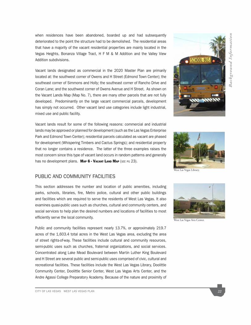
CITY OF LAS VEGAS WEST LAS VEGAS PLAN 22
Back
grou
nd
In
form
ati
on
deteriorated to the point the structure had to be demolished. The residential areas
that have a majority of the vacant residential properties are mainly located in the
Addition subdivisions.
Vacant lands designated as commercial in the 2020 Master Plan are primarily
located at: the southwest corner of Owens and H Street (Edmond Town Center); the
southeast corner of Simmons and Holly; the southeast corner of Rancho Drive and
Coran Lane; and the southwest corner of Owens Avenue and H Street. As shown on
the Vacant Lands Map (Map No. 7), there are many other parcels that are not fully
developed. Predominantly on the large vacant commercial parcels, development
has simply not occurred. Other vacant land use categories include light industrial,
mixed use and public facility.
Vacant lands result for some of the following reasons: commercial and industrial
lands may be approved or planned for development (such as the Las Vegas Enterprise
Park and Edmond Town Center); residential parcels calculated as vacant are phased
for development (Whispering Timbers and Cactus Springs); and residential property
that no longer contains a residence. The latter of the three examples raises the
most concern since this type of vacant land occurs in random patterns and generally
has no development plans. MAP 6 - VACANT LAND MAP (SEE PG 23).
PUBLIC AND COMMUNITY FACILITIES
This section addresses the number and location of public amenities, including
parks, schools, libraries, fire, Metro police, cultural and other public buildings
social services to help plan the desired numbers and locations of facilities to most
efficiently serve the local community.
Public and community facilities represent nearly 13.7%, or approximately 219.7
acres of the 1,603.4 total acres in the West Las Vegas area, excluding the area
of street rights-of-way. These facilities include cultural and community resources,
Concentrated along Lake Mead Boulevard between Martin Luther King Boulevard
and H Street are several public and semi-public uses comprised of civic, cultural and
recreational facilities. These facilities include the West Las Vegas Library, Doolittle
Community Center, Doolittle Senior Center, West Las Vegas Arts Center, and the
Andre Agassi College Preparatory Academy. Because of the nature and proximity of
West Las Vegas Library.
West Las Vegas Arts Center.

MARTIN L KING BLVD.
TONOPAH DR.
CAR
EY AVE.
INTERSTATE 15
BON
ANZA R
D.
WASH
ING
TON
AVE.
LAKE MEAD
BLVD.
CO
RA
N LN
.
VEG
AS
DR
.O
WEN
S AVE
.
RANCHODR.
OR
AN K. G
RAG
SON
HW
Y.H ST. REVERE ST.
COMSTOCK DR.
LAKE MEAD
BLVD.
DO
OLITTLE
AVE.
MO
NR
OE
AVE.
HO
LLY AVE
.
J ST.
D ST.
ROBIN ST.
M:/planning/gis/projectsgis/sesector/w
estlv/westlvvacant.m
xd
WEST LA
S VEGA
S PLAN
Vacant Land
Map 6
Vacant Land by G
eneral Plan Designation
Residential
Com
mercial
Light Industrial/Research
Mixed U
se
Public Facility
West Las Vegas Boundary
13.4% of total acreage is vacant
215.52 acres of Vacant Land
Data current as of: July 31, 2009
GIS
maps are norm
ally producedonly to m
eet the needs of the City.
Due to continuous developm
ent activitythis m
ap is for reference only.
Geographic Inform
ation SystemP
lanning & D
evelopment D
ept.702-229-6301
·

CITY OF LAS VEGAS WEST LAS VEGAS PLAN 24
Back
grou
nd
In
form
ati
onthese facilities, this area serves as the cultural and community center of the West
Las Vegas area.
For a detailed list of Cultural and Community Facilities please refer to the Appendix.
MAP 7 - PUBLIC AND COMMUNITY FACILITIES MAP (SEE PAGE 25)
Parks
There are a number of recreational areas currently located within the West Las
Vegas area, including two parks designated specifically for children.
space and two playgrounds on 1.4 acres.
three basketball courts, a fitness course and jogging path, picnic areas, a
playground and open space on 18.37 acres.
courts, a jogging path, a roller hockey rink, a playground, picnic areas and
open space on 2.59 acres. The park was designated as a children’s park
area and a playground on 0.86 acres.
playground, a picnic area and open space on 7.18 acres.
Park is intended to serve residents in an eight-mile radius and provide a range of
features an amphitheatre, four baseball and softball fields, two basketball courts, a
concession stand, a fitness course, a jogging path, picnic areas, playgrounds, and
ten tennis courts.
Semi-Public Facilities
A notably high number of religious facilities are located in the West Las Vegas area
and account for approximately 2.9% of the total acreage, compared to 0.6% of the
City as a whole. Of the approximate 46 religious facilities in the area, over 90% are
located east of Martin Luther King Boulevard. Although there are several facilities
Church, and the True Love Baptist Church, the majority of the facilities in the West
are generally located in residential districts and are single-family homes that have
Doolittle Park.
Gay Park.

MARTIN L KING BLVD.
TONOPAH DR.
CAR
EY AV
E.
INTERSTATE 15
BON
AN
ZA RD
.
WA
SHIN
GTO
N AV
E.
LAKE M
EAD
BLVD.
CO
RA
N LN
.
VEGAS
DR
.O
WE
NS
AVE
.
RANCHODR.
OR
AN K. G
RAG
SO
N H
WY
.H ST. REVERE ST.
COMSTOCK DR.
LAKE M
EAD B
LVD.
DO
OLITTLE A
VE.
MO
NR
OE
AVE.
HO
LLY AVE.
J ST.
D ST.
ROBIN ST.
WEST LA
S VEGA
S PLAN
Com
munity Facilities
Map 7
Data current as of: July 31, 2009
GIS m
aps are normally produced
only to meet the needs of the C
ity.D
ue to continuous development activity
this map is for reference only.
Geographic Inform
ation SystemP
lanning & Developm
ent Dept.
702-229-6301
Public Facilities
Parks
Schools
·
West Las Vegas B
oundary

CITY OF LAS VEGAS WEST LAS VEGAS PLAN 26
Back
grou
nd
In
form
ati
onbeen converted to a religious use. MAP 8 - EXISTING RELIGIOUS FACILITIES MAP (SEE PAGE
27)
Social Services
County facilities, the Housing Authority of the City of Las Vegas are located within
the West Las Vegas area and provide a wide variety of services to the population
within and beyond the plan area. For a detailed list of Social Service providers,
please refer to the Appendix.
COMMERCIAL USES AND INDUSTRIAL LAND USES
Commercial uses, consisting of nearly 6.1% of the total area, are located primarily
along the major arterials throughout the West Las Vegas area including Owens
refer to the Existing Land Use Map, Map No. 5.
Industrial uses, comprising nearly 2.1% of the total area, are primarily concentrated
(Light Industrial/Research) as well as other sites through out the Plan area including
vacant parcels located at the southeast corner of Simmons and Holly; west of
the northwest corner of Owens Avenue and Interstate 15; and various lots within
the Enterprise Plan district. The commercial uses together with industrial uses
represent approximately 8.3% of the land area (see Table 1).
Many of the existing industrial and commercial areas are not aesthetically attractive
due to deteriorating or dated buildings, and to lack of landscaping and other
of the industrial and commercial sites is a retardant to the future development
and redevelopment of adjacent sites and presents an unfortunate image of the
development of new commercial properties is an emphasis of this plan and will be
VA Hospital on Martin L.King Boulevard.
US Post Office on Martin L.King Boulevard.
Convenience store at Owens.

MARTIN L KING BLVD.
TONOPAH DR.
CAR
EY AVE.
INTERSTATE 15
BO
NAN
ZA R
D.
WAS
HIN
GTO
N A
VE.
LAKE
ME
AD
BLVD.
CO
RA
N LN
.
VEG
AS D
R.
OW
EN
S A
VE.
RANCHODR.
OR
AN
K. GR
AG
SON
HW
Y.
H ST. REVERE ST.
COMSTOCK DR.
LAKE
MEA
D BLVD
.
DO
OLITTLE AV
E.
MO
NR
OE
AVE.
HO
LLY AV
E.
J ST.
D ST.
ROBIN ST.
T:\advplan\projects\projectsGIS\W
estLasVegas\Jim
_March_2009
WEST LA
S VEGA
S PLAN
Religious Facilities
46 Religious facilities are located w
ithin the W
est Las Vegas A
rea.
Over 90%
are located east of M
artin L. King B
oulevard.
Map 8
Data current as of: M
arch 30, 2009
West Las Vegas B
oundary
Parcels coded as religious facilities
Building footprints
400 Foot Buffer
1500 Foot Buffer
Plotted April 1, 2004G
IS maps are norm
ally producedonly to m
eet the needs of the City.
Due to continuous developm
ent activitythis m
ap is for reference only.
Geographic Inform
ation SystemPlanning & D
evelopment D
ept.702-229-6301
·

CITY OF LAS VEGAS WEST LAS VEGAS PLAN 28
Back
grou
nd
In
form
ati
onSince the adoption of the previous West Las Vegas Plan, particularly since 1998,
new commercial and industrial development within the West Las Vegas area has
occurred, bringing such services as: Cox Communications; pharmacies such as
Walgreens and CVS Pharmacy; fast food restaurants including A&W/KFC Restaurant
Commercial Centers (note: this is not an all inclusive list).
Approved Non-Restricted Gaming Locations
Gaming in the City of Las Vegas is allowed only in areas specifically designated
on the State Gaming Enterprise District Map by either Gaming Enterprise Districts
(GED) or by Non-Restricted Gaming Locations. The non-restricted gaming licenses
are governed by NRS.463.3072 to 463.3094, inclusive.
Two locations within the West Las Vegas Plan area designated as Non-Restricted
The Gaming Enterprise Districts and Locations Approved for Non-Restricted Gaming
the map at least once every four months, per NRS.463.309.
Other Land Uses.
County Islands.
There are approximately thirty (30) identified parcels that are located within the
West Las Vegas Plan area boundary, but are not located within the City of Las Vegas
boundaries. These parcels are under the jurisdiction of Clark County and therefore
the city cannot initiate annexations, as restricted by NRS 268.580, No. 2 (c).
Public Infrastructure and Facilities
Local Streets
Locally, the circulation system in West Las Vegas is anchored by five primary
arterials (minimum 100-foot right-of-way) and three secondary arterials (minimum
80-foot right-of-way). One of the secondary arterials, Martin Luther King Boulevard,
is scheduled for a widening project that will upgrade the roadway to a 100-foot right-
of-way.

CITY OF LAS VEGAS WEST LAS VEGAS PLAN 29
Back
grou
nd
In
form
ati
onThe primary arterials are:
The secondary arterials are:
In terms of regional access, the West Las Vegas area is well served by the U.S.
95 (Oran K. Gragson Highway) that runs east to west along the southern boundary
of the Plan area, and Interstate 15 (I-15) that runs northeast to southwest along
the eastern boundary. The U.S. 95 intersects I-15 at the interchange known as the
residents for both I-15 and U.S. 95:
Map 9 - West Las Vegas Plan Master Plan of Streets and Highways (see page
30)
Levels of Service
The existing circulation system in West Las Vegas, as it relates to vehicle movement,
defined in terms of average travel speed of either a section or the entire arterial
under consideration. Table 4 generally defines the LOS for arterials.
Most of the streets in West Las Vegas do not have a level of service lower than
Boulevard and Rancho Drive, with lower levels of service during peak hours, 7 to
8 a.m. and 5 to 6 p.m. During these hours, the level of service may decrease to
(LOS C).
The factors that contribute to this high level of service rating in West Las Vegas are
based on existing land uses. Due to the high percentage of vacant land (15.5%
percent), there are a reduced number of properties in the study area that generate
vehicular movement (Please refer to Map 5, West Las Vegas Existing Land Uses).

MARTIN L KING BLVD.
TONOPAH DR.
CA
RE
Y A
VE
.
INTERSTATE 15
BO
NA
NZA
RD
.
WA
SH
ING
TON
AV
E.
LAK
E M
EA
D B
LVD
.
CO
RA
N LN
.
VE
GA
S D
R.
OW
EN
S A
VE
.
RANCHODR.
OR
AN
K. G
RA
GS
ON
HW
Y.
H ST. REVERE ST.
COMSTOCK DR.
LAK
E M
EA
D B
LVD
.
DO
OLITTLE
AV
E.
MO
NR
OE
AV
E.
HO
LLY A
VE
.
J ST.
D ST.
ROBIN ST.
M:/planning/gis/projectsgis/w
estlv/westlvm
psh.mxd
Street Classification
Frontage Streets (70 ft.)
Parkway A
rterial (120 ft.)Prim
ary Arterial (100 ft.)
Secondary Collector (80 ft.)
Master P
lan ofS
treets and Highw
ays
WEST LA
S VEGA
S PLAN
Map 9
Data current as of: July 31, 2009
GIS
maps are norm
ally producedonly to m
eet the needs of the City.
Due to continuous developm
ent activitythis m
ap is for reference only.
Geographic Inform
ation SystemPlanning &
Developm
ent Dept.
702-229-6301·

CITY OF LAS VEGAS WEST LAS VEGAS PLAN 31
Back
grou
nd
In
form
ati
onTable 5– Arterial Levels of Service
Level of Definition Service
A Primarily free flow operations at average travel speeds of about 90 percent of the free flow speed. Vehicles are completely unimpeded in their ability to maneuver within traffic.
B Reasonably unimpeded operations at average travel speeds usually about 70 percent of the free flow speed. Maneuvering within the traffic stream is only slightly restricted and stopped delays are not bothersome.
C Represents stable operations, however, ability to maneuver and change lanes in midblock locations may be more restricted than LOS B. Lower average travel speeds of about 50 percent of the average free flow speed are typical.
D Small increases in flow may cause substantial decreases in speed. Average travel speeds are about 40 percent of free flow speed.
and average travel speeds of one-third of free flow speed or lower.
speed.
Additionally, commercial land uses, which are major
trip generators, account for only 6.1 percent of the
total land use for the study area. Typically, the
percentage of commercial land use for a community
is closer to ten percent. It is important to note that
most of the commercial ventures in West Las Vegas
are local in terms of their service areas; therefore, the
traffic generated by these businesses is not as great
as if their service areas were regional in nature.
Street Improvements
There are numerous areas in need of road improvement
within West Las Vegas. The City of Las Vegas Public
Works Department has identified these areas and a
work program has been developed as outlined in the
West Las Vegas Plan Road Improvement Map (Map
10) below. Projects currently under construction
include the improvements being made to Vegas
Drive/Owens Avenue between Rancho Drive and I-15,
which includes both roadway resurfacing and storm
drain improvements. The Public Works Department
is currently on a seven-year rotation basis for
applying a slurry seal coat to City streets. Comstock
Drive, Tonopah Drive and Simmons Street are the
neighborhood streets that received a seal coat during the 2002-03 fiscal year.
Improvements in the design stage include Martin Luther King Boulevard, which has
been identified for a street widening project that will begin construction in 2005.
The project will increase the width of the street right-of-way between Alta Drive and
Carey Avenue, and resolve circulation problems on Martin Luther King Boulevard
by increasing capacity. The construction work is expected to be completed by early
2006. Other street improvements that are in the design or planning phases include
Revere Street.
Another area of concern is the lack of sidewalks and the need for sidewalk repairs.
The city has not programmed these projects in its five-year Capital Improvement Plan
and therefore the Department of Public Works does not have the funds currently
available to install new sidewalks or to repair existing sidewalks. Other funding
sources need to be investigated, including possible use of Community Development
Block Grant funds or the creation of Special Improvement Districts.
Source: Federal Highway Capacity Manual.

CITY OF LAS VEGAS WEST LAS VEGAS PLAN 32
Back
grou
nd
In
form
ati
onMAP 10 - WEST LAS VEGAS PLAN ROAD IMPROVEMENT MAP (SEE PAGE 33)
The existing pattern of development has created a strong dependence on the
automobile for transportation. For many West Las Vegas residents this presents a
serious problem: 25 percent of West Las Vegas households do not have a vehicle
and 39 percent have only one vehicle, according to 2000 Census Data. While the
number of households without any vehicles has decreased over the last ten years,
a convenient and efficient public transportation system is essential to meet the
transportation needs of this community.
The Regional Transportation Commission operates the public transportation system
that service the West Las Vegas community. Bus routes have been revised over
the years to accommodate changes in ridership. Major routes run north to south
along Martin Luther King Boulevard and Rancho Drive. Routes also travel east to
west on Carey Avenue, Lake Mead Boulevard, Owens Avenue, Washington Avenue
within the West Las Vegas neighborhood.
Bus shelters are provided by a private company and are paid for with advertising in
the shelter. The number of shelters within the neighborhood has steadily increased
along the major streets, although a number of stops still do not have any amenities
or proper accessibility.
Pioneer Trail
The Pioneer Trail is a recreation trail that passes through sixteen (16) sites that
show the historical progression of settlement in the Las Vegas Valley. The trail,
which is six miles long and, for the most part, to be a five-foot wide sidewalk, begins
at the Las Vegas Springs Preserve and ends at the Old Mormon Fort. It passes
through some of the earliest settlements of African Americans, Asian Americans,
Hispanic Americans, Native Americans and European Americans. Included with the
walk will be markers that denote the history of all the historic structures along the
route; banners will be installed to mark the trail route. In addition, opportunities for
public artwork will be included in the trail design.
The trail plan was originally developed by the Regional Transportation Commission
and sponsored by Clark County. The trail has received funding through a grant
program that is supported by the sale of Bureau of Land Management land by the
Federal Government. Construction of the trail will be a joint effort by Clark County
and the City of Las Vegas, with the City of Las Vegas managing the construction
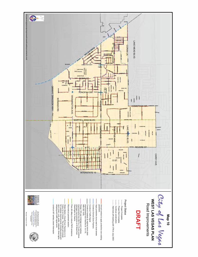
30
MARTIN L KING BLVD.
TONOPAH DR.
CA
RE
YA
VE
.
INTERSTATE 15
BO
NA
NZA
RD
.
WA
SH
ING
TON
AV
E.
LAK
EM
EA
DB
LVD
.
CO
RA
NLN
.
VE
GA
SD
R.
OW
EN
SA
VE
.
RANCHODR.
OR
AN
K.G
RA
GS
ON
HW
Y.
H ST. REVERE ST.
COMSTOCK DR.
LAK
EM
EA
DB
LVD
.
DO
OLITTLE
AV
E.
MO
NR
OE
AV
E.
HO
LLYA
VE
.
J ST.
D ST.
ROBIN ST.
J
H
D
F
I
N
E
I 15
G
C
B
US95
RANCHO
VEGA
S
LAK
EM
EAD
CA
RE
Y
BO
NA
NZA
WA
SH
ING
TON
MARTIN L KING
CO
RA
N
OW
EN
S
TONOPAH
ROBIN
HO
LLY
K
BA
LZAR
MILLER
AD
AM
S
MO
NR
OE
LOSEE
L
LEXINGTON
REVERE
SIMMONS
ALLEN
OPH
IR
MC
WILLIA
MS
LA SALLE
SUTR
O
M
BA
RTLETT
MA
DISO
NSHARON
GO
LDH
ILL COMSTOCK
HA
RR
ISO
N
PAU
L
JIMM
Y
LAW
RY
ALEXA
ND
ER
DIKE
SUNNY
FERRELL
FRED
ER
ICK
DU
NE
BLA
NK
ENSH
IP
LUNING
FAIR
GO
LD
HA
RT
RALSTON
HA
SSELL
LUDWIG
NYE
TAMERACK
MILLS
VIRGINIA CITY
RIVERSIDE
STELLALAKE
EAST
LEONA
MEZPAH
IVY
ARROWHEAD
GILD
AY
TUMBLEWEED
CENSUS TRACT BDRY
KA
SPER
WEAVER
CA
RV
ER
AN
DE
RSO
N
GREGORY
MO
RG
AN
CLARKWAY
WYA
TT
ALWILL
CONCORD
WALKERBY
RN
ES
CO
RP
LIMIT
MANHATTAN
FREEM
AN
JAC
KS
ON
ERN
EST
MA
Y
LAH
AR
VE
LAM
AR
K
KING HILL
GEO
RG
E
ELLIOTT
GER
SO
NREED
MAENPAH
CRYSTAL GEM
RAMPD
I15 S
CHEROKEE
POR
T
AD
ELAN
TE
RO
SEC
OR
AL
WO
OL Y
RO
SE
VAN
BU
REN
JEFFERSO
N
DOWN
RA
MP
I15N
US
95N
CINDYSUE
GRASS PALM
RA
MP
I15N
MLK
BO
WM
AN
CUNNINGHAM
WINDCHIME
VALLE
Y
LEVY
LIVING
RO
CK
HO
LLAN
D
RAMP I15 S WASH
NORTH
SANGALLO
PETERBUOL
SAPH
IRE
STON
E
SPICE CACTUS
SUSAN
LEO
NA
RD
ELEAN
OR
MO
UN
TM
AR
IAH
WILD JAN
BELROSE
TUR
QU
OIS
E
HA
ND
SPR
UC
E
CA
LMS
EA
DA
ISY
HILLC
AN
AR
Y
SLEEPY
CURRAN
PALM
EMER
ALD
GR
EEN
WIN
DSTO
RM
CRYSTAL CHIMES
SHA
DY
HILL
JADE PLANT
GOLDEN SKY
SUNSET
HOLMES
WILSO
N
MELODY
DU
NK
EE
WEST
WILLOWBROOK
WIN
TERS
NO
W
CADILLAC
SPRING
WEN
DELL
WILLIA
MS
PINK
ICE
RIFF
QUAIL HILLK
EN
DA
LLH
ILL
PEA
CH
HILL
DEBRA
CARTER
MORTON
WA
RR
EN
SIERR
ALU
NA
EVERBACK
BAILEY
ABBOTT
GERLACH
LIDA
BANGLE
EXODUS
HA
SSELL
I
SUTR
O
J
CO
RP
LIMIT
MO
RG
AN
FREEM
AN
MEZPAH
JEFFERSO
N
HA
RT
G
CO
RP
LIMIT
LEO
NA
RD
MA
DISO
N
HA
RR
ISO
N
DU
NE
CO
RP
LIMIT
M
NYE
COMSTOCK
GO
LDH
ILL
MAENPAH
MO
RG
AN
CORP LIMIT
VAN
BU
REN
LAW
RY
E
HO
LLY
LEXINGTON
WYA
TT
JAC
KS
ON
NYE
M
Road
Improvem
entsW
ESTLA
SVEG
AS
PLAN
M:/planning/gis/projectsgis/w
estlv/westlroadim
provements.m
xd
Annualcontractto
applyprotective
overexistingpavem
ent.
Apply
protectiveslurry
sealtolocalstreets
ConstructS
choolZoneFlashers
ConstructTraffic
Signal
Constructroadw
ay&
regionalstormdrain
improvem
entsfrom
Rancho
Dr.to
I-15.W
ithS
ID1478.
Design
100yeardrainage
androadw
ayim
provements
fromM
LKto
I-15and
continuedrainage
improvem
entson
BS
treetfromW
ashingtonto
Ow
ens.
Pave
dirtalleysto
reduceP
M10
emissions.
Reconstructpavem
entsection.
Widen
Martin
LK
ingB
lfromP
alomino
Lnto
Carey
Av
to6
lanes.The
projectwillinclude
fullroadway
improvem
entsincluding
pavement,
stormdrain,curb,gutter,sidew
alk,streetlights,stripping
andtraffic
signalwork.
construct60"sanitarysew
erInterceptor
ProjectStatus!
!P
rojectCom
plete!
!P
rojectNotC
omplete
!!
Continue
construction.!
!H
eldkick-offm
eetingw
ithV
TNin
July2003
DR
AFT
Map
10
Revised:O
ctober20,2005
GIS
maps
arenorm
allyproduced
onlyto
meetthe
needsofthe
City.
Due
tocontinuous
developmentactivity
thism
apis
forreferenceonly.
Geographic
Information
SystemPlanning
&D
evelopmentD
ept.702-229-6301

CITY OF LAS VEGAS WEST LAS VEGAS PLAN 34
Back
grou
nd
In
form
ati
onprocess. Construction documents are scheduled to be completed by late 2005,
with construction to be completed in 2006.
As a trail that interconnects West Las Vegas and Downtown North, the Pioneer’s
Trail is invaluable to the Cultural Corridor in providing pedestrian access to the area.
With a link to the Downtown area and to the regional trails system at Valley View
Boulevard, access by both Valley residents and visitors will be much improved.
Management, will extend nearly 10 miles from Summerlin eastward to downtown
Las Vegas. The project is scheduled to begin construction in 2006, and has a
construction timeframe of approximately one year.
by the City of Las Vegas, the Southern Nevada Regional Planning Coalition, and
the Regional Transportation Commission. The goal of this cooperative planning
effort is to support the continued development of an interconnected regional trail
system, which provides an alternative mode of transportation and recreational
opportunities.
paved surface with landscaping, benches and other amenities. Trailheads along the
corridor will provide convenient rest and information stops for users of the trail. The
trail is intended to connect to other planned trail segments and will provide access
to downtown Las Vegas.
Map 11 - Trails Map (See page 35)
Pioneer Trail marker.

E
E
S
E
NN
N
S
E
E
MARTIN L KING BLVD.
TONOPAH DR.
CA
RE
Y A
VE
.
INTERSTATE 15
BON
AN
ZA R
D.
WAS
HIN
GTO
N AV
E.
LAK
E M
EA
D B
LVD
.
CO
RAN
LN.
VEG
AS
DR
.O
WEN
S A
VE
.
RANCHODR.
OR
AN
K. G
RAG
SON
HW
Y.
H ST. REVERE ST.
COMSTOCK DR.
LAK
E M
EA
D B
LVD
.
DO
OLITTLE
AV
E.
MO
NR
OE
AVE
.
HO
LLY A
VE
.
J ST.
D ST.
ROBIN ST.
VAN
BUR
EN
AVE
.
F ST.
M:/planning/gis/projectsgis/w
estlv/westlvtrails.m
xd
WEST LA
S VEGA
S PLAN
TRAILS
Map 11
Data current as of: July 31, 2009
EQU
ESTR
IAN
MU
LTI-US
E EQ
UES
TRIA
N
MU
LTI-US
E NO
N-E
QU
ESTR
IAN
,
BELTW
AY
BON
ANZA TR
AIL
LAS
VEG
AS
WA
SH
LON
E M
OU
NTA
IN TR
AILS
PED
ESTR
IAN PATH
BON
ANZA TR
AIL
PION
EER
TRA
IL
ART TR
AIL
BOU
LDE
R PLA
ZA
CU
LTUR
AL C
OR
RID
OR
ENTER
TAIN
ME
NT TR
AIL
TOR
TOIS
E TR
AIL
LasVegasBlvd Trail
ScenicByway
GIS
maps are norm
ally producedonly to m
eet the needs of the City.
Due to continuous developm
ent activitythis m
ap is for reference only.
Geographic Inform
ation SystemP
lanning & D
evelopment D
ept.702-229-6301
·

Chart 3 Age Distribution
34.5
%
32.0
%
56.7
%
59.2
%
8.8%
8.8%
0.0%
10.0%
20.0%
30.0%
40.0%
50.0%
60.0%
Less than18
18 - 64 65 Yearsand over
1990 2000
125,787
15,857
164,674
15,122
258,295
15,629
478,630
20,453100,000
200,000
300,000
400,000
500,000
1970 1980 1990 2000
Las Vegas West Las Vegas
10.0%20.0%30.0%40.0%50.0%
White Black Hispanic
1990 2000
60.0%70.0%80.0%
5%
Asian
Chart 1 Population Trends Chart 2 Race & Ethnicity
CITY OF LAS VEGAS WEST LAS VEGAS PLAN 36
Back
grou
nd
In
form
ati
onPopulation
The following information describes the population and income characteristics of
the West Las Vegas community as compared to the City of Las Vegas and Clark
County. The purpose of the comparison is to understand the population that makes
up the West Las Vegas community. The data is mainly derived from the April 1,
2000 U.S. Census. The Plan area is divided into five census tracts as noted in MAP
12 - WEST LAS VEGAS CENSUS TRACTS MAP (SEE PG 37)
For much of the time from 1970 until 1990, West Las Vegas population changed
very little, decreasing from 15,857 in 1970 to 15,629 in 1990. During that same
time, the city of Las Vegas’ population went from 125,787 to 258,295, an increase
of 105 percent. During the 1990’s, the City’s population exploded. According to
the 2000 Census, Las Vegas had 478,630 residents, an increase of 85 percent
from 1990. West Las Vegas’ population increased as well. By the 2000 Census,
the West Las Vegas population had grown to 20,453, an increase of 31 percent or
more than 4,800 residents. From 1970 to 2000, the West Las Vegas share of the
city’s population decreased from 13 percent to 4 percent.
Race and Ethnicity
The West Las Vegas area underwent a change during the 1990’s. According to
the 1990 Census, 78.2 percent of the
areas population was classified as
Black. By Census 2000 that figure
had decreased to 52.0 percent, going
from 12,067 to 10,627. Conversely,
the Hispanic population went from
914 or 5.9 percent of the population
to 6,041 or 29.5 percent of the
population. Citywide, 10.1 percent
of the population is Black and 23.5
percent is Hispanic.

MARTIN L KING BLVD.
TONOPAH DR.
CA
REY A
VE.
INTERSTATE 15
BON
AN
ZA RD
.
WASH
ING
TON
AVE.
LAKE M
EAD
BLVD.
CO
RA
N LN
.
VEGA
S DR
.O
WEN
S AVE
.
RANCHODR.
OR
AN K. G
RAG
SON
HW
Y.
H ST. REVERE ST.
COMSTOCK DR.
LAKE M
EA
D BLVD
.
DO
OLITTLE AVE
.
MO
NR
OE AVE
.
HO
LLY AVE
.
J ST.
D ST.
ROBIN ST.
3602
301101
302
201
3700
1005700
3425
203
400
3500
34243800
105
800
WEST LA
S VEGA
S PLAN
CE
NS
US TR
ACTS
Census Tracts
Map 12
Data current as of: July 31, 2009
GIS
maps are norm
ally producedonly to m
eet the needs of the City.
Due to continuous developm
ent activitythis m
ap is for reference only.G
eographic Information System
Planning & D
evelopment D
ept.702-229-6301
·

7.4% 8.8% 30
.7%
25.6
%
33.6
%33
.2%
0.0%5.0%
10.0%15.0%20.0%25.0%30.0%35.0%40.0%
MarriedCouple
FemaleHead
28.3
%32
.4%
MaleHead
Non-Family
1990 2000
Chart 5 Household
5.4%
5.9%
76.3
%78
.5%
13.4
%18
.2%
0.0%10.0%20.0%30.0%40.0%50.0%60.0%70.0%80.0%
HighSchool
Graduate- WLV
HighSchool
Graduate- CLV
57.6
%
55.7
%
CollegeGraduate
- WLV
CollegeGraduate
- CLV
1990 2000
Chart 4 Educational
Burglary
Robbery
AutoTheft
Larceny
Assault
SexualAssault
0200400600800
100012001400160018002000
1995 1997 1999 2001 2003
Chart 6 Crime Statistics-Calls for Service
CITY OF LAS VEGAS WEST LAS VEGAS PLAN 38
Back
grou
nd
In
form
ati
onAge Composition
West Las Vegas is becoming a little less youthful and little more middle-aged.
Persons under 18 years of age went from 34.5 percent of the population to 32.0
percent. Those between 18 and 64 went from 56.7 percent of the population to
59.2 percent. Persons over 65 years of age remained at 8.8 percent. Citywide
25.9 percent of the population is under 18 years of age, 62.5 percent between 18
and 64 years of age and 11.6 percent 65 years of age and over.
Household Composition
West Las Vegas has a significantly higher rate of single parent households than
does the city of Las Vegas. Greater than one-third of all households in West Las
Vegas is headed by a single parent compared to the City total of about 18 percent.
The figure for West Las Vegas is down from 1990 when more than 40 percent
of the areas households were single parent. Non-family households experienced
no change while Married Couple households increased to nearly one-third of the
households in the area.
Educational Attainment
Educational attainment in West Las Vegas changed very little between 1990 and
2000. Less than 60 percent of the areas adults over 25 years of age graduated
from high school while just under six-percent had a college degree. For the city of
Las Vegas, 78.5 percent of the population had a high school diploma and 18.2
percent a college degree.
Crime Statistics
Overall, crime as defined by calls for service, has steadily gone down in West Las
Vegas since 1995. Non-confrontational crimes such as Burglary and Larceny have
decreased substantially during the past eight years. Among the more confrontational

West Las Vegas Las Vegas
0.00%10.00%20.00%30.00%40.00%50.00%60.00%70.00%80.00%90.00%
Wages &Salaries
SocialSecurity
RetirementSelfEmployed
PublicAssistance
$14,
012
$30,
590
$27,
981
$44,
069
$-
$5,000
$10,000
$15,000
$20,000
$25,000
$30,000
$35,000
$40,000
$45,000
1990 2000
West Las Vegas Las Vegas
Chart 7 Median Household Income
Chart 8 Income Sources
CITY OF LAS VEGAS WEST LAS VEGAS PLAN 39
Back
grou
nd
In
form
ati
oncrimes, robbery has decreased slightly while the number of Assaults and Sexual
Assaults have remained about the same. Perhaps more telling than the number of
crimes reported decreasing is the reduction in the rate of crime. West Las Vegas
population has increased by over 40 percent during the past ten years. The overall
crime rate has gone from about 260 per 1,000 population to about 166 per 1,000
population.
Income
In 1990, West Las Vegas households had a median income $13,911, substantially
lower than that of the Citywide median of $30,590. At that time, the median
household income for West Las Vegas was 46 percent of the City median. Census
2000 showed that West Las Vegas median household income had climbed to
$27,981, 64 percent of the City median. While still lower than the Citywide median
of $44,069, the increase of 101 percent in income was substantially higher than
that of the City, 44 percent, during the same time period. Another indication that
household prosperity may be on the increase in West Las Vegas is that the number
of persons living at or below poverty level income decreased from 38.6 percent in
1990 to 27.1 percent in 2000.
Income Sources
About 70 percent of the areas households receive wage and salary income
compared to 82 percent citywide. The greatest difference between the City as
a whole and West Las Vegas is in the income from public assistance category
where 13 percent of the areas receive some sort of income supplement from the
government compared to about 6 percent for the City. The current rate in West Las
Vegas represents a decrease of nearly 65 percent from the 1990 figure of 21.4
percent. The City’s rate stayed about the same.

1990 2000
0.0%
10.0%20.0%
30.0%
40.0%
50.0%
60.0%
70.0%
80.0%
DroveAlone
PublicTransportation
Carpool Walk OtherMeans
Work atHome
Chart 11 Commuting to
1990 2000
6.6% 7.0%
16.9%
12.3%
0.0%
2.0%
4.0%
6.0%
8.0%
10.0%
12.0%
14.0%
16.0%
18.0%
City of Las Vegas West Las Vegas
Chart 10 Unemployment
0.0%
5.0%
10.0%
15.0%
20.0%
25.0%
30.0%
35.0%
40.0%
West Las Vegas City of Las Vegas
Management, Professionaland Related Occupations
ServiceOccupations
Sales and OfficeOccupations
Farming, Fishingand ForestryOccupations
Construction, Extractonand Maintenance
Occupations
Production, Transportationand Material Moving
Occupations
Chart 9 Occupation
CITY OF LAS VEGAS WEST LAS VEGAS PLAN 40
Back
grou
nd
In
form
ati
onOccupation
The majority of employment for persons 16 years of age and older is the service
sector. The rate of employment in services is 50 percent higher in the area (39
percent) than in the City (26 percent) as a whole. Employment in construction
and the trades was at a higher rate in West Las Vegas as well. Conversely, West
Las Vegas had half the rate of the City for residents employed in management,
professional and related occupations. Other occupations had similar rates for City
and West Las Vegas residents.
Unemployment
Unemployment in West Las Vegas was nearly twice the rate of the City, 12.3 percent
versus 7.0 percent respectively. While still high, the rate represented a substantial
decrease from the 1990 figure of 16.9 percent.

CITY OF LAS VEGAS WEST LAS VEGAS PLAN 41
Back
grou
nd
In
form
ati
onCommuting to Work
Fewer West Las Vegas residents commuted to and from work in an automobile
(77.4%) than did the remainder of the City (88.9%). However, carpooling was
more common in West Las Vegas. Area residents used public transportation for
commuting at nearly three times the rate of the City. This may be due to the
proximity of West Las Vegas to employment centers, bus routes through the area
and the fact that 25 percent of West Las Vegas households do not have a vehicle
available to them. The commute time for area residents was slightly higher than
for the City.
Economy
According to a review of business licenses for the Plan area, West Las Vegas has
approximately 674 active businesses, compared to 312 businesses licenses
stated in the original West Las Vegas Plan adopted March 2, 1994. Many types of
vary considerably; they range from a large newspaper plant to small home-based
businesses.
The most intense commercial activity is located along Primary Arterials, namely
Rancho Drive (between Vegas Drive and U.S. 95), Owens Avenue (between Martin
Luther King Boulevard and A Street), Martin Luther King Boulevard (between Lake
Street). There is some encroachment of commercial activity into the residential
neighborhoods; primarily these licenses are for home occupation permits, in which
business is allowed in the home.
Local Economy
Prior to the 1960’s West Las Vegas had a thriving economy. The end of segregation
the Introduction section. Dollars that originally supported black owned businesses
moved out of the community and notably contributed to the economic weakening of
the West Las Vegas community. Private investment was virtually non-existent and
the commercial areas began to deteriorate.
There has been economic growth in the area since the Plan’s original adoption in
1994. However, there are still many poorly maintained properties, vacant building
and unkempt lots in the area. The commercial districts within West Las Vegas
have not greatly changed since the Plan’s last approval. There has been increased
commercial development along the major primary arterials in the Plan area.
NOTE: there are 136 different CLV business categories represented in WLV out of around 380+- business categories the City tracks. Also, out of the 674 licenses there are many firms that have more than one license, for example
Table 6 - Number of West Las Vegas Businesses
Business Type (NAICS TotalClassification)
Construction 5
Manufacturing 2
Wholesale Trade 1
Retail Trade 142
Transportation & Warehousing 5
Information 9
Finance & Insurance 9
Real Estate & Rental/Leasing 84
Professional, Scientific, andTechnical Services 35
Administrative 106
Education Services 1
Health Care & SocialAssistance 34
Arts, Entertainment, &Recreation 47
Accommodation & FoodServices 42
Other Services (except PublicAdmin) 149
Public Administration 3
Total Number of BusinessLicenses 674

CITY OF LAS VEGAS WEST LAS VEGAS PLAN 42
Back
grou
nd
In
form
ati
onThere is need to integrate the West Las Vegas economy into the regional economy
by encouraging the development of neighborhood commercial and office space.
Las Vegas Enterprise Park
of Martin Luther King Boulevard between Lake Mead Boulevard and Vegas Drive for
$3.5 million. Infrastructure improvements, including interior streets and stubbing
utilities to each site, was completed by the city in October 1997 for the cost of
approximately $3 million.
Completed Projects
of $3 – 4 million, the facility currently employs 45 workers with plans to hire
12 additional workers in 2004. The city sold the land for $524,000.
The City donated land for the facility, valued roughly at $920,000.
site is leased from the city by Clark County. The center is operated by UMC
and is looking to expand to provide an AIDS health clinic on site.
Constructed by the Moreland Corporation for the Department of Veterans
Affairs, the building is currently vacant. The Moreland Corporation owns the
13-acre site and as of March 2004 is exploring sale or re-use opportunities
for the property.
Funded through federal CDBG and EDA grants, the center is located on a
2-acre site donated by the city. The center houses an SBA-sponsored Busi-
ness Information Center and the Evolve Center, a workforce reintegration
program for felons operated by the city of Las Vegas Department of Neigh-
borhood Services. Additional market-rate office space is leased to business
tenants.
The post office faculty is located on a 4.64-acre parcel donated by the city of
Las Vegas.

CITY OF LAS VEGAS WEST LAS VEGAS PLAN 43
Back
grou
nd
In
form
ati
on
*Miscellaneous permits include sheds, gazebos, carports, patio covers, balconies, reroofing, foundations, grading and excavation.
Table 7 – West Las Vegas Building Permits
Proposed Projects
The proposed training center for McDonald’s franchises will create 30 new
jobs for training and corporate support. The facility will also help market job
opportunities in 22 valley restaurants to the area residents. The city sold
the land for $258,000.
-
fessional services tenants, business incubator tenants, and a retail banking
tenant. The facility is projected to create 40 jobs in its first year, and 217
jobs within the first nine years of operation. The project is contingent on the
Urban Chamber securing an EDA grant. The city is contributing 3 acres of
land, valued at approximately $850,000.
Harwood & Associates is under contract with the General Services Admin-
construction expected to start November or December 2004. A total of 230
jobs will be based at the facility. The city’s contribution of land is valued at
$544,000.
Building Permits
were issued in the West Las Vegas area totaling a valuation of $28,866,918. In
terms of valuation, the greatest amount of permit activity was in the Single Family
New category followed by Commercial Additions and Commercial New. Permit
valuation in the West Las Vegas Area accounted for 1.51% of total permit activity in
the city of Las Vegas for the same period.
Public Investment
The City of Las Vegas has recently made significant improvements to the West
Las Vegas area in the previous five years, in particular public works infrastructure
investments and neighborhood services investments. The City has made substantial
improvements to the public infrastructure in the West Las Vegas area since 1998.
Approximately $58,343,924 was funded during the years 2000-2004, including full
street improvements, street rehabilitation and other capital improvement projects
such as public facility, sewer and lighting improvements.
Neighborhood Services Department
The Neighborhood Services Department has also funded improvements in the
neighborhoods as shown below:
West Las Vegas Building Permits (July 2003 – June 2004)
Permit Type Permits Valuation
Single Family 206 $17,728,454New
Single Family 17 $376,268Additions
Single Family 6 $95,720Remodel
Apartments 11 $3,774,553Multiplex
Commercial 7 $3,802,192New
Commercial 1 $520,000Additions
Commercial 10 $440,350Remodel
Pools & Spas 2 $26,000
Signs 13 $145,380
Mobile Homes 1 $36,000
Miscellaneous* 129 $1,922,001
TOTAL 403 $28,866,918
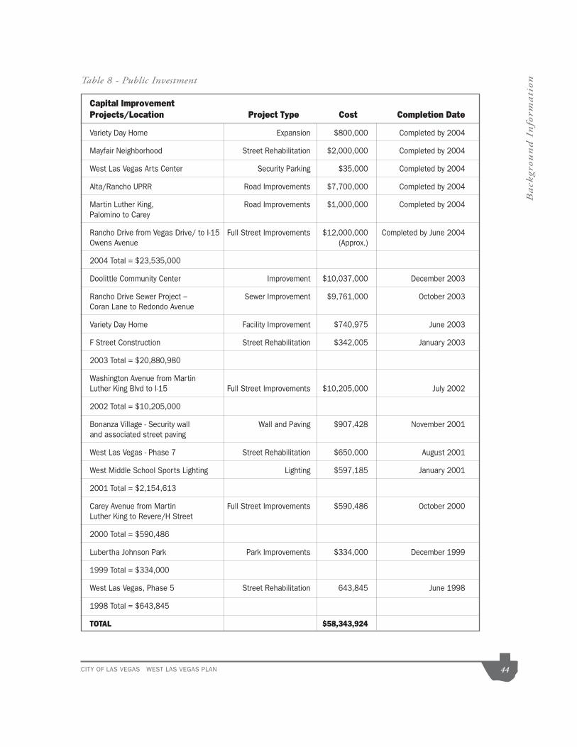
CITY OF LAS VEGAS WEST LAS VEGAS PLAN 44
Back
grou
nd
In
form
ati
on
Capital Improvement Projects/Location Project Type Cost Completion Date
Variety Day Home Expansion $800,000 Completed by 2004
Mayfair Neighborhood Street Rehabilitation $2,000,000 Completed by 2004
West Las Vegas Arts Center Security Parking $35,000 Completed by 2004
Alta/Rancho UPRR Road Improvements $7,700,000 Completed by 2004
Martin Luther King, Road Improvements $1,000,000 Completed by 2004Palomino to Carey
Owens Avenue (Approx.)
2004 Total = $23,535,000
Doolittle Community Center Improvement $10,037,000 December 2003
Rancho Drive Sewer Project – Sewer Improvement $9,761,000 October 2003Coran Lane to Redondo Avenue
2003 Total = $20,880,980
Washington Avenue from Martin
2002 Total = $10,205,000
and associated street paving
West Las Vegas - Phase 7 Street Rehabilitation $650,000 August 2001
2001 Total = $2,154,613
Carey Avenue from Martin Full Street Improvements $590,486 October 2000Luther King to Revere/H Street
2000 Total = $590,486
1999 Total = $334,000
1998 Total = $643,845
TOTAL $58,343,924
Table 8 - Public Investment

CITY OF LAS VEGAS WEST LAS VEGAS PLAN 45
Back
grou
nd
In
form
ati
on
Table 9 - Neighborhood Services Department Funded Improvements
Additionally, rehab programs are available for the West Las Vegas neighborhoods.
Since they are located within a designated low-income Census Tract making these
homes eligible to receive assistance through the following grant-funded programs:
* City of Las Vegas Single Family Rehabilitation Program (up to $50,000)
* City of Las Vegas Emergency Repair program (up to $15,000)
Program Project Type Cost Dates
NPF (Neighborhood Landscaping & Partners Fund) Beautification Projects $21,500 1999-2004
Rehabilitation/Safety & $13,800Security Projects
Total $35,300
YNAPP (Youth Beautification Projects $2,000 2001-2004
Neighborhood Rehabilitation & Partnership Neighborhood Cleanup $2,000Program) Projects
Total $4,000
CDBG CDBG Construction $7,230,647 1999-2004(Community Development Block Grant)
Federal Grant FundsCDBG Public Service Act $1,597,529HOME Housing $6,433,558HOME Single Family Rehab Projects $1,228,360CDBG Single Family Emergency Repair Projects $148,717
Total $16,638,811
Total Investments $16,678,111

CITY OF LAS VEGAS WEST LAS VEGAS PLAN 46
Lan
d U
se G
oals
, O
bje
ctiv
es,
an
d P
olic
iesLand Use Goals, Objectives, And
PoliciesIncluded in this section are the land use goals, objectives, policies, and
LAS VEGAS MASTER PLAN 2020
Goals, Objectives, and Policies
Master Plan 2020 (Ordinance #2000-62 adopted 9/6/2000). The Plan addresses
the area by stating:
decline of some older areas, which have been affected by a range of social ills
or impacted by a shift in the land use base. These may be neighborhoods which
crime, vandalism and graffiti. These neighborhoods may be experiencing greater
amounts of through traffic and noise than in the past; the rapid growth of the city
of the community, protect them from intrusion of non-residential land uses, and
where a transition to incompatible non-residential activities is underway, to integrate
these uses in a sensitive and attractive manner. A key component of neighborhood
into mixed-use urban hubs, creating a walkable and interesting urban environment.

CITY OF LAS VEGAS WEST LAS VEGAS PLAN 47
Lan
d U
se G
oals
, O
bje
ctiv
es,
an
d P
olic
ies
goals, objectives, and policies. Those having particular applicability to the West Las Vegas area are set forth as
follows:
redevelopment and preservation.
densities that support mass transit usage.
POLICY 2.1.1: That mixed-use residential/ commercial developments occur on sites currently occupied by declining commercial centers or vacant land.
residential neighborhoods be sensitive in use and design to surrounding development.
POLICY 2.1.3: That urban hubs at the intersections of primary roads, containing a mix of residential, commercial and office uses, be supported.
POLICY 2.1.4: That new commercial development be designed in a walkable and non-vehicular friendly manner, providing shelter from sun and wind, with outdoor seating areas and other amenities and parking areas located away from the street.
incentives, which may include accessory apartments and relaxation of
deemed appropriate.
POLICY 2.1.6: That, where feasible, neighborhoods be distinguished from one another through urban design elements, lighting, or landscaping features, or
POLICY 2.1.7: That the demand for transportation services be reduced by improving the balance between jobs and housing and by creating options for people to live and work within walking or cycling distance of their place of work.
POLICY 2.1.8: That the concept of walkable communities with porches and neighborhood amenities be promoted in areas of residential reinvestment.
in close proximity to higher density residential, mixed-use, or non-residential land uses by mitigating adverse impacts where feasible.
POLICY 2.2.1: That any higher density or mixed-use redevelopment which is adjacent to lower density residential development incorporate appropriate design, transition, or buffering elements which will mitigate adverse visual, audible, aesthetic and traffic impacts.

CITY OF LAS VEGAS WEST LAS VEGAS PLAN 48
Lan
d U
se G
oals
, O
bje
ctiv
es,
an
d P
olic
ies
develop, both to meet the needs of community residents who wish to age in place in their neighborhoods, and as a means of increasing residential densities in these areas.
POLICY 2.2.3: That design standards be adopted to address the need for transitions between different kinds of urban land uses.
more detailed planning is needed. These special area plans shall conform to and implement the Master Plan and address land use and other issues specific to that area. Neighborhood plans shall be prepared in conformance with the neighborhood planning process.
POLICY 2.3.2: That the West Las Vegas Plan provide such direction for West Las Vegas and adjacent areas.
POLICY 2.3.4: That historic districts provide such direction to preserve the architectural heritage of Las Vegas.
POLICY 2.3.5: That special area plans be prepared for other areas of the city where appropriate.
POLICY 2.3.7: That the Las Vegas Redevelopment Plan continue to be used as a means of promoting the development of commercial areas near the Downtown,
vitality of these areas, and to support the role of the Downtown as the regional center for finance, business, and governmental services, entertainment and recreation, while retaining gaming and tourism.
Vegas is maintained and enhanced.
POLICY 2.4.1: That the City aggressively promote, on an opportunity basis, the
POLICY 2.4.3: That the City facilitate the removal of graffiti and waste materials left on public or private property and work with owners of neglected property to improve the overall appearance of older neighborhoods across the city.
POLICY 2.4.4: That crime prevention and public safety be the primary priority for the city’s neighborhoods, and that this priority be reflected in design and lighting of public spaces and in neighborhood design, using established CPTED (Crime Prevention Through Environmental Design) principles, providing that this approach does not contradict other important planning and design principles.
POLICY 2.4.5: That the City work with neighborhood and homeowners’ associations to learn about local concerns as they arise and respond to these concerns in a comprehensive and timely manner.

CITY OF LAS VEGAS WEST LAS VEGAS PLAN 49
Lan
d U
se G
oals
, O
bje
ctiv
es,
an
d P
olic
iesPOLICY 2.4.6: That the City assist local residents in mature neighborhoods in
their neighborhoods, and neighborhood associations and assist in the development of special improvement programs offering lower cost loans or other discounts for neighborhood restoration projects.
POLICY 2.4.7: That the City maintain and renovate its public infrastructure within existing residential neighborhoods as needed.
review, amendment and consistent application of its Sign Code.
POLICY 2.5.1: That the City cooperate with regional and private educational institutions to bring higher educational opportunities to the City.
POLICY 2.5.2: That the City cooperate with regional and private educational institutions to bring vocational and technical training to the City.
lands within established areas of the city.
POLICY 2.6.1: That the City investigate the development of an incentive program designed to encourage property owners to redevelop vacant or derelict
POLICY 2.6.2: That the City take steps to encourage the development of two, three and four-plex housing opportunities.

CITY OF LAS VEGAS WEST LAS VEGAS PLAN 50
Lan
d U
se G
oals
, O
bje
ctiv
es,
an
d P
olic
iesLAS VEGAS REDEVELOPMENT PLAN
Objectives
The Redevelopment Agency proposes to eliminate and prevent the spread of blight
and deterioration in the Redevelopment Area. Major objectives of the Redevelopment
Plan are stated as follows:
A. The elimination of environmental deficiencies and blight in the Redevelop-
ment Area, which constitute either social or economic liabilities or both and
welfare of the people, including, among others, small and/or irregular lots,
obsolete and aged building types, economic and social deficiencies, dete-
B. The assembly of land into parcels suitable for modern, integrated develop-
ment and allowing for improved pedestrian and vehicular circulation in the
Redevelopment Area;
C. The replanning, redesign and development of undeveloped areas that are
D. The strengthening of retail, office, and other commercial and residential func-
tions in the downtown area;
E. The strengthening and diversification of the economic base of the Redevel-
opment Area and the community by the installation of needed site improve-
ments to stimulate new commercial expansion, employment and economic
growth;
G. The establishment of financial mechanisms to assist in the upgrading and/or
redevelopment of properties in the Redevelopment Area;
H. The provisions of necessary public improvements to correct existing deficien-
cies;
I. The establishment and implementation of performance criteria to assure
-
ments that provide unity and integrity to the entire Redevelopment Area;

CITY OF LAS VEGAS WEST LAS VEGAS PLAN 51
Lan
d U
se G
oals
, O
bje
ctiv
es,
an
d P
olic
ies
the improvement of transportation efficiency;
K. The orderly development of the Redevelopment Area;
L. The rehabilitation and preservation of historically and architecturally worth-
while structures and sites;
M. The provision of an environment where a socially balanced community can
work and live by providing jobs and housing for persons of varying social,
economic and ethnic groups;
WEST LAS VEGAS NEIGHBORHOOD PLAN
the vision and aspirations of the neighborhood and results in a position statement
for the neighborhood. Recommendations applicable to the West Las Vegas Plan
area from this neighborhood plan that address land use and other issues specific
to the area include:
Community Facilities And Youth Programs
ISSUE 1.5: Safety conditions at parks remain an issue. Although the children’s park designation significantly reduced the incidents in most parks, those bordering the freeways and industrial areas
With the parks now being targeted toward children’s activities, the community feels bathroom facilities should still be addressed with special consideration to security issues.
RECOMMENDATION 1.5: More stringently enforce the children’s park designation and, at a minimum, install and properly maintain port-a-potties.
Land UseGOAL 2. Plan for future development
ISSUE 2.1 Buffering residential areas from commercial areas became an issue as a result of a
from various commercial uses to Light Industrial/Research (LI/R). This proposal resulted from several applications for projects in that area that allowed such a change. Community meetings were held on each project and the neighborhood expressed no opposition to the developments. Based on this

CITY OF LAS VEGAS WEST LAS VEGAS PLAN 52
Lan
d U
se G
oals
, O
bje
ctiv
es,
an
d P
olic
ies
of encroachment concerns are LI/R designated parcels located at Rancho Drive/Robin Street and Simmons Ave/Holly Street. Both are adjacent to single family residential neighborhoods. An industrial
The parcel is presently vacant, but residents are concerned that future uses could place industrial businesses right in their backyard.
RECOMMENDATION 2.1.1: Maintain medium-low residential designations in established neighborhoods and maintain medium/high density residential designations along with open space in residential areas that serve as buffers between single-family homes and commercial development. This would include support for mixed-use development.
RECOMMENDATION 2.1.2: Support efforts by the City of Las Vegas to establish commercial and residential development standards. This would include allowing no billboards in residential areas.
ISSUE 2.2: The issue of county islands, unincorporated parcels of land surrounded by City land, stems from the difficulty of coordinating activities in neighborhoods that cross city and county lines. While not a direct land use concern, it triggers land use issues.
RECOMMENDATION 2.2: The planning team shall begin a resident initiative to annex into the city all county islands in West Las Vegas neighborhoods to provide for consistent standards of jurisdiction, development and maintenance. The process is one that is administered by the government jurisdictions involved.
HousingGOAL 3: Preserve the character of existing neighborhoods.
ISSUE 3.1: Vacant and/or abandoned housing has been an issue of concern for some time. Although there are opposing views on the subject, the consensus of the community is that these properties must be rehabilitated or torn down. Currently, there are no time limits on vacant properties as long as they
the boards. This allows for other criminal activity to occur while the owner is notified and re-secures the building. A windshield survey of the area identified other problems including abandoned vehicles, trash and debris. Properties without landscaping in front, broken fences and severe presences of weeds and growth, were also evident from the survey.
RECOMMENDATION 3.1.1: Continue City of Las Vegas rehabilitation programs that assist those financially or physically unable to bring homes up to current building code standards.
RECOMMENDATION 3.1.2: Establish volunteer code-officer programs, coordinated by the
to determine reasons for violations.
RECOMMENDATION 3.1.3: Support an amendment to the municipal code to impose a six-
structure or demolish it. Additional time should be granted upon a comprehensive review by the City of Las Vegas.

CITY OF LAS VEGAS WEST LAS VEGAS PLAN 53
Lan
d U
se G
oals
, O
bje
ctiv
es,
an
d P
olic
ies
HOME (Home Investment Partnership Program) funds. The team has noted some positive outcomes. Several non-profit developers have either constructed new homes or have rehabilitated existing homes in the area. There is a need to see these types of infill developments on a larger scale. The current infill developments have occurred in spotty areas on a small scale. Through a windshield survey, numerous adjacent vacant parcels were identified that, if feasible, could lead to amore clustered approach to infill development.
RECOMMENDATION 3.2: Encourage market rate infill housing consistent with the character of existing residential areas.
areas are not experiencing the development of market-rate housing, which is evident from windshield surveys. The Whispering Timbers project at Lake Mead and Martin L. King Blvd. is one notable exception. While affordable housing fulfills a role in providing home ownership, the development of market-rate housing is still desirable and should be encouraged. Without successful market rate projects, the market values of the existing neighborhoods in the area may continue to decline.
RECOMMENDATION 3.3: Develop a private non-profit community land bank whose role would be to assemble abandoned and vacant lots for residential housing development. This
Circulation
West Las Vegas contains a network of roads, which facilitate traffic to, through and from the community. Because
of the tremendous growth in the Valley, circulation has become more of a regional issue. High traffic along the
major arterials through the neighborhood serves as a reminder that close proximity to Downtown and the major
employment centers is a mixed blessing. Planning for the transportation demands of the future is vital to the
future health of the neighborhood.
GOAL 4: Enhance the existing circulation system
ISSUE 4.1: Due to the development that has occurred northwest and northeast of West Las Vegas, its secondary streets have become victim to drive through traffic during peak travel times. Byrnes Avenue,
landscaping, to discourage non-residential traffic and assist in slowing down traffic in high pedestrian areas.
ISSUE 4.2: Traffic flows along major arterials become extremely heavy during peak morning and afternoon travel times. These slowdowns can be exacerbated when buses must pull over to service transit riders. This is especially the case on MLK Blvd. Many of the bus stops are not sheltered and have no trash receptacles.
RECOMMENDATION 4.2.1: Develop bus turnouts along the major arterials.
RECOMMENDATION 4.2.2: Continue to work on providing covered bus shelters and trash

CITY OF LAS VEGAS WEST LAS VEGAS PLAN 54
Lan
d U
se G
oals
, O
bje
ctiv
es,
an
d P
olic
iesRECOMMENDATION 4.2.3: Plan and budget for the local system as part of the regional system
to ensure funding for road development and maintenance are addressed on a regional level.
traffic flow, public transportation, and pollution are critical to maintaining a local system that can carry its share in the regional system.
ISSUE 4.4: Each year, the city assesses its road development and maintenance issues to determine which roads will be supported through RTC (Regional Transportation Commission) funding and which will be supported City of Las Vegas Public Works funding. To handle heavier traffic flows on both major and secondary arterials due to development, use of CDBG (Community Development Block Grant) program funds has also been necessary, which takes dollars that otherwise might be used for programs and services in the community.
Public SafetyGOAL 5: Ensure the public welfare of all residents
RECOMMENDATION 5.2.2: Strictly enforce the building codes on vacant and abandoned property. This will ensure vacant and abandoned properties are always properly boarded and secured.
Economic DevelopmentGOAL 6: Integrate the West Las Vegas economy into the regional economy.
ISSUE 6.2: Tourism is the principal driver of our economy, and disposable incomes and the consumer’s willingness to spend, in turn, drive tourism. This dependence on tourism places Las Vegas at risk when economic conditions are not conducive to supporting that industry due to the number of sectors of the valley’s economy that are linked directly or indirectly to it. With no expansion and diversification of activities, a lack of strategies that could expand the local economy makes West Las Vegas vulnerable to these same economic downturns. These ‘local recessions’ generally have a stronger negative effect on urban communities than any other.
RECOMMENDATION 6.2: Support the development of a comprehensive economic development strategy that focuses on community assets on the recruitment and expansion of business and job creation.
ISSUE 6.3: Local economies thrive off of their respective niches within the greater regional economy. These types of developments create jobs, rotate consumer dollars within the community, and serve as
Vegas has yet to define its niche.
RECOMMENDATION 6.3: Encourage the development of neighborhood commercial, class
incentives designed to raise the median income and lower unemployment in West Las Vegas.
needs of local business. Without capital services available to those enterprises that have proper growth management and strategies, sound business development is limited.

CITY OF LAS VEGAS WEST LAS VEGAS PLAN 55
Lan
d U
se G
oals
, O
bje
ctiv
es,
an
d P
olic
iesRECOMMENDATION 6.4: Create a revolving loan program as well as other financial products
that can be coordinated with the City of Las Vegas Business Incubator to assist local residents and businesses in obtaining credit and capital services currently unavailable to them through traditional finance markets.
Analysis
are the guiding principles for the formulation of the land use plan and for future
decisions affecting the West Las Vegas area. The applicability of these principles
Although each plan has its own stated goals, objectives, policies and
recommendations, there is some commonality amongst them. The issues
Infill Development. One of the central issues in all three plans is to pursue infill
development is key to addressing the vacant land issues in the West Las Vegas
area.
the development of an incentive program designed to encourage property owners
of environmental deficiencies and blight in the Redevelopment Area, which
in the interests of the health, safety and general welfare of the people, including,
among others, small and/or irregular lots, obsolete and aged building types,

CITY OF LAS VEGAS WEST LAS VEGAS PLAN 56
Lan
d U
se G
oals
, O
bje
ctiv
es,
an
d P
olic
ies
private non-profit community land bank whose role would be to assemble abandoned
Commercial Development. Commercial Development is a common element in all
three plans. The references in all three plans are listed below:
development be designed in a walkable and non-vehicular friendly manner, providing
shelter from sun and wind, with outdoor seating areas and other amenities and parking
diversification of the economic base of the Redevelopment Area and the community by
the installation of needed site improvements to stimulate new commercial expansion,
expansion incentives designed to raise the median income and lower unemployment
Neighborhood Revitalization. A key common element in all three plans is neighborhood
neighborhoods be distinguished from one another through urban design elements,
to each neighborhood. POLICY 2.1.8: That the concept of walkable communities
with porches and neighborhood amenities be promoted in areas of residential
reinvestment.
financial mechanisms to assist in the upgrading and/or redevelopment of properties

CITY OF LAS VEGAS WEST LAS VEGAS PLAN 57
Lan
d U
se G
oals
, O
bje
ctiv
es,
an
d P
olic
ies
balanced community can work and live by providing jobs and housing for persons of
demolish it. Additional time should be granted upon a comprehensive review by the
Neighborhood Preservation. Another central issue of all three plans is the preservation
of neighborhood.
of their neighborhoods, and neighborhood associations and assist in the development
of special improvement programs offering lower cost loans or other discounts for
and live by providing jobs and housing for persons of varying social, economic and
assist those financially or physically unable to bring homes up to current building code
Property Maintenance. Property maintenance is a common issue in all three plans. The
references made in all three plans to this issue are listed accordingly:

CITY OF LAS VEGAS WEST LAS VEGAS PLAN 58
Lan
d U
se G
oals
, O
bje
ctiv
es,
an
d P
olic
ies
left on public or private property and work with owners of neglected property to improve
environmental deficiencies and blight in the Redevelopment Area, which constitute
of the health, safety and general welfare of the people, including, among others ... aged
building types, economic and social deficiencies, deteriorated public improvements,
and abandoned property. This will ensure vacant and abandoned properties are
Parks and Recreation. All three plans address parks and recreation in varying degrees.
West Las Vegas lacks large regional parks and recreational opportunities, as is the case
in many older areas of the community. This issue is addressed in all three plans below.
stringently enforce the children’s park designations and, at a minimum, install properly
Traffic Circulation. Another issue addressed by all three plans is the recognition for
better access and exposure to West Las Vegas by mass transit and improved traffic
circulation.

CITY OF LAS VEGAS WEST LAS VEGAS PLAN 59
Lan
d U
se G
oals
, O
bje
ctiv
es,
an
d P
olic
ies
the balance between jobs and housing and by creating options for people to live and work
maintain and renovate its public infrastructure within existing residential neighborhoods
as needed.
and budget for the local system as part of the regional system to ensure funding for road
Other goals and objectives are identified above for each plan. Not all, however, are addressed
by all three plans. Nevertheless, all the goals and objectives have applicability to the West
Las Vegas Area.

CITY OF LAS VEGAS WEST LAS VEGAS PLAN 60
Lan
d U
se P
lan
an
d S
trate
gyLand Use Plan and StrategySeveral plans for future development of the West Las Vegas area have been
synopsis of these plans are addressed in the following subsections.
Downtown Redevelopment Plan.
Chapter 279 of the Nevada Revised Statutes sets forth the provisions for the
redevelopment of blighted areas. According to section 279.388, a blighted area
residential, commercial, industrial or other purposes, or any combination thereof,
which are unfit or unsafe for those purposes and are conducive to ill health,
obsolescence, deterioration, dilapidation, mixed character or shifting of uses;
an economic dislocation, deterioration or disuse, resulting from faulty planning;
prevalence of depreciated values, impaired investments and social and economic
maladjustment to such an extent that the capacity to pay taxes is reduced and tax
and unproductive condition of land which is potentially useful and valuable for
contributing to the public health, safety and welfare.
vested in Chapter 279 of the Nevada Revised Statutes is, among other things,
the adoption of a redevelopment plan. The City’s redevelopment plan, titled the
Vegas Redevelopment Plan for short was adopted by the City on March 5, 1986
(Ordinance #3218) and amended on February 3, 1988 (Ordinance #3339), April 1,
1992 (Ordinance #3637), and November 4, 1996 (Ordinance #4036). The West
Las Vegas area, from Washington Avenue south, was included with the Downtown
Redevelopment Map Area, Map 13 shows the intended land use implementation
designations for the redevelopment areas. Map No. 13 was adopted by City Council
on October 1, 2003.
Redevelopment Plan. The current portion of the West Las Vegas Plan area that is
included in the Redevelopment Plan Area is primarily located on the east side of the
Plan area, including Martin Luther King Boulevard between Carey Avenue and U.S.

CITY OF LAS VEGAS WEST LAS VEGAS PLAN 61
Lan
d U
se P
lan
an
d S
trate
gy95/I-15 Interchange; along Owens Avenue between Martin Luther King Boulevard
Luther King Boulevard and Interstate 15; and properties located in the northern
portion of the H F M & M Addition and Valley View subdivisions bounded by Van
Buren Avenue to the north, Monroe Avenue and Washington Avenue to the south, B
Street to the east and H Street and D Street to the west. A smaller portion of the
Redevelopment Plan area is located along the east side of Rancho Drive, between
U.S. 95 and Dune Street extending easterly to Robin Street and Dike Lane.
The Redevelopment Plan for the Downtown Las Vegas Redevelopment Area (RDA)
was adopted March 5, 1986 (Ordinance # 3218). The West Las Vegas area was
part of the original plan. Land uses were established as part of the original plan
and amended by Ordinance # 3637, adopted April 1, 1992. Map 13 depicts the
land use categories that are currently in effect at this time, as adopted (GPA-9219)
on March 1, 2006.
-
tial), M (Medium Density Residential), H (High Density Residential), O (Office),
SC (Service Commercial), GC (General Commercial), PF (Public Facility)]
GC (General Commercial)]
Expansion of the Las Vegas Redevelopment Plan, included a portion of West Las
West Las Vegas Neighborhood Plan.
2002. The plan was prepared and presented by the West Las Vegas Neighborhood
Planning Team. The plan boundaries are the same as the West Las Vegas Plan.
The neighborhood plan results from a community-driven process reflecting the vision
and aspirations of the neighborhood, resulting in a position statement. The mission
of the Plan is:
both the public and private resources needed for the increased development

MARTIN L KING BLVD.
TONOPAH DR.
CAR
EY
AVE
.
INTERSTATE 15
BON
ANZA
RD
.
WA
SHIN
GTO
N A
VE.
LAK
E M
EAD
BLVD
.
CO
RAN
LN.
VE
GAS
DR
.O
WEN
S A
VE
.
RANCHODR.
OR
AN
K. G
RA
GS
ON
HW
Y.
H ST. REVERE ST.
COMSTOCK DR.
LAKE
ME
AD B
LVD.
DO
OLITTLE A
VE.
MO
NR
OE AV
E.
HO
LLY AVE.
J ST.
D ST.
ROBIN ST.
WEST LA
S VEGA
S PLAN
Redevelopm
ent Area
Dow
ntown R
edevelopment Plan
Mixed U
se (L, ML, M
, H, O
, SC, G
C, PF)
Com
mercial (O
, SC, G
C)
Public Facility (PF)
Industrial (LI/R)
Map 13
Data current as of: July 31, 2009
West Las Vegas Boundary
GIS m
aps are normally produced
only to meet the needs of the C
ity.D
ue to continuous development activity
this map is for reference only.
Geographic Inform
ation SystemPlanning & D
evelopment D
ept.702-229-6301

CITY OF LAS VEGAS WEST LAS VEGAS PLAN 63
Lan
d U
se P
lan
an
d S
trate
gyThe West Las Vegas Neighborhood Plan (WLVNP) 2001 seeks to accomplish the
following goals:
Recommendations. The West Las Vegas Neighborhood Plan references four Land
Use Issue Locations (pages 21-22) and recommended changes on the Suggested
Land Use Changes Maps. Listed below each Land Use Issue, West Las Vegas
Neighborhood Plan recommendation and the Issue status:
1) Southeast corner of Simmons and Holly Avenue from LI/R (Light Industry/
Research);
WLVNP Recommendation: To change the General Plan designation to
MLA (Medium Low Attached Residential).
Status: The property is surrounded by residential development on three
two existing communication towers (100 foot tall) are located on the 7.5-acre
site. At the May 6, 2004 West Las Vegas community meeting, the residents
recommended this property remain as LI/R (Light Industrial/Research) due
to a deed restriction that limits the type of uses permitted on the property.
Previously a General Plan Amendment (GPA-0028-02) application was
submitted to change the land use designation to ML (Medium Low Density
Residential), but was withdrawn from the agenda because it was determined
it was not needed.
Action: None Recommended.
2) Northwest corner of Robin Street and Washington Avenue;
WLVNP Recommendation: To change the General Plan designation from
LI/R (Light Industry/Research) to MLA (Medium Low Attached Residential).
Status: Accomplished. A General Plan Amendment (GPA-0022-01)
PD8 (Residential Planned Development – 8 units per acre); and a Site

CITY OF LAS VEGAS WEST LAS VEGAS PLAN 64
Lan
d U
se P
lan
an
d S
trate
gy
residential development was approved by City Council on September 5,
2001.
Action: None Recommended
WLVNP Recommendation No change is recommended, restating previous
recommendation for open space.
Status: A General Plan Amendment (GPA-2497) to Amend the City of
Las Vegas Downtown Development Plan Map (Map 5) of the Las Vegas
Commercial), and GC (General Commercial)] for the subject property as part
Action: None. The site is part of the Redevelopment Plan Area.
Boulevard.
WLVNP Recommendation: From various GC (General Commercial), SC
(Service Commercial), and M (Medium Density Residential) to LI/R (Light
Industry/Research) use.
Status: To the north of the subject properties are L (Low Density
Residential), ML (Medium Low Density Residential) and M (Medium Density
Residential) designated properties. At the May 6, 2004 community meeting,
the residents recommended these properties change to a Mixed Use land
use designation.
Action: The subject area became part of the Redevelopment Plan area via a General Plan Amendment (GPA-9219). The General Plan Amendment was approved by City Council on March 1, 2006.
Specific recommendations outlined in the West Las Vegas Neighborhood Plan are
outlined in the chapter on Land Use Goals, Objectives, and Policies.

CITY OF LAS VEGAS WEST LAS VEGAS PLAN 65
Lan
d U
se P
lan
an
d S
trate
gyLand Use Plan Strategy.
Based on the guiding principles of the preceding chapter on Land Use Goals,
Objectives, and Policies and the plans developed for the area as discussed above
in this chapter, a strategy was developed for the configuration of proposed land
uses for the West Las Vegas area.
Residential Land Use. Much of the existing residential land use has been long
established, since the late 1950’s with the exception of development during
the ‘90’s and the recent development of Cactus Springs (2003) and Whispering
Las Vegas area is the advent of more commercial development. However, the
development. As was discussed in the Background information section, residential
expand its boundaries due to its central and urban location. The key to residential
development is to pursue Infill Development and Redevelopment opportunities.
If a parcel is vacant or to be redeveloped within or adjacent to existing residential
uses and it could logically be developed for either residential or nonresidential uses,
then the parcel should be designated for residential development.
Much emphasis needs to be placed on the enhancement of existing residential
areas such as the Vegas Heights subdivision located at the most northern end of
the Plan area, which consist of a mix of land uses including single family residential,
(including religious facilities), and vacant lands.
Likewise, where possible, mixed-use development with residential development
located on the second floor and above low intensity commercial uses of commercial
buildings should be encouraged. A potential location for mixed-use development
mixed-use development in the Redevelopment Plan.
The West Las Vegas area consists of numerous
neighborhood associations. The neighborhood
associations should be encouraged to initiate self-
help programs to rid areas of junk and trash and to
repair and improve existing dwellings. In conjunction
with the neighborhood associations, a cooperative
Cactus Springs.
Lubertha Johnson Park.

MARTIN L KING BLVD.
TONOPAH DR.
CA
RE
Y A
VE.
INTERSTATE 15
BON
ANZA
RD
.
WAS
HIN
GTO
N A
VE.
LAKE M
EAD B
LVD.
CO
RAN
LN.
VEG
AS D
R.
OW
ENS AV
E.
RANCHODR.
OR
AN
K. GR
AGSO
N H
WY.
H ST. REVERE ST.
COMSTOCK DR.
LAKE M
EAD BLVD
.
DO
OLITTLE
AV
E.
MO
NR
OE AVE.
HO
LLY AVE
.
J ST.
D ST.
ROBIN ST.
WEST LA
S VEGA
S PLAN
Adopted M
arch 2, 1994 GP
A-07-94
LAN
D U
SE
CA
TEG
OR
IES
Data current as of: July 31, 2009
GIS m
aps are normally produced
only to meet the needs of the C
ity.D
ue to continuous development activity
this map is for reference only.
Geographic Inform
ation SystemPlanning &
Developm
ent Dept.
702-229-6301
Rural N
eighborhood Preservation
Rural E
states
Desert R
ural
Rural
Low
Medium
- Low
Medium
- Low A
ttached
Medium
High
Office
Service C
omm
ercial
General C
omm
ercial
Tourist Com
mercial
Com
mercial (O
, SC
, GC
)
Mixed U
se (L, ML, M
, H, O
, SC, G
C, P
F)
Light Industrial / Research
Planned C
omm
unity Developm
ent
Parks/R
ecreation/Open S
pace
Public Facility
Public Facility - S
chool
·
West Las Vegas B
oundary
Map 14

MARTIN L KING BLVD.
TONOPAH DR.
CAR
EY AVE.
INTERSTATE 15
BON
ANZA R
D.
WA
SHIN
GTO
N AVE
.
LAKE M
EAD
BLVD
.
CO
RA
N LN
.
VEG
AS DR
.O
WE
NS AV
E.
RANCHODR.
OR
AN K. G
RAG
SO
N H
WY.
H ST. REVERE ST.
COMSTOCK DR.
LAKE M
EAD B
LVD
.
DO
OLITTLE
AVE.
MO
NR
OE
AVE.
HO
LLY AV
E.
J ST.
D ST.
ROBIN ST.
M
C-2
C-1
C-2
O
C-1
C-2
C-2
C-2
C-1
R-PD
5
R-3
C-1
M
C-1
C-1
C-2
C-M
C-1
R-3
R-C
L
C-1
C-V
R-1
R-1
C-1
C-V
C-2
C-V
C-2
R-1
C-2
R-1
C-1 C
-1C
-1
P-RC
-1
C-1
WEST LA
S VEGA
S PLAN
ZON
ING
CA
TEGO
RIES
Data current as of: July 31, 2009
GIS m
aps are normally produced
only to meet the needs of the C
ity.D
ue to continuous development activity
this map is for reference only.
Geographic Inform
ation SystemPlanning & D
evelopment D
ept.702-229-6301
Resolution of Intent
U - U
ndeveloped (GP
A Designation)
R-A
- Ranch Acres D
istrict
R-E
- Residence E
states District
R-D
- Single-Fam
ily Residence-R
estricted District
R-P
D - R
esidential Planned Developm
ent District
R-1 - S
ingle Family R
esidence District
R-M
H - M
obile Hom
e Residence D
istrict
R-C
L - Single-Fam
ily Com
pact Lot District
R-2 - Tw
o-Family R
esidence District
R-3 - Lim
ited Multiple R
esidence District
R-4 - A
partment R
esidence District
R-5 - D
owntow
n Apartm
ent District
R-M
HP - R
esidential Mobile H
ome P
ark District
P-R - P
rofessional Offices and P
arking
N-S
- Neighborhood Services
O - O
ffice
C-D
- Designed C
omm
ercial District
C-1 - Lim
ited Com
mercial D
istrict
C-2 - G
eneral Com
mercial D
istrict
C-M
- Com
mercial Industrial D
istrict
M - Industrial D
istrict
C-V
- Civic D
istrict
C-P
B - Planned Business Park D
istrict
P-C - P
lanned Com
munity D
istrict
PD - Planned D
evelopment
TC - Tow
n Center
T-D - Traditional D
evelopment
·
Map 15
West Las V
egas Boundary

CITY OF LAS VEGAS WEST LAS VEGAS PLAN 68
Lan
d U
se P
lan
an
d S
trate
gyeffort by the residents and code enforcement should be used as a tool to invoke
improvements to the areas.
Commercial Development. Commercial development in West Las Vegas
consists of approximately 6.1 percent of the total land area. Many of the existing
commercial uses are primarily consumer serving uses such as retail stores,
restaurants, and automotive-related services. The primary commercial corridors
are along Rancho Drive, Owens Avenue, Lake Mead Boulevard, and Martin Luther
King Boulevard. Some commercial areas and in particular, some strip commercial
Code, Title 19. Improvements to commercial areas
throughout the West Las Vegas area are a high priority.
An emphasis should be placed on enhancement of
these properties by complying with Title 19 (Section
19.08.045) commercial design standards. With
related applications (including variances and special
use permits) of the existing commercial properties;
aesthetic and safety improvements should be made
to the subject site, to the extent most practical and
logical.
Locations that are currently vacant and consist of land
use designations other than commercial should be
considered for land use changes to commercial. The
low percentage of commercial business in the area means that the West Las Vegas
Road, between Rancho Drive and Martin Luther King Boulevard, is dissected by
current land use designations of LI/R (Light Industry/Research) to the south and
a combination of M (Medium-Density Residential), H (High Density Residential), SC
(Service Commercial) to the north. The Redevelopment Plan expansion, approved
by City Council on March 1, 2006 as GPA-9219, includes this particular area, and
consists of Mixed Use and Commercial land use designations.
Industrial Land Use. The Industrial land use designation (LI/R) is largely found
located at the southwest corner of Lake Mead Boulevard and Martin Luther King
Boulevard. The proposed future land use plan reinforces the continued use of
these areas for industrial development.
Abundant Life Church.

CITY OF LAS VEGAS WEST LAS VEGAS PLAN 69
Lan
d U
se P
lan
an
d S
trate
gyAt the edges of existing industrial development, much attention should be given to
providing buffers or transitions to other land uses. Zoning regulations and design
standards should be implemented to reinforce this strategy.
Other existing LI/R (Light Industry/Research) locations are found scattered
throughout West Las Vegas. Some of these spot locations are not conducive to
the surrounding land use designations such as: property located at the southeast
corner of Simmons and Holly, which is bounded by Medium-Low Density residential
and High Density residential land uses; and property located north of Owens
Avenue, west of Interstate-15 abuts Low and Medium Density residential and
Commercial (Redevelopment Plan) designated property. In these cases the Future
Land Use designation may be recommended to change to a less intense land
use classification, unless otherwise stated. Another property, located near the
southwest corner of Lake Mead Boulevard and Losee Road, appears to be conducive
to the adjacent uses. The above mentioned areas are all vacant properties and
therefore the change to land use designations that are more comparable to the
existing surrounding land uses should be considered.
not promote expanding these areas, except as logical extensions of existing
development.
Inconsistent General Land Use Plan and Zoning Classification designations.
As shown in Inconsistent General Plan and Zoning Designations map (Map 16),
there are a number of parcels in which the General Plan Designation and the Zoning
classification are not consistent. Some properties consist of a more intense Zoning
classification than General Plan land use designation; conversely, other properties
have a more intense General Plan land use designation than Zoning classification.
It is recommended that, where appropriate, parcels with inconsistent land use
with the respective Master Plan land use designation and Zoning classifications.
Jackson Avenue.
Westside area of West Las Vegas. The revival of this once thriving street is important
to the area’s future. Every effort should be made to provide amenities to this area
in the way of enhanced streetscapes and building facades. It is recommended to

MARTIN L KING BLVD.
TONOPAH DR.
CA
REY
AV
E.
INTERSTATE 15
BON
AN
ZA R
D.
WA
SHIN
GTO
N AV
E.
LAKE
ME
AD B
LVD
.
CO
RA
N LN
.
VEG
AS D
R.
OW
EN
S AV
E.
RANCHODR.
OR
AN
K. G
RAG
SON
HW
Y.H ST. REVERE ST.
COMSTOCK DR.
LAKE
ME
AD B
LVD
.
DO
OLITTLE A
VE
.
MO
NR
OE A
VE.
HO
LLY AVE
.
J ST.
D ST.
ROBIN ST.
Inconsistent General Plan
and Zoning Designations
WEST LA
S VEGA
S PLAN
Redevelopm
ent Area
Outside R
edevelopment A
rea
Dow
ntown R
edevelopment Area
Map 16
GIS
maps are norm
ally producedonly to m
eet the needs of the City.
Due to continuous developm
ent activitythis m
ap is for reference only.
Geographic Inform
ation SystemPlanning &
Developm
ent Dept.
702-229-6301
Data current as of: July 31, 2009
·
CITY OF LAS VEGAS WEST LAS VEGAS PLAN 71
Lan
d U
se P
lan
an
d S
trate
gyLand Use Plan Map. Map No. 14 illustrates the Current Future Land Use within
the area and the environs. The land uses identified were compared to isolate
areas of potential conflict between incompatible land uses and to determine the
best potential land uses. A comparison of the inconsistent General Plan and
Zoning classifications was made in order to remedy these inconsistent General Plan
designations.
A proposed General Plan land use map was then prepared based on these
comparisons, the goals and objectives of this study, and the availability of the
necessary infrastructure to support alternative land uses. This map is identified as
MAP 17 – PROPOSED FUTURE LAND USE (SEE PG. 69)

MARTIN L KING BLVD.
TONOPAH DR.
CA
RE
Y A
VE
.
INTERSTATE 15
BO
NA
NZA
RD
.
WA
SH
ING
TON
AV
E.
LAKE M
EAD
BLVD
.
CO
RA
N LN
.
VE
GA
S DR
.O
WEN
S A
VE
.
RANCHODR.
OR
AN
K. G
RAG
SO
N H
WY
.H ST. REVERE ST.
COMSTOCK DR.
LAKE M
EAD
BLVD
.
DO
OLITTLE
AVE
.
MO
NR
OE
AV
E.
HO
LLY AVE.
J ST.
D ST.
ROBIN ST.
WEST LA
S VEGAS PLA
N
Proposed Future
Land Use
#2 FLU
: ML
ZON
: R-PD19
Recomm
end: Msr. apt. com
plex
#1 FLU
: ML
ZON
: R-3
Recomm
end: Mapt. com
plex
#7 FLU
: ML
Z: R-1
Recomm
end: PFSchool
District
#8 FLU
: LZ: C-V
Recomm
end: PF(park)
#5 FLU
: MZ: C-2
Recomm
end: LI/R*existing vacant*
#6 FLU
: MZO
N: R-1
Recomm
end: LW
est Las Vegas Boundary
WE
ST LAS
VEG
AS
PLAN
#9 FLU
: multiple
ZON
: multiple
Recomm
end: MLA
#11 FLU
: ML
ZON
: R-4
Recomm
end: M
#10 FLU
: ML
ZON
: R-4
Recomm
end: PF
#12 FLU
: LI/RZO
N: C-2
Recomm
end: GC
#13 FLU
: ML
ZON
: C-1
Recomm
end: SC
#3 FLU
: HZO
N: R-3
Recomm
end: M18.8 du/ac
#4 FLU
: HZO
N: R-3
Recomm
end: PFexisting Church &
V.F.W.
Existing R
DA
Area
Map17
Approved G
PA-7292 - 03-01-06
GIS m
aps are normally produced
only to meet the needs of the C
ity.D
ue to continuous development activity
this map is for reference only.
Geographic Inform
ation SystemPlanning & D
evelopment D
ept.702-229-6301
Data current as of: July 31, 2009
·
Rural N
eighborhood Preservation
Rural Estates
Desert R
ural
Rural
Low
High
Office
Service Com
mercial
General C
omm
ercial
Tourist Com
mercial
Las Vegas Medical D
istrict
Light Industrial / Research
Planned Com
munity D
evelopment
Dow
ntown R
edevelopment Area
Park / Recreation / O
pen Space
Public Facility
Public Facility - School
Public Facility - Clark C
ounty
Town C
enter
Resource C
onservation
Dow
ntown - C
omm
ercial
Dow
ntown - M
ixed Use
Not in C
ity
Right - of - W
ay
Medium
Medium
- Low
Medium
- Low A
ttached

CITY OF LAS VEGAS WEST LAS VEGAS PLAN 73
Imple
men
tati
onImplementationIn addition to the programs that form the Plan summary, other Program options to
forward goals of the West Las Vegas Plan area shall include the following:
LAND USE.
The Action Plan items listed under this category pertain to planning for future land
use and improving land use in the West Las Vegas Plan area.
1. Explore opportunities to introduce mixed-use development in exist-
ing commercial areas while maintaining medium-low and medium-high
residential designations to serve as buffers between single-family
homes and commercial development.
An Issue from the West Las Vegas Neighborhood Plan was the need to buffer
Road between Rancho Drive and Martin Luther King Boulevard from various
commercial uses to Light Industrial/Research (LI/R). The Planning Team, which
worked on creating the West Las Vegas Neighborhood Plan, agreed with the change
encroachment concerns are LI/R designated parcels located at Rancho Drive/Robin
Street and Simmons Ave/Holly Street.
Action: The Planning and Development Department, in cooperation with Neighborhood Services and Office of Business Development, shall initiate a study to explore opportunities to introduce mixed-use development in existing commercial areas while maintaining medium-low and medium-high residential designations to serve as buffers between single-family homes and commercial development.
Source: West Las Vegas Neighborhood Plan; Las Vegas 2020 Master Plan
2. Identify vacant and underutilized lands and pursue compatible resi-
dential and commercial infill development opportunities, including
potential locations for neighborhood serving commercial develop-
ment that is within walking distance of residences.
Approximately 15.5% or 248.2 acres in the West Las Vegas Plan area are vacant.
This figure does not take into account many other properties in the Area that consist
Edmonds Town Center.
Martin L.King Boulevard corridor.

CITY OF LAS VEGAS WEST LAS VEGAS PLAN 74
Imple
men
tati
on
excellent opportunity for residential and commercial infill development opportunities
in West Las Vegas. As was discussed earlier, the difficulty in planning for additional
its boundaries due to its central and urban location. The key to residential and
commercial development is to pursue Infill Development opportunities.
Action: The Planning and Development Department, in cooperation with the Office of Business Development, shall conduct an inventory study to identify
commercial infill development opportunities, including potential locations for neighborhood serving commercial development that is within walking distance of residences.
Source: West Las Vegas Neighborhood Plan; Las Vegas 2020 Master Plan; Redevelopment Plan
3. Examine the effect of distance separation requirements for
religious facilities (Church, House of Worship per Title 19) on
economic development opportunities in West Las Vegas.
2.9% or 46.6 acres of the West Las Vegas Plan area as compared to 0.6% of the City
as a whole. Over 90% are located east of Martin Luther King Boulevard. Although
there are several facilities on two or more acres, the majority of the facilities in the
facilities are generally located in residential districts and are single-family homes
that have been converted to a religious use.
Action: The Planning and Development Department, in cooperation with Office of Business Development, shall conduct a study to determine if distance
impact economic development opportunities in West Las Vegas.
Source: Input at Community Meeting
4. Identify inconsistencies in land use and zoning within the Plan area
and amend where appropriate.
The Inconsistent General Plan and Zoning Designations Map for West Las Vegas Plan
(Map 16) shows a number of parcels in which the General Plan Designation and the
more intense Zoning classification than Master Plan land use designation; conversely,

CITY OF LAS VEGAS WEST LAS VEGAS PLAN 75
Imple
men
tati
onother properties have a more intense Master Plan Land Use designation than Zoning
classification. It is recommended that, where appropriate, parcels with inconsistent
the respective Master Plan designation and Zoning classifications. Other properties
with inconsistent Master Plan land use designations/Zoning classifications that are
not amended by this Plan update will undergo further analysis/research and the
property owners will be notified of any proposed changes.
Action: The Planning and Development Department shall initiate a study to identify
where appropriate.
5. Implement a Main Street Program for Jackson Avenue.
owned businesses such as the former Harlem Club, Ebony Club, the Brown Derby
There is little in the way of community services such as a market, shops, barbers,
and cafes; however, there are a few churches and small private clubs mixed with
Main Street program be implemented to include, but not limited to: façade and
streetscape restoration and business start-up support.
The Main Street Program will incorporate the following goals and strategies to
. Reclaiming streets for pedestrians
. Rights-of-way where pedestrians, bikes, cars, and transit can co-exist
. Sidewalks that allow for diverse pedestrian activities
. Well-lit, shaded and furnished spaces that promote public interaction
. Intersections that are easy and safe to cross
. Link infrastructure improvements with economic development and housing op-
portunities
Action: 1. The Planning and Development Department, in conjunction with the Office of Business Development and the Neighborhood Services Department, shall investigate and implement a Main Street program

CITY OF LAS VEGAS WEST LAS VEGAS PLAN 76
Imple
men
tati
on
and replaced sidewalks, repaved streets, street trees, sidewalks, pedestrian light fixtures and banners.
3. Establish a Main Street subcommittee to work with staff on the
4. Planning and Development Department shall develop a Walkable
residents by providing convenience and access.
Source: West Las Vegas Plan, Input from Community Meeting (2009)
INFRASTRUCTURE.
The Action Plan items listed under this category pertain to circulation and
infrastructure in the West Las Vegas Plan area.
6. Examine the circulation and transportation corridors within West Las
Vegas, and opportunities for infrastructure improvements, including:
sidewalks, streetlights, pedestrian overpasses, bus turnouts along
major arterials and the provision of covered bus shelters and trash
receptacles at all stops.
An Issue pertaining to circulation and transportation from the West Las Vegas
Neighborhood Plan is the traffic flows along major arterials have become more
intense during peak morning and afternoon travel times. Traffic congestion is also
attributed to buses stopping at non-turnout lane bus stops. Many of the bus stops
are not sheltered and have no trash receptacles. A concern from the May 6, 2004
community meeting was the need for infrastructure improvements on many streets,
such as sidewalks, streetlights and pedestrian overpasses.
At the April 27, 2008 APA Community Workshop, a recommendation was to establish
a main thoroughfare to connect Symphony Park to the Historic West Las Vegas
community with the intention that the multi-billion dollar, 61-acre mixed use cultural,
economic and educational center, less than a mile from Historic West Las Vegas,
could be a catalyst for redevelopment.
This implementation item was revisited in an update of the West Las Vegas Plan in
2009. On an April 2, 2009 neighborhood meeting participants provided comments
on the repair and maintenance of sidewalks, need for bike lanes, lighting, shade
bus stops and removal of overhead wiring.
Additionally, the City has recently changed the way it plans for its capital projects by

CITY OF LAS VEGAS WEST LAS VEGAS PLAN 77
Imple
men
tati
on
planning efforts and a move towards performance based budgeting. Coordinating
capital expenditures so that budgeting and planning efforts are linked logically and
efficiently is one way to support the City’s strategic planning priority of manage cost
and revenue resources to achieve efficient operations.
Action: 1. Connect infrastructure planning in West Las Vegas to the Capital Improvement process, including, but not limited to, sidewalks, landscaping, streetlights, pedestrian overpasses, and bus turnouts, and
hat budgeting and planning priorities are linked logically and efficiently.2. Phase 1 – Implementation
a. Establish bike lanes from an area bound by Lake Mead Avenue, Tonopah Drive, Washington Avenue and D Street.
b. Replace and repair sidewalks and provide street trees in an area bound by Washington Avenue, H Street, D Street and I-15.
c. Provide streetscape and median improvements on D
to include landscaped medians, new ornamental street lights and banners.
3. Phase 2 – Implementation a. Study the removal of overhead wiring
and replace with underground wiring. b. Examine B and C Streets for sidewalk
installation, replacement or repair.
Source: Input at Community Meeting; (2004 & 2009); West Las Vegas Neighborhood Plan; West Las Vegas Plan; Las Vegas 2020 Master Plan, (2008 APA Workshop)
7. Explore and identify the impact of the pop-
ulation growth north of West Las Vegas on
traffic and land uses in West Las Vegas.
The West Las Vegas Neighborhood Plan indicated that the West Las Vegas
area has had increased drive-through traffic on secondary streets in residential
neighborhoods due to the development that has occurred northwest and northeast
and Simmons Street.

CITY OF LAS VEGAS WEST LAS VEGAS PLAN 78
Imple
men
tati
onis projected at approximately 261,500. The majority of the growth will occur in the
new areas like Aliante that are north/northwest of West Las Vegas. The City of Las
the past couple of years nearly 50% of the City’s growth has occurred in Ward 6,
northwest of WLV. Another 45% of the growth has occurred in Ward 2 and 4.
Action: The Planning and Development Department and the Public Works Department shall conduct a study to assess the population growth occurring north of West Las Vegas in the City of Las Vegas and the City of North Las Vegas and how the growth impacts traffic and land uses in the West Las Vegas area.
Source: West Las Vegas Neighborhood Plan
8. Identify and prioritize primary and secondary streets for traffic calm-
ing devices to discourage non-residential traffic and assist in slowing
down traffic in high pedestrian areas.
burgeoning growth north of the West Las Vegas area has impacted the local
neighborhoods with cut-through traffic.
Action: The Planning and Development Department and the Public Works Department shall determine streets that experience a high volume of non-residential traffic; and where determined, the Public Works Department shall work with the Finance Department to seek funding for necessary traffic calming device improvements in the West Las Vegas area.
Source: West Las Vegas Neighborhood Plan; West Las Vegas Plan
9. Enhance the Owens Avenue corridor
At the April 27, 2008 APA Community Workshop, a recommendation was to establish
a main thoroughfare to connect Symphony Park to the Historic West Las Vegas
community with the intention that the multi-billion dollar, 61-acre mixed use cultural,
economic and educational center, less than a mile from Historic West Las Vegas,
could be a catalyst for redevelopment.
As Martin L. King Boulevard, which runs north to south, is a primary street in West
Las Vegas to facilitate traffic movement, Owens Avenue, which runs east to west, is
situated near I-15 and presents opportunities for access and connectivity.

CITY OF LAS VEGAS WEST LAS VEGAS PLAN 79
Imple
men
tati
onEnhance the Owens Avenue corridor through investigating the following:
. Improved access to I-15 through new on-ramps or the use of parallel roads;
. Improved aesthetics through planting streets, trees, decorative street lights, etc;
. Improve connectivity to the neighborhood;
. Sidewalks
Action: 1. Provide a north/south parkway type corridor connecting D Street, B Street, Loose Road, running through the West Las Vegas community to facilitate redevelopment opportunities along this new corridor.
2. Realign Owens Avenue from a one-way couplet to a single four-lane road to enhance east/west circulation and encourage commercial redevelopment along this corridor.
3. Provide an I-15 frontage road for direct access to Owens Avenue from the Washington inter change and the Lake Mead interchange in order to increase access into this community and to facilitate redevelopment opportunities.
Source: Input at Community Meeting (2009); 2008 APA Workshop
PUBLIC FACILITIES.
The Action Plan items listed under this category pertain to public facilities in the
West Las Vegas Plan area.
10. Explore and identify the adequate provision of cultural and public
facilities (including community centers, fire stations, police stations,
social services, parks and trails, performing and fine arts, etc.).
Public and community facilities in West Las Vegas represents nearly 13.7%, or approximately 219.7 acres of the Plan area’s 1,603.3 acres. These facilities include cultural and community resources, fire and police stations, semi-public uses such
Mead Boulevard between Martin Luther King Boulevard and H Street are several public and semi-public uses comprised of civic, cultural and recreational facilities. A comment at the April 1, 2004 community meeting was made that there is a need for the expansion of public and community facilities.
Action: The Planning and Development Department, in coordination with the Neighborhood Services Department and Leisure Services Department, shall perform a study to determine if additional public and/or community facilities are needed in the West Las Vegas area. And where determined, the Planning and Development Department and Leisure Services Department shall work with the Finance Department to seek funding for necessary public and community facilities in West Las Vegas.

CITY OF LAS VEGAS WEST LAS VEGAS PLAN 80
Imple
men
tati
onSource: West Las Vegas Neighborhood Plan; West Las Vegas Plan; Las Vegas 2020 Master Plan; Redevelopment Plan
11. Examine and identify public safety opportunities, including additional
fire and police protection services, to ensure the public welfare of all
residents.
The West Las Vegas Plan area has existing fire and police protection services. The
Bolden Area Command Police Substation is located at 1851 Stella Lake Street.
The Substation opened in the fall of 2002 and is the product of a combined effort
between West Las Vegas residents, the Metropolitan Police Department and the
City of Las Vegas to facilitate an increased presence in the West Las Vegas area.
Fire Station 3 is located at 2645 West Washington Avenue and was constructed in
1980. A comment at the April 1, 2004 community meeting was made to investigate
additional public safety opportunities.
Action: The Planning and Development Department, in coordination with the Neighborhood Services Department, Fire Protection Services, and the Las Vegas Metropolitan Police Department, shall examine and identify public safety opportunities, which will also include fire and police protection services. And if determined that additional public safety services are needed, the Planning and Development Department and the Neighborhood Services Department shall work with the Finance Department to seek funding for necessary public safety facilities and services in West Las Vegas.
Source: West Las Vegas Neighborhood Plan; Las Vegas 2020 Master Plan
ECONOMIC DEVELOPMENT.
The Action Plan items listed under this category pertain to economic development
opportunities in the West Las Vegas Plan area.
12. Integrate the West Las Vegas economy into the regional economy by
encouraging the development of commercial and office space.
The West Las Vegas Neighborhood Plan concludes that local economies thrive off
of their respective niches within the greater regional economy. These types of
developments create jobs, rotate consumer dollars within the community, and serve
populations. West Las Vegas has yet to define its niche. The Planning Team for the

CITY OF LAS VEGAS WEST LAS VEGAS PLAN 81
Imple
men
tati
onstores in conjunction with business development and expansion incentives designed
Action: The Planning and Development Department, in coordination with the Office of Business Development Department, shall investigate opportunities to encourage the development of commercial and office space to better integrate the West Las Vegas area into the regional economy.
Source: West Las Vegas Neighborhood Plan; West Las Vegas Plan; Redevelopment Plan
13. Pursue redevelopment opportunities, including mixed economic op-
portunities in housing development, cultural institutions and neigh-
borhood commercial, in the Las Vegas Redevelopment Plan area with-
in the West Las Vegas Plan area.
The Office of Business Development spearheads development projects in the
Downtown Redevelopment Plan area, which include projects within Enterprise Park
and Edmond Town Center. Many other properties are identified in the Downtown
Redevelopment Plan Map, ripe for redevelopment, especially along major corridors
within the Old Historic Westside neighborhood.
Action: The Planning and Development Department, in coordination with the Office of Business Development Department, shall investigate redevelopment opportunities, including mixed economic opportunities in housing, cultural institutions and neighborhood commercial in the Downtown Redevelopment Plan area within West Las Vegas.
HISTORIC PRESERVATION.
The Action Plan item listed under this category pertains to historic preservation in
the West Las Vegas Plan area.
14. Work with the West Las Vegas residents and neighborhoods to document
and preserve existing historic, cultural and architectural resources.
The history of West Las Vegas is intimately intertwined with the beginning of
location on the west side of the railroad tracks. Many historic resources, such as
the McWilliams townsite, Westside School, Christienson Home, Benny Binion House

CITY OF LAS VEGAS WEST LAS VEGAS PLAN 82
Imple
men
tati
onand the Moulin Rouge are located within West Las Vegas. In order to preserve and
protect the history of West Las Vegas, historic cultural and architectural resources
need to be documented.
The first school, the Westside School, in West Las Vegas opened with two rooms
and two teachers for four grades. From 1904 until 1923, children from McWilliams’
Townsite crossed the railroad tracks to get to school in Clark’s Townsite. This
dangerous situation lasted until the Las Vegas School District built this two-room
school on land in the new Valley View addition, adjoining McWilliam’s Townsite on
the east.
construction of Hoover Dam brought families from the south searching for work.
A kindergarten was added 1938, and in 1942 a small building from the Civilian
Conservation Corps camp was moved to the site to house third and fourth grades.
Fifth grade was added in 1947. Finally, in 1948, a concrete block addition with eight
classrooms was built next to the original school building to house sixth, eventh and
eighth grades. In May 1949, twenty-seven students graduated in the first eighth
grade commencement class.
Westside School, was phased out for school use in 1967, and became city property
in 1974. Shortly thereafter, the city leased the building to the Economic Opportunity
Board (EOB) as a community center and radio station.
With the renovation of the Historic 5th Street School in the midst of downtown Las
Vegas’ office and legal corridors, which is home to an assortment of local arts
renovation and multi-purpose usage.
Action: 1. The Planning and Development Department, in coordination with the residents of West Las Vegas and other interested parties, shall work to document and preserve the existing historic cultural and architectural resources found in the West Las Vegas area.
2. Pursue the preservation, maintenance and protection of the Westside School.
a. Hire consultant to completing an existing conditions study and Historic American Building Survey for the existing structures;
b. Complete restoration based on consultant recommendations; c. Continue to pursue all available funding for restoration and building
improvements.

CITY OF LAS VEGAS WEST LAS VEGAS PLAN 83
Imple
men
tati
onSource: Input at Community Meeting; (2004 & 2009) West Las Vegas Plan
Urban Design/Visual Image
Plan area, including the perception that both residents and others have of the area.
Urban Design is concerned with the visual and other sensory relationships between
problems of the built environment.
One important aspect of Urban Design is Visual Image. Visual Image is the perception
that individuals, residents, and visitors have of West Las Vegas. This perception is
formed by both:
.blocks, and buildings
.by the orderliness and cleanliness of streets and yards and the structural
condition and appearance of buildings
15. Improve the physical character and enhance the visual image of West-
Las Vegas through streetscape improvements
Many streets in West Las Vegas, not unlike those throughout many parts of Las
Vegas itself, are visually unappealing, and present a negative visual image of the
area. Improving the streetscapes (landscaping and other roadside amenities) can
have a very positive impact, both on residents’ feelings about their neighborhoods,
and on visitors’ perceptions about the entire West Las Vegas community. Emphasis
on providing safe and pleasant pedestrian path system, and aesthetically pleasant
and effective signage system are also important when considering streetscape
improvements.
An effective method for applying streetscape improvements is to implement them
and visitors:
.Owens Avenue, Lake Mead Boulevard and Carey Avenue
. north-south primary and secondary streets: Martin Luther King Boulevard and H
Street
CITY OF LAS VEGAS WEST LAS VEGAS PLAN 84
Imple
men
tati
on
which identify the area and portray a pleasant and positive image to motorists or
pedestrians entering West Las Vegas along primary or secondary streets. These
gateways will consist of attractive urban design and landscape features at major
intersections on the periphery of West Las Vegas.
Actions: 1. Implement streetscape and median improvements along the primary and secondary thoroughfares in accordance with the following guidelines:. spatially define the streets by planting the trees along the public
right-of-way in a linear pattern
. tions use drought tolerant plant materials
. in segments with high projected pedestrian use, give more atten-
tionto pedestrian amenities:
. crosswalks, wider sidewalks, pedestrian activity nodes, benches,
kiosks, etc. provide pedestrian linkages between residential areas
and schools, libraries, parks and open space, and transit stops
. provide all segments with appropriate lighting and signage
2. Based upon the input from the APA Community Workshop, initial applications of streetscape and median improvements should occur within Historic West Las Vegas.
3. Include, in the streetscape and median improvements, a series of public art projects which can be implemented with community involvement.
West Las Vegas, and Historic West Las Vegas.5. Interested community members and stakeholders work with the City
of Las Vegas Arts Commission on a public art program/plan for West Las Vegas.
Source: West Las Vegas Plan, 2008 APA Community Workshop, Community Meeting (2009)

CITY OF LAS VEGAS WEST LAS VEGAS PLAN 85
Imple
men
tati
on