Weekly Edition 23 of 2022
83
Notices 2340 -- 2432/22 ADMIRALTY NOTICES TO MARINERS Weekly Edition 23 09 June 2022 (Published on the ADMIRALTY website 30 May 2022) CONTENTS I Explanatory Notes. Publications List II ADMIRALTY Notices to Mariners. Updates to Standard Nautical Charts III Reprints of NAVAREA I Navigational Warnings IV Updates to ADMIRALTY Sailing Directions V Updates to ADMIRALTY List of Lights and Fog Signals VI Updates to ADMIRALTY List of Radio Signals VII Updates to Miscellaneous ADMIRALTY Nautical Publications VIII Updates to ADMIRALTY Digital Services For information on how to update your ADMIRALTY products using ADMIRALTY Notices to Mariners, please refer to NP294 Howto Keep Your ADMIRALTY Products Up--to--Date. Mariners are requested to inform the UKHO immediately of the discovery of new or suspected dangers to navigation, observed changes to navigational aids and of shortcomings in both paper and digital ADMIRALTY Charts or Publications. The H--Note App helps you to send H--Notes to the UKHO, using your device’s camera, GPS and email. It is available for free download on Google Play and on the App Store. The Hydrographic Note Form (H102) should be used to forward this information and to report any ENC display issues. H102A should be used for reporting changes to Port Information. H102B should be used for reporting GPS/Chart Datum observations. Copies of these forms can be found at the back of this bulletin and on the UKHO website. The following communication facilities are available: NMs on ADMIRALTY website: Web: admiralty .co.uk/msi Searchable Notices to Mariners: Web: www.ukho.gov .uk/nmwebsearch Urgent navigational information: e--mail: [email protected] Phone: +44(0)1823 353448 +44(0)7989 398345 Fax: +44(0)1823 322352 H102 forms (see back pages of this Weekly Edition) e--mail: [email protected] Post: UKHO, Admiralty Way, Taunton, Somerset, TA1 2DN, UK All other enquiries/information e--mail: [email protected] Phone: +44(0)1823 484444 (24/7) Crown Copyright 2022. All rights Reserved. Permission is not required to make analogue or PDF copies of these Notices, but such copies may not be sold without the permission of the UKHO. For permission to sell copies of the Notices or to make (non--PDF) digital copies please email [email protected] .uk
-
Upload
khangminh22 -
Category
Documents
-
view
2 -
download
0
Transcript of Weekly Edition 23 of 2022
Notices2340 -- 2432/22
ADMIRALTYNOTICES TO MARINERS
Weekly Edition 2309 June 2022
(Published on the ADMIRALTY website 30 May 2022)
CONTENTS
I Explanatory Notes. Publications List
II ADMIRALTY Notices to Mariners. Updates to Standard Nautical Charts
III Reprints of NAVAREA I Navigational Warnings
IV Updates to ADMIRALTY Sailing Directions
V Updates to ADMIRALTY List of Lights and Fog Signals
VI Updates to ADMIRALTY List of Radio Signals
VII Updates to Miscellaneous ADMIRALTY Nautical Publications
VIII Updates to ADMIRALTY Digital Services
For information on how to update your ADMIRALTY products using ADMIRALTY Notices toMariners, please refer to NP294 How to Keep Your ADMIRALTY Products Up--to--Date.
Mariners are requested to inform the UKHO immediately of the discovery of new or suspecteddangers to navigation, observed changes to navigational aids andof shortcomings in bothpaperand digital ADMIRALTY Charts or Publications.
The H--Note App helps you to send H--Notes to the UKHO, using your device’s camera, GPS andemail. It is available for free download on Google Play and on the App Store.
TheHydrographic Note Form (H102) should be used to forward this information and to report anyENC display issues.
H102A should be used for reporting changes to Port Information.
H102B should be used for reporting GPS/Chart Datum observations.
Copies of these forms can be found at the back of this bulletin and on the UKHO website.
The following communication facilities are available:NMs on ADMIRALTY website: Web: admiralty.co.uk/msiSearchable Notices to Mariners: Web: www.ukho.gov.uk/nmwebsearchUrgent navigational information: e--mail: [email protected]
Phone: +44(0)1823 353448+44(0)7989 398345
Fax: +44(0)1823 322352H102 forms(see back pages of this Weekly Edition)
e--mail: [email protected]: UKHO, Admiralty Way, Taunton,
Somerset, TA1 2DN, UKAll other enquiries/information e--mail: [email protected]
Phone: +44(0)1823 484444 (24/7)
Crown Copyright 2022. All rights Reserved. Permission is not required to make analogue or PDF copiesof these Notices, but such copies may not be sold without the permission of the UKHO. For permission tosell copies of the Notices or to make (non--PDF) digital copies please [email protected]
I
1.2
GUIDANCE NOTES FOR THE USE OF ADMIRALTY NOTICES TO MARINERSON THE UKHO WEBSITE
The Weekly Notices to Mariners (NM) updates for paper Charts and Publications can be accessed via admiralty.co.uk/msi or the searchable NM Website www.ukho.gov.uk/nmwebsearch The latest digital NM Weekly update is available 10 days prior to the paper publication date; there are no subscription fees for access to the UKHO Notices to Mariners Website.
NB: The NM database includes historical NM data from 1 January 2000, for NMs prior to 2000 the Cumulative List of Notices to Mariners (NP234B-00) must be used.
Software required:
Adobe Acrobat Reader (Version 6.0 or later). Reader software can be obtained direct from the Adobe website (www.adobe.com).
SEARCHABLE NOTICES TO MARINERS
Enter the www.ukho.gov.uk/nmwebsearch website and select the search option that you require following the on screen instructions:
Search NMs by - Chart Number onlySearch NMs by - Chart Number + Previous NM Number/YearSearch NMs by - Chart Number + Between Previous and Present DatesSearch for Single NM by NM Number/Year
To view the NM, NM Note or full-colour NM Blocks, click on the relevant link.
NOTICES TO MARINERS ON-LINE
Enter the admiralty.co.uk/msi website, and then select Notices to Mariners. This will give you access to the following range of Notice to Mariners services:
- ADMIRALTY NM Web Search- Weekly NMs- NM Block, Notes and Diagrams- Annual NMs- Cumulative NM List
FURTHER GUIDANCE NOTES
For further details of the online NM facilities please see the NM Guidance Notes on the website, additional detail includes:
File content and descriptionPC and printer specifications
CUSTOMER SERVICE
If you experience any difficulties, please contact the UKHO Customer Services Team in the UK on:
Tel: +44 (0) 1823 484444 (office hours Monday-Friday 6am-10pm GMT and an on call service for emergency permits operated 24/7)Email: [email protected]
Our Singapore team can also be contacted outside of UK hours on:Tel: +65 6424 4200
Wk23/22
ADMIRALTY NOTICES TO MARINERS
Planning for the future
Plan with ADMIRALTY Maritime Data Solutions, brought to you by the United Kingdom Hydrographic Office.
© Crown Copyright 2020. All rights reserved. Correct at the time of publishing.
Admiralty Way, Taunton, Somerset TA1 2DN, United KingdomTelephone +44 (0)1823 484444 [email protected] gov.uk/ukho
Find out more about our market-leading ADMIRALTY Maritime Data Solutions:
admiralty.co.uk
are trademarks of the Secretary of State for Defenceand
Wk23/22
I
1.4
EXPLANATORY NOTES Dating Weekly Notices are dated for the Thursday appropriate to the week that the printed version is despatched from the UKHO. They are available earlier from the UKHO website.
Section I - Publications List At the beginning of the Publications List is an index of ADMIRALTY Charts affected by the Publications List. Thereafter there are a number of standard lists which contain details and announcements concerning charts and publications relevant for the particular Weekly Notice. Full details of how to use the various lists contained in Section I are available in NP294.
Special Announcements and Errata are occasionally included at the end of this Section.
Section IA - Temporary and Preliminary (T&P) Notices A list of T&P Notices in force (along with a list of those cancelled during the previous month), is included in the Weekly NM each month (see below).
Section IB - Current Nautical Publications Information about Publications including the current edition numbers is included in the Weekly NM at the end of March, June, September and December.
Section II - Updates to Standard Nautical Charts The notices in Section II give instructions for the updating of standard nautical charts and selected thematic charts in the ADMIRALTY series. Geographical positions refer to the horizontal datum of the current edition of each affected chart which is stated in the notice alongside the appropriate chart number. Positions are normally given in degrees, minutes and decimals of a minute, but may occasionally quote seconds for convenience when plotting from the graduation of some older-style charts. Where Leisure Products are referred to different horizontal datums from the standard nautical charts for that geographical area, positions in the notices cannot be plotted directly on these products. Bearings are true reckoned clockwise from 000° to 359°; those relating to lights are from seaward. Symbols referred to are those shown in NP5011. Depths and heights are given in metres or fathoms and/or feet as appropriate for the chart being updated (abbreviated where necessary to m, fm and ft respectively). Blocks and notes accompanying notices in Section II are placed towards the end of the section.
T&P Notices. These are indicated by (T) or (P) after the notice number and are placed at the end of Section II. They are printed on one side of the paper in order that they may be cut up and filed. To assist in filing, the year is indicated after the notice number and an in-force list is published monthly. Information from these notices is not included on charts before issue; charts should be updated in pencil on receipt. Associated diagrams are reproduced with Blocks at the end of Section II.
Original Information. A star (*) adjacent to the number of a notice indicates that the notice is based on original information.
Section III - Navigational Warnings NAVAREA I Navigational Warnings in force at the specified time quoted in the header are reprinted in Section III. It is recommended that this reprint should be kept in a file or book, followed by subsequent weekly reprints. Only the most convenient ADMIRALTY Chart is quoted. The full text of all Warnings in force is included in Weeks 1, 13, 26 and 39 each year.
Section IV - Sailing Directions Updates to all Sailing Directions are given in Section IV of ADMIRALTY Notices to Mariners. Those in force at the end of the year are reprinted in NP247(2) Annual Summary of ADMIRALTY Notices to Mariners Part 2. A list of updates in force is published in Section IV of the Weekly Edition quarterly. Full details of how to keep Sailing Directions up-to-date can be found in NP294 How to Keep Your ADMIRALTY Products Up-to-Date.
In 2018, the UKHO began the process of removing AIS and Racon information from ADMIRALTY Sailing Directions, as this is held in greater detail within ADMIRALTY Radio Signals publications. During this transition, AIS and Racon information will be removed from new editions of each Sailing Direction volume, and AIS and Racon information present in existing Sailing Direction volumes will no longer be updated. For accurate, up-to-date information on AIS and Racons, refer to ADMIRALTY Radio Signals publications.
Section V - Lights Updates to all the List of Lights are given in Section V and may be published in an earlier edition than the chart-updating notice. The entire entry for each light updated will be printed (including minor changes) and an asterisk (*) will denote which column contains a change. In the case of a new light, or where a new sequence is added below the main light, an asterisk (*) will appear under all columns. All Section V entries are intended to be cut out and pasted into the appropriate volume. It is emphasised that the List of Lights is the primary source of information on lights and that many alterations, especially those of a temporary but operational nature, are promulgated only as updates to the List of Lights. Light positions should be regarded as approximate and are intended to indicate the relative positions of lights only. Charts should be consulted for a more authoritative position. When a light is affected by a separate chart-updating notice, its Light List number is always included in the relevant text contained in Section II. The range of a light is normally the nominal range, except when the responsible authority quotes luminous or geographical range - see special remarks for ranges used by each country.
Wk23/22
a
b
Wk23/22
I
denotes chart available in the ADMIRALTY Raster Chart Service series.
1.6
[23/22]ADMIRALTY Charts affected by the Publication List
ADMIRALTY Charts ADMIRALTY Charts International Charts ADMIRALTY Publications
1292 5616_4 INT 654 NP 77
1648 5616_5 INT 656 NP 201B
1934 5616_6 INT 1550
2120 5616_7 INT 1805
2743 AUS 130 INT 1844
3584 AUS 767
4654 AUS 798
4656
5616_8
5614_8
5614_13
5614_14
5614_21
BALTIC SEA CHART DATUM 2000 (BSCD2000)
UKHO Products and Services, including foreign charts, in the Baltic Sea region are changing to a
new vertical reference system for depth and height information. During this transition period,
Charts may be referred to either mean sea level or the new BSCD2000. For further information
please contact the national charting authority and see ADMIRALTY Sailing Directions.
This note is to be reviewed in 2026.
PHOTOGRAPHY
ADMIRALTY publications utilise imagery from a wide variety of sources, mariners, port authorities and
other users. The UK Hydrographic Office (UKHO) welcomes new imagery of navigational aids,
landmarks, coastline, approaches to and from ports and berths. Imagery from the mariner's point of view
is especially helpful. Images can be sent to the UKHO using the email [email protected].
Please include the name and location of the feature in the image and how the image should be accredited
within ADMIRALTY publications.
UKRAINE NAVIGATIONAL INFORMATION
Owing to insufficient information, it is not always possible to ensure that ADMIRALTY Nautical
Publications are completely up-to-date for new dangers or changes to aids to navigation.
Mariners are therefore advised to exercise particular caution when navigating in Ukrainian waters.
Wk23/22
I
denotes chart available in the ADMIRALTY Raster Chart Service series.
1.7
ADMIRALTY CHARTS AND PUBLICATIONS NOW PUBLISHED AND AVAILABLE
NEW EDITIONS OF ADMIRALTY CHARTS AND PUBLICATIONS
New Editions of ADMIRALTY Charts published 09 June 2022
Chart Title, limits and other remarks Scale Folio 2022 Catalogue
page
1648 Japan - South Coast, Kishika Saki to Shiono Misaki.
Includes significant safety-related information as follows: new buoyage and
general updating throughout.
Note: On publication of this New Edition former Notices 4508(T)/21 and
1794(P)/22 are cancelled. This chart remains affected by Notices 196(T)/14,
5018(T)/21 and 343(T)/22.
1:500,000 53 84, 86
1934
INT 1550
International Chart Series, England - East Coast, River Tyne.
A Willington Quay To Saint Anthony's Point.
B Saint Anthony's Point To Dunston.
Includes changes to depths from the latest British Government and Port
Authority surveys.
Note: This chart remains affected by Notice 2925(T)/21.
1:7,500
1:12,500
1:12,500
7 26
3584 Malacca Strait – Indonesia, Ports on the North East Coast of Sumatera.
A Pelabuhan Kualatanjung.
B Belawan.
C Approaches to Belawan.
Includes significant safety-related information as follows: New port
development. Changes to depths, coastline, lights, beacons, buoyage and
recommended tracks.
Note: On publication of this New Edition former Notice 1629(P)/22 is
cancelled.
1:50,000
1:15,000
1:25,000
45 66
4654
INT 654
International Chart Series, South Pacific Ocean, Tahiti to Îles Marquises.
Includes changes to depths, recommended track and restricted area. (A
modified reproduction of INT654 published by France.)
1:1,500,000 73 104
4656
INT 656
International Chart Series, South Pacific Ocean, Îles Tuamotu to Îles
Australes.
Includes changes to depths and restricted areas. (A modified reproduction of
INT656 published by France.)
1:1,500,000 73 104
Wk23/22
I
denotes chart available in the ADMIRALTY Raster Chart Service series.
1.8
ADMIRALTY CHARTS AND PUBLICATIONS NOW PUBLISHED AND AVAILABLE
NEW EDITIONS OF ADMIRALTY CHARTS AND PUBLICATIONS
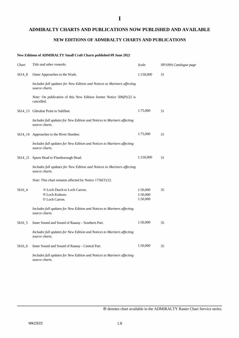
New Editions of ADMIRALTY Small Craft Charts published 09 June 2022
Chart Title and other remarks Scale NP109A Catalogue page
5614_8 Outer Approaches to the Wash.
Includes full updates for New Edition and Notices to Mariners affecting
source charts.
Note: On publication of this New Edition former Notice 506(P)/22 is
cancelled.
1:150,000 31
5614_13 Gibraltar Point to Saltfleet.
Includes full updates for New Edition and Notices to Mariners affecting
source charts.
1:75,000 31
5614_14 Approaches to the River Humber.
Includes full updates for New Edition and Notices to Mariners affecting
source charts.
1:75,000 31
5614_21 Spurn Head to Flamborough Head.
Includes full updates for New Edition and Notices to Mariners affecting
source charts.
Note: This chart remains affected by Notice 1750(T)/22.
1:150,000 31
5616_4 A Loch Duich to Loch Carron.
B Loch Kishorn.
C Loch Carron.
Includes full updates for New Edition and Notices to Mariners affecting
source charts.
1:50,000
1:50,000
1:50,000
35
5616_5 Inner Sound and Sound of Raasay - Southern Part.
Includes full updates for New Edition and Notices to Mariners affecting
source charts.
1:50,000 35
5616_6 Inner Sound and Sound of Raasay - Central Part.
Includes full updates for New Edition and Notices to Mariners affecting
source charts.
1:50,000 35
Wk23/22
I
denotes chart available in the ADMIRALTY Raster Chart Service series.
1.9
ADMIRALTY CHARTS AND PUBLICATIONS NOW PUBLISHED AND AVAILABLE
NEW EDITIONS OF ADMIRALTY CHARTS AND PUBLICATIONS
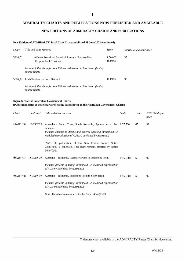
New Editions of ADMIRALTY Small Craft Charts published 09 June 2022 (continued)
Chart Title and other remarks Scale NP109A Catalogue page
5616_7 A Inner Sound and Sound of Raasay - Northern Part.
B Upper Loch Torridon.
Includes full updates for New Edition and Notices to Mariners affecting
source charts.
1:50,000
1:50,000
35
5616_8 Loch Torridon to Loch Gairloch.
Includes full updates for New Edition and Notices to Mariners affecting
source charts.
1:50,000 35
Reproductions of Australian Government Charts
(Publication dates of these charts reflect the dates shown on the Australian Government Charts)
Chart Published Title and other remarks Scale Folio 2022 Catalogue
page
AUS130 13/05/2022 Australia - South Coast, South Australia, Approaches to Port
Adelaide.
Includes changes to depths and general updating throughout. (A
modified reproduction of AUS130 published by Australia.)
Note: On publication of this New Edition former Notice
2288(P)/20 is cancelled. This chart remains affected by Notice
3648(T)/21.
1:37,500 65 92
AUS767 29/04/2022 Australia – Tasmania, Wardlaws Point to Eddystone Point.
Includes general updating throughout. (A modified reproduction
of AUS767 published by Australia.)
1:150,000 65 92
AUS798 29/04/2022 Australia – Tasmania, Eddystone Point to Stony Head.
Includes general updating throughout. (A modified reproduction
of AUS798 published by Australia.)
Note: This chart remains affected by Notice 4545(T)/20.
1:150,000 65 92
Wk23/22
I
denotes chart available in the ADMIRALTY Raster Chart Service series.
1.10
ADMIRALTY CHARTS AND PUBLICATIONS NOW PUBLISHED AND AVAILABLE
NEW EDITIONS OF ADMIRALTY CHARTS AND PUBLICATIONS
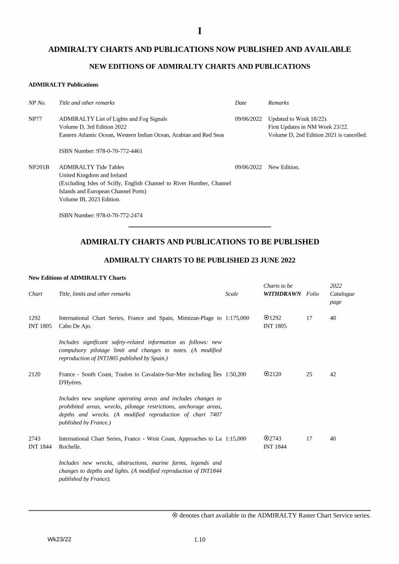
ADMIRALTY Publications
NP No. Title and other remarks Date Remarks
NP77 ADMIRALTY List of Lights and Fog Signals
Volume D, 3rd Edition 2022
Eastern Atlantic Ocean, Western Indian Ocean, Arabian and Red Seas
ISBN Number: 978-0-70-772-4461
09/06/2022 Updated to Week 18/22).
First Updates in NM Week 23/22.
Volume D, 2nd Edition 2021 is cancelled.
NP201B ADMIRALTY Tide Tables
United Kingdom and Ireland
(Excluding Isles of Scilly, English Channel to River Humber, Channel
Islands and European Channel Ports)
Volume IB, 2023 Edition.
ISBN Number: 978-0-70-772-2474
09/06/2022 New Edition.
ADMIRALTY CHARTS AND PUBLICATIONS TO BE PUBLISHED
ADMIRALTY CHARTS TO BE PUBLISHED 23 JUNE 2022
New Editions of ADMIRALTY Charts
Chart Title, limits and other remarks Scale
Charts to be
WITHDRAWN Folio
2022
Catalogue
page
1292
INT 1805
International Chart Series, France and Spain, Mimizan-Plage to
Cabo De Ajo.
Includes significant safety-related information as follows: new
compulsory pilotage limit and changes to notes. (A modified
reproduction of INT1805 published by Spain.)
1:175,000 1292
INT 1805
17 40
2120 France - South Coast, Toulon to Cavalaire-Sur-Mer including Îles
D'Hyères.
Includes new seaplane operating areas and includes changes to
prohibited areas, wrecks, pilotage restrictions, anchorage areas,
depths and wrecks. (A modified reproduction of chart 7407
published by France.)
1:50,200 2120 25 42
2743
INT 1844
International Chart Series, France - West Coast, Approaches to La
Rochelle.
Includes new wrecks, obstructions, marine farms, legends and
changes to depths and lights. (A modified reproduction of INT1844
published by France).
1:15,000 2743
INT 1844
17 40
Wk23/22
I
denotes chart available in the ADMIRALTY Raster Chart Service series.
1.11
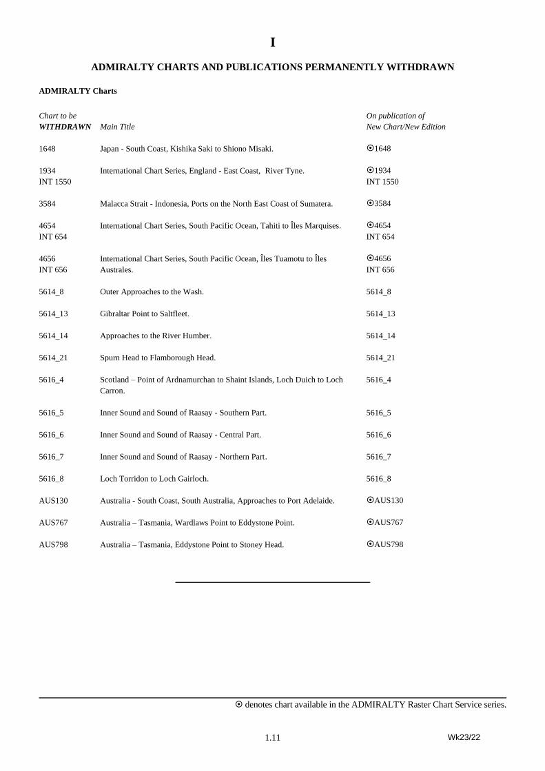
ADMIRALTY CHARTS AND PUBLICATIONS PERMANENTLY WITHDRAWN
ADMIRALTY Charts
Chart to be
WITHDRAWN Main Title
On publication of
New Chart/New Edition
1648 Japan - South Coast , Kishika Saki to Shiono Misaki. 1648
1934
INT 1550
International Chart Series, England - East Coast, River Tyne. 1934
INT 1550
3584 Malacca Strait - Indonesia, Ports on the North East Coast of Sumatera. 3584
4654
INT 654
International Chart Series, South Pacific Ocean, Tahiti to Îles Marquises. 4654
INT 654
4656
INT 656
International Chart Series, South Pacific Ocean, Îles Tuamotu to Îles
Australes.
4656
INT 656
5614_8 Outer Approaches to the Wash. 5614_8
5614_13 Gibraltar Point to Saltfleet. 5614_13
5614_14 Approaches to the River Humber. 5614_14
5614_21 Spurn Head to Flamborough Head. 5614_21
5616_4 Scotland – Point of Ardnamurchan to Shaint Islands, Loch Duich to Loch
Carron.
5616_4
5616_5 Inner Sound and Sound of Raasay - Southern Part. 5616_5
5616_6 Inner Sound and Sound of Raasay - Central Part. 5616_6
5616_7 Inner Sound and Sound of Raasay - Northern Part . 5616_7
5616_8 Loch Torridon to Loch Gairloch. 5616_8
AUS130 Australia - South Coast, South Australia, Approaches to Port Adelaide. AUS130
AUS767 Australia – Tasmania, Wardlaws Point to Eddystone Point. AUS767
AUS798 Australia – Tasmania, Eddystone Point to Stoney Head. AUS798
Wk23/22
2.1
II
GEOGRAPHICAL INDEX
(1) Miscellaneous . . . . . . . . . . . . . . . . . . . . . . . . . . . . . . . . . . . . . . . . . . . . . . . . . . . . . . . . . . . . . . . . . . . . . . . . . . 2.5
(2) British Isles . . . . . . . . . . . . . . . . . . . . . . . . . . . . . . . . . . . . . . . . . . . . . . . . . . . . . . . . . . . . . . . . . . . . . . . 2.5 – 2.6
(3) North Russia, Norway, The Færoe Islands and Iceland . . . . . . . . . . . . . . . . . . . . . . . . . . . . . . . . . . . . . . . . . . 2.6
(4) Baltic Sea and Approaches . . . . . . . . . . . . . . . . . . . . . . . . . . . . . . . . . . . . . . . . . . . . . . . . . . . . . . . . . . 2.7 – 2.10
(5) North Sea and North and West Coasts of Denmark, Germany, Netherlands and Belgium . . . . . . . . . . . . . . 2.10
(6) France and Spain, North and West Coasts, and Portugal . . . . . . . . . . . . . . . . . . . . . . . . . . . . . . . . . . . . . . . . 2.11
(7) North Atlantic Ocean. . . . . . . . . . . . . . . . . . . . . . . . . . . . . . . . . . . . . . . . . . . . . . . . . . . . . . . . . . . . . . . . . . . . 2.11
(8) Mediterranean and Black Seas. . . . . . . . . . . . . . . . . . . . . . . . . . . . . . . . . . . . . . . . . . . . . . . . . . . . . . . 2.12 – 2.14
(9) Africa, West Coast and South Atlantic . . . . . . . . . . . . . . . . . . . . . . . . . . . . . . . . . . . . . . . . . . . . . . . . 2.14 – 2.15
(10) Africa, South and East Coasts, and Madagascar . . . . . . . . . . . . . . . . . . . . . . . . . . . . . . . . . . . . . . . . . . . . . . . . . . . .
(11) Red Sea, Arabia, Iraq and Iran. . . . . . . . . . . . . . . . . . . . . . . . . . . . . . . . . . . . . . . . . . . . . . . . . . . . . . . 2.15 – 2.16
(12) Indian Ocean, Pakistan, India, Sri Lanka, Bangladesh and Burma . . . . . . . . . . . . . . . . . . . . . . . . . . . . . . . . . 2.16
(13) Malacca Strait, Singapore Strait and Sumatera . . . . . . . . . . . . . . . . . . . . . . . . . . . . . . . . . . . . . . . . . . . . . . . . . . . . .
(14) China Sea with its West Shore and China . . . . . . . . . . . . . . . . . . . . . . . . . . . . . . . . . . . . . . . . . . . . . . 2.16 – 2.17
(15) Japan . . . . . . . . . . . . . . . . . . . . . . . . . . . . . . . . . . . . . . . . . . . . . . . . . . . . . . . . . . . . . . . . . . . . . . . . . . . . . . . . . . . . .
(16) Korea and the Pacific Coasts of Russia . . . . . . . . . . . . . . . . . . . . . . . . . . . . . . . . . . . . . . . . . . . . . . . . . . . . . . 2.17
(17) Philippine Islands, Borneo and Indonesia except Sumatera . . . . . . . . . . . . . . . . . . . . . . . . . . . . . . . . 2.17 – 2.18
(18) Australia and Papua New Guinea . . . . . . . . . . . . . . . . . . . . . . . . . . . . . . . . . . . . . . . . . . . . . . . . . . . . 2.18 – 2.19
(19) New Zealand . . . . . . . . . . . . . . . . . . . . . . . . . . . . . . . . . . . . . . . . . . . . . . . . . . . . . . . . . . . . . . . . . . . . . . . . . . . . . . .
(20) Pacific Ocean . . . . . . . . . . . . . . . . . . . . . . . . . . . . . . . . . . . . . . . . . . . . . . . . . . . . . . . . . . . . . . . . . . . . . . . . . . . . . . .
(21) Aleutian Islands, Alaska and West Coast of North America including Mexico . . . . . . . . . . . . . . . . . 2.19 – 2.22
(22) West Coasts of Central and South America . . . . . . . . . . . . . . . . . . . . . . . . . . . . . . . . . . . . . . . . . . . . . . . . . . . . . . .
(23) Antarctica. . . . . . . . . . . . . . . . . . . . . . . . . . . . . . . . . . . . . . . . . . . . . . . . . . . . . . . . . . . . . . . . . . . . . . . . . . . . . . . . . .
(24) East Coast of South America and The Falkland Islands . . . . . . . . . . . . . . . . . . . . . . . . . . . . . . . . . . . 2.22 – 2.23
(25) Caribbean Sea, West Indies and the Gulf of Mexico. . . . . . . . . . . . . . . . . . . . . . . . . . . . . . . . . . . . . . . . . . . . 2.23
(26) East Coast of North America and Greenland . . . . . . . . . . . . . . . . . . . . . . . . . . . . . . . . . . . . . . . . . . . 2.24 – 2.25
(27) T & P Notices . . . . . . . . . . . . . . . . . . . . . . . . . . . . . . . . . . . . . . . . . . . . . . . . . . . . . . . . . . . . . . . . . . . 2.26 – 2.33
Wk23/22
II
2.2
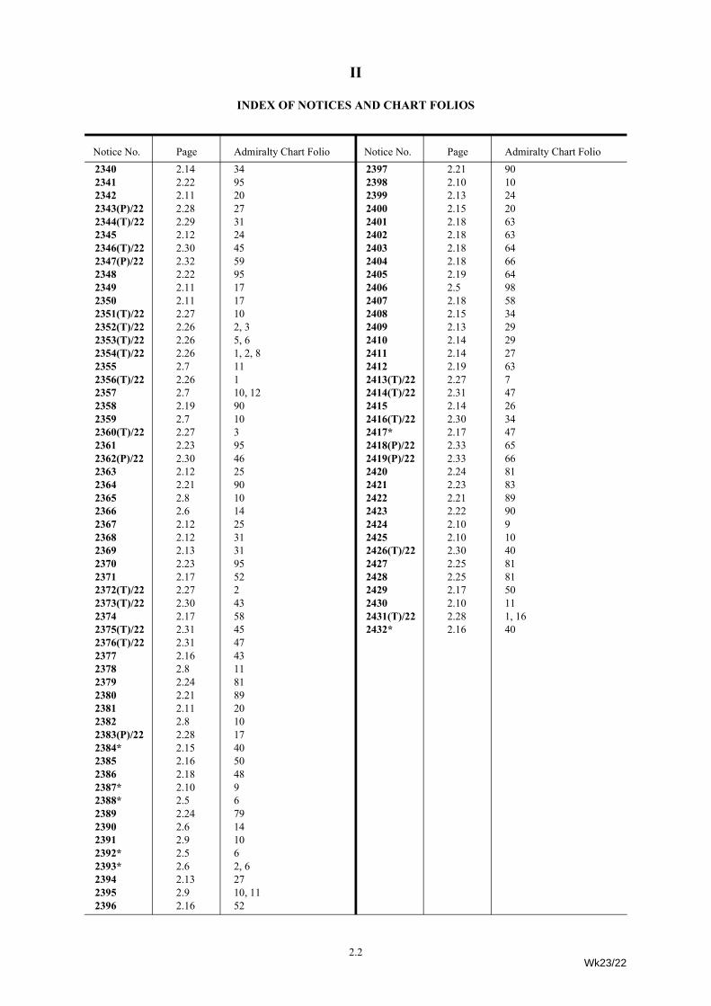
INDEX OF NOTICES AND CHART FOLIOS
Notice No. Page Admiralty Chart Folio Notice No. Page Admiralty Chart Folio2340 2.14 342341 2.22 952342 2.11 202343(P)/22 2.28 272344(T)/22 2.29 312345 2.12 242346(T)/22 2.30 452347(P)/22 2.32 592348 2.22 952349 2.11 172350 2.11 172351(T)/22 2.27 102352(T)/22 2.26 2, 32353(T)/22 2.26 5, 62354(T)/22 2.26 1, 2, 82355 2.7 112356(T)/22 2.26 12357 2.7 10, 122358 2.19 902359 2.7 102360(T)/22 2.27 32361 2.23 952362(P)/22 2.30 462363 2.12 252364 2.21 902365 2.8 102366 2.6 142367 2.12 252368 2.12 312369 2.13 312370 2.23 952371 2.17 522372(T)/22 2.27 22373(T)/22 2.30 432374 2.17 582375(T)/22 2.31 452376(T)/22 2.31 472377 2.16 432378 2.8 112379 2.24 812380 2.21 892381 2.11 202382 2.8 102383(P)/22 2.28 172384* 2.15 402385 2.16 502386 2.18 482387* 2.10 92388* 2.5 62389 2.24 792390 2.6 142391 2.9 102392* 2.5 62393* 2.6 2, 62394 2.13 272395 2.9 10, 112396 2.16 52
2397 2.21 902398 2.10 102399 2.13 242400 2.15 202401 2.18 632402 2.18 632403 2.18 642404 2.18 662405 2.19 642406 2.5 982407 2.18 582408 2.15 342409 2.13 292410 2.14 292411 2.14 272412 2.19 632413(T)/22 2.27 72414(T)/22 2.31 472415 2.14 262416(T)/22 2.30 342417* 2.17 472418(P)/22 2.33 652419(P)/22 2.33 662420 2.24 812421 2.23 832422 2.21 892423 2.22 902424 2.10 92425 2.10 102426(T)/22 2.30 402427 2.25 812428 2.25 812429 2.17 502430 2.10 112431(T)/22 2.28 1, 162432* 2.16 40
Wk23/22
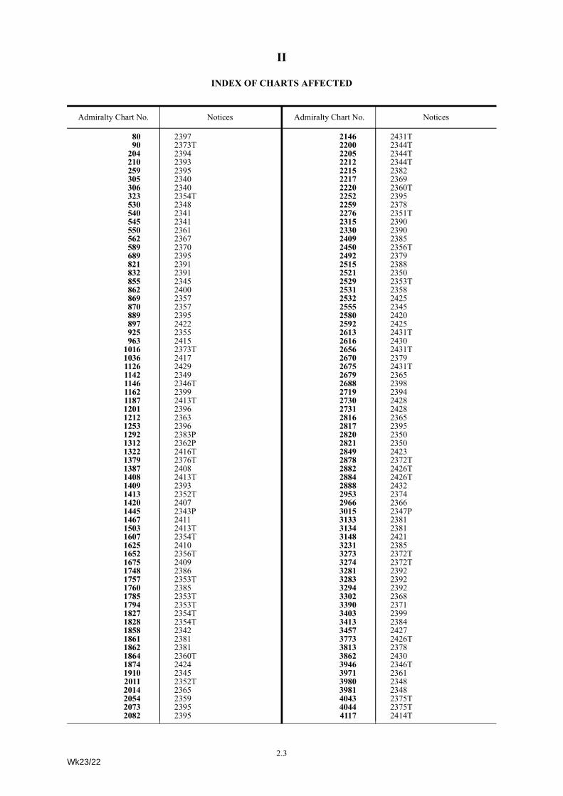
II
INDEX OF CHARTS AFFECTED
Admiralty Chart No. NoticesAdmiralty Chart No. Notices
80 239790 2373T
204 2394210 2393259 2395305 2340306 2340323 2354T530 2348540 2341545 2341550 2361562 2367589 2370689 2395821 2391832 2391855 2345862 2400869 2357870 2357889 2395897 2422925 2355963 2415
1016 2373T1036 24171126 24291142 23491146 2346T1162 23991187 2413T1201 23961212 23631253 23961292 2383P1312 2362P1322 2416T1379 2376T1387 24081408 2413T1409 23931413 2352T1420 24071445 2343P1467 24111503 2413T1607 2354T1625 24101652 2356T1675 24091748 23861757 2353T1760 23851785 2353T1794 2353T1827 2354T1828 2354T1858 23421861 23811862 23811864 2360T1874 24241910 23452011 2352T2014 23652054 23592073 23952082 2395
Wk23/22
Admiralty Chart No. Notices
2146 2431T2200 2344T2205 2344T2212 2344T2215 23822217 23692220 2360T2252 23952259 23782276 2351T2315 23902330 23902409 23852450 2356T2492 23792515 23882521 23502529 2353T2531 23582532 24252555 23452580 24202592 24252613 2431T2616 24302656 2431T2670 23792675 2431T2679 23652688 23982719 23942730 24282731 24282816 23652817 23952820 23502821 23502849 24232878 2372T2882 2426T2884 2426T2888 24322953 23742966 23663015 2347P3133 23813134 23813148 24213231 23853273 2372T3274 2372T3281 23923283 23923294 23923302 23683390 23713403 23993413 23843457 24273773 2426T3813 23783862 24303946 2346T3971 23613980 23483981 23484043 2375T4044 2375T4117 2414T
Admiralty Chart No. Notices
2.3
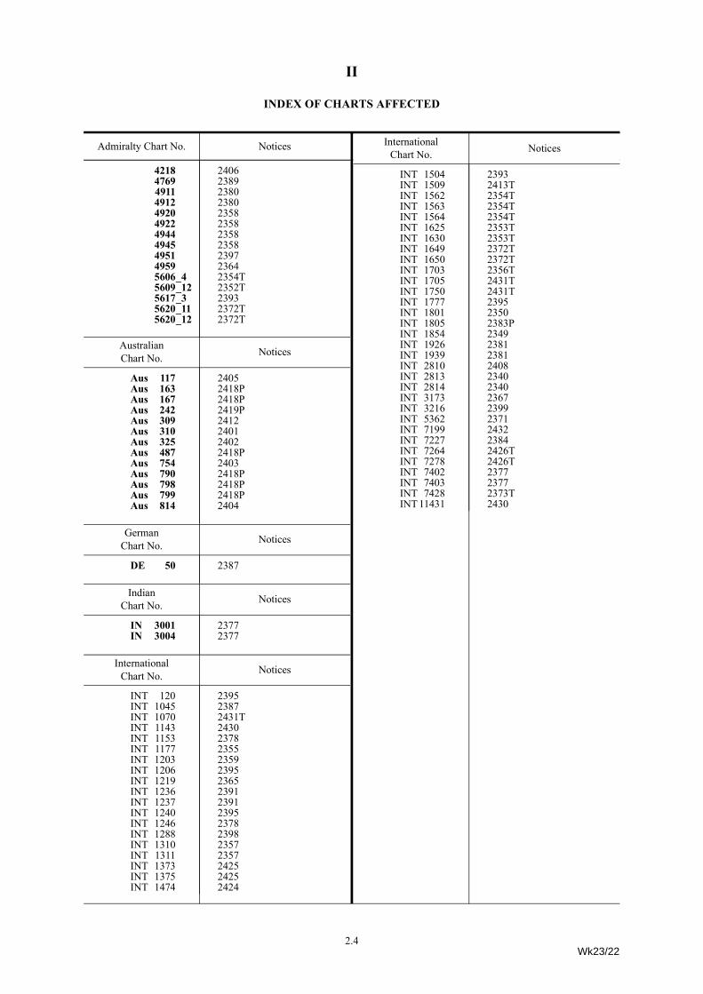
II
INDEX OF CHARTS AFFECTED
Admiralty Chart No. Notices
4218 24064769 23894911 23804912 23804920 23584922 23584944 23584945 23584951 23974959 23645606_4 2354T5609_12 2352T5617_3 23935620_11 2372T5620_12 2372T
AustralianChart No. Notices
Aus 117 2405Aus 163 2418PAus 167 2418PAus 242 2419PAus 309 2412Aus 310 2401Aus 325 2402Aus 487 2418PAus 754 2403Aus 790 2418PAus 798 2418PAus 799 2418PAus 814 2404
GermanChart No. Notices
DE 50 2387
IndianChart No. Notices
IN 3001 2377IN 3004 2377
InternationalChart No. Notices
INT 120 2395INT 1045 2387INT 1070 2431TINT 1143 2430INT 1153 2378INT 1177 2355INT 1203 2359INT 1206 2395INT 1219 2365INT 1236 2391INT 1237 2391INT 1240 2395INT 1246 2378INT 1288 2398INT 1310 2357INT 1311 2357INT 1373 2425INT 1375 2425INT 1474 2424
Admiralty Chart No. Notices
Admiralty Chart No. NoticesINT 1504 2393INT 1509 2413TINT 1562 2354TINT 1563 2354TINT 1564 2354TINT 1625 2353TINT 1630 2353TINT 1649 2372TINT 1650 2372TINT 1703 2356TINT 1705 2431TINT 1750 2431TINT 1777 2395INT 1801 2350INT 1805 2383PINT 1854 2349INT 1926 2381INT 1939 2381INT 2810 2408INT 2813 2340INT 2814 2340INT 3173 2367INT 3216 2399INT 5362 2371INT 7199 2432INT 7227 2384INT 7264 2426TINT 7278 2426TINT 7402 2377INT 7403 2377INT 7428 2373TINT 11431 2430
InternationalChart No. Notices
2.4Wk23/22
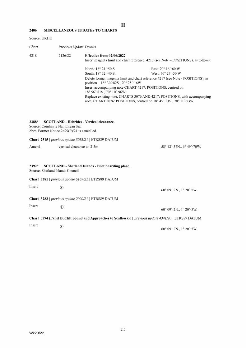
II2406 MISCELLANEOUS UPDATES TO CHARTS
Source: UKHO
Chart Previous Update Details
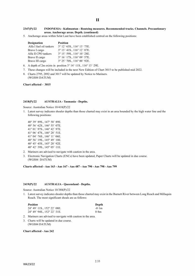
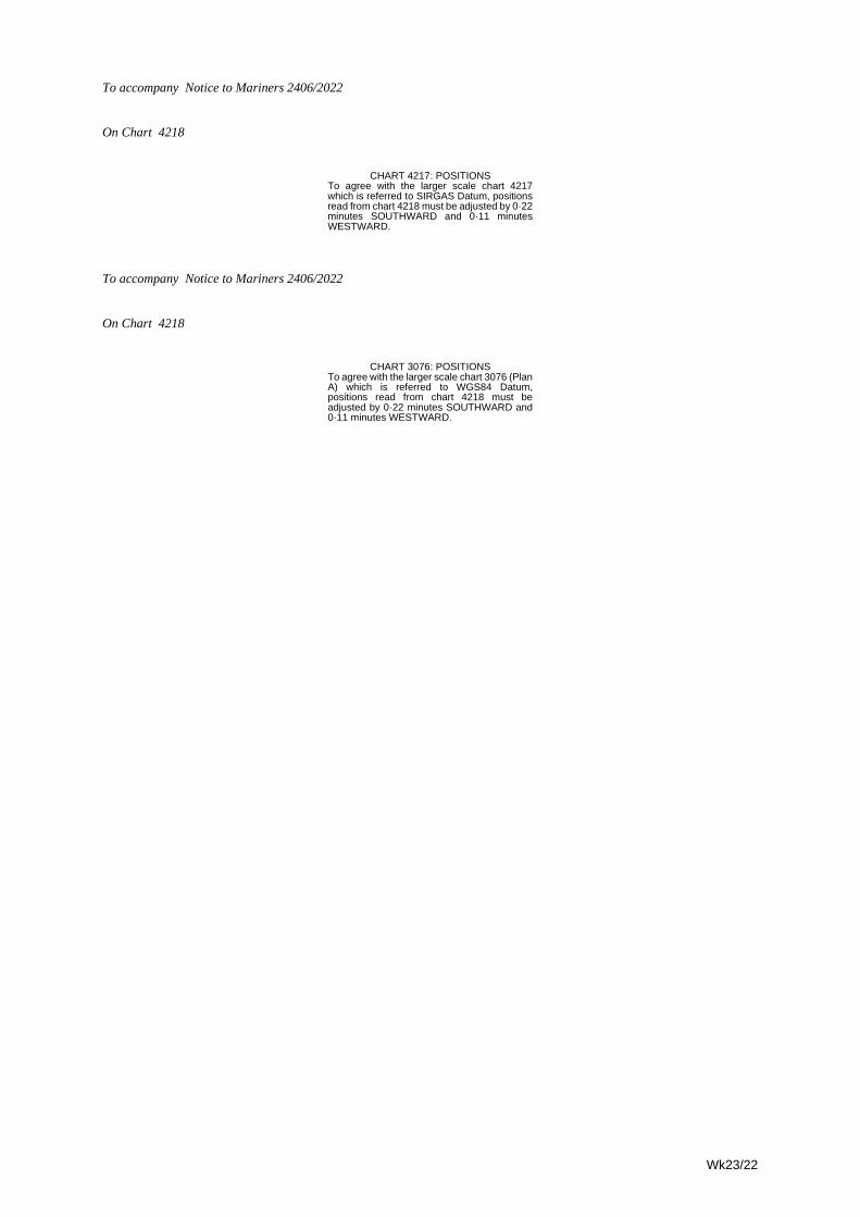
4218 2126/22 Effective from 02/06/2022Insert magenta limit and chart reference, 4217 (see Note – POSITIONS), as follows:
Delete former magenta limit and chart reference 4217 (see Note - POSITIONS), in position 18° 30´·82S., 70° 25´·16W.Insert accompanying note CHART 4217: POSITIONS, centred on 18° 56´·81S., 70° 10´·96W.Replace existing note, CHARTS 3076 AND 4217: POSITIONS, with accompanying note, CHART 3076: POSITIONS, centred on 18° 45´·81S., 70° 11´·53W.
2388* SCOTLAND - Hebrides - Vertical clearance.Source: Comhairle Nan Eilean SiarNote: Former Notice 2699(P)/21 is cancelled.
Chart 2515 [ previous update 3055/21 ] ETRS89 DATUM
Amend vertical clearance to, 2·3m 58° 12´·37N., 6° 49´·70W.
2392* SCOTLAND - Shetland Islands - Pilot boarding place.Source: Shetland Islands Council
Chart 3281 [ previous update 5167/21 ] ETRS89 DATUM
Insert  60° 09´·2N., 1° 20´·5W.
Chart 3283 [ previous update 2920/21 ] ETRS89 DATUM
Insert  60° 09´·2N., 1° 20´·5W.
Chart 3294 (Panel B, Clift Sound and Approaches to Scalloway) [ previous update 4341/20 ] ETRS89 DATUM
Insert  60° 09´·2N., 1° 20´·5W.
North: 18° 21´·50 S. East: 70° 16´·60 W.South: 18° 32´·40 S. West: 70° 27´·50 W.
2.5Wk23/22
II
2393* SCOTLAND - East Coast - Depths.Source: mv Northern Wind
Chart 210 [ previous update 2109/22 ] ETRS89 DATUM
Insert depth, 83, and extend 10m contour E to enclose (a) 57° 00´·70N., 2° 09´·41W.Delete depth, 113, close NE of: (a) aboveInsert depth, 27, enclosed by 30m contour (b) 56° 59´·77N., 2° 07´·01W.Delete depth, 31, close NE of: (b) above
Chart 1409 (INT 1504) [ previous update 2263/22 ] ETRS89 DATUM
Insert depth, 83, and extend 10m contour E to enclose 57° 00´·70N., 2° 09´·41W.depth, 27, enclosed by 30m contour (a) 56° 59´·77N., 2° 07´·01W.
Delete depth, 31, close NE of: (a) above
Chart 5617_3 [ previous update 1972/22 ] ETRS89 DATUM
Insert depth, 83, and extend 10m contour E to enclose (a) 57° 00´·70N., 2° 09´·41W.Delete depth, 113, close NE of: (a) aboveInsert depth, 27, enclosed by 30m contour (b) 56° 59´·77N., 2° 07´·01W.Delete depth, 31, close NE of: (b) above
2366 RUSSIA - Barents Sea Coast - Obstruction.Source: Russian Notice 8/770/22
Chart 2966 (Panel, Murmansk) [ previous update 2208/22 ] WGS84 DATUM
Insert åObstn69° 02´·04N., 33° 01´·85E.
2390 NORWAY - North Coast - Lights.Source: Norwegian Notices 24/66429/21, 24/66443/21, 24/66473/21, 24/66477/21 and Norwegian Lights List
Chart 2315 [ previous update 2130/22 ] WGS84 DATUM
Amend range of light to, 4-3M 71° 05´·19N., 23° 59´·01E.70° 59´·50N., 24° 07´·80E.
Delete ¶Fl(2)14s12m6M70° 58´·42N., 26° 00´·92E.
¶LdgQ.3M & Iso.4s4M71° 00´·13N., 26° 06´·92E.
Chart 2330 [ previous update 2318/22 ] WGS84 DATUM
Delete ¶Fl(2)14s12m6M70° 58´·42N., 26° 00´·91E.
¶LdgQ.3M & Iso.4s4M71° 00´·14N., 26° 06´·91E.
2.6Wk23/22
II
2355 SWEDEN - East Coast - Rock. Depths.Source: Swedish Notice 910/16650/22
Chart 925 (INT 1177) [ previous update 2034/22 ] WGS84 DATUM
Insert ¯ 64° 40´·71N., 21° 15´·27E.3m contour, joining: (a) 64° 40´·71N., 21° 15´·37E.
64° 40´·72N., 21° 15´·32E.64° 40´·73N., 21° 15´·25E.
(b) 64° 40´·76N., 21° 15´·21E.Delete former 3m contour, joining: (a) above
64° 40´·70N., 21° 15´·33E.Insert 6m contour, joining: (c) 64° 40´·74N., 21° 15´·35E.
64° 40´·73N., 21° 15´·33E.64° 40´·73N., 21° 15´·29E.64° 40´·73N., 21° 15´·26E.(b) above
Delete former 6m contour, joining: (c) above64° 40´·72N., 21° 15´·33E.64° 40´·71N., 21° 15´·32E.64° 40´·71N., 21° 15´·30E.64° 40´·71N., 21° 15´·20E.
3m contour, joining: 64° 40´·63N., 21° 15´·19E.64° 40´·63N., 21° 15´·17E.
2357 SWEDEN - West Coast - Submarine pipeline. Buoy.Source: Swedish Notices 910/16447/22 and 910/16679/22
Chart 869 (INT 1311) [ previous update 4729/21 ] WGS84 DATUM
Insert submarine pipeline, È, joining:58° 12´·03N., 11° 31´·44E.58° 12´·18N., 11° 31´·47E.58° 12´·28N., 11° 31´·40E.58° 12´·85N., 11° 31´·47E.
Delete Jd 58° 10´·95N., 11° 27´·60E.
Chart 870 (INT 1310) [ previous update 1024/22 ] WGS84 DATUM
Delete Jd 58° 10´·95N., 11° 27´·60E.
2359 BALTIC SEA - Buoy.Source: Swedish Notice 910/16696/22
Chart 2054 (INT 1203) [ previous update 1729/22 ] WGS84 DATUM
Delete JW 57° 04´·87N., 18° 27´·63E.
2.7Wk23/22
II
2365 POLAND - Submarine pipeline.Source: Polish Notice 6/47/22
Chart 2014 (INT 1219) [ previous update 2196/22 ] WGS84 DATUM
Insert submarine pipeline, È, joining:54° 06´·74N., 15° 08´·67E.54° 08´·06N., 15° 08´·12E.54° 14´·50N., 15° 03´·62E.
Chart 2679 [ previous update 2196/22 ] WGS84 DATUM
Insert submarine pipeline, È, joining:54° 13´·96N., 15° 04´·00E.54° 14´·50N., 15° 03´·62E.
Chart 2816 [ previous update 1729/22 ] WGS84 DATUM
Insert submarine pipeline, È, joining:54° 07´·0N., 15° 08´·6E.54° 08´·1N., 15° 08´·1E.54° 14´·5N., 15° 03´·6E.
2378 FINLAND - South Coast - Submarine pipeline. Legend.Source: Finnish Notice 4/36/22
Chart 2259 (INT 1153) [ previous update 3356/19 ] WGS84 DATUM
Insert submarine pipeline, È, joining:(a) 60° 31´·686N., 27° 08´·414E.(b) 60° 31´·917N., 27° 08´·378E.
legend, Gas, along: (a)-(b) above
Chart 3813 (INT 1246) [ previous update 1828/22 ] WGS84 DATUM
Insert submarine pipeline, È, joining:(a) 60° 31´·69N., 27° 08´·41E.(b) 60° 31´·92N., 27° 08´·38E.
legend, Gas, along: (a)-(b) above
2382 ESTONIA - Depths. Wreck.Source: ENC EE4C3816
Chart 2215 [ previous update 1536/22 ] WGS84 DATUM
Insert depth, 38 (a) 58° 13´·32N., 24° 15´·91E.Delete depth, 43, close NE of: (a) aboveInsert depth, 64 (b) 58° 16´·44N., 24° 22´·51E.Delete depth, 72, close NE of: (b) aboveReplace 5Ó+Wk with 5$+Wk
58° 19´·55N., 24° 24´·99E.
2.8Wk23/22
II
2391 SWEDEN - East Coast - Legends. Submarine power cables.Source: Swedish Notices 910/16663/22 and 910/16689/22
Chart 821 (INT 1237) [ previous update New Edition 10/02/2022 ] WGS84 DATUM
Insert legend, (May-Sep), centred on: 59° 20´·71N., 18° 53´·51E.59° 20´·83N., 18° 54´·00E.59° 20´·28N., 18° 54´·41E.
submarine power cable, ÉÊÉ, joining:59° 18´·05N., 18° 52´·47E.59° 18´·02N., 18° 52´·33E.59° 18´·06N., 18° 52´·19E.
(a) 59° 18´·03N., 18° 52´·13E.Delete former submarine power cable, ÉÊÉ, joining:
59° 18´·05N., 18° 52´·48E.59° 17´·97N., 18° 52´·25E.(a) above
Chart 832 (INT 1236) [ previous update 374/22 ] WGS84 DATUM
Insert submarine power cable, ÉÊÉ, joining:59° 18´·05N., 18° 52´·47E.59° 18´·02N., 18° 52´·33E.59° 18´·06N., 18° 52´·19E.
(a) 59° 18´·03N., 18° 52´·13E.Delete former submarine power cable, ÉÊÉ, joining:
59° 18´·05N., 18° 52´·48E.59° 17´·97N., 18° 52´·25E.(a) above
2395 SWEDEN - East Coast - Legend.Source: Swedish Notice 910/16564/22
Chart 259 (INT 120) [ previous update 2272/21 ] WGS84 DATUM
Amend legend to, DW 18m, centred on: 60° 19´·6N., 19° 00´·4E.
Chart 689 (INT 1240) [ previous update 1457/22 ] WGS84 DATUM
Amend legend to, DW 18m, centred on: 60° 25´·00N., 19° 00´·95E.
Chart 889 (INT 1777) [ previous update 1623/22 ] WGS84 DATUM
Amend legend to, DW 18m, centred on: 60° 17´·15N., 19° 00´·35E.
Chart 2073 [ previous update New Edition 24/02/2022 ] WGS84 DATUM
Amend legend to, DW 18m, centred on: 60° 24´·91N., 19° 00´·93E.
Chart 2082 (INT 1206) [ previous update 57/22 ] WGS84 DATUM
Amend legend to, DW 18m, centred on: 60° 26´·21N., 19° 01´·34E.
Chart 2252 [ previous update 3679/21 ] WGS84 DATUM
Amend legend to, DW 18m, centred on: 60° 23´·7N., 19° 00´·5E.
Chart 2817 [ previous update 1536/22 ] WGS84 DATUM
Amend legend to, DW 18m, centred on: 60° 22´·5N., 19° 00´·6E.
2.9Wk23/22
II
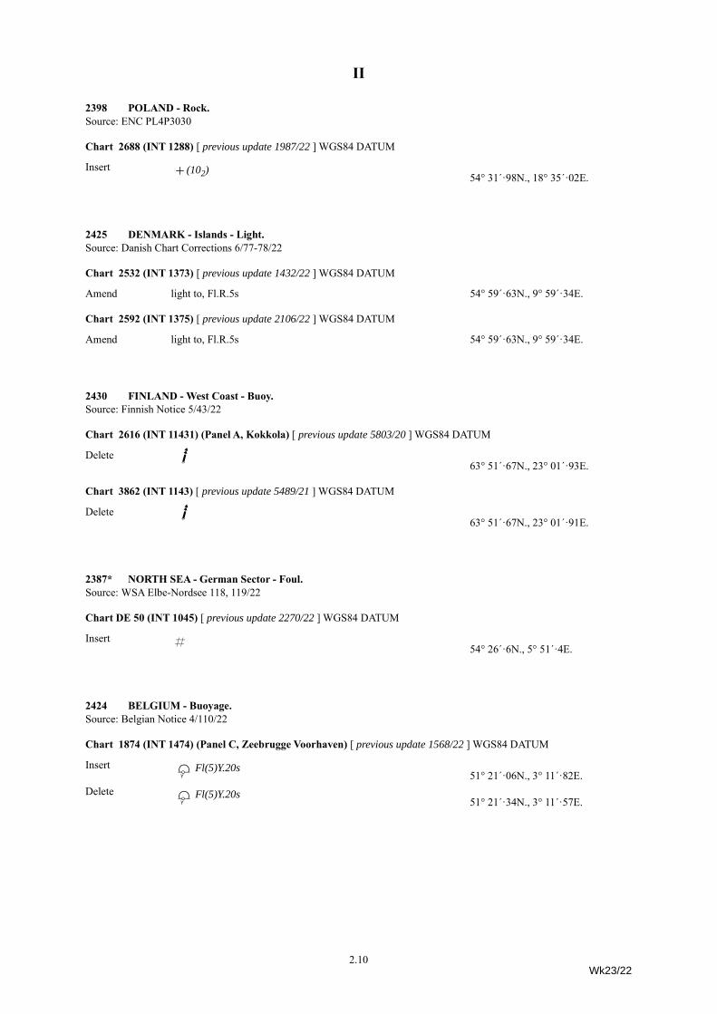
2398 POLAND - Rock.Source: ENC PL4P3030
Chart 2688 (INT 1288) [ previous update 1987/22 ] WGS84 DATUM
Insert ¯(102)54° 31´·98N., 18° 35´·02E.
2425 DENMARK - Islands - Light.Source: Danish Chart Corrections 6/77-78/22
Chart 2532 (INT 1373) [ previous update 1432/22 ] WGS84 DATUM
Amend light to, Fl.R.5s 54° 59´·63N., 9° 59´·34E.
Chart 2592 (INT 1375) [ previous update 2106/22 ] WGS84 DATUM
Amend light to, Fl.R.5s 54° 59´·63N., 9° 59´·34E.
2430 FINLAND - West Coast - Buoy.Source: Finnish Notice 5/43/22
Chart 2616 (INT 11431) (Panel A, Kokkola) [ previous update 5803/20 ] WGS84 DATUM
Delete JU 63° 51´·67N., 23° 01´·93E.
Chart 3862 (INT 1143) [ previous update 5489/21 ] WGS84 DATUM
Delete JU 63° 51´·67N., 23° 01´·91E.
2387* NORTH SEA - German Sector - Foul.Source: WSA Elbe-Nordsee 118, 119/22
Chart DE 50 (INT 1045) [ previous update 2270/22 ] WGS84 DATUM
Insert « 54° 26´·6N., 5° 51´·4E.
2424 BELGIUM - Buoyage.Source: Belgian Notice 4/110/22
Chart 1874 (INT 1474) (Panel C, Zeebrugge Voorhaven) [ previous update 1568/22 ] WGS84 DATUM
Insert EfFl(5)Y.20s51° 21´·06N., 3° 11´·82E.
Delete EfFl(5)Y.20s51° 21´·34N., 3° 11´·57E.
2.10Wk23/22
II
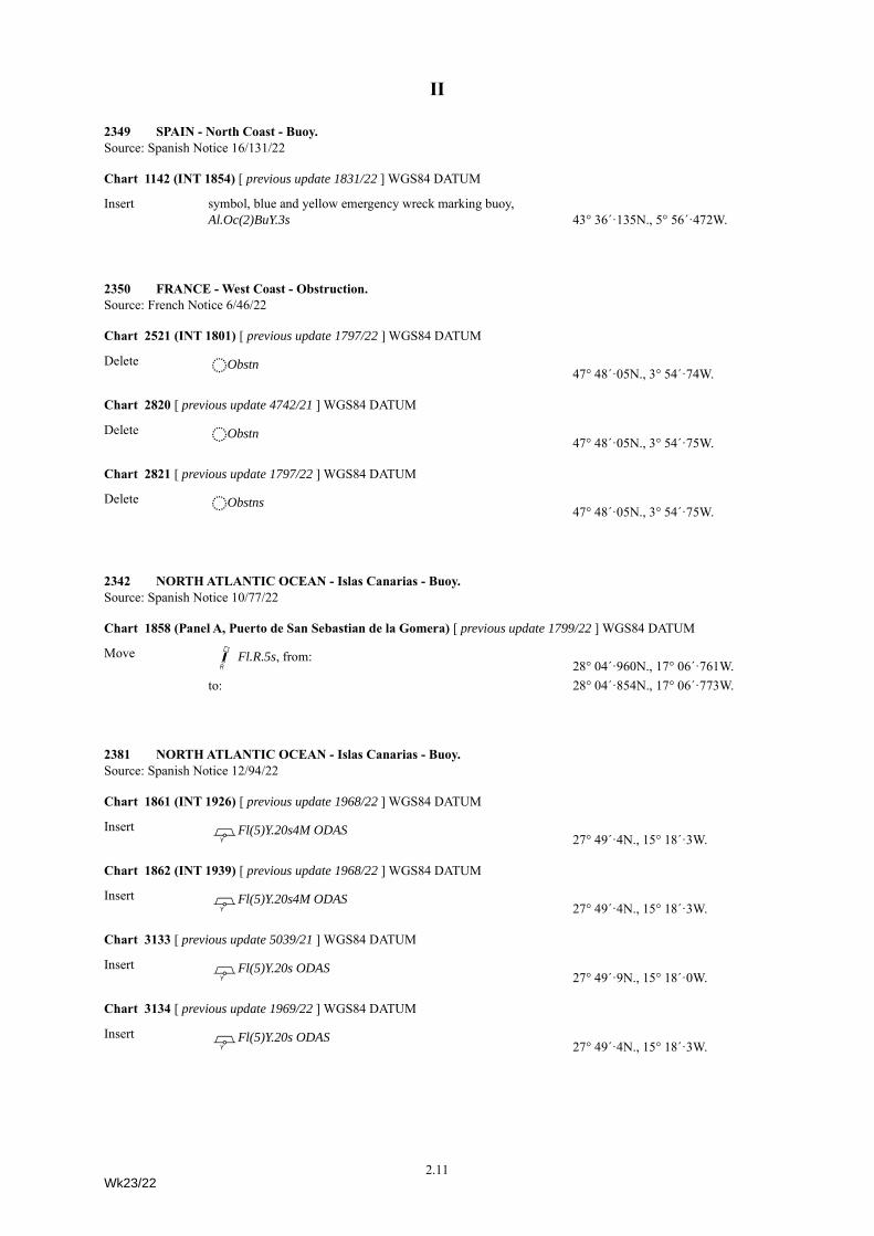
2349 SPAIN - North Coast - Buoy.Source: Spanish Notice 16/131/22
Chart 1142 (INT 1854) [ previous update 1831/22 ] WGS84 DATUM
Insert symbol, blue and yellow emergency wreck marking buoy, Al.Oc(2)BuY.3s 43° 36´·135N., 5° 56´·472W.
2350 FRANCE - West Coast - Obstruction.Source: French Notice 6/46/22
Chart 2521 (INT 1801) [ previous update 1797/22 ] WGS84 DATUM
Delete åObstn47° 48´·05N., 3° 54´·74W.
Chart 2820 [ previous update 4742/21 ] WGS84 DATUM
Delete åObstn47° 48´·05N., 3° 54´·75W.
Chart 2821 [ previous update 1797/22 ] WGS84 DATUM
Delete åObstns47° 48´·05N., 3° 54´·75W.
2342 NORTH ATLANTIC OCEAN - Islas Canarias - Buoy.Source: Spanish Notice 10/77/22
Chart 1858 (Panel A, Puerto de San Sebastian de la Gomera) [ previous update 1799/22 ] WGS84 DATUM
Move J\dFl.R.5s, from:28° 04´·960N., 17° 06´·761W.
to: 28° 04´·854N., 17° 06´·773W.
2381 NORTH ATLANTIC OCEAN - Islas Canarias - Buoy.Source: Spanish Notice 12/94/22
Chart 1861 (INT 1926) [ previous update 1968/22 ] WGS84 DATUM
Insert PfFl(5)Y.20s4M ODAS27° 49´·4N., 15° 18´·3W.
Chart 1862 (INT 1939) [ previous update 1968/22 ] WGS84 DATUM
Insert PfFl(5)Y.20s4M ODAS27° 49´·4N., 15° 18´·3W.
Chart 3133 [ previous update 5039/21 ] WGS84 DATUM
Insert PfFl(5)Y.20s ODAS27° 49´·9N., 15° 18´·0W.
Chart 3134 [ previous update 1969/22 ] WGS84 DATUM
Insert PfFl(5)Y.20s ODAS27° 49´·4N., 15° 18´·3W.
2.11Wk23/22
II
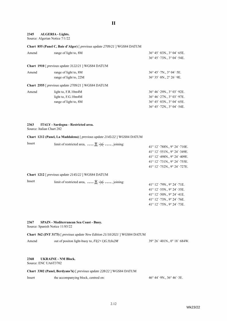
2345 ALGERIA - Lights.Source: Algerian Notice 7/1/22
Chart 855 (Panel C, Baie d’Alger) [ previous update 2709/21 ] WGS84 DATUM
Amend range of light to, 8M 36° 45´·83N., 3° 04´·65E.36° 45´·73N., 3° 04´·54E.
Chart 1910 [ previous update 3122/21 ] WGS84 DATUM
Amend range of light to, 8M 36° 45´·7N., 3° 04´·5E.range of light to, 22M 36° 35´·8N., 2° 26´·9E.
Chart 2555 [ previous update 2709/21 ] WGS84 DATUM
Amend light to, F.R.10m4M 36° 46´·29N., 3° 03´·92E.light to, F.G.10m4M 36° 46´·27N., 3° 03´·97E.range of light to, 8M 36° 45´·83N., 3° 04´·65E.
36° 45´·72N., 3° 04´·54E.
2363 ITALY - Sardegna - Restricted area.Source: Italian Chart 282
Chart 1212 (Panel, La Maddalena) [ previous update 2145/22 ] WGS84 DATUM
Insert limit of restricted area, ÇÅÆÇ, joining: 41° 12´·788N., 9° 24´·710E.41° 12´·551N., 9° 24´·349E.41° 12´·498N., 9° 24´·409E.41° 12´·731N., 9° 24´·755E.41° 12´·752N., 9° 24´·727E.
Chart 1212 [ previous update 2145/22 ] WGS84 DATUM
Insert limit of restricted area, ÇÅÆÇ, joining: 41° 12´·79N., 9° 24´·71E.41° 12´·55N., 9° 24´·35E.41° 12´·50N., 9° 24´·41E.41° 12´·73N., 9° 24´·76E.41° 12´·75N., 9° 24´·73E.
2367 SPAIN - Mediterranean Sea Coast - Buoy.Source: Spanish Notice 11/85/22
Chart 562 (INT 3173) [ previous update New Edition 21/10/2021 ] WGS84 DATUM
Amend out of positon light-buoy to, Fl(2+1)G.9,6s2M 39° 26´·401N., 0° 18´·684W.
2368 UKRAINE - NM Block.Source: ENC UA6T3702
Chart 3302 (Panel, Berdyans’k) [ previous update 228/22 ] WGS84 DATUM
Insert the accompanying block, centred on: 46° 44´·9N., 36° 46´·3E.
2.12Wk23/22
II
2369 UKRAINE - Obstruction.Source: UKHO
Chart 2217 (Panel, Sevastopol’) [ previous update 5031/21 ] PULKOVO 1942 DATUM
Insert 29%,Obstn44° 39´·62N., 33° 30´·91E.
Chart 2217 [ previous update 5031/21 ] PULKOVO 1942 DATUM
Insert 29%,Obstn44° 39´·62N., 33° 30´·91E.
2394 CROATIA - Lights.Source: Croatian Notices 3/7-8/22
Chart 204 [ previous update 1282/22 ] WGS84 DATUM
Insert ¶ Fl.R.5s8M Rt. Peć(a) 45° 11´·0N., 14° 14´·6E.
Delete ¶ Fl.R.5s8M Rt. Šip, close S of:(a) above
Chart 2719 [ previous update 1967/22 ] WGS84 DATUM
Insert ¶ Fl.R.5s23m8M Rt. Peć(a) 45° 11´·00N., 14° 14´·60E.
Delete ¶ Fl.R.5s23m8M Rt. Šip, close S of:(a) above
Insert ¶ Fl.G.3s6m3M45° 07´·34N., 14° 29´·80E.
2399 TUNISIA - Wrecks.Source: French Notice 7/144/22
Chart 1162 (Panel C, Approaches to Sfax) [ previous update 782/22 ] WGS84 DATUM
Insert ´PA34° 34´·61N., 10° 45´·00E.
Chart 3403 (INT 3216) [ previous update 2040/22 ] WGS84 DATUM
Insert ´PA34° 34´·6N., 10° 45´·0E.
´ 35° 12´·5N., 11° 34´·5E.
2409 GREECE - Aegean Sea Coast - Maritime limit. Works. Legend.Source: Greek Notice 1/21/22
Chart 1675 (Panel A, Órmos Sígri) [ previous update 1822/22 ] WGS84 DATUM
Insert maritime limit, pecked line, joining: (a) 39° 12´·74N., 25° 50´·97E.(b) 39° 12´·92N., 25° 50´·83E.(c) 39° 13´·09N., 25° 51´·19E.(d) 39° 12´·89N., 25° 51´·34E.
legend, Works in progress (2022), within: (a)-(d) above
2.13Wk23/22
II
2410 GREECE - Aegean Sea Coast - Restricted area.Source: ENC GR4APP15 and Greek Notice 10/165/21
Chart 1625 [ previous update 4322/21 ] WGS84 DATUM
Insert limit of restricted area, entry prohibited, pecked line, joining: 38° 29´·14N., 26° 07´·60E.38° 29´·30N., 26° 07´·88E.
2411 ITALY - East Coast - Light.Source: Italian Notice 3.16/22
Chart 1467 [ previous update 5237/21 ] WGS84 DATUM
Amend light to, Q.R.9m8M 44° 40´·57N., 12° 15´·22E.
2415 ITALY - Sicilia - NM Block.Source: Italian Notices 3.7/22 and 8.9/22
Chart 963 (Panel B, Porto di Palermo) [ previous update 2198/22 ] WGS84 DATUM
Insert the accompanying block, centred on: 38° 07´·7N., 13° 22´·2E.
2340 CONGO - Platform. Submarine pipeline.Source: John Lovell
Chart 305 (INT 2813) [ previous update 6041/20 ] WGS84 DATUM
Insert ¼{ (a) 4° 11´·0S., 10° 39´·0E.
submarine pipeline, È, joining: 4° 14´·8S., 10° 49´·1E.(a) above
Chart 306 (INT 2814) [ previous update 1840/22 ] WGS84 DATUM
Insert ¼{ (a) 4° 11´·0S., 10° 39´·0E.
submarine pipeline, È, joining: 4° 14´·8S., 10° 49´·1E.(a) above
2.14Wk23/22
II
2400 MOROCCO - West Coast - Buoyage. Automatic Identification Systems.Source: French Notice 7/150/22
Chart 862 (Panel C, El Jadida) [ previous update 2022/22 ] WGS84 DATUM
Insert IbFl.G EJ1(a) 33° 15´·71N., 8° 29´·63W.
Automatic Identification System, AIS, at light-buoy (a) above
GdFl(2)R.4s EJ2(b) 33° 15´·46N., 8° 29´·27W.
Automatic Identification System, AIS, at light-buoy (b) aboveDelete IbFl.G EJ1
33° 15´·42N., 8° 29´·50W.
GdFl(2)R.4s EJ233° 15´·30N., 8° 29´·59W.
2408 CAMEROON - Pilot boarding place.Source: French Notice 8/167/22
Chart 1387 (INT 2810) [ previous update 5196/21 ] WGS84 DATUM
Move Â, from:3° 02´·7N., 9° 45´·5E.
to: 3° 03´·0N., 9° 49´·0E.
2384* UNITED ARAB EMIRATES - Buoyage.Source: MEANS Navtex 121/22
Chart 3413 (INT 7227) (Panel D, Jazīrat Dās) [ previous update New Edition 05/05/2022 ] WGS84 DATUM
Insert Bf;Fl.Y.5s BUOY 125° 08´·76N., 52° 53´·37E.
Bf;Fl.Y.5s BUOY 225° 08´·81N., 52° 53´·35E.
Bf;Fl.Y.5s RESTD-125° 10´·33N., 52° 53´·24E.
Bf;Fl.Y.5s RESTD-325° 10´·68N., 52° 52´·11E.
Chart 3413 (INT 7227) (Panel C, Approaches to Jazīrat Dās) [ previous update New Edition 05/05/2022 ] WGS84 DATUM
Insert Bf;Fl.Y.5s RESTD-125° 10´·33N., 52° 53´·24E.
Bf;Fl.Y.5s RESTD-325° 10´·68N., 52° 52´·11E.
Bf;Fl.Y.5s RESTD-225° 10´·83N., 52° 52´·84E.
2.15Wk23/22
II
2432* UNITED ARAB EMIRATES - Buoy. Lights. Coastline.Source: Port of Fajairah
Chart 2888 (INT 7199) [ previous update 2031/22 ] WGS84 DATUM
Insert HpZIso.6s25° 38´·5N., 56° 20´·0E.
¶ 2Fl.Y.2s5M25° 37´·0N., 56° 17´·3E.
coastline, single firm line, joining: (a) 25° 36´·9N., 56° 16´·9E.(b) 25° 37´·1N., 56° 17´·2E.(c) 25° 36´·9N., 56° 17´·4E.(d) 25° 36´·5N., 56° 17´·3E.
Delete charted detail, within: (a)-(d) aboveAmend light to, Fl.R.3s5M & Fl.R.2s5M 25° 36´·9N., 56° 17´·8E.
2377 INDIA - East Coast - NM Blocks.Source: Indian Notice 14/148/21
Chart IN 3001 (INT 7402) [ previous update 2303/21 ] WGS84 DATUM
Insert the accompanying block, centred on: 13° 06´·1N., 80° 18´·3E.
Chart IN 3004 (INT 7403) [ previous update 4966/18 ] WGS84 DATUM
Insert the accompanying block, centred on: 13° 06´·0N., 80° 18´·2E.
2385 TAIWAN - Buoy. NM Blocks.Source: UKHO
Chart 1760 [ previous update 2185/22 ] WGS84 DATUM
Delete EfAl.RY.8s24° 01´·0N., 120° 12´·3E.
Chart 2409 [ previous update 1677/22 ] WGS84 DATUM
Insert the accompanying block, centred on: 23° 58´·9N., 120° 15´·0E.
Chart 3231 [ previous update 1985/22 ] WGS84 DATUM
Insert the accompanying block, centred on: 23° 59´·0N., 120° 14´·9E.
2396 CHINA - Yellow Sea Coast - Wreck.Source: Chinese Notice 13/419/22
Chart 1201 [ previous update 2063/22 ] CGCS 2000 DATUM
Insert ´Rep (2021) PA34° 45´·80N., 120° 01´·42E.
Chart 1253 [ previous update 2111/22 ] CGCS 2000 DATUM
Insert ´Rep(2021) PA34° 45´·8N., 120° 01´·4E.
2.16Wk23/22
II
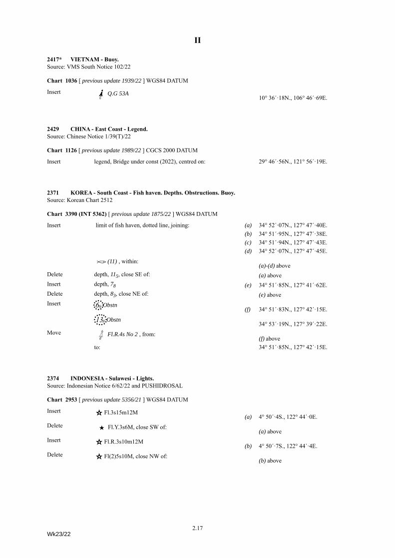
2417* VIETNAM - Buoy.Source: VMS South Notice 102/22
Chart 1036 [ previous update 1939/22 ] WGS84 DATUM
Insert Ib]Q.G 53A10° 36´·18N., 106° 46´·69E.
2429 CHINA - East Coast - Legend.Source: Chinese Notice 1/39(T)/22
Chart 1126 [ previous update 1989/22 ] CGCS 2000 DATUM
Insert legend, Bridge under const (2022), centred on: 29° 46´·56N., 121° 56´·19E.
2371 KOREA - South Coast - Fish haven. Depths. Obstructions. Buoy.Source: Korean Chart 2512
Chart 3390 (INT 5362) [ previous update 1875/22 ] WGS84 DATUM
Insert limit of fish haven, dotted line, joining: (a) 34° 52´·07N., 127° 47´·40E.(b) 34° 51´·95N., 127° 47´·38E.(c) 34° 51´·94N., 127° 47´·43E.(d) 34° 52´·07N., 127° 47´·45E.
À(11) , within:(a)-(d) above
Delete depth, 115, close SE of: (a) aboveInsert depth, 78 (e) 34° 51´·85N., 127° 41´·62E.Delete depth, 83, close NE of: (e) aboveInsert 6)+Obstn
(f) 34° 51´·83N., 127° 42´·15E.
13(,Obstn34° 53´·19N., 127° 39´·22E.
Move Gd:Fl.R.4s No 2 , from:(f) above
to: 34° 51´·85N., 127° 42´·15E.
2374 INDONESIA - Sulawesi - Lights.Source: Indonesian Notice 6/62/22 and PUSHIDROSAL
Chart 2953 [ previous update 5356/21 ] WGS84 DATUM
Insert ¶ Fl.3s15m12M(a) 4° 50´·4S., 122° 44´·0E.
Delete ·Fl.Y.3s6M, close SW of:(a) above
Insert ¶ Fl.R.3s10m12M(b) 4° 50´·7S., 122° 44´·4E.
Delete ¶ Fl(2)5s10M, close NW of:(b) above
2.17Wk23/22
II
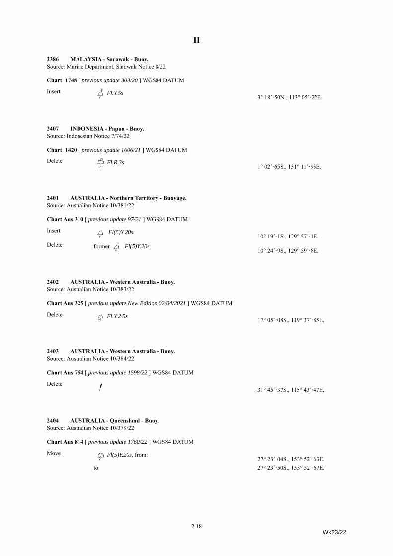
2386 MALAYSIA - Sarawak - Buoy.Source: Marine Department, Sarawak Notice 8/22
Chart 1748 [ previous update 303/20 ] WGS84 DATUM
Insert D;fFl.Y.5s3° 18´·50N., 113° 05´·22E.
2407 INDONESIA - Papua - Buoy.Source: Indonesian Notice 7/74/22
Chart 1420 [ previous update 1606/21 ] WGS84 DATUM
Delete Bd\Fl.R.3s1° 02´·65S., 131° 11´·95E.
2401 AUSTRALIA - Northern Territory - Buoyage.Source: Australian Notice 10/381/22
Chart Aus 310 [ previous update 97/21 ] WGS84 DATUM
Insert Df Fl(5)Y.20s10° 19´·1S., 129° 57´·1E.
Delete formerDf Fl(5)Y.20s10° 24´·9S., 129° 59´·8E.
2402 AUSTRALIA - Western Australia - Buoy.Source: Australian Notice 10/383/22
Chart Aus 325 [ previous update New Edition 02/04/2021 ] WGS84 DATUM
Delete DqFl.Y.2·5s17° 05´·08S., 119° 37´·85E.
2403 AUSTRALIA - Western Australia - Buoy.Source: Australian Notice 10/384/22
Chart Aus 754 [ previous update 1598/22 ] WGS84 DATUM
Delete Jf 31° 45´·37S., 115° 43´·47E.
2404 AUSTRALIA - Queensland - Buoy.Source: Australian Notice 10/379/22
Chart Aus 814 [ previous update 1760/22 ] WGS84 DATUM
Move EfFl(5)Y.20s, from:27° 23´·04S., 153° 52´·63E.
to: 27° 23´·50S., 153° 52´·67E.
2.18Wk23/22
II
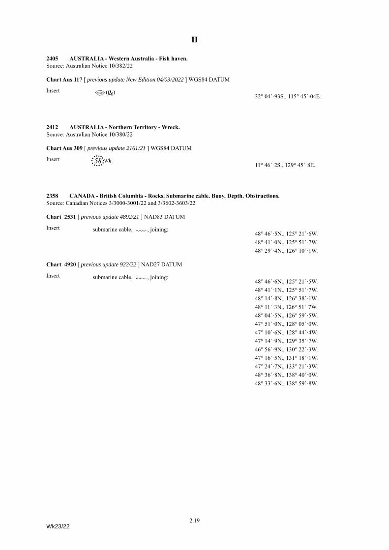
2405 AUSTRALIA - Western Australia - Fish haven.Source: Australian Notice 10/382/22
Chart Aus 117 [ previous update New Edition 04/03/2022 ] WGS84 DATUM
Insert Á(06)32° 04´·93S., 115° 45´·04E.
2412 AUSTRALIA - Northern Territory - Wreck.Source: Australian Notice 10/380/22
Chart Aus 309 [ previous update 2161/21 ] WGS84 DATUM
Insert 58,Wk11° 46´·2S., 129° 45´·8E.
2358 CANADA - British Columbia - Rocks. Submarine cable. Buoy. Depth. Obstructions.Source: Canadian Notices 3/3000-3001/22 and 3/3602-3603/22
Chart 2531 [ previous update 4892/21 ] NAD83 DATUM
Insert submarine cable, É, joining:48° 46´·5N., 125° 21´·6W.48° 41´·0N., 125° 51´·7W.48° 29´·4N., 126° 10´·1W.
Chart 4920 [ previous update 922/22 ] NAD27 DATUM
Insert submarine cable, É, joining:48° 46´·6N., 125° 21´·5W.48° 41´·1N., 125° 51´·7W.48° 14´·8N., 126° 38´·1W.48° 11´·3N., 126° 51´·7W.48° 04´·5N., 126° 59´·5W.47° 51´·0N., 128° 05´·0W.47° 10´·6N., 128° 44´·4W.47° 14´·9N., 129° 35´·7W.46° 56´·9N., 130° 22´·3W.47° 16´·5N., 131° 18´·1W.47° 24´·7N., 133° 21´·3W.48° 36´·8N., 138° 40´·0W.48° 33´·6N., 138° 59´·8W.
2.19Wk23/22
II
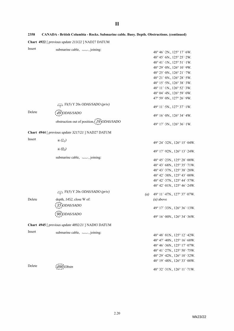
Chart 4922 [ previous update 213/22 ] NAD27 DATUM
Insert submarine cable, É, joining:48° 46´·2N., 125° 17´·6W.48° 45´·6N., 125° 25´·2W.48° 41´·1N., 125° 51´·1W.48° 29´·0N., 126° 10´·9W.48° 25´·0N., 126° 21´·7W.48° 21´·8N., 126° 28´·5W.48° 15´·5N., 126° 38´·3W.48° 11´·1N., 126° 52´·3W.48° 04´·4N., 126° 59´·0W.47° 59´·0N., 127° 26´·9W.
Pl Fl(5) Y 20s ODAS/SADO (priv)49° 11´·5N., 127° 37´·1W.
Delete 49,ODAS/SADO49° 16´·0N., 126° 34´·4W.
obstruction out of position, 19,ODAS/SADO49° 17´·3N., 126° 36´·1W.
Chart 4944 [ previous update 3217/21 ] NAD27 DATUM
Insert ³(11)49° 24´·32N., 126° 15´·04W.
³(03)49° 17´·92N., 126° 13´·24W.
submarine cable, É, joining:48° 45´·23N., 125° 28´·00W.48° 43´·68N., 125° 35´·71W.48° 43´·37N., 125° 38´·28W.48° 42´·38N., 125° 43´·00W.48° 42´·37N., 125° 44´·57W.48° 42´·01N., 125° 46´·24W.
Pl Fl(5) Y 20s ODAS/SADO (priv)(a) 49° 11´·47N., 127° 37´·07W.
Delete depth, 1452, close W of: (a) above
35,ODAS/SADO49° 17´·33N., 126° 36´·13W.
90,ODAS/SADO49° 16´·00N., 126° 34´·36W.
Chart 4945 [ previous update 4892/21 ] NAD83 DATUM
Insert submarine cable, É, joining:48° 48´·81N., 125° 12´·42W.48° 47´·40N., 125° 16´·68W.48° 46´·36N., 125° 17´·07W.48° 41´·27N., 125° 50´·75W.48° 29´·42N., 126° 10´·32W.48° 19´·48N., 126° 33´·00W.
Delete 490-Obstn48° 32´·31N., 126° 11´·71W.
2358 CANADA - British Columbia - Rocks. Submarine cable. Buoy. Depth. Obstructions. (continued)
2.20Wk23/22
II
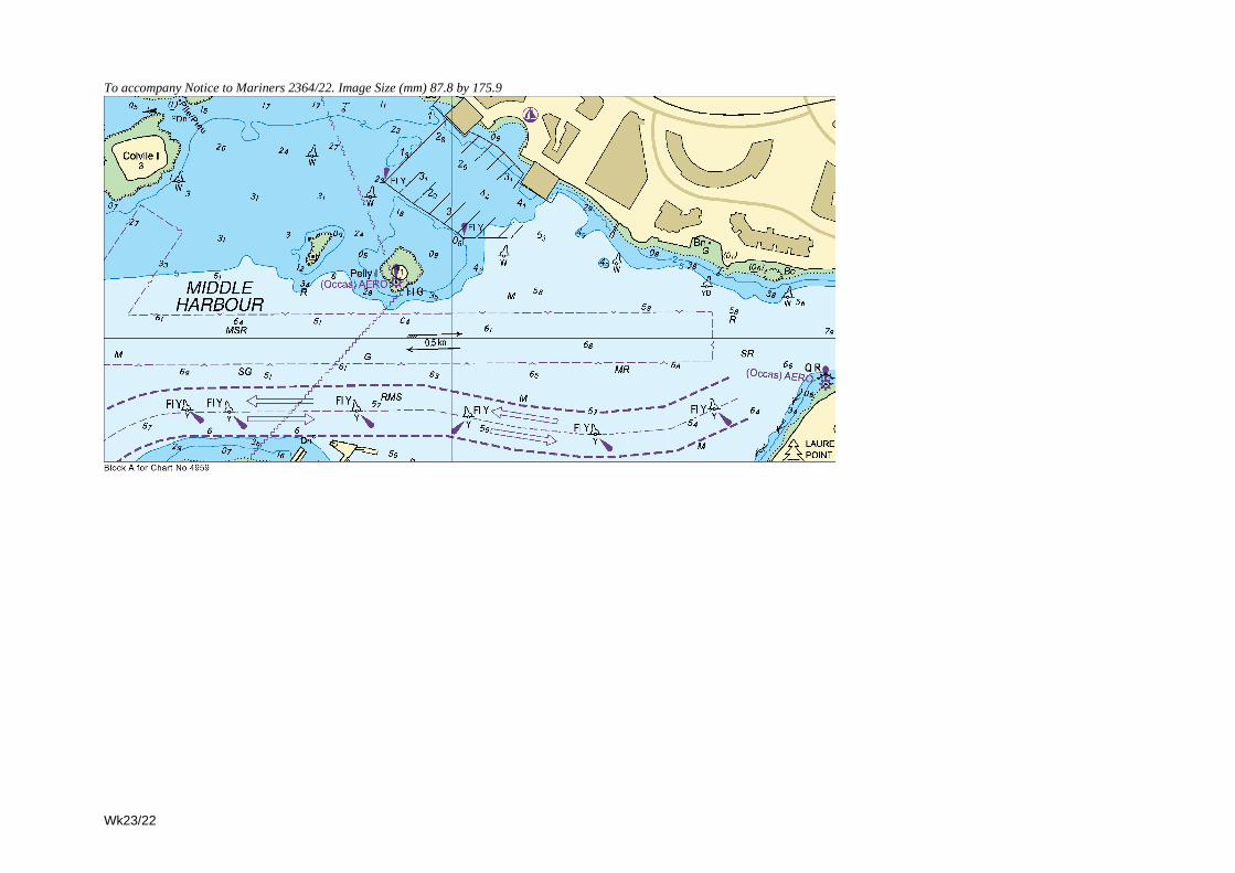
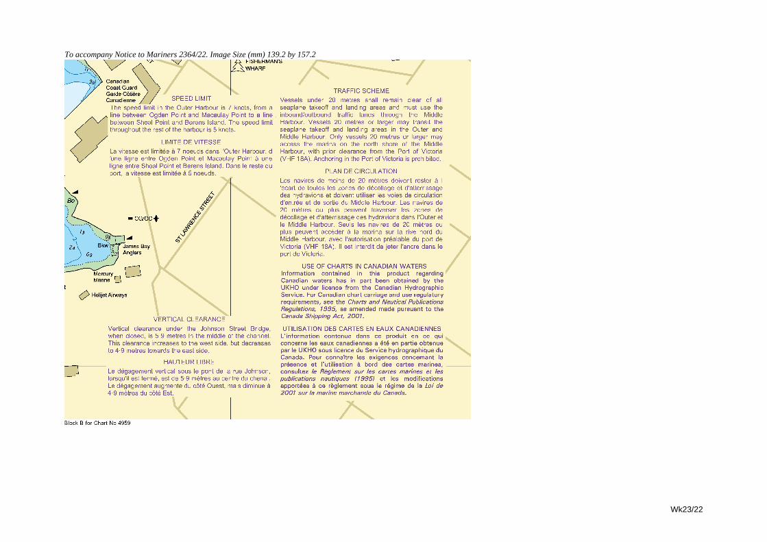
2364 CANADA - British Columbia - NM Blocks. Legends. Slipway. Pier.Source: Canadian Notice 3/3412/22
Chart 4959 [ previous update 1780/22 ] NAD83 DATUM
Insert the accompanying block A, centred on: 48° 25´ 32"N., 123° 22´ 59"W.the accompanying block B, centred on: 48° 25´ 08"N., 123° 22´ 57"W.legend, See/Voir Note VERTICAL CLEARANCE HAUTEUR LIBRE, centred on: 48° 25´ 38·1"N., 123° 22´ 19·4"W.
Amend legend to, See/Voir Note TRAFFIC SCHEME PLAN DE CIRCULATION, centred on: 48° 25´ 03·7"N., 123° 23´ 40·7"W.
Delete slipway, double firm line, and associated symbol, joining: 48° 25´ 34·8"N., 123° 23´ 44·1"W.48° 25´ 34·5"N., 123° 23´ 44·7"W.
pier, double firm line, joining: 48° 26´ 01·4"N., 123° 22´ 06·8"W.48° 26´ 01·6"N., 123° 22´ 07·6"W.and48° 26´ 01·7"N., 123° 22´ 07·4"W.48° 26´ 01·3"N., 123° 22´ 07·6"W.
2380 UNITED STATES OF AMERICA - West Coast - Buoy.Source: US Coast Guard District 11 LNM 13/18721/22
Chart 4911 [ previous update 1997/22 ] NAD83 DATUM
Insert GfFl.Y.4s ’Harvest 22’34° 27´·52N., 120° 41´·17W.
Chart 4912 [ previous update 2627/21 ] NAD83 DATUM
Insert GfFl.Y.4s ’Harvest 22’34° 27´·52N., 120° 41´·17W.
2397 UNITED STATES OF AMERICA - West Coast - Buoy.Source: US Coast Guard District 13 LNM 13/18430/22
Chart 80 [ previous update 1732/22 ] NAD83 DATUM
Move GdQ.R Bell ’16’, from:48° 38´·47N., 122° 42´·88W.
to: 48° 38´·49N., 122° 42´·76W.
Chart 4951 [ previous update 4978/21 ] NAD83 DATUM
Move GjQ R 16 BELL, from:48° 38´·44N., 122° 42´·88W.
to: 48° 38´·49N., 122° 42´·76W.
2422 UNITED STATES OF AMERICA - West Coast - Wreck.Source: US Coast Guard District 11 LNM 17/18773/22
Chart 897 [ previous update 2218/22 ] NAD83 DATUM
Insert ´Rep(2022) PA32° 40´·68N., 117° 11´·58W.
2.21Wk23/22
II
2423 UNITED STATES OF AMERICA - West Coast - Buoy. Light.Source: US Coast Guard District 13 LNM 17/18525/22 and LNM 17/18526/22
Chart 2849 (Panel B) [ previous update 2209/22 ] NAD83 DATUM
Insert symbol, orange and white can buoy 45° 31´·50N., 122° 40´·02W.
Chart 2849 (Panel A) [ previous update 2209/22 ] NAD83 DATUM
Insert ¶ Fl.Y.4s ’A’45° 43´·91N., 122° 45´·53W.
2341 BRAZIL - East Coast - Depths. Rock.Source: Brazilian Notice 6/E 57(P)/22
Chart 540 [ previous update 1773/22 ] WGS84 DATUM
Insert depth, 143 , and extend 20m contour W to enclose (a) 12° 56´·60S., 38° 35´·29W.Delete depth, 21, close S of: (a) aboveInsert depth, 17 , enclosed by 2m contour (b) 12° 56´·89S., 38° 35´·68W.Delete 4Ó+ with seabed type, R, close S of:
(b) above
Chart 545 (Panel C, Porto de Salvador) [ previous update 1773/22 ] WGS84 DATUM
Insert depth, 174 , and extend 20m contour NW to enclose (a) 12° 56´·12S., 38° 31´·27W.Delete depth, 18, close SE of: (a) aboveInsert depth, 121 (b) 12° 56´·71S., 38° 35´·06W.Delete depth, 15, close SE of: (b) above
2348 BRAZIL - South Coast - Maritime limits. Legend.Source: Brazilian Notice 5/S 48/22
Chart 530 [ previous update 567/22 ] WGS84 DATUM
Insert maritime limit, pecked line, joining: (a) 25° 44´·9S., 47° 10´·7W.25° 53´·5S., 47° 18´·3W.26° 12´·3S., 46° 28´·5W.
(b) 25° 56´·1S., 46° 06´·8W.Delete former maritime limit, pecked line, joining: (a) above
25° 54´·0S., 47° 00´·0W.25° 28´·0S., 46° 38´·9W.25° 21´·0S., 46° 26´·0W.(b) above
2.22Wk23/22
II
Chart 3980 [ previous update 5061/21 ] WGS84 DATUM
Insert maritime limit, pecked line, joining: (a) 25° 01´·2S., 46° 20´·9W.25° 01´·7S., 46° 15´·6W.24° 56´·0S., 45° 52´·6W.25° 10´·0S., 45° 40´·3W.25° 20´·0S., 45° 29´·4W.
Delete former maritime limit, pecked line, joining: (a) above25° 01´·9S., 46° 14´·6W.24° 56´·3S., 45° 52´·5W.25° 20´·0S., 45° 31´·7W.
Chart 3981 [ previous update 1563/22 ] WGS84 DATUM
Insert maritime limit, pecked line, joining: (a) 25° 49´·8S., 47° 15´·0W.(b) 25° 53´·5S., 47° 18´·3W.(c) 25° 54´·7S., 47° 15´·0W.
legend, Cargo Transhipment Area, within: (a)-(c) above
2361 BRAZIL - South Coast - Depths.Source: Brazilian Notice 6/E 58(P)/22
Chart 550 [ previous update 1766/22 ] WGS84 DATUM
Insert depth, 7, enclosed by 10m contour 22° 25´·45S., 41° 47´·35W.
Chart 3971 [ previous update 1766/22 ] WGS84 DATUM
Insert depth, 7, and extend 10m contour SE to enclose (a) 22° 25´·5S., 41° 47´·3W.Delete depth, 138, close NE of: (a) above
2370 BRAZIL - South Coast - Buoy.Source: Brazilian Notice 6/S 59/22
Chart 589 [ previous update 5455/21 ] WGS84 DATUM
Insert GfFl(5)Y.20s ODAS25° 39´·81S., 48° 19´·47W.
2421 UNITED STATES OF AMERICA - Gulf of Mexico - Wreck.Source: US Coast Guard District 8 LNM 17/11391/22
Chart 3148 (Panel, St Andrew Bay) [ previous update 2302/22 ] NAD83 DATUM
Insert ´PA30° 09´·79N., 85° 42´·16W.
2348 BRAZIL - South Coast - Maritime limits. Legend. (continued)
2.23Wk23/22
II
2379 UNITED STATES OF AMERICA - East Coast - Buoy.Source: US Coast Guard District 1 LNM 13/13278/22
Chart 2492 [ previous update 4148/21 ] NAD83 DATUM
Move GfFl.Y.2·5s (priv), from:42° 55´·1N., 70° 03´·9W.
to: 42° 53´·4N., 70° 03´·6W.
Chart 2670 [ previous update 1522/22 ] WGS84 DATUM
Move GfFl.Y.2·5s, from:42° 55´·1N., 70° 03´·9W.
to: 42° 53´·4N., 70° 03´·6W.
2389 CANADA - Gulf of Saint Lawrence - NM Block. Depths.Source: Canadian Notice 3/4426/22
Chart 4769 [ previous update New Edition 10/02/2022 ] NAD83 DATUM
Insert the accompanying block, centred on: 48° 01´·5N., 66° 38´·4W.depth, 13 (a) 48° 02´·46N., 66° 35´·33W.
Delete depth, 21, close NE of: (a) aboveInsert depth, 85 (b) 48° 03´·67N., 66° 30´·62W.Delete depth, 103, close NW of: (b) aboveInsert depth, 04, enclosed by 1fm contour 48° 05´·23N., 66° 26´·56W.
depth, 74 48° 05´·22N., 66° 25´·67W.Replace depth, 5, with depth, 32 48° 02´·63N., 66° 34´·63W.
depth, 33, with depth, 25 48° 02´·82N., 66° 33´·98W.depth, 35, with depth, 24, and extend 3fm contour E to enclose 48° 02´·86N., 66° 33´·84W.depth, 4, with depth, 32 48° 02´·94N., 66° 33´·39W.depth, 22, with depth, 15 48° 03´·02N., 66° 33´·28W.
2420 UNITED STATES OF AMERICA - East Coast - Buoy.Source: US Coast Guard District 1 LNM 17/12366/22
Chart 2580 (Panel, Execution Rocks to Tallman Island) [ previous update 2225/22 ] NAD83 DATUM
Delete GfFl.Y.4s ’A’ 40° 53´·00N., 73° 43´·70W.
Chart 2580 [ previous update 2225/22 ] NAD83 DATUM
Move GfFl.Y.4s ’A’ , from:40° 53´·00N., 73° 43´·71W.
to: 40° 53´·10N., 73° 43´·61W.
2.24Wk23/22
II
2427 UNITED STATES OF AMERICA - East Coast - Buoy.Source: US Coast Guard District 1 LNM 17/12333/22
Chart 3457 [ previous update 2184/22 ] NAD83 DATUM
Move GdFl.R.2.5s ’2’ from:40° 38´·662N., 74° 08´·857W.
to: 40° 38´·658N., 74° 08´·882W.
Chart 3457 (Panel A, Continuation of Kill Van Kull) [ previous update 2184/22 ] NAD83 DATUM
Move GdFl.R.2.5s ’2’ from:40° 38´·662N., 74° 08´·863W.
to: 40° 38´·658N., 74° 08´·882W.
2428 UNITED STATES OF AMERICA - East Coast - Buoy.Source: US Coast Guard District 1 LNM 14/13223/22
Chart 2730 [ previous update 275/22 ] NAD83 DATUM
Move Dd’16’, from: 41° 36´·77N., 71° 24´·03W.
to: 41° 36´·68N., 71° 23´·94W.
Chart 2731 [ previous update 276/22 ] NAD83 DATUM
Delete Dd’16’41° 36´·77N., 71° 24´·02W.
2.25Wk23/22
II
2352(T)/22 WALES - North Coast - Wrecks. Buoy.
Source: Holyhead Port Authority1. Two dangerous wrecks exist in the vicinity of position 53° 19´·396N., 4° 38´·533W.2. *These wrecks are marked by an isolated danger light-buoy, Fl(2)10s.3. Mariners are advised to navigate with caution in the area.4. Former Notice 1667(T)/20 is cancelled.
(ETRS89 DATUM)* Indicates new or revised entry
Charts affected - 1413 - 2011 - 5609_12
2353(T)/22 SCOTLAND - West Coast - Measuring instruments.
Source: Marine Scotland Science and Whale and Dolphin Conservation 1. An acoustic measuring instrument, has been established on the seabed in position 58° 06´·73N., 6° 21´·36W.2. * Acoustic monitoring instruments attached to subsurface moorings, and marked by unlit pink buoys, have been
established in the following positions:
3. Mariners are advised to navigate with caution in the area. 4. *Former Notice 1254(T)/22 is cancelled.
*Indicates new or revised entry.(ETRS89 DATUM)
Charts affected - 1757 (INT 1630) - 1785 - 1794 (INT 1625) - 2529
2354(T)/22 ENGLAND - South East Coast - Beacon.
Source: Port of Ramsgate 1. The unlit beacon in position 51° 21´·501N., 1° 26´·798E. is reported missing.2. Mariners are advised to navigate with caution in the area.
(ETRS89 DATUM)
Charts affected - 323 (INT 1564) - 1607 (INT 1562) - 1827 - 1828 (INT 1563) - 5606_4
2356(T)/22 ENGLAND - South Coast - Buoy. Automatic Identification System.
Source: RWE Renewables UK Ltd1. The yellow special light-buoy, Fl.Y.5s AIS Rampion South, in position 50° 38´·55N., 0° 16´·95W. is reported off station.2. Mariners are advised to navigate with caution in the area.
(ETRS89 DATUM)
Charts affected - 1652 - 2450 (INT 1703)
58° 11´·06N., 6° 15´·90W.58° 11´·89N., 6° 11´·56W.58° 15´·85N., 6° 08´·94W.
2.26Wk23/22
II
2360(T)/22 SCOTLAND - West Coast - Pier. Works.
Source: Caledonian Maritime Assets Notice 23/22 1. Pier demolition works are taking place, in the vicinity of position 55° 34´·63N., 5° 08´·33W.2. Mariners are advised to navigate with caution in the area.
(ETRS89 DATUM)
Charts affected - 1864 - 2220
2372(T)/22 WALES - South Coast - Buoyage. Wrecks.
Source: Port of Milford Haven 1. Orange special purpose buoys have been deployed until October to reduce damage to existing wrecks.2. These buoys are marked with the wreck name and ’No Mooring’ and located in the following positions:
3. Mariners are advised to navigate with caution in the area.(ETRS89 DATUM)
Charts affected - 2878 - 3273 (INT 1649) - 3274 (INT 1650) - 5620_11 - 5620_12
2351(T)/22 LITHUANIA - Quay. Works.
Source: Lithuanian Notice 2/15(T)/221. Quay re-construction works are taking place at Klaipeda quays 66A – 67A in the vicinity of position
55° 41´·803N., 21° 07´·780E.2. Mariners are advised to navigate with caution in the area.
(WGS84 DATUM)
Chart affected - 2276
2413(T)/22 NORTH SEA - United Kingdom Sector - Buoy. Automatic Identification System. Scientific instrument.
Source: TotalEnergies1. A yellow light-buoy, Fl(5)Y.20s, with Automatic Identification System, AIS, has been deployed in position
53° 35´·23N., 1° 16´·95E.2. A scientific instrument has been established on the seabed in position 53° 37´·47N., 1° 24´·90E. The instrument extends
approximately 1·1m from the seabed.3. Mariners are advised to navigate with caution in the area.
(ETRS89 DATUM)
Charts affected - 1187 - 1408 - 1503 (INT 1509)
51° 42´·480N., 5° 06´·890W.51° 42´·210N., 5° 08´·300W.51° 41´·680N., 5° 08´·720W.
2.27Wk23/22
II
2383(P)/22 FRANCE - West Coast - Pilotage.
Source: French Notice 10/65/221. A compulsory pilotage limit has been established joining the approximate following positions:
2. Pilotage is mandatory for vessels over 60m in overall length for Bayonne and Hendaye harbours, and over 40m for Saint-Jean-de-Luz harbour.
3. Mariners are advised to navigate with caution in the area.4. These and other changes will be included in a New Edition of Chart 1292 to be published mid 2022.
(WGS84 DATUM)
Chart affected - 1292 (INT 1805)
2431(T)/22 FRANCE - North Coast - Wreck. Buoy. Automatic Identification System.Restricted area.
Source: French Notice 10/4(T)/221. A dangerous wreck, marked by a light-buoy and a virtual AIS, exists in position 49° 36´·47N., 0° 10´·32W.2. A restricted area, entry prohibited, radius 300m, has been established centred on the wreck.3. Mariners are advised to navigate with caution in the area.
(WGS84 DATUM)
Charts affected - 2146 (INT 1750) - 2613 (INT 1705) - 2656 - 2675 (INT 1070)
2343(P)/22 ITALY - East Coast - Dredged area.
Source: ENC IT5002181. *Extensive changes to charted detail have taken place within and in the approaches to the port of Ravenna, including
numerous changes to coastline, depths and buoyage.2. *A dredged area, depth 11·1m (2021), has been established in the approaches to the port, bounded by the following
positions:
43° 22´·61N., 1° 46´·21W.43° 26´·13N., 1° 46´·23W.43° 26´·28N., 1° 44´·75W.43° 26´·76N., 1° 42´·08W.43° 28´·20N., 1° 39´·31W.43° 30´·45N., 1° 38´·09W.43° 33´·69N., 1° 35´·34W.43° 34´·42N., 1° 34´·15W.43° 39´·30N., 1° 31´·07W.43° 41´·58N., 1° 30´·77W.43° 45´·06N., 1° 30´·01W.43° 49´·99N., 1° 28´·40W.43° 50´·00N., 1° 24´·02W.
44° 29´·740N., 12° 18´·862E.44° 29´·769N., 12° 19´·131E.44° 29´·824N., 12° 19´·495E.44° 29´·881N., 12° 19´·480E.44° 29´·814N., 12° 18´·846E.
2.28Wk23/22
II
3. *A dredged area, depth 8·4m (2021), has been established in the approaches to the Cruise Pier, bounded by the following positions:
*Buoyage has been relocated accordingly to mark the dredged area.4. *A dredged channel, depth 10·1m (2021), has been established along an approximate centre-line joining the following
positions:
5. *A dredged channel, depth 9·2m (2021), has been established along an approximate centre-line joining the following positions:
6. *For the latest depth information in the approaches to berths and quays outside of the dredged channels, contact Ravenna port authority.
7. *Mariners are advised to navigate with caution in the area.8. *These and other changes will be included in the next New Edition of Chart 1445.9. *Former Notice 4366(P)/19 is cancelled.
* indicates new or revised entry.(WGS84 Datum)
Chart affected - 1445
2344(T)/22 UKRAINE - Spoil ground. Virtual aid to navigation.
Source: Ukrainian Notice 5/63(T)/221. A dumping ground, radius 1000m, has been established, centred on position 46° 28´·11N., 31° 21´·88E.2. A virtual aid to navigation (V-AIS), X-Shape topmark, has been established marking the dumping ground.3. Mariners are advised to navigate with caution in the area.
(WGS84 DATUM)
Charts affected - 2200 - 2205 - 2212
2343(P)/22 ITALY - East Coast - Dredged area. (continued)
44° 29´·741N., 12° 17´·131E.44° 29´·632N., 12° 17´·150E.44° 29´·640N., 12° 17´·411E.44° 29´·602N., 12° 17´·434E.44° 29´·667N., 12° 17´·967E.44° 29´·770N., 12° 17´·673E.
44° 28´·001N., 12° 15´·263E.44° 28´·417N., 12° 15´·512E.44° 29´·397N., 12° 16´·499E.44° 29´·476N., 12° 16´·639E.44° 29´·630N., 12° 17´·823E.44° 29´·740N., 12° 18´·863E.
44° 26´·298N., 12° 14´·608E.44° 26´·309N., 12° 14´·642E.44° 26´·441N., 12° 14´·601E.44° 26´·611N., 12° 14´·644E.44° 26´·755N., 12° 14´·649E.44° 27´·026N., 12° 14´·759E.44° 27´·073N., 12° 14´·788E.44° 27´·644N., 12° 15´·069E.44° 27´·696N., 12° 15´·080E.44° 27´·860N., 12° 15´·171E.44° 28´·001N., 12° 15´·263E.
2.29Wk23/22
II
2416(T)/22 GABON - Obstruction.
Source: French Notice 12/18(T)/221. An obstruction, depth unknown, exists in position 0° 43´·64S., 8° 47´·84E.2. Mariners are advised to navigate with caution in the area.
(WGS84 DATUM)
Chart affected - 1322
2426(T)/22 KUWAIT - Buoy.
Source: MENAS Navigational warning 136/221. A South cardinal buoy, VQ(6)+LFl.10s, has been deployed, until further notice, in position 29° 19´·65N., 48° 25´·48E.2. Mariners are advised to navigate with caution in the area.
(WGS84 DATUM)
Charts affected - 2882 (INT 7264) - 2884 (INT 7278) - 3773
2373(T)/22 BANGLADESH - Wreck.
Source: UKHO1. A dangerous wreck exists in position 22° 07´·98N., 91° 30´·16E. . 2. Mariners are advised to navigate with caution in the area. 3. Former Notice 4122(T)/21 is cancelled4. NOTE: Content of Notice unchanged, re-issued to include Chart 1016.
(WGS84 DATUM)
Charts affected - 90 - 1016 (INT 7428)
2346(T)/22 MALAYSIA - Peninsular Malaysia, West Coast - Buoy.
Source: Marine Department, Malaysia Notice 45(T)/221. The isolated danger light-buoy, Fl(2)10s, in position 2° 19´·42N., 101° 57´·63E. is unlit.2. Mariners are advised to navigate with caution in the area.
(WGS84 DATUM)
Charts affected - 1146 - 3946
2362(P)/22 SOUTH CHINA SEA - Light.
Source: Indonesian Notice 11/124/221. A light, Fl.5s12M, has been established in position 1° 35´·1S., 108° 47´·8E.2. This change will be included in a New Edition of Chart 1312 to be published mid 2022. 3. Charts 2470, 2872 and 3758 will be updated by Notice to Mariners.
(WGS84 DATUM)
Chart affected - 1312
2.30Wk23/22
II
2375(T)/22 MALAYSIA - Peninsular Malaysia, East Coast - Light-beacon. Buoy.
Source: Malaysian Notice 7/136(T)/21 1. The Neville Rock light-beacon, Fl(2)R.5s15m10M in position 1° 26´·66N., 104° 02´·64E. has been destroyed.2. A red lateral light-buoy, FI(2)R.5s has been established in position 1° 26´·67N., 104° 02´·75E.3. Former Notice 4679(T)/21 is cancelled.
(WGS84 DATUM)
Charts affected - 4043 - 4044
2376(T)/22 MALAYSIA - Peninsular Malaysia, East Coast - Buoy.
Source: Marine Department, Malaysia Notice 219(T)/211. The special light-buoy, Fl.Y.5s, in position 3° 47´·45N., 103° 21´·18E. has been reported destroyed.2. Mariners are advised to navigate with caution in the area.
(WGS84 DATUM)
Chart affected - 1379
2414(T)/22 CHINA - South Coast - Works.
Source: Hong Kong Notice 18/70(T)/211. Harbour and breakwater construction works are taking place in an area bounded by the following positions:
2. Mariners are advised to navigate with caution in the area.(WGS84 DATUM)
Chart affected - 4117
22° 17´·253N., 114° 14´·273E.22° 17´·230N., 114° 14´·256E.22° 17´·267N., 114° 14´·195E.22° 17´·284N., 114° 14´·208E.
2.31Wk23/22
II
2347(P)/22 INDONESIA - Kalimantan - Routeing measures. Recommended tracks. Channels. Precautionary areas. Anchorage areas. Depth.
Source: Indonesian Notice 11/128/22 and ENC ID3001221. New routeing measures have been established within Selat Laut.2. Two-way recommended tracks and channels have been established to the Port of Samudera Batulicin, Port of Kotubaru and
in Laut Strait, joining the following positions:
3. Precautionary areas have been established centred on the following positions:
4. Anchorage areas have been established in the northern approaches to Selat Laut, bounded by the following positions:
3° 26´·37S., 116° 00´·80E.3° 28´·68S., 116° 01´·35E.3° 31´·00S., 116° 01´·36E.3° 40´·73S., 115° 57´·50E.and3° 12´·39S., 116° 19´·97E.3° 12´·67S., 116° 18´·77E.3° 11´·62S., 116° 16´·58E.3° 11´·84S., 116° 15´·15E.3° 16´·82S., 116° 09´·08E.3° 17´·51S., 116° 06´·77E.3° 20´·00S., 116° 05´·91E.3° 25´·72S., 116° 02´·76E.3° 26´·20S., 116° 02´·89E.3° 26´·49S., 116° 02´·68E.3° 26´·72S., 116° 02´·67E.3° 28´·37S., 116° 01´·28E.
3° 17´·03S., 116° 08´·57E.3° 16´·88S., 116° 09´·08E.3° 16´·78S., 116° 09´·05E.3° 16´·92S., 116° 08´·54E.and
3° 26´·96S., 116° 00´·88E.3° 27´·49S., 116° 01´·00E.3° 27´·46S., 116° 01´·12E.3° 26´·93S., 116° 00´·99E.and
3° 27´·92S., 116° 01´·59E.3° 28´·25S., 116° 01´·31E.3° 28´·32S., 116° 01´·39E.3° 27´·99S., 116° 01´·67E.
STS A3° 10´·80S., 116° 25´·06E.3° 09´·63S., 116° 24´·79E.3° 10´·23S., 116° 22´·16E.3° 11´·40S., 116° 22´·43E.
STS B3° 12´·00S., 116° 22´·58E.3° 13´·18S., 116° 22´·84E.3° 12´·57S., 116° 25´·48E.3° 11´·40S., 116° 25´·21E.
2.32Wk23/22
II
5. Anchorage areas within Selat Laut have been established centred on the following positions:
6. A depth of 2m exists in position 3° 14´·11S., 116° 13´·29E.7. These changes will be included in the next New Edition of Chart 3015 to be published mid 2022. 8. Charts 2795, 2892 and 3017 will be updated by Notice to Mariners.
(WGS84 DATUM)
Chart affected - 3015
2418(P)/22 AUSTRALIA - Tasmania - Depths.
Source: Australian Notice 10/410(P)/221. Latest survey indicates shoaler depths than those charted may exist in an area bounded by the high water line and the
following positions:
2. Mariners are advised to navigate with caution in the area.3. Electronic Navigation Charts (ENCs) have been updated, Paper Charts will be updated in due course.
(WGS84 DATUM)
Charts affected - Aus 163 - Aus 167 - Aus 487 - Aus 790 - Aus 798 - Aus 799
2419(P)/22 AUSTRALIA - Queensland - Depths.
Source: Australian Notice 10/388(P)/221. Latest survey indicates shoaler depths than those charted may exist in the Burnett River between Long Reach and Millaquin
Reach. The most significant shoals are as follows:
2. Mariners are advised to navigate with caution in the area.3. Charts will be updated in due course.
(WGS84 DATUM)
Chart affected - Aus 242
2347(P)/22 INDONESIA - Kalimantan - Routeing measures. Recommended tracks. Channels. Precautionary areas. Anchorage areas. Depth. (continued)
Designation Position Alfa I fuel oil tankers 3° 12´·63S., 116° 13´·75E.Bravo I cargo 3° 13´·41S., 116° 12´·87E.Alfa II CPO tankers 3° 15´·59S., 116° 10´·28E.Bravo II cargo 3° 16´·17S., 116° 09´·57E.Bravo III cargo 3° 25´·70S., 116° 00´·92E.
40° 39´·89S., 147° 58´·89E.40° 56´·62S., 146° 55´·07E.41° 01´·97S., 146° 42´·97E.41° 06´·47S., 146° 28´·51E.41° 04´·76S., 146° 11´·06E.40° 56´·19S., 145° 49´·10E.40° 45´·45S., 145° 20´·92E.40° 42´·39S., 145° 05´·11E.
Position Depth24° 49´·11S., 152° 22´·08E. -0·1m24° 49´·94S., 152° 22´·31E. 0·8m
2.33Wk23/22
To accompany Notice to Mariners 2406/2022
On Chart 4218
CHART 4217: POSITIONSTo agree with the larger scale chart 4217which is referred to SIRGAS Datum, positionsread from chart 4218 must be adjusted by 0·22minutes SOUTHWARD and 0·11 minutesWESTWARD.
To accompany Notice to Mariners 2406/2022
On Chart 4218
CHART 3076: POSITIONSTo agree with the larger scale chart 3076 (PlanA) which is referred to WGS84 Datum,positions read from chart 4218 must beadjusted by 0·22 minutes SOUTHWARD and0·11 minutes WESTWARD.
Wk23/22
To accompany Notice to Mariners 2364/22. Image Size (mm) 87.8 by 175.9
Wk23/22
Wk23/22
To accompany Notice to Mariners 2364/22. Image Size (mm) 139.2 by 157.2
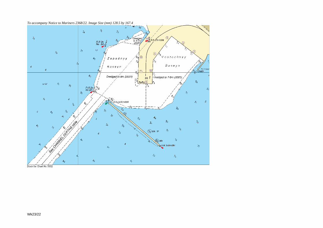
To accompany Notice to Mariners 2368/22. Image Size (mm) 128.5 by 167.4
Wk23/22
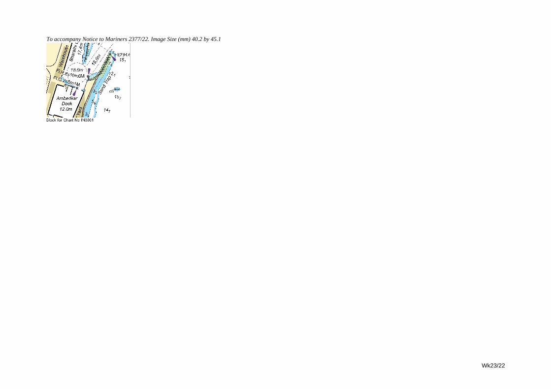
Wk23/22
To accompany Notice to Mariners 2377/22. Image Size (mm) 40.2 by 45.1
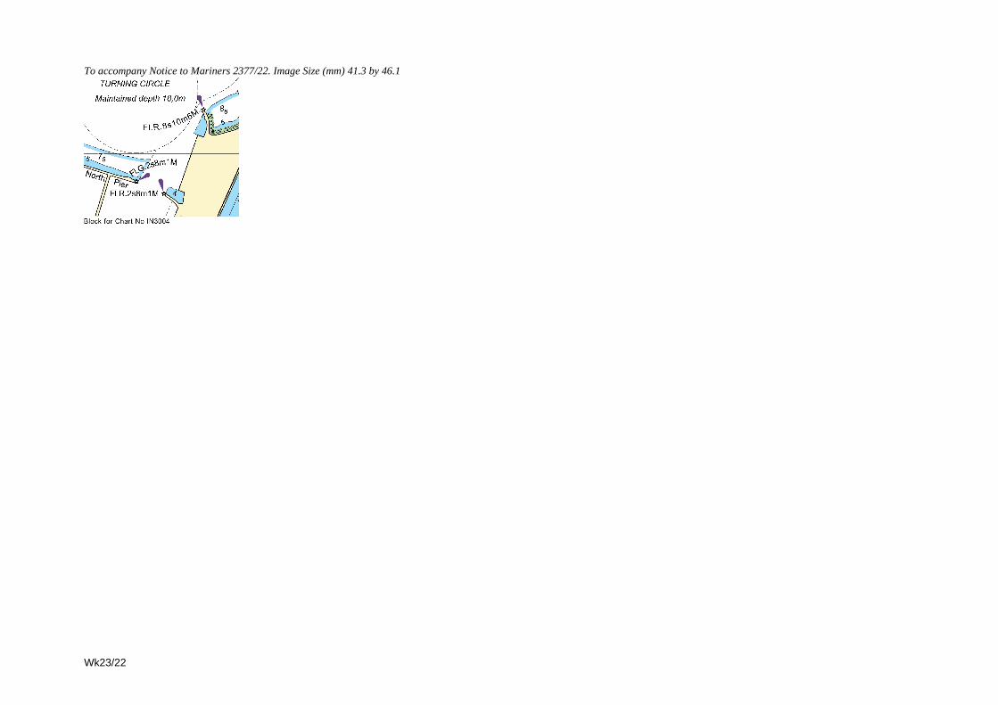
To accompany Notice to Mariners 2377/22. Image Size (mm) 41.3 by 46.1
Wk23/22
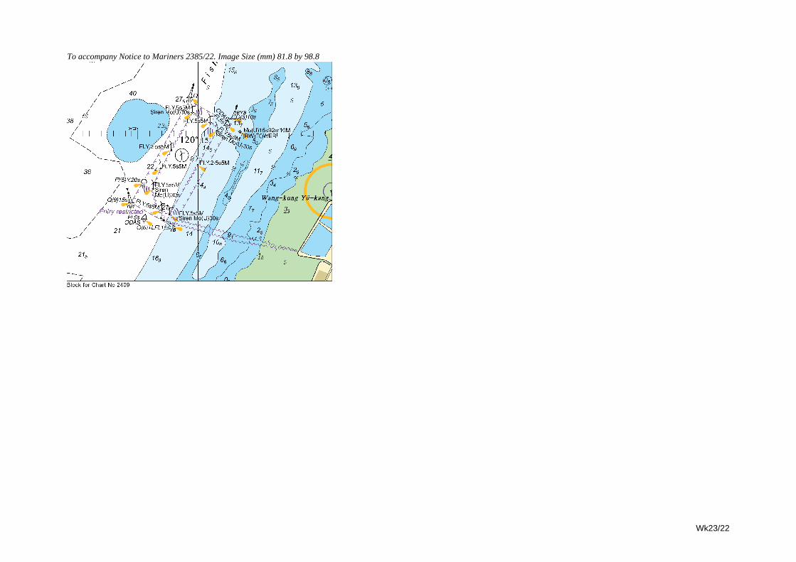
Wk23/22
To accompany Notice to Mariners 2385/22. Image Size (mm) 81.8 by 98.8
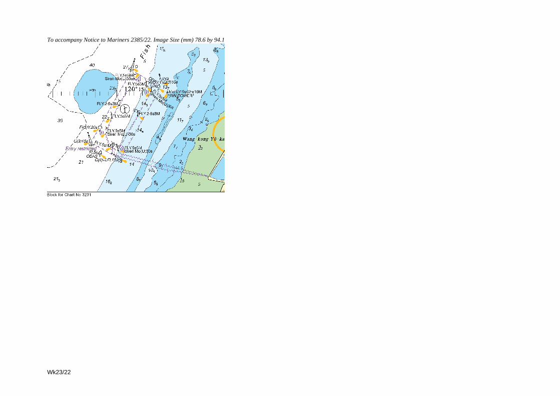
To accompany Notice to Mariners 2385/22. Image Size (mm) 78.6 by 94.1
Wk23/22
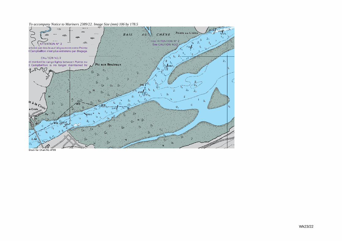
Wk23/22
To accompany Notice to Mariners 2389/22. Image Size (mm) 106 by 178.5
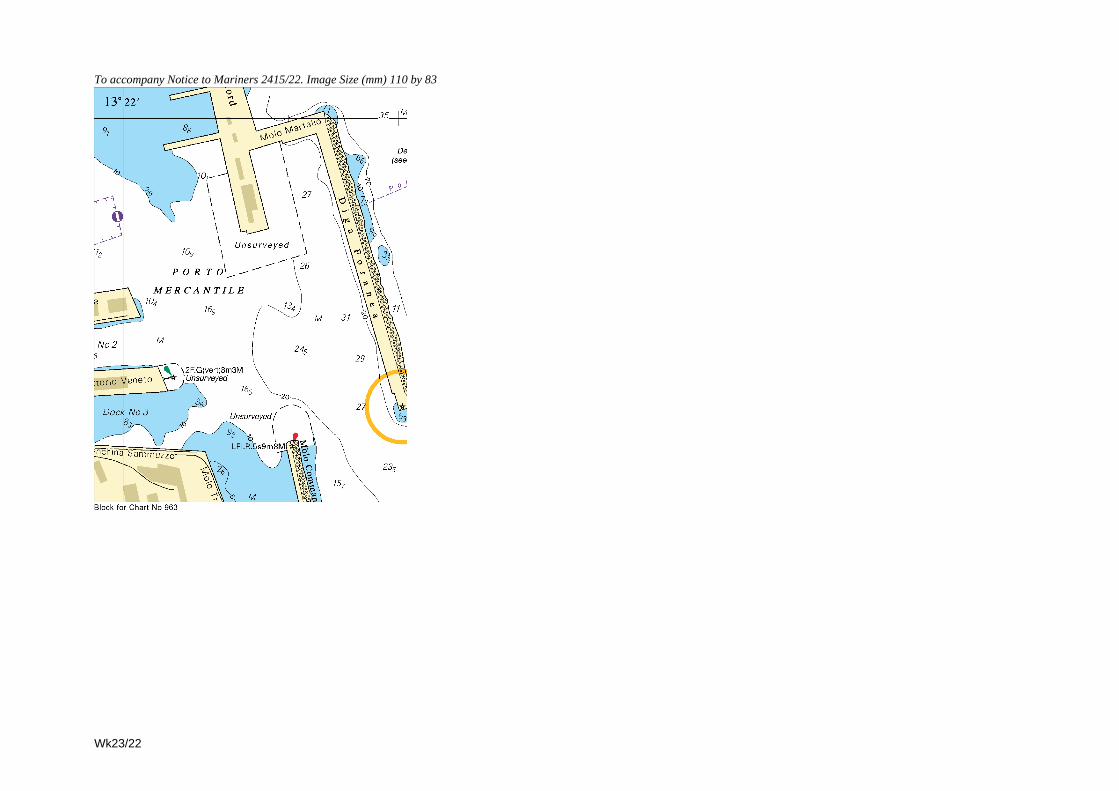
To accompany Notice to Mariners 2415/22. Image Size (mm) 110 by 83
Wk23/22
III
3.1
NAVIGATIONAL WARNINGS
See The Mariner’s Handbook (2020 Edition). Only the most convenient ADMIRALTY Chart is quoted. All warnings issued
within the previous 42 days are broadcast via Enhanced Group Call (EGC) and/or NAVTEX.
The complete texts of all in-force NAVAREA I warnings, including those which are no longer being broadcast, are
available from www.admiralty.co.uk/RNW. Additionally, a quarterly cumulative list of the complete text of all in-force
NAVAREA I Warnings is included in Section III of the Weekly NM Bulletin in Weeks 1, 13, 26 and 39 each year.
Alternatively, these may be requested by e-mail from NAVAREA I Co-ordinator at: [email protected]
The RNW web page also contains a link to the IHO website which allows direct access to all the other NAVAREA Co-
ordinators around the world who have made their NAVAREA warnings available on the web.
----------------------------------------------------------------------------------------------------------------------------------------------------------
Weekly Edition 23 published on the UKHO website 30 May 22.
----------------------------------------------------------------------------------------------------------------------------------------------------------
Navarea I (NE Atlantic) Weekly Edition 23
The following NAVAREA I warnings were in force at 300500 UTC May 22.
2021 series: 031.
2022 series: 043, 050, 059, 065, 067, 068, 069, 070, 071.
Summary of Navarea I warnings issued since Weekly Edition 22:
067 NORTH SEA. Dogger Bank. Chart GB 266.
Cardinal and special light buoys established marking the perimeter of the future Dogger Bank A Offshore Wind Farm
within area bounded by 54-50.5N 001-37.1E, 54-50.6N 002-10.3E, 54-48.8N 002-14.7E, 54-39.2N 001-58.7E and
54-44.2N 001-37.6E.
068 SCOTLAND, EAST COAST. Moray Firth. Chart GB 115 (INT 1503).
Buoys marking perimeter of Moray East Offshore Wind Farm, 58-12N 002-42W, permanently discontinued.
069 1. Navarea I warnings in force at 271000 UTC May 22. 2. Cancel 064/22.
070 NORTH SEA. Snorre and Visund Oil Fields. Chart 1427 (INT 1401).
1. Seismic survey in progress by M/V Ramform Vanguard, towing 12 x 5000 metre long cables with ends marked by
V-AIS and yellow buoys, within area bounded by: 61-38.6N 002-19.8E, 61-20.4N 003-02.5E, 61-09.1N 002-41.3E
and 61-27.1N 001-58.8E. Berth of 6 miles astern and 3 miles ahead and abeam requested. Guard vessels M/V Rig
Andromeda and M/V Sanco Sea in attendance.
2. Cancel Navarea I 050/22.
071 1. RIGLIST. Correct at 300500 UTC May 22.
Southern North Sea: 51N to 55N
52-07.6N 003-56.2E Valaris 123 ACP P18-A
52-15.4N 004-05.2E Seafox 7 ACP HZB
53-00.0N 001-50.8E Valaris 72 ACP Hewett Gas Field
53-11.0N 002-05.9E Noble Hans Deul ACP Southwark
53-14.0N 003-14.5E 590021
53-21.8N 002-34.0E Haeva ACP Indefatigable Gas Field
53-24.3N 004-37.0E Maersk Resolute
53-29.5N 005-56.6E Seafox 4 ACP AWG 1
53-33.1N 003-46.9E Seajacks Leviathan ACP K9ab-B
53-34.9N 004-36.2E Swift 10 ACP L8-G
53-39.1N 002-03.4E Valaris 92 ACP Tethys Gas Field
53-43.1N 001-07.0E Erda ACP 48/6-B
53-56.4N 002-44.8E Maersk Resolve ACP Chiswick Gas Field
53-56.9N 003-39.8E Prospector 1 ACP K2b-A
54-03.6N 002-04.7E Valaris Gorilla V ACP Schooner Gas Field
54-07.6N 001-24.3E Valaris Norway
54-55.9N 004-51.7E Prospector 5
North Sea: 55N to 60N, East of 5W
NEW 55-32.3N 005-01.8E Noble Sam Turner ACP Halfdan Oil Field
55-43.1N 004-48.0E Haven ACP Tyra Gas Field
56-10.8N 003-28.0E Maersk Integrator ACP Hod Oil Field
56-22.6N 003-15.8E West Linus ACP Eldfisk Oil Field
56-23.4N 002-15.2E Stena Spey
NEW Grenaa, Denmark Maersk Invincible
NEW Navarea XIV Valaris 249
Wk23/22
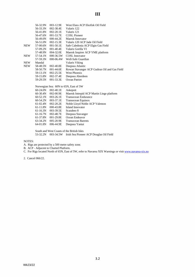
III
3.2
56-32.9N 003-12.9E West Elara ACP Ekofisk Oil Field
56-33.3N 002-38.4E Valaris 122
56-41.8N 002-20.1E Valaris 121
56-47.6N 001-53.7E COSL Pioneer
56-49.0N 000-44.2E Maersk Innovator
56-51.0N 002-15.3E Valaris 120 ACP Jade Oil Field
NEW 57-00.6N 001-50.1E Safe Caledonia ACP Elgin Gas Field
57-09.2N 001-40.4E Valaris Gorilla VI
57-48.9N 004-32.0E Maersk Inspirer ACP YME platform
NEW 57-54.1N 000-36.5W COSL Innovator
57-59.3N 000-06.4W Well-Safe Guardian
NEW Mandal Valaris Viking
NEW 58-48.5N 002-40.8E Deepsea Atlantic
58-50.7N 001-44.6E Rowan Stavanger ACP Gudrun Oil and Gas Field
59-13.1N 002-25.5E West Phoenix
59-15.8N 002-37.4E Deepsea Aberdeen
59-29.5N 001-33.3E Ocean Patriot
Norwegian Sea: 60N to 65N, East of 5W
60-24.0N 002-40.1E Askepott
60-30.4N 002-00.9E Maersk Intrepid ACP Martin Linge platform
60-52.1N 003-26.1E Transocean Endurance
60-54.2N 003-37.1E Transocean Equinox
61-02.4N 002-20.2E Noble Lloyd Noble ACP Valemon
61-11.8N 000-43.8E Island Innovator
61-16.3N 003-39.5E Scarabeo 8
61-16.7N 002-48.7E Deepsea Stavanger
61-37.8N 001-29.8E Ocean Endeavor
63-34.2N 005-20.9E Transocean Barents
64-01.8N 006-44.9E Deepsea Yantai
South and West Coasts of the British Isles
53-32.2N 003-34.5W Irish Sea Pioneer ACP Douglas Oil Field
NOTES:
A. Rigs are protected by a 500 metre safety zone.
B. ACP - Adjacent to Charted Platform.
C. For Rigs located North of 65N, East of 5W, refer to Navarea XIX Warnings or visit www.navarea-xix.no
2. Cancel 066/22.
Wk23/22
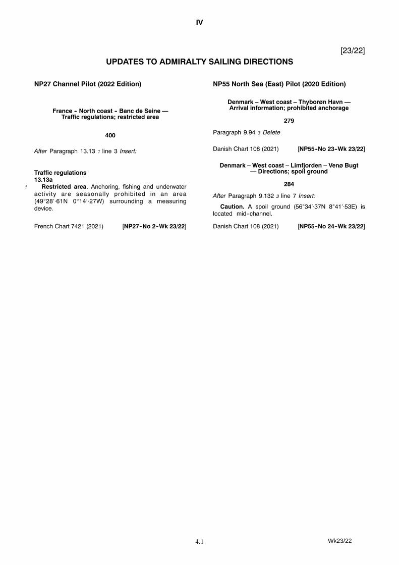
IV
4.1
[23/22]UPDATES TO ADMIRALTY SAILING DIRECTIONS
NP27 Channel Pilot (2022 Edition)
France -- North coast -- Banc de Seine —Traffic regulations; restricted area
400
After Paragraph 13.13 1 line 3 Insert:
Traffic regulations13.13a
1 Restricted area. Anchoring, fishing and underwateractivity are seasonally prohibited in an area(492861N 01427W) surrounding a measuringdevice.
French Chart 7421 (2021) [NP27--No 2--Wk 23/22]
NP55 North Sea (East) Pilot (2020 Edition)
Denmark – West coast – Thyborøn Havn —Arrival information; prohibited anchorage
279
Paragraph 9.94 3 Delete
Danish Chart 108 (2021) [NP55--No 23--Wk 23/22]
Denmark – West coast – Limfjorden – Venø Bugt— Directions; spoil ground
284
After Paragraph 9.132 3 line 7 Insert:
Caution. A spoil ground (563437N 84153E) islocated mid--channel.
Danish Chart 108 (2021) [NP55--No 24--Wk 23/22]
Wk23/22
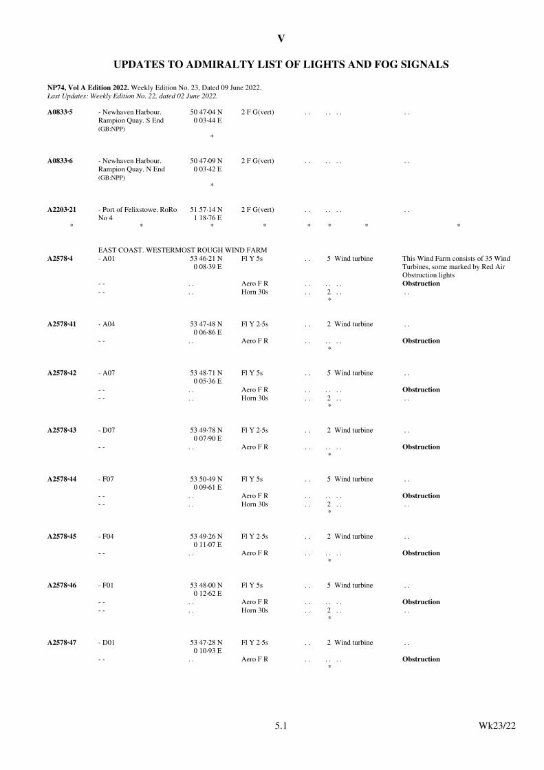
V
UPDATES TO ADMIRALTY LIST OF LIGHTS AND FOG SIGNALS
NP74, Vol A Edition 2022. Weekly Edition No. 23, Dated 09 June 2022.Last Updates: Weekly Edition No. 22, dated 02 June 2022.
A0833·5 - Newhaven Harbour. Rampion Quay. S End(GB:NPP)
50 47·04 N0 03·44 E
2 F G(vert) . . . . . . . .
*
A0833·6 - Newhaven Harbour. Rampion Quay. N End(GB:NPP)
50 47·09 N0 03·42 E
2 F G(vert) . . . . . . . .
*
A2203·21 - Port of Felixstowe. RoRo No 4
51 57·14 N1 18·76 E
2 F G(vert) . . . . . . . .
* * * * * * * *
EAST COAST. WESTERMOST ROUGH WIND FARM
A2578·4 - A01 53 46·21 N0 08·39 E
Fl Y 5s . . 5 Wind turbine This Wind Farm consists of 35 Wind Turbines, some marked by Red Air Obstruction lights
- - . . Aero F R . . . . . . Obstruction
- - . . Horn 30s . . 2 . . . .*
A2578·41 - A04 53 47·48 N0 06·86 E
Fl Y 2·5s . . 2 Wind turbine . .
- - . . Aero F R . . . . . . Obstruction*
A2578·42 - A07 53 48·71 N0 05·36 E
Fl Y 5s . . 5 Wind turbine . .
- - . . Aero F R . . . . . . Obstruction
- - . . Horn 30s . . 2 . . . .*
A2578·43 - D07 53 49·78 N0 07·90 E
Fl Y 2·5s . . 2 Wind turbine . .
- - . . Aero F R . . . . . . Obstruction*
A2578·44 - F07 53 50·49 N0 09·61 E
Fl Y 5s . . 5 Wind turbine . .
- - . . Aero F R . . . . . . Obstruction
- - . . Horn 30s . . 2 . . . .*
A2578·45 - F04 53 49·26 N0 11·07 E
Fl Y 2·5s . . 2 Wind turbine . .
- - . . Aero F R . . . . . . Obstruction*
A2578·46 - F01 53 48·00 N0 12·62 E
Fl Y 5s . . 5 Wind turbine . .
- - . . Aero F R . . . . . . Obstruction
- - . . Horn 30s . . 2 . . . .*
A2578·47 - D01 53 47·28 N0 10·93 E
Fl Y 2·5s . . 2 Wind turbine . .
- - . . Aero F R . . . . . . Obstruction*
Wk23/225.1
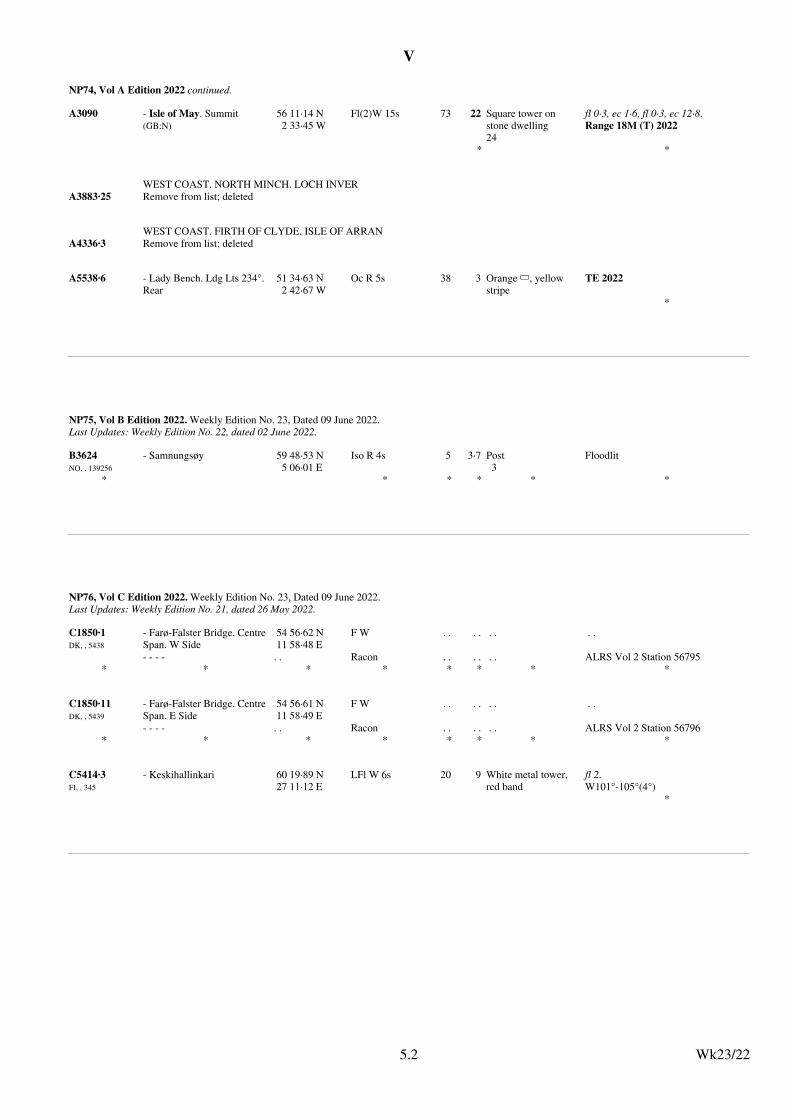
V
NP74, Vol A Edition 2022 continued.
A3090 - Isle of May. Summit(GB:N)
56 11·14 N2 33·45 W
Fl(2)W 15s 73 22 Square tower on stone dwelling24
fl 0·3, ec 1·6, fl 0·3, ec 12·8.Range 18M (T) 2022
* *
WEST COAST. NORTH MINCH. LOCH INVER
A3883·25 Remove from list; deleted
WEST COAST. FIRTH OF CLYDE. ISLE OF ARRAN
A4336·3 Remove from list; deleted
A5538·6 - Lady Bench. Ldg Lts 234°. Rear
51 34·63 N2 42·67 W
Oc R 5s 38 3 Orange 6, yellow stripe
TE 2022
*
Wk23/225.2
NP75, Vol B Edition 2022. Weekly Edition No. 23, Dated 09 June 2022.Last Updates: Weekly Edition No. 22, dated 02 June 2022.
B3624NO, , 139256
- Samnungsøy 59 48·53 N5 06·01 E
Iso R 4s 5 3·7 Post3
Floodlit
* * * * * *
Wk23/225.2
NP76, Vol C Edition 2022. Weekly Edition No. 23, Dated 09 June 2022.Last Updates: Weekly Edition No. 21, dated 26 May 2022.
C1850·1DK, , 5438
- Farø-Falster Bridge. Centre Span. W Side
54 56·62 N11 58·48 E
F W . . . . . . . .
- - - - . . Racon . . . . . . ALRS Vol 2 Station 56795* * * * * * * *
C1850·11DK, , 5439
- Farø-Falster Bridge. Centre Span. E Side
54 56·61 N11 58·49 E
F W . . . . . . . .
- - - - . . Racon . . . . . . ALRS Vol 2 Station 56796* * * * * * * *
C5414·3FI, , 345
- Keskihallinkari 60 19·89 N27 11·12 E
LFl W 6s 20 9 White metal tower, red band
fl 2.W101°-105°(4°)
*
Wk23/225.2
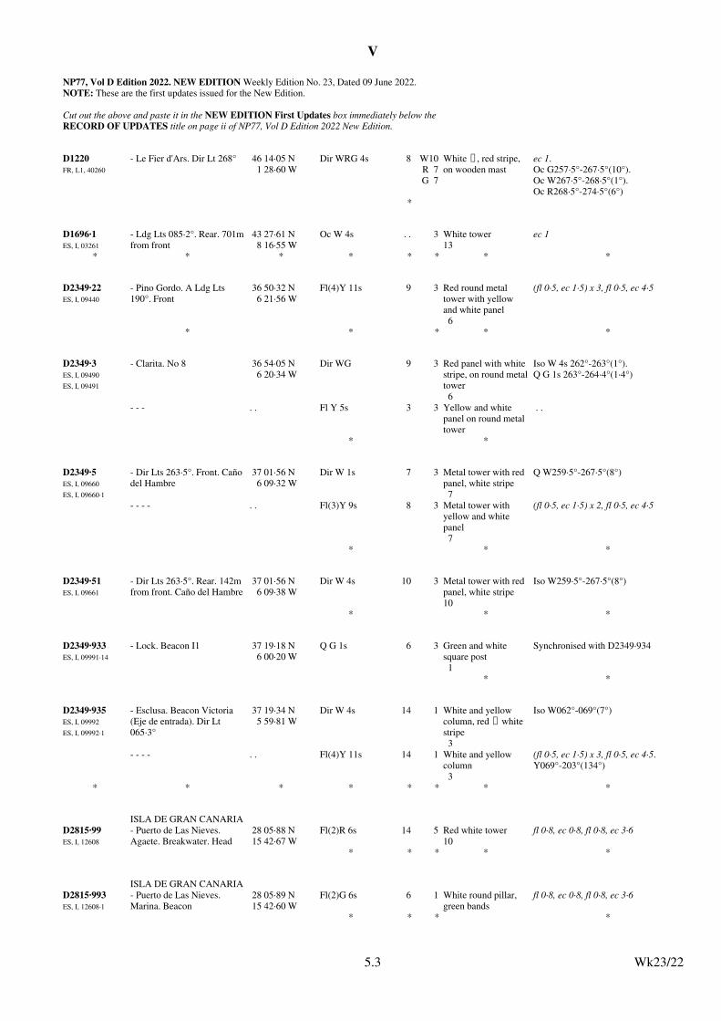
V
NP77, Vol D Edition 2022. NEW EDITION Weekly Edition No. 23, Dated 09 June 2022.NOTE: These are the first updates issued for the New Edition.
Cut out the above and paste it in the NEW EDITION First Updates box immediately below theRECORD OF UPDATES title on page ii of NP77, Vol D Edition 2022 New Edition.
D1220FR, L1, 40260
- Le Fier d'Ars. Dir Lt 268° 46 14·05 N1 28·60 W
Dir WRG 4s 8 W10R 7G 7
White U, red stripe, on wooden mast
ec 1.Oc G257·5°-267·5°(10°).Oc W267·5°-268·5°(1°).Oc R268·5°-274·5°(6°)
*
D1696·1ES, I, 03261
- Ldg Lts 085·2°. Rear. 701mfrom front
43 27·61 N8 16·55 W
Oc W 4s . . 3 White tower13
ec 1
* * * * * * * *
D2349·22ES, I, 09440
- Pino Gordo. A Ldg Lts 190°. Front
36 50·32 N6 21·56 W
Fl(4)Y 11s 9 3 Red round metal tower with yellow and white panel6
(fl 0·5, ec 1·5) x 3, fl 0·5, ec 4·5
* * * * *
D2349·3ES, I, 09490
ES, I, 09491
- Clarita. No 8 36 54·05 N6 20·34 W
Dir WG 9 3 Red panel with white stripe, on round metaltower6
Iso W 4s 262°-263°(1°).Q G 1s 263°-264·4°(1·4°)
- - - . . Fl Y 5s 3 3 Yellow and white panel on round metal tower
. .
* *
D2349·5ES, I, 09660
ES, I, 09660·1
- Dir Lts 263·5°. Front. Caño del Hambre
37 01·56 N6 09·32 W
Dir W 1s 7 3 Metal tower with red panel, white stripe7
Q W259·5°-267·5°(8°)
- - - - . . Fl(3)Y 9s 8 3 Metal tower with yellow and white panel7
(fl 0·5, ec 1·5) x 2, fl 0·5, ec 4·5
* * *
D2349·51ES, I, 09661
- Dir Lts 263·5°. Rear. 142m from front. Caño del Hambre
37 01·56 N6 09·38 W
Dir W 4s 10 3 Metal tower with red panel, white stripe10
Iso W259·5°-267·5°(8°)
* * *
D2349·933ES, I, 09991·14
- Lock. Beacon I1 37 19·18 N6 00·20 W
Q G 1s 6 3 Green and white square post1
Synchronised with D2349·934
* *
D2349·935ES, I, 09992
ES, I, 09992·1
- Esclusa. Beacon Victoria (Eje de entrada). Dir Lt 065·3°
37 19·34 N5 59·81 W
Dir W 4s 14 1 White and yellow column, red U white stripe3
Iso W062°-069°(7°)
- - - - . . Fl(4)Y 11s 14 1 White and yellow column3
(fl 0·5, ec 1·5) x 3, fl 0·5, ec 4·5.Y069°-203°(134°)
* * * * * * * *
ISLA DE GRAN CANARIA
D2815·99ES, I, 12608
- Puerto de Las Nieves. Agaete. Breakwater. Head
28 05·88 N15 42·67 W
Fl(2)R 6s 14 5 Red white tower10
fl 0·8, ec 0·8, fl 0·8, ec 3·6
* * * * *
ISLA DE GRAN CANARIA
D2815·993ES, I, 12608·1
- Puerto de Las Nieves. Marina. Beacon
28 05·89 N15 42·60 W
Fl(2)G 6s 6 1 White round pillar, green bands
fl 0·8, ec 0·8, fl 0·8, ec 3·6
* * * *
Wk23/225.3
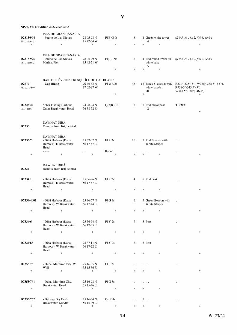
V
NP77, Vol D Edition 2022 continued.
ISLA DE GRAN CANARIA
D2815·994ES, I, 12608·3
- Puerto de Las Nieves 28 05·98 N15 42·64 W
Fl(3)G 9s 8 1 Green white tower4
(fl 0·3, ec 1) x 2, fl 0·3, ec 6·1
* * * * * * * *
ISLA DE GRAN CANARIA
D2815·995ES, I, 12608·2
- Puerto de Las Nieves. Marina. Pier
28 05·99 N15 42·71 W
Fl(3)R 9s 8 1 Red round tower on white base5
(fl 0·3, ec 1) x 2, fl 0·3, ec 6·1
* * * * *
BAIE DU LÉVRIER. PRESQU' ÎLE DU CAP BLANC
D2977FR, L2, 19800
- Cap Blanc 20 46·33 N17 02·87 W
Fl WR 5s 43 17 Black 8-sided tower, white bands20
R330°-335°(5°), W335°-338·5°(3·5°), R338·5°-343·5°(5°), W343·5°-330°(346·5°)
* * *
D7326·22OM, , 1105
Sohar Fishing Harbour. Outer Breakwater. Head
24 28·94 N56 38·52 E
Q(3)R 10s 3 3 Red metal post2
TE 2021
*
DAWHAT DIBĀ
D7333 Remove from list; deleted
DAWHAT DIBĀ
D7333·7 - Dibā Harbour (Daba Harbour). E Breakwater. Head
25 37·02 N56 17·67 E
Fl R 3s 16 5 Red Beacon with White Stripes
. .
- - - - . . Racon . . . . . . . .* * * * * * * *
DAWHAT DIBĀ
D7334 Remove from list; deleted
D7334·1 - Dibā Harbour (Daba Harbour). E Breakwater. Head
25 36·96 N56 17·67 E
Fl R 2s 4 5 Red Post . .
* * * * * * * *
D7334·4001 - Dibā Harbour (Daba Harbour). W Breakwater. Head
25 36·67 N56 17·44 E
Fl G 3s 6 5 Green Beacon with White Stripes
. .
* * * * * * * *
D7334·6 - Dibā Harbour (Daba Harbour). W Breakwater. Head
25 36·94 N56 17·35 E
Fl Y 2s 7 5 Post . .
* * * * * * * *
D7334·65 - Dibā Harbour (Daba Harbour). W Breakwater. Head
25 37·11 N56 17·22 E
Fl Y 2s 8 5 Post . .
* * * * * * * *
D7355·76 - Dubai Maritime City. W Wall
25 16·85 N55 15·56 E
Fl R 3s . . . . . . . .
* * * * * * * *
D7355·761 - Dubai Maritime City. Breakwater. Head
25 16·98 N55 15·46 E
Fl G 3s . . . . . . . .
* * * * * * * *
D7355·762 - Dubayy Dry Dock. Breakwater. Middle
25 16·34 N55 15·39 E
Oc R 4s . . 5 . . . .
* * * * * * * *
Wk23/225.4
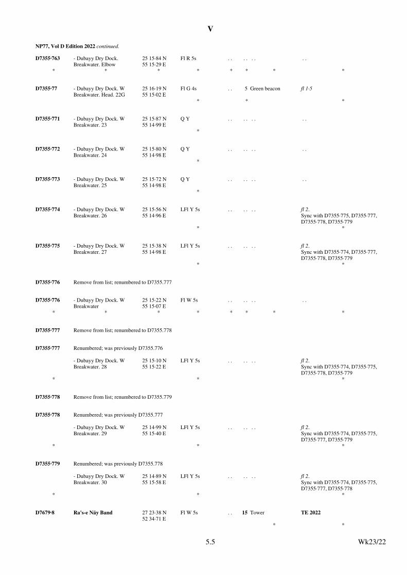
V
NP77, Vol D Edition 2022 continued.
D7355·763 - Dubayy Dry Dock. Breakwater. Elbow
25 15·84 N55 15·29 E
Fl R 5s . . . . . . . .
* * * * * * * *
D7355·77 - Dubayy Dry Dock. W Breakwater. Head. 22G
25 16·19 N55 15·02 E
Fl G 4s . . 5 Green beacon fl 1·5
* * *
D7355·771 - Dubayy Dry Dock. W Breakwater. 23
25 15·87 N55 14·99 E
Q Y . . . . . . . .
*
D7355·772 - Dubayy Dry Dock. W Breakwater. 24
25 15·80 N55 14·98 E
Q Y . . . . . . . .
*
D7355·773 - Dubayy Dry Dock. W Breakwater. 25
25 15·72 N55 14·98 E
Q Y . . . . . . . .
*
D7355·774 - Dubayy Dry Dock. W Breakwater. 26
25 15·56 N55 14·96 E
LFl Y 5s . . . . . . fl 2.Sync with D7355·775, D7355·777, D7355·778, D7355·779
* *
D7355·775 - Dubayy Dry Dock. W Breakwater. 27
25 15·38 N55 14·98 E
LFl Y 5s . . . . . . fl 2.Sync with D7355·774, D7355·777, D7355·778, D7355·779
* *
D7355·776 Remove from list; renumbered to D7355.777
D7355·776 - Dubayy Dry Dock. W Breakwater
25 15·22 N55 15·07 E
Fl W 5s . . . . . . . .
* * * * * * * *
D7355·777 Remove from list; renumbered to D7355.778
D7355·777 Renumbered; was previously D7355.776
- Dubayy Dry Dock. W Breakwater. 28
25 15·10 N55 15·22 E
LFl Y 5s . . . . . . fl 2.Sync with D7355·774, D7355·775, D7355·778, D7355·779
* * *
D7355·778 Remove from list; renumbered to D7355.779
D7355·778 Renumbered; was previously D7355.777
- Dubayy Dry Dock. W Breakwater. 29
25 14·99 N55 15·40 E
LFl Y 5s . . . . . . fl 2.Sync with D7355·774, D7355·775, D7355·777, D7355·779
* * *
D7355·779 Renumbered; was previously D7355.778
- Dubayy Dry Dock. W Breakwater. 30
25 14·89 N55 15·58 E
LFl Y 5s . . . . . . fl 2.Sync with D7355·774, D7355·775, D7355·777, D7355·778
* * *
D7679·8 Ra's-e Nāy Band 27 23·38 N52 34·71 E
Fl W 5s . . 15 Tower TE 2022
* *
Wk23/225.5
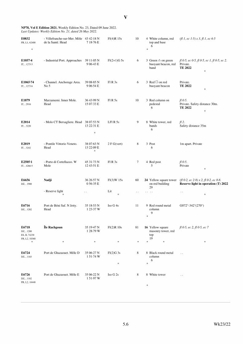
V
NP78, Vol E Edition 2021. Weekly Edition No. 23, Dated 09 June 2022.Last Updates: Weekly Edition No. 21, dated 26 May 2022.
E0832FR, L1, 62400
- Villefranche-sur-Mer. Môlede la Santé. Head
43 42·18 N7 18·76 E
Fl(4)R 15s 10 4 White column, red top and base6
(fl 1, ec 1·5) x 3, fl 1, ec 6·5
* *
E1057·4IT, , 1275·5
- Industrial Port. Approaches 39 11·05 N9 06·43 E
Fl(2+1)G 5s 6 3 Green % on green buoyant beacon, red band
fl 0·5, ec 0·5, fl 0·5, ec 1, fl 0·5, ec 2.Private.TE 2022
*
E1065·74IT, , 1273·6
- Channel. Anchorage Area. No 5
39 08·85 N9 06·54 E
Fl R 3s 6 3 Red & on red buoyant beacon
Private.TE 2022
*
E1879IT, , 2916
Marzamemi. Inner Mole. Head
36 43·99 N15 07·33 E
Fl R 5s 10 3 Red column on pedestal6
fl 0·5.Private. Safety distance 30m.TE 2022
*
E2014IT, , 3220
- Molo CT Bersagliere. Head 38 07·53 N13 22·31 E
LFl R 5s 9 8 White tower, red bands6
fl 2.Safety distance 35m
*
E2019IT, , 3242
- Pontile Vittorio Veneto. Head
38 07·63 N13 22·09 E
2 F G(vert) 8 3 Post6
1m apart. Private
*
E2505·1IT, , 4266·5
- Porto di Cortellazzo. W Mole
45 31·73 N12 43·51 E
Fl R 3s 7 4 Red post5
fl 0·5.Private
*
E6656DZ, , 1900
Nadji 36 26·57 N0 56·35 E
Fl(3)W 15s 60 24 Yellow square tower on red building29
(fl 0·2, ec 2·8) x 2, fl 0·2, ec 8·8.Reserve light in operation (T) 2022
- Reserve light . . Lit . . . . . . . .* * *
E6716DZ, , 1202
Port de Béni Saf. N Jetty. Head
35 18·53 N1 23·37 W
Iso G 4s 11 9 Red round metal column9
G072°-342°(270°)
*
E6718DZ, , 1200
ES, II, 74230
FR, L2, 10360
Île Rachgoun 35 19·47 N1 28·79 W
Fl(2)R 10s 81 16 Yellow square masonry tower, red top19
fl 0·5, ec 2, fl 0·5, ec 7
* * * * * * * *
E6724DZ, , 1103
Port de Ghazaouet. Môle D 35 06·27 N1 51·74 W
Fl(2)G 3s 8 8 Black round metal column6
. .
* *
E6726DZ, , 1102
FR, L2, 10440
Port de Ghazaouet. Môle E 35 06·22 N1 51·97 W
Iso G 2s 8 8 White tower . .
*
Wk23/225.6
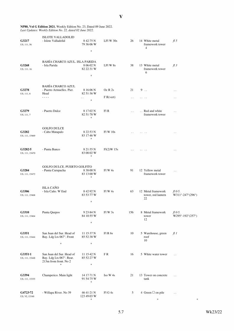
V
NP80, Vol G Edition 2021. Weekly Edition No. 23, Dated 09 June 2022.Last Updates: Weekly Edition No. 22, dated 02 June 2022.
ISLOTE VALLADOLID
G3217US, 111, 56
- Islote Valladolid 8 42·75 N79 36·06 W
LFl W 30s 26 14 White metal framework tower4
fl 5
*
BAHÍA CHARCO AZUL. ISLA PARIDA
G3268US, 111, 16
- Isla Parida 8 06·02 N82 22·31 W
LFl W 8s 38 13 White metal framework tower6
fl 3
*
BAHÍA CHARCO AZUL
G3278US, 111, 8
- Puerto Armuelles. Pier. Head
8 16·06 N82 51·36 W
Oc R 2s 21 9 . . . .
- - - - . . F R(vert) . . . . . . . .*
G3279US, 111, 7
- Puerto Dulce 8 17·02 N82 51·78 W
Fl R . . . . Red and white framework tower
. .
*
GOLFO DULCE
G3282US, 111, 15469
- Cabo Matapalo 8 22·53 N83 17·46 W
Fl W 10s . . . . . . . .
*
G3282·5US, 111, 15470
- Punta Banco 8 21·55 N83 08·02 W
Fl(2)W 15s . . . . . . . .
*
GOLFO DULCE. PUERTO GOLFITO
G3284US, 111, 15472
- Punta Curupacha 8 38·00 N83 13·00 W
Fl W 4s 91 12 Yellow metal framework tower
. .
*
ISLA CAÑO
G3306US, 111, 15468
- Isla Caño. W End 8 42·92 N83 53·77 W
Fl W 4s 63 12 Metal framework tower, red lantern22
fl 0·5.W311°-247°(296°)
*
G3310US, 111, 15464
Punta Quepos 9 23·84 N84 10·55 W
Fl W 3s 156 8 Metal framework tower12
fl 0·5.W295°-192°(257°)
*
G3351US, 111, 15444
San Juan del Sur. Head of Bay. Ldg Lts 067°. Front
11 15·37 N85 52·38 W
Fl R 6s 10 5 Warehouse, green roof10
fl 1
* *
G3351·1US, 111, 15448
San Juan del Sur. Head of Bay. Ldg Lts 067°. Rear. 213m from front. No 2
11 15·42 N85 52·27 W
F R 16 5 White water tower . .
* *
G3394US, 111, 15355
Champerico. Main light 14 17·71 N91 54·75 W
Iso W 4s 21 13 Tower on concrete tank
. .
*
G4723·72US, VI, 15340
- Willapa River. No 39 46 41·21 N123 49·03 W
Fl G 4s 5 4 Green & on pile . .
* * *
Wk23/225.7
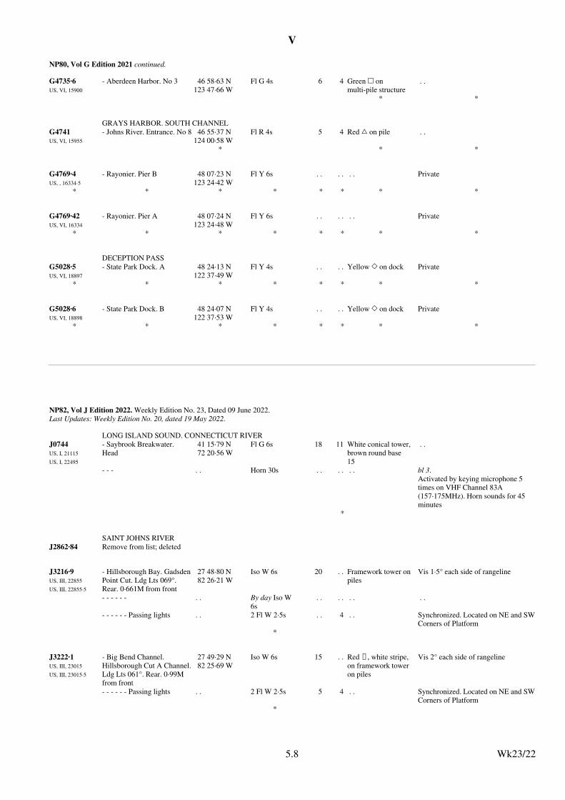
V
NP80, Vol G Edition 2021 continued.
G4735·6US, VI, 15900
- Aberdeen Harbor. No 3 46 58·63 N123 47·66 W
Fl G 4s 6 4 Green & on multi-pile structure
. .
* *
GRAYS HARBOR. SOUTH CHANNEL
G4741US, VI, 15955
- Johns River. Entrance. No 8 46 55·37 N124 00·58 W
Fl R 4s 5 4 Red % on pile . .
* * *
G4769·4US, , 16334·5
- Rayonier. Pier B 48 07·23 N123 24·42 W
Fl Y 6s . . . . . . Private
* * * * * * * *
G4769·42US, VI, 16334
- Rayonier. Pier A 48 07·24 N123 24·48 W
Fl Y 6s . . . . . . Private
* * * * * * * *
DECEPTION PASS
G5028·5US, VI, 18897
- State Park Dock. A 48 24·13 N122 37·49 W
Fl Y 4s . . . . Yellow , on dock Private
* * * * * * * *
G5028·6US, VI, 18898
- State Park Dock. B 48 24·07 N122 37·53 W
Fl Y 4s . . . . Yellow , on dock Private
* * * * * * * *
Wk23/225.8
NP82, Vol J Edition 2022. Weekly Edition No. 23, Dated 09 June 2022.Last Updates: Weekly Edition No. 20, dated 19 May 2022.
LONG ISLAND SOUND. CONNECTICUT RIVER
J0744US, I, 21115
US, I, 22495
- Saybrook Breakwater. Head
41 15·79 N72 20·56 W
Fl G 6s 18 11 White conical tower, brown round base15
. .
- - - . . Horn 30s . . . . . . bl 3.Activated by keying microphone 5 times on VHF Channel 83A (157·175MHz). Horn sounds for 45 minutes
*
SAINT JOHNS RIVER
J2862·84 Remove from list; deleted
J3216·9US, III, 22855
US, III, 22855·5
- Hillsborough Bay. GadsdenPoint Cut. Ldg Lts 069°. Rear. 0·661M from front
27 48·80 N82 26·21 W
Iso W 6s 20 . . Framework tower on piles
Vis 1·5° each side of rangeline
- - - - - - . . By day Iso W 6s
. . . . . . . .
- - - - - - Passing lights . . 2 Fl W 2·5s . . 4 . . Synchronized. Located on NE and SWCorners of Platform
*
J3222·1US, III, 23015
US, III, 23015·5
- Big Bend Channel. Hillsborough Cut A Channel.Ldg Lts 061°. Rear. 0·99M from front
27 49·29 N82 25·69 W
Iso W 6s 15 . . Red U, white stripe, on framework tower on piles
Vis 2° each side of rangeline
- - - - - - Passing lights . . 2 Fl W 2·5s 5 4 . . Synchronized. Located on NE and SWCorners of Platform
*
Wk23/225.8
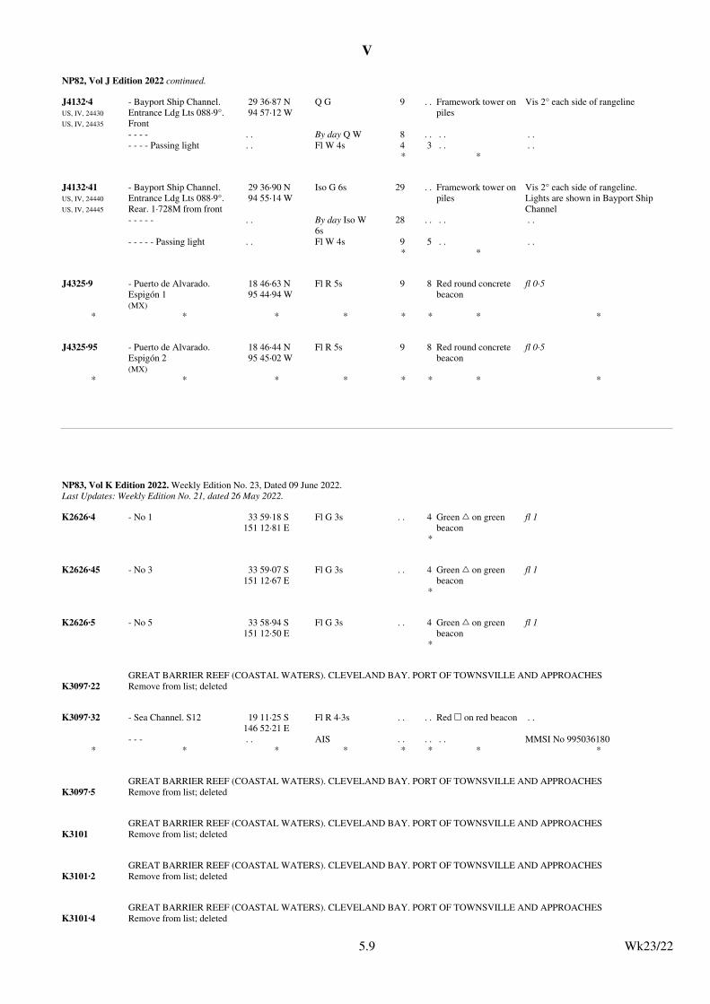
V
NP82, Vol J Edition 2022 continued.
J4132·4US, IV, 24430
US, IV, 24435
- Bayport Ship Channel. Entrance Ldg Lts 088·9°. Front
29 36·87 N94 57·12 W
Q G 9 . . Framework tower on piles
Vis 2° each side of rangeline
- - - - . . By day Q W 8 . . . . . .
- - - - Passing light . . Fl W 4s 4 3 . . . .* *
J4132·41US, IV, 24440
US, IV, 24445
- Bayport Ship Channel. Entrance Ldg Lts 088·9°. Rear. 1·728M from front
29 36·90 N94 55·14 W
Iso G 6s 29 . . Framework tower on piles
Vis 2° each side of rangeline.Lights are shown in Bayport Ship Channel
- - - - - . . By day Iso W 6s
28 . . . . . .
- - - - - Passing light . . Fl W 4s 9 5 . . . .* *
J4325·9 - Puerto de Alvarado. Espigón 1(MX)
18 46·63 N95 44·94 W
Fl R 5s 9 8 Red round concrete beacon
fl 0·5
* * * * * * * *
J4325·95 - Puerto de Alvarado. Espigón 2(MX)
18 46·44 N95 45·02 W
Fl R 5s 9 8 Red round concrete beacon
fl 0·5
* * * * * * * *
Wk23/225.9
NP83, Vol K Edition 2022. Weekly Edition No. 23, Dated 09 June 2022.Last Updates: Weekly Edition No. 21, dated 26 May 2022.
K2626·4 - No 1 33 59·18 S151 12·81 E
Fl G 3s . . 4 Green % on green beacon
fl 1
*
K2626·45 - No 3 33 59·07 S151 12·67 E
Fl G 3s . . 4 Green % on green beacon
fl 1
*
K2626·5 - No 5 33 58·94 S151 12·50 E
Fl G 3s . . 4 Green % on green beacon
fl 1
*
GREAT BARRIER REEF (COASTAL WATERS). CLEVELAND BAY. PORT OF TOWNSVILLE AND APPROACHES
K3097·22 Remove from list; deleted
K3097·32 - Sea Channel. S12 19 11·25 S146 52·21 E
Fl R 4·3s . . . . Red & on red beacon . .
- - - . . AIS . . . . . . MMSI No 995036180* * * * * * * *
GREAT BARRIER REEF (COASTAL WATERS). CLEVELAND BAY. PORT OF TOWNSVILLE AND APPROACHES
K3097·5 Remove from list; deleted
GREAT BARRIER REEF (COASTAL WATERS). CLEVELAND BAY. PORT OF TOWNSVILLE AND APPROACHES
K3101 Remove from list; deleted
GREAT BARRIER REEF (COASTAL WATERS). CLEVELAND BAY. PORT OF TOWNSVILLE AND APPROACHES
K3101·2 Remove from list; deleted
GREAT BARRIER REEF (COASTAL WATERS). CLEVELAND BAY. PORT OF TOWNSVILLE AND APPROACHES
K3101·4 Remove from list; deleted
Wk23/225.9

V
NP83, Vol K Edition 2022 continued.
GREAT BARRIER REEF (COASTAL WATERS). CLEVELAND BAY. PORT OF TOWNSVILLE AND APPROACHES
K3101·6 Remove from list; deleted
GREAT BARRIER REEF (COASTAL WATERS). CLEVELAND BAY. PORT OF TOWNSVILLE AND APPROACHES
K3101·8 Remove from list; deleted
GREAT BARRIER REEF (COASTAL WATERS). CLEVELAND BAY. PORT OF TOWNSVILLE AND APPROACHES
K3104 Remove from list; deleted
K3545·5 - Ldg Lts 223·5°. Front 41 03·78 S145 54·86 E
F Bu 17 7 Orange % . .
* *
K3545·51 - Ldg Lts 223·5°. Rear. 360mfrom front
41 03·95 S145 54·64 E
F Bu 34 7 Orange + . .
* *
K3598·84 - No 11 41 23·62 S147 05·73 E
Q(3)G 6s . . 2 Green beacon (fl 0·3, ec 0·7) x 2, fl 0·3, ec 3·7.TE 2022
*
Wk23/225.10
NP84, Vol L Edition 2022. Weekly Edition No. 23, Dated 09 June 2022.Last Updates: Weekly Edition No. 22, dated 02 June 2022.
L0806NO, , 336400
- Hamnøya. SW Point. Oksebåsen
62 30·60 N6 09·00 E
Oc(2)WRG 8s 9 W2·9R1·9G1·7
Post3
G294·1°-296·1°(2°), W296·1°-335·2°(39·1°), R335·2°-018·8°(43·6°), G018·8°-177·2°(158·4°), W177·2°-198·7°(21·5°), R198·7°-215·9°(17·2°), W215·9°-216·8°(0·9°), G216·8°-221·5°(4·7°)
* * *
L3383NO, , 837100
- Engenes. Mole. Head 68 55·50 N17 07·63 E
F G 7 0·5 Post7
Iso G 2s (T); to be removed (P) 2022
* *
L3400NO, , 839400
- Klauva. Reipneset 69 10·61 N17 57·45 E
Fl WRG 5s 13 W6·8R5·4G5·4
Post3
fl 0·7.G236·4°-238°(1·6°), W238°-258·2°(20·2°), R258·2°-270·4°(12·2°), G270·4°-294·3°(23·9°), W294·3°-305·3°(11°), R305·3°-034·5°(89·2°), G034·5°-059·2°(24·7°), W059·2°-064·8°(5·6°), R064·8°-069·8°(5°)
* *
FINNSNESRENNA
L3402·5NO, , 839900
- Finnsnesgrunnen 69 13·39 N17 57·41 E
Q G 5 2·2 Tripod17
. .
* *
L3851·5NO, , 902404
- Breivik. Breivikbotn. Lillehavet NV
70 35·50 N22 17·35 E
Iso R 2s 4 0·5 Post10
. .
* * * * * * * *
Wk23/225.10
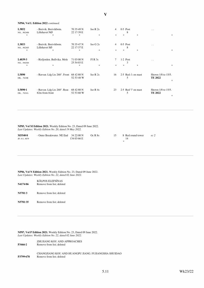
V
NP84, Vol L Edition 2022 continued.
L3852NO, , 902406
- Breivik. Breivikbotn. Lillehavet NØ
70 35·49 N22 17·39 E
Iso R 2s 4 0·5 Post8
. .
* * * * * * * *
L3853NO, , 902405
- Breivik. Breivikbotn. Lillehavet SØ
70 35·47 N22 17·37 E
Iso G 2s 4 0·5 Post8
. .
* * * * * * * *
L4039·3NO, , 946304
- Risfjorden. Bullvika. Mole 71 03·00 N25 54·03 E
Fl R 3s 7 1·2 Post3
. .
* * * * * * * *
L5890DK, , 7624B
- Ræveø. Ldg Lts 268°. Front 68 42·80 N52 53·48 W
Iso R 2s 16 2·5 Red % on mast5
Shown 1/8 to 15/5.TE 2022
*
L5890·1DK, , 7624A
- Ræveø. Ldg Lts 268°. Rear.82m from front
68 42·80 N52 53·60 W
Iso R 4s 23 2·5 Red + on mast5
Shown 1/8 to 15/5.TE 2022
*
Wk23/225.11
NP85, Vol M Edition 2021. Weekly Edition No. 23, Dated 09 June 2022.Last Updates: Weekly Edition No. 20, dated 19 May 2022.
M5540·8JP, 411, 4079
- Outer Breakwater. NE End 34 22·00 N134 03·66 E
Oc R 8s 15 8 Red round tower14
ec 2
*
Wk23/225.11
NP86, Vol N Edition 2021. Weekly Edition No. 23, Dated 09 June 2022.Last Updates: Weekly Edition No. 22, dated 02 June 2022.
KÓLPOS ELEFSÍNAS
N4174·86 Remove from list; deleted
N5781·3 Remove from list; deleted
N5781·35 Remove from list; deleted
Wk23/225.11
NP87, Vol P Edition 2021. Weekly Edition No. 23, Dated 09 June 2022.Last Updates: Weekly Edition No. 22, dated 02 June 2022.
ZHUJIANG KOU AND APPROACHES
P3466·2 Remove from list; deleted
CHANGJIANG KOU AND HUANGPU JIANG. FUJIANGSHA SHUIDAO
P3799·678 Remove from list; deleted
Wk23/225.11
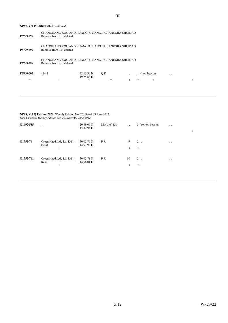
V
NP87, Vol P Edition 2021 continued.
CHANGJIANG KOU AND HUANGPU JIANG. FUJIANGSHA SHUIDAO
P3799·679 Remove from list; deleted
CHANGJIANG KOU AND HUANGPU JIANG. FUJIANGSHA SHUIDAO
P3799·697 Remove from list; deleted
CHANGJIANG KOU AND HUANGPU JIANG. FUJIANGSHA SHUIDAO
P3799·698 Remove from list; deleted
P3800·005 - J4-1 32 15·30 N119 25·63 E
Q R . . . . , on beacon . .
* * * * * * * *
Wk23/225.12
NP88, Vol Q Edition 2022. Weekly Edition No. 23, Dated 09 June 2022.Last Updates: Weekly Edition No. 22, dated 02 June 2022.
Q1692·585 - 20 49·09 S115 32·94 E
Mo(U)Y 15s . . 3 Yellow beacon . .
*
Q1755·76 Green Head. Ldg Lts 131°. Front
30 03·76 S114 57·99 E
F R 9 2 . . . .
* * *
Q1755·761 Green Head. Ldg Lts 131°. Rear
30 03·78 S114 58·01 E
F R 10 2 . . . .
* * *
Wk23/225.12
VI
6.1
VI
6.1
UPDATES TO ADMIRALTY LIST OF RADIO SIGNALSWeekly Edition No. 23 dated 09 June 2022
The ADMIRALTY List of Radio Signals diagrams included in the paper version of the weekly Notice to Mariners (SectionVI) are printed in black and white. If required, a colour version of these diagrams can be downloaded fromwww.admiralty.co.uk/maritime-safety-information. To obtain the colour versions select View and download NMs – selectWeekly – select Year – select Week – go to Selected Week Content – select File (for example:NP286(3)–WK01–14–PAGE149_Week01_2022.pdf)
MARITIME TELEMEDICAL ASSISTANCE SERVICE (TMAS)
Usual name of centre National Institute for Emergency Medicine, Ministry of Public Health, Tiwanon Road, Muang District, Nonthaburi 1100, Thailand
Associated MRCC orJRCC
Bangkok Radio, Communication Authority of Thailand (CAT). Sriracha VTS, Vessel Traffic Control and Maritime Security Office, MarineDepartment.
Telephone: +66 2872 1669 (National Institute of Emergency Medicine)
+66 88 5491669
Fax: +66 2591 9140 (National Institute of Emergency Medicine)
Consultation Languages English, Thai
Remarks:
Emergency Contact (Narenthorn Emergency Medical Coordination Center: NEMCC)
Mr. Rangsan Kuhakan, Manager, Mobile Phone: +66 81 172 1669
Mr. Arnon Muangngam, Operating Officer, Mobile Phone: +66 81 652 2145
Supervisor NEMCC (24 hr), Mobile Phone: +66 88 549 1669
IMO GISIS Global SAR Plan (RSDRA2022000123742) 23/22
VOLUME 1, NP281(2), Second Edition, 2021Published Wk 47/21
(Last Updates: Weekly Edition No. 22 dated 02 June 2022)
MARITIME RADIO STATIONS
PAGE 355, THAILAND.MARITIME TELEMEDICAL ASSISTANCE SERVICE (TMAS).Delete entry and replace by:
Outer Dowsing Windfarm MetoceanFLiDAR Buoy
53°35′·23N 1°16′·95E 992351378 Real
TotalEnergies correspondence (RSDRA2022000124964) 23/22
VOLUME 2, NP282(1), Third Edition, 2022Published Wk 12/22
(Last Updates: Weekly Edition No. 21 dated 26 May 2022)
AUTOMATIC IDENTIFICATION SYSTEM (AIS)
PAGE 216, UNITED KINGDOM, below Ocean Court Lt Bn.Insert:
Wk23/22
VI
6.2
VI
6.2
VOLUME 2, NP282(2), Third Edition, 2022Published Wk 12/22
(Last Updates: Weekly Edition No. 22 dated 02 June 2022)
AUTOMATIC IDENTIFICATION SYSTEM (AIS)
PAGE 134, CHINA, below CFD181 WHPF Platform.Insert:
CGN Yangjiang Nanpeng Island LtBn No 1
21°30′·02N 112°17′·05E 994121788 Broadcasts every 3 minutes Real
CGN Yangjiang Nanpeng Island LtBn No 5
21°24′·10N 112°17′·05E 994121789 Broadcasts every 3 minutes Real
CGN Yangjiang Nanpeng Island LtBn No 10
21°30′·05N 112°10′·44E 994121790 Broadcasts every 3 minutes Real
Chinese Notice 19/698/22 (RSDRA2022000124582) 23/22
Tosakuroshio Marine Farm Lt BuoyNo 21
32°23′·20N 132°28′·85E 994311571 Real
(former update 12/22)Japanese List of Lights Vol.1 2022 Supplement 5 (RSDRA2022000121206) 23/22
PAGE 228, JAPAN, below Tosakuroshio Marine Farm Lt Buoy No 20.Insert:
Wk23/22
VI
6.3
VI
1
VOLUME 6, NP286(1), Third Edition, 2022Published Wk 20/22
––––––––––––––––––(Last Updates: Weekly Edition No. 21 dated 26 May 2022)
PAGE 409, UNITED KINGDOM, SCALLOWAY, Shetland, Pilots, PROCEDURE, below section (3).Insert:
(4) Vessels approaching the port of Scalloway by the North Channel may, depending on the prevailing weather conditions, be asked to rendezvous with the Pilot in position 60°09′·20N 1°20′·50W.
Shetland Islands Council correspondence, (RSDRA2022000112041), 23/22
––––––––––––––––––––––––––––––
VOLUME 6, NP286(2), Second Edition, 2021Published Wk 20/21
––––––––––––––––––(Last Updates: Weekly Edition No. 16 dated 21 April 2022)
PAGE 387, SWEDEN, FLIVIK.Delete entry and replace by:
FLIVIK 57°32′N 16°35′EUNCTAD LOCODE: SE FLI
PilotsFor details see OSKARSHAMN.
PROCEDURE:Pilot boards in position 57°29′·91N 16°52′·06E
Swedish Chart SE71/22, (RSDRA2022000116703), 23/22
––––––––––––––––––––––––––––––
VOLUME 6, NP286(6), Third Edition, 2022Published Wk 2/22
––––––––––––––––––(Last Updates: Weekly Edition No. 22 dated 2 June 2022)
PAGE 8, CHINA, BEIHAI, Pilots, PROCEDURE, section (3).Delete and replace by:
(3) Pilot boards in the following positions:(a) No 1: 21°17′·10N 108°59′·27E(b) No 2: 21°20′·33N 108°59′·00E(c) 21°20′·41N 109°34′·31E (Tieshan Gang)
Chinese Notice 17/628/22, (RSDRA2022000111800), 23/22
PAGE 33, CHINA, FANGCHENG, Pilots, PROCEDURE, section (4).Delete and replace by:
(4) Pilot boards in the following positions:(a) 21°20′·00N 108°22′·67E(b) 21°22′·00N 108°22′·67E(c) 21°25′·50N 108°19′·10E(d) 21°27′·00N 108°23′·40E(e) 21°29′·50N 108°12′·00E (Zhenzhu Gang)
Chinese Notice 17/626/22, (RSDRA2022000111800), 23/22
PAGE 113, CHINA, QINGLAN, Hai-Nan Tao, Pilots, PROCEDURE section.Delete and replace by:
PROCEDURE:Pilot boards in the following positions: (1) Anchorage No 1, a circular area of radius 0·3 n miles centred on position 19°29′·77N 110°52′·50E(2) 19°29′·80N 110°52′·00E
Chinese Notice 17/624/22, (RSDRA2022000111800), 23/22
PAGE 122, CHINA, SANYA, Hai-Nan Tao, Pilots, PROCEDURE, section (4).Delete and replace by:
(4) Pilot boards in the following positions:(a) The Quarantine Anchorage (18°11′·10N 109°26′·00E)(b) No 1: 18°12′·50N 109°26′·00E(c) No 2: 18°13′·98N 109°27′·82E (Anchorage No 3)
Chinese Notice 17/625/22, (RSDRA2022000111800), 23/22
PAGE 141, CHINA, TIESHAN, Pilots, PROCEDURE section.Delete and replace by:
PROCEDURE:Pilot boards in the following positions:(1) No 1: 21°17′·43N 109°31′·00E(2) No 2: 21°20′·41N 109°34′·31E
Chinese Notice 17/627/22, (RSDRA2022000111800), 23/22
PAGE 166, CHINA, ZHANJIANG, diagram ZHANJIANG VESSEL TRAFFIC SERVICE.Delete diagram and replace by diagram ZHANJIANG VESSEL TRAFFIC SERVICE on page 6.4
Chinese Notices 17/622/22 & 17/623/22, (RSDRA2022000111800), 23/22
PAGE 167, CHINA, ZHANJIANG, Pilots, PROCEDURE, section (4).Delete and replace by:
(4) Pilot boards in the following positions:(a) No 5: 20°58′·00N 111°04′·00E(b) No 4: 20°58′·00N 110°54′·00E(c) 21°01′·40N 110°51′·60E (in the anchorage area)(d) No 3: 21°01′·50N 110°44′·10E(e) Vessels unfamiliar with fairway conditions and with a draught over 9·5m: Pilot
Anchorage No 1 (20°58′·05N 110°37′·30E)(f) Vessels with a draught less than 9·5m: Pilot and Quarantine Anchorage No 2
(21°05′·37N 110°30′·76E)(g) No 2: 21°04′·93N 110°29′·85E(h) No 6: 20°28′·00N 109°43′·00E (Liusha Wan)
Chinese Notices 17/622/22, 17/623/22 & 17/629/22, (RSDRA2022000111800), 23/22
––––––––––––––––––––––––––––––
Wk23/22
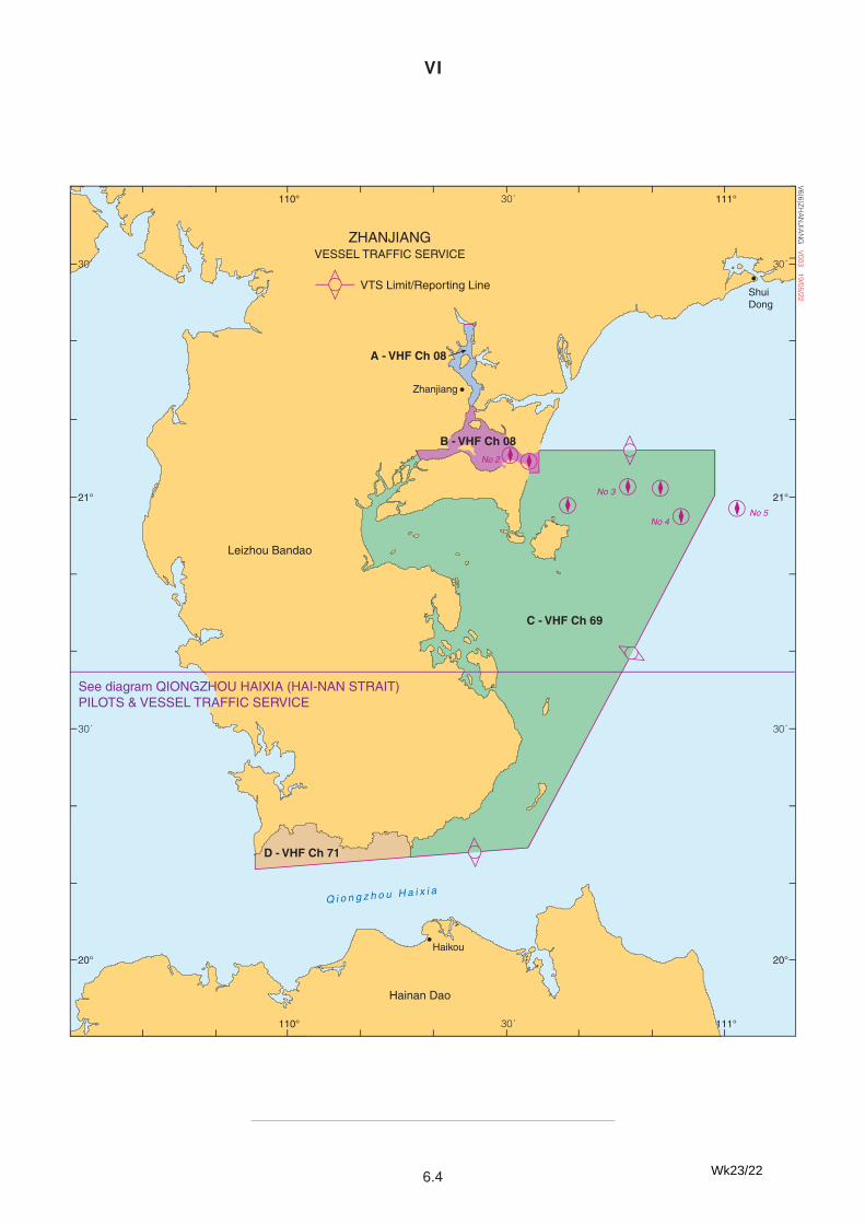
VI
6.4
´
´
´
´
ZHANJIANGVESSEL TRAFFIC SERVICE
VTS Limit/Reporting LineShuiDong
C - VHF Ch 69
D - VHF Ch 71
B - VHF Ch 08
A - VHF Ch 08
Leizhou Bandao
Zhanjiang
Haikou
Hainan Dao
Q i o n g z h o u H a i x i a
See diagram QIONGZHOU HAIXIA (HAI-NAN STRAIT)PILOTS & VESSEL TRAFFIC SERVICE
No 5No 4
No 3
No 2
° °110 11130´
° °110 11130´
°
°
21
20
30
30
°
°
21
20
30
30
V6(6)ZHA
NJIA
NG
V003 19/05/22
VI
6.2
VOLUME 2, NP282(2), Third Edition, 2022Published Wk 12/22
(Last Updates: Weekly Edition No. 22 dated 02 June 2022)
AUTOMATIC IDENTIFICATION SYSTEM (AIS)
PAGE 134, CHINA, below CFD181 WHPF Platform.Insert:
CGN Yangjiang Nanpeng Island LtBn No 1
21°30′·02N 112°17′·05E 994121788 Broadcasts every 3 minutes Real
CGN Yangjiang Nanpeng Island LtBn No 5
21°24′·10N 112°17′·05E 994121789 Broadcasts every 3 minutes Real
CGN Yangjiang Nanpeng Island LtBn No 10
21°30′·05N 112°10′·44E 994121790 Broadcasts every 3 minutes Real
Chinese Notice 19/698/22 (RSDRA2022000124582) 23/22
Tosakuroshio Marine Farm Lt BuoyNo 21
32°23′·20N 132°28′·85E 994311571 Real
(former update 12/22)Japanese List of Lights Vol.1 2022 Supplement 5 (RSDRA2022000121206) 23/22
PAGE 228, JAPAN, below Tosakuroshio Marine Farm Lt Buoy No 20.Insert:
Wk23/22
VII
7.1
UPDATES TO MISCELLANEOUS ADMIRALTY NAUTICAL PUBLICATIONS
There are no updates to miscellaneous Nautical Publications this week
UKRAINE NAVIGATIONAL INFORMATION
Owing to insufficient information, it is not always possible to ensure that ADMIRALTYNauticalPublications are completely up--to--date for new dangers or changes to aids to navigation.
Mariners are therefore advised to exercise particular cautionwhennavigating inUkrainianwaters.
Wk23/22
VIII
8.1
Wk 23/22
ADMIRALTY DIGITAL SERVICES 1. ENC / ECDIS and AVCS
a) ENCs temporarily withdrawn from AVCS
A list of ENCs temporarily withdrawn from AVCS for safety reasons can be found in the README file and the ‘Updates’ tab at
admiralty.co.uk/AVCS
b) ENC Readme.txt file
The README.TXT file located within the ENC_ROOT folder of AVCS Exchange sets contains important safety related information
relating to the use of ENCs in ECDIS. The file is also available on the Support tab at admiralty.co.uk/avcs.
This file should be consulted each week to ensure that all related issues are taken into consideration. The file header indicates the last
time that the README file was updated and the date that it was issued.
c) Temporary information in ENCs
Mariners should take temporary information into account when planning and executing a passage with ENCs and most ENC producers
now include temporary information in their ENCs. It is usually compiled as normal ENC updates, sometimes with the start and end dates
attributed or described as ‘Temporary’ in the pick report.
The latest confirmed status of T&P NM information in the ENCs that are available in ADMIRALTY services is shown in the ENC-
T&P-NM-Status.pdf file at: admiralty.co.uk/ENC-TP-NMs. Note that T&P NMs are compiled for paper charts and may not align with
any temporary information that is compiled into ENCs.
ADMIRALTY Information Overlay (AIO) includes ADMIRALTY T&P NMs for paper charts where the ENC Producer has not
confirmed that they include temporary information in their ENCs.
Further guidance can be found in the AIO User Guide on the Support tab at admiralty.co.uk/avcs.
d) Important notice for users of AVCS and ARCS Online Updating Services (AVCS OUS and ARCS OUS)
The email service for AVCS OUS was withdrawn at the end of February 2019 due to technology infrastructure changes at UKHO.
The ARCS Online Updating Service was withdrawn in July 2019.
2. ADMIRALTY Products Supporting Digital Navigation
i. ADMIRALTY ENC and ECDIS Maintenance Record (NP133C). This publication is designed to hold paper records on ENC
and ECDIS maintenance to assist information management and support inspections. Please note that V2.0 is the current
edition.
ii. ADMIRALTY Guide to ENC Symbols Used in ECDIS (NP5012). A companion to the ADMIRALTY Guide to Symbols and
Abbreviations Used on Paper Charts, NP5011. The 2nd edition of NP5012 includes the changes highlighted in the new S-52
standards and the new presentation library 4.0.
iii. ADMIRALTY Guide to the Practical Use of ENCs (NP231). Supports ECDIS training on the interpretation and use of ENC
data.
iv. ADMIRALTY Guide to ECDIS Implementation, Policy and Procedures (NP232). Provides clear guidance for any individual
or organisation responsible for the introduction of ECDIS, in particular those involved in the development of detailed ECDIS
operating procedures.
VIII
8.2
Wk 23/22
3. ADMIRALTY Digital Publications (ADP)
ADMIRALTY Sailing Directions: Removal of AIS and Racons
In 2018, the UKHO began the process of removing AIS and Racon information from ADMIRALTY Sailing Directions, as this is held in
greater detail within ADMIRALTY Radio Signals publications. During this transition, AIS and Racon information will be removed
from new editions of each Sailing Direction volume, and AIS and Racon information present in existing Sailing Direction volumes will
no longer be updated. For accurate, up-to-date information on AIS and Racons, refer to ADMIRALTY Radio Signals publications.
ADP V19 is available on the ADP Weekly Update DVD.
The UKHO only supports ADP V18 and V19. Users of older versions of ADP should upgrade to a supported version at their earliest
convenience. ADP V18 and V19 are the only versions that allow users to receive tidal updates as they are made available.
ADMIRALTY TotalTide (ATT): German Tidal Stations predicted on LAT
The TotalTide application computes predictions for all German tidal stations based on Lowest Astronomical Tide (LAT).
Mariners using charts which refer to Mean Low Water Springs (MLWS) in German waters, must deduct 0.5m from all predicted tidal
heights for these ports before applying them to the depths on those charts to determine the correct predicted depth of water. This advice
will also be contained in the ‘Notes’ tab on the Prediction Windows in TotalTide for each German tidal station.
For information: Please note that there will not be a 2022 ADP release.
Historically we have made new versions of the ADP software available at the end of each year however, there will be no commercial
release of ADP this year. Regular changes/improvements have been made throughout the year and therefore there is no value in issuing
a new Software version.
The only change this year is a new Base Dataset for Week 42/21 will be added to V19 to refresh the Base Data from the current Week
40/20 to Week 40/21. Nothing else has changed on this V19 version.
The supported ADP versions continue to remain at V18 and V19.
The ADP software and the Data updates can still be downloaded from weekly ADP Update and Software DVDs.
To get access to the ADP Update and Software DVD, please contact your ADMIRALTY Distributor.
For information: Ensure that Activation Key Requests and Update Data Requests for ADP are sent to [email protected]
4. ADMIRALTY e-Nautical Publications (AENP)
There is currently an e-Reader 1.3 enabling users to read Digital copies of our Sailing Directions paper publications.
A new e-Reader 1.4 was released to the Channel on 01/10/2020. This version 1.4 has got the same functionalities as the current version
1.3 but is more performant and user-friendly. While the current 1.3 version can be used on Windows 7 and 8.1 Operating Systems (OS),
the e-Reader 1.4 can only be used on Windows 8.1 and 10 OS, to follow the Microsoft guidelines of withdrawing support for Windows
7 OS.
To enable users to activate this new application, users might need to delete one e-Reader application from their Fleet Manager Licences
if the maximum 3 allowed has been reached.
Both the e-Readers 1.3 and 1.4 are supported at the UKHO.
The e-Reader 1.4 software and the Data updates can be downloaded from weekly ADP Update and Software DVDs.
To get access to the AENP Update and Software DVD, please contact your ADMIRALTY Distributor.
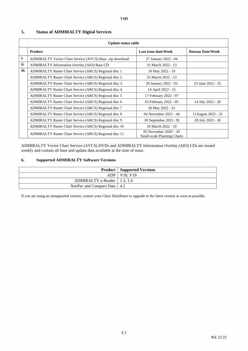
VIII
8.3
Wk 23/22
5. Status of ADMIRALTY Digital Services
Update status table
Product Last issue date/Week Reissue Date/Week
i. ADMIRALTY Vector Chart Service (AVCS) Base .zip download 27 January 2022 - 04
ii. ADMIRALTY Information Overlay (AIO) Base CD 31 March 2022 - 13
iii. ADMIRALTY Raster Chart Service (ARCS) Regional disc 1 10 May 2022 - 19
ADMIRALTY Raster Chart Service (ARCS) Regional disc 2 31 March 2022 - 13
ADMIRALTY Raster Chart Service (ARCS) Regional disc 3 20 January 2022 - 03 23 June 2022 - 25
ADMIRALTY Raster Chart Service (ARCS) Regional disc 4 14 April 2022 - 15
ADMIRALTY Raster Chart Service (ARCS) Regional disc 5 17 February 2022 - 07
ADMIRALTY Raster Chart Service (ARCS) Regional disc 6 03 February 2022 - 05 14 July 2022 - 28
ADMIRALTY Raster Chart Service (ARCS) Regional disc 7 26 May 2022 - 21
ADMIRALTY Raster Chart Service (ARCS) Regional disc 8 04 November 2021 - 44 11August 2022 - 32
ADMIRALTY Raster Chart Service (ARCS) Regional disc 9 30 September 2021- 39 28 July 2022 - 30
ADMIRALTY Raster Chart Service (ARCS) Regional disc 10 10 March 2022 - 10
ADMIRALTY Raster Chart Service (ARCS) Regional disc 11 05 November 2020 – 45
Small-scale Planning Charts
ADMIRALTY Vector Chart Service (AVCS) DVDs and ADMIRALTY Information Overlay (AIO) CDs are issued
weekly and contain all base and update data available at the time of issue.
6. Supported ADMIRALTY Software Versions
Product Supported Versions
ADP V18, V19
ADMIRALTY e-Reader 1.3, 1.4
NavPac and Compact Data 4.2
If you are using an unsupported version, contact your Chart Distributor to upgrade to the latest version as soon as possible.
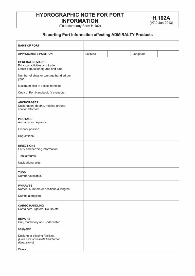
HYDROGRAPHIC NOTE FOR PORT INFORMATION
(To accompany Form H.102)
H.102A(V7.0 Jan 2013)
Reporting Port Information affecting ADMIRALTY Products
NAME OF PORT
APPROXIMATE POSITION Latitude Longitude
GENERAL REMARKS
Principal activities and trade. Latest population figures and date.
Number of ships or tonnage handled per year.
Maximum size of vessel handled.
Copy of Port Handbook (if available).
ANCHORAGES
Designation, depths, holding ground, shelter afforded.
PILOTAGE
Authority for requests.
Embark position.
Regulations.
DIRECTIONS
Entry and berthing information.
Tidal streams.
Navigational aids.
TUGS
Number available.
WHARVES
Names, numbers or positions & lengths.
Depths alongside.
CARGO HANDLING
Containers, lighters, Ro-Ro etc.
REPAIRS
Hull, machinery and underwater.
Shipyards.
Docking or slipping facilities.(Give size of vessels handled or dimensions)
Divers.
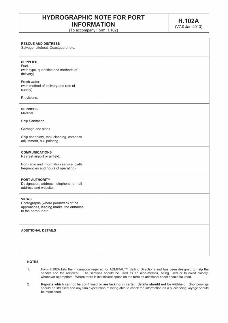
HYDROGRAPHIC NOTE FOR PORT INFORMATION
(To accompany Form H.102)
H.102A(V7.0 Jan 2013)
RESCUE AND DISTRESS
Salvage, Lifeboat, Coastguard, etc.
SUPPLIES
Fuel.(with type, quantities and methods of delivery)
Fresh water. (with method of delivery and rate of supply)
Provisions.
SERVICES
Medical.
Ship Sanitation.
Garbage and slops.
Ship chandlery, tank cleaning, compass adjustment, hull painting.
COMMUNICATIONS
Nearest airport or airfield.
Port radio and information service. (with frequencies and hours of operating)
PORT AUTHORITY
Designation, address, telephone, e-mail address and website.
VIEWS
Photographs (where permitted) of the approaches, leading marks, the entrance to the harbour etc.
ADDITIONAL DETAILS
NOTES:
1. Form H.I02A lists the information required for ADMIRALTY Sailing Directions and has been designed to help thesender and the recipient. The sections should be used as an aide-memoir, being used or followed closely,whenever appropriate. Where there is insufficient space on the form an additional sheet should be used.
2. Reports which cannot be confirmed or are lacking in certain details should not be withheld. Shortcomingsshould be stressed and any firm expectation of being able to check the information on a succeeding voyage shouldbe mentioned.
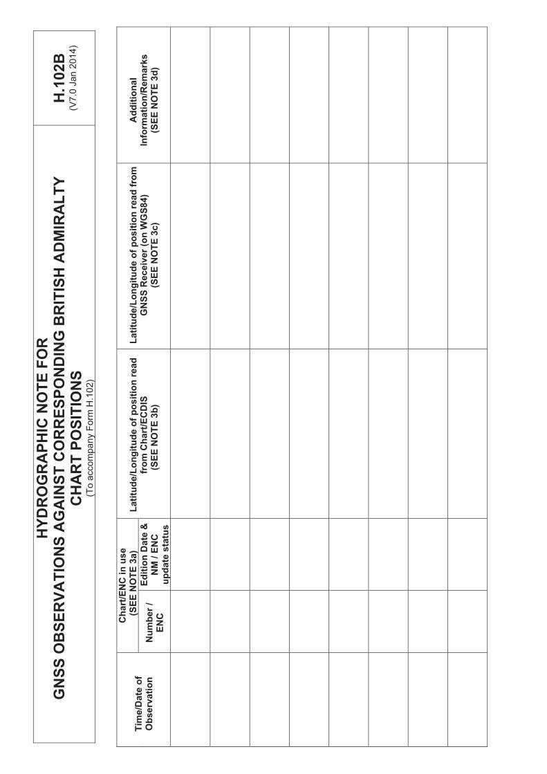
HY
DR
OG
RA
PH
IC N
OT
E F
OR
GN
SS
OB
SE
RV
AT
ION
S A
GA
INS
T C
OR
RE
SP
ON
DIN
G B
RIT
ISH
AD
MIR
AL
TY
C
HA
RT
PO
SIT
ION
S
(To a
ccom
pany F
orm
H.1
02)
H.1
02B
(V7
.0 J
an
201
4)
Ch
art
/EN
C in
use
(SE
E N
OT
E 3
a)
Tim
e/D
ate
of
Ob
se
rva
tio
n
Lati
tud
e/L
on
git
ud
e o
f p
osit
ion
read
fro
m
GN
SS
Rec
eiv
er
(on
WG
S8
4)
(SE
E N
OT
E 3
c)
Ad
dit
ion
al
Info
rmati
on
/Rem
ark
s
(SE
E N
OT
E 3
d)
La
titu
de
/Lo
ng
itu
de
of
po
sit
ion
re
ad
fr
om
Ch
art
/EC
DIS
(S
EE
NO
TE
3b
) N
um
ber
/ E
NC
Ed
itio
n D
ate
&N
M / E
NC
u
pd
ate
sta
tus
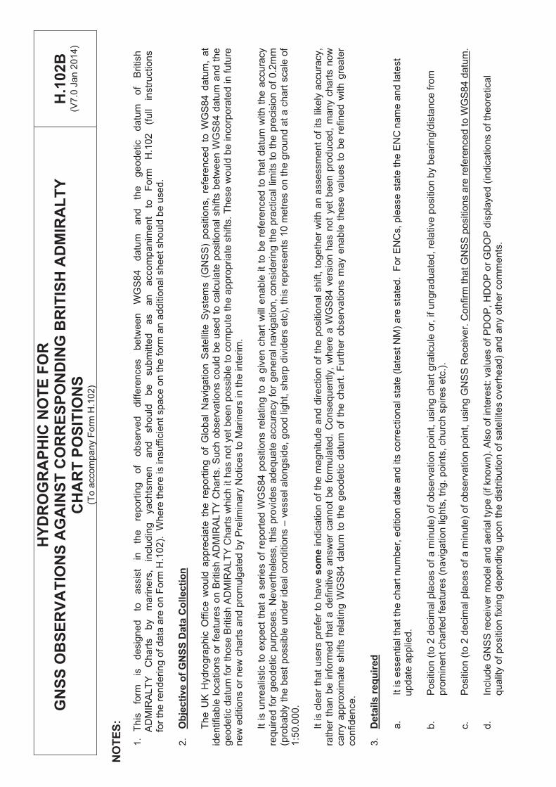
HY
DR
OG
RA
PH
IC N
OT
E F
OR
GN
SS
OB
SE
RV
AT
ION
S A
GA
INS
T C
OR
RE
SP
ON
DIN
G B
RIT
ISH
AD
MIR
AL
TY
C
HA
RT
PO
SIT
ION
S
(To a
ccom
pany F
orm
H.1
02)
H.1
02B
(V7
.0 J
an
201
4)
NO
TE
S:
1.
This
fo
rm
is
desig
ned
to
assis
t in
th
e
report
ing
of
observ
ed
diffe
rences
betw
een
WG
S84
datu
m
and
the
geodetic
datu
m
of
British
AD
MIR
ALT
Y
Chart
s
by
mariners
, in
clu
din
g
yachts
men
and
should
be
subm
itte
d
as
an
accom
panim
ent
to
Form
H
.102
(full
instr
uctio
ns
fo
r th
e r
endering o
f data
are
on F
orm
H.1
02).
W
he
re t
he
re is in
su
ffic
ien
t sp
ace
on
the
fo
rm a
n a
dd
itio
na
l sh
ee
t sh
ou
ld b
e u
sed.
2.
Ob
jecti
ve o
f G
NS
S D
ata
Co
llecti
on
The U
K H
ydro
gra
phic
Off
ice w
ould
appre
cia
te t
he
re
po
rtin
g o
f G
lob
al
Na
vig
atio
n S
ate
llite
Syste
ms (
GN
SS
) p
ositio
ns,
refe
ren
ce
d t
o W
GS
84 d
atu
m,
at
identifiable
locations o
r fe
atu
res o
n B
ritish A
DM
IRA
LT
Y C
hart
s.
Such o
bserv
ations c
ould
be u
sed t
o c
alc
ula
te p
ositio
nal shifts
betw
een W
GS
84 d
atu
m a
nd t
he
ge
od
etic d
atu
m f
or
those B
ritish A
DM
IRA
LT
Y C
ha
rts w
hic
h it
ha
s n
ot
ye
t b
ee
n p
ossib
le t
o c
om
pu
te t
he
ap
pro
pria
te s
hifts
. T
hese
would
be incorp
ora
ted in f
utu
re
ne
w e
ditio
ns o
r new
chart
s a
nd p
rom
ulg
ate
d b
y P
relim
ina
ry N
otice
s t
o M
arin
ers
in
th
e in
terim
.
It i
s u
nre
alis
tic t
o e
xpect
that
a s
eries o
f re
port
ed W
GS
84 p
ositio
ns r
ela
ting t
o a
giv
en c
hart
will
enable
it
to b
e r
efe
renced
to
th
at
da
tum
with
th
e a
ccu
racy
required f
or
geodetic p
urp
oses.
Nevert
hele
ss,
this
pro
vid
es a
dequate
accura
cy f
or
genera
l navig
ation,
consid
ering t
he p
ractical
limits t
o t
he
pre
cis
ion
of
0.2
mm
(p
rob
ably
the b
est
possib
le u
nder
ideal conditio
ns –
ve
sse
l a
lon
gsid
e,
go
od
lig
ht,
sh
arp
div
ide
rs e
tc),
th
is r
ep
rese
nts
10
me
tre
s o
n t
he
gro
un
d a
t a
ch
art
sca
le o
f 1:5
0.0
00.
It is c
lear
that
users
pre
fer
to h
ave s
om
ein
dic
atio
n o
f th
e m
ag
nitu
de
an
d d
ire
ctio
n o
f th
e p
ositio
na
l sh
ift,
to
ge
the
r w
ith
an
asse
ssm
en
t o
f its lik
ely
accu
racy,
rath
er
than b
e i
nfo
rmed t
hat
a d
efinitiv
e a
nsw
er
cannot
be f
orm
ula
ted.
Consequently,
where
a W
GS
84 v
ers
ion h
as n
ot
yet
been p
roduced,
many c
hart
s n
ow
ca
rry a
ppro
xim
ate
shifts
rela
ting W
GS
84 d
atu
m t
o t
he
ge
od
etic d
atu
m o
f th
e c
ha
rt.
Fu
rth
er
ob
se
rva
tio
ns m
ay e
na
ble
th
ese
va
lue
s t
o b
e r
efin
ed
with
gre
ate
r co
nfidence.
3.
Deta
ils r
eq
uir
ed
a.
It is e
ssential th
at
the c
hart
num
ber,
ed
itio
n d
ate
an
d its
co
rre
ction
al sta
te (
late
st
NM
) a
re s
tate
d.
Fo
r E
NC
s,
ple
ase
sta
te t
he E
NC
nam
e a
nd late
st
u
pd
ate
ap
plie
d.
b.
Positio
n (
to 2
decim
al pla
ces o
f a m
inu
te)
of
ob
se
rva
tio
n p
oin
t, u
sin
g c
ha
rt g
raticu
le o
r, if
un
gra
du
ate
d,
rela
tive
po
sitio
n b
y b
ea
rin
g/d
ista
nce
fro
m
pro
min
ent
chart
ed f
eatu
res (
navig
atio
n lig
hts
, tr
ig.
poin
ts, ch
urc
h s
pire
s e
tc.)
.
c.
Positio
n (
to 2
decim
al pla
ces o
f a m
inu
te)
of
ob
se
rva
tio
n p
oin
t, u
sin
g G
NS
S R
ece
ive
r. C
on
firm
th
at
GN
SS
po
sitio
ns a
re r
efe
ren
ce
d t
o W
GS
84
da
tum
.
d.
Inclu
de G
NS
S r
eceiv
er
model and a
eri
al ty
pe
(if k
no
wn
). A
lso
of in
tere
st:
va
lue
s o
f P
DO
P,
HD
OP
or
GD
OP
dis
pla
ye
d (
ind
ica
tio
ns o
f th
eo
retica
l qualit
y o
f positio
n f
ixin
g d
ependin
g u
pon t
he d
istr
ibution o
f sate
llite
s o
verh
ead)
and a
ny o
ther
com
ments
.
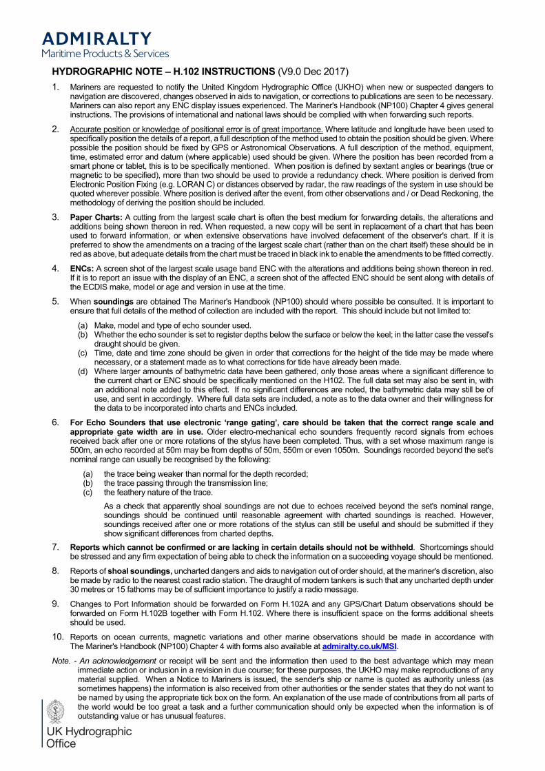
HYDROGRAPHIC NOTE H.102 INSTRUCTIONS (V9.0 Dec 2017)1. Mariners are requested to notify the United Kingdom Hydrographic Office (UKHO) when new or suspected dangers to
navigation are discovered, changes observed in aids to navigation, or corrections to publications are seen to be necessary.Mariners can also report any ENC display issues experienced. The Mariner's Handbook (NP100) Chapter 4 gives general instructions. The provisions of international and national laws should be complied with when forwarding such reports.
2. Accurate position or knowledge of positional error is of great importance. Where latitude and longitude have been used to specifically position the details of a report, a full description of the method used to obtain the position should be given. Where possible the position should be fixed by GPS or Astronomical Observations. A full description of the method, equipment, time, estimated error and datum (where applicable) used should be given. Where the position has been recorded from a smart phone or tablet, this is to be specifically mentioned. When position is defined by sextant angles or bearings (true or magnetic to be specified), more than two should be used to provide a redundancy check. Where position is derived from Electronic Position Fixing (e.g. LORAN C) or distances observed by radar, the raw readings of the system in use should be quoted wherever possible. Where position is derived after the event, from other observations and / or Dead Reckoning, the methodology of deriving the position should be included.
3. Paper Charts: A cutting from the largest scale chart is often the best medium for forwarding details, the alterations and additions being shown thereon in red. When requested, a new copy will be sent in replacement of a chart that has been used to forward information, or when extensive observations have involved defacement of the observer's chart. If it is preferred to show the amendments on a tracing of the largest scale chart (rather than on the chart itself) these should be in red as above, but adequate details from the chart must be traced in black ink to enable the amendments to be fitted correctly.
4. ENCs: A screen shot of the largest scale usage band ENC with the alterations and additions being shown thereon in red. If it is to report an issue with the display of an ENC, a screen shot of the affected ENC should be sent along with details ofthe ECDIS make, model or age and version in use at the time.
5. When soundings are obtained The Mariner's Handbook (NP100) should where possible be consulted. It is important to ensure that full details of the method of collection are included with the report. This should include but not limited to:
(a) Make, model and type of echo sounder used.(b) Whether the echo sounder is set to register depths below the surface or below the keel; in the latter case the vessel's
draught should be given.(c) Time, date and time zone should be given in order that corrections for the height of the tide may be made where
necessary, or a statement made as to what corrections for tide have already been made.(d) Where larger amounts of bathymetric data have been gathered, only those areas where a significant difference to
the current chart or ENC should be specifically mentioned on the H102. The full data set may also be sent in, with an additional note added to this effect. If no significant differences are noted, the bathymetric data may still be ofuse, and sent in accordingly. Where full data sets are included, a note as to the data owner and their willingness for the data to be incorporated into charts and ENCs included.
6. F be taken that the correct range scale and appropriate gate width are in use. Older electro-mechanical echo sounders frequently record signals from echoes received back after one or more rotations of the stylus have been completed. Thus, with a set whose maximum range is 500m, an echo recorded at 50m may be from depths of 50m, 550m or even 1050m. Soundings recorded beyond the set's nominal range can usually be recognised by the following:
(a) the trace being weaker than normal for the depth recorded;(b) the trace passing through the transmission line;(c) the feathery nature of the trace.
As a check that apparently shoal soundings are not due to echoes received beyond the set's nominal range, soundings should be continued until reasonable agreement with charted soundings is reached. However, soundings received after one or more rotations of the stylus can still be useful and should be submitted if they show significant differences from charted depths.
7. Reports which cannot be confirmed or are lacking in certain details should not be withheld. Shortcomings should be stressed and any firm expectation of being able to check the information on a succeeding voyage should be mentioned.
8. Reports of shoal soundings, uncharted dangers and aids to navigation out of order should, at the mariner's discretion, also be made by radio to the nearest coast radio station. The draught of modern tankers is such that any uncharted depth under 30 metres or 15 fathoms may be of sufficient importance to justify a radio message.
9. Changes to Port Information should be forwarded on Form H.102A and any GPS/Chart Datum observations should be forwarded on Form H.102B together with Form H.102. Where there is insufficient space on the forms additional sheets should be used.
10. Reports on ocean currents, magnetic variations and other marine observations should be made in accordance withThe Mariner's Handbook (NP100) Chapter 4 with forms also available at admiralty.co.uk/MSI.
Note. - An acknowledgement or receipt will be sent and the information then used to the best advantage which may mean immediate action or inclusion in a revision in due course; for these purposes, the UKHO may make reproductions of any material supplied. When a Notice to Mariners is issued, the sender's ship or name is quoted as authority unless (as sometimes happens) the information is also received from other authorities or the sender states that they do not want to be named by using the appropriate tick box on the form. An explanation of the use made of contributions from all parts of the world would be too great a task and a further communication should only be expected when the information is of outstanding value or has unusual features.
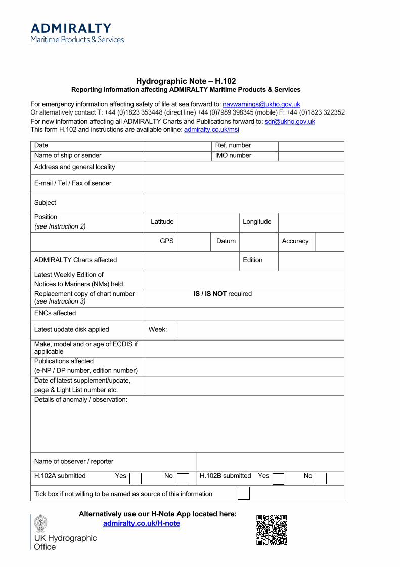
Hydrographic Note H.102Reporting information affecting ADMIRALTY Maritime Products & Services
For emergency information affecting safety of life at sea forward to: [email protected] alternatively contact T: +44 (0)1823 353448 (direct line) +44 (0)7989 398345 (mobile) F: +44 (0)1823 322352For new information affecting all ADMIRALTY Charts and Publications forward to: [email protected] form H.102 and instructions are available online: admiralty.co.uk/msi
Date Ref. numberName of ship or sender IMO number
Address and general locality
E-mail / Tel / Fax of sender
Subject
Position(see Instruction 2)
Latitude Longitude
GPS Datum Accuracy
ADMIRALTY Charts affected Edition
Latest Weekly Edition of Notices to Mariners (NMs) heldReplacement copy of chart number(see Instruction 3)
IS / IS NOT required
ENCs affected
Latest update disk applied Week:
Make, model and or age of ECDIS if applicablePublications affected (e-NP / DP number, edition number)Date of latest supplement/update, page & Light List number etc.Details of anomaly / observation:
Name of observer / reporter
H.102A submitted Yes No H.102B submitted Yes No
Tick box if not willing to be named as source of this information
Alternatively use our H-Note App located here:admiralty.co.uk/H-note