Water and Landscape: Ancient Maya Settlement Decisions
13
3 Water and Landscape: Ancient Maya Settlement Decisions Lisa J. Lucero University of Illinois, Urbana-Champaign Scott L. Fedick University of California, Riverside Nicholas P. Dunning University of Cincinnati David L. Lentz University of Cincinnati and Vernon L. Scarborough University of Cincinnati ABSTRACT In this chapter we present the major transitions in Maya history from the Late Preclassic through Terminal Classic periods in the Maya Lowlands, focusing first on major settlement and subsistence systems, followed by major social and environmental costs. We particularly focus on how the Maya built and relied on increasingly complex water and agricultural systems to adapt in the humid tropics where everything in life was rainfall dependent. The seasonality of rainfall required innovative strategies to contain water throughout the long dry season in the face of growing population and socio-political complexity. Drastic changes occurred when several prolonged droughts struck the Maya area, resulting in them exploring new areas and subsistence practices. The chapter concludes with a few thoughts on how understanding ancient Maya water and land use is relevant for today’s issues regarding sustainable land and water use. [settlement patterns, water management, seasonal issues, agricultural strategies, climate change] T he ancient Maya lived in a diverse tropical setting with dispersed pockets of soils suitable for agricul- ture, differential water resources, noticeable seasonality, and an abundance of floral and faunal species. Everything in Maya society was rainfall-dependent, especially agricul- ture. Timing was crucial, including predicting when the rainy season would start, which is also the onset of in- tensive agricultural activities. Because of these character- istics, water and agricultural land availability impacted how people lived, built, and moved across the landscape. They also meant that the Maya were more susceptible to major shifts in seasonal or long-term rainfall patterns. To com- pensate for seasonal vagaries and differential soil distribu- tion, the Maya engineered features that provided access to, control over, and improvement of water and soil resources from small-scale household systems to massive and intricate ones in centers. Reservoirs were particularly critical in the 4–5 month annual dry season, especially in areas without ARCHEOLOGICAL PAPERS OF THE AMERICAN ANTHROPOLOGICAL ASSOCIATION, Vol. 24, pp. 30–42, ISSN 1551-823X, online ISSN 1551-8248. C 2014 by the American Anthropological Association. All rights reserved. DOI: 10.1111/apaa.12027.
Transcript of Water and Landscape: Ancient Maya Settlement Decisions

3
Water and Landscape: Ancient Maya SettlementDecisions
Lisa J. LuceroUniversity of Illinois, Urbana-Champaign
Scott L. FedickUniversity of California, Riverside
Nicholas P. DunningUniversity of Cincinnati
David L. LentzUniversity of Cincinnati
andVernon L. Scarborough
University of Cincinnati
ABSTRACTIn this chapter we present the major transitions in Maya history from the Late Preclassic through Terminal
Classic periods in the Maya Lowlands, focusing first on major settlement and subsistence systems, followed by majorsocial and environmental costs. We particularly focus on how the Maya built and relied on increasingly complexwater and agricultural systems to adapt in the humid tropics where everything in life was rainfall dependent. Theseasonality of rainfall required innovative strategies to contain water throughout the long dry season in the faceof growing population and socio-political complexity. Drastic changes occurred when several prolonged droughtsstruck the Maya area, resulting in them exploring new areas and subsistence practices. The chapter concludes witha few thoughts on how understanding ancient Maya water and land use is relevant for today’s issues regardingsustainable land and water use. [settlement patterns, water management, seasonal issues, agricultural strategies,climate change]
T he ancient Maya lived in a diverse tropical settingwith dispersed pockets of soils suitable for agricul-
ture, differential water resources, noticeable seasonality, andan abundance of floral and faunal species. Everything inMaya society was rainfall-dependent, especially agricul-ture. Timing was crucial, including predicting when therainy season would start, which is also the onset of in-tensive agricultural activities. Because of these character-istics, water and agricultural land availability impacted how
people lived, built, and moved across the landscape. Theyalso meant that the Maya were more susceptible to majorshifts in seasonal or long-term rainfall patterns. To com-pensate for seasonal vagaries and differential soil distribu-tion, the Maya engineered features that provided access to,control over, and improvement of water and soil resourcesfrom small-scale household systems to massive and intricateones in centers. Reservoirs were particularly critical in the4–5 month annual dry season, especially in areas without
ARCHEOLOGICAL PAPERS OF THE AMERICAN ANTHROPOLOGICAL ASSOCIATION, Vol. 24, pp. 30–42, ISSN 1551-823X,online ISSN 1551-8248. C© 2014 by the American Anthropological Association. All rights reserved. DOI: 10.1111/apaa.12027.

Ancient Maya Settlement Decisions 31
permanent surface water and, in many instances, low watertables.
In this chapter, we touch upon the transitions in Mayahistory, and then briefly present the social and environmentalcosts of the growing reliance on an engineered landscape.We conclude with a few thoughts on how understandingancient Maya water and land use is relevant for today’s issuesregarding sustainable land and water use.
Transitions in Maya History
Late Preclassic to Late Classic
In the southern Maya Lowlands, the Maya started mi-grating into interior areas such as the Peten in Guatemalafrom riverine or coastal areas in the Early Preclassic periodby ca. 1000 B.C.E. (Ford 1986:59, 80–82; Wahl et al. 2006).They moved into areas with fertile agricultural land andlittle surface water, which presented particular challenges,especially during the long dry season. The dry season inthe southern Lowlands, usually from January through May,transforms the landscape into a green desert where it mightnot rain at all for several months, and where temperaturesand humidity noticeably climb (see Graham 1999; Scarbor-ough 1993). Although this season involved few agriculturaltasks, the Maya still needed water for daily drinking needs,cooking and food preparation, plaster manufacture and ce-ramic production, as well as other domestic and produc-tion activities (e.g., Marcus 2006). The length and intensityof the rainy and dry seasons also are important variablesthat impacted agricultural schedules and strategies. The be-ginning of the rainy season can vary up to five weeks inany given area, and the annual amount of rainfall can vary30 to 40 percent ranging from 1350 to 3700 millimeters(Gunn et al. 1995; Gunn et al. 2002; Scarborough 1993).Adequate amounts of rain are vital for crops, especiallysince the major staple of maize is a relatively thirsty plantcompared to staples grown elsewhere such as millet andsorghum (Vince 2010).
Tikal and its environs provide an excellent case to il-lustrate the intricate relationship between water availability,fertile land, and settlement decisions (see Figure 1.2 in chap-ter 1 for map with major areas and sites mentioned). Rel-ative to other regions, this polity has a noticeable amountof dispersed agricultural soils, but limited water sources(Ford 1986, 1996). It, like other regional capitals such asCalakmul and many other centers without permanent watersources, was surrounded by bajos, or seasonally inundatedswamps. Forty to 60 percent of the southern Lowlands con-sists of wetlands, mostly bajos (Dunning et al. 2006), and
the Maya exploited them for agriculture, fishing, and hunting(Scarborough 2006). While some bajos were perennial wet-lands, many were seasonal (Dunning et al. 2006). In somebajos, the Maya practiced flood–recession agriculture, indi-cated by the noticeable number of terraces and berms alongtheir margins, as well as terracing, to avert soil loss (Beachet al. 2008; Kunen 2006; Scarborough 2006).
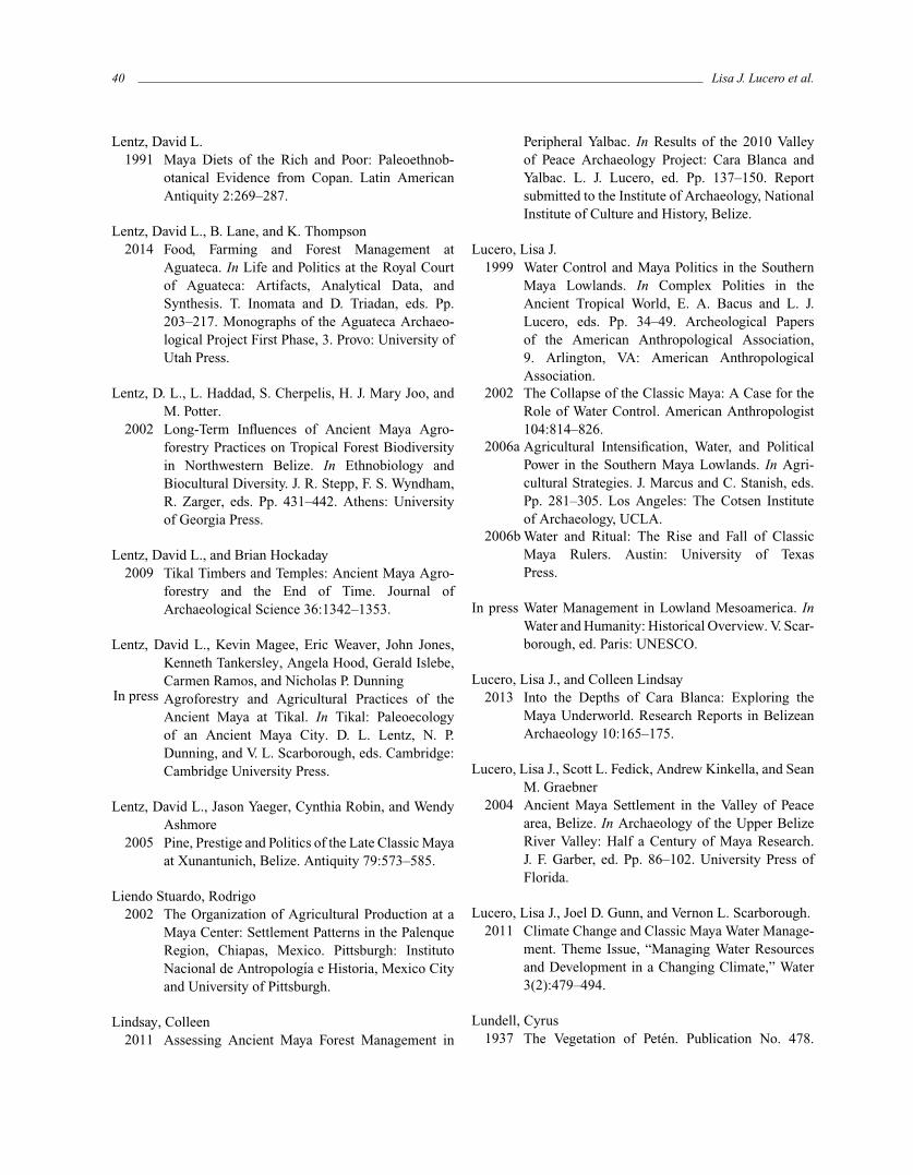
To offset seasonally limited water supplies, the Mayabuilt water retention systems (Scarborough 1993; seeScarborough 2001:354). By the Late Preclassic period (ca.300 B.C.E.–C.E. 250), these systems included wetland recla-mation adaptations (e.g., Cerros, Belize) and “passive” orconcave micro-watershed systems where the Maya took ad-vantage of the natural landscape, namely depressions, asfound at the major Preclassic center of El Mirador in thePeten (Figure 3.1; Scarborough 1993, 2000). A growing con-cern would have been increasing sedimentation into theselow-lying, gravity-driven water systems due to erosion.
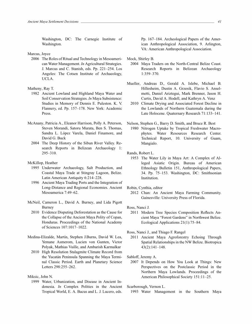
By the Early Classic period (ca. C.E. 250–550), popula-tion growth led to a growing reliance on increasingly largerartificial reservoirs, a trend that continued into the Late Clas-sic period (ca. C.E. 550–800) when water systems were fur-ther augmented in size and scope. These sophisticated engi-neered reservoir systems are epitomized by elevated convexmicro-watershed systems whereby reservoirs, dams, chan-nels, sluices, filtration systems and switching stations weredesigned to capture, store and distribute water as seen at, forexample, Tikal and Caracol (Figure 3.2; Scarborough 1993,2003:50–51, 2007; Scarborough and Gallopin 1991; Scar-borough et al. 2012). Gravity release of water during the dryseason supplied water to urban center inhabitants in lower–lying settlements (Scarborough 2003:110–111). As the dryseason wore on and water levels dropped and water qual-ity worsened, the Maya diverted gray water into agriculturalfields and holding ponds for other purposes including fish-ponds, ceramic production, and plaster manufacture. Theentire system depended on adequate rainfall and maintain-ing water quality, especially in the core reservoirs (Lucero1999; Lucero et al. 2011).
The need for potable water was critical in the trop-ics where people can lose up to 10 liters per day sweatingand thus require more water than their counterparts livingin temperate areas of the world (Bacus and Lucero 1999).Maintaining water quality in the humid tropics presents chal-lenges, especially since standing water provides prime con-ditions for both water-borne diseases and disease carrierssuch as mosquitoes (Burton et al. 1979; Miksic 1999). Tomaintain water quality in reservoirs, the Maya applied theirunderstanding and knowledge of wetland biosphere systemsby introducing a balance of macrophytic and hydrophyticplants, as well as other organisms such as fish (Lucero

32 Lisa J. Lucero et al.
Figure 3.1. Schematic of concave and convex watershed systems (courtesy of V. Scarborough).
Figure 3.2. Tikal and its reservoirs (courtesy of V. Scarborough).
1999). Associated bacteria, along with a certain amount ofalgae, together purify water since plants absorb phosphorusand nitrogen, elements that accumulate in standing water(Hammer and Kadlec 1980; Nelson et al. 1980). For in-stance, investigations of both urban and hinterland reservoirsat the Peten sites of San Bartolo and Xultun indicate that theMaya went to great lengths to secure clean water, includinginvesting in plaster linings in some reservoirs and siltation
tanks in others fed by surface runoff (Akpinar-Ferrand et al.2012).
Because a major role of kings was providing clean wa-ter to their subjects, it is not surprising that royals high-lighted the association between their power and clean wa-ter in the iconographic record, especially via water lilies(Finamore and Houston 2010; Lucero 1999; e.g., Rands1953:figures 3.1–6). Water lilies, Nymphaea ampla (Salisb.)

Ancient Maya Settlement Decisions 33
Figure 3.3. Water lilies at Cara Blanca (photo by L. J. Lucero).
DC., on reservoir surfaces actually indicate clean water be-cause they are sensitive aquaflora that require specific con-ditions to flourish, including relatively shallow depths (1–3meters) of still, non-acidic water without too much calciumor algae (Figure 3.3; Conrad 1905:116; Lundell 1937:18,26). Their significance is also highlighted in many inscrip-tions, where Nab Winik Makna, or water lily lords, refersto Maya kings (Ford 1996), while Ah Nab refers to Mayanobility as water lily people (Schele and Freidel 1990:94).As we discuss below, significant changes in rainfall pat-terns had major repercussions for Maya rulers because ofthe close relationship between water and power in ClassicMaya society.
People living in centers located along rivers also builtreservoirs for a steady supply of drinking water, as riverswere not always reliable sources of potable water. At theheight of the rainy season, the rains churned up sedi-ment (e.g., Davis-Salazar 2003; Fash and Davis-Salazar2006), while at the height of the dry season, rivers becamelow, murky, and disease-ridden (e.g., Houston 1998). Weshould note that in certain situations the Maya built wa-ter systems, such as aqueducts and canals, to divert wa-ter away from monumental architecture and living areas,as was the case at Palenque. This major center has over50 streams and springs, not to mention a higher than av-erage annual rainfall exceeding 3600 millimeters (French2002; French et al. 2006). Evidence also suggests thatfarmers constructed irrigation canals on the plains belowto take advantage of the abundance of water (Barnhart2001:101; Liendo 2002). In most cases, however, the main
goal of water systems was to contain water during the dryseason.
In the northern Lowlands, we find a different situationwhich has to do with its higher water table and thinnersoils. For instance, in the Yalahau region of the northeastYucatan Peninsula, water was readily available in freshwaterwetlands, wells that tapped into an abundant freshwateraquifer, and cenotes, or steep-sided sinkholes fed by therelatively high water table (Brown 2006). During the LatePreclassic, the Maya extensively modified the wetlands withrock alignments to manage soil and water. The Maya likelytapped the Yalahau wetlands for recession agriculture fordomesticated crops, or alternatively for the management ofeconomically important wetland plant and animal species,or as a source for biofertilizer transported to uplandgardens (Fedick et al. 2000; Fedick and Morrison 2004).Rising water levels in the Early Classic may have actuallycontributed to the abandonment of wetlands because theremight have been too much water.
Settlement was widespread across the northern Low-lands during the Late Preclassic, with numerous settlementsdispersed to take advantage of natural water sources, chieflycenotes, tracts of higher quality soil, and coastal resourcessuch as salt (Glover and Stanton 2010). While many Pre-classic sites were abandoned for unknown reasons by theonset of the Early Classic, including many Puuc centers(Smyth et al. in press), the region as a whole was notcompletely depopulated. Settlement was sparser in areassuch as the Puuc Hills with few natural water sources, butsome small and a few large Preclassic centers emerged,

34 Lisa J. Lucero et al.
including Xcoch and its elaborate system of rain–fed reser-voirs (Dunning, Weaver, et al. in press). However, Xcochexhibits a period of abandonment early in the Early Classic,perhaps related to a period of increased aridity that even itselaborate reservoir system was unable to overcome (Smythet al. in press).
In summary and in general, the major transition be-tween the Late Preclassic and Late Classic consisted ofthe Maya successfully having met increasing land and wa-ter demands in areas without adequate sources of surfacewater.
Late Classic to Terminal Classic and Beyond
In the Terminal Classic period (ca. C.E. 800–1000), peo-ple no longer could rely on artificial reservoirs in the south-ern Lowlands because of increasingly frequent multiyeardroughts, especially between C.E. 800 and 930 (Medina-Elizalde et al. 2010); ultimately, and through varied trajec-tories, the Maya largely abandoned major centers. ThoseMaya who did not leave the southern Lowlands lived insmall communities near permanent water sources includingthe Belize River valley, wetland areas in northern Belize,nearby lakes and rivers in the Peten, and coastal areas ingeneral (e.g., Demarest et al. 2004; Lucero 2006b; Luceroet al. 2004; McAnany et al. 2004; Mock 2004; Willey etal. 1965:292). Living near coasts provided Maya access tomarine resources and maritime trade routes as evidenced inthe emergence and growth of trade ports (Sabloff 2007). TheMaya also practiced wetland agriculture along slow–movingrivers and near shallow lakes.
In the northern Lowlands, surface water was alwaysseverely limited due to its relatively small number ofaguadas, lakes, small springs, and cenotes (Matheny 1982).However, Uxmal, a Late and Terminal Classic center, had atleast 13 reservoirs within its sprawling urban area that un-doubtedly were an important factor in its explosive growthand the construction of massive monuments in the site corebetween C.E. 870 and C.E. 910 (Dunning and Beach 2010).While household cisterns were vital to the Maya in the Puuc,urban reservoirs were also employed at some northern sitesfrom an early date (Carmean et al. 2004; Dunning, Weaver,et al. in press; Isendahl 2011).
These apparent limitations in the northern Lowlandsdid not prevent the Maya from building large centers; nordid they prevent the Maya from migrating from the southinto this area. For example, people moved to Chichen Itzain the Terminal Classic (ca. C.E. 800–1000); it has twomajor cenotes, one within the site core and the other locatedat the end of a causeway 400 meters to the north (Sharer
and Traxler 2006:562–565). Occupants of Chichen Itza alsobenefitted from opportunities in trade and other productionactivities (Cobos Palma 2004). Maritime trade in subsistence(e.g., salt) and prestige goods became increasingly important(McKillop 1995, 1996). Areas in the Yucatan peninsula,such as the southern areas of Quintana Roo, incorporatedthe use of irrigation canals to support the growing immigrantpopulations (Carmean et al. 2004). Interestingly, the Yalahauregion of northern Quintana Roo remained virtually vacantthrough the Late Classic period, despite an abundance ofreadily available fresh water (Glover 2006).
At Edzna, located along the Rıo Candelaria inCampeche, the Maya built complex water managementsystems consisting of extensive canals, reservoirs, and amoat (Forsyth et al. 1983). While built sometime in theLate Preclassic, the Maya used them through the Termi-nal Classic period. Of the 29 known canals, the mostimpressive is the Great Canal; it is over 12 kilometerslong, up to 50 meters wide, and ca. 1.5 meters deep(pp. 68, 73, table 30). However, Doolittle (2006:6) arguesthat most of these supposed water systems, other than theGreat Canal, are natural geological formations called grikes,or “solution-enlarged structural joints found in karsticlandscapes.”
In southwest Yucatan, the Maya constructed ridged fieldsystems (ca. 1.5–2 square kilometers in area) and hundredsof canals one to two kilometers in length along the upperCandelaria (Seimens and Puleston 1972). The challenge isdating them since they could have been constructed by 15th–16th century inhabitants of Acalan, or from earlier timeperiods based on ceramics dating to ca. C.E. 800–1200.Some of the linear features may also have served as fisheries,which also have been found in northern Belize and northernVeracruz (Siemens 1996).
In summary and in general, the major transition be-tween the Late Classic and Terminal Classic periods andbeyond consisted of a move away from the interior south-ern Lowlands out towards coastal and riverine areas and tothe northern Lowlands where the Maya could access a dif-ferent suite of resources and participate in commerce andtrade.
Environmental and Social Costs
Late Preclassic to Late Classic
To appreciate the environmental and social costs ex-perienced in the Late Preclassic through Late Classic pe-riods, it is important to reiterate the fact that many peoplerelied on large scale artificial reservoirs in areas with and
Ancient Maya Settlement Decisions 35
without permanent water sources (e.g., Ford 1996; Lucero1999, 2006a, 2006b; Scarborough 1998). The social costsof an increasing reliance on artificial water systems includespending more time and labor constructing and maintainingthem coupled with a growing dependency on water sys-tems ostensibly controlled by others. As population densi-ties grew and mobility decreased, the Maya faced increaseduncertainty as they became more dependent on engineeredlandscapes.
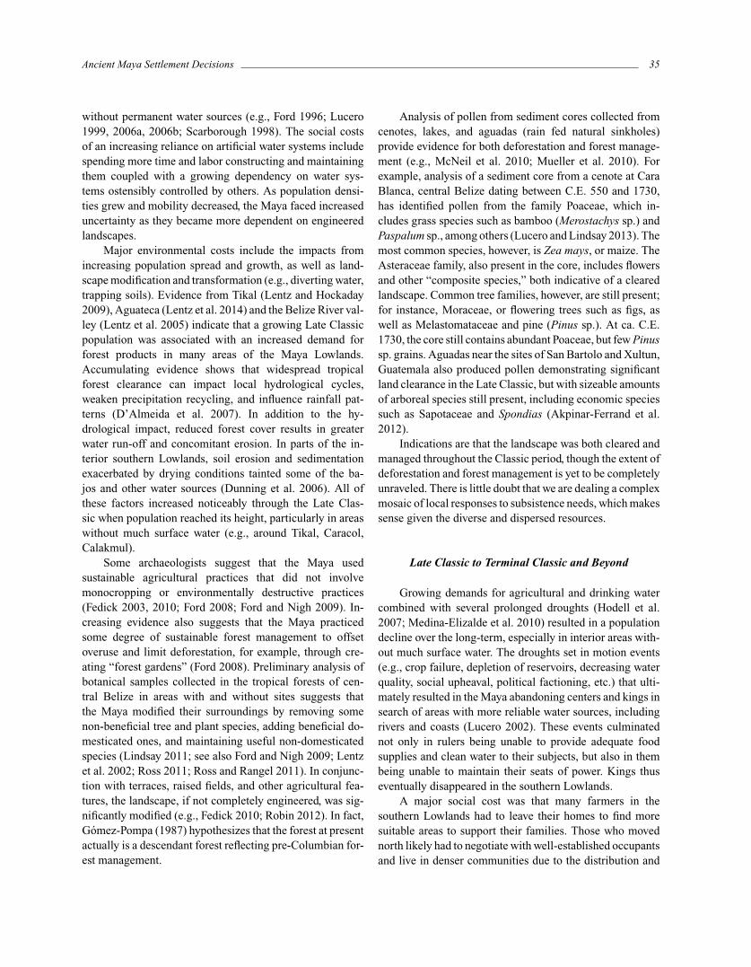
Major environmental costs include the impacts fromincreasing population spread and growth, as well as land-scape modification and transformation (e.g., diverting water,trapping soils). Evidence from Tikal (Lentz and Hockaday2009), Aguateca (Lentz et al. 2014) and the Belize River val-ley (Lentz et al. 2005) indicate that a growing Late Classicpopulation was associated with an increased demand forforest products in many areas of the Maya Lowlands.Accumulating evidence shows that widespread tropicalforest clearance can impact local hydrological cycles,weaken precipitation recycling, and influence rainfall pat-terns (D’Almeida et al. 2007). In addition to the hy-drological impact, reduced forest cover results in greaterwater run-off and concomitant erosion. In parts of the in-terior southern Lowlands, soil erosion and sedimentationexacerbated by drying conditions tainted some of the ba-jos and other water sources (Dunning et al. 2006). All ofthese factors increased noticeably through the Late Clas-sic when population reached its height, particularly in areaswithout much surface water (e.g., around Tikal, Caracol,Calakmul).
Some archaeologists suggest that the Maya usedsustainable agricultural practices that did not involvemonocropping or environmentally destructive practices(Fedick 2003, 2010; Ford 2008; Ford and Nigh 2009). In-creasing evidence also suggests that the Maya practicedsome degree of sustainable forest management to offsetoveruse and limit deforestation, for example, through cre-ating “forest gardens” (Ford 2008). Preliminary analysis ofbotanical samples collected in the tropical forests of cen-tral Belize in areas with and without sites suggests thatthe Maya modified their surroundings by removing somenon-beneficial tree and plant species, adding beneficial do-mesticated ones, and maintaining useful non-domesticatedspecies (Lindsay 2011; see also Ford and Nigh 2009; Lentzet al. 2002; Ross 2011; Ross and Rangel 2011). In conjunc-tion with terraces, raised fields, and other agricultural fea-tures, the landscape, if not completely engineered, was sig-nificantly modified (e.g., Fedick 2010; Robin 2012). In fact,Gomez-Pompa (1987) hypothesizes that the forest at presentactually is a descendant forest reflecting pre-Columbian for-est management.
Analysis of pollen from sediment cores collected fromcenotes, lakes, and aguadas (rain fed natural sinkholes)provide evidence for both deforestation and forest manage-ment (e.g., McNeil et al. 2010; Mueller et al. 2010). Forexample, analysis of a sediment core from a cenote at CaraBlanca, central Belize dating between C.E. 550 and 1730,has identified pollen from the family Poaceae, which in-cludes grass species such as bamboo (Merostachys sp.) andPaspalum sp., among others (Lucero and Lindsay 2013). Themost common species, however, is Zea mays, or maize. TheAsteraceae family, also present in the core, includes flowersand other “composite species,” both indicative of a clearedlandscape. Common tree families, however, are still present;for instance, Moraceae, or flowering trees such as figs, aswell as Melastomataceae and pine (Pinus sp.). At ca. C.E.1730, the core still contains abundant Poaceae, but few Pinussp. grains. Aguadas near the sites of San Bartolo and Xultun,Guatemala also produced pollen demonstrating significantland clearance in the Late Classic, but with sizeable amountsof arboreal species still present, including economic speciessuch as Sapotaceae and Spondias (Akpinar-Ferrand et al.2012).
Indications are that the landscape was both cleared andmanaged throughout the Classic period, though the extent ofdeforestation and forest management is yet to be completelyunraveled. There is little doubt that we are dealing a complexmosaic of local responses to subsistence needs, which makessense given the diverse and dispersed resources.
Late Classic to Terminal Classic and Beyond
Growing demands for agricultural and drinking watercombined with several prolonged droughts (Hodell et al.2007; Medina-Elizalde et al. 2010) resulted in a populationdecline over the long-term, especially in interior areas with-out much surface water. The droughts set in motion events(e.g., crop failure, depletion of reservoirs, decreasing waterquality, social upheaval, political factioning, etc.) that ulti-mately resulted in the Maya abandoning centers and kings insearch of areas with more reliable water sources, includingrivers and coasts (Lucero 2002). These events culminatednot only in rulers being unable to provide adequate foodsupplies and clean water to their subjects, but also in thembeing unable to maintain their seats of power. Kings thuseventually disappeared in the southern Lowlands.
A major social cost was that many farmers in thesouthern Lowlands had to leave their homes to find moresuitable areas to support their families. Those who movednorth likely had to negotiate with well-established occupantsand live in denser communities due to the distribution and

36 Lisa J. Lucero et al.
limited nature of water sources and thinner soils. Immigrantsstill were obligated to “pay” for access to some resourcesin areas into which they moved since other Maya groupshad been living there for centuries. Newcomers, however,found diverse economic opportunities, including exploitingsalt pans and participating in commerce and maritime trade.They also found a completely different political system—one that emphasized shared leadership rather than individ-ual kings, as suggested in the archaeological record thatlacked funerary temples and centralized palaces; and in theiconographic record that de-emphasized kings and insteadhighlighted the gods, a complete reversal from the Late Clas-sic (Sharer and Traxler 2006:544–569).
The major environmental cost in the southern Low-lands was the repercussions of several prolonged droughtson crops, forests, and water resources. Small groups of farm-ers continued to live in the areas adjacent to the moredependable aguadas at Tikal (Dunning, Griffin, et al. inpress) and likely used the un-maintained center reservoirsas well—after all, archaeologists a millennium later reliedon these same reservoirs at both Tikal and Caracol. Someareas were impacted more by overexploitation than others,especially those with limited resources at the outset. Forexample, the populace at Tikal, which relied almost en-tirely on rainfall to recharge reservoirs and grow crops, wasliving close to the carrying capacity of its extractive zonegiven the available technology and the population it sup-ported during the Late Classic period (Lentz et al. in press).Erosion has been noted in several areas of Tikal, particu-larly in the bajo margins (Dunning, Griffin, et al. in press).When the droughts of the 9th century became manifest,all of the resiliency had been wrung out of the landscapeand the polity was no longer able to support its expandedpopulation.
Copan in Honduras demonstrates a case with a dif-ferent type of limited resources. The alluvial soils aroundthe site core are concentrated within a 24 square kilome-ter area, which itself is surrounded by steep hills (Webster1999). Copan’s occupants extracted timber from both pine-oak forests and tropical deciduous forests as paleoethnob-otanical studies (Lentz 1991) and sediment core analysesindicate (Fedick 2010; McNeil et al. 2010). These forestryactivities likely contributed to bouts of erosion and environ-mental degradation in susceptible areas (Abrams and Rue1988).
Severe droughts at the end of the Classic period ulti-mately resulted in drastic environmental and social costs,especially in parts of the southern Lowlands. In spite of thisfact, the Maya adapted by exploring new areas for commerceand trade opportunities.
Discussion and Concluding Remarks
Our concluding remarks highlight some of the maintopics discussed in the context of Maya land use and watermanagement, and their implications regarding coping withsimilar issues today. Needless to say, the story is not asclear-cut as we might hope, especially regarding the qualityand quantity of water sources. The Maya have been adapt-ing to this semi-tropical region for millennia quite well,including moving into new areas and identifying sustainablewater sources such as springs, lakes, rivers, streams, andaguadas.
Their social, political, and religious life revolved aroundwater. When the dry season became acute in areas withoutmuch or any surface water, such as the elevated interior re-gions of the southern Lowlands (Dunning et al. 2012), theyrelied on artificial reservoirs found in nearly every majorcenter and maintained water quality by creating their ownwetland biospheres (Lucero et al. 2011). No matter the kindand scale of water systems, they were rainfall-dependent.Surviving annual and regional variation in precipitation wasa universal challenge since nearly all agricultural productionwas rainfall-dependent. Yet they adapted and adopted sus-tainable agricultural practices that have withstood the test oftime for millennia.
A vast portion of the northern Lowlands containsaquifers with water tables high and sizable enough to read-ily access by hand-excavated wells. This was not the casein the southern Lowlands where the water table is gener-ally unreachable with hand-excavation technology. One onlyhas to consider the 1960s University of Pennsylvania andGuatemalan archaeology project at Tikal where archaeolo-gists abandoned mechanical well digging at ca. 180 metersbelow the surface when they failed to hit water, and insteadturned to the ancient Maya reservoirs to meet their waterneeds (Siemens 1978). Nevertheless, little attempt has beenmade in the southern Lowlands to look for perched aquifersand their associated springs and shallow water tables. Aperched aquifer is situated at a shallower depth than thepermanent groundwater table, and is typically created bythe presence of an aquitard, or relatively impermeable layerwithin the bedrock strata. There is also the question aboutcommunity or household water storage systems, includingsmall natural and artificial depressions, used to supply wateryear-round in the southern Lowlands (e.g., Weiss-Krejci andSabbas 2002). However, a major concern with small–scalesystems would have been evaporation and decreasing waterquality as the dry season wore on. Yet to the north in thePuuc area, the Maya constructed household-scale, potablewater cistern systems (Isendahl 2011).

Ancient Maya Settlement Decisions 37
We need to rethink our notions about water scarcity inthe Maya Lowlands, and explore why there was such ap-parent variability in options and resilience when faced withwater shortages. Clearly there are complex and multidimen-sional issues that came into play when adapting and surviv-ing in the humid, seasonal tropics. The fact that the Mayadid so quite well has relevance for unraveling long-term so-lutions to current problems regarding water and landscapeuse.
One of the most challenging questions when discussingwater and landscape use is how to reconcile the noticeablearray of systems found in the Maya Lowlands today andin the past. Understanding how these seemingly incongru-ous features are linked can help us in understanding andaddressing today’s problems in the face of global climatechange. After all, no matter how diverse things have been,there is no doubt that farmers persevered and continue do soat present; there are lessons here that we are getting closer torevealing. In fact, the Intergovernmental Panel on ClimateChange (2007) recommends expanding rainfall harvesting,storage, and conservation to offset the impact of global cli-mate change—something the Maya accomplished for at leasta millennium (Lucero in press). Some of the strategies wehave presented here might be useful today, especially at thecommunity level.
From small to large-scale water systems, the Mayaadapted to living in the humid semi-tropics. How they ac-complished this feat varied depending on local factors andvariable strategies used for long-term success, even whenfaced with the seasonal vagaries of too much or not enoughrainfall (Scarborough and Lucero 2010). A final lesson withwhich we can leave readers is the knowledge that no matterthe type and scale of water features, local social networking,engagement, and interaction were key to keep the systemworking.
References Cited
Abrams, Eliot M., and David J. Rue1988 The Causes and Consequences of Deforestation
among the Prehistoric Maya. Cultural Ecology16:377–395.
Akpinar-Ferrand, Ezgi, Nicholas P. Dunning, David L.Lentz, and John G. Jones
2012 The Use of Aguadas as Water Sources in TwoSouthern Lowland Maya Sites. Ancient Mesoamer-ica 23:85–101.
Bacus, Elisabeth A., and Lisa J. Lucero1999 Introduction: Issues in the Archaeology of Trop-
ical Polities. In Complex Polities in the AncientTropical World. E. A. Bacus and L. J. Lucero, eds.Pp. 1–11. Archeological Papers of the AmericanAnthropological Association, 9. Arlington, VA:American Anthropological Association.
Barnhart, Edwin E.2001 The Palenque Mapping Project: Settlement and
Urbanism at an Ancient Maya City. Ph.D. disser-tation, Department of Anthropology, University ofTexas.
Beach, Timothy, Sheryl Luzzadder-Beach, and NicholasDunning
2008 Human and Natural Impacts on Fluvial and KarstSystems in the Maya Lowlands. Geomorphology101:301–331.
Brown, Clifford T.2006 Water Sources of Mayapan, Yucatan, Mexico.
In Precolumbian Water Management: Ideology,Ritual, and Politics. L. J. Lucero and B. W. Fash,eds. Pp. 171–185. Tucson: University of ArizonaPress.
Burton, Thomas M., Darrell L. King, Robert C. Ball, andThomas G. Baker
1979 Utilization of Natural Ecosystems for Waste WaterRenovation. United States Environmental Protec-tion Agency, Region V. Chicago: Great LakesNational Programs Office.
Carmean, Kelli, Nicholas Dunning, and Jeff K. Kowalski2004 High Times in the Hill country: A Perspective
from the Terminal Classic Puuc Region. InThe Terminal Classic in the Maya Lowlands:Collapse, Transition, and Transformation. A.A. Demarest, P. M. Rice, and D. S. Rice, eds.Pp. 424–449. Boulder: University Press ofColorado.
Cobos Palma, Rafael2004 Chichen Itza: Settlement and Hegemony During
the Terminal Classic Period. In The TerminalClassic in the Maya Lowlands: Collapse, Transi-tion, and Transformation. A. A. Demarest, P. M.Rice, and D. S. Rice, eds. Pp. 517–544. Boulder:University Press of Colorado.
Conrad, Henry S.1905 The Waterlilies: A Monograph of the Genus
38 Lisa J. Lucero et al.
Nymphaea. Publication No. 4. Washington, DC:The Carnegie Institute of Washington.
D’Almeida, Cassiano, Charles J. Vorosmarty, George C.Hurtt, Jose A. Marengo, S. Lawrence Dingman,and Barry D. Keim
2007 The Effects of Deforestation on the HydrologicalCycle in Amazonia: A Review on Scale andResolution. International Journal of Climatology27:633–647.
Demarest, Arthur A., Prudence M. Rice, and Don S. Rice,eds.
2004 The Terminal Classic in the Maya Lowlands: Col-lapse, Transition, and Transformation. Boulder:University Press of Colorado.
Davis-Salazar, Karla L.2003 Late Classic Water Management and Community
Organization at Copan, Honduras. Latin AmericanAntiquity 14:275–299.
Doolittle, William E.2006 An Epilogue and Bibliographic Supplement to
Canal Irrigation in Prehistoric Mexico: TheSequence of Technological Change. Mono yConejo 4:3–15.
Dunning, Nicholas P., and Timothy Beach2010 Farms and Forests: Spatial and Temporal Perspec-
tives on Ancient Maya Landscapes. In Landscapesand Societies. I. P. Martini and W. Chesworth, eds.Pp. 369–389. Dordrecht: Springer.
Dunning, Nicholas P., Timothy Beach, and SherylLuzzadder-Beach
2006 Environmental Variability Among Bajos in theSouthern Maya Lowlands and Its Implicationsfor Ancient Maya Civilization and Archaeology.In Precolumbian Water Management: Ideology,Ritual, and Politics. L. J. Lucero and B. W. Fash,eds. Pp. 81–91. Tucson: University of ArizonaPress.
2012 Kax and Kol: Collapse and Resilience in LowlandMaya Civilization. Proceedings of the NationalAcademy of Sciences 106(2012):3652–3657.
Dunning, Nicholas P., Robert Griffin, John G. Jones, RichardTerry, Zachary Larsen, and Christopher Carr
In press Life on the Edge: Tikal in a Bajo Landscape. InTikal: Paleoecology of an Ancient Maya City.
D. L. Lentz, N. P. Dunning, and V. L. Scarbor-ough, eds. Cambridge: Cambridge UniversityPress.
Dunning, Nicholas, E. Weaver, M. Smyth, and D. OrtegonIn press Xcoch: Home of Ancient Maya Rain Gods and
Water Managers. In The Archaeology of Yucatan:New Directions and Data. T. Stanton, ed. Oxford:BAR International Series.
Fash, Barbara W., and Karla L. Davis-Salazar2006 Copan Water Ritual and Management: Imagery
and Sacred Place. In Precolumbian Water Man-agement: Ideology, Ritual, and Politics. L. J.Lucero and B. W. Fash, eds. Pp. 129–143. Tucson:University of Arizona Press.
Fedick, Scott L.2003 In Search of the Maya Forest. In In Search of the
Rain Forest. Candace Slater, ed. Pp. 133–164.Durham: Duke University Press.
2010 The Maya Forest: Destroyed or Cultivated bythe Ancient Maya? Proceedings of the NationalAcademy of Sciences 107:953–954.
Fedick, Scott L., and Bethany A. Morrison2004 Ancient Use and Manipulation of Landscape in
the Yalahau Region of the Northern Maya Low-lands. Agriculture and Human Values 21:207–219.
Fedick, Scott L., Bethany A. Morrison, Bente Juhl Andersen,Sylviane Boucher, Jorge Ceja Acosta, and JenniferP. Mathews
2000 Wetland Manipulation in the Yalahau Region ofthe Northern Maya Lowlands. Journal of FieldArchaeology 27:131–152.
Finamore, Daniel, and Stephen D. Houston, eds.2010 Fiery Pool: The Maya and the Mythic Sea. New
Haven: Peabody Essex Museum and YaleUniversity Press.
Ford, Anabel1986 Population Growth and Social Complexity: An
Examination of Settlement and Environment in theCentral Maya Lowlands. Anthropological Papers,35. Tempe: Arizona State University.
1996 Critical Resource Control and the Rise of theClassic Period Maya. In The Managed Mosaic:Ancient Maya Agriculture and Resource Use. S.

Ancient Maya Settlement Decisions 39
L. Fedick, ed. Pp. 297–303. Provo: University ofUtah Press.
2008 Dominant Plants of the Maya Forest and Gardensof El Pilar: Implications for Paleoevironmen-tal Reconstructions. Journal of Ethnobiology28:179–199
Ford, Anabel, and Ronald Nigh2009 Origins of the Maya Forest Garden: Maya Re-
source Management. Journal of Ethnobiology29:213–236.
Forsyth, Donald W., Deanne L. Gurr, F. Richard Hauck, andRay T. Matheny
1983 Investigations at Edzna, Campeche, Mexico, Vol-ume 1, Part 1: The Hydraulic System. Papers ofthe New World Archaeological Foundation, 46.Provo: Brigham Young University.
French, Kirk D.2002 Creating Space through Water Management at the
Classic Maya Site of Palenque, Chiapas, Mexico.M.A. thesis, Department of Anthropology,University of Cincinnati.
French, Kirk, David S. Stuart, and Alfonso Morales2006 Archaeological and Epigraphic Evidence for Wa-
ter Management and Ritual at Palenque. InPrecolumbian Water Management: Ideology,Ritual, and Politics. L. J. Lucero and B. W. Fash,eds. Pp. 144–152. Tucson: University of ArizonaPress.
Gomez-Pompa, Arturo1987 On Maya Silviculture. Mexican Studies/ Estudios
Mexicanos 3(1):1–17
Glover, Jeffrey B.2006 The Yalahau Regionial Settlement Pattern Survey:
A Study of Ancient Maya Social Organization inNorthern Quintana Roo, Mexico. Ph.D. disserta-tion, Department of Anthropology, University ofCalifornia, Riverside.
Glover, Jeffrey B., and Travis W. Stanton2010 Assessing the Role of Preclassic Traditions in
the Formation of Early Classic Yucatec Cultures.Journal of Field Archaeology 35:58–77.
Graham, Elizabeth1999 Stone Cities, Green Cities. In Complex Polities in
the Ancient Tropical World, E. A. Bacus and L. J.Lucero, eds. Pp. 185–194. Archeological Papersof the American Anthropological Association,9. Arlington, VA: American AnthropologicalAssociation.
Gunn, Joel, William J. Folan, and Hubert R. Robichaux1995 A Landscape Analysis of the Candelaria Wa-
tershed in Mexico: Insights into Paleoclimatesaffecting Upland Horticulture in the SouthernYucatan Peninsula Semi-Karst. Geoarchaeology10:3–42.
Gunn, Joel D., Ray T. Matheny, and William J. Folan2002 Climate-Change Studies in the Maya Area. Ancient
Mesoamerica 13:79–84.
Hammer, David E., and Robert H. Kadlec1980 Wetland Utilization for Management of Commu-
nity Water: Concepts and Operation in Michigan.Industrial Development Division, Institute ofScience and Technology. Ann Arbor: Universityof Michigan.
Hodell, David A., Mark Brenner, and Jason H. Curtis2007 Climate and Cultural History of the Northeast-
ern Yucatan Peninsula, Quintana Roo, Mexico.Climatic Change 83:215–240.
Houston, Stephen D.1998 On the River of Ruins: Explorations at Piedras
Negras, Guatemala, 1997. Mexicon 20:16–22.2007 Summary for Policymakers of the Synthesis Re-
port of the IPCC Fourth Assessment Report.Accessed http://www.ipcc.ch/index.htm, accessedNovember 15, 2013.
Isendahl, Christian2011 The Weight of Water: A New Look at Pre-Hispanic
Puuc Maya Water Reservoirs. Ancient Mesoamer-ica 22:185–197.
Kunen, Julie L.2006 Water Management, Ritual, and Community in
Tropical Complex Societies. In PrecolumbianWater Management: Ideology, Ritual, and Politics.L. J. Lucero and B. W. Fash, eds. Pp. 100–115.Tucson: University of Arizona Press.
40 Lisa J. Lucero et al.
Lentz, David L.1991 Maya Diets of the Rich and Poor: Paleoethnob-
otanical Evidence from Copan. Latin AmericanAntiquity 2:269–287.
Lentz, David L., B. Lane, and K. Thompson2014 Food, Farming and Forest Management at
Aguateca. In Life and Politics at the Royal Courtof Aguateca: Artifacts, Analytical Data, andSynthesis. T. Inomata and D. Triadan, eds. Pp.203–217. Monographs of the Aguateca Archaeo-logical Project First Phase, 3. Provo: University ofUtah Press.
Lentz, D. L., L. Haddad, S. Cherpelis, H. J. Mary Joo, andM. Potter.
2002 Long-Term Influences of Ancient Maya Agro-forestry Practices on Tropical Forest Biodiversityin Northwestern Belize. In Ethnobiology andBiocultural Diversity. J. R. Stepp, F. S. Wyndham,R. Zarger, eds. Pp. 431–442. Athens: Universityof Georgia Press.
Lentz, David L., and Brian Hockaday2009 Tikal Timbers and Temples: Ancient Maya Agro-
forestry and the End of Time. Journal ofArchaeological Science 36:1342–1353.
Lentz, David L., Kevin Magee, Eric Weaver, John Jones,Kenneth Tankersley, Angela Hood, Gerald Islebe,Carmen Ramos, and Nicholas P. Dunning
In press Agroforestry and Agricultural Practices of theAncient Maya at Tikal. In Tikal: Paleoecologyof an Ancient Maya City. D. L. Lentz, N. P.Dunning, and V. L. Scarborough, eds. Cambridge:Cambridge University Press.
Lentz, David L., Jason Yaeger, Cynthia Robin, and WendyAshmore
2005 Pine, Prestige and Politics of the Late Classic Mayaat Xunantunich, Belize. Antiquity 79:573–585.
Liendo Stuardo, Rodrigo2002 The Organization of Agricultural Production at a
Maya Center: Settlement Patterns in the PalenqueRegion, Chiapas, Mexico. Pittsburgh: InstitutoNacional de Antropologıa e Historia, Mexico Cityand University of Pittsburgh.
Lindsay, Colleen2011 Assessing Ancient Maya Forest Management in
Peripheral Yalbac. In Results of the 2010 Valleyof Peace Archaeology Project: Cara Blanca andYalbac. L. J. Lucero, ed. Pp. 137–150. Reportsubmitted to the Institute of Archaeology, NationalInstitute of Culture and History, Belize.
Lucero, Lisa J.1999 Water Control and Maya Politics in the Southern
Maya Lowlands. In Complex Polities in theAncient Tropical World, E. A. Bacus and L. J.Lucero, eds. Pp. 34–49. Archeological Papersof the American Anthropological Association,9. Arlington, VA: American AnthropologicalAssociation.
2002 The Collapse of the Classic Maya: A Case for theRole of Water Control. American Anthropologist104:814–826.
2006a Agricultural Intensification, Water, and PoliticalPower in the Southern Maya Lowlands. In Agri-cultural Strategies. J. Marcus and C. Stanish, eds.Pp. 281–305. Los Angeles: The Cotsen Instituteof Archaeology, UCLA.
2006b Water and Ritual: The Rise and Fall of ClassicMaya Rulers. Austin: University of TexasPress.
In press Water Management in Lowland Mesoamerica. InWater and Humanity: Historical Overview. V. Scar-borough, ed. Paris: UNESCO.
Lucero, Lisa J., and Colleen Lindsay2013 Into the Depths of Cara Blanca: Exploring the
Maya Underworld. Research Reports in BelizeanArchaeology 10:165–175.
Lucero, Lisa J., Scott L. Fedick, Andrew Kinkella, and SeanM. Graebner
2004 Ancient Maya Settlement in the Valley of Peacearea, Belize. In Archaeology of the Upper BelizeRiver Valley: Half a Century of Maya Research.J. F. Garber, ed. Pp. 86–102. University Press ofFlorida.
Lucero, Lisa J., Joel D. Gunn, and Vernon L. Scarborough.2011 Climate Change and Classic Maya Water Manage-
ment. Theme Issue, “Managing Water Resourcesand Development in a Changing Climate,” Water3(2):479–494.
Lundell, Cyrus1937 The Vegetation of Peten. Publication No. 478.
Ancient Maya Settlement Decisions 41
Washington, DC: The Carnegie Institute ofWashington.
Marcus, Joyce2006 The Roles of Ritual and Technology in Mesoameri-
can Water Management. In Agricultural Strategies.J. Marcus and C. Stanish, eds. Pp. 221–254. LosAngeles: The Cotsen Institute of Archaeology,UCLA.
Matheny, Ray T.1982 Ancient Lowland and Highland Maya Water and
Soil Conservation Strategies. In Maya Subsistence:Studies in Memory of Dennis E. Puleston. K. V.Flannery, ed. Pp. 157–178. New York: AcademicPress.
McAnany, Patricia A., Eleanor Harrison, Polly A. Peterson,Steven Morandi, Satoru Murata, Ben S. Thomas,Sandra L. Lopez Varela, Daniel Finamore, andDavid G. Buck
2004 The Deep History of the Sibun River Valley. Re-search Reports in Belizean Archaeology 1:295–310.
McKillop, Heather1995 Underwater Archaeology, Salt Production, and
Coastal Maya Trade at Stingray Lagoon, Belize.Latin American Antiquity 6:214–228.
1996 Ancient Maya Trading Ports and the Integration ofLong-Distance and Regional Economies. AncientMesoamerica 7:49–62.
McNeil, Cameron L., David A. Burney, and Lida PigottBurney
2010 Evidence Disputing Deforestation as the Cause forthe Collapse of the Ancient Maya Polity of Copan,Honduras. Proceedings of the National Academyof Sciences 107:1017–1022.
Medina-Elizalde, Martın, Stephen J.Burns, David W. Lea,Yemane Asmerom, Lucien von Gunten, VictorPolyak, Mathias Vuille, and Ambarish Karmalkar
2010 High Resolution Stalagmite Climate Record fromthe Yucatan Peninsula Spanning the Maya Termi-nal Classic Period. Earth and Planetary ScienceLetters 298:255–262.
Miksic, John N.1999 Water, Urbanization, and Disease in Ancient In-
donesia. In Complex Polities in the AncientTropical World, E. A. Bacus and L. J. Lucero, eds.
Pp. 167–184. Archeological Papers of the Amer-ican Anthropological Association, 9. Arlington,VA: American Anthropological Association.
Mock, Shirley B.2004 Maya Traders on the North-Central Belize Coast.
Research Reports in Belizean Archaeology1:359–370.
Mueller, Andreas D., Gerald A. Islebe, Michael B.Hillesheim, Dustin A. Grzesik, Flavio S. Ansel-metti, Daniel Ariztegui, Mark Brenner, Jason H.Curtis, David A. Hodell, and Kathryn A. Venz
2010 Climate Drying and Associated Forest Decline inthe Lowlands of Northern Guatemala during theLate Holocene. Quaternary Research 71:133–141.
Nelson, Stephen G., Barry D. Smith, and Bruce R. Best1980 Nitrogen Uptake by Tropical Freshwater Macro-
phytes. Water Resources Research Center.Technical Report, 10. University of Guam,Mangialo.
Rands, Robert L.1953 The Water Lily in Maya Art: A Complex of Al-
leged Asiatic Origin. Bureau of AmericanEthnology Bulletin 151, Anthropological Papers,34. Pp. 75–153. Washington, DC: SmithsonianInstitution.
Robin, Cynthia, editor2012 Chan: An Ancient Maya Farming Community.
Gainesville: University Press of Florida.
Ross, Nanci J.2011 Modern Tree Species Composition Reflects An-
cient Maya “Forest Gardens” in Northwest Belize.Ecological Applications 21(1):75–84.
Ross, Nanci J., and Thiago F. Rangel2011 Ancient Maya Agroforestry Echoing Through
Spatial Relationships in the NW Belize. Biotropica43(2):141–148.
Sabloff, Jeremy A.2007 It Depends on How You Look at Things: New
Perspectives on the Postclassic Period in theNorthern Maya Lowlands. Proceedings of theAmerican Philosophical Society 151:11–25.
Scarborough, Vernon L.1993 Water Management in the Southern Maya

42 Lisa J. Lucero et al.
Lowlands: An Accretive Model for the EngineeredLandscape. Research in Economic Anthropology7:17–69.
1998 Ecology and Ritual: Water Management and theMaya. Latin American Antiquity 9:135–159.
2000 Resilience, Resource Use, and SocioeconomicOrganization: A Mesoamerican Pathway. InNatural Disaster and the Archaeology of HumanResponse. G. Bawden and R. Reycraft, eds. Pp.195–212. Albuquerque: Maxwell Museum ofAnthropology and the University of New MexicoPress.
2001 Hydrology. In Archaeology of Ancient Mexicoand Central America: An Encyclopedia. S. T.Evans, and D. L. Webster, eds. Pp. 352–356. NewYork: Garland Publishing.
2003 The Flow of Power: Ancient Water Systems andLandscapes. Santa Fe: School of AmericanResearch Press.
2006 An Overview of Mesoamerican Water Systems.In Precolumbian Water Management: Ideology,Ritual, and Politics. L. J. Lucero and B. W. Fash,eds. Pp. 223–235. Tucson: University of ArizonaPress.
2007 Colonizing a Landscape: Water and Wetlands inAncient Mesoamerica. In The political economy ofancient Mesoamerica: Transformations during theFormative and Classic Periods. V. L. Scarboroughand J. E. Clark, eds. Pp 163–174. Albuquerque:University of New Mexico Press.
Scarborough, Vernon L., and Gary C. Gallopin1991 A Water Storage Adaptation in the Maya Lowlands.
Science 251:658–662.
Scarborough, Vernon L., and Lisa J. Lucero2010 The Non-Hierarchical Development of Complex-
ity in the Semitropics: Water and Cooperation.Theme Issue, “Ancient Near East and Americas,”Water History 2(2):185–205.
Scarborough, Vernon L., Nicholas P. Dunning, Kenneth B.Tankersley, Christopher Carr, Eric Weaver, LiwyGrazioso, Brian Lane, John G. Jones, Palma But-tles, Fred Valdez, and David L. Lentz
2012 Water and Sustainable Land Use at the AncientTropical City of Tikal, Guatemala. Proceed-ings of the National Academy of Sciences109:12408–12413.
Schele, Linda, and David Freidel1990 A Forest of Kings: The Untold Story of the An-
cient Maya. New York: William Morrow andCompany.
Siemens, Alfred H.1978 Karst and the Pre-Hispanic Maya in the Southern
Lowlands. In Pre-Hispanic Maya Agriculture. P.D. Harrison and B. L. Turner, eds. Pp. 117–143.Albuquerque: University of New Mexico Press.
1996 Benign Flooding on Tropical Lowland Flood-plains. In The Managed Mosaic: Ancient MayaAgriculture and Resource Use. S. L. Fedick, ed.Pp. 132–144. Provo: University of Utah Press.
Siemens, Alfred H., and Dennis E. Puleston1972 Ridged Fields and Associated Features in Southern
Campeche: New Perspectives on the LowlandMaya. American Antiquity 37:228–239.
Sharer, Robert J., and Loa P. Traxler2006 The Ancient Maya. 6th edition. Stanford: Stanford
University Press.
Smyth, M. P., D. Ortegon, N. Dunning, and E. WeaverIn press Settlement Dynamics, Climate Change, and Hu-
man Response at Xcoch in the Puuc Region ofYucatan, Mexico. In The Archaeology of Yucatan:New Directions and Data. T. Stanton, ed. Oxford:BAR International Series.
Vince, Gaia2010 From One Farmer, Hope—and Reason for Worry.
Science 327:800.
Wahl D., R. Byrne, T. Schreiner, and R. Hansen2006 Holocene Vegetation Change in the Northern Pe-
ten and Its Implications for Maya Prehistory.Quaternary Research 65:80–389.
Webster, David L.1999 The Archaeology of Copan, Honduras. Journal of
Archaeological Research 7:1–53.
Weiss-Krejci, Estella and Thomas Sabbas2002 The Potential Role of Small Depressions as Water
Storage Features in the Central Maya Lowlands.Latin American Antiquity 13:343–357.
Willey, Gordon R., William R. Bullard, John B. Glass, andJames C. Gifford
1965 Prehistoric Maya Settlements in the Belize Valley.Peabody Museum of Archaeology and EthnologyPapers, 54. Cambridge: Harvard University.