Was the Oligocene–Miocene a time of fire and rain? Insights frombrown coals of the southeastern...
14
Was the Oligocene–Miocene a time of fire and rain? Insights from brown coals of the southeastern Australia Gippsland Basin Guy R. Holdgate ⁎ ,a , Malcolm W. Wallace a , Ian R.K. Sluiter b , Daniel Marcuccio a , Thomas A. Fromhold a , Barbara E. Wagstaff a a School of Earth Sciences, The University of Melbourne, Victoria 3010, Australia b Federation University Australia, Ballarat, Victoria 3350, Australia abstract article info Article history: Received 23 December 2013 Received in revised form 2 June 2014 Accepted 9 June 2014 Available online 24 June 2014 Keywords: Brown coal Lithotypes Cycles Sedimentology Facies Lithotype cycles (ranging from 10 to 30 m thick) in the brown coals of the Latrobe Valley, Gippsland Basin, Australia, display well-developed lightening-upward trends. Cycle tops are characterized by abrupt and uncon- formable boundaries with the overlying cycle. Geological, geochemical, palynological and macrofossil evidence is consistent with a relative drying (terrestrialization) upward depositional model for the cycles. The abundance of charcoal in dark lithotypes near the cycle bases is explained by the fire-prone and highly flam- mable nature of the herbaceous/reed wetlands, in common with similar modern wetlands in modern Australasia, in which the dark lithotypes are suggested to have formed. This, together with the greater preservation potential of charcoal in subaqueous environments, results in the wettest facies of the Latrobe Valley coals having the highest charcoal contents. Despite prevailing warm, wet climate conditions and the predominance of rainforests that are suggested to have characterized the Cenozoic of southern Australia, some swamp taxa were clearly already pre-adapted to tolerate fire and are likely to have been the ancestors of the fire-adapted floral communi- ties of modern arid Australia. © 2014 Elsevier B.V. All rights reserved. 1. Introduction Despite the enormous commercial value of brown coals, details of their facies architecture and depositional environments remain poorly understood. A major problem is relating layered development or lithologies of Holocene peat-forming environments directly with lay- ered development, or lithotypes, found in Tertiary age brown coal seams (Diessel, 1980, 1992, 1998). In addition, there is a considerable degree of variation in Holocene peat facies from different geographical regions (e.g. sub-tropical Okefenokee peatlands of Georgia vs tropical Malaysian and Indonesian peatlands, Cohen and Stack, 1996). The lithological scheme used for the Latrobe Valley brown coals (Fig. 1, Plate 1) places importance on the color of the coal (together with other factors such as texture, gelification, shrinkage and weathering patterns). These Tertiary age brown coal lithotypes range in color from nearly black (dark lithotype) to yellow–brown (light or pale lithotypes). The depositional model that dominates most brown coal literature is based on the brown coals of the lower Rhineland in Germany (Teichmueller, 1950). In this model, light lithotypes are interpreted as being deposited sub-aqueously in open water environ- ments, while darker lithotypes are deposited in relatively drier forest swamps above the water table (here termed the dry-dark model). By contrast, some other authors working on European brown coals have suggested the reverse of this depositional model (here termed the dry-light model); that the light colored coals were deposited in relatively drier conditions and dark coals in subaqueous conditions (e.g. Wölk, 1935; Hagemann and Wolf, 1987). Precisely the same con- troversy has occurred with respect to the brown coals of the Latrobe Valley in southeastern Australia (eg. Luly et al., 1980). Palynological studies of the Latrobe Valley coals (Luly et al., 1980; Kershaw and Sluiter, 1982; Sluiter and Kershaw, 1982; Kershaw et al., 1991; Blackburn and Sluiter, 1994), macrofossil work (Blackburn, 1980, 1981; Blackburn and Sluiter, 1994) and organic geochemical work (Finotello and Johns, 1986) have been used to support a modified version of the dry-dark model. In contrast, geological studies of the Latrobe Valley coals (Mackay et al., 1985; Anderson and Mackay, 1990; Holdgate et al., 1995) have supported the opposite dry-light model. Briggs et al. (2007) investigat- ed the relationship between lithotype color and the stable carbon isotopic composition of brown coals from the Morwell 1B seam and pre- sented yet another model for lithotype formation that emphasized later diagenetic, rather than syndepositional processes. Palaeogeography, Palaeoclimatology, Palaeoecology 411 (2014) 65–78 ⁎ Corresponding author. E-mail address: [email protected] (G.R. Holdgate). http://dx.doi.org/10.1016/j.palaeo.2014.06.004 0031-0182/© 2014 Elsevier B.V. All rights reserved. Contents lists available at ScienceDirect Palaeogeography, Palaeoclimatology, Palaeoecology journal homepage: www.elsevier.com/locate/palaeo
Transcript of Was the Oligocene–Miocene a time of fire and rain? Insights frombrown coals of the southeastern...
Palaeogeography, Palaeoclimatology, Palaeoecology 411 (2014) 65–78
Contents lists available at ScienceDirect
Palaeogeography, Palaeoclimatology, Palaeoecology
j ourna l homepage: www.e lsev ie r .com/ locate /pa laeo
Was the Oligocene–Miocene a time of fire and rain? Insights from browncoals of the southeastern Australia Gippsland Basin
Guy R. Holdgate ⁎,a, Malcolm W. Wallace a, Ian R.K. Sluiter b, Daniel Marcuccio a,Thomas A. Fromhold a, Barbara E. Wagstaff a
a School of Earth Sciences, The University of Melbourne, Victoria 3010, Australiab Federation University Australia, Ballarat, Victoria 3350, Australia
⁎ Corresponding author.E-mail address: [email protected] (G.R. Holdgate).
http://dx.doi.org/10.1016/j.palaeo.2014.06.0040031-0182/© 2014 Elsevier B.V. All rights reserved.
a b s t r a c t
a r t i c l e i n f oArticle history:Received 23 December 2013Received in revised form 2 June 2014Accepted 9 June 2014Available online 24 June 2014
Keywords:Brown coalLithotypesCyclesSedimentologyFacies
Lithotype cycles (ranging from 10 to 30 m thick) in the brown coals of the Latrobe Valley, Gippsland Basin,Australia, display well-developed lightening-upward trends. Cycle tops are characterized by abrupt and uncon-formable boundaries with the overlying cycle. Geological, geochemical, palynological and macrofossil evidenceis consistent with a relative drying (terrestrialization) upward depositional model for the cycles.The abundance of charcoal in dark lithotypes near the cycle bases is explained by the fire-prone and highly flam-mable nature of the herbaceous/reedwetlands, in commonwith similarmodernwetlands inmodern Australasia,inwhich the dark lithotypes are suggested to have formed. This, together with the greater preservation potentialof charcoal in subaqueous environments, results in the wettest facies of the Latrobe Valley coals having thehighest charcoal contents. Despite prevailing warm, wet climate conditions and the predominance of rainforeststhat are suggested to have characterized the Cenozoic of southern Australia, some swamp taxa were clearlyalready pre-adapted to tolerate fire and are likely to have been the ancestors of the fire-adapted floral communi-ties of modern arid Australia.
© 2014 Elsevier B.V. All rights reserved.
1. Introduction
Despite the enormous commercial value of brown coals, details oftheir facies architecture and depositional environments remain poorlyunderstood. A major problem is relating layered development orlithologies of Holocene peat-forming environments directly with lay-ered development, or lithotypes, found in Tertiary age brown coalseams (Diessel, 1980, 1992, 1998). In addition, there is a considerabledegree of variation in Holocene peat facies from different geographicalregions (e.g. sub-tropical Okefenokee peatlands of Georgia vs tropicalMalaysian and Indonesian peatlands, Cohen and Stack, 1996).
The lithological scheme used for the Latrobe Valley brown coals(Fig. 1, Plate 1) places importance on the color of the coal (togetherwith other factors such as texture, gelification, shrinkage andweathering patterns). These Tertiary age brown coal lithotypes rangein color from nearly black (dark lithotype) to yellow–brown (light orpale lithotypes). The depositional model that dominates most browncoal literature is based on the brown coals of the lower Rhineland in
Germany (Teichmueller, 1950). In this model, light lithotypes areinterpreted as being deposited sub-aqueously in open water environ-ments, while darker lithotypes are deposited in relatively drier forestswamps above the water table (here termed the dry-dark model).
By contrast, some other authors working on European brown coalshave suggested the reverse of this depositional model (here termedthe dry-light model); that the light colored coals were deposited inrelatively drier conditions and dark coals in subaqueous conditions(e.g. Wölk, 1935; Hagemann and Wolf, 1987). Precisely the same con-troversy has occurred with respect to the brown coals of the LatrobeValley in southeastern Australia (eg. Luly et al., 1980).
Palynological studies of the Latrobe Valley coals (Luly et al., 1980;Kershaw and Sluiter, 1982; Sluiter and Kershaw, 1982; Kershaw et al.,1991; Blackburn and Sluiter, 1994), macrofossil work (Blackburn,1980, 1981; Blackburn and Sluiter, 1994) and organic geochemicalwork (Finotello and Johns, 1986) have been used to support a modifiedversion of the dry-dark model.
In contrast, geological studies of the Latrobe Valley coals (Mackayet al., 1985; Anderson and Mackay, 1990; Holdgate et al., 1995) havesupported the opposite dry-light model. Briggs et al. (2007) investigat-ed the relationship between lithotype color and the stable carbonisotopic composition of brown coals from theMorwell 1B seamand pre-sented yet another model for lithotype formation that emphasized laterdiagenetic, rather than syndepositional processes.
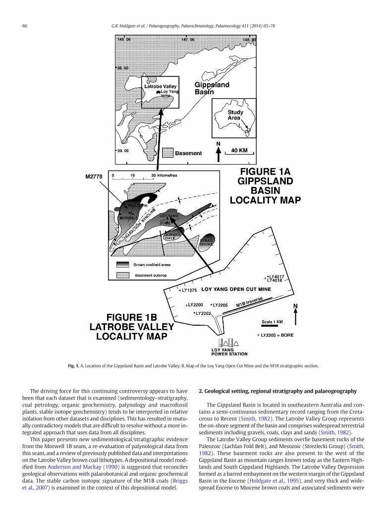
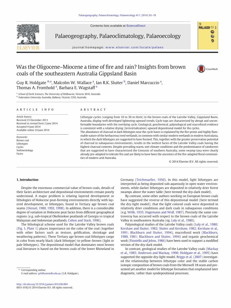
Fig. 1. A. Location of the Gippsland Basin and Latrobe Valley. B. Map of the Loy Yang Open Cut Mine and the M1B stratigraphic section.
66 G.R. Holdgate et al. / Palaeogeography, Palaeoclimatology, Palaeoecology 411 (2014) 65–78
The driving force for this continuing controversy appears to havebeen that each dataset that is examined (sedimentology–stratigraphy,coal petrology, organic geochemistry, palynology and macrofossilplants, stable isotope geochemistry) tends to be interpreted in relativeisolation from other datasets and disciplines. This has resulted in mutu-ally contradictorymodels that are difficult to resolvewithout amore in-tegrated approach that uses data from all disciplines.
This paper presents new sedimentological/stratigraphic evidencefrom the Morwell 1B seam, a re-evaluation of palynological data fromthis seam, and a review of previously published data and interpretationson the Latrobe Valley brown coal lithotypes. A depositional modelmod-ified from Anderson and Mackay (1990) is suggested that reconcilesgeological observations with palaeobotanical and organic geochemicaldata. The stable carbon isotopic signature of the M1B coals (Briggset al., 2007) is examined in the context of this depositional model.
2. Geological setting, regional stratigraphy and palaeogeography
The Gippsland Basin is located in southeastern Australia and con-tains a semi-continuous sedimentary record ranging from the Creta-ceous to Recent (Smith, 1982). The Latrobe Valley Group representsthe on-shore segment of the basin and compriseswidespread terrestrialsediments including gravels, coals, clays and sands (Smith, 1982).
The Latrobe Valley Group sediments overlie basement rocks of thePaleozoic (Lachlan Fold Belt), and Mesozoic (Strezlecki Group) (Smith,1982). These basement rocks are also present to the west of theGippsland Basin as mountain ranges known today as the Eastern High-lands and South Gippsland Highlands. The Latrobe Valley Depressionformed as a barred embayment on thewesternmargin of the GippslandBasin in the Eocene (Holdgate et al., 1995), and very thick and wide-spread Eocene to Miocene brown coals and associated sediments were
Plates 1–5.
67G.R. Holdgate et al. / Palaeogeography, Palaeoclimatology, Palaeoecology 411 (2014) 65–78
68 G.R. Holdgate et al. / Palaeogeography, Palaeoclimatology, Palaeoecology 411 (2014) 65–78
deposited (Fig. 1). Coal seams were formed behind a barrier complexknown as the Balook Formation (Thompson and Walker, 1982),which upon episodes of eustatic sea level rise, would be broken,allowing the deposition of interseam sediments such as mudstonesand siltstones with varying degrees of marine influence (Holdgateand Sluiter, 1991).
Coal seams of the Latrobe Valley Group are separated into threemain sequences of the Traralgon, Morwell and Yallourn seams.Combined stratigraphic thicknesses of all three seams may exceed 600m (Holdgate et al., 1995). The Traralgon Formation is the oldest coal de-posit in the Latrobe Valley lying within the Lower, Middle and UpperNothofagidites asperus Zone pollen stratigraphy of the late MiddleEocene to Early Oligocene (Partridge, 1971; Stover and Partridge,1973). Overlying the Traralgon Formation is the Morwell Formationwhich lies within the Lower, Middle and Upper Proteaciditestuberculatus Zone of the Late Oligocene to late Early Miocene(Partridge, 1971; Stover and Partridge, 1973). The Morwell Formationis further divided into the Morwell 2 (M2), Morwell 1B (M1B) andMorwell 1A (M1A) coal seams. The M2 seam reaches a maximumvertical thickness of 140 m, while the M1B and M1A attain maximumvertical thicknesses of 120 m and 80 m respectively (Holdgate, 2005).These sub-seams are split by thin sand and silt sequences of marine in-fluence in which dinoflagellates and foraminifera are found (Holdgateand Sluiter, 1991). Overlying the Morwell Formation is the YallournFormation which lies within the Lower Canthiumidites bellus Zone ofthe Middle Miocene (Holdgate et al., 2007). The Late Pliocene HauntedHill Formation overlies the Yallourn seam unconformably (Bolger,1991).
In the Latrobe Valley coals, lithotype refers to color layering that isvisible on open cut coal faces particularly on the older dried out faces(see Plates 1 to 6). The layering is characterized by variations in color,
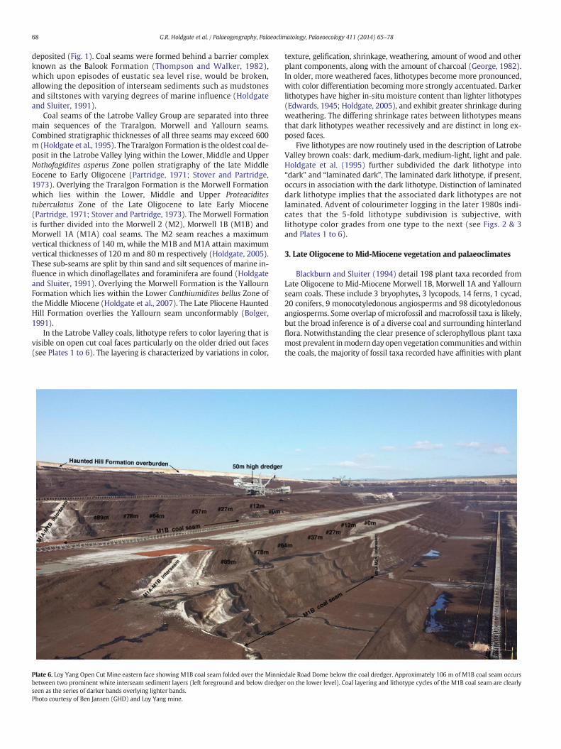
Plate 6. Loy Yang Open Cut Mine eastern face showing M1B coal seam folded over the Minniebetween two prominent white interseam sediment layers (left foreground and below dredgeseen as the series of darker bands overlying lighter bands.Photo courtesy of Ben Jansen (GHD) and Loy Yang mine.
texture, gelification, shrinkage, weathering, amount of wood and otherplant components, along with the amount of charcoal (George, 1982).In older, more weathered faces, lithotypes become more pronounced,with color differentiation becoming more strongly accentuated. Darkerlithotypes have higher in-situ moisture content than lighter lithotypes(Edwards, 1945; Holdgate, 2005), and exhibit greater shrinkage duringweathering. The differing shrinkage rates between lithotypes meansthat dark lithotypes weather recessively and are distinct in long ex-posed faces.
Five lithotypes are now routinely used in the description of LatrobeValley brown coals: dark, medium-dark, medium-light, light and pale.Holdgate et al. (1995) further subdivided the dark lithotype into“dark” and “laminated dark”. The laminated dark lithotype, if present,occurs in association with the dark lithotype. Distinction of laminateddark lithotype implies that the associated dark lithotypes are notlaminated. Advent of colourimeter logging in the later 1980s indi-cates that the 5-fold lithotype subdivision is subjective, withlithotype color grades from one type to the next (see Figs. 2 & 3and Plates 1 to 6).
3. Late Oligocene to Mid-Miocene vegetation and palaeoclimates
Blackburn and Sluiter (1994) detail 198 plant taxa recorded fromLate Oligocene to Mid-Miocene Morwell 1B, Morwell 1A and Yallournseam coals. These include 3 bryophytes, 3 lycopods, 14 ferns, 1 cycad,20 conifers, 9 monocotyledonous angiosperms and 98 dicotyledonousangiosperms. Some overlap of microfossil and macrofossil taxa is likely,but the broad inference is of a diverse coal and surrounding hinterlandflora. Notwithstanding the clear presence of sclerophyllous plant taxamost prevalent inmodern dayopen vegetation communities andwithinthe coals, the majority of fossil taxa recorded have affinities with plant
dale Road Dome below the coal dredger. Approximately 106 m of M1B coal seam occursr on the lower level). Coal layering and lithotype cycles of the M1B coal seam are clearly
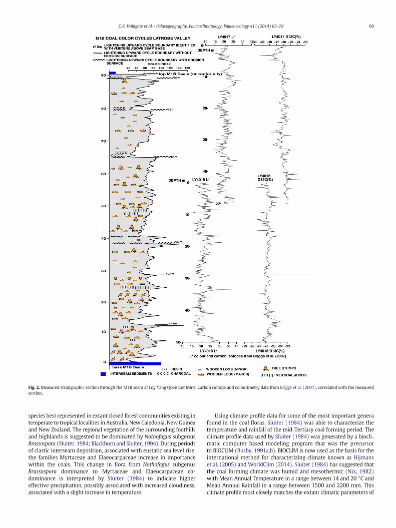
Fig. 2.Measured stratigraphic section through the M1B seam at Loy Yang Open Cut Mine. Carbon isotope and colourimetry data from Briggs et al. (2007), correlated with the measuredsection.
69G.R. Holdgate et al. / Palaeogeography, Palaeoclimatology, Palaeoecology 411 (2014) 65–78
species best represented in extant closed forest communities existing intemperate to tropical localities in Australia, NewCaledonia, NewGuineaand New Zealand. The regional vegetation of the surrounding foothillsand highlands is suggested to be dominated by Nothofagus subgenusBrassospora (Sluiter, 1984; Blackburn and Sluiter, 1994). During periodsof clastic interseam deposition, associated with eustatic sea level rise,the families Myrtaceae and Elaeocarpaceae increase in importancewithin the coals. This change in flora from Nothofagus subgenusBrassospora dominance to Myrtaceae and Elaeocarpaceae co-dominance is interpreted by Sluiter (1984) to indicate highereffective precipitation, possibly associated with increased cloudiness,associated with a slight increase in temperature.
Using climate profile data for some of the most important generafound in the coal floras, Sluiter (1984) was able to characterize thetemperature and rainfall of the mid-Tertiary coal forming period. Theclimate profile data used by Sluiter (1984) was generated by a biocli-matic computer based modeling program that was the precursorto BIOCLIM (Busby, 1991a,b). BIOCLIM is now used as the basis for theinternational method for characterizing climate known as Hijmanset al. (2005) and WorldClim (2014). Sluiter (1984) has suggested thatthe coal forming climate was humid and mesothermic (Nix, 1982)with Mean Annual Temperature in a range between 14 and 20 °C andMean Annual Rainfall in a range between 1500 and 2200 mm. Thisclimate profile most closely matches the extant climatic parameters of
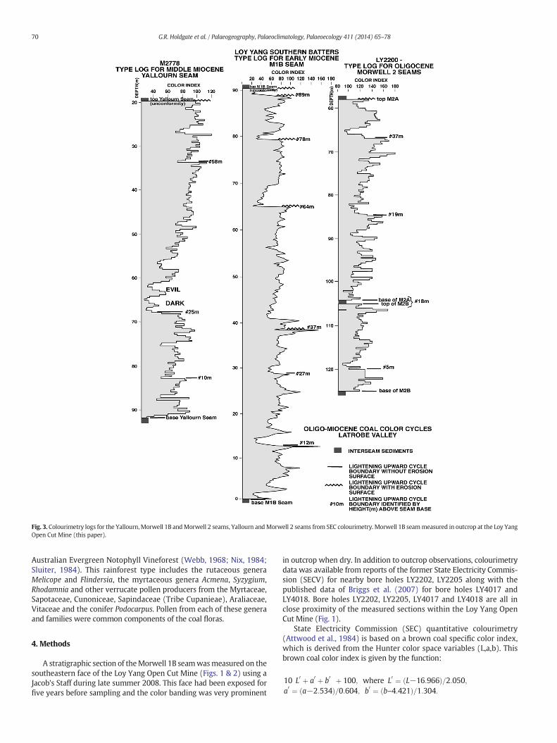
Fig. 3. Colourimetry logs for the Yallourn,Morwell 1B andMorwell 2 seams, Yallourn andMorwell 2 seams from SEC colourimetry. Morwell 1B seammeasured in outcrop at the Loy YangOpen Cut Mine (this paper).
70 G.R. Holdgate et al. / Palaeogeography, Palaeoclimatology, Palaeoecology 411 (2014) 65–78
Australian Evergreen Notophyll Vineforest (Webb, 1968; Nix, 1984;Sluiter, 1984). This rainforest type includes the rutaceous generaMelicope and Flindersia, the myrtaceous genera Acmena, Syzygium,Rhodamnia and other verrucate pollen producers from the Myrtaceae,Sapotaceae, Cunoniceae, Sapindaceae (Tribe Cupanieae), Araliaceae,Vitaceae and the conifer Podocarpus. Pollen from each of these generaand families were common components of the coal floras.
4. Methods
A stratigraphic section of theMorwell 1B seamwasmeasured on thesoutheastern face of the Loy Yang Open Cut Mine (Figs. 1 & 2) using aJacob's Staff during late summer 2008. This face had been exposed forfive years before sampling and the color banding was very prominent
in outcrop when dry. In addition to outcrop observations, colourimetrydata was available from reports of the former State Electricity Commis-sion (SECV) for nearby bore holes LY2202, LY2205 along with thepublished data of Briggs et al. (2007) for bore holes LY4017 andLY4018. Bore holes LY2202, LY2205, LY4017 and LY4018 are all inclose proximity of the measured sections within the Loy Yang OpenCut Mine (Fig. 1).
State Electricity Commission (SEC) quantitative colourimetry(Attwood et al., 1984) is based on a brown coal specific color index,which is derived from the Hunter color space variables (L,a,b). Thisbrown coal color index is given by the function:
10 L0 þ a0 þ b0� �þ 100; where L0 ¼ L−16:966ð Þ=2:050;
a0 ¼ a−2:534ð Þ=0:604; b0 ¼ b–4:421ð Þ=1:304:
71G.R. Holdgate et al. / Palaeogeography, Palaeoclimatology, Palaeoecology 411 (2014) 65–78
Briggs et al. (2007) also reported detailed carbon isotope data to-gether with color data for the M1B seam (Fig. 2) and took samples atevery 0.1 m. Briggs et al. (2007) used a different color measurementsystem (L*,a*,b*) and only used the lightness variable (L*) to specifycoal color. It is therefore difficult to directly correlate lithotypes andquantitative colourimetry with the data of Briggs et al. (2007).
For quantitative colourimetry from the Morwell 1B seam, sampleswere taken at 0.25 m intervals. The Minolta color meter measured re-sults are recorded in Marcuccio (2009). All samples were dried at40 °C for 3 days and then crushed to a grain size of 0.5–1 mm.Colourimetry was performed using a Konica-Minolta Chromameter(CR-410) using the Hunter L′, a′, b′ color scale. These values were con-verted to the SEC coal color index using the above formula. Thecolourimeter was calibrated each day to a standard, and an internalstandard was repeatedly measured in order to estimate analyticalprecision (precision on the color index being 2.3% at 2 sigma).
Pollen counts fromM1B seam in the bore LY1275were documentedby Sluiter (1984) and within the current Loy Yang Open Cut Mine(Fig. 1). The primary count data from Sluiter (1984) was re-examinedand selected taxa were illustrated with respect to the coal lithotypefrom which they occur. Averages for coal chemistry and coal maceralcontents for the lithotypes are calculated from the data of George(1982) and George and Hibbert (1986) from the Yallourn seam.Sluiter (1984), George (1982) and George and Hibbert (1986) did notdistinguish the laminated dark lithotype and thus there is no data forthis lithofacies. Rush cuticle and charcoal content for lithotypes iscalculated from data in Blackburn (1981) from the Yallourn seam.
Previous authors (Briggs et al., 2007; Holdgate et al., 2009) havemeasured stable carbon isotopes from theM1B seam, and tried to relatethose values to coal lithotype. Only Briggs et al. (2007)made their sam-pling sufficiently close at Loy Yang to provide an effective δ13C/colordata base (n = 995). However their colourimetry data gave highlyvariable results and provided no simple relationship to their isotopedata (Fig. 2). By re-sampling the M1B seam in outcrop we were ableto obtain a more consistent set of color data at 25 cm intervals (Fig. 2)that could be compared to the Briggs et al. (2007) δ13C values.
5. Results
5.1. Stratigraphy and sedimentology of lithotype cycles
The stratigraphic section of the M1B seam consists of a series oflithotype cycles of variable thickness (10–30 m) and composition(Fig. 2). Each cycle generally displays smaller scale lithotype variation,but overall, there is a lightening-upward trend evident that is supportedby statistical analyses conducted by Mackay et al. (1985). Cycle bound-aries are characterized by light or pale coals of the underlying cyclebeing overlain abruptly by dark or laminated dark coals that form thebase of the overlying cycle (Plates 2 to 6). The abrupt contacts are planarto undulating, showing relief of up to 1m, and always occur over lighterlithotype coals. The undulations are filled with laminated dark coal thatcontains large amounts of charcoal that locally may contain quartzsands at very low concentrations (b1%). The base of the M1B seam isunderlain by the M2/M1B interseam that is normally found as a 2 mthick band of finely laminated ligneous sands and siltstones.
From the stratigraphic section through the M1B seam, cycle bound-aries occur at stratigraphic levels of approximately 0 m, 12 m, 27 m, 37m, 64 m, 78 m and 89 m based on the stratigraphic height above thebase of the M1B seam. These cycle boundaries show close correlationwith those documented by Holdgate et al. (1995) whom referred tothem as the #24 m, #35 m, #64 m and #78 m boundaries (seePlates 4 and 5). Holdgate et al. (1995) and Holdgate et al. (2009) usedthese lithotype cycle boundaries within the M1B seam to subdivide it,from the oldest to youngest, into the M1Be, M1Bd, M1Bc, M1Bb andM1Ba subseams and parasequences. These measured lithotype cyclescorrelate with lithotype cycling in the colourimetry logs of the SEC
data in bore LY2205, although only the lower 32 m of M1B seam wascovered.
The colourimetry data of Briggs et al. (2007) displays amuch greatervariability and fluctuation from sample to sample than is evident in ei-ther measured colourimetry from outcrop or on SEC colourimetrylogs, making lithotype correlations with the work of Briggs et al.(2007) difficult. Briggs et al. (2007) used two drill holes at the LoyYangMine (LY4017, LY4018) to produce a single composite log throughthe M1B seam as shown in Fig. 2. The correlation of Briggs et al. (2007)to previous logs for the upper part of M1B (upper drill hole LY4017) ap-pears unequivocal, with two prominent dark units correlating with the#64 m and #78 m boundaries. Correlation of the lower bore (LY4018)with existing lithotype logs is difficult. Bore LY4018 may also lie 10 mstratigraphically lower in the M1B seam than the suggested correlationof Briggs et al. (2007) as shown in Fig. 2. This implies a short uncored in-terval in the stratigraphic record between the two bores, rather than anoverlap (as suggested by Briggs et al., 2007), and explains the poorcolourimetry correlation between the two bores.
Measured lithotype cycle boundaries equate with the base of theInterseam Influence Zones 1–7 of Blackburn and Sluiter (1994).Interseam Influence Zones are based on a quantitative palaeofloristicpalynological zonation in the coal seams. They are thought to representmarine influences associated with eustatic sea level rise on the Tertiaryage peat swamps. These serial marine incursions on to themassive peatswamp that dominated the onshore parts of the Latrobe Valley are be-lieved to have led to development of sub-aqueous plant communities.The Interseam Influence Zones are equivalent to the base of subseams/parasequences defined by Holdgate et al. (1995).
Lightening-upward lithotype cycles in the measured section beginwith a dark, or laminated dark charcoal-rich coal that has no large (N2cm) wood fragments. Much of the charcoal in the laminated darklithotypes consists of well preserved and delicate plant fragments, par-ticularly fern stems such as the pinnules of the fern Gleichenia(Blackburn and Sluiter, 1994). The charcoalified stem fragments showno sorting and range from 1 to 5 mm in diameter and up to 2 cm long.Charcoal fragments lie parallel to laminae but are randomly orientedwithin the laminae. Quartz sand is locally present at the base of the lam-inated dark coals.
The basal dark coals of each cycle grade upward into medium darkand medium light coals that have an abundance of large wood frag-ments (including whole trunks and rarely in-situ stumps). Charcoal isless abundant in these lighter lithotypes and the coal is unlaminated.The lithotype cycles are terminated by a light or pale coal with little orno woody material.
Petrographically, the darker lithotypes have greater levels ofgelification (i.e. with a high Gelification Index, see George, 1982). Ligh-ter lithotypes have high liptinite concentrations (particularly sporinite).Darker lithotypes also have higher average in-situ moisture contents(65% average) than lighter lithotypes (average 58%) in the M1B seam(range from 55 to 65%) (Allardice, 1991).
5.2. Lithotype cycles in other Latrobe Valley coal seams
Lightening upward lithotype-colourimetry cycles occur in all otherLatrobe Valley coal seams (Fig. 3; also see Plates 2 and 3). In lithotypebore M2778 (Fig. 1) (George and Hibbert, 1986) the Middle MioceneYallourn seam has cycle boundaries at 10 m, 25 m, and 58 m abovethe seam base. Sub-cycle boundaries are also evident. The prominentdark lithotype interval above the 25 m boundary between 62 and 68m in bore M2778 is one of the thickest dark intervals known. This partof Yallourn seam was referred locally by the Yallourn workers as the“Evil Dark” due to its poor briquetting capabilities (see Plate 2). It hasabundant charcoal at the base, and the #25 m surface immediatelybelow exhibits widespread erosional effects (Holdgate et al., 2007).
In the Oligocene Morwell 2 seam in bore LY2200 (Fig. 3), cycleboundaries occur 5 m above the base of M2B seam, and 19 m and 37
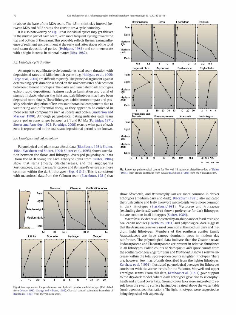
Fig. 5. Average palynological counts for Morwell 1B seam calculated from data of Sluiter(1984). Rush cuticle content is from data of Blackburn (1980) from the Yallourn seam.
72 G.R. Holdgate et al. / Palaeogeography, Palaeoclimatology, Palaeoecology 411 (2014) 65–78
m above the base of the M2A seam. The 1.5 m thick clay interval be-tween M2A and M2B seams also constitutes a cycle boundary.
It is also noteworthy on Fig. 3 that individual cycles may get thickerin themiddle part of each seam, withmore frequent cycling toward thetop and bottom of the seams. This probably reflects the increasing influ-ence of sediment encroachment at the early and latter stages of the totalcoal seam depositional period (Holdgate, 1985) and commensuratewith a slight increase in mineral matter (Kiss, 1982).
5.3. Lithotype cycle duration
Attempts to equilibrate cycle boundaries, coal seam duration withdepositional rates and Milankovitch cycles (e.g. Holdgate et al., 1995;Large et al., 2004) are difficult to justify. The principal argument againstdetermining cycle duration is based on the unknown rates of depositionbetween different lithotypes. The darks and laminated dark lithotypesexhibit rapid depositional features such as lamination and burial ofstumps in place, whereas the light and pale lithotypes may have beendepositedmore slowly. These lithotypes exhibitmore compact and pos-sibly selective depletion of less resistant botanical components due toweathering and differential decay, as they appear to be enriched inmore resistant components such as spores and pollen (Anderson andMackay, 1990). Although palynological dating indicates each seamspore–pollen zone ranges between a 3.1 and 9.4 Ma (Partridge, 1971;Stover and Partridge, 1973; Partridge, 2006) exactly what part of eachzone is represented in the coal seam depositional period is not known.
5.4. Lithotypes and palaeobotany
Palynological and plant macrofossil data (Blackburn, 1981; Sluiter,1984; Blackburn and Sluiter, 1994; Sluiter et al., 1995) shows correla-tion between the floras and lithotype. Averaged palynological data(from the M1B seam) for each lithotype (data from Sluiter, 1984)show that ferns (mostly Gleichenaceae), and the angiospermsRestionaceae, Epacridaceae/Ericaceae and Banksia/Dryandra are morecommon within the dark lithotypes (Figs. 4 & 5). This is consistentwith macrofossil data from the Yallourn seam (Blackburn, 1981) that
Fig. 4. Average values for geochemical and liptinite data for each lithotype. (Calculatedfrom George, 1982; George and Hibbert, 1986). Charcoal content calculated from data ofBlackburn (1980) from the Yallourn seam.
show Gleichenia, and Banksieaphyllum are more common in darkerlithotypes (medium dark and dark). Blackburn (1981) also indicatedthat rush cuticle and leafy liverwort macrofossils were more commonin dark lithotypes (Blackburn,1981). Myrtaceae and Proteaceae(excluding Banksia/Dryandra) show a preference for dark lithotypes,but are common in all lithotypes (Sluiter, 1984).
Macrofossil evidence as indicated by an abundance of fossil resin andAraucarian nodules (Blackburn, 1981) and palynological data suggeststhat the Araucariaceaeweremost common in themediumdark andme-dium light lithotypes. Members of the southern conifer familyAraucariaceae are large canopy dominant trees in modern dayrainforests. The palynological data indicate that the Casuarinaceae,Podocarpaceae and Elaeocarpaceae are present in relative abundancein all lithotypes. Pollen counts of Nothofagus, and spore counts fromthe southern conifers Lagarostrobus and Phyllocladus show a relative in-crease within the total spore–pollen counts in lighter lithotypes. Thereare, however, few macrofossils described from the lighter lithotypes.Kershaw et al. (1991) illustrated palynological averages for lithotypesconsistent with the above trends for the Yallourn, Morwell and upperTraralgon seams. From this data, Kershaw et al. (1991) gave supportto the dry-dark model, where dark lithotypes gave rise to sclerophyllheath and ground cover taxa. Ground cover taxa were suggested to re-sult from the swamp surface having been raised above the water table(ombrogenous peat formation). The light lithotypes were suggested asbeing deposited sub-aqueously.
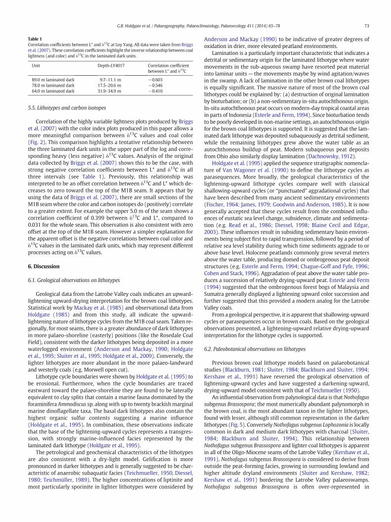
Table 1Correlation coefficients between L* and δ13C at Loy Yang. All data were taken from Briggset al. (2007). These correlation coefficients highlight the inverse relationship between coallightness (and color) and δ13C in the laminated dark units.
Unit Depth-LY4017 Correlation coefficientbetween L* and δ13C
89.0 m laminated dark 9.7–11.1 m −0.60378.0 m laminated dark 17.5–20.6 m −0.54664.0 m laminated dark 31.9–34.9 m −0.410
73G.R. Holdgate et al. / Palaeogeography, Palaeoclimatology, Palaeoecology 411 (2014) 65–78
5.5. Lithotypes and carbon isotopes
Correlation of the highly variable lightness plots produced by Briggset al. (2007) with the color index plots produced in this paper allows amore meaningful comparison between δ13C values and coal color(Fig. 2). This comparison highlights a tentative relationship betweenthe three laminated dark units in the upper part of the log and corre-sponding heavy (less negative) δ13C values. Analysis of the originaldata collected by Briggs et al. (2007) shows this to be the case, withstrong negative correlation coefficients between L* and δ13C in allthree intervals (see Table 1). Previously, this relationship wasinterpreted to be an offset correlation between δ13C and L* which de-creases to zero toward the top of the M1B seam. It appears that byusing the data of Briggs et al. (2007), there are small sections of theM1B seamwhere the color and carbon isotopes do (positively) correlateto a greater extent. For example the upper 5.0 m of the seam shows acorrelation coefficient of 0.399 between δ13C and L*, compared to0.031 for the whole seam. This observation is also consistent with zerooffset at the top of the M1B seam. However a simpler explanation forthe apparent offset is the negative correlations between coal color andδ13C values in the laminated dark units, which may represent differentprocesses acting on δ13C values.
6. Discussion
6.1. Geological observations on lithotypes
Geological data from the Latrobe Valley coals indicates an upward-lightening upward-drying interpretation for the brown coal lithotypes.Statistical work by Mackay et al. (1985) and observational data fromHoldgate (1985) and from this study, all indicate the upward-lightening nature of lithotype cycles from theM1B coal seam. Taken re-gionally, formost seams, there is a greater abundance of dark lithotypesin more palaeo-shoreline (easterly) positions (like the Rosedale CoalField), consistent with the darker lithotypes being deposited in a morewaterlogged environment (Anderson and Mackay, 1990; Holdgateet al., 1995; Sluiter et al., 1995; Holdgate et al., 2009). Conversely, thelighter lithotypes are more abundant in the more palaeo-landwardand westerly coals (e.g. Morwell open cut).
Lithotype cycle boundaries were shown by Holdgate et al. (1995) tobe erosional. Furthermore, when the cycle boundaries are tracedeastward toward the palaeo-shoreline they are found to be laterallyequivalent to clay splits that contain a marine fauna dominated by theforaminifera Ammodiscus sp. alongwith up to twenty brackishmarginalmarine dinoflagellate taxa. The basal dark lithotypes also contain thehighest organic sulfur contents suggesting a marine influence(Holdgate et al., 1995). In combination, these observations indicatethat the base of the lightening-upward cycles represents a transgres-sion, with strongly marine-influenced facies represented by thelaminated dark lithotype (Holdgate et al., 1995).
The petrological and geochemical characteristics of the lithotypesare also consistent with a dry-light model. Gelification is morepronounced in darker lithotypes and is generally suggested to be char-acteristic of anaerobic subaquatic facies (Teichmueller, 1950, Diessel,1980; Teichmüller, 1989). The higher concentrations of liptinite andmost particularly sporinite in lighter lithotypes were considered by
Anderson and Mackay (1990) to be indicative of greater degrees ofoxidation in drier, more elevated peatland environments.
Lamination is a particularly important characteristic that indicates adetrital or sedimentary origin for the laminated lithotype where watermovements in the sub-aqueous swamp have resorted peat materialinto laminar units — the movements maybe by wind agitation/wavesin the swamp. A lack of lamination in the other brown coal lithotypesis equally significant. The massive nature of most of the brown coallithotypes could be explained by: (a) destruction of original laminationby bioturbation; or (b) a non-sedimentary in-situ autochthonous origin.In-situ autochthonous peat occurs onmodern-day tropical coastal areasin parts of Indonesia (Esterle and Ferm, 1994). Since bioturbation tendsto be poorly developed in non-marine settings, an autochthonous originfor the brown coal lithotypes is supported. It is suggested that the lam-inated dark lithotype was deposited subaqueously as detrital sediment,while the remaining lithotypes grew above the water table as anautochthonous buildup of peat. Modern subaqueous peat depositsfrom Ohio also similarly display lamination (Dachnowsky, 1912).
Holdgate et al. (1995) applied the sequence stratigraphic nomencla-ture of Van Wagoner et al. (1990) to define the lithotype cycles asparasequences. More broadly, the geological characteristics of thelightening-upward lithotype cycles compare well with classicalshallowing-upward cycles (or “punctuated” aggradational cycles) thathave been described from many ancient sedimentary environments(Fischer, 1964; James, 1979; Goodwin and Anderson, 1985). It is nowgenerally accepted that these cycles result from the combined influ-ences of eustatic sea level change, subsidence, climate and sedimenta-tion (e.g. Read et al., 1986; Diessel, 1998; Blaine Cecil and Edgar,2003). These influences result in subsiding sedimentary basin environ-ments being subject first to rapid transgression, followed by a period ofrelative sea level stability during which time sediments aggrade to orabove base level. Holocene peatlands commonly grow several metersabove the water table, producing domed or ombrogenous peat depositstructures (e.g. Esterle and Ferm, 1994; Chague-Goff and Fyfe, 1996;Cohen and Stack, 1996). Aggradation of peat above thewater table pro-duces a succession of relatively drying-upward peat. Esterle and Ferm(1994) suggested that the ombrogenous forest bogs of Malaysia andSumatra generally displayed a lightening upward color succession andfurther suggested that this provided a modern analog for the LatrobeValley coals.
From a geological perspective, it is apparent that shallowing-upwardcycles or parasequences occur in brown coals. Based on the geologicalobservations presented, a lightening-upward relative drying-upwardinterpretation for the lithotype cycles is supported.
6.2. Paleobotanical observations on lithotypes
Previous brown coal lithotype models based on palaeobotanicalstudies (Blackburn, 1981; Sluiter, 1984; Blackburn and Sluiter, 1994;Kershaw et al., 1991) have reversed the geological observation oflightening-upward cycles and have suggested a darkening-upward,drying-upward model consistent with that of Teichmueller (1950).
An influential observation frompalynological data is thatNothofagussubgenus Brassospora; the most numerically abundant palynomorph inthe brown coal, is the most abundant taxon in the lighter lithotypes,found with lesser, although still common representation in the darkerlithotypes (Fig. 5). ConverselyNothofagus subgenus Lophozonia is locallycommon in dark and medium dark lithotypes with charcoal (Sluiter,1984; Blackburn and Sluiter, 1994). This relationship betweenNothofagus subgenus Brassospora and lighter coal lithotypes is apparentin all of the Oligo-Miocene seams of the Latrobe Valley (Kershaw et al.,1991). Nothofagus subgenus Brassospora is considered to derive fromoutside the peat-forming facies, growing in surrounding lowland andhigher altitude dryland environments (Sluiter and Kershaw, 1982;Kershaw et al., 1991) bordering the Latrobe Valley palaeoswamps.Nothofagus subgenus Brassospora is often over-represented in
74 G.R. Holdgate et al. / Palaeogeography, Palaeoclimatology, Palaeoecology 411 (2014) 65–78
palynological analyses because of its high pollen production and regionalpollen dispersal capabilities (Walker and Flenley, 1979; Fletcher andThomas, 2007).
The abundance of Nothofagus subgenus Brassospora in lighterlithotypes poses obvious problems for the dry-dark model, withprevious authors interpreting the widely dispersed Nothofagus pollenas accumulating in open water pale lithotype environments (Sluiterand Kershaw, 1982; Kershaw et al., 1991). This alternative dry-darkmodel would only work if the ‘open water’ light and pale lithotype en-vironments were the only lithotypes to contain abundant Nothofagus,however, Nothofagus subgenus Brassospora is common in all lithotypes,albeit generally more abundant in the lighter lithotypes (Sluiter, 1984).An alternative explanation for a greater proportion of the total pollen ofNothofagus subgenus Brassospora in lighter lithotypes, is that the abun-dance of Nothofagus in each of the lithotypes may reflect the proximityof the individual peat-forming facies to the pollen source, that is thedryland or landward rainforest communities growing on the foothillsand slopes of the bordering Eastern and South Gippsland Highlands.This scenario infers a dry-light model of lithotype formation wherebypale lithotypes were the most landward, and hence closer to drylandNothofagus subgenus Brassospora forests, while the darker lithotypesformed closest to the palaeoshoreline.
Dark and medium dark lithotypes also have the highest palynologi-cal abundance of Restionacea or rush pollen, Epacridaceae/Ericaceae, orheathy shrubs and shrub and sub-shrubpollen, Banksia/Drylandra shrubpollen, as well as pteridophyte spores dominated by Gleichenia. Each ofthese floristic elements has modern analogs in wet swamp conditions,with Banksia, rush and heath taxa also common in present-dayAustralian heath swamps occurring on oligotrophic sands. Co-occurrence of locally abundant macrofossils of Banksiaphyllum rushcuticle and Gleichenia pinnules and stems in medium dark and darklithotypes has also been reported by Blackburn (1981) and Blackburnand Sluiter (1994). The palynology and macrofossil observations canbe interpreted as consistent with an open swampy herbland/heathlandsetting growing in close proximity to the existing water table, not dis-similar to the reed/rush-Gleichenia moor envisaged by Blackburn andSluiter (1994).
The lack of herbaceous heathy and fern swamp taxa in the lighterlithotypes e.g. Restionaceaa, Banksia/Drylandra, Epacridaceae/Ericaceaeand Gleichenaceae had previously been explained by their depositionin open water (Sluiter and Kershaw, 1982). In addition the lack of anyidentified plant macrofossils in the pale and light lithotypes promptedBlackburn (1981) to first propose an open water origin for lightlithotypes. Again, a simpler explanation for the lack of herbaceousswamp taxa is that the light lithotypes were the highest and relativelydriest facies where plant-fragment oxidation took place and wheremore resistant spore–pollenwaspreserved post-deposition. Laminationwould also be an expected consequence of deposition in a subaqueousopen water environment, yet none of the lighter lithotypes displayany lamination. The only coal facies that does display lamination —
the laminated dark lithotype, when present, occurs in the most basalportion of the lightening upward cycle.
6.3. Charcoal abundance in dark lithotypes
Palaeobotanical-based interpretations of lithotype cycles appear tohave been strongly influenced by the observation of very abundant(N10%) charcoal fragments in some dark lithotypes, particularly thelaminated dark lithotype. Charcoal in these darker lithotypes wasinterpreted as being caused by fires in the driest coal-forming environ-ments (Sluiter, 1984; Kershawet al., 1991; Blackburn and Sluiter, 1994).In addition, maceral counts usually show that the fusinite content is thehighest (~0.2%) in the dark lithotypes (George and Mackay, 1991).These arguments appear to provide strong support for the dry darklithotype model and have never been addressed by proponents of thewet-dark model.
Field logging conducted in this study suggests that charcoal is mostabundant in the laminated dark lithotype (not distinguished fromdark lithotypes in palaeobotanical studies). Furthermore, this charcoalis commonly in the form of very delicate charcoalified plant fragmentssuch as the pinnules of the fern Gleichenia, as noted by Blackburn andSluiter (1994) that are almost perfectly preserved. This suggests preser-vation in a low energy subaqueous setting, also consistent with the lam-inated nature of the lithotype.
The absence of large wood fragments and abundance ofcharcoalified fern fragments, together with the dominance of herba-ceous rush and heathy taxa in palynological data for this lithotype sug-gests that the charcoal was not produced in a forest fire, but rather inlow-growing heathy plant communities. There is no evidence for thepeat surface having been burned, as masses of structureless pyrolyticcarbon would be expected (Peterson, 1998; Collinson et al., 2007).These observations oppose the hypothesis of Briggs et al. (2007) thatthe charcoal-rich dark lithotypes are a result of surface and subsurfacepeat burning. Briggs et al. (2007) also proposed this peat-burningmodel as an explanation for the abrupt and irregular contacts betweenlight and dark lithotypes. The radically different nature of the light anddark lithotypes together with their lateral stratigraphic relationshipsand their distinctive macrofossil and palynological composition dis-proves this scenario for the Latrobe Valley coals.
The dark charcoal-rich coal lithotypes contain flora that, in modernenvironments are fire-tolerant. Extant plant associations containingRestionaceae rush, Epacidaceae heath, Gleichenia, and Banksia are allfire-tolerant taxa that are more typical of Pleistocene and extantsclerophyll communities in Australia than of the ever-wet rainforest en-vironments of the mid-Cenozoic (Kershaw et al., 1991). Blackburn(1981) also noted from macrofossil work that the dark lithotypes as-sumed at the time to be climax vegetation at the top of lithotype cyclescontained floras that inmodernAustralian communitieswere xeric fire-tolerant. In contrast the Podocarpaceae macrofossil taxa, most commonin lighter lithotypes, were more typical of ever-wet rainforests that arenot fire-tolerant. These botanical interpretations appear to have beenimportant in assigning environments to the lithotypes under the dry-dark model.
A distinction should bemade however between the fire-tolerance ofplant taxa and a hot-dry ecology. Some of the most highly flammableplant communities that are prone to regular fires are in fact wetlands.A study by Bond et al. (2004) of New Zealand manuka (Leptospermumscoparium), found that highly fire-tolerant varieties were locatedadjacent to waterlogged peat bogs and pakihi heath sites in Westlandwith up to 3000 mm of rainfall annually. These authors make thepoint that highly flammable vegetation types like xeric sclerophyll-dominated heaths and herbaceous wetlands growing in high rainfallclimates only require a few days of hot dry weather to produce dryfuel for fires.
Western Tasmanian herbaceous moorlands are also very flammableand fire-prone, despite their water-logged nature (Pyrke and Marsden-Smedley, 2005). Importantly these Tasmanian wetlands contain fire-tolerant plant taxa from the genera Banksia and Gleichenia, along withmembers of the families Epacridaceae and Restionaceae, in commonwith the charcoal-rich dark lithotypes of the Latrobe Valley browncoals. Fletcher and Thomas (2007) found that Epacridaceae/Ericaceaepollen was consistently present in surface samples from Tasmanianmoorlands. The low altitude moorlands of western Tasmania are com-monly surrounded by Nothofagus subgenus Lophozonia dominatedrainforest and these environments are perhaps partially analogous tothe Cenozoic peat-forming environments of the Latrobe Valley. Thebest analogs for the Latrobe Valley brown coals are however withNothofagus subgenus Brassospora dominated rainforest types occurringon mountains surrounding lowland vegetation in Papua New Guineaand New Caledonia. Also in a study of fire behavior in the WesternTasmanian moorlands, Marsden-Smedley et al. (1999) found that de-gree of ground wetness had little bearing on the likelihood of fire.
75G.R. Holdgate et al. / Palaeogeography, Palaeoclimatology, Palaeoecology 411 (2014) 65–78
These observations from New Zealand and Tasmania contradict theassumption that abundant charcoal implying fire is indicative of a dryenvironment. We suggest that the abundance of charcoal in the lami-nated dark lithotype of the Latrobe Valley coals is not due to the actionof forest fires in a dry environment. Delicate charcoalified plant frag-ments would not normally survive in such an environment. Instead,we suggest that the charcoal abundance in the laminated dark lithotypeof the Latrobe Valley coals is not due to the action of forest fires in a dryenvironment. Delicate charcoalified plant fragments in this settingwould not survive in such an environment. Instead, we suggest thatthe charcoal abundance in the laminated dark lithotype is due to firesin herbaceous rush/heath moors that fringe open water environments.Delicate partially burnt and charcoalified plant fragments in this settinghave a much higher likelihood of preservation if they fall into the openwater in and around the adjoining swamps. Reeds, rushes andsclerophyllous heaths are very efficient biomass producers and createlarge quantities of dry fuel to support fires. It is entirely feasible, indeedlikely, that fire-tolerant taxa like Banksia, Restionaceae andEpacridaceae could be expected to have inhabited and surrounded theOligo-Miocene herbaceous/heathy moorlands.
Collinson et al. (2007) gave an example of a very similar charcoal-richfacies in a Palaeocene–Eocene lignite succession from England. In thiscase, the charcoal-rich lignite was also laminated and contained abun-dant well-preserved charcoalified fern fragments. Furthermore, thelaminated lignite of Collinson et al. (2007) occurs in a stratigraphicallyequivalent position to the laminated dark lithotypes of the LatrobeValley. In the English example laminated lignite directly overlies asand–mud unit, analogous to interseam sands and clays that underlielaminated dark lithotypes in the Latrobe Valley (Holdgate et al., 1995).Chague-Goff and Fyfe (1996) also found abundant charcoal in theirlower herbaceous wetland or “lagg” facies in Nova Scotia swamplands.
6.4. Lithotype controls on carbon isotope variation
Briggs et al. (2007) carried out a detailed colourimetry and carbonisotope study of the Morwell 1B seam at Loy Yang. Their colourimetrydata display lightening upward cycles consistent with those describedby previous authors (Mackay et al., 1985; Holdgate et al., 1995). Theyfound little direct correlation between lightness and δ13C (r = 0.08)but noted that the two datasets display similar trends at the scale ofthe lightening upward cycles. Briggs et al. (2007) explained the lack ofdirect correlation by proposing a lag or offset between δ13C andcolourimetry. They explained the colourimetry-isotope lag by suggest-ing a complex mechanism involving a zone of surface influence withvarying depth of alteration. In essence, these researchers suggestedthat the δ13C signal faithfully records depositional processes, but thatthe lithotype color is entirely controlled by diagenetic processes thatextend to a depth of up to 20 m.
We consider the diagenetic model for lithotype color by Briggs et al.(2007) to be inconsistent with geological, palaeobotanical and chemicalevidence pertaining to the synsedimentary origin of brown coallithotypes and lithotype cycles (e.g. Teichmueller, 1950; Sluiter, 1984;Teichmüller, 1989; Anderson and Mackay, 1990; Kershaw et al., 1991;Blackburn and Sluiter, 1994; Holdgate et al., 1995; Sluiter et al., 1995).Latrobe Valley brown coal lithotypes are not considered to be the prod-uct of post-depositional processes as there is a large range of lithotypeparameters including petrology, macrofossil and palynology, thatdirectly reflect the environment in which the lithotype was deposited.
Examination of the colourimetry-isotope data presented by Briggset al. (2007) in the context of our sedimentological lithotype logs re-veals that the proposed offset between color and δ13C is associatedwith the dark coal lithotype that is present at the base of each lithotypecycle (cycle boundary). Most of the coal lithotypes display a positivecorrelation between δ13C and color. However, the dark lithotypes arecharacterized by a relatively heavy δ13C composition. The heavy δ13C
values for dark lithotypes, and most particularly the laminated darklithotype, are probably the most striking feature of the isotope data.
From our previous discussion of the dark lithotypes, we suggest thatthis facies of coal was deposited either at the water table, orsubaqueously in the case of laminated dark lithotypes. If the darkcoals are representative of a very wet environment in the peat swamp,then the δ13C fractionation of vegetation could be expected to be influ-enced by this depositional setting. Farquhar et al. (1989) suggested thatthe diffusion of carbon dioxide in plants in aqueous settings is heavilyreduced and therefore limits the amount of available CO2. Discrimina-tion against 13CO2 in the plant is reduced and results in a heavier carbonisotope fractionation. Therefore, if a component of the biomass in thedark lithotypes is produced in a subaqueous environment as oursedimentologic model predicts, then the heavy δ13C values for thislithotype are explained. The positive correlation observed betweencoal color and δ13C values throughout the middle of each color cycle isinterpreted to be due to the presence of a fully developed ombrogenouspeat bog where both coal color and plant water stress (greater waterstress = a higher value for δ13C) are controlled by height above thewater table. The end result is the occurrence of positive and negativecorrelations between δ13C values and coal lithotype at different heightsin the M1B seam. The apparent non-correlation between δ13C valuesand coal lithotype in the entire-seam data is a result of these two corre-lations canceling each other out.
Water use efficiency is another factor controlling carbon isotopefractionation within C3 plants (Farquhar et al., 1989). The amount ofwater available to the plant directly determines its transpirationefficiency. Self-regulation of the stomatal aperture within the leavesoptimizes the limited water available. A reduction of available waterwill result in an increase in water use efficiency as the plant minimizeswater loss through a smaller stomatal aperture. A reduction in stomatalaperture reduces the CO2 assimilation rate of the leaf, which then de-creases fractionation of 13CO2, resulting in an overall heavier isotoperesponse.
From our sedimentological model, the shallowing upward cyclesimply relative drying upward cycles in the sense of their relativeproximity to water table, with the driest lithotypes being the light andpale facies. Relative drying upward environments would therefore re-turn a heavying upward δ13C cycle due to increasedwater use efficiencyin the vertical profile. The medium dark and medium light lithotypeswould then return the lightest δ13C values (the dark lithotypes beingexcluded for the reason discussed), and should then gradually increaseor ‘heavy’ upward until the lithotype cycle terminates with a light orpale lithotype. This predicted pattern in the δ13C profile is encounteredfrequently through the composite color and carbon isotope record pro-duced by Briggs et al. (2007), particularly from the M1Be, M1Bd andM1Bc subseams (Fig. 3).
6.5. Comparison with other low rank coal isotope data
Previous fine-scale carbon isotope analyses in low rank coals havebeen carried out on an ~32.0 m thick Palaeocene coal seam of the Pow-der River Basin in the USA (Holmes and Flores, 1991), two 25.0 m thickMiddle and Late Miocene coal seams in the German Lower Rhine andAustrian Vienna basins (Jones et al., 1997; Lucke et al., 1999; Bechtelet al., 2007) and a 50.0 m thick Lower Oligocene brown coal seam inIreland (Large, 2007). Other carbon isotope analyses, butwith less inter-nal coal seam detail, have been undertaken on Cenozoic brown coalseams in Central Europe (Hamor-Vido and Hamor, 2007; Bechtel et al.,2008). Jones et al. (1997) and Lucke et al. (1999) recognized carbon iso-tope cycles in their data fromGerman and AustrianMiocene coal seams.From spectrometric analysis, they suggested that the trends and cyclefrequency reflected Milankovitch-scale climatic cycles. Jones et al.(1997) and Lucke et al. (1999) also obtained an overall trend of isotopiclightening-upward, and also a correlation between heavier isotopes andgymnosperms, similar to some coal seam isotope results in the
76 G.R. Holdgate et al. / Palaeogeography, Palaeoclimatology, Palaeoecology 411 (2014) 65–78
Gippsland Basin as detailed by Holdgate et al. (2009). In the GippslandBasin, however, not all seams show this trend. Indeed, some exhibit,over the whole seam, an opposite heavier upward trend, particularlyYallourn seam coals of late Early to earlyMiddleMiocene, because over-all the Gymnosperm component increased upward through the seam(Holdgate et al., 2009).
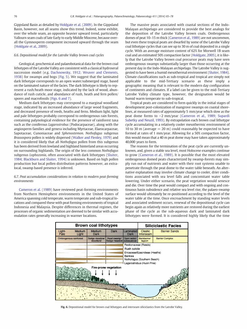
6.6. Depositional model for the Latrobe Valley brown coal cycles
Geological, geochemical and palaeobotanical data for the brown coallithotypes of the LatrobeValley are consistentwith a classical hydroseralsuccession model (e.g. Dachnowsky, 1912; Weaver and Clements,1938) for swamps and bogs (Fig. 5). We suggest that the laminateddark lithotype corresponds to an open water/submerged stage, basedon the laminated nature of the facies. The dark lithotype is likely to rep-resent a rush/heath moor stage, indicated by the lack of wood, abun-dance of rush cuticle, and abundance of rush, heath and fern pollen/spores and macrofossils (Figs. 6 and 7).
Medium dark lithotypes may correspond to a marginal woodlandstage, indicated by an increased abundance of large wood fragments,and decreased presence of reeds, heaths and ferns. Medium light, lightand pale lithotypes probably correspond to ombrogenous rain forests,containing palynological evidence for the presence of rainforest taxasuch as the coniferous Lagarostrobus (Podocarpaceae), along with theangiosperm families and genera including Myrtaceae, Elaeocarpaceae,Sapotaceae, Cunoniaceae and Sphenostemon. Nothofagus subgenusBrassospora pollen is widely dispersed (Walker and Flenley, 1979) andit is considered likely that all Nothofagus pollen from this subgenushas been derived from lowland and highland hinterland areas occurringon surrounding highlands. The origin of the less common Nothofagussubgenus Lophozonia, often associated with dark lithotypes (Sluiter,1984; Blackburn and Sluiter, 1994) is unknown. Based on high pollenproduction but local pollen distribution patterns however, an extra-local, swamp based presence is inferred.
6.7. Peat accumulation considerations in relation to modern peat-formingenvironments
Cameron et al. (1989) have reviewed peat-forming environmentsfrom Northern Hemisphere environments in the United States ofAmerica spanning cold temperate, warm temperate and sub-tropical lo-cations and compared thesewith peat forming environments of tropicalIndonesia and Malaysia. Despite differences in thermal regimes, theprocesses of organic sedimentation are deemed to be similar with accu-mulation rates generally increasing in warmer locations.
Fig. 6. Depositional model for brown coal lithotypes an
The massive peats associated with coastal sections of the Indo-Malayan archipelago are considered to provide the best analogs forthe deposition of the Latrobe Valley brown coals. Ombrogenousdomes of peat 10–15m thick (Cameron et al., 1989) are not uncommon,but even these tropical peats are dwarfed by some of the Latrobe Valleycoal lithotype cycles that can see up to 30m of coal deposited in a singlecycle. With an average moisture content of 62% for Morwell 1B seamcoal and an estimated 50% compaction factor (Holdgate, 2005), it is like-ly that the Latrobe Valley brown coal precursor peats may have seenombrogenous swamps substantially larger than those occurring at thepresent day in the Indo-Malayan archipelago. The Latrobe Valley is sug-gested to have been a humidmesothermal environment (Sluiter, 1984).Climate classifications such as sub-tropical and tropical are simply notapplicable to the mid-Tertiary scenario as these imply ageographic meaning that is relevant to the modern day configurationof continents and climates. If a label can be given to the mid-TertiaryLatrobe Valley climate type, however, the designation would behumid warm temperate to sub-tropical.
Tropical peats are considered to form quickly in the initial stages ofdevelopment post-colonization of mangrove swamps on coastal shore-lines, at measured rates of approximately 5 mm/year which slow as thepeat dome forms to b2 mm/year (Cameron et al., 1989; SupardiSubetky and Neuzil, 1993). By extrapolation each brown coal lithotypecycle accumulating in a relatively cooler mesothermic environment of10 to 30 m (average = 20 m) could reasonably be expected to haveformed at rates of 1 mm/year. Allowing for a 50% compaction factor,this wouldmean that a 40m peat domemay have taken approximately40,000 years to form.
The reasons for the termination of the peat cycle are currently un-known, and, given a stable sea level, most Holocene examples continueto grow (Cameron et al., 1989). It is possible that the most elevatedombrogenous domed peats characterized by swamp-forests may sim-ply run out of nutrients and water with their root systems unable topenetrate through the peat dome to the water table beneath. An alter-native explanation may involve climate change to cooler, drier condi-tions associated with sea level falls and concomitant water tablelowering. Under either scenario, the peat vegetation would senesceand die. Over time the peat would compact and with ongoing and con-tinuous basin subsidence and relative sea level rise, the palaeo-swampsurface would ultimately be re-positioned according to the level of thewater table at the time. Once encroachment by standing water levelsand associated sediment occurs, renewal of the depositional cycle canbegin again as relatively more nutrients are restored during the earliestphase of the cycle as the sub-aqueous dark and laminated darklithotypes were formed. It is considered highly likely that the time
d interseam siliciclastics from the Latrobe Valley.
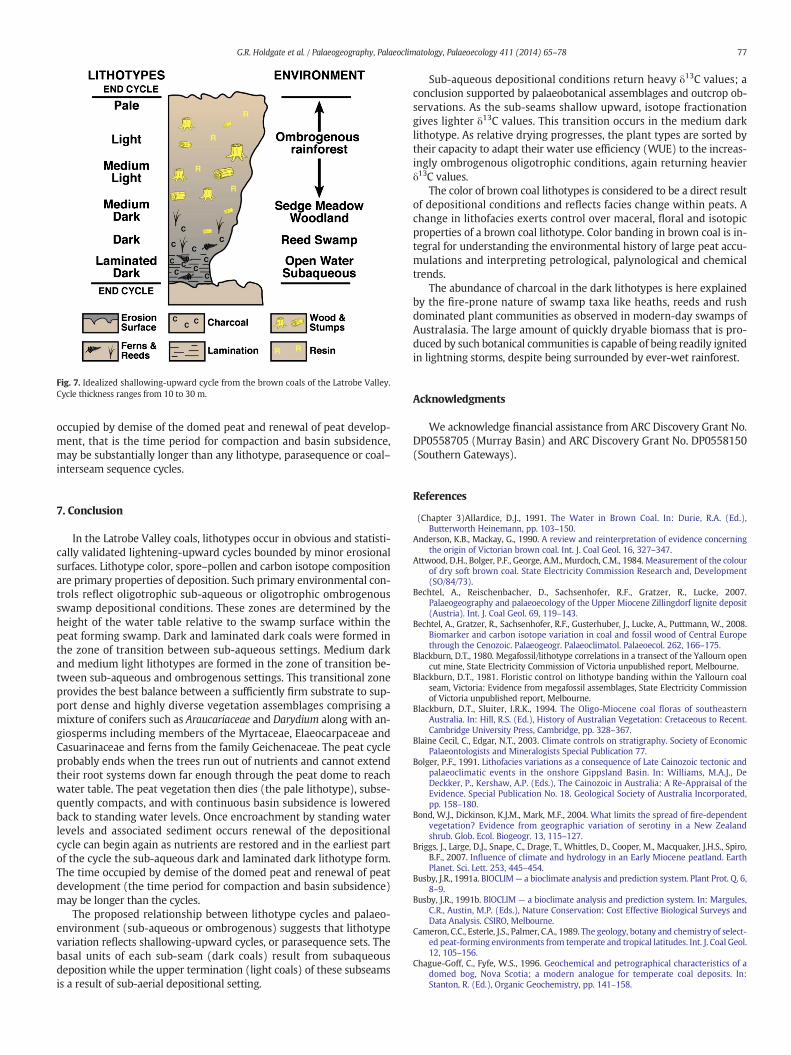
Fig. 7. Idealized shallowing-upward cycle from the brown coals of the Latrobe Valley.Cycle thickness ranges from 10 to 30 m.
77G.R. Holdgate et al. / Palaeogeography, Palaeoclimatology, Palaeoecology 411 (2014) 65–78
occupied by demise of the domed peat and renewal of peat develop-ment, that is the time period for compaction and basin subsidence,may be substantially longer than any lithotype, parasequence or coal–interseam sequence cycles.
7. Conclusion
In the Latrobe Valley coals, lithotypes occur in obvious and statisti-cally validated lightening-upward cycles bounded by minor erosionalsurfaces. Lithotype color, spore–pollen and carbon isotope compositionare primary properties of deposition. Such primary environmental con-trols reflect oligotrophic sub-aqueous or oligotrophic ombrogenousswamp depositional conditions. These zones are determined by theheight of the water table relative to the swamp surface within thepeat forming swamp. Dark and laminated dark coals were formed inthe zone of transition between sub-aqueous settings. Medium darkand medium light lithotypes are formed in the zone of transition be-tween sub-aqueous and ombrogenous settings. This transitional zoneprovides the best balance between a sufficiently firm substrate to sup-port dense and highly diverse vegetation assemblages comprising amixture of conifers such as Araucariaceae and Darydium along with an-giosperms including members of the Myrtaceae, Elaeocarpaceae andCasuarinaceae and ferns from the family Geichenaceae. The peat cycleprobably ends when the trees run out of nutrients and cannot extendtheir root systems down far enough through the peat dome to reachwater table. The peat vegetation then dies (the pale lithotype), subse-quently compacts, and with continuous basin subsidence is loweredback to standing water levels. Once encroachment by standing waterlevels and associated sediment occurs renewal of the depositionalcycle can begin again as nutrients are restored and in the earliest partof the cycle the sub-aqueous dark and laminated dark lithotype form.The time occupied by demise of the domed peat and renewal of peatdevelopment (the time period for compaction and basin subsidence)may be longer than the cycles.
The proposed relationship between lithotype cycles and palaeo-environment (sub-aqueous or ombrogenous) suggests that lithotypevariation reflects shallowing-upward cycles, or parasequence sets. Thebasal units of each sub-seam (dark coals) result from subaqueousdeposition while the upper termination (light coals) of these subseamsis a result of sub-aerial depositional setting.
Sub-aqueous depositional conditions return heavy δ13C values; aconclusion supported by palaeobotanical assemblages and outcrop ob-servations. As the sub-seams shallow upward, isotope fractionationgives lighter δ13C values. This transition occurs in the medium darklithotype. As relative drying progresses, the plant types are sorted bytheir capacity to adapt their water use efficiency (WUE) to the increas-ingly ombrogenous oligotrophic conditions, again returning heavierδ13C values.
The color of brown coal lithotypes is considered to be a direct resultof depositional conditions and reflects facies change within peats. Achange in lithofacies exerts control over maceral, floral and isotopicproperties of a brown coal lithotype. Color banding in brown coal is in-tegral for understanding the environmental history of large peat accu-mulations and interpreting petrological, palynological and chemicaltrends.
The abundance of charcoal in the dark lithotypes is here explainedby the fire-prone nature of swamp taxa like heaths, reeds and rushdominated plant communities as observed in modern-day swamps ofAustralasia. The large amount of quickly dryable biomass that is pro-duced by such botanical communities is capable of being readily ignitedin lightning storms, despite being surrounded by ever-wet rainforest.
Acknowledgments
We acknowledge financial assistance from ARC Discovery Grant No.DP0558705 (Murray Basin) and ARC Discovery Grant No. DP0558150(Southern Gateways).
References
(Chapter 3)Allardice, D.J., 1991. The Water in Brown Coal. In: Durie, R.A. (Ed.),Butterworth Heinemann, pp. 103–150.
Anderson, K.B., Mackay, G., 1990. A review and reinterpretation of evidence concerningthe origin of Victorian brown coal. Int. J. Coal Geol. 16, 327–347.
Attwood, D.H., Bolger, P.F., George, A.M., Murdoch, C.M., 1984. Measurement of the colourof dry soft brown coal. State Electricity Commission Research and, Development(SO/84/73).
Bechtel, A., Reischenbacher, D., Sachsenhofer, R.F., Gratzer, R., Lucke, 2007.Palaeogeography and palaeoecology of the Upper Miocene Zillingdorf lignite deposit(Austria). Int. J. Coal Geol. 69, 119–143.
Bechtel, A., Gratzer, R., Sachsenhofer, R.F., Gusterhuber, J., Lucke, A., Puttmann, W., 2008.Biomarker and carbon isotope variation in coal and fossil wood of Central Europethrough the Cenozoic. Palaeogeogr. Palaeoclimatol. Palaeoecol. 262, 166–175.
Blackburn, D.T., 1980. Megafossil/lithotype correlations in a transect of the Yallourn opencut mine, State Electricity Commission of Victoria unpublished report, Melbourne.
Blackburn, D.T., 1981. Floristic control on lithotype banding within the Yallourn coalseam, Victoria: Evidence from megafossil assemblages, State Electricity Commissionof Victoria unpublished report, Melbourne.
Blackburn, D.T., Sluiter, I.R.K., 1994. The Oligo-Miocene coal floras of southeasternAustralia. In: Hill, R.S. (Ed.), History of Australian Vegetation: Cretaceous to Recent.Cambridge University Press, Cambridge, pp. 328–367.
Blaine Cecil, C., Edgar, N.T., 2003. Climate controls on stratigraphy. Society of EconomicPalaeontologists and Mineralogists Special Publication 77.
Bolger, P.F., 1991. Lithofacies variations as a consequence of Late Cainozoic tectonic andpalaeoclimatic events in the onshore Gippsland Basin. In: Williams, M.A.J., DeDeckker, P., Kershaw, A.P. (Eds.), The Cainozoic in Australia: A Re-Appraisal of theEvidence. Special Publication No. 18. Geological Society of Australia Incorporated,pp. 158–180.
Bond, W.J., Dickinson, K.J.M., Mark, M.F., 2004. What limits the spread of fire-dependentvegetation? Evidence from geographic variation of serotiny in a New Zealandshrub. Glob. Ecol. Biogeogr. 13, 115–127.
Briggs, J., Large, D.J., Snape, C., Drage, T., Whittles, D., Cooper, M., Macquaker, J.H.S., Spiro,B.F., 2007. Influence of climate and hydrology in an Early Miocene peatland. EarthPlanet. Sci. Lett. 253, 445–454.
Busby, J.R., 1991a. BIOCLIM— a bioclimate analysis and prediction system. Plant Prot. Q. 6,8–9.
Busby, J.R., 1991b. BIOCLIM — a bioclimate analysis and prediction system. In: Margules,C.R., Austin, M.P. (Eds.), Nature Conservation: Cost Effective Biological Surveys andData Analysis. CSIRO, Melbourne.
Cameron, C.C., Esterle, J.S., Palmer, C.A., 1989. The geology, botany and chemistry of select-ed peat-forming environments from temperate and tropical latitudes. Int. J. Coal Geol.12, 105–156.
Chague-Goff, C., Fyfe, W.S., 1996. Geochemical and petrographical characteristics of adomed bog, Nova Scotia; a modern analogue for temperate coal deposits. In:Stanton, R. (Ed.), Organic Geochemistry, pp. 141–158.
78 G.R. Holdgate et al. / Palaeogeography, Palaeoclimatology, Palaeoecology 411 (2014) 65–78
Cohen, A.D., Stack, E.M., 1996. Some observations regarding the potential effects of dom-ing of tropical peat deposits on the composition of coal beds. Int. J. Coal Geol. 29,39–65.
Collinson, M.E., Steart, D.C., Scott, A.C., Glasspool, I.J., Hooker, J.J., 2007. Episodic fire, runoffand deposition at the Paleocene–Eocene boundary. J. Geol. Soc. Lond. 164, 87–97.
Dachnowsky, A., 1912. Peat deposits of Ohio, their origin, formation and uses. GeologicalSurvey of Ohio, Fourth Series, Bulletin 16 (424 pages).
Diessel, C.F.K., 1980. Coal geology workshop course. Australian Mineral Foundation,Course 137/80, Adelaide, 11th–15th August 1980.
Diessel, C.F.K., 1992. Coal-Bearing Depositional Systems. Springer-Verlag, Berlin, Heidelberg(721 pp.).
Diessel, C.F.K., 1998. Sequence Stratigraphy Applied to Coal Seams: Two Case Histories. In:Shanley, K.W., McCabe, P.J. (Eds.), Relative Role of Eustasy, Climate and Tectonism inContinental Rocks. , 59. SEPM Special Publication, pp. 151–177.
Edwards, A.B., 1945. The composition of Victorian brown coal. Proc. Australas. Inst. Min.Metall. 140, 205–280.
Esterle, J.S., Ferm, J.C., 1994. Spatial variability in modern tropical peat deposits from Sa-rawak, Malaysia and Sumatra, Indonesia: analogues for coal. Int. J. Coal Geol. 26, 1–41.
Farquhar, G.D., Ehleringer, J.R., Hubick, K.T., 1989. Carbon isotope discrimination andphotosynthesis. Annu. Rev. Plant Physiol. Plant Mol. Biol. 40, 503–537.
Finotello, F., Johns, R.B., 1986. Some inter-relationships of kerogen and humic acidfractions in the Victorian brown coal pale lithotype. Org. Geochem. 9 (5), 265–273.
Fischer, A.G., 1964. The Lofer cyclothems of the Alpine Triassic. Kansas Geol. Surv. Bull.169, 107–149.
Fletcher, M.-S., Thomas, I., 2007. Modern pollen–vegetation relationships in westernTasmania, Australia. Rev. Palaeobot. Palynol. 146, 146–168.
George, A.M., 1982. Latrobe Valley brown coal; lithotypes, macerals, coal properties. Aust.Coal Geol. 4 (1–2), 111–130.
George, A.M. and Hibbert, D., 1986. Yallourn East Field Petrology. State ElectricityCommission Research and Development, LO/86/747. Unpublished SECV Report.
George, A.M., Mackay, G.H., 1991. Petrology (Chapter 2) In: Durie, R.A. (Ed.), The Scienceof Victorian Brown Coal: Structure, Properties and Consequences for Utilisation.Butterworth Heinemann, pp. 10–45.
Goodwin, P.W., Anderson, E.J., 1985. Punctuated aggradational cycles: a general hypothe-sis of episodic stratigraphic accumulation. J. Geol. 93, 515–533.
Hagemann, H.W., Wolf, M., 1987. New interpretations of the facies of the Rhenish browncoal of West Germany. Int. J. Coal Geol. 7 (4), 335–348.
Hamor-Vido, M., Hamor, T., 2007. Sulphur and carbon isotopic composition of powersupply coals in the Pannonian Basin, Hungary. Int. J. Coal Geol. 71, 425–447.
Hijmans, R.J., Cameron, S.E., Parra, J.L., Jones, P.G., Jarvis, A., 2005. Very high resolutioninterpolated climate surfaces for global land areas. Int. J. Climatol. 25, 1965–1978.
Holdgate, G.R., 1985. Latrobe Valley brown coals — their geometry and facies equivalentsas a guide to depositional environment. Aust. Coal Geol. 5, 53–68.
Holdgate, G.R., 2005. Geological processes that control lateral and vertical variability incoal seam moisture contents; Latrobe Valley, Gippsland Basin, Australia. Int. J. CoalGeol. 63, 130–155.
Holdgate, G.R., Sluiter, I.R.K., 1991. Oligocene–Miocene marine incursions in the LatrobeValley Depression, onshore Gippsland Basin: evidence, facies relationships andchronology. In: Williams, M.A.J., De Deckker, P., Kershaw, A.P. (Eds.), The Cainozoicin Australia: A Re-Appraisal of the Evidence. Special Publication No. 18. GeologicalSociety of Australia Incorporated, pp. 158–180.
Holdgate, G.R., Kershaw, A.P., Sluiter, I.R.K., 1995. Sequence stratigraphic analysis and theorigins of Tertiary brown coal lithotypes, Latrobe Valley, Gippsland Basin, Australia.Int. J. Coal Geol. 28, 249–275.
Holdgate, G.R., Cartwright, I., Blackburn, D.T., Wallace, M.W., Gallagher, S.J., Wagstaff, B.E.,Chung, Li, 2007. The Middle Miocene Yallourn coal seam — the last coal in Australia.Int. J. Coal Geol. 70, 95–115.
Holdgate, G.R., McGowran, B., Fromhold, T., Wagstaff, B.E., Gallagher, S.J., Wallace, M.W.,Sluiter, I.R.K., Whitelaw, M., 2009. Eocene–Miocene carbon-isotope and floral recordfrom brown coal seams in the Gippsland Basin of southeast Australia. Glob. Planet.Chang. 65, 89–103.
Holmes, C.W., Flores, R.M., 1991. Carbon isotopes in Tertiary coals of the Powder RiverBasin. J. Coal Qual. 10 (2), 49–52.
James, N.P., 1979. Facies models 10. Shallowing-upward sequences in carbonates. In:Walker, R.G. (Ed.), Facies Models. Geoscience Canada Reprint Series 1. Geological As-sociation of Canada, Toronto, pp. 109–119.
Jones, T.P., Fortier, S.M., Mosbrugger, V., Roessler, J., Utescher, T., Ashraf, A.R., 1997. C13/C13
ratio double cyclicity in a Miocene lignite: isotopic signals and orbital forcing. TerraNova 9 (1), 19–23.
Kershaw, A.P., Sluiter, I.R.K., 1982. The application of pollen analysis to the elucidation ofLatrobe Valley brown coal depositional environments and stratigraphy. Aust. CoalGeol. 4, 169–186.
Kershaw, A.P., Bolger, P.F., Sluiter, I.R.K., Baird, J.G., Whitelaw, M., 1991. The nature andevolution of lithotypes in the Tertiary brown coals of the Latrobe Valley, southeasternAustralia. Int. J. Coal Geol. 18, 233–249.
Kiss, L.T., 1982. Chemistry of Victorian brown coals. Aust. Coal Geol. 4 (1), 153–169.
Large, D.J., 2007. A 1.16 Ma record of carbon accumulation in western European peatlandduring the Oligocene from the Ballymoney lignite, Northern Ireland. J. Geol. Soc. Lond.164, 1233–1240.
Large, D.J., Jones, T.F., Briggs, J., Macquaker, J.H.S., Spiro, B.F., 2004. Orbital tuning andcorrelation of 1.7 m. yr. of continuous carbon storage in an early Miocene peatland.Geology 32 (10), 873–876.
Lucke, A., Helle, G., Schleser, G.H., Figueiral, I., Mosbrugger, V., Jones, T.P., Rowe, N.P., 1999.Environmental history of the German Lower Rhine Embayment during the middleMiocene as reflected by carbon isotopes in lignite. Palaeogeogr. Palaeoclimatol.Palaeoecol. 154, 339–352.
Luly, J., Sluiter, I.R.K., Kershaw, A.P., 1980. Pollen Studies of Tertiary Brown Coals: Prelim-inary Analysis of Lithotypes Within the Latrobe Valley, Victoria. Monash Publicationsin Geography. , 23.
Mackay, G., Attwood, D.H., Gaulton, R.J., George, A.M., 1985. The cyclic occurrence ofbrown coal lithotypes. State Electricity Commission Research and DevelopmentDepartment Report SO/85/93, Melbourne.
Marcuccio, D., 2009. Brown coal lithotypes in the M1B seam. University of Melbourne Hon-ours thesis, Berlin, Latrobe Valley, Victoria (92p.).
Marsden-Smedley, J.B., Rudman, T., Pyrke, A., Catchpole, W.R., 1999. Buttongrassmoorland fire-behaviour prediction and management. Tasforests 11, 87–107.
Nix, H.A., 1982. Environmental determinants of biogeography and evolution in TerraAustralis. In: Barker, W.R., Greenslade, P.J.M. (Eds.), Evolution of the Flora andFauna of Arid Australia. Peacock Publications, Adelaide.
Nix, H.A., 1984. An environmental analysis of Australian rainforests. In: Werren, G.L.,Kershaw, A.P. (Eds.), Proceedings of a Workshop on the Past, Present and Future ofAustralian Rainforests. Australian National Rainforest Project, vol. 3. World WildlifeFund Australia and the Australian Conservation Foundation, Melbourne.
Partridge, A.D., 1971. Stratigraphic palynology of the onshore Tertiary sediments of theGippsland Basin, Victoria. M.Sc. thesis, University of New South Wales, Sydney,Australia, 302 pp. (unpublished).
Partridge, A.D., 2006. Late Cretaceous–Cenozoic palynology zonations Gippsland Basin. InMontiel, E., (co-ord) AustralianMesozoic and Cenozoic Palynology Zonations, Geosci-ence Australia, Record 2006/23.
Peterson, H.I., 1998. Morphology, formation and palaeo-environmental implications of natu-rally formed char particles in coals and carbonaceous mudstones. Fuel 77, 1177–1183.
Pyrke, A.F., Marsden-Smedley, J.B., 2005. Fire-attribute categories, fire sensitivity, andflammability of Tasmanian vegetation communities. Tasforests 16, 35–46.
Read, J.F., Grotzinger, J.P., Bova, J.A., Koerschner, W.F., 1986. Models for generation of car-bonate cycles. Geology 14, 107–110.
Sluiter, I.R.K., 1984. Palynology of Oligo-Miocene coal seams, Latrobe Valley, Victoria. Ph.DThesis, Monash University, Melbourne (unpublished).
Sluiter, I.R.K., Kershaw, A.P., 1982. The nature of later Tertiary vegetation in Australia.Alcheringa 6, 211–222.
Sluiter, I.R.K., Kershaw, A.P., Holdgate, G.R., Bulman, D., 1995. Biogeographic, ecologicaland stratigraphic relationships of the Miocene brown coal floras, Latrobe Valley,Victoria, Australia. Int. J. Coal Geol. 28, 277–302.
Smith, G.S., 1982. A review of the Tertiary–Cretaceous tectonic history of the GippslandBasin and its control on coal measure sedimentation. Aust. Coal Geol. 4 (1), 1–38.
Stover, L.E., Partridge, A.D., 1973. Tertiary and Late Cretaceous spores and pollen from theGippsland Basin, southeastern Australia. Proc. Royal Soc. Vic. 85, 237–286.
Supardi Subetky, A.D., Neuzil, S.G., 1993. General geology and peat resources of the SiakKanan and Bengkalis Island peat deposits, Sumatra, Indonesia. In: Cobb, J.C., Cecil, C.B. (Eds.), Modern and Ancient Coal-Forming Environments. Geological Society ofAmerica Special Paper, 286, pp. 45–61.
Teichmueller,M., 1950. ZumpetrographischenAufbauundWerdegangderWeichbraunkohle(mit Beruecksichtigung genetischer Fragen der Steinkohlenpetrographie). Geol.Landesanst. Geol. Jb. 64, 429–488 (Germany).
Teichmüller, M., 1989. The genesis of coal from the viewpoint of coal petrology. Int. J. CoalGeol. 12, 1–87.
Thompson, B.R., Walker, G.M., 1982. The Geology of the Seaspray Depression: GippslandBasin. In: Mallett, C.W. (Ed.), Symposium on Coal Resources: Origin, Exploration andUtilization in Australia. Proceedings, Melbourne, 15–19 November 1982. , 4. Geolog-ical Society of Australia, Coal Group, pp. 39–56.
Van Wagoner, J.C., Mitchum, R.M., Campion, K.M., Rahmanian, V.D., 1990. Siliciclasticsequence stratigraphy in well logs, cores and outcrops. American AssociationPetroleum Geologists Methods in Exploration Series No. 7.
Walker, D., Flenley, J.R., 1979. Late quaternary vegetational history of the Enga Province ofupland Papua New Guinea. Philos. Trans. R. Soc. Lond. B Biol. Sci. 265–344.
Weaver, J.E., Clements, F.E., 1938. Plant Ecology, Second edition. McGraw-Hill BookCompany, Inc., NY (601 pp.).
Webb, L.J., 1968. Environmental relationships of the structural types of Australianrainforest vegetation. Ecology 49, 296–311.
Wölk, E., 1935. Machtigkeit, Gliederung und Entstehung des niederrheinischenHauptbraunkohlenflozes. Decheniana 92, 81–162.
WorldClim, 2014. WorldClim — global climate data. www.worldclim.org.