Walrus Island – a pivotal place for Palaeo-Eskimo societies in High Arctic Northeast Greenland.
23
ÉTUDES/INUIT/STUDIES, 2012, 36(1): Walrus Island – A pivotal place for High Arctic Palaeo-Eskimo societies in Northeast Greenland Mikkel Sørensen * Résumé: Walrus Island – Un lieu phare pour les sociétés paléoesquimaudes du Haut Arctique au nord-est du Groenland Dans cet article, nous présentons et analysons les vestiges paléoesquimaux du site Walrus Island. En 2008, l’étude du site a révélé plus de 2 000 structures en pierre, dont 445 habitations attribuées à des occupations paléoesquimaudes. Les vestiges sont décrits comme étant des «aménagements axiaux», des «cercles de tentes», des «aires dégagées» ou encore des «pavages». Les vestiges lithiques témoignent de la présence sur ce site de toutes les cultures paléoesquimaudes identifiées au nord-est du Groenland: Indépendance I, Saqqaq et Dorsétien groenlandais. En nous basant sur la localisation des structures en bordure de pentes et sur l’absence de pierres dans leur périphérie, nous formulons l’hypothèse que les Dorsétiens groenlandais utilisaient des iglous sur le site. Walrus Island est le deuxième plus grand site paléoesquimau au nord-est du Groenland, le premier étant celui du cap Saint-Jacques sur l’Île-de- France, qui a 548 structures. Ces deux sites, ainsi que quatre autres potentiellement très vastes, ont ceci en commun qu’ils sont situés près de polynies le long du rivage du nord-est du Groenland. Ces grands sites étaient d’une importance capitale pour les Paléoesquimaux du nord- est du Groenland et peuvent nous aider à comprendre leur mode de vie dans l’extrême Haut Arctique. Abstract: Walrus Island – A pivotal place for High Arctic Palaeo-Eskimo societies in Northeast Greenland In this article, the Palaeo-Eskimo ruin features of the Walrus Island site are presented and analysed. The Walrus Island site was investigated in 2008 and more than 2,000 stone features were recorded, of which 445 were the remains of dwellings attributed to Palaeo-Eskimo occupations. These ruins are described as “mid-passages,” “tent rings,” “clearings,” and “pavements.” They are associated with lithic artefacts that attest to the presence of all the previously identified Palaeo-Eskimo cultures of Northeast Greenland, i.e., Independence I, Saqqaq, and Greenlandic Dorset. Based on the ruins’ location near sloping terrain and lack of peripheral stones, it is argued that the Greenlandic Dorset people built snow houses on the site. Walrus Island has the second largest known Palaeo-Eskimo site in Northeast Greenland, the largest one being the Kap Skt. Jacques site on the island Île-de-France, which has 548 features. Both sites, and four other large or potentially very large sites, have in common a shore location * Department of Archaeology, University of Copenhagen, Njalsgade 80, DK-2300, Copenhagen, Denmark. [email protected]
Transcript of Walrus Island – a pivotal place for Palaeo-Eskimo societies in High Arctic Northeast Greenland.

ÉTUDES/INUIT/STUDIES, 2012, 36(1):
Walrus Island – A pivotal place for High
Arctic Palaeo-Eskimo societies in Northeast
Greenland
Mikkel Sørensen*
Résumé: Walrus Island – Un lieu phare pour les sociétés paléoesquimaudes du Haut Arctique
au nord-est du Groenland
Dans cet article, nous présentons et analysons les vestiges paléoesquimaux du site Walrus
Island. En 2008, l’étude du site a révélé plus de 2 000 structures en pierre, dont 445 habitations
attribuées à des occupations paléoesquimaudes. Les vestiges sont décrits comme étant des
«aménagements axiaux», des «cercles de tentes», des «aires dégagées» ou encore des «pavages».
Les vestiges lithiques témoignent de la présence sur ce site de toutes les cultures
paléoesquimaudes identifiées au nord-est du Groenland: Indépendance I, Saqqaq et Dorsétien
groenlandais. En nous basant sur la localisation des structures en bordure de pentes et sur
l’absence de pierres dans leur périphérie, nous formulons l’hypothèse que les Dorsétiens
groenlandais utilisaient des iglous sur le site. Walrus Island est le deuxième plus grand site
paléoesquimau au nord-est du Groenland, le premier étant celui du cap Saint-Jacques sur l’Île-de-
France, qui a 548 structures. Ces deux sites, ainsi que quatre autres potentiellement très vastes,
ont ceci en commun qu’ils sont situés près de polynies le long du rivage du nord-est du
Groenland. Ces grands sites étaient d’une importance capitale pour les Paléoesquimaux du nord-
est du Groenland et peuvent nous aider à comprendre leur mode de vie dans l’extrême Haut
Arctique.
Abstract: Walrus Island – A pivotal place for High Arctic Palaeo-Eskimo societies in
Northeast Greenland
In this article, the Palaeo-Eskimo ruin features of the Walrus Island site are presented and
analysed. The Walrus Island site was investigated in 2008 and more than 2,000 stone features
were recorded, of which 445 were the remains of dwellings attributed to Palaeo-Eskimo
occupations. These ruins are described as “mid-passages,” “tent rings,” “clearings,” and
“pavements.” They are associated with lithic artefacts that attest to the presence of all the
previously identified Palaeo-Eskimo cultures of Northeast Greenland, i.e., Independence I,
Saqqaq, and Greenlandic Dorset. Based on the ruins’ location near sloping terrain and lack of
peripheral stones, it is argued that the Greenlandic Dorset people built snow houses on the site.
Walrus Island has the second largest known Palaeo-Eskimo site in Northeast Greenland, the
largest one being the Kap Skt. Jacques site on the island Île-de-France, which has 548 features.
Both sites, and four other large or potentially very large sites, have in common a shore location
* Department of Archaeology, University of Copenhagen, Njalsgade 80, DK-2300, Copenhagen, Denmark. [email protected]

2/M. SØRENSEN
on the Northeast Greenland coast near polynyas. These large sites were of pivotal importance for
the Palaeo-Eskimos of Northeast Greenland and may help us understand their way of life in the
extreme High Arctic.
Introduction
Walrus Island is in the Greenland Sea, 2 km off Sabine Island (74° 30 N, 18° 46 E)
(Figure 1). This purely basaltic island presents a bleak, uninviting, and windswept
landscape of boulder beaches, raised boulder-beach ridges, and raised gravel terraces. It
is 1.2 km long and 0.8 km wide. Its west coast is low, and the terrain rises gradually
towards a steep cliff face at the northeastern end, at 85 m a.s.l.1 (Figures 1 and 2). Its
Palaeo-Eskimo ruins are primarily concentrated near the northwest and southwest
beaches, at elevations from 6 to 10 m a.s.l., but some clusters of ruins appear on beach
terraces up to 35 m a.s.l. and over 400 m inland (Figure 2). Erosion is visible on the
northwest beach, where some prehistoric ruins are eroding into the sea, although the
erosion is modest and, presumably, only a few ruins have been affected. The other ruins
have been sheltered from erosive processes, bioturbation, and modern human activity.
In general, the ruin features seem well preserved but are often difficult to interpret and
describe due to the nature of the local geology.
This prehistoric settlement was initially discovered and briefly surveyed in 1926
by Johnson and Wordie (1933), who did not identify it as being Palaeo-Eskimo. No
sites would be reported as such for the region until 1948. In 2005, archaeologists and
geographers of the GeoArk project2 arrived to begin a survey (Jensen et al. 2008). The
number of prehistoric features they discovered was so overwhelming that a complete
inventory had to wait until a team of eight GeoArk project researchers (four
archaeologists, one zoologist, and three geographers) systematically carried out a nine-
day survey in August 2008 (Sørensen et al. 2009). The team found 2,094 features and
attributed them mainly to the Thule culture (Grønnow et al. 2011). Based on
morphology and in situ lithic artefacts, a significant number were identified as Palaeo-
Eskimo (Sørensen et al. 2009).
This article is the first to present the Palaeo-Eskimo archaeology of Walrus Island.
Data on 445 recorded ruins are described and analysed, and the following questions
discussed: Which Palaeo-Eskimo peoples settled there? Which dwelling types and
locations did they use on the island? Based on the new evidence from Walrus Island,
how did they use the High Arctic landscape of Northeast Greenland?
1 The abbreviation a.s.l. means “above sea level.” 2 The GeoArk project was an interdisciplinary research initiative by archaeologists, geographers, and
zoologists from the following institutions: SILA-Arctic Centre at the Ethnographic Collections of the
National Museum of Denmark; the Department of Geography at the University of Copenhagen; and the Natural History Museum of Denmark.

WALRUS ISLAND…/3
Figure 1. Location of Walrus Island in Northeast Greenland. Legends on right-hand side of map:
dark grey: land; light grey: mountains; white: glaciers; lightest grey: sea. Photo (below) shows
Walrus Island in the Greenland Sea as seen from Sabine Island where the GeoArk team camped
next to the trapper station Germania Havn. Photo by Mikkel Sørensen.

4/M. SØRENSEN
Figure 2. Map of Walrus Island with ruin features attributed to Palaeo-Eskimo cultures. Left: all
recorded Palaeo-Eskimo ruin features. Right: numbered ruin features that could be attributed to a
specific Palaeo-Eskimo culture from lithic artefacts. Dots: Independence I; squares: Saqqaq;
stars: Greenlandic Dorset. Maps by J.B.T. Pedersen.
Methodology
Fieldwork was non-destructive and focused primarily on identifying, cataloguing,
and photographing each ruin feature. The aim was to estimate the total number of ruins,
to record their precise locations with GPS equipment, and to write up an overview of
the site, i.e., an initial description that could highlight the most relevant research
questions for future investigations and excavations. When surface scatters of lithic
artefacts were discovered during the inventory, they were documented in the field, i.e.,
associated with a feature, and placed back in situ for future investigation. Thus, the
2005 and 2008 fieldwork involved no excavation or thorough spatial surface recording
of single structures. The recorded data (GPS location, feature description, artefacts,
faunal remains, and photo documentation) were stored as information about
topography, artefacts, and ruin type, thereby forming a database that the present
analysis has drawn upon.
Because conditions were poor for preservation of organic artefacts, none were
found in Palaeo-Eskimo contexts, and this absence made absolute dating and faunal
analysis impossible. Optically stimulated luminescence (OSL) dating was performed on
WALRUS ISLAND…/5
samples taken from beneath the foundations of the Palaeo-Eskimo ruins. Unfortunately,
due to the young geology of the area and the lack of quartz sediments on Walrus Island,
this method still needs further development to produce reliable absolute dates from this
site (Pedersen et al. 2010b).
To identify cultural traditions and to estimate relative dating, we used information
from lithic artefacts and ruin types that had already been extensively described in the
archaeological literature on Northeast Greenland (Grønnow and Jensen 2003; Knuth
1984). We analysed the lithic artefacts using a dynamic technological approach that
integrates the choices that had originally been made to produce them—from the
selection of raw material to the discarding or modification of the tools, and including
all debris (i.e. the chaîne opératoire, e.g., Inizan et al. 1999; Pelegrin et al. 1988). A
study of lithic technology had previously shown that each Palaeo-Eskimo culture in
Greenland had specific concepts and methods of lithic production (Sørensen 2006,
2012). By assessing raw material quality, preform morphology, flake types, and
microblade cores for example, this approach makes it easier to assign lithic artefacts to
each of Greenland’s Palaeo-Eskimo cultures than was possible with earlier typological
studies (Sørensen 2012).
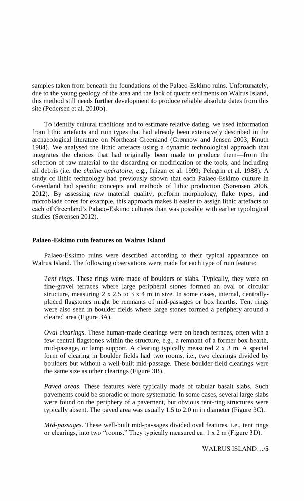
Palaeo-Eskimo ruin features on Walrus Island
Palaeo-Eskimo ruins were described according to their typical appearance on
Walrus Island. The following observations were made for each type of ruin feature:
Tent rings. These rings were made of boulders or slabs. Typically, they were on
fine-gravel terraces where large peripheral stones formed an oval or circular
structure, measuring 2 x 2.5 to 3 x 4 m in size. In some cases, internal, centrally-
placed flagstones might be remnants of mid-passages or box hearths. Tent rings
were also seen in boulder fields where large stones formed a periphery around a
cleared area (Figure 3A).
Oval clearings. These human-made clearings were on beach terraces, often with a
few central flagstones within the structure, e.g., a remnant of a former box hearth,
mid-passage, or lamp support. A clearing typically measured 2 x 3 m. A special
form of clearing in boulder fields had two rooms, i.e., two clearings divided by
boulders but without a well-built mid-passage. These boulder-field clearings were
the same size as other clearings (Figure 3B).
Paved areas. These features were typically made of tabular basalt slabs. Such
pavements could be sporadic or more systematic. In some cases, several large slabs
were found on the periphery of a pavement, but obvious tent-ring structures were
typically absent. The paved area was usually 1.5 to 2.0 m in diameter (Figure 3C).
Mid-passages. These well-built mid-passages divided oval features, i.e., tent rings
or clearings, into two “rooms.” They typically measured ca. 1 x 2 m (Figure 3D).

6/M. SØRENSEN
Triangular paved areas. This particular type of pavement made from slabs was
triangular in shape and measured ca. 1 x 1 x 1 m. It was not associated with
peripheral stones (Figure 3E).
Compressed circular areas. These areas, specific to Walrus Island, were defined as
“compressions.” Compressions were light-coloured areas of egg-sized basalt rocks
pressed into underlying fine gravel. They were associated with many of the above-
mentioned types of features, and especially with paved areas on fine-gravel
terraces. Sometimes, compressed areas had no peripheral stones, e.g., only a few
flagstones centrally placed in the compression (Figure 3F). Unfortunately, the
compressions cannot be assigned to a cultural tradition since no artefacts were
found in them. However, because they were located in an area away from the shore
near dwelling features attributed to the Greenlandic Dorset, they might be of
Palaeo-Eskimo origin.
This initial description is summarised in Table 1. Many caches were found but
none could be clearly linked to the Palaeo-Eskimos because later prehistoric Inuit had
also used caches on the raised beach terraces (Grønnow et al. 2011) and because
Palaeo-Eskimo attributes were lacking. It should be borne in mind that the recorded
ruin features reflect not only subjective choices made during prehistory, but also the
local geology. Boulder fields forced people to clear areas for dwelling places, often
described as “clearings.” Gravel terraces were more conducive to tent rings and
pavements. Thus, differences between features, e.g., between tent rings and clearings,
may not only be architectural but also reflect the specific location chosen by Palaeo-
Eskimos. Our observations should therefore be considered preliminary. More elaborate
fieldwork, with more time being spent investigating each ruin, should be conducted in
the future.
Table 1. Palaeo-Eskimo ruin features on Walrus Island.
Tent rings Clearings Paved areas Compressed Other
circular areas
No. of ruin
features 164 198 47 3 33
Feature
elements
Mid-
passage 22 66 3 0 5
Triangular
pavement 0 0 5 0 0
Box hearth 16 7 2 0 0
Lithic
artefact 19 33 4 0 2

WALRUS ISLAND…/7
Identifying different Palaeo-Eskimo cultures on Walrus Island
Although architecture varies among the Palaeo-Eskimo groups of Northeast
Greenland, the differences are generally too vague for use in identifying specific
cultural traditions. Palaeo-Eskimo cultures on Walrus Island were identified by in situ
analyses of lithic artefacts on the basis of typology and the dynamic technological
approach mentioned earlier (Figure 4). The Independence I culture was identified by its
distinct lithic technology, i.e., burins, burin spalls, arrowheads, bifaces, choice of raw
material, and serially produced large microcrystalline quartz (mcq)3 flakes that result
from reduction of large tabular blanks. The Saqqaq culture was identified by its
diagnostic production of large bifacial flakes with abraded butts made from fine-
grained basalt, a material available on Basalt Ø (Basalt Island) in nearby Young Sund
(Sørensen and Andreasen 2006; Sørensen 2012: source no. 48). The Greenlandic
Dorset culture was identified by its distinct endscraper design, i.e., flaring edges, use of
stemmed notched endblades and a preference for small irregular mcq core blanks as
preforms.
By identifying the presence of Independence I, Saqqaq, and Greenlandic Dorset
groups on Walrus Island, we have confirmed previous archaeological research in
Northeast Greenland, which recognised these three Palaeo-Eskimo groups as the
exclusive human colonisers until Inuit societies arrived ca. 1400 AD (Bennike et al.
2008; Grønnow and Jensen 2003). Radiocarbon dating indicates that Independence I
people settled the region ca. 2500-1900 BC and the Greenlandic Dorset ca. 800-0 BC
(Grønnow and Jensen 2003; Sandell and Sandell 1999). Walrus Island has provided the
northernmost evidence of Saqqaq groups in Northeast Greenland. No material has yet
been recovered in the region for absolute dating of this group’s presence. There is only
typological and technological evidence previously retrieved from the Young Sund area,
50 km to the south (Bennike et al. 2008; Sørensen and Andreasen 2006) and in the
Scoresby Sund region (Sandell and Sandell 1999). Because Saqqaq ruins and artefacts
are so sparse within the area of Young Sund and Walrus Island, it seems that these
people visited the northern parts of Northeast Greenland only sporadically, unlike the
Independence I and Greenlandic Dorset groups. All of the above Palaeo-Eskimo groups
have also been identified in the High Arctic Thule region, demonstrating that they were
well adapted to extreme environments (Schledermann 1990).
Following the in situ recording of the lithic material, an attempt was made to
ascribe specific ruins and their characteristics to each Palaeo-Eskimo group of
Northeast Greenland. Overall, 26 ruin features could be assigned in this manner: 19 to
Independence I; two to Saqqaq; and five to Greenlandic Dorset (Table 2). In line with
previous archaeological research, it seems that both Independence I and Greenlandic
Dorset groups created the mid-passage structures on Walrus Island and that all groups
produced boulder-area clearings for dwelling places. In contrast, pavements without
tent rings or any other peripheral structures are attributed solely to the Greenlandic
3 To produce lithic tools, Independence I groups used microcrystalline quartz, like chalcedony and agates, typically found in basaltic rock formations.

8/M. SØRENSEN
Dorset. This observation is confirmed by an endscraper with flaring edges of
Greenlandic Dorset type that had previously been found on a triangular pavement on
southeastern Wollaston Forland (Andreasen 2005: 123; Sørensen and Andreasen 2006:
33).
Figure 3. Feature types attributed to ruins of Palaeo-Eskimo dwellings on Walrus Island: A) tent
ring in clearing (no. A138); B) oval clearing in boulder field (no. A164); C) Area with
pavement/flagstones (no. A623); D) mid-passage in clearing (no. A231); E) triangular pavement
(no. A600); F) compressed circular area (no. A548). Photos of no. A138, A164, A231, A548 by
Bjarne Grønnow, no. A623 and A600 by Mikkel Sørensen.

WALRUS ISLAND…/9
Figure 4. Typical lithic artefacts from Palaeo-Eskimo ruin contexts on Walrus Island: A) spalled burin of
Independence I type (tent ring no. 426); B) spalled burin of Independence I type (tent ring with mid-passage
no. 320); C) spalled burin of Independence I type (tent ring no. 231, see Figure 3A); D) arrowhead of Independence I type (clearing no. A314); E) endscraper with flaring lateral edges of Greenlandic Dorset type
(pavement area no. A529); F) endscraper with flaring lateral edges of Greenlandic Dorset type (clearing with
mid-passage no. A374); G) microblade and endblade preform of Independence I type (mid-passage no. A302); H) endblade preform and endblade of Greenlandic Dorset type (near cache no. 611); I) microblade,
endscraper with flaring edges of Greenlandic Dorset type and debris (mid-passage no. A1942).
Photos by Mikkel Sørensen.

10/M. SØRENSEN
Table 2. Cultural attribution of Palaeo-Eskimo ruin features on Walrus Island.
Feature m a.s.l. Palaeo-Eskimo Lithic artefacts Ruin characteristics
no. culture
166 10 Indep. I Flakes Tent ring
169 9 Indep. I Flakes Tent ring
223 13.1 Indep. I Flakes Tent ring
224 12.9 Indep. I Flakes Tent ring
230 9 Indep. I Burin spall Tent ring
231 7.2 Indep. I Burin Clearing with mid-passage
238 8.5 Indep. I Endscraper + flakes Clearing in beach terrace
246 5.3 Indep. I Burin Clearing in beach terrace
247 5.4 Indep. I Burin Clearing in beach terrace
302 6.7 Indep. I Biface Tent ring with mid-passage
314 5.1 Indep. I Arrowhead Clearing in beach terrace
320 6.1 Indep. I Burin Tent ring with mid-passage
561 5.2 Indep. I Sidescraper Tent ring
574 5.1 Indep. I Flakes Tent ring with mid-passage
575 8 Indep. I Burin spall Tent ring with mid-passage
636 5.2 Indep. I Flakes Clearing with mid-passage
653 5.1 Indep. I Flakes Tent ring and clearing
695 5.9 Indep. I Flakes Tent ring and clearing
1087 10.4 Indep. I Biface Clearing in beach terrace
239 6.7 Saqqaq Flakes Clearing in beach terrace
248 5.4 Saqqaq Flakes Clearing in beach terrace
374 7.6 Gr. Dorset Endscraper Clearing with mid-passage
529 10.5 Gr. Dorset Endscraper Paved area
615 9.8 Gr. Dorset Flakes + cores Paved area
623 10.6 Gr. Dorset Biface Paved area
1942 21.3 Gr. Dorset Endscraper Clearing with mid-passage
Differences in Palaeo-Eskimo settlement location and architecture on Walrus
Island
Sea-level changes were charted over time for the region since the arrival of
Independence I groups ca. 4500 BP to 2300 BP. The sea level fell modestly by around
2 m and then rose by about 0.5 m to the present time (Pedersen et al. 2011). Palaeo-
Eskimo ruins in the region appear to have been unaffected by marine transgression,
though affected by erosion in some cases. Many Thule ruins, however, have undergone
marine transgression, the sea level falling by about 2 m from the Independence I

WALRUS ISLAND…/11
occupation to the Greenlandic Dorset occupation. Thus, it can be expected that ruin
features are ca. 2 m lower for the Greenlandic Dorset than for Independence I groups.
However, as seen on the Walrus Island site, factors other than proximity to the shore
were in mind when the Palaeo-Eskimos chose their camping grounds. Indeed, Palaeo-
Eskimo ruin features on Walrus Island range in elevation from a low of around 3-4 m
a.s.l. to a high of 36 m a.s.l. It seems, then, that proximity to the shore did not influence
some of the culturally defined choices and demands.
The 21 identified Independence I and Saqqaq ruins are near the coastal zone
(average elevation of 7.5 m), often in areas made up of substantial beach boulders and
also in proximity to the main dwelling places of the Thule (Grønnow et al. 2011). In
contrast, the five ruins attributed to the Greenlandic Dorset are on higher terrain (12 m
on average and up to 21 m), not so close to the shore, and often on stable flat-beach
terraces consisting of fine gravel (Figure 2, right). On the same terrace behind a small
lake are the three pavements without peripheries that are attributed to Greenlandic
Dorset groups (no. 529, 615, 623). This particular plateau has around 30 ruins of
similar structure and thus seems to have been favoured by the Greenlandic Dorset. It
was therefore named the “Dorset terrace” during the 2008 fieldwork. High elevations
were occasionally preferred for habitation by the Greenlandic Dorset at the Kap Skt.
Jacques site in Northeast Greenland, as shall be discussed later.
Snow houses on Walrus Island?
On Walrus Island, the general lack of peripheral stones, e.g., on the Dorset terrace,
implies use of something other than a skin tent, which had to be anchored to the ground
by stones. One hypothesis is that the walls could have been made of snow, leaving
behind only inner-structure stones, compressions in the gravel, and some lithic
artefacts. This possibility is strengthened by the specific location of these ruins on a
wide terrace with a pronounced slope to the northeast (Figure 2). Strong winds blow
over the open landscapes of Walrus Island during winter, thus causing snowdrifts to
redeposit on leeward slopes. Because the southwestern part of the island has a large
open plateau with small lakes that ends in a slope near the Dorset terrace, masses of
snow are redeposited there. This location is perfect for snow-house building (e.g.,
Flaherty 1922; Savelle 1987: 31-32), while the flat plateaus of the island are more or
less windswept and clear of snow. Within a dwelling, human activity would have
compressed the gravel, and during spring the melting snow would not have drained
from the compressed area, thus forming puddles. As a result of these puddles, the red-
brown patina otherwise seen on most basalt rocks on Walrus Island would have washed
away, leaving the compressed area lighter in colour.
In Palaeo-Eskimo contexts of the Eastern Arctic, snow houses are indicated by the
presence of snow knives. The earliest snow knife from Greenland is a fragment made
from a walrus tusk and found at Malmquist, a Greenlandic Dorset site near
Kangerlussuaq in West Greenland (Gynther and Meldgaard 1984: 54). Probably the
oldest snow knife from the Eastern Arctic comes from the Kapuivik site, on Jens Munk

12/M. SØRENSEN
Island in the Igloolik area. This specimen (no. M 2403), a fragment likewise made from
walrus tusk, was found by Jørgen Meldgaard in House 3 on the 24 m terrace, equivalent
to a late Pre-Dorset context. A complete snow knife was recovered from an Early
Dorset context on the 22 m terrace at the same site (Meldgaard 1962: pl. 3). Because
artefacts interpreted as snow knives are present in late Pre-Dorset, Early Dorset, and
Greenlandic Dorset contexts, it seems that the Greenlandic Dorset people of Northeast
Greenland knew how to build snow houses. Such knowledge may go further back to
early Palaeo-Eskimo cultures, as indicated by Pre-Dorset features without peripheral
stones in Back Bay, in the Central Eastern Arctic, which Ramsden and Murray (1995)
have convincingly interpreted as being snow-walled structures.
This line of argument would suggest that pavements and circular compressions
without peripheral stones in the gravel indicate that snow houses were built on Walrus
Island, especially by the Greenlandic Dorset. Another possibility is later scavenging of
tent stones and slabs. On Walrus Island, given the local boulder-rich geology, such
scavenging seems mostly to have occurred in areas where the Inuit had their main
settlement, on the southwestern shore (Grønnow et al. 2011). The Palaeo-Eskimo ruin
features on the island differ in their characteristics perhaps because of chronological
differences in site use and architecture or perhaps because of seasonal differences. As
suggested by contextual faunal remains from the Bettison Point site on Back Bay
(Ramsden and Murray 1995), Palaeo-Eskimo ruins with snow walls were likely winter
dwellings, while those with tent rings were warm-season dwellings. Yet we still are
unsure why mid-passages and pavements are seen only in some ruins on Walrus Island.
Future studies may determine whether seasonality or different cultural practices explain
the great variation in Palaeo-Eskimo architecture of Northeast Greenland.
The Kap Skt. Jacques site on Île-de-France
The Walrus Island site is not the only very large Palaeo-Eskimo site in this region.
From 1987 to 1989, Count Eigil Knuth and his assistants recorded 584 ruin features at
the Kap Skt. Jacques site on the southwestern corner of the Island of Île-de-France, ca.
160 km north of Walrus Island, which were attributed to the Palaeo-Eskimos (Grønnow
and Jensen 2003: 278) (Figure 5). The ruin features are located in clusters on raised
beach terraces between 2 and 20 m a.s.l. In a tentative typological description, Knuth
defined 274 as ruins with a mid-passage, but only 49 of them also had a tent ring. Thus,
225 of these mid-passage ruins survived without an apparent peripheral structure, while
307 other ruin features without mid-passages were attributed to the Palaeo-Eskimos.
The ruin features were built with boulders and flagstones and some had pavements;
others had centrally-placed box hearths. Some features were defined as stone-built
caches. A recent study of Knuth’s inventory suggests that at least some of the tent rings
should be attributed to the Thule (Grønnow and Jensen 2003: 294).

WALRUS ISLAND…/13
Figure 5. Kap Skt. Jacques site on the island of Île-de-France. More than 500 ruin structures were
recorded and assigned by Eigil Knuth to the Greenlandic Dorset. After Grønnow and Jensen
(2003).
Eleven ruins from the site were thoroughly investigated through excavation and
documentation, while artefacts were systematically collected at another 14 ruins. Based
on the lithic tool morphology and the architecture, all excavated artefacts and
investigated ruins were attributed to the Greenlandic Dorset (formerly defined by
Knuth as Independence II). One absolute date was produced from a terrestrial mammal
bone found in a Palaeo-Eskimo context in excavated ruin no. 426 (muskox bone, Lab
no: Ua-1686, 2340+/-70 bp). The date suggests that this feature was in use ca. 200-400
cal BC, when the Greenlandic Dorset is generally dated in Northeast Greenland (e.g.,
Grønnow and Jensen 2003). Based on Knuth’s data, the ruin features at Kap Skt.
Jacques ought to be attributed mainly to the Greenlandic Dorset, while only a few
belong to the Thule. To date, the site has not yielded artefacts that are typical of
Independence I and Saqqaq groups.

14/M. SØRENSEN
The Walrus Island and Kap Skt. Jacques sites share many similarities.
Geographically, both are located on the southwestern shores of islands on the outer
coast in the High Arctic Greenland Sea. At both sites, several hundred Palaeo-Eskimo
features cluster on beach terraces 2-40 m a.s.l. Further, they are largely similar in size
and types; i.e., they are oval, between 2 and 4 m long, and described as clearings, tent
rings, pavements, and mid-passages. These similarities suggest similar functions and
meanings for the Palaeo-Eskimos of Northeast Greenland during certain periods. A big
difference, however, is an absence at the Kap Skt. Jacques site of artefacts and ruins
that could be attributed to the Independence I group.
Polynyas and Palaeo-Eskimo settlements along the coast of Northeast Greenland
Why do very large Palaeo-Eskimo sites exist at Walrus Island and Kap Skt.
Jacques? And why at these two particular places in the High Arctic? These questions
will be discussed in this section through a look at sea-ice formation off Northeast
Greenland.
When annual sea-ice formation off Walrus Island is examined through satellite
imagery and historical records, we find that a large and persistent polynya called the
“Sirius Water” forms during winter and spring from Shannon Island down to Young
Sund (Pedersen et al. 2010a: figure 8) (Figure 6). This polynya is driven primarily by
northern gales that break up the ice south of the southern tip of Shannon Island,
occasionally as far south as Kap Breusing on Clavering Island (ibid.: figure 3). Open
water predominates here even during the coldest part of spring, when fast ice generally
dominates the seascape elsewhere in the region (Figure 6). Moreover, to get to the
Sirius Water during episodes of severe cold and calm winds, one of the only access
routes would start at Walrus Island, which could be reached without a boat over the
solid fast ice between its location and Sabine Island (ibid: figures 3, 7).
Around Walrus Island, the sea is generally less than 80 m deep and thus in winter
and spring attracts marine mammal species that prefer open sea and relatively shallow
depths (e.g., walrus, bearded seal, and whales). Hence the name “Walrus Island.”
During some periods of the year, Walrus Island was possibly the place from which
local Arctic hunters could hunt large marine mammals from the sea ice, while
maintaining stable camping grounds and having access to dry land for the processing of
game meat. Thus, the ruins on Walrus Island, and also on the eastern capes of
Wollaston Forland and Clavering Island, are concentrated where the sea ice is least
stable during winter and where, therefore, marine mammals are likely to live and gather
(Figure 7). A similar situation has been documented in the High Arctic Thule-
Ellesmere Island region, where Palaeo-Eskimo settlements are closely associated with
recurring polynyas (Schledermann 1980; Sørensen 2010).

WALRUS ISLAND…/15
Figure 6. Distribution of the Sirius Water polynya on February 29 (left) and April 20, 2008
(right). It can be seen that the polynya opens and shrinks during winter. This variability primarily
depends on changing wind direction and speed, rather than on changing temperatures. (Data from
the Danish Meteorological Institute, after Pedersen et al. 2010). Legend (ovals): sea ice
classification after the World Meteorological Organizations “Ice Egg Symbol.” Upper numbers
represent total ice concentration on a scale of one to ten (10 is fast ice). Lower numbers are
respectively stage of sea-ice development and form of the ice (see http://www.
natice.noaa.gov/products/egg).
Annual sea-ice formation has been measured along the coast of Northeast
Greenland between Nordostrundingen and Scoresby Sund. This region has at least three
large and two small recurrent shore polynyas, i.e., places where the sea ice breaks up
during winter, and where openings in the ice appear next to dry land all year-round
(Sandell and Sandell 1999: 10) (Figure 8). These polynyas are found off
Nordostrundingen (the “Northeast Water”), south of Île-de-France, south of Store
Koldewey, south of Shannon Island (the Sirius Water), and in the mouth of Scoresby
Sund (the “Scoresby Sund Water”). Two of these polynyas are adjacent to the two very
large Palaeo-Eskimo sites previously described, an indication that the High Arctic
Palaeo-Eskimos organised their lives and economy around such open water. It may be
that the Kap Skt. Jacques site has only ruins of Greenlandic Dorset origin because the
polynya south of Île-de-France formed differently in the 3rd to 2nd millennia BC.
There might also be cultural reasons.

16/M. SØRENSEN
Concentrations of Palaeo-Eskimo and Inuit ruins have also been recorded at the
other four polynyas. On Amdrup Land and Holm Land towards the Northeast Water,
clusters of Palaeo-Eskimo ruins (Andreasen 1998, 2005: 118) and Inuit winter houses
have been recorded (Grønnow and Jensen 2003: 266 ff). The Eigil Knuth site on Holm
Land has ca. 100 recorded ruins, five convincingly attributed to Independence I groups
and 33-37 to the Greenlandic Dorset (Andreasen 1998: 203). On Store Koldewey
Island, a concentration of Palaeo-Eskimo ruin features is located at its southern tip, at
the Kap Alf Trolle site, where 130 have been attributed to the Greenlandic Dorset and
the Thule (Andreasen and Elling 1990: 39). The Cape Swainson site in the Scoresby
Sund estuary, next to the Scoresby Sund Water on southern Liverpool Land, resembles
the Walrus Island site. Here, clusters of numerous stone-built ruin features have been
attributed to the Palaeo-Eskimos and the Thule (Sandell and Sandell 1999: 117). This
site is, like the Walrus Island site, on raised boulder-beach terraces in a harsh,
uninviting environment next to the Greenland Sea. More than 85 large stone features
have so far been documented and primarily attributed to the Thule, e.g., large caches,
meat pits, shelter walls, tent rings, and clearings. The site has also yielded 509 Palaeo-
Eskimo (Independence I and Greenlandic Dorset) lithic artefacts.
Cape Tobin, ca. 10 km west of Cape Swainson, has remnants of another large
Palaeo-Eskimo site (the Cape Tobin site) (Sandell and Sandell 1999: 103). The site has
been disturbed by historical and modern human activity. Along its periphery, 1,284
lithic artefacts have been found in seven areas, indicating a large intensively used
Palaeo-Eskimo dwelling area. The vast concentrations of lithic debris and tools have
been attributed to Independence I, Saqqaq, and Greenlandic Dorset groups. The Cape
Swainson and Cape Tobin sites are probably large (or very large) Palaeo-Eskimo sites,
whose different locations adjacent to the polynya suggest use during various stages of
sea-ice formation in the course of the year, by all of the different Palaeo-Eskimo groups
over time.
By understanding the relationship between large Palaeo-Eskimo sites and the
formation of polynyas, we can also understand how the Palaeo-Eskimos used and
perceived these High Arctic landscapes. To them, Northeast Greenland must have
consisted of a few pivotal places where the sea ice, in combination with dry land,
presented extraordinary possibilities for ice-edge hunting of sea mammals—the main
subsistence activity of the Palaeo-Eskimos. Moreover, the clustering of the dwellings,
as seen at the Walrus Island site, suggests that Palaeo-Eskimo families came from
many areas north and south of the polynyas to live and gather here at specific times of
the year, depending on polynya formation. Besides their advantageous hunting
possibilities, these very large sites and their large ingathering of people also probably
favoured annual communal practices for ritual, social, and material purposes. To
conclude, the large and very large sites of Northeast Greenland are key to
understanding how prehistoric hunter-gatherers subsisted and organised their lives for
centuries in one of the world’s most extreme environments.

WALRUS ISLAND…/17
Figure 7. Distribution of recorded Palaeo-Eskimo ruin features in the Wollaston Forland-
Clavering Island area. A dotted line indicates maximum extent of the Sirius Water Polynya
during winter and spring (see Figure 6). After Sørensen et al. (2009).

18/M. SØRENSEN
Figure 8. Locations of polynyas in Northeast Greenland: A) the Northeast Water; B) the Île-de-
France Water; C) the Store Koldeway Polynya; D) the Sirius Water; E) the Scoresby Sund
Polynya. Large or very large Palaeo-Eskimo sites referred to in the text are marked by numbers:
1) Eigil Knuth site; 2) Kap Skt. Jacques site; 3) Kap Alf Trolle site; 4) Walrus Island site; 5)
Cape Swainson site; 6) Cape Tobin site.

WALRUS ISLAND…/19
Conclusion
Along with the Kap Skt. Jacques site, the Walrus Island site is one of a few sites
where more than 400 Palaeo-Eskimo ruin features have been discovered and recorded
in Northeast Greenland. At the Kap Skt. Jacques site, only Greenlandic Dorset and
Thule ruins have been identified thus far, while Walrus Island has yielded evidence of
all previously known Palaeo-Eskimo groups from Northeast Greenland, i.e.,
Independence I, Saqqaq, and Greenlandic Dorset. The existence of four other large or
potentially very large Palaeo-Eskimo sites is supported by previous surveys of Palaeo-
Eskimo ruin features in Northeast Greenland. These sites are all located on the outer
coast, most often on southern spits of land, where there is or historically has been
formation of polynyas primarily driven by northern gales. Because polynyas currently
appear near concentrations of Palaeo-Eskimo ruins, Northeast Greenland may have had
a similar icescape during the late Holocene. These stable recurrent coastal-shelf
polynyas provided the Palaeo-Eskimos with much of their subsistence.
The Palaeo-Eskimo ruins on Walrus Island raise several questions about
differences and similarities between Independence I and Greenlandic Dorset groups. It
seems that the Greenlandic Dorset did not use the Walrus Island and Kap Skt. Jacques
sites in the same way that earlier Palaeo-Eskimo groups had. Greenlandic Dorset ruins
are associated with pavements, often without a peripheral structure. Sometimes, they
are located higher on plateaus and further inland. The main reason could be that the
Greenlandic Dorset knew how to build snow houses, as documented by the existence of
snow knives from late Pre-Dorset and Dorset contexts in Canada and Greenland. They
may have preferred this type of architecture during certain seasons.
There are still many unsolved questions about the Walrus Island site, e.g., its
formation, the contemporaneity of its ruins, and their seasonal use. Generally, only a
few Palaeo-Eskimo ruins have been carefully recorded and excavated from Northeast
Greenland between Nordostrundingen and Scoresby Sund, e.g., at Kap Skt. Jacques
(Grønnow and Jensen 2003) and on Holm Land (Andreasen 1998). Other Palaeo-
Eskimo sites could yield much more information, e.g., seasonality, absolute dating,
architecture, and cultural attribution. The priority now with the very large Palaeo-
Eskimo sites is probably a conceptual one and concerns our understanding of hunter-
gatherer societies in the High Arctic. These sites demonstrate that the Palaeo-Eskimos
concentrated their landscape use and settlement pattern at a few key locations. To
understand how Palaeo-Eskimo societies managed to organise their lives in Northeast
Greenland, we must see the landscape as they saw it—as a huge territory where just a
few special places played a pivotal role.
Acknowledgments
The GeoArk project of 2007-2008 was part of the IPY (International Polar Year)
program Dynamic social strategies in Arctic Environments. The project was financed
by the Danish Ministry of Science, Technology and Innovation. I would like to thank

20/M. SØRENSEN
my colleges on the GeoArk team for an outstanding project and for their collaboration,
not least of all during the intense fieldwork on Walrus Island where so much new
information and knowledge was gathered: archaeologists Bjarne Grønnow, Hans
Christian Gulløv, Claus Andreasen, Jens Fog Jensen, and Mari Hardenberg;
geographers Bjarne Holm Jakobsen, Aart Kroon, Jørn Bjarke Torp Pedersen, Henrik
Sulsbrück Møller, and Morten Rasch; and zoologist Anne Birgitte Gotfredsen. Special
thanks to Jørn Bjarke Torp Pedersen for help with spatial analysis, maps, and Figures 2,
6, and 7. Thanks also to Martin Appelt, the Meldgaard-Carpenter Endowment at the
National Museum of Denmark, for providing information from J. Meldgard’s archives
about snow-cutting knives from the Igloolik sites. Finally, I would like to thank the two
anonymous reviewers for constructive comments and suggestions, Farina Sternke for
her competent revision and correction of the text, and Pierre Desrosiers for translating
the abstract.
References
ANDREASEN, Claus
1998 NEWland: settlement patterns, social organization and economic strategies
at a High Arctic polynya, in J. Arneborg and H.C. Gulløv (eds), Man
Culture and Environment in Ancient Greenland, Copenhagen, Dansk Polar
Center, 4: 198-212.
2005 Independence II-kulturen, in H.C. Gulløv (ed.), Grønlands Forhistorie,
Copenhagen, Gyldendal: 112-140.
ANDREASEN, Claus and Henrik ELLING
1990 Arkæologisk kortlægning mellem Shannon (74°55´N) og Île de France
(77°41´N), sommeren 1990, Nuuk, Grønlands Hjemmestyre, Miljø- og
Naturforvaltningen Teknisk Rapport, 18.
BENNIKE, Ole, Mikkel SØRENSEN, Bent FREDSKILD, Bjarne Holm JAKOBSEN,
Jens BÖCHER, Susanne AMSINCK, Erik JEPPESEN, Claus ANDREASEN, Hanne
CHRISTIANSEN and Ole HUMLUM
2008 Late Quaternary Environmental and Cultural Changes in the Wollaston
Forland Region, Northeast Greenland, in H. Meltofte, T.R. Christensen, B.
Elberling, M.C. Forchhammer and M. Rasch (eds), Arctic Climate and
Climate Change with a Focus on Greenland. High-Arctic Ecosystem
Dynamics in a Changing Climate, New York, Elsevier, Advances in
Ecological Research, 40: 45-76.
FLAHERTY, Robert J.
1922 Nanook of the North: A Story of Life and Love in the Actual Arctic,
documentary film, United States, 79 min.

WALRUS ISLAND…/21
GRØNNOW, Bjarne and Jens Fog JENSEN
2003 The Northernmost Ruins of the Globe, Meddelser om Grønland, Man and
Society, 29.
GRØNNOW, Bjarne, Hans Christian GULLØV, Bjarne Holm JAKOBSEN, Anne
Birgitte GOTFREDSEN, Laura Hauch KAUFMANN, Aart KROON, Jørn Bjarke Torp
PEDERSEN and Mikkel SØRENSEN
2011 At the Edge: High Arctic Walrus Hunters during the Little Ice Age,
Antiquity, 85(329): 960-977.
GYNTHER, Bent and Jørgen MELDGAARD
1984 5 kapitler af Grønlands Forhistorie, Greve, Pilersuiffik.
INIZAN, Marie-Louise, Michèle REDURON-BALLINGER, Helene ROCHE and
Jacques TIXIER
1999 Technology and Terminology of Knapped Stone, Nanterre, CREP.
JENSEN, Jens Fog, Bjarne GRØNNOW, Anne Birgitte GOTFREDSEN, Bjarne Holm
JAKOBSEN, Aart KROON, Morten MELDGAARD and Mikkel SØRENSEN
2008 GeoArk 2005 og 2007, København, SILA Nationalmuseets Center for
Grønlandsforskning, SILA Feltrapporter, 27.
JOHNSON, Donald McIntosh and James Mann WORDIE
1933 Observations on the Eskimo Remains on the East Coast of Greenland
between 72 and 75 North Latitude, Meddelelser om Grønland, 92.
KNUTH, Eigil
1984 Reports from the Musk-ox Way. A compilation of previously published
articles with insertion of some new illustrations and with a slightly altered
radiocarbon dating list, Copenhagen, self-published.
MELDGAARD, Jørgen
1962 On the formative period of the Dorset culture, in J.M. Campbell (ed),
Prehistoric Cultural Relations Between the Arctic and Temperate Zones of
North America. Montreal, Arctic Institute of North America, Technical
Paper, 11: 92-95.
PEDERSEN, Jørn Bjarke Torp, Laura Hauch KAUFMANN, Aart KROON and Bjarne
Holm JAKOBSEN
2010a The Northeast Greenland Sirius water polynya dynamics and variability
inferred from satellite imagery, Danish Journal of Geography, 110(2): 131-
141.

22/M. SØRENSEN
PEDERSEN, Jørn Bjarke Torp, Bjarne Holm JAKOBSEN and Aart KROON
2010b Optically Stimulated Luminescence dating of Inuit settlement structures in
coastal landscapes of Northeast Greenland, Danish Journal of Geography,
110(2): 365-371.
PEDERSEN, Jørn Bjarke Torp, Aart KROON and Bjarne Holm JAKOBSEN
2011 Holocene Sea-level reconstruction in the Young Sound region, Northeast
Greenland, Quatenary Research, 26(2): 219-226.
PELEGRIN, Jacques, Claudine KARLIN and Pierrre BODU
1988 Chaîne opératoire: un outil pour le préhistorien, in J. Tixier (ed.),
Technologie Préhistorique, Paris, Éditions du CNRS, Notes et
Monographies Techniques du CRA, 25: 55-62.
RAMSDEN, Peter and Marybeth MURRAY
1995 Identifying seasonality in Pre-Dorset structures in Back Bay, Prince of
Wales Island, NWT, Arctic Anthropology, 32(2): 106-117.
SANDELL, Hanne Tuborg and Birger SANDELL
1999 Paleo-Eskimo Setllements in Scoresby Sund, Northeast Greenland,
Copenhagen, Danish Polar Center, 6.
SCHLEDERMANN, Peter
1980 Polynias and Prehistoric Settlement Patterns, Arctic, 33(2): 292-302.
1990 Crossroads to Greenland, Calgary, University of Calgary.
SØRENSEN, Mikkel
2006 The Chaîne Opératoire Applied to Arctic Archaeology, in B. Grønnow and
J. Arneborg (eds), Dynamics of Northern Societies, Copenhagen, Sila/Nabo:
31-44.
2010 The Archaeology of Old Nuulliit: Eigil Knuth's investigations in the Thule
region, North Greenland, from 1952-1990, Copenhagen, Museum
Tusculanum Press, Meddelelser om Grønland, 349, Man and Society, 39.
2012 Technology and Tradition in the Eastern Arctic, 2500 BC-AD 1200: A
Dynamical Technological Investigation of Lithic Inventories in the Palaeo-
Eskimo Traditions, Copenhagen, Museum Tusculanum Press, Meddelelser
om Grønland, 350, Man and Society, 40.
SØRENSEN, Mikkel and Claus ANDREASEN
2006 "Geo-Ark 2003". Arkæologisk berejsning af: Wollaston Forland, Nordlige
Clavering Ø, Sydspidsen af Kuhn Ø, Copenhagen, Nationalmuseet
København, Grønlands Nationalmuseum og Arkiv, SILA-Feltrapport, 23.

WALRUS ISLAND…/23
SØRENSEN, Mikkel, Anne Birgitte GOTFREDSEN, Jørn Bjarke Torp PEDERSEN,
Marianne HARDENBERG, Hans Christian GULLØV, Bjarne GRØNNOW, Jens Fog
JENSEN, Aart KROON and Bjarne Holm JAKOBSEN
2009 GeoArk 2008. Archaeological and Zoo-archaeological Report on
Investigations of the Southern Coast of Clavering Ø, the Revet area,
Hvalros Ø and the Estuary of Young Sund, Copenhagen, Sila-The
Greenland Research Centre at the National Museum of Denmark, SILA-
Feltrapport, 28.