vvv iiisss iiiooo nnn aaa nnn ddd ppp rrr iiinnn ccc iiippp llleee ...
10
3 3 . . 1 1 P P r r o o j j e e c c t t V V i i s s i i o o n n The vision for Sierra Vista is to create a new community that meets or exceeds the City’s development standards through a high level of amenities and services, and distinguishes itself through an efficient design and development pattern. Its visual character is defined by several placemaking elements that include neighborhood gathering nodes, paseos, network of pedestrian paths and bikeways, and park facilities. In addition, the community is envisioned as a place with strong connectivity among neighborhoods, which will contribute to Roseville’s economic and job base. The vision includes the ability to obtain state and federal approvals required to implement the land use plan without the need for significant revisions that would invoke reinitiating CEQA. Building upon Roseville’s established growth patterns, the SVSP supports the City’s implementation of ‘smart growth’ principles derived from SACOG’s regional Blueprint process. In addition to helping the City meet its fair share obligation of the region’s housing needs, Sierra Vista demonstrates that newly developing areas can support a more efficient use of land consistent with regional goals. To further these goals, the Sierra Vista Specific Plan provides the mechanisms to create and encourage housing choices and diversity, compact design, mixed-use development, convenient opportunities for employment and services, narrower roadways with gridded street networks, transportation choices, and natural resource conservation. The Specific Plan provides opportunities to create new residential neighborhoods that accommodate Roseville’s and the region’s demand for housing. The residential land uses are generally organized such that many neighborhoods are anchored by a park that provides opportunities for residents to gather and enjoy the neighborhood setting. Further, the 3 3 3 v v v i i i s s s i i i o o o n n n a a a n n n d d d p p p r r r i i i n n n c c c i i i p p p l l l e e e s s s
-
Upload
khangminh22 -
Category
Documents
-
view
1 -
download
0
Transcript of vvv iiisss iiiooo nnn aaa nnn ddd ppp rrr iiinnn ccc iiippp llleee ...
33..11 PPrroojjeecctt VViissiioonn The vision for Sierra Vista is to create a new community that meets or exceeds the City’s development standards through a high level of amenities and services, and distinguishes itself through an efficient design and development pattern. Its visual character is defined by several placemaking elements that include neighborhood gathering nodes, paseos, network of pedestrian paths and bikeways, and park facilities. In addition, the community is envisioned as a place with strong connectivity among neighborhoods, which will contribute to Roseville’s economic and job base. The vision includes the ability to obtain state and federal approvals required to implement the land use plan without the need for significant revisions that would invoke reinitiating CEQA.
Building upon Roseville’s established growth patterns, the SVSP supports the City’s implementation of ‘smart growth’ principles derived from SACOG’s regional Blueprint process. In addition to helping the City meet its fair share obligation of the region’s housing needs, Sierra Vista demonstrates that newly developing areas can support a more efficient use of land consistent with regional goals. To further these goals, the Sierra Vista Specific Plan provides the mechanisms to create and encourage housing choices and diversity, compact design, mixed-use development, convenient opportunities for employment and services, narrower roadways with gridded street networks, transportation choices, and natural resource conservation.
The Specific Plan provides opportunities to create new residential neighborhoods that accommodate Roseville’s and the region’s demand for housing. The residential land uses are generally organized such that many neighborhoods are anchored by a park that provides opportunities for residents to gather and enjoy the neighborhood setting. Further, the
333
vvv ii iss s ii i oo o
nn n aa a n
n n dd d pp p
rr r ii i nn ncc c i
i i pp pll l ee e
ss s
3-2 City of Roseville
plan seeks to create a higher-intensity ‘village node’ where more compactly designed residential neighborhoods are organized around a core area that supports commercial/office and/or public uses. This provides opportunities for development patterns that foster walking and bicycling in lieu of driving to local destinations.
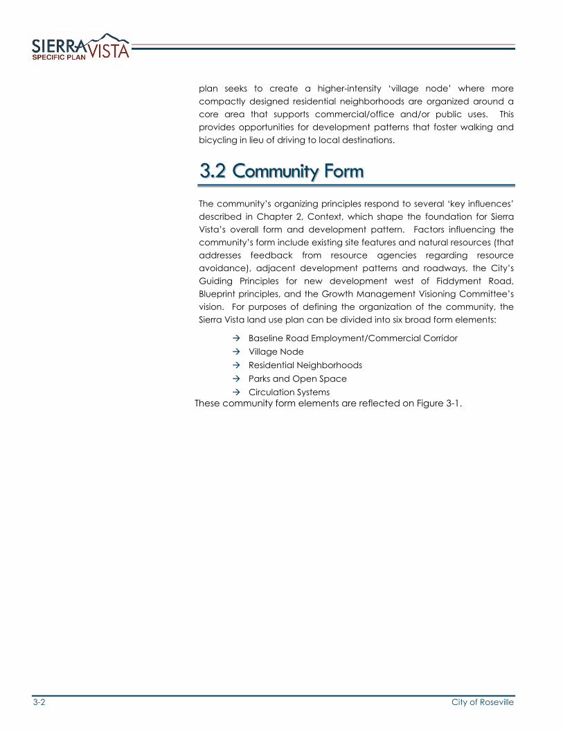
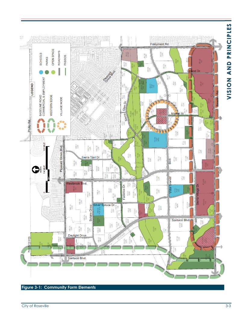
33..22 CCoommmmuunniittyy FFoorrmm The community’s organizing principles respond to several ‘key influences’ described in Chapter 2, Context, which shape the foundation for Sierra Vista’s overall form and development pattern. Factors influencing the community’s form include existing site features and natural resources (that addresses feedback from resource agencies regarding resource avoidance), adjacent development patterns and roadways, the City’s Guiding Principles for new development west of Fiddyment Road, Blueprint principles, and the Growth Management Visioning Committee’s vision. For purposes of defining the organization of the community, the Sierra Vista land use plan can be divided into six broad form elements:
Baseline Road Employment/Commercial Corridor Village Node Residential Neighborhoods Parks and Open Space Circulation Systems
These community form elements are reflected on Figure 3-1.
City of Roseville 3-3
VIS
ION
AN
D P
RIN
CIP
LES
Figure 3-1: Community Form Elements
3-4 City of Roseville
Commercial and office flex space
Business professional buildings and employment centers
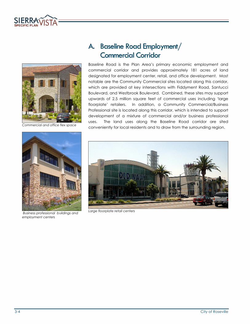
AA.. BBaasseelliinnee RRooaadd EEmmppllooyymmeenntt// CCoommmmeerrcciiaall CCoorrrriiddoorr
Baseline Road is the Plan Area’s primary economic employment and commercial corridor and provides approximately 181 acres of land designated for employment center, retail, and office development. Most notable are the Community Commercial sites located along this corridor, which are provided at key intersections with Fiddyment Road, Santucci Boulevard, and Westbrook Boulevard. Combined, these sites may support upwards of 2.5 million square feet of commercial uses including ‘large floorplate’ retailers. In addition, a Community Commercial/Business Professional site is located along this corridor, which is intended to support development of a mixture of commercial and/or business professional uses. The land uses along the Baseline Road corridor are sited conveniently for local residents and to draw from the surrounding region.
Large floorplate retail centers

City of Roseville 3-5
VIS
ION
AN
D P
RIN
CIP
LES
BB.. VViillllaaggee NNooddee In order to reinforce the community’s urban form and create smaller-scale “place-making” opportunities, a village node is planned in the Plan Area. As an anchor to some of Sierra Vista’s higher-density residential neighborhoods, the Node is envisioned to establish local-serving retail/service centers or public/quasi-public gathering places within the residential neighborhoods. The intent is to encourage residents living within a ¼-mile of a mixed-use node to walk for services, thereby reducing reliance on the automobile.
Each commercial mixed-use site would be permitted to develop with a combination of neighborhood-serving commercial, office, and/or public/quasi-public uses, supported by high-density residential units. For commercial areas, uses may be mixed either in a horizontal or vertical fashion, with either commercial/office or residential development on the same site, or with residential units or office space located above ground-floor commercial space. The intent is to create an environment where residential units are sited in proximity to commercial areas, office spaces, or other service uses. Design guidelines for development of the Village Node are provided in Appendix B.
Concept plan illustrating a potential design solution for Sierra Vista’s commercial mixed-use sites (See Figure B-11 for Market Street detail.)
Mar
ket S
treet
Vista Grande Blvd.
3-6 City of Roseville
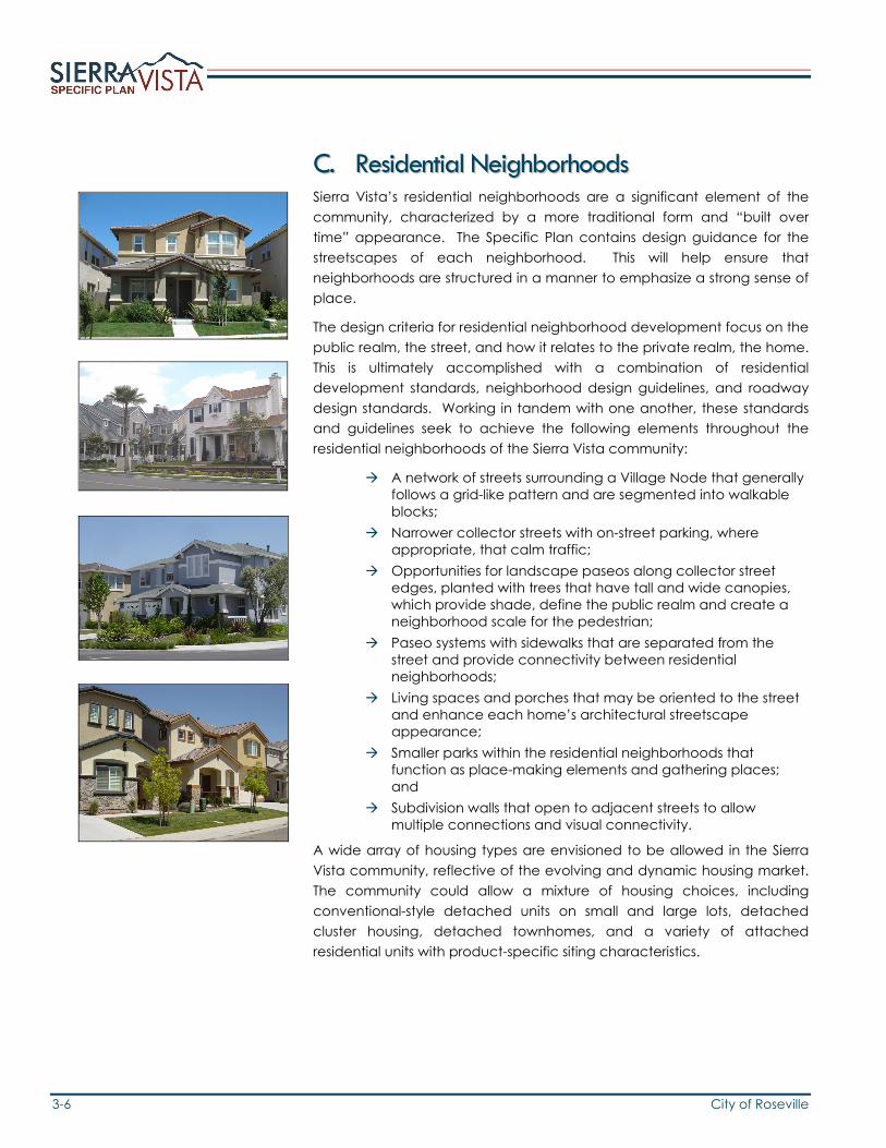
CC.. RReessiiddeennttiiaall NNeeiigghhbboorrhhooooddss Sierra Vista’s residential neighborhoods are a significant element of the community, characterized by a more traditional form and “built over time” appearance. The Specific Plan contains design guidance for the streetscapes of each neighborhood. This will help ensure that neighborhoods are structured in a manner to emphasize a strong sense of place.
The design criteria for residential neighborhood development focus on the public realm, the street, and how it relates to the private realm, the home. This is ultimately accomplished with a combination of residential development standards, neighborhood design guidelines, and roadway design standards. Working in tandem with one another, these standards and guidelines seek to achieve the following elements throughout the residential neighborhoods of the Sierra Vista community:
A network of streets surrounding a Village Node that generally follows a grid-like pattern and are segmented into walkable blocks;
Narrower collector streets with on-street parking, where appropriate, that calm traffic;
Opportunities for landscape paseos along collector street edges, planted with trees that have tall and wide canopies, which provide shade, define the public realm and create a neighborhood scale for the pedestrian;
Paseo systems with sidewalks that are separated from the street and provide connectivity between residential neighborhoods;
Living spaces and porches that may be oriented to the street and enhance each home’s architectural streetscape appearance;
Smaller parks within the residential neighborhoods that function as place-making elements and gathering places; and
Subdivision walls that open to adjacent streets to allow multiple connections and visual connectivity.
A wide array of housing types are envisioned to be allowed in the Sierra Vista community, reflective of the evolving and dynamic housing market. The community could allow a mixture of housing choices, including conventional-style detached units on small and large lots, detached cluster housing, detached townhomes, and a variety of attached residential units with product-specific siting characteristics.

City of Roseville 3-7
VIS
ION
AN
D P
RIN
CIP
LES
DD.. SSiiggnnaattuurree PPaarrkk One of Sierra Vista’s most significant defining elements is a 40-acre citywide park, located along Baseline Road in the southwestern portion of the community. As a “Signature Park” intended to promote tourism in the City, the park will enhance Roseville’s reputation as a place with state of the art sporting facilities by providing a venue for large scale recreational events and tournaments. Ultimately, full buildout of the park is envisioned to include a variety of recreation facilities for baseball and softball tournaments. Final design and programming of this facility will be determined in the future. A preliminary concept plan is illustrated below. Ancillary amenities that complement the tournament-level fields could include a stadium, batting cages, restaurants, and large outdoor spaces or plazas for fairs and other large events. Recreational and/or ancillary amenities include lighted facilities.
Concept plan illustrating a potential design solution for the Signature Park

3-8 City of Roseville
EE.. PPaarrkkss aanndd OOppeenn SSppaaccee A comprehensive system of parks and open space are planned within the Sierra Vista community. Approximately 423 acres (20%) of the Plan Area are provided for these features, which together create another community-defining element that supports Roseville’s long-standing heritage as a City with high-quality parks. Several park types are provided, each designed to meet different needs of community residents. Large neighborhood parks are sited throughout the community adjacent to elementary and middle schools, maximizing joint-use opportunities for outdoor recreation facilities. Small neighborhood parks are provided in greater frequency throughout the community, generally sited in a manner to ensure that a park anchors many residential neighborhoods. Schools in the Plan Area are adjacent to park sites and are linked to one another through a combination of paseos and open space corridors. Within paseos and open space areas, over 15 miles of street-separated pathways are provided for both bicyclists and pedestrians, which provide connections between the residential neighborhoods and the community’s public spaces. Several natural features in the Plan Area will be preserved as open space, including the Curry Creek corridor and intermittent drainages within, and adjacent to, the Western Area Power Authority (WAPA) corridor. These open space areas provide opportunities for locating Class I bike paths that further strengthen the community-wide linkages between parks, schools, and residential neighborhoods.
City of Roseville 3-9
VIS
ION
AN
D P
RIN
CIP
LES
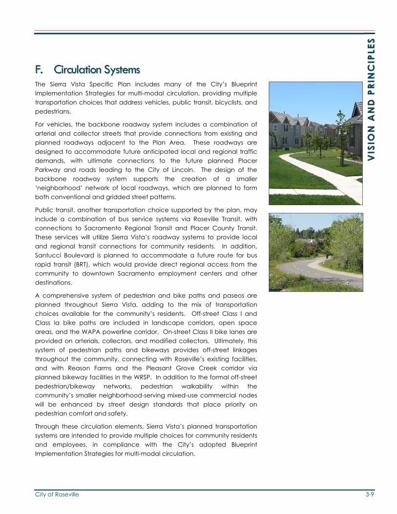
FF.. CCiirrccuullaattiioonn SSyysstteemmss The Sierra Vista Specific Plan includes many of the City’s Blueprint Implementation Strategies for multi-modal circulation, providing multiple transportation choices that address vehicles, public transit, bicyclists, and pedestrians.
For vehicles, the backbone roadway system includes a combination of arterial and collector streets that provide connections from existing and planned roadways adjacent to the Plan Area. These roadways are designed to accommodate future anticipated local and regional traffic demands, with ultimate connections to the future planned Placer Parkway and roads leading to the City of Lincoln. The design of the backbone roadway system supports the creation of a smaller ‘neighborhood’ network of local roadways, which are planned to form both conventional and gridded street patterns.
Public transit, another transportation choice supported by the plan, may include a combination of bus service systems via Roseville Transit, with connections to Sacramento Regional Transit and Placer County Transit. These services will utilize Sierra Vista’s roadway systems to provide local and regional transit connections for community residents. In addition, Santucci Boulevard is planned to accommodate a future route for bus rapid transit (BRT), which would provide direct regional access from the community to downtown Sacramento employment centers and other destinations.
A comprehensive system of pedestrian and bike paths and paseos are planned throughout Sierra Vista, adding to the mix of transportation choices available for the community’s residents. Off-street Class I and Class Ia bike paths are included in landscape corridors, open space areas, and the WAPA powerline corridor. On-street Class II bike lanes are provided on arterials, collectors, and modified collectors. Ultimately, this system of pedestrian paths and bikeways provides off-street linkages throughout the community, connecting with Roseville’s existing facilities, and with Reason Farms and the Pleasant Grove Creek corridor via planned bikeway facilities in the WRSP. In addition to the formal off-street pedestrian/bikeway networks, pedestrian walkability within the community’s smaller neighborhood-serving mixed-use commercial nodes will be enhanced by street design standards that place priority on pedestrian comfort and safety.
Through these circulation elements, Sierra Vista’s planned transportation systems are intended to provide multiple choices for community residents and employees, in compliance with the City’s adopted Blueprint Implementation Strategies for multi-modal circulation.

3-10 City of Roseville


![L-nnn-yy-[LICENSEE]-ELPAC-VVV AMBER Sensitive information ...](https://static.fdokumen.com/doc/165x107/6326029f6d480576770c9276/l-nnn-yy-licensee-elpac-vvv-amber-sensitive-information-.jpg)