Vol. 49 No. 2 (Spl) September 2020 - Administrative Staff ...
194
Leadership through Learning Vol. 49 No. 2 (Spl) September 2020 Special Issue on Land Pooling/Readjustment for Development Projects: Lessons Learnt & Way Forward
-
Upload
khangminh22 -
Category
Documents
-
view
0 -
download
0
Transcript of Vol. 49 No. 2 (Spl) September 2020 - Administrative Staff ...

Leadership through Learning
Vol. 49 No. 2 (Spl) September 2020
Special Issue on
Land Pooling/Readjustment forDevelopment Projects:
Lessons Learnt & Way Forward

Journal of ManagementVol. 49 (Spl) No. 2 September 2020
Editorial Board
ChairpersonNirmalya Bagchi
EditorM. Ramshirish
Technical EditorReshmy Nair
MembersValli Manickam, Nirmalya Bagchi,
S. Chary Vedala and Subodh Kandamuthan
The , published every March and September by theASCI Journal of ManagementAdministrative Staff College of India, is devoted to discussions on policy and managementissues concerning various aspects of national life. The papers published in the journal arebased on research work, consulting and professional experience. The ASCI Journal ofManagement also publishes analytical reviews of literature on specific themes, researchnotes, short notes from practising executives on issues and concerns of current interest, andbook reviews. Manuscripts of papers (see ) should reach the EditorNotes for Contributorsfour months prior to the date of release of a particular issue. The papers received forpublication are sent to referees for their comments before a final decision is taken on theirinclusion. The authors of papers that are published will receive 25 reprints free of cost.
Subscription
Country/category One year Two years Three years
India Rs. 500 Rs. 900 Rs.1,200
Bellavistans (members of ASCI Association) Rs. 500 Rs. 800 Rs.1,000
USA/other countries $ 30 $ 55 $ 80
UK £ 18 £ 30 £ 45
Note: Administrative StaffAll payments may ideally be made by demand draft in favour ofCollege of India. In case of outstation cheques, please add Rs. 30 towards collection charges.
Advertisements: The accepts a limited number ofASCI Journal of Managementadvertisements. The advertisement tariffs are available on request.
Correspondence: Please address all letters regarding publication of papers, books for review,subscription, non-receipt of the journal, etc., to the Editor, ,ASCI Journal of ManagementAdministrative Staff College of India, Bella Vista, Hyderabad 5000 82, India, or e-mail [email protected].
Leadership through Learning

Special Issue
ASCI Journal of Management
Conference Papers and Proceedingsof
Online International Conference
LAND POOLING/READJUSTMENT FOR DEVELOPMENT PROJECTS:LESSONS LEARNT & WAY FORWARD

Journal of ManagementVol. 49 No. 2 (Spl), September 2020
INDEX
Foreword i
Section I-Overview-Reshmy Nair 1
Section II-Summary of Paper Presentations 10
Section III-Q and A and Remarks by Session Chair 73
Section IV-Conference Papers 87
Takeo Ochi 87A Global Perspective of Land Readjustment
Linke, Hans-Joachim; Bretscher, Raphael 95Land Readjustment in Germany - Special Aspects & Practical Experience
Kirti Kusum Joshi 109Land Pooling in Nepal: Promises and Pitfalls
Sevkiye Sence TURK 122Land Readjustment (LR) Experience from Turkey’s Perspective
Naoyuki Yoshino & Saloni Lakhia 133Land Trust/Spillover Return to Infrastructure Investors
Felipe Francisco De Souza 147Nakasu Land Readjustment Project In Nagoya, Japan:Analyzing Development Costs And Benefits In Replotting Design
Aparna Das, Kasinath Anbu & Arpan Mazumder 161Exploring feasibility of Land Pooling/Land Readjustment instrumentsin informal settlements –a perspective from the ground (India)
Leadership through Learning

.

Foreword
Massive investments in infrastructure will be critical to kick start the global economyin the post-covid phase. Assembling land efficiently and equitably for infrastructureprojects is an ongoing challenge. Acquisition of land in areas with potential forvast appreciation in land values post project intervention poses several issues.Primarily, some landowners may have to be displaced from the area. The cost ofthe land they would receive may not sufficiently account for the appreciation inland values that their neighbours would experience after the project development.When the government pays hefty compensation to acquire the land, the broaderpublic pays (through their tax contributions) for the development, while few peopleget the benefit. Some people who receive property value increases are those whodo not encounter any losses. Though Land Pooling (LP)/Land Readjustment (LR)has its share of challenges, it addresses most of the issues mentioned above underthe land acquisition regime. LP/LR largely avoids physical displacement and makesthe landowners share their land for undertaking the project and paying back forthe improved infrastructure. In the face of rapid urbanisation and limited financialresources with the government, LP/LR often becomes the only available strategyto improve infrastructure. The process is known in different parts of the world byvarious names, viz. Land Readjustment, Land Consolidation, Land Pooling etc. Themethod is widely practised in Japan and Germany for more than a century. LP/LRis most widely used as an urban planning tool. The legal bindings regarding landuse in a land pooling area is usually covered in the urban/spatial planning law. As atool to address urban challenges, LR is used to alter plots’ shape and conditionsand install/improve public facilities in the city planning area to provide betterpublic facilities. LP can also work successfully in different project contexts. Themodel is workable if each project generates land value sufficient to cover theproject costs and leaves the landowners with a significant gain in their total landvalue despite the reduced size of their landholdings.
Land pooling is gaining acceptance in India in varied project contexts. This is agood indicator of its attractiveness and potential transferability. However, ASCI’sconsultancy studies on alternate land assembly models in India reflect the need forsignificant improvements on diverse aspects of planning and implementation ofLP/LR. As the country expands the use of this innovative land assembly tool, thereare several issues that merit attention of both the policy makers and practitioners.With this objective, ASCI organised an online International Land Pooling Conferencefrom 27th to 29th June 2020. The Conference aimed at bringing both global anddomestic experts on a common platform to share their valuable country experiencesbesides sharing perspectives on some of the key practical issues associated withthe assembly tool. The Conference also aimed at addressing the knowledge gapamong professionals in the design and implementation of LP/LR. Besides reflecting

upon the varied country experiences in the implementation of these tools, theConference discussed the improvements required for the existing pooling modelsto evolve as sustainable futuristic assembly models. The Conference was madepossible by the support from GIZ, Madhya Pradesh Industrial DevelopmentCorporation, State Industries Promotion Corporation of Tamil Nadu, Mahatma GandhiInstitute of Public Administration, and Western Coalfields Ltd. ASCI acknowledgesthe timely and valuable support from each of the supporting institutions. We thankMs. Aparna Das, Senior Advisor, GIZ, and the entire technical team from GIZ, includingthe Technical Advisor, Mr. Arpan Mazumdar for their support in the publication ofthe Special Volume.
More than thirty experts, considered globally authorities on the subject from variouscountries and development institutions (JICA, World Bank, Asian Development Bankand UN-Habitat) presented papers/participated in the three-day virtual Conferencediscussions. The success of the event owes to their remarkable contribution. Wededicate this Special Issue of ASCI Journal of Management on Land Pooling to eachone of them. About 300 participants from more than 30 countries participated inthe event.
The Special Issue of ASCI Journal of Management on Land Pooling is divided intothree sections. Section I provides an overview of Land Pooling models in India.Section II presents the summary of the Conference presentations, the compilationof queries raised by the participants along with the summary of the reflections bythe Session Chairs. Section IV includes six important papers on LP/LR; A GlobalPerspective of Land Readjustment by Mr. Takeo Ochi; Special Aspects & PracticalExperience of LR in Germany by Prof Hans-Joachim Linke & Raphael Bretscher; LRExperience in Turkey by Prof Sevkiye Sence TURK; Land Pooling in Nepal-Promisesand Pitfalls by Dr. Kirti Kusum Joshi; Land Trust/Spillover Return to InfrastructureInvestors by Prof Naoyuki Yoshino & Ms. Saloni Lakhia and Analyzing DevelopmentCosts And Benefits in Replotting Design in the Nakasu Land Readjustment Project,Nagoya, Japan by Dr. Felipe Francisco De Souza.
We hope this Special Issue will enrich the body of knowledge.
Dr. Reshmy NairProfessor and DirectorCentre for Excellence in Management ofLand Acquisition and R & R (CMLARR)Administrative Staff College of India

Online International Conference
LAND POOLING/READJUSTMENT FOR DEVELOPMENT PROJECTS:LESSONS LEARNT & WAY FORWARD
(JUNE 27-29, 2020)
CONFERENCE AGENDA
INAUGURAL SESSION & CONTEXT SETTING
DAY:1 June 27, 2020 Timing: 0800-0900 hrs Indian Standard Time (IST)
0800-0805 hrs Dr. Reshmy NairWelcome/Agenda Professor & Conference Director, ASCI
0805-0810 hrs Mr. K.Padmanabhaiah, IAS (Retd.)Special Address Chairman, Court of Governors, ASCI
0810-0815 hrs Mr. Maninder GillSpecial Address Global Director, Environmental &
Social Framework, World Bank
0815-0850 hrs Mr. Takeo OchiGlobal Perspectives Senior Advisor, JICA
0850-0900 hrs Ms. Aparna DasIntroductory Remarks Senior Advisor, GIZ

SESSION I LP/LR-DECODING SUCCESS STORIES
DAY1: June 27, 2020 Session Timings: 0925-1130 hrs IST
Session Chair: Mr. K B S Sidhu, IAS, Special Chief Secretary and Director General,Mahatma Gandhi State Institute of Public Administration (MGSIPA), Govt. of Punjab
KEY SPEAKERS
0925-0930 hrs Introduction of Distinguished Session Chair
0930-0940 hrs Mr. K B S Sidhu, IASSession Chair Special Chief Secretary & Director General,
MGSIPA, Govt. of Punjab
0940-0950 hrs Dr. Felipe Francisco De SouzaOverview Senior Urban Specialist & Ph.D. Researcher, University of Tokyo
0950-1015 hrs Prof. Hans Joachim LinkeLR in Germany Head of the Chair “Land Management”
at the Institute of Geodesy, Germany
1015-1040 hrs Prof. Andre SorensenLR in Japan Professor, Department of Human Geography,
University of Toronto, Scarborough
1040-1105 hrs Prof. (emerita) Rachelle AltermanLR in Israel Senior Researcher, Neaman Institute for Policy Research,
Technion Israel Institute of Technology, Israel
1105-1130 hrs Mr. K B S Sidhu, IASSession Chair Special Chief Secretary & Director General,
MGSIPA, Govt. of Punjab
SESSION II LP IMPLEMENTATION IN DIVERSE SECTORS IN INDIA
DAY1: June 27, 2020 Session Timings: 1400-1630 hrs IST
Session Chair: Mr. Takeo Ochi, Senior Advisor, JICA
KEY SPEAKERS
1400-1402 hrs Introduction of Distinguished Session Chair
1402-1412 hrs Mr. Takeo OchiSession Chair Senior Advisor, JICA
1412-1420 hrs Dr. Reshmy NairOverview Professor & Conference Director,
Administrative Staff College of India, Hyderabad
1420-1445 hrs Mr. K B S Sidhu, IASUrban Projects Special Chief Secretary & Director General,
MGSIPA, Govt. of Punjab

1445-1510 hrs Mr. Vivek Porwal, IASIndustrial Project Managing Director,
Madhya Pradesh Industrial Development Corporation Ltd.
1510-1530 hrs Dr. Sreedhar Cherukuri, IASNew Capital City Joint Secretary,
Chief Commissioner of Land Administration, Govt. of AP
1530-1550 hrs Mr. Harpal DaveDisaster Assistant Town & Country Planner,Reconstruction Ministry of Urban Development, Govt. of India
1550-1610 hrs Ms. Aparna DasHousing Projects Senior Advisor, GIZ, India
1610-1630 hrs Mr. Takeo OchiKey Observations Senior Advisor, JICA
SESSION III LESSONS FROM COUNTRY EXPERIENCES – I
DAY 2: June 28, 2020 Session Timings: 0930-1200 hrs IST
Session Chair: Mr. Vivek Porwal, IAS, Managing Director, Madhya Pradesh IndustrialDevelopment Corporation Ltd.
KEY SPEAKERS
0930-0932 hrs Introduction of Distinguished Session Chair
0932-0942 hrs Mr. Vivek Porwal, IASSession Chair Managing Director, Madhya Pradesh Industrial
Development Corporation Ltd., India
0942-0950 hrs Dr. Felipe Francisco De SouzaOverview Senior Urban Specialist and Ph.D. Researcher,
University of Tokyo, Japan
0950-1010 hrs Ms. Marta Lora TamayoLR in Germany UNED, Universidad Nacional de Educación a Distancia, Spain
1010-1030 hrs Prof. María Cristina Rojas EberhardLR in Spain Advisor, Urban Planning, Land Management, &
Land Value Recapture, Columbia
1030-1050 hrs Dr. Gisela FaerberLR in Columbia Chair, Public Sector Economics & Public Finance, German
University of Administrative Sciences Speyer, Germany
1050-1110 hrs Dr. Sevkiye Sence TurkLR in Turkey Professor, Land policy, Urban Law & Urban planning,
Istanbul Technical University
1110-1130 hrs Mr. Tommy ÖsterbergLR in Sweden Part-time Professor at the University of Lund, Sweden.
1130-1200 hrs Mr. Vivek Porwal, IASKey Observations Managing Director, Madhya Pradesh Industrial Development
Corporation Ltd., India

TECHNICAL SESSION IV LP/LR -Learning from Country Experiences -II
DAY 2: June 28, 2020 Session Timings: 1400-1630 hrs
Session Chair: Dr. Girija Vaidyanathan, IAS Retd., Ex. Chief Secretary, Govt. of TamilNadu
1400-1402 hrs Introduction of Distinguished Session Chair
1402-1410 hrs Dr. Girija Vaidyanathan, IAS Retd.,Session Chair Ex. Chief Secretary, Govt. of Tamil Nadu
1410-1420 hrs Dr. Reshmy NairOverview Professor & Conference Director
1420-1440 hrs Mr. Satish MagarMagarpatta LP Model Managing Director, MTDCL
1440-1500 hrs Dr. Ngakan Ketut Acwin Dwijendra,LC Projects in Assosiacet Professor, Udayana University,Indonesia Bali, Indonesia
1500-1520 hrs Mr. Jacob ManoharGujarat/Raipur/ Associate Town & Country Planner,Delhi LPS Ministry of Urban Development, GoI
1520-1540 hrs Dr. Kirti Kusum JoshiLR Projects in Nepal Urban Specialist, City Planning Commission,
Kathmandu Metropolitan City
1540-1600 hrs Ms. Tashi WangmoLR Projects in Bhutan Executive Secretary, Gelephu Thromde (Municipality),
Kingdom of Bhutan
1600-1610 hrs Dr. Girija Vaidyanathan, IAS Retd.,Key Observations Ex. Chief Secretary, Govt. of Tamil Nadu
1610-1630 hrs Q and A-Session Chair
TECHNICAL SESSION V ALTERNATE VOLUNTARY LAND ASSEMBLY TOOLS
DAY 3: June 29, 2020 Session Timings: 0930-1140 hrs
Session Chair: Dr. Sanjay Kumar, Director Personnel, Western Coalfields Ltd.
0930-0932 hrs Introduction of Distinguished Session Chair
0932-0942 hrs Dr. Sanjay KumarSession Chair Director Personnel, Western Coalfields Ltd.
0942-0950 hrs Dr. Reshmy Nair/ Dr. Felipe Francisco De SouzaOverview
0950-1010 hrs Dr. Paul Rabe,Land Sharing Senior Land Expert, Institute for Housing & Urban
Development Studies, Erasmus University, Rotterdam.

1010-1030 hrs Dr. Reshmy NairLand Leasing Professor & Director CMLARR, ASCI
1030-1050 hrs Prof. (Emeritus) Naoyuki Yoshino, Keio University, Tokyo,Land Trusts Japan & Ms. Saloni Lakhia, Public Policy Consultant, India
1050-1110 hrs Prof. Guoqing ShiLP & Equity Sharing Director, National Research Centre for Resettlement,
Hohai University, China
1110-1140 hrs Dr. Sanjay KumarKey Observations Director Personnel, Western Coalfields Ltd.
TECHNICAL SESSION VI LP/LR-TOWARDS A FUTURISTIC LAND ASSEMBLY STRATEGY
DAY 3: June 29, 2020 Session Timings: 1630-2000 hrs IST
Session Chair: Mr. Maninder Gill, Global Director, Environmental & Social Framework,World Bank, DC
KEY SPEAKERS
1630-1632 hrs Introduction of Distinguished Session Chair
1632-1642 hrs Mr. Maninder GillSession Chair Global Director, Environmental & Social Framework, World Bank
1642-1700 hrs Dr. Reshmy NairEvaluation Findings Professor & Conference Director
1700-1720 hrs Mr. Robert Lewis-Lettington,Participatory LR/LP Chief, Urban Legislation Unit, UN-Habitat
1720-1740 hrs Mr. Jon Kher KawLand Value Capture Senior Urban Development Specialist, World BankInstruments
1740-1800 hrs Prof. Martim Oscar SmolkaLP/LR in Post Senior Fellow & Director, Lincoln Institute of Land PolicyCovid-World
1800-1810 hrs Q and A
1810-1830 hrs Break
1830-1850 hrs Mr. Padma MainaleeTransforming LP Deputy Director General, Ministry of Urban DevelopmentPractices
1850-1910 hrs Mr. S. ViswanathanSafeguard Issues Senior Safeguard Specialist, Asian Development Bank
1910-1940 hrs Dr. Felipe Francisco De SouzaEquity in Land Value Senior Urban Specialist and Ph.D. Researcher,Distribution University of Tokyo
1940-1950 hrs Mr. Maninder GillKey Observations Global Director, Environmental & Social Framework, World Bank
1950-2000 hrs Q and A-Session Chair


ASCI Journal of Management 49 (2): 1–9Copyright © 2020 Administrative Staff College of India
Section IOverview of Indian Land Pooling Models
Reshmy Nair*
Introduction
In India, the Town Planning Scheme (TPS) was first introduced under the BombayTown Planning Act (TPA) of 1915. In the words of A. E. Mirams, credited to haveintroduced the concept to India, “The Bombay Town Planning Act aimed atdistributing the cost of development schemes over the lands improved thereby,and yet at the same time allowed a fair margin of profit to the owners of the land,who as a rule had done absolutely nothing to improve the value of the property. Atthe same time, the Act brings into the market large areas of land which withoutcooperative action would for untold years remain agricultural land. In this way, thecommunity at large is able to obtain land at a reasonable price”. The Overview isdivided into two parts. Part I provides a summary of key issues emerging from theimplementation of Land Pooling (LP)/Land Readjustment (LR) in India. Part II providesan assessment of three important LP/LR policies in the states of Gujarat, Punjab,and Andhra Pradesh.
I – Key Issues from LP/LR Implementation
Legislative Framework & Judicial Interpretation: In India, the legislativecompetence of the Central and State Legislatures are demarcated by the Constitutionunder Article 246, with the fields for the exercise of legislative power enumeratedin Central, State, and concurrent lists. The statutory backing of the land poolingmodels lies in the Town Planning/Urban Development Acts of various States. Theconstitutional validity of the Gujarat Town Planning Act was upheld in severaljudgments. The Gujarat High Court had held that TPS ipso facto is a form of delegatedlegislation and such a scheme is prepared not by the legislature but by the competentauthority constituted under the delegated legislation and that TPS at any time canbe varied by a subsequent scheme to be made by the competent authority1. The
* Professor & Conference Director, ASCI, Email: [email protected],[email protected]
1 Rajan Sankalchand Patel Vs. State of Gujarat (1997) 1 GLR 31 28

2 ASCI Journal of Management 49 (2) September 2020
Court has held that complaint of pecuniary loss to the petitioners become immaterialand irrelevant in such cases as individual interests have to be subordinated so as toserve the public good2. Regarding the applicability of the central land acquisitionlaw on the state planning act, the Supreme Court in Girnar Traders Vs. State ofMaharashtra3, held that the application of Doctrine of Pith and Substance makes itclear that the State Act (Mumbai Regional Town Planning Act) is aimed at planneddevelopment unlike the Central Act where the object is to acquire land and disbursecompensation in accordance with law. The paramount purpose and object of theState Act being planned development and acquisition being incidental thereto, thequestion of repugnancy does not arise. The Court held that they would fall withinthe permissible limits of doctrine of “incidental encroachment” without invalidatingany part of the State Law.
It is, however, important to recognise the changed legal environment after theenactment of the Right to Fair Compensation and Transparency in Land Acquisition,Rehabilitation and Resettlement Act, 2013 (2013 Act henceforth). The field ofcompulsory acquisition is occupied the Central Law (2013 Act), and the statutoryrights accorded by the Act may require protection by any law framed by the State.Defining affected families solely in terms of title-holders may also lend the modelsvulnerable in case of judicial scrutiny. It is important to note that tenants insightswere upheld under the TPS even prior to the enactment of the 2013 Act. In asignificant Judgment4, the Court ruled that the TPS had injuriously affected thetenant by terminating his possession and adversely affecting his business and directedthat he may be provided alternative premises by allotting a suitable shop withinthe city. Given that LP/LR interferes with the property structure and rights ofcommunities, there are several other pertinent issues for consideration in the currentpractices. The important ones are comprehensive provisions covering planningrequirements, choice and conditions for the use of alternate and assembly models,cost recovery, value capture, and allocation; stringent conditions for adherence totimelines; penalty clauses for discrepancies between plans for an area and itseventual development; rights and duties of affected families, implementationagencies, and other third parties involved from the initial phase until projectcompletion; option for landowners to choose between compensation (appropriation)and developed land; a minimum percentage of voluntary land owners participationfor both government/private projects; a time bound dispute settlement frameworketc. LP/LR mechanisms may also require improvements regarding consultation andtransparency requirements. While some projects have progressive practices, othersleave a lot to be desired. Whether we should have a specific LP/LR law or incorporateit under the relevant statutes is another matter to be considered.
2 Hasmukh Shah Vs. Ahmedabad Municipal Corporation (2001) 4 GLR 28403 (2004) 8 SCC 505
4 Jaswant Singh Mathura Singh Vs. Ahmedabad Municipal Corporation, 991 AIR 2130
Overview of Indian Land Pooling Models 3
Planning for LR/LPs: To result in a win-win situation for all stakeholders, the selectedsite should be physically and economically suitable for LP/LR. The size of the LP/LR project, level of development, the trend of property prices, and the real estatemarket are all important. It may be progressive to have a quick study of the proposedpooling area (especially agricultural peri-urban areas) to understand the land usepattern, identification of the affected families and the special needs so as to developappropriate safeguard measures in line with the specific needs of the region. Whenthe proposed area comprises of agricultural lands, the due diligence measures toavoid, minimize and mitigate adverse impacts on livelihood will assume criticalimportance. There are some countries where the recognition of occupation rightsis recognised as the first step in LP/LR. There are others in which this is ignoredand gets delayed owing to multiple reasons. In India, the practices and challengesvary across states. Recognising and institutionalising mechanisms to address theissue, including greater synergy and coordination between the revenue departmentsand urban local bodies, become vital for LP projects in new cities/areas.
Equity and Social Acceptance: Not all land pooling projects present similar impacts.An urban rehabilitation project in the core city area will be different from a projectin the urban periphery or another one which proposes reconstruction of a damagedcity. Equity considerations may not be the same in both projects. Equity in landpooling/reconstitution refers to both substantive and procedural equity. For twolandowners who had pooled their lands for a project, will equity not demand parityin the proportionate value of plots after LP/LR? If yes, what are the diverseinstruments of land value capture including balancing fees that could be integratedwith LP/LR to maintain the proportionality rule? Can the uniform contribution ratioprovide rationale outcomes when lands pooled are non-homogenous?
Further, is it fair to have the landowner bear the risk of uncertainty surroundingthe expected land value appreciation, or would it have to be shared with thegovernment and facilitating entity? The small landowners face an inherentdisadvantage under LP/LR. The graded/progressive contribution ratio wasimplemented in some projects and it does promote fairness. However, much moreattention and efforts are required to address the operational challenges of cut-offdates, fragmentation of land etc., in such cases. Equity also means how well thestrategy is meeting the needs of particular groups that have special needs namelythe landless, tenant farmers etc. Loss of income during the land developmentperiod also requires ameliorative measures.
Reserve Lands: Many countries avoid the self-financing options given its impact onthe contribution ratio, and as the concept of reserve land/ self-financing nature ofland pooling is difficult for landowners to comprehend. LR is considered analternative to expropriation. Under expropriation, the land is acquired by thegovernment by paying due compensation, following which public utilities arefinanced through multiple sources. Is there a potential for misuse of the self-
4 ASCI Journal of Management 49 (2) September 2020
financing nature of land readjustment both in terms of its quantum as well as itsallocation? Is the provision of ‘reserve lands’ equitable, considering that the publicamenities may benefit the population outside the project area? Should the use ofreserve land only be restricted to big infrastructure projects where the governmenthas severe fund constraints? These are fundamental questions to be considered bythe policymakers. While the provision cannot be uniform across projects, it may beimportant to ensure that the use of provision for reserve land is guided by certainpre-defined criteria along with the quantum and mode of sale of these lands forfinancing public facilities.
II – Assessment of Key Land Pooling Models in India
1. The Gujarat Plan–Town Planning Scheme, 1976: In Gujarat, the first TPA wasimplemented in 1915. The recent version of the Act is the Gujarat Town Planningand Urban Development Act (GTPUDA), 1976. The legislation provides for thedevelopment of the decadal macro level “Development Plan” for the entire cityand is followed by a many micro level TPSs of 100 ha area each. The Act wasamended in 1999 to enable the local Government to take possession of land toconstruct roads after obtaining approval of the draft TPS. The allotment of land inthe TPS is 15 percent for roads, 5 percent for parks, playgrounds, garden & openspaces, 5 percent for social infrastructure plots, 15 percent for sale for residential/commercial or industrial plots, and 10 percent for housing for social/economicallyweaker sections. The remaining land is to be reconstituted and returned to thelandowners. The scheme is conceptualised as a joint venture between the localauthority and the landowners, who voluntarily agree to pool their land, redistributethe reconstituted plots of land among themselves and share the development cost.To address the grievance, there exists a Board of Appeal in which the PrincipalJudge of the City Civil Court or the District Judge acts as the President. The appealsagainst the President are addressed by the State Government in consultation withthe High Court. The common demands raised by landowners include changes in theplot allotted (near garbage dumps/informal settlement), higher contribution ratio,higher compensation for land taken, widening of the road in front of their plot,settlement of ownership disputes, etc.
The Process Flow: The process includes a detailed topographical survey of theproposed TPS area; preparation of a base map by collation of the ground surveyand the cadastral maps; marking of the boundary of the TPS area on the final basemap; publication in local newspapers; design of subsidiary roads; drawing up ofplots for amenities; assessment of Final Plot (FP) size, compensation payment tolandowners and assessment of the value of FPs and betterment charges. A publicmeeting of the landowners is called to present the draft TPS, and suggestions/objections are solicited, following which the draft TPS is modified and published.It is again put for objections and suggestions from the landowners. Based on thesecond round of objections and suggestions, it is modified and then submitted to
Overview of Indian Land Pooling Models 5
the State Government for approval. Once approved, the draft TPS is now called thesanctioned draft TPS. After the sanction, the Development Authority can takephysical possession of the land designated for roads. A quasi-judicial officer calledthe Town Planning Officer (TPO) is appointed after the approval of the draft TPS.The TPO’s task is to deal with each landowner both on the physical planning proposal,the shape and location of the FP and the financial proposal viz. the compensationand betterment norms, and eventually demarcate the FP on the ground and hand itover to the owner. The TPO conducts three individual hearings to each landownerand revises the preliminary TPS, if required. There are four rounds of public inputs.The first round is initiated by the development authority at the Draft TPS stage.The other three rounds are initiated by the TPO in the Preliminary and Final TPSstages. The TPO finalizes the preliminary TPS by writing his/her decisions withregard to every plot, following which it is sent to the State Government for approval.The preliminary TPS comes into effect from the date of sanction, and all plotsappropriated for public purpose vest with the local/development authority.
Benefits Entitlements to Land Owners/Others: The landowner gets back 50 to 60percent of the size of the original plot. The Government is entitled to paycompensation for the land surrendered to the Government. The landowners areentitled to pay betterment levies at the rate of half the increase in land values ofthe final plots.
The TPS is being implemented by all urban development authorities in the State ofGujarat. The scale of TPS implementation has however, increased since the 1999amendment across different development authorities. TPS is an establishedmechanism and working very successfully in Gujarat. This can be expanded to theother States too. The TPS essentially is an integrated mechanism through whichthe various tasks of urban transformation governed by diverse laws are broughtunder the same legal mechanism. In States that do not make use of the TPSs, anumber of different departments governed by the different legal frameworks wouldhave to coordinate and work towards the objective. With the enactment of a newland acquisition law in India in 2013, the entitlements to affected families deserveattention. It is also extremely important to recognise the impact on families otherthan landowners and provide for entitlements to non-title-holders/livelihood losers.Though the Gujarat LPS is progressive for its consultation with landowners at multiplestages, these schemes do not require the consent of the landowners’ to proceed.Further, the Government can take possession of land needed to construct roadsafter the draft scheme is approved. It would be progressive if the consultationexercises can engage the community more in planning for design for TPS (layout ofroads, networks, open spaces, public amenities etc) than just issues relating toparticulars of individual plots. A major concern with regard to the mechanism isthe delay in completion of projects, often extending between the four yearscontemplated in the law. It would therefore be progressive to have effective

6 ASCI Journal of Management 49 (2) September 2020
monitoring arrangements to ensure adherence to timelines, development of publicamenities, and utilisation of the land reserved for low income housing (with penaltiesfor delay).
2. The Punjab Land Pooling Model: The Department of Housing and UrbanDevelopment, Government of Punjab, notified the Land Pooling Policy in June 2013,though the practice of sharing a proportion of developed land existed earlier. Thestated aim of the land pooling policy is to avoid complications of compulsoryacquisition and share benefits of urban development with landowners so as tomake them a stakeholder in development. The landowners can opt for compensation,as arrived under the provisions of the Land Acquisition Act (LAA) or the packageunder land pooling policy. The land pooling policy is available to the landownerseven if the land is acquired for other than residential purpose. If the land is acquiredunder LPS through land aggregators, the aggregator is paid a two percent commissionon handing over possession of land (calculated at Collector rates excluding solatiumor any other charges payable).
The Process Flow: The process framework is as per the Land Acquisition Act. Theoption for returnable developed plots is given to the landowner at the award stage.
Entitlements to Land Owners/Others: For every acre of land pooled, the landownersare entitled to 1000 square yards of residential land. The commercial returnableplot is Shop cum Office (SCO) of 121 sq yards or two shops of 60 sq. yards (12ft x45ft). A landowner possessing half an acre of land is entitled to 500 square yards ofresidential land and one shop of 60 sq yards. The minimum land size that can bepooled is one canal (one-eighth of an acre), for which the residential returnableland is 150 square yards. Similarly, returnable land for two and three canals is 300and 450 square yards respectively. Commercial returnable plot entitlements areonly for those possessing half acre or more. In case the area acquired for thescheme is in fractions and if the fraction is more than half of the unit, the areaacquired shall be counted in the next upper category. The residential and commercialplots are allotted through an open draw. The compensation for structures is carriedout as per the provisions of the LAA. In case the possession of the structure (house)of the landowner is taken by the Authority, the possession is not made effective fora period of one year to enable him/her to construct a new house. The landownersare entitled to a subsistence allowance of Rs. 25,000 per acre up to a maximum ofthree years or till the possession of developed share of land is not handed over tohim/her, whichever is earlier. Benefits to non-title-holders or special benefits tovulnerable sections are not envisaged under the policy. An assessment of the datacollected from GMADA reveals that despite the high compensation given tolandowners who had opted for the same, GMADA could easily recover the samefrom the sale of plots (about 27 percent of land remains with GMADA). The periodtaken for the return of developed land is about five years in most of the projects.

Overview of Indian Land Pooling Models 7
The Punjab LPS provides a real option to the landowners to choose betweencompensation or share the developed land in return. The implementation experiencereveals that market conditions and outlook for the real estate sector govern thechoices of the landowners exercising the option. Land pooling is not always thepreferred option. This also points out the difficulties that may crop up if the landassembly process provides for land pooling as the only option for landowners. Giventhe high compensation cost of land in the State, the land pooling has helped theGovernment in reducing its financial burden as well as reducing litigation at differentcourts. It is also seen that the Government can easily recover its high compensationoutgo by the sale of high value plots. The delay in the period for returning the landto the landowners is the most common concern with land pooling models. Thistransition period is critical if the landowners were dependent on the pooled landfor their livelihood. The Punjab Policy provides a transitional allowance for thelandowners for a maximum period of three years. This should be extended till theperiod the developed land is returned to the landowner. The policy does not havea structured consultation mechanism or institutionalised GRM. The Punjab policyhas not been modified after the coming into force of the 2013 Act. According to the2013 Act, a mandatory Social Impact Assessment (SIA) is to be carried out prior toland acquisition. Since the Punjab policy is integrated with the land acquisitionframework, it remains to be seen if a diligently conducted Social Impact Assessment(SIA) study prior to notification would cover the gaps in the existing pooling policyviz. holistic assessment of the impacted and providing entitlements to non-title-holders and others adversely impacted.
3. The Andhra Pradesh Capital City Land Pooling Model: The Andhra Pradesh CapitalRegion Development Authority (APCRDA) Act, 2014 notified an area of 8352.69 Sq.Kmsfor Capital Region and 217.23 Sq.Kms as AP Capital City area. The Capital City areafalls in Guntur district, covering 24 revenue villages and part of Tadepalli Municipalitycovering mandals of Thullur, Mangalagiri, and Tadepalli. The Capital RegionDevelopment Authority (CRDA) notified the Andhra Pradesh Capital City Land PoolingScheme (LPS) Rules in January 2015. Through the LPS, land parcels owned byindividuals or group of owners were legally consolidated by transfer of ownershiprights to the CRDA, which later transferred the ownership of a part of the landback to the land owners. Half of the total land in the capital city is reserved forroads, utility services, parks, playgrounds, gardens, open spaces, social amenitiesand affordable housing. The balance after meeting the above requirements andthe return of plot to the landowners were vested with the Authority.
The Process Flow: Upon issuance of the Notification by the Commissioner(declaration of intention to make the LPS), the landowners had to submit theirconsent/suggestions/objections within 30 days. The Authority made a draft LPS ofthe area in accordance with the sanctioned plans, and in consultation with thelandowners. A 30-day period timeline was provided for suggestions/objections andthe final LPS was notified by the Commissioner. After the landowners executed a
8 ASCI Journal of Management 49 (2) September 2020
Development Agreement cum Irrevocable General Power of Attorney with AP CRDA,the rights over the land were transferred to CRDA by executing a registered deed.The finalised plan was notified, and landowners were allotted their ‘returnableplots’ by means of a digital lottery. Along with the lottery allotment, the landownerswere given their Land Pooling Ownership Certificate (LPOC) that specified the detailsof the original and reconstituted plots. This was followed by the registration ofland. The notified area under the final LPS vests absolutely with the CRDA freefrom all encumbrances. The reconstituted plots, given to the landowners, werewithin the same revenue village boundary in most cases. The landowners could optfor different sizes of standard plots as per their eligibility. The owners of thereconstituted land required permission for the development of the plot afterpayment of necessary fees. Though the reserve lands with CRDA initially workedout to be about 20 percent, the actual share turned out to be less owing to hike incommercial space granted to the landowners; grant of plots in the capital city todisplaced population of a proposed international airport etc.
Entitlements to Land Owners/Others: For every acre of irrigated and semi urbanland surrendered for the LPS, the landowners received 1000/450 square yards ofdeveloped residential/commercial plots. Those possessing dry land have a lowerentitlement of 1000/250 square yards of residential/commercial plots per acre.The landowners are also entitled to an annuity for crop loss at the rate of Rs.30,000 for dry and Rs. 50,000 for irrigated lands (with an annual enhancement often percent); one time additional payment up to Rs 1 lakh for gardens. Agriculturalloans amounting to Rs. 1.50 lakh for each family were also waived off. The AP LPSwas also unique in providing benefits to the landless families viz. Rs. 2,500 permonth for a period of 10 years besides a plethora of other benefits that includedthe provision of National Rural Employment Guarantee Scheme (NREGS) upto 365days a year per family, Interest free loan up to 25 lakhs to all the poor families forself-employment, free education and medical benefits and skill development trainingwith sty-fund to enhance the skills of cultivating tenants, agricultural labourersand other needy persons to have alternative livelihoods.
The AP LPS mechanism is grounded in the legislative framework with a detailedconsultative framework. The extraordinary success of the model was in procuringabout 35000 acres of private land in a record time. Several factors can be attributedto this success; political commitment; massive State-led consultation exercises,avoiding displacement by marking old village sites and extended habitations aspart of the Capital City, an innovative package for various categories of affectedfamilies that includes annuity scheme for landowners, pensions for the landlessetc. The returnable developed land entitlements to even farmers who had beencultivating on objectionable government lands is a very progressive measure thatreflects the inclusiveness of LPS model. However, the fact that the non-pooledlands were to be compulsorily acquired meant that those not desirous of joining

Overview of Indian Land Pooling Models 9
the LPS did not really have an option. Could the land procurement anddiscontinuation of agricultural activities have been carried out in a phased manner,particularly given the mammoth challenge of building a new capital city? Delay inthe envisaged timeline adversely impacts all the stakeholders; for the land owners,the value of these plots would increase only when the capital city develops andbecomes livable; for the small and marginal farmers, the annuity component maynot have been enough for sustenance though the anticipated spur in constructionactivities was expected to vastly increase the employment opportunities for unskilledlabour. The assessment of the distribution of landholdings of the landowners in thecapital city area prior to their joining LPS could have helped a better understandingof the quantum of such adversely affected population and the extent/magnitudeof impact. While the provision of monthly pension for the landless families isprogressive, the ‘per family’ norm may go against the interest of the bigger families.Other than the environmental concerns associated with the project, there wereconcerns over the large quantum of land procured for the capital city project alongwith the transfer of fertile multi-crop land for non-agricultural use. It would beprogressive for models which try to replicate the AP LPS to institutionalise thesemeasures. Also, areas with vast variation in the pre and post valuation of land mayrequire paying greater attention to the technical assessment of land contributionarea and/or additional measures to ensure fairness.
The above discussion summed up the experience of land pooling models in Gujarat,Punjab, and Andhra Pradesh, the largest projects in terms of quantum of landprocured. There are several other states/projects that are implementing LP projectsin India. These include Chhattisgarh, Madhya Pradesh, Kerala, Delhi, Haryana,Rajasthan, Maharashtra, etc. Balancing social and economic issues is central toany strategy for land assembly. Even the established land pooling models may haveto bring forth necessary changes in the light of the changed legal environmentafter the enactment of the new land acquisition Act (2013) in India. The alternatemodels of land assembly including land pooling, has both strengths and shortcomings.The success or failure of the policies in the initial years may not be appropriatebarometers to predict their potential performance in the future. Any successfulland assembly strategy should maintain the delicate balance of the mutuallyinfluencing objectives of efficiency, equity, and social acceptance. The suggestionsfor improvement are with the objective of strengthening these models on theselines as we expand their use for assembling lands for infrastructure development.

ASCI Journal of Management 49 (2): 10–72Copyright © 2020 Administrative Staff College of India
Section IISummary of Paper Presentations
LR in Israel: The Routine Instrument of Urban Development-Prof Rachelle Alterman
LR is the “Sleeping Beauty”1 of urban planning tools: despite its powerful potential,it is still limited in its implementation across the globe, and is particularly rareamong advanced economies (Organisation for Economic Cooperation andDevelopment (OECD) member countries). Attempts to introduce LR decades ago inthe United Kingdom failed, and in the United States, it has not progressed beyonda proposal in a single academic paper. There are perceived legal limitations (somereal, but most imagined) that may have prevented its widespread adoption, includingamorphous conceptions of “property rights” and other socio-political fears thatshould be dispelled.
LR in Israel: Israel is an exceptional case of an OECD country that employs LRwidely and frequently. While there is no global, comparative data on the practicaluse of LR or alternative instruments, Israel appears to have the highest (and rapidlyincreasing) rate of applied use of urban LR globally (in terms of per area developed/per building permits. In Israel, LR is already a standard part of planning routinesfor all types of land uses. The use of LR is borne from necessity: Israel—with adensity of 400 persons per square kilometer and an annual population growth rateof 1.6—stands to soon become the most densely populated country in the OECD.Every city in Israel is growing, and with them the price of land, though there remainsignificant differences between central and peripheral locations.
1 This image was first introduced by Prof Rachelle Alterman in Alterman, R. (2012).Land use regulations and property values: The ‘Windfalls Capture’ idea revisited.Chapter in: ‘The Oxford Handbook of Urban Economics and Planning’(Nancy Brooks,Kieran Donaghy, and Gerrit-Jan Knaap, eds.) pp, 755-786.þ

Summary of Paper Presentations 11
Fig. 1 (left): The largest vacant land plot in Tel Aviv(possibly the most expensive in the country), freed for development by LR;
Fig. 2 (right): Rendering of the proposed project on the site featured in Fig. 1
Easily developable open sites have already been exhausted, and the need to preservescarce open spaces requires a massive urban regeneration and densification effort(for both housing and non-residential uses). As in growth areas in other countries(even countries experiencing overall or regional decline), there is a distinct needfor an instrument that will reallocate property within existing urban configurations.LR is easily applied to all types of land uses, as well as land values (i.e., areas of allsocio-economic status).
LR compared with other land instruments: LR has become popular in Israel partiallydue to the unsuitability of other land instruments. The private sector, on its own, islimited in its capacity to pool developable land purely through market forces. Landbanking by municipalities—i.e., the purchase of agricultural land in advance ofneed at cheaper prices—is economically infeasible given their limited reserves.Land expropriation for new or re-development is politically and legally problematic,and there are no available budgets for compensation. (Land expropriation is, infact, no longer a common tool in most OECD countries, although it is in continueduse in Germany and the UK). Thus, where development without LR is eitherimpossible (according to planning or property law) or is much less lucrative forlandholders, LR is regarded as the better choice.

12 ASCI Journal of Management 49 (2) September 2020
Fig. 3: An example of an initial plan (right) and a new plan (left) featuring LR
The Essence of the Legislation: The context for Land readjustment (or re-parcellation scheme) is found in Israel’s body of planning law dating to 1955, and itappears to have been imported from Germany. The law provides that LR can beinitiated in two ways: in the first, LR is initiated by the planning authority withoutthe relevant landowners’ consent. In practice, landowners often initiate the LRprocedure as if it were without their consent, as the tax system gives priority tonon-consent procedures. The second way is with the consent of all the landowners(who, as aforementioned, typically initiate the procedure anyway). The IsraeliPlanning and Building Law provides rules for re-parcellation without consent, asfollows:
a) The proximity rule: The location of each plot after re-parcellation should beas close as possible to the location of the original plot.
b) The proportionality rule: The proportionate value of each new plot, relativeto the total value of all the new plots included in the scheme, should be equalto its proportionate value in its original state prior to re-parcellation. Whenthe value is not equal, the proportionality should be corrected via “balancingfees,” with the local authority acting as an intermediary.
Balancing fees are, however, complex to administer; appraisers have become skilledat avoiding such fees and instead seek to redistribute land via floor area so thatthe value share is kept precise.
In both cases, with or without consent, the rules of consultation and transparencyare enhanced compared to regular planning processes. Individual owners involvedin LR must be contacted, and they are usually intensively involved in the allocation.
Simplicity and Strengths of LR Institutional Structure: The institutional structurefor LR in Israel is relatively simple for a number of reasons. For one, there is noneed for a special landowners’ association, though owners may form one of theirvolition. The fact that LR can be applied with or without full owners’ consent isalso a simplifying factor. It prevents the majority from bullying minority holdouts,pursuing illicit arrangements with developers, and other unsavory outcomes that
Summary of Paper Presentations 13
sometimes result in systems where consent is required. However, the with/withoutconsent system should not be regarded as a dichotomy but as a spectrum. In practice,there is almost always full consent and full participation, because owners generallystand to profit significantly from LR and cannot otherwise develop. Empiricalresearch indicates that, in almost all cases, landowners agree to participate, evenwhen the LR is formally classified as “without agreement.” Despite the institutionalsimplicity, the LR process is lengthy because it entails a great deal of negotiation;Israeli society being quite litigious, LR-related court actions are common, but theyrarely concern agreement to participate.
The LR process in Israel has several other strengths. The rules of valuation areclear and are based on the specific value of each plot and not by approximation orby the size of plot. LR can be applied to any type of land ownership or holding,whether private, public leasehold, national ownership, or other.2 LR can be appliedto built-up areas, with which the country already has considerable experience.Allocation after re-allotment can be vertical based on floor area (e.g., apartments).Israel has developed very mature land valuation professionals, with sophisticatedregulations to ensure fairness, transparency, and an appeals process. This is a hugedeficiency in many countries where LR law is consequently rendered dysfunctionaldue to the lack of professional valuers. More recent regulations have established apanel of dedicated appraisal decision arbitrators who are nationally appointed andfor whom this is their exclusive task. These good valuation principles and practicesensure that the reconstituted plots maintain the closest location and relative value.
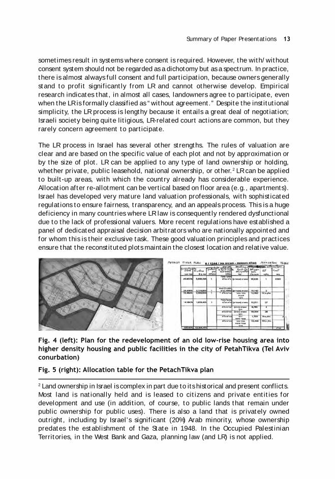
Fig. 4 (left): Plan for the redevelopment of an old low-rise housing area intohigher density housing and public facilities in the city of PetahTikva (Tel Avivconurbation)
Fig. 5 (right): Allocation table for the PetachTikva plan
2 Land ownership in Israel is complex in part due to its historical and present conflicts.Most land is nationally held and is leased to citizens and private entities fordevelopment and use (in addition, of course, to public lands that remain underpublic ownership for public uses). There is also a land that is privately ownedoutright, including by Israel’s significant (20%) Arab minority, whose ownershippredates the establishment of the State in 1948. In the Occupied PalestinianTerritories, in the West Bank and Gaza, planning law (and LR) is not applied.

14 ASCI Journal of Management 49 (2) September 2020
Value capture for public needs: What can be extracted? The issue of value captureand land extraction for public the benefit has been a subject of dispute in Israel fora long time. Normally, without LR, land dedication can be up to 40 percent of thearea in question, even if there is no value increase. After years of the legal contestand contradicting decisions, the Supreme Court finally held that, where there is avalue increase, there shall be no limit to land exactions so long as the owner’sbenefit. In effect, the percent dedicated can reach up to 60-70 percent. It remainsunsettled for what range of public services land can be taken (or, indeed, whatconstitutes a public service). However, the law provides that land cannot bedesignated for transfer to the government for sale. It is also illegal to exact moneyin cash to finance the construction of services. In the past, landowners or developerswere sometimes asked to dedicate or build public services; subsequently, afterhaving benefitted from the new plan, they appealed to the courts and lost. A recentSupreme Court decision ruled that any agreements with developers are, in fact,illegal.
LR, in the Israeli planning system and in the courts, also interacts with bettermentlevies. This has led to two contradicting Supreme Court decisions, ultimately forcingthe Court to reverse itself. The binding decision held that, upon approval of a newplan with higher value development rights, betterment levies of 50 percent beyondthe land dedication will be imposed as in any land development (without LR). Whatremains unclear is if the land dedicated beyond 40 percent should be deductedfrom the betterment tax. However, it is resolved that the money from the bettermentlevy should go into the city’s general fund, and not towards the particular projectthat paid it.
Concluding thoughts: The biggest challenge for LR’s present and future in Israel isthe length of the process, despite its seemingly simple structure and conditions.When LR is applied intensively in a country where courts are highly involved in landtransactions, LR becomes far more complex than the simplistic image projected inthe literature. The existing institutional structure for planning regulation can befit to handle LR without special additional institutions, but with important caveats:the degree of litigiousness in society matters; the culture of expected participationmatters. LR is not a quick process, nor is it a panacea. But it has the best built-inmechanisms for fair distribution of gains and losses.
LP Vis-à-Vis Compulsory Land Acquisition: Punjab’s Experience in Mohali-Mr. K.B.S. Sidhu, IAS
Chandigarh had been conceived as a new and modern capital of Punjab, followingthe partition of the country in 1947. After the Reorganisation of Punjab in 1966,Chandigarh was carved out as a Union Territory and was governed directly by theCentral Government. The planning of Chandigarh is in the native of a sectoral grid,comprising independent sectors, each of an area of 250 acres.

Summary of Paper Presentations 15
As soon as the development of the new Capital City (Chandigarh) of Punjabcommenced in the early 1950s, the State Legislature of the united/undivided Punjabenacted the Punjab New Capital (Periphery) Control Act, 1952. This Act inter aliaprovides that the land use within 10 miles (i.e., 16 km) of the area originally acquiredfor the Capital Project of Chandigarh would stand frozen. In other words, agriculturalland could not be converted to non-agricultural use. No doubt, the Act empoweredthe State Government to grant permission for the change of land use, yet suchapprovals were accorded very sparingly. In the year 2006, the Periphery Change ofLand Use Policy was notified, but this also did not open up many new pockets fordevelopment; rather the conditions for a change of land use were quite strict andstringent. Also, for the first time, change of land use charges/cess were levied/imposed. In this scenario, whenever GMADA was acquiring land, from a strict legalperspective, it was paying for what was merely agricultural land, the existing ofland use of which stood frozen under a law. On the other hand, when afteracquisition, the Authority developed residential/commercial sectors, the value ofland was automatically enhanced on account of the implicit permission of changeof land use. This created a huge perceived difference in valuation in the eyes oflandowners/farmers and the Acquiring Authority, which was bound to paycompensation only for agricultural land under the provisions of the Land AcquisitionAct, 1894. Indirectly, the Land Pooling Scheme also reconciled these differences,as it spoke only in terms of percentage of developed land returned rather than theprice paid/assessed.
Mohali, situated wholly in the State of Punjab, was conceived in the 1970s as asatellite township of Chandigarh. The layout was planned and maintained as asectoral grid, as a natural and logical extension of the one obtaining in Chandigarh.The agricultural land was acquired by the Urban Estate Organization, a Departmentof Punjab Government, in “phases” under the provisions of the Land AcquisitionAct, 1894. Thenceforth, after executing internal and external development works,residential plots were allotted at prices significantly below the market price, throughthe system of a draw of lots. Commercial sites were generally auctioned off. Ingeneral, land acquisition was contentious, and litigation regarding the compensationto be paid to the landowners lingered on for decades. With effect from 1st July1995, Punjab Urban Development Authority (PUDA) was constituted under the newlyenacted Punjab Regional and Town Planning and Development Act, 1995. The sectorspreviously developed by the Urban Estate Organisation were merged, along withother assets and liabilities, with the newly constituted PUDA, a statutory corporatebody. Further, land acquisition for creating new sectors took place under the aegisof PUDA, invoking the Land Acquisition Act (LAA), 1894. The major problem regardingthe land acquisition was that the compensation/valuation of the land as arrived atthrough the mechanism provided under the British-era LAA, 1894 was very low ascompared to the valuation perceived by the landowners, especially consideringthe open market price of the residential plots developed therefrom. For instance,if the all-inclusive compensation paid to the landowners was approximately Rs. 15lac per acre in the year 2000, the price of a residential plot was approximately

16 ASCI Journal of Management 49 (2) September 2020
Rs. 7,000/- per square yard. Assuming a conservative saleable area of even 50percent and disregarding the commercial sites, PUDA was seen as garnering Rs.1.75 crore on a gross basis, against a pittance paid to the farmers. It was underthese circumstances that the Land-Pooling Scheme was first envisaged under GreaterMohali Area Development Authority (GMADA), the Regional successor entity of PUDA.
In essence, land pooling comprises offering to the farmers 1000 to 1200 squareyards of developed residential plots and 120 square yards of developed commercialsites for every one acre (4840 square yards) of land acquired. The scheme is optional,and a farmer can opt to receive compensation in accordance with the provisions ofthe LAA, 1894 and under the new Land Acquisition Act. One could also opt to go infor land pooling allotment “parchi” entitlement for a part of one’s land, whileopting for cash compensation for the remaining part of the land in accordance withthe statutory land acquisition award. The attractive part of land-pooling allotment“parchi” was that these Letters of Intent for Allotment were freely transferable inthe open market, and the name and the particulars of the transferees/vendeescould be entered into the record of the Land Acquisition-cum- Allotment Departmentof GMADA. The transfer of “parchis” was carried out in-house within the GMADAwith a nominal transfer fee, and these transfers were not required to be registeredwith the Sub Registrar, which should have entailed payment of a significantly highstamp duty and registration fee etc. The holders of the land allotment pooling“parchis” also enjoyed the benefit of escalating real estate prices, whereby theopen-market price of the “parchi” could go up. Compared to the quite low interestrates on bank deposits, accompanied by income tax on the interest component,the “parchi” allotment was not subject to any taxation on account of escalation inthe market price, till of course, it was sold in the open market. Table 1 shows theland pooling scheme and entitlements of the landowners.
Table 1: Land Pooling Scheme and Land Owners’ Entitlements
Acquired Residential Area Returned Commercial FAR-Land ( Sq Yd) Area Returned CommercialKanals) (Sq Yd) Area
1 150 Nil -
2 200 sq yd/Lower size 150 sq yd OR 40 Sq yd Booth FAR 1:1
3 300 sq yd Nil
4 400 sq yd approx. 0r Lower size 100 Sqyd SCO FAR 2:1350 sq yd OR
5 500 sq yd (R) 60 Sq yd Shop FAR 2:1
6 800 sqyd( 500+300, 400+400) OR 200 Sq SCO FAR 3:1Lower size 750 sq yd OR
1000 sq yd
Note: 1 acre is equal to 8 canals.
Summary of Paper Presentations 17
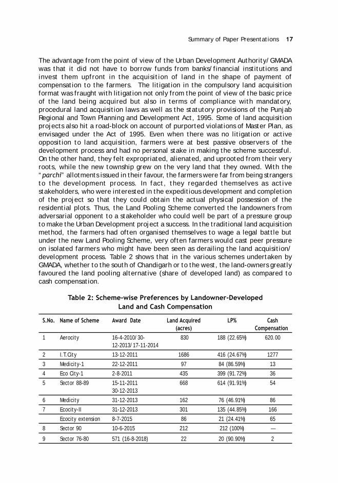
The advantage from the point of view of the Urban Development Authority/GMADAwas that it did not have to borrow funds from banks/financial institutions andinvest them upfront in the acquisition of land in the shape of payment ofcompensation to the farmers. The litigation in the compulsory land acquisitionformat was fraught with litigation not only from the point of view of the basic priceof the land being acquired but also in terms of compliance with mandatory,procedural land acquisition laws as well as the statutory provisions of the PunjabRegional and Town Planning and Development Act, 1995. Some of land acquisitionprojects also hit a road-block on account of purported violations of Master Plan, asenvisaged under the Act of 1995. Even when there was no litigation or activeopposition to land acquisition, farmers were at best passive observers of thedevelopment process and had no personal stake in making the scheme successful.On the other hand, they felt expropriated, alienated, and uprooted from their veryroots, while the new township grew on the very land that they owned. With the“parchi” allotments issued in their favour, the farmers were far from being strangersto the development process. In fact, they regarded themselves as activestakeholders, who were interested in the expeditious development and completionof the project so that they could obtain the actual physical possession of theresidential plots. Thus, the Land Pooling Scheme converted the landowners fromadversarial opponent to a stakeholder who could well be part of a pressure groupto make the Urban Development project a success. In the traditional land acquisitionmethod, the farmers had often organised themselves to wage a legal battle butunder the new Land Pooling Scheme, very often farmers would cast peer pressureon isolated farmers who might have been seen as derailing the land acquisition/development process. Table 2 shows that in the various schemes undertaken byGMADA, whether to the south of Chandigarh or to the west, the land-owners greatlyfavoured the land pooling alternative (share of developed land) as compared tocash compensation.
Table 2: Scheme-wise Preferences by Landowner-DevelopedLand and Cash Compensation
S.No. Name of Scheme Award Date Land Acquired LP% Cash(acres) Compensation
1 Aerocity 16-4-2010/30- 830 188 (22.65%) 620.0012-2013/17-11-2014
2 I.T.City 13-12-2011 1686 416 (24.67%) 1277
3 Medicity-1 22-12-2011 97 84 (86.59%) 13
4 Eco City-1 2-8-2011 435 399 (91.72%) 36
5 Sector 88-89 15-11-2011 668 614 (91.91%) 5430-12-2013
6 Medicity 31-12-2013 162 76 (46.91%) 86
7 Ecocity-II 31-12-2013 301 135 (44.85%) 166
Ecocity extension 8-7-2015 86 21 (24.41%) 65
8 Sector 90 10-6-2015 212 212 (100%) —
9 Sector 76-80 571 (16-8-2018) 22 20 (90.90%) 2

18 ASCI Journal of Management 49 (2) September 2020
As regards the farmers who felt that their land was preferentially located, theLand Pooling Scheme allowed them to take up compensation for the traditionalland acquisition process where a higher price/premium is generally paid for theland abutting the main road. As compared to the traditional Town Planning Scheme,where the ownership continued to vest with the original landowners, the LandPooling Scheme is backed up by the statutory framework of the Land AcquisitionAct, where the land vests in the State/Authority free from all encumbrances. Theonly difference being that the compensation was new receivable either in cash orthrough “parchi” allotment or a combination of both. Wherever there was litigation/dispute of a civil nature in respect of the land being acquired, the Land AcquisitionAuthorities were still free to deposit compensation amount in the Court, whiletaking over possession of the land in question. The traditional Town Planning schemeswere rarely carried to the logical conclusion because landowners getting preferentialuse such as commercial refused to/resisted the payment of betterment cess/chargetooth and nail, while those landowners whose land was put to non-commercial usessuch as road/parks would find ways to get hefty compensation through the Courts.Thus, in the Town Planning schemes, the grievance is basically by one aggrievedlandowner against the other, who is seen as getting a much better deal. Incidentally,the Land Pooling Scheme also takes care of these disparities, inevitably arising inTown Planning Schemes.
Also from the perspective of the eventual end-purchasers of the developed plots,they had no fear regarding the title disputes since they were purchasing the plots/land from a statutory Urban Development Authority in which the land had vestedfar from all encumbrances. The scheme also had its drawbacks, which are sometimesnot very obvious. Although it looks good that Urban Development Authority did nothave to borrow funds and thus could save an interest burden, there was an adversefactor that they come to the fore. Many “parchi” holders opted to sell of theirentitlement “parchis” in the secondary market if the prevailing price was attractive.When this trend grew, the price of the “parchis” fell but along with the same, theprice of the fully developed plots already in the stock of the Urban DevelopmentAuthority or the private colonizers also fell correspondingly. It was almost as if theFutures and Options (F&O) segment of the stock market was pulling down the priceof the underlying equity assets. Moreover, no new capital funds were injected intothe market, and the multiplier effect of the displaced farmers purchasing agriculturalland in the adjoining districts also waned. Many would argue that significant portionof slump in the real market price surrounding the periphery of Chandigarh could beattributed to the “parchi” allotment being sold enmass in the secondary market.
Another factor which is generally not discussed in official circles is that manyinfluential persons, with good cash-reserves, are known to buy agricultural landthat is coming up for acquisition under the Land Pooling Scheme. The members ofthe so-called land mafia purchase the agricultural land, registering the transaction

Summary of Paper Presentations 19
at the “Collector/Circle Rate” while making the bulk of the payment to the originallandowners in cash. The landowner is also quite happy to enter into this transactionbecause he could get some premium on the official land acquisition compensationrate but more importantly, he would get it immediately. The members of the landmafia are thus able to absorb their unaccounted cash into assets which soon providethem within income tax free return following the land acquisition, since as persection 96 of the Right to Fair Compensation and Transparency in Land Acquisition,Rehabilitation and Resettlement Act, 2013, no amount received as compensationunder this law is subject to Income Tax. Thus the Land Pooling Scheme has thepotential of indirectly assisting money-laundering in the hands of unscrupulouspersons with unaccounted money.
In summary, land-pooling is an attractive alternative to the compulsory landacquisition model, especially in the areas where residential plots/small commercialsites are much sought after. It is a win-win situation not only for the landowners aswell as the end-users. The secondary market players like dealers and estate agentsalso benefit in the process. Protracted litigation and enhancement through Courtsis avoided, and expeditious implementation of the projects takes place. However,it would be naive to reach a conclusion that land pooling is the elixir of all the illsthat bedevil the process of land acquisition. In big projects like setting up of newcantonments, industrial estates, airports, there may not be any developed residentialplots to part with and the statutory provisions of the new Land Acquisition Act arethe only alternative. Moreover, the Land-Pooling Scheme does not recognise anyfurther stakeholder except the landowner, and persons like tenants, landlesslabourers and other dwellers of the village get nothing under this Scheme. TheAward under the new land acquisition has some space for them. Nevertheless, inthe periphery of U.T. Chandigarh and other big towns of Punjab, Land-Pooling Schemeis set to remain as the preferred alternative. Depending on the market conditions,the landowners may at a future date clamour for a higher share for the developedland, but that negotiation is, of course, an ongoing process. No doubt, the schemecan said to be ideal, but in essence, it remains a fair, just, and equitable frameworkfor the extension of planned cities, wherein the landowners become a positivecontributor in the urban development process.
LP for Industrial Projects in Madhya Pradesh, India-Mr. Vivek Porwal, IAS,
The paper outlines the experience of land pooling for an industrial project in Indore,Madhya Pradesh (MP), India. Madhya Pradesh is the second largest Indian state byarea and the fifth largest state by population with over 75 million residents. MPIndustrial Development Corporation Ltd (MPIDC) is an undertaking of the StateGovernment entrusted with the responsibility of industrial promotion through thedevelopment of growth centers in selected areas of its jurisdiction. In 2019, theMPIDC designed a Land Pooling Scheme for assembling land through a governmentorder by the Department of Industrial Policy and Investment Promotion Department.

20 ASCI Journal of Management 49 (2) September 2020
MP is the first state in India to pool land for an industrial purpose. India has 330million hectares, out of which only 50 percent is inhospitable. The land underagriculture is 152 million hectares. While agriculture takes up 46 percent of India’sland resources, it produces only 16 percent of India’s GDP (2018-19). Industry usesapproximately 1.5 percent of land and contributes 73 percent of our GDP (2018-19). Land can be acquired for the industry in three ways; through consentedpurchase, compulsory acquisition, or through pooling. Though the cost for thegovernment is highest under compulsory acquisition, it faces the maximum resistanceby landowners.
In the present project, 121 landowners from 8 villages agreed to pool 321 hectaresof land. The entire project area is spread across 587 ha of land including 321 ha ofprivate pooled land, the remaining comprising of government lands. As comparedto other forms of obtaining land for industry, land pooling has several strengths.However, there is a critical design element, and if it is not designed properly, itwill create problems. Land pooling can only be successful when there is developmentaround that area. Farmers take the land pooling certificate in the hope that theland value will always go up. Since land prices will go up only when there isdevelopment in the area, it was recognised that this is a responsibility that thestate has to take up and cannot be left to any third party. In the present case, thelands were pooled for the industry. The MPIDC, for whom lands were pooled, tookup the responsibility of bringing industries to the areas that the price does go up.The land acquisition process is reflected in the following chart.
Another issue is regarding the percentage of land that will be returned as developedland. This varies from project to project, and it cannot be fixed as per the law. InMadhya Pradesh, the power for the planning was devolved to the industrydepartment, and planning has to be very flexible as per the need of the people.One of the design elements was to facilitate the exit of the farmers as soon aspossible. The developed land as per land pooling certificate is to be issued to thelandowner within 30 days. The tradeable land pooling certificate that was issuedto the landowner was not only made tradeable but exempted from taxation in both
Summary of Paper Presentations 21
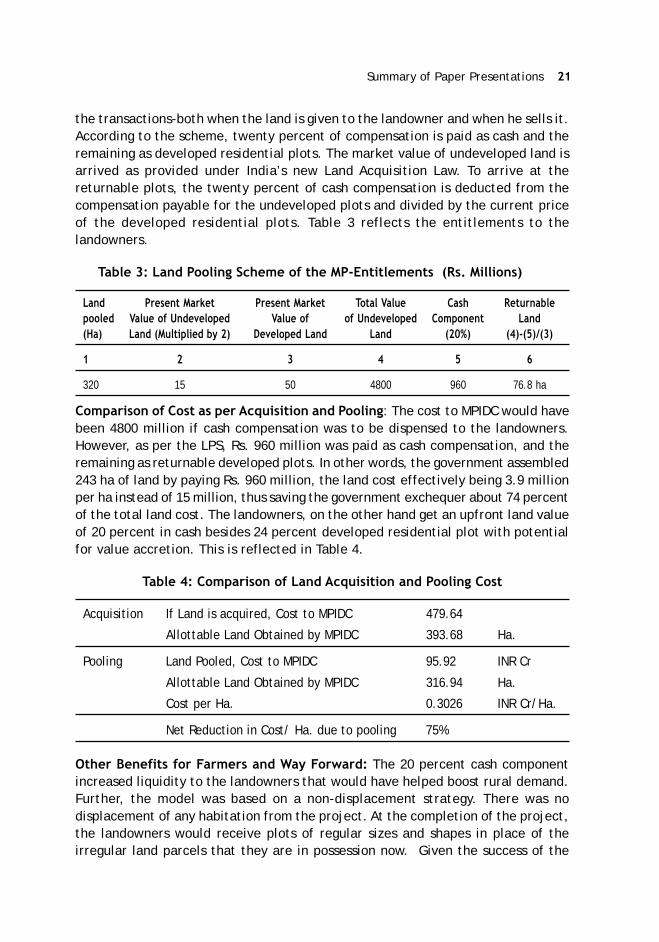
the transactions-both when the land is given to the landowner and when he sells it.According to the scheme, twenty percent of compensation is paid as cash and theremaining as developed residential plots. The market value of undeveloped land isarrived as provided under India’s new Land Acquisition Law. To arrive at thereturnable plots, the twenty percent of cash compensation is deducted from thecompensation payable for the undeveloped plots and divided by the current priceof the developed residential plots. Table 3 reflects the entitlements to thelandowners.
Table 3: Land Pooling Scheme of the MP-Entitlements (Rs. Millions)
Land Present Market Present Market Total Value Cash Returnablepooled Value of Undeveloped Value of of Undeveloped Component Land(Ha) Land (Multiplied by 2) Developed Land Land (20%) (4)-(5)/(3)
1 2 3 4 5 6
320 15 50 4800 960 76.8 ha
Comparison of Cost as per Acquisition and Pooling: The cost to MPIDC would havebeen 4800 million if cash compensation was to be dispensed to the landowners.However, as per the LPS, Rs. 960 million was paid as cash compensation, and theremaining as returnable developed plots. In other words, the government assembled243 ha of land by paying Rs. 960 million, the land cost effectively being 3.9 millionper ha instead of 15 million, thus saving the government exchequer about 74 percentof the total land cost. The landowners, on the other hand get an upfront land valueof 20 percent in cash besides 24 percent developed residential plot with potentialfor value accretion. This is reflected in Table 4.
Table 4: Comparison of Land Acquisition and Pooling Cost
Acquisition If Land is acquired, Cost to MPIDC 479.64
Allottable Land Obtained by MPIDC 393.68 Ha.
Pooling Land Pooled, Cost to MPIDC 95.92 INR Cr
Allottable Land Obtained by MPIDC 316.94 Ha.
Cost per Ha. 0.3026 INR Cr/Ha.
Net Reduction in Cost/ Ha. due to pooling 75%
Other Benefits for Farmers and Way Forward: The 20 percent cash componentincreased liquidity to the landowners that would have helped boost rural demand.Further, the model was based on a non-displacement strategy. There was nodisplacement of any habitation from the project. At the completion of the project,the landowners would receive plots of regular sizes and shapes in place of theirregular land parcels that they are in possession now. Given the success of the
22 ASCI Journal of Management 49 (2) September 2020
model, the Government is extending land pooling to more areas-Mandideep, VikramUdyogpuri, and Bagroda. One key learning from experience is the need to have afunctioning Grievance Redressal Mechanism that resolves the grievances in aneffective and time-bound manner.
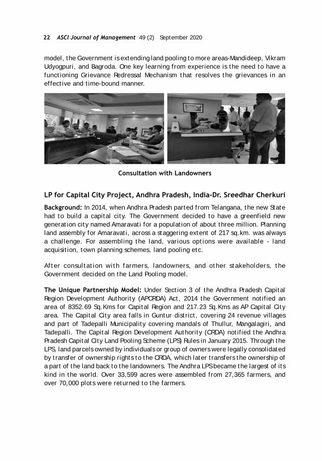
Consultation with Landowners
LP for Capital City Project, Andhra Pradesh, India-Dr. Sreedhar Cherkuri
Background: In 2014, when Andhra Pradesh parted from Telangana, the new Statehad to build a capital city. The Government decided to have a greenfield newgeneration city named Amaravati for a population of about three million. Planningland assembly for Amaravati, across a staggering extent of 217 sq.km. was alwaysa challenge. For assembling the land, various options were available - landacquisition, town planning schemes, land pooling etc.
After consultation with farmers, landowners, and other stakeholders, theGovernment decided on the Land Pooling model.
The Unique Partnership Model: Under Section 3 of the Andhra Pradesh CapitalRegion Development Authority (APCRDA) Act, 2014 the Government notified anarea of 8352.69 Sq.Kms for Capital Region and 217.23 Sq.Kms as AP Capital Cityarea. The Capital City area falls in Guntur district, covering 24 revenue villagesand part of Tadepalli Municipality covering mandals of Thullur, Mangalagiri, andTadepalli. The Capital Region Development Authority (CRDA) notified the AndhraPradesh Capital City Land Pooling Scheme (LPS) Rules in January 2015. Through theLPS, land parcels owned by individuals or group of owners were legally consolidatedby transfer of ownership rights to the CRDA, which later transfers the ownership ofa part of the land back to the landowners. The Andhra LPS became the largest of itskind in the world. Over 33,599 acres were assembled from 27,365 farmers, andover 70,000 plots were returned to the farmers.

Summary of Paper Presentations 23
Envisioned Land Pooling Scheme layouts in the Capital City
Entitlements under Andhra LPS: Unlike the usual land acquisition mechanism,where the landowner is always treated as a subject, the Andhra governmentenvisaged a partnership between the state and the landowners. There are twotypes of land categorisation in Andhra Pradesh, dry land and wetland. The landpooling scheme entitlement had to reflect this difference in the quality of thelands pooled. Further, the Government also focused on two more things, the needto protect the farmers during the transition phase and the plight of people who areindirectly dependant on the land, viz. agricultural labourers, village level tradersand artisans, etc. Substantial stakeholder consultations were carried out to finalisethe entitlements under the Amravati LPS as given in Table 5.
Table 5: Entitlements and Benefits under AP LPS
Returnable Land/Entitlements (per acre)
Land Category
Dry Jareebu
Patta
Residential 1000 Sq.Yds 1000 Sq.Yds
Commercial 250 Sq.Yds 450 Sq.Yds
Assigned
Residential 800 Sq.Yds 800 Sq.Yds
Commercial 100 Sq.Yds 200 Sq.Yds
Annuity (10 years) 30000($460) 50000($767)
Yearly increase (Rs) 3000 ($46) 5000 ($77)
One time additional payment for gardens 100000($1534)
24 ASCI Journal of Management 49 (2) September 2020
Social benefits
1. INR 2500/- ($38) pm to each of the land-less poor family for 10 years2. Debt waiver up to INR 1,50,000/- $2300)3. Training and employment4. Free higher education5. Universal medical insurance6. Habitation development7. Skill and entrepreneurship development8. Housing9. Old and infringed people care10. Limited displacement
The entitlement matrix was designed to take into account the identified issues.Differential entitlements in terms of returnable land were provided to owners ofdry and wetlands. To address livelihood issues during the transition period, anannuity of Rs.30,000-50,000 per acre (with a yearly increase of 10 percent) wasprovided to the farmers over a period of ten years. Financial support was alsoextended to the labourers/non-titleholders in terms of monthly family pension ofRs.3000 and rehabilitating them in terms of livelihoods. A debt waiver of INR1,50,000/- was allowed to the landowners in the affected area. The social benefitsfor the people in the capital city area include the establishment of NTR canteensto serve the poorest of the poor with nutritious food at cheaper rates (establishedat Velagapudi, Thulluru, and Yerrabalem); distribution of heath cards, conductinghealth camps, tuition fee reimbursement, utilisation of tractors and local machineryfor the construction work, etc.
The lands were pooled outside the habitation area to cause minimal displacement.The farmers were given options to have a single plot or a combination of plot withfriends or relatives through the open lottery system. Also, an electronic platformwas developed for the farmers to sell their land in the open market.
Consultation: Dedicated personnel were engaged by the APCRDA to convince andexplain the benefits of the scheme to farmers; Each of the 26 units set up wereheaded by a “Deputy Collector”, senior officer of the district administration towork at the grass-root level and sort out land-related issues, The land issues relatedto family disputes, enjoyment issues, survey errors, extent variations,encroachments, etc. The Authority created an environment for continuousfacilitation, duly updating the land records as well as the settlement of familydisputes duly conducting enjoyment survey. The draft notifications were publishedat the offices of the local government as well as the official website. The inputsreceived from the consultations with the village elders and gram committee memberswere taken into account for the preparation of LPS layout plans. The key enabler inthe overall success is considered to be consultation at all levels - farmer level,family level, and village level and in every step in the process. The farmers wererequired to sign with the Government at least six times before final consent istaken.

Summary of Paper Presentations 25
LPS Layout for Nelapadu village
Use of IT for the entire process-The Amaravati LPS made extensive use of IT tools.For land management in the capital city area, blockchain technology was made useof. The entire documentation process for the massive exercise was based onblockchain. Since blockchain essentially means that making a change to a recordwithout disturbing the previous records in the chain is not possible, this was toensure that the data that is with the CRDA is safe and can be traced back at anygiven point of time so the security of title is always maintained. The entire process,allocating plots, registration, storing the data was fully automated. The exactlocations of these plots are all recorded on the blockchain. A total of 58 attributes,name, Aadhaar number, mobile number, boundaries marked with latitude andlongitude coordinates, neighboring plots, roads, and so on are linked to each propertyin the database. Data on the blockchain can serve as indisputable proof in cases ofdisputes over ownership, even after redevelopment. Geospatial co-ordinates weretaken to Identify the property accurately. The project also developed a “One stopmobile application “Mana Amaravati.” The application provided the platform forcitizens to register their grievances, identify the plot in a larger masterplan, provideregular updates about capital city development activities, etc. The Amravati LPSprovided several good practices for land pooling models in India and worldwide.
LP for Urban Planning and Disaster Reconstruction, Gujarat, India-Mr. Harpal Dave
TPS in India: In Gujarat and Maharashtra, LR is popularly known as Town PlanningScheme (TPS). TPS has a long legacy in Gujarat. In 1915, the TPS was introduced inthe erstwhile Bombay State of British India. The detailed procedural provisions forthe implementation of the TPS that exist presently have been created in the StateUrban Development Act known as the Gujarat Town Planning and Urban DevelopmentAct, 1976. During the period between 1915 and 1976, there have been several TPschemes, mainly in the cities of Baroda, Ahmadabad, and Surat. The Act providesan overall framework, first for the preparation of a development plan and then aTP scheme which is used more as an implementation tool for DP. In Gujarat, it is

26 ASCI Journal of Management 49 (2) September 2020
therefore called the DP-TP model. TPSs provides the advantage of creating a micro-level plan/legal plans, and DP is the overall Development Plan for the city. TPS is atool to implement the DP. TP gives the advantage of creating a micro-level planand helps to mobilise land for infrastructure, reconstitution of plots and financingof the infrastructure through the creation of land banks (reserved plots). Generally,under the TPS, about 40 percent is retained for public use, and 60 percent is returnedto owners. TPSs are generally implemented in new development areas in the urbanfringes.
Key steps in TPS: As per the legal provisions, TPS is Implemented in four stages asgiven in Table 6. The TPS is initiated with the publication of intent by the government.The preparation of the draft includes re-constituted plots presented for publicviewing and objections. Once the draft plan is sanctioned, the lands can be takenunder possession for public use. At the preparation of the preliminary scheme, theState Government appoints a Town Planning Officer (TPO) to arbitrate betweenthe owners and the Government and there are three rounds of individual hearingswith the landowners before the physical plan and layout is finalised, and financialcalculations freezes. Generally, an area of about 100 to 150 hectares is consideredfor a typical TPS, though in some cases, large projects of 900-1000 hectares is alsoplanned under TPS. Legally, there is no limitation on the land extent/size of the TPproject. Implementation of TPS is a lengthy process and sometimes takes up to 8-9 years or even more to finalise the TP scheme. The Land is a sensitive issue, andpeople have their attachment with land, and many rounds of discussions andnegotiations take place before the TPS is finalised.
Table 6: Implementation of TP Stages
Stages Processes
Stage I- Declaration · Declaration of Intent by appropriate authority to prepare TPS inof Intent a delineated area, identifying an area
Stage II-Preparation · Reconstitution of plots, the framing of tentative proposals, forof Draft public viewing, objections, and suggestions
· Plan is submitted to the State Government for sanction.
· After plan is sanctioned, authority can take possession of roadsand other land allocated for public use.
Stage III-Preliminary · Town Planning Officer (TPO), a quasijudicial authorityScheme appointed for arbitration
· Three rounds of individual hearings are given to the owners andthe physical plan and layout is finalised.
Stage-IV-Final · Implementation of the physical planScheme · Resolution of all outstanding issues/financial matters.
Summary of Paper Presentations 27
TP Scheme in Ahmedabad - In the TP Scheme in Ahmedabad, an area ofapproximately 100 to 150 hectares is taken up for planning. Firstly, a preliminarysurvey is conducted, and the boundaries of the detailed planning area is definedand delineated. A survey follows, where the internal plot boundaries are againsurveyed, and every square inch of land is measured. After the survey, the ownershipdetails are taken from the land registry, following which the plot size and theoriginal value details are tabulated. The original plots are marked on the surveymaps, and roads are marked and delineated. The final plots marking the area areto be returned to the landowners along with other uses, and public amenities aredelineated. Efforts are taken to ensure that the owner receives the land in thesame place where the original plot was located more or less. Where this is notpossible, there is a slight shifting of the location but within the same TP schemearea. The final plot values are then calculated. The betterment levies are tabulatedwhich incorporates the increase in value of land because of the infrastructuredevelopment which the development authority has undertaken in a particular area.
Various Uses of the TPS Mechanism-In Gujarat, the TPS mechanism is mostly usedfor the planned urban extension. However, it has also been used for city levelinfrastructure (roads, parks, amenities, etc.). For e.g., in Ahmedabad, more than95 percent of the land has been mobilised by using TPS mechanism. There is alsoland consolidation besides post disaster reconstruction as incase of the KutchEarthquake reconstruction project (discussed below).
Post Disaster Reconstruction in Kutch (Bhuj)- Kutch, one of the districts in thewestern side of Gujarat, was hit by a devastating earthquake (7.7 on the RichterScale) on 26th January 2001. Many of the urban settlements in Kutch faced largescaledestruction. There were four major towns in Kutch that were devastated; In Bhachau,which was the epicenter of the earthquake, about 90 percent of all its buildingscollapsed, and in Bhuj about 10 percent of the buildings collapsed. Most of theinner city of Bhuj was destroyed. The development plan of Bhuj as it existed beforethe earthquake was prepared several years back in 1976. The information on landrecords, land maps or survey maps was also not available. When TPS model wasadopted to rebuild the city, the important consideration was also to ensure thereduction of loss of life and property in future disasters by creating a more efficientstreet network. It was recognised that the earthquake caused a large scale loss ofhuman lives owing to the extremely narrow streets, and people could not escapeto open spaces when the earthquake struck. Since Kutch has a history of recurringearthquakes, creating an efficient street network was a top priority under the TPS.The plan also tried to improve the shape of plots and the pattern in which they arelaid out for more efficient buildings besides creating more open spaces for otherutilities. Since the population density was very high i.e., about 35,000 in just oneKm, eight TPSs were delineated so that each scheme was a manageable designunit.

28 ASCI Journal of Management 49 (2) September 2020
Delineated TPSs for Reconstruction of Bhuj
There were some buildings that were still standing without any damage, whileothers were completely erased. The preparation of the Development Plan of theBhuj town took about 4-5 months. There were no survey drawings available, andhence the survey was done of the entire area. The roads were consciously widened,boundaries were reconstituted, and provisions were made to build the road network.
Design of the Bhuj TPS with wider Street and Final plots
The ward offices were established in each scheme area. The maps were displayed,and people were assisted in filing written responses. The draft TPSs were detailedout and were discussed with people in vernacular medium. Though it was a distressingsituation (with many people having lost family members in the earthquake), theAdministration made special arrangements for conducting discussions/negotiationsand the process went smoothly. Four ward officers were appointed so that peoplecould come anytime and submit their oral request to the Development Authority. Aunique feature in the Bhuj TPS is the progressive land contribution ratio. Accordingly,there was no deduction for very small plots i.e., less than 30 sqm. Between 30sq.m to 100 sq.m, ten percent deduction was levied, and so on. It was also decidedthat standing buildings would be spared from deduction unless they were affected
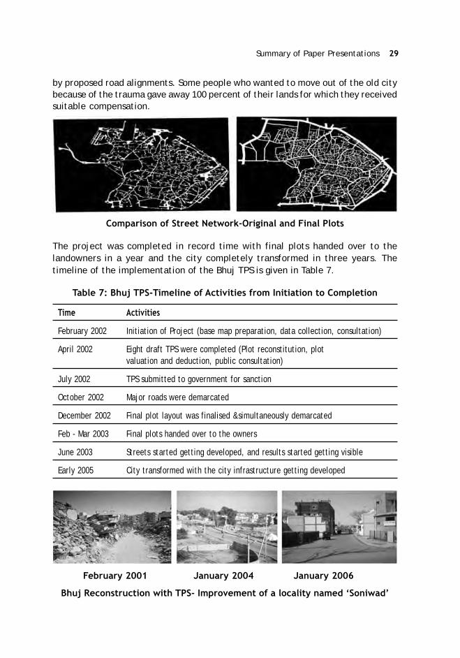
Summary of Paper Presentations 29
by proposed road alignments. Some people who wanted to move out of the old citybecause of the trauma gave away 100 percent of their lands for which they receivedsuitable compensation.
Comparison of Street Network-Original and Final Plots
The project was completed in record time with final plots handed over to thelandowners in a year and the city completely transformed in three years. Thetimeline of the implementation of the Bhuj TPS is given in Table 7.
Table 7: Bhuj TPS-Timeline of Activities from Initiation to Completion
Time Activities
February 2002 Initiation of Project (base map preparation, data collection, consultation)
April 2002 Eight draft TPS were completed (Plot reconstitution, plotvaluation and deduction, public consultation)
July 2002 TPS submitted to government for sanction
October 2002 Major roads were demarcated
December 2002 Final plot layout was finalised &simultaneously demarcated
Feb - Mar 2003 Final plots handed over to the owners
June 2003 Streets started getting developed, and results started getting visible
Early 2005 City transformed with the city infrastructure getting developed
February 2001 January 2004 January 2006
Bhuj Reconstruction with TPS- Improvement of a locality named ‘Soniwad’

30 ASCI Journal of Management 49 (2) September 2020
The re-development of the walled City of Bhuj proved to be a very complex planningexercise. The project involved over 12,000 plots on which there 30,000 personshad ownership claims. It consumed over 200,000 man hours of work by highlyqualified professionals using the best available technology, coordinating the workof nearly a dozen organisations. It was a multidimensional team effort, involvingconstruction workers, contractors, engineers, planners, administrators, socialworkers, and political leaders. However, the project was successful in rebuildingthe city along with its economy and infrastructure in an expeditious manner.
Planning/Implementation of LR in Colombia-Prof. María Cristina RojasEberhard
There is no specific LR law in Colombia. However, with the technical support of theJapan International Cooperation Agency (JICA), LR was included as a managementinstrument in the Planning Law of 1989 that can be implemented in the frame ofother two planning instruments-Partial plan and Urban Action Unit (UAU). Thesetwo concepts have been adapted from the Spanish Land Law. The Colombian lawdefined land readjustment as a mechanism to “encompass several land plots to, asa consequence, subdivide them more adequately, providing basic infrastructure,such as roads, parks, water supply network, electricity and telecommunicationnetworks” in areas without proper urbanisation and real estate connectivity,designated for undeveloped areas, and renewal. LR in Colombia is implemented ata municipal level.
The “Partial Plan” is an urban planning tool used to develop and specifies theCity´s Master Plan at an intermediate scale of planning. In other words, partialplans constitute a tool that shapes the conditions for planning, management, andfinancing for urban land and land for urban expansion, and that may use mechanismslike Land Readjustment to define land management intervention. Within the PartialPlans, the government can implement and develop “Urban Action Units” (UAU) asthe area consisting of one or more property buildings as a planning unit, aiming topromote the rational use of land, to ensure the compliance of planning regulations.UAU, based on the principle of the law, “Social function of property” is theinstrument with which landowners can be forced to participate in LR. A minimumof 51 percent of the landowners in the UAU have to agree before the municipalityinitiates the LR, while the law permits the expropriation of the remaining 49 percentthrough the ‘eminent domain’ principle. In practice, the municipality agrees forexpropriation only if the percentage is much higher (around 90 percent of landownersare in agreement). The partial plan regulations using LR is essentially implementedin Columbia for urban renewal, urban expansion and in vacant urban areas.
The partial plan regulations that have been developed by Bogota (the capital cityof Colombia) and later by the national level include the criteria for area delimitation;the plan contents (plots and owners identification, urban design, building area,

Summary of Paper Presentations 31
land use); the minimum contribution ratio/exactions that contribute to providepublic facilities, parks, streets; the basic and maximum building rights (FAR)according to planning objectives in the territory of the city; the compulsory minimumpercentage for social housing; the procedure and timelines for information andparticipation; the regulation of compensation payment to public funds; the “Projectannouncement” authorisation which objective it to establish initial land value,before the project for possible purchase or expropriation; mechanism or tools insidethe partial Plan; Costs and benefit distributions, in which the goal is to securedevelopment financing and ensure equitable distribution. Partial plans also providefor other urban planning tools viz. value capture and regulation for its investment;priority development and construction; inclusionary housing and right of preferenceor right of pre-emption.
The approach to LR in Columbia is defined by the classification of land managementcomplexity. The first generation urban projects are those that do not have anassociation of landowners for its implementation but share one urban design forthe plots involved. Each property owner obtains a license for urbanisation, andboth the design and the distribution of costs and benefits ensure equity betweenowners. Compensation is paid when urban design cannot solve equitable distribution.In this generation, it is less likely that reserve land will be defined to obtain resourcesto leverage the infrastructure. Most partial plans in Colombia belong to thisgeneration. The second-generation urban projects are those with an urban designthat involves all the plots and implies an association of landowners and investorsthrough trust agreements/contracts. In such projects, reserve land is used to financepublic infrastructure and other costs.
Example of First-Generation Partial Plan, “LA FELICIDAD”: The initial challengewas to develop vacant land in the city’s geographical centre by generating supplyof employment, commerce and social housing. The project included large publicland for urban parks, public facilities and roads, and additional building rights inturn of land obtained for main roads to connect parts of the city. There was 20percent of compulsory land for social housing, producing 3000 units of social housing.The project involved 13 landowners and 100 hectares of land.
Example of Second-Generation Partial Plan “Triángulo de Fenicia”: The initialchallenge was to develop a project that includes actual inhabitants and commerceand making space for the extension of the campus of a University in the centralarea of Bogotá City, avoiding gentrification. Other challenge was to ensure socialhousing supply; and articulating heritage buildings. The land contributions includedproviding more public space in the central area. There were additional strategies,including special programmes for a vulnerable population and social housing. Theproject intervention area was 8.8 ha., of which 3.8 hectares are dedicated topublic space and 5 hectares are private land, to be developed and build.

32 ASCI Journal of Management 49 (2) September 2020
Example of Third-Generation Partial Plan, “CIUDAD VERDE”: The project wasformulated and approved by the national government as a strategy to ensure awide social housing supply. This project was an exception of the national planninglaw, incorporating rural areas to urban out of the decisions of City´s Master Plan(Soacha City). Land value increase as a result of the planning decision to incorporaterural areas to urban, is reflected in Table 8. Although some costs that could use theincrements inland value to finance them were not included and the public sectorfinance them. The 18 landowners create a trust agreement with investors andbuilders which allowed the management of the project.
Table 8: Land Value Increases in the Project Area
S.No Heads In US Millions
1 Construction sale US$ 862,50
2 Construction costs US$ 625,83
3 Useful land sale US$ 236,67
4 Urbanization costs US$ 138,27
5 Residual value of gross land US$ 98,40
6 Initial land value US$ 26,24
Comparison: The least area used as well as the lowest contribution ratio of 27percent is in urban renewal project. The rural land project is providing more unitsof social housing. In the partial plan of urban renewal, the replacement of theresidential properties to the state assumes importance.
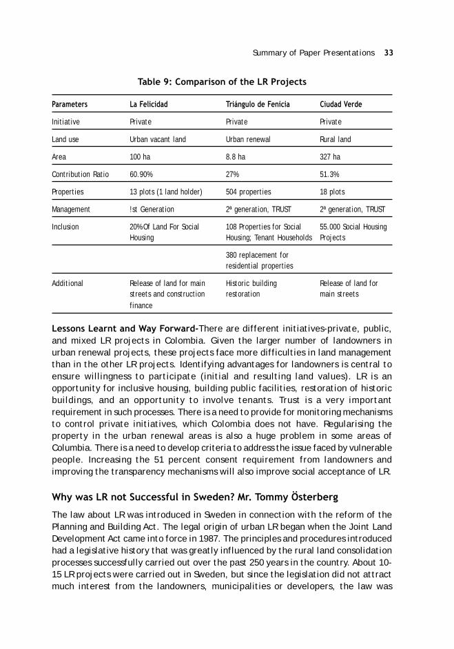
Summary of Paper Presentations 33
Table 9: Comparison of the LR Projects
Parameters La Felicidad Triángulo de Fenicia Ciudad Verde
Initiative Private Private Private
Land use Urban vacant land Urban renewal Rural land
Area 100 ha 8.8 ha 327 ha
Contribution Ratio 60.90% 27% 51.3%
Properties 13 plots (1 land holder) 504 properties 18 plots
Management !st Generation 2ª generation, TRUST 2ª generation, TRUST
Inclusion 20% Of Land For Social 108 Properties for Social 55.000 Social HousingHousing Housing; Tenant Households Projects
380 replacement forresidential properties
Additional Release of land for main Historic building Release of land forstreets and construction restoration main streetsfinance
Lessons Learnt and Way Forward-There are different initiatives-private, public,and mixed LR projects in Colombia. Given the larger number of landowners inurban renewal projects, these projects face more difficulties in land managementthan in the other LR projects. Identifying advantages for landowners is central toensure willingness to participate (initial and resulting land values). LR is anopportunity for inclusive housing, building public facilities, restoration of historicbuildings, and an opportunity to involve tenants. Trust is a very importantrequirement in such processes. There is a need to provide for monitoring mechanismsto control private initiatives, which Colombia does not have. Regularising theproperty in the urban renewal areas is also a huge problem in some areas ofColumbia. There is a need to develop criteria to address the issue faced by vulnerablepeople. Increasing the 51 percent consent requirement from landowners andimproving the transparency mechanisms will also improve social acceptance of LR.
Why was LR not Successful in Sweden? Mr. Tommy Österberg
The law about LR was introduced in Sweden in connection with the reform of thePlanning and Building Act. The legal origin of urban LR began when the Joint LandDevelopment Act came into force in 1987. The principles and procedures introducedhad a legislative history that was greatly influenced by the rural land consolidationprocesses successfully carried out over the past 250 years in the country. About 10-15 LR projects were carried out in Sweden, but since the legislation did not attractmuch interest from the landowners, municipalities or developers, the law was

34 ASCI Journal of Management 49 (2) September 2020
cancelled in 2012 for not being in use since the 1990s. The paper discusses the LRprocesses that existed in the law along with an analysis as to why it was notsuccessful.
LR Law in Sweden: The LR was expected to be used in mainly three situations;First, in the renewal of large areas in the urban fringe, presently consisting of oldbuildings on large sites not used extensively or being used for recreational purposes;second, in the renewal of old buildings and sites in city centres including newconstructions or renovations and improvements of the physical environment andthird, in rural areas with weakening population in order to create more incomepossibilities for the existing population by the development of areas for recreationalhousing and tourism. The procedures in the law specified that the initiative of LRshould come from the landowners from the area by applying to the CadastralAuthority. The landowners were to form a joint venture to undertake physicalplanning and the implementation of the area development approvals. The CadastralAuthority would start a procedure, investigate interests by the concerned, andestablish the preconditions for the project. The municipality had to approve theinitiative in the beginning. The idea was that each participating landowner wouldparticipate in a joint venture with a share, mainly depending on the area he wascontributing to the project and independent of the future use of that land. Theinterested land owners had to form an association to implement the project,including development of a physical land use plan, the establishment of jointfacilities like roads, water and sewerage, playground, parking, etc. All of this hadto be included in the land development. The cost was to be shared between theparticipants according to the shares in the association. The profits were also to bedistributed according to their shares in land. The transfer of land, compensations,etc. was to be handled by the Cadastral Authority, and the municipality was toapprove the physical land use plan. The transfer of land titles to new owners wasmade through sale contracts between the original landowners (sellers) and thenew inhabitants of the area (buyers). About 10 to 15 projects were implemented atthe beginning of the 1990s following the above procedures, following which theinterest waned.
Reasons for the failure of LR in Sweden: First, there was a decrease in demandfor new housing in Sweden (until 2010), and hence there was no real pressure fromnew development potential to change the use of existing land to more efficientuse. There was low interest among municipalities to promote private landdevelopment since they already owned considerable land areas intended fordevelopment. The rural population that were to benefit from land developmenthad already left for urban areas when the law finally came into force. The interestsbehind the legislation was initially mainly from the private entrepreneurs for privatedevelopments who saw a possibility to break the municipal control of land fordevelopment. The previous policy in Sweden was that land for urban development

Summary of Paper Presentations 35
should be acquired by Municipalities and then distributed among developers.However, the political situation changed, and a more liberal legislation came, whichgiving private entrepreneurs other possibilities to acquire land for developmentfor themselves or through municipalities. The pre-emption rights for municipalitieswere abolished, and also the expropriation laws were changed that made it moredifficult for municipalities to acquire land. So, the private entrepreneurs found iteasier to acquire land without involving land readjustment. The financial institutionslike banks were not acquainted to handle the cooperation between landowners,and they preferred to handle development through professional developers. Lastbut not least, the cooperation between landowners is very difficult as they havedifferent opinions, desires, possibilities, etc., which are often difficult to manageefficiently.The problems in Sweden today is similar to Germany with regard to highdemand for social housing for low-income groups and private investors have notbeen able to meet the demand gap.
Magarpatta-India’s First Private Land Pooling Scheme-Mr. Satish Magar
The Magarpatta city was developed by pooling 430 acres of land owned by about130 farmer families covering 800 beneficiary participation. These farmers joinedtogether to form the township called Magarpatta Township Development andConstruction Company Limited (MTDCCL), and developed the city, thereby realisingtheir dream of converting their land into a value-added finished product that gavethem benefits and returns in perpetuity. The Magarpatta area was in the agriculturezone but was listed as part of the Pune Municipal Corporation from 1960 onwards.Under the Urban Land Ceiling Act, the Government had the authority to acquirethe land at rates decided by them. This was in most cases substantially lower thanthe market rates.
The Land Pooling Model provided the farmers with an opportunity to becomeentrepreneurs while in the other course, they would have sold off their land, spentunproductively, and ended up as labour often in their own fields. The objective ofthe Magarpatta joint venture model was to create long term wealth for the farmersfrom their landholdings, create an opportunity for the farmers to turn intoentrepreneurs; to provide them with a long-term annuity, and to create a strongreal estate franchise to enable the development of other large-scale projects. Thefarmers contributed their individual landholdings under a Joint DevelopmentAgreement (JDA) to the project for a refundable security deposit and a revenueshare. In addition to the share of revenue, the farmers were also given equity inthe project’s Special Purpose Vehicle. As opposed to the situation elsewhere, wherethe farmers were losing their land to the developers with urbanisation, inMagarpatta, every farmer became an equity holder in the company in proportionto his holding. The Magarpatta city with five million sqft of leased space createdlong term annuity for all the farmers. Most of the farmers have also becomecontractors, building material suppliers, and machinery owners. The second-
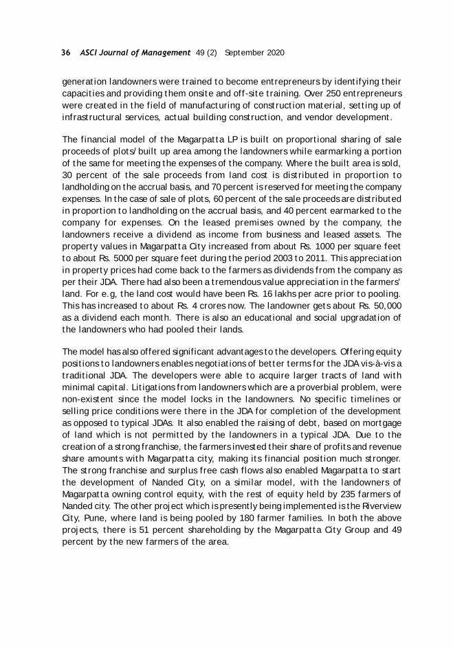
36 ASCI Journal of Management 49 (2) September 2020
generation landowners were trained to become entrepreneurs by identifying theircapacities and providing them onsite and off-site training. Over 250 entrepreneurswere created in the field of manufacturing of construction material, setting up ofinfrastructural services, actual building construction, and vendor development.
The financial model of the Magarpatta LP is built on proportional sharing of saleproceeds of plots/built up area among the landowners while earmarking a portionof the same for meeting the expenses of the company. Where the built area is sold,30 percent of the sale proceeds from land cost is distributed in proportion tolandholding on the accrual basis, and 70 percent is reserved for meeting the companyexpenses. In the case of sale of plots, 60 percent of the sale proceeds are distributedin proportion to landholding on the accrual basis, and 40 percent earmarked to thecompany for expenses. On the leased premises owned by the company, thelandowners receive a dividend as income from business and leased assets. Theproperty values in Magarpatta City increased from about Rs. 1000 per square feetto about Rs. 5000 per square feet during the period 2003 to 2011. This appreciationin property prices had come back to the farmers as dividends from the company asper their JDA. There had also been a tremendous value appreciation in the farmers’land. For e.g, the land cost would have been Rs. 16 lakhs per acre prior to pooling.This has increased to about Rs. 4 crores now. The landowner gets about Rs. 50,000as a dividend each month. There is also an educational and social upgradation ofthe landowners who had pooled their lands.
The model has also offered significant advantages to the developers. Offering equitypositions to landowners enables negotiations of better terms for the JDA vis-à-vis atraditional JDA. The developers were able to acquire larger tracts of land withminimal capital. Litigations from landowners which are a proverbial problem, werenon-existent since the model locks in the landowners. No specific timelines orselling price conditions were there in the JDA for completion of the developmentas opposed to typical JDAs. It also enabled the raising of debt, based on mortgageof land which is not permitted by the landowners in a typical JDA. Due to thecreation of a strong franchise, the farmers invested their share of profits and revenueshare amounts with Magarpatta city, making its financial position much stronger.The strong franchise and surplus free cash flows also enabled Magarpatta to startthe development of Nanded City, on a similar model, with the landowners ofMagarpatta owning control equity, with the rest of equity held by 235 farmers ofNanded city. The other project which is presently being implemented is the RiverviewCity, Pune, where land is being pooled by 180 farmer families. In both the aboveprojects, there is 51 percent shareholding by the Magarpatta City Group and 49percent by the new farmers of the area.

Summary of Paper Presentations 37
Magarpatta City-Economic Contribution
Employment for 1,01,513 people (direct and indirect).
Annual salary of 65,221 million INR i.e., Rs 6521.1 Cr.
20,000 indirect employees creating a total impact of 344.23 million
160 national and international companies have offices in Magarpatta City
GDP of Pune City enhanced by 18,000 million INR per year
70 Million to Pune Municipal Corporation towards development Charges
LC and Transformation of Sustainable Urban Morphology in Indonesia-Dr. Ngakan Ketut Acwin Dwijendra
Importance of LC/LR in Indonesia- Indonesia has a population of 258 million, with50 percent concentrated in Java Island. With a geographical area of 1904.569 squareKm, the country is growing at a rate of 14 percent per year. It cannot be deniedthat the physical development of urban space is strongly influenced by urbanisation.The development of urbanisation in Indonesia can be observed from three aspects:first, the number of people living in urban areas, now reaching 120 million from atotal of 230 million people; second, uneven population distribution (almost 70percent in Java with 125 million people and in Sumatra with 45 million people);and, third, the high rate of urbanisation, in which metropolitan cities, such asJakarta (including Bekasi, Bogor, and Tangerang), Surabaya, Bandung, Medan,Palembang, and Makassar, are the main magnets. Statistical records show thatsince 1970, Indonesia’s urban population fraction increased from 17.4% (1970) to22.3% (1980), 30.9% (1990), 43.99% (2002) and, finally, 52.03% (2010). This meansthat within 40 years, urbanization has doubled and the urban population has tripled.
In the future, the trend in urbanisation is expected to continue due to naturalurban population growth, rural-urban migration, and regional expansion. With amoderate growth rate of 1.5%/year, the proportion of the population of the city isexpected to increase to 60.39% in 2020. Urban areas have a relatively fixed area,while the need for land continues to increase. Weaknesses in urban managementlead to speculation, illegal land use, and the proliferation of slums. In the last fewdecades, we have observed a very rapid process of social transformation in urbanareas that has changed the morphology of Indonesian cities. This transformationwas accelerated after the implementation of regional autonomy in Indonesia since1999. To deal with various land conflicts, Indonesia has regulations and national,provincial and local spatial planning under National Land Agency and Planning Board.LC/LR is used as an Instrument to improve the urban land use, initiated in 1981 inDenpasar. It is important to understand the extent to which the implementation ofLC/LR has been able to improve the efficiency and productivity of the morphologicaltransformation of urban land use in Indonesia.

38 ASCI Journal of Management 49 (2) September 2020
The Legal framework of LC/LR: The Law number 5 of 1960 provides the basicregulations on agrarian principles in Indonesia. In 2019, the Minister of Agrarianand Spatial Planning is institutionalised as the Head of BPN No.12 of 2019 concerningLand consolidation. The aim of the legal framework is to achieve optimal use ofland, increase the efficiency and productivity of land and space use, improve thequality of the environment and provide legal certainty of land and space rights.The purpose of land consolidation/readjustment is to achieve optimal land usethrough increased efficiency and productivity in land use so as to be able to (1)meet the need for an orderly and healthy residential environment, (2) givelandowners the opportunity to enjoy direct land consolidation/readjustmentbenefits, both land price increases and other benefits, due to the creation of anorderly environment, (3) increase the equitable results of settlement developmentso that it can be enjoyed directly by landowners, (4) avoid conflicts that oftenarise in the provision of land conventionally, (5) accelerate the pace of developmentof residential areas, (6) curb land administration and saving government fundingfor the cost of building road infrastructure, public facilities, compensation, andoperations, (7) increase efficiency and productivity of land use.
Role of LC/LR In Indonesia: In Indonesia, LC/LR is used for arranging scatteredparcels of land into a larger project for harmony in design, service, and territorialdivision. In terms of the efficiency and productivity of urban land, LC/LR is used torealize the infrastructure and public facilities needed by the community, such asroads, green lines, irrigation, etc. LC/LR has become the most successful instrumentof implementation of city planning in Indonesia. For the government, LC/LR hashelped streamline development in urban areas and savings in providing costs forland acquisition, create areas in accordance with the principles of environmentaland land management and limit the use of land that reflects the implementation ofUrban Spatial Planning and Control of land ownership and completion of the landcertificate. For the landowners, the availability of desired public facilities increasesalong with the value of the land after the LR planning. LR also guarantees landrights with certificates obtained in a relatively fast time and minimise land disputes.
Urban land development in Denpasar City, Bali, Indonesia: Denpasar is the capitalof the Bali Province, developed from a former royal city with spatial planning andthe social community which is regulated according to a cultural system that is atradition of customs based on Balinese culture. The population of Denpasar City in2018 is 930,600 and is in the ‘big city category’ (500,000-1,000,000 residents),with a population growth rate of 2.21% per year (population growth of Bali Provincewas only 0.94% per year, Bappeda, 2018). The growth rate of the population ofDenpasar City is due to a large amount of migration/urbanisation. Before LC in1948, the land development was at a slow pace and less than 10 percent till 1970.From the late 1980s onwards, the land growth rate kept on increasing at a highrate of above 30 percent and stood at 61 percent in 2019.

Summary of Paper Presentations 39
Land Development in Denpasar City
LC/LR Increases Efficiency & Productivity Transformation of Sustainable UrbanLand Morphology in Indonesia.There are two systems for implementing LC/LR inBali, Indonesia, namely the voluntary system where LC/LR is carried out if anagreement has been obtained from all landowners whose territory will beconsolidated and the mandatory system, where the implementation is based onthe legislation binding for it through ‘Land for Development’. The target of LC/LRcovers areas planned to become new cities or settlements, areas that have begunto grow, residential areas that are growing rapidly, areas that are relatively empty,and areas that were disaster-prone. There are two types of approaches in theurban land consolidation/readjustment in Bali, Indonesia; first, the top-downapproach, whereby the implementation of the development plan is outlined by thegovernment towards the regions, and the implementation of the LC/LR is fromfunds provided from the national/regional budget. The participants are only subjectto land donations for the procurement of infrastructure. Second, the bottom-upapproach, which is an approach originating from the proposals of communitylandowners who have been coordinated and wish to regulate their land through aLC/LR program. This approach is more focused on public awareness of environmentalregulation and harmony. The landowning community then submits a request to thegovernment for consolidation/readjustment on their land. The projectimplementation costs are borne jointly by the participants of the LC/LR.Communities are subject to land donations for infrastructure and projectimplementation.
An assessment of LC/LR reveals that it increases the efficiency and productivity ofurban land. For the Government, it helps in streamlining development in urbanareas and results in savings in land acquisition costs; creating areas in accordancewith the principles of environmental and land management; creating the use ofland that reflects the implementation of urban spatial planning etc. For the

40 ASCI Journal of Management 49 (2) September 2020
participants. LC/LR increases the availability of desired public facilities, increasevalue of land, guarantees of land rights with certificates obtained in a relativelyfast time and minimises the land disputes.
Conclusion: Efforts to restructure the morphology of cities through LC/LR will bebetter if done early on, when urbanisation and population density is not high, andspaces for maneuver are still available. Further, regulation is needed regardingland consolidation/readjustment as outlined in the form of law because there arestill voids between the Basic Agrarian Law on land consolidation and readjustment,resulting in weak legal rules for implementation. Attention to small and mediumcities is very important. Further, intervention is needed through the formal systemin planning and zoning regulations. It must be strengthened by operationalinstruments at a more detailed level. The initiative for LC/LR should not only comefrom the government but from the private sector and community. The governmentshould also improve the capacity of the community regarding the understanding ofLC/LR to increases efficiency and productivity transformation of sustainable urbanmorphology in Indonesia.
Innovations and Challenges-Land Pooling Schemes in Raipur, Gujarat, andDelhi, India: Mr. Jacob Manohar
Land Pooling/Readjustment is used as a tool for planned urban development bysome states in India and is considered as a better alternative to land acquisitionfor infrastructure development. The redevelopment of existing areas (urban renewal)is yet to be undertaken in India. Gujarat and Maharashtra are the pioneering statesin land pooling in India (known as Town Planning Schemes in these states). Sincethe land pooling and readjustment are carried out by State Governments, variationsare found in land pooling models across states. The paper covers the case studiesof land pooling policies in three states of Chhattisgarh, Gujarat, and Delhi, besidesthe challenges of implementing the tool in India.
Town Development Schemes in Chhattisgarh: The land pooling scheme is calledthe Town development Scheme in Chhattisgarh. The provision of land pooling wasincluded in Chhattisgarh Town and Country Planning Act 1973" in 2009. The entirecost of development works is recovered through the sale of developed plots reservedfor that purpose (about 10%). There is also a provision for levy of developmentcharges, if necessary. TDS is always proposed in the fringe areas in Chhattisgarh.There are four TDS under implementation in Raipur. Two schemes have beencompleted by December 2015 for a combined area of 700 hectares designed for apopulation of 1,50,000. There are two schemes in the planning stage with a combinedarea of 700 ha. The Raipur Development Plan, 2021, covers 107 villages in itsplanning area.
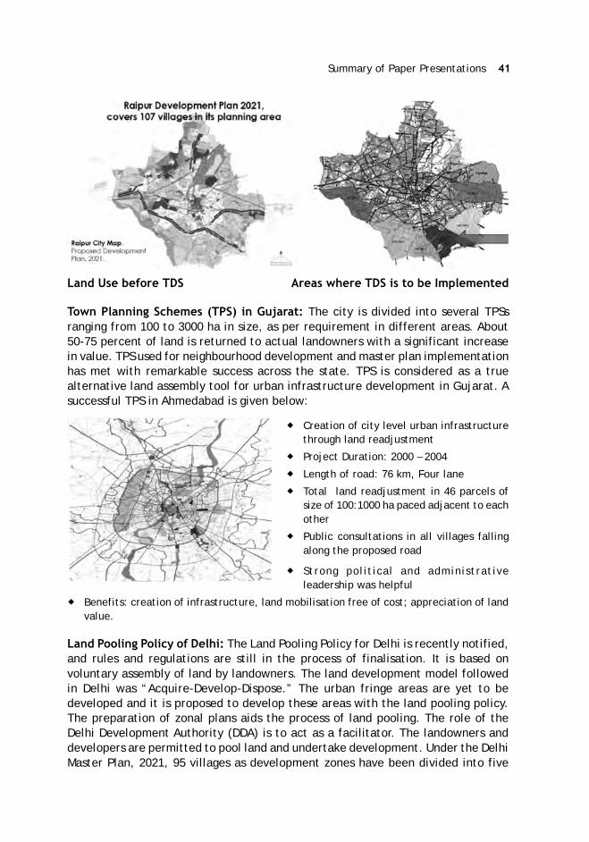
Summary of Paper Presentations 41
Land Use before TDS Areas where TDS is to be Implemented
Town Planning Schemes (TPS) in Gujarat: The city is divided into several TPSsranging from 100 to 3000 ha in size, as per requirement in different areas. About50-75 percent of land is returned to actual landowners with a significant increasein value. TPS used for neighbourhood development and master plan implementationhas met with remarkable success across the state. TPS is considered as a truealternative land assembly tool for urban infrastructure development in Gujarat. Asuccessful TPS in Ahmedabad is given below:
Creation of city level urban infrastructurethrough land readjustment
Project Duration: 2000 – 2004
Length of road: 76 km, Four lane
Total land readjustment in 46 parcels ofsize of 100:1000 ha paced adjacent to eachother
Public consultations in all villages fallingalong the proposed road
Strong political and administrativeleadership was helpful
Benefits: creation of infrastructure, land mobilisation free of cost; appreciation of landvalue.
Land Pooling Policy of Delhi: The Land Pooling Policy for Delhi is recently notified,and rules and regulations are still in the process of finalisation. It is based onvoluntary assembly of land by landowners. The land development model followedin Delhi was “Acquire-Develop-Dispose.” The urban fringe areas are yet to bedeveloped and it is proposed to develop these areas with the land pooling policy.The preparation of zonal plans aids the process of land pooling. The role of theDelhi Development Authority (DDA) is to act as a facilitator. The landowners anddevelopers are permitted to pool land and undertake development. Under the DelhiMaster Plan, 2021, 95 villages as development zones have been divided into five

42 ASCI Journal of Management 49 (2) September 2020
zones for development through land pooling. The land parcels measuring twohectares and above and located in remote parts of an area will be eligible, dependingupon the layout plan. The landowners will form a consortium and will retain 60 percent of the pooled land and surrender 40 per cent to service-providing agencies orthe DDA, for building infrastructure and public facilities. The landowners can alsobecome a separate developer entity and develop 60 per cent of the land, as a sub-project. The consortium has to complete integrated planning and take due approvals.DDA is a facilitator, and landowners in these sectors form a consortium or somegroup. After the formation of the consortium by landowners, the land will bedistributed between the members and service providing agencies for taking updevelopment as per the policy. Also, a minimum of 70 per cent of land of thedevelopable area of a particular sector, is required to be pooled to make the sectoreligible for development.An extra FAR of 15 is allowed for affordable housing forEconomically Weaker Section (EWS), and the dimensions of the house shall be 32-40 sqm. The Table 10 provides the details of the conceptualised land pooling scheme:
Table 10: LPS in Delhi
Minimum Surrendered Remaining Land Returned to Developer Entity (DE)Land to Govt. With DE
Residential Commercial PSP Facilities
2 Ha 40% (8Ha) 60% (12Ha) 53 % (10.6 Ha) 5% (1.0 Ha) 2% (0.4 Ha)
DDA gets ownership of the balance pooled land, which shall be utilised for roads,utilities, green areas and development of commercial, industrial and public & semi-public uses. Out of the share of DDA, the utilisation of land is mandatory for citylevel facilities viz. roads (12%), recreational facilities (15%), Utilities (5%) and theremaining 8 to 20 % land may be utilized for Govt. Use, PSP, Industries & other use.
Zone Villages Area Pooled
J 1 15178 4
K 20 12190 231
L 30 22840 1659
N 21 13975 3294
P 23 18400 1261
As on February 2020, DDA has received 6,113applications from landowners, through which6,449 hectares of land has been registered.Most of the areas pooled are in Zone N (3,294hectares), which is 50 per cent of totaldevelopable area in the zone, followed byZone L (1,659 hectares), Zone P-II (1,261hectares), Zone K-I (231 hectares) and ZoneJ (4 hectares).
Summary of Paper Presentations 43
Issues and challenges of land Readjustment in India: Successful LR is grounded inthree main enablers; fairly well-defined property rights(Land records/title);streamlined, independent, and transparent evaluations process (consultation andpeople participation), and a strong judicial system to address public concerns(statutory backing). The biggest roadblock between the design of TPS using theLand Readjustment method and the supply of serviced land for construction is themultiple and complex bureaucratic procedures. There is a need for an online buildingpermission system in the local government without integrating all agencies involvedin the building permission process. The local government must be given moreauthority for sanctioning plans, managing land auctions, revising land use rulesand regulation such as FAR (floor area ratio) and TDR (transferable developmentrights). Countries like Japan have very advanced land value estimations, and weneed substantial improvement in this regard. The other areas of improvement relatedto the fairness, consultation, and transparency, use of land pooling for urban renewalprojects and brownfield development etc.
LP Implementation Experience in Bhutan and Way Forward - Ms. TashiWangmo
In Bhutan, there are different levels of plans such as the 1) Valley DevelopmentPlans which are prepared to ensure integrated development of an urban centreand its hinterland and which enables the shared use of resources and infrastructurebetween an urban centre and its surrounding areas; 2) Regional plans that areplanned for specific development interventions in a region that lags behind in theoverall socio-economic development and in regional growth centres where there ispotential for a particular urban centre to stimulate economic development of aregion; 3) Structural Plans that are broad land use plans for settlement areas withthe development potentials and 4) Local Area Plans (LAPs) that are developed withreference to and within the framework and provisions of the Structure Plans. LP inBhutan is actually used in the local area plans as given below.

44 ASCI Journal of Management 49 (2) September 2020
Different Levels of Plans
LP and Other Land Assembly Tools: Bhutan has three kinds of planning tools; landacquisition that was used till the year 2000; guided land development that isgenerally used in the developed areas whereby landowners donate their land forlaying roads/public infrastructure and the third and the very popular one is theland pooling. Unlike other countries, LP in Bhutan is at its learning phase, havingbeen initiated only from the early 2000s. However, LP has gained popularity in thecountry. LP was introduced in 1998 in the Thimphu Urban Development Plan.However, it could not be implemented due to the resource constraints. In 2002, LPwas initiated in one of the eastern parts of Bhutan called Ranjung.The RanjungTownship in Tashigang was the first LP project undertaken in the country.
Rangjung LR Project
Valley Development Plans
Variation of the concept of a regionaldevelopment plan.
Enable shared use of resources and infrastructurebetween an urban centre and its surroundingareas.
Ensure integrated development of an urbancentre and its hinterland.
Regional Hubs/ Growth Centres
Regional Hubs - planned for specific developmentinterventions in a region that lags behind in theoverall socio-economic development.
Regional growth centres - planned where thereis potential for a particular urban centre tostimulate the economic development of a region.
Structure Plans
Broad land use plans for settlement areas withthe development potentials, objectives andstrategies.
Outline the main precincts/ zones, infrastructurelayout plans, LAP boundaries.
Local Area Plans (LAPs)
Detailed plot level plans, ready forimplementation (with implications for individuallandowners especially in land pooling schemes).
Developed with reference to and within theframework and provisions of the Structure Plans.
Summary of Paper Presentations 45
Prior to LP, land acquisition was adopted to assemble land for urban development,but it soon proved unpopular as it was considered to be an inequitable tool thatdisplaced the original landowners and favored the business communities. Presently,in all the 24 districts of the country, local area plans are prepared using LR/LP asthe planning tool. Though people are given the option of other tools such as theacquisition or guided development, they invariably choose LP. The land poolingrules of the Kingdom of Bhutan was adopted in 2009 and later revised in 2018. Thestandard of distribution is area based flat rate(not more than 30 percent irrespectiveof the project coverage). Though the Spatial Planning Bill has been formulated andis yet to be discussed in the Parliament, the legal backing for LP is provided in theLocal Government Act, 2009 & Land Act of Bhutan, 2009.
LP, at the policy/planning level is looked upon as an incentive-based planningapproach where landowners in return for land contribution receive buildable servicedplots with all urban facilities (park, road, drainage, pathways, and other urbanamenities). The LP is considered self-financing. However, at the implementing level,the stakeholders are not able to understand the concept and it is difficult for theplanners to convince the landowners regarding auctioning of the reserve land tofinance infrastructure development. Also, the use of area-based flat rate methodfor LP results in inequitable benefits to stakeholders when there are differences inland uses (precinct) and varying development provisions (height, coverage,commercial space).
Way Forward: Given the above challenges, three improvements are proposed forLP implementation in Bhutan. First, change in the way Development ControlRegulation is drafted. These regulations are framed as an integral complementarydocument to every development plan that contains mandatory requirements onland use, building construction procedure, and regulations like plot coverage,building height, procedures during construction, precinct sanctions, buildingregulations, etc. For uneducated people, it is often difficult to comprehend. It istherefore proposed that the objective of the development control regulations forlandscape and settlement areas is also presented in the pictorial form so thatpeople who cannot read can also understand.

46 ASCI Journal of Management 49 (2) September 2020
Pictorial Representation of DCR
The second important change is the use of differential LR/LP contribution method.Given that the value-based standard of distribution may be complicated to startwith and convince the landowners, there may be area-based differences in thecontribution method, and the parameters considered would be commercial usagein the building, number of floors, etc. For e.g., the contribution ratio can be morefrom landowners for commercial usage of the building, with a larger number offloors etc. This method was successfully tried out in one of the towns in CentralBhutan for a small area. The third important change is proposed in the planpreparation method. Though the consultation is done, the entire work is done bythe planners. The landowners should also be extended the opportunity to provideplan proposals that can then be reviewed by the municipality. The Municipality canthen guide also by involving an urban planner who will ensure that the developmenthappens as per the planning guidelines. Table 11 reflects the proposed planningprocedure for the implementation of LP in Bhutan.
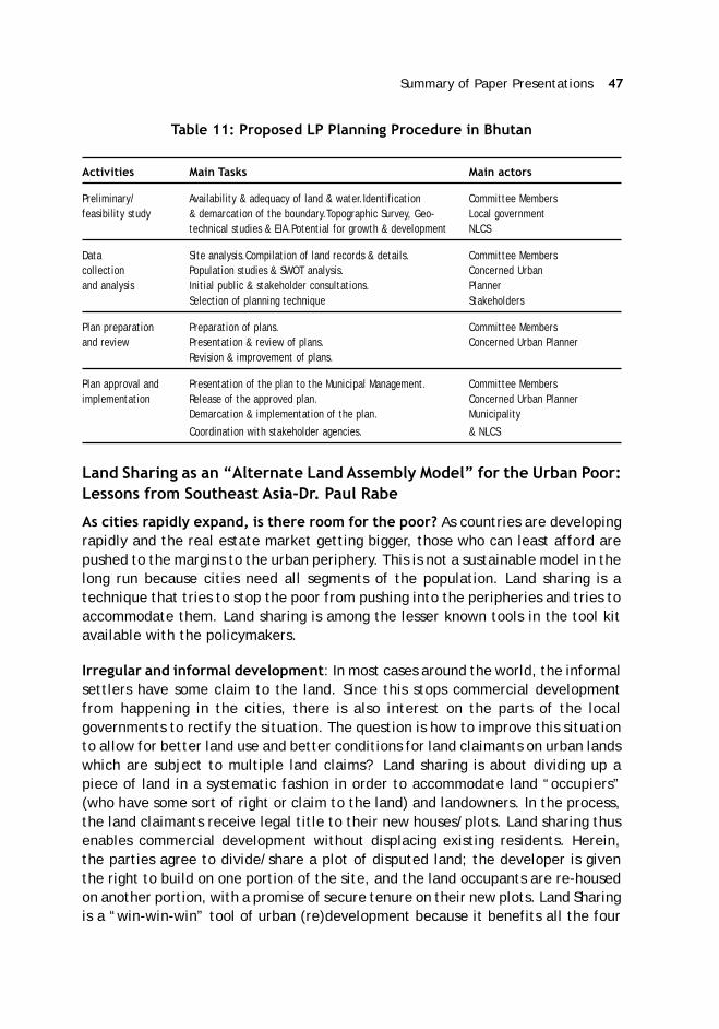
Summary of Paper Presentations 47
Table 11: Proposed LP Planning Procedure in Bhutan
Activities Main Tasks Main actors
Preliminary/ Availability & adequacy of land & water.Identification Committee Membersfeasibility study & demarcation of the boundary.Topographic Survey, Geo- Local government
technical studies & EIA.Potential for growth & development NLCS
Data Site analysis.Compilation of land records & details. Committee Memberscollection Population studies & SWOT analysis. Concerned Urbanand analysis Initial public & stakeholder consultations. Planner
Selection of planning technique Stakeholders
Plan preparation Preparation of plans. Committee Membersand review Presentation & review of plans. Concerned Urban Planner
Revision & improvement of plans.
Plan approval and Presentation of the plan to the Municipal Management. Committee Membersimplementation Release of the approved plan. Concerned Urban Planner
Demarcation & implementation of the plan. Municipality
Coordination with stakeholder agencies. & NLCS
Land Sharing as an “Alternate Land Assembly Model” for the Urban Poor:Lessons from Southeast Asia-Dr. Paul Rabe
As cities rapidly expand, is there room for the poor? As countries are developingrapidly and the real estate market getting bigger, those who can least afford arepushed to the margins to the urban periphery. This is not a sustainable model in thelong run because cities need all segments of the population. Land sharing is atechnique that tries to stop the poor from pushing into the peripheries and tries toaccommodate them. Land sharing is among the lesser known tools in the tool kitavailable with the policymakers.
Irregular and informal development: In most cases around the world, the informalsettlers have some claim to the land. Since this stops commercial developmentfrom happening in the cities, there is also interest on the parts of the localgovernments to rectify the situation. The question is how to improve this situationto allow for better land use and better conditions for land claimants on urban landswhich are subject to multiple land claims? Land sharing is about dividing up apiece of land in a systematic fashion in order to accommodate land “occupiers”(who have some sort of right or claim to the land) and landowners. In the process,the land claimants receive legal title to their new houses/plots. Land sharing thusenables commercial development without displacing existing residents. Herein,the parties agree to divide/share a plot of disputed land; the developer is giventhe right to build on one portion of the site, and the land occupants are re-housedon another portion, with a promise of secure tenure on their new plots. Land Sharingis a “win-win-win” tool of urban (re)development because it benefits all the four
48 ASCI Journal of Management 49 (2) September 2020
important stakeholders viz the landowners, private developers, informalsettlements, and the public authorities. The tool benefits the landowners and privatedevelopers by resolving the land conflict that has been blocking the use of land,thus enabling private development (on one portion of divided land); informalresettlers’ through avoiding their displacement while improving their housing andlegal development. Finally, the public authorities get benefited by resolution oflong-standing land conflicts in the city with minimum subsidy3.
Land sharing vs. Comparable Land Assembly Techniques: Land sharing is dividinga plot of land so that it can be shared fairly by all claimants for development/resettlement on site to avoid resettlement and enable development on-site. LP/LRrefers to the pooling of all land parcels in a particular area in order to plan them asa unit (UN-Habitat, 2018), often to facilitate planning and implementation ofinfrastructure. The difference between LP and LS is that LS is usually carried outon a site where there is an ongoing land conflict. LP, on the other hand does nothave to involve land conflicts but is just a way to reorganise the plots of land tofacilitate planning for infrastructural development. Land swaps refer to negotiatinga land exchange, so that current land occupants are resettled off-site in exchangefor alternative land use on the vacated site.
Pre-Conditions for LS: There are six pre-conditions for LS to be successful. Thefirst condition is a booming property market because unless there is a boom, thereis no incentive for landowners and land occupants to come together and try tonegotiate a solution. Second, there should be well-established communities (lengthof settlement; some kind of land right) because if the community is weak, they canbe resettled outside the city. The third pre-condition is a community organizationand consensus. If the community is not organised, there is a no consensus withinthe community, and that results in weaknesses in negotiation and LS does not reallytake place. Fourth, third party intermediation is very important to facilitatenegotiation between landowners, and land occupants. A third party can be agovernment organisation or a civil society organization and the interest may be inkeeping the land occupants on the site and solution of a long-standing land conflictin the city respectively. The fifth condition is with respect to the physical/technicalfeasibility of the project i.e., the site needs to be big enough to accommodate theLS solutions. The final pre-condition is the financial feasibility. The financialfeasibility is accomplished either through loan schemes or through cross-subsidyfrom commercial development. In the latter, there is a deal with the developerthat as part of development on the site, the developer needs to fund the housingfor the land occupants already on the site. Our research shows that the existenceof the above pre-conditions ensures the success of the LS and the absence on one
3 Usually, LS is financed either from small loan schemes to build the housing for theland occupants or it is a cross subsidy from the commercial development, that ishow it is done in Cambodia.

Summary of Paper Presentations 49
or more of them may result in the failure of the LS model. When it succeeds, landsharing offers the prospect of a negotiated, “win-win-win” resolution to landconflicts between land occupants, landowners and developers, by accommodatingthe interests of all on one single site.
LS Innovations-Two Cases: The Bangkok (1977-1997 and later) LS projects resultedin the resolution of seven long-simmering land disputes in central areas of Bangkok,affecting over 10,000 households. It took place over the course of twenty years.The new on-site housing for slum residents was financed by various kinds of loanschemes. Most cases involved private developers or leaseholders, on public land.The intermediaries during negotiations included the National Housing Authorityand other public organisations, as well as a network of concerned individuals fromcivil society. In all the seven projects, it was the public agencies that decided to gofor the LS as private landowners generally tried to look out for other ways. Only inone case, there is an exception in having a private landowner who decided to gofor LS solution. The Bangkok cases are reflected in Table 12.
Table 12: The Bangkok LS Cases
Name of Number Total Landowner Negotiation Intermediary Summary of outcome forSettlement of area before land period organization slum dwellers
families (ha.) sharing
Rama-4 1,250 8.5 CPB lease to 1977-81 NHA, Treasury 2.4 ha. reserved to re-housedeveloper Department residents; 850 high-rise units leased
to community by CPB on 20-yearleases.
Manangkasila 500 1.6 Treasury 1979-82 None 0.87 ha. leased to 198Department remaining familieslease todeveloper
Wat Lad 63 1.6 Private land- 1978-83 NHA, 0.32 ha. sold to 67 remainingBua Kaw owners lease BMA, families
to developer Military
Klong Toey 7,500 69 PAT 1982-85 NHA, Military 11.5 ha. sub-leased to 1200Area-3 families for 20 years, via NHA
Sengki 143 1.1 KPB 1984-87 NHA Housing co-operative purchased 0.60ha for all families, with loans fromKPB
Sam Yod 30+ 0.95 CPB 1982-89 NHA 0.65 ha. sub-leased to 200 families(including newcomers), via NHA
Klong Pai Sing To 350 n/a CPB 1989-97 None All families relocated to two high-rise buildings owned by CPB

50 ASCI Journal of Management 49 (2) September 2020
LS in Phnom Penh: Phnom Penh is the capital and primate city of the Kingdom ofCambodia, with a population estimated at 1.3 million and rapidly growing. In a2003 NGO survey, the city has 569 officially recognised “urban poor settlements”housing approximately about a quarter of the city’s population (SUPF survey). Theurban poor settlements were characterised by five features: insecure tenure, poorsanitation, unsafe water supply, poor quality of housing and insufficient living area.The Phnom Penh (2003-2009) on-site upgrading model for four large slums in centralPhnom Penh with a population of 17,000 is the more recent in comparison to Bangkok.The new housing for slum dwellers was financed through cross subsidies fromcommercial development. Currently, land sharing is being applied as a tool in severalcases within the Royal Thai Government’s new slum upgrading program nationwide(the Baan Mankongprogram). In 2003, the apparent “breakthrough” for the poorcame about when the President of Cambodia decided to go for LS in the city insteadof going with a massive resettlement scheme. The resettlement schemes were notworking, and the poor were coming back to the city after multiple violentresettlement schemes, and it did not come as a long-term solution. The PrimeMinister announced a slum upgrading campaign for over 500 slum settlements withupgradation on site, with full services and land titles. The historic announcementof four pilot projects of “land sharing” resulting from NGO advocacy was a clearbreak from decades of forced evictions and housing rights organisations predictedan era of newfound power and citizenship for the urban poor. All the four projectsin Cambodia were in the centre of the city which made LS a necessity.
Case study settlement of Borei Keila LS: The site is where the South East AsianGames was held in the 1960s but came to be inhabited by squatters after the civilwar. The area of about 14.12 hectares was inhabited by 1776 families, and afterthe land sharing agreement in 2004, ten new “community buildings” wereconstructed to re-house the slum population on the site. The project was crosssubsidised by a private developer. After the completion of the LS scheme, out ofthe total area of 14.12 ha, 2 ha is used for new buildings for slum dwellers, 2.6 hais awarded to the developer for market housing, and 9.52 ha is “returned” to theState. As a part of the contract, the developer built ten high rise buildings on aportion of the site that was housed by the community and the commercialdevelopment took place on the rest of the site. The people were living in theabsence of sanitation facilities and without legal documents. After the LS, thepeople had titles and were allowed to live in the new and better housing system.However, the developer broke the contract with the Municipality and failed toconstruct the last two community buildings, and 154 households remained homeless.The municipality has not pursued the developer to complete the project. The former“slum” areas have made way for new commercial development.
Case study settlement of Dey Krahom: The second case in Phnom Penh was in aL- shaped squatted property. In this case, the LS failed, and people eventuallymoved out of the city due to their own will. LS, therefore, became a land swap as
Summary of Paper Presentations 51
the people decided that they did not want to live in a ten-floor building whichwould be the LS solution, but would stay outside the city (about 12 Kms out oftown) in single storey buildings. The Land swap was a negotiated solution insteadof LS. The project area of 4.8 ha had a population of 1465 families.
Case study settlements of Railway A & B-The project area of about 11.3 ha had apopulation of 325 families squatting next to the railway line. The LS here did notwork out because the communities could not agree among themselves, and so theydelayed the negotiation process. The area was leased by a developer. After yearsof deadlock, the developer bought off the residents by paying them individualcompensation.
Latest developments in Phnom Penh and Thailand: Massive Chinese investmentis changing the skyline of Phnom Penh. There is a massive transformation of theBassac riverfront area with residential towers, casinos, malls, and commercialtowers. There are enormous structures coming up all across the area, andcommercial development is expanding on an explosive scale. It remains to be seenif there is room for affordable housing in the new “spectacular” Phnom Penh or willthey be pushed out? In Thailand, LS is now being “scaled up” as part of formalgovernment supported upgrading schemes (Baan Mankongprogram, supported byCommunity Organization Development Institute). LS is part of a broader solution.Communities are also being given more power and responsibility to plan, design,and negotiate their upgrading schemes (in the Baan Mankongprogram, and by theCrown Property Bureau) and in a way are becoming the “owners” of their projects(risks and responsibilities) with supervision and technical assistance by CODI andCPB.
Other experiences in Asia: There are varieties of “land sharing” in other parts ofAsia, known by different names; China (urban village redevelopment in the processof conversion from rural to urban land); India (Slum redevelopment in Dharavi,Mumbai; Slum Rehabilitation Policy, SRP in Pune and previous land sharingexperience in Hyderabad), etc.
Evaluation of LS Cases: In Phnom Penh, LS happened in one of the biggest projectsbut in three out of four cases, the parties could not come to a land sharingagreement, and slum redevelopment took a “familiar” turn: relocation andindividual payouts, as the land occupants did not get the housing as big as thehousing outside the city. It was seen that the residents were not active participantsin the planning of the land sharing projects and were overruled by the developer(in Borei Keila) and by community leaders (Dey Krahom and Railway settlements).But the two largest projects were unique. In Borei Keila, the residents were re-housed on site in fully serviced walk-up medium rise buildings, free of charge. InDey Krahom, the residents were relocated at the expense of the developer andreceived fully serviced new housing units with social infrastructure and facilitiesfree of charge. In 3 of the 4 settlements, residents had to relocate, many of them
52 ASCI Journal of Management 49 (2) September 2020
involuntarily. The compensation packages were generally below market rate, andthe redevelopment process was characterised by large-scale abuses. However, thefree replacement housing (in Borei Keila and Dey Krahom) ended up going mainlyto outsiders, and the original objective of the Prime Minister’s social land concessionprogram (keeping the poor in the city) was not met. The cases reflect that the pre-conditions are important for the success of the LS Model. LS still offers a uniquetool for resolving land conflicts with the benefits of flexibility, compromise, andwin-win outcomes.
Land Pooling: Policies and Practices in China - Prof. Guoqing Shi &Mr. Wang Nan
In China, besides the national constitutions, the key laws and regulations regardingland and resettlement are framed at both the national and local levels. The nationallaws and policies include the Real Right Law, 2007; Law of Land Administration,issued in 1986 and revised in 2019; Basic Farmland Protection Regulation adoptedin1991, revised in September 1999,2004 and Regulations on the Housing Acquisitionand Compensation on State owned Land (new revision,2011). The local laws includethe provincial level legal regulations and rules, city level implementation rules,and county level implementation rules. Besides the above, their special resettlementpolicies and implementation rules in big projects. For e.g., the Xiaolangdi DamResettlement Implementation Management.
The Chinese Constitution (Article 10) provides that the state may, in the publicinterest, requisition land for its property or use in accordance with the law.Noorganisation or individual may appropriate, buy, sell or lease land or otherwiseengage in the transfer of land by unlawful means. All organisations and individualsusing land must ensure its rational use. According to Real Right Law (Article 42), inorder to meet the demands of public interests, it is allowed to requisition landsowned collectively, premises owned by units and individuals according to thestatutory power limit and procedures. When there is the requisition of land ownedby the collective, it is required to, in accordance with the law and in full amount,pay land compensation fees, resettlement subsidies, compensations for the groundattachments and green crops, arrange endowment insurance for the land-losingfarmers, guarantee their livelihood and protect their lawful rights and interests.Similarly, when requisition of the premises owned by units and individuals, it isrequired to compensate for demolishment in accordance with the law and protectthe lawful rights and interests of the owners of the requisitioned realities; whenrequisitioning the individuals’ residential houses, it is required to guarantee thehousing conditions of the owners of the requisitioned houses.
The policy and practices relating to LP/LR in China vary for different regions andprojects. For urban shantytown reconstruction, the national policies since 2009provide for the transformation of the old houses in cities. With the advancement of
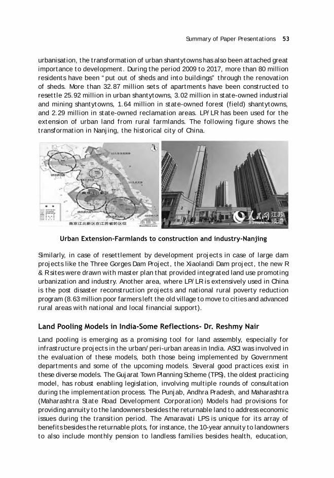
Summary of Paper Presentations 53
urbanisation, the transformation of urban shantytowns has also been attached greatimportance to development. During the period 2009 to 2017, more than 80 millionresidents have been “put out of sheds and into buildings” through the renovationof sheds. More than 32.87 million sets of apartments have been constructed toresettle 25.92 million in urban shantytowns, 3.02 million in state-owned industrialand mining shantytowns, 1.64 million in state-owned forest (field) shantytowns,and 2.29 million in state-owned reclamation areas. LP/LR has been used for theextension of urban land from rural farmlands. The following figure shows thetransformation in Nanjing, the historical city of China.
Urban Extension-Farmlands to construction and industry-Nanjing
Similarly, in case of resettlement by development projects in case of large damprojects like the Three Gorges Dam Project, the Xiaolandi Dam project, the new R& R sites were drawn with master plan that provided integrated land use promotingurbanization and industry. Another area, where LP/LR is extensively used in Chinais the post disaster reconstruction projects and national rural poverty reductionprogram (8.63 million poor farmers left the old village to move to cities and advancedrural areas with national and local financial support).
Land Pooling Models in India-Some Reflections- Dr. Reshmy Nair
Land pooling is emerging as a promising tool for land assembly, especially forinfrastructure projects in the urban/peri-urban areas in India. ASCI was involved inthe evaluation of these models, both those being implemented by Governmentdepartments and some of the upcoming models. Several good practices exist inthese diverse models. The Gujarat Town Planning Scheme (TPS), the oldest practicingmodel, has robust enabling legislation, involving multiple rounds of consultationduring the implementation process. The Punjab, Andhra Pradesh, and Maharashtra(Maharashtra State Road Development Corporation) Models had provisions forproviding annuity to the landowners besides the returnable land to address economicissues during the transition period. The Amaravati LPS is unique for its array ofbenefits besides the returnable plots, for instance, the 10-year annuity to landownersto also include monthly pension to landless families besides health, education,

54 ASCI Journal of Management 49 (2) September 2020
skill building support, etc. The Punjab and Haryana Models provide a genuine choiceto the landowner to choose between compensation and pooling. All the Indianmodels have a homogeneous contribution ratio in terms of land to be returned tothe landowners with the exception of Andhra Pradesh (differential entitlementsfor wet/drylands and different categories of assigned landowners) and the KamalVihar/Chhattisgarh/Bhuj Reconstruction/Gujarat (progressive contribution ratio).
There are important differences in the Indian LP policies with regard to the standardsgoverning returnable plots to landowners; Delhi (60 percent); Gujarat (40-50percent); Raipur (35 percent); Andhra Pradesh (25/30 percent); Punjab and Haryana(23 percent). The minimum land size that can be pooled also varies, with a minimumin Raipur to a maximum in Delhi. The AP LPS is unique in being the only poolingmodel that provides benefits to the landless and other social development benefitsto the affected families. The paper presents some cases in LP/LR in India from asocio-economic perspective, both good practices, and areas of concern4.
Case 1: Who is Impacted & how do we know who is impacted? Andhra PradeshLPS is unique in the world for providing entitlements to non-titleholders andinstitutionalising social development schemes for the population in the affectedarea. A good practice that was followed in the project was the comprehensivesocio-economic survey conducted by the project authorities. The survey revealedthat i.e., more than 55 percent of the working population residing in the area werelandless labourers. This critical information helped the authorities to come upwith an inclusive and holistic entitlement matrix reflective of the ground situation.The Table 13 reflects the composition of the workforce in the AP capital City area.
Table 13: Composition of Workforce in the AP Capital City Area
Villages Population Cultivators Agriculture Household Other Total % ALLabourers Workers Workers
A 43288 3507 16845 191 3440 23983 70.2
B 36952 6595 11810 1802 4507 24714 47.8
C 22161 554 2979 2017 3656 9206 32.4
Total 102401 10656 31634 4010 11603 57903 54.6
Case 2: Issues in the transition phase and uncertainty over the magnitude ofprice appreciation: A critical concern for the landowners in the LP project is thelivelihood related issues during the transition phase as well as uncertainty over themagnitude of price appreciation after the LP that is required to outweigh their
4 While the projects reflecting good practices are named, those details of the twocase studies reflecting unsustainable practices are withheld as the objective is tobring to the front improvement in such practices.

Summary of Paper Presentations 55
land contribution for the project. These concerns have been taken care in someIndian LP models. For example, the annuity provisions that provide income supportduring the transitional phase and partially supports the livelihood issues of thelandowners are included in the entitlements in the AP and Punjab models. In APLPS, annuity for crop loss @ Rs. 30,000/Rs. 50,000 per acre dry/irrigated landswith the annual enhancement of ten percent was provided. In Punjab, subsistenceallowance @ Rs. 25,000/ per acre up to three years/ till the possession of a developedshare of land is taken is provided. Another key concern for the landowners is therisk associated with the appreciation of the land value to the expected extent inthe future. There are projects which get delayed or the envisaged development donot happen owing to multiple reasons, including political. The Amaravati LPS is acase example. To allay such concerns, an LPS scheme for a road project inMaharashtra included a provision that if the landowners cannot find buyers fortheir returnable plots after ten years, the Government will buy back the land atfive time the then prevailing ready-reckoner rates. Though the project could notproceed with the LP mechanism, the provision was unique in recognising that thereare risks for the landowners in case development does not happen as envisaged.
Case 3: Choice with land owner-returnable plots or cash compensation: In India,land acquisition and cash compensation were the preferred mode of land assemblyin most states till the enactment of a new land acquisition law with extensivetransparency/consultation process and vastly increased compensation andmandatory R & R norms in 2013. After the new Land Acquisition Act came intoforce, more and more state governments are coming out with schemes to poolland. Undoubtedly, the value of developed land is many times the compensation ofundeveloped land. But will landowners have a choice to decide what is best forthem? Punjab is the only Indian state that gives the option to the people to choosebetween developed land and cash compensation. And It is important to understandthat the decision of the landowners is clearly based on the trend in the real estatemarket and returnable developed and is not always the choice of the landownersas indicated in the Table 14.

56 ASCI Journal of Management 49 (2) September 2020
Table 14: Landowners Choice in Projects-Returnable Land and Cash Compensation
S.No Project Total Choice of Choice of % of LPArea (Ha) Returnable Cash in Total
Land Compensation
1 IT City 1693 416 1277 24.57
2 Medicity-Phase I 97 84 13 86.60
3 Eco City-Phase I & II 435 399 36 91.72
4 Sector 88-89 668 614 54 91.92
5 Medicity 162 76 86 46.91
6 Ecocity II 301 135 166 44.85
7 Ecocity Extension 86 21 65 24.42
Total* 3442 1745 1697 49.30
Case 4: Equity and Progressive Contribution Ratio: In some LP models in India(see the Table 15), the graded contribution ratio was used. This essentially meansthat landowners of extremely small pieces of land will have more returnable landthan relatively bigger landowners. There is a progressive increase in the landcontribution as per the size of the original plot. The two case experiences in thecase of Kamal Vihar TPS in Raipur, Chhattisgarh and Bhuj, Gujarat is given in thefollowing table. The Graded contribution is like a progressive income tax thatimposes higher tax liability on people in the higher income bracket. The gradedratio has worked well in some projects and can be replicated in others. The potentialland fragmentation issues can be resolved with strict cut-off dates.
Table 15: Graded Contribution Ratio in Raipur, Chhattisgarh and Bhuj, Gujarat
Kamal Vihar TPS, Raipur, Chhattisgarh TPS for Bhuj Reconstruction, Gujarat
Original Plot Allotted Plot Original Plot Allotted Plot(Sqm) [Sqm.] (Sqm) [Sqm.]
90–120 52.50 Less than 30 Sqm No deduction
120-150 60.00 30-100 sqm 10% deduction
150-200 71.875 100-200 sqm 20% deduction
200-240 86.25 200-500 sqm 30% deduction
240-270 96.875
270-290 102.50
290 and above 35% of the original area
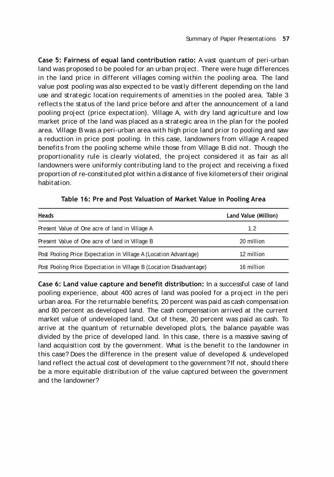
Summary of Paper Presentations 57
Case 5: Fairness of equal land contribution ratio: A vast quantum of peri-urbanland was proposed to be pooled for an urban project. There were huge differencesin the land price in different villages coming within the pooling area. The landvalue post pooling was also expected to be vastly different depending on the landuse and strategic location requirements of amenities in the pooled area. Table 3reflects the status of the land price before and after the announcement of a landpooling project (price expectation). Village A, with dry land agriculture and lowmarket price of the land was placed as a strategic area in the plan for the pooledarea. Village B was a peri-urban area with high price land prior to pooling and sawa reduction in price post pooling. In this case, landowners from village A reapedbenefits from the pooling scheme while those from Village B did not. Though theproportionality rule is clearly violated, the project considered it as fair as alllandowners were uniformly contributing land to the project and receiving a fixedproportion of re-constituted plot within a distance of five kilometers of their originalhabitation.
Table 16: Pre and Post Valuation of Market Value in Pooling Area
Heads Land Value (Million)
Present Value of One acre of land in Village A 1.2
Present Value of One acre of land in Village B 20 million
Post Pooling Price Expectation in Village A (Location Advantage) 12 million
Post Pooling Price Expectation in Village B (Location Disadvantage) 16 million
Case 6: Land value capture and benefit distribution: In a successful case of landpooling experience, about 400 acres of land was pooled for a project in the periurban area. For the returnable benefits, 20 percent was paid as cash compensationand 80 percent as developed land. The cash compensation arrived at the currentmarket value of undeveloped land. Out of these, 20 percent was paid as cash. Toarrive at the quantum of returnable developed plots, the balance payable wasdivided by the price of developed land. In this case, there is a massive saving ofland acquisition cost by the government. What is the benefit to the landowner inthis case? Does the difference in the present value of developed & undevelopedland reflect the actual cost of development to the government? If not, should therebe a more equitable distribution of the value captured between the governmentand the landowner?

58 ASCI Journal of Management 49 (2) September 2020
Table 17: Distribution of Benefits in a Land Pooling Scheme in India
Present Value of undeveloped Land 15 Million per ha
Present Value of developed land 50 million per ha
Under LP Scheme (Distribution)
Cash (20%) 3 million
Land (80%) 0.24 ha
The Government saves 75 percent of the total land cost
Quantum of Balance Land = Total Compensation Payable minus Cash Payment (20%)/Present Value of Developed Land
The above cases reflect a few good cases as well as areas requiring improvement.Land pooling models can work successfully in different project contexts. That it isgaining acceptance in varied project contexts in India is a good indicator of itsattractiveness and potential transferability. However, balancing social and economicissues is central to any strategy for land assembly. Even the established land poolingmodels in India may have to bring forth necessary changes in the light of the changedlegal environment after the enactment of the 2013 Act. The current legal frameworkdoes not provide for stringent conditions for adherence to timelines, penalty clausesfor discrepancies between plans and its eventual development, institutionalmechanisms for implementation of the scheme, and transparency regarding landvaluation/value capture. The existing models largely have a uniform contributionratio based on size; a practice that would provide optimum outcome only whenplots have no dramatic differences in prices pre and post LPS. The Punjab landpooling experience reveals that it is the expectation from the real estate marketthat guide the choice of the landowners. The failure of the Mumbai Nagpur SuperCommunication Project LPS and a few others in attracting landowners is a case inpoint. A genuine option to the landowners to choose between land compensationand alternative mechanisms hence become vital. To ensure legal sanctity in theIndian models, obtaining free consent from the landowners and ensuring that thestatutory rights of the affected families under the 2013 Act are protected may alsobe critical.
The other improvements required include robust planning to minimise landrequirements/choosing of alternatives that avoid lands prone to conflicts (irrigatedlands, necessitating physical displacement etc.), holistic and inclusive mitigationmechanisms recognising the potential of these strategies to cause economicdisplacement of people that a compensation mechanism in cash (land purchase) orin kind (returnable land after a transition period) may not be able to adequatelyaddress; need to provide cover to non-title-holders and those who are yet to have

Summary of Paper Presentations 59
formal rights on land, special provision for vulnerable sections etc. Further, theneglect of transparency in implementation and insufficient participation of affectedpeople, reflected in most of the LP models may, cause a loss of confidence in theprocess. Information flow and consultations during different phases of the projectwill be essential. The disclosure of information should be accessible in the locallanguage and also updated. An institutionalised GRM which ensures timely andresponsive feedback is a critical gap in most policies and may also have to beincorporated on a priority basis with the authority supervising the LP process.
Improving the Urban Fabric Through Land Readjustment-The PILaRApproach-Dr. Robert Lewis-Lettington
The urbanisation trends reveal that both in the developed and developing countries,the land use efficiency seems to be going down i.e., we are using more land percapita than ever before. For instance, between 1990-2015, when the population ofcities doubled in less developed countries, their urban extent increased by a factorof 3.5. Similarly, in developed countries, when the population of cities increasedby a factor of 1.2, their urban extents increased by a factor of 1.8. In the currentcovid crisis, it is important to distinguish between density and overcrowding; whileovercrowding presents a public health threat, density presents a range of benefits.Also, the informal and not-planned areas seem to be growing in the urban space.The non-planned/informally planned areas increased from 38 percent of the totalresidential areas in the pre 1990s to about 60 percent during the period 1990-2015.The urbanisation trend worldwide also reveals that in the majority of cities, theaverage street width is below the minimum legal street width (106 cities as against82 cities where it is higher). The street width is taken as a proxy for prevailingconditions with regard to traffic safety to emergency access. In many cities, thestreet width determines street level economic activity, including informal traders.The tendency seems to be for more adhoc planning and less planning as a whole.Though planning is not always solution of our problems but it does tend to imply amore organised process, where it can be considered what a good land design is.
Population Growth Vs Urban Land Extent
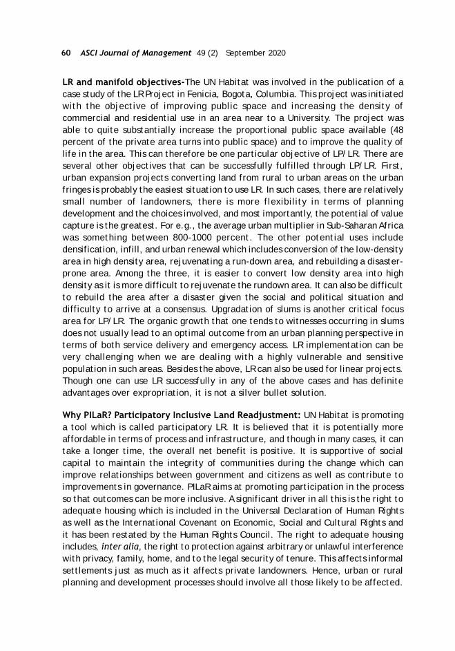
60 ASCI Journal of Management 49 (2) September 2020
LR and manifold objectives-The UN Habitat was involved in the publication of acase study of the LR Project in Fenicia, Bogota, Columbia. This project was initiatedwith the objective of improving public space and increasing the density ofcommercial and residential use in an area near to a University. The project wasable to quite substantially increase the proportional public space available (48percent of the private area turns into public space) and to improve the quality oflife in the area. This can therefore be one particular objective of LP/LR. There areseveral other objectives that can be successfully fulfilled through LP/LR. First,urban expansion projects converting land from rural to urban areas on the urbanfringes is probably the easiest situation to use LR. In such cases, there are relativelysmall number of landowners, there is more flexibility in terms of planningdevelopment and the choices involved, and most importantly, the potential of valuecapture is the greatest. For e.g., the average urban multiplier in Sub-Saharan Africawas something between 800-1000 percent. The other potential uses includedensification, infill, and urban renewal which includes conversion of the low-densityarea in high density area, rejuvenating a run-down area, and rebuilding a disaster-prone area. Among the three, it is easier to convert low density area into highdensity as it is more difficult to rejuvenate the rundown area. It can also be difficultto rebuild the area after a disaster given the social and political situation anddifficulty to arrive at a consensus. Upgradation of slums is another critical focusarea for LP/LR. The organic growth that one tends to witnesses occurring in slumsdoes not usually lead to an optimal outcome from an urban planning perspective interms of both service delivery and emergency access. LR implementation can bevery challenging when we are dealing with a highly vulnerable and sensitivepopulation in such areas. Besides the above, LR can also be used for linear projects.Though one can use LR successfully in any of the above cases and has definiteadvantages over expropriation, it is not a silver bullet solution.
Why PILaR? Participatory Inclusive Land Readjustment: UN Habitat is promotinga tool which is called participatory LR. It is believed that it is potentially moreaffordable in terms of process and infrastructure, and though in many cases, it cantake a longer time, the overall net benefit is positive. It is supportive of socialcapital to maintain the integrity of communities during the change which canimprove relationships between government and citizens as well as contribute toimprovements in governance. PILaR aims at promoting participation in the processso that outcomes can be more inclusive. A significant driver in all this is the right toadequate housing which is included in the Universal Declaration of Human Rightsas well as the International Covenant on Economic, Social and Cultural Rights andit has been restated by the Human Rights Council. The right to adequate housingincludes, inter alia, the right to protection against arbitrary or unlawful interferencewith privacy, family, home, and to the legal security of tenure. This affects informalsettlements just as much as it affects private landowners. Hence, urban or ruralplanning and development processes should involve all those likely to be affected.
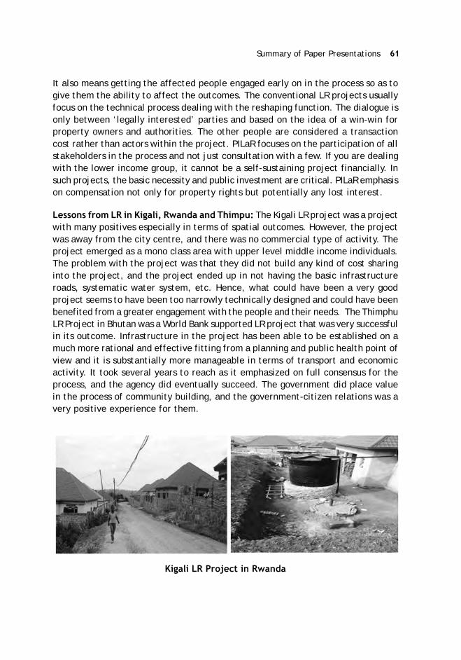
Summary of Paper Presentations 61
It also means getting the affected people engaged early on in the process so as togive them the ability to affect the outcomes. The conventional LR projects usuallyfocus on the technical process dealing with the reshaping function. The dialogue isonly between ‘legally interested’ parties and based on the idea of a win-win forproperty owners and authorities. The other people are considered a transactioncost rather than actors within the project. PILaR focuses on the participation of allstakeholders in the process and not just consultation with a few. If you are dealingwith the lower income group, it cannot be a self-sustaining project financially. Insuch projects, the basic necessity and public investment are critical. PILaR emphasison compensation not only for property rights but potentially any lost interest.
Lessons from LR in Kigali, Rwanda and Thimpu: The Kigali LR project was a projectwith many positives especially in terms of spatial outcomes. However, the projectwas away from the city centre, and there was no commercial type of activity. Theproject emerged as a mono class area with upper level middle income individuals.The problem with the project was that they did not build any kind of cost sharinginto the project, and the project ended up in not having the basic infrastructureroads, systematic water system, etc. Hence, what could have been a very goodproject seems to have been too narrowly technically designed and could have beenbenefited from a greater engagement with the people and their needs. The ThimphuLR Project in Bhutan was a World Bank supported LR project that was very successfulin its outcome. Infrastructure in the project has been able to be established on amuch more rational and effective fitting from a planning and public health point ofview and it is substantially more manageable in terms of transport and economicactivity. It took several years to reach as it emphasized on full consensus for theprocess, and the agency did eventually succeed. The government did place valuein the process of community building, and the government-citizen relations was avery positive experience for them.
Kigali LR Project in Rwanda

62 ASCI Journal of Management 49 (2) September 2020
Thimpu Project in Bhutan-Pre and Post LR
Risks in PILaR: There are risks associated with ensuring successful outcomes. It isimportant to pay attention to each of the following:
If it is a massively packed existing area and there is no open space and there isno funding to be able to build at least minimal vertical development of up totwo/three/four stories, it will be very difficult to create a viable LR project.
Though LR requires a potential for good municipal-community relations, it isimportant to recognise that there are high transaction costs. From the outset,the local governments have to get the citizens involved in the decision making,which most the local governments are generally very good at.
LR requires a potential for a healthy balance between public and private rolesin development. if there is a heavily economically pressured environment witha lot of predatory property development, it will be difficult to get the balance.
LR projects require a careful analysis of gentrification risks. The broader thescale of the project, the more you can mitigate this risk, but if you are operatingin small blocks then you are going to face challenges.
Land readjustment in low income communities will require significant publicinvestment.
Leveraging Land Value Capture Instruments: A Global Experience-Mr. JonKher Kaw
Land pooling and land readjustment (LP/LR) can be framed through the broaderlens of land value capture (LVC) – when public infrastructure such as new roads andmetro stations raise the value of land nearby; they create gains for both privateand public land and property owners. Local governments can reap a fair share ofthat land value increase that their public investments create for surrounding privateowners. LVC instruments are based on the government’s ability to obtain publicbenefits, either revenues or amenities, by exercising their control over land andproperty (both private and government-owned). By so doing, governments canreceive a fair share of the increase in the value of private land or property.

Summary of Paper Presentations 63
The public benefits of successful LVC implementation are varied and can includethe ability to improve revenues to cover infrastructure costs by the local governmentand create public amenities through in-kind benefits. These, in turn, promote localeconomic activities and, in many cases, more intensive use of space (air rightscontracts). There are broadly three types of LVC instruments5: (a) those that relyon the government’s control of public land and property (e.g., sale or lease ofmunicipal land); (b) those that rely on the government’s authority to control publicand private land use (e.g., through land-use planning parameters); and (c) throughfiscal instruments (e.g., property taxes or developer charges).
LP/LR, in this context, primarily relies on the control of land use, where thegovernment re-parcels and regularises privately-owned land in a predefined area.In so doing, the government also reserves spaces for public use and infrastructure,some sites to pay for infrastructure, and returns smaller but more valuable plots toprevious owners. The creation of a reliable land and fiscal cadaster, which oftenaccompany LP/LR schemes, would be essential in enabling the implementation ofother types of LVC instruments, such as property taxes.
Creating and capturing value: LVC, if implemented successfully, can providemultiple benefits to governments: namely, it helps create a source of public revenuesto cover infrastructure costs, facilitates the creation of public amenities withoutpublic spending, provides space for new economic activities, and increases privateinvestments. For example:
In Singapore, LVC instruments are used systematically as part of the planning toencourage private developments to incorporate public infrastructure – incentivesare given to developers for providing public spaces and greenery in return foradditional air rights or higher density/height bonuses.
In India, Ahmedabad’s CBD6 is set to transform through a development planleveraging on its connectivity to a proposed Metrorail system through transit-
5 Based on a World Bank background paper authored by Olga Kaganova, Jon KherKaw, and Gabor Peteri.6 A case study can be found in the World Bank’s “The Hidden Wealth of Cities:Creating, Financing, and Managing Public Spaces” at www.worldbank.org/hiddenwealthofcities.7 Transit-oriented development (TOD) revolves around the creation of compact,walkable, pedestrian-oriented, mixed-use communities centered around high-qualitytransit systems. TOD approaches generate synergies between public investment ininfrastructure and the ensuing private investment in commercial development atand around transportation nodes. In TOD projects, densification allows for thegeneration of revenue streams that can be captured to finance infrastructure andpublic spaces.8 Floor area ratio (FAR) refers to the ratio of a building’s total gross floor area overthe area of the land site which is it built upon. This ratio is often used in urbanplanning as a means to control how much floor space can be built on a land site.
64 ASCI Journal of Management 49 (2) September 2020
oriented development (TOD)7, allowing the average floor area ratio (FAR)8 toincrease, thereby supporting more economical uses and livable space, anddoubling the road and green network through land readjustment. The creationof compact, attractive, and high-density developments could drive up the valueof land and development, where the government could potentially use LVC tofund its planned infrastructure and public amenities.
Global application of LVC: Globally, there are about 15 different types of LVCinstruments.9 Depending on the local context, different types of LVC instrumentsare used differently or combined. Some commonly used instruments globally include:
Short-term leases of vacant municipal land/property and the use of developercharge/exaction10 for funding off-site infrastructure and municipal services.
Local property tax is used in more than 70 countries in Latin America, Europe,and Africa.
Many big cities in OECD countries make use of the sale of development rights/density bonuses11 to capture value.
OECD countries make use of the Joint Development Agreements (JDA12) fordelivering public-use facilities.
Conversion fees13 are used in India, Indonesia, and the US.
Real estate transfer tax14 is used in Australia, France, Japan, Russia, Turley, UK,and the US, and real estate capital gain tax is used in Canada, Pakistan, andthe US.
9 The analysis and compilation of global LVC instruments in this presentation drawsfrom a World Bank background paper authored by Olga Kaganova, Jon Kher Kaw,and Gabor Peteri.
10 A one-time contribution of land for public facilities/infrastructure in exchangefor development rights.
11 Rights that allow a developer or property owner to exceed the base zoning densityin exchange for a payment or an in-kind contribution of public use facility (such aspublic spaces).
12 Joint development between municipality and developer for private and/or publicuse on municipal land.
13 Conversion of land classified as not-developable for development.
14 A tax levied upon completion of a real estate transaction.
Summary of Paper Presentations 65
LP/LR is used widely used in some countries such as Germany, Japan, India,and South Korea. Betterment charges are used in Spain and some cities in LatinAmerica.
Tax increment financing (TIF15) is often used in US municipalities to financemedium to large scale infrastructure, urban regeneration, and environmentalrehabilitation.
Key challenges for leveraging LVC: In choosing which LVC instruments areappropriate, local governments may wish to consider the following issues, but notlimited to: Who pays and assumes the risks? How will it be implemented, such aswhether it should be compulsory (e.g., property taxes) or voluntary (e.g., developerincentives)? How large is the payers’ base? What are the administrative costsinvolved, and how feasible is it to implement?
For municipalities to reap the benefits from land values, the government mustaddress and ensure that certain fundamentals are in place, and primary amongthem are secure land and property rights and a sound legal and regulatoryenvironment. This would, in many cases, include (but not limited to):
Modernising land-use planning and related regulations like zoning, land use,and density controls;
Improving land-management capacity;
Enhancing fiscal autonomy and financial management in areas such as thecapacity to set rates and the ability to manage funds for infrastructureinvestments; and
Improving administration and management capacities in terms of understandingLVC tools and their applicability in different contexts.
Perspectives for LP/LR in Post Covid World- Prof. Martim Oscar Smolka
For the post Covid phase, some pre-existing trends are expected to accelerate,such as local fiscal pressure, lower demand for office space in the cities CentralBusiness Districts (CBD), and rising redundancy in the labour market. Increasinglocal fiscal pressures would result from lower tier governments called to contributeto bailing public debts, and this is something which has been going worldwide.After coming back to the new normal, the local governments, which were alreadyin distress before the pandemic, will be expected to pitch-in on the public debtthat has been accumulated over time and that will have an adverse impact on the
15 An instrument that allows for the assignment of revenues collected from increasedtax base to designated area for development.

66 ASCI Journal of Management 49 (2) September 2020
public investment capacity for maintenance/expansion of infrastructure/servicesand the capacity to provide real estate credits. The private sector will be adverselyimpacted by the fall in mortgage credits.
The second trend is the acceleration of devaluation of office buildings in the inner-city skyscrapers. This has been going on already, rents are going down in manyplaces, and with the pandemic, this will be accelerated. In many of the advancedcities, more than five percent of the total city mobility happens vertically (elevators)in the office buildings. With requirements of social distancing (e.g., elevator density,common areas), most office buildings will not be able to operate. There will beincreasing demand for office space in lower rise buildings for exclusive occupationwhich will include retrofitting of old mansions and low-rise residential buildings.The pre-pandemic trends in tele-work would also accelerate as workers (and theirbosses!) in many areas realise they have actually become more productive workingfrom home than in office. The telework professionals have been demanding biggerand better houses, and the lower commuting needs will push demand to the outerlower cost areas bringing about a perceptible change in the real estate demand.
The rising ‘redundancy in the labor market’ will be accelerated by the pandemic aslow paid jobs in small service businesses may disappear and enormous amount oflabor will be rendered redundant. White color workers in the CBD has a high jobmultiplier on supporting services (e.g., restaurant, florists and the like). A perfectstorm can be expected for the urban poor owing to multiple issues relating to localfiscal insolvency, unemployable low-income workforce, shrinking opportunities forinformal occupations, lower tolerance of informal high dense housing, low capacityto invest in public social housing owing to fiscal stress, etc. In most developingcities, the middle-class sub-urbanisation can be expected to increase the peripheralland prices, and with that the ‘closing from within’ of an area often open to lowerincome public social housing projects.
The above scenario poses new and non-negligible challenges but also opportunitiesfor LP/LR as a tool to facilitate the up-coming reshuffling of the real estate marketstructure. The pandemic-imposed development of the teleworkers moving to newcheaper, less serviced areas may lead to some new developments in the conventionaltypes of application of LR. On the non-conventional side, one may expect a city-wide renegotiation of land (including building rights) to accommodate distinct usersupon the ‘new vacancies’. The reshuffling of the real estate market structure showsbig buildings occupants moving to residential rings, the residents of some low-rise

Summary of Paper Presentations 67
buildings moving to the periphery, etc. The apartments occupied by the teleworkersnow moving to the suburb can be expected to release additional space that may beused for social housing.
Anticipated Covid-19 Impact on Real Estate Market Structure
Retrofitted devalued CBD office buildings may open new alternatives for socialhousing (as already proposed by the housing secretary of the US). Revisiting rezoningcharges would ensure that the new offices building in high-end residential areas(to accommodate some functions of original CBD office buildings) shouldn’t begiven for free. To address the middle-class appetite for outer bigger housing, self-funding of urban infrastructure & services may be plausible through LR/LP. Thereduced mobility need may lower land prices enhancing alternatives to slums otherthan at the urban fringe. One may envisage new opportunities to promote the ideaof more polycentric cities (the 15 mins cities?).
Disentangling the upcoming changes is still an exercise in scenario ‘planning’ asthe phenomena has yet to show its full face! However, the urban trend for biggerand better houses for tele-workers - amidst the negative economic impacts of thepandemic, an ‘unexpected’ real estate boom is already occurring in many places.A Surrogate Land Trust for abandoned inner city office areas could in turn beconsidered to address the need for social housing. Abandoned office floor area byvarious owners may now be treated as land and as in any conventional poolingsystem. The opportunity is enhanced from the otherwise potential high losses withthe deterioration (technical, financial, and moral depreciation) of these abandonedbuildings. The latter may thus become a new resource. The rezoning of formerhigh-end residential areas for new exclusive office buildings may in turn become a‘public currency’ paying for inner city vacant floor areas to be occupied with socialhousing.
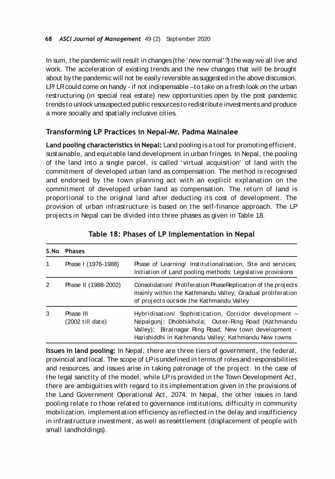
68 ASCI Journal of Management 49 (2) September 2020
In sum, the pandemic will result in changes (the ‘new normal’?) the way we all live andwork. The acceleration of existing trends and the new changes that will be broughtabout by the pandemic will not be easily reversible as suggested in the above discussion.LP/LR could come on handy - if not indispensable – to take on a fresh look on the urbanrestructuring (in special real estate) new opportunities open by the post pandemictrends to unlock unsuspected public resources to redistribute investments and producea more socially and spatially inclusive cities.
Transforming LP Practices in Nepal-Mr. Padma Mainalee
Land pooling characteristics in Nepal: Land pooling is a tool for promoting efficient,sustainable, and equitable land development in urban fringes. In Nepal, the poolingof the land into a single parcel, is called ‘virtual acquisition’ of land with thecommitment of developed urban land as compensation. The method is recognisedand endorsed by the town planning act with an explicit explanation on thecommitment of developed urban land as compensation. The return of land isproportional to the original land after deducting its cost of development. Theprovision of urban infrastructure is based on the self-finance approach. The LPprojects in Nepal can be divided into three phases as given in Table 18.
Table 18: Phases of LP Implementation in Nepal
S.No Phases
1 Phase I (1976-1988) Phase of Learning/ Institutionalisation, Site and services;Initiation of Land pooling methods; Legislative provisions
2 Phase II (1988-2002) Consolidation/ Proliferation PhaseReplication of the projectsmainly within the Kathmandu Valley; Gradual proliferationof projects outside the Kathmandu Valley
3 Phase III Hybridisation/ Sophistication, Corridor development –(2002 till date) Nepalgunj; Dhobhikhola; Outer-Ring Road (Kathmandu
Valley); Biratnagar Ring Road; New town development -Harishiddhi in Kathmandu Valley; Kathmandu New towns
Issues in land pooling: In Nepal, there are three tiers of government, the federal,provincial and local. The scope of LP is undefined in terms of roles and responsibilitiesand resources, and issues arise in taking patronage of the project. In the case ofthe legal sanctity of the model, while LP is provided in the Town Development Act,there are ambiguities with regard to its implementation given in the provisions ofthe Land Government Operational Act, 2074. In Nepal, the other issues in landpooling relate to those related to governance institutions, difficulty in communitymobilization, implementation efficiency as reflected in the delay and insufficiencyin infrastructure investment, as well as resettlement (displacement of people withsmall landholdings).

Summary of Paper Presentations 69
Way forward: It is important to document good practices for easy replication. Weneed to upscale from the small projects presently being implemented to megaprojects bringing in the application of the lessons learned from years ofimplementation. It is important to optimise the cost and benefit and make privatecontributions equitable. To avoid delays in the project and the tremendous costimplications, it is important to finalise the financing norms and seed money for theproject. Nepal is in the process of drafting a new urban development act and bywhich there is more clarity on project initiation and completion as well as on therole of the state, municipality, and group of municipalities. On addressing theissue of governance, it is planned to involve thinktanks and experts. For informationdissemination and community mobilisation, a dedicated unit on LP is being planned.It is also recognised that there should be policy intervention to address the issue ofresettlement in LP.
Addressing Safeguard Issues in LP/LR-Mr. R. Viswanathan
ADB safeguard principles: LP/LR is a great tool for urban planners given that it isvoluntary, helps expedite the period of implementation, and benefits thelandowners. To make it the preferred form of land assembly and to move from thepilot stage, there is a need to integrate key principles of safeguards especiallyrelated to participation, transparency, disclosure, inclusion, etc. in the LP/LRprocess. ADB has been working with several countries in planning and designing LPand LR projects in South and South-East Asia viz. Nepal, Bhutan, Vietnam, Philippines,Indonesia etc.
Integrating the safeguard principles in the LP/LR projects enables mainstreamingand promotes fairness, transparency, trust and a strong stakeholder commitment.The integration of these principles, through the establishment of sound proceduresand systems (particularly with regard to the early screening of the project, inclusiveconsultation strategies, restoration of livelihoods, grievance redressal, anddisclosures) helps develop strong partnerships that align with creative synergiesbetween government, development partners, civil society and private sectorinitiatives. In several projects, when these projects go ahead, and land is developed,retrofitting some of these actions as per funding requirements of MultilateralDevelopment Banks (MDBs) become a costly affair. The integration of these principleshence are project enablers and not an additional burden as these ensure projectreadiness for the participation of MDBs and financial institutions.
Safeguard issues in LP/LR: In most LP/LR projects, there are some safeguard issuesencountered. First, is the issue of landowners/ land users who do not voluntarilyparticipate in the LP/LR schemes. For example, if people are not voluntarily optingfor LP then there would be forcible expropriation. There are projects where masterplanning of the area has been done which provide the little option for the landownernot to participate because the continuation of the current land use would be
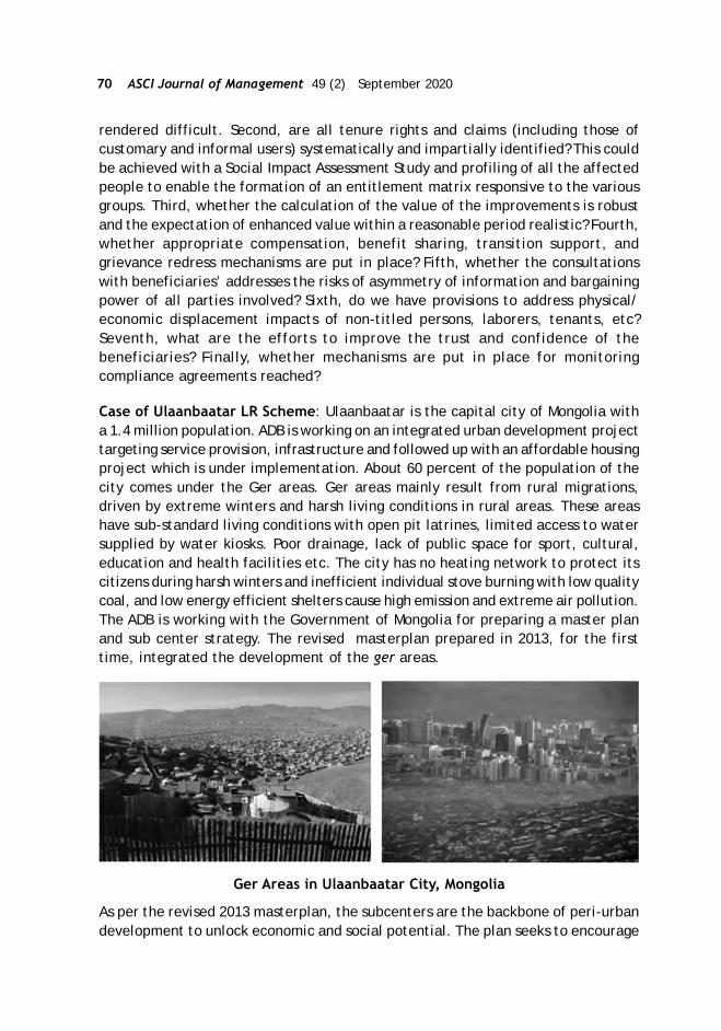
70 ASCI Journal of Management 49 (2) September 2020
rendered difficult. Second, are all tenure rights and claims (including those ofcustomary and informal users) systematically and impartially identified? This couldbe achieved with a Social Impact Assessment Study and profiling of all the affectedpeople to enable the formation of an entitlement matrix responsive to the variousgroups. Third, whether the calculation of the value of the improvements is robustand the expectation of enhanced value within a reasonable period realistic? Fourth,whether appropriate compensation, benefit sharing, transition support, andgrievance redress mechanisms are put in place? Fifth, whether the consultationswith beneficiaries’ addresses the risks of asymmetry of information and bargainingpower of all parties involved? Sixth, do we have provisions to address physical/economic displacement impacts of non-titled persons, laborers, tenants, etc?Seventh, what are the efforts to improve the trust and confidence of thebeneficiaries? Finally, whether mechanisms are put in place for monitoringcompliance agreements reached?
Case of Ulaanbaatar LR Scheme: Ulaanbaatar is the capital city of Mongolia witha 1.4 million population. ADB is working on an integrated urban development projecttargeting service provision, infrastructure and followed up with an affordable housingproject which is under implementation. About 60 percent of the population of thecity comes under the Ger areas. Ger areas mainly result from rural migrations,driven by extreme winters and harsh living conditions in rural areas. These areashave sub-standard living conditions with open pit latrines, limited access to watersupplied by water kiosks. Poor drainage, lack of public space for sport, cultural,education and health facilities etc. The city has no heating network to protect itscitizens during harsh winters and inefficient individual stove burning with low qualitycoal, and low energy efficient shelters cause high emission and extreme air pollution.The ADB is working with the Government of Mongolia for preparing a master planand sub center strategy. The revised masterplan prepared in 2013, for the firsttime, integrated the development of the ger areas.
Ger Areas in Ulaanbaatar City, Mongolia
As per the revised 2013 masterplan, the subcenters are the backbone of peri-urbandevelopment to unlock economic and social potential. The plan seeks to encourage
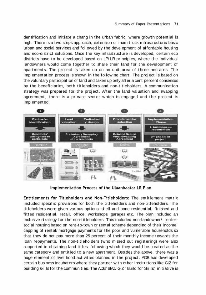
Summary of Paper Presentations 71
densification and initiate a chang in the urban fabric, where growth potential ishigh. There is a two steps approach, extension of main truck infrastructure/basicurban and social services and followed by the development of affordable housingand eco-district solutions. Once the key infrastructure is developed, certain ecodistricts have to be developed based on LP/LR principles, where the individuallandowners would come together to share their land for the development ofapartments. The project is taken up on an unit area of three hectares. Theimplementation process is shown in the following chart. The project is based onthe voluntary participation of land and taken up only after a cent percent consensusby the beneficiaries, both titleholders and non-titleholders. A communicationstrategy was prepared for the project. After the land valuation and swappingagreement, there is a private sector which is engaged and the project isimplemented.
Implementation Process of the Ulaanbaatar LR Plan
Entitlements for Titleholders and Non-Titleholders: The entitlement matrixincluded specific provisions for both the titleholders and non-titleholders. Thetitleholders were given various options; shell and bone residential, finished andfitted residential, retail, office, workshops, garages etc. The plan included aninclusive strategy for the non-titleholders. This included non-landowner/ renter-social housing based on rent-to-town or rental scheme depending of their income,capping of rental/mortgage payments for the poor and vulnerable households sothat they do not pay more than 25 percent of their monthly income towards theloan repayments. The non-titleholders (who missed out registering) were alsosupported in obtaining land titles, following which they would be treated as thesame category and entitled to a new apartment. Besides the above, there was ahuge element of livelihood activities planned in the project. ADB has developedcertain business incubators where they partner with other institutions like GiZ forbuilding skills for the communities. The ADB/BMZ/GIZ “Build for Skills” initiative is

72 ASCI Journal of Management 49 (2) September 2020
being piloted to build technical skills of the local communities to participate in theprogram infrastructure and facilities construction. Further, the Asia FoundationWomen entrepreneurship program will partner with the business incubator operatorto deliver training and capacity support for women entrepreneurs. ADB alsopartnered with the Global Disability Innovation Hub (GDI Hub) to provide technicalsupport the Affordable Housing PMO to support the inclusive design and inclusiveneighbourhoods that support all members of the community.
Way forward: It is important to get the beneficiaries to agree on a project’s value,particularly in countries where there is no precedent of successful LR projects orwhere there is a general distrust for government projects. All LP/LR projects maynot be financially viable on a stand-alone basis and may require support from theGovernment and other sources of funding. It is important to have stakeholderidentification and social assessments/surveys at an initial stage. The consent is nota one-time process but also to be taken multiple times during the LP process so asto avoid coercion. All LP/LR projects should develop measures to benefit non-titled households, tenants, laborers, poor and vulnerable households, women groups,etc. It is also important to build local capacities to handle LP/LR, including impartialand fair valuation of land and assets, participation strategies, monitoring, and aneffective grievance system. It may be a good practice to include organisations thatcan reduce fear and distrust of landowners so as to enhance their understandingand reduce suspicion. Such projects would do well to invest in technology and datamanagement tools, as well as geographic information systems to generate real-time data, information, and analysis. The importance of the documentation of allprocesses, recording of consultations, grievances, agreements reached, etc. needsno emphasis, and this remains more critical for projects with potential funding ofmultilateral institutions. Last but not least, all LP/LR projects should develop andimplement a stakeholder participation/communication strategy throughout projectprocess.

ASCI Journal of Management 49 (2): 73–86Copyright © 2020 Administrative Staff College of India
Section IIISummary of Remarks by Session Chairs and Q & A
Technical Session I -Q and A
How is LR implemented in linear projects?
Mr. KBS Sidhu: In Chandigarh, where they acquired land for the airport, someadditional land in the vicinity of the airport was acquired. The people who hadland within the airport had the choice of either taking compensation in termsof money as per the law or be accommodated in terms of residential plots orsmall commercial sites. In case of highways, some enclaves along the highwaywere acquired. There too, people’s option was sought. One has to distinguishbetween linear developments like roads where there is a natural accretion ofvalue or a canal or a railway line for that matter which bifurcates, crosses theline and actually reduces the value. When huge chunks of land are required forcantonment like an airport, education institution etc. some extra land can beacquired for sharing with affected landowners.
In terms of the core city area where you have heritage structures, how would youreally implement LR?
Prof. Hans Joachim Linke: LR in Germany is typically used for greenfielddevelopment. We use it sometimes for inner city redevelopment but only invery small cases. Typically, we don’t have the practice of destroying of wholequarters. Many years ago, in the 1960s or 70s, we had such developments in theinner city where we destroyed everything and constructed new.
Prof. Rachelle Alterman: LR classically is not suited for the redevelopment. Aclose instrument is the transfer of development rights.
In the context of slum area where the squatters have informal right what percentageof the value of land should be given back?
Prof. Andre Sorensen: I think it will really depend on the individual case, Idon’t think you can prescribe a number that can work everywhere. In someplaces, those squatters have been there for generations in that case, they mayfeel that they have more rights. In some cases, they may have a very strongpolitical voice, and people will have to pay attention to them and in other

74 ASCI Journal of Management 49 (2) September 2020
cases that won’t be the case and they may get less, I think it’s hard to comewith a number, it depends on the politics of the situation, the particular historyof that place, and the nature of the claims that are being made, which can beso diverse.
Remarks by Session Chair, Mr. K.B.S Sidhu, IAS: While we are focusing on LP/LR,we have to place it in a broader context of urbanisation. Urbanisation is an inexorableprocess worldwide and has accelerated in the 20th century and 21st century. Wehave to only channelise it to reap the dividends thereof. From a broader economicperspective, cities are really the powerhouses, and I think the citizens deserve thegood quality of living which is consistent to their contribution as the economy as awhole. How to expand an existing city and how to redevelop etc. are contentiousissues open to debate. There are divergent perspectives on whether you want highrise/low rise, in what direction you want your city to expand, whether you aregoing to have state-led development or going to allow the private colonizers, etc.These debatable issues will lie at the epicenter of the discussions on LP/R.
When it comes to the urban planning process, there is no technically optimal plan.Planning is a political process and reconciliation of conflicting/divergent views ofa wide range of stakeholders including the landowners, other residents of the city,the municipal administration who are going to ultimately maintain the city, thetown planners, the environmental lobby, the land users, etc. The planning processhas to reconcile all these conflicting demands and forces, and only then can it bepractically implemented. If the plan is such which literally divides the public opinion50-50, even if it is good from a technical perspective, it is doomed to be a failure.Thus, there is no ideal plan and there is no plan that contains a solution to all theproblems. We can still can have an optimal plan for development of your town andcity and something which is acceptable to majority of stakeholders, somethingwhich is seen as broadly equitable. Another important issue that should be recognizedearly on is that the landowners are not the only stakeholders in this process. Thepeople who are actually going to buy those flats, the municipal administration thatis going to maintain the facilities, the homeless people for whom the governmenthas framed the policy of affordable housing, the elective representatives in anydemocracy are all part and parcel of the process and all these stakeholders have tobe delicately involved at every stage of the planning process, in making theseschemes take off and plan.
It is also important to recognise that irrespective of whether the implementation iscarried out by a parastatal agency or private colonisers, the state cannot be amute spectator with a hands-off approach. The role of the State is critical as aneutral referee with a regulatory role that ensures that the cake is divided equitably.The challenges are different in the case of greenfield projects or in the case ofredevelopment of a town or a city. In Punjab, we have the Town Improvement TrustAct of 1942 which provides for rebuilding/redeveloping existing inner cities.

Summary of Remarks by Session Chairs and Q and A 75
Experience reveals that while expanding a city/greenfield project has its share ofchallenges, they are nowhere near the challenges that emerge in brownfieldprojects. If we have to really built or unlock the value, we have to look at LP aswell as land exchange. Ultimately, when we assess a particular LP/LR scheme, thecontext, countries, and type of project (greenfield/brownfield) would all bedifferent. We always aim for the perfect, but in policy implementation, the perfectis the worst enemy of very good. If you can achieve something which is very good,it is much better than a perfect plan that never takes off.
One thing that emerges very clearly in different country context is that theinvolvement of the community, whether mandated by law, political imperative ordemocratic principle, is very important at every stage, particularly for the credibilityof the promoter who could be the federal government, local municipal body, urbandevelopment authority, or landowner’s association. The most important aspect whichhas emerged again is how to divide the cake which was the bane of the compulsoryacquisition method that one stakeholder may reap disproportionate dividends. Theother important question is to see how the non-titleholders are to be involved.
Session II – Q and A
Do you think, AP Capital City LP Model is a self-enhanced model?
Dr. Sreedhar Cherukuri: The project was defined to be self-financing. We raisedabout Rs. 2000 crores through bonds. After returning reconstituted plots to thelandowners and other uses, the CRDA was left with 500-600 acres of prime landthat would have fetched a significant amount.
What is the price at which you sold the developed land to the investors?
Dr. Sreedhar Cherukuri: Till date, we haven’t sold any land. We have allottedsome parcels of land to social institutions. The commercial selling of the landwill be initiated only after the development of the infrastructure.
Could you please elaborate a little bit about the skill development programactivities for affected people in the AP Capital City LP area?
Dr. Sreedhar Cherukuri: The concept of Amaravati LP is the LP plus concept.The project developed a comprehensive social security net for all theparticipants in the project. There are around 28,000 farm families (about alakh population). We conducted an elaborate socio-economic survey of all thefamilies as well as focus group discussions at the affected area. We have triedto assess their areas of interest and accordingly trained them. We have alsotied them up with bankers, facilitated in forming their own small companiesand tied up with front end and backend market. We have focused on the women’groups, giving them financial assistance as well as exposure to the markets. We

76 ASCI Journal of Management 49 (2) September 2020
have placed more than 4000-5000 people directly in various jobs and another4000 people have been trained in various fields.
Are there any bureaucratic or legal obstacles to operationally enable the transferof property rights?
Mr. K.B.S Sidhu: The revenue department works in a very specific statutoryframework in India. I do feel that there is a very strong case for bettercoordination between the municipal authorities and the district revenueadministration. However, what is required is a kind of special statute in theurban areas which can confer proprietary rights to people who have beenoccupying small pieces of land for a very long time. While, there are a varietyof such initiatives in the rural areas under the land reforms initiative, there isnone in the urban areas.
Do you think that it is important to keep a proportional value of plots by and largethe same to ensure equity in LP?
Dr. Sreedhar Cherukuri: I think it is a very valid and relevant question, especiallyfrom the AP LP, since the extent of the project is very large, covering about54000 acres of land in 30 villages. From the productivity perspective, too, wehad lands with vastly differential quality that fetched different values in themarket. The villages which were close to an existing urban settlement had highmarket values. In the case of AP LPS, what was ensured was that the returnableplots were not far away from their village in 90-95 percent cases and there aredifferent entitlements for dry and irrigated lands. Also, when we compare withthe typical land acquisition compensation entitlements versus the lowest valueof the returnable plot, it will still be 2-3 times higher.
Mr. K.B.S. Sidhu: In the Mohali LPS, the landowners are given an option to optfor cash compensation. Also, generally, the acquisition is done sector-wise,and within the particular sector, the quality of land would hardly matter. InPunjab, 99 percent of agricultural land is irrigated. Hence, as long as you aregetting a plot within the same sector, you would be quite happy. In terms ofvalue capture, there should be equitable distribution. Among the landowners,there is heartburn if someone is getting a plot with a higher returnable value.These are still work in progress and what we need is to fit in the concerns ofvarious stakeholders and not have a straight jacket approach. However, thereshould not be frequent policy revisions, especially with the retrospective openingup of valuation claims. One has to have a balanced approach, and once thegovernment is seen as a neutral stakeholder, things eventually balance out.
Mr. Vivek Porwal: The difference between land use in agriculture andresidential/ commercial is the chunk of the pie that also has to finance theproject. Beyond a point, we cannot bring such things into consideration. Finally,

Summary of Remarks by Session Chairs and Q and A 77
it is regulatory arbitrage, if there is no regulatory arbitrage, there is no LP.There will be a value capture, and there will be a transfer of value from thepublic to government or implementing agency. That is the essence of a LPproject.
Remarks by Session Chair, Mr. Takeo Ochi: Three aspects are important when wediscuss the future of LP in India. First is the technical aspect relating to land valueassessment method, right conversion method, etc. Second is the financial aspectrelating to sources of project financing including value capture mechanism andbalancing of cost/benefit. The third is the social aspect dealing with educational,health, and other benefits for affected people in the LP area like the Amaravati LPmodel. As in the case of the Punjab LP model, the farmers can select land poolingor land acquisition. It is however, important to recognise that when land priceschange, it is a bit difficult to compare the option that may be the most effectivefor them, especially when land is supplied enough in specific areas where landprices are going down. We, therefore, need various kinds of options, includingoffering alternative land and resettlement.
Session III – Q and A
Is LP/LR only used as an urban planning tool or are there any other uses too?
Dr. Marta Lora: LR is used for infrastructure projects in Spain. Road, highways,etc., are also incorporated in LR plan. The post LR land use could be residentialor industrial.
Dr. Maria Rojas: LR is a tool of urban planning in Columbia. It is a tool forimplementing the master plan of the city and transportation projects withinthe plan are also implemented using LR.
Dr. Sence Turk: In Turkey, the implementation of the detailed local plans isdone through LR. Big infrastructure projects like major highways, airport etc.are not provided by LR. This is because LR is defined within the local area plan.The big infrastructure is either implemented by expropriation or through privatepartnership.
Dr. Felipe De Souza: Historically, it has been used to upgrade agricultural land.Since the last time the law was enacted in 1954, LR has been used for differentpurposes in Japan.
Apart from residential benefits how do you ensure the protection of livelihoods,especially where you are considering pooling of land in the peri-urban area wheretheir livelihood is actually dependent on a land?
Dr. Marta Lora: Livelihood is warranted through statutory regulation, wherepeople are assured of minimum standards for livelihood.

78 ASCI Journal of Management 49 (2) September 2020
Dr. Maria Rojas: The minimum livelihood standards are regulated nationally asalso through the municipality. While these minimums can be increased in themunicipalities willing to solve some of the special problems of the territory,there is no project specific interventions.
Mr. Vivek Porwal: LP/LR is a very voluntary process, every person has theirperception for the future. The Land is an asset that people own, and they havethe choice of trading it for better assets. In Madhya Pradesh, we have pooledland for an industrial purpose, and everyone came forward voluntarily becausethey see a better future by parting with their asset.
Dr. Reshmy Nair: Point well taken. However, the decision made by thelandowners should be an informed one and not because of informationasymmetry.
Are renters also included in beneficiaries in Turkey?
Dr. Sence Turk: Renters are not included in LR in Turkey. In urban renewalprojects, informal settlers are allowed to stay in the area but renters are notincluded in LR system. This is problematic and, in my opinion, renters shouldbe included.
There has been an increase in land contribution ratio across the world. For e.g., InJapan, the contribution ratio had increased from 15 percent in 1930 to 45 percentin 2018. It has been contested there has been opposition in Japan. What has beenthe experience of Turkey?
Dr. Sence Turk: In Turkey, the contribution ratio increased to 45 percent lastyear. Generally, landowners were even against the 35 percent ratio that existedearlier. There were some important legal cases relating to the contributionpercentage. The people do not generally have much say as the administrativecourts support the contribution percentage. Hence, in practice the contributionratio is implemented as per the regulatory framework.
Remarks by Session Chair, Mr. Vivek Porwal, IAS: Land is a scarce resourceand, in any country, there is competing demand over the land. I foresee thesituation is going to continue in the developing country which are industrialisingfast. Dr. Marta Lora has brought out a very critical issue about the financialsustainability of the LP/LR project and what happens when we assemble landand develop but there is no demand. Dr. María Cristina Rojas stressed upon theprivately initiated LR projects. One issue with this priority initiative is thatthey can work only when there is homogeneity in the group, land titles areclear and people have the same perception about the future. To that extent,the scalability remains a question.

Summary of Remarks by Session Chairs and Q and A 79
Session IV-Q and AIn the case of the Magarpatta model, what is the representation of the landownersin the management board? How are they elected, and how are the decisions takenin the company? What are the enabling legal systems which are required forreplicating the Magarpatta Model? In your opinion, can this be suitably adoptedfor agriculture?
Mr. Satish Magar: The entire Board of Directors of the Magarpatta company isrepresentatives of the landowners. All the landowners are shareholders, andthere were no outside shareholders. The board is in the capacity of advisory.The company is totally run and managed by professionals but under the guidanceof the Board. All the major decisions are taken by the 50-member board. I donot think there are any legal issues in replicating the model. It is not difficultto do, and the only question is that you should have the will to do it. It can beadopted in agro-processing, and we have an example in Nasik, Maharashtra.The farmers are members of the stockholding company, and they produce,supply, process, market, and get their dividends from the profit.
What are the risks associated with the Magarpatta project? How were the tenants/agricultural laborers dealt with at the time of LP?
Mr. Satish Magar: There were risks were in the beginning. The marketacceptability was a major risk because farmers coming together for such alarge project was never done before. Regarding the agricultural labours, youhave to see the way they have upgraded themselves. They have all beenintegrated in various jobs, and this was done consciously, as they were part ofthe whole ecosystem. We also included housing in the township, where 15percent of the land was reserved and most families got houses.
One related question that comes in when you say they were benefited was thereany survey in terms of how many such livelihood losers-people who did not havetitle to land were there?
Mr. Satish Magar: There were only farm labourers and no tenants. The farmlabourers were first accommodated because when the construction started in2000, the only people who believed that this could happen because they thoughtthere is no other alternate were the labourer. I would not say 100 percent, but99 percent of them were such people who started working in the project. Theirsecond generation was more educated, and we have the track of all the peoplefrom the past 20 years.
When LP is not initiated by the government, then who takes care of themaintenance?
Mr. Satish Magar: A mechanism was worked out whereby the maintenance ofthe project is being done by the company. The company has asset, and interest,

80 ASCI Journal of Management 49 (2) September 2020
and we get annuity income from that asset. We, therefore, see to it that thewhole area is properly maintained and managed. Though it is not an obligationfor us to manage. We continue to do it to value add and keep the asset valueintact.
Given the height restrictions in Bali and the need to protect farmlands, is thereany specific strategy being thought of for land consolidation and readjustmentschemes?
Dr. Ngakan Ketut Acwin Dwijendra: The problem in Bali is that we cannotbuild more density structures because of the cultural restrictions, and hencethere is more sprawl. Our government is therefore trying to build theinfrastructure to connect within the city.
In cases where there is a lack of collaboration between the Central Governmentand infrastructure providing agencies, there is a poor layout plan as well as itsimplementation, limiting the benefits of LP projects to the landowners. How canthese issues be addressed in future projects?
Dr. Kirti Kusum Joshi: I think the local governments should be at the forefrontof implementing these LP projects. The new Constitution of Nepal also authoriseslocal government/municipalities to take the lead but for some reasons we stillhave federal agencies dominating the scene. I think it is advisable to have thelocal government lead this process.
Since the eligibility for facilitation for Delhi LP model is 2 hectares, what happensto those having less land holdings? Does it lead to lopsided development tiltedtowards the better off? What happens to the 2013 Act which actually providesentitlement to the non-titleholders? How are the Indian LP models fairing in thisregard?
Mr. Jacob Manohar: Lesser than the minimum threshold of two hectares, theywill not be able to develop a smaller plot and hence the thresholds have beenfixed after a lot of consultation.
Dr. Reshmy Nair: There are various alternative models of land assembly beingimplemented in India, land pooling, lease, purchase, etc. However, any executiveinstructions/policy that overrides the statutory right of the landowner (from2013 Act) may not be legally tenable. In Andhra LPS, they give the non-titleholders broadly the same amount as pension as provided for in the 2013Act. Even in Gujarat TPS, judicial pronouncements have upheld the rights ofthe tenants. In India, all due diligences have to be done especially in areaswhere there are a large number of livelihood losers.
How can speculative land hoarding of returned plots or readjusted plots bemanaged, especially when the original landholders/owners of the returned plots
Summary of Remarks by Session Chairs and Q and A 81
of new landowners who buy from the returnable plots have motivation for contrivedland prices. Is there any institutional or legal mechanism?
Ms. Tashi Wangmo: We do have problems of speculation in Bhutan after the LPhas been done and the land has been adjusted. There are landowners, especiallythe big landowners who try to hoard the land to sell the land when the priceincreases. We are trying to deal with this by imposing a higher vacant land tax.While the vacant tax exists now, it is very small for people to feel the pinch. Weare now in the process of reviewing the land taxation policy, and the governmentis trying to increase the vacant land tax.
Dr. Kirti Kusum Joshi: I think this is the biggest weakness of LP projects becausethe original objective of LP project is not to make some people richer.
How do the municipalities and local governments choose between the two toolswhether to go for appropriation or for LP?
Ms. Tashi Wangmo: In the case of Bhutan, we have LP rules and regulationwhich has a criterion for selecting the LP tool. The main criterion is the areaidentified for that preparation of the plan and how much of that is developed.If the area is more than 25 percent developed, then LP cannot be applied. Itactually depends on the local area. If development is scattered, then evenwith more than 25 percent development, LP can be applied. The site determinesthe land planning tool.
Dr. Kirti Kusum Joshi: I think land acquisition for housing projects is an outdatedconcept, and that’s why we are considering LP. Even for projects where landacquisition was exercised like highway development, road broadening etc, LPis being considered in Nepal. LA is increasingly becoming an unpopular option.
Dr. Ngakan Ketut Acwin Dwijendra: It depends on the development projects.In Indonesia, in the case of road projects, generally, we acquire lands. In thecase of housing/settlement projects, LP is used.
After pooling the land, what should be the best price to sell out the reserve lands?
Mr. Jacob Manohar: It depends on the area and forces of demand and supply.
Ms. Tashi Wangmo: In the case of Bhutan, we do keep reserve lands but havenot sold any of the reserved plots so far. If we do sell these plots, we willauction and sell to the maximum price bidder.
Dr. Kirti Kusum Joshi: The minimum prices are fixed on the basis of amenitiesand infrastructure. For example, we have a certain minimum price for landplots which are next to 4m road, 6m road, etc. Ultimately, the land will be soldout through auction.

82 ASCI Journal of Management 49 (2) September 2020
Dr. Ngakan Ketut Acwin Dwijendra: In our case, we already have set up theprice based on zoning. The governments also balance between the localgovernment set price and from the community perspective and arrive at thefinal price.
Remarks by Session Chair, Dr. Girija Vaidyanathan: It is very heartening to knowthat there some are success stories at least and equally heartening to know thatnobody has stopped trying to improve be it Nepal, Bhutan, India or Indonesia, weare all still trying to find a way to balance the needs of the infrastructuredevelopment with the need of the landowner, and I think that is the challenge.Each case is special and separate, and we cannot have ‘one size that fits allapproach’. However, there are issues that were common and very interesting. Someof these include issues of involvement of the local government, issues that thelandowner who stays back is not able to get the same benefit as the one who hasthe capacity to own the land and sell, etc.
Session V
In the case of the land lease/land trust approach, what would happen to thelandowner in case land is taken away, and they wait for dividends which will takeconsiderable time to be paid out?
Prof. Naoyuki Yoshino: The sources of revenue come from two sources; one isuser charges for infrastructure, and the second is increased spillover taxrevenues. In most of the cases, the user charges come in front, and in the worstcase, the infrastructure company can borrow money from banks to pay themfor the first two or three years. Many countries do not have trust banks, unlikeJapan, where there are special trust banks and the central bank provides licenseto banks to function as a trust bank. The central bank monitors the trust functionsof the new section of the bank so that they act as intermediates and are neutralbetween the landowners and users.
In the case of land trust banks, will all the children of the landowner get equalshares of dividend in the future in the trust document?
Prof. Naoyuki Yoshino: This depends on their parents/grandparents and howthey want to share the assets with their children/grandchildren. The Trust bankwill work as per the documents submitted.
Landowners may still refuse to participate, leasing their land. How will the landtrust banks incentivize the participation of the landowner in the leasing scheme?
Prof. Naoyuki Yoshino: If the landowners lend their small piece of land toanother individual, the rent will not be high. However, if there is a new highway/railway line and the land development goes really well, then their revenue willbecome much higher. The benefit for the landowner in land trust cases will be

Summary of Remarks by Session Chairs and Q and A 83
the higher future rate of return from leasing the land. The Trust bank is aneutral body that can watch what the infrastructure operators are doing andcan check if the rent is properly distributed to the owners. Trust bank willintroduce transparency, and when there are many different landowners in theregion, the trust bank can play the role of a neutral negotiator.
Dr. Reshmy Nair: If we look at land leasing in mining or other sectors, then thetrust with the organisation is very important. When an intermediary comes inwhose job is to ensure that the conditions that are agreed upon is met and thelandowners are not taken for a ride, the trust in the process goes up.
Is land leasing the next alternative for land pooling in India?
Dr. Reshmy Nair: Incase of Pavagada, the average landholding was large, in therange of 4.6-5 acres. The lands were largely dry with limited productivity. Itseemed working fine because of the limited return that the landowners couldget from these lands. Given the largely dry, unproductive lands, the livelihoodlosers may have been limited even if they existed. This is one aspect that mayhave to be considered for possible replication. The other aspect that workedfor the model was its ability to leave out lands where the landowners did notwant to dispense with and these largely belonged to those small farmers whohad irrigation facilities. When we go for greenfield projects, the holdouts issueis an acritical one that has to be taken care. All these alternatives are voluntaryand the legal sanctity of the model depends on voluntary consent by thelandowner. However, even when we have wide consultation and incentivizelandowners to actually join, there may be some hard nuts to crack, for whomthe traditional land acquisition process has to be resorted to get the land fromthose holdouts. The other very important part of the Pavagada model was thatthe people benefited from the social and economic infrastructure developmentin the area. Another important aspect that has to be considered for replicationis the need for stringent and effective monitoring arrangement.
Remarks by Session Chair, Dr. Sanjay Kumar: Land is always an emotive issue inIndia. The pressure on the land is growing owing to the increasing population andmeeting the rising infrastructural requirements. LP is a wonderful concept not onlyfor building cities but also for rebuilding old ones. We have old cities like Jaipurand Hyderabad in India, and globally you have cities like Venice and Rome whichhave been ancient civilisations, where there is a need for redevelopment. LP/LR isalso being used for the consolidation of farming land as well as cities ravaged bynatural calamities. The issue of squatters is a universal phenomenon. Land swappingand leasing are interesting concepts with a lot of practical relevance. In the coalbearing acquisitions, we do not know what to do with the mined-out lands as thereis no provision of returning them. The concept of land trust is excellent as it givesa kind of assurance to the stakeholders that their rights are going to be protected.

84 ASCI Journal of Management 49 (2) September 2020
Session VI-Q and A
What are compensation calculation parameters in an LP scheme for linear projects,and how do they differ from non-linear projects?
Dr. Robert Lewis: Depending on the specifics of the case, we have to work outthe details. There are some common elements between linear projects, andnon-linear projects, and the basic one being the use of some kind of premiumon property taxation or fees, some variation on that. Hence, within a certainrange of the development area; a higher charge is arrived at for a fixed periodof time in the inner core area and another charge for a fixed period of time inthe outer core area so as to achieve the uplift in terms of calculating benefits.In non-linear projects, it depends upon the objectives of the project, whetherit is in a high income/low income area, etc. and for the latter, there would bethe need of subsidising through public funds. If it’s a high-income area, thenfrom the percentage value uplift in the properties, we can split the profitbetween cutting around some space for the landowners to contribute to theinfrastructure/public good. However, each case will be different from the otherif you dig deep into the details.
Do we need some legal tool to consider the persons other than having propertyrights in P/R Projects?
Mr. Robert Lewis: It is important to understand that by default, every country,because of their commitment to human rights, is required to respect the rightsof the non-property owners. Though it does not mean that you cannot moveanybody, it does mean that you have to engage with them and consider theadverse impacts that your actions are going to have on them.
Dr. Reshmy Nair: I think this question also relates to how we do it. In the Indiancontext, there is a mandatory Social Impact Assessment study prior to landacquisition, and entitlements exist for non-titleholders as well. However, whenwe adopt alternate land assembly tools like land purchase/lease/pooling, thereis no such requirement. Unless we have a process of identifying such people, itwould be difficult to accommodate their rights/interests.
Mr. Maninder Gill: If you cannot have a regulatory framework, given the hugevariation in context and conditions of every situation, it is time to draw upsome overarching principles of LP, including a systematic social assessment toidentify people who maybe not have strict legal titles but may have otherrights on the land.
Why the Multilateral banks are not so much interested in financing LP/LR projects?
Mr. Maninder Gill: I don’t believe that’s the case. Before we get involved in aLR project, the first question is whether the project is worthwhile with

Summary of Remarks by Session Chairs and Q and A 85
development impacts. If yes, we would be very interested. We are also extremelyinterested in exploring LP/LR as a promising tool, and there are a few examplesfrom across the world where we have been collaborating on such projects.However, we certainly want to do more.
Mr. R. Vishwanathan: I fully agree that the number of LP/LR projects may notbe that significant, and there are several startups in many countries that havenot been taken forward largely owing to certain issues that were not enabling.However, we are certainly keen on expanding/working on projects withalternative land procurement techniques, and Ulaanbaatar, Mongolia, is onesuch project.
Where will the landowners/squatters be temporally resettled while theconstruction is being carried out and will they be provided with rental allowanceand livelihood assistance, insurance for their survival?
Dr. Reshmy Nair: In the AP capital city project, they tried to avoid/minimisedisplacement. For people who were displaced, there was an entitlement matrixincluding annuity provisions or sustenance allowance in a specific LP model inIndia. This was also because of the proposed World Bank funding. This differsfrom case to case.
Mr. Maninder Gill: I think this is more applicable to brownfield developmentbecause the landowners/ squatters are temporarily resettled while constructionis carried out. In Japan, there are temporary allowances for two to three yearswhile the whole area is being redeveloped. It would be safe to say that theyshould be provided with rental allowance and livelihood assistance becausethat’s the only way they are going to participate in the process.
Mr. Vishwanathan: In the case of Ulaanbaatar, Mangolia project they hadbuildings funded, there were transitional housing which were developed aspart of the previous project to house them temporarily, and this was in additionto rental allowances that were provided to all title holders and non-titleholders.And coming to the Indian context, in Mumbai slum redevelopment projects,several of the private developers have an arrangement for payment of rentalallowances for the period between the surrender of the apartment to the dateof the allotment of the apartment.
Mr. Maninder Gill: There was an excellent suggestion from Ms. Aparna Das thatdocumentation of LP experiences by individuals in low income settlements inIndia is missing and that in India, only large projects pushed by public institutionsget documented. She was referring to some models which may not be sostructured and informal but might be working well for people living in these
86 ASCI Journal of Management 49 (2) September 2020
informal settlements. Documentation of such practices is something which weall should consider in going forward.
Remarks by Session Chair, Mr. Maninder Gill: To make LP better, more sustainable,and to improve its scale, what are the institutional dimensions? Presently, what isthe relative use of LP compared to land acquisition? How far are we to make itmore mainstream, and what can we do to ensure a more mainstream approach touse LP? The voluntary nature is the one thing that distinguishes it from landacquisition. What do we need to make it truly voluntary is to enhance theparticipative processes and involvement of all the affected people, and when wedo that, how does it interfere with the timeline? One of the strengths of LP is ashorter timeline, and it remains to be seen if the voluntary participatory processadversely impacts that advantage of LPs. Another point that is emphasisedrepeatedly in all the models is the need for transparency. Can we agree on somekey principles of participation that can be codified as part of the LP process, justas the technical parts? Are there any key principles we need to further solidify andmake more mainstream? Another fascinating issue in the Indian context is that ofthe third party and vulnerable groups who may not be landowners. How do weinvolve them so as to make sure that they don’t lose out in the process? They tooare key stakeholders, and as we build support for LP/LR, it will be important toaddress their issues and have some durable principles on how to make thembeneficiaries in the process. Another question is the liquidity issues in the transitionperiod.
The participants of the LP process may be struck for 2-3 years before drawing thebenefits of the developed plot and we need to build on the existing practices toaddress issues faced by the participants during the transition period. What aboutmaking the affected people the permanent shareholders in the process? Can therebe any regulatory bodies or any institutional entities that play a role in making surethat all LP practices in a country are adhering to the key principles of the LPprocess? As we discuss the technical aspects of LP, can we also keep our minds opento how do we take this forward and mainstream LP as part of the developmentprocess?
ASCI Journal of Management 49 (2): 87–177Copyright © 2020 Administrative Staff College of India
Section IVConference Papers
Takeo Ochi*
A Global Perspective of Land Readjustment
Abstract
This paper covers the geographical spread of LP/LR worldwide, the progress inimplementation, enactment of specific legislation in different countries, how LP/LR was disseminated in Asia and Latin America, and the key essence of LP/LR. Thefour essential principles are extracted from the international implementationexperiences of LP/LR.
Global Expansion of LR
There are several countries that have LP covered in their legislation, includingColumbia (1989), and Argentina (2012) in South America; Germany (1902), Turkey(1930), Israel (1936), France (1967), Greece (1979), Switzerland (1979), Finland(1995), Spain (1956), and Sweden (2012) in Europe; and India (1915), Japan (1919),Taiwan (1930), South Korea (1934), Indonesia (1985), Nepal (1988), China (2001),Thailand (2004), Bhutan (2007)1 in Asia. There are other countries which have notenacted a legislation to facilitate LR but have some experiences implementingthese projects. These include the United States of America, Brazil (South America),Angola (Africa) and Afghanistan, Philippines, and Vietnam (Asia). Many countriesthat used agricultural land consolidation methods applied the same principles tothe urban areas. Figure 1 shows the global map reflecting the dissemination ofLand Readjustment (LR)/Land Pooling (LP) across the continents.
* Senior Advisor, Japan International Cooperation Agency.Email: [email protected]
1 Figures in parenthesis reflect the year of origin of the legislation.
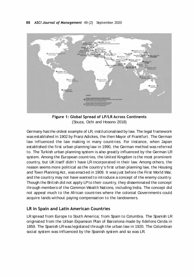
88 ASCI Journal of Management 49 (2) September 2020
Figure 1: Global Spread of LP/LR Across Continents(Souza, Ochi and Hosono 2018)
Germany has the oldest example of LR, institutionalised by law. The legal frameworkwas established in 1902 by Franz Adickes, the then Mayor of Frankfurt. The Germanlaw influenced the law making in many countries. For instance, when Japanestablished the first urban planning law in 1990, the German method was referredto. The Turkish urban planning system is also greatly influenced by the German LRsystem. Among the European countries, the United Kingdom is the most prominentcountry, but UK itself didn’t have LR incorporated in their law. Among others, thereason seems more political as the country’s first urban planning law, the Housingand Town Planning Act, was enacted in 1909. It was just before the First World War,and the country may not have wanted to introduce a concept of the enemy country.Though the British did not apply LP to their country, they disseminated the conceptthrough members of the Common Wealth Nations, including India. The concept didnot appeal much to the African countries where the colonial Governments couldacquire lands without paying compensation to the landowners.
LR in Spain and Latin American Countries
LR spread from Europe to South America; from Spain to Columbia. The Spanish LRoriginated from the Urban Expansion Plan of Barcelona made by Ildefons Cerda in1859. The Spanish LR was legislated through the urban law in 1920. The Columbiansocial system was influenced by the Spanish system and so was LR.

Conference Papers 89
Figure 2: Barcelona Extension Plan by Ildefons Cerda (1859) (Behind Four Walls)
The concept was introduced in Columbia by Law 9, the Urban Reform Law in 1989,followed by Law No. 388, the Territorial Development Law in 1997, which is thebasic law for the current Columbian urban planning. Though the law stipulated LR,the practical dimensions for its implementation was still unknown in the country.During the period from 1998 to 2003, the Columbians learned the nuances ofimplementation from the Japanese system. In the following years, they modifiedthe Japanese LR method and established their own system. Columbia is presentlydisseminating its system to neighboring countries like Costa Rica and Brazil.
LR from Japan to Asian Countries
Japan has disseminated the concept and methodology of LR primarily to the Asiancountries except for Korea and Taiwan (that were colonised by Japan before theSecond World War). The export of LR to Asian countries started in the 1980s. Thetarget countries included Indonesia, Thailand, Nepal, Mongolia, Vietnam, andAfghanistan. The Japanese type of LR was also studied in the Philippines andMalaysia. Presently, LR is at a learning stage in Vietnam, where experimental projectssupported by the World Bank are being implemented. Bhutan first learned theconcept from Nepal, and then, they incorporated the Japanese method to theirsystem in the recent years.
LR in East Asian Developing Countries
The 1980s was the beginning of internationalisation of LR/LP. During the 1980s, theAsian countries, especially the South-East Asian countries, which experienced asharp population increase in large cities in the 70s due to the migration from ruralto urban, initiated an intensive study and research on LR. This was triggered by theInternational Conference on Land Consolidation in Taiwan, 1979, organised by theWorld Bank, Lincoln Institute of Land Policy, and the Taiwan Training Center ofLand Reform. The base for the debate was the seminal research work of Professor
90 ASCI Journal of Management 49 (2) September 2020
William Doebele from the Harvard University (1976) focusing on the financialstructure of LR viz how the increased land value brought by the project can beused to cover the project cost. Countries that participated in this conference wereAustralia, China, then West Germany, Hongkong, India, Indonesia, Malaysia, Thailand,Philippines, Papua New Guinea, the US, South Korea, and Japan. After theConference, the terminology of ‘Land Readjustment’ became common. Since then,the Conference was conducted every two years, the last such conference held in2002 in Osaka, Japan. With the urban expansion and increasing demand for housingand infrastructure, there are three focus areas for the developing countries; first,the value capture mechanism that is inbuilt in LR models viz landowners/beneficiaries pay for the project cost; second, land necessary for infrastructuredevelopment can be secured by LR projects and third, as a countermeasure forsquatter issues.
Japan and JICA’s Contribution to the Expansion of LR in Asia
In the 1980s, as the South East Asian countries seriously studied the application ofLR, Japan extended support by dispatching the experts to various countries forproviding technical support for the implementation of the pilot projects. Since1983, the Japan International Cooperation Agency (JICA) has been offering LRtraining program every year. 416 people from 66 countries have participated in thisprogram from 1983 to 2019. The countries that established their own LR system asa result of this outreach include Indonesia, Nepal, Bhutan, Thailand, Mongolia andColumbia. LR in Indonesia was based on agricultural land consolidation. The firsturban land consolidation project was implemented in 1979 in Denpasar city, Bali(the year in which the country participated in the International Conference onLand Consolidation in Taiwan). It can be pointed out that the current primarychallenges of LP/LR in the developing countries are (1) application of LP/LR to theredevelopment of urban centers, (2) the participation of the private sector inprojects, particularly as an investor and (3) the linkage with urban planning. Somecountry-wise experience following the JICA outreach programs and support areoutlined below:
Nepal: The first land pooling project in Nepal was a road expansion project inPokhara in 1976. In 1988, the LP was legislated by the Urban Development Act.Nepal introduced the Japanese type of LR in 1992 and joined JICA LR trainingprograms for Nepal in 1995 and 1996. The participants in these training programsdrove a dozen LP projects in Kathmandu Valley in the 90s, which led to the expansionof its implementation across the country in the 2000s. Until 2010, LP projects wereimplemented in 17 cities outside of Kathmandu. LR in Nepal is mainly implementedin urban fringes through the conversion of land from agricultural land to residentialland. Figure 3 shows Bhaktapur, the World Heritage Old Capital, 12 km east of thecenter of Kathmandu. It can be recognized that the outside of the old capital hasbeen developed mainly by LP. Nepal is now applying LP to 50 km2 of large-scale newtown development in a suburb of Kathmandu and outer ring road development.

Conference Papers 91
Figure 3: Bhaktapur LP Project, Nepal.
Thailand: In Thailand, the Government seriously studied LR in the 90s and enactedthe LR Act in 2004. The primary urban issue in the country is that there are so manyland parcels without road access. LR has therefore been used to improve the roadnetwork and access. Following 10 pilot LR projects in the 2000s, they have beenimplementing LR projects across the country. Thailand promotes LR projects underthe ‘One Province-One Project Policy.’ i.e., at least one LR project is to beimplemented in one province. Under the policy, the construction cost of trunkroads designated by a comprehensive urban plan is covered by the national subsidy.Besides, the central government (Department of Public Works and Town & CountryPlanning, Ministry of Interior) offers financial support (loan and subsidy) to projectsthrough the LR fund. So far, 54 projects have been executed in 45 provinces. Theproject implementation entities are mainly governments except for one project inBangkok implemented by a landowners’ association with technical support fromthe Bangkok Metropolitan Administration (BMA). Like Nepal, LR in Thailand is mainlyimplemented in urban fringes. Figure 4 shows the Yala LR project located in thesouthern part of Thailand. The project was completed during the period 2008-12.It had a project area of 54 ha belonging to 101 landowners and a land contribution
Figure 4: Yala LR Project, Thailand (DPTC)

92 ASCI Journal of Management 49 (2) September 2020
ratio of 19.8 percent (17.6 percent for infrastructure and 2.2 percent for reserveland). The department developed LR textbooks for its LR training programs forlocal government staff and brochures and videos for potential landowners to promoteLR all over the country.
Bhutan: Influenced by the LP experiences in Nepal, Bhutan started implementingthese projects in the early 2000s. LR was applied when Bhutan developed localarea plans (LAPs) of the expanded city of Thimphu, the capital of Bhutan, when thecity area increased from 8 km2 to 26 km2. The government enacted the LP legislationin 2007. However, it was not a smooth road. The reason why Bhutan employed LP asa tool to implement LAPs in Thimphu was the increasing difficulty associated withland expropriation for public works. It was because (1) the land purchase price(public price) was very cheap compared to the market value, (2) farmers werereluctant to give away their land, and (3) land speculation happened when thegovernment tried to acquire land. When the government initiated to make LAPs inThimphu city, they faced strong objections from landowners. In 2003, the supremecourt ruled that LP was illegal, which means land contribution without compensationwas illegal. After this, the government paid lots of effort to spread awarenessamong the people about LR. They held many consultation meetings with citizensand was finally successful. This took about five to six years. Since then, Thimphumunicipal government has been implementing 14 LP projects, the average areasize and land contribution ratio is 53 ha and 26.8 percent, respectively. These LPprojects have been financially supported by the ADB and World Bank. In the past LPprojects, the land contribution ratios of all the land parcels were the same andthere were no projects that secured reserve land to recover the project costs. Inorder to make project implementation more sustainable, the government(Department of Housing and Human Settlement (DHS), Ministry of Works and HumanSettlement) amended the LR Rule, 2007 in 2018 to abolish the 30 percent landcontribution ratio ceiling. The amendment also provided that a LP project shouldsecure land contribution from the project cost and a project financial plan shouldbe clearly shown and local governments are eligible to dispose of the reserve land.Figure 5 shows the Taba LP project in Thimphu city with a project area of 89 ha anda land contribution ratio of 28.5 percent.
Mongolia: In Mongolia, LP was initiated as an urban redevelopment tool in the cityof Ulaanbaatar. It was only seven years earlier that government initiated urbanredevelopment works. People settle down in Ulaanbaatar city with traditionalportable houses called Ger and they call this new settlement as Ger area, whereabout 60 percent of 1.45 million of the city population (2017) is living. The Gerareas have no utility supply except electricity, while the central areas are equippedwith all utilities including hot water for heating for long and severe winter. Peopleliving in ger areas need to go buy drinking water at a kiosk, which is a tough job,especially in extremely cold winter for children. They dig a hole in their yards as atoilet and dig another hole when the previous one is full, which contaminatesunderground water. As a countermeasure, since 2013, the Ulaanbaatar city
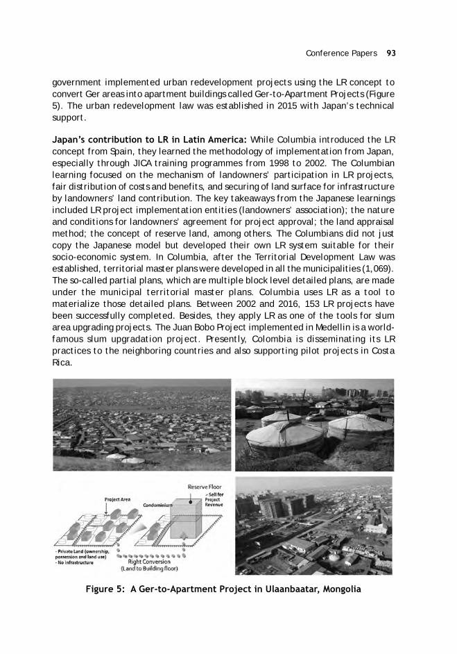
Conference Papers 93
government implemented urban redevelopment projects using the LR concept toconvert Ger areas into apartment buildings called Ger-to-Apartment Projects (Figure5). The urban redevelopment law was established in 2015 with Japan’s technicalsupport.
Japan’s contribution to LR in Latin America: While Columbia introduced the LRconcept from Spain, they learned the methodology of implementation from Japan,especially through JICA training programmes from 1998 to 2002. The Columbianlearning focused on the mechanism of landowners’ participation in LR projects,fair distribution of costs and benefits, and securing of land surface for infrastructureby landowners’ land contribution. The key takeaways from the Japanese learningsincluded LR project implementation entities (landowners’ association); the natureand conditions for landowners’ agreement for project approval; the land appraisalmethod; the concept of reserve land, among others. The Columbians did not justcopy the Japanese model but developed their own LR system suitable for theirsocio-economic system. In Columbia, after the Territorial Development Law wasestablished, territorial master plans were developed in all the municipalities (1,069).The so-called partial plans, which are multiple block level detailed plans, are madeunder the municipal territorial master plans. Columbia uses LR as a tool tomaterialize those detailed plans. Between 2002 and 2016, 153 LR projects havebeen successfully completed. Besides, they apply LR as one of the tools for slumarea upgrading projects. The Juan Bobo Project implemented in Medellin is a world-famous slum upgradation project. Presently, Colombia is disseminating its LRpractices to the neighboring countries and also supporting pilot projects in CostaRica.
Figure 5: A Ger-to-Apartment Project in Ulaanbaatar, Mongolia
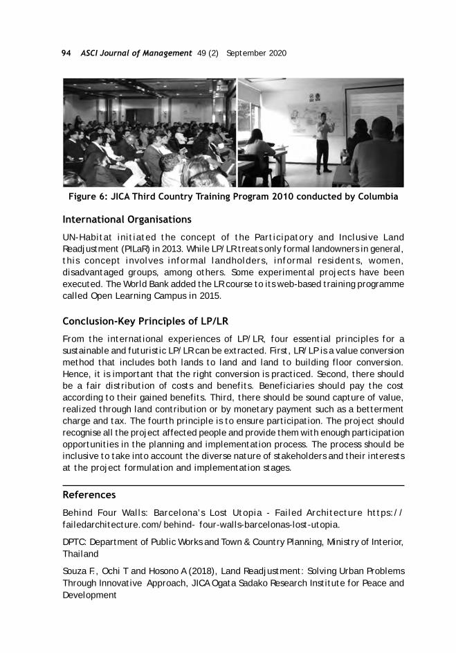
94 ASCI Journal of Management 49 (2) September 2020
Figure 6: JICA Third Country Training Program 2010 conducted by Columbia
International Organisations
UN-Habitat initiated the concept of the Participatory and Inclusive LandReadjustment (PILaR) in 2013. While LP/LR treats only formal landowners in general,this concept involves informal landholders, informal residents, women,disadvantaged groups, among others. Some experimental projects have beenexecuted. The World Bank added the LR course to its web-based training programmecalled Open Learning Campus in 2015.
Conclusion-Key Principles of LP/LR
From the international experiences of LP/LR, four essential principles for asustainable and futuristic LP/LR can be extracted. First, LR/LP is a value conversionmethod that includes both lands to land and land to building floor conversion.Hence, it is important that the right conversion is practiced. Second, there shouldbe a fair distribution of costs and benefits. Beneficiaries should pay the costaccording to their gained benefits. Third, there should be sound capture of value,realized through land contribution or by monetary payment such as a bettermentcharge and tax. The fourth principle is to ensure participation. The project shouldrecognise all the project affected people and provide them with enough participationopportunities in the planning and implementation process. The process should beinclusive to take into account the diverse nature of stakeholders and their interestsat the project formulation and implementation stages.
References
Behind Four Walls: Barcelona’s Lost Utopia - Failed Architecture https://failedarchitecture.com/behind- four-walls-barcelonas-lost-utopia.
DPTC: Department of Public Works and Town & Country Planning, Ministry of Interior,Thailand
Souza F., Ochi T and Hosono A (2018), Land Readjustment: Solving Urban ProblemsThrough Innovative Approach, JICA Ogata Sadako Research Institute for Peace andDevelopment

Conference Papers 95
Linke, Hans-Joachim*; Bretscher, Raphael**
Land Readjustment in Germany - Special Aspects and Practical Experience
History of Land Readjustment in Germany
In the 19th century, as industrialisation progressed at a brisk pace, there was arapid increase in the population of German cities. Accordingly, a lot of living spacewas needed in a short time, so private investors came forth to invest in urbanexpansions. This was essentially carried out in areas where they could acquire landand not where it would have made sense in terms of sustainable urban development.In fact, there was no structured urban development during this period. Also, thefocus of the private investors was primarily on optimising profits and not in creatinghealthy living and working conditions. Many of the twenty-five former states of theGerman Empire started at first by passing laws against harmful building constructionand then using laws to control urban development. In addition to the need forurban land-use plans for the development of building areas, there was also theneed to develop a Land Readjustment (LR) instrument, which ensured that theplots of land were rearranged for appropriate building construction. Prior to this,the rearrangement of land plots were sometimes managed with the rural landconsolidation law, which had existed and been applied since the beginning of the19th century (Bonczek, 1978, p. 82). In other cases, LR was initially only carriedout on a voluntary basis that often failed due to the unwillingness of a few landownersto cooperate. In 1902, a law for LR was passed in the state of Prussia, initially onlyfor the city of Frankfurt, famously called “Lex Adickes” after the name of itsarchitect, the then-mayor of Frankfurt. The law made it possible to carry out LRprojects even against the will of the landowners. Other states of the former Germanempire followed that example and developed their own laws for LR. It was only in1960 that LR was standardised in West Germany by the enactment of the FederalBuilding Act. With the exception of minor adjustments, these regulations arepresently applied in practice in building land development in Germany.
LR Process
In the overall context of building land development, readjustment of land manifeststhe requirements of urban land use planning and enables the subsequent creationof public infrastructure and buildings. It is thus a major pillar in the process ofbuilding land development. Readjustment of land can be carried out either on aprivate-law basis using appropriate models, such as the finalisation of a notarisedpurchase, division or exchange contracts by the landowners or by sovereign
* Professor for Land Management, Technical University Darmstadt, Germany.E-mail: [email protected]
** Research Associate, Department of Land Management, Technical UniversityDarmstadt, Germany. E-mail: [email protected]
96 ASCI Journal of Management 49 (2) September 2020
procedures such as readjustment or expropriation. In Germany, experience hasshown that landowners are only able to reach a private-law agreement in verysimple cases. Usually, a sovereign LR process is preferred so that the mediationand management process happens smoothly.
Officially, the LR process starts with the direction of the municipality to the LRdepartment to initiate the readjustment process. At the same time, the bindingland-use plan will be prepared. In Germany, such a parallel procedure of preparinga new binding land use plan and performing LR is normal because of the possibilityof influencing the framework of the new binding land-use plan according to theresults of the negotiations between the LR institution and the landowner. Afterthis, LR is initiated by a resolution adopted by the readjustment department. Beforetaking this step, the landowners have to be heard. This promotes the landowners’acceptance of land readjustment and gives the LR institution its first indications asto which further uses the individual landowners intend. By displaying the as-builtmap and the inventory of the parcels that registers all facts as per the land cadastrein the municipality for a period of one month, the LR adjustment departmentprovides all parties with a comprehensive and applicable overview of the true andlegal relationships, which is the basis for the readjustment. A discussion and hearingwith all the affected parties follow, and efforts are made to reach an understandingof all their interests. Before the LR plan that indicates the new utilisation with theactual and legal changes of the subjected plots is set up, the binding land-use planhas to come into force. Also, there is a public announcement of the decisions in theLR plan, providing the landowners with another opportunity for legal recourse. Ifall legal recourses are eliminated, the LR plan comes into force with the publicannouncement of the indefeasibility.
Principles of LR
To be subsumed as a legal LR instrument, the following principles must be fulfilled,according to Seele (1982). In this context, the rule of private use is generallyabsolute, and the other rules must at least be fulfilled without discretionary error.
Rule of private use:
The readjustment is mainly in the interest of the landowner, and that person willbe able to use the land according to the legally binding land-use plan. LR is not anexpropriation, although it also serves public interests, such as the realisation ofthe urban development concept (e.g., binding land-use plan). It is predominantlyand primarily aimed at balancing the private interests of the landowners. It isintended to enable them to use their land for building houses even in cases wherethey cannot themselves agree on the necessary readjustment. In simple terms, theLR can thus be understood as state help for self-help, since it pursues the well-understood, objective interests of an economically thinking landowner. The public
Conference Papers 97
authority (e.g., municipality), which is the responsible body for the proceedings,thus merely replaces the lack of agreement between the landowners in a private-law agreement.
Rule of conformity
The legal status of the land will be adjusted according to the designations of thebinding land-use plan or the built-up areas by changing the boundaries.The purposeof LR is to rearrange the existing plots of land in such a way that they are suitablefor building houses or other uses. In doing so, the boundaries of the plots of landmust be altered in terms of location, shape and/or size in such a way that they canbe used according to the binding land-use plan. In the past, LR was mostly appliedto developing agricultural land into building land. However, it can also be used forredeveloping building land areas (e.g., brownfield development) or to re-densifyexisting settlement areas.
Rule of solidarity
All landowners must contribute part of their land to the installation of local publicinfrastructure, in proportion to the advantage received from this infrastructure.Only after the necessary local public areas for roads, paths, etc. are designated isit possible to build houses on the private plots. Accordingly, the local publicinfrastructure gives the landowners an economic advantage. At the same time,these public uses are generally located on plots that were previously only usedprivately, according to earlier planning requirements. In order to compensate forthese unequal advantages among the landowners, all the landowners benefitingfrom the areas for public use contribute them jointly, in proportion to the advantagethey receive in the LR. In addition to local public infrastructure, landowners mustalso provide all other areas that are mainly intended to serve the needs of thefuture inhabitants of the LR (pre-deduction). The landowners usually provide theland free of charge, so that levying contributions for land acquisition after a LRprocedure is unnecessary. Areas for other public uses, such as kindergartens andschools, can only be provided in the LR if the respective public authority (e.g.,municipality) provides suitable alternative land within or outside the LR area.
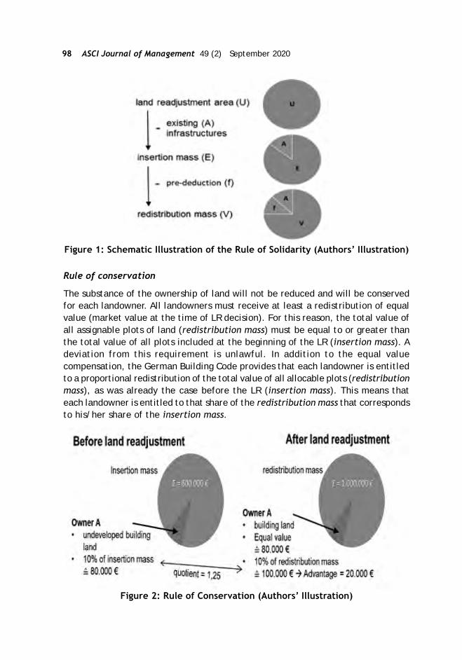
98 ASCI Journal of Management 49 (2) September 2020
Figure 1: Schematic Illustration of the Rule of Solidarity (Authors’ Illustration)
Rule of conservation
The substance of the ownership of land will not be reduced and will be conservedfor each landowner. All landowners must receive at least a redistribution of equalvalue (market value at the time of LR decision). For this reason, the total value ofall assignable plots of land (redistribution mass) must be equal to or greater thanthe total value of all plots included at the beginning of the LR (insertion mass). Adeviation from this requirement is unlawful. In addition to the equal valuecompensation, the German Building Code provides that each landowner is entitledto a proportional redistribution of the total value of all allocable plots (redistributionmass), as was already the case before the LR (insertion mass). This means thateach landowner is entitled to that share of the redistribution mass that correspondsto his/her share of the insertion mass.
Figure 2: Rule of Conservation (Authors’ Illustration)

Conference Papers 99
Rule of surrogation
The rights relating to former parcels are transferred to the parcels newly allocatedto the landowner unless they are locally bound. In many cases, rights andencumbrances (e.g., rights of way for third parties or mortgages) still rest on parcels.These property-related rights are transferred to the parcels newly assigned to thelandowner unless these rights are locally bound (e.g., a right to draw water).
Value of Land at Different Levels of Building Land Development (qualities)
In Germany, parcels could have four separate development qualities in the buildingland process before the completion of buildings. Agricultural land is usable only foragricultural or forestry purposes. With the designation of construction areas in thepreparatory land-use plan, agricultural land becomes land with building landexpectations. The benefit of urban development will be shared between thelandowner and the municipality. The landowner receives the increase in value byplanning (value of undeveloped building land minus value of agricultural land. Theundeveloped building land is defined as land that will be developed into buildingland in the future due to an existing binding land-use plan. Only the LR and theconstruction of the local public infrastructure (e.g., roads and other technicalinfrastructure) are left. The municipality receives the increase in value caused byLR itself (value of building land minus value of undeveloped building land – Figure4?) as well as the increase in value caused by the cost of building publicinfrastructure, which the landowners pay directly (Figure 4?). The increase of valueby LR is typically similar to the costs the landowners would have to pay if theydeveloped the land by themselves. Then, they have to arrange sales contractsbetween all parties as well as construct the boundaries of the new building landparcels. This process normally needs more time than to get the same result by LR.Therefore, the landowners receive interest advantages by LR. Thus, landownersare often interested in obtaining new building land by LR.
Figure 3: Value Increase through Several Development Qualities(Authors’ Illustration)
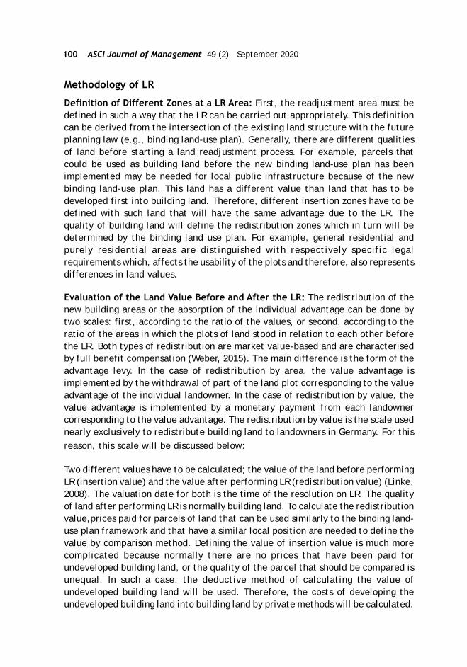
100 ASCI Journal of Management 49 (2) September 2020
Methodology of LR
Definition of Different Zones at a LR Area: First, the readjustment area must bedefined in such a way that the LR can be carried out appropriately. This definitioncan be derived from the intersection of the existing land structure with the futureplanning law (e.g., binding land-use plan). Generally, there are different qualitiesof land before starting a land readjustment process. For example, parcels thatcould be used as building land before the new binding land-use plan has beenimplemented may be needed for local public infrastructure because of the newbinding land-use plan. This land has a different value than land that has to bedeveloped first into building land. Therefore, different insertion zones have to bedefined with such land that will have the same advantage due to the LR. Thequality of building land will define the redistribution zones which in turn will bedetermined by the binding land use plan. For example, general residential andpurely residential areas are distinguished with respectively specific legalrequirements which, affects the usability of the plots and therefore, also representsdifferences in land values.
Evaluation of the Land Value Before and After the LR: The redistribution of thenew building areas or the absorption of the individual advantage can be done bytwo scales: first, according to the ratio of the values, or second, according to theratio of the areas in which the plots of land stood in relation to each other beforethe LR. Both types of redistribution are market value-based and are characterisedby full benefit compensation (Weber, 2015). The main difference is the form of theadvantage levy. In the case of redistribution by area, the value advantage isimplemented by the withdrawal of part of the land plot corresponding to the valueadvantage of the individual landowner. In the case of redistribution by value, thevalue advantage is implemented by a monetary payment from each landownercorresponding to the value advantage. The redistribution by value is the scale usednearly exclusively to redistribute building land to landowners in Germany. For thisreason, this scale will be discussed below:
Two different values have to be calculated; the value of the land before performingLR (insertion value) and the value after performing LR (redistribution value) (Linke,2008). The valuation date for both is the time of the resolution on LR. The qualityof land after performing LR is normally building land. To calculate the redistributionvalue,prices paid for parcels of land that can be used similarly to the binding land-use plan framework and that have a similar local position are needed to define thevalue by comparison method. Defining the value of insertion value is much morecomplicated because normally there are no prices that have been paid forundeveloped building land, or the quality of the parcel that should be compared isunequal. In such a case, the deductive method of calculating the value ofundeveloped building land will be used. Therefore, the costs of developing theundeveloped building land into building land by private methods will be calculated.

Conference Papers 101
The price of undeveloped building land is determined by the price of the similarbuilding land, the time needed to develop the land (waiting time), the costs forthe land needed for local public infrastructure (site development costs), and thecosts for the development into building land (development costs). During the waitingtime, the interest of the capital bounded in the land (property yield) has to betaken into account as well.
Figure 4: Evaluation of the Land Value before andafter Land Readjustment
Redistribution of New Parcels: The distribution quotient (q) is to be determinedaccording to the determined insertion value (IV €/m2) and redistribution value (DV€/m2). This results from the ratio of the value of the total redistribution mass (D€) tothe value of the total insertion mass (I€).
q = D€
I€
with: I€ = (Im2 * IV€/m2)
D€ = ( Dm2 * DV€/m2)
Such a uniform distribution quotient for all plots in the LR area presupposes thatall plots receive a uniform redistribution-related advantage. In practice, such asimple case hardly ever exists. In cases of inhomogeneous insertion qualities, thereadjusted area must be divided into different insertion zones (cf. Cape. 5.1) andmay require the use of separate distribution quotas. In principle, when calculatingthe redistribution quotient, it has to be ensured that it is at least one or more inorder to the rule of conservation (cf. Cape. 3.4).
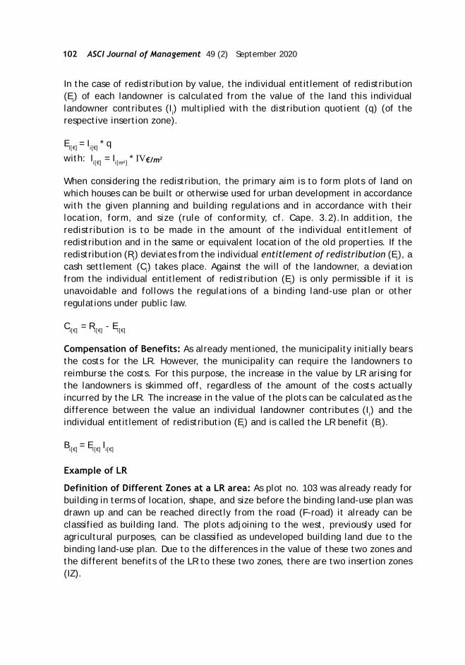
102 ASCI Journal of Management 49 (2) September 2020
In the case of redistribution by value, the individual entitlement of redistribution(Ei) of each landowner is calculated from the value of the land this individuallandowner contributes (Ii) multiplied with the distribution quotient (q) (of therespective insertion zone).
Ei[€] = Ii[€] * q
with: Ii[€] = Ii[m²] * IV€/m2
When considering the redistribution, the primary aim is to form plots of land onwhich houses can be built or otherwise used for urban development in accordancewith the given planning and building regulations and in accordance with theirlocation, form, and size (rule of conformity, cf. Cape. 3.2).In addition, theredistribution is to be made in the amount of the individual entitlement ofredistribution and in the same or equivalent location of the old properties. If theredistribution (Ri) deviates from the individual entitlement of redistribution (Ei), acash settlement (Ci) takes place. Against the will of the landowner, a deviationfrom the individual entitlement of redistribution (Ei) is only permissible if it isunavoidable and follows the regulations of a binding land-use plan or otherregulations under public law.
Ci[€] = Ri[€] - Ei[€]
Compensation of Benefits: As already mentioned, the municipality initially bearsthe costs for the LR. However, the municipality can require the landowners toreimburse the costs. For this purpose, the increase in the value by LR arising forthe landowners is skimmed off, regardless of the amount of the costs actuallyincurred by the LR. The increase in the value of the plots can be calculated as thedifference between the value an individual landowner contributes (Ii) and theindividual entitlement of redistribution (Ei) and is called the LR benefit (Bi).
Bi[€] = Ei[€] Ii[€]
Example of LR
Definition of Different Zones at a LR area: As plot no. 103 was already ready forbuilding in terms of location, shape, and size before the binding land-use plan wasdrawn up and can be reached directly from the road (F-road) it already can beclassified as building land. The plots adjoining to the west, previously used foragricultural purposes, can be classified as undeveloped building land due to thebinding land-use plan. Due to the differences in the value of these two zones andthe different benefits of the LR to these two zones, there are two insertion zones(IZ).

Conference Papers 103
Figure 5: Determination of Insertion Zones (Author’s Illustration)
In the example, two redistribution zones have to be formed. The first is theredistribution zones RZI, which comprises the two plots along the F-road that havebeen defined as a general residential area, and the second is the redistributionzones RZII, which have been defined as a purely residential area in the bindingland-use plan.
Figure 6: Determination of Redistribution Zones (Authors’ Illustration)

104 ASCI Journal of Management 49 (2) September 2020
Evaluation of the Land Value before and after the LR: Land values for plots in thereadjustment area can be derived from purchase prices for plots in comparableareas using the comparative value method (VBL). In general, the infrastructureconstruction costs (ICC) are deducted from the comparative values for thedetermination of the redistribution value so that no previously paid costs lead toincreased land redistribution. This results in the redistribution value of bothredistribution zones (VBL-ICC). Since the insertion zone I already has the classificationbuilding land before LR, the insertion value is equal to the redistribution value. Forthe insertion value of insertion zone II, the development costs from the classificationof undeveloped building land to the quality building land must be taken into account.This includes (side) development costs (SDC & DC) as well as the discounting withcapital that is bounded in the land (property yield, p) of about 5,5% for undevelopedbuilding land (q = 1+p) and a waiting time until readiness for building (n), shortenedby the LR duration.
Figure 7: Sample Calculation of the Land Value before and after LR
Redistribution of new parcels: At first, the existing infrastructure (A), as well asthe pre-deduction(f) for local public infrastructure has to be determined, and theredistribution mass, as well as the insertion mass has to be calculated (cf. Cape.3.3) to compute the redistribution quotient (q). To simplify the example, thesevalues are given as:
qI = 1,00qII = 1,35
Let’s have a closer look at landowner no. 2 with the parcels number 107 (insertionzone II) and 103 (insertion zone I). At first, the individual value of the contributedland (I2) has to be calculated to compute the individual entitlement of redistribution(E2).
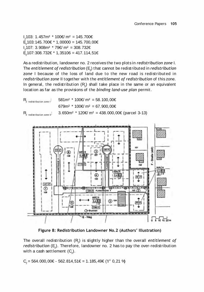
Conference Papers 105
I2103: 1.457m² * 100€/m² = 145.700€E2103:145.700€ * 1,00000 = 145.700,00€I2107: 3.908m² * 79€/m² = 308.732€E2107:308.732€ * 1,35106 = 417.114,51€
As a redistribution, landowner no. 2 receives the two plots in redistribution zone I.The entitlement of redistribution (E2) that cannot be redistributed in redistributionzone I because of the loss of land due to the new road is redistributed inredistribution zone II together with the entitlement of redistribution of this zone.In general, the redistribution (R2) shall take place in the same or an equivalentlocation as far as the provisions of the binding land-use plan permit.
R2 redistribution zone I: 581m² * 100€/m² = 58.100,00€
679m² * 100€/m² = 67.900,00€
R2 redistribution zone II: 3.650m² * 120€/m² = 438.000,00€ (parcel 3-13)
Figure 8: Redistribution Landowner No.2 (Authors’ Illustration)
The overall redistribution (R2) is slightly higher than the overall entitlement ofredistribution (E2). Therefore, landowner no. 2 has to pay the over-redistributionwith a cash settlement (C2).
C2 = 564.000,00€ - 562.814,51€ = 1.185,49€ (Y” 0,21 %)
106 ASCI Journal of Management 49 (2) September 2020
Compensation of Benefits: By carrying out the LR, landowner no.2 receives aneconomic advantage (LR benefit B2), as it saves the costs of private LR. Accordingly,he has to pay compensation to the municipality in the amount of this benefit,which results from the difference between the values of the entitlement ofredistribution (E2) and the individual value of the contributed land (I2).
B2 = 562.814,51€ - 454.432,00€ = 108.382,51€
Current Use of LR in Germany
Surveys from the years 2006 (Linke, 2006) and 2009 (Voß & Weitkamp, 2009); (Voß& Weitkamp, 2010) shown that LR is not applied across the board in Germany. Theinstrument of LR is mostly used in municipalities that have a long experience ofusing land readjustment and have the support of project leaders (their ownemployees, freelancers, or other public organisations). Larger cities like Berlin,Bonn or Frankfurt am Main, for example, have their LR department. Smallermunicipalities without their department use the cadastral administration to carryout their LR projects. Also, publicly appointed surveyors specialised in LR to supportmunicipalities.
One of the biggest problems in the process of building land development is thatdeveloped plots are not used to construct buildings. From the historical model ofurban land development with the steps of developing a binding land-use plan, LR,and constructing of local public infrastructure, there arises no obligation to do so.Especially in areas with large increases in land value due to the current economicsituation, many plots of land are stockpiled as capital investments. For example,in a small city, 30 kilometers to the south of Frankfurt am Main, the land valueincreases by 5 to 10 percent per year. Due to that, there are still many unused plotsfor housing in an area that was readjusted 40 years ago.
To address this issue, the common model that is now advocated and implementedin big cities starts with the urban-development contract, in which the landownersreceive part of the increasing land value through planning. This is in principle, dueto the landowner. Only when the contract is concluded, do the classic steps ofbuilding land development follow. The part-retention of the increase in value byplanning can be justified by the fact that these increases in value are not due toactions of the landowners, so these are unearned profits for them. Moreover,municipalities must pay the development costs of planning. The retained increasesin value could be used for financing social infrastructure, land for social housing,and other beneficial purposes. For example, the City of Munich claims 2/3 of theplanning-related increases in land value for those purposes (Stadt München, 2020).There are also approaches to using LR to increase the provision of land for socialhousing (Kötter & Rehorst, 2019). In connection with readjustment in the newprocess of building land development, many provisions of the urban-development

Conference Papers 107
contract are implemented in the LR process. Therefore, the institutions responsiblefor LR must be involved at an early stage in the negotiations with the landownersand investors. Typically, interdisciplinary working groups are formed to define andto implement this new model of building land development. This includes at leastthe following disciplines:
An urban planner for urban design and the urban land use planning regulations
A lawyer for the legal design of urban development contracts
Land managers for the land readjustment
Real estate valuers for the determination of values
A specialist planner for public infrastructure
A project controller for internal project coordination and as a central contact
person.
Smaller municipalities can consult such working groups to handle such complexservices. With appropriate expertise, one person can also take over some disciplines.In practice, the land manager often assumes the role of real estate valuer andproject controller at the same time, as that person enters into very early andintensive dialogue with the landowners and can thus act as a moderator forparticipants from other disciplines. The knowledge of a land manager shouldtherefore cover a variety of topics, such as comprehensive knowledge of building,planning, and land law, fundamental knowledge of real estate valuation as well asthe ability to negotiate with participants and creativity to find out the optimalmost accepted solution.
References
Bonczek, W. (1978). Stadt und Boden: Boden-Nutzungs-Reform im Städtebau.Hamburg: Hammonia-Verlag.
Kötter, T., & Rehorst, F. (2019). Die Soziale Umlegung – ein Vorschlag zurWeiterentwicklung der Baulandumlegung zur Flächenbereitstellung für densozialen Wohnungsbau. zfv – Zeitschrift für Geodäsie, Geoinformation undLandmanagement, 144 Jg. (Vol. 1/2019), 57-65.
Linke, H.-J. (2006). PPP bei Bauleitplanung und Bodenordnung. fub -Flächenmanagement und Bodenordnung, Vol. 1/2006, 1-8.
Linke, H.-J. (2008). Wertermittlung in der Umlegung. Umlegung in Stadt und Land.Grundlagen und Praxisbeispiele (65-86). Fulda: DVW-Arbeitskreis 5»Landmanagement«.
108 ASCI Journal of Management 49 (2) September 2020
Seele, W. (1982). Zur bodenpolitischen Bedeutung der Landumlegung – insbesondereim Hinblick auf eine Weiterentwicklung der Umlegung nach demBundesbaugesetz. Vermessungswesen und Raumordnung, 44. Jg. (Vol. 7/1982),353-374.
Stadt München. (2020). Die Sozialgerechte Bodennutzung - Der Münchner Weg (4.aktualisierte Ausg.). München: Landeshauptstadt München, Referat fürStadtplanung und Bauordnung.
Voß, W., & Weitkamp, A. (2009). Zum aktuellen Einsatz der Umlegung nach demBauGB (Teil 1). fub - Flächenmanagement und Bodenordnung ( Vol. 5/2009), p.207 ff.
Voß, W., & Weitkamp, A. (2010). Zum aktuellen Einsatz der Umlegung nach demBauGB (Teil 2). fub - Flächenmanagement und Bodenordnung (Vol. 1/2010), p.29 ff.
Weber, M. (2015). Zum Verteilungsmaßstab in der Erschließungsumlegung. fub -Flächenmanagement und Bodenordnung, 77 Jg. (Vol. 02/2015), 80-87.

Conference Papers 109
Kirti Kusum Joshi*
Land Pooling in Nepal: Promises and Pitfalls
Abstract
Land Readjustment has emerged as a powerful technique for urban landdevelopment across the world because of its comparative advantages over othermethods. Most notably, LR makes the land acquisition and hence displacement oflandowners needless. Landowners contribute part of their lands for the provisionof infrastructure and amenities as well as to finance the projects internally throughthe sale of reserve plots. However, the perceived benefits of LR should beunderstood in the specific context of where such schemes are implemented. Theexperience of LR implementation in Nepal, where it is known as Land Pooling (LP),indicates several pitfalls. In this paper, we look at the impact of land poolingprojects on the welfare of original landowners, including small landholders aswell as their impact on urban spatial growth, and find that land pooling is yet todeliver on its promises. We recommend measures to address major pitfallsassociated with the implementation of LP in Nepal.
Introduction
More than half of the world’s population now live in cities, and the share of theurban population is expected to increase to 68 percent by 2050 (UN DESA, 2019).Although urbanisation is a global phenomenon, future urban growth will be mostlyconcentrated in the developing world. Nepal, for instance, is one of the leasturbanized countries in the world with the level of urbanisation at 17.1 percent in2011, but the rate of urban growth in the country is among the highest in Asia.Between 2001 and 2011, the urban population in Nepal (defined as the populationliving in the erstwhile 58 municipalities) increased by 40 percent, an annual averagerate of 3.38 percent (see CBS, 2012). Presently, the number of municipalities standsat 293 with two-third of the national population estimated to be living in thesemunicipalities. Although many municipalities in Nepal still portray ruralcharacteristics, these are areas where urban growth is likely to occur sooner thanlater.
Rapid and haphazard urban growth across Nepal in recent decades has left citiesand municipalities overwhelmed, outstripping their capacity to provide adequateservices to the burgeoning urban population, including housing, drinking water,sanitation, transportation, and healthcare, among others. The quality and quantityof urban infrastructure and services remain abysmal in most urban and urbanising
* Urban specialist and a visiting faculty at Institute of Engineering, Nepal.E-mail: [email protected]
110 ASCI Journal of Management 49 (2) September 2020
areas with the infrastructure deficit growing at an alarming rate. Most of thesechallenges are intrinsically linked with urban land use, and the land is a scarceresource, competition for which gets only fiercer with urbanisation. As a result, alandowner or user always tries to put their land to the best use for the optimalreturn in terms of monetary and/or non-monetary value. However, what is good foran individual may not be socially optimum, which is often the case in the urbanareas of Nepal. It is common to see buildings mushrooming up even in areas wherebasic urban infrastructure such as roads and drainage are non-existent or severelyinadequate. Likewise, poor land subdivisions with random shapes and sizes haveresulted in haphazard networks of streets with uneven widths and frequent bends,making it difficult to drive and dangerous to walk.
In recent decades, Land Readjustment (LR), known as Land Pooling (LP) in Nepal,has been emerging as a de facto urban land development technique for plannedurban growth. With its origin in Japan and Germany, LR has gained popularity acrossthe world because of its comparative advantages over other methods. In a LRscheme, individual plots are combined into one large estate, which is subdividedrationally after planning a new road layout. Landowners contribute a certain portionof their land for the sake of open space, roads, and reserved plots. New roadlayout facilitates piped drinking water, drainage, and electricity, among others,along the right-of-way, because of which the price of plots increases significantly,thereby compensating landowners for their contribution. The cost of infrastructureis borne through the sale of reserved plots, which makes planned developmentpossible without external funds. Besides such self-financing mechanism, LR is laudedfor other perceived benefits. Most notably, there is no need to acquire land, andhence original landowners are not displaced. Likewise, although the originallandowners lose part of their lands, the market price of their now-serviced plots ishigh enough to compensate them for the loss, thereby creating a win-win scenariofor the landowners and project developers. Finally, the LR technique helps to controlthe premature conversion of farmlands and urban sprawl. However, in this paper,we argue that the perceived benefits of LR (hereafter called LP) should be understoodin the specific context of where such schemes are implemented.
The objective of this paper is to look at the impact of LP projects on the welfare oforiginal landowners including small landholders as well as their impact on urbanspatial growth. Using the experience of LP in Nepal, we indicate several pitfalls,leading us to argue that the tool is yet to deliver on its promises. We recommendmeasures to address major pitfalls associated with the implementation of LP inNepal so that the full potential of this powerful urban land development tool couldbe unlocked.

Conference Papers 111
Land Pooling in Nepal
LP is one of the three forms of land development schemes implemented by thecentral government through Town Development Committees (TDCs) or bymunicipalities in coordination with the TDCs as authorised by Town DevelopmentAct, 1988 (amended in 1991, 1992, 1997, and most recently in 2019). The othertwo forms of land development, namely site and services scheme and guided landdevelopment, are almost out of practice now. Introduced in the late 1970s, underthe site and services scheme, the government would acquire primarily cheap vacantplots through eminent domain or make available public land and then develop theacquired land by adding infrastructure and services. As land acquisition becameincreasingly costlier over the time, the site and services method lost relevance. Onthe other hand, the purpose of guided land development, introduced in the late80’s, was to increase accessibility by reorganising the road network, for whichlandowners would contribute part of their lands. Some of the features of guidedland development have been inherited by the LP technique. LP was introduced inNepal in 1975 with the initiation of the Chipledhunga Project (13.5 hectares) inPokhara (Acharya, 1988). However, the country’s first official LP project, theGongabuLP Project (14.3 hectares) in Kathmandu, was initiated a decade later in1988 as a pilot given below.
Figure 1: Plot division in Gongabu Land Pooling Project
Source: Singh (2002), Joshi and Shrestha (2018)
As of now, 14 LP projects (total area: 352.8 ha; developed plots: 15,960) have beencompleted or almost completed in the Kathmandu Valley (Faust, 2020), the largesturban region in Nepal, consisting of 18 municipalities, including, Kathmandu (Figure2). Likewise, 8 projects (total area: 358.7 ha) are at different stages ofimplementation. The project area varies from as small as 5.4 ha to a maximum of90.2 ha with an average of 31.5 ha. In global comparison, the scale of LP in the

112 ASCI Journal of Management 49 (2) September 2020
Kathmandu Valley (or Nepal for that matter) remains small, both at the projectlevel as well as in aggregate. LP projects have also been implemented in Nepaloutside the Kathmandu Valley.
Figure 2: Completed and Ongoing LP projects in the Kathmandu Valley
Source: Faust et al. (2020)
Although the basic identity of LP as a technique to produce serviced residentialplots has not changed, wider applications are now being explored in Nepal. Withinthe Kathmandu Valley, there are plans to develop Outer Ring Road (71.9 km inlength) as well as new satellite towns through LP. Outside the Kathmandu Valley,ten new towns along Mid-Hill Highway with a minimum population of 100,000 areproposed to be developed through LP. Likewise, LP technique has been employedin the post-earthquake resettlement plans in several parts of the country. Manymunicipalities across the country are preparing to launch LP projects toaccommodate the growing population.
Legal Provision
As per Sub-section 12.1.2 of Section 12 of the Town Development Act, 1988, LP canbe carried out in any part of the town planning area with the agreement of at least51 percent of the landowners or tenants. The process begins with an official decisionfor LP by the government, followed by the formation of a management sub-committee (Figure 3). Public notice is published, and land ownership certificatesare then collected from the landowners. Topographical survey and re-cadastralsurveys are conducted. Landowners’ committee is formed, and alternative schemes

Conference Papers 113
are designed, discussed, and finalised. The government gives its approval for thescheme, following which roads and plots are demarcated. The plots are thenredistributed to the landowners.
Figure 3: Official Process of LP in Nepal
Source: Joshi (1997)
The Department of Urban Development and Building Construction under the central(now federal) government provides management control in the LP projects whereasTDC (or municipal office in case of the municipality-led project), projectmanagement sub-committee, and users’ committee provide regulatory control.After the eighth amendment in the Town Development Act, 1988, the TDC is nowchaired by the head of the respective local government (e.g., mayor) instead of apolitical appointee as in the past. In the case of Kathmandu Valley, however, theKathmandu Valley Development Authority (KVDA) formed through KVDA Act, 1988,continues to function as the much more powerful version of TDC despite theemergence of municipalities as local governments with the promulgation of theConstitution of Nepal in 2015. The KVDA Act, 1988 has similar legal provisions asthose in the Town Development Act, 1988, regarding the implementation of landdevelopment schemes.
Promises of LP
LP enjoys global popularity as an effective tool to provide housing, infrastructure,and services in an efficient manner. Land value capture, self-financing scheme,and fair distribution of benefits are the commonly perceived advantages of landpooling, which are summarised below (see MoUD, 2016):
114 ASCI Journal of Management 49 (2) September 2020
There is no need to acquire land and hence no need to displace landowners.The landowners receive new plots which, although smaller in size, have higheruse value as well as commodity value due to the provision of infrastructure andamenities such as roads, parks, sidewalks, and open spaces, among others.
The cost of infrastructure is borne through the sale of reserve plots, whichmakes planned development possible without external funds.
LP helps to reduce land speculation and enables landowners to act in favor ofpublic interest.
LP projects help control the premature conversion of farmlands and urbansprawl.
However, the so-called benefits of LP should be evaluated in the specific contextof a country or an urban area where such schemes are implemented. Despite thehype over LP as a reliable land development tool, Nepal, however, has not seen aboom in these projects. Existing projects also continue to suffer from long delays.It is easier said than done to garner public support in favor of LP despite the toutedbenefits. It is, therefore, important to stop singing one-sided praises of LP and seethe other side of the coin as well. To do so, we next examine the possible pitfalls ofland pooling in Nepal’s context.
Threat of Eminent Domain
Despite the popular notion, eminent domain is not completely out of the picture ina LP scheme in Nepal. As stated earlier, LP schemes require agreement from 51percent (75 percent at one time) of the concerned landowners, which means thatthe remaining 49 percent of landowners could be made to participate in the processagainst their will. After all, if the government wants to acquire any private land forland development, it can do so through the TDC as per Section 16 of the TownDevelopment Act, 1988. The Sword of Damocles thus hangs over the head of thelandowners. It is not that the government would jump at any occasion to exerciseits power to acquire land, but it can if needed. Moreover, there is also a legalprovision for the government to acquire land if the land parcels are smaller thanthe pre-determined minimum lot size, after accounting for the land contribution.Small landholders have two options to choose from: either purchase extra land tomeet the minimum lot size requirement (Part 12.1.4 of Subsection 12.1 of Section12 of the Town Development Act) or sell their land parcels to the government atthe prevailing market price (Part 12.1.5 of Subsection 12.1 of Section 12 of theTown Development Act). The popular notion that no landowners are displaced in aLP scheme is thus not necessarily true; small landholders who are unable to buyextra lands do get displaced from their land. Although they are entitled to receivecompensation from the government, the compensation in valued at the prevailingmarket rate, which implies that they are refrained from enjoying the promisedbenefits of LP (e.g., high property value after the project completion) despitetheir contribution to the project.
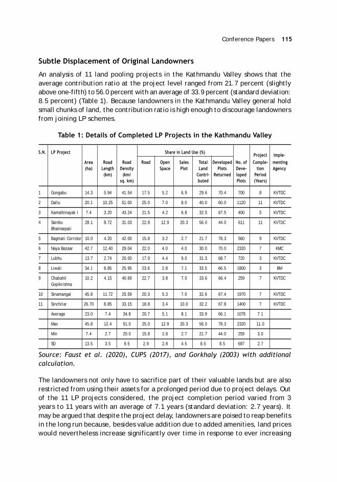
Conference Papers 115
Subtle Displacement of Original Landowners
An analysis of 11 land pooling projects in the Kathmandu Valley shows that theaverage contribution ratio at the project level ranged from 21.7 percent (slightlyabove one-fifth) to 56.0 percent with an average of 33.9 percent (standard deviation:8.5 percent) (Table 1). Because landowners in the Kathmandu Valley general holdsmall chunks of land, the contribution ratio is high enough to discourage landownersfrom joining LP schemes.
Table 1: Details of Completed LP Projects in the Kathmandu Valley
S.N. LP Project Share in Land Use (%) Project Imple-Area Road Road Road Open Sales Total Developed No. of Comple- menting(ha) Length Density Space Plot Land Plots Deve- tion Agency
(km) (km/ Contri- Returned loped Periodsq. km) buted Plots (Years)
1 Gongabu 14.3 5.94 41.54 17.5 5.2 6.9 29.6 70.4 700 8 KVTDC
2 Dallu 20.1 10.25 51.00 25.0 7.0 8.0 40.0 60.0 1120 11 KVTDC
3 Kamalbinayak I 7.4 3.20 43.24 21.5 4.2 6.8 32.5 67.5 400 5 KVTDC
4 Sainbu 28.1 8.72 31.03 22.8 12.9 20.3 56.0 44.0 611 11 KVTDCBhainsepati
5 Bagmati Corridor 10.0 4.20 42.00 15.8 3.2 2.7 21.7 78.3 560 9 KVTDC
6 Naya Bazaar 42.7 12.40 29.04 22.0 4.0 4.0 30.0 70.0 2320 7 KMC
7 Lubhu 13.7 2.74 20.00 17.9 4.4 9.0 31.3 68.7 720 3 KVTDC
8 Liwali 34.1 8.85 25.95 23.6 2.8 7.1 33.5 66.5 1800 3 BM
9 Chabahil 10.2 4.15 40.69 22.7 3.8 7.0 33.6 66.4 259 7 KVTDCGopikrishna
10 Sinamangal 45.8 11.72 25.59 20.3 5.3 7.0 32.6 67.4 1970 7 KVTDC
11 Sinchitar 26.70 8.85 33.15 18.8 3.4 10.0 32.2 67.8 1400 7 KVTDC
Average 23.0 7.4 34.8 20.7 5.1 8.1 33.9 66.1 1078 7.1
Max 45.8 12.4 51.0 25.0 12.9 20.3 56.0 78.3 2320 11.0
Min 7.4 2.7 20.0 15.8 2.8 2.7 21.7 44.0 259 3.0
SD 13.5 3.5 9.5 2.9 2.8 4.5 8.5 8.5 697 2.7
Source: Faust et al. (2020), CUPS (2017), and Gorkhaly (2003) with additionalcalculation.
The landowners not only have to sacrifice part of their valuable lands but are alsorestricted from using their assets for a prolonged period due to project delays. Outof the 11 LP projects considered, the project completion period varied from 3years to 11 years with an average of 7.1 years (standard deviation: 2.7 years). Itmay be argued that despite the project delay, landowners are poised to reap benefitsin the long run because, besides value addition due to added amenities, land priceswould nevertheless increase significantly over time in response to ever increasing
116 ASCI Journal of Management 49 (2) September 2020
demand for urban land. But then, the question arises over the motive of LP as towhy residential plots are developed – is it because landowners get a betterenvironment to live in or because they get better assets to sell off and live elsewhere?
Because of LP, the market value of land parcels, though reduced in size, can increasemany folds by the end of the project. This could encourage the original landownersto sell their plots to new residents. Although such displacement of the originallandowners is not ‘forced’ as such, LP does create a conducive environment forthis to happen. As an example, in the Nayabazaar LP area, located near the centerof Kathmandu Metropolitan City, the land contribution ratio at the project levelwas 30 percent (Shrestha, 2018). However, now only 36 percent of the residentsare the original landowners, while the remaining 64 percent of the residents arenew settlers. The displacement of original landowners could be a concern for thelocal political representatives who would want their voters to stay. This could havean impact on the political feasibility of LP projects, given that the local governmentshave a greater say on land development schemes after the recent amendment inthe Town Development Act, 1988. However, more than the political implication,the displacement of the native population, particularly from the core areas of theKathmandu Valley, has a negative consequence on the sustainability of local culturalpractices which are an intrinsic part of the historical identity of the Valley and animportant factor to promote tourism industry in the Valley.
Welfare of Resident Landowners
Price escalation does not benefit the landowners who choose to reside in the projectarea. In other words, the price escalation of a property does not matter if theproperty is not to be sold. In contrast, the original resident landowners may insteadlose in terms of higher property tax than before. It may be argued that the residentlandowners would nevertheless benefit from the amenities and services madepossible by LP. But then, it is also possible that these landowners would havepreferred a more moderate level of amenities and services (for e.g., 6 m roadinstead of 8 m) that would have required a lower land contribution ratio. Most ofthe amenities and services provided in a LP, such as roads and open spaces, arealso available for consumption by the population living beyond the project areawho could therefore be seen as free riders by the resident landowners.
Impact on Land Market and Urban Form
Despite the popular notion that LP controls land speculation, premature conversionof farmlands into urban use, and urban sprawl, Nepal’s experience tells a differentstory. In Nepali society, the land is not only a valuable possession but also adependable investment with a high return. Because land prices have beencontinuously increasing in the urban areas for the past several decades, landownershave a tendency to hold lands as long as possible in anticipation of further price

Conference Papers 117
escalation. It is not different in the case of LP projects. The prolonged existence ofvacant lots in several LP areas even after the completion of the projects and thesignificant proportion of new settlers in such areas together suggests an act of landspeculation.
Figure 4: Gongabu Land Pooling Project Area (2003) and (2011) (right)
Source: Google Earth
Because LP areas are relatively small in Nepal, the effect of these projects on thebroader urban form has been negligible. Observations show that pace of urbangrowth is no less rapid (sometimes even more rapid) outside land pooling areasthan inside (see Figure 5 and 6). Therefore, without broader control over land use,LP alone cannot control urban sprawl.
Figure 5: Sinchitar LP Project Area in 2007 (left) and in 2020 (right)
Source: Google Earth

118 ASCI Journal of Management 49 (2) September 2020
Figure 6: Sinamangal LP Project Area in 2003 (left) and in 2011 (right)
Source: Google Earth
Almost all of the LP projects in the Kathmandu Valley (or in Nepal) have beenlaunched on farmlands. Proponents of LP claim that it is just a matter of timebefore farmlands are converted into residential plots by private developers. But tosay that LP controls premature conversion of farmlands into urban use is an irony.In fact, in many cases, farmlands in use have also been destroyed to pave the wayfor LP projects. In some occasions, farmers have even clashed with project staffover the formers’ attempt to farm on their previous lands now located inside a LPsite. Likewise, in the four proposed LP sites in New Towns along the Mid-Hill Highway,the share of existing agricultural lands ranges from 75.0 percent (Basantapur) to92.02 percent (Sanphe) (see Kanth, n.d.).
Role of Local Governments
As also stated earlier, the eighth amendment in the Town Development Act, 1988has given local governments (e.g., municipalities) a greater role in implementingland development schemes in their jurisdictions whereby the TDCs are now chairedby the head of respective local governments. Earlier, municipalities had to seekapproval from the concerned TDC to carry out any such scheme. However, in theKathmandu Valley, land development schemes still fall under the jurisdiction ofthe Kathmandu Valley Development Authority (KVDA), a federal entity. When LPprojects are overseen by local governments, local sensitivity and concerns getdeserved attention. After all, local governments are supposed to maintain closecontact with the general public. Potential pitfalls described in this paper would bebetter addressed by local governments rather than by a federal entity. However,with the presence of both KVDA and municipalities as powerful stakeholders in theland development sector, the future of LP projects in the Kathmandu Valley isanyone’s guess.

Conference Papers 119
Way Forward
In this paper, we have analysed the potential pitfalls of LP technique using the caseof Nepal in general and Kathmandu Valley in particular. It is possible to addressthese pitfalls without compromising on the basic principles of LP. Small landholdersface the threat of eminent domain if they are unable to purchase extra land fromthe project office in order to meet the minimum lot size criteria. In a such case,compensation is paid at the prevailing market rate. Had they been in possession ofsufficient land, they would have been in a position to reap larger benefits at theend of the project. Being a small landholder should not be an excuse to writesomeone off. Small landholders can be better compensated by considering thepresent value of the future worth of their lands at the end of the project.Alternatively, soft loans could be provided to the small landholders to purchaseextra land, making them eligible to stay. In order to discourage land speculationand consequent displacement of original landowners, a moratorium can be put onthe sale of properties inside the LP area for certain years. This would also helpsupport the real motive of LP, which is to produce planned residential plots forpeople to live, not to trade. With this said, the welfare of resident landownersneeds to be addressed carefully because these are the people who are not intoseeking financial gains by selling off their properties.
More often, project developers give high emphasis to wider roads, which takeaway a significant portion of lands that could have been used for residentialpurposes. The need of the hour is the walkable neighborhoods, not the car-centricdevelopment. The level or amount of infrastructure should be reviewed inconsultation with the landowners so that the land contribution ratio remains withina reasonable limit. The government or local government can also contribute towardsinfrastructure such that there is no excessive pressure to produce more reserveplots just to recover the project cost. Minimising the necessity for reserve plotswould contribute in enhancing the welfare of landowners. This would also help ingaining support for LP. The premature conversion of farmlands into urban use throughLP is a matter of discussion. The point is to address the demand for residentialplots, not deliberately create demand for housing. The government should investin land development across the country so that the responsibility of supplying housingplots to the ever-increasing urban population is also shared. This would also createa conducive environment for the government or local government to introduceinnovative models of LP by incorporating not only residential plots but also schools,hospitals, markets, and even farmlands. LP schemes should be a part of a broadercity plan, unlike the current practice of treating them as standalone projects, andonly then negative externalities such as urban sprawl could be addressed.
Public participation is perhaps the most important ingredient for the success of aLP project. LP also gives an opportunity to the people to act in a responsible way infavour of public interest. Because local governments have the closest connection
120 ASCI Journal of Management 49 (2) September 2020
with the people as compared to the provincial or federal government, it makessense to have local governments at the forefront in implementing LP projects.With the pitfalls addressed, LP can be a valuable tool for the local governments (inparticular, municipalities) to not only address housing challenges but also to guideoverall urban planning in their territories.
Conclusion
The Constitution of Nepal, 2015, has provided greater authority to local governmentsto manage development issues at local levels. LP can be a powerful tool for thelocal governments (in particular, municipalities) to guide urban growth in theirjurisdictions, but if not used properly, LP can also backfire. As argued in this paper,the potential benefits of LP should be analysed in the specific context of the areawhere such projects are being implemented. Nepal’s experience in LP indicatesthe existence of serious pitfalls, particularly regarding the welfare of landowners,including the issue of small landholders who are even susceptible to eminent domain.These pitfalls need to be addressed first in order to unlock the full potential of LP,and as this paper argues, it is possible to do so without compromising on the basicprinciples of land pooling.
References
Acharya B. P. (1988). Urban Land Pooling in Nepal: The Land Pooling Projects inPokhara, HSD Research Report No. 21. Thailand: Asian Institute of Technology.
CBS. 2012. National Population and Housing Census 2011: National Report.Kathmandu: Central Bureau of Statistics.
CUPS (2017). Land Pooling Projects in Nepal: A Consolidated Documentation. Nepal:Center for Urban Planning Studies, Institute of Engineering.
Faust, A., Castro-Wooldridge, V., Chitrakar, B., Pradhan, M. (2020). Land Pooling inNepal: From Planned Urban “Islands” to City Transformation. MandaluyongCity: Asian Development Bank.
Gorkhaly, G. P. (2003). Land Pooling (What, Why, Where and How). Kathmandu:Ministry of Physical Planning and Works, Department of Urban Development andBuilding Construction. (in Nepali)
Joshi, J. (1997). Planning for Sustainable Development. Kathmandu: Lajmina Joshi.
Joshi, K. K., Shrestha, S. B. (2018). Land Readjustment in Nepal. In: Souza, F. F.,Ochi, T., and Hosono, A. (eds.), Land Readjustment: Solving Urban ProblemsThrough Innovative Approach. Tokyo: JICA Research Institute.

Conference Papers 121
Kanth, C. (n.d.). Land Pooling Experience in New Towns. Presentation slide availableat www.dudbc.gov.np (last retrieved on September 1, 2020).
MoUD (2016). Habitat III- Nepal National Report. Kathmandu: Ministry of UrbanDevelopment.
Shrestha, B. K. (2018). Land Readjustment: An Innovative Urban Development Toolin Nepal. Presentation slide available at www.gdln.or.kr (last retrieved on August30, 2020).
Singh, P. M. (2003). Post Land Development Evaluation – A Case Study of LandPooling Projects in Kathmandu Valley, unpublished dissertation. Lalitpur:Institute of Engineering, Tribhuvan University.
UN-DESA (2019). World Urbanization Prospects – The 2018 Revision. United NationsDepartment of Economic and Social Affairs.

122 ASCI Journal of Management 49 (2) September 2020
Sevkiye Sence TURK*
Land Readjustment Experience from Turkey’s Perspective
Abstract
The experiences related to LR in the world demonstrate that the tool can be usedfor different purposes with varying outcomes. Therefore, the examination ofdifferent countries’ LR experiences is significant. The aim of the article is to showthe LR experience in Turkey. For this, the article covers the legal framework,characteristic features, and lessons learned from the Turkish LR experience. TheTurkish experience of using of LR in different projects and highly differing landtenure contexts shows the adaptability of the tool, especially for developingcountries.
Introduction
Although LR mechanism differs according to countries’ models (Hong and Tierney,2018; Hong and Needham, 2007; Turk, 2008), the main principles are similar. Themain principles in LR models are the participation of landowners, removal of landassembly costs, and sharing of the cost and benefits. Compared to other alternativeland development tools, this tool has the potentials that serve enabling strategieslike land assembly (Home, 2007; Lin, 2005), self-financing (Mittal, 2014; Mattur,2013), sharing of benefits and costs (Hoyos, 2019; Van Krabben and Needham,2008), recovery of service and infrastructure costs (Munoz Gielen, 2014; Turk, 2005),protection of social capital (Turk, 2018; Soliman, 2017), and provision of thepartnership or cooperation of all parties (Sorensen, 2000; Mukhija, 2006). LR canbe used to achieve different project objectives in urban areas yielding differentiatedoutcomes. Therefore, the assessment of countries’ experiences is significant tounderstand the capacity of LR.
This paper discusses the legal framework, characteristic features, and lessonslearned from the Turkish LR experience. Turkey can be considered a good laboratoryfor studying LR. Firstly, Turkey has a long history in using LR (Çete, 2010; Turk,2008; Turk, 2007; Turk, 2005). Secondly, local governments- municipalities, provincialadministrations, and landowners have a significant amount of knowledge andexperience with LR (Turk, 2018) because of the large number of LR projectsimplemented in the country. For example, in 2013, within only one year, 3,127 LRprojects were implemented (General Directorate of Land Registry and Cadastre,2013). Large municipalities are the main implementers of LR projects, with 60.7percent of all projects implemented by municipalities with a population of over300,000 (Turk, 2004). Thirdly, LR has been used in three different ways in Turkey,
* Professor, Land policy, Urban Law & Urban planning, Istanbul Technical University.E-mail: [email protected]

Conference Papers 123
as different from the other countries-in new development areas of the city, inupgrading existing illegal housing areas for regularisation of land tenure and in therenewal of irregular and informal settlements.
This paper is organised as follows: the second section gives the legal framework ofLR in Turkey. The third section examines LR process. The fourth section covers themain features of LR in Turkey. The fifth section discusses some lessons from theTurkish LR experience as a conclusion.
Legal Framework for LR in Turkey
Legal Past: The past of LR in Turkey goes to the time of the Ottoman Period. Thefirst legal source was regulations related to buildings dated 1848 prepared forIstanbul. This regulation contains the simplest form of the current LR. In thisregulation, LR was only used in fire areas. At a later stage, in the Regulationsrelated to Roadways and Buildings dated 1864, Code of Buildings dated 1882, andLaw No. 625 dated 1925, similar provisions were included. In these legal sources,LR could only be used in fire areas (Tekeli,1994). Instead of fire areas, using LR inall urban areas was made possible by Law No.1663 dated 1930. After this, LR becameapplicable to all municipalities through the Buildings and Roads Law No. 2290 (1933),Reconstruction Law No. 6785 (1957), and Reconstruction Law No. 3194 (1985).
Table 1. Legal Sources related to LR in Turkey
Date
Legal Sources related to using of LR in the formal market
The Building Regulations of 1848 1848
Road and Building Regulations of 1864 1864
The Building Law of 1882 1882
Law No. 642 1925
Law No 1663 1930
Building and Roads Law No. 2290 1933
The Reconstruction Law No. 6785 1956
The Reconstruction Law No. 3194 1985
Law No. 5006 2003
Law No. 6704 2016
Legal sources related to lusing of LR in the informal market
The Amnesty Law No. 2981 1983
The Amnesty Law No. 3290 1984
The Amnesty Law No. 3366 1986
Legal Sources related to using of LR for large scale housing projects in renewal areas whereinclude irregular and informal settlements and in newly developing areas
Law No. 5366 2005
Law No. 5393 (Article 73) 2005
Circular (General Directorate of Land Registry and Cadastre) No. 20 2008
Law No. 5998 2010
Decree Law No. 648 2011
Law No. 6306 2012
Sources: Turk, 2005; Turk 2007; Turk, 2013

124 ASCI Journal of Management 49 (2) September 2020
The important difference between these laws was a change in the contributionpercentage and the scope of public areas content. The percentage deduction wasincreased from 15 per cent (Buildings and Roads Law dated 1933) to 25 per cent(Reconstruction Law No. 6785, 1957). The concept of a contribution percentagewas introduced by Law No. 1605 (1972). This law accepted the contributionpercentage and prescribed what constituted public use areas such as roads, squares,parks, car parks, nurseries, and green areas needed in the LR area. TheReconstruction Law No. 3194 (1985) protected the LR concept but increased thecontribution percentage to 35 per cent and also included religious facilities andpolice stations within the scope of public use areas. Law No. 5006 in 2003 furtherincreased the contribution percentage to 40 per cent, and included elementaryand secondary education within the scope for public areas (Turk and Turk, 2011, p.693). Law No. 7181 in 2019 increased the contribution percentage to 45 percent.The scope of public areas was broadened, and the contribution percentage couldthen onwards be used for road, square, green area, car park, park, children’splayground, religious place, police station, elementary and secondary schools, healthfacilities, market places, district sports areas, public transportation stops, theroad where access control, waterway, municipal service areas, official service areas,cemetery areas, social and cultural facility areas.
Table 2. Land Contribution Percentage as per Turkish Law
Year Law No. Contribution % Context
1933 Law No. 2290 15 Road, square, and green area
1956 Law No. 6785 25 Road, square, green area, and car park
1972 Law No. 1605 25 Road, square, green area, car park, park, and children’splayground
1985 Law No. 3194 35 Road, square, green area, car park, park, children’splayground, mosque, & police station
2003 Law No. 5006 40 Road, square, green area, car park, park, children’splayground, religious place, police station, and elementaryand secondary schools
2019 Law No. 7181 45 Road, square, green area, car park, park, children’splayground, religious place, police station, and elementaryand secondary schools, health facilities areas, marketplaces, district sport areas, public transportation stops,the road where access control, waterway, municipal serviceareas, official service areas, cemetery areas, social &
cultural facility areas.
Note: Some additions are made by the author on the relevant table of Çete (2010).
Legal Basis and Purpose for LR: The basic law related to LR is the ReconstructionLaw No. 3194 that came into force in 1985 and its regulations, Title 18 is related to

Conference Papers 125
LR. In the scope of this law, LR is used as an implementation tool for detailed localplans, especially in new development areas and partly built up areas. The secondsource is the Building Amnesty Law No: 2981/3290 which came into force in 1985that includes provisions for legalising illegal settlements. The third source is theUrban Renewal Law that came into force in 2004, whereby LR can be used forurban renewal of irregular and informal settlements. The main aim of LR in thisinstance is to re-parcel land by taking into consideration de facto subdivisions anduses in the area and build local infrastructure. The use of LR in new developmentareas, especially for housing areas is of two types, first the production of servicedurban plots in small size, and second, the production of the serviced plots in largesize for mass housing. In the former, the development process is by differentlandowners while in the latter type, the development process is undertaken byprofessional players by the mass housing Authority (TOKI), public-privatepartnerships, developers or cooperatives. During the legalisation of informalsettlements, squatters received title allocation documents (tapu tahsis belgesi)after their land claims were found to be legitimate. Although these documents arenot legally binding, they provide an official recognition of the use rights of informalsettlers. To obtain a legal title, land occupants must come up with a developmentplan for improvement (or upgrading) (Turk, 2018; Uzun et al. 2010). A special LRmethod has been applied to upgrade existing illegal housing areas for bothregularisation of land tenure and the provision of basic services in the areas. Theimplementation of development plans for improvement is provided by a special LRmethod.
The third source is related to large-scale housing projects in renewal areas thatinclude informal settlements and newly developing areas. By 2003, significant powerswere delegated to the Mass Housing Authority (TOKI) as a unit of the centralgovernment to manage large-scale housing projects (Turk and Korthals Altes, 2014).Similar powers were given to the Ministry of Environment and Urbanisation in 2011.These central government agencies could use LR for large-scale housing projects inthe renewal areas or newly developing areas. The main aim of using LR is to produceserviced urban plots suitable for large-scale housing projects and to construct localpublic facilities and infrastructure (Turk, 2018). Among the aforementioned waysof using LR, it is mostly used for the implementation of detailed local plans in theformal market in Turkey. LR for legalising informal settlements was often usedbetween 1980 and 1990 (Amnesty Laws No. 2981/3290/3366). However, this typeof LR is no longer practiced in Turkey. A 2012 law—Regeneration Law of Areasunder Disaster Risk (Law No: 6306) abolished the Amnesty Laws.
LR Process in Turkey
The LR process in Turkey can be divided into four stages. These are initiation,calculations, distribution (reallocation), and approval.
126 ASCI Journal of Management 49 (2) September 2020
Initiation: In Turkey, the LR project starts with the determination of the projectarea. LR project area is determined by the municipal committee in municipal areasand by the provincial committee outside those areas directly regardless of thelandowners’ consent. The landowners are informed after the public announcement.LR projects are implemented directly by the municipality or by private offices. Inthe preparation stage, land registry records, cadastre maps, existing maps, andgeodetic control points, and detailed local plans are used for the provision of data.The data must conform with each other and be up-to-date. If land registry recordsand cadastre maps are defectively produced, these directly affect the accuracy ofcalculations in LR projects (Çete, 2010). Following this, the cadastral parcels in LRthe project area are defined. The administration gives information to the LandRegistry Office to initiate LR. Upon this notification, the Land Registry Office putan annotation on the parcel records to inform the relevant parties about the LRproject. The precise areas of the cadastral parcels are supplied from the landregistry office. By taking into consideration the protected buildings and the widthof the roads, in accordance with the detailed local plan, the building blocks aredrawn on the reallocation (distribution) map. They are resurveyed after boundariesof building blocks are applied to the area. After that, the reallocation (distribution)map that contains boundaries of the cadastral parcels and the resurveyed buildingblocks are developed (Çete, 2010).
Calculations: While some parcels are included in LR projects as a whole, some arepartially included. Therefore, first of all, the parts of the cadastral that are includedin the LR project parcels are calculated. After that, the areas calculated and areastaken from the land registry office are compared with each other and corrected.For this correction, the area taken from the land registry office is the base. In theproject area, the included and excluded parts of each parcel are shown on a map.The title registration office revises the notifications in the land registry by takinginto consideration the new situation. The area of each building block is computed,and the contribution percentage is determined. The contribution percentage isapplied to all parcels in the project area to provide land for public service areasdefined in Law no. 3194 and its regulation. If the contribution percentage is greaterthan 45 percent, the excess part is expropriated from all parcels included in theproject (Çete, 2010).
Distribution (reallocation): In Turkey, distribution in LR is made based on the landarea. However, the main principle in distribution is that the new plots are given,firstly, in its own original place, secondly close to the original place of the cadastralparcel, if not possible, third within the LR area. After fulfillment of the reallocationstages, parcel sizes of the new parcels and corner coordinates are computed andbalanced.

Conference Papers 127
Figure 1: LR Model in Turkey
Approval: In a LR project, the parcellation map that shows new parcels is approvedby the municipal committee or the provincial committee. Then the project isannounced for one month. During the announcement period, the landowners canobject to the LR project. After examination of the objections, the project issubmitted to the cadastral office for providing technical control and then sent tothe land registry office for registration. The LR process is concluded at this stage.Although the administrative processes carried out for LRs by using public force areapplied on behalf of the public, they are open to judicial review. The landownerswho fail to obtain the expected results from LR have the right to appeal in accordancewith the provision of Article 125 of the Constitutional Law. The period for lawsuitsto be filed regarding LR starts with written notification of the LR results to theconcerned persons.
Main Features of LR in Turkey
Relation to Planning: The main aim of the LR process in Turkey is to provide theimplementation of the detailed local plans. Therefore, LR is a legal administrativeprocedure. Municipalities determine LR project areas by taking into considerationthe self-evaluated needs. For this reason, the municipalities have to prepare five-

128 ASCI Journal of Management 49 (2) September 2020
year implementation programs within three months after the detailed local plansgo into effect (Turk, 2007; Turk, 2005).
Within the implementation programs, municipalities have to determine LR areas.At the same time, the municipalities have to think of how LR projects areimplemented in the whole of the urban area. At this point, the distribution ofpublic service areas (both on-site and off-site areas) are to be known. Thedetermination of LR project areas is closely related to the distribution of publicservice areas within the urban area. If the LR projects are distributed in a balancedway, municipalities can provide on-site areas free of charge. However, in Turkey,there is a lack of criteria regarding the determination of LR project areas and thedesignation of their sizes. According to the Reconstruction Law and relevantregulations, LR project areas cannot be designed smaller than the size of a singleresidential block. Municipalities generally prefer to implement LR projects in sizesequal to a single residential block. In this situation, the contribution percentage tobe taken from landowners for public service areas will be limited. This might beconsidered very low when considering the infrastructural needs for the whole urbanarea. If each owner contributes a small contribution percentage in the whole ofthe urban area through LR projects, the needs of the social and technicalinfrastructure of the urban area cannot be solved (Turk, 2005).
Basis of Contribution Percentage: The contribution percentage and its usagepurpose are defined in legal sources in Turkey. The maximum contribution percentageis determined as 45 percent. Each plot owners in all LR projects has to give thispercentage as land. According to the law related to LR and related regulations, thecontribution percentage within the project area is calculated based on dividingthe amount of land utilised for public services by the total amount of cadastralparcels in the project area (Turk, 2005). Over time, there have been controversiesinvolved in such a high contribution percentage, and this has been the subject oflitigation. The Constitution Court’s decision dated 22 November 1963 is quiteimportant. The Court indicated that the contribution percentage was construed asan “expropriation action without compensation”; thus this article was annulled,and the use of LR was blocked until an amendment was made to Law No. 1605 in1972, introducing the concept of “Contribution Percentage for Public Areas” (Turkand Turk, 2011). The contribution percentage is taken for an increase in valuearising from LR, and this can only be used to provide social and technicalinfrastructure areas (defined in Law no.3194 and its regulation).
Principle of Distribution: Distribution in LR in Turkey is made based on the landarea. However, the main principle in distribution is that the new plots are given inits own original place, close to the original place of the cadastral parcel or if notpossible, within the LR area (Turk, 2018; Turk, 2007). Also, in case the area of theplot given to the landowner following the LR project is smaller than an urban plot,shared plots are formed by necessity. Until Law no 7181 that came into force in
Conference Papers 129
2019, the shared plots before the project implementation could not be transformedinto independent plots during the reallocation process. However, after this legalregulation, shared plots can turn into independent plots during the reallocationprocess.
Provision of Land for Public Service Areas and Construction: In Turkey, duringthe LR process, the provision of land for infrastructure and services andconstruction on the land are separated. The construction on the land that is providedthrough the contribution percentage is not included in LR process. Because, this isdefined as the duties of the municipalities. The construction is realised by themuncipalities after LR project. According to Articles 86, 87, and 88 of the MunicipalityRevenues Act No. 2464, contributions obtained from landowners are used in roadconstruction, expansion of existing roads in these areas, readjustment of existingroads, and services. The contribution includes the installation of sewerage, therevision of existing installations, the installation of new drinking water networkfacilities, or the renewal of existing network facilities. This contribution is obtainedfrom owners of the land located on both sides of the roads where the infrastructurepasses through (Turk, 2007).
Value Capture Capacity: The LR ensures a changeover from cadastral plot to urbanplot. LR results in the production of new urban plots. The value capture mechanismof the method intends to be used for the setting aside of land for public use. Theamount of deduction of land in return for the value increment in the LR projects inTurkey is clearly set in the legislative sources. The categories of urban infrastructureto be financed are also defined in the legal sources. The value capture in theimplementation of LR is the value increment to occur in the changeover fromcadastral plot to urban plot. However, the development rights on urban plots afterLR may be frequently changed through new plan decisions or changes in such plans.Until Law no. 7181 came into force in 2019, there was no provision related tocapturing the value increment arising from the change in the development rightsof new urban plots. It is essential not to take more than one contribution percentagefrom a parcel. However, with this law, in case of an increase in the housing andpopulation with any plan decision, an additional contribution percentage can betaken. The value capture attained from the LR is linked directly to the financing ofthe urban infrastructure. Again, LR can be applied within highly differing landtenure contexts where title and tenure is clear, or where there are informal owners.
Participatory and Inclusive Mechanisms: In the LR process, the participation ofthe public in the project has a critical significance. In LR mechanism, the publicmay have direct as well indirect participation (Turk, 2008). Generally, in the public-initiated LR projects, the landowners are informed about the project after thepublic announcement as these projects are decided directly by public institutionsregardless of the landowners’ consents (Turk, 2008). Mostly, the participation ofthe public into the LR projects are provided by the public announcements at different

130 ASCI Journal of Management 49 (2) September 2020
stages of the process. Thus, landowners have indirect participation in the project.In Turkey, the court cases by the landowners have blocked the implementation ofseveral LR projects (Turk, 2011).
Lessons from the Turkish Experience
In Turkey, the practice of using LR in three different ways demonstrates that thetool can be adapted for different purposes. LR can be applied within highly differingland tenure contexts where title and tenure is clear or where there are informalowners. This feature is important, especially for developing countries. Also, it isknown that most developing countries do not have an institutional structure relatedto land valuation, and hence it may be advisable to use an area-based approachinstead of a value-based approach.
Turkey has gained a great experience by implementing of LR by an area-basedapproach. Although LR by an area-based approach has important limitations, itoffers ease of application, especially in newly developing areas of cities. In Turkey,there is lack of criteria regarding the determination of LR areas and designation oftheir size. This situation adversely affects the provision of land for public serviceareas in the whole city and the value capture capacity. On the other hand, therehas been an important increase in the contribution percentage, and broadening inthe scope of public areas’ in LR applications of Turkey. This has increased thelandowners’ prejudices against LR projects and rising concerns regarding the issueof protecting property rights.
In Turkey, the LR process can be completed within a relatively shorter time comparedto other developing countries. Though the duration of LR changes depending onthe size of the project, the average length is about one year. This situation originatesfrom three main factors. First, the construction of infrastructure is not included inthe LR process. Second, the planning and LR processes are independent of, but atthe same time following, each other. In other words, a detailed local plan hasalready been prepared at the commencement of the LR project. Third, a publicannouncement is made at the end of the LR process, which is the only opportunitythat landowners can make use of to voice their objections. However, completion ofLR process in a shorter timeframe implies that the participatory and inclusivemechanisms are compromised. In Turkey, although LR can be completed within ayear, landowners are likely to litigate for the annulment of such projects (Turk,2018; Turk and Turk, 2011). To improve efficiency of LR in Turkey, the following arerequired:
Participatory and inclusive mechanisms must be included in the LR process.
LR project areas and the contribution percentage should be calculated in thewhole of local plans.
Conference Papers 131
Links between LR projects and a detailed local plan should be established.
The contribution of LR to social housing should be defined, especially in largescale parcels.
Municipalities must staff skilled and competent personnel and surveyorsauthorized to perform LR projects must have defined qualifications andcompetence.
Common platforms should be institutionalised for the sharing of experiences inLR projects.
References
Çete, M. (2010) Turkish Land Readjustment: Good Practice in Urban Development,Journal of Urban Planning and Development, Vol. 136, No.4.
Home, R. (2007), Land readjustment as a method of development land assembly, acomparative overview, Town Planning Review, 78(4), 2007.
Hong, Y.H., Needham, B. (2007) Analyzing land readjustment: Economics, law, andcollective action, pp. 3-36, Lincoln Institute of Land Policy, Cambridge,Massachusetts.
Hong, Y.H, Tierney, J. (Eds.) (2018) Global Experiences in Land Readjustment, UNHabitat, Nairobi, Kenya.
Hoyos, R.A.D (2019) Evaluating the Land Readjustment in Colombia: An EquitableDistribution among the Actors, Cuadernos de Vivienda y Urbanismo, 12 (3), 1-47.
Lin, T.C. (2005) Land assembly in a fragmented land market through landreadjustment, Land Use Policy, 22(2), 95-102.
Mattur, S. (2013) Self-financing urbanization: Insights from the use of Town PlanningSchemes in Ahmadabad, India, Habitat International, 31, 308-316.
Mittal, J. (2014) Self-financing land and urban development via land readjustmentand value capture, Habitat International, 44, 314-323.
Mukhija, V. (2006) Property readjustment and a tenants’ cooperative in Mumbai:Some lessons and some questions. Environment and Planning A, 38 (11), 2157-2171.
Munoz Gielen, D. (2014) Urban governance, property rights, land readjustment andpublic value capturing, 21 (1), 60-78.
132 ASCI Journal of Management 49 (2) September 2020
Soliman, A.M. (2017) Land readjustment as a mechanism for New Urban LandExpansion in Egypt: experimenting participatory, inclusive processes, InternationalJournal of Urban Sustainable Development, 9(3), 313-332
Sorensen, A (2000) Conflict, consensus or consent: implications of Japanese landreadjustment practice for developing countries. Habitat International, 24, pp.51-73.
Turk, S. S. (2004) The applicability of urban land acquisition methods for the provisionof serviced residential land in the Turkish Case, International Development PlanningReview (IDPR), 26(2), 141-166.
Turk, S. S. (2005) Land readjustment: an examination of its application in Turkey,Cities, 22 (1), 29- 42.
Turk, S. S. (2007) An analysis on the efficient applicability of the land readjustment(LR) method in Turkey, Habitat International, 31, pp. 53-64.
Turk, S. S. (2008) An Examination for Efficient Applicability of the Land ReadjustmentMethod at the International Context, Journal of Planning Literature, Vol. 22 No. 3(February 2008), pp. 229-242.
Turk, S.S. (2018) Could Land Readjustment be participatory and inclusive in Turkey?In: Yu-Hung Hong and Julia Tierney (eds), Global Experiences in Land Readjustment,UN-Habitat, United Nations Human Settlements Programme, 8.
Tekeli, I. (1994) The Development of the Istanbul Metropolitan Area: UrbanAdministration and Planning, Istanbul: Kent Basimevi.
Turk, S.S., Celil Turk (2011) The annulment of land readjustment projects: an analysisfor Turkey, Town Planning Review, 82.6, 687-708.
Turk, S.S., KorthalsAltes, W.K. (2011) Potential Application of Land ReadjustmentMethod (LR) in Urban Renewal: An Analysis for Turkey”, ASCE (Journal of UrbanPlanning and Development), 137 (1), 7-19.
Turk S S, KorthalsAltes, WK. (2014) The applicability of inclusionary housing (IH) inTurkey, Journal of Housing and the Built Environment, 3 (29), 507-520.
Uzun, B., Çete, M., Palancýoglu, H.M. (2010) Legalizing and upgrading illegalsettlements in Turkey, Habitat International, 34, p.204-209.
Van der Krabben, E., Needham, B. (2008) Land Readjustment for Value Capturing:A New Planning Tool for Urban Redevelopment, 79(6), 651-672.

Conference Papers 133
Naoyuki Yoshino* & Saloni Lakhia**
Land Trust Method and the Evaluation of the Effect of InfrastructureInvestment
Abstract
Infrastructure projects such as roads and railways bring businesses into the regionand connect the rural area to cities. Infrastructure plays an essential role inmitigating income disparities by creating jobs. In the long run, growth dividendsfrom infrastructure development and industrialization are likely to be materialised,and the acquisition of land to facilitate such a process remains one of the leadingdevelopment challenges in many Asian countries. However, landowners do notwant to sell their land, generally inherited from their ancestors. Combining thetools from the fields of law and economics, we propose the land trust or landlease for the development of infrastructure investment and industrialisationpurposes. We argue that this is one of the best ways to increase the spillovereffect and rate of return to invite private investors into infrastructure investment.
Introduction
The ‘land question’ has invigorated agrarian studies and economic history sinceMarx, and the early twentieth century writers on agrarian questions. Now morethan ever amidst the global COVID19 pandemic, does the impact and effect of landuse hold great value. Most countries around the world are grappling with economicre-structuring due to the ongoing crisis, and Asian countries have faced cripplingbreakdowns with countries relying on tourism and exports as large GDP driversfacing great challenges. Infrastructure investment will play an even more integralrole in economic revival in the Asian countries, and as per the Asian DevelopmentBank estimates, there already exists a huge need for infrastructure investment inthe Asian region.
Many growing cities are congested due to a lack of planning and public transport,with water supply, electricity, and sanitation lacking in many parts of Asia. Further,the COVID-19 pandemic has led to a structural shift in various sectors, includingeducation, wherein the schools have been transferred to virtual spaces andprofessional services are to continue working from home. This region now is also
* Professor Emeritus, Keio University, Tokyo, Japan, Visiting Professor GRIPS, andFormer Dean & CEO, Asian Development Bank Institute (ADBI)). E-mail:[email protected]
** Public Policy Consultant, Former Research Associate, Asian Development BankInstitute (ADBI). E-mail: [email protected]

134 ASCI Journal of Management 49 (2) September 2020
facing a lack of digital infrastructure which this pandemic has highlighted to beequally important to its large-scale physical infrastructure. With compromised fiscalspending, there is an overall reluctance to spend on infrastructure investmentswhen the majority of spending is being redirected to medical and vulnerable groupfunding. There is now a need for private sector financing, and though even earlier,public finance has not been enough to support these infrastructure needs in Asiaand PPP (Public Private Partnerships) were proposed, they have not met with muchsuccess due to the low rate of return from infrastructure investments and highrisks associated with infrastructure investment, especially land acquisition. Theseregions are looking for long-term investments due to the benefits of its long-termnature, with many developing Asian countries initiating pension system and lifeinsurance. It is pertinent that the supply of finance and demand for long terminvestment by infrastructure should match each other by increasing the rate ofreturns and reducing risks.
In this paper, the land trust method and return on spillover tax revenues will berecommended to increase the rate of return from infrastructure investment. Oneof the risks associated in infrastructure investment is that of land acquisition.Purchasing price of land often goes up by bilateral negotiations and it takes a longtime to purchase the land from owners which delay the operation of infrastructure.Further, in many Asian countries, the land mafia plays an important role in landtransactions, and they raise the land price. How to secure maintenance costs isanother issue associated with infrastructure.
Land Trust to Smooth Land Acquisition
Rationale: Acquisition of land for infrastructure investments and regionaldevelopments has been a major barrier in many Asian countries. Landowners arereluctant to give up their land for development projects. A land trust can be asolution to these barriers. According to the land trust practiced in Japan, the ownersretain their ownership of the land while they lease it for a stipulated period, forinstance, 99 years for infrastructure projects. In Japan, for instance, trust businesscan only be carried out by entities licensed under the Trust Business Act and financialinstitutions licensed under the Act for Financial Institutions’ Trust Business.
Land Trust Method: There are three bodies in trust: entruster, entrustee, andbeneficiary. When an entruster has an asset that he wishes to leave for thebeneficiary, but he does not want to give it right away, he may entrust the entrusteewith the asset with conditions for the beneficiary to receive the profit. This methodcan be used for trust by will (Yoshino, N., et al 2019).
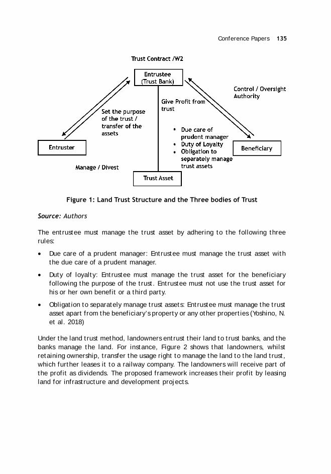
Conference Papers 135
Figure 1: Land Trust Structure and the Three bodies of Trust
Source: Authors
The entrustee must manage the trust asset by adhering to the following threerules:
Due care of a prudent manager: Entrustee must manage the trust asset withthe due care of a prudent manager.
Duty of loyalty: Entrustee must manage the trust asset for the beneficiaryfollowing the purpose of the trust. Entrustee must not use the trust asset forhis or her own benefit or a third party.
Obligation to separately manage trust assets: Entrustee must manage the trustasset apart from the beneficiary’s property or any other properties (Yoshino, N.et al. 2018)
Under the land trust method, landowners entrust their land to trust banks, and thebanks manage the land. For instance, Figure 2 shows that landowners, whilstretaining ownership, transfer the usage right to manage the land to the land trust,which further leases it to a railway company. The landowners will receive part ofthe profit as dividends. The proposed framework increases their profit by leasingland for infrastructure and development projects.
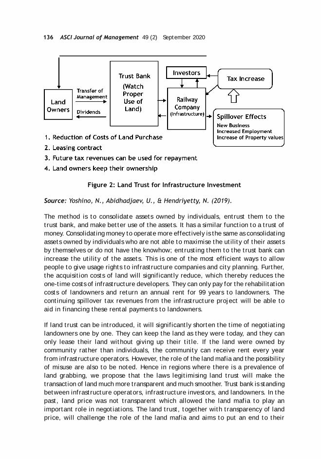
136 ASCI Journal of Management 49 (2) September 2020
Figure 2: Land Trust for Infrastructure Investment
Source: Yoshino, N., Abidhadjaev, U., & Hendriyetty, N. (2019).
The method is to consolidate assets owned by individuals, entrust them to thetrust bank, and make better use of the assets. It has a similar function to a trust ofmoney. Consolidating money to operate more effectively is the same as consolidatingassets owned by individuals who are not able to maximise the utility of their assetsby themselves or do not have the knowhow; entrusting them to the trust bank canincrease the utility of the assets. This is one of the most efficient ways to allowpeople to give usage rights to infrastructure companies and city planning. Further,the acquisition costs of land will significantly reduce, which thereby reduces theone-time costs of infrastructure developers. They can only pay for the rehabilitationcosts of landowners and return an annual rent for 99 years to landowners. Thecontinuing spillover tax revenues from the infrastructure project will be able toaid in financing these rental payments to landowners.
If land trust can be introduced, it will significantly shorten the time of negotiatinglandowners one by one. They can keep the land as they were today, and they canonly lease their land without giving up their title. If the land were owned bycommunity rather than individuals, the community can receive rent every yearfrom infrastructure operators. However, the role of the land mafia and the possibilityof misuse are also to be noted. Hence in regions where there is a prevalence ofland grabbing, we propose that the laws legitimising land trust will make thetransaction of land much more transparent and much smoother. Trust bank is standingbetween infrastructure operators, infrastructure investors, and landowners. In thepast, land price was not transparent which allowed the land mafia to play animportant role in negotiations. The land trust, together with transparency of landprice, will challenge the role of the land mafia and aims to put an end to their
Conference Papers 137
prevalence. To enable a more transparent and efficient method in the Asian regions,a national licensing method is also proposed for land evaluators. For instance, theJapanese government provides certificate of national license to evaluators of land.They are experienced land evaluators who passed the national examinations toassess the land price.
Land Trust in Japan
In cities like Tokyo, individuals who live in small houses may increase the utility oftheir land by consolidating the land and building apartments or office buildings onit. To do so, those individuals will need help from a trust bank or trust company.The landowners entrust their land to the trust bank, and the trust bank builds alarge building on the land to realise the effective utilisation of the land. And thoselandowners can live in apartments within the building and receive part of theprofit as dividends from the trust bank. Individual landowners can gain more profitsby this method.
Based on the real estate trust, the idea of “Trust of agricultural land” was proposed.The landowners entrust their agricultural land to a trust bank, and the trust bankmanages the land. In this case, the trust bank aids the young farmers who wish tofarm the large consolidated land to use it and increase the utility. The landownerswill receive part of the profit as dividends. The consolidation of land leads tohigher profits for the landowners. Presently, the landowners are obligated to givethe land to the trust bank. But in the future, giving only the usage right of the landto the trust bank can be an option, and in that case, registration of the land will benecessary. This way, the landowners can maintain the ownership of the land andincrease the profit by lending the land to the younger farmers through a trustbank. Another instance where the same method can be employed is in the case ofship owners or cowmen to increase the utility of their ships or cows.
Land Trust in Thailand
In Thailand, too, if banking laws change, banks can change their role from beingfinancer of infrastructure projects to becoming land trust managers. This can benefitlandowners and developers and lead to an increase in successful infrastructureprojects. The resulting expansion in economic activity will encourage theconstruction of commercial buildings, apartments, restaurants, and shopping mallsand boost the revenue from property, corporate, income, and sales taxes. In thepast, this tax revenue has been collected by central and local governments, butthe increased tax revenue can be partly returned to those constructing or investingin the infrastructure projects, together with the user charges, to increase the rateof return and make the projects more attractive to both investors and developers.

138 ASCI Journal of Management 49 (2) September 2020
Overall, the passing of the Right ver Property Act in Thailand has opened a newchapter for land use and land development in the country. Thailand will be able toutilise the land trusts set up by the new act to increase the rates of return on landand infrastructure development projects. This important change in legislation willfacilitate the efforts of landowners, the government, banks, and infrastructuredevelopers in the implementation of a variety of land development projects. Certainessential article from the Right Over Property Act are:
Table 1. Right Over Property Act, Essential Articles
Source: Authors’ own
Land Trust in India
Land ownership is broadly defined by access to a land title. A land title is a documentthat determines the ownership of land or immovable property. In India, landownership is determined through various records such as sale deeds that areregistered, property tax documents, government survey records, etc. The onus ofverifying the validity of the land title is on the buyer and not the government,making the title vulnerable to challenges (Lakhia, S. 2019).
However, land titles in India are unclear due to various reasons such as legacyissues of the zamindari system, poor legal framework, and improper administrationof land records. This has led to several legal disputes related to land ownershipand affected the agriculture and real estate sectors. Further, the land administrationis spread across various departments that work in silos making it an even morecumbersome process.
ARTICLE 03 ARTICLE 04 ARTICLE 12
“Right over property” means Propertiewhich are collaterised by right to utilisethe properties to property for utilisereal property according to this Act
“Real property” means registeredland deed, registered land withbuilding and registeredcondominiums according to law oncondominium
The owner of property/real propertywho wishes to establish a right over theproperty has to submit an applicationto the officers and has to present theregistered land deed or condominiumregistration to the officers in each case
Right over property is not to exceed30 years.
A partial establishment of a right overproperty on the registered land deedor condominium registration is notpermitted
The right over property is transferableor becomes collateral for any mortgageaccording to the Thai Civil andCommercial Code
The right over property is inheritable
Any juristic act on the right overproperty must be registered with theofficers and when registration iscomplete, the officer will have torapidly issue a notification letter to theowner of the real property accordingto the juristic act and ministerialregulations.
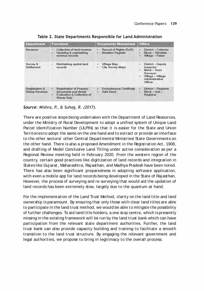
Conference Papers 139
Table 2. State Departments Responsible for Land Administration
Source: Mishra, P., & Suhag, R. (2017).
There are positive steps being undertaken with the Department of Land Resources,under the Ministry of Rural Development to adopt a unified system of Unique LandParcel Identification Number (ULPIN) so that it is easier for the State and UnionTerritories to adopt the same on the one hand and to extract or provide an interfaceto the other sectors/ other Central Departments/Ministries/State Governments onthe other hand. There is also a proposed Amendment in the Registration Act, 1908,and drafting of Model Conclusive Land Titling under active consideration as per aRegional Review meeting held in February 2020. From the western region of thecountry, certain good practices like digitization of land records and integration inStates like Gujarat, Maharashtra, Rajasthan, and Madhya Pradesh have been noted.There has also been significant preparedness in adopting software application,with even a mobile app for land records being developed in the State of Rajasthan.However, the process of surveying and re-surveying that would aid the updation ofland records has been extremely slow, largely due to the quantum at hand.
For the implementation of the Land Trust Method, clarity on the land title and landownership is paramount. By ensuring that only those with clear land titles are ableto participate in the land trust method, we would be able to mitigate the possibilityof further challenges. To aid land title holders, a one stop centre, which is presentlymissing in the existing framework will be run by the land trust bank which can haveparticipation from the relevant state department authorities. Further, the landtrust bank can also provide capacity building and training to facilitate a smoothtransition to the land trust structure. By engaging the relevant government andlegal authorities, we propose to bring in legitimacy to the overall process.

140 ASCI Journal of Management 49 (2) September 2020
Figure 3: Land Trust Scheme
The land trust will benefit landowners if the spillover effects of infrastructureinvestments become larger. Landowners will give their usage rights to infrastructureproviders and receive annual rent. If infrastructure will bring higher spillover effectsin the region, all the businesses in the region will be benefitted. Their sales willrise, which will bring higher tax revenues to the government and infrastructureproviders. Landowners can receive higher rental revenues due to the higher spillovereffects of infrastructure investments. The ongoing pandemic has highlighted theneed for a more robust digital interface which can enable efficient use of landutility. It has also laid bare the conundrum in the legal framework with an urgentneed for a unifying land record management law. Infrastructure investments areintegral for an economy that’s rapidly shifting away from its agrarian identity. Thespillover effects are large, and rent of land lease will become higher, benefitingthe landowners who have leased land. It is important to create a high spill over byensuring for instance, that railway station areas have options for shops, restaurants,vehicular parking sections, etc.
Examples of Spillover Tax created by Infrastructure Investments
Transport infrastructure and digital infrastructure such as railways, highways, andbroadband internet will increase business opportunities in the region and createnew residential areas (Yoshino, N., & Abidhadjaev, U. 2017). GDP in the region willrise, and various tax revenues in the region will rise compared with other regionswhich had no impact an infrastructure investment (Yoshino, N., &Pontines, V. 2018).Figure 4 shows the region along with the infrastructure which had a positive impactby water supply, electricity, road, etc. Increases in GDP will raise various tax revenuesin the region. Higher property prices will increase property tax revenues. Increase
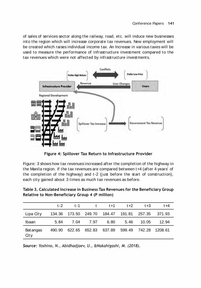
Conference Papers 141
of sales of services sector along the railway, road, etc. will induce new businessesinto the region which will increase corporate tax revenues. New employment willbe created which raises individual income tax. An Increase in various taxes will beused to measure the performance of infrastructure investment compared to thetax revenues which were not affected by infrastructure investments.
Figure 4: Spillover Tax Return to Infrastructure Provider
Figure: 3 shows how tax revenues increased after the completion of the highway inthe Manila region. If the tax revenues are compared between t+4 (after 4 years’ ofthe completion of the highway) and t-2 (just before the start of construction),each city gained about 3 times as much tax revenues as before.
Table 3. Calculated Increase in Business Tax Revenues for the Beneficiary GroupRelative to Non-Beneficiary Group 4 (P million)
t-2 t-1 t t+1 t+2 t+3 t+4
Lipa City 134.36 173.50 249.70 184.47 191.81 257.35 371.93
Ibaan 5.84 7.04 7.97 6.80 5.46 10.05 12.94
Batangas 490.90 622.65 652.83 637.89 599.49 742.28 1208.61City
Source: Yoshino, N., Abidhadjaev, U., &Nakahigashi, M. (2018).

142 ASCI Journal of Management 49 (2) September 2020
Figure 5 compares changes in various tax revenues, such as corporate tax, individualincome tax and other tax revenues based on the estimates created by highspeedrailways in Kyushu island of Japan.
Figure 5: Impact of Infrastructure on Tax Revenue
Source: Yoshino, N., & Abidhadjaev, U. (2017b)
Climate Change is another by product which has to be considered in the global callfor sustainable and quality infrastructure investments. Construction of road andhighways are sometimes criticised because they will increase pollution of the regionby exhaustion gases. Yoshino, Taghizadeh-Hesary, and Otsuka (2020) show thattaxation on pollution gases will lead investors to optimal portfolio allocation. Taxon gasoline will gradually push the shift from gasoline cars to electric cars whichwill reduce pollution gases along roads and highways. Infrastructure will bring newbusinesses and new residential areas into the region. New restaurants and newshops can be established which will create jobs and reduce poverty. Pollution andother dis-externalities should be solved by taxation rather than stopping theconstruction of new infrastructure investments. We propose charging a tax on CO2emissions to mitigate the environmental issues.
How to Measure the Impact of Infrastructure Investment into the RegionalEconomy
The construction of infrastructure will bring large benefits to the surrounding regions.The provisioning for water supply and electricity supply will invite private companiesand new residents. Restaurants and other services sector will come to the regionafter the completion of water and electricity supplies. Digital infrastructure willmake companies and individuals have easy access to the internet which will addvalue for their business. These are called externality effects (or spillover effects)
Conference Papers 143
created by infrastructure investment. It is believed that externality effects (orspillover effects) are not easy to measure (Yoshino, N., and Nakahigashi, M. 2004).Therefore, the evaluation of infrastructure was mainly concentrated on how muchtime would be reduced by new infrastructure investments. This paper shows theway to measure externality effects created by infrastructure investments bymeasuring how much GDP in the region had increased compared to other regions orhow much tax revenues increased in the region along with infrastructure comparedto other regions where no benefit is obtained by infrastructure investment. Theexisting infrastructure investments are struggling to maintain its infrastructure.Recent climate change affects weather conditions such as typhoons, floods, therise of sea levels, higher temperature, etc. These phenomena damage infrastructurein many parts of Asia. Maintenance costs are difficult to raise. User charges ofinfrastructure such as highway tolls, water tariffs, electricity prices, internet usercharges cannot easily be raised. If part of the spillover tax revenues were returnedto infrastructure operating companies, maintenance costs can easily be covered.Without infrastructure, there would not have been any spillover tax revenues intothe government. If the regions along existing infrastructure investments are growing,it is easy to return extra spillover tax revenues to infrastructure operators so as tocover its maintenance costs.
Increasing the Rate of Return from Infrastructure Investment
Traditionally, infrastructure investments relied on user charges such as water tariffs,electricity prices, highway tolls. Uses of water, electricity, and highways preferlow user charges. On the other hand, private investors in infrastructure prefer ahigher rate of return. There are conflicts between users and investors ininfrastructure. This will be the main causes of the difficulty in PPP. Not so manybankable projects exist.
The important part of infrastructure investment relies on how much eachinfrastructure would develop the region by bringing private businesses, increasingemployment and tax revenues. In the past, all these tax revenues were absorbedby both local government and the central government even though they are comingfrom the externality effect created by infrastructure. If part of these increased taxrevenues created by infrastructure were returned to the investors in infrastructureevery year, the rate of return from infrastructure investments would be a dottedline which is much higher than the cases relying only on user charges. In this case,spillover tax revenues are shared by government and infrastructure investors, 50percent each.

144 ASCI Journal of Management 49 (2) September 2020
Figure 6: Increase in Tax Revenue by Spillover Tax
Source: Yoshino, N., Abidhadjaev, U., &Nakahigashi, M. (2018)
Disclosure of Land Prices in Japan
In order to assess the price of land, disclosure of transactions of land prices in eachregion will be important information for land value evaluation. There is a websiteprovided by the Japanese government on which one can get the price of land byselecting the region. It shows the price of land in each area without identifying thename of the owner, etc. If similar data can be collected in each country and adisclosure system set up, everybody can access the data, not only land valueevaluators but also landowners. This would make it difficult for landowners to askvery high prices for their land when they plan to sell. The collection of such datashould be established in each country. Real estate evaluators would be asked toreport the prices of each transaction, and this would become the basis of the bigdata set of land price values in the country. This data would facilitate landtransactions without concealing their prices.
Measures for Secured Maintenance Costs of Infrastructure
Infrastructure operating companies have to spend some money for the maintenanceof infrastructure. If they rely only on user charges, it is not enough to keep theirmaintenance costs. Without a good running of transport infrastructure, the regionaleconomy does not work well. If a train stops due to lack of maintenance, businesses,and residents along the infrastructure have to face the large inconvenience. Becauseof good running conditions of infrastructure, regional tax revenues can be wellmaintained. Spillover tax revenues should be partly directed to maintain the existingtransport infrastructure in good condition. In other words, the spillover tax revenuescan only increase the rate of return for investors in transport infrastructure butalso covering the maintenance costs.

Conference Papers 145
Conclusion
Covid 19 is creating fiscal deficits which are only expected to grow larger in nature.Government spending capacity is reduced during the ongoing crisis. Infrastructureinvestment is a key element for economic recovery, and to maintain adequatefinancing, it is pertinent to ensure that the benefits of land are shared among allparties concerned, and due diligence and monitoring need to be in place to ensurefair and just means. The return of spillover tax and land trust are deemed toreduce the risks associated with infrastructure investments.
References
Lakhia, S. (2019). Land Pooling as a Means of Mitigating Land Displacement in India.Land Acquisition in Asia (pp. 167-181). Palgrave Macmillan, Singapore.
Meeting Asia’s Infrastructure Needs. (2017). Asian Development Bank.
Mishra, P., & Suhag, R. (2017). Land records and titles in India. PRS LegislativeResearch.
Yoshino, N, and Nakahigashi, M. (2004). “The Role of Infrastructure in EconomicDevelopment.” ICFAI Journal of Managerial Economics 2: 7–24.
Yoshino, N., & Abidhadjaev, U. (2017). Impact of infrastructure on tax revenue:Case study of high-speed train in Japan. Journal of Infrastructure, Policy andDevelopment, 1(2), 129-148.
Yoshino, N., & Pontines, V. (2018). The “Highway Effect” on Public Finance: TheCase of the Southern Tagalog Arterial Road Tollway in the Philippines. FinancingInfrastructure in Asia and the Pacific, Edited by Yoshino, N., Helble, M., &Abidhadjaev, U. Chapter 3, 80-99.
Yoshino, N., Abidhadjaev, U., & Hendriyetty, N. (2019). Quality InfrastructureInvestment and Land Trust. Global Solutions Journal, 1ssue 4, 156-163.
Yoshino, N., Abidhadjaev, U., & Nakahigashi, M. (2018). Closing the AsiaInfrastructure Gap. Horizons: Journal of International Relations and SustainableDevelopment, (10), 62-75.
Yoshino, N., Nakahigashi, M., & Pontines, V. (2017). Attract private financing toinfrastructure investment by injecting spillover tax revenues. Nomura Journalof Asian Capital Market, 1(2), 4-9.

146 ASCI Journal of Management 49 (2) September 2020
Yoshino, N., Paul, S., Sarma, V., & Lakhia, S. (2018). Land acquisition andinfrastructure development through land trust laws: A policy framework forAsia (No. 854). ADBI working paper series.
Yoshino, N., Paul, S., Sarma, V., & Lakhia, S. (2019). Land Trust to FacilitateDevelopment Through Land Transfer. In Land Acquisition in Asia (pp. 135-145).Palgrave Macmillan, Singapore.
Yoshino, N., Taghizadeh-Hesary, F., & Otsuka, M. (2020). Covid-19 and OptimalPortfolio Selection for Investment in Sustainable Development Goals. FinanceResearch Letters, July, available online,101695.
Yoshino, N., Wisuttisak, P. (2020). Land trust law & its importance for both publicand private use. Japan Spotlight, March/April 2020, (PP.47-50).

Conference Papers 147
Felipe Francisco De Souza*
Nakasu Land Readjustment Project In Nagoya, Japan:Analyzing Development Costs And Benefits In Replotting Design
Abstract
Land readjustment is a public-private instrument in which governments andlandowners bear the urban development costs and benefits in places where existingland use patterns are inadequate and inefficient. The primary mechanism for theimplementation of a land readjustment project is known as replotting. Replottingmeans the change of location, format, and area of several plots of land to achievea project’s final scenario. Often, the scenario expectations are that every piece oftransformed private land will be smaller than the original one due to the significantincrease in public spaces, and a higher land value due to the added facilities.However, such a transformation process needs to be conducted under clearprocedures as any project-related intervention requires the commitment of existingrights holders, which affects their social, cultural, and economic realities. Thepresent work analyzes replotting through the land readjustment project of Nakasuin Nagoya, Japan. The goal is to understand how the Japanese manage the replottingdesign and some of its related features, such as land contribution, appreciationproportional ratio, and reserve land. During any replotting design process, it willbe necessary to calculate the government share through subsidies but also theburden over landowners through their contribution to cost recovery land. Knownas R/Rmax, the analysis expresses if the landowners’ share of the project costswill be heavy or if they will receive most of the development benefits. As aconclusion, the research praises the advantage of the Japanese replotting design:it is logical and scientific, and it emphasizes the acknowledgment of land pricesbefore and after the project at the same time, which makes it easier to gainrights holders’ understanding and acceptance. Therefore, the work clarifies theJapanese replotting design for countries aiming to adapt and implement landreadjustment according to their own planning systems.
Introduction
Land readjustment can be defined as a public-private instrument in whichgovernments and landowners bear the urban development costs and benefits inplaces where existing land use patterns are inadequate and inefficient. The primarymechanism for the implementation of a land readjustment project is known as‘replotting.’ Replotting means the change of location, format, and area of several
* Senior Urban Specialist and Ph.D. Scholar, University of Tokyo. Email:[email protected]

148 ASCI Journal of Management 49 (2) September 2020
plots of land to achieve a project’s final scenario. Often, the scenario expectationsare that every piece of transformed private land will be smaller than the originalone due to the significant increase in public spaces. Also, it is expected that thevalue of the replotted land will be higher than the original land, due to the effectiveimprovement in its use, and its proximity to new urban facilities, such as greenareas and roads. The percentage difference in the private property area beforeand after replotting is called the ‘contribution ratio.’ Its value corresponds to thearea of the reduced property after project implementation, and to the amount ofbenefits that a given area requires, shared among all rights holders. Replotting andcontribution, therefore, serve two complementary purposes: (i) to adjust thedemand for land required for proper urbanisation, and (ii) to create supply to –partially or fully finance project costs.
In Japan, the contribution of land also aims to amalgamate shares in ‘reserve land,’or ‘cost recovery land,’ which are plots of land to be sold to finance landreadjustment projects. The location, quantities, and dimensions of reserve landare determined according to (i) the economic criterion, which is the capacity tofinance new public facilities; and (ii) the equity criterion, which is the ability toequitably balance the land value increase generated by the land readjustmentproject. Although the sale of reserve land is intended for the payment of the projectcosts, the government can provide subsidies for the implementation of relatedlarger infrastructure projects. As explained by Sorensen (2000), in Japan, first,land readjustment has shown benefits due to the potential to be a self-financingtechnique for urban land and infrastructure development, as it is cheaper than togather all project land into a single ownership, whether on the open market or byexpropriation. Second, the pattern of property divisions is reformed and newinfrastructure and public spaces are supplied. This feature is particularly importantin locations where rural property divisions were irregular and fragmented into manysmall parcels with little or no road access as it is common in rice paddy areas.Third, the original landowners retain title to the majority of their land. This resultsin less landowner opposition to projects than in the case of large-scale landexpropriation and development, and is less disruptive of the existing community.
Japanese Land Readjustment Act of 1964
After the Second World War (1939-1945), land readjustment became the target ofa national legislation in Japan, the Land Readjustment Act No. 119 of 1954 (LRA).The purpose of the law is to facilitate the building of sound urban areas and toencourage public benefit by enacting necessary measures for implementing andallocating project expenses to land readjustment projects (LRA article 1). Accordingto the law, the implementation agencies for land readjustment projects are dividedinto six categories (LRA articles 3 to 3.3), which the most important are prefecturalor municipal governments, and associations of landowners and leaseholders. In thecase of an implementation agency set up as an association, it is necessary to obtain

Conference Papers 149
consensus from at least two-thirds of all landowners and leaseholders respectivelywithin the project area. Moreover, the total sum of the areas of the landowners’and leaseholders’ plots that consent to the project’s implementation shall at leasttotal two-thirds of the total land area of landownership and land lease rights (LRAarticle 18). Where the land readjustment project is carried by the public sector,this requirement is not necessary because the project shall be implemented as acity-planning project according to the city master plan.
The implementing agency shall formulate the replotting plan to enforce thereplotting of the plots within the project area. According to the law, the replottingplan shall guarantee the maintenance of the characteristics corresponding to theoriginal land “in terms of location, area, soil, water supply, land use, environment,and other conditions” (LRA article 89). This is known as the ‘principle ofcorrespondence’ and in cases that a full correspondence is not possible, at leastpart of the transformed land must keep the original characteristics. The replottingplan comprises of (i) a replotting design, (ii) specifications of each replot, (iii)specifications for equity payment for each plot and each right, and (iv) specificationof the lands with special arrangements, such as reserve land, among others (LRAarticle 87). Such plan shall consider the following measures to avoid excessivelysmall plots of land, (i) the small land and the adjoining land may be consolidatedto one replot and the landowners may get co-ownership of the replot, if theyagree; (ii) the replot may not be applied to the small land and equity shall be paidby the landowner instead (LRA articles 91.4 and 94); or (iii) land plots that are bigenough shall be able to be reduced, and used for additional allocation to the smallland. In this case, the landowner shall be given or pay the equity respectively (LRAarticles 91.5 and 94). Imbalances which may arise during replotting shall be correctedby means of equity payments, which shall be established in monetary terms (LRAarticle 94).
Problem being Addressed
After the Second World War and after the coming decades where colonialism andcolonial processes came to an end, a whole new space for the diffusion of ideasand models emerged. International agencies, therefore, became the main driversto support the developing world in turning ideas into reality and, consequently,scholars began to explore the outcomes of such processes. The process to introducethe idea of land readjustment for urban development to a number of Asian developingcountries – mainly sponsored by the Japanese government – has been one of themost significant international collaborations in urban planning in the twentiethcentury. Land readjustment adaptation and implementation processes can replaceold approaches and precede significant changes within planning cultures.Thepossibility that land readjustment was self-financing through the sale of landcontribution was very appealing as one constraint on the development of facilitiesin developing countries is the chronic lack of funds. Also, the widespread desire to

150 ASCI Journal of Management 49 (2) September 2020
find self-help, participatory techniques of urban development which could mobiliselocal actors and resources, and could clarify ambiguous and complex land tenurerights, were key arguments in favor of land readjustment.
Additionally, Japan was highly responsible for the portrayal of land readjustmentas a consensus-based process initiated by the government and local landowners,especially by promoting the association type of project – mainly from particularcases in Nagoya city throughout international seminars promoting land readjustment.The Japanese association-led type of project highly differs from the government-led one, which government national interests and enforcement capacity is putaside and its nature seems similar to private and profitable development type.There are concerns with some of the Japanese literature on land readjustment,especially those published in English, because they constantly conceal the difficultiesto conclude both types of project, and the vigorous opposition that commonlyemerged in Japan (Sorensen 2000; 2007). However, such time-consuming processesneed to be conducted under clear procedures as any project-related interventionrequires the commitment of existing rights holders, which affects their social,cultural, and economic realities. The present work intends to analyze replottingthrough the land readjustment project of Nakasu in Nagoya, Japan. The goal is tounderstand how the Japanese manage the replotting design and some of its relatedfeatures, such as land contribution, appreciation proportional ratio, and reserveland. Therefore, the work intends to clarify the Japanese replotting design forcountries aiming to adapt and implement land readjustment according to theirown planning systems.
Research Methodology
The research methodology will largely rely on the theory of replotting design asproposed by Yanase (1996). Replotting design intends to measure the transfer ofownership rights from the original plot to the new replot, and the amount anddisposition of betterment contribution for the public facilities and for the reserveland (or the cost recovery land). This approach (or the absorption of costs andbenefits development model) is a photograph – on average – of the exact momentof the project before it starts and the exact moment of the project after it finishes.So it has several limitations like it is not possible to tell what happens during theproject (if affected by externalities like inflation, credit programs, etc.) and afterthe project in a short or long term (if affected by externalities like taxation andchange in zoning regulation that might affect land prices, etc.). Also, replottingdoes not consider the ‘spill-over effect’ which the increase in land prices areabsorbed by private properties outside the project area, but rights holders did notparticipate or contributed to the project.
Figure 1: illustrates briefly the replotting design that will be detailed in the comingparts of this work. Y-axis provides information related to the land price per square

Conference Papers 151
meter before (a) and after (e) the project implementation – on average – and anintermediate price (if), which represents how much land price per square metershould be if the total private asset value before the project (A • a) equaled to thetotal private asset value after the project (A • a = E • e). Y-axis also provides atheoretical land price (b) which represents the maximum price before thedistribution of the positive net benefit being captured as reserve land by theimplementation agency. X-axis provides a total area of land (PRJ) before and afterthe project implementation divided into private areas and public areas (road system,green and parks, and other uses). Outside the rectangles on the right side, it hasprovided information related to the distribution of positive net benefit derivingfrom the project (R/Rmax). ‘Rmax’ is the acreage of the reserve land that could besecured theoretically at a maximum, which means that the total positive net benefitwould be captured by the implementation agency (in which theoretically, landownersget no profit from the project), and “r” and “1–r” expresses how much landownersshare the costs and the benefits of the project. Outside the rectangles, it has alsoprovided the distribution of project expenses, or total project costs, and therepresentation of how much from the total cost was paid using government subsidiesand how much was paid using the sale of reserve land. Finally, it was included‘Property Taxation after Urbanisation’ which might capture valuation in land pricesin the long-run.
Figure 1: Replotting Design, Distribution of Positive Net Benefit,and Project Expenses
Source: Author’s consolidation of the framework proposed by Yanase (1996).

152 ASCI Journal of Management 49 (2) September 2020
Case Study: Nakasu Project in Nagoya
The city of Nagoya is located approximately at the center of Japan. Its urban areahas expanded gradually to the present area of 326.45 square kilometers due to theconsolidation of neighboring municipalities and land reclamation processes. Since1955, the city of Nagoya has been implementing land readjustment projects throughassociations, focusing on the existing areas excluded from the ‘War RehabilitationPlan’ and old areas requiring improvements of urban infrastructure. Areas in Nagoyaimproved by land readjustment projects (including arable land readjustmentprojects), implemented by both the government administration and associations,affected about 22,000 hectares. If the approximately 1,100 hectares currently underconstruction are included, the land readjustment implementation covers nearly68% of the entire city area.
Among over 200 association-led projects already implemented in Nagoya since theenactment of the Land Readjustment Act No. 119 of 1954, the project of Nakasu isone of them.The area where this association was enforced is located in the west ofNagoya, east of Chuo Shônai River in Nakagawa Ward, and about 7.5 kilometersaway from the city center. Before the project implementation, the area wascomposed of flat paddy fields (about 80% of the total area) and there was only oneroad with an average width of 1 to 2 meters running between some residentialunits and the farmlands. In the northern part of Nakasu, back 1972 when itsassociation was established by its 82 rights holders, there was no facility otherthan water supply pipelines. The project took 5 years to be completed and toreorganise 217 plots of land in the enforcement area of 77,091 square meters.After completed, the average size of private parcels in the project decreased from330.68 to 226.30 square meters and a sewage treatment plant was constructed.
Figure 2: Land Readjustment Project of Nakasu (1972-1977)(Maps before and after the Project implementation, and
satellite image after project implementation)
Source: Nagoya City Government (1983; 2009).

Conference Papers 153
Replotting, Proportional Ratio, and R/RMAX
Once again, replotting means the change of location, format, and area of severalplots of land to achieve a project’s final scenario. As an example to understand theJapanese replotting design, we will research the Nakasul and readjustment projectby association in the city of Nagoya. First of all, every association-led project musthave a budget to be approved by the government, considering the implementationexpenditures and estimated revenues. Expenditure refers to all relevant costs relatedto (C1) construction, (C2) removal and relocation of facilities, (C3) soil preparation,(C4) research and project development, and (C5, C6) direct and indirect costsaccording to the specificities of the project. Revenues refer to all sources of fundsfor the project development: government subsidies – (NS) national, (PS) prefecturaland/or (LS) local subsidies –, (R x e) gains from the sale of reserve lands, and (OS)other sources of revenues. Table 1 presents the final budget as established forNakasu association-led project.
Table 1: Nakasu Project: Expenditure and Revenue
Expenditure (thousand JP¥) Revenue (thousand JP¥)
Construction Costs (C1) 111,888 National Subsidies (NS) 0
Relocation and Compensation Costs (C2) 7,782 Prefecture Subsidies (PS) 0
Infrastructure and Soil Preparation (C3) 0 Local Subsidies (LS) 7,535
Research and Project Costs (C4) 7,126 Revenue from the Sale of 307,623Reserve Lands (R x e)
Miscellaneous and Office Costs (C5) 70,820
Indemnity and Interest (C6) 143,799 Other Revenues (OS) 26,257
Total (T) 341,415 Total (T) 341,415
Source: Nagoya City Government(1983; 2009).
After establishing the financial planning, it was necessary to establish a landevaluation system for all rights holders of the Nakasu project. Land evaluation hasa significant purpose to judge contribution for reserve land, calculate compensationfor loss in damage, calculate replotting area, and calculate equity collection andpayment. Besides the conventional system based on market value for land evaluationand real estate appraisal, the Japanese land readjustment uses three additionalcalculation methods: experience-based, zone value, and street value evaluationmethods. The street value is the most widely used today, which was first introducedin 1950 as ‘The Standard for Calculation of Land Use Value,’ which became later in1978 ‘The Standard for Land Evaluation in Land Readjustment.’

154 ASCI Journal of Management 49 (2) September 2020
In the street evaluation method, the price per unit area of a plot facing a streetwith standard frontage and shape is assumed as the street value for a street. Plotsare then evaluated based on this street value, with modifications made correlatingits location with the street, shape and use conditions. The street value is composedby the sum of index figures evaluated separately, consisting of street, accessibility,and land coefficients. The street coefficient gives a value according to the continuity,degree of systematicness, and condition of the road a plot faces, which are presentedby a road rank, road width, existence of sidewalk, pavement, street trees, parkinglanes, slope, and curves, among others. The accessibility coefficient gives value tothe distance between the plot and public facilities, such as train stations, parksand schools; and also, conversely, gas tanks, sewage treatment plants, graveyards,and other unwelcome facilities that are considered minus factors. The landcoefficient gives value to the plots features, such as scale, land use, public landratio, street density, conditions of sunlight, ventilation, topography’s security, andinstalled infrastructures, such as water, sewage, electricity, and gas supplies.
By using formulas and charts stating values for every coefficient mentionedpreviously, the street value is converted into a street value index to be multipliedindividually by each plot size according to its individual features, such as locatedin the corner, sandwiched between two streets, flag-shaped, or being isolated. Theevaluation of each plot must be adjusted according to land market prices in thearea, and judged by sales or by indexes as the property-tax evaluation, nationalevaluation for succession tax, and publicly announced land prices. In short, youhave a numerical evaluation for every land parcel, grading every property, beforethe execution, to be compared with the graded property after the execution of theland readjustment project.Then, the replotted plots will be adjusted according tothe acquired benefits and legally required to obey the ‘principle of correspondence,’in which the replotted land and the former land shall correspond as much as possiblein terms of location, soil, water condition, land use, and environment, amongother features. After the evaluation of every right according to the mentioned landevaluation method, it is necessary to establish an overall contribution ratio fromthe private ownership to increase the public area required for the projectimplementation. In the case of the Nakasu project, within its 7.7 hectares, it wasstipulated a public area increase from 6.92% (M) to 21.12% (N), proportionallycompared to the reduction of the private properties from 93.08% to 78.88%. Includedin the 78.88% of private areas after the project implementation, 15.18% wereearmarked for reserve lands, targeting the revenue of JP¥ 307 million to make theproject financially feasible (see Table 1). Table 2 summarises land use classificationbefore and after the project completion.

Conference Papers 155
Table 2: Nakasu Project: Land Use Before and After the Project
Category Before the project After the project
Area (m2) (%) Area (m2) (%)
Public areas
Road system 3,332 4.32% 14,276 18.52%
Parks and green areas 2,002 2.60% 2,002 2.60%
Streams, rivers and water sources 0 0.00% 0 0.00%
Subtotal 5,334 (M) 6.92% 16,278 (N) 21.12%
Private areas
Private properties 71,757 (A) 93.08% 49,108 (E) 63.70%
Reserve lands - 0.0% 11,705 (R) 15.18%
Subtotal 71,757 93.08% 60,813 78.88%
Total (M + A) | (N + E + R) 77,091 100,0% 77,091 100,0%
Source: Nagoya City Government (1983; 2009).
Since a decrease in the private property area will take place for the improvementin public facilities and the establishment of reserve land to fund the project costs,the contribution ratio is the sum of land increase for public areas (P = N – M), plusthe contribution for the establishment of reserve land (R), divided by the totalarea of private properties prior to the project implementation (A), multiplied by100 (or percentage). The total contribution ratio for the Nakasu project was 31.56%(see Table 3). This ratio is an average contribution of all the land parcels, whichwill be equalised – may increase or decrease – when an individual land parcelevaluation is conducted according to the original asset relationship with the previousroad, infrastructure, and public facilities conditions, and the posterior characteristicof the plot after the replotting plan according to the street evaluation method.
Table 3: Nakasu Project: Land Contribution Ratio Calculation
Private Properties Contribution Contribution Ratio
Before the After the Increase in Reserve Total Public Reserve Total d =Project(A) Project Public Areas Land(R) (P + R) Areas Land ((P + R)
(E = A - P - R) (P = N - M) (P / A) (R / A) / A)
71,757 m² 49,108 m² 10,944 m² 11,705 m² 22,649 m² 15.25% 16.31% 31.56%
Source: Nagoya City Government (1983; 2009).

156 ASCI Journal of Management 49 (2) September 2020
After getting the average contribution ratio, analysis and valuation of the properties’net asset value need to be estimated. The proportional ratio is defined as thecomparison between the previous and posterior land values, and the previous andposterior area of the private properties, excluding reserve land. For instance, ifthe contribution ratio (d) is 33.3%, the value per square meter is required to increase50% (land value increase ratio (y) = 1.5) in order to maintain the equal balance ofvalues between previous land plot value and posterior replot value (in this case theproportional ratio (Pr) is 1).
Equal balance: The proportional ratio Pr = (1 – d) y = (1 – 33.3%) 1.5 = 1
Table 4 illustrates that by dividing the estimated value after the project (e) by thevalue per square meter before the project (a) we will estimate the land valueincrease ratio (y = previous land price divided by posterior land price). In the caseof the Nakasu project, JP¥ 14,942 per square meter was the average assessed landprice before the project implementation; and estimated to rise to JP¥ 26,281 persquare meter, an increase of 75.9% (y = 1.759) after the project completion. If wedivide the total value of private properties after the project (V’ = area of privateland without reserve land (E) multiplied by the estimated unit value (e)) by thetotal value of private properties before the project (V = area of private land (A)multiplied by the unit value (a) before the project implementation) we will reacha relative appreciation of the value of private properties caused by the project,which is called appreciation proportional ratio (Pr). Pr is 1.204 in this case (calculatedwith private land without reserve land).
Pr = V’ / V = E e / A a = (1 – d) y = (1 – 31.56%) 1.759 = 1.204
Table 4: Nakasu Project: Increase Ratio and Proportional Ratio Calculation
Private Properties Before the Project (A) 71,757 m²
Price per m² Before the Project (a) ¥ 14,942 / m
Total Value Before the Project (V = A a) ¥ 1,072,215,567
Whole Replots After the Project (E) 49,108 m²
Price per m² After the Project (e) ¥ 26,281 / m²
Total Value After the Project Without Reserve Land (V = E e) ¥ 1,598,246,689
Land Value Increase Ratio (y = e / a) 1.759
Proportional Ratio (Pr = V’ / V) 1.204
Source: Nagoya City Government (1983; 2009).

Conference Papers 157
The proportional ratio Pr is also used to calculate the area of each individualreplotted lot, as Pr is a constant (common for all the land plots). The followingformula determines the relationship between the value of an individual plot beforethe project and the value of its replot after the project,
Formula 1. Proportional Ratio Calculation
Pr Ai ai = Ei ei (Pr is the same for all the land plots and replots)
When Pr is calculated, the area of an arbitrary individual replot (i) can be calculatedas follows:
Ei = (Pr Ai ai) / ei
Pr: the proportional ratio of total private-plot value
Ai: area of an individual plot (i) before the project (m2)
ai: unit value of an individual plot (i) before the project (¥/m2)
Ei: area of an individual replotted plot (i) (m2)
ei: unit value of an individual replotted plot (i) (¥/m2)
Consequently, it was necessary to establish the project costs share through thecontribution for reserve land for the Nakasu project. Reserve land is the resourcefor the project costs’ recovery, and landowners share the project costs with thecontribution of their land for reserve land. The weight of landowners’ share ofcosts is expressed as r = R/Rmax. ‘R’ is the acreage of the reserve land that isactually secured in a project while ‘Rmax’ is the acreage of the reserve land thatcould be secured theoretically at a maximum, which means that the total value ofall the replots is equal to the total value of all the private land before the project(in which theoretically landowners get no profit from his land). The “r”, ascalculated, shows how much landowners share the costs and the benefits of theproject: if “r” is 100%, it means that all landowners’ share of the project costs isquite heavy, and if the “r” is 0% (there is no reserve land), it indicates thatlandowners will receive most of the development benefits. In Japan, “r” (R/Rmax)is used as an indicator of the necessity of government financial support (subsidy).If R/Rmax calculated without subsidies is more than 1 (or 100%), the governmentrecognizes the necessity of subsidy. If a project receives government subsidy, ‘R’decreases, so, “r” also decreases. The condition of the provision of subsidy fromthe government is that R/Rmax calculated with subsidies needs to be more than50% in principle. Table 5 illustrates that, in the case of the Nakasu project, the “r”was 58.48% considering an increase in land value, on average, from JP¥ 14,942 (in1972) to JP¥ 26,281 (expected after 1975).

158 ASCI Journal of Management 49 (2) September 2020
Table 5: Nakasu Project: Reserve Land and R/Rmax Calculation
Total Value Before the Project(V = A a) ¥ 1,072,215,567
Total Value After the Project With Reserve Land (Ve = (E + R) e) ¥ 1,598,246,689
Increase of Total Value (V = Ve – V) ¥ 526,031,121
Price per m² After the Project (e) ¥ 26,281 /m²
Reserve Land
Maximum Acreage of Reserve Land (R max = V / e) 20,015 m²
Acreage of Reserve Land (R) 11,705 m²
r = R/Rmax 58.48%
Source: Nagoya City Government (1983; 2009).
Following the project plan and the financial plan, consensus building is performedin order to carry on the project. Then, the draft project plan with the financialplan of the Nakasu project was submitted to the government; such a plan includedthe draft of the implementation ordinance stipulating project costs, the landreadjustment council, the land evaluation advisors, and the equity estimation,among others. The draft of the project plan and the implementation ordinancewere presented for public inspection. According to the actual legislation, writtencomplaints can be submitted within the two weeks period for the project’s publicinspection to the prefectural governor. The governor shall order the implementingagency to modify the implementation ordinance or the project plan if the objectionsare found to be valid, and shall notify the submitters that the objections wererejected if the objections are found to be invalid. In general, complaints in landreadjustment projects are commonly related to equity issues, such as landownerswill require that former land should receive better treatment in calculation thanothers’ land. In the Nakasu project, no written complaints were submitted.
After the project plan and implementation ordinance were approved, in order toundertake construction works, the implementation agency designated the provisionalreplotting so that the landowners and leaseholders were required to stop utilisingtheir original land, when necessary for construction works. For the provisionalreplotting, the implementation agency formulated a draft replotting plan listeningto opinions of the land readjustment council and land evaluation advisors.Also,negotiated with rightholders with the draft through individual explanations aboutthe relationship between the new and the old property locations, the new shape ofreplots, and the reasons why he/she needs to bear his/her particular contributionratio. After the enforcement of replotting and end of the construction works, thenew replots were registered and the association was dissolved on April 26, 1977.
Conference Papers 159
Conclusions: Research Results and Limitations
Japan, a nation with a high likelihood for natural disasters, over the past decades,has spent considerable effort to achieve better technical results in its urban realitytransformation. Throughout this entire process, methods for territorial planningwere institutionalised across the country, including land readjustment aiming toimplement infrastructure and land pattern changes, without the extensive use ofexpropriation. With the strong and centralised Japanese State lending its efforts,from time to time, to specific goals – such as the promotion of industrialisation –the city of Nagoya received less national investment than other large cities inJapan. This forced the city to develop urban areas at its own expense aiming tobenefit from land readjustment. The present work analysed the replotting design –a primary mechanism for the implementation of a land readjustment project –through the project of Nakasu in Nagoya, Japan. The goal was to understand howthe Japanese manage the replotting design and some of its related features, suchas land contribution, appreciation proportional ratio, and reserve land. As aconclusion, the research praises the advantage of the Japanese replotting design:it is logical and scientific, and it emphasises the acknowledgment of land pricesbefore and after the project at the same time, which makes it easier to gain rightsholders’ understanding.
After analysing the replotting design of the Nakasu project, it was possible toidentify a land contribution ratio of 31.56%, including 16.31% just for reserve land;and the landowners’ share of the project costs (R/Rmax) was 58.48% of the plus-value of increasing property values to be absorbed as reserve land. The rest of theproject costs were subsidised with a local government subsidy. Therefore, R/Rmaxcan be understood as a metric to evaluate the share of cost and benefits in theimplementation of land readjustment projects. As a photograph – on average – ofthe exact moment of the project before it starts and the exact moment of theproject after it finishes, the presented replotting design has limitations because itis not possible to tell what happens during the project (if affected by externalitieslike inflation, credit programs, etc.) and after the project in short-run or after along period of time (if affected by externalities like taxation and change in zoningregulation, etc.). Also, the benefits related to the increase in land prices are notcompletely absorbed by the rights holders as they will be absorbed by thegovernment in the long-run through Municipal Property Tax levied from 1.4% to2.1% (excluded one-third of the assessed value in case of residential areas), andthrough the City Planning Tax levied at a flat rate of 0.3%, both from the assessedvalue after the land readjustment project. So attention must be paid whenreplicating the Japanese replotting design to other countries and their differenteconomic realities.
160 ASCI Journal of Management 49 (2) September 2020
References
Nagoya City Government, Planning Bureau Land Readjustment Section. 1983. LandReadjustment in Nagoya City [ ]. Nagoya: LandReadjustment Association.
Nagoya City Government, Planning Bureau Land Readjustment Section. 2009. LandReadjustment in Nagoya City [ ]. Nagoya: LandReadjustment Association.
Sorensen, A. 2000. “Conflict, Consensus or Consent: Implications of Japanese LandReadjustment Practice for Developing Countries.” Habitat International 24(1):51-73.
Sorensen, A. 2007. “Consensus, Persuasion, and Opposition: Organizing LandReadjustment in Japan.” In Analyzing Land Readjustment: Economics, Law, andCollective Action, edited by Y. Hong, and B. Needham, 89-114. Cambridge: LincolnInstitute of Land Policy.
Yanase, N. 1996. A Theory of Replotting Design in Land Readjustment: AdoptingLand Readjustment in Malaysia. Yokohama: Civil, Ind.

Conference Papers 161
Aparna Das*, Kasinath Anbu**, Arpan Mazumder***
Exploring feasibility of Land Pooling/Land Readjustment instruments ininformal settlements –a Perspective from the Ground (India)
Abstract
The assembly of privately owned land parcels, having no clear titles, forcomprehensive urban redevelopment is a vastly unexplored area with immenseknowledge gaps. To a large extent, cities in India reflect this knowledge deficit,with most parts of the cities growing without conforming to the statutory plans.Many states have made efforts in strengthening the private property regime throughland/property records modernisation, conferring land rights through land titlingprojects/programmes. However, these initiatives remain agnostic to the land useplanning processes. Mechanisms for assembling land remain limited, especially insettlements with ambiguous or no land titles. In recent times, with the increasedcontestations over land, it has been near impossible to acquire land throughvoluntary exchange or using the instrument of ‘eminent domain’. Taking the leadfrom countries like Germany, Japan, the Netherlands, explorations have been madeto implement spatial tools like Land Pooling (LP)/Land Readjustment (LR) forassembling land in India. Public institutions mostly deploy these tools to executelarge infrastructure projects. However, in its present state, LP/LR is not relevantin informal settlements having ambiguous/no legal titles. Further, these toolsneed to be implemented in close coordination with the revenue administration,which oversees the ownership aspects of the land parcels. At present, these tworegimes- land use planning steered by the urban development authorities/urbanlocal bodies, and land management under the revenue administration operate insilos.
This paper argues that, with adequate adjustments, the current LP/LR tools havethe potential to be used in consolidating land, even for neighbourhoods withambiguous land titles. Taking the case of Berhampur city in Odisha, India, thispaper highlights the need to make better coordination between urban planninginstitutions and the revenue administration. It explores the gaps that limit theimplementation of such tools in informal settlements, followed by a set ofrecommendations.
* Senior Advisor, GIZ India. E-mail: [email protected]** Technical Advisor, GIZ India. E-mail: [email protected]** Technical Advisor, GIZ India. E-mail: [email protected]

162 ASCI Journal of Management 49 (2) September 2020
Introduction
Cities need to reconfigure themselves as the nature of their economies change.“Every now and again, cities have to recycle land for new uses. They do this tosurvive. For as technologies and markets change, cities must adjust –or stagnateand atrophy” (Correa, 2006). Cities are constantly transforming, demanding landreconfiguration to respond to new functions. These transitions are steered by theprevailing local political and macro-economic conditions. Like in numerousdeveloping nations, in India, almost 80 percent of the urban population is employedin the informal sector(ILO, 2018). A large section of the population, especially thepoor, access housing/land through informal markets, knowledge about which arenot adequately documented.
“Great effort has been devoted to the precise delineation and assignment of thelegal and physical boundaries of private property. Yet, issues of unifying or assemblingprivate property rights for comprehensive urban redevelopment remainunderstudied.” (Hong & Needham, 2007). In Indian cities, two disjointed regimes,functioning in silos, shape the land/housing markets. On one hand, land use planning(part of urban administration) allocates land for different functions, such asresidential, commercial, etc. These agencies, usually the development authorities,operate more as a technocratic agency, and remain insulated from the prevailinglocal political economy. Hence, the statutory plans, like Master Plans/ComprehensiveDevelopment Plans (CDPs), tend to remain utopian and mostly non-implementable.The land ownership and management aspects, on the other hand, are steered bythe revenue department (part of rural administration). Its authoritarian nature isetched in the way businesses are conducted and in its engagement with the localpopulace. The processes are cumbersome, convoluted, and beyond the reach ofthe common citizens, especially the poor.
Against this backdrop, it is not surprising that the Indian cities are growing outsidethe formal planning processes. As of 2014, only 24 percent of the cities have statutoryplans (Shirsagar & Srinivas, 2014). On an average, 30-40 percent of a city’s populationlive in slums/informal settlements, without access to adequate housing and basicservices. Most often, urban dwellers, especially those living in slums/informalsettlements, claim their stake on the city’s land through political negotiations/social contracts and not through de jure route (Payne, Lasserve, & Rakodi, TheLimits of Land Titling and Home Ownership, 2009). This ground reality does notreflect coherently in the public policy domain. States continue to focus on urbanland titling programmes, which advocate for individual private property rights.Succumbing to the persuasive arguments by de Soto (Soto, 2000), there has beenan impetus among the public institutions to define the private property rights anddelineate land ownership. The underlying assumption is that, once the urban poorhas the de jure property rights, they will be able to mortgage their property.However, studies have established that, even after receiving the de-jure rights,
Conference Papers 163
urban poor may still be unable to access the institutional credits (Cockburn &Quispe, 2013) (Das & Mukherjee, 2018). Scholars have established the existence oftenure continuum in cities (Payne, Lasserve, & Rakodi, Urban Land TitlingProgrammes. Legal Empowerment – A Way Out of Poverty, 2007) (Fernandes, 2011).Further, urban land ownership is fragmented, with almost 45 percent of the urbanpopulation owning land less than 0.005 ha. (Ministry of Statistics & ProgrammeImplementation, 2018). Regularising such large-scale informal areas via individualproperty rights is a Herculean task. Almost 66 percent of all civil cases in India aremostly related to land/property disputes (Wahi, 2019). Acknowledging that thecapacity of the revenue administration, both in terms of finances and humanresources, are limited, an alternative solution needs to be explored. Integratingthe informal settlements within the scheme of the city-wide planning processes iscritical in creating inclusive and sustainable cities.
In urban areas, Land Pooling (LP)/Land Readjustment (LR) tools are not implementedin informal settlements having ambiguous/no land titles. Given that a largeproportion of the urban population lives in such settlements, it is indeed a challengeto assemble these areas for the purposes of upgrading/improving infrastructureand housing conditions. In this paper, the authors present a conceptual frameworkto explore possibilities to accommodate these informal settlements within the ambitof land use planning so as to facilitate upgrading/improvement projects.
In doing so, this paper adopts a theoretical framework approach to explore theapplicability of the LP/LR instruments in the context of urban renewal, especiallyfor the urban poor settlements without de jure tenure. The Pradhan Mantri AwasYojana (PMAY) - a centrally-sponsored mission mode programme aiming at providinghousing for all, mandates the states and cities to prepare Housing for All Plan ofAction (HfAPoA). The central ministry envisaged HfAPoA to be only a comprehensivelist of housing deficits with no spatial component. However, under the InclusiveCities Partnership Programme (ICPP) project, the Deutsche Gesellschaft fürInternationale Zusammenarbeit (GIZ) GmbH India supported the preparation ofHfAPoA for Berhampur city in Odisha, by incorporating spatial dimension to thehousing deficits. The spatial maps revealed that the city core is characterised bythin strips of plots, referred to as ‘narrow plots;, pointing to the need for reviewingcurrent development patterns. These areas have ambiguous/no land titles. Eventhe statutory documents, i.e., the Master Plan and CDP, remain silent on theseaspects. This paper builds on to the experience of preparing the Berhampur HfAPoA(Das, Anbu, Panda, & Mazumder, 2018) and the recommendations therein. It alsodraws on critical tenurial aspects from an urban land tenure study (Das & Mukherjee,2018), learnings from Beneficiary-led Individual House Construction (BLC)implementation in Odisha (GIZ India & CPR, 2020), and a detailed literature review.
One of the limitations arising of this approach and methodology is that the proposedconceptual framework is yet to be tested for its economic and social viabilityaspects.

164 ASCI Journal of Management 49 (2) September 2020
The paper is divided into four sections. The first section provides a description ofthe issues at hand and the adopted methodology. The second section discusses theLP/LR practices globally, with a focus on informal settlements, to understand theprevailing legal and governance systems, social cultural context, and land useplanning. The third section highlights the experiences and learnings from theBerhampur case study. The concluding section articulates the recommendationsand the possible way ahead.
Implementation of Land Pooling/Land Readjustment -Literature Overview
A literature review on the implementation of LP/LR tools in countries like Germany,Japan, the Netherlands, and Israel articulates that, for implementing such tools,an ecosystem that hinges on a robust legal regime is a prerequisite. Other necessaryconditions, such as functional land administration and management, urban planning,effective conflict resolution mechanisms supported by participatory localgovernance, are imperative (Dieterich, Dransfield, & Voss, 1993) (Sorensen, 2007).It is crucial to establish and sustain trust between the administration and thelandowners since these processes are long-drawn, requiring dedicated efforts.
In India, usually, the public institutions lead the LP/LR initiatives. There are veryfew examples that have been led by the private sector, one of the successful onesbeing the Magarpatta LP model. This initiative was led by a group of farmers whodo not qualify as ‘distressed.’ About 120 farmers pooled in 174 ha. of land to forma township called ‘Magarpatta Township Development and Construction CompanyLimited’ (MTDCCL). As opposed to the situation where farmers usually lose theirland to real estate developments, in Magarpatta, the farmers became equity holdersin proportion to their holdings. Does this model offer solution to informal settlementsthat have no clear land titles?
The land assembly options with minor variations that are explored in various othercountries are as follows:
1. Land development techniques where a group of separate land parcelsis assembled for unified planning, servicing, and subdivision as a singleestate, with the sale of some of the new building plots to recover thecosts and the redistribution of the other plots back to the landowners.
2. Land pooling is differentiated as where land is legally consolidated(‘pooled’) by transferring ownership of the separate parcels of land tothe agency handling the transaction and redesign. A new replotting planwith infrastructure upgrading is mutually agreed upon between the agencyand the plot owners. The agency transfers the new building plots, usuallysmaller than the original plot size, to the landowners.

Conference Papers 165
3. Land readjustment is where the land parcels are only notionallyconsolidated, with the agency having the right to design services andsubdivide the land on a unified basis. Landowners then exchange theirrural land parcels for their building plots.
4. Plot reconstitution - another variation - is a regulatory arrangementimposed on landowners designed to facilitate the development of land,which requires the owners to contribute land and cash. Land remains inseparate ownership, and partial cost recovery is achieved through thebetterment tax.
In their current forms, the above options are not relevant for the informalsettlements. Various studies establish that plot owners in informal settlements areconcerned with plots’ use value rather than its transactional value. In India, theformal land/housing market is extremely skewed, leaving few options for the poorto access land/housing through the formal markets. As these informal settlementsget consolidated organically, there may be situations to carry out plot reconfigurationor consolidation for upgrading the utility infrastructure. However, the statutoryurban planning instruments fall short of including such measures. In the absence ofnecessary enabling conditions, small plot holders, especially those with ambiguouslegal land titles and lacking familiarity with the administrative processes, experiencetrust deficit and refrain from engaging in LP/LR processes. In addition, statutorydocuments such as the Development Control Regulations often do not includeprovisions for the implementation of LP/LR for small plot holders.
Global literature informs that there have been attempts to develop tools forintervening in informal settlements. Massachusetts Institute of Technology (MIT)has a rich repository1of case studies mainly from Latin America and Africa, whereplots in the informal areas are reconstituted. In 2001, Brazil adopted the ‘CityStatute,’ an innovative national legal framework to provide low-income familieswith housing in mainstream city areas. It incorporated ‘Special Zones of SocialInterest’ (ZEIS) as a land regularisation tool (Santoro P. F., 2015). The statute requiredmunicipalities with over 20,000 inhabitants to draw up or review their master planto include ZEIS, which advocated land having a ‘social function.’ It contested thereal estate market induced ‘highest and best use’ of land parcels by proposing theuse of well-located and more central areas for social housing. These zones areintended to integrate low-income groups within the mainstream city by promotingurban and land regularisation in informal settlements; enforcing the mandatorydevelopment of idle or underused buildings, including potential expropriations;and making real estate owners build a certain proportion of social housing units indevelopments located within ZEIS perimeters (Hirata & Samora, 2013).
1 http://web.mit.edu/urbanupgrading/upgrading/whatis/what-is.html

166 ASCI Journal of Management 49 (2) September 2020
Building on instruments like ZEIS, Latin American countries have reshaped/conceivedtheir normative frameworks in the last two decades. In 2016, Ecuador adopted aninstrument called the ‘Organic Law of Territory Organisation and Land Use andManagement’ (LOOTUS). It emphasises on urban, non-tax mechanisms to captureland value to achieve infrastructure financing. With this, Ecuador became part ofthe multiple processes of urban reforms taking place in the region (Rossbach &Montandon, 2017).
A host of the literature suggests that urban planning and land tenure linkages needto be explored further. Such discussion in the Indian context is in a nascent stage.The current political economy is focused on individual interests and not responsiveto the urban planning-based approach.
Against this background, this paper highlights the possibility of implementing urbanplanning instruments, such as zoning and subsequently LP/LR, which enable theurban poor to access serviced land/housing in cities. This paper describes howsmaller plots, especially the narrow plots having a width as little as 1.5-2.0 m,pose significant challenges in improving housing conditions and, in particular,implementing the BLC vertical of PMAY.
Potential for using LP/LR tools in Informal Settlements – Berhampur, Odisha
Berhampur city profile
Berhampur, also known as the ‘Silkcity,’ is located along the easterncoastline of India, in the Ganjamdistrict of Odisha, and is about 160 kmsouth of the state capital,Bhubaneswar. Berhampur is one of theoldest and most prominent placesbetween Bhubaneswar-Cuttack andnorthern Andhra Pradesh. During thecolonial era, the region formed a partof the Madras Presidency. Itsprominence can be gauged from thefact that a court existed here duringthe British rule. The BerhampurMunicipality, oldest in the state, wasformed in 1867, and only in 2008 itwas upgraded to the status of aMunicipal Corporation. The culture of
Figure 1: Regional setting ofBerhampur city
Conference Papers 167
the city, including its cuisine, is unique with a blend of Odia and Andhra cultures.
Institutional Structure
The Berhampur Municipal Corporation (BMC) (jurisdiction over an area of 80 sq.km.)caters to activities, such as preparing city plans, planning for economic and socialdevelopment, maintaining public health and sanitation services, provisioning ofpublic amenities (streetlights, bus stops, etc.). BMC is also responsible forimplementing the slum improvement programmes such as Rajiv Awas Yojana andPMAY. Under PMAY, it is mandated to prepare HfAPoA and detailed project reports(DPRs) for upgrading/redevelopment/resettlement of slums in the city.
The Berhampur Development Authority (BDA), constituted under the OrissaDevelopment Authorities Act (ODA Act) 1982, has jurisdiction over an area of 320sq. km. As per Section 9 of the ODA Act 1982, the CDP shall:
a. Define the various zones into which the land covered by the CDP may bedivided for the purpose of the development and indicate the manner inwhich the land in each zone is proposed to be used (whether by carryingout thereon of development or otherwise) and the stages by which anysuch development shall be carried out and
b. Serve as a basic pattern of the framework within which the zonaldevelopment plans (ZDPs) of various zones may be prepared
The CDP may provide for any other matter which is necessary for the properdevelopment of the area covered by such plan and for the health, comfort,convenience, and general betterment of the present and future inhabitants of thedevelopment area. Some of its key responsibilities include preparation of interim,comprehensive, and ZDPs, enforcement of provisions under these statutory plans(including building approvals), creation of housing stock (public housing) andcommercial complexes, and improvement of city level infrastructure andenvironment.
The State Revenue Department is the custodian of the land, concerned with mattersof land reforms, land tenure, land records, land acquisition, and any other mattersrelated to land. Its key functions include the creation and maintenance of landrecords/cadastre, management of land tenure, and registration of land and propertytransactions.
Housing Scenario
Predominantly, the houses are built either by individuals or private developers.Public agencies broadly cater to the housing supply in urban poor areas and theseareas are spread across the city. Housing supply in the form of apartments and

168 ASCI Journal of Management 49 (2) September 2020
gated communities is still a budding concept. While apartments are predominantlydeveloping towards the eastern part of the city, plotted housing and gatedcommunities are coming up beyond the urban local body (ULB) limits. Urban poorsettlements are spread across the city (core, developing, and undeveloped areas).
As of 2016, the city had a total housing stock of around 75,000. The number wasderived from various data sources, primarily the Census. An attempt was made tofurther understand the housing stock by types and affordability through limitedsurveys and the mapping of housing typologies.
The city is challenged with the prevalence of narrow plots in its core, which happensto be the commercial hub of the city, covering around 25 per cent of the total landarea (around 20 sq. km). However, the exact number of such plots is not available.This phenomenon is more of a property-sharing method (retaining the frontage ofthe property) than a compulsion due to poverty. Such built forms are observed inmany settlements along the coasts of southern Odisha and the neighbouring stateof Andhra Pradesh. Over generations, these plots have been divided and furthersub-divided into irrational sizes. It was observed that the transaction of such linearplots is an acceptable common practice in the local land market. Such plots areinhabited by both the poor and the affluent, with some of these settlements beingcategorised as slums.
Figure 2: A typical house on a narrow plot

Conference Papers 169
Figure 3: Sample Mouza (Division) map of Berhampur, CDP
Urban Poor Settlements
As per BMC (2016), the total number of slums in Berhampur is 254, having 23,973households. Among these, 158 are recognised by BMC. Slums are predominantlylocated in the city core (around commercial land uses and waterbodies).40 slumshave already been selected for upgrading/redevelopment under various governmentschemes. Out of the remaining 214, 146 slums (refer Table 1), comprising about5,700 households, are located on tenable private land, having clear land titles.
These 214 slums occupy about 3 per cent of the city area (2.3 sq. km), and houseabout 33 per cent of the city population. Out of the 214 slums, only 7 are largerthan 5 ha. and are located on private land. 188 of these slums have area varyingbetween 0.5 ha and 3.0 ha.

170 ASCI Journal of Management 49 (2) September 2020
Figure 4: Locations of slums and areas with linear plots
Table 1: Distribution of Slums Based on Land Ownership and Tenability
Tenability Tenable Untenable Semi- Partly No Total
Land ownership tenable untenable data
Govt. land 23 5 6 - - 34
Private land 146 2 12 2 3 165
Private and Govt. land 5 - - 1 - 6
Temple land 1 - - - - 1
No data 2 - - - 6 8
Total 177 7 18 3 9 214
Slums with Narrow Plot Division
There are 72 slums (about 11,000 households) with narrow plot division, havingmore than 3,000 semi-pucca and kutcha houses (refer Table 2). Out of these, 2,261non-pucca households are located on tenable private land (refer Table 3). Thesehouseholds have clear land titles, making them eligible for BLC subsidy.

Conference Papers 171
Table 2: Categorisation of Slums with Linear Plots Based on Tenability
Category No. of Total DU DU DU %slums dwelling pucca2 semi- kutcha4 SP+K
units pucca3 (K) to total(DUs) (SP) DUs
Tenable slums on 50 7,867 5,606 1,711 550 29%private land
Tenable slums 7 694 319 188 187 54%on govt. land
Tenable slums on 4 259 154 102 3 41%other ownership land
Semi-tenable slums 1 185 180 4 1 3%on govt. land
Semi-tenable slums 5 1,335 1,090 114 131 18%on private land
Partly untenable slums 3 360 333 14 13 8%on private and mixedownership land
Untenable slums on 2 189 134 53 2 29%private land
Total 72 10,889 7,816 2,186 887 28%
2 Pucca house: A house that has walls and roof made of the following material: Wallmaterial: Burnt bricks, stones (packed with lime/cement), cement concrete, timber,etc. Roof material: Tiles, GCI (Galvanised Corrugated Iron) sheets, asbestos cementsheet, RBC(Reinforced Brick Concrete), RCC (Reinforced Cement Concrete), timber,etc.
3 Semi-pucca house: A house that has fixed walls made up of pucca material, butthe roof is made up of the material other than those used for the pucca house.
4 Kutcha house: The walls and/or roof are made of a material other than thosementioned above, such as unburnt bricks, bamboos, mud, grass, reeds, thatch,loosely packed stones, etc.

172 ASCI Journal of Management 49 (2) September 2020
Table 3: Distribution of non-pucca houses in slums with linear plots
Tenability Tenable Untenable Semi- Partly Total
Land ownership tenable untenable
Government land 375 - 5 - 380
Private land 2,261 55 245 18 2,579
Private and Govt. land 39 - - 9 48
Temple land 66 - - - 66
Total 2,741 55 250 27 3,073
Challenges in implementing PMAY in Berhampur
Planning oversight
The statutory CDP of Berhampur acknowledges the issue of plots with narrowfrontages as one of the weaknesses while formulating the broad goals and strategiesfor the next 20 years(2011-2031). It primarily focuses on greenfield developmentwith the expectation that businesses and residences would relocate to the newlydeveloped peripheries, thereby reducing congestion in the city core. Hence, itprovides no strategies to address the topic of narrow plots in the city core. Rather,the emphasis is on the overall improvement of the old parts of the city throughupgrading/augmentation of roads, water supply networks, sanitation, and organisedopen spaces.
Narrow plots
The width of the narrow plots is usually lower than the prescribed ‘old settlementplot5’ (having a width ranging between 4.0 m and 6.3 m, plot depth being morethan three times the width, and located in an old settlement area). These plotscannot even accommodate a room that conforms to the prescribed minimum widthfor habitable rooms6 (2.4 m). These narrow plot divisions give rise to several issues,including physical inconvenience and lack of privacy; limited ventilation and lighting,leading to higher energy consumption and health risks (respiratory diseases);
5 Odisha Development Authorities (Planning & Building Standards) Rules 2020 (ODARules 2020)
6 As per ODA Rules 2020, a ‘habitable room’ means a room having an area of not lessthan 9.0 sq. m, width 2.4 m (min.), height 2.75 m (min.) occupied or designed foroccupancy by one or more persons for study, living, sleeping, eating, cooking if it isused as a living room, but does not include bathrooms, water closet compartments,laundries, serving and storage pantries, corridors, cellars, attics and spaces thatare not used frequently or during extended periods.

Conference Papers 173
difficulty in provisioning of basic services; heavy damage during natural/man-madedisasters due to the high population and built densities; restricted scope for futuredevelopment/upgrading, reduction in the commercial value of properties, etc.
Lack of ‘right legal papers’
One of the pre-requisites to avail BLC subsidy is the possession of ownershipdocuments of the land parcel occupied by a household. Initially, the Governmentof Odisha recognised the Record of Rights (RoR) in the name of the applicant as theonly admissible document. However, this stringent provision pushed most indigenthouseholds outside the ambit of the subsidy. In the city core area, it was found thatalthough many beneficiaries in the slums rightfully owned their plot, they did nothave the right legal papers to access the subsidy (Das & Mukherjee, 2018).
The absence of clear and/or updated land records arises out of the dual land record-keeping system (deed registration system and the land revenue system of RoR)followed in Odisha, like in other parts of India. The deed registration system placesland/property related transactions on public record but fails to spatially identifythe land parcel. The revenue system provides information related to land rightsand spatial extent. However, this is not definitive, coupled with a weak and/orarchaic spatial framework. This dual land record-keeping system leaves the updatingof RoR in the land revenue system to the discretion of the buyer. In addition, theprocess of mutation, which puts the RoR in the owner’s name as well as updatesthe cadastre maps, is lengthy, costly, and cumbersome. There is often no incentivefor the poor to get their land records updated, as they rarely use it for the exchangevalue. The revenue department, despite being custodian of the land, is not involvedenough in the implementation of PMAY. This function is anchored with the ULBs,which do not have a mandate for land record management.
Summary
In the absence of strategies and instruments through which the narrow plots couldbe pooled in and redistributed, residents are unable to improve their housingconditions and continue to upgrade the housing stock without conforming to thebuilding standards. In the case of urban poor settlements, potential beneficiariesunder PMAY miss out on accessing the subsidies due to the non-conformity with thebuilding standards as well as unavailability of the ‘right legal papers.’
Possible way ahead
It is evident from the literature review that there is not enough knowledge on thetopic of land assembly by private owners within or outside the institutionalframework. The much talked about the case of Magarpatta points out to the factthat the topic is yet to be explored. However, considering the scale of India,

174 ASCI Journal of Management 49 (2) September 2020
experiences such as Magarpatta are too few and far in between. Moreover, learningsfrom such examples are not applicable while dealing with landowners withoutde jure rights, such as in Berhampur. The landowners in both cases have distinctpower equations with the revenue administration. The Berhampur case studyexplicitly establishes that a common interface between land use planning and landadministration is missing.
The following recommendations are proposed:
Improved coordination between agencies
The colonial legacy of an authoritarian revenue administration in charge ofmaintaining the land records continues to influence the perceptions of commoncitizens. Most mission-mode urban development programmes, including PMAY, areanchored with the ULBs with limited participation of the revenue department. Thelatter continues to play the role of a regulatory entity, detached from the localneeds and realities. There is a need for institutional reform to synergise the activitiesof the land administration with the statutory land use planning processes. Aninstitutional mechanism is needed to recognise and negotiate the claims oflandowners without de-jure rights. Land needs to be recognised for having ‘socialfunction’ and not always for its ‘best use value.’
Alternative tenurial arrangements
The informal settlements with narrow plots in Berhampur may be legally categorisedin the CDP as a “special zone of social interest” that supply housing for the poor.Synergies between the two regimes (land use planning and land administration)will need a paradigm shift in the urban planning processes. Instead of givingindividual property rights, tenurial rights may be conferred at a collective communitylevel, by drawing learnings from established models from across the globe.
LP/LR are effective tools to develop an area/settlement and improve livingconditions. Such interventions may be jointly executed through collaborationbetween the resident’s welfare association and the local administration. As a pilot,a group of plot owners, willing to pool in their land parcels to access the subsidyunder PMAY, may be encouraged to reorganise the plots with reasonable proportions.
Statutory provisions
The Berhampur case establishes that private landowners continue to sub-dividetheir plots, even when the quality of life is compromised. The housing consolidationover the narrow plots are varied, with the majority having already invested inpucca structures. Considering the complexity and the scale of narrow plots, thereis enough evidence for the local authorities to intervene under the purview of

Conference Papers 175
public health concern. Taking this route, BDA may prepare a town planning scheme7
(TPS) for the improvement of areas with bad layout/obsolete development andslum areas under a ZDP. Further, BDA has the authority to undertake developmentin any area under its jurisdiction by framing and executing improvement andclearance of slum areas, among others. Despite the availability of legal provisionsto address the issue of narrow plots, lack of capacities at the local level restrictsthe planning and execution of such interventions.
Capacity enhancement of stakeholders
The proposed interventions will require a robust participatory mechanism betweenthe beneficiaries, local, and state administration. The capacities at the local level(Das & Mukherjee, 2018) need to be built up to initiate such processes. To implementLP/LR projects, it is proposed to constitute an interface, which includes land revenueofficials and urban planners, to resolve issues associated with ambiguous titles.Urban planning instruments, such as zoning, local area plans, land-based financingtools, need to be oriented towards carrying out such interventions.
Acknowledgement
Inclusive Cities Partnership Programme (ICPP)
The Ministry of Housing and Urban Affairs, Government of India (GoI), and GIZ Indiajointly implemented the “Inclusive Cities Partnership Programme (ICPP)” during2014-18. The project supported the agenda of GoI in making affordable housingavailable to all, with a focus on the improvement of housing and living conditionsin slums and non-slum areas. At the state level, the project collaborated with theHousing and Urban Development Department of the Government of Odisha andTamil Nadu for the implementation of select components of PMAY - Housing for All.As part of the collaboration, GIZ supported BMC to prepare the HfAPoAand BLCDPR.
Prof. (Dr.) Bhuvaneswari RamanProfessor & Dean (Academic Affairs)Jindal School of Government and Public Policy, Haryana, India
Prof. (Dr.) Bhuvaneswari is trained in architecture, urban planning and socialsciences. She was educated at the School of Planning and Architecture, Chennai,Asian Institute of Technology, Bangkok, and the London School of Economics, UK.She completed her doctoral degree in urban social policy at the London School ofEconomics, UK. Her research interests are in the areas of transformation of urban
7 ODA Act 1982

176 ASCI Journal of Management 49 (2) September 2020
land, urban politics, economic geography governance, research methodology, genderand urban poverty.
Anindita Mukherjee
Senior Researcher, Centre for Policy Research (CPR), New Delhi, India
Ms. Mukherjee is a Senior Researcher at the Centre for Policy Research working inthe project, Scaling City Institutions for India (SCI-FI): Sanitation. Before joiningCPR, Anindita worked with GIZ India in the ICPP project. Her key sectors ofexperience are urban economics, slum upgradation, inclusion, housing and urbanbasic services (water and sanitation) for the poor and other marginalised sectionof the society, issues pertaining to land and land tenure in urban areas,mainstreaming gender concerns in policy formulation and associated research work.Anindita is an economist by training and has specialisation in Statistics andEconometrics.
References
Cockburn, J. C., & Quispe, J. (2013). Affordable Housing Policies and Urban LandMarkets in Peru. Cambridge, Masachusetts: Lincoln Institute of Land Policy .
Correa, C. (2006). Mill Lands for Sale .
Das & Mukherjee, A. A. (2018). Demystifying Urban Land Tenure Issues - A CaseStudy from Odisha.
Das, A., Anbu, K., Panda, R., & Mazumder, A. (2018). Housing for All Plan of ActionPlus - Berhampur City, Odisha. Berhampur. Retrieved from https://www.urban-industrial.in/hrdpmp/igep-uid/content/e15/e1533/e1534/e4479/e4480/e4656/HfAPoABerhampurspread_lowres.pdf
Dieterich, H., Dransfield, E., & Voss, W. (1993). Urban Land and Property Marketsin Germany . London, UK: UCL Press .
Fernandes, E. (2011). Regularization of informal settlements in Latin America.Cambridge, MA: Lincoln Institute of Land Policy.
GIZ India & CPR. (2020). Improving Housing for Urban Poor - Learning from BLCImplementation in Odisha. New Delhi. Retrieved from https://www.urban-industrial.in/hrdpmp/igep-uid/content/e8800/e9044/e10743/e10744/e10767/20200815BLCImplementation_Odisha.pdf

Conference Papers 177
Hirata, M. S., & Samora, P. R. (2013). Participatory Urban Plans for ‘Special Zonesof Social Interest’in São Paulo: Fostering Dense Central Areas. Rethinking UrbanInclusion, 612.
Hong, Y.-H., & Needham, B. (2007). Analyzing Land Readjustment,Economics, lawand Collective Action. Cambridge, Masachusetts : Lincoln Institute of Land Policy.
ILO. (2018). Women and Men in the Informal Economy: A Statistical Picture. Geneva:ILO.
Ministry of Statistics & Programme Implementation. (2018). NSS 76th Round; DrinkingWater, Sanitation, Hygiene and Housing Condition in India. Retrieved from http://mospi.nic.in/sites/default/files/publication_reports/Report_584_final_0.pdf
Payne, G., Lasserve, A. D., & Rakodi, C. (2007). Urban Land Titling Programmes.Legal Empowerment – A Way Out of Poverty. Oslo: Norwegian Ministry of ForeignAffairs, Oslo, (3), 11-41.
Payne, G., Lasserve, A. D., & Rakodi, C. (2009). The Limits of Land Titling andHome Ownership. Environment and Urbanization.
Rossbach, A., & Montandon, D. (2017). An overview of national urban laws in LatinAmerica and the Caribbean: case studies from Brazil, Colombia and Ecuador.Cities Alliance.
Santoro, P. F. (2015). rban planning instruments for promoting social interesthousing: from zoning to obligatory percentages in São Paulo, Brazil, in dialogwith Bogotá, Colombia. Revista Brasileira de Estudos Urbanos e Regionais .
Santoro, P. F. (2015). Urban planning instruments for promoting social interesthousing: from.
Shirsagar, J., & Srinivas, R. (2014). Town Planning and Development Laws: Evolutionand Current Amendments.
Sorensen. (2007).
Soto, H. d. (2000). The Mystery of Capital: Why Capitalism Triumphs in the Westand Fails Everywhere Else . New York : Basic Books .
Wahi, N. (2019). Understanding Land Conflicts in India and Suggestions for Reform.

Notes for Contributors
Manuscript submission: Copies of the paper, notes, or book reviews to be considered forpublication must be sent to the Editor, ASCI Journal of Management, as a Word fileattachment via e-mail. Additionally, a hard copy in 1.5 spacing—on one side of the paper,with sufficient margins on both sides—can also be sent. It is a condition for publication thatthe material sent is original work, which has neither been previously published nor beensubmitted for publication elsewhere. It is in the author’s interest to submit a clearly writtenand carefully proofread manuscript.
Blind review: The follows a policy of blind peer review. ToASCI Journal of Managementfacilitate this review, a separate title page should include the title of the paper, names(s) of theauthor(s) and relevant biographical information. The second page should carry the title of thepaper and a 100 to 150-word, single paragraph abstract of the paper. Manuscripts shouldideally not exceed 25 double-spaced typed pages.
Research results: Those papers that report the results of empirical research are expected toprovide reliability estimates for all measures or give a thorough justification for theirabsence. When statistically significant relationships are reported, an estimate on thevariance accounted for must be provided. When non-significant statistical tests are reported,an estimate of the power of the test must be given. Avoid graphs and analyses of variancesummary tables, but include tables of means and standard deviations and/or correlationwherever needed. The tables should be numbered.
Format and style: Contributors are requested to strictly adhere to the guidelinesspecified in the Publication Manual of the American Psychological Association(6th edition) for format and style.
Papers should be no more than 4,500 words including references and endnotes.
Quotations of 45 words or more should be separated from the text and indented withone space with a line space above and below.
An alphabetical reference list of all books, articles, essays and theses referred to inthe text should be provided.
Contributors must provide their affiliation, complete postal and e-mail addressesand telephone numbers along with their papers.
Authors should disclose any potential conflict of interest regarding the manuscript.
Authors should avoid plagiarism and copyright-related offenses
Material taken directly from a copyrighted source should be clearly identified, andthe copyright holder’s written permission to reproduce it must be submitted in aseparate file.
It is very important to note that obtaining permission to reproduce copyrightedmaterial is the author’s responsibility, as is payment of any fees the copyrightholder may request.
Books for review: One copy of each book should be sent for review to the Editor. Thepublication takes no responsibility for returning books not found suitable for review. Onecopy of the journal will be sent separately to the reviewer and the publisher if the book reviewis published.

Published by M. Ramshirish for Administrative Staff College of India, Hyderabad, India.Typeset and printed at Balaram Graphics, Hyderabad, India.