re-visioning the legacy of slavery - UNIVERSITY OF FLORIDA ...
Upload
khangminh22Category
view
0download
0
VISIONING
City of Red Oak Comprehensive Plan
2-1
PlanVision
Goals and Objectives
Visual Character Survey (VCS)
SWOT Analysis
Issue Identification
INPUT
VISIONING Chapter 1: Baseline Analysis provides a foundation for this Comprehensive Plan. It does this by outlining
facts about Red Oak that need to be considered; facts which pertain generally to demographics, housing
and land use characteristics. This chapter also provides a foundational element for this Plan, but in a
very different way. It creates a vision for this comprehensive planning effort, as well as for the City of
Red Oak in general. This is also the chapter upon which many of the recommended actions and
implementation efforts of Red Oak’s 2010 Comprehensive Plan will be based.
What should the future hold for Red Oak? What should the City be like in 2020 or 2030? These are the
key questions that this chapter addresses. The vision for Red Oak described within this 2010
Comprehensive Plan will help shape and direct growth and development for the next ten years and
beyond. In order to do this effectively, this plan should be premised upon a shared vision of what Red
Oak should become as it grows, attains its anticipated build-out configuration, and becomes an
increasingly mature, livable and sustainable City.
In order to create this shared vision, numerous
meetings with Comprehensive Plan Advisory
Committee (CPAC) members and City leaders
were held. Members participated in a Visual
Character Survey, a Strengths, Weaknesses,
Opportunities and Threats (SWOT) exercise in
which members focused on various internal
and external issues in Red Oak and an issue
identification exercise where members
prioritized a list of identified issues seen to be
facing Red Oak. This chapter will examine the
above three components in more detail and
will conclude with the Goals and Objectives.

VISIONING
City of Red Oak Comprehensive Plan
2-2
Comprehensive Plan Advisory Committee (CPAC)
An essential component of the planning process is
ensuring that the Plan developed is representative
and reflective of issues important to Red Oak. It is
important that individuals from different
backgrounds and different perspectives be
included in the process in order to provide
adequate and comprehensive knowledge. For this
reason, the Comprehensive Plan Advisory
Committee was created to assist in the
development of this Comprehensive Plan. Their
input, although important throughout the Plan, is
especially crucial during the initial visioning stages
in order to set the direction and tone for the Plan.
The committee’s role is intended to:
• Provide judgment and wisdom
• Communicate ideas
• Provide active and productive input
• Attend the meetings and workshops
• Be an ambassador of the process
• Ensure that the Plan belongs to the City, not the Consulting Team.
Committee representatives include:
• Mike Arnoldy
• Jack Edwards
• Hugh Grandstaff
• Alan Hanes
• Clyde Hargrove
• John Hawkins
• Alan Hugley
• David Johnston
• Andrea Lathrop
• Scott Lindsey
• Ralph Madden
“Public participation is a two-way
communication and collaborative
problem solving with the goal of
achieving better and more
acceptable decisions.“
-Creighton & Creighton

VISIONING
City of Red Oak Comprehensive Plan
2-3
Visual Character Survey (VCS)
A Visual Character Survey (VCS) is a technique in which respondents are asked to score a series of
photographs based on what they find to be visually preferable for their city. The images used are
selected in order to illustrate different aesthetic, architectural, and visual elements within any particular
built environment and are used in order to quantify exactly what types of developments are desired and
appropriate for Red Oak. Although the VCS is not necessarily scientific in nature, it is an effective
method of receiving attitudinal, aesthetic-based input.
This VCS, which was developed specifically for Red Oak, was a result of various issues which were
identified previously by the City as well as by those in the CPAC. It is important to note that the
following images are intended to reflect general characteristics which may, or may not be desired in Red
Oak. While Red Oak would naturally want to attract the highest quality of every type of development, it
is important that market conditions be evaluated in conjunction with long term visions and goals to
ensure that Red Oak remains competitive within the region. The various subjects presented in this VCS
for Red Oak were:
• Interstate 35-E Corridor
• Ovilla Road/SH 342 Corridors
• Loop 9
• Housing Mix
• Street Design
• Public Space
• Transit Oriented Development
• Mixed Use/Lifestyle Center
Respondents were shown 162 images which corresponded to the above categories and were asked to
rate each image according to the scale below.
The following pages are the results of the VCS. In evaluating the results of the VCS, the average score of
each image is used. Overall high and low scoring images are shown first, followed by the highest and
lowest rated images within each of the subject headings previously listed, and last are the images with
the lowest and highest standard deviations (most and least consistent scoring). A total of 14 individuals,
including members of the CPAC and City Staff, participated in the VCS at the February 9, 2010 meeting.

VISIONING
City of Red Oak Comprehensive Plan
2-4
Overall Highest Scoring Images
The following images depict the top ten highest scoring images in this VCS. The specific category where
the image was shown as well as the average score is depicted below each image.
Housing Mix 4.9 Housing Mix 4.9
Loop 9 4.8 Interstate 35-E 4.8
Housing Mix 4.8 Public Space 4.8

VISIONING
City of Red Oak Comprehensive Plan
2-5
Ovilla Rd/SH342 4.6 Ovilla Rd/SH342 4.6
Ovilla Rd/SH342 4.6 Housing Mix 4.7

VISIONING
City of Red Oak Comprehensive Plan
2-6
Overall Lowest Scoring Images The following images depict the top ten lowest scoring images in this VCS. The specific category where the image was shown as well as the average score is depicted below each image.
Interstate 35-E 1.4 Interstate 35-E 1.4
Interstate 35-E 1.4
Ovilla Rd/SH342 1.4
Street Design 1.4
Street Design 1.5

VISIONING
City of Red Oak Comprehensive Plan
2-7
Street Design 2.1 Street Design 2.1
Street Design 1.7 Ovilla Rd/SH342 1.6

VISIONING
City of Red Oak Comprehensive Plan
2-8
Highest and Lowest Scoring Per Category
As previously discussed, eight different categories were used in the VCS for Red Oak, reflective of
various identified issues or needs within the community. The following are the highest and lowest four
images per category.
Interstate 35-E—Highest
Images most favorable within this category included sit-down restaurants,
hotels, and regional retail. These types of services typically require visibility
and accessibility, which Interstate 35-E provides.
VISIONING
City of Red Oak Comprehensive Plan
2-9
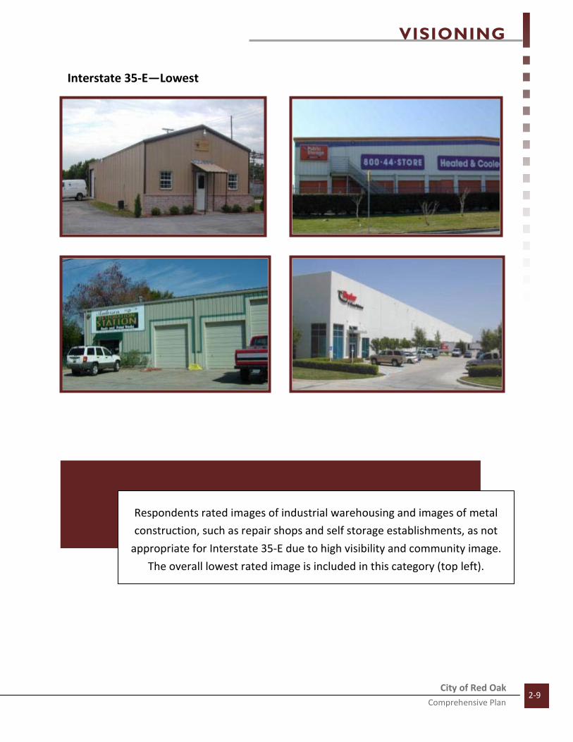
Interstate 35-E—Lowest
Respondents rated images of industrial warehousing and images of metal
construction, such as repair shops and self storage establishments, as not
appropriate for Interstate 35-E due to high visibility and community image.
The overall lowest rated image is included in this category (top left).
VISIONING
City of Red Oak Comprehensive Plan
2-10
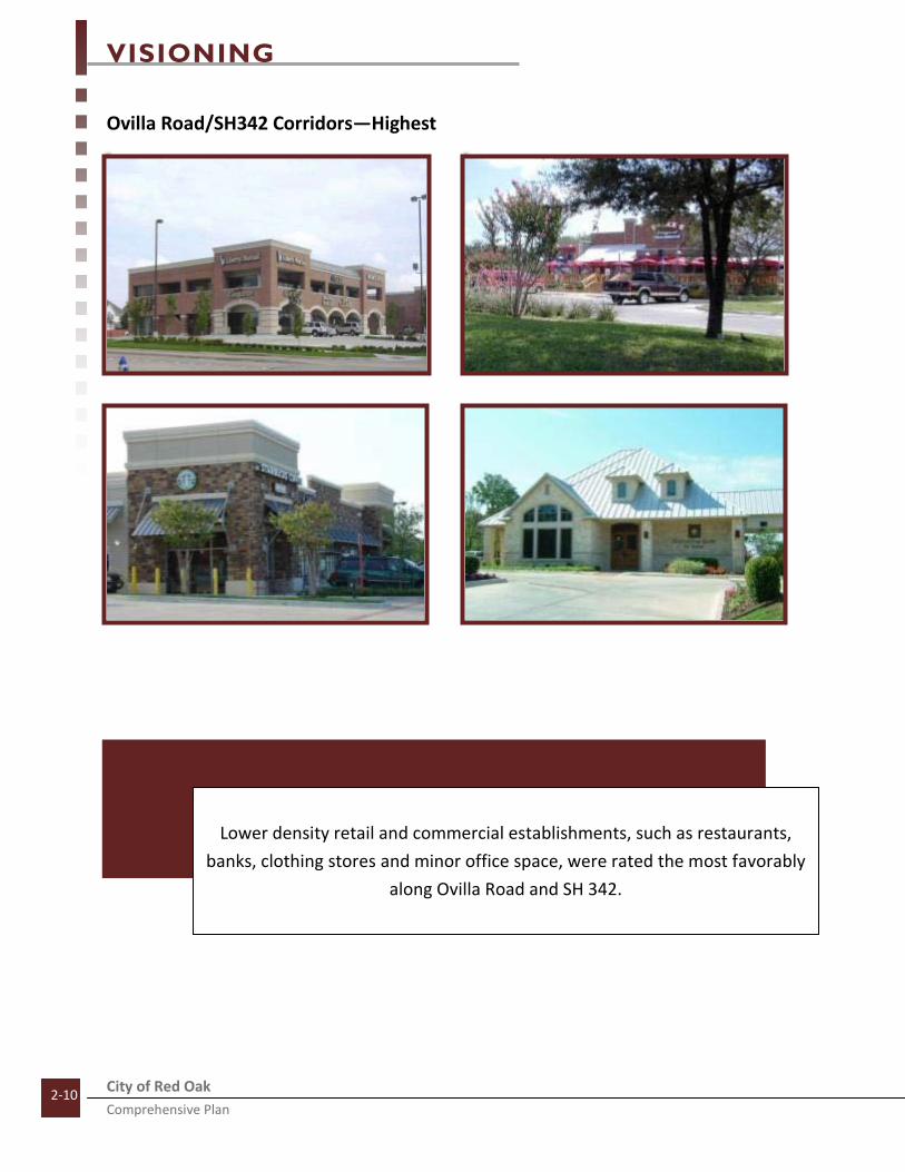
Ovilla Road/SH342 Corridors—Highest
Lower density retail and commercial establishments, such as restaurants,
banks, clothing stores and minor office space, were rated the most favorably
along Ovilla Road and SH 342.

VISIONING
City of Red Oak Comprehensive Plan
2-11
Ovilla Road/SH342 Corridors—Lowest
Images rated the least favorably included residential apartments, strip
center retail with little or no aesthetic quality and streetscapes with a lack of
sign regulation creating substantial visual clutter.

VISIONING
City of Red Oak Comprehensive Plan
2-12
Loop 9 Corridor—Highest
Potential development along Loop 9 included examples of lower density
office, high tech, and larger scale business parks. Vacant areas along Loop 9
have the potential to substantially define Red Oak, particularly its regional
relationship.

VISIONING
City of Red Oak Comprehensive Plan
2-13
Loop 9 Corridor—Lowest
Lowest rated images in this category included residential and mixed use
images, perhaps indicating that these options are more appropriate for other
locations in Red Oak.

VISIONING
City of Red Oak Comprehensive Plan
2-14
Housing Mix—Highest
Highest rated residential images in Red Oak were those depicting higher
quality single family residential housing. A “Traditional Neighborhood
Design” photo was also rated among the top four images in this category.
The overall highest rated VCS image is included in this category (top left).

VISIONING
City of Red Oak Comprehensive Plan
2-15
Housing Mix—Lowest
Lowest Rated residential images included apartments, townhomes, and
smaller housing options. It is important to note the lowest scoring housing
mix image only received a 2.9 out of a possible 5, indicating the potential
openness to the incorporation of different housing types in appropriate
locations.

VISIONING
City of Red Oak Comprehensive Plan
2-16
Street Design—Highest
Street Design images depicting roadway pocket parks, pedestrian
walkways/greenways, and landscaped medians and right-of-way were
scored the highest in this category.

VISIONING
City of Red Oak Comprehensive Plan
2-17
Street Design –Lowest
Images reflecting lack of pedestrian walkways, unsafe pedestrian walkways,
little or no landscaping or aesthetic quality and poor signage design (such as
pole signs) were rated the least favorably in this category.
VISIONING
City of Red Oak Comprehensive Plan
2-18
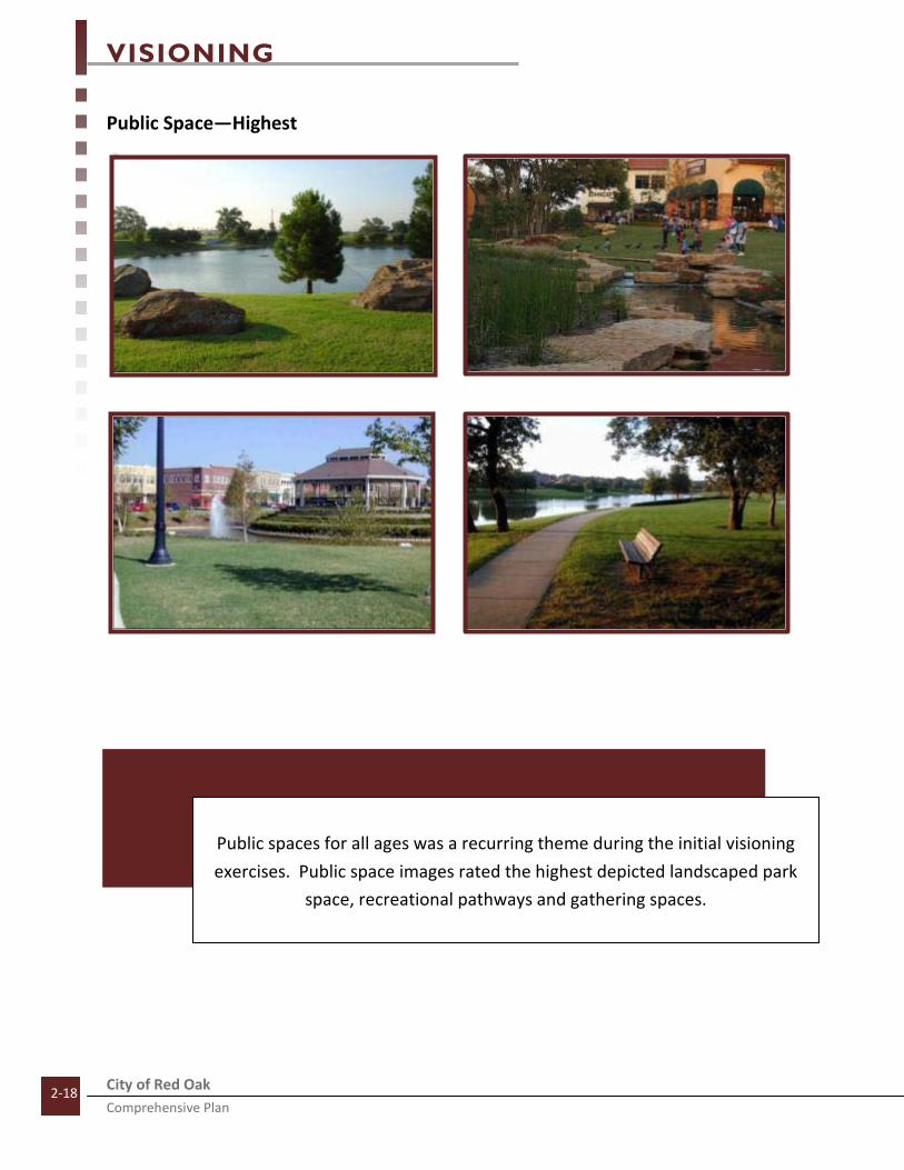
Public Space—Highest
Public spaces for all ages was a recurring theme during the initial visioning
exercises. Public space images rated the highest depicted landscaped park
space, recreational pathways and gathering spaces.
VISIONING
City of Red Oak Comprehensive Plan
2-19
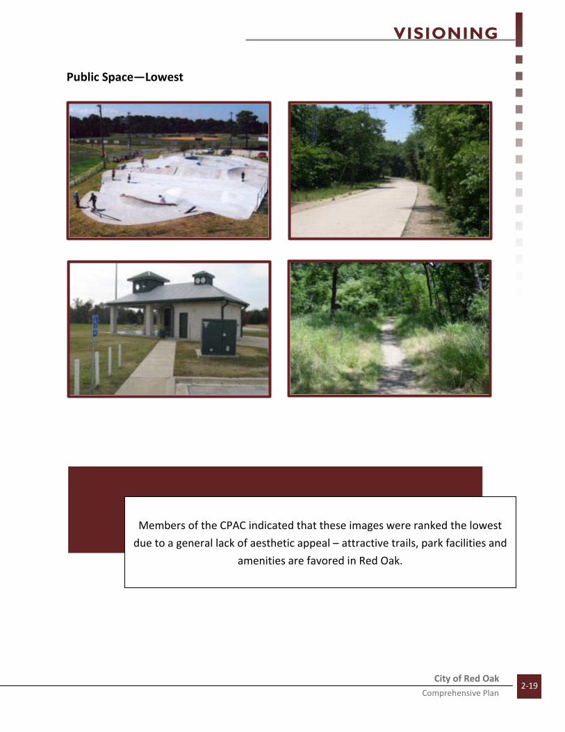
Public Space—Lowest
Members of the CPAC indicated that these images were ranked the lowest
due to a general lack of aesthetic appeal – attractive trails, park facilities and
amenities are favored in Red Oak.

VISIONING
City of Red Oak Comprehensive Plan
2-20
Transit Oriented Development—Highest and Lowest
Due to the limited number of images in this category, only the highest and
lowest two images are shown. Public spaces, unique architecture and high
quality design were the most favored. Images depicting a park-and-ride lot
and higher density residential options were the least favored images.
HIGHEST
LOWEST

VISIONING
City of Red Oak Comprehensive Plan
2-21
Mixed Use/Lifestyle Center—Highest
Images scoring the most favorably in this category included areas which
were lower in density and which included public space or resembled a
regional shopping center. It is also important to note that all but one image
in this category scored above a 3 out of a possible 5, indicating general
favorability towards mixed uses in appropriate areas.

VISIONING
City of Red Oak Comprehensive Plan
2-22
Mixed Use/Lifestyle Center—Lowest
The lowest rated images depicted above include developments greater than
three stories in height. The pictures also depicted developments with a
greater residential to retail ratio—ground level retail followed by several
floors of residential units.

VISIONING
City of Red Oak Comprehensive Plan
2-23
Most Agreed Upon Images
Standard deviation is a scientific research method used to determine basic consistency within a group or
range of scores. In terms of the VCS, standard deviation is used to determine if there is wide spread
agreement or disagreement upon an image— how consistently a particular image is scored. For
instance, a standard deviation of zero would mean every person taking the VCS rated that particular
image the same, or that there is consistency.
The image on the right depicts the
most agreed upon image in the VCS.
The image was included as part of
the Housing Mix category and had
an average score of 4.9. It is
interesting to note that not only is
this image the most agreed upon
image, but it is also the second
highest rated image overall,
indicating that not only is there
consensus, but it is highly favorable.
The three images below depict the
next three most agreed upon images
in the VCS. These images were also
rated highly, indicating that there is
agreement upon what types of
development are appropriate within
Red Oak.
Housing Mix Average. Score: 4.9
Average Score: 4.8 Average Score: 4.8 Average Score: 4.9

VISIONING
City of Red Oak Comprehensive Plan
2-24
Least Agreed Upon Images
Standard deviation is a scientific research method used to determine basic consistency within a group or
range of scores. In terms of the VCS, standard deviation is used to determine if there is wide spread
agreement or disagreement upon an image— how consistently a particular image is scored. For
instance, a standard deviation of zero would mean every person taking the VCS rated that particular
image the same, or that there is consistency or agreement.
The picture to the left depicts the most disagreed
upon image in the VCS. The picture was included in
the Ovilla Road/SH 342 Corridor category and is
representative of potential signage articulation. The
average score for this image was a 3.3; however, an
examination of the image’s standard deviation
reflects that some respondents scored this image
very favorably, while others scored it disfavorably,
making it the least agreed upon image. The three
images below were the next three least agreed upon
images. Once again, many resondents scored these
images very favorably indicating that they were
desired or appropriate for Red Oak, while others
scored the images disfavorably indicating they were
not appropriate for Red Oak.
Average Score: 3.7
Ovilla Road/SH 342 Corridors Av. Score: 3.3
Average Score: 3.2 Average Score: 3.7 Average Score: 2.7

VISIONING
City of Red Oak Comprehensive Plan
2-25
Questionnaire Results
As a component of the Visual Character Survey, respondents were asked to complete 11 additional
questions pertaining to their individual perceptions of the community, potential development types and
quality of life issues. The following is a summary of the collected results of the questionnaire.
Question #1: How long have you lived in Red Oak?
The largest category of respondents was
those indicating that they have lived in the
community between five and ten years, at
36 percent. It is important to note the
relatively equal distribution among the
different categories, indicating that a
variety of perspectives were included
within the planning input process. This is
important in order to gage the community
from the perspectives of those new to the
community as well as those who have lived
in the community for a number of years.
Question #2: How would you describe the quality of life in Red Oak?
Respondents to this question generally
responded with positive feedback. 57
percent of the respondents indicated that
the quality of life in Red Oak is Good
followed by Excellent at 22 percent. Only
21 percent indicated a Fair quality of life in
Red Oak and no respondents indicated that
the quality of life was Poor.
1 to 5 years22%
5 to 10 years36%
10 to 20 years21%
20 to 30 years
0%
More than 30 years
21%
Excellent22%
Good57%
Fair21%

VISIONING
City of Red Oak Comprehensive Plan
2-26
Question #3: What was the most important factor for you when you decided to
move to Red Oak?
Respondents to this question were given a
number of optional answers ranging from
affordable housing to the perceived sense
of safety present in Red Oak.
Respondents rated “Close to Work” as the
most important factor for determining
why they moved to Red Oak at 43
percent. Red Oak schools was the second
highest rated response at 22 percent
followed by an equal distribution among
Red Oak being a safe place to live, its
small town feel, friends and family, and
distance to Dallas and Fort Worth.
Question #4: Do you think the quality of life in Red Oak will improve, stay the
same, or decline over the next five years?
The intent of this question is to judge the
attitudinal perception by the respondents
to a variety of issues which may be
affecting the ability of the community to
make significant steps forward in the short
term. In many situations, politics, inaction
or resistance to change may affect the
perceived ability of a community to make
significant steps forward and may be
perceived as a hindrance by community
residents. Respondents to this question
indicated to the contrary. 72 percent
believed the quality of life in Red Oak
would improve over the short term. No
respondents indicated that conditions
would decline.
Close to work43%
Distance to Dallas/Fort
Worth7%
Friends/Family7%
Schools/education
22%
Small town feel7%
Safe place to live7%
Did not answer
7%
Improve72%
Stay the same14%
Decline0%
Do not know 14%

VISIONING
City of Red Oak Comprehensive Plan
2-27
Question #5: What would you consider the greatest single issue facing Red Oak
today?
Answers to this question were generally
formulated based upon the responses to
the SWOT Analysis conducted at a previous
meeting. Overall, the single greatest issue
believed to be facing Red Oak today is
Outsider Perception, or how outsiders see
or think about Red Oak. The second major
identified issue was the City’s dependency
upon residential ad valorem taxes—this
stems from a current lack of retail or
commercial activity which generally
conveys more taxable revenue to a
community’s financial coffers than
residential ad-valorem taxes.
Question #6: Would you rate Red Oak as excellent, good, fair or poor in terms of
cleanliness, quality of houses and general appearance?
Respondents indicated that the general
quality and appearance of Red Oak was
positive. 43 percent believed that Red Oak
had a Good general appearance. An equal
number of respondents, 43 percent,
indicated that the general appearance of
the community was Fair. Seven percent
indicated that the community appearance
was Poor and seven percent declined to
answer.
Outsider Perception
43%
Fragmented City
Boundary7%
Lack of Rooftops
14%
Dependent on
Residential Ad Valorem
29%
Inaction7%
Good43%
Fair 43%
Poor7%
Did not answer
7%

VISIONING
City of Red Oak Comprehensive Plan
2-28
Question #7: For each of the services provided by the city, please rate the
service as excellent, good, fair or poor.
Answer Option Street
Maintenance Recreational
Programs
Storm Water
Drainage Police
Department Fire
Department
Emergency Medical Services
Excellent 7% 0% 0% 29% 71% 21%
Good 7% 0% 14% 71% 29% 64%
Fair 50% 7% 21% 0% 0% 14%
Poor 36% 93% 50% 0% 0% 0%
No Opinion 0% 0% 14% 0% 0% 0%
Did Not Answer 0% 0% 0% 0% 0% 0%
Answer Option
Trash Collection Services
Recycling Collection Services
Water Services Utilities
Animal Control Parks
Excellent 14% 7% 14% 14% 7% 0%
Good 57% 50% 79% 50% 71% 7%
Fair 29% 21% 7% 29% 7% 29%
Poor 0% 7% 0% 0% 7% 64%
No Opinion 0% 14% 0% 7% 7% 0%
Did Not Answer 0% 0% 0% 0% 0% 0%
VISIONING
City of Red Oak Comprehensive Plan
2-29
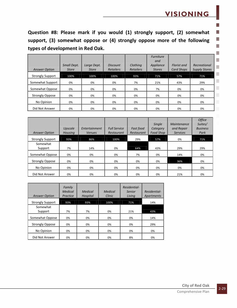
Question #8: Please mark if you would (1) strongly support, (2) somewhat
support, (3) somewhat oppose or (4) strongly oppose more of the following
types of development in Red Oak.
Answer Option Small Dept.
Store Large Dept.
Store Discount Retailers
Clothing Retailers
Furniture and
Appliance Stores
Florist and Card Shops
Recreational Supply Stores
Strongly Support 100% 100% 100% 93% 71% 57% 71%
Somewhat Support 0% 0% 0% 7% 21% 43% 29%
Somewhat Oppose 0% 0% 0% 0% 7% 0% 0%
Strongly Oppose 0% 0% 0% 0% 0% 0% 0%
No Opinion 0% 0% 0% 0% 0% 0% 0%
Did Not Answer 0% 0% 0% 0% 0% 0% 0%
Answer Option Upscale Housing
Entertainment Venues
Full Service Restaurant
Fast food Restaurant
Single Category
Food Shop
Maintenance and Repair
Services
Office Suites/
Business Park
Strongly Support 93% 86% 100% 29% 57% 0% 71%
Somewhat Support 7% 14% 0% 64% 43% 29% 29%
Somewhat Oppose 0% 0% 0% 7% 0% 14% 0%
Strongly Oppose 0% 0% 0% 0% 0% 36% 0%
No Opinion 0% 0% 0% 0% 0% 0% 0%
Did Not Answer 0% 0% 0% 0% 0% 21% 0%
Answer Option
Family Medical Practice
Medical Hospital
Medical Clinic
Residential-Senior Living
Residential-Apartments
Strongly Support 93% 93% 100% 71% 14%
Somewhat Support 7% 7% 0% 21% 43%
Somewhat Oppose 0% 0% 0% 0% 14%
Strongly Oppose 0% 0% 0% 0% 29%
No Opinion 0% 0% 0% 0% 0%
Did Not Answer 0% 0% 0% 8% 0%

VISIONING
City of Red Oak Comprehensive Plan
2-30
Question #9: How important or unimportant are the following
to you in terms of Red Oak’s quality of life?
Answer Option Trail System Appearance of the City
Attractive Roadways
Availability of
Apartments
Availability of
Townhomes Employment
Opportunities
Effective Roadway Network
Very Important 7% 79% 71% 0% 0% 36% 64%
Important 50% 21% 29% 29% 43% 57% 36%
Unimportant 43% 0% 0% 29% 29% 7% 0%
Very Unimportant 0% 0% 0% 43% 21% 0% 0%
No Opinion 0% 0% 0% 0% 7% 0% 0%
Did Not Answer 0% 0% 0% 0% 0% 0% 0%
Answer Option
Enhancing the City's Identity
Establishing Community Focal Points
Mixed Use Development Open Space
Parks and Recreation Walkability
Very Important 86% 50% 43% 14% 36% 7%
Important 14% 21% 43% 57% 57% 64%
Unimportant 0% 14% 14% 21% 7% 29%
Very Unimportant 0% 0% 0% 0% 0% 0%
No Opinion 0% 14% 0% 7% 0% 0%
Did Not Answer 0% 0% 0% 0% 0% 0%

VISIONING
City of Red Oak Comprehensive Plan
2-31
Question #10: Of the three identified locations, where do you
feel a “transit oriented” development would best be located? One of the potential issues within this
2010 Comprehensive Plan is identifying
the possible location for transit
oriented development or TOD.
Respondents were asked which of the
three locations in the graphic would be
best suited for a TOD and were given
the option to write in any addition
possibilities. Site 1 was selected due to
its designation as a lifestyle center in
previous planning efforts. Site 2 was
included due to the recent completion
of the Downtown Vision planning
efforts. Location 3 was selected due to
the availability of vacant land and the
potential accessibility to Loop 9. An
additional consideration for the location
of the TOD is whether or not residents
desire the transit stop to be included as
part of a greater transit oriented
development. Based upon these three
locations, options 1 and 3 both received
36 percent each and location 2 followed
by location 2 at 28 percent.
Location 136%
Location 228%
Location 336%

VISIONING
City of Red Oak Comprehensive Plan
2-32
Question #11: If you could select one other city to use as a
model for Red Oak, would city would that be and why?
1. Greenville, TX. Older town that grew into a big vibrant city with high standards for livability and appearance. Frisco is another example.
2. I would not model Red Oak after any one city. I would like to take the good points of several cities and adapt them to Red Oak
3. Carmel, Indiana and Fishers, Indiana
4. Southlake, nice housing and mixed use with many quality of life venues
5. That would be my question to our consultants. What are the most successful cities and how did they get that way. Don't reinvent the wheel.
6. Cedar Hill
7. Plano. Proactive infrastructure through bond programs (streets)
8. Cedar Hill for strong retail and accessibility (not much residential though)
9. Naperville, IL and Wheaton, IL-great town centers and good housing mix. Tight code
enforcement so it’s very clean and tidy
10. Round Rock. It has an expansive suburb feel with many commercial/retail and housing options. It has a strong center for employment but maintains its hill country suburb feel with many conveniences located nearby
11. Cedar Hill. Good mix of all needs for people/good government and good look (looks
new)
12. Cedar Hill. Good business mix on HWY 67. Good restaurants. Good signage. Great variety of homes. Mostly single family dwellings, few (if any) apartments.
13. Maumelle, AR. Utilities are all underground-green space in neighborhoods that tie
together (not paved). Utilized water areas appropriately. Nice, clean, attractive areas.

VISIONING
City of Red Oak Comprehensive Plan
2-33
SWOT Analysis
A strengths, weaknesses, opportunities and threats
(SWOT) analysis was conducted with the CPAC during
the January 12, 2010 meeting. The SWOT analysis is
commonly used as a means of evaluating internal and
external factors affecting a City or entity. Strengths
and weaknesses are seen to be internal—existing
assets or downfalls. Opportunities and threats, on
the other hand, are seen to be external—potential or
future assets or downfalls. The purpose of the SWOT
exercise is to utilize current strengths, address
current weaknesses, utilize future opportunities and
mitigate future threats. Although not scientific, the
SWOT helps process, understand and put into
perspective the full planning context.
For this exercise, CPAC members were first asked to
identify perceived strengths, weaknesses,
opportunities and threats. After all such issues were
identified, each CPAC member was given a total of
five dots—four red dots, representing one point
each, and one green dot, representing five points.
The CPAC members then placed their dots next to issues which they perceived to be the most important
to them individually. The top results (two or more votes) of the SWOT Analysis are listed below. For a
complete list of all identified issues, refer to the appendix of this document.
• Outsider Perception (29 Votes) Weakness
• Interstate 35-E (17 Votes) Strength
• Fragmented City Boundary (14 Votes) Weakness
• Schools and Facilities (13 Votes) Strength
• Lack of Roof Tops (6 Votes) Weakness
• “Do-it-now” Leadership (6 Votes) Opportunities
• Sports Complex (4 Votes) Opportunities
• Quality Development/Image Standards (4 Votes) Opportunities
• Limited Circulation System (2 Votes) Weakness
• Dependent on Residential Ad Valorem (2 Votes) Weakness
• Regional Cooperation (2 Votes) Opportunities
• Resistance to Growth (2 Votes) Threats

VISIONING
City of Red Oak Comprehensive Plan
2-34
Issue Identification Exercise
A component of the December 8, 2009 CPAC
meeting was the Issue Identification exercise. This
exercise was intended to be the first step in the
formulation of ideas which will guide the
development of this 2010 Comprehensive Plan.
CPAC members were asked to identify key issues in
respect to what this Plan should focus on and
consider. Although the focus of this Plan may shift
as the process continues and as newer ideas are
identified, these original issues help to serve as a
foundational guide.
An additional significance of the Issue
identification exercise is their use in the
development of goals and objectives. These
preliminary issues may be classified as goals, or
objectives, under the four chapter categories of
Transportation, Future Land Use, Neighborhood
Livability and Infrastructure. Discourse may then
be initiated in regards to more specific objectives
pertaining to each of the general issues identified.
Often times, during the course of visioning
exercises, common or recurring themes become
apparent, and these recurring ideas may therefore
be developed as focal points within this Plan.
VISIONING
City of Red Oak Comprehensive Plan
2-35
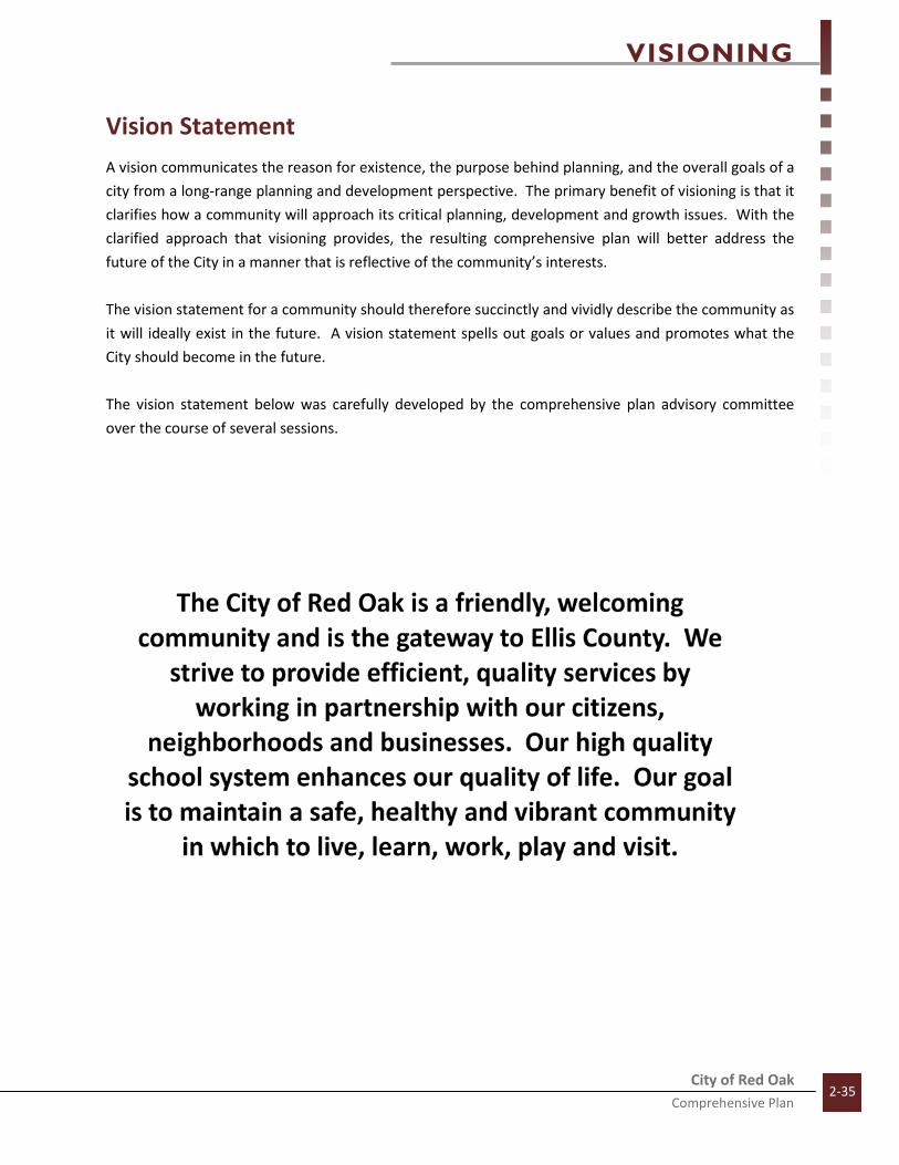
Vision Statement
A vision communicates the reason for existence, the purpose behind planning, and the overall goals of a
city from a long-range planning and development perspective. The primary benefit of visioning is that it
clarifies how a community will approach its critical planning, development and growth issues. With the
clarified approach that visioning provides, the resulting comprehensive plan will better address the
future of the City in a manner that is reflective of the community’s interests.
The vision statement for a community should therefore succinctly and vividly describe the community as
it will ideally exist in the future. A vision statement spells out goals or values and promotes what the
City should become in the future.
The vision statement below was carefully developed by the comprehensive plan advisory committee
over the course of several sessions.

VISIONING
City of Red Oak Comprehensive Plan
2-36
Goals and Objectives
Thoroughfare/Transportation
Goal 1: Ensure a safe and efficient thoroughfare network providing for the safety of Red Oak
Residents.
Objective 1.1: Ensure that the thoroughfare classifications provide for safe and
convenient flow of traffic both within Red Oak and to adjacent
communities
Objective 1.2: Identify areas where access and mobility deficiencies exist and
concentrate resources on upgrading and improving infrastructure to
minimize congestion and accidents.
Objective 1.3: Thoroughfare network should offer efficient organization of collector
roadways and neighborhood connections to minimize the negative
impacts of congestion in residential areas.
Objective 1.4: A minimum number of connections between adjacent neighborhoods
should be required to encourage connectivity.
Goal 2: Ensure that roadway projects consider both current and future needs to achieve quality
roadway infrastructure.
Objective 2.1: Plan for the creation of continuous backage roads along Interstate 35-E
as new development occurs to improve accessibility and ease
congestion.
Objective 2.2: Work with elected and appointed officials to establish a four-lane
east/west thoroughfare from a point on I-45 near Trumbull going west
on FM 2377 to Stephenson Road continuing west, establishing an
additional east/west regional arterial.
Objective 2.3: Work with Ellis County and TxDot officials to create an overpass at
Interstate 35-E in conjunction with the proposed east/west regional
arterial along FM 2377.
Objective 2.4: Consider right of way/easement acquisition as new development occurs
to ensure long term roadway configuration goals are able to be
achieved.
Goal 3: Monitor regional transportation system planning efforts to ensure a proactive community
response to issues affecting the City.
Objective 3.1: Work with North Central Texas Council of Governments (NCTCOG) to
ensure compatibility between roadway decisions in Red Oak and
regional planning efforts.

VISIONING
City of Red Oak Comprehensive Plan
2-37
Objective 3.2: Proactively monitor North Texas Transit Authority (NTTA) Loop 9
planning efforts and work to ensure that intersection access points
which best meet the needs of Red Oak are achieved.
Objective 3.3: Ensure that transit oriented development (TOD) locations are planned
and conveyed to NCTCOG and are reflected in commuter rail planning
efforts.
Objective 3.4: Monitor changes to the Ellis County Thoroughfare Plan and ensure that
roadway alignments best reflect the desires of Red Oak, particularly FM
2377 and Ovilla Road.
Goal 4: Enhance multi-modal transportation alternatives within Red Oak.
Objective 4.1: Include greenway corridors and bicycle corridors along appropriate
roadways to accommodate bicycles and pedestrians, particularly in
areas outlined by the Trails Master Plan.
Objective 4.2: Ensure that sidewalks are included throughout the community as
development occurs creating safe, walkable options for Red Oak
residents.
Objective 4.3: Connect city trails to the Veloweb Trail Network providing connectivity
between Red Oak and the regional trail system.
Objective 4.4: Consider local transit or shuttle service for seniors and other residents if
and when demand becomes necessary.
Goal 5: Consider including transit oriented development (TOD) in future planning efforts, connecting
Red Oak to DART and the regional commuter rail system.
Objective 5.1: Identify areas where transit oriented development may be appropriate.
Objective 5.2: Consider concentrating mixed-uses and higher concentrations of activity
near proposed locations.
Objective 5.3: Work with NCTCOG and the Regional Transportation Commission (RTC)
to ensure that TOD areas in Red Oak are reflected in regional planning
efforts to give validity if and when commuter rail becomes a reality.
Objective 5.4: Link activity centers near potential TOD to the Master Trail Plan,
providing multi-modal access to rail transit if and when commuter rail
becomes a reality.
Goal 6: Incorporate good urban design practices along transportation corridors by taking a proactive
approach to the City’s appearance.
Objective 6.1: Ensure quality landscaping along roadways and within medians of
thoroughfares to enhance the aesthetic quality of roadways in Red Oak.
Objective 6.2: Incorporate greenway corridors to provide contiguous sidewalks and
enhance the aesthetic value of City corridors.

VISIONING
City of Red Oak Comprehensive Plan
2-38
Objective 6.3: Include Context Sensitive Solutions (CSS) as a component of roadway
design, considering the context of surrounding development with
transportation functionality.
Objective 6.4: Consider intersection enhancements and public art at key intersections.
Land Use
Goal 7: Ensure that future land uses balance new development with the community vision and will
understand and consider the market for development within Red Oak.
Objective 7.1: Conduct an on-going analysis of market conditions to create prime
commercial sites and prime development along Red Oak’s
thoroughfares.
Objective 7.2: Continue to enhance both rural and urban lifestyles and preserve open
space areas for Red Oak residents to enjoy natural beauty.
Objective 7.3: Examine standards in adjacent and regional communities to ensure that
Red Oak creates quality development but remains regionally
competitive.
Goal 8: Promote a diversity of land uses to ensure long term financial stability and which will
ultimately allow Red Oak to pursue and maintain a high quality of life.
Objective 8.1: Incorporate land uses other than residential in appropriate activity
centers throughout the City.
Objective 8.2: Promote Red Oak as a location for business and commercial interests.
Objective 8.3: Continue to encourage and promote vertical and horizontal mixed-use
development, particularly downtown, near TOD’s and near the
interstate 35-E lifestyle center.
Objective 8.4: Encourage integrated land uses, where possible, to create a more
sustainable form of development and encourage reinvestment over the
long term.
Objective 8.5: Continue to implement the Downtown Vision Plan, encouraging quality
infill development and protecting Red Oak’s historic heritage.
Goal 9: Create strategies to achieve more logical City boundaries in order to ensure efficient use of
City services and infrastructure.
Objective 9.1: Create a growth management plan directing and guiding strategies for
expanding City boundaries in a financially responsible and logical
fashion.
Objective 9.2: Create a plan showing the service and monetary advantages of
voluntary annexation by adjacent neighborhoods into Red Oak.
Objective 9.3: Continue to educate residents within the ETJ on the benefits of
annexation into Red Oak, particularly the benefits of City services such
as police and fire.

VISIONING
City of Red Oak Comprehensive Plan
2-39
Objective 9.4: Provide high quality public services and quality of life venues to create
an additional incentive for voluntary annexation.
Goal 10: Incorporate a variety of residential options providing full life-cycle housing for Red Oak
Residents.
Objective 10.1: Include a mixture of housing types and sizes within neighborhood
developments.
Objective 10.2: Ensure an adequate supply of single-family, multi-family and other
housing types such as townhomes, garden homes and accessory
dwelling units.
Objective 10.3: Ensure that medium-density housing types are compatible with
surrounding and adjacent land uses and are either integrated within the
neighborhood or properly screened and buffered to protect
neighborhood integrity.
Interstate 35-E Corridor
Goal 11: Create a positive and identifiable image of Red Oak along the Interstate 35-E Corridor
Objective 11.1: Ensure that existing and future development is visually attractive by
incorporating quality design, architectural standards and well-
planned/master planned sites.
Objective 11.2: Employ code enforcement strategies/code enforcement programs along
the corridor targeting key code violation issues.
Objective 11.3: Require new developments to contain Red Oak branding, being
compatible with new development and creating a consistent and unified
presence along Interstate 35-E.
Objective 11.4: Include major gateways along the corridor, particularly at the City’s
southern boundary, to clearly identify Red Oak from Waxahachie, Glenn
Heights and Lancaster.
Goal 12: Diversify land uses to increase economic activity and expand the City’s tax base.
Objective 12.1: Implement an overlay district representative of the various zones and
land uses developed within the Corridor Plan.
Objective 12.2: Create public/private partnerships and actively market Zones 1 and 2 as
prime locations for retail activity.
Objective 12.3: Work to create a destination point/Lifestyle Center within Zone 2,
providing opportunities for residents to gather, shop, dine, play and
recreate.
Objective 12.4: Increase housing options and densities along the corridor, providing
quality medium density residential options to increase viability of future
non-residential development.

VISIONING
City of Red Oak Comprehensive Plan
2-40
Neighborhood Livability and Image Enhancement
Goal 13: Create strategies for code enforcement and compliance in order to promote and maintain
quality residential neighborhoods.
Objective 13.1: Design a code enforcement program which concentrates resources
towards a particular issue creating public awareness and promoting city-
wide compliance.
Goal 14: Employ Neighborhood Strategies to protect Red Oak neighborhoods.
Objective 14.1: Utilize code enforcement as a proactive tool to preserving
neighborhoods by addressing compliance issues before they have
negative impacts on neighborhoods as a whole.
Objective 14.2: Facilitate partnerships between the City and local organizations to
create volunteer opportunities such as “paint your heart out” to address
code compliance when the property owner is physically unable to
perform required maintenance.
Objective 14.3: Encourage neighborhood organizations in order to facilitate and
encourage personal responsibility in property maintenance and
neighborhood upkeep.
Objective 14.4: Utilize demolition if and when properties become a safety hazard to the
community.
Objective 14.5: Explore grant funding opportunities which may be used to provide
avenues for aid to property owners who may not be financially able to
perform required maintenance (e.g., zero interest loans).
Goal 15: Incorporate quality design and neighborhood amenities to promote the long term
sustainability and viability of individual neighborhoods in Red Oak.
Objective 15.1: Encourage life cycle housing and neighborhood amenities, such as parks
and trails, to ensure the long term viability and sustainability of
neighborhoods.
Objective 15.2: Require quality building materials and designs to reduce property
maintenance and preserve structural appearance.
Objective 15.3: Incorporate Traditional Neighborhood Design (TND) integrating parks
and neighborhood retail, reducing setbacks, mixing housing sizes and
types, and including attractive and unique design features.
Goal 16: Incorporate quality design standards and image enhancement strategies to project a positive
and recognizable image of Red Oak.
Objective 16.1: Continue to monitor and update Article 11 Landscaping Standards to
ensure that aesthetic goals of the community are achieved.

VISIONING
City of Red Oak Comprehensive Plan
2-41
Objective 16.2: Regulate signage along major corridors to reduce visual clutter including
limiting temporary signage, mandating shared signage, using materials
compatible to the physical structure and encouraging distance studies
to limit the frequency and height of pole signs.
Objective 16.3: encourage the integration of non-residential and residential land uses in
a manner which fosters walkability, provides convenient access and
creates synergy.
Objective 16.4: Incorporate gateways at major entrances into Red Oak, particularly
along Ovilla Road, SH 342, FM 2377 and Interstate 35-E.
Objective 16.5: Require the placement of sidewalks, incorporate greenway corridors
according to the Transportation Plan and integrate the Core Area
Master Trail Plan to promote walkability within Red Oak.
Goal 17: Encourage the development of non-residential services to enhance the tax base and meet the
needs of Red Oak residents within the community.
Objective 17.1: Create public and private partnerships towards the creation of the
community Lifestyle Center on Interstate 35-E providing venues for
shopping, dining and entertainment.
Objective 17.2: Continue to promote a pro-business environment in Red Oak, marketing
the Interstate 35-E Corridor Plan, Comprehensive Plan and any other
planning documents as the City’s commitment towards quality growth
and development.
Objective 17.3: Integrate gathering places within key non-residential developments to
create places for residents to congregate and socialize as well as to
conduct key community festivals and events.
Goal 18: Create a parks and trails system which is equitably distributed throughout the community
and which provides recreational opportunities for Red Oak residents.
Objective 18.1: Implement the Possum Trot Trail Master Plan as new development
occurs, providing a contiguous trail system throughout the community.
Objective 18.2: Include park amenities, such as playgrounds, trails and recreational
facilities, in order to provide options for residents of all ages.
Objective 18.3: Establish a hierarchy of park classifications that will provide for the
adequate and equitable distribution of park facilities.
Objective 18.4: Monitor and revise a Park Dedication Ordinance fee to reflect the true
cost of the proposed parks and trails system.
Objective 18.5: Promote respect, conservation and enhancement of important natural
features, such as floodplain and other flood hazard areas.

VISIONING
City of Red Oak Comprehensive Plan
2-42
Infrastructure Assessment
Goal 19: Ensure that water supply, wastewater treatment and storm drainage systems adequately
serve current and future residents and businesses.
Objective 19.1: Investigate deficiencies in the infrastructure systems.
Objective 19.2: Develop a policy to address localized system issues.
Objective 19.3: Strive for an infrastructure system that will effectively and economically
serve existing and projected needs of the community in a safe and
efficient manner.
Objective 19.4: Coordinate the provision of water/wastewater services within the City
and ETJ.
Objective 19.5: Ensure that infrastructure is compatible or expanded to support future
development, specifically in key development areas.
Copyright © 2022 FDOKUMEN