Untitled - Rajiv Gandhi University, Itanagar, Arunachal Pradesh
Upload
khangminh22Category
view
0download
0
PPLLAANN FFOORR DDEEVVEELLOOPPMMEENNTT OOFF CCOOMMMMUUNNIICCAATTIIOONN SSEECCTTOORR IINN AARRUUNNAACCHHAALL PPRRAADDEESSHH
VVIISSIIOONN 22002200
PUBLIC WORKS DEPARTMENT ARUNACHAL PRADESH
ITANAGAR AUGUST 2005

((ii))
PPrreeffaaccee
This perspective plan of communication sector in Arunachal Pradesh,
Vision 2020, was initially prepared for presentation in the meeting on
preparation of Vision document for communication sector taken by
Member (NEC), Dr. (Mrs.) I.K. Borthakur, in NEC office, Shillong on 25th
and 26th July’2005.
The plan attempts to document the present status of development in
communication sector in Arunachal Pradesh, especially the road
communication and air transport. It further attempts to assess the needs
for development of surface communication and bridges and air transport
by horizon year 2020; estimate the plan resources likely to be available to
sustain the development efforts required to bridge the gap in infra-
structural needs; work out the objective targets aimed at; and evolve a plan
to reach the goal by the horizon year 2020.
I acknowledge the help and efforts put in by term of officers specially by Er.
T. H. Tayung, Addl. Chief Engineer (EZ), Er. Bora Ete, SE (HQ), Er. Atop
Lego, SSW (EZ), Er. Y.P. Singh, ASW and Sr. PA Shri Haridas Sinha and
other supporting staff in preparing this document.
Itanagar August 2005
Er. Tomi Ete Chief Engineer (EZ)
PWD, Arunachal Pradesh Itanagar – 791 111
I N D E X
Sl.
No. Index
Page
No.
1. Overview of State 1
2. Road Transport
8
3. Development of National Highway 12
4. Road development under NEC
19
5. Road development through External Aid Programmes
24
6. Special Accelerated Road Development Programme in North Eastern Region
29
7. Township Roads
39
8. Pradhan Mantri Gram Sadak Yojana
47
9. Development of Border Trade Routes 51
10. Needs of roads in uncovered areas 54
11. Bus and Truck terminals and wayside amenities
57
12. Road hierarchy & classification
59
13. Air Transport
61
14. Vision 2020 65

1
I. OVERVIEW OF STATE
1.1 Introduction
Arunachal Pradesh, the 24th State of the India Union, lies in the
north eastern tip of the country bordering the neighbouring
countries of China, Myanmar and Bhutan and sharing inter-state
boundaries with Assam and Nagaland. With an area of 83,734
sq.km, it is the largest geographical entity in North Eastern Region.
Being a part of the Himalayas and the Patkai range, the state is
predominantly hilly and is traversed by many major rivers and their
numerous tributaries, all discharging into the Brahmaputra. The
state receives heavy rainfall and substantial snow-melt. Major area of
the state is under forest cover. It is sparsely populated. The
indigenous population consists of 26 major tribes spread over
different areas. The state is underdeveloped with major deficiency in
infrastructure specially in communication sector with very poor
density of road and practically no railway and air service or water
transport.
1.2 Geo-climatic condition
Forming a part of the Himalayas in the north and the Patkai hills in
the south, Arunachal Pradesh is a ruggedly mountainous region with
altitude ranging from 150 m in the foothills adjacent to the plains of
Brahamaputra valley to over 7300 m in the higher reaches towards
the north. The hill slopes are steep, unstable and susceptible to
wasting. Then again, falling under Zone V in the seismic map of the
country, the whole state is prone to frequent earthquakes.
The area is drained by a number of major rivers like the Kameng, the
Subansiri, the Siang, the Lohit, the Dibang, the Dihing and their
numerous tributaries. The state receives heavy rainfalls (average over
2500 mm per annum) and good snowmelt.
Owing to the enabling geo-climatic conditions, about 82% of the area
of the state is under forest cover, which thus helps to support a wide

2
spectrum of flora and fauna. The plant types have a wide range
starting from broad-leaved rain forests in the foothills to temperate in
the middle zone and alpine in the high altitude mountains above
snow line. Numerous species of evergreen trees, suitable for timber
or veneering, pines, shrubs, bamboos, canes, orchids, medicinal
plants and vast collection of wild life like tigers, leopards, elephants,
bears, deers, etc and different varieties of birds and reptiles abound
in the rich forests of the state.
1.3 Population
With a total population of 10,19,117 (Census 2001) spread over an
area of 83,734 sq.km the state has population density of 13
people/sq.km only, the lowest in the country. The indigenous
population consists of 26 major tribes, which include Monpas,
Sherdukpens, Akas, Mijis, Nyishis, Tagins, Boris, Bokaros, Ramos,
Apatanis, Gallos, Adis, Membas, Khambas, Mishmis, Khamtis,
Singphos, Tangsa, Tutsas, Noktes, Wanchoes etc. In the past these
tribes lived in mutually exclusive pockets bounded by natural
barriers like rivers, hills etc., and remained cut off from the people in
other parts of the country and the world.
The average decadal growth rate of population in the state from 1991
to 2001 has been recorded as 26.20%. The growth rate of urban
population, however, has been as high as 101.3%. This indicates to a
possible migration of population from rural areas towards urban
centers and/or influx of people from outside remaining concentrated
in and around towns. The population projected for the horizon 2020
is about 19,80,800, which is an increase of about 94% over census
2001.
This increase in population especially in urban centres will give rise
to greater needs for road connectivity to outlying areas, especially
towards the outer periphery for serving the increasing demands for
passenger and freight movements, both within and from outside the
state. High concentration of population in urban centres will also

3
lead to increasing demands for urban infrastructure like water
supply, roads sanitation etc.
1.4 Historical evolution
Having remained an un-administered territory during the British Raj
the region evolved into what came to be popularly known as North
East Frontier Agency (NEFA) in the post Independence period and
then transformed into the Union Territory of Arunachal Pradesh in
1972, and finally to full fledged state in 1987. Having remained
outside the planning process for whole of the pre Independence era
and much of the post Independence years, Arunachal Pradesh did
not inherit threshold infrastructure at the time of acquiring
statehood and has remained in an under developed stage even today.
1.5 Agro-forestry activities
Its favourable geo-climatic conditions have bestowed the state with
immense potentials for growth in the field of agriculture and
horticulture. There has been a marked shift from jhumming, the
traditionally practiced slash and burn form of agriculture, to settled
cultivation. Where irrigation potentials are available like the foothill,
the plains and hill spurs in valleys, people are taking to wet rice
cultivation (WRC) and terraced rice cultivation (TRC). The major
produces are rice, maize, millets, potatoes, ginger, mustard seeds
etc. Commercial farming of vegetables is also picking up. Although
the agriculture still remains at subsistence level, there is a scope for
producing surpluses through multi-cropping and by improving the
yield by adopting scientific methods of cultivation.
In some areas especially in the districts of Tirap, Changlang, Lohit,
Lower Dibang Valley, East Siang, Upper Siang, West Siang, Papum
Pare etc. tea plantation and processing are coming into practice.
Horticulture is a major area of promise. Apples, oranges, pineapples,
kiwi fruits, passion fruits, bananas, jack fruits, walnuts etc. are
grown in various pockets with different agro-climatic conditions. By

4
facilitating proper marketing linkages these produces could help to
uplift the economy of the people.
The management of the agro and rich bio-resources of the state like
aromatic plants, medicinal plants, orchids, bamboos, rattans and
their harvesting, processing and marketing will also need good road
network which will facilitate in flow of modern technical know-how in
agro-forestry activities including processes like storage
transportation and marketing.
1.6 Hydropower development
The favourable topography, sparse population and perennial river
systems endow the sate with huge potentials for development of
hydropower, estimated to be around 50000 MW, which is about one
third of the total potential in the country. The Central Electrical
Authority of India (CEA) in its ranking studies of potential hydro
power project sites in the country have identified about 50 small,
large and mega hydro projects in various river basins of Arunachal
Pradesh. Exploitation of these hydro potentials will require the
support of good road network with required width and pavement
capacity. Improvement and upgradation of existing road network and
construction of new road linkages especially to the identified project
sites will be essential to facilitate movement of personnel,
construction materials, equipment etc. needed for developing these
potential sites.
Opening of other means of transportation like air services will also
help to faster development of hydro project in the state.
1.7 Growth of industry
The state has vast potential for forest based and agro-based
industries. Though imposition of restriction on logging operation by
the Supreme Court in 1995-96 told the death knell of many a timber
and plywood industry in the state, some of the factories could easily

5
be converted for manufacture of alternative products based on non-
conventional raw materials like bamboos, agricultural wastes etc.
They could also be transformed as tea processing factories,
extraction units for medical and aromatic plants or food processing
plants. The state also has substantial mineral deposits like coal, oil,
limestone, graphite etc which could sustain industries based on
these raw materials.
Lack of proper road communication infrastructure has been one of
the major bottlenecks standing in the way of development of
industries in the state. Further, improvement in communication and
availability of power would help in fast track growth of IT industries
in the state.
1.8 Long international borders threats and potential
Arunachal Pradesh long international borders, as much as 1628 km,
shared with China and Tibet China in the north, Bhutan in the west
and Myanmar in east.
These long borders could pose as a source of immediate threat to the
security integrity of the country. An obvious answer would lie in
development of proper means of communication especially towards
the deep borders for rapid movement and response of the defence
forces.
On the other hand, those long borders could also offer immense
potential for international trade and commerce with the neighboring
country. In the past there were traditional trade routes to Tibet and
Bhutan with trading done mainly through barter. These routes can
now be reopened with the modern cross border facilities to be
developed in collaboration with the government of the neighbouring
countries. New cross border trade centres could also be identified
and developed based on potentials, and demands from across and
within the country. With the Government of India’s look east policy,
these trade routes could help to make Arunachal Pradesh a corridor

6
for international trades with the emerging economic giant China and
other South East Asian countries.
1.9 Tourism
Tourism is one of the major growth potentials of the state. The state
has many exotic and yet unexplored locations which, if developed,
could become important destinations of tourists, both domestic and
foreign. The lush green hills, snowcapped mountains, rich
biodiversity with a number of national parks and wild life
sanctuaries, pristine climate, mighty rivers with their surfs and
rapids, culturally rich ethnic tribes – all these could support many
types of tourism like culture tourism, eco-tourism, adventure
tourism covering rafting, angling, surfing, canoeing, kayaking etc.
Good communication facilities along with clean and reasonable
accommodations would be one of the prerequisites for the growth of
tourism industry in the state.
1.10 Road for social integration and delivery of services
As mentioned above, Arunachal Pradesh is inhabited by various
tribes of different ethnic origin. In the past they had been living in
mutually exclusive pockets bounded by natural barriers like rivers,
hills, etc. Development of road network has brought the societies
closer and united them for coherent efforts towards development
activities. The roads are also needed to enable the people access
social services like poverty alleviation programme, health, education
etc. which are usually available in the abodes of administrative
heads like the district, sub-divisional headquarters.
1.11 Environmental concern
Construction of communication facilities like roads is an intrusive
process. It can disturb the natural environment and cause
landslides, floods, silting problems etc. It would, therefore, be
necessary to adopt the least disturbing option and method. On the

7
other hand, road is an unavoidable and crucial infrastructure need
especially in a state like Arunachal Pradesh where there is no other
viable means of communication.
Then again, with a vast area of the state under forest cover, new
proposals for road construction would require statutory clearances
like environmental forest clearance from Government of India.
Presently the procedures involved in obtaining E & F clearance for
new road project is daunting to say the least. Because of daunting
procedural imbroglio in obtaining the statutory clearance some of the
essential road projects may never see light of the day.
Development of roads could also bring a train of changes that could
assail and disturb the cultural ethos of a traditional society not yet
ready to assimilate the changes. This will call for preparing the
society to accept and assimilate changes without undergoing cultural
shock, proper dose of education and involvement in development
process could help in this context.

8
II. ROAD TRANSPORT
2.1 Roads only viable means of transport
With hilly topography, the hinterland state of Arunachal Pradesh has
limited choices of transportation. Railways, water transport or air
services not being present at all or not significantly road is the only
available of means of transportation of men, materials and services
within and from outside the state.
Because of the difficult hilly terrain, possibility of extending any
railway line beyond the Assam plains to the hinterland of Arunachal
Pradesh is rather remote. The two terminals on the border with
Assam viz. Bhalukpong in West Kameng district and Murkongselek
near Ruksin in East Siang district are unable to fulfill the real
transport needs of the people of the area.
Arunachal Pradesh does not find a place in the air map of the
country. There is no airport where a jet liner or higher pay load
capacity ATR plane could land. The helipads and a few landing
grounds in selected locations are used mostly for defence sorties.
Limited services by Pawan Hans helicopters are priced beyond the
affordable capacity of general public, even with highly subsidized
fares.
Then again with most rivers having steep bed, turbulent flow and
shallow draft, there is hardly any scope for developing inland water
transport system.
Though road development has made considerable stride in the last
few decades, yet the state still has a very low road density, the lowest
in the country, and very poor status of village connectivity.

9
2.2 Road construction agencies
The two main agencies involved in construction and maintenance of
roads in the state are Arunachal Pradesh PWD, and Border Roads
Organisation (BRO). The PWD mostly takes up roads under State
Plan which include and other Centrally loan schemes like RIDF fund
programmes like NLCPR, NEC, NH and CRF. The BRO on the other
hand takes up construction of the General Staff (GS) roads and
projects under China Study Group (CSG) mostly in border areas with
funding under Non-Plan from the Ministry of Road Transport and
Highway, and works under the control of the Defence Ministry. BRO
have also been entrusted with projects under NEC and NH works
under the Ministry of Road Transport and Highways.
A third agency viz, Rural Works Department (RWD), another works
department of the state government mandated for infrastructure
development in rural areas, also takes up construction of short
length rural link roads connecting villages. RWD has also been
designated as the state executing agency for the remaining
programmes under PMGSY, which earlier was implemented mainly
by PWD.
The Environment and Forest Department also has constructed some
project roads under the department. Rural Development Department,
District Rural Development Agencies (DRDAs) and Panchayati Raj
Institutes (PRI) too could take up small road works as a component
of various poverty alleviation programmes targeted towards
employment generation and creating of rural assets.
Similarly the Urban Development Department, the State Urban
Development Agency (SUDA) and the District Urban development
Agencies (DUDAs) could also play an important role in development
of urban road infrastructure.

10
2.3 Problems of road development in Arunachal Pradesh
Given its topography, geo-climatic conditions and remoteness, both
construction and maintenance of roads in Arunachal Pradesh are not
difficult but costly. Steep and unstable slopes of young Himalayan
hills, subjected to by frequent earth quakes, deforestation and heavy
precipitations, are prone to wasting of land masses further leading to
the problem of land slides, avalanches, rock falls, subsidence etc.
The resulting damages to roads costly repairs and also call for heavy
protection works. Removal of land slides, cleaning of clogged drains
and culverts, jungle clearance trimming, operations at least twice a
year - all add to the cost of maintenance both during and after
construction. The cost of maintenance and upkeepment of ODR
standard road as per norms of MoRT&H works out to about Rs. 1.80
lakhs per km (2005).
The cost of construction of new road is also high. Formation cutting
in difficult hill terraces, the protection works like retaining and
breast walls, and the long side drains and cross drainage works like
the numerous culverts and bridges required to capture and drain off
intense runoff and numerous water bodies are cost intensive. The
need for culverts works out to an average of five for every kilometer.
Then again, as per general experience, a small bridge upto 30 m is
required in every 5 km, a medium bridge of length 30 to 60 m in
every 25 km, a large bridge of 60 to 100 m in every 50 km and a very
large bridge above 100 m in very 100 km. Added to all these is the
high cost of pavement mainly due to the problem of transportation
and poor CBR (California Bearing Ratio) of sub-grade materials. So
construction of new ODR standard road would work out to about Rs.
1.00 crore per km., intermediate lane road to Rs. 1.20 crore km and
double lane road to Rs. 1.50 crore per km.
2.4 Present Status of road development
The total road network in the state constructed by various agencies
like the state PWD, the BRO, the RWD, the Forest and Environment
Department etc. aggregate to a length of 15,213.78 km (March,
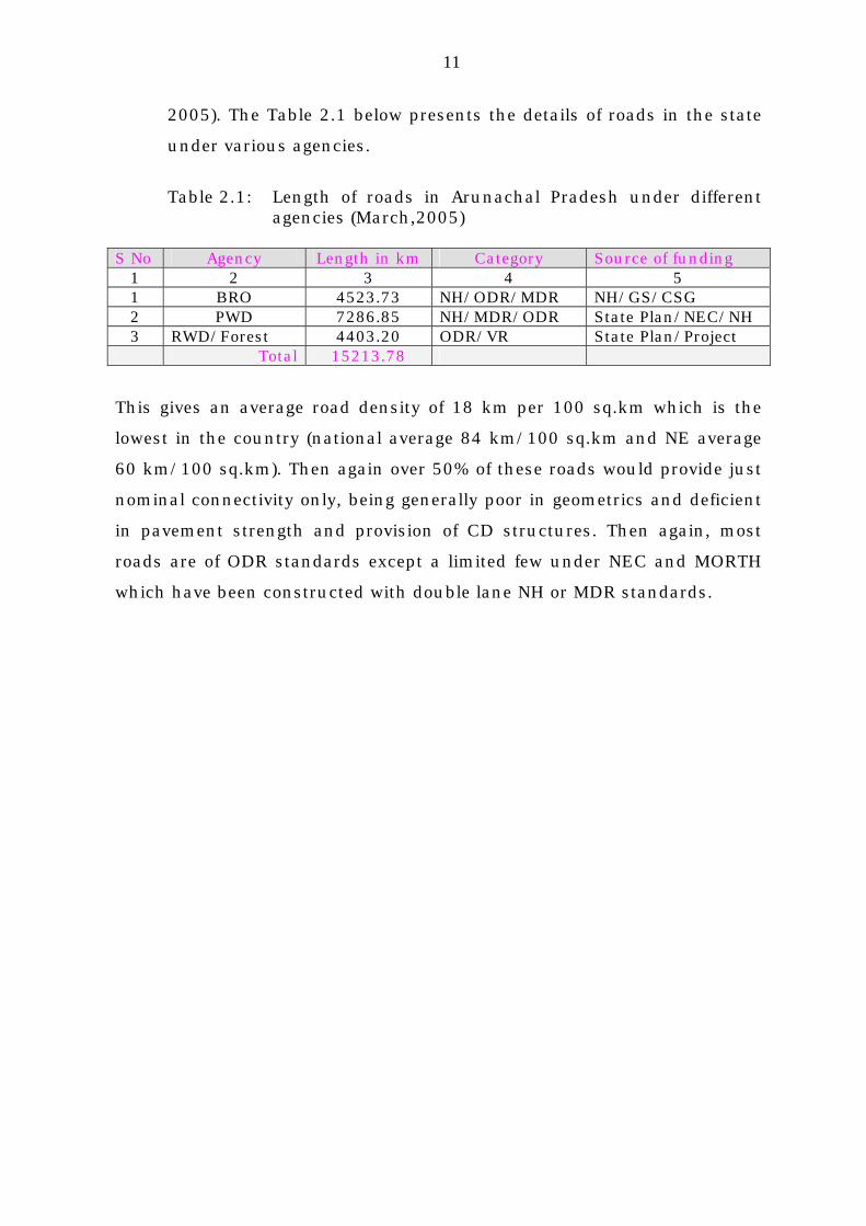
11
2005). The Table 2.1 below presents the details of roads in the state
under various agencies.
Table 2.1: Length of roads in Arunachal Pradesh under different
agencies (March,2005)
S No Agency Length in km Category Source of funding 1 2 3 4 5 1 BRO 4523.73 NH/ODR/MDR NH/GS/CSG 2 PWD 7286.85 NH/MDR/ODR State Plan/NEC/NH 3 RWD/Forest 4403.20 ODR/VR State Plan/Project
Total 15213.78
This gives an average road density of 18 km per 100 sq.km which is the
lowest in the country (national average 84 km/100 sq.km and NE average
60 km/100 sq.km). Then again over 50% of these roads would provide just
nominal connectivity only, being generally poor in geometrics and deficient
in pavement strength and provision of CD structures. Then again, most
roads are of ODR standards except a limited few under NEC and MORTH
which have been constructed with double lane NH or MDR standards.

12
III. DEVELOPMENT OF NATIONAL HIGHWAY
3.1 Existing NH network
Coverage of National Highway network in Arunachal Pradesh is very
poor. There are only three NHs in the state viz. NH 50, NH 50A and
NH 153 with total length of barely 420.00 km as given in Table 3.1
below.
Table 3.1: Profiles of existing NH network in Arunachal Pradesh
S No Reach covered Length in KM
Agency
NH No
I. NH 52 - Jonai to Sitpani 1) Jonai-Pasighat-Ranaghat-Mebo-
Dambuk-Bomjur (570.00 to 613.50 km )
103.50 Project Udayak BRO
NH-52
2) Bomjir-Iphipani-Roing(Meka)-Koronu-Paya (613.50 to 677.78 km)
64.29 -do- NH-52
3) Paya-Digaru (km 677.78 to 688.00)
10.22 -do- NH-52
4) Digaru-Tezu (688.00 to 705.90 km)
17.90 -do- NH-52
5) Tezu-Tohogam (705.90 to 735.10 km)
29.20 -do- NH-52
6) Tohogam-Brahmakund (705.10 to 749.80 km)
14.70 -do- NH-52
7) Brahmakund-Tri junction-Chowkham (749.80 to 805.93 km)
56.13 -do- NH-52
8) Chowkham-Sitapani (805.80 to 805.93 km)
39.00 -do- NH-52
Sub Total 335.94 II. NH 52A - Banderdewa to Gohpur 1) Banderdewa-Itanagar 31.50 Project Vartak
BRO NH-52A
2) Itanagar-Gohpur 20.37 -do- NH-52A Sub Total 51.87
III. NH 153 - Jairampur-Pangshu pass
32.52 PWD, Arunachal Pradesh
NH-153
Total 419.33
In the 20 Year Road Plan of India (Lucknow Plan), 1980-2000, it was
envisaged that the length and breadth India would be covered by the
NH network in a grid of 100 Km. In other word, every place of the
country must be within a distance of less than 50 km from an NH.
Under the scenario envisaged, the minimum length of NH network
required to cover the state of Arunachal Pradesh would work out to

13
1675 Km. Considering the need for height compensation of road
length in a hilly area, the actual requirement of NH in the state
would be much more. Against this backdrop the aggregate length of
the three existing NHs in Arunachal Pradesh works out to only
419.33 Km. It may also be appreciated that the existing NH network
covers only a fringe area in the foot hills adjacent to Assam and
leaves major areas of the state untouched.

14
3.2 East-West Highway: an NH along middle belt of Arunachal
Pradesh
a. Original proposal along the foothills. A proposal for one East-West
Highway running in east-west direction along the foothills from
Balemu in West Kameng district to Pasighat in East Siang district
was mooted in 1989-1990 with a view to facilitate intra-state
linkages within Arunachal Pradesh, and thus to avoid frequent
incursions into Assam for movement from one district of the state to
another. A pre-feasibility study by the RITES was funded by the NEC
at a cost of Rs. 24.00 lakhs. Because of the very heavy investment
required for constructing road in geologically fragile Siwalik region
with extensive needs for bridges on a large number of rivers,
emerging from the hills of Arunachal Pradesh to the plains of Assam,
and also considering the fact that the proposed road was in close
proximity to the NH-52, running along the north bank of the river
Brahmaputra, the proposal in question, originally mooted for funding
under NEC, could not find favour, and the project was thus shelved.
b. Revised proposal along middle belt. The need for the East-West
Highway, a trunk route within the territory of Arunachal Pradesh to
provide inter district linkages within the state, remained an unfilled
need. The importance of this proposal has also been recognized by
the Shukla Commission which has recommended an investment of
Rs.509.00 crores (1996-1997) for it.
The dream of East-West Highway in Arunachal Pradesh lives on. It is
being conceived …… under a revised proposal. The new proposal will
consist of a infra-state trunk road of two lane standard running
through various contiguous areas in east-west direction by
integrating the existing road networks and linking district
headquarters and other towns in the higher populated and more
productive zones along the middle belt of the sate. It will start from

15
or terminate on NH, State Highway or major State Roads within
Arunachal Pradesh or in Assam.
The proposal will have two major sectors viz. Western Sector (WS),
starting from Balipara on NH-52 in Assam and terminating again on
NH-52 at Pasighat (939 Km) and Eastern Sector (ES), linking
Mahadevpur on NH-52, lying on Assam-Arunachal Pradesh border to
Bimlapur on Naharkatia to Sibsagar two lane State Highway of
Assam (320 Km). Of the 939 Km in Western Sector, 32 Km falls in
Assam. On the other hand, of the 320 Km in Eastern Sector, 14 Km
lies in Assam. Profiles of different segments under the two sectors of
East-West Highway are given in Table 3.2 below.
Table 3.2: East West Highway: Western Sector (WS) – Balipara to Pasighat (939 km)
Segment
No. Names of Segments Length
in km Present Owner
Category of
existing road
Approx. cost
in crore
(1) (2) (3) (4) (5) (6) 1/WS Balipara-Bhalukpong
(on NH-52 in Assam) 32.00 BRO MDR 38.40
2/WS Bhalukpong – Nichipu 47.00 BRO ODR 56.40 3/WS Nichipu – Seppa 99.00 BRO ODR 118.80 4/WS Seppa – Sagalee 170.00 PWD
(NEC) ODR 204.00
5/WS Sagalee-Doimukh 75.00 PWD ODR 90.00 6/WS Nirjuli –Pottin 48.00 PWD
(NEC) ODR 57.60
7/WS Pottin – Yazali 13.00 BRO ODR 15.60 8/WS Yazali – Ziro 42.00 BRO ODR 50.40 9/WS Ziro – Daporijo 162.00 BRO ODR 194.40 10/WS Daporijo – Bam 108.00 BRO ODR 129.60 11/WS Bam – Along 42.00 BRO ODR 50.40 12/WS Along-Pangin 26.00 BRO ODR 31.20 13/WS Pangin – Pasighat
(on NH-52) 75.00 PWD ODR 90.00
Total 939.00 1126.00 In Arunachal Pradesh - 32.00 KM In Assam - 907.00 KM

16
Table 3.3: East-West Highway: Eastern Sector (ES)- Mahadevpur to Bimlapur (320 km)
Segment
No. Names of segments Length
in km. Present Owner
Category of
existing road
Approx. cost in crore
1 2 3 4 5 6 1/ES Mahadevpur –
Bordumsa (on NH-52 on Assam border)
22.00 PWD ODR 26.40
2/ES Bordumsa – Namchik 35.00 PWD ODR 42.00 3/ES Namchik – Jairampur 15.00 PWD ODR 18.00 4/ES Jairampur –
Changlang 76.00 PWD ODR 91.20
5/ES Changlang – Khonsa 64.00 PWD ODR 76.80 6/ES Khonsa – Longding 52.00 BRO ODR 62.40 7/ES Longding – Ranglua 42.00 NEC ODR 50.40 8/ES Ranglua-Bimlapur
(in Assam) 14.00 NEC ODR 16.80
Total 320.00 384.00
In Arunachal Pradesh - 14.00 KM In Assam - 306.00 KM 3.3 Lateral Highways and Spurs from East-West Highway
In order to improve its connectivity functions the proposed East-West
Highway at selected nodal points will have to be linked to NH-52 in
Assam by Lateral Highways. There will also be need to develop some
spurs from East West Highway to connect important locations having
tourism or growth potential; or serving as major administrative
centres; or leading to the sites of major hydro power projects being
taken up or planned in various river basins like Subansiri, Siang,
Lohit, Kameng etc. The details of these proposed Lateral Highways
and Spurs to East-West Highway are given in Table 3.4.
3.4 Investment proposal
Work involved for East-West Highway will mainly be upgradation of
the existing 1259 Km of ODR standard roads. Similarly 1122.35 Km
of Lateral Highways linking east-west highway to NH-52 and Spurs
from the new highway to identified tourist destinations or project

17
sites will cost another Rs.950.90 crores. Thus, the total investment
required will work out to about Rs.2460.90 crores.
Phasing and other parallel programme. The ultimate objective is to
bring East-West Highway and the Later Highways and Spurs of East-
West Highway and under the NH programme of the Ministry of Road
Transport and Highways. However, because of the heavy investment
required inclusion of these road proposals under NH programme
could be possible in phases only. Hence initially upgradation works
programme of selected reaches of the existing road network are
proposed to be supported through parallel programmes like ADB and
SARDP-NE. The details of such programmes are given in related
chapters.

18
Table 3.4: Lateral Highways and Spurs to East-West Highway
(937.50 Km) S
No Name of road Approx.
length (km) Scope Approx.
cost (crore)
Executing agency
Funding program
1 2 3 4 5 6 7 1 Daporijo-Menga 35.00 Upgrada
tion 31.50 BRO GS
2 Akajan(Assam)-Bam 109.00 ” 98.00 BRO GS 3 Roing-Anini 220.85 ” 199.00 BRO GS 4 Pangin-Yingkiong 126.00 ” 113.00 BRO GS 5 Yingkiong-Pugging 21.00 ” 19.00 PWD State
Plan 6 Along-Reying 60.00 ” 54.00 BRO GS 7 Pohumara-Potin 64.00 ” 58.00 BRO GS 8 Nichipu-Tawang 204.00 ” 184.00 BRO GS 9 Tinsukia-Naharkatia 45.00 IRQ 23.00 Assam NEC 10 Naharkatia-Khonsa 65.00 IRQ 33.00 PWD State
Plan 10 Changlang-Margherita 37.50 IRQ 19.00 PWD State
Plan 11 Hawai Camp-Hawai 118.00 Upgrada
tion 106.00 BRO GS
Total 1177.85 937.50

19
IV. ROAD DEVELOPMENT UNDER NEC
4.1 Completed works
NEC has played an important role in the development of
communication sector in the states of North Eastern Region
including Arunachal Pradesh. The Table:4.1 below shows the road
projects in the state completed under NEC upto the end of 8th Plan. A
few of these roads completed by the Border Roads component now
form General Staff or GS road network of BRO. On the other hand
some roads completed by BRO, on entrustment by NEC, have been
transferred to state PWD for maintenance.
Table 4.1: Completed NEC roads in Arunachal Pradesh. (road length in km)
S No Name of road Length In km
Agency
1 2 3 4 1 Shergaon-Kalaktang-Sikaridanga road 68.00 PWD 2 Jagun-Miao road 26.80 -do- 3 Longding-Bimlapur road 43.00 -do- 4 Dirok-Deomali road 16.00 -do- 5 Tezu-Sadiya road 13.20 -do- 6 Kumchai-Manabhum-Deban road 54.70 BRO
(Transferred under PWD)
7 Pakke-Seijosa-Itakhola road 76.00 PWD 8 Paka-Gongo NT road (Motorable stretch) 30.00 PWD 9 Seppa-Sagalee-Yazali road 250.00 BRO
(Transferred under PWD)
10 Kamlang-Tri Junction to Deban road 50.70 (Transferred to BRO) 11 Banderdewa-Itanagar Road 34.00 PWD
(Transferred under BRO)
12 Gohpur-Itanagar Road 22.00 PWD (Transferred under
BRO) 13 Bichom Bridge at Bana Road 1 No. BRO 14 Kaying-Tato Road 97.00 BRO
(Included under GS programme of BRO)
15 Taliha-Nacho Road 73.00 -do- 16 Ditte-Dime-Migging Road 200.00 -do- 17 Hunli-Anini Road 142.00 -do- 18 Orang-Mazbat-Rupa Road 142.00 PWD
(40.00 Km from Rupa to Shergaon transferred under
BRO) Total 1340.20

20
Total length of NEC roads under maintenance of PWD, AP, works out
to 675.36 km. As per the norm of MoRT&H, resources to the tune of
Rs. 12.15 crore (at the rate of Rs.1.80 lacs/Km) would be required for
their repairs and upkeepment.
4.2 9th Plan schemes
During 9th Plan four road projects involving improvement and
upgradation works, were taken up. Three of them formed parts of
Prime Minister’s package for North Eastern Region announced in
1996. Table 4.2 below gives the details of projects taken up during
9th Plan. The projects at Sls.(1) and (2) are expected to be completed
by March’2006 while Sl.(3) shall be completed by March’2007. The
scheme at Sl. (4) has meanwhile been completed (2005).
Table 4.2: Roads under NEC taken up during 9th Plan
S No
Name of roads Length In KM
Project cost
(in lakhs)
Cumulative expenditure
upto 31.03.06
Balance funds
required for completion
PDC Remarks
1 2 3 4 5 6 7 8 1 Changlang-
Margherita 37.48 2493.30 2363.83 129.47 3/07 PM package
2 Khonsa-Hukanjuri
35.00 2692.75 2536.48 156.27 3/07 -do-
3 Jote-Balijan 47.00 4017.96 3124.64 893.32 3/07 -do- 4 Dirok-
Deomali (SH: RCC bridges 6 Nos)
16.00 588.95 588.95 - Completed Conversion of timber bridge
Total 135.48 9792.96 8613.90 1179.06 4.3 10th Plan schemes
Initially 13 projects, both new and upgradation works, covering inter
state as well as works of economic importance were short-listed for
survey and investigation by the Working Group constituted by the
Council. An interim revised list was approved with number of

21
projects brought down to nine with a few replacements from the
original list. The final approved list consist of five projects as follows :
Table 4.3: Roads finally selected by NEC for 10th Plan
S No
Name of roads Length in KM
Project cost
in lakhs
Cumulative expenditure
upto 31.03.05
Balance funds
required for completion
PDC Remarks
1 2 3 4 5 6 7 8 1 Pasighat-Koyu
road 60.00 4636.00 994.72 3641.00 3/06
2 Laimekuri-Nari-Telam road (60 KM under AP)
60.00 6420.00 499.62 5921.00 3/07
3 Digboi-Pengri-Bordumsa-Mahadevpur (40 KM in AP)
40.00 4313.00 - 4313.00 - Not sanction
4 Seppa-Chyangtajo road
81.00 6773.00 - 6773.00 - Not sanction
5 Bleeting-Namtsering-Khungba-Honglo Road
76.00 9896.00 - 9896.00 - Not yet sanction
ed
Total 317.00 32038.00 1494.34 30544.00
4.4 Projects identified for 11th Plan and post 11th Plans
The following road projects have been identified for implementation
during 11th and post 11th Plan periods under NEC. The roads
identified are mainly from the original list recommended by the
Working Group for S&I at the onset of 10th plan but finally not
selected. Some important new projects have also been included in
this list given in Table 4.4 below.
Table 4.4: Roads projects identified for implementation under 11th and post 11th Plans of NEC
S No Name of roads Length
in km Approx.
cost in crores
Scope
1 2 3 4 5 1 Paka-Gongo NT road (phase-II) 70.00 84.00 New work 2 Pasighat-Koyu-Ego road (phase-II) 34.00 30.60 Upgradation
New work 3 Wak-Liromoba road 64.00 57.60 Upgradation work 4 Changlang-Khonsa road 65.00 58.50 Upgradation work 5 Longding-Bimlapur road 43.00 38.70 Upgradation work 6 Nyapin-Chayangtajo road 65.00 58.50 Upgradation work 7 Koloriang to Parsi Parlo road 70.00 84.00 New work

22
S No Name of roads Length in km
Approx. cost
in crores
Scope
1 2 3 4 5 8 Pasighat-Pangin road 76.00 68.40 Upgradation work 9 Mirem-Mikong-Jonai road 16.00 14.40 Upgradation work 10 Raga-Yorkum-Tali road via Luba 135.00 162.00 New work 11 Tamen-Dollungmukh road 89.00 106.80 New work 12 Lumla-Bleeting-Dudunghar-
Khobletang- BTK 62.00 68.40 New work/
Upgradation 13 Shergaon-Doimara road 110.00 132.00 New work 14 Orang-Mazbat-Kalaktang road 103.00 92.70 Upgradation work 15 Seijosa to Pake-Kessang road 66.00 59.40 Upgradation work Total 998.00 1116.00
4.5 Investment need
Funds to the tune of Rs.18.00 crore would be required for completion
of 9th project. For 10th Plan roads investment needed will work out to
Rs. 224.20 crores. On the other hand, the investment required for
projects identified for 11th and post 11th Plans is assessed to be
around Rs. 1116.00 crores (2005). Considering the deficiency in road
infrastructure in Arunachal Pradesh, legging far behind other states
even of the NE region, NEC will have to focus its efforts towards
development of this state.
4.6 A need for review of NEC policy on qualifying criteria for projects selection
It needs to be understood that in a state with vast area like
Arunachal Pradesh with long international borders with three
neighbouring countries viz. China, Bhutan and Myanmar with added
problem of remoteness and inaccessibility, there would be many
potential projects, especially under road transport sector, which
though of immense economic importance, but because of the
locational compulsion cannot be given the attribute of interstate
character, the main criteria for selection of projects under
programme of NEC. Thus, preponderance on interstate nature of
projects will prevent states like Arunachal Pradesh from availing the

23
opportunities under the Council. The selection criteria of projects
with overriding importance given to interstate nature of projects thus
need a review with higher priority accorded to economically
important projects also.

24
V. ROAD DEVELOPMENT THROUGH EXTERNAL AID PROGRAMMES 5.1 Need for tapping external funding sources
From the experience of near stagnating plan outlay over the last few
Five Year Plans, the possibility of significant increase in grants for
bridging the resource gap for critical infrastructure development
would appears to be remote. On the other hand, the state lagging far
behind other states, even of the NE region, in the field of
infrastructure development specially in communication sector,
Arunachal Pradesh will to leap-frog in its efforts if it ever could
dream of catching up with other parts of the country. For this a hike
in resource inputs would be a must. A time has, therefore, come to
look far non-traditional sources funding by tapping external funding
agencies such as the World Bank, Asian Development Bank etc.
5.2 North Eastern State Road Project
Under the aegis of the Ministry of Development of North Eastern
Region (MDONER), Govt. of India, the Asian Development Bank
(ADB) has sanctioned the North Eastern State Roads Project (ADB TA
4378-IND), a project for providing technical assistance to the eight
states of NE region in the field of road communication sector. The job
is to be undertaken by the consultant appointed by the Bank with
active inputs from the concerned road development agencies of the
states.
a. Project goal. The overall sectoral goal of the project is: To facilitate
economic growth, poverty reduction, and environmental action by
improving the North Eastern State Roads network and road
connectivity to the national and sub-regional road networks.
b. Project goal envisioned Three board objective outputs for this
TA, envisioned are as follows:
(a) Board prioritization of the regional roads network in the North
Eastern Region (NER) covering National Highways (NH), State

25
Roads (SR) and Major District Roads (MDR) in order to enhance
the national and sub-regional level roads connectivity.
(b) Undertake a Project Preparation Feasibility Study for an
investment project in the NER for rehabilitation, improvement,
upgrading and new roads construction, in each of the eight states
in the NER.
(c) Investigate existing needs and gaps in the various road sector
institutions in the NER, and prepare a preliminary Institutional
Development/Capacity Building (ID/CB) Action Plan to support
implementation of the investment project as well as longer term
improvements in the efficiency and effectiveness of the relevant
institutions, with a focus on key concerns including staff training
of the required ongoing investment programme and longer term
sustainable maintenance of road assets in the region.
5.3 Constitution of project cell
It is proposed to constitute a project cell which, under direction and
control of the Chief Engineer, (Eastern Zone), PWD, AP, Itanagar, will
be responsible for formulating DPRs, submitting data inputs
monitoring reports and returns and conducting quality audit etc in
regards to the NESR project and the subsequent investment package
likely to follow the present TA project.
Subsequently the project cell could also take up survey and
investigation (S&I) jobs, design works including referred cases on
(possibly on payment of nominal fees). Supervision activities and
quality auditing of other projects. In course of time this cell could be
given a legal entity by registering it as a society under the Societies
Registration Act or as corporation under the Company’s Act. It is also
envisioned that this unit in the long run will function on a self
sustaining basis with minimum support from the government
budget.

26
5.4 Identification of roads for investment project
One of the three envisaged outputs of the present TA project of ADB
is to undertake a project preparation feasibility study for an
investment package in each state of NER. The feasibility study will
cover rehabilitation, improvement or upgradation package and even
or new construction work. The TA project in hand is thus likely to be
followed by an investment project, sometime in 2006-2007.
a. Initial list of proposals. The initial investment package is sleighted
to be limited to IR 12,000 millions, (1200 crore) spread across eight
states under NE Council including Sikkim. With counter part
funding obligations against the loan likely to be covered by
MDONER, and also taking into view that the size of the loan itself is
limited, the share of each state is likely to be restricted beyond a
point. Then again, though in principle construction of new road is
also included under the purview of the investment project, definite
preference exists for improvement/up-gradation works, which will
not only be less cost intensive but also have lower gestation period
and lesser environmental impact tentative proposals from the state.
These roads are shown in Map 5.1. Within these parameters the
following seven roads were initially identified.
Table:5.1 List-Proposals under Arunachal Pradesh initially for investment project under ADB
Sl.
No. Name of roads Length Scope of work
1) Nirjuli-Potin Road 42.95 KM Upgradation to double
lane NH
2) Hoj to Seppa Road 218.00 KM Upgradation to MDR
3) Namdang-Changlang-Khonsa-
Hukanjuri Road
132.50 KM Improvement of riding
quality-72.50 KM
Upgradation 64.00 KM

27
Sl.
No. Name of roads Length Scope of work
4) Pakke-Kesang-Seijosa Road 75.00 KM Rehabilitation
5) Roing-Shantipur Road 35.00 KM IRQ
6) Longding-Bimlapur Road 56.00 KM Upgradation
7) Pasighat-Pangin Road 76.00 KM Upgradation
Total: 663.45 KM
b. Prioritised list as per ADB. With the initial size of the loan from the
Bank likely to be limited to only Rs.1200 crores, the total length of road to
be taken up in the whole of the NER under the investment project will
possibly need to be restricted to 1500 about Km from a figure of 2500 Km
as envisaged earlier. Thus the proposals from Arunachal Pradesh too will
have to be pruned down realistically. The ADB, and NEC, acting on behalf
of MDONER, have also made it clear that any road which is presently
included under an active programme of a Central agency like NEC or
MORT&H, will not be considered for ADB is given in Table 5.2 below. They
are also shown in map 5.2.
Table 5.2. Prioritised list of roads from Arunachal Pradesh under
consideration of ADB
Sl.
No.
Name of road Length
in Km
Scope of work Approximate
cost in cr.
1 Papu-Potin road via
Yupia
52.00 Upgradation of
double lane NH
standard
62.40
2 Hoj to Riloh road 175.00 Upgradation to
MDR
157.50
3 Pasighat-Pangin Road 76.00 Upgradation to
MDR
68.40
4 Changlang-Khonsa
road
64.00 Upgradation to
MDR
57.60
Total: 367.00 345.90

28
c. Rationale behind selection of projects. The roads which were
included in the initial list and those covered in the final prioritized list for
project preparatory feasibility studies under the NERSP-TA package under
ADB have been identified on the basis of their relative importance in the
existing road network specially those which are likely to play catalytic roles
for other development efforts in the area. They cover roads that provide
linkage to the state capital or inter district connectivity serving as conduits
for materials and services. Roads involving new cutting over substantial
lengths have not been considered to avoid high costs, long gestation
periods and above all the problem associated with Forests and
Environmental clearance.
The road identified also form parts of the proposed East-West Highways
through the mid belt of the state.
5.5. Future Plans
On successful completion of the works under the first phase of investment
project of ADB being envisaged, further programmes could be taken up
under the same bank or other aid agencies like World Bank. The roads
which may be covered under such future programmes with investment
through external aids could include the segments, laterals and spurs of the
proposed East-West Highway (Chapter III). The programmes may also cover
the roads leading to sites of major hydro projects, tourist centers
(chapter…) and cross border trade centers (chapter …)

29
VI. SPECIAL ACCELERATED ROAD DEVELOPMENT PROGRAMME IN
NORTH EASTERN REGION
6.1 Origin and concept of programme
The Special Accelerated Road Development Programme in North
Eastern Region (SARDP-NE) is a major initiative of the
Government of India aimed at rapid development of road
infrastructure in the North Eastern region of the country
comprising of the eight states Arunachal Pradesh, Assam,
Manipur, Meghalaya, Mizoram, Nagaland, Tripura and Sikkim.
The programme was conceived in the meeting taken by the
Hon’ble Union Minister (Shipping, Road Transport & Highways)
with Hon’ble Chief Ministers/State PWD Ministers and state
government officials at Guwahati and Shillong on 3 August and
4 August, 2004 respectively.
In a follow up meeting in Transport Bhavan, New Delhi on 13
October, 2004, taken by Secretary (RT&H), Government of
India, the concept of the proposed SARDP-NE, the composition
of the programme and the modalities of its implementation were
also outlined. The main objective of the programme is to link
the state capitals and district headquarters of the states in NER
with double lane NH or State Roads to the existing NH network.
The programme will thus include improvement, upgradation or
construction of National Highways and State Roads.
6.2 Proposals submitted by Arunachal Pradesh PWD
The original proposals submitted by PWD, Arunachal Pradesh
to the Ministry of Road Transport and Highways under SARDP-
NE consisted of 12 roads of standard with an aggregate length

30
of 1607 Km requiring upgradation or improvement of riding
quality, with the objective of improving the connectivity to
district headquarters which were yet to be linked directly by
any NH. Three of these roads belonged to PWD while ten fell
under BRO including one combined project a part of which is
owned by PWD. The length under the two agencies worked out
to 150 Km under state PWD and 1449 Km under BRO.
Subsequently, the original proposals submitted by PWD, AP
under the programme were reviewed in a meeting in the office
chamber of Chief Secretary on 8 November, 2004. In that
meeting it was decided that where the traffic intensity was not
high the width of the roads proposed may be limited to single
lane or intermediate lane only. After this review the total length
of roads proposed under the programme reduced to 1234 Km,
(1066 Km of GS roads within Arunachal Pradesh under BRO
and another 32 Km falling within Assam and 136 Km of State
Roads under PWD, AP.
6.3 Road proposals submitted before Foreign Secretary
Proposals of eight roads in border areas of Arunachal Pradesh,
including the Indo Myanmar Road, two Inter Basin roads, one
road leading to Bhutan border and four other road proposals
for outposts close to the border with China were placed before
the Foreign Secretary during his visit to Arunachal Pradesh on
26 and 27 November, 2004. On the basis of the report of
Foreign Secretary emphasizing the needs of these roads, there
was a meeting in PMO followed by another meeting taken by
Secretary (RT&H) in Transport Bhavan on 17 January 2005
where it was decided that these eight important roads in border

31
areas of the state would be integrated with SARDP-NE.
6.4 Meeting of GOS taken by Cabinet Secretary
In a meeting of the Group of Secretary, GOI, taken by the Union
Cabinet Secretary on 15 July 2005 with the main objective of
finalising the agencies to implement the projects under SARDP-
NE Phase: A, with special emphasis on Assam, Arunachal
Pradesh and Mizoram, the then Commissioner (PWD),
Arunachal Pradesh, made a request that since there was no
project from Arunachal Pradesh covered under the first Phase:A
of the programme, one small project the state, viz. Road from
Lumla to Tashigaon in Bhutan via Dudunghar (36 Km), could
be considered for inclusion under this phase. The proposal was
accepted.
6.5 Selected projects of Arunachal Pradesh
The Ministry of Road Transport and Highways had invited
proposals under SARDP-NE from both the state PWD and the
Border Road Organisation (BRO). The projects identified by the
Ministry, therefore, have a mix of roads under the two
organizations. The programme envisioned consists of three
phases viz. A, B and C with total length of 3000 Km (36.00 Km
under Phase: A, 1757 Km under Phase: B and 1207.00 Km
under Phase: C).
Phase A. The original list of roads identified for Phase: A
include those road which were covered under Prime Minister's
declaration. They included selected NHs and State Roads
proposed for four laning through BOT by National Highway

32
Authority of India (NHAI). Initially no proposal from Arunachal
Pradesh was included in this list. Subsequently, however, one
road of small stretch viz. Lumla to Tashigaon road via Dudunghar
(36.00 Km) has been included under this phase as per the decision
taken in the meeting of the GOS on 15 July, 2005.
Phase B. The works selected under phase B consist of NHs,
State Roads and General staff of GS roads identified for
improvement or upgradation with the aim of improving the
connectivity to district headquarters. The list includes roads
belonging to both BRO and state PWD. The state roads
identified are ODRs (Ordinary District Roads) with road width of
5.95 m, forming components of the network linking district
headquarters and in need of upgradation or improvement the
riding quality. The roads of BRO selected include NH 52 and GS
roads linking district headquarters and with needs for
upgradation to double lane standard or improvement of riding
quality. The combined list of works selected from PWD and BRO
under phases: A and B of SARDP-NE is shown in Table 6.1
below.
Table I: Provisions of SARDP-NE Phases A & B under Arunachal Pradesh Phase: A Sl.No.
NH. No. / State road Section Length
(Km)
Remarks
Original 1
Nil Nil Nil
In original list of MORT&H no scheme from AP was included under Phase:A.
Substituted 1
State road
Lumla to Tashigao in Bhutan via Dudunghar
36.00
Included in the meeting of GOS taken by Cabinet Secretary on 15.07.08 by transferring from Phase:C.

33
Phase B: National Highways/State Roads to be upgraded/ improved
Executing Agencies and Length (Km) NH No/State Road/Standard Section
BRO PWD Total
1 NH-52 Jonai-Sitapani 335 - 335
2 GS (MDR) Tawang-Balipara 283 - 283
3 GS (ODR) Seppa-Nechipu 96 - 96
4 State Road (ODR) Yupia-Pappu - 10 10
5 GS (ODR) Ziro-Pahumara 106 - 106
6 GS (ODR) Koloriang-Joram 158 - 158
7 GS/State Road (ODR) Yingkiong-Pasighat 91 76 167
8 GS (ODR) Anini-Meka 235 - 235
9 State Road (ODR) Hawai-Hawai Camp 118 8 126
10 GS (ODR) Likabali (Akajan)-Daporijo 210 - 210
11 GS (ODR) Along-Bame 31 - 31
Total 1663 94 1757
Phase: C. The phase C of SARDP-NE is a special programme specific
to Arunachal Pradesh. It consist of eight road projects in border areas
of Arunachal Pradesh with aggregate length of 1243 Km. The
proposals of these roads had originally been placed before the
Foreign Secretary, GOI, during his visit to Itanagar on 26 and 27
August 2004. The eight roads covered include the Indo-Myanmar

34
Road, two Inter Basin roads, one border road towards Bhutan, and
four other roads link border outposts on the border with China.
Subsequently, the road proposal from Lumla to Tashigaon in Bhutan
via Dudunghar (36Km) has been transferred from Phase: C and
covered under Phase:A, a decision which was taken during the
meeting of the Group of Secretaries, GOI, at Delhi on 15 July 2005.
The details of project proposals under Phase: C are given in Table 6.2
below.
6.6 SARDP-NE under different Scenario
The table below shows the different scenarios with comparative
summaries of the proposals initiated for SARDP-NE by state
PWD, and finally selected by the Ministry of Shipping, Road
Transport & Highways. Scenario: I covers the original
proposals submitted by PWD to MoRT&H with total length of
1607 Km while Scenario: II shows the revised proposals of
PWD as per meeting of 8.11.2004 where the length of reduced
to 1234 Km due to non-inclusion of two roads already under
upgradation to intermediate standard under NEC. Scenario: III carries the roads both BRO and PWD selected by MoSRT&H
under SARDP-NE Phase: B. Scenario: IV contains the roads in
border areas of Arunachal Pradesh earlier submitted before the
Foreign Secretary during his visit to the state on 26 and 27
November 2004 which were later brought under phase: C.
Scenario: V contains one project selected originally under
Phase C and subsequently included under Phase A as per
decision of the GOS, GOI, in the meeting of 15 July 2005. And
finally Scenario: IV combines the phases: A, B and C of

35
SARDP-NE in respect of Arunachal Pradesh with aggregate
length of 3000 Km.

36
Table 6.3: Comparative details of proposals for SARDP-NE under different Scenarios
Details under different scenario
Scenario Agencies
(I)
Original proposals
submitted by PWD to
MORT&H
(II)
Revised proposals of PWD as per meeting on 8.11.2004
(III)
BRO and PWD roads selected by MoSRT&H
under second phase Ph : B
(IV)
Border roads placed before
Foreign Secy:
included as third phase
Ph : C
(V)
One road proposal accepted
later under the first phase
Ph : A
(VI)
Combined list of
proposals selected
under the three phases
Ph: A+B+C
Under BRO (In A.P)
1319 Km 1066 Km 1597 Km
Under BRO (In Assam)
130 Km
32 Km
66 Km
Sub-Total 1449 Km 1098 Km 1663 Km Under PWDAP
158 Km 136 Km 94 Km
Under BRO
50 Km New
Proposals 807 Km
Under PWD 386 Km
Original -Nil
Added-36.00 Km (Substituted from Ph:C)
Ph:A - 37.80 Km
(Substituted from Ph:C)
Ph:B -1757
Km
Ph:C-1207.00 Km
(1243-36.00)
Total 1607 Km 1234 Km 1757 Km 1243 Km 36.00 Km 3000 Km

37
6.6 Agencies for implementation of SARDP-NE in AP
The Ministry of Shipping Road Transport and Highways,
Government of India, had envisaged that implementation of
SARDP-NE would be done only by the two Central agencies viz.
National Highway Authority of India (Phase: A) and Border
Roads Organisation (Phases: B and C). The Government of
Arunachal Pradesh and other states of NE region, however, are
of the view that parts of the programme covering at least the
roads which were originally under the state PWDs, should be
implemented by the state agency only.
It may be realized that BRO which is heavily committed for
construction and maintenance of strategically important roads
in the border areas and other agency works like NH in
Arunachal Pradesh would be extremely hard pressed with extra
workloads of SARDP-NE, if all the entire roads to be taken up
under the programme are entrusted to the agency, as originally
envisaged by the Ministry of Road Transport and Highways,
GOI.
In the light of above background it may be decided to entrust to
BRO the improvement and up-gradation works of the GS roads
and NH, already with the agency, under SARDP-NE Phase: B,
and construction of new border area roads under Phase: C. The
PWD, on the other hand, may be allowed to execute
improvement, up-gradation and construction of the remaining
roads presently with the agency, under the phases A, B and C
of SARDP-NE. The question of entrusting a road to either the
two agencies for implementation under SARDP-NE could be
decided on a principle of as-is-where-is basis.

38
6.7 Maps
The maps showing the identified roads in Arunachal Pradesh to
be taken up under various phases of SARDP-NE are shown in
maps as given below.
Appendix VI.a: Roads of Arunachal Pradesh selected for
improvement under SARDP-NE Phase: B
Appendix VI.b: Eight roads in border areas of Arunachal Pradesh,
originally placed before Foreign Secretary during his visit to
Arunachal Pradesh, included under SARDP-NE Phase: C and Phase
A.

39
VII TOWNSHIP ROADS 7.1 Origin of urban centres and trends of growth
Urbanization process in Arunachal Pradesh started late as a post
Independence phenomenon, linked mainly to growth of administrative
centres like the district, the ADC, the sub-divisional and the circle
headquarters. In the beginning most of these centres came up at isolated
places without road linkage. Even today out of 157 administrative centres
in the state (2005), 34 circle headquarters still remain unconnected by
road. Once the government offices were established along with other
facilities like hospitals, schools and markets, people from villages in the
catchment of the administrative set up began to gravitate towards these
settlements, leading to rapid increase in their populations. This process
which was slow in the beginning picked up speed in the seventies and
accelerated fast in the eighties and ninties. The trend is likely to maintain
its momentum for decades more.
7.2 Census towns and potential growth centres
At Independence there was no recognized town in the whole of the then
NEFA (North East Frontier Agency), now Arunachal Pradesh. In Census
1961 whole area of NEFA was treated as rural. In Census 1971, four
district and sub-divisional headquarters, viz. Bomdila, Along, Tezu and
Pasighat, came to be categoried as towns. In the next census of 1981,
Itanagar and Naharlagun were added to the earlier list of four. By 1991 the
list of urban centres went up to ten with addition of Ziro, Roing, Namsai
and Khonsa. Finally in 2001 the tally went up to 17 with entry of new

40
towns like Basar, Changlang, Daporijo, Deomali, Jairampur, Seppa and
Tawang.
The list of these 17 recognised urban centres in the state does not include
four district headquarters viz. Koloriang (Layeng Yangte) of Kurung Kumey
district, Yingkiong of Upper Siang, Anini of Dibang Valley and Hawai of
Anjaw district. These four left out district headquarters, however, are
included in separate list of 35 potential growth centers having scope for
further growth and becoming recognised urban centres in future. Some of
the towns in this list already have populations above 2000, one of the
required criteria for being recognized as class VI towns. The populations
and the lengths of roads in these 17 recognised urban centers are given in
Table 7.1. The profiles of the 35 other potential growth centres including
the uncovered district headquarters are given in Table 7.2.
7.3 High growth rate of urban population
Though the average decadal growth rate of population in Arunachal
Pradesh has decreased from 35.15% during 1971-81 to 26.21% during
1991-2001, the growth of urban population has been recording a high rate
of 158% during 1981-91 (national figure 36.09%) and 101.29% during
1991-2001. This high growth rate probably reflects a phenomenon of in-
migration of people from rural areas to urban pockets in search of better
facilities and opportunities like health, education, commercial or economic
activities. It also could indicate an influx of population from outside the
state, especially to the towns like Itanagar and Naharlagun, which have

41
registered high decadal growth rates of 111.36% and 87.31% respectively
during 1981-1991 and 1991-2001.
7.4 Functional roles of urban centers
As mentioned above the growth of urban centres in Arunachal Pradesh was
linked with spread of administrative system and growth of administrative
centers. Most of the urban centres in the state thus are functioning
administrative centres like the capital township or the district, the ADC,
the sub-divisional or circle headquarters. The main functional roles of
these towns, therefore, are administrative, which also include delivery of
social sector services like health, education, marketing etc. In a limited way
some of these towns also serve other functional needs that include tourism,
commercial and industrial activities etc.
7.5 Needs and problems of urban centres
Because of the rapidly increasing urban populations and the roles that
these centres play as hubs for delivery of services like health, education,
marketing etc. to the people living in these settlements and in the outlying
rural areas, it becomes essential to provide necessary urban infrastructure
support such as water supply, sanitation, health, education, road network
in these centres.
Except a few settlements in the lower belt of the state along the foothills,
adjacent to plains of neighbouring Assam, most of the urban centres in
Arunachal Pradesh lie in terraces of hills, some of them even in snowfall
regions in upper reaches. Most urban infrastructure in these towns,
especially the road network, would, therefore, have to face the vagaries and

42
constraints imposed due to the harsh topography weak geomorphology and
high precipitation. Then again, non of the towns in Arunachal Pradesh,
including the capital towns of Itanagar and Naharlagun, have Building
Byelaws, nor any laid down regulations to govern construction activities
(2005). Further, there is no Town and Country Planning Act in the state.
No identified authority exists with vested powers to control and regulate
development and construction activities in urban areas. Hence all the
urban centres in the state including the capital towns and the district
headquarters suffer from haphazard growth with growing menace of
encroachments and unauthorized constructions. In view of above
background, construction and maintenance of roads in urban centres of
the state remain beset with multifarious problems and constraints. Unless
required legal framework is established through statutes the problems will
multiply and all efforts towards development of urban infrastructure will be
negated.
7.6 Need for separate fund and designated agency.
Role of PWD. Presently there is no separate funds nor any designated
agency assigned exclusively for development and upkeepment of road
infrastructure in urban areas of the state. Earlier, in the absence of
separate designated agency, the construction of roads in township areas of
the state was being taken care by the State PWD as a part of general road
development programme of the department under State Plan. The resource
required for these activities was drawn from the common kitty under head
of account 5054 and 3054 Roads & Bridges.

43
Upkeepment of these assets was being done through corresponding
maintenance head under Non-Plan till 1996-97. Grants under Non-Plan for
maintenance and upkeepment of roads was stopped since 1997-98.
Consequently, urban roads under PWD are also being looked after with
meagre resources apportioned from Plan outlay under the sector as is
being done for other assets of the department.
Urban Development Department. In the beginning the urban
infrastructure development schemes under the head of account 4217
Urban Development, covering mainly minor works like storm water drains
in colonies; concrete foot path; land protection jobs such as retaining wall
etc., were taken up PWD. In 1993 a separate department viz. Urban
Development Department, with Town Planning and Housing attached to it,
was created. The new department which started functioning in 1996 began
to take up the schemes under the above fund.
Subsequently registered societies viz. the SUDA (the State Urban
Development Agency), based in the state capital, and the DUDAs (the
District Urban Development Agencies), located in district headquarters,
were created as legal entities registered under the Societies Registration Act
1869 under the aegis of the Urban Development Department. Funds
received from the Central Urban Development Ministry are parked in the
accounts of these societies and utilized against approved projects under
various programme of the Ministry. The projects implemented by DUDAs
so far however, appear to be of amorphous nature with no visibility on
ground. On the other hand, the State Urban Development Department has
recently initiated a member of major urban infrastructure projects that

44
cover urban roads, water supply scheme etc. with funding through Central
UD Ministry and possibly under NLCPR. As the activities of UD
Department grows dualism or multi agency involvement in various urban
infrastructure development projects cannot be ruled out. For example in
construction and upkeepment of urban roads the department has to work
in tendem with PWD. Similarly, for implementation of urban water supply
and sanitation schemes the PHED may have to involved. The SUDA of
which the Secretaries and Chief Engineers of some works department like
PWD are members does not as yet have a mechanism for coordination with
the line departments. The lack of coordination is often reflected in the
activities of DUDAs. The Agency sometime take up schemes like
retaining/breast walls and pucca drains on urban roads belonging to PWD
without the knowledge of the owner agency. Such lack of information
sharing could even lead to duplication of schemes and wasteful
expenditures. It could also adversely affect effective use of the assets in
hand.
Investment need for urban roads. In the Annual Plan document of Road
and Bridge sector under PWD, the roads in urban areas are shown as
Township Roads. Total length of roads in 17 census urban centres works
out to …. Km (Table 7.1). On the other hand, there exist another …….Km
of roads in the 35 other potential growth centres which include the four
district headquarters of Yinkiong, Anini, Koloriang and Hawai, not yet
recognized as census urban centers (Table 7.2). The resource required to
complete the ongoing urban road schemes or Township Roads works out to

45
about Rs.……… crores (See Tables 7.1 and 7.2). On the other hand, funds
required for maintenance and up-keepment of existing road taken as black
topped standard works out to Rs….. crores. Considering the high growth
rate of urban populations in recent decades and the likelihood of this trend
continuing in coming decades, there would be a need for substantial
increase in the urban infrastructure. Pegging the requirement of urban
roads by 2020 to be twice of the present length, it will call for quality
improvement of the present roads and capacity enhancement to the extent
of 747.500 Km. Improvement in quality of the existing road assets upto the
horizon year 2020 will require any investment of Rs……….crores. On the
other hand, construction of new roads will require an additional
investment of about Rs………… crore. So considering above scenario it will
need on the average at least Rs………….. crore per year for sustaining the
activities of construction and maintenance of urban roads in the state.
Need of designated fund and statutory bodies. Though in the annual
plans of Road & Bridge sector over the last several years the PWD has been
making additional dispensation of 5% of the free grant available (after
taking care of the committed expenditure and earmarked allocations) to the
urban centers like the state capital and another 5% to the district
headquarters, the actual allocations against road sector in urban areas
have been far from adequate.
It is observed that resource mobilization efforts for development and
upkeepment of urban roads, as a part of normal road development
programme of PWD, suffers from a general disinterest among the
individuals or organizations to champion its cause. With a backdrop of

46
general resource constraint, every elected representative makes his efforts
to draw the maximum resource outlays to his constituency only. In this
competitive environment everyone’s capital becomes nobody’s capital and
everyone’s district headquarter has few to champion its cause.
While the PWD could be expected to continue its activities towards
development of urban infrastructure in the state, supplementing the roles
of the designated agencies like Urban Development Department, SUDA,
DUDA etc, there is need for a designated fund for development and
upkeepment of urban roads in the state. Corollary to this is the need for
setting up of grass root urban democratic institutions like Municipal bodies
especially in larger townships, with statutory support for raising funds
through taxation and other means for making their development efforts
them self sustaining.

47
IX. PRADHAN MANTRI GRAM SADAK YOJANA
9.1 Programme objective and guiding principles
Pradhan Mantri Gram Sadak Yojana (PMGSY), has been a major
initiative of the Central Government for linking unconnected rural
habitations, fulfilling qualifying criteria, by good quality all weather
roads (AWR). The programme is supported mainly with funds
generated from cess on diesel (50%). The programme population
norms in general envisaged to link the villages with population 1000
and above by 2003, and 500 and above by 2007. For hilly and desert
states having smaller habitations the population norms were
correspondingly relaxed to 500 and 250 respectively.
The population will be reckoned based on Census 2001. The
Guideline of PMGSY also provides for inclusion of schemes to link
headquarters of Village Panchayats or places of tourist interest. In
such cases the population criteria may be relaxed. Provision also
exist in the guideline for covering cluster of smaller habitations,
within path distances of 1.50 Km from an all weather road, having
combined population of 250 or above.
Specification criteria of road. An all weather road is a road which
has adequate cross drainage and pavement provision to remain
operational in all types of weather. It however necessarily does not
imply that the road should be paved or black topped.
The coverage of PMGSY programme is limited to rural areas only.
Urban roads are excluded from the purview of the programme. Even
in rural areas PMGSY will cover only the rural roads i.e., the roads
falling under Ordinary District Road (ODR) and Village Road (VR)
category. Major District Road, State Highway, National Highway,
Expressway will not be covered under PMGSY even if such roads are
located in rural areas.
Each road work taken up under PMGSY must form a part of the Core
Network. A Core-Network, on the other hand, is the minimal network

48
of roads that is essential to provide basic access to essential social
and economic services to all eligible habitations through at last a
single all weather road.
The primary focus of PMGSY is to provide new connectivity with all
weather road to an unconnected habitation. New connectivity implies
construction of road from earthwork stage to desired specification.
Upgradation of road with deficient specifications to the prescribed
standard can be permitted under PMGSY provided all the qualifying
unconnected habitations have been provided with all weather road.
PMGSY however does not allow repairs of black topped or cement
roads.
9.2 Nodal Ministry/Department
The nodal ministry in Government of India is the Ministry of Rural
Development. The Central Ministry have set up the National Rural
Road Development Agency (NRRDA), a legal entity registered under
the Societies Registration Act 1869 to provide operational and
management support to the programme. The State Governments and
UT Administrations will furnish reports, data and information to
NRRDA.
Initially in Arunachal Pradesh the Rural Development Department
had been made the state nodal department Subsequently this was
changed to PWD Arunachal Pradesh. Finally however the
Government of Arunachal Pradesh in December 2003 entrusted the
entire PMGSY programme to the Rural Works Department and
designated it as the nodal department and executing agency.
Subsequently under RWD, the state autonomous agency viz.
Arunachal Pradesh Rural Road Development Agency, an independent
legal entity in line with NRRDA of the Central Government, has been
constituted under the Societies Registration Act 1869.
Subsequently designated Programme Implementation Units have also
been constituted under RWD in each district of the state.
49
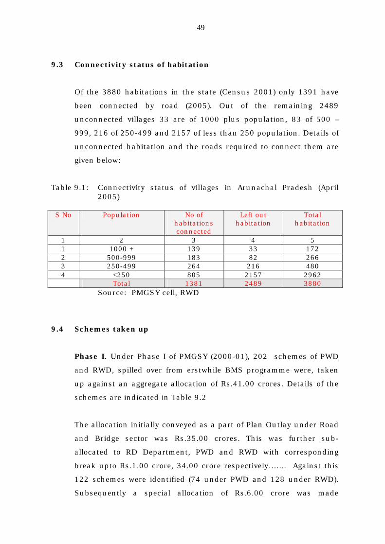
9.3 Connectivity status of habitation
Of the 3880 habitations in the state (Census 2001) only 1391 have
been connected by road (2005). Out of the remaining 2489
unconnected villages 33 are of 1000 plus population, 83 of 500 –
999, 216 of 250-499 and 2157 of less than 250 population. Details of
unconnected habitation and the roads required to connect them are
given below:
Table 9.1: Connectivity status of villages in Arunachal Pradesh (April 2005)
S No Population No of
habitations connected
Left out habitation
Total habitation
1 2 3 4 5 1 1000 + 139 33 172 2 500-999 183 82 266 3 250-499 264 216 480 4 <250 805 2157 2962 Total 1381 2489 3880
Source: PMGSY cell, RWD
9.4 Schemes taken up
Phase I. Under Phase I of PMGSY (2000-01), 202 schemes of PWD
and RWD, spilled over from erstwhile BMS programme were, taken
up against an aggregate allocation of Rs.41.00 crores. Details of the
schemes are indicated in Table 9.2
The allocation initially conveyed as a part of Plan Outlay under Road
and Bridge sector was Rs.35.00 crores. This was further sub-
allocated to RD Department, PWD and RWD with corresponding
break upto Rs.1.00 crore, 34.00 crore respectively……. Against this
122 schemes were identified (74 under PWD and 128 under RWD).
Subsequently a special allocation of Rs.6.00 crore was made

50
additionally under RWD. Against this 80 additional schemes were
taken up. But they were operationalised during the next final year ie
2001-2002, only.
Table 9.3 Details of road project taken up under PMGSY Phase II
(2001-03)
Phase II. Under Phase II (2001-03) 137 roads were taken up under
PWD and RWD at a cost of Rs.86.43 crores. Details are given in
Table 9.3.
More than 76% of the villages have population less than 250, the
threshold level for qualifying under PMGSY.
9.5 Works ahead
Over 11,000 km of road would be needed to connect the remaining
unconnected villages. Of this about 3000 km would be linking for the
villages with population of 250 and above. The investment needed
would be to the tune of Rs.2700 crores.

51
X. DEVELOPMENT OF BORDER TRADE ROUTES 10.1 Traditional trade routes
In the past there were many traditional trade routes from Arunachal
Pradesh to the neighbouring countries like Tibet (China), Myanmar
(Burma) and Bhutan. Trading was carried out mainly through barter.
Over the years some of these routes especially those leading to China
and Myanmar fell into disuse mainly due to souring of relationship
between the countries. Now, with changes taking place in global
scenario, there is an emerging need to reopen these traditional trade
routes.
10.2 Identified route for cross border trade
Besides reopening the traditional trade routes, there is a new cross
border trade centres will also have to be identified and developed
based on demand and potential.
Table 10.1 below shows the names of the traditional trade routes and
potential new routes in Arunachal Pradesh leading to internal
borders with countries like China, Myanmar and Bhutan. It is
proposed to develop these roads leading to cross border trade centres
in phased manner under different programmes like SARDP-NE, NH,
G Road, State Plan etc.

52
Table 10.1:
S No
Name of road Length (km)
Destination
country
Approximate cost (crore)
Present category
Scope of work
Remarks
(1) (2) (3) (4) (5) (6) (7) 1 Tawang to …… 35.00 Bhutan 32.00 ODR Improve
ment
2 Mechuka to Lolla pass road
40 .00 China 48.00 ODR New constn.
3 Tuting to Gelling road
37.00 China 45.00 ODR -do-
4 Wallong to Kibithoo road
25.00 China 23.00 ODR Improvement
5 Jairampur to Pangsu pass road
32.50 Myanmar
30.00 NH Upgradation
6 Panchao to Konsa road
28.00 Myanmar
25.00 ODR Improvement
7 Lumla to Tashigaon via Dudunghar
40.00 Bhutan 45.00 ODR Improvement/New constr
Total 237.50 251.00

53
10.3 Map: Enclosed as Appendix 10.1 map No……………. Title:

54
XI. NEEDS OF ROADS IN UNCOVERED AREAS
11.1 Bias in road development
Although road development has made good stride in Arunachal
Pradesh (from near to nothing at Independence), the impact of this
development remains confined mostly to higher population areas in
or around the capital towns, district headquarters or other
administrative centers. Then again, though the Border Roads
Organisation has taken up a large number of General Staff (GS) and
China Study Group (CSG) roads towards the border areas, their
development is concentrated only in areas where perception of threat
from across the border is high the last half century.
11.2 Special problem of uncovered areas
Thus in view of above background where in a particular sector there
may be maze crises of crossing road network of BRO, vast tracts in
other areas, where little or no threat is perceived have been left
uncovered. The road construction programme under state plan,
starving of funds, cannot make a dent to this vast need. On the other
hand the externally funded programme like NEC also fails to provide
the needed coverage due to the poor funding and its preponderance
on inter-state nature of projects.
11.3 Perspective requirements of roads in uncovered area
Table 11.1 below shows the tentative list of roads required for
establishing connectivity to uncovered areas of the state. Most of
these roads would lead to unconnected stations in border areas.
Some of them will function as alternative access to existing GS roads.
Others will serve as interbasin linkage and will thus be of strategic
importance. All roads identified under existing programmes like NEC
or SARDP-NE have been excluded from this list.
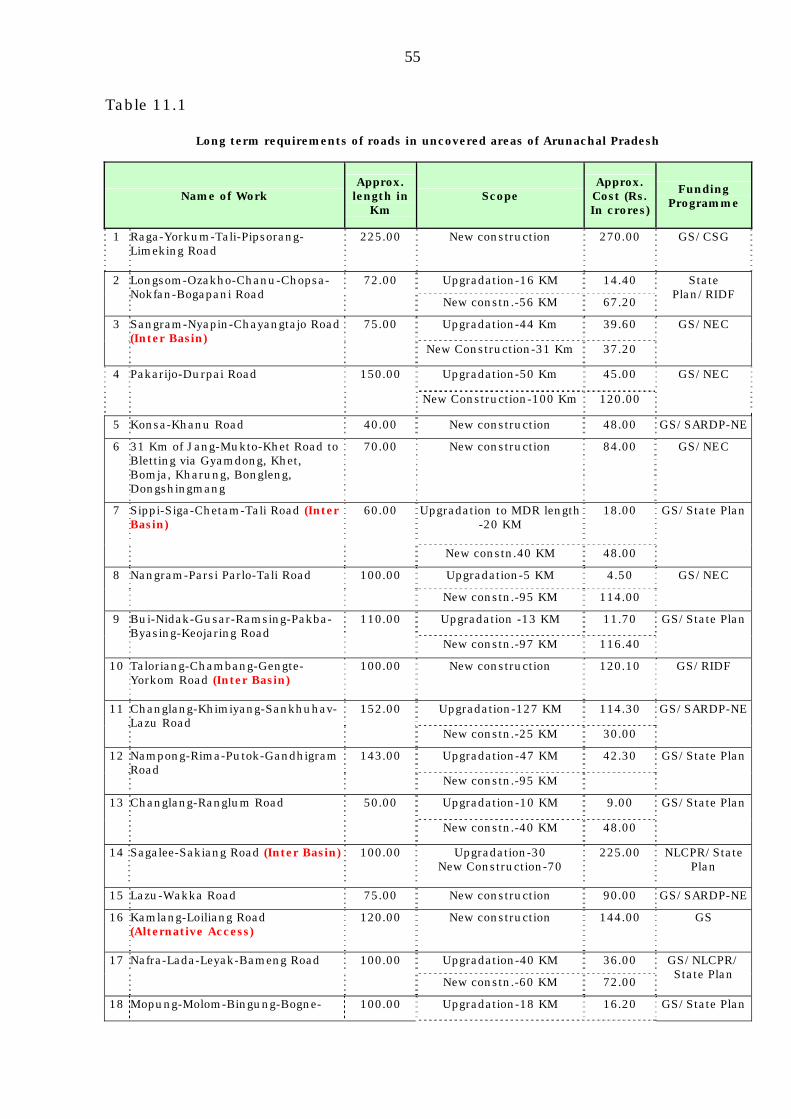
55
Table 11.1
Long term requirements of roads in uncovered areas of Arunachal Pradesh
Name of Work Approx. length in
Km Scope
Approx. Cost (Rs. In crores)
Funding Programme
1 Raga-Yorkum-Tali-Pipsorang-Limeking Road
225.00 New construction 270.00 GS/CSG
Upgradation-16 KM 14.40 2 Longsom-Ozakho-Chanu-Chopsa-Nokfan-Bogapani Road
72.00
New constn.-56 KM 67.20
State Plan/RIDF
Upgradation-44 Km 39.60 3 Sangram-Nyapin-Chayangtajo Road (Inter Basin)
75.00
New Construction-31 Km 37.20
GS/NEC
Upgradation-50 Km 45.00 4 Pakarijo-Durpai Road 150.00
New Construction-100 Km 120.00
GS/NEC
5 Konsa-Khanu Road 40.00 New construction 48.00 GS/SARDP-NE
6 31 Km of Jang-Mukto-Khet Road to Bletting via Gyamdong, Khet, Bomja, Kharung, Bongleng, Dongshingmang
70.00 New construction 84.00 GS/NEC
Upgradation to MDR length -20 KM
18.00 7 Sippi-Siga-Chetam-Tali Road (Inter Basin)
60.00
New constn.40 KM 48.00
GS/State Plan
Upgradation-5 KM 4.50 8 Nangram-Parsi Parlo-Tali Road 100.00
New constn.-95 KM 114.00
GS/NEC
Upgradation -13 KM 11.70 9 Bui-Nidak-Gusar-Ramsing-Pakba-Byasing-Keojaring Road
110.00
New constn.-97 KM 116.40
GS/State Plan
10 Taloriang-Chambang-Gengte-Yorkom Road (Inter Basin)
100.00 New construction 120.10 GS/RIDF
Upgradation-127 KM 114.30 11 Changlang-Khimiyang-Sankhuhav-Lazu Road
152.00
New constn.-25 KM 30.00
GS/SARDP-NE
Upgradation-47 KM 42.30 12 Nampong-Rima-Putok-Gandhigram Road
143.00
New constn.-95 KM
GS/State Plan
Upgradation-10 KM 9.00 13 Changlang-Ranglum Road 50.00
New constn.-40 KM 48.00
GS/State Plan
14 Sagalee-Sakiang Road (Inter Basin) 100.00 Upgradation-30 New Construction-70
225.00 NLCPR/State Plan
15 Lazu-Wakka Road 75.00 New construction 90.00 GS/SARDP-NE
16 Kamlang-Loiliang Road (Alternative Access)
120.00 New construction 144.00 GS
Upgradation-40 KM 36.00 17 Nafra-Lada-Leyak-Bameng Road 100.00
New constn.-60 KM 72.00
GS/NLCPR/ State Plan
18 Mopung-Molom-Bingung-Bogne- 100.00 Upgradation-18 KM 16.20 GS/State Plan

56
Long term requirements of roads in uncovered areas of Arunachal Pradesh
Name of Work Approx. length in
Km Scope
Approx. Cost (Rs. In crores)
Funding Programme
Paksing-Gacheng-Payum Road New constn.-82 KM 98.40
19 Tuting-Singa-Chepe-Anelieh-Arzoo (Inter Basin Road)
225.00 New construction 270.00 GS/SARDP-NE
Upgradation-15 KM 13.50 20 Hunli-Desali-Lohitpur (Alternative Access)
130.00
New constn.-115 KM 138.00
GS
21 Katan-Pongging-Sissen-Pangi-Komsing-Jorsing Road
70.00 New construction 84.00 State Plan/RIDF/
NLCPR Upgradation-29 KM 26.10 22 Namsang-Khela Road 46.00
New constn.-17 KM 20.40
State Plan/RIDF/
CRF 23 Namtok - Thamiyang Road 40.00 New construction 48.00 State
Plan/RIDF 24 Foothill Road from Ruskin to
Balemu 500.00 New construction 600.00 State Plan/NEC
25 Miao-Vijaynagar
26 Bam-Nyorak-Nikte Road
27 Koyu-Rina-Piri-Beye-Ngomdir-Tadin-Kombo-Along Road
Total 2885.00 3436.90

57
XII. BUS AND TRUCK TERMINALS AND WAYSIDE
AMENITIES
12.1 Need of transit and terminal facilities
Arunachal Pradesh is almost solely dependent on the roads for
surface transport. Wayside amenities and terminal facilities are
essential to enhance the efficiency of the road communication for
movement of men, materials and services.
12.2 Present status
Presently the state lacks in proper wayside or terminal facilities. The
entry gates located on the foothills adjacent to Assam and halting
places along the roads have no proper facilities for waiting and
refreshment, or even wash rooms. The toilets, if provided at all, are
dirty and un-attended. Eating places are mostly unhygienic. Not all
can go to IBs or Circuit Houses which are generally located away
from the road.
Inter State Bus Terminus (ISBT) and Inter State Truck Terminus (ISTT). Though NEC had kept a provision of over Rs. 3.00 crores for Inter
State Bus Terminus (ISBT) at Naharlagun during 10th Plan, the
project could not take off for want of land.
12.3 Provision required
It is proposed to establish a Inter State Bus Terminus (ISBT) at
Naharlagun. Bus terminus are also be established at other regional
focal stations like Pasighat and Bhalukpong. Inter State Truck
Terminus is also proposed to be established at Naharlagun.
It is also proposed set up resting space, eateries, toilets etc. at all
important entry gates.

58
The following facilities are now sought to be provided –
Rs in crore
1 Inter State Bus Terminus at Naharlagun
10.00
2 ISBT at Pasighat and Bhalukpong 14.00
3 Inter State Truck Terminus at Naharlagun 7.00
4 Wayside amenities at entry gates (Bhalukpong, Balemu, Hallongi, Banderdewa, Kimin, Likabali, Ruksin, Santipur, Namchik gate, Sunpura, Dirok gate, Namdang, Hukanjuri, Rangluah)
14.00
Total 45.00

59
XIII. ROAD HIERARCHY & CLASSIFICATION
Classification of roads
Hierarchy of Roads as per Indian Road Congress. In India the roads in
general are categorized into one of the following classes based mainly on
their functional requirements and standards as per hierarchy established
by Indian Road Congress.
(i) Express Ways
(ii) National Highways (NH)
(iii) State Highways (SH)
(iv) Major District Road (MDR)
(v) Ordinary District Road (ODR)
(vi) Village Road (VR)
Classification of roads as per established hierarchy also helps to assign
priority for investment decisions.
Position in Arunachal Pradesh. In Arunachal Pradesh, hierarchy of road
network is yet to be established. The category of roads except NH still
remain un-classified. However, in course of time the roads in the state will
have to be classified as per their priority status and functional role.
While declaration of Express Way and National Highways, and their
construction and maintenance, will rest with the Central Government,
declaration of other roads into different classes as per established
hierarchy shall be done by the State Government through notification in
the official gazette. The state may enact acts and rules as may be required
in this regard. The classification may be based on the following criteria.
State Highways (SH). Important roads providing interstate connectivity or
linking series of districts within the state including the General Staff or GS
roads under Border Road Organisation (BRO).

60
Major District Road (MDR). Roads providing inter-district connectivity or
linking series of urban centres like the ADC or SDO headquarters to the
district headquarter.
Ordinary District Road (ODR). Roads providing inter linkages between
administrative centres or connecting series of major villages with
population exceeding 250.
Village Road (VR). Roads of limited lengths linking individual villages or
hamlets specially with population less than 250.
Appropriate Specification. The roads under State Highway and Major
District Road categories will have standards as recommended by IRC.
However, roads leading to one or two villages and with very low traffic
intensity, which is not likely to change appreciably in foreseeable future
may have toned down specifications appropriate to their utility level.
Considering the possibility of upgradation demand in future, the road
formation and the cross drainage (CD) must have the minimum width of
5.95 m. The pavement, however, could be restricted to a single layer of
WBM I with 3.75 m width. Attention must, however, be given to proper sub
grade preparation and compaction as per prescribed practice. Such roads
with grass surface over well laid single layer WBM have been found to
function satisfactorily for light traffic. The cot of construction will also come
down by about 40% compared to bitumenised surfaced roads, which are
also environmentally more harmful due to the use of carbonaceous
bitumen and use of road for heating.
Communication of road construction and maintenance activities:-

61
Many an existing road like Along-Likabali road and Khonsa-Hukanjuri road
were constructed by the communities through self help basis with nominal
involvement of the administration which was limited providing equipment,
ration, medical support. The spirit of community participation sco… in
tradition, now threatened due to politicization of life needs to be revised
and used for development of infrastructure especially in remote areas.
Road construction activities could be dovetailed with various programs of
the Rural Development, Panchayati Raj and DRDAs for employment
generation and creation of durable rural assets.
Then again many of the road maintenance activities like jungle cutting,
clearance of drains and culverts and removal of slips and seasonal
activities for which the villagers could be engaged on part time basis. This
will help to economize on road maintenance cost as the need for employing
large maintenance gangs could be done away with.
XIV. AIR TRANSPORT 14.1 Need of air services In a vast and remote hinterland state like Arunachal Pradesh where
development of road is difficult, and its cost of construction and
maintenance prohibitively high, it would not be feasible to provide
road linkage to all destination, especially those in the far flung
border areas. Then again travelling long distances through hill roads
is time taking, tedious, uncomfortable and could be dangerous too.
These factors could inhibit and defer travel within the state and deter
prospective tourists and other visitors.

62
14.2 Services available earlier
Paradoxical as it may sound, Arunachal Pradesh had better and
more assured air services in the past than ever afterward. A number
of air strips or advance landing grounds (ALGs), were constructed
during fifties, by the army personnel or by the local people on self
help basis with nominal support from the administration. Fixed
winged propeller aircrafts like Fokker Friendship, Dakota, Caribow,
Otter etc. carried out sorties to these ALG located at places like Ziro,
Daporijo, Along, Mechuka, Tuting, Pasighat, Anini (Alinye), Tezu and
Vijaynagar. These aeroplanes, however, were gradually phased out.
Later Vayudoot provided limited services to some of these ALGs
through 18 seater Dornier aircrafts Services of the Dornier aircrafts
were also ultimately discontinued.
14.3. Present status
After phasing out of the fixed wing propeller aircrafts and withdrawal
of Vayudoot services, the landing grounds at various locations in
Arunachal Pradesh became defunct and remained unused, except
limited services by IAF and Pawan Hans helicopters. To a limited
extent selected ALGs like Mechuka, Tuting, Vijaynagar continue to
cater to AN 32 planes of IAF which ferry defense sorties to these
places.
All attempts to have proper airports in Arunachal Pradesh have not
been fruitful. As the answer to a long felt need, efforts have been
made to set up an airport near Itanagar with runway length of 8500
ft. capable of receiving Airbus 320 and Boeing 737. However, all the
sites identified, including Gumto-Emchi, Jotte, Nirjuli and
Banderdewa, have been rejected on various technical grounds by the
Airport Authority of India (AAI).
Thus Arunachal Pradesh is one of the few states in the country
without air linkage due to the absence of proper airport. Though the
State has also contributed its share of NEC funds towards

63
procurement of 50 seater ATR planes, now under operation under
Alliance Airline, the people of the state cannot avail of any direct
benefit from this service due to the absence of any airport within its
territory.
Then again, though the NEC funded airport at Lilabari near North
Lakhimpur in Assam has been operationalized, the service of ATR by
Alliance Airlines is erratic, and is unable to assure linkage to further
connecting flights from the hub of operation at Guwahati. Moreover
due to frequent bandhs and disturbances in Assam the service is
disrupted quite frequently.
14.4 Future requirements
Airport at Itanagar. An airport of Itanagar still remains an
unfulfilled need. Since no site in immediate vicinity of the capital
townships of Itanagar, Naharlagun, Nirjuli and Banderdewa have
been accepted by AAI, we may have look for possible sites beyond at
reasonable distances.
Possible site for airport at Yachuli.
From visual observation, there appears to be a possible site for an
airport at Yachuli lying in North-South orientation on the eastern sid
of Yazali-Ziro BRTF road. The required runway of 8500 ft length and
other required infrastructure could be created by cutting, the minor
hillocks and filling depressions in between aircrafts. Table 13.1
shows the list of identified aircrafts landing grounds to be developed
in Arunachal Pradesh.
An airport at this location will not only serve the capital area of
Itanagar but also a large catchment covering Lower Subansiri,
Kurung Kumey, Upper Subansiri and even Papum Pare.

64
Airports for ATR.
Airports will also be required at Pasighat, Tezu, Yingkiong and Roing
for 50 seater ATR aircrafts with runway length of 4500 ft. each
catering to large catchments covering number of districts. Where
feasible, the length and areas acquired or developed in these
locations should be such as to enable expansion of facilities to
Airbus or Boeing standard in future. The two projects for
construction of airports for 50 seater ATR aircrafts at Pasighat and
Tezu under Ninth Plan of NEC have been languishing for want of
EFC clearance and sanctions.
Airports for STOL airports.
The old landing grounds at Ziro, Daporijo, Along, Mechuka, Tuting,
Alinye, Vijaynagar could also be improved with runway length
increased to 2500 to 3000 ft. wherever feasible for operation of 15 to
20 seater short take off and landing (STOL).
Table 13.1: The needs of airports and LGs in Arunachal Pradesh
Rs. in crores S
No Location Capacity Runway
length Cost in crores
Remarks Source of fund
1 2 3 4 5 6 7 1
Yachuli
Airbus 320/ Boeing 737
8200 ft.
200.00
New
NLCPR/NEC/AAI
2 Pasighat 50 seater ATR
4500 ft 25.00 Upgradation ”
3 Tezu 50 seater ATR
4500 ft 20.00 Improvement ”
4 Roing ” ” 30.00 New ” 5 Yingkiong ” ” 35.00 New ” 6 Ziro 15-20
Seater 3000 ft. 5.00 Improvement ”
7 Daporijo 15-20 ” ” 5.00 ” ” 8 Along 15-20 ” ” 5.00 ” ” 9 Mechuka 15-20 ” ” 5.00 ” ” 10 Tuting 15-20 ” ” 10.00 ” ” 11 Alinye 15-20 ” ” 10.00 ” ” 12 Vijaynagar 15-20 ” ” 10.00 ” ” Total 265.00

65
VISION : 2020
1. Resource estimate
An estimate of the resources likely to be available upto horizon year
2020 under various budget sources has been made. They will include
sources as PWD (State Plan including CRF & RIDF), MDONER
(NLCPR), BRO (GS, CSG), MOSRT&H (NH, SARDP-NE), ADB (Loan),
RWD (PMGSY). The total estimate works out to Rs. 12262.00 crores.
2. Vision goal
By end of the horizon year 2020 it is proposed to achieve a road
density of 24 km/100 Sq.km. The total road length envisioned is
20000 km. Thus a capacity addition of 4800 km is targeted at a cost
of Rs. 4800.00 crores. On the other hand, existing road length of
15200 km will require improvement and upgradation, which will
require an investment of Rs. 7600.00 crores.
Copyright © 2022 FDOKUMEN