Virtual reconstruction of the wall and alcazar of Molina de Segura
14
HCITOCH 2011, Huerta Grande (Valle de Punilla) Córdoba, Argentina 61 Virtual Reconstruction of the Wall and Alcazar of Molina de Segura Gonzalo Martín Sánchez. Universidad Antonio de Nebrija, Madrid, Spain [email protected] Abstract. This paper is intended to describe the completed research process aimed to the virtual reconstruction of the medieval walls of the town of Molina de Segura using the Maya software 2011 in order to represent it in video format within the interpretive center Molina Wall (MUDEM), in the Spanish village of Molina de Segura. Keywords: 3D, Computer Graphics, Archaeological Simulation 1 Introduction The virtual reconstruction of monuments requires not only the application of knowledge management tools to generate 3D images (either still or moving), but also the understanding of the scientific information that is provided to achieve a reliable reconstruction of the monument we tend to recreate. Our main objective is to reconstruct in the most possible reliable way medieval walls from the information provided by the archaeological activities. But it also raises the secondary aim of generating an image that could lead to propose new questions for archaeologists on existing scenarios as well as to create a useful and attractive audio-visual for the public in describing the walls of Molina de Segura. 2 Museum Project The interpretive center of the Wall of Molina de Segura, called Enclave Museum Wall of Molina de Segura, is a cultural project of the City of Molina de Segura 1 has asked the company Oníricom 2, has undertaken the completion of all audiovisual content, led by Vicente Peñataro, within which is “Molina rebuilt”, which is the focus of this communication material. 1 www.molinadesegura.es 2 www.oniricom.com
Transcript of Virtual reconstruction of the wall and alcazar of Molina de Segura
HCITOCH 2011, Huerta Grande (Valle de Punilla) Córdoba, Argentina
61
Virtual Reconstruction of the Wall and Alcazar of Molina de Segura
Gonzalo Martín Sánchez.
Universidad Antonio de Nebrija, Madrid, Spain [email protected]
Abstract. This paper is intended to describe the completed research process aimed to the virtual reconstruction of the medieval walls of the town of Molina de Segura using the Maya software 2011 in order to represent it in video format within the interpretive center Molina Wall (MUDEM), in the Spanish village of Molina de Segura.
Keywords: 3D, Computer Graphics, Archaeological Simulation
1 Introduction
The virtual reconstruction of monuments requires not only the application of knowledge management tools to generate 3D images (either still or moving), but also the understanding of the scientific information that is provided to achieve a reliable reconstruction of the monument we tend to recreate. Our main objective is to reconstruct in the most possible reliable way medieval walls from the information provided by the archaeological activities. But it also raises the secondary aim of generating an image that could lead to propose new questions for archaeologists on existing scenarios as well as to create a useful and attractive audio-visual for the public in describing the walls of Molina de Segura. 2 Museum Project
The interpretive center of the Wall of Molina de Segura, called Enclave Museum Wall of Molina de Segura, is a cultural project of the City of Molina de Segura 1 has asked the company Oníricom 2, has undertaken the completion of all audiovisual content, led by Vicente Peñataro, within which is “Molina rebuilt”, which is the focus of this communication material.
1 www.molinadesegura.es 2 www.oniricom.com
ALAIPO & AINCI 62
2.1 Molina de Segura
Molina de Segura is a municipality that lies within the middle flood plain of the Segura river, in southeastern Spain at the Murcia region. Of possible pre-Roman origin, its importance as a key strategic location originated in the Middle Ages, under Muslim rule in the ninth century (Silliere, 1982, p. 248) in wich the settlement was known as as-Sikka Mulinat (Molina de la Calzada), later named as Molina Seca (Torres, 1963, p. 230) and afterwards as Molina de Segura, being situated on the banks of this river.
During this time Molina stands in a walled perimeter and a fortress, which is known as Mulina Hisn (the walled city). The castle represents the center of power settled at the top of the population, the wall closes the room where daily life unfolds and is home to the population in case of attack (González Caballero y Ramírez Águila, 2006, pág. 27).
Fortifications such as Molina de Segura is meant by the historical context in which arose during the Islamic conquest of the Iberian peninsula and the subsequent Christian reconquest. Fortifications that dot the south of the Spanish territory have served to make comparisons and to look for similarities that have helped in the reconstruction performed.
Interestingly, the shift occurred in regard to concerns about the artistic heritage of the towns and cities . For although, due to urban developments within the nineteenth and twentieth century, many of these monuments were demolished in the territory, today we are interested in recovering the footprint of the past. That’s the case of Molina de Segura because, with the appearance of the remains of the wall in the early nineties3, has developed a museological project which has led, among others, to the virtual reconstruction project. 2.1.1 Archaeological work: data on the wall and the Medieval castle
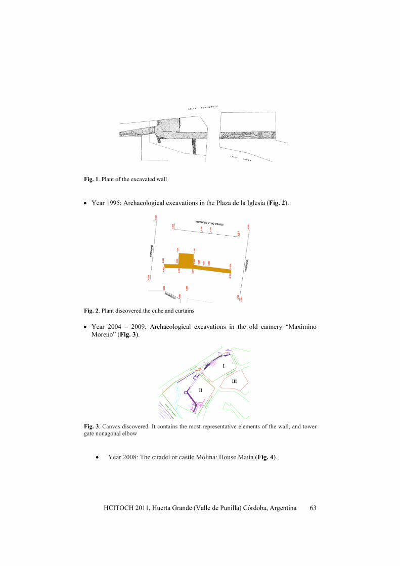
Archaeological excavations during the last twenty years have uncovered 125 m. Islamic wall in addition to 6 towers, one of nine sides (nonagonal) and another with a side door. These elements allowed to raise the Molina de Segura walls as a interesting enough construct for the town Council to set up the construction of an interpretation of it. These interventions have not figured out the whole perimeter, but they have revealed sufficient data to calculate it: • Year 1992: Archaeological excavations in the streets and Honda Pensioner (Fig.
1).
3 During this period he developed and extended the emergency archaeological excavation carried out on the site of the former factory “conservative Maximiliano Moreno” directed by Juan Antonio Ramirez and Felipe González Caballero Águila and the promotion of Three Texon, SL
HCITOCH 2011, Huerta Grande (Valle de Punilla) Córdoba, Argentina
63
Fig. 1. Plant of the excavated wall
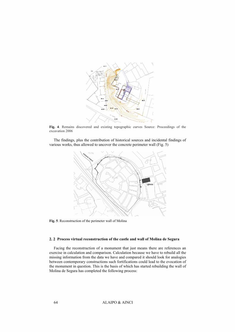
• Year 1995: Archaeological excavations in the Plaza de la Iglesia (Fig. 2).
Fig. 2. Plant discovered the cube and curtains
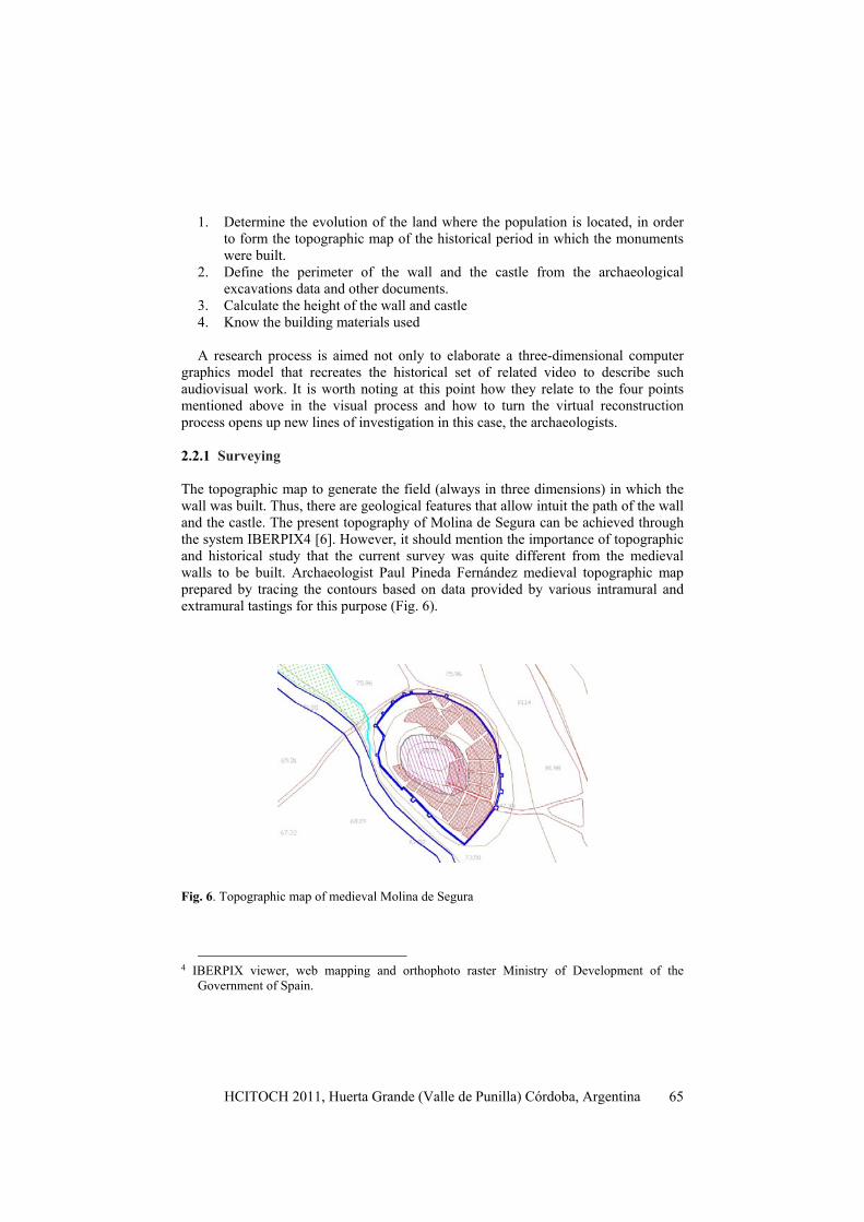
• Year 2004 – 2009: Archaeological excavations in the old cannery “Maximino Moreno” (Fig. 3).
Fig. 3. Canvas discovered. It contains the most representative elements of the wall, and tower gate nonagonal elbow
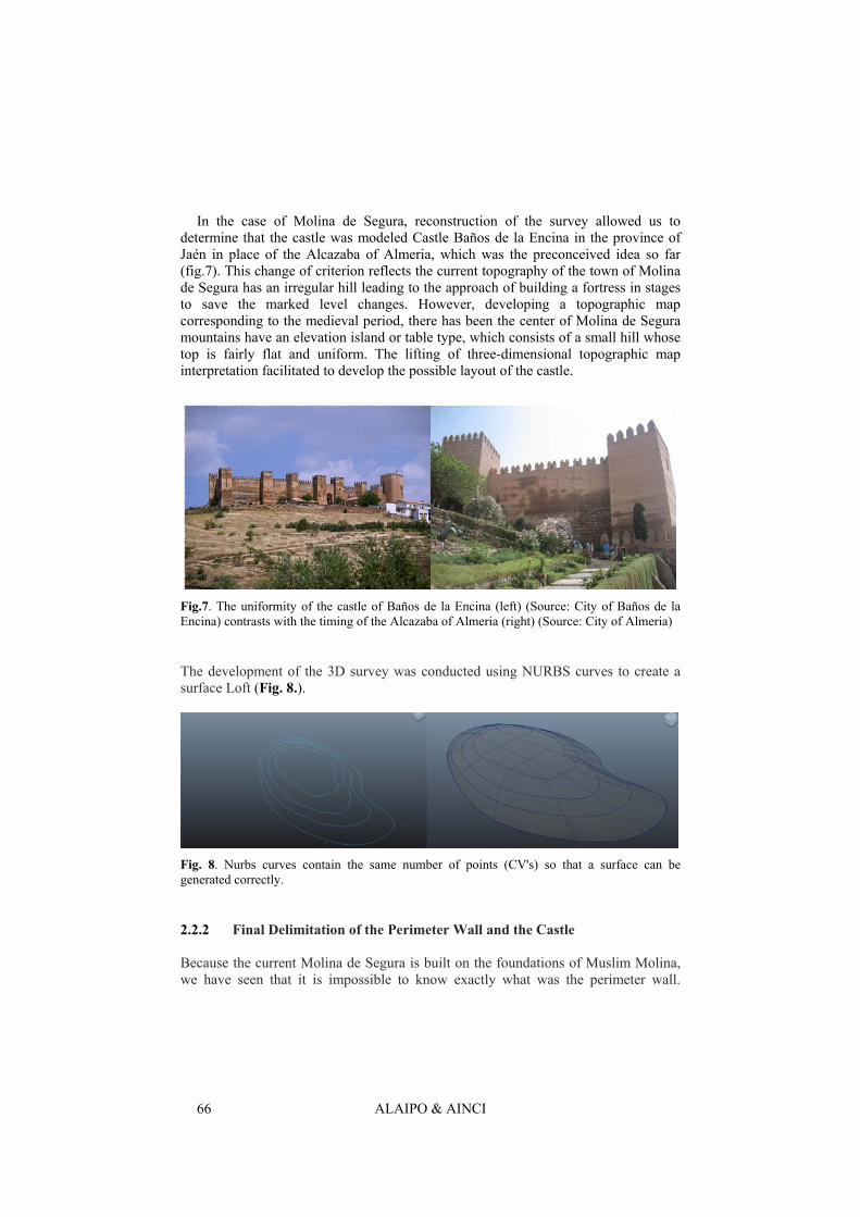
• Year 2008: The citadel or castle Molina: House Maita (Fig. 4).
ALAIPO & AINCI 64
Fig. 4. Remains discovered and existing topographic curves Source: Proceedings of the excavation 2006
The findings, plus the contribution of historical sources and incidental findings of various works, thus allowed to uncover the concrete perimeter wall (Fig. 5)
Fig. 5. Reconstruction of the perimeter wall of Molina
2. 2 Process virtual reconstruction of the castle and wall of Molina de Segura Facing the reconstruction of a monument that just means there are references an
exercise in calculation and comparison. Calculation because we have to rebuild all the missing information from the data we have and compared it should look for analogies between contemporary constructions such fortifications could lead to the evocation of the monument in question. This is the basis of which has started rebuilding the wall of Molina de Segura has completed the following process:
HCITOCH 2011, Huerta Grande (Valle de Punilla) Córdoba, Argentina
65
1. Determine the evolution of the land where the population is located, in order to form the topographic map of the historical period in which the monuments were built.
2. Define the perimeter of the wall and the castle from the archaeological excavations data and other documents.
3. Calculate the height of the wall and castle 4. Know the building materials used
A research process is aimed not only to elaborate a three-dimensional computer
graphics model that recreates the historical set of related video to describe such audiovisual work. It is worth noting at this point how they relate to the four points mentioned above in the visual process and how to turn the virtual reconstruction process opens up new lines of investigation in this case, the archaeologists. 2.2.1 Surveying
The topographic map to generate the field (always in three dimensions) in which the wall was built. Thus, there are geological features that allow intuit the path of the wall and the castle. The present topography of Molina de Segura can be achieved through the system IBERPIX4 [6]. However, it should mention the importance of topographic and historical study that the current survey was quite different from the medieval walls to be built. Archaeologist Paul Pineda Fernández medieval topographic map prepared by tracing the contours based on data provided by various intramural and extramural tastings for this purpose (Fig. 6).
Fig. 6. Topographic map of medieval Molina de Segura
4 IBERPIX viewer, web mapping and orthophoto raster Ministry of Development of the
Government of Spain.
ALAIPO & AINCI 66
In the case of Molina de Segura, reconstruction of the survey allowed us to determine that the castle was modeled Castle Baños de la Encina in the province of Jaén in place of the Alcazaba of Almeria, which was the preconceived idea so far (fig.7). This change of criterion reflects the current topography of the town of Molina de Segura has an irregular hill leading to the approach of building a fortress in stages to save the marked level changes. However, developing a topographic map corresponding to the medieval period, there has been the center of Molina de Segura mountains have an elevation island or table type, which consists of a small hill whose top is fairly flat and uniform. The lifting of three-dimensional topographic map interpretation facilitated to develop the possible layout of the castle.
Fig.7. The uniformity of the castle of Baños de la Encina (left) (Source: City of Baños de la Encina) contrasts with the timing of the Alcazaba of Almeria (right) (Source: City of Almeria)
The development of the 3D survey was conducted using NURBS curves to create a surface Loft (Fig. 8.).
Fig. 8. Nurbs curves contain the same number of points (CV's) so that a surface can be generated correctly.
2.2.2 Final Delimitation of the Perimeter Wall and the Castle Because the current Molina de Segura is built on the foundations of Muslim Molina, we have seen that it is impossible to know exactly what was the perimeter wall.
HCITOCH 2011, Huerta Grande (Valle de Punilla) Córdoba, Argentina
67
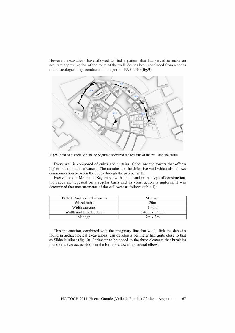
However, excavations have allowed to find a pattern that has served to make an accurate approximation of the route of the wall. As has been concluded from a series of archaeological digs conducted in the period 1995-2010 (fig.9).
Fig.9. Plant of historic Molina de Segura discovered the remains of the wall and the castle
Every wall is composed of cubes and curtains. Cubes are the towers that offer a higher position, and advanced. The curtains are the defensive wall which also allows communication between the cubes through the parapet walk.
Excavations in Molina de Segura show that, as usual in this type of construction, the cubes are repeated on a regular basis and its construction is uniform. It was determined that measurements of the wall were as follows (table 1):
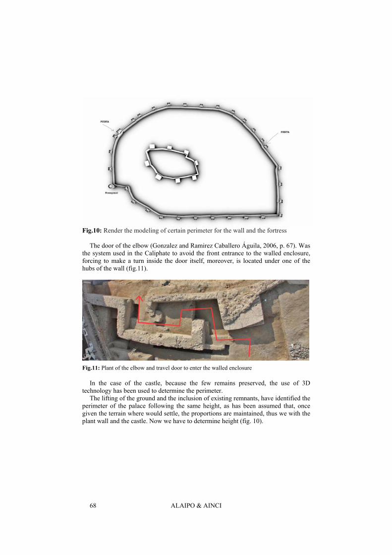
This information, combined with the imaginary line that would link the deposits found in archaeological excavations, can develop a perimeter had quite close to that as-Sikka Mulinat (fig.10). Perimeter to be added to the three elements that break its monotony, two access doors in the form of a tower nonagonal elbow.
Table 1. Architectural elements Measures Wheel hubs 20m
Width curtains 1,40m Width and length cubes 3,40m x 3,90m
pit edge 7m x 3m
ALAIPO & AINCI 68
Fig.10: Render the modeling of certain perimeter for the wall and the fortress
The door of the elbow (Gonzalez and Ramirez Caballero Águila, 2006, p. 67). Was the system used in the Caliphate to avoid the front entrance to the walled enclosure, forcing to make a turn inside the door itself, moreover, is located under one of the hubs of the wall (fig.11).
Fig.11: Plant of the elbow and travel door to enter the walled enclosure
In the case of the castle, because the few remains preserved, the use of 3D technology has been used to determine the perimeter.
The lifting of the ground and the inclusion of existing remnants, have identified the perimeter of the palace following the same height, as has been assumed that, once given the terrain where would settle, the proportions are maintained, thus we with the plant wall and the castle. Now we have to determine height (fig. 10).
HCITOCH 2011, Huerta Grande (Valle de Punilla) Córdoba, Argentina
69
2.2.3 Interpreting the Height of the Wall and Castle Calculate the height of the wall can not be done in this case, no comparative work. It was associated with the tower of the castle Molina de Baños de la Encina in developing the hypothetical layout of your plant, well, the castle and many others of the era and style allow us to establish an analogy: the art military buildings are Spanish Caliphate, which used a construction technique based on the cob (which will be discussed to address the issue of textures). Through the study of the proportions of width and length and the calculation of the development of the mud is concluded that the wall should have the following measures for height.Table 2.
The parapet and battlements are two of the series of elements with medieval
fortresses. It is understood that the wall and had a parapet (road located on top of a wall, behind the battlements) to walk on a parapet (wall or railing placed to prevent falls) and battlements (prisms that crown the walls ) for the protection of defenders. Tickets lintels inside and superior access through a trapdoor.
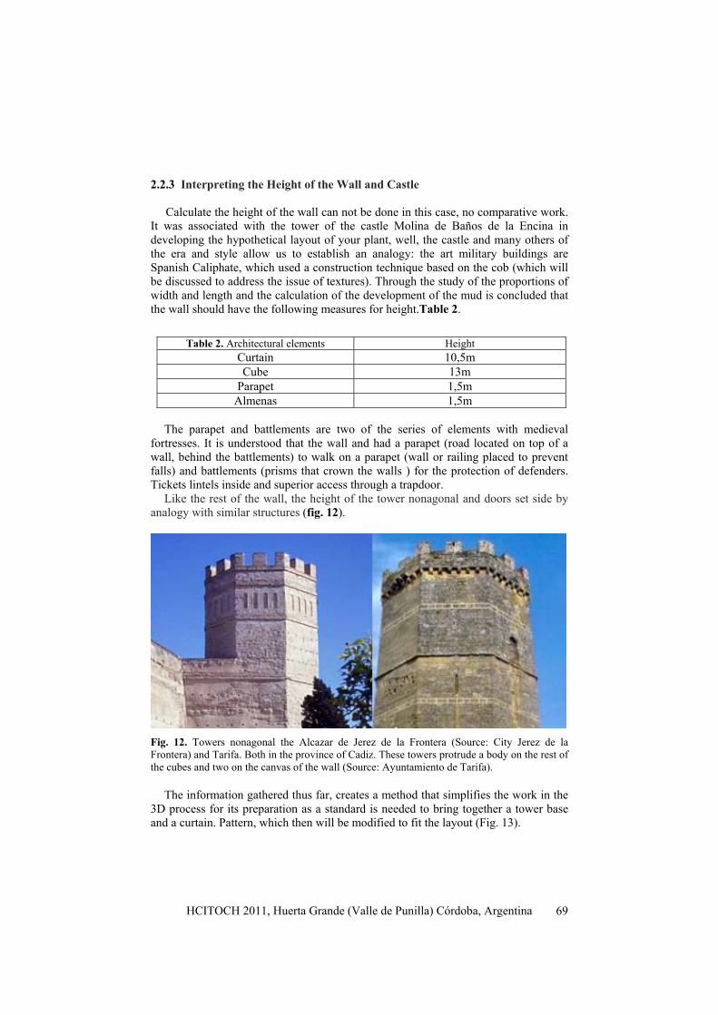
Like the rest of the wall, the height of the tower nonagonal and doors set side by analogy with similar structures (fig. 12).
Fig. 12. Towers nonagonal the Alcazar de Jerez de la Frontera (Source: City Jerez de la Frontera) and Tarifa. Both in the province of Cadiz. These towers protrude a body on the rest of the cubes and two on the canvas of the wall (Source: Ayuntamiento de Tarifa).
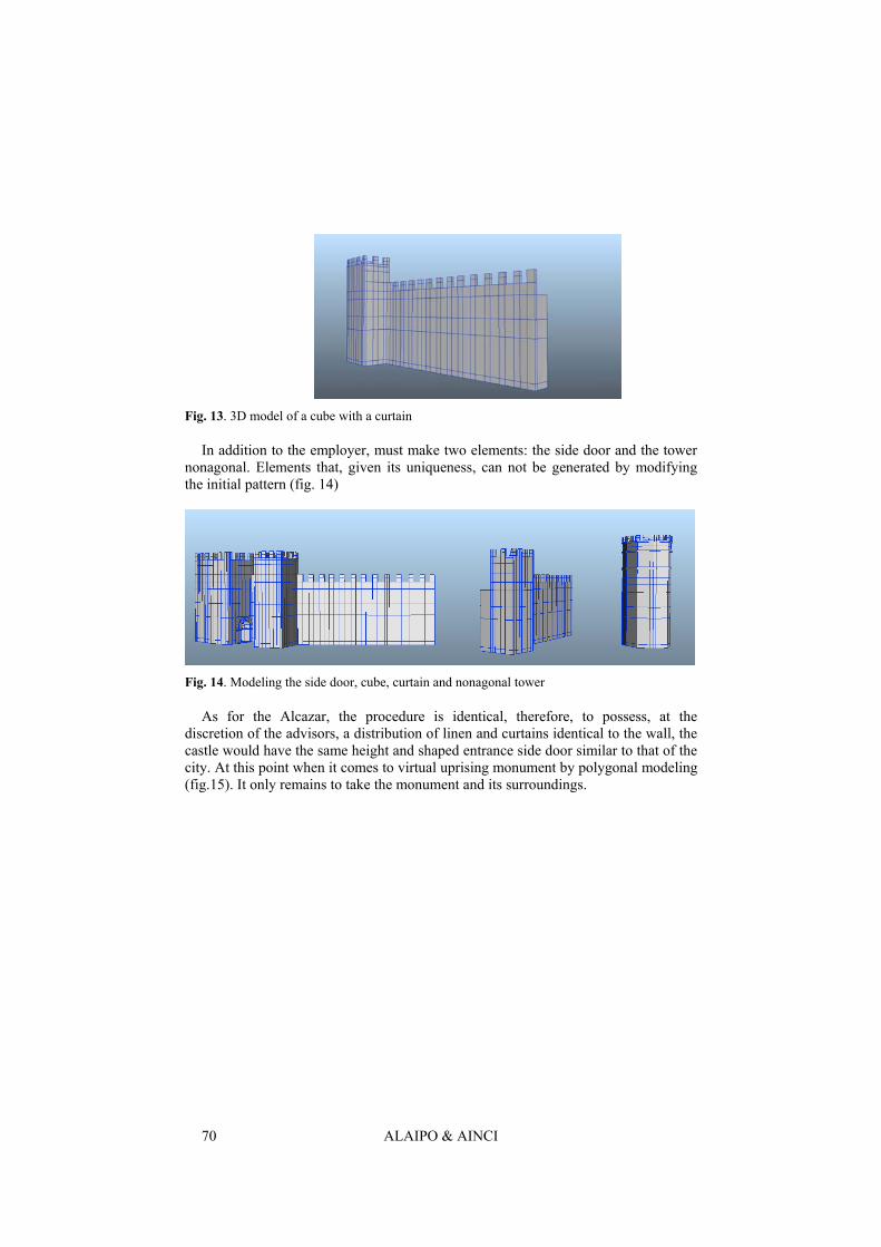
The information gathered thus far, creates a method that simplifies the work in the 3D process for its preparation as a standard is needed to bring together a tower base and a curtain. Pattern, which then will be modified to fit the layout (Fig. 13).
Table 2. Architectural elements Height Curtain 10,5m Cube 13m
Parapet 1,5m Almenas 1,5m
ALAIPO & AINCI 70
Fig. 13. 3D model of a cube with a curtain
In addition to the employer, must make two elements: the side door and the tower nonagonal. Elements that, given its uniqueness, can not be generated by modifying the initial pattern (fig. 14)
Fig. 14. Modeling the side door, cube, curtain and nonagonal tower
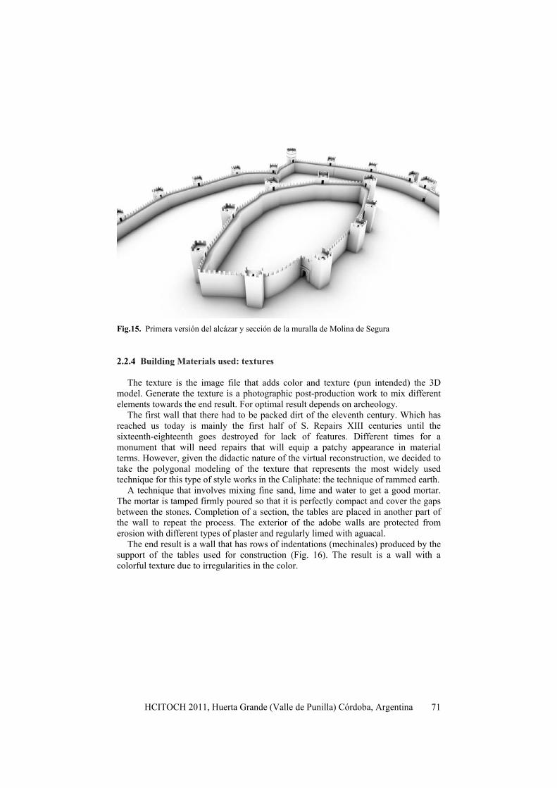
As for the Alcazar, the procedure is identical, therefore, to possess, at the discretion of the advisors, a distribution of linen and curtains identical to the wall, the castle would have the same height and shaped entrance side door similar to that of the city. At this point when it comes to virtual uprising monument by polygonal modeling (fig.15). It only remains to take the monument and its surroundings.
HCITOCH 2011, Huerta Grande (Valle de Punilla) Córdoba, Argentina
71
Fig.15. Primera versión del alcázar y sección de la muralla de Molina de Segura
2.2.4 Building Materials used: textures
The texture is the image file that adds color and texture (pun intended) the 3D
model. Generate the texture is a photographic post-production work to mix different elements towards the end result. For optimal result depends on archeology.
The first wall that there had to be packed dirt of the eleventh century. Which has reached us today is mainly the first half of S. Repairs XIII centuries until the sixteenth-eighteenth goes destroyed for lack of features. Different times for a monument that will need repairs that will equip a patchy appearance in material terms. However, given the didactic nature of the virtual reconstruction, we decided to take the polygonal modeling of the texture that represents the most widely used technique for this type of style works in the Caliphate: the technique of rammed earth.
A technique that involves mixing fine sand, lime and water to get a good mortar. The mortar is tamped firmly poured so that it is perfectly compact and cover the gaps between the stones. Completion of a section, the tables are placed in another part of the wall to repeat the process. The exterior of the adobe walls are protected from erosion with different types of plaster and regularly limed with aguacal.
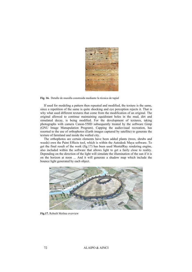
The end result is a wall that has rows of indentations (mechinales) produced by the support of the tables used for construction (Fig. 16). The result is a wall with a colorful texture due to irregularities in the color.
ALAIPO & AINCI 72
Fig. 16. Detalle de muralla construida mediante la técnica de tapial
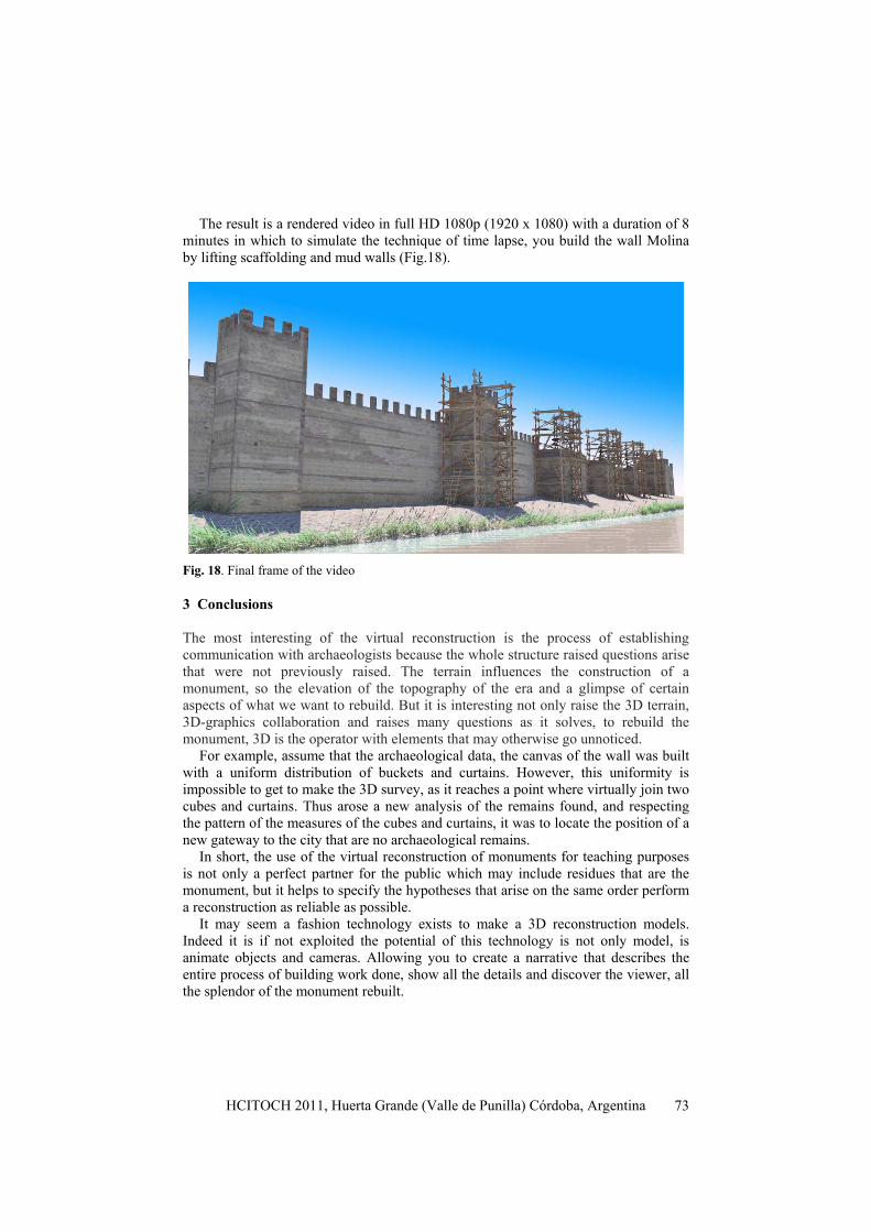
If used for modeling a pattern then repeated and modified, the texture is the same, since a repetition of the same is quite shocking and eye perception rejects it. That is why what used different textures that come from the modification of an original. The original allowed to continue maintaining equidistant holes in the mud, dirt and simulated decay, is being modified. For the development of textures, taking photographs with camera Canon-550D subsequently treated by the software Gimp (GNU Image Manupulation Program). Capping the audiovisual recreation, has resorted to the use of orthophotos (Earth images captured by satellite) to generate the texture of farmland and inside the walled city.
The orthophotos are certain elements have been added plants (trees, shrubs and weeds) own the Paint Effects tool, which is within the Autodesk Maya software. To get the final result of the work (fig.17) has been used MentalRay rendering engine, also included within the software that allows light to get a fairly close to reality. Depending on the direction of the light will simulate the illumination of the sun if it is on the horizon at noon ... And it will generate a shadow map which include the bounce light generated by each object.
Fig.17. Rebuilt Molina overview
HCITOCH 2011, Huerta Grande (Valle de Punilla) Córdoba, Argentina
73
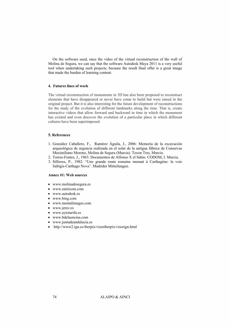
The result is a rendered video in full HD 1080p (1920 x 1080) with a duration of 8 minutes in which to simulate the technique of time lapse, you build the wall Molina by lifting scaffolding and mud walls (Fig.18).
Fig. 18. Final frame of the video
3 Conclusions
The most interesting of the virtual reconstruction is the process of establishing communication with archaeologists because the whole structure raised questions arise that were not previously raised. The terrain influences the construction of a monument, so the elevation of the topography of the era and a glimpse of certain aspects of what we want to rebuild. But it is interesting not only raise the 3D terrain, 3D-graphics collaboration and raises many questions as it solves, to rebuild the monument, 3D is the operator with elements that may otherwise go unnoticed.
For example, assume that the archaeological data, the canvas of the wall was built with a uniform distribution of buckets and curtains. However, this uniformity is impossible to get to make the 3D survey, as it reaches a point where virtually join two cubes and curtains. Thus arose a new analysis of the remains found, and respecting the pattern of the measures of the cubes and curtains, it was to locate the position of a new gateway to the city that are no archaeological remains.
In short, the use of the virtual reconstruction of monuments for teaching purposes is not only a perfect partner for the public which may include residues that are the monument, but it helps to specify the hypotheses that arise on the same order perform a reconstruction as reliable as possible.
It may seem a fashion technology exists to make a 3D reconstruction models. Indeed it is if not exploited the potential of this technology is not only model, is animate objects and cameras. Allowing you to create a narrative that describes the entire process of building work done, show all the details and discover the viewer, all the splendor of the monument rebuilt.
ALAIPO & AINCI 74
On the software used, once the video of the virtual reconstruction of the wall of Molina de Segura, we can say that the software Autodesk Maya 2011 is a very useful tool when undertaking such projects, because the result final offer is a great image that made the burden of learning content.
4. Futures lines of work
The virtual reconstruction of monuments in 3D has also been proposed to reconstruct elements that have disappeared or never have come to build but were raised in the original project. But it is also interesting for the future development of reconstructions for the study of the evolution of different landmarks along the time. That is, create interactive videos that allow forward and backward in time in which the monument has existed and even discover the evolution of a particular place in which different cultures have been superimposed.
5. References
1. González Caballero, F., Ramírez Águila, J., 2006: Memoria de la excavación arqueológica de urgencia realizada en el solar de la antigua fábrica de Conservas Maximiliano Moreno, Molina de Segura (Murcia). Texon Tres, Murcia.
2. Torres-Fontes, J., 1963: Documentos de Alfonso X el Sabio. CODOM, I. Murcia. 3. Sillieres, P., 1982: “Une grande route romaine menant à Carthagéne: la voie
Saltigis-Carthago Nova”. Madrider Mitteilungen.
Annex #1: Web sources
• www.molinadesegura.es • www.oniricom.com • www.autodesk.es • www.bing.com • www.mentalimages.com • www.jerez.es • www.aytotarifa.es • www.bdelaencina.com • www.juntadeandalucia.es • http://www2.ign.es/iberpix/visoriberpix/visorign.html