Virginia Tech Concept Plan: 2050 Eastern Gateway - Falls ...
93
-
Upload
khangminh22 -
Category
Documents
-
view
2 -
download
0
Transcript of Virginia Tech Concept Plan: 2050 Eastern Gateway - Falls ...


Acknowledgements Planning studio work was performed for: Mr. Rick Goff, Economic Development Director, City of Falls Church Suzanne Cotellessa, Development Services Director, City of Falls Church Virginia Tech UAP 5124 Planning Studio Instructors: Dr. Shelley Mastran Mr. Jim Snyder
Virginia Tech UAP 5124 Planning Studio Students: Monica Andrews Inga Beermann Rudi Byron Jill Chen William Cook Kate Dykgraaf Ximena Gonzalez Milano Katrina Kramer Lara Malakoff Millie O’Neal Carmelina Perez Marco Rivero Julia Rodgers Mari Russ Jeremy Sewall Sian Seys-Evans Cara Smith Julie Still Patt Talvanna Jessica Turrin Juan Carlos Vazquez James Velesz Maria Villacreces Raymond Vuong Chris Winnike Joshua Yetter Kate Youngbluth

Table of Contents
1. Introduction and Vision
2. Existing Conditions
3. 2050 Eastern Gateway Plan
Roosevelt and Wilson
Eden Center
Koons and Syms
4. Transportation Network
5. Office and Retail Analysis
6. Implementation and Impacts

I. Introduction and Vision

Introduction and Vision The Project A group of architecture, landscape architecture, and urban planning graduate students from Virginia Tech’s Alexandria Center worked for the City of Falls Church Economic Development Authority to create a vision and plan for the Eastern Gateway area in the City of Falls Church. UAP 5124, a planning studio class, offered the students the opportunity to apply their academic pursuits to a real-world client and community in transition. The City of Falls Church was enthusiastic to have a fresh set of eyes study an aging commercial area that offers a great opportunity for redevelopment during the next 40 years.
The UAP 5124 students assumed a build-out date of 2050 for the proposed Eastern Falls Church Gateway plan. The class broke the proposed development plan of the approximately 65-acre site into three plan areas to be redeveloped through the rezoning application process. The studio assumed that transportation improvements would occur creating a new road network and enhanced transit, walking, and bicycling facilities. The students also assumed that a mixed-use zoning district would be created for the area that permitted increased densities, building heights and urban design.
The planning studio spent several weeks studying appropriate urban design densities, speaking with the members of the Falls Church planning and economic development departments and local developers and regional experts on planning. The studio conducted a site visit to the Eastern Gateway site prior to the development of the overall concept plan. Once the limits of the overall concept plan area were defined, three plan areas were identified for study. The plan areas were defined as the Koons-Syms area, the Eden Center area, and the Roosevelt-Wilson area.
The 27 members of the studio organized in groups that developed plans, models, and analysis for the densities, heights and uses within the three area plans, architecture concepts for the buildings, streetscape designs, a multimodal transportation network, and an overall economic development analysis. On December 10, 2009, the studio class developed a presentation for the Falls Church Economic Development Authority to discuss the concepts and analysis for the Eastern Gateway. Finally, the studio drafted text that provided a detailed analysis and a description for each plan area and included a narrative on the streetscape design, transportation network and economic analysis. Plans and architectural drawings were developed for each of the area plans to provide an illustrative example of the proposed development described by the text. The analysis and plans were compiled into this report and provided to members of the Falls Church Economic Development Authority.

The Vision In 2050 the Falls Church Eastern Gateway will be a vibrant, mixed-use, multimodal economic asset to the city. Its tree-lined streets will welcome pedestrians and bicyclists and create a 24-hour-a-day community.

Route 7 (Leesburg Pike) slices through the Eastern Gateway and is a major road in the region. Source: Marco Rivero.
The Plan The proposed plan for the Falls Church Eastern Gateway consists of a comprehensive set of area-specific plan recommendations that will promote a vibrant mixed-use community for the area’s future development. The recommendations are based on a vision for the area that promotes increased densities, urban design standards and an enhanced transportation network. The plan will significantly increase the commercial tax base and improve the economic viability of the area; at the same time, it will preserve the unique existing historic and cultural features located in the eastern boundary of the City of Falls Church.
The Eastern Gateway is the front door of Falls Church from Arlington and Fairfax Counties. The existing conditions of the area have no distinct features that clearly identify the entrance into the City. Bounded by major arterials that serve the region (Route 7, Route 50, Wilson Boulevard, and Roosevelt
Boulevard), the existing developments are a combination of aging auto-oriented uses and strip commercial developments. For purposes of the vision, the plan has established three major areas for redevelopment.
The Koons-Syms plan area includes the two Koons auto dealerships, the vacant Syms retail store and two parcels in Fairfax County: the existing Grand Market grocery store parcel and adjacent Italian Inn restaurant.
The Eden Center plan area includes the Edens Center
and vacant Wholesale Liquidators store, the BP Gas Station and the two parcels in Fairfax County that contain the veterinary clinic and parking lot.
The Roosevelt-Wilson Boulevard plan area includes
Oakwood Apartments, Madison Condominium, Roosevelt Towers Apartments, Koons Body Shop, Public Storage, the Shell Gas Station, the Wilson Boulevard Strip retail development and the future BJ’s Wholesale store site.
Because the site is bounded by four-lane major arterials, including Leesburg Pike (Route 7), Arlington Boulevard (Route 50), Wilson Boulevard, Roosevelt Boulevard and Hillwood Avenue, the plan calls for an enhanced streetscape design for the plan areas that addresses the elements needed to calm automobile traffic and create an active street life. Proposed
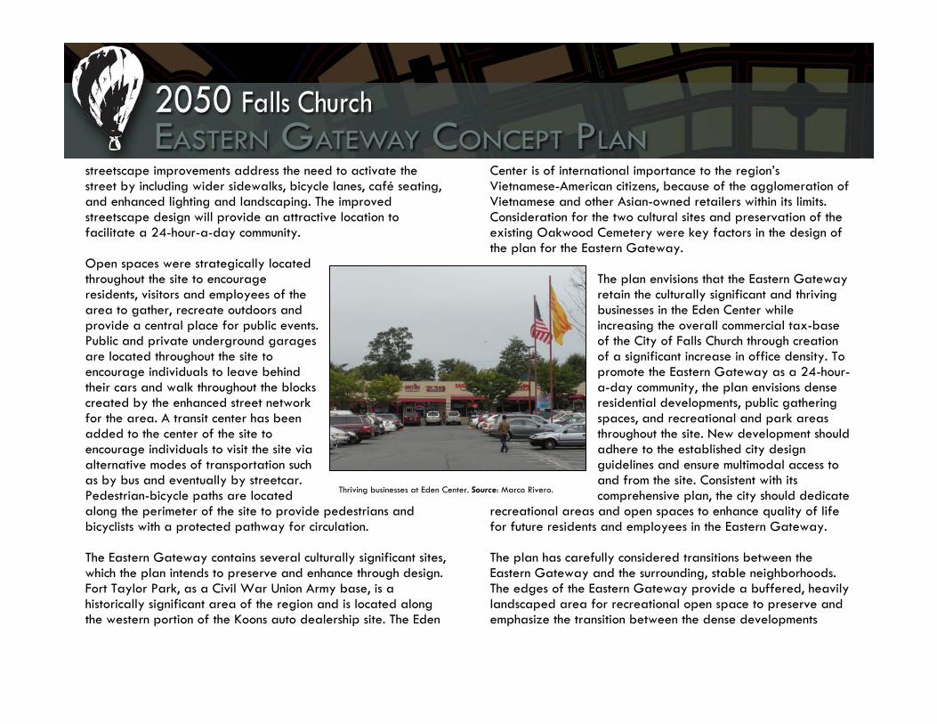
Thriving businesses at Eden Center. Source: Marco Rivero.
streetscape improvements address the need to activate the street by including wider sidewalks, bicycle lanes, café seating, and enhanced lighting and landscaping. The improved streetscape design will provide an attractive location to facilitate a 24-hour-a-day community. Open spaces were strategically located throughout the site to encourage residents, visitors and employees of the area to gather, recreate outdoors and provide a central place for public events. Public and private underground garages are located throughout the site to encourage individuals to leave behind their cars and walk throughout the blocks created by the enhanced street network for the area. A transit center has been added to the center of the site to encourage individuals to visit the site via alternative modes of transportation such as by bus and eventually by streetcar. Pedestrian-bicycle paths are located along the perimeter of the site to provide pedestrians and bicyclists with a protected pathway for circulation. The Eastern Gateway contains several culturally significant sites, which the plan intends to preserve and enhance through design. Fort Taylor Park, as a Civil War Union Army base, is a historically significant area of the region and is located along the western portion of the Koons auto dealership site. The Eden
Center is of international importance to the region’s Vietnamese-American citizens, because of the agglomeration of Vietnamese and other Asian-owned retailers within its limits. Consideration for the two cultural sites and preservation of the existing Oakwood Cemetery were key factors in the design of the plan for the Eastern Gateway.
The plan envisions that the Eastern Gateway retain the culturally significant and thriving businesses in the Eden Center while increasing the overall commercial tax-base of the City of Falls Church through creation of a significant increase in office density. To promote the Eastern Gateway as a 24-hour-a-day community, the plan envisions dense residential developments, public gathering spaces, and recreational and park areas throughout the site. New development should adhere to the established city design guidelines and ensure multimodal access to and from the site. Consistent with its comprehensive plan, the city should dedicate
recreational areas and open spaces to enhance quality of life for future residents and employees in the Eastern Gateway.
The plan has carefully considered transitions between the Eastern Gateway and the surrounding, stable neighborhoods. The edges of the Eastern Gateway provide a buffered, heavily landscaped area for recreational open space to preserve and emphasize the transition between the dense developments

contemplated along the Roosevelt-Wilson Boulevard and the Koons-Syms plan areas. A building height restriction and residential uses are planned for the westernmost portion of the Syms site, which contemplates a significant height reduction from the eastern portion of the site to the neighborhood adjacent to the westernmost portion of the site. The proposed developments along the border of the site should be low density and provide a village-like feel to the pedestrians. The large existing parcels within the Eastern Gateway have been broken up by an extensive street and pedestrian network; appropriate block lengths should be incorporated into the design and should accommodate on-street parking, bicycle lanes and traffic-calming measures. To mitigate existing visual clutter within the corridor, all utilities should be undergrounded as part of redevelopment projects.
Planning Objectives Objective 1: To achieve a cohesive and orderly planned development, the City of Falls Church must coordinate future land use developments with the clear urban design guidance for the Eastern Gateway. Unified signage, streetscape improvements, building design and orientation, street furniture, lighting, and landscaping should be of an established style throughout the area.
Objective 2: Retain the culturally significant businesses in the area to continue to serve the niche international market. Promote commercial revitalization and investment through marketing and permit significantly increased office and residential mixed-use densities. Objective 3: Create buffers and height restrictions at the Eastern Gateway’s edges to provide a transition between high-density mixed-use developments and the existing residential neighborhoods. Objective 4: Foster carefully phased development plans by crafting parcel-specific comprehensive plan language for each plan area and encourage lot consolidation where necessary. Adopt a mixed-use zoning district that encourages a denser urban form to be developed through carefully timed phased development plans. Objective 5: Ensure that transportation improvements are proffered through redevelopment and revitalization activities.
2. Existing Conditions

To East Falls Church Metro,
Route I-66
To Arlington, Rosslyn-Ballston
Corridor
To Alexandria Annandale
To Downtown Falls Church
To I-495 Capital Beltway, Fairfax
To Washington, DC
Figure 2.1: Greater Geographical Context for Falls Church Eastern Gateway
Existing Conditions Geography, History, and Development The Falls Church Eastern Gateway site lies at the convergence of Route 50, Route 7, and Wilson Boulevard on the eastern edge of the City of Falls Church and just seven miles outside of Washington, D.C. The site is at the nexus of Falls Church and Arlington and Fairfax Counties, and serves as a gateway for nearly one million commuters daily. The Seven Corners area gets its name from the identifiable intersection of many of the area’s major arteries. The three major roads in and around the Falls Church Eastern Gateway Corners Gateway site are Wilson Boulevard, Broad Street/Route 7, and Roosevelt Boulevard, but the site is also bordered to the south by Route 50/Arlington Boulevard, a major east-west artery between Washington, D.C. and points west. Wilson Boulevard begins east of the Seven Corners Gateway site in Arlington County. It runs the length of Arlington’s Rosslyn-Ballston transit corridor, enters the boundaries of Falls Church, and ends when it hits Broad Street/Route 7 inside the Falls Church Eastern Gateway site. Roosevelt Boulevard connects the Falls Church segment of Wilson Boulevard and Route I-66 and the East Falls Church Metro station, approximately one mile to the north. Broad Street/Route 7 runs north from Alexandria and Annandale, through Falls Church City and the gateway site, and is the primary street serving downtown Falls Church, which is located
about 1.5 miles to the northwest of the Falls Church Eastern Gateway. Figure 2.1 shows links to and from the Falls Church Eastern Gateway to major Northern Virginia and Metropolitan Washington, D.C. areas. In part because of its proximity to several Northern Virginia transportation arteries, the Falls

Church Eastern Gateway suffers from severe traffic congestion. However this proximity to these major arteries, along with proximity to alternative forms of transportation such as Metro, bus, and bicycle routes, makes the site a likely candidate for urban-style redevelopment. Site Features The area of study encompasses several identifiable Falls Church locations, including:
A. The Eden Center (6763 Wilson Boulevard), a Vietnamese-American shopping center located near the center of the site, bordered by Roosevelt Boulevard to the east, Wilson Boulevard to the south, East Broad Street/Arlington Boulevard to the west, and the Oakwood Cemetery to the north;
B. The Koons Falls Church Ford dealership and body shop (1051 East Broad Street);
C. The former Syms department store site (1000 East Broad Street), which currently sits empty;
D. The 12-acre Oakwood Cemetery, along the north edge of the site, bordered by Roosevelt Street, divides the sprawling, auto-oriented commercial development from nearby single-family residential neighborhoods to the north and west;
E. The future site of an 87,000-square-foot BJ’s Wholesale Warehouse on the north side of Wilson Boulevard and on the east side of Roosevelt Boulevard; and
F. Fort Taylor Park and Civil War historical site.
Adjacent sites include: G. The landmark 12-story twin BB&T towers located just
over the Falls Church City border on the southwestern edge of the site in Fairfax County; and
H. The Seven Corners Shopping Center, located to the southwest of the site, and bordered by Route 7 and Route 50/Arlington Boulevard;
D
BE
A
F
CG
H
Figure 2.2: Features of the Eastern Gateway

Size The approximately 65-acre Eastern Gateway site includes the 12 acre Oakwood Cemetery and 58 acres, or 2.5 million square feet, of developable land. Table 3.1 on the following page provides detailed acreage and square footage information for each parcel within the three areas of interest within the Seven Corners Gateway Site and for Oakwood Cemetery. History of Development A Sprawling Commercial Center Though the City of Falls Church was established in 1875, it was around 1948, when Falls Church became an independent city, that the Eastern Gateway began to develop into what it is today. As the Washington, D.C. metropolitan area began to expand in the mid 20th century, the City of Falls Church was well-positioned to accommodate the impending suburban development. Due to its location at the
intersection of several major arteries connecting it to Washington, D.C. to the east and expanding Northern Virginia development to the west, Falls Church welcomed its first suburban-style shopping center in 1953. While the 1953 Seven Corners Shopping Center is not located within Falls Church, its early success encouraged similar suburban development, with single-use buildings, vast surface parking areas, and limited access to public transportation, to spring up and spread. The site and the surrounding areas in Arlington and Fairfax Counties grew to become the typically auto-oriented mid-20th century suburban commercial development, where patrons could conveniently drive their cars directly to strip shopping centers, car dealerships, and large grocery stores. But in the last decade, there has been a shift away from suburban auto-oriented commercial development in favor of more traditional main street-type development. This has led to the demise of the development typical of the Falls Church Eastern Gateway site. For example, shortly after the Seven Corners Shopping Center was built, a Jelleff’s Department Store at 1000 E. Broad Street was built in 1956. Typical of suburban retail development, the store was surrounded by a sea of surface parking. Eventually, Jelleff’s closed its Falls Church store in favor of more popular locations such as the developing Tysons Corner. In 1978, the store building was taken over by the Syms Corporation, which was successful until it too closed the 1000 East Broad Street

Table 3.1: Seven Corners/Falls Church Gateway Parcel Acreage and Square Footage Site 1: Koons/Syms
Site Name Parcel Number Site Address Acreage Square Footage Koons Main Site 53-218-145 1101 E. Broad Street 6.70 292,043 Water Tower 53-218-016 Falls Church, VA 22205 0.21 9,000 Vet Shelter 53-218-008 6801 Wilson Boulevard 0.34 14,670 North Edge of Koons Site 53-218-042 1051 E. Broad Street 0.22 9,502 Fort Taylor Park 53-218-041 N. Roosevelt Street 0.43 18,686 Hillwood Avenue Parcel 53-217-001 Hillwood Ave/Roosevelt Blvd 0.35 15,333 Hillwood East 53-217-002 Hillwood Avenue 0.36 15,600 Koons/Syms Site Total 8.61 374,834 Site 2: Eden Center
Site Name Parcel Number Site Address Acreage Square Footage Eden Center 53-218-006 6795 Wilson Boulevard 15.32 667,383 Eden Center Gas Station 53-218-005 6701 Wilson Boulevard 0.40 17,320 Wilson Blvd Retail Parcel 53-218-007 6799 Wilson Boulevard 0.43 18,921 Eden Center Total 16.15 703,624 Site 3: Roosevelt Boulevard/Wilson Boulevard
Site Name Parcel Number Site Address Acreage Square Footage Oakwood Apartments 53-218-014 501 Roosevelt Boulevard 12.14 528,821 Madison Condo 53-218-144 600 Roosevelt Boulevard 2.26 98,407 Roosevelt Towers Apts. 53-218-019 500 Roosevelt Boulevard 5.15 224,334 Public Storage 53-218-021 400 Roosevelt Boulevard 1.48 64,603 Koons Body Shop 53-218-020 410 Roosevelt Boulevard 2.71 118,042 Shell Gas Station 53-218-004 6623 Wilson Boulevard 0.49 21,425 Wilson Blvd Commercial 53-218-003 6609 Wilson Boulevard 0.65 28,385 BJ's Wholesale Warehouse 53-218-002 6607 Wilson Boulevard 8.30 361,575 Roosevelt/Wilson Total 33.19 1,445,592 Other
Site Name Parcel Number Site Address Acreage Square Footage Oakwood Cemetery 53-218-013 N. Roosevelt Street 11.48 500,000 Oakwood Cemetery Total 11.48 500,000 Acreage Square Footage Falls Church/Seven Corners Gateway Site Total 69.42 3,024,050
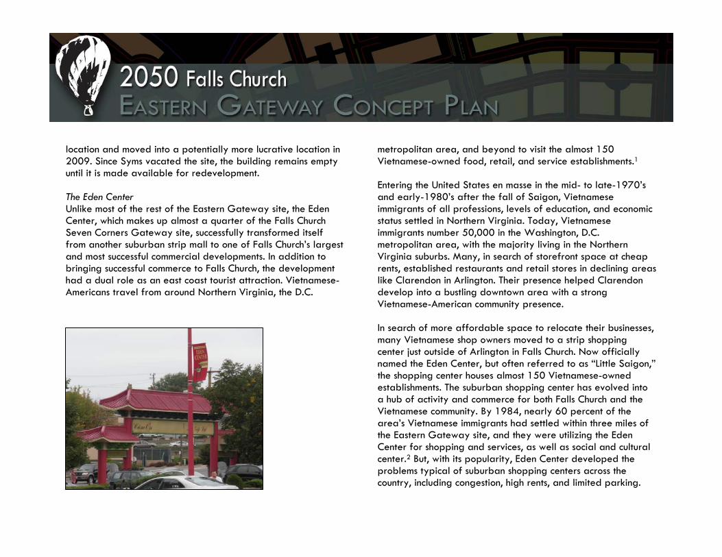
location and moved into a potentially more lucrative location in 2009. Since Syms vacated the site, the building remains empty until it is made available for redevelopment. The Eden Center Unlike most of the rest of the Eastern Gateway site, the Eden Center, which makes up almost a quarter of the Falls Church Seven Corners Gateway site, successfully transformed itself from another suburban strip mall to one of Falls Church’s largest and most successful commercial developments. In addition to bringing successful commerce to Falls Church, the development had a dual role as an east coast tourist attraction. Vietnamese-Americans travel from around Northern Virginia, the D.C.
metropolitan area, and beyond to visit the almost 150 Vietnamese-owned food, retail, and service establishments.1 Entering the United States en masse in the mid- to late-1970’s and early-1980’s after the fall of Saigon, Vietnamese immigrants of all professions, levels of education, and economic status settled in Northern Virginia. Today, Vietnamese immigrants number 50,000 in the Washington, D.C. metropolitan area, with the majority living in the Northern Virginia suburbs. Many, in search of storefront space at cheap rents, established restaurants and retail stores in declining areas like Clarendon in Arlington. Their presence helped Clarendon develop into a bustling downtown area with a strong Vietnamese-American community presence.
In search of more affordable space to relocate their businesses, many Vietnamese shop owners moved to a strip shopping center just outside of Arlington in Falls Church. Now officially named the Eden Center, but often referred to as “Little Saigon,” the shopping center houses almost 150 Vietnamese-owned establishments. The suburban shopping center has evolved into a hub of activity and commerce for both Falls Church and the Vietnamese community. By 1984, nearly 60 percent of the area’s Vietnamese immigrants had settled within three miles of the Eastern Gateway site, and they were utilizing the Eden Center for shopping and services, as well as social and cultural center.2 But, with its popularity, Eden Center developed the problems typical of suburban shopping centers across the country, including congestion, high rents, and limited parking.
These are issues that the City of Falls Church hopes to deal with in future redevelopment of Eden Center, while retaining as many of the Vietnamese-American tenants as possible in the process. Constraints and Opportunities The Eastern Gateway site presents several constraints and opportunities for redevelopment. Constraints:
Oakwood Cemetery. The cemetery is a constraint in that it takes up a large, centrally located portion of the site. This limits the ability to create internal pathways to facilitate movement and creates some odd-shaped parcels. In addition, it limits the ability to make connections between the site and the neighborhoods of Falls Church immediately to the west.
Proximity to Fairfax County Line. The ability to create
a node of activity is limited to what Falls Church has direct influence on, but which is directly affected by development immediately adjacent in the Fairfax County portion of Seven Corners. This includes the odd parcel of the animal hospital that appears to be in Falls Church but is actually located in Fairfax County.
Unfriendly Pedestrian Environment. Vehicles driving through Seven Corners are not alerted to the presence of pedestrians, sidewalks are minimal where they exist
at all, and pedestrian crossings are hazardous. Attracting street life will be difficult as long as Seven Corners is primarily seen as a vehicular intersection.
No Major Transit Stop on Site. Attracting pedestrians and thus a more lively street life will be challenging because Seven Corners does not have a major transit station to bring people who will walk. There is an extra-large bus stop at the Seven Corners shopping mall in Fairfax County, but the Falls Church portion of Seven Corners does not include even a bus shelter; pedestrian connections between this Seven Corners bus stop and the Eastern Gateway are hazardous and unfriendly.
Negative Perception of Seven Corners. In general, Seven Corners is not regarded as a pleasant place to be by local residents, who instead view it as a frustrating, confusing, and congested intersection.
Successful But Congested Eden Center. Eden Center is a thriving retail shopping center that could benefit from redevelopment and density intensification. A challenge for redevelopment will be keeping the smaller, Vietnamese-American tenants operational and successful during the construction of a redeveloped Eden Center.
Opportunities:
Elevation. The Falls Church portion of Seven Corners includes some of the highest terrain in the area.

Enhancing these views by building tall structures would increase desirability for offices and residents to locate here.
Eden Center. The Eden Center is one of the most successful commercial areas in the City of Falls Church, and has an established reputation, especially among the Vietnamese community, that draws visitors from around the world.
Oakwood Cemetery. While this cemetery presents a constraint in terms of connectivity between the Falls Church neighborhood immediately to its west and the Seven Corners site, the cemetery also provides an existing green space that could serve the function of a park and create desirable views for neighboring offices and residents.
Proximity to East Falls Church Metro Station. This site is very close to an existing heavy rail transit stop, such that it could be easily connected to it via shuttle buses or more frequent bus service, at a minimum, thus drawing pedestrian traffic to the site.
Location at a Major Intersection. The fact that Route 7 and Route 50, two of Northern Virginia’s main thoroughfares, intersect at Seven Corners provides an excellent market space due to the high volume of traffic passing through. By redeveloping its portion of Seven Corners, Falls Church would be poised to capture the
market interest of the majority of this traffic.
Existing Tall Buildings. The BB&T towers and the residential units along Roosevelt Avenue provide an existing precedent for high-density development in this area, such that creating a larger cluster of increased density would be more palatable to residents and business owners in this area.
Historic Site. Falls Church should capitalize on this location for its historical significance of being the first place that a military balloon was launched to perform aerial reconnaissance at Fort Taylor Park. This historic event could fuel a thematic development of the site that could attract those with interests in military history, balloons, the Civil War, and others.

Demographics All demographic information was gathered from the U.S. Census available at www.census.gov. Overall demographic information from 2008 is listed below for the three jurisdictions. Falls Church, VA
10,600 residents in 2005; anticipated 2010 population (MCOG) is 12,300
85% white; 8.4% Hispanic; 6.5% Asian; 3.3% African American
Median age of 39.7 (highest in region) Median household income is $74,924 39.4% housing is renter occupied
Fairfax County, VA
1,015,302 residents in 2008 67% white; 13.5% Hispanic; 15.8% Asian; 9.4 African
American Median age is 39.1 Median household income is $106,785 26% of housing is renter occupied
Arlington County, VA 209,969 was the population in 2008 70.5% white; 15.9% Hispanic; 8.9% Asian; 8.1%
African American Median age is 37.6 Median household income is $96,390 48% housing is renter occupied
This information provides a very broad look at the surrounding areas. Census data from the block group level was gathered to provide a closer look at the areas within a half-mile from the gateway site. The drawback of this data is that it is from the 2000 census and not current. On the following pages are maps, graphs, and charts that show the population density and average household income of each block group, the age distribution, travel time to work information, housing stock information, and racial break down for the entire site.

Figure 2.3: Population Density in Eastern Gateway
Figure 2.4: Average Income in Eastern Gateway

Racial Break Down Within 1/2 Mile of Site
70.11%
4.18%
0.47%
11.59%
9.72%3.93%
White
African American
American Indian
Asian
Other Race Alone
Tw o or More Races
Age Distribution Around Site
0
200
400
600
800
1000
1200
1400
1600
1800
0-5
6-12
13-1
718
-21
22-2
425
-29
30-3
435
-39
40-4
445
-49
50-5
455
-59
60-6
465
-69
70-7
475
-79
80-8
485
+
Age Range
Num
ber o
f Peo
ple
These data indicate that the population of the Eastern Gateway and adjacent areas is affluent, with average income levels well over $62,000 per capita, and with many homes at more than $100,000. The population is 70 percent white, with about 10 percent African American and 10 percent Asian. The age distribution chart indicates that the population is mostly made up of people aged 30-60, older than average for the United States as a whole. This population is presently organized in low-to medium-density settlements.
Figure 2.5: Residents by Race near Eastern Gateway Figure 2.6: Residents by Age near Eastern Gateway
Existing Land Use, Future Land Use, Zoning, and Plans for Redevelopment Our three study subareas, Roosevelt Blvd/Wilson Blvd, The Eden Center and Koons/Syms sites, currently consist of similar land uses, densities, and general characteristics. While the site is located in the City of Falls Church, Arlington and Fairfax Counties are immediately adjacent, which provides both great challenges and opportunities for redevelopment. Increased coordination and joint planning efforts need to be augmented for current and future development.
Existing Land Use Classifications Roosevelt Boulevard/Wilson Boulevard A mix of uses occupies independent sites along Roosevelt and Wilson Boulevards. The Falls Church Existing Land Use Map shows Light Industrial/Auto and Shopping Center uses at the intersection of Wilson and Roosevelt. North on Roosevelt Blvd, the multifamily apartment designation is in use.3
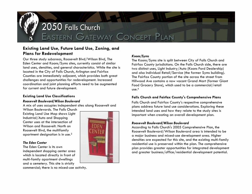
The Eden Center The Eden Center is its own independent shopping center area which is located directly in front of multi-family apartment dwellings and a cemetery. This site is strictly commercial; there is no mixed-use activity.
Koons/Syms The Koons/Syms site is split between City of Falls Church and Fairfax County jurisdictions. On the Falls Church side, there are two distinct uses, Light Industry/Auto (Koons Ford Dealership) and also Individual Retail/Service (the former Syms building). The Fairfax County portion of the site across the street from Hillwood Ave contains a now vacant Grand Mart (former Giant Food Grocery Store), which used to be a commercial/retail use.4
Falls Church and Fairfax County's Comprehensive Plans Falls Church and Fairfax County’s respective comprehensive plans address future land use considerations. Exploring these intended land uses and how they relate to the study sites is important when creating an overall development plan.
Roosevelt Boulevard/Wilson Boulevard According to Falls Church's 2005 Comprehensive Plan, the Roosevelt Boulevard/Wilson Boulevard area is intended to be a major business and mixed-use development area. Higher densities are expected for this site, and the existing multi-family residential use is preserved within the plan. The comprehensive plan provides greater opportunities for integrated development and greater business/office/residential development potential.

The Eden Center The Eden Center will remain a business/commercial center, as is explicitly identified within the comprehensive plan. The site’s retail commercial uses will remain. There would be potential for greater redevelopment and density if mixed-use development were also allowed on that site.
Koons/Syms This site, which was primarily a single use commercial and light industry/auto use area, would generate larger densities and diverse, commercial uses. The 2005 Comprehensive Plan identifies these areas to be specifically business sites with a transitional area included near the western part of Syms for possibly residential and commercial redevelopment.5
Fairfax County also expresses interest on this particular site through their 2007 Comprehensive Plan. The 2007 Fairfax County Comprehensive plan states:
"As an option, Parcels 51-3((1))2 and 3, located directly at the intersection of Arlington Boulevard and Hillwood Avenue may be considered for retail and/or office use up to .50 FAR if the two parcels are consolidated and access coordinated with Virginia Plaza or provided as far west of the intersection as possible. As a further option, the entire sub-unit may be considered for retail/office mixed use up to .70 FAR provided that full consolidation is achieved and higher structures are located to the east, away from adjacent residential areas. At this higher
intensity, a traffic study at the time of redevelopment should be performed."6
Regarding the intersection at Arlington Boulevard and Hillwood Avenue, the current densities and projected land use densities for that site are not high. Achieving a mixed-use retail/office build-out for this area would require greater densities and greater connectivity with the Syms site. This can be achieved through enhanced pedestrian connectivity and enhanced congestion management strategies.
Existing Zoning Requirements: Falls Church and Fairfax Zoning classifications and details usually concur with the existing land use and may also correlate with future land use strategies. Both Falls Church City and Fairfax County clearly identify the zoning classifications for these three sites and the permitted uses within them.
Roosevelt Boulevard/Wilson Boulevard Currently, this section of our study area has three predominant zoning classifications. The first is the M-1 zoning district, Light Industry. M-1 allows for all commercial uses described in the B-1 Limited Business, B-2 Central Business, and B-3 General Business districts. Within the B-3 General Business district, there is a 75-feet building height maximum or seven stories (building height maximum for B-1 is 55 feet). Nurseries, greenhouses, carpentry, building supplies, and automotive sales are allowed but at a maximum height of 55 feet.7 Within applicable commercial and industrial sites, a special exception provision

and mixed-use redevelopment zoning overlay allow developers/businesses to obtain height and density bonuses.
M-1 specifically allows for all commercial uses in B-1, B-2, and B-3 commercial districts with the exception of dwellings, schools, and hospitals.8 M-1 also allows for industrial research and development facilities, manufacturing businesses, automotive body repair facilities, kennels, animal hospitals, building material storage yards, and other listed uses.9 The land use range within this zoning district allows for much flexibility, and also creates greater opportunities for more expansive and vertical development through a mixed-use overlay zone.
This site also contains the R-M or Multi-Family Residential district. This district allows for high-density residential multifamily, attached dwellings which can be apartments or condominiums. The density is 16 to 31 dwelling units per acre. The sizes and densities for these sites may differ significantly but must not exceed this standard.10 This district was created primarily to instill development that would be near major transportation nodes, stores, offices, and community facilities. This district also allows the uses specified in the B-1, Limited Business zoning district.11
Finally, this area also contains the C-D or Creative Development district. This district was intended to be a special development district area that would accommodate various use types and configurations. This district idea was used to develop projects such as Whittier Park, a 62-townhouse and hotel development project located at the 300 and 400 blocks of Hillwood
Avenue.12 It also was used to build the Oakwood Apartments development, located at 501 Roosevelt Blvd which includes 576 units (roughly 47 units per acre).13 The C-D district was repealed in 2003 and now the option for mixed-use redevelopment sites (MURs) is allowed as a by-right zoning tool.
The Eden Center The Eden Center area contains only one zoning district, the M-1 zoning district, Light Industry. All uses and classifications for M-1 (mentioned in the previous subsection) apply to this site.
Koons/Syms Koons/Syms has the B-3, General Business district (discussed in more detail above) specifically encompassing the Koons car dealership and the Syms department store site. Located northwest of the same parcel, there is a transitional zoning district, T-1 or Transitional 1. This zoning classification allows for professional offices and parking facilities. T-1 also allows for residential uses, such as detached single family dwellings, duplexes, and townhouses on properties larger than three acres.14 The southern parcel of the site within Fairfax County is zoned C-7, a Regional Retail Commercial District. This zone district allows for commercial uses such as community clubs, restaurants, bowling alleys, colleges/universities, churches, hotels, and offices subject to all conditions within the Fairfax County Zoning Ordinance (FCZO).15 The minimum lot area is 40,000 square feet with a minimum width of 200 feet; these measurements

may be waived by the Fairfax County Board of Supervisors subject to conditions listed in Section 9-610 of the FCZO. Maximum building height is 90 feet and may be increased under approval by the Board of Supervisors under Section 9-607. Minimum floor area ratio (FAR) is 0.80, but an increase of 1.0 may be permitted by the Board of Supervisors under Section 9-618.16 All regulations listed pertain to existing land use classifications and zoning requirements, which will be subject to change in this study. Transportation and Parking Average Daily Traffic The Eastern Gateway and adjacent communities in Falls Church and Arlington experience relatively high traffic volumes from commuters and residents working, shopping, and doing business in the area. Table 3.2 highlights the principal and minor arterials serving the Eastern Gateway, and the related traffic counts obtained from the Virginia Department of Transportation.17 Existing Transit Services The Falls Church Eastern Gateway and East Falls Church Metro Station are generally well served by a range of local and regional public transportation services, including GEORGE, the Washington Metropolitan Area Transportation Authority (WMATA) and Arlington Transit (ART). A brief description of the providers’ services to Falls Church and the study area are described below, with Table 3.3 including further details such as fares and service hours for the routes that serve Falls Church
from each system. Note that bus services to the East and West Falls Church Metro Stations are highlighted because these two stations represent the major transit hubs that provide access to Falls Church, though the stations physically lie just outside the city boundaries. See Appendix A for route maps and schedules, where available.
Street Name Type Traffic Counts AADT/AAWDT
Virginia State Route 7
Leesburg Pike, Broad Street
Principal Arterial
From Cherry St to East Corporate Limit
22,000/24,000
U.S. Route 338
Hillwood Avenue
Minor Arterial From Cherry St to South St
8,500/9,300
Roosevelt Street
N/A Urban Collector
From Route 7 to Tuckahoe St
2,400/2,600
Roosevelt Boulevard
N/A Urban Minor Arterial
From the South Corporate Limit Falls Church to Roosevelt St
18,000/20,000
Table 3.2: VDOT Traffic Counts at Major Road Segments in the Falls Church’s Eastern Gateway (2008)

GEORGE Bus18 The City of Falls Church has its own local bus service, called GEORGE, which consists of two loops that connect to the East and West Falls Church Metro stations. The 26E route consists of a loop on the eastern side of the city, which serves the East Falls Church Metro station and provides a connection to the northern portion of the study area, along Roosevelt Street. The 26W route serves the western side of the city with a connection to the West Falls Church Metro station. Both routes meet at Broad Street and Virginia Avenue, where passengers can transfer between the services. GEORGE operates on weekdays during the peak periods, mainly serving commuters who need to reach the Metro stations. GEORGE service uses 24-passenger, 30-feet-long, low-floor transit buses that are wheelchair accessible and contain Clever Devices, which announce and display stops along the routes. These buses are clean diesel buses with Exhaust Gas Recirculation systems, which filter particulate matter and lower noise levels. The City of Falls Church has fully funded GEORGE service since December 2004, and the buses are maintained and operated by Arlington County. The City of Falls Church is considering eliminating the GEORGE bus service due to its current budgetary shortfall.19 Eliminating the GEORGE bus would severely inhibit efforts to make the Falls Church Eastern Gateway a pedestrian-oriented development, because the 26E route is the only public transit link between the East Falls Church Metro station and the study area. This will negatively impact transit-dependent populations,
including those without cars and those unable to drive, in particular. It will also hurt efforts to encourage choice or discretionary riders to get out of their cars and use transit. In order to support a thriving commercial development in the Falls Church Eastern Gateway, a direct and frequent link to the East Falls Church Metro station will be indispensable unless and until an alternate public transit option became available, such as a bus depot or light rail station. WMATA Metrorail and Metrobus Two stations provide access to Falls Church via the Orange Line of the Metrorail system, though neither is physically located within City boundaries. The East Falls Church station, the major Metro station in proximity to the study area, is located at 2001 North Sycamore Street. This station includes 33 short-term metered parking spots, 422 all day parking spaces, 86 bike racks, and 36 bike lockers.20 The West Falls Church station is located at 7040 Haycock Road, and includes 45 short-term metered parking spots, 2,009 all day parking spaces, 40 bike racks, and 22 bike lockers.21 Both stations have reserved parking among the all day spaces, where customers pay $55 for a reserved monthly parking permit, in addition to the daily parking fee of $4.50. Reserved spaces are available until 10 a.m., after which any unused spaces are open to all customers.22 All the reserved spaces at the East Falls Church Station are currently filled, while some are still available at the West Falls Church station.23 Carsharing is also available at both stations and is described in further detail below.

Several Metrobus routes serve the East Falls Church station: 2A, 2B, 2C, 2G, 3A, 3B, 3E, and 24T. The Route 2 series operates along Washington Boulevard to Vienna and Oakton. The number 3 routes A, B, and E comprise the Lee Highway Line, which provide connections between the Rosslyn, East Falls Church, and West Falls Church Metro Stations, as well as Annandale. Route 24T connects McLean to East Falls Church. Routes 28 A and B run between Alexandria and Tyson’s Corner, serving Bailey’s Crossroads, Seven Corners, and Falls Church via Route 7. In addition, Metrobus routes 1A, 1B, 1Z, and 1E serve
the study area, with the first three serving the Eden Center and Route 1E stopping at Wilson Boulevard and McKinley Road. These routes provide connections to Vienna, INOVA Fairfax Hospital, Dunn-Loring, Merrifield, Fairview Park, Dominion Hills, and Ballston. ART24 ART Routes 52 and 53 serve the East Falls Church station and provide Falls Church residents with access to destinations in Arlington. ART 52 provides service from the East Falls Church station through North Arlington to Virginia Hospital Center and the Ballston-MU Metro Station. ART 53 also connects the East Falls Church and Ballston-MU Stations, but travels through several neighborhoods in North Arlington.
Figure 2.7: Study Area Circled in Red. Source: WMATA

Table 3.2: Summary of Transit Services in Vicinity of Falls Church Eastern Gateway Transit System
Routes that Serve Eastern Gateway or Falls Church
Service Days and Hours Service Frequency Fares
GEORGE 26E, 26W Mon-Fri, 6:00-9:40 a.m. and 4:00-7:40 p.m.
25-30 minutes Regular and senior fares: $1.00
WMATA Metrorail
Orange Line (East Falls Church and West Falls Church Stations)
Mon-Thurs, 5:00 a.m.-12:00 a.m.; Fri, 5:00 a.m.-3:00 a.m.; Sat, 7:00 a.m.-3:00 a.m.; Sun, 7:00 a.m.-12:00 a.m.
2-6 minutes during peak periods, 7-20 minutes during non-peak periods
Regular fare: $1.65-$4.50, Reduced fare: $1.35-$2.35 (fares vary by distance), S/D fare: half the regular fare
WMATA Metrobus
1A, 1B, 1E, 1Z, 2A, 2B, 2C, 2G, 3A, 3B, 3E, 24T, 28A, 28B
Mon-Fri, 4:50 a.m.-12:50 a.m.; Sat/Sun, 5:40 a.m.-12:40 a.m.
About 30 minutes during peak periods, hourly otherwise
Regular fare: $1.35, S/D fare: $0.60
ART 52, 53 Mon-Fri, 6:00 a.m.-9:25 p.m. 30 minutes during peak periods, hourly otherwise
Regular cash fare: $1.35, Regular fare with SmarTrip card: $1.25, S/D fare: $0.60
Notes: S/D represents senior/disabled fare. For WMATA and Fairfax Connector services, up to two children, ages 4 and younger, may ride for free with each paying customer. For ART services, children under age five ride for free.
Bicycle Network The well-travelled Washington and Old Dominion (W&OD) bike trail runs from Purcellville to Alexandria and traverses Falls Church, entering the city near the West Falls Church station, approximately two miles from the redevelopment area. The W&OD trail crosses over Route 7, which provides bicycle commuters coming from the west with an easy 2-mile trip from the trail to the site. Bicycle commuters coming from the east can exit the trail at North Sycamore Street less than one mile from the site. Shown in Figure 2.8, Falls Church also has a local bicycle route, which connects to regional trails, though the existing route does not travel to the study area. Several transit providers encourage connections between bicycling and riding transit by providing bicycle storage and transporting bicycles. Both Metrorail and Metrobus accommodate bicycles. Bikes may be taken onto Metrorail cars except for weekdays during peak hours and during special events or holidays with large crowds. All Metrobuses are equipped with two bike racks each, and bikes are permitted on buses during peak periods as well. The East Falls Church Metro station has bike racks, which are free and available on a first-come, first-served basis, and lockers that may be rented for $70 annually. ART buses are also equipped with bike racks, which are free of charge for transit riders to use when bringing bikes on the buses.25
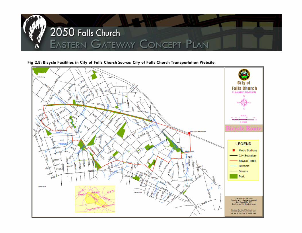
Fig 2.8: Bicycle Facilities in City of Falls Church Source: City of Falls Church Transportation Website,

Parking Facilities Drivers have only one parking option in the City of Falls Church’s Eastern Gateway: private parking lots. city-owned parking lots are located in downtown Falls Church (on or adjacent to West Broad Street). Plans to build additional parking facilties are slated for the City Center redevelopment area. 26 Transit riders can park at the East Falls Church Metro Station, which has 422 all-day spaces and 33 short-term metered spaces.27 Some commercial centers, such as the Eden Center, lack sufficient parking. The Eden Center is Falls Church’s largest retail center, as well as the cultural and social center of the Vietnamese-American community.28 With approximately 1,000 parking spaces, insufficient parking remains a problem due to high demand maintained during weekends and major holidays such as the New Moon Festival. Some Eden Center patrons report on Yelp.com, a popular restaurant review site, that they feel parking at the Eden Center “takes forever,” is “a headache” and a “terrible pain.”29 Other than spot reconfiguration, there are no immediate solutions available due to the scarcity of surrounding land.30 Parking requirements in Falls Church reflect traditional suburban sensibilities regarding off-street parking and land use. Table 2.3, on the following page, indicates the off-street parking requirements for typical developments in the City of Falls Church.
(Left) Congested parking at Eden Center during a Christmas holiday. (Right) While parking is in high demand at Eden Center, this photo shows a significant amount of unused surface parking. Source: Capital City Partners’ Presentation to the City of Falls Church, www.fallschurchva.gov.

Table 2.3: Falls Church Parking Requirements
Business, general, and government buildings
1/300 square feet
Hotel and motel
One per guestroom and one employee space per 10 guestrooms
Professional office buildings, mixed professional uses
1/250 square feet
Banks One per 300 square feet of floor area
Single family dwellings
One per dwelling unit
Apparel and accessories
One per 200 square feet of floor area
Multifamily Two per unit
Convenience food store
One per 100 square feet of floor area
Townhouse 2.5 per dwelling unit
Restaurant One per 100 square feet of floor area
Shopping Center
One per 250 square feet of floor area
Carsharing In order to improve accessibility to destinations not easily served by transit, the Washington Metropolitan Transportation Authority (WMATA) partnered with Zipcar, a car sharing company that offers car rentals at select Metro stations and other urban locations. Residents of the City of Falls Church and area visitors can take advantage of this service at the East Falls Church Metro station, which has at this time two cars available for rental; rates start at $9.25/hour, with daily charges totaling $69. Carsharing patrons also enjoy dedicated parking spots in selected areas throughout Arlington County.31 Transportation Demand Management Transportation demand management (TDM) involves a set of services that addresses the demand for transportation as well as providing information about the supply of services available. The regional TDM program, Commuter Connections, is operated through the Washington, D.C., area’s metropolitan planning organization, the Metropolitan Washington Council of Governments (MWCOG). MWCOG provides several TDM services for employees within the D.C., Metropolitan Statistical Area through its Commuter Connections program. Commuters who live or work in Falls Church and the study area can sign up to utilize Commuter Connections’ services, which include the Ridesharing Program, the Guaranteed Ride Home (GRH) Program, and the Commuter Connections Bulletin Board.

The ridesharing program is a free service that provides information for commuters who are interested in joining a carpool or vanpool to reach their workplace. Commuter Connections operates ridesharing technology that allows commuters to view potential ridesharing partners in their area. The ridesharing program also provides information on the closest transit stops to a commuter’s home and work, the closest park and ride lot (to meet up for ridesharing or access commuter bus service), and the closest telework center. The Guaranteed Ride Home Program is a free service for commuters that rideshare, use public transportation, bicycle, or walk to work at least two days a week. For commuters registered in the program, GRH provides rides up to four times a year in case of emergencies or unscheduled overtime. Another service is the Commuter Connections Bulletin Board, which provides information on short-term ridesharing options for commuters who do not want to formally sign up for the Ridesharing Program.32 Travel-to-Work Patterns Commuting patterns to and from the City of Falls Church are highest between the City, Washington, D.C., and Fairfax County, VA, with modest commuting to and from jurisdictions in Maryland. As of the 2000 Census, the City of Falls Church had 8,870 persons who worked in the city, and 5,520 residents who worked in the city or elsewhere in the Washington, D.C., region. Fifty-seven percent of working city residents commuted to Washington, D.C. and Fairfax, Virginia, for employment, with
only 16 percent who reported working and living in Falls Church. Only five percent of city residents commuted to Maryland for employment. Figure 2.9: Falls Church Residents Places of Work, Source: U.S. Census Bureau, 2000 Decennial Census.
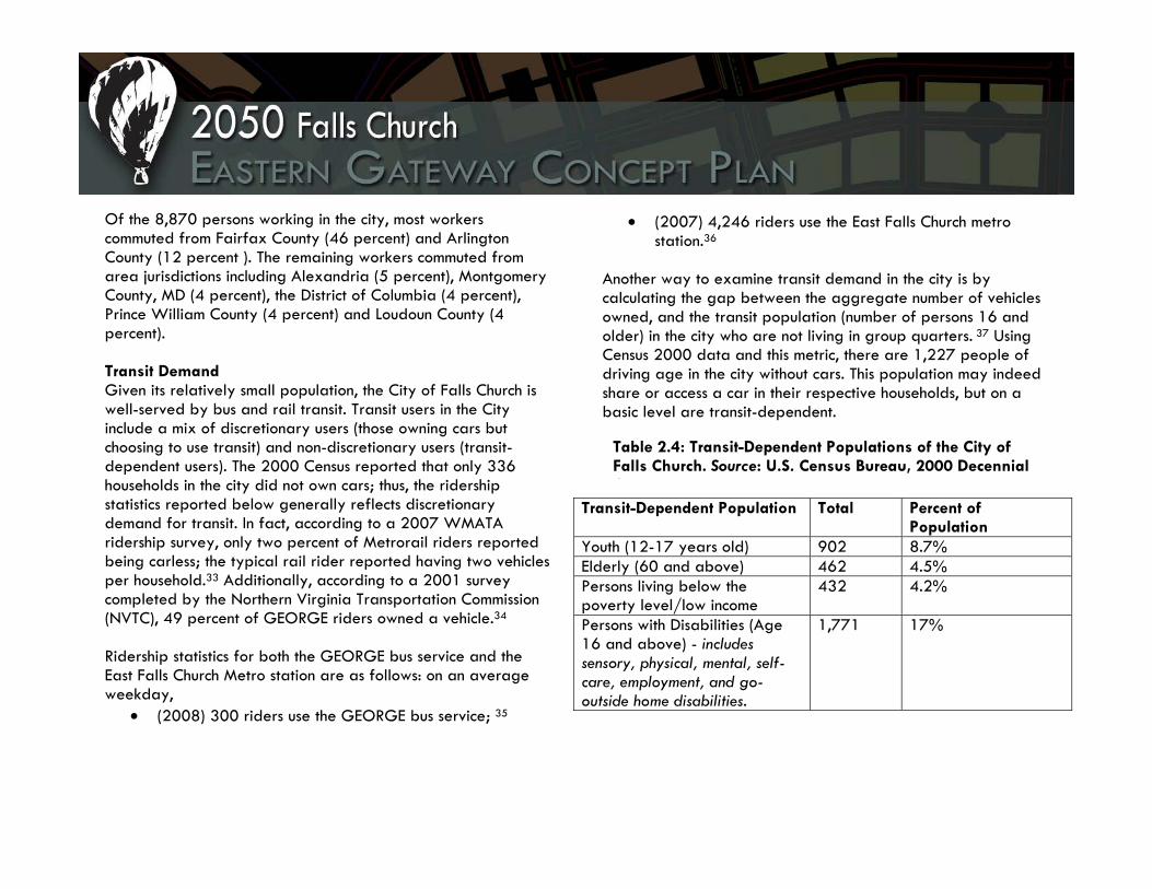
Of the 8,870 persons working in the city, most workers commuted from Fairfax County (46 percent) and Arlington County (12 percent ). The remaining workers commuted from area jurisdictions including Alexandria (5 percent), Montgomery County, MD (4 percent), the District of Columbia (4 percent), Prince William County (4 percent) and Loudoun County (4 percent). Transit Demand Given its relatively small population, the City of Falls Church is well-served by bus and rail transit. Transit users in the City include a mix of discretionary users (those owning cars but choosing to use transit) and non-discretionary users (transit-dependent users). The 2000 Census reported that only 336 households in the city did not own cars; thus, the ridership statistics reported below generally reflects discretionary demand for transit. In fact, according to a 2007 WMATA ridership survey, only two percent of Metrorail riders reported being carless; the typical rail rider reported having two vehicles per household.33 Additionally, according to a 2001 survey completed by the Northern Virginia Transportation Commission (NVTC), 49 percent of GEORGE riders owned a vehicle.34 Ridership statistics for both the GEORGE bus service and the East Falls Church Metro station are as follows: on an average weekday,
• (2008) 300 riders use the GEORGE bus service; 35
• (2007) 4,246 riders use the East Falls Church metro station.36
Another way to examine transit demand in the city is by calculating the gap between the aggregate number of vehicles owned, and the transit population (number of persons 16 and older) in the city who are not living in group quarters. 37 Using Census 2000 data and this metric, there are 1,227 people of driving age in the city without cars. This population may indeed share or access a car in their respective households, but on a basic level are transit-dependent.
Transit-Dependent Population Total Percent of Population
Youth (12-17 years old) 902 8.7% Elderly (60 and above) 462 4.5% Persons living below the poverty level/low income
432 4.2%
Persons with Disabilities (Age 16 and above) - includes sensory, physical, mental, self-care, employment, and go-outside home disabilities.
1,771 17%
Table 2.4: Transit-Dependent Populations of the City of Falls Church. Source: U.S. Census Bureau, 2000 Decennial C

1 Wood, Joseph. “Vietnamese American Placemaking in Northern Virginia.” Geographical Reviewm 1997: 58-72. 2 Ibid. 3 City of Falls Church, Existing Land Use Map, Figure 4-2 (February 2007). 4 Ibid. 5 2005 Falls Church Comprehensive Plan, Chapter 4, Land Use and Economic Development, page 41. 6 Fairfax County Comprehensive Plan, 2007 Edition, Baileys Planning District, Area I, page 61. 7 2005 Falls Church Comprehensive Plan, Chapter 4, Land Use and Economic Development, page 41. 8 Ibid, 42. 9 Ibid, 42. 10 Ibid, 47. 11 Ibid, 41. 12 Ibid, 38 13 Ibid, 37. 14 Ibid, 42. 15 Fairfax County Zoning Ordinance, Article 4, Commercial District Regulations, 4-700, page 4-43. 16 Ibid, page 4-51. 17 Virginia Department of Transportation, Daily Traffic Volume Estimates Including Vehicle Classification Estimates – Special Locality Report, City of Falls Church, 2008, http://www.virginiadot.org/info/resources/AADT_110_FallsChurch_2008.pdf. 18 Information collected from City of Falls Church GEORGE Bus website, http://www.fallschurchva.gov/Content/CultureRecreation/GEORGEmain.aspx (accessed November 14, 2009). 19 City of Falls Church, FY2010 Budget and Capital Improvements Program, Presentation. http://www.fallschurchva.gov. 20 WMATA East Falls Church website, http://www.wmata.com/rail/station_detail.cfm?station_id=100 (accessed November 15, 2009). 21 WMATA West Falls Church website, http://www.wmata.com/rail/station_detail.cfm?station_id=101 (accessed November 15, 2009). 22 WMATA Reserved Parking website, http://www.wmata.com/rail/parking/reserved_parking.cfm (accessed November 15, 2009). 23 According to WMATA station websites, as of November 15, 2009. 24 Arlington Transit website, http://www.commuterpage.com/art/ (accessed November 15, 2009). 25 Washington Area Bicyclist Association Bikes on Transit Website, http://www.waba.org/areabiking/transit.php (accessed December 2, 2009). 2626 City of Falls Church, Comprehensive Plan Adopted October 24, 2005, pg. 141, http://www.fallschurchva.gov/Content/Government/Departments/DevelopmentServices/CompPlan.aspx?&cnlid=767. 27 Washington Metropolitan Transit Authority, http://www.wmata.com/rail/station_detail.cfm?station_id=100. 28 Alan Frank, Eden Center: The #1 Tourist Attraction in Falls Church. Presentation to the City of Falls Church Economic Development Authority, January 6, 2009,
http://www.fallschurchva.gov/Content/Government/Departments/EconomicDevelopment/EdenCtrPresentation010609.pdf 29 Yelp.com reviewers for the Huong Que/Four Sisters Restaurant in Eden Center, http://www.yelp.com/biz/four-sisters---huong-que-falls-church. 30 Frank, Eden Center: The #1 Tourist Attraction, pg. 37. 31 For additional details on carsharing, see http://www.commuterpage.com/carshare.htm. 32 Commuter Connections Commuter Programs Website, http://www.mwcog.org/commuter2/commuter/index.html (accessed December 2, 2009). 33 Kytja Weir, “Survey: Metrorail users more affluent, better educated,” The Examiner, May 17, 2009, http://www.washingtonexaminer.com/local/45265152.html. 34 Northern Virginia Transportation Commission, “Considerations in Evaluating the Future of GEORGE Bus Service in Falls Church, Virginia,” March 2009, http://www.fallschurchva.gov/Content/Docs/GEORGENVTCEval.pdf. 35Ibid, pg. 4. 36 Washington Metropolitan Transit Authority, 2007 Ridership Survey. Station statistics compiled by Rob Godspeed at http://www.swivel.com/data_sets/show/1010688. 37 Todd Steiss, Calculating Transit Dependent Populations Using 2000 Census Data and GIS, http://www.fhwa.dot.gov/ctpp/sr0406.htm

3. 2050 Eastern Gateway Plan

2050 Falls Church Eastern Gateway Concept Plan UAP 5124 students created a land use concept for the Koons-Syms, Edens Center and Roosevelt-Wilson plan areas to suggest development scenarios that implement the area’s vision. The plan areas identify the general type and character of the proposed architecture, open space, densities, and land uses that are appropriate for each site. Because plan implementation will undoubtedly be a long-term process, the City of Falls Church would be wise to develop short- and long-term solutions to facilitate the organized development of land uses in the area through deliberate land use application actions and facilitation of appropriate public infrastructure investments. Graphics, renderings, and language describing each of the three plan areas begin on the following page. Additionally, of particular interest to the city is the economic analysis section in Chapter 6, which describes the fiscal benefits that the density of the plan will provide to the city’s financial health and the offset that the potential for increased development in the Eastern Gateway will provide to existing and future budget shortfalls. The political will of the elected officials and citizen investment in the development of the plan will be crucial elements for the
city to implement specific comprehensive plan language and develop an enforceable mixed-use zoning district that will create the area as an economic asset. Without community buy-in and staff enforcement of the plan, there will be little interest by elected officials, city staff or citizens to enforce any comprehensive plan language or ordinance that is developed. The areawide vision for the recommendations below will present overall guidance for the development of the land use, urban design, and transportation for each plan area. Implementing the vision for the Eastern Gateway will depend on city staff review of development proposals within the area; recommendations suggested below may not adequately address land consolidation, infill development, acquisition of affordable housing or public infrastructure facilities and other site-specific issues that may arise during the development review process. The city should create goals and planning strategies to address adequate administrative processes for such regulations. Taken together, the area plan recommendations will provide a denser urban environment, increase the city’s commercial tax-base, promote a sense of place and create a distinct gateway for the City of Falls Church.


Roosevelt and Wilson Plan The Vision The vision for the Roosevelt-Wilson Boulevard areas in the Eastern Gateway is built on a commitment to encouraging alternative transportation to and from the East Falls Church Metro station and I-66. Residential activity will be focused on the north end of the area, with an increase in density and commercial uses towards Wilson Boulevard. Roosevelt Boulevard will serve as a principal arterial with a concentration of residential activity for the Falls Church Eastern Gateway area. Along this corridor, there will be mixed-use development that includes ground-level commercial activity, upper-level unique office space for small business, upper-level residential activity, and townhouses. A retail, restaurant, and entertainment area, anchored by a movie theater, will be located at the corner of Wilson and Roosevelt. Encouraging community interaction and pedestrian activity, and acting as a buffer between the single family residential area to the east and more intense uses along Roosevelt and Wilson Boulevard is a large open space that will be designed for a variety of recreational activities. Wilson Boulevard will serve as a principal arterial with concentrated office activity. Mid- to high-density office buildings with ground-level commercial use along Wilson
Boulevard will attract activity during the day, and will be complemented by commercial, retail, and residential activity in the evening. This synergy provides support for a vibrant corridor at all times of the day. Figure 3.1 Roosevelt Boulevard/Wilson Boulevard Site Plan

Existing Site Conditions The Roosevelt Boulevard/Wilson Boulevard area consists of approximately 33 acres, or just over 1.4 million square feet of area. Current site uses include three high-rise apartment complexes (approximately 14 acres), a public storage facility (approximately. 1.5 acres), an auto body shop (approximately three acres) a gas station (approximately 0.5 acres), a small commercial strip (approximately 0.7 acres), and the former Noland Plumbing warehouse—future site of a BJ’s Wholesale Warehouse (approximately eight acres). Buildings on each of the sites are surrounded by surface parking and open space. The resulting development character is very low-density, with an average floor-area ratio (FAR) of 0.62; this low FAR is not conducive to a walkable urban environment or public transportation and does not support underground parking. The current floor area ratio of each parcel is listed in Table 3.1 below:
Table 3.1: Existing Floor Area Ratios for Roosevelt Boulevard/Wilson Boulevard Sites
Site Name Floor Area Ratio Oakwood Apartments 0.3152 Madison Condo 0.9448 Roosevelt Towers Apts. 1.0060 Koons Ford Body Shop 0.2551 Public Storage 1.8784 Shell Gas Station 0.1018 Wilson Blvd Commercial 0.3114 BJ's Wholesale Warehouse 0.2175 Current subsite FAR 0.6228
The Wilson Boulevard corridor brings traffic into the Eastern Gateway from Arlington’s Rosslyn-Ballston corridor. Roosevelt Boulevard serves as a major north-south artery through the site, leading traffic to and from the East Falls Church Metro station and Route I-66, located approximately 1.5 miles to the north of the site. Because of these major arterial connections, this approximately one mile section of Roosevelt Boulevard has the potential to serve as a major thoroughfare into the Eastern Gateway site, in addition to successfully hosting concentrated, main street-type commercial and residential development.

Table 3.2 Floor-Area Ratios for Roosevelt Boulevard/Wilson Boulevard Site
Floor-Area Ratios The ultimate goal of the proposed development is to significantly increase the floor-area ratios of the existing parcels in the Roosevelt Boulevard/Wilson Boulevard site with low-scale, dense development that promotes street level activity and walkability. Table 3.2 below shows that the proposed development will more than triple the overall floor-area ratio of the site.
The FAR of the Wilson Boulevard commercial strip parcel will increase more than seven-fold. Shell Gas Station parcel, whose current FAR is nearly negligible at 0.10, will become the densest parcel on the Roosevelt Boulevard/Wilson Boulevard site, with an FAR of 5.48. The FAR of the Madison Condo parcel will actually decrease slightly with the development; however the new development proposes buildings that are set at the front of the site along Roosevelt Boulevard, which is far more conducive to creating a walkable urban environment and better reflects the overall objectives of the redevelopment.
Site Name Parcel Number Site Address Acreage Site Square
Footage
Proposed Square Footage
Site FAR
Oakwood Apartments 53-218-014 501 Roosevelt 12.14 528,821 768,045 1.45 Madison Condo 53-218-144 600 Roosevelt 2.26 98,407 81,600 0.83 Roosevelt Towers Apts. 53-218-019 500 Roosevelt 5.15 224,334 350,317 1.56 Koons Ford Body Shop 53-218-020 410 Roosevelt 2.71 118,042 208,192 1.76 Public Storage 53-218-021 400 Roosevelt 1.48 64,603 88,842 1.38 Shell Gas Station 53-218-004 6623 Wilson 0.49 21,425 117,510 5.48 Wilson Comm. Strip 53-218-003 6609 Wilson 0.65 28,385 62,604 2.21 BJ's Wholesale Site 53-218-002 6607 Wilson 8.30 361,575 398,014 1.10 Roosevelt/Wilson Total 33.19 1,445,592 2,075,124 1.97

Proposed Development Objectives The area is currently zoned for light industry, creative development, and multifamily residential. Figure 3.1 below is an image of current zoning map for this part of the Eastern Gateway site. In an effort to create a more attractive jurisdiction edge and a more memorable entrance into Falls Church, the zoning should change from light industry to a creative development zone that can then be designed as mixed-use, injecting more pedestrian activity and life into the area. We further suggest that the multifamily residential zoning along Roosevelt be changed to a zoning designation that will allow residential mixed used development with commercial development at the ground level. Finally, we suggest requiring the preservation of the open space between the multifamily and single family home residential areas. These zoning changes will allow higher intensity development of Roosevelt Boulevard/Wilson Boulevard and more creativity in the development that will occur, which will serve to encourage clustering development while preserving open space for recreational use.
Figure 3.1. Current Zoning
Because it is situated along a major transportation route, Roosevelt Boulevard can serve as a principal artery through the Falls Church Seven Corners Gateway site. Proposed development for the Roosevelt Boulevard/Wilson Boulevard site will consist of a mix of retail/commercial, office, and residential uses. The goal of the development is to transform Roosevelt Boulevard into an urban main street, with many buildings offering a variety of first-floor commercial and retail establishments, along with restaurants and cafes with sidewalk

seating to promote an active outdoor presence at all times of the day. Commercial, office, and residential uses will make up the upper floors of the buildings. Development in this area will also include some standalone residential in the form of townhouses and commercial buildings, including a movie theatre. With the significant increase in density proposed across the Eastern Gateway site as a whole, development must accommodate an increase in residents who will be inclined to move to this new transit-oriented urban center. The proposed residential units will replace the existing high-rise apartment buildings, in addition to accommodating a growing demand for residential land use as a result of higher density development across the site. These apartments will be predominately studios, one-bedroom, and two-bedroom apartments to attract a young professional residential base. Unlike the existing high-rise apartment buildings, which are set back on the site, the proposed residential development along Roosevelt Boulevard will border the street and feature first-floor commercial and retail establishments. Figure 3.2 provides an overview of the Roosevelt Wilson site plan. Although the development density will be increasing on the site, the increase will be upward instead of outward. The proposed plan will create more open space than currently exists. A large recreation area between the single family residential area east of the site and the higher intensity development along Roosevelt Boulevard and Wilson Boulevard will act as a buffer and a shared recreation area for residents. It will include a pedestrian
path around the perimeter of the open space, a field in the center for outdoor sports, a large playground on one side, and a basketball court or tennis court on the other. A courtyard with a central feature of interest will be included at the center of the designated office section along Wilson Boulevard and the large pedestrian boulevard between the retail/office mixed-use buildings will lead to the movie theater from Roosevelt Boulevard and include a skating rink and possibly a central outdoor pavilion for small local concerts. Figure 3.2. Roosevelt Boulevard/Wilson Boulevard Site Plan

The Roosevelt Boulevard/Wilson Boulevard site will contain a walkable entertainment area on the eastern side of Roosevelt Boulevard, which will feature additional retail establishments, restaurants, a movie theater, and an outdoor plaza. Office uses will be mixed throughout the site, but will be concentrated closer to Wilson Boulevard, which serves as a secondary gateway into the Eastern Gateway site. Aside from a parking structure on the east side of the entertainment center and some street parking, all other retail, office, and residential parking will be underground. Figure 3.3. Roosevelt Boulevard/Wilson Boulevard Massing
General Architectural Character The architectural character of Falls Church has been established in the city’s design guidelines. These sites we have developed shall portray a high quality of design and intent specific to the needs of Falls Church. The students were encouraged to develop ideas that were fiscally efficient as well as aesthetically pleasing. Thus, all sites will incorporate a mixed-use scheme sharing retail, residential, or commercial office space. Compared to the existing conditions, (multiple store fronts as a single façade with overwhelming, and unnecessarily large, parking lots in front) the new design will include underground parking and broken fronts to enhance visual interest and break building mass into smaller scale components. This will be accomplished by creating
stepping portions of the façade, resulting in shadow lines and different volumetric spacing. Within this spacing, different ornamental, non-structural, columns will engage the spaces and force different circulation. Different materials and textures of the façade will augment divisions to break up the face. Within each site development, there will be variation in rooflines with the use of stepped roofs, overhangs, and simple windows.
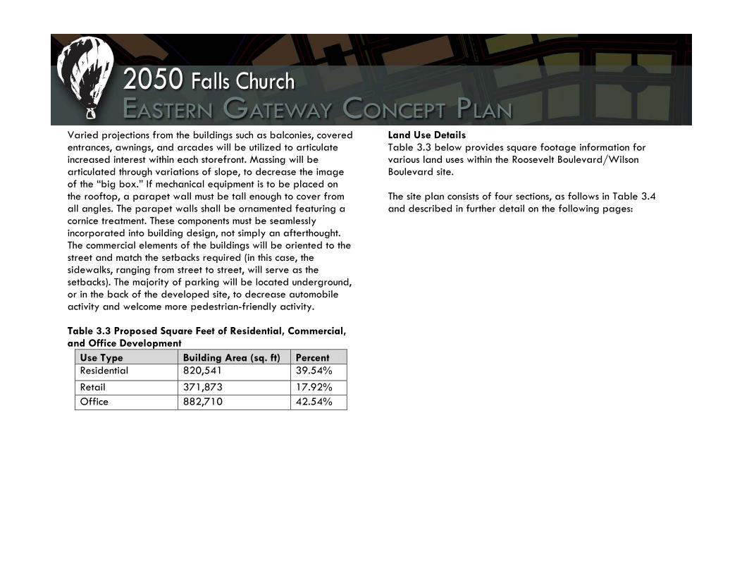
Varied projections from the buildings such as balconies, covered entrances, awnings, and arcades will be utilized to articulate increased interest within each storefront. Massing will be articulated through variations of slope, to decrease the image of the “big box.” If mechanical equipment is to be placed on the rooftop, a parapet wall must be tall enough to cover from all angles. The parapet walls shall be ornamented featuring a cornice treatment. These components must be seamlessly incorporated into building design, not simply an afterthought. The commercial elements of the buildings will be oriented to the street and match the setbacks required (in this case, the sidewalks, ranging from street to street, will serve as the setbacks). The majority of parking will be located underground, or in the back of the developed site, to decrease automobile activity and welcome more pedestrian-friendly activity. Table 3.3 Proposed Square Feet of Residential, Commercial, and Office Development
Use Type Building Area (sq. ft) Percent Residential 820,541 39.54% Retail 371,873 17.92% Office 882,710 42.54%
Land Use Details Table 3.3 below provides square footage information for various land uses within the Roosevelt Boulevard/Wilson Boulevard site. The site plan consists of four sections, as follows in Table 3.4 and described in further detail on the following pages:

Table 3.4 Site Section Descriptions
Section Current Use GeographicDescription Proposed Use Heights
Section 1 Oakwood Apartments
West of Roosevelt
Concentrated residential, mixed-use residential with ground floor commercial
3-6 stories
Section 2 Roosevelt Towers, Madison Condos
East of Roosevelt, North
Concentrated residential, Mixed-use residential with ground floor commercial
5-8 stories
Section 3 Public Storage, Koons Ford Body Shop, BJ’s Wholesale Warehouse North
East of Roosevelt, Central
Entertainment, mixed-use office with ground floor commercial, Residential
6-8 stories
Section 4 Shell Gas Station, Wilson Boulevard Commercial, BJ’s Wholesale Warehouse South
East of Roosevelt, South
Mixed-use office, ground-floor commercial
4-6 stories

Section 1: West of Roosevelt The current Oakwood Apartments site on the western side of Roosevelt Boulevard will consist of 15 buildings. Four will be three-story residential townhomes on the far northern and western portions of this section. Six will be three- to five-story apartment-style residential on the northern portion of this section, and five will be five- to six-story mixed-use with commercial on the first floor and apartment-style residential on the upper floors on the southern portion of this section. The first-floor square footage of these five mixed-use residential/ commercial buildings lends itself to larger commercial uses, for example a grocery store or other large retailer. Figure 3.4, to the right, depicts townhouse and apartment-style residential development on an internal street west of Roosevelt Boulevard. The proposed development here will promote a feeling of vibrancy and safety for residents, with narrow streets to reduce auto speed, wide sidewalks, street trees, and apartment balconies overlooking the street. Figure 3.4: Proposed Residential Development West of Roosevelt Boulevard

Section 2: East of Roosevelt, North The current Roosevelt Towers and Madison Condos site on the eastern side of Roosevelt Boulevard will consist of six buildings fronting to Roosevelt Boulevard. Two larger buildings will be 8-story one- and two-bedroom apartment-style residential with ground floor commercial. Three smaller buildings will be six-story apartment-style residential with ground floor commercial. Another smaller 5-story building, which will not front the street, will consist of all apartment-style residential. To the east of this development, serving as a buffer to the existing single-family houses, will be the recreation area and green space with ball fields, tennis courts, and a public gathering area.
Figure 3.5: Proposed Residential Development East of Roosevelt Boulevard, North Section

Section 3: East of Roosevelt, Central The central portion of the development east of Roosevelt Boulevard will be the entertainment sector, anchored by a movie theater. Attached to the movie theater will be the site’s only surface parking structure. In addition, four 6-story buildings will consist of a mix of commercial and office use, and there will be two 8-story residential buildings. This section of the site contains more open space than the other sections, in order to encourage outdoor activity and promote commercial and residential uses that utilize the open space, such as restaurants with outdoor seating and pleasant areas with central features of interest and creative landscaping. Figure 3.6: Proposed Residential Development East of Roosevelt Boulevard, Central

Section 4: East of Roosevelt, South The southern portion of the development east of Roosevelt Boulevard and along Wilson Boulevard will consist of mid- to high-density mixed-use office with ground floor commercial. The eight 4-6 story buildings front Roosevelt and Wilson Boulevards, but also face inward toward an outdoor plaza. Like the mixed-use buildings west of Roosevelt, the first-floor square footage of these buildings can accommodate grocery stores or other large retailers.

Conclusion The development of the Roosevelt-Wilson subarea is orientated towards traffic flow along Roosevelt from the Metro station and I-66, as well as along Wilson Boulevard traveling from Arlington and Fairfax. The intensity of use is concentrated around the intersection of Roosevelt and Wilson Boulevard. The Roosevelt-Wilson sub-area supports a majority of the residential demand that is required to absorb new residents for the overall project site. A creative development zone intends to encourage mixed-use development. The general functionality is ground floor retail, and upper floor residential or office use. The proposed residential type is intended to attract young professional families. The suggested office type is Class A Office that is attractive for large, high-end corporations. The site places an emphasis on the live-work-play concept. This is achieved through streetscapes that encourage active walking, and use of open space that enhances a sense of community. The orientation of buildings toward the streets is intended to create a lively street life. Additionally, inner areas between buildings are complemented with open spaces that encouraging a lively civic space. A movie theatre and surrounding restaurants and cafes will provide opportunities for entertainment. The development also seeks to respect existing uses bordering the site by using a transition of open space and the cemetery as a buffer.

Eden Center Plan The Vision Eden Center is redesigned as a vibrant retail center that offers active street life due to a mix and balance of uses that allows for round-the-clock activity. The new Eden Center will be easy to access via an adjacent transit center. Surrounding neighborhoods will be able to access the Eden Center from safe, attractive, and intuitive pedestrian linkages and bike routes. Visitors arriving by car will be able to access Eden Center from multiple points, due to a new street network. After exiting hidden structured and underground parking, residents and guests will find it attractive and practical to explore Eden Center and the surrounding attractions on foot. Eden Center will remain an important center of Vietnamese commercial activity. Added uses and an enhanced street scene with new outdoor spaces will provide places for resting and people-watching, as well as spaces or areas for festivals and public events. Improved transit marketing and connectivity will bring additional visitors from throughout the metropolitan region, and make visits easier and more memorable for tourists traveling from further distances. The vitality of Eden Center will be enhanced by new and interesting uses. Office buildings with ground-level commercial use will attract activity during the day, and will be complemented by commercial, retail, and
residential activity in the evening. This synergy of mixed uses provides support for a vibrant corridor at all times of the day. Existing Site Conditions The current Eden Center site consists of approximately 16 acres, or 703,624 square feet of area. The current site uses include a shopping center (15.3 acres), a gas station (0.39 acres), and a stand-alone retail site (0.43 acres). The buildings on each of the sites are surrounded predominantly by surface parking, which results in a very low density. The average floor area ratio (FAR) is 0.29 for the three properties combined. The area is currently zoned for light industry (M-1), with future plans calling for the area to be designated for “Business” uses, according to the 2005 City of Falls Church Comprehensive Plan. The existing retail structures were all built in the early 1960’s, and the gas station was built in 1988. Since then, the retail buildings have been upgraded and well maintained, but the value of the structures themselves is low when compared to the land value. Clearly, the site is not performing to its best economic potential. The sidewalks in front of the stores are narrow and do not allow sufficient space for retail activity, outdoor dining, or public space. The parking lot of the large site is primarily accessible from Wilson Boulevard. Other points of access are limited. From Roosevelt Boulevard, there are no left turns for automobiles to access the site. Other access points from Wilson and Roosevelt are limited, and there is no connectivity with surrounding properties. The traffic backups in the parking

lot are widely acknowledged as the single most negative experience that one can have at the Eden Center. Proposed Development Objectives The general goals for proposed development include increasing the density to allow better economic usage of the site, increasing the mix of uses, and improving the connectivity to neighborhoods and the regional transit network. A final goal is to improve the overall character and aesthetics to make it a vibrant and active place where people want to spend time. Architecture should contribute to the sense of place, culture and general convenience of the new Eden Center. Increased Development Density The current FAR of the site ranges from .05 at the gas station to .40 at the Capital Properties sub-site. The proposed development will increase the FAR to 1.62, by increasing the number, floor plate size and heights of the buildings. While the FAR will increase the height of the site overall, we took care to make sure that the proposed heights will be compatible with the other proposed buildings in the area. Increased FAR will further maximize the economic vitality and use of the space. Although the proposed FAR will be more than three times the current FAR, the site will gain a new green public space and green roofs, and will be more pedestrian-friendly and aesthetically pleasing.
Table 3.4: Floor-Area Ratios for Eden Center Site
Greater Mix of Uses In addition to ground-floor retail throughout the entire site, Eden Center will feature office and residential uses on the upper floors of designated buildings. Table 3.5, below, entitled Square Footage of Proposed Buildings by Land Use, lists the square footage and proportion information for various uses within the Eden Center site. Retail space will consist of 200,232 square feet, or 17 percent of the total space for the site. The majority of retail space will be on the first levels of all buildings in the new Eden Center. Lower buildings surrounding the new public courtyard/park will be retail only, and can be two stories or higher. Retail space above the first floor would be
Site Name Land Area (sq. ft.)
Existing Building (sq. ft.)
Existing FAR
Proposed Building (sq.ft.)
Proposed FAR
6701, LLC (gas station)
17,320 880 0.05
Eden Center 667,383 197,061 0.30
Capital Properties 18,921 7,633 0.40
TOTAL, Eden Center
703,624 205,571 0.29 1,171,252 1.77

well-suited for large restaurants, or banquet facilities suitable for weddings and special events. Table 3.5: Square Footage of Proposed Buildings by Land Use
Land Use Square Footage
Percent of Total
Residential 200,232 17% Retail 243,776 21% Office 727,244 62%
Aboveground floor retail space, office space will take up 727,244 square feet, or 62 percent of the total usable building space, as proposed. Residential uses will take up 200,232 square feet, or 17 percent of the Eden Center site as a whole. Figure 1 depicts the general layout of uses, the square footages of individual floor plates, and the heights of the concept plan. The uses and building heights were intended to be flexible to allow adjustments to the mix of uses and density depending on market demand.
Figure 3.7: Eden Center Land Use Map
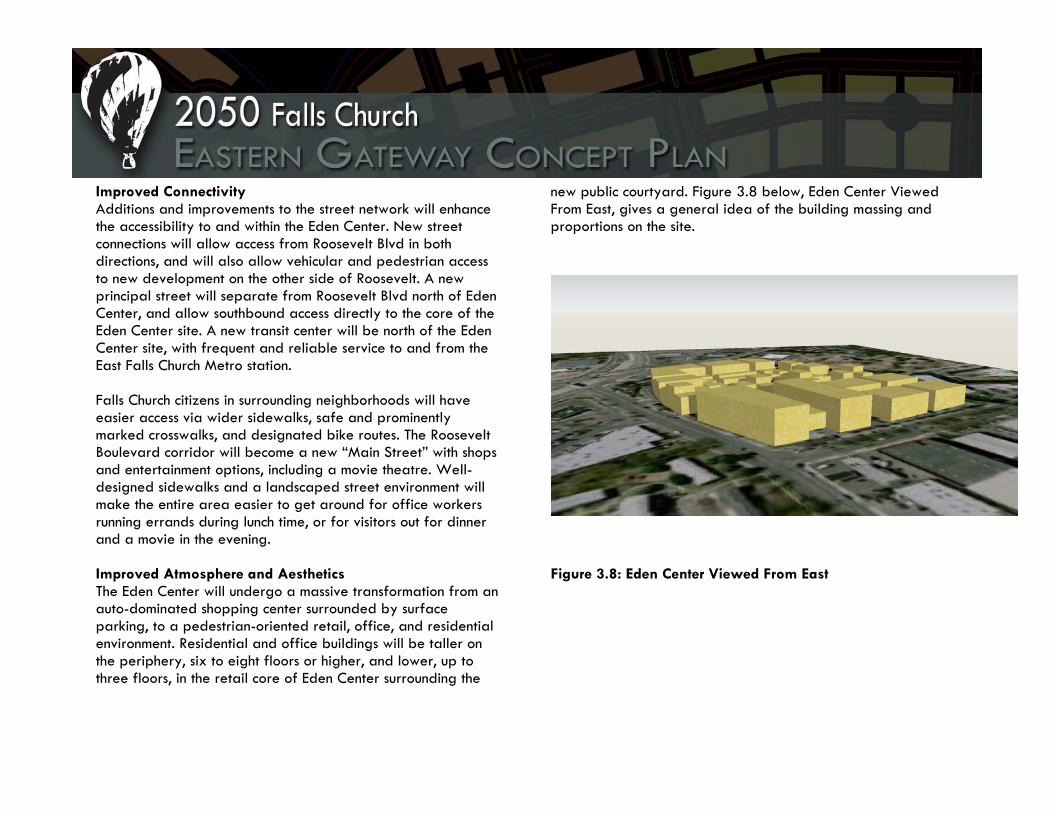
Improved Connectivity Additions and improvements to the street network will enhance the accessibility to and within the Eden Center. New street connections will allow access from Roosevelt Blvd in both directions, and will also allow vehicular and pedestrian access to new development on the other side of Roosevelt. A new principal street will separate from Roosevelt Blvd north of Eden Center, and allow southbound access directly to the core of the Eden Center site. A new transit center will be north of the Eden Center site, with frequent and reliable service to and from the East Falls Church Metro station. Falls Church citizens in surrounding neighborhoods will have easier access via wider sidewalks, safe and prominently marked crosswalks, and designated bike routes. The Roosevelt Boulevard corridor will become a new “Main Street” with shops and entertainment options, including a movie theatre. Well-designed sidewalks and a landscaped street environment will make the entire area easier to get around for office workers running errands during lunch time, or for visitors out for dinner and a movie in the evening. Improved Atmosphere and Aesthetics The Eden Center will undergo a massive transformation from an auto-dominated shopping center surrounded by surface parking, to a pedestrian-oriented retail, office, and residential environment. Residential and office buildings will be taller on the periphery, six to eight floors or higher, and lower, up to three floors, in the retail core of Eden Center surrounding the
new public courtyard. Figure 3.8 below, Eden Center Viewed From East, gives a general idea of the building massing and proportions on the site.
Figure 3.8: Eden Center Viewed From East

Western Side of Eden Center On the western edge of the consolidated Eden Center site, the current strip-mall style of Eden Center will become a walkable urban village surrounding a public gathering space. Above all, the new Eden Center aims to retain the unique Vietnamese shops and owners that exist in the current Eden Center. Since the cultural aspect is so important to the City and the region, the new Eden Center will need to be recreated in close consultation with the Vietnamese community that currently exists. An architect who specializes in Vietnamese architecture will be hired specifically to take on the task of creating a new Eden Center that is both reminiscent of the history and looks towards the future of the Vietnamese culture and way of life. The distinctly urban village setting is achieved through small passageways between buildings and “market-like” awnings and open doorways, not unlike Chinatown in San Francisco (Figure 3.9, to the right). Creating a human scale to the new development is also important, as this section of Eden Center will be completely car-free. The space will welcome pedestrians, office workers from nearby buildings, residents, visitors, pets, and children. Eden Center will be active during all times of the day, as restaurants and other vendors will cater to residents and visitors alike.
A main feature of the Eden Center, and the site as a whole, is the new public courtyard. The courtyard will feature landscaping that represents the Vietnamese flag, street furniture, and possible performance space. We envision the courtyard at the new Eden Center to be full of people at all times of the day, as people gather for meals or sit to listen to a musical performance. Currently, when the Eden Center has a cultural festival, the parking lot is shut down for space. With the new Eden Center, festivals and gatherings will have ample, safe space to stage events.
Figure 3.9: Chinatown, San Francisco. (Source: http://opentopsightseeing.files.wordpress.com/2008/04/cina-town.jpg)

Central and Eastern Eden Center Blocks East of the pedestrian village, both the Capital Properties and the gas station sites will be consolidated with the rest of the Eden Center site to become high-rise office buildings with retail on the first floor. The Capital Properties site lies adjacent to the new Roosevelt retail corridor. Buildings on the Eden Center site that face Roosevelt Blvd will complement the size and scale of buildings on the other side of Roosevelt in order to give the street a harmonious and dignified Main Street presence. The retail mix along Roosevelt Blvd will be composed of upscale vendors and national chains. This location would be ideal for coffee shops, bookstores, beauty shops, bakeries, and specialty clothing stores. Both functional and hidden, a structured parking garage will be built between the two office buildings. A new divided street with median will pass east/west from Roosevelt Blvd, between the office buildings, and leading towards the pedestrian village. Figures 3.10 and 3.11 show general concept views of what the street could look like.
Figure 3.10: Streetscape with Tree Median
Figure 3.11: Streetscape with Median

Eden Center will now have a residential component to complement the other uses, and help create a truly unique and attractive new part of Falls Church. Apartments and condominiums will be located on the three blocks along the northern edge of Eden Center, near the transit center, and along another new east/west street that connects with Roosevelt Boulevard. Residential units can also be located along Wilson Boulevard, one block west of Roosevelt Boulevard. Because so much of the area is on high elevation, all units should feature balconies to take advantage of views, and balconies facing the pedestrian village will be excellent for entertaining and people-watching (See Figure 3.12: Residential Buildings with Balconies, below). We think Eden Center would be a very attractive place to live for young professionals who would enjoy having so many diverse and attractive amenities just a few steps from home.
Figure 3.12: Residential Block with Balconies

Landscaping and Streetscapes Landscaping and streetscapes ensure that the pedestrian experience in Eden Center is pleasant, convenient and safe. Like the rest of the proposed development, the Eden Center will use low-impact development (LID) practices in all landscaping and streetscapes. The Eden Center will comply with the design guidelines developed by the City of Falls Church. The new street that bisects the Eden Center site serves as a pedestrian vista and main entrance into the courtyard public space. As people walk into the main street from Roosevelt Boulevard, they will be able to see the Vietnamese gate and plaza, welcoming from afar. The sidewalks will be wide enough to accommodate outdoor dining. Trees, bollards, and other street furniture will offer a pedestrians a buffer from any cars on the bisecting road. The new Eden Center plaza features native plants and plants that are significant to Vietnamese culture. If desired, a community garden placed on the site can grow herbs, edible flowers, and small vegetables. Green roofs will cover all buildings so that the site is as environmentally sound as possible.
Design Guidelines While the Eden Center will comply with guidelines set by the city, this proposal suggests that the Eden Center be included in the new established Arts and Cultural District. The Arts and Cultural District will give the Eden Center tax incentives to encourage growth in the new center. This proposal encourages the Eden Center to retain its own cultural identity that sets itself apart from the rest of the city. Architectural details, unique to Vietnamese culture, should be represented in signage, architecture, street furniture or landscaping.

Koons and Syms Plan Introduction The planned changes to the configuration and development of the Koons/Syms site will provide great opportunities and challenges for the City of Falls Church, its citizens, and its commercial tenants. Land use for this area should be in character with existing neighborhoods and their interests, but it should also be a prospect for diverse, dense, and pedestrian friendly development.
Figure 3.13: Massing Model of Proposed Development to Koons and Syms Sites
The proposed subarea plans for the Koons/Syms site: Grand Mart, Syms, and Koons respectively will attempt to address these challenges but also provide various options for effective and complementary land use development. Throughout the Koons/Syms section, please refer to the land use map, Figure 3.14, for explanations on land area configurations, land use classifications, and land area square footages. Figure 3.14: Land Use Map for Proposed Development
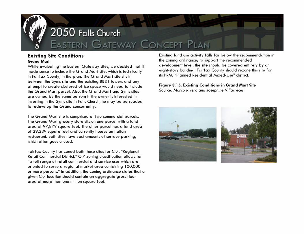
Existing Site Conditions Grand Mart While evaluating the Eastern Gateway sites, we decided that it made sense to include the Grand Mart site, which is technically in Fairfax County, in the plan. The Grand Mart site sits in between the Syms site and the existing BB&T towers and any attempt to create clustered office space would need to include the Grand Mart parcel. Also, the Grand Mart and Syms sites are owned by the same person; if the owner is interested in investing in the Syms site in Falls Church, he may be persuaded to redevelop the Grand concurrently. The Grand Mart site is comprised of two commercial parcels. The Grand Mart grocery store sits on one parcel with a land area of 97,879 square feet. The other parcel has a land area of 39,339 square feet and currently houses an Italian restaurant. Both sites have vast amounts of surface parking, which often goes unused. Fairfax County has zoned both these sites for C-7, “Regional Retail Commercial District.” C-7 zoning classification allows for “a full range of retail commercial and service uses which are oriented to serve a regional market area containing 100,000 or more persons.” In addition, the zoning ordinance states that a given C-7 location should contain an aggregate gross floor area of more than one million square feet.
Existing land use activity falls far below the recommendation in the zoning ordinance; to support the recommended development level, the site should be covered entirely by an eight-story building. Fairfax County should rezone this site for its PRM, “Planned Residential Mixed-Use” district. Figure 3.15: Existing Conditions in Grand Mart Site Source: Marco Rivero and Josephine Villacreces

Syms In Falls Church, there are few sites viable for redevelopment and unique enough to serve as a gateway to the city. The Syms site parcel is an interesting case because it is the converging point of several streets within the Seven Corners area. It marks the point where Fairfax County, Arlington County, and Falls Church meet. Leesburg Pike (Route 7), Arlington Boulevard (Route 50), Wilson Boulevard, and Hillwood Avenue all converge at this point. This parcel is adjacent to a parcel in Fairfax County containing two office towers for BB&T. The Syms site is currently a 134,487-square-foot, single-use, commercial parcel. The site contains a vacant department store and a parking lot. The 2005 Falls Church Comprehensive Plan identifies the Syms site as a transitional area, focusing on business sites with a transition to the western part of Syms for possible residential and commercial redevelopment. The zoning classifications for this parcel are B-3, “General Business” district, a transitional zoning district, and T-1 or “Transitional 1”. T-1 zoning classification allows for professional offices and parking facilities. T-1 also allows for residential uses, such as detached single family dwellings, duplexes, and townhouses on properties larger than three acres. Existing land use activity and zoning are inadequate for the potential redevelopment measures proposed at this site.
Figure 3.16: Existing Conditions at Syms Site Source: Marco Rivero

Koons The Koons site, across Route 7 from the potential landmark building Syms site, is marked by distinctive topography that challenges and influences development within the parcel. Similar to the Syms site, the Koons area also marks the point where Fairfax County and Falls Church meet, with the southeast end of the Koons site as the farthest point of Falls Church into Seven Corners. Leesburg Pike (Route 7), Arlington Boulevard (Route 50), Wilson Boulevard, and Hillwood Avenue all converge at this point. The Koons site is currently a 301,545-square-foot parcel. For the purposes of this analysis, it is split into Koons and Koons East. The main Koons parcel is 292,043 square feet and currently zoned as light industry/auto—the site currently contains the Koons Ford Dealership and adjacent auto body shop. The Koons East parcel has an area of 9,502 square feet. No development is proposed for this site and is not addressed further. The Koons parcel is also adjacent to two open space areas: the Oakwood Cemetery to the east and the underutilized Fort Taylor Park at the northern edge of the parcel.
Just like the Syms parcel, the 2005 Comprehensive Plan identifies the Koons site to be a transitional area, focusing on business sites with a transition to possible residential and commercial redevelopment. Figure 3.17: Existing Conditions at Koons Site Source: Josephine Villacreces

Proposed Development Objectives Grand Mart The Grand Mart site will contain residential space with ground-floor retail and office space at approximately the same height as the neighboring BB&T towers. Three buildings have been proposed, their configurations based on the shape of the parcels. The first, in the northwest corner of the site, is a building with a floor plate of 19,872 square feet that will be eight stories of condominiums/apartments, with the ground floor being made up of retail uses. The gross floor area will be 178,848 square feet. Of that, 158,976 square feet will be residential. The second building, in the southwest corner of the map, will have a floor plate of 13,959 square feet. This also will be a nine-story building, with the ground floor designated for retail uses and the upper floors for condominiums/apartments. The gross floor area will be 125,631 square feet, with 111,672 square feet for residential. The third building, on the east side of the map and immediately adjacent to the Seven Corners intersection, will be a 10-story structure with nine stories of office and ground floor commercial/retail. The gross floor area will be 197,900 square feet, with 178,110 square feet of office space.
Figure 3.18: Architectural Rendering of Proposed Development on Grand Mart Site

Overall, the total land area developed is 53,621 square feet out of 137,218 square feet or approximately 39 percent of the Grand Mart site area. Total office gross floor area is 178,110 square feet, total commercial gross floor area is 53,621 square feet, and total residential gross floor area is 270,648 square feet. By adding all gross floor areas together, the overall gross floor area is 502,379 square feet for the site with an overall floor area ratio of 3.7. The Grand Mart site will contain two major open space areas. The first includes a 3,451-square-foot parcel between the two residential buildings on the west side of the site. This area is projected to be a converging court area for the families who live in these residential units. A variety of landscaping options and play areas can be created to invigorate the space. Opposite a newly created pedestrian walkway bisecting the Grand Mart parcel will be a 5,384-square-foot space, serving as a courtyard area for the office building on the east side of the site.
There will be a new bisecting street on the west side of the residential buildings that will follow the path of the new street cut through the Syms site. This street will provide greater connectivity between Hillwood Avenue and the service road for Arlington Boulevard (Route 50). As future development enters the site, this street or other surrounding streets can become nodal points for future public transit expansion. The transit center located at the Eden Center enhancing the connectivity with East Falls Church Metro station will be integrated with the Grand Mart site through these potential transit nodes. The pedestrian walkway separating the residences and office building will provide connectivity to the Syms site, with new pedestrian crossings on Hillwood Avenue. The site will contain greater sidewalk connectivity and pedestrian mobility will be enhanced. Surface parking lots will be discouraged as structured parking will be provided underneath the site. These elements encourage efficient, pedestrian-scale planning and minimize automobile dependence.

Figure 3.19: Massing Model for Proposed Syms Site
Syms The Syms site will contain office and commercial development in a high-density, mixed-use form. It also will include a low-density residential component to serve as a buffer to the residential neighborhoods west of the site. A gateway building is proposed for the eastern edge of the site, facing a mixed-use building on the Koons West site. The Syms site was planned in three component areas. The first is a 17,329-square-foot land area that will be residential, primarily three- story condominium apartments/lofts. Gross floor area will be 51,987 square feet, all residential use. The second configuration consists of two commercial building areas, Commercial Building 1 (North) at 2,450 square feet and Commercial Building 2 (South) at 4,251 square feet respectively. Each of those buildings will be three stories tall with a total gross floor area of 7,350 square feet for Commercial Building 1 (North) and 12,753 square feet for Commercial Building 2 (South). Even though these buildings are intended to be commercial in character, the developer will have the option of using the upper floors for work studios, living spaces, or offices, depending on their interests. The final land configuration is the most extensive, with a land area of 28,327 square feet, primarily mixed-use office/commercial (mainly restaurants on the first floor). The mixed-use building will be a tapering building with heights increasing eastward. The first two northern sections of the
building (Mixed Use Office, North) will contain a land area of 3,332 square feet at six and nine stories respectively, with a gross floor area of 16,660 square feet of office and 3,332 square feet of commercial for the six-story portion, as well as 26,656 square feet of office and 3,332 square feet of commercial for the nine-story portion. The section of the building labeled “Mixed Use Office, South” will also contain the same numbers. The final portion of this building will be triangular in shape and 15,000 square feet in land area. It will be twelve (12) stories tall and contain 165,000 square feet of office space and 15,000 square feet of commercial. This building will serve as the central gateway into and out of Falls Church. It will be a staple of integrated neighborhood design with innovative urban design and architecture.

Figure 3.20: Architectural Renderings for Proposed Syms Site Buildings
Overall, the total land area to be developed is 52,358 square feet out of 134,487 square feet or approximately 39 percent of the Koons site area. Total office gross floor area is 251,632 square feet, total commercial gross floor area is 48,431 square feet, and total residential gross floor area is 51,987 square feet. By adding all gross floor areas together, the overall gross floor area is 352,050 square feet for the site with an overall floor area ratio of 2.6. This proposal produces both continuity and opportunities for expanded land use development, through a variety of options. The city will be able to generate greater interest and investment by private citizens, developers, and other commercial companies. Existing neighborhood character is preserved and enhanced dramatically, and this is evident with the changes in open space and infrastructure development as well. The Syms site will contain two major open space areas. The first includes a 3,928-square-foot parcel that is contained within the residential condominium apartments/lofts. Opposite the newly created street bisecting the Syms parcel will be a 7,671-square-foot space that will contain a fountain as its main attraction. Water can dramatically enhance the character of any site, and is fitting for a gateway concept. There will be a pedestrian bridge uniting the future mixed-use office/commercial building to the Koons site across Leesburg Pike (Route 7). Parking lots will be discouraged as structured parking will be provided underneath the site to encourage pedestrian-scale planning.
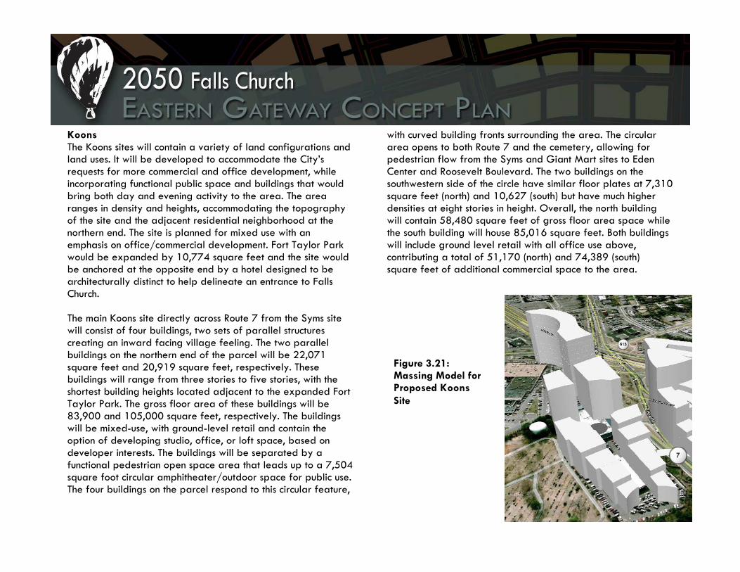
Koons The Koons sites will contain a variety of land configurations and land uses. It will be developed to accommodate the City’s requests for more commercial and office development, while incorporating functional public space and buildings that would bring both day and evening activity to the area. The area ranges in density and heights, accommodating the topography of the site and the adjacent residential neighborhood at the northern end. The site is planned for mixed use with an emphasis on office/commercial development. Fort Taylor Park would be expanded by 10,774 square feet and the site would be anchored at the opposite end by a hotel designed to be architecturally distinct to help delineate an entrance to Falls Church. The main Koons site directly across Route 7 from the Syms site will consist of four buildings, two sets of parallel structures creating an inward facing village feeling. The two parallel buildings on the northern end of the parcel will be 22,071 square feet and 20,919 square feet, respectively. These buildings will range from three stories to five stories, with the shortest building heights located adjacent to the expanded Fort Taylor Park. The gross floor area of these buildings will be 83,900 and 105,000 square feet, respectively. The buildings will be mixed-use, with ground-level retail and contain the option of developing studio, office, or loft space, based on developer interests. The buildings will be separated by a functional pedestrian open space area that leads up to a 7,504 square foot circular amphitheater/outdoor space for public use. The four buildings on the parcel respond to this circular feature,
with curved building fronts surrounding the area. The circular area opens to both Route 7 and the cemetery, allowing for pedestrian flow from the Syms and Giant Mart sites to Eden Center and Roosevelt Boulevard. The two buildings on the southwestern side of the circle have similar floor plates at 7,310 square feet (north) and 10,627 (south) but have much higher densities at eight stories in height. Overall, the north building will contain 58,480 square feet of gross floor area space while the south building will house 85,016 square feet. Both buildings will include ground level retail with all office use above, contributing a total of 51,170 (north) and 74,389 (south) square feet of additional commercial space to the area.
Figure 3.21: Massing Model for Proposed Koons Site

The Koons site will be anchored by a 12-story hotel at the southern-most point, at the Seven Corners intersection. The floor plate of the hotel will be 31,728 square feet. The twelve story hotel will contain a total of 380,736 square feet and would include a conference center and banquet hall to accommodate these uses within the redevelopment efforts. Overall the Koons site, including the existing Fort Taylor Park, would contain 46,676 square feet of open space for pedestrian use. Overall, the total land area developed, excluding the addition to the park, is 66,645 square feet out of 292,043 square feet or approximately 23 percent of the Koons site area. Total office gross floor area is 197,479 square feet, total commercial gross floor area is 439,653 square feet, and total residential gross floor area is 76,000 square feet. By adding all gross floor areas together, the overall gross floor area is 713,132 square feet for the site with an overall floor area ratio of 2.4. This proposal produces both continuity and opportunities for expanded land use development, through a variety of options. The Koons site is defined by green space to the western end, with the expansion of Fort Taylor Park. The expansion would be accompanied by a reworking of the park to emphasize the history of the site while creating a green space that will be more functional for public use. The 29,460-square-foot green space will also be the top of an underground parking structure. The parking structure would have an entrance off of Roosevelt Street and be completely underground. The pedestrian exit from the garage would exit at ground level on the western end of the developed Koons parcel into the village atmosphere and
Figure 3.22: Architectural Drawings and Renderings for Proposed Koons Site Development

second Koons site open space. This second open space area is a 17,216 square foot pedestrian parcel that extends through the center of the Koons property, including the circular amphitheater described in the previous section. One new street will bisect the four parallel buildings, beginning at the hotel and allowing access to the center of the development, including the central parking garage from Route 7. The transit center located at the Eden Center enhancing the connectivity with East Falls Church Metro station will be integrated with the Syms site through these potential transit nodes. There will be a pedestrian bridge uniting the future mixed-use office/commercial building to the Koons site across Leesburg Pike (Route 7). Conclusion The Koons/Syms site has many great attributes and challenges. Through effective planning and land use development, the City is able to generate greater interest and investment by private citizens, developers, and other commercial companies through this land use plan. Sound neighborhood design will make the area pedestrian friendly and aesthetically pleasing with parking primarily concentrated underground these sites. These are only a few opportunities the Syms, Grand Mart, and Koons sites can create over the course of several decades. The Koons/Syms site has the potential to become a stalwart example for these social, economic, and cultural efforts.
Figure 3.23: Rendering of Proposed Enhanced Fort Taylor Park

4. Transportation Network

Transportation Network Transportation Issues to Consider The 2050 Eastern Gateway Concept Plan calls for much higher densities and concentrations of mixed-use development than are currently in Falls Church. The proposed increase in development in the study area will cause significant transportation impacts. Maintaining smooth traffic circulation and providing several reliable and efficient transportation options will be paramount to preserve the quality of life for Falls Church residents, promote the study area as an attractive location for economic development and tourism, and facilitate development to occur in an environmentally sustainable manner. The development proposed for the Falls Church Eastern Gateway requires consideration of several issues: How will the transportation experience for existing residents
in Falls Church change with the proposed development? How will new residents and employees in the proposed
development travel to and move within the study area? What transportation improvements should be made? How will the transportation improvements be funded? How will developers contribute to the transportation
improvements needed to address the impacts of their new buildings?
What role can incentives play,
both for patrons to use alternative transportation and for developers to contribute to improvements for alternative transportation?
The transportation analysis conducted for this study did not attempt to model travel demand and specific traffic impacts as a result of the proposed development in 2050. Further detailed transportation studies will need to be conducted in the future as developers propose specific plans for the sites. This analysis offers a broader approach to providing a good transportation system to accommodate the proposed development within the study area. Various goals and strategies were developed to guide transportation improvements, particularly for alternative modes to the private automobile.
Impacts of proposed development on the road network must be mitigated to keep traffic moving within and through the Eastern Gateway. Source: Comstock Images, 2000.

Goals The goals for the future transportation network in the study area seek to address the issues described above. The goals are multi-faceted and aim to address the needs of the existing community as well as newcomers to the study area, the need to provide smooth circulation to facilitate economic development, and sustainability concerns related to the local environment, economy, and social equity. These goals are meant to serve as a general starting point and may be expanded with future public input or direction from city staff as specific plans are proposed within the study area. The fundamental transportation goals for the proposed development at the Falls Church Eastern Gateway are as follows, not listed in any priority order: Goal 1: Minimize traffic congestion resulting from the proposed development. Goal 2: Move people and goods efficiently. Goal 3: Meet the transportation needs of long-time Falls Church residents as well as the new residents, employees, and tourists that come to the study area as a result of the proposed development. Such transportation solutions will focus on local transportation services within the study area, with connections to regional services. Goal 4: Coordinate land use and transportation planning to accommodate the transportation needs resulting from the level of development proposed for each site within the study area.
Goal 5: Minimize negative impacts to air quality as a result of the proposed development and its associated transportation impacts. Goal 6: Promote a multi-modal transportation system that is socially equitable and economically and environmentally sustainable. Strategies Each strategy described below may help meet several of the proposed transportation goals. Some of the strategies are already in use today, but there is a need to expand these efforts and perhaps focus them for the study area. For example, those who currently work in Falls Church may use the ridesharing services provided through the Metropolitan Washington Council of Government’s existing Commuter Connections program. When the study area is built out and has a high concentration of employees commuting from various parts of the D.C. region, a ridesharing program specific to the study area may be warranted. Such a program could potentially be run through the city, through individual employers, or through coordinated efforts between employers within the study area. This example demonstrates that the transportation strategies already in place today may also be effective in achieving transportation goals in the future. These strategies vary in how difficult they are to implement, the associated costs of implementation, and their potential impacts
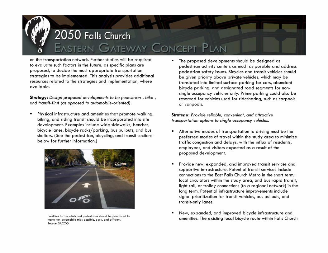
on the transportation network. Further studies will be required to evaluate such factors in the future, as specific plans are proposed, to decide the most appropriate transportation strategies to be implemented. This analysis provides additional resources related to the strategies and implementation, where available. Strategy: Design proposed developments to be pedestrian-, bike-, and transit-first (as opposed to automobile-oriented). Physical infrastructure and amenities that promote walking,
biking, and riding transit should be incorporated into site development. Examples include wide sidewalks, benches, bicycle lanes, bicycle racks/parking, bus pullouts, and bus shelters. (See the pedestrian, bicycling, and transit sections below for further information.)
The proposed developments should be designed as pedestrian activity centers as much as possible and address pedestrian safety issues. Bicycles and transit vehicles should be given priority above private vehicles, which may be translated into limited surface parking for cars, abundant bicycle parking, and designated road segments for non-single occupancy vehicles only. Prime parking could also be reserved for vehicles used for ridesharing, such as carpools or vanpools.
Strategy: Provide reliable, convenient, and attractive transportation options to single occupancy vehicles. Alternative modes of transportation to driving must be the
preferred modes of travel within the study area to minimize traffic congestion and delays, with the influx of residents, employees, and visitors expected as a result of the proposed development.
Provide new, expanded, and improved transit services and
supportive infrastructure. Potential transit services include connections to the East Falls Church Metro in the short term, local circulators within the study area, and bus rapid transit, light rail, or trolley connections (to a regional network) in the long term. Potential infrastructure improvements include signal prioritization for transit vehicles, bus pullouts, and transit-only lanes.
New, expanded, and improved bicycle infrastructure and
amenities. The existing local bicycle route within Falls Church Facilities for bicyclists and pedestrians should be prioritized to make non-automobile trips possible, easy, and efficient. Source: SACOG

could be expanded to connect to the study area. The new pedestrian pathway proposed around the cemetery could be expanded to a multi-purpose trail that also promotes bicycling.
Strategy: Promote travel demand management. A travel demand management (TDM) program for the study
area would involve various components that reduce the demand for transportation during the work week, and thereby minimize work-related traffic and congestion. Potential components of a TDM program include:
• A ridesharing program geared toward those who work
within the study area, providing matches for potential carpools or vanpools from the same origin areas. Ridesharing services could also be extended to Falls Church residents to reach proximate work destinations within the D.C. region. Both targets for ridesharing services would help reduce single occupancy vehicles traveling through the study area during peak periods.
• Carsharing and bikesharing programs, based at East
Falls Church Metro Station or the proposed transit center within the study area.
• A Guaranteed Ride Home Program, where those who
commute by walking, bicycling, taking transit, or ridesharing, at least twice a week may get free rides home (typically with a maximum number per year) in
case of emergencies or unscheduled overtime. This service provides a “safety net” for those who commute regularly using alternative transportation.
• Encouraging teleworking, where employees work
remotely, either at a teleworking center or in their homes. The frequency for teleworking could range from once a week to every day of the work week. The City could work with employers that locate within the study area to promote and implement a teleworking option for employees.
• Encouraging employers located in the study area to
permit employees to have flexible work schedules, where they work outside of traditional office hours (and accordingly decrease traffic during peak periods). Examples of flexible schedules include working five days a week and starting and ending the work day earlier or later than the traditional “9 to 5” schedule; working four days per week at ten hours per day to reach a traditional 40-hour work week; or working nine-hour days for nine consecutive work days and getting one eight-hour day “off” every other week.
• Employer-sponsored incentives to use alternative
transportation such as transit allowances or subsidies, priority parking for carpools and vanpools, or cash payments in lieu of a parking space.

One TDM program could be operated for the entire study area, with a focus on the Falls Church Eastern Gateway as a common destination; the City or a third-party vendor would be responsible for managing the program. Or individual employers could operate their own TDM programs with the City or a third-party vendor providing support.
See the Metropolitan Washington Council of Government’s
Commuter Connections website for more details regarding travel demand management: http://www.mwcog.org/commuter2/commuter/index.html
Strategy: Provide incentives for patrons to use alternative transportation, and for developers to contribute to such improvements. Mentioned above as a possible component of a TDM
program, employers that locate within the study area could provide employees with incentives to use alternative transportation such as transit allowances or subsidies, priority parking for carpools and vanpools, or cash payments in lieu of parking spaces.
Developers could be required or incentivized, through
changes to the City’s zoning code or development approval process, to contribute funding toward local transit services, or install amenities geared toward pedestrians, bicyclists, and transit riders such as showering facilities in all new buildings.
Housing developers could also be required or incentivized to provide transit subsidies to new residents, provide shuttle connections to the Metro, or contribute funding toward local transit services.
Mode-Specific Recommendations Several recommendations related to promoting pedestrian activity, bicycling, and transit use are described below. A few conceptual transit routes to serve the study area are also included. These recommendations are meant to provide a basic guide as development plans move forward at the Falls Church Eastern Gateway. Again, the transportation impacts and appropriate strategies to achieve the goals described previously should be further examined in future studies when detailed site plans are proposed. Pedestrians Creating a pedestrian-friendly environment yields benefits for various alternative transportation modes including bicycling and transit. Adding and improving features such as sidewalks, raised medians, bus stop placement, and pedestrian crossings will improve pedestrian safety and encourage pedestrian activity. Some features, such as medians, can improve safety for all users by enabling pedestrians to cross busy roads in two stages, controlling left-turning traffic, and slowing driver speeds. The pedestrian improvements should be made with connectivity and pedestrian circulation in mind.

With the additional office space added, the Falls Church Eastern Gateway will become a new job center. It will be important that workers be able to move about during lunch, and even spend time shopping and dining after work, without having to get in their cars. Many workers may be using public transportation that goes hand-in-hand with pedestrian design. If the area is designed to be safe, convenient, and pleasant for the pedestrian, then they will be more likely to utilize public transportation. Several overall recommendations were developed for the Falls Church Eastern Gateway, with specific recommendations for Roosevelt Boulevard, Wilson Boulevard, and Route 7/Broad Street as well. All sidewalks should be at a comfortable pedestrian width, at least 6-20 feet or more on streets with
outdoor dining or high-density commercial uses. Sidewalks should include some sort of pedestrian buffer from vehicular traffic. Buffers can include landscaping, storm water management structures, on-street parking, street trees, etc. These sidewalks and any crossings should take into the
needs of persons with disabilities into consideration and meet Americans with Disabilities Act Standards. The streetscape plays an important role in providing a comfortable pedestrian environment, and should be taken into consideration on all roads and pedestrian corridors. Aesthetic improvements can include the presence of landscaping, art, fine detail architecture, and lighting. Lighting also plays a role in pedestrian safety and should be included along all pedestrian corridors. The lighting should follow Falls Church guidelines and add to the aesthetics, not retract from it.1 A specific recommendation for Roosevelt Boulevard is to implement traffic calming by narrowing the street to one lane on either side of the median. On-street parking could be added to the north-bound side of Roosevelt, with a bike route going both ways on the south-bound side of Roosevelt. The bike route would be buffered from the road with a planted median. Narrowing Roosevelt to two lanes would also provide opportunity to implement bus rapid transit, which works best with a dedicated lane, in the future. Wilson Boulevard is currently very unsafe to pedestrians. A recommended improvement is to implement traffic calming by adding a broken up, planted median in places where no turn lane is necessary. Wilson Boulevard is also a candidate for major aesthetic improvement to enhance pedestrian comfort. This could be done by under-grounding power lines, planting street trees, adding a planted median, and adding art, fine detail architecture, and lighting as previously mentioned.
Landscaped medians work to slow traffic down, making the street safer for pedestrians and bicyclists. Source: Project for Public Spaces.

There are no marked crosswalks at the current intersections within the study area. Marked crosswalks, in a contrasting color and texture such as brick pavers or stamped paving, are highly recommended. These clearly delineate the pedestrian realm, and can be engineered to contribute to vehicular traffic calming. Pedestrian signals should be placed at all major intersections, and pedestrian refuge islands should be considered at certain long crossings. Pedestrian crossings should mainly be located at lights, but any that are necessary and cannot be located at lights should use the advance yield crosswalk so that drivers in the second lane can see pedestrians attempting to cross. This type of crosswalk is extremely important at a multi-lane crosswalk that is not at a signalized intersection. Route 7 coming into Falls Church is currently even more of a pedestrian hazard than Wilson Boulevard. A crosswalk and pedestrian signals are recommended improvements to the light at the intersection of North Roosevelt Street. A pedestrian bridge is proposed over Route 7 to facilitate pedestrian movement across the street and connect the Syms site to the rest of the redevelopment area. Large buffers are recommended along the sidewalks on Route 7 to improve pedestrian comfort when walking along this road. These recommendations are in addition to the design elements to improve pedestrian access, safety, and comfort, which have already been incorporated into the proposed overall site design. Since the existing Seven Corners intersection is heavily oriented toward cars (and the authority to redesign this intersection lies with the state), these recommendations seek to minimize pedestrian movement
directly at the Seven Corners intersection and distribute it throughout the redevelopment area. The final recommendation is to develop a pedestrian path around the cemetery that will provide a recreational opportunity and provide better pedestrian connections between North Roosevelt Street and the rest of the Eastern Gateway. It will be important to include lighting and pedestrian amenities such as trash cans along the path to enhance safety and reduce littering. This path could potentially be open to bicyclists as well. Bicycling A separate, comprehensive bicycle plan for Falls Church including connections to the study area would complement the proposed redevelopment of these parcels. In order to accommodate and encourage bicycle commuters, it is recommended that new zoning requirements include mandatory shower facilities in all office buildings. The zoning language should also require bicycle parking in all underground garages and street-level bicycle racks throughout the redevelopment
Crosswalks make pedestrians safer when crossing at intersections or mid-block. More distinct crosswalks, such as this paved one, are more visible to automobile drivers. Source: SACOG

area, encouraging visitors to use this form of transportation to and from the site. In terms of the proposed street grid, a dedicated bicycle lane is recommended only for streets that do not allow on-street parking. Falls Church should work to expand the bicycle network to and from both the West and East Falls Church Metro Stations—along Route 7 and Roosevelt Boulevard—to facilitate easy access to and from the area for both visitors and commuters. Public Transit Figure 4.1 delineates two local circulators designed to serve the major origins and destinations within the study area. Proposed Circulator A would serve the east side of the study area, while Proposed Circulator B would serve the west side; potential bus stops for both circulators are marked in the map. Both transit services would provide a connection between the East Falls Church Metro Station and the redevelopment area via North Sycamore Street, which becomes Roosevelt Boulevard as the services travel south. Proposed Circulator A would travel farther south on Roosevelt Boulevard before turning left on the new street labeled “C” in the map. The shuttle would operate in a counter-clockwise loop around the site with the proposed movie theater and take Roosevelt Boulevard north back to the Metro station. This shuttle would serve the southern portion of the Roosevelt and Wilson Boulevards redevelopment site, as well as the strip of ground level retail/residential mixed use developments
proposed farther north on Roosevelt Boulevard. This circulator would not necessarily need to run in both directions since it is a
Figure 4.1: Proposed Transit Circulator Routes

relatively short in length, and therefore a quick service to operate. From Roosevelt Boulevard, Proposed Circulator B would make a slight right on a new street, labeled “A” in the map, and serve the Roosevelt Boulevard redevelopment site. Then the shuttle would serve the new transit center, and continue toward Route 7/Broad Street, providing access to the Eden Center and Koons redevelopment sites. The service would cross Broad Street (which is ideally improved to facilitate direct access to Hillwood Avenue) and travel on Hillwood Avenue to serve the Syms redevelopment site. Then the shuttle would turn northeast on Roosevelt Street to return to the East Falls Church Metro Station. This circulator could run in both directions simultaneously to provide the most convenient services for commuters traveling from the Metro station to the redevelopment area, as well as residents living in the study area to access the Metro station. To encourage transit ridership, these circulators should run frequently, at least every 15 minutes and ideally every few minutes, and be operated with comfortable and attractive buses. Small shuttle-type vehicles might be used to initiate the services, switching to larger transit buses as needed with increased demand. Some road segments could potentially be designated for alternative transportation modes only, thereby improving the travel time of using alternative transportation including transit services. Faster travel times and significantly reduced congestion on these designated roads would increase the appeal of using transit services, compared to driving. Potential road segments for this designation include the new
road “A” heading toward the transit center from Roosevelt Boulevard and the segment of Hillwood Avenue adjacent to the Syms site. Beyond these two circulator services proposed specifically for the study area, the current GEORGE bus routes could also be extended to serve the redevelopment area and provide connections to the rest of the city. If demand warrants it and higher levels of funding are available, bus rapid transit service could also be implemented along North Sycamore Street/Roosevelt Boulevard, from the East Falls Church Metro Station to Wilson Boulevard and the infamous Seven Corners intersection of major arterials, where the BRT route would ideally connect to regional BRT services along Wilson Boulevard, U.S. Route 50/Arlington Boulevard, and State Route 7/Leesburg Pike/Broad Street. Transit Center A multimodal transportation hub is highly recommended as a central point of access to the study area. Denoted as the Transit Center in the general land use plan and the conceptual transit services map, this transportation hub will promote the use of alternative modes and facilitate inter- and intra-modal transfers. The transit center will not only serve as the hub for the
Arlington County’s Shirlington Station is a transit center that serves their redevelopment area of Shirlington, which does not have Metrorail access. Source: Arlington County
local circulator and city transit routes serve the, but regional transit providers including WMATA, Arlington Transit, and the Fairfax Connector could also serve the Transit Center. With coordinated planning between the transit providers to minimize wait times between local and regional services, the Transit Center could serve as a convenient access point into the redevelopment area and out of it to destinations throughout the D.C. region. The designated location for the Transit Center is in easy walking distance for most of the redevelopment area. The proposed multipurpose path around Oakwood Cemetery would provide connections to the transit center from the existing neighborhoods west of the redevelopment area. The proposed pedestrian walkway connecting the Syms site to the Koons site could lead into the multi-purpose path, and facilitate a connection by foot between the transit center and these two sites. In other parts of the redevelopment area that are several blocks’ walking from the transit center, patrons could utilize the circulators to meet other transit connections at the transit center or access the East Falls Church Metro station. The transit center would also provide bicycle parking and potentially limited parking for ridesharing and transit riders. Given sufficient space, another potential use of the site that is proposed to house the transit center is a welcome center or Vietnamese cultural activity center. A separate building adjacent to the Transit Center could be developed, or the functions and exhibits associated with a tourism-oriented activity center could be incorporated into the transit center building.
This separate function was proposed to accommodate the tourism associated with the current Eden Center. Tour buses could park at the transit center, and visitors could access the redevelopment area by foot (using the numerous pedestrian amenities incorporated into the redevelopment) or the local circulators. The Welcome/Cultural Activity Center could also provide visitors with information to guide them through the Falls Church Eastern Gateway, or house exhibits related to the strong Vietnamese community in Northern Virginia. Summary The significant increase in density and mixed land uses proposed for the Falls Church Eastern Gateway will lead to extensive transportation impacts. This analysis has outlined numerous transportation issues to consider, and proposed several goals and strategies to guide redevelopment within the study area. One of the top transportation priorities must be promoting the use of alternative transportation options to minimize the negative transportation impacts associated with a higher population and density concentrated in one area. A convenient, reliable, and affordable multimodal transportation network must be provided to draw drivers out of their cars, minimize traffic congestion and delays, and minimize air pollution and other environmental damage. A well designed transportation network, taking into account the specific plans and influx of people expected per site, will provide a positive experience for individual users as well as local businesses. Providing a range of good transportation options will help attract new employers and retail establishments, as well as resident and visitors, to the Falls Church Eastern Gateway.

1 For additional resources related to street design and improvement to enhance pedestrian and bicyclist safety, visit links to the National Complete Streets Coalition, the Federal Highway Administration, and the Institute of Transportation Engineers: http://www.completestreets.org/, http://safety.fhwa.dot.gov/ped_bike/docs/00-01156walkablecommunity.pdf, http://www.ite.org/traffic/default.asp

5. Office and Retail Analysis

Office and Retail Analysis Office Analysis Cities across the U.S. have encouraged a mix of land use in redevelopment efforts, and are now thriving economic centers. The City of Falls Church has found that mixed-use development has a positive fiscal impact on city revenues.1 The 2050 Concept Plan for the Falls Church Eastern Gateway area proposes a share of uses of 41 percent office, 26 percent residential, and 31 percent retail. The Eastern Gateway has potential for office development because of proximity to Washington, D.C. Similar mixed-use redevelopments have renewed inner ring suburb into urban village2communities. The objective of this study is to provide a better understanding of the office market in the City of Falls Church, and provide recommendations for the 2050 vision of the Eastern Gateway area. The study takes a look at the local office market for Arlington County, Fairfax County, and Washington, D.C., to evaluate the potential development of office space for the City of Falls Church. Lastly, recommendations from this analysis are made for the 2050 vision for the Eastern Gateway. Context in the Regional Office Market Northern Virginia, specifically areas inside the Capital Beltway, has generally experienced strong demands for office space. Two main areas inside the Beltway with competing interest are
Arlington County and the City of Alexandria. In Arlington County, 31 million square feet of office space has been constructed between 1960 and 20053, largely concentrated in Ballston. Despite the recent economic slowdown, as of early January 2009, 123,059 square feet of office space was under construction4. The asking price for Arlington County is one of the highest in the area, and is still around $30 per square foot for Class A office space; while the vacancy rate is roughly nine percent.5 Alexandria has a much smaller office inventory consisting of roughly 18 million square feet, and a vacancy rate of 7.9 percent.6 Alexandria’s lower vacancy rate may be consistent with a lower asking price of Class B or C office space that characterizes the city. The market for office space is quite strong compared to areas outside the Beltway, which include Tyson’s Corner, Vienna, Herndon, or Reston that are experiencing vacancy rates between 13 to 18 percent.7 The location of City of Falls Church between Ballston and Old Town Alexandria takes advantage of existing industry clusters that are looking to expand. This includes technology, research or consulting firms that have been attracted to Class A office space. Currently, Arlington County has a monopoly over the net office absorption, which is roughly 94 percent of office space inside the Beltway8. This suggests that potential development of office space in the City of Falls Church has a strategic edge.
Office Market Analysis Office Supply The supply of office space is comprised of properties that are vacant for lease or sale in the City of Falls Church. Currently, the City of Falls Church has an estimated vacancy rate of 11 to 15 percent.9 Unemployment in Northern Virginia in the past year (2008 to 2009) has increased by about 13,000 jobs, or about one percent. As of December 10, 2009, nearly 70 separate properties were up for rental or sale in the City of Falls Church.10 A majority of the properties in Falls Church are not Class A Office buildings, but older and smaller properties. Table 1 depicts the 2009 asking rents for Class A and Class B office properties. Office Demand Office Demand is quantified by evaluating several factors that influence the habits of companies. First, competition from nearby businesses impacts is a major factor in determining demand. Also, established local and regional office patterns contribute to demand in Falls Church. Finally, existing and projected expenditures by households and the general economy as a whole determine the demand for various types of businesses. Impact of Nearby Office Centers According to a report by Transwestern Commercial Services, the City of Falls Church/Bailey Crossroads has an inventory of
5,636,357 square feet, with a vacancy rate is 10.7 percent. The total office inventory for Northern Virginia is 151,397,820 square feet, with a vacancy rate of 14.3 percent.11 Compared to Northern Virginia as a whole, the City of Falls Church is performing better, on average, in terms of vacancy rate. The City of Falls Church is surrounded by several strong office centers. Businesses in Falls Church will need to draw activity from residents and areas of the borders of the city. Falls Church has many advantages when compared to other regions, including convenience, safety, parking, and variety of businesses. Rosslyn-Ballston (R-B) Corridor: As of third quarter 2009,
the R-B Corridor had an inventory of 21,994,117 square feet of office space. The direct vacancy rate for this same period is 5.7 percent.12 Since the City of Falls Church is very close to the R-B Corridor, the impact of the corridor on the city’s office market is strong. The R-B Corridor draws businesses and workers from inside the corridor and outside from other regions in Virginia and D.C. However, Falls Church may be able to position itself as an extension of the R-B Corridor.
Alexandria: As of third quarter 2009, Alexandria had an inventory of 8,268,663 square feet of office space. The direct vacancy rate for this same period is 8.5 percent.13 Alexandria office space has a strong impact on Falls Church, since the Alexandria market is close in physical

proximity and offers similar types of office space and uses.
Fairfax County: As of third quarter 2009, Fairfax County had an inventory of 88,097,931 square feet of office space. The direct vacancy rate for this same period is 16.6 percent.14 The impact of Fairfax County is moderate to strong, since Fairfax County is located outside of the Beltway. However, Tysons Corner has a very strong impact on Falls Church, since it is already a large office center that attracts business from Washington, D.C. • Tysons Corner (included in Fairfax County): As of 3rd
Quarter 2009, Tysons Corner had an inventory of 26,160,645 square feet of office space. The direct vacancy rate for this same period is 12.1 percent.15
Washington, D.C. As of third quarter 2009, Washington, D.C. had an inventory of 116,756,501 square feet of office space. The direct vacancy rate for this same period is 10.3 percent.16 Although the market qualities are similar to those of Falls Church, the size of office space ranges from small to large companies. Washington, D.C. has a moderate impact on the City of Falls Church.
Table 5.1 Office Demand by Categories Definition17 2009
Asking Rent CLASS A Class A space can be
characterized as buildings that have excellent location and access, attract high quality tenants, and are managed professionally. Building materials are high quality and rents are competitive with other new buildings
Est. $25-$30/ sq. ft18
CLASS B Class B buildings have good locations, management, and construction, and tenant standards are high. Buildings should have very little functional obsolescence and deterioration
Est. $25.20/ sq. ft (for Northern Virginia as a whole)19
Impact of planned development The 2050 Eastern Gateway Concept Plan creates approximately 2,237,175 square feet of office space. This new, Class A space will encourage growth in the new Eastern Gateway. The overall proposal is revenue neutral, and the city would make money on the proposed development. Since office space contributes revenue, in the form of taxes to the city, the

office space would become an income maker for Falls Church. Furthermore, employees would frequent the retail usages on the first floors of the buildings and be more likely to live in the nearby residences. For more information, please refer to Section 6, Implementation and Impacts. Conclusion and Recommendations Although the economy is in a period of sluggish growth due to global recession, investment in office space in the Seven Corners area of Falls Church will return. Unlike any other region in the United States, the presence of government agencies and contractors means that the contraction in the economy is not as deep as it might have been otherwise. Unemployment and office vacancies in Northern Virginia are average or better than average when compared to the rest of the region. The Northern Virginia region and Falls Church specifically are still strong players in the medium- and long-term time horizons. Location and history of stability are two main selling points for office in Falls Church. The 2050 vision for Falls Church includes an office center that is dynamic, active, and caters to all interests and talents. Falls Church must reinvigorate its work force by attracting new and creative companies to its new office spaces. Marketing campaigns could have a positive impact on the name recognition and image of Falls Church. Eventually, others in the region will see Falls Church as a convenient connection and center point between Ballston and Fairfax County. Additionally, Falls Church will be known for innovation and sustainability,
which are both attractive features for many businesses. New mixed-use office space will encourage activity during all times of the day and will increase the street life. Most of the proposed development consists of office buildings with retail on the first floor, to create an urban village feel in Falls Church. Recommendations for Office Planning and Design Many creative and innovative companies are attracted to Class A building space and LEED Certified office space. The proposed development will take advantage of all the natural features of the land, while employing cutting edge technology to build energy efficient and environmentally sound buildings. Ventilation, building orientation, and natural lighting will influence office building architecture. Additionally, buildings will interact with pedestrians at the street level, to create an inviting and safe atmosphere. Buildings will also be designed so that usable green space is maximized, so that employees have pleasant views from windows and places to take breaks. Retail Analysis As part of this study, an inventory of the retail businesses and offices within a half-mile of Seven Corners (specifically the intersection of Route 7 and Route 50) was conducted. For a better understanding of the market, it is important to note the proximity of other major office and retail centers that compete with Seven Corners. Bailey's Crossroads, featuring a large amount of retail (and several "big box" chains) is approximately two miles to the southeast. The Rosslyn-Ballston Corridor, containing a large amount of both office and retail

space, begins about two miles to the northeast in Ballston and continues another three miles to Rosslyn. Finally, Tysons Corner, with its large concentration of both office and retail space, is approximately five miles to the northwest. Table 5.2 Major Retail Centers in Surrounding Seven Corners
Within a half-mile radius of Seven Corners, the majority of the retail is located in shopping centers along Route 7 and Route 50. These shopping centers serve both the everyday needs of people living in the area as well as many specialty shops. There are three major grocery stores, as well as a number of smaller specialty markets. There are also a number of drug stores, salons, and laundromats. Some of the specialty shops in the area include a home beer brewing shop, a scuba shop, and a guitar store. Eden Center One of the main shopping centers is the Eden Center, located on Wilson Boulevard and at the very heart of the study area. The 197,061 square foot center was originally a standard commercial strip center, but has been adapted to provide space for about 120 businesses. The Eden Center has about 35 shops and restaurants that face the parking lot, with the remainder of the stores located in three interior "mini malls" (Eden Center Mini Mall, Saigon East Mini Mall, and Saigon West Mini Mall). Some of the shops that primarily serve the Vietnamese community are a grocery store, shops selling Vietnamese CDs and DVDs, as well as tax and travel services. Some shops with wider appeal include jewelery stores and salons. The Eden Center also contains 47 bakeries, bistros, cafes, and restaurants serving a variety of Vietnamese cuisine.
Retail Center/Store
Gross Floor Area (Square Feet) Tenants
Eden Center 204,694 Locally owned Vietnamese
The Corner 70,890 Guitar Center, Omaha Steaks, Pearle Vision
Seven Corners Center 569,798
Home Depot, Barnes & Noble, Shoppers Food & Pharmacy, Dogfish Head Ale House
Willston Center I 109,275
CVS/Pharmacy, Edible Arrangements, local shops and restaurants
Willston Center II 127,449
Safeway, BB&T Bank, Dollar City, local shops and restaurants
Target/PetSmart 193,009 Sears 160,843

The Corner Located across Wilson Boulevard from the Eden Center in Fairfax County is a smaller strip center called The Corner. This shopping center includes a gym, a Guitar Center, some small restaurants, and will soon have a Medics USA Primary & Urgent Care. There is also a vacant building that used to house a Bennigan's restaurant. Wilson Boulevard Two very small strip centers are also located on Wilson Boulevard. The Wilson Plaza Shopping Center in Falls Church has another Vietnamese market, a cellular telephone store, a hair salon, a clothing store, and a Chinese restaurant and carry out. Champion's Oriental Shopping Center has an Asian market, Vietnamese restaurant, and a fabric store. There is also a Jiffy Lube on Wilson Boulevard, and a Public Storage and Koon's Auto Center located on Roosevelt Boulevard. Seven Corners Center The second major shopping center is the Seven Corners Center, located between Route 7 and Route 50, with shops facing both roads. This 564,000-square-foot center currently contains 35 businesses. There is a mix of major national chains (Barnes & Noble, Home Depot, and Pizza Hut) as well as regional and local chains and restaurants. Seven Corners Center contains one of the supermarkets in the area, Shoppers Food & Pharmacy. The shopping center also has a number of bargain clothing stores, including Ross Dress for Less, Off Broadway Shoe Warehouse, Dress Barn, and Payless Shoe Source.
Table 5.3 Major Office Buildings Surrounding Seven Corners
Office Building
Gross Floor Area (Square Feet)
Falls Church Corporate Center Tower One 198,409 Falls Church Corporate Center Tower Two 196,262 McIlvaine Building 50,096 The Mark Building 54,930 The Hudson Building 20,000 7 Corners Medical Arts Building 31,620 7 Corners Professional Building 18,000 7 Corners Medical Building 14,080 The Doctor's Building 16,883 Seven Corners Professional Park 42,870
Willston Center The third major shopping center in the area is the Willston Center, located on Route 50. Half of the Willston Center is located within a half-mile of Seven Corners, and the other half is just outside it. Willston Center I, located within a half-mile of Seven Corners, contains 109,275 square feet of retail space with 38 shops and restaurants. Several of the shops and restaurants in Willston Center I primarily serve the local Hispanic population, including Centro Market, Libreria Christiana Eloasis, and the Sanz School. The majority of the

businesses in this center are local, with the only major chains being CVS and Radio Shack. Just outside half a mile from Seven Corners is Willston Center II. This shopping center has 127,449 square feet of retail space, currently housing 36 businesses. Willston Center II contains another of the supermarkets in the area, a Safeway. The majority of the shops in this center are locally operated, with the exception of the fast food restaurants Subway, Domino's Pizza, and Popeye's Chicken and Biscuits. While not part of the Willston Center, two major chain stores located right next to it are a Target and a PetSmart. Other Businesses In addition to the shopping centers, there are a number of businesses located along the major roads, especially Route 7. These include a number of banks, gas stations, and restaurants. The only major chain store located outside of a shopping center on Route 7 is a Sears and Sears Auto Center. Opportunity for High-End Retail A particular focus for the Eastern Gateway’s investment in new retail should be high-end stores. The study area currently has no high-end retail options, nor are any found in the adjacent commercial centers or anywhere in the City of Falls Church. Residents spend money at Tysons Corner Center, in nearby Fairfax County, when they purchase high-end goods. The city should prioritize high-end retail to keep some of money of their residents in the city.
Summary The overall assessment of the current state of retail and office in the study area is that there is a healthy mix of retail, but the office market is lacking. The various shopping centers in the area provide a number of options to rent that could appeal to a wide variety of businesses and restaurants. The office space in the area is aging and other than the Falls Church Corporate Center, is most appropriate for smaller offices that best suit the many medical uses in the area. None of the office space is actually within the City of Falls Church, so a redevelopment of the area that includes premium office space could help set the Falls Church section apart from the surrounding area. 1 City of Falls Church, Interoffice Memorandum: Background regarding Fiscal Impact Analysis of Five Mix Use Development Project in the City of Falls Church. 11/10/2009. 2 City of Falls Church, Comprehensive Plan 2005. 3 2009 Arlington County Profile, published Fall 2009. 4 2009 Arlington County Profile, published Fall 2009. 5 Cassidy & Pinkard Colliers, Market Insights for Northern Virginia Q1 2009. 6 Cassidy & Pinkard Colliers, Market Insights for Northern Virginia Q1 2009. 7 7 Cassidy & Pinkard Colliers, Market Insights for Northern Virginia Q1 2009. 8 Takes an average from a group of Realty Firms. 2009 Annual Arlington Real Estate Review and Forecast. PowerPoint Presentation by Arlington Economic Department. 9 estimated by the Economic Development Department of the City of Falls Church) 10 Available Commercial Space in Falls Church, VA. City of Falls Church, December 10, 2009. 11Cassidy & Pinkard Colliers, Market Insights for Northern Virginia Q3 2009. 12 Transwestern, Transwestern Outlook Northern Virginia Q3:2009 13 Transwestern, Transwestern Outlook Northern Virginia Q3:2009 14 Cassidy & Pinkard Colliers, Market Insights for Northern Virginia Q3 2009. 15 Transwestern, Transwestern Outlook Northern Virginia Q3:2009 16 Cassidy & Pinkard Colliers, Market Insights for Northern Virginia Q3 2009. 17 Urban Land Institute 18 Estimated by the Economic Development Group of the City of Falls Church 19 Cresca Partners, Washington, DC Tenant’s Guide, Q3 2009

6. Implementation and Impacts

Implementation and Impacts Planned, Phase Implementation While market forces will ultimately drive redevelopment in the Eastern Gateway, the City of Falls Church has a great opportunity to provide guidance on long-term improvements to influence the function and character of the next iteration of development. The city can encourage public/private partnerships to foster business investment and help pay for infrastructure improvements. The Eastern Gateway is a prime location for commercial development; the advantages of the location can be maximized by a marketing plan for the area that provides businesses with a package of economic incentives to grow the commercial tax-base. For example, the city can invest in public infrastructure to increase access to the Eastern Gateway, such as improved bus service to and from the East Falls Church Metro station to the Eastern Gateway. Improving the site will help draw developers. Additional ideas regarding site-specific improvements and investments can be developed by city staff, citizens, council members and developers through the city’s planning review process. The plan for the Eastern Gateway must be further developed and refined by city staff to create short- and long-term strategies for attracting quality developers to implement the
vision and uses outlined in Chapter 3. Areawide and site-specific strategies will need to be developed through comprehensive plan language for each parcel to provide land use and density guidance for developers as they prepare plans for each site. The mixed-use zoning overlay district will provide land use controls and facilitate exactions for the city staff and council members to ensure that the development is following established regulations and to ensure that development-related public infrastructure improvements can be funded. The city can work with its zoning ordinance consultants to develop a mixed-use district that requires phased development plans for each plan area. Many of the parcels within the Eastern Gateway contain large swaths of land that are owned by single property owners; the opportunity to uniformly develop these parcels should be encouraged. A phased development plan would particularly benefit the Eden Center, as the property owner will need to carefully contemplate retention and transfer of the unique retailers within the existing development to the new development. Finally, active and meaningful citizen participation should be facilitated to assist staff with the development of the site-specific plan short- and long-term plan implementation strategies, creation of comprehensive plan language, and regulations of the mixed-use zoning district. A stronger sense of civic investment will be created within participants of the planning process by encouraging community participation in the development and implementation of the plan.

Economic and Fiscal Impacts The objective of the fiscal and economic impact analysis is to support to the feasibility of the proposed concept. The overall fiscal analysis depends heavily on the FISCALS model, which the City of Falls Church uses, to provide suggestions and recommendations. The proposed Eastern Gateway plan suggests an FAR of 1.65, which increases the total building floor area by approximately 3,258,278 square feet. Table 6.1 compares the development opportunities for a low, medium, and high FAR. The scenario FARs were chosen based on practices in neighboring counties such as Arlington and Fairfax. Additionally, the analysis factored in the appropriate intensity for communities that want to preserve the character of inner ring suburban communities. Table 6.1: Comparison of Possible FARs to the Proposed FAR
The proposed plan suggests a mixed-use redevelopment broken down between 26 percent residential, 31 percent retail, and 41 percent office use (Table 6.2). A large share of the space is occupied by office uses because the office study identified the Eastern Gateway area as ripe for office development. The site will want to attract high-end tenants to Class A office space. The office study further examines the opportunities of this area to extend the office corridor from Arlington. Table 6.2: Share of Uses (square feet)
Total Residential Total Retail Total Office
1,150.710 1,347,486 1,779,537 26.9% 31.5% 41.6% Based on the proposed FAR and share of uses, the fiscal impact to the City of Falls Church was derived using the city’s own FISCALS model. The results displayed in Table 6.3 show that by increasing the FAR roughly four times the current level will yield a positive annual net fiscal impact to the city of more than$15 million.2 This is an increase of almost eight times the current annual net fiscal impact. This large increase shows massive opportunities to increase revenue from redevelopment of the Eastern Gateway. It also suggests that the opportunity cost of postponing redevelopment is as high as the projected annual net fiscal impact. Although the proposed project suggests
Building Area (square feet)
Land Area ( square feet1) FAR
Current 1,019,455 2,599,918 0.39 Low 2,630,851 2,599,918 1 Proposed 4,277,733 2,599,918 1.65 Medium 5,261,702 2,599,918 2 High 7,892,553 2,599,918 3

doubling the existing residential units, the increase in residential use is revenue neutral for the overall site. Table 6.3: Fiscal Impact
Recommendations and Conclusion The proposed plan identifies the Eastern Gateway as a strategic part of the City of Falls Church. This offers many opportunities for attracting an office market interested in perhaps lower rents than Washington, D.C., or neighboring areas, but needing to be closer the capital than Fairfax, particularly Tysons Corner. The proposed plan also updates the uses from old and vacant strip malls to Class A office, and loft style residential use. This forward looking plan is sure to receive attention from large corporations and young residents. This may require that the FISCALS model also weigh factors to be forward looking as well. A simulation of the hypothetical share of uses reveals that the city may need to revaluate its value given to a property being residential and office. It seems that the city maybe undervaluing the retail properties. In addition, there are many other features included in this plan that will have a positive economic impact on the area, but are not included in the FISCALS model, such as a gateway feature, civic space, proximity to the Metro station and a major highway. Although the city will incur costs from expanding infrastructure, roads improvements, etc., the potential annual net fiscal impact in the long run is a strong argument that these costs will be worth it.
Scenario Building Area (square feet)
FAR Annual Net Fiscal Impact
Current 1,019,455 0.39 $2,260,150
Proposed 4,277,733 1.65 $15,111,513
Change 3,258,278 1.26 $12,851,363