an intertextual analysis of the village novels by village - Open ...
Upload
khangminh22Category
view
0download
0
Prepared forCity of Lincoln
Community Development Department
DRAFT PARTIALLY RECIRCULATED ENVIRONMENTAL IMPACT REPORTSCH No. 2014052071
May 2021
Village 5 & Special Use District B (SUD-B) Specific Plan

VILLAGE 5 & SPECIAL USE DISTRICT B (SUD-B) SPECIFIC PLAN
Draft Partially Recirculated Environmental Impact Report SCH# 2014052071
Prepared for May 2021 City of Lincoln Community Development Department
2600 Capitol Avenue Suite 200 Sacramento, CA 95816 916.564.4500 esassoc.com
Bend
Camarillo
Delray Beach
Destin
Irvine
Los Angeles
Oakland
Orlando
Pasadena
Petaluma
Portland
Sacramento
San Diego
San Francisco
San Jose
Santa Monica
Sarasota
Seattle
Tampa
201800402.01

OUR COMMITMENT TO SUSTAINABILITY | ESA helps a variety of public and private sector clients plan and prepare for climate change and emerging regulations that limit GHG emissions. ESA is a registered assessor with the California Climate Action Registry, a Climate Leader, and founding reporter for the Climate Registry. ESA is also a corporate member of the U.S. Green Building Council and the Business Council on Climate Change (BC3). Internally, ESA has adopted a Sustainability Vision and Policy Statement and a plan to reduce waste and energy within our operations. This document was produced using recycled paper.

Village 5 & Special Use District B (SUD-B) Specific Plan i ESA / 201800402.01
Draft Partially Recirculated Environmental Impact Report May 2021
TABLE OF CONTENTS Village 5 & Special Use District B (SUD-B) Specific Plan Draft Partially Recirculated EIR
Page
Acronyms and Abbreviations ............................................................................................. iv
1. Introduction .................................................................................................................. 1-1 1.1 Background and Purpose of the Draft Partially Recirculated Environmental
Impact Report ....................................................................................................... 1-1 1.2 Content of the Draft Partially Recirculated Environmental Impact Report ............. 1-3 1.3 Project Description ................................................................................................ 1-4 1.4 Availability of the Draft Partially Recirculated Environmental Impact Report ...... 1-14
3. Environmental Setting, Impacts, and Mitigation Measures 3.2 Agriculture and Forestry Resources .................................................................. 3.2-1 3.4 Biological Resources ......................................................................................... 3.4-1 3.15 Transportation and Circulation ......................................................................... 3.15-1
7. Report Preparers .......................................................................................................... 7-1
8. References.................................................................................................................... 8-1
Appendices
Appendix M. Transit
Figures
Figure 3.2-1 USDA Crop Data ................................................................................... 3.2-3 Figure 3.2-2 Farmland Classification ......................................................................... 3.2-6 Figure 3.2-3 Williamson Act Contracts ..................................................................... 3.2-11 Figure 3.4-1 Habitats in the Plan Area ....................................................................... 3.4-5 Figure 3.4-2 Wetland Features ................................................................................ 3.4-12 Figure 3.4-3 CNDDB Occurrences .......................................................................... 3.4-24 Figure 3.4-4 Proposed Mitigation Lands .................................................................. 3.4-54 Figure 3.4-5 PCCP Land Cover Types of the PCCP Reserve Acquisition Areas
and the County Aquatic Resources Program Floodplain Areas ........... 3.4-55 Figure 3.15-1 Study Area and Study Intersections .................................................... 3.15-4 Figure 3.15-2 Existing Roadway Network .................................................................. 3.15-7 Figure 3.15-3A Peak Hour Traffic Volumes and Lane Configurations – Existing
Conditions ........................................................................................... 3.15-9 Figure 3.15-3B Peak Hour Traffic Volumes and Lane Configurations – Existing
Conditions ......................................................................................... 3.15-10

Table of Contents
Page
Village 5 & Special Use District B (SUD-B) Specific Plan ii ESA / 201800402.01
Draft Partially Recirculated Environmental Impact Report May 2021
Figure 3.15-4 Existing & Planned Bicycle Network .................................................. 3.15-21 Figure 3.15-5 Land Use Plan ................................................................................... 3.15-46 Figure 3.15-6 Circulation Plan ................................................................................. 3.15-48 Figure 3.15-7 Mobility Plan ...................................................................................... 3.15-49 Figure 3.15-8A Peak Hour Traffic Volumes and Lane Configurations – Existing Plus
Project Conditions ............................................................................. 3.15-53 Figure 3.15-8B Peak Hour Traffic Volumes and Lane Configurations – Existing Plus
Project Conditions ............................................................................. 3.15-54 Figure 3.15-8C Peak Hour Traffic Volumes and Lane Configurations – Existing Plus
Project Conditions ............................................................................. 3.15-55 Figure 3.15-9 Cumulative Roadway Network........................................................... 3.15-69 Figure 3.15-10A Peak Hour Traffic Volumes and Lane Configurations – Cumulative
No Project Conditions ........................................................................ 3.15-71 Figure 3.15-10B Peak Hour Traffic Volumes and Lane Configurations – Cumulative
No Project Conditions ........................................................................ 3.15-72 Figure 3.15-11A Peak Hour Traffic Volumes and Lane Configurations – Cumulative
(2035) Plus Project Conditions .......................................................... 3.15-73 Figure 3.15-11B Peak Hour Traffic Volumes and Lane Configurations – Cumulative
(2035) Plus Project Conditions .......................................................... 3.15-74 Figure 3.15-11C Peak Hour Traffic Volumes and Lane Configurations – Cumulative
(2035) Plus Project Conditions .......................................................... 3.15-75
Tables
Table 1-1. Village 5 Specific Plan Land Use Summary ............................................. 1-6 Table 1-2. Area A Land Use Summary ...................................................................... 1-8 Table 3.2-1. USDA Crop Data (in acres) ................................................................... 3.2-2 Table 3.2-2. Farmland Acreage – Placer County and Plan Area ............................... 3.2-5 Table 3.4-1. Approximate Acreage of Land Cover Types by Specific Plan Phase .... 3.4-6 Table 3.4-2. Potential Wetlands/Waters of the U.S. in Portions of the Plan Area
that Have Had Formal Wetland Delineations ....................................... 3.4-13 Table 3.4-3. Special-Status Species with Potential to Occur in the Plan Area......... 3.4-16 Table 3.15-1. Level of Service Standards – Intersections ......................................... 3.15-5 Table 3.15-2. Intersection Level of Service Definitions ............................................ 3.15-11 Table 3.15-3. Intersection Operations – Existing Conditions ................................... 3.15-12 Table 3.15-4. Roadway Segment Level of Service Definitions ................................ 3.15-14 Table 3.15-5. Daily Roadway Segment Operations – Existing Conditions .............. 3.15-15 Table 3.15-6. Two-Lane Highway Level of Service Definitions ................................ 3.15-16 Table 3.15-7. Multi-Lane Highway Level of Service Definitions ............................... 3.15-16 Table 3.15-8. Highway Operations – Existing Conditions ........................................ 3.15-17 Table 3.15-9. Freeway Level of Service Definitions ................................................. 3.15-18 Table 3.15-10. Freeway Operations – Existing Conditions ........................................ 3.15-19 Table 3.15-11. Village 5 Specific Plan Land Use Summary ...................................... 3.15-44 Table 3.15-12. Intersection Operations – Existing Plus Project Conditions ............... 3.15-57 Table 3.15-13. Daily Roadway Operations – Existing Plus Project Conditions .......... 3.15-60 Table 3.15-14. Highway Operations – Existing Plus Project Conditions .................... 3.15-60 Table 3.15-15. Freeway Operations – Existing Plus Project Conditions .................... 3.15-61 Table 3.15-16. Intersection Operations – Cumulative Conditions .............................. 3.15-77 Table 3.15-17. Daily Roadway Segment Operations – Cumulative Conditions ......... 3.15-81 Table 3.15-18. Highway Operations – Cumulative Conditions................................... 3.15-82
Table of Contents
Page
Village 5 & Special Use District B (SUD-B) Specific Plan iii ESA / 201800402.01
Draft Partially Recirculated Environmental Impact Report May 2021
Table 3.15-19. Freeway Operations – Cumulative Conditions................................... 3.15-83 Table 3.15-20. City of Lincoln Intersection Operations – Existing Plus Project
Conditions With Mitigation ................................................................. 3.15-88 Table 3.15-21. Village 5 Intersection Operations – Existing Plus Project Conditions
With Mitigation ................................................................................... 3.15-91 Table 3.15-22. County of Placer Intersection Operations – Existing Plus Project
Conditions With Mitigation ................................................................. 3.15-94 Table 3.15-23. Caltrans Intersection Operations – Existing Plus Project Conditions
With Mitigation ................................................................................... 3.15-97 Table 3.15-23A. Freeway Operations – Existing Plus Project Conditions With
Mitigation ........................................................................................... 3.15-98 Table 3.15-24. City of Lincoln Intersection Operations – Cumulative Conditions
With Mitigation ................................................................................. 3.15-107 Table 3.15-25. City of Lincoln Intersection Operations – Cumulative Conditions
With Mitigation ................................................................................. 3.15-110 Table 3.15-26. Village 5 Intersection Operations – Cumulative Conditions With
Mitigation ......................................................................................... 3.15-112 Table 3.15-27. County of Placer Intersection Operations – Cumulative Conditions
With Mitigation ................................................................................. 3.15-114 Table 3.15-28. City of Roseville Intersection Operations – Cumulative Conditions
With Mitigation ................................................................................. 3.15-116 Table 3.15-29. Caltrans Intersection Operations – Cumulative Conditions With
Mitigation ......................................................................................... 3.15-118 Table 3.15-29A. Freeway Operations – Cumulative Plus Project Conditions With
Mitigation ......................................................................................... 3.15-119 Table 3.15-30. Daily Roadway Segment Operations – Cumulative Conditions With
Mitigation ......................................................................................... 3.15-120 Table 3.15-31. Freeway Operations – Cumulative Conditions................................. 3.15-122 Table 3.15-32. Freeway Operations – Cumulative Conditions With Mitigation ........ 3.15-123
Acronyms and Abbreviations
Village 5 & Special Use District B (SUD-B) Specific Plan iv ESA / 201800402.01
Draft Partially Recirculated Environmental Impact Report May 2021
Acronyms and Abbreviations
°C degrees Celsius
°F degrees Fahrenheit
g/m3 micrograms per cubic meter
2050 General Plan EIR
City of Lincoln 2050 General Plan Environmental Impact Report
AB Assembly Bill
AC Advisory Circular
ACI American Concrete Institute
ADA Americans with Disabilities Act
ADT average daily traffic
ADWF Average Dry Weather Flows
AF acre feet
AFY acre feet per year
AISC American Institute of Steel Construction
Alquist-Priolo Act Alquist-Priolo Earthquake Fault Zoning Act
ALUC Airport Land Use Commission
ALUCP airport land use compatibility plan
ALUP Airport Land Use Plan
AMSL above mean sea level
AO Agricultural Overlay
AOA aircraft operations area
APCD Air Pollution Control District
APE area of potential effect
AQMD Air Quality Management District
AQMP Air Quality Management Plan
ARDTP Archaeological Research Design and Treatment Plan
ASCE American Society of Civil Engineers
ATCM Airborne Toxic Control Measure
AWSC All-Way Stop Controlled
Basin Plan Water Quality Control Plan for the Sacramento River Basin and San Joaquin River Basin
BAT Best Available Technology
BFE base flood elevation
Blueprint Preferred Blueprint Scenario for 2050
BMP best management practice
BOE California State Board of Equalization
BP before present
BP Business Professional
BWFS Basin-wide Feasibility Studies

Acronyms and Abbreviations
Village 5 & Special Use District B (SUD-B) Specific Plan v ESA / 201800402.01
Draft Partially Recirculated Environmental Impact Report May 2021
C&D construction and demolition
Cal/OSHA California Division of Occupational Safety and Health
CAL FIRE California Department of Forestry and Fire Protection
CalEEMod California Emissions Estimator Model
Cal/EPA California Environmental Protection Agency
CALGreen California Green Buildings Standards Code
Caltrans California Department of Transportation
Calveno California Vehicle Noise
CAPCOA California Air Pollution Control Officers Association
CARB California Air Resources Board
CARP County Aquatic Resources Program
CBC California Building Code
CC&Rs covenants, conditions, and restrictions
CCAA California Clean Air Act
CCR California Code of Regulations
CCRR Central California Railroad
CDF California Department of Finance
CDF California Department of Forestry
CDFW California Department of Fish and Wildlife
CEC California Energy Commission
CEQA California Environmental Quality Act
CESA California Endangered Species Act
CFD community facilities district
CFR Code of Federal Regulations
cfs cubic feet per second
CH4 methane
CHP California Highway Patrol
CHRIS California Historic Resources Information System
CIP cast-in-place
City City of Lincoln
CIWMA California Integrated Waste Management Act
CIWMB California Integrated Waste Management Board
CMP Congestion Management Program
CNDDB California Natural Diversity Database
CNEL Community Noise Equivalent Level
CNPS California Native Plant Society
CO carbon monoxide
CO2 carbon dioxide
CO2e carbon dioxide equivalent
Cortese List State Hazardous Water and Substances List
CPR cardiopulmonary resuscitation
Acronyms and Abbreviations
Village 5 & Special Use District B (SUD-B) Specific Plan vi ESA / 201800402.01
Draft Partially Recirculated Environmental Impact Report May 2021
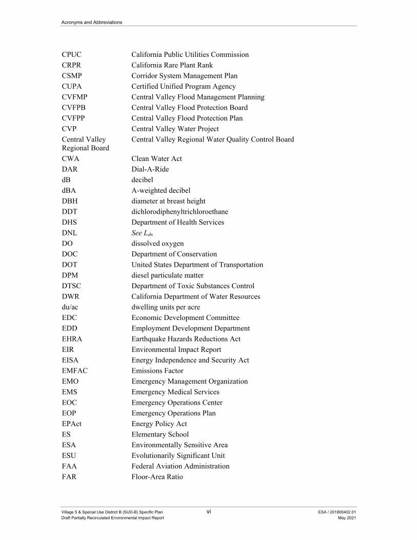
CPUC California Public Utilities Commission
CRPR California Rare Plant Rank
CSMP Corridor System Management Plan
CUPA Certified Unified Program Agency
CVFMP Central Valley Flood Management Planning
CVFPB Central Valley Flood Protection Board
CVFPP Central Valley Flood Protection Plan
CVP Central Valley Water Project
Central Valley Regional Board
Central Valley Regional Water Quality Control Board
CWA Clean Water Act
DAR Dial-A-Ride
dB decibel
dBA A-weighted decibel
DBH diameter at breast height
DDT dichlorodiphenyltrichloroethane
DHS Department of Health Services
DNL See Ldn
DO dissolved oxygen
DOC Department of Conservation
DOT United States Department of Transportation
DPM diesel particulate matter
DTSC Department of Toxic Substances Control
DWR California Department of Water Resources
du/ac dwelling units per acre
EDC Economic Development Committee
EDD Employment Development Department
EHRA Earthquake Hazards Reductions Act
EIR Environmental Impact Report
EISA Energy Independence and Security Act
EMFAC Emissions Factor
EMO Emergency Management Organization
EMS Emergency Medical Services
EOC Emergency Operations Center
EOP Emergency Operations Plan
EPAct Energy Policy Act
ES Elementary School
ESA Environmentally Sensitive Area
ESU Evolutionarily Significant Unit
FAA Federal Aviation Administration
FAR Floor-Area Ratio

Acronyms and Abbreviations
Village 5 & Special Use District B (SUD-B) Specific Plan vii ESA / 201800402.01
Draft Partially Recirculated Environmental Impact Report May 2021
FCAA Federal Clean Air Act
FCAAA Federal Clean Air Act Amendments
Federal Hazmat Law Federal Hazardous Materials Transportation Law
FEMA Federal Emergency Management Agency
FERC Federal Energy Regulatory Commission
FESA Federal Endangered Species Act
FHWA Federal Highway Administration
FIP Federal Implementation Plan
FIRM Flood Insurance Rate Map
FMMP Farmland Mapping and Monitoring Program
FR Federal Register
FTA Federal Transit Administration
FTE Full Time Equivalent
FY fiscal year
GDP General Development Plan
GHG greenhouse gas
GIS geographical information systems
gpd gallons per day
GMP Groundwater Management Plan
gpm gallons per minute
GSA Groundwater Sustainability Agency
GSP Groundwater Sustainability Plan
GVW gross vehicle weight
GWP global warming potential
HABS Historic American Buildings Survey
HAER Historic American Engineering Record
HAP Hazardous Air Pollutant
HCP Habitat Conservation Plan
HCM Highway Capacity Manual
HFC hydroflourocarbon
HOV High Occupancy Vehicle
HRA Health Risk Assessment
HSG Hydrologic Soil Group
HUD Housing and Urban Development
HVAC Heating, Ventilation and Air Conditioning
Hz Hertz
I-80 Interstate 80
IBC International Building Code
IRWMP Integrated Water Resources Management Plan
ISO Independent System Operator
ISO Insurance Services Office
Acronyms and Abbreviations
Village 5 & Special Use District B (SUD-B) Specific Plan viii ESA / 201800402.01
Draft Partially Recirculated Environmental Impact Report May 2021
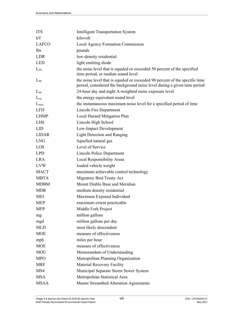
ITS Intelligent Transportation System
kV kilovolt
LAFCO Local Agency Formation Commission
lbs pounds
LDR low-density residential
LED light emitting diode
L50 the noise level that is equaled or exceeded 50 percent of the specified time period, or median sound level
L90 the noise level that is equaled or exceeded 90 percent of the specific time period, considered the background noise level during a given time period
Ldn 24-hour day and night A-weighted noise exposure level
Leq the energy-equivalent sound level
Lmax the instantaneous maximum noise level for a specified period of time
LFD Lincoln Fire Department
LHMP Local Hazard Mitigation Plan
LHS Lincoln High School
LID Low-Impact Development
LIDAR Light Detection and Ranging
LNG liquefied natural gas
LOS Level of Service
LPD Lincoln Police Department
LRA Local Responsibility Areas
LVW loaded vehicle weight
MACT maximum achievable control technology
MBTA Migratory Bird Treaty Act
MDBM Mount Diablo Base and Meridian
MDR medium density residential
MEI Maximum Exposed Individual
MEP maximum extent practicable
MFP Middle Fork Project
mg million gallons
mgd million gallons per day
MLD most likely descendent
MOE measure of effectiveness
mph miles per hour
MOE measure of effectiveness
MOU Memorandum of Understanding
MPO Metropolitan Planning Organization
MRF Material Recovery Facility
MS4 Municipal Separate Storm Sewer System
MSA Metropolitan Statistical Area
MSAA Master Streambed Alteration Agreements
Acronyms and Abbreviations
Village 5 & Special Use District B (SUD-B) Specific Plan ix ESA / 201800402.01
Draft Partially Recirculated Environmental Impact Report May 2021
MSL Mean Sea Level
MSR Municipal Services Review
MT/yr metric tons per year
MTP Metropolitan Transportation Plan
MTP/SCS Metropolitan Transportation Plan/Sustainable Communities Strategy
MU Mixed Use
MUTCD California Manual on Uniform Traffic Control Devices
MW megawatt
MWELO Model Water Efficient Landscape Ordinance
N2O nitrous oxide
NAAQS National Ambient Air Quality Standards
NAHC Native American Heritage Committee
NAL numeric actions level
NAT no action taken
National Register National Register of Historic Places
NCCP Natural Community Conservation Plan
NCIC North Central Information Center
NCMWC Natomas Central Mutual Water Company
NEHRP National Earthquake Hazards Reduction Program
NEHRPA National Earthquake Hazards Reduction Program Act
NEL numeric effluent limitation
NEPA National Environmental Policy Act
NESHAP National Emission Standards for Hazardous Air Pollutant
NEV neighborhood electric vehicle
NFIP National Flood Insurance Program
NHPA National Historic Preservation Act
NID Nevada Irrigation District
NLR noise level reduction
NMFS National Marine Fisheries Service
NOA naturally-occurring asbestos
NOAA National Oceanic and Atmospheric Administration
NO2 Nitrogen Dioxide
NOI Notice of Intent
NOP Notice of Preparation
NOx nitrogen oxide
NPDES National Pollutant Discharge Elimination System
NPDWR National Primary Drinking Water Regulations
NPPA Native Plant Protection Act
NRCS Natural Resources Conservation Service
OC Office/Commercial
OEHHA Office of Environmental Health Hazard Assessment

Acronyms and Abbreviations
Village 5 & Special Use District B (SUD-B) Specific Plan x ESA / 201800402.01
Draft Partially Recirculated Environmental Impact Report May 2021
OES Office of Emergency Services
OHWM Ordinary High Water Mark
OPR California Office of Planning and Research
OSHA Occupational Safety and Health Administration
PCA Placer Conservation Authority
PCAPCD Placer County Air Pollution Control District
PCAQMD Placer County Air Quality Management District
PCBs polychlorinated biphenyls
PCCP Placer County Conservation Plan
PCE primary constituent element
PCDEHS Placer County Department of Environmental Health Services
PCFCWCD Placer County Flood Control and Water Conservation District
PCFD Placer County Fire Department
pcpmpl passenger cars per mile per lane
PCSO Placer County Sheriff’s Office
PCSWMM Placer County Storm Water Management Manual
PCTPA Placer County Transportation Planning Agency
PCWA Placer County Water Agency
PEA Preliminary Environmental Assessment
PFC perfluorocarbon
PFE Public Facilities Element
PG&E Pacific Gas & Electric
PM Particulate Matter
PM10 particulate matter that is 10 microns or less in diameter
PM2.5 particulate matter that is 2.5 microns or less in diameter
POC Point of Connection
Porter-Cologne Act Porter-Cologne Water Quality Control Act of 1969
POU publicly owned utility
PPH persons per household
ppm parts per million
PPV peak particle velocity
PQP Public/Quasi-Public
PQP-ES Elementary School
PQP-HS High School
PQP-MS Middle School
PRC Public Resources Code
PRD Permit Registration Documents
proposed project Village 5 Specific Plan
psi pounds per square inch
PTSF Percent Time Spent Following
PUC Public Utilities Code
Acronyms and Abbreviations
Village 5 & Special Use District B (SUD-B) Specific Plan xi ESA / 201800402.01
Draft Partially Recirculated Environmental Impact Report May 2021
RAA Reserve Acquisition Area
REA Registered Environmental Assessor
REC recognized environmental condition
Reclamation U.S. Bureau of Reclamation
Remels reference energy mean emission levels
Reporting Rule Greenhouse Gas Reporting Rule
RFS Renewable Fuel Standard
RFS1 the original Renewable Fuel Standard program
RHNA Regional Housing Needs Assessment
RHNP Regional Housing Needs Plan
RMS root mean square
ROG reactive organic gases
ROW right of way
RPS Renewable Portfolio Standard
RWA Regional Water Authority
RWQCB Regional Water Quality Board
RWSP Regional Water Supply Project
SACOG Sacramento Area Council of Governments
SB Senate Bill
SCARI Six County Aquatic Resources Inventory
SCS Sustainable Communities Strategy
SDC Seismic Design Category
SDWA Safe Drinking Water Act
SEMS Standardized Emergency Management System
SF6 sulfur hexafluoride
SGM Sustainable Groundwater Management
SIP State Implementation Plan
SLM Sound Level Meter
SLMP-AIO South Lincoln Master Plan: Auburn Ravine, Ingram Slough, and Orchard Creek, Final Report
SMAQMD Sacramento Metropolitan Air Management District
SMARA Surface Mining and Reclamation Act
SO2 Sulfur Dioxide
SOI Sphere of Influence
SPCP Spill Prevention and Control Plan
SPRTA South Placer Regional Transportation Authority
SR State Route
SRA State Responsibility Area
SRRE Source Reduction and Recycling Element
SSSC Side-Street Stop Controlled
SSWD South Sutter Water District
Acronyms and Abbreviations
Village 5 & Special Use District B (SUD-B) Specific Plan xii ESA / 201800402.01
Draft Partially Recirculated Environmental Impact Report May 2021
Standards Secretary of the Interior’s Standards for the Treatment of Historic Properties with Guidelines for Preserving, Rehabilitating, Restoring, and Reconstructing Historic Buildings
SUD Special Use District
SVAB Sacramento Valley Air Basin
SVP Society of Vertebrate Paleontology
SWMP storm water management plan
SWPPP Storm Water Pollution Prevention Plan
SWRCB State Water Resources Control Board
TAC Toxic Air Contaminant
T-BACT Toxics Best Available Control Technology
TDF travel demand forecasting
TDS total dissolved solids
TMDL Total Maximum Daily Load
TPZ Timber Land Production Zone
TSM tentative subdivision map
UAIC United Auburn Indian Community
ULOP Urban Level of Flood Protection
Unified Program Unified Hazardous Waste and Hazardous Materials Management Regulatory Program
USACE United States Army Corps of Engineers
U.S. EPA United States Environmental Protection Agency
USFWS United States Fish and Wildlife Service
USGS United States Geological Survey
USPS United States Postal Service
UV ultraviolet
UWMP Urban Water Management Plan
V5SP Village 5 Specific Plan
VBP Village Business and Professional
VC Village Center
VCE Village Country Estate
VCOMM Village Commercial
VdB Vibration Decibels
VEE Visible Emissions Evaluations
VELB Valley Elderberry Longhorn Beetle
VHDR Village High Density Residential
VLDR Village Low Density Residential
VLP Village Linear Park
VMDR Village Medium Density Residential
VMT vehicle miles traveled
VMU Village Mixed Use
VOC volatile organic compound
Acronyms and Abbreviations
Village 5 & Special Use District B (SUD-B) Specific Plan xiii ESA / 201800402.01
Draft Partially Recirculated Environmental Impact Report May 2021
VO/C Village Office/Commercial
VOSA Village Ag/Preserve
VOSN Village Natural Open Space
VOSP Village Open Space Preserve
VPARK Village Park
VPC vernal pool complex
VRR Village Rural Residential
WDR Waste Discharge Requirement
WPCGMP Western Placer County Groundwater Management Plan
WPUSD Western Placer Unified School District
WPWMA Western Placer Waste Management Authority
WQMP water quality management plan
WRSL Western Regional Sanitary Landfill
WSA Water Supply Assessment
WSEL water surface elevation
WTP Water Treatment Plant
WWTRF Wastewater Treatment and Reclamation Facility

Village 5 & Special Use District B (SUD-B) Specific Plan xiv ESA / 201800402.01
Draft Partially Recirculated Environmental Impact Report May 2021
This page intentionally left blank
Village 5 & Special Use District B (SUD-B) Specific Plan 1-1 ESA / 201800402.01
Draft Partially Recirculated Environmental Impact Report May 2021
CHAPTER 1 Introduction
1.1 Background and Purpose of the Draft Partially Recirculated Environmental Impact Report
Village 5 & Special Use District B (SUD-B) Specific Plan EIR In August 2016, the City of Lincoln (City) published a Draft Environmental Impact Report (DEIR) for the Village 5 & Special Use District B (SUD-B) Specific Plan (V5SP or proposed project), which assessed the potential environmental impact of development and annexation of the 4,775-acre plan area (Plan Area) into the City of Lincoln, pursuant to the Village 5 Specific Plan.
The V5SP would be the primary land use, policy, and regulatory document used to guide the overall development of the Plan Area. It establishes a development framework for land use, mobility, utilities and services, resource protection, and implementation to promote the systematic and orderly development of Village 5. All subsequent development projects and related activities proposed within the Plan Area would be required to be consistent with the V5SP.
Implementation of the V5SP would require annexation to the City of Lincoln of 4,775 acres in unincorporated area of western Placer County, which is situated along the southwest boundary of the City of Lincoln. The V5SP would include the development of approximately 2,290 gross acres of residential uses, 443 acres of commercial uses, 1,558 acres of parks and open space, and 118 acres of public uses.
The Plan Area is contiguous with the existing City boundary along the eastern boundary of the Plan Area. The City of Lincoln would initiate by petition the annexation with the Placer County Local Agency Formation Commission or LAFCO, the responsible agency that would be required to approve the annexation. It is anticipated that the Placer County LAFCO would use this EIR in considering the annexation application. LAFCO’s policies and procedures are discussed in the EIR.
The DEIR was circulated for public review and comment for a period of 45 days that ended on October 11, 2016. The City of Lincoln received 25 comment letters during the comment period on the DEIR for the proposed project. The City of Lincoln certified the Final EIR (FEIR) for the V5SP and approved the V5SP on December 5, 2017. For the purposes of this document, the V5SP EIR, which includes the DEIR and FEIR is collectively referred to as the 2017 EIR.
1. Introduction
Village 5 & Special Use District B (SUD-B) Specific Plan 1-2 ESA / 201800402.01
Draft Partially Recirculated Environmental Impact Report May 2021
Litigation and Writ of Mandate On January 12, 2018, following the City Council’s certification of the 2017 EIR and approval of the V5SP, Scheiber Ranch Properties, LP and Albert Scheiber filed a petition for writ of mandate in the Superior Court of California in the County of Placer, alleging violations of the California Environmental Quality Act (“CEQA”) (Case Number SCV-0040629). The Court issued a Peremptory Writ of Mandate on April 13, 2020, upholding two of the petitioners’ arguments related to mitigation of potentially significant impacts to biological resources and the level of analysis conducted for potential project impacts related to transit. A final Judgment was filed on June 25, 2020.
In its April 13, 2020 ruling, the Court found that Mitigation Measure 3.2-1(a), which requires compliance with the Placer County Conservation Plan (PCCP), for the mitigation of agricultural and biological impacts, improperly deferred the formulation of mitigation, as the PCCP was only in draft form and thus, the final details of the PCCP at the time of certification relating to mitigation requirements and ratios could not be known. The Court also ruled that the 2017 EIR did not provide an adequate discussion or analysis of the Project’s impacts to transit, rendering that portion of the 2017 EIR inadequate as an informational document.
In its June 25, 2020 judgment, the Court reiterated the findings of the ruling, stating that the “EIR improperly deferred mitigation for agricultural impacts and impacts to biological resources, in relying on the draft Placer County Conservation Program (“PCCP”) and that the EIR fails to adequately analyze impacts to transit.” The judgment further reiterated the finding from the ruling that “the alternative mitigation measures required in the event the PCCP is not adopted” (Mitigation Measures 3.2-1(b) and 3.4-2(b)), were determined to be adequate. The ruling directed the City to take corrective actions that “brings [sic] agricultural and biological resource mitigation measures into compliance with CEQA and prepares [sic] an analysis that adequately discusses transit.” The Court found that the “certification of the EIR and the adoption of findings of fact and statement of overriding considerations as they relate specifically to reliance on the PCCP as mitigation and impacts to transit (‘CEQA Approvals’) are severable from the remaining Project approvals.” Thus, the Court directed the City to make appropriate corrections to the EIR but stated that “All other Project approvals were based on portions of the EIR that are not affected by the Court’s decision and no remedial action is required unless compliance with the writ changes or affects the other Project approvals.” The preparation of this Draft Partially Recirculated EIR is the initial step in correcting the deficiencies identified by the Court.
Draft Partially Recirculated EIR In response to the Court’s writ of mandate, the City has chosen to take specific action necessary to bring its consideration of the project into compliance with CEQA. The City has determined that revising the relevant sections of the 2017 EIR to address the inadequacies identified by the Court is the appropriate process for complying with the Court’s ruling.

1. Introduction
Village 5 & Special Use District B (SUD-B) Specific Plan 1-3 ESA / 201800402.01
Draft Partially Recirculated Environmental Impact Report May 2021
This Draft Partially Recirculated EIR (DPREIR) has been prepared pursuant to Section 15234 of the CEQA Guidelines, which only requires additional environmental review of portions of the 2017 EIR found by the Court not to comply with CEQA, consistent with principles of res judicata. The City need not expand the scope of analysis on remand beyond that specified by the Court. Therefore, the DPREIR will only address portions of the 2017 EIR determined to not comply with CEQA, including portions of the chapters on Agriculture and Biological Resources relating to Mitigation Measures 3.2-1(b) and 3.4-2(b) and the transit analysis in Transportation. All other portions of the 2017 EIR and corresponding findings remain valid.
1.2 Content of the Draft Partially Recirculated Environmental Impact Report
The City decertified portions of the Agricultural, Biological Resources and Transportation sections of the 2017 EIR on July 14, 2020 pursuant to Resolution No. 202-122. This action allowed for the preparation and circulation of this DPREIR. This DPREIR has been prepared pursuant to Section 15088.5 of the CEQA Guidelines, which provides guidance for recirculation of an EIR prior to certification. As described above and affirmed in Section 15088.5(c) of the CEQA Guidelines, if the revisions to the DEIR are limited to a few chapters or portions of the EIR, the lead agency need only recirculate the chapters or portions that have been modified. Therefore, the City is only including the following revised sections in this DPREIR:
Section 3.2, Agriculture and Forestry Resources;
Section 3.4, Biological Resources; and
Section 3.15, Transportation and Circulation.
All chapter and section numbering is consistent with the chapter and section numbering outlined in the DEIR (released August 2016), available for review on the City’s website at the following address:
http://www.lincolnca.gov/city-hall/departments-divisions/community-development/planning/environmental-documents
Changes to the 2017 EIR text are identified by double underline for additions and strikeout (strikeout) for deletions.
Chapter 1, “Introduction”: Chapter 1 describes the purpose and organization of the DPREIR.
Chapter 2, “Project Description”: Chapter 2 describes the project location, background, proposed actions by the applicant, lead agency, trustee and responsible agency actions, project characteristics, and project objectives. This chapter also describes project construction and regulatory requirements. No substantive changes to the project description have occurred since publication of the DEIR in 2016 and certification of the FEIR in 2017. For this reason, Chapter 2 is not included in this DPREIR. The full text of Chapter 2 can be reviewed on the City’s website at the link provided above.

1. Introduction
Village 5 & Special Use District B (SUD-B) Specific Plan 1-4 ESA / 201800402.01
Draft Partially Recirculated Environmental Impact Report May 2021
Section 3.2, “Agriculture and Forestry Resources”: This section describes the project’s potential effects on important farmland, agricultural or agriculture-supporting uses and forestry resources.
Section 3.4, “Biological Resources”: This section describes the potential project impacts to protected species and their habitat.
Section 3.15, “Transportation and Circulation”: This section describes the potential impacts to transportation and circulation systems and to users of various modes of transportation.
Chapter 7, “Report Preparers”: This chapters identifies the DPREIR authors and the consultants who provided analysis in support of the DPREIR’s conclusions.
Chapter 8, “References”: This chapter sets forth a comprehensive listing of all sources of information used in the preparation of the DPREIR.
The following chapters and sections are not required to be included in the DPREIR for the reasons described below:
Chapter 4, “Other CEQA Required Considerations”: This chapter provides an analysis of the project’s potential growth-inducing and cumulative impacts. The project’s growth-inducing and cumulative impacts are the same those that were circulated in the 2017 EIR. For this reason, Chapter 4 is not included in this DPREIR. The full text of Chapter 4 can be reviewed on the City’s website at the link provided above.
Chapter 5, “General Plan Consistency”: This chapter provided an analysis of the plan’s consistency with the City’s General Plan. As noted above, the description of the project is not changed from what was described in the 2017 EIR. Therefore, no changes are necessary for this chapter and it is not included in the DPREIR
Chapter 6, “Alternatives”: This chapter describes alternatives to the project, at a level consistent with CEQA requirements. The purpose of the alternatives analysis in an EIR is to describe a range of reasonable alternatives to a project that could mitigate the project’s significant environmental impacts while meeting most project objectives. The discussion of alternatives is the same as that circulated in the 2017 EIR. No new significant impacts have been identified, that were not previously identified in the 2017 EIR. For this reason, Chapter 6 is not included in this DPREIR. The full text of Chapter 6 can be reviewed on the City’s website at the link provided above.
1.3 Project Description The project description for the V5SP is unchanged from the V5SP described in Chapter 2 of the EIR, evaluated in Chapter 3 of the EIR, and approved in December 2017. In summary, the V5SP establishes a development framework for land use, mobility, utilities and services, resource protection, and implementation to promote the systematic and orderly development of the Village 5 Plan Area. Implementation of the V5SP includes amendments to the City of Lincoln’s 2050 General
1. Introduction
Village 5 & Special Use District B (SUD-B) Specific Plan 1-5 ESA / 201800402.01
Draft Partially Recirculated Environmental Impact Report May 2021
Plan to move land uses within the Plan Area from the Village (V) designation to land use designations reflective of the mixed use plan. The City proposes to prezone the Plan Area in accordance with the General Development Plan (GDP), which is a required companion document to the V5SP that would function as the zoning code for the Specific Plan. The GDP establishes the regulations, standards, and guidelines for development, with a much greater level of detail and specificity than is provided in the Specific Plan to ensure that each Area of the V5SP would be developed in a cohesive and well-planned manner. The GDP includes specific direction for Area A, an approximately 799-acre portion of the Plan Area, controlled by the project applicant. The City and project applicant have entered into a development agreement to implement the V5SP, and further development agreements for different portions of the V5SP are anticipated in the future.
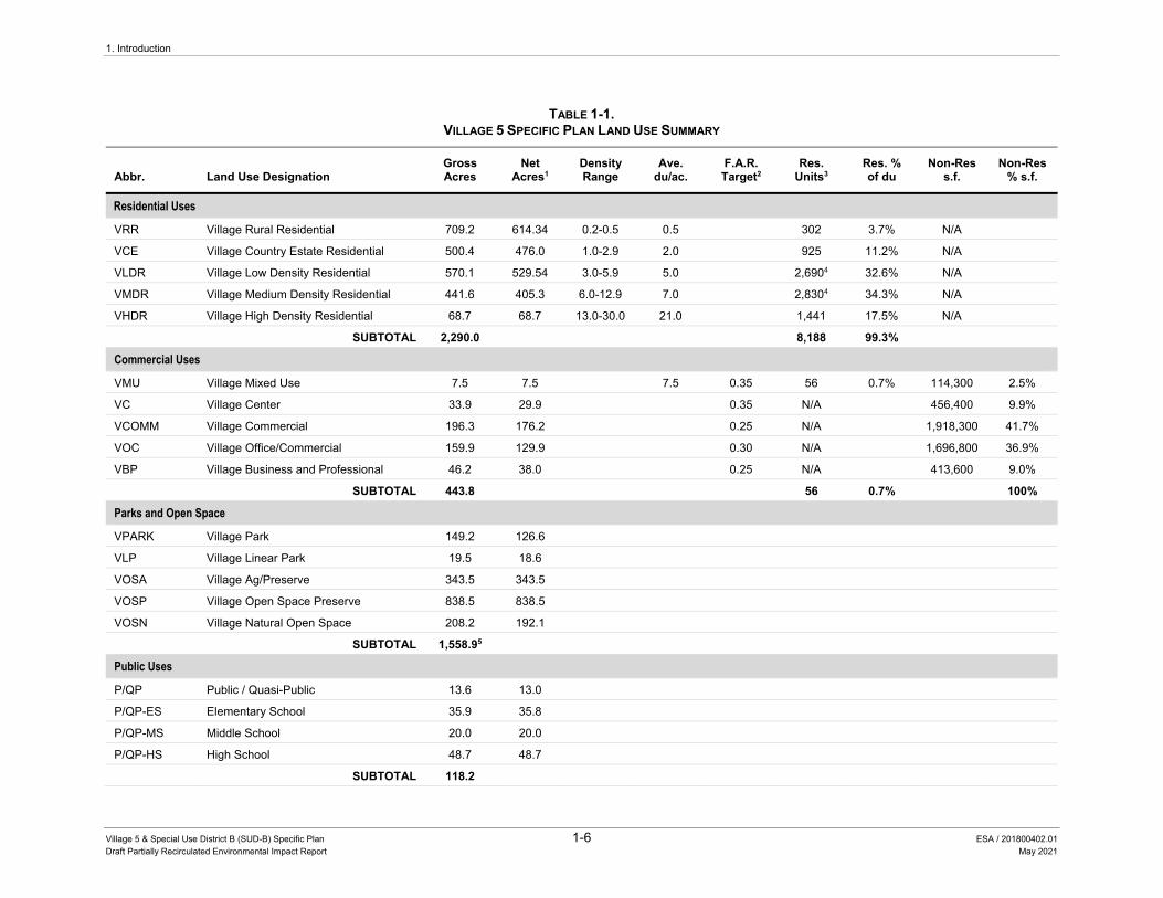
Proposed Land Uses Full Specific Plan
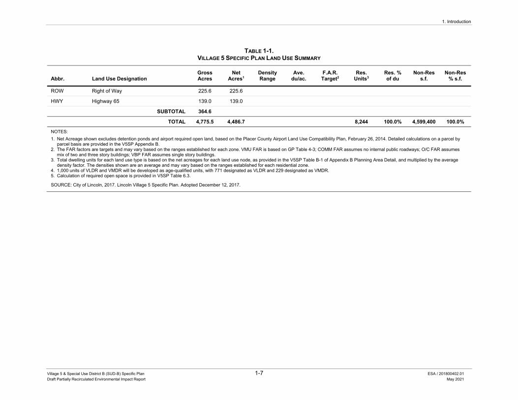
The V5SP allows for the development of the Plan Area with residential and employment-generating uses along with recreational, open space, public and educational land uses. Buildout of the Plan Area is estimated to accommodate development of approximately 8,244 dwelling units (see Table 1-1). Approximately 4.6 million square feet total of employment-generating and commercial land uses are proposed as part of the proposed project.
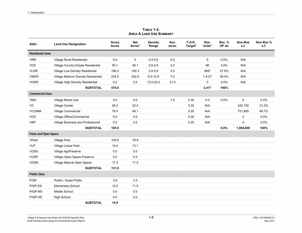
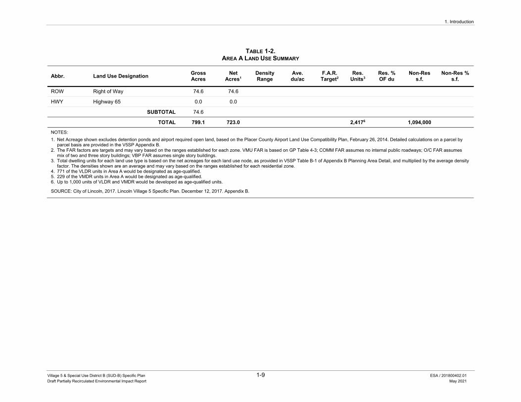
Area A
Area A is an approximately 799-acre area, located in the center of the Plan Area. Area A is expected to be the portion of the Plan Area where development and construction of Village 5 would be initiated. Area A is planned to include a mix of Village Country Estate (VCE), Village Low Density Residential (VLDR), Village Medium Density Residential (VMDR), Village Center (VC), Village Commercial (VCOMM), Village Natural Open Space (VOSN), Village Park (VPark), and Village Linear Park (VLP), Elementary School (ES), Public Quasi-Public (P/QP), and Right of Way (ROW) land uses (see Table 1-2). Area A would accommodate a total of 2,417 dwelling units and 1,094,000 square feet of non-residential uses.
Windsor Cove (Within Area J)
A 90-acre tract within Area J, named Windsor Cove, is also presented in project-level detail for analysis in the EIR, although no GDP or tentative has been approved for the Windsor Cove project. The proposed land use for the tract is a mix of VCE, VLDR and Village Open Space Preserve (VOSP). The northern third of the property would be dedicated to open space, with the inclusion of a lake and some recreational facilities, including proposed parkland and pedestrian trails. The southern two-thirds of the property is proposed as VCE and VLDR development, with development concentrated in the southwestern portion of the property.
1. Introduction
Village 5 & Special Use District B (SUD-B) Specific Plan 1-6 ESA / 201800402.01
Draft Partially Recirculated Environmental Impact Report May 2021
TABLE 1-1. VILLAGE 5 SPECIFIC PLAN LAND USE SUMMARY
Abbr. Land Use Designation Gross Acres
Net Acres1
Density Range
Ave. du/ac.
F.A.R. Target2
Res. Units3
Res. % of du
Non-Res s.f.
Non-Res % s.f.
Residential Uses
VRR Village Rural Residential 709.2 614.34 0.2-0.5 0.5 302 3.7% N/A
VCE Village Country Estate Residential 500.4 476.0 1.0-2.9 2.0 925 11.2% N/A
VLDR Village Low Density Residential 570.1 529.54 3.0-5.9 5.0 2,6904 32.6% N/A
VMDR Village Medium Density Residential 441.6 405.3 6.0-12.9 7.0 2,8304 34.3% N/A
VHDR Village High Density Residential 68.7 68.7 13.0-30.0 21.0 1,441 17.5% N/A
SUBTOTAL 2,290.0 8,188 99.3%
Commercial Uses
VMU Village Mixed Use 7.5 7.5 7.5 0.35 56 0.7% 114,300 2.5%
VC Village Center 33.9 29.9 0.35 N/A 456,400 9.9%
VCOMM Village Commercial 196.3 176.2 0.25 N/A 1,918,300 41.7%
VOC Village Office/Commercial 159.9 129.9 0.30 N/A 1,696,800 36.9%
VBP Village Business and Professional 46.2 38.0 0.25 N/A 413,600 9.0%
SUBTOTAL 443.8 56 0.7% 100%
Parks and Open Space
VPARK Village Park 149.2 126.6
VLP Village Linear Park 19.5 18.6
VOSA Village Ag/Preserve 343.5 343.5
VOSP Village Open Space Preserve 838.5 838.5
VOSN Village Natural Open Space 208.2 192.1
SUBTOTAL 1,558.95
Public Uses
P/QP Public / Quasi-Public 13.6 13.0
P/QP-ES Elementary School 35.9 35.8
P/QP-MS Middle School 20.0 20.0
P/QP-HS High School 48.7 48.7
SUBTOTAL 118.2
1. Introduction
Village 5 & Special Use District B (SUD-B) Specific Plan 1-7 ESA / 201800402.01
Draft Partially Recirculated Environmental Impact Report May 2021
TABLE 1-1. VILLAGE 5 SPECIFIC PLAN LAND USE SUMMARY
Abbr. Land Use Designation Gross Acres
Net Acres1
Density Range
Ave. du/ac.
F.A.R. Target2
Res. Units3
Res. % of du
Non-Res s.f.
Non-Res % s.f.
ROW Right of Way 225.6 225.6
HWY Highway 65 139.0 139.0
SUBTOTAL 364.6
TOTAL 4,775.5 4,486.7 8,244 100.0% 4,599,400 100.0%
NOTES:
1. Net Acreage shown excludes detention ponds and airport required open land, based on the Placer County Airport Land Use Compatibility Plan, February 26, 2014. Detailed calculations on a parcel by parcel basis are provided in the V5SP Appendix B.
2. The FAR factors are targets and may vary based on the ranges established for each zone. VMU FAR is based on GP Table 4-3; COMM FAR assumes no internal public roadways; O/C FAR assumes mix of two and three story buildings; VBP FAR assumes single story buildings.
3. Total dwelling units for each land use type is based on the net acreages for each land use node, as provided in the V5SP Table B-1 of Appendix B Planning Area Detail, and multiplied by the average density factor. The densities shown are an average and may vary based on the ranges established for each residential zone.
4. 1,000 units of VLDR and VMDR will be developed as age-qualified units, with 771 designated as VLDR and 229 designated as VMDR. 5. Calculation of required open space is provided in V5SP Table 6.3.
SOURCE: City of Lincoln, 2017. Lincoln Village 5 Specific Plan. Adopted December 12, 2017.
1. Introduction
Village 5 & Special Use District B (SUD-B) Specific Plan 1-8 ESA / 201800402.01
Draft Partially Recirculated Environmental Impact Report May 2021
TABLE 1-2. AREA A LAND USE SUMMARY
Abbr. Land Use Designation Gross Acres
Net Acres1
Density Range
Ave. du/ac
F.A.R. Target2
Res. Units3
Res. % OF du
Non-Res s.f.
Non-Res % s.f.
Residential Uses
VRR Village Rural Residential 0.0 0 0.2-0.5 0.5 0 0.0% N/A VCE Village Country Estate Residential 50.1 48.1 0.6-2.9 2.0 96 4.0% N/A VLDR Village Low Density Residential 196.2 182.3 3.0-5.9 5.0 9094 37.6% N/A VMDR Village Medium Density Residential 224.5 202.0 6.0-12.9 7.0 1,4125 58.4% N/A VHDR Village High Density Residential 0.0 0.0 13.0-25.0 21.0 0 0.0% N/A SUBTOTAL 470.8 2,417 100%
Commercial Uses
VMU Village Mixed Use 0.0 0.0 7.5 0.35 0.0 0.0% 0 0.0%
VC Village Center 26.4 22.4 0.35 N/A 342,100 31.3%
VCOMM Village Commercial 79.5 69.1 0.25 N/A 751,900 68.7%
VOC Village Office/Commercial 0.0 0.0 0.30 N/A 0 0.0%
VBP Village Business and Professional 0.0 0.0 0.25 N/A 0 0.0%
SUBTOTAL 105.9 0.0% 1,094,000 100%
Parks and Open Space
VPark Village Park 100.6 78.9
VLP Village Linear Park 14.0 13.1
VOSA Village Ag/Preserve 0.0 0.0
VOSP Village Open Space Preserve 0.0 0.0
VOSN Village Natural Open Space 17.3 17.3
SUBTOTAL 131.9
Public Uses
P/QP Public / Quasi-Public 3.9 3.3
P/QP-ES Elementary School 12.0 11.9
P/QP-MS Middle School 0.0 0.0
P/QP-HS High School 0.0 0.0
SUBTOTAL 15.9
1. Introduction
Village 5 & Special Use District B (SUD-B) Specific Plan 1-9 ESA / 201800402.01
Draft Partially Recirculated Environmental Impact Report May 2021
TABLE 1-2. AREA A LAND USE SUMMARY
Abbr. Land Use Designation Gross Acres
Net Acres1
Density Range
Ave. du/ac
F.A.R. Target2
Res. Units3
Res. % OF du
Non-Res s.f.
Non-Res % s.f.
ROW Right of Way 74.6 74.6
HWY Highway 65 0.0 0.0
SUBTOTAL 74.6
TOTAL 799.1 723.0 2,4176 1,094,000
NOTES:
1. Net Acreage shown excludes detention ponds and airport required open land, based on the Placer County Airport Land Use Compatibility Plan, February 26, 2014. Detailed calculations on a parcel by parcel basis are provided in the V5SP Appendix B.
2. The FAR factors are targets and may vary based on the ranges established for each zone. VMU FAR is based on GP Table 4-3; COMM FAR assumes no internal public roadways; O/C FAR assumes mix of two and three story buildings; VBP FAR assumes single story buildings.
3. Total dwelling units for each land use type is based on the net acreages for each land use node, as provided in V5SP Table B-1 of Appendix B Planning Area Detail, and multiplied by the average density factor. The densities shown are an average and may vary based on the ranges established for each residential zone.
4. 771 of the VLDR units in Area A would be designated as age-qualified. 5. 229 of the VMDR units in Area A would be designated as age-qualified. 6. Up to 1,000 units of VLDR and VMDR would be developed as age-qualified units.
SOURCE: City of Lincoln, 2017. Lincoln Village 5 Specific Plan. December 12, 2017. Appendix B.
1. Introduction
Village 5 & Special Use District B (SUD-B) Specific Plan 1-10 ESA / 201800402.01
Draft Partially Recirculated Environmental Impact Report May 2021
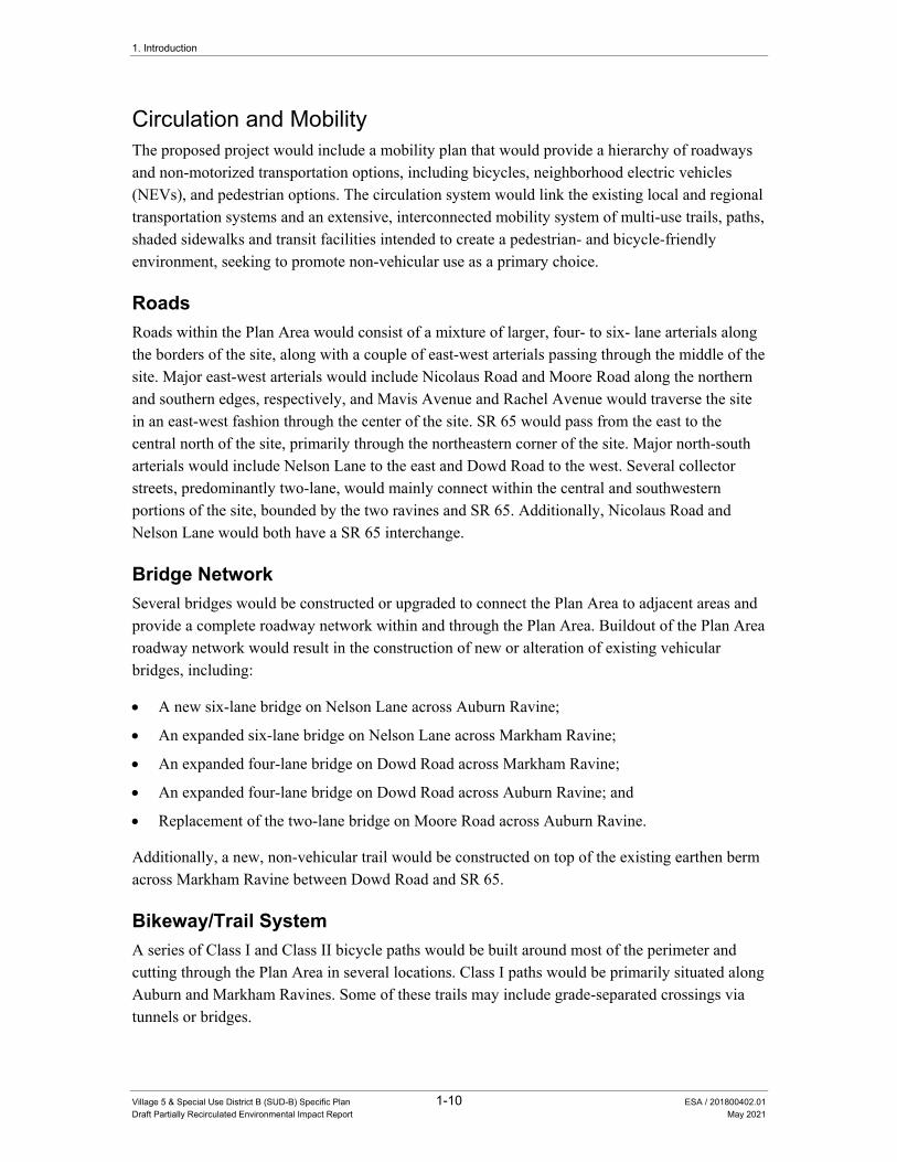
Circulation and Mobility The proposed project would include a mobility plan that would provide a hierarchy of roadways and non-motorized transportation options, including bicycles, neighborhood electric vehicles (NEVs), and pedestrian options. The circulation system would link the existing local and regional transportation systems and an extensive, interconnected mobility system of multi-use trails, paths, shaded sidewalks and transit facilities intended to create a pedestrian- and bicycle-friendly environment, seeking to promote non-vehicular use as a primary choice.
Roads
Roads within the Plan Area would consist of a mixture of larger, four- to six- lane arterials along the borders of the site, along with a couple of east-west arterials passing through the middle of the site. Major east-west arterials would include Nicolaus Road and Moore Road along the northern and southern edges, respectively, and Mavis Avenue and Rachel Avenue would traverse the site in an east-west fashion through the center of the site. SR 65 would pass from the east to the central north of the site, primarily through the northeastern corner of the site. Major north-south arterials would include Nelson Lane to the east and Dowd Road to the west. Several collector streets, predominantly two-lane, would mainly connect within the central and southwestern portions of the site, bounded by the two ravines and SR 65. Additionally, Nicolaus Road and Nelson Lane would both have a SR 65 interchange.
Bridge Network
Several bridges would be constructed or upgraded to connect the Plan Area to adjacent areas and provide a complete roadway network within and through the Plan Area. Buildout of the Plan Area roadway network would result in the construction of new or alteration of existing vehicular bridges, including:
A new six-lane bridge on Nelson Lane across Auburn Ravine;
An expanded six-lane bridge on Nelson Lane across Markham Ravine;
An expanded four-lane bridge on Dowd Road across Markham Ravine;
An expanded four-lane bridge on Dowd Road across Auburn Ravine; and
Replacement of the two-lane bridge on Moore Road across Auburn Ravine.
Additionally, a new, non-vehicular trail would be constructed on top of the existing earthen berm across Markham Ravine between Dowd Road and SR 65.
Bikeway/Trail System
A series of Class I and Class II bicycle paths would be built around most of the perimeter and cutting through the Plan Area in several locations. Class I paths would be primarily situated along Auburn and Markham Ravines. Some of these trails may include grade-separated crossings via tunnels or bridges.

1. Introduction
Village 5 & Special Use District B (SUD-B) Specific Plan 1-11 ESA / 201800402.01
Draft Partially Recirculated Environmental Impact Report May 2021
Pedestrian System
The Plan Area pedestrian system would consist of a variety of off-street and on-street facilities. The on-street facilities would consist of six-foot sidewalks provided on the vast majority of primary roadways and five-foot sidewalks on local neighborhood streets.
Neighborhood Electric Vehicle System
The proposed project would be designed to accommodate NEV travel within the Plan Area. Several four- to six-lane arterials in the Plan Area including Nelson Lane, Nicolaus Road, Mavis Avenue, Fiddyment Road, Dowd Road and Moore Road would feature eight-foot-wide NEV/bike lanes. Further, NEVs are permitted to use the general purpose lanes on two-lane streets.
Transit Connections
The proposed project would include the provision of transit facilities, such as bus stops and park and ride lots, which would be used in the event that the City of Lincoln Transit, Placer County Transit, and/or major regional public transit service providers extend service to the Plan Area. Park and ride lots would likely be suitably located near the planned SR 65/Nelson Lane and SR 65/Nicolaus Road interchanges. Specific bus stop locations would be identified in coordination with the City of Lincoln Transit and Placer County Transit during the tentative mapping process and required pursuant to Conditions of Approval issued consistent with the V5SP.
Public Services Parks and Open Space
The Plan Area would be served by the City of Lincoln Parks Department, and would include one regional park, two community parks, nine neighborhood parks, and numerous open spaces and two linear parks. Specifically, the Plan Area would feature 139.2 net acres of recognized active park areas (71.2 acres in the Regional Sports Park, 35.0 acres in community parks, and 43.0 acres in neighborhood parks).
Open space in the Plan Area is organized into three categories: open space preserve, natural open space and linear parkways. The open space preserve areas have been designed to preserve large, contiguous open space areas, primarily to allow for the preservation of Auburn Ravine and Markham Ravine, wetlands, and other waters, while also providing visual open space for the adjacent community. These spaces would be generally sited to protect areas containing the greatest concentration of wetlands, and the Plan Area would designate these areas to allow for consistency with the PCCP and City open space requirements.
Linear parkways would be developed to interconnect the trail system. The prominent linear parkway (14 ac gross) would connect the Regional Sports Park (17 acres) with the 16-acre Auburn Ravine Community Park. Another linear parkway would be constructed along an existing drainage ditch, serving as both a buffer and trail connector between neighborhoods and school/park sites.

1. Introduction
Village 5 & Special Use District B (SUD-B) Specific Plan 1-12 ESA / 201800402.01
Draft Partially Recirculated Environmental Impact Report May 2021
Schools
The Plan Area would include three elementary schools of approximately 12 acres each, one middle school of approximately 20 acres, and one high school of approximately 49 acres. The elementary school sites would be co-located with neighborhood park sites. All school sites would be linked on the greenway system to maximize pedestrian and bicycle mobility.
Police Protection
There are no police facilities planned as part of the V5SP, but a substation could be located in any one of the commercial zones.
Fire Protection
The project applicant proposes to construct a new fire station facility in the land under the Public/Quasi Public designation with Area A, located on the southwestern corner of Rachel Avenue and Nelson Lane. A second fire station facility could be located on the P/QP site in Area H.
Utilities Water
The water system constructed to serve the Plan Area would implement the City of Lincoln Water System Plan, which serves the purpose of ensuring adequate pressures and delivery to the Plan Area, while maintaining service to the existing City water system. The system would be designed to integrate with existing transmission mains and complete a looped connection through the Plan Area. The system would include a backbone of 18-inch supply mains, located in primary roadways within the Plan Area, with 12-inch supply lines located in other major roadways. The primary connection to the existing City system would extend a 24-inch pipeline into the Plan Area from the proposed point of connection (POC) near the Moore Road/Old Nelson Lane intersection. Another POC would be located in the northeastern corner of the Plan Area at the corner of Nicolaus Road and Nelson Lane.
The proposed project would include two water storage tanks, intended to provide approximately 10 million gallon of water storage.
The proposed project could require up to six wells to accommodate buildout of the V5SP, which would be located in proposed parks throughout the Plan Area.
Reclaimed Water
The V5SP would include a reclaimed water system including dedicated reclaimed water lines located within major backbone roadways, backflow prevention devices and cross-connection controls. The system would provide for the Plan Area’s irrigation needs, including, but not limited to, landscaped medians, separated sidewalk parkway strips for arterials, linear parkways, and parks. The proposed reclaimed water master plan assumes that a 1.8-million-gallon storage capacity would be needed, and would be provided at the WWTRF.
1. Introduction
Village 5 & Special Use District B (SUD-B) Specific Plan 1-13 ESA / 201800402.01
Draft Partially Recirculated Environmental Impact Report May 2021
Wastewater
The City’s existing WWTRF would provide wastewater treatment for the Plan Area. The proposed backbone sewer system would consist primarily of 18-inch or smaller piping with several large diameter trunk mains required to carry the additional offsite flows through the Plan Area. This would include 36-inch, 42-inch, and 54-inch trunk mains on Nelson Lane, and 36-inch trunk mains on Nicolaus Road and Moore Road. The proposed sewer system would cross Auburn Ravine at two locations and would be designed to support gravity flow under the ravine and connection to the existing stub at the WWTRF. The system would also include a pump station, located on the northwest corner of the Nicolaus Road/Dowd Road intersection.
Drainage and Flood Control Improvements
There are two watersheds that form the basis of the drainage plan for the Plan Area: the Auburn Ravine watershed and Markham Ravine watershed. Thirteen drainage subsheds would be located within the Auburn Ravine watershed and 12 subsheds would be located within the Markham Ravine watershed. Drainage improvements proposed for the Plan Area would include a combination of subsurface and surface drainage systems, including new pipe and channel conveyance systems, and culverts and/or pipelines in bridges over waterway crossings. The proposed drainage system also includes 21 on-site detention basins, ranging in size from one to six acres, to attenuate post-project peak flow rates for storms up to the 100-year, 24-hour event.
Electricity
Pacific Gas and Electric Company (PG&E) would provide electricity service to the Plan Area. The proposed project would require the extension of PG&E’s distribution system though the construction of new overhead and underground distribution lines, joint trench facilities, and street lights. An on-site substation would also be required to accommodate the Plan Area growth. This substation would most likely be served from PG&E’s 230kV lines in the vicinity of Rio Oso Substation on Hicks Road, 5.5 miles west of SR 65.
Natural Gas
Natural gas services would be provided to the Plan Area by PG&E. A six-inch transmission main runs west along Nicolaus Road to Teal Hollow Road South, just north of the Plan Area and near Lincoln Regional Airport. This gas distribution system emanates from the existing PG&E mains on the site periphery, and would be sufficient to serve the entire Plan Area.
Telecommunications
The Plan Area is within the service areas of the following companies: Consolidated Communications (formerly SureWest), AT&T, and Wave Broadband. Existing infrastructure would extend distribution lines to individual parcels within the Plan Area as development occurs.
1. Introduction
Village 5 & Special Use District B (SUD-B) Specific Plan 1-14 ESA / 201800402.01
Draft Partially Recirculated Environmental Impact Report May 2021
Electronic Message Center
An electronic message center is included as part of the proposed project. The electronic message center would be located on the site of the Regional Sports Park, situated on the north side of Mavis Avenue and adjacent to Markham Avenue and SR 65. The electronic message center would have one or two screens, oriented to be visible from vehicles traveling on SR 65.
Phasing and Sequencing The phasing/development sequencing plan would provide backbone infrastructure improvements in each phase that would support associated development in compliance with City policies and standards. The proposed project is anticipated to be developed over a 15- to 25-year period. There are 10 planning subareas within the Plan Area, designated as Areas A through J. The first planning subarea to be developed would be Area A due to its proximity to existing infrastructure, access from SR 65 and its centralized location. Windsor Cove may also develop early and concurrent with Area A, but separate project approvals will be required. In order to facilitate initial development phases, Area A is described in full detail in the GDP, the SP, and this document, while the remaining areas (B-J) are discussed with a general level of detail and guidance.
1.4 Availability of the Draft Partially Recirculated Environmental Impact Report
Consistent with the requirements of Section 15087 of the State CEQA Guidelines, this DPREIR is being made available for public review and comment, for a period of 45 days, beginning on May 7, 2021, and concluding on June 21, 2021. During this period, the general public, agencies, and organizations may submit written comments on the DPREIR to the City of Lincoln. Pursuant to procedures set forth in Section 15088.5(f)(2) of the State CEQA Guidelines, reviewers are requested to limit their comments to the materials contained in the DPREIR.
As required under Sections 15087 of the State CEQA Guidelines, the City has sent a notice of availability (NOA) to all those who submitted comments on the 2017 EIR, to all organizations and members of the public who were on the City’s distribution list for the 2017 EIR, and to any additional persons or organizations that have requested information about the EIR since certification of the 2017 EIR.
Copies of this DPREIR are available for review at:
City of Lincoln 600 Sixth Street Lincoln, CA 95648

1. Introduction
Village 5 & Special Use District B (SUD-B) Specific Plan 1-15 ESA / 201800402.01
Draft Partially Recirculated Environmental Impact Report May 2021
All written comments on this DPREIR should be addressed to:
Steve Prosser City of Lincoln Community Development Director 600 Sixth Street Lincoln, CA 95648 [email protected]

1. Introduction
Village 5 & Special Use District B (SUD-B) Specific Plan 1-16 ESA / 201800402.01
Draft Partially Recirculated Environmental Impact Report May 2021
This page intentionally left blank
3.2 Agriculture and Forestry Resources
Village 5 & Special Use District B (SUD-B) Specific Plan 3.2-1 ESA / 201800402.01 Draft Partially Recirculated Environmental Impact Report May 2021
3.2 Agriculture and Forestry Resources This section of the Draft EIR describes the existing agricultural uses in the Plan Area and surrounding area, and evaluates the potential for loss of farmland and other effects on agricultural productivity. This section also evaluates forestry resources in the Plan Area.
Comment letters received in response to the Notice of Preparation (NOP) concern the loss of Important Farmland, conservation of topsoil, and effects on Williamson Act lands. These topics are addressed in this section. Comments received identify concerns regarding the adequacy of buffers or setbacks between existing agricultural uses and proposed future residential development, and effects on the Lincoln High School farm property are addressed in Section 3.11, Land Use.
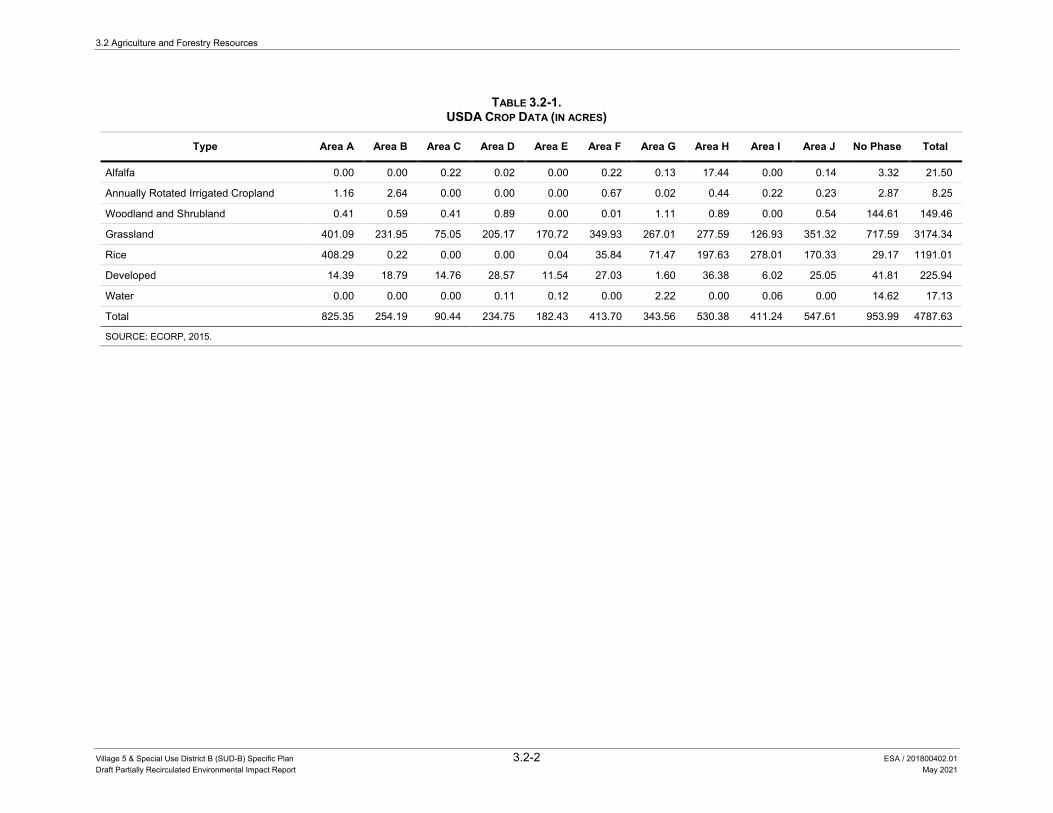
3.2.1 Environmental Setting While agricultural operations have a long history in western Placer County, agriculture is no longer a major part of the City of Lincoln’s economy. Grazing is the primary agricultural activity within the Plan Area. According to USDA data, grassland makes up the majority of the Plan Area, while rice is the main crop as shown in Figure 3.2-1. The list of crops and acreage by phase is shown in Table 3.2-1.
The Lincoln High School Farm is an approximately 280-acre working agricultural education site located on William Lane, west of Dowd Road within the Plan Area. Current agricultural activities at the LHS Farm include hay production, raising cattle and other livestock, a water fowl and wetland habitat, a fruit orchard, cold water aquaculture for raising trout, and a mechanics shop. A portion of the school farm is subject to a conservation easement that covers approximately 100 acres of the site. The conservation easement area serves as mitigation land for habitat of protected species.
An aircraft landing strip easement is located approximately one-half mile east of Dowd Road and extends south from Markham Ravine. The landing strip is primarily used as a dirt roadway for agricultural vehicles. Aircraft using the landing strip are generally small aircraft used for agricultural operations, such as crop dusting. The location of the easement is shown in Figure 3.11-1 in Section 3.11, Land Use, of this EIR.
Farmland Classification The Department of Conservation’s Farmland Mapping and Monitoring Program (FMMP) identifies agricultural land that is lost as well as gained during two-year periods. The farmland monitoring program reports changes in the amounts of different types of farmland based on farmland classifications, which take into consideration soil surveys, availability of water, past and current agricultural practices, and other factors. Agricultural land is quantified based upon acreage and classified as Prime, Farmland of Statewide Importance, Unique Farmland, Farmland of Local
3.2 Agriculture and Forestry Resources
Village 5 & Special Use District B (SUD-B) Specific Plan 3.2-2 ESA / 201800402.01 Draft Partially Recirculated Environmental Impact Report May 2021
TABLE 3.2-1. USDA CROP DATA (IN ACRES)
Type Area A Area B Area C Area D Area E Area F Area G Area H Area I Area J No Phase Total
Alfalfa 0.00 0.00 0.22 0.02 0.00 0.22 0.13 17.44 0.00 0.14 3.32 21.50
Annually Rotated Irrigated Cropland 1.16 2.64 0.00 0.00 0.00 0.67 0.02 0.44 0.22 0.23 2.87 8.25
Woodland and Shrubland 0.41 0.59 0.41 0.89 0.00 0.01 1.11 0.89 0.00 0.54 144.61 149.46
Grassland 401.09 231.95 75.05 205.17 170.72 349.93 267.01 277.59 126.93 351.32 717.59 3174.34
Rice 408.29 0.22 0.00 0.00 0.04 35.84 71.47 197.63 278.01 170.33 29.17 1191.01
Developed 14.39 18.79 14.76 28.57 11.54 27.03 1.60 36.38 6.02 25.05 41.81 225.94
Water 0.00 0.00 0.00 0.11 0.12 0.00 2.22 0.00 0.06 0.00 14.62 17.13
Total 825.35 254.19 90.44 234.75 182.43 413.70 343.56 530.38 411.24 547.61 953.99 4787.63
SOURCE: ECORP, 2015.

LAKE
SIDE
DR
NICOLAUS RD
1ST ST
ABBEYHILL RDCELTIC DR
FLOR ADALE WAY
TC ORIA
IBIS CT
TC YERG
DVLB N
OI TAI VA
MOORE RD
DR TROPRI A
AVOCET WAY
NICOLAUS RD
CHARLENE WAY VENTURE DRFLIGHTLIN
E DR
PRAIRIE WAY
DR NEKTI A
DR D
WO
D N
ROCKWELL LN
DR D
WO
D S
DR TNE
MYDDI F
WILLIAM LN
RD SREB
MAHC
NL KCI REVAM
DR ARI ERREF
NEIGHBOR LN
Area I
Area G
Area B
Area H
Area F Area E
Area C
Area J
Area J
Area A
Area A
Area D
Area D
Area D
Area J
Area JArea J
Map Date: 8/28/2015
Specific PlanUSDA Cropland Data Layer (CDL)
with Phasing
I0 2,000
Sca le i n Fee t2013-051 Lincoln Village 5 Photo Source: NAIP 20141 Cunningham
2 USDA 2012; Types aggregated by ECORP
Loca
tion:
N:\
2013
\201
3-05
1 Li
ncol
n V
illag
e 5\
MA
PS\L
andc
over
\CD
L\SP
A_C
DL2
012_
Land
cove
r_Ph
asin
g_20
1508
26.m
xd (
JDS)
-JSw
ager
8/2
8/20
15
Service Layer Credits: Sources: Esri, HERE, DeLorme, USGS, Intermap, incrementP Corp., NRCAN, Esri Japan, METI, Esri China (Hong Kong), Esri (Thailand),
Map Features
Specific Plan Area 1
Phasing 1
Aggregated Crop Types2
Alfalfa
Annually Rotated Irrigated Cropland
Woodland and Shrubland
Grassland
Rice
Developed
Water
A¤E
LAKE
SIDE
DR
NICOLAUS RD
1ST ST
ABBEYHILL RDCELTIC DR
FLOR ADALE WAY
AIRO
CT
IBIS CT
GREY
CT
AVIA
TIO
N B
LVD
MOORE RD
AIRP
ORT
RD
AVOCET WAY
NICOLAUS RD
CHARLENE WAY VENTURE DRFLIGHTLIN
E DR
PRAIRIE WAY
AITK
EN R
DN
DOW
D RD
ROCKWELL LN
S DO
WD
RD
FIDD
YMEN
T RD
WILLIAM LN
CHAM
BERS
DRM
AVER
ICK
LN
FERR
EIRA
RD
NEIGHBOR LN
Area I
Area G
Area B
Area H
Area F Area E
Area C
Area J
Area J
Area A
Area A
Area D
Area D
Area D
Area J
Area JArea J
Map Date: 8/28/2015
Specific PlanUSDA Cropland Data Layer (CDL)
with Phasing
I0 2,000
Sca le i n Fee t2013-051 Lincoln Village 5 Photo Source: NAIP 20141 Cunningham
2 USDA 2012; Types aggregated by ECORP
Loca
tion:
N:\
2013
\201
3-05
1 Li
ncol
n V
illag
e 5\
MA
PS\L
andc
over
\CD
L\SP
A_C
DL2
012_
Land
cove
r_Ph
asin
g_20
1508
26.m
xd (
JDS)
-JSw
ager
8/2
8/20
15
Service Layer Credits: Sources: Esri, HERE, DeLorme, USGS, Intermap, incrementP Corp., NRCAN, Esri Japan, METI, Esri China (Hong Kong), Esri (Thailand),
Map Features
Specific Plan Area 1
Phasing 1
Aggregated Crop Types2
Alfalfa
Annually Rotated Irrigated Cropland
Woodland and Shrubland
Grassland
Rice
Developed
Water
CDL Aggregated Type Area A Area B Area C Area D Area E Area F Area G Area H Area I Area J No Phase TotalAlfalfa 0.00 0.00 0.22 0.02 0.00 0.22 0.13 17.44 0.00 0.14 3.32 21.50Annually Rotated Irrigated Cropland 1.16 2.64 0.00 0.00 0.00 0.67 0.02 0.44 0.22 0.23 2.87 8.25Woodland and Shrubland 0.41 0.59 0.41 0.89 0.00 0.01 1.11 0.89 0.00 0.54 144.61 149.46Grassland 401.09 231.95 75.05 205.17 170.72 349.93 267.01 277.59 126.93 351.32 717.59 3,174.34Rice 408.29 0.22 0.00 0.00 0.04 35.84 71.47 197.63 278.01 170.33 29.17 1,191.01Developed 14.39 18.79 14.76 28.57 11.54 27.03 1.60 36.38 6.02 25.05 41.81 225.94Water 0.00 0.00 0.00 0.11 0.12 0.00 2.22 0.00 0.06 0.00 14.62 17.13Total 825.35 254.19 90.44 234.75 182.43 413.70 343.56 530.38 411.24 547.61 953.99 4,787.63
CDL Aggregated Land Cover by Phase
CALIFORNIA
65
Lincoln Village 5 EIR . 130368
Figure 3.2-1USDA Crop Data
SOURCE: NAIP 2014; USDA 2012; Types aggregated by ECORP 2015

3.2 Agriculture and Forestry Resources
Village 5 & Special Use District B (SUD-B) Specific Plan 3.2-4 ESA / 201800402.01 Draft Partially Recirculated Environmental Impact Report May 2021
This page intentionally left blank
3.2 Agriculture and Forestry Resources
Village 5 & Special Use District B (SUD-B) Specific Plan 3.2-5 ESA / 201800402.01 Draft Partially Recirculated Environmental Impact Report May 2021
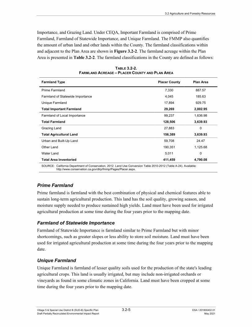
Importance, and Grazing Land. Under CEQA, Important Farmland is comprised of Prime Farmland, Farmland of Statewide Importance, and Unique Farmland. The FMMP also quantifies the amount of urban land and other lands within the County. The farmland classifications within and adjacent to the Plan Area are shown in Figure 3.2-2. The farmland acreage within the Plan Area is presented in Table 3.2-2. The farmland classifications in the County are defined as follows:
TABLE 3.2-2. FARMLAND ACREAGE – PLACER COUNTY AND PLAN AREA
Farmland Type Placer County Plan Area
Prime Farmland 7,330 887.57
Farmland of Statewide Importance 4,045 185.63
Unique Farmland 17,894 929.75
Total Important Farmland 29,269 2,002.95
Farmland of Local Importance 99,237 1,636.98
Total Farmland 128,506 3,639.93
Grazing Land 27,883 0
Total Agricultural Land 156,389 3,639.93
Urban and Built-Up Land 59,708 24.47
Other Land 190,351 1,125.68
Water Land 5,011 0
Total Area Inventoried 411,459 4,790.08
SOURCE: California Department of Conservation, 2012. Land Use Conversion Table 2010-2012 (Table A-24). Available: http://www.conservation.ca.gov/dlrp/fmmp/Pages/Placer.aspx.
Prime Farmland Prime farmland is farmland with the best combination of physical and chemical features able to sustain long-term agricultural production. This land has the soil quality, growing season, and moisture supply needed to produce sustained high yields. Land must have been used for irrigated agricultural production at some time during the four years prior to the mapping date.
Farmland of Statewide Importance Farmland of Statewide Importance is farmland similar to Prime Farmland but with minor shortcomings, such as greater slopes or less ability to store soil moisture. Land must have been used for irrigated agricultural production at some time during the four years prior to the mapping date.
Unique Farmland Unique Farmland is farmland of lesser quality soils used for the production of the state's leading agricultural crops. This land is usually irrigated, but may include non-irrigated orchards or vineyards as found in some climatic zones in California. Land must have been cropped at some time during the four years prior to the mapping date.
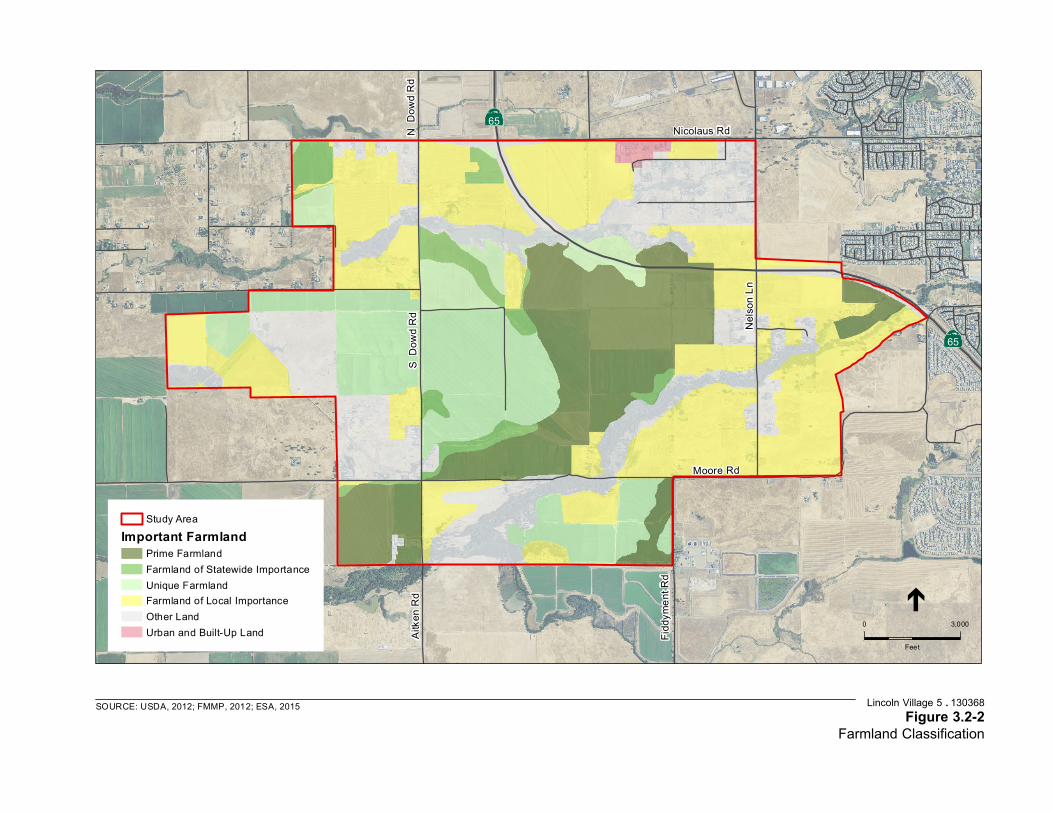
65
65
Nicolaus Rd
S Do
wd R
d
Nels
on Ln
Fidd
ymen
t Rd
Aitk
en R
d
Moore Rd
N D
owd R
d
SOURCE: USDA, 2012; FMMP, 2012; ESA, 2015
0 3,000
Feet
Study AreaImportant Farmland
Prime FarmlandFarmland of Statewide ImportanceUnique FarmlandFarmland of Local ImportanceOther LandUrban and Built-Up Land
Lincoln Village 5 . 130368 Figure 3.2-2
Farmland Classification

3.2 Agriculture and Forestry Resources
Village 5 & Special Use District B (SUD-B) Specific Plan 3.2-7 ESA / 201800402.01 Draft Partially Recirculated Environmental Impact Report May 2021
Farmland of Local Importance Farmland of Local Importance is land that does not otherwise meet the criteria as Prime Farmland, Farmland of Statewide Importance, or Unique Farmland, but is nevertheless understood to be important to the local agricultural economy as determined by each county's board of supervisors and a local advisory committee. Placer County defines Farmland of Local Importance as follows:
Farmlands not covered by the categories of Prime, Statewide, or Unique. They include lands zoned for agriculture by County Ordinance and the California Land Conservation Act as well as dry farmed lands, irrigated pasture lands, and other agricultural lands of significant economic importance to the County and include lands that have a potential for irrigation from Placer County water supplies.
Grazing Land Grazing land does not meet the categories described above, but is land on which the existing vegetation is suited to the grazing of livestock.
Urban and Built-Up Land Urban and built-up land is occupied by structures with a building density of at least one unit to 1.5 acres, or approximately six structures to a 10-acre parcel. This land is used for residential, industrial, commercial, construction, institutional, public administration, railroad and other transportation yards, cemeteries, airports, golf courses, sanitary landfills, sewage treatment, water control structures, and other developed purposes.
Other Land Land designated as Other Land is not included in any other mapping category. Common examples include low density rural developments; brush, timber, wetland, and riparian areas not suitable for livestock grazing; confined livestock, poultry or aquaculture facilities; strip mines, borrow pits; and water bodies smaller than forty acres. Vacant and nonagricultural land surrounded on all sides by urban development and greater than 40 acres is mapped as Other Land.
Water Land designated as Water includes perennial water bodies of at least 40 acres in surface area.
As of 2012, the Department of Conservation reported that Placer County included 156,389 acres of agricultural land, which includes all types of farmland as well as grazing land. This represents 38 percent of all land inventoried (411,459 acres total) in Placer County.
As part of its biannual land inventory, the FMMP inventories the amount of farmland lost and gained. Between 2010 and 2012, the FMMP reported that Placer County lost 4,231 acres of Important Farmland (Prime Farmland, Farmland of Statewide Importance, Unique Farmland, and Farmland of Local Importance). However, with the addition of 3,689 acres of grazing land during that time period, the overall net conversion of agricultural land in Placer County was a loss of 542 acres.
3.2 Agriculture and Forestry Resources
Village 5 & Special Use District B (SUD-B) Specific Plan 3.2-8 ESA / 201800402.01 Draft Partially Recirculated Environmental Impact Report May 2021
Of the 4,790-acre Plan Area, a total of 3,640 acres is classified as farmland. With the County containing 128,506 acres of farmland, the Plan Area represents 2.8 percent of the total farmland within the County. A total of 2,003 acres of the site is designated Important Farmland, including 888 acres of Prime Farmland, 186 acres of Farmland of Statewide Importance, and 930 acres of Unique Farmland. A total of 1,640 acres of the site is Farmland of Local Importance (1,636.98 acres). The site also includes 1,126 acres of Other Land, and 25 acres of Urban and Built-up Land.
Soil Capability Classification Ratings One method for evaluating soil quality for agricultural purposes is the soil capability rating provided by the Natural Resource Conservation Service (NRCS). Capability classes provide insight into the suitability of a soil for field crop uses based on factors that include texture, erosion, wetness, permeability, and fertility. Land capability classification generally shows the suitability of soils for most kinds of field crops. Land capability classes are designated by the numbers 1 through 8. The numbers indicate progressively greater limitations and narrower choices for practical use. Class 1 and 2 soils may only have slight to moderate limitations that restrict their use, while Class 7 and 8 soils have severe limitations that make them unsuitable for cultivation. Class 1 and 2 soils generally support Prime Farmland.
According to the United States Department of Agriculture, Natural Resources Conservation Services, the Plan Area consists of 14 different surface and near-surface soils. See Figure 3.10-2 for a visualization of the soil types in the Plan Area.
Alamo-Fiddyment Complex (104) This map unit consists of approximately 50 percent Alamo soil, 30 percent Fiddyment soil, with the remaining 20 percent composed of a mixture of San Joaquin sandy loam, Comenta sandy loam, and Kaseberg loam. The Alamo soil is poorly drained clay at a moderate depth over a hardpan. This soil does not support Prime Farmland and is identified as Class 4 soil.
Cometa Sandy Loam (140) This map unit consists of approximately 85 percent Cometa soil, 5 percent of Kaseberg soil, 5 percent of Fiddyment soil, 4 percent of San Joaquin soil, and 1 percent of Alamo soil. The Cometa soil is a well-drained soil forming in alluvium deposits that are derived from granite. This soil supports Farmland of Statewide Importance and is identified as Class 3 soil.
Cometa-Fiddyment Complex (141) This map unit consists of approximately 50 percent Alamo soil, 30 percent Fiddyment soil, with the remaining 20 percent composed of a mixture of San Joaquin sandy loam, Comenta sandy loam, and Kaseberg loam. The Alamo soil is poorly drained clay at a moderate depth over hardpan. This soil does not support Prime Farmland and is identified as Class 4 soil.
3.2 Agriculture and Forestry Resources
Village 5 & Special Use District B (SUD-B) Specific Plan 3.2-9 ESA / 201800402.01 Draft Partially Recirculated Environmental Impact Report May 2021
Cometa-Ramona Sandy Loams (142) This map unit consists of about 50 percent Cometa soil and 30 percent Ramona soil with the remainder composed of San Joaquin sandy loam, Fiddyment loam, and Alamo clays. The Ramona soil is a very deep, well-drained soil forming in alluvium from predominantly granitic sources. The Cometa soil is discussed above. This soil supports Farmland of Statewide Importance and is identified as Class 3 soil.
Fiddyment Loam (146) The Fiddyment soil is moderately deep silty and clayey loam over hardpan. The soils above the hardpan tend to be silts and clays to an approximate depth of 28 inches. This soil does not support Prime Farmland and is identified as Class 4 soil.
Fiddyment-Kaseberg Loams (147) This map unit consists of approximately 50 percent Fiddyment soil and 30 percent Kaseberg soil. The Kaseberg soil is a well-drained soil that is shallow over hardpan. Fiddyment soil is discussed above. This soil does not support Prime Farmland and is identified as Class 4 soil.
Kilaga Loam (162) This map unit consists of approximately 80 percent Kilaga soil, 5 percent San Joaquin soil, 5 percent Cometa soil, 5 percent Ramona soil, 4 percent Xerofluvents, and 1 percent unnamed. San Joaquin soil is a well-drained loam. If irrigated, this soil supports Prime Farmland and is identified as Class 2 soil. Nonirrigated land is identified as Class 3 soil.
Ramona Sandy Loam (175) This map unit consists of approximately 80 percent Ramona soil, 10 percent Kilaga soil, 5 percent Cometa soil, 3 percent Xerofluvents, and 2 percent unnamed. Ramona soil is a well-drained sandy loam. If irrigated, this soil supports Prime Farmland and is identified as Class 2 soil. Nonirrigated land is identified as Class 3 soil.
San Joaquin Sandy Loam (181) This map unit consists of approximately 80 percent San Joaquin soil, 10 percent Cometa soil, 5 percent Fiddyment loam, 3 percent unnamed, and 2 percent Alamo soil. San Joaquin soil is a well-drained claypan soil that is moderately deep over hard pan. This soil does not support Prime Farmland and is identified as Class 4 soil.
San Joaquin-Cometa Sandy Loams (182) This map unit consists of approximately 40 percent San Joaquin soil, 30 percent Cometa soil, 10 percent Fiddyment loam, and the remaining 20 percent is composed of Kaseberg loam, Ramona sandy loam, Alamo clay, and Kilaga loam. San Joaquin soil is a well-drained claypan soil that is moderately deep over hard pan. This soil does not support Prime Farmland and is identified as Class 4 soil.
3.2 Agriculture and Forestry Resources
Village 5 & Special Use District B (SUD-B) Specific Plan 3.2-10 ESA / 201800402.01 Draft Partially Recirculated Environmental Impact Report May 2021
Xerofluvents, Occasionally Flooded (193) This map unit consists of small, moderately well-drained loamy sand to fine sandy loam in minor drainage ways and terraces. This is identified as Class 2 soil and supports Prime Farmland if irrigated.
Xerofluvents, Frequently Flooded (194) This map unit consists of small, somewhat poorly drained loamy alluvium in minor drainage ways and terraces. This soil does not support Prime Farmland and is identified as Class 4 soil.
Xerofluvents, Hardpan Substratum (195) This map unit consists of small, fairly poorly drained loamy alluvium in minor drainage ways and terraces. This soil supports Farmland of Statewide Importance and is identified as Class 3 soil.
Water (198) This map unit consists solely of 100 percent water.
Williamson Act Contract Lands The California Land Conservation Act of 1965, also known as the Williamson Act, is codified in Government Code Section 51200 et seq. The Act recognizes the importance of agricultural land, and includes provisions to protect and ensure the orderly conversion of agricultural land. As is described in greater detail below, the Williamson Act allows property owners to enter into contracts with the County through which they commit to not developing the subject property in exchange for a guarantee that the property will be taxed at agricultural values. The contracts run for a 10-year period, and are automatically renewed each year. The contracts may not be cancelled except for a limited number of public purposes and a cancellation fee may apply. The process for exiting the contracts involves non-renewal, which takes place over a nine-year period.
The Plan Area includes 15 parcels (987.08 acres) that are subject to active Williamson Act contracts, as well as 10 parcels (302.27 acres) that have started the non-renewal process. Figure 3.2-3 shows areas of land under active contracts, as well as land in the non-renewal process.
3.2.2 Regulatory Setting Federal There are no federal regulations that pertain to agricultural and forestry resources that are applicable to the proposed project.
State Williamson Act The California Land Conservation Act of 1965 (Government Code Section 51200), also known as the Williamson Act, recognizes the importance of agricultural land as an economic resource. The Williamson Act enables local governments to enter into contracts with private landowners for the

65
65
Nicolaus Rd
S Do
wd R
d
Nels
on Ln
Fidd
ymen
t Rd
Aitk
en R
d
Moore Rd
N Do
wd R
d
SOURCE: USDA, 2012; Placer County, 2016; ESA, 2016
0 3,000
Feet
Study AreaWilliamson Act
Non-RenewalUnder Contract
Lincoln Village 5 . 130368Figure 3.2-3
Williamson Act Contracts

3.2 Agriculture and Forestry Resources
Village 5 & Special Use District B (SUD-B) Specific Plan 3.2-12 ESA / 201800402.01 Draft Partially Recirculated Environmental Impact Report May 2021
purpose of restricting specific parcels of land to agricultural or related open space use. In return, landowners receive property tax assessments which are much lower than normal because they are based upon farming and open space uses as opposed to full market value.
Williamson Act contracts remain in effect for 10 years. Contracts are automatically renewed every 10 years, unless the property owner files for a notice of nonrenewal with the County. The filing of a notice of nonrenewal triggers a nine-year countdown of the contract. When Williamson Act contract lands are annexed to a city, that city succeeds to the administration of the contract, which typically remains in force until it is cancelled or expires.
The Placer County zoning ordinance, Section 17.60 4.150, provides a process by which cancellation of a Williamson Act contract may occur. In order for the County to cancel a contract under its jurisdiction, the following findings must be made:
F. Required Findings. The approval of a cancellation request shall require that the board of supervisors first make all of the findings under one of the following two sets of findings to approve a cancellation request, in compliance with Section 51282 of the Act.
1. The cancellation is consistent with the purposes of the California Land Conservation Act of 1965.
a. A notice of nonrenewal has been served.
b. Cancellation is not likely to result in the removal of adjacent lands from agricultural use.
c. An alternative use is proposed which is consistent with the county general plan.
d. Cancellation will not result in discontinuous patterns of urban development.
e. There is no proximate noncontracted land which is both available and suitable for the proposed alternative use, or, development of the contracted land would provide more contiguous patterns of urban development than development of proximate noncontracted land, which is sufficiently close to the contracted land that it can serve as a practical alternative for the use which is proposed for the contracted land.
2. The cancellation is in the public interest.
a. Other public concerns substantially outweigh the objectives of the California Land Conservation Act of 1965; and
b. Same as subsection (F)(1)(e).
The following provision applies to subsections (1) and (2): the uneconomic character of an existing agricultural use shall not by itself be sufficient reason for cancellation of the contract. The uneconomic character of the existing use may be considered only if there is no other reasonable or comparable agricultural use to which the land may be put.
3.2 Agriculture and Forestry Resources
Village 5 & Special Use District B (SUD-B) Specific Plan 3.2-13 ESA / 201800402.01 Draft Partially Recirculated Environmental Impact Report May 2021
Public Resources Code Section 21060.1 CEQA defines agricultural land as follows:
(a) “Agricultural land” means prime farmland, farmland of statewide importance, or unique farmland, as defined by the United States Department of Agriculture land inventory and monitoring criteria, as modified for California.
(b) In those areas of the state where lands have not been surveyed for the classifications specified by subdivision (a), “agricultural land” means land that meets the requirements of “prime agricultural land” as defined in paragraph (1), (2), (3), or (4) of subdivision (c) of Section 51201 of the Government Code. (Public Resources Code (PRC) Section 21060.1.)
The FMMP was established in 1982 to assess the location, quality, and quantity of agricultural lands and the conversion of these lands. The FMMP provides analysis of agricultural land use and land use changes throughout California.
Public Resources Code/Government Code The California Public Resource and Government Codes defines Forest Land, Timber Land and Timber Land Production Zones as follows:
Forest land (PRC Section 12220, subd. (g) G): Land that can support 10-percent native tree cover of any species, including: hardwoods, under natural conditions, and that allows for management of one or more forest resources, including timber, aesthetics, fish and wildlife, biodiversity, water quality, recreation, and other public benefits.
Timber Land (PRC Section 4526): Land, other than land owned by the Federal government and land designated by the Board as experimental forest land, which is available for, and capable of, growing a crop of trees of any commercial species used to produce lumber and other forest products, including Christmas trees. Commercial species shall be determined by the Board on a District basis after consultation with the District committees and others.
Timber Land Production Zone (Gov. Code, Section 51104, subd. (g) G): Timber Land Production Zone (TPZ) are areas that have been zoned and are devoted to uses for growing and harvesting timber, or for growing and harvesting timber and compatible uses.
Local Placer County LAFCO Local Agency Formation Commissions or LAFCOs review proposals for the formation of new local government agencies and regulate jurisdictional changes of existing agencies. A LAFCO is the entity that evaluates proposals for the creation of cities or special districts, as well as proposals to annex land to local jurisdictions. Each county in California has its own LAFCO. The Plan Area is located within the City's Sphere of Influence (SOI), but because the Plan Area is not within the City limits, annexation is required.

3.2 Agriculture and Forestry Resources
Village 5 & Special Use District B (SUD-B) Specific Plan 3.2-14 ESA / 201800402.01 Draft Partially Recirculated Environmental Impact Report May 2021
Placer County LAFCO is responsible for approval of the proposed annexation for the project, and this EIR will be used by the Placer County LAFCO during its review of the proposed project. Placer County LAFCO has adopted a comprehensive list of guidelines and policies to implement its stated objectives; however, some policies are intended to provide guidance to the Commission and are not directly applicable to actions by local jurisdictions. One of the objectives of Placer County LAFCO includes preservation of agricultural land. The following LAFCO policy relates to agriculture:
2. Preserve Agricultural Land and Open Space Resources
(1) Policy: The Commission encourages all agencies within the County to adopt and exercise development policies that promote orderly development and logical boundaries and protect productive agricultural lands and significant open space areas, including riparian areas.
(2) Policy: Unless the subject area is substantially developed to its ultimate use, annexation to a city or special district will be linked to a proposal to develop and not be speculative in nature. Development plans, including a timetable, will be required as part of the LAFCO application for annexation.
(3) Policy: Generally annexation of farmlands shall not be permitted when significant areas of non-productive farmland are already available. Development of vacant land within a city or district should be developed prior to fringe areas.
City of Lincoln 2050 General Plan The following goals and policies from the 2050 General Plan are relevant to Agricultural resources:
Goal LU-5 To retain rural designations for large parcels of land outside the city limits but within the Planning Area, until annexed to the city.
Policies
LU-5.3 Protect Agriculture. The City shall ensure that agricultural land uses are not prematurely terminated by protecting the continued operation of agricultural land uses.
LU-5.4 Agricultural Buffers. The City shall require that agricultural land uses designated for long-term protection (i.e., in a Williamson Act contract or under a conservation easement) shall be buffered from urban land uses through the use of techniques including, but not limited to, greenbelts, open space setbacks, soundwalls, fencing and berming.
LU-5.5 Agricultural Disclosure. Residential developments locating next to active agricultural areas will have a notice included in the deed notifying buyers of the agricultural use.
Goal OSC-2 To cooperate with Placer County in preserving agricultural operations which are located outside the City’s planning boundaries.
Policies
OSC-2.1 Agricultural Buffers. The City will provide for open space or other appropriate buffers, to protect agricultural operations located adjacent to the City planning boundaries, when reviewing land use plans for such areas.
3.2 Agriculture and Forestry Resources
Village 5 & Special Use District B (SUD-B) Specific Plan 3.2-15 ESA / 201800402.01 Draft Partially Recirculated Environmental Impact Report May 2021
OSC-2.2 Agricultural Disclosures. The City will require that developers of residential projects, which are within general proximity of agricultural operations in the County, provide notification to new homeowners within their deeds, of the County’s right to farm ordinance.
OSC-2.3 Coordinate with Neighboring City/County Agricultural Objectives. The City shall support policies adopted by neighboring cities and Placer County to promote the viability of agriculture in the county.
The relationship of these 2050 General Plan Policies to the V5SP is included in Chapter 5, General Plan Consistency.
Placer County Conservation Plan Process The County is in the process of developing and proposing has developed and adopted the Placer County Conservation Plan Program (PCCP) as a County-proposed strategy to coordinate and streamline the state and federal natural resources regulatory permitting processes. The City of Lincoln is a participating jurisdiction in the proposed PCCP or a Permittee. The proposed PCCP would be is a Habitat Conservation Plan (HCP) pursuant to Section 10 of the Federal Endangered Species Act and a Natural Community Conservation Plan (NCCP) under the California Natural Community Conservation Planning Act. Agricultural lands are considered under the PCCP. For instance, rice is mapped as a community because of its large extent and relationship to historic vernal pool complex lands, as well as its potential for wetland restoration. Orchards and vineyards are considered agricultural lands, but are treated as a separate agricultural community due to their value to Covered Species (e.g., birds).1 It is anticipated that the PCCP will protect 8,240 acres of agricultural lands (compared to the 601 acres currently protected).2 Additional details regarding the PCCP can be found in Section 3.4, Biological Resources, of this Draft EIR.
As proposed, the The PCCP would also includes a County Aquatic Resources Program (CARP) to streamline the issuance of permits related to Section 404 of the Federal Clean Water Act and the Streambed Alteration Agreements pursuant to the California Fish and Game Code. The proposed PCCP would be is a landscape-level plan that would will facilitate the issuance of project-level permits based on how the project contributes to the County’s natural, social, and economic conditions. At the time of this the Draft EIR, a public draft of the proposed PCCP had not been released. Prior to a future adoption of the PCCP environmental documents pursuant to CEQA and NEPA would be circulated and completed. Since then, the County, City, and other permittee agencies have circulated a draft PCCP and an EIR/EIS (SCH# 2005032050) for public review and input. In the summer/fall of 2020, the County, City and other agencies all certified the Final EIR/FEIS and adopted the PCCP. The Final EIR/EIS for the PCCP can be accessed on the Placer County website at https://www.placer.ca.gov/3362/Placer-County-Conservation-Program. Upon completion of those processes, the PCCP would require adoption or approval by the County, the The US Fish and Wildlife Service (USFWS), the National Marine Fisheries Service (NMFS)/National Oceanic and Atmospheric Administration (NOAA), the California Department
1 Placer County. Placer County Conservation Program, 2020. Western Placer County Habitat Conservation Plan/
Natural Communities Conservation Plan. February 2020. Pp. 1-11, 2-62, 2-71, 3-30, 3-59, 3-107, 4-26, 4-54. Etc. Available: https://www.placer.ca.gov/3362/Placer-County-Conservation-Program. Accessed January 20, 2021.
2 Placer County Conservation Program, Executive Summary, p. 18. September 2018.
3.2 Agriculture and Forestry Resources
Village 5 & Special Use District B (SUD-B) Specific Plan 3.2-16 ESA / 201800402.01 Draft Partially Recirculated Environmental Impact Report May 2021
of Fish and Wildlife, (CDFW), and, potentially, the US Army Corps of Engineers (ACE) have all approved the PCCP. It is anticipated that pursuant to the PCCP, the USFWS, NMFS, and CDFW will issue incidental take permits (ITPs) based on the PCCP with a term of 50 years. Similarly, pursuant to the CARP (a component of the PCCP), permitting under the Clean Water Act section 404 and 401 will be streamlined with programmatic 404 and 401 permits issued by the ACE and CVWQCB, respectively.
3.2.3 Analysis, Impacts, and Mitigation Significance Criteria The significance criteria for this analysis were developed from criteria presented in Appendix G, “Environmental Checklist Form,” of the CEQA Guidelines and based on the professional judgment of the City of Lincoln and its consultants. The proposed project would result in a significant impact if it would:
• Result in the conversion of Important Farmland to non-agricultural use;
• Conflict with a Williamson Act contract;
• Convert forest land to non-forest use;
• Conflict with zoning for forest land or timberland; or
• Indirectly result in the conversion of farmland to non-agricultural use.
Methodology and Assumptions Important Farmland is defined under CEQA as “prime farmland, farmland of statewide importance, or unique farmland, as defined by the United States Department of Agriculture land inventory and monitoring criteria, as modified for California” (PRC Section 21060.1). Therefore, loss or conversion of these lands would be a loss of Important Farmland and result in a significant effect under CEQA. The FMMP was compared with project maps to determine the types of farmland that could be affected by the proposed project. Figure 3.2-2 shows the FMMP classifications present on the Plan Area.
Impacts Not Analyzed Further in This EIR • Convert forest land to non-forest use. The Plan Area does not include any land that meets the
criteria for forest land or land zoned as timberland. Therefore, project implementation would not convert forest land to non-forest use and this issue is not evaluated further in this EIR.
• Conflict with zoning for forest land or timberland. The Plan Area does not include any land, and is not adjacent to any land, that is zoned as forest land or timberland or that meets the criteria for forest land or timberland. Therefore, project implementation would not conflict with zoning for forest land or timberland and this issue is not evaluated further in this EIR.

3.2 Agriculture and Forestry Resources
Village 5 & Special Use District B (SUD-B) Specific Plan 3.2-17 ESA / 201800402.01 Draft Partially Recirculated Environmental Impact Report May 2021
Impacts and Mitigation Measures Impact 3.2-1: Implementation of the proposed project would result in conversion of Important Farmland to non-agricultural use.
Full Specific Plan Not all areas classified as Important Farmland are currently farmed in the Plan Area. Likewise, agricultural operations within the Plan Area occur on soils that are not formally designated as Important Farmland. Other areas of the Plan Area that could be used for agricultural production are not being farmed and sit fallow.
As discussed above, the Plan Area includes 887.57 acres of Prime Farmland, 185.63 acres of Farmland of Statewide Importance, and 929.75 acres of Unique Farmland. Together, these three categories comprise 2,002.95 acres of Important Farmland. The proposed project would convert approximately 1,927.34 acres of Important Farmland to non-agricultural use. The 75.61 acres of Important Farmland that would not be converted to non-agricultural use is within the 345-acre Area G. Area G includes the 280-acre Lincoln High School Farm and surrounding agricultural farmland, and would remain as an agricultural and wetland preserve.
As discussed in the proposed V5SP, an Agricultural Overlay (AO) District would be established within the Plan Area. The only land use designations within the Plan Area that would not be subject to the AO would be the VOSN and VOSP open space designations located along Auburn and Markham ravines. The AO District would be established to respect and allow the continuation of agricultural uses that were in existence prior to adoption the Specific Plan. The AO District would establish regulations to guide agricultural-related activities for the interim period until urban development begins in accordance with the adopted Specific Plan. The transition of the Plan Area would be a gradual process and it is the intent of the AO District to allow for the continuation of agriculture and agricultural support uses on an interim basis. The AO District is further intended to protect continued agricultural activity by limiting land uses to those uses that are compatible and supportive of agriculture and related uses and/or agricultural by-products. Uses that would be permitted within the AO District include: one single-family residence and accessory buildings; agricultural crops and open field grazing; livestock, poultry and small animals pursuant to separation standards contained in the General Development Plan (GDP); greenhouses, when incidental to agricultural uses on premises; marketing of products on the premises; agribusiness; pasturing and grazing; and, public stables and riding academies (with restrictions). Conditionally permitted uses would include: churches; country clubs and golf courses; kennels; and, animal hospitals or clinics.
While the proposed project would permanently preserve some farmland within the Plan Area, and the AO District would allow for the continued use for agricultural purposes of all of the land within the Plan Area until it is developed for urban uses, there would still be a net permanent loss over the course of Plan Area build out of 1,927.34 acres of Important Farmland. Therefore, implementation of the full V5SP would result in a potentially significant impact.

3.2 Agriculture and Forestry Resources
Village 5 & Special Use District B (SUD-B) Specific Plan 3.2-18 ESA / 201800402.01 Draft Partially Recirculated Environmental Impact Report May 2021
Area A Area A is located in the center of the Plan Area and would be the first area to be developed. Proposed land uses in Area A would include commercial, residential, an elementary school, open space and parks. Within Area A, there are 511.30 acres of Prime Farmland, 35.99 acres of Farmland of Statewide Importance, and 120.61 acres of Unique Farmland. Much of the land is in rice production, which provides wildlife habitat. Overall, 667.90 acres of Important Farmland would be converted to non-farmland use within Area A.
Development of Area A would result in the irreversible conversion of Important Farmland to non-agricultural use. Therefore, the impact would be potentially significant.
Mitigation Measures
According to the Working Draft PCCP, agricultural land is best served by large, contiguous blocks of land that can minimize edge effects from surrounding urbanization.3 Preservation of large tracts of land that are used for active agricultural production can also provide biological habitat for sensitive species. Impacts to agricultural land and biological resources can be concurrently addressed by designating large areas for preservation. This strategy would mitigate for irreversible land conversion through permanent preservation of large tracts of land with similar land cover, habitat, soil types, agricultural productivity, and agricultural value. The PCCP calls for the preservation of 8,240 acres, in addition to the existing 601 acres, of agricultural land Land within the Reserve Acquisition Areas identified in the Working Draft PCCP would to be preserved in perpetuity and would to serve as mitigation for agricultural resources and farmland and associated biological resources on agricultural land. This approach, articulated below under Mitigation Measures 3.2-1(a) and 3.2-1(b), would be compatible with the overall preservation strategy included in the adopted Working Draft PCCP.
Mitigation Measure 3.2-1(a) (Full Specific Plan, Area A, Windsor Cove)
a) If the PCCP has been approved and adopted, the The project applicant shall comply with the PCCP to mitigate impacts of converting Prime Farmland, Farmland of Statewide Importance, or Unique Farmland agricultural lands., most specifically rice lands. Mitigation achieved through implementation of the PCCP shall be equal to or greater than the mitigation ratios and requirements described in subsection (b), below.
b) The project applicant shall implement Mitigation Measures 3.4-1(b) and 3.4-2(b) in Section 3.4, Biological Resources, of this Draft EIR, shown below.
3 Placer County, 2016 2018. Placer County Conservation Program Plan. Working Draft, March 2016. Executive
Summary, September 2018. At the time of this Draft EIR, the PCCP has not been adopted and no public draft is currently available.

3.2 Agriculture and Forestry Resources
Village 5 & Special Use District B (SUD-B) Specific Plan 3.2-19 ESA / 201800402.01 Draft Partially Recirculated Environmental Impact Report May 2021
Mitigation Measure 3.4-1 (Full Specific Plan, Area A, and Windsor Cove)
b) If the PCCP is not in operation or has not been adopted by the County and City processes for designating project impacts as covered under the PCCP have not been established and/or has not been approved by the agencies, the following mitigation measures shall apply:
1) The project applicant for each project phase shall retain a qualified biologist to delineate all wetlands and waters of the U.S. or other protected waters within the proposed development. The delineation(s) shall be submitted to the USACE for verification as part of the formal Section 404 wetland delineation process. If no wetlands are determined to be present, or if wetlands would be avoided, no further mitigation would be required. Prior to fill of any wetlands, or hydrologic interruption of the wetland, the applicant must obtain a Section 404 permit and obtain Section 401 certification from the Central Valley Regional Water Quality Control Board.
2) For each 1.0 wetted acre of vernal pools impacted, 1.35 acres of vernal pools shall be preserved. For purposes of calculating impact and mitigation requirements, seasonal depressional wetlands shall be considered vernal pools. For each 1.0 acres of impact of any other wetland type, the preservation requirement may be met by preserving 1.35 acres of any wetland type without regard for in-kind mitigation. The preservation requirement for open water may be met through preservation of 1.0 acres of open water or any wetland type for each 1.0 acres of impact. The total amount of required wetland preservation under this strategy will be automatically reduced by any and all wetland preservation required by any permitting agency.
For each 1.0 acres of vernal pool impact, 1.25 acres of compensatory wetlands shall be restored, enhanced or created including a minimum of 0.75 acres of vernal pool and no more than 0.5 acres of other wetlands. For each 1.0 acres of impact of any other wetland type, the restoration, enhancement, or creation requirement may be met by restoring, enhancing, and/or creating 1.25 acres of any wetland type without regard for in-kind mitigation. The compensatory requirement for open-water may be met through restoration, enhancement, and/or creation of 1.25 acres of open water or any wetland type for each 1.0 acres of impact. The total amount of required compensatory wetland restoration, enhancement, or creation under this measure will be automatically reduced by any and all wetland restoration, enhancement, and creation required by any permitting agency as well as any wetland preservation required by a permitting agency greater than the wetland preservation
3.2 Agriculture and Forestry Resources
Village 5 & Special Use District B (SUD-B) Specific Plan 3.2-20 ESA / 201800402.01 Draft Partially Recirculated Environmental Impact Report May 2021
amount required by this mitigation. The compensatory requirement shall not be reduced below 1.0 by excess preservation.
Approximately 715 acres of land within the PCCP Reserve Acquisition Area that would serve as suitable mitigation land for impacts on habitat within Area A have been identified and acquired by the applicant. All mitigation lands would be located within the Upper Coon-Upper Auburn watershed north of Auburn Ravine. Soil types at these mitigation lands would consist primarily of San Joaquin-Cometa sandy loams soils, with some occasionally flooded Xerofluvents soils, frequently flooded Xerofluvents soils, Cometa sandy loam soils, and Cometa-Fiddyment complex soils. Some of these soils have impervious soil layers and support vernal pool complexes or could be restored to vernal pool or seasonal swale habitats. If the entire mitigation area is not needed for mitigation of Area A impacts, impacts to vernal pool habitats and species within other areas could be mitigated on these lands.
The mitigation lands are currently used as mostly grassland/pasture and fallow/idle cropland, with some areas used to grow winter wheat, hay/non-alfalfa, and other crops. The mitigation lands are largely surrounded by fallow/idle cropland, rice fields, hay/non-alfalfa fields, and active cropland used for growing clover/wildflowers, rye, corn, and other rotational crops. Management of the mitigation lands could be modified to provide greater benefit to special-status plant and wildlife species.
3) Wetland preservation, restoration, enhancement and creation shall be accompanied by the associated uplands and hydrology necessary to sustain long-term viability in a natural or restored environmental setting.
4) It is anticipated that most wetland preservation, restoration, enhancement and creation may be accomplished on land conserved to meet the land cover mitigation requirement and will be subject to the required conservation easements and management plans. If additional lands are conserved to meet the wetland mitigation requirement, the same requirements for conservation easements and management plans shall apply.
5) Project applicants may use credits from approved conservation or mitigation banks to meet all or a part of the wetland mitigation required by this strategy.
6) The density of wetlands on land conserved to meet the land cover mitigation requirement in some projects within the V5SP may provide wetland mitigation in excess of the acreage required by this strategy.
3.2 Agriculture and Forestry Resources
Village 5 & Special Use District B (SUD-B) Specific Plan 3.2-21 ESA / 201800402.01 Draft Partially Recirculated Environmental Impact Report May 2021
Excess mitigation may be freely assigned by private agreement between projects within the City of Lincoln and Lincoln Sphere of Influence. Such assignment shall be documented and tracked by the City. Project applicants may apply excess mitigation assigned from other projects in the Plan Area to meet all or a part of the wetland mitigation required by this measure provided proof of assignment can be demonstrated to the satisfaction of the City.
7) The City may allow mitigation located outside of Placer County that advances the City’s conservation goals and meets the biological intent of this mitigation strategy. In addition, the City may accept credits from out-of-county conservation or mitigation banks towards full or partial compliance with this strategy if the project is within the agency-approved service area for the credits.
Avoidance and Minimization Measures
8) Prior to any construction activities that could impact protected waters, a protective fence shall be erected around the boundaries of avoided wetlands, including a protective buffer as dictated in the 401, 404, or 1600 permits as described in section 9) below. This fence shall remain in place until all construction activity in the immediate area is completed. No activity shall be permitted within the protected areas except for those expressly permitted by the USACE and/or CDFW.
9) A construction buffer shall be provided along all avoided wetlands in accordance with the Section 404 permit, and Section 401 Water Quality Certification. Only those uses allowed in the Section 404 permit and Section 401 Water Quality Certification and/or the Streambed Alteration Agreements shall be permitted in the wetlands preserve and its buffer.
10) Water quality in the avoided wetlands shall be protected during construction in the watershed by using erosion control techniques including (as appropriate), but not necessarily limited to, preservation of existing vegetation, mulches (e.g., hydraulic, straw, wood), and geotextiles and mats. Additionally, urban runoff shall be managed to protect water quality in the wetlands preserve using techniques such as velocity dissipation devices, sediment basins and pollution collection devices.
3.4-2 (Full Specific Plan, Area A, and Windsor Cove)
a) If the PCCP has been adopted by the County, the City, and approved by the agencies, the The project applicant shall comply with the PCCP and that participation shall satisfy all of the mitigation requirements for this
3.2 Agriculture and Forestry Resources
Village 5 & Special Use District B (SUD-B) Specific Plan 3.2-22 ESA / 201800402.01 Draft Partially Recirculated Environmental Impact Report May 2021
impact. Mitigation achieved through implementation of the PCCP shall be equal to or greater than the mitigation ratios and requirements described in subsection (b), below.
b) If the PCCP is not in operation or has not been adopted by the County and City processes for designating project impacts as covered under the PCCP have not been established and/or has not been approved by the agencies, the following mitigation measures shall apply:
1) The project applicant shall obtain a Biological Opinion and any applicable incidental take authorization from USFWS and comply with the conditions and requirements therein.
2) The project applicant shall prepare and submit to the City, a Project-Level Open Space, Agricultural Land and Biological Resources Mitigation Plan that implements the open space, agricultural land and biological resources strategy and includes the following elements:
i. Identification and quantification of land cover and wetland removal and applicable mitigation requirements set forth below in subsection (5).
ii. Identification and quantification of proposed mitigation lands and/or resources with sufficient detail to allow for City evaluation, including plans for restoration, enhancement and/or creation of wetlands.
iii. Identification of any conservation or mitigation bank credits or assignment of excess mitigation from other projects in the V5SP.
iv. Draft conservation easements and draft management and monitoring plans, if applicable.
v. An endowment for long-term management of the proposed mitigation lands.
3) Any Project-Level Open Space, Agricultural Land and Biological Resource Mitigation Plan must be approved by the City, in its sole discretion, at the time of the approval of any improvement plans for subdivision improvements or off-site infrastructure, recordation of a final map (not including a large lot final map that results in no disturbance of any existing natural condition), or issuance of any project-level discretionary approval for non-residential land uses that does not require a tentative subdivision map. A Project-Level Open Space, Agricultural Land and Biological Resource Mitigation Plan may cover a development project or group of projects and must

3.2 Agriculture and Forestry Resources
Village 5 & Special Use District B (SUD-B) Specific Plan 3.2-23 ESA / 201800402.01 Draft Partially Recirculated Environmental Impact Report May 2021
include any required off-site infrastructure unless covered by a separate project-level mitigation plan for that infrastructure improvement. The City may require the applicant to provide a conceptual plan for the Project-Level Open Space, Agricultural Land and Biological Resources Mitigation Plan that includes a calculation of acres of impact and acres of required mitigation prior to approval of a General Development Program or tentative map. A tentative map may have more than one Project-Level Open Space, Agricultural Land and Biological Resource Mitigation Plan if the development authorized by the map is owned by separate owners.
4) Each project (including off-site infrastructure) must demonstrate compliance with an approved Open Space, Agricultural Land and Biological Resources Mitigation Plan prior to approval of a grading permit that results in land cover or wetland impact. Such compliance may be phased with the actual development of the project. Demonstration of compliance shall include:
i. Demonstrate recordation of required easements for land conservation.
ii. Demonstrate ownership of applicable credits and/or assignment of any applicable excess mitigation from other projects in the V5SP.
iii. Demonstrate implementation of an endowment for the management of all mitigation lands.
iv. Demonstrate approval of construction and monitoring plans for any required restoration, enhancement, or creation of wetlands. Provide proof of executed contracts and initiation of construction.
v. Documentation and approval of any mitigation credits eligible for future use or assignment.
5) An Open Space, Agricultural Land and Biological Resources Mitigation Plan shall require that for every 1.0 acres of land cover impacted, 1.35 acres of land will be conserved in perpetuity. The impact area shall be calculated to the nearest one-tenth (0.10) acre. The total amount of required acreage will be automatically reduced by any and all off-site conservation or mitigation land required by any permitting agency, specifically including upland areas required in association with wetland mitigation, whether acquired through mitigation bank credits or other means. The mitigation land to be conserved may be located in the Reserve Acquisition Areas, or
3.2 Agriculture and Forestry Resources
Village 5 & Special Use District B (SUD-B) Specific Plan 3.2-24 ESA / 201800402.01 Draft Partially Recirculated Environmental Impact Report May 2021
elsewhere as determined by the City and regulatory agencies. No additional land mitigation will be required beyond the 1.35 to 1.0 requirement for the removal of land cover.
6) To determine the acreage of land cover impact, all land within the V5SP shall be considered to be “land cover,” except for land that is already developed with infrastructure, such as roadways, and homes and related development such as accessory structures, driveways, improved roadways, and landscaped areas. Any land cover that will be maintained in or restored to a natural or semi-natural condition as required by the City and/or any state or federal permitting agency shall not be included in the land cover impacted acreage. Any wetland area required to be avoided, restored, and/or enhanced on site by the City and/or any permitting agency shall be automatically excluded from the removal calculation.
7) Land conserved under this measure shall, to the extent feasible, as determined by the City, be located within the Reserve Acquisition Area, but may be included in other areas deemed adequate by the regulatory agencies. Impacts to annual grassland, vernal pool grassland, and pasture lands cover shall be mitigated on existing or restorable grassland. All other land cover impacts may be mitigated on any natural or semi-natural land within the Reserve Acquisition Areas, specifically including agricultural land. Vernal pool grassland will be mitigated by any grassland without regard to wetted area density.
8) Conservation sites shall be subject to recorded conservation easements and management plans with an identified funding source for long-term management of conserved lands. The conservation easements and management plans are subject to approval by the City and shall provide for the long-term maintenance of biological functions and values while, whenever feasible, also providing for compatible agricultural use. The City shall accept as satisfactory mitigation any conservation easement and/or management plan required and approved by the terms and conditions of any permit issued by a state or federal resource agency.
9) Project applicants may use credits from approved conservation or mitigation banks to meet all or a part of the conservation required by this strategy. Specifically, the uplands associated with any bank wetland preservation, restoration, enhancement or creation may be applied towards the land cover mitigation requirement provided that the uplands are subject to an appropriate conservation easement and

3.2 Agriculture and Forestry Resources
Village 5 & Special Use District B (SUD-B) Specific Plan 3.2-25 ESA / 201800402.01 Draft Partially Recirculated Environmental Impact Report May 2021
the applicant can demonstrate that the approved mitigation credits include both wetland and upland land cover to the satisfaction of the City. Mitigation and conservation banks must be approved by the USFWS, USACE, or the CDFW. Credits can count toward mitigation obligations if the banks are consistent with the requirements of state and federal natural resources agencies, as accepted by the City.
10) It is anticipated that, depending on the availability and relative parcel size of potential conservation sites, some projects within the V5SP may provide land cover mitigation in excess of the acreage required by this strategy. Excess mitigation may be freely assigned by private agreement between projects within the City of Lincoln and the Lincoln Sphere of Influence. Such assignment will be documented and tracked by the City. Project applicants may apply excess mitigation assigned from other projects in the V5SP to meet all or a part of the land cover mitigation required by this measure provided proof of assignment can be provided to the satisfaction of the City.
11) Because of their particular regulatory status and their biological importance, wetlands shall be accounted for separately through mitigation ratios requiring preservation and or restoration of a set amount of wetted area calculated as a proportion of wetland impact as set forth in Mitigation Measure 3.4-1. These wetted acres, along with any upland area that is conserved in association with the wetted acres, will be fully credited towards the required land cover mitigation. It is intended that all of the wetland mitigation shall be counted towards land cover mitigation requirements. Likewise, all wetted acres contained within land cover mitigation shall be counted towards wetland mitigation.
Impact Significance After Mitigation: Implementation of Mitigation Measure 3.2-1(a) would implement a preservation strategy consistent with the Working Draft PCCP through the protection and restoration of sensitive habitats. Based on a review of the large tracts of land anticipated for preservation within the Working Draft PCCP Reserve Acquisition Area, implementation of Mitigation Measure 3.2-1(a) would ensure that agricultural land that is similar in character to that which would be lost in the Plan Area would be preserved at a ratio consistent with the Working Draft PCCP, particularly since agricultural land provides foraging habitat for many species that would be covered by the PCCP. The PCCP’s conservation strategy includes landscape-level biological goals and objectives that require and would result in conservation of agricultural land. Implementation of the PCCP would include protection of agricultural land resources through purchase of land in fee title, deed restrictions, or through acquisition of conservation easements, resulting in protection of natural communities or covered species associated with associated agricultural practices.

3.2 Agriculture and Forestry Resources
Village 5 & Special Use District B (SUD-B) Specific Plan 3.2-26 ESA / 201800402.01 Draft Partially Recirculated Environmental Impact Report May 2021
The adopted PCCP includes a commitment for acquisition of fee title or conservation easements on approximately 10,050 acres of agricultural land, including 2,000 acres of rice agriculture and up to 8,050 acres of land dedicated to other agricultural uses.4 PCCP Objective L-1.1, Establish a Large Interconnected Reserve System, requires the establishment of a large interconnected reserve system of at least 47,300 acres of natural communities, agricultural habitat, and covered species’ habitat.5 Objective L-2.4, Conserve North-South Connectivity, will protect north-south connectivity in the Valley Reserve Acquisition Area (Valley RAA) through an interconnected network of vernal pool complex, grassland, rice land, and, to a lesser extent, agricultural reserves extending from the border of the PCCP Plan Area A with Sutter County, east and north to the border of Yuba and Nevada Counties.6 The PCCP describes agricultural land as providing additional open-space corridors for movement of wildlife between habitats on reserves, particularly through vegetated buffer strips, hedgerows, and riparian habitats, in its rationale for including agricultural lands in its landscape level conservation strategy.7 Objective AO-1.1, Protect Agricultural Lands and Other Open Space, calls for the protection of at least 8,240 acres of agricultural lands or natural communities in the Valley to provide large blocks of open space between protected natural communities.
The commitment for agriculture and other open space protection is sufficient to assemble an interconnected reserve system of natural communities and agricultural land in the Valley RAA. Objective GGS-1.1 ensures that at least 2,000 of the 8,240 acres will be rice land (or wetland equivalent). As summarized above, PCCP conservation strategy includes requirements for the conservation of agricultural lands as a critical component of provision of breeding and foraging habitat, dispersal habitat, and continuity across a large landscape.
Although the land preserved and restored would have similar physical characteristics and may be used for similar agricultural production as those lands converted to urban in the Plan Area, it is not possible at this point to guarantee that comparable amounts of Important Farmland that would have the same soil characteristics as those areas in the Plan Area would be preserved. Furthermore, there is no viable way to recreate new farmland in the amount converted, and while conservation easements to protect remaining farmland from conversion is helpful, such easements cannot save the lands being converted. Therefore, the impact to Important Farmland would remain significant and unavoidable.
Mitigation Measure 3.2-1(b) (Area A)
Concurrent with development of Area A, the project applicant shall preserve mitigation lands at ratios identified in Mitigation Measures 3.4-1(b) and 3.4-2. The preserved land
4 Placer County Conservation Program, 2020. Western Placer County Habitat Conservation Plan/Natural
Communities Conservation Plan. February 2020. Page 5-30. 5 Placer County Conservation Program, 2020. Western Placer County Habitat Conservation Plan/Natural
Communities Conservation Plan. February 2020. Page 5-12. 6 Placer County Conservation Program, 2020. Western Placer County Habitat Conservation Plan/Natural
Communities Conservation Plan. February 2020. Page 5-14. 7 Placer County Conservation Program, 2020. Western Placer County Habitat Conservation Plan/Natural
Communities Conservation Plan. February 2020. Page 5-14.
3.2 Agriculture and Forestry Resources
Village 5 & Special Use District B (SUD-B) Specific Plan 3.2-27 ESA / 201800402.01 Draft Partially Recirculated Environmental Impact Report May 2021
should be of similar agricultural productivity, soil classifications, and farmland type (Prime Farmland, Farmland of Statewide Importance, and Unique Farmland) as the land proposed for development in Area A. Conservation Easements for agricultural and biological resources may be stacked, meaning that areas preserved to mitigate for biological resources can may also serve as mitigation for agricultural impacts.
Impact Significance After Mitigation: Mitigation for impacts related to Area A would include approximately 715 acres of land set aside within the PCCP Reserve Acquisition Area. These mitigation lands are anticipated to be located within the Upper Coon-Upper Auburn watershed north of Auburn Ravine. Soil types on these mitigation lands would consist primarily of San Joaquin-Cometa sandy Sandy Loams soils, with some occasionally flooded Xerofluvents soils, frequently flooded Xerofluvents soils, Cometa sandy loam soils, and Cometa-Fiddyment complex soils. Sandy Loam soils, and Cometa-Fiddyment Complex soils. The San Joaquin-Cometa Sandy Loams soils, frequently flooded Xerofluvents, and Cometa-Fiddyment Complex soils are not typically considered to support a Prime Farmland designation; however, they are critical for rice farming – a mainstay crop in this area of Placer County – because they contain clay pan soil over hardpan. Notably, rice-cropping systems are known and proven to not only provide a profitable agricultural crop, but they provide wetland habitat to a variety of wildlife species. In fact, a 1995 study by UC Davis researchers found that up to 177 animal species (21 of which are listed species), including 28 mammals, 27 amphibians/reptiles, and 122 birds, spend all or part of their life cycles in rice fields or associated levees, canals and riparian areas.
Land within this identified mitigation area includes 0.03 acres of Farmland of Statewide Importance, 46.7 acres of Unique Farmland, and 667.1 acres of Farmland of Local Importance. The mitigation lands are currently used as mostly grassland/pasture and fallow/idle cropland, with some areas used to grow winter wheat, hay/non-alfalfa, and other crops. The mitigation lands are largely surrounded by fallow/idle cropland, rice fields, hay/non-alfalfa fields, and active cropland used for growing clover/wildflowers, rye, corn, and other rotational crops.
Although the land anticipated to be used as mitigation for the loss of agricultural land in Area A would be of similar agricultural value and productivity, the mix of soil types and capabilities could be different than those converted to urban use in Area A. Therefore, the loss of Important Farmland in Area A would be a significant and unavoidable impact.
Impact 3.2-2: Implementation of the proposed project could conflict with a Williamson Act contract.
Full Specific Plan Within the Plan Area, there are 25 parcels under Williamson Act contract, totaling 1,289.35 acres. As discussed above, lands under a Williamson Act contract are restricted to agricultural use in exchange for tax benefits. Of the parcels under Williamson Act contracts, ten parcels (302.27 acres) have filed for non-renewal to wind the contracts down. Upon annexation of the Plan Area
3.2 Agriculture and Forestry Resources
Village 5 & Special Use District B (SUD-B) Specific Plan 3.2-28 ESA / 201800402.01 Draft Partially Recirculated Environmental Impact Report May 2021
to the City of Lincoln, the City would assume responsibility from Placer County for administration of the Williamson Act contracts. To cancel the remaining years on a Williamson Act contract, property owners may petition Placer County, or the City of Lincoln following annexation. Unless and until the parcels are no longer subject to a Williamson Act contract, the parcels cannot be developed as proposed under the V5SP. The GDP for the proposed project prohibits the development of land under an active Williamson Act contract. Furthermore, the GDP provides for an AO District throughout the entire Plan Area to ensure that agricultural uses and operations existing as of the time of annexation would remain viable by implementing buffers between the agricultural use and newly proposed development. Because land under a Williamson Act contract would not be developed until the contract is cancelled and because all agricultural uses existing at the time of annexation would remain viable and valid uses under the GDP’s AO District, implementation of the proposed project would not conflict with Williamson Act contracts. As a result, this impact would be considered less than significant.
Area A Within Area A, there are 15.40 acres under active Williamson Act contracts and 143.15 acres in the non-renewal process. As discussed above, no development could occur until the Williamson Act contracts expire or are cancelled. The proposed project would not force early cancellation of active Williamson Act contracts. The GDP for the proposed project prohibits the development of land under an active Williamson Act contract. Furthermore, the GDP provides for an AO District throughout the entire Plan Area to ensure that agricultural uses and operations existing as of the time of annexation would remain viable by implementing buffers between the agricultural use and newly proposed development. Because land under a Williamson Act contract would not be developed until the contract is cancelled and because all agricultural uses existing at the time of annexation would remain viable and valid uses under the GDP’s AO District, implementation of the proposed project would not conflict with Williamson Act contracts, and thus, this impact would be considered less than significant.
Mitigation Measure
None required.
Impact 3.2-3: Implementation of the proposed project could involve other changes in the environment which, due to their location or nature, could indirectly convert agricultural land to non-agricultural use.
Full Specific Plan and Area A The proposed project would not indirectly result in the conversion of agricultural land. While implementation of the proposed Specific Plan would place new residents near existing farmlands and agricultural uses, the proposed project would include an AO District to enable continued agricultural operations within the Plan Area, as well as along the borders of the Plan Area. Further, while new growth in the area could lead to increased property values in the Plan Area,
3.2 Agriculture and Forestry Resources
Village 5 & Special Use District B (SUD-B) Specific Plan 3.2-29 ESA / 201800402.01 Draft Partially Recirculated Environmental Impact Report May 2021
the increased property values due to new development would not substantially increase values for nearby land, creating an incentive to develop additional land adjacent to or in the vicinity of the Plan Area, since any area outside the boundary of Village 5 would have to be fully rezoned, annexed, and entitled to have similar property values.
Additionally, while limits placed on agricultural activities (e.g., prohibition of aerial crop dusting, limitations of agricultural vehicles on roads, etc.) could reduce productivity on surrounding agriculturally productive lands to a degree that continued agricultural operations are not financially viable, there are areas surrounding the City of Lincoln where agricultural and urban uses have successfully interfaced, and development adjacent to agricultural activities and has not made agricultural production unviable due to conflicts or other pressures.
The proposed project would include the AO District to enable continued agricultural operations within the Plan Area until full buildout occurs, and would prevent conflicts between development and agricultural operations along the boundaries of the Plan Area. The proposed project emphasizes policies that support the long-term preservation of agriculture and ensure that development pressures are avoided to the maximum extent feasible. For example, the proposed project emphasizes compatibility between land uses and discourages the introduction of incompatible uses. The proposed policies also allow for the implementation of land use planning tools such as buffers to reduce the impacts between urban and agricultural land uses where these edges do occur and support the adoption and compliance with the PCCP to ensure the long-term protection of important agricultural resource land.
Following build out of the Plan Area, areas around the perimeter of the Plan Area would generally be uses that would provide transitions between urban uses within the Plan Area and agricultural lands adjacent to the Plan Area, as well as provide buffer areas. For example, land uses along the western boundary of the Plan Area would be designated as VCE, VOSP, and VOSA. The low density development of VCE and the open space preserves of those designations would reduce pressure to urbanize areas directly west of the Plan Area. Other areas to the north, east, and south of the Plan Area are designated by the Lincoln General Plan for Village development.
Development consistent with the Lincoln General Plan would concentrate development within the established Village 5 and would not extend infrastructure to areas beyond the identified growth boundary and would not size infrastructure to serve development offsite. Therefore, this impact would be less than significant.
Mitigation Measure
None required.
Cumulative Impacts The cumulative context for agricultural impacts is western Placer County and a portion of southeastern Sutter County. Because conflicts with active Williamson Act contract could only
3.2 Agriculture and Forestry Resources
Village 5 & Special Use District B (SUD-B) Specific Plan 3.2-30 ESA / 201800402.01 Draft Partially Recirculated Environmental Impact Report May 2021
occur within the Plan Area and would not create conflicts or otherwise affect Williamson Act contracted lands outside of the Plan Area, there would be no cumulative impacts related to conflicts with land subject to Williamson Act contracts.
Impact 3.2-4: Implementation of the proposed project would contribute to cumulative conversion of Important Farmland to non-agricultural use.
As discussed in the “Environmental Setting” discussion above, agriculture has long been a part of Placer County’s economy. Between 2010 and 2012, western Placer County lost 542 acres of Important Farmland. Between 2008 and 2010, western Placer County lost 1,182 acres of Important Farmland. The EIR prepared for the City of Lincoln 2050 General Plan noted that the loss of agricultural land within the City’s Sphere of Influence is part of a larger trend toward urbanization in western Placer County and the Sacramento Valley. As discussed in Impact 3.2-1 above, implementation of the proposed project would result in conversion of 1,927.34 acres of Important Farmland to non-agricultural use. Other projects in the cumulative area that would further reduce the acreage of Important Farmland in the area include Placer Vineyards Specific Plan (loss of 951 acres), Riolo Vineyard Specific Plan (loss of 78 acres), City of Lincoln Village 1 (loss of 15 acres), and City of Lincoln Village 7 Specific Plan (loss of 193.3 acres).
As shown in Table 3.2-2, there are approximately 29,269 acres of Important Farmland in Placer County. The proposed project’s conversion of approximately 7.6 percent of Placer County’s Important Farmland combined with the overall growth trends in the City of Lincoln, western Placer County, southeastern Sutter County, and the Sacramento Valley, would be cumulatively considerable. Because of the relative magnitude of the proposed project’s contribution would be cumulatively considerable, the proposed project’s impact would be cumulatively potentially significant.
Mitigation Measure
Mitigation Measure 3.2-4
Implement Mitigation Measure 3.2-1(a) and (b).
Impact Significance After Mitigation: Mitigation Measure 3.2-4 would require the project applicant to mitigate for loss of Important Farmland. While this measure would help preserve agricultural land, it would not replace prime farmland or the farmland taken out of production. Therefore, the cumulative impact to Important Farmland would be cumulatively significant and unavoidable.

3.2 Agriculture and Forestry Resources
Village 5 & Special Use District B (SUD-B) Specific Plan 3.2-31 ESA / 201800402.01 Draft Partially Recirculated Environmental Impact Report May 2021
Impact 3.2-5: Implementation of the proposed project would contribute to cumulative pressure to convert agricultural land to non-agricultural use.
As discussed previously, the City of Lincoln has experienced a tremendous amount of growth in the last two decades. Development within the City of Lincoln as well as surrounding cities and unincorporated western Placer County has reduced the amount of agricultural land in the area because land values tend to rise as nearby areas develop. In fact, Lincoln’s General Plan calls for the annexation and development of surrounding unincorporated areas designated as future villages to provide areas for the City to grow. Thus, existing agricultural land may be converted to non-agricultural use through 2050, especially where landowners can make a greater profit by selling their agricultural land for development than could be made in agricultural production. As growth and development expand, additional areas of agricultural land may be affected. While the proposed project would convert agricultural land to non-agricultural use, the proposed project would be consistent with the planned reserve areas under the PCCP, which is a regional plan. While the PCCP would help mitigate for the loss of agricultural land, it would not prevent its conversion. Because the proposed project would have a cumulatively considerable incremental contribution to this cumulatively significant effect, the proposed project’s impact would be cumulatively potentially significant.
Mitigation Measure
None available.
Impact Significance After Mitigation: Although the V5SP would include areas of agricultural preserve land, the development of new development along the periphery of the existing City boundary would substantially and permanently alter the existing agricultural character of the area. As a result, this impact remains cumulatively significant and unavoidable.

3.2 Agriculture and Forestry Resources
Village 5 & Special Use District B (SUD-B) Specific Plan 3.2-32 ESA / 201800402.01 Draft Partially Recirculated Environmental Impact Report May 2021
This page intentionally left blank
3.4 Biological Resources
Village 5 & Special Use District B (SUD-B) Specific Plan 3.4-1 ESA / 201800402.01 Draft Partially Recirculated Environmental Impact Report May 2021
3.4 Biological Resources This section assesses the potential effects of implementing the V5SP on biological resources. The section includes a description of relevant baseline information, including: a description of the Plan Area’s habitats; a description of special-status plant and wildlife species that could potentially occur in the area; and federal, state, and regional regulations pertaining to plant and wildlife species and the regulatory agencies that enforce these standards. A description of the potential impacts of the proposed project is also provided and includes the identification of feasible mitigation (where applicable) to avoid or lessen the impacts. In addition to evaluating the environmental impacts resulting from implementation of the V5SP at a programmatic level, this section also describes the potential project-specific impacts resulting from development of Area A1 and an 80-acre portion of Area J (referenced as Windsor Cove) of the Specific Plan if specific information is known for those areas.
Comments on the 2014 NOP were received from cities near the Plan Area, private individuals, community organizations, and government agencies. Comments relevant to the biological resources section were received from the Placer County Community Development Resource Agency and the Lincoln Open Space Committee. These comments focused on special-status species, their habitats, and wetlands, and are addressed in this section.
The primary sources of data referenced for this section include:
• City of Lincoln 2050 General Plan;2
• City of Lincoln 2050 General Plan Environmental Impact Report;3
• Biological Resources Assessment for the Lincoln Village 5 & SUD-B Specific Plan;4
• Dry Season Survey for Federally Listed Vernal Pool Branchiopods for the Lincoln Village 5, Phase 1 Project;5
• Wetland Delineation for the Lincoln Village 5, Phase 1 Project;6
• Special-Status Plant Survey – Lincoln Village 5 Project;7
• Elderberry Shrub (Sambucus spp.) Surveys for the Lincoln Village 5, Phase 1 Project;8
1 Area A is referred to as the Phase 1 Area in the ECORP reports cited in this section. 2 City of Lincoln, 2008. City of Lincoln 2050 General Plan. Adopted March 25, 2008. 3 City of Lincoln, 2008. City of Lincoln General Plan Update Final Environmental Impact Report. State
Clearinghouse No. 2005112003. Prepared by Environmental Science Associates. February 2008. 4 ECORP Consulting, Inc., 2015. Biological Resources Assessment for the Lincoln Village 5 & SUD-B Specific
Plan. Prepared for Richland Developers, Inc. March 18, 2015. 5 ECORP Consulting, Inc., 2014. Federally listed large brachiopod dry season surveys, Lincoln Village 5, Phase 1
Project. Letter addressed to U.S. Fish and Wildlife Service, Sacramento, CA. December 16, 2014. 6 ECORP Consulting, Inc., 2014. Wetland Delineation for the Lincoln Village 5, Phase 1 Project. Prepared for
Richland Developers, Inc. December 1, 2014. 7 ECORP Consulting, Inc., 2014. Special-Status Plant Survey for the Lincoln Village 5, Phase 1 Project. Prepared for
Richland Developers, Inc. August 27, 2014. 8 ECORP Consulting, Inc., 2014. Results of Elderberry Shrub Surveys for the Lincoln Village 5, Phase 1 Project.
Prepared for Richland Developers, Inc. March 9, 2015.
3.4 Biological Resources
Village 5 & Special Use District B (SUD-B) Specific Plan 3.4-2 ESA / 201800402.01 Draft Partially Recirculated Environmental Impact Report May 2021
• Preliminary Biological Assessment, Moore Road Property;9,10
• Moore Road Property Wetland Delineation and Preliminary Jurisdictional Determination;11
• Moore Road Property Arborist Report and Native Oak Inventory;12
• Placer County Conservation Plan (PCCP), Working Draft. March 2016 September 2020;
• Federal Endangered and Threatened Species that may be Affected by Projects in the Sacramento East and Sacramento West, California 7.5-Minute Topographic Quadrangles;13
• California Natural Diversity Database (CNDDB);14 and
• California Native Plant Society (CNPS) Inventory of Rare and Endangered Plants.15
3.4.1 Environmental Setting Project Location The Plan Area is located within a rural area in western Placer County, surrounded by Lincoln Regional Airport, rural residences, and agricultural land to the north; the City of Lincoln, rural residences, agricultural land, and vacant land to the east; the City of Lincoln Wastewater Treatment and Reclamation Facility (WWTRF) and agricultural land to the south; and agricultural land to the west. The location of the proposed Lincoln V5SP corresponds to portions of Sections 13, 14, 22-26, Township 12 North, and Range 5 East Mount Diablo Base and Meridian (MDBM), as well as a portion of Section 17-20 and 30, Township 12 North, and Range 6 East MDBM of the “Lincoln, California,” “Roseville, California,” “Pleasant Grove, California” and “Sheridan, California” 7.5-minute quadrangles (see Figure 2-2). The Plan Area is south of the Lincoln Regional Airport and a portion of the Plan Area is within the Airport’s flyover zone. The approximate center of the Plan Area is located at 38° 52′ 58″ North and 121° 22′ 12″ West within the Upper Coon-Upper Auburn Watershed. The Plan Area is traversed by Auburn and Markham Ravines and bisected by SR 65.
Project Setting The Plan Area is located in the Sacramento Valley subregion, Great Valley region of the California Floristic Province.16 This area is characterized by a Mediterranean climate typical of the Great
9 Cardno, 2015. Preliminary Biological Assessment for the Moore Road Property. March 2, 2015. 10 The Moore Road property is a small portion of Area J as described in the V5SP, referred to as Windsor Cove in this
EIR. 11 Cardno, 2015. Wetland Delineation and Preliminary Jurisdictional Determination. Moore Road Property.
February 4, 2015. 12 Cardno, 2015. Moore Road Property Arborist and Native Oak Inventory. March 2, 2015. 13 U.S. Fish and Wildlife Service, 2015. List of threatened and endangered species that may occur in your proposed
project location, and/or may be affected by your proposed project. Consultation Code: 08ESMF00-2015-SLI-0329. Available: http://ecos.fws.gov/ipac/. Accessed April 16, 2015.
14 California Department of Fish and Wildlife, 2015. California Natural Diversity Database (CNDDB) RareFind 4 personal computer program. Available: http://www.dfg.ca.gov/biogeodata/cnddb/mapsanddata.asp. Accessed April 16, 2015.
15 California Native Plant Society, 2015. Inventory of Rare and Endangered Plants (online edition, v8-02). Available: http://www.rareplants.cnps.org/. Accessed April 16, 2015.
16 Baldwin, B. G., D.H Goldman, D.J. Keil, R. Patterson, T.J. Rosatti, and D.H. Wilken, editors. 2012. The Jepson Manual; Vascular Plants of California, Second Edition. University of California Press, Berkeley, California.

3.4 Biological Resources
Village 5 & Special Use District B (SUD-B) Specific Plan 3.4-3 ESA / 201800402.01 Draft Partially Recirculated Environmental Impact Report May 2021
Valley of California. The annual precipitation in Sacramento (approximately 15 miles to the southwest) is 19.9 inches (with the wettest period during November through March), and average daily temperatures range from 47.7°F in December to 77.4°F in July.17 Mean annual precipitation in Auburn (approximately 15 miles to the east) is 34.39 inches and 22.80 inches for Rocklin (approximately 9 miles to the southeast), with 89 percent occurring from November through April. Mean annual maximum temperature is 72.4°F with the highest mean monthly maximum occurring in July (92.5°F). Mean annual minimum temperature is 48.3°F with the lowest mean monthly minimum occurring in January (36.6°F).18 Precipitation and weather data is included here to provide context for the Upper Coon-Upper Auburn watershed.
The local topography is flat to gently rolling. The Plan Area is mostly undeveloped with some scattered single family residences and agricultural buildings, and is situated at an elevation range of 85-125 feet above mean sea level (MSL).
Plan Area Plant Communities and Wildlife Habitats Wildlife habitats are generally described in terms of dominant plant species and plant communities along with landform, disturbance regime, and other unique environmental characteristics. The wildlife habitats described in this section are based on the Biological Resources Assessment for the Lincoln Village 5 and SUD-B Specific Plan,19 and the California Department of Fish and Wildlife’s (CDFW) A Guide to Wildlife Habitats20 that is used in CDFW’s California Wildlife Habitat Relationships System.
Wildlife habitats generally correspond to plant communities. Plant communities are assemblages of plant species that occur together in the same area and are repeated across landscapes. Both species composition and relative abundance define them. Plant communities within the Plan Area were identified using field reconnaissance and aerial photography. CDFW classifies certain vegetation types as rare or threatened and in need of conservation.21 Waters of the United States (U.S.) are present as inclusions within these habitat types and are addressed in subsequent sections.
The Plan Area has historically been used for ranching or farming, which has resulted in substantial changes and conversions of native habitats. The current land uses on the properties within the Plan Area include grazing, rice farming, small ranches, and rural residential homes.
17 National Oceanic and Atmospheric Administration, 2002. Climatography of the United States No. 81, Monthly
Station Normals of Temperature, Precipitation, and Heating and Cooling Degree Days, 1971-2000, 04 California. NOAA, National Environmental Satellite, Data, and Information Service, National Climatic Data Center. Asheville, North Carolina.
18 Western Regional Climate Center. Auburn, California (040383), Period of Record Monthly Climate Summary, Period of Record: 01/01/1905 to 01/20/2015. Available: www.wrcc.dri.edu/cgi-bin/cliMAIN.pl?ca0383. Accessed February 20, 2015.
19 ECORP Consulting, Inc., 2015. Biological Resources Assessment for the Lincoln Village 5 & SUD-B Specific Plan. Prepared for Richland Developers, Inc. March 18, 2015.
20 Mayer, K. E., and W.F. Laudenslayer, Jr., eds.,1988. A Guide to Wildlife Habitats of California. California Department of Fish and Game. Sacramento, CA.
21 Sawyer, J. O., T. Keeler-Wolf, and J. M. Evens, 2009. A Manual of California Vegetation. California. 2nd Edition. Native Plant Society Press. Sacramento, CA.

3.4 Biological Resources
Village 5 & Special Use District B (SUD-B) Specific Plan 3.4-4 ESA / 201800402.01 Draft Partially Recirculated Environmental Impact Report May 2021
Nonnative annual grassland is the most common habitat type within the Plan Area. Riparian woodland is found in association with the Auburn and Markham Ravines.22
Historically, natural habitats within the Plan Area included perennial grasslands, riparian woodlands, oak woodlands, and a variety of wetlands, including vernal pools, seasonal wetlands, freshwater marshes, ponds, and streams. Though much of these natural habitats in the Plan Area have been lost or altered due to agriculture or rural residential development, the presence of scattered portions of undeveloped habitat and the proximity to the Auburn and Markham Ravines and the rice fields provides suitable habitat for a variety of common and special-status species.
The following land cover types, described and delineated in the Draft PCCP, occur throughout the Plan Area and are shown in Figure 3.4-1. Table 3.4-1, below, details the approximate acreage of each habitat type within the Plan Area, and within each phase of the specific plan.
Upland Habitats Nonnative Annual Grassland The nonnative annual grasslands within the Plan Area are dominated by a variety of species, including wild oats (Avena fatua), ripgut brome (Bromus diandrus), Italian ryegrass (Festuca perennis), medusa head grass (Elymus caput-medusae), and wild radish (Raphanus sativus). Other plant species commonly occurring in this community include redstem filaree (Erodium cicutarium), winter vetch (Vicia villosa), hairy hawkbit (Leontodon saxatilis), rose clover (Trifolium hirtum), pitgland tarweed (Holocarpha virgata), cultivated wheat (Triticum aestivum), valley tassels (Castilleja attenuata), Spanish lotus (Acmispon americanus), and milkweed (Asclepias spp.).23
Nonnative annual grassland within the Plan Area may contain vernal pools, seasonal wetlands, and seasonal swales at various densities and are therefore mapped as “vernal pool complex” (VPC) within the PCCP and in this EIR (see Figure 3.4-1 and Table 3.4-1). Areas mapped as VPC typically contain at least 89.5 percent of annual grassland. The grassland community within the Plan Area supports numerous birds, including mourning dove (Zenaida macroura), Western meadowlark (Sturnella neglecta), savannah sparrow (Passerculus sandwichensis), and foraging habitat for tricolored blackbirds (Agelaius tricolor). Other wildlife species likely to occur in the grassland community include western fence lizard (Sceloporus occidentalis), gopher snake (Pituophis catenifer), deer mouse (Peromyscus maniculatus), California vole (Microtus californicus), and coyote (Canis latrans).24
22 City of Lincoln, 2016. Lincoln Village 5 Specific Plan. August 12, 2016. 23 ECORP Consulting, Inc., 2015. Biological Resources Assessment for the Lincoln Village 5 & SUD-B Specific
Plan. Prepared for Richland Developers, Inc. March 18, 2015. 24 ECORP Consulting, Inc., 2015. Biological Resources Assessment for the Lincoln Village 5 & SUD-B Specific
Plan. Prepared for Richland Developers, Inc. March 18, 2015.
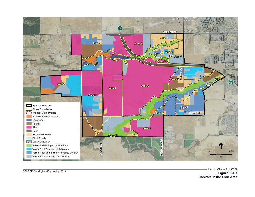
Service Layer Credits: Source: Esri,DigitalGlobe, GeoEye, Earthstar Geographics,CNES/Airbus DS, USDA, USGS, AEX,Getmapping, Aerogrid, IGN, IGP, swisstopo,and the GIS User Community
Moore Rd
Aitk
en R
d
Fidd
ymen
t Rd
Nels
on Ln
Nicolaus Rd 65
65Area A
Area H
Area I
Area F
Area G
Area J
Area B
Area J
Area E
Area D
Area DArea C
Area A
Area D
Area J
Area J
Area J
Lincoln Village 5 . 130368Figure 3.4-1
Habitats in the Plan AreaSOURCE: Cunningham Engineering, 2015
0 2,800
Feet
Specific Plan AreaPhase BoundariesWindsor Cove ProjectFresh Emergent WetlandLacustrinePastureRiceRoadRural ResidentialStock PondsUrban/SuburbanValley Foothill Riparian WoodlandVernal Pool Complex High DensityVernal Pool Complex Intermediate DensityVernal Pool Complex Low Density
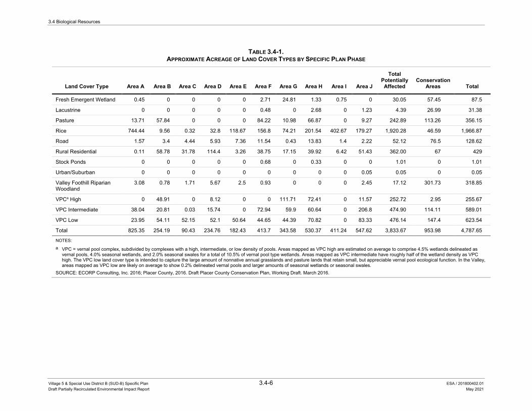
3.4 Biological Resources
Village 5 & Special Use District B (SUD-B) Specific Plan 3.4-6 ESA / 201800402.01 Draft Partially Recirculated Environmental Impact Report May 2021
TABLE 3.4-1. APPROXIMATE ACREAGE OF LAND COVER TYPES BY SPECIFIC PLAN PHASE
Land Cover Type Area A Area B Area C Area D Area E Area F Area G Area H Area I Area J
Total Potentially Affected
Conservation Areas Total
Fresh Emergent Wetland 0.45 0 0 0 0 2.71 24.81 1.33 0.75 0 30.05 57.45 87.5
Lacustrine 0 0 0 0 0 0.48 0 2.68 0 1.23 4.39 26.99 31.38
Pasture 13.71 57.84 0 0 0 84.22 10.98 66.87 0 9.27 242.89 113.26 356.15
Rice 744.44 9.56 0.32 32.8 118.67 156.8 74.21 201.54 402.67 179.27 1,920.28 46.59 1,966.87
Road 1.57 3.4 4.44 5.93 7.36 11.54 0.43 13.83 1.4 2.22 52.12 76.5 128.62
Rural Residential 0.11 58.78 31.78 114.4 3.26 38.75 17.15 39.92 6.42 51.43 362.00 67 429
Stock Ponds 0 0 0 0 0 0.68 0 0.33 0 0 1.01 0 1.01
Urban/Suburban 0 0 0 0 0 0 0 0 0 0.05 0.05 0 0.05
Valley Foothill Riparian Woodland
3.08 0.78 1.71 5.67 2.5 0.93 0 0 0 2.45 17.12 301.73 318.85
VPCa High 0 48.91 0 8.12 0 0 111.71 72.41 0 11.57 252.72 2.95 255.67
VPC Intermediate 38.04 20.81 0.03 15.74 0 72.94 59.9 60.64 0 206.8 474.90 114.11 589.01
VPC Low 23.95 54.11 52.15 52.1 50.64 44.65 44.39 70.82 0 83.33 476.14 147.4 623.54
Total 825.35 254.19 90.43 234.76 182.43 413.7 343.58 530.37 411.24 547.62 3,833.67 953.98 4,787.65
NOTES: a VPC = vernal pool complex, subdivided by complexes with a high, intermediate, or low density of pools. Areas mapped as VPC high are estimated on average to comprise 4.5% wetlands delineated as
vernal pools, 4.0% seasonal wetlands, and 2.0% seasonal swales for a total of 10.5% of vernal pool type wetlands. Areas mapped as VPC intermediate have roughly half of the wetland density as VPC high. The VPC low land cover type is intended to capture the large amount of nonnative annual grasslands and pasture lands that retain small, but appreciable vernal pool ecological function. In the Valley, areas mapped as VPC low are likely on average to show 0.2% delineated vernal pools and larger amounts of seasonal wetlands or seasonal swales.
SOURCE: ECORP Consulting, Inc. 2016; Placer County, 2016. Draft Placer County Conservation Plan, Working Draft. March 2016.

3.4 Biological Resources
Village 5 & Special Use District B (SUD-B) Specific Plan 3.4-7 ESA / 201800402.01 Draft Partially Recirculated Environmental Impact Report May 2021
Rice Fields The Plan Area also contains many “laser-leveled” rice fields. This rice farming method involves carefully leveling a field and grading to a constant grade from one end of the field to the other. This allows for maximum efficiency in flood irrigation, and generally requires one irrigation point and one drain point for each field. “Checks” (long, linear bermed areas across each field) with doors or gates between each field to allow for irrigation flexibility are often installed. To control rice stubble, approximately 25 percent (allowed maximum) of the stubble is burned and the remainder is disced. The fields are flooded through a series of excavated irrigation canals and ditches. Water enters the Plan Area from a dam at Auburn Ravine and exits at Markham Ravine.25
The rice fields support a variety of wintering waterfowl that likely includes Northern pintail (Anas acuta), tundra swan (Cygnus columbianus), greater white-fronted geese (Anser albifrons), American widgeon (Anas americana), and green-winged teal (Anas carolinensis), among many others.26
Riparian Woodland Much of the upland area adjacent to Auburn Ravine, and to a lesser extent Markham Ravine, supports riparian woodland habitat. These woodlands are dominated by native trees, shrubs, and vines including valley oak (Quercus lobata), California wild grape (Vitis californica), Himalayan blackberry (Rubus armeniacus), and poison oak (Toxicodendron diversilobum). The canopy of the riparian woodland is dominated by Valley oak and Fremont cottonwood (Populus fremontii) with southern catalpa (Catalpa bignonioides) and box-elder (Acer negundo) also occurring frequently. Herbaceous species in the understory are largely the same as those observed in the nonnative annual grasslands on the project site.27
Riparian habitats provide abundant food, cover, and breeding sites for wildlife in close proximity to water. These factors, and the structural diversity of riparian woodland, are largely responsible for the high diversity of wildlife in this habitat type. Characteristic bird species in this habitat include the California quail (Callipepla californica), mourning dove, Nuttall's woodpecker (Picoides nuttallii), black phoebe (Sayornis nigricans), western wood-pewee (Contopus sordidulus), California towhee (Pipilo crissalis), and song sparrow (Melospiza melodia). A number of these species nest or roost in riparian woodlands and feed in adjacent habitat types, such as nonnative annual grassland and agricultural fields. Riparian woodlands also provide important feeding, resting, and nesting habitat for neotropical migrant songbirds such as warblers, vireos, grosbeaks, and flycatchers. Mammals found within riparian habitat could include the
25 ECORP Consulting, Inc., 2015. Biological Resources Assessment for the Lincoln Village 5 & SUD-B Specific
Plan. Prepared for Richland Developers, Inc. March 18, 2015. 26 ECORP Consulting, Inc., 2015. Biological Resources Assessment for the Lincoln Village 5 & SUD-B Specific
Plan. Prepared for Richland Developers, Inc. March 18, 2015. 27 ECORP Consulting, Inc., 2015. Biological Resources Assessment for the Lincoln Village 5 & SUD-B Specific
Plan. Prepared for Richland Developers, Inc. March 18, 2015.
3.4 Biological Resources
Village 5 & Special Use District B (SUD-B) Specific Plan 3.4-8 ESA / 201800402.01 Draft Partially Recirculated Environmental Impact Report May 2021
raccoon (Procyon lotor), deer mouse, broad-footed mole (Scapanus latimanus), striped skunk (Mephitis mephitis), opossum (Didelphis virginianus), and gray fox (Urocyon cinereoargenteus).28
Amphibians and reptiles likely to occur in this community include the western toad (Anaxyrus boreas), Sierran tree frog (Pseudacris sierra), California king snake (Lampropeltis californiae), valley garter snake (Thamnophis sirtalis fitchi), and Gilbert’s skink (Plestiodon gilberti). Special-status species that forage and/or nest in riparian habitats include the Swainson’s hawk (Buteo swainsoni), Cooper’s hawk (Accipiter cooperii), yellow warbler (Dendroica petechia), white-tailed kite, and yellow-breasted chat (Icteria virens).29
Aquatic Habitat Vernal Pool Vernal pools are a unique type of wetland that form in a Mediterranean climate. In general, vernal pools are topographic basins that are underlain with an impermeable or semi-permeable hardpan or duripan layer. Direct rainfall and surface runoff inundate the pools during the wet season. The pools remain inundated and/or the soil maintains saturation through spring and the pools are dry by late spring until the following wet season. Vernal pools are found in the northeastern and southeastern corners of the Plan Area.
Vernal pools support a distinct flora and fauna. Vernal pools are often connected by swales forming larger vernal pool complexes. A vernal pool complex is a series of vernal pools and seasonal wetland swales that are hydrologically connected during wet periods. In the PCCP, three densities of vernal pool complexes are mapped: high, intermediate, and low. Areas mapped in the PCCP as high density vernal pool complexes are estimated on average to comprise 4.5 percent wetlands delineated as vernal pools, 4.0 percent seasonal wetlands, and 2.0 percent seasonal swales for a total of 10.5 percent of vernal pool type wetlands. Areas mapped in the PCCP as intermediate density have roughly half of the wetland density as vernal pool complex “high”. The vernal pool complex “low” land cover type is intended to capture the large amount of nonnative annual grasslands and pasture lands that retain small, but appreciable vernal pool ecological function. In the Central Valley, areas mapped as vernal pool complex “low” are likely on average to show 0.2 percent delineated vernal pools and larger amounts of seasonal wetlands or seasonal swales.30
In contrast to the surrounding grasslands which are dominated by nonnative annual grasses, vernal pools are typically dominated by native plant species, and also provide habitat for several species of native aquatic invertebrates that are only found in the unique vernal pool environment. Vernal pools are differentiated from seasonal wetlands based on species composition and hydrology. Typical vernal pool species are absent from seasonal wetlands and vice versa.
28 ECORP Consulting, Inc., 2015. Biological Resources Assessment for the Lincoln Village 5 & SUD-B Specific
Plan. Prepared for Richland Developers, Inc. March 18, 2015. 29 ECORP Consulting, Inc., 2015. Biological Resources Assessment for the Lincoln Village 5 & SUD-B Specific
Plan. Prepared for Richland Developers, Inc. March 18, 2015. 30 Placer County, 2016. Placer County Conservation Plan. Working Draft. March 2016 Section 3.3.1.2.5, Table 3-11.

3.4 Biological Resources
Village 5 & Special Use District B (SUD-B) Specific Plan 3.4-9 ESA / 201800402.01 Draft Partially Recirculated Environmental Impact Report May 2021
Vernal pools in the Plan Area range from well-defined basins with distinct boundaries to those with indistinct boundaries that have been altered over time through previous agricultural use. Dominant plants within the vernal pools in the Plan Area include slender popcorn-flower (Plagiobothrys stipitatus), American pillwort (Pilularia americana), and Carter’s buttercup (Ranunculus bonariensis).
Seasonal Wetland/Seasonal Swales Seasonal wetlands are ephemerally wet due to accumulation of surface runoff and rainwater within low-lying areas. Inundation periods tend to be relatively short and they are commonly dominated by nonnative annual, and sometimes perennial, hydrophytic species plants. Seasonal swales (sometimes referred to as “seasonal wetland swales”) are linear wetland features that do not exhibit an ordinary high water mark. Typical seasonal wetlands in the Plan Area are dominated by low-growing grasses and annual herbs such as annual hairgrass (Deschampsia danthonioides), Italian ryegrass, beardless wild rye (Elymus triticoides), meadow barley (Hordeum brachyantherum), annual bluegrass (Poa annua), manna grass (Glyceria declinata) and Bermuda grass (Cynodon dactylon). Typical drainage swales are dominated by Mediterranean barley (Hordeum marinum var. gussoneanum), fiddle dock (Rumex pulcher), chicory (Cichorium intybus), little quaking grass (Briza minor), redstem filaree, toad rush (Juncus bufonius), white meadowfoam (Limnanthes alba), and hyssop loosestrife (Lythrum hyssopifolia). When inundated, these seasonal wetlands and seasonal swales provide habitat for aquatic invertebrates and amphibians. For most of the remainder of the year, wildlife use is similar to that of typical Central Valley nonnative annual grassland habitat.
Fresh Emergent Marsh Fresh emergent marsh is characterized by erect, rooted, primarily perennial herbaceous hydrophytes (plants adapted for growing in saturated soils). Two emergent marshes are located in the southern portion of Area A. One is located north and adjacent to Auburn Ravine and the other is located south of Auburn Ravine and adjacent to a seasonal wetland feature. Dominant vegetation within representative emergent marsh includes spotted ladysthumb (Persicaria maculosa). Marsh habitat supports waterfowl species and amphibians as described above for riparian wetlands and rice fields, and could support additional bird species including red-winged blackbird (Agelaius phoeniceus) and if open water is present, species such as American coot (Fulica americana).
Riparian Wetland Riparian wetlands were mapped within the seasonally inundated floodplain and margins below the ordinary high water mark (OHWM) of Auburn Ravine. Dominant vegetation within a representative riparian wetland included Valley oak, sandbar willow (Salix exigua), arroyo willow (Salix lasiolepis), Himalayan blackberry, mugwort (Artemisia douglasiana), Italian ryegrass, common bedstraw (Galium aparine), cut-leaved geranium (Geranium dissectum), beardless wild rye, and dallisgrass (Paspalum dilatatum). Wildlife species that could use this habitat are similar to those described for riparian woodland above.
3.4 Biological Resources
Village 5 & Special Use District B (SUD-B) Specific Plan 3.4-10 ESA / 201800402.01 Draft Partially Recirculated Environmental Impact Report May 2021
Perennial Drainage A perennial channel has flowing water throughout the year. The gradient is low and water velocity is slow. Perennial stream beds are located below the water table year-round, and groundwater is a source of water for the channel. Wildlife species that could use this habitat are similar to those described for riparian woodland above. The open water and seasonally inundated sand bars of Auburn Ravine and Markham Ravine are considered “riverine habitat”. Riverine habitat supports submerged aquatic vegetation, as well as sparse seasonal wetland plants on stream banks and sand bars such as cocklebur (Xanthium strumarium) and watergrass (Echinochloa crus-galli).
Auburn Ravine – Auburn Ravine is located in the southern portion of the Plan Area in a northeast/southwest alignment. The ravine’s most significant feature is its perennial stream, which originates approximately 10 miles to the east near the City of Auburn, and ultimately flows through the City of Lincoln to the East Side Canal. Through the Plan Area, Auburn Ravine supports dense riparian woodland and riparian wetlands (described above) within low-lying sections of its floodplain.
Markham Ravine – Markham Ravine is a perennial stream located in the northern portion of the Plan Area in an east/west alignment. The floodplain of Markham Ravine supports riparian wetlands and small patches of riparian woodland. Species composition of the riparian wetlands and riparian woodlands are described above.
Intermittent Drainage An intermittent drainage has flowing water during certain times of the year, when groundwater provides water for stream flow. During dry periods, intermittent streams may not have flowing water. Runoff from rainfall is a supplemental source of water for stream flow. One intermittent drainage was found within the southern portion of Area A. The intermittent drainage was unvegetated and the edges were dominated by hyssop loosestrife, creeping spikerush (Eleocharis macrostachya), toad rush, and purslane speedwell (Veronica peregrina).
Irrigation Canal Irrigation canals throughout the Plan Area convey irrigation water to and from the rice fields. Dominant plant species identified within the irrigation canals included tall flatsedge (Cyperus eragrostis), hairy willow-herb (Epilobium ciliatum), manna grass, and broad-leaf cattail (Typha latifolia).
Wetlands/Waters of the U.S. Wetlands are ecologically complex habitats that support a variety of both plant and animal life. In a jurisdictional sense, the federal government defines wetlands in Section 404 of the Clean Water Act (CWA) as “areas that are inundated or saturated by surface or ground water at a frequency and duration sufficient to support (and do support, under normal circumstances) a prevalence of vegetation typically adapted for life in saturated soil conditions” (33 CFR 328.3[b] and 40 CFR 230.3). Under normal circumstances, the federal definition of wetlands requires three
3.4 Biological Resources
Village 5 & Special Use District B (SUD-B) Specific Plan 3.4-11 ESA / 201800402.01 Draft Partially Recirculated Environmental Impact Report May 2021
wetland identification parameters be present: wetland hydrology, hydric soils, and hydrophytic vegetation. Examples of wetlands include freshwater marsh, seasonal wetlands, and vernal pool complexes that have a hydrologic link to other waters of the U.S. (see definition below for “other waters of the U.S.”). The U.S. Army Corps of Engineers (USACE) is the agency responsible for regulating wetlands under Section 404 of the CWA, while the Environmental Protection Agency (U.S. EPA) has overall responsibility for implementing and enforcing the CWA. The CDFW does not normally have direct jurisdiction over wetlands unless a Streambed Alteration Agreement is required or a state-listed endangered species is deemed present; however, CDFW is a trustee agency with trust responsibility for wildlife and habitats pursuant to California law.
“Other waters of the U.S.” refers to those hydric features that are regulated by the CWA but are not wetlands (33 CFR 328.4). To be considered jurisdictional, these features must exhibit a defined bed and bank and an ordinary high-water mark. Examples of other waters of the U.S. include rivers, creeks, intermittent and ephemeral channels, ponds, and lakes.
The majority of the Plan Area has not been subject to a jurisdictional delineation of Waters of the U.S. This section describes the results of a wetland assessment using National Wetland Inventory maps and the Six County Aquatic Resources Inventory (SCARI) data to identify potential wetlands in the Plan Area. A wetland delineation of potential Waters of the U.S. was conducted in accordance with the Corps of Engineers Wetlands Delineation Manual31 and the Regional Supplement to the Corps of Engineers Wetland Delineation Manual: Arid West Region32 for Area A in April and October 2013 and August 2014, and for Windsor Cove (located in Area J) in May 2014 and those results are also discussed below.33,34 The wetland delineation for Area A has been verified by the USACE. The results of both the assessment and delineation are shown in Figure 3.4-2. Wetlands/Waters of the U.S. for the Plan Area include vernal pools, seasonal wetlands and seasonal swales, riparian wetlands and the Auburn and Markham Ravines. The acreages of these features are presented in Table 3.4-2 and are described above in the Plan Area Plant Communities and Wildlife Habitats section.
31 Environmental Laboratory. 1987. Corps of Engineers Wetlands Delineation Manual. Technical Report Y- 87-1.
U.S. Army Engineer Waterways Experiment Station. Vicksburg, Mississippi. Available: http://el.erdc.usace.army.mil/publications.cfm?Topic=techreport&Code=wetland.
32 U.S. Army Corps of Engineers. 2008. Regional Supplement to the Corps of Engineers Wetland Delineation Manual: Arid West Region. ed. J.S. Wakeley, R.W. Lichvar, and C.V. Noble. ERDC/EL TR-06-16. Vicksburg, MS: U.S. Army Engineer Research and Development Center. Available: http://www.usace.army.mil/Missions/CivilWorks/RegulatoryProgramandPermits/reg_supp.aspx.
33 Cardno. 2015. Wetland Delineation and Preliminary Jurisdictional Determination. Moore Road Property. February 4, 2015.
34 ECORP Consulting, Inc., 2014. Wetland Delineation for the Lincoln Village 5, Phase 1 Project. Prepared for Richland Developers, Inc. December 1, 2014.

Map Features
Lincoln Village 5 Plan Area
Area A
FEMA 100 Year Flood Plain
Area A wetland Delineation 1
Wetlands
Vernal Pool
Seasonal Wetland
Seasonal Wetland Swale
Marsh
Riparian Wetland
Other Waters
Intermittent Drainage
Creek
Irrigation Canal
NWI Features 2
Freshwater Emergent Wetland
Freshwater Forested/Shrub Wetland
Freshwater Pond
Lake
Other
SCARI Features 3
Open Water/Fringe
Other Depressional
Riverine
Vernal Pool
NOTE: NWI and SCARI features within Phase 1 survey area not shown.
1 Phase 1 Wetland Delineation, ECORP2 National Wetland Inventory, USFWS3 Six County Aquatic Resources Inventory, USACE
0 1,500 3,000
Sc a le in Fee t
Lincoln Village 5 EIR . 130368
Figure 3.4-2Wetland Features
SOURCE: NAIP, 2012 (map); ECORP Consulting, Inc., 2015

3.4 Biological Resources
Village 5 & Special Use District B (SUD-B) Specific Plan 3.4-13 ESA / 201800402.01 Draft Partially Recirculated Environmental Impact Report May 2021
TABLE 3.4-2. POTENTIAL WETLANDS/WATERS OF THE U.S. IN PORTIONS OF THE PLAN AREA THAT HAVE HAD FORMAL
WETLAND DELINEATIONS
Type Acreage
Area A1
Wetlands
Vernal Pool 0.997
Seasonal Wetland 20.595
Farmed Seasonal Wetland 6.873
Seasonal Swale 3.46
Fresh Emergent Marsh 6.810
Riparian Wetland 31.855
Other Waters
Intermittent Drainage 0.164
Creek 18.952
Irrigation Canal 2.933
Irrigation Ditch 4.560
Roadside Ditch 1.328
Total 98.547
Windsor Cove (located in Area J)2
Wetlands
Vernal Pool 0.682
Vernal Swale 3.484
Freshwater Forested Wetland 3.118
Other Waters
Ephemeral Drainage 0.391
Total 7.675
SOURCES: 1 ECORP Consulting, Inc., 2015. Wetland Delineation for the Lincoln Village 5, Phase 1 Project. Prepared for Richland Developers,
Inc. June 2, 2015. Verified by the USACE June 5, 2015. 2 Cardno, 2015. Wetland Delineation and Preliminary Jurisdictional Determination. Moore Road Property. February 4, 2015.
Sensitive Natural Community A sensitive natural community is a biological community that is regionally rare, provides important habitat opportunities for wildlife, is structurally complex, or is in other ways of special concern to local, state, or federal agencies. Most sensitive natural communities are given special consideration because they perform important ecological functions, such as maintaining water quality and providing essential habitat for plants and wildlife. Some plant communities support a unique or diverse assemblage of plant species and therefore, are considered sensitive from a botanical standpoint. Appendix G of the CEQA Guidelines identifies the elimination of such communities as a potentially significant impact. The most current version of the CDFW’s List of

3.4 Biological Resources
Village 5 & Special Use District B (SUD-B) Specific Plan 3.4-14 ESA / 201800402.01 Draft Partially Recirculated Environmental Impact Report May 2021
California Terrestrial Natural Communities35 indicates which natural communities are of special-status given the current state of the California classification.
Special-Status Species Special-status species are legally protected under the state and federal Endangered Species Acts or other regulations or are species that are considered sufficiently rare by the scientific community to qualify for such listing. These species are classified under the following categories:
• Species listed or proposed for listing as threatened or endangered under the federal Endangered Species Act (50 Code of Federal Regulations [CFR] 17.12 [listed plants], 17.11 [listed animals] and various notices in the Federal Register [FR] [proposed species]).
• Species that are candidates for possible future listing as threatened or endangered under the federal Endangered Species Act (61 FR 40, February 28, 1996);
• Species listed or proposed for listing by the State of California as threatened or endangered under the California Endangered Species Act (CESA) (14 California Code of Regulations [CCR] 670.5);
• Animal species of special concern to CDFW;
• Animals fully protected in California (California Fish and Game Code, Sections 3511 [birds], 4700 [mammals], and 5050 [reptiles and amphibians]);
• Birds of prey protected under the federal Bald and Golden Eagle Protection Act;
• Species that meet the definitions of rare and endangered under CEQA. CEQA section 15380 provides that a plant or animal species may be treated as “rare or endangered” even if not on one of the official lists (State CEQA Guidelines, section 15380);
• Plants listed as rare or endangered under the California Native Plant Protection Act (California Fish and Game Code, Section 1900 et seq.); and
• Plants considered by CDFW and CNPS to be “rare, threatened or endangered in California” (Rank 1A, 1B, 2A, and 2B in CNPS, 2015) plant species.
The potential occurrence of special-status plant and animal species within the Plan Area and surrounding area has been determined through a review of the CDFW’s Natural Diversity Data Base (CNDDB),36 the U.S. Fish and Wildlife Service’s (USFWS) online species list database,37 the CNPS Inventory of Rare and Endangered Plants,38 and reconnaissance level field surveys. Using information from the CNDDB, USFWS, CNPS, the literature review, and limited
35 California Department of Fish and Wildlife, 2010. List of Vegetation Alliances and Associations. Vegetation
Classification and Mapping Program. Sacramento, CA. Available: http://www.dfg.ca.gov/biogeodata/vegcamp/natural_comm_list.asp.
36 California Department of Fish and Wildlife, 2015. California Natural Diversity Database (CNDDB) RareFind 4 personal computer program. Available: http://www.dfg.ca.gov/biogeodata/cnddb/mapsanddata.asp. Accessed April 16, 2015.
37 U.S. Fish and Wildlife Service, 2015. List of threatened and endangered species that may occur in your proposed project location, and/or may be affected by your proposed project. Consultation Code: 08ESMF00-2015-SLI-0329. Available: http://ecos.fws.gov/ipac/. Accessed April 16, 2015.
38 California Native Plant Society, 2015. Inventory of Rare and Endangered Plants (online edition, v8-02). Available: http://www.rareplants.cnps.org/. Accessed April 16, 2015.
3.4 Biological Resources
Village 5 & Special Use District B (SUD-B) Specific Plan 3.4-15 ESA / 201800402.01 Draft Partially Recirculated Environmental Impact Report May 2021
observations in the field, a list of special-status plant and animal species that have the potential to occur in the Plan Area was generated and shown in Table 3.4-3.
The “Potential to Occur” category identified in Table 3.4-3 uses the following definitions:
• Absent: The Plan Area does not and could not support the particular species.
• Unlikely: The Plan Area does not support suitable habitat for a particular species. The Plan Area is outside of the species known range.
• Low Potential: The Plan Area only provides limited and low quality habitat for a particular species. In addition, the known range for a particular species may be outside of the immediate Plan Area.
• Medium Potential: The Plan Area provides suitable habitat for a particular species.
• High Potential: The Plan Area provides ideal habitat conditions for a particular species and/or known populations occur in the immediate area or within the potential area of impact.
Of the special-status animals listed in Table 3.4-3, only species classified as having a medium or high potential for occurrence in the Plan Area were considered in the impact analysis.
Special-Status Plants A number of special-status plants have the potential to occur within the Plan Area, including big-scale balsamroot (Balsamorhiza macrolepis var. macrolepis), dwarf downingia (Downingia pusilla), Boggs Lake hedge-hyssop (Gratiola heterosepala), Ahart’s dwarf rush (Juncus leiospermus ssp. ahartii), Red Bluff dwarf rush (Juncus leiospermus ssp. leiospermus), legenere (Legenere limosa), pincushion navarretia (Navarretia myersii ssp. myersii), slender Orcutt grass (Orcuttia tenuis), and Sanford’s arrowhead (Sagittaria sanfordii).39 According to the CNDDB, some of these special-status species have been documented to occur within five miles of the Plan Area (Figure 3.4-3).40 Descriptions of these species with potential to occur within the Plan Area and survey results from Area A are provided below, based on the Biological Resources Assessment for the Lincoln Village 5 and SUD-B Specific Plan.41
Adobe navarretia (Navarretia nigelliformis ssp. nigelliformis), Stebbins morning glory (Calystegia stebbinsii), Pine Hill ceanothus (Ceanothus roderickii), hispid bird’s-beak (Chloropyron molle ssp. hispidum), El Dorado bedstraw (Galium calfornicum ssp. sierrae), and Layne’s ragwort (Packera layneae) are not expected to occur due to lack of suitable habitat or the Plan Area is outside the known range of the species. These species are not further addressed in this EIR.
39 ECORP Consulting, Inc., 2015. Biological Resources Assessment for the Lincoln Village 5 &SUD-B Specific
Plan. Prepared for Richland Developers, Inc. March 18, 2015. 40 California Department of Fish and Wildlife, 2015. Rarefind Natural Diversity Data Base Program. Version 3.1.1,
commercial version dated: January 3, 2014. California Natural Diversity Database. The Resources Agency, Sacramento. Accessed April 16, 2015.
41 ECORP Consulting, Inc., 2015. Biological Resources Assessment for the Lincoln Village 5 & SUD-B Specific Plan. Prepared for Richland Developers, Inc. March 18, 2015.
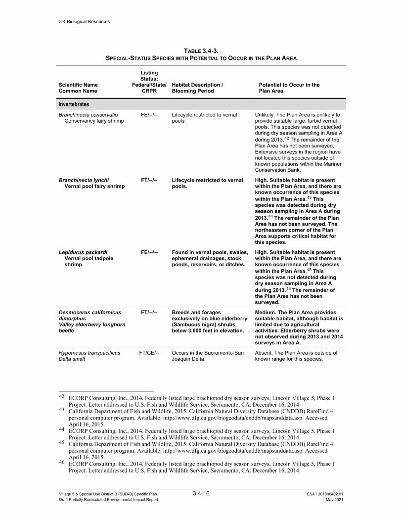
3.4 Biological Resources
Village 5 & Special Use District B (SUD-B) Specific Plan 3.4-16 ESA / 201800402.01 Draft Partially Recirculated Environmental Impact Report May 2021
TABLE 3.4-3. SPECIAL-STATUS SPECIES WITH POTENTIAL TO OCCUR IN THE PLAN AREA
Scientific Name Common Name
Listing Status:
Federal/State/ CRPR
Habitat Description / Blooming Period
Potential to Occur in the Plan Area
Invertebrates Branchinecta conservatio
Conservancy fairy shrimp FE/--/-- Lifecycle restricted to vernal
pools. Unlikely. The Plan Area is unlikely to provide suitable large, turbid vernal pools. This species was not detected during dry season sampling in Area A during 2013.42 The remainder of the Plan Area has not been surveyed. Extensive surveys in the region have not located this species outside of known populations within the Mariner Conservation Bank.
Branchinecta lynchi Vernal pool fairy shrimp
FT/--/-- Lifecycle restricted to vernal pools.
High. Suitable habitat is present within the Plan Area, and there are known occurrence of this species within the Plan Area.43 This species was detected during dry season sampling in Area A during 2013.44 The remainder of the Plan Area has not been surveyed. The northeastern corner of the Plan Area supports critical habitat for this species.
Lepidurus packardi Vernal pool tadpole shrimp
FE/--/-- Found in vernal pools, swales, ephemeral drainages, stock ponds, reservoirs, or ditches.
High. Suitable habitat is present within the Plan Area, and there are known occurrence of this species within the Plan Area.45 This species was not detected during dry season sampling in Area A during 2013.46 The remainder of the Plan Area has not been surveyed.
Desmocerus californicus dimorphus Valley elderberry longhorn beetle
FT/--/-- Breeds and forages exclusively on blue elderberry (Sambucus nigra) shrubs, below 3,000 feet in elevation.
Medium. The Plan Area provides suitable habitat, although habitat is limited due to agricultural activities. Elderberry shrubs were not observed during 2013 and 2014 surveys in Area A.
Hypomesus transpacificus Delta smelt
FT/CE/-- Occurs in the Sacramento-San Joaquin Delta.
Absent. The Plan Area is outside of known range for this species.
42 ECORP Consulting, Inc., 2014. Federally listed large brachiopod dry season surveys, Lincoln Village 5, Phase 1
Project. Letter addressed to U.S. Fish and Wildlife Service, Sacramento, CA. December 16, 2014. 43 California Department of Fish and Wildlife, 2015. California Natural Diversity Database (CNDDB) RareFind 4
personal computer program. Available: http://www.dfg.ca.gov/biogeodata/cnddb/mapsanddata.asp. Accessed April 16, 2015.
44 ECORP Consulting, Inc., 2014. Federally listed large brachiopod dry season surveys, Lincoln Village 5, Phase 1 Project. Letter addressed to U.S. Fish and Wildlife Service, Sacramento, CA. December 16, 2014.
45 California Department of Fish and Wildlife, 2015. California Natural Diversity Database (CNDDB) RareFind 4 personal computer program. Available: http://www.dfg.ca.gov/biogeodata/cnddb/mapsanddata.asp. Accessed April 16, 2015.
46 ECORP Consulting, Inc., 2014. Federally listed large brachiopod dry season surveys, Lincoln Village 5, Phase 1 Project. Letter addressed to U.S. Fish and Wildlife Service, Sacramento, CA. December 16, 2014.
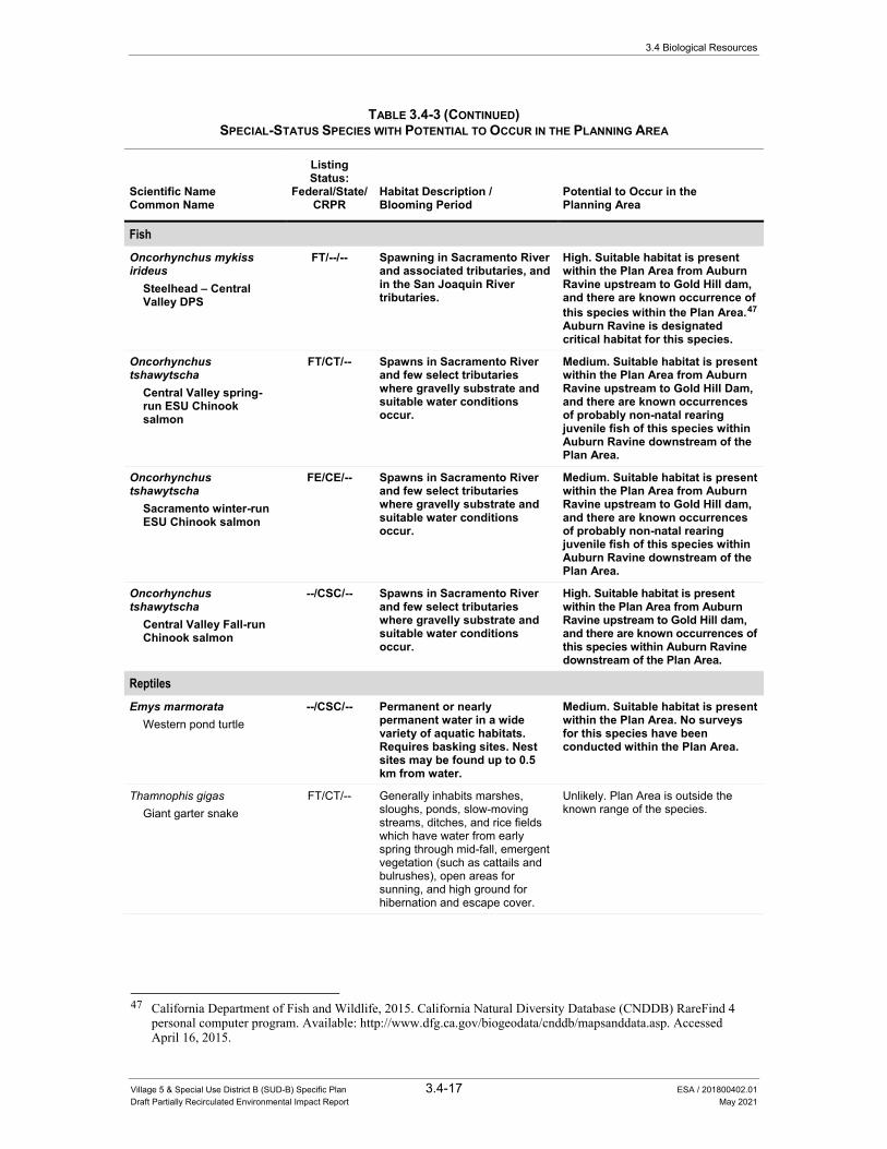
3.4 Biological Resources
Village 5 & Special Use District B (SUD-B) Specific Plan 3.4-17 ESA / 201800402.01 Draft Partially Recirculated Environmental Impact Report May 2021
TABLE 3.4-3 (CONTINUED) SPECIAL-STATUS SPECIES WITH POTENTIAL TO OCCUR IN THE PLANNING AREA
Scientific Name Common Name
Listing Status:
Federal/State/ CRPR
Habitat Description / Blooming Period
Potential to Occur in the Planning Area
Fish Oncorhynchus mykiss irideus
Steelhead – Central Valley DPS
FT/--/-- Spawning in Sacramento River and associated tributaries, and in the San Joaquin River tributaries.
High. Suitable habitat is present within the Plan Area from Auburn Ravine upstream to Gold Hill dam, and there are known occurrence of this species within the Plan Area.47 Auburn Ravine is designated critical habitat for this species.
Oncorhynchus tshawytscha
Central Valley spring-run ESU Chinook salmon
FT/CT/-- Spawns in Sacramento River and few select tributaries where gravelly substrate and suitable water conditions occur.
Medium. Suitable habitat is present within the Plan Area from Auburn Ravine upstream to Gold Hill Dam, and there are known occurrences of probably non-natal rearing juvenile fish of this species within Auburn Ravine downstream of the Plan Area.
Oncorhynchus tshawytscha
Sacramento winter-run ESU Chinook salmon
FE/CE/-- Spawns in Sacramento River and few select tributaries where gravelly substrate and suitable water conditions occur.
Medium. Suitable habitat is present within the Plan Area from Auburn Ravine upstream to Gold Hill dam, and there are known occurrences of probably non-natal rearing juvenile fish of this species within Auburn Ravine downstream of the Plan Area.
Oncorhynchus tshawytscha
Central Valley Fall-run Chinook salmon
--/CSC/-- Spawns in Sacramento River and few select tributaries where gravelly substrate and suitable water conditions occur.
High. Suitable habitat is present within the Plan Area from Auburn Ravine upstream to Gold Hill dam, and there are known occurrences of this species within Auburn Ravine downstream of the Plan Area.
Reptiles Emys marmorata
Western pond turtle --/CSC/-- Permanent or nearly
permanent water in a wide variety of aquatic habitats. Requires basking sites. Nest sites may be found up to 0.5 km from water.
Medium. Suitable habitat is present within the Plan Area. No surveys for this species have been conducted within the Plan Area.
Thamnophis gigas Giant garter snake
FT/CT/-- Generally inhabits marshes, sloughs, ponds, slow-moving streams, ditches, and rice fields which have water from early spring through mid-fall, emergent vegetation (such as cattails and bulrushes), open areas for sunning, and high ground for hibernation and escape cover.
Unlikely. Plan Area is outside the known range of the species.
47 California Department of Fish and Wildlife, 2015. California Natural Diversity Database (CNDDB) RareFind 4
personal computer program. Available: http://www.dfg.ca.gov/biogeodata/cnddb/mapsanddata.asp. Accessed April 16, 2015.
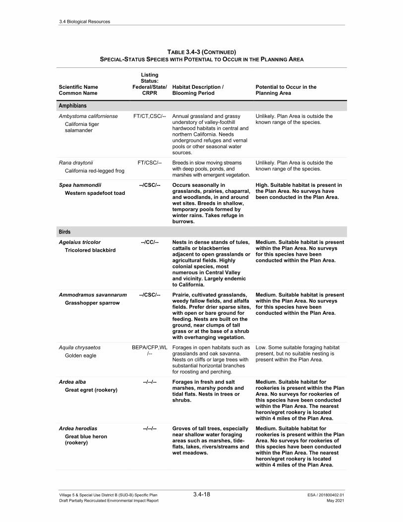
3.4 Biological Resources
Village 5 & Special Use District B (SUD-B) Specific Plan 3.4-18 ESA / 201800402.01 Draft Partially Recirculated Environmental Impact Report May 2021
TABLE 3.4-3 (CONTINUED) SPECIAL-STATUS SPECIES WITH POTENTIAL TO OCCUR IN THE PLANNING AREA
Scientific Name Common Name
Listing Status:
Federal/State/ CRPR
Habitat Description / Blooming Period
Potential to Occur in the Planning Area
Amphibians Ambystoma californiense
California tiger salamander
FT/CT,CSC/-- Annual grassland and grassy understory of valley-foothill hardwood habitats in central and northern California. Needs underground refuges and vernal pools or other seasonal water sources.
Unlikely. Plan Area is outside the known range of the species.
Rana draytonii California red-legged frog
FT/CSC/-- Breeds in slow moving streams with deep pools, ponds, and marshes with emergent vegetation.
Unlikely. Plan Area is outside the known range of the species.
Spea hammondii Western spadefoot toad
--/CSC/-- Occurs seasonally in grasslands, prairies, chaparral, and woodlands, in and around wet sites. Breeds in shallow, temporary pools formed by winter rains. Takes refuge in burrows.
High. Suitable habitat is present in the Plan Area. No surveys have been conducted in the Plan Area.
Birds
Agelaius tricolor Tricolored blackbird
--/CC/-- Nests in dense stands of tules, cattails or blackberries adjacent to open grasslands or agricultural fields. Highly colonial species, most numerous in Central Valley and vicinity. Largely endemic to California.
Medium. Suitable habitat is present within the Plan Area. No surveys for this species have been conducted within the Plan Area.
Ammodramus savannarum Grasshopper sparrow
--/CSC/-- Prairie, cultivated grasslands, weedy fallow fields, and alfalfa fields. Prefer drier sparse sites, with open or bare ground for feeding. Nests are built on the ground, near clumps of tall grass or at the base of a shrub with overhanging vegetation.
Medium. Suitable habitat is present within the Plan Area. No surveys for this species have been conducted within the Plan Area.
Aquila chrysaetos Golden eagle
BEPA/CFP,WL/--
Forages in open habitats such as grasslands and oak savanna. Nests on cliffs or large trees with substantial horizontal branches for roosting and perching.
Low. Some suitable foraging habitat present, but no suitable nesting is present within the Plan Area.
Ardea alba Great egret (rookery)
--/--/-- Forages in fresh and salt marshes, marshy ponds and tidal flats. Nests in trees or shrubs.
Medium. Suitable habitat for rookeries is present within the Plan Area. No surveys for rookeries of this species have been conducted within the Plan Area. The nearest heron/egret rookery is located within 4 miles of the Plan Area.
Ardea herodias Great blue heron (rookery)
--/--/-- Groves of tall trees, especially near shallow water foraging areas such as marshes, tide-flats, lakes, rivers/streams and wet meadows.
Medium. Suitable habitat for rookeries is present within the Plan Area. No surveys for rookeries of this species have been conducted within the Plan Area. The nearest heron/egret rookery is located within 4 miles of the Plan Area.
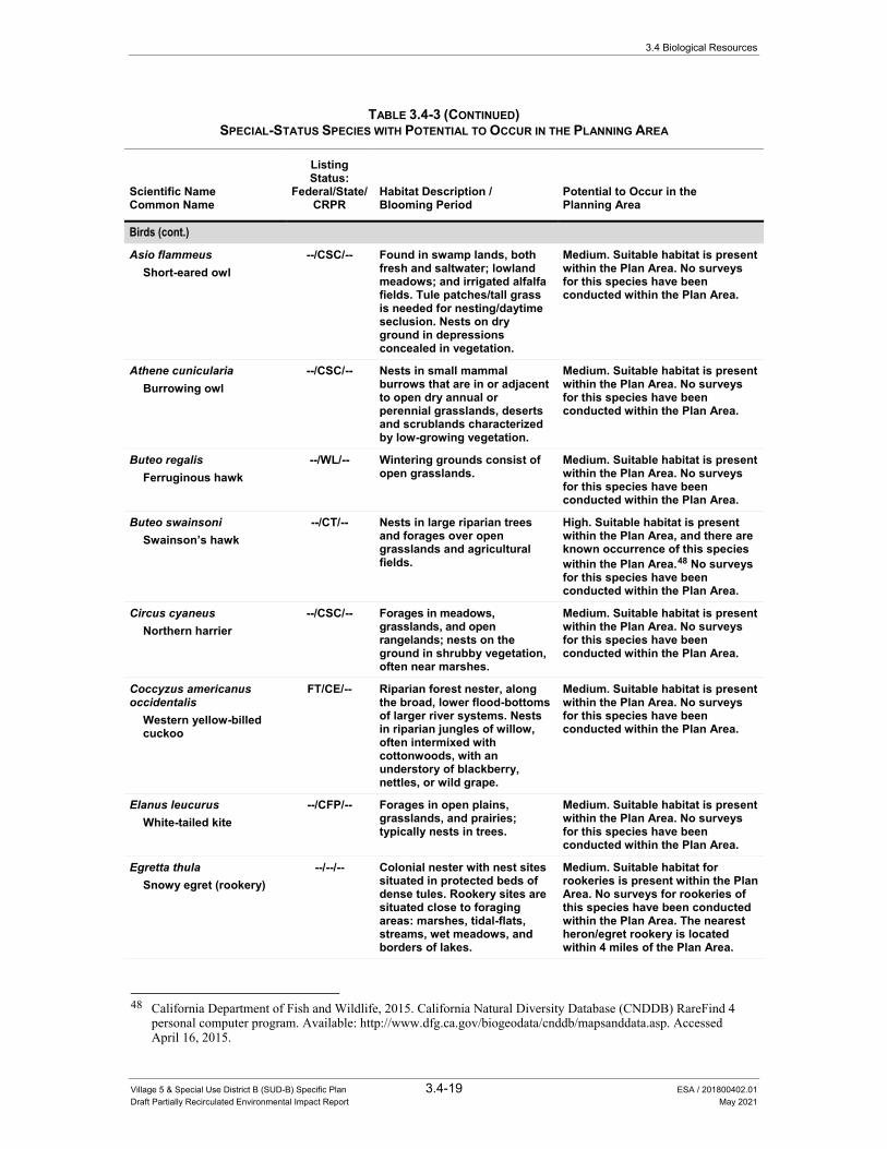
3.4 Biological Resources
Village 5 & Special Use District B (SUD-B) Specific Plan 3.4-19 ESA / 201800402.01 Draft Partially Recirculated Environmental Impact Report May 2021
TABLE 3.4-3 (CONTINUED) SPECIAL-STATUS SPECIES WITH POTENTIAL TO OCCUR IN THE PLANNING AREA
Scientific Name Common Name
Listing Status:
Federal/State/ CRPR
Habitat Description / Blooming Period
Potential to Occur in the Planning Area
Birds (cont.)
Asio flammeus Short-eared owl
--/CSC/-- Found in swamp lands, both fresh and saltwater; lowland meadows; and irrigated alfalfa fields. Tule patches/tall grass is needed for nesting/daytime seclusion. Nests on dry ground in depressions concealed in vegetation.
Medium. Suitable habitat is present within the Plan Area. No surveys for this species have been conducted within the Plan Area.
Athene cunicularia Burrowing owl
--/CSC/-- Nests in small mammal burrows that are in or adjacent to open dry annual or perennial grasslands, deserts and scrublands characterized by low-growing vegetation.
Medium. Suitable habitat is present within the Plan Area. No surveys for this species have been conducted within the Plan Area.
Buteo regalis Ferruginous hawk
--/WL/-- Wintering grounds consist of open grasslands.
Medium. Suitable habitat is present within the Plan Area. No surveys for this species have been conducted within the Plan Area.
Buteo swainsoni Swainson’s hawk
--/CT/-- Nests in large riparian trees and forages over open grasslands and agricultural fields.
High. Suitable habitat is present within the Plan Area, and there are known occurrence of this species within the Plan Area.48 No surveys for this species have been conducted within the Plan Area.
Circus cyaneus Northern harrier
--/CSC/-- Forages in meadows, grasslands, and open rangelands; nests on the ground in shrubby vegetation, often near marshes.
Medium. Suitable habitat is present within the Plan Area. No surveys for this species have been conducted within the Plan Area.
Coccyzus americanus occidentalis
Western yellow-billed cuckoo
FT/CE/-- Riparian forest nester, along the broad, lower flood-bottoms of larger river systems. Nests in riparian jungles of willow, often intermixed with cottonwoods, with an understory of blackberry, nettles, or wild grape.
Medium. Suitable habitat is present within the Plan Area. No surveys for this species have been conducted within the Plan Area.
Elanus leucurus White-tailed kite
--/CFP/-- Forages in open plains, grasslands, and prairies; typically nests in trees.
Medium. Suitable habitat is present within the Plan Area. No surveys for this species have been conducted within the Plan Area.
Egretta thula Snowy egret (rookery)
--/--/-- Colonial nester with nest sites situated in protected beds of dense tules. Rookery sites are situated close to foraging areas: marshes, tidal-flats, streams, wet meadows, and borders of lakes.
Medium. Suitable habitat for rookeries is present within the Plan Area. No surveys for rookeries of this species have been conducted within the Plan Area. The nearest heron/egret rookery is located within 4 miles of the Plan Area.
48 California Department of Fish and Wildlife, 2015. California Natural Diversity Database (CNDDB) RareFind 4
personal computer program. Available: http://www.dfg.ca.gov/biogeodata/cnddb/mapsanddata.asp. Accessed April 16, 2015.

3.4 Biological Resources
Village 5 & Special Use District B (SUD-B) Specific Plan 3.4-20 ESA / 201800402.01 Draft Partially Recirculated Environmental Impact Report May 2021
TABLE 3.4-3 (CONTINUED) SPECIAL-STATUS SPECIES WITH POTENTIAL TO OCCUR IN THE PLANNING AREA
Scientific Name Common Name
Listing Status:
Federal/State/ CRPR
Habitat Description / Blooming Period
Potential to Occur in the Planning Area
Birds (cont.) Falco mexicanus
Prairie falcon --/WL/-- Inhabits dry, open terrain,
either level or hilly. Breeding sites are located on cliffs. Forages far afield.
Medium. Suitable habitat is present within the Plan Area. No surveys for this species have been conducted within the Plan Area.
Grus canadensis tabida Greater sandhill crane
--/CT,CFP/-- Found in mudflats around reservoirs, moist meadows and agricultural areas. They forage in grain fields and pastures. During migrations and in winter they prefer open prairie, agricultural fields or river valleys.
Low – Limited and low quality habitat is present within the Plan Area.
Lanius ludovicianus Loggerhead shrike
--/CSC/-- Nests in tall shrubs and dense trees, forages in grasslands, marshes, and ruderal habitats.
Medium. Suitable habitat is present within the Plan Area. No surveys for this species have been conducted within the Plan Area.
Laterallus jamaicensis columiculus
California black rail
--/CT,CFP/-- Inhabits freshwater marshes, wet meadows, and shallow margins of saltwater marshes bordering larger bays. Needs water depths of about 1 inch that do not fluctuate during the year and dense vegetation for nesting habitat.
Unlikely. Suitable habitat is not present within the Plan Area.
Numenius americanus Long-billed curlew
--/WL/-- Breeds in grasslands. Medium. Suitable habitat is present within the Plan Area. No surveys for this species have been conducted within the Plan Area.
Nycticorax nycticorax Black-crowned night heron (rookery)
--/--/-- Colonial nester, usually in trees, occasionally in tule patches. Rookery sites located adjacent to foraging areas: lake marings, mud-bordered bays, marshy spots.
Medium. Suitable habitat is present within the Plan Area. No surveys for this species have been conducted within the Plan Area.
Progne subis Purple martin
--/CSC/-- Inhabits woodlands, low elevation coniferous forest of Douglas-fir (Pseudotsuga menziesii), ponderosa pine (Pinus ponderosa), and Monterey pine (Pinus radiata). Nests primarily in old woodpecker cavities, also in human-made structures. Nest often located in tall, isolated tree/snag.
Medium. Suitable habitat is present within the Plan Area. No surveys for this species have been conducted within the Plan Area.
Mammals Antrozous pallidus
Pallid bat --/CSC/-- Found in deserts, grasslands,
scrublands, woodlands and forests. Roosts in rock crevices, buildings, and bridges in arid regions.
Medium. Suitable habitat is present within the Plan Area. No surveys for this species have been conducted within the Plan Area.

3.4 Biological Resources
Village 5 & Special Use District B (SUD-B) Specific Plan 3.4-21 ESA / 201800402.01 Draft Partially Recirculated Environmental Impact Report May 2021
TABLE 3.4-3 (CONTINUED) SPECIAL-STATUS SPECIES WITH POTENTIAL TO OCCUR IN THE PLANNING AREA
Scientific Name Common Name
Listing Status:
Federal/State/ CRPR
Habitat Description / Blooming Period
Potential to Occur in the Planning Area
Mammals (cont.) Corynorhinus townsendii
Townsend’s big-eared bat
--/CCT,CSC/-- Roosts in the open in large caves, abandoned mines and occasionally buildings. Extremely sensitive to disturbance during roosting, particularly at maternity roosts.
Medium. Suitable habitat is present within the Plan Area. No surveys for this species have been conducted within the Plan Area.
Taxidea taxus American badger
--/CSC/-- Occurs in a wide variety of open forest, shrub, and grassland habitats that have friable soils for digging.
Medium. Suitable habitat is present within the Plan Area. No surveys for this species have been conducted within the Plan Area.
Plants Balsamorhiza macrolepis
big-scale balsamroot --/--/1B.2 Perennial herb found in
chaparral, cismontane woodland, and grasslands, often in serpentine soils, between 90 and 1,555 meters elevation. Blooms March through June.
Medium. Suitable habitat is present within the Plan Area. However, this species was not observed during surveys of Area A conducted in 2013 and 2014. The remainder of the Plan Area has not been surveyed.
Calystegia stebbinsii Stebbins’ morning-glory
--/--/1B.1 Perennial rhizomatous herb found on gabbroic or serpentinite soils in chaparral openings and cismontane woodland. Elevations range from 185 to 1,090 meters. Blooms April through July.
Unlikely. No suitable habitat within or adjacent to the Plan Area.
Ceanothus roderickii Pine Hill ceanothus
FE/CR/1B.1 Evergreen shrub found on serpentine or gabbroic soils within chaparral or cismontane woodland, between 245 and 1,090 meters elevation. Blooms April through June.
Unlikely. No suitable habitat within or adjacent to the Plan Area.
Chloropyron molle subsp. hispidum
hispid bird’s-beak
--/--/1B.1 Annual herb found on alkaline soils in meadows, seeps, and playas within valley and foothill grasslands. Blooms from June to September. Found below 155 meters in elevation.
Unlikely. No suitable habitat within or adjacent to the Plan Area.
Downingia pusilla dwarf downingia
--/--/2B.2 Annual herb occurring in mesic sites in valley and foothill grassland and vernal pools Blooms from March to May. Found below 445 meters in elevation.
High. Suitable habitat is present within the Plan Area, and there are known occurrence of this species within the Plan Area.49 However, this species was not observed during surveys of Area A conducted in 2013 and 2014. The remainder of the Plan Area has not been surveyed.
49 California Department of Fish and Wildlife, 2015. California Natural Diversity Database (CNDDB) RareFind 4
personal computer program. Available: http://www.dfg.ca.gov/biogeodata/cnddb/mapsanddata.asp. Accessed April 16, 2015.

3.4 Biological Resources
Village 5 & Special Use District B (SUD-B) Specific Plan 3.4-22 ESA / 201800402.01 Draft Partially Recirculated Environmental Impact Report May 2021
TABLE 3.4-3 (CONTINUED) SPECIAL-STATUS SPECIES WITH POTENTIAL TO OCCUR IN THE PLANNING AREA
Scientific Name Common Name
Listing Status:
Federal/State/ CRPR
Habitat Description / Blooming Period
Potential to Occur in the Planning Area
Plants (cont.) Galium californicum subsp. sierrae
El Dorado bedstraw
FE/CR/1B.2 Perennial herb found on gabbroic soils in chaparral, cismontane woodland, and lower montane coniferous forest. Elevations range from 100 to 585 meters. Blooms May to June.
Unlikely. No suitable habitat within or adjacent to the Plan Area.
Gratiola heterosepala Boggs Lake hedge-hyssop
--/CE/1B.2 Annual herb occurring at the margins of marshes and swamps, and in clay substrate in vernal pools. Found at 10 to 2,375 meters in elevation. Blooms April-August.
Medium. Suitable habitat is present within the Plan Area. However, this species was not observed during surveys of Area A conducted in 2013 and 2014. The remainder of the Plan Area has not been surveyed.
Juncus leiospermus var. ahartii
Ahart’s dwarf rush
--/--/1B.2 Annual herb occurring in mesic valley and foothill grasslands. Found between 30 and 229 meters in elevation. Blooms March-May.
Medium. Suitable habitat is present within the Plan Area. However, this species was not observed during surveys of Area A conducted in 2013 and 2014. The remainder of the Plan Area has not been surveyed.
Juncus leiospermus var. leiospermus
Red Bluff dwarf rush
--/--/1B.1 Annual herb occurring in vernally mesic areas in chaparral, cismontane woodland, valley and foothill grassland, meadows and seeps, and vernal pools. Blooms from March to June. Elevation ranges from 35 to 1,250 meters.
Medium. Suitable habitat is present within the Plan Area. However, this species was not observed during surveys of Area A conducted in 2013 and 2014. The remainder of the Plan Area has not been surveyed.
Legenere limosa legenere
--/--/1B.1 Annual herb occurring in vernal pools. Blooms April to June. Found below 880 meters in elevation.
Medium. Suitable habitat is present within the Plan Area. However, this species was not observed during surveys of Area A conducted in 2013 and 2014. The remainder of the Plan Area has not been surveyed.
Navarretia myersii subsp. myersii
pincushion navarretia
--/--/1B.1 Annual herb occurring in vernal pools, often acidic. Blooms April and May. Found at 20 to 330 meters in elevation.
Medium. Suitable habitat is present within the Plan Area. However, this species was not observed during surveys of Area A conducted in 2013 and 2014. The remainder of the Plan Area has not been surveyed.
Orcuttia tenuis slender Orcutt grass
FT/CE/1B.1 Annual grass occurring in vernal pools, often gravelly. Blooms May to October. Found at 35 to 1,760 meters in elevation.
Medium. Suitable habitat is present within the Plan Area. However, this species was not observed during surveys of Area A conducted in 2013 and 2014. The remainder of the Plan Area has not been surveyed.
Orcuttia viscida Sacramento Orcutt grass
FE/CE/1B.1 Annual grass occurring in vernal pools. Blooms April to September. Found at 30 to 100 meters in elevation.
Unlikely. Suitable habitat is present within the Plan Area. However, this species was not observed during surveys of Area A conducted in 2013 and 2014, There are no documented occurrences of this species in the vicinity, and it is not expected to occur in the Plan Area.
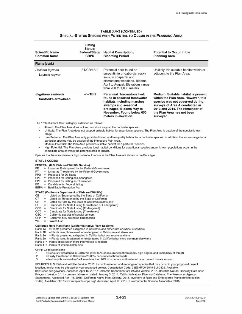
3.4 Biological Resources
Village 5 & Special Use District B (SUD-B) Specific Plan 3.4-23 ESA / 201800402.01 Draft Partially Recirculated Environmental Impact Report May 2021
TABLE 3.4-3 (CONTINUED) SPECIAL-STATUS SPECIES WITH POTENTIAL TO OCCUR IN THE PLANNING AREA
Scientific Name Common Name
Listing Status:
Federal/State/ CRPR
Habitat Description / Blooming Period
Potential to Occur in the Planning Area
Plants (cont.) Packera layneae
Layne’s ragwort FT/CR/1B.2 Perennial herb found on
serpentinite or gabbroic, rocky soils, in chaparral and cismontane woodland. Blooms April to August. Elevations range from 200 to 1,085 meters.
Unlikely. No suitable habitat within or adjacent to the Plan Area.
Sagittaria sanfordii Sanford’s arrowhead
--/--/1B.2 Perennial rhizomatous herb found in assorted freshwater habitats including marshes, swamps and seasonal drainages. Blooms May to November. Found below 650 meters in elevation.
Medium. Suitable habitat is present within the Plan Area. However, this species was not observed during surveys of Area A conducted in 2013 and 2014. The remainder of the Plan Area has not been surveyed.
The “Potential for Effect” category is defined as follows: • Absent: The Plan Area does not and could not support the particular species. • Unlikely: The Plan Area does not support suitable habitat for a particular species. The Plan Area is outside of the species known
range. • Low Potential: The Plan Area only provides limited and low quality habitat for a particular species. In addition, the known range for a
particular species may be outside of the immediate Plan Area. • Medium Potential: The Plan Area provides suitable habitat for a particular species. • High Potential: The Plan Area provides ideal habitat conditions for a particular species and/or known populations occur in the
immediate area or within the potential area of impact. Species that have moderate or high potential to occur in the Plan Area are shown in boldface type.
STATUS CODES: FEDERAL (U.S. Fish and Wildlife Service): FE = Listed as Endangered by the Federal Government FT = Listed as Threatened by the Federal Government FPD = Proposed for De-listing FPE = Proposed for Listing as Endangered FPT = Proposed for Listing as Threatened FC = Candidate for Federal listing BEPA = Bald Eagle Protection Act
STATE (California Department of Fish and Wildlife): CE = Listed as Endangered by the State of California CT = Listed as Threatened by the State of California CR = Listed as Rare by the State of California (plants only) CC = Candidate for State Listing (Threatened or Endangered) CCE = Candidate for State Listing (Endangered) CCT = Candidate for State Listing (Threatened) CSC = California species of special concern CFP = California fully protected bird species WL = Watch List
California Rare Plant Rank (California Native Plant Society): Rank 1A = Plants presumed extirpated in California and either rare or extinct elsewhere Rank 1B = Plants rare, threatened, or endangered in California and elsewhere Rank 2A = Plants presumed extirpated in California but common elsewhere Rank 2A = Plants rare, threatened, or endangered in California but more common elsewhere Rank 3 = Plants about which more information is needed Rank 4 = Plants of limited distribution
CRPR Code Extensions .1 = Seriously threatened in California (over 80% of occurrences threatened / high degree and immediacy of threat) .2 = Fairly threatened in California (20-80% occurrences threatened) .3 = Not very threatened in California (less than 20% of occurrences threatened or no current threats known)
SOURCES: U.S. Fish and Wildlife Service, 2015. List of threatened and endangered species that may occur in your proposed project location, and/or may be affected by your proposed project. Consultation Code: 08ESMF00-2015-SLI-0329. Available: http://ecos.fws.gov/ipac/. Accessed April 16, 2015.; California Department of Fish and Wildlife, 2015. Rarefind Natural Diversity Data Base Program. Version 3.1.1, commercial version dated: January 3, 2014. California Natural Diversity Database. The Resources Agency, Sacramento. Accessed April 16, 2015.; California Native Plant Society, 2015. Inventory of Rare and Endangered Plants (online edition, v8-02). Available: http://www.rareplants.cnps.org/. Accessed April 16, 2015.; Environmental Science Associates, 2015.
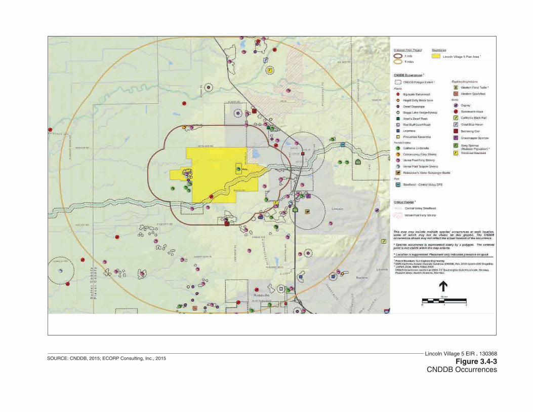
Lincoln Village 5 EIR . 130368
Figure 3.4-3CNDDB Occurrences
SOURCE: CNDDB, 2015; ECORP Consulting, Inc., 2015
Lincoln Village 5 Plan Area 1
3.4 Biological Resources
Village 5 & Special Use District B (SUD-B) Specific Plan 3.4-25 ESA / 201800402.01 Draft Partially Recirculated Environmental Impact Report May 2021
Protocol-level special-status plant surveys of Area A were conducted during the 2013 and 2014 growing seasons.50 No special-status plants were found within Area A. To date, no special-status plant surveys have been conducted within the remainder of the Plan Area. The PCCP does not provide coverage for the take of special-status plant species. Thus, consultation with the CDFW or USFWS would be required if state- or federally-listed plant species are identified during protocol surveys for Areas B through J. Further, if take cannot be avoided, take authorization may be required.
Big-Scale Balsamroot The big-scale balsamroot is not listed pursuant to either the federal Endangered Species Act (FESA) or CESA, but is designated as a California Rare Plant Rank (CRPR) 1B.2 species. This species is an herbaceous perennial that occurs in chaparral, cismontane woodlands, valley and foothill grasslands, and occasionally on serpentine soils.51 The big-scale balsamroot blooms from March through June and is known to occur at elevations ranging from 295 to 5,100 feet above MSL. The big-scale balsamroot is endemic to California; the current range of this species includes Alameda, Amador, Butte, Colusa, El Dorado, Lake, Mariposa, Napa, Placer, Santa Clara, Shasta, Solano, Sonoma, Tehama, Tuolumne counties.52
One occurrence of big-scale balsamroot has been reported within one mile and one occurrence within five-miles of the Plan Area.53 The annual grasslands throughout the Plan Area support suitable habitat for this species. Big-scale balsamroot was not observed in Area A during surveys in 2013 and 2014.54 The remainder of the Plan Area has not been surveyed for this species.
Dwarf Downingia The dwarf downingia is designated as a CRPR 2B.2 species. This species is a small herbaceous annual that occurs in vernal pools and mesic areas in valley and foothill grasslands. This species also appears to have an affinity for slight disturbance since it has been found in man-made features such as tire ruts, scraped depressions, stock ponds, and roadside ditches.55 This species blooms from March through May and is known to occur at elevations ranging from three to 1,460 feet above MSL. The current range of this species in California includes Amador, Fresno, Merced, Napa, Placer, Sacramento, San Joaquin, Solano, Sonoma, Stanislaus, Tehama, and Yuba counties.
50 ECORP Consulting, Inc., 2014. Special-Status Plant Survey for the Lincoln Village 5, Phase 1 Project. Prepared for
Richland Developers, Inc. August 27, 2014. 51 California Native Plant Society, 2015. Inventory of Rare and Endangered Plants (online edition v7- 13mar 3-14-
13). California Native Plant Society. Sacramento California. Available: http://www.cnps.org/inventory. Accessed February 25, 2015.
52 California Native Plant Society, 2015. Inventory of Rare and Endangered Plants (online edition v7- 13mar 3-14-13). California Native Plant Society. Sacramento California. Available: http://www.cnps.org/inventory. Accessed February 25, 2015.
53 California Department of Fish and Wildlife, 2015. Rarefind Natural Diversity Data Base Program. Version 3.1.1, commercial version dated: January 3, 2014. California Natural Diversity Database. The Resources Agency, Sacramento. Accessed April 16, 2015.
54 ECORP Consulting, Inc., 2014. Special-Status Plant Survey for the Lincoln Village 5, Phase 1 Project. Prepared for Richland Developers, Inc. August 27, 2014.
55 U.S. Fish and Wildlife Service, 2005. Recovery plan for vernal pool ecosystems of California and Southern Oregon. Portland, OR. December 15, 2005. Available: http://ecos.fws.gov/docs/recovery_plan/060614.pdf.
3.4 Biological Resources
Village 5 & Special Use District B (SUD-B) Specific Plan 3.4-26 ESA / 201800402.01 Draft Partially Recirculated Environmental Impact Report May 2021
One occurrence of dwarf downingia has been reported within the Plan Area (CNDDB Occurrence 61) as well as 15 additional occurrences within a five-mile radius.56 The vernal pools, seasonal wetlands, and seasonal swales throughout the Plan Area support suitable habitat for this species. Dwarf downingia was not observed in Area A during surveys in 2013 and 2014.57 The remainder of the Plan Area has not been surveyed for this species.
Boggs Lake Hedge-Hyssop Boggs Lake hedge-hyssop is listed as endangered pursuant to CESA and is designated as a CRPR 1B.2 species. This species is a small, semi-aquatic, herbaceous annual that occurs on clay soils in vernal pools, marshes, and swamps of lake margins. Boggs Lake hedge-hyssop blooms from April through August and is known to occur at elevations ranging from 32 feet above MSL to 7,792 feet above MSL. The current range of this species in California includes Fresno, Lake, Lassen, Madera, Merced, Modoc, Placer, Sacramento, Shasta, Siskiyou, San Joaquin, Solano, and Tehama counties.58
Two occurrences of Boggs Lake hedge-hyssop have been reported within five miles of the site.59 The vernal pools, seasonal wetlands, and seasonal swales throughout the Plan Area support suitable habitat for this species. Boggs Lake hedge-hyssop was not observed in Area A during surveys in 2013 and 2014.60 The remainder of the Plan Area has not been surveyed for this species.
Ahart’s Dwarf Rush Ahart’s dwarf rush is designated as a CRPR 1B.2 species. This species is an herbaceous annual that occurs in mesic areas in valley and foothill grasslands. This species also appears to have an affinity for slight disturbance since it has been found on farmed fields and gopher turnings. Ahart’s dwarf rush blooms from March through May and is known to occur at elevations ranging from 98 to 751 feet above MSL. Ahart’s dwarf rush is endemic to California; the current range of this species includes Butte, Calaveras, Placer, Sacramento, Tehama, and Yuba counties.61
56 California Department of Fish and Wildlife, 2015. Rarefind Natural Diversity Data Base Program. Version 3.1.1,
commercial version dated: January 3, 2014. California Natural Diversity Database. The Resources Agency, Sacramento. Accessed April 16, 2015.
57 ECORP Consulting, Inc., 2014. Special-Status Plant Survey for the Lincoln Village 5, Phase 1 Project. Prepared for Richland Developers, Inc. August 27, 2014.
58 California Native Plant Society, 2015. Inventory of Rare and Endangered Plants (online edition v7- 13mar 3-14-13). California Native Plant Society. Sacramento California. Available: http://www.cnps.org/inventory. Accessed February 25, 2015.
59 California Department of Fish and Wildlife, 2015. Rarefind Natural Diversity Data Base Program. Version 3.1.1, commercial version dated: January 3, 2014. California Natural Diversity Database. The Resources Agency, Sacramento. Accessed April 16, 2015.
60 ECORP Consulting, Inc., 2014. Special-Status Plant Survey for the Lincoln Village 5, Phase 1 Project. Prepared for Richland Developers, Inc. August 27, 2014.
61 California Native Plant Society, 2015. Inventory of Rare and Endangered Plants (online edition v7- 13mar 3-14-13). California Native Plant Society. Sacramento California. Available: http://www.cnps.org/inventory. Accessed February 25, 2015
3.4 Biological Resources
Village 5 & Special Use District B (SUD-B) Specific Plan 3.4-27 ESA / 201800402.01 Draft Partially Recirculated Environmental Impact Report May 2021
One occurrence of Ahart’s dwarf rush has been reported within five miles of the site.62 The vernal pools, seasonal wetlands, and seasonal swales throughout the Plan Area support suitable habitat for this species. Ahart’s dwarf rush was not observed in Area A during surveys in 2013 and 2014.63 The remainder of the Plan Area has not been surveyed for this species.
Red Bluff Dwarf Rush Red Bluff dwarf rush is designated as a CRPR 1B.1 species. This species is an herbaceous annual that occurs in vernally mesic areas in chaparral, cismontane woodland, meadows, seeps, valley and foothill grasslands, and vernal pools. Red Bluff dwarf rush blooms from March through June and is known to occur at elevations ranging from 114 to 4001 feet above MSL. Red Bluff dwarf rush is endemic to California; the current range of this species includes Butte, Placer, Shasta, and Tehama counties.64
One occurrence of Red Bluff dwarf rush has been reported within five miles of the site.65 The vernal pools, seasonal wetlands, and seasonal swales throughout the Plan Area support suitable habitat for this species. Red Bluff dwarf rush was not observed in Area A during surveys in 2013 and 2014.66 The remainder of the Plan Area has not been surveyed for this species.
Legenere Legenere is designated as a CRPR 1B.1 species. This species is an herbaceous annual that occurs in a variety of seasonally inundated environments including wetlands, wetland swales, marshes, vernal pools, artificial ponds, and floodplains of intermittent drainages. Legenere blooms from April through June and is known to occur at elevations ranging from three to 2,624 feet above MSL. Legenere is endemic to California; the current range of this species includes Alameda, Lake, Monterey, Napa, Placer, Sacramento, Santa Clara, San Joaquin, Shasta, San Mateo, Solano, Sonoma, Stanislaus, Tehama, and Yuba counties and is believed to be extinct in Stanislaus County.67
62 California Department of Fish and Wildlife, 2015. Rarefind Natural Diversity Data Base Program. Version 3.1.1,
commercial version dated: January 3, 2014. California Natural Diversity Database. The Resources Agency, Sacramento. Accessed April 16, 2015.
63 ECORP Consulting, Inc., 2014. Special-Status Plant Survey for the Lincoln Village 5, Phase 1 Project. Prepared for Richland Developers, Inc. August 27, 2014
64 California Native Plant Society, 2015. Inventory of Rare and Endangered Plants (online edition v7- 13mar 3-14-13). California Native Plant Society. Sacramento California. Available: http://www.cnps.org/inventory. Accessed February 25, 2015.
65 California Department of Fish and Wildlife, 2015. Rarefind Natural Diversity Data Base Program. Version 3.1.1, commercial version dated: January 3, 2014. California Natural Diversity Database. The Resources Agency, Sacramento. Accessed April 16, 2015.
66 ECORP Consulting, Inc., 2014. Special-Status Plant Survey for the Lincoln Village 5, Phase 1 Project. Prepared for Richland Developers, Inc. August 27, 2014.
67 California Native Plant Society, 2015. Inventory of Rare and Endangered Plants (online edition v7- 13mar 3-14-13). California Native Plant Society. Sacramento California. Available: http://www.cnps.org/inventory. Accessed February 25, 2015.

3.4 Biological Resources
Village 5 & Special Use District B (SUD-B) Specific Plan 3.4-28 ESA / 201800402.01 Draft Partially Recirculated Environmental Impact Report May 2021
Three occurrences of legenere have been reported within five miles of the site.68 The vernal pools, seasonal wetlands, and seasonal swales throughout the Plan Area support suitable habitat for this species. Legenere was not observed in Area A during surveys in 2013 and 2014.69 The remainder of the Plan Area has not been surveyed for this species.
Pincushion Navarretia Pincushion navarretia is not listed pursuant to either FESA or CESA, but is designated as a CRPR 1B.1 species. This species is an herbaceous annual that occurs in vernal pools that are often acidic. Pincushion navarretia blooms in April through May and is known to occur at elevations ranging from 65 to 1,082 feet above MSL. Pincushion navarretia is endemic to California; the current range of this species includes Amador, Calaveras, Merced, Placer, and Sacramento counties.70
One occurrence of pincushion navarretia has been reported within one mile of the site.71 The vernal pools, seasonal wetlands, and seasonal swales throughout the Plan Area support suitable habitat for this species. Pincushion navarretia was not observed in Area A during surveys in 2013 and 2014.72 The remainder of the Plan Area has not been surveyed for this species.
Slender Orcutt Grass Slender Orcutt grass is listed as threatened and endangered pursuant to FESA and CESA, respectively, and is designated as a CRPR 1B.1 species. This species is an herbaceous annual that occurs in vernal pools primarily on substrates of volcanic origin. This species is known to occur in the same type of vernal pool complexes as Sacramento Orcutt grass in Sacramento County; however, these species have not been observed co-existing in the same vernal pool.73 The median area of pools occupied by populations was 1.6 acres and ranged from 0.2 acre to 111.0 acres.74 Slender Orcutt grass blooms from May through October and is known to occur at elevations ranging from 115 to 5,775 feet above MSL. Slender Orcutt grass is endemic to California; the current range for this species includes Butte, Lake, Lassen, Modoc, Plumas, Sacramento, Shasta, Siskiyou, and Tehama counties.75
68 California Department of Fish and Wildlife, 2015. Rarefind Natural Diversity Data Base Program. Version 3.1.1,
commercial version dated: January 3, 2014. California Natural Diversity Database. The Resources Agency, Sacramento. Accessed April 16, 2015.
69 ECORP Consulting, Inc., 2014. Special-Status Plant Survey for the Lincoln Village 5, Phase 1 Project. Prepared for Richland Developers, Inc. August 27, 2014.
70 California Native Plant Society, 2015. Inventory of Rare and Endangered Plants (online edition v7- 13mar 3-14-13). California Native Plant Society. Sacramento California. Available: http://www.cnps.org/inventory. Accessed February 25, 2015.
71 California Department of Fish and Wildlife, 2015. Rarefind Natural Diversity Data Base Program. Version 3.1.1, commercial version dated: January 3, 2014. California Natural Diversity Database. The Resources Agency, Sacramento. Accessed April 16, 2015.
72 ECORP Consulting, Inc., 2014. Special-Status Plant Survey for the Lincoln Village 5, Phase 1 Project. Prepared for Richland Developers, Inc. August 27, 2014.
73 U.S. Fish and Wildlife Service, 2003. Final Designation of Critical Habitat for Four Vernal Pool Crustaceans and Eleven Vernal Pool Plants in California and Southern Oregon; Final Rule. Federal Register 68(151):46684-46867.
74 U.S. Fish and Wildlife Service, 2003. Final Designation of Critical Habitat for Four Vernal Pool Crustaceans and Eleven Vernal Pool Plants in California and Southern Oregon; Final Rule. Federal Register 68(151):46684-46867.
75 California Native Plant Society, 2015. Inventory of Rare and Endangered Plants (online edition v7- 13mar 3-14-13). California Native Plant Society. Sacramento California. Available: http://www.cnps.org/inventory. Accessed February 25, 2015.

3.4 Biological Resources
Village 5 & Special Use District B (SUD-B) Specific Plan 3.4-29 ESA / 201800402.01 Draft Partially Recirculated Environmental Impact Report May 2021
While no documented occurrences of slender Orcutt grass have been reported within five miles of the site,76 this species was still considered a target species due to the presence of suitable habitat within the site. The vernal pools in the Plan Area support suitable habitat for this species. Slender Orcutt grass was not observed in Area A during surveys in 2013 and 2014.77 The remainder of the Plan Area has not been surveyed for this species.
Sanford's Arrowhead Sanford’s arrowhead is not listed pursuant to FESA or CESA, but is designated as a CRPR 1B.2 species. This species is a rhizomatous, herbaceous perennial that occurs in shallow marshes and freshwater swamps.78 Sanford’s arrowhead blooms from May through October and is known to occur at elevations ranging from sea level to 2,132 feet above MSL. Sanford’s arrowhead is endemic to California; the current range of this species includes Butte, Del Norte, El Dorado, Fresno, Merced, Mariposa, Orange, Placer, Sacramento, San Bernardino, San Joaquin, Shasta, Solano, Tehama, and Ventura counties, but is believed to be extinct in Orange and Ventura counties.79
While no documented occurrences of Sanford’s arrowhead have been reported within five miles of the site,80 this species was still considered a target species due to the presence of suitable habitat within the site. The creek and canals throughout the site support suitable habitat for this species. Sanford’s arrowhead was not observed in Area A during surveys in 2013 and 2014.81 The remainder of the Plan Area has not been surveyed for this species.
Special-Status Wildlife A number of special-status invertebrates, fish, amphibians, reptiles, and birds may occur within the Plan Area (Table 3.4-3). Some of these special-status species have been found during targeted species surveys within Area A.82 In addition, according to the CNDDB, these and other special-status species have been documented to occur within five miles of the Plan Area.83 Based on the
76 California Department of Fish and Wildlife, 2015. Rarefind Natural Diversity Data Base Program. Version 3.1.1,
commercial version dated: January 3, 2014. California Natural Diversity Database. The Resources Agency, Sacramento. Accessed April 16, 2015.
77 ECORP Consulting, Inc., 2014. Special-Status Plant Survey for the Lincoln Village 5, Phase 1 Project. Prepared for Richland Developers, Inc. August 27, 2014.
78 California Native Plant Society, 2015. Inventory of Rare and Endangered Plants (online edition v7- 13mar 3-14-13). California Native Plant Society. Sacramento California. Available: http://www.cnps.org/inventory. Accessed February 25, 2015.
79 California Native Plant Society, 2015. Inventory of Rare and Endangered Plants (online edition v7- 13mar 3-14-13). California Native Plant Society. Sacramento California. Available: http://www.cnps.org/inventory. Accessed February 25, 2015.
80 California Department of Fish and Wildlife, 2015. Rarefind Natural Diversity Data Base Program. Version 3.1.1, commercial version dated: January 3, 2014. California Natural Diversity Database. The Resources Agency, Sacramento. Accessed April 16, 2015.
81 ECORP Consulting, Inc., 2014. Special-Status Plant Survey for the Lincoln Village 5, Phase 1 Project. Prepared for Richland Developers, Inc. August 27, 2014.
82 ECORP Consulting, Inc., 2014. Federally listed large brachiopod dry season surveys, Lincoln Village 5, Phase 1 Project. Letter addressed to U.S. Fish and Wildlife Service, Sacramento, CA. December 16, 2014.
83 California Department of Fish and Wildlife, 2015. California Natural Diversity Database (CNDDB) RareFind 4 personal computer program. Available: http://www.dfg.ca.gov/biogeodata/cnddb/mapsanddata.asp. Accessed April 16, 2015.
3.4 Biological Resources
Village 5 & Special Use District B (SUD-B) Specific Plan 3.4-30 ESA / 201800402.01 Draft Partially Recirculated Environmental Impact Report May 2021
Biological Resources Assessment for the Lincoln Village 5 & SUD-B Specific Plan,84 species that have been documented within the Plan Area or that could occur within the Plan Area are discussed in more detail below.
Invertebrates Three listed branchiopod species have the potential to occur within the Plan Area. These are the federally endangered Conservancy fairy shrimp (Branchinecta conservatio), the federally threatened vernal pool fairy shrimp (Branchinecta lynchi), and the federally endangered vernal pool tadpole shrimp (Lepidurus packardi) (collectively “listed large branchiopods”). ECORP conducted dry season surveys in Area A in September and October 2014.85 During the survey, eggs belonging to the genus Branchinecta were found in two vernal pools surveyed. While eggs of the genus Branchinecta cannot be identified to species without DNA analysis, there is no suitable habitat for Conservancy fairy shrimp in Area A. The large turbid vernal pools or playas where this species occurs are absent. It can therefore be assumed that the eggs that were found are of the vernal pool fairy shrimp. Since the pools containing eggs occur in two disjunct areas on the site, further sampling was terminated and the assumption was made that vernal pool fairy shrimp are likely to occur within potentially suitable habitat within Area A. Given the similarity of the Area A conditions to the remainder of the Plan Area, it is expected that federally listed large branchiopods, primarily vernal pool fairy shrimp, may also be present within the Plan Area. Similar to Area A, it is unlikely that suitable habitat for Conservancy fairy shrimp is present within the Plan Area.
Vernal Pool Fairy Shrimp The vernal pool fairy shrimp is federally listed as threatened under FESA. Fairy shrimp are ephemeral crustaceans. The population remains in the dry basin as cysts (embryonic eggs) when the temporary water bodies that they inhabit dry up. These cysts can withstand harsh conditions (e.g., summer heat, freezing, desiccation) until winter rains fill their basin. After the appropriate conditions (e.g., water temperature, water depth) are present, the cysts hatch instars (immature fairy shrimp), that quickly mature and mate to ensure the next generation.
This species has a short average maturation period (18 days), and a short average number of days to reproduction (39 days), which explains its ability to survive in some of the most ephemeral wetland habitats. This species generally cannot withstand warm water (24°C), which may explain why it is typically observed during the cooler months (i.e., January, February, and early March). Vernal pool fairy shrimp are most often observed in vernal pools (79 percent of observations); however, they have also been observed in other natural and artificial habitats, including seasonal wetlands, alkali pools, ephemeral drainages, stock ponds, roadside ditches, railroad ditches, vernal swales, and rock outcrop vernal pools. The species occurs on many geologic formations
84 ECORP Consulting, Inc., 2015. Biological Resources Assessment for the Lincoln Village 5 &SUD-B Specific
Plan. Prepared for Richland Developers, Inc. March 18, 2015. 85 ECORP Consulting, Inc., 2014. Federally listed large brachiopod dry season surveys, Lincoln Village 5, Phase 1
Project. Letter addressed to U.S. Fish and Wildlife Service, Sacramento, CA. December 16, 2014.

3.4 Biological Resources
Village 5 & Special Use District B (SUD-B) Specific Plan 3.4-31 ESA / 201800402.01 Draft Partially Recirculated Environmental Impact Report May 2021
and landforms. This species is most often found in small (less than 200 meters square) and shallow (five centimeters deep) habitats, although it also can occur in large and deep vernal pools.86
Vernal pool fairy shrimp have one of the broadest distributions of the California endemic fairy shrimp species. It occurs most of the length of the Central Valley, from the Millville Plains and Stillwater Plains in Shasta County south to Pixley in Tulare County, and the eastern margin of the central Coast Range from San Benito County south to Ventura County. Disjunct populations occur on the Santa Rosa Plateau and near Rancho Santa Rosa, California in Riverside County. The species also occurs within the Medford area of southern Oregon.87,88
Threats to vernal pool fairy shrimp include agricultural conversion and development that result in habitat loss. Habitat loss also occurs through changes in natural hydrology, incompatible livestock grazing, pollution by storm water, and disturbance from recreational activities.89
There are three reported occurrences of the vernal pool fairy shrimp within the Plan Area (CNDDB Occurrence Nos. 319; 423; and 158) as well as numerous occurrences within a one- and five-mile radius of the Plan Area.90 Upon further investigation, it was determined that one of these occurrences is in the western portion of the Plan Area (CNDDB Occurrence 319). There is also approximately 180 acres of vernal pool fairy shrimp critical habitat on the easternmost portion of the Plan Area.91
Vernal Pool Tadpole Shrimp The vernal pool tadpole shrimp is federally listed as endangered under FESA. The vernal pool tadpole occurs in seasonally inundated basins. The species’ cysts (embryonic eggs) lie dormant in the basin when basins are dry. After winter rainwater fills the pools, populations of the species re-emerge from their cysts.92 Unlike the cysts of many of the fairy shrimp species, the cysts of vernal pool tadpole shrimp do not require a freezing or drying period to hatch. Adult tadpole shrimp can have multiple generations during a single ponding period and are often present in
86 Helm, B. P. 1998. Biogeography of eight large branchiopods endemic to California. Pages 124-139 in Witham, C. W.,
E. T. Bauder, D. Belk, W.R. Ferren Jr., and R. Ornduff. (eds.). Ecology, conservation, and management of vernal pool ecosystems – proceeding from a 1996 conference. California Native Plant Society, Sacramento, CA. 285 pp.
87 Helm, B. P. 1998. Biogeography of eight large branchiopods endemic to California. Pages 124-139 in Witham, C. W., E. T. Bauder, D. Belk, W.R. Ferren Jr., and R. Ornduff. (eds.). Ecology, conservation, and management of vernal pool ecosystems – proceeding from a 1996 conference. California Native Plant Society, Sacramento, CA. 285 pp.
88 Helm, B. P., and W.C. Fields. 1998. Aquatic macro-invertebrate assemblages on the Agate Desert and nearby sites in Jackson, Oregon. Prepared for the Oregon Natural Heritage Program, 812 SE 14th Avenue, Portland, OR 97214.
89 U.S. Fish and Wildlife Service, 2005. Recovery plan for vernal pool ecosystems of California and Southern Oregon. Portland, OR. December 15, 2005. Available: http://ecos.fws.gov/docs/recovery_plan/060614.pdf.
90 California Department of Fish and Wildlife, 2015. California Natural Diversity Database (CNDDB) RareFind 4 personal computer program. Available: http://www.dfg.ca.gov/biogeodata/cnddb/mapsanddata.asp. Accessed April 16, 2015.
91 U.S. Fish and Wildlife Service, 2006. Designation of Critical Habitat for Four Vernal Pool Crustaceans and Eleven Vernal Pool Plants; Final Rule. Federal Register 71(28):7118-7316.
92 Ahl, J. S. B. 1991. Factors affecting contributions of the tadpole shrimp, Lepidurus packardi, to its oversummering egg reserves. Hydrobiologia 212:137-143.

3.4 Biological Resources
Village 5 & Special Use District B (SUD-B) Specific Plan 3.4-32 ESA / 201800402.01 Draft Partially Recirculated Environmental Impact Report May 2021
vernal pools until the pools dry up in late spring.93 Vernal pool tadpole shrimp mature slowly and are long lived in comparison to other California endemic branchiopod species.94
The vernal pool tadpole shrimp occurs in small (two meters square) to very large (356,253 meters square) vernal pools with a variety of depths and volumes of water during ponding. The species is associated with vernal pools and other seasonally inundated basins on the following geomorphologic surfaces: alluvial fan, basin, basin rim, floodplain, marine terrace, high terrace, stream terrace, very high terrace, low terrace, and volcanic mudflow landforms.
The vernal pool tadpole shrimp has been observed in stock ponds, vernal pools, grass-bottom swales, mud-bottomed pools, roadside ditches, railroad ditches, and other seasonal inundated wetlands. The vernal pool tadpole shrimp has been found with other California endemic branchiopods, including California fairy shrimp, vernal pool fairy shrimp, longhorn fairy shrimp (Branchinecta longiantenna), and conservancy fairy shrimp.
The vernal pool tadpole shrimp is found in the Central Valley from Stillwater Plains and Millville Plains in Shasta County, south to Kings County and from one single wetland complex on the San Francisco Bay National Wildlife Refuge in the City of Fremont, Alameda County.95
The largest threats to vernal pool tadpole shrimp are loss of habitat through urbanization. Other threats include encroachment of nonnative annual grasses, agricultural conversion, and parasitism by flukes (Trematoda) of an undetermined species.96 Some populations are also threatened by pesticide drift from adjacent farmlands.
There is an occurrence of vernal pool tadpole shrimp within the Plan Area (CNDDB Occurrence No. 27), as well as numerous additional occurrences within a one- and five-mile radius of the Plan Area.97 This occurrence was located in a man-made roadside ditch southwest of the intersection of Pleasant Grove Road and is presumed existing. Many of the seasonal wetlands, seasonal swales, vernal pools, and farmed wetlands within the Plan Area represent potentially suitable habitat for this species and this species is likely present.
93 Helm, B. P. 1998. Biogeography of eight large branchiopods endemic to California. Pages 124-139 in Witham,
C. W., E. T. Bauder, D. Belk, W.R. Ferren Jr., and R. Ornduff. (eds.). Ecology, conservation, and management of vernal pool ecosystems – proceeding from a 1996 conference. California Native Plant Society, Sacramento, CA. 285 pp.
94 Ahl, J. S. B. 1991. Factors affecting contributions of the tadpole shrimp, Lepidurus packardi, to its oversummering egg reserves. Hydrobiologia 212:137-143.
95 U.S. Fish and Wildlife Service, 1994. Endangered and Threatened Wildlife and Plants; Determination of Endangered Status for the Conservancy Fairy Shrimp, Longhorn Fairy Shrimp, and the Vernal Pool Tadpole Shrimp; and Threatened Status for the Vernal Pool Fairy Shrimp. Portland, Oregon.
96 Ahl, J. S. B. 1991. Factors affecting contributions of the tadpole shrimp, Lepidurus packardi, to its oversummering egg reserves. Hydrobiologia 212:137-143.
97 California Department of Fish and Wildlife, 2015. California Natural Diversity Database (CNDDB) RareFind 4 personal computer program. Available: http://www.dfg.ca.gov/biogeodata/cnddb/mapsanddata.asp. Accessed April 16, 2015.

3.4 Biological Resources
Village 5 & Special Use District B (SUD-B) Specific Plan 3.4-33 ESA / 201800402.01 Draft Partially Recirculated Environmental Impact Report May 2021
Valley Elderberry Longhorn Beetle The Valley Elderberry Longhorn Beetle ([VELB] Desmocerus californicus dimorphus) is listed as threatened in accordance with FESA.98 The VELB is completely dependent on its host plant, elderberry (Sambucus species), which occurs in riparian and other woodland and scrub communities.99 Elderberry plants located within the range of the beetle, with one or more stems measuring 1.0 inch or greater in diameter at ground level are considered to be habitat for the species. The adult flight season extends from late March through June. During that time, the adults feed on foliage and perhaps flowers, mate, and females lay eggs on living elderberry plants. The first instar larvae bore into live elderberry stems, where they develop for one to two years feeding on the pith. The fifth instar larvae create exit holes in the stems and then plug the holes and remain in the stems through pupation.100 The beetle’s current distribution is patchy throughout California’s Central Valley, from Shasta County to Kern County, and associated foothills up to an elevation of approximately 3,000 feet.101
Elderberry plant surveys have not been conducted in the entire Plan Area; however surveys have been completed for all of Area A and no elderberry plants were found.102 The Markham and Auburn Ravines provide suitable habitat for elderberry plants; these areas would be largely preserved by the proposed project.
Fish Central Valley steelhead (Oncorhynchus mykiss), and Chinook salmon including fall-, winter- and spring-run, (Oncorhynchus tshawytscha) are reported within the Auburn Ravine, in the southeast portion of the Plan Area. The Plan Area is outside the known distribution of Delta smelt and Lahontan cutthroat trout (Oncorhynchus clarki henshawi); thus, these species are not further discussed.
Central Valley Steelhead Central Valley Steelhead is designated as a federally listed threatened species. Existing wild steelhead stocks in the Central Valley are mostly confined to the upper Sacramento River and its tributaries, including Antelope, Deer, and Mill creeks and the Yuba River. Populations may also exist in Big Chico and Butte creeks and a few wild steelhead are produced in the American and Feather rivers.103 Recent snorkel surveys (1999 to 2002) indicate that steelhead are also present in
98 U.S. Fish and Wildlife Service, 1980. Listing the Valley Elderberry Longhorn Beetle as a Threatened Species with
Critical Habitat. Final Rule. Federal Register 45(155):52803-52807. 99 U.S. Fish and Wildlife Service, 1999. Conservation Guidelines for the Valley Elderberry Longhorn Beetle.
July 9, 1999. 100 Barr, C. B. 1991. The distribution, habitat and status of the valley elderberry longhorn beetle Desmocerus
californicus dimorphus. U.S. Fish and Wildlife Service, Sacramento, California. 101 U.S. Fish and Wildlife Service, 1999. Conservation Guidelines for the Valley Elderberry Longhorn Beetle.
July 9, 1999. 102 ECORP Consulting, Inc., 2014. Results of Elderberry Shrub Surveys for the Lincoln Village 5, Phase 1 Project.
Prepared for Richland Developers, Inc. March 9, 2015. 103 McEwan, D., and T.A. Jackson. 1996. Steelhead Restoration and Management Plan for California. Department of
Fish and Game, Sacramento, California, 234 pp.

3.4 Biological Resources
Village 5 & Special Use District B (SUD-B) Specific Plan 3.4-34 ESA / 201800402.01 Draft Partially Recirculated Environmental Impact Report May 2021
Clear Creek.104 Naturally-spawning populations may also exist in many other streams but have been undetected due to lack of monitoring programs.
The life history of steelhead is similar to that of Chinook salmon with two major exceptions: steelhead do not necessarily die after spawning, and juveniles may spend up to four years in freshwater before migrating to the ocean. Central Valley (Evolutionarily Significant Unit [ESU]) steelhead, the anadromous form of rainbow trout, typically spawn in tributaries to mainstem rivers from December through March, often ascending significant distances. Following spawning, adults normally migrate back to the ocean. Productive steelhead habitat is characterized by complexity, primarily in the form of large and small woody debris. Cover is an important habitat component for juvenile steelhead both as velocity refuge and as a means of avoiding predation.
Steelhead require gravel and cobble substrates (0.6 to 13 centimeter diameter) with limited amounts of fine sediments (sand, silt, and clay) for spawning. In general, water temperatures less than 16.1°C (61°F) are necessary for successful incubation and hatching of steelhead eggs. Fry and older juveniles require adequate instream cover (cobble or boulders, large woody debris, undercut banks, or submerged and overhanging vegetation for protection from predators).
No surveys have been conducted for this species in the Plan Area. This species is reported within the Auburn Ravine within the Plan Area (CNDDB Occurrence 4).105 The Auburn Ravine is also designated critical habitat for the Central Valley steelhead and steelhead are expected to be present in the Plan Area.106
Chinook salmon Chinook salmon are an anadromous species which spawn in freshwater rivers but migrate to the ocean to rear.107 Chinook salmon typically return to their natal stream to spawn. Within the Central Valley there are four races of Chinook salmon: fall-run, late fall-run, winter-run, and spring-run. The timing of spawning of the four races of Chinook salmon in Central Valley rivers is as follows:108
• Adult fall-run Chinook salmon migrate through the Delta and into Central Valley rivers from July through December and spawn from October through December.
• Adult late-fall-run Chinook salmon migrate through the Delta and into the Sacramento River from October through March or possibly April and spawn from January through April. Peak spawning activity occurs in February and March.
104 Good, T.P., R.S. Waples, and P. Adams (editors). 2005. Updated status of federally listed ESUs of West Coast
salmon and steelhead. National Oceanic and Atmospheric Administration Tech. Memo. NMFS-NWFSC-66, 598 pp.
105 California Department of Fish and Wildlife, 2015. California Natural Diversity Database (CNDDB) RareFind 4 personal computer program. Available: http://www.dfg.ca.gov/biogeodata/cnddb/mapsanddata.asp. Accessed April 16, 2015.
106 National Marine Fisheries Office, 2015. Population boundaries for Central Valley Chinook and Steelhead. Available: http://www.westcoast.fisheries.noaa.gov/maps_data/species_population_boundaries.html. Accessed February 26, 2015.
107 Moyle, Peter B., 2002. Inland Fishes of California. University of California Press, Ltd. Berkeley, CA. 108 Moyle, Peter B., 2002. Inland Fishes of California. University of California Press, Ltd. Berkeley, CA.
3.4 Biological Resources
Village 5 & Special Use District B (SUD-B) Specific Plan 3.4-35 ESA / 201800402.01
Draft Partially Recirculated Environmental Impact Report May 2021
Adult winter-run Chinook salmon migrate through the Delta from late November through June and into the Sacramento River from December through July. Winter-run Chinook salmon remain in the river up to several months before spawning. Spawning occurs from mid-April through August, with peak spawning activity in May and June.
Adult spring-run Chinook salmon migrate through the Delta from January through June, enter the Sacramento River and its tributaries from March through September, and remain in the rivers up to several months before spawning. Spawning occurs from late August through October, with peak spawning activity in September.
Chinook rely on suitable water temperature and substrate for successful spawning and incubation. Rearing habitat for juveniles includes riffles, runs, pools, and inundated floodplains. In streams, Chinook are opportunistic feeders. They eat aquatic insects, terrestrial insects and bottom invertebrates. Larger fish tend to eat larger pray. Juvenile Chinook are significantly affected by
predatory nonnative fish.109
Degradation and loss of habitat have contributed substantially to the decline of Chinook salmon. Shasta and other dams have blocked access to much of their historical spawning and rearing habitat. Other factors affecting the species include modified water temperatures, entrainment in diversions, contaminants, and nonnative species.
No surveys have been conducted for this species in the Plan Area, however, fall, spring, and winter run (based on juvenile size at time of survey), were collected downstream of the Plan
Area110 and could be present within Auburn Ravine within the Plan Area. The spring-run and winter-run juvenile fish that were collected were probably rearing in Auburn Ravine, but likely hatched in other streams in the Sacramento River watershed. Spring-run and winter-run Chinook
salmon are not known to spawn in Auburn Ravine.111
Amphibians and Reptiles
The Plan Area may support potentially suitable habitat for one special-status amphibian species and one special-status reptilian species, specifically the Western spadefoot toad (Spea hammondii) and Northwestern Western pond turtle (Actinemys marmorata). Surveys for the Western spadefoot toad and northwestern Western pond turtle have not been performed within the Plan Area.
The Plan Area is not within the current known range of the California tiger salamander (Ambystoma californiense), the California red-legged frog (Rana draytonii), and giant garter snake (Thamnophis gigas). As such, these species are considered absent from the Plan Area and are not discussed further.
109 Placer County, 2004. Placer County Natural Resources Report: A Scientific assessment of watersheds, ecosystems,
and species of the Phase I Planning Area. Ch 4 p. 115. Prepared for Placer County Planning Department. Prepared by Jones & Stokes, Sacramento, CA.
110 California Department of Fish and Wildlife, 2014. Completion of the 2013 Auburn Ravine Rotary Screw Trap Monitoring Report. Memorandum from Michael Healey to Colin Purdy, July 10, 2014. Rancho Cordova, CA.
111 California Department of Fish and Wildlife, 2014. Completion of the 2013 Auburn Ravine Rotary Screw Trap Monitoring Report. Memorandum from Michael Healey to Colin Purdy, July 10, 2014. Rancho Cordova, CA.
3.4 Biological Resources
Village 5 & Special Use District B (SUD-B) Specific Plan 3.4-36 ESA / 201800402.01
Draft Partially Recirculated Environmental Impact Report May 2021
Western Spadefoot Toad
The Western spadefoot toad is designated as a CDFW species of special concern. Necessary habitat components of the Western spadefoot toad include suitable underground retreats and breeding ponds. Suitable breeding sites include temporary rain pools such as vernal pools and seasonal wetlands, or pools within portions of intermittent drainages. The Western spadefoot toads spend most of their adult life within underground burrows or other suitable refuge, such as rodent burrows. In California, Western spadefoot toads are known to occur from the Redding area
in Shasta County southward to northwestern Baja California, at elevations below 4,475 feet.112
There is one occurrence of Western spadefoot toad within five miles south of Plan Area.113 This occurrence included one adult crossing Phillip Road at a bend, approximately 1.5 miles west of the junction of Fiddyment Road and 0.3 miles west where Phillip Road parallels Pleasant Grove Creek. The population is presumed to be existing.
Surveys for this species have not been performed in the Plan Area, but wetlands within these sites may represent potentially suitable habitat.
Northwestern Western Pond Turtle
The Northwestern Western pond turtle is designated as a CDFW species of special concern. Northwestern Western pond turtles occur in a variety of fresh and brackish water habitats including marshes, lakes, ponds, and slow moving streams. This species is primarily aquatic;
however, they typically leave aquatic habitats in the fall to reproduce and to overwinter.114 Deep, still water with abundant emergent woody debris, overhanging vegetation, and rock outcrops is optimal for basking and thermoregulation. Although adults are habitat generalists, hatchlings and juveniles require specialized habitat for survival through the first few years. Hatchlings require shallow water habitat with relatively dense submergent or short emergent vegetation in which to forage.
Northwestern Western pond turtles are typically active between March and November. Mating generally occurs during late April and early May and eggs are deposited between late April and early August. Eggs are deposited within excavated nests in upland areas, with substrates that typically have high clay or silt fractions, usually in the vicinity of aquatic habitats. The majority of nesting sites are located within 650 feet (200 meters) of the aquatic habitat; however, sites
have been documented as far as 1,310 feet (400 meters) from the aquatic habitat.115
112 Jennings, M.R. and M.P. Hayes, 1994. Amphibians and reptile species of special concern in California. Contract
38023, report to the California Department of Fish and Game, Inland Fisheries Division. Sacramento, CA. 255 pp. 113 California Department of Fish and Wildlife, 2015. California Natural Diversity Database (CNDDB) RareFind 4
personal computer program. Available: http://www.dfg.ca.gov/biogeodata/cnddb/mapsanddata.asp. Accessed April 16, 2015.
114 Jennings, M.R. and M.P. Hayes, 1994. Amphibians and reptile species of special concern in California. Contract 38023, report to the California Department of Fish and Game, Inland Fisheries Division. Sacramento, CA. 255 pp.
115 Jennings, M.R. and M.P. Hayes, 1994. Amphibians and reptile species of special concern in California. Contract 38023, report to the California Department of Fish and Game, Inland Fisheries Division. Sacramento, CA. 255 pp.
3.4 Biological Resources
Village 5 & Special Use District B (SUD-B) Specific Plan 3.4-37 ESA / 201800402.01
Draft Partially Recirculated Environmental Impact Report May 2021
There are no documented occurrences of Northwestern Western pond turtle within five miles of
the Plan Area.116 Portions of Auburn and Markham Ravines and ponds within the Plan Area may represent Northwestern Western pond turtle habitat. Surveys for this species have not been performed within the Plan Area.
Birds
The Plan Area may support potentially suitable habitat for special-status bird species as described below.
Tricolored Blackbird
The tricolored blackbird was declared a candidate for listing as threatened or endangered by the California Fish and Game Commission under CESA on December 10, 2015, and is federally protected under the MBTA. This colonial nesting species is distributed widely throughout the
Central Valley, Coast Range, and into Oregon, Washington, Nevada, and Baja California.117 Tricolored blackbird nests in colonies that can range from several pairs to several thousand pairs, depending on prey availability, the presence of predators, or level of human disturbance. This nomadic species typically nests in emergent marsh, riparian thickets, and blackberry brambles, usually with some nearby standing water or ground saturation. Open grassland and agricultural fields are typical foraging areas, with nesting generally occurring from April through June.
There is one occurrence of tricolored blackbird within one mile and an additional occurrence
within five miles of the Plan Area.118 Tricolored blackbird surveys or habitat assessments have not been performed for the Plan Area but suitable habitat is present.
Grasshopper Sparrow
The grasshopper sparrow (Ammodramus savannarum) is designated as a species of special concern by the CDFW. The grasshopper sparrow is an uncommon and local summer resident and breeder along the western edge of the Sierra Nevada and most coastal counties south to Baja California (where resident). This species generally inhabits moderately open grasslands and prairies with patchy bare ground and scattered shrubs. Grasshopper sparrow is more likely to occupy large tracts of habitat than small fragments. Breeding generally occurs from early April to
mid-July, with a peak in May and June.119
116 California Department of Fish and Wildlife, 2015. California Natural Diversity Database (CNDDB) RareFind 4
personal computer program. Available: http://www.dfg.ca.gov/biogeodata/cnddb/mapsanddata.asp. Accessed April 16, 2015.
117 Beedy, E. C., and W. J. Hamilton, III. 1999. Tricolored Blackbird (Agelaius tricolor), The Birds of North America Online (A. Poole, Ed.). Ithaca: Cornell Lab of Ornithology. Available: http://bna.birds.cornell.edu/bna/species/423.
118 California Department of Fish and Wildlife, 2015. California Natural Diversity Database (CNDDB) RareFind 4 personal computer program. Available: http://www.dfg.ca.gov/biogeodata/cnddb/mapsanddata.asp. Accessed April 16, 2015.
119 Vickery, P. D. 1996. Grasshopper Sparrow (Ammodramus savannarum), The Birds of North America Online (A. Poole, Ed.). Ithaca: Cornell Lab of Ornithology; Retrieved from the Birds of North America Online. Available: http://bna.birds.cornell.edu/bna/species/239.

3.4 Biological Resources
Village 5 & Special Use District B (SUD-B) Specific Plan 3.4-38 ESA / 201800402.01 Draft Partially Recirculated Environmental Impact Report May 2021
There is one occurrence of grasshopper sparrow within five miles of the Plan Area.120 Grasshopper sparrow surveys or habitat assessments have not been performed for the Plan Area, but the on-site annual grassland community provides potential nesting habitat.
Burrowing Owl The burrowing owl is designated as a species of special concern by the CDFW. Burrowing owls inhabit dry open rolling hills, grasslands, desert floors, and open bare ground with gullies and arroyos. They can also inhabit developed areas such as golf courses, cemeteries, roadsides within cities, airports, vacant lots in residential areas, school campuses, and fairgrounds. This species typically uses burrows created by fossorial mammals, most notably the California ground squirrel, but may also use man-made structures such as cement culverts or pipes, cement, asphalt, or wood debris piles, or openings beneath cement or asphalt pavement. The breeding season typically occurs 1 February through 31 August.121
There is one occurrence of burrowing owl within one mile of the Plan Area and additional occurrence within five miles of the Plan Area.122 Burrowing owl surveys or habitat assessments have not been performed, but the annual grasslands within the Plan Area represent potential habitat for burrowing owl.
Swainson's Hawk The Swainson’s hawk (Buteo swainsoni) is listed as a threatened species and is protected pursuant to CESA. This species nests in North America (Canada, western U.S., and Mexico) and typically winters from South America north to Mexico. However, a small population has been observed wintering in the Sacramento-San Joaquin River Delta. In California, the nesting season for Swainson’s hawk ranges from mid-March to late August.
Swainson’s hawk nests within tall trees in a variety of wooded communities including riparian, oak woodland, roadside landscape corridors, urban areas, and agricultural areas, among others. Foraging habitat includes open grassland, savannah, low-cover row crop fields, and livestock pastures. In the Central Valley, Swainson’s hawks typically feed on a combination of California vole, California ground squirrel (Spermophilus beecheyi), ring-necked pheasant (Phasianus colchicus), many passerine birds, and grasshoppers (Melanopulus spp.). Swainson’s hawks are opportunistic foragers and will readily forage in association with agricultural mowing, harvesting, discing, and irrigating.123 The removal of vegetative cover by such farming activities results in more readily available prey items for this species. 120 California Department of Fish and Wildlife, 2015. California Natural Diversity Database (CNDDB) RareFind 4
personal computer program. Available: http://www.dfg.ca.gov/biogeodata/cnddb/mapsanddata.asp. Accessed April 16, 2015.
121 California Department of Fish and Wildlife, 2012. Staff Report on Burrowing Owl Mitigation. State of California. Natural Resources Agency, Sacramento.
122 California Department of Fish and Wildlife, 2015. California Natural Diversity Database (CNDDB) RareFind 4 personal computer program. Available: http://www.dfg.ca.gov/biogeodata/cnddb/mapsanddata.asp. Accessed April 16, 2015.
123 Estep, J. A. 1989. Biology, movements, and habitat relationships of the Swainson's hawk in the Central Valley of California, 1986-1987. California Department of Fish and Game, Nongame Bird and Mammal Section Report.
3.4 Biological Resources
Village 5 & Special Use District B (SUD-B) Specific Plan 3.4-39 ESA / 201800402.01 Draft Partially Recirculated Environmental Impact Report May 2021
There is one occurrence of Swainson’s hawk in the Plan Area (CNDDB occurrence 1484) as well as seven additional records within five miles of the Plan Area.124 No Swainson’s hawk surveys have been performed; however, potential nesting habitat for Swainson’s hawk includes the larger trees along the Auburn and Markham Ravines and associated foraging habitat occurs throughout the Plan Area in fields and agricultural areas, and other grasslands.
Northern Harrier The Northern harrier is considered to be a species of special concern by the CDFW. This species is known to nest within the Central Valley, along the Pacific Coast, and in northeastern California. The Northern harrier is a ground-nesting species and typically nests in emergent wetland/marsh, open grasslands, or savannah communities usually in areas with dense vegetation. Foraging occurs within a variety of open environments such as marshes, agricultural fields, and grasslands. Nesting occurs during April through September. To date, no surveys for the Northern harrier have been performed in the Plan Area, but potential nesting and foraging habitat for Northern harrier include the annual grasslands on-site.
Western Yellow-billed Cuckoo The Western yellow-billed cuckoo (Coccyzus americanus occidentalis) is listed as an endangered species pursuant to CESA, and is listed as threatened under FESA. Typical nesting habitat includes dense riparian thicket/woodland. This migratory species arrives from its wintering grounds in South America during June and departs from California during September. In northern California, current nesting populations occur along the upper Sacramento River (Tehama, Butte, Colusa, Glenn and Sutter counties), Feather River, and the Butte Sink (Sutter and Butte counties). No habitat assessment or surveys have been conducted for the Wester yellow-billed cuckoo in riparian corridors along the Auburn and Markham Ravines. While these locations may contain suitable habitat, no nesting sites are known from Placer County. However, this does not preclude the potential for the rare occurrence of a migrant Western yellow-billed cuckoo.
White-tailed Kite The white-tailed kite has been fully protected in California under Section 3511 of the California Fish and Game Code since 1957. This species is a resident in the Central Valley and along the entire length of the California coast. In northern California, the white-tailed kite typically nests from March through June. Nesting occurs in trees within riparian, oak woodland, savannah, and agricultural communities that are found in or near foraging areas such as open grasslands, meadows, farmlands, savannahs, and emergent wetlands. While no surveys for the white-tailed kite have been conducted, potential nesting habitat includes the trees along Auburn and Markham Ravines, and the annual grassland represents potential foraging habitat.
124 California Department of Fish and Wildlife, 2015. California Natural Diversity Database (CNDDB) RareFind 4
personal computer program. Available: http://www.dfg.ca.gov/biogeodata/cnddb/mapsanddata.asp. Accessed April 16, 2015.
3.4 Biological Resources
Village 5 & Special Use District B (SUD-B) Specific Plan 3.4-40 ESA / 201800402.01 Draft Partially Recirculated Environmental Impact Report May 2021
Loggerhead Shrike The loggerhead shrike (Lanius ludovicianus) is considered a species of special concern by the CDFW. Loggerhead shrikes nest throughout California except the northwestern corner, montane forests, and high deserts. Loggerhead shrikes nest in small trees and shrubs in open country with short vegetation such as pastures, old orchards, mowed roadsides, cemeteries, golf courses, agricultural fields, riparian areas, and open woodlands.125 The nesting season extends from March through June. Although no surveys for the loggerhead shrike have been performed, potential nesting habitat includes the smaller trees along Markham and Auburn Ravines.
Purple Martin The purple martin (Progne subis) is a CDFW species of special concern. It occurs within the foothills of the Sierra Nevada and the Coast Range to the Pacific Coast, with several small sub-populations occurring within the city limits of Sacramento. The purple martin typically nests in woodlands where tree cavities are utilized to raise broods. To date, surveys for the purple martin have not been performed within the Plan Area, but potential nesting habitat includes the smaller trees along Markham and Auburn Ravines.
Heron/Egret Rookeries The great egret (Ardea alba), great blue heron (Ardea herodias), snowy egret (Egretta thula), and black-crowned night heron (Nycticorax nycticorax) are colonial nesting birds that typically nest in trees and/or riparian areas. While these species are not formally listed and protected pursuant to either CESA or FESA, their rookeries are of interest to CDFW and are subject to CEQA review. The nearest recorded rookery site is within four miles of the Plan Area, and potential habitat exists within the Plan Area.126
Wintering Special-Status Birds Several special-status birds may forage within the Plan Area during the non-nesting season. These include golden eagle (Aquila chrysaetos), short-eared owl (Asio flammeus), ferruginous hawk, prairie falcon (Falco mexicanus), and long-billed curlew (Numenius americanus). These species do not nest in the Central Valley, but may occur as post-breeding dispersers, migrants, or winter residents.
Mammals The annual grassland community found within the Plan Area represents marginally suitable habitat for regionally occurring special-status mammals, including American badger (Taxidea taxus) and two bat species: pallid bat (Antrozous pallidus) and Townsend’s big-eared bat (Corynorhinus townsendii).
125 Yosef, R. 1996. Loggerhead Shrike (Lanius ludovicianus), The Birds of North America Online (A. Poole, Ed.).
Ithaca: Cornell Lab of Ornithology; Retrieved from the Birds of North America Online. Available: http://bna.birds.cornell.edu/bna/species/231.
126 California Department of Fish and Wildlife, 2015. California Natural Diversity Database (CNDDB) RareFind 4 personal computer program. Available: http://www.dfg.ca.gov/biogeodata/cnddb/mapsanddata.asp. Accessed April 16, 2015.

3.4 Biological Resources
Village 5 & Special Use District B (SUD-B) Specific Plan 3.4-41 ESA / 201800402.01 Draft Partially Recirculated Environmental Impact Report May 2021
American Badger The American badger is designated as a species of special concern by the CDFW. In California, American badgers ranged throughout the state except for the humid coastal forests of northwestern California in Del Norte County and the northwestern portion of Humboldt County. No current data exist on the status of American badger populations in California, but they have declined or disappeared in large sections of the state. American badgers occupy diverse habitats. The principal requirements seem to be sufficient food, friable soils, and relatively open, uncultivated ground, and they prefer grasslands, savannas, and mountain meadows near timberline. Badgers prey primarily on burrowing rodents. American badgers dig burrows in friable soil for cover and frequently reuse old burrows, although some may dig a new den each night, especially in summer.
There are no documented occurrences of American badger in the project vicinity. This species has a low potential to occur within the Plan Area. To date, no surveys for this species or its burrows have been performed for the Plan Area.
Bats The pallid bat is a CDFW species of special concern; Townsend’s big-eared bat is both a CDFW species of special concern and a candidate species proposed for listing under CESA. Targeted surveys for bats have not occurred and these bat species have a moderate potential to occur within the Plan Area. Potential roosting habitat within the Plan Area includes the larger trees along Markham and Auburn Ravines and the rural residence-associated dilapidated barn and trees in the Plan Area.
Wildlife Movement/Corridors Wildlife movement corridors are considered an important ecological resource by various agencies (CDFW and USFWS) and under CEQA. Movement corridors may provide favorable locations for wildlife to travel between different habitat areas such as foraging sites, breeding sites, cover areas, and preferred summer and winter range locations. They may also function as dispersal corridors allowing animals to move between various locations within their range. Topography and other natural factors, in combination with urbanization, can fragment or separate large open-space areas. Areas of human disturbance or urban development can fragment wildlife habitats and impede wildlife movement between areas of suitable habitat. This fragmentation creates isolated “islands” of vegetation that may not provide sufficient area to accommodate sustainable populations, and can adversely affect genetic and species diversity. Movement corridors mitigate the effects of this fragmentation by allowing animals to move between remaining habitats, which in turn allows depleted populations to be replenished and promotes genetic exchange between separate populations.
The Plan Area is located in an undeveloped landscape with irrigated pastures and annual grassland (non-irrigated) and used for livestock grazing (primarily cattle) and actively farmed wheat and rice fields. The annual grassland community in this region has been documented as an

3.4 Biological Resources
Village 5 & Special Use District B (SUD-B) Specific Plan 3.4-42 ESA / 201800402.01 Draft Partially Recirculated Environmental Impact Report May 2021
important resource for wintering raptors.127 The Plan Area has the potential to support ephemeral wetlands and intermittent drainages that likely support wildlife (e.g., waterfowl, waders, and shorebirds) movement during the wet season and less so during the dry summer/fall months. The flooded rice fields support waterfowl, waders, and shorebirds during the flooded periods and raptor foraging habitat during the drier harvest and post-harvest period. The adjacent Markham and Auburn Ravines also support wildlife movement throughout the year. The proposed V5SP identifies extensive open space preserves, including both Markham and Auburn Ravines. These ravines are the highest quality and most intact linear habitats currently available for wildlife dispersal and connectivity in the area, and would continue to function in this capacity following development of the V5SP project.
3.4.2 Regulatory Setting This section provides a discussion of applicable federal, state, and local regulations as they pertain to biological resources.
Federal Federal Endangered Species Act FESA (16 U.S. Code Section 1531 et seq.) protects threatened and endangered plants and animals and their critical habitat. Candidate species are those proposed for listing; these species are usually treated by resource agencies as if they were actually listed during the environmental review process. Procedures for addressing impacts to federally listed species follow two principal pathways. The first pathway is a Section 10(a) incidental take permit, which applies to situations where a non-federal government entity must resolve potential adverse impacts to species protected under the FESA. The proposed PCCP, discussed below, is an example of this first path. The second pathway involves Section 7 consultation, which applies to projects directly undertaken by a federal agency or private projects requiring a federal permit or approval such as a Section 404 permit under the CWA, or receiving federal funding.
FESA defines an endangered species as “any species or subspecies that is in danger of extinction throughout all or a significant portion of its range.” A threatened species is defined as “any species or subspecies that is likely to become an endangered species within the foreseeable future throughout all or a significant portion of its range.” The term “take” means to “harass, harm, pursue, hunt, shoot, wound, kill, trap, or collect or to attempt to engage in any such conduct.”
Critical Habitat Under Section 7 of FESA, federal agencies are required to ensure that any action authorized, funded, or carried out by such agency is not likely to jeopardize the continued existence of any endangered or threatened species or result in the destruction or adverse modification of critical habitat. This is achieved through consultation with USFWS and the National Marine Fisheries Service (NMFS). 127 Jones & Stokes. 2003. Important Migrant and Wintering Bird Concentration Areas of Western Placer County.
Prepared for the Placer County Planning Department.
3.4 Biological Resources
Village 5 & Special Use District B (SUD-B) Specific Plan 3.4-43 ESA / 201800402.01 Draft Partially Recirculated Environmental Impact Report May 2021
“Critical habitat” is defined as those specific areas, within the areas occupied by the endangered species, at the time of listing, which contain physical or biological features that (1) are essential to the conservation of the species, or (2) require special management considerations or protection (16 U.S. Code, Section 1532(5)(A)). Except in limited circumstances, critical habitat does not include all of the area occupied by the species.
In designating critical habitat, USFWS and NMFS are required to focus their analysis on the “principal biological or physical constituent elements” available in the area. These primary constituent elements (“PCEs”) must be included in the proposed and final critical habitat designation descriptions.
The Plan Area contains designated critical habitat for the vernal pool fairy shrimp and Central Valley steelhead.
Migratory Bird Treaty Act The Migratory Bird Treaty Act (MBTA) (16 U.S. Code Section 703-712) enacts the provisions of treaties between the United States, Great Britain, Mexico, Japan, and the Soviet Union and authorizes the U.S. Secretary of the Interior to protect and regulate the taking of migratory birds. It establishes seasons and bag limits for hunted species and protects migratory birds, their occupied nests, and their eggs. Most actions that result in a taking or in permanent or temporary possession of a protected species constitute violations of the MBTA. Examples of permitted actions that do not violate the MBTA are the possession of a hunting license to pursue specific game birds, legitimate research activities, display in zoological gardens, bird banding, and other similar activities. USFWS is responsible for overseeing compliance with the MBTA.
Bald and Golden Eagle Protection Act The Bald and Golden Eagle Protection Act (16 U.S. Code Section 668), enforced by the USFWS, makes it illegal to import, export, take (which includes molest or disturb), sell, purchase, or barter any bald eagle (Haliaeetus leucocephalus) or golden eagle (Aquila chrysaetos) or parts thereof.
Clean Water Act The federal CWA (33 U.S. Code Section 1251 et seq.) was enacted as an amendment to the federal Water Pollution Control Act of 1972, which outlined the basic structure for regulating discharges of pollutants to waters of the U.S. The CWA serves as the primary federal law protecting the quality of the nation’s surface waters, including lakes, rivers, and coastal wetlands.
Section 404 Section 404 of the CWA regulates the discharge of dredged and fill materials into waters of the U.S. “Waters of the U.S.” refers to oceans, bays, rivers, streams, lakes, ponds, and wetlands. Applicants must obtain a permit from the USACE for all discharges of dredged or fill material into waters of the U.S., including wetlands, before proceeding with a proposed activity. Waters of the U.S. are under the jurisdiction of the USACE and the U.S. EPA. The term “waters” includes wetlands and non-wetland bodies of water that meet specific criteria as defined in the CFR. All
3.4 Biological Resources
Village 5 & Special Use District B (SUD-B) Specific Plan 3.4-44 ESA / 201800402.01 Draft Partially Recirculated Environmental Impact Report May 2021
three of the identified technical criteria must be met for an area to be identified as a wetland under USACE jurisdiction, unless the area has been modified by human activity. In general, a permit must be obtained before fill can be placed in or removed from wetlands or other waters of the U.S. The type of permit required depends on the amount of acreage and the purpose of the proposed fill, subject to discretion of the USACE, and the U.S. EPA.
Certain activities in wetlands or “other waters” are automatically authorized, or granted a nationwide permit that allows filling where impacts are considered minor. Eligibility for a nationwide permit simplifies the permit review process. Nationwide permits cover construction and fill of waters of the U.S. for a variety of routine activities such as minor road crossings, utility line crossings, streambank protection, recreational facilities and outfall structures. To qualify for a nationwide permit, a project must demonstrate that it has no more than a minimal adverse effect on the aquatic ecosystem, including species listed under the FESA.
The USACE retains discretionary approval over proposed projects where impacts are considered significant, requiring adequate mitigation and permit approval. To provide compliance with the U.S. EPA’s Section 404(b)(1) Guidelines, an applicant must demonstrate that the proposed discharge is unavoidable and is the least environmentally damaging practicable alternative that will achieve the overall project purpose. Compliance with CWA Section 404 also requires compliance with several other environmental laws and regulations. The USACE cannot issue an individual permit or verify the use of a general nationwide permit until the requirements of FESA and the National Historic Preservation Act (NHPA) have been met. In addition, the USACE cannot issue or verify any permit until a water quality certification or a waiver of certification has been issued by the applicable California Water Quality Control Board pursuant to CWA Section 401.
Section 401 Under CWA Section 401, applicants for a federal license or permit to conduct activities which may result in the discharge of a pollutant into waters of the U.S. must obtain certification from the state in which the discharge would originate or, if appropriate, from the interstate water pollution control agency with jurisdiction over affected waters at the point where the discharge would originate. Therefore, all projects that have a federal component and may affect state water quality (including projects that require federal agency approval, such as issuance of a Section 404 permit) must also comply with CWA Section 401. In California, the nine Regional Water Quality Control Boards are tasked with issuing Section 401 certifications for projects within their jurisdiction. The State Water Resources Control Board issues 401 certifications for state or federal projects in California.
State Regional Water Quality Control Board The State Water Resources Control Board (SWRCB) and the nine Regional Water Quality Control Boards (RWQCBs) (together “Boards”) are the principal state agencies with primary responsibility for the coordination and control of water quality. In the Porter-Cologne Water
3.4 Biological Resources
Village 5 & Special Use District B (SUD-B) Specific Plan 3.4-45 ESA / 201800402.01 Draft Partially Recirculated Environmental Impact Report May 2021
Quality Control Act (Porter-Cologne Act) (California Water Code Section 13000 et seq.), the Legislature declared that the “state must be prepared to exercise its full power and jurisdiction to protect the quality of the waters in the state from degradation …” (California Water Code Section 13000). The Porter-Cologne Act grants the Boards the authority to implement and enforce the water quality laws, regulations, policies and plans to protect the groundwater and surface waters of the state. Waters of the state determined to be jurisdictional would require, if impacted, waste discharge permitting and/or a CWA Section 401 certification (in the case of the required USACE permit). The enforcement of the state's water quality requirements is not solely the purview of the Boards and their staff. Other agencies (e.g., the CDFW) also have the ability to enforce certain water quality provisions in state law.
California Endangered Species Act Under CESA (California Fish and Game Code Section 2050-2098), CDFW has the responsibility for maintaining a list of endangered and threatened species (Fish and Game Code Section 2070). Sections 2050 through 2098 of the Fish and Game Code outline the protection provided to California’s rare, endangered, and threatened species. Section 2080 of the Fish and Game Code prohibits the taking of plants and animals listed under the CESA. CESA defines take as “any action or attempt to hunt, pursue, catch, capture, or kill any listed species.” The CESA definition of take does not include “harm” or “harass” as is included in the federal ESA. Section 2081 established an Incidental Take Permit program for State-listed species. CDFW maintains a list of “candidate species” which are species that CDFW formally notices as being under review for addition to the list of endangered or threatened species.
Pursuant to the requirements of CESA, an agency reviewing a proposed project within its jurisdiction must determine whether any State-listed endangered or threatened species may be present in the project study area and determine whether the proposed project will have a potentially significant impact on such species. In addition, CDFW encourages informal consultation on any proposed project that may impact a candidate species.
Project-related impacts to species on the CESA endangered or threatened list would be considered significant. “Take” of protected species incidental to otherwise lawful management activities may be authorized under Fish and Game Code Section 206.591. Authorization from CDFW would be in the form of an Incidental Take Permit under Section 2801.
California Fish and Game Code Fully Protected Species Certain species are considered fully protected, meaning that the code explicitly prohibits all take of individuals of these species except for take permitted for scientific research. Section 5050 lists fully protected amphibians and reptiles, Section 5515 lists fully protected fish, Section 3511 lists fully protected birds, and Section 4700 lists fully protected mammals. Except as provided in Sections 2081.7 or 2835, fully protected species may not be taken or possessed at any time and no licenses or permits may be issued for their take except for collecting these species for necessary scientific research and relocation of the species for the protection of livestock.

3.4 Biological Resources
Village 5 & Special Use District B (SUD-B) Specific Plan 3.4-46 ESA / 201800402.01 Draft Partially Recirculated Environmental Impact Report May 2021
Protection of Birds and Their Nests Under Section 3503 of the California Fish and Game Code, it is unlawful to take, possess, or needlessly destroy the nest or eggs of any bird, except as otherwise provided by this code or any regulation made pursuant thereto. Section 3503.5 of the code prohibits take, possession, or destruction of any birds in the orders Falconiformes (hawks) or Strigiformes (owls), or of their nests and eggs. Migratory non-game birds are protected under Section 3800, while other specified birds are protected under Section 3505.
Stream and Lake Protection CDFW has jurisdictional authority over streams and lakes and the wetland resources associated with these aquatic systems under California Fish and Game Code Section 1600 et seq. through administration of lake or streambed alteration agreements. Such an agreement is not a permit, but rather a mutual accord between CDFW and the project proponent. Section 1600 et seq. was repealed and replaced in October of 2003 with the new Sections 1600–1616 which took effect on January 1, 2004 (Senate Bill No. 418 Sher). Under the new code provisions, CDFW has the authority to regulate work that will “substantially divert or obstruct the natural flow of, or substantially change or use any material from the bed, channel, or bank of, any river, stream, or lake, or deposit or dispose of debris, waste, or other material containing crumbled, flaked, or ground pavement where it may pass into any river lake or stream.” CDFW enters into a streambed alteration agreement with the project proponent and can impose conditions in the agreement to minimize and mitigate impacts to fish and wildlife resources. Because CDFW includes under its jurisdiction streamside habitats that may not qualify as wetlands under the federal CWA definition, CDFW jurisdiction may be broader than USACE jurisdiction.
A project proponent must submit a notification of streambed alteration to CDFW before construction commences. The notification requires an application fee for streambed alteration agreements, with a specific fee schedule to be determined by CDFW. CDFW can enter into programmatic agreements that cover recurring operation and maintenance activities and regional plans. These agreements are sometimes referred to as Master Streambed Alteration Agreements (MSAAs).
Under Fish and Game Code Section 1602 (Streambed Alteration Agreements), CDFW takes jurisdiction over the stream zone which is defined top of bank or outside extent of riparian vegetation, whichever is the greatest. Within the stream zone, waters of the State of California are typically delineated to include the streambed to the top of the bank and adjacent areas that would meet any one of the three wetland parameters in the USACE definition (i.e., vegetation, hydrology, and/or soils). Whereas federal jurisdiction requires meeting all three parameters, in practice meeting one parameter, or even the presence (rather than dominance) of wetland plants in an area associated with a jurisdictional streambed would qualify an area as waters of the State of California. CDFW jurisdiction does not include isolated wetlands and wetlands that are not associated with a streambed.
3.4 Biological Resources
Village 5 & Special Use District B (SUD-B) Specific Plan 3.4-47 ESA / 201800402.01 Draft Partially Recirculated Environmental Impact Report May 2021
Native Plant Protection Act State listing of plant species began in 1977 with the passage of the California Native Plant Protection Act (NPPA) (California Fish and Game Code Section 1900-1913), which directed the CDFW to carry out the legislature’s intent to “preserve, protect, and enhance endangered plants in this state.” The NPPA gave the California Fish and Game Commission the power to designate native plants as endangered or rare and to require permits for collecting, transporting, or selling such plants. CESA expanded on the original NPPA and enhanced legal protection for plants. CESA established threatened and endangered species categories, and grandfathered all rare animals—but not rare plants—into the act as threatened species. Thus, three listing categories for plants are employed in California: rare, threatened, and endangered.
California Rare Plant Rank CDFW in collaboration with CNPS maintains a list of plant species native to California that have low numbers, limited distribution, or are otherwise threatened with extinction. This information is published in the Inventory of Rare and Endangered Vascular Plants of California as a system of CRPRs. Potential impacts to populations of CNPS-listed plants may receive consideration under CEQA review. The following identifies the definitions of the CRPR listings:
Rank 1A: Plants presumed extirpated in California and either rare or extinct elsewhere.
Rank 1B: Plants Rare, Threatened, or Endangered in California and elsewhere.
Rank 2A: Plants presumed extirpated in California, but more common elsewhere.
Rank 2B: Plants Rare, Threatened, or Endangered in California, but more common elsewhere.
Rank 3: Plants about which more information is needed - A Review List.
Rank 4: Plants of limited distribution - A Watch List.
In general, CRPR128 1A, 1B, 2A, or 2B plants are considered to meet the criteria of CEQA Guidelines Section 15380 and impacts to these species are considered “significant” in this EIR.
Species of Special Concern CDFW maintains lists for candidate-endangered species and candidate-threatened species. California candidate species are afforded the same level of protection as listed species. California also designates species of special concern, which are species of limited distribution, declining populations, diminishing habitat, or unusual scientific, recreational, or educational value. These species do not have the same legal protection as listed species or fully protected species, but may be added to official lists in the future. CDFW intends the species of special concern list to be a management tool for consideration in future land use decisions.
128 CRPRs also include Code Extensions which add detail to individual rankings as defined below:
.1 = Seriously threatened in California (over 80% of occurrences threatened/high degree and immediacy of threat) .2 = Fairly threatened in California (20-80% occurrences threatened) .3 = Not very threatened in California (less than 20% of occurrences threatened or no current threats known)

3.4 Biological Resources
Village 5 & Special Use District B (SUD-B) Specific Plan 3.4-48 ESA / 201800402.01 Draft Partially Recirculated Environmental Impact Report May 2021
CEQA Guidelines Section 15380 Although threatened and endangered species are protected by specific federal and state statutes, CEQA Guidelines section 15380(d) provides that a species not listed on the federal or state list of protected species may be considered rare or endangered if the species can be shown to meet certain specific criteria.
CEQA also specifies the protection of other locally or regionally significant resources, including natural communities or habitats. Although natural communities do not presently have legal protection, CEQA requires an assessment of such communities and potential project impacts. Natural communities that are identified as sensitive in the CNDDB are considered by CDFW to be significant resources and fall under the CEQA Guidelines for addressing impacts. Local planning documents such as general and area plans often identify natural communities.
Local City of Lincoln General Plan The goals of the Open Space and Conservation Element of the City of Lincoln General Plan pertinent to the proposed project are:
Goal OSC-1. To designate, protect, and encourage natural resources, open space, and recreation lands in the city, protect and enhance a significant system of interconnected natural habitat areas, and provide opportunities for recreation activities to meet citizen needs.
Policies
OSC-1.1 The City shall strive to protect natural resource areas, fish and wildlife habitat areas, scenic areas, open space areas and parks from encroachment or destruction by incompatible development.
OSC-1.3 In new development areas, the City shall encourage the use of open space or recreational buffers between incompatible land uses.
OSC-1.6 The City shall require new development to implement measures that minimize soil erosion from wind and water related to construction. Measures may include, but not be limited to the following:
• Grading requirements that limit grading to the amount necessary to provide stable areas for structural foundations, street rights-of-way, parking facilities, or other intended uses; and/or
• Construction techniques that utilize site preparation, grading, and best management practices that provide erosion and sediment control to prevent construction-related contaminants from leaving development sites and polluting local waterways.
OSC-1.7 The City shall require all development to minimize soil erosion by maintaining compatible land uses suitable building designs and appropriate construction techniques. Contour grading, where appropriate, and revegetation shall be required to mitigate the appearance of engineered slopes and to control erosion.
Goal OSC-4. To preserve and enhance local streams, creeks, and aquifers.
Goal OSC-5. To preserve and protect existing biological resources including both wildlife and vegetative habitat.
3.4 Biological Resources
Village 5 & Special Use District B (SUD-B) Specific Plan 3.4-49 ESA / 201800402.01 Draft Partially Recirculated Environmental Impact Report May 2021
Policies
OSC-5.1 The City shall support the preservation of heritage oaks and threatened or endangered vegetative habitat from destruction. A heritage oak shall be defined as a tree with a diameter of 36 inches measured at a point 4.5 feet above grade level (i.e., diameter at breast height or DBH).
OSC-5.2 The City shall support the management of wetland and riparian plant communities for passive recreation, groundwater recharge, and wildlife habitats. Such communities shall be restored or expanded, where possible and as appropriate.
OSC-5.3 The City will continue to coordinate with Placer County and the Placer Legacy Open Space and Conservation Program to protect habitat areas that support endangered species and other special-status species.
OSC-5.4 The City shall encourage the planting of native trees, shrubs, and grasslands in order to preserve the visual integrity of the landscape, provide habitat conditions suitable for native vegetation, and ensure that a maximum number and variety of well-adapted plants are maintained.
OSC-5.5 The City shall require that new development in areas that are known to have particular value for biological resources be carefully planned and where possible avoided so that the value of existing sensitive vegetation and wildlife habitat can be maintained.
OSC-5.6 The City will maintain a policy of no net loss of wetlands on a project-by project basis, which may include an entire specific plan area. For the purpose of identifying such wetlands, the City will accept a map delineating wetlands which has been accepted by the U.S. Army Corps of Engineers pursuant to Section 404 of the Clean Water Act of 1972. The term “no net loss” may include mitigation implemented through site mitigation bank or similar mitigation mechanism acceptable to the City and permitting agencies.
OSC-5.7 The City may require project proponents to obtain 404 Permits, and prepare mitigation plans for, or provide for the avoidance, preservation, and maintenance of identified wetlands prior to submitting applications for land use entitlements.
OSC-5.8 The City may, but need not, accept a Corps of Engineers disclaimer of any jurisdiction over the project of a Corps of Engineers 404 permit as the City's own plan for the achievement of a project's no net loss of wetlands.
OSC-5.9 All preserved wetlands shall be dedicated to the City or a non-profit organization acceptable to the City and preserved through perpetual covenants enforceable by the City or other appropriate agencies, to ensure their maintenance and survival. With respect to areas dedicated to the City, acceptance shall be conditioned upon establishment of a lighting and landscaping district or other public or private funding mechanisms acceptable to the City.
OSC-5.11 Prior to project (i.e., specific plan or individual project) approval, the City shall require a biological study to be prepared by a qualified biologist for any proposed development within areas that contain a moderate to high potential for sensitive habitat. As appropriate, the study shall include the following activities: (1) inventory species listed in the CNPS Manual of California Vegetation, (2) inventory species identified by the USFWS and CDFG, (3) inventory special status species listed in the California NDDB, and (4) field survey of the project site by a qualified biologist.
OSC-5.12 The City shall consider using appropriate mitigation measures for future projects (i.e., specific plans or individual projects) based on mitigation standards or protocols adopted by the applicable statute or agency (e.g., USFWS, CDFG, etc.) with jurisdiction over any affected sensitive habitats or special status species.
OSC-5.13 The City shall ensure that lighting in residential areas and along roadways shall be designed to prevent artificial lighting from reflecting into adjacent natural or open space areas.
The relationship of these 2050 General Plan policies to the V5SP is included in Chapter 5, General Plan Consistency.

3.4 Biological Resources
Village 5 & Special Use District B (SUD-B) Specific Plan 3.4-50 ESA / 201800402.01 Draft Partially Recirculated Environmental Impact Report May 2021
Placer County Conservation Plan For over a decade, Placer County led has been leading an effort to prepare and adopt a comprehensive plan for the conservation of natural resources in western Placer County. In September 2020, the County certified the FEIR/FEIS and adopted the PCCP. The City and other Permitee Agencies followed suit in fall of 2020. The proposed PCCP is envisioned as a landscape-level plan that would allow individual projects to be issued permits based on how they contribute to the County’s natural, social, and economic health now and in the future. The proposed PCCP covers approximately 201,000 acres of western Placer County and would seek to establishes a conservation reserve program made up of existing reserve areas, desired acquisitions, and areas for future development (the Reserve Acquisition Areas). This conservation reserve system would will preserve many acres of vernal pool habitat (approximately 50 percent of the County’s remaining vernal pool ecosystems). These areas occur in the unincorporated County, the City of Lincoln, and other jurisdictions in the region.
The proposed PCCP would be is both a Habitat Conservation Plan (HCP) under FESA and a Natural Community Conservation Plan (NCCP) under the California Natural Community Conservation Planning Act. Pursuant to section 10(a)(1)(B) of the FESA, HCPs provide for partnerships with non-federal parties to conserve the ecosystems upon which listed species depend, ultimately contributing to their recovery. HCPs are planning documents required as part of an application for an incidental take permit. They describe the anticipated effects of the proposed taking; how those impacts will be minimized and mitigated; and how the HCP is to be funded. HCPs can apply to both listed and non-listed species, including those that are candidates or have been proposed for listing. Conserving species before they are in danger of extinction or are likely to become so can also provide early benefits and prevent the need for listing.
The proposed PCCP is a landscape-level plan and emphasizes the conservation of ecosystems, natural communities and ecological processes in western Placer County. The natural communities within western Placer County require large, contiguous blocks of intact habitat to maintain their biological function. Rather than the piecemeal approach of project-level mitigation, which often results in small blocks of avoided and preserved habitat both within project sites and at off-site mitigation areas, the proposed PCCP focuses on configuring a large, contiguous reserve system. Both natural communities as well as agricultural uses benefit from this approach, as larger preserves reduce edge effects, minimize human intrusion, allow adequate buffers from incompatible land uses, reduce the risk of invasive species introductions, result in significant buffers around wetlands and other regional waterways, and allow for largely unobstructed movement of plant and wildlife populations resulting in gene flow as well as opportunities for dispersal. Management of contiguous blocks of preserve land within a contiguous reserve system also results in economies of scale associated with acquisition and maximizes management efficiency, reducing long-term implementation costs. Under the proposed PCCP, preserve lands would will be acquired from willing sellers outside of (and in some cases, within) the potential future growth areas. The land may will be acquired and protected in perpetuity by some combination of fee-title ownership, conservation easements, or deed restrictions.

3.4 Biological Resources
Village 5 & Special Use District B (SUD-B) Specific Plan 3.4-51 ESA / 201800402.01 Draft Partially Recirculated Environmental Impact Report May 2021
A key component of the conservation strategy is based on land cover mitigation. In addition to wetland mitigation, impacts to specific land cover types (e.g., annual grassland, agriculture, etc.) would will be tracked, and in-kind mitigation would will will occur at ratios of 1:1.25, 1:1.35, or 1:1.5, or 1:1.52 depending on the land cover. This land cover approach would will mitigate for the habitat loss associated with individual development projects within the proposed PCCP area, including habitat for the 14 covered species. This mitigation strategy would will protect and enhance both natural communities and agricultural lands within the proposed PCCP area, resulting in the establishment of a sustainable reserve system in conjunction with the development of the future growth area.
Based on the County’s most current discussions with the federal and state resource agencies, the The species to be covered by the proposed PCCP would include:
Birds
• Swainson’s hawk • California black rail • Western burrowing owl • Tricolored blackbird
Reptiles
• Giant garter snake • NorthwWestern pond turtle
Amphibians
• Foothill yellow-legged frog • California red-legged frog
Fish
• Central Valley Steelhead • Chinook salmon
Invertebrates
• Valley elderberry longhorn beetle • Conservancy fairy shrimp • Vernal pool fairy shrimp • Vernal pool tadpole shrimp
Of these species, two (vernal pool fairy shrimp and Central Valley steelhead) have designated critical habitat within the Plan Area. The proposed PCCP does not cover special-status state or federally-listed plants.
As currently discussed, the proposed PCCP would The PCCP also includes a County Aquatic Resources Program (CARP) that would will serve as an implementation program supporting the issuance of permits under the federal CWA and the California Fish and Game Code. It is anticipated that the proposed The PCCP would will provide a streamlined process that would provide clarity and certainty around conservation of habitats for sensitive species in western Placer County, and would will reduce costs and uncertainties for project permitting, allowing project proponents to obtain state and federal permits through the local planning entitlement process. The approval of local projects would will be subject to the requirements of the proposed PCCP, but generally authorized and monitored locally.
The proposed PCCP is being was developed through coordination of Placer County, the USACE, U.S. EPA, USFWS, NMFS, and CDFW with partners in preparation of the plan, including the Placer County Water Agency (PCWA), the South Placer Regional Transportation Authority (SPRTA), and the City of Lincoln. A working draft copy of the PCCP is available on the

3.4 Biological Resources
Village 5 & Special Use District B (SUD-B) Specific Plan 3.4-52 ESA / 201800402.01 Draft Partially Recirculated Environmental Impact Report May 2021
County’s website at: https://www.placer.ca.gov/3362/Placer-County-Conservation-Program for review by participating agencies, however a public draft of the PCCP has not yet been released and ultimate adoption of the PCCP is as of yet uncertain.
3.4.3 Analysis, Impacts, and Mitigation Significance Criteria For the purposes of this analysis, this EIR uses the criteria presented in Appendix G of the CEQA Guidelines to determine impact significance. Significant impacts would occur if the proposed project would:
• Have a substantial adverse effect, either directly or through habitat modifications on any species identified as a candidate, sensitive, or special-status species in local or regional plans, policies, or regulations, or by the California Department of Fish and Wildlife or U.S. Fish and Wildlife Service;
• Substantially reduce the habitat of a fish or wildlife species;
• Cause a fish or wildlife population to drop below self-sustaining levels, threaten to eliminate a plant or animal or community;
• Substantially reduce the number or restrict the range of an endangered, rare or threatened species;
• Have a substantial adverse effect on any riparian habitat or other sensitive natural community identified in local or regional plans, policies, or regulations or by the California Department of Fish and Wildlife or U.S. Fish and Wildlife Service;
• Have a substantial adverse effect on federally protected wetlands defined by Section 404 of the Clean Water Act (including, but not limited to, marsh, vernal pool, coastal, etc.) through direct removal, filling, hydrological interruption, or by other means;
• Interfere substantially with the movement of any native resident or migratory fish or wildlife species or with established native resident or migratory wildlife corridors, or impede the use of native wildlife nursery sites;
• Conflict with the provisions of approved local, regional or state policies or ordinances protecting biological resources, such as a tree preservation policy or ordinance; or
• Conflict with the provisions of an adopted Habitat Conservation Plan, Natural Community Conservation Plan, or other approved local, regional, or state habitat conservation plan.
Methodology and Assumptions The impact analysis focuses on foreseeable changes to the baseline condition of the Plan Area in the context of the significance criteria presented above. In the impact analysis both direct and indirect impacts were considered. In conducting the following impact analysis, three principal components of the Guidelines outlined above were considered:
• Magnitude of the impact (e.g., substantial/not substantial);
• Uniqueness of the affected resource (i.e., rarity of the resource); and
• Susceptibility of the affected resource to perturbation (i.e., sensitivity of the resource).

3.4 Biological Resources
Village 5 & Special Use District B (SUD-B) Specific Plan 3.4-53 ESA / 201800402.01 Draft Partially Recirculated Environmental Impact Report May 2021
The evaluation of the significance of the following impacts considered the interrelationship of these three components. For example, a relatively small magnitude impact to a state or federally listed species would be considered significant because the species is very rare and is believed to be very susceptible to disturbance. Conversely, a plant community such as nonnative annual grassland is not necessarily rare or sensitive to disturbance. Therefore, a much larger magnitude of impact would be required to result in a significant impact.
The proposed project would be a covered activity under the draft PCCP if once it is adopted fully implemented by the County and the City of Lincoln and approved the necessary permits have been issued by the regulatory agencies. In anticipation of its adoption and approval, mitigation measures for potential impacts on biological resources presented in this EIR were developed to be consistent with the current Working Draft version of the PCCP. Any mitigation measures in this EIR that would be required to avoid or minimize impacts were are based on avoidance and minimization measures in the current Working Draft version of the PCCP. If required, any compensatory mitigation in the form of habitat preservation, wetland mitigation, (i.e., the protection in perpetuity of existing habitat), or habitat restoration (i.e., the creation, enhancement or rehabilitation of habitat) would occur in the PCCP Reserve Acquisition Area (RAA), in an agency-approved mitigation bank, or elsewhere as determined appropriate by the regulatory agencies for areas less than 200 acres in size (Figure 3.4-4). Mitigation lands would therefore be preserved and/or restored by utilizing a larger landscape-level approach. Performance standards and monitoring requirements for mitigation lands would be consistent with the PCCP. Land cover of the PCCP RAA is shown in Figure 3.4-5.
Assuming Once the PCCP is adopted implemented by the County, the City, and approved the required permits issued by the state and federal regulatory agencies, the management and monitoring of the mitigation lands would will become the responsibility of the Placer Conservation Authority (PCA), the implementing entity of the PCCP. The amount of preservation and restoration required to mitigate impacts to a less-than-significant level would be consistent with the ratio of habitat impacted to habitat preserved and restored under the Conservation Strategy of the adopted current Working Draft version of the PCCP.
If the PCCP has not been adopted implemented prior to entitlement and buildout of the V5SP, or prior to certain phases of the V5SP, project-level permitting would will be required to fulfill legal obligations associated with the laws and regulations described in Section 3.4.2 above (such as the CWA and state and federal ESAs). Additionally, because the PCCP does not cover special status plants, project-level permitting will be required, if they are present.
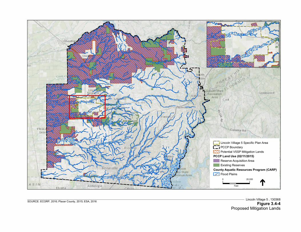
Service Layer Credits: Sources: Esri, HERE, DeLorme, Intermap, incrementP Corp., GEBCO, USGS, FAO, NPS, NRCAN, GeoBase, IGN, Kadaster NL,Ordnance Survey, Esri Japan, METI, Esri China (Hong Kong), swisstopo,MapmyIndia, © OpenStreetMap contributors, and the GIS User CommunityUSGS, NGA, NASA, CGIAR,N
Lincoln Village 5 . 130368Figure 3.4-4
Proposed Mitigation LandsSOURCE: ECORP, 2016; Placer County, 2015; ESA, 2016
0 20,000
Feet
Lincoln Village 5 Specific Plan AreaPCCP BoundaryPotential V5SP Mitigation Lands
PCCP Land Use (02/11/2015)Reserve Acquisition AreaExisting Reserves
County Aquatic Resources Program (CARP)Flood Plains

Map Date: 3/22/2016
PCCP Land Cover WithinPCCP Reserve Acquisition Area &
CARP Flood Plain Areas
I0 3
Mi les2013-051 Lincoln Village 5
Loca
tion:
N:\
2013
\201
3-05
1 Li
ncol
n Vi
llage
5\M
APS\
Land
cove
r\PC
CP\S
PA_P
CCP_
RAA
andC
ARP_
2016
0322
.mxd
(D
EK/J
DS/
DW
)-dw
agno
n 3/
22/2
016
Service Layer Credits: Sources: Esri, HERE, DeLorme, TomTom, Intermap, increment P Corp., GEBCO, USGS, FAO, NPS, NRCAN,GeoBase, IGN, Kadaster NL, Ordnance Survey, Esri Japan, METI, Esri China (Hong Kong), swisstopo, MapmyIndia, ©OpenStreetMap contributors, and the GIS User Community
Map FeaturesPCCP Boundary
Source: Placer County Conseervation Plan (PCCP) - Placer County GIS
County Aquatic Resources ProgramFlood Plains
PCCP Land Use (12/10/2015)Reserve Acquisition AreaExisting Reserves
PCCP Land Cover
AlfalfaAnnual GrasslandBarren (Rock outcrops/cliffs)Blue Oak WoodlandDisturbed LandsEucalyptus WoodlandFoothill ChaparralFoothill Hardwood WoodlandFresh Emergent WetlandInterior Live Oak WoodlandLacustrineLandscape and Golf Course PondsOak - Foothill Pine WoodlandOak Woodland - SavanahOrchardsPasture
RiceRiverineRow CropsRural ResidentialRural Residential ForestedSeasonal WetlandSprings and SeepsStock PondsUnidentified CroplandsUrban Golf CoursesUrban ParksUrban RiparianUrban WetlandUrban WoodlandUrban/SuburbanValley Foothill Riparian WoodlandValley Oak WoodlandVineyards
Lincoln Village 5 EIR . 130368
Figure 3.4-5PCCP Land Cover Types of the PCCP Reserve Acquisition Areas
and the County Aquatic Resources Program Floodplain Areas
SOURCE: ECORP Consulting, Inc., 2016
3.4 Biological Resources
Village 5 & Special Use District B (SUD-B) Specific Plan 3.4-56 ESA / 201800402.01 Draft Partially Recirculated Environmental Impact Report May 2021
Impacts and Mitigation Measures Impact 3.4-1: Implementation of the proposed project could have a substantial adverse effect on federally protected wetlands defined by Section 404 of the Clean Water Act through direct removal, placement of fill, hydrological interruption, or by other means and would result in fill of jurisdictional wetlands or other protected waters.
Full Specific Plan (Except Area A and Windsor Cove) Development of the full specific plan would result in the fill of jurisdictional wetlands, other waters of the U.S., or waters of the State. Wetland delineations have not been conducted for the properties that comprise the majority of the Plan Area. Estimates of wetlands and waters of the U.S. based on a review of aerial photography followed by a reconnaissance-level visit to the site indicate that a variety of potentially jurisdictional wetlands and other waters are present. As shown in Table 3.4-1, approximately 30 acres of potential wetland habitat could be impacted by the V5SP.
The proposed project has been designed to avoid many wetland features by designating over 40 percent of the entire Plan Area as open space areas and wildlife corridors such as Auburn and Markham Ravines. Within these areas, habitats would be preserved and enhanced. The open space corridors, which are consistent with the proposed PCCP and a part of the future Reserve Acquisition Area and CARP, include both Markham and Auburn Ravines and their associated floodplains. The channels of these ravines, as well as the extensive wetlands located within their floodplains, are some of the highest quality wetlands and habitat remaining in western Placer County. In addition, these open space corridors provide important connectivity corridors for wildlife, as well as potential spawning and rearing habitat for anadromous fish. The remaining wetlands in the Plan Area located in areas designated for development would be lost due to filling, grading, or other activities related to development. Many of the wetland resources to be filled are farmed wetlands (occurring within areas of active agriculture and often highly disturbed) or agricultural irrigation ditches or canals; however, some areas of relatively intact vernal pool and seasonal wetland complexes would be impacted. Construction related impacts could include increased turbidity and deposition of sediment into wetlands and waters. Project operations post-construction could also impact wetlands through runoff from irrigated landscapes that could include the introduction of nutrients from fertilizers or other pollutants into wetlands and waters. The loss of wetlands or other waters of the U.S. as a result of grading and other ground disturbance, or the degradation of waters during construction and operation of the proposed full specific plan would be considered a potentially significant impact.
Area A A wetland delineation has been conducted for Area A; a total of 94.90 acres of potentially jurisdictional wetlands and other waters of the U.S. occurs in Area A. GIS analysis of wetland mapping data,129 implementation of the V5SP would result in the loss of up to 20.78 acres of wetlands and other waters due to urban development in Area A. This would be considered a potentially significant impact.
129 ECORP Consulting, Inc., 2015. Wetland Delineation for the Lincoln Village 5, Phase 1 Project. Prepared for
Richland Developers, Inc. June 2, 2015. Verified by the USACE June 5, 2015.
3.4 Biological Resources
Village 5 & Special Use District B (SUD-B) Specific Plan 3.4-57 ESA / 201800402.01 Draft Partially Recirculated Environmental Impact Report May 2021
Windsor Cove The wetlands and other waters of the U.S. on the 80-acre Windsor Cove site were delineated in 2014. The site supports 7.68 acres of potentially jurisdictional wetlands and other water of the U.S. Implementation of the V5SP would result in the loss of up to approximately 7.68 acres of waters and other wetlands due to urban development at the Windsor Cove site. This would be considered a potentially significant impact.
Mitigation Measures
In practice, certain wetland types are not easily distinguished and often intergrade. The mitigation strategy below minimizes the effect of field interpretation by applying the same ratios for all wetland types and by allowing broad latitude for out-of-kind mitigation. For the purposes of applying mitigation requirements, the definition of “vernal pool complex” includes vernal pools and depressional areas within vernal swales, and other seasonal wetlands.
Mitigation Measure 3.4-1 (Full Specific Plan, Area A, and Windsor Cove)
a) If the PCCP has been adopted by the County, the City, and approved by the agencies, the The project applicant shall comply with the PCCP and that participation shall satisfy all mitigation requirements for this impact. Mitigation achieved through implementation of the PCCP shall be equal to or greater than the mitigation ratios and requirements described in subsection (b), below.
b) If the PCCP is not in operation or has not been adopted by the County and City processes for designating project impacts as covered under the PCCP have not been established and/or has not been approved by the agencies, the following mitigation measures shall apply:
1) The project applicant for each project phase shall retain a qualified biologist to delineate all wetlands and waters of the U.S. or other protected waters within the proposed development. The delineation(s) shall be submitted to the USACE for verification as part of the formal Section 404 wetland delineation process. If no wetlands are determined to be present, or if wetlands would be avoided, no further mitigation would be required. Prior to fill of any wetlands, or hydrologic interruption of the wetland, the applicant must obtain a Section 404 permit and obtain Section 401 certification from the Central Valley Regional Water Quality Control Board.
2) For each 1.0 wetted acre of vernal pools impacted, 1.35 acres of vernal pools shall be preserved. For purposes of calculating impact and mitigation requirements, seasonal depressional wetlands shall be considered vernal pools. For each 1.0 acres of impact of any other wetland type, the preservation requirement may be met by preserving 1.35 acres of any wetland type without regard for in-kind mitigation. The preservation requirement for open water may be met through preservation of 1.0 acres of open water or any wetland
3.4 Biological Resources
Village 5 & Special Use District B (SUD-B) Specific Plan 3.4-58 ESA / 201800402.01 Draft Partially Recirculated Environmental Impact Report May 2021
type for each 1.0 acres of impact. The total amount of required wetland preservation under this strategy will be automatically reduced by any and all wetland preservation required by any permitting agency.
For each 1.0 acres of vernal pool impact, 1.25 acres of compensatory wetlands shall be restored, enhanced or created including a minimum of 0.75 acres of vernal pool and no more than 0.5 acres of other wetlands. For each 1.0 acres of impact of any other wetland type, the restoration, enhancement, or creation requirement may be met by restoring, enhancing, and/or creating 1.25 acres of any wetland type without regard for in-kind mitigation. The compensatory requirement for open-water may be met through restoration, enhancement, and/or creation of 1.25 acres of open water or any wetland type for each 1.0 acres of impact. The total amount of required compensatory wetland restoration, enhancement, or creation under this measure will be automatically reduced by any and all wetland restoration, enhancement, and creation required by any permitting agency as well as any wetland preservation required by a permitting agency greater than the wetland preservation amount required by this mitigation. The compensatory requirement shall not be reduced below 1.0 by excess preservation.
Approximately 715 acres of land within the PCCP Reserve Acquisition Area that would serve as suitable mitigation land for impacts on habitat within Area A have been identified and acquired by the applicant. All mitigation lands would be located within the Upper Coon-Upper Auburn watershed north of Auburn Ravine. Soil types at these mitigation lands would consist primarily of San Joaquin-Cometa sandy loams soils, with some occasionally flooded Xerofluvents soils, frequently flooded Xerofluvents soils, Cometa sandy loam soils, and Cometa-Fiddyment complex soils. Some of these soils have impervious soil layers and support vernal pool complexes or could be restored to vernal pool or seasonal swale habitats. If the entire mitigation area is not needed for mitigation of Area A impacts, impacts to vernal pool habitats and species within other areas could be mitigated on these lands.
The mitigation lands are currently used as mostly grassland/pasture and fallow/idle cropland, with some areas used to grow winter wheat, hay/non-alfalfa, and other crops. The mitigation lands are largely surrounded by fallow/idle cropland, rice fields, hay/non-alfalfa fields, and active cropland used for growing clover/wildflowers, rye, corn, and other rotational crops. Management of the mitigation lands could be modified to provide greater benefit to special-status plant and wildlife species.
3) Wetland preservation, restoration, enhancement and creation shall be accompanied by the associated uplands and hydrology necessary to sustain long-term viability in a natural or restored environmental setting.
3.4 Biological Resources
Village 5 & Special Use District B (SUD-B) Specific Plan 3.4-59 ESA / 201800402.01 Draft Partially Recirculated Environmental Impact Report May 2021
4) It is anticipated that most wetland preservation, restoration, enhancement and creation may be accomplished on land conserved to meet the land cover mitigation requirement and will be subject to the required conservation easements and management plans. If additional lands are conserved to meet the wetland mitigation requirement, the same requirements for conservation easements and management plans shall apply.
5) Project applicants may use credits from approved conservation or mitigation banks to meet all or a part of the wetland mitigation required by this strategy.
6) The density of wetlands on land conserved to meet the land cover mitigation requirement in some projects within the V5SP may provide wetland mitigation in excess of the acreage required by this strategy. Excess mitigation may be freely assigned by private agreement between projects within the City of Lincoln and Lincoln Sphere of Influence. Such assignment shall be documented and tracked by the City. Project applicants may apply excess mitigation assigned from other projects in the Plan Area to meet all or a part of the wetland mitigation required by this measure provided proof of assignment can be demonstrated to the satisfaction of the City.
7) The City may allow mitigation located outside of Placer County that advances the City’s conservation goals and meets the biological intent of this mitigation strategy. In addition, the City may accept credits from out-of-county conservation or mitigation banks towards full or partial compliance with this strategy if the project is within the agency-approved service area for the credits.
Avoidance and Minimization Measures
8) Prior to any construction activities that could impact protected waters, a protective fence shall be erected around the boundaries of avoided wetlands, including a protective buffer as dictated in the 401, 404, or 1600 permits as described in section 9) below. This fence shall remain in place until all construction activity in the immediate area is completed. No activity shall be permitted within the protected areas except for those expressly permitted by the USACE and/or CDFW.
9) A construction buffer shall be provided along all avoided wetlands in accordance with the Section 404 permit, and Section 401 Water Quality Certification. Only those uses allowed in the Section 404 permit and Section 401 Water Quality Certification and/or the Streambed Alteration Agreements shall be permitted in the wetlands preserve and its buffer.
10) Water quality in the avoided wetlands shall be protected during construction in the watershed by using erosion control techniques including (as appropriate),

3.4 Biological Resources
Village 5 & Special Use District B (SUD-B) Specific Plan 3.4-60 ESA / 201800402.01 Draft Partially Recirculated Environmental Impact Report May 2021
but not necessarily limited to, preservation of existing vegetation, mulches (e.g., hydraulic, straw, wood), and geotextiles and mats. Additionally, urban runoff shall be managed to protect water quality in the wetlands preserve using techniques such as velocity dissipation devices, sediment basins and pollution collection devices.
Impact Significance After Mitigation: Mitigation Measure 3.4-1 would ensure that the project achieves no net loss of wetlands through avoidance and restoration. Additionally, buffer requirements as set forth in the Section 404 and/or 401 water quality certification would reduce the potential for storm water runoff to cause adverse impacts to onsite wetland. Therefore, this impact would be reduced to a less-than-significant level.
Impact 3.4-2: Implementation of the proposed project could result in adverse impacts to special-status species, either directly or through habitat modifications.
Implementation of the proposed project could have a substantial adverse effect, either directly or indirectly through habitat modification on special-status species. Construction activities, such as grading, landscaping, and building roads, drainages, and structures could directly harm or kill special-status species, and remove or degrade substantial amounts of their habitats in Areas A through J, as shown in Table 3.4-1. The removal of habitat or the modification of habitat for special-status species would occur throughout the Plan Area. The transformation of the Plan Area from active and fallow rice fields, pasture, wetlands, and vernal pool complexes to urban uses would directly or indirectly displace or eliminate special-status species from the Plan Area, and would permanently modify the habitat. As shown in Table 3.4-1, approximately 3,418 acres of potential habitat and land cover would be disturbed in the Plan Area.
Special-status species that use rice fields, pasture, wetlands, or vernal pool complexes as habitat would no longer be able to use the Plan Area as nesting or foraging habitat. Species such as vernal pool crustaceans or amphibians, rare plants, valley elderberry longhorn beetle, western pond turtle, fish, and migratory birds, for example, could be adversely affected due to the inability to use the Plan Area as a nesting, burrowing, foraging, or breeding area. Impacts to specific species and habitats and their levels of significance are discussed under Impacts 3.4-1, 3.4-3, 3.4-4, 3.4-5, 3.4-6, 3.4-7, 3.4-8, and 3.4-9. Many of these species flourish when there are large tracts of land preserved, rather than small patches of land, because species movement and migration can be preserved. Buildout of the Plan Area would eliminate large tracts of land that could be used by special-status species and directly and indirectly affect special-status species. Therefore, the impact to special-status species would be potentially significant.
3.4 Biological Resources
Village 5 & Special Use District B (SUD-B) Specific Plan 3.4-61 ESA / 201800402.01 Draft Partially Recirculated Environmental Impact Report May 2021
Mitigation Measures
Mitigation Measure 3.4-2
a) If the PCCP has been adopted by the County, the City, and approved by the agencies, the The project applicant shall comply with the PCCP and that participation shall satisfy all of the mitigation requirements for this impact. Mitigation achieved through implementation of the PCCP shall be equal to or greater than the mitigation ratios and requirements described in subsection (b), below.
b) If the PCCP is not in operation or has not been adopted by the County and City processes for designating project impacts as covered under the PCCP have not been established and/or has not been approved by the agencies, the following mitigation measures shall apply:
1) The project applicant shall obtain a Biological Opinion and any applicable incidental take authorization from USFWS and comply with the conditions and requirements therein.
2) The project applicant shall prepare and submit to the City, a Project-Level Open Space, Agricultural Land and Biological Resources Mitigation Plan that implements the open space, agricultural land and biological resources strategy and includes the following elements:
i. Identification and quantification of land cover and wetland removal and applicable mitigation requirements set forth below in subsection (5).
ii. Identification and quantification of proposed mitigation lands and/or resources with sufficient detail to allow for City evaluation, including plans for restoration, enhancement and/or creation of wetlands.
iii. Identification of any conservation or mitigation bank credits or assignment of excess mitigation from other projects in the V5SP.
iv. Draft conservation easements and draft management and monitoring plans, if applicable.
v. An endowment for long-term management of the proposed mitigation lands.
3) Any Project-Level Open Space, Agricultural Land and Biological Resource Mitigation Plan must be approved by the City, in its sole discretion, at the time of the approval of any improvement plans for subdivision improvements or off-site infrastructure, recordation of a final map (not including a large lot final map that results in no disturbance of any existing natural condition), or issuance of any project-level discretionary approval for non-residential land uses that does not require a tentative subdivision map. A Project-Level Open

3.4 Biological Resources
Village 5 & Special Use District B (SUD-B) Specific Plan 3.4-62 ESA / 201800402.01 Draft Partially Recirculated Environmental Impact Report May 2021
Space, Agricultural Land and Biological Resource Mitigation Plan may cover a development project or group of projects and must include any required off-site infrastructure unless covered by a separate project-level mitigation plan for that infrastructure improvement. The City may require the applicant to provide a conceptual plan for the Project-Level Open Space, Agricultural Land and Biological Resources Mitigation Plan that includes a calculation of acres of impact and acres of required mitigation prior to approval of a General Development Program or tentative map. A tentative map may have more than one Project-Level Open Space, Agricultural Land and Biological Resource Mitigation Plan if the development authorized by the map is owned by separate owners.
4) Each project (including off-site infrastructure) must demonstrate compliance with an approved Open Space, Agricultural Land and Biological Resources Mitigation Plan prior to approval of a grading permit that results in land cover or wetland impact. Such compliance may be phased with the actual development of the project. Demonstration of compliance shall include:
i. Demonstrate recordation of required easements for land conservation.
ii. Demonstrate ownership of applicable credits and/or assignment of any applicable excess mitigation from other projects in the V5SP.
iii. Demonstrate implementation of an endowment for the management of all mitigation lands.
iv. Demonstrate approval of construction and monitoring plans for any required restoration, enhancement, or creation of wetlands. Provide proof of executed contracts and initiation of construction.
v. Documentation and approval of any mitigation credits eligible for future use or assignment.
5) An Open Space, Agricultural Land and Biological Resources Mitigation Plan shall require that for every 1.0 acres of land cover impacted, 1.35 acres of land will be conserved in perpetuity. The impact area shall be calculated to the nearest one-tenth (0.10) acre. The total amount of required acreage will be automatically reduced by any and all off-site conservation or mitigation land required by any permitting agency, specifically including upland areas required in association with wetland mitigation, whether acquired through mitigation bank credits or other means. The mitigation land to be conserved may be located in the Reserve Acquisition Areas, or elsewhere as determined by the City and regulatory agencies. No additional land mitigation will be required beyond the 1.35 to 1.0 requirement for the removal of land cover.
3.4 Biological Resources
Village 5 & Special Use District B (SUD-B) Specific Plan 3.4-63 ESA / 201800402.01 Draft Partially Recirculated Environmental Impact Report May 2021
6) To determine the acreage of land cover impact, all land within the V5SP shall be considered to be “land cover,” except for land that is already developed with infrastructure, such as roadways, and homes and related development such as accessory structures, driveways, improved roadways, and landscaped areas. Any land cover that will be maintained in or restored to a natural or semi-natural condition as required by the City and/or any state or federal permitting agency shall not be included in the land cover impacted acreage. Any wetland area required to be avoided, restored, and/or enhanced on site by the City and/or any permitting agency shall be automatically excluded from the removal calculation.
7) Land conserved under this measure shall, to the extent feasible, as determined by the City, be located within the Reserve Acquisition Area, but may be included in other areas deemed adequate by the regulatory agencies. Impacts to annual grassland, vernal pool grassland, and pasture lands cover shall be mitigated on existing or restorable grassland. All other land cover impacts may be mitigated on any natural or semi-natural land within the Reserve Acquisition Areas, specifically including agricultural land. Vernal pool grassland will be mitigated by any grassland without regard to wetted area density.
8) Conservation sites shall be subject to recorded conservation easements and management plans with an identified funding source for long-term management of conserved lands. The conservation easements and management plans are subject to approval by the City and shall provide for the long-term maintenance of biological functions and values while, whenever feasible, also providing for compatible agricultural use. The City shall accept as satisfactory mitigation any conservation easement and/or management plan required and approved by the terms and conditions of any permit issued by a state or federal resource agency.
9) Project applicants may use credits from approved conservation or mitigation banks to meet all or a part of the conservation required by this strategy. Specifically, the uplands associated with any bank wetland preservation, restoration, enhancement or creation may be applied towards the land cover mitigation requirement provided that the uplands are subject to an appropriate conservation easement and the applicant can demonstrate that the approved mitigation credits include both wetland and upland land cover to the satisfaction of the City. Mitigation and conservation banks must be approved by the USFWS, USACE, or the CDFW. Credits can count toward mitigation obligations if the banks are consistent with the requirements of state and federal natural resources agencies, as accepted by the City.
10) It is anticipated that, depending on the availability and relative parcel size of potential conservation sites, some projects within the V5SP may provide land

3.4 Biological Resources
Village 5 & Special Use District B (SUD-B) Specific Plan 3.4-64 ESA / 201800402.01 Draft Partially Recirculated Environmental Impact Report May 2021
cover mitigation in excess of the acreage required by this strategy. Excess mitigation may be freely assigned by private agreement between projects within the City of Lincoln and the Lincoln Sphere of Influence. Such assignment will be documented and tracked by the City. Project applicants may apply excess mitigation assigned from other projects in the V5SP to meet all or a part of the land cover mitigation required by this measure provided proof of assignment can be provided to the satisfaction of the City.
11) Because of their particular regulatory status and their biological importance, wetlands shall be accounted for separately through mitigation ratios requiring preservation and or restoration of a set amount of wetted area calculated as a proportion of wetland impact as set forth in Mitigation Measure 3.4-1. These wetted acres, along with any upland area that is conserved in association with the wetted acres, will be fully credited towards the required land cover mitigation. It is intended that all of the wetland mitigation shall be counted towards land cover mitigation requirements. Likewise, all wetted acres contained within land cover mitigation shall be counted towards wetland mitigation.
Impact Significance After Mitigation: If the PCCP is adopted and agency-approved operational, compliance with it would satisfy all legal requirements to mitigate impacts to special-status species because the PCCP would identify all covered species and ratios for protecting them. If the PCCP is not yet adopted and agency-approved is not operational (i.e., take authorization pursuant to the PCCP has not been issued) when permitting for the Project occurs, consultation with the Corps, CDFW, and USFWS, and the development of a Project-Level Open Space, Agricultural Land and Biological Resources Mitigation Plan would ensure that habitat modification and potential impacts to special-status species are mitigated on a system-wide level, ensuring the conservation of large, contiguous tracts of land to maintain species habitat. This plan would both comply with the draft PCCP, should it be adopted, and would provide a framework for habitat and species preservation should the draft PCCP not be adopted operational. Therefore, with the implementation of Mitigation Measure 3.4-2, the impact to special-status species would be less than significant.
Impact 3.4-3: Implementation of the proposed project could result in the loss and/or degradation of vernal pool habitat, and the loss of special-status vernal pool crustaceans or amphibians.
Full Specific Plan (Except Area A and Windsor Cove) Development of the V5SP could result in the loss of special-status vernal pool crustaceans and amphibians and degradation and/or loss of their habitat, including the loss of federally designated critical habitat for vernal pool fairy shrimp. The Plan Area contains a variety of habitats including seasonal wetlands and vernal pools, which could support vernal pool crustaceans and western spadefoot toads. Based on habitat data developed as part of the PCCP process, as shown in
3.4 Biological Resources
Village 5 & Special Use District B (SUD-B) Specific Plan 3.4-65 ESA / 201800402.01 Draft Partially Recirculated Environmental Impact Report May 2021
Figure 3.4-1 and Table 3.4-1, approximately 1,204 acres of vernal pool complex habitat with the potential to support vernal pools, vernal pool crustaceans, and amphibians could be lost as a result of implementation of the full specific plan. This includes 94 acres of the approximately180 acres of vernal pool fairy shrimp critical habitat located within the Plan Area130 mostly located in Area B with 0.03 acres in Area C. Approximately 20 acres of additional habitat in Area B (and less than 0.01 acres in Area J), including pasture, rural residential, and valley foothill riparian woodland, is also designated critical habitat for vernal pool fairy shrimp, and could be lost as a result of the implementation of the V5SP. GIS analysis shows that approximately 112 acres of vernal pool critical habitat could be lost as a result of the implementation of the full buildout of V5SP. The remaining 68 acres of critical habitat131 within the Plan Area are located within the Auburn Ravine reserve area and would not be impacted because it would be avoided and protected. Because development of the V5SP could result in the loss of individual vernal pool crustaceans, amphibians, or their habitat through grading and conversion to urban development or landscaping, this would be considered a potentially significant impact.
Area A Surveys in Area A found Branchinecta (fairy shrimp) eggs in separate areas of the site, and it is expected that vernal pool crustaceans are present in suitable habitats within Area A, including vernal pools and other seasonal wetland features. Within the 62 acres of vernal pool complex in Area A, approximately 8.5 acres of potentially suitable vernal pools, seasonal wetlands, and seasonal swales would be directly lost during development of Area A. An additional 4.7 acres of potentially suitable vernal pools, seasonal wetlands, and seasonal swales are located in other habitat types outside of the mapped vernal pool complex. Development of Area A would result in the loss of approximately 13 acres (or 1%) of potential vernal pool crustaceans habitat, and individual vernal pool crustaceans and spadefoot toad through grading and conversion to urban development or landscaping, and thus, potential loss of wetland and habitat of a federally listed species (vernal pool fairy shrimp) is considered to be a “take” of a federally listed species and would be considered a potentially significant impact.
Windsor Cove No surveys for vernal pool crustaceans have been conducted in the Windsor Cove area; however, suitable habitat has been identified within Windsor Cove including vernal pools and vernal swales.132 In 2014, 13 vernal pools (0.68 acres) and three vernal swales (3.48 acres) were delineated on the site as part of a wetland delineation133 and these features could potentially support vernal pool crustaceans and western spadefoot toad. Because development of the Windsor Cove area could result in the loss of individual vernal pool crustaceans or amphibians,
130 ECORP Consulting, Inc., 2015. Analysis of Vernal Pool Fairy Shrimp (Branchinecta lynchi) Critical Habitat within
the Lincoln Village 5 Project. Memorandum to Katherine Hart, Richland Investments. September 11, 2015. 131 U.S. Fish and Wildlife Service, 2015. List of threatened and endangered species that may occur in your proposed
project location, and/or may be affected by your proposed project. Consultation Code: 08ESMF00-2015-SLI-0329. Available: http://ecos.fws.gov/ipac/. Accessed April 16, 2015.
132 Cardno, 2015. Preliminary Biological Assessment for the Moore Road Property. March 2, 2015. 133 Cardno, 2015. Wetland Delineation and Preliminary Jurisdictional Determination. Moore Road Property.
February 4, 2015.

3.4 Biological Resources
Village 5 & Special Use District B (SUD-B) Specific Plan 3.4-66 ESA / 201800402.01 Draft Partially Recirculated Environmental Impact Report May 2021
and potential habitat through grading and conversion to urban development or landscaping, this would be considered a potentially significant impact.
Mitigation Measures
Mitigation Measure 3.4-3
a) If the PCCP has been adopted by the County, the City, and approved the agencies, the The project applicant shall comply with the PCCP and that participation shall satisfy all of the mitigation requirements for this impact. Mitigation achieved through implementation of the PCCP shall be equal to or greater than the mitigation ratios and requirements described in subsection (b), below.
b) If the PCCP is not in operation or has not been adopted by the County and City processes for designating project impacts as covered under the PCCP have not been established and/or has not been approved by the agencies, the following mitigation measures shall apply:
1) The project applicant shall implement Mitigation Measure 3.4-1, subsection b) and Mitigation Measure 3.4-2.
Avoidance and Minimization Measures
c) Orange exclusionary fencing shall be placed, and a buffer area of 250 feet (or lesser distance deemed sufficiently protective by a qualified biologist with approval from USFWS) maintained, around any avoided (preserved) vernal pool crustacean or western spadefoot toad habitat during construction to prevent impacts from construction vehicles and equipment. This fencing shall be inspected by a qualified biologist throughout the construction period to ensure that it is in good functional condition.
d) Prior to beginning work on a project site, all on-site construction personnel shall receive instruction regarding the presence of listed species and the importance of avoiding impacts to these species and their habitat.
Impact Significance After Mitigation: Compliance with the PCCP, if adopted and approved, would satisfy all legal requirements to mitigate impacts to vernal pool habitat, special-status vernal pool crustaceans or amphibians because the PCCP would identify identifies all covered species and ratios for protecting them. Should the PCCP not be adopted or approved in operation by the time permitting occurs, the applicant’s implementation of Mitigation Measure 3.4-3(b) would ensure a conservation strategy through the protection and restoration of vernal pool complexes, vernal pool wetlands, seasonal wetlands and seasonal swales, and avoidance and minimization measures that include requiring a buffer area during construction and not changing flows into adjacent resources as required by the draft PCCP. Thus, any impacts on vernal pools or vernal pool species would be reduced to a less-than-significant level.
3.4 Biological Resources
Village 5 & Special Use District B (SUD-B) Specific Plan 3.4-67 ESA / 201800402.01 Draft Partially Recirculated Environmental Impact Report May 2021
Impact 3.4-4: Implementation of the proposed project could result in the loss and/or degradation of rare plant populations.
Full Specific Plan Based on the literature review and studies described above, nine rare plant species could occur within the Plan Area including: pincushion navarretia, dwarf downingia, legenere, Boggs Lake hedge-hyssop, Ahart’s dwarf rush, Red Bluff dwarf rush, slender Orcutt grass, Sanford’s arrowhead, and big-scale balsamroot. Habitats in the Plan Area such as vernal pools, seasonal wetlands, seasonal swales, fresh emergent marsh, or nonnative annual grasslands could support these species. If these species are present and are not identified and appropriately managed, grading or other ground disturbance related to the proposed project would result in the removal of habitats that could support these species. This is considered a potentially significant impact.
Area A Based on the literature review and on-site field studies described above, nine rare plant species could occur within Area A including: pincushion navarretia, dwarf downingia, legenere, Boggs Lake hedge-hyssop, Ahart’s dwarf rush, Red Bluff dwarf rush, slender Orcutt grass, Sanford’s arrowhead, and big-scale balsamroot. Habitats including vernal pools, seasonal wetlands, seasonal swales, or nonnative annual grasslands could support these species. Rare plant surveys were conducted during the 2013 and 2014 growing seasons for the target species, and none were found in Area A. These surveys were conducted at the appropriate time of year to detect the target species and were conducted per established protocols. Because none of these species were found to occur within Area A, no further surveys are necessary. Because of none of the rare species with potential to occur are currently present in Area A, the development of Area A is not expected to impact rare plant species. This would be considered a less-than-significant impact.
Mitigation Measures
Mitigation Measure 3.4-4 (Full Specific Plan)
a) For Areas B through J, the project applicant(s) for each phase shall retain a qualified biologist to conduct focused botanical surveys in vernal pool complexes, fresh emergent marsh, seasonal wetlands and nonnative annual grassland habitats within the Plan Area for special-status plant species including, but not limited to, pincushion navarretia, dwarf downingia, legenere, Boggs Lake hedge-hyssop, Ahart’s dwarf rush, Red Bluff dwarf rush, slender Orcutt grass, Sanford’s arrowhead, and big-scale balsamroot during the appropriate time of year to detect each of these species. In order to determine the appropriate survey window, the qualified biologist shall visit reference populations when such populations are available and accessible. If no special-status plants are located during the surveys, no mitigation would be required.

3.4 Biological Resources
Village 5 & Special Use District B (SUD-B) Specific Plan 3.4-68 ESA / 201800402.01 Draft Partially Recirculated Environmental Impact Report May 2021
b) If special-status plant species are located during surveys in areas proposed for ground disturbance, the project applicant for each project shall mitigate for impacts to vernal pool wetlands and complexes as described in Mitigation Measure 3.4-3, for impacts to grasslands as described in Mitigation Measure 3.4-2, and for wetlands as described in Mitigation Measure 3.4-1. The applicant shall also report the plant survey results to CDFW using a CNDDB field survey form. In addition, the applicant shall retain a qualified biologist to develop and implement a special-status plant salvage and transplantation plan that shall be approved by CDFW. The plan shall provide for the salvage of seeds of the impacted special-status plants and soil from the site surrounding those plants. The salvaged seeds and soil shall be transplanted to a protected site with appropriate habitat. To ensure the success of transplantation and the species, the applicant shall monitor the protected site for three years from the date of transplantation.
c) If state or federally-listed plants are found during surveys, project applicant for each project phase shall consult with CDFW to obtain an Incidental Take Permit under Section 2081 of the CESA and comply with the conditions and requirements therein, and/or USFWS to obtain a Biological Opinion under Section 7 of FESA and comply with the conditions and requirements.
Impact Significance After Mitigation: The above-referenced mitigation will ensure that the project impacts to special-status plants will be mitigated. For these reasons, impacts to special-status plants would be reduced to a less-than-significant level.
Impact 3.4-5: Implementation of the proposed project could result in the loss of western pond turtle and/or degradation of potential habitat.
Potential habitat for western pond turtle exists in the Plan Area in the vicinity in Auburn Ravine, Markham Ravine, irrigation canals, and stock ponds. No western pond turtles have been observed within the Plan Area or vicinity and both Auburn and Markham Ravines would be substantially avoided as a part of project design to retain open space along the ravines. However, approximately 0.59 acres of potentially suitable creek habitat could be lost as a result of project implementation where Nelson Lane would cross Auburn Ravine, where Mavis Avenue would abut Markham Ravine, and where Dowd Road would cross Markham Ravine. In addition, onsite stock ponds and other waters, as well as adjacent upland habitat, could be lost through grading or other construction-related activities. Up to approximately 36 acres of potentially suitable freshwater emergent wetland, stock ponds, and lacustrine habitat could be lost as a result of project implementation. Western pond turtle is a state species of concern, and potential loss of individual western pond turtles or their habitat would be considered a potentially significant impact.
3.4 Biological Resources
Village 5 & Special Use District B (SUD-B) Specific Plan 3.4-69 ESA / 201800402.01 Draft Partially Recirculated Environmental Impact Report May 2021
Mitigation Measures
Mitigation Measure 3.4-5
a) If the PCCP has been adopted by the County, the City, and approved by the agencies, the The project applicant shall comply with the PCCP and that participation shall satisfy all of the mitigation requirements for this impact. Mitigation achieved through implementation of the PCCP shall be equal to or greater than the mitigation ratios and requirements described in subsection (b), below.
b) If the PCCP is not in operation or has not been adopted by the County and City processes for designating project impacts as covered under the PCCP have not been established and/or has not been approved by the agencies, the following mitigation measures shall apply:
1) Prior to project construction for each phase that would disturb any potential habitat for western pond turtle, the project applicant(s) for such phase shall retain a qualified biologist to conduct preconstruction surveys of potential habitat and the vicinity (250 feet) within 30 days prior to project construction. If no western pond turtles are located, no mitigation would be required and construction could proceed.
2) If western pond turtles are determined to be present, and potential habitat is not proposed for modification due to development of the site, then exclusionary fencing shall be used to prevent the turtle(s) from entering the construction area. The location of the fence shall be determined by a qualified biologist. Retained habitat shall also be protected through implementation of water quality and hydrology measures that ensure habitat remains viable post-construction as required for Clean Water Act Sections 401 and 404 permits and would be consistent with the Draft PCCP.
3) If occupied habitat would be impacted or lost, the project applicant(s) for each phase shall retain a qualified biologist approved by the CDFW to relocate all potentially affected western pond turtles into suitable habitat. Lost habitat would be mitigated through the Sections 401 and 404 permitting process, and would be consistent with the Draft PCCP.
Impact Significance After Mitigation: Compliance with the PCCP, if adopted and approved, would mitigate all impacts to the western pond turtle to less than significant. However, if the PCCP is not in operation has not yet been adopted or approved by the time project applicants seek permits to construct, these measures mimic those in the draft PCCP. Furthermore, the majority and highest quality habitat for western pond turtle would be protected in Auburn and Markham Ravines, and any western pond turtles present within the Plan Area prior to construction would either be protected in place or relocated (as required by Mitigation Measure 3.4-5), and because
3.4 Biological Resources
Village 5 & Special Use District B (SUD-B) Specific Plan 3.4-70 ESA / 201800402.01 Draft Partially Recirculated Environmental Impact Report May 2021
loss of their aquatic habitat would be compensated through compliance with the Sections 401 and 404 permitting process, this impact would be reduced to a less-than-significant level.
Impact 3.4-6: Implementation of the proposed project could result in the loss or disturbance of nesting birds and the loss or degradation of special-status bird nesting and foraging habitat.
Various habitats within the Plan Area could provide nesting and foraging habitat for protected raptors, migratory birds, and other special-status bird species including: tricolored blackbird, grasshopper sparrow, Swainson’s hawk, northern harrier, western yellow-billed cuckoo, white-tailed kite, loggerhead shrike, purple martin, heron/egret rookeries, and wintering special-status birds. Nests and eggs of any bird species are protected by California Fish and Game Code Sections 3503 and 3503.5. While many of the riparian trees and shrubs would be avoided and preserved in open space areas, implementation of V5SP, including Area A, could require tree and shrub removal, as well as disturbance and/or removal of grassland, that could result in direct mortality of adult or young birds, nest destruction, disturbance of nesting bird species (including migratory birds and other special-status species) resulting in nest abandonment and/or the loss of reproductive effort, and/or loss of foraging habitat. Disruption of nesting birds resulting in the abandonment of active nests, the loss of active nests through structure removal, or the loss of foraging habitat for special-status bird species would be considered a potentially significant impact.
Mitigation Measures
Mitigation Measure 3.4-6
a) If the PCCP has been adopted by the County, the City, and approved by the agencies, the The project applicant shall comply with the PCCP and that participation shall satisfy all of the mitigation requirements for this impact. Mitigation achieved through implementation of the PCCP shall be equal to or greater than the mitigation ratios and requirements described in subsection (b) and/or (c), below, as applicable.
b) If the PCCP is not in operation or has not been adopted by the County and City processes for designating project impacts as covered under the PCCP have not been established and/or has not been approved by the agencies, the following mitigation measures for foraging habitat shall apply:
1) The project applicant shall comply with Mitigation Measure 3.4-2(b)(2)-(10).
c) If the PCCP is not in operation or has not been adopted by the County and City processes for designating project impacts as covered under the PCCP have not been established and/or has not been approved by the agencies, the following mitigation measures for nesting habitat shall apply:

3.4 Biological Resources
Village 5 & Special Use District B (SUD-B) Specific Plan 3.4-71 ESA / 201800402.01 Draft Partially Recirculated Environmental Impact Report May 2021
1) If construction activity that may disturb nesting birds (according to a qualified biologist) occurs during the nesting season (February 15 – September 1), the project applicant(s) for each project phase shall retain a qualified biologist to conduct a pre-construction breeding-season survey of the project site at least 30 days prior to onset of construction. Surveys for nesting raptors shall be conducted within ¼ mile of proposed construction activities. A survey for nesting birds shall be conducted within 500 feet of construction areas to determine if any birds are nesting on or within 500 feet of the project site. The results of the survey shall be valid only for the season when it is conducted. New surveys shall be conducted if construction of the surveyed area extends into the following season or if construction is suspended for more than 14 days during the nesting season, or if there is a substantial change in the level of disturbance at the site, unless all of the potential nesting trees or other habitat have been removed.
2) If the pre-construction survey does not identify any protected raptor or bird nests on or within the buffers to the project site, no mitigation shall be required. However, should any active nests be located within 500 feet of a proposed construction area at any time throughout the construction, the project applicant(s) for each project phase, in consultation with CDFW, shall avoid all bird nest sites located in the project site disturbance area(s) during the breeding season (approximately February 15 – September 1) while the nest is occupied with adults and/or young. This avoidance could consist of delaying construction in close proximity to the nest during the nesting season or establishing a non-disturbance buffer zone around the nest site. The size of the buffer zone shall be determined in consultation with CDFW. The buffer zone shall be delineated by orange temporary construction fencing. Any occupied nest shall be monitored by a qualified biologist to determine when the nest is no longer in use. Should construction activities cause the nesting bird to vocalize, make defensive flights at intruders, get up from a brooding position, or fly off the nest, then a qualified biologist should identify an increased exclusionary buffer such that activities are far enough from the nest to stop this agitated behavior.
Additional Measures for Swainson’s Hawk
3) The project applicant(s) for each project phase shall retain a qualified biologist to conduct a Swainson’s hawk nesting survey within the area to be disturbed, extending out to one-half mile. The survey shall be conducted during the nesting season of the same calendar year that construction is expected to begin, and prior to the issuance of any grading permits. If this survey does not identify any nesting Swainson’s hawk in the area within the project site that will be disturbed plus the one-half mile radius, no mitigation would be required.
4) Should any active Swainson’s hawk nests be located within one-half mile of the disturbance area, no project-related activities that could cause nest

3.4 Biological Resources
Village 5 & Special Use District B (SUD-B) Specific Plan 3.4-72 ESA / 201800402.01 Draft Partially Recirculated Environmental Impact Report May 2021
abandonment or forced fledging (such as heavy equipment operation), shall be initiated within the one-quarter mile (buffer zone) of an active nest between March 1 and September 15. If high quality Swainson’s hawk foraging habitat would be removed (i.e., alfalfa fields and pasture), then the applicant shall purchase mitigation credits for Swainson’s hawk foraging habitat at a CDFW-approved mitigation bank at a ratio of 1.35:1 or protect similar value agricultural land at a ratio of 1.35:1 with a conservation easement that maintains the land in high-valuve Swainson’s hawk foraging habitat in perpetuity, consistent with Mitigation Measure 3.4-2(b)(2)-(10).
Additional Measures for Burrowing Owl
5) Prior to project construction the project applicant(s) for each project phase shall hire a qualified biologist to conduct both nesting and wintering season surveys for burrowing owl to determine if potential habitat within 500 feet of ground disturbance is used by this species. The timing and methodology for the surveys shall be based on the 2012 Staff Report on Burrowing Owl Mitigation.134 A qualified biologist will conduct four survey visits: 1) at least one visit between February 15 and April 15, and 2) a minimum of three survey visits, at least three weeks apart between April 15 and July 1. If feasible, at least one visit will occur after June 15. Surveys willb e conducted within areas that, according to the qualified biologist, could support burrowing owl nesting habitat at the project site and within 150 meters of areas that will be directly or indirectly impacted by the project if feasible.
6) If burrowing owls are discovered during the surveys, the project applicant shall notify the CDFW. A qualified biologist shall monitor the owls and establish a fenced exclusion zone around each occupied burrow. No construction activities shall be allowed within the exclusion buffer zone until such time that the burrows are determined to be unoccupied by a qualified biologist. The buffer zones shall be a minimum of 150 feet from an occupied burrow during the non-breeding season (September 1 through January 31), and a minimum of 250 feet from an occupied burrow during the breeding season (February 1 through August 31).
7) If complete avoidance is not feasible, the CDFW shall be consulted regarding a Burrowing Owl Exclusion Plan. All activities that will result in a disturbance to burrows shall be approved by CDFW prior to implementation.
8) Prior to project construction the project applicant(s) for each project phase shall hire a qualified biologist to conduct a tricolored blackbird nesting survey within the area to be disturbed, targeting potential breeding habitat such as
134 California Department of Fish and Wildlife. 2012. Staff Report on Burrowing Owl Mitigation. State of California
Natural Resources Agency, Sacramento.
3.4 Biological Resources
Village 5 & Special Use District B (SUD-B) Specific Plan 3.4-73 ESA / 201800402.01 Draft Partially Recirculated Environmental Impact Report May 2021
emergent marsh, riparian thickets, and blackberry brambles. Two surveys shall be conducted at least three weeks apart between March 15 and September 1 within 500 feet of the area subject to ground disturbance. If a nesting colony is found within the survey area the project applicant(s) shall consult with CDFW to develop a Tricolored Blackbird Mitigation Plan to avoid, minimize and compensate for impacts to occupied nesting habitat and adjacent foraging habitat. Mitigation measures may include work windows (March 15 to September 1) to avoid impacting an active on-site nesting colony, purchasing conservation easements to protect occupied nesting and foraging habitat, or other measures mutually agreed upon by the applicant(s) and CDFW.
Impact Significance After Mitigation: Compliance with the PCCP, if adopted and approved, would mitigate all impacts to foraging and nesting habitats for special-status birds because this measure would ensure the avoidance and/or preservation of such habitat in excessive excess of 1:1 ratios, and ensuring active nesting habitat is not disturbed. If, however, the PCCP has not yet been approved or adopted is not operational by the time project applicant(s) seek permits to construct, the mitigation measures listed above would mimic those in the PCCP. Therefore, this impact would be reduced to a less-than-significant level.
Impact 3.4-7: Implementation of the proposed project could result in the loss of valley elderberry longhorn beetle and/or loss or degradation of potential habitat.
Full Specific Plan The Markham and Auburn Ravines provide suitable habitat for elderberry plants, however, elderberry shrubs could be present in other areas of the Plan Area that are not designated as open space. VELB is listed as threatened under FESA and take of this species without incidental take authorization is prohibited. Surveys for elderberry shrubs have not been conducted in Areas B through J. Thus, implementation of the V5SP in Areas B through J could result in damage to, or loss of elderberry shrubs through root damage, removal of the shrub or trampling resulting from construction-related activities, and the loss of VELB could result. Loss of individual VELB or their habitat (elderberry shrubs) would be considered a potentially significant impact.
Area A Surveys for elderberry shrubs were conducted by ECORP throughout all of Area A in 2015.135 No elderberry shrubs were identified. Thus, implementation of the project in Area A would be considered a less-than-significant impact on the VELB or its habitat.
135 ECORP Consulting, Inc., 2014. Results of Elderberry Shrub Surveys for the Lincoln Village 5, Phase 1 Project.
Prepared for Richland Developers, Inc. March 9, 2015.
3.4 Biological Resources
Village 5 & Special Use District B (SUD-B) Specific Plan 3.4-74 ESA / 201800402.01 Draft Partially Recirculated Environmental Impact Report May 2021
Windsor Cove Cardno biologists surveyed the Windsor Cove site in May 2014 and February 2015. No elderberry shrubs were identified.136 Thus, implementation of the project in Windsor Cove would be considered a less-than-significant impact on the VELB or its habitat.
Mitigation Measures
Mitigation Measure 3.4-7 (Full Specific Plan, Excluding Area A and Windsor Cove)
a) If the PCCP has been adopted by the County and City and approved by the agencies, the The project applicant shall comply with the PCCP, which shall be deemed to mitigate for impacts to the VELB. Mitigation achieved through implementation of the PCCP shall be equal to or greater than the mitigation ratios and requirements described in subsection (c)-(e), below.
b) If the PCCP is not in operation or has not been adopted by the County and City processes for designating project impacts as covered under the PCCP have not been established and approved by the agencies, the project applicant shall comply with mitigation measures c) through e).
c) For construction requiring consultation under Section 7 of the FESA, the project applicant shall obtain incidental take authorization and comply with the requirements therein. If no Section 7 consultation is required (because no federal permit is required), the applicant shall comply with mitigation measures d) through (f).
d) The removal of elderberry shrubs or their stems measuring one inch or greater (removal or trimming) shall be compensated for by salvaging and planting the affected elderberry shrubs and planting additional elderberry shrubs and associated native riparian plants at a 1:1 ratio. Mitigation planting shall occur, to the maximum extent practicable, in areas adjacent to the impact area and/or located to fill in existing gaps in riparian corridors. If the plants to be removed show recent boring holes, the project applicants shall consult with the USFWS and obtain incidental take authorization prior to removal.
e) Elderberry shrubs with stems measuring one inch or greater in diameter at ground level that are not proposed to be removed shall be protected as follows during construction:
1. Any ground disturbing activities within 100 feet of elderberry plants containing stems measuring one inch or greater in diameter at ground level shall provide a minimum setback of at least 20 feet from the drip line of each elderberry plant containing stems measuring one inch or greater in diameter at ground level. The setbacks shall be fenced and flagged to prohibit equipment and
136 Cardno, 2015. Preliminary Biological Assessment for the Moore Road Property. March 2, 2015.
3.4 Biological Resources
Village 5 & Special Use District B (SUD-B) Specific Plan 3.4-75 ESA / 201800402.01 Draft Partially Recirculated Environmental Impact Report May 2021
materials encroachment into the setback zone. Fire fuel breaks (disked land) may not be included within the 20-foot setback.
2. The project applicant shall brief the construction foreman on the need to avoid damaging the elderberry plants (unless the proper take authorization is obtained) and the possible penalties for not complying with these requirements. A copy of these mitigation measures shall be provided to the construction foreman for his distribution to his crews by the project applicant.
3. No insecticides, herbicides, fertilizers, or other chemicals that might harm the beetle or its host plant shall be used in the buffer areas, or within 100 feet of any elderberry plant with one or more stems measuring one inch or greater in diameter at ground level.
4. No mowing shall occur closer than five feet to elderberry plant stems. Mowing shall be done in a manner that avoids damaging elderberry plants (e.g., avoid stripping away bark through careless use of mowing/trimming equipment).
5. Trimming of elderberry stems less than one inch in diameter may occur between September 1 and March 14. The elderberry plants shall only be trimmed between November through the first two weeks in February, or when the plants are dormant and after they have lost their leaves.
Impact Significance After Mitigation: By requiring identification of all potentially affected elderberry shrubs on or adjacent to the Plan Area, protecting elderberry shrubs that will not be removed, and by requiring mitigation of VELB habitat as required by Mitigation Measure 3.4-7, this impact would be reduced to a less-than-significant level.
Impact 3.4-8: Implementation of the proposed project could result in changes to surface water quality in Auburn Ravine that could affect Central Valley Steelhead and Chinook salmon due to the reconstruction and/or widening of various bridges within the Plan Area.
The reach of Auburn Ravine that passes through the Plan Area is designated as Critical Habitat for Central Valley steelhead and represents migration and possibly spawning habitat for this species and for Chinook salmon which have been documented downstream of the Plan Area. Fall-run Chinook salmon is a California Species of Special Concern and it may spawn in Auburn Ravine. Spring-run and winter-run Chinook salmon are federally listed and although they have been collected in Auburn Ravine, they are not expected to spawn in the stream. They are likely only rearing as juveniles at this location. Take of Central Valley steelhead and spring-run and winter-run Chinook salmon or degradation of their habitat without incidental take authorization is prohibited.
Two bridges across Auburn Ravine are planned to be replaced with larger bridges as part of the proposed project: one bridge at Nelson Lane and one bridge at Moore Road. At each location pilings of the old bridge would be removed and new pilings would be placed in the stream. For

3.4 Biological Resources
Village 5 & Special Use District B (SUD-B) Specific Plan 3.4-76 ESA / 201800402.01 Draft Partially Recirculated Environmental Impact Report May 2021
the Nelson Lane Bridge, the bridge would be supported by a total of 144 piers – nine rows of 16 piers that would support the roadway structure. Each row of piers would be placed at 44-foot intervals, with three rows of piers within the ordinary high water mark of the seasonal waterway of Auburn Ravine. Each pier would be approximately 24 inches in diameter. The total footprint of bridge piers below the ordinary high water mark (OHWM) would be 0.001 acre. An additional approximately 0.002 acre of adjacent riparian wetland would be affected by piers, including mature riparian trees. Beyond the riparian wetland boundary, an additional approximately 0.073 acre or riparian forest would be cleared for bridge placement.
The existing two-lane rural bridge on Moore Road at Auburn Ravine would be replaced by a 60-foot-wide, two-lane collector bridge. The bridge would be a 15-span cast-in-place (CIP) concrete slab bridge shifted slightly north of its current location to avoid impacts to the Auburn Ravine floodway and the existing adjacent wastewater treatment outflow structure near the southeast corner of the bridge. The total footprint of bridge piers below the OHWM would be 0.001 acre. An additional approximately 0.002 acre of adjacent riparian wetland would be affected by piers, including mature riparian trees. Beyond the riparian wetland boundary, an additional approximately 0.043 acre of riparian forest would be cleared for bridge placement.
Additionally, an existing bridge on Dowd Road across Auburn Ravine would be expanded from two lanes to four lanes, resulting in the addition of a single pier of 17 cylindrical columns placed in the ravine.
During bridge construction access to the creek would be required to allow for construction of pile piers for the bridges, and to provide temporary support for bridge falsework. To provide for in-channel work, dewatering would be conducted to accommodate flows through the work area. All dewatering structures would be removed at the conclusion of the project. Areas that are temporarily impacted during construction would be restored to a similar condition as the baseline condition following construction. Temporary or permanent damage to or direct loss of Central Valley steelhead, Chinook salmon or their habitat through direct modification and loss of habitat or the excavation, siltation or other pollution of the habitat would be considered a potentially significant impact.
Mitigation Measures
Mitigation Measure 3.4-8
a) If the PCCP has been adopted and approved prior to the start of construction in the V5SP area in question, the The project applicant(s) (be they the City, County, or another agency) shall comply with the PCCP and mitigate for impacts to Central Valley steelhead and Chinook salmon as stated in the PCCP. Mitigation achieved through implementation of the PCCP shall be equal to or greater than the mitigation ratios and requirements described in subsection (b), below.

3.4 Biological Resources
Village 5 & Special Use District B (SUD-B) Specific Plan 3.4-77 ESA / 201800402.01 Draft Partially Recirculated Environmental Impact Report May 2021
b) If the PCCP is not in operation has not been adopted and approved prior to the start of construction in the V5SP area in question, the project applicant(s) (be they the City, County, or another agency) shall comply with the following mitigation measures:
1) Obtain a Biological Opinion and incidental take authorization for Central Valley steelhead and winter-run and spring-run Chinook salmon from NMFS and comply with the conditions and requirements therein.
2) Obtain any necessary permits from the USACE, CDFW, and the RWQCB. Dewatering plans and the specific temporary impacts to Auburn Ravine associated with bridge construction shall be discussed in the permit applications and avoidance and minimization measures shall be proposed, including timing of construction to avoid presence of steelhead and Chinook salmon, fish rescue and relocation, as well as specific BMPs to avoid impacts to these species and their habitat. The permit requirements shall include the following elements:
• In-water construction work windows shall be observed in consultation with NMFS and CDFW, and as specified in the permits issued.
• Applicant(s) shall implement a pile driving, dewatering and fish rescue plan. The plan shall include specific measures to avoid and minimize impacts to salmonids and their habitats during bridge construction, and shall be approved by NMFS and CDFW.
3) Install Environmentally Sensitive Area (ESA) fences within 200 feet of work along Auburn Ravine, as indicated in the 401 or 404 permits. The ESA fencing shall be delineated on the final plans for each project phase and the fence shall be installed and remain on-site until construction within 200 feet of the Auburn Ravine preserve area is completed.
4) Implement Mitigation Measure 3.10-1 and construction best management practices (BMPs) as prescribed in the project’s Storm Water Pollution Prevention Plan (SWPPP) prepared in accordance with the California National Pollutant Discharge Elimination System (NPDES) General Permit for Storm Water Discharges Associated with Construction Activity (Construction General Permit) (Order No. 2009-0009-DWQ, NPDES No. CAR000002). These BMPs shall be in place throughout the construction for each project phase. The SWPPP shall include specific measures for water conservation; vehicle and equipment cleaning, fueling and maintenance; dewatering; paving and grinding; concrete finishing and curing; directing water away from work areas; use of attachments on construction equipment to catch debris; use of approved covers or platforms to collect debris; stockpiling of accumulated

3.4 Biological Resources
Village 5 & Special Use District B (SUD-B) Specific Plan 3.4-78 ESA / 201800402.01 Draft Partially Recirculated Environmental Impact Report May 2021
debris and waste generated during demolition away from watercourses; and ensuring safe passage of wildlife, as necessary.
Impact Significance After Mitigation: Protection of Central Valley steelhead, Chinook salmon and their habitat in Auburn Ravine would occur through avoidance and minimization of impacts on these salmonids (e.g., by observing work-windows and BMPs), protection of riverine habitat, and protection of water quality as required by Mitigation Measure 3.4-8. Avoiding work in Auburn Ravine during the identified work window would ensure sensitive fish would not be present when heavy construction activities occur in and adjacent to the ravine. Therefore, this impact would be reduced to a less-than-significant level.
Impact 3.4-9: Implementation of the proposed project could have a substantial adverse effect on riparian habitat or other sensitive natural communities identified in local, state, or federal plans, policies, or regulations.
The proposed project protects riparian habitat in the Plan Area because it would preserve most lands associated with the Markham and Auburn Ravine floodplains where almost all riparian habitat within the Plan Area occurs. However, the proposed project would require existing bridges be replaced or expanded (widened) where Nelson Lane, Moore Road, and Dowd Road cross Auburn Ravine and where Nelson Lane and Dowd Road cross Markham Ravine. Thus, bridge replacement and construction could affect approximately 17 acres of riparian habitat by removal or damaging of riparian trees and shrubs.
Other sensitive natural communities include vernal pools, seasonal swales, seasonal wetlands, fresh emergent marsh, and riverine (creek) habitat as shown in Table 3.4-2. Those habitats would be affected directly and indirectly by implementation of the V5SP through permanent and temporary construction disturbance in the Plan Area, or future operation within the Plan Area.
Sensitive habitat for western pond turtle exists within Auburn and Markham Ravines, as discussed in Impact 3.4-5. Sensitive habitat for steelhead and Chinook salmon exists within Auburn Ravine, as discussed in Impact 3.4-8. Riverine woodland habitat is also present within Auburn and Markham Ravines. The ravines would be protected from degradation through compliance with regulations (e.g., California Fish and Game Code Section 1600 and CWA Sections 401 and 404) and policies (e.g., Policies OSC 1.1, 1.6, 1.7, 5.1 and 5.2, of the Open Space and Conservation Element of the City of Lincoln General Plan), but indirect impacts could result from storm water runoff and construction of bridges.
As discussed in Impact 3.4-3, approximately 1,204 acres of vernal pool complex habitat with the potential to support vernal pools, vernal pool crustaceans, and amphibians could be lost as a result of implementation of the Full Specific Plan. Both the direct filling of wetlands and storm water runoff or the discharge of pollutants to these natural communities can contribute to their direct loss or indirect degradation, respectively.

3.4 Biological Resources
Village 5 & Special Use District B (SUD-B) Specific Plan 3.4-79 ESA / 201800402.01 Draft Partially Recirculated Environmental Impact Report May 2021
The loss or degradation of sensitive natural communities protected by local, regional, state, and federal policies would be considered a potentially significant impact.
Mitigation Measures
Mitigation Measure 3.4-9
a) If the PCCP has been adopted and approved prior to the start of construction in the V5SP area in question, the The project applicant(s) shall comply with the PCCP and mitigate for impacts to and loss of sensitive natural communities as stated in the PCCP. Mitigation achieved through implementation of the PCCP shall be equal to or greater than the mitigation ratios and requirements described in subsection (b), below.
b) If the PCCP is not in operation has not been adopted and approved prior to the start of construction in the V5SP area in question, the project applicant(s) shall comply with Mitigation Measures 3.4-1, 3.4-2, 3.4-3, 3.4-4, and 3.10-1.
Impact Significance After Mitigation: By complying with the adopted and approved PCCP (if in operation place) and preserving the majority of lands associated with the Markham and Auburn Ravine floodplains and ensuring no net loss of riparian habitat values, including implementing Mitigation Measures 3.4-1, 3.4-2, 3.4-3, 3.4-4, and 3.10-1 which ensure protection and restoration of vernal pools, seasonal swales, seasonal wetlands, marsh, and riverine (creek) natural communities as required by Mitigation Measure 3.4-9, this impact would be reduced to a less-than-significant level.
Impact 3.4-10: Implementation of the proposed project could interfere substantially with the movement of native resident or migratory fish or wildlife species or with established native resident or migratory wildlife corridors, or impede the use of native wildlife nursery sites.
Full Specific Plan (Except Area A) Auburn and Markham Ravines traverse the Plan Area; these corridors provide habitat for special-status species, and harbor a variety of habitats for fish and wildlife, including riverine habitat and riparian woodland. The riparian habitat along Auburn and Markham Ravines provides important shelter, nesting and foraging habitat for both common and special-status wildlife species in the region.
While the proposed project would urbanize much of the Plan Area, the proposed project would also preserve a majority of Auburn Ravine and Markham Ravine, thereby retaining wildlife habitat and movement corridors through the site and retaining connectivity with adjacent and regional areas of wildlife habitat. The impact would be less than significant.
3.4 Biological Resources
Village 5 & Special Use District B (SUD-B) Specific Plan 3.4-80 ESA / 201800402.01 Draft Partially Recirculated Environmental Impact Report May 2021
Area A Some animals are extremely sensitive to light cues, which influence their physiology and behaviors. The proposed electronic message center would be located within or adjacent to suitable foraging and nesting habitat for migratory and special-status bird species. In particular, artificial night light sources could influence migratory behavior in birds if the light source appears as a point source of light from above. Point source lighting could also attract birds to the source of light and cause disorientation, potential exposure to predators, and stress or exhaustion.
Artificial lighting could also indirectly affect birds and bats, as well as amphibians and insects, by increasing the nocturnal activity of predators and/or causing birds and bats, as well as amphibians and insects, to avoid well-lit areas. Birds could be deterred from nesting or roosting in trees and shrubs in the vicinity of the proposed electronic message center. Thus, nesting/roosting habitat availability and quality for birds could be reduced in areas with introduced nighttime lighting.
However, based upon the following factors, lighting produced by the proposed electronic message center would not significantly affect the migration or nesting activities of birds in the vicinity of the proposed electronic message center for the following reasons:
• The proposed electronic message center is designed to emit light from the face of the electronic message center and light emission is produced by light emitting diodes (LEDs) which are laid out in a grid and shielded such that the billboard is visible from direct view and less visible as the viewing position is shifted to a 35 degree angle from center. At a sufficient angle, the LED lights would not be visible. Consequently, the viewing angle will be narrow enough to preclude attracting migratory birds when birds are flying more than 35 degrees above center of the sign’s beam angle. Additionally, the electronic message center light would be no more than 0.3 lumens at 250 feet from the electronic message center face. Thus, lighting from the electronic message center would not create a significant point source (as viewed from above) that would attract birds migrating at night.
• The proposed electronic message center would be located adjacent to a major highway (SR 65), urban areas, or near structures that would be lighted during the night (e.g., Regional Sports Park). Thus, operation of the proposed electronic message center would not significantly increase ambient lighting at the proposed electronic message center site. Additionally, birds that typically nest or roost in urban environments are not likely to be deterred by the introduction of night lighting. However, those that may be deterred by lighting from the proposed electronic message center in areas adjacent to Markham Ravine would have abundant similar habitat available to them elsewhere along Markham Ravine and Auburn Ravine.
In summary, because the electronic message center would not produce a direct light source as perceived by migratory birds, its impacts on migratory birds would be less than significant.
Because the proposed project would retain the primary fish and wildlife movement corridors present within the Plan Area, the development of the urbanized portion of the Plan Area on migratory fish and wildlife would be considered a less-than-significant impact.

3.4 Biological Resources
Village 5 & Special Use District B (SUD-B) Specific Plan 3.4-81 ESA / 201800402.01 Draft Partially Recirculated Environmental Impact Report May 2021
Mitigation Measure
None required.
Impact 3.4-11: Implementation of the proposed project could conflict with the provisions of approved local, regional or state policies or ordinances protecting biological resources, such as a tree preservation policy or ordinance.
Full Specific Plan (Except Area A and Windsor Cove) The proposed project is generally consistent with relevant local regulations, including the City’s General Plan and Municipal Code (i.e., ordinances). The V5SP has been designed to protect many of the natural resources present on the site, including almost all of Auburn Ravine and Markham Ravine and their floodplains, per General Plan policies OSC-1.1 and OSC-5.5. During construction, sensitive areas would be fenced to limit temporary impacts to biological resources in accordance with all applicable project permits. Following construction, permanent fencing and educational signage would be installed around all open space preserves to protect sensitive areas from human or vehicular encroachment and to educate the community about the biological resources located within the open space, consistent with the proposed PCCP and with any project-level permits obtained from the resource agencies. Sensitive areas include wetlands or other protected waters, protected trees, or habitats for special-status plants and wildlife.
As described, Impact 3.10-1 in Section 3.10, Hydrology and Water Quality, project mitigation includes BMPs to reduce impacts from soil erosion and sedimentation during construction and project operation, per General Plan policies OSC-1.6 and 1.7. The project would include a substantial amount of undeveloped open space and parkland that would preserve a variety of natural features including vernal pools and other wetland areas, in compliance with General Plan policy OSC-5.2.
Policy OSC-5.1 requires that the City protect significant vegetation. Specifically, it states as follows:
The City shall support the preservation of heritage oaks and threatened or endangered vegetative habitat from destruction. A heritage oak shall be defined as a tree with a diameter of 36 inches measured at a point 4.5 feet above grade level (i.e., diameter at breast height or DBH).
The Plan Area contains a number of heritage oak trees, almost all of which are located within the riparian corridors of the Auburn and Markham Ravines, most of which will be preserved. While most of the oak heritage trees will be preserved, there may be instances when an heritage oak is located within a proposed utility or infrastructure corridor, and which cannot be avoided or preserved. The loss of any heritage oak would be considered a significant impact.
3.4 Biological Resources
Village 5 & Special Use District B (SUD-B) Specific Plan 3.4-82 ESA / 201800402.01 Draft Partially Recirculated Environmental Impact Report May 2021
Additionally, the development of the full specific plan could impact special-status species and their habitats and sensitive habitats such as wetlands through direct loss of habitats and individuals, or through indirect impacts from temporary construction disturbance or future operation of the specific plan outside of the preserved ravine areas. The loss of special-status and other native species or their habitats, or sensitive habitats, either directly or indirectly would not be consistent with local, regional and state policies regulating biological resources, including City of Lincoln General Plan policies OSC-5.6, OSC-5.7, OSC-5.8, and OSC-5.9, the California Fish and Game Code, and the Porter-Cologne Act, and would be considered a potentially significant impact.
Area A GIS analysis of wetland mapping137 shows that in Area A, the project would impact up to 20.78 acres of potentially jurisdictional wetlands and other waters of the U.S. The loss of sensitive species or their habitats, or sensitive habitats such as wetlands, either directly or indirectly would not be consistent with local, regional, or state policies regulating biological resources and would be considered a potentially significant impact.
Windsor Cove At the Windsor Cove site, the project would impact up to 7.68 acres of potentially jurisdictional wetlands and other waters of the U.S. The loss of sensitive species or their habitats, or sensitive habitats such as wetlands, either directly or indirectly would not be consistent with local, regional, or state policies regulating biological resources and would be considered a potentially significant impact.
Mitigation Measures
Mitigation Measure 3.4-11
a) For impacts to threatened or endangered vegetation, the project applicant(s) shall implement Mitigation Measures 3.4-1, 3.4-2, 3.4-3, 3.4-4, 3.4-5, 3.4-6, 3.4-7, 3.4-8 3.4-9, and 3.10-1 as applicable.
b) For impacts to heritage oak trees, the project applicant(s) shall first make every reasonable attempt to avoid any heritage oak tree by designing around it. If a heritage oak tree cannot be avoided due to health, safety, and welfare risks, the project applicant(s) shall provide the following mitigation:
i. Submit a justification statement as to why the heritage tree(s) cannot be preserved in place to the City’s Community Development Director.
ii. Provide a Site Plan with proposed development which also identifies the location of the heritage tree(s) to be removed.
137ECORP Consulting, Inc., 2015. Wetland Delineation for the Lincoln Village 5, Phase 1 Project. Prepared for
Richland Developers, Inc. June 2, 2015. Verified by the USACE June 5, 2015.

3.4 Biological Resources
Village 5 & Special Use District B (SUD-B) Specific Plan 3.4-83 ESA / 201800402.01 Draft Partially Recirculated Environmental Impact Report May 2021
iii. If the Community Development Director deems the justification statement to be valid, the project applicant(s) shall mitigate the loss of heritage oak trees on an inch for inch basis. Specifically, for every inch of heritage oak tree removed, an inch of oak tree shall be planted. All new plantings shall be plantings in a minimum of 15 gallon pots, and shall be of the same species of oak as was being removed and replaced, and shall, if feasible, be located on the property from which the heritage oak tree was removed. Project applicant(s) shall submit to the City’s Community Development Director a revegetation plan for his/her review and approval. The project applicant(s) shall irrigate and maintain the new plantings for a minimum of three years, at which time a licensed arborist shall opine as to whether the trees are sufficiently established to release the project applicant(s) from continuing to irrigate and maintain the plantings. Any replacement trees which die before the end of the irrigation and maintenance obligations shall be replaced at a 1:1 ratio.
Impact Significance After Mitigation: By preserving a majority of lands associated with the Markham and Auburn Ravine floodplains and avoiding, minimizing, and compensating for impacts of specific plan implementation on habitats and special-status species, as required by Mitigation Measure 3.4-11, the development of the urbanized portion of the Plan Area would be consistent with local, regional, and state policies and ordinances regulating biological resources. This includes consistency with the California Fish and Game Code, because impacts to habitats, state-listed species and nesting birds would be avoided, minimized and compensated. This also includes consistency with the Porter-Cologne Act, because implementing Mitigation Measures 3.4-1, 3.4-2, 3.4-9, and 3.10-1 would minimize, avoid and compensate impacts on Waters of the State, including impacts on their use as habitat.
By implementing Mitigation Measures 3.4-1, 3.4-2, 3.4-3, 3.4-4, 3.4-5, 3.4-6, 3.4-7 and 3.4-9, specific plan implementation would be consistent with City of Lincoln General Plan policies OSC-1.1 and OSC-5.5 to preserve or compensate for impacts to special-status species and their habitats, and would satisfy conditions for pre-construction surveys and appropriate mitigation for sensitive species as addressed in General Plan policies OSC-5.11 and OSC-5.12. Implementing Mitigation Measures 3.4-1, 3.4-2 and 3.4-9 would ensure no net loss of wetlands, meeting the intent of General Plan policies OSC-5.6, OSC-5.7, OSC-5.8, and OSC-5.9. Thus, by implementing Mitigation Measure 3.4-11 this impact would be reduced to a less-than-significant level.
Impact 3.4-12: Implementation of the proposed project could conflict with the provisions of an adopted Habitat Conservation Plan, Natural Community Conservation Plan, or other approved local, regional, or state habitat conservation plan.
As discussed above, a draft the HCP/NCCP known as the PCCP is currently has been approved after being under development, and has been for the last decade. The proposed PCCP would covers approximately 201,000 acres of western Placer County and would establishes a
3.4 Biological Resources
Village 5 & Special Use District B (SUD-B) Specific Plan 3.4-84 ESA / 201800402.01
Draft Partially Recirculated Environmental Impact Report May 2021
conservation reserve program made up of existing reserve areas, desired acquisitions, and areas for future development. This conservation reserve system would will preserve many acres of vernal pool habitat (approximately 50 percent of the County’s remaining stock of these seasonal ecosystems). As it is currently being developed, theThe PCCP would be is both an HCP under FESA and an NCCP under the California Natural Community Conservation Planning Act. If As approved, the PCCP would will address many of the species potentially impacted by the proposed project including Swainson’s hawk, burrowing owl, northwestern Western pond turtle, steelhead, Chinook salmon, valley elderberry longhorn beetle, Conservancy fairy shrimp, vernal pool fairy shrimp, and vernal pool tadpole shrimp.
Adoption of the PCCP is was originally scheduled for December 2017; however, it was not adopted by the County until August 2020 and by the other Permitees (i.e., City, PCWA) until fall of 2020. While the adoption implementation of the PCCP is anticipated, it is not guaranteed. Until the PCCP is actually implemented adopted by the County and City and permits have been issued approved by the state and federal regulatory agencies, it cannot be relied upon to ensure the mechanism to obtain regulatory compliance for environmental impacts. Notably, however, the The proposed project has been designed to fully comply with the Draft PCCP by preserving a majority of both the Auburn and Markham Ravines in their natural, undeveloped states, in perpetuity via one or more conservation easements. Additionally, to the extent the proposed project has remaining portions to be built out when the PCCP is fully implemented adopted, the project would fully comply with the conservation and mitigation strategies and ratios in the PCCP. There are no other HCPs, NCCPs, or other conservation plans applicable to the project. Accordingly, the proposed project would have no impact on any conservation plan.
Mitigation Measure
None required.
Cumulative Impacts
The geographic scope of the cumulative impact assessment is western Placer County. Western Placer County includes approximately 261,000 acres ranging from the City of Auburn and Highway 49 westward to the Yuba, Sutter, and Sacramento County lines.
The western Placer County landscape and associated land uses are greatly influenced by topography. Most of the population in Placer County is on the valley floor and lower foothills in the western quarter of the County, and it is there that future growth is projected to occur. The valley floor has extensive areas of agricultural uses, as well as the urban and suburban development along Interstate 80 and State Route 65. Natural vegetation on the valley floor generally consists of grasslands, vernal pool complexes within a grassland matrix, and riparian woodlands. The foothills within western Placer County are dominated by rural residential land use, woodlands, orchards, and grazing land.
3.4 Biological Resources
Village 5 & Special Use District B (SUD-B) Specific Plan 3.4-85 ESA / 201800402.01 Draft Partially Recirculated Environmental Impact Report May 2021
Over the past 150 years, grasslands, woodlands, and riparian areas in western Placer County have been largely converted to urban, rural, suburban, and agricultural uses. Since 1940, Placer County has almost doubled in population every 20 years. The pace of growth and change in land use accelerated in the 1970s, with economic growth stimulating more residential growth. Throughout the decade from 2000 to 2010, Placer County ranked as the fastest-growing county in California in terms of population growth. This growth rate has recently slowed.138
The history of development is reflected in the present-day natural communities. Representatives of native species and natural communities still exist, but all of the natural communities in western Placer County have been significantly affected by the history of agriculture and development.
Western Placer County currently supports approximately 142,200 acres of natural communities, including 45,065 acres of vernal pool complexes that include 2,237 acres of vernal pools, seasonal swales and seasonal wetlands and 42,828 acres of upland grasses, and 34,760 acres of grassland not associated with vernal pool complexes. The area also has 6,685 acres of riparian and riverine habitat, 3,433 acres of open water and wetland habitat, and 52,234 acres of oak woodlands.139 In addition, the area supports approximately 19,600 acres of rice fields that may provide habitat to wintering waterfowl.
Over the next 50 years, approximately 30,100 acres of agricultural or natural and semi-natural land could be converted for urban/suburban and rural residential development and associated infrastructure and public facilities. This growth projection is based on analysis of development potential in Placer County and the cities in the county and assumptions about long-term trends for economic growth and housing demand.140 Habitat loss under this scenario could include approximately 12,550 acres of vernal pool complexes, including 585 acres of vernal pools, seasonal swales and seasonal wetlands and 11,965 associated upland grasslands, as well as 6,800 acres of grasslands not associated with vernal pools. Additional projected habitat losses could include 524 acres of riparian and riverine habitat (including some uplands), 262 acres of open water and fresh emergent marsh, and (non-vernal pool complex) seasonal wetlands, and 6,350 acres of oak woodlands.141 In addition, approximately 2,200 acres of rice fields are expected to be converted.
Impact 3.4-13: Implementation of the proposed project could contribute to a cumulative substantial adverse effect on federally protected wetlands defined by Section 404 of the Clean Water Act through direct removal, placement of fill, hydrological interruption, or by other means and would result in fill of jurisdictional wetlands or other protected waters.
Western Placer County supports habitats that could qualify as federally protected wetlands and waters, including 2,237 acres of vernal pools, seasonal swales and seasonal wetlands occurring in
138 Placer County, 2016. Placer County Conservation Plan. Working Draft March 2016. Chapter 2. 139 Byous, Jennifer. Placer County Planning Services Division. Electronic mail message to Gerrit Platenkamp,
Environmental Science Associates. November 5, 2015. 140 Placer County, 2016. Placer County Conservation Plan. Working Draft March 2016. Section 2.5.1. 141 Byous, Jennifer. Placer County Planning Services Division. Electronic mail message to Gerrit Platenkamp,
Environmental Science Associates. November 5, 2015.
3.4 Biological Resources
Village 5 & Special Use District B (SUD-B) Specific Plan 3.4-86 ESA / 201800402.01 Draft Partially Recirculated Environmental Impact Report May 2021
grasslands, 2,850 acres of fresh emergent marsh, lacustrine habitat and seasonal wetland (not in grassland), and 5,519 acres of riverine and riparian habitat. Projected development impacts for vernal pools, seasonal swales and seasonal wetlands were estimated at 585 acres; for fresh emergent wetland, lacustrine habitat, and seasonal wetlands (not in grassland) impacts would be 255 acres; and for riparian and riverine habitat 485 acres, or overall a loss of approximately 12 percent. The cumulative loss of potential jurisdictional wetlands and waters could be a significant impact because it could result in a substantial adverse effect on potential federally protected wetlands and waters.
Implementation of the proposed project would result in impacts on vernal pools, seasonal swales and seasonal wetlands estimated at 54 acres.142 Impacts on fresh emergent marsh and lacustrine habitats would be 34 acres, and impacts on riparian habitat would be 17 acres. The proposed project’s contribution to the loss of wetlands and waters would be approximately eight percent of the anticipated cumulative loss the proposed project’s contribution to the cumulative loss of wetlands and other protected waters would be cumulatively considerable, and thus, a potentially significant cumulative impact.
Mitigation Measure
Mitigation Measure 3.4-13
The project applicant shall implement Mitigation Measure 3.4-1.
Impact Significance After Mitigation: Implementation of Mitigation Measure 3.4-1 would mitigate the loss of protected wetlands and waters by requiring protection at a minimum of 1.35:1 and restoration at a minimum ratio of 1.25:1 of wetlands and waters types in large preserves or agency-approved mitigation banks. Therefore, with implementation of this mitigation, the project’s contribution to the cumulative impact would be less than cumulatively considerable and the cumulative impact would be less than significant.
Impact 3.4-14: Implementation of the proposed project could contribute to cumulative loss and/or degradation of vernal pool habitat, and the loss of special-status vernal pool crustaceans or amphibians.
Western Placer County supports approximately 45,065 acres of vernal pool complex that provides habitat for special-status vernal pool crustaceans and amphibians. Projected development in western Placer County could result in the loss of 12,550 acres of vernal pool complexes, or a loss of approximately 28 percent. The cumulative loss of vernal pool habitat would be a significant impact because it would result in a substantial adverse effect on special-status species.
142 Estimate was based on vernal pool complex data for Table 3.4-1 assuming 10% wetland coverage for high density
complexes, 5% wetland coverage for intermediate density complexes, and 1% wetland coverage for low density complexes.

3.4 Biological Resources
Village 5 & Special Use District B (SUD-B) Specific Plan 3.4-87 ESA / 201800402.01 Draft Partially Recirculated Environmental Impact Report May 2021
Implementation of the proposed project would result in a loss of 1,204 acres of vernal pool complex, which provides habitat to special-status vernal pool crustaceans and amphibians. The proposed project’s contribution to the loss of vernal pool habitat would be approximately 10 percent of the anticipated cumulative loss. The proposed project’s contribution to the cumulative loss of vernal pool habitat would be cumulatively considerable, and thus, could have a potentially significant cumulative impact on special-status vernal pool species and habitat.
Mitigation Measure
Mitigation Measure 3.4-14
The project applicant shall implement Mitigation Measures 3.4-1, 3.4-2, and 3.4-3.
Impact Significance After Mitigation: Implementation of Mitigation Measures 3.4-1, 3.4-2 and 3.4-3 would compensate for the project’s contribution to the loss of vernal pool complexes by protecting vernal pools, seasonal wetlands, and seasonal swales in vernal pool complexes at a minimum ratio of 1.35:1 and restoring, enhancing, or creating these habitats at a minimum ratio of 1.25:1 within large preserves in western Placer County. Therefore, with implementation of this mitigation, the project’s contribution to the cumulative impact would be less than cumulatively considerable and the cumulative impact would be less than significant.
Impact 3.4-15: Implementation of the proposed project could contribute to cumulative loss and/or degradation of rare plant populations.
Rare plant habitat in western Placer County mostly consists of 45,065 acres of vernal pool complexes, 34,760 acres of upland grassland, and 1,112 acres of fresh emergent wetland. Projected development in western Placer County could result in a loss of 12,550 acres of vernal pool complexes, 6,800 acres of upland grassland, and 105 acres of fresh emergent wetland. Overall the projected development would result in a loss of 24 percent of these rare plant habitats. The cumulative loss of rare plant habitat would be a significant impact because it could result in a substantial adverse effect on special-status species.
Implementation of the proposed project would result in a loss of 1,204 acres of vernal pool complexes, 243 acres of upland grasslands, and 30 acres of fresh emergent wetland. The proposed project’s contribution to the loss of potential rare plant habitat would be approximately eight percent of the anticipated cumulative loss. The proposed project’s contribution to the cumulative loss of rare plant habitat would be cumulatively considerable, and thus, a potentially significant cumulative impact.
Mitigation Measure
Mitigation Measure 3.4-15
The project applicant shall implement Mitigation Measures 3.4-1, 3.4-2, 3.4-3, and 3.4-4.

3.4 Biological Resources
Village 5 & Special Use District B (SUD-B) Specific Plan 3.4-88 ESA / 201800402.01 Draft Partially Recirculated Environmental Impact Report May 2021
Impact Significance After Mitigation: Implementation of Mitigation Measures 3.4-1, 3.4-2, and 3.4-3 would require preservation and restoration of natural habitats that could support rare plants. In addition, Mitigation Measure 3.4-4 would require conducting rare plant surveys and obtaining incidental take permits from CDFW, if required by that agency. Therefore, with implementation of this mitigation, the project’s contribution to the cumulative impact would be less than cumulatively considerable and the cumulative impact would be less than significant.
Impact 3.4-16: Implementation of the proposed project could contribute to cumulative loss of western pond turtle and/or degradation of potential habitat.
Western pond turtle habitat in western Placer County includes 1,112 acres of fresh emergent marsh, 1,061 acres of lacustrine habitat, and 868 acres of riverine habitat. Projected development in western Placer County could result in a loss of 105 acres of fresh emergent marsh, 102 acres of lacustrine habitat, and 105 acres of riverine habitat. Overall the projected development would result in a loss of 10 percent of western pond turtle habitats. The cumulative loss of western pond turtle habitat would be a significant impact because it could result in a substantial adverse effect on a special-status species.
Implementing the proposed project could result in direct impacts on western pond turtles and the loss of western pond turtle habitat within riparian habitat, irrigation canals and stock ponds, including up to approximately 36 acres of potentially suitable freshwater emergent, stock ponds, and lacustrine habitat. The proposed project’s contribution to the loss of potential western pond turtle habitat would be approximately 11 percent of the anticipated cumulative loss. The proposed project’s contribution to the cumulative loss of western pond turtle habitat would be cumulatively considerable, and thus a potentially significant cumulative impact.
Mitigation Measure
Mitigation Measure 3.4-16
The project applicant shall implement Mitigation Measure 3.4-5.
Impact Significance After Mitigation: Implementation of Mitigation Measure 3.4-5 would mitigate the impacts by avoiding or minimizing impacts on western pond turtles, or their habitats. Therefore, with implementation of this mitigation, the project’s contribution to the cumulative impact would be less than cumulatively considerable and the cumulative impact would be less than significant.
3.4 Biological Resources
Village 5 & Special Use District B (SUD-B) Specific Plan 3.4-89 ESA / 201800402.01 Draft Partially Recirculated Environmental Impact Report May 2021
Impact 3.4-17: Implementation of the proposed project could contribute to cumulative loss or disturbance of nesting birds and the loss or degradation of special-status bird habitat.
Western Placer County supports 45,065 acres of vernal pool complex and 34,760 acres of grassland that provide habitat for ground nesting birds and foraging habitat for raptors. In addition, the area supports 1,112 acres of marsh and 4,651 acres of riparian woodland that also provide habitat for nesting birds. The area also includes 19,580 acres of rice fields that provide wintering habitat to migratory waterfowl.
Projected development could result in the loss of 12,550 acres of vernal pool complex, 6,800 acres of grassland, 105 acres of fresh emergent marsh, and 364 acres of riparian woodland. Overall the projected development could result in a loss of 23 percent of these nesting bird habitats. The total projected development would also result in the loss of 2,200 acres (11%) of rice fields. The cumulative loss of nesting bird habitat would be a significant impact because it would result in a substantial adverse effect on nesting birds which are protected under the California Fish and Game Code, migratory birds protected by the Migratory Bird Treaty Act and other special-status birds.
The proposed project would result in direct impacts on nesting birds and the loss of nesting bird habitat, including 1,204 acres of vernal pool complex, 243 acres of grassland, 30 acres of marsh and 17 acres of riparian woodland. The proposed project’s contribution to the loss of potential bird nesting habitat would be approximately eight percent of the anticipated cumulative loss. The project would also result in the loss of 1,920 acres of rice fields, 87 percent of the cumulative loss. The proposed project’s contribution to the cumulative loss of nesting and special-status bird habitat would be cumulatively considerable, and thus, a potentially significant cumulative impact.
Mitigation Measure
Mitigation Measure 3.4-17
The project applicant shall implement Mitigation Measures 3.4-2 and 3.4-6.
Impact Significance after Mitigation: Implementation of Mitigation Measure 3.4-6 would mitigate for impacts by avoiding or minimizing impacts on nesting and special-status birds, or their habitats. In addition, habitat losses would be mitigated by implementation of Mitigation Measure 3.4-2 that would require protection and restoration of habitats in large preserve areas. Therefore, with implementation of this mitigation, the project’s contribution to the cumulative impact would be less than cumulatively considerable and the cumulative impact would be less than significant.

3.4 Biological Resources
Village 5 & Special Use District B (SUD-B) Specific Plan 3.4-90 ESA / 201800402.01 Draft Partially Recirculated Environmental Impact Report May 2021
Impact 3.4-18: Implementation of the proposed project could contribute to cumulative loss of valley elderberry longhorn beetle and/or degradation of potential habitat.
Western Placer County supports 4,651 acres of riparian woodland which provides habitat to the hostplant (elderberry) of VELB. The projected development in western Placer County could result in 364 acres of riparian woodland, or a loss of approximately eight percent. The cumulative loss of riparian woodland habitat would be a significant impact because it could result in a substantial adverse effect on a special-status species.
Implementation of the proposed project would result in the loss of 17 acres of riparian woodland. The proposed project’s contribution to the loss of potential VELB habitat would be approximately five percent of the anticipated cumulative loss. The proposed project’s contribution to the cumulative loss of VELB habitat would be cumulatively considerable, and thus, a potentially significant cumulative impact.
Mitigation Measure
Mitigation Measure 3.4-18
The project applicant shall implement Mitigation Measure 3.4-7.
Impact Significance After Mitigation: Implementation of Mitigation Measure 3.4-7 would mitigate the loss of VELB habitat by requiring avoidance, minimization, and compensation for direct impacts to VELB and elderberry shrubs, as well as protection and restoration of riparian woodland. Therefore, with implementation of this mitigation, the cumulative impact would be less than cumulatively considerable and the cumulative impact would be less than significant.
Impact 3.4-19: Implementation of the proposed project could contribute to cumulative changes to surface water quality in Auburn Ravine that could affect Central Valley steelhead and Chinook salmon due to the widening or construction of bridges within western Placer County.
Projected development in western Placer County is expected to involve construction activities that could potentially affect the aquatic habitat of Auburn Ravine, although any project would require permits under the CWA from USACE, water quality certification from RWQCB, and waste discharge requirements from RWQCB under the Porter-Cologne Act. These activities are therefore not expected to significantly affect Central Valley steelhead and Chinook salmon habitat.
Projected development in western Placer County is also expected to require additional transportation infrastructure, including the construction of bridges over major streams, including Auburn Ravine. Beyond the two bridges that would be constructed over Auburn Ravine as a direct result of the V5SP, a bridge expansion where Dowd Road crosses Auburn Ravine is planned. This bridge would likely include pilings that would be placed in the stream. These
3.4 Biological Resources
Village 5 & Special Use District B (SUD-B) Specific Plan 3.4-91 ESA / 201800402.01 Draft Partially Recirculated Environmental Impact Report May 2021
pilings could temporarily or permanently affect Central Valley steelhead and Chinook salmon and this would be a significant impact because special-status species habitat would be affected.
The proposed project would require the reconstruction and expansion of the bridges crossing Auburn Ravine at both Nelson Lane and Moore Road. The Nelson Lane Bridge would require approximately 450 square feet of pilings in Auburn Ravine. The two-lane Moore Road Bridge across Auburn Ravine would be replaced by a two-lane bridge of adequate length to span Auburn Ravine, which is a FEMA-designated floodway. Because two of the three planned bridge expansions over Auburn Ravine would be constructed as part of the specific plan, these bridges could represent a cumulatively considerable contribution to the temporary or permanent impact on Central Valley steelhead and Chinook salmon special-status species habitat. Therefore, this is a potentially significant cumulative impact.
Mitigation Measure
Mitigation Measure 3.4-19
The project applicant shall implement Mitigation Measure 3.4-8.
Impact Significance After Mitigation: Implementation of Mitigation Measure 3.4-8 would mitigate the effect of bridge construction on salmonid habitat by requiring BMPs, implementing fish protection measures, and permit compliance. Therefore, with implementation of this mitigation, the project’s contribution to the cumulative impact would be less than cumulatively considerable and the cumulative impact would be less than significant.
Impact 3.4-20: Implementation of the proposed project could contribute to a cumulative substantial adverse effect on riparian habitat or other sensitive natural communities identified in local or regional plans, policies, or regulations or by CDFW or USFWS.
Western Placer County supports 4,651 acres of riparian woodland habitat. Projected development could result in the loss of 364 acres, or a loss of approximately eight percent. The cumulative loss of riparian woodland habitat could be a significant impact because it could result in a substantial adverse effect on a sensitive natural community.
Implementation of the proposed project would result in the loss of 17 acres of riparian woodland. The proposed project’s contribution to the loss of riparian woodland habitat would be approximately five percent of the anticipated cumulative loss. The proposed project’s contribution to the cumulative loss of riparian woodland habitat would be cumulatively considerable, and thus, a potentially significant cumulative impact.

3.4 Biological Resources
Village 5 & Special Use District B (SUD-B) Specific Plan 3.4-92 ESA / 201800402.01 Draft Partially Recirculated Environmental Impact Report May 2021
Mitigation Measure
Mitigation Measure 3.4-20
The project applicant shall implement Mitigation Measures 3.4-2 and 3.4-9.
Impact Significance After Mitigation: Implementation of Mitigation Measures 3.4-2 and 3.4-9 would compensate for the loss of riparian habitat by protecting riparian habitat within large preserves in western Placer County and/or agency-approved mitigation banks at a ratio of 1.35:1, and restoration of riparian habitat at a ratio of 1.5:1. Therefore, with implementation of this mitigation, the project’s contribution to the cumulative impact would be less than cumulatively considerable and the cumulative impact would be less than significant.
Impact 3.4-21: Implementation of the proposed project could contribute to cumulative substantial interference with the movement of native resident or migratory fish or wildlife species or with established native resident or migratory wildlife corridors, or impede the use of native wildlife nursery sites.
Projected development in western Placer County could result in impacts on the movement of fish and wildlife because of the creation of urban landscapes that may act as barriers. Auburn and Markham Ravines are the most important corridors for fish and wildlife movement within western Placer County, and the V5SP would protect these streams, their associated floodplains and the riparian habitat they support within the Plan Area. A substantial portion of these streams that is within the valley floor portion of western Placer County occurs within the Plan Area, and some of the best riparian habitat of these streams occurs within the Plan Area. Further downstream where future development may occur the riparian habitat is narrow because of encroachment of agricultural land. In addition, conversion of annual grassland and open agricultural lands to urban uses could impact the ability of wildlife to move through the V5SP.
If the PCCP is adopted implemented, large, connected, protected and restored habitat areas that would support fish and wildlife migration would be retained, including along Auburn and Markham Ravines. If the PCCP is ultimately not adopted implemented, a substantial and relatively high quality portion of Auburn and Markham Ravines would still be protected under the V5SP. Additionally, land cover mitigation would result in the preservation of annual grassland and agricultural land that would ensure adequate open space would remain to allow for the movement of wildlife within the county. The cumulative loss of migratory wildlife corridors would therefore, be less than significant.
Mitigation Measure
None required.
3.4 Biological Resources
Village 5 & Special Use District B (SUD-B) Specific Plan 3.4-93 ESA / 201800402.01 Draft Partially Recirculated Environmental Impact Report May 2021
Impact 3.4-22: Implementation of the proposed project could contribute to cumulative conflicts with the provisions of an approved local, regional or state policies or ordinances protecting biological resources, such as a tree preservation policy or ordinance.
Projected development in western Placer County would will be implemented under the PCCP regulatory framework if the PCCP is adopted. As drafted, complianceCompliance with the PCCP would will ensure that a project would will be consistent with all local, regional, and state policies and ordinances. Even if the PCCP were not fully implemented adopted, the proposed project would comply with all policies and ordinances in place for purposes of protecting biological resources. Thus, the cumulative impact regarding conflicts with local, regional, or state policies, or ordinances protecting biological species would be less than significant.
Mitigation Measure
None required.

3.4 Biological Resources
Village 5 & Special Use District B (SUD-B) Specific Plan 3.4-94 ESA / 201800402.01 Draft Partially Recirculated Environmental Impact Report May 2021
This page intentionally left blank
3.15 Transportation and Circulation
Village 5 & Special Use District B (SUD-B) Specific Plan 3.15-1 ESA / 201800402.01 Draft Partially Recirculated Environmental Impact Report May 2021
3.15 Transportation and Circulation This section analyzes the potential transportation and circulation impacts resulting from the implementation of the V5SP. This includes the proposed project’s potential impacts on the roadway, transit, bicycle, and pedestrian systems under existing and cumulative conditions. The “existing plus project” scenario analyzes the impacts of the project on the existing environmental setting. The “cumulative plus project” section analyzes the project’s cumulative effects when viewed in conjunction with reasonably foreseeable projects. Appendix L of this Draft EIR includes the data supporting the impact analysis. Appendix M of this Partially Recirculated Draft EIR includes a detailed transit analysis, supporting the discussion of transit setting, planned transit, and project-specific and cumulative transit-related impacts throughout this section.
This section is organized into three main sections. The first section describes the environmental setting, which is the baseline condition upon which project impacts are evaluated. The second section describes the federal, state, and local transportation policies that apply to the project. The third section describes the project’s impacts and mitigation measures including standards of significance and methods of analysis.
The notice of preparation for the V5SP EIR (Appendix A in this the Draft EIR) yielded comment letters relating to the scope of the transportation analysis from responsible agencies, including Caltrans, Placer County, the City of Roseville, and the City of Rocklin. The comments, which are included in Appendix A of this Draft EIR, generally related to the study area, approach, analysis scenarios, acceptable forms of mitigation, and overall circulation concerns. The analysis contained herein addresses those comments that are relevant to the study.
The analysis included in this section was developed based on the V5SP land use and circulation plans, information provided in the City of Lincoln 2050 General Plan, the City of Roseville General Plan 2025, the Placer County General Plan, Caltrans’ State Route 65 Corridor System Management Plan, and Caltrans’ Guide for the Preparation of Traffic Impact Studies.
3.15.1 Environmental Setting This section describes the existing transportation network in the vicinity of the Plan Area, including the roadway, transit, pedestrian, and bicycle systems. The environmental setting represents approximate 2013-2014 conditions, corresponding to the timeframe in which the NOP was released.
Roadway System The roadway network includes local streets and intersections, plus state and federal highways and freeways.
3.15 Transportation and Circulation
Village 5 & Special Use District B (SUD-B) Specific Plan 3.15-2 ESA / 201800402.01 Draft Partially Recirculated Environmental Impact Report May 2021
Study Area An extensive study area was selected for analysis, given the project’s size, traffic generation characteristics, and existing/projected traffic conditions in the area. The study locations analyzed for this report include the following intersections, roadways, and state freeways and highways:
Intersections 1. SR 65/Riosa Road
2. SR 65/Wise Road
3. SR 65/Nelson Lane
4. SR 65 Southbound Ramps/Ferrari Ranch Road
5. SR 65 Northbound Ramps/Ferrari Ranch Road
6. SR 65 Southbound On-Ramp/Lincoln Boulevard
7. SR 65 Northbound On-Ramp/Lincoln Boulevard
8. SR 65 Southbound Ramps/Twelve Bridges Drive
9. SR 65 Northbound Ramps/Twelve Bridges Drive
10. Nelson Lane/Nicolaus Road
11. Airport Road/Nicolaus Road
12. Joiner Parkway/Nicolaus Road
13. Dowd Road/Nicolaus Road
14. Nelson Lane/Moore Road
15. Fiddyment Road/Moore Road
16. Fiddyment Road/Athens Avenue
17. Fiddyment Road/E. Catlett Road
18. Fiddyment Road/W. Sunset Boulevard
19. Fiddyment Road/Blue Oaks Boulevard
20. Fiddyment Road/Pleasant Grove Boulevard
21. Fiddyment Road/Baseline Road
22. Dowd Road/Moore Road
23. Sorrento Parkway/Moore Road
24. Sorrento Parkway/Ferrari Ranch Road
25. Caledon Circle-Courtyards Way/Ferrari Ranch Road
26. Joiner Parkway/Ferrari Ranch Road
27. Joiner Parkway/1st Street
28. Lincoln Boulevard/Ferrari Ranch Road
29. Lincoln Boulevard/1st Street
30. Lincoln Boulevard/McBean Park Drive

3.15 Transportation and Circulation
Village 5 & Special Use District B (SUD-B) Specific Plan 3.15-3 ESA / 201800402.01 Draft Partially Recirculated Environmental Impact Report May 2021
31. Lincoln Boulevard/7th Street
32. Lakeside Drive/Nicolaus Road
33. Teal Hollow Drive-Waverly Drive/Nicolaus Road
34. Sterling Parkway/Lincoln Boulevard
35. Industrial Avenue/Athens Avenue
36. Industrial Avenue/Twelve Bridges Drive
Future Project Intersections 1. Dowd Road/Mavis Road
2. “A Street”/Mavis Road
3. Ruth Avenue/Mavis Road
4. Nelson Lane/Mavis Road
5. Dowd Road/Rachel Avenue
6. “A Street”/Rachel Avenue
7. Ruth Avenue/Rachel Avenue
8. Nelson Lane/Rachel Avenue
9. Dowd Road/“B Street”
10. “A Street”/“B Street”
11. “A Street”/Moore Road
Roadway Segments 1. Fiddyment Road – Moore Road to Athens Avenue
2. Fiddyment Road – Athens Avenue to Roseville City Limits
3. Athens Avenue – Fiddyment Road to Foothills Boulevard
State Freeway & Highway Segments 1. SR 65 Northbound – Sunset Boulevard to Twelve Bridges Drive
2. SR 65 Northbound – Twelve Bridges Drive to Lincoln Boulevard
3. SR 65 Northbound – Ferrari Ranch Road to Nelson Lane
4. SR 65 Southbound – Nelson Lane to Ferrari Ranch Road
5. SR 65 Southbound – Ferrari Ranch Road to Twelve Bridges Drive
6. SR 65 Southbound – Twelve Bridges Drive to Sunset Boulevard
7. SR 65 – Nelson Lane to Wise Road
8. SR 65 – Wise Road to Riosa Road
9. SR 65 – North of Riosa Road
Figure 3.15-1 shows the study area and the study intersections. Note that this figure shows both the existing intersections and the future proposed project intersections.
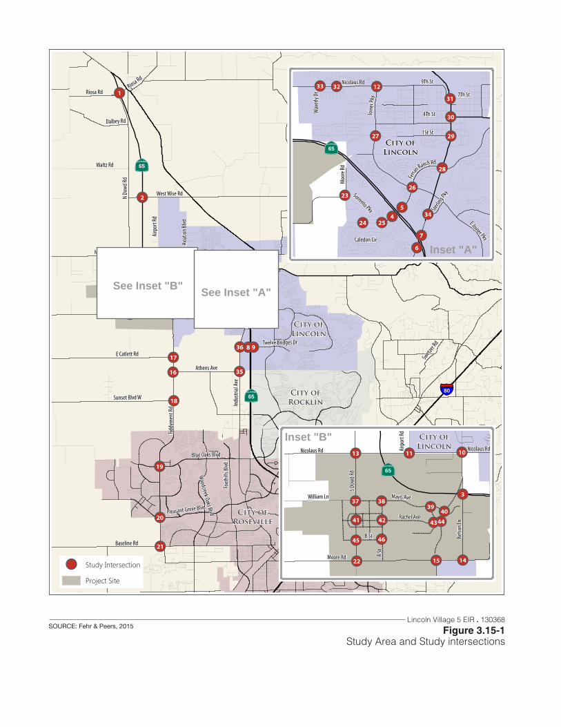
!!
!!
!!
!!!!
!!!!
!!!!
!!!! !!!!
!!!!
!!!!
!!
!!
!!
!!
!!!!!!!!
!!
!!!!!!!!!!!!!!
!!
!!
!!
Riosa Rd
N Do
wd Rd
Moore Rd
Indu
strial
Ave
Baseline Rd
1St St
Fiddy
men
t Rd
Nicolaus Rd
E Catlett Rd
Join
er Pk
y
Twelve Bridges Dr
Sunset Blvd W
West Wise Rd
Blue Oaks Blvd
E Joiner Pky
Athens Ave
Nelso
n Ln
Foot
hills
Blvd
Swetz
er Rd
Airp
ort R
d
S Dow
d Rd
Waltz Rd
O St
H St
Dalbey Rd
Ferrari Ranch Rd
Woodcreek Oaks Blvd
Aviat
ion Bl
vd
Pleasant Grove Blvd
Groveland Ln
Cham
bers
Dr
Riosa Rd
98
76
3
2
1
36
35
3331
28
27
2524
23
22
21
20
19
18
17
16
15 14
13 1211 10
54 34
32
3029
26
!!!!
!!!!
!!
!!
!! !!
!!
!!
!!
!!
!!
!!!!!!
!!
1St St
Joine
r Pky
Ferra
ri Ranch Rd
4Th St
Nicolaus Rd
Moo
re Rd
E Joiner Pky9Th St
Caledon Cir
Sorrento Pky Sterlin
g Pky
Wav
erly
Dr 7Th St
7
6
54 34
33 32
31
30
29
28
27
26
2524
23
12
!!
!!
!!
!!!!!!!!!!!!!!!!!!!!!!!
!!
!!
!!
!!
!!
!!
!!
!!!!!!!!
!!
!!
!
! ! ! ! ! ! ! ! ! ! ! ! ! ! ! ! ! ! ! ! ! ! ! ! ! ! ! ! ! ! ! ! ! ! !!!!!
!! ! ! ! ! ! ! ! ! ! ! ! ! ! ! ! ! !
!!!!!!
!! !
!
!!!
!
!! ! !
!!
!!
!!
!!
!!
!!
!!
!!
!!
!!
!!
!!
!!
!
! ! ! ! ! ! ! ! ! ! ! ! ! ! ! ! ! ! ! ! ! ! ! ! ! ! !!
! ! ! ! ! ! ! ! ! ! ! ! ! ! ! ! ! ! ! ! ! ! ! ! ! ! ! ! ! ! ! ! ! ! ! ! ! ! ! ! ! ! ! ! ! ! !
!!
!!
!!
!!
!!
!!
!!
!!
!!
!!
!!
!!
!!!
!!
!!
!!
!!
!!
!!
!!
!!
!!
!!
!!
!!
!!
!!
!!
!!
!!
!!
!!
!!
!
! ! ! ! ! ! ! ! ! ! ! ! !!!!!!
!!
!!
!!!!!!
!!!
!
! ! ! ! ! ! ! ! !!
! ! ! ! ! ! ! ! ! ! !
!!!!!!!!!!!!!!!!!!!!!!!!
!!
!!
!!
!!
! ! ! ! ! ! ! ! ! ! ! ! ! ! ! ! ! ! ! ! ! !
!!
!!
!!
!!
!!
!!
!!!!!!
!!!!!!
!!
!! !!
!! !! !!!!!!!!
!! !!Moore Rd
Nicolaus RdNe
lson L
n
S Dow
d Rd
William Ln
Airp
ort R
d
Nicolaus Rd
Rachel Ave
Mavis Ave
A St
B St
3
22 15 14
13 11 10
4645
4039
44434241
3837
See Inset "A"
Inset "A"
|þ65
|þ65
|þ65
|þ65
§̈¦80
See Inset "B"
Inset "B"
!! Study Intersection
Project Site
City ofLincoln
City ofRoseville
City ofLincoln
City ofLincoln
City ofRocklin
Lincoln Village 5 EIR . 130368
Figure 3.15-1Study Area and Study intersections
SOURCE: Fehr & Peers, 2015
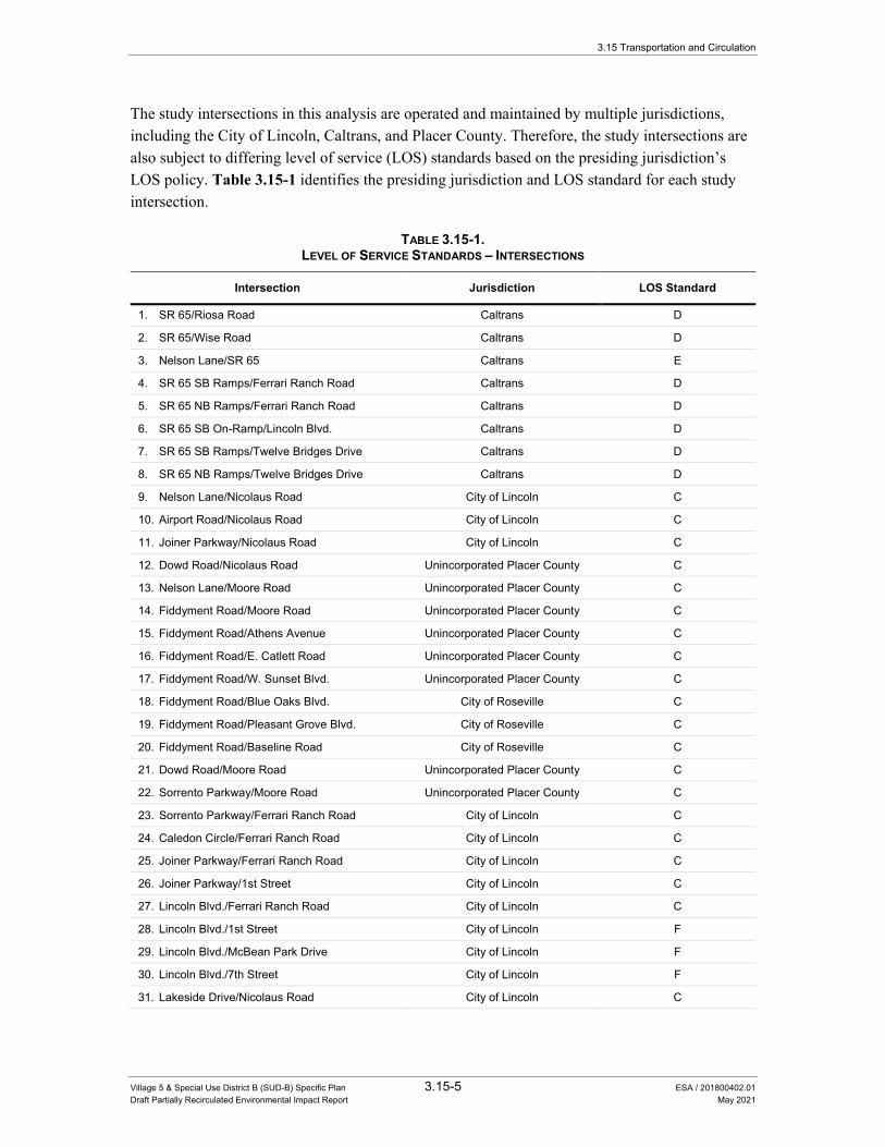
3.15 Transportation and Circulation
Village 5 & Special Use District B (SUD-B) Specific Plan 3.15-5 ESA / 201800402.01 Draft Partially Recirculated Environmental Impact Report May 2021
The study intersections in this analysis are operated and maintained by multiple jurisdictions, including the City of Lincoln, Caltrans, and Placer County. Therefore, the study intersections are also subject to differing level of service (LOS) standards based on the presiding jurisdiction’s LOS policy. Table 3.15-1 identifies the presiding jurisdiction and LOS standard for each study intersection.
TABLE 3.15-1. LEVEL OF SERVICE STANDARDS – INTERSECTIONS
Intersection Jurisdiction LOS Standard
1. SR 65/Riosa Road Caltrans D
2. SR 65/Wise Road Caltrans D
3. Nelson Lane/SR 65 Caltrans E
4. SR 65 SB Ramps/Ferrari Ranch Road Caltrans D
5. SR 65 NB Ramps/Ferrari Ranch Road Caltrans D
6. SR 65 SB On-Ramp/Lincoln Blvd. Caltrans D
7. SR 65 SB Ramps/Twelve Bridges Drive Caltrans D
8. SR 65 NB Ramps/Twelve Bridges Drive Caltrans D
9. Nelson Lane/Nicolaus Road City of Lincoln C
10. Airport Road/Nicolaus Road City of Lincoln C
11. Joiner Parkway/Nicolaus Road City of Lincoln C
12. Dowd Road/Nicolaus Road Unincorporated Placer County C
13. Nelson Lane/Moore Road Unincorporated Placer County C
14. Fiddyment Road/Moore Road Unincorporated Placer County C
15. Fiddyment Road/Athens Avenue Unincorporated Placer County C
16. Fiddyment Road/E. Catlett Road Unincorporated Placer County C
17. Fiddyment Road/W. Sunset Blvd. Unincorporated Placer County C
18. Fiddyment Road/Blue Oaks Blvd. City of Roseville C
19. Fiddyment Road/Pleasant Grove Blvd. City of Roseville C
20. Fiddyment Road/Baseline Road City of Roseville C
21. Dowd Road/Moore Road Unincorporated Placer County C
22. Sorrento Parkway/Moore Road Unincorporated Placer County C
23. Sorrento Parkway/Ferrari Ranch Road City of Lincoln C
24. Caledon Circle/Ferrari Ranch Road City of Lincoln C
25. Joiner Parkway/Ferrari Ranch Road City of Lincoln C
26. Joiner Parkway/1st Street City of Lincoln C
27. Lincoln Blvd./Ferrari Ranch Road City of Lincoln C
28. Lincoln Blvd./1st Street City of Lincoln F
29. Lincoln Blvd./McBean Park Drive City of Lincoln F
30. Lincoln Blvd./7th Street City of Lincoln F
31. Lakeside Drive/Nicolaus Road City of Lincoln C

3.15 Transportation and Circulation
Village 5 & Special Use District B (SUD-B) Specific Plan 3.15-6 ESA / 201800402.01 Draft Partially Recirculated Environmental Impact Report May 2021
TABLE 3.15-1. LEVEL OF SERVICE STANDARDS – INTERSECTIONS
Intersection Jurisdiction LOS Standard
32. Teal Hollow Drive/Nicolaus Road City of Lincoln C
33. Sterling Parkway/Lincoln Blvd. City of Lincoln C
34. Industrial Avenue/Athens Avenue Unincorporated Placer County C
35. Industrial Avenue/Twelve Bridges Drive Unincorporated Placer County C
36. Dowd Road/Mavis Road (Future) City of Lincoln (Future) C
37. “A Street”/Mavis Road (Future) City of Lincoln (Future) C
38. Ruth Avenue/Mavis Road (Future) City of Lincoln (Future) C
39. Nelson Lane/Mavis Road (Future) City of Lincoln (Future) C
40. Dowd Road/Rachel Avenue (Future) City of Lincoln (Future) C
41. “A Street”/Rachel Avenue (Future) City of Lincoln (Future) C
42. Ruth Avenue/Rachel Avenue (Future) City of Lincoln (Future) C
43. Nelson Lane/Rachel Avenue (Future) City of Lincoln (Future) C
44. Dowd Road/”B Street” (Future) City of Lincoln (Future) C
45. “A Street”/”B Street” (Future) City of Lincoln (Future) C
46. Moore Road/”A Street” (Future) City of Lincoln (Future) C
NOTES: 1. Level of Service (LOS) standard based on presiding jurisdiction’s LOS policy. SOURCE: Fehr & Peers, 2015.
Key Roadways Figure 3.15-2 displays the existing number of travel lanes on the major roadways in the study area. Key roadways within the study area are described below.
State Route 65 (SR 65) – is a north-south state highway that begins at Interstate 80 (I-80) and extends north through Lincoln to SR 70 south of Marysville. SR 65 is a four-lane freeway from I-80 to the at-grade intersection with Nelson Lane. It continues as a four-lane divided highway from Nelson Lane to north of Wise Road. North of Wise Road, it becomes a two-lane state highway connecting the area to Yuba County and Marysville to the north.
The section of SR 65 between Lincoln Boulevard and Riosa Road is known as the Lincoln Bypass. The Lincoln Bypass opened in 2012 to facilitate travel between South Placer County and Yuba County and reduce through traffic on surface streets in the City of Lincoln. The former SR 65 alignment through Downtown Lincoln is now called Lincoln Boulevard.
Dowd Road – is a two-lane, north-south rural roadway that runs between Moore Road at the south to Riosa Road on the north. South of Riosa Road, it generally parallels the SR 65 bypass to the west.
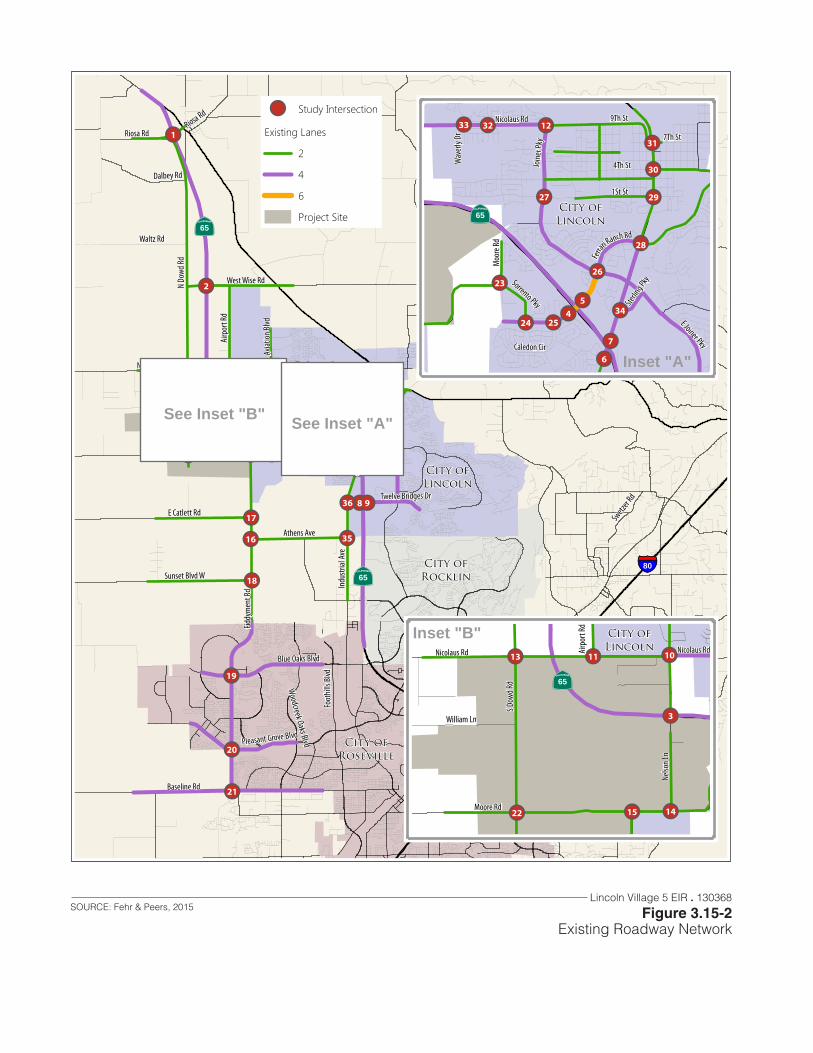
!!
!!
!!
!!!!
!!!!
!!!!
!!!! !!!!
!!!!
!!!!
!!
!!
!!
!!
!!!!!!!!
!!
!!!!!!!!!!!!!!
!!
!!
!!
Riosa Rd
N Do
wd Rd
Moore Rd
Indu
strial
Ave
Baseline Rd
1St St
Fiddy
men
t Rd
Nicolaus Rd
E Catlett Rd
Join
er Pk
y
Twelve Bridges Dr
Sunset Blvd W
West Wise Rd
Blue Oaks Blvd
E Joiner Pky
Athens Ave
Nelso
n Ln
Foot
hills
Blvd
Swetz
er Rd
Airp
ort R
d
S Dow
d Rd
Waltz Rd
O St
H St
Dalbey Rd
Ferrari Ranch Rd
Woodcreek Oaks Blvd
Aviat
ion Bl
vd
Pleasant Grove Blvd
Groveland Ln
Cham
bers
Dr
Riosa Rd
98
76
3
2
1
36
35
3331
28
27
2524
23
22
21
20
19
18
17
16
15 14
13 1211 10
54 34
32
3029
26
!!!!
!!!!
!!
!!
!! !!
!!
!!
!!
!!
!!
!!!!!!
!!
1St St
Joine
r Pky
Ferra
ri Ranch Rd
4Th St
Nicolaus Rd
Moo
re Rd
E Joiner Pky9Th St
Caledon Cir
Sorrento Pky Sterlin
g Pky
Wav
erly
Dr 7Th St
7
6
54 34
33 32
31
30
29
28
27
26
2524
23
12
!!
!!!!!!
!!!!!!
!!
3
22 15 14
13 11 10
Moore Rd
Nicolaus RdNe
lson L
n
S Dow
d Rd
William Ln
Airp
ort R
d
Nicolaus Rd
See Inset "A"
Inset "A"
|þ65
|þ65
|þ65
|þ65
§̈¦80
See Inset "B"
Inset "B"
!! Study Intersection
Existing Lanes
2
4
6
Project Site
City ofLincoln
City ofRoseville
City ofLincoln
City ofLincoln
City ofRocklin
Lincoln Village 5 EIR . 130368
Figure 3.15-2Existing Roadway Network
SOURCE: Fehr & Peers, 2015

3.15 Transportation and Circulation
Village 5 & Special Use District B (SUD-B) Specific Plan 3.15-8 ESA / 201800402.01 Draft Partially Recirculated Environmental Impact Report May 2021
Nelson Lane – is a two-lane, north-south rural roadway that runs from Moore Road north to Nicolaus Road. It has a signalized intersection with SR 65 where SR 65 transitions from an access-controlled freeway to a multi-lane highway.
Fiddyment Road – is a north south arterial roadway that extends from Moore Road south into Roseville to Baseline Road. South of Baseline Road, it becomes Walerga Road traveling south into Sacramento County. North of Roseville, it is a two-lane rural roadway. Within the City of Roseville, it is generally a four-lane divided arterial.
Nicolaus Road – is an east-west arterial roadway that extends from H Street near Lincoln High School west to the Sutter County Line. Within the Study Area, it is a four-lane divided roadway between Nelson Lane and Joiner Parkway. It is two-lanes east of Joiner Parkway and a two-lane rural roadway west of Nelson Lane. It has a grade separated overcrossing of the SR 65 bypass.
Moore Road – is a two-lane, east-west arterial street that begins west of SR 65 and extends to the southwest to Fiddyment Road and beyond. Segments of this street are within the City of Lincoln and unincorporated Placer County.
Analysis Periods The City of Lincoln’s traffic operations policy focuses on peak hour intersection operations. Therefore, this study evaluates the traffic conditions during the following analysis periods:
• Weekday A.M. Peak Hour – the a.m. peak hour is defined as the consecutive 60-minute period that has the greatest traffic volume within the 7:00 to 9:00 a.m. peak period.
• Weekday P.M. Peak Hour – the p.m. peak hour is defined as the consecutive 60-minute period that has the greatest traffic volume within the 4:00 to 6:00 p.m. peak period.
Traffic Data Collection This analysis uses traffic counts collected between May 2013 and August 2014. Figures 3.15-3a and 3.15-3b present the existing lane configurations and traffic control devices at the existing study intersections.
Traffic Operations This study analyzes traffic operations on roadway facilities using the concept of LOS. Roadway LOS is a qualitative description of traffic flow from the perspective of motorists, and is an indication of the comfort and convenience associated with driving. The Highway Capacity Manual (HCM) defines six levels of service from LOS A representing the least congested traffic conditions to LOS F representing the most congested traffic conditions. The analysis uses the methodology presented in the HCM to analyze the traffic conditions at study roadway locations.
Intersections Table 3.15-2 presents the delay ranges associated with each LOS category for signalized and unsignalized intersections.

Figure 1APeak Hour Traffic Volumes and Lane Configurations
Existing (2013) Conditions
ACCF
2 (9
)75
5 (5
62)
9 (4
4)
ACF
9 (11)6 (12)7 (6)
AACCF9 (4
)57
1 (8
28)
196
(218
)
ACF 192 (296)
22 (13)33 (22)
1. SR 65/Riosa Rd
ACCF
3 (1
2)79
5 (6
03)
4 (7
)
ACF
4 (8)2 (14)5 (8)
ACCF19
(4)
571
(829
)7
(11)
ACF 4 (12)
9 (9)1 (7)
2. SR 65/Wise Rd
AACF
29 (1
1)29
(42)
2 (9
)
AACCF
26 (44)535 (782)
18 (29)
AACF43
(24)
35 (2
5)33
3 (2
23)
AACC
F 134 (303)691 (581)9 (4)
3. Nelson Ln/SR 65
CE590 (369)544 (164)
BF30 (4
7)0
(0)
52 (9
7)
CCCF 706 (250)
483 (782)
4. SR 65 SB Ramps/Ferrari Ranch Rd
ABFF
170
(395
)0
(0)
242
(670
)
ACC55 (10)587 (456)
CCCF 60 (76)
1,019 (637)
5. SR 65 NB Ramps/Ferrari Ranch Rd
CE
77 (1
93)
0 (5
)
AAC177
(210
)88
0 (6
96)
6. Lincoln Blvd/SR 65 SB On-Ramp
CC
77 (1
93)
CC1,0
46 (9
04)
AFF 616 (967)
11 (2)
7. Lincoln Blvd/SR 65 NB Off-Ramp
AC16 (41)143 (231)
AF62
(100
)44
9 (1
85)
CF
561 (396)132 (113)
8. SR 65 SB Ramps/Twelve Bridges Dr
Riosa Rd
SR
65
SR 65
Nel
son
Ln
Ferrari Ranch Rd
SR
65
SB
Ram
psS
R 6
5 S
B O
n-R
amp
Ferrari Ranch Rd
SR
65
NB
On-
Ram
pS
R 6
5 N
B O
ff-R
amp
SR 65 SB On-ramp
Linc
oln
Blv
d
SR 65 NB Off-Ramp
Linc
oln
Blv
d
Twelve Bridges Dr
SR
65
SB
Rra
mps
AEF
16 (4
7)0
(0)
336
(479
)
ACC50 (92)542 (324)
CCF 362 (239)
677 (462)
9. SR 65 NB Ramps/Twelve Bridges Dr
Twelve Bridges Dr
SR
65
NB
On-
Ram
pS
R 6
5 N
B O
ff-R
amp
D
20 (3
2)14
1 (1
26)
98 (2
38)
ACE
23 (21)66 (93)45 (32)
ACF18
(7)
143
(126
)37
(57)
ACF 53 (20)
106 (63)261 (122)
10. Nelson Ln/Nicolaus Rd
Nicolaus Rd
Avi
atio
n B
lvd
Nel
son
Ln
STOP
STOP
STO
P
B2 (0)127 (121)
G1 (0
)5
(14)
E 13 (5)143 (111)
11. Airport Rd/Nicolaus Rd
ABCF
163
(155
)10
1 (1
73)
117
(46)
ACCF
15 (22)269 (157)171 (155)
ABCF29
(15)
143
(129
)13
2 (5
0)
ACCF 112 (85)
171 (211)42 (36)
12. Joiner Pkwy/Nicolaus Rd
D
2 (5
)3
(11)
5 (5
)D4 (10)110 (129)
4 (4)
D10 (8
)3
(4)
15 (6
)
D
3 (14)138 (72)2 (7)
13. Dowd Rd/Nicolaus Rd
B47 (56)20 (72)
G54 (4
5)7
(5)
E 10 (5)53 (35)
14. Nelson Ln/Moore Rd
G
6 (1
5)61
(106
)E6 (22)13 (11)
B 18 (4)90 (76)
15. Fiddyment Rd/Moore Rd
Nicolaus Rd
Airp
ort R
d
Nicolaus Rd
Dow
d R
d
Moore Rd
Nel
son
Ln
Moore Rd
Fidd
ymen
t Rd
STOP
STOP
STOP STOP
STOP
STOP
STO
P
E
53 (1
21)
210
(292
)
B89 (8
7)18
(27)
G
31 (16)166 (247)
16. Fiddyment Rd/Athens Ave
B
10 (2
3)74
(114
)G1 (2)13 (8)
E4 (2
)94
(106
)
17. Fiddyment Rd/E Catlett Rd
B
51 (4
5)19
0 (2
47)G36 (142)
39 (58)
E95 (6
7)15
3 (2
16)
18. Fiddyment Rd/W. Sunset Blvd
Athens Ave
Fidd
ymen
t Rd
W. Sunset Blvd
Fidd
ymen
t Rd
STOP
STOP
STO
P
STOP
STOP
Nicolaus Rd
Join
er P
kwy
E Catlett Rd
Fidd
ymen
t Rd
Wise Rd
SR
65
STOP
Lincoln Village 5 EIR . 130368
Figure 3.15-3APeak Hour Traffic Volumes and Lane Configurations -
Existing Conditions
SOURCE: Fehr & Peers, 2015

Figure 1BPeak Hour Traffic Volumes and Lane Configurations
Existing (2013) Conditions
AACCF
2 (2
)22
3 (2
78)
358
(342
)
AACCCF
10 (8)43 (44)
2 (4)
AACCF6 (8
)22
1 (2
59)
59 (6
6)
AACC
F 58 (88)61 (86)333 (374)
19. Fiddyment Rd/Blue Oaks Blvd
AACCCF
126
(269
)49
0 (6
38)
403
(417
)
AACCF
21 (16)216 (162)262 (112)
AACCF10
(27)
687
(568
)11
2 (1
04)
AACC
F 79 (136)100 (334)393 (477)
20. Fiddyment Rd/Pleasant Grove Blvd
ACCF
15 (1
3)54
3 (5
41)
130
(196
)
ACE
278 (601)63 (267)
0 (4)
ACCF649
(306
)59
3 (6
40)
146
(118
)
ACCF 127 (193)
314 (99)178 (179)
21. Fiddyment Rd/Baseline Rd
D
3 (1
)0
(1)
0 (2
)D5 (1)5 (21)4 (0)
D3 (4
)0
(1)
19 (1
0)
D
9 (14)12 (14)3 (2)
22. S Dowd Rd/Moore Rd
E
4 (1
3)25
(56)
B7 (5
)53
(39)
G 15 (76)
40 (40)
23. Moore Rd/Sorrento Pkwy
ACC11 (6)190 (82)
AF5 (4
)17
8 (1
25)
CCF 101 (139)
91 (135)
24. Ferrari Ranch Rd/Sorrento Pkwy
BF
15 (8
)2
(2)
695
(321
)
ACCF
0 (4)358 (178)
10 (25)
BF3 (3
)1
(3)
81 (3
4)
AACF 30 (82)
174 (263)309 (484)
25. Ferrari Ranch Rd/Caledon Cir
AACCF
222
(264
)20
8 (2
64)
71 (1
12)
AACCF
39 (31)255 (181)
61 (62)
ACCF18
(81)
189
(251
)53
(43)
AACC
F 16 (20)129 (172)34 (87)
26. Joiner Pkwy/Ferrari Ranch Rd
Blue Oaks Blvd
Fidd
ymen
t Rd
Baseline Rd
Fidd
ymen
t Rd
Moore Rd
S D
owd
Rd
Sorrento Pkwy
Moo
re R
d
Ferrari Ranch Rd
Sor
rent
o P
kwy
Ferrari Ranch Rd
Cou
rtyar
ds L
oop
Cal
edon
Cir
Ferrari Ranch Rd
Join
er P
kwy
STOP
STOP
STOP
STOP
STO
P
ACE
128
(131
)30
4 (4
94)
99 (9
6)
ACF69 (34)63 (26)
232 (90)
ACE125
(37)
377
(312
)36
(38)
ACF 34 (39)
113 (42)148 (107)
27. Joiner Pkwy/1st St
1st St
Join
er P
kwy
ACCF
45 (1
77)
429
(836
)94
(303
)
ACF
54 (138)107 (173)
52 (45)
ACCF55
(126
)47
9 (4
91)
76 (1
11)
AACC
F 32 (56)43 (120)237 (150)
28. Lincoln Blvd/Ferrari Ranch Rd
Ferrari Ranch Rd
Linc
oln
Blv
d
ACF
154
(143
)44
3 (6
22)
44 (1
15)AE49 (49)
53 (59)200 (5)
AE37 (6
3)48
5 (4
07)
7 (7
)
AE
6 (142)57 (76)30 (51)
29. Lincoln Blvd/1st St
AE
0 (5
)37
6 (4
83)
142
(103
)D0 (8)1 (7)
1 (14)
AE0 (0
)40
7 (2
74)
123
(84)
BF 77 (112)
0 (5)121 (175)
30. Lincoln Blvd/McBean Park Dr
AE
59 (6
3)14
6 (2
60)
52 (5
4)
AE24 (25)155 (118)131 (88)
AE57 (3
3)27
0 (2
14)
24 (3
3)
ACF 42 (110)
184 (128)38 (34)
31. Lincoln Blvd/7th St
D
10 (3
)20
(12)
66 (3
0)
ACCF
37 (95)194 (210)
1 (10)
ACF76
(35)
15 (7
)16
6 (1
05)
ACCF 60 (116)
287 (202)43 (44)
32. Lakeside Dr/Nicolaus Rd
D
38 (2
3)6
(2)
12 (5
)
ACCF
48 (108)144 (245)
10 (35)
D77 (3
8)0
(1)
76 (6
5)
ACCF 54 (81)
305 (144)14 (15)
33. Teal Hollow Dr/Nicolaus Rd
1st St
Linc
oln
Blv
d
7th St
Linc
oln
Blv
d
Nicolaus Rd
Lake
side
Dr
Nicolaus Rd
Teal
Hol
low
Dr
Wav
erly
Dr
STOP
STOP
STOP
STO
P
STOP
STOP
STO
P
CCCF
649
(1,1
05)
87 (1
06)
AACC936
(743
)29
(28)
AAF 12 (22)
110 (161)
34. Lincoln Blvd/Sterling Pkwy
AAC
187
(243
)65
(132
)AF149 (299)93 (268)
CF202
(275
)11
6 (8
8)
35. Industrial Ave/Athens Ave
E
91 (1
88)
123
(243
)
AC136
(153
)35
(29)
AF
11 (3)183 (210)
36. Industrial Ave/Twelve Bridges Dr
Sterling Pkwy
Linc
oln
Blv
d
Twelve Bridges Dr
Indu
stria
l Ave
STOP
STOP
STO
P
Driveway McBean Park Dr
Linc
oln
Blv
d
Athens Ave
Indu
stria
l Ave
Pleasant Grove Blvd
Fidd
ymen
t Rd
STO
P
STOP
Lincoln Village 5 EIR . 130368
Figure 3.15-3BPeak Hour Traffic Volumes and Lane Configurations -
Existing Conditions
SOURCE: Fehr & Peers, 2015

3.15 Transportation and Circulation
Village 5 & Special Use District B (SUD-B) Specific Plan 3.15-11 ESA / 201800402.01 Draft Partially Recirculated Environmental Impact Report May 2021
TABLE 3.15-2. INTERSECTION LEVEL OF SERVICE DEFINITIONS
Average Delay (seconds per vehicle)1
Level of Service
Signalized Intersections Unsignalized Intersections Description
A 0 – 10.0 0 – 10.0 Minimal control delay.
B 10.1 – 20.0 10.1 – 15.0 Insignificant traffic delays.
C 20.1 – 35.0 15.1 – 25.0 Increased traffic delays; queues may build.
D 35.1 – 55.0 25.1 – 35.0 Longer traffic delays; increased queuing.
E 55.1 – 80.0 35.1 – 50.0 Very long traffic delays.
F > 80.0 > 50.0 Stop-and-go conditions.
NOTES: 1. Average control delay includes initial deceleration delay, queue move-up time, stopped delay, and acceleration delay. SOURCE: Transportation Research Board, 2010. Highway Capacity Manual. pp. 18-6, 19-2, 20-3, 21-1.
This study uses the Synchro 8 traffic operations software to analyze traffic operations at study intersections. The Synchro 8 analysis software calculates intersection LOS consistent with the HCM procedures. At most intersections, this study applies the HCM 2010 methodology. At some locations, the intersection configuration is not compatible with the HCM 2010 methodology, and the study uses the HCM 2000 methodology. The HCM 2000 methodology uses the same delay thresholds as the HCM 2010 methodology (see Table 3.15-2).
Table 3.15-3 presents the a.m. and p.m. peak hour LOS at each study intersection under existing conditions (refer to Appendix L for calculations).
Based on the results presented in Table 3.15-3, all intersections operate at LOS C or better with the exception of the following three locations, which operate at LOS D, E, or F:
• Fiddyment Road/Baseline Road (#21) – LOS D during the a.m. peak hour and LOS F during the p.m. peak hour
• Caledon Circle/Ferrari Ranch Road (#25) – LOS E during the a.m. peak hour
• Lincoln Boulevard/1st Street (#29) – LOS D during the a.m. peak hour
The Fiddyment Road/Baseline Road intersection is identified in the City of Roseville General Plan as one of the intersections anticipated to operate at an LOS worse than LOS C. As described in Section 3.15.2, the City of Roseville General Plan’s LOS policy is to maintain LOS C operations at a minimum of 70 percent of all signalized intersections.1 Per Table III-3 in the City of Roseville General Plan, 165 of the 204 signalized intersections in Roseville, or 80.9 percent, are expected to operate at LOS C or better under 2025 conditions. The Fiddyment Road/Baseline Road intersection is one of the 39 intersections expected to operate at an LOS worse than LOS C.
1 City of Roseville, 2010. City of Roseville General Plan 2025. Adopted May 5, 2010. p. III-31.

3.15 Transportation and Circulation
Village 5 & Special Use District B (SUD-B) Specific Plan 3.15-12 ESA / 201800402.01 Draft Partially Recirculated Environmental Impact Report May 2021
TABLE 3.15-3. INTERSECTION OPERATIONS – EXISTING CONDITIONS
Peak Hour
Existing Conditions
Intersection Jurisdiction Traffic Control Delay LOS
1. SR 65/Riosa Road Caltrans Signal A.M. 15 B
P.M. 16 B
2. SR 65/Wise Road Caltrans Signal A.M. 9 A
P.M. 11 B
3. Nelson Lane/SR 65 Caltrans Signal A.M. 22 C
P.M. 21 C
4. SR 65 SB Ramps/Ferrari Ranch Road Caltrans Signal
A.M. 4 A
P.M. 4 A
5. SR 65 NB Ramps/Ferrari Ranch Road Caltrans Signal
A.M. 11 B
P.M. 11 B
6. SR 65 SB On-Ramp/Lincoln Blvd. Caltrans Signal
A.M. 5 A
P.M. 7 A
7. SR 65 NB Off-Ramp/Lincoln Blvd. Caltrans Signal
A.M. 2 A
P.M. 1 A
8. SR 65 SB Ramps/Twelve Bridges Drive Caltrans Signal
A.M. 13 B
P.M. 9 A
9. SR 65 NB Ramps/Twelve Bridges Drive Caltrans Signal
A.M. 11 B
P.M. 11 B
10. Nelson Lane/Nicolaus Road City of Lincoln All-Way Stop
Controlled (AWSC)
A.M. 19 C
P.M. 18 C
11. Airport Road/Nicolaus Road City of Lincoln Side-Street Stop
Controlled (SSSC)
A.M. 10 B
P.M. 10 B
12. Joiner Parkway/Nicolaus Road City of Lincoln Signal A.M. 12 B
P.M. 10 B
13. Dowd Road/Nicolaus Road Unincorporated Placer County SSSC
A.M. 10 B
P.M. 11 B
14. Nelson Lane/Moore Road Unincorporated Placer County SSSC
A.M. 9 A
P.M. 9 A
15. Fiddyment Road/Moore Road Unincorporated Placer County AWSC
A.M. 8 A
P.M. 8 A
16. Fiddyment Road/Athens Avenue Unincorporated Placer County AWSC
A.M. 10 A
P.M. 13 B
17. Fiddyment Road/E. Catlett Road Unincorporated Placer County SSSC
A.M. 9 A
P.M. 9 A
18. Fiddyment Road/W. Sunset Blvd. Unincorporated Placer County SSSC
A.M. 12 B
P.M. 20 C
19. Fiddyment Road/Blue Oaks Blvd. City of Roseville Signal A.M. 19 B
P.M. 18 B
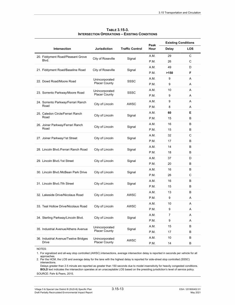
3.15 Transportation and Circulation
Village 5 & Special Use District B (SUD-B) Specific Plan 3.15-13 ESA / 201800402.01 Draft Partially Recirculated Environmental Impact Report May 2021
TABLE 3.15-3. INTERSECTION OPERATIONS – EXISTING CONDITIONS
Peak Hour
Existing Conditions
Intersection Jurisdiction Traffic Control Delay LOS
20. Fiddyment Road/Pleasant Grove Blvd. City of Roseville Signal
A.M. 29 C
P.M. 26 C
21. Fiddyment Road/Baseline Road City of Roseville Signal A.M. 49 D
P.M. >150 F
22. Dowd Road/Moore Road Unincorporated Placer County SSSC
A.M. 9 A
P.M. 9 A
23. Sorrento Parkway/Moore Road Unincorporated Placer County SSSC
A.M. 10 A
P.M. 9 A
24. Sorrento Parkway/Ferrari Ranch Road City of Lincoln AWSC
A.M. 9 A
P.M. 8 A
25. Caledon Circle/Ferrari Ranch Road City of Lincoln Signal
A.M. 60 E
P.M. 15 B
26. Joiner Parkway/Ferrari Ranch Road City of Lincoln Signal
A.M. 16 B
P.M. 15 B
27. Joiner Parkway/1st Street City of Lincoln Signal A.M. 32 C
P.M. 17 B
28. Lincoln Blvd./Ferrari Ranch Road City of Lincoln Signal A.M. 14 B
P.M. 18 B
29. Lincoln Blvd./1st Street City of Lincoln Signal A.M. 37 D
P.M. 20 B
30. Lincoln Blvd./McBean Park Drive City of Lincoln Signal A.M. 16 B
P.M. 26 C
31. Lincoln Blvd./7th Street City of Lincoln Signal A.M. 16 B
P.M. 15 B
32. Lakeside Drive/Nicolaus Road City of Lincoln AWSC A.M. 13 B
P.M. 9 A
33. Teal Hollow Drive/Nicolaus Road City of Lincoln AWSC A.M. 10 A
P.M. 9 A
34. Sterling Parkway/Lincoln Blvd. City of Lincoln Signal A.M. 7 A
P.M. 9 A
35. Industrial Avenue/Athens Avenue Unincorporated Placer County Signal
A.M. 15 B
P.M. 17 B
36. Industrial Avenue/Twelve Bridges Drive
Unincorporated Placer County AWSC
A.M. 10 B
P.M. 14 B
NOTES: 1. For signalized and all-way stop controlled (AWSC) intersections, average intersection delay is reported in seconds per vehicle for all
approaches. 2. Per the HCM, the LOS and average delay for the lane with the highest delay is reported for side-street stop controlled (SSSC)
intersections. Delays greater than 2.5 minute are reported as greater than 150 seconds due to model insensitivity for heavily congested conditions. BOLD text indicates the intersection operates at an unacceptable LOS based on the presiding jurisdiction’s level of service policy. SOURCE: Fehr & Peers, 2015.
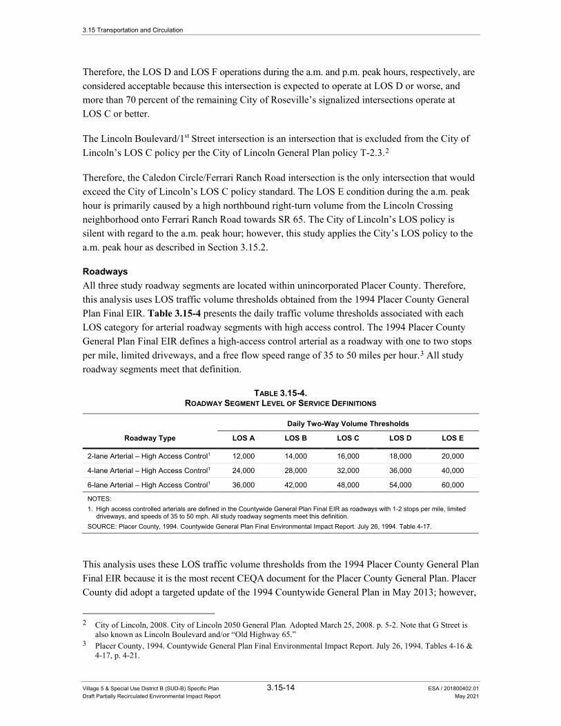
3.15 Transportation and Circulation
Village 5 & Special Use District B (SUD-B) Specific Plan 3.15-14 ESA / 201800402.01 Draft Partially Recirculated Environmental Impact Report May 2021
Therefore, the LOS D and LOS F operations during the a.m. and p.m. peak hours, respectively, are considered acceptable because this intersection is expected to operate at LOS D or worse, and more than 70 percent of the remaining City of Roseville’s signalized intersections operate at LOS C or better.
The Lincoln Boulevard/1st Street intersection is an intersection that is excluded from the City of Lincoln’s LOS C policy per the City of Lincoln General Plan policy T-2.3.2
Therefore, the Caledon Circle/Ferrari Ranch Road intersection is the only intersection that would exceed the City of Lincoln’s LOS C policy standard. The LOS E condition during the a.m. peak hour is primarily caused by a high northbound right-turn volume from the Lincoln Crossing neighborhood onto Ferrari Ranch Road towards SR 65. The City of Lincoln’s LOS policy is silent with regard to the a.m. peak hour; however, this study applies the City’s LOS policy to the a.m. peak hour as described in Section 3.15.2.
Roadways All three study roadway segments are located within unincorporated Placer County. Therefore, this analysis uses LOS traffic volume thresholds obtained from the 1994 Placer County General Plan Final EIR. Table 3.15-4 presents the daily traffic volume thresholds associated with each LOS category for arterial roadway segments with high access control. The 1994 Placer County General Plan Final EIR defines a high-access control arterial as a roadway with one to two stops per mile, limited driveways, and a free flow speed range of 35 to 50 miles per hour.3 All study roadway segments meet that definition.
TABLE 3.15-4. ROADWAY SEGMENT LEVEL OF SERVICE DEFINITIONS
Daily Two-Way Volume Thresholds
Roadway Type LOS A LOS B LOS C LOS D LOS E
2-lane Arterial – High Access Control1 12,000 14,000 16,000 18,000 20,000
4-lane Arterial – High Access Control1 24,000 28,000 32,000 36,000 40,000
6-lane Arterial – High Access Control1 36,000 42,000 48,000 54,000 60,000
NOTES: 1. High access controlled arterials are defined in the Countywide General Plan Final EIR as roadways with 1-2 stops per mile, limited
driveways, and speeds of 35 to 50 mph. All study roadway segments meet this definition. SOURCE: Placer County, 1994. Countywide General Plan Final Environmental Impact Report. July 26, 1994. Table 4-17.
This analysis uses these LOS traffic volume thresholds from the 1994 Placer County General Plan Final EIR because it is the most recent CEQA document for the Placer County General Plan. Placer County did adopt a targeted update of the 1994 Countywide General Plan in May 2013; however,
2 City of Lincoln, 2008. City of Lincoln 2050 General Plan. Adopted March 25, 2008. p. 5-2. Note that G Street is
also known as Lincoln Boulevard and/or “Old Highway 65.” 3 Placer County, 1994. Countywide General Plan Final Environmental Impact Report. July 26, 1994. Tables 4-16 &
4-17, p. 4-21.

3.15 Transportation and Circulation
Village 5 & Special Use District B (SUD-B) Specific Plan 3.15-15 ESA / 201800402.01 Draft Partially Recirculated Environmental Impact Report May 2021
that targeted update only included ministerial changes, incorporation of Board of Supervisors adopted resolutions, and revised language that was out-of-date. The targeted update did not:
• include any specific development projects
• modify General Plan land use designations, the land use map, or capital improvement program
• prepare a new CEQA document
Table 3.15-5 presents the daily traffic volumes for each roadway segment and the corresponding LOS under existing conditions. Daily traffic counts were collected on each study roadway segment in April 2014. Based on the results presented in Table 3.15-5, all study roadway segments operate at LOS A under existing conditions.
TABLE 3.15-5. DAILY ROADWAY SEGMENT OPERATIONS – EXISTING CONDITIONS
Existing Conditions
Roadway Segment Classification Daily Traffic
Volume V/C2 LOS3
Fiddyment Road
Moore Road to Athens Avenue 2-lane Arterial1 2,521 0.13 A
Athens Avenue to Roseville City Limits 2-lane Arterial1 7,539 0.38 A
Athens Avenue
Fiddyment Road to Foothills Boulevard 2-lane Arterial1 6,512 0.33 A
NOTES: 1. High-Access Controlled Arterial, per the definition outlined in Table 4-16 of the Placer County Countywide General Plan Final EIR. 2. V/C = Volume-to-capacity ratio. 3. Level of service based on thresholds presented in Table 3.15-3 from the Placer County Countywide General Plan Final EIR. SOURCE: Fehr & Peers, 2015
Highways Non-freeway state highway facilities are analyzed using the highway capacity software (HCS 2010) consistent with the HCM. Within the study area, there are two types of highway segments: two-lane highways and multi-lane highways.
This study analyzes two-lane highway segments consistent with the methodologies in Chapter 15 of the 2010 HCM. The two-lane highway segment analysis identifies a single LOS value for the highway segment based on the average travel speed and percent time spent following (the average percentage of time that vehicles are traveling behind slower vehicles). Table 3.15-6 presents the LOS definitions for two-lane highway segments as defined by the HCM.
Multi-lane highways are analyzed based on the methodology in Chapter 14 of the 2010 HCM. The multi-lane highway methodology identifies a LOS value for each direction of travel based on the vehicle density of the segment measured in passenger car equivalents per mile per lane.
Table 3.15-7 presents the LOS definitions for multi-lane highway segments as defined by the HCM.

3.15 Transportation and Circulation
Village 5 & Special Use District B (SUD-B) Specific Plan 3.15-16 ESA / 201800402.01 Draft Partially Recirculated Environmental Impact Report May 2021
TABLE 3.15-6. TWO-LANE HIGHWAY LEVEL OF SERVICE DEFINITIONS
Level of Service
Average Travel Speed (mph)
Percent Time Spent Following (%) Description
A >55 ≤35 Motorists experience high operating speeds and little difficulty in passing. Platoons of three or more vehicles are rare.
B 50.1 – 55 35.1 – 50 Passing demand and passing capacity are balanced. The degree of platooning becomes noticeable.
C 45.1 – 50 50.1 – 65 Most vehicles are traveling in platoons. Speeds are noticeably curtailed.
D 40.1 – 45 65.1 – 80 Platooning increases significantly. Passing demand is high, but passing capacity approaches zero. A high percentage of vehicles are now traveling in platoons.
E ≤40 >80 Demand is approaching capacity. Passing is virtually impossible. Speeds are seriously curtailed.
F Demand Exceeds Capacity Operations are unstable and heavy congestion exists.
NOTES: 1. Automobile LOS criteria for Class I two-lane highway. A Class I two-lane highway is defined as a major intercity routes in the state or
national highway network where motorists expect to travel at relatively high speeds. SR 65 is considered a Class I two-lane highway. SOURCE: Transportation Research Board, 2010. Highway Capacity Manual. December 2010. Exhibit 15-3.
TABLE 3.15-7. MULTI-LANE HIGHWAY LEVEL OF SERVICE DEFINITIONS
Level of Service Free-Flow Speed (mph) Density (pcpmpl)1
A All < 11
B All > 11 to 18
C All > 18 to 26
D All > 26 to 35
E
60 > 35 – 40
55 > 35 – 42
50 > 35 – 43
45 > 35 – 45
F
Demand Exceeds Capacity
60 >40
55 >41
50 >43
45 >45
NOTES: 1. Density is expressed in passenger car equivalents per mile per lane (pcpmpl). SOURCE: Transportation Research Board, 2010. Highway Capacity Manual. December 2010. Exhibit 14-4.
Table 3.15-8 presents the a.m. and p.m. peak hour traffic volumes and LOS results for the study highway segments under existing conditions. The traffic volumes are based on a.m. and p.m. peak period counts collected in April 2014 at signalized intersections along SR 65 from Riosa Road to Nelson Lane.

3.15 Transportation and Circulation
Village 5 & Special Use District B (SUD-B) Specific Plan 3.15-17 ESA / 201800402.01 Draft Partially Recirculated Environmental Impact Report May 2021
TABLE 3.15-8. HIGHWAY OPERATIONS – EXISTING CONDITIONS
Location Peak Hour Direction
Existing Conditions
Performance Metric LOS
State Route 65 – Two Lane Highway1 PTSF ATS (mph)
North of Riosa Rd. A.M. Combined 89 39 E
P.M. Combined 84 39 E
State Route 65 – Multilane Highway2 Density (pcpmpl)
Riosa Rd. to Wise Rd.
A.M. Northbound 8 A
Southbound 6 A
P.M. Northbound 8 A
Southbound 6 A
Wise Rd. to Nelson Ln.
A.M. Northbound 8 A
Southbound 6 A
P.M. Northbound 8 A
Southbound 6 A
NOTES: 1. Percent Time Spent Following (PTSF), Average Travel Speed (ATS), and LOS are calculated for two-lane highway segments using
the methodologies and procedures in the Highway Capacity Manual (Transportation Research Board, 2010). 2. Density is reported in passenger car equivalents per mile per lane (pcpmpl). Directional densities and LOS results for multilane
highway segments are calculated using the methodologies and procedures in the Highway Capacity Manual (Transportation Research Board, 2010).
SOURCE: Fehr & Peers, 2015
Based on these results, the two-lane highway segment of SR 65 north of Riosa Road operates at LOS E, while the multi-lane highway segments of SR 65 between Riosa Road and Nelson Lane operate at LOS A under existing conditions.
As described in Section 3.15.2, the SR 65 Corridor System Management Plan (CSMP) identifies LOS E as the concept LOS (the minimal acceptable LOS over the time period 2009 to 2029) for SR 65 north of Riosa Road. South of Riosa Road, this study uses LOS D as the concept LOS for Riosa Road to Wise Road, and LOS E as the concept LOS from Wise Road to Lincoln Boulevard. These concept LOS determinations are described in Section 3.15.2.
Therefore, all highway segments operate at an acceptable LOS under existing conditions.4
Freeways Freeway facilities are analyzed using procedures described in Chapters 11 and 13 of the HCM. In accordance with Caltrans policies, weave segments are analyzed using the Leisch method, which is described in the latest edition of the Highway Design Manual.5 Table 3.15-9 identifies the density
4 California Department of Transportation, 2009. State Route 65 Corridor System Management Plan. Approved
June 24, 2009. Table 11. 5 California Department of Transportation, 2012. Highway Design Manual. May 7, 2012. pp. 500-38 - 500-41.
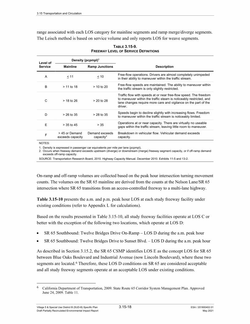
3.15 Transportation and Circulation
Village 5 & Special Use District B (SUD-B) Specific Plan 3.15-18 ESA / 201800402.01 Draft Partially Recirculated Environmental Impact Report May 2021
range associated with each LOS category for mainline segments and ramp merge/diverge segments. The Leisch method is based on service volume and only reports LOS for weave segments.
TABLE 3.15-9. FREEWAY LEVEL OF SERVICE DEFINITIONS
Level of Service
Density (pcpmpl)1
Mainline Ramp Junctions Description
A < 11 < 10 Free-flow operations. Drivers are almost completely unimpeded in their ability to maneuver within the traffic stream.
B > 11 to 18 > 10 to 20 Free-flow speeds are maintained. The ability to maneuver within the traffic stream is only slightly restricted.
C > 18 to 26 > 20 to 28
Traffic flow with speeds at or near free-flow speed. The freedom to maneuver within the traffic steam is noticeably restricted, and lane changes require more care and vigilance on the part of the driver.
D > 26 to 35 > 28 to 35 Speeds begin to decline slightly with increasing flows. Freedom to maneuver within the traffic stream is noticeably limited.
E > 35 to 45 > 35 Operations at or near capacity. There are virtually no useable gaps within the traffic stream, leaving little room to maneuver.
F > 45 or Demand exceeds capacity
Demand exceeds capacity2
Breakdown in vehicular flow. Vehicular demand exceeds capacity.
NOTES: 1. Density is expressed in passenger car equivalents per mile per lane (pcpmpl). 2. Occurs when freeway demand exceeds upstream (diverge) or downstream (merge) freeway segment capacity, or if off-ramp demand
exceeds off-ramp capacity. SOURCE: Transportation Research Board, 2010. Highway Capacity Manual. December 2010. Exhibits 11-5 and 13-2.
On-ramp and off-ramp volumes are collected based on the peak hour intersection turning movement counts. The volumes on the SR 65 mainline are derived from the counts at the Nelson Lane/SR 65 intersection where SR 65 transitions from an access-controlled freeway to a multi-lane highway.
Table 3.15-10 presents the a.m. and p.m. peak hour LOS at each study freeway facility under existing conditions (refer to Appendix L for calculations).
Based on the results presented in Table 3.15-10, all study freeway facilities operate at LOS C or better with the exception of the following two locations, which operate at LOS D:
• SR 65 Southbound: Twelve Bridges Drive On-Ramp – LOS D during the a.m. peak hour
• SR 65 Southbound: Twelve Bridges Drive to Sunset Blvd. – LOS D during the a.m. peak hour
As described in Section 3.15.2, the SR 65 CSMP identifies LOS E as the concept LOS for SR 65 between Blue Oaks Boulevard and Industrial Avenue (now Lincoln Boulevard), where these two segments are located.6 Therefore, these LOS D conditions on SR 65 are considered acceptable and all study freeway segments operate at an acceptable LOS under existing conditions.
6 California Department of Transportation, 2009. State Route 65 Corridor System Management Plan. Approved
June 24, 2009. Table 11.

3.15 Transportation and Circulation
Village 5 & Special Use District B (SUD-B) Specific Plan 3.15-19 ESA / 201800402.01 Draft Partially Recirculated Environmental Impact Report May 2021
TABLE 3.15-10. FREEWAY OPERATIONS – EXISTING CONDITIONS
Location Segment Type Peak Hour
Existing Conditions
Density1 LOS
Northbound SR 65
Sunset Blvd. to Twelve Bridges Drive Basic A.M. 16 B P.M. 25 C
Twelve Bridges Drive Off-Ramp Diverge A.M. 20 C P.M. 31 C
Twelve Bridges Drive to Lincoln Blvd. Weave2 A.M. - A P.M. - C
Ferrari Ranch Road Off-Ramp Diverge A.M. 7 A P.M. 10 A
Ferrari Ranch Road On-Ramp Merge A.M. 10 A P.M. 9 A
Ferrari Ranch Road to Nelson Lane Basic A.M. 8 A P.M. 7 A
Southbound SR 65
Nelson Lane to Ferrari Ranch Road Basic A.M. 8 A P.M. 9 A
Ferrari Ranch Road Off-Ramp Diverge A.M. 11 B P.M. 13 B
Ferrari Ranch Road Loop On-Ramp Basic A.M. 9 A P.M. 6 A
Ferrari Ranch Road Slip On-Ramp Merge A.M. 14 B P.M. 8 A
Lincoln Blvd. to Twelve Bridges Drive Weave2 A.M. - C P.M. - A
Twelve Bridges Drive On-Ramp Merge A.M. 28 D P.M. 21 C
Twelve Bridges Drive to Sunset Blvd. Basic A.M. 26 D P.M. 18 C
NOTES: 1. Density is expressed in passenger car equivalents per mile per lane (pcpmpl) 2. Per Caltrans’ Guide for the Preparation of Traffic Impact Studies, weave sections are analyzed using the Leisch Method as described
in Chapter 500 of the Highway Design Manual. Weave LOS results are based on service volume (density not calculated). SOURCE: Fehr & Peers, 2015
Bicycle Network Bicycle facilities are grouped into the following three classifications:
• Multi-use paths (Class I) – are paved trails that are separated from roadways, and allow for shared use by both cyclists and pedestrians.
• On-street bike lanes (Class II) – are designated for use by bicycles by striping, pavement legends, and signs.
3.15 Transportation and Circulation
Village 5 & Special Use District B (SUD-B) Specific Plan 3.15-20 ESA / 201800402.01 Draft Partially Recirculated Environmental Impact Report May 2021
• On-street bike routes (Class III) – are designated by signage for shared bicycle use with vehicles but do not necessarily include any additional pavement width.
Figure 3.15-4 presents the existing and planned bicycle facilities within the study area. As shown in the figure, Class I multi-use paths exist along Nicolaus Road and along natural waterways, such as Auburn Ravine, North Ingram Slough, and South Ingram Slough. Class II bike lanes exist on some of the arterials in the study area, including Ferrari Ranch Road, Joiner Parkway, and Aviation Boulevard.
Pedestrian Network The pedestrian network in the study area includes sidewalks along the majority of streets within the City of Lincoln, City of Roseville, and City of Rocklin, crosswalks at most study intersections within incorporated cities, and the Class I multi-use trails shown in Figure 3.15-4.
The rural roadways outside the incorporated cities, including Fiddyment Road, Nelson Lane, Moore Road, Dowd Road, and Nicolaus Road do not currently have facilities to support pedestrian activity. Pedestrians are prohibited from using SR 65 in the project study area.
Transit Network The City of Lincoln is served by a combination of fixed-route and demand-response public transit services. Currently, Placer County Transit (PCT) is the contract transit operator for fixed-route and demand-response transit services in Lincoln. The City of Lincoln provides funding for PCT operations in Lincoln through the City’s Local Transportation Fund (LTF) and State Transit Assistance (STA) claims as established by the State Transportation Development Act (TDA). The City of Lincoln provides fixed-route and demand-response public transit service to its residents.
PCT The fixed- route service serving the City of Lincoln consists of the following routes:
• Route 20, known as the Lincoln/Rocklin/Sierra College route. This route operates on weekdays and Saturdays. The route begins in downtown Lincoln, makes a stop at the Thunder Valley Casino on Athens Avenue, and continues through Roseville and Rocklin before reaching its destination at Sierra College. The bus route operates on one-hour headways from 7:00 a.m. to 7:00 p.m. Monday through Friday, and from 8:00 a.m. to 6:00 p.m. on Saturdays.
• Route 70, known as the Lincoln Circulator. operates in Historic Downtown Lincoln and along Highway 65 with stops near City Hall (Sixth Street), downtown retail centers, Safeway Center, Twelve Bridges Library, and Kaiser Permanente. The service begins each morning at the Lincoln Transfer Point at Third and F Streets. The Lincoln Circulator connects daily with PCT’s Lincoln/Rocklin/Sierra College route. The bus route operates on one-hour headways from 7:00 a.m. to 6:30 p.m. Monday through Friday, and from 8:30 a.m. to 4:00 p.m. on Saturdays.
• The Lincoln School Tripper, which operates two one-way trips per day to connect Downtown Lincoln and several residential neighborhoods with Twelve Bridges Middle School.

Riosa Rd
N Do
wd Rd
Moore Rd
Indu
strial
Ave
Baseline Rd
1St St
Fiddy
men
t Rd
Nicolaus Rd
E Catlett Rd
Join
er Pk
y
Twelve Bridges Dr
Sunset Blvd W
West Wise Rd
Blue Oaks Blvd
E Joiner Pky
Athens Ave
Nelso
n Ln
Foot
hills
Blvd
Swetz
er Rd
Airp
ort R
d
S Dow
d Rd
Waltz Rd
O St
H St
Dalbey Rd
Ferrari Ranch Rd
Woodcreek Oaks Blvd
Aviat
ion Bl
vd
Pleasant Grove Blvd
Groveland Ln
Cham
bers
Dr
Riosa Rd
1St St
Joine
r Pky
Ferra
ri Ranch Rd
4Th St
Nicolaus Rd
Moo
re Rd
E Joiner Pky9Th St
Caledon Cir
Sorrento Pky Sterlin
g Pky
Wav
erly
Dr 7Th St!
!!
!!!
!!!!!!!!!!!!!!!!!!!!!!!
!!
!!
!!
!!
!!
!!
!!
!!!!!!!!
!!
!!
!
! ! ! ! ! ! ! ! ! ! ! ! ! ! ! ! ! ! ! ! ! ! ! ! ! ! ! ! ! ! ! ! ! ! !!!!!
!! ! ! ! ! ! ! ! ! ! ! ! ! ! ! ! ! !
!!!!!!
!! !
!
!!!
!
!! ! !
!!
!!
!!
!!
!!
!!
!!
!!
!!
!!
!!
!!
!!
!
! ! ! ! ! ! ! ! ! ! ! ! ! ! ! ! ! ! ! ! ! ! ! ! ! ! !!
! ! ! ! ! ! ! ! ! ! ! ! ! ! ! ! ! ! ! ! ! ! ! ! ! ! ! ! ! ! ! ! ! ! ! ! ! ! ! ! ! ! ! ! ! ! !
!!
!!
!!
!!
!!
!!
!!
!!
!!
!!
!!
!!
!!!
!!
!!
!!
!!
!!
!!
!!
!!
!!
!!
!!
!!
!!
!!
!!
!!
!!
!!
!!
!!
!
! ! ! ! ! ! ! ! ! ! ! ! !!!!!!
!!
!!
!!!!!!
!!!
!
! ! ! ! ! ! ! ! !!
! ! ! ! ! ! ! ! ! ! !
!!!!!!!!!!!!!!!!!!!!!!!!!
!!
!!
!!!
! ! ! ! ! ! ! ! ! ! ! ! ! ! ! ! ! ! ! ! ! !
!!
!!
!!
!!
!!
Moore Rd
Nicolaus RdNe
lson L
n
S Dow
d Rd
William Ln
Airp
ort R
d
Nicolaus Rd
Rachel Ave
Mavis Ave
A St
B St
See Inset "A"
Inset "A"
|þ65
|þ65
|þ65
|þ65
§̈¦80
See Inset "B"
Inset "B"
Existing Bike Facilities
Class I Bike Path
Class II Bike Lane
Class III Bike Route
Project Site
Future Bike Facilities
Class I Bike Path
Class II Bike Lane
Class III Bike Route
Cycle Track
! ! ! ! ! ! ! ! ! ! ! ! ! Planned Roads
City ofLincoln
City ofRoseville
City ofLincoln
City ofLincoln
City ofRocklin
Lincoln Village 5 EIR . 130368
Figure 3.15-4Existing & Planned Bicycle Network
SOURCE: SACOG, 2015
3.15 Transportation and Circulation
Village 5 & Special Use District B (SUD-B) Specific Plan 3.15-22 ESA / 201800402.01 Draft Partially Recirculated Environmental Impact Report May 2021
two bus routes known as the Downtown Circulator and Lincoln Loop. Both routes operate on one-hour headways (at each stop, buses arrive every hour) and run between 6:30 a.m. and 5:30 p.m. Monday through Friday.7
The Downtown Circulator operates in Historic Downtown Lincoln and along Highway 65 with stops near City Hall (Sixth Street), downtown retail centers, Safeway Center, Twelve Bridges Library, Twelve Bridges Medical Center, and Kaiser Permanente. The service begins each morning at the Lincoln Transfer Point at Third and F Streets. The Circulator connects daily with the Lincoln Loop and the Placer County Transit’s Lincoln/Rocklin/Sierra College route.
The Lincoln Loop operates throughout the city with stops at several schools, parks, community centers, and major activity centers. The route begins daily at the southwest corner of Venture and Lakeside Drives. It continues to the Lincoln Transfer Point at Third and F Streets and then to destinations throughout the city.8
As of November 2020, the one-way fare for PCT fixed-route service is $1.25.
Lincoln Transit Dial-A-Ride (DAR) is a complimentary curb-to-curb, shared-ride para-transit service operated by PCT for the general public. DAR operates in the city limits of Lincoln on a reservation basis.9
Placer County Transit operates the Lincoln-Rocklin-Sierra College bus route on weekdays and Saturdays. The route begins in downtown Lincoln, makes a stop at the Thunder Valley Casino on Athens Avenue, and continues through Roseville and Rocklin before reaching its destination at Sierra College. The bus route operates on one-hour headways from 6:00 a.m. to 8:00 p.m. Monday through Friday, and from 8:00 a.m. to 6:00 p.m. on Saturdays.
No transit stops are currently located in the vicinity of the project site.
3.15.2 Regulatory Setting This section provides a discussion of applicable federal, state, and local regulations pertaining to transportation that may be applicable to the proposed project.
Federal There are no applicable federal regulations related to transportation that directly apply to the proposed project. However, federal regulations relating to the Americans with Disabilities Act (ADA), Title VI, and Environmental Justice relate to transit service.
7 City of Lincoln, 2015. Hours of Operation. Available: www.ci.lincoln.ca.us/default.aspx?Jpage=15181. Accessed
February 5, 2015. 8 Lincoln Transit. Transit Brochure. Available: www.ci.lincoln.ca.us/pagedownloads/Transit%20Brochure%20
2012%20.pdf. Accessed January 27, 2015. 9 City of Lincoln. Dial-A-Ride. Available: http://www.lincolnca.gov/city-hall/departments-divisions/public-services/transit/
dial-a-ridewww.ci.lincoln.ca.us/default.aspx?Jpage=14060. Accessed November 23, 2020 February 5, 2015.
3.15 Transportation and Circulation
Village 5 & Special Use District B (SUD-B) Specific Plan 3.15-23 ESA / 201800402.01 Draft Partially Recirculated Environmental Impact Report May 2021
State The California Department of Transportation (Caltrans) is responsible for operating and maintaining the state highway system. In the project vicinity, the mainline, ramps, and intersections along SR 65 fall under Caltrans jurisdiction.
State Route 65 Corridor System Management Plan In June 2009, Caltrans approved a corridor system management plan (CSMP) for SR 65 from I-80 in Roseville to SR 70 in Yuba County south of Marysville. The CSMP is a long-range comprehensive planning document for state highway facilities that includes system management strategies and performance evaluation measures to track the effectiveness of strategies and projects.10
The CSMP documents the current LOS on SR 65 and the future LOS when considering feasible long-term projects. The CSMP also identifies a concept LOS, or the minimum level or quality of operations acceptable, for SR 65 within the 20-year planning period. A deficiency or need for improvement is triggered when the actual LOS falls below the concept LOS. Within the Village 5 study area, the SR 65 CSMP identifies the 20-year concept LOS as LOS E from Blue Oaks Boulevard to Gladding Road, LOS D from Gladding Road to Riosa Road, and LOS E from Riosa Road to the Yuba County Line.11
At the time of the preparation of the SR 65 CSMP, the SR 65 Lincoln Bypass through the study area was not yet open to traffic. The SR 65 Lincoln Bypass opened to traffic in 2012, and SR 65 no longer travels through Downtown Lincoln. The segment from Gladding Road to Riosa Road now exists as part of the Lincoln Bypass, roughly corresponding with Wise Road to Riosa Road. Therefore, this study applies the Concept LOS D identified for Gladding Road to Riosa Road in the CSMP to the Wise Road to Riosa Road segment of SR 65 (a.k.a. the Lincoln Bypass).
Since SR 65 is a Caltrans facility, this study applies the CSMP concept LOS to study highway and freeway segments, ramps, and intersections along SR 65. This analysis applies the City of Lincoln’s LOS policy for state highway facilities (policy T-2.4) for ramp terminal intersections within the City of Lincoln.
Caltrans Guide for the Preparation of Traffic Impact Studies Caltrans’ Guide for the Preparation of Traffic Impact Studies provides general guidance regarding the preparation of traffic impacts studies for projects that may have an impact on the state highway system. The guidance includes when a traffic study should be prepared and the methodology to use when evaluating operating conditions on the State highway system. This includes requiring that weave segments use the Leisch method to analyze traffic operations.
10 California Department of Transportation, 2009. State Route 65 Corridor System Management Plan. Approved
June 24, 2009. p. 9. 11 California Department of Transportation, 2009. State Route 65 Corridor System Management Plan. Approved
June 24, 2009, Table 11.

3.15 Transportation and Circulation
Village 5 & Special Use District B (SUD-B) Specific Plan 3.15-24 ESA / 201800402.01
Draft Partially Recirculated Environmental Impact Report May 2021
The Guide for the Preparation of Traffic Impact Studies states that where “an existing State highway facility is operating at less than the appropriate target LOS, the existing measure of
effectiveness (MOE) should be maintained.”12 Appendix C of the Guide for the Preparation of Traffic Impact Studies defines these MOEs, which include density in passenger cars per mile per lane (pcpmpl) for multi-lane highways, freeway segments, and ramps (i.e., merge and diverge segments), average control delay in seconds per vehicle for intersections, and percent time following and average travel speed for two-lane highways. Tables 3.15-1, 3.15-5, 3.15-6, and 3.15-8 provide the relationship between LOS and these MOEs.
Regional
Sacramento Area Council of Governments
SACOG is an association of local governments in the six-county Sacramento Region. Its members include the counties of El Dorado, Placer, Sacramento, Sutter, Yolo, and Yuba, as well as 22 cities, including the City of Lincoln. SACOG functions as the Metropolitan Planning Organization (MPO) for the Sacramento Region, providing transportation planning and funding for the region, and serving as a forum for the study and resolution of regional issues. Under this organization, Placer County is unique in this arrangement as it has its own state-designated regional transportation planning agency (RTPA), the Placer County Transportation Planning Agency (PCTPA), that is responsible for developing its own transportation plan.
2020 Metropolitan Transportation Plan/Sustainable Communities Strategy
SACOG is responsible for the preparation of, and updates to, the 2016 MTP/SCS and the subsequently adopted 2020 MTP/SCS and the corresponding Metropolitan Transportation Improvement Program (MTIP) for the six-county Sacramento region. The 2020 MTP/SCS provides a 20-year transportation vision and corresponding list of projects. The MTIP identifies short-term projects (7-year horizon) in more detail. The current MTP/SCS was adopted by the SACOG board on November 18, 2019.
The transit strategy of the 2020 MTP/SCS emphasizes increased frequencies on productive transit routes, supplemented by lower cost, micro-transit, or demand-sensitive options, such as DAR, where ridership is not high enough to justify regular, fixed-route service. Transit service in the plan is dependent on transit-supportive infrastructure and land uses and is complemented by new mobility options that give riders more first/last mile options that increase their opportunities to use transit for at least some portion of their daily travel.
The following are 2020 MTP/SCS goals and supportive policies related to transit, that are relevant to the proposed project:
Goal 4: Build and maintain a safe, resilient, and multimodal transportation system
Policy 19 Transit expansion, particularly light rail and other fixed infrastructure transit options, should be targeted at communities with supportive land use policies and development patterns that will generate transit ridership and improve the cost recovery rates for transit service.
12 California Department of Transportation, 2002. Guide for the Preparation of Traffic Impact Studies. p. 1.

3.15 Transportation and Circulation
Village 5 & Special Use District B (SUD-B) Specific Plan 3.15-25 ESA / 201800402.01 Draft Partially Recirculated Environmental Impact Report May 2021
Placer County Transportation Planning Agency As described above, the PCTPA is the state-designated RTPA for the County of Placer, and thus, provides regional transportation planning and funding for the City of Lincoln and the V5SP Plan Area. PCTPA executed a memorandum of understanding (MOU) with Caltrans and SACOG in April 2001 to govern federal transportation planning and programming in Placer County. This agreement, as updated in 2005 and 2016, integrates the PCTPA Regional Transportation Plan (RTP) within the SACOG process.
Placer County Regional Transportation Plan 2040 The Placer County Regional Transportation Plan (RTP) 2040 was developed by PCTPA to document the policy direction, actions, and funding recommendations that are intended to meet the short- and long-range needs of Placer County’s transportation systems through 2040. The RTP is a financially-constrained13 document designed to guide the systematic development of a balanced, comprehensive, multi-modal transportation system for the current and future needs of Placer County. PCTPA submits the state mandated RTP, developed pursuant to Section 65080.5 of the Government Code, to SACOG for inclusion in the federal Metropolitan Transportation Plan.
The Placer County RTP 2040 identifies the following transit-related goals and policies that would be applicable to the V5SP:
Goal 1 Highways/Streets/Roadways: Maintain and upgrade a safe, efficient, and convenient countywide roadway systems that meets the gravel needs of people and the movement of goods through and within the region.
Objective C: To promote economic development, prioritize roadway maintenance and improvement projects on principal freight and tourist travel routes in Placer County
Policies:
6. Implement capacity-increasing strategies that encourage use of alternative modes, such as HOV lanes, bus rapid transit, and bus-only lanes.
Goal 2: Public Transit. Provide effective, convenient, regionally and locally coordinated transit service that connects residential areas with employment centers, serves key activity centers and facilities, and offers a viable option to the drive-alone commute.
Objective A: Provide transit services that fulfill all “unmet transit needs that are reasonable to meet.”
Policies:
1 Work with transit operators, social service agencies, the Social Services Transportation Advisory Council, and the general public to identify unmet transit needs.
2 On an annual basis, administer the unmet transit needs process, including hearings and findings, in accordance with the Transportation Development Act.
3. Work with transit operators to implement any transit services identified as reasonable to meet in the unmet transit needs process.
13 For the purposes of the RTP, “financially-constrained” means that all projects or programs included in the RTP are expected to be
funded through reasonably foreseeable revenue sources. Potential projects or programs that do not have reasonably foreseeable revenue sources are not included in the RTP.
3.15 Transportation and Circulation
Village 5 & Special Use District B (SUD-B) Specific Plan 3.15-26 ESA / 201800402.01 Draft Partially Recirculated Environmental Impact Report May 2021
Objective B: Tailor transit services and programs to the area’s population characteristics and special needs.
Policies:
1. Encourage jurisdictions to prioritize fixed route and dial-a-ride transit service within the urbanized area where the greatest operational efficiencies exist.
2. Encourage jurisdictions to develop alternative transit systems in non-urbanized/rural areas where transit needs exist, such as park-and-ride commuter services, lifeline fixed route deviation services, non-emergency medical transport programs, subsidized taxi services, and volunteer transport programs.
3. Encourage some level of “lifeline” transit service between all communities where feasible.
4. Encourage jurisdictions to pursue improvements to transit access whenever opportunities arise.
6. Support transit operators in the implementation of the Americans with Disabilities Act
Objective C: Develop and encourage the use of public transit as a viable alternative to the automobile in order to maximize transit ridership.
Policies:
1. Implement and maintain transit services at levels recommended in adopted Short Range and Long Range Transit Master Plans, and update these plans at regular intervals.
2. Work with transit operators and jurisdictions to develop and fund routes that serve key commute corridors.
3. Develop and implement a coordinated marketing program to promote public transit as a viable transportation option, raise public awareness of the various systems, and increase understanding of how to use them.
4. Ensure that transit services continue to meet all state and federal requirements for funding, including those for fare box recovery ratios, while developing fares and pricing that encourage non-riders to give transit a try.
5. Work with transit operators to develop and enforce ridership rules that ensure the safety of passengers and transit employees alike.
6. Develop working relationships with the business and industrial sector of the region to better understand and to the extent feasible meet the transportation needs of their employees and clients.
Objective D: Coordinate various transportation services to maximize efficiency and convenience and minimize duplication of services.
Policies:
1. Work to provide convenient, coordinated transit schedules that provide for seamless regional connections both within Placer County and the Sacramento region.
2. Encourage transit operators to develop agreements that maximize convenience and minimize transfers when making trips that involve crossing jurisdictional boundaries, including opportunities to contract with Transportation Network Companies and Micro Transit.
3. Coordinate public transit schedules and rail passenger schedules to allow passengers to utilize bus service to access rail services to the extent feasible.

3.15 Transportation and Circulation
Village 5 & Special Use District B (SUD-B) Specific Plan 3.15-27 ESA / 201800402.01 Draft Partially Recirculated Environmental Impact Report May 2021
4. Work with transit operators and other RTPAs in the region to implement enhancements to a centralized, one-stop consumer information center for transit schedules, reservations, and trip planning.
5. Work with social service agencies and the CTSA to utilize available resources and coordinate social service transportation to the extent feasible.
6. Establish and maintain a performance monitoring system which evaluates the effectiveness of transit service as outlined in the Transportation Development Act.
Goal 3: Passenger Rail. Improve the availability and convenience of passenger rail service.
Objective A: Provide more frequent, convenient, and reliable passenger rail service to and through Placer County.
Policies:
1. Support the Capital Corridor Joint Powers Board’s Business Plan to increase the number of intercity passenger trains serving the entire Capital Corridor route, including increased service frequency to Placer County.
2. Support extension of regular Capital Corridor rail service to Truckee and Reno.
3. Work with the Capital Corridor Joint Powers Board, Amtrak, Union Pacific, and other agencies to improve reliability of trains serving Placer County.
4. Encourage continued implementation of passenger information systems, convenient ticketing systems, and security upgrades on trains and at rail stations.
5. Work with jurisdictions and pursue funding resources to improve rail station facilities, including bus transfer, parking, lighting, and amenities.
Goal 7: Transportation Systems Management (TSM). Provide an economical alternative to the single-occupant vehicle travel through the use of alternative transportation methods.
Objective B: Advance the use of Transportation Demand Management (TDM) in a thorough, cost-effective manner.
Policies:
2. Prepare and distribute transit service information to educational, commercial, recreational, and large employment centers.
3. Work with Caltrans and local jurisdictions to locate and develop park-and-ride lots in high demand locations.
4. Provide outreach to media, employers, and the general public to promote awareness of alternative transportation.
5. Continue to support local jurisdiction efforts to promote alternative transportation events and programs.
Goal 9: Integrated Land Use, Air Quality, & Transportation Planning. By integrating land, air, and transportation planning, build and maintain the most efficient and effective transportation system possible while achieving the highest possible environmental benefit.
Objective A: Provide information and support services to jurisdictions regarding the countywide transportation impacts of local land use decisions.
3.15 Transportation and Circulation
Village 5 & Special Use District B (SUD-B) Specific Plan 3.15-28 ESA / 201800402.01 Draft Partially Recirculated Environmental Impact Report May 2021
Policies:
3. Encourage jurisdictions to require land uses which produce significant trip generation to be served by roadways with adequate capacity and design standards to provide safe usage for all modes of travel.
Objective B: Provide transportation infrastructure that meets existing and future needs.
Policies:
1. Encourage jurisdictions to develop roadways and transit investments that complement growth patterns, infill development, economic development programs, and requirements of infrastructure to support planned land uses.
2. Encourage jurisdictions to review and assess the impact of new development proposals consistency with the regional sustainable communities strategy, and the impact on local circulation plans and transit system demand and supply.
3. Encourage jurisdictions to require street patterns for new roadways, especially in commercial, industrial, and high-density residential areas, that take into consideration the requirements of public transit.
5. Encourage jurisdictions to include the needs of all transportation users in the planning, design, construction, reconstruction, and maintenance of roadway, bridge, and transit facilities.
The Placer County RTP 2040 identifies the following planned transit services and/or facilities related to the City of Lincoln:
• Pursue the recommendations outlined for Scenario 2 in the Transit Master Plan for South Placer County (PCTPA, June 2007) in the development of future transit services in Placer County through the year 2040, with a focus on coordination and integration opportunities. Recommendations related to the City of Lincoln include:
– Implementation of the City of Lincoln SRTP (2009)14
– Limited bus service expansion into the West Lincoln annexation area
– A new transit connection between the West Lincoln annexation area and Roseville via Fiddyment Road
– Create a more direct route between Lincoln and Sierra College via SR 65 and the Galleria
• Project PLA25585 (Planned) – Placer County Bus Rapid Transit Operations & Maintenance (O&M) – Annual operating and maintenance costs specifically for a three-route bus rapid transit (BRT) system for FY 2023-2040 for a TBD transit operator. Note that BRT Routes 1 and 2 identified in the Bus Rapid Transit (BRT) Implementation Study for South Placer County (South Placer Regional Transportation Authority, September 8, 2006) include optional service extensions to the City of Lincoln from the routes’ northern termini in Roseville. A potential BRT station in Lincoln is identified in the vicinity of Lincoln Crossing near the Highway 65 and Ferrari Ranch Road interchange. Lead Agency: PCTPA.
14 Note that this document has since been superseded by the Placer County Transit (PCT) Short Range Transit Plan (SRTP) 2018-
2025 (Placer County Transportation Planning Agency, August 9, 2018, amended April 22, 2020).
3.15 Transportation and Circulation
Village 5 & Special Use District B (SUD-B) Specific Plan 3.15-29 ESA / 201800402.01 Draft Partially Recirculated Environmental Impact Report May 2021
• Project PLA25631 (Planned) – Placer County Transit Operating & Maintenance – Lump-sum annual operating and maintenance costs for FY 2023-2040, does not account for expansion of service. Lead Agency: PCTPA.
• Project PLA Regional Service Expansion Lump Sum (Planned) – Local and Commuter Transit Bus Expansion – Lump-sum for increased local and commuter bus service operating and maintenance costs and bus purchase and replacement. Lead Agency: PCTPA.
• Project PLA25759 (Planned) – Placer County Transit – Operations and preventative maintenance in urbanized area. Lead Agency: Placer County Transit.
• Project PLA25760 (Planned) – Placer County Transit Non-Urbanized Ops – Operations in non-urbanized areas of Placer County. Lead Agency: Placer County Transit.
• Project PLA25593 (Planned) – Western Placer CTSA O&M – Annual operations and maintenance costs for Article 4.5 Community Transit Services and Complimentary Transit Services and Complimentary ADA dial-a-ride services for designate CTSA of Placer County servicing Placer County and Cities. Lead Agency – Western Placer Consolidated Transportation Service Agency.
• Project PLA25632 (Planned) – Bus Replacement – Lump-sum for bus vehicles for fiscal years 2019-2036, does not account for expansion of service. Placer County operators only. Lead Agency: PCTPA.
• Project PLA25634 (Planned) – Placer County Bus Rapid Transit Capital – Capital costs for a three-route bus rapid transit system serving South Placer County, including planning, environmental studies, right-of-way acquisition, vehicles, related roadway improvements, signalization, park and ride facilities, signage, bus stop improvements, ITS elements, and fare vending equipment. As mentioned previously, BRT Routes 1 and 2 identified in the Bus Rapid Transit (BRT) Implementation Study for South Placer County include optional service extensions to the City of Lincoln from the routes’ northern termini in Roseville. Lead Agency: PCTPA.
• Project PLA25594 (Planned) – Placer County CTSA Capital – Capital costs for CTSA Article 4.5 and complementary ADA dial-a-ride services for designated CTSA operating in Placer County. Lead Agency – Western Placer Consolidated Transportation Service Agency.
All of the projects listed above are designated as planned projects in the Placer County RTP 2040, consistent with federal conformity regulations established in Title 40 CFR 93.106, Content of Transportation Plans. Planned projects refer to projects for which a specific funding source has not yet been identified, but given the assumptions contained in the Financial Element of the Placer County RTP 2040 are reasonably expected to be fully funded by 2040.
Placer County Transit Short Range Transit Plan 2018-2025 The Placer County Transit Short Range Transit Plan (SRTP) 2018-2025, prepared by the PCTPA, provides a detailed business plan for use by Placer County Transit (PCT) to guide the setting of services strategies, improvement priorities, and implementation sequencing between 2018 and 2025. An SRTP is also important to State and federal funding partners so they are able

3.15 Transportation and Circulation
Village 5 & Special Use District B (SUD-B) Specific Plan 3.15-30 ESA / 201800402.01 Draft Partially Recirculated Environmental Impact Report May 2021
to ensure that funds for improvements are consistent with a comprehensive overall strategy that has been developed through a public process.
The Placer County Transit SRTP 2018-2025 identifies the following planned transit services and/or facilities related to the City of Lincoln:
• Modifications to the Lincoln Circulator route (Route 70) to realign portions of the route from areas that do not generate significant ridership to those that exhibit stronger ridership potential in northwest Lincoln.
• Modifications to the Lincoln DAR and the Rocklin/Loomis DAR to combine the two dial-a-ride service areas into a single dial-a-ride service area to better serve residents traveling between Lincoln, Rocklin, and Loomis. Additionally, expand the new dial-a-ride service area west into the Industrial Boulevard area in Rocklin.
• Implementation of the Lincoln-Sacramento Light Rail express bus service. This route would run between Lincoln and the Sacramento Regional Transit (SacRT) Watt/I-80 station at the Blue Line light rail terminus. The service would operate on weekdays between 5:00 a.m. and 9:00 p.m. with a 30-minute frequency. Stops in Lincoln would include Downtown Lincoln, Sterling Parkway, and the Twelve Bridges Boulevard park-and-ride lot. The route would then continue to serve the Galleria Mall, Sutter Hospital, and Kaiser Hospital in Roseville, before continuing on to its terminus at the Watt/I-80 station.
Local City of Lincoln General Plan The City of Lincoln General Plan (March 2008) includes the following goals and policies that are relevant to transportation and circulation.
Goal LU-1 To grow in orderly pattern consistent with the economic, social, and environmental needs of Lincoln.
Policies
LU-1.6 Transportation Choices. The City will promote the application of land use layouts and community designs that provide residents with transportation choices to walk, ride bicycles, ride transit services, as well as utilize a vehicle, including neighborhood electric vehicles. The City shall ensure that streets and highways will be available to serve new development by requiring detailed traffic studies and necessary improvements as a part of all major development proposals.
LU-1.8 Compact Development. The City will promote the use of development patterns that are more compactly built and use space in an efficient but aesthetic manner to promote more walking, biking and use of public transit.
Goal LU-15 To organize new development areas to create vibrant, mixed‐use villages characterized by a mix of land uses, pedestrian and transit accessibility, and neighborhood identity.
Policies
LU-15.1 Village Specific Plans / General Plan Amendment. The City shall require the completion and approval of a specific plan and associated General Plan Amendment prior to development of land within an area designated as a Village.
The Circulation Framework will include the proposed circulation network, system elements, design standards, and system phasing. This framework will address all components of the circulation
3.15 Transportation and Circulation
Village 5 & Special Use District B (SUD-B) Specific Plan 3.15-31 ESA / 201800402.01 Draft Partially Recirculated Environmental Impact Report May 2021
system, including vehicular traffic, bicycles, pedestrian movement, NEV’s, and transit. This component will also address parking and loading standards if different from the standard City requirements.
LU-15.2 Village Components. The City shall ensure that each village contains a mix of land use types. The following components will be required in each Village specific plan. The land uses allowed in each component are shown on Table 4‐4.
Village Center. The Village Center is the heart of the village, containing a mix of retail, office, residential, and public uses. The commercial component could include uses such as a supermarket, retail shops, restaurants, service commercial, and entertainment. Office and residential uses can be mixed in with commercial core as a second floor element. Other village serving uses, such as a community center, day care center, fire station, and other similar uses are encouraged to locate in the Village Center.
The overall village should be designed so that the Village Center is the focal point for transit, NEV’s, pedestrian, and bicycle travel.
Criteria
• The Village Center will be located along or in close proximity to a primary arterial street in the village to maximize access options, visibility, and transit orientation.
• The Village Center will be located on only one side of a roadway exceeding four lanes or only one quadrant of any two intersecting roadways when both roadways exceed four lanes. The Village Center shall incorporate design measures emphasizing pedestrian, bicycle, NEV, and public transit movements, convenience, and priority. Special consideration shall be given to sidewalk widths, planter strips, street furniture, automobile travel lane widths, neckdowns, curb radii, pedestrian crossing treatments, traffic calming and other enhancements.
• The Village Center will be located to take advantage of transit opportunities.
LU-15.5 Connectivity. New villages shall provide connectivity to other Villages and the developed portions of the City. This connectivity shall be in the form of roadways, transit connections, and bicycle and pedestrian linkages.
LU-15.18 Trail and Open Space Connections. Each village, and the neighborhoods they contain, shall include trails, bikeways, and open spaces as an integral design component. These facilities shall create a network that links every neighborhood to each other and provide a convenient path to the Village Center.
Goal T-1 To coordinate long-term regional planning decisions with California Department of Transportation (Caltrans) and the Placer County Transportation and Planning Agency (PCTPA)
Policies
T-1.1 Circulation Diagram. The City shall utilize and maintain a Circulation Diagram to designate the classification for all major roadways, designate significant transit facilities, and designate bicycle facilities.
Goal T-2 Continue to ensure provision and maintenance of a safe and efficient system of streets to meet demands of existing and planned development.
Policies
T-2.2 New Development. The City shall ensure that streets and highways will be available to serve new development by requiring detailed traffic studies and necessary improvements as a part of all major development proposals.
T-2.3 Level of Service for Local Streets and Intersections. Strive to maintain a LOS C at all signalized intersections in the City during the p.m. peak hours. Exceptions to this standard may be considered
3.15 Transportation and Circulation
Village 5 & Special Use District B (SUD-B) Specific Plan 3.15-32 ESA / 201800402.01 Draft Partially Recirculated Environmental Impact Report May 2021
for intersections where the city determines that the required road improvements are not acceptable (i.e., due to factors such as the cost of improvements exceeding benefits achieved, results are contrary to achieving a pedestrian design, or other factors) or that based upon overriding considerations regarding project benefits, an alternative LOS may be accepted. For purposes of this policy, City intersections along McBean Park Drive between East Avenue and G Street, and G Street between First Street and Seventh Street, are excluded from the LOS C standard, and will operate at a lower LOS.15
T-2.4 Level of Service for State Highways. The City shall coordinate with Caltrans in order to strive to maintain a minimum LOS “D” for SR 65 and SR 193.
T-2.5 Monitor Intersections. The City will identify and monitor critical intersections on a periodic basis and construct needed improvements in a timely manner, based upon available resources, if the LOS drops below “C”, unless a lower LOS has been established pursuant to Policy T‐2.3. For purposes of this policy, critical intersections exclude those along McBean Park Drive between East Avenue and G Street, and G Street between First Street and Seventh Street.
T-2.9 SR 65 Bypass. The City shall support construction of the SR 65 Bypass with interchanges provided at Ferrari Ranch Road, the realigned Nelson Lane, Nicolaus Road and Wise Road. The City will continue to place a very high priority on the construction of the Highway 65 Bypass and to aggressively pursue its funding and construction with Caltrans, SACOG, Placer County Transportation and Planning Agency, appropriate Federal agencies and private sources.
T-2.11 Funding by Individual Projects. The costs for funding interchanges will be allocated to areas of benefit and proportionately borne by individual projects.
T-2.14 Developer Requirements. The City shall require developers to construct at least the first two lanes of any road (including curbs, gutters and sidewalks) within their projects.
T-2.15 Dedication of Property. The City shall require dedication by affected property owners of rights‐of-way for all streets and interchanges as part of the project approval process.
T-2.16 Traffic Signalization. The City shall minimize the number, properly space, and interconnect traffic signals to maximize progression and minimize the acceleration/deceleration that produces significantly higher vehicle emissions and noise levels.
T-2.17 Minimize Conflicting Traffic Movements. The City shall require that existing and future arterial improvements be designed to minimize conflicting traffic movements such as turning, curb parking, and frequent stops.
T-2.19 Capital Improvements Program. The City shall implement street widening and other circulation improvements which are related to new development in conjunction with the City’s capital improvements program.
T-2.20 Coordinate with Neighboring Jurisdictions. The City will coordinate with neighboring jurisdictions to determine if acceptable and compatible levels of service, consistent with the circulation elements and levels of service set forth in the affected jurisdiction’s general plan, on the roadways that extend into other jurisdictions can be achieved. The City will continue to participate in the South Placer Regional Transportation Authority (SPRTA) as part of an effort to develop interagency funding mechanisms to construct mutually acceptable regional transportation improvements. The City will require project developers to be responsible for a project’s fair share of all feasible physical improvements identified as part of the interagency funding program.
T-2.21 Multi-Jurisdictional Roadways. As a specific example of implementation of Policy T‐2.20 and without limiting its application into other roadways, Dowd Road has been identified as an important north/south roadway that will benefit the transportation network of several South Placer jurisdictions and will, therefore, be a regional roadway that will extend into other jurisdictions. The City will support the development of this roadway as a regional improvement and will coordinate
15 Note that G Street is also known as Lincoln Boulevard and/or “Old Highway 65.”
3.15 Transportation and Circulation
Village 5 & Special Use District B (SUD-B) Specific Plan 3.15-33 ESA / 201800402.01 Draft Partially Recirculated Environmental Impact Report May 2021
its design and improvements with the County of Placer and the City of Roseville. The City, during the review of future specific plans that may affect the Dowd Road alignment and design, will coordinate with and participate with the County and the City of Roseville, and to plan and implement Dowd Road as a regional improvement. The City will require the projects to fund or be responsible for the project’s fair share of all feasible physical improvements identified as part of the City or as part of an interagency transportation plan and/or funding program to develop this regional roadway, provided a funding mechanism for payments and improvements is in place at the time that a specific plan or project land use application or subdivision approval affecting Dowd Road is considered by the City.
Goal T-3 Provide appropriate parking for existing and future development in the City.
Policies
T-3.2 Adequate Off-Street Parking. The City shall require the provision of adequate off‐street parking in conjunction with new development. Parking shall be located convenient to new development and shall be easily accessible from the street system.
Goal T-4 To provide and maintain viable alternate modes of transportation for the community that will relieve congestion and improve environmental conditions.
Policies
T-4.1 Public Transit. The City shall promote and support public transit services that meet the needs of residents and visitors.
T-4.2 Regional Transit. The City shall coordinate with appropriate jurisdictions and agencies to encourage the timely improvement of transit facilities and services that address local and regional transit needs.
T-4.3 Promote Public Transit. The City shall promote the use of public transit through development conditions requiring park‐and‐ride lots, bus turnouts and passenger shelters along major streets adjacent to appropriate land uses.
T-4.4 Funding for Public Transit. The City shall continue to provide funding mechanism for community transit services and require that new employment‐generating, large‐scale commercial, office, and residential development be adequately served by transit.
T-4.5 ADA Compatible Transit. The City shall support public transit services that meet the needs of the disabled and are in compliance with the Americans with Disabilities Act.
T-4.6 Expansion of Transit Service Areas. The City shall expand fixed route transit service to serve new development areas, including direct connections to employment and commercial areas.
T-4.7 Electric Golf Carts. Through the use of Golf Transportation Plans, the City shall support the use of electric golf carts within the City, and providing the necessary infrastructure to support them, when feasible.
T-4.8 Neighborhood Electric Vehicles. Through the implementation of the Neighborhood Electric Vehicle Plan, the City shall support the use of Neighborhood Electrical Vehicles (NEV) and similar vehicles by providing where possible for street classifications that provide for their use and ensure connectivity throughout the City.
Goal T-5 To provide an interconnected system of bikeways that would provide users with direct linkages at a city and regional level.
Policies
T-5.1 Develop Bike Lanes. The City shall require bike lanes in the design and construction of major new street and highway improvements, and to establish bike lanes on those city streets wide enough to accommodate bicycles safely.
3.15 Transportation and Circulation
Village 5 & Special Use District B (SUD-B) Specific Plan 3.15-34 ESA / 201800402.01 Draft Partially Recirculated Environmental Impact Report May 2021
T-5.2 Promote Regional Bikeway. The City shall promote and support the development of local and regional bikeway links as established in the City Bikeways Master Plan and the County Bikeway Master Plan.
T-5.3 Promote Bicycle Safety. The City shall improve bicycle safety by developing routes that will minimize conflicts with vehicles and pedestrians.
T-5.4 Bicycle and Pedestrian Crossings. The City shall provide pedestrian/bicycle crossings at appropriate intervals along new roadways that will adequately serve new large‐scale commercial office, industrial development, and residential development as well as parks and schools.
T-5.6 Trails and Pathways to Retail and Employment Centers. The City shall promote pedestrian convenience and safety through development conditions requiring sidewalks, walking paths, or hiking trails that connect residential areas with commercial, shopping, and employment centers. Where feasible, trails will be looped and interconnected.
T-5.7 Trails and Pathways along Creeks and Wetland Areas. The City shall encourage the development of trails and pathways along the edges of creeks and wetland areas. Where feasible, trails will be looped and interconnected.
T-5.9 Pedestrian Access. The City shall encourage specific plans and development plans to include design of pedestrian access that enables residents to walk from their homes to places of work, recreation and shopping.
Goal HS-3 To reduce the generation of air pollutants and promote non‐polluting activities to minimize impacts to human health and the economy of the City.
Policies
HS-3.10 Travel Demand Measures. Coordinating with the PCAPCD, the City shall require large development projects to mitigate air quality impacts. As feasible, mitigations may include, but are not limited to, the following:
• Providing bicycle access and bicycle parking facilities,
• Providing preferential parking for high‐occupancy vehicles, car pools, or alternative fuels vehicles (including neighborhood electric vehicles or NEVs), and
• Establishing telecommuting programs or satellite work centers.
HS-3.17 Street Design. The City shall promote street design that provides an environment which encourages neighborhood electric vehicles, transit use, biking and walking.
HS-3.18 Design for Transportation Alternatives. The City shall encourage all new development to be designed to promote pedestrian and bicycle access and circulation (including the use of NEVs), to the greatest extent feasible.
The relationship of these 2050 General Plan policies to the V5SP is included in Chapter 5, General Plan Consistency.
City of Lincoln Public Facilities Element Fee Program The City of Lincoln has adopted a Public Facilities Element Fee Program (PFE) which was established to provide a nexus between the projected new development in the City and the new capital facilities required to serve new development within the City’s 1988 General Plan boundary as well as the proposed Village 7 and Lincoln 270 developments. The program serves as a basis for requiring development impact fees in accordance with the provisions of Government Code Section 66000 et seq. The City of Lincoln being a full service city has
3.15 Transportation and Circulation
Village 5 & Special Use District B (SUD-B) Specific Plan 3.15-35 ESA / 201800402.01 Draft Partially Recirculated Environmental Impact Report May 2021
established the PFE to address the capital facilities required in a wide range of service areas: wastewater, drainage, water, transportation, police, fire, administration, solid waste, as well as parks and recreational facilities. As part of the program the City maintains a master list of capital improvements in each category that are needed to service new development. The cost of improvements are funded by the collection of fees from new development based upon an equivalent dwelling units basis which represents each project’s share in the capital facilities needed to serve development. In some instances, projects may be required to build one of the improvements from the Master Improvement List in which case they are able to receive credits against the fee they would have otherwise been required to pay. The City’s Public Facilities Element (PFE) contains the list of specific projects to be paid for by the fee program. The City is currently in the process of updating the PFE fee program and the list of specific projects.
City of Lincoln 2012 Bicycle Transportation Plan Update The City of Lincoln 2012 Bicycle Transportation Plan Update includes the following policies related to bicycle circulation in new development areas that are relevant to this analysis.
Goal 1 Provide a well-connected bikeway system within the City of Lincoln to improve the quality of life for all residents and visitors.
Policies
1.5 Provide bicycle connections that allow for regional bike travel to and from the City of Lincoln.
1.6 Integrate bicycle planning with other community planning, including land use and transportation planning.
Goal 2 Include bikeway facilities in all appropriate development projects to facilitate on-site circulation for bicycle and pedestrian travel, on-site bicycle parking, and connections to the proposed system of golf cart and NEV facilities.
Policies
2.1 Require new development projects to reserve the right-of-way for multi-use trails shown in the proposed system of bikeways.
2.3 Provide pedestrian/bicycle crossings at appropriate intervals along new roadways that will adequately serve new large-scale commercial office, industrial development, and residential development.
Sections 5.3 and 5.4 of the Specific Plan describe the bicycle related planning that has been integrated into the proposed project, consistent with policies 1.5, 1.6, 2.1, and 2.3.
Placer County General Plan The Placer County General Plan (2013) includes the following policies related to transportation and circulation that are relevant to this analysis.
Goal 3.A To provide for the long-range planning and development of the County's roadway system to ensure the safe and efficient movement of people and goods.
3.15 Transportation and Circulation
Village 5 & Special Use District B (SUD-B) Specific Plan 3.15-36 ESA / 201800402.01 Draft Partially Recirculated Environmental Impact Report May 2021
Policies
3.A.7 The County shall develop and manage its roadway system to maintain the following minimum levels of service (LOS), or as otherwise specified in a community or specific plan:
• LOS “C” on rural roadways, except within one-half mile of state highways where the standard shall be LOS “D”.
• LOS “C” on urban/suburban roadways except within one-half mile of state highways where the standard shall be LOS “D”.
• An LOS no worse than specified in the Placer County Congestion Management Program (CMP) for the state highway system.
Temporary slippage in LOS C may be acceptable at specific locations until adequate funding has been collected for the construction of programmed improvements
The County may allow exceptions to these levels of service standards where it finds that the improvements or other measures required to achieve the LOS standards are unacceptable based on established criteria. In allowing any exception to the standards, the County shall consider the following factors:
• The number of hours per day that the intersection or roadway segment would operate at conditions worse than the standard.
• The ability of the required improvement to significantly reduce peak hour delay and improve traffic operations.
• The right-of-way needs and the physical impacts on surrounding properties.
• The visual aesthetics of the required improvement and its impact on community identity and character.
• Environmental impacts including air quality and noise impacts.
• Construction and right-of-way acquisition costs.
• The impacts on general safety.
• The impacts of the required construction phasing and traffic maintenance.
• The impacts of quality of life as perceived by residents.
• Consideration of other environmental, social, or economic factors on which the County may base findings to allow an exceedance of the standards.
Exceptions to the standards will only be allowed after all feasible measures and options are explored, including alternative forms of transportation.
3.A.9 The County shall work with neighboring jurisdictions to provide acceptable and compatible levels of service and joint funding on the roadways that may occur on the circulation network in the Cities and unincorporated area.
3.A.12 The County shall require an analysis of the effects of traffic from all land development projects. Each such project shall construct or fund improvements necessary to mitigate the effects of traffic from the project. Such improvements may include a fair share of improvements that provide benefits to others.
Goal 3.D To provide a safe, comprehensive, and integrated system of facilities for non-motorized transportation.
Policies
3.D.2 The County shall work with neighboring jurisdictions to coordinate planning and development of the County’s bikeways and multi-purpose trails with those of neighboring jurisdictions.
3.15 Transportation and Circulation
Village 5 & Special Use District B (SUD-B) Specific Plan 3.15-37 ESA / 201800402.01 Draft Partially Recirculated Environmental Impact Report May 2021
The traffic impact analysis and the proposed mitigation measures presented in Section 3.15.3 consider these policies for Placer County roadway facilities.
Sunset Industrial Area Plan The Sunset Industrial Area Plan refines and implements the goals and policies of the Placer County General Plan for the Sunset Industrial Area.16 The Plan was originally adopted in 1994, and as of the preparation of this EIR, the Sunset Industrial Area Plan is in the process of being updated.17
The Sunset Industrial Area Plan includes the following policies related to transportation and circulation that are relevant to this analysis.
Goal 2.B To establish a safe, efficient and adequate transportation system to serve the needs of the Sunset Industrial Area Plan.
Policies
2.B.1 Maintain a level “C” service standard on Plan Area roadways. Exceptions to level of service “C” will be allowed at locations within one-half mile of state highways where the standard shall be level of service “D”. Other exceptions may be appropriate on a case-by-case basis where specific factors shall be considered (see policy 3.A.7 of the Countywide General Plan – Policy Document).
2.B.3 Determine traffic and circulation impacts and identify appropriate mitigation measures for the proposed land development projects.
As an implementation plan of the Placer County General Plan, the traffic impact analysis and the proposed mitigation measures presented in Section 3.15.3 consider these policies for Placer County roadway facilities within the Sunset Industrial Area Plan.
City of Roseville General Plan 2025 The City of Roseville General Plan 2025 includes the following policies related to transportation and circulation that are relevant to this analysis.
Level of Service Goal 1: Maintain an adequate level of transportation service for all of Roseville's residents and
employees through a balanced transportation system, which considers automobiles, transit, bicyclists, and pedestrians.
Policies
1 Maintain a level of service (LOS) “C” standard at a minimum of 70 percent of all signalized intersections and roadway segments in the City during the p.m. peak hours. Exceptions to the LOS “C” standard may be considered for intersections where the City finds that the required improvements are unacceptable based on established criteria identified in the implementation measures. In addition, Pedestrian Districts may be exempted from the LOS standard.
Table III-3 in the City of Roseville General Plan identifies 39 signalized intersections that are expected to operate at LOS D, E, or F under 2025 Conditions. The remaining 165 signalized 16 Placer County. Sunset Industrial Area Plan. Available: www.placer.ca.gov/departments/communitydevelopment/
planning/documentlibrary/commplans/sunset-industrial-area-cp. Accessed February 5, 2015. 17 Placer County. Sunset Industrial Area Plan. Available: www.placer.ca.gov/departments/communitydevelopment/
planning/documentlibrary/commplans/sunset-industrial-area-cp. Accessed February 5, 2015.
3.15 Transportation and Circulation
Village 5 & Special Use District B (SUD-B) Specific Plan 3.15-38 ESA / 201800402.01 Draft Partially Recirculated Environmental Impact Report May 2021
intersections, or 80.9 percent, are expected to operate at LOS C or better.18 Therefore, this is within the City’s LOS policy.
Two of the 39 signalized intersections that are expected to exceed the LOS C policy are study intersections in this analysis: Pleasant Grove Boulevard/Fiddyment Road (#20) and Baseline Road/Fiddyment Road (#21). Pleasant Grove Boulevard/Fiddyment Road is anticipated to operate at LOS E during the p.m. peak hour under 2025 Conditions, while Baseline Road/Fiddyment Road is anticipated to operate at LOS F during the p.m. peak hour under 2025 Conditions.
Similar to the City of Lincoln’s LOS policy, the City of Roseville’s LOS policy applies to signalized intersections during the p.m. peak hour. Like Lincoln’s LOS policy, this study applies this LOS C standard to all City of Roseville intersections during both the a.m. and p.m. peak hours since the City of Roseville does not have a LOS policy for unsignalized intersections or other time periods (i.e., a.m. peak hour). This approach is consistent with other environmental documents prepared for the City of Roseville.
The traffic impact analysis and the proposed mitigation measures presented in Section 3.15.3 consider this policy and the data presented in Table III-3 for City of Roseville intersections.
South Placer Regional Transportation Authority Fee Program Member agencies of the South Placer Regional Transportation Authority (SPRTA) include Placer County, the City of Lincoln, the City of Roseville, and the City of Rocklin. The SPRTA was formed in January 2002 and adopted a fee program later that year. The SPRTA fee program area is divided into 10 fee districts, with fees calculated on a nexus-basis via the South Placer traffic model. Fees are assessed on all development, including residential, commercial, and industrial.
3.15.3 Analysis, Impacts, and Mitigation The traffic impact analysis and proposed mitigation measures presented in this section are developed within the framework of the applicable regulations pertaining to transportation described in the Regulatory Setting section. This includes the City of Lincoln General Plan policies as well as City of Roseville and Placer County general plan policies, Caltrans criteria, and local and regional traffic impact analysis models to ensure consistency with local and regional transportation and circulation planning.
Significance Criteria The following describes the significance criteria used to identify project-specific and cumulatively significant impacts to the transportation and circulation system. The significance criteria are based on the applicable regulations described in the Regulatory Setting section.
18 City of Roseville, 2010. City of Roseville General Plan 2025. Adopted May 5, 2010. Table III-3.

3.15 Transportation and Circulation
Village 5 & Special Use District B (SUD-B) Specific Plan 3.15-39 ESA / 201800402.01 Draft Partially Recirculated Environmental Impact Report May 2021
Traffic Conditions The following significance criteria related to traffic conditions reflect whether the project would conflict with applicable policies related to the performance of the vehicular circulation system.19 These criteria take into account the applicable vehicle LOS policies and standards for the City of Lincoln, Caltrans, Placer County, and City of Roseville.
Intersections Impacts to traffic conditions at intersections are considered significant if the proposed project would:
• Cause a signalized intersection operating at an acceptable LOS (without the project) to operate at an unacceptable LOS (with the project);
• Cause an unsignalized intersection operating at an acceptable LOS (without the project) to operate at an unacceptable LOS (with the project) and cause the intersection to meet the California Manual on Uniform Traffic Control Devices (MUTCD) peak hour signal warrant (§4C.04, Warrant 3);
• Increase the average vehicle delay for a City of Lincoln or City of Roseville study intersection by five seconds or more that is already (or projected to be) operating at an unacceptable LOS (without project). This is consistent with previous environmental studies adopted by the City of Lincoln;20
• Increase the overall average intersection vehicle delay at a County of Placer signalized study intersection by four seconds or more at an intersection that is already operating at an unacceptable LOS (without project);
• Increase the average vehicle delay at a County of Placer unsignalized study intersection by 2.5 seconds or more at an intersection that is already operating at an unacceptable LOS (without project); or
• Increase the average vehicle delay for a Caltrans study intersection by one second or more that is already (or projected to be) operating at an unacceptable LOS (without project), as prescribed by Caltrans’ Guide for the Preparation of Traffic Impact Studies.
In addition to consistency with previously adopted environmental studies, the “five second” threshold identified above for City of Lincoln and City of Roseville intersections allows for daily fluctuation in traffic volumes along major roadways, as documented in Variability in Traffic Monitoring Data.21 Peak hour traffic volumes are not exactly identical from day-to-day. This fluctuation in traffic coupled with variable travel conditions, such as weather or collisions, results in variations in delay from day-to-day. The “five second” delay threshold is intended to account for these normal variations in traffic conditions.
19 Association of Environmental Professionals, 2014. 2014 CEQA Statute and Guidelines. p. 283. Sample Question
XVI.a. 20 City of Lincoln, 2009. Draft Environmental Impact Report for the Village 7 Specific Plan Project. June 2009.
p. 4.3-30. 21 Wright, Tommy, Patricia Hu, Jennifer Young, and An Lu, 1997. Variability in Traffic Monitoring Data: Final
Summary Report. August 1997. Table 5, p. 10.

3.15 Transportation and Circulation
Village 5 & Special Use District B (SUD-B) Specific Plan 3.15-40 ESA / 201800402.01 Draft Partially Recirculated Environmental Impact Report May 2021
For City of Lincoln intersections, LOS A-C is considered acceptable, while LOS D-F is considered unacceptable per Lincoln General Plan policy T-2.3. This policy also states that intersections along Lincoln Boulevard between First Street and Seventh Street (including study intersections 29-31) are excluded from the LOS C standard.
As stated previously, this study applies this policy to all intersections during both the a.m. and p.m. peak hour, consistent with previous traffic analyses prepared for the City of Lincoln. Therefore, this study treats LOS A-C as acceptable and LOS D-F as unacceptable at all City of Lincoln intersections during both the a.m. and p.m. peak hours.
For County of Placer intersections, LOS A-C is considered acceptable, while LOS D-F is considered unacceptable per Placer County General Plan policy 3.A.7 and Sunset Industrial Area Plan policy 2.B.1.
The City of Roseville General Plan requires a minimum of 70 percent of signalized intersections in the city to operate at LOS A-C during the p.m. peak hour. As stated previously, this study applies this policy to all intersections during both the a.m. and p.m. peak hour, consistent with previous environmental documents prepared for the City of Roseville.
The City of Roseville General Plan identifies two of the study intersections in this analysis as intersections anticipated to operate at LOS D-F: Pleasant Grove Boulevard/Fiddyment Road (#20) (LOS E) and Baseline Road/Fiddyment Road (#21) (LOS F). Therefore, for purposes of this study, the following LOS standards are used for City of Roseville intersections:
• Blue Oaks Boulevard/Fiddyment Road (#19): LOS A-C is considered acceptable, while LOS D-F is considered unacceptable.
• Pleasant Grove Boulevard/Fiddyment Road (#20): LOS A-E is considered acceptable, while LOS F is considered unacceptable.
• Baseline Road/Fiddyment Road (#21): LOS A-F is considered acceptable.
At Caltrans intersections, the SR 65 CSMP establishes a concept LOS E for SR 65 through most of the study area, with the exception of between Wise Road and Riosa Road, which has a concept LOS D. As previously stated, the City of Lincoln General Plan policy T-2.4 states that the City shall coordinate with Caltrans to strive to maintain a minimum of LOS D conditions for SR 65.
Based on these policies, LOS A-D is considered acceptable at the ramp intersections at City of Lincoln roadways, while LOS E and F is considered unacceptable consistent with the Lincoln General Plan policy. At intersections along SR 65 in unincorporated Placer County, LOS A-E is considered acceptable, while LOS F is considered unacceptable per the SR 65 CSMP.
3.15 Transportation and Circulation
Village 5 & Special Use District B (SUD-B) Specific Plan 3.15-41 ESA / 201800402.01 Draft Partially Recirculated Environmental Impact Report May 2021
Roadway Facilities Impacts to traffic conditions on roadway segments are considered significant if the proposed project would:
• Cause a roadway segment operating at an acceptable LOS (without the project) to operate at an unacceptable LOS (with the project); or
• Increase the volume to capacity ratio by 0.01 or more for a roadway segment that is already (or projected to be) operating at an unacceptable LOS (without project).
All study roadway segments are located within unincorporated Placer County. Per Placer County General Plan policy 3.A.7 and Sunset Industrial Area Plan policy 2.B.1, LOS A-C is considered acceptable, while LOS D-F is considered unacceptable.
Highway & Freeway Facilities Impacts to traffic conditions on highway and freeway facilities are considered significant if the proposed project would:
• Cause a highway or freeway facility operating at an acceptable LOS (without the project) to operate at an unacceptable LOS (with the project); or
• Increase the traffic volume by 60 or more vehicles during the peak hour for a highway or freeway facility that is already (or projected to be) operating at an unacceptable LOS (without project)
As described in Section 3.15.2, LOS E or better is considered acceptable on SR 65 from Blue Oaks Boulevard to Wise Road and from Riosa Road to the Yuba County line, while LOS F is unacceptable. On SR 65 between Wise Road and Riosa Road, LOS D or better is considered acceptable while LOS E or F is considered unacceptable.
Since SR 65 is a Caltrans facility, this study applies the CSMP concept LOS to study highway and freeway segments along SR 65 instead of local LOS policies.
The SR 65 CSMP also notes that “no further degradation of service from existing “F” is acceptable, as indicated by delay performance measurement.” 22 For freeway facilities, the applicable performance standard is density, which is expressed in passenger cars per hour per mile per lane. Since density values are rounded to the nearest integer value for reporting purposes, a minimum density increase of 0.5 would, by definition, cause an increase in the reported density measurement. Density is not reported for LOS F conditions, but is reported for LOS A through E conditions. Through an iterative process, it was determined that a 60-vehicle increase to a four-lane freeway operating at LOS E would approximately correspond to a 0.5-increase in density. Accordingly, an increase of 60 or more vehicles during a peak hour to a facility operating at LOS F is the threshold of significance used in this study.
22 California Department of Transportation, 2009. State Route 65 Corridor System Management Plan. Approved
June 24, 2009. Table 11.
3.15 Transportation and Circulation
Village 5 & Special Use District B (SUD-B) Specific Plan 3.15-42 ESA / 201800402.01 Draft Partially Recirculated Environmental Impact Report May 2021
Bicycle and Pedestrian Facilities The following significance criteria related to bicycle and pedestrian facilities reflect whether the project would conflict with adopted plans, policies, or programs regarding bicycle and pedestrian facilities.23
Impacts to bicycle and pedestrian facilities are considered significant if the proposed project would:
• Disrupt or interfere with existing or planned bicycle and pedestrian facilities
• Create inconsistencies with adopted pedestrian or bicycle system plans, guidelines, policies, or standards.
Transit Facilities Impacts The following significance criteria related to transit facilities are considered significant if reflect whether the proposed project would conflict with adopted plans, policies, or programs regarding transit facilities.24 Conflicts with adopted plans, policies, or programs would include interference with existing or planned transit facilities.
Impacts to the transit system are considered significant if the proposed project would:
• Create a demand for mass transit services above the capacity which is provided or planned.
• Interfere with existing or planned transit facilities.
Emergency Vehicle Access Impacts to transportation and circulation are considered significant if the proposed project would result in inadequate emergency access.25
Construction Impacts Impacts to the transportation and circulation system are considered significant if construction activities for the proposed project would create a prolonged impact on travel conditions or facilities, including inadequate emergency vehicle access, traffic hazards to bicyclists and pedestrians, damage to roadbeds, or substantial truck traffic on roadways not designated as truck routes.
Project Information Chapter 2 of this Draft EIR provides a full description of the proposed project. The following section re-states the relevant project characteristics for the transportation and circulation analysis, including the proposed land uses and circulation and mobility information.
23 Association of Environmental Professionals, 2014. 2014 CEQA Statute and Guidelines. p. 283. Sample Question
XVI.f. 24 Association of Environmental Professionals, 2019. 2021 CEQA Statute and Guidelines. p. 340. Sample Question
XVII.a. Ibid. 25 Association of Environmental Professionals, 2014. 2014 CEQA Statute and Guidelines. p. 283Ibid. Sample
Question XVI.e.
3.15 Transportation and Circulation
Village 5 & Special Use District B (SUD-B) Specific Plan 3.15-43 ESA / 201800402.01 Draft Partially Recirculated Environmental Impact Report May 2021
Proposed Land Uses As described in Section 2.3.6 and Chapter 4 of the V5SP, buildout of the proposed project is estimated to accommodate development of approximately 8,206 dwelling units and approximately 4.6 million square feet of total employment-generating and commercial land uses (see Table 3.15-11). Figure 3.15-5 shows the land use plan for the proposed project.
Circulation and Mobility Section 2.3.6 and Figures 3.15-6 and 3.15-7 present the circulation and mobility plans, respectively, for the proposed project.
Roads As described in Section 2.3.6 and in Chapter 5 of the V5SP, roads within the proposed project would consist of a mixture of larger, four- to six- lane arterials along the borders of the site, along with a couple of east-west arterials passing through the middle of the site. Major east-west arterials would include Nicolaus Road and Moore Road along the northern and southern edges, respectively, and Mavis Avenue and Rachel Avenue would traverse the site in an east-west fashion through the center of the site. SR 65 would pass from the east to the central north of the site, primarily through the northeastern corner of the site. Major north-south arterials would include Nelson Lane to the east and Dowd Road to the west. Nelson Lane is proposed to consist of six lanes (three lanes in each direction). Nicolaus Road would have six lanes between Dowd Road and Airport Road, and four lanes (two lanes in each direction) west of Dowd Road and east
of Airport Road. South Dowd Road would consist of four lanes. The majority of collector streets would consist of two lanes. However, portions of Mavis Avenue along the frontage of the Regional Sports Park and commercial properties (west of Nelson Lane) would consist of four and six lanes, respectively. Several collector streets, predominantly two-lane, would mainly connect within the central and southwestern portions of the site, bounded by the two ravines and SR 65. Additionally, Nicolaus Road and Nelson Lane would both have a SR 65 interchange. Fiddyment Road would provide access from the south of the Plan Area, while Moore Road and Ferrari Ranch Road would offer access from the east of the Plan Area.
Several bridges would be constructed or upgraded to connect the Plan Area to adjacent areas and provide a complete roadway network within and through the Plan Area. In some instances, new bridge structures may be necessary to replace existing, outdated structures. New bridges may also be constructed alongside existing bridges that would remain. Buildout of the Plan Area roadway network would result in the construction of new or alteration of existing vehicular bridges, including:
• A new six-lane bridge on Nelson Lane across Auburn Ravine;
• An expanded six-lane bridge on Nelson Lane across Markham Ravine;
• An expanded four-lane bridge on Dowd Road across Markham Ravine;
• An expanded four-lane bridge on Dowd Road across Auburn Ravine; and
• Replacement of the two-lane bridge on Moore Road across Auburn Ravine.
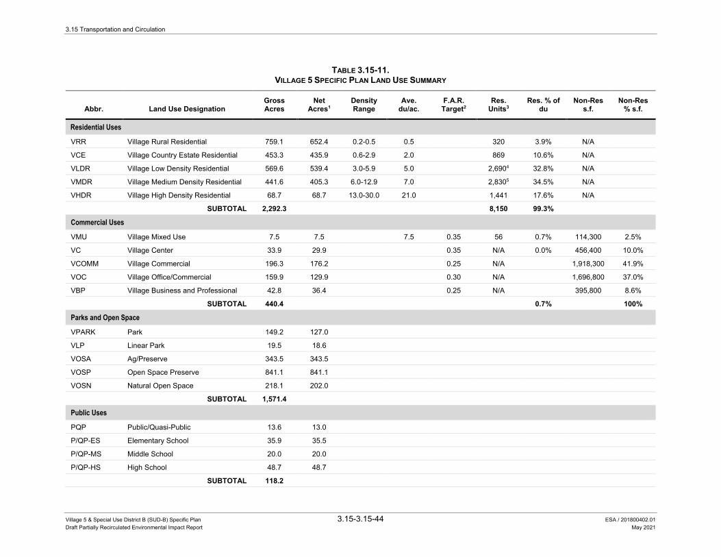
3.15 Transportation and Circulation
Village 5 & Special Use District B (SUD-B) Specific Plan 3.15-3.15-44 ESA / 201800402.01 Draft Partially Recirculated Environmental Impact Report May 2021
TABLE 3.15-11. VILLAGE 5 SPECIFIC PLAN LAND USE SUMMARY
Abbr. Land Use Designation Gross Acres
Net Acres1
Density Range
Ave. du/ac.
F.A.R. Target2
Res. Units3
Res. % of du
Non-Res s.f.
Non-Res % s.f.
Residential Uses
VRR Village Rural Residential 759.1 652.4 0.2-0.5 0.5 320 3.9% N/A
VCE Village Country Estate Residential 453.3 435.9 0.6-2.9 2.0 869 10.6% N/A
VLDR Village Low Density Residential 569.6 539.4 3.0-5.9 5.0 2,6904 32.8% N/A
VMDR Village Medium Density Residential 441.6 405.3 6.0-12.9 7.0 2,8305 34.5% N/A
VHDR Village High Density Residential 68.7 68.7 13.0-30.0 21.0 1,441 17.6% N/A
SUBTOTAL 2,292.3 8,150 99.3%
Commercial Uses
VMU Village Mixed Use 7.5 7.5 7.5 0.35 56 0.7% 114,300 2.5%
VC Village Center 33.9 29.9 0.35 N/A 0.0% 456,400 10.0%
VCOMM Village Commercial 196.3 176.2 0.25 N/A 1,918,300 41.9%
VOC Village Office/Commercial 159.9 129.9 0.30 N/A 1,696,800 37.0%
VBP Village Business and Professional 42.8 36.4 0.25 N/A 395,800 8.6%
SUBTOTAL 440.4 0.7% 100%
Parks and Open Space
VPARK Park 149.2 127.0
VLP Linear Park 19.5 18.6
VOSA Ag/Preserve 343.5 343.5
VOSP Open Space Preserve 841.1 841.1
VOSN Natural Open Space 218.1 202.0
SUBTOTAL 1,571.4
Public Uses
PQP Public/Quasi-Public 13.6 13.0
P/QP-ES Elementary School 35.9 35.5
P/QP-MS Middle School 20.0 20.0
P/QP-HS High School 48.7 48.7
SUBTOTAL 118.2
3.15 Transportation and Circulation
Village 5 & Special Use District B (SUD-B) Specific Plan 3.15-45 ESA / 201800402.01 Draft Partially Recirculated Environmental Impact Report May 2021
TABLE 3.15-11. VILLAGE 5 SPECIFIC PLAN LAND USE SUMMARY
Abbr. Land Use Designation Gross Acres
Net Acres1
Density Range
Ave. du/ac.
F.A.R. Target2
Res. Units3
Res. % of du
Non-Res s.f.
Non-Res % s.f.
ROW Right of Way 225.6 225.6
HWY SR 65 139.0 139.0
SUBTOTAL 364.6
TOTAL 4,786.9 4,495.6 8,2066 100.0% 4,581,600 100.0%
NOTES: 1. Net Acreage shown excludes detention basins and airport required open land, based on the Placer County Airport Land Use Compatibility Plan, February 26, 2014. Detailed calculations on a parcel by
parcel basis are provided in the V5SPAppendix B. 2. The FAR factors are targets and may vary based on the ranges established for each zone. VMU FAR is based on GP Table 4-3; COMM FAR assumes no internal public roadways; O/C FAR assumes
mix of two and three story buildings; BP FAR assumes single story buildings. 3. Total dwelling units for each land use type is based on the net acreages on a parcel by parcel basis, as provided in Table B-1 of Appendix B Planning Area Detail, and multiplied by the average density
factor. The densities shown are an average and may vary based on the ranges established for each residential zone. 4. 771 of the VLDR units would be designated as age-qualified. 5. 229 of the VMDR units would be designated as age-qualified. 6. Up to 1,000 units of VLDR and VMDR would be developed as age-qualified units. SOURCE: City of Lincoln, 2015. Lincoln Village 5 Specific Plan. August 7, 2015.
CHAPTER 4-LAND USE PLAN
Village 5 Specific Plan 4 3Exhibit 4.1: Land Use PlanLincoln Village 5 EIR . 130368
Figure 3.15-5 Land Use Plan
SOURCE: Cunningham Engineering, 2015

3.15 Transportation and Circulation
Village 5 & Special Use District B (SUD-B) Specific Plan 3.15-47 ESA / 201800402.01 Draft Partially Recirculated Environmental Impact Report May 2021
Additionally, a new, non-vehicular trail would be constructed on top of the existing earthen berm across Markham Ravine between Dowd Road and SR 65. The new trail would accommodate bicycle and pedestrian travel and provide a north-south connection between the northern part of the Plan Area, the Regional Sports Park, and a Class I trail that would parallel Auburn Ravine on its north side.
Figure 3.15-6 presents the roadway circulation plan for the proposed project.
Bikeway/Trail System A series of Class I and Class II bicycle paths would be built around most of the perimeter and cutting through the Plan Area in several locations, as indicated in Figure 3.15-7. The Class I bikeway system would provide off-street connectivity within the Plan Area for both cyclists and pedestrians. In addition, the paths would accommodate emergency and maintenance vehicle access to open space areas. Class I paths would be primarily situated along Auburn and Markham Ravines. Some of these trails may include grade-separated crossings via tunnels or bridges.
Specifically, three pedestrian/bicycle tunnels are proposed along a north-south Class I bikeway that connects Mavis Avenue and Ruth Avenue. Class II bike lanes (alongside vehicular traffic on-street) would be provided on expected bicycle commute corridors (i.e., Nelson Lane, Nicolaus Road, and South Dowd Road) and other key locations within the heart of the Plan Area. In the vast majority of instances, bicyclists would share the lane with NEVs.
Analysis Methods This section presents a topic-by-topic discussion of the key methods that this analysis applies to estimate the proposed project’s travel characteristics and to assess the proposed project’s impacts on the transportation and circulation system.
This section begins by presenting the methodology for estimating the expected traffic characteristics of the proposed project, followed by an analysis of the existing plus project conditions. This section also includes an analysis of the proposed project’s incremental contribution to cumulative traffic conditions within the study area.
For bicycle, pedestrian, and transit facilities, emergency vehicle access, and project access and internal circulation, this analysis relies upon the components in V5SP and engineering judgment to determine whether the proposed project would cause an impact.
Construction-related impacts are discussed in further detail in Section 3.15.3 under Impact 3.15-13.
CHAPTER 5-CIRCULATION & MOBILITY
Village 5 Specific Plan 5 4 Exhibit 5.1: Circulation PlanLincoln Village 5 EIR . 130368
Figure 3.15-6 Circulation Plan
SOURCE: Cunningham Engineering, 2015

CHAPTER 5-CIRCULATION & MOBILITY
Village 5 Specific Plan 5 20Exhibit 5.5: Mobility PlanLincoln Village 5 EIR . 130368
Figure 3.15-7 Mobility Plan
SOURCE: Cunningham Engineering, 2015

3.15 Transportation and Circulation
Village 5 & Special Use District B (SUD-B) Specific Plan 3.15-50 ESA / 201800402.01 Draft Partially Recirculated Environmental Impact Report May 2021
Project Traffic Characteristics Traffic generated by the proposed project is assigned to the roadway network using the following three-step process:
1. Trip Generation – estimates the amount of traffic generated by the proposed plans based on the planned land uses
2. Trip Distribution – distributes project trips based on origins and destinations in the region
3. Trip Assignment – assigns project trips to the roadway network based on the proposed project’s trip generation and distribution
This study uses the 2008 Placer County travel demand forecasting (TDF) model for this three-step process. This TDF model uses land use inputs, trip rates, and other traffic engineering inputs to estimate travel demand. The model’s roadway network includes major roadways, including freeways, highways, arterials, and collectors.
This study uses a version of the 2008 Placer County TDF model that has been updated to include the SR 65 Lincoln Bypass in the Base Year model, as well as updated land uses to reflect recent land development.
For the existing plus project scenario, the arterial and collector roadway network for the proposed project was added to the Placer County TDF model roadway network to reflect the build out of the proposed project.
Trip Generation The Placer County TDF model estimates the traffic generated by the proposed project based on the land uses identified in the V5SP. The land uses for the proposed project are added to the base year model land uses to create an “existing plus project” land use total. Using the land uses identified in the V5SP, the Placer County TDF model uses locally valid trip generation rates to estimate the total amount of traffic that would occur with the proposed project.
Trip Distribution Given the size of the proposed project in terms of land uses and the extent of the Plan Area, this study also uses the Placer County TDF model to estimate the distribution of proposed project trips.
The TDF model accounts for every trip from its origin to its destination. The model identifies the distribution of trips according to these origin-destination pairs, which are based on the interaction between complimentary land uses. For example, the residential land uses within the model generate trips that travel from dwelling units to employment areas, commercial and retail establishments, and educational uses both within and outside the proposed project site. Similarly, the commercial and employment uses within the model attract trips from residential neighborhoods and generate trips between non-residential uses.
3.15 Transportation and Circulation
Village 5 & Special Use District B (SUD-B) Specific Plan 3.15-51 ESA / 201800402.01 Draft Partially Recirculated Environmental Impact Report May 2021
The model also accounts for the distance between these complimentary land uses. For example, the model is more likely to assign a shopping trip from one’s home to a retail destination that is a shorter time distance away than one that is a longer time distance.
Using these principles of the interaction and proximity of complimentary land uses, the Placer County TDF model estimates the distribution of the project trips based on how the proposed project would interact with other land uses within the region.
Since the TDF model accounts for every trip from its origin to its destination, no additional modifications to the project trip distribution are necessary. The model accounts for all trip types, including the pairing of trips within the project (i.e., internalization) and redistribution of existing trips. This includes existing trips along roadways that stop at new intermediate destinations within the proposed project, such as a gas station or restaurant, in route to their ultimate destination (i.e., pass-by or diverted link trips).
Trip Assignment Using the trip generation and distribution data described above, the Placer County TDF model assigns traffic generated by the proposed project onto the model’s roadway network. This trip assignment is based on the most likely routes that would be used to travel between origins and destinations.
To account for model error, this study adjusts the existing plus project traffic forecasts using a process known as the “difference method,” which adjusts raw model volume forecasts based on expected incremental growth from existing conditions using the following formula:
Existing Plus Project Forecasts = Existing Traffic Count + (Existing Plus Project Raw Model Volume – Base Year Raw Model Volume)
This study uses this difference method process to develop the existing plus project traffic forecasts at the study intersections, roadway segments, highways, and freeway facilities.
Existing Plus Project Conditions Traffic Conditions Intersections Figures 3.15-8a through 3.15-8c display the existing plus project traffic forecasts at the study intersections.
Table 3.15-12 presents the anticipated a.m. and p.m. peak hour LOS at each study intersection under existing plus project conditions (refer to Appendix L for calculations). This analysis is based on the existing plus project volumes shown in Figure 3.15-3A through Figure 3.15-3C. This study uses the existing lane configurations, traffic control, and signal timings for this analysis.
For purposes of this analysis, it is assumed that all study intersections within the Plan Area are annexed into the incorporated City of Lincoln. The following summarizes the meaningful changes in intersection operations by jurisdiction:

3.15 Transportation and Circulation
Village 5 & Special Use District B (SUD-B) Specific Plan 3.15-52 ESA / 201800402.01 Draft Partially Recirculated Environmental Impact Report May 2021
City of Lincoln • The traffic added by the proposed project causes the following City of Lincoln intersections
operating at an acceptable LOS under existing conditions to operate at an unacceptable LOS:
– Nelson Lane/Nicolaus Road (#10): degrades from LOS C to LOS F during the a.m. and p.m. peak hours
– Airport Road/Nicolaus Road (#11): degrades from LOS B to LOS F during the a.m. and p.m. peak hours
– Dowd Road/Nicolaus Road (#13): degrades from LOS B to LOS F during the a.m. and p.m. peak hours
– Fiddyment Road/Moore Road (#15): degrades from LOS A to LOS E during the p.m. peak hour
– Dowd Road/Moore Road (#22): degrades from LOS A to LOS D during the a.m. peak hour
– Lakeside Drive/Nicolaus Road (#32): degrades from LOS B to LOS D during the a.m. peak hour
• The proposed project adds traffic to the following City of Lincoln intersection currently operating at an unacceptable LOS under existing conditions:
– Caledon Circle/Ferrari Ranch Road (#25): the addition of project trips increases the average vehicle delay by four seconds during the a.m. peak hour when the intersection operates at LOS E.
• The proposed project also creates several new intersections within the Plan Area. Of these intersections, only the Nelson Lane/Mavis Road (#40) intersection is expected to operate worse than LOS C during the a.m. and p.m. peak hours at build out of the specific plan.
Caltrans • The traffic added by the proposed project causes the following Caltrans intersections
operating at an acceptable LOS under existing conditions to operate at an unacceptable LOS:
– Nelson Lane/SR 65 (#3): degrades from LOS C to LOS F during the a.m. and p.m. peak hours
Placer County • The traffic added by the proposed project causes the following Placer County intersections
operating at an acceptable LOS under existing conditions to operate at an unacceptable LOS:
– Fiddyment Road/Athens Avenue (#16): degrades from LOS A to LOS E during the a.m. peak hour and from LOS B to LOS F during the p.m. peak hour
– Fiddyment Road/W. Sunset Boulevard (#18): degrades from LOS B to LOS D during the a.m. peak hour and from LOS C to LOS F during the p.m. peak hour
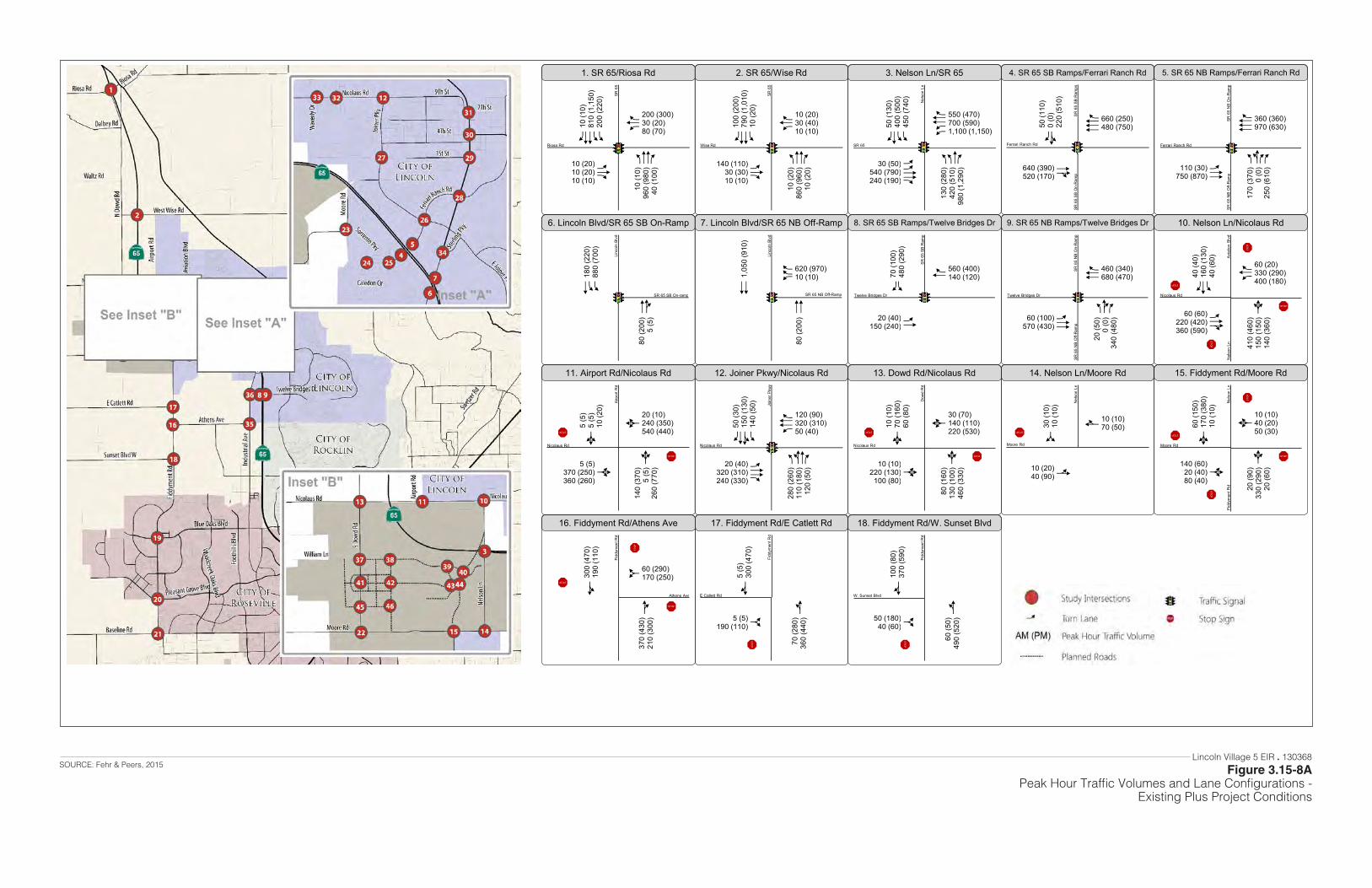
Figure 2APeak Hour Traffic Volumes and Lane Configurations
Existing Plus Project Conditions
ACCF
10 (1
0)96
0 (9
80)
40 (1
00)
ACF
10 (20)10 (20)10 (10)
AACCF10
(10)
810
(1,1
50)
200
(220
)
ACF 200 (300)
30 (20)80 (70)
1. SR 65/Riosa Rd
ACCF
10 (2
0)86
0 (9
60)
10 (2
0)
ACF
140 (110)30 (30)10 (10)
ACCF100
(200
)79
0 (1
,010
)10
(20)
ACF 10 (20)
30 (40)10 (10)
2. SR 65/Wise Rd
AACF
130
(280
)42
0 (5
10)
980
(1,2
90)
AACCF
30 (50)540 (790)240 (190)
AACF50
(130
)40
0 (5
00)
450
(740
)
AACCF 550 (470)
700 (590)1,100 (1,150)
3. Nelson Ln/SR 65
CE640 (390)520 (170)
BF50 (1
10)
0 (0
)22
0 (5
10)
CCCF 660 (250)
480 (750)
4. SR 65 SB Ramps/Ferrari Ranch Rd
ABFF
170
(370
)0
(0)
250
(610
)ACC110 (30)750 (870)
CCCF 360 (360)
970 (630)
5. SR 65 NB Ramps/Ferrari Ranch Rd
CE
80 (2
00)
5 (5
)
AAC180
(220
)88
0 (7
00)
6. Lincoln Blvd/SR 65 SB On-Ramp
CC
80 (2
00)
CC1,0
50 (9
10)
AFF 620 (970)
10 (10)
7. Lincoln Blvd/SR 65 NB Off-Ramp
AC20 (40)150 (240)
AF70
(100
)48
0 (2
90)
CF
560 (400)140 (120)
8. SR 65 SB Ramps/Twelve Bridges Dr
Riosa Rd
SR 6
5
SR 65
Nel
son
Ln
Ferrari Ranch Rd
SR 6
5 SB
Ram
psSR
65
SB O
n-R
amp
Ferrari Ranch Rd
SR 6
5 N
B O
n-R
amp
SR 6
5 N
B O
ff-R
amp
SR 65 SB On-ramp
Linc
oln
Blvd
SR 65 NB Off-Ramp
Linc
oln
Blvd
Twelve Bridges Dr
SR 6
5 SB
Ram
p
AEF
20 (5
0)0
(0)
340
(480
)ACC60 (100)570 (430)
CCF 460 (340)
680 (470)
9. SR 65 NB Ramps/Twelve Bridges Dr
Twelve Bridges Dr
SR 6
5 N
B O
n-R
amp
SR 6
5 N
B O
ff-R
amp
D
410
(460
)15
0 (1
50)
140
(360
)
ACE
60 (60)220 (420)360 (590)
ACF40
(40)
160
(130
)40
(60)
ACF 60 (20)
330 (290)400 (180)
10. Nelson Ln/Nicolaus Rd
Nicolaus Rd
Avia
tion
Blvd
Nel
son
Ln
STOP
STOP
STO
P
D
140
(370
)5
(5)
260
(770
)D5 (5)370 (250)360 (260)
D5 (5
)5
(5)
10 (2
0)
D
20 (10)240 (350)540 (440)
11. Airport Rd/Nicolaus Rd
ABCF
280
(260
)11
0 (1
80)
120
(50)
ACCF
20 (40)320 (310)240 (330)
ABCF50
(30)
150
(130
)14
0 (5
0)
ACCF 120 (90)
320 (310)50 (40)
12. Joiner Pkwy/Nicolaus Rd
D
80 (1
60)
130
(100
)46
0 (3
30)D10 (10)
220 (130)100 (80)
D10 (1
0)70
(160
)60
(80)
D
30 (70)140 (110)220 (530)
13. Dowd Rd/Nicolaus Rd
B10 (20)40 (90)
G30 (1
0)10
(10)
E 10 (10)70 (50)
14. Nelson Ln/Moore Rd
D
20 (9
0)33
0 (2
90)
20 (6
0)
D140 (60)20 (40)80 (40)
D60 (1
50)
170
(380
)10
(10)
D
10 (10)40 (20)50 (30)
15. Fiddyment Rd/Moore Rd
Nicolaus Rd
Airp
ort R
d
Nicolaus Rd
Dow
d R
d
Moore Rd
Nel
son
Ln
Moore Rd
Nel
son
LnFi
ddym
ent R
d
STOPSTOP
STOPSTOP STOP
STOP
STOP
STO
P
E
370
(430
)21
0 (3
00)
B300
(470
)19
0 (1
10)
G
60 (290)170 (250)
16. Fiddyment Rd/Athens Ave
B
70 (2
80)
360
(440
)G5 (5)190 (110)
E5 (5
)30
0 (4
70)
17. Fiddyment Rd/E Catlett Rd
B
60 (5
0)49
0 (5
20)G50 (180)
40 (60)
E100
(80)
370
(590
)
18. Fiddyment Rd/W. Sunset Blvd
Athens Ave
Fidd
ymen
t Rd
W. Sunset Blvd
Fidd
ymen
t Rd
STOP
STOP
STO
P
STOP
STOP
Nicolaus Rd
Join
er P
kwy
E Catlett Rd
Fidd
ymen
t Rd
Wise Rd
SR 6
5
STOP
STOP
Lincoln Village 5 EIR . 130368
Figure 3.15-8APeak Hour Traffic Volumes and Lane Configurations -
Existing Plus Project Conditions
SOURCE: Fehr & Peers, 2015

Figure 2BPeak Hour Traffic Volumes and Lane Configurations
Existing Plus Project Conditions
AACCF
10 (1
0)42
0 (4
10)
360
(350
)
AACCCF
10 (10)50 (50)10 (10)
AACCF10
(10)
370
(490
)60
(70)
AACCF 60 (90)
70 (90)340 (380)
19. Fiddyment Rd/Blue Oaks Blvd
AACCCF
130
(270
)67
0 (7
40)
410
(420
)
AACCF
30 (20)220 (170)270 (120)
AACCF10
(30)
800
(760
)12
0 (1
10)
AACCF 80 (140)
100 (340)400 (480)
20. Fiddyment Rd/Pleasant Grove Blvd
ACCF
20 (2
0)60
0 (5
80)
130
(200
)
ACE
280 (610)70 (270)
10 (10)
ACCF650
(330
)65
0 (7
10)
150
(130
)
ACCF 140 (200)
320 (100)180 (180)
21. Fiddyment Rd/Baseline Rd
AE
10 (2
0)60
(280
)10
(10)
AE40 (50)30 (40)20 (10)
ACF50
(40)
210
(100
)80
(50)
AE
50 (70)20 (40)10 (10)
22. S Dowd Rd/Moore Rd
E
10 (2
0)40
(80)
B10 (1
0)60
(40)
G 20 (80)
60 (50)
23. Moore Rd/Sorrento Pkwy
ACC20 (10)190 (85)
AF10
(10)
195
(150
)
CCF 120 (155)
95 (140)
24. Sorrento Pkwy/Ferrari Ranch Rd
BF
20 (1
0)5
(5)
700
(320
)
ACCF
5 (5)370 (200)
10 (30)
BF5 (5
)5
(5)
90 (4
0)
AACF 30 (90)
190 (280)310 (490)
25. Caledon Cir/Ferrari Ranch Rd
AACCF
240
(300
)22
0 (2
70)
80 (1
20)
AACCF
40 (30)380 (440)100 (110)
ACCF20
(90)
190
(280
)60
(60)
AACCF 30 (20)
380 (370)40 (90)
26. Joiner Pkwy/Ferrari Ranch Rd
Blue Oaks Blvd
Fidd
ymen
t Rd
Baseline Rd
Fidd
ymen
t Rd
Moore Rd
S D
owd
Rd
Sorrento Pkwy
Moo
re R
d
Ferrari Ranch Rd
Sorre
nto
Pkw
y
Ferrari Ranch Rd
Cou
rtyar
ds L
oop
Cal
edon
Cir
Ferrari Ranch Rd
Join
er P
kwy
STOP
STOP
STOP
STOP
STO
P
ACE
130
(140
)32
0 (5
00)
100
(100
)
ACF70 (40)70 (30)
240 (90)
ACE130
(40)
380
(370
)50
(60)
ACF 60 (60)
120 (50)150 (110)
27. Joiner Pkwy/1st St
1st St
Join
er P
kwy
ACCF
50 (1
80)
430
(840
)10
0 (3
10)
ACF
100 (200)160 (370)
60 (50)
ACCF80
(170
)48
0 (5
00)
80 (1
20)
AACCF 40 (60)
240 (230)240 (150)
28. Lincoln Blvd/Ferrari Ranch Rd
Ferrari Ranch Rd
Linc
oln
Blvd
ACF
160
(150
)47
0 (6
60)
50 (1
20)AE50 (50)
60 (60)200 (10)
AE40 (7
0)50
0 (4
20)
10 (1
0)
AE
10 (150)60 (80)30 (70)
29. Lincoln Blvd/1st St
AE
5 (5
)38
0 (5
00)
150
(110
)D5 (10)5 (10)5 (20)
AE5 (5
)41
0 (2
80)
130
(100
)
BF 100 (130)
5 (5)130 (180)
30. Lincoln Blvd/McBean Park Dr
AE
100
(80)
150
(260
)60
(60)
AE40 (60)170 (180)140 (120)
AE90 (5
0)27
0 (2
20)
30 (4
0)
ACF 50 (110)
240 (160)40 (40)
31. Lincoln Blvd/7th St
D
10 (1
0)20
(20)
70 (3
0)
ACCF
60 (150)330 (610)
10 (10)
ACF110
(70)
20 (1
0)17
0 (1
10)
ACCF 60 (120)
610 (430)40 (50)
32. Lakeside Dr/Nicolaus Rd
D
40 (4
0)10
(10)
20 (1
0)
ACCF
80 (110)300 (690)
20 (40)
D100
(50)
5 (5
)80
(70)
ACCF 60 (90)
650 (400)20 (20)
33. Teal Hollow Dr/Nicolaus Rd
1st St
Linc
oln
Blvd
7th St
Linc
oln
Blvd
Nicolaus Rd
Lake
side
Dr
Nicolaus Rd
Teal
Hol
low
Dr
Wav
erly
Dr
STOPSTOP
STOP
STO
P
STOP
STOP
STO
P
CCCF
650
(1,1
10)
90 (1
10)
AACC940
(750
)30
(30)
AAF 20 (30)
110 (160)
34. Lincoln Blvd/Sterling Pkwy
AAC
190
(330
)70
(140
)AF150 (300)120 (280)
CF210
(280
)12
0 (9
0)
35. Industrial Ave/Athens Ave
E
90 (1
90)
130
(250
)
AC140
(160
)40
(30)
AF
20 (10)190 (210)
36. Industrial Ave/Twelve Bridges Dr
Sterling Pkwy
Linc
oln
Blvd
Twelve Bridges Dr
Indu
stria
l Ave
STOP
STOP
STO
P
Driveway McBean Park Dr
Linc
oln
Blvd
Athens Ave
Indu
stria
l Ave
Pleasant Grove Blvd
Fidd
ymen
t Rd
STO
P
STOP
Lincoln Village 5 EIR . 130368
Figure 3.15-8BPeak Hour Traffic Volumes and Lane Configurations -
Existing Plus Project Conditions
SOURCE: Fehr & Peers, 2015

Figure 2CPeak Hour Traffic Volumes and Lane Configurations
Existing Plus Project Conditions
ACE
10 (1
0)35
0 (3
00)
130
(60)
AE20 (10)30 (10)10 (10)
ACE10 (2
0)20
0 (3
90)
420
(330
)
ACF 310 (460)
10 (30)50 (100)
37. Dowd Rd/Mavis Rd
G
10 (1
0)10
0 (5
0)
CE810 (500)10 (10)
ACC 440 (840)
50 (90)
38. A St/Mavis Rd
AE
10 (1
0)20
(30)
20 (2
0)
ACE
50 (50)1,010 (530)
10 (10)
AE10 (1
00)
20 (3
0)50
(100
)
ACCF 50 (100)
480 (1,040)20 (20)
39. Ruth Ave/Mavis Rd
AACCCF
150
(140
)53
0 (2
00)
220
(110
)
AACCF
810 (1,050)230 (180)
60 (200)
AACCCF750
(920
)28
0 (5
70)
710
(350
)
AACCF 190 (830)
90 (290)40 (260)
40. Nelson Ln/Mavis Rd
ACE
10 (1
0)36
0 (3
10)
10 (1
0)
AE10 (10)10 (10)10 (10)
ACE10 (1
0)22
0 (3
70)
10 (3
0)
AE
30 (20)10 (10)10 (10)
41. Dowd Rd/Rachel Ave
D
10 (1
0)30
(30)
50 (1
0)
AE10 (10)20 (10)10 (10)
D10 (1
0)30
(30)
10 (1
0)
AE
10 (10)10 (10)10 (50)
42. A St/Rachel Ave
AE
10 (1
0)10
(10)
60 (6
0)
AE20 (10)310 (80)
10 (10)
AE10 (1
0)10
(10)
20 (1
0)
AE
10 (20)60 (300)30 (90)
43. Ruth Ave/Rachel Ave
ACCC
20 (7
0)57
0 (3
30)AF330 (120)
50 (30)
CCCF70
(320
)23
0 (6
20)
44. Nelson Ln/Rachel Ave
Mavis Rd
Dow
d R
d
Mavis Rd
Driv
eway
Rut
h Av
e
Mavis Rd
Nel
son
Ln
Rachel Ave
Dow
d R
d
Rachel Ave
A St
Rachel Ave
Rut
h Av
e
Rachel Ave
Nel
son
Ln
STOP
ACE
10 (2
0)14
0 (2
80)
10 (1
0)
AE10 (10)10 (10)10 (10)
ACE10 (1
0)21
0 (1
80)
20 (3
0)
AE
40 (20)10 (10)10 (10)
45. Dowd Rd/B St
B St
Dow
d R
d
B
30 (2
0)20
(30)
G10 (10)30 (20)
E10 (1
0)30
(10)
46. A St/B St
B St
A St
STOP
STOP
B10 (10)80 (50)
G10 (1
0)11
0 (4
0)
E 30 (110)50 (80)
47. A St/Moore Rd
Moore Rd
A St
STOP
STOP
STO
P
Y
Mavis Rd
A St
STOP
STOP
STOP
STO
P
STOP
STO
P
STOP
STOP
STOP
Y
Y
Y Y
Lincoln Village 5 EIR . 130368
Figure 3.15-8CPeak Hour Traffic Volumes and Lane Configurations -
Existing Plus Project Conditions
SOURCE: Fehr & Peers, 2015

3.15 Transportation and Circulation
Village 5 & Special Use District B (SUD-B) Specific Plan 3.15-56 ESA / 201800402.01 Draft Partially Recirculated Environmental Impact Report May 2021
This page intentionally left blank

3.15 Transportation and Circulation
Village 5 & Special Use District B (SUD-B) Specific Plan 3.15-57 ESA / 201800402.01 Draft Partially Recirculated Environmental Impact Report May 2021
TABLE 3.15-12. INTERSECTION OPERATIONS – EXISTING PLUS PROJECT CONDITIONS
Traffic Control
Peak Hour
Existing Conditions
Existing Plus Project
Intersection Jurisdiction Delay LOS Delay LOS
1. SR 65/Riosa Road Caltrans Signal A.M. 15 B 16 B P.M. 16 B 19 B
2. SR 65/Wise Road Caltrans Signal A.M. 9 A 13 B P.M. 11 B 13 B
3. Nelson Lane/SR 65 Caltrans Signal A.M. 22 C >150 F P.M. 21 C >150 F
4. SR 65 SB Ramps/Ferrari Ranch Rd. Caltrans Signal
A.M. 4 A 7 A P.M. 4 A 10 B
5. SR 65 NB Ramps/Ferrari Ranch Rd. Caltrans Signal
A.M. 11 B 12 B P.M. 11 B 11 B
6. SR 65 SB On-Ramp/Lincoln Blvd. Caltrans Signal
A.M. 5 A 8 A P.M. 7 A 7 A
7. SR 65 NB Off-Ramp/Lincoln Blvd. Caltrans Signal
A.M. 2 A 2 A P.M. 1 A 1 A
8. SR 65 SB Ramps/Twelve Bridges Dr. Caltrans Signal
A.M. 13 B 15 B P.M. 9 A 10 A
9. SR 65 NB Ramps/Twelve Bridges Dr. Caltrans Signal
A.M. 11 B 12 B P.M. 11 B 13 B
10. Nelson Lane/Nicolaus Road City of Lincoln AWSC A.M. 19 C 69 F P.M. 18 C 64 F
11. Airport Road/Nicolaus Road City of Lincoln SSSC A.M. 10 B >150 F P.M. 10 B >150 F
12. Joiner Parkway/Nicolaus Road City of Lincoln Signal A.M. 12 B 14 B P.M. 10 B 12 B
13. Dowd Road/Nicolaus Road Unincorporated Placer County3 SSSC
A.M. 10 B >150 F P.M. 11 B >150 F
14. Nelson Lane/Moore Road Unincorporated Placer County3 SSSC
A.M. 9 A 9 A P.M. 9 A 9 A
15. Fiddyment Road/Moore Road Unincorporated Placer County3 AWSC
A.M. 8 A 21 C P.M. 8 A 41 E
16. Fiddyment Road/Athens Avenue
Unincorporated Placer County AWSC
A.M. 10 A 45 E P.M. 13 B 66 F
17. Fiddyment Road/E. Catlett Road
Unincorporated Placer County SSSC
A.M. 9 A 13 B P.M. 9 A 19 C
18. Fiddyment Road/W. Sunset Blvd.
Unincorporated Placer County SSSC
A.M. 12 B 28 D P.M. 20 C >150 F
19. Fiddyment Road/Blue Oaks Blvd.
City of Roseville Signal
A.M. 19 B 17 B P.M. 18 B 19 B
20. Fiddyment Road/Pleasant Grove Blvd.
City of Roseville Signal
A.M. 29 C 30 C P.M. 26 C 28 C
21. Fiddyment Road/Baseline Road
City of Roseville Signal
A.M. 49 D 50 D P.M. >150 F 145 F
22. Dowd Road/Moore Road Unincorporated Placer County3 SSSC
A.M. 9 A 32 D P.M. 9 A 24 C
23. Sorrento Parkway/Moore Road
Unincorporated Placer County SSSC
A.M. 10 A 10 A P.M. 9 A 10 A
24. Sorrento Parkway/Ferrari Ranch Road City of Lincoln AWSC
A.M. 9 A 10 A P.M. 8 A 8 A
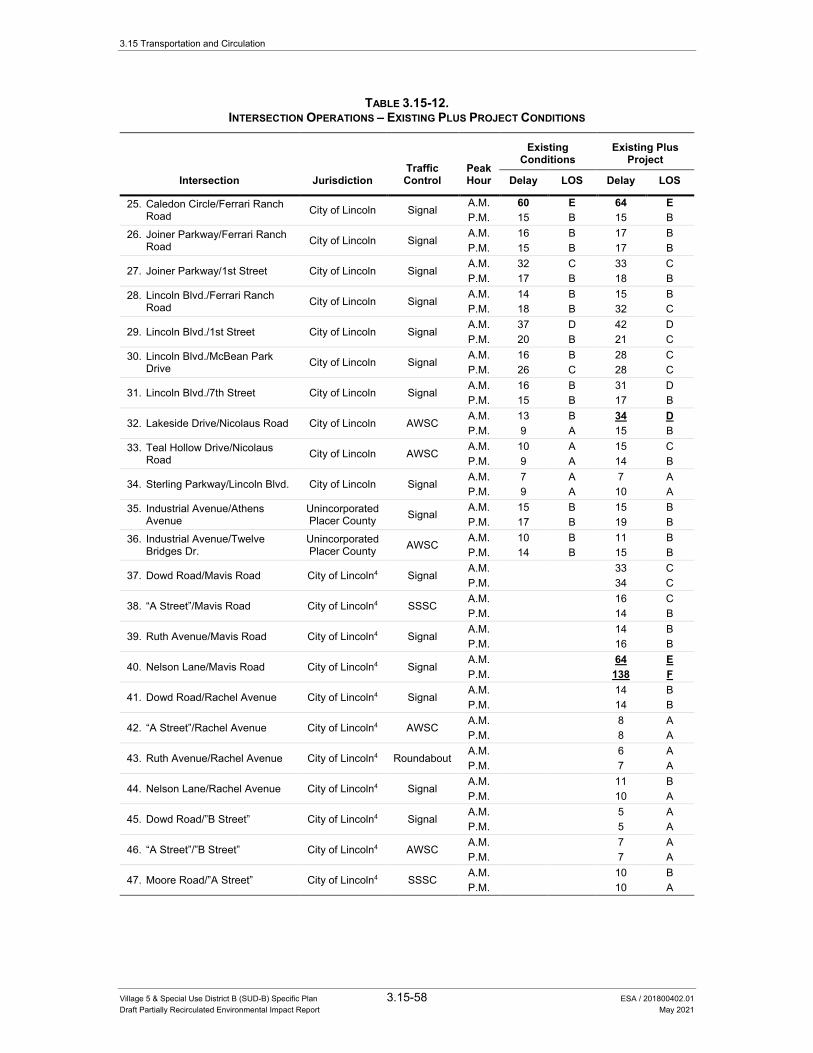
3.15 Transportation and Circulation
Village 5 & Special Use District B (SUD-B) Specific Plan 3.15-58 ESA / 201800402.01 Draft Partially Recirculated Environmental Impact Report May 2021
TABLE 3.15-12. INTERSECTION OPERATIONS – EXISTING PLUS PROJECT CONDITIONS
Traffic Control
Peak Hour
Existing Conditions
Existing Plus Project
Intersection Jurisdiction Delay LOS Delay LOS
25. Caledon Circle/Ferrari Ranch Road City of Lincoln Signal
A.M. 60 E 64 E P.M. 15 B 15 B
26. Joiner Parkway/Ferrari Ranch Road City of Lincoln Signal
A.M. 16 B 17 B P.M. 15 B 17 B
27. Joiner Parkway/1st Street City of Lincoln Signal A.M. 32 C 33 C P.M. 17 B 18 B
28. Lincoln Blvd./Ferrari Ranch Road City of Lincoln Signal
A.M. 14 B 15 B P.M. 18 B 32 C
29. Lincoln Blvd./1st Street City of Lincoln Signal A.M. 37 D 42 D P.M. 20 B 21 C
30. Lincoln Blvd./McBean Park Drive City of Lincoln Signal
A.M. 16 B 28 C P.M. 26 C 28 C
31. Lincoln Blvd./7th Street City of Lincoln Signal A.M. 16 B 31 D P.M. 15 B 17 B
32. Lakeside Drive/Nicolaus Road City of Lincoln AWSC A.M. 13 B 34 D P.M. 9 A 15 B
33. Teal Hollow Drive/Nicolaus Road City of Lincoln AWSC
A.M. 10 A 15 C P.M. 9 A 14 B
34. Sterling Parkway/Lincoln Blvd. City of Lincoln Signal A.M. 7 A 7 A P.M. 9 A 10 A
35. Industrial Avenue/Athens Avenue
Unincorporated Placer County Signal
A.M. 15 B 15 B P.M. 17 B 19 B
36. Industrial Avenue/Twelve Bridges Dr.
Unincorporated Placer County AWSC
A.M. 10 B 11 B P.M. 14 B 15 B
37. Dowd Road/Mavis Road City of Lincoln4 Signal A.M. 33 C P.M. 34 C
38. “A Street”/Mavis Road City of Lincoln4 SSSC A.M. 16 C P.M. 14 B
39. Ruth Avenue/Mavis Road City of Lincoln4 Signal A.M. 14 B P.M. 16 B
40. Nelson Lane/Mavis Road City of Lincoln4 Signal A.M. 64 E P.M. 138 F
41. Dowd Road/Rachel Avenue City of Lincoln4 Signal A.M. 14 B P.M. 14 B
42. “A Street”/Rachel Avenue City of Lincoln4 AWSC A.M. 8 A P.M. 8 A
43. Ruth Avenue/Rachel Avenue City of Lincoln4 Roundabout A.M. 6 A P.M. 7 A
44. Nelson Lane/Rachel Avenue City of Lincoln4 Signal A.M. 11 B P.M. 10 A
45. Dowd Road/”B Street” City of Lincoln4 Signal A.M. 5 A P.M. 5 A
46. “A Street”/”B Street” City of Lincoln4 AWSC A.M. 7 A P.M. 7 A
47. Moore Road/”A Street” City of Lincoln4 SSSC A.M. 10 B P.M. 10 A
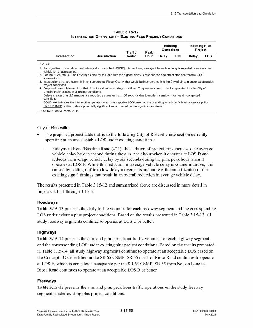
3.15 Transportation and Circulation
Village 5 & Special Use District B (SUD-B) Specific Plan 3.15-59 ESA / 201800402.01 Draft Partially Recirculated Environmental Impact Report May 2021
TABLE 3.15-12. INTERSECTION OPERATIONS – EXISTING PLUS PROJECT CONDITIONS
Traffic Control
Peak Hour
Existing Conditions
Existing Plus Project
Intersection Jurisdiction Delay LOS Delay LOS
NOTES: 1. For signalized, roundabout, and all-way stop controlled (AWSC) intersections, average intersection delay is reported in seconds per
vehicle for all approaches. 2. Per the HCM, the LOS and average delay for the lane with the highest delay is reported for side-street stop controlled (SSSC)
intersections. 3. Intersections that are currently in unincorporated Placer County that would be incorporated into the City of Lincoln under existing plus
project conditions. 4. Proposed project Intersections that do not exist under existing conditions. They are assumed to be incorporated into the City of
Lincoln under existing plus project conditions. Delays greater than 2.5 minutes are reported as greater than 150 seconds due to model insensitivity for heavily congested
conditions. BOLD text indicates the intersection operates at an unacceptable LOS based on the presiding jurisdiction’s level of service policy. UNDERLINED text indicates a potentially significant impact based on the significance criteria. SOURCE: Fehr & Peers, 2015.
City of Roseville • The proposed project adds traffic to the following City of Roseville intersection currently
operating at an unacceptable LOS under existing conditions:
– Fiddyment Road/Baseline Road (#21): the addition of project trips increases the average vehicle delay by one second during the a.m. peak hour when it operates at LOS D and reduces the average vehicle delay by six seconds during the p.m. peak hour when it operates at LOS F. While this reduction in average vehicle delay is counterintuitive, it is caused by adding traffic to low delay movements and more efficient utilization of the existing signal timings that result in an overall reduction in average vehicle delay.
The results presented in Table 3.15-12 and summarized above are discussed in more detail in Impacts 3.15-1 through 3.15-6.
Roadways Table 3.15-13 presents the daily traffic volumes for each roadway segment and the corresponding LOS under existing plus project conditions. Based on the results presented in Table 3.15-13, all study roadway segments continue to operate at LOS C or better.
Highways Table 3.15-14 presents the a.m. and p.m. peak hour traffic volumes for each highway segment and the corresponding LOS under existing plus project conditions. Based on the results presented in Table 3.15-14, all study highway segments continue to operate at an acceptable LOS based on the Concept LOS identified in the SR 65 CSMP. SR 65 north of Riosa Road continues to operate at LOS E, which is considered acceptable per the SR 65 CSMP. SR 65 from Nelson Lane to Riosa Road continues to operate at an acceptable LOS B or better.
Freeways Table 3.15-15 presents the a.m. and p.m. peak hour traffic operations on the study freeway segments under existing plus project conditions.
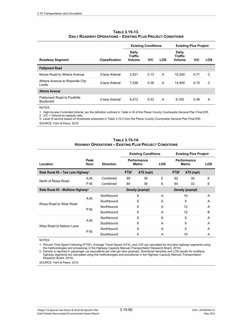
3.15 Transportation and Circulation
Village 5 & Special Use District B (SUD-B) Specific Plan 3.15-60 ESA / 201800402.01 Draft Partially Recirculated Environmental Impact Report May 2021
TABLE 3.15-13. DAILY ROADWAY OPERATIONS – EXISTING PLUS PROJECT CONDITIONS
Roadway Segment Classification
Existing Conditions Existing Plus Project
Daily Traffic
Volume V/C LOS
Daily Traffic
Volume V/C LOS
Fiddyment Road
Moore Road to Athens Avenue 2-lane Arterial 2,521 0.13 A 14,200 0.71 C
Athens Avenue to Roseville City Limits 2-lane Arterial 7,539 0.38 A 14,900 0.75 C
Athens Avenue
Fiddyment Road to Foothills Boulevard 2-lane Arterial 6,512 0.33 A 9,100 0.46 A
NOTES: 1. High-Access Controlled Arterial, per the definition outlined in Table 4-16 of the Placer County Countywide General Plan Final EIR. 2. V/C = Volume-to-capacity ratio. 3. Level of service based on thresholds presented in Table 3.15-3 from the Placer County Countywide General Plan Final EIR. SOURCE: Fehr & Peers, 2015
TABLE 3.15-14. HIGHWAY OPERATIONS – EXISTING PLUS PROJECT CONDITIONS
Location Peak Hour Direction
Existing Conditions Existing Plus Project
Performance Metric LOS
Performance Metric LOS
State Route 65 – Two Lane Highway1 PTSF ATS (mph) PTSF ATS (mph)
North of Riosa Road A.M. Combined 89 39 E 92 35 E P.M. Combined 84 39 E 94 33 E
State Route 65 – Multilane Highway2 Density (pcpmpl) Density (pcpmpl)
Riosa Road to Wise Road A.M.
Northbound 8 A 10 A Southbound 6 A 9 A
P.M. Northbound 8 A 10 A Southbound 6 A 12 B
Wise Road to Nelson Lane A.M.
Northbound 8 A 9 A Southbound 6 A 9 A
P.M. Northbound 8 A 9 A Southbound 6 A 10 A
NOTES: 1. Percent Time Spent Following (PTSF), Average Travel Speed (ATS), and LOS are calculated for two-lane highway segments using
the methodologies and procedures in the Highway Capacity Manual (Transportation Research Board, 2010). 2. Density is reported in passenger car equivalents per mile per lane (pcpmpl). Directional densities and LOS results for multilane
highway segments are calculated using the methodologies and procedures in the Highway Capacity Manual (Transportation Research Board, 2010).
SOURCE: Fehr & Peers, 2015
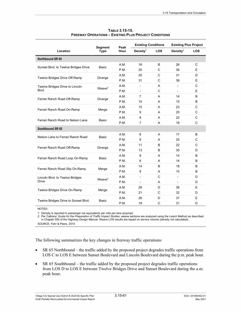
3.15 Transportation and Circulation
Village 5 & Special Use District B (SUD-B) Specific Plan 3.15-61 ESA / 201800402.01 Draft Partially Recirculated Environmental Impact Report May 2021
TABLE 3.15-15. FREEWAY OPERATIONS – EXISTING PLUS PROJECT CONDITIONS
Segment
Type Peak Hour
Existing Conditions Existing Plus Project
Location Density1 LOS Density1 LOS
Northbound SR 65
Sunset Blvd. to Twelve Bridges Drive Basic A.M. 16 B 26 C P.M. 25 C 36 E
Twelve Bridges Drive Off-Ramp Diverge A.M. 20 C 31 D P.M. 31 C 38 E
Twelve Bridges Drive to Lincoln Blvd. Weave2
A.M. - A - C P.M. - C - E
Ferrari Ranch Road Off-Ramp Diverge A.M. 7 A 14 B P.M. 10 A 15 B
Ferrari Ranch Road On-Ramp Merge A.M. 10 A 23 C P.M. 9 A 20 C
Ferrari Ranch Road to Nelson Lane Basic A.M. 8 A 22 C P.M. 7 A 18 C
Southbound SR 65
Nelson Lane to Ferrari Ranch Road Basic A.M. 8 A 17 B P.M. 9 A 25 C
Ferrari Ranch Road Off-Ramp Diverge A.M. 11 B 22 C P.M. 13 B 30 D
Ferrari Ranch Road Loop On-Ramp Basic A.M. 9 A 14 B P.M. 6 A 14 B
Ferrari Ranch Road Slip On-Ramp Merge A.M. 14 B 18 B P.M. 8 A 15 B
Lincoln Blvd. to Twelve Bridges Drive Weave2
A.M. - C - D P.M. - A - D
Twelve Bridges Drive On-Ramp Merge A.M. 28 D 36 E P.M. 21 C 32 D
Twelve Bridges Drive to Sunset Blvd. Basic A.M. 26 D 37 E P.M. 18 C 31 D
NOTES: 1. Density is reported in passenger car equivalents per mile per lane (pcpmpl) 2. Per Caltrans’ Guide for the Preparation of Traffic Impact Studies, weave sections are analyzed using the Leisch Method as described
in Chapter 500 of the Highway Design Manual. Weave LOS results are based on service volume (density not calculated). SOURCE: Fehr & Peers, 2015
The following summarizes the key changes in freeway traffic operations:
• SR 65 Northbound – the traffic added by the proposed project degrades traffic operations from LOS C to LOS E between Sunset Boulevard and Lincoln Boulevard during the p.m. peak hour.
• SR 65 Southbound – the traffic added by the proposed project degrades traffic operations from LOS D to LOS E between Twelve Bridges Drive and Sunset Boulevard during the a.m. peak hour.

3.15 Transportation and Circulation
Village 5 & Special Use District B (SUD-B) Specific Plan 3.15-62 ESA / 201800402.01 Draft Partially Recirculated Environmental Impact Report May 2021
Since LOS E is the concept LOS for these segments of SR 65, per the SR 65 CSMP, the LOS E operations are considered acceptable.
Bicycle and Pedestrian System The V5SP identifies a comprehensive mobility network, including designated facilities for bicyclists and pedestrians. This includes numerous off-street Class I multi-use trails along several project roadways and along Markham and Auburn Ravines. The Specific Plan also identifies several north-south Class I trail connecting the regional park off Mavis Avenue to Auburn Ravine, community parks, schools, and commercial areas. These north-south trails may include grade-separated crossings, such as tunnels or bridges, at east-west roadways, such as Ruth Avenue, Rachel Avenue, and Mavis Avenue, to reduce conflicts between bicyclists, pedestrians, and vehicles.
Class II bike lanes are provided on the expected bicycle commute corridors, including Nicolaus Road, Mavis Avenue, Dowd Road, and Nelson Lane, and facilities expected to be used for longer distance recreational travel, such as Moore Road.
The V5SP also includes a cycle track along Rachel Avenue, the central spine street which connects the neighborhoods to the Village Centers on each end. This new type of bicycle facility offers many of the safety advantages of an off-street facility, while technically being an on-street facility. The proposed cycle track permits two-way bicycle travel in a 10-foot designated area for the exclusive use of bicyclists. The cycle track is physically separated from vehicle traffic by a landscaped buffer.
The proposed project also includes sidewalks on the vast majority of project roadways, and will provide crosswalks at signalized intersections and roundabouts to support pedestrian activity.
Neighborhood Electric Vehicles The City of Lincoln has a Neighborhood Electric Vehicle (NEV) plan consistent with Section 21250 of the California Vehicle Code. NEVs are permitted to travel in general purpose lanes on roadways in the city with posted speed limits of 35 miles per hour or less. For roadways with posted speeds of 35 mph or over, a dedicated NEV lane is required. The City’s NEV plan allows for a combined eight-foot shared Class II bicycle/NEV lane in these instances. Exhibit 5.2 and Table 5-1 (Plan Area Roadway Cross-Sections) of the V5SP identify which roadways will have dedicated NEV systems that will coincide with the Class II bicycle lane.
Transit System The V5SP includes bus turnouts and shelters to accommodate potential planned future transit service expansion to the area. In addition, a bus transfer lot is being considered as part of a joint use park-and-ride lot to support transit use. While the V5SP would include the construction of transit facilities, it does not specify any transit service expansion into the V5SP area. The V5SP states that transit services would be extended into the V5SP area as the demand for such services occurs and funds are available as determined by the transit provider. A detailed description of
3.15 Transportation and Circulation
Village 5 & Special Use District B (SUD-B) Specific Plan 3.15-63 ESA / 201800402.01
Draft Partially Recirculated Environmental Impact Report May 2021
transit service funding and planning considerations is provided in the transit analysis memorandum, included as Appendix M to this Draft EIR.
Planned Transit Services & Facilities
Planned transit services and facilities would increase transit service levels in and near the V5SP area in the future.
Near-Term
In the near-term, the Lincoln-Sacramento Light Rail express bus service identified in the Placer County Transit SRTP 2018-2025 would increase the number of transit trips between the City of Lincoln, the City of Roseville, and the Watt/I-80 Station (which provides connections to SacRT light rail service to/from Downtown Sacramento). Stops in Lincoln would include Downtown Lincoln, Sterling Parkway, and the Twelve Bridges Boulevard park-and-ride lot, all of which are located between one and one-half and two miles from the easterly V5SP area boundary. While these stops would be located a considerable distance from most residential and commercial uses within the V5SP area, some V5SP residents and employees may opt to drive and park at the planned bus stops to utilize the service to complete intercity travel along the Highway 65 and I-80 corridors. The service would operate with a 30-minute all-day frequency, which would provide capacity for approximately 80 to 90 seated passengers per direction per hour.
The Lincoln Dial-a-Ride (DAR) service area currently covers the entirety of the City of Lincoln city limits. Based on its transit operating agreement with the County, the City would have the discretion to similarly extend the Lincoln DAR service area into the V5SP area as it is incorporated into the City. This modification would provide basic coverage transit service to the V5SP area during its initial phases of development. If it chose to do so, and if agreed upon by the County, the City would be required to pay the County for increased operating costs that could be incurred by the DAR service expansion.
Long-Term
In the long-term, the Placer County RTP 2040 identifies transit service and facility improvements that would result in increased transit service levels in and near the V5SP area through 2040. The Placer County RTP 2040 includes multiple planned projects that would allocate funding towards O&M and capital costs related to sustaining and expanding local, commuter, and dial-a-ride transit services in Placer County, citing the need to expand the transit system to serve planned population and employment growth in the County. Specific to the City of Lincoln, the Transit Master Plan for South Placer County indicates that transit service expansion resulting from planned land development in Lincoln (including in the V5SP area) would require that the transit
fleet serving the City increase from four vehicles to 23 vehicles.26 The Transit Master Plan for
South Placer County identifies future transit service expansion based upon the notion that transit operating resources would increase at a rate commensurate with the growth in population and
26 Placer County Transportation Planning Agency, 2007. Transit Master Plan for South Placer County, June 2007,
pg. 25.
3.15 Transportation and Circulation
Village 5 & Special Use District B (SUD-B) Specific Plan 3.15-64 ESA / 201800402.01 Draft Partially Recirculated Environmental Impact Report May 2021
employment in the County (refer to the “Transit Service Planning & Funding Considerations” section for additional information).
The Placer County RTP 2040 additionally incorporates the recommendations from Scenario 2 of the Transit Master Plan for South Placer County, which include limited transit service expansion into the West Lincoln annexation area (which includes the V5SP area) as well as providing a new transit connection between the West Lincoln annexation area and Roseville via Fiddyment Road. Specific alignments and service levels for new routes in the West Lincoln annexation area are not identified in the Transit Master Plan for South Placer County, however, it is reasonably anticipated that any such new routes would result in increased transit service in and around the V5SP area.
Finally, the Placer County RTP 2040 includes the implementation of a three-route Bus Rapid Transit (BRT) system serving south Placer County, with routes primarily oriented towards connecting the City of Roseville with Sacramento County. Optional extensions into the City of Lincoln are identified for BRT Routes 1 and 2. A potential BRT station is identified in the vicinity of Lincoln Crossing near the Highway 65 and Ferrari Ranch Road interchange, approximately one mile east of the easterly V5SP area boundary. The specific BRT operating plan (e.g., service frequency, route alignment, stop locations, transit priority treatments, etc.) is not known at this time, however, BRT services typically operate with higher frequencies, faster travel times, and enhanced passenger and transit stop amenities relative to typical fixed-route transit services.
As described previously, the Placer County RTP 2040 is financially-constrained and therefore, assumes that that long-term transit improvements described above would be funded through reasonably foreseeable revenue sources as identified by PCTPA.
Village 5 Specific Plan Transit Passenger Demand Transit passenger demand is determined by the transit service characteristics (e.g., service levels, quality, access, etc.) within a given service area and its underlying land use, socioeconomic, and travel patterns.
Initial V5SP Transit Passenger Demand Because the V5SP area is not currently served by transit and because the V5SP does not identify fixed-route transit service expansion into the V5SP area, transit options for V5SP residents, employees, and visitors would initially be limited. The number of new transit passengers generated by the project would initially be nominal for the following reasons:
• Fixed-route transit services would not provide coverage to the V5SP area.
• Transit stops would be located beyond a typical walkshed (one-half mile) from the majority of V5SP residential and employment uses.
3.15 Transportation and Circulation
Village 5 & Special Use District B (SUD-B) Specific Plan 3.15-65 ESA / 201800402.01 Draft Partially Recirculated Environmental Impact Report May 2021
• Existing fixed-route transit routes in Lincoln operate at low frequencies (every 60 minutes), which would make it challenging to plan travel around a transit schedule for prospective V5SP riders who are willing to travel long distances to access existing transit stops.
Despite these factors, a small number of V5SP residents, employees, or visitors may initially choose to utilize transit, and thus would generate a nominal amount of new passenger demand on existing fixed-route transit services (e.g., a V5SP resident who works at Sierra College could choose to drive two miles from the V5SP area to the Twelve Bridges Library to ride the Lincoln/Rocklin/Sierra College route to Sierra College). It is also possible that the planned Lincoln-Sacramento Light Rail express bus service would be operational prior to the completion of the initial phases of the V5SP. This service could similarly generate a small amount of V5SP-related transit passenger demand for early residents of the V5SP area who would travel to Roseville or Sacramento, and who would be willing to drive to access the service at the Twelve Bridges Library. Finally, if the City chooses to extend the Lincoln DAR service area into the V5SP area, and if agreed upon by the County, V5SP residents, employees, or visitors could utilize the DAR service for local trips within Lincoln.
Transit Passenger Demand at Village 5 Specific Plan Buildout At buildout, the V5SP would create approximately 8,200 dwelling units and 4.6 million square feet of employment and commercial land uses within the V5SP area. Over time, it is possible that the V5SP area could develop in a manner where the underlying land use, socioeconomic, and travel patterns support the expansion of transit service into the V5SP area. Moreover, long-term planning documents such as the City of Lincoln General Plan and the Placer County RTP 2040 identify the need to expand transit services as new development occurs to support local and regional transportation goals.
As described previously, planned transit service expansion in and near the V5SP area would increase local and intercity transit service levels to the V5SP vicinity. The implementation of planned transit services would increase the capacity and, in turn, demand for transit that would be generated by the V5SP. Because the V5SP is envisioned to build out over a 15- to 25-year time period, it is likely that the buildout of the project would occur concurrently with the implementation of planned transit services.
V5SP-related transit demand that would result from planned transit service expansion would ultimately be dependent on detailed transit service characteristics that are not known at this time, including route alignment, frequency, stop locations, travel time, and origin/destination locations. However, high-level conclusions regarding V5SP buildout transit demand can be derived based on the area’s planned density and land use characteristics. Note that the transit passenger demand estimates described below represent an “unconstrained” scenario, whereby planned transit services serving the V5SP would become operational over the course of the project’s buildout and enable greater use of transit for daily travel activities.
Local and regional transit plans and policies do not establish what are referred to as “new service warrants,” or the minimum land use and/or density characteristics required to consider the
3.15 Transportation and Circulation
Village 5 & Special Use District B (SUD-B) Specific Plan 3.15-66 ESA / 201800402.01 Draft Partially Recirculated Environmental Impact Report May 2021
provision of baseline levels of transit service. The Transit Capacity and Quality of Service Manual (TCQSM), Third Edition (Transportation Research Board, 2013) indicates that a minimum residential density of 4.5 dwelling units/net acre is required to support 60-minute local bus service with a farebox recovery ratio of 33 percent.27 At buildout, the V5SP area would exhibit 3.8 dwelling units/net acre, below the TCQSM minimum threshold. Thus, according to this measure, baseline levels of local transit service serving the V5SP area would likely exhibit marginal transit passenger demand and performance due to the area’s proposed residential development patterns.
Based upon existing local transit service performance in comparable residential areas in South Placer County (e.g., Lincoln, Roseville, etc.) it is estimated that the local transit demand generated by the V5SP at buildout would be approximately 70 to 120 passenger boardings per day.28 This demand could be satisfied by the planned transit service extensions into the West Lincoln annexation area as identified in the Transit Master Plan for South Placer County. A dial-a-ride service or a 60-minute fixed-route transit service would provide sufficient capacity to accommodate local transit demand generated by the V5SP.
In addition to local transit demand, the V5SP could generate demand for commuter transit services, both for commute trips originating from the V5SP residential uses as well as commute trips destined for the V5SP employment uses. Based upon existing transit mode splits for commute travel in comparable areas in South Placer County, it is estimated that the commute transit demand generated by the V5SP at buildout would be approximately 300 to 800 passenger boardings per day (refer to the Appendix for calculations). This demand could be satisfied by the planned Lincoln-Sacramento Light Rail express bus service, the planned new transit connection between the West Lincoln annexation area and Roseville via Fiddyment Road, and the two planned South Placer County BRT routes with optional extensions to Lincoln. Some portion of this demand could also be internalized within the V5SP area for V5SP residents who also work within the V5SP area (i.e., commute travel could be fulfilled by walking or bicycling trips given the short trip length). Note than in the absence of the implementation of these (or comparable) transit services, V5SP residents and employees would simply choose to use other modes of travel to fulfill commute trips.
Transit service to the area may be provided both by City of Lincoln Transit and Placer County Transit. In addition, a bus transfer lot is being considered as part of a joint use park-and-ride lot to support transit use.
27 Transportation Research Board, 2013. Transit Capacity and Quality of Service Manual, Third Edition, Exhibit 3-8. 28 The Placer County Transit SRTP 2018-2025 (PCTPA, August 9, 2018, amended April 22, 2020) indicates that the
PCT Lincoln Circulator generates 8.8 passenger boardings per revenue hour. The Roseville SRTP 2018-2025 (PCTPA, August 10, 2018) Roseville Transit local routes generate an average of 5.9 passenger boardings per revenue hour. V5SP local ridership estimates assume an average of 12 revenue hours of local transit service serving the V5SP per day, which is typical of a 60-minute local fixed-route service.

3.15 Transportation and Circulation
Village 5 & Special Use District B (SUD-B) Specific Plan 3.15-67 ESA / 201800402.01 Draft Partially Recirculated Environmental Impact Report May 2021
Cumulative Conditions This section describes the anticipated travel conditions under cumulative conditions for the roadway, transit, and bicycle/pedestrian systems. As with the existing plus project analysis, the Placer County TDF model is used to forecast cumulative traffic volumes within the study area.
To identify the proposed project’s cumulative effect, the cumulative conditions analysis includes the following two scenarios:
• Cumulative No Project Conditions
• Cumulative Plus Project Conditions
Both scenarios include the land use and transportation system inputs described below. The Cumulative No Project scenario does not include any development proposed by the V5SP. The Cumulative Plus Project scenario includes the proposed project in addition to the cumulative land use and transportation system inputs. The difference in traffic conditions between these two scenarios is assumed to be the proposed project’s incremental effect when viewed in connection with the effects of other current and probable future projects.
Land Use and Transportation System Inputs The cumulative version of the 2008 Placer County TDF model has a horizon year of 2025. This “2025” Placer County TDF model includes land development and transportation infrastructure projects that are anticipated to be constructed by 2025. The land development inputs are projected based on the adopted general plans for the County of Placer and Cities of Auburn, Lincoln, Loomis, Rocklin, and Roseville, and population and employment projections at the time of the model’s development. Similarly, the transportation infrastructure projects are those anticipated to be funded and constructed by the horizon year of the model based on adopted regional transportation plans and local capital improvement programs.
Since the recent economic recession slowed the pace of land development in Placer County, the land use development assumed in the 2025 Placer County TDF model is unlikely to occur within the next ten years as originally anticipated in 2008. For example, the Sacramento Area Council of Governments’ (SACOG) 2035 Metropolitan Transportation Plan and Sustainable Communities Strategy (MTP/SCS), which was adopted in 2012, forecasts a dramatically reduced amount of land development in South Placer County based on revised population and employment forecasts. In fact, the growth anticipated for the City of Lincoln by 2035 in the SACOG MTP/SCS is only about one-third of the growth included in the 2025 Placer County TDF model.
To account for this reduced amount of growth while also including all reasonably foreseeable land development projects in the study area, this study makes the following adjustments to the 2025 Placer County TDF model land use inputs.
• Updated the land use inputs to ensure that the full build out of the Lincoln Village 1 and Lincoln Village 7 Specific Plans, which have been adopted by the City of Lincoln.

3.15 Transportation and Circulation
Village 5 & Special Use District B (SUD-B) Specific Plan 3.15-68 ESA / 201800402.01 Draft Partially Recirculated Environmental Impact Report May 2021
• Removed all projected development in Lincoln Villages 2, 3, 4, and 6, as well as SUD-C, which have limited or no growth in the SACOG MTP/SCS, and do not have approved specific plans.
• Updated the land use inputs to include full build out of both Amoruso Ranch Specific Plan and Placer Ranch Specific Plan. The City of Roseville has issued a notice of preparation of a Draft EIR for both of these specific plans, which indicates that they are reasonably foreseeable to occur.29,30
• Used the land use inputs in the 2025 Placer County TDF model to reflect additional development within the City of Lincoln City Limits.
In addition to these land development adjustments, several adjustments were made to the roadway network in the 2025 Placer County TDF model. This study verified that the internal circulation improvements associated with the land developments listed above were included in the cumulative model. This analysis also cross-references the SACOG MTP/SCS financially constrained transportation project list to verify that the reasonably foreseeable funded transportation infrastructure improvements are included. This includes the following transportation improvements in the study area.
• Widen Nicolaus Road from 2 to 4 lanes from Airport Road to Aviation Boulevard
• Widen East Joiner Parkway from 4 to 6 lanes from Ferrari Ranch Road to Sterling Parkway
• Extend Ferrari Ranch Road from existing City Limit to Moore Road
• Widen Twelve Bridges Drive from 2 to 4 lanes from Industrial Boulevard to SR 65; includes interchange improvements at SR 65
• Widen Industrial Boulevard from 2 to 4 lanes from Athens Avenue to SR 65
• Replace 2 lane bridge with a 4 lane bridge on Nelson Lane over Markham Ravine
• Placer Parkway Phase I – construct a new 4-lane divided facility with an interchange at SR 65 at Whitney Ranch Parkway alignment. Includes at grade intersection at Foothills Boulevard.
• Whitney Ranch Parkway – construct a new 6-lane facility from SR 65 to Wildcat Boulevard
In addition, the City of Lincoln PFE includes funding for the following transportation improvements:
• SR 65/Nicolaus Road – construct a new interchange at SR 65/Nicolaus Road
Figure 3.15-9 presents the future number of travel lanes on the major roadways in the study area with the transportation improvements summarized above.
29 City of Roseville, 2016. Amoruso Ranch Specific Plan. Adopted June 15, 2016. Available: www.roseville.ca.us/
gov/development_services/planning/specific_plans_n_planning_areas/amoruso_ranch_specific_plan.asp. Accessed February 7, 2015.
30 City of Roseville. Placer Ranch Specific Plan. Available: www.roseville.ca.us/gov/development_services/planning/specific_plans_n_planning_areas/placer_ranch_specific_plan.asp. Accessed February 5, 2015.

!!
!!
!!
!!!!
!!!!
!!!!
!!!! !!!!
!!!!
!!!!
!!
!!
!!
!!
!!!!!!!!
!!
!!!!!!!!!!!!!!
!!
!!
!!
Riosa Rd
N Do
wd Rd
Moore Rd
Indu
strial
Ave
Baseline Rd
1St St
Fiddy
men
t Rd
Nicolaus Rd
E Catlett Rd
Join
er Pk
y
Twelve Bridges Dr
Sunset Blvd W
West Wise Rd
Blue Oaks Blvd
E Joiner Pky
Athens Ave
Nelso
n Ln
Foot
hills
Blvd
Swetz
er Rd
Airp
ort R
d
S Dow
d Rd
Waltz Rd
O St
H St
Dalbey Rd
Ferrari Ranch Rd
Woodcreek Oaks Blvd
Aviat
ion Bl
vd
Pleasant Grove Blvd
Groveland Ln
Cham
bers
Dr
Riosa Rd
!!
!!
!!!!!!!!!!!!
!!
!!
!!
!!!!!!
!!!
! ! ! ! ! ! ! ! ! ! ! ! ! ! ! ! ! ! !!!
! ! ! ! ! ! ! ! ! ! !!!!
! !
!!
!!
!!
!!
!!
!!
!!
!!
!!
! ! ! ! ! ! ! ! ! ! ! ! ! ! !
! ! ! ! ! ! ! ! ! ! ! ! ! ! ! ! ! ! ! ! ! ! ! ! !!
!!
!!
!!
!!
!!
!!
!!
!
!!
!!
!!
!!
!!
!!
!!
!!
!!
!!
!!
!
! ! ! ! ! ! !!!
!!
!!!!
!!
! ! ! ! !! ! ! ! ! !!
!!!!!!!!!!!!!!
!!
!
! ! ! ! ! ! ! ! ! ! ! !!
!!
!!
!!
98
76
3
2
1
36
35
3331
28
27
2524
23
22
21
20
19
18
17
16
15 14
13 1211 10
54 34
32
3029
26
!!!!
!!!!
!!
!!
!! !!
!!
!!
!!
!!
!!
!!!!!!
!!
1St St
Joine
r Pky
Ferra
ri Ranch Rd
4Th St
Nicolaus Rd
Moo
re Rd
E Joiner Pky9Th St
Caledon Cir
Sorrento Pky Sterlin
g Pky
Wav
erly
Dr 7Th St
7
6
54 34
33 32
31
30
29
28
27
26
2524
23
12
!!
!!
!!
!!!!!!!!!!!!!!!!!!!!!!!
!!
!!
!!
!!
!!
!!
!!
!!!!!!!!
!!
!!
!
! ! ! ! ! ! ! ! ! ! ! ! ! ! ! ! ! ! ! ! ! ! ! ! ! ! ! ! ! ! ! ! ! ! !!!!!
!! ! ! ! ! ! ! ! ! ! ! ! ! ! ! ! ! !
!!!!!!
!! !
!
!!!
!
!! ! !
!!
!!
!!
!!
!!
!!
!!
!!
!!
!!
!!
!!
!!
!
! ! ! ! ! ! ! ! ! ! ! ! ! ! ! ! ! ! ! ! ! ! ! ! ! ! !!
! ! ! ! ! ! ! ! ! ! ! ! ! ! ! ! ! ! ! ! ! ! ! ! ! ! ! ! ! ! ! ! ! ! ! ! ! ! ! ! ! ! ! ! ! ! !
!!
!!
!!
!!
!!
!!
!!
!!
!!
!!
!!
!!
!!!
!!
!!
!!
!!
!!
!!
!!
!!
!!
!!
!!
!!
!!
!!
!!
!!
!!
!!
!!
!!
!
! ! ! ! ! ! ! ! ! ! ! ! !!!!!!
!!
!!
!!!!!!
!!!
!
! ! ! ! ! ! ! ! !!
! ! ! ! ! ! ! ! ! ! !
!!!!!!!!!!!!!!!!!!!!!!!!!
!!
!!
!!!
! ! ! ! ! ! ! ! ! ! ! ! ! ! ! ! ! ! ! ! ! !
!!
!!
!!
!!
!!
!!
!!!!!!
!!!!!!
!!
!! !!
!! !! !!!!!!!!
!! !!
3
22 15 14
13 11 10
Moore Rd
Nicolaus RdNe
lson L
n
S Dow
d Rd
William Ln
Airp
ort R
d
Nicolaus Rd
4645
4039
44434241
3837
See Inset "A"
Inset "A"
|þ65
|þ65
|þ65
|þ65
§̈¦80
See Inset "B"
Inset "B"
! ! ! ! ! ! ! ! ! ! ! ! ! Planned Roads
!! Study Intersection
Future Lanes
2
4
6
Project Site
City ofLincoln
City ofRoseville
City ofLincoln
City ofLincoln
City ofRocklin
Lincoln Village 5 EIR . 130368
Figure 3.15-9Cumulative Roadway Network
SOURCE: Fehr & Peers, 2015
3.15 Transportation and Circulation
Village 5 & Special Use District B (SUD-B) Specific Plan 3.15-70 ESA / 201800402.01 Draft Partially Recirculated Environmental Impact Report May 2021
Cumulative Traffic Conditions Similar to the existing plus project travel demand modeling, this study forecasts the cumulative conditions traffic volumes using the “difference method.” This approach adjusts raw model volume forecasts based on expected incremental growth from existing conditions using the following formula:
Cumulative Forecasts = Existing Traffic Count + (Cumulative Raw Model Volume – Base Year Raw Model Volume)
This study uses this difference method process to independently develop both the cumulative no project and cumulative plus project traffic forecasts.
Intersections Figure 3.15-10A and 3.15-10B present the traffic volumes, lane configurations and traffic control devices at the study intersections under cumulative no project conditions. Figure 3.15-11A through 3.15-11C present the traffic volumes, lane configurations and traffic control devices at the study intersections under cumulative plus project conditions.
Table 3.15-16 presents the a.m. and p.m. peak hour LOS at each study intersection for both cumulative no project and cumulative plus conditions (refer to Appendix L for calculations). The following summarizes the key intersection traffic operations results by jurisdiction:
City of Lincoln • The following City of Lincoln intersections are anticipated to operate at LOS D, E, or F under
cumulative no project and/or cumulative plus project conditions:
– Nelson Lane/Nicolaus Road (#10): LOS F during a.m. and p.m. peak hour under both cumulative scenarios
– Airport Road/Nicolaus Road (#11): LOS F during a.m. and p.m. peak hour under both cumulative scenarios
– Fiddyment Road/Moore Road (#15): LOS E during the a.m. peak hour and LOS F during the p.m. peak hour under cumulative no project conditions; LOS F during the a.m. and p.m. peak hour under cumulative plus project conditions
– Dowd Road/Moore Road (#22): LOS D during the p.m. peak hour under cumulative no project conditions; LOS F during the a.m. and p.m. peak hour under cumulative plus project conditions
– Caledon Circle/Ferrari Ranch Road (#25): LOS F during the a.m. peak hour under both cumulative scenarios; LOS D during the p.m. peak hour under both cumulative scenarios
– Joiner Parkway/1st Street (#27): LOS D during the a.m. peak hour under both cumulative scenarios
– Lincoln Boulevard/Ferrari Ranch Road (#28): LOS D during the p.m. peak hour under both cumulative scenarios

Figure 3.15-8APeak Hour Traffic Volumes and Lane Configurations
Cumulative (2025) No Project Conditions
ACCF
10 (1
60)
840
(740
)30
(50)
ACF
10 (90)270 (70)140 (30)
AACCF20
(10)
860
(1,1
50)
310
(250
)
ACF 200 (410)
50 (340)40 (60)
1. SR 65/Riosa Rd
ACCF
60 (3
20)
800
(700
)23
0 (5
0)
ACF
50 (110)120 (170)
300 (60)
ACCF160
(180
)75
0 (1
,000
)13
0 (6
0)
ACF 30 (140)
110 (200)20 (200)
2. SR 65/Wise Rd
AACF
150
(20)
340
(110
)10
(10)
AACCF
30 (80)1,020 (1,130)
20 (50)
AACF50
(30)
80 (2
70)
630
(950
)
AACCF 830 (710)
890 (1,020)10 (10)
3. Nelson Ln/SR 65
CE1,080 (930)1,490 (500)
BF60 (2
00)
0 (0
)13
0 (3
00)
CCCF 820 (390)
1,060 (2,200)
4. SR 65 SB Ramps/Ferrari Ranch Rd
ABFF
390
(1,1
30)
0 (0
)55
0 (7
60)ACC70 (50)
1,140 (1,180)
CCCF 150 (350)
1,490 (1,460)
5. SR 65 NB Ramps/Ferrari Ranch Rd
CE
80 (2
00)
5 (7
60)
AAC1,0
70 (4
60)
880
(920
)
6. Lincoln Blvd/SR 65 SB On-Ramp
CC
80 (2
00)
CC1,9
30 (1
,370
)
AFF 1,050 (1,580)
20 (10)
7. Lincoln Blvd/SR 65 NB Off-Ramp
ACC120 (440)400 (1,590)
AF460
(290
)52
0 (3
80)
CCF 590 (400)
1,270 (430)
8. SR 65 SB Ramps/Twelve Bridges Dr
Riosa Rd
SR 6
5
SR 65
Nel
son
Ln
Ferrari Ranch Rd
SR 6
5 SB
Ram
ps
Ferrari Ranch Rd
SR 6
5 N
B R
amps
SR 65 SB On-Ramp
Linc
oln
Blvd
SR 65 NB Off-Ramp
Linc
oln
Blvd
Twelve Bridges Dr
SR 6
5 SB
Ram
ps
ACF
590
(170
)0
(0)
510
(640
)ACC230 (930)690 (1,040)
CCF 530 (240)
1,270 (660)
9. SR 65 NB Ramps/Twelve Bridges Dr
Twelve Bridges Dr
SR 6
5 N
B R
amps
ACE
320
(320
)66
0 (4
30)
100
(240
)
ACE
360 (120)210 (370)310 (390)
ACE80 (3
70)
370
(590
)60
(260
)
ACF 230 (70)
330 (270)260 (130)
10. Aviation Blvd/Nelson Ln
Nicolaus Rd
Avia
tion
Blvd
Nel
son
Ln
STOP
STOP
STOP
STO
P
AC110 (80)810 (500)
AF30
(140
)70
(360
)
CF
310 (150)430 (820)
11. Airport Rd/Nicolaus Rd
ABCF
330
(300
)17
0 (2
80)
140
(60)
ACCF
20 (30)370 (460)310 (400)
ABCF30
(20)
230
(290
)20
0 (1
70)
ACCF 230 (160)
450 (390)50 (50)
12. Joiner Pkwy/Nicolaus Rd
D
10 (1
0)12
0 (2
40)
10 (2
0)
D90 (70)690 (280)
10 (10)
D30 (1
00)
120
(200
)22
0 (3
00)
D
260 (290)190 (640)10 (20)
13. Dowd Rd/Nicolaus Rd
B330 (120)120 (780)
G90 (3
10)
10 (1
0)
E 150 (10)520 (300)
14. Nelson Ln/Moore Rd
G
10 (2
0)40
0 (7
50)E50 (150)
20 (20)
B 80 (130)530 (480)
15. Fiddyment Rd/Moore Rd
Nicolaus Rd
Airp
ort R
d
Nicolaus Rd
Dow
d R
d
Moore Rd
Nel
son
Ln
Moore Rd
Fidd
ymen
t Rd
STOPSTOP
STOP STOPSTOP
STOP
STO
P
CF
520
(730
)57
0 (4
80)
AC590
(680
)43
0 (1
00)
AF
70 (480)320 (540)
16. Fiddyment Rd/Athens Ave
B
120
(490
)47
0 (7
20)G10 (10)
510 (210)
E10 (1
0)51
0 (5
70)
17. Fiddyment Rd/E Catlett Rd
ACC
80 (4
70)
450
(750
)AF650 (430)360 (150)
CCF300
(720
)59
0 (4
90)
18. Fiddyment Rd/W. Sunset Blvd
Fidd
ymen
t Rd
W. Sunset Blvd
Fidd
ymen
t Rd
STOP
Nicolaus Rd
Join
er P
kwy
E Catlett Rd
Fidd
ymen
t Rd
Wise Rd
SR 6
5
Lincoln Village 5 EIR . 130368
Figure 3.15-10APeak Hour Traffic Volumes and Lane Configurations -
Cumulative No Project Conditions
SOURCE: Fehr & Peers, 2015
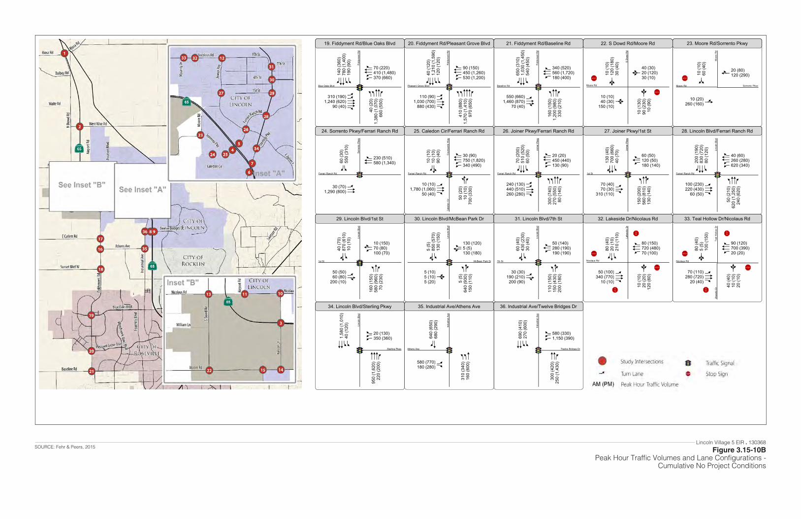
Figure 3.15-8BPeak Hour Traffic Volumes and Lane Configurations
Cumulative (2025) No Project Conditions
AACCF
40 (2
0)1,
380
(1,0
70)
660
(550
)
AACCCF
310 (190)1,240 (620)
90 (40)
AACCF140
(360
)78
0 (1
,400
)19
0 (9
0)
AACCF 70 (220)
410 (1,480)370 (660)
19. Fiddyment Rd/Blue Oaks Blvd
AACCCF
410
(880
)1,
570
(1,4
10)
970
(650
)
AACCF
110 (90)1,030 (700)
880 (430)
AACCF40
(120
)1,
210
(1,5
90)
120
(120
)
AACCF 90 (150)
450 (1,260)530 (1,200)
20. Fiddyment Rd/Pleasant Grove Blvd
ACCF
160
(150
)1,
200
(980
)33
0 (2
10)
ACE
550 (660)1,460 (870)
70 (40)
ACCF650
(310
)1,
030
(1,4
50)
540
(450
)
ACCF 340 (520)
560 (1,720)180 (400)
21. Fiddyment Rd/Baseline Rd
D
10 (1
30)
90 (2
30)
10 (9
0)
D10 (10)40 (30)
150 (10)
D10 (1
0)12
0 (1
80)
30 (4
0)
D
40 (30)20 (120)30 (10)
22. S Dowd Rd/Moore Rd
B10 (20)260 (160)
G10 (1
0)60
(40)
E 20 (80)120 (290)
23. Moore Rd/Sorrento Pkwy
ACC30 (70)1,290 (800)
AF60
(30)
550
(310
)
CCF 230 (510)
580 (1,340)
24. Sorrento Pkwy/Ferrari Ranch Rd
BF
50 (2
0)10
(10)
700
(330
)
ACCF
10 (10)1,780 (1,060)
50 (40)
BF10 (1
0)10
(10)
90 (4
0)
AACCF 30 (90)
750 (1,820)340 (490)
25. Caledon Cir/Ferrari Ranch Rd
AACCF
300
(740
)27
0 (5
50)
80 (1
40)
AACCF
240 (130)440 (510)260 (280)
ACCF70
(200
)51
0 (5
20)
60 (5
0)
AACCF 20 (20)
450 (440)130 (90)
26. Joiner Pkwy/Ferrari Ranch Rd
Blue Oaks Blvd
Fidd
ymen
t Rd
Baseline Rd
Fidd
ymen
t Rd
Moore Rd
S D
owd
Rd
Moore Rd Sorrento Pkwy
Moo
re R
d
Ferrari Ranch Rd
Sorre
nto
Pkw
y
Ferrari Ranch Rd
Cou
rtyar
ds W
ayC
aled
on C
ir
Ferrari Ranch Rd
Join
er P
kwy
STOP
STOP STOP
ACE
150
(200
)56
0 (8
10)
130
(140
)
ACF70 (40)70 (30)
310 (110)
ACE130
(40)
700
(660
)40
(70)
ACF 60 (50)
120 (50)180 (140)
27. Joiner Pkwy/1st St
1st St
Join
er P
kwy
ACCF
50 (2
10)
620
(1,2
50)
240
(620
)
ACCF
100 (230)220 (430)
60 (50)
ACCF200
(190
)83
0 (7
20)
80 (1
20)
AACCF 40 (60)
260 (280)620 (340)
28. Lincoln Blvd/Ferrari Ranch Rd
Ferrari Ranch Rd
Linc
oln
Blvd
ACF
160
(150
)58
0 (9
60)
70 (2
30)AE50 (50)
60 (80)200 (10)
AE40 (7
0)87
0 (6
10)
10 (1
0)
AE
10 (150)70 (80)100 (70)
29. Lincoln Blvd/1st St
AE
5 (5
)64
0 (9
30)
150
(110
)D5 (10)5 (10)5 (20)
AE5 (5
)85
0 (5
70)
130
(150
)
BF 130 (120)
5 (5)130 (180)
30. Lincoln Blvd/McBean Park Dr
AE
110
(150
)15
0 (4
30)
200
(180
)AE30 (30)190 (210)
200 (90)
AE60 (4
0)43
0 (2
30)
30 (4
0)
ACF 50 (140)
280 (190)190 (190)
31. Lincoln Blvd/7th St
D
10 (1
0)20
(20)
120
(60)
ACCF
50 (100)340 (770)
10 (10)
ACF80
(40)
20 (1
0)21
0 (1
10)
ACCF 80 (150)
720 (480)70 (100)
32. Lakeside Dr/Nicolaus Rd
D
40 (4
0)10
(10)
20 (1
0)
ACCF
70 (110)280 (720)
20 (40)
D80 (4
0)5
(5)
100
(150
)
ACCF 90 (120)
700 (390)20 (20)
33. Teal Hollow Dr/Nicolaus Rd
1st St
Linc
oln
Blvd
7th St
Linc
oln
Blvd
Nicolaus Rd
Lake
side
Dr
Nicolaus Rd
Teal
Hol
low
Dr
Wav
erly
Dr
STOPSTOP
STOP
STO
P
STOPSTOP
STOP
STO
P
CCCF
950
(1,6
20)
220
(200
)
AACC1,58
0 (1
,010
)40
(120
)
AAF 20 (130)
350 (360)
34. Lincoln Blvd/Sterling Pkwy
AAC
310
(340
)16
0 (6
00)AF580 (770)
180 (280)
CF640
(650
)68
0 (2
90)
35. Industrial Ave/Athens Ave
CCF
300
(420
)25
0 (1
,430
)
AACC690
(410
)27
0 (6
00)
AAF 580 (330)
1,150 (390)
36. Industrial Ave/Twelve Bridges Dr
Sterling Pkwy
Linc
oln
Blvd
Twelve Bridges Dr
Indu
stria
l Ave
McBean Park Dr
Linc
oln
Blvd
Athens Ave
Indu
stria
l Ave
Pleasant Grove Blvd
Fidd
ymen
t Rd
Lincoln Village 5 EIR . 130368
Figure 3.15-10BPeak Hour Traffic Volumes and Lane Configurations -
Cumulative No Project Conditions
SOURCE: Fehr & Peers, 2015
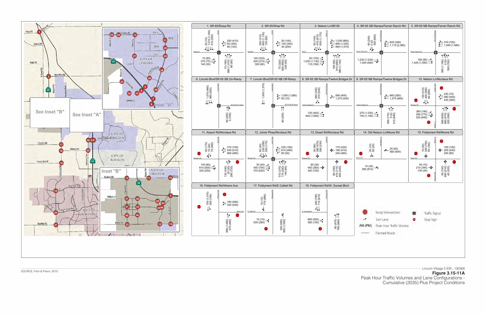
Figure 3.15-9APeak Hour Traffic Volumes and Lane Configurations
Cumulative (2025) Plus Project Conditions
ACCF
10 (1
60)
880
(1,0
70)
80 (9
0)
ACF
10 (90)270 (70)140 (30)
AACCF20
(10)
1,01
0 (1
,350
)31
0 (2
50)
ACF 200 (410)
50 (340)80 (120)
1. SR 65/Riosa Rd
ACCF
70 (3
20)
800
(850
)23
0 (5
0)
ACF
140 (330)200 (210)
300 (60)
ACCF250
(310
)85
0 (1
,130
)13
0 (6
0)
ACF 30 (140)
120 (340)30 (200)
2. SR 65/Wise Rd
AACF
160
(60)
810
(660
)98
0 (1
,140
)
AACCF
50 (100)1,020 (1,130)
110 (160)
AACF50
(140
)47
0 (9
10)
830
(1,1
70)
AACCF 1,030 (860)
890 (1,020)990 (1,070)
3. Nelson Ln/SR 65
CE1,230 (1,030)1,540 (560)
BF60 (2
40)
0 (0
)35
0 (6
50)
CCCF 820 (390)
1,110 (2,380)
4. SR 65 SB Ramps/Ferrari Ranch Rd
ABFF
390
(1,1
90)
0 (0
)55
0 (7
60)ACC160 (90)
1,420 (1,590)
CCCF 370 (720)
1,540 (1,580)
5. SR 65 NB Ramps/Ferrari Ranch Rd
CE
80 (2
00)
5 (7
60)
AACC1,07
0 (4
60)
880
(920
)
6. Lincoln Blvd/SR 65 SB On-Ramp
CC
80 (2
00)
CC1,9
30 (1
,370
)
AFF 1,050 (1,580)
20 (10)
7. Lincoln Blvd/SR 65 NB Off-Ramp
ACC120 (440)440 (1,690)
AF560
(330
)57
0 (5
30)
CF
590 (400)1,270 (430)
8. SR 65 SB Ramps/Twelve Bridges Dr
Riosa Rd
SR 6
5
SR 65
Nel
son
Ln
Ferrari Ranch Rd
SR 6
5 SB
Ram
ps
Ferrari Ranch Rd
SR 6
5 N
B R
amps
SR 65 SB On Ramp
Linc
oln
Blvd
SR 65 NB Off-Ramp
Linc
oln
Blvd
Twelve Bridges Dr
SR 6
5 SB
Ram
ps
ACF
590
(170
)0
(0)
510
(640
)ACC270 (1,030)740 (1,190)
CCF 660 (260)
1,270 (660)
9. SR 65 NB Ramps/Twelve Bridges Dr
Twelve Bridges Dr
SR 6
5 N
B R
amps
ACE
590
(630
)66
0 (4
70)
200
(360
)
ACE
360 (190)290 (770)520 (640)
ACF120
(410
)40
0 (5
90)
60 (2
60)
ACF 230 (70)
580 (400)430 (260)
10. Nelson Ln/Nicolaus Rd
Nicolaus Rd
Avia
tion
Blvd
Nel
son
Ln
STOP
STOP
STOP
STO
P
AE
130
(430
)20
(20)
290
(720
)AE140 (80)810 (500)320 (250)
AE30 (1
70)
10 (3
0)70
(360
)
ACF 310 (150)
430 (510)560 (480)
11. Airport Rd/Nicolaus Rd
ABCF
510
(370
)17
0 (2
80)
140
(60)
ACCF
30 (40)450 (700)370 (630)
ABCF50
(30)
230
(290
)20
0 (1
70)
ACCF 230 (160)
610 (490)50 (50)
12. Joiner Pkwy/Nicolaus Rd
D
90 (1
90)
470
(710
)40
0 (3
30)D90 (30)
450 (260)340 (150)
D30 (8
0)38
0 (5
70)
290
(230
)
D
170 (220)190 (410)240 (460)
13. Dowd Rd/Nicolaus Rd
B10 (30)290 (810)
G30 (1
0)50
(20)
E 20 (50)560 (600)
14. Old Nelson Ln/Moore Rd
D
30 (1
00)
690
(510
)40
(320
)D40 (10)210 (340)
130 (40)
D10 (2
0)35
0 (7
00)
50 (1
80)
D
150 (100)200 (430)240 (80)
15. Fiddyment Rd/Moore Rd
Nicolaus Rd
Airp
ort R
d
Nicolaus Rd
Dow
d R
d
Moore Rd
Old
Nel
son
Ln
Moore Rd
Nel
son
LnFi
ddym
ent R
d
STOPSTOP
STOPSTOP STOP
STOP
STOP
STOP
STO
P
CF
890
(1,0
90)
570
(480
)
AC750
(1,0
70)
550
(190
)
AF
160 (590)320 (540)
16. Fiddyment Rd/Athens Ave
B
200
(590
)85
0 (1
,090
)G10 (10)530 (280)
E10 (1
0)77
0 (9
80)
17. Fiddyment Rd/E Catlett Rd
ACC
80 (4
70)
780
(990
)AF690 (550)360 (150)
CCF340
(790
)71
0 (8
10)
18. Fiddyment Rd/W. Sunset Blvd
Athens Ave
Fidd
ymen
t Rd
W. Sunset Blvd
Fidd
ymen
t Rd
STOP
STOP
STO
P
STOP
STOP
Nicolaus Rd
Join
er P
kwy
E Catlett Rd
Fidd
ymen
t Rd
Wise Rd
SR 6
5
Lincoln Village 5 EIR . 130368
Figure 3.15-11APeak Hour Traffic Volumes and Lane Configurations -
Cumulative (2035) Plus Project Conditions
SOURCE: Fehr & Peers, 2015

Figure 3.15-9BPeak Hour Traffic Volumes and Lane Configurations
Cumulative (2025) Plus Project Conditions
AACCF
40 (2
0)1,
430
(1,1
40)
660
(550
)
AACCCF
310 (200)1,240 (620)
90 (40)
AACCF140
(360
)82
0 (1
,460
)19
0 (9
0)
AACCF 70 (220)
410 (1,480)370 (660)
19. Fiddyment Rd/Blue Oaks Blvd
AACCCF
410
(880
)1,
620
(1,4
60)
970
(650
)
AACCF
110 (90)1,030 (700)
880 (430)
AACCF40
(130
)1,
250
(1,6
40)
120
(120
)
AACCF 90 (150)
450 (1,260)530 (1,200)
20. Fiddyment Rd/Pleasant Grove Blvd
ACCF
160
(150
)1,
250
(1,0
20)
330
(210
)
ACE
550 (660)1,460 (870)
70 (40)
ACCF650
(310
)1,
070
(1,5
00)
540
(450
)
ACCF 340 (520)
560 (1,720)180 (400)
21. Fiddyment Rd/Baseline Rd
D
10 (2
0)19
0 (5
80)
10 (1
10)D140 (40)
100 (60)150 (10)
D20 (2
30)
410
(320
)80
(90)
D
100 (110)20 (180)40 (10)
22. S Dowd Rd/Moore Rd
B10 (20)270 (160)
G20 (1
0)60
(40)
E 20 (80)120 (290)
23. Moore Rd/Sorrento Pkwy
ACC40 (90)1,450 (940)
AF70
(40)
590
(330
)
CCF 230 (520)
630 (1,550)
24. Sorrento Pkwy/Ferrari Ranch Rd
BF
50 (2
0)10
(10)
700
(330
)
ACCF
10 (10)1,980 (1,220)
50 (40)
BF10 (1
0)10
(10)
90 (4
0)
AACCF 30 (90)
800 (2,040)340 (490)
25. Caledon Cir/Ferrari Ranch Rd
AACCF
370
(980
)32
0 (5
50)
80 (1
40)
AACCF
240 (130)550 (700)340 (390)
ACCF70
(200
)56
0 (5
70)
60 (5
0)
AACCF 20 (20)
600 (650)130 (90)
26. Joiner Pkwy/Ferrari Ranch Rd
Blue Oaks Blvd
Fidd
ymen
t Rd
Baseline Rd
Fidd
ymen
t Rd
Moore Rd
S D
owd
Rd
Moore Rd Sorrento Pkwy
Moo
re R
d
Ferrari Ranch Rd
Sorre
nto
Pkw
y
Ferrari Ranch Rd
Cou
rtyar
ds W
ayC
aled
on C
ir
Ferrari Ranch Rd
Join
er P
kwy
STOP
STOP STOP
STOP
STOP
STO
P
ACE
150
(200
)61
0 (8
10)
130
(140
)
ACF70 (40)70 (30)
310 (110)
ACE130
(40)
750
(740
)40
(70)
ACF 70 (60)
120 (50)180 (140)
27. Joiner Pkwy/1st St
1st St
Join
er P
kwy
ACCF
50 (2
20)
620
(1,2
50)
240
(620
)
ACCF
130 (260)290 (550)
60 (60)
ACCF220
(230
)83
0 (7
20)
80 (1
20)
AACCF 40 (60)
340 (410)620 (340)
28. Lincoln Blvd/Ferrari Ranch Rd
Ferrari Ranch Rd
Linc
oln
Blvd
ACF
160
(150
)60
0 (9
70)
70 (2
40)AE50 (50)
60 (80)200 (10)
AE40 (7
0)88
0 (6
30)
10 (1
0)
AE
10 (150)70 (80)100 (80)
29. Lincoln Blvd/1st St
AE
5 (5
)64
0 (9
40)
150
(110
)D5 (10)5 (10)5 (20)
AE5 (5
)86
0 (5
70)
140
(180
)
BF 160 (130)
5 (5)130 (180)
30. Lincoln Blvd/McBean Park Dr
AE
140
(180
)15
0 (4
30)
200
(180
)AE30 (30)200 (260)230 (130)
AE60 (4
0)43
0 (2
30)
30 (4
0)
ACF 50 (140)
310 (210)190 (190)
31. Lincoln Blvd/7th St
D
10 (1
0)20
(20)
120
(60)
ACCF
60 (120)510 (1,270)
10 (10)
ACF90
(60)
20 (1
0)21
0 (1
10)
ACCF 80 (150)
1,130 (680)70 (100)
32. Lakeside Dr/Nicolaus Rd
D
40 (5
0)10
(10)
20 (1
0)
ACCF
90 (110)430 (1,240)
30 (40)
D80 (7
0)5
(5)
130
(150
)
ACCF 90 (120)
1,120 (610)20 (20)
33. Teal Hollow Dr/Nicolaus Rd
1st St
Linc
oln
Blvd
7th St
Linc
oln
Blvd
Nicolaus Rd
Lake
side
Dr
Nicolaus Rd
Teal
Hol
low
Dr
Wav
erly
Dr
STOPSTOP
STOP
STO
P
STOPSTOP
STOP
STO
P
CCCF
950
(1,6
20)
220
(200
)
AACC1,58
0 (1
,010
)40
(120
)
AAF 20 (130)
350 (360)
34. Lincoln Blvd/Sterling Pkwy
AAC
310
(340
)17
0 (6
20)AF580 (780)
180 (290)
CF650
(650
)70
0 (3
00)
35. Industrial Ave/Athens Ave
CCF
300
(420
)27
0 (1
,480
)
AACC690
(410
)29
0 (6
50)
AAF 630 (350)
1,200 (410)
36. Industrial Ave/Twelve Bridges Dr
Linc
oln
Blvd
Indu
stria
l Ave
STOP
STOP
STO
P
McBean Park Dr
Linc
oln
Blvd
Athens Ave
Indu
stria
l Ave
Pleasant Grove Blvd
Fidd
ymen
t Rd
Lincoln Village 5 EIR . 130368
Figure 3.15-11BPeak Hour Traffic Volumes and Lane Configurations -
Cumulative (2035) Plus Project Conditions
SOURCE: Fehr & Peers, 2015

Figure 3.15-9CPeak Hour Traffic Volumes and Lane Configurations
Cumulative (2025) Plus Project Conditions
Y
ACE
10 (1
0)52
0 (5
40)
50 (6
0)
AE30 (10)10 (10)10 (10)
ACE10 (3
0)40
0 (6
10)
670
(430
)
ACF 350 (770)
10 (10)30 (50)
37. Dowd Rd/Mavis Rd
G
10 (1
0)70
(10)
CE820 (450)10 (10)
ACC 360 (870)
30 (60)
38. A St/Mavis Rd
AE
20 (1
0)20
(0)
100
(60)
ACE
50 (0)770 (440)
10 (20)
AE10 (0
)20
(0)
50 (0
)
ACCF 50 (0)
300 (820)20 (170)
39. Ruth Ave/Mavis Rd
AACCCF
180
(170
)97
0 (3
70)
340
(200
)
AACCF
780 (830)210 (120)
70 (250)
AACCCF670
(930
)31
0 (8
50)
590
(360
)
AACCF 200 (660)
60 (290)90 (440)
40. Nelson Ln/Mavis Rd
ACE
10 (1
0)45
0 (5
60)
200
(70)
D10 (10)20 (10)10 (10)
ACE10 (1
0)40
0 (5
40)
20 (4
0)
D
30 (30)10 (20)40 (270)
41. Dowd Rd/Rachel Ave
D
30 (1
0)20
(20)
80 (3
0)
AE10 (10)380 (160)
30 (10)
D10 (1
0)30
(10)
10 (2
0)
AE
20 (10)140 (490)20 (80)
42. A St/Rachel Ave
D
10 (1
0)10
(10)
50 (5
0)
D90 (50)670 (240)
10 (10)
D20 (1
50)
10 (2
0)10
(20)
D
20 (10)170 (730)20 (70)
43. Ruth Ave/Rachel Ave
ACCC
50 (1
50)
900
(510
)AF590 (230)140 (70)
CCCF160
(650
)31
0 (8
90)
44. Nelson Ln/Rachel Ave
Mavis Rd
Dow
d R
d
Mavis Rd
Rut
h Av
e
Mavis Rd
Nel
son
Ln
Rachel Ave
Dow
d R
d
Rachel Ave
A St
Rachel Ave
Rut
h Av
e
Rachel Ave
Nel
son
Ln
STOP STOP
STOP
STOP
STO
P
STOP
STOP
STOP
STO
P
ACE
10 (3
0)45
0 (6
20)
10 (1
0)
AE10 (10)10 (10)20 (10)
ACE10 (1
0)43
0 (6
50)
20 (3
0)
AE
40 (20)10 (10)10 (10)
45. Dowd Rd/B St
B St
Dow
d R
d
STOP
STOP
STOP
STOP
B
50 (6
0)70
(80)
G10 (10)50 (80)
E10 (1
0)10
0 (6
0)
46. A St/B St
B St
A St
STOP
STOP
STOP
B10 (10)150 (230)
G10 (1
0)17
0 (1
10)
E 80 (170)130 (260)
47. A St/Moore Rd
Moore Rd
A St
STOP
Mavis Rd
A St
Y
Y Y
Y
Lincoln Village 5 EIR . 130368
Figure 3.15-11CPeak Hour Traffic Volumes and Lane Configurations -
Cumulative (2035) Plus Project Conditions
SOURCE: Fehr & Peers, 2015
3.15 Transportation and Circulation
Village 5 & Special Use District B (SUD-B) Specific Plan 3.15-76 ESA / 201800402.01 Draft Partially Recirculated Environmental Impact Report May 2021
This page intentionally left blank
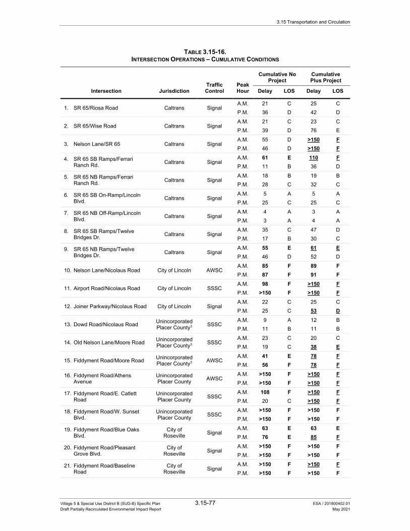
3.15 Transportation and Circulation
Village 5 & Special Use District B (SUD-B) Specific Plan 3.15-77 ESA / 201800402.01 Draft Partially Recirculated Environmental Impact Report May 2021
TABLE 3.15-16. INTERSECTION OPERATIONS – CUMULATIVE CONDITIONS
Traffic Control
Peak Hour
Cumulative No Project
Cumulative Plus Project
Intersection Jurisdiction Delay LOS Delay LOS
1. SR 65/Riosa Road Caltrans Signal A.M. 21 C 25 C P.M. 36 D 42 D
2. SR 65/Wise Road Caltrans Signal A.M. 21 C 23 C P.M. 39 D 76 E
3. Nelson Lane/SR 65 Caltrans Signal A.M. 55 D >150 F P.M. 46 D >150 F
4. SR 65 SB Ramps/Ferrari Ranch Rd. Caltrans Signal
A.M. 61 E 110 F P.M. 11 B 36 D
5. SR 65 NB Ramps/Ferrari Ranch Rd. Caltrans Signal
A.M. 18 B 19 B P.M. 28 C 32 C
6. SR 65 SB On-Ramp/Lincoln Blvd. Caltrans Signal
A.M. 5 A 5 A P.M. 25 C 25 C
7. SR 65 NB Off-Ramp/Lincoln Blvd. Caltrans Signal
A.M. 4 A 3 A P.M. 3 A 4 A
8. SR 65 SB Ramps/Twelve Bridges Dr. Caltrans Signal
A.M. 35 C 47 D P.M. 17 B 30 C
9. SR 65 NB Ramps/Twelve Bridges Dr. Caltrans Signal
A.M. 55 E 61 E P.M. 46 D 52 D
10. Nelson Lane/Nicolaus Road City of Lincoln AWSC A.M. 85 F 89 F P.M. 87 F 91 F
11. Airport Road/Nicolaus Road City of Lincoln SSSC A.M. 98 F >150 F P.M. >150 F >150 F
12. Joiner Parkway/Nicolaus Road City of Lincoln Signal A.M. 22 C 25 C P.M. 25 C 53 D
13. Dowd Road/Nicolaus Road Unincorporated Placer County3 SSSC
A.M. 9 A 12 B P.M. 11 B 11 B
14. Old Nelson Lane/Moore Road Unincorporated Placer County3 SSSC
A.M. 23 C 20 C P.M. 19 C 38 E
15. Fiddyment Road/Moore Road Unincorporated Placer County3 AWSC
A.M. 41 E 78 F P.M. 56 F 78 F
16. Fiddyment Road/Athens Avenue
Unincorporated Placer County AWSC
A.M. >150 F >150 F P.M. >150 F >150 F
17. Fiddyment Road/E. Catlett Road
Unincorporated Placer County SSSC
A.M. 108 F >150 F P.M. 20 C >150 F
18. Fiddyment Road/W. Sunset Blvd.
Unincorporated Placer County SSSC
A.M. >150 F >150 F P.M. >150 F >150 F
19. Fiddyment Road/Blue Oaks Blvd.
City of Roseville Signal
A.M. 63 E 63 E P.M. 76 E 85 F
20. Fiddyment Road/Pleasant Grove Blvd.
City of Roseville Signal
A.M. >150 F >150 F P.M. >150 F >150 F
21. Fiddyment Road/Baseline Road
City of Roseville Signal
A.M. >150 F >150 F P.M. >150 F >150 F
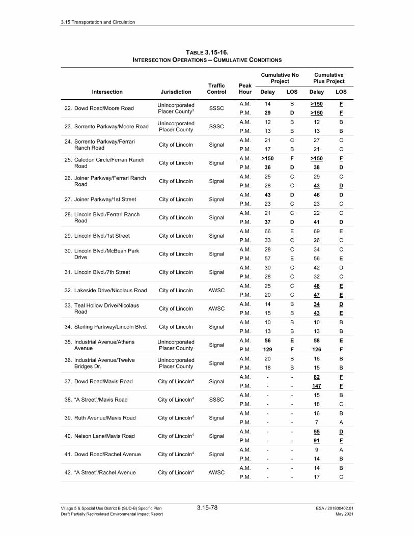
3.15 Transportation and Circulation
Village 5 & Special Use District B (SUD-B) Specific Plan 3.15-78 ESA / 201800402.01 Draft Partially Recirculated Environmental Impact Report May 2021
TABLE 3.15-16. INTERSECTION OPERATIONS – CUMULATIVE CONDITIONS
Traffic Control
Peak Hour
Cumulative No Project
Cumulative Plus Project
Intersection Jurisdiction Delay LOS Delay LOS
22. Dowd Road/Moore Road Unincorporated Placer County3 SSSC
A.M. 14 B >150 F P.M. 29 D >150 F
23. Sorrento Parkway/Moore Road Unincorporated Placer County SSSC
A.M. 12 B 12 B P.M. 13 B 13 B
24. Sorrento Parkway/Ferrari Ranch Road City of Lincoln Signal
A.M. 21 C 27 C P.M. 17 B 21 C
25. Caledon Circle/Ferrari Ranch Road City of Lincoln Signal
A.M. >150 F >150 F P.M. 36 D 38 D
26. Joiner Parkway/Ferrari Ranch Road City of Lincoln Signal
A.M. 25 C 29 C P.M. 28 C 43 D
27. Joiner Parkway/1st Street City of Lincoln Signal A.M. 43 D 46 D P.M. 23 C 23 C
28. Lincoln Blvd./Ferrari Ranch Road City of Lincoln Signal
A.M. 21 C 22 C P.M. 37 D 41 D
29. Lincoln Blvd./1st Street City of Lincoln Signal A.M. 66 E 69 E P.M. 33 C 26 C
30. Lincoln Blvd./McBean Park Drive City of Lincoln Signal
A.M. 28 C 34 C P.M. 57 E 56 E
31. Lincoln Blvd./7th Street City of Lincoln Signal A.M. 30 C 42 D P.M. 28 C 32 C
32. Lakeside Drive/Nicolaus Road City of Lincoln AWSC A.M. 25 C 48 E P.M. 20 C 47 E
33. Teal Hollow Drive/Nicolaus Road City of Lincoln AWSC
A.M. 14 B 34 D P.M. 15 B 43 E
34. Sterling Parkway/Lincoln Blvd. City of Lincoln Signal A.M. 10 B 10 B P.M. 13 B 13 B
35. Industrial Avenue/Athens Avenue
Unincorporated Placer County Signal
A.M. 56 E 58 E P.M. 129 F 126 F
36. Industrial Avenue/Twelve Bridges Dr.
Unincorporated Placer County Signal
A.M. 20 B 16 B P.M. 18 B 15 B
37. Dowd Road/Mavis Road City of Lincoln4 Signal A.M. - - 82 F P.M. - - 147 F
38. “A Street”/Mavis Road City of Lincoln4 SSSC A.M. - - 15 B P.M. - - 18 C
39. Ruth Avenue/Mavis Road City of Lincoln4 Signal A.M. - - 16 B P.M. - - 7 A
40. Nelson Lane/Mavis Road City of Lincoln4 Signal A.M. - - 55 D P.M. - - 91 F
41. Dowd Road/Rachel Avenue City of Lincoln4 Signal A.M. - - 9 A P.M. - - 14 B
42. “A Street”/Rachel Avenue City of Lincoln4 AWSC A.M. - - 14 B P.M. - - 17 C

3.15 Transportation and Circulation
Village 5 & Special Use District B (SUD-B) Specific Plan 3.15-79 ESA / 201800402.01 Draft Partially Recirculated Environmental Impact Report May 2021
TABLE 3.15-16. INTERSECTION OPERATIONS – CUMULATIVE CONDITIONS
Traffic Control
Peak Hour
Cumulative No Project
Cumulative Plus Project
Intersection Jurisdiction Delay LOS Delay LOS
43. Ruth Avenue/Rachel Avenue City of Lincoln4 Roundabout A.M. - - 15 C P.M. - - 19 C
44. Nelson Lane/Rachel Avenue City of Lincoln4 Signal A.M. - - 15 B P.M. - - 20 C
45. Dowd Road/”B Street” City of Lincoln4 Signal A.M. - - 5 A P.M. - - 5 A
46. “A Street”/”B Street” City of Lincoln4 AWSC A.M. - - 8 A P.M. - - 8 A
47. Moore Road/”A Street” City of Lincoln4 SSSC A.M. - - 13 B P.M. - - 16 C
NOTES: 1. For signalized, roundabout, and all-way stop controlled (AWSC) intersections, average intersection delay is reported in seconds per
vehicle for all approaches. 2. For side-street stop controlled (SSSC) intersections, the LOS and average delay for the movement with the highest delay is reported,
along with the overall intersection delay in parentheses. 3. Intersections that are currently in unincorporated Placer County that would be incorporated into the City of Lincoln under existing plus
project conditions. 4. Proposed project Intersections that do not exist under existing conditions. They are assumed to be incorporated into the City of
Lincoln under existing plus project conditions. Delays greater than 2.5 minutes are reported as greater than 150 seconds due to model insensitivity for heavily congested
conditions. BOLD text indicates the intersection operates at an unacceptable LOS based on the presiding jurisdiction’s level of service policy. UNDERLINED text indicates a potentially significant impact based on the significance criteria.
SOURCE: Fehr & Peers, 2015.
• The following City of Lincoln intersections are anticipated to operate at LOS D, E, or F under cumulative plus project conditions only:
– Joiner Parkway/Nicolaus Road (#12): LOS D during the p.m. peak hour under cumulative plus project conditions
– Old Nelson Lane/Moore Road (#14): LOS E during the p.m. peak hour under cumulative plus project conditions
– Joiner Parkway/Ferrari Ranch Road (#26): LOS D during the p.m. peak hour under cumulative plus project conditions
– Lakeside Drive/Nicolaus Road (#32): LOS E during the a.m. and p.m. peak hour under cumulative plus project conditions
– Teal Hollow Drive/Nicolaus Road (#33): LOS D during the a.m. peak hour and LOS E during the p.m. peak hour under cumulative plus project conditions
– Dowd Road/Mavis Road (#37): LOS F during the a.m. and p.m. peak hours under cumulative plus project conditions
– Nelson Lane/Mavis Road (#40): LOS D during the a.m. peak hour and LOS F during the p.m. peak hour under cumulative plus project conditions
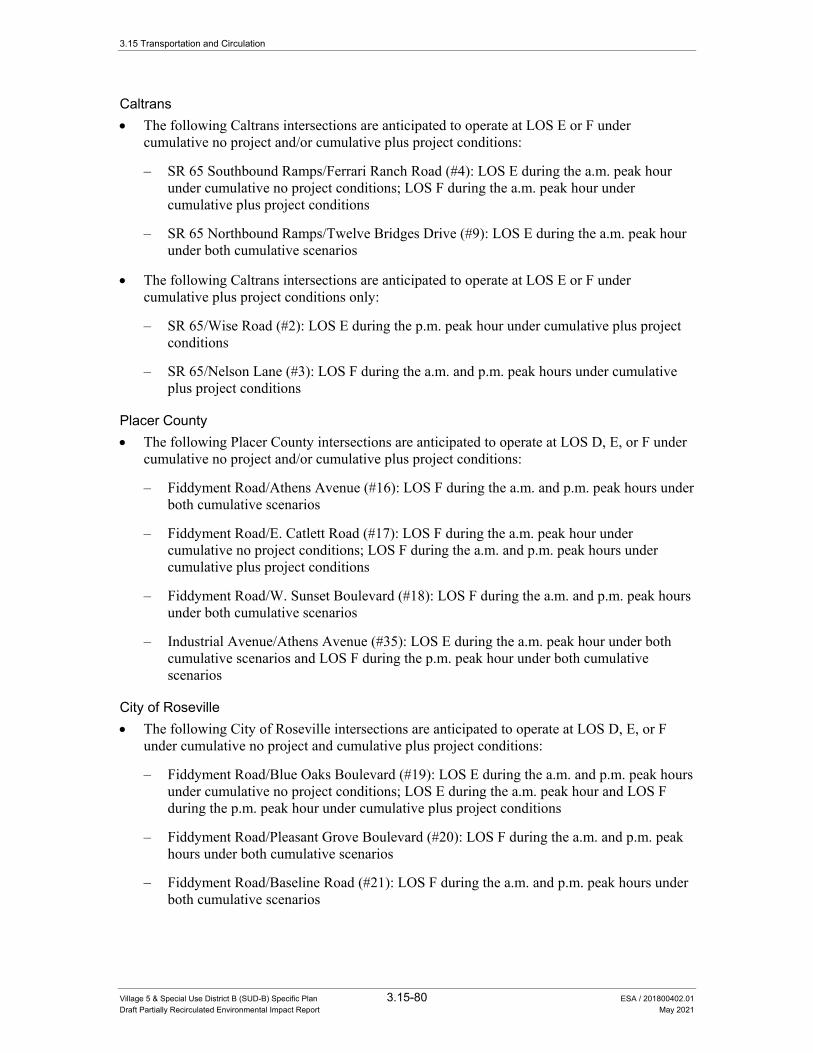
3.15 Transportation and Circulation
Village 5 & Special Use District B (SUD-B) Specific Plan 3.15-80 ESA / 201800402.01 Draft Partially Recirculated Environmental Impact Report May 2021
Caltrans • The following Caltrans intersections are anticipated to operate at LOS E or F under
cumulative no project and/or cumulative plus project conditions:
– SR 65 Southbound Ramps/Ferrari Ranch Road (#4): LOS E during the a.m. peak hour under cumulative no project conditions; LOS F during the a.m. peak hour under cumulative plus project conditions
– SR 65 Northbound Ramps/Twelve Bridges Drive (#9): LOS E during the a.m. peak hour under both cumulative scenarios
• The following Caltrans intersections are anticipated to operate at LOS E or F under cumulative plus project conditions only:
– SR 65/Wise Road (#2): LOS E during the p.m. peak hour under cumulative plus project conditions
– SR 65/Nelson Lane (#3): LOS F during the a.m. and p.m. peak hours under cumulative plus project conditions
Placer County • The following Placer County intersections are anticipated to operate at LOS D, E, or F under
cumulative no project and/or cumulative plus project conditions:
– Fiddyment Road/Athens Avenue (#16): LOS F during the a.m. and p.m. peak hours under both cumulative scenarios
– Fiddyment Road/E. Catlett Road (#17): LOS F during the a.m. peak hour under cumulative no project conditions; LOS F during the a.m. and p.m. peak hours under cumulative plus project conditions
– Fiddyment Road/W. Sunset Boulevard (#18): LOS F during the a.m. and p.m. peak hours under both cumulative scenarios
– Industrial Avenue/Athens Avenue (#35): LOS E during the a.m. peak hour under both cumulative scenarios and LOS F during the p.m. peak hour under both cumulative scenarios
City of Roseville • The following City of Roseville intersections are anticipated to operate at LOS D, E, or F
under cumulative no project and cumulative plus project conditions:
– Fiddyment Road/Blue Oaks Boulevard (#19): LOS E during the a.m. and p.m. peak hours under cumulative no project conditions; LOS E during the a.m. peak hour and LOS F during the p.m. peak hour under cumulative plus project conditions
– Fiddyment Road/Pleasant Grove Boulevard (#20): LOS F during the a.m. and p.m. peak hours under both cumulative scenarios
– Fiddyment Road/Baseline Road (#21): LOS F during the a.m. and p.m. peak hours under both cumulative scenarios
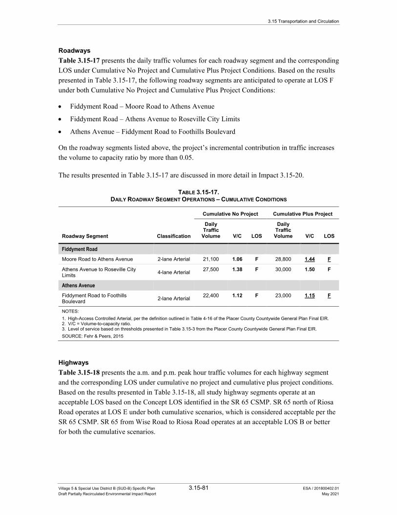
3.15 Transportation and Circulation
Village 5 & Special Use District B (SUD-B) Specific Plan 3.15-81 ESA / 201800402.01 Draft Partially Recirculated Environmental Impact Report May 2021
Roadways Table 3.15-17 presents the daily traffic volumes for each roadway segment and the corresponding LOS under Cumulative No Project and Cumulative Plus Project Conditions. Based on the results presented in Table 3.15-17, the following roadway segments are anticipated to operate at LOS F under both Cumulative No Project and Cumulative Plus Project Conditions:
• Fiddyment Road – Moore Road to Athens Avenue
• Fiddyment Road – Athens Avenue to Roseville City Limits
• Athens Avenue – Fiddyment Road to Foothills Boulevard
On the roadway segments listed above, the project’s incremental contribution in traffic increases the volume to capacity ratio by more than 0.05.
The results presented in Table 3.15-17 are discussed in more detail in Impact 3.15-20.
TABLE 3.15-17. DAILY ROADWAY SEGMENT OPERATIONS – CUMULATIVE CONDITIONS
Roadway Segment Classification
Cumulative No Project Cumulative Plus Project
Daily Traffic
Volume V/C LOS
Daily Traffic
Volume V/C LOS
Fiddyment Road
Moore Road to Athens Avenue 2-lane Arterial 21,100 1.06 F 28,800 1.44 F
Athens Avenue to Roseville City Limits 4-lane Arterial 27,500 1.38 F 30,000 1.50 F
Athens Avenue
Fiddyment Road to Foothills Boulevard 2-lane Arterial 22,400 1.12 F 23,000 1.15 F
NOTES: 1. High-Access Controlled Arterial, per the definition outlined in Table 4-16 of the Placer County Countywide General Plan Final EIR. 2. V/C = Volume-to-capacity ratio. 3. Level of service based on thresholds presented in Table 3.15-3 from the Placer County Countywide General Plan Final EIR. SOURCE: Fehr & Peers, 2015
Highways Table 3.15-18 presents the a.m. and p.m. peak hour traffic volumes for each highway segment and the corresponding LOS under cumulative no project and cumulative plus project conditions. Based on the results presented in Table 3.15-18, all study highway segments operate at an acceptable LOS based on the Concept LOS identified in the SR 65 CSMP. SR 65 north of Riosa Road operates at LOS E under both cumulative scenarios, which is considered acceptable per the SR 65 CSMP. SR 65 from Wise Road to Riosa Road operates at an acceptable LOS B or better for both the cumulative scenarios.

3.15 Transportation and Circulation
Village 5 & Special Use District B (SUD-B) Specific Plan 3.15-82 ESA / 201800402.01 Draft Partially Recirculated Environmental Impact Report May 2021
TABLE 3.15-18. HIGHWAY OPERATIONS – CUMULATIVE CONDITIONS
Cumulative No Project Cumulative Plus Project
Location Peak Hour Direction Performance
Metric LOS Performance
Metric LOS
State Route 65 – Two Lane Highway1 PTSF ATS (mph) PTSF ATS (mph)
North of Riosa Road A.M. Combined 93 35 E 95 33 E
P.M. Combined 94 33 E 96 29 E
State Route 65 – Multilane Highway2 Density (pcpmpl) Density (pcpmpl)
Riosa Road to Wise Road
A.M. Northbound 8 A 9 A
Southbound 10 A 12 B
P.M. Northbound 9 A 13 B
Southbound 12 B 14 B
NOTES: 1. Percent Time Spent Following (PTSF), Average Travel Speed (ATS), and LOS are calculated for two-lane highway segments using
the methodologies and procedures in the Highway Capacity Manual (Transportation Research Board, 2010). 2. Density is reported in passenger car equivalents per mile per lane (pcpmpl). Directional densities and LOS results for multilane
highway segments are calculated using the methodologies and procedures in the Highway Capacity Manual (Transportation Research Board, 2010).
SOURCE: Fehr & Peers, 2015
Freeways The SR 65/Nicolaus Road interchange would change the designation of SR 65 from Nelson Lane to Wise Road from a multi-lane highway with at-grade intersections to a fully access-controlled freeway. Therefore, these segments of SR 65 are analyzed as freeway segments under cumulative conditions.
Table 3.15-19 presents the a.m. and p.m. peak hour traffic operations on the study freeway segments under cumulative no project and cumulative plus project conditions.
The following summarizes the key intersection traffic operations results on the study freeway segments:
• SR 65 Northbound during the a.m. peak hour: the merge segments at the Placer Parkway loop on-ramp and Whitney Ranch Parkway on-ramp are anticipated to operate at LOS D, while the freeway segments from Placer Parkway to the Twelve Bridges Drive off-ramp are anticipated to operate at LOS E under cumulative no project conditions. The project’s incremental contribution under cumulative plus project conditions is anticipated to degrade the traffic operations to LOS F conditions from the Whitney Ranch Parkway on-ramp to the Twelve Bridges Drive off-ramp.
• SR 65 Northbound during the p.m. peak hour: the merge segment at the Placer Parkway loop on-ramp is anticipated to operate at LOS E, while the freeway segments north of Placer Parkway from the Whitney Ranch Parkway on-ramp to Lincoln Boulevard off-ramp are anticipated to operate at LOS F under cumulative no project conditions. The project’s incremental contribution under cumulative plus project conditions is anticipated to add more than 700 peak hour vehicles of demand during the p.m. peak hour to these segments, causing worse LOS F conditions from the Placer Parkway loop on-ramp to the Lincoln Boulevard off-ramp.

3.15 Transportation and Circulation
Village 5 & Special Use District B (SUD-B) Specific Plan 3.15-83 ESA / 201800402.01 Draft Partially Recirculated Environmental Impact Report May 2021
TABLE 3.15-19. FREEWAY OPERATIONS – CUMULATIVE CONDITIONS
Location Segment
Type Peak Hour
Cumulative No Project Cumulative Plus Project
Density1 LOS Density1 LOS
Northbound SR 65
Sunset Blvd. to Placer Parkway Weave2 A.M. - D - D Basic3 P.M. 20 C 24 C
Placer Parkway Loop On-Ramp Merge A.M. 32 D 39 E P.M. 38 E - F
Whitney Ranch Pkwy. Slip On-Ramp Merge A.M. 30 D - F P.M. - F - F
Placer Pkwy. to Twelve Bridges Dr. Basic A.M. 36 E - F P.M. - F - F
Twelve Bridges Drive Off-Ramp Diverge A.M. 38 E - F P.M. - F - F
Twelve Bridges Drive to Lincoln Blvd. Weave2 A.M. - D - E
P.M. - F - F
Ferrari Ranch Road Off-Ramp Diverge A.M. 14 B 18 C P.M. 18 B 22 C
Ferrari Ranch Road On-Ramp Merge A.M. 16 B 26 C P.M. 16 B 26 C
Ferrari Ranch Road to Nelson Lane Basic A.M. 14 B 24 C P.M. 14 B 24 C
Nelson Lane to Nicolaus Road Basic A.M. 11 B 11 B P.M. 10 A 10 A
Nicolaus Road Off-Ramp Diverge A.M. 15 B 15 B P.M. 14 B 14 B
Nicolaus Road On-Ramp Merge A.M. 14 B 14 B P.M. 14 B 16 B
Nicolaus Road to Wise Road Basic A.M. 10 A 9 A P.M. 10 A 11 B
Southbound SR 65
Wise Road to Nicolaus Road Basic A.M. 10 A 11 B P.M. 10 A 12 B
Nicolaus Road Off-Ramp Diverge A.M. 14 B 15 B P.M. 14 B 16 B
Nicolaus Road On-Ramp Merge A.M. 13 B 13 B P.M. 14 B 16 B
Nicolaus Road to Nelson Lane Basic A.M. 10 A 10 A P.M. 11 B 13 B
Nelson Lane to Ferrari Ranch Road Basic A.M. 14 B 23 C P.M. 17 B 29 D
Ferrari Ranch Road Off-Ramp Diverge A.M. 18 B 29 D P.M. 22 C 34 D
Ferrari Ranch Road Loop On-Ramp Basic A.M. 13 B 18 B P.M. 11 A 16 B
Ferrari Ranch Road Slip On-Ramp Merge A.M. 24 C 29 D P.M. 15 B 20 B
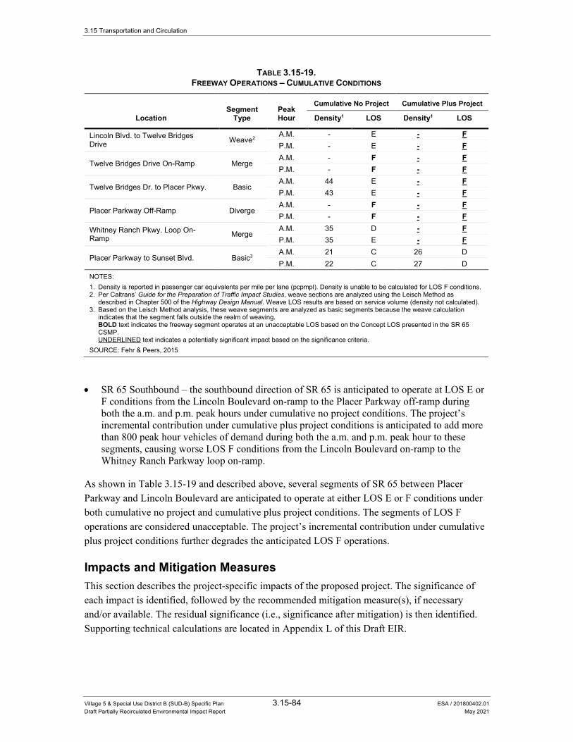
3.15 Transportation and Circulation
Village 5 & Special Use District B (SUD-B) Specific Plan 3.15-84 ESA / 201800402.01 Draft Partially Recirculated Environmental Impact Report May 2021
TABLE 3.15-19. FREEWAY OPERATIONS – CUMULATIVE CONDITIONS
Location Segment
Type Peak Hour
Cumulative No Project Cumulative Plus Project
Density1 LOS Density1 LOS
Lincoln Blvd. to Twelve Bridges Drive Weave2 A.M. - E - F
P.M. - E - F
Twelve Bridges Drive On-Ramp Merge A.M. - F - F P.M. - F - F
Twelve Bridges Dr. to Placer Pkwy. Basic A.M. 44 E - F P.M. 43 E - F
Placer Parkway Off-Ramp Diverge A.M. - F - F P.M. - F - F
Whitney Ranch Pkwy. Loop On-Ramp Merge
A.M. 35 D - F P.M. 35 E - F
Placer Parkway to Sunset Blvd. Basic3 A.M. 21 C 26 D P.M. 22 C 27 D
NOTES: 1. Density is reported in passenger car equivalents per mile per lane (pcpmpl). Density is unable to be calculated for LOS F conditions. 2. Per Caltrans’ Guide for the Preparation of Traffic Impact Studies, weave sections are analyzed using the Leisch Method as
described in Chapter 500 of the Highway Design Manual. Weave LOS results are based on service volume (density not calculated). 3. Based on the Leisch Method analysis, these weave segments are analyzed as basic segments because the weave calculation
indicates that the segment falls outside the realm of weaving. BOLD text indicates the freeway segment operates at an unacceptable LOS based on the Concept LOS presented in the SR 65
CSMP. UNDERLINED text indicates a potentially significant impact based on the significance criteria. SOURCE: Fehr & Peers, 2015
• SR 65 Southbound – the southbound direction of SR 65 is anticipated to operate at LOS E or F conditions from the Lincoln Boulevard on-ramp to the Placer Parkway off-ramp during both the a.m. and p.m. peak hours under cumulative no project conditions. The project’s incremental contribution under cumulative plus project conditions is anticipated to add more than 800 peak hour vehicles of demand during both the a.m. and p.m. peak hour to these segments, causing worse LOS F conditions from the Lincoln Boulevard on-ramp to the Whitney Ranch Parkway loop on-ramp.
As shown in Table 3.15-19 and described above, several segments of SR 65 between Placer Parkway and Lincoln Boulevard are anticipated to operate at either LOS E or F conditions under both cumulative no project and cumulative plus project conditions. The segments of LOS F operations are considered unacceptable. The project’s incremental contribution under cumulative plus project conditions further degrades the anticipated LOS F operations.
Impacts and Mitigation Measures This section describes the project-specific impacts of the proposed project. The significance of each impact is identified, followed by the recommended mitigation measure(s), if necessary and/or available. The residual significance (i.e., significance after mitigation) is then identified. Supporting technical calculations are located in Appendix L of this Draft EIR.
3.15 Transportation and Circulation
Village 5 & Special Use District B (SUD-B) Specific Plan 3.15-85 ESA / 201800402.01 Draft Partially Recirculated Environmental Impact Report May 2021
Impact 3.15-1: Implementation of the proposed project would increase traffic levels at intersections under the City of Lincoln’s jurisdiction operating at an acceptable LOS under existing conditions.
Per the results presented in Table 3.15-12, the vehicle traffic added by the proposed project causes six City of Lincoln intersections operating at an acceptable LOS under existing conditions to operate at an unacceptable LOS under existing plus project conditions. This is considered a potentially significant impact.
The following list identifies the intersections that are significantly impacted by traffic generated by the proposed project during each peak hour:
AM Peak Hour • Nelson Lane/Nicolaus Road (#10) – LOS C to LOS F
• Airport Road/Nicolaus Road (#11) – LOS B to LOS F
• Dowd Road/Nicolaus Road (#13) – LOS B to LOS F
• Dowd Road/Moore Road (#22) – LOS A to LOS D
• Lakeside Drive/Nicolaus Road (#32) – LOS B to LOS D
PM Peak Hour • Nelson Lane/Nicolaus Road (#10) – LOS C to LOS F
• Airport Road/Nicolaus Road (#11) – LOS B to LOS F
• Dowd Road/Nicolaus Road (#13) – LOS B to LOS F
• Fiddyment Road/Moore Road (#15) – LOS A to LOS E
Mitigation Measures
Mitigation Measure 3.15-1
The project applicants shall pay their fair share cost towards the following improvements. These improvements are included in the City’s updated PFE fee program. Therefore, PFE credits would be given to the constructing party. Alternatively, the City may require the project applicants to construct the improvements and provide them with a right of reimbursement from third parties who also benefit from the improvements. The development agreement between the City and project applicants shall specify the timing of the fair share payment or construction of these improvements, with the required timing prior to the service level degrading to LOS D, as determined by a traffic study to be funded by the project applicants.
If, in the alternative to paying the applicable PFE fees, the project applicant(s) are required to construct improvements, the following improvements would be required to restore operations to an acceptable level at each intersection.
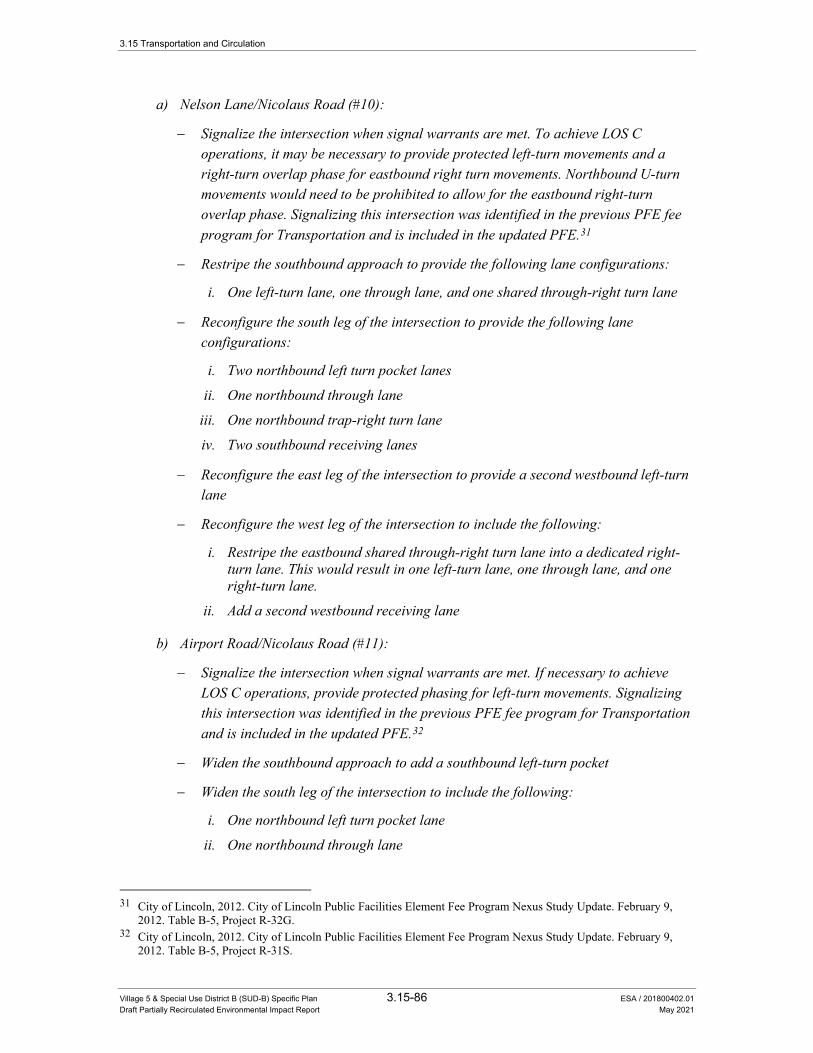
3.15 Transportation and Circulation
Village 5 & Special Use District B (SUD-B) Specific Plan 3.15-86 ESA / 201800402.01 Draft Partially Recirculated Environmental Impact Report May 2021
a) Nelson Lane/Nicolaus Road (#10):
− Signalize the intersection when signal warrants are met. To achieve LOS C operations, it may be necessary to provide protected left-turn movements and a right-turn overlap phase for eastbound right turn movements. Northbound U-turn movements would need to be prohibited to allow for the eastbound right-turn overlap phase. Signalizing this intersection was identified in the previous PFE fee program for Transportation and is included in the updated PFE.31
− Restripe the southbound approach to provide the following lane configurations:
i. One left-turn lane, one through lane, and one shared through-right turn lane
− Reconfigure the south leg of the intersection to provide the following lane configurations:
i. Two northbound left turn pocket lanes
ii. One northbound through lane
iii. One northbound trap-right turn lane
iv. Two southbound receiving lanes
− Reconfigure the east leg of the intersection to provide a second westbound left-turn lane
− Reconfigure the west leg of the intersection to include the following:
i. Restripe the eastbound shared through-right turn lane into a dedicated right-turn lane. This would result in one left-turn lane, one through lane, and one right-turn lane.
ii. Add a second westbound receiving lane
b) Airport Road/Nicolaus Road (#11):
− Signalize the intersection when signal warrants are met. If necessary to achieve LOS C operations, provide protected phasing for left-turn movements. Signalizing this intersection was identified in the previous PFE fee program for Transportation and is included in the updated PFE.32
− Widen the southbound approach to add a southbound left-turn pocket
− Widen the south leg of the intersection to include the following:
i. One northbound left turn pocket lane
ii. One northbound through lane
31 City of Lincoln, 2012. City of Lincoln Public Facilities Element Fee Program Nexus Study Update. February 9,
2012. Table B-5, Project R-32G. 32 City of Lincoln, 2012. City of Lincoln Public Facilities Element Fee Program Nexus Study Update. February 9,
2012. Table B-5, Project R-31S.
3.15 Transportation and Circulation
Village 5 & Special Use District B (SUD-B) Specific Plan 3.15-87 ESA / 201800402.01 Draft Partially Recirculated Environmental Impact Report May 2021
iii. One northbound channelized free right turn lane
iv. Two southbound receiving lanes
− Widen the east leg of the intersection to include the following:
i. Two westbound left turn lanes (one trap lane; one pocket lane)
ii. Restripe the existing westbound lane to a through-right lane
iii. Two eastbound receiving lanes (one from the eastbound through lane and one from the northbound free right-turn lane)
− Widen the eastbound approach to include one left-turn pocket lane, one through lane, and one-right turn pocket lane.
c) Dowd Road/Nicolaus Road (#13):
− Signalize the intersection when signal warrants are met. If necessary to achieve LOS C operations, provide protected phasing for left-turn movements. Signalizing this intersection is identified in the Village 5 Specific Plan, and is included in the updated PFE.
− Widen the southbound approach to add a southbound left-turn pocket
− Widen the south leg of the intersection to include the following improvements:
i. One northbound left turn pocket lane
ii. One northbound through lane
iii. One northbound trap right turn lane
iv. Two southbound receiving lanes
− Widen the east leg of the intersection to include the following improvements:
i. Two westbound left turn lanes (one trap lane; one pocket lane)
ii. Restripe the existing westbound lane to a through-right lane
− Widen the eastbound approach to include one left-turn pocket lane, one shared through-right turn lane.
d) Fiddyment Road/Moore Road (#15):
− Widen the southbound approach to add a southbound right-turn pocket
e) Dowd Road/Moore Road (#22):
− Change the traffic control to side-street stop control for Moore Road, and free movements on Dowd Road (existing configuration is free movements on Moore Road and side-street stop control for Dowd Road).

3.15 Transportation and Circulation
Village 5 & Special Use District B (SUD-B) Specific Plan 3.15-88 ESA / 201800402.01 Draft Partially Recirculated Environmental Impact Report May 2021
f) Lakeside Drive/Nicolaus Road (#32):
− Signalize the intersection when signal warrants are met. Signalizing this intersection was identified in the previous PFE fee program for Transportation and is included in the updated PFE.33
Table 3.15-20 presents the resulting intersection operations with these improvements in place.
TABLE 3.15-20. CITY OF LINCOLN INTERSECTION OPERATIONS –
EXISTING PLUS PROJECT CONDITIONS WITH MITIGATION
Peak Hour
Existing Conditions
Existing Plus Project
Existing Plus Project with Mitigation
Intersection Jurisdiction Delay LOS Delay LOS Delay LOS
10. Nelson Lane/Nicolaus Road City of Lincoln A.M. 19 C 69 F 28 C P.M. 18 C 64 F 31 C
11. Airport Road/Nicolaus Road City of Lincoln A.M. 10 B >150 F 26 C P.M. 10 B >150 F 32 C
13. Dowd Road/Nicolaus Road Unincorporated Placer County3
A.M. 10 B >150 F 33 C P.M. 11 B >150 F 27 C
15. Fiddyment Road/Moore Road
Unincorporated Placer County3
A.M. 8 A 21 C 21 C P.M. 8 A 41 E 24 C
22. Dowd Road/Moore Road Unincorporated Placer County3
A.M. 9 A 32 D 24 C P.M. 9 A 24 C 24 C
32. Lakeside Drive/Nicolaus Road City of Lincoln
A.M. 13 B 34 D 11 B P.M. 9 A 25 C 7 A
NOTES: 1. For signalized and all-way stop controlled intersections, average intersection delay is reported in seconds per vehicle for all
approaches. 2. Per the HCM, the LOS and average delay for the lane with the highest delay is reported for side-street stop controlled intersections. 3. Intersections that are currently in unincorporated Placer County that would be incorporated into the City of Lincoln under existing plus
project conditions. BOLD text indicates the intersection operates at an unacceptable LOS based on the presiding jurisdiction’s level of service policy. UNDERLINED text indicates a potentially significant impact based on the significance criteria. SOURCE: Fehr & Peers, 2015.
Impact Significance After Mitigation: With the implementation of the improvements listed in Mitigation Measures 3.15-1(a) through 3.15-1(f) above, the traffic operations at the impacted intersections would be improved to acceptable operations. Alternatively, Mitigation Measure 3.15-1 would commit the project applicant(s) to pay their fair share towards these improvements through the City of Lincoln’s PFE fee program and ensure that they are constructed prior to the service level degrading to an unacceptable LOS D or worse. Therefore, this impact to vehicle traffic operations would be reduced to a less than significant level.
33 City of Lincoln, 2012. City of Lincoln Public Facilities Element Fee Program Nexus Study Update. February 9,
2012. Table B-5, Project R-32E.
3.15 Transportation and Circulation
Village 5 & Special Use District B (SUD-B) Specific Plan 3.15-89 ESA / 201800402.01 Draft Partially Recirculated Environmental Impact Report May 2021
Resulting Potentially Significant Impact of Mitigation on Intersections # 11 and #13. The improvements to widen the intersections at Airport Road/Nicolaus Road (#11) and Dowd Road/Nicolaus Road (#13) would increase the crossing distance for bicycles and pedestrians. This would increase the conflict zone of bicyclists and pedestrians with vehicles possibly resulting in safety concerns for bicyclists and pedestrians attempting to cross the widened streets. Pursuant to General Plan Policy T-2.3, the City may make an exception to a degraded vehicle LOS where the results of achieving the desired LOS C traffic operations are contrary to achieving a functional and safe pedestrian design. Additionally, the effects of the improvements proposed in Mitigation Measure 3.15-1 (b) and (c) may result in a conflict with General Plan Policy T-5.3, which states the City’s desire to improve bicycle safety by minimizing conflicts with vehicles and bicycles. These effects would be considered a significant impact.
Additional Mitigation to Reduce Impacts of Mitigation Measures 3.15-1 (b) and (c) to Intersections #11 and #13: One of the following options shall be implemented:
Option 1
g) The City shall monitor traffic conditions at the intersections of Airport Road/Nicolaus Road (#11) and Dowd Road/Nicolaus Road (#13). In addition to compliance with Mitigation Measures 3.15-1(b) and (c), the City shall cause one of the following measures to be taken prior to the service level degrading to LOS D, as determined by a traffic study at each location to be funded by the project applicant(s):
i. The project applicant(s) shall coordinate with the City staff to ensure signal phasing times would allow adequate time for cyclists to cross through the widened intersections during green and amber signal phases; or
ii. The project applicants’ intersection designs shall eliminate free right-turn movements in exchange for right-turn overlap phases or dual right turn lanes to serve high right-turn traffic volumes. Any dual right-turn lanes shall be designed to ensure adequate visibility of pedestrians, including any use of a channelized right-turn lane for the inside right-turn lane.
Option 2
g) The project applicant(s) shall apply to the Community Development Director for a determination as to whether the recommended intersection widening conflicts with the City’s Policy T-2.3 and T-5.3 to achieve a traffic design to minimize conflicts between vehicles and pedestrians and bicycles. The Community Development Director may determine that an exception to the LOS C standard in Policy T-2.3 is warranted.
Impact Significance After Additional Mitigation for Intersections #11 and #13:
Option 1: With the implementation of one of the additional improvements listed in Mitigation Measures 3.15-1(1-g) above, the traffic operations at intersections #11 and #13 would be
3.15 Transportation and Circulation
Village 5 & Special Use District B (SUD-B) Specific Plan 3.15-90 ESA / 201800402.01 Draft Partially Recirculated Environmental Impact Report May 2021
improved to acceptable operations without impacts to pedestrians and bicycles despite the widening by giving them additional time to get across the widened intersections or by requiring vehicles to stop or yield prior to turning right. Therefore, the impact of intersection widening to pedestrians and bicyclists would be reduced to a less than significant level.
Option 2: If the City’s Community Development Director determines pedestrian and/or bike safety has not been adequately addressed, s/he may make an exception to the LOS C standard pursuant to General Plan Policy T-2.3. While doing so would not result in increased impacts to other intersection, it would still create increased delay at intersections #11 and #13 because the LOS would be increased above C. Therefore, this impact would be considered a significant and unavoidable impact.
Impact 3.15-2: Implementation of the proposed project would increase traffic levels at intersections under the City of Lincoln’s jurisdiction operating at an unacceptable LOS under existing conditions.
The proposed project would add traffic to the Caledon Circle/Ferrari Ranch Road (#25) intersection, which operates at an unacceptable LOS E during the a.m. peak hour under existing conditions. However, the addition of the proposed project traffic would only result in an increase of four seconds of average vehicle delay during the a.m. peak hour, as shown in Table 3.15-12. Based on the significance criteria for City of Lincoln intersections, this incremental addition in average vehicle delay is considered below the significance threshold of five seconds or more increase in average vehicle delay for an intersection that is already operating at an unacceptable LOS without the project. Therefore, this impact would be considered less than significant.
Mitigation Measure
None required.
Impact 3.15-3: Implementation of the proposed project would increase traffic levels at future City of Lincoln intersections in Village 5.
The proposed project would add traffic to the roadway network within Village 5. The future Nelson Lane/Mavis Road (#40) intersection is anticipated to operate at an unacceptable LOS E during the a.m. peak hour and LOS F during the p.m. peak hour with build out of the proposed project with the following lane configurations:
• Northbound: two left-turn lanes, three through lanes, one right-turn lane
• Southbound: two left-turn lanes, three through lanes, one right-turn lane
• Eastbound: two left-turn lanes, two through lanes, one right-turn lane
• Westbound: two left-turn lanes, two through lanes, one right-turn lane
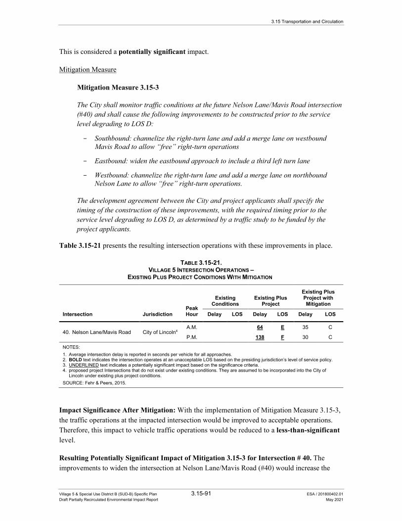
3.15 Transportation and Circulation
Village 5 & Special Use District B (SUD-B) Specific Plan 3.15-91 ESA / 201800402.01 Draft Partially Recirculated Environmental Impact Report May 2021
This is considered a potentially significant impact.
Mitigation Measure
Mitigation Measure 3.15-3
The City shall monitor traffic conditions at the future Nelson Lane/Mavis Road intersection (#40) and shall cause the following improvements to be constructed prior to the service level degrading to LOS D:
- Southbound: channelize the right-turn lane and add a merge lane on westbound Mavis Road to allow “free” right-turn operations
- Eastbound: widen the eastbound approach to include a third left turn lane
- Westbound: channelize the right-turn lane and add a merge lane on northbound Nelson Lane to allow “free” right-turn operations.
The development agreement between the City and project applicants shall specify the timing of the construction of these improvements, with the required timing prior to the service level degrading to LOS D, as determined by a traffic study to be funded by the project applicants.
Table 3.15-21 presents the resulting intersection operations with these improvements in place.
TABLE 3.15-21. VILLAGE 5 INTERSECTION OPERATIONS –
EXISTING PLUS PROJECT CONDITIONS WITH MITIGATION
Intersection Jurisdiction Peak Hour
Existing Conditions
Existing Plus Project
Existing Plus Project with Mitigation
Delay LOS Delay LOS Delay LOS
40. Nelson Lane/Mavis Road City of Lincoln4 A.M. 64 E 35 C
P.M. 138 F 30 C
NOTES: 1. Average intersection delay is reported in seconds per vehicle for all approaches. 2. BOLD text indicates the intersection operates at an unacceptable LOS based on the presiding jurisdiction’s level of service policy. 3. UNDERLINED text indicates a potentially significant impact based on the significance criteria. 4. proposed project Intersections that do not exist under existing conditions. They are assumed to be incorporated into the City of
Lincoln under existing plus project conditions. SOURCE: Fehr & Peers, 2015.
Impact Significance After Mitigation: With the implementation of Mitigation Measure 3.15-3, the traffic operations at the impacted intersection would be improved to acceptable operations. Therefore, this impact to vehicle traffic operations would be reduced to a less-than-significant level.
Resulting Potentially Significant Impact of Mitigation 3.15-3 for Intersection # 40. The improvements to widen the intersection at Nelson Lane/Mavis Road (#40) would increase the
3.15 Transportation and Circulation
Village 5 & Special Use District B (SUD-B) Specific Plan 3.15-92 ESA / 201800402.01 Draft Partially Recirculated Environmental Impact Report May 2021
crossing distance for bicycles and pedestrians. Moreover, the addition of free right-turn operations at Nelson Lane/Mavis Road (#40) would also increase the conflict zone for pedestrians and bicycles, possibility resulting in more vehicle/pedestrian/bike collisions. This would increase the conflict zone of bicyclists and pedestrians with vehicles possibly resulting in safety concerns for bicyclists and pedestrians attempting to cross the widened intersection. Pursuant to General Plan Policy T-2.3, the City may make an exception to a degraded vehicle LOS where the results of achieving the desired LOS C traffic operations are contrary to achieving a functional and safe pedestrian design. Additionally, the effects of the improvements proposed in Mitigation Measure 3.15-3 may result in a conflict with General Plan Policy T-5.3, which states the City’s desire to improve bicycle safety by minimizing conflicts with vehicles and bicycles. These effects would be considered a significant impact.
Additional Mitigation to Reduce Impacts to Intersection #40 If Widened:
Option 1
The City shall monitor traffic conditions at the intersection of Nelson Lane/Mavis Road (#40). In addition to compliance with Mitigation Measures 3.15-3, the City shall cause one of the following measures to be taken prior to the service level degrading to LOS D, as determined by a traffic study at each location to be funded by the project applicant(s):
a) The project applicant(s) shall coordinate with the City staff to ensure signal phasing times would allow adequate time for cyclists to cross through the widened intersections during green and amber signal phases; or
b) The project applicants’ intersection designs shall eliminate free right-turn movements in exchange for right-turn overlap phases or dual right turn lanes to serve high right-turn traffic volumes. Any dual right-turn lanes shall be designed to ensure adequate visibility of pedestrians, including any use of a channelized right-turn lane for the inside right-turn lane.
Option 2
The project applicant(s) may apply to the Community Development Director for a determination as to whether the recommended intersection widening conflicts with the City’s Policy T-2.3 and T-5.3 to achieve a traffic design to minimize conflicts between vehicles and pedestrians and bicycles. The Community Development Director may determine that an exception to the LOS C standard in Policy T-2.3 is warranted.
Impact Significance After Additional Mitigation for Intersection #40.
Option 1: With the implementation of one of the additional improvements listed in Mitigation Measures 3.15-3(1) above, the traffic operations at intersection #40 would be improved to acceptable operations without impacts to pedestrians and bicycles despite the widening by giving them additional time to get across the widened intersections or by requiring vehicles to stop or

3.15 Transportation and Circulation
Village 5 & Special Use District B (SUD-B) Specific Plan 3.15-93 ESA / 201800402.01 Draft Partially Recirculated Environmental Impact Report May 2021
yield prior to turning right. Therefore, the impact of intersection widening to pedestrians and bicyclists would be reduced to a less than significant level.
Option 2: If the City’s Community Development Director determines pedestrian and/or bike safety has not been adequately addressed, s/he may make an exception to the LOS C standard pursuant to General Plan Policy T-2.3. While doing so would not result in increased impacts to other intersection, it would still create increased delay at intersection #40 because the LOS would be increased above C. Therefore, this impact would be considered a significant and unavoidable impact.
Impact 3.15-4: Implementation of the proposed project would increase traffic levels at intersections under the County of Placer’s jurisdiction.
The vehicle traffic added by the proposed project would cause two County of Placer intersections operating at an acceptable LOS under existing conditions to operate at an unacceptable LOS under existing plus project conditions. This is considered a potentially significant impact.
The following list identifies the intersections that would be significantly impacted by traffic generated by the proposed project during each peak hour:
AM Peak Hour • Fiddyment Road/Athens Avenue (#16) – LOS A to LOS E (meets California MUTCD Peak
Hour Signal Warrant)
• Fiddyment Road/W. Sunset Boulevard (#18) – LOS B to LOS D (does not meet California MUTCD Peak Hour Signal Warrant)
PM Peak Hour • Fiddyment Road/Athens Avenue (#16) – LOS B to LOS F (meets California MUTCD Peak
Hour Signal Warrant)
• Fiddyment Road/W. Sunset Boulevard (#18) – LOS C to LOS F (meets California MUTCD Peak Hour Signal Warrant)
Mitigation Measures
Mitigation Measure 3.15-4
The project applicants shall pay their fair share cost towards the following recommended improvements to restore vehicle traffic operations to an acceptable LOS at each intersection.
a) Fiddyment Road/Athens Avenue (#16):
− Widening of the northbound approach to include a right-turn pocket lane
− Widening of the southbound approach to include a left-turn pocket lane
− Signalization at the intersection with a protected southbound left-turn movement.

3.15 Transportation and Circulation
Village 5 & Special Use District B (SUD-B) Specific Plan 3.15-94 ESA / 201800402.01 Draft Partially Recirculated Environmental Impact Report May 2021
There is no funding program in place for these improvements. Accordingly, the project applicant(s) shall obtain cost estimates for these improvements and determine its/their fair share payments. Once the fair share has been determined, the project applicant(s) shall pay that fair share to the City to ensure the payment goes to the above-referenced improvements.
b) Fiddyment Road/W. Sunset Boulevard (#18):
− Widening of the northbound approach to include a left-turn pocket lane
− Signalization at the intersection with a protected northbound left-turn movement.
There is no funding program in place for these improvements. Accordingly, the project applicant(s) shall obtain cost estimates for these improvements and determine its/their fair share payments. Once the fair share has been determined, the project applicant(s) shall pay that fair share to the City to ensure the payment goes to the above-referenced improvements.
Table 3.15-22 presents the resulting intersection operations with these improvements in place.
TABLE 3.15-22. COUNTY OF PLACER INTERSECTION OPERATIONS –
EXISTING PLUS PROJECT CONDITIONS WITH MITIGATION
Intersection Jurisdiction Peak Hour
Existing Conditions
Existing Plus Project
Existing Plus Project with Mitigation
Delay LOS Delay LOS Delay LOS
16. Fiddyment Road/Athens Avenue
Unincorporated Placer County
A.M. 10 A 45 E 14 B P.M. 13 B 66 F 24 C
18. Fiddyment Road/W. Sunset Blvd.
Unincorporated Placer County
A.M. 12 B 28 D 9 A P.M. 20 C >150 F 14 B
NOTES: 1. For signalized and all-way stop controlled intersections, average intersection delay is reported in seconds per vehicle for all
approaches. 2. Per the HCM, the LOS and average delay for the lane with the highest delay is reported for side-street stop controlled intersections. 3. BOLD text indicates the intersection operates at an unacceptable LOS based on the presiding jurisdiction’s level of service policy. 4. UNDERLINED text indicates a potentially significant impact based on the significance criteria. SOURCE: Fehr & Peers, 2015.
Impact Significance After Mitigation: As shown in Table 3.15-22, the implementation of the improvements listed in Mitigation Measures 3.15-4(a) and 3.15-4(b) would improve the traffic operations at the impacted intersections to an acceptable LOS. However, the improvements listed in Mitigation Measures 3.15-4(a) and 3.15-4(b) are not included in any known fee program. Since these improvements are not included in a known fee program, there is no assurance that the remaining funds for construction will be collected. Furthermore, since these improvements are not within the City of Lincoln’s jurisdiction to implement, it cannot be guaranteed that these improvements will be constructed. Therefore, this impact would be considered significant and unavoidable.
3.15 Transportation and Circulation
Village 5 & Special Use District B (SUD-B) Specific Plan 3.15-95 ESA / 201800402.01 Draft Partially Recirculated Environmental Impact Report May 2021
Impact 3.15-5: Implementation of the proposed project would increase traffic levels at intersections under the City of Roseville’s jurisdiction.
The proposed project would add traffic to the Fiddyment Road/Baseline Road (#21) intersection, which operates at an unacceptable LOS D during the a.m. peak hour and LOS F during the p.m. peak hour under existing conditions. However, the addition of the proposed project traffic would result in an increase of one second of average vehicle delay during the a.m. peak hour, and would reduce the average vehicle delay by six seconds during the p.m. peak hour as shown in Table 3.15-12. As noted earlier, while this reduction in average vehicle delay is counterintuitive, it is caused by adding traffic to low delay movements and more efficient utilization of the existing signal timings that result in an overall reduction in average vehicle delay. Based on the significance criteria for City of Roseville intersections, this change in average vehicle delay would be below the significance threshold of five seconds or more increase in average vehicle delay for an intersection that is already operating at an unacceptable LOS without the project. Therefore, this impact would be considered less than significant.
Mitigation Measure
None required.
Impact 3.15-6: Implementation of the proposed project would increase traffic levels at intersections maintained by Caltrans.
The vehicle traffic added by the proposed project would cause the Nelson Lane/SR 65 (#3) intersection to operate at an unacceptable LOS under existing plus project conditions. This is considered a potentially significant impact.
Mitigation Measures
Mitigation Measure 3.15-6
The project applicants shall pay their fair share cost towards the construction of a new interchange at SR 65/Nelson Lane (#3), as supported by Lincoln General Plan Policy T-2.9. The timing of these payments is outlined in the development agreement. As described in Section 3.15.2, the City of Lincoln is in the process of updating its PFE fee program. This interchange is included in the City’s updated PFE fee program. Therefore, the project applicants shall pay their fair share towards these improvements through the City of Lincoln’s updated PFE fee program and ensure that they are constructed prior to the service level degrading to an unacceptable LOS F.
To initiate the Caltrans project development process towards implementing the new interchange, the project applicant shall fund the preparation of a Project Study Report –
3.15 Transportation and Circulation
Village 5 & Special Use District B (SUD-B) Specific Plan 3.15-96 ESA / 201800402.01 Draft Partially Recirculated Environmental Impact Report May 2021
Project Development Support (PSR-PDS) document for a new interchange at SR 65/Nelson Lane (#3) in coordination with the City of Lincoln and Caltrans. The Caltrans project development process will determine the ultimate configuration of the new interchange and ensure that the ultimate configuration provides acceptable operations (i.e., LOS) based on Caltrans standards. Through the Caltrans project development process, the following intersection control options may be considered in accordance with Caltrans’ Intersection Control Evaluation (ICE) policy:
• Unsignalized (side street stop controlled);
• Roundabout – Single or multi-lane;
• Diverging diamond interchange;
• Signalized spread diamond;
• Signalized single point urban interchange; or
• Signalized partial cloverleaf.
While the PSR-PDS process would determine the ultimate configuration of the interchange, the City and project applicant assumed a six-lane signalized partial cloverleaf interchange for this analysis based on the available footprint and the planned circulation network identified in the Village 5 Specific Plan. Since the six-lane partial cloverleaf provides the greatest capacity and has the largest footprint of the options listed above, it was determined that this configuration would verify whether an interchange would adequately mitigate the project’s impact on traffic operations (i.e., if a six-lane partial cloverleaf does not meet LOS standards, additional mitigation may be necessary). Analysis presented in Table 3.15-23 shows that the six-lane signalized partial cloverleaf interchange provides acceptable operations with the following lane configurations at the interchange ramp terminal intersections:
• SR 65 Northbound Ramps/Nelson Lane intersection:
i. Northbound SR 65 off-ramp: one left-turn lane, one shared left-right turn lane, and one right turn lane
ii. Northbound Nelson Lane: three through lanes, one free right-turn lane onto the northbound SR 65 loop on-ramp
iii. Southbound Nelson Lane: three through lanes, one free right-turn lane onto the northbound SR 65 slip on-ramp
• SR 65 Southbound Ramps/Nelson Lane intersection:
iv. Southbound SR 65 off-ramp: one left-turn lane and one right-turn lane
v. Northbound Nelson Lane: three through lanes, one free right-turn lane onto the southbound SR 65 slip on-ramp

3.15 Transportation and Circulation
Village 5 & Special Use District B (SUD-B) Specific Plan 3.15-97 ESA / 201800402.01 Draft Partially Recirculated Environmental Impact Report May 2021
vi. Southbound Nelson Lane: three through lanes, one free right-turn lane onto the southbound SR 65 loop on-ramp
Since the SR 65/Nelson Lane interchange would not be built prior to (or needed for) the initial phases of the project, project applicants shall prepare a traffic study that at a minimum identifies the level of service at the SR 65/Nelson Lane intersection prior to the construction of the new SR 65/Nelson Lane interchange. The traffic study shall be prepared concurrent with the submittal of any application for a tentative tract map, parcel map, or commercial site plan development. The traffic study shall identify any necessary interim improvements to provide acceptable traffic operations, such as striping, temporary widening, or signal timing changes. Any identified improvements shall be included as conditions of approval of any final subdivision maps or commercial site plans and be implemented prior to the issuance of any occupancy permits. The traffic study shall be prepared for the City of Lincoln and provided to Caltrans for review.
Table 3.15-23 presents the resulting intersection operations with a six-lane signalized partial cloverleaf interchange in place at SR 65/Nelson Lane. As shown in Table 3.15-23, the ramp intersections would operate at an acceptable LOS B or better with a six-lane signalized cloverleaf interchange.
TABLE 3.15-23. CALTRANS INTERSECTION OPERATIONS –
EXISTING PLUS PROJECT CONDITIONS WITH MITIGATION
Peak Hour
Existing Conditions
Existing Plus Project
Existing Plus Project with Mitigation
Intersection Jurisdiction Delay1 LOS Delay1 LOS Delay1 LOS
3a. Nelson Lane/SR 65 (NB Ramps) Caltrans
A.M. 22 C >150 F 13 B P.M. 21 C >150 F 18 B
3b. Nelson Lane/SR 65 SB Ramps Caltrans
A.M. 8 A P.M. 7 A
NOTES: 1. Average intersection delay is reported in seconds per vehicle for all approaches. 2. BOLD text indicates the intersection operates at an unacceptable LOS based on the presiding jurisdiction’s level of service policy. 3. UNDERLINED text indicates a potentially significant impact based on the significance criteria. SOURCE: Fehr & Peers, 2015.
The addition of a new interchange at SR 65/Nelson Lane would result in additional diverge and merge segments on the freeway system. Table 3.15-23A presents the resulting freeway operations with this improvement in place. As shown in Table 3.15-23A, the freeway ramp merge and diverge segments would operate at an acceptable LOS C or better with the SR 65/Nelson Lane interchange.
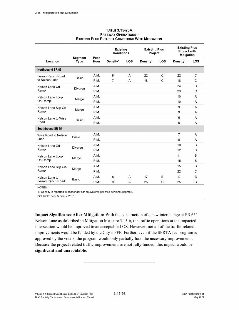
3.15 Transportation and Circulation
Village 5 & Special Use District B (SUD-B) Specific Plan 3.15-98 ESA / 201800402.01 Draft Partially Recirculated Environmental Impact Report May 2021
TABLE 3.15-23A. FREEWAY OPERATIONS –
EXISTING PLUS PROJECT CONDITIONS WITH MITIGATION
Location Segment
Type Peak Hour
Existing Conditions
Existing Plus Project
Existing Plus Project with Mitigation
Density1 LOS Density1 LOS Density1 LOS
Northbound SR 65
Ferrari Ranch Road to Nelson Lane Basic
A.M. 8 A 22 C 22 C P.M. 7 A 18 C 18 C
Nelson Lane Off-Ramp Diverge
A.M. 24 C P.M. 23 C
Nelson Lane Loop On-Ramp Merge
A.M. 10 A P.M. 10 A
Nelson Lane Slip On-Ramp Merge
A.M. 9 A P.M. 9 A
Nelson Lane to Wise Road Basic
A.M. 6 A P.M. 6 A
Southbound SR 65
Wise Road to Nelson Lane Basic
A.M. 7 A P.M. 8 A
Nelson Lane Off-Ramp Diverge
A.M. 10 B P.M. 12 B
Nelson Lane Loop On-Ramp Merge
A.M. 11 B P.M. 15 B
Nelson Lane Slip On-Ramp Merge
A.M. 15 B
P.M. 22 C
Nelson Lane to Ferrari Ranch Road Basic
A.M. 8 A 17 B 17 B P.M. 9 A 25 C 25 C
NOTES: 1. Density is reported in passenger car equivalents per mile per lane (pcpmpl). SOURCE: Fehr & Peers, 2016.
Impact Significance After Mitigation: With the construction of a new interchange at SR 65/Nelson Lane as described in Mitigation Measure 3.15-6, the traffic operations at the impacted intersection would be improved to an acceptable LOS. However, not all of the traffic-related improvements would be funded by the City’s PFE. Further, even if the SPRTA fee program is approved by the voters, the program would only partially fund the necessary improvements. Because the project-related traffic improvements are not fully funded, this impact would be significant and unavoidable.
3.15 Transportation and Circulation
Village 5 & Special Use District B (SUD-B) Specific Plan 3.15-99 ESA / 201800402.01 Draft Partially Recirculated Environmental Impact Report May 2021
Impact 3.15-7: Implementation of the proposed project would increase traffic levels on study roadway segments in Placer County.
The proposed project would add traffic to segments of Fiddyment Road and Athens Avenue in Placer County. The addition of the proposed project traffic would degrade the daily LOS on the study segments of Fiddyment Road from LOS A to LOS C, as shown in Table 3.15-13. However, LOS C operations are considered acceptable per the Placer County General Plan and the significance criteria in this analysis. Therefore, this impact is less than significant.
Mitigation Measure
None required.
Impact 3.15-8: Implementation of the proposed project would increase traffic levels on study highway facilities maintained by Caltrans.
The proposed project would add traffic to study highway segments on SR 65. The addition of the proposed project traffic would increase the percent time spent following and reduces the average travel speed on study two-lane highway segments, and increases the density on study multi-lane highway segments, as shown in Table 3.15-14.
All study highway segments continue to operate at an acceptable LOS based on the Concept LOS identified in the SR 65 CSMP. SR 65 north of Riosa Road continues to operate at LOS E, which is considered acceptable per the SR 65 CSMP. SR 65 from Nelson Lane to Riosa Road continues to operate at an acceptable LOS B or better. Therefore, this impact is less than significant.
Mitigation Measure
None required.
Impact 3.15-9: Implementation of the proposed project would increase traffic levels on freeway facilities maintained by Caltrans.
The proposed project would add traffic to study freeway segments. The addition of the proposed project traffic would increase the density on study freeway segments, as shown in Table 3.15-15. Notwithstanding, all study freeway segments would continue to operate at an acceptable LOS based on the Concept LOS E identified in the SR 65 CSMP. Therefore, this impact is less than significant.
Mitigation Measure
None required.
3.15 Transportation and Circulation
Village 5 & Special Use District B (SUD-B) Specific Plan 3.15-100 ESA / 201800402.01 Draft Partially Recirculated Environmental Impact Report May 2021
Impact 3.15-10: Implementation of the proposed project would include the provision of new bicycle and pedestrian facilities in the proposed project to support bicycle and pedestrian travel within the project, and connect the project with adjacent areas in the City of Lincoln.
The V5SP identifies a comprehensive mobility network, including designated facilities for bicyclists and pedestrians. This includes numerous off-street Class I multi-use trails, on-street Class II bike lanes, a cycle track along Rachel Avenue, and potential grade-separated crossings to reduce conflicts between vehicles and bicyclists/pedestrians. The V5SP also includes sidewalks on the vast majority of project roadways, and will provide crosswalks at signalized intersections and roundabouts to support pedestrian activity. These facilities are adequate to support bicycling and walking, and would not disrupt or interfere with existing or planned bicycle and pedestrian facilities.
The implementation of these facilities would also be consistent with adopted pedestrian and bicycle plans, guidelines, and policies in the City of Lincoln General Plan. The project will include bike lanes wide enough to accommodate bicycles safely on new major streets within the project (see Policy T-5.1). The project will include pedestrian/bicycle crossings at appropriate intervals along new roadways that will serve new large-scale commercial, industrial, and residential development (see Policy T-5.4). Trails, sidewalks, and walking paths in the project will connect residential areas with commercial, shopping, and employment centers (see Policy T-5.6). The project includes trails and pathways along the edges of the ravines passing through the project (see Policy T-5.7). The project’s extensive sidewalk network will also enable residents to walk from their homes to places of work, recreation, and shopping (see Policy T-5.8).
The implementation of on-street Class II bike lanes will also include eight-foot shared Class II bicycle/NEV lanes which allow for the dual use of bicycles and NEVs, consistent with the City of Lincoln NEV Plan and General Plan Policy T-4.8. Therefore, this impact is less than significant.
Mitigation Measure
None required.
Impact 3.15-11: Implementation of the proposed project would include the provision of transit shelters and a potential bus transfer facility to support transit use as a means of travel within the project and between the project and the surrounding area. The Project would not conflict with adopted plans, policies, or programs regarding transit facilities and would not interfere with existing or planned transit facilities.
As described previously, impacts to transit are considered significant if they would conflict with adopted plans, policies, or programs regarding transit facilities. Conflicts with adopted plans, policies, or programs would include interference with existing or planned transit facilities.
3.15 Transportation and Circulation
Village 5 & Special Use District B (SUD-B) Specific Plan 3.15-101 ESA / 201800402.01 Draft Partially Recirculated Environmental Impact Report May 2021
The V5SP would include bus turnouts and shelters to accommodate planned potential future transit service expansion to the area, if it is provided by local or regional transit operators. In addition, a bus transfer lot is being considered as part of a joint use park-and-ride lot to support transit use. While the V5SP would include the construction of transit facilities, it does not identify any transit service expansion into the V5SP area. The V5SP states that transit services would be extended into the V5SP area as the demand for such services occurs and funds are available as determined by the transit provider.
At buildout, the V5SP would include approximately 8,200 dwelling units and 4.6 million square feet of employment and commercial land uses within the V5SP area, establishing a new market in the City of Lincoln and south Placer County. Transit demand generated by the V5SP could be served by a variety of existing, planned, and potential transit services, as described below.
In the near-term, the City would have the discretion to extend the Lincoln DAR into the V5SP area (contingent upon agreement by the County), as warranted by transit demand and as funding allows. Additionally, during the near-term, existing PCT Route 20 and the planned Lincoln-Sacramento Light Rail express bus service would provide intercity bus connections between the V5SP area vicinity (at the Twelve Bridges park-and-ride lot) and locations along the Highway 65 and I-80 corridors. In the long-term, transit service levels to the V5SP area would increase with the planned implementation of new local and intercity bus service as identified in the Placer County RTP 2040. Transit service levels in the V5SP area could increase further with the possible implementation of south Placer County BRT service into Lincoln as identified in the Placer County RTP 2040. The provision of these planned and potential new transit services would support City of Lincoln General Plan policies related to the land use and policies listed above in the Regulatory Setting of this section, as well as in Chapter 5 of the DEIR. Therefore, the proposed project would not conflict with any adopted policies.
Over time, as the V5SP builds out, the underlying land use, socioeconomic, and travel patterns would influence the timing and nature of transit service expansion into the V5SP area. Moreover, based on current formula-based State transit funding programs (e.g., the LTF and the STA under the TDA), population growth that would result from the V5SP could increase the City’s available funding for transit services, which could in turn be allocated towards future transit service expansion into the V5SP area. Under such circumstances, the City could consider the potential for transit service expansion into the V5SP area through its annual unmet transit needs process (pursuant to the TDA) and make a determination regarding the viability of service expansion at that time based on factors such as funding availability and adherence to applicable transit performance standards (e.g., farebox recovery ratio). The existing transit operating agreement between the City and Placer County provides a mechanism for which transit service modifications could be made to increase transit levels in the V5SP area.
It is conceivable that the V5SP area would be served by limited transit options during the early phases of its development (i.e., prior to the implementation of planned transit services to the V5SP area). A consequence of limited transit serving the V5SP area would be that people

3.15 Transportation and Circulation
Village 5 & Special Use District B (SUD-B) Specific Plan 3.15-102 ESA / 201800402.01 Draft Partially Recirculated Environmental Impact Report May 2021
traveling to, from, and within the V5SP area would be required to choose other modes of transportation, particularly driving. This is reflected in the trip generation and travel demand characteristics described in the PREIR transportation section. The secondary environmental effects of this use of vehicular transport are disclosed elsewhere in the PREIR, including Section 3.3 Air Quality, Section 3.5 Climate Change, as well as impact analyses in the transportation section regarding the operations of local and regional roadways serving the V5SP area.
This analysis additionally considers the potential for the V5SP to cause an impact to transit service on the basis of interfering with existing or planned transit facilities. Because transit facilities do not currently exist in the V5SP area, the implementation of the V5SP would not interfere with any existing transit facilities. As described previously, while existing plans do not identify new transit services or facilities in the V5SP area, the V5SP would construct several on-site transit facilities that would support potential future transit service expansion to the V5SP area. For example, the project does not propose any non-grade separated roads that would cross a transit line, nor would it require removal or relocation of any bus stops, or affect access to any bus stops. Therefore, there are no physical attributes of the V5SP that would interfere with existing or planned transit.
This analysis further considers the potential for the V5SP to conflict with existing plans or policies regarding transit facilities. Section 3.15.2 Regulatory Setting, above, identifies regional and local plans and policies related to transit, that are applicable to the V5SP. On a regional level, the SACOG 2020 MTP/SCS includes policies relevant to the funding of transportation projects, within existing or anticipated areas of development. As described in Section 3.11 Land Use, Page 3.11-13 of the Draft EIR, the V5SP Plan Area is designated as a Developing Community in the 2016 MTP/SCS. The Plan Area is given the same designation in the 2020 MTP/SCS; therefore, the V5SP would be consistent with the growth projections of the both the 2016 and 2020 MTP/SCS documents and would not conflict with any of the 2020 MTP/SCS policies related to transit.
The Placer County RTP 2040 provides regional transportation planning, including transit planning and funding, for Placer County. The growth assumptions in the Placer County RTP 2040 update are based on the growth assumptions, developed by SACOG and presented in the 2020 MTP/SCS. Therefore, as with the 2020 MTP/SCS, the V5SP would be consistent with the growth projections in the Placer County RTP 2040. The Placer County RTP 2040 also provides transit policies that are relevant to the V5SP and are included in Section 3.15.2, above. These policies direct the PCTPA to work with member and adjacent jurisdictions to facilitate the provision of transit services to new and developing areas, promote transit use, and develop and administer systems to assess the need and assist in the facilitation of transit expansion within Placer County and regionally. As described above, the V5SP would include bus turnouts and shelters to accommodate potential future transit service expansion to the area, if it is provided by local or regional transit operators. Thus, the V5SP would not conflict with PCTPA policies that encourage the expansion of transit services into the Plan Area or policies that encourage transit use, and the V5SP would not conflict with the RTP.
Local policies and programs related to transit are also identified in Section 3.15.2, above, as included in the City of Lincoln General Plan. The land use, development pattern, and circulation
3.15 Transportation and Circulation
Village 5 & Special Use District B (SUD-B) Specific Plan 3.15-103 ESA / 201800402.01 Draft Partially Recirculated Environmental Impact Report May 2021
system design of the V5SP would not conflict with General Plan land use policies related to transit (LU 1.6, LU 1.8, LU 15.1, LU 15.2, LU 15.5), as the Plan includes required considerations for multi-modal uses, including transit, and would not interfere with the operation or development and expansion of transit facilities. The V5SP would also not conflict with relevant transit-related General Plan transportation policies, which require the City to promote and support public transit services (T-4.1), coordinate with relevant jurisdictions to implement improvements to transit services (T-4.2), promote the use of public transit (T-4.3), provide funding mechanisms for community transit services and require new development be adequately served by transit (T-4.4), support transit services that meet the needs of the disabled (T-4.5), and expand fixed route transit service to serve new development areas (T-4.6). The analysis above describes the process through which transit service could expand within the V5SP and surrounding areas, to serve growth in transit demand within the West Lincoln Annexation Area. As further described above, the V5SP includes design accommodations in the Plan Area circulation system to be utilized by transit operators if transit service is expanded into the V5SP. Thus, the design or operation of the V5SP would not conflict with the City’s implementation of transit policies of the Lincoln General Plan. For these reasons, the V5SP would not conflict with adopted plans, policies, or programs related to transit facilities.
These transit facilities provided for in the V5SP would be are adequate to support future transit demand. and the expansion of transit service to the project area. Furthermore, they do The V5SP would not conflict with adopted plans, policies, or programs regarding transit facilities and would not interfere with existing or planned transit facilities. Therefore, the V5SP would cause a this impact is less-than-significant impact to transit.
Mitigation Measure
None required.
Impact 3.15-12: Implementation of the proposed project would include adequate access for emergency vehicles.
All roadways within the proposed project would include at least the minimum required travel way (20 feet) for emergency vehicle access. In addition, Class I multi-use trails may accommodate emergency and maintenance vehicles to provide access to open space areas. All commercial and residential developments will provide an adequate amount of access points to sufficiently provide access for emergency vehicles. Therefore, this impact is less than significant.
Mitigation Measure
None required.
3.15 Transportation and Circulation
Village 5 & Special Use District B (SUD-B) Specific Plan 3.15-104 ESA / 201800402.01 Draft Partially Recirculated Environmental Impact Report May 2021
Impact 3.15-13: The proposed project could result in temporary impacts to transportation and traffic when construction activity occurs within the Village 5 Specific Plan site.
The proposed project could cause potentially significant traffic impacts during construction. Construction activity will require heavy vehicles to access the site and may include the possibility of temporary traffic lane closures, travel hazards to bicyclists and pedestrians, increased loading and potential damage to roadbeds, or substantial truck traffic on roadways not designated as truck routes. These activities could result in temporary degraded roadway operating conditions, and introduce potentially hazardous travel conditions for vehicles, bicycles, and pedestrians. Therefore, this impact is considered potentially significant.
Mitigation Measures
Mitigation Measure 3.15-13
Prior to the beginning of construction for each project phase, project applicants shall prepare a detailed Construction Traffic Management Plan subject to review and approval by the City Department of Public Works, in consultation with Caltrans, affected transit providers, and local emergency service providers. The Traffic Management Plan shall ensure that acceptable operating conditions are maintained on local roadways and freeway facilities. At a minimum, the plan shall include:
• The number of truck trips, time, and day of street closures
• Time of day of arrival and departure of trucks
• Provision of a truck circulation pattern
• Identification of detour routes and signing plan for street closures, if necessary
• Maintain safe and efficient access routes for emergency vehicles
• Manual traffic control when necessary
• Proper advance warning and posted signage concerning street closures
• Provisions for pedestrian and bicycle safety
A copy of the Construction Traffic Management Plan shall be submitted to local emergency response agencies and transit providers, and these agencies shall be notified at least 30 days before the commencement of construction that would partially or fully obstruct roadways.
Impact Significance After Mitigation: With the implementation of Mitigation Measure 3.15-13, the impact of construction-related traffic activity would be reduced by managing the travel times of heavy vehicles during peak hours, informing motorists of detour routes, minimizing construction traffic effects, reducing travel hazards to bicyclists and pedestrians, and ensuring adequate transit and emergency vehicle access. Therefore, this impact would be reduced to a less-than-significant level.

3.15 Transportation and Circulation
Village 5 & Special Use District B (SUD-B) Specific Plan 3.15-105 ESA / 201800402.01 Draft Partially Recirculated Environmental Impact Report May 2021
Cumulative Impacts This section identifies the proposed project’s potential cumulatively considerable effects to transportation and traffic conditions when viewed in connection with the effects of other current and probable future projects. This section uses the data presented in the previous Cumulative Conditions section and the significance criteria to evaluate the proposed project’s cumulative impacts. The significance of each impact is identified, followed by the recommended mitigation measure(s) to reduce the proposed project’s incremental effect, if necessary and/or available. The residual significance (i.e., significance after mitigation) is then identified. Supporting technical calculations are located in Appendix L of this Draft EIR.
Impact 3.15-14: Implementation of the proposed project would contribute to cumulative traffic levels at intersections under the City of Lincoln’s jurisdiction operating at an acceptable LOS under cumulative no project conditions.
The incremental addition of vehicle traffic generated by the proposed project would cause five City of Lincoln intersections operating at an acceptable LOS under cumulative no project conditions to operate at an unacceptable LOS under cumulative plus project conditions. This is considered cumulatively considerable, and therefore, would be a potentially significant cumulative impact.
The following intersections would operate at an acceptable LOS under cumulative no project conditions and would be significantly impacted by the incremental addition of vehicle traffic generated by the proposed project during each peak hour:
AM Peak Hour • Lakeside Drive/Nicolaus Road (#32) – LOS C to LOS E
• Teal Hollow Drive/Nicolaus Road (#33) – LOS B to LOS D
PM Peak Hour • Joiner Parkway/Nicolaus Road (#12) – LOS C to LOS D
• Old Nelson Lane/Moore Road (#14) – LOS C to LOS E
• Joiner Parkway/Ferrari Ranch Road (#26) – LOS C to LOS D
• Lakeside Drive/Nicolaus Road (#32) – LOS C to LOS E
• Teal Hollow Drive/Nicolaus Road (#33) – LOS B to LOS E
Mitigation Measures
Mitigation Measure 3.15-14
Intersections 12, 14, 26, 32 and 33 have been incorporated into the City’s update PFE program for transportation. As a result, the project applicants may mitigate by either paying their fair share cost towards the following improvements, or in the alternative to paying fees, the City may require project applicant(s) to construct the improvements identified in below. The development agreement between the City and project applicants
3.15 Transportation and Circulation
Village 5 & Special Use District B (SUD-B) Specific Plan 3.15-106 ESA / 201800402.01 Draft Partially Recirculated Environmental Impact Report May 2021
shall specify the timing of the fair share payment or construction of these improvements, with the required timing prior to the service level degrading to LOS D, as determined by a traffic study to be funded by the project applicants:
In the alternative to paying fees, the project applicant(s) shall construct the following improvements to restore operations to an acceptable level at each intersection.
a) Joiner Parkway/Nicolaus Road (#12):
− Restripe the northbound shared through-left turn lane to be a dedicated left-turn lane
− Restripe the southbound shared through-left turn lane to be a dedicated through lane
− Re-time the signal to provide protected northbound and southbound left-turn phasing.
b) Old Nelson Lane/Moore Road (#14):
− Widen Moore Road to provide an eastbound left-turn pocket and a two-way left-turn lane to allow two-stage gap acceptance for southbound left-turn movements.
c) Joiner Parkway/Ferrari Ranch Road (#26):
− Widen the northbound Joiner Parkway approach to include a third left-turn lane
− To provide space to receive the third northbound left-turn lane on westbound Ferrari Ranch Road, remove the channelized free right-turn lane from southbound Joiner Parkway.
d) Lakeside Drive/Nicolaus Road (#32):
− Signalize the intersection when signal warrants are met, as stated in Mitigation 3.15-1(f). Signalizing this intersection was identified in the previous City of Lincoln PFE fee program for Transportation and is included in the updated PFE.34
e) Teal Hollow Drive/Nicolaus Road (#33):
− Signalize the intersection when signal warrants are met.
Table 3.15-24 presents the resulting intersection operations with the improvements listed in Mitigation Measure 3.15-14 in place.
Impact Significance After Mitigation: With the implementation of the improvements listed in Mitigation Measure 3.15-14, the traffic operations at the impacted intersections would be improved to acceptable operations prior to the service level degrading to an unacceptable LOS D or worse. Alternatively, the project applicants would be required to pay their fair share towards
34 City of Lincoln, 2012. City of Lincoln Public Facilities Element Fee Program Nexus Study Update. February 9, 2012.

3.15 Transportation and Circulation
Village 5 & Special Use District B (SUD-B) Specific Plan 3.15-107 ESA / 201800402.01 Draft Partially Recirculated Environmental Impact Report May 2021
these improvements through the City of Lincoln’s PFE fee program. Therefore, this impact to vehicle traffic operations would be reduced to a less than significant level.
TABLE 3.15-24. CITY OF LINCOLN INTERSECTION OPERATIONS –
CUMULATIVE CONDITIONS WITH MITIGATION
Intersection Jurisdiction Peak Hour
Cumulative No Project
Cumulative Plus Project
Cumulative + Project with Mitigation
Delay LOS Delay LOS Delay LOS
12. Joiner Parkway/Nicolaus Road City of Lincoln
A.M. 22 C 25 C 22 C
P.M. 25 C 53 D 23 C
14. Old Nelson Lane/Moore Road
Unincorporated Placer County3
A.M. 23 C 20 C 15 C
P.M. 19 C 38 E 19 C
26. Joiner Pkwy./Ferrari Ranch Road City of Lincoln
A.M. 25 C 29 C 27 C
P.M. 28 C 47 D 32 C
32. Lakeside Drive/Nicolaus Road City of Lincoln
A.M. 25 C 48 E 10 B
P.M. 20 C 47 E 7 A
33. Teal Hollow Drive/Nicolaus Road City of Lincoln
A.M. 14 B 34 D 8 A
P.M. 15 B 43 E 22 C
NOTES: 1. For signalized and all-way stop controlled intersections, average intersection delay is reported in seconds per vehicle for all
approaches. 2. Per the HCM, the LOS and average delay for the lane with the highest delay is reported for side-street stop controlled intersections. 3. Intersections that are currently in unincorporated Placer County that would be incorporated into the City of Lincoln under existing plus
project conditions. BOLD text indicates the intersection operates at an unacceptable LOS based on the presiding jurisdiction’s level of service policy. UNDERLINED text indicates a potentially significant impact based on the significance criteria. SOURCE: Fehr & Peers, 2015.
The improvement to widen approaches at Joiner Parkway/Ferrari Ranch Road (#26) would increase the crossing distance for bicycles and pedestrians. This would increase the conflict zone of bicyclists and pedestrians with vehicles possibly resulting in a less bicycle and pedestrian-friendly environment.
Additional Mitigation to Reduce Impacts to Intersection #26 If Widened:
Option 1
The City shall monitor traffic conditions at the intersection of Joiner Parkway/Ferrari Ranch Road (#26). In addition to compliance with Mitigation Measures 3.15-14, the City shall cause one of the following measures to be taken prior to the service level degrading to LOS D, as determined by a traffic study at each location to be funded by the project applicant(s):
f) The project applicant(s) shall coordinate with the City staff to ensure signal phasing times would allow adequate time for cyclists to cross through the widened intersections during green and amber signal phases; or
3.15 Transportation and Circulation
Village 5 & Special Use District B (SUD-B) Specific Plan 3.15-108 ESA / 201800402.01 Draft Partially Recirculated Environmental Impact Report May 2021
g) The project applicants’ intersection designs shall eliminate free right-turn movements in exchange for right-turn overlap phases or dual right turn lanes to serve high right-turn traffic volumes. Any dual right-turn lanes shall be designed to ensure adequate visibility of pedestrians, including any use of a channelized right-turn lane for the inside right-turn lane.
Option 2
f) The project applicant(s) may apply to the Community Development Director for a determination as to whether the recommended intersection widening conflicts with the City’s Policy T-2.3 and T-5.3 to achieve a traffic design to minimize conflicts between vehicles and pedestrians and bicycles. The Community Development Director may determine that an exception to the LOS C standard in Policy T-2.3 is warranted.
Impact Significance After Additional Mitigation for Intersection #26
Option 1: With the implementation of one of the additional improvements listed in Mitigation Measures 3.15-14(1-f) or 3.15-14(1-g) above, the traffic operations at intersection #26 would be improved to acceptable operations without impacts to pedestrians and bicycles despite the widening by giving them additional time to get across the widened intersections or by requiring vehicles to stop or yield prior to turning right. Therefore, the impact of intersection widening to pedestrians and bicyclists would be reduced to a less than significant level.
Option 2: If the City’s Community Development Director determines pedestrian and/or bike safety has not been adequately addressed, s/he may make an exception to the LOS C standard pursuant to General Plan Policy T-2.3. While doing so would not result in increased impacts to other intersections, it would still create increased delay at intersection #26 because the LOS would be increased above C. Therefore, this impact would be considered a significant and unavoidable impact.
Impact 3.15-15: Implementation of the proposed project would contribute to cumulative traffic levels at intersections under the City of Lincoln’s jurisdiction operating at an unacceptable LOS under cumulative no project conditions.
The proposed project would add vehicle traffic to seven City of Lincoln intersections anticipated to operate at an unacceptable LOS under cumulative no project conditions. At three of these seven intersections, the implementation of the proposed project is anticipated to increase delay by less than five seconds over cumulative no project conditions, which is below the threshold of significance. These are summarized below.
AM Peak Hour • Nelson Lane/Nicolaus Road (#10) – delay increases from 85 seconds (LOS F) to 89 seconds
(LOS F)

3.15 Transportation and Circulation
Village 5 & Special Use District B (SUD-B) Specific Plan 3.15-109 ESA / 201800402.01 Draft Partially Recirculated Environmental Impact Report May 2021
• Joiner Parkway/First Street (#27) – delay increases from 43 seconds (LOS D) to 46 seconds (LOS D)
PM Peak Hour • Nelson Lane/Nicolaus Road (#10) – delay increases from 87 seconds (LOS F) to 91 seconds
(LOS F)
• Lincoln Boulevard/Ferrari Ranch Road (#28) – delay increases from 37 seconds (LOS D) to 41 seconds (LOS D)
Since the proposed project’s incremental effect increases delay by less than five seconds over cumulative no project conditions, the project’s incremental contribution is anticipated to have a less than cumulatively considerable impact at these three intersections.
At the remaining four of the seven City of Lincoln intersections anticipated to operate at an unacceptable LOS under cumulative no project conditions, the incremental addition of project traffic is anticipated to increase delay by five seconds or more over cumulative no project conditions. Therefore, the project is considered to make a cumulatively considerable contribution to the significant cumulative impact.
The following identifies the four City of Lincoln intersections that would be significantly impacted under cumulative plus project conditions by the incremental addition of vehicle traffic generated by the proposed project during each peak hour:
AM Peak Hour • Airport Road/Nicolaus Road (#11) – delay increases from 98 seconds (LOS F) to 1039
seconds (LOS F)
• Fiddyment Road/Moore Road (#15) – delay increases from 41 seconds (LOS E) to 78 seconds (LOS F)
• Dowd Road/Moore Road (#22) – delay increases from 14 seconds (LOS B) to 601 seconds (LOS F)
• Caledon Circle/Ferrari Ranch Road (#25) – delay increases from 153 seconds (LOS F) to 179 seconds (LOS F)
PM Peak Hour • Airport Road/Nicolaus Road (#11) – delay increases from 1381 seconds (LOS F) to 1715
seconds (LOS F)
• Fiddyment Road/Moore Road (#15) – delay increases from 56 seconds (LOS F) to 78 seconds (LOS F)
• Dowd Road/Moore Road (#22) – delay increases from 29 seconds (LOS D) to 363 seconds (LOS F)
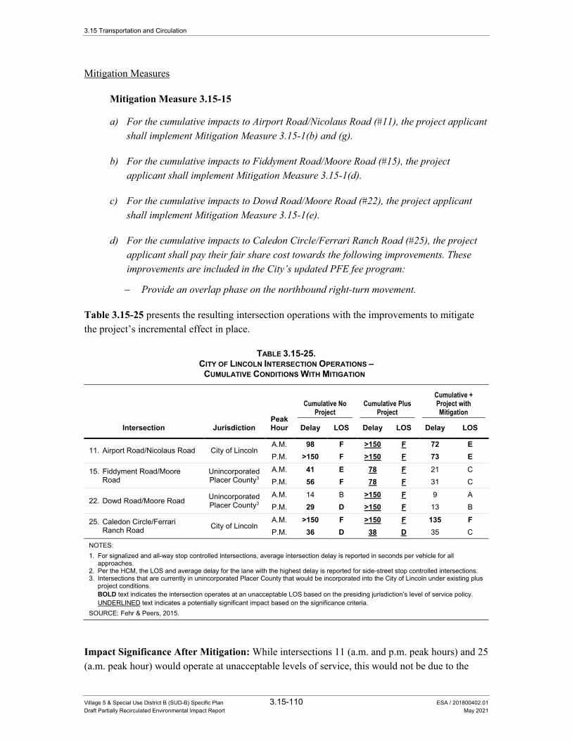
3.15 Transportation and Circulation
Village 5 & Special Use District B (SUD-B) Specific Plan 3.15-110 ESA / 201800402.01 Draft Partially Recirculated Environmental Impact Report May 2021
Mitigation Measures
Mitigation Measure 3.15-15
a) For the cumulative impacts to Airport Road/Nicolaus Road (#11), the project applicant shall implement Mitigation Measure 3.15-1(b) and (g).
b) For the cumulative impacts to Fiddyment Road/Moore Road (#15), the project applicant shall implement Mitigation Measure 3.15-1(d).
c) For the cumulative impacts to Dowd Road/Moore Road (#22), the project applicant shall implement Mitigation Measure 3.15-1(e).
d) For the cumulative impacts to Caledon Circle/Ferrari Ranch Road (#25), the project applicant shall pay their fair share cost towards the following improvements. These improvements are included in the City’s updated PFE fee program:
− Provide an overlap phase on the northbound right-turn movement.
Table 3.15-25 presents the resulting intersection operations with the improvements to mitigate the project’s incremental effect in place.
TABLE 3.15-25. CITY OF LINCOLN INTERSECTION OPERATIONS –
CUMULATIVE CONDITIONS WITH MITIGATION
Peak Hour
Cumulative No Project
Cumulative Plus Project
Cumulative + Project with Mitigation
Intersection Jurisdiction Delay LOS Delay LOS Delay LOS
11. Airport Road/Nicolaus Road City of Lincoln A.M. 98 F >150 F 72 E P.M. >150 F >150 F 73 E
15. Fiddyment Road/Moore Road
Unincorporated Placer County3
A.M. 41 E 78 F 21 C P.M. 56 F 78 F 31 C
22. Dowd Road/Moore Road Unincorporated Placer County3
A.M. 14 B >150 F 9 A P.M. 29 D >150 F 13 B
25. Caledon Circle/Ferrari Ranch Road City of Lincoln
A.M. >150 F >150 F 135 F P.M. 36 D 38 D 35 C
NOTES: 1. For signalized and all-way stop controlled intersections, average intersection delay is reported in seconds per vehicle for all
approaches. 2. Per the HCM, the LOS and average delay for the lane with the highest delay is reported for side-street stop controlled intersections. 3. Intersections that are currently in unincorporated Placer County that would be incorporated into the City of Lincoln under existing plus
project conditions. BOLD text indicates the intersection operates at an unacceptable LOS based on the presiding jurisdiction’s level of service policy. UNDERLINED text indicates a potentially significant impact based on the significance criteria. SOURCE: Fehr & Peers, 2015.
Impact Significance After Mitigation: While intersections 11 (a.m. and p.m. peak hours) and 25 (a.m. peak hour) would operate at unacceptable levels of service, this would not be due to the
3.15 Transportation and Circulation
Village 5 & Special Use District B (SUD-B) Specific Plan 3.15-111 ESA / 201800402.01 Draft Partially Recirculated Environmental Impact Report May 2021
Proposed Project. With the implementation of Mitigation Measures 3.15-15(a) through 3.15-15(d) listed above, the traffic operations at the impacted intersections would be improved to address the project’s incremental contribution. Alternatively, the project applicant could pay its fair share towards improvements through the City of Lincoln’s PFE fee program and ensure that they are constructed prior to the project exacerbating future unacceptable operations. Therefore, this impact to vehicle traffic operations would be reduced to a less than significant level.
Impact 3.15-16: Implementation of the proposed project would contribute to cumulative traffic levels at future City of Lincoln intersections in Village 5.
With implementation of the proposed project, traffic from current and probable future projects (i.e., Villages 1 and 7) would use the roadway network within Village 5. When viewed in combination with the proposed project, the Dowd Road/Mavis Road and Nelson Lane/Mavis Road intersections within Village 5 are anticipated to operate at an unacceptable LOS.
The future intersection of Dowd Road/Mavis Road (#37) is anticipated to operate at LOS F during both the a.m. and p.m. peak hours with the following lane configurations:
• Northbound: one left-turn lane, one through lane, and one shared through-right turn lane
• Southbound: one left-turn lane, one through lane, and one shared through-right turn lane
• Eastbound: one left-turn lane and one shared through-right turn lane
• Westbound: one left-turn lane, one through lane, and one trap right-turn lane
The future intersection of Nelson Lane/Mavis Road (#30) is anticipated to operate at LOS D during the a.m. peak hour and LOS F during the p.m. peak hour with the following lane configurations:
• Northbound: two left-turn lanes, three through lanes, one right-turn lane
• Southbound: two left-turn lanes, three through lanes, one right-turn lane
• Eastbound: two left-turn lanes, two through lanes, one right-turn lane
• Westbound: two left-turn lanes, two through lanes, one right-turn lane
Therefore, the project is considered to make a cumulatively considerable contribution to a potentially significant cumulative impact.
Mitigation Measures
Mitigation Measure 3.15-16
The City shall monitor traffic conditions at the future Dowd Road/Mavis Road (#37) and Nelson Lane/Mavis Road (#40) intersections, and shall cause the following improvements

3.15 Transportation and Circulation
Village 5 & Special Use District B (SUD-B) Specific Plan 3.15-112 ESA / 201800402.01 Draft Partially Recirculated Environmental Impact Report May 2021
to be constructed prior to the service level degrading to LOS D, subject to reimbursement to the constructing entity by those benefitting from the improvements:
a) Dowd Road/Mavis Road (#37):
− To reduce the average vehicle delay, the following improvements are necessary to provide LOS C operations at Dowd Road/Mavis Road:
i. Provide two southbound left-turn lanes
ii. Channelize the westbound right-turn lane and provide a receiving merge lane on northbound Dowd Road to allow free right-turn movements
b) Nelson Lane/Mavis Road (#40):
− Implement Mitigation Measure 3.15-3.
Table 3.15-26 presents the resulting intersection operations with these improvements in place.
TABLE 3.15-26. VILLAGE 5 INTERSECTION OPERATIONS –
CUMULATIVE CONDITIONS WITH MITIGATION
Peak Hour
Cumulative No Project
Cumulative Plus Project
Cumulative + Project with Mitigation
Intersection Jurisdiction Delay LOS Delay1 LOS Delay LOS
37. Dowd Road/Mavis Road Unincorporated Placer County2
A.M. 82 F 20 B P.M. 147 F 27 C
40. Nelson Lane/Mavis Road Unincorporated Placer County2
A.M. 55 D 31 C P.M. 91 F 36 D
NOTES: 1. For signalized and all-way stop controlled intersections, average intersection delay is reported in seconds per vehicle for all
approaches. 2. These are proposed project intersections that do not exist under cumulative no project conditions. They are assumed to be
incorporated into the City of Lincoln under cumulative plus project conditions. BOLD text indicates the intersection operates at an unacceptable LOS based on the presiding jurisdiction’s level of service policy. UNDERLINED text indicates a potentially significant impact based on the significance criteria. SOURCE: Fehr & Peers, 2015.
Impact Significance After Mitigation: With the implementation of Mitigation Measure 3.15-16(a) and 3.15-16(b), the traffic operations at the impacted intersections would be improved. More specifically, these improvements would result in traffic operations at the LOS C/LOS D threshold during the a.m. peak hour (35.8 seconds of delay) and LOS C operations during the p.m. peak hour (31.0 seconds of delay). To fully achieve LOS C operations during the a.m. peak hour, a third southbound left-turn lane would be required (reducing delay to 31.3 seconds during the a.m. peak hour and 30.5 seconds during the p.m. peak hour), as shown in Table 3.15-26. However, the Nelson Lane/Mavis Road intersection would continue to operate at an unacceptable LOS D. Therefore, the impact would remain significant and unavoidable.

3.15 Transportation and Circulation
Village 5 & Special Use District B (SUD-B) Specific Plan 3.15-113 ESA / 201800402.01 Draft Partially Recirculated Environmental Impact Report May 2021
Impact 3.15-17: Implementation of the proposed project would contribute to cumulative traffic levels at intersections under the County of Placer’s jurisdiction.
The proposed project would add vehicle traffic to four County of Placer intersections anticipated to operate at an unacceptable LOS under cumulative no project conditions. At the intersections of Industrial Avenue/Athens Avenue (#35), the implementation of the proposed project would not increase delay by more than four seconds. Since the proposed project’s incremental effect would increase delay by less than four seconds over cumulative no project conditions, the project is anticipated to have a less than cumulatively considerable impact at these intersections.
At the intersections of Fiddyment Road/Athens Avenue (#16), Fiddyment Road/E. Catlett Road (#17), and Fiddyment Road/W. Sunset Boulevard (#18), the incremental addition of project traffic is anticipated to increase delay by five seconds or more over cumulative no project conditions and meet the California MUTCD peak hour signal warrant. Therefore, the project is considered to make a cumulatively considerable contribution to a potentially significant cumulative impact.
The following list provides additional information regarding the intersections that would be significantly impacted under cumulative plus project conditions by the incremental addition of vehicle traffic generated by the proposed project during each peak hour:
AM Peak Hour • Fiddyment Road/Athens Avenue (#16) – delay increases from 440 seconds (LOS F) to
763 seconds (LOS F) (meets California MUTCD Peak Hour Signal Warrant)
• Fiddyment Road/E. Catlett Road (#17) – delay increases from 108 seconds (LOS F) to 538 seconds (LOS F) (meets California MUTCD Peak Hour Signal Warrant)
• Fiddyment Road/W. Sunset Boulevard (#18) – delay increases from >1,000 seconds (LOS F) to >3,000 seconds (LOS F) (meets California MUTCD Peak Hour Signal Warrant)
PM Peak Hour • Fiddyment Road/Athens Avenue (#16) – delay increases from 550 seconds (LOS F) to
847 seconds (LOS F) (meets California MUTCD Peak Hour Signal Warrant)
• Fiddyment Road/E. Catlett Road (#17) – delay increases from 20 seconds (LOS C) to 844 seconds (LOS F) (meets California MUTCD Peak Hour Signal Warrant)
• Fiddyment Road/W. Sunset Boulevard (#18) – delay increases from 455 seconds (LOS F) to >1,000 seconds (LOS F) (meets California MUTCD Peak Hour Signal Warrant)
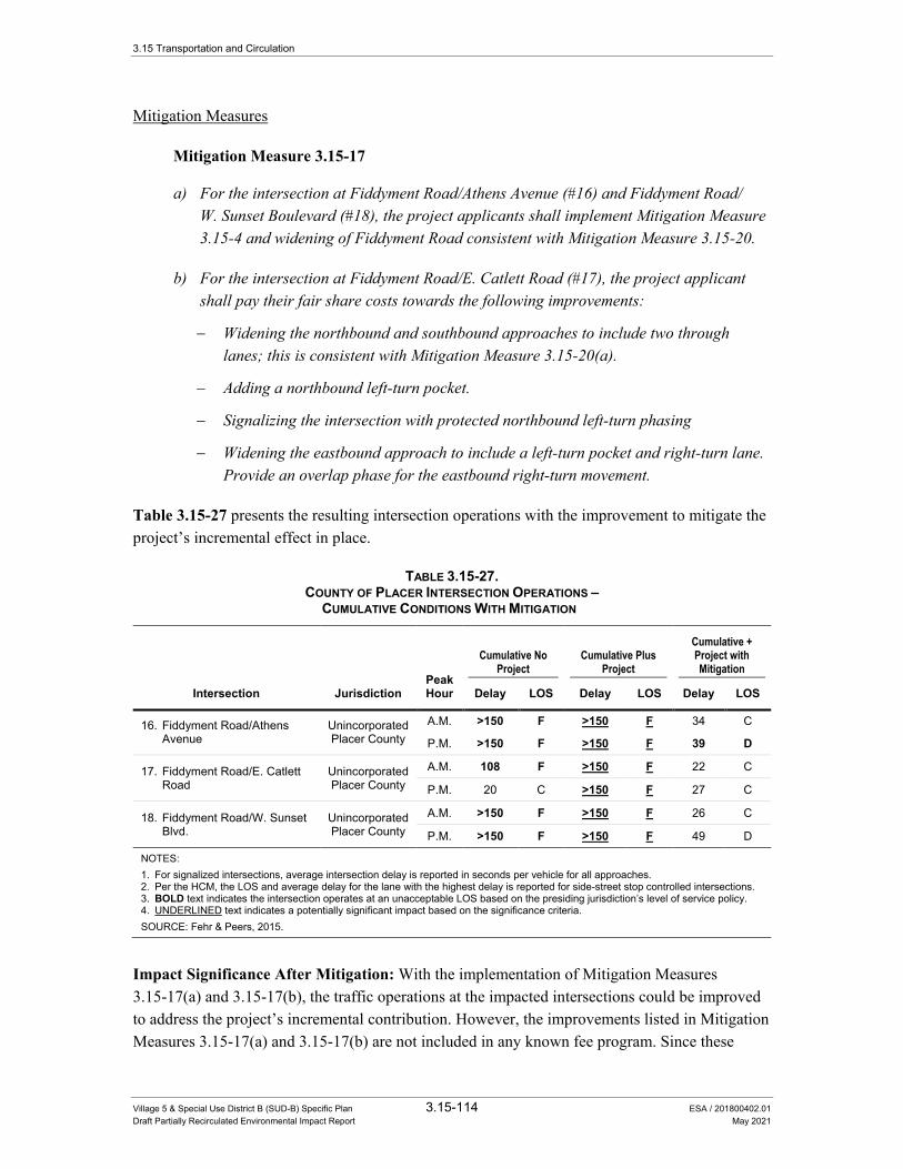
3.15 Transportation and Circulation
Village 5 & Special Use District B (SUD-B) Specific Plan 3.15-114 ESA / 201800402.01 Draft Partially Recirculated Environmental Impact Report May 2021
Mitigation Measures
Mitigation Measure 3.15-17
a) For the intersection at Fiddyment Road/Athens Avenue (#16) and Fiddyment Road/W. Sunset Boulevard (#18), the project applicants shall implement Mitigation Measure 3.15-4 and widening of Fiddyment Road consistent with Mitigation Measure 3.15-20.
b) For the intersection at Fiddyment Road/E. Catlett Road (#17), the project applicant shall pay their fair share costs towards the following improvements:
− Widening the northbound and southbound approaches to include two through lanes; this is consistent with Mitigation Measure 3.15-20(a).
− Adding a northbound left-turn pocket.
− Signalizing the intersection with protected northbound left-turn phasing
− Widening the eastbound approach to include a left-turn pocket and right-turn lane. Provide an overlap phase for the eastbound right-turn movement.
Table 3.15-27 presents the resulting intersection operations with the improvement to mitigate the project’s incremental effect in place.
TABLE 3.15-27. COUNTY OF PLACER INTERSECTION OPERATIONS –
CUMULATIVE CONDITIONS WITH MITIGATION
Peak Hour
Cumulative No Project
Cumulative Plus Project
Cumulative + Project with Mitigation
Intersection Jurisdiction Delay LOS Delay LOS Delay LOS
16. Fiddyment Road/Athens Avenue
Unincorporated Placer County
A.M. >150 F >150 F 34 C
P.M. >150 F >150 F 39 D
17. Fiddyment Road/E. Catlett Road
Unincorporated Placer County
A.M. 108 F >150 F 22 C
P.M. 20 C >150 F 27 C
18. Fiddyment Road/W. Sunset Blvd.
Unincorporated Placer County
A.M. >150 F >150 F 26 C
P.M. >150 F >150 F 49 D
NOTES: 1. For signalized intersections, average intersection delay is reported in seconds per vehicle for all approaches. 2. Per the HCM, the LOS and average delay for the lane with the highest delay is reported for side-street stop controlled intersections. 3. BOLD text indicates the intersection operates at an unacceptable LOS based on the presiding jurisdiction’s level of service policy. 4. UNDERLINED text indicates a potentially significant impact based on the significance criteria. SOURCE: Fehr & Peers, 2015.
Impact Significance After Mitigation: With the implementation of Mitigation Measures 3.15-17(a) and 3.15-17(b), the traffic operations at the impacted intersections could be improved to address the project’s incremental contribution. However, the improvements listed in Mitigation Measures 3.15-17(a) and 3.15-17(b) are not included in any known fee program. Since these

3.15 Transportation and Circulation
Village 5 & Special Use District B (SUD-B) Specific Plan 3.15-115 ESA / 201800402.01 Draft Partially Recirculated Environmental Impact Report May 2021
improvements are not included in a known fee program, there is no assurance that the remaining funds for construction will be collected. Additionally, this mitigation requires approvals from agencies other than the City. Since these improvements are not within the City of Lincoln’s jurisdiction to implement, it cannot be guaranteed that these improvements will be constructed. Therefore, this impact would be considered significant and unavoidable.
Impact 3.15-18: Implementation of the proposed project would contribute to cumulative traffic levels at intersections under the City of Roseville’s jurisdiction.
The proposed project would add vehicle traffic to three City of Roseville intersections anticipated to operate at an unacceptable LOS under cumulative no project conditions. At the intersection of Fiddyment Road/Pleasant Grove Boulevard (#20), the implementation of the proposed project is anticipated to increase delay from 176 seconds under cumulative no project conditions to 180 seconds under cumulative plus project conditions during the a.m. peak hour, and have no effect on delay during the p.m. peak hour (remains constant at 241 seconds of delay for both cumulative scenarios). Since the proposed project’s incremental effect would increase delay by less than five seconds over cumulative no project conditions, the project is anticipated to have a less than cumulatively considerable impact at this intersection.
At the intersections of Fiddyment Road/Blue Oaks Boulevard (#19) and Fiddyment Road/Baseline Road (#21), the incremental addition of project traffic is anticipated to increase delay by five seconds or more over cumulative no project conditions during either the a.m. or p.m. peak hour. Therefore, the project would result in a cumulatively considerable contribution to a potentially significant cumulative impact.
The following list provides additional information regarding the intersections that would be significantly impacted under cumulative plus project conditions by the incremental addition of vehicle traffic generated by the proposed project during each peak hour:
AM Peak Hour • Fiddyment Road/Baseline Road (#21) – delay increases from 271 seconds (LOS F) to 277
seconds (LOS F)
PM Peak Hour • Fiddyment Road/Blue Oaks Boulevard (#19) – delay increases from 76 seconds (LOS E) to
85 seconds (LOS F)
Mitigation Measures
Mitigation Measure 3.15-18
The project applicants shall pay their fair share cost towards the following recommended improvements to mitigate the proposed project’s incremental contribution to unacceptable traffic operations at each of the following intersections:
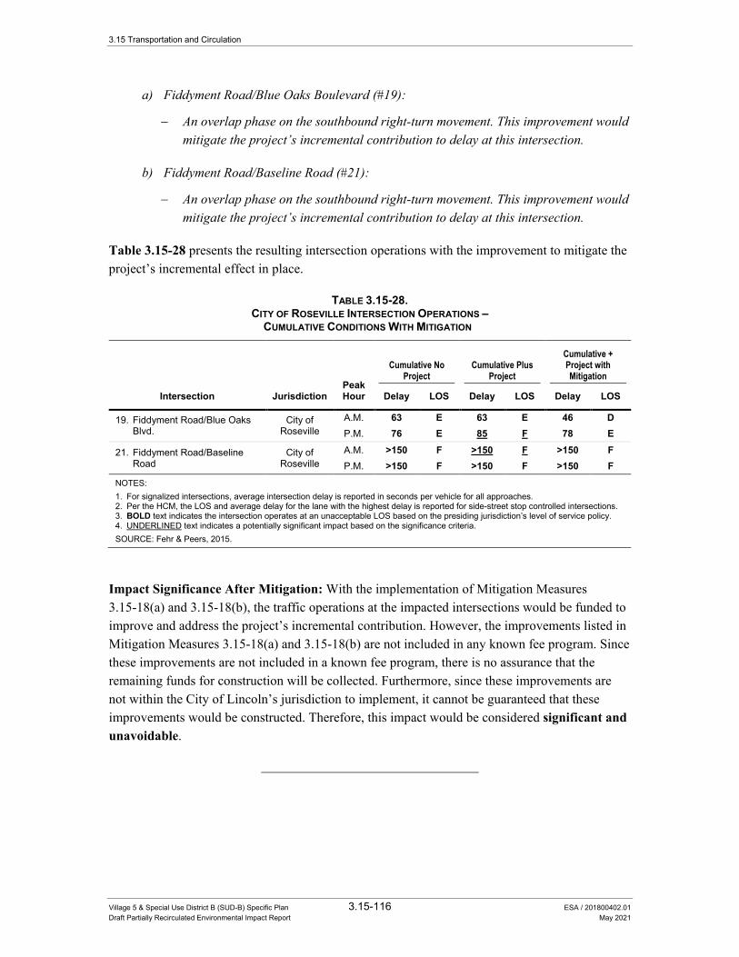
3.15 Transportation and Circulation
Village 5 & Special Use District B (SUD-B) Specific Plan 3.15-116 ESA / 201800402.01 Draft Partially Recirculated Environmental Impact Report May 2021
a) Fiddyment Road/Blue Oaks Boulevard (#19):
− An overlap phase on the southbound right-turn movement. This improvement would mitigate the project’s incremental contribution to delay at this intersection.
b) Fiddyment Road/Baseline Road (#21):
− An overlap phase on the southbound right-turn movement. This improvement would mitigate the project’s incremental contribution to delay at this intersection.
Table 3.15-28 presents the resulting intersection operations with the improvement to mitigate the project’s incremental effect in place.
TABLE 3.15-28. CITY OF ROSEVILLE INTERSECTION OPERATIONS –
CUMULATIVE CONDITIONS WITH MITIGATION
Peak Hour
Cumulative No Project
Cumulative Plus Project
Cumulative + Project with Mitigation
Intersection Jurisdiction Delay LOS Delay LOS Delay LOS
19. Fiddyment Road/Blue Oaks Blvd.
City of Roseville
A.M. 63 E 63 E 46 D P.M. 76 E 85 F 78 E
21. Fiddyment Road/Baseline Road
City of Roseville
A.M. >150 F >150 F >150 F P.M. >150 F >150 F >150 F
NOTES: 1. For signalized intersections, average intersection delay is reported in seconds per vehicle for all approaches. 2. Per the HCM, the LOS and average delay for the lane with the highest delay is reported for side-street stop controlled intersections. 3. BOLD text indicates the intersection operates at an unacceptable LOS based on the presiding jurisdiction’s level of service policy. 4. UNDERLINED text indicates a potentially significant impact based on the significance criteria. SOURCE: Fehr & Peers, 2015.
Impact Significance After Mitigation: With the implementation of Mitigation Measures 3.15-18(a) and 3.15-18(b), the traffic operations at the impacted intersections would be funded to improve and address the project’s incremental contribution. However, the improvements listed in Mitigation Measures 3.15-18(a) and 3.15-18(b) are not included in any known fee program. Since these improvements are not included in a known fee program, there is no assurance that the remaining funds for construction will be collected. Furthermore, since these improvements are not within the City of Lincoln’s jurisdiction to implement, it cannot be guaranteed that these improvements would be constructed. Therefore, this impact would be considered significant and unavoidable.

3.15 Transportation and Circulation
Village 5 & Special Use District B (SUD-B) Specific Plan 3.15-117 ESA / 201800402.01 Draft Partially Recirculated Environmental Impact Report May 2021
Impact 3.15-19: Implementation of the proposed project would contribute to cumulative traffic levels at intersections maintained by Caltrans.
The incremental addition of vehicle traffic generated by the proposed project is anticipated to cause the Nelson Lane/SR 65 (#3) intersection to operate at an unacceptable LOS under cumulative plus project conditions. In addition, the proposed project would add vehicle traffic to the SR 65 Southbound Ramps/Ferrari Ranch Road (#4) and SR 65 Northbound Ramps/Twelve Bridges Drive (#9) intersections, which are anticipated to operate at an unacceptable LOS under cumulative no project conditions. The incremental addition of project traffic is anticipated to increase delay by five seconds or more over cumulative no project conditions at these two intersections. Therefore, the project would result in a cumulatively considerable contribution to a potentially significant cumulative impact. The following list provides additional information regarding the intersections that are significantly impacted under cumulative plus project conditions by the incremental addition of vehicle traffic generated by the proposed project during each peak hour:
AM Peak Hour • SR 65/Nelson Lane (#3) – delay increases from 55 seconds (LOS D) to 286 seconds (LOS F)
• SR 65 Southbound Ramps/Ferrari Ranch Road (#4) – delay increases from 61 seconds (LOS E) to 110 seconds (LOS F)
• SR 65 Northbound Ramps/Twelve Bridges Drive (#9) – delay increases from 55 seconds (LOS E) to 61 seconds (LOS E)
PM Peak Hour • SR 65/Nelson Lane (#3) – delay increases from 46 seconds (LOS D) to 450 seconds (LOS F)
Mitigation Measures
Mitigation Measure 3.15-19
a) For SR 65/Nelson Lane (#3a and #3b), implement Mitigation Measure 3.15-6.
b) For SR 65 Southbound Ramps/Ferrari Ranch Road (#4):
The project applicants shall pay their fair share cost towards the following recommended improvements to mitigate the proposed project’s incremental contribution to unacceptable traffic operations at SR 65 Southbound Ramps/Ferrari Ranch Road. These improvements are included in the City’s updated PFE fee program. Therefore, the project applicant shall pay their fair share through the City of Lincoln’s updated PFE fee program:
− Widening the eastbound approach to include a dedicated right-turn lane; channelize the eastbound right-turn movement onto the southbound on-ramp to allow free right-turn movements.
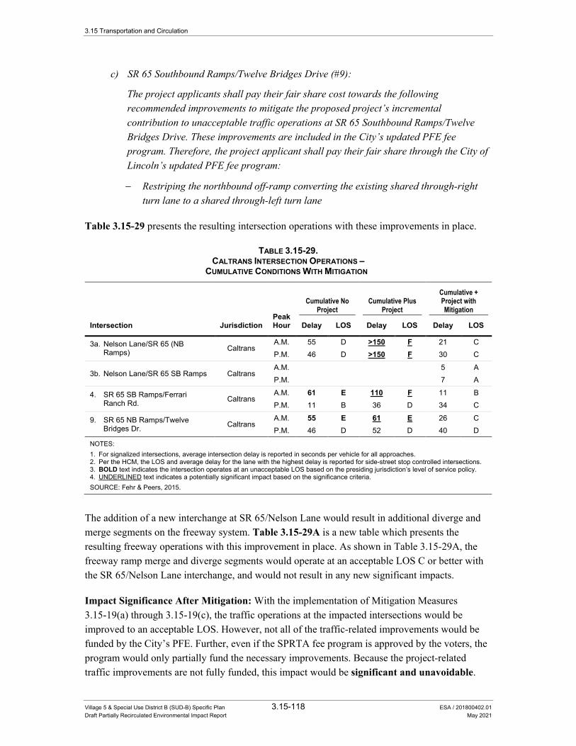
3.15 Transportation and Circulation
Village 5 & Special Use District B (SUD-B) Specific Plan 3.15-118 ESA / 201800402.01 Draft Partially Recirculated Environmental Impact Report May 2021
c) SR 65 Southbound Ramps/Twelve Bridges Drive (#9):
The project applicants shall pay their fair share cost towards the following recommended improvements to mitigate the proposed project’s incremental contribution to unacceptable traffic operations at SR 65 Southbound Ramps/Twelve Bridges Drive. These improvements are included in the City’s updated PFE fee program. Therefore, the project applicant shall pay their fair share through the City of Lincoln’s updated PFE fee program:
− Restriping the northbound off-ramp converting the existing shared through-right turn lane to a shared through-left turn lane
Table 3.15-29 presents the resulting intersection operations with these improvements in place.
TABLE 3.15-29. CALTRANS INTERSECTION OPERATIONS –
CUMULATIVE CONDITIONS WITH MITIGATION
Intersection Jurisdiction Peak Hour
Cumulative No Project
Cumulative Plus Project
Cumulative + Project with Mitigation
Delay LOS Delay LOS Delay LOS
3a. Nelson Lane/SR 65 (NB Ramps) Caltrans
A.M. 55 D >150 F 21 C P.M. 46 D >150 F 30 C
3b. Nelson Lane/SR 65 SB Ramps Caltrans A.M. 5 A P.M. 7 A
4. SR 65 SB Ramps/Ferrari Ranch Rd. Caltrans
A.M. 61 E 110 F 11 B P.M. 11 B 36 D 34 C
9. SR 65 NB Ramps/Twelve Bridges Dr. Caltrans
A.M. 55 E 61 E 26 C P.M. 46 D 52 D 40 D
NOTES: 1. For signalized intersections, average intersection delay is reported in seconds per vehicle for all approaches. 2. Per the HCM, the LOS and average delay for the lane with the highest delay is reported for side-street stop controlled intersections. 3. BOLD text indicates the intersection operates at an unacceptable LOS based on the presiding jurisdiction’s level of service policy. 4. UNDERLINED text indicates a potentially significant impact based on the significance criteria. SOURCE: Fehr & Peers, 2015.
The addition of a new interchange at SR 65/Nelson Lane would result in additional diverge and merge segments on the freeway system. Table 3.15-29A is a new table which presents the resulting freeway operations with this improvement in place. As shown in Table 3.15-29A, the freeway ramp merge and diverge segments would operate at an acceptable LOS C or better with the SR 65/Nelson Lane interchange, and would not result in any new significant impacts.
Impact Significance After Mitigation: With the implementation of Mitigation Measures 3.15-19(a) through 3.15-19(c), the traffic operations at the impacted intersections would be improved to an acceptable LOS. However, not all of the traffic-related improvements would be funded by the City’s PFE. Further, even if the SPRTA fee program is approved by the voters, the program would only partially fund the necessary improvements. Because the project-related traffic improvements are not fully funded, this impact would be significant and unavoidable.

3.15 Transportation and Circulation
Village 5 & Special Use District B (SUD-B) Specific Plan 3.15-119 ESA / 201800402.01 Draft Partially Recirculated Environmental Impact Report May 2021
TABLE 3.15-29A. FREEWAY OPERATIONS –
CUMULATIVE PLUS PROJECT CONDITIONS WITH MITIGATION
Location Segment
type Peak hour
Cumulative No Project
Cumulative Plus Project
Cumulative Plus Project with Mitigation
Density1 LOS Density1 LOS Density1 LOS
Northbound SR 65
Ferrari Ranch Road to Nelson Lane Basic
A.M. 14 B 24 C 24 C P.M. 14 B 24 C 24 C
Nelson Lane Off-ramp Diverge A.M. 30 D A.M. 30 D
Nelson Lane Loop On-ramp Merge
A.M. 14 B
A.M. 13 B
Nelson Lane Slip On-ramp Merge A.M. 12 B A.M. 13 B
Nelson Lane to Nicolaus Road Basic
A.M. 11 B 11 B 11 B
A.M. 10 A 10 A 10 A
Southbound SR 65
Nicolaus Road to Nelson Lane Basic
A.M. 10 A 10 A 10 A A.M. 11 B 13 B 13 B
Nelson Lane Off-ramp Diverge A.M. 14 B A.M. 17 B
Nelson Lane Loop On-ramp Merge
A.M. 19 B A.M. 22 C
Nelson Lane Slip On-ramp Merge A.M. 22 C
A.M. 27 C
Nelson Lane to Ferrari Ranch Road Basic
A.M. 14 B 23 C 23 C A.M. 17 B 29 D 29 D
NOTES: 1. Density is reported in passenger car equivalents per mile per lane (pcpmpl). SOURCE: Fehr & Peers, 2016.
Impact 3.15-20: Implementation of the proposed project would contribute to cumulative traffic levels on study roadway segments in Placer County.
The proposed project would add vehicle traffic to three study roadway segments in Placer County that are anticipated to operate at an unacceptable LOS under cumulative no project conditions: Fiddyment Road between Moore Road and Athens Avenue, Fiddyment Road between Athens Avenue and Roseville City Limits, and Athens Avenue between Fiddyment Road and Foothills Boulevard. At all of these locations, the implementation of the proposed project is anticipated to increase the volume-to-capacity ratio by more than 0.05. Therefore, the project is anticipated to result in a cumulatively considerable contribution to a potentially significant cumulative impact.

3.15 Transportation and Circulation
Village 5 & Special Use District B (SUD-B) Specific Plan 3.15-120 ESA / 201800402.01 Draft Partially Recirculated Environmental Impact Report May 2021
Mitigation Measures
Mitigation Measure 3.15-20
The project applicants shall pay their fair share cost to the City for the following recommended improvements to restore vehicle traffic operations to mitigate the proposed project’s incremental contribution to unacceptable traffic operations at each roadway segment.
a) Widening Fiddyment Road from Athens Avenue to Moore Road from a two-lane undivided arterial to a four-lane divided arterial.
b) Widening Fiddyment Road from Roseville City Limits to Athens Avenue from a two-lane undivided arterial to a four-lane divided arterial.
c) Widening Athens Road from Fiddyment Road to Foothills Boulevard from a two-lane undivided arterial to a four-lane divided arterial.
Table 3.15-30 presents the resulting roadway segment operations with these improvements in place.
TABLE 3.15-30. DAILY ROADWAY SEGMENT OPERATIONS – CUMULATIVE CONDITIONS WITH MITIGATION
Cumulative No Project1 Cumulative Plus Project1
Cumulative Plus Project with Mitigation2
Roadway Segment Daily
Traffic V/C3 LOS4 Daily
Traffic V/C3 LOS4 Daily
Traffic V/C3 LOS4
Fiddyment Road
Moore Road to Athens Avenue 21,100 1.06 F 28,800 1.44 F 28,800 0.72 C
Athens Avenue to Roseville City Limits 27,500 1.38 F 30,000 1.50 F 30,000 0.75 C
Athens Avenue Fiddyment Road to Foothills Boulevard 22,400 1.12 F 23,000 1.15 F 23,000 0.58 A
NOTES: 1. Both study segments are analyzed as two-lane, high-access controlled arterials, per the definition outlined in Table 4-16 of the Placer
County Countywide General Plan Final EIR, under cumulative no project and cumulative plus project conditions. 2. Both study segments are analyzed as four-lane, high-access controlled arterials, per the definition outlined in Table 4-16 of the
Placer County Countywide General Plan Final EIR, with mitigation. 3. V/C = Volume-to-capacity ratio. 4. Level of service based on thresholds presented in Table 3.15-3 from the Placer County Countywide General Plan Final EIR. SOURCE: Fehr & Peers, 2015
Impact Significance After Mitigation: With the implementation of Mitigation Measures 3.15-20(a)-(c), the traffic operations at the impacted roadways would be improved to an acceptable LOS. However, the improvements listed in Mitigation Measures 3.15-20(a)-(c) are not included in any known fee program. This mitigation also requires approvals from other agencies.

3.15 Transportation and Circulation
Village 5 & Special Use District B (SUD-B) Specific Plan 3.15-121 ESA / 201800402.01 Draft Partially Recirculated Environmental Impact Report May 2021
Since these improvements are not included in a known fee program, there is no assurance that the remaining funds for construction will be collected. Furthermore, since these improvements are not within the City of Lincoln’s jurisdiction to implement, it cannot be guaranteed that these improvements would be constructed. Therefore, this impact would be considered significant and unavoidable.
Impact 3.15-21: Implementation of the proposed project would contribute to cumulative traffic levels on study highway facilities maintained by Caltrans.
The proposed project would add vehicle traffic to study highway segments on SR 65. The proposed project’s incremental addition in traffic in conjunction with traffic generated by other known projects would increase the percent time spent following and reduce the average travel speed on study two-lane highway segments, and increase the density on study multi-lane highway segments under cumulative plus project conditions, as shown in Table 3.15-18.
All study highway segments would continue to operate at an acceptable LOS based on the Concept LOS identified in the SR 65 CSMP. SR 65 north of Riosa Road continues to operate at LOS E, which is considered acceptable per the SR 65 CSMP. SR 65 from Nelson Lane to Riosa Road continues to operate at an acceptable LOS B or better. Therefore, this impact would be less than cumulatively considerable.
Mitigation Measure
None required.
Impact 3.15-22: Implementation of the proposed project would contribute to cumulative traffic levels on study freeway facilities maintained by Caltrans as well as roadways in the City of Rocklin.
The incremental addition of vehicle traffic generated by the proposed project would add traffic to the study freeway segments and would contribute to unacceptable traffic operations under cumulative plus project conditions. Furthermore, the addition of project trips to SR 65 under cumulative plus project conditions would also cause traffic to use alternate routes on local streets parallel to SR 65, potentially affecting these roadways. Table 3.15-31 identifies the amount of peak hour trips that the proposed project would add to freeway segments operating at LOS F conditions under cumulative plus project conditions. As shown in Table 3.15-31, the proposed project is expected to add more than 60 peak hour trips to these freeway segments operating at LOS F conditions. Therefore, the project is considered to result in a cumulatively considerable contribution to a potentially significant cumulative impact.
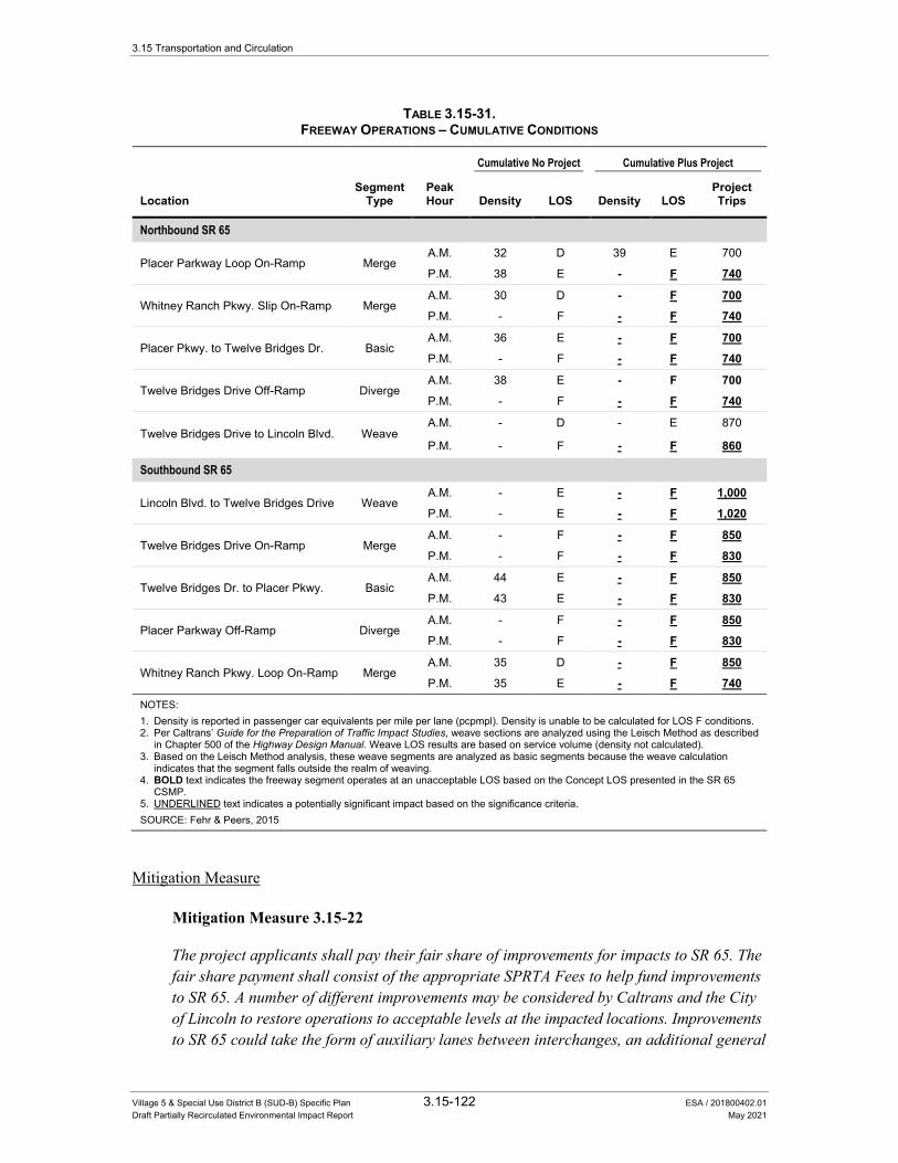
3.15 Transportation and Circulation
Village 5 & Special Use District B (SUD-B) Specific Plan 3.15-122 ESA / 201800402.01 Draft Partially Recirculated Environmental Impact Report May 2021
TABLE 3.15-31. FREEWAY OPERATIONS – CUMULATIVE CONDITIONS
Location Segment
Type Peak Hour
Cumulative No Project Cumulative Plus Project
Density LOS Density LOS Project Trips
Northbound SR 65
Placer Parkway Loop On-Ramp Merge A.M. 32 D 39 E 700
P.M. 38 E - F 740
Whitney Ranch Pkwy. Slip On-Ramp Merge A.M. 30 D - F 700 P.M. - F - F 740
Placer Pkwy. to Twelve Bridges Dr. Basic A.M. 36 E - F 700 P.M. - F - F 740
Twelve Bridges Drive Off-Ramp Diverge A.M. 38 E - F 700 P.M. - F - F 740
Twelve Bridges Drive to Lincoln Blvd. Weave A.M. - D - E 870
P.M. - F - F 860
Southbound SR 65
Lincoln Blvd. to Twelve Bridges Drive Weave A.M. - E - F 1,000 P.M. - E - F 1,020
Twelve Bridges Drive On-Ramp Merge A.M. - F - F 850 P.M. - F - F 830
Twelve Bridges Dr. to Placer Pkwy. Basic A.M. 44 E - F 850 P.M. 43 E - F 830
Placer Parkway Off-Ramp Diverge A.M. - F - F 850 P.M. - F - F 830
Whitney Ranch Pkwy. Loop On-Ramp Merge A.M. 35 D - F 850 P.M. 35 E - F 740
NOTES: 1. Density is reported in passenger car equivalents per mile per lane (pcpmpl). Density is unable to be calculated for LOS F conditions. 2. Per Caltrans’ Guide for the Preparation of Traffic Impact Studies, weave sections are analyzed using the Leisch Method as described
in Chapter 500 of the Highway Design Manual. Weave LOS results are based on service volume (density not calculated). 3. Based on the Leisch Method analysis, these weave segments are analyzed as basic segments because the weave calculation
indicates that the segment falls outside the realm of weaving. 4. BOLD text indicates the freeway segment operates at an unacceptable LOS based on the Concept LOS presented in the SR 65
CSMP. 5. UNDERLINED text indicates a potentially significant impact based on the significance criteria. SOURCE: Fehr & Peers, 2015
Mitigation Measure
Mitigation Measure 3.15-22
The project applicants shall pay their fair share of improvements for impacts to SR 65. The fair share payment shall consist of the appropriate SPRTA Fees to help fund improvements to SR 65. A number of different improvements may be considered by Caltrans and the City of Lincoln to restore operations to acceptable levels at the impacted locations. Improvements to SR 65 could take the form of auxiliary lanes between interchanges, an additional general
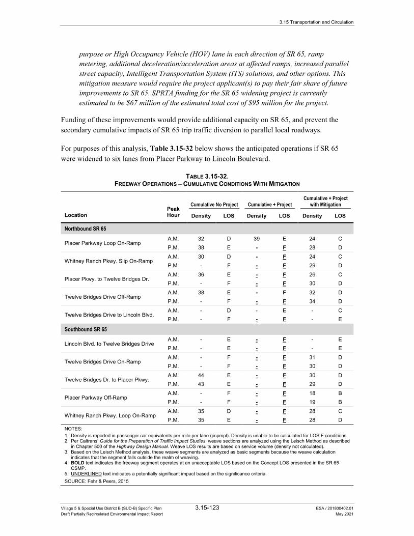
3.15 Transportation and Circulation
Village 5 & Special Use District B (SUD-B) Specific Plan 3.15-123 ESA / 201800402.01 Draft Partially Recirculated Environmental Impact Report May 2021
purpose or High Occupancy Vehicle (HOV) lane in each direction of SR 65, ramp metering, additional deceleration/acceleration areas at affected ramps, increased parallel street capacity, Intelligent Transportation System (ITS) solutions, and other options. This mitigation measure would require the project applicant(s) to pay their fair share of future improvements to SR 65. SPRTA funding for the SR 65 widening project is currently estimated to be $67 million of the estimated total cost of $95 million for the project.
Funding of these improvements would provide additional capacity on SR 65, and prevent the secondary cumulative impacts of SR 65 trip traffic diversion to parallel local roadways.
For purposes of this analysis, Table 3.15-32 below shows the anticipated operations if SR 65 were widened to six lanes from Placer Parkway to Lincoln Boulevard.
TABLE 3.15-32. FREEWAY OPERATIONS – CUMULATIVE CONDITIONS WITH MITIGATION
Location Peak Hour
Cumulative No Project Cumulative + Project Cumulative + Project
with Mitigation
Density LOS Density LOS Density LOS
Northbound SR 65
Placer Parkway Loop On-Ramp A.M. 32 D 39 E 24 C P.M. 38 E - F 28 D
Whitney Ranch Pkwy. Slip On-Ramp A.M. 30 D - F 24 C P.M. - F - F 29 D
Placer Pkwy. to Twelve Bridges Dr. A.M. 36 E - F 26 C P.M. - F - F 30 D
Twelve Bridges Drive Off-Ramp A.M. 38 E - F 32 D P.M. - F - F 34 D
Twelve Bridges Drive to Lincoln Blvd. A.M. - D - E - C P.M. - F - F - E
Southbound SR 65
Lincoln Blvd. to Twelve Bridges Drive A.M. - E - F - E P.M. - E - F - E
Twelve Bridges Drive On-Ramp A.M. - F - F 31 D P.M. - F - F 30 D
Twelve Bridges Dr. to Placer Pkwy. A.M. 44 E - F 30 D P.M. 43 E - F 29 D
Placer Parkway Off-Ramp A.M. - F - F 18 B P.M. - F - F 19 B
Whitney Ranch Pkwy. Loop On-Ramp A.M. 35 D - F 28 C P.M. 35 E - F 28 D
NOTES: 1. Density is reported in passenger car equivalents per mile per lane (pcpmpl). Density is unable to be calculated for LOS F conditions. 2. Per Caltrans’ Guide for the Preparation of Traffic Impact Studies, weave sections are analyzed using the Leisch Method as described
in Chapter 500 of the Highway Design Manual. Weave LOS results are based on service volume (density not calculated). 3. Based on the Leisch Method analysis, these weave segments are analyzed as basic segments because the weave calculation
indicates that the segment falls outside the realm of weaving. 4. BOLD text indicates the freeway segment operates at an unacceptable LOS based on the Concept LOS presented in the SR 65
CSMP. 5. UNDERLINED text indicates a potentially significant impact based on the significance criteria. SOURCE: Fehr & Peers, 2015
3.15 Transportation and Circulation
Village 5 & Special Use District B (SUD-B) Specific Plan 3.15-124 ESA / 201800402.01 Draft Partially Recirculated Environmental Impact Report May 2021
Impact Significance After Mitigation: Currently, there is no regional funding program in place to fund the referenced improvements. Despite the project’s fair share contribution, uncertainty that funding will be available for the necessary improvements, as well as the lack of City jurisdiction over the improvements, requires the project’s impacts to the above affected locations to be considered significant and unavoidable.
Impact 3.15-23: The proposed project and cumulative development would not conflict with any adopted plans, policies, or programs regarding transit facilities and would not interfere with existing or planned transit facilities.
Please refer to Impact 3.15-11 for a detailed discussion of anticipated project-level impacts to transit. Altogether, circumstances would not change under cumulative conditions such that transit demand, transit capacity, and/or transit facilities within the V5SP area would materially differ from those described in Impact 3.15-11.
As described previously, impacts to transit are considered significant if the proposed project would conflict with adopted plans, policies, or programs regarding transit facilities. Conflicts with adopted plans, policies, or programs would include interference with existing or planned transit facilities.
Under cumulative conditions, the underlying land use, socioeconomic, and travel patterns would influence the timing and nature of transit service expansion into the V5SP area and other areas of large-scale development adjacent to and near the V5SP area, that constitute the West Lincoln annexation area. Based on current and reasonably foreseeable formula-based State transit funding programs (e.g., the LTF and the STA under the TDA), population growth that would result from the V5SP, and cumulative development in other parts of the West Lincoln annexation area, could increase the City’s available funding for transit services, which could in turn be allocated towards future transit service expansion in and around the V5SP area. Under such circumstances, the City could consider the potential for transit service expansion into the V5SP area through the annual unmet transit needs process (pursuant to the TDA) and make a determination regarding the viability of service expansion at that time based on factors such as funding availability and adherence to applicable transit performance standards (e.g., farebox recovery ratio). The existing transit operating agreement between the City and Placer County provides a mechanism for which transit service modifications could be made to increase transit service levels in the V5SP area. Within the area of cumulative development, it is further foreseeable that Placer County and neighboring cities would similarly benefit from the resultant increase in available transit funding, due to population growth, and would utilize similar processes to extend transit service into developing areas. The resultant effect would be cumulative growth concentrated in the area within and around the V5SP, that would be anticipated to improve the viability of service expansion into those areas, based on the factors identified above.
3.15 Transportation and Circulation
Village 5 & Special Use District B (SUD-B) Specific Plan 3.15-125 ESA / 201800402.01 Draft Partially Recirculated Environmental Impact Report May 2021
As described previously under Impact 3.15-11, because transit facilities do not currently exist in the V5SP area, the implementation of the V5SP would not interfere with any existing transit facilities. While planning agencies’ existing plans do not identify new transit services or facilities in the V5SP area, under cumulative conditions the V5SP would construct several on-site transit facilities that would support potential future transit service expansion to the V5SP area. Because to date no tentative map has been approved in any of the V5SP areas, the exact location and design of these facilities are not known. They will be determined during the tentative subdivision mapping processes, which must occur in order for development to proceed, and which include consultation with transit providers. Therefore, there are no physical attributes of the V5SP that would interfere with existing or planned transit, and the V5SP would not contribute to cumulative effects that would conflict with implementation of transit plans, policies or programs.
Under cumulative conditions, transit facilities provided for in the V5SP would be adequate to support future transit demand and would not conflict with adopted plans, policies, or programs regarding transit facilities and would not interfere with existing or planned transit facilities. Therefore, this cumulative impact is less than significant.

3.15 Transportation and Circulation
Village 5 & Special Use District B (SUD-B) Specific Plan 3.15-126 ESA / 201800402.01 Draft Partially Recirculated Environmental Impact Report May 2021
This page intentionally left blank

Village 5 & Special Use District B (SUD-B) Specific Plan 7-1 ESA / 201800402.01 Draft Partially Recirculated Environmental Impact Report May 2021
CHAPTER 7 Report Preparers
Lead Agency The City of Lincoln is the CEQA lead agency for preparation of this Partially Recirculated EIR.
City of Lincoln 600 Sixth Street Lincoln, CA 95648
Steve Prosser .......................................................................... Director of Community Development
Kristine L. Mollenkopf ................................................................................................. City Attorney
Environmental Science Associates Brian D. Boxer, AICP .............................................................................................. Project Director
Jonathan Teofilo ...................................................................................................... Project Manager
Subconsultants Fehr & Peers Greg Behrens, AICP ....................................................................... Project Manager, Transportation
David Robinson, AICP .................................................................... Project Director, Transportation

Village 5 & Special Use District B (SUD-B) Specific Plan 7-2 ESA / 201800402.01 Draft Partially Recirculated Environmental Impact Report May 2021
This page intentionally left blank

Village 5 & Special Use District B (SUD-B) Specific Plan 8-1 ESA / 201800402.01 Draft Partially Recirculated Environmental Impact Report May 2021
CHAPTER 8 References
1. Introduction City of Lincoln, 2017. Lincoln Village 5 Specific Plan. Adopted December 12, 2017. Appendix B.
3.2 Agriculture and Forestry Resources California Department of Conservation, 2012. Land Use Conversion Table 2010-2012. Available:
http://www.conservation.ca.gov/dlrp/fmmp/Pages/Placer.aspx.
Placer County, 2016 2018. Placer County Conservation Program Plan. Working Draft, March 2016. Executive Summary, September 2018. At the time of this Draft EIR, the PCCP has not been adopted and no public draft is currently available.
Placer County, 2018. Placer County Conservation Program, 2018. Executive Summary. September 2018.
Placer County Conservation Program, 2020. Western Placer County Habitat Conservation Plan/Natural Communities Conservation Plan. February 2020. Available: https://www.placer.ca.gov/3362/Placer-County-Conservation-Program. Accessed January 20, 2021.
3.4 Biological Resources Ahl, J. S. B. 1991. Factors affecting contributions of the tadpole shrimp, Lepidurus packardi, to
its oversummering egg reserves. Hydrobiologia 212:137-143.
Baldwin, B. G., D.H Goldman, D.J. Keil, R. Patterson, T.J. Rosatti, and D.H. Wilken, editors. 2012. The Jepson Manual; Vascular Plants of California, Second Edition. University of California Press, Berkeley, California.
Barr, C. B. 1991. The distribution, habitat and status of the valley elderberry longhorn beetle Desmocerus californicus dimorphus. U.S. Fish and Wildlife Service, Sacramento, California.
Beedy, E. C., and W. J. Hamilton, III. 1999. Tricolored Blackbird (Agelaius tricolor), The Birds of North America Online (A. Poole, Ed.). Ithaca: Cornell Lab of Ornithology. Available: http://bna.birds.cornell.edu/bna/species/423.
Byous, Jennifer. Placer County Planning Services Division. Electronic mail message to Gerrit Platenkamp, Environmental Science Associates. November 5, 2015.
Village 5 & Special Use District B (SUD-B) Specific Plan 8-2 ESA / 201800402.01 Draft Partially Recirculated Environmental Impact Report May 2021
California Department of Fish and Wildlife, 2015. California Natural Diversity Database (CNDDB) RareFind 4 personal computer program. Available: http://www.dfg.ca.gov/biogeodata/cnddb/mapsanddata.asp. Accessed April 16, 2015.
———, 2015. Rarefind Natural Diversity Data Base Program. Version 3.1.1, commercial version dated: January 3, 2014. California Natural Diversity Database. The Resources Agency, Sacramento. Accessed April 16, 2015.
———, 2014. Completion of the 2013 Auburn Ravine Rotary Screw Trap Monitoring Report. Memorandum from Michael Healey to Colin Purdy, July 10, 2014. Rancho Cordova, CA.
———, 2012. Staff Report on Burrowing Owl Mitigation. California Natural Resources Agency, Sacramento.
———, 2010. List of Vegetation Alliances and Associations. Vegetation Classification and Mapping Program. Sacramento, CA. Available: http://www.dfg.ca.gov/biogeodata/vegcamp/natural_comm_list.asp.
California Native Plant Society, 2015. Inventory of Rare and Endangered Plants (online edition v7- 13mar 3-14-13). California Native Plant Society. Sacramento California. Available: http://www.cnps.org/inventory. Accessed February 25, 2015.
———, 2015. Inventory of Rare and Endangered Plants (online edition, v8-02). Available: http://www.rareplants.cnps.org/. Accessed April 16, 2015.
Cardno, 2015. Moore Road Property Arborist and Native Oak Inventory. March 2, 2015.
———, 2015. Preliminary Biological Assessment for the Moore Road Property. March 2, 2015.
———, 2015. Wetland Delineation and Preliminary Jurisdictional Determination. Moore Road Property. February 4, 2015.
City of Lincoln, 2016. Lincoln Village 5 Specific Plan. August 12, 2016.
———, 2008. City of Lincoln 2050 General Plan. Adopted March 25, 2008.
———, 2008. City of Lincoln General Plan Update Final Environmental Impact Report. State Clearinghouse No. 2005112003. Prepared by Environmental Science Associates. February 2008.
ECORP Consulting, Inc., 2015. Analysis of Vernal Pool Fairy Shrimp (Branchinecta lynchi) Critical Habitat within the Lincoln Village 5 Project. Memorandum to Katherine Hart, Richland Investments. September 11, 2015.
———, 2015. Biological Resources Assessment for the Lincoln Village 5 & SUD-B Specific Plan. Prepared for Richland Developers, Inc. March 18, 2015.
———, 2015. Wetland Delineation for the Lincoln Village 5, Phase 1 Project. Prepared for Richland Developers, Inc. June 2, 2015. Verified by the USACE June 5, 2015.
Village 5 & Special Use District B (SUD-B) Specific Plan 8-3 ESA / 201800402.01 Draft Partially Recirculated Environmental Impact Report May 2021
———, 2014. Federally listed large brachiopod dry season surveys, Lincoln Village 5, Phase 1 Project. Letter addressed to U.S. Fish and Wildlife Service, Sacramento, CA. December 16, 2014.
———, 2014. Results of Elderberry Shrub Surveys for the Lincoln Village 5, Phase 1 Project. Prepared for Richland Developers, Inc. March 9, 2015.
———, 2014. Special-Status Plant Survey for the Lincoln Village 5, Phase 1 Project. Prepared for Richland Developers, Inc. August 27, 2014.
———, 2014. Wetland Delineation for the Lincoln Village 5, Phase 1 Project. Prepared for Richland Developers, Inc. December 1, 2014.
Environmental Laboratory. 1987. Corps of Engineers Wetlands Delineation Manual. Technical Report Y- 87-1. U.S. Army Engineer Waterways Experiment Station. Vicksburg, Mississippi. Available: http://el.erdc.usace.army.mil/publications.cfm?Topic=techreport&Code=wetland.
Estep, J. A. 1989. Biology, movements, and habitat relationships of the Swainson's hawk in the Central Valley of California, 1986-1987. California Department of Fish and Game, Nongame Bird and Mammal Section Report.
Good, T.P., R.S. Waples, and P. Adams (eds). 2005. Updated status of federally listed ESUs of West Coast salmon and steelhead. National Oceanic and Atmospheric Administration Tech. Memo. NMFS-NWFSC-66.
Helm, B. P. 1998. Biogeography of eight large branchiopods endemic to California. Pages 124-139 in Witham, C. W., E. T. Bauder, D. Belk, W.R. Ferren Jr., and R. Ornduff. (eds.). Ecology, conservation, and management of vernal pool ecosystems – proceeding from a 1996 conference. California Native Plant Society, Sacramento, CA.
Helm, B. P., and W.C. Fields. 1998. Aquatic macro-invertebrate assemblages on the Agate Desert and nearby sites in Jackson, Oregon. Prepared for the Oregon Natural Heritage Program, 812 SE 14th Avenue, Portland, OR 97214.
Jennings, M.R. and M.P. Hayes. 1994. Amphibians and reptile species of special concern in California. Contract 38023, report to the California Department of Fish and Game, Inland Fisheries Division. Sacramento, CA. 255 pp.
Jones & Stokes. 2003. Important Migrant and Wintering Bird Concentration Areas of Western Placer County. Prepared for the Placer County Planning Department.
Mayer, K. E., and W.F. Laudenslayer, Jr., eds., 1988. A Guide to Wildlife Habitats of California. California Department of Fish and Game. Sacramento, CA.
McEwan, D., and T.A. Jackson. 1996. Steelhead Restoration and Management Plan for California. Department of Fish and Game, Sacramento, CA.
Moyle, Peter B., 2002. Inland Fishes of California. University of California Press, Ltd. Berkeley, CA.
Village 5 & Special Use District B (SUD-B) Specific Plan 8-4 ESA / 201800402.01 Draft Partially Recirculated Environmental Impact Report May 2021
National Marine Fisheries Office, 2015. Population boundaries for Central Valley Chinook and Steelhead. Available: http://www.westcoast.fisheries.noaa.gov/maps_data/species_population_boundaries.html. Accessed February 26, 2015.
National Oceanic and Atmospheric Administration, 2002. Climatography of the United States No. 81, Monthly Station Normals of Temperature, Precipitation, and Heating and Cooling Degree Days, 1971-2000, 04 California. NOAA, National Environmental Satellite, Data, and Information Service, National Climatic Data Center. Asheville, North Carolina.
Placer County, 2016. Placer County Conservation Plan. Working Draft. March 2016.
———, 2004. Placer County Natural Resources Report: A Scientific assessment of watersheds, ecosystems, and species of the Phase I Planning Area. Prepared for Placer County Planning Department. Prepared by Jones & Stokes, Sacramento, CA.
Sawyer, J. O., T. Keeler-Wolf, and J. M. Evens, 2009. A Manual of California Vegetation. California. 2nd Edition. Native Plant Society Press. Sacramento, CA.
U.S. Army Corps of Engineers, 2008. Regional Supplement to the Corps of Engineers Wetland Delineation Manual: Arid West Region. ed. J.S. Wakeley, R.W. Lichvar, and C.V. Noble. ERDC/EL TR-06-16. Vicksburg, MS: U.S. Army Engineer Research and Development Center. Available: http://www.usace.army.mil/Missions/CivilWorks/RegulatoryProgramandPermits/reg_supp.aspx.
U.S. Fish and Wildlife Service, 2015. List of threatened and endangered species that may occur in your proposed project location, and/or may be affected by your proposed project. Consultation Code: 08ESMF00-2015-SLI-0329. Available: http://ecos.fws.gov/ipac/. Accessed April 16, 2015.
———, 2006. Designation of Critical Habitat for Four Vernal Pool Crustaceans and Eleven Vernal Pool Plants; Final Rule. Federal Register 71(28):7118-7316.
———, 2005. Recovery plan for vernal pool ecosystems of California and Southern Oregon. Portland, OR. December 15, 2005. Available: http://ecos.fws.gov/docs/recovery_plan/060614.pdf.
———, 2003. Final Designation of Critical Habitat for Four Vernal Pool Crustaceans and Eleven Vernal Pool Plants in California and Southern Oregon; Final Rule. Federal Register 68(151):46684-46867.
———, 1999. Conservation Guidelines for the Valley Elderberry Longhorn Beetle. Dated July 9, 1999.
———, 1994. Endangered and Threatened Wildlife and Plants; Determination of Endangered Status for the Conservancy Fairy Shrimp, Longhorn Fairy Shrimp, and the Vernal Pool Tadpole Shrimp; and Threatened Status for the Vernal Pool Fairy Shrimp. Portland, Oregon.
———, 1980. Listing the Valley Elderberry Longhorn Beetle as a Threatened Species with Critical Habitat. Final Rule. Federal Register 45(155):52803-52807.

Village 5 & Special Use District B (SUD-B) Specific Plan 8-5 ESA / 201800402.01 Draft Partially Recirculated Environmental Impact Report May 2021
Vickery, P. D. 1996. Grasshopper Sparrow (Ammodramus savannarum), The Birds of North America Online (A. Poole, Ed.). Ithaca: Cornell Lab of Ornithology; Retrieved from the Birds of North America Online. Available: http://bna.birds.cornell.edu/bna/species/239.
Western Regional Climate Center. Auburn, California (040383), Period of Record Monthly Climate Summary, Period of Record: 01/01/1905 to 01/20/2015. Available: www.wrcc.dri.edu/cgi-bin/cliMAIN.pl?ca0383. Accessed February 20, 2015.
Yosef, R. 1996. Loggerhead Shrike (Lanius ludovicianus), The Birds of North America Online (A. Poole, Ed.). Ithaca: Cornell Lab of Ornithology; Retrieved from the Birds of North America Online. Available: http://bna.birds.cornell.edu/bna/species/231.
3.15 Transportation and Circulation Association of Environmental Professionals, 2019. 2021 CEQA Statute and Guidelines.
———, 2014. 2014 CEQA Statute and Guidelines.
California Department of Transportation, 2012. Highway Design Manual. May 7, 2012.
———, 2009. State Route 65 Corridor System Management Plan. Approved June 24, 2009.
———, 2002. Guide for the Preparation of Traffic Impact Studies.
City of Lincoln, 2015. Lincoln Village 5 Specific Plan. August 7, 2015.
———, 2015. Dial-A-Ride. http://www.lincolnca.gov/city-hall/departments-divisions/public-services/transit/dial-a-ridehttp://www.ci.lincoln.ca.us/default.aspx?Jpage=14060. Accessed November 23, 2020 February 5, 2015.
———, 2015. Hours of Operation. http://www.ci.lincoln.ca.us/default.aspx?Jpage=15181. Accessed February 5, 2015.
———. Lincoln Transit. Transit Brochure. Available: http://www.ci.lincoln.ca.us/pagedownloads/Transit%20Brochure%202012%20.pdf. Accessed January 27, 2015.
———, 2012. City of Lincoln Public Facilities Element Fee Program Nexus Study Update. February 9, 2012.
———, 2009. Draft Environmental Impact Report for the Village 7 Specific Plan Project. June 2009.
———, 2008. City of Lincoln 2050 General Plan. Adopted March 25, 2008.
City of Roseville, 2016. Amoruso Ranch Specific Plan. www.roseville.ca.us/gov/development_services/planning/specific_plans_n_planning_areas/amoruso_ranch_specific_plan.asp. Adopted June 15, 2016. Accessed February 7, 2015.
———, 2010. City of Roseville General Plan 2025. Adopted May 5, 2010.
Village 5 & Special Use District B (SUD-B) Specific Plan 8-6 ESA / 201800402.01 Draft Partially Recirculated Environmental Impact Report May 2021
———. Placer Ranch Specific Plan. www.roseville.ca.us/gov/development_services/planning/specific_plans_n_planning_areas/placer_ranch_specific_plan.asp. Accessed February 5, 2015.
Placer County, 2015. Sunset Industrial Area Plan Update. www.placer.ca.gov/departments/communitydevelopment/planning/sunset. Accessed February 5, 2015.
———, 1994. Countywide General Plan Final Environmental Impact Report. July 26, 1994.
Placer County Transportation Planning Agency (PCTPA), 2020. Placer County Transit Short Range Transit Plan (SRTP) 2018-2025 August 9, 2018, amended April 22, 2020.
———, 2007. Transit Master Plan for South Placer County, June 2007.
Transportation Research Board, 2013. Transit Capacity and Quality of Service Manual, Third Edition,
———, 2010. Highway Capacity Manual. December 2010.
Wright, Tommy, Patricia Hu, Jennifer Young, and An Lu, 1997. Variability in Traffic Monitoring Data: Final Summary Report. August 1997.
Appendix M Transit

Memorandum Date: April 7, 2021
To: Jonathan Teofilo, ESA
From: Greg Behrens and David B. Robinson, Fehr & Peers
Subject: Transit Considerations for the Lincoln Village 5 Specific Plan Draft PREIR
RS21-3989
This memorandum summarizes existing and planned transit services and facilities relevant to the Lincoln
Village 5 Specific Plan (V5SP). The purpose of this memorandum is to inform the transit impact analysis in
the Village 5 Specific Plan Draft Partially Recirculated Environmental Impact Report (PREIR).
This memorandum is organized into the following sections:
• CEQA Significance Criteria
• Planning Context
• Existing Transit Services & Facilities
• Planned Transit Services & Facilities
• V5SP Transit Services & Facilities
• Transit Service Funding & Planning Considerations
• Conclusions
CEQA Transit-Related Significance Criterion
The Draft PREIR establishes the following significance criterion for impacts related to transit:
• Impacts to transit are considered significant if the proposed project would conflict with adopted
plans, policies, or programs regarding transit facilities. Conflicts with adopted plans, policies, or
programs would include interference with existing or planned transit facilities.
The significance criteria used in the Draft PREIR is updated from that included in the Village 5 Specific Plan
Final EIR (July 2017) to reflect updates to the CEQA Guidelines in response to SB 743, and in light of guidance
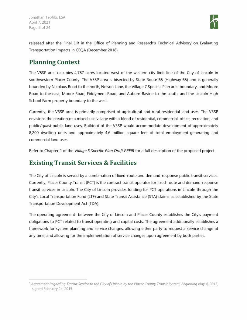
Jonathan Teofilo, ESA
April 7, 2021
Page 2 of 24
released after the Final EIR in the Office of Planning and Research’s Technical Advisory on Evaluating
Transportation Impacts in CEQA (December 2018).
Planning Context
The V5SP area occupies 4,787 acres located west of the western city limit line of the City of Lincoln in
southwestern Placer County. The V5SP area is bisected by State Route 65 (Highway 65) and is generally
bounded by Nicolaus Road to the north, Nelson Lane, the Village 7 Specific Plan area boundary, and Moore
Road to the east, Moore Road, Fiddyment Road, and Auburn Ravine to the south, and the Lincoln High
School Farm property boundary to the west.
Currently, the V5SP area is primarily comprised of agricultural and rural residential land uses. The V5SP
envisions the creation of a mixed-use village with a blend of residential, commercial, office, recreation, and
public/quasi-public land uses. Buildout of the V5SP would accommodate development of approximately
8,200 dwelling units and approximately 4.6 million square feet of total employment-generating and
commercial land uses.
Refer to Chapter 2 of the Village 5 Specific Plan Draft PREIR for a full description of the proposed project.
Existing Transit Services & Facilities
The City of Lincoln is served by a combination of fixed-route and demand-response public transit services.
Currently, Placer County Transit (PCT) is the contract transit operator for fixed-route and demand-response
transit services in Lincoln. The City of Lincoln provides funding for PCT operations in Lincoln through the
City’s Local Transportation Fund (LTF) and State Transit Assistance (STA) claims as established by the State
Transportation Development Act (TDA).
The operating agreement1 between the City of Lincoln and Placer County establishes the City’s payment
obligations to PCT related to transit operating and capital costs. The agreement additionally establishes a
framework for system planning and service changes, allowing either party to request a service change at
any time, and allowing for the implementation of service changes upon agreement by both parties.
1 Agreement Regarding Transit Service to the City of Lincoln by the Placer County Transit System, Beginning May 4, 2015,
signed February 24, 2015.
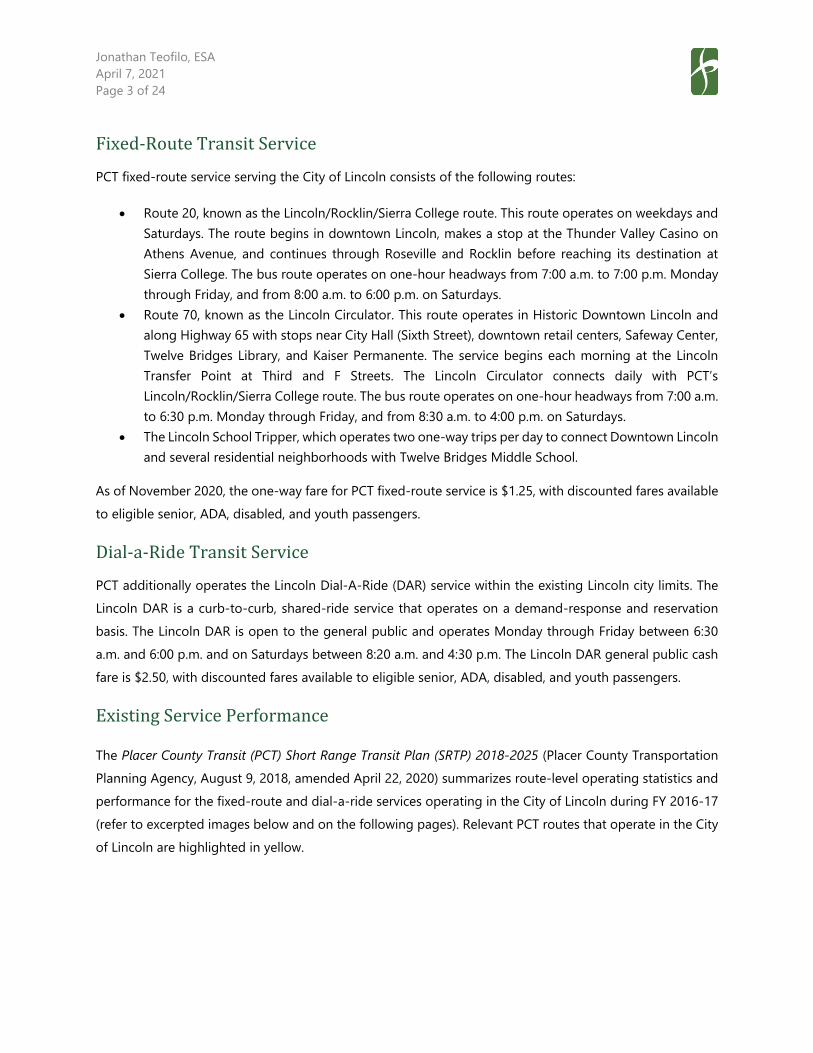
Jonathan Teofilo, ESA
April 7, 2021
Page 3 of 24
Fixed-Route Transit Service
PCT fixed-route service serving the City of Lincoln consists of the following routes:
• Route 20, known as the Lincoln/Rocklin/Sierra College route. This route operates on weekdays and
Saturdays. The route begins in downtown Lincoln, makes a stop at the Thunder Valley Casino on
Athens Avenue, and continues through Roseville and Rocklin before reaching its destination at
Sierra College. The bus route operates on one-hour headways from 7:00 a.m. to 7:00 p.m. Monday
through Friday, and from 8:00 a.m. to 6:00 p.m. on Saturdays.
• Route 70, known as the Lincoln Circulator. This route operates in Historic Downtown Lincoln and
along Highway 65 with stops near City Hall (Sixth Street), downtown retail centers, Safeway Center,
Twelve Bridges Library, and Kaiser Permanente. The service begins each morning at the Lincoln
Transfer Point at Third and F Streets. The Lincoln Circulator connects daily with PCT’s
Lincoln/Rocklin/Sierra College route. The bus route operates on one-hour headways from 7:00 a.m.
to 6:30 p.m. Monday through Friday, and from 8:30 a.m. to 4:00 p.m. on Saturdays.
• The Lincoln School Tripper, which operates two one-way trips per day to connect Downtown Lincoln
and several residential neighborhoods with Twelve Bridges Middle School.
As of November 2020, the one-way fare for PCT fixed-route service is $1.25, with discounted fares available
to eligible senior, ADA, disabled, and youth passengers.
Dial-a-Ride Transit Service
PCT additionally operates the Lincoln Dial-A-Ride (DAR) service within the existing Lincoln city limits. The
Lincoln DAR is a curb-to-curb, shared-ride service that operates on a demand-response and reservation
basis. The Lincoln DAR is open to the general public and operates Monday through Friday between 6:30
a.m. and 6:00 p.m. and on Saturdays between 8:20 a.m. and 4:30 p.m. The Lincoln DAR general public cash
fare is $2.50, with discounted fares available to eligible senior, ADA, disabled, and youth passengers.
Existing Service Performance
The Placer County Transit (PCT) Short Range Transit Plan (SRTP) 2018-2025 (Placer County Transportation
Planning Agency, August 9, 2018, amended April 22, 2020) summarizes route-level operating statistics and
performance for the fixed-route and dial-a-ride services operating in the City of Lincoln during FY 2016-17
(refer to excerpted images below and on the following pages). Relevant PCT routes that operate in the City
of Lincoln are highlighted in yellow.
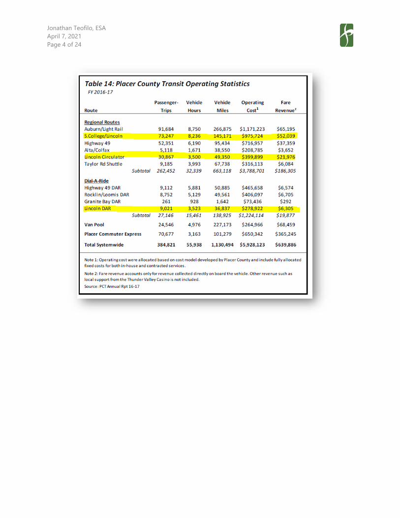
Jonathan Teofilo, ESA
April 7, 2021
Page 4 of 24

Jonathan Teofilo, ESA
April 7, 2021
Page 5 of 24

Jonathan Teofilo, ESA
April 7, 2021
Page 6 of 24
Jonathan Teofilo, ESA
April 7, 2021
Page 7 of 24
Chapter 7 of the PCT SRTP establishes PCT’s goals and standards related to transit service performance,
including farebox recovery ratio, passengers per vehicle service hour, and on-time performance. Existing
ridership and performance levels for fixed-route transit services in Lincoln fall below the PCT performance
targets of 10 passenger boardings per vehicle service hour and a farebox recovery ratio of 10 percent for
fixed-route services.2 Similarly, the Lincoln DAR falls below the PCT performance targets of five passenger
boardings per vehicle service hour and a farebox recovery ratio of three percent for dial-a-ride services. The
farebox recovery ratio targets represent minimum performance thresholds that must be met or exceeded
in order to meet California’s TDA funding requirements. Finally, the maximum average passenger loads by
run suggest that existing fixed-route services in Lincoln have excess capacity and do not experience
crowding issues (a standard 40-foot bus can typically accommodate 40 to 45 seated passengers plus
standing capacity, which is commonly calculated as approximately 50 percent of seated capacity).
Overall, existing fixed-route and dial-a-ride transit service performance in Lincoln is indicative of a transit
market that exhibits low transit passenger demand potential. Such ridership and performance patterns are
typical of areas with dispersed, low-density development patterns where traditional transit services lack the
convenience, cost effectiveness, and travel time savings to compete with driving as a preferred mode of
travel for most travelers and trip purposes.
Generally, existing PCT routes serving Lincoln would need to experience increased ridership (or
route/schedule modifications to reduce operating resources without adversely affecting ridership) in order
to achieve established performance targets related to farebox recovery ratio and passenger boardings per
vehicle hour. Therefore, actions that increase transit ridership on existing PCT routes serving Lincoln would
generally increase the potential for these routes to achieve their established performance targets.
2 Placer County Transit Short Range Transit Plan 2018-2025, Placer County Transportation Planning Agency, August 9,
2018, amended April 22, 2020, pg. 106.
Jonathan Teofilo, ESA
April 7, 2021
Page 8 of 24
Planned Transit Services & Facilities
The following documents contain plans and policies that pertain to future transit services and facilities in
the City of Lincoln:
• City of Lincoln General Plan (City of Lincoln, March 2008)
• Placer County Transit Short Range Transit Plan (SRTP) 2018-2025 (Placer County Transportation
Planning Agency, August 9, 2018, amended April 22, 2020)
• Placer County Regional Transportation Plan (RTP) 2040, (Placer County Transportation Planning
Agency, November 21, 2019)
• Transit Master Plan for South Placer County (Placer County Transportation Planning Agency, June
2007)
This section summarizes the plans and policies relevant to future transit services and facilities in and around
the V5SP area.
City of Lincoln General Plan
The City of Lincoln General Plan includes the following goals and policies that are relevant to future transit
services and facilities within the City:
Goal LU-1 To grow in orderly pattern consistent with the economic, social, and environmental
needs of Lincoln.
Policies
LU-1.6 Transportation Choices. The City will promote the application of land use layouts and
community designs that provide residents with transportation choices to walk, ride bicycles,
ride transit services, as well as utilize a vehicle, including neighborhood electric vehicles.
The City shall ensure that streets and highways will be available to serve new development
by requiring detailed traffic studies and necessary improvements as a part of all major
development proposals.
LU-1.8 Compact Development. The City will promote the use of development patterns that are
more compactly built and use space in an efficient but aesthetic manner to promote more
walking, biking and use of public transit.
Goal LU-15 To organize new development areas to create vibrant, mixed‐use villages
characterized by a mix of land uses, pedestrian and transit accessibility, and
neighborhood identity.
Jonathan Teofilo, ESA
April 7, 2021
Page 9 of 24
Policies
LU-15.1 Village Specific Plans / General Plan Amendment. The City shall require the completion
and approval of a specific plan and associated General Plan Amendment prior to
development of land within an area designated as a Village.
The Circulation Framework will include the proposed circulation network, system elements,
design standards, and system phasing. This framework will address all components of the
circulation system, including vehicular traffic, bicycles, pedestrian movement, NEV’s, and
transit. This component will also address parking and loading standards if different from
the standard City requirements.
LU-15.2 Village Components. The City shall ensure that each village contains a mix of land use
types. The following components will be required in each Village specific plan. The land
uses allowed in each component are shown on Table 4‐4.
Village Center. The Village Center is the heart of the village, containing a mix of retail, office,
residential, and public uses. The commercial component could include uses such as a
supermarket, retail shops, restaurants, service commercial, and entertainment. Office and
residential uses can be mixed in with commercial core as a second floor element. Other
village serving uses, such as a community center, day care center, fire station, and other
similar uses are encouraged to locate in the Village Center.
The overall village should be designed so that the Village Center is the focal point for
transit, NEV’s, pedestrian, and bicycle travel.
Criteria
• The Village Center will be located along or in close proximity to a primary arterial
street in the village to maximize access options, visibility, and transit orientation.
• The Village Center will be located on only one side of a roadway exceeding four lanes
or only one quadrant of any two intersecting roadways when both roadways exceed
four lanes. The Village Center shall incorporate design measures emphasizing
pedestrian, bicycle, NEV, and public transit movements, convenience, and priority.
Special consideration shall be given to sidewalk widths, planter strips, street furniture,
automobile travel lane widths, neckdowns, curb radii, pedestrian crossing treatments,
traffic calming and other enhancements.

Jonathan Teofilo, ESA
April 7, 2021
Page 10 of 24
• The Village Center will be located to take advantage of transit opportunities.
LU-15.5 Connectivity. New villages shall provide connectivity to other Villages and the developed
portions of the City. This connectivity shall be in the form of roadways, transit connections,
and bicycle and pedestrian linkages.
Goal T-1 To coordinate long‐term regional planning decisions with California Department of
Transportation (Caltrans) and the Placer County Transportation and Planning Agency
(PCTPA).
Policies
T-1.1 Circulation Diagram. The City shall utilize and maintain a Circulation Diagram to designate
the classification for all major roadways, designate significant transit facilities, and
designate bicycle facilities.
Goal T-4 To provide and maintain viable alternate modes of transportation for the community
that will relieve congestion and improve environmental conditions.
Policies
T-4.1 Public Transit. The City shall promote and support public transit services that meet the
needs of residents and visitors.
T-4.2 Regional Transit. The City shall coordinate with appropriate jurisdictions and agencies to
encourage the timely improvement of transit facilities and services that address local and
regional transit needs.
T-4.3 Promote Public Transit. The City shall promote the use of public transit through
development conditions requiring park‐and‐ride lots, bus turnouts and passenger shelters
along major streets adjacent to appropriate land uses.
T-4.4 Funding for Public Transit. The City shall continue to provide funding mechanism for
community transit services and require that new employment‐generating, large‐scale
commercial, office, and residential development be adequately served by transit.
T-4.5 ADA Compatible Transit. The City shall support public transit services that meet the needs
of the disabled and are in compliance with the Americans with Disabilities Act.
Jonathan Teofilo, ESA
April 7, 2021
Page 11 of 24
T-4.6 Expansion of Transit Service Areas. The City shall expand fixed route transit service to
serve new development areas, including direct connections to employment and
commercial areas.
Goal HS-3 To reduce the generation of air pollutants and promote non‐polluting activities to
minimize impacts to human health and the economy of the City.
Policies
HS-3.17 Street Design. The City shall promote street design that provides an environment which
encourages neighborhood electric vehicles, transit use, biking and walking.
Per Policy T-1.1, the General Plan Land Use and Circulation Diagram does not identify new transit services
or facilities of significance within the vicinity of the V5SP area.
Placer County Transit Short Range Transit Plan 2018-2025
The Placer County Transit Short Range Transit Plan (SRTP) 2018-2025, prepared by the Placer County
Transportation Planning Agency (PCTPA), provides a detailed business plan for use by Placer County Transit
(PCT) to guide the setting of services strategies, improvement priorities, and implementation sequencing
between 2018 and 2025. An SRTP is also important to State and Federal funding partners so they can ensure
that funds for improvements are consistent with a comprehensive overall strategy that has been developed
through a public process.
The Placer County Transit SRTP 2018-2025 identifies the following planned transit services and/or facilities
related to the City of Lincoln:
• Modifications to the Lincoln Circulator route (Route 70) to realign portions of the route from areas
that do not generate significant ridership to those that exhibit stronger ridership potential in
northwest Lincoln.
• Modifications to the Lincoln DAR and the Rocklin/Loomis DAR to combine the two dial-a-ride
service areas into a single dial-a-ride service area to better serve residents traveling between
Lincoln, Rocklin, and Loomis. Additionally, expand the new dial-a-ride service area west into the
Industrial Boulevard area in Rocklin.
• Implementation of the Lincoln-Sacramento Light Rail express bus service. This route would run
between Lincoln and the Sacramento Regional Transit (SacRT) Watt/I-80 station at the Blue Line
light rail terminus. The service would operate on weekdays between 5:00 a.m. and 9:00 p.m. with a
30-minute frequency. Stops in Lincoln would include Downtown Lincoln, Sterling Parkway, and the
Twelve Bridges Boulevard park-and-ride lot. The route would then continue to serve the Galleria
Mall, Sutter Hospital, and Kaiser Hospital in Roseville, before continuing on to its terminus at the
Watt/I-80 station.

Jonathan Teofilo, ESA
April 7, 2021
Page 12 of 24
Placer County Regional Transportation Plan 2040
The Placer County Regional Transportation Plan (RTP) 2040 was developed by PCTPA to document the policy
direction, actions, and funding recommendations that are intended to meet the short- and long-range
needs of Placer County’s transportation systems through 2040. The RTP is a financially-constrained3
document, designed to guide the systematic development of a balanced, comprehensive, multi-modal
transportation system for the current and future needs of Placer County.
The Placer County RTP 2040 identifies the following planned transit services and/or facilities related to the
City of Lincoln:
• Pursue the recommendations outlined for Scenario 2 in the Transit Master Plan for South Placer
County (PCTPA, June 2007) in the development of future transit services in Placer County through
the year 2040, with a focus on coordination and integration opportunities. Recommendations
related to the City of Lincoln include:
o Implementation of the City of Lincoln SRTP (2009)4
o Limited bus service expansion into the West Lincoln annexation area
o A new transit connection between the West Lincoln annexation area and Roseville via
Fiddyment Road
o Create a more direct route between Lincoln and Sierra College via SR 65 and the Galleria
• Project PLA25585 (Planned) – Placer County Bus Rapid Transit Operations & Maintenance (O&M) –
Annual operating and maintenance costs specifically for a three-route bus rapid transit (BRT) system
for FY 2023-2040 for a TBD transit operator. Note that BRT Routes 1 and 2 identified in the Bus
Rapid Transit (BRT) Implementation Study for South Placer County (South Placer Regional
Transportation Authority, September 8, 2006) include optional service extensions to the City of
Lincoln from the routes’ northern termini in Roseville. A potential BRT station in Lincoln is identified
in the vicinity of Lincoln Crossing near the Highway 65 and Ferrari Ranch Road interchange. Lead
Agency: PCTPA.
• Project PLA25631 (Planned) – Placer County Transit Operating & Maintenance – Lump-sum annual
operating and maintenance costs for FY 2023-2040, does not account for expansion of service. Lead
Agency: PCTPA.
• Project PLA Regional Service Expansion Lump Sum (Planned) – Local and Commuter Transit Bus
Expansion – Lump-sum for increased local and commuter bus service operating and maintenance
costs and bus purchase and replacement. Lead Agency: PCTPA.
3 For the purposes of the RTP, “financially-constrained” means that all projects or programs included in the RTP are
expected to be funded through reasonably foreseeable revenue sources. Potential projects or programs that do not
have reasonably foreseeable revenue sources are not included in the RTP. 4 Note that this 2009 document has since been superseded by the Placer County Transit (PCT) Short Range Transit Plan
(SRTP) 2018-2025 (Placer County Transportation Planning Agency, August 9, 2018, amended April 22, 2020).

Jonathan Teofilo, ESA
April 7, 2021
Page 13 of 24
• Project PLA25759 (Planned) – Placer County Transit – Operations and preventative maintenance in
urbanized area. Lead Agency: Placer County Transit.
• Project PLA25760 (Planned) – Placer County Transit Non-Urbanized Ops – Operations in non-
urbanized areas of Placer County. Lead Agency: Placer County Transit.
• Project PLA25593 (Planned) – Western Placer CTSA O&M – Annual operations and maintenance
costs for Article 4.5 Community Transit Services and Complimentary Transit Services and
Complimentary ADA dial-a-ride services for designate CTSA of Placer County servicing Placer
County and Cities. Lead Agency – Western Placer Consolidated Transportation Service Agency.
• Project PLA25632 (Planned) – Bus Replacement – Lump-sum for bus vehicles for fiscal years 2019-
2036, does not account for expansion of service. Placer County operators only. Lead Agency: PCTPA.
• Project PLA25634 (Planned) – Placer County Bus Rapid Transit Capital – Capital costs for a three-
route bus rapid transit system serving South Placer County, including planning, environmental
studies, right-of-way acquisition, vehicles, related roadway improvements, signalization, park and
ride facilities, signage, bus stop improvements, ITS elements, and fare vending equipment. As
mentioned previously, BRT Routes 1 and 2 identified in the Bus Rapid Transit (BRT) Implementation
Study for South Placer County include optional service extensions to the City of Lincoln from the
routes’ northern termini in Roseville. Lead Agency: PCTPA.
• Project PLA25594 (Planned) – Placer County CTSA Capital – Capital costs for CTSA Article 4.5 and
complementary ADA dial-a-ride services for designated CTSA operating in Placer County. Lead
Agency – Western Placer Consolidated Transportation Service Agency.
All of the projects listed above are designated as planned projects in the Placer County RTP 2040, consistent
with federal conformity regulations established in Title 40 CFR 93.106, Content of Transportation Plans.
Planned projects refer to projects for which a specific funding source has not yet been identified, but given
the assumptions contained in the Financial Element of the Placer County RTP 2040 are reasonably expected
to be fully funded by 2040.
Jonathan Teofilo, ESA
April 7, 2021
Page 14 of 24
V5SP Transit Services & Facilities
Existing Transit Services & Facilities Serving the V5SP Area
Currently, the V5SP area is not directly served by transit. The nearest existing local transit stop is a Lincoln
Circulator (Route 70) stop located at the Ferrari Ranch Road/Celadon Circle intersection, approximately one-
half mile east of the easterly V5SP area boundary. The nearest existing intercity transit stops are
Lincoln/Rocklin/Sierra College route (Route 20) stops located in Downtown Lincoln and at the Twelve
Bridges Library, both approximately two miles away from the easterly V5SP area boundary. The Lincoln DAR
service area does not currently include the V5SP area.
Note that a distance of one-half mile is commonly recognized as the distance a person is willing to walk to
access high-quality transit service. Thus, the majority of residential and employment uses within the V5SP
area would be located beyond a typical walking distance from the nearest existing transit stops.
Planned Transit Services & Facilities Serving the V5SP Area
Planned transit services and facilities would increase transit service levels in and near the V5SP area in the
future.
In the near-term, the Lincoln-Sacramento Light Rail express bus service identified in the Placer County
Transit SRTP 2018-2025 would increase the number of transit trips between the City of Lincoln, the City of
Roseville, and Watt/I-80 Station (which provides connections to SacRT light rail service to/from Downtown
Sacramento). Stops in Lincoln would include Downtown Lincoln, Sterling Parkway, and the Twelve Bridges
Boulevard park-and-ride lot, all of which are located between one and one-half and two miles from the
easterly V5SP area boundary. While these stops would be located a considerable distance from most
residential and commercial uses within the V5SP area, some V5SP residents and employees may opt to drive
and park at the planned bus stops to utilize the service to complete intercity travel along the Highway 65
and I-80 corridors. The service would operate with a 30-minute all-day frequency, which would provide
capacity for approximately 80 to 90 seated passengers per direction per hour.
The Lincoln DAR service area currently covers the entirety of the City of Lincoln city limits. Based on its
transit operating agreement with the County, the City would have the discretion to similarly extend the
Lincoln DAR service area into the V5SP area as it is incorporated into the City. This modification would
provide basic coverage transit service to the V5SP area during its initial phases of development. If it chose
to do so, and if agreed upon by the County, the City would be required to pay the County for increased
operating costs that could be incurred by the DAR service expansion.
Jonathan Teofilo, ESA
April 7, 2021
Page 15 of 24
In the long-term, the Placer County RTP 2040 identifies transit service and facility improvements that would
result in increased transit service levels in and near the V5SP area through 2040. The Placer County RTP
2040 includes multiple planned projects that would allocate funding towards O&M and capital costs related
to sustaining and expanding local, commuter, and dial-a-ride transit services in Placer County, citing the
need to expand the transit system to serve planned population and employment growth in the County.
Specific to the City of Lincoln, the Transit Master Plan for South Placer County indicates that transit service
expansion resulting from planned land development in Lincoln (including in the V5SP area) would require
that the transit fleet serving the City increase from four vehicles to 23 vehicles.5 The Transit Master Plan for
South Placer County identifies future transit service expansion based upon the notion that transit operating
resources would increase at a rate commensurate with the growth in population and employment in the
County (refer to the “Transit Service Planning & Funding Considerations” section for additional information).
The Placer County RTP 2040 additionally incorporates the recommendations from Scenario 2 of the Transit
Master Plan for South Placer County, which include limited transit service expansion into the West Lincoln
annexation area (which includes the V5SP area), as well as providing a new transit connection between the
West Lincoln annexation area and Roseville via Fiddyment Road. Specific alignments and service levels for
new routes in the West Lincoln annexation area are not identified in the Transit Master Plan for South Placer
County, however, it is reasonably anticipated that any such new routes would result in increased transit
service in and around the V5SP area.
Finally, the Placer County RTP 2040 includes the implementation of a three-route BRT system serving south
Placer County, with routes primarily oriented towards connecting the City of Roseville with Sacramento
County. Optional extensions into the City of Lincoln are identified for BRT Routes 1 and 2. A potential BRT
station is identified in the vicinity of Lincoln Crossing near the Highway 65 and Ferrari Ranch Road
interchange, approximately one mile east of the easterly V5SP area boundary. The specific BRT operating
plan (e.g., service frequency, route alignment, stop locations, transit priority treatments, etc.) is not known
at this time, however, BRT services typically operate with higher frequencies, faster travel times, and
enhanced passenger and transit stop amenities relative to typical fixed-route transit services.
As described previously, the Placer County RTP 2040 is financially-constrained and therefore, assumes that
that long-term transit improvements described above would be funded through reasonably foreseeable
revenue sources as identified by PCTPA.
5 Transit Master Plan for South Placer County, Placer County Transportation Planning Agency, June 2007, pg. 25.

Jonathan Teofilo, ESA
April 7, 2021
Page 16 of 24
Transit Services & Facilities Proposed in the V5SP
Section 5.7 of the V5SP states that the V5SP would include bus turnouts and shelters to accommodate
potential future transit service expansion to the area. While the V5SP would include the construction of
transit facilities, it does not identify any specific transit service expansion into the V5SP area. The V5SP states
that transit services would be extended into the V5SP area as the demand for such services occurs and
funds are available as determined by the transit service provider. Potential transit service providers identified
in the V5SP include the City of Lincoln and Placer County Transit.
V5SP Transit Passenger Demand
Transit passenger demand is determined by the transit service characteristics (e.g., service levels, quality,
access, etc.) within a given service area and its underlying land use, socioeconomic, and travel patterns.
Because the V5SP area is not currently served by transit and because the V5SP does not identify fixed-route
transit service expansion into the V5SP area, transit options for V5SP residents, employees, and visitors
would initially be limited. The number of new transit passengers generated by the project would initially be
nominal for the following reasons:
• Fixed-route transit services would not provide coverage to the V5SP area.
• Transit stops would be located beyond a typical walkshed (one-half mile) from the majority of V5SP
residential and employment uses.
• Existing fixed-route transit routes in Lincoln operate at low frequencies (every 60 minutes), which
would make it challenging to plan travel around a transit schedule for prospective V5SP riders who
are willing to travel long distances to access existing transit stops.
Despite these factors, a small number of V5SP residents, employees, or visitors may initially choose to utilize
transit, and thus would generate a nominal amount of new passenger demand on existing fixed-route transit
services (e.g., a V5SP resident who works at Sierra College could choose to drive two miles from the V5SP
area to the Twelve Bridges Library to ride the Lincoln/Rocklin/Sierra College route to Sierra College). It is
also possible that the planned Lincoln-Sacramento Light Rail express bus service would be operational prior
to the completion of the initial phases of the V5SP. This service could similarly generate a small amount of
V5SP-related transit passenger demand for early residents of the V5SP area who would travel to Roseville
or Sacramento, and who would be willing to drive to access the service at the Twelve Bridges Library. Finally,
if the City chooses to extend the Lincoln DAR service area into the V5SP area, and if agreed upon by the
County, V5SP residents, employees, or visitors could utilize the DAR service for local trips within Lincoln.
Jonathan Teofilo, ESA
April 7, 2021
Page 17 of 24
At buildout, the V5SP would create approximately 8,200 dwelling units and 4.6 million square feet of
employment and commercial land uses within the V5SP area. Over time, it is possible that the V5SP area
could develop in a manner where the underlying land use, socioeconomic, and travel patterns support the
expansion of transit service into the V5SP area. Moreover, long-term planning documents such as the City
of Lincoln General Plan and the Placer County RTP 2040 identify the need to expand transit services as new
development occurs to support local and regional transportation goals.
As described previously, planned transit service expansion in and near the V5SP area would increase local
and intercity transit service levels to the V5SP vicinity. The implementation of planned transit services would
increase the capacity and, in turn, demand for transit that would be generated by the V5SP. Because the
V5SP is envisioned to build out over a 15- to 25-year time period, it is likely that the buildout of the project
would occur concurrently with the implementation of planned transit services.
V5SP-related transit demand that would result from planned transit service expansion would ultimately be
dependent on detailed transit service characteristics that are not known at this time, including route
alignment, frequency, stop locations, travel time, and origin/destination locations. However, high-level
conclusions regarding V5SP buildout transit demand can be derived based on the area’s planned density
and land use characteristics. Note that the transit passenger demand estimates described below represent
an “unconstrained” scenario, whereby planned transit services serving the V5SP would become operational
over the course of the project’s buildout and enable greater use of transit for daily travel activities.
Local and regional transit plans and policies do not establish what are referred to as “new service warrants,”
or the minimum land use and/or density characteristics required to consider the provision of baseline levels
of transit service. The Transit Capacity and Quality of Service Manual (TCQSM), Third Edition (Transportation
Research Board, 2013) indicates that a minimum residential density of 4.5 dwelling units/net acre is required
to support 60-minute local bus service with a farebox recovery ratio of 33 percent.6 At buildout, the V5SP
area would exhibit 3.8 dwelling units/net acre, below the TCQSM minimum threshold. Thus, according to
this measure, baseline levels of local transit service serving the V5SP area would likely exhibit marginal
transit passenger demand and performance due to the area’s proposed residential development patterns.
Based upon existing local transit service performance in comparable residential areas in South Placer County
(e.g., Lincoln, Roseville, etc.) it is estimated that the local transit demand generated by the V5SP at buildout
6 Transit Capacity and Quality of Service Manual, Third Edition, Transportation Research Board, 2013, Exhibit 3-8.

Jonathan Teofilo, ESA
April 7, 2021
Page 18 of 24
would be approximately 70 to 120 passenger boardings per day.7 This demand could be satisfied by the
planned transit service extensions into the West Lincoln annexation area as identified in the Transit Master
Plan for South Placer County. A dial-a-ride service or a 60-minute fixed-route transit service would provide
sufficient capacity to accommodate local transit demand generated by the V5SP.
In addition to local transit demand, the V5SP could generate demand for commuter transit services, both
for commute trips originating from the V5SP residential uses as well as commute trips destined for the V5SP
employment uses. Based upon existing transit mode splits for commute travel in comparable areas in South
Placer County, it is estimated that the commute transit demand generated by the V5SP at buildout would
be approximately 300 to 800 passenger boardings per day (refer to the Appendix for calculations). This
demand could be satisfied by the planned Lincoln-Sacramento Light Rail express bus service, the planned
new transit connection between the West Lincoln annexation area and Roseville via Fiddyment Road, and
the two planned South Placer County BRT routes with optional extensions to Lincoln. Some portion of this
demand could also be internalized within the V5SP area for V5SP residents who also work within the V5SP
area (i.e., commute travel could be fulfilled by walking or bicycling trips given the short trip length). Note
than in the absence of the implementation of these (or comparable) transit services, V5SP residents and
employees would simply choose to use other modes of travel to fulfill commute trips.
7 The Placer County Transit SRTP 2018-2025 (PCTPA, August 9, 2018, amended April 22, 2020) indicates that the PCT
Lincoln Circulator generates 8.8 passenger boardings per revenue hour. The Roseville SRTP 2018-2025 (PCTPA, August
10, 2018) Roseville Transit local routes generate an average of 5.9 passenger boardings per revenue hour. V5SP local
ridership estimates assume an average of 12 revenue hours of local transit service serving the V5SP per day, which is
typical of a 60-minute local fixed-route service.

Jonathan Teofilo, ESA
April 7, 2021
Page 19 of 24
Transit Service Funding & Planning Considerations
Transit Funding Sources
In the State of California, public transit operations are primarily funded by formula-based State transit
funding programs enacted under the Transportation Development Act (TDA) of 1971. These funds are the
Local Transportation Fund (LTF) and the State Transit Assistance (STA) fund:
• The LTF is derived from a ¼ cent of the general sales tax collected statewide. The State Board of
Equalization, based on sales tax collected in each county, returns the general sales tax revenues to
each county’s LTF. Each county then apportions the LTF funds within the country based on
population. In qualifying counties with a population under 500,000, LTF funds may also be used for
local streets and roads, construction, and maintenance.
• The STA funds are appropriated by the legislature to the State Controller’s Office (SCO). The SCO
then allocates the tax revenue, by formula, to planning agencies and other selected agencies. Statue
requires that 50 percent of STA funds be allocated according to population and 50 percent be
allocated according to transit operator revenues from the prior fiscal year.
As the designated regional transportation planning agency (RTPA), PCTPA is responsible for allocating LTF
and STA funds to local jurisdictions, including the City of Lincoln. Currently, the City of Lincoln passes
through a portion of its LTF and STA revenue to Placer County to cover operating expenses related to PCT
fixed-route and dial-a-ride services in Lincoln.
Additional regional, State, and Federal funding programs are available to cover transit capital and operating
expenses, including, but not limited to the following:
• Federal Transit Administration (FTA) Bus and Bus Facilities Infrastructure Investment Program
• FTA 5309 Capital Investment Grants
• FTA Congestion Mitigation and Air Quality Program
• FTA 5339(a) Grants for Buses and Bus Facilities Program
• FTA 5339 (c) Low or No Emission Vehicle Program
• California Proposition 1B Transit Capital Program
• Sacramento Emergency Clean Air & Transportation Grant Program
Both TDA funding programs (LTF and STA) and some of the Federal funding programs allocate transit capital
and operating resources on a formula basis. Therefore, population growth that would result from the V5SP
could increase the City’s available funding for transit services, which could in turn be allocated towards
future transit service expansion into the V5SP area.
Jonathan Teofilo, ESA
April 7, 2021
Page 20 of 24
Performance Requirements
The State TDA requires that transit operators meet minimum performance standards in order to sustain
funding levels in subsequent fiscal years. Transit operators that fail to meet their respective farebox recovery
ratio requirement for two fiscal years are subject to future funding reductions. The blended urban/rural
farebox recovery ratio requirement for PCT is currently 12.94 percent.
This is relevant to the V5SP because potential future transit services serving the V5SP area would need to
be implemented with the goal of supporting the TDA performance requirement. Transit services extended
into the V5SP area prior to the maturation of the area’s transit market could result in underperforming
service, in turn potentially hindering PCT’s ability to meet their TDA performance requirement. As described
previously, existing local fixed-route transit service in Lincoln falls below the TDA performance threshold,
so similarly performing service in the V5SP area could further decrease PCT’s average farebox recovery ratio.
It is important to note that commuter transit services in South Placer County generally exhibit strong
performance (e.g., the Roseville Transit commuter routes to Downtown Sacramento), so similar commuter
services serving the V5SP could help to increase PCT’s overall farebox recovery ratio.
Unmet Transit Needs Process
As required under the Transportation Development Act, PCTPA must annually make an assessment of the
unmet transit needs existing within Placer County. Based on this assessment, PCTPA must make one of the
following findings:
• There are not unmet transit needs that are reasonable to meet;
• There are unmet transit needs, but they are not reasonable to meet; or,
• There are unmet transit needs, including those which are reasonable to meet.
The PCTPA Board of Directors has adopted a definition of an unmet transit need and criteria for determining
whether needs are reasonable to meet. The adopted definition of an unmet transit need is as follows:
An unmet transit need is an expressed or identified need, which is not currently being met through
the existing system of public transportation services. Unmet transit needs are also those needs
required to comply with the requirements of the Americans with Disabilities Act.
The adopted criteria for determining whether or not an unmet transit need is reasonable to meet (assuming
all of the criteria prevail) are as follows:
• Service, which if implemented or funded, would result in the responsible service meeting the fare
box recovery requirement specified in California Code of Regulations Sections 6633.2 and 6633.5,
and Public Utilities Code 99268.2, 99268.3, 99268.4, and 99268.5. The minimum required fare box

Jonathan Teofilo, ESA
April 7, 2021
Page 21 of 24
recovery is 10 percent for Placer County Transit (PCT), Tahoe Area Regional Transit (TART), Auburn
Transit, Lincoln Transit, and paratransit (Dial-A-Ride) services; for Roseville Transit it is 15 percent.
• Notwithstanding the criterion above, an exemption to the required fare box recovery requirement
is available to the claimant for extension of public transportation services, as defined by California
Code of Regulations Section 6633.8, and Public Utilities Code 99268.8.
• Service, which if implemented or funded, would not cause the responsible operator to incur
expenditures in excess of the maximum amount of Local Transportation Funds, State Transit
Assistance Funds, Federal Transit Administration Funds, and fare revenues and local support, as
defined by Sections 6611.2 and 6611.3 of the California Administrative Code, which may be
available to the claimant.
• Community support exists for the public subsidy of transit services designed to address the unmet
transit need, including but not limited to, support from community groups, community leaders, and
community meetings reflecting a commitment to public transit.
• The need should be in conformance with the goals included in the Regional Transportation Plan.
• The need is consistent with the intent of the goals of the adopted Short Range Transit Plan, as
amended, for the applicable jurisdiction.
Unmet transit needs workshops are held annually in various locations throughout the County. The purpose
is to provide a forum for public input into the transit planning process and identify those transit needs that
are not being met. Once these needs are identified, a determination is made as to whether these needs are
reasonable to meet, based on the criteria above.
If the PCTPA Board of Directors finds that there are unmet transit needs that are reasonable to meet, LTF
funds must be spent to meet those needs before funds can be spent for streets and roads purposes. TDA
funds are the primary source of subsidy for public transportation services. However, if no needs meet the
reasonable-to-meet criteria, jurisdictions can implement service changes or other improvements as long as
transit operators continue to meet the TDA-required fare box recovery minimum.
Transit Operating Agreement
As described previously, the City of Lincoln and Placer County currently have a transit operating agreement
in place. The agreement establishes the provisions for County-operated transit service in the City, as well as
the City’s payment obligations to the County related to transit operating and capital costs.
The agreement also establishes a framework for system planning and service changes, allowing for either
party to request modifications to service levels at any time, and allowing for the implementation of service
changes upon agreement by both parties.
Altogether, the transit operating agreement provides the City with the ability to expand transit into the
V5SP area, contingent on the County’s agreement to such a medication. The precise timing and nature of

Jonathan Teofilo, ESA
April 7, 2021
Page 22 of 24
such a transit service expansion would be dependent on funding availability, transit market potential, and
coordination with the County.
Jonathan Teofilo, ESA
April 7, 2021
Page 23 of 24
Conclusions
As described previously, the Draft PREIR states that impacts to transit are considered significant if they
would conflict with adopted plans, policies, or programs regarding transit facilities. Conflicts with adopted
plans, policies, or programs would include interference with existing or planned transit facilities.
The V5SP would include bus turnouts and shelters to accommodate potential future transit service
expansion to the area. In addition, a bus transfer lot is being considered as part of a joint use park-and-ride
lot to support transit use. While the V5SP includes the construction of transit facilities, it does not identify
any transit service expansion into the V5SP area. The V5SP states that transit services would be extended
into the V5SP area as the demand for such services occurs and funds are available as determined by the
transit provider.
At buildout, the V5SP would create approximately 8,200 dwelling units and 4.6 million square feet of
employment and commercial land uses within the V5SP area, establishing a new transit market in the City
of Lincoln and south Placer County. Transit demand generated by the V5SP could be served by a variety of
existing, planned, and potential transit services, as described below.
In the near-term, the City would have the discretion to extend the Lincoln DAR into the V5SP area
(contingent upon agreement by the County), as warranted by transit demand and as funding allows.
Additionally, during the near-term, existing PCT Route 20 and the planned Lincoln-Sacramento Light Rail
express bus service would provide intercity bus connections between the V5SP area vicinity (at the Twelve
Bridges park-and-ride lot) and locations along the Highway 65 and I-80 corridors. In the long-term, transit
service levels to the V5SP area would increase with the planned implementation of new local and intercity
bus service as identified in the Placer County RTP 2040. Transit service levels in the V5SP area could increase
further with the possible implementation of south Placer County BRT service into Lincoln as identified in the
Placer County RTP 2040. The provision of these planned and potential new transit services would support
City of Lincoln General Plan policies related to transit and increased travel choices, including policies T-4.1,
T-4.2, T-4.3, and T-4.6.

Jonathan Teofilo, ESA
April 7, 2021
Page 24 of 24
Over time as the V5SP builds out, the underlying land use, socioeconomic, and travel patterns would
influence the timing and nature of transit service expansion into the V5SP area. Moreover, based on current
formula-based State transit funding programs (e.g., the LTF and the STA under the TDA), population growth
that would result from the V5SP could increase the City’s available funding for transit services, which could
in turn be allocated towards future transit service expansion into the V5SP area. Under such circumstances,
the City could consider the potential for transit service expansion into the V5SP area through the annual
unmet transit needs process (pursuant to the TDA) and make a determination regarding the viability of
service expansion at that time based on factors such as funding availability and adherence to applicable
transit performance standards (e.g., farebox recovery ratio). The existing transit operating agreement
between the City and Placer County provides a mechanism for which transit service modifications could be
made to increase transit service levels in the V5SP area.
It is conceivable that the V5SP area would be served by limited transit options during the early phases of
its development (i.e., prior to the implementation of planned transit services to the V5SP area). A
consequence of limited transit serving the V5SP area would be that people traveling to, from, and within
the V5SP area would be required to choose other modes of transportation, particularly driving. This is
reflected in the trip generation and travel demand characteristics described in the PREIR transportation
section. The secondary environmental effects of this use of vehicular transport are disclosed elsewhere in
the PREIR, including Section 3.3 Air Quality, Section 3.5 Climate Change, as well as impact analyses in the
transportation section regarding the operations of local and regional roadways serving the V5SP area.
This analysis additionally considers the potential for the V5SP to cause an impact to transit service on the
basis of interfering with existing or planned transit facilities. Because transit facilities do not currently exist
in the V5SP area, the implementation of the V5SP would not interfere with any existing transit facilities. As
described previously, while existing plans do not identify new transit facilities in the V5SP area, the V5SP
would construct several on-site transit facilities that would support potential future transit service expansion
to the V5SP area.
The V5SP would not conflict with adopted plans, policies, or programs regarding transit facilities and would
not interfere with existing or planned transit facilities. Therefore, the V5SP would cause a less than significant
impact to transit.

Technical Appendix

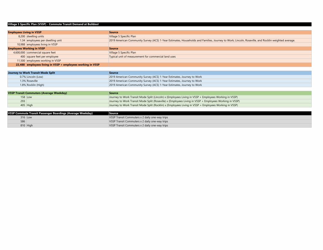
Village 5 Specific Plan (V5SP) - Commute Transit Demand at Buildout
Source8,200 dwelling units Village 5 Specific Plan1.34 employees per dwelling unit 2019 American Community Survey (ACS) 1-Year Estimates, Households and Families, Journey to Work; Lincoln, Roseville, and Rocklin weighted average.
10,988 employees living in V5SPSource
4,600,000 commercial square feet Village 5 Specific Plan400 square feet per employee Typical unit of measurement for commercial land uses
11,500 employees working in V5SP22,488 employees living in V5SP + employees working in V5SP
Source0.7% Lincoln (Low) 2019 American Community Survey (ACS) 1-Year Estimates, Journey to Work1.3% Roseville 2019 American Community Survey (ACS) 1-Year Estimates, Journey to Work1.8% Rocklin (High) 2019 American Community Survey (ACS) 1-Year Estimates, Journey to Work
Source158 Low Journey to Work Transit Mode Split (Lincoln) x (Employees Living in V5SP + Employees Working in V5SP)293 Journey to Work Transit Mode Split (Roseville) x (Employees Living in V5SP + Employees Working in V5SP)405 High Journey to Work Transit Mode Split (Rocklin) x (Employees Living in V5SP + Employees Working in V5SP)
Source316 Low V5SP Transit Commuters x 2 daily one-way trips586 V5SP Transit Commuters x 2 daily one-way trips810 High V5SP Transit Commuters x 2 daily one-way trips
V5SP Commute Transit Passenger Boardings (Average Weekday)
V5SP Transit Commuters (Average Weekday)
Journey to Work Transit Mode Split
Employees Working in V5SP
Employees Living in V5SP

Copyright © 2022 FDOKUMEN