Verde Connect Project Draft EIS, Public Meeting Reporter's ...
139
In The Matter Of: Verde Connect Project Draft EIS, Public Meeting Reporter's Transcript of Proceedings May 11, 2020 Additional Public Comments Original File VC051120 VM.txt Min-U-Script® with Word Index
-
Upload
khangminh22 -
Category
Documents
-
view
1 -
download
0
Transcript of Verde Connect Project Draft EIS, Public Meeting Reporter's ...

In The Matter Of:Verde Connect Project
Draft EIS, Public Meeting
Reporter's Transcript of ProceedingsMay 11, 2020
Additional Public Comments
Original File VC051120 VM.txt
Min-U-Script® with Word Index

Verde Connect ProjectDraft EIS, Public Meeting
Additional Public Comments Reporter's Transcript of ProceedingsMay 11, 2020
Page 2
PUBLIC COMMENTS
SPEAKER: PAGE: Janet Walther................................. 3 Frances Judd.................................. 4
Page 3
(Voicemail dated 05/11/2020 at 2:36 p.m.) JANET WALTHER: Hi, my name is Janet Walther. My phone number is (760) 271-8506. And I have a comment for the court reporter. I do wish to remain anonymous. My comment is -- or my question is: What are the estimates or likely additional costs to Yavapai County for the Verde Connect project for hiring of the additional environment monitoring personnel that they have listed and all the mitigation requirements to address the environmental impacts of this project? Are there similar past projects that these costs can be estimated? Again, my question, and I do wish to remain anonymous is: What are the estimates or likely additional costs to Yavapai County for the Verde Connect project for hiring of the additional environment monitoring personnel listed and all the mitigation requirements to address the environmental impacts of this project? Are there similar past projects that these costs can be estimated? Thank you. (End of audio.)
Page 4
(Voicemail dated 05/16/2020 at 9:20 a.m.) FRANCES JUDD: Hi, my name is Frances Judd. I live at 1495 Abbey Road South in Clarkdale, Arizona, and I am very much against this Verde Connect road. In the days of the COVID virus now, the last thing we need is an increase in taxes for a road that's going to lead to nowhere really. It's going to serve very little purpose in the Verde Valley, and I know it's going to raise the taxes extensively. Anyway, please put me in as very much against the Verde Connect road. Thank you very much. Bye. (End of audio.)
Min-U-Script® Griffin Group International602.264.2230
(1) Pages 2 - 4

Verde Connect ProjectDraft EIS, Public Meeting
Additional Public Comments Reporter's Transcript of ProceedingsMay 11, 2020
Page 5
Min-U-Script® Griffin Group International602.264.2230
(2) Page 5

Verde Connect ProjectDraft EIS, Public Meeting
Additional Public Comments Reporter's Transcript of ProceedingsMay 11, 2020
A
Abbey (1) 4:3additional (4) 3:6,7,13,15address (2) 3:9,16Again (1) 3:12against (2) 4:4,11anonymous (2) 3:5,13Arizona (1) 4:3audio (2) 3:20;4:13
B
Bye (1) 4:12
C
can (2) 3:11,18Clarkdale (1) 4:3comment (2) 3:4,5COMMENTS (1) 2:1Connect (4) 3:7,14;4:4,11costs (4) 3:6,11,14,18County (2) 3:6,14court (1) 3:4COVID (1) 4:5
D
dated (2) 3:1;4:1days (1) 4:5
E
End (2) 3:20;4:13environment (2) 3:8,15environmental (2) 3:10,17estimated (2) 3:11,18
estimates (2) 3:6,13extensively (1) 4:9
F
Frances (3) 2:5;4:2,2
H
Hi (2) 3:2;4:2hiring (2) 3:7,15
I
impacts (2) 3:10,17increase (1) 4:6
J
Janet (3) 2:4;3:2,2Judd (3) 2:5;4:2,2
L
last (1) 4:5lead (1) 4:6likely (2) 3:6,13listed (2) 3:8,16little (1) 4:7live (1) 4:3
M
mitigation (2) 3:9,16monitoring (2) 3:8,15much (3) 4:4,10,11
N
name (2) 3:2;4:2need (1) 4:5nowhere (1) 4:7
number (1) 3:3
P
PAGE (1) 2:3past (2) 3:11,18personnel (2) 3:8,15phone (1) 3:3please (1) 4:10pm (1) 3:1project (4) 3:7,10,14,17projects (2) 3:11,18PUBLIC (1) 2:1purpose (1) 4:7put (1) 4:10
R
raise (1) 4:8really (1) 4:7remain (2) 3:4,12reporter (1) 3:4requirements (2) 3:9,16Road (4) 4:3,4,6,11
S
serve (1) 4:7similar (2) 3:10,17South (1) 4:3SPEAKER (1) 2:3
T
taxes (2) 4:6,9
V
Valley (1) 4:8
Verde (5) 3:7,14;4:4,8,11virus (1) 4:5Voicemail (2) 3:1;4:1
W
Walther (3) 2:4;3:2,3wish (2) 3:4,12
Y
Yavapai (2) 3:6,14
0
05/11/2020 (1) 3:105/16/2020 (1) 4:1
1
1495 (1) 4:3
2
2:36 (1) 3:1271-8506 (1) 3:3
3
3 (1) 2:4
4
4 (1) 2:5
7
760 (1) 3:3
9
9:20 (1) 4:1
Min-U-Script® Griffin Group International602.264.2230
(1) Abbey - 9:20

In The Matter Of:Verde Connect Project
Draft EIS, Public Meeting
Reporter's Transcript of ProceedingsMay 11, 2020
Public Comments
Original File Verde Connect Public Comments 051520.txt
Min-U-Script® with Word Index

Verde Connect ProjectDraft EIS, Public Meeting
Public Comments Reporter's Transcript of ProceedingsMay 11, 2020
Page 2
Page 3
JEN: I live in Village of Oak Creek in Sedona. And I just wanted to make a very brief comment that as a resident of Big Park in Village of Oak Creek, we rarely utilize the Beaver Road going towards Cottonwood. And with the recent flooding in the Tonto Basin area, I know the residents in Gila County were looking for some support to build a bridge over Tonto Basin/Tonto Creek. And I believe that the $25 million would be best served for Gila County in constructing a bridge in Tonto Basin. I believe the Governor's Office stated that a number of people were killed due to flooding, and I believe the -- the money would be best served for those residents for Tonto Creek/Tonto Basin. So that's my comment. I don't agree with the bridge over the Verde Valley. I do not believe -- or the Verde River. And I do not believe that will serve the residents. I believe it would be best served for a bridge for Tonto Basin and Gila County. Thank you. MARIE SCHOENBERG: Okay. My name is Marie Schoenberg. And I'm calling from Albuquerque, New Mexico. And my address is 4965 Butte, NW. And that's Albuquerque, New Mexico, and the ZIP is 87120. Okay. I'm going to read my comments. And I have, like, a couple questions within that comment. So I realize that this competitive project has been going since
Page 4
June 2018. And Yavapai County and the Federal Highway Administration has been studying the potential roadways and bridge across the Verde River to provide a new north-south connection between 260 to Cornville Road; however, I am currently in support of the no-build alternative at this time. And wondering if you could elaborate on the B2 alternative that -- it was mentioned in the video, but it was very brief. And then also my concern is that you need to track this. It's missing the primary indicator of the natural scenic beauty of the Verde River landscape. And if this project goes smooth, will there be biplanes? Since biplanes have a negligible effect on congestion, traffic congestion and speed limit is what I'm referring to. And then my final comment is, the economic outlook has changed drastically in the past couple months. And since the grant requires that all funds be fully expended by September 30th, 2025, will the 25 million grant be enough to cover the entire project? And what is the entire project cost? And will the Yavapai Apache Nation be required to pay part of the estimated price tag? And since the grant requires that all funds be fully expended by 9/30/2025, and with the Coronavirus pandemic and the long-term economic outlook not looking very favorable, this may change the outlook for future
Min-U-Script® Griffin Group International602.264.2230
(1) Pages 2 - 4

Verde Connect ProjectDraft EIS, Public Meeting
Public Comments Reporter's Transcript of ProceedingsMay 11, 2020
Page 5
contributions. So how will the county be able to cover the remaining amount? So thank you. Those were my concerns. ERIC WYLES: My full name is Eric, E-r-i-c, Wyles, W-y-l-e-s. My mailing is P.O. Box 727 Cornville, AZ, 86325. I really want to thank the group and the county and everyone involved for such a comprehensive presentation. I really appreciated that. I also had about half a dozen questions written down before I saw the presentation and all of them were answered except for one. That question is: Based upon the presentation, it appears construction starts at the 260 connection point. And I would hope that as construction proceeds toward the junction with the Cornville Road, that they would consider in their construction planning to take the majority of the heavy trucks on 260 and not down through Cornville where so many vehicles go. I don't know how you would accomplish this. I don't know if incentives could be given to the construction companies, the suppliers, the people that will be working on the project, if some consideration like that could be taken. But besides that, thank you to all the engineering and all of the reports that I know this took to put together. And I look forward to construction beginning because I see this as another artery of safety for the
Page 6
Verde Valley. I've been here for a few years now and remember when bridges were nonexistent over the Verde. And I also remember the pushback on Beaverhead Flat Road and they talked about paving it and I've been in Cornville for many years. And I remember the upper over the Mingus Avenue Bridge. So I feel this is something that's needed. Thank you again for all your hard work and the opportunity to formalize this comment. JIM WILKINSON: Jim Wilkinson, P.O. Box 2024 Camp Verde, Arizona, 86322. My comment is I have a small branch on Little Verde Road. I'm pretty much semiretired. I do a lot of towing for local outfits around here. I've been here about 20 years. And about the last five years, Middle Verde has really gotten busy. And basically Middle Verde is the road from I-17 westbound that has turned basically into a racetrack. We've got a lot more people living out towards the end of Middle Verde, and I get a lot of time to watch the traffic. I've had several people drive off the road. Been drinking and stuff like that and wrecked on my property. I had one lady try to commit suicide. That's what she told me when I went out there and picked her up out of her Jeep.
Page 7
I'm worried about the Middle Verde -- I think you guys did a great job. You put on a great deal, what you've got me listening to on the radio. I can't believe nobody is making any comments here on Middle Verde Road. But all us ranchers up and down here, I think, are really going to suffer from the traffic off I-17. I get enough people out here looking for Indian ruins, ATVs, shortcuts to the Verde River. And I think that this is greatly going to hurt the Middle Verde Road and the ranching community out here and the people that want to remain, you know, quiet lives out here with a bridge. But still fully understand that ambulances and police department need quicker ways to get around out here and all that stuff. Basically, that's about it. I -- I -- knowing marshals and Apache Tribe police and all that a lot, I've invited them to sit on my property a lot and try to catch speeders. I cannot leave my property without getting T-boned on a daily basis even though there's almost enough room to pull out without getting hit. The speed limit's only 35 miles an hour, yet people are doing 70. It's easy to tell. And I'm just worried about Middle Verde Road getting ruined with more tourism. And like I said, we have enough people running up and down here by accident looking for places to go and all that stuff. Basically that's about it. It's just going
Page 8
to make it way too busy for us out here. I wish there was a way to connect Cornville Road to 260 without involving Middle Verde Road. That's basically what I got to say. (Public comments end.)
Min-U-Script® Griffin Group International602.264.2230
(2) Pages 5 - 8

Verde Connect ProjectDraft EIS, Public Meeting
Public Comments Reporter's Transcript of ProceedingsMay 11, 2020
Page 9
Min-U-Script® Griffin Group International602.264.2230
(3) Page 9

Verde Connect ProjectDraft EIS, Public Meeting
Public Comments Reporter's Transcript of ProceedingsMay 11, 2020
$
$25 (1) 3:8
A
able (1) 5:1accident (1) 7:23accomplish (1) 5:18across (1) 4:3address (1) 3:21Administration (1) 4:2again (1) 6:8agree (1) 3:14Albuquerque (2) 3:20,21almost (1) 7:18alternative (2) 4:5,7ambulances (1) 7:12amount (1) 5:2answered (1) 5:10Apache (2) 4:20;7:15appears (1) 5:12appreciated (1) 5:8area (1) 3:5Arizona (1) 6:11around (2) 6:14;7:13artery (1) 5:25ATVs (1) 7:7Avenue (1) 6:7AZ (1) 5:5
B
B2 (1) 4:6Based (1) 5:11
basically (5) 6:16,17;7:14,25;8:3Basin (4) 3:5,9,13,17Basin/Tonto (1) 3:7basis (1) 7:18beauty (1) 4:11Beaver (1) 3:4Beaverhead (1) 6:4beginning (1) 5:24besides (1) 5:22best (3) 3:8,12,16Big (1) 3:3biplanes (2) 4:12,13Box (2) 5:4;6:10branch (1) 6:12bridge (7) 3:7,9,14,17;4:3;6:7; 7:11bridges (1) 6:3brief (2) 3:2;4:8build (1) 3:7busy (2) 6:16;8:1Butte (1) 3:21
C
calling (1) 3:20Camp (1) 6:11catch (1) 7:16change (1) 4:25changed (1) 4:16comment (6) 3:2,13,24;4:15;6:9, 12comments (3) 3:23;7:4;8:4commit (1) 6:23community (1) 7:9
companies (1) 5:19competitive (1) 3:25comprehensive (1) 5:7concern (1) 4:9concerns (1) 5:2congestion (2) 4:13,14connect (1) 8:2connection (2) 4:4;5:13consider (1) 5:15consideration (1) 5:21constructing (1) 3:9construction (5) 5:12,13,15,19,24contributions (1) 5:1Cornville (6) 4:4;5:4,14,17;6:5;8:2Coronavirus (1) 4:23cost (1) 4:20Cottonwood (1) 3:4County (6) 3:6,9,17;4:1;5:1,7couple (2) 3:24;4:16cover (2) 4:19;5:1Creek (3) 3:1,3,7Creek/Tonto (1) 3:13currently (1) 4:5
D
daily (1) 7:17deal (1) 7:2department (1) 7:12down (4) 5:9,16;7:5,23dozen (1) 5:9drastically (1) 4:16drinking (1) 6:22
drive (1) 6:21due (1) 3:11
E
easy (1) 7:20economic (2) 4:15,24effect (1) 4:13elaborate (1) 4:6end (2) 6:20;8:4engineering (1) 5:23enough (4) 4:19;7:6,18,23entire (2) 4:19,20Eric (2) 5:3,3E-r-i-c (1) 5:3estimated (1) 4:21even (1) 7:18everyone (1) 5:7except (1) 5:10expended (2) 4:18,23
F
favorable (1) 4:25Federal (1) 4:1feel (1) 6:7few (1) 6:2final (1) 4:15five (1) 6:15Flat (1) 6:4flooding (2) 3:5,11formalize (1) 6:9forward (1) 5:24full (1) 5:3fully (3)
4:17,23;7:11funds (2) 4:17,22future (1) 4:25
G
Gila (3) 3:6,9,17given (1) 5:19goes (1) 4:12Governor's (1) 3:10grant (3) 4:17,18,22great (2) 7:2,2greatly (1) 7:8group (1) 5:6guys (1) 7:2
H
half (1) 5:9hard (1) 6:8heavy (1) 5:16Highway (1) 4:1hit (1) 7:19hope (1) 5:13hour (1) 7:20hurt (1) 7:9
I
I-17 (2) 6:17;7:6incentives (1) 5:18Indian (1) 7:7indicator (1) 4:10into (1) 6:17invited (1) 7:15involved (1) 5:7involving (1)
Min-U-Script® Griffin Group International602.264.2230
(1) $25 - involving

Verde Connect ProjectDraft EIS, Public Meeting
Public Comments Reporter's Transcript of ProceedingsMay 11, 2020
8:2
J
Jeep (1) 6:25JEN (1) 3:1JIM (2) 6:10,10job (1) 7:2junction (1) 5:14June (1) 4:1
K
killed (1) 3:11knowing (1) 7:14
L
lady (1) 6:23landscape (1) 4:11last (1) 6:15leave (1) 7:17limit (1) 4:14limit's (1) 7:19listening (1) 7:3Little (1) 6:12live (1) 3:1lives (1) 7:11living (1) 6:19local (1) 6:14long-term (1) 4:24look (1) 5:24looking (4) 3:6;4:24;7:7,23lot (5) 6:13,19,20;7:15,16
M
mailing (1) 5:4
majority (1) 5:16making (1) 7:4many (2) 5:17;6:6MARIE (2) 3:19,19marshals (1) 7:14may (1) 4:25mentioned (1) 4:7Mexico (2) 3:20,22Middle (8) 6:15,16,20;7:1,4,9, 21;8:3miles (1) 7:19million (2) 3:8;4:18Mingus (1) 6:6missing (1) 4:10money (1) 3:12months (1) 4:16more (2) 6:19;7:22much (1) 6:13
N
name (2) 3:19;5:3Nation (1) 4:20natural (1) 4:11need (2) 4:9;7:12needed (1) 6:7negligible (1) 4:13New (3) 3:20,22;4:3nobody (1) 7:4no-build (1) 4:5nonexistent (1) 6:3north-south (1) 4:3number (1) 3:11NW (1)
3:21
O
Oak (2) 3:1,3off (2) 6:21;7:6Office (1) 3:10one (2) 5:10;6:23only (1) 7:19opportunity (1) 6:8out (9) 6:19,24,25;7:7,10,11, 13,18;8:1outfits (1) 6:14outlook (3) 4:16,24,25over (4) 3:7,14;6:3,6
P
pandemic (1) 4:24Park (1) 3:3part (1) 4:21past (1) 4:16paving (1) 6:5pay (1) 4:21people (8) 3:11;5:20;6:19,21; 7:7,10,20,23picked (1) 6:24places (1) 7:24planning (1) 5:15PO (2) 5:4;6:10point (1) 5:13police (2) 7:12,15potential (1) 4:2presentation (3) 5:8,10,12pretty (1) 6:13price (1) 4:21
primary (1) 4:10proceeds (1) 5:14project (5) 3:25;4:12,19,20;5:20property (3) 6:23;7:16,17provide (1) 4:3Public (1) 8:4pull (1) 7:18pushback (1) 6:4put (2) 5:24;7:2
Q
quicker (1) 7:13quiet (1) 7:11
R
racetrack (1) 6:18radio (1) 7:3ranchers (1) 7:5ranching (1) 7:9rarely (1) 3:4read (1) 3:23realize (1) 3:25really (4) 5:6,8;6:16;7:5recent (1) 3:5referring (1) 4:14remain (1) 7:10remaining (1) 5:2remember (3) 6:3,4,6reports (1) 5:23required (1) 4:21requires (2) 4:17,22resident (1) 3:3residents (3)
3:6,12,16River (4) 3:15;4:3,11;7:8Road (12) 3:4;4:4;5:14;6:4,13, 16,22;7:4,9,21;8:2,3roadways (1) 4:2room (1) 7:18ruined (1) 7:22ruins (1) 7:7running (1) 7:23
S
safety (1) 5:25saw (1) 5:9scenic (1) 4:11SCHOENBERG (2) 3:19,20Sedona (1) 3:2semiretired (1) 6:13September (1) 4:18serve (1) 3:16served (3) 3:8,12,17several (1) 6:21shortcuts (1) 7:7sit (1) 7:16small (1) 6:12smooth (1) 4:12speed (2) 4:14;7:19speeders (1) 7:16starts (1) 5:12stated (1) 3:10still (1) 7:11studying (1) 4:2stuff (3) 6:22;7:13,24suffer (1) 7:6
Min-U-Script® Griffin Group International602.264.2230
(2) Jeep - suffer

Verde Connect ProjectDraft EIS, Public Meeting
Public Comments Reporter's Transcript of ProceedingsMay 11, 2020
suicide (1) 6:23suppliers (1) 5:20support (2) 3:7;4:5
T
tag (1) 4:21talked (1) 6:5T-boned (1) 7:17though (1) 7:18together (1) 5:24told (1) 6:24Tonto (5) 3:5,7,9,13,17took (1) 5:23tourism (1) 7:22toward (1) 5:14towards (2) 3:4;6:20towing (1) 6:14track (1) 4:10traffic (3) 4:13;6:21;7:6Tribe (1) 7:15trucks (1) 5:16try (2) 6:23;7:16turned (1) 6:17
U
up (3) 6:24;7:5,23upon (1) 5:11upper (1) 6:6utilize (1) 3:4
V
Valley (2) 3:14;6:1vehicles (1) 5:17
Verde (17) 3:14,15;4:3,11;6:1,3, 11,13,15,16,20;7:1,4,8, 9,21;8:3video (1) 4:7Village (2) 3:1,3
W
watch (1) 6:21way (2) 8:1,2ways (1) 7:13westbound (1) 6:17WILKINSON (2) 6:10,10wish (1) 8:1within (1) 3:24without (3) 7:17,19;8:2wondering (1) 4:6work (1) 6:8working (1) 5:20worried (2) 7:1,21wrecked (1) 6:22written (1) 5:9WYLES (2) 5:3,4W-y-l-e-s (1) 5:4
Y
Yavapai (2) 4:1,20years (4) 6:2,6,15,15
Z
ZIP (1) 3:22
2
20 (1) 6:152018 (1) 4:12024 (1)
6:102025 (1) 4:1825 (1) 4:18260 (4) 4:4;5:12,16;8:2
3
30th (1) 4:1835 (1) 7:19
4
4965 (1) 3:21
7
70 (1) 7:20727 (1) 5:4
8
86322 (1) 6:1186325 (1) 5:587120 (1) 3:22
9
9/30/2025 (1) 4:23
Min-U-Script® Griffin Group International602.264.2230
(3) suicide - 9/30/2025

P. O. Box 2535, Cottonwood, AZ 86326 928.641.6013 VerdeRiver.org
SUSTAINING FLOWS RESTORING HABITAT PROMOTING COMMUNITY
May 20, 2020 Verde Connect Project C/O Central Creative LLC 24 W Camelback Road, #A-479 Phoenix, AZ 85013 Dear Verde Connect Project Team: Thank you for the opportunity to comment on the Verde Connect Draft Environmental Assessment. Friends of the Verde River (Friends) is a 501(c)(3) organization based in Cottonwood, Arizona that works collaboratively to restore habitat, sustain flows, and promote community stewardship to support a healthy Verde River system. We have worked with partners in the Verde River watershed since 2011 to remove invasive plants and restore riparian habitat. We work with the Verde Watershed Restoration Coalition (VWRC), a partnership of over 25 federal, state, tribal, and local agencies and organizations and over 250 private landowners. In addition, we work with recreational boating businesses and community members to support and promote river-related recreation. The Verde River is one of few remaining perennial rivers in Arizona and provides habitat for many resident and migratory wildlife species, including several listed species. According to Sandra Postel of the Global Water Policy Project, “more than 60 percent of the vertebrate animals of the American Southwest are “riparian obligates,” meaning they can survive only in the gallery forests of cottonwoods, willows, and mesquite sustained by healthy rivers. Three-quarters of bird species that breed in the Southwest depend on those riverside corridors.” The Draft Environmental Assessment determined the proposed action “may affect, and is likely to adversely affect” the endangered southwestern willow flycatcher, threatened western yellow-billed cuckoo, and threatened northern Mexican gartersnake. All of these species are highly dependent on a healthy riparian corridor. The Draft Environmental Assessment also concluded the proposed action “may affect, and is likely to adversely affect” flycatcher designated critical habitat, and proposed critical habitat for the cuckoo and northern Mexican gartersnake. Proposed mitigation measures to reduce effects on these species and their habitats will likely minimize project impacts. However, we recommend additional habitat mitigation measures, including restoring sensitive riparian habitat within and near the project area, to further offset these impacts. Restoration of additional riparian habitat would offset losses from the Verde Connect project. Friends would be happy to assist in identifying suitable sites and work on implementing habitat mitigation with the project team. Floating the Verde River is a popular recreational activity throughout much of the year. Project information should be posted at upstream river access points to inform boaters of potential risks due to construction activities. When construction is occurring on the bridge span over the river, additional personnel should be posted at river access points and upstream of the bridge to warn boaters. Construction should be staged and timed to minimize impacts of riparian dependent wildlife and people recreating on the river.

P. O. Box 2535, Cottonwood, AZ 86326 928.641.6013 VerdeRiver.org
SUSTAINING FLOWS RESTORING HABITAT PROMOTING COMMUNITY
Thank you for the opportunity to comment on the Draft Environmental Assessment for the Verde Connect project. If you have any questions, please contact Tracy Stephens, Manager, Habitat Restoration, at [email protected] or call our office at (928) 641-6013. Sincerely, Nancy L.C. Steele, D. Env. Executive Director

From: Shelton, NancySent: Wednesday, April 15, 2020 1:15 PMTo: Bushey, SabraSubject: verdeDISconnect Petitions From: administrator <[email protected]> Sent: Wednesday, April 15, 2020 1:13 PMTo: Roger McCormick ([email protected]) <[email protected]>Cc: [email protected]; Petty, Karla (FHWA) <[email protected]>; Dan Cherry ([email protected]) <[email protected]>; Yedlin, Rebecca (FHWA) <[email protected]>; Sieglitz,Troy <[email protected]>; Shelton, Nancy <[email protected]>; Charles German <[email protected]>; Butner Joe <[email protected]>; Jenkins Dee<[email protected]>; [email protected]; Martin Russ <[email protected]>; [email protected]; [email protected];[email protected]: [EXTERNAL] verdeDISconnect Petitions For your records, please find attached 924 petitions opposing the project known as Verde Connect. Over 150 Middle Verde petitions provide proof that the neighborhood opposes the project. 20 petitionssigned by shareholders of the OK Ditch - Middle Verde’s historic, mutual ditch company, irrigating 600+ acres of Middle Verde rural and agricultural land - account for 75% of Middle Verde’s irrigatedlandowner shares. The remaining 750+ signatures are proof that citizens from not only Camp Verde but also the Yavapai Apache Nation, the Verde Valley, the County and visitors from across the nationoppose the project. We remain steadfast in our belief that:
1. This project would add an additional 4,000+ cars/day to Middle Verde Rd - a rural collector neither designed for nor capable of carrying such traffic safely.2. The County has made no concessions or plans for Middle Verde Rd safety improvements between the proposed connection and I-17, e.g., suitable connection points BEFORE the neighborhood
begins, road widening, shoulders, flood control or proper traffic calming for a small, rural neighborhood.3. The cost of the proposed project would far exceed the County’s transportation budget and would result in increased taxes for all Yavapai County residents.4. According to the project’s own traffic studies, the project would not significantly improve the County’s most congested and dangerous roads.5. The project would negatively impact the Coconino National Forest’s Land Plan, the Verde River’s riparian corridor and endangered and threatened plants and animals.6. The project stands in contradiction to the Town of Camp Verde’s General Plan to preserve Middle Verde as a rural and agricultural neighborhood, and the Town Council stands in unanimous
opposition. At a time when we are being told to stay home because our homes are the safest place to be, it is both ironic and wrong that the project continues to be promoted and that our neighborhood is forced totake time away from more important work to defend our safety and the peace and solace of our homes during a national pandemic. We remain dedicated to a NO BUILD decision; however, we also remain open to discussing solutions that could mutually benefit all concerned. Thank you for including these petitions in in your NEPA assessment. We wish you Continued Health, verdeDISconnect and the Verde Valley NO BUILD Alliance PS- Should anyone not receive the (large) file of petitions, they can also be found here: https://www.dropbox.com/s/9tlb9im2qh0gahc/petition_signatures_150420%20copy.pdf?dl=0

From: Ernie Strauch <[email protected]>
Sent: Friday, May 22, 2020 10:33 PM
To: VerdeConnectComments
Subject: [EXTERNAL] Opposition to "Verde Connect" Project
Gentlepersons,
I oppose the acceptance and expenditure of the FHWA grant of $25 million for a number of reasons enumerated below:
However, first, let me give you my perspective. I am a former Vice-Mayor of the City of Sedona. I was the lead person on the City’s side for a 10 year process with ADOT to develop the Highway 179 re-construction into the All-America Road that it is. I was the primary promoter of the roundabout solutions.
I live just below the Chapel of the Holy Cross in Sedona, and my wife and I have been boarding our 2 horses at Nashwa Farms (the corner of Middle Verde Rd. and Mahoney Rd. (see the yellow arrow pointedat the barn below) for several years. As such, we drive between our home and Nashwa, down Middle Verde Rd. several times a week. We ride our horses on FR 119A and the current trail that begins wherethe blue line joins Middle Verde Rd. Your Preferred Alternative would reduce our round-trip time by between 16 to 20 minutes, so one would expect that we would be in favor of such a direct route. NOT SO!
My primary opposition is based upon a true lack of need that the EA readily indicates from page 8 below. Comparing the existing traffic to 25 years into the future, and doing nothing, does not change anycondition that would be effected by this project. The only changes to traffic conditions are on Cornville Rd. as it approaches 89A near Cottonwood. In fact, if the Verde Connect were completed, the trafficon this segment would only be increased and detrimentally impacted as a stated purpose of the project.
The EA states on page 6: "The region’s Verde Valley Master Transportation Plan 2040 estimates that the population in the study area will grow by 39 percent between 2016-2040. With corridors alreadyexperiencing congestion, this projected population growth will increase delays on portions of the existing local roadways and adversely affect the level of service”. There are two things wrong with thisstatement. 1). It was made prior to the effects and impact of the CoVid-19 virus impact and long-term results to business enterprises, and 2). Nothing about the project assists in decreasing "delays onportions of existing local roadways”. In fact, this project just impacts the “local roadways" to an even greater extent! It is the stated intent of this project to add traffic to Middle Verde Rd. It is the statedintent of the project to add traffic to Cornville Rd. It is the stated intent of the project to add traffic to Beaverhead Flat Rd. and thence on to SR 179. Nowhere in the planning for this project is there anysuggestion for how the added traffic will be accommodated or at what cost for obviously needed roadway improvements and traffic control measures on these “local roadways”.

This is, in truth, a project in search of a need, a "bridge to nowhere” a vastly underfunded project for which Yavapai County has no reasonable means to complete funding. Let’s consider the true costs. TheBridge itself has been estimated by Yavapai County in a Sedona City Council meeting to cost $22 million, leaving $3 million to construct a connection through currently unowned State Land to Coury Rd. atSR260, at which point there is no intersection control. So, the “paid-for” segment doesn’t get you to Middle Verde Rd. In order to do that, (besides purchasing the State Trust Land) the County must raise $10million to complete Phase One that only then connects to Middle Verde Rd. and a very limited population. Further, since I drive Middle Verde Rd. several times a week, it has NO SHOULDERS, narrow lanesand curves that exceed maximum safe radius. The improvement of this road to accept any significant new traffic has NOT been included in ANY BUDGET!
On page 5 of the EA it states:
"In December 2018, Yavapai County was awarded a $25 million Better Utilizing Investments to Leverage Development (BUILD) grant to assist with the construction

of a 1.7-mile roadway and bridge to connect the Nation and Town of Camp Verde to SR 260. As part of the requirements to obtain the BUILD funding, Yavapai Countymust complete the NEPA document for fund obligation by July 2020".
It is thus clear, that the $25 million grant is a “teaser” amount. It buys the County absolutely NO SOLUTIONS to anything without a substantial additional investment. The County’s budgethas been severely impacted with no visibility as to when and under what reduced resource conditions it may be forced to operate for an unknown future.
On Page 38 of the EA it states:
"In December 2018, Yavapai County was awarded a grant for $25 million for the Verde Connect project as described in the BUILD Grant application. The NEPA process is scheduled to conclude in thesummer of 2020. Assuming the Build Alternative is selected, final design would occur from 2020 -2021, and construction of Phase I of the project would start in 2021 and be complete prior to August 2025.Phase II would be constructed as a continuation of Phase I if funding is available. If funding is not available, Phase II would be postponed until funding can be allocated.”
As one reads through the EA, it appears obvious that virtually all rationale for the entire Verde Valley is predicated upon completion of BOTH Phase 1 and Phase 2, because that is the only way the reason foradding alternative emergency routes makes any practical sense. If Phase 2 does not occur due to either economic, political or social changes over time, this project becomes a “White Elephant” and a terriblewaste of taxpayer money.
Also on Page 38:
"The estimated cost of the project would be approximately $35 million for Phase I and approximately $20 million for Phase II. The BUILD Grant would provide $25.0 million towards Phase I of the project.New ROW would be purchased from ASLD and new ROW easement would be needed from both the Prescott and the Coconino NFs. This project is included in the NACOG TIP.”
In conclusion, and recapping the costs to Yavapai County, we have a minimum of $30 million (assuming no cost over-runs - unlikely) in today’s dollars (also unlikely - because costs for concrete, asphalt, rebarand structural steel have far outpaced the general inflation index by significant amounts over the last 20 years). One must assume additional costs to acquire the State Trust Land, and must we assume no costto acquire needed rights of way? The 7-8 miles of Middle Verde Road needing widening, drainage improvements, and shoulders will add another $5 million at a minimum. Then we get to Cornville Rd., thesuper-narrow bridge crossing the Verde River and the switchbacks just past the Mercantile. All that will need to be addressed if you drive additional traffic beyond population increases down Cornville Rd. Ifthe County got away with a total expenditure of $50 million on top of the $25 million grant, it could consider itself lucky.
Overall, I believe the costs to be paid by individual residents of Yavapai County, who I strongly believe agree with me (tax increase calculation?) far outweigh the benefits that may or may not ever berealized.
Ernie Strauch
148 Cathedral Lane, Sedona, AZ 86336
Hm: 928.282.6666 Cell: 928.300.2307
Email: [email protected]

From: Shelton, NancySent: Tuesday, May 26, 2020 8:13 AMTo: Bushey, SabraSubject: FW: NO to Verde Connect I am still working through the 100s of emails in my inbox so not sure if this came to us as well. Thanks,Nancy Shelton602.530.1612 From: Grover-Bullington, Lenore - FS <[email protected]> Sent: Tuesday, May 26, 2020 8:06 AMTo: Hurrell, Kevin - FS <[email protected]>; Welker, Chris L -FS <[email protected]>; Shelton, Nancy <[email protected]>Subject: [EXTERNAL] FW: NO to Verde Connect A comment on the Verde Connect project…
Lenore Grover-Bullington, MS Public ServicesStaff OfficerForest ServicePrescott Natl Forest,Supervisor's Officep: 928-777-2230 [email protected] N Hw y 89Chino Valley , AZ 86323w w w .fs.fed.us
Caring for the landand serving people
From: Codie Moore <[email protected]> Sent: Sunday, May 24, 2020 12:38 PMTo: [email protected]; Roth, Bridget -FS <[email protected]>; Raitanen, Eric -FS <[email protected]>; [email protected]; [email protected]; [email protected];[email protected]; Grover-Bullington, Lenore - FS <[email protected]>Subject: NO to Verde Connect To Whom it May Concern, I am writing this email to express my opposition to the Verde Connect Project for the following reasons. The BUILD grant received by Yavapai County was awarded because it would connect the Yavapai Apache Nation’s (YAN ) Tunli and Middle Verde housing areas and provide economicopportunities for “the disadvantaged“ residents of Middle Verde. To date, the YAN will not allow the county to use any tribal property for road construction, over 150 Middle Verde residentsand 550 residents of Yavapai County have signed petitions in opposition to this road, and the Town of Camp Verde Council, Beaver Creek Community Association and Jerome Town Councilhave voted unanimously to support a NO BUILD Alternative. Since this project’s inception, the Yavapai County Supervisors have not done their jobs. They did not talk to stakeholders before the grant application was submitted, and they are not listeningto them now. Thinly disguised as a “transportation project,” it simply promotes development of the Highway 260 commercial corridor, while opening up agricultural and possibly Forest Serviceand State lands to private development. The project’s Transportation Study and the 2016 ADOT Master Transportation Plan show that this project provides little to no traffic relief and is notneeded if simpler, less invasive, less costly but more effective transportation needs are met. Although the BUILD grant would cover part of the bridge project, it will not cover the cost of connecting Middle Verde Road to Hwy 260, or the ultimate connection of Cornville Rd to Hwy 260.Yavapai County has not provided an estimate of what it might cost to build 7 miles of steep incline road from Cornville Rd across the Chalk Hills through Middle Verde and on to 260, and theCounty has also not addressed the increased risk – both traffic and fire – that would be created. Yavapai County taxpayers and residents will be paying for this project for many years to come. Yavapai County’s BUILD grant application anticipates this project will add 4,500 cars a day to residential and rural Middle Verde Rd – a road that has always been a dead end. The agriculturaland rural character of Middle Verde should be protected, as mandated by the Town of Camp Verde’s General Plan for the Middle Verde Character Area. Not only Middle Verde but the River arein danger. A bridge and road across Middle Verde would endanger the rare Cottonwood/ Gooding’s Willow riparian habitat with 16 types of endangered, sensitive and candidate species. Theproject would also cut across the Chalk Hills and its artifacts and fragile, desert plants, depriving us of even more Coconino Forest Service land. The residents of Middle Verde, along with theplants and animals of Middle Verde, and the citizens of Yavapai County will be paying for this project for many, MANY years to come. Sincerely;Codie Moore
This electronic message contains information generated by the USDA solely for the intended recipients. Any unauthorized interception of this message or the use or disclosure of the information itcontains may violate the law and subject the violator to civil or criminal penalties. If you believe you have received this message in error, please notify the sender and delete the email immediately.

From: Shannon Garrels <[email protected]>Sent: Monday, May 25, 2020 3:56 PMTo: VerdeConnectCommentsSubject: [EXTERNAL] The incomplete Verde Connect Draft EA I support the No Build option until a complete study on how the environment, antiquities, archaeological sites, Verde River Riparian area, and the Middle Verde neighborhood are assessed in theirentirety. What Verde Connect has compiled in the past 20 months and presented to the public is an incomplete study. Verde Connect continues to ask for public response without giving a complete set of facts. This seems to have become the standard operating procedure for this project. For example, after numerous Public Scoping opportunities, after being over twenty months into this project, and being amere two and a half months from Randy Garrison’s projected August ground breaking on this project, Verde Connect still does not have a definitive route to present to the public for the Middle VerdeConnector – the Phase One portion of the road that the entire $25 Million Dollar Build Grant is dependent upon. Quite literally, the entire Verde Connect project hinges upon the one portion of the roadproject that was least studied, and there is no plan for. Verde Connect is requesting public comment on a project that does not have a set route to present in regards to the Middle Verde Connector, hasno monetary amount announced for the cost of Phase One or Phase Two of the project, and has no announced plan as to how Yavapai County will pay for this road. How can you request public responseto an incomplete project analysis? For example, in regards to Phase One of Verde Connect, the Middle Verde Connector Road and how it will impact the ONLY residential neighborhood to be directly affected: The impact to the Middle Verde Neighborhood is not mentioned until page 151, under section 4.18.1, and then only briefly. “4.18.4 Conclusion: Public health and safety may be adversely affected byshort-term, localized noise, dust, or traffic delays. These impacts are expected to be minor and would cease upon completion of the project. Once constructed, the Verde Connect project would have alasting beneficial effect on local communities and the public by adding another crossing of the Verde River, providing better access and connectivity, and reducing emergency response times” (P.151). This is a blatantly false statement, as there is no plan to improve Middle Verde Road, a narrow and winding two lane road with no fog line. A rural agricultural community road with current approximationof 600 cars per day traveling it, no plans for upgrades or improvements to Middle Verde Road through the Verde Connect project, the Build Grant application states there will be an increase in traffic to4,500 cars per day on Middle Verde Road, so I predict the Middle Verde Road rural agricultural community will MOST CERTAINLY have lasting long term negative impacts. Verde Connect projects “minorimpacts” to a neighborhood where people walk their dogs, children ride their bikes, and horses from numerous local barns are ridden down the side of a road with NO OUTSIDE LINE because the road isnot wide enough to have one? I wonder how much a life costs to the Verde Connect Team. Clearly not much, as they didn’t take the time to study the neighborhood their Middle Verde Connector wouldbe affecting the most, and clearly stated jeopardizing the lives of the local community are “minor impacts”. I read that as “collateral damage”. I translate this as “sorry about your loss Mrs.Wedidntcareenoughtocompletethestudy, and even though the Middle Verde residents attended our first scoping meeting and brought up concerns about kids riding bikes, and people walking dogs, andhorses being ridden along a road that would carry 4,500 cars per day, in the past 20 months we were planning this project, we just never got around to looking into that”. The next time Middle Verde Road is mentioned is in section 4.19.5, page 155. “The Build Alternative would also result in an increase in traffic and noise on Middle Verde Road. The additional trafficwould contribute to additional degradation of the existing Middle Verde Road over time”. Seriously? I don’t need to be a road analyst to know that changing the usage from 600 to 4,500 cars per daywould contribute to additional degradation of the road. That is the extent of mentions of the Middle Verde neighborhood that will be directly affected by the Middle Verde Connector Road. One paragraph on one page, and two lines on another. How,exactly, is that an Environmental Assessment? The Draft Environmental Assessment study is incomplete. There was no more forethought or detail put into how the Verde River, the Verde River Riparian area, the Coconino National Forest, thePrescott National Forest, the Historic OK Ditch, the archaeology sites, or numerous endangered plants and animals will be affected by the entirety of the Verde Connect and Middle Verde ConnectorRoad than there was to how the MOST IMPORTANT part of the road that the entire $25 Million Dollar Grant hinges upon, and how it will impact the only neighborhood directly affected by this project. No Build Option until a full study is completed, at which time I reserve the right to assess your documentation and then decide if I would like to change the way I would vote for this project.

Page 1 of 2
Dear Supervisors,
I am writing in opposition to the Verde Connect Project FederalNo.: YYV-0(209) Z; Yavapai County No.: 1722601.
A list of itemized reasons for my opposition is as follows:
1. Route will lead more traffic to congestion point at Cornville Rd.and 89A
2. Adds traffic to Middle Verde Rd., Cornville Rd., Beaverhead FlatRd., SR 179; plan provides no solutions and no funding for theselocal roads to be able to accommodate increased traffic
3. Funding from grant insufficient to complete project and addresssecondary needs; taxpayers left with greater burden; majority inimpacted communities see project as unnecessary and do notwant to pay increased taxes for little to no benefit
4. Middle Verde Rd. needs safety improvements to accommodatemore traffic; no funding included for this
5. Purported benefits rely on completion of Phase 2; completion ofPhase 2 subject to many volatile and uncertain factors that areyet undeterminable; investment in Phase 1 can be too easilyrendered useless

Page 2 of 2
There are many, many more fact-based and logical reasonspredicated on planning documents of communities across the VerdeValley to not move this project forward. However, the most recentCOVID-19 pandemic is perhaps the essential and most personallyaccountable rationale of your decision today. There is noresponsible governance model that could support a decision toburden our Verde Valley residents during an economic crisis notexperienced since the Great Depression with this ill-conceived,misrepresented, unsupported and inappropriate request. Ourresidents will be burdened with upwards of one hundred milliondollars in debt and subsequent increased taxes. This is unthinkablein a time of national, state, and local health and economic crisis.
I urge you to either vote no or suspend this decision for a later, moreappropriate time.
Respectfully,
Donna Michaels60 Apple Creek LnVillage of Oak Creek

Dear Supervisors and To Whom It May Concern at VerdeConnect.com,
I am writing in opposition to the Verde Connect ProjectFederal No.: YYV-0(209) Z; Yavapai County No.: 1722601
A list of itemized reasons for my opposition is as follows:
1. Route will lead more traffic to congestion point at Cornville Rd. and89A
2. Adds traffic to Middle Verde Rd., Cornville Rd., Beaverhead Flat Rd.,SR 179; plan provides no solutions and no funding for these local roadsto be able to accommodate increased traffic
3. Funding from grant insufficient to complete project and addresssecondary needs; taxpayers left with greater burden; majority inimpacted communities see project as unnecessary and do not want topay increased taxes for little to no benefit
4. Middle Verde Rd. needs safety improvements to accommodate moretraffic; no funding included for this
5. Purported benefits rely on completion of Phase 2; completion of Phase 2subject to many volatile and uncertain factors that are yetundeterminable; investment in Phase 1 can be too easily rendereduseless
Please vote no on this project.
Respectfully,
Jackie Ellis60 Apple Creek Ln

Village of Oak Creek

1
Rice, Jesse M CIV USARMY CESPL (USA)
From: Janette Corbin <[email protected]>Sent: Sunday, May 17, 2020 2:04 PMTo: Rice, Jesse M CIV USARMY CESPL (USA)Subject: [Non-DoD Source] Comment on Verde Connect YYV-0(209)Z
Importance: High
Dear Army Corp, This letter is public comment on the following:
Public Notice/Application No.: SPL-2019-00226 Project:Verde Connect YYV-0(209)Z Comment Period: April 24, 2020 through May 25, 2020 Project Manager: Jesse Rice; (602) 230-6854; [email protected]
My name is Janette Corbin and I am writing on behalf of myself and my husband Rod who bought this place back in 2013 with plans of retiring up here and making this our last home. We removed a old mobile, brought in another one, remodeled it and added a back deck and an addition, put in raised beds for gardens and got to know our neighbors. It is a great area, with a nice rural feel, small town mentality where people help each other and play together. Being born and raised in Alaska, it felt like the perfect place – nice long spring, summer, fall; just the right amount of winter, off road activities right out the front door (FS 119A) and limited traffic due to the dead end nature of the road. Our dream that we worked for since 1987 here in Arizona has the potential of being destroyed by building a bridge and road that will destroy this area, our way of life, the Verde River, the unique plants and animals, the artifacts, hieroglyphics, and other historical treasures. Let’s talk about the washes and what really happens here on Middle Verde road and the property off the road. When the washes run, it’s a big deal – for all of us! When grandpa wash flows across the MV road, it is a raging river. When that happens, there are multiple other places that are also flooding. I have some pictures for you of the unnamed wash that runs across the dirt portion of MV road through a vacant property on Northern, across the road and into our yard then on to the property to the south of us on Center St, across through 2 properties off Pike St and on to Mahoney and then to the Verde River.
. This picture is looking north west from our house at 3745 West Northern Ave. in Overlook Acres.
2
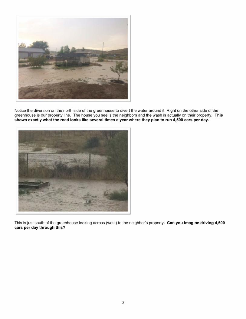
Notice the diversion on the north side of the greenhouse to divert the water around it. Right on the other side of the greenhouse is our property line. The house you see is the neighbors and the wash is actually on their property. This shows exactly what the road looks like several times a year where they plan to run 4,500 cars per day.
This is just south of the greenhouse looking across (west) to the neighbor’s property. Can you imagine driving 4,500 cars per day through this?

3
These last 2 pictures show the southwest corner of our property and the property to the south of us flooded with the flowing water. Notice the concrete blocks being used to divert the water back to the wash and to slow it down as it comes to the block wall on the south side of our property. Bottom line, these pictures are what happens without culverts, can you imagine what will happen if all this water is routed into a culvert and comes out with more force and a lot more depth? I don’t even want to think about it! Some time ago, we watched them put a culvert in on the dirt MV road for this wash and thought, this can’t be good! We were trying to figure out what was the best way to get this removed when they came back and removed it, thankfully. It’s our understanding that our County Supervisor Tom Thurman was instrumental in getting the culvert removed! The washes are manageable only because there are no culverts! Culverts will not only destroy the property but will alter the Verde River and not in a good way. The flooding brings an enormous amount of silt, mud, dirt and debris. We can’t stress enough the damage this can do, especially when concentrated through a culvert. And, what about our well water? All of us have our own wells, and if this road goes in, we are terrified that we will lose that with no alternative in sight. Hauling water is not what we had in mind when we bought this property. In fact, having a well with good water was and is the #1 requirement for living anywhere! Building this road will have an extremely detrimental effect on the wildlife in this area as well. Coming down from the White Hills to the river is a necessity for the wildlife. Being cut off from the river will most likely result in many dying from lack of water or at least driving them to migrate elsewhere. Either way, it should not happen. Do you know that in some places where large amounts of wildlife are cut off from their migratory paths, in order to build a road (freeway), the solution resulted in building a wildlife overpass, at great expense. My point is that they should not even be considering a road that will adversely affect the wildlife without looking at ways to mitigate the damages. It increasingly looks like they don’t care

4
about anything except spending the grant money (along with a lot more of our tax dollars) no matter who or what gets sacrificed along the way! Finally, we would like you to take a look at the road they intend to dump 4000+ cars a day on, Middle Verde road is hardly a “major road”, in fact it barely can be classified as a country road or a local road. It has no shoulders, barely wide enough for cars, blind corners with hidden drives, no lines or markings in places. I took the following pictures so you can see what I mean.
These 2 pictures show blind drives on a hill (left picture) – there are actually 3 driveways there, and those on Middle Verde Road or coming to/from the properties cannot see each other! It’s really is a thrill every time we visit! The picture on the right is the last turn before Grandpa’s wash going west, not quite as blind since the driveway is elevated, nevertheless quite challenging!
5
Look real close on this one on the left side at the corner…that’s a driveway and it goes immediately downhill and you can’t see any traffic coming pulling in or out, so you have to roll down your window and listen and then go like your pants are on fire! The Middle Verde Road is worse than any road I have been on, and that’s saying a lot! Remember, I was born and raised in Alaska and you would think that the roads down here would be better than Alaska’s, but sadly no. Most of the Alaska roads have ample ditches (which we utilized for walking, riding horses, snow machining, etc) and they came in handy in the winter time when you never knew when you would need a place to land off the road due to ice or moose on the road! I’ll stop with the pictures; I think you get the idea. This is not a road for lots of traffic like they are planning. The possibilities for accidents are only limited by the imagination. And, let me point out that more traffic also adds more of a chance of accidental fires! We all know the danger out here and we do our best to keep the threat from becoming a reality and keep our eyes open for the first sign of smoke. The more traffic, the greater the threat of fire, accidents, and thefts. Please, you have to see this road is a really, really bad idea! We are asking you to please do everything in your power to veto this road! Thank you for your consideration and for asking for our input! Janette & Rod Corbin 3745 W. Northern Ave. Camp Verde, AZ 86322 [email protected] 602-618-9012 cell

1
Rice, Jesse M CIV USARMY CESPL (USA)
From: [email protected]: Thursday, May 21, 2020 7:22 PMTo: Rice, Jesse M CIV USARMY CESPL (USA)Subject: [Non-DoD Source] Public Notice/Application No.: SPL-2019-00226
This letter is public comment on the following: Public Notice/Application No.: SPL‐2019‐00226 Project:Verde Connect YYV‐0(209)Z Comment Period: April 24, 2020 through May 25, 2020 Project Manager: Jesse Rice; (602) 230‐6854; Please choose the no‐build option. Thank you, Sincerely, Marla Mott‐Smith 801‐231‐5793 [email protected]

1
Rice, Jesse M CIV USARMY CESPL (USA)
From: Debbie Folchert <[email protected]>Sent: Friday, May 22, 2020 8:45 AMTo: Rice, Jesse M CIV USARMY CESPL (USA)Subject: [Non-DoD Source] No Build
Please No Build! Middle Verde area major road. Save the Middle Verde Facebook member. Debbie Folchert 1470 E REAY RD Rimrock, AZ 86335 928‐301‐6460 I have trouble with the confluence of Beaver Creek and Dry Beaver Creek with tractors and floods. It is document with the company you work for. The Middle Verde project would impact residents terribly. Thank you for your time. Be safe and healthy. :) Sent from my iPhone

1
Rice, Jesse M CIV USARMY CESPL (USA)
From: Eric Moore <[email protected]>Sent: Sunday, May 24, 2020 12:31 PMTo: [email protected]; [email protected]; [email protected];
[email protected]; [email protected]; [email protected]; Rice, Jesse M CIV USARMY CESPL (USA); [email protected]
Cc: Codie Moore; Melina MooreSubject: [Non-DoD Source] Verde Connect project
To Whom it May Concern, I am writing this email to express my opposition to the Verde Connect Project for the following reasons. The BUILD grant received by Yavapai County was awarded because it would connect the Yavapai Apache Nation’s (YAN ) Tunli and Middle Verde housing areas and provide economic opportunities for “the disadvantaged“ residents of Middle Verde. To date, the YAN will not allow the county to use any tribal property for road construction, over 150 Middle Verde residents and 550 residents of Yavapai County have signed petitions in opposition to this road, and the Town of Camp Verde Council, Beaver Creek Community Association and Jerome Town Council have voted unanimously to support a NO BUILD Alternative. Since this project’s inception, the Yavapai County Supervisors have not done their jobs. They did not talk to stakeholders before the grant application was submitted, and they are not listening to them now. Thinly disguised as a “transportation project,” it simply promotes development of the Highway 260 commercial corridor, while opening up agricultural and possibly Forest Service and State lands to private development. The project’s Transportation Study and the 2016 ADOT Master Transportation Plan show that this project provides little to no traffic relief and is not needed if simpler, less invasive, less costly but more effective transportation needs are met. Although the BUILD grant would cover part of the bridge project, it will not cover the cost of connecting Middle Verde Road to Hwy 260, or the ultimate connection of Cornville Rd to Hwy 260. Yavapai County has not provided an estimate of what it might cost to build 7 miles of steep incline road from Cornville Rd across the Chalk Hills through Middle Verde and on to 260, and the County has also not addressed the increased risk – both traffic and fire – that would be created. Yavapai County taxpayers and residents will be paying for this project for many years to come. Yavapai County’s BUILD grant application anticipates this project will add 4,500 cars a day to residential and rural Middle Verde Rd – a road that has always been a dead end. The agricultural and rural character of Middle Verde should be protected, as mandated by the Town of Camp Verde’s General Plan for the Middle Verde Character Area. Not only Middle Verde but the River are in danger. A bridge and road across Middle Verde would endanger the rare Cottonwood/ Gooding’s Willow riparian habitat with 16 types of endangered, sensitive and candidate species. The project would also cut across the Chalk Hills and its artifacts and fragile, desert plants, depriving us of even more Coconino Forest Service land. The residents of Middle Verde, along with the plants and animals of Middle Verde, and the citizens of Yavapai County will be paying for this project for many, MANY years to come.

2
Page 1 of 2
May 23, 2020
To: Yavapai County Supervisors and To Whom It May Concern at
VerdeConnect.com
RE: Opposition to the Verde Connect Project Federal No.: YYV-
0(209) Z; Yavapai County No.: 1722601.
Following are my family’s reasons for opposing this project:
1. This $25 Million Grant is completely insufficient to resolve the
problems it creates. The Yavapai County Board of Supervisors will
be imposing a crippling financial burden on the residents of Yavapai
County and the Verde Valley of over one hundred million dollars in
debt and subsequent increased taxes. And that is just for phase one of
this multi-phase project.
2. Adds traffic to Middle Verde Rd., Cornville Rd., Beaverhead Flat Rd.,
SR 179; plan provides no solutions and no funding for these local roads
to be able to accommodate increased traffic
3. Route will lead to more traffic and accidents at the congestion point of
Cornville Rd. and 89A.
4. Funding from grant insufficient to complete this project and address
secondary needs; taxpayers left with greater burden; majority in
impacted communities see project as unnecessary and do not want to
pay increased taxes for little to no benefit
5. Middle Verde Rd. needs safety improvements to accommodate more
traffic; no funding included for this
6. Purported benefits rely on completion of Phase 2; completion of Phase 2
subject to many volatile and uncertain factors that are yet
Page 2 of 2
undeterminable; investment in Phase 1 can too easily be rendered
useless
7. There are many, many more fact-based and logical reasons predicated
on planning documents of communities across the Verde Valley to not
move this project forward. However, the most recent COVID-19
pandemic is perhaps the essential and most personally accountable
rationale of your decision today.
8. There is no responsible governance model that could support a decision
to burden our Verde Valley residents during an economic crisis not
experienced since the Great Depression with this ill-conceived,
misrepresented, unsupported and inappropriate request. Our residents
will be burdened with upwards of one hundred million dollars in
debt and subsequent increased taxes. This is unthinkable in a time
of national, state, and local health and economic crisis.
We urge you to vote no and do not approve this project.
Respectfully,
Mary Morris & Scott Kummerfeldt
100 Solo De Paso Lane
Sedona, AZ 86351

Cheryl (Cheri Wischmeyer
Wischmeyer Page 1
May 24, 2020
Verde Connect Project
Care of Central Creative LLC
24 W. Camelback Rd. #A-479
Phoenix, AZ 85013
Sent VIA E-Mail
RE: Comments on the Verde Connect Draft Environmental Assessment
Federal No: YYV-0(209)Z; Yavapai County No.: 1722601
To Whom It May Concern:
I am writing this letter to voice my concerns relating to the “EA” or “DEA” document that has
been shared for public comment. There are so many concerns, that I am not sure that I will
cover all of them in my letter, but will try to cover the main concerns relating to safety and
transparency.
Safety
First and foremost to me is the safety of the residents who reside on or use the existing Middle
Verde Road that is located in Camp Verde Arizona. The Verde Connect Project purports to
connect Highway 260 to I-17 via a new bridge and new road that connects to Middle Verde
Road. At a future date the project will connect Middle Verde Road to Cornville Road. Verde
Connect is basically a bypass road that intends to funnel large amounts of traffic onto a small
dead-end local road (Middle Verde Road). In doing so, it places a huge strain on a small local
community to maintain a stretch of road of several miles, at a much higher standard, placing a
huge burden on the roadway funds that are currently inadequate. In short, Yavapai County
plans to build a high quality roadway and connect it to a small two-lane local roadway that is
substandard to say the least. They plan to do this without ever acquiring permission from the
local municipality that is responsible for the road. This narrow two-lane roadway has hills and
curves, no shoulders or sidewalks, a significant number of blind driveways and cannot be used
for multi-modal travel safely. Additionally, portions of it are prone to flooding and it is an area
that has a low water table which is not conducive to major road improvements. To connect a
multi-modal highway to this rural connector roadway is both unsafe and irresponsible. They are
placing both Yavapai County and the Town of Camp Verde at risk for future litigation if these
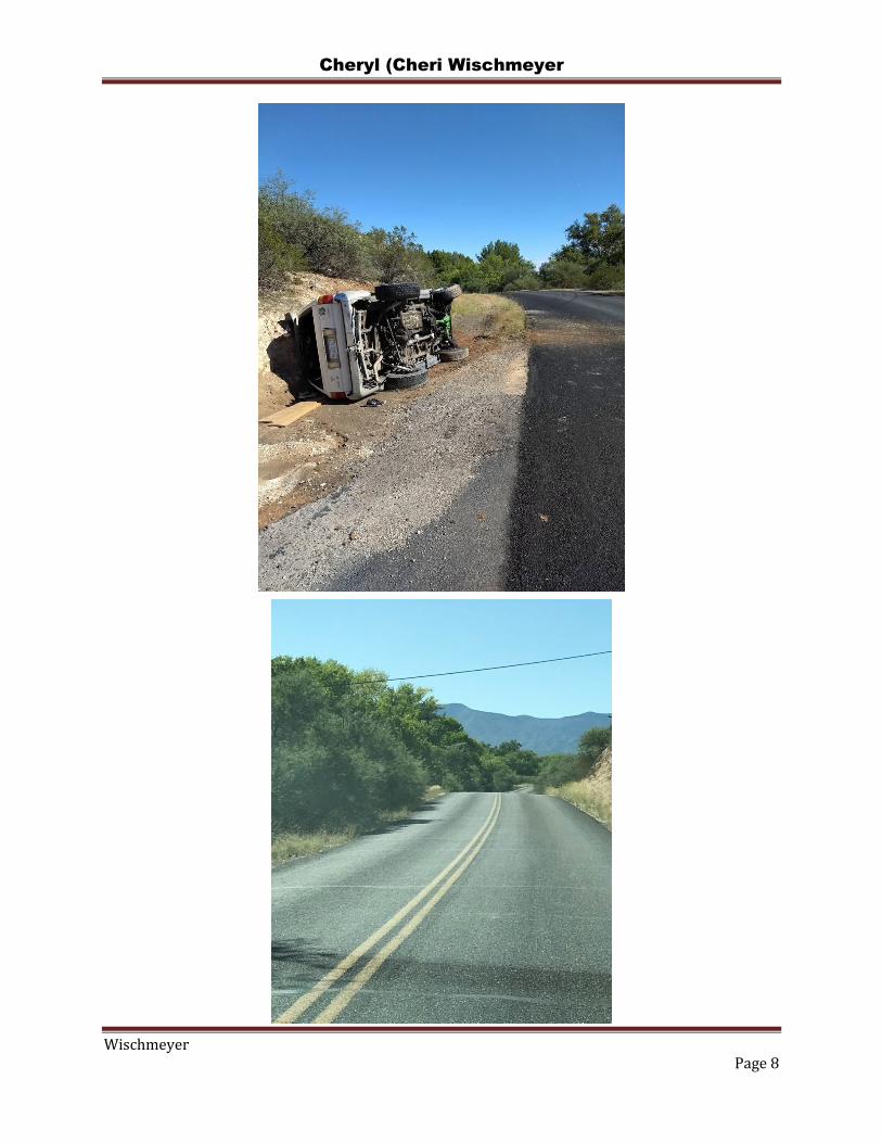
unsafe and irresponsible actions take place. See photos in Appendix A
Additionally, Yavapai County Elected Officials have repeatedly, in public meetings with the
Town of Camp Verde, stated that they have no intention of assisting in the maintenance of the
Middle Verde Roadway of this portion of the project and therefore place not only the citizens of

Cheryl (Cheri Wischmeyer
Wischmeyer Page 2
Camp Verde who reside by and use this roadway, but also those who will be using this roadway
as a connector at risk.
Transparency
The County has never worked with the Town of Camp Verde in a positive manner on this
project, but has resorted to threats and intimidation – threatening to refuse to provide funding for
future projects if Camp Verde refuses to accept this project by voting to support the “No Build”
selection. The Town of Camp Verde Town Council, regardless of these threats, voted to support
the “No Build” alternative, as did the Town of Jerome. (See Appendix B) There are also several
unincorporated communities, who are affected by this project, who have passed “No Build”
resolutions or their equivalent. Yavapai County Officials have continued to ignore these
communities, publically stating that they simply need to get on board – the project is going to
happen. Yavapai County representative have stated repeatedly that the project will be
completed, regardless of public opinion and long before the “EA” was completed.
Not only has Yavapai County refused to work with the general public and elected officials of
affected communities, they have attempted at every turn to avoid public participation, to the
point of refusing access to the original documents until I became involved in early July of 2019.
Arizona Public Records Laws are very clear on what are and are not public records and Yavapai
County was attempting to circumvent these laws. (See Appendix C)
A key component of this project is to work with the affected areas and the County’s repeated
threats and intimidation have avoided this requirement. In Appendix J of the “EA” the County
provides you with copies of letters from supporting agencies. One of those documents is a letter
from Camp Verde Mayor Charles German. This letter was written without the appropriate
authorization of the Town Council. In fact, as previously stated, the Town of Camp Verde is
opposed to this project and Camp Verde Council Members were unaware of this letter until
months after it was written, when they finally received a copy of the grant application from me.
The Yavapai-Apache Nation also wrote a letter of support, but once they saw the grant
application, which had been hidden from them, they wrote a follow-up letter stating that the
Nation would not allow the roadway to cross Tribal land. In speaking with affected communities,
I have found that none of them had seen the actual grant application before the letters of
support were written.
The Verde River
The Verde River is a gem that simply stated cannot be damaged. It is an area that provides life
and sustenance to a variety of fish, birds, and wildlife. The River holds a place in Native
American heritage and is dear to the members of the Yavapai-Apache Nation. Building yet
another bridge will potentially upset this sensitive ecosystem unnecessarily.

Cheryl (Cheri Wischmeyer
Wischmeyer Page 3
“The Verde River is one of Arizona's last perennial river systems. An oasis of life and
livelihoods, the Verde provides crucial habitat for fish and wildlife, fresh water for local
agricultural production, recreational opportunities for locals and tourists alike, and brings clean
drinking water to over 2 million people in the greater Phoenix area. At Friends of the Verde
River, our mission is to protect and restore this unique riparian treasure.” (Oasis in the Desert:
Restoring the Verde River by Friends of the Verde River) (See Appendix D)
Conclusion:
The EA has many weak areas that need further review and public discussion. Additionally, the
EA far exceeds the guidance for an EA and therefore, an EIS should be required. The current
EA document exceeds 900 pages with appendices, while the CEQ guidance states that “an EA
in Excess of 10-15 pages indicates the need for an EIS.”
With the serious safety concerns, concerns for the environment, and lack of transparency, I
would ask that Yavapai County be required to conduct a full EIS as well as conduct further
public interaction with the affected citizens and communities. To date, the communication with
these entities has been nothing short of negligible, threatening and intimidating. Yavapai County
would have a difficult time demonstrating public support for this project, especially in the
affected Middle Verde area.
Thank you for the opportunity to provide feedback on this critical issue as it affects the
environment and safety of Camp Verde and the surrounding communities.
Respectfully,
Cheryl (Cheri) Wischmeyer
P. O. Box 324
Camp Verde, AZ 86322
Cheryl (Cheri Wischmeyer
Wischmeyer Page 4
CC:
Clifton Meek ([email protected]);
Bob Lehman ([email protected]);
Laura Jo West ([email protected]);
Mike Dechter ([email protected]);
Dee Kephart ([email protected]);
Camp Verde’s Town Council

Cheryl (Cheri Wischmeyer
Wischmeyer Page 5
Attachments
Appendix A Middle Verde Area Photos
Appendix B No Build Documents
Town of Camp Verde
Town of Jerome
Appendix C Lack of Transparency
Letter from C. Wischmeyer re:
Public Records Requests and
Yavapai County Interaction
Appendix D Friends of the Verde River Document

Cheryl (Cheri Wischmeyer
Wischmeyer Page 6
Appendix A
Middle Verde Area Photos

Cheryl (Cheri Wischmeyer
Wischmeyer Page 7
Cheryl (Cheri Wischmeyer
Wischmeyer Page 8

Cheryl (Cheri Wischmeyer
Wischmeyer Page 9

Cheryl (Cheri Wischmeyer
Wischmeyer Page 10
Appendix B
No Build Documents

Cheryl (Cheri Wischmeyer
Wischmeyer Page 11

Cheryl (Cheri Wischmeyer
Wischmeyer Page 12

Cheryl (Cheri Wischmeyer
Wischmeyer Page 13

Cheryl (Cheri Wischmeyer
Wischmeyer Page 14
Cheryl (Cheri Wischmeyer
Wischmeyer Page 15
Appendix C
Lack of Transparency
Cheryl (Cheri Wischmeyer
Wischmeyer Page 16
Date: September 29, 2019
RE: FOIA Request Denial
2018 BUILD grant – “Verde Connect
State Route 260 to Middle Verde Road”
DUNNS Number 074472796000
Awarded to Yavapai County in the Amount of $25,000,000 on 12/20/2018
To Whom It May Concern:
In early July, I was notified by Eric Eberhard that several individuals had attempted to
acquire a copy of the BUILD grant application for the Verde Connect. He advised that
they have been told by the County Public Works Department that the County had
decided not to release a copy of the grant application. After further inquiries, they were
advised that they would be able to review the document at the Yavapai County Public
Works Department in Camp Verde or Prescott, but that photographs or copying would
not be allowed. They were advised that if they wished, they could take notes, but that
the document WOULD NOT be released to the public.
I have extensive knowledge of the Freedom of Information Act, and advised Mr.
Eberhard that this was not legal, that all public documents must be available to the
public and that the public has the right to acquire copies of any public documents. He
then asked if I would be willing to assist the residents of Middle Verde in acquiring the
document.
On July 9, 2019 I contacted the Yavapai County Public Works Department and spoke
with an individual who advised me that I was more than welcome to come to the offices
and review the document, but that no photographs or copies of the document would be
allowed. I reminded her that under FOIA they are required to give copies of public
documents to any individual requesting them. She advised that this is not a public
document. I reminded her that they had used this document to apply for federal grant
money and that at that point the document became public. I also advised that once they
allowed the public to review the document, this strengthened the public document
theory. I again asked for a copy of the document and was denied. At that point I asked
for the contact information of her boss. She gave me the name Roger McCormick and a
contact telephone number.
I called Mr. McCormick and left a message, asking that he return my call. Mr.
McCormick returned my call a short time later. I explained my request to him and he

Cheryl (Cheri Wischmeyer
Wischmeyer Page 17
reiterated what I had been told by the female I had spoken with earlier. I reiterated that
these documents are, in fact, public documents. He advised that they are proprietary in
nature and therefore did not need to be released. I explained that this document did not
meet the criteria for a proprietary document and that even if it had been; it lost the
status once they used it to apply for federal funding and opened the document for public
review. He stood firm on his stand. He kept advising me that I was welcome to come to
the Public Works Departments offices to review the document. I explained to Mr.
McCormick that I am disabled and unable to sit for long periods of time. At this point he
advised that I was more than welcome to complete a FOIA request form and drop it off
at the Public Works Office in Camp Verde. They would then forward it to him and he
would have legal review the document. He further stated that he was confident that my
request would be denied because they had made the decision to not release the
document. He then told me where to find the FOIA form on the County’s website and
the call ended.
A short time later I completed the FOIA form and took two copies to the Yavapai County
Public Works Department in Camp Verde. I met with the lady I had spoken with earlier
on the phone and gave her the copies of the FOIA form. I asked if she would forward
one to Mr. McCormick and if she would date stamp the other for my records. She
advised that she had no date stamp and that she would not acknowledge receipt of the
document because that was a legal matter. She then reiterated that I could not have a
copy and reminded me she had told me this earlier. I explained that I had spoken with
Mr. McCormick and I was simply doing what he had asked me to do. I also explained to
her that I am disabled and have a difficult time sitting for extended periods of time in
office chairs. She stridently attempted to reach Mr. McCormick by telephone, telling the
person on the other end that she needed him called out of his meeting, that no one had
told her I was bringing a FOIA from by and she didn’t know if she should accept it or not.
I then asked to look at the BUILD grant documents. She gave me the packet of
documents and reminded me again that I could not photocopy or take pictures of the
document. As I began looking at the document, I immediately noticed that the
attachments listed in the grant application were missing. I approached the counter, yet
again and asked for the attachments. She took the document and walked out of the
room. A short time later a very large gentleman came out of the back offices and
approached in an aggressive manner. He waved the document and said that I had
already been told I was not getting copies, and that they were not allowing the public to
review the attachments. I explained to him that FOIA allows for full review of the
document and he became very aggressive, stepping toward me and raising his voice. I
then advised him that I was done talking with him and he said “You don’t have to be
rude.” I retorted with “Neither do you.” At this point he turned around and started walking

Cheryl (Cheri Wischmeyer
Wischmeyer Page 18
off with the document that I had been reviewing. I called to him and said “I am not
finished reviewing that document.” He kept walking and I had to repeat myself twice
before he returned the grant application to me.
After reviewing the document I returned home, determined to contact Mr. McCormick by
e-mail and advise him of what had happened in the Yavapai County Public Works
Office. Before I could complete the document, Mr. McCormick called me and advised
that I could have a copy of the grant application. He advised it would be ready the
following day. I asked if I could also have the attachments and he advised that I could. I
then advised that I wanted the documents in “soft” form. He said that he would provide a
hard copy and I could scan it myself. I repeated that I wanted it in soft copy and
reminded him that the law allows for me to receive the information in “soft” copy if I so
desired. He then agreed to provide the document in “soft” copy.
I received the documents the following day. After reviewing the document, I requested
supporting documentation relating to assertions made within the grant. It took several
requests to acquire the information. The Yavapai County Public Works Department’s
website has only a generic e-mail and it could not handle the FOIA forms. I finally put
the request into E-mail form without the County’s FOIA form. I received an
acknowledgement from Mr. McCormick that I would need to complete and send the
forms. He provided his e-mail address and I made the requests. It took a couple of
weeks to acquire this information – some of which was minutes for the Verde Valley
Transportation Committee. These minutes were supposed to be housed on their
website, but several years that were pertinent to my review were missing. I was advised
that they were going to recreate them and place them on the website. This was
disconcerting that records that were to be maintained by law were missing and had to
be “recreated”. Some of the documents I was requesting were to be provided to me in
“soft” copy. I was advised that I could come to the Public Works Office to retrieve a CD.
Upon arrival I was given a CD. Once I was home, the CD would not open, and indicated
that it was a new, unformatted disc. Once again, I had to follow-up with Mr. McCormick
to get this matter resolved and this necessitated a second trip to the county offices.
As you can see, my interactions with Yavapai County in regards to the BUILD grant
have not been positive. Their actions led me to believe that they did not want the public
to have access to the grant documents until after the grant had been approved without
the opportunity for public review and input from other affected stakeholders.
Furthermore, upon my review of the grant application documents, I found many
statements that were inaccurate and based on faulty premises.

Cheryl (Cheri Wischmeyer
Wischmeyer Page 19
Appendix D
Friends of Verde River
Document

Cheryl (Cheri Wischmeyer
Wischmeyer Page 20
Oasis in the Desert: Restoring the Verde River
Send keyboard focus to media
In the Southwest, water is life, a resource that is too scarce and precious to be taken
for granted. The Verde River is that golden thread that connects the many pearls of the
Verde Valley, from the cultural monuments to the River Access Points that provide
public access for recreational activities, watchable wildlife sites, and camping.
From its headwaters near Paulden to its confluence with the Salt River outside Phoenix,
the Verde passes through Cottonwood/Willow Gallery forests, and Mixed-Broadleaf
Riparian Forest as it winds down to the Sonoran Desert.
The Verde River is one of Arizona's last perennial river systems. An oasis of life and
livelihoods, the Verde provides crucial habitat for fish and wildlife, fresh water for local
agricultural production, recreational opportunities for locals and tourists alike, and
brings clean drinking water to over 2 million people in the greater Phoenix area. At
Friends of the Verde River, our mission is to protect and restore this unique riparian
treasure.
The Verde Watershed Send keyboard focus to media
The Verde River, one of Arizona’s two federally designated Wild and Scenic Rivers,
bubbles out of the ground in the Big Chino Wash near Paulden. From there, the it
meanders freely through piñon-juniper forests and grasslands and makes its
downstream course through the Verde Canyon to meet Sycamore Creek. Here the
riparian forests are mostly healthy with upland desert shrub at its edge.

Cheryl (Cheri Wischmeyer
Wischmeyer Page 21
From the headwaters down to the Town of Clarkdale is an area mostly managed by the
US Forest Service. Once the river reaches the Verde Valley, you can see the impacts of
decades of mining, agriculture, and ranching. The river continues through the Verde
Valley, and the communities of Clarkdale, Cottonwood, and Camp Verde, where
agriculture, fish and wildlife, and recreational tourism all depend on sustainable flows in
the river.
There are three major perennial tributaries (Oak Creek, Beaver Creek and West Clear
Creek) that join the Verde River through this reach, adding additional flow. From Camp
Verde, the Verde River starts its final decent down into the Sonoran Desert, where
Saguaro Cactus overlook the river. This reach contains two Wild and Scenic
designations, the first along the Verde River and the second along Fossil Creek, a
tributary to the Verde River. The Verde navigates through private, state, tribal and
federal lands for over 125 miles before hitting its first major impediment, Horseshoe
Dam, then flowing into the Salt River near Phoenix.
The Verde River Send keyboard focus to media
The Verde River is divided into 3 distinct sections that flow through different
landscapes, landowners, ecosystems, and communities:
Still relatively remote and isolated, the Upper Verde is home to thousands of plant and
animal species, including nesting Bald Eagles.
The Middle Verde flows through the Verde Valley where it contributes to agricultural
production, vineyards, and local communities as a surface water resource.
The Lower Verde is ideal for kayaking and canoeing, especially the 40 mile stretch
designated as a Wild and Scenic River.

Cheryl (Cheri Wischmeyer
Wischmeyer Page 22
"A wilderness, in contrast with those areas where man and his own works dominate the
landscape, is hereby recognized as an area where the earth and its community of life
are untrammeled by man, where man himself is a visitor who does not remain." –The
Wilderness Act, 1964

Cheryl (Cheri Wischmeyer
Wischmeyer Page 23
Verde Watershed Restoration Coalition Send keyboard focus to media
The Verde River Watershed encompasses 1.2 million acres of public, private, tribal, and
federal lands on 450 miles of stream and river banks along the Verde River and its
tributaries. The Verde Watershed Restoration Coalition (VWRC) is a collaborative effort
among federal and state agencies, private companies, nonprofit organizations, and
landowners to develop and implement riparian restoration for the Verde watershed.
VWRC’s scope of work describes over 32,000 acres of restoration for the Verde
Watershed—an ambitious project area that requires collaboration among a broad range
of stakeholders, along with a multi-year approach.
Our work since 2011 has taken on the following goals:
Ecological: Reduce invasive woody and herbaceous plant species through various
control methods.
Social: Educate the local community and public about the economic and social value of
a healthy river system, the prevention and removal of invasive species, and the services
and funding that are available to remove invasive species on their land.
Economic: Give the local community economic incentives and employment
opportunities for removing invasive plant species on their own property.
Management: Establish a multi-stakeholder group to accomplish the ecological, social,
and economic goals and to monitor the project’s success over the long term.
VWRC’s goals are challenged by several ecological and anthropogenic stressors —
ornamental plants, secondary weed invasion, and bank erosion — that challenge the
ability to successfully build a resilient and sustainable ecosystem for the Verde River
Watershed over time.
Although the river corridor primarily supports native riparian vegetation, invasive
species — particularly saltcedar (Tamarix spp.), Russian olive (Elaeagnus angustifolia),
tree of heaven (Ailanthus altissima) and giant reed (Arundo donax) — threaten the
health and sustainability of these communities. Other invasive plant species persist in
the system with the threat of expanding their range; in some cases, there are no known
effective control methods for wildland settings. VWRC focuses on managing the most

Cheryl (Cheri Wischmeyer
Wischmeyer Page 24
invasive species through a combination of cultural, mechanical, manual, and chemical
treatments.
Partners Send keyboard focus to media
VWRC is a program of Friends of the Verde River (Friends), who began as a Friends
group with Arizona State Parks, focusing on the State Natural Area known as the Verde
River Greenway. Today Friends works with a much wider variety of partners and
landholders throughout the entire Verde Watershed, including the U.S. Forest Service,
National Park Service, State and Tribal lands, in addition to local municipalities and
private landowners.
“VWRC’s aggressive efforts with invasive plant species removal, treatment and
monitoring is critical to the overall health of the Verde River. Arizona State Parks
recognizes and appreciates the importance of this partnership, without their assistance,
funding, and man power to continue the program at its current level would be
impossible," Dusty Humphreys, Arizona State Parks
Through the years, large ranches and farms have dominated the Verde River
Watershed. Today, the mark of traditional agriculture on the local economy is rivaled by
the growing number of homes in the Verde Valley. The effects of land-subdivision
throughout the watershed has fragmented riparian areas into a mosaic of smaller
private properties along the riparian areas of the Verde River, Oak Creek, Sycamore
Creek, Wet Beaver Creek and West Clear Creek. Today there are an estimated 1,700
individual parcels owned by approximately 850 private landowners.
Partnerships with private landowners are essential for effective restoration, monitoring
and maintenance within the Verde River Watershed. VWRC’s collaborative, partner-
driven programs are the recipe for success for a free-flowing Verde River that will
benefit our communities for generations to come.
VWRC Partners
Arizona Game & Fish Department

Cheryl (Cheri Wischmeyer
Wischmeyer Page 25
Arizona State Forestry
Arizona State Parks
Arizona Conservation Corps (AZCC)
City of Cottonwood
Coconino National Forest
Gila Watershed Partnership
National Park Service
USDA Natural Resources Conservation Service
Prescott National Forest
Prescott College
Salt River Project
Tonto National Forest
Southwest Conservation Corps
Tamarisk Coalition
The Nature Conservancy
The Vetraplex
The Wildlife Habitat Council
Town of Camp Verde
Town of Clarkdale
US Fish & Wildlife Service
Verde Natural Resource Conservation District
Verde Valley Land Preservation
Verde Canyon Railroad
Walton Family Foundation
Yavapai-Apache Nation
Yavapai County
Oak Creek Watershed Council
Verde River Basin Partnership
USDA Forest Service-Region 3
Field Crews Send keyboard focus to media
At VWRC, we use a boots-on-the-ground approach to accomplish our restoration goals
in the Verde River Watershed, hiring from 3 to 5 field crews per year. These crews are
contracted through local green job-training resources, including the Arizona
Conservation Corps (AZCC) and Vetraplex. Additional support for VWRC field work is

Cheryl (Cheri Wischmeyer
Wischmeyer Page 26
provided by the Yavapai Apache Nation, Yavapai County’s Adult Probation Program, and
regional volunteer networks.
AZCC operates conservation service programs across Arizona that empower individuals
to positively impact their lives, their communities and the environment. AZCC, a
program of Conservation Legacy, aims to continue the legacy of the Civilian
Conservation Corps of the 1930s by hiring AmeriCorps members for conservation crews.
AZCC is focused on connecting youth, young adults and recent era military veterans
with conservation service work projects on public lands.
“We worked hard, got a lot done, had tons of fun, and fell in love with the Verde Valley,”
says Sara Van Marel, former VWRC Field Supervisor of her first season with us.
The Vetraplex began its affiliation with Friends of the Verde River and our VWRC
partners in 2012, resulting in sustainable programming for valuable hands-on job skill
training and job placement to Veterans living in the Verde Valley. Vetraplex contributes
to the local economy by providing Veterans and their families income and career
opportunities, as well as impacting our entire community by providing a healthy river
for recreation and tourism to flourish. During the past four years, 31 Veterans have
been employed and trained for a total of 122,080 hours. VWRC’s Conservation Crew
training and experience has enabled several Veterans to be hired into permanent full-
time positions with the Arizona State Parks, City of Cottonwood and Vetraplex-
Vets4Hire.
“It was great to come back to our work on Oak Creek. We could see all that we had
accomplished last year and built on that. I’m looking forward to next season." –James
Privett, former Vetraplex Crew Leader
5 Years of VWRC: Changing the Landscape of Restoration
Send keyboard focus to media
Restoring the health of our Watershed is more than just an environmental effort: it is
becoming an economy of scale, too. The economics of restoration consider the financial

Cheryl (Cheri Wischmeyer
Wischmeyer Page 27
and in-kind investments; regional job creation professional training and services surface
and groundwater savings value of water quality and habitat as well as the sales of
native plant materials.
Time lapse video of our crews removing tamarisk from the middle Verde near Tuzigoot
National Monument.
From 2012-2017, VWRC
Built a coalition of 221 private landowners and 13 public partners,
Worked on over 2,000 riparian acres on 7,800 acres of public and private lands,
Restored a total of 39 river miles by treating invasive plant species,
Created over 100 jobs locally for restoration crews, staff, and consultants through FVRG
In 2016 alone, VWRC and Friends of the Verde River oversaw 2,150 volunteer hours,
for a total in-kind value of $61,327.18. Together VWRC and Friends have accumulated
to over 65,000 hours over five years.
Verde River Headwaters Send keyboard focus to media

Cheryl (Cheri Wischmeyer
Wischmeyer Page 28
The Verde River originates east of Paulden from a series of springs in the remote and
rugged upper canyons near Sullivan Dam. Sullivan Lake and the dam were constructed
in the mid 1930s to offer recreation and fishing below the confluences of Williamson
Valley Wash, Big Chino Wash, and Little Chino Creek. The lake filled with sediment by
the early 1940s, and is only a few feet deep today. It is generally recognized as the
beginning of the Verde River.
The Dam at Sullivan Lake,
the headwaters of the Verde River.
Upper Verde: Perkinsville Ranch Send keyboard focus to media
Perkinsville is named for the Perkins family, who established a cattle ranch here in
1900. In 1912, William A. Clark financed a railroad to service his copper smelter in
Clarkdale and mine in Jerome with a station in Perkinsville. The railroad buildings
included a depot, water tower, and station master's house. When diesel locomotives
eliminated the need for the Perkinsville water stop, it became a ghost town.

Cheryl (Cheri Wischmeyer
Wischmeyer Page 29
The railroad is still used by Verde Canyon Railroad, one of our partners, offering
daily sight-seeing excursions to the public. The railroad is occasionally used to transport
our crews to remote areas of the watershed. Our crews work to restore and maintain
both public and private lands near Perkinsville, and all along the scenic Upper Verde.
Middle Verde: Big Spring Send keyboard focus to media
Big Springs is a remarkable oasis in the desert: Hidden just outside of the immediate
riparian area of the Verde River in Clarkdale; Big Springs is a series of five springs
secluded by legacy Cottonwoods, Sycamores, and many wetland-obligate sedges,
grasses, reeds, and other herbaceous plants. Bird songs float through the air in a dense
chorus, and there is a peace that can be found there that has always been known by
locals.
Native Americans have returned to Big Springs for ages, drinking from clear and fresh
waters, foraging native plants, and celebrating the life that thrives under tall trees and
between lush reeds. Yavapai Apache Elder, Mr. Vince Randall, shares his story about
the sacred waters of Big Springs and the Verde River:
Big Springs is just upstream from Tuzigoot Bridge, and ancient Sinaguan ruins now
protected as Tuzigoot National Monument. Big Spring is home to an incredible diversity
of plants, insects and birds because of its perennial springs and lush riparian habitat.

Cheryl (Cheri Wischmeyer
Wischmeyer Page 30
VWRC has worked consistently since 2012 to restore this desert oasis; removing
invasive plants, and monitoring the health of the ecosystem with the help of partners at
The Spring Stewardship Institute.
The Springs are beautiful today, and are a central part of the Native history for the
Verde Valley, but for a time, not too long ago, this natural area was used as a dump,
then became infested with, dense stands of Salt Cedar (Tamarix spp.) and Tree of
Heaven (Ailanthus altissima).
VWRC field crews began removing invasive plants near Big Springs in 2012. The
removal of the Salt Cedar and tree of heaven left a lot of biomass, as woody debris
piles were turned to habitat piles and mulched wood for trails. Some areas most
affected by the invasive plants were even treated by burning fuel-wood from the slash-
piles, which effectively restarted native plant colonies.
It does indeed ―take a village‖ to do the necessary work of watershed restoration: The
effort to clean-up Big Springs included VWRC’s field crews from AZCC and the
Vetraplex, Friends of the Verde River Volunteers, Town of Clarkdale, Yavapai County
Adult Probation, and Prescott College.
Friends' volunteers continue to work hard to preserve Big Springs Natural Area (now a
slated park with Town of Clarkdale) by maintaining the trail system, including the
construction of the new Crystal Springs Trail, named by students at Clarkdale-Jerome
Elementary and Clarkdale Kids Conserve.
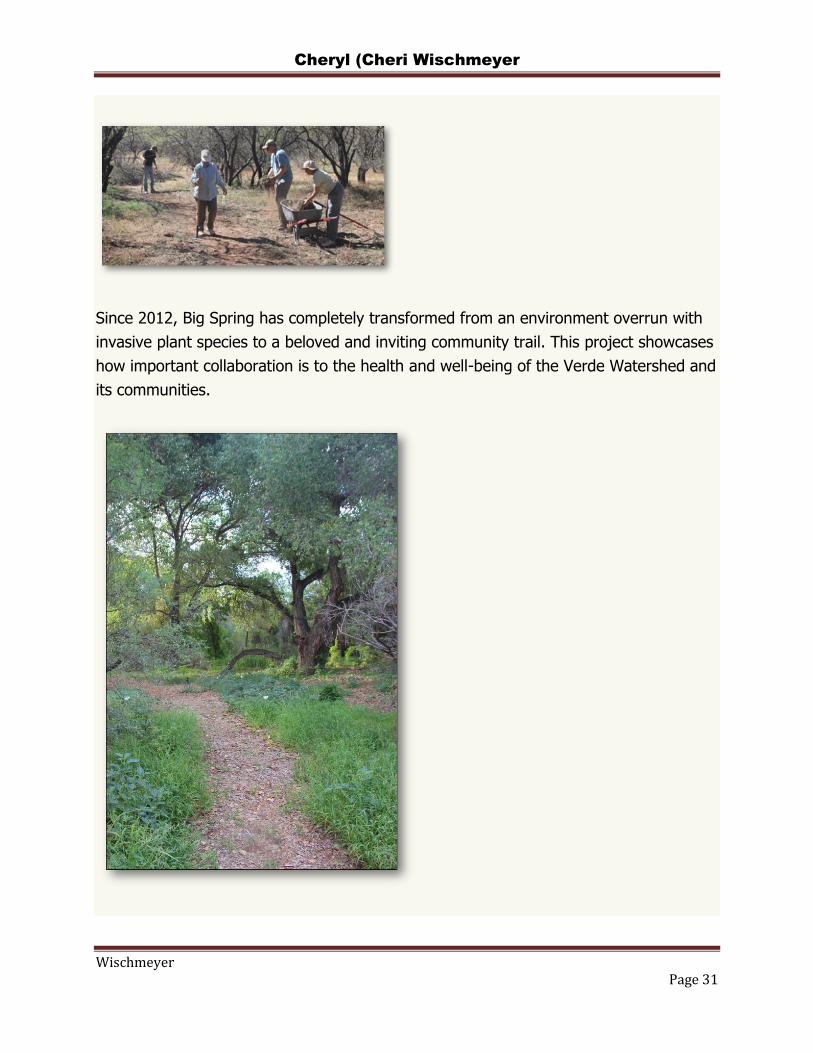
Cheryl (Cheri Wischmeyer
Wischmeyer Page 31
Since 2012, Big Spring has completely transformed from an environment overrun with
invasive plant species to a beloved and inviting community trail. This project showcases
how important collaboration is to the health and well-being of the Verde Watershed and
its communities.

Cheryl (Cheri Wischmeyer
Wischmeyer Page 32
Middle Verde: Dead Horse Ranch State Park Send keyboard focus to media
Shortly downstream from Clarkdale, the Verde River flows through Dead Horse Ranch
State Park. Here, ancient historical sites illustrate what life was like for the Sinaguas
who lived here over 2,000 years ago. For them, as it does today, the Verde River
offered life to the desert Southwest. Deadhorse State Park is 285 total acres, with 3
lagoons that were built for fishing when the ranch was donated to Arizona State Parks
in 1977 by Mr. Duane Miller for conservation and recreation.
In this area, the Verde River and its floodplain have experienced many changes over
time—once a natural riparian forest, converted to a livestock ranch, and later into a
State Park. These changes are evident along the stretch of river through the State Park.
The river is incised and shrunken due to a much smaller volume of surface water
available after the Verde River’s two main irrigation ditches, the Cottonwood and Hickey
Ditches. Historical land management including prolonged grazing and an increase of
roads helped introduce two of the Verde River’s main threats along this middle-reach of
the Verde River—stream-bank erosion and invasive plants—impacting water
quality while impairing native plant and wildlife habitat.
"VWRC has been instrumental in irradiating multiple acres of unwanted invasives. The
knowledge of VWRC staff and the dedication of the crews has helped improve visitor’s
experience in the park. VWRC’s restoration efforts have also helped native plants
reestablish in the park, improving the diversity and health of the river and the entire
park," George Christianson, Park Manager, Dead Horse Ranch State Park
To tackle one of the biggest threats to the health of the Verde River at Dead Horse
State Park, VWRC’s field crews and volunteers sprang into action, providing countless
hours digging and pulling-up Tree of Heaven from the riparian area. One of VWRC’s
first volunteer events ever was held at the State Park, where thousands of trees were
removed over the course of a few weeks in 2013. During these initial efforts more than
4,000 sprouts, seedlings and saplings were removed from the riparian corridor, making
significant headway in the restoration of the park’s beautiful Cottonwood Grove.

Cheryl (Cheri Wischmeyer
Wischmeyer Page 33
Oak Creek: Mormon's Crossing Send keyboard focus to media
A few miles south of Cottonwood, the Verde is joined by a major year-round tributary,
Oak Creek, which flows off the Mogollon Rim near Flagstaff, and through a dramatic
canyon at the heart of Sedona’s Red Rock Country.
Removing Giant Reed, which can grow up to 30 feet tall.
VWRC has partnered with a local watershed group, Oak Creek Watershed Council, and
the U.S. Forest Service’s Coconino National forest to engage Oak Creek residents and
visitors alike in restoration activities.
Mormon’s Crossing is a historic low-water crossing and popular swimming area along
Oak Creek, located in Cornville, AZ. Throughout much of Oak Creek, Giant Reed
(Arundo donax) is invading the riparian corridor at a rapid rate and with high-density.
VWRC and Friends have initiated two community events to educate and train local
residents about Giant Reed, and put boots-on-the ground towards its eradication in the
Verde River Watershed and Oak Creek. Removal of Giant Reed is very difficult, as it is
extremely labor intensive to treat dense patches of the reed by hand, yet this is the
most effectively proven regime for its management.
Oak Creek: Page Springs Cellars Send keyboard focus to media
Page Springs Cellars & Vineyards is a family owned vineyard and winery that crafts fine
Arizona wines. Overlooking pristine Oak Creek, as it flows towards the Verde River,

Cheryl (Cheri Wischmeyer
Wischmeyer Page 34
Page Springs Cellars & Vineyard offers delicious Rhône style wines, gourmet food
selections and breathtaking views.
Eric Glomski is both the owner and winemaker at Page Springs. He sees wine as an
expression of landscape, meaning every taste and smell in a bottle represents the land
where the grapes were cultivated. He is involved in the Verde River Exchange—a water
offset program—and is one of the pilot projects of this program, because he deeply
values the Verde River and believes maintaining its health is a community effort.
"In the big picture, the river to me is a gigantic indicator and metaphor for the condition
of our landscape and our relationship to it.‖ –Eric Glomski, Page Springs Cellars and
Vineyards
The Verde River Exchange (the Exchange) provides a market-driven vehicle for current
and potential water users to balance the economics and ecology of water use on the
Verde River. The xchange reduces the amount of water removed from the river and
the groundwater system through an offset mechanism involving Sellers and uyers.
ach Water Offset Credit is tracked in the xchange’s internal registry to ensure that
the benefits associated with the Credit are attributed only to one unique Buyer.
You can learn more about the Verde River Exchange, and its pilot projects
at www.verderiverexchange.org.
Lower Verde: Wild and Scenic River Send keyboard focus to media
Across the U.S., only a quarter-percent of our rivers are protected under the National
Wild & Scenic Rivers System. In Arizona, only two of our desert rivers have this
protection, the Lower Verde and Fossil Creek, both within the Verde River Watershed.
―It is hereby declared to be policy of the United States that certain selected rivers of the Nation
which, with their immediate environments, possess outstandingly remarkable scenic, recreational,
geologic, fish and wildlife, historic, cultural or other similar values, shall be preserved in free-flowing
condition,and that their immediate environments shall be protected for the benfit and enjoyument of
present and future generations‖. -S. 119,1968.

Cheryl (Cheri Wischmeyer
Wischmeyer Page 35
These values, preserved by the U.S. Congressional designation of a ―Wild & Scenic
River,‖ provide exceptional opportunities for visitors to connect with the outdoors.
The Lower Verde River Wild & Scenic reach begins at Beasley Flat River Access Point,
just outside Camp Verde, AZ. Throughout this 36-mile reach of untrammeled river and
riparian area, the Verde River supports over 200 bird species, including the largest
number of bald eagle nesting sites in Arizona; one of the most diverse native
fish populations in Arizona, including the endangered Razorback Sucker; populations
of river otter (which to date are found in only three Arizona rivers). Beavers are now
returning to the Verde and restoring watershed health through dam-building activities.
The area also supports large populations of elk, deer, and even the occasional large
carnivore including bears and mountain lions occur in the higher elevations of the lower
portion of the Verde River Watershed.
The Lower Verde is also the birthplace of VWRC and Friends of Verde River Greenway.
Many years ago, a group of Forest Service land managers and non-profit organizers
were sitting around a campfire on the Lower Verde River talking about the river's
health, and the real threats that the Verde Watershed faced with the growing presence
of invasive plants in riparian areas throughout the watershed. It was then, at that
campfire talk, that a few good river buddies realized that to take on the challenge to
protect, preserve, and promote the health of the Verde River, they would need to
implement a holistic approach with multi-stakeholder participation. In 2010, they began
forming the Verde Cooperative Invasive Plant Management Plan, and the Verde
Watershed Restoration Coalition was founded to spearhead the initiative.
“Around a campfire along the Lower Verde, Chip Norton, Laura Moser and I were trying
to figure out the best way to get rid of the invasive Tamarisk in the Wild and Scenic area
and realized that the only way to do this was to treat the seed sources upstream from
here. Chip was the one who really ran away with the idea and started this coalition that
has become Verde Watershed Restoration Coalition. Up to now, VWRC has not done
much work in the lower Verde to this point but there are plans to inventory all the
invasive and start sending volunteer groups, led by FS and VWRC employees to start
boating and treating the fountain grass and arundo. This will be the first step towards
restoring the Wild and Scenic reach of the Verde River.”
-Dex Allen, River Ranger, U.S. Forest Service

Cheryl (Cheri Wischmeyer
Wischmeyer Page 36
Letter from the President Send keyboard focus to media
The President of the Board of Directors, Chip Norton, recaps some of the
accomplishments we've achieved in collaboration with our partners over the past year.
Contact Us Send keyboard focus to media
www.verderiver.org
https://www.facebook.com/verderiverfriends/
https://www.instagram.com/verdefriends/
https://twitter.com/verdefriends
phone: (928) 641-6013

Cheryl (Cheri Wischmeyer
Wischmeyer Page 37

O.K. DITCH COMPANY
P.O. BOX 3037
CAMP VERDE, AZ 86322
To: Verde Connect Project Team, care of Central Creative, LLC, 24 W. Camelback Road, #A-479, Phoenix, AZ, 85013
From: OK Ditch Co., PO Box 3037, Camp Verde, AZ 86322 Subject: Comments on Draft Environmental Assessment (DEA), Federal No.: YYV-0(209)Z, Yavapai County No.: 1722601 We apprecaite the opportunity to respond to, ask questions about, get clarifications and suggest proper mitigaiton efforts for the proposed project. As background, we note the following excerpts from the DEA, with our comments in green:
• Pg X (Yavapai County Responsibilities) “An additional assessment and documentation of the OK Ditch would be undertaken as per the provisions of the project’s Historic Properties Treatment Plan. “The OK Ditch, established in 1876, is indeed an Historic Property, essential to the irrigation of rural land and farmlands, and protected not only by its historic and cultural heritage but also under the Town of Camp Verde’s General Plan. As stated in the Town’s June 2019 resolution (No. 2019-1028 6/24/19): “… for the Middle Verde Character Area, the General Plan includes strategies to maintain the rural residential and agricultural character of the area, to preserve existing densities… as a mix of rural properties of various densities, with small farms straddling the Verde River that provide food for local business and the valley-wide supported agriculture program.”
• Pg XIV (Contractor’s Responsibilities) “All vehicles and equipment would only cross the flowing Verde River and OK Ditch using a temporary bridge or other temporary structure during all construction activities; no vehicles or equipment would enter the active channel.” The proposed bridge appears to cross the OK Ditch directly over what is known as the “third spillway.” Spillways are used to manage flow, drain, clean and otherwise maintain the OK Ditch and there are 4-spillways located in or immediately adjacent to the Coconino National Forest. The Ditch runs year-round, and several times each year, using traditional easement dirt roads through private properties and the Coconino National Forest dirt roads, OK Ditch shareholder “volunteers” access the Coconino National Forest section of the Ditch to rebuild and maintain the OK Ditch.
• Pg 77, (Section 4.7.2 Affected Environment, Cultural Resources Identified within the Survey Area) Site Number: AR-03-04-01-02207 (OK Ditch); Description: In-use historic irrigation ditch; NRHP Eligibility: Determined eligible, Criterion A; Unevaluated, Criteria B, C, and D Although the OK Ditch is certainly historic, it is also essential as a utility for Middle Verde property irrigaiton. We do not understand these eligibility designations listed above nor the relevance they might have when considering impacts to the OK Ditch. We request your explanation of the effects these designations could have on the operation of the OK Ditch.
• Pg 78 (Agency Coordination) “FHWA further requested concurrence with a finding of “no adverse effect” for the OK Ditch and provided notification of a de minimis finding for the OK Ditch under Section 4(f) of the Department of Transportation Act of 1966.” And pg 81 (Build Alternative) “AR-03-04-01-02207/OK Ditch was determined eligible for inclusion in the NRHP under Criterion A for its association with early irrigation systems in the Verde Valley. The site’s NRHP eligibility under Criteria B, C, and D could not be adequately assessed based

on currently available information, and therefore remains unevaluated under those criteria. AR-03-04-01-02207/OK Ditch would be spanned by a bridge across the Verde River; however, it would not be directly impacted by construction. The bridge would diminish the integrity of setting and feeling of the OK Ditch within the APE but would not adversely affect the existing aspects of integrity of the canal as a whole.” And pg 82, Section 4.7.5 (Conclusion) “HWA determined that a finding of “no adverse effect” is appropriate for the OK Ditch.” ANY change in water flow, temporary or permannet, whether due to construction, new runoff/ drainage or any other impact requiring work/ effort on the part of the OK Ditch to repair the Ditch or adjust flows could be detrimental and potentially costly to the shareholders of the OK Ditch.
• Pg 88 (The OK Ditch) “The Build Alternative will span the ditch, but the introduction of the bridge would diminish the integrity of setting and feeling in the area of potential effect resulting in a direct use. However, while it will affect this small portion of the ditch, it would not adversely affect the integrity of the canal as a whole. As part of this project, an additional assessment and documentation of the ditch will be undertaken as per the provisions of the project’s HPTP. While additional assessments are welcome by the OK Ditch Company, the officers and shareholders of the OK Ditch need to know now what impacts the project might have on the Ditch, so as to plan (and corresponding address any potential costs) for any work might need to take place to guarantee historic and current (i.e., No Build) flows of the OK Ditch. Compared with the No Build option, the project sponsor and FHWA should be responsible for any new costs the project could create for the OK Ditch.
• A de minimis impact finding for the OK Ditch would be appropriate because the de minimis criteria are met:
o The proposed improvements would diminish the integrity of the setting and feeling of the immediate area of the proposed bridge but would not adversely affect the integrity for the canal as a whole. SHPO concurred with a no adverse effect finding. The proposed project would not adversely affect the features or attributes that qualify it for protection under Section 4(f).
o This use of the Section 4(f) resource is included in the Environmental Assessment (EA). The EA will be available for a 30-day review/comment period and a public hearing will be held during the public comment period.
o A letter that provides notification of FHWA’s de minimis impact determination was sent to the SHPO on 12/10/2019. The SHPO concurred with the finding on 12/13/2019 and no objections were raised. Concurrence with the letter acknowledges the agreement that the use of the ditch for the Verde Connect road would not adversely affect the activities, features, or attributes qualifying the resource for protection under Section 4(f).” While we respect that the SHPO was consulted, the officers of the OK Ditch were not, so they expect a full and detailed explanation of what effects the project could have on the OK Ditch, as specified in the following bullet point.
• Pg 114, (Section 4.12.2, Environmental Consequences, Build Alternative) “The OK Ditch would be spanned by the bridge crossing the Verde River and would not be directly impacted by construction of the roadway or bridge.” And pg 11 (Section 4.12.4, Conlcusion) “The structure of and service from the OK Ditch would not be affected.” And pg 112 (Section 4.14.2) “Extended temporary impacts would occur within the ordinary high-water mark of the Verde River, OK Ditch, and one unnamed ephemeral water during construction of the bridge crossing for construction access and maneuvering.” And pg 123 (Estimated Impacts to Waters) Drainage: OK Ditch; Permanent Impacts (acres): 0.000; Extended Temporary Impacts (acres): 0.015; Temporary Impacts (acres): 0.000.” The following points should be addressed and and attested to by the project sponsor (Yavapai County) and FHWA:


Letter sent To Project Principals: Feb 22, 2020
________________________________________________________________
To: Verde Connect Project Principals (see listing at the end of this letter) From: OK Ditch Co., PO Box 3037, Camp Verde, AZ 86322 Subject: “Verde Connect – State Route 260 to Middle Verde Road” (DUNNS Number 074472796000) The historic OK Ditch, established 1876, delivers irrigation water to over 100 shareholders on over 600 acres of irrigated land. The point of its diversion from the Verde River is a dam within SW1/4;NW1/4;Section 28 (near Thousand Trails RV Park), from whence it flows along and North of the River through the Coconino National Forest to the 1st irrigated, shareholder property 403-24-002N, and then through private properties South of Middle Verde Rd to its outflow in Verde River Estates. The “Verde Connect” project, should it proceed as planned, would open up previously remote and little traveled Forest Service land surrounding the Ditch. It would also cross the OK Ditch, making it, in essence, an “attractive nuisance.” The planned route and proposed construction raise three major areas of concern: Access, Flooding and Safety. These concerns must be considered and addressed as follows: Access:
• In order to reach the OK Ditch for repair and maintenance, historic easement must be preserved, without interruption, starting at parcels 403-24-002 and extending through the Coconino National Forest to the OK Ditch dam, including all current dirt road accesses to OK Ditch spillways.
• Any bridging of the Verde River should include the OK Ditch, providing uninterrupted access, transportation and clearance for equipment, including large excavators. Culvert or other limited access bridging of the OK Ditch would not be acceptable.
Flooding/ Runoff
• Current washes that would otherwise flood the Ditch are carried over the Ditch by concrete overshoots. These washes and overshoots must not be overwhelmed by new runoff or diversion created by the proposed Project.
• Any new runoff created that could flood the Ditch at new points not currently protected by overshoots would need new overshoots or other protections guaranteeing no new maintenance issues for and an uninterrupted flow of the OK Ditch.
Safety
• As stated above, the currently limited, private property and rough, 4-wheel only, dirt, Forest Service roads penetrating the OK Ditch segment within the Coconino National Forest have prevented all but the most determined public access to the OK Ditch. The Ditch not only carries a significant amount of water but includes steep, cliffed segments that would, in the event of a new road through the area and increased pedestrian and 4-wheel access, present new and increased threats of injury and drowning. Therefore, should the Project proceed as planned, a 6+ foot chain link fence, or other, suitable access deterrent, would have to be installed between the proposed road and the OK Ditch.
Please acknowledge receipt of this letter and also assurance that the above concerns will be addressed in the planning of the proposed Project, e.g., as part of the NEPA Assessment. Sincerely, Robert Kovacovich, President Todd Scantlebury, Vice President Zach Wolfe, Secretary/ Treasurer Rebecca Yedlin - Federal Highways Administration Environmental Coordinator([email protected]); Ed Stillings - Federal Highways Administration, Senior Transportation Planner ([email protected]); Alan Hansen - Federal Highways Administration, Team Leader – PEARC ([email protected]); Thomas Deitering - Federal Highways Administration, Project Delivery Team Leader ([email protected]); Karla Petty - Federal Highway Administration, Arizona Division Administrator ([email protected]); Howard Hill - Federal Highways Administration, Transportation Analyst and BUILD Grant Contact ([email protected]); Bridget Roth - US Forest Service, Coconino, Public Services Staff Officer ([email protected]); Lenore Grover - US Forest Service, Prescott, Public Services; Staff Officer ([email protected]); Eric Raitanen - US Forest Service, Prescott, Acting; Natural Resources Program Manager ([email protected]); Clifton Meek - US Environmental Protection Agency, Life Scientist ([email protected]); Bob Lehman - US Fish and Wildlife Service FHWA/ADOT Transportation Liaison ([email protected]); Jesse Rice - US Army Corp of Engineers Project Manager, Regulatory Division ([email protected]); Roger McCormick - Yavapai County Public Works Assistant Director ([email protected]); Dan Cherry - Yavapai County Public Works Director PE Public Works Director ([email protected]); Misael Cabrera - Arizona Department of Environmental Quality, Director ([email protected]); Frank Milstead, Arizona Department of Public Safety, Director ([email protected]); Cheri Boucher - Arizona Game and Fish Department, Project Evaluation Program Specialist ([email protected]); David Jacobs - Arizona State Historic Preservation Office, Compliance Specialist ([email protected]); Ruben Ojeca - Arizona State Land Department, Section Manager ([email protected]); Town of Camp Verde Mayor, Council & Manager ([email protected], [email protected], [email protected], [email protected], [email protected], [email protected], [email protected], [email protected])

To: Coconino National Forest Supervisor Re: Verde Connect Proposed Project May 23, 2020 Dear Supervisor West, Thank you for the opportunity to comment on this project. My concerns/comments focus on:
• Change in scenic quality and the need for a Forest Plan Amendment. • Change in ROS and recreation character as a result of 119A turning into a paved high
speed highway. • Requirement that the Forest Service pay for the changes associated with OHV recreation
infrastructure, impacted by the project. • Bike lanes. • Future unsustainable maintenance liabilities.
The analysis of changes related to scenic quality as a result of the proposed action are incomplete. While there is adequate qualitative description of the anticipated impact and downgrade of areas of High SIO, there is inadequate quantification of the acreage affected. How many acres are affected and to what SIO would they be downgraded to? This information is needed in order to understand the scope of the change to scenic quality. Also, when would a Forest Plan Amendment Process be initiated? Does the fact that an Amendment is required trigger a “significant action” and EIS?
The analysis of the ROS for the project area located between Tissaw Road east to I-17 is inadequate. This area has many characteristics of Semi-primitive Motorized ROS, including low amount of public use, few sights and sounds of human activities, low level of management, natural quiet and so on. This should be revealed and also the fact that this ROS Class is relatively rare overall in Arizona according the the AZ State SCORP. While this part of the project area is designated Roaded Natural ROS, this classification is primarily due to the acreage restrictions for ROS classifications, and not tied to the SPM factors that exist here. These SPM factors are of great value and would be eliminated by the construction of a high speed paved roadway bisecting the area – introducing noise (tire wine), visual effects, pollution, and increased visitation and management. This impact should be disclosed more accurately. These very same Semi-Primitive characteristics were lost when the Beaverhead Flat Road was constructed, bisecting a similarly SP area. Now, with this project, we would lose another area containing a SP recreation environment.
The State of Arizona OHV Fund recently funded the construction of the Singletrack Trail within this area. This area is known for its low level of use and semi-primitive character near Oak Creek and the Verde River bluffs. The AZ OHV Program recognized these characteristics in their project selection for funding the Singletrack. This aspect of the area is valued and would be lost as a result of the project. This should be disclosed.

Connected to #2 above is the issue of physical changes to the Singletrack Trail associated with the proposed action, including the relocation of the trailhead, abandonment of a trail segment and construction of a replacement segment and trailhead connector road. The Assessment states that the costs associated with these recreation impacts are to be borne by the Forest Service. This is ridiculous. The Forest Service relies on declining appropriated funding and hard won grant funding to do recreation management. These project costs should be paid for by the road project that is causing these impacts in the first place. In addition, during road construction the equipment is already mobilized and the cost of trailhead relocation, for example is far more economical to do at the same time. The State of AZ OHV fund just finished recently paying, through a grant, for the construction of the Single Track Trail. I am sure the State OHV Advisory Board would not be happy to know that this valued OHV asset could be put in financial jeopardy by this road project. If the project were to be approved and a two lane paved highway installed along 119A, there should be an effective paved and striped bike lane. The Beaverhead Flat Road, to the north, does not have this type of paved bike land. Instead, that project, years ago, opted for a rugged unsurfaced trail paralleling the roadway. This trail is now overgrown and unused along most of its length. Please do not make the same mistake on this new project – both roads (Beaverhead Flat Road and this new connector, if it happens) need to have safe paved and striped bike lanes.
In addition to what is stated above, I do not believe that any benefits of the construction of this north/south road built, are worth the trade-offs: destroying the semi-primitive (not to mention biological) values of this area, in exchange for dubious and future reduction in traffic congestion. I also do not think more road building is consistent with an enlightened approach to climate change mitigation. Nor is it consistent with sustainable infrastructure management considering future maintenance liabilities. Regarding the part of the project that directly affects the YAN, I would leave it up to them to weigh in on how it may or may not benefit the Nation. Clearly there would be a significant change to the character of that part of the Nation from the upgrading of the roadway as a through route to SR160, increased traffic and associated impacts. Sincerely, Jennifer M. Burns 820 E. Armetta Drive Camp Verde Arizona 86322 928-282-2242 Retired Landscape Architect and Recreation Manager, USFS Cc: Red Rock Ranger District

From: Shelton, NancySent: Thursday, May 28, 2020 2:26 PMTo: Bushey, SabraSubject: FW: [Non-DoD Source] Fwd: Public Notice/Application No.: SPL-2019-00226 Thanks,Nancy Shelton602.530.1612 From: Rice, Jesse M CIV USARMY CESPL (USA) <[email protected]> Sent: Thursday, May 28, 2020 2:25 PMTo: Roger McCormick <[email protected]>; Yedlin, Rebecca (FHWA) <[email protected]>Cc: Shelton, Nancy <[email protected]>; Phoebus, Elizabeth (Betsi) <[email protected]>Subject: [EXTERNAL] FW: [Non-DoD Source] Fwd: Public Notice/Application No.: SPL-2019-00226 Hello, I received one more comment today for the 404 permit. Apparently the message failed to send and the commenter wasn’t aware of it until yesterday. Also, I apologize Betsi for leaving you off of my original comment transmittal email on Tuesday. I’m sure Nancy forwarded it to you but let me know if you need me to resend. Thanks! Jesse
From: jandjdonald [mailto:[email protected]] Sent: Thursday, May 28, 2020 2:08 PMTo: Rice, Jesse M CIV USARMY CESPL (USA) <[email protected]>Subject: [Non-DoD Source] Fwd: Public Notice/Application No.: SPL-2019-00226
Begin forwarded message: From: John Donald <[email protected]>Subject: Public Notice/Application No.: SPL-2019-00226Date: May 24, 2020 at 10:40:20 PM PDTTo: [email protected] I would like to comment on the Verde Connect Project in the Middle Verde area, YYV-0(209)Z. I am opposed to the construction of this bridge and Middle Verde Connector Road for several reasons: 1. Conservation. The bridge and roads would have harmful effects on many plant and animal species as noted in Yavapai County’s environmental assessment. Of particular concern to me isEriogonum ericifolium, a scarce low shrub known only on the lacrustine limestone soils in the Verde Valley. The proposed Middle Verde Connector passes right over a population in the section ofroad very near the center of your sheet 31just east of wash no. MVR 3.
Eriogonum ericifoliumThese are slow growing plants with fragile root systems. The EA proposes moving such plants out of the path of the roadway, but it is unlikely they could be transplanted successfully, and theywould be lost. This species is considered a “sensitive” species in Arizona and is a candidate for federal protection. 2. Economics. The environmental assessment is in error in calculating fuel and driving time savings to connect the two sides of the Yavapai Apache Nation lands on each side of the Verde River.The distance from the YAN Admin Bldg. to the Cherry Rd. Roundabout on Hiway 260 via I-17 is about 7 miles. The distance would be 10 miles using Middle Verde Road north, the MiddleVerde Connector, the proposed bridge and Hiway 260 to the Cherry Rd. roundabout.Both YAN communities on each side of the river have economic opportunities and are not limited by transportation infrastructure as the Yavapai County application for the DOT grant asserts. 3. Aesthetics. The proposed Middle Verde Connector would involve large roadcuts in stark white limestone soils and bedrock. These ugly scars would be visible from many parts of MiddleVerde and from Hwy 260. 4. Wildlife. The proposed Middle Verde Connector Road would fragment the wildlife habitat in the basin through which it would pass. Right of way fencing would preclude deer and elk fromaccessing the Verde River safely as they need to do in drought years.

5. Flood hazards. This basin is remote with only one primitive road, 119A, and several small trails. Any increased access would increase the erosion damage caused by off-road vehicles.Many ephemeral washes along the route of the proposed Middle Verde Connector Road run profusely during summer monsoon microbursts.
This is the lower section of wash no. MRV 9 crossing Middle Verde Road during a summer storm. The road was impassable for hours. On or about Sept. 8, 2000 a stronger microburst broughthigh water down wash no. MRV 9 shown on sheet 33, flooded across Middle Verde Road and came within a few inches of entering the house at 3780 W Northern Ave. This same storm brought down soccer ball size rocks onto I-17 southbound lanes and closed Middle Verde Road at the wash beside Distant Drums RV Park. It also washed debris onto MiddleVerde Road from I-17 to Overlook Acres which had to be cleaned off with a grader the next day. It is doubtful that the retention basins planned could handle this kind of flow. Adding thousands of square feet of impervious pavement to the watershed drained by wash no. MRV 9 would make it more likely that flooding will damage Middle Verde Road and flood housesimmediately to the south. It should also be noted that little or no provision was made in the layout of the Overlook Acres housing tract for drainage of washes like MRV nos. 1-11, so whateverflows come down from the upper watershed have no watercourses to carry the flow to the Verde River. Increased flows and sediment from road building would make this problem worse. 6. Needs and Welfare of the People. The environmental assessment repeatedly states there is “overwhelming support” for the Verde Connect Project. This is simply not the case. In addition tothe Yavapai Apache Nation, the towns of Camp Verde, Jerome, and Beaver Creek, there are two organized no-build groups that are opposed to the project. The Howard Shanker letter of12/7/2019 to Elaine Chao requesting the withdrawal of the BUILD grant funds is essential reading for background on this project. The Corp of Engineers is listed as having been sent a copy ofthis letter. As Mr. Shanker points out, there are several significant impacts not adequately addressed in the environmental assessment and it will be challenged so that an environmental impactstatement would be required. In summary, I am strongly opposed to the proposed Verde Connect Project and recommend the no-build option. Sincerely, John Donald3750 W Northern AveCamp Verde, AZ [email protected]


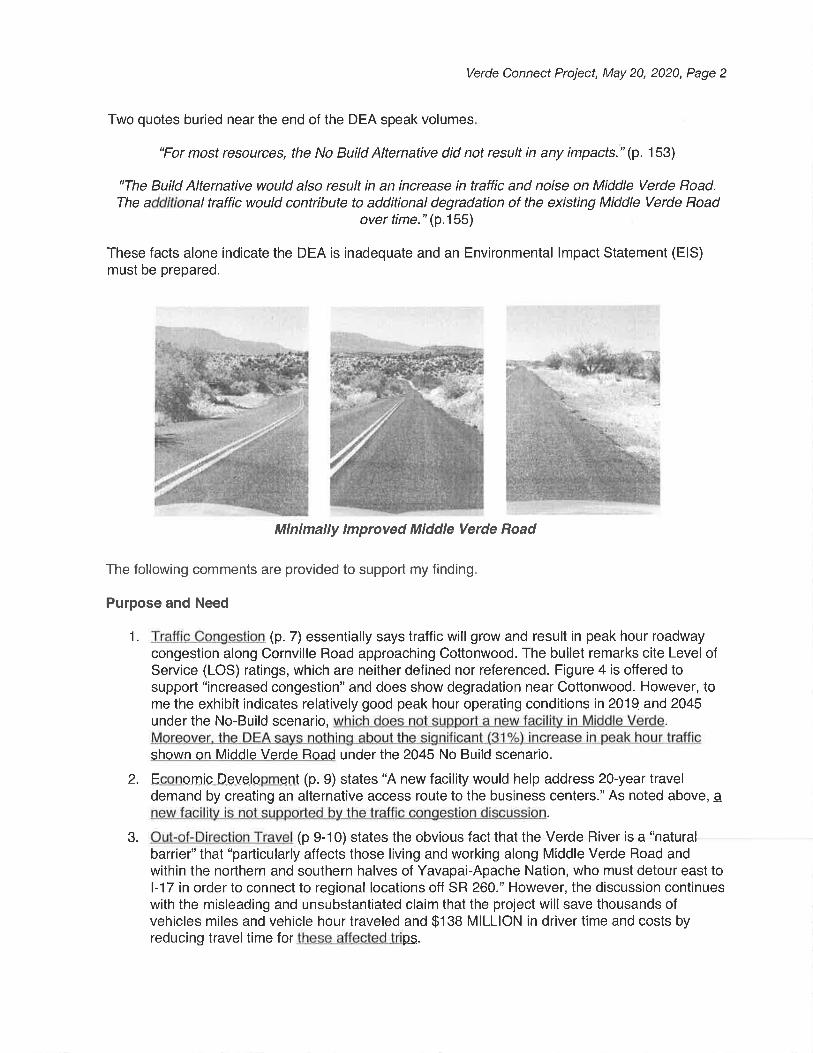


From: Dee Kephart <[email protected]>
Sent: Tuesday, May 19, 2020 1:12 PM
To: VerdeConnectComments
Subject: [EXTERNAL] AGFD Response Letter Verde Connect Draft EA
Attachments: c12102_1-15.pdf; AGFD Response Verde Connect Draft EA.pdf
Good Afternoon,
Attached is the Arizona Game and Fish Department's response letter to the Verde Connect Draft Environmental Assessment. Additionally I have included a fencing schematic referenced in the responseletter. Please feel free to contact me if you have any questions or need further information. Thank you for the opportunity to provide Department concerns and comments throughout the Verde Connectdevelopment process.
Kind Regards
Dee Kephart
DEE KEPHART| HABITAT, EVALUATION AND LANDS PROGRAM MANAGER
ARIZONA GAME AND FISH DEPARTMENT
OFFICE: 928.692.7700MOBILE: 928.263.8855EMAIL: [email protected]
azgfd.gov | 5325 Stockton Hill Rd., Kingman AZ 86409
Join our new Conservation Membership program and ensure a wildlife legacy for the future.


From: Ronald Tiller <[email protected]>
Sent: Monday, May 25, 2020 11:54 PM
To: VerdeConnectComments
Cc: Edwin Slade; Dodie O'Bier
Subject: [EXTERNAL] Verde Connect Comments
Dear Yavapai County and Federal Highway Administration,
Thank you for the opportunity to review and comment on the Draft Environmental Assessment for the Verde Connect, a project that proposes to construct a new two-lane road between State Route 260and Cornville Road. The project is anticipated to cross the Verde River, one of the largest perennial streams in the State of Arizona. The vast majority of the proposed project area of the Build Alternative(B2; Coury Drive to Beaverhead Flat Road) lies within the Verde River watershed. A small portion, about 2,500 feet, of its 9.4-mile length traverses into the uppermost elevations of the adjoining OakCreek watershed.
The proposed bridge alignment anticipates crossing the Verde River about 1.5 miles downstream of the confluence of the Verde River and Oak Creek. Page 121 notes that the Arizona List of UniqueWaters (Arizona Administrative Code R18-11-112(E)) and the Arizona 2006/2008 Section 303(d) List of Impaired and Not Attaining Waters were reviewed to determine whether any unique or impairedwaters were present and found that no Unique or Impaired waters occurred within the study area. Arizona’s 2018 303(d) List of Impaired Waters includes the Verde River (Reach 15060202-025; SycamoreCreek to Oak Creek) for Dissolved Oxygen and E. coli and Oak Creek (Reach 15030202-106; Spring Creek to Verde River) for E. coli. The reach over which the proposed project crosses is Inconclusive, whichmeans not enough water quality data are available to determine its status; however, given the Impaired status of the reaches immediately upstream of the proposed project, it is likely that additionaldata will reveal that this reach of the river is Impaired as well. The mitigation measures approved by the Federal Highway Administration demonstrates the commitment of the responsible parties tominimize impacts on the water quality of the Verde River.
Mitigation measures established for the upland areas and ephemeral channels affected by the construction of the road aim to minimize the disturbance footprint and address efforts to control erosionvia a suite of Best Management Practices including reseeding using U.S. Forest Service approved seed mixes. Culvert design elements maintaining the dimension, pattern, and profile of ephemeralchannel morphology will reduce the risk of erosion and sediment discharge from tributary drainages to the Verde River. As noted on page 120, the proper design and placement of culverts will be criticalfor minimizing erosion in drainages that are prone to channel incision.
Thank you in advance for considering and responding to our comments in the final version of the Environmental Assessment for Verde Connect.
Respectfully submitted,
Ron Tiller
Ron Tiller, PhD
Senior Scientist
Work: 602-771-0367Mobile: 602-762-2036
azdeq.gov
Your feedback matters to ADEQ. Visit azdeq.gov/feedback

UNITED STATES ENVIRONMENTAL PROTECTION AGENCY
REGION IX 75 Hawthorne Street San Francisco, CA 94105
May 25, 2020 Karla Petty Division Administrator Federal Highway Administration, Arizona Division 4000 North Central Avenue, Suite 1500 Phoenix, Arizona 85012 Subject: Verde Connect Project Environmental Assessment, Yavapai County, Arizona Dear Ms. Petty: Thank you for the opportunity to review the Draft Environmental Assessment (DEA) for the Verde Connect project. The EA evaluates alternatives for a new road connection between State Route 260 and Cornville Road, including a new crossing of the Verde River and alternative access to the Middle Verde community and portions of the Yavapai-Apache Nation north of the Verde River. Throughout development of the DEA, EPA has appreciated the commitment of FHWA to work closely with state and federal resource and regulatory agencies to address concerns early and avoid and minimize impacts to environmental resources. Through a collaborative approach of monthly agency meetings and cooperating agency reviews, EPA has had the opportunity to provide feedback and have our comments addressed through early revisions to technical reports and the environmental document. While EPA has no further comments on the DEA, we continue to be concerned about potential impacts to environmental resources associated with the Verde River, one of only two Wild and Scenic Rivers within Arizona, and one of the largest perennial streams in the state. We are encouraged by commitments made in the document that no permanent or temporary construction will occur within the main flow channel of the Verde River, and by the habitat restoration plan proposed for the Verde River Riparian Corridor. We look forward to continued collaboration with your agency as project design progresses to identify further avoidance and minimization measures, and to finalize a compensatory mitigation plan for any unavoidable impacts to federally regulated wetlands and waters. If you have any questions or concerns regarding our comments, please feel free to contact me at 415-972-3370 or [email protected].
Sincerely, Clifton Meek Environmental Review Branch Cc via email: Roger McCormick, Yavapai County Public Works
Jesse Rice, U.S. Army Corps of Engineers
CLIFTON MEEK
Digitally signed by CLIFTON MEEK Date: 2020.05.25 12:29:18 -07'00'