Variation in styles of rifting in the Gulf of California
17
Variation in styles of rifting in the Gulf of California Daniel Lizarralde 1 , Gary J. Axen 2 , Hillary E. Brown 3 , John M. Fletcher 4 , Antonio González-Fernández 4 , Alistair J. Harding 5 , W. Steven Holbrook 3 , Graham M. Kent 5 , Pedro Paramo 3,7 , Fiona Sutherland 5,7 , and Paul J. Umhoefer 6 1 Dept. of Geology and Geophysics, Woods Hole Oceanographic Institution 2 Dept. of Earth & Environmental Sciences, New Mexico Inst. of Mining and Technology 3 Dept. of Geology and Geophysics, University of Wyoming 4 Dept. of Geology, Centro de Invest. Científica y de Educación Superior de Ensenada 5 Inst. of Geophysics and Planetary Physics, Scripps Institution of Oceanography 6 Dept. of Geology, Northern Arizona Univ. 7 BP Exploration Operating Company, London The rifting of continental lithosphere is a fundamental solid-earth process that leads to the formation of rifted continental margins and ocean basins. Understanding of this process comes from observations of the geometry of rifted margins and the magmatism resulting from rifting, which inform us about the strength of the lithosphere, the state of the underlying mantle, and the transition from rifting to seafloor spreading. Here we describe results from the PESCADOR seismic experiment in the southern Gulf of California and present the first crustal-scale images across conjugate margins of multiple segments within a single rift that has reached the stage of oceanic spreading. A surprisingly large variation in rifting style and magmatism is observed between these segments, from wide rifting with minor syn-rift magmatism to narrow rifting in magmatically robust segments. These differences encompass much of the variation observed across nearly all other non-end-member continental margins. The characteristics of magmatic endmember margins are typically explained in terms of mantle temperature. Our explanations for the variation in the Gulf of California, in contrast, invoke mantle depletion to
-
Upload
independent -
Category
Documents
-
view
3 -
download
0
Transcript of Variation in styles of rifting in the Gulf of California
Variation in styles of rifting in the Gulf of California Daniel Lizarralde1, Gary J. Axen2, Hillary E. Brown3, John M. Fletcher4, Antonio
González-Fernández4, Alistair J. Harding5, W. Steven Holbrook3, Graham M. Kent5,
Pedro Paramo3,7, Fiona Sutherland5,7, and Paul J. Umhoefer6
1Dept. of Geology and Geophysics, Woods Hole Oceanographic Institution 2Dept. of Earth & Environmental Sciences, New Mexico Inst. of Mining and Technology 3Dept. of Geology and Geophysics, University of Wyoming 4Dept. of Geology, Centro de Invest. Científica y de Educación Superior de Ensenada 5Inst. of Geophysics and Planetary Physics, Scripps Institution of Oceanography 6Dept. of Geology, Northern Arizona Univ. 7BP Exploration Operating Company, London
The rifting of continental lithosphere is a fundamental solid-earth process that leads
to the formation of rifted continental margins and ocean basins. Understanding of
this process comes from observations of the geometry of rifted margins and the
magmatism resulting from rifting, which inform us about the strength of the
lithosphere, the state of the underlying mantle, and the transition from rifting to
seafloor spreading. Here we describe results from the PESCADOR seismic
experiment in the southern Gulf of California and present the first crustal-scale
images across conjugate margins of multiple segments within a single rift that has
reached the stage of oceanic spreading. A surprisingly large variation in rifting
style and magmatism is observed between these segments, from wide rifting with
minor syn-rift magmatism to narrow rifting in magmatically robust segments.
These differences encompass much of the variation observed across nearly all other
non-end-member continental margins. The characteristics of magmatic endmember
margins are typically explained in terms of mantle temperature. Our explanations
for the variation in the Gulf of California, in contrast, invoke mantle depletion to
account for wide, magma-poor rifting and mantle fertility and possibly the influence
of sediments to account for robust rift and post-rift magmatism in the Gulf of
California. These factors may vary laterally over small distances in regions that
have transitioned from convergence to extension, as is the case for the Gulf of
California and many other rifts.
The most basic structural feature of a rift is its width. A range of rift widths is
observed globally, with wide rifts defined as those with a total conjugate-margin width
greater than 200 km(1). Narrow rifts form in numerical models as necking instabilities2
provided extension rates outpace thermal diffusion3. Wide rifts require a mechanism to
inhibit localization, and it is believed that flow within a weak lower crust, driven by
buoyancy forces in high heat flow settings, plays this role in many wide rifts1,4.
Parameterizations of mantle melting predict melt production as a function of lithospheric
thinning5. Rifted margins with magmatic additions substantially greater or less than
predicted for “normal” mantle potential temperature (~1350°C) can be referred to as
magma-rich or magma-poor margins. End members range from volcanic margins, with
2-3 times predicted magmatism and voluminous subaerial eruptions, to non-volcanic
margins, which exhibit almost no rift or post-rift magmatism. Volcanic margins are
commonly explained as due to increased mantle potential temperature, and non-volcanic
margins as due to conductive cooling at slow rates of extension. It is generally believed
that mantle temperature also places the primary control on rift magmatism observed
across non-end-member margins, such as those of the southern Gulf of California.
Many of the factors believed to control structural evolution and magmatism during
rifting – extension rate, mantle potential temperature, and heat flow – tend to be regional
in nature. Our results reveal structural and magmatic variations over small distances
along the Gulf of California rift, suggesting that other factors also exert a first-order
influence on rift evolution.
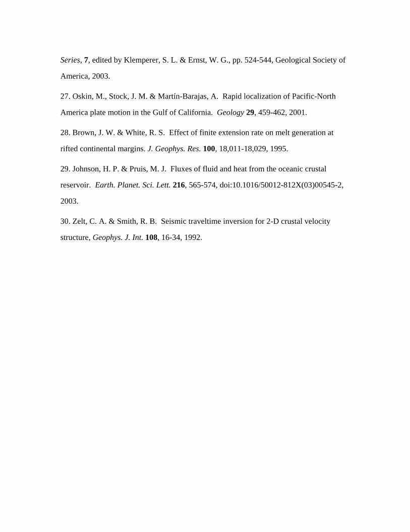
The Gulf of California is an oblique rift system with short spreading segments
connected by long transform faults (Fig. 1)6. Rifting in the gulf began at ~12-15 Ma
when subduction ended west of the Baja California peninsula. As the East Pacific Rise
(EPR) approached the paleo-trench, the subducting Farallón plate broke into a number of
microplates, and, as subduction stalled, those microplates and the Baja California
peninsula coupled to the Pacific plate, resulting in the onset of rifting and eventually the
modern plate boundary within the Gulf of California in the vicinity of the former arc7-10.
The peninsula now moves nearly completely with the Pacific plate, with ~48 mm/yr of
spreading across the Gulf of California representing ~92% of Pacific-North America
relative motion11,12. No shear zones cut across the peninsula south of the Agua Blanca
fault (Fig. 1, inset), and the Pacific/North American Euler pole is sufficiently distant that
the rift segments of the southern gulf have all experienced the same net extension rate
since rifting began.
Previously, little was known about the variation in rifted-margin crustal structure
along the gulf, with constraints limited to geologic observations, seafloor bathymetry,
gravity transects, sparse seismic refraction measurements13, and the CORTES-P9614
crustal-scale seismic transect in the northern gulf (Fig. 1). The seafloor expression of rift
structure is masked by sediments in much of the gulf, and the considerable variation in
sediment thickness, from thick sediments in the north to little sediment input in the south,
gives the impression that rift structure varies from narrow in the south to wide in the
north. This impression is enhanced by the obscuring effect of sediment on the
development of seafloor spreading magnetic lineations6, such that diagnostic magnetic
lineations are only observed across the southernmost segments of the gulf. Our results
indicate that a simple north-to-south variation does not exist in the southern gulf, south of
Tiburon Island (Fig. 1). Instead, distinct styles of rifting and rift magmatism occur within
the southern gulf, and this variation appears to be related to pre-rift magmatic history.
We acquired wide-angle and multi-channel seismic data across the northern
Guaymas, Alarcón, and San José del Cabo to Puerto Vallarta (Cabo-PV) segments of the
southern Gulf of California as part of the PESCADOR experiment. Each of these
transects was instrumented with ocean-bottom seismometers spaced 10-15 km apart and
similarly spaced seismometers on land recording the offshore shots to ~100 km inland.
Excellent quality data from this dense source and receiver coverage enable imaging of
detailed crustal structure across these rift segments15-17 (Fig. 2 and Supp. Inf.). Each
transect reveals a rifting style that is distinct in terms of structure and magmatism.
The Guaymas basin is a narrow rift segment that has been robustly magmatic since
breakup. We estimate the location of the continent/ocean transition here based on the
well constrained rapid shallowing of the Moho and coincident lateral increase in seismic
velocity to ~6.8 km/s, a value typical of gabbroic composition rock. We interpret the
crust seaward of the continent/ocean transitions to be new igneous crust formed at an
oceanic spreading centre that accommodated the majority of extension in this segment
since lithospheric rupture. The spreading centre has been robustly magmatic, forming
new intrusive igneous crust 6 to 8 km thick, with an additional unknown volume of
igneous material intruded into the overlying sediments. The ~280 km width of new
igneous crust and spreading rates of ~48 mm/yr imply that lithospheric rupture occurred
at ~6 Ma. Lithospheric rupture followed at least 70 km of continental extension, the
amount estimated across the thinned continental-margin crust of the velocity model. It is
likely that the low-lying crust of the coastal plain beyond our transect to the southeast
also was extended.
The Alarcón segment is a wide rift. This segment experienced ~350 km of
continental extension prior to the onset of seafloor spreading at 2-3 Ma, which has
produced ~135 km of oceanic crust ~6 km thick15. The continent/ocean boundary is
marked by a sharp transition from a shallowing to a flat Moho below normal-thickness
oceanic crust with clearly identifiable magnetic anomalies (Sup. Inf. Fig. S1). In this
segment, the transition to seafloor spreading appears coincident with the northward
propagation of the EPR6,18. Earlier, extension localized beneath the Tamayo trough,
thinned the continental crust there to ~7 km, but left little evidence there or elsewhere
within the segment for syn-rift magmatism apart from a 250- to 500-m-thick, 2.5- to 2.8-
km/s layer overlying basement along much of the transect that may represent volcanic or
volcaniclastic strata15. The Alarcón segment was thus magma-poor during rifting,
suggesting that the underlying “continental” asthenospheric mantle did not readily melt
upon decompression. We speculate that, as the EPR propagated northward, dikes
sourced from the presumably more fertile EPR asthenospheric mantle ultimately enabled
rupturing of the continental lithosphere19.
The Cabo-PV segment is a narrow rift. The continent/ocean boundary at the
western margin is similar to that in Alarcón, juxtaposing EPR-sourced oceanic crust
against extended continental crust. In this segment, however, seafloor spreading initiated
~1 m.y. prior to the propagation of the EPR into the gulf at ~3.5 Ma. The initial
spreading centre is preserved in the southeast as the María Magdalena Rise6,20. The crust
produced at the Magdelena Rise was presumably derived from “continental”
asthenosphere and is ~1 km thicker than the crust formed at the EPR. The EPR
propagated into the segment along the western continent/ocean boundary, and it is
believed that a brief period of coincident spreading at the two spreading centres resulted
in convergence along the eastern margin6. Estimating pre-rift extension in this segment is
thus complicated, but the steep western margin indicates that this is a narrow rift segment
(Sup. Inf. Fig. S5). There is little direct evidence of syn-rift magmatism in this segment,
but the rapid transition to magmatic seafloor spreading suggests that this segment is
neither magma poor nor magma rich and that the underlying continental asthenosphere
produced melt as would be expected during rifting.
The crustal structure of the Alarcón segment challenges the common notion of how
wide rifts form. A mechanism of wide-rift formation in which buoyancy-driven lower-
crustal flow inhibits localization1,4 does not apply to this segment, since substantial Moho
topography persists to the present. The localized extension beneath the Tamayo trough
indicates that the lithosphere resisted rupture even after substantial thinning, suggesting
that the lithospheric mantle was strong and that the asthenosphere did not produce
sufficient melt to rupture the lithosphere via diking19 prior to the arrival of the
presumably more fertile EPR mantle. The adjacent Pescadero and Farallón segments
north of Alarcon have rifted-margin morphologies that are similar to Alarcón (Supp. Info.
Fig. S5). These segments differ from Alarcón in that their spreading centres are defined
by narrow bathymetric deeps that indicate only nascent, or no, seafloor spreading. (Supp.
Info. Figs. S4-6). This suggests that the EPR mantle has not propagated into them and
that these are also magma poor segments underlain by continental mantle that does not
readily melt. We call these wide-rift segments collectively the south-central domain.
The south-central segments rifted over the locus of voluminous early-Miocene
ignimbrite volcanism21 (Fig. 1). This early Miocene event, which followed a more
extensive early Oligocene event, deposited 1-2 km of ignimbrite and lava over a wide
area and may have left the residual mantle both depleted and dry, reducing its ability to
melt and deform22. Magmatic depletion of the mantle may thus be a primary factor
controlling the evolution of rifting in the south-central domain. The relatively abrupt
transition in rift style between the south-central domain and the surrounding segments
may be related to the focused magmatism characteristic of volcanic arcs, evidenced by
their long-lived volcanic centres, which may be manifest partly in the mantle.
Alternatively, the triggering mechanism of ignimbrite magmatism, perhaps slab
foundering21, may have been laterally discontinuous. Either situation could enable
voluminous arc volcanism to impart depleted mantle signatures that vary over small
spatial scales, thus explaining the relatively abrupt variation in rifting style between the
south-central domain and the segments to the north and south.
Magmatism within the Guaymas basin is anomalous with respect to the south-
central segments and with respect to globally averaged mid-ocean ridge crustal
production23 (~6 km). The average thickness of the plutonic component of new igneous
crust (average VP=6.8 km/s) in the northern Guaymas segment is greater than 7 km, and
velocities of 4.0-5.5 km/s in the overlying 2- to 3-km-thick layer of sediments and
igneous rocks24 suggest an additional 1 km or more equivalent igneous thickness. It is
likely that the southern Guaymas segment, which hosts a basaltic shield volcano25, is
similarly magmatic. It is possible that the underlying mantle here is more fertile and/or
hotter than that beneath the south-central domain and the average MORB-source mantle.
The mantle may be “charged”26 in a similar fashion to how the mantle beneath the south-
central domain was charged prior to the early Miocene ignimbrite event. That ignimbrite
event did not extend northward beneath the Guaymas basin, however, and so the
inherited fertility/hydration beneath Guaymas basin has been expressed as ongoing robust
magmatism since continental breakup, with this magmatism probably contributing to
lithospheric rupture after only moderate extension.
A second factor possibly contributing to the anomalous magmatism in Guaymas
basin may also explain crustal structure within the northern gulf and has implications for
sedimented spreading centres and mantle melt extraction generally. The crustal structure

of the Delfín-Tiburón segment in the northern gulf 14 is similar to the northern Guaymas
segment, with a thick layer (> 5 km) of intruded sediments overlying a thick igneous
layer with mafic (6.5-6.8 km/s) seismic velocities. Geologic evidence suggests that ~275
km of extension has occurred across the Delfín-Tiburón segment between points
separated by 300 km27 (Fig. 1), and so it is likely that most of this extension was
accommodated by the creation of new igneous crust. A common feature shared by the
Guaymas and Delfín-Tiburón segments, and not shared by the Cabo-PV segment, is a
thick sedimentary layer, and we speculate that this sediment blanket may enhance mantle
melt extraction. It is unlikely that melt extraction beneath mid-ocean ridges is 100%
efficient, and so the global average oceanic crustal thickness likely underestimates the
available melt. The thermal structure near mid-ocean ridges may place controls on melt
extraction28, and hydrothermal circulation is a robust mechanism for enhancing heat
flux29. It might thus be expected that a thick blanket of sediment, by inhibiting
hydrothermal circulation, would enhance melt extraction, resulting in new igneous crust
thicker than that at unsedimented mid-ocean ridges.
The results presented here highlight the importance of inherited mantle
fertility/hydration and possibly of sediments as controlling parameters of the rifting
process. The primary observations are variations in rift width and magmatism over small
spatial scales, with wide, magma-poor rift segments formed over mantle that sourced
voluminous pre-rift, arc magmatism, and magma-rich segments associated with thick
sediments. Many rifts initiate or localize at formerly convergent boundaries in response
to ridge subduction, in back-arc settings, or along suture zones following
continent/continent collision. Substantial along-strike variations in the expression of
rifting, with these variations controlled by pre-rift tectonics and magmatism of the
formerly convergent margin, may thus be common along many rifted margins. Similarly,

substantial along-strike variability in syn-rift sedimentation is likely in many rifts,
depending on topography, climate, and regional drainage patterns.
References
1. Hopper, J. R. & Buck, W. R. The effect of lower crustal flow on continental extension
and passive margin formation. J. Geopys. Res. 101, 21,175-20,194, 1996.
2. Braun, J. & Beaumont, C. Styles of continental rifting from dynamical models of
lithospheric extension. Mem. Can. Soc. Pet. Geol. 12, 241-258, 1987.
3. England, P. C., Constraints on extension of continental lithosphere. J. Geophys. Res.
88, 1145-1152, 1983.
4. Buck, W. R., Lavier, L. L. & Poliakov, A. N. B. How to make a rift wide. Phil. Trans.
R. Soc. Lon. 357, 671-693, 1999.
5. McKenzie, D. & Bickle, M. J. The volume and composition of melt generated by
extension of the lithosphere. J. Petrol. 29, 625-679, 1988.
6. Lonsdale, P. Geology and tectonic history of the Gulf of California, in The Eastern
Pacific Ocean and Hawaii, edited by Winterer, E. L., Hussong, D. M. & Decker, R. W.,
The Geology of North America N, Geological Society of America, pp. 499-521, 1989.
7. Atwater, T. M. Implications of plate tectonics for the Cenozoic evolution of western
North America. Geol. Soc. Amer. Bull. 81, 3513-3536, 1970.
8. Menard, H. W. Fragmentation of the Farallon plate by pivoting subduction. J. Geol.
86, 99-110, 1978.
9. Stock, J. M. & Lee, J. Do microplates in subduction zones leave a geological record?
Tectonics, 13, 1472-1487, 1994.
10. Michaud, F., Royer, J. Y., Bourgois, J., Dyment, J., Calmus, T., Bandy, W., Sosson,
M., Mortera-Gutiérrez, C., Sichler, B., Rebolledo-Viera, M. & Pontoise, B. Oceanic-
ridge subduction vs. slab break off: Plate tectonic evolution along the Baja California Sur
continental margin since 15 Ma. Geology 34, 13-16, doi:10.1130/G22050.1, 2006.
11. DeMets, C. & Dixon, T. H. New kinematic models for Pacific-North America
motion from 3 Ma to present; I, Evidence for steady motion and biases in the NUVEL-1A
model. Geophys. Res. Let., 26, 1921-1924.
12. Dixon, T. H., Farina, F., DeMets, C., Suarez-Vidal, F., Fletcher, J., Marquez-Azua,
B., Miller, M., Sanchez, O. & Umhoefer, P. J., New kinematic models for Pacific-North
America motion from 3 Ma to present; II, Evidence for a “Baja California shear zone”.
Geophys. Res. Let., 26, 1921-1924.
13. Phillips, R. P. Seismic refraction studies in Gulf of California, in Marine geology of
the Gulf of California, AAPG Memoir, 3, edited by van Andel, T. & Shor, G. G., pp. 90-
125, 1964.
14. González-Fernández, A., Dañobeitia, J. J., Delgado-Argote, L. A., Michaud, F.,
Córdoba, D. & Bartolomé, R. Mode of extension and rifting history of upper Tiburón
and upper Delfín basins, northern Gulf of California. J. Geophy. Res. 110,
doi:10.1029/2003JB002941, 2005.
15. Sutherland, F. H. "Continental Rifting Across the Southern Gulf of California",
Ph.D. Thesis, Univ. of California, San Diego, 2006.
16. Paramo, P. "Seismic Studies of Continental Rupture and Ocean Finestructure in the
Gulf of California", Ph. D. Thesis, Univ. of Wyoming, 2006.
17. Brown, H. E., Paramo, P., Holbrook, W. S., Lizarralde, D., Kent, G., Harding, A.,
Gonzalez, A., Fletcher, J., Umhoefer, P. & Axen, G. Crustal structure of the southern
Gulf of California and subducting Rivera plate. Eos Trans., 87, Fall Meet. Suppl., T41D-
1607, 2006.
18. Castillo, P. R., Hawkins, J. W., Lonsdale, P. F., Hilton, D. R., Shaw, A. M. &
Glascock, M. D. Petrology of Alarcon Rise lavas, Gulf of California: Nascent
intracontinental ocean crust. J. Geophy. Res. 107, doi:10.1029/2001JB000666, 2002.
19. Buck, W. R. The role of magma in development of the Afro-Arabian rift system, in
The Afar Volcanic Province Within the East African Rift System, Geol. Soc. Spec. Pub.,
259, edited by Yirgu, G., Ebinger, C. J. & Maguire, P. K. H., pp. 43-54, 2006.
20. Larsen, R. L. Bathymetry, magnetic anomalies, and plate tectonic history of the
mouth of the Gulf of California. Geol. Soc. Amer. Bull. 83, 3345-3360, 1972.
21. Ferrari, L., Valencia-Moreno, M. & Bryan, S. Magmatismo y tectónica en la Sierra
Madre Occidental y su relación con la evolución de la margen occidental de
Norteamérica. Bull. Geol. Soc. Mexico 57, 343-378, 2005.
22. Hirth, G. & Kohlstedt, D .L. Water in the oceanic upper mantle: Implications for
rheology, melt extraction, and the evolution of the lithosphere. Earth. Planet. Sci. Lett.
144, 93-108, 1996.
23. White, R.S., McKenzie, D. & O’Nions, R.K. Oceanic crustal thickness from seismic
measurements and rare earth element inversions. J. Geophys. Res. 97, 19,683-19,715,
1992.
24. Einsele, G., Curray, J. M., Moore, D. M., Aguayo, E., Aubry, M. P., Fornari, D.,
Guerrero, J., Kastner, M., Kelts, K., Lyle, M., Matoba, Y., Molina-Cruz, A., Niemitz, J.,
Rueda, J., Saunders, A., Schrader, H., Simoneit, B. & Vacquier, V. Intrusion of basaltic
sills into highly porous sediments, and resulting hydrothermal activity. Nature, 283, 441-
445, 1980.
25. Batiza, R., Geology, petrology, and geochemistry of Isla Tortuga, a recently formed
tholeiitic island in the Gulf of California. Geol. Soc. Amer. Bull., 89, 1309-1324, 1978.
26. Humphreys, E., Hessler, E., Dueker, K., Erslev, E., Farmer, G. L. & Atwater, T. How
Laramide-age hydration of North America by the Farallon slab controlled subsequent
activity in the western U.S., in The George A. Thompson Volume, International Book
Series, 7, edited by Klemperer, S. L. & Ernst, W. G., pp. 524-544, Geological Society of
America, 2003.
27. Oskin, M., Stock, J. M. & Martín-Barajas, A. Rapid localization of Pacific-North
America plate motion in the Gulf of California. Geology 29, 459-462, 2001.
28. Brown, J. W. & White, R. S. Effect of finite extension rate on melt generation at
rifted continental margins. J. Geophys. Res. 100, 18,011-18,029, 1995.
29. Johnson, H. P. & Pruis, M. J. Fluxes of fluid and heat from the oceanic crustal
reservoir. Earth. Planet. Sci. Lett. 216, 565-574, doi:10.1016/50012-812X(03)00545-2,
2003.
30. Zelt, C. A. & Smith, R. B. Seismic traveltime inversion for 2-D crustal velocity
structure, Geophys. J. Int. 108, 16-34, 1992.

Supplementary Information is linked to the online version of the paper at www.nature.com/nature.
Acknowledgements We thank the captains and crew of the R/V Maurice Ewing and R/V New Horizon, the OBSIP teams, J. Urban, and A. Gorman for his efforts as Chief Scientist on the R/V New Horizon. The Lamont Earth Observatory Marine Office and CICESE provided invaluable support before and during the experiment. This work was funded by a grant from the U.S. NSF-MARGINS program.
Author Contributions D.L., P.J.U., G.M.K., W.S.H., A.J.H., A.G.F., J.M.F., and G.J.A. were the principle investigators on this project and each contributed substantially to this work. F.S., P.P., and H.E.B. analysed data from the Alarcón and Cabo-PV segments as portions of their Ph.D. theses. D.L. analysed data from Guaymas and wrote the paper. All authors discussed the results and commented on the manuscript.
Author Information Reprints and permissions information is available at npg.nature.com/reprintsandpermissions. The authors declare no competing financial interests. Correspondence and requests for materials should be addressed to D.L. ([email protected]).

Figure Captions
Figure 1. Map of the PESCADOR experiment in southern Gulf of California.
Guaymas, Carmen, Farallón, Pescadero, Alarcón, and San José del Cabo-
Puerto Vallarta segments separated by dashed lines and labelled G, C, F, P, A,
C-PV, blue for south-central segments; white and red dots are instrument
locations of the three seismic transects; white shading indicates extent of early
Miocene ignimbrite volcanism21. Inset: Green shading, northern; pink, EPR-
sourced crust; extinct and modern plate boundaries in blue and red; A.B., Agua
Blanca; white and blue dots, CORTES-P9614 instruments; geologic constraints
on northern gulf spreading27 indicated by yellow stars; and mapped extent21 of
Oligicene (yellow shading) and early Miocene (purple) ignimbrite events.
Figure 2. Models of seismic velocity structure along the Guaymas, Alarcón and
Cabo-PV transects of the PESCADOR experiment. Velocity contours are
labelled in km/s. Yellow diamonds are instrument locations. COT indicates
interpreted continent/ocean transition. Dashed line in the Cabo-PV model
indicates interpreted boundary between oceanic crust formed at the Magdalena
Rise and the EPR. Models were determined using a combined forward/inverse
travel time modelling approach30. Examples of data are presented in the
Supplementary Information.
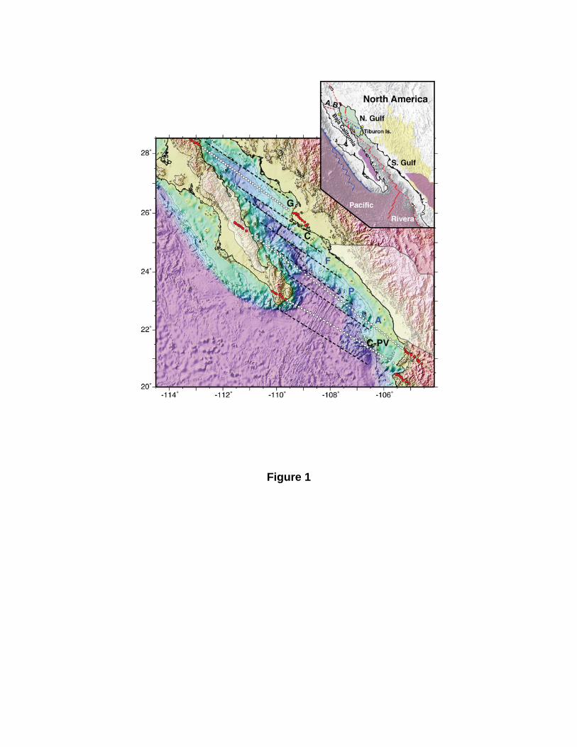
Figure 1
Figure 2