Variability of the subtropical shelf front off eastern South America: Winter 2003 and summer 2004
10
Variability of the subtropical shelf front off eastern South America: Winter 2003 and summer 2004 Alberto R. Piola a, , Osmar O. Mo ¨ller Jr. b , Rau ´ l A. Guerrero c , Edmo J.D. Campos d a Departamento Oceanografı ´a, Servicio Hidrografı ´a Naval and Departamento de Ciencias de la Atmo ´sfera y los Oce ´anos, FCEN, Universidad de Buenos Aires, Buenos Aires, Argentina b Departamento Fı ´sica, Fundac - a ˜o Universidade Federal do Rio Grande, Rio Grande, Brazil c Instituto Nacional de Investigacio ´n y Desarrollo Pesquero, Mar del Plata, Argentina d Instituto Oceanogra ´fico, Universidade de Sa ˜o Paulo, Sa ˜o Paulo, Brazil article info Available online 26 March 2008 Keywords: Shelf fronts Water masses Water mixing Seasonal variations Southwest Atlantic abstract Hydrographic data collected during surveys carried out in austral winter 2003 and summer 2004 are used to analyze the distributions of temperature (T) and salinity (S) over the continental shelf and slope of eastern South America between 271S and 391S. The water mass structure and the characteristics of the transition between subantarctic and subtropical shelf water (STSW), referred to as the subtropical shelf front (STSF), as revealed by the vertical structure of temperature and salinity are discussed. During both surveys, the front intensifies downward and extends southwestward from the near coastal zone at 331S to the shelf break at 361S. In austral winter subantarctic shelf water (SASW), derived from the northern Patagonia shelf, forms a vertically coherent cold wedge of low salinity waters that locally separate the outer shelf STSW from the fresher inner shelf Plata Plume Water (PPW) derived from the Rı ´o de la Plata. Winter T–S diagrams and cross-shelf T and S distributions indicate that mixtures of PPW and tropical water only occur beyond the northernmost extent of pure SASW, and form STSW and an inverted thermocline characteristic of this region. In summer 2004, dilution of Tropical water (TW) occurs at two distinct levels: a warm near surface layer, associated to PPW–TW mixtures, similar to but significantly warmer than winter STSW, and a colder (T16 1C) salinity minimum layer at 40–50 m depth, created by SASW–STSW mixtures across the STSF. In winter, the salinity distribution controls the density structure creating a cross-shore density gradient, which prevents isopycnal mixing across the STSF. Temperature stratification in summer induces a sharp pycnocline providing cross-shelf isopycnal connections across the STSF. Cooling and freshening of the upper layer observed at stations collected along the western edge of the Brazil Current suggest offshore export of shelf waters. Low T and S filaments, evident along the shelf break in the winter data, suggest that submesoscale eddies may enhance the property exchange across the shelf break. These observations suggest that as the subsurface shelf waters converge at the STSF, they flow southward along the front and are expelled offshore, primarily along the front axis. & 2008 Elsevier Ltd. All rights reserved. 1. Introduction The Rio de la Plata discharges on average about 23,000 m 3 s 1 of freshwater into the western South Atlantic inducing a large- scale buoyant plume that in winter extends beyond 1000 km from the estuary. Primarily in response to variations in the along-shore wind stress, the Plata plume presents large northeastward penetrations along the continental shelf in late fall–winter (Piola et al., 2000). In contrast, in late spring–summer, the plume retracts southward (Guerrero et al., 1997; Framin ˜an et al., 1999; Piola et al., 2000). These seasonal Plata plume variations induce a large impact on the shelf ecosystem (e.g., Ciotti et al., 1995; Castello et al., 1990; Muelbert and Sinque, 1996; Sunye ´ and Servain, 1998). After the pioneering work of Emilson (1961), the inner shelf waters freshened by continental runoff have been generally referred to as Coastal Waters. More recently, however, it has been proposed that the complex thermohaline structure observed off Uruguay and southern Brazil arises from mixing of Plata waters with distinct shelf water masses, advected from remote regions (Piola et al., 2000). The subsurface shelf layers found underneath and offshore of the Plata plume are occupied by two distinct water masses: cold- fresh subantarctic shelf waters (SASW), derived from the Patagonia continental shelf, and warm–salty subtropical shelf waters (STSW), which are primarily influenced by the Brazil Current (Piola et al., 2000). Analysis of the historical hydrographic ARTICLE IN PRESS Contents lists available at ScienceDirect journal homepage: www.elsevier.com/locate/csr Continental Shelf Research 0278-4343/$ - see front matter & 2008 Elsevier Ltd. All rights reserved. doi:10.1016/j.csr.2008.03.013 Corresponding author. E-mail address: [email protected] (A.R. Piola). Continental Shelf Research 28 (2008) 1639– 1648
-
Upload
independent -
Category
Documents
-
view
0 -
download
0
Transcript of Variability of the subtropical shelf front off eastern South America: Winter 2003 and summer 2004

ARTICLE IN PRESS
Continental Shelf Research 28 (2008) 1639– 1648
Contents lists available at ScienceDirect
Continental Shelf Research
0278-43
doi:10.1
� Corr
E-m
journal homepage: www.elsevier.com/locate/csr
Variability of the subtropical shelf front off eastern South America: Winter2003 and summer 2004
Alberto R. Piola a,�, Osmar O. Moller Jr.b, Raul A. Guerrero c, Edmo J.D. Campos d
a Departamento Oceanografıa, Servicio Hidrografıa Naval and Departamento de Ciencias de la Atmosfera y los Oceanos, FCEN, Universidad de Buenos Aires, Buenos Aires, Argentinab Departamento Fısica, Fundac- ao Universidade Federal do Rio Grande, Rio Grande, Brazilc Instituto Nacional de Investigacion y Desarrollo Pesquero, Mar del Plata, Argentinad Instituto Oceanografico, Universidade de Sao Paulo, Sao Paulo, Brazil
a r t i c l e i n f o
Available online 26 March 2008
Keywords:
Shelf fronts
Water masses
Water mixing
Seasonal variations
Southwest Atlantic
43/$ - see front matter & 2008 Elsevier Ltd. A
016/j.csr.2008.03.013
esponding author.
ail address: [email protected] (A.R. Piola).
a b s t r a c t
Hydrographic data collected during surveys carried out in austral winter 2003 and summer 2004 are
used to analyze the distributions of temperature (T) and salinity (S) over the continental shelf and slope
of eastern South America between 271S and 391S. The water mass structure and the characteristics of
the transition between subantarctic and subtropical shelf water (STSW), referred to as the subtropical
shelf front (STSF), as revealed by the vertical structure of temperature and salinity are discussed. During
both surveys, the front intensifies downward and extends southwestward from the near coastal zone at
331S to the shelf break at 361S. In austral winter subantarctic shelf water (SASW), derived from the
northern Patagonia shelf, forms a vertically coherent cold wedge of low salinity waters that locally
separate the outer shelf STSW from the fresher inner shelf Plata Plume Water (PPW) derived from the
Rıo de la Plata. Winter T–S diagrams and cross-shelf T and S distributions indicate that mixtures of PPW
and tropical water only occur beyond the northernmost extent of pure SASW, and form STSW and
an inverted thermocline characteristic of this region. In summer 2004, dilution of Tropical water
(TW) occurs at two distinct levels: a warm near surface layer, associated to PPW–TW mixtures, similar
to but significantly warmer than winter STSW, and a colder (T�16 1C) salinity minimum layer at
40–50 m depth, created by SASW–STSW mixtures across the STSF. In winter, the salinity distribution
controls the density structure creating a cross-shore density gradient, which prevents isopycnal mixing
across the STSF. Temperature stratification in summer induces a sharp pycnocline providing cross-shelf
isopycnal connections across the STSF. Cooling and freshening of the upper layer observed at stations
collected along the western edge of the Brazil Current suggest offshore export of shelf waters. Low T and
S filaments, evident along the shelf break in the winter data, suggest that submesoscale eddies may
enhance the property exchange across the shelf break. These observations suggest that as the subsurface
shelf waters converge at the STSF, they flow southward along the front and are expelled offshore,
primarily along the front axis.
& 2008 Elsevier Ltd. All rights reserved.
1. Introduction
The Rio de la Plata discharges on average about 23,000 m3 s�1
of freshwater into the western South Atlantic inducing a large-scale buoyant plume that in winter extends beyond 1000 km fromthe estuary. Primarily in response to variations in the along-shorewind stress, the Plata plume presents large northeastwardpenetrations along the continental shelf in late fall–winter (Piolaet al., 2000). In contrast, in late spring–summer, the plumeretracts southward (Guerrero et al., 1997; Framinan et al., 1999;Piola et al., 2000). These seasonal Plata plume variations induce a
ll rights reserved.
large impact on the shelf ecosystem (e.g., Ciotti et al., 1995;Castello et al., 1990; Muelbert and Sinque, 1996; Sunye andServain, 1998). After the pioneering work of Emilson (1961), theinner shelf waters freshened by continental runoff have beengenerally referred to as Coastal Waters. More recently, however, ithas been proposed that the complex thermohaline structureobserved off Uruguay and southern Brazil arises from mixing ofPlata waters with distinct shelf water masses, advected fromremote regions (Piola et al., 2000).
The subsurface shelf layers found underneath and offshore ofthe Plata plume are occupied by two distinct water masses: cold-fresh subantarctic shelf waters (SASW), derived from thePatagonia continental shelf, and warm–salty subtropical shelfwaters (STSW), which are primarily influenced by the BrazilCurrent (Piola et al., 2000). Analysis of the historical hydrographic

ARTICLE IN PRESS
A.R. Piola et al. / Continental Shelf Research 28 (2008) 1639–16481640
data revealed limited evidence of mixing between these watermasses. A sharp thermohaline transition between SASW andSTSW, referred to as subtropical shelf front (STSF) is observed onthe continental shelf off southern Brazil and Uruguay. There is alsostrong evidence that the STSF marks transition in planktonassemblage’s composition (Muelbert et al., this issue). The frontruns approximately southward from the inner shelf off RioGrande, Brazil, and appears to be an extension of the subantarc-tic–subtropical transition observed at the Brazil–Malvinas Con-fluence over the continental shelf (Piola et al., 2000).
The large seasonal displacements of the low salinity upperlayer observed over the continental shelf suggest that subsurfacewater masses may also present some degree of seasonalvariability. However, the lack of synoptic observations with highvertical and horizontal resolution have prevented the detailedmapping of the location of the STSF and its seasonal variability. InAustral winter 2003 and summer 2004, we conducted two large-scale, multidisciplinary surveys of the continental shelf and slopebetween Mar del Plata, Argentina (381S) and Itajaı, Brazil (261S,Fig. 1). Among other goals, the fieldwork was designed todetermine the relation between the distribution of low salinitycoastal waters and the subsurface water mass structure, toexplore possible mechanisms of frontal formation and mainte-nance and the fate of the shelf water masses. In this article, wediscuss the subsurface water mass distribution and the thermoha-line structure observed across the STSF during these cruises. InSection 2, we describe the data and methods; in Section 3, we
40
38
36
34
32
30
28
26
Río dela Plata
P.del Este
Albardão
Rio Grande
Cabo Sta. Marta Grande
44
37 46 54
48
25
32 39
33 40
48
Pozo de Fango
44
Solidão
Mardel Plata
Itajai
24
P. Medanos
Torres PatosLagoon
56
5967
42
56
6364
28
60
58 56 54 52 50 48 46
P. del Diablo
Fig. 1. Location of hydrographic stations occupied during the PLATA cruises in
austral winter: August–September 2003 (dots) and summer: February 2004
(triangles). Selected station numbers (bold in winter and italic in summer) and
section names are shown. Also shown are the 40 (shaded), 100, 200 (heavy), 1000
and 2000 m isobaths.
present the cross-shelf thermohaline structure and the distribu-tion of the water masses; and in Section 4, the results arediscussed.
2. Data
The Nicop-LAPLATA cruises were carried out on board R/V ARA
PUERTO DESEADO, between 20 August and 2 September 2003, andR/V NoC ANTARES between 1 and 19 February 2004. In eachcruise, 11 hydrographic sections spanning the shelf and shelfbreak regions to within the western boundary currents wereoccupied between Mar del Plata, Argentina and Itajai, Brazil.Eighty-three stations were occupied in winter 2003 and 90stations in summer 2004. At each station, we collected verticalquasi-continuous conductivity–temperature–depth (CTD) profileswith a SeaBird Electronics model 911, together with watersamples in up to 12 levels for determination of salinity, nutrientsand dissolved oxygen. Underway near-surface (�3 m) temperatureand salinity data were also collected during both cruises employ-ing SeaBird Electronics Seacat 21 thermosalinographs. Salinityfrom water samples was measured on board using a GuildlineAutosal 8400B salinometer calibrated with Ocean ScientificInternational standard seawater batch P131. The CTD salinitywas calibrated based on the water sample salinities, with aresidual error of 0.003. Similarly, based on CTD and underwaywater sample data, the thermosalinograph salinities collected ineach cruise were calibrated to within 0.05.
The above hydrographic observations are combined with asubsurface (15 m) salinity time series collected at a mooringlocated over the mid-shelf off Rio Grande from 4 March to 2August 1997 (see Zavialov et al., 2002).
3. Results
3.1. Water mass distribution across the STSF
The mean temperature (T), salinity (S) and potential densityanomaly (sy) of SASW and STSW as observed in each hydrographicsection occupied between Mar del Plata (381S) and Solidao (311S)in August 2003 and February 2004 are given in Table 1. SASWproperties are calculated including all data within 33.4oSo34and within the 25.5–26.5 and 24–26.5 kg m�3 sy intervals inwinter and summer, respectively. Since STSW generally forms alow S layer over tropical water (TW) and South Atlantic CentralWater (SACW), in the calculation of STSW properties, we includeall waters shallower than the S maximum and sy425 and24 kg m�3 in winter and summer, respectively.
SASW fills most of the continental shelf around 391S withsalinity higher than 33.4 (Guerrero and Piola, 1997). Salinitieslower than 33.4, found north of 361S, require mixtures of Plata andPatos Lagoon waters. Though low salinity waters at variouslocations have generally been referred to as Coastal Waters,because waters fresher than 32.5 can be traced southward to thePlata estuary, we will refer to them as Plata Plume Water (PPW).As will be shown later, the 32.5 isohaline is close to the mostintense cross-shore salinity gradients observed off Punta delDiablo (341S) and Albardao (331S) and is therefore close to theoffshore edge of the Plata plume at these locations (see Fig. 1 forlocations).
3.1.1. Austral winter 2003
The winter water mass structure across the STSF is depicted bythe T–S diagrams from selected stations collected off Punta delDiablo (Fig. 2). For comparison, the winter historical hydrographic

ARTICLE IN PRESS
Table 1Mean temperature (T), salinity (S) and density anomaly (sy) of subantarctic shelf
water and subtropical shelf water (italics) along selected sections in August 2003
(a) and February 2004 (b)
Section T (1C) S sy (kg m�3) Stations
(a) August 2003
Mar del Plata 8.43871.106 33.68170.076 26.16670.165 1–6
– – – –
Punta Medanos 8.96371.114 33.64170.087 26.05570.213 11–15
– – – –
Rıo de la Plata 8.87571.263 33.68270.101 26.09870.227 18–23
13.38372.556 34.56070.779 25.94270.067 24
Punta del Este 9.80470.743 33.62870.029 25.91170.114 27–30
15.68772.024 35.04870.687 25.83770.073 26
Punta del Diablo 10.69470.109 33.50670.004 25.66670.017 36–37
17.23571.014 35.36270.459 25.73670.120 38
Albardao – – – –
17.27770.948 35.11970.446 25.54170.156 41– 43
Rio Grande – – – –
18.03071.113 35.44670.622 25.60470.230 52– 56
Solidao – – – –
18.44270.610 35.37770.441 25.45570.232 59– 61
(b) February 2004
Mar del Plata 9.39173.221 33.68770.060 26.95070.609 3–6
– – – –
Punta Medanos 9.93473.502 33.74270.081 25.899 70.671 11–15
– – – –
Rıo de la Plata 9.37073.580 33.73370.061 25.98170.699 22–25
23.89670.339 36.44470.404 24.76870.316 26– 27
Punta del Este 15.01870.266 33.64170.017 24.89070.352 30–31
24.31870.253 36.10170.415 25.38270.242 42– 44
Punta del Diablo 15.49770.089 33.46070.009 24.67070.034 41
24.28172.191 36.46670.567 24.66170.442 28
Albardao 16.02370.502 33.71970.321 24.73370.237 50–51
20.10473.720 35.14670.993 24.77270.464 41– 43
Rio Grande – – – –
23.51572.174 36.04570.325 24.55270.559 52– 56
Solidao – – – –
23.55871.669 36.11370.449 24.59970.514 59– 61
Station numbers and standard deviations are given.
28 30 32 34 364
8
12
16
20
24
Tem
pera
ture
(°C
)
SASW
PPW
STSW
37
TW
22 23 24 2526
27
38 SACW
Salinity
45
Fig. 2. Temperature–salinity diagram of selected stations collected off Punta del
Diablo (341S) in austral winter 2003. Water masses are indicated as follows:
subtropical shelf water (STSW), upper layer of station 38 (open circles) and Plata
Plume Water (PPW, stars, stations 33–35). The large square indicates station 37.
Also shown are the historical data (gray dots), station 45 (crosses) collected off
Albardao and subantarctic shelf water (SASW, open squares enclosed by rectangle)
from selected stations collected off Punta Medanos (371S), Rio de la Plata (361S)
and P. del Este (351S) (see Fig. 1 for locations). The dashed line is the STSW–PPW
mixing line at station 38.
A.R. Piola et al. / Continental Shelf Research 28 (2008) 1639–1648 1641
data collected over the shelf between 201S and 401S are alsoshown in Fig. 2. The southernmost sections present a tight T–S
distribution within the 7–11 1C and 33.5–33.8 ranges, character-istic of pure SASW derived from the northern Patagoniacontinental shelf (see Table 1 and Guerrero and Piola, 1997).Saltier water (�34) evident in the historical data is a product ofmixing with cold-salty Malvinas Current water found in a near-bottom layer in the outer shelf south of 371S. Further north, offPunta del Diablo (341S), two distinct distributions are observed.First, the warm end member of SASW (10–11 1C, Table 1) mixeswith PPW (Fig. 2). In addition, relatively warm (T416 1C)–salty(S434.8) waters characteristic of STSW are observed in the upperlayer of station 38 (open circles in Fig. 2). STSW is found offshoreof SASW and overriding TW and SACW that intrude in the nearbottom layer in the outer shelf. The downward warming fromSTSW in the upper layer (T ¼ 16 1C) to TW (T ¼ 19 1C), as observedat station (stn.) 38, is referred to as the inverted thermocline(Figs. 2 and 3, Castello and Moller, 1977). The T–S diagramsuggests that the STSW observed off Punta del Diablo is formedfrom mixtures of a salty variety of PPW derived from further north(S�32, e.g., station 45, Fig. 2) with TW (S�36.2) derived from theBrazil Current. Station 37 presents pure SASW characteristics(large square in Fig. 2 and Table 1). Though stations 37 and 38 areonly 35 km apart, the T–S distribution presents no indication ofmixing between SASW and STSW at this location.
The cross-shelf T and S sections off Punta del Diablo (Fig. 3)reveal vertically homogeneous, low-salinity (So33) water in theshelf inner 60 km (stations 33–35). The inner shelf is also virtually
isothermal (T�11.2 1C). Around 80 km from shore, the Pozo deFango, presumably a Rıo de la Plata paleochannel, forms anelongated depression of about 60–70 m depth (Urien and Ottman,1971, see Fig. 1). At this location, a moderate salinity stratificationdevelops (station 36), with PPW–SASW mixtures (S�33) overlyinga lower layer of diluted SASW (Fig. 3c). As pointed out above,SASW also occupies the whole water column at the rise east of thePozo de Fango (station 37, Table 1). Off Punta del Diablo, STSW isfound over the shelf-break, within the upper 80 m of the watercolumn (station 38, T416 1C–S434.8; Figs. 2 and 3). Underlyingthe STSW at station 38 (�100 m depth), the T and S maximacharacteristic of TW (T�19 1C, S�36.2) are observed (Fig. 3b andc). The sharp thermohaline transition between stations 37 and 38marks the location of the STSF close to the 34.5 isohaline.
Off Albardao (331S), the PPW and STSW T–S characteristics aresimilar to those observed off Punta del Diablo (Fig. 4). The bottomlayer at station 44 presents PPW–SASW mixtures (S ¼ 33.12). TheSTSW observed off Albardao is a mixture of the salty variety ofPPW (T�12 1C, S�32) and TW (T�19 1C, S�36) and leads to theformation of the inverted thermocline, as observed off Punta delDiablo. Fig. 4 reveals that pure SASW does not reach 331S. Thenear coastal band off Albardao is occupied by a verticallyhomogeneous, low S variety of PPW (So28, stations 47 and 48)extending to �40 km from shore (Fig. 5c). About 50 km fromshore, the water column presents strong S stratificationand progressively saltier varieties of PPW–SASW mixtures(station 44). A sharp halocline (DS/Dz ¼ 1.5/5 m) that leads tothe formation of an intense pycnocline (1 kg m�3/5 m) is observedat 30 m depth (station 46). Salinity induced vertical stratificationat these mid-shelf locations subsists despite winter heat lost tothe atmosphere (Piola et al., 2000; Zavialov et al., 2003). Verticalstratification weakens considerably at station 44 (Figs. 4 and 5).Station 43 presents a shallow (�15 m) low T layer (14.2 1C),characteristic of the coldest and freshest variety of STSW,capping a relatively thick, warm (17 1C) near bottom layer(Figs. 4 and 5). Stations 43 and 44 present weak density

ARTICLE IN PRESS
25.725.5
0
Pre
ssur
e (d
bars
)
< 28.5
S
T
25.66
> 36
25.725.5
28
30
32
34
36
Sal
inity
20
0
Pre
ssur
e (d
bars
)
25.66
11.2
0
26
25242321
Distance (km)4020 60 80 100 120 140 160
50
100
150
150
100
50
33 34 35 36 37 38 39
Tem
pera
ture
(°C
)
18
16
14
12
10
Fig. 3. (a) Surface temperature (1C, thin line) and salinity (heavy gray line) along
Punta del Diablo (341S) section as measured by the underway thermosalinograph
in winter 2003. (b) Cross-shelf temperature and (c) salinity sections. Contour
intervals are 1 1C and 0.5, respectively. Shading in (b) and (c) indicates water colder
than 11 1C. The heavy dashed lines in (b) and (c) are selected isopycnals
(sy, kg m�3).
150
100
50
0
Pre
ssur
e (d
bars
)
0 20 40
25.25
25.5
27
29
31
33
35
Sal
inity
101214161820
S
T D
150
100
50
0
Pre
ssur
e (d
bars
)
404142434445464748
25.25
25.5
25
25
60Distance (km)80 100 120 140 160 180 200
Tem
pera
ture
(°C
)
Fig. 5. As Fig. 3 for the section occupied off Albardao (331S) in winter 2003.
Filament D of Fig. 12 is indicated in (a). The heavy dashed lines in (b) and (c) are
the 25 and 25.5 kg m�3 (sy) isopycnals.
28 30 32 34 364
8
12
16
20
24
Tem
pera
ture
(°C
)
SASW
PPW
STSW
44
TW
22 23 24 2526
27
SACW
43
42
Salinity
Fig. 4. As Fig. 2 for the section collected off Albardao (331S) in winter 2003. PPW
(stars): stations 45–48, station 44 (heavy black line), STSW: upper layer of station
42 (open circles) and whole water column of station 43 (heavy gray line).
28 30 32 34 36
8
12
16
20
24
Tem
pera
ture
(°C
)
41TW
PPW
STSW
22 23 24
2526
27
42 4344
SACWSASW
37
Salinity
Fig. 6. Temperature–salinity diagram of selected stations for the section occupied
off Punta del Diablo (341S) in summer 2004. Water masses and stations are
indicated as follows: station 37, Plata Plume Water (PPW, stars), stations 19–24
collected off Rio de la Plata (squares), represent the summer conditions of PPW and
subantarctic shelf waters (SASW, enclosed by rectangle). Station 41 (SASW at
bottom, heavy gray line). Station 42, subtropical shelf water (upper layer of STSW,
open circles). Stations 43 (gray line) and 44 (diamonds), South Atlantic Central
Water (SACW) and tropical water (TW). See Fig. 1 for station locations.
A.R. Piola et al. / Continental Shelf Research 28 (2008) 1639–16481642

ARTICLE IN PRESS
0 20 40 60 80
0
Pre
ssur
e (d
bars
)
150
100
50
0
Pre
ssur
e (d
bars
)
37 38 39 40 41 42 43 44
24
25
24
25
22
> 37
Distance (km)100 120 140 160 180
150
100
50
Fig. 7. Cross-shelf temperature (a) and salinity sections (b) collected off Punta del
Diablo (341S) in summer 2004. Contour intervals are 1 1C and 0.5, respectively.
Shading indicates water colder than 16 1C. The dashed lines indicate the 24 and
25 kg m�3 (sy) isopycnals.
28 30 32 34 36
8
12
16
20
24
Tem
pera
ture
(°C
)
51
5352
54
48
22 23 24
2526
27
SASW
TW
SACW
STSW
Salinity
Fig. 8. As Fig. 6 for the section occupied off Albardao (331S) in summer 2004.
Station numbers are indicated (see Fig. 1 for locations).
150
100
50
0
Pre
ssur
e (d
bars
)
48 49 50 51 52 53 54
150
100
50
0
Pre
ssur
e (d
bars
)
0 20 40 60 80 100 120 140 160 180
16
16
18
Distance (km)
Fig. 9. As in Fig. 7 for the section occupied off Albardao (331S) in summer 2004.
A.R. Piola et al. / Continental Shelf Research 28 (2008) 1639–1648 1643
stratification (Figs. 4 and 5). Though these stations are only 23 kmapart, they do not share common densities (sigma–theta), becausethe bottom density at station 44 is 25.19 kg m�3 and the surfacedensity of station 43 is 25.28 kg m�3.
The cross-shelf S section off Albardao suggests two well-defined fronts. The most intense inner shelf front, locatedbetween stations 45 and 46, is not apparent in the temperaturedistribution (Fig. 5b) and marks the offshore edge of the Plataplume. The outer shelf front, located between stations 43 and 44marks the transition between diluted SASW (station 44) and
STSW (station 43). The plume front is nearly isothermal and isassociated with a sharp density front while the STSF presentssharp, density compensating T and S gradients (Fig. 5b and c).Though the density gradients across the STSF are moderate, thereis no evidence of isopycnal mixing between SASW and STSW (e.g.,station 43, Figs. 4 and 5c). In winter, the STSF intensifiesdownward and, because the front is slanted, the weaker surfacesalinity front is observed close to the shelf break, several tens ofkilometer offshore from the near-bottom front (Figs. 3c and 5c).The surface expression of the salinity front off Albardao is weakerthan near the bottom because a thin-shallow layer of STSWoverlying TW extends offshore reaching station 42 (Fig. 5a and c).
3.1.2. Austral summer 2004
Over most of the coastal region, the along shore winds reversein summer to the NNE (Piola et al., this issue), causing the Plataplume to retract southwestward to about 321S and to expandoffshore reaching the shelf break (Moller et al., this issue).Consequently, the summer halocline induced by the Platadischarge extends northward only to about 321S, expands east-ward over the entire shelf width, and south of the Plata estuary toabout 381S (Moller et al., this issue). The summer water massstructure across the STSF is depicted by T–S diagrams and T and S
sections off Punta del Diablo, near 341S (Figs. 6 and 7) andAlbardao (Figs. 8 and 9). Off Punta del Diablo, the coastal waters(station 37) present a shallow warm (T�23 1C) and relatively saltyvariety of PPW (S�31.5). Further offshore (stations 39–41), PPWoverrides a relatively cold-fresh lower layer (To17 1C–33.5, Fig. 7).The cold bottom layer at station 41, located east of Pozo de Fangofalls within the pure SASW T–S characteristics (Fig. 6, Table 1).Station 42, located over the shelf break, presents three distinctlayers. The two uppermost layers present a salty PPW (24 1C–32.4)and a somewhat freshened TW (22 1C–36). The bottom layerappears to be a product of mixing between SACW and a coldvariety of SASW (11 1C–33.6). Note that at any given T, the lower
ARTICLE IN PRESS
A.R. Piola et al. / Continental Shelf Research 28 (2008) 1639–16481644
layer is fresher than SACW and that at greater depths itsthermohaline characteristics diverge from those of SACW(Fig. 6). The cold end member of the bottom layer is derivedfrom under-thermocline levels in the outer shelf further south(e.g., squares in Fig. 6, representing stations from the Rio de laPlata section). Though stations 41 and 42 are only 25 km apart,evidence of lateral mixing is only found within the low S near-surface layer. The T–S distribution of station 43, located within thewestern edge of the Brazil Current, presents a diluted SACW thatalso suggests mixing with SASW, similar to that observed atstation 42. However, further down, within 10 m above the bottom,the water column presents pure SACW characteristics, followingthe structure observed at station 44 (Fig. 6).
In summer, the near coastal waters of Albardao are relativelysalty (S�32) and, as varieties of STSW occupy most of the outershelf upper layer, the cross-shore S gradients relax considerably(Figs. 8 and 9b). Most stations present a warm (23 1C) low salinitysurface layer, a warm subsurface S maximum and a relatively cold(17 1C) low S lower layer. Salinity in all three layers progressivelyincreases in the offshore direction. At the northern end of Pozo deFango (station 51), STSW (S�34–34.7) overrides a complexstructure of SASW and relatively warm–salty near bottomintrusions. The later suggests mixtures of SACW. At this location,STSW occupies the upper 25 m separated from a thin layer of pureSASW by a sharp thermocline (Fig. 8). The later overrides awarm–salty bottom layer associated to SASW–SACW mixtures.This near bottom layer resembles the inverted thermoclineobserved during the winter (Fig. 4). Station 52 presents saltySTSW overriding mixtures of sub-thermocline SASW derived fromfurther south, as observed off Punta del Diablo (station 43, Fig. 6).Consequently, compared to station 51, station 52 presents asubstantially saltier thermocline (S435). At station 53, locatedonly 18 km further offshore, STSW is fresher than at station 52 andan intermediate S minimum (S�34.3) is observed at the base ofthe seasonal thermocline (�45 m, Figs. 8 and 9). The bottom layerat station 53 is occupied by pure SACW (T�17 1C, S�35.8, Fig. 8).
Off Albardao, the coastal waters inshore of the 20 m isobath arewell mixed (stations 48 and 49, Fig. 9). In contrast with the winter
58 56 54 52 50 48 4640
38
36
34
32
30
28
26
100
200
1000
5
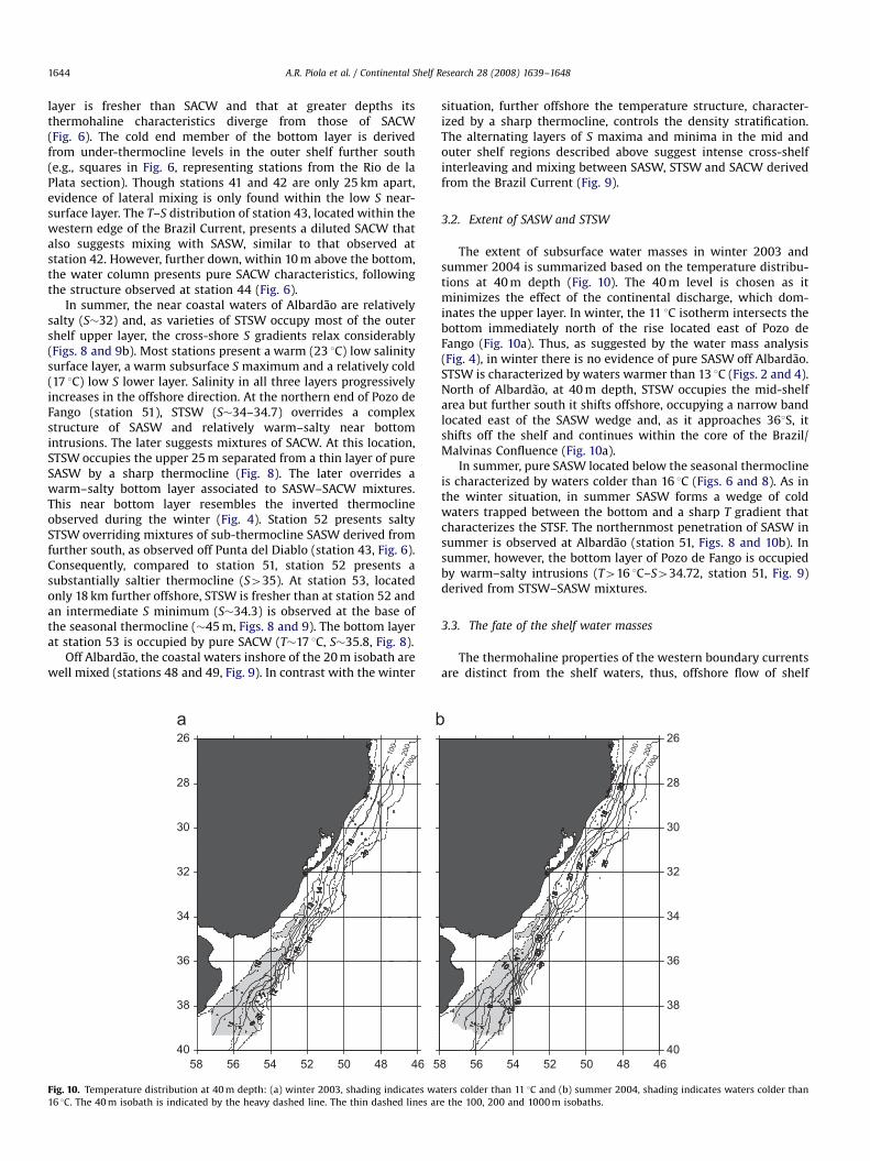
Fig. 10. Temperature distribution at 40 m depth: (a) winter 2003, shading indicates wa
16 1C. The 40 m isobath is indicated by the heavy dashed line. The thin dashed lines ar
situation, further offshore the temperature structure, character-ized by a sharp thermocline, controls the density stratification.The alternating layers of S maxima and minima in the mid andouter shelf regions described above suggest intense cross-shelfinterleaving and mixing between SASW, STSW and SACW derivedfrom the Brazil Current (Fig. 9).
3.2. Extent of SASW and STSW
The extent of subsurface water masses in winter 2003 andsummer 2004 is summarized based on the temperature distribu-tions at 40 m depth (Fig. 10). The 40 m level is chosen as itminimizes the effect of the continental discharge, which dom-inates the upper layer. In winter, the 11 1C isotherm intersects thebottom immediately north of the rise located east of Pozo deFango (Fig. 10a). Thus, as suggested by the water mass analysis(Fig. 4), in winter there is no evidence of pure SASW off Albardao.STSW is characterized by waters warmer than 13 1C (Figs. 2 and 4).North of Albardao, at 40 m depth, STSW occupies the mid-shelfarea but further south it shifts offshore, occupying a narrow bandlocated east of the SASW wedge and, as it approaches 361S, itshifts off the shelf and continues within the core of the Brazil/Malvinas Confluence (Fig. 10a).
In summer, pure SASW located below the seasonal thermoclineis characterized by waters colder than 16 1C (Figs. 6 and 8). As inthe winter situation, in summer SASW forms a wedge of coldwaters trapped between the bottom and a sharp T gradient thatcharacterizes the STSF. The northernmost penetration of SASW insummer is observed at Albardao (station 51, Figs. 8 and 10b). Insummer, however, the bottom layer of Pozo de Fango is occupiedby warm–salty intrusions (T416 1C–S434.72, station 51, Fig. 9)derived from STSW–SASW mixtures.
3.3. The fate of the shelf water masses
The thermohaline properties of the western boundary currentsare distinct from the shelf waters, thus, offshore flow of shelf
40
38
36
34
32
30
28
26
8 56 54 52 50 48 46
100
200
1000
ters colder than 11 1C and (b) summer 2004, shading indicates waters colder than
e the 100, 200 and 1000 m isobaths.

ARTICLE IN PRESS
54 52 50 48 4635
33
31
29
36
353433
32
36
Rio Grande
A
B
C
D
Fig. 12. Surface salinity distribution based on the underway measurements, as
observed in austral winter 2003. Contour interval 1. Station positions are indicated
(large dots) together with cruise track (small dots) and low salinity shelf water
filaments A–D. The open triangles show the locations selected to depict the
filaments T–S characteristics shown in Fig. 11. The dashed lines are the 100, 200,
1000 and 2000 m isobaths.
A.R. Piola et al. / Continental Shelf Research 28 (2008) 1639–1648 1645
waters is revealed by thermohaline alterations observed east ofthe shelf break (Fig. 11). Station 24, for instance, occupied inwinter at the offshore end of the Rıo de la Plata section (see Fig. 1for location), presents subsurface thermohaline characteristicstypical of subtropical waters, derived from the southward flowingBrazil Current. Subtropical waters are capped by a well-mixed,thin (�30 m), cold (10.8 1C) and fresh (33.8) layer of pure SASW(Fig. 11). Similarly, evidence of STSW export to deep waters isapparent further north near 331S (station 56 in Fig. 11). Thus, theT–S distributions at the shelf break present clear evidence ofrelatively cold-fresh shelf waters capping the upper layer alongthe western edge of the Brazil Current. These waters must beadvected southward within the western boundary current.
A possible cross-shelf transfer mechanism is suggested by thesurface salinity distribution based on the quasi-continuoustemperature and salinity thermosalinograph data (Fig. 12). Fournarrow (10–20 km), elongated (30–60 km) streaks of low salinitywater intruding off the shelf break and into the deep ocean areapparent between Punta del Diablo and Cabo Santa Marta Grande(Fig. 12). These features appear to drive mid-shelf waters beyondthe shelf break. Plotting the core of the shelf break filaments inT–S space shows that they fall within the STSW characteristics(Fig. 11). As winter shelf waters are substantially colder than theBrazil Current, the filaments are also associated to relatively coldwaters (see Fig. 5a). Though the core of filament D was notcaptured by the CTD stations, the vertical extent of the intrusion issuggested by the relatively low salinity (S�34.6) in the upper 50 mat station 41 (Fig. 5c). Satellite derived sea surface temperaturedistributions reveal similar patterns at the locations of filaments Cand D, with cold water associated to low salinity filaments (notshown).
4. Discussion
In late August and early September 2003, the 33.5 isohalineextends northeastward forming a narrow low S band that can betraced along the continental shelf beyond 261S, 1400 km from thePlata estuary (see Moller et al., this issue). The PPW extendsbeyond its mean winter position, near Cabo Santa Marta Grande,
32 33 34 35 36
4
8
12
16
20
Tem
pera
ture
(°C
)
A
B
C
D
24
56
25 26
27
SASW
24
Salinity
Fig. 11. Temperature–salinity diagrams of selected stations collected east of the
shelf break during winter 2003. Black line is station 24, occupied off Rio de la Plata,
gray line station 56, occupied off Rio Grande. Locations are shown in Fig. 1. Also
shown are the surface T–S characteristics from filaments A–D shown in Fig. 12
(heavy dots). The rectangle shows the winter T–S characteristics of SASW.
located at 281S (Piola et al., 2000). Models, in situ and remotesensing observations suggest that the PPW penetration isprimarily controlled by along shore wind stress variations, and asmaller contribution from river outflow (Piola et al., 2005, thisissue).
The T–S diagrams and the cross-shelf T and S distributions offPunta del Diablo indicate that in austral winter 2003, the STSF islocated between stations 37 and 38, where the large subsurface T
and S gradients are observed (Fig. 3b and c). The cold variety ofSTSW observed at the surface of station 38, which creates theinverted thermocline characteristic of this region, are too fresh tobe a product of mixtures between TW and SASW, as observedfurther south, at station 24 (Fig. 11). This variety of STSW must bea product of mixing between TW and waters fresher than SASW(Fig. 2). However, at Punta del Diablo and further south, a band ofSASW occupying the full water column over Pozo de Fango(station 37) prevents contact between PPW and TW/SACW. Theupper layer of station 43, occupied off Albardao, presentsthe coldest variety of STSW observed over the shelf throughoutthe winter cruise (T�14.3 1C, S�33.9, Fig. 4). This variety ofSTSW is about 2 1C colder and 0.9 fresher than STSW observedfurther south, off Punta del Diablo (station 38, Fig. 2), suggestingthat the coldest and freshest variety of STSW is formed offAlbardao, where the cold-fresh PPW first mixes with TW/SACWderived from the Brazil Current. The subsurface temperaturedistribution (Fig. 10a) suggests that these waters flow southwardinshore of warmer–saltier varieties of STSW, derived fromfurther north, and are observed offshore of SASW off Punta delDiablo (Figs. 3 and 10a). The cold-fresh STSW of station 43 as wellas the inverted thermocline observed at station 38 off Punta delDiablo can only be formed beyond the northernmost penetrationof SASW.
North of Albardao, as PPW mixes with TW, it becomesprogressively saltier and warmer. Consequently, salinity of PPWobserved in our northernmost section, off Itajai, is about 32.0 (seeMoller et al., this issue). The PPW–TW mixtures derived from thisregion, where less intense inverted thermoclines are observed,

ARTICLE IN PRESS
A.R. Piola et al. / Continental Shelf Research 28 (2008) 1639–16481646
form warm–salty varieties of STSW. The winter data suggest thatthe coastal waters continue their northward flow beyond Itajaı,in agreement with the results based on historical hydrographicdata (Piola et al., 2000) and surface drifters (Souza andRobinson, 2004). Further offshore most of the upper layer isoccupied by a warm–salty variety of STSW (18 1C, 35). The STSWoriginated in this region flows southward along the western edgeof the Brazil Current and offshore of the northward flowassociated to PPW.
In summer, the PPW retracts southward to 321S and expandsoffshore to the shelf break (see Moller et al., this issue). Thoughthere are large seasonal T differences, the summer and winterdistributions of SASW and STSW, and the location of the STSF, donot differ significantly (Fig. 10). The summer observations revealthe penetration of pure SASW to the latitude of Albardao, where itforms a thin low salinity layer centered at about 45 m within Pozode Fango (station 51, Figs. 8 and 9). Though in the winter section,we did not observe SASW, since the summer section was occupiedabout 30 km south from the winter position (Fig. 1), the apparentsouthward retraction of SASW in winter may be due to samplingdifferences.
In February 2004, dilution of TW at Albardao appears to occurat two distinct levels. A near surface low salinity layer, clearlydepicted in the T–S distributions of stations 50–53 (Fig. 8) isderived from PPW–TW mixtures. In addition, a colder (T�16 1C)salinity minimum layer is found near 40–50 m depth (Fig. 9). TheT–S diagram suggests that the deeper S-minimum is created bySASW–STSW mixtures across the STSF. The distinct varieties ofSTSW lead to the wider range of temperature and salinityobserved off Albardao (Table 1). In winter, the salinity distributioncontrols the density structure, creating intense cross-shoredensity gradients and limiting isopycnal mixing across the STSF.In contrast, the strong temperature stratification in summerinduces a sharp pycnocline and provides cross-shelf isopycnalconnections (e.g., 24 and 25 kg m�3, Fig. 9). At station 53, the low-S layer overrides TW–SACW mixtures intruding into the outershelf bottom layer (Figs. 8 and 9). This subsurface transitionclosely resembles the vertical structure of the winter invertedthermocline (Fig. 8). Similar structures, though less intense, arealso observed off Punta del Diablo (station 42, Fig. 6).
Souza and Robinson (2004) described the path of threelagrangian drifters entering the shelf region from the BrazilCurrent between 331300 and 291S as they were trapped by eddiesalong the western edge of the Brazil Current. They suggested thatwaters from the Brazil Current might feed the PPW, which theyreferred to as Brazilian Coastal Current (Souza and Robinson,2004). Our hydrographic observations suggest that as they enterthe shelf, the majority of the warm–salty Brazil Current watersoccupy the near bottom layer, leading to the formation of theinverted thermocline and the STSW. During winter, we do not findevidence of high salinity TWs recirculating northward along thecoastal region. The thermohaline structure suggest that thoughsome TW mixes with PPW and flow northward along the coast,most warm–salty waters continue flowing southward along theshelf break and are entrained back into the Brazil Current as theyreach the STSF further downstream. Export of shelf waters at theBrazil/Malvinas Confluence has been suggested based on theanalysis of hydrographic data (Gordon, 1989; Provost et al., 1996)and an inverse model (Zavialov et al., 1998). The northward pathsdescribed by surface drifters may be associated with the north-ward penetration of PPW, with minor contributions from theBrazil Current.
The winter thermosalinograph data reveal the presence of fourshelf break filaments between 291S and 331S, which appear todrive STSW offshore beyond the shelf break. Winter sea surfacetemperature data reveal similar features at the shelf break north
of Cabo Santa Marta (Assireu et al., 2003). The intrusions may beassociated with shear instabilities developing at the western edgeof the Brazil Current revealed by surface drifters and satellitederived surface temperature (Souza and Robinson, 2004), whichare also observed in other western boundary current systems (e.g.,Luther and Bane, 1985; Glenn and Ebbesmeyer, 1994; Lutjeharmset al., 2003). The T–S properties of filaments A–D present varietiesof TW–PPW mixing, indicating offshore export of STSW (Fig. 12).Filament D, located just offshore from the STSF, presentsthe coldest variety of STSW, similar to that observed at station38 (Fig. 2). Though we do not find evidence of these features in thehydrographic data from February 2004, the decreased cross-shoretemperature (see Saraceno et al., 2004, Fig. 6) and salinitygradients, associated with the southward retreat of PPW (Molleret al., this issue), may obscure the thermohaline signature of theshelf break eddies in austral summer. In contrast, the T–S diagramof station 24 located south of the STSF indicates export of pureSASW, with no evidence of mixing with PPW. Thus, the winterhydrographic and thermosalinograph data show that the distinctwater masses that occupy the continental shelf are transferredoffshore and cap the Brazil Current waters, with STSW andSASW dominating the exchange north and south of about 341S,respectively.
The Brazil Current and shelf waters form an intense shelf breakfront (40.4 1C km�1) in austral fall, winter and spring, whichsharply decays in summer (o 0.2 1C km�1, Saraceno et al., 2004).The study, based on the analysis of satellite derived sea surfacetemperature, encompasses the shelf break region between 301Sand 361S. Our data indicates that these seasonal changes in theintensity of the shelf break front are due to the presence of coldPPW in austral winter over the shelf, which is replaced bywarm–salty TW/SACW in summer, and therefore weakens thecross-shelf temperature gradients. High-resolution satellite infra-red images from December 1997 suggest the occurrence of adistinct inshore branch of the Brazil Current flowing southwardover the mid shelf region along the 100 m isobath to about 311S(Franco et al., 2006). Though to the best of our knowledge, thereare no other reports of such Brazil Current branching, the impliedsouthward flow is consistent with the flow derived from surfacedrifters (Piola et al., this issue), the ubiquitous observation ofsubtropical waters over the shelf and the southward retreat ofPlata waters in austral summer.
Using underway acoustic Doppler current profilers in australwinter 1999 and summer 2000, Munchow and Framinan (2001)observed a strong (�0.5 m s�1) and persistent subsurface south-ward flow over the shelf between Punta del Este and Punta delDiablo. They found that in winter, the flow is more intense alongthe eastern slope of Pozo de Fango, while in summer thesouthward current is barotropic and spans a 40 km near coastalband centered along the axis of the topographic depression. Theirsimultaneous hydrographic observations confirm the large seaso-nal variability in the upper layer, associated with the southwardand offshore retreat of PPW in summer, and reveal dense watersoccupying the western slope of Pozo de Fango during bothseasons. Our winter data presents an offshore density increase,with high density atop the eastern slope of Pozo de Fango (e.g.,station 37) and a thin layer of diluted SASW at the bottomof the depression (station 36, Fig. 3b and c). During our 2003and 2004 surveys, the bottom of Pozo de Fango at Punta delDiablo was occupied by relatively cold-fresh waters of southernorigin (So33.5, station 36, Fig. 3c and station 39, Fig. 7b). Sinceduring both surveys, the pure STSF extends along the shelf breakbeyond the northern end of the rise (Fig. 10), these waters mayhave entered the depression from the north, becoming progres-sively fresher by vertical mixing with PPW, and flow southwardalong its axis.

ARTICLE IN PRESS
A.R. Piola et al. / Continental Shelf Research 28 (2008) 1639–1648 1647
Direct current measurements at 15 m depth collected fromMarch to August 1997 on the 50 m isobath, close to our Rio Grandesection, present a highly variable along shore flow (Zavialov et al.,2002). In early fall, the along shore currents are significantlycorrelated with along shore winds (�0.7). In late autumnand winter, the currents decreased considerably and presentedlittle correlation with the winds, presumably due to the presenceof the stable low salinity layer, which decoupled the subsurfaceflow from direct wind effects (Zavialov et al., 2003). Theirsalinity time series at 15 m depth is reproduced here in Fig. 13.The salinity data reveal three periods of distinct variations:first, in March–April S is relatively stable, oscillating around33.6270.49, typical of SASW (Fig. 13). In May S decreases to31.5371.00, suggesting that the influence of PPW extends below15 m. Finally, from early June to early August, S oscillates betweentwo states: of about 32.5–33.5 and 36, with characteristic timescales of 10–20 days. The later period corresponds to the timewhen the velocity at 15 m decreases substantially (Zavialov et al.,2002). The bimodal S variations observed off Rio Grandein June and July 1997 suggests oscillations of the STSF across themooring site (Fig. 13). The northward penetration of the STSF toRio Grande is in agreement with its location based on the analysisof historical hydrographic data (Piola et al., 2000). In contrast, thesubsurface temperature distributions reported here (Fig. 10)suggest a more southward location of the STSF in August 2003and February 2004.
The August 2003 observations suggests that pure SASW flowsnorthward over the mid shelf region past the Rıo de la Plata,reaching as far north as Punta del Diablo, close to the location ofthe STSF. At this latitude, most SASW describes a sharp cyclonicloop and flows southward along the front and is expelled offshore,where it forms a cold-fresh upper layer capping SACW within theBrazil Current, as observed at station 24 (Fig. 11). PPW–TW/SACWmixtures are observed in winter, in all sections occupied north ofthe STSF. The subsurface temperature distributions (Fig. 10) revealthat the sharp thermohaline transition between SASW and STSWobserved in winter and summer over the shelf (e.g., stations 37and 38 in winter, Figs. 2 and 3, and stations 41–42 in summer,Figs. 6 and 7) extends southward, and across the shelf break near361S. This observation is confirmed by the T–S distributions of the
Mar-97 Apr-97 May-97 Jun-9727
28
29
30
31
32
33
34
35
36
37
1
2
3
Sal
inity
Fig. 13. (a) Salinity time series at 15 m depth collected off Rio Grande between 4 March
text. (b) Relative frequency histograms of salinity for each of the periods indicated in (
offshore stations from the southernmost sections (Fig. 11) and alsoby the sharp decrease in percentage concentrations of SASW andSTSW observed across the STSF (Moller et al., this issue). Since theshelf water masses are lighter than the saltier, though warmer,Brazil Current waters and then the colder Malvinas Currentwaters, at these locations both shelf water masses form a lowdensity surface layer.
5. Conclusions
The hydrographic data collected during the Nicop-Laplatacruises in late August 2003 and February 2004 present significantchanges in water mass characteristics over the continental shelfoff Uruguay and southern Brazil. The schematic circulationdiagram of Fig. 14 summarizes our findings for the wintersituation. The diagram is similar to the one presented by Molleret al. (this issue), but emphasizes the subsurface water massdistribution and circulation. In austral winter, vertical stratifica-tion is controlled by the salinity distribution, which is primarilyassociated with the contrast between PPW (So32.5) and thewarm–salty TW and SACW from the Brazil Current. In winter, PPWoccupies a coastal band several tens of kilometers wide andextends northeastward beyond Itajaı (�271S). Consequently, thedensity structure presents a well-defined density front at the edgeof the low salinity plume. SASW, derived from the southern shelf,extends northward to about 331S forming a wedge of cold water,which separates the PPW from the warm–salty waters derivedfrom the Brazil Current. The offshore boundary of SASW forms asharp thermohaline front with STSW. The later is a product ofmixing of PPW with TW and South Atlantic Central Water. Suchmixing is only possible north of the northernmost penetration ofSASW. As in winter, isopycnals intersect the sea surface and thebottom, there are limited cross-shore exchanges, except thosearising from instabilities along the shelf break, which may allowfor direct contact of PPW with the Brazil Current. In summer, as asharp seasonal thermocline develops, density stratification iscontrolled by the temperature distribution. Isopycnal connectionsallow intense cross-shelf mixing, which lead to the formation oftwo distinct varieties of STSW south of 321S. Warm STSW, formed
Jul-970
0.2
0.4
0.6
Rel
ativ
e Fr
eque
ncy
29 31 33 35 37 39
1
2
33
and 2 August 1997. The periods 1–3 refer to distinct S regimes as described in the
a): 1 (gray shading), 2 (thick line) and 3 (hatched).

ARTICLE IN PRESS
Fig. 14. Schematic circulation diagram for the winter situation. Darker gray lines
are associated with colder waters. The dashed lines are the 40 and 200 m isobaths.
A.R. Piola et al. / Continental Shelf Research 28 (2008) 1639–16481648
by mixing of slope waters with PPW and cold STSW, a product ofmixing of SASW and slope waters, across the STSF. Though PPWretreats southward and the whole water column is warmer insummer, the location of the subsurface expression of the STSF(e.g., the sharp subthermocline cross-shelf temperature andsalinity gradients) remain at approximately the same location asin winter. Thus, other than the northward penetration of PPWalong the coast and the PPW–Brazil Current water mixing, theschematic circulation and water mass distribution of Fig. 14 is alsovalid for the summer situation.
Acknowledgments
The PLATA project was financed by the Inter-AmericanInstitute for Global Change Research (IAI) grants CRN061 and2076. The IAI is funded by the US National Science Foundationgrant GEO-0452325. Additional funding was provided by a NavalInternational Cooperative Opportunities in Science and Techno-logy Program grant N00014-02-1-0295 from the US Office ofNaval Research, Fundacion Antorchas grant 13900-13 and CNPqProc. 302173/2004-8. We acknowledge Diretoria de Hidrografia eNavegac-ao (Brazil), Servicio de Hidrografıa Naval (Argentina) andServicio de Oceanografıa, Hidrografıa y Meteorologıa (Uruguay)for their cooperation in obtaining clearance for carrying out fieldwork within EEZs, and the crews of RV NOc ANTARES and ARA
PUERTO DESEADO and the scientific parties of both cruises fortheir valuable assistance at sea.
References
Assireu, A.T., Stevenson, M.R., Stech, J.L., 2003. Surface circulation and kineticenergy in the SW Atlantic obtained by drifters. Continental Shelf Research 23(2), 145–157.
Castello, J.P., Moller Jr., O.O., 1977. Sobre as condic- oes oceanograficas no Rio Grandedo Sul. Atlantica 2, 25–110.
Castello, J.P., et al., 1990. On the importance of coastal and subantartic waters forthe shelf ecosystems off RioGrande do Sul. In: Watanabe, S. (Ed.), II Simposiode Ecossistemas da Costa Sul e Sudeste Brasileira: Estrutura, Func- ao e Manejo.ACIESP, Sao Paulo, Brazil, pp. 112–119.
Ciotti, A.M., Odebrecht, C., Fillmann, G., Moller Jr., O.O., 1995. Freshwater outflowand subtropical convergence influence on phytoplankton biomass on thesouthern Brazilian continental shelf. Continental Shelf Research 15, 1737–1756.
Emilson, I., 1961. The shelf and coastal waters off southern Brazil. Boletim doInstituto Oceanografico 11 (2), 101–112.
Framinan, M.B., Etala, M.P., Acha, E.M., Guerrero, R.A., Lasta, C., Brown, O., 1999.Physical characteristics and processes of the Rıo de la Plata estuary. In: Perillo,G.M.E., Piccolo, M.C., Pino-Quiviara, M. (Eds.), Estuaries of South America, TheirGeomorphology and Dynamics. Springer, Berlin, Heidelberg, pp. 161–191.
Franco, B.C., Mata, M.M., Muelbert, J.H., 2006. Mesoscale physical processes andthe distribution and composition of ichthyoplankton on the southern Brazilianshelf break. Fisheries Oceanography 15, 37–43.
Glenn, S.M., Ebbesmeyer, C.C., 1994. The structure and propagation of a Gulf Streamfrontal eddy along the North Carolina shelf break. Journal of GeophysicalResearch 99, 5029–5046.
Gordon, A.L., 1989. Brazil–Malvinas Confluence—1984. Deep Sea Research Part A36, 359–384.
Guerrero, R.A., Piola, A.R., 1997. Masas de agua. In: Boschi, E. (Ed.), El Mar Argentinoy sus Recursos Pesqueros, Tomo 1, Instituto Nacional de Investigacion yDesarrollo Pesquero. Mar del Plata, Argentina, pp. 107–118.
Guerrero, R.A., Acha, M.E., Framinan, M.E., Lasta, C., 1997. Physical oceanography ofthe Rıo de la Plata estuary. Continental Shelf Research 17 (7), 727–742.
Lutjeharms, J.R.E., Boebel, O., Rossby, H.T., 2003. Agulhas cyclones. Deep-SeaResearch II 50, 13–34.
Luther, M.E., Bane Jr., J.M., 1985. Mixed instabilities in the Gulf Stream over thecontinental slope. Journal of Physical Oceanography 15, 3–23.
Moller Jr., O.O., Piola, A.R., Freitas, A.C., Campos, E.J.D. The effects of river dischargeand seasonal winds on the shelf off Southeastern South America. ContinentalShelf Research, this issue, doi:10.1016/j.csr.2008.03.012.
Muelbert, J.H., Sinque, C., 1996. The distribution of bluefish larvae (Pomatomussaltatrix) in the continental shelf of southern Brazil. Marine and FreshwaterResearch 47, 311–314.
Muelbert, J.H., Acha, E.M., Mianzan, H., Reta, R., Guerrero R.A., Berasategui, A.,Braga, E.S., Garcia, V.M.T., Gomez-Erache, M., Ramirez, F. Biological,physical and chemical properties at the subtropical shelf front zone in theSW–Atlantic Continental Shelf. Contiental Shelf Research, this issue,doi:10.1016/j.csr.2007.08.011.
Munchow, A., Framinan, M.B., 2001. Kinematics of a topographically steeredpoleward shelf flow off Uruguay. Abstract, IAPSO/IABO Joint Assembly, IB01-96,Mar del Plata, Argentina.
Piola, A.R., Campos, E.J.D., Moller Jr., O.O., Charo, M., Martinez, C.M., 2000.Subtropical shelf front off eastern South America. Journal of GeophysicalResearch 105 (C3), 6566–6578.
Piola, A.R., Matano, R.P., Palma, E.D., Moller, O.O., Campos, E.J.D., 2005. Theinfluence of the Plata River discharge on the western South Atlantic shelf.Geophysical Research Letters 32, L01603.
Piola, A.R., Romero, S.I., Zajaczkovski, U. Space–time variability of the Plata plumeinferred from ocean color. Continental Shelf Research, this issue, doi:10.1016/j.csr.2007.02.013.
Provost, C., Garc-on, V., Medina Falcon, L., 1996. Hydrographic conditions in thesurface layers over the slope-open ocean transition area near the Brazil–Mal-vinas confluence during austral summer 1990. Continental Shelf Research 16(2), 215–219.
Saraceno, M., Provost, C., Piola, A.R., Gagliardini, A., Bava, J., 2004. The BrazilMalvinas Frontal System as seen from nine years of AVHRR data. Journal ofGeophysical Research 109 (C5), C05027.
Souza, R.B., Robinson, I.S., 2004. Lagrangian and satellite observations of the BrazilCoastal Current. Continental Shelf Research 24, 241–262.
Sunye, P.S., Servain, J., 1998. Effects of seasonal variations in meteorology andoceanography on the Brazilian sardine fishery. Fisheries Oceanography 7,89–100.
Urien, C.M., Ottman, F., 1971. Histoire du Rio de la Plata au Quaternaire.Quaternaire 14, 51–59.
Zavialov, P.O., Ghisolfi, R.D., Garcia, C.A.E., 1998. An inverse model for seasonalcirculation over the South Brazilian shelf: near-surface velocity from the heatbudget. Journal of Physical Oceanography 28 (4), 545–562.
Zavialov, P.O., Moller Jr., O.O., Campos, E.J.D., 2002. First direct measurements ofcurrents on the continental shelf of southern Brazil. Continental Shelf Research22, 1975–1986.
Zavialov, P.O., Kostianoy, A.G., Moller Jr., O.O., 2003. SAFARI cruise: mapping riverdischarge effects on Southern Brazilian shelf. Geophysical Research Letters 30(21), 2126.