
Van Wijngaarten G. J. M., Sotiriou A., Kourtessi-Philippakis G., Bogaard B. et al. 2011-12. The...
22
Pharos 18(2), 35-56. doi: 10.2143/PHA.18.2.2977241 © 2012 by Pharos. All rights reserved. The Zakynthos Archaeology Project Preliminary report on the 2010 season GERT JAN VAN WIJNGAARDEN, ANDREAS SOTIRIOU, GEORGIA KOURTESSI-PHILIPPAKIS, BART BOGAARD, PIM BLOEMENDAAL, NIENKE PIETERS & ANKE STOKER Abstract The 2010 campaign of the Zakynthos Archaeology Project took place on the peninsula of Vasilikos in the south-east of the island, where we had surveyed also in 2006. In addition to covering more ground by archaeological survey, the return after four years also enabled us to evaluate survey methodologies and changes in the landscape. In the area near ‘Banana beach’, where the land- scape is being changed to accommodate tourist facilities, spots with buried ceramics dating to the Early and/or Middle Bronze Ages were discovered. The same periods were represented at a newly discovered site in the hills of Vasilikos-Doretes. A rediscovered Mycenaean tomb, a Hellenistic- Roman defensive post and a number of find concentrations show that Vasilikos constitutes an important diachronic archaeological landscape from the Palaeolithic to the present day. Keywords Ionian islands – landscape archaeology – Palaeolithic – Early Bronze Age – Mycenaean archaeology. Introduction The focus of the fifth campaign of the Zakynthos Archaeology Project was on our research area C, on the peninsula of Vasilikos in the south-east of the island. The same area had been subject of research during our campaign of 2006. 1 In that year, we were not able to investigate the area fully and the goal for 2010 was to connect the survey areas from 2006. Moreover, the return to research area C gave us the opportunity to study changes in the landscape after four years and to assess their effect on the archaeological surface record. The fieldwork was done in two campaigns: one week from 26 April to 1 May and five weeks during the summer from 14 June to 16 July. During the week in April, we prepared ourselves for the 1 Van Wijngaarden et al. 2006. See for a description of the project in general and for preliminary reports on previous campaigns: Van Wijngaarden et al. 2005, 2006, 2007, 2008, 2009.
Transcript of Van Wijngaarten G. J. M., Sotiriou A., Kourtessi-Philippakis G., Bogaard B. et al. 2011-12. The...

Pharos 18(2), 35-56. doi: 10.2143/PHA.18.2.2977241© 2012 by Pharos. All rights reserved.
The Zakynthos Archaeology ProjectPreliminary report on the 2010 season
GERT JAN VAN WIJNGAARDEN, ANDREAS SOTIRIOU, GEORGIA KOURTESSI-PHILIPPAKIS, BART BOGAARD, PIM BLOEMENDAAL,
NIENKE PIETERS & ANKE STOKER
Abstract
The 2010 campaign of the Zakynthos Archaeology Project took place on the peninsula of Vasilikos in the south-east of the island, where we had surveyed also in 2006. In addition to covering more ground by archaeological survey, the return after four years also enabled us to evaluate survey methodologies and changes in the landscape. In the area near ‘Banana beach’, where the land-scape is being changed to accommodate tourist facilities, spots with buried ceramics dating to the Early and/or Middle Bronze Ages were discovered. The same periods were represented at a newly discovered site in the hills of Vasilikos-Doretes. A rediscovered Mycenaean tomb, a Hellenistic-Roman defensive post and a number of find concentrations show that Vasilikos constitutes an important diachronic archaeological landscape from the Palaeolithic to the present day.
Keywords
Ionian islands – landscape archaeology – Palaeolithic – Early Bronze Age – Mycenaean archaeology.
Introduction
The focus of the fifth campaign of the Zakynthos Archaeology Project was on our research area C, on the peninsula of Vasilikos in the south-east of the island. The same area had been subject of research during our campaign of 2006.1 In that year, we were not able to investigate the area fully and the goal for 2010 was to connect the survey areas from 2006. Moreover, the return to research area C gave us the opportunity to study changes in the landscape after four years and to assess their effect on the archaeological surface record. The fieldwork was done in two campaigns: one week from 26 April to 1 May and five weeks during the summer from 14 June to 16 July. During the week in April, we prepared ourselves for the
1 Van Wijngaarden et al. 2006. See for a description of the project in general and for preliminary reports on previous campaigns: Van Wijngaarden et al. 2005, 2006, 2007, 2008, 2009.
96254_Pharos_18/2_02.indd 35 26/04/13 12:02

36 GERT JAN VAN WIJNGAARDEN ET AL.
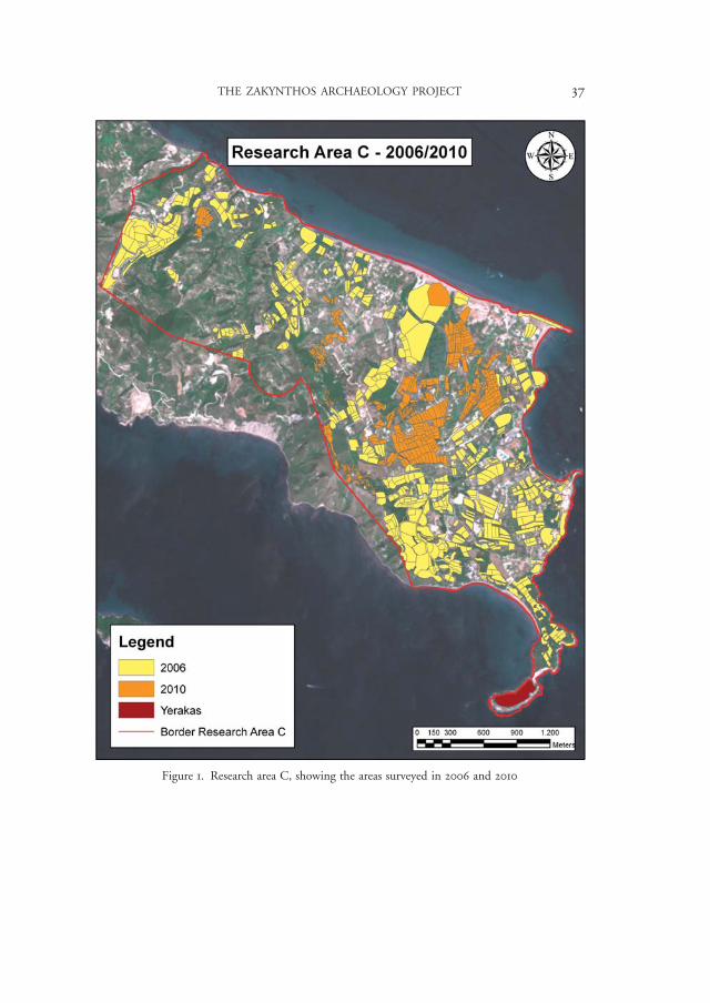
survey and we carried out systematic study of lithic artifacts collected during pre-vious campaigns. The ceramics were studied in October. Most of the actual field-work was done in the summer. One survey team, consisting of a team leader, an assistant and six field walkers covered 564 tracts (Figure 1), resulting in the collec-tion of some 6,600 finds. Most of these were pottery finds, but, as had been the case in previous years, numerous lithics were collected as well.2
Survey methodology
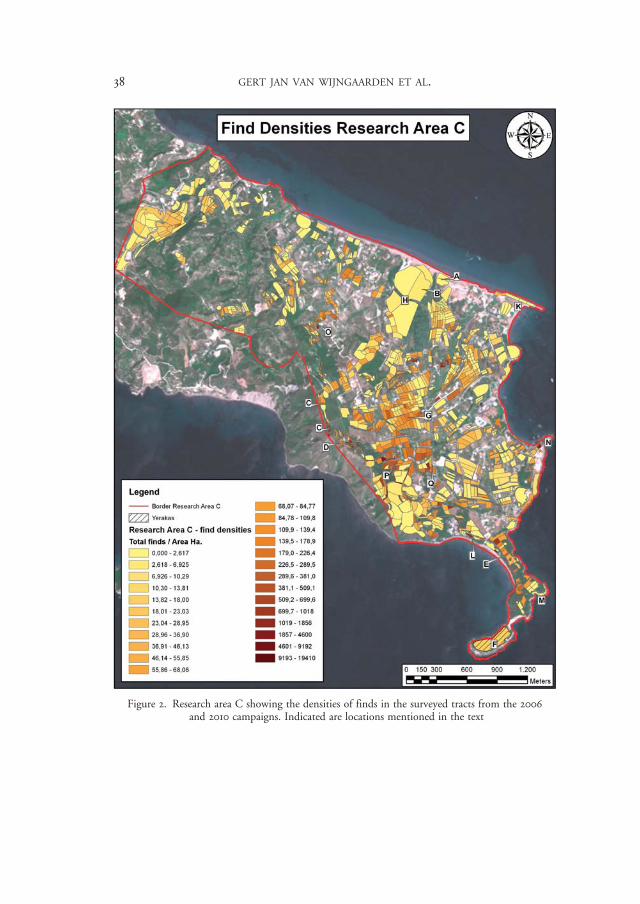
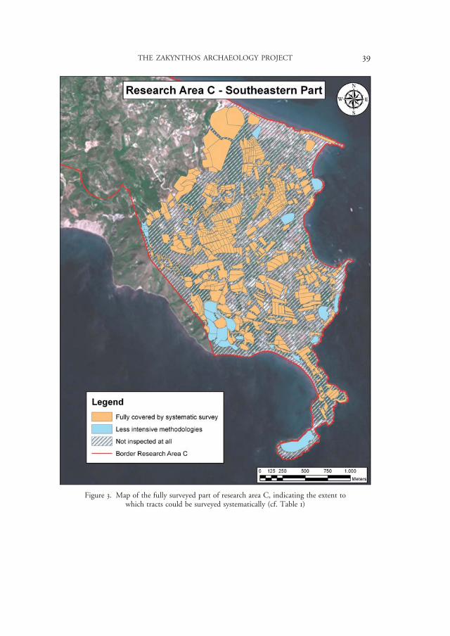
The main zone of survey is situated to the west of Cape Ayios Nikolaos and south of the modern village of Ano Vasilikos. The 2010 tracts are situated between two areas surveyed in 2006 (Figures 1 and 2) and a large zone of c. 440 hectares in the south-eastern part of research area C has now been covered fully by systematic survey (Figure 3). In addition, several transects in somewhat different landscapes have been surveyed in the north-west of the research area (Figure 2).
The landscape of Vasilikos has a mixed agricultural and touristic character. The coastal part of the research area is increasingly being developed for tourism. The hinterland consists of olive groves and green fields. Also, there is extensive wood-land and abandoned fields are overgrown with thick brush vegetation. There are two main modern settlement concentrations: the village of Ano Vasilikos and the nucleus near the former residence of the Romas family.3 Along the eastern coast there are several concentrations of touristic facilities. Habitation is scattered through the countryside and new houses, mainly touristic villas, continue to be built, especially in the hills that bound the research area in the south-west.
Even though full coverage by intensive field walking was aimed for, a substan-tial part of the research area could not be inspected by systematic survey. Even in that part of the research area which appears to have been covered fully by archae-ological survey (Figure 3), many fields were inaccessible due to fencing, modern construction or impenetrable vegetation, preventing systematic survey altogether. Moreover, in several cases vegetation growth forced the teams to inspect fields with a less intensive methodology, so called walk overs.4 In the intensively used landscape of Vasilikos, only about a third of the total surface could be investigated intensively (Table 1 and Figure 3).
2 Of the 6,633 finds, 930 were lithic artifacts. 3 Referred to as Stavromenos on the topographical map, while the name Panayia tou Bateli is also used, see Liveris 2002, 44. 4 During a walk over, a few field walkers inspect overgrown fields for architectural remains and arti-facts. When finds are attested, for example on cleared patches, such as paths, a grab sample is made to collect as many finds as possible. If a field is overgrown with impenetrable vegetation, only a photograph is made.
96254_Pharos_18/2_02.indd 36 26/04/13 12:02
THE ZAKYNTHOS ARCHAEOLOGY PROJECT 37
Figure 1. Research area C, showing the areas surveyed in 2006 and 2010
96254_Pharos_18/2_02.indd 37 26/04/13 12:02
38 GERT JAN VAN WIJNGAARDEN ET AL.
Figure 2. Research area C showing the densities of finds in the surveyed tracts from the 2006 and 2010 campaigns. Indicated are locations mentioned in the text
96254_Pharos_18/2_02.indd 38 26/04/13 12:02
THE ZAKYNTHOS ARCHAEOLOGY PROJECT 39
Figure 3. Map of the fully surveyed part of research area C, indicating the extent to which tracts could be surveyed systematically (cf. Table 1)
96254_Pharos_18/2_02.indd 39 26/04/13 12:02
40 GERT JAN VAN WIJNGAARDEN ET AL.
Table 1. Extent to which the fully surveyed area has been covered by systematic survey (cf. Figure 3)
Hectare %
Fully covered by systematic survey 157,08 35,75
Less intensive methodologies 22,17 5,05
Not inspected at all 260,13 59,20
Revisits of 2006 tracts
Since the first campaign of the Zakynthos Archaeology project in 2006, the method-ology of the intensive survey has been refined to suit the specific circumstances of Zakynthos.5 In addition, new recording equipment, such as hand-held computers, as well as more accurate satellite photographs have been introduced to the project. The return to research area C in 2010 enabled us to evaluate the methodology of the pro-ject and to assess the changes to the archaeological surface record of the research area.
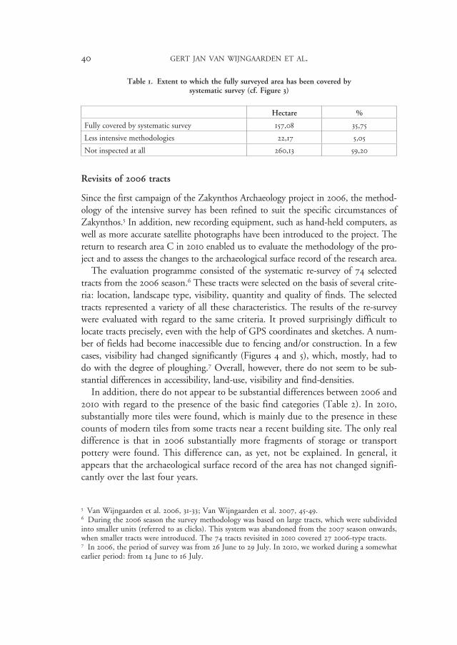
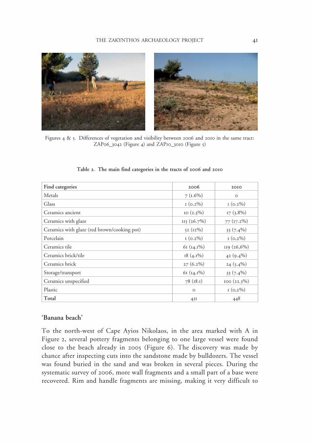
The evaluation programme consisted of the systematic re-survey of 74 selected tracts from the 2006 season.6 These tracts were selected on the basis of several crite-ria: location, landscape type, visibility, quantity and quality of finds. The selected tracts represented a variety of all these characteristics. The results of the re-survey were evaluated with regard to the same criteria. It proved surprisingly difficult to locate tracts precisely, even with the help of GPS coordinates and sketches. A num-ber of fields had become inaccessible due to fencing and/or construction. In a few cases, visibility had changed significantly (Figures 4 and 5), which, mostly, had to do with the degree of ploughing.7 Overall, however, there do not seem to be sub-stantial differences in accessibility, land-use, visibility and find-densities.
In addition, there do not appear to be substantial differences between 2006 and 2010 with regard to the presence of the basic find categories (Table 2). In 2010, substantially more tiles were found, which is mainly due to the presence in these counts of modern tiles from some tracts near a recent building site. The only real difference is that in 2006 substantially more fragments of storage or transport pottery were found. This difference can, as yet, not be explained. In general, it appears that the archaeological surface record of the area has not changed signifi-cantly over the last four years.
5 Van Wijngaarden et al. 2006, 31-33; Van Wijngaarden et al. 2007, 45-49. 6 During the 2006 season the survey methodology was based on large tracts, which were subdivided into smaller units (referred to as clicks). This system was abandoned from the 2007 season onwards, when smaller tracts were introduced. The 74 tracts revisited in 2010 covered 27 2006-type tracts. 7 In 2006, the period of survey was from 26 June to 29 July. In 2010, we worked during a somewhat earlier period: from 14 June to 16 July.
96254_Pharos_18/2_02.indd 40 26/04/13 12:02
THE ZAKYNTHOS ARCHAEOLOGY PROJECT 41
Table 2. The main find categories in the tracts of 2006 and 2010
Find categories 2006 2010
Metals 7 (1.6%) 0
Glass 1 (0.2%) 1 (0.2%)
Ceramics ancient 10 (2.3%) 17 (3.8%)
Ceramics with glaze 115 (26.7%) 77 (17.2%)
Ceramics with glaze (red brown/cooking pot) 52 (12%) 33 (7.4%)
Porcelain 1 (0.2%) 1 (0,2%)
Ceramics tile 61 (14.1%) 119 (26,6%)
Ceramics brick/tile 18 (4.1%) 42 (9.4%)
Ceramics brick 27 (6.2%) 24 (5.4%)
Storage/transport 61 (14.1%) 33 (7.4%)
Ceramics unspecified 78 (18.1) 100 (22.3%)
Plastic 0 1 (0,2%)
Total 431 448
‘Banana beach’
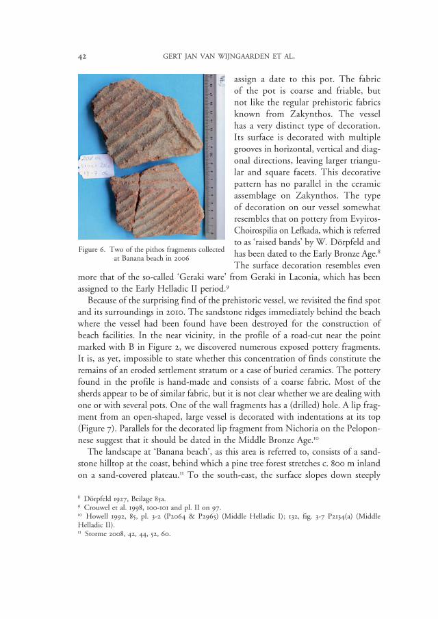
To the north-west of Cape Ayios Nikolaos, in the area marked with A in Figure 2, several pottery fragments belonging to one large vessel were found close to the beach already in 2005 (Figure 6). The discovery was made by chance after inspecting cuts into the sandstone made by bulldozers. The vessel was found buried in the sand and was broken in several pieces. During the systematic survey of 2006, more wall fragments and a small part of a base were recovered. Rim and handle fragments are missing, making it very difficult to
Figures 4 & 5. Differences of vegetation and visibility between 2006 and 2010 in the same tract: ZAP06_3042 (Figure 4) and ZAP10_3010 (Figure 5)
96254_Pharos_18/2_02.indd 41 26/04/13 12:02
42 GERT JAN VAN WIJNGAARDEN ET AL.
assign a date to this pot. The fabric of the pot is coarse and friable, but not like the regular prehistoric fabrics known from Zakynthos. The vessel has a very distinct type of decoration. Its surface is decorated with multiple grooves in horizontal, vertical and diag-onal directions, leaving larger triangu-lar and square facets. This decorative pattern has no parallel in the ceramic assemblage on Zakynthos. The type of decoration on our vessel somewhat resembles that on pottery from Evyiros-Choirospilia on Lefkada, which is referred to as ‘raised bands’ by W. Dörpfeld and has been dated to the Early Bronze Age.8 The surface decoration resembles even
more that of the so-called ‘Geraki ware’ from Geraki in Laconia, which has been assigned to the Early Helladic II period.9
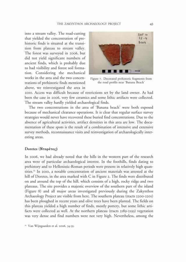
Because of the surprising find of the prehistoric vessel, we revisited the find spot and its surroundings in 2010. The sandstone ridges immediately behind the beach where the vessel had been found have been destroyed for the construction of beach facilities. In the near vicinity, in the profile of a road-cut near the point marked with B in Figure 2, we discovered numerous exposed pottery fragments. It is, as yet, impossible to state whether this concentration of finds constitute the remains of an eroded settlement stratum or a case of buried ceramics. The pottery found in the profile is hand-made and consists of a coarse fabric. Most of the sherds appear to be of similar fabric, but it is not clear whether we are dealing with one or with several pots. One of the wall fragments has a (drilled) hole. A lip frag-ment from an open-shaped, large vessel is decorated with indentations at its top (Figure 7). Parallels for the decorated lip fragment from Nichoria on the Pelopon-nese suggest that it should be dated in the Middle Bronze Age.10
The landscape at ‘Banana beach’, as this area is referred to, consists of a sand-stone hilltop at the coast, behind which a pine tree forest stretches c. 800 m inland on a sand-covered plateau.11 To the south-east, the surface slopes down steeply
8 Dörpfeld 1927, Beilage 85a. 9 Crouwel et al. 1998, 100-101 and pl. II on 97. 10 Howell 1992, 85, pl. 3-2 (P2064 & P2965) (Middle Helladic I); 132, fig. 3-7 P2134(a) (Middle Helladic II). 11 Storme 2008, 42, 44, 52, 60.
Figure 6. Two of the pithos fragments collected at Banana beach in 2006
96254_Pharos_18/2_02.indd 42 26/04/13 12:02
THE ZAKYNTHOS ARCHAEOLOGY PROJECT 43
into a stream valley. The road-cutting that yielded the concentration of pre-historic finds is situated at the transi-tion from plateau to stream valley. The forest was surveyed in 2006, but did not yield significant numbers of ancient finds, which is probably due to bad visibility and forest soil forma-tion. Considering the mechanical works in the area and the two concen-trations of prehistoric finds mentioned above, we reinvestigated the area in 2010. Access was difficult because of restrictions set by the land owner. As had been the case in 2006, very few ceramics and some lithic artifacts were collected. The stream valley hardly yielded archaeological finds.
The two concentrations in the area of ‘Banana beach’ were both exposed because of mechanical clearance operations. It is clear that regular surface survey strategies would never have recovered these buried find concentrations. Due to the absence of agricultural activities, artifact densities in this area are low. The docu-mentation of these spots is the result of a combination of intensive and extensive survey methods, reconnaissance visits and reinvestigation of archaeologically inter-esting areas.
Doretes (Ntorétev)
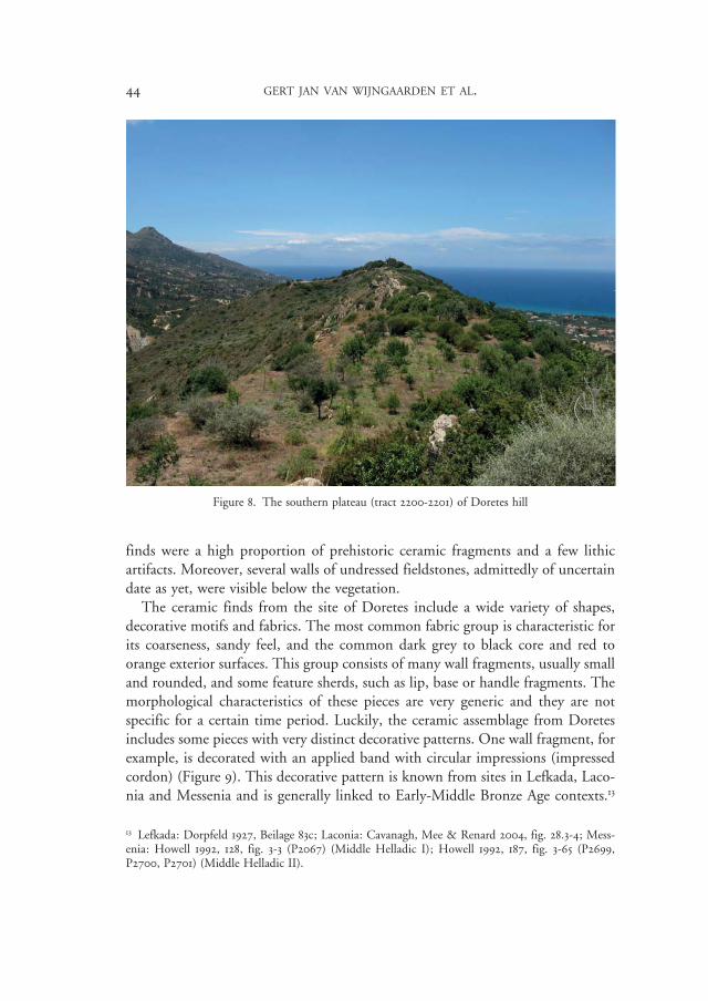
In 2006, we had already noted that the hills in the western part of the research area were of particular archaeological interest. In the foothills, finds dating to prehistory and to Hellenistic-Roman periods were present in relatively high quan-tities.12 In 2010, a notable concentration of ancient materials was attested at the hill of Doretes, in the area marked with C in Figure 2. The finds were distributed on and around the top of the hill, which consists of a high, rocky ridge and two plateaus. The site provides a majestic overview of the southern part of the island (Figure 8) and all major areas investigated previously during the Zakynthos Archaeology Project are visible from here. The southern plateau (tracts 2200-2201) has been ploughed in recent years and olive trees have been planted. The fields on this plateau yielded a high number of finds, mostly pottery, but some lithic arti-facts were collected as well. At the northern plateau (tracts 2189-2193) vegetation was very dense and find numbers were not very high. Nevertheless, among the
12 Van Wijngaarden et al. 2006, 34-35.
Figure 7. Decorated prehistoric fragments from the road profile near ‘Banana Beach’
96254_Pharos_18/2_02.indd 43 26/04/13 12:02
44 GERT JAN VAN WIJNGAARDEN ET AL.
finds were a high proportion of prehistoric ceramic fragments and a few lithic artifacts. Moreover, several walls of undressed fieldstones, admittedly of uncertain date as yet, were visible below the vegetation.
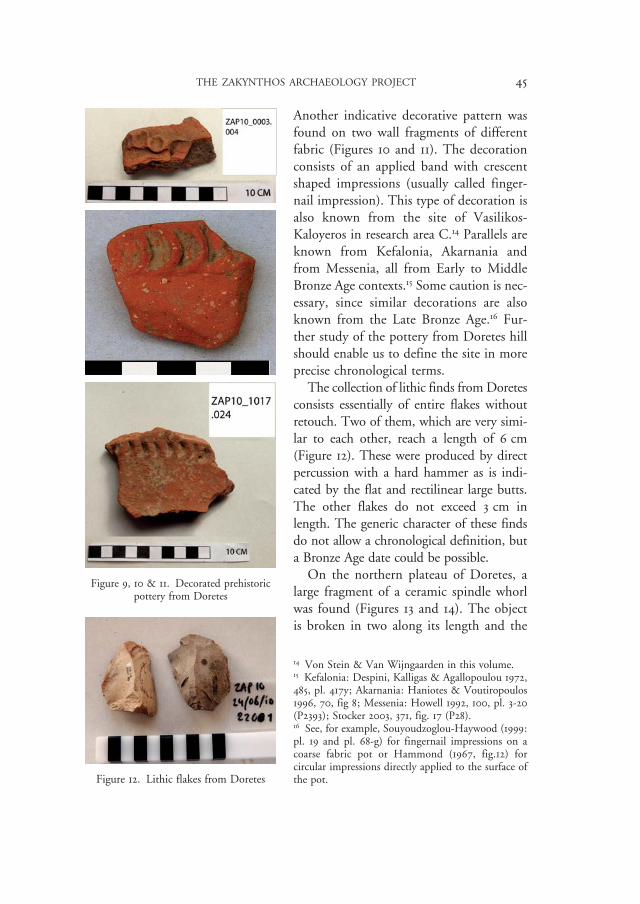
The ceramic finds from the site of Doretes include a wide variety of shapes, decorative motifs and fabrics. The most common fabric group is characteristic for its coarseness, sandy feel, and the common dark grey to black core and red to orange exterior surfaces. This group consists of many wall fragments, usually small and rounded, and some feature sherds, such as lip, base or handle fragments. The morphological characteristics of these pieces are very generic and they are not specific for a certain time period. Luckily, the ceramic assemblage from Doretes includes some pieces with very distinct decorative patterns. One wall fragment, for example, is decorated with an applied band with circular impressions (impressed cordon) (Figure 9). This decorative pattern is known from sites in Lefkada, Laco-nia and Messenia and is generally linked to Early-Middle Bronze Age contexts.13
13 Lefkada: Dorpfeld 1927, Beilage 83c; Laconia: Cavanagh, Mee & Renard 2004, fig. 28.3-4; Mess-enia: Howell 1992, 128, fig. 3-3 (P2067) (Middle Helladic I); Howell 1992, 187, fig. 3-65 (P2699, P2700, P2701) (Middle Helladic II).
Figure 8. The southern plateau (tract 2200-2201) of Doretes hill
96254_Pharos_18/2_02.indd 44 26/04/13 12:02
THE ZAKYNTHOS ARCHAEOLOGY PROJECT 45
Another indicative decorative pattern was found on two wall fragments of different fabric (Figures 10 and 11). The decoration consists of an applied band with crescent shaped impressions (usually called finger-nail impression). This type of decoration is also known from the site of Vasilikos-Kaloyeros in research area C.14 Parallels are known from Kefalonia, Akarnania and from Messenia, all from Early to Middle Bronze Age contexts.15 Some caution is nec-essary, since similar decorations are also known from the Late Bronze Age.16 Fur-ther study of the pottery from Doretes hill should enable us to define the site in more precise chronological terms.
The collection of lithic finds from Doretes consists essentially of entire flakes without retouch. Two of them, which are very simi-lar to each other, reach a length of 6 cm (Figure 12). These were produced by direct percussion with a hard hammer as is indi-cated by the flat and rectilinear large butts. The other flakes do not exceed 3 cm in length. The generic character of these finds do not allow a chronological definition, but a Bronze Age date could be possible.
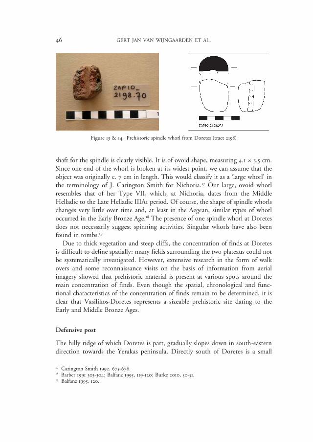
On the northern plateau of Doretes, a large fragment of a ceramic spindle whorl was found (Figures 13 and 14). The object is broken in two along its length and the
14 Von Stein & Van Wijngaarden in this volume. 15 Kefalonia: Despini, Kalligas & Agallopoulou 1972, 485, pl. 417y; Akarnania: Haniotes & Voutiropoulos 1996, 70, fig 8; Messenia: Howell 1992, 100, pl. 3-20 (P2393); Stocker 2003, 371, fig. 17 (P28). 16 See, for example, Souyoudzoglou-Haywood (1999: pl. 19 and pl. 68-g) for fingernail impressions on a coarse fabric pot or Hammond (1967, fig.12) for circular impressions directly applied to the surface of the pot.
Figure 9, 10 & 11. Decorated prehistoric pottery from Doretes
Figure 12. Lithic flakes from Doretes
96254_Pharos_18/2_02.indd 45 26/04/13 12:02
46 GERT JAN VAN WIJNGAARDEN ET AL.
shaft for the spindle is clearly visible. It is of ovoid shape, measuring 4.1 ≈ 3.5 cm. Since one end of the whorl is broken at its widest point, we can assume that the object was originally c. 7 cm in length. This would classify it as a ‘large whorl’ in the terminology of J. Carington Smith for Nichoria.17 Our large, ovoid whorl resembles that of her Type VII, which, at Nichoria, dates from the Middle Helladic to the Late Helladic IIIA1 period. Of course, the shape of spindle whorls changes very little over time and, at least in the Aegean, similar types of whorl occurred in the Early Bronze Age.18 The presence of one spindle whorl at Doretes does not necessarily suggest spinning activities. Singular whorls have also been found in tombs.19
Due to thick vegetation and steep cliffs, the concentration of finds at Doretes is difficult to define spatially: many fields surrounding the two plateaus could not be systematically investigated. However, extensive research in the form of walk overs and some reconnaissance visits on the basis of information from aerial imagery showed that prehistoric material is present at various spots around the main concentration of finds. Even though the spatial, chronological and func-tional characteristics of the concentration of finds remain to be determined, it is clear that Vasilikos-Doretes represents a sizeable prehistoric site dating to the Early and Middle Bronze Ages.
Defensive post
The hilly ridge of which Doretes is part, gradually slopes down in south-eastern direction towards the Yerakas peninsula. Directly south of Doretes is a small
17 Carington Smith 1992, 675-676. 18 Barber 1991 303-304; Balfanz 1995, 119-120; Burke 2010, 50-51. 19 Balfanz 1995, 120.
Figure 13 & 14. Prehistoric spindle whorl from Doretes (tract 2198)
96254_Pharos_18/2_02.indd 46 26/04/13 12:02
THE ZAKYNTHOS ARCHAEOLOGY PROJECT 47
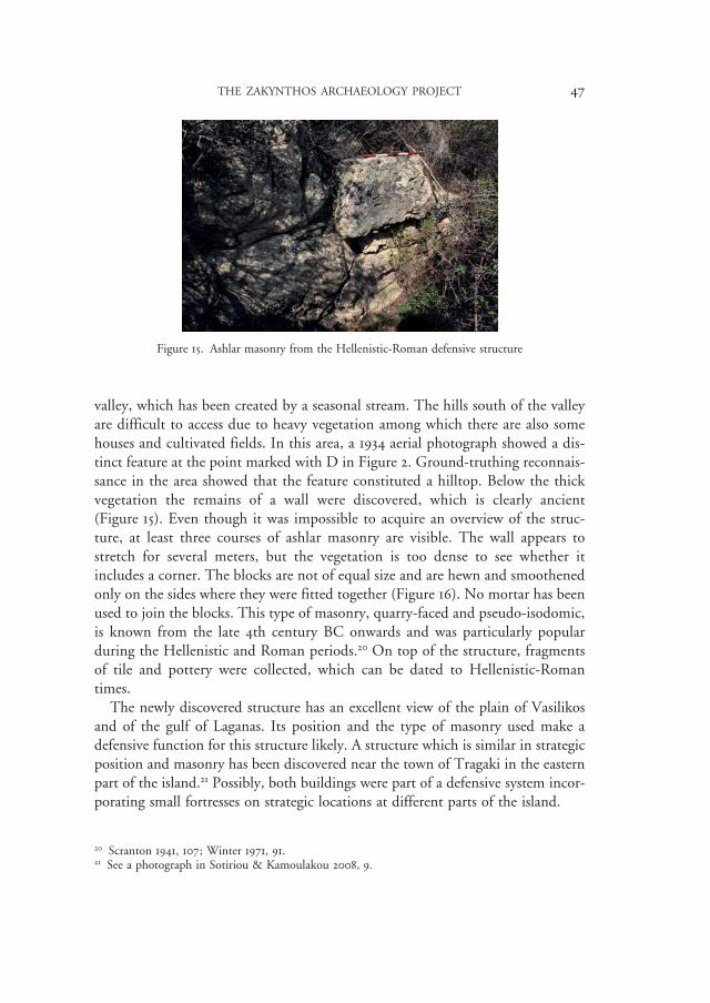
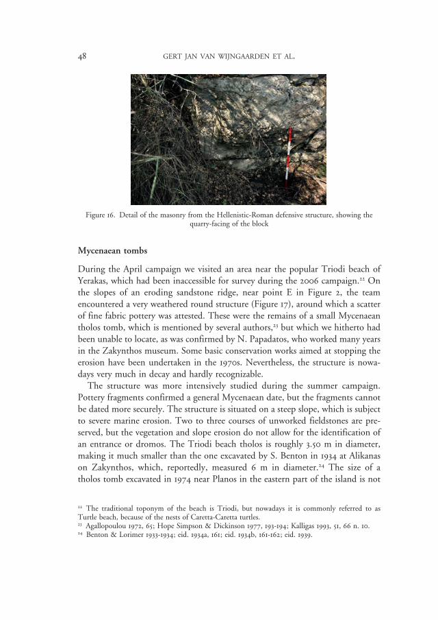
valley, which has been created by a seasonal stream. The hills south of the valley are difficult to access due to heavy vegetation among which there are also some houses and cultivated fields. In this area, a 1934 aerial photograph showed a dis-tinct feature at the point marked with D in Figure 2. Ground-truthing reconnais-sance in the area showed that the feature constituted a hilltop. Below the thick vegetation the remains of a wall were discovered, which is clearly ancient (Figure 15). Even though it was impossible to acquire an overview of the struc-ture, at least three courses of ashlar masonry are visible. The wall appears to stretch for several meters, but the vegetation is too dense to see whether it includes a corner. The blocks are not of equal size and are hewn and smoothened only on the sides where they were fitted together (Figure 16). No mortar has been used to join the blocks. This type of masonry, quarry-faced and pseudo-isodomic, is known from the late 4th century BC onwards and was particularly popular during the Hellenistic and Roman periods.20 On top of the structure, fragments of tile and pottery were collected, which can be dated to Hellenistic-Roman times.
The newly discovered structure has an excellent view of the plain of Vasilikos and of the gulf of Laganas. Its position and the type of masonry used make a defensive function for this structure likely. A structure which is similar in strategic position and masonry has been discovered near the town of Tragaki in the eastern part of the island.21 Possibly, both buildings were part of a defensive system incor-porating small fortresses on strategic locations at different parts of the island.
20 Scranton 1941, 107; Winter 1971, 91. 21 See a photograph in Sotiriou & Kamoulakou 2008, 9.
Figure 15. Ashlar masonry from the Hellenistic-Roman defensive structure
96254_Pharos_18/2_02.indd 47 26/04/13 12:02
48 GERT JAN VAN WIJNGAARDEN ET AL.
Mycenaean tombs
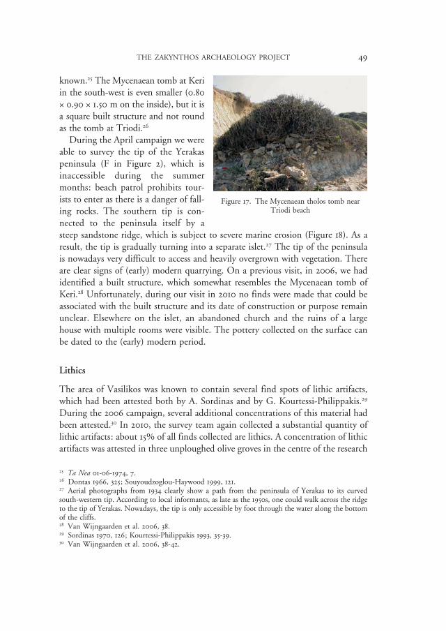
During the April campaign we visited an area near the popular Triodi beach of Yerakas, which had been inaccessible for survey during the 2006 campaign.22 On the slopes of an eroding sandstone ridge, near point E in Figure 2, the team encountered a very weathered round structure (Figure 17), around which a scatter of fine fabric pottery was attested. These were the remains of a small Mycenaean tholos tomb, which is mentioned by several authors,23 but which we hitherto had been unable to locate, as was confirmed by N. Papadatos, who worked many years in the Zakynthos museum. Some basic conservation works aimed at stopping the erosion have been undertaken in the 1970s. Nevertheless, the structure is nowa-days very much in decay and hardly recognizable.
The structure was more intensively studied during the summer campaign. Pottery fragments confirmed a general Mycenaean date, but the fragments cannot be dated more securely. The structure is situated on a steep slope, which is subject to severe marine erosion. Two to three courses of unworked fieldstones are pre-served, but the vegetation and slope erosion do not allow for the identification of an entrance or dromos. The Triodi beach tholos is roughly 3.50 m in diameter, making it much smaller than the one excavated by S. Benton in 1934 at Alikanas on Zakynthos, which, reportedly, measured 6 m in diameter.24 The size of a tholos tomb excavated in 1974 near Planos in the eastern part of the island is not
22 The traditional toponym of the beach is Triodi, but nowadays it is commonly referred to as Turtle beach, because of the nests of Caretta-Caretta turtles. 23 Agallopoulou 1972, 65; Hope Simpson & Dickinson 1977, 193-194; Kalligas 1993, 51, 66 n. 10. 24 Benton & Lorimer 1933-1934; eid. 1934a, 161; eid. 1934b, 161-162; eid. 1939.
Figure 16. Detail of the masonry from the Hellenistic-Roman defensive structure, showing the quarry-facing of the block
96254_Pharos_18/2_02.indd 48 26/04/13 12:02
THE ZAKYNTHOS ARCHAEOLOGY PROJECT 49
known.25 The Mycenaean tomb at Keri in the south-west is even smaller (0.80 ≈ 0.90 ≈ 1.50 m on the inside), but it is a square built structure and not round as the tomb at Triodi.26
During the April campaign we were able to survey the tip of the Yerakas peninsula (F in Figure 2), which is inaccessible during the summer months: beach patrol prohibits tour-ists to enter as there is a danger of fall-ing rocks. The southern tip is con-nected to the peninsula itself by a steep sandstone ridge, which is subject to severe marine erosion (Figure 18). As a result, the tip is gradually turning into a separate islet.27 The tip of the peninsula is nowadays very difficult to access and heavily overgrown with vegetation. There are clear signs of (early) modern quarrying. On a previous visit, in 2006, we had identified a built structure, which somewhat resembles the Mycenaean tomb of Keri.28 Unfortunately, during our visit in 2010 no finds were made that could be associated with the built structure and its date of construction or purpose remain unclear. Elsewhere on the islet, an abandoned church and the ruins of a large house with multiple rooms were visible. The pottery collected on the surface can be dated to the (early) modern period.
Lithics
The area of Vasilikos was known to contain several find spots of lithic artifacts, which had been attested both by A. Sordinas and by G. Kourtessi-Philippakis.29 During the 2006 campaign, several additional concentrations of this material had been attested.30 In 2010, the survey team again collected a substantial quantity of lithic artifacts: about 15% of all finds collected are lithics. A concentration of lithic artifacts was attested in three unploughed olive groves in the centre of the research
25 Ta Nea 01-06-1974, 7. 26 Dontas 1966, 325; Souyoudzoglou-Haywood 1999, 121. 27 Aerial photographs from 1934 clearly show a path from the peninsula of Yerakas to its curved south-western tip. According to local informants, as late as the 1950s, one could walk across the ridge to the tip of Yerakas. Nowadays, the tip is only accessible by foot through the water along the bottom of the cliffs. 28 Van Wijngaarden et al. 2006, 38. 29 Sordinas 1970, 126; Kourtessi-Philippakis 1993, 35-39. 30 Van Wijngaarden et al. 2006, 38-42.
Figure 17. The Mycenaean tholos tomb near Triodi beach
96254_Pharos_18/2_02.indd 49 26/04/13 12:02

50 GERT JAN VAN WIJNGAARDEN ET AL.
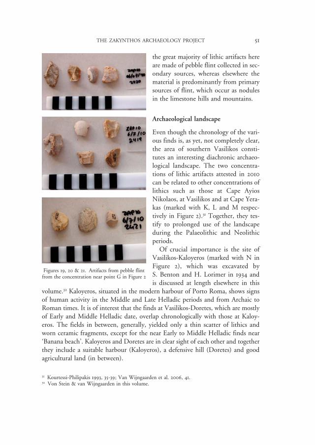
area (tracts 2419-2421), which yielded 33 lithic objects (near G in Figure 2). This small lithic collection is very homogeneous (Figures 19, 20, 21). The raw material is small flint pebble. The pebbles do not exceed 5-6 cm in length, a size which determines the industry as a whole. The flakes are produced by direct percussion with a hard hammer. The presence of some first flakes as well as the cortical butts and the high percentages of cortex indicate that the production took place in situ. We can distinguish some find types, such as notches and splintered pieces. Some techniques can also be recognized, for example abrupt retouch, as well as direct continuous short retouch. There is also a distal fragment of a blade (1.89 ≈ 2.32 ≈ 0.50 cm) of whitish grainy flint. The chrono-cultural significance of this concen-tration still needs to be assessed.
Another area of interest was encountered where the central road in our research area from Vasilikos to Porto Roma cuts through a slope where at various points reddish soils have become visible. At one point (marked with H in Figure 2), lithic artifacts were protruding from a section. These finds were collected and a system-atic survey of the whole road-cutting was conducted, which did not yield addi-tional material. Unfortunately, intensive surface survey could not be carried out in the rest of/the adjacent area, as this was fenced off.
The lithic artifacts in the area of Vasilikos (research area C) can be distin-guished from those in the other research areas of the project by the raw material:
Figure 18. The tip of Gerakas from the north-west
96254_Pharos_18/2_02.indd 50 26/04/13 12:02
THE ZAKYNTHOS ARCHAEOLOGY PROJECT 51
the great majority of lithic artifacts here are made of pebble flint collected in sec-ondary sources, whereas elsewhere the material is predominantly from primary sources of flint, which occur as nodules in the limestone hills and mountains.
Archaeological landscape
Even though the chronology of the vari-ous finds is, as yet, not completely clear, the area of southern Vasilikos consti-tutes an interesting diachronic archaeo-logical landscape. The two concentra-tions of lithic artifacts attested in 2010 can be related to other concentrations of lithics such as those at Cape Ayios Nikolaos, at Vasilikos and at Cape Yera-kas (marked with K, L and M respec-tively in Figure 2).31 Together, they tes-tify to prolonged use of the landscape during the Palaeolithic and Neolithic periods.
Of crucial importance is the site of Vasilikos-Kaloyeros (marked with N in Figure 2), which was excavated by S. Benton and H. Lorimer in 1934 and is discussed at length elsewhere in this
volume.32 Kaloyeros, situated in the modern harbour of Porto Roma, shows signs of human activity in the Middle and Late Helladic periods and from Archaic to Roman times. It is of interest that the finds at Vasilikos-Doretes, which are mostly of Early and Middle Helladic date, overlap chronologically with those at Kaloy-eros. The fields in between, generally, yielded only a thin scatter of lithics and worn ceramic fragments, except for the near Early to Middle Helladic finds near ‘Banana beach’. Kaloyeros and Doretes are in clear sight of each other and together they include a suitable harbour (Kaloyeros), a defensive hill (Doretes) and good agricultural land (in between).
31 Kourtessi-Philipakis 1993, 35-39; Van Wijngaarden et al. 2006, 41. 32 Von Stein & van Wijngaarden in this volume.
Figures 19, 20 & 21. Artifacts from pebble flint from the concentration near point G in Figure 2
96254_Pharos_18/2_02.indd 51 26/04/13 12:02
52 GERT JAN VAN WIJNGAARDEN ET AL.
The Late Helladic remains at Kaloyeros and the Mycenaean tholos tomb at Triodi beach are separated some 1.2 km from Kaloyeros.33 It is logical to assume that both sites are connected to each other. Some wheel-made sherds that are found at Doretes may also be of Late Helladic date, but, as yet, there are no signs of extensive Mycenaean occupation in the western hills of the research area. A vague, but marked concentration of ancient pottery was attested somewhat to the north-west in the area marked with O in Figure 2. Several fields in this area, in the foothills of the hilly ridge, yielded worn pottery fragments, many of which we tentatively assigned as BA? (= perhaps Bronze Age). These may be indicative of an agricultural use of the area.
From the fields marked with O in Figure 2, came pottery fragments, which have been labeled as Classical-Hellenistic. These correlate with the finds from these periods at Kaloyeros34 and with a scatter of finds near Stavromenos (point P in Figure 2), which was attested during the 2006 season and labeled as Hellen-istic-Roman. The defensive fortification mentioned above also dates back to Hellenistic or Roman times.
In addition to the ancient sites, the church and other remains from the mon-astery of Akrogriotisa are still standing near Stavromenos (Q in figure 2). The monastery dates back to at least 1665.35 Somewhat to the south-west of the mon-astery, remains of a hamlet can still be seen, which was deserted after the 1953 earthquake. Some World War II bunkers are also situated nearby. The ancient and historical remains of Vasilikos are inconspicuous markers in a touristic land-scape that is intensifying rapidly.
Preliminary conclusions
The preliminary results of the 2010 archaeological survey in research area C of the Zakynthos Archaeology Project can be summarized as follows:
• In the coastal zone of ‘Banana beach’, there is evidence of prehistoric remains of the Early and/or Middle Bronze Ages. The area is difficult to access and it is currently being developed for tourism.
• The hilly ridge which delineates the research area to the west shows ample signs of prehistoric presence. These indications appear to be related to an important site on the top plateaus of Vasilikos-Doretes, which dates to the Early to Middle Bronze Ages. Some finds from later periods are present as well.
33 If the built structure at the tip of Yerakas, was also a Mycenaean tomb (which is by no means certain), then it could also be related to Kaloyeros. 34 Von Stein & van Wijngaarden in this volume. 35 Konomos 1979, 40.
96254_Pharos_18/2_02.indd 52 26/04/13 12:02
THE ZAKYNTHOS ARCHAEOLOGY PROJECT 53
• Directly south of Doretes, there is a fortification from the Hellenistic-Roman period.
• The Mycenaean tomb, which was referred to by several scholars as ‘above Triodi beach’ has been found and is subject to severe erosion.
• Lithic artifacts, predominantly from pebble flint, are widely distributed in the survey area. Two concentrations, one on the surface and another from a road section, have been identified during the survey of 2010.
• There are several concentrations of ancient material of different periods in research area C, showing diachronic use of the landscape from the palaeo-lithic to modern times. As the only site that shows a more or less continuous human presence from the Early Bronze Age to the Roman period, Vasilikos-Kaloyeros plays an important role in this archaeological landscape.
G.J.M. VAN WIJNGAARDEN A. SOTIRIOU
University of Amsterdam 35th Ephorate of Prehistoric and [email protected] Classical Archaeology, Argostoli
G. KOURTESSI-PHILIPPAKIS B. BOGAARD
Kapodistrian University of Athens University of [email protected] [email protected]
P. BLOEMENDAAL N. PIETERS
University of Amsterdam University of [email protected]
A. STOKER ArcheoSynthese
Acknowledgements
The Zakynthos Archaeology Project is directed by A. Sotiriou from the 35th Ephorate of Prehistoric and Classical Antiquities (35th EPKA) and Dr G.J. van Wijngaarden from the University of Amsterdam (UvA). V. Sarris of the 35th EPKA participated in the 2010 survey and helped us in various ways. The study of ceramics is coordinated by Professor V. Stissi (UvA). N. Pieters (UvA) organ-ised the find processing and carried out ceramic studies, assisted by L. Hoff (UvA). A. Kotsonas (UvA) visited the programme and gave expertise comments
96254_Pharos_18/2_02.indd 53 26/04/13 12:02
54 GERT JAN VAN WIJNGAARDEN ET AL.
on ceramics of specific tracts. Professor G. Kourtessi-Philipakis of the Kapodis-trian University in Athens (KUA) coordinates the study of the lithic finds. She was assisted by L. Erisman and Ellen Bond (UvA). Computer applications and GIS were the responsibility of J. Waagen (UvA), J. van der Velden (Radboud University Nijmegen) and K. Abed (VU). The analysis of aerial photographs and the resulting ground truthing was coordinated and carried out by Anke Stoker. Find photographs were taken by M. Nieuwe Weme. Teamleader of the archaeo-logical survey was B. Bogaard (UvA). P. Bloemendaal (UvA) and K. Abed (VU) directed the revisiting of 2006 tracts. Student and volunteer participants were: E. Bond, Ch. de Hoogd, J. van der Krieke, B. Krijger, J. van Leeuwen, L. Muis, J. den Ouden, M. Roos, K. Sinha, C. Smith, B. Petrutoni (UvA); D. Charalam-bopoulos, K. Karatasaki, P. Stathopoulou (KUA). The directors of the Zakyn-thos Archaeology Project are grateful to all participants for their expertise, energy and companionship. The project would not be possible without the generous support of the Dutch Foundation for Scientific Research (NWO), the University of Amsterdam, the UTOPA Foundation and the Institute for Aegean Prehistory. All participants are grateful to these institutions.
The ZAP 10 team would also like to thank Andreas Sotiriou and the staff of the 35th EPKA for the very pleasant cooperation. In addition, we would like to thank Mrs T. Rigakou, acting Direcor of the 20th Ephorate of Byzantine Antiquities, for her support. D. Nicolia and N. Komis, also of the 20th Ephorate of Byzantine Antiquities, were helpful in many different ways. We also thank Dr Ch. Tytgat and the staff of the Netherlands Institute in Athens. Our landlady Nana Var-dakastanis deserves thanks for help of various kind. Last but not least, we thank the inhabitants of Zakynthos for their generous hospitality, which allows us to do our research.
References
AGALLOPOULOU, P.I. 1972. Anaskafß mukjnaïkÉn táfwn pará to Kampí dutikßv Hakún-qou, AAA 5, 63-66.
AGALLOPOULOU, P.I. 1973. MukjnaïkÉn nekrotafeíwn pará to Kampí Hakúnqou, ArchDelt 28-A, 198-214.
BALFANZ, K. 1995. Bronzezeitlichen Spinnwirtel aus Troia, Studia Troica V, 117-144.BARBER, E.J.W. 1991. Prehistoric textiles. The Development of Cloth in the Neolithic and
Bronze Ages, Princeton.BENTON, S. & H. LORIMER 1933-1934. Zakynthos, Annual Report of the BSA 5. BENTON, S. & H. LORIMER 1939. Arxaiologiká eurßmata, Ai Moúsai 973, 5-6, Zakyn-
thos. BURKE, B. 2010. From Minos to Midas. Ancient Cloth Production in the Aegean and Anatolia,
Oxford & Oakville.
96254_Pharos_18/2_02.indd 54 26/04/13 12:02
THE ZAKYNTHOS ARCHAEOLOGY PROJECT 55
CARINGTON SMITH, J. 1992. Textiles at Nichoria. In: W.A. McDonald & N.C. Wilkie (eds), Excavations at Nichoria in Southwestern Greece II. The Bronze Age Occupation, Minneapolis, 764-711.
CAVANAGH, W., C. MEE, & J. RENARD 2004: ‘Sparta before Sparta’: Report on the inten-sive survey at Kouphovouno. BSA 99, 49-128.
CROUWEL, J.H., M. PRENT, R. CAPPERS, & T. CARTER 1998. Geraki. An acropolis site in Lakonia. Preliminary report on the fourth season. Pharos. Journal of the Netherlands Institute at Athens VI, 93-118.
DESPINI, A.K., P. KALLIGAS & P. AGALLOPOULLOU 1972. Iónioi Nßsoi, ArchDelt. 27-B, 475-494.
DONTAS, G. 1996. Hákunqov, ArchDelt 23-II, 325.DÖRPFELD, W. 1927. Alt-Ithaka. Ein Beitrag zur Homer-Frage, München. HAMMOND, N.G.L. 1967. Epirus, Oxford.HANIOTES, F.K. & N. VOUTIROPOULOS 1996. New evidence from Platygiali, an Early
Bronze Age settlement in Western Greece, BSA 91, 59-80.HOPE SIMPSON, R. & O.T.P.K. DICKINSON 1979. A Gazetteer of Aegean Civilisation in the
Bronze Age, I. The Mainland and Islands, Studies in Mediterranean Archaeology 52, Göteborg.
HOWELL, R.J. 1992: The Middle Helladic settlement: pottery. In: W.A. McDonald, N.C. Wilkie (eds), Excavations at Nichoria in Southwestern Greece II. The Bronze Age Occupation, Minneapolis, 43-204.
KALLIGAS P.G. 1993. Oíkjsj stjn arxaía Hákunqo. In: Oi oikismoí tjv Hakúnqou apó tjn arxaiótjta méxri sßmera, Zakynthos, 45-73.
KONOMOS, D. 1979. Hákunqov (pentakósia xrónia) 1478-1978 t. B. ´Upaiqrov xÉra, Athens.
KOURTESSI-PHILIPAKIS, G., 1993. J proïstorikß katoíkjsj tjv Hakúnqou. In: Oi Oikismoí tjv Hakúnqou apó tjn Arxaiótjta méxri Sßmera, 33-43. Zakynthos.
LIVERIS, CH. 2002. Ta Topwnúmia tjv Hakúnqou, Zakynthos.SCRANTON, R.L. 1941. Greek walls, Cambridge Mass.SORDINAS, A. 1970. Líqina ergaleía apo tjn proïstorikß Hákunqou, Kerkuraïká Xroniká
15, 122-130.SOTIRIOU, A. & M. KAMOULAKOU 2008. Hakunqinoí qjsauroí sto diába twn aiÉnwn. Oi
arxaiótjtev tjv Zakúnqou xqev kai sßmera, STIGMES in Zante 10/10/2008, 7-10.STORME, A. 2008. The landscape at Zakynthos. Detailed geomorphological description of
the south-eastern part of the Vassilikos peninsula. IGBA Rapport Vrije Universiteit, Amsterdam 2008-1. MA Thesis.
VAN WIJNGAARDEN, G.J.M., X. ARAPOGIANNI, R. RINK & V. TOURLOUKIS 2005. The Zakynthos survey 2005. Preliminary report of a pilot survey, Pharos. Journal of the Netherlands Institute at Athens XIII, 59-76.
VAN WIJNGAARDEN, G.J.M., A. SOTIRIOU, N. PIETERS & V. TOURLOUKIS 2006. The Zakynthos Archaeology Project 2006. Preliminary report of the first season, Pharos. Journal of the Netherlands Institute at Athens XIV, 29-46.
VAN WIJNGAARDEN, G.J.M., A. SOTIRIOU, N. PIETERS, K. ABED & M. TENDÜRÜS 2007. The Zakynthos Archaeology Project. Preliminary report of the 2007 season, Pharos. Journal of the Netherlands Institute at Athens XV, 43-57.
VAN WIJNGAARDEN, G.J.M., A. SOTIRIOU, J. HORN LOPES, M. GKOUMA, K. KOSTER, A. STOKER, D. SUSAN & E. TOURLOUKIS 2008. The Zakynthos Archaeology
96254_Pharos_18/2_02.indd 55 26/04/13 12:02

56 GERT JAN VAN WIJNGAARDEN ET AL.
Project. Preliminary report of the 2008 season, Pharos. Journal of the Netherlands Institute at Athens XVI, 63-86.
VAN WIJNGAARDEN, G,.J.M., A. SOTIRIOU, V. STISSI, A. BONNIER & L. ERISMAN 2009. The Zakynthos Archaeology Project. Preliminary report of the 2009 season. Pharos. Journal of the Netherlands Institute at Athens XVII.2, 59-76.
WINTER, F.E. 1971. Greek Fortifications, London.
96254_Pharos_18/2_02.indd 56 26/04/13 12:02