Ute Indian Rock Art Maps and Game Drives in Western Colorado: A Preliminary Study of Ute Rock Art...
20
INTRODUCTION T he Numic cultures were highly mobile hunter-gatherer people, constantly migrating across diverse environments in small groups of 10 to 15 family members, keeping seasonal pace with plant and animal food resources. Their territory ranged from canyon-laced semi-desert shrublands, to mesa- top pinyon-juniper woodlands and dense aspen and pine forests, upward in elevation to the highest alpine peaks of the Rockies. Their life way was guided by their collective knowledge of game trails, hunting strategies, and seasonal locations of wild plant foods (Burns 2004; Conetah, 1982; Fowler and Fowler 1971; Smith 1974). Ute Indians that inhabited the western slope of Colorado’s Rocky Mountains call themselves the Nuutsiyu, meaning “the Mountain People.” For them, “movement was a basic value. That is, you could say they had a sacred mandate, passed on to them by tradition from deity, that they were supposed to do this… and that was a pattern that wasn’t just econom- ic, but it was sacred. It had a sacred mandate to do it” (Goss 2003). Carol Patterson, Ph.D. Dominguez Anthropological Research Group (DARG) Native American consultants of the Northern Ute Tribe have identified certain abstract linear rock art motifs located at sites in their traditional homelands of west central Colorado that may represent maps of aboriginal trails and hunting areas. A preliminary study of all petroglyph sites within the Early and Late Historic Ute era, limited to sites located in and near Gunnison Gorge National Conservation Area (GGNCA) and Domin- guez Escalante National Conservation Area (DENCA), devised and tested a conceptual framework for objec- tively identifying possible correlations between what Utes identified as map-like rock art figures and existing natural and archaeological features within surrounding locals. The results of the study are preliminary and suggest further investigations be undertaken with a larger sample size following the model put forth here. Ute Indian Rock Art Maps and Game Drives in Western Colorado: A Preliminary Study of Ute Rock Art Maps in Gunnison Gorge National Conservation Area and Dominguez-Escalante National Conservation Area IFRAO 2013 Proceedings, American Indian Rock Art, Volume 40. American Rock Art Research Association, 2013, pp #-# Mavis Greer Session Editor, Peggy Whitehead Volume Editor.
Transcript of Ute Indian Rock Art Maps and Game Drives in Western Colorado: A Preliminary Study of Ute Rock Art...

IntroductIonT he Numic cultures were highly mobile hunter-gatherer people, constantly migrating across diverse environments in small groups of 10 to 15 family members, keeping seasonal pace with plant and animal food resources. Their territory ranged from canyon-laced semi-desert shrublands, to mesa-top pinyon-juniper woodlands and dense aspen and pine forests, upward in elevation to the highest alpine peaks of the Rockies. Their life way was guided by their collective knowledge of game trails, hunting strategies, and seasonal locations of wild plant foods (Burns 2004; Conetah, 1982; Fowler and Fowler 1971; Smith 1974).Ute Indians that inhabited the western slope of Colorado’s
Rocky Mountains call themselves the Nuutsiyu, meaning “the Mountain People.” For them,
“movement was a basic value. That is, you could say they had a sacred mandate, passed on to them by tradition from deity, that they were supposed to do this… and that was a pattern that wasn’t just econom-ic, but it was sacred. It had a sacred mandate to do it” (Goss 2003).
Carol Patterson, Ph.D.
Dominguez Anthropological Research Group (DARG)
Native American consultants of the Northern Ute Tribe have identified certain abstract linear rock art motifs located at sites in their traditional homelands of west central Colorado that may represent maps of aboriginal trails and hunting areas. A preliminary study of all petroglyph sites within the Early and Late Historic Ute era, limited to sites located in and near Gunnison Gorge National Conservation Area (GGNCA) and Domin-guez Escalante National Conservation Area (DENCA), devised and tested a conceptual framework for objec-tively identifying possible correlations between what Utes identified as map-like rock art figures and existing natural and archaeological features within surrounding locals. The results of the study are preliminary and suggest further investigations be undertaken with a larger sample size following the model put forth here.
Ute Indian Rock Art Maps and Game Drives in Western Colorado: A Preliminary Study of Ute Rock Art Maps in Gunnison Gorge National Conservation Area and Dominguez-Escalante
National Conservation Area
IFRAO 2013 Proceedings, American Indian Rock Art, Volume 40. American Rock Art Research Association, 2013, pp #-#Mavis Greer Session Editor, Peggy Whitehead Volume Editor.
Ute Indian Rock Art Maps and Game Drives in Western Colorado: A Preliminary Study of Ute Rock Art Maps in Gunnison Gorge National Conservation Area and Dominguez-Escalante National Conservation Area
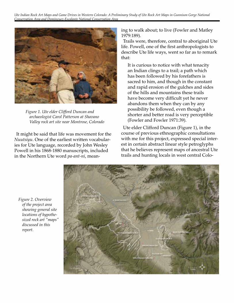
It might be said that life was movement for the Nuutsiyu. One of the earliest written vocabular-ies for Ute language, recorded by John Wesley Powell in his 1868-1880 manuscripts, included in the Northern Ute word pa-ant-ni, mean-
ing to walk about; to live (Fowler and Matley 1979:189).Trails were, therefore, central to aboriginal Ute
life. Powell, one of the first anthropologists to describe Ute life ways, went so far as to remark that:
It is curious to notice with what tenacity an Indian clings to a trail; a path which has been followed by his forefathers is sacred to him, and though in the constant and rapid erosion of the gulches and sides of the hills and mountains these trails have become very difficult yet he never abandons them when they can by any possibility be followed, even though a shorter and better road is very perceptible (Fowler and Fowler 1971:39).
Ute elder Clifford Duncan (Figure 1), in the course of previous ethnographic consultations with me for this project, expressed special inter-est in certain abstract linear style petroglyphs that he believes represent maps of ancestral Ute trails and hunting locals in west central Colo-
Figure 1. Ute elder Clifford Duncan and archaeologist Carol Patterson at Shavano Valley rock art site near Montrose, Colorado
Figure 2. Overview of the project area showing general site locations of hypothe-sized rock art “maps” discussed in this report.

Carol Patterson
rado. In Mr. Duncan’s view, a system for record-ing such knowledge in place would have offered significant advantages to highly mobile, widely dispersed small family groups, particularly when fluctuating climates drew them into unfa-miliar locales or areas that had been abandoned for long periods then reoccupied, perhaps after several generations.The primary objective of this project was to
test the idea that some Ute rock art figures are map-like representations of aboriginal trails and game drives, inscribed in situ in the landscapes they depict. The project was limited in scope and consisted chiefly of visual comparisons of representative rock art figures, identified by Mr. Duncan as map-like representations, with exist-ing geographic features and previously recorded archaeological features located in the surround-ing landscapes (Patterson 2007; Patterson and Duncan 2007). Petroglyphs figures from five rock art sites (Figure 2) within and near Gun-nison Gorge National Conservation Area (GGN-CA) and Dominguez Escalante National Conser-vation Area (DENCA) were selected for sample examination in the study. All of the sampled figures are thought to have been created during Ute occupation of the region in Early and Late Historic Ute periods, dating roughly A.D. 1400 to1900.This article summarizes the comparative data
collected and compiled for the project and proposes a beginning research approach for evaluating possible correlations between rock art figures and landscape features. It also offers a preliminary analysis and discussion of test results and recommends certain follow-on re-search directions suggested by project findings.
Study AreA
The study was implemented to support the research and science program of the National Landscape Conservation System (NLCS) and focuses on archaeological resources within and near the GGNCA and DENCA. Although sev-
eral of the rock art sites examined for this study are located outside the proscribed boundaries of the NCAs (Figure 2), it is important to note that they exhibit characteristics directly analogous to cultural and natural features found within the NCAs themselves.
rAtIonAle And Methodology
Given the limited scope of this project, its re-search rationale was narrowly focused on correl-ative analysis of visual data from photographs and traced drawings of selected petroglyph figures compared with various contemporary relief and topographic maps of the study area. Baseline data for the project were compiled from my research collections, which include rock art site records from the Colorado Office of Archae-ology and Historic Preservation (OAHP) as well as photographs and drawings from a number of known but unrecorded sites within the study area, mostly on private land. The dataset includ-ed primary site records for 216 recorded rock art sites located in Montrose, Delta, and Mesa Counties, and included, in whole or part, 35 sites identified as Archaic, 140 as Formative, and 125 as Protohistoric, Ute or Numic in OAHP’s Compass database. Of these, only about a dozen were described as “abstract linear” in style and were candidates eligible for sampling within or near the NCAs (Gleichman et al. 1982).Two types of abstract linear rock art figures
previously identified and conceptualized by Ute elder Clifford Duncan as possible map-like representations were used as visual benchmarks for filtering baseline data to select sample fig-ures for analysis. Type One, consists of complex arrays of interconnected straight and wavy lines, sometimes including circles. These are hy-pothesized to represent “terrain maps” showing trails and routes through nearby or surrounding regions. Type Two consists primarily of circles and connecting lines and sometimes including stand-alone circles. These are hypothesized to represent “hunting maps” showing ridge lines

Ute Indian Rock Art Maps and Game Drives in Western Colorado: A Preliminary Study of Ute Rock Art Maps in Gunnison Gorge National Conservation Area and Dominguez-Escalante National Conservation Area
Figure 3. Traced drawings from photographs of rock art panels examined in this study. Figures A and B are hypothesized to represent “terrain maps.” Figures C-F are hypothesized to represent “hunting maps.” The figures are shown in their in-situ vertical orientations and are at variable scales.

Carol Patterson
and catchment areas in nearby locales. In to-tal, six petroglyph figures located at five rock art sites were selected for analysis: two terrain maps and four hunting maps (Figure 3). First order of analysis consisted of layering the cor-relations between rock figures and surrounding landscape features.
conceptuAl FrAMework
Several cartographic and interpretive conven-tions suggested by Mr. Duncan were formulated into a working conceptual framework to guide selection and analysis of sample figures:
1. The northern orientation does not apply. Ute map figures are oriented south.2. Map figures vary in scale and rock feature
incorporations play a role in the composition, like schematic diagrams of nearby places.3. Circles may represent a “place” or “area” of
interest; e.g., where game animals congregate for feeding, or, conversely, to escape hunters. Lines may represent trails. Undulating lines may represent rivers.
4. Animal tracks, animal figures, and human figures touching or associated with linear ele-ments may provide descriptive context indicat-ing hunting or plant procurement locals. 5. Complex linear figures may represent trails
and routes through a large area “terrain map.”6. Simple circle and line figures may indi-
cate game drives and hunting locals “hunting maps.”
generAl terrAIn MApS
The first example is a rock art panel located in the Shavano Valley Petroglyph site about five miles west of Montrose, Colorado (Figure 4). Clifford Duncan, Ute Tribal Elder has inter-preted the image on Figure 5a as depicting a map of the Uncompahgre Plateau directly to the southwest. He explained that Ute Indians orient themselves to the south, rather than the north (Duncan 2009). So, by rotating the petroglyph drawing 180 degrees, one can see a striking correlation to the USGS topographic map of the immediate area. To the Utes, the south is where the sun comes from and sun-wise direction from
Figure 4. Shavano Valley Petroglyph site, main panel called “three bears.”

Ute Indian Rock Art Maps and Game Drives in Western Colorado: A Preliminary Study of Ute Rock Art Maps in Gunnison Gorge National Conservation Area and Dominguez-Escalante National Conservation Area
east to west (clockwise) is the preferred direc-tion of travel (Duncan 2005). When this petro-glyph is rotated to orient to the south, it has corresponding features to those found in the im-mediate area map of the Uncompahgre plateau. The corresponding features proposed are la-beled a – h and placed on the topographic map (Figure 5b). The green areas on the topographic map are basins that game animals congregate in the winter. They are located along Roubideau Canyon, while down the center is Dry Creek, and to the far right is the Uncompahgre River. The direct overlay of the petroglyph map over the physical land features has a remarkable correspondence. The circled areas are the high-est elevations where game animals congregate. On the left is Oak Hill, and the center is a large high meadow plateau on the slope of Horsefly Peak and is within a private hunting ranch. Both areas have a high density of cultural material.BLM Range Administration Manager Debo-
rah Birch grew up in this area and her family ran cattle from east to west across the Plateau to summer grazing in Horseshoe Basin. She
identified the east/west linear features on the petroglyph map as those trails she knows well and used every summer. Historic activity on the plateau has created new roads and graded over the old Ute trails. Visitors can find traces of the prehistoric trails but they are no longer in use for cattle drives. Following this pattern of Ute petroglyphs and their association with the adja-cent landscape, a study was conducted of sev-eral other similar looking petroglyphs and their possible association with the adjacent landscape.
the gunnISon gorge nAtIonAl
conServAtIon AreA
The GGNCA is known to contain many cultur-al resources attributed to Ute culture including wikiup camps and Ute trails. The Smith Fork of the Gunnison Gorge is now on private land, but it is geographically part of the river and canyon complex that makes up the GGNCA. Located adjacent to the NCA boundary in the upper end of the Smith Fork is a petroglyph panel known
Figure 5. Petroglyph at Shavano Valley (a) and Uncompah-gre Plateau with Shavano Valley map overlay (b). The corresponding features proposed are labeled a – h and placed on the topographic map: A – Horseshoe Basin; B – Travelers Ba-sin; C – Roubideau Canyon; D – Oak Hill; E – Dry Creek; F – Horsefly Basin; G – Uncom-pahgre River; H – Shavano Valley.

Carol Patterson
to the locals as “Map Rock” (Figures 6-8). The features that coincide with the petroglyph and the topographic map (Figure 8) are labeled A – G for clarification. The following analysis ad-dresses each corresponding element from the petroglyph to the feature on the landscape.At the top of the map (Figure 8) there are two
circles joined by a line “stem” that corresponds to two petroglyph sites and roughly to a divid-ing gulch called Lawhead Gulch. A and B on
Figure 6. The Map Rock petroglyph was photographed and drawn as it is found in situ oriented to the north.
Figure 7. The Map Rock linear features of the drawing shown here is rotated to orient to the south and placed upon a topographic map of the area.
Figure 8. Map Rock at Smith Fork of the Gunnison and with the petroglyph overlay on a topographic map. The corresponding features proposed are labeled a – g and placed on the topographic map: A - Two circles at the top encircle the highest elevations over-looking the Gunnison River.; B -The connecting “stem” between these two circles aligns with Lawhead Gulch; C - The prominently pecked diagonal broad line aligns with the Gunnison Gorge; D - the pecked line in this location aligns with the trail still used called “Ute Trail”; E - Trail up from Gunnison Gorge to Black Ridge with connecting trails up to known wikiup villages; F - Ute Trail Ford marked on BLM maps linking the game trails up Long Gulch to mesa top with connecting trails up to Buttermilk Mesa; G -The pecked spikey motif in this area aligns with the traditional Sage Grouse breeding grounds on Grizzly Ridge.

Ute Indian Rock Art Maps and Game Drives in Western Colorado: A Preliminary Study of Ute Rock Art Maps in Gunnison Gorge National Conservation Area and Dominguez-Escalante National Conservation Area
Figure 9 are noted as “circles” correspond to archaeological sites 5DT335 and 5DT813. When examined more closely, the following sample of rock art panels are of antiquity probably dating from the Late Archaic era. Site 5DT813 was fully documented (Patterson and Watchman 2006.) The petroglyphs dated from the Archaic era to the Historic Ute. Site 5DT355 consists of a large array of petroglyphs on a cliff face overlooking the river (Figure 10). Site 5DT813 contains 16
panels of Archaic through Historic Ute petro-glyphs (Figure 11).Lawhead Gulch opens up at the location of this
cave (site 5DT813), and deer and elk pass by frequently as they come down from the higher elevations and access the river for water or to cross at the sandbar that extends across at this location. During a field recording of the Gunni-son Gorge rock shelter in the GGNCA, a herd of mule deer appeared above the site, on a look-out point. It was captured on video and used to demonstrate the use of game trails that still exist from this high lookout point, down Law-head Gulch, and past the Gunnison Gorge rock shelter down to the river. Video footage of these animals crossing in front of 5DT813 was taken while documenting the petroglyphs at this site. Lawhead Gulch is an important migration trail used by animals both prehistorically and in the present. The large petroglyph panel of deer and elk above the cave seems to be associated with the heavily used game trail adjacent to it.Gunnison Gorge aligned with the engraved
line on the panel (Figure 12). The “map rock” in the Smithfork of the Gunnison Gorge is unique in that the petroglyph engravings do not in-corporate any of the natural rock features, as so often is the case with other map like images
Figure 9. Close up on the rock art super-imposition over the topographic map of Lawhead Gulch and two rock art sites overlooking the Gunnison River.
Figure 10. Drawings of petroglyph site 5DT335.

Carol Patterson
throughout the western states. Features such as cracks and bumps are usually incorporated by extended pecking from an animal’s foot or hu-man foot along the crack to convey the idea that that person or animal is ‘walking on” a trail or ‘walking in” a canyon (see the Bancroft Library Rock Art Bibliography for hundreds of citations on rock incorporation: http://bancroft.berkeley.edu/collections/rockart/search.html). One can see from the photograph (Figure 12a) that the engraved line running nearly diagonally across the rock face does not incorporate any natural
features, and the bedding plane features of the rock surface are distinct and untouched.
Trails into and out of the Gunnison Gorge to Black Ridge are marked on Figure 13. The trail to Black Ridge from the Gunnison Gorge was retraced on the figure. Today, trail riders and recreationalists have improved trails that lead from the Gorge up into Red Canyon and out towards Crawford. It is not known how much of the modern trail overlays the prehistoric trail. Private land ownership has shifted many parts
Figure 11. Drawings of 5DT813.
Figure 12. Photograph of the “map rock” (a) with equivalent line drawing (b).

Ute Indian Rock Art Maps and Game Drives in Western Colorado: A Preliminary Study of Ute Rock Art Maps in Gunnison Gorge National Conservation Area and Dominguez-Escalante National Conservation Area
of the trail onto Public land for public use. The labyrinth of game trails that lead off of Butter-milk Ridge converge at Long Gulch. These trails were retraced us, and GPS points plotted on a map. One of the trail crossings was noted in the
BLM records as the “Ute Trail Ford” and located on the Gunnison River at the south end of Ute Park (Figure 14). The Ute Trail Ford and Animal Crossing at the end of Ute Park are still used by game animals.
Figure 13. Map showing the ‘Map Rock’ petroglyph superimposition in black and the cultural survey along these possible trails in red
Figure 14. Map showing the encircled area of Ute Park and the location of the “Ute Trail Ford” that leads to Long Gulch.

Carol Patterson
When I examined the sage grouse traditional breeding grounds relative to the petroglyph map I considered the image on the upper left of Figure 15, which is a unique spikey-looking motif. It is unlike anything in the rock art data conforming to a named zoomorph or natural-istic rendering. Worldwide there is a pattern among Indigenous cultures that follows a pat-tern of depicting large animals in profile view, small reptiles and insects in plan view, and hu-mans in frontal view. The reasoning being that what humans “see” is how things are portrayed. Small animals are viewed from the top down. Identifying traits for a lizard versus a turtle for
example are the legs and tail and body width from the top down. Large animals are scene in profile. Elk, deer, fox, and crane are identified by their profiles. Humans are drawn face on and identifying traits are seen in the headdress, ac-companying weapons, and arm gestures. Hu-mans would be difficult to distinguish if drawn in profile or top down.The sage grouse in breeding season is distin-
guished from other birds by the display of its spikey tail feathers and bulbuls breast (Figure 15, right side). So it would follow that a petro-glyph of a sage grouse would emphasize these traits. Figure 15 shows comparisons of the petro-
Figure 15. Petroglyph of sage grouse from a plan view and profile view. Photographs of sage grouse with characteristic spikey tails and bulbous throat pouch.

Ute Indian Rock Art Maps and Game Drives in Western Colorado: A Preliminary Study of Ute Rock Art Maps in Gunnison Gorge National Conservation Area and Dominguez-Escalante National Conservation Area
glyph image and a sage grouse. The petroglyph may be a plan view of the bird. Below the radi-ating spiky motif is another image that may be a profile of the bird in breeding stance. The two images may represent the sage grouse from two perspectives. It follows the tradition of draw-ing what is known rather than what is visually realistic from a single view or advantage point. Called Intellectual Realism, Conceptual Real-ism, or Twisted Perspective, it describes what Indigenous people draw from what they know or see intellectually. The result is often from two or more perspectives combined. Picasso employed combined perspectives after study-ing tribal art in Africa. Past art of the Australian Aborigines, South American Inca, Moche, and Chimu cultures employ imaging techniques of multiple perspectives as well. Examples in North America are numerous and beyond the scope of this paper to address. When the ‘Map Rock’ petroglyph is turned 180 degrees and placed over the topographic map, this spikey image occurs on top of the Sage Grouse habitat.
huntIng MApS
Several sites in the Uncompahgre Plateau ad-jacent to the DENCA have circle and line motifs that appear to be hunting strategies. Like maps, they show the movement patterns of game animals in the adjacent landscape. The next two examples fit closely to the local typography.The Dry Creek rock art “Map Site” is a petro-
glyph located on the wall of a shallow rock shelter. It is on Public Land outside of the DENCA. It consists of the characteristic circles and lines, with a few quadrupeds. The panel shown in Figures 17 (right side) and Figure 18 depicts deer or game animals traveling from the large circled area to the smaller one and up into the isolated circle. The Panel is rotated to ori-ent south, and then graphically placed over the immediate landscape on the adjacent finger like mesa directly south of the petroglyph panel. The long line is aligned with the long ridge that runs directly south of the panel.
Figure 16. A map showing the location of the Sage Grouse Plain, which is traditional habitat for Sage Grouse. The petroglyph is superim-posed over the topographic map.

Carol Patterson
Bob McKeever, US Forest Ser-vice Archaeologist and a hunter, explains that to him it is a very simple hunting map (Figures 17-19). Animals always go from lower elevations to higher elevations because scents travel with warm air that rises with elevation. When pursued, the animals always move up hill until they reach a vantage point to see what is behind them. They naturally circle around a high point. Hunters all know this. The Dry Creek map (Figure 19) shows the catchment area at one
Figure 17. Unnamed cave in Dry Creek area with rock art panel (left), and close up of the rock art panel (right).
Figure 18. Drawing of the circle and line motif on the back wall of the cave shown in Figure 17.
Figure 19. Dry Creek area rock art superimposed over the topographic map showing the catchment area, the ridge line, and Coal Hill encircled.
Ute Indian Rock Art Maps and Game Drives in Western Colorado: A Preliminary Study of Ute Rock Art Maps in Gunnison Gorge National Conservation Area and Dominguez-Escalante National Conservation Area
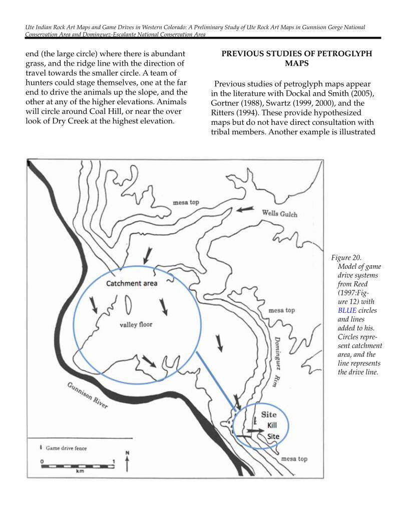
end (the large circle) where there is abundant grass, and the ridge line with the direction of travel towards the smaller circle. A team of hunters could stage themselves, one at the far end to drive the animals up the slope, and the other at any of the higher elevations. Animals will circle around Coal Hill, or near the over look of Dry Creek at the highest elevation.
prevIouS StudIeS oF petroglyph MApS
Previous studies of petroglyph maps appear in the literature with Dockal and Smith (2005), Gortner (1988), Swartz (1999, 2000), and the Ritters (1994). These provide hypothesized maps but do not have direct consultation with tribal members. Another example is illustrated
Figure 20. Model of game drive systems from Reed (1997:Fig-ure 12) with BLUE circles and lines added to his. Circles repre-sent catchment area, and the line represents the drive line.

Carol Patterson
by previous research by Alpine Archaeological Consultants (Reed 1997) in which they found the Escalante Game Drive site is composed of a combination of rock and brush fences and rock blinds strategically situated on the landscape. It has (1) a collection area, where animals are first encountered; (2) a concentration area, formed by natural and architectural features, and (3) a kill area, where the concentrated animals are dis-patchedThe collection area comprises approximately
1,000 acres of valley bottom, with easy access to permanent water (Figure 20). Access to the bottomland is provided by Wells Gulch, which becomes progressively less entrenched to the east. The Gunnison River flows against the can-yon wall to concentrate animals driven south-ward. The area south of the site is rugged talus, with slopes exceeding 60 percent grade. Travel along the river bottom south of the site would be difficult. It is believed that game animals that entered the river bottom, perhaps from Wells Gulch and were driven south toward the “Es-calante Game Drive Site” (Reed 1997).
Moore Shelter rock Art MAp
The Moore Shelter is located amid low hills at the intersection of a north/south running arroyo bisected by an east/west arroyo (Figures 21 and 22). One of the petroglyphs appears to be a map (Figure 23). When the petroglyph is rotated, it fits over the topographic map (Figure 24). The red dot is the location of the Moore Shelter. The lines follow the arroyos and the circles encircle the game collection areas. At the site, there are game trails that come down the arroyo and pass in front of the cave. The bisecting arroyo leads to a broad flat area that supports grasses and che-nopodium plants. Alternatively, the game trail leads south and climbs up to the highest point around the hill slope. Knowing game animal’s behavior to run to higher elevations, this area would provide an advantage for a skilled hunt-er. Fresh deer tracks were observed on these driveline routes and encirclement of the highest hill.
Figure 21. View of the Moore Shelter overhang and low hills in the background.
Figure 22. At the back of the Moore Shelter are many petroglyphs, some of which have been chalked by visi-tors in previous decades. The petroglyph of interest is the upper right of the picture and outlined in blue on this photo.

Ute Indian Rock Art Maps and Game Drives in Western Colorado: A Preliminary Study of Ute Rock Art Maps in Gunnison Gorge National Conservation Area and Dominguez-Escalante National Conservation Area
Figure 23. Photograph (left) of the Moore Shelter petroglyph that appears to be a map (chalked in the past by unknown people), and a drawing of the image (right).
Figure 24. Moore Shelter petroglyph map over-laid on topographic map

Carol Patterson
Clifford Duncan looked at this map and said:
“Certain canyons would be ideal to per-suade the animals to walk through there. It’s just like walking into a trap. These [circle] symbols might represent ‘high points,’ – ‘high point,’ -- high point,’ [points to the three circles] so if the animals could be persuaded to stay on this line [points to the line between the circles], the hunters could get them here, here, and here [points to the three circles]. That’s what I think” (Duncan 2010).
“…you’re dealing with animals, and animals in hunting have habits and fol-low the same circle, a deer doesn’t run in a straight line, it goes around in a circle, about a mile all the way around to the same place. That’s the way they move, so you set your trap that way and you know about what time they are going to be there” (Duncan 2007).
“The deer schedule it according to the light. At certain places they are not really alert, so these Indians study that and say well, at this point
they are more at ease cause they are more con-cerned with eating” (Duncan 2010).
huntIng MApS oF the dencA In doMInguez cAnyon
Two suspected hunting map petroglyph panels are shown in Figures 25-28. They are on adjacent sides of a large boulder that occur in the Domin-guez Canyon of the DENCA. Preliminary inves-tigations of these panel with the characteristic circles and lines (Figures 25-28) are underway. Clifford Duncan, Ute elder, believes these are “maps” of the adjacent area to the south (Patter-son and Duncan 2007).
concluSIonS And Further reSeArch
The preliminary findings in this report were limited to petroglyphs within or near the Gun-nison Gorge National Conservation Area and the Dominguez Escalante National Conserva-tion Area. There is great promise for further exploration as to how the circle and line dia-grams might relate to hunting strategies and game movement from the lower elevations to the higher ones. With further research and Ute
Figure 25. Possible hunting map petroglyph in Dominguez Canyon. Photograph of Panel 1 (left) and drawing (right).

Ute Indian Rock Art Maps and Game Drives in Western Colorado: A Preliminary Study of Ute Rock Art Maps in Gunnison Gorge National Conservation Area and Dominguez-Escalante National Conservation Area
Figure 26. Drawing of the possible hunting map petroglyph in Dominguez Canyon superim-posed over the topographic map.
Figure 27. An-other possible hunting map petroglyph in Dominguez Canyon. Photograph of Panel 2 (left) and drawing (right).

Carol Patterson
consultation, it may be possible to interpreted more abstract curvilinear style panels that might represent adjacent land typography and form a better understanding of the complex trail systems used by aboriginal people in western Colorado.
AcknowledgeMentS
This project was supported with research funding awarded to the Bureau of Land Man-agement, Uncompahgre Field Office by the National Landscape Conservation System. The project was conducted though Dominguez Archaeological Research Group, Inc. (DARG) and the Bureau of Land Management, Colorado State Office. Field research and Native American consultations were conducted from 2009 to 2012 by Principal Investigator Carol Patterson, Ph.D. Clifford Duncan, cultural advisor for the North-
ern Ute tribe, provided primary ethnographic information. Additional consultation was pro-vided by Terry Knight, Tribal Historic Preser-vation Officer for the Ute Mountain Ute tribe. Editorial assistance and report preparation were provide by DARG research associates Richard Ott and Cheryl Harrison.
reFerenceS cIted
Burns, S.2004 The Ute Relationships to the Lands of West Central Colorado: An Ethnographic Overview. Prepared by the Office of Community Services, Fort Lewis College, Durango, Colorado, for the Grand Mesa, Uncompahgre, and Gunnison National For-ests, through a cooperative agreement with the Na-tional Park Service, Midwest Archaeological Center, Lincoln, NE. Pages 46-49.
Figure 28. Possible hunting map petroglyphs in Dominguez Canyon Petroglyph superim-posed over the landscape.

Ute Indian Rock Art Maps and Game Drives in Western Colorado: A Preliminary Study of Ute Rock Art Maps in Gunnison Gorge National Conservation Area and Dominguez-Escalante National Conservation Area
Conetah, Fred1982 A History of the Northern Ute People, edited by Kathryn L. MacKay and Floyd A. O’Neil. Published by the Uintah-Ouray Ute Tribe, Utah.
Dockal, James A., and Michael S. Smith2005 Evidence for a Prehistoric Petroglyph Map in Central Arizona. Kiva 70(4):413-421.
Duncan, Clifford2005 Conversations at Shavano Rock Art Site.2007 Conversations at Dominguez Rock Art panels. 2009 Conversations at Shavano Rock Art site.2010 Conversations about Ute hunting maps
Fowler, Don D., and Catherine S. Fowler1971 Anthropology of the Numa: John Wesley Pow-ell’s Manuscripts on the Numic Peoples of Western North America, 1868-1880. Smithsonian Contribu-tions to Anthropology 14. Washington.
Fowler, Don D., and John F. Matley1979 Material Culture of the Numa: The John Powell Collection 1867-1880. Smithsonian Contribution to Anthropology 26. Washington
Gleichman, Peter J., Susan Steel, and Douglas Scott1982 The Archaeology of the West End. Report on file with the Department of Interior, Bureau of Land Management, Montrose District Office, Montrose, CO.
Gortner, Willis A.1988 A Fourth ‘Glyph Map’ and a Composite of the Trails. North American Archaeologist 11(2):99-119.
Goss, James A.2003 An Ethnographic Conversation held with Sam Burns, tape-recorded at Fort Lewis College, October 24, 2003, Durango, Colorado.
Patterson, Carol 2007 Squint Moore and Rock Art. Southwest Lore 73(2):29-42.
Patterson, Carol, and Clifford Duncan2007 Deer Creek, Dominguez Canyon Rock Art Docu-mentation and Interpretive Signage for The River Heri-tage Project. 105 pgs. Report on file with the BLM Uncompahgre Field Office, Montrose, CO.
Patterson, Carol, and Alan Watchman2006 Gunnison Gorge Rock Art Documentation, 5DT.813 Re-evaluation. 80 pgs. Report on file with the BLM, UFO, Montrose, CO.
Reed, Alan D.1997 The Escalante Game Drive Site. Utah Archae-ology, Vol.10, No.1, edited by Kevin T. Jones and Robert B. Kohl, pp. 21-30. Utah Professional Ar-chaeological Council, Salt Lake City.
Ritter, Dale W., and Ritter, Eric W.1994 Line Convention in the Rock Art of North America. In Rock Art Studies in the Americas. Papers from the Darwin Rock Art Congress, edited by Jack Steinbring, pp. 22-41. Oxbow Monograph, No. 45. Oxbow Books, Oxford, England
Swartz Jr., B.K.1999 Petroglyphs Ignored or Never Seen. In Sympo-sium 10C. Recording, Dating and Computer Sci-ence, chaired by B. K. Swartz, Jr, and Mila Simões De Abreu. NEWS 95 - International Rock Art Con-gress Proceedings. Pinerolo, Italy. CD-ROM.
2000 How Prehistoric People of the North American Great Basin used Petroglyphs to Read their Land-scape. In Signifying Place and Space. Perspectives in Rock Art and Landscape, edited by George Nash, pp. 149-62. BAR International Series 902. Ar-chaeopress, Oxford.