Using Parametrics to Facilitate Collaborative Urban Design. An attempt to overcome some inherent...
13
Using Parametrics to Facilitate Collaborative Urban Design. An attempt to overcome some inherent dilemmas Nicolai Steinø 1 Karima Benbih 2 Esben Obeling 3 Collaborative urban design faces three inherent dilemmas of limitations to time and resources, of barriers to language and communication between professionals and stakeholders, and of the reciprocal nature of the relation between influence and understanding. Parametric design tools may address all of these dilemmas, as they provide a fast way to test different design scenarios and make it possible keep designs open while at the same time allowing for a level of detailing which is high enough to facilitate an understanding of the generic qualities of proposed designs. This is particularly relevant in the context of the urban South, which is characterized by high urban growth rates, weak planning systems and modest means. The current state of planning and urban development in Morocco is introduced as a context for discussing collaborative urban design and parametric urban design, and some tentative conclusions are attempted. Keywords: Parametric design, Urban design, Collaborative design, Urban development, Morocco 1 Associate professor, PhD, Aalborg University, Department of Architecture, Design and Media Technology, Aalborg, Denmark. Email: [email protected] 2 PhD student, WAAC, Virginia Tech, North Carolina, USA, [email protected]; 3 MSc Urban Design, Aalborg University, Denmark, [email protected]
Transcript of Using Parametrics to Facilitate Collaborative Urban Design. An attempt to overcome some inherent...
Using Parametrics to Facilitate Collaborative Urban Design. An attempt to overcome some inherent dilemmas
Nicolai Steinø 1 Karima Benbih2 Esben Obeling 3
Collaborative urban design faces three inherent dilemmas of limitations to time and resources, of barriers to language and communication between professionals and stakeholders, and of the reciprocal nature of the relation between influence and understanding. Parametric design tools may address all of these dilemmas, as they provide a fast way to test different design scenarios and make it possible keep designs open while at the same time allowing for a level of detailing which is high enough to facilitate an understanding of the generic qualities of proposed designs. This is particularly relevant in the context of the urban South, which is characterized by high urban growth rates, weak planning systems and modest means. The current state of planning and urban development in Morocco is introduced as a context for discussing collaborative urban design and parametric urban design, and some tentative conclusions are attempted. Keywords: Parametric design, Urban design, Collaborative design, Urban development, Morocco
1 Associate professor, PhD, Aalborg University, Department of Architecture, Design and Media Technology,
Aalborg, Denmark. Email: [email protected] 2 PhD student, WAAC, Virginia Tech, North Carolina, USA, [email protected]; 3 MSc Urban Design, Aalborg University, Denmark, [email protected]

Planum. The Journal of Urbanism 2 | 13
Introduction In the Western world, urban design and planning has long been acknowledged as politically imbued activities rather than clean areas of professional expertise. This raises the issues of power and interests and how to negotiate between different stakeholders. Collaborative urban design has proven a powerful tool to this end, yet it contains some inherent dilemmas. It is both resource and time consuming. Professionals and stakeholders have different modes of thinking and different languages and this represents a communication dilemma. And while design ideas are traditionally difficult to communicate at the early stages of design, they are equally difficult to change at the late stages of design. With the advent of parametric design, new ways of designing which are fast, detailed and flexible, respond to all these dilemmas of collaborative planning. As it allows for different perspectives on design and for testing different design scenarios, it can significantly improve the understanding and thus communication between professionals and stakeholder, thus allowing for better and more informed design decisions. This is particularly interesting in the context of the urban South, which is characterized by high urban growth rates, weak planning systems and modest means. Yet uneven distribution of power typically presents an obstacle to collaborative planning and urban design. The first section of this paper discusses the dilemmas of collaborative urban design and how they may be overcome by a parametric approach to urban design. The concept of parametric urban design is briefly discussed, and in the second section, a case example of parametric design is given to hint the scope and possibilities of the approach. In the third section, the current state of planning and urban development in Morocco is introduced. In the fourth section, collaborative urban design and parametric urban design are discussed in the context of Moroccan urban planning and development. And finally some tentative conclusions are attempted.
Dilemmas of Urban Design Processes and Potentials of Parametric Design Collaborative urban design and planning has a long history in Western Europe and the USA (Steinø, 2003). As a means to democratically involve different stakeholders in the urban development process, a large variety of collaborative design and planning formats, such as design charrettes, future workshops, and planning weekends, have seen the light of day (Batchelor & Lewis, 1985; Wates & Knevitt, 1987; Zadow, 1997; Kelbaugh, 1997). While collaborative urban design requires some level of democracy to be meaningful, it is a powerful, if not essential means to successful urban development. It can also be resource and time consuming, however. In contexts of rapid growth and fragile democratic institutions, collaborative urban design may therefore seem inapplicable, even if desirable. This represents an inherent dilemma in the context of the urban South. There is another inherent dilemma in collaborative design processes however, as it involves both professional designers/architects and planners, as well as lay people. Such lay people can be stakeholders like property developers, residents, local retailers, NGOs, and others with an interest in urban development. As several planning theorists have pointed out, differences in thinking and language between professionals and lay people represent a communication barrier (Forester, 1980; Friedman, 1973). A final dilemma lies in the opposites of influence of understanding. While design is still open in the early phases of the design process, the level of detailing is typically low. Hence, the implications of the design may be difficult to comprehend for non-professionals. But as the level of detailing increases, thus allowing for a better understanding of the design, the design tends to close and can no longer be changed without substantial implications for time, money and resources (Steinø & Veirum, 2005; Steinø 2010).
Planum. The Journal of Urbanism 3 | 13
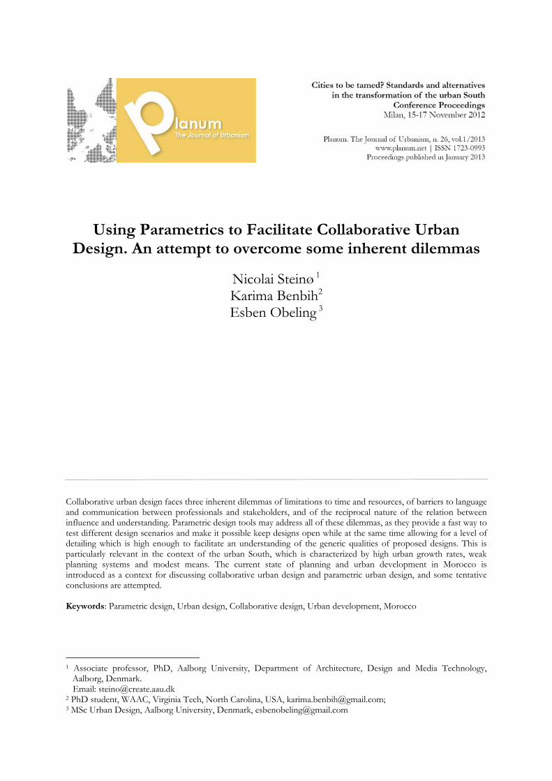
Hence, an approach which is capable of responding to these three dilemmas is desirable. When time and resources are scarce, it must be expedient and effective. In order to overcome the communicative gap between professionals and lay people, it must be able to convey ideas about urban space between these two groups. And in order to overcome the influence/understanding dilemma, it must provide a level of detailing high enough for lay people to engage, even at early stages when real and substantial changes to the design may still be possible.
Figure 1: The relation between understanding and influence over time Potentials of Parametric Urban Design With the advent of parametric design tools, such an approach may now become a reality. Rather than making one-off designs which need to be redesigned from the ground up in case of changes, parametric design tools make it possible keep the design open while at the same time allowing for a level of detailing which is high enough to facilitate an understanding of the generic qualities of proposed designs. Although the concept of parametric design covers a variety of different applications, Anderl & Mendgen's (1995) definition of parametric design gives a general idea of the concept: “In a parametric CAD system the designer has to model the shape of a part or assembly only once and may derive variants by changing dimension values, engineering parameters (to create geometric variants), or the feature history of the part (to create topological variants). The shape of a part is modelled as a combination of features, each described by geometric parameters (dimensions) for its shape, position and orientation with respect to other features of the part” (ibid., p. 7). Different parametric design tools exist, some of which are very feature rich and expensive, while others are simpler and cheaper. And while some are targeted at specific fields of application, others are more general (Steinø, 2010). Common to the different parametric design tools however, is 1) the capacity to quickly generate large generic designs, 2) the capacity to add detailing in the early stages of design with little effort, 3) to maintain the model’s ‘intelligence’ throughout the different stages of design, and 4) to facilitate easy testing by changing parameter settings.

Planum. The Journal of Urbanism 4 | 13
This has obvious advantages for collaborative urban design. While conventional design techniques require much design work to be redone whenever a design is altered as models or drawings must be redone to various degrees, a parametric design approach allows to keep the design 'open' for a larger part of the design process without loss. As Anderl & Mendgen note, this makes it more feasible to start modelling in the in the conceptual design phase, rather than in the design presentation phase (1995, p. 1), which in turn, allows for a higher level of understanding among lay people at stages where the design is still amenable to change. Although a parametric design approach, is generic by nature, as only predefined variables can be made subject to parametric variation, it may still be detailed enough to discuss the essence of different design criteria, which is the level at which urban design typically operates. Although final designs may not be achievable by means of parametric urban design, it can still be detailed enough to enable professionals and lay people to make informed decisions about urban design. A considerable advantage of a parametric approach to urban design is the potential to make real-time alterations to different design scenarios. Being able to analyse urban design scenarios through variations of different parameters, e.g. building heights and types, density, street widths, etc., and see the immediate effects has great pedagogical and informative value in collaborative design processes. Not only will it be possible to test more scenarios than by conventional techniques, it is also likely to create a better basis for making right decisions. Overview of Different Approaches to Parametric Urban Design At present, at least four different approaches to parametric urban design can be identified. At the one extreme, parametrics is used in urban design to relate analytical data parametrically to 3D models in order to provide information for design as in Ghani & Datta (2009). By this approach, tools are purely analytical. They may serve as a basis for design but they are not design tools in themselves. This strand takes its point of departure in real-life urban planning as it is practiced throughout the world. At the other extreme, the power of parametrics is used in urban design as source of artistic inspiration for novel design as in Schnabel (2007) and Coorey (2010). While data may derive from the context, it is typically subjectively interpreted by the designer with the aim of triggering designs which might not materialize otherwise. By this approach, parametrics is used as a sort of power tool for the artistic generation of designs. While such designs may respond interactively to environmental data, the aim is artistic effect rather than to fulfil utilitarian needs (e.g. comfort or energy preservation). Not surprisingly, this strand takes its point of departure in urban design studios taught in architecture programs in universities. Between these two approaches, one approach (also based in urban design studio teaching) attempts to use parametrics in order to analytically address particular needs or constraints in the course of design as in Karakiewicz & Kvan (2010), and another is focused on parametrics as rule-based design. While the former of these two is relevant as a basis for real-life design, it seems to mainly facilitate analysis which could have been made by conventional techniques. The latter however, holds promise for a completely new approach to urban space design, as parametrics is applied to the design process itself. While still in its relative infancy, parametric urban design as rule-based design has been subject to both experimental and theoretical work. While Pellitteri et al. (2008, 2010) are concerned with how parametrics can be applied to building design in concrete settings with specific sets of variables, Jacobi et al. (2009) explore the potential of parametric urban design for facilitating collaborative design processes involving different stakeholders. Beirão et al. (2008, 2011) and Gil & Duarte (2008) on the other hand, are more
Planum. The Journal of Urbanism 5 | 13
concerned with the theoretical analysis and design (ontology) of a parametric approach to urban space design, noting in particular, the necessity to bridge the analytical capacity of GIS systems to the design capacity of CAD systems.
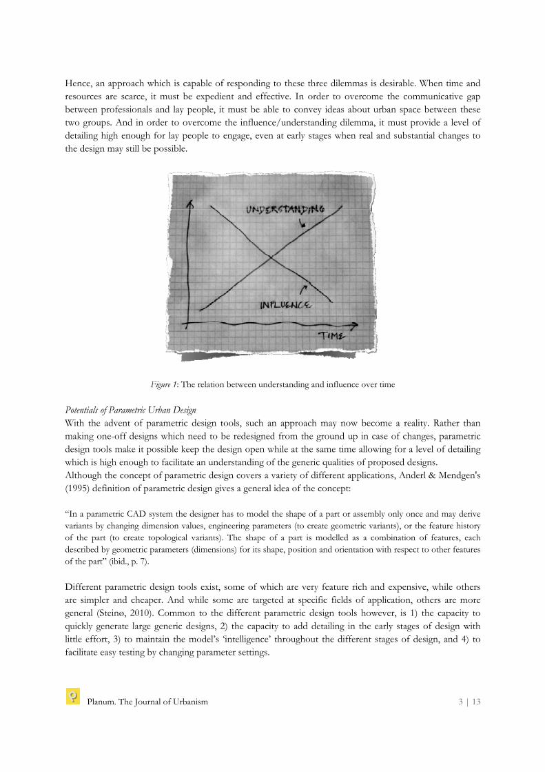
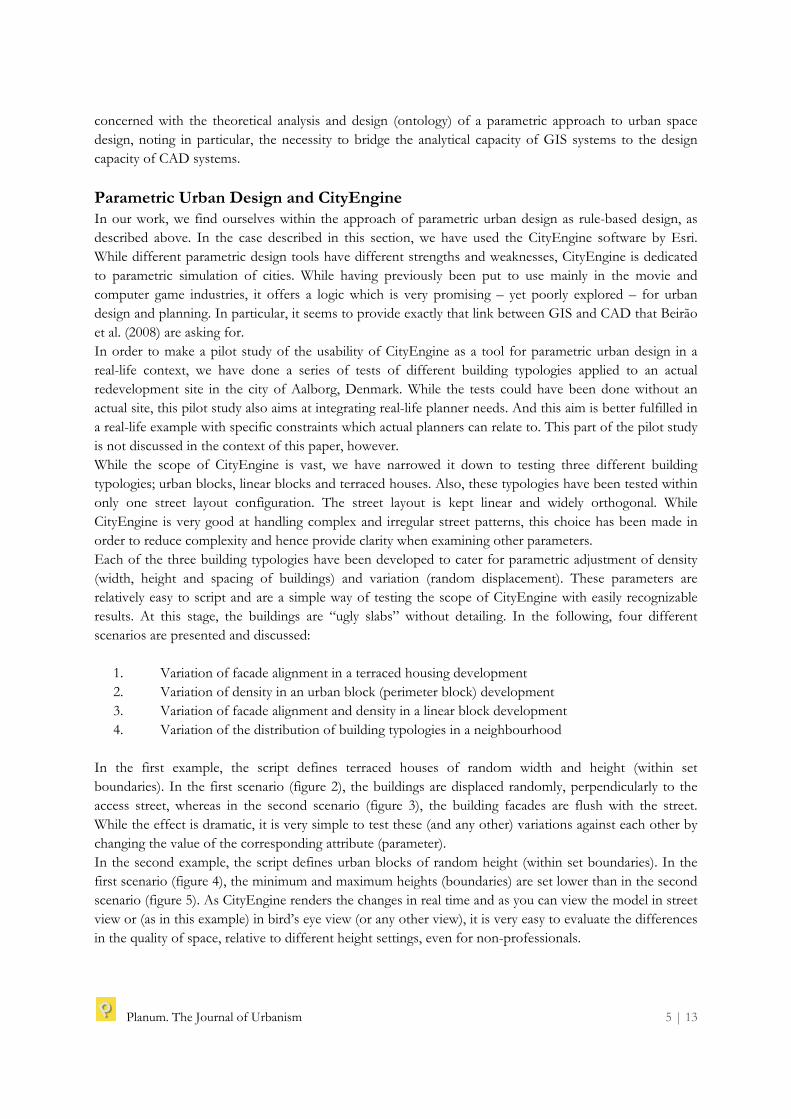
Parametric Urban Design and CityEngine In our work, we find ourselves within the approach of parametric urban design as rule-based design, as described above. In the case described in this section, we have used the CityEngine software by Esri. While different parametric design tools have different strengths and weaknesses, CityEngine is dedicated to parametric simulation of cities. While having previously been put to use mainly in the movie and computer game industries, it offers a logic which is very promising – yet poorly explored – for urban design and planning. In particular, it seems to provide exactly that link between GIS and CAD that Beirão et al. (2008) are asking for. In order to make a pilot study of the usability of CityEngine as a tool for parametric urban design in a real-life context, we have done a series of tests of different building typologies applied to an actual redevelopment site in the city of Aalborg, Denmark. While the tests could have been done without an actual site, this pilot study also aims at integrating real-life planner needs. And this aim is better fulfilled in a real-life example with specific constraints which actual planners can relate to. This part of the pilot study is not discussed in the context of this paper, however. While the scope of CityEngine is vast, we have narrowed it down to testing three different building typologies; urban blocks, linear blocks and terraced houses. Also, these typologies have been tested within only one street layout configuration. The street layout is kept linear and widely orthogonal. While CityEngine is very good at handling complex and irregular street patterns, this choice has been made in order to reduce complexity and hence provide clarity when examining other parameters. Each of the three building typologies have been developed to cater for parametric adjustment of density (width, height and spacing of buildings) and variation (random displacement). These parameters are relatively easy to script and are a simple way of testing the scope of CityEngine with easily recognizable results. At this stage, the buildings are “ugly slabs” without detailing. In the following, four different scenarios are presented and discussed:
1. Variation of facade alignment in a terraced housing development 2. Variation of density in an urban block (perimeter block) development 3. Variation of facade alignment and density in a linear block development 4. Variation of the distribution of building typologies in a neighbourhood
In the first example, the script defines terraced houses of random width and height (within set boundaries). In the first scenario (figure 2), the buildings are displaced randomly, perpendicularly to the access street, whereas in the second scenario (figure 3), the building facades are flush with the street. While the effect is dramatic, it is very simple to test these (and any other) variations against each other by changing the value of the corresponding attribute (parameter). In the second example, the script defines urban blocks of random height (within set boundaries). In the first scenario (figure 4), the minimum and maximum heights (boundaries) are set lower than in the second scenario (figure 5). As CityEngine renders the changes in real time and as you can view the model in street view or (as in this example) in bird’s eye view (or any other view), it is very easy to evaluate the differences in the quality of space, relative to different height settings, even for non-professionals.
Planum. The Journal of Urbanism 6 | 13
Figure 2-3: Parametric variation of façade alignment in terraced housing development
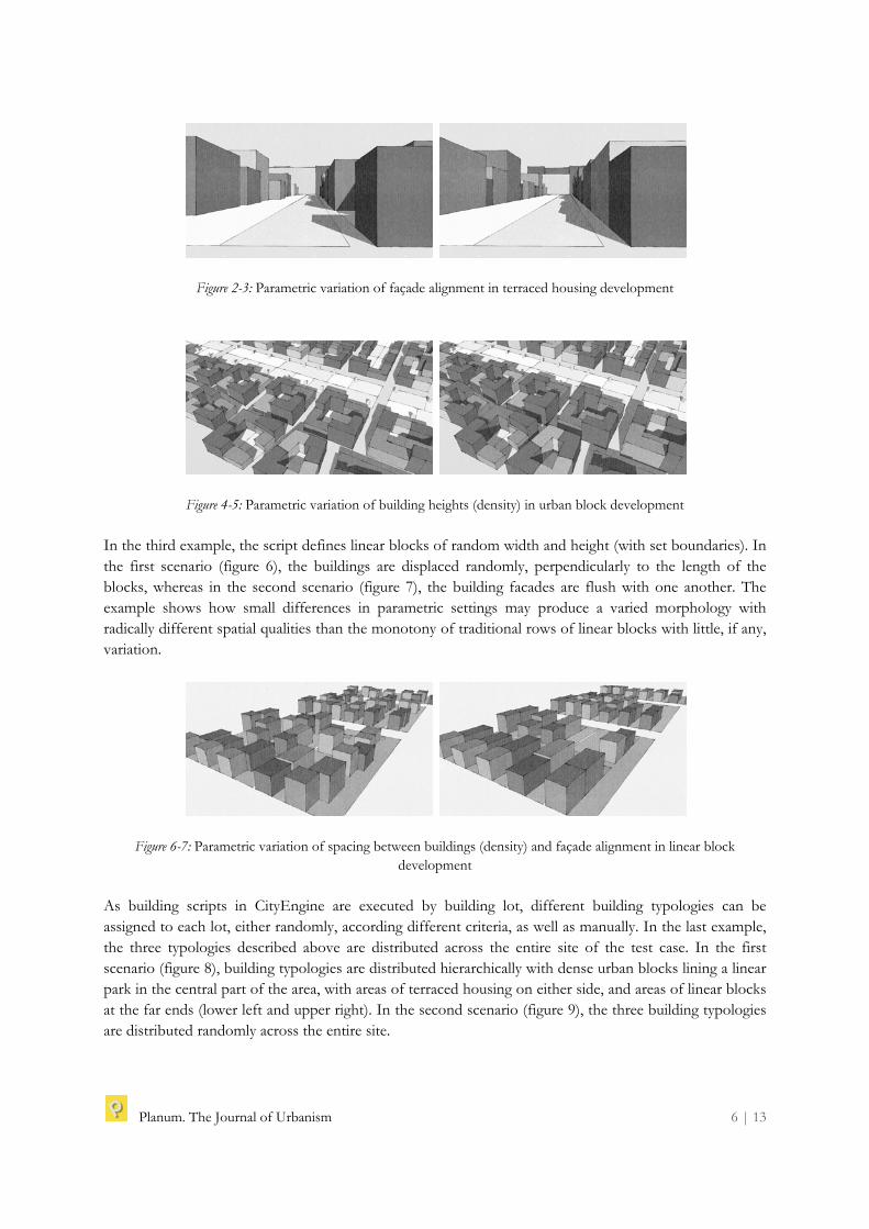
Figure 4-5: Parametric variation of building heights (density) in urban block development In the third example, the script defines linear blocks of random width and height (with set boundaries). In the first scenario (figure 6), the buildings are displaced randomly, perpendicularly to the length of the blocks, whereas in the second scenario (figure 7), the building facades are flush with one another. The example shows how small differences in parametric settings may produce a varied morphology with radically different spatial qualities than the monotony of traditional rows of linear blocks with little, if any, variation.
Figure 6-7: Parametric variation of spacing between buildings (density) and façade alignment in linear block development
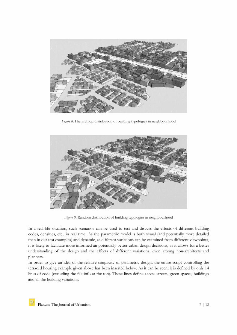
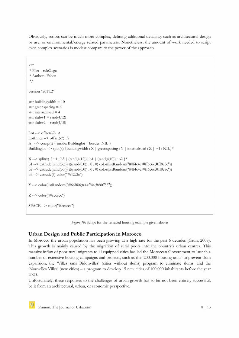
As building scripts in CityEngine are executed by building lot, different building typologies can be assigned to each lot, either randomly, according different criteria, as well as manually. In the last example, the three typologies described above are distributed across the entire site of the test case. In the first scenario (figure 8), building typologies are distributed hierarchically with dense urban blocks lining a linear park in the central part of the area, with areas of terraced housing on either side, and areas of linear blocks at the far ends (lower left and upper right). In the second scenario (figure 9), the three building typologies are distributed randomly across the entire site.
Planum. The Journal of Urbanism 7 | 13
Figure 8: Hierarchical distribution of building typologies in neighbourhood
Figure 9: Random distribution of building typologies in neighbourhood In a real-life situation, such scenarios can be used to test and discuss the effects of different building codes, densities, etc., in real time. As the parametric model is both visual (and potentially more detailed than in our test examples) and dynamic, as different variations can be examined from different viewpoints, it is likely to facilitate more informed an potentially better urban design decisions, as it allows for a better understanding of the design and the effects of different variations, even among non-architects and planners. In order to give an idea of the relative simplicity of parametric design, the entire script controlling the terraced housing example given above has been inserted below. As it can be seen, it is defined by only 14 lines of code (excluding the file info at the top). These lines define access streets, green spaces, buildings and all the building variations.
Planum. The Journal of Urbanism 8 | 13
Obviously, scripts can be much more complex, defining additional detailing, such as architectural design or use, or environmental/energy related parameters. Nonetheless, the amount of work needed to script even complex scenarios is modest compare to the power of the approach.
/** * File: rule2.cga * Author: Esben */ version "2011.2" attr buildingwidth = 10 attr greenspacing = 6 attr internalroad = 4 attr slabw1 = rand(4,12) attr slabw2 = rand(4,10) Lot --> offset(-2) A LotInner --> offset(-2) A A --> comp(f) { inside: Buildinglot | border: NIL } Buildinglot --> split(x) {buildingwidth : X | greenspacing : Y | internalroad : Z | ~1 : NIL}* X --> split(y) { ~1 : b3 | (rand(4,12)) : b1 | (rand(4,10)) : b2 }* b1 --> extrude(rand(3,6)) t((rand(0,0)) , 0 , 0) color(listRandom("#ff4c4c;#ff6c6c;#ff8c8c")) b2 --> extrude(rand(3,9)) t((rand(0,0)) , 0 , 0) color(listRandom("#ff4c4c;#ff6c6c;#ff8c8c")) b3 --> extrude(3) color("#ff2c2c") Y --> color(listRandom("#66ff66;#44ff44;#88ff88")) Z --> color("#cccccc") SPACE --> color("#cccccc")
Figure 10: Script for the terraced housing example given above
Urban Design and Public Participation in Morocco In Morocco the urban population has been growing at a high rate for the past 6 decades (Catin, 2008). This growth is mainly caused by the migration of rural poors into the country’s urban centres. This massive influx of poor rural migrants to ill equipped cities has led the Moroccan Government to launch a number of extensive housing campaigns and projects, such as the ‘200.000 housing units’ to prevent slum expansion, the ‘Villes sans Bidonvilles’ (cities without slums) program to eliminate slums, and the ‘Nouvelles Villes’ (new cities) – a program to develop 15 new cities of 100.000 inhabitants before the year 2020. Unfortunately, these responses to the challenges of urban growth has so far not been entirely successful, be it from an architectural, urban, or economic perspective.
Planum. The Journal of Urbanism 9 | 13
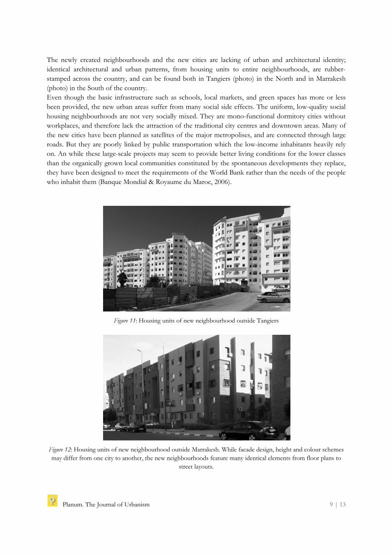
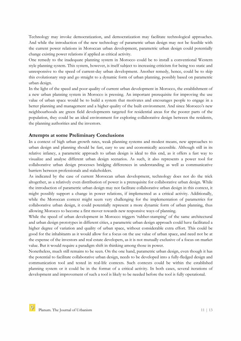
The newly created neighbourhoods and the new cities are lacking of urban and architectural identity; identical architectural and urban patterns, from housing units to entire neighbourhoods, are rubber-stamped across the country, and can be found both in Tangiers (photo) in the North and in Marrakesh (photo) in the South of the country. Even though the basic infrastructure such as schools, local markets, and green spaces has more or less been provided, the new urban areas suffer from many social side effects. The uniform, low-quality social housing neighbourhoods are not very socially mixed. They are mono-functional dormitory cities without workplaces, and therefore lack the attraction of the traditional city centres and downtown areas. Many of the new cities have been planned as satellites of the major metropolises, and are connected through large roads. But they are poorly linked by public transportation which the low-income inhabitants heavily rely on. An while these large-scale projects may seem to provide better living conditions for the lower classes than the organically grown local communities constituted by the spontaneous developments they replace, they have been designed to meet the requirements of the World Bank rather than the needs of the people who inhabit them (Banque Mondial & Royaume du Maroc, 2006).
Figure 11: Housing units of new neighbourhood outside Tangiers
Figure 12: Housing units of new neighbourhood outside Marrakesh. While facade design, height and colour schemes may differ from one city to another, the new neighbourhoods feature many identical elements from floor plans to
street layouts.

Planum. The Journal of Urbanism 10 | 13
Deficiencies of the Moroccan Planning System Despite the expediency with which the large-scale urban projects have been developed, the planning system in Morocco is weak compared to those of Central and Northern European Countries. Although there have been several attempts to improve the regulatory system and to strengthen its capacity to respond to the massive socio-economic changes which urban Morocco is undergoing, the legal infrastructure is still insufficient. Planning procedures are long and completely unable to keep up with the speed of urban development. The urban planning documents in Morocco have a limited lifespan. The transition between old documents and news ones takes years, and the planning documents that regulate urban development and design are often obsolete at the time of validation and approval. As an example, the general urban plan (SDAU) regulating Casablanca (one of the largest cities in Africa with a population of 3 million people) expired in 2005 but is still the reference for decisions about urban development in the greater Casablanca area (Ministère de l’Habitat, de l’Urbanisme et de la Politique de la Ville, 2012). This creates an situation where stakeholders act in a grey zone and navigate by proposing deviations. Power Relations and the Nature of Public Participation There is only little, if any, tradition of public participation in Morocco. The concept of a collaborative approach to urban planning appears alien in the current socio-economic setting, mainly because of the country’s large social inequalities. Due to money and power relations, a small minority of investors and developers are the only ones who engage in the process of preparing urban design and planning documents. As the construction industry is highly monopolized and subject to mass production, the result is a very poorly built environment, and apartments which are sold very expensively to the poor target population. At the other extreme, 50% of the population is illiterate, disenfranchised, and culturally and socially programmed for obedience. This discrepancy produces a highly uneven ground for public participation. Hence, stakeholder involvement in Moroccan urban design and planning is reserved for the few ad the powerful and urban design is guided by concerns for market value rather than use value. Democracy, Power Relations and Technology Collaborative urban design faces three inherent dilemmas of limitations to time and resources, of barriers to language and communication between professionals and stakeholders, and of the reciprocal nature of the relation between influence and understanding. While a parametric approach to urban design may help to alleviate all of these dilemmas, it is not a magic formula which will work in any context. The problems that exist for collaborative urban design in general still exist, even when assisted by parametric urban design. One of the central problems of collaborative urban design is uneven distribution of power. If power is concentrated among select stakeholders, their incentive to engage in a collaborative process is small. And while stakeholders with less power may still have valid claims to take part in collaborative processes, they are unlikely to be invited in situations of uneven distribution of power. No technological fix – such as parametric urban design – can change that. Nonetheless, the introduction of new technologies may foster a shift of power relations. The importance of internet and telecommunications technologies during the Arab Spring is a powerful example of this. This indicates that in the relation between democratization and new technology, both may be the hen, as well as the egg.
Planum. The Journal of Urbanism 11 | 13
Technology may invoke democratization, and democratization may facilitate technological approaches. And while the introduction of the new technology of parametric urban design may not be feasible with the current power relations in Moroccan urban development, parametric urban design could potentially change existing power relations if applied as critical activity. One remedy to the inadequate planning system in Morocco could be to install a conventional Western style planning system. This system, however, is itself subject to increasing criticism for being too static and unresponsive to the speed of current-day urban development. Another remedy, hence, could be to skip this evolutionary step and go straight to a dynamic form of urban planning, possibly based on parametric urban design. In the light of the speed and poor quality of current urban development in Morocco, the establishment of a new urban planning system in Morocco is pressing. An important prerequisite for improving the use value of urban space would be to build a system that motivates and encourages people to engage in a better planning and management and a higher quality of the built environment. And since Morocco’s new neighbourhoods are green field developments targeted for residential areas for the poorer parts of the population, they could be an ideal environment for exploring collaborative design between the residents, the planning authorities and the investors.
Attempts at some Preliminary Conclusions In a context of high urban growth rates, weak planning systems and modest means, new approaches to urban design and planning should be fast, easy to use and economically accessible. Although still in its relative infancy, a parametric approach to urban design is ideal to this end, as it offers a fast way to visualize and analyse different urban design scenarios. As such, it also represents a power tool for collaborative urban design processes bridging differences in understanding as well as communicative barriers between professionals and stakeholders. As indicated by the case of current Moroccan urban development, technology does not do the trick altogether, as a relatively even distribution of power is a prerequisite for collaborative urban design. While the introduction of parametric urban design may not facilitate collaborative urban design in this context, it might possibly support a change in power relations, if implemented as a critical activity. Additionally, while the Moroccan context might seem very challenging for the implementation of parametrics for collaborative urban design, it could potentially represent a more dynamic form of urban planning, thus allowing Morocco to become a first mover towards new responsive ways of planning. While the speed of urban development in Morocco triggers ‘rubber-stamping’ of the same architectural and urban design prototypes in different cities, a parametric urban design approach could have facilitated a higher degree of variation and quality of urban space, without considerable extra effort. This could be good for the inhabitants as it would allow for a focus on the use value of urban space, and need not be at the expense of the investors and real estate developers, as it is not mutually exclusive of a focus on market value. But it would require a paradigm shift in thinking among those in power. Nonetheless, much still remains to be seen. On the one hand, parametric urban design, even though it has the potential to facilitate collaborative urban design, needs to be developed into a fully-fledged design and communication tool and tested in real-life contexts. Such contexts could be within the established planning system or it could be in the format of a critical activity. In both cases, several iterations of development and improvement of such a tool is likely to be needed before the tool is fully operational.
Planum. The Journal of Urbanism 12 | 13
References Anderl, R. & Mendgen, R. (1995) ‘Parametric Design and its Impact on Solid Modeling Applications’. (Salt
Lake City: Solid Modeling '95). Banque Mondial & Royaume du Maroc (2006) Programme ‘Villes sans bidonvilles’ du Maroc: Rapport de l’analyse
d’impact social et sur la pauvrete. Batchelor, P. & Lewis, D. (eds.) (1985) ‘Urban Design in Action’. Raleigh, North Carolina: The Student
Publication of the School of Design, North Carolina State University, Vol. 29, 1985. Beirão, J. et al. (2008) ‘Structuring a Generative Model for Urban Design: Linking GIS to Shape
Grammars’. eCAADe 2008 conference proceedings, pp. 929-938. Beirão, J. et al. (2011) ‘Parametric urban design: An interactive sketching system for shaping
neighborhoods’. eCAADe 2011 conference proceedings, pp. 225-234. Catin, M. et al. (2008) ‘L’évolution de la structure et de la primatie urbaines au Maroc’. Région et
Développement Vol. 27. Coorey, B. (2010) ‘Scalability: Parametric studies from exoskeletons to the city’. CAADRIA 2010
conference proceedings, pp. 155-163. Forester, J. (1980) ‘Critical Theory and Planning Practice’. JAPA, vol. 46, 3. Friedman, J. (1973) Retracking America. A Theory of Transactive Planning. (Garden City, NY: Anchor
Press/Doubleday). Ghani, M. & Datta, S. (2009) ‘Virtual Ampang Jaya: An Interactive Visualization Environment for
Modeling Urban Growth and Spatio-Temporal Transformation’. ASCAAD 2009 conference proceedings, pp. 389-394.
Gil, J. & Duarte, J. (2008) ‘Towards an Urban Design Evaluation Framework: Integrating Spatial Analysis Techniques in the Parametric Urban Design Process’. eCAADe 2008 conference proceedings, pp. 257-264.
Healey P. (1997) Collaborative Planning - Shaping Places in Fragmented Societies, (Macmillan press). Jacobi, M. et al. (2009) ‘A Grammar-based System for the Participatory Design of Urban Structures’,
Sigradi 2009 conference proceedings, pp. 27-29. Karakiewicz, J. & Kvan, T. (2010) ‘Diagrams as Parametric Systems in Urban Design: Parametric Systems
Applied to Conceptual Design’. CAADRIA 2010 conference proceedings, pp. 337-346. Kelbaugh, D. (1997) Common Place: Toward Neighborhood and Regional Design. (Seattle: University of
washington Press). Ministère de l’Habitat, de l’Urbanisme et de la Politique de la Ville (2012). ‘Schémas Directeurs
Homologues’ [website]. http://www.marocurba.gov.ma/site2012/marocurbanisme/SDAU.aspx. Pellitteri, G. et al. (2008) ‘Digital Architectures Generated Using Forces in Urban Environment’. eCAADe
2008 conference proceedings, pp. 951-958. Pellitteri, G. et al. (2010) ‘A Generative Design System to Interactively Explore Different Urban
Scenarios’. eCAADe 2010 conference proceedings, pp. 851-960. Schnabel, M. (2007) ‘Rethinking Urban Parameters’. CAADRIA 2007 conference proceedings, pp. 625-
632. Steinø, N. (2003) ‘Urban Design between Theory and Practice: From conceptualization to realization and
back again’. Paper for ASCP-AESOP Third Joint Conference, Leuven, Belgium, July 8-12, 2003. Steinø, N. (2003) Vision, Plan and Reality: Urban Design between Conceptualization and Realization. PhD thesis,
Aarhus School of Architecture, August 2003.
Planum. The Journal of Urbanism 13 | 13
Steinø, N. (2010) ‘Parametric Thinking in Urban Design: A Geometric Approach’. In: Amar Bennadji et al.: CAAD, Cities, Sustainability. Proceedings for the 5th ASCAAD 2010 Conference, October 19-21, 2010, National School of Architecture, Fez, Morocco. (Aberdeen: Robert Gordon University, pp. 261-70).
Steinø, N. & Veirum, N. (2005) ‘Parametric Urban Design’. Paper for the AESOP 05 Congress, Vienna, July 13-17, 2005.
von Zadow, A. (1997) Perspektivenwerkstatt. Hintergründe und Handhabung des ‘Community Planning Weekend’. (Berlin: MATCH).
Wates, N. & Knevitt, C. (1987) Community Architecture: How People are Creating Their Own Environment. (London: Penguin Books).