Cisco ONS 15454 Troubleshooting Guide, Releases 4.1.x and 4.5
Upload
khangminh22Category
view
4download
0
Getty Thesaurus of Geographic Names™
User’s Guide to theTGN Data ReleasesRelease Version 2.0
© The J. Paul Getty Trust, 2000

.

© The J. Paul Getty Trust, 2001 TGN Release Formats User’s Guide
User’s Guide to theTGN Data Releases
Release Version 2.0
Compiled and Edited byPatricia Harpring, Managing Editor
Getty Vocabulary Program
GettyThesaurusof GeographicNames™
The Getty Vocabulary Program1200 Getty Center Drive, Suite 1100Los Angeles, California 90049-1680
http://www.getty.edu/research/tools/vocabulary/02/12/2001

© The J. Paul Getty Trust, 2001 TGN Release Formats User’s Guide
© the J. Paul Getty Trust, 2000. All rights reserved.

© The J. Paul Getty Trust, 2000 TGN Release Formats User’s Guide
CONTENTS
PREFACE . . . . . . . . . . . . . . . . . . . . . . . . . . . . . . . . . . . . . . . . . . . . . . . . . vACKNOWLEDGMENTS . . . . . . . . . . . . . . . . . . . . . . . . . . . . . . . . . . . . . vii
CHAPTER 1: INTRODUCTION . . . . . . . . . . . . . . . . . . . . . . . . . . . . . . 1OVERVIEW . . . . . . . . . . . . . . . . . . . . . . . . . . . . . . . . . . . . . . . . . . . . 1ABOUT THE TGN . . . . . . . . . . . . . . . . . . . . . . . . . . . . . . . . . . . . . . . . 1
CHAPTER 2: RELATIONAL FILES FORMAT . . . . . . . . . . . . . . . . . . 5OVERVIEW . . . . . . . . . . . . . . . . . . . . . . . . . . . . . . . . . . . . . . . . . . . . 5DATA DICTIONARY. . . . . . . . . . . . . . . . . . . . . . . . . . . . . . . . . . . . . . . 7
CHAPTER 3: REC FORMAT. . . . . . . . . . . . . . . . . . . . . . . . . . . . . . . . . . . 17OVERVIEW . . . . . . . . . . . . . . . . . . . . . . . . . . . . . . . . . . . . . . . . . . . . 17DATA DICTIONARY . . . . . . . . . . . . . . . . . . . . . . . . . . . . . . . . . . . . . . 20
CHAPTER 4: USMARC FORMAT . . . . . . . . . . . . . . . . . . . . . . . . . . . . . . 33OVERVIEW . . . . . . . . . . . . . . . . . . . . . . . . . . . . . . . . . . . . . . . . . . . . 33DATA DICTIONARY . . . . . . . . . . . . . . . . . . . . . . . . . . . . . . . . . . . . . . 35
CHAPTER 5: CONTENTS OF THE TGN . . . . . . . . . . . . . . . . . . . . . . . . 43OVERVIEW . . . . . . . . . . . . . . . . . . . . . . . . . . . . . . . . . . . . . . . . . . . . 43
Relationships . . . . . . . . . . . . . . . . . . . . . . . . . . . . . . . . . . . . 44SCOPE . . . . . . . . . . . . . . . . . . . . . . . . . . . . . . . . . . . . . . . . . . . . . . . . 46
What Is a Geographic Place? . . . . . . . . . . . . . . . . . . . . . . . 47THE RECORD FOR EACH PLACE . . . . . . . . . . . . . . . . . . . . . . . . . . . 49
Names . . . . . . . . . . . . . . . . . . . . . . . . . . . . . . . . . . . . . . . . . . 50Preferred Name . . . . . . . . . . . . . . . . . . . . . . . . . . . . 51Variant Names . . . . . . . . . . . . . . . . . . . . . . . . . . . . . 51Alphabet . . . . . . . . . . . . . . . . . . . . . . . . . . . . . . . . . . 53Sequence of Names . . . . . . . . . . . . . . . . . . . . . . . . . 53Contributors . . . . . . . . . . . . . . . . . . . . . . . . . . . . . . 55Bibliography . . . . . . . . . . . . . . . . . . . . . . . . . . . . . . 55
Latitude and Longitude . . . . . . . . . . . . . . . . . . . . . . . . . . . 57Descriptive Note . . . . . . . . . . . . . . . . . . . . . . . . . . . . . . . . . 57Place Types . . . . . . . . . . . . . . . . . . . . . . . . . . . . . . . . . . . . . 58
Preferred Place Type . . . . . . . . . . . . . . . . . . . . . . . 58Sort Order and Dates for Place Types . . . . . . . . . 59
THE HIERARCHY . . . . . . . . . . . . . . . . . . . . . . . . . . . . . . . . . . . . . . . 61View of the Hierarchy . . . . . . . . . . . . . . . . . . . . . . . . . . . . . 61
English View of the Hierarchy . . . . . . . . . . . . . . . . 63Islands in the Hierarchy . . . . . . . . . . . . . . . . . . . . . 64
Physical and Political Geography . . . . . . . . . . . . . . . . . . . 64Administrative Subdivisions . . . . . . . . . . . . . . . . . 65

© The J. Paul Getty Trust, 2000 TGN Release Formats User’s Guide
Urban Expansion . . . . . . . . . . . . . . . . . . . . . . . . . . . 67Special Cases in Hierarchical Position . . . . . . . . . . . . . . . 68
Multiple Parents . . . . . . . . . . . . . . . . . . . . . . . . . . . 69
CHAPTER 6: RECOMMENDATIONS FOR USING THE TGN . . . . 71OVERVIEW . . . . . . . . . . . . . . . . . . . . . . . . . . . . . . . . . . . . . . . . . . . . . 71PROVIDING ACCESS TO THE DATA . . . . . . . . . . . . . . . . . . . . . . . . . . 71
Querying . . . . . . . . . . . . . . . . . . . . . . . . . . . . . . . . . . . . . . . . 72Results List . . . . . . . . . . . . . . . . . . . . . . . . . . . . . . . . . . . . . . 73
DIACRITICS . . . . . . . . . . . . . . . . . . . . . . . . . . . . . . . . . . . . . . . . . . . . 74DISPLAYING A FULL RECORD . . . . . . . . . . . . . . . . . . . . . . . . . . . . . 74
Record Key . . . . . . . . . . . . . . . . . . . . . . . . . . . . . . . . . . . . . . 74Label . . . . . . . . . . . . . . . . . . . . . . . . . . . . . . . . . . . . . . . . . . . 74Displaying Names . . . . . . . . . . . . . . . . . . . . . . . . . . . . . . . . . 75Sorting Names . . . . . . . . . . . . . . . . . . . . . . . . . . . . . . . . . . . 76Sources and Contributors. . . . . . . . . . . . . . . . . . . . . . . . . . . 76Displaying Place Types . . . . . . . . . . . . . . . . . . . . . . . . . . . . 77Sorting Place Types . . . . . . . . . . . . . . . . . . . . . . . . . . . . . . . 77Coordinates . . . . . . . . . . . . . . . . . . . . . . . . . . . . . . . . . . . . . 78Descriptive Note . . . . . . . . . . . . . . . . . . . . . . . . . . . . . . . . . . 78Other Information . . . . . . . . . . . . . . . . . . . . . . . . . . . . . . . . 79Sample Record Display . . . . . . . . . . . . . . . . . . . . . . . . . . . . 80
DISPLAYING THE HIERARCHY . . . . . . . . . . . . . . . . . . . . . . . . . . . . . 81Indicating Levels . . . . . . . . . . . . . . . . . . . . . . . . . . . . . . . . . 82Accommodating Siblings . . . . . . . . . . . . . . . . . . . . . . . . . . . 82Non-Preferred Parents . . . . . . . . . . . . . . . . . . . . . . . . . . . . . 83
APPENDIX A: CODES FOR DIACRITICS . . . . . . . . . . . . . . . . . . . . . . 87OVERVIEW . . . . . . . . . . . . . . . . . . . . . . . . . . . . . . . . . . . . . . . . . . . . . 87DIACRITICAL CODES CHART. . . . . . . . . . . . . . . . . . . . . . . . . . . . . . . 87
APPENDIX B: CONTRIBUTOR INITIALS LIST FOR THE TGN . . . 91CONTRIBUTORS . . . . . . . . . . . . . . . . . . . . . . . . . . . . . . . . . . . . . . . . . 91BACKGROUND . . . . . . . . . . . . . . . . . . . . . . . . . . . . . . . . . . . . . . . . . 91
APPENDIX C: SAMPLE TGN DATA . . . . . . . . . . . . . . . . . . . . . . . . . . 93SAMPLE RECORD 1: Relational Files Format: Alenuihaha Channel . . . . 93SAMPLE RECORD 2: Relational Files Format: Hawaii . . . . . . . . . . . . . . 100SAMPLE RECORD 3: Relational Files Format: Firenze . . . . . . . . . . . . . . 108SAMPLE RECORD 4: REC Format: Firenze. . . . . . . . . . . . . . . . . . . . . . 121SAMPLE RECORD 5: USMARC Format: Firenze. . . . . . . . . . . . . . . . . . 128

© The J. Paul Getty Trust, 2000 TGN Release Formats User’s Guide

© The J. Paul Getty Trust, 2000 TGN Release Formats User’s Guide
© The J. Paul Getty Trust, 2000 TGN Release Formats User’s Guide v
PREFACE
About This Guide This guide describes the release formats for the Getty Thesaurus of GeographicNames (TGN), one of the vocabularies produced by the Getty Vocabulary Program.It also provides a description of the history, structure, content, and application ofthe TGN. It does not give step-by-step instructions regarding how to construct adatabase or interface based on the data files; analysis and a competent programmerwill be required of any user who wishes to implement the vocabulary data files. TheGetty will not aid in this process.
About the TGNRelease Formats
The TGN data releases are intended for users wishing to integrate the TGN data ina custom design that is compatible with their particular documentation program orother system. These files include all name forms (both preferred and variant) in thedatabase, as well as coordinates, notes, dates, and place types.
Regular or extensive use of the Getty Thesaurus of Geographic Names (TGN) issubject to terms of our licenses. To learn about terms of the licenses, contact theVocabulary Program at [email protected]. The TGN is available for licensing inthree formats created especially for organizations developing their own datamanagement systems. The data files are released annually. The sizes of the filesvary depending upon the format, but they will be at least 500 megabytes.Customized versions of these files are not available.
The data releases use an 8-bit, code-extended ASCII character set. The TGNRelational Files are in relational database format. The TGN:REC files are ASCIIrecords in a flat file format. The TGN:MARC data files contain USMARCauthority records. To learn more about the datal go tohttp://www.getty.edu/research/tools/vocabulary/obtain.html or [email protected].
The accuracy of the information contained in the database is not warranted in anyway by the Getty, and the Getty assumes no responsibility or liability for the resultsof any use of the information.

© The J. Paul Getty Trust, 2000 TGN Release Formats User’s Guidevi
.

© The J. Paul Getty Trust, 2000 TGN Release Formats User’s Guide vii
ACKNOWLEDGMENTS
The development and dissemination of the TGN and the other Getty Vocabularies are possible due to thework of numerous people.
The TGN grows through contributions. Information in the TGN was compiled by the Getty VocabularyProgram in collaboration with many institutions, including the following projects:
ARLIS: Art Libraries Society of North America AVERY: Avery Index to Architectural Periodicals BHA: Bibliography of the History of Art / Bibliographie d'Histoire de l'Art FDA: Foundation for Documents of Architecture GCI: Getty Conservation Institute GRLPA: Getty Research Library Photo Archive JPGM: The J. Paul Getty Museum PROV: Getty Provenance Index
We thank the people who have worked to overcome various administrative, logistical, and legal obstacles tomake the creation and release of the TGN possible: Murtha Baca, Kathryn Girard, Ken Hamma, MaureenWhalen, Jim Bower, Kathleen McDonnell, and Penney Cobey. We recognize the invaluable guidance ofadvisors: Henry Millon, John Onians, and Oreste Signore. We acknowledge the commitment, creativity, andsuperb craftsmanship of people who have provided technical solutions to the production of the TGN: JoanCobb, Gregg Garcia, Tulio Hernández, April Brown, Joe Shubitowski, Sofie Dondoe, Marty Harris, VivianHay, James Lockwood, Ted Jung, and Stephen Toney.
I want to express my special appreciation to Vocabulary Program staff and temporary editors who haveedited the database, including the following people: Alison Chipman, Robin Johnson, Jennifer Goodell,Christi Richardson, Michelle Kaufman, Shelley Triggs, Kim Burnham, Erin Coburn, Nathaniel Bleekman,Laïla Lalami, Jennifer Wood, Nanda Prato, Andrea Roth, Victoria Herd, Kezia Schulhof, Mali Griffen,Kharon Hathaway, Keshni Kashyap, Karen Tongson, and Christina Yamanaka. These editors have beenenthusiastic researchers and indefatigable laborers who have spent long, tedious hours bent over maps,books, and computer monitors.
Patricia HarpringManaging EditorGetty Vocabulary ProgramOctober 23, 2000

© The J. Paul Getty Trust, 2000 TGN Release Formats User’s Guideviii
GettyThesaurusof GeographicNames™

© The J. Paul Getty Trust, 2000 TGN Release Formats User’s Guide
CHAPTER 1: INTRODUCTION1
CHAPTER 1INTRODUCTION
OVERVIEW
The Getty Vocabulary Program, working closely with the Getty Standards Program, builds, maintains, anddisseminates vocabulary tools for the visual arts and architecture. Development of the Getty Vocabulariesbegan in the mid-1980s. The vocabularies produced by the Getty are the Art & Architecture Thesaurus®(AAT), the Union List of Artist Names® (ULAN), and the Getty Thesaurus of Geographic Names™(TGN). The AAT is a controlled vocabulary of around 125,000 terms for describing and retrievinginformation on fine art, architecture, decorative art, and material culture. The ULAN is a database of around220,000 names, biographical data, and bibliographical information about artists and architects, including awealth of variant names, pseudonyms, and language variants. The TGN is a hierarchical database of around1,000,000 vernacular, English, and historical names, coordinates, place types, and other relevantinformation about places.
ABOUT THE TGN
Contributions and Scope
The Getty vocabularies are compiled resources; they are not comprehensive. The vocabularies growthrough contributions; contributors are typically Getty projects or other museums, libraries, archives, andbibliographic and documentation projects that catalog art objects, visual surrogates, or information aboutthe visual arts and material culture. The scope of the AAT, ULAN, and TGN is limited to terminologyimportant for the description of art, architecture, and material culture. At the same time, the Gettyvocabularies do not provide all the types of terms necessary to describe art and architecture; terminology foriconography, events, and objects, people, and concepts that are unrelated to art are outside the scope of theGetty vocabularies. The vocabulary program is collecting the names of institutions that may be interested incontributing terms in electronic format to the vocabularies. If you are interested in becoming a contributor,please contact us. For AAT, send mail to [email protected]; for ULAN send mail to [email protected]; for TGN,send mail to [email protected].
Structured Vocabularies
The Getty vocabularies are “structured vocabularies.” Structured vocabularies are collections of termsorganized in a way that specifies the relationships between terms and concepts for the purpose of facilitatingaccess to key information. The Getty’s vocabulary tools cover geographic names, artist names, and conceptsrelated to art and art history. The Getty vocabularies are used worldwide as standards for cataloging anddescribing art, architecture, and material culture. In local environments, the vocabularies can serve as accesspoints or in “search assistants” to help users refine, expand, and enhance their searches in order to retrievemore meaningful results.
Structured vocabularies have traditionally been the province of catalogers and indexers, but in recent yearsvocabularies have played an increasingly important role in the retrieval of information from varied sources.More and more institutions and individuals are making material available electronically, resulting in a sea ofdata that is difficult to navigate without tools like vocabularies. These tools help information seekers obtainbetter results.

© The J. Paul Getty Trust, 2000 TGN Release Formats User’s Guide
CHAPTER 1: INTRODUCTION2
The development of vocabularies and common standards is an important component in protecting the long-term value of data, and to permit individuals and institutions to share information. For standards andresources to be useful, they must respect the disparate requirements of various intellectual disciplines anddispersed audiences and interest groups, including museums, libraries, archives, scholars, informationspecialists, and others who are concerned with art, architecture, and material culture. Therefore, the Gettyseeks the advice and collaboration of other institutions and specialists in the various disciplines. The goal isto reach agreement so that the resulting standards may constitute a common voice that will speak forcefullyfor many cultural interests and be heard by policy-makers in the public and private sectors.
The Purpose of Vocabularies
The Getty vocabularies and other structured vocabularies are needed to describe, organize and provideaccess to information about art, architecture, and material culture. Using a structured vocabulary enablesresearchers to find le mot juste, or the “exact” term for the scholarly description of objects or concepts, aswell as the appropriate term for organizing a set of objects or concepts. Structured vocabularies also act asmaps that guide people to information. As the number of potential access points to information increasesexponentially, vocabularies may provide spelling variants, synonyms, and related terms that may allowaccess to a vast array of data.
Users of the Vocabularies
The Getty vocabularies are used by a wide variety of professionals, including art librarians, slide librarians,archivists, museum catalogers, scholars, researchers, students, and anyone who needs to describe and/orfind information about art.
Ways To Use The Vocabularies
The Getty vocabularies can be used in three ways. They may be used at the data entry stage, by catalogersor indexers who are describing works of art, architecture, material culture, visual surrogates, orbibliographic materials. They may also be used as knowledge bases, providing interesting information toresearchers. They may be used as search assistants to provide access in a local environment. Note that theAAT, ULAN, and TGN are copyrighted by the J. Paul Getty Trust, all rights reserved. Companies andinstitutions interested in regular or extensive use of the vocabularies should explore licensing options byreading about Licenses and Sample Data at http://www.getty.edu/research/tools/vocabulary or by contactingthe Vocabulary Program at [email protected].
© The J. Paul Getty Trust, 2000 TGN Release Formats User’s Guide
CHAPTER 1: INTRODUCTION3
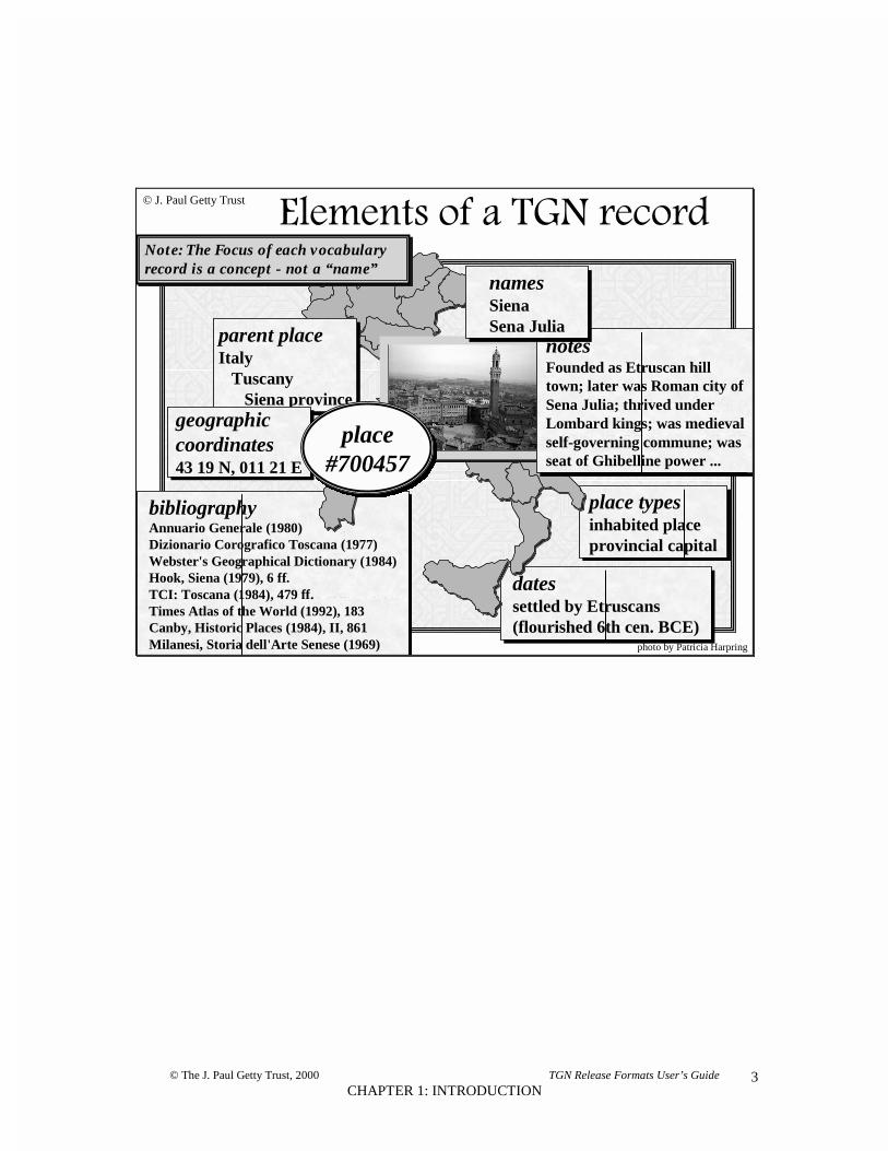
datessettled by Etruscans(flourished 6th cen. BCE)
place typesinhabited placeprovincial capital
bibliographyAnnuario Generale (1980)Dizionario Corografico Toscana (1977)Webster's Geographical Dictionary (1984)Hook, Siena (1979), 6 ff.TCI: Toscana (1984), 479 ff.Times Atlas of the World (1992), 183Canby, Historic Places (1984), II, 861Milanesi, Storia dell'Arte Senese (1969)
������������� �������
parent placeItaly Tuscany Siena province
.
© J. Paul Getty Trust
geographiccoordinates43 19 N, 011 21 E
place#700457
notesFounded as Etruscan hilltown; later was Roman city ofSena Julia; thrived underLombard kings; was medievalself-governing commune; wasseat of Ghibelline power ...
namesSienaSena Julia
photo by Patricia Harpring
Note: The Focus of each vocabularyrecord is a concept - not a “name”

© The J. Paul Getty Trust, 2000 TGN Data Release User’s Guide
CHAPTER 2: RELATIONAL FILES FORMAT4

© The J. Paul Getty Trust, 2000 TGN Data Release User’s Guide
CHAPTER 2: RELATIONAL FILES FORMAT5
CHAPTER 2 RELATIONAL FILES FORMAT
OVERVIEW
The data releases use an 8-bit, code-extended ASCII character set. See Appendix A: Codes for Diacriticsused in the TGN. The database is at least 500 megabytes in size.
The TGN was compiled using a custom-built editorial system that allowed the Vocabulary Program 1) tomerge records from separate contributors that represent the same place, 2) to build and rearrangehierarchies, and 3) to accept, edit, and manage contributions to the database.1
There are 14 relational tables.2 The logical focus of the TGN is a place, information about which forms anintellectual record. This intellectual record comprises all information tied to the place through a uniquenumeric key (geog_key). Names, notes, coordinates, dates, and place types for a place are linked by thegeog_key. Each name is also uniquely identified by a key (placename_id), and contributors, bibliography,and dates are linked to a name by that key. The geog_key of the immediate parent of a place is located inthe geog_parents table, and it is with these keys that hierarchies may be constructed. A minimum recordfor a place includes one name (and the accompanying sort name and key words), one place type, and a linkto an immediate parent.
Four tables, former_geogkeys, former_geoglinks, former_biblinks, and former_bibkeys, store unique keysthat have changed since the last release. Unique keys may change because of the nature of a compiledsource like the TGN. For example, if there are two places in the database that represent the same place,when these separate records are merged into a single record, at least one of the unique keys must be lost.
Note that information in certain of the tables and columns is not intended to be displayed to the end-user.Such information includes normalized names intended for retrieval, and date fields intended to indexdisplay dates (which are notes).
1 Contributions will be accepted from selected institutions in an automated format prescribed by theVocabulary Program. The contribution format and a new Vocabulary Coordination System are scheduled tobe in place by Spring, 2001. The original TGN editorial system operated under the Sybase RelationalDatabase Management System and Sybase SQL Server release 4.9.2; it was developed using APT Editrelease 4.0.2. TGN ran on Sun SPARC workstations running Sun OS release 4.3.4.2 Note that table names and data structure may change with the implementation of the new TGN editorialsystem and data model, slated for completion in 2001.

© The J. Paul Getty Trust, 2000 TGN Data Release User’s Guide
CHAPTER 2: RELATIONAL FILES FORMAT6
Entity Relationship Diagram for the TGN
GEOG_MAINunique record information, numeric ID
coordinates, descriptive note
NAME_DETAILdates for name, contributor, source
GEOG_PARENTShierarchical information, ID of parents
GEOG_NAMEID of name, name, sequence, language,
historical flags
NAME_KEYWORDSkeywords for names
BIBLIObrief citation, full citation
BIB_KEYWORDSkeywords for citations
GEOG_PLACETYPEplace type, historical flag
PLACETYPE_DATESdates for place type
PLACETYPE LISTplace type, codes
FORMER_BIBKEYSmerged or deleted citations
FORMER_GEOGKEYSIDs of merged places
FORMER_GEOGLINKSIDs of children whose parent
was merged
FORMER_BIBLINKSIDs of places linked to citations that
have since been merged

© The J. Paul Getty Trust, 2000 TGN Data Release User’s Guide
CHAPTER 2: RELATIONAL FILES FORMAT7
RELATIONAL FILES DATA DICTIONARY
The TGN relational files format contains the following tables:
GEOG_MAIN Main place record table, containing unique key for the place,coordinates, and descriptive note.
GEOG_PARENTS Table containing keys for immediate parents of geog_key.
GEOG_NAME Table for names of places, containing unique ID for thename, name string, normalized name, and various flags.
NAME_DETAIL Table for repeating detail information about each name,including display date, contributor, and link to citation.
GEOG_PLACETYPE Table for place types associated with the place, includingcode for place type, and various flags.
PLACETYPE_DATES Table for repeating detail information about the place type,including display date, start and end dates.
BIBLIO Table for citations for sources, including key for citation,brief citation, and full citation.
PLACETYPE_LIST Table for place types, containing code for place type andplace type term.
NAME_KEYWORDS Table containing keywords for the names.
BIB_KEYWORDS Table containing the keywords for full citations.
FORMER_GEOGKEYS Table containing mapping of geog_keys that have beenmerged or deleted since last release.
FORMER_GEOGLINKS Table containing former links to children of geog_keys thathave been merged or deleted.
FORMER_BIBKEYS Table containing mapping of bib_keys that have been mergedor deleted since the last release.
FORMER_BIBLINKS Table containing geog_keys that were linked to citations thathave been merged or deleted.
In the following chart, the names of tables appear in small caps (GEOG_MAIN). The names of columns
are in lower case (geog_key). For each column, the following is indicated: the data type, the length of thedata, the allowance of nulls (i.e., whether or not data is required in that column), a description of the data,an example of the data, and an explanatory note, where necessary.
EXAMPLE
COLUMN TYPE Len Nulls DESCRIPTION EXAMPLE NOTE
GEOG_MAIN Main place record table,containing unique key for place,coordinates, and descriptivenote.
geog_key int 4 0 Unique key for the place. 7008736descr_note text 500 1 Note describing the history,
physical characteristics, andsignificance of the place.
(QWPFGF D[
'VTWUECPU� TWNGF
D[ 4QOCPU �TF
EGP� $% ���
Notethat novalue inthis ...

© The J. Paul Getty Trust, 2000 TGN Data Release User’s Guide
CHAPTER 2: RELATIONAL FILES FORMAT8

© The J. Paul Getty Trust, 2000 TGN Data Release User’s Guide
CHAPTER 2: RELATIONAL FILES FORMAT – DATA DICTIONARY9
COLUMN TYPE Len Nulls DESCRIPTION EXAMPLE NOTE
GEOG_MAIN Main place record table, containing unique key for place, coordinates, anddescriptive note.
geog_key int 4 3 0 Unique key for the place. 7011179
descr_note text 500 1 Note describing the history, physicalcharacteristics, and significance of the place.
(QWPFGF D[ 'VTWUECPU� TWNGF D[
4QOCPU �TF EGP� $% �
.QODCTFU �VJ EGP�� EQPUVKVWVKQP
����� OGFKGXCN UGCV QH
)JKDGNNKPG HCEVKQP� TKXCN QH
(NQTGPEG� TWNGF D[ %JCTNGU QH
#PLQW ��VJ EGP�� 8KUEQPVK QH
/KNCP GCTN[ ��VJ EGP�� � /GFKEK
QH (NQTGPEG CHVGT �����
Note that no value in thiscolumn is currently greaterthan 500, even though this is atext field.
lat varchar 5 1 The degrees and minutes of the latitude,which is the angular distance north or southof the equator, measured in degrees andminutes along a meridian.
43 19 Format is two digits, onespace, two digits.
lat_dir char 1 1 Letter indicating if latitude is north or southof equator.
N Legal values = N or S.
long varchar 6 1 The degrees and minutes of the longitude,which is the angular distance east or west of
011 21 Format is three digits, onespace, two digits.
3 A 4-byte integer can hold a number as high as 2 billion.
Getty Thesaurus of Geographic Names:RELATIONAL FILES format DATA DICTIONARY

© The J. Paul Getty Trust, 2000 TGN Data Release User’s Guide
CHAPTER 2: RELATIONAL FILES FORMAT – DATA DICTIONARY10
COLUMN TYPE Len Nulls DESCRIPTION EXAMPLE NOTEthe Prime Meridian at Greenwich, England.
long_dir char 1 1 Letter indicating if latitude is east or west ofthe Prime Meridian.
E Legal values = E or W.
lat_num dec (5,3)
or float1 Latitude expressed as decimal fractions of
degrees.43.316 Whole degrees are represented
by a two-digit decimal numberranging from 0 through 90,with any decimal fraction of adegree separated by a decimalpoint; latitudes south of theequator are designated by aminus sign.
long_num dec (6,3)
or float1 Longitude expressed as decimal fractions of
degrees.011.350 Whole degrees are represented
by a three-digit decimalnumber ranging from 0 through180, with any decimal fractionof a degree separated by adecimal point; longitudes westof the Prime Meridian aredesignated by a minus sign.
GEOG_PARENTS Table containing keys for immediate parents of geog_key. Places may have mulitpleparents.
geog_key int 4 0 Unique key for the place. 7011179
parent_key int 4 0 Unique key for a parent of the place. 7003168
pref_flag varchar 1 0 Flag indicating if parent is P = Preferred, orN = Non-preferred.
P Legal values = P or N.
GEOG_NAME Table for names of places, containing unique ID for the name, name string,normalized name, and various flags.
geog_key int 4 0 Unique key for the place. 7011179
placename_id
int 4 0 Unique key for this name (unique acrossentire database).
47413 All names have unique IDs,including homonyms.

© The J. Paul Getty Trust, 2000 TGN Data Release User’s Guide
CHAPTER 2: RELATIONAL FILES FORMAT – DATA DICTIONARY11
COLUMN TYPE Len Nulls DESCRIPTION EXAMPLE NOTE
seqn int 1 0 Sequence position in which the name shouldbe ordered in displays.
0 Values = 0-x.
place_name varchar 122 0 Name string. Siena
sort_name varchar 122 0 Normalized name; all caps with punctuation,diacritic codes, numbers, and spacesremoved.
SIENA To be used for sorting andretrieval.
lang char 1 0 Flag indicating if name is V = Vernacular, orO = Other language.
V Legal values = V or O. Inrestructuring of data for newsystem, this will be expandedto handle multiple languages.
age_flag char 1 0 Flag indicating if the name is C = Current, H= Historical, or B = Both.
C Legal values = C, H, or B.
pref_flag char 1 0 Flag indicating if this is the P = Preferredname, or V = a Variant name.
P Legal values = P or V.
other_flags char 10 0 Flags indicating if name is ADJ = adjectivalname form, ADJE = preferred Englishversion of adjectival name form, ENG =preferred English name, FIPS = codeindicated for the place by the FederalInformation Processing Standards, USP =U.S. Postal abbreviation for a state, ISO = 3-letter ISO code for nation, ISO2 = 2-letterISO code for a nation, ISON = numeric ISOcode for a nation, DIS = special displayname to be used when place is displayed as abroader context in a horizontal string
N Legal values = ADJ, ADJE,DIS, ENG, FIPS, ISO, ISO2,ISON, USP.
NAME_DETAIL Table for repeating detail information about each name, including display date,contributor, and link to citation.
geog_key int 4 0 Unique key for the place. 7011179
placename_id
int 4 0 Unique key for this name. 47413

© The J. Paul Getty Trust, 2000 TGN Data Release User’s Guide
CHAPTER 2: RELATIONAL FILES FORMAT – DATA DICTIONARY12
COLUMN TYPE Len Nulls DESCRIPTION EXAMPLE NOTE
bib_key int 4 1 Unique key for the source where this namewas found.
9006009
display_date
varchar 125 1 Note describing the time period when thename was used, and other information aboutthe name.
used since 13th cen.
start_date varchar 30 1 Date indicating the earliest actual orestimated year delimiting the span of timeindicated in the display date.
1200 Dates BCE are preceded by aminus sign.
end_date varchar 30 1 Date indicating the latest actual or estimatedyear delimiting the span of time.
9999 Dates BCE are preceded by aminus sign. If the name is stillused for the place, this date is“9999.”
bib_page varchar 40 1 Volume (if applicable) and page number,plate number, etc., for the source where thename was found.
V, 123
contrib varchar 30 0 Acronym, initials, or brief name of the projector institution that contributed the name.
VP
GEOG_PLACETYPE Table for place types associated with the place, contains code for place type, andvarious flags.
geog_key int 4 0 Unique key for the place. 7011179
seqn int 1 0 Sequence position in which the place typeshould be ordered in displays.
0 Values = 0-x.
pref_flag char 1 0 Flag indicating if the place type is P =Preferred, or N = Non-preferred
P
placetype_code
int 4 0 Numeric code for the place type. 83002 For a given geog_key, a placetype may be linked only once.
age_flag char 1 0 Flag indicating if the place type is C =Current, H = Historical, or B = Both
C

© The J. Paul Getty Trust, 2000 TGN Data Release User’s Guide
CHAPTER 2: RELATIONAL FILES FORMAT – DATA DICTIONARY13
COLUMN TYPE Len Nulls DESCRIPTION EXAMPLE NOTE
PLACETYPE_DATES Table for repeating detail information about the place type, including displaydate.
geog_key int 4 0 Unique key for the place. 7008736
placetype_code
int 4 0 Numeric code for the place type. 80132
display_date
varchar 125 0 Note describing the time period when theplace type applied, and other informationabout the place type.
founded by Etruscans
start_date varchar 30 1 Date indicating the earliest actual orestimated year delimiting the span of timeindicated in the display date.
-800 Dates BCE are preceded byminus sign.
end_date varchar 30 1 Date indicating the latest actual or estimatedyear delimiting the span of time indicated inthe display date.
9999 Dates BCE are preceded by aminus sign. If the name is stillused for the place, this date is“9999.”
BIBLIO Table for citations for sources, including key for citation, brief citation, and fullcitation.
bib_key int 4 0 Unique key for the source. 9006009
bib_brief varchar 40 0 Brief citation for the source; to be used indisplays.
TCI: Toscana (1984)
bib_brief_sort
varchar 40 0 Normalized brief citation; all caps withpunctuation, diacritic codes, numbers, andspaces removed.
TCITOSCANA
citation text 16 1 Full citation for the source. Toscana (non compresa Firenze).Guida d’Italia del Touring ClubItaliano. Milano: Touring ClubItaliano, 1984.

© The J. Paul Getty Trust, 2000 TGN Data Release User’s Guide
CHAPTER 2: RELATIONAL FILES FORMAT – DATA DICTIONARY14
COLUMN TYPE Len Nulls DESCRIPTION EXAMPLE NOTE
PLACETYPE_LIST Table for place types, containing code for place type and place type term.
placetype_code
int 4 0 Numeric code for the place type. 83002
placetype_search
char 4 0 Character string version of the code; to allowsearching by truncation.
83002
placetype varchar 64 0 Place type term. inhabited place
NAME_KEYWORDS Table containing keywords for the names.
geog_key int 4 0 Unique key for the place. 7011796
placename_id
int 4 0 Unique key for this name. 47413
keyword varchar 40 0 A normalized version of a word contained inthe place name; all caps with punctuation,diacritic codes, numbers, and spacesremoved.
SIENA
BIB_KEYWORDS Table containing keywords for the citations.
bib_key int 4 0 Unique key for the source. 9006009
keyword varchar 40 0 Normalized word from the citation; all capswith punctuation, diacritic codes, numbers,and spaces removed.
TOSCANA
FORMER_GEOGKEYS Table containing mapping of geog_keys that have been merged or deleted sincelast release.
new_key int 4 0 Key of merged record. 7011179
master_key int 4 0 Key of the record that was the “master” in themerge operation.
1000982

© The J. Paul Getty Trust, 2000 TGN Data Release User’s Guide
CHAPTER 2: RELATIONAL FILES FORMAT – DATA DICTIONARY15
COLUMN TYPE Len Nulls DESCRIPTION EXAMPLE NOTE
collapse_key
int 4 0 Key of a record that was a “member” in themerge operation.
4000985 A merge operation involvesone master record and one ormore “member” records. Thenew record inherits the defaultsof the “master” where there isconflict; the new record maythen be edited.
FORMER_GEOGLINKS Table containing former links to children of geog_keys that have been merged ordeleted.
new_key int 4 0 Key of merged record. 7011179
collapse_key
int 4 0 Key of a record that was a “member” in themerge operation, and thus lost children whenthe merge occurred.
4000985
old_link_key
int 4 0 Key of the record that used to be a child of a“member” involved in a merge operation.
4002973
FORMER_BIBKEYS Table containing mapping of bib_keys that have been merged or deleted since thelast release.
new_key int 4 0 Key of merged record. 9006009
master_key int 4 0 Key of the record that was the “master” in themerge operation.
9000098
collapse_key
int 4 0 Key of a record that was a “member” in themerge operation.
9000954 A merge operation involvesone master record and one ormore “member” records. Thenew record inherits the defaultsof the “master,” though thenew record may then be edited.
FORMER_BIBLINKS Table containing geog_keys that were linked to citations that have been merged ordeleted.
new_key int 4 0 Key of merged record. 9006009

© The J. Paul Getty Trust, 2000 TGN Data Release User’s Guide
CHAPTER 2: RELATIONAL FILES FORMAT – DATA DICTIONARY16
COLUMN TYPE Len Nulls DESCRIPTION EXAMPLE NOTE
collapse_key
int 4 0 Key of a record that was a “member” in themerge operation.
9000954
old_link_key
int 4 0 Geog_key of the place record that used tohave this bib_key linked as a source.
7002973

© The J. Paul Getty Trust, 2000 TGN Data Release User’s Guide
CHAPTER 3: REC FORMAT17
CHAPTER 3 REC FORMAT
OVERVIEW
The data releases use an 8-bit, code-extended ASCII character set. See Appendix A: Codes for Diacriticsused in the TGN. The database is at least 500 megabytes in size.
The TGN was compiled using a custom-built editorial system that allowed the Vocabulary Program 1) tomerge records from separate contributors that represent the same place, 2) to build and rearrangehierarchies, and 3) to accept, edit, and manage contributions to the database.4
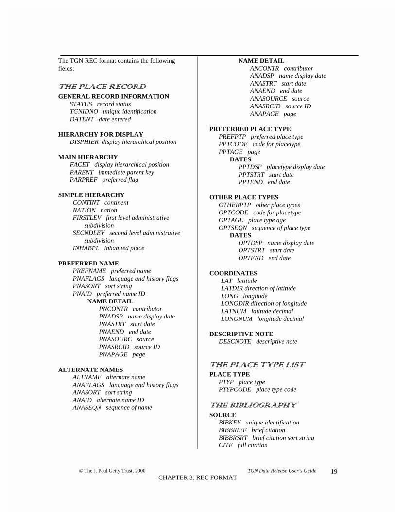
The TGN REC format contains the following types of information:
Place RecordGENERAL RECORD INFORMATION The unique numeric ID, status, and date of the record.HIERARCHY FOR DISPLAY The name of the place together with its parents, displayed in
a horizontal string.MAIN HIERARCHY Unique ID of the immediate parent of the place at hand, used
to build full hiearchies.SIMPLE HIERARCHY The names of the administrative parents of the place at hand,
to be used for filling in values in flat files.PREFERRED NAME The TGN preferred name and associated flags.NAME DETAIL Contributors, dates, and sources for the preferred name.ALTERNATE NAMES Alternate names for the place, and associated flags(the
preferred English name is included among these names).NAME DETAIL Contributors, dates, and sources for the alternate name.PREFERRED PLACE TYPE The preferred place type for the place, together with flags and
dates.DATES Dates for the preferred place type.OTHER PLACE TYPES Other place types that are applicable to the place, together
with flags and dates.DATES Dates for the other place types.COORDINATES The latitude and longitude for the place.DESCRIPTIVE NOTE Note describing the place.
Place Type ListPLACE TYPE List of terms and codes for place types.
BibliographySOURCE List of unique ID, brief citation, and full citation for sources.
TGN:REC uses a mnemonic field labeling convention, each section of the record beginning with a tag.Each TGN REC record is divided in sections corresponding to the chart above. The heading names beginwith an asterisk (*), are in title case, and end with a carriage return/line feed <CR><LF> (ASCII decimalcharacter 013 followed by ASCII decimal character 010). The field tags are in all upper case, and
4 Contributions will be accepted from selected institutions in an automated format prescribed by theVocabulary Program. The contribution format and a new Vocabulary Coordination System are scheduled tobe in place by Spring, 2001. The original TGN editorial system operated under the Sybase RelationalDatabase Management System and Sybase SQL Server release 4.9.2; it was developed using APT Editrelease 4.0.2. TGN ran on Sun SPARC workstations running Sun OS release 4.3.4.

© The J. Paul Getty Trust, 2000 TGN Data Release User’s Guide
CHAPTER 3: REC FORMAT18
correspond to the tags listed in the Data Dictionary below. Each field tag is followed by an equal sign (=),and the equal sign is followed by the data. The end of the data is marked by a carriage return/line feed<CR><LF>. Each TGN REC place record begins with the first section heading and carriage return/linefeed (*General Record Information<CR><LF> ), and ends with two dollar signs and a carriagereturn/line feed ($$<CR><LF> ). Each instance of a repeating group will be preceded by the *header forthat group. Repeating groups may be nested.
EXAMPLE
General Record Information<CR><LF>STATUS=n<CR><LF>TGNIDNO=4001715<CR><LF>DATENT=19980316<CR><LF>*Hierarchy for Display<CR><LF>DISPHIER=Bosco della Fontana (Lombardia, Italia, Europe) <CR><LF>*Main Hierarchy<CR><LF>FACET=Current World<CR><LF>PARENT=7003237<CR><LF>*Simple Hierarchy<CR><LF>CONTINT=Europe<CR><LF>NATION=Italia<CR><LF>FIRSTLEV=Lombardia<CR><LF>*Preferred Name<CR><LF>PREFNAME=Bosco della Fontana<CR><LF>PNAFLAGS=C,V<CR><LF>PNSORT=BOSCODELLAFONTANA<CR><LF>PNAID=145113<CR><LF>*Name DetailPNCONTR=BHA<CR><LF>PNASOURC=TCI: Lombardia (1970) <CR><LF>PNASRCID=9004901<CR><LF>PNAPAGE=552<CR><LF>*Name DetailPNCONTR=VP<CR><LF>PNASOURC=TCI: Lombardia (1987) <CR><LF>PNASRCID=9005691<CR><LF>PNAPAGE=788<CR><LF>*Preferred Place Type<CR><LF>PREFPTP=forest<CR><LF>PPTCODE=21642<CR><LF>*Coordinates<CR><LF>LAT=45 00<CR><LF>LATDIR=N<CR><LF>LONG=010 40<CR><LF>LONGDIR=E<CR><LF>LATNUM=45.000<CR><LF>LONGNUM=10.666<CR><LF>*Descriptive Note<CR><LF>DESCNOTE=One of the few remaining forests in the Po delta.<CR><LF>$$<CR><LF>
© The J. Paul Getty Trust, 2000 TGN Data Release User’s Guide
CHAPTER 3: REC FORMAT19
The TGN REC format contains the followingfields:
�������������
GENERAL RECORD INFORMATIONSTATUS record statusTGNIDNO unique identificationDATENT date entered
HIERARCHY FOR DISPLAYDISPHIER display hierarchical position
MAIN HIERARCHYFACET display hierarchical positionPARENT immediate parent keyPARPREF preferred flag
SIMPLE HIERARCHYCONTINT continentNATION nationFIRSTLEV first level administrative
subdivisionSECNDLEV second level administrative
subdivisionINHABPL inhabited place
PREFERRED NAMEPREFNAME preferred namePNAFLAGS language and history flagsPNASORT sort stringPNAID preferred name ID
NAME DETAILPNCONTR contributorPNADSP name display datePNASTRT start datePNAEND end datePNASOURC sourcePNASRCID source IDPNAPAGE page
ALTERNATE NAMESALTNAME alternate nameANAFLAGS language and history flagsANASORT sort stringANAID alternate name IDANASEQN sequence of name
NAME DETAILANCONTR contributorANADSP name display dateANASTRT start dateANAEND end dateANASOURCE sourceANASRCID source IDANAPAGE page
PREFERRED PLACE TYPEPREFPTP preferred place typePPTCODE code for placetypePPTAGE page
DATESPPTDSP placetype display datePPTSTRT start datePPTEND end date
OTHER PLACE TYPESOTHERPTP other place typesOPTCODE code for placetypeOPTAGE place type ageOPTSEQN sequence of place type
DATESOPTDSP name display dateOPTSTRT start dateOPTEND end date
COORDINATESLAT latitudeLATDIR direction of latitudeLONG longitudeLONGDIR direction of longitudeLATNUM latitude decimalLONGNUM longitude decimal
DESCRIPTIVE NOTEDESCNOTE descriptive note
���������������� ��
PLACE TYPEPTYP place typePTYPCODE place type code
����� �� �����
SOURCEBIBKEY unique identificationBIBBRIEF brief citationBIBBRSRT brief citation sort stringCITE full citation

© The J. Paul Getty Trust, 2000 TGN Data Release User’s Guide
CHAPTER 3: REC FORMAT20
REC FORMAT DATA DICTIONARY
In the following chart, the names of sections appear in small caps (GENERAL RECORD
INFORMATION). The names of field tags are in uppercase (STATUS). For each field, the following isindicated: the field tag label, whether or not the field is repeatable, a description of the data, an example ofthe data, an explanatory note, and the columns to which this field corresponds in the TGN Relational Filesformat.
EXAMPLE
LABEL FIELD NAME REP
DESCRIPTION EXAMPLE NOTE MAPPINGTO REL.TABLESFORMAT
The Place Record
GENERAL RECORD INFORMATION NSTATUS record status N An alphabetical code
indicating if the record is new(n), corrected/revised (c), ordeleted (d).
n For firstedition ofTGN, allrecords areNew.
N/A
TGNIDNO uniqueidentification
N A numeric code that uniquelyidentifies each placerepresented in TGN.
7011179 geog_main.geog_key
DATENT date entered N The date a record was created[yyyymmdd].
20000602 N/A

© The J. Paul Getty Trust, 2000 TGN Data Release User’s Guide
CHAPTER 3: REC FORMAT – DATA DICTIONARY21
LABEL FIELD NAME REP
DESCRIPTION EXAMPLE NOTE MAPPING TORELATIONALFILES FORMAT
Place Record
GENERAL RECORD
INFORMATION
N
LEN length of record N Number of characters in the entire recordincluding <carriage return>, <line-feed>,and all delimiters.
3453
STATUS record status N An alphabetical code indicating if therecord is new (n), corrected/revised (c), ordeleted (d).
n N/A
TGNIDNO uniqueidentification
N A numeric code that uniquely identifieseach place represented in the TGN.
7011179 geog_main.geog_key
DATENT date entered N The date a record was created[yyyymmdd].
20000602 N/A
HIERARCHY FOR DISPLAY Y
Getty Thesaurus of Geographic NamesREC format DATA DICTIONARY

© The J. Paul Getty Trust, 2000 TGN Data Release User’s Guide
CHAPTER 3: REC FORMAT – DATA DICTIONARY22
LABEL FIELD NAME REP
DESCRIPTION EXAMPLE NOTE MAPPING TORELATIONALFILES FORMAT
DISPHIER displayhierarchicalposition
N The full list of parents for the place indisplay (note) format, listing parents inascending order, to the level of continent.Names are in the vernacular, whereapplicable.
Siena (Siena province,Toscana, Italia, Europe)
If a place has multipleparents, only one parentis included in thisstring.
Display names orpreferred names ofparents tracedthroughgeog_parents.parent_key.
MAIN HIERARCHY Y
FACET facet N The facet in which the place is located. Current World In the first release ofTGN:REC, all placesare in the CurrentWorld facet
N/A
PARENT immediateparent key
N The unique numeric ID of the place that isthe immediate parent for the placerepresented in this record.
7003168 geog_parents.parent_key
PARPREF preferred flag N Flag indicating whether or not this parentis the preferred parent.
P legal values are P or N. geog_parentspref_flag
SIMPLE HIERARCHY Y
CONTINT continent Y Preferred name of the continent on whichthe place is located.
Europe Since places may havemore than one parent,this field and thefollowing fields mayrepeat together as agroup.
continent tracedthroughgeog_parents.parent_key.
NATION nation Y If the place is located in a nation,thepreferred name of that nation.
Italia primary politicalunit tracedthroughgeog_parents.parent_key

© The J. Paul Getty Trust, 2000 TGN Data Release User’s Guide
CHAPTER 3: REC FORMAT – DATA DICTIONARY23
LABEL FIELD NAME REP
DESCRIPTION EXAMPLE NOTE MAPPING TORELATIONALFILES FORMAT
FIRSTLEV first leveladministrativesubdivision
If the place is located in a first levelsubdivision in a nation, the name of thatsubdivision.
Toscana first levelsubdivision tracedthroughgeog_parents.parent_key
SECNDLEV second leveladminsitrativesubdivision
If the place is located in a second levelsubdivision in a nation, the name of thatsubdivision.
Siena province second levelsubdivision tracedthroughgeog_parents.parent_key
INHABPL inhabited place For neighborhoods and other subdivisionsof inhabited places, the name of theinhabited place in which the neighborhoodis located.
[e.g., for Montmartreneighborhood]Paris
inhabited placeor desertedsettlement tracedthroughgeog_parents.parent_key
PREFERRED NAME N
PREFNAME preferred name N The preferred name for the place in theTGN, usually the vernacular name.
Siena geog_name.place_name

© The J. Paul Getty Trust, 2000 TGN Data Release User’s Guide
CHAPTER 3: REC FORMAT – DATA DICTIONARY24
LABEL FIELD NAME REP
DESCRIPTION EXAMPLE NOTE MAPPING TORELATIONALFILES FORMAT
PNAFLAGS language andhistory flags
N Flags indicating information about thecurrent/historical status (C or H) of thename, whether or not it is a vernacularname (V or O). Other flags are thoseindicating if name is ADJ = adjectivalname form, ADJE = preferred Englishversion of adjectival name form, ENG =preferred English name, FIPS = codeindicated for the place by the FederalInformation Processing Standards, USP =U.S. Postal abbreviation for a state, ISO =3-letter ISO code for nation, ISO2 = 2-letter ISO code for a nation, ISON =numeric ISO code for a nation, DIS =special display name to be used whenplace is displayed as a broader context ina horizontal string, and whether or not it isthe preferred English name, a specialDisplay name, an ISO code, or a USPostal abbreviation for a US state.
C,V C = CurrentH = HistoricalV = VernacularO = Other languageADJ = adjectivalADJE = adjectivalEnglishDIS = displayENG = preferredEnglishFIPS = FIPS codeISO = ISO 3-letter codeISO2 = ISO 2-lettercodeISON = ISO numericcodeUSP = US Postal Code
geog_name.age_flag,geog_name.lang,geog_name.other_flags
PNASORT sort string N Normalized name; all caps withpunctuation, diacritic codes, numbers, andspaces removed.
SIENA
PNAID preferred nameID
N The unique numeric key identifying thisname.
47413 geog_name.placename_id
(NAME DETAIL) Y
PNCONTR contributor N The initials or acronym of the contributorof the preferred name.
BHA name_detail.contrib
PNADSP name displaydate
N Note describing the time period when thename was used, and other informationabout the name.
used since 13th cen. Note that in mergedTGN record, there maybe only one date pername.
name_detail.display_date

© The J. Paul Getty Trust, 2000 TGN Data Release User’s Guide
CHAPTER 3: REC FORMAT – DATA DICTIONARY25
LABEL FIELD NAME REP
DESCRIPTION EXAMPLE NOTE MAPPING TORELATIONALFILES FORMAT
PNASTRT start date N Date indicating the earliest actual orestimated year delimiting the span of timeindicated in display date above.
1200 Dates BCE arepreceded by minus sign.
name_detail.start_date
PNAEND end date N Date indicating the latest actual orestimated year delimiting the span of timeindicated in display date.
9999 Dates BCE arepreceded by minus sign.If the name is still usedfor the place, this dateis 9999.
name_detail.end_date
PNASOURC source N Brief citation for the source where thepreferred name was found.
Hook, Siena (1979) biblio.bib_brief(linked toname_detailthrough bib_key)
PNASRCID source ID N Unique numeric key identifying thissource.
9000009 name_detail.bib_key
PNAPAGE page N Volume (if applicable) and page number,plate number, etc., in source where namewas found.
6 ff. name_detail.bib_page
ALTERNATE NAMES Y
ALTNAME alternate name N Any alternate name(s) associated with theplace,PLUS the same added fields as for Prefname.
Saena Julia geog_name.place_name &geog_name.pref_flag;plus geog_name.seqn
ANAFLAGS language andhistory flags
N See PNAFLAGS above H,O See PNAFLAGS above geog_name.age_flag,geog_name.lang,geog_name.other_flags

© The J. Paul Getty Trust, 2000 TGN Data Release User’s Guide
CHAPTER 3: REC FORMAT – DATA DICTIONARY26
LABEL FIELD NAME REP
DESCRIPTION EXAMPLE NOTE MAPPING TORELATIONALFILES FORMAT
ANASORT sort string N Normalized name; all caps withpunctuation, diacritic codes, numbers, andspaces removed.
SAENAJULIA
ANAID alternate nameID
N The unique numeric key identifying thisname.
141380 geog_name.placename_id
ANASEQN sequence ofname
N Sequence position in which the name willbe ordered.
4 Values = 1-x. name_detail.seqn
(NAME DETAIL) Y
ANCONTR contributor N The initials or acronym of the contributorof the alternate name.
FDA name_detail.contrib
ANADSP name displaydate
N Note describing the time period when thename was used, and other informationabout the name.
Roman name_detail.display_date
ANASTRT start date N Date indicating the earliest actual orestimated year delimiting the span of timeindicated in display date above.
-100 Dates BCE arepreceded by minus sign.
name_detail.start_date
ANAEND end date N Date indicating the latest actual orestimated year delimiting the span of timeindicated in display date.
300 Dates BCE arepreceded by minus sign.If the name is still usedfor the place, this dateis 9999.
name_detail.end_date
ANASOURC source N Brief citation for the source where thealternate name was found.
Webster’s GeographicalDictionary (1984)
biblio.bib_brief(linked toname_detailthrough bib_key)
ANASRCID source ID N Unique numeric key identifying thissource.
9006449 name_detail.bib_key
ANAPAGE page N Volume (if applicable) and page number,plate number, etc., in source where namewas found.
1114 name_detail.bib_page

© The J. Paul Getty Trust, 2000 TGN Data Release User’s Guide
CHAPTER 3: REC FORMAT – DATA DICTIONARY27
LABEL FIELD NAME REP
DESCRIPTION EXAMPLE NOTE MAPPING TORELATIONALFILES FORMAT
PREFERRED PLACE TYPE N
PREFPTP preferred placetype
N Word or phrase that characterizes asignificant aspect of the place, includingits size, function, role, political anatomy,or physical characteristics.
inhabited place placetype_list.placetype holdsvalue (linked torecord by geog_placetype.placetype _code)
PPTCODE code forplacetype
N Numeric code for the placetype. 83002 geog_placetype.placetype _code
PPTAGE place type age N Flag indicating if the preferred place typeis is Current (C), Historical (H), or Bothcurrent and historical (B).
C geog_placetype.age_flag
(DATES) Y
PPTPDSP placetypedisplay date
N Note describing the time period when theplace type applied, and other informationabout the place type.
settled by Etruscans Place type dates arerepeatable if theplacetype applied inseparate periods of time(e.g., capital duringRoman times, again inMiddle Ages).
placetype_dates.display_date
PPTPSTRT start date N Date indicating the earliest actual orestimated year delimiting the span of timeindicated in display date above.
-800 For inhabited place anddeserted settlement,indicates span ofhabitation.
Dates BCE arepreceded by minus sign.
placetype_dates.start_date

© The J. Paul Getty Trust, 2000 TGN Data Release User’s Guide
CHAPTER 3: REC FORMAT – DATA DICTIONARY28
LABEL FIELD NAME REP
DESCRIPTION EXAMPLE NOTE MAPPING TORELATIONALFILES FORMAT
PPTPEND end date N Date indicating the latest actual orestimated year delimiting the span of timeindicated in display date.
9999 Dates BCE, arepreceded by minus sign.If the name is still usedfor the place, this dateis 9999.
placetype_dates.end_date
OTHER PLACE TYPES Y
OTHERPTP other place type N Word or phrase that characterizes anadditional significant aspect of the place,including its size, function, role, politicalanatomy, or physical characteristics.
commune(administrative)
placetype_list.placetype holdsvalue, (linked torecord bygeog_placetype.placetype _code)
OPTCODE code forplacetype
N Numeric code for the placetype. 81112 geog_placetype.placetype _code
OPTAGE place type age N Flag indicating if this place type is isCurrent (C), Historical (H), or Bothcurrent and historical (B).
C geog_placetype.age_flag
OPTSEQN sequence ofplace type
N Sequence position in which the place typewill be ordered.
2 Values = 1-x. geog_placetype.seqn
(DATES) Y
OPTPDSP placetypedisplay date
N Note describing the time period when theplace type applied, and other informationabout the place type.
since 1125 Place type dates arerepeatable if theplacetype applied inseparate periods of time(e.g., capital duringRoman times, again inMiddle Ages).
placetype_dates.display_date
OPTPSTRT start date N Date indicating the earliest actual orestimated year delimiting the span of timeindicated in display date above.
1125 Dates BCE arepreceded by minus sign.
placetype_dates.start_date

© The J. Paul Getty Trust, 2000 TGN Data Release User’s Guide
CHAPTER 3: REC FORMAT – DATA DICTIONARY29
LABEL FIELD NAME REP
DESCRIPTION EXAMPLE NOTE MAPPING TORELATIONALFILES FORMAT
OPTPEND end date N Date indicating the latest actual orestimated year delimiting the span of timeindicated in display date.
9999 Dates BCE arepreceded by minus sign.Where placetype is stillapplicable, value is9999.
placetype_dates.end_date
COORDINATES N The point of latitude and longitude on theglobe representing the location of theplace.
LAT latititude N The degrees and minutes of the latitude,which is the angular distance north orsouth of the equator, measured in degreesand minutes along a meridian.
43 19 Format is two digits,one space, two digits.
geog_main.lat
LATDIR direction oflatitude
N Letter indicating if latitude is North orSouth of equator.
N Legal values = N or S. geog_main.lat_dir
LONG longitude N The degrees and minutes of the longitude,which is the angular distance east or westof the Prime Meridian at Greenwich,England.
011 19 Format is three digits,one space, two digits.
geog_main.long
LONDIR direction oflongitude
N Letter indicating if latitude is East or Westof the Prime Meridian.
E Values = E or W. geog_main.long_dir
LATNUM latitude decimal N Latitude expressed as decimal fractions ofdegrees.
43.316 Whole degrees arerepresented by a two-digit decimal numberranging from 0 through90, with any decimalfraction of a degreeseparated by a decimalpoint; latitudes south ofthe equator aredesignated by a minussign.
geog_main.lat_num

© The J. Paul Getty Trust, 2000 TGN Data Release User’s Guide
CHAPTER 3: REC FORMAT – DATA DICTIONARY30
LABEL FIELD NAME REP
DESCRIPTION EXAMPLE NOTE MAPPING TORELATIONALFILES FORMAT
LONGNUM longitudedecimal
N Longitude expressed as decimal fractionsof degrees.
11.316 Whole degrees arerepresented by a three-digit decimal numberranging from 0 through180, with any decimalfraction of a degreeseparated by a decimalpoint; longitudes westof the Prime Meridianare designated by aminus sign.
geog_main.long_num
DESCRIPTIVE NOTE N
DESCNOTE descriptive note N Note describing the history, physicalcharacteristics and significance of theplace.
(QWPFGF D[ 'VTWUECPU�
TWNGF D[ 4QOCPU �TF
EGP� $% � .QODCTFU
�VJ EGP�� EQPUVKVWVKQP
����� OGFKGXCN UGCV QH
)JKDGNNKPG HCEVKQP� ���
geog_main.descr_note

© The J. Paul Getty Trust, 2000 TGN Data Release User’s Guide
CHAPTER 3: REC FORMAT – DATA DICTIONARY31
Place Type List
PLACE TYPEPTYP place type N Place type term. inhabited place placetype_list.
placetypePTYPCODE place type code N A numeric code that identifies each place
type.83002 placetype_list.
placetype_code
Bibliography
SOURCEBIBKEY unique
identificationN A numeric code that uniquely identifies
each source represented in the TGN.9000009 biblio.bib_key
BIBBRIEF brief citation N Brief citation for the source; to be used indisplays.
Hook, Siena (1979) biblio.bib_brief
BIBBRSRT brief citationsort string
N Normalized brief citation; all caps withpunctuation, diacritic codes, numbers, andspaces removed
HOOKSIENA biblio.bib_brief_sort
CITE full citation N Full citation for the source. Hook, Judith. Siena: ACity and Its History.London: HamishHamilton, 1979.
biblio.citation

© The J. Paul Getty Trust, 2000 TGN Data Release User’s Guide
CHAPTER 4: USMARC FORMAT – DATA DICTIONARY32

© The J. Paul Getty Trust, 2000 TGN Data Release User’s Guide
CHAPTER 4: USMARC FORMAT – DATA DICTIONARY33
CHAPTER 4 USMARC FORMAT
OVERVIEW
The TGN MARC data release uses an 8-bit, code-extended ASCII character set. Diacritics for the TGNMARC release are not the same as listed in Appendix A; instead, the TGN MARC release uses the ANSELcharacter set (ANSI Z39.47).5 The database is at least 500 megabytes in size. The TGN was compiledusing a custom-built editorial system that allowed the Vocabulary Program 1) to merge records fromseparate contributors that represent the same place, 2) to build and rearrange hierarchies, and 3) to accept,edit, and manage contributions to the database.6
The TGN USMARC release format includes the heading for the place record, its hierarchical context,latitude and longitude, its place types, bibliography and contributors, and notes. Although a briefintroduction to the structure of a USMARC authority record is given here, please seehttp://lcweb.loc.gov/marc for a complete description of the USMARC Format for Authorities Data.
The MARC portion of a TGN:MARC record consists of four sections arranged in the following order:
• Record leader• Record directory• Control fields• Variable fields
Each TGN:USMARC record ends with a record terminator (Hex 1D). In addition, a <carriage return> and a<line feed> (Hex 0D0A) follow the end of each record. The file is thus not stream file, but an ASCII textfile with 3 non-printing characters (Hex 1F, Hex 1E (field terminator), and Hex 1D) used as delimiters.
Record Leader: The first 24 character positions (0-23) of a record are the record leader and are used forcomputer processing of the record. Leader elements are not repeatable.
Record Directory: The record directory is an index to the location of each variable control field and datafield within a record. It begins at character position 24. Every field (control or variable) in a record has adirectory entry. Each entry gives the field’s tag, length, and starting character position. At the end of thewhole series of directory entries is a field terminator (Hex 1E).
Control Fields: Control fields provide information useful for processing a record such as identificationnumbers and dates. Each control field is identified by a three-character numeric tag. Control fields do notcontain indicator positions or subfield codes.
Variable Fields: Variable fields contain the TGN preferred name, variant names, and related data. Datawithin the variable fields is formatted using tags, indicators, and subfield codes. These conventions are
5 For the ANSEL character set, see “MARC 21: Specifications for Record Structure, Character Sets, andExchange Media” at http://lcweb.loc.gov/marc/specifications .6 Contributions will be accepted from selected institutions in an automated format prescribed by theVocabulary Program. The contribution format and a new Vocabulary Coordination System are scheduled tobe in place by Spring, 2001. The original TGN editorial system operated under the Sybase RelationalDatabase Management System and Sybase SQL Server release 4.9.2; it was developed using APT Editrelease 4.0.2. TGN ran on Sun SPARC workstations running Sun OS release 4.3.4.

© The J. Paul Getty Trust, 2000 TGN Data Release User’s Guide
CHAPTER 4: USMARC FORMAT – DATA DICTIONARY34
referred to in USMARC as content designators, since they provide information about the field and identifythe type of data that follows them. Each field ends with an end-of-field character (Hex 1E).
Tags: A tag is a three-character numeric label for a field, (e.g., 150). Tags appear only in the directoryportion of an TGN:MARC record, not in the variable field portion. Indicators follow the tag and furtherdefine the information in the field. Indicators consist of two characters: numeric (e.g., 01), blanks, or acombination of a blank and a number. Subfield codes separate and distinguish information within afield.The format of subfield content designators consists of a delimiter, "‡", and a lower-case alphabeticalcharacter or number, (e.g., ‡w, ‡3). A record may or may not contain all of these variable fields. Somefields, including 151, 451, 670, and 902, may be repeated in separate occurrences within a record. Eachfield ends with a field terminator (Hex 1E).
EXAMPLELen 00914Sta nTyp zLevBas 00157Enc n001 7016740¶008 000602 n anznnbabn b ana d¶151 ‡aMercia (England, United Kingdom, Europe) historic
region‡c(7016740,scheme=TGN)‡dH,V,N‡eMERCIA‡f150562¶551 ‡wg‡aEngland (7002445,scheme=TGN)¶670 ‡aColumbia Lippincott Gazetteer (1961) [BHA]‡bMercia¶670 ‡aCanby, Historic Places (1984) [VP]‡bMercia¶670 ‡aEncyclopædia Britannica (1988) [VP]‡bMercia¶678 ‡iArea comprising modern Staffordshire, Derbyshire,
Nottinghamshire & parts of West Midlands & Warwickshire; wasAnglo-Saxon kingdom; gained greatest power under King Offa (ruled757-96); declined after rise of kings of Wessex & divided by Danesin 9th cen.¶
901 ‡ahistoric region‡b81501‡cC¶902 ‡akingdom‡b82141‡cH‡d1‡efrom ca. 500 until dissolved by Danish
attack in 874‡f500‡g874¶905 ‡aEurope‡bUnited Kingdom‡cEngland¶
TGN MARC FORMAT DATA DICTIONARY
In the following chart, the names of field tags are in left column, followed by the name of the field, anindication whether or not the field is repeatable, a description of the data, an example of the data, anexplanatory note, and the fields to which this field corresponds in the TGN REC format.

© The J. Paul Getty Trust, 2000 TGN Data Release User’s Guide
CHAPTER 4: USMARC FORMAT – DATA DICTIONARY35
LABEL FIELD NAME REP
DESCRIPTION EXAMPLE NOTE MAPPING TOREC FORMAT
Place Record (USMARC format)
RECORD LEADERLen length N Character position 0-4. Length of the
record.03069 Total number of
characters in the record;including the recordterminator character,but not the <carriagereturn><line feed>.
LEN
Sta record status N Character position 5. An alphabetical codeindicating if the record is new (n),corrected/revised (c), or deleted (d).
n STATUS
Typ record type N Character position 6. Type of record (zindicates “authority”)
z
Lev undefined N Character position 7-9. [spaces]
indicator count N Character position 10. Number ofcharacter positions used for indicators atthe beginning of variable fields.
2
Getty Thesaurus of Geographic NamesUSMARC format DATA DICTIONARY

© The J. Paul Getty Trust, 2000 TGN Data Release User’s Guide
CHAPTER 4: USMARC FORMAT – DATA DICTIONARY36
LABEL FIELD NAME REP
DESCRIPTION EXAMPLE NOTE MAPPING TOREC FORMAT
subfield codecount
N Character position 11. Number of thecharacer position used for each subfieldcode in a variable data field.
2
Bas base address N Character position 12-16. Base address ofthe data.
00457 The computer-generated, five-character numbericstring that indicates thefirst character positonof the first variablecontrol field in a record.
Enc encoding level N A one-character code that indicateswhether the record is complete. Values aren or o.
n n = Compele authorityrecord; the record meetsnational level recordrequirements.o = Incompleteauthority record; TGNrecords do not alwayscontain full contentdesignation.
undefined N Character position 18-19. [spaces]
length of fieldlength
N Length of the length-of-field portion ofthe record.
4
startingcharacter length
N Character position 21. Length of thestarting character positoin portion of eachrecord directory entry.
5
implementationposition
N Character position 22. Length of theimplementation portion of each recorddirectory entry.
0
undefined N Character position 23. 0

© The J. Paul Getty Trust, 2000 TGN Data Release User’s Guide
CHAPTER 4: USMARC FORMAT – DATA DICTIONARY37
LABEL FIELD NAME REP
DESCRIPTION EXAMPLE NOTE MAPPING TOREC FORMAT
RECORD DIRECTORYtag N Character position 0-2. Three-character
numeric symbol that identifies a control orvariable field
001 Directory begins atposition 24, andsubsequent positions arecounted from there.
field length N Character position 3-6. Number ofcharacters in the field.
0008
startingcharacterposition
N Character position 7-11. The characterposition of the first character of the fieldrelative to the first character of the firstcontrol field that follows the recorddirectory.
00000
CONTROL FIELDS001 TGN unique
identificationN A numeric code that uniquely identifies
each place represented in TGN.7011179 TGNIDNO
008 date entered N The date a record was created [yymmdd],and other information.
000602 nanznnbabnb ana d
DATEENT
date entered onfile
N Character positions 0-5. The year, month,day that a TGN record was created.
000602
geographicplace
N Character position 6. Direct or indirectgeographic subdivision.
[space]
Romanizationscheme
N Character position 7. Type ofRomanization scheme used fortransliterations.
n n = not applicable
language ofcatalog
N Character position 8. Language in whichthe record is written.
[space] [space] = noinformation provided.
kind of record N Character position 9. Indicates the kind ofterm in the 150 field.
a a = preferred name.
descriptivecataloging rules
N Character position 10. Cataloging rulesused for the record.
n n = not applicable

© The J. Paul Getty Trust, 2000 TGN Data Release User’s Guide
CHAPTER 4: USMARC FORMAT – DATA DICTIONARY38
LABEL FIELD NAME REP
DESCRIPTION EXAMPLE NOTE MAPPING TOREC FORMAT
subject headingsystem /thesaurus
N Character position 10. Indicates thesubject heading system or thesaurusbuilding conventions used to formulate thecontents of the 1xx field.
z
series type N Character position 12. Type of series. n n = not applicablenumbered series N Character position 13. Indicates if the
record is a numbered or unnumberedseries.
n n = not applicable
heading use—main or addedentry
N Character position 14. Indicates if thepreferred name, when used as a heading,is appropriate as a main or added entry.
b b = not appropriate
heading use—subject addedentry
N Character position 15. Indicates if thepreferred name, when used as a heading,is appropriate as a subject added entry.
a a = appropriate
heading use—series addedentry
N Character position 16. Indicates if thepreferred name, when used as a heading,is appropriate as a series added entry.
b b = not appropriate
subjectsubdivision
N Character position 17. Type of subjectsubdivision.
n n = not applicable
undefined N Character positions 18-27. Undefinedcharacter positions.
[spaces]
governmentagency
N Character position 28. Type ofgovernment agency.
[space] [space] = not agovernment agency
referenceevaluation
N Character position 29. Referenceevaluation.
b
undefined N Character position 30. Undefinedcharacter position.
[space]
record update N Character position 31. Record update inprocess.
a a = record can be used
personal name N Character position 32. Undifferentiatedpersonal name.
n n = not applicable

© The J. Paul Getty Trust, 2000 TGN Data Release User’s Guide
CHAPTER 4: USMARC FORMAT – DATA DICTIONARY39
LABEL FIELD NAME REP
DESCRIPTION EXAMPLE NOTE MAPPING TOREC FORMAT
level ofestablishment
N Character position 33. Indicates the extentto which the 1xx heading conforms to thesubject heading system or thesaurusconvention indicated in 008/11.
a a = fully established(descriptors)n = not applicable(guide terms)
undefined N Character position 34-37. Undefinedcharacter positions.
[spaces]
modified record N Character position 38. Indicates whetherrecord is modified from its intendedcontent (e.g., missing characters due tocharacter set limitations).
[space] [space] = not modified
catalogingsource
N Character position 39. Indicates thecreator of the record.
d d = organization otherthan a nationalbibliographic agency orparticipant in acooperative catalogingprogram
VARIABLE FIELDS151 preferred name
of the place,displayhierarchicalposition andotherinformation
N The preferred name for the entry, the fulllist of parents for the place in display(note) format, listing parents in ascendingorder, to the level of continent. Names arein the vernacular, where applicable. It alsoincludes the preferred place type, latitudevalue, latitude direction, longitude value,longitude direction, TGN ID number, flagindicating if the name is vernacular orhistorical, the normalized sort name, thesequence number of the name, and thenumeric ID of the name.
‡aSiena (Sienaprovince,Toscana, Italia,Europe)inhabitedplace‡c43 19 N011 19 E(7011179,scheme=TGN)‡dC,V,N‡eSIENA‡f47413¶
If a place has multipleparents, only one parentis included in thisstring.
DISPHIER, PREFPTP,LAT, LATDIR,LONG, LONGDIR,TGNIDNO,PNAFLAGS,PNASORT, PNAID

© The J. Paul Getty Trust, 2000 TGN Data Release User’s Guide
CHAPTER 4: USMARC FORMAT – DATA DICTIONARY40
LABEL FIELD NAME REP
DESCRIPTION EXAMPLE NOTE MAPPING TOREC FORMAT
451 alternate name,and additionalinformation
Y It includes the alternate name, history andvernacular flags for the name, normalizedsort name for the name, the ID for thename, and the sequence number for thename
‡aSaenaJulia‡dH,V,N‡eSAENAJULIA‡f141380‡g4¶
ALTNAME,ANAFLAGS,ANASORT, ANAID,ANASEQN
551 immediateparent
Y The name and unique numeric ID of theplace that is the immediate parent for theplace represented in this record.
‡wg‡aSienaprovince(7003168,scheme=TGN)¶
DISPHIER, PARENT
670 sources for therecord
N Published source for the record,contributor of the name, and the namefound in the cited source
‡aAnnuarioGenerale (1980)[BHA]‡bSiena¶
PNASOURC,ANASOURC,PREFNAME,ALTNAME,PNCONTR,ANCONTR
678 descriptive note N Descriptive note for the place. ‡iFounded asEtruscan hilltown; later wasRoman city ofSena Julia (3rdcen. BC);flourished underLombard kings(6th cen. AD);was medievalself-governingcommune(constitution in1179); wasmedieval seat ofpro-imperial,Ghibellinepower;…
DESCNOTE
© The J. Paul Getty Trust, 2000 TGN Data Release User’s Guide
CHAPTER 4: USMARC FORMAT – DATA DICTIONARY41
LABEL FIELD NAME REP
DESCRIPTION EXAMPLE NOTE MAPPING TOREC FORMAT
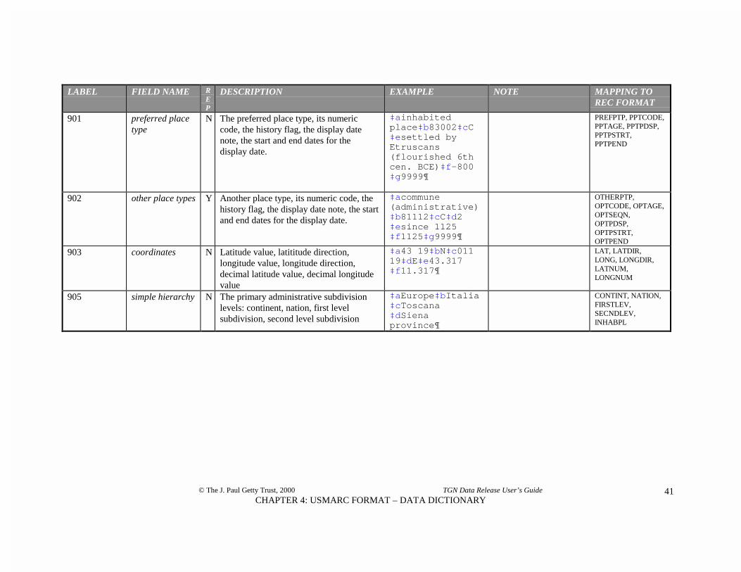
901 preferred placetype
N The preferred place type, its numericcode, the history flag, the display datenote, the start and end dates for thedisplay date.
‡ainhabitedplace‡b83002‡cC‡esettled byEtruscans(flourished 6thcen. BCE)‡f-800‡g9999¶
PREFPTP, PPTCODE,PPTAGE, PPTPDSP,PPTPSTRT,PPTPEND
902 other place types Y Another place type, its numeric code, thehistory flag, the display date note, the startand end dates for the display date.
‡acommune(administrative)‡b81112‡cC‡d2‡esince 1125‡f1125‡g9999¶
OTHERPTP,OPTCODE, OPTAGE,OPTSEQN,OPTPDSP,OPTPSTRT,OPTPEND
903 coordinates N Latitude value, latititude direction,longitude value, longitude direction,decimal latitude value, decimal longitudevalue
‡a43 19‡bN‡c01119‡dE‡e43.317‡f11.317¶
LAT, LATDIR,LONG, LONGDIR,LATNUM,LONGNUM
905 simple hierarchy N The primary administrative subdivisionlevels: continent, nation, first levelsubdivision, second level subdivision
‡aEurope‡bItalia‡cToscana‡dSienaprovince¶
CONTINT, NATION,FIRSTLEV,SECNDLEV,INHABPL

© The J. Paul Getty Trust, 2000 TGN Data Release User’s Guide
CHAPTER 4: USMARC FORMAT – DATA DICTIONARY42
Place Type List (simple file of full place type list; not USMARC format)
PTYP place type N Place type term. inhabited placePTYPCODE place type code N A numeric code that identifies each place
type.83002
Bibliography (simple file of full bibliography; not USMARC format)
BIBKEY uniqueidentification
N A numeric code that uniquely identifieseach source represented in TGN.
9000009
BIBBRIEF brief citation N Brief citation for the source; to be used indisplays.
Hook, Siena (1979)
BIBBRSRT brief citationsort string
N Normalized brief citation; all caps withpunctuation, diacritic codes, numbers, andspaces removed
HOOKSIENA
CITE full citation N Full citation for the source. Hook, Judith. Siena: ACity and Its History.London: HamishHamilton, 1979.

© The J. Paul Getty Trust, 2000 TGN Data Release User’s Guide
CHAPTER 5: CONTENTS OF TGN43
CHAPTER 5CONTENTS OF THE TGN
OVERVIEW
The Getty Thesaurus of Geographic Names (TGN) is a hierarchically arranged source of geographic data,global in scope. It is intended to be a source of geographic names for cataloging and retrieving recordsabout art and cultural heritage, but it may have broader application in other disciplines. In the world of art,architecture, and material culture, geographic names are used to record the location of the art object,building, or artifact, its place of origin, the loci of activity of the creator, and the sites of the creator’s birthand death.
The TGN provides users with vernacular and English names of places, as well as variant names in otherlanguages and historical names for some places. Other information also may be included to identify anddescribe the place. Places in the TGN are arranged in hierarchies to show broader and narrower contexts,ranging from continents to nations to states to inhabited places.
The logical focus of a record7 in the TGN is a place. Attributes of the place include hierarchical position,names, “place types,” coordinates, dates, and sources (contributors and bibliographic citations).
Logical focus of the TGN “record” is a place
bibliography
parent place,hierarchicalplacement .
© J. Paul Getty Trust
geographiccoordinates
namespreferred and variants
place typesdates
placeunique ID
notes
7 Note that for the purposes of this chapter, “record” refers to an intellectual record − not a database record.The intellectual record comprises data linked through the unique numeric ID for the place, the geog_key.

© The J. Paul Getty Trust, 2000 TGN Data Release User’s Guide
CHAPTER 5: CONTENTS OF TGN44
The record is identified uniquely in the database by a numeric key. For most records, the minimuminformation needed by a user to identify the place and intellectually distinguish it from other places includea name, place type, and position in the hierarchy. However, since there are so many homographs in theTGN, in some cases coordinates or a distinguishing note are also necessary to disambiguate places.
The TGN is a compiled resource. A TGN record may contain information from multiple contributors.Contributors include various Getty projects and qualified outside institutions who collect information aboutgeographic places. The Vocabulary Program also contributes original information to the TGN. Allinformation about a single place is merged to allow display as a single, uniform, homogenous set ofinformation. At the same time, each contributor’s individual contribution is flagged, so a display mayalternatively illustrate the diversity and conflicting nature of information about a single place.
The TGN incorporates “flexible standards” in order to allow contributions from a wide variety ofinstitutions with established, diverse practice. While critical standards for technical details, structure,content, and editorial guidelines are required of contributors, other content and editorial guidelines areconsidered non-critical and are therefore recommended, but not required. For example, it is critical that corefields are included and that they are indexed or formatted in a way that will allow retrieval. However, it isnot critical that the “preferred name” be in the vernacular language (although this is highly recommended)or that the “descriptive note” be phrased according to a uniform style (although this is recommended too).Employing flexible standards means that the TGN database as a whole is not entirely consistent or totallyuniform.
Relationships
The TGN is a thesaurus that includes equivalence, associative, and hierarchical relationships.
Equivalence Relationship. All relationships between names within the same TGN record are equivalencerelationships. In the example below, all names refer to the same city, Lisbon, Portugal.
Lisboa (preferred) Lisbon (preferred English) Lisbonne Lissabon Lisabon Olissibona Ulixbone Luzbona Lixbuna Felicitas Julia Olisipo
Among all the names that refer to the place, one is indicated as the "preferred name," comparable to the“descriptor” in the AAT. This is the "vernacular" or local-language name most often found in scholarly orauthoritative published sources (e.g., the name in bold in the example above). The English name is alsoindicated. Institutions who wish to use the TGN as an authority may use one of these two names to refer tothe place consistently.
Variant and alternate names in the record include names in other languages, names transliterated into theRoman alphabet by various methods, names in natural or inverted form (particularly for physical features,e.g., "Etna, Mount"), nicknames, official names, and historical names. Misspellings may be included if theyare found in published sources.

© The J. Paul Getty Trust, 2000 TGN Data Release User’s Guide
CHAPTER 5: CONTENTS OF TGN45
Hierarchical Relationship. The “hierarchy” in the TGN refers to the method of structuring and displayingthe places within their broader contexts. Hierarchical relationships in the TGN represent part/wholerelationships and are typically indicated with indention, as in the example below.
.....Europe........(continent) ..........Italia...........(nation) ...............Toscana.......(region) .....................Siena..... (province) .........................Abbadia San Salvatore......(inhabited place) .........................Argiano...... (inhabited place) .........................Asciano.... (inhabited place) .........................Badia a Isola.... (inhabited place) .........................Bagno Vignoni.....(inhabited place) .........................Buonconvento.... (inhabited place) .........................Campiglia dei Fosci.... (inhabited place) .........................Casciano...(inhabited place) [...] .........................Scrofiano........(inhabited place) .........................Serre di Rapolano.....(inhabited place) .........................Siena........(inhabited place) .........................Sinalunga......(inhabited place) .........................Sovicille.....(inhabited place) .........................Staggia...... (inhabited place) .........................Torrenieri.......(inhabited place)
The TGN is polyhierarchical, meaning that a place may have multiple "parents" or broader contexts. Forexample, the US state of Hawaii is administratively part of the United States in North America, but it isphysically located in Oceania.
The TGN hierarchy includes both physical features and political/administrative entities. Major subdivisionsof the hierarchy typically include the continent, nation, first level subdivision, second level subdivision,inhabited place, and possibly neighborhood. Most nations have one level of administrative subdivisionabove inhabited place, and many have two levels. Generally, the hierarchy in the TGN goes only to the levelof the inhabited place. However, the level of neighborhood has been included for some of the world'slargest cities. Releases of the TGN will generally not include levels for streets or buildings within theboundaries of inhabited places.
If users integrate the TGN’s hierarchical structure into their database of objects, they can link their objectrecord to a specific inhabited place (e.g., Campo Largo in Argentina in the example below). However, theycan still retrieve the record by searching for a broader context (e.g., Chaco province, Argentina), withouthaving had to do redundant data entry of the inhabited place and all its broader contexts in each relevantobject record. In a less sophisticated application, the TGN is still a source of the vernacular and Englishname (if applicable) of the place and its broader contexts, which users could implement in almost anyautomated or manual application.

© The J. Paul Getty Trust, 2000 TGN Data Release User’s Guide
CHAPTER 5: CONTENTS OF TGN46
Partial hierarchy showing places in Chaco province, Argentina
WorldSouth America (continent)
Argentina (nation)Chaco (province)
Barranqueras (inhabited place)Basail (inhabited place)Campo Largo (inhabited place)Charadai (inhabited place)
Associative Relationship.8 Associative relationships may exist between the records for places in the TGN.For example, if an inhabited place has been physically moved (as when the location has been deemed unsafedue to flood or earthquake), there should be an associative relationship between the original settlement andthe new settlement. For example, Ocotepeque, Honduras was originally located to the NE of the currentcity, but was moved after the Marchala river flooded in 1935; Ocotepeque and Nueva Ocotepeque could belinked by the associative relationship.
SCOPE
The TGN contains more than one million names and other information for around 900,000 places. Theplaces are arranged in hierarchies. The scope is global; all continents and all nations are represented.Physical features (including mountains and rivers) and administrative entities (including towns and nations)are included. Historical places may also be included. The target audience of the TGN is the art, architecture,and material culture communities.
The focus of the TGN record, the “place,” is represented by a name and a “place type” in the hierarchyabove. Each place record includes a name, a place type, and a position in the hierarchy. For most users, thisis the minimum information needed to identify the place and intellectually distinguish it from other places.9
The name alone does not identify it because there are many homographs among place names: For example,there are over 70 inhabited places called “Springfield” in the TGN. Many of them are located in variousstates in the USA; however, recording the state and nation alone still does not identify the place. Since onestate can have multiple Springfields, it is necessary to record the county as well. Among the outstandingissues regarding implementation of the TGN (or any geographic information) in a retrieval tool orcataloging system is how to incorporate the parents’ names (and their variant names and abbreviations) in ameaningful way.
8 In the current edition of TGN, the associative relationships are not included; they weill be included infuture relaeases.9 In an automated system, the place should be identified by the unique key (in the relational files, thegeog_key).

© The J. Paul Getty Trust, 2000 TGN Data Release User’s Guide
CHAPTER 5: CONTENTS OF TGN47
Labels containing minimum information for two places with names that are homographs
Springfield (Delaware county, Pennsylvania, United States), inhabited place
Springfield (Montgomery county, Pennsylvania, United States), inhabited place
In addition to names, place types, and hierarchical position, a TGN record may include other information,including coordinates, dates, notes, and bibliography.
Geographic places in the TGN can be either physical or political entities. They include physical featuressuch as continents, rivers, and mountains. Geographic places also include entities defined by politicalboundaries, such as empires, nations, states, districts, townships, cities, and neighborhoods. Although theVocabulary Program focused editing on political entities, physical features were included in the databasebecause they were considered useful by potential users of the TGN.
What is a geographic place?
Geographic places in the TGN include physical features such as continents, rivers, and mountains.
PARTIAL PLACE TYPE LIST FOR PHYSICAL FEATURES
ocean pond river creeklakes lake intermittent lake baystrait glacier river mouth waterfalldesert oasis wetland marshcontinent subcontinent fault volcanodunes arroyo canyon fluvial islandmountain mountain range mountain system hillhills plateau valley basinfield plain cape island groupisland peninsula reef shorecave crater depression pampaprairie savanna jungle forest
Geographic places also include entities defined by political and administrative boundaries, such as empires,nations, states, districts, townships, and cities
PARTIAL PLACE TYPE LIST FOR ADMINISTRATIVE AND POLITICAL ENTITIES
primary political unit independent sovereign nation empirefederation nation kingdomdependent state first level subdivision countrybailiwick autonomous municipality cantoncity-state special city colonycommissary commonwealth metropolitan areaindependent city county departmentdependency parish (political) province

© The J. Paul Getty Trust, 2000 TGN Data Release User’s Guide
CHAPTER 5: CONTENTS OF TGN48
region shire stateterritory external territory unincorporated territoryoverseas territory possession occupied territorysecond level subdivision diocese archdioceseparish (ecclesiastical) third level subdivision arrondissementborough precinct townshipinhabited place locale rural communityhamlet village towncity American Indian reservation Aboriginal reserve
Administrative entities include those defined by boundaries set up by standard, independent sovereignstates. In addition, administrative entities in the TGN may include those with government and boundariesdefined by other authorities, such as ecclesiastical or tribal authorities.
Administrative subdivisions and neighborhoods of the largest cities are within the scope of the TGN.Included are subdivisions such as urban districts, quarters, neighborhoods, or suburbs. Also within thescope of the TGN are large physical or man-made features within the boundaries of a city, includingstreams, hills, woods, or large parks. Smaller features typically found within the boundaries of a city areoutside the scope of the TGN. Therefore, generally excluded from the TGN are buildings, landmarks, andstreets within cities. Note that buildings are occasionally considered within the scope of the TGN; these arelimited to structures that are located in the countryside (for example, abbeys, villas, and shopping centers),where they serve as a place name in the absence of a larger populated place.
Likewise, some other large, major man-made features are within the scope of the TGN, for example theGreat Wall of China and the Via Appia.
Cultural and political groups are outside the scope of the TGN; however, the political state of a cultural orpolitical group, and the territory within its boundaries, are within the TGN’s scope. For example, theOttoman Turks are outside the scope of the TGN, though the Ottoman Empire could be included in TGN.
The scope of the TGN may include places that are no longer extant. This includes deserted settlements,such as ghost towns and archaeological sites. Lost physical feature could include features such assubmerged islands.
Within the scope of the TGN are included “general regions,” which are recognized, named areas withundefined, controversial, or ambiguous borders. Examples include the Middle East, which refers to an areain SW Asia and NE Africa, but which has no defined borders and may be variously interpreted to meandifferent sets of nations. General regions are not organized political entities, though they may have theirroots in historical entities such as kingdoms, duchies, or traditional tribal areas.
Historical entities may also be included; the number of historical entities will grow through contributions.Historical names and information regarding extant places may also be included in the TGN. For example,the record for the extant Turkish city of Pamukkale includes the historical name Hierapolis, as well as notesand dates describing the history of the city.

© The J. Paul Getty Trust, 2000 TGN Data Release User’s Guide
CHAPTER 5: CONTENTS OF TGN49
THE RECORD FOR EACH PLACE
The minimum record10 for each place represented in the TGN includes a unique numeric identifier, a namefor the place, at least one “place type,” and a hierarchical position (indicated through a link to theimmediate “parent”). Altogether, some 25 or so items of information may be associated with a place, andsome of these data (including names, place types, and parents) are repeating. Some of the data may not beappropriate to display for end-users (see Chapter 6: Recommendations for Using the TGN).
Sample TGN “Record” Display for the End-User
(7000457) � Firenze (Firenze province, Toscana Italia) (inhabited place)
Coordinates: Lat: 43 47 N Long: 011 15 E (represented in degrees minutes direction) Lat: 43.783 Long: 11.250 (represented in decimal degrees and fractions of degrees)
Note: Was Roman military center at head of navigation on Arno river & on Casian Way; escaped capture by Goths 5th cen.; was thriving center by 12th cen.; torn by medieval Guelph/Ghibelline civil strife; ruled by Medici family from 1434.
Hierarchical Position:� Europe .......................................(continent)� Italia ......................................(nation)� Toscana ............................(region)� Firenze .........................(province)� Firenze .................(inhabited place)
Names:Firenze (C,V, Pref)Florence (C,O, prefEng)Florencia (C,O)Florenz (C,O)Fiorenza (H,V).....................................medievalFlorentia (H,V).....................................name of Roman colony on N bank of Arno
Place Types:inhabited place (C) .......................................site of ancient settlement, later founded as colony by Romans
in 1st cen. BC, at foot of Etruscan hill town Fiesolecity (C)regional capital (C)provincial capital (C)commune (administrative) (C)river settlement (C) .......................................developed on both sides of the Arno river, is subject to
periodic flooding; most bridges were destroyed in WWIItourist center (C)archiepiscopal see (C) ....................................bishops were established here early; today is famed for huge
cathedral & baptistry & for numerous other churchesindustrial center (C)........................................factories located in suburbs produce precision instruments
& other itemscultural center (C) ..........................................noted as great center of art & literature since Middle Ages,
especially flourished 14th-16th cen.transportation center (C)................................. for road & river traffic since Roman times, now is also
10 For the purposes of this chapter, “record” refers to an intellectual record — not necessarily a databaserecord.
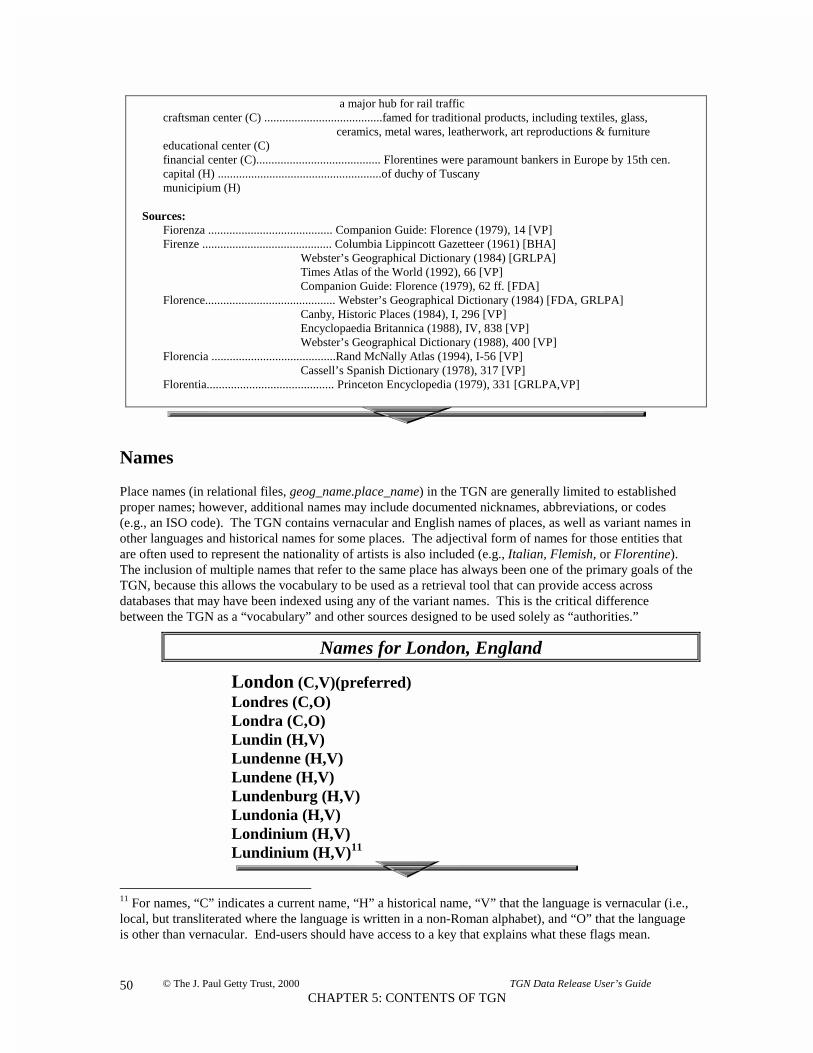
© The J. Paul Getty Trust, 2000 TGN Data Release User’s Guide
CHAPTER 5: CONTENTS OF TGN50
a major hub for rail trafficcraftsman center (C) .......................................famed for traditional products, including textiles, glass,
ceramics, metal wares, leatherwork, art reproductions & furnitureeducational center (C)financial center (C)......................................... Florentines were paramount bankers in Europe by 15th cen.capital (H) ......................................................of duchy of Tuscanymunicipium (H)
Sources:Fiorenza ......................................... Companion Guide: Florence (1979), 14 [VP]Firenze ........................................... Columbia Lippincott Gazetteer (1961) [BHA]
Webster’s Geographical Dictionary (1984) [GRLPA]Times Atlas of the World (1992), 66 [VP]Companion Guide: Florence (1979), 62 ff. [FDA]
Florence........................................... Webster’s Geographical Dictionary (1984) [FDA, GRLPA]Canby, Historic Places (1984), I, 296 [VP]Encyclopaedia Britannica (1988), IV, 838 [VP]Webster’s Geographical Dictionary (1988), 400 [VP]
Florencia .........................................Rand McNally Atlas (1994), I-56 [VP]Cassell’s Spanish Dictionary (1978), 317 [VP]
Florentia.......................................... Princeton Encyclopedia (1979), 331 [GRLPA,VP]
Names
Place names (in relational files, geog_name.place_name) in the TGN are generally limited to establishedproper names; however, additional names may include documented nicknames, abbreviations, or codes(e.g., an ISO code). The TGN contains vernacular and English names of places, as well as variant names inother languages and historical names for some places. The adjectival form of names for those entities thatare often used to represent the nationality of artists is also included (e.g., Italian, Flemish, or Florentine).The inclusion of multiple names that refer to the same place has always been one of the primary goals of theTGN, because this allows the vocabulary to be used as a retrieval tool that can provide access acrossdatabases that may have been indexed using any of the variant names. This is the critical differencebetween the TGN as a “vocabulary” and other sources designed to be used solely as “authorities.”
Names for London, England
London (C,V)(preferred) Londres (C,O) Londra (C,O) Lundin (H,V) Lundenne (H,V) Lundene (H,V) Lundenburg (H,V) Lundonia (H,V) Londinium (H,V) Lundinium (H,V)11
11 For names, “C” indicates a current name, “H” a historical name, “V” that the language is vernacular (i.e.,local, but transliterated where the language is written in a non-Roman alphabet), and “O” that the languageis other than vernacular. End-users should have access to a key that explains what these flags mean.

© The J. Paul Getty Trust, 2000 TGN Data Release User’s Guide
CHAPTER 5: CONTENTS OF TGN51
Preferred NameAlthough the TGN uses multiple names to refer to the same place, it was necessary to flag one name toidentify to a computer system which name to use in the hierarchy, in a label for the place, or in alphabeticallists. Therefore, although all variant names provide access to the place record, one name is flagged as the“preferred name,” also known as the “entry form” or “descriptor” (in relational files,geog_name.place_name where geog_name.pref_flag = P). Given that the audience for the TGN isinternational, the name flagged “preferred” is the name currently commonly used in the place (the“vernacular” or local name).12 The preferred name in the example above is “London.” Note that thevernacular name is not necessarily technically in the official language spoken in the nation; for example,Los Angeles is a Spanish phrase, but it is the vernacular name of a city in the United States where thecommon language (and the language used in official government transactions) is English.
Note that a place can have multiple vernacular names, as when multiple languages are spoken in a place(e.g., Switzerland). A place can have multiple vernacular names even when there is a single vernacularlanguage (e.g., Abydel and Abbey Dell are both vernacular names for the same town in Orange county,Indiana, where the local language is English). There can be multiple vernacular names for a place when thevernacular language is not written in the Roman alphabet and variant transliterations exist (as in Ashkhabadand Aµhabad, Turkmenistan). Where it is difficult or inappropriate to indicate a vernacular name (as withthe names of continents or oceans), the preferred name is English by default.
Because the preferred name is meant to be used in displays, length is a practical consideration. Therefore,the preferred name is not necessarily the “official name,” but rather the commonly used vernacular name(e.g., for Jordan, al-Urdunn is preferred, not the official al-Mamlakah al-Urdunn�yah al-Hashim�yah,Hashemite Kingdom of Jordan).
The Vocabulary Program has attempted to indicate the correct current vernacular name for places; however,owing to the vast number of names in the TGN database, editors could not research each name. Editorshave relied upon names published in atlases and encyclopedias whose editorial policy preferred thevernacular name; given the rapid pace of geopolitical changes and the lag-time involved in publicationslisting them, it is possible that in some instances the newest, current vernacular name may not be correctlyindicated.
The official name and other variants are included in the record for the place and can be used for access,even though they are not the “preferred” name. The place record may contain alternate names that includeall variations in spelling, names in different languages, nicknames, and historical names. If there is acommonly used English name for the place, this is flagged (in the relational files, wheregeog_name.other_flags = ENG) and can be used for displays instead of the so-called “preferred name.”See an example of an alternate English display in the section on The Hierarchy.
Variant Names
Variant (or alternate) names may include all variations in spelling (including differences in diacriticalmarks, punctuation, or capitalization),13 names in different languages, nicknames, and historical names.Certain types of names are flagged in the data, and the flags should be available to end-users. Where theflag or some other abbreviation is displayed to end-users, they should have access to a key explaining what
12 For names in languages that do not use the Roman alphabet, the names have been transliterated.
13 If a name appears in a well-known, published source, it is a valid alternate name for that place in TGN, evenif it is a misspelling.

© The J. Paul Getty Trust, 2000 TGN Data Release User’s Guide
CHAPTER 5: CONTENTS OF TGN52
the flags mean. In the examples below, current names are flagged “C” and historical names are flagged “H”(in the relational files, where geog_name.age_flag = C or H). Vernacular names are flagged “V” (inrelational files, where geog_name.lang = V).14 Names in languages other than the vernacular are flagged“O” (for “other language,” in relational files, where geog_name.lang = O).15
Names may also have other flags. The name flagged “ENG” is the commonly used English name for theplace (in relational files, where geog_name.other_flags = ENG, indicated as preferredEng for the end-userin the sample display below). “ISO” indicates the three-letter ISO code for nations (in relational files, wheregeog_name.other_flags = ISO, indicated as ISO in sample display below).16 “USP” indicates the two-letter U.S. Postal Service code for states in the USA (in relational files, where geog_name.other_flags =USP). “ADJE” is the preferred English adjectival form of the name.
Names and flags for nation of Jordan
al-Urdunn (C, V, Preferred) Al-Urdunn (C,V) Al Urdunn (C,V) Urdunn (C,V) al-Mamlakah al-Urdunn�ah al-H�shim�yah (C,V) Al Mamlakah al Urdunniya al Hashemiya (C,V) Jordan (C, O, preferred Eng) Hashemite Kingdom of Jordan (C,O) Jordanie (C,O) Royaume hachémite de Jordanie (C,O) Jordanië (C,O) Jordania (C,O) Jordânia (C,O) Giordano (C,O) JOR (C, O, ISO) Transjordan (H,O) Jordanian (C,O, English adjectival)
“DIS” indicates the display form of the name (in relational files, where geog_name.other_flags = DIS),used in strings of names when the place is presented as a broader context, but when using its preferred namewould result in ambiguity or confusion. This usually occurs when an administrative subdivision has thesame name as an inhabited place. For example, Tokushima the inhabited place and Tokushima theprefecture (in Japan) have the same preferred name. Therefore, in horizontal displays of the hierarchicalstring, the prefecture should be represented by its display name (Tokushima prefecture) in order to avoidconfusing it with the inhabited place of the same name (see example below).
14 Each place has only one name tagged as preferred (in relational files, where geog_name.pref_flag = P), and thatname generally is a vernacular name. However, each place may have more than one vernacular name, so every nameflagged as “vernacular” is not necessarily the preferred name.
15 In the future, TGN will have added structure to allow an indication of the specific language of the name.
16 International Organization for Standardization. Codes for the Representation of Names of Countries and TheirSubdivisionsGenève: International Organization for Standardization, 1999. The Vocabulary Program also used variousother ISO publications and newsletters.

© The J. Paul Getty Trust, 2000 TGN Data Release User’s Guide
CHAPTER 5: CONTENTS OF TGN53
Label with “display name” for Tokushima prefecture
Tokushima (Tokushima prefecture, Shikoku region, Nihon) (inhabited place)
Alphabet
Names and all other information in the TGN records are expressed in the Latin alphabet. The sources usedin the TGN were generally written in Western European languages; therefore, names in languages that useother alphabets were already transliterated before they were incorporated into the database. In thoserecords edited by the Vocabulary Program, variant names derived by various transliteration standards wereincluded, where possible.
Diacritics in the Relational Files and REC formats are represented by numeric codes in the TGN data; atranslation of the codes and diacritical marks is located in Appendix A of this manual. The VocabularyProgram has used these codes rather than diacritical marks because existing international standards fordiacritics pose technical obstacles for many of our contributors and users.17 The TGN USMARC formatuses ANSEL for diacritics (the standard ANSI Z39.47).
Names may be alphabetized using the normalized version of the name (in the relational files,geog_name.sort_name), which is stripped of all diacritical codes, punctuation, spaces, and translated to alluppercase letters.
Sequence of Names
In a full record for a place, names are arranged in a logical order. The sort order (in relational tables,geog_name.seqn) should allow names to be arranged with the preferred name at the top of the record, andvariant names arranged with current names before historical names. Note that historical names are arrangedin reverse chronological order, from the most recent to most ancient names. Within a set of names usedduring the same period, the vernacular names precede the names in other languages.
In some cases, the TGN describes the time frame when a given place name was used. This is described in a“display date” (in relational tables, name_detail.display_date), which is a short note describing when thename was used; other information pertinent to the name may be included. The database also includesassociated years that represent the beginning and end of the span indicated in the display date. These“start” and “end” dates (in relational tables, name_detail.start_date and name_detail.end_date) can be usedin retrieval, but should be hidden from end-users.
17 It is possible that TGN will adopt the Unicode Standard (ISO 10646) in the future.

© The J. Paul Getty Trust, 2000 TGN Data Release User’s Guide
CHAPTER 5: CONTENTS OF TGN54
Sequence, history/language flags, and dates for names,Siena, Tuscany, Italy
0 Siena (C,V) used since 13th cen. (start: 1200, end: 999918)1 Sienna (C,O)2 Senae (H,V) medieval (start: 800, end: 1500)3 Sanna (H,V)4 Saena Julia (H,V) Roman (start: -100, end: 300)5 Sena Julia (H,V)6 Sena (H,V) Etruscan (start: -800, end: 100)
Dates for place names may be known with different levels of specificity and varying shades of certainty. Inthe display date, editors express exact and imprecise dates based on what information is available. In thestart and end date, the editors can record a known or estimated time span in years, based on what is known.Since conventions used to describe approximate dates (e.g., “circa”) may vary depending upon context, thisgives editors flexibility in establishing appropriate date spans for retrieval.
Display dates for names, with associated start and end dates
(for town in New York state, USA, exact day of name change is known)Sleepy Hollow new name certified by village trustees on Dec. 11, 1996
(start: 1996, end: 9999)
(for US state, estimated searching dates for “circa”)Indiana named by land developers ca. 1765, roughly means “land
of the [American] Indian” (start: 1750, end: 9999)
(for variant name for Thebes, Egypt, estimated searching dates for “century”)Nowe used from 22nd cen. BC (start: -2100, end: -29)
(for variant for Siena, Italy, searching dates informed by life dates of Julius Caesar)Saena Julia Roman (start: -100, end: 300)
(for variant for Vienna, Austria, estimated searching dates express broad span of time)Vindobona ancient (start: -400, end: 1500)
18 TGN records an end date “9999” to indicate that the name is still used. Dates BCE (before current era)are indicated with negative numbers (i.e., using a minus sign).

© The J. Paul Getty Trust, 2000 TGN Data Release User’s Guide
CHAPTER 5: CONTENTS OF TGN55
Contributors
Contributors of names to the TGN are noted by their initials or an abbreviated form of their name (inrelational files, name_detail.contrib). End-users should have access to a key that lists the full name of theGetty project and the initials (see Appendix B for description of these contributors).
Bibliography of the History of Art BHAFoundation for Documents of Architecture FDAGetty Research Library Photo Archive GRLPAVocabulary Program VP
Note that where a contributor’s data was received in hard-copy and entered by hand by the VocabularyProgram, the contributor will be listed as “VP,” and the project or institution that supplied the data will belisted as a Source (see Bibliography below).
Bibliography
In most cases, contributors and the Vocabulary Program editors have listed the sources used for names (inrelational files, table = BIBLIO). Most names in the TGN were derived from standard general referencesources, including atlases, loose maps, gazetteers, guidebooks, geographic dictionaries, and encyclopedias.Web sites, including NIMA,19 provided many names. Many names in the USA are from USGS.20 Othersources include books on the history of art and architecture, journal articles, newspaper articles, newslettersfrom ISO and the United Nations, letters and telephone calls to embassies, inscriptions on art objects, andcatalog records of repositories of art objects.
19 United States National Imagery and Mapping Agency. GEOnet Names Server [online database]. Editedby the U.S. Board on Geographhic Names. Washington, DC: National Imagery and Mapping Agency, 2000.
20 United States Department of the Interior and U.S. Geological Survey. Geographic Names InformationSystem Digital Gazetteer. Reston, Virginia: U.S. Geological Survey, 1994.

© The J. Paul Getty Trust, 2000 TGN Data Release User’s Guide
CHAPTER 5: CONTENTS OF TGN56
Contributors and bibliographic sources for names, Beijing, China
0 BeijingBHA,21 Columbia Encyclopedia (1975) Encyclop)dia Britannica (1976)GRLPA, Webster’s Geographical Dictionary (1984) 936VP, Times Atlas of the World (1992) 24
1 PekingBHA, Webster’s Geographical Dictionary (1984) 936VP, US National Imagery and Mapping Agency, GEOnet Names Server (1996)
2 Pei-ChingVP, US National Imagery and Mapping Agency, GEOnet Names Server (1996)
3 P�kinBHAFDA, Cassell’s French Dictionary (1973) 550VP, US National Imagery and Mapping Agency, GEOnet Names Server (1996)
4 Pequ�nVP, Cassell’s Spanish Dictionary (1978) 917
5 PechinoVP, Cassell’s Italian Dictionary (1983) 365
6 Peip’ingVP, US National Imagery and Mapping Agency, GEOnet Names Server (1996)
7 Ch’iVP, Webster’s Geographical Dictionary (1984) 936
8 KhanbalikVP, Times Atlas of World History (1994) 347
9 CambalucVP, Canby, Historic Places (1984) II, 721-722
The sources for each name are generally cited for the end user by the brief citation (in relational files,biblio.bib_brief). A key listing the full citation for these brief references should be available to end-users(in relational files, biblio.bib_brief and biblio.citation for each bib_key).
21 Contributors in this example: BHA, Bibliography of the History of Art; FDA, Foundation for Documentsof Architecture; GRLPA, Getty Research Library Photo Archive; VP, Vocabulary Program. Note that userswill also need access to a key that lists the contributor initials with the corresponding full name for thecontributing project (see Appendix B).

© The J. Paul Getty Trust, 2000 TGN Data Release User’s Guide
CHAPTER 5: CONTENTS OF TGN57
Latitude and LongitudeMost of the place records in the TGN include geographic coordinates (in relational files, geog_main.lat,geog_main.lat_dir, geog_main.long, and geog_main.long_dir). Latitude is the angular distance north orsouth of the equator, measured along a meridian. Longitude is the angular distance east or west of thePrime Meridian at Greenwich, England. Latitude and longitude are expressed in degrees and minutes.22
Geographic coordinates represent a single point for each place, corresponding to a point in or near thecenter of the inhabited place, political entity, or physical feature. For linear features such as rivers, thepoint represents the source of the feature. The Vocabulary Program editors entered coordinates using avariety of sources.23
Coordinates for state of Indiana, USA
Latitude: 40° 00’ NLongitude: 086° 15’ W
The TGN also includes coordinate data expressed as decimal degrees (in relational files,geog_main.lat_num and geog_main.long_num), where the minutes of latitude and longitude are convertedto decimal fractions of degrees (e.g., 40.000 and -086.250 are the decimal degrees for the example ofIndiana above). Coordinates south of the equator and west of the Prime Meridian are expressed as negativenumbers. See Chapter 5: Recommendations for Using the TGN for further discussion of decimal degrees.
Descriptive Note
For some records, a note has been included to describe the place (in relational files, geog_main.descr.note).This descriptive note may provide additional information about the place, or expand on information in otherfields. Topics that may be covered in this note include the political history of the place, a physicaldescription, and its importance relative to other places or to the history of art and architecture.
Descriptive note for state of Indiana, USA
Originally inhabited by Mound Builders; when Europeans arrived,Algonquian-speaking Miami confederation, Potowatomi & Delaware livedhere; claimed by French in 17th cen., by British in 1763; taken by USA inRevolution; was strongly pro-Union in Civil War.
22 When the new system is implemented in 2001, TGN will be able to capture four bounding coordinates.
23 Major sources include United States Department of the Interior and U.S. Geological Survey. GeographicNames Information System Digital Gazetteer. Reston, Virginia: U.S. Geological Survey, 1994; UnitedStates National Imagery and Mapping Agency. GEOnet Names Server [online database]. Edited by the U.S.Board on Geographic Names. Washington, DC: National Imagery and Mapping Agency, 1996-2000; TimesAtlas of the World. 9th ed. New York: Times Books, 1994; Rand McNally and Company. The NewInternational Atlas. Chicago: Rand McNally, 1994; and Cambridge World Gazetteer: A GeographicalDictionary. Cambridge, England; New York: Cambridge University Press, 1990.

© The J. Paul Getty Trust, 2000 TGN Data Release User’s Guide
CHAPTER 5: CONTENTS OF TGN58
The sources for descriptive notes and all other information are linked indirectly through a name.24
Descriptive notes and display dates are written in English. However, in order to make the informationunderstood more easily by an international audience, the Vocabulary Program editors have rarely usedabbreviated words. Abbreviations occur only when the full word can be understood easily by virtue of itscontext in the note (e.g., preceding or following a date); they include the following abbreviated words:“ca.” for “circa,” “cen.” for “century,” “mill.” for “millennium,” and “&” for “and.”
Place Types
Geographic places in the TGN can be either physical or political entities. Physical features includecontinents, rivers, and mountains; political entities include empires, nations, states, districts, townships,cities, and neighborhoods. The “place type”25 in the TGN is a term that characterizes a significant aspect ofthe place, including its role, function, political anatomy, size, or physical characteristics.
Place types, history flags, and display dates for Marrakesh, Morocco
inhabited place (C, Pref) founded by Yusuf ibn-Tashfin in 1062city (C) modern European city founded 1913provincial capital (C)commercial center (C)transportation center (C)religious center (C) important medieval center of Islamroyal residence (H)capital (H) of Almoravid dynasty, until 1147; of Almohades from 1147; of
Morocco, 1550-1660
Preferred Place Type
One place type in each record is flagged “preferred” (in relational files, where geog_placetype.pref_flag =P). As with preferred names, a preferred place type is necessary because one place type must bedistinguished to appear with the preferred name in an identification of the place (as in the hierarchy or inlists).
24 In the current TGN data model, sources are linked only to the name; therefore, to deal with thislimitation, editors cited sources for other information indirectly by linking the source to a name (generallythe entry form name in the published source). In the future, sources will be linked directly to the data.
25 In relational files, geog_placetype.placetype_code links the place type to the geog_key; the code is linkedto the term by placetype_list.placetype_code and placetype_list.placetype.

© The J. Paul Getty Trust, 2000 TGN Data Release User’s Guide
CHAPTER 5: CONTENTS OF TGN59
The preferred place type for cities, towns, and villages is “inhabited place”; for places that are no longerinhabited, the preferred place type is “deserted settlement.”26 The preferred place type for sovereignnations is “nation”; it is “dependent state” for semi-autonomous states.27 The preferred place types ofsubdivisions within a nation generally are the terms used by the nation (or English translations of the terms).The preferred place types of physical features are terms that describe the individual feature.
Each record has a preferred place type, and for some records, additional place type terms have beenincluded. The Vocabulary Program editorial policy was to add place type terms that describe the mostimportant qualities and roles of the place.
Sort Order and Dates for Place Types
As is true of names, place types also are ordered logically by a sequence number (in relational files,geog_placetype.seqn). The order generally represents order of importance, with the preferred place typefirst, and others listed with current before historical, and then in order of importance.
For place types, “C” indicates a current place type, “H” a historical place type that no longer applies (inrelational files, where geog_placetype.age_flag = C or H). Occasionally, when a place type has applied fora period in history, then does not apply for a period, but again currently applies, it may be flagged “B” (for“both historical and current”).28 A key explaining these flags should be accessible to end-users.
As with names, place types may have associated display dates (in relational files,placetype_dates.display_date), which are indexed with years representing the start and end of the span (inrelational files, placetype_dates.start_date and placetype_dates.end_date). These “start” and “end” datesshould not be visible to the end-user.
26 Note that occasionally the precise location of an abandoned settlement is unknown (e.g., Gath, Israel),and is labeled by the place type “lost settlement.” Abandoned structures that were not actually inhabited(e.g., Stonehenge, England) are labeled “ruins.”
27 Excludes territories (1) to which Antarctic Treaty is applicable in whole or in part, (2) without permanentcivilian population, (3) without internationally recognized civilian government, or (4) representingunadjudicated unilateral or multilateral territorial claims. 2000 Encyclopaedia Britannica Book of the Year.Events of 1999. Chicago: Encyclopaedia Britannica Inc., 2000.
28 The date is a repeating set of fields in the TGN database, and thus a place type (or a name) may havemultiple ranges of time associated with it; therefore it may be both current and historical.

© The J. Paul Getty Trust, 2000 TGN Data Release User’s Guide
CHAPTER 5: CONTENTS OF TGN60
Place types, sort order, flags, display dates, and retrieval dates forParis, France
0 inhabited place (C, Pref) (settled as Gallic (Parisi tribe) fishing village on �sle de la Cit�) (start: -800, end: 9999)
1 city (C) 2 national capital (C) (since accession of Hugh Capet to French
throne in 987) (start: 987, end: 9999) 3 department capital (C) 4 river port (C) 5 financial center (C) 6 commercial center (C) 7 transportation center (C) 8 cultural center (C) 9 industrial center (C)10 tourist center (C)11 trade center (C)12 educational center (C)13 episcopal see (C) (since 3rd cen.) (start: 200, end: 9999)14 countship (H) (Carolingian) (start: 700, end: 1000)

© The J. Paul Getty Trust, 2000 TGN Data Release User’s Guide
CHAPTER 5: CONTENTS OF TGN61
THE HIERARCHY
The “hierarchy” in the TGN refers to the method of structuring and displaying the inhabited places withintheir broader contexts. The name of a city alone does not identify it; the city exists within the larger contextof a state, and the state in turn exists within the larger context of the nation. The name “Columbus” attachedto the location of an art work does not identify its location. Even adding the nation, “United States ofAmerica,” does not identify the location, because in the USA there are more than a dozen Columbuses.One would have to add the level of state — and even county — to make the location clear, saying, forexample, that Henry Moore’s sculpture, “Large Arch,” is located in “Columbus, Bartholomew county,Indiana, United States.”29
Hierarchical display of Columbus, Indiana
World North and Central America (continent) United States (nation) Indiana (state) Bartholomew (county) Columbus (inhabited place)
View of the Hierarchy
The 900,000 places in the TGN are arranged in hierarchies to represent the modern world. Historical placesare also included. The top of the TGN hierarchy is the World, and all continents and all nations arerepresented below.
To display hierarchies of the TGN, indentation is generally used to indicate part/whole relationships—thatis, broader and narrower contexts. For example, all inhabited places that are indented one level beneath aregion are part of that region (sometimes referred to as “children” of a “parent,” in relational files, link ofgeog_parents.geog_key to geog_parent.parent_key).
Since the TGN hierarchy has too many levels to display on a monitor simultaneously, the display shouldideally show only the first level below the target place, and as many levels above it as possible. In theexample below, an ellipsis (...) indicates that there are additional places beneath a given level in thehierarchy.
29 The preferred name of the place with its full string of parents’ names and its preferred place type usuallyuniquely identifies the place. However, this is not true in all cases, because sometimes there is more than oneinhabited place with the same preferred name in the same administrative district; such places may bedistinguished by their geographic coordinates. In an automated system, the numeric keys (in relational files,geog_key) are unique identifiers of places.

© The J. Paul Getty Trust, 2000 TGN Data Release User’s Guide
CHAPTER 5: CONTENTS OF TGN62
Levels of hierarchy in display, with “B�nin” as target
WorldAfrica (continent)
Bénin (nation)Alibori (river)Atakora (province) ...Atlantique (province) ...Borgou (province) ...Kouffo (river)Mono (province)...Ouémé (province) ...Ouémé (river)Zou (province) ...
Places are generally represented in the hierarchy by their “preferred” or entry-form name (generally thevernacular, in relational files, geog_name where geog_name.pref_flag = P) and a “preferred” place type (inrelational files, placetype_list.placetype linked to place by geog_placetype.placetype_code wheregeog_placetype.pref_flag = P). For continents and oceans, the default preferred name is English. Seesection on Preferred Names for further discussion.
Partial hierarchical display for island of Rhodes, Greece, usingpreferred names (generally vernacular)
WorldEurope (continent)
Ellás (nation)Aiyaíon (region)
Sporádhes (department)Ródos (island)
Attáviros (mountain)Kámiros (deserted settlement)Líndhos (deserted settlement)Afándou (inhabited place)Apolakkiá (inhabited place)Arkhangélos (inhabited place)Anithi (inhabited place)Asklepios (inhabited place)Kalavárdha (inhabited place)Kattaviá (inhabited place)Prasonísi, Ákra (cape)Líndhos (inhabited place)Plimiri (inhabited place)Ródhos (inhabited place)...Triánda (inhabited place)Vroulia (inhabited place)

© The J. Paul Getty Trust, 2000 TGN Data Release User’s Guide
CHAPTER 5: CONTENTS OF TGN63
English View of the Hierarchy
In addition to the so-called “preferred” name (usually in the vernacular, in relational files,geog_name.place_name where geog_name.pref_flag = P), the TGN also flags a preferred English name forthe place where appropriate (in relational files, where geog_name.other_flags = ENG). The hierarchycould be displayed using the English names instead of the “vernacular” names.
Note, however, that most places do not have a commonly used English name, and the preferred (vernacular)name must be used.30 In the example below, the nation Greece and the island Rhodes are displayed withtheir preferred English names, but many places in this section of the hierarchy must still be displayed withtheir preferred vernacular names.
Partial hierarchical display for island of Rhodes, Greece, usingpreferred English names
World Europe (continent)
Greece (nation)Aegean Islands (region)
Sporades (department)Rhodes (island)
Attáviros (mountain)Kámiros (deserted settlement)Líndhos (deserted settlement)Afándou (inhabited place)Apolakkiá (inhabited place)Arkhangélos (inhabited place)Arnithi (inhabited place)Asklepios (inhabited place)Kalavárdha (inhabited place)Kattaviá (inhabited place)Lindos (inhabited place)Prasonísi, Ákra (cape)Plimiri (inhabited place)Rhodes (inhabited place) ...Trianda (inhabited place)Vroulia (inhabited place)
30 In relational files, an algorithm would look for geog_name.place_name wheregeog_name.geog_name.other_flags = ENG, and where there is none, would default togeog_name.place_name where geog_name.pref_flag = P.

© The J. Paul Getty Trust, 2000 TGN Data Release User’s Guide
CHAPTER 5: CONTENTS OF TGN64
Islands in the Hierarchy
Inhabited places and physical features that are located on islands usually have been positioned under theisland in the TGN hierarchy. That is, if places are located on an island, the island will generally form alevel in the hierarchy. This was necessary for island nations, and the rule was extended to include allislands in the database.31
Note that, in this edition of the TGN, a similar rule was not applied to other physical features such aspeninsulas, nor to general regions that have no defined administrative boundaries.32 Therefore, although therecord for a general region, such as the Middle East, may appear in the TGN, the places that are locatedinside this area are not linked to it. For some historical entities, “children” may not be linked to the“parent.”
Physical and Political GeographyWhile we are used to seeing the physical and political world coexist on maps, some complexity is addedwhen these unlike entities are merged into a single hierarchy in the TGN. Though it is useful for retrievaland for some displays to have all entities living together in the same hierarchy, it may also be desirable to beable to display the political hierarchy without physical features.
Place types 33 help describe and index places. Place types in the TGN are derived from a controlled listbased on terms in the AAT. The TGN took advantage of the AAT’s hierarchical structure, which groupssimilar things together, and enhanced it to allow users to sort the political world separately from thephysical world. This feature could also be useful when the TGN is utilized in a retrieval tool.
Section of the TGN place type list
20000 <natural physical world>21000 <landscapes>21100 <bodies of water & components>21101 body of water21102 ocean21103 sea21104 pond21105 river21106 tributary (river)21107 stream21108 creek21109 brook21110 watercourse21111 aquifer21112 lakes21113 lake21118 intermittent lake
31 See also section on Administrative Subdivisions below.
32 This was due to constraints of time and the difficult arbitrary decisions required in defining the
boundaries of these entities.
33 Place types are linked to the place record by (in relational files) geog_placetype.placetype_code; the termassociated with the code is found in placetype_list.placetype.

© The J. Paul Getty Trust, 2000 TGN Data Release User’s Guide
CHAPTER 5: CONTENTS OF TGN65
The TGN’s list of controlled vocabulary for place types is arranged in an implied hierarchy, meaning thatrelated things are identified by having sequential numeric codes. For example, all physical features have acode within the range 20000-29999, and all flowing bodies of water have a code within the range 21105-21110. Therefore, all places with a place type code within the range 20000-29999 could be excluded froma political hierarchy (programmers would need to analyze how to construct the resulting hierarchicalrelationships, and account for holes in the hierarchy). Also, all places with a place type code within therange 21105-21110 could be included in a retrieval of rivers and other flowing bodies of water.
While this coded system of place types helps to separate the physical from the political world, additionalmethods may be employed to pull out the political hierarchy.
Administrative SubdivisionsThe main subdivisions in the political world include continents, nations, and main political subdivisionswithin nations (e.g., states, regions, provinces, etc.). Whenever possible, every nation has at least one levelof subdivision, and some nations have two (e.g., the USA has the levels of state and county). However, thelevel of these subdivisions is not consistent across the hierarchy: That is, you cannot count on finding thefirst-level internal subdivision directly under the nation because there could be intervening levelsrepresenting the physical world. Likewise, inhabited places are not necessarily directly under anadministrative subdivision and not always on the same level, even within a single nation (note the inhabitedplaces under Pate Island in the example below).
Hierarchy with physical feature as intervening level betweenadministrative levels and inhabited place, Coast province, Kenya
Africa (continent)Kenya (nation)
Coast (province)Bura (inhabited place)Galana (river)Gazi (inhabited place)Kinango (inhabited place)Lamu (inhabited place)Lugards Falls (waterfalls)Mkunumbi (inhabited place)Pate Island (island)
Pate (inhabited place)Rasini (inhabited place)
Rabai (inhabited place)Shimoni (inhabited place)Tana (river)
To further complicate the situation, the first-level subdivisions are not labeled with a consistent preferredplace type across the database, because it was inappropriate to use a consistent term. For example, the first-level administrative subdivision is called “state” in the United States, “region” in Italy, “province” inKenya, etc. In addition, the same term may have different significance in different nations. For example,

© The J. Paul Getty Trust, 2000 TGN Data Release User’s Guide
CHAPTER 5: CONTENTS OF TGN66
the “province” is the first-level subdivision in Kenya, but “province” is the second-level subdivision (below“region”) in Italy.
To clarify the levels, the TGN adds place type terms “primary political unit,” “first-level subdivision,” and“second-level subdivision” that appear as non-preferred place type terms in place records. In the aboveexample, the full record for Kenya contains a place type code “81002” for “primary political unit,” and thefull record for Coast province contains a place type code “81100” for “first-level subdivision.” This wouldallow implementors to build hierarchies of only the political entities. It also meets a critical need for userswho have simple systems that require a set number of levels, generally “primary political unit” (i.e., nationsand dependent states), “first-level subdivision,” optional “second-level subdivision,” and “inhabited place.”Note that, in order to construct such a hierarchy, analysis would have to be done to determine how to skipover unwanted hierarchical levels and how to deal with resulting holes in the TGN hierarchies. (The Gettywill not aid in this analysis.)
Generally, the hierarchy in the TGN goes only to the level of the inhabited place. However, the level ofneighborhood has been included for some of the world’s largest cities. Releases of the TGN will generallynot include records for streets or buildings within inhabited places.34
Partial hierarchy illustrating level below inhabited place, Rome, Italy
World Europe (continent) Italia (nation) Lazio (region) Roma (province) Roma (inhabited place) Borgo (neighborhood) Castel Romano (neighborhood) Trastevere (neighborhood) Acilia (rione) Borgata Borghesina (rione) Borgata Fidene (rione) Capannelle (rione) Casalotti (rione) Campo Marzio (field) Aventino (hill) Campidoglio (hill)
34 Although the data structure would allow the addition of buildings, an issue arises with this suggestion,because the attributes of buildings are different from those of places (e.g., architects, construction materials,etc. are appropriate attributes for buildings). Logically, records for architectural structures would becompiled in a separate vocabulary, albeit ideally linked to the geographic vocabulary. Currently there is anoccasional building in the release version of the TGN hierarchy, when the building is located in thecountryside outside any city and serves as a place name for the area.
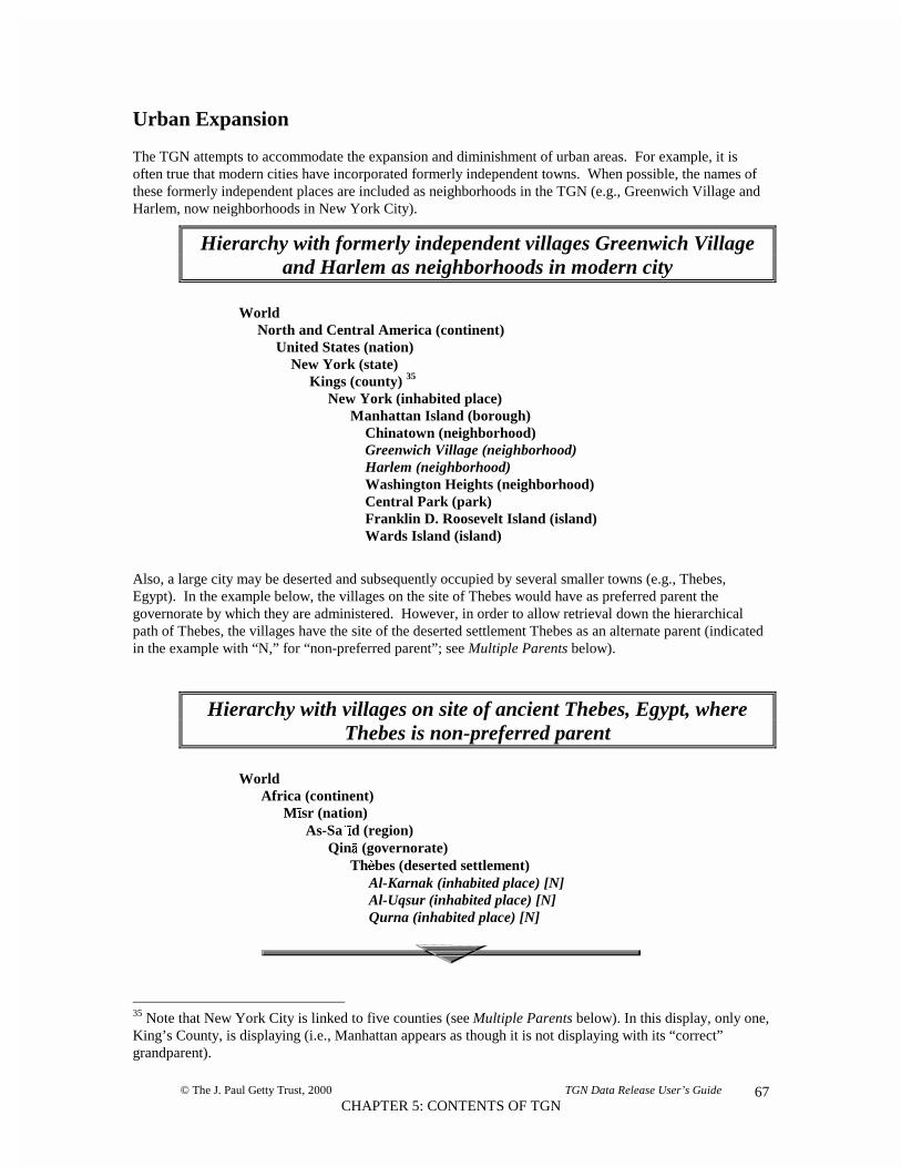
© The J. Paul Getty Trust, 2000 TGN Data Release User’s Guide
CHAPTER 5: CONTENTS OF TGN67
Urban Expansion
The TGN attempts to accommodate the expansion and diminishment of urban areas. For example, it isoften true that modern cities have incorporated formerly independent towns. When possible, the names ofthese formerly independent places are included as neighborhoods in the TGN (e.g., Greenwich Village andHarlem, now neighborhoods in New York City).
Hierarchy with formerly independent villages Greenwich Villageand Harlem as neighborhoods in modern city
World North and Central America (continent) United States (nation) New York (state) Kings (county) 35
New York (inhabited place) Manhattan Island (borough) Chinatown (neighborhood) Greenwich Village (neighborhood) Harlem (neighborhood) Washington Heights (neighborhood) Central Park (park) Franklin D. Roosevelt Island (island) Wards Island (island)
Also, a large city may be deserted and subsequently occupied by several smaller towns (e.g., Thebes,Egypt). In the example below, the villages on the site of Thebes would have as preferred parent thegovernorate by which they are administered. However, in order to allow retrieval down the hierarchicalpath of Thebes, the villages have the site of the deserted settlement Thebes as an alternate parent (indicatedin the example with “N,” for “non-preferred parent”; see Multiple Parents below).
Hierarchy with villages on site of ancient Thebes, Egypt, whereThebes is non-preferred parent
World Africa (continent) M��sr (nation) As-Sa����d (region) Qinaa (governorate) Th33bes (deserted settlement) Al-Karnak (inhabited place) [N] Al-Uqsur (inhabited place) [N] Qurna (inhabited place) [N]
35 Note that New York City is linked to five counties (see Multiple Parents below). In this display, only one,King’s County, is displaying (i.e., Manhattan appears as though it is not displaying with its “correct”grandparent).

© The J. Paul Getty Trust, 2000 TGN Data Release User’s Guide
CHAPTER 5: CONTENTS OF TGN68
Special Cases in Hierarchical Position
The TGN editorial policy is to publish places only when it is possible to determine their correct hierarchicalposition. However, in certain cases it is considered appropriate to publish the places even when this is nottrue – for example, when information about the internal subdivisions of a nation is unavailable at the time ofrelease. In such cases, the inhabited places for that nation appear under a place-saver level (marked “lost &found/...”) under the nation.36
Partial hierarchy with inhabited places under levelmarked “lost & found”
World Asia (continent) Al-Yaman (nation) North Yemen (region) Al-Bayda’ (governorate) ... Al-Hudayadah (governorate) ... lost & found/North Yemen Al-Fazah (inhabited place) Al-Luhayyah (inhabited place) Al-Mukha (inhabited place)
In the TGN, if a physical feature crosses a boundary, it is placed under the next highest level in thehierarchy. In other words, the river or mountain range is placed under the level of the hierarchy that entirelycontains it. For example, the Amazon river crosses national boundaries, so it is placed under the nexthighest level, the continent of South America.
Physical feature crosses national borders, Amazon river
World South America (continent) Acre (river) Altiplano (upland) Amazonas (river) Argentina (nation) ...
36 In this example, though the capital of each governorate was known and placed in its correct hierarchicalposition, a map of Yemen was not available detailing to which governorate the other inhabited placesbelonged. Therefore, they are placed under “lost & found/North Yemen” and “lost & found/South Yemen”in this release of TGN.

© The J. Paul Getty Trust, 2000 TGN Data Release User’s Guide
CHAPTER 5: CONTENTS OF TGN69
Multiple Parents
The TGN does not resolve the issue of spanning borders in the same way for inhabited places as forphysical features, because recording the hierarchical position of inhabited places is a higher priority;unusual or complicated relationships of inhabited places to their “parents” are accommodated by thepolyhierarchy. If the area of an inhabited place crosses administrative boundaries (as may happen in theUSA with a city belonging to two counties), the inhabited place appears under both administrativesubdivisions. Likewise, if jurisdiction over an area is disputed between two nations, that area may appear aspart of both nations — it may have “multiple parents.”
Places in the TGN may be linked to multiple places as broader contexts. In many thesauri, each item mayhave only a single parent. However, with geographic places, it is necessary for some places to have multipleparents. For example, a dependent state such as Bermuda may be physically located in North and CentralAmerica; however, it is politically associated with the United Kingdom. To allow access to Bermuda viaeither hierarchical path, it must have two parents. To allow the system to have a default hierarchical viewfor lists and other displays and reports, one parent is indicated as “preferred.”37 In the TGN, Bermuda’spreferred position in the hierarchy represents its physical location. In Bermuda’s alternate hierarchical viewit displays under the United Kingdom. This alternate view is indicated with an uppercase “N” (indicating“non-preferred”) in the hierarchy display below.38
Dependent state has multiple parents, Bermuda
WorldNorth and Central America (continent)
Anguilla (dependent state) ...Bahamas (nation) ...Belize (nation) ...Bermuda (dependent state) ...
WorldEurope (continent)
United Kingdom (nation)Anguilla (dependent state)[N] ...Bermuda (dependent state)[N] ...England (country) ...
37 The main (so-called “preferred”) position of dependent states in the hierarchy is with their physicallocation (generally a continent). The main position of colonies, provinces, and other such entities that haveless autonomy is with their political “parent.” When jurisdiction over an area is disputed between twonations, the preferred parent is the nation generally accepted by the international community, as reflected inmajor published atlases and encyclopedias. However, these places should be retrieved equally wellregardless of whether the preferred or non-preferred “parent” is used in a search. See also the displayproblem noted in the foonote for the “New York” example under Urban Expansion above.
38 That is, in relational files, for each geog_key, there is only one geog_parents.parent_key where pref_flag= P, but in addition there may be one or more geog_parents.parent_key where pref_flag = N.

© The J. Paul Getty Trust, 2000 TGN Data Release User’s Guide
CHAPTER 5: CONTENTS OF TGN70
Another way of displaying the multiple parents of Bermuda
Inhabited places on islands also occasionally required the assignment of multiple parents. This happenedwhen the island does not correspond to (or was not contained within) borders of the administrative region,for example when the island is divided between two administrative regions that extend onto the mainland.
Bermuda
United KingdomNorth and CentralAmerica

© The J. Paul Getty Trust, 2000 TGN Data Release User’s Guide
CHAPTER 6: RECOMMENDATIONS FOR USING TGN71
CHAPTER 6RECOMMENDATIONS FOR USING THE TGN
OVERVIEW
The Getty Vocabulary Program application of the TGN may be viewed as a “browser” athttp://www.getty.edu/research/tools/vocabulary/. Views of the hierarchy and of the full records will beparticularly useful as examples to implementors.
The TGN may be used as a source of vocabulary at the point of data entry and as an aid to retrieval. Whenused to inform the use of terminology for data entry, the TGN may be used as an authority if the catalogeror indexer consistently uses the same form of the TGN term to refer to a given place; the vernacular nameand the English name are flagged and could be used to control terminology. That is, the TGN may be usedas an authority by 1) always choosing the name flagged “preferred”, which is generally a vernacular name,or 2) choosing the “preferred English” name (in relational files, geog_name.place_name where other_flags= ENG) where there is one and, where there is no “preferred English” name (which is true of the majorityof the places in the world), default to the “preferred” name. The preferred name may also be used forimplementors who need to always have one name to represent the place in hierarchies and other displays.However, even though one name is flagged “preferred” (in relational files, geog_name.place_name wherepref_flag = P) for technical reasons, it is not expected that all users will want to use that name for theirlocal purposes.
One of the most valuable uses of the TGN can be as a filter or search assistant for querying large, disparatedata sets. The hierarchical structure and variant names can provide enhanced access to disparate databaseswhere various names may have been used to represent the same place. Use of the TGN in such anapplication requires a license; see http://www.getty.edu/research/tools/vocabulary/, and follow the links for“Licenses and Sample Data.”
The logical focus of the TGN is a place (not a “name”). Places have attributes, including names.Information about a place is linked across various tables by the unique numeric identifier for the place, inrelational files, the geog_key. The data associated with the geog_key makes up the intellectual “record” fora place.
PROVIDING ACCESS TO THE DATA
It is advised that the TGN place records be accessible through any of the names associated with the place,preferred or variant. Furthermore, note that any name may be accessible in three forms, as illustrated in theexample below: The exact name string (in relational files, geog_name.place_name), the normalized “sortname” (with case differentiation, spaces, diacritics, and punctuation removed, in relational files,geog_name.sort_name), and through a keyword table (where individual words of names have been parsedand normalized, in relational files, name_keywords.keyword). These various forms of the name are linkedby the placename_id (in relational files) for that name, and to the place record by the geog_key Generally,the normalized name and normalized keywords are hidden from the end-user.

© The J. Paul Getty Trust, 2000 TGN Data Release User’s Guide
CHAPTER 6: RECOMMENDATIONS FOR USING TGN72
EXAMPLE:exact name string: Rancho San Diego
sort name: RANCHOSANDIEGO
keywords: RANCHOSANDIEGO
Where commas appear in TGN names (i.e., with inverted names), it is useful to use the comma as a pivot tocreate additional access points. For example, if a TGN name is “Etna, Mount”, a useful access point will be“Mount Etna” (normalized “MOUNTETNA,” and created by using the comma as a cue to recombine wordsin natural order). Creating such strings should be done in addition to allowing Boolean operators on keywords, as described below.
Querying
The TGN data should be accessible by both simple and advanced searches. For more advanced users,querying by name will be enhanced if users may utilize right-hand truncation, when searching for both thefull name string or for keywords. For example, querying for “BODA*” (where the asterisk is a wildcard)would bring back dozens of place records in the TGN, including the following:
Boda... (Africa, République centrafri, Lobaye) (inhabited place)Boda... (Europe, Sverige, Dalarna)[..(inhabited place)Böda.. (Europe, Sverige, Kalmar, Öland)..(inhabited place)Bodafors... (Europe, Sverige, Jönköping). (inhabited place)Boda Glasbruk.. (Europe, Sverige, Kalmar)...(inhabited place)Bodai... (Asia, Bharat, West Bengal)..(inhabited place)Bodalangi... (Africa, Congo, Équateur).(inhabited place)Bodalla... (Oceania, Australia, New South Wales)..(inhabited place)Bodallin.. (Oceania, Australia, Western Australia..(inhabited place)Bodan Creek.... (N & C Am., USA, Texas, Angelina)...(creek)Bodan Draw.. (N & C Am., USA, Wyoming, Johnson)...(valley)Bodane Ridge... (N & C Am., USA, Tennessee, Johnson)...(ridge)
Searching with Boolean operators on keywords can be very valuable, particularly when the user cannotanticipate whether a multiple-word name is listed in reverse or natural order, when names are composed ofmore than two or three words, or are in languages with which the user is not familiar. For example,searching for “HAWWARAT AND MAQTA” will retrieve the records with the names “Hawwarat al-Maqta'” and “Maqta, Hawwarat al-” and “Al-Maqta, Hawwarat”.
In addition to names, other useful qualifiers for retrieval are broader contexts, place type, and coordinates.For broader contexts, it is useful 1) to allow retrieval on parents, grandparents, and all other ancestors (inrelational files, linked to a given geog_key up the tree through geog_parents.parent_key), or 2) byprocessing the data, to allow retrieval of places under nations and continents.39 For place types (in
39 This would require finding nations and continents through their place type, and noting all children linkedto these nations and continents. See Chapter 5: Contents of TGN: The Hierarchy: AdministrativeSubdivisions.

© The J. Paul Getty Trust, 2000 TGN Data Release User’s Guide
CHAPTER 6: RECOMMENDATIONS FOR USING TGN73
relational files, geog_placetype.placetype_code, which is linked to the term in placetype_list.placetype), itis useful to allow retrieval on multiple place types, perhaps employing the place type codes to allow users toretrieve similar things. For coordinates (in relational files, geog_main.lat, geog_main.lat_dir,geog_main.long, geog_main.long_dir, or geog_main.lat_num and geog_main.long_num), note that around10 percent of the places in the TGN do not have coordinates in this release, so searching on coordinates willnot always retrieve a full set of relevant records.
Results List
The results list should contain enough information to disambiguate places with the same name. Generallythe preferred name, preferred place type, and hierarchical position are enough to distinguish places in thelist. Geographic coordinates can also be useful in a results list display. Since the result may have beenretrieved based on querying a name other than the preferred name, it is also useful to display the name thatmet the criterion.
Results lists should be sorted in a way to make it easy for end-users to find the place they are seeking. Inthe example below, the results are sorted first by name, then by the parent string. In this example, theparent string is listed in descending order so that continents, nations, and subdivisions (e.g., counties) willsort together.
EXAMPLE:
Partial results list for query on exact string “Saint Louis”:
Galveston..................... Saint Louis
inhabited place........ N & C Am., USA, Texas, Galveston county
Louisburg.................... Saint Louis
inhabited place........ N & C Am., USA, Kansas, Miami county
Old Saint Louis........... Saint Louis
inhabited place........ N & C Am., USA, Indiana, Bartholomew county
Saint Louis................... inhabited place........ Africa, Réunion, Réunion islandSaint Louis................... region...................... Africa, SénégalSaint Louis................... inhabited place........ Africa, Sénégal, Saint-Louis regionSaint Louis................... inhabited place........ Europe, France, Alsace, Haut-RhinSaint-Louis.................. river......................... N & C Am., Canada, QuébecSaint-Louis.................. inhabited place........ N & C Am., Canada, SaskatchewanSaint-Louis.................. inhabited place........ N & C Am., Guadeloupe, Pointe-à-Pitre, Marie ...Saint-Louis.................. inhabited place........ N & C Am., USA, California, Sierra countySaint-Louis.................. inhabited place........ N & C Am., USA, Georgia, Macon countySaint-Louis.................. inhabited place........ N & C Am., USA, Louisiana, Iberville countySaint-Louis.................. inhabited place........ N & C Am., USA, Louisiana, Saint Landry countySaint-Louis.................. inhabited place........ N & C Am., USA, Michigan, Gratiot countySaint-Louis.................. county...................... N & C Am., USA, MinnesotaSaint-Louis.................. county...................... N & C Am., USA, Missouri,Saint-Louis.................. inhabited place........ N & C Am., USA, Missouri, Saint Louis CitySaint-Louis.................. deserted settlement.. N & C Am., USA, Ohio, Putnam countySaint-Louis.................. inhabited place........ N & C Am., USA, Oklahoma, Pottawatomie countySaint Louis River........ Saint Louis
river......................... N & C Am., USA

© The J. Paul Getty Trust, 2000 TGN Data Release User’s Guide
CHAPTER 6: RECOMMENDATIONS FOR USING TGN74
DIACRITICS
Diacritics in the TGN Relational Files and REC format are represented by a code preceding the letter overwhich the diacritical mark appears.40 The code should be translated into the correct diacritical mark fordisplay, if possible. For example, the code “$04” is an umlaut. The name represented as “M$04unchen” inthe TGN data should be translated to “München” for display to the end-user. Diacritics may appear invarious fields, including names, display dates descriptive note, and citations (in relational files,geog_name.place_name, name_detail.display_date, placetype_dates.display_date, geog_main.descr_note,biblio.bib_brief, biblio.citation). See Appendix A, Codes for Diacritics used in the TGN.
EXAMPLES:$00Aqua = Áqua Radam$02a = Radamà$04Orebro = Örebro T$01ky$01o = T�ky�
If your system cannot display diacritics outside the Latin 1 set (e.g., “©“), depending upon the needs of yourend-user, you may consider suppressing the diacritic for the end-user rather than displaying the TGN codes(e.g., displaying “o” instead of “$01o” or “©”).
DISPLAYING A FULL RECORD41
Places in the TGN generally should be available in results displays, and in two other displays for the end-user: The full record view and the hierarchical view. The former is a grouping of the data that makes up theintellectual “record” for the place, linked across tables, by the geog_key (in relational files).
Record Key
It may be useful to display the record key (in relational files, geog_key) to the end-user. Since there are somany homographs in the TGN, this unique identifier for a place is helpful when users wish to refer to aspecific record. The unique identifier is requested by the Vocabulary Program when users correspond aboutupdates to records.
EXAMPLE:
PLACE KEY: 7014444
Label
It may be useful to construct a label to refer to the place, for example at the top of a full record or in lists.The minimum information an end-user generally requires to identify a place is the name, parent string, andplace type.
40 In the future, TGN may employ Unicode. The TGN USMARC format uses ANSEL (see standard ANSIZ39.47).
41 For the purpose of this section, “record” refers to an intellectual record — not a database record.

© The J. Paul Getty Trust, 2000 TGN Data Release User’s Guide
CHAPTER 6: RECOMMENDATIONS FOR USING TGN75
Note that the TGN has flagged a special Display Name (in relational files, where geog_name.other_flags =DIS) to be used in strings of names when the place is presented as a broader context, but when using itspreferred name would result in ambiguity or confusion.42 This usually occurs when an administrativesubdivision has the same name as an inhabited place. For example, Siena the inhabited place and Siena theprovince have the same preferred name, “Siena.” Therefore, in horizontal displays of the hierarchicalstring, the province should be represented by its display name, “Siena province,” in order to avoidconfusing it with the inhabited place of the same name (e.g., Siena (Siena province, Toscana, Italia).
In the example below, the parent string is sorted in ascending order, because this is “natural” order andprobably easier for end-users to read (see example in Results List section above for parent string indescending order). The name and parent string are combined with preferred place type to identify the place.
EXAMPLE:
Saint Louis (Saint Louis City, Missouri, United States), inhabited place
Displaying Names
It is recommended to display the names together with the flags indicating whether the name isVernacular/Other language (in relational files, where geog_name.lang = V or O), and Current/Historical(where geog_name.age_flag = C or H). Users may also be interested in other flags as well. Many userswish to know if the name is the “preferred” (where geog_name.pref_flag = P) or the “preferred English”name (in relational files, where geog_name.other_flags = ENG). It may be useful to translate some or allof the flags into forms more easily understood by the end-user (in the example below, P is translated to“Pref,” ENG to “prefEng,”). A key for the flags should be available to the end-user.
EXAMPLE:
C = Current Pref = Preferred nameH = Historical prefEng = preferred English nameV = Vernacular ISO = 3-letter ISO codeO = Other language USPS = US Postal Service abbreviation
Dis = Display Name
The names should also display with their appropriate “display date” (in relational files,name_detail.display_date) describing when the name was used. The start and end dates (in relational files,name_detail.start_date and name_detail.end_date) that index this display date should not be displayed tothe end-user.43
EXAMPLE:
Saint Louis (C,V,Pref) named for Louis IX of France in 1764
42 Note: Always use the preferred name (or the preferred English name) for the place that is the focus of thelabel, but use the display name for the parents in the string (when parents have a display name, otherwisedefault the parents’ preferred name).43 The start and end dates may be used in retrieval; however, as yet, most names do not have these data. Thestructure is included to allow for the possibility that TGN could in the future be employed to displayhistorical views based on dates on names, place types, and parent links.

© The J. Paul Getty Trust, 2000 TGN Data Release User’s Guide
CHAPTER 6: RECOMMENDATIONS FOR USING TGN76
Sorting Names
Names should be arranged in logical order by sorting them according to sequence numbers (in relationalfiles, geog_name.seqn). It is not necessary that the end-user actually see the sequence numbers.
EXAMPLE:
0 Saint Louis (C,V,Pref) named for Louis IX of France in 17641 St. Louis (C,V)2 Mound City (C,V) nickname used by boatmen, referring to Native
American mounds on the site3 Pain Court (H,V)4 Pancore (H,V)
Sources and Contributors
Sources and Contributors should be displayed to end-users; the data includes contributors (in relationalfiles, name_detail.contrib), brief citations (in relational files, biblio.bib_brief, linked to name byname_detail.bib_key), and page numbers (in relational files, name_detail.bib_page) associated with thenames (in relational files, linked by placename_id).
EXAMPLE:
Saint Louis: Encyclopaedia Britannica (1988) X, 327 / [VP] Getty Research Library Photo Archive, Authority file / [GRLPA] Times Atlas of the World (1992) 17 / [VP] USGS, GNIS Digital Gazetteer (1994) / [VP] Webster’s Geographical Dictionary (1984) / [BHA, FDA]
Users should have access to a key explaining the abbreviations of the contributors. See Appendix B,Contributor Initials List for the TGN. Future development of the TGN will involve additional contributors;therefore this list will be updated with future releases.
EXAMPLE:
BHA Bibliography of the History of ArtFDA Foundation for Documents of ArchitectureGRLPA Getty Research Library Photo ArchiveVP Vocabulary Program
It is intended that the citation displayed with name will be the “brief citation” (in relational files,biblio.bib_brief). The full citation (in relational files, biblio.citation) is quite long and generallyinconvenient for such displays. However, users should have access to a key citing the brief citation and thecorresponding full citation.

© The J. Paul Getty Trust, 2000 TGN Data Release User’s Guide
CHAPTER 6: RECOMMENDATIONS FOR USING TGN77
EXAMPLE:
USGS, GNIS Digital Gazetteer (1994)United States Department of the Interior and U.S. Geological Survey. GeographicNames Information System Digital Gazetteer. Reston, Virginia: U.S. GeologicalSurvey, 1994.
Displaying Place Types
Place types should be displayed with the appropriate flags and display dates (in relational files, place typesare placetype_list.placetype linked to place record by geog_placetype.placetype_code; flags aregeog_placetype.age_flag and where geog_placetype.pref_flag = P; display datres areplacetype_dates.display_date). As was true for names, the start and end dates that index the display dateshould not be visible to the end-user (in relational files, placetype_dates.start_date,plactype_dates.end_date).
EXAMPLE:
inhabited place (C, Pref) Native American ceremonial site; founded in 1764 as furstation by French pioneer Pierre Lacléde Liguest
Also, end-users should have access to a key explaining the meaning of the flags.
EXAMPLE:
C = Current Pref = Preferred place typeH = Historical
Sorting Place Types
Place types should be arranged in logical order by sorting them according to the sequence numbers (inrelational files, geog_placetype.seqn). As with the sort order for names, it is not necessary that the end-users actually see the sequence numbers.
EXAMPLE:
0 inhabited place (C, Pref) Native American ceremonial site; founded in 1764 as fur station by French pioneer Pierre Lacléde Liguest
1 city (C) since 18222 river port (C)3 industrial center (C) for aircraft, iron, steel & automobiles4 agricultural center (C)

© The J. Paul Getty Trust, 2000 TGN Data Release User’s Guide
CHAPTER 6: RECOMMENDATIONS FOR USING TGN78
Coordinates
Latitude and longitude (in relational files, geog_main.lat, geog_main.lat_dir, geog_main.long,geog_main.long_dir) in the TGN are expressed in degrees and minutes. It is recommended to clearlyseparate degrees and minutes in displays, as in any of the examples below (with space, degree symbol, orhyphen). Note that if a period is used to separate degrees and minutes (as is the format in some majoratlases), the user may mistakenly assume that the format represents decimal degrees rather than degrees andminutes.44
EXAMPLES:
38 37 N, 090 11 W 38° 37’ N, 090° 11’ W 38-37 N, 090-11 W
Latitude and longitude expressed in degrees and minutes will probably be most familiar to most end-users.However, the TGN also includes coordinate data expressed as decimal degrees (in relational files,geog_main.lat_num and geog_main.long_num), which are numbers that can hold decimal points and can beused for calculations and for retrieval (and could be comprehensible to some end-users). For decimaldegrees, the minutes of latitude and longitude are converted to decimal fractions of degrees (e.g., 38.616and -090.183 are the decimal degrees for the example above). Whole degrees of latitude are represented bya two-digit decimal number ranging from 0 through 90, with any decimal fraction of a degree separated by adecimal point; latitudes south of the equator are expressed as negative numbers (designated by a minussign). Whole degrees of longitude are represented by a three-digit decimal number ranging from 0 through180, with any decimal fraction of a degree separated by a decimal point; longitudes west of the PrimeMeridian are expressed as negative numbers (designated by a minus sign).
Descriptive Note
It is recommended to display the descriptive note (in relational files, geog_main.descr_note) to the end-user.
EXAMPLE:
Located on Mississippi river in E Missouri, adjacent to, but independent of, St. Louiscounty; largest city in state; given to Spain in 1770, went to France in 1800; after Louisianapurchase, became part of USA; center of Unionist support in Missouri during Civil War.
44 The expression of coordinates will be updated in future releases of TGN and will include structure forrecording seconds and for bounding coordinates.

© The J. Paul Getty Trust, 2000 TGN Data Release User’s Guide
CHAPTER 6: RECOMMENDATIONS FOR USING TGN79
Other Information
It is also useful to display the hierarchical position of the place in the full record (in addition to allowingnavigation of the hierarchy in a hierarchy display). See also section below, Hierarchy: Non-PreferredParents.
Certain data are not appropriate to display to the end-user. This includes the start and end dates intended toindex display dates (in relational files, in name_detail and placetype_dates), normalized sort names (inrelational files, geog_name.sort_name), and keywords (in relational files, in name_keywords).
Depending upon the end-users, they may or may not find the unique keys helpful; the most important keysto end-users are likely to be the key that identifies the “record” (in relational files, geog_key) or keys for theindividual names (in relational files, placename_id). In the example below, keys of the record and ofindividual names are displayed. Users may also find it useful to see the place type codes (in relational files,placetype_code) with the place type term. See Chapter 4, Contents of the TGN for another sample record,where only the “record” key is displayed.

© The J. Paul Getty Trust, 2000 TGN Data Release User’s Guide
CHAPTER 6: RECOMMENDATIONS FOR USING TGN80
SAMPLE RECORD DISPLAY:
PLACE KEY: 7014444 LABEL: St. Louis (Saint Louis City, Missouri, United States), inhabited place
NAMES:Saint Louis (C,V,Pref) named for Louis IX of France in 1764
name key: 9867St. Louis (C,V)
name key: 87326Mound City (C.V) nickname used by boatmen, referring to Native American mounds on the site
name key: 81124Pain Court (H,V)
name key: 1254Pancore (H,V)
name key: 176
COORDINATES: 38° 37’ N, 090° 11’ W
DESCRIPTIVE NOTE:Located on Mississippi river in E Missouri, adjacent to but independent of St. Louis county;largest city in state; given to Spain in 1770, went to France in 1800; after Louisianapurchase, became part of USA; center of Unionist support in Missouri during Civil War.
PLACE TYPES:inhabited place (C, Pref) Native American ceremonial site; founded in 1764 as fur station by French pioneer Pierre Lacléde Liguestcity (C) since 1822river port (C)industrial center (C) for aircraft, iron, steel & automobilesagricultural center (C)
HIERARCHY:• North and Central America (continent)• United States (nation)• Missouri (state)• Saint Louis City (independent city)• Saint Louis (inhabited place)
CITATION/CONTRIBUTOR :Saint Louis: Encyclopaedia Britannica (1988) X, 327 / [VP]
Getty Research Library Photo Archive, Authority file / [GRLPA] Times Atlas of the World (1992) 17 / [VP] USGS, GNIS Digital Gazetteer (1994) / [VP] Webster’s Geographical Dictionary (1984) / [BHA, FDA]
St. Louis: Webster’s Geographical Dictionary (1984) / [GRLPA]Mound City: Faherty, St. Louis History (1989) / [VP]Pain Court: USGS, GNIS Digital Gazetteer (1994) / [VP]Pancore: USGS, GNIS Digital Gazetteer (1994) / [VP]

© The J. Paul Getty Trust, 2000 TGN Data Release User’s Guide
CHAPTER 6: RECOMMENDATIONS FOR USING TGN81
DISPLAYING THE HIERARCHY
The hierarchy is constructed by following links up the tree through geog_parents.parent_key (in relationalfiles). It is recommended that places in the hierarchy be represented by 1) either their “preferred” name (inrelational files, where geog_name.pref_flag = P) or the “preferred English” name (in relational files, wheregeog_name.other_flags = ENG), and 2) the preferred place type (in parentheses in the example below, inrelational files, placetype_list.placetype, linked to geog_key by geog_placetype.placetype_code).
It is recommended that the hierarchy generally be displayed with indentation indicating part/wholerelationships. As the user maneuvers through the hierarchical displays, it is typically necessary to displayall levels above the target and one level beneath. Aisén (region) is the target in the example below.
EXAMPLE:
World South America (continent) Chile (nation) Aisén (region) Anna Pink, Bahía (bay) Baker (river) Baker, Canal (channel) Balmaceda (inhabited place) Campana, Isla (island) Chile Chico (inhabited place)

© The J. Paul Getty Trust, 2000 TGN Data Release User’s Guide
CHAPTER 6: RECOMMENDATIONS FOR USING TGN82
Indicating Levels
When users navigate through levels of the hierarchy, it is generally recommended to show only one levelbeneath the target. Since the hierarchy is so long at any one level, showing the full depth and breadthbeneath the target could be confusing.
EXAMPLE:
WorldAfrica (continent)
Kenya (nation)Central (province) ...Choichuff, Laga (river)Coast (province) ...
However, some method should be employed to indicate that further levels are present. An ellipsis (...) isused in the example above, though a hierarchy symbol, plus/minus icon, or other icon would also work (asillustrated in example below).
EXAMPLE:
WorldAfrica (continent)
Kenya (nation)Central (province)Choichuff, Laga (river)Coast (province)
Accommodating Siblings
There can be thousands of siblings at any level of the TGN hierarchy. This poses challenges in creating acoherent hierarchical display. One solution is to simply allow users to scroll through all places at any level;however, this may mean they must scroll through dozens of pages. If this method is employed, it will aidthe user if nations and major political subdivisions are highlighted.
EXAMPLE:
WorldEurope (continent)
Achen Pass (pass)Adriatic Sea (sea)Agepsta, gora (mountain)Águeda (river)Ajdar (river)Andorra (nation)+

© The J. Paul Getty Trust, 2000 TGN Data Release User’s Guide
CHAPTER 6: RECOMMENDATIONS FOR USING TGN83
Another strategy for organizing a long list of siblings is to separate the physical world from the politicalworld, using place types and other features explained in Chapter 4, Contents of the TGN: Physical andPolitical Geography, and Administrative Subdivisions. The user could alternate between a view of thephysical features and one of the political world, as illustrated in the example below. Note, however, that thecomplexities of the relationships between the physical and political world must be considered. This isparticularly important where a physical feature forms an intervening level between levels of the politicalworld, and where a physical feature, such as an island, can be both a physical and political place.
EXAMPLE:
WorldEurope (continent)[View PHYSICAL FEATURES]
Andorra (nation)Bâlgaria (nation)Belarus (nation)België (nation)
Yet another method to accommodate large numbers of siblings is illustrated in the example below. Whenthere are more than 200 places at a given level of the hierarchy, these places could be indexedalphabetically.
EXAMPLE:
World
Europe (continent)<A> count = 78...<B> count = 86 ...<C> count = 109...<D> count = 67...
Non-Preferred Parents
Places in the TGN may have multiple parents. However, one parent is flagged as preferred. That is, inrelational files, for each geog_key, there is only one geog_parents.parent_key where pref_flag = P, but inaddition there may be one or more geog_parents.parent_key where pref_flag = N.
+
+
+
+
+

© The J. Paul Getty Trust, 2000 TGN Data Release User’s Guide
CHAPTER 6: RECOMMENDATIONS FOR USING TGN84
The place should display under both its parents. The example immediately below illustrates the state ofHawaii displaying under its political parent (its preferred parent).
EXAMPLE:
WorldNorth and Central America (continent)
United States (nation)Alabama (state)Alaska (state)American Samoa [N] (dependent state)Arizona (state)Arkansas (state)California (state)Colorado (state)Connecticut (state)Delaware (state)District of Columbia (state)Florida (state)Georgia (state)Hawaii (state)Idaho (state)
It is useful to alert the end-user when multiple parents exist. One way to do this is to mark the non-preferred link. In the example below, the state of Hawaii is displayed in an alternate hierarchical view withthe island group of which it is a part, and the non-preferred relationship is indicated with an “N.”
EXAMPLE:
WorldOceania (continent)
Hawaiian Islands (island group)Hawaii [N] (state)Midway Islands [N] (possession)
Other graphics may be used to illustrate the relationship of a place to multiple parents, as in the examplebelow.
EXAMPLE:
Hawaii
++++++++++++++
Hawaiian Islands
+
+
United States

© The J. Paul Getty Trust, 2000 TGN Data Release User’s Guide
CHAPTER 6: RECOMMENDATIONS FOR USING TGN85
Multiple parents should also be represented in the full record display for the place.
EXAMPLE:
PLACE KEY:7007249 LABEL: Hawaii (United States, North and Central America), state
NAMES:Hawaii (C,V,Pref) name is probably derived from a native word meaning “homeland”HI (C,V, USPS)
LAT: 20° 00’ N, LONG: 157° 50 W
DESCRIPTIVE NOTE:One of 2 non-contiguous states; comprises most of the Hawaiian Islands; probably firstinhabited by Polynesians who immigrated from Marquesas Islands ca. AD 400; immigrantsfrom Tahiti arrived in 9th cen.; Europeans & Americans arrived in 18th cen.
HIERARCHICAL POSITION:• North and Central America (continent)• United States (nation)• Hawaii (state)
ADDITIONAL PARENTS:• Oceania (continent)• Hawaiian Islands (island group)• Hawaii (state)
PLACE TYPES:state (C) since August 21, 1959first level subdivision (C)
CITATION/CONTRIBUTOR : HI Webster's Geographical Dictionary (1988), [VP] Hawaii National Zip Code Directory (1985) [BHA] Columbia Lippincott Gazetteer (1961) [BHA] Random House English Dictionary (1987) [BHA] LC Subject Headings, 11th edition (1988) [BHA] Webster's Geographical Dictionary (1984) [BHA, FDA] Canby, Historic Places (1984), I, 380-381 [VP] Times Atlas of the World (1994), Plate 114 [VP] Encyclopædia Britannica (1988), XXIX, 447 ff. [VP] USGS, GNIS Digital Gazetteer (1994), GNIS88000311 [VP]

© The J. Paul Getty Trust, 2000 TGN Data Release User’s Guide86

© The J. Paul Getty Trust, 2000 TGN Data Release User’s Guide
APPENDIX A: CODES USED FOR DIACRITICS IN THE GETTY VOCABULARIES87
APPENDIX ACODES FOR DIACRITICS
OVERVIEW
The following chart lists the codes used to indicate diacritics in the vocabulary data for AAT,45 ULAN, andTGN. Each code consists of the dollar sign ($) followed by two numbers. This code is placed before (in frontof) the letter to which the diacritical mark applies. The same code can be applied to multiple letters. Forexample, if an acute accent should be applied to an a (á), it is recorded as $00a; if an acute accent should beapplied to an e (é), it is recorded as $00e. In some cases, the code means that two diacritics are placed over thesame character (e.g., $30). In other isolated cases, the code applies to two adjacent characters (e.g., $57, adigraph).
DIACRITICAL CODES CHART
Getty Vocabularies’ Diacritical Codes46
VocabCode
Example
in VocabExampleto Display orPrint
DiacriticName
$00 Andr$00e$00Aqua
AndréÁqua
acute accent/ miagkiy znak
$01 T$01oky$01o$01Agra
T©ky©`gra
macron
$02 Radam$02a$02Ecole
Radam%
2colegrave accent
$03 P$03orto$03Etat
Pôrto.tat
circumflex
$04 M$04unchen$04Orebro
MünchenBrebro
umlaut / dieresis
$05 Fran$05cois$05Sisli
François¶isli
cedilla
$06 Br$06aila$06Uiju
Br_ilaÀiju
breve
$07 Franti$07sek$07Zabari
FrantišekÒabari
hacek / wedge
$08 Klaip$08eda$08Ism$08ir
.ODLS¡GD
øVPLU
superior dot (dot above)
$09 Jap$09ao$09Naupe
JapQoÑaupe
tilde
45 In the current release, AAT does not use this set of diacritic codes; however, it will use them in 2001.46 The asterisk (*) in the Diacritic Name column indicates that the correct diacritic may not display in theExample to Display or Print column.

© The J. Paul Getty Trust, 2000 TGN Data Release User’s Guide
APPENDIX A: CODES USED FOR DIACRITICS IN THE GETTY VOCABULARIES88
Getty Vocabularies’ Diacritical Codes46
VocabCode
Example
in VocabExampleto Display orPrint
DiacriticName
$10 Dv$10ur$10Alborg
DvÉrÅlborg
angtrsom / circle above
$12 Gy$12or$12Ogyr
Gy§r¦gyr
double acute accent / tverdyi znak
$13 W$13lodzim$13Lodz
W�odzim�odz
Polish l / slashed l
$14 $14Orslev
Agers$14o
Ørslev
AgersU
Scandinavian o / slashed o
$15 $15D dot below (sub-dot)
$16 $16L
$16l
�
�
dot right side
$17 B$13l$17ed-$00ow
B�G?w right hook
$18 Stra$18sburg Stra�burg eszett
$19 $19th ] small thorn
$20 $20TH \ large thorn
$21 $21th [ eth / edh
$22 $22IA IA * ligature, first half*
$23 $23ts ts * ligature, second half*
$24 $55D$24oc RAc * circumflex and acute accent *
$25 $25u hook above and dot below (sub-dot)
$26 $26o hook above and acute accent
$27 $27A breve and acute accent
$28 $28o hook above
$29 $29A circumflex and dot below (sub-dot)
$30 $30o circumflex and grave accent
$31 $31A breve and grave accent
$32 $32U horn (pseudo question mark) and grave accent
$33 $33E horn (pseudo question mark) and circumflex
$34 Th$34o ThA * circumflex and hook above *
$35 $35O horn (pseudo question mark) and hook above

© The J. Paul Getty Trust, 2000 TGN Data Release User’s Guide
APPENDIX A: CODES USED FOR DIACRITICS IN THE GETTY VOCABULARIES89
Getty Vocabularies’ Diacritical Codes46
VocabCode
Example
in VocabExampleto Display orPrint
DiacriticName
$36 $36O hook above and tilde
$37 $37A breve and tilde
$38 $38o circumflex and tilde
$39 $39a breve and dot below (sub-dot)
$40 $40a breve and horn (pseudo question mark)
$41 $41I dieresis (umlaut) and acute accent
$42 $42O hook above and grave accent
$46 Na$46zeratHa$46Zafon
Naz_eratHaZ_afon
underscore / sub-macron
$47 Bra$47sov$47S$01ur
Bra·ov¶År
left hook / tail
$48 L$48eborkG$48abin
LuborkGcbin
right cedilla
$49 $49L ¹ comma below / sub-comma
$50 $50E horn (pseudo question mark)
$55 $55DakovoSta$55dur
ÐakovoStaSur
d with crossbar / barred d
$56 $56T
$56t
Ç
È
T with crossbar / barred t
$57 $57Aero Æro digraph (ligature) AE uppercase
$58 $58Oeuf Œuf digraph (ligature) OE uppercase
$59 $59OE digraph (ligature) OE uppercase and breve
$60 $60oe digraph (ligature) oe lowercase and breve
$65 $65g § inverted apostrophe above
$66 $66L � half-space apostrophe
$67 Nuk$67alofa$67Akko
Nuku‘alofa‘Akko
ayn
$68 $68 å inverted apostrophe
$69 $69 ” double apostrophe
$70 B$70aek Bæk digraph (ligature) ae lowercase
$71 Sch$71oelcher Schœlcher digraph (ligature) oe lowercase

© The J. Paul Getty Trust, 2000 TGN Data Release User’s Guide
APPENDIX A: CODES USED FOR DIACRITICS IN THE GETTY VOCABULARIES90
Getty Vocabularies’ Diacritical Codes46
VocabCode
Example
in VocabExampleto Display orPrint
DiacriticName
$73 K$73ir$73ik-kale K�r�kkale Turkish i lowercase / undotted i
$74 $74[SPACE] · center dot
$81 G$81hawdex$81Hawdex
G�awdex�awdex
h with cross bar / barred h
$85 $85SH
$85Sh
SH
Shunderscore sh / extended macron sh
$86 $86ZH
$85Zh
ZHZh
underscore zh / extended macron zh
$91 $91a - alif
$92 $92A
$92a
F schwa
$93 $93N
$93n
Ö
×
eng

© The J. Paul Getty Trust, 2000 TGN Data Release User’s Guide
APPENDIX B: CONTRIBUTOR INITIALS LIST FOR TGN91
APPENDIX BCONTRIBUTOR INITIALS LIST FOR THE TGN
CONTRIBUTORS
Contributors of names to the TGN are noted by their initials or an abbreviated form of their name. End-users should have access to a key that lists the initials and the full name of the Getty project.
Contributors to the TGN
BHA Bibliography of the History of ArtFDA Foundation for Documents of ArchitectureGRLPA Getty Research Library Photo ArchivesVP Vocabulary Program
BACKGROUND
Contributors include abstracting and indexing projects, collections of images, object-based collections, andvocabulary experts.
The Bibliography of the History of Art/Bibliographie d’Histoire de l’Art is jointly sponsored by the J.Paul Getty Trust and the Institut de l’Information Scientifique et Technique (INIST), a division of France’sCentre National de la Recherche Scientifique (CNRS). The BHA produces abstracts and indexes of currentliterature on the history of art, including books, conference proceedings, dissertations, exhibition anddealer's catalogs, and articles from more than 2,500 periodicals. It focuses primarily on European andAmerican art. The Bibliography of the History of Art includes and extends the coverage of its twopredecessor art indexes: RAA (Repertoire d'Art et d'Archeologie) from 1973 to 1989 and RILA(International Repertory of the Literature of Art) from 1975 to 1989.
Place names contributed to the TGN by the Foundation for Documents of Architecture were derivedfrom the geographic authority in the FDA’s experimental database. This database was compiled by FDA in1988-1989, during a period FDA to cataloged architectural drawings in order to test guidelines proposed bythe Architectural Drawings Advisory Group (ADAG). ADAG was a consortium of institutions representingmuseums, libraries, archives, and art historians world-wide, including the Royal Institute of BritishArchitects; the Centre Canadien d'Architecture/Canadian Centre for Architecture; the National Archives ofCanada; the American Architectural Foundation, American Institute of Architects; the Avery Architecturaland Fine Arts Library, Columbia University; the Cooper-Hewitt Museum, Smithsonian Institution; theLibrary of Congress; the National Archives and Records Administration of the United States; the NationalGallery of Art, Washington, D.C.; the Victoria and Albert Museum; the Deutsches Architekturmuseum, theÉcole Supérieure des Beaux-Arts, Graphische Sammlung Albertina, and the Royal Library, Windsor. Themembers of FDA who contributed information were the Canadian Centre for Architecture, the National

© The J. Paul Getty Trust, 2000 TGN Data Release User’s Guide
APPENDIX B: CONTRIBUTOR INITIALS LIST FOR TGN92
Gallery of Art in Washington, the National Archives and Records Administration in Washington, theNational Archives of Canada, and the J. Paul Getty Trust. 47
The Getty Research Library Photo Archive provided geographic names used to index their visualcollections, which document the history of art from Antiquity to the present. The Photo Archive containsapproximately two million photographs, primarily black and white, which document a wide variety of worksof art and architecture.
The Vocabulary Program (formerly known as the Vocabulary Coordination Group, or VCG) is located inthe Getty Research Institute. The Vocabulary Program compiles three vocabularies, the Art & ArchitectureThesaurus (AAT), the Union List of Artist Names (ULAN), and the Getty Thesaurus of Geographic Names(TGN).
Other contributors: For some contributors, the Vocabulary Program editors received information inhardcopy and entered it by hand in the editorial system.48 In such cases, “VP” is listed as the “contributor,”and the institution or project that contributed the data is noted as the source in the bibliography.
47 A standard for cataloging architectural drawings resulted: Porter, Vicki and Robin Thornes. A Guide tothe Description of Architectural Drawings. New York: G.K. Hall & Co., 1994 (seehttp://www.getty.edu/gri/standard/fda).48 Future contributions will be accepted only in automated form, in the format prescribed by the VocabularyProgram (available in Spring, 2001).

© The J. Paul Getty Trust, 2000 TGN Data Release User’s Guide
APPENDIX C: SAMPLE TGN DATA93
APPENDIX CSAMPLE TGN DATA
SAMPLE RECORD 1: Relational Files FormatAlenuihaha Channel (Hawaii, United States, North and Central America) channel
COLUMN EXAMPLE
GEOG_MAIN
geog_key 1114064descr_note Separates Maui & Hawaii islands.lat 20 26lat_dir Nlong 156 00long_dir Wlat_num 20.433long_num -156.000
GEOG_PARENTS49
geog_key 1114064parent_key 7007249pref_flag P
GEOG_NAME
geog_key 1114064placename_id 115296seqn 0place_name Alenuihaha Channelsort_name ALENUIHAHACHANNELpref_flag Plang Vage_flag Cother_flags Ngeog_key 1114064placename_id 366362seqn 1place_name Alennihaha Canalsort_name ALENNIHAHACANALpref_flag N
49 Note that the parent in this table is the state of Hawaii, which is the second sample record.

© The J. Paul Getty Trust, 2000 TGN Data Release User’s Guide
APPENDIX C: SAMPLE TGN DATA94
SAMPLE RECORD 1: Relational Files FormatAlenuihaha Channel (Hawaii, United States, North and Central America) channel
COLUMN EXAMPLElang Vage_flag Cother_flags Ngeog_key 1114064placename_id 366363seqn 2place_name Hawaii Channelsort_name HAWAIICHANNELpref_flag Nlang Vage_flag Cother_flags Ngeog_key 1114064placename_id 366364seqn 3place_name Kai o Aleuuihahasort_name KAIOALEUUIHAHApref_flag Nlang Vage_flag Cother_flags N
NAME_DETAIL
geog_key 1114064placename_id 115296bib_key 9006567bib_page plate 114contrib VPdisplay_datestart_dateend_dategeog_key 1114064placename_id 115296bib_key 9006563bib_page GNIS15000186contrib VPdisplay_datestart_dateend_dategeog_key 1114064placename_id 366362bib_key 9006563bib_page GNIS15000186

© The J. Paul Getty Trust, 2000 TGN Data Release User’s Guide
APPENDIX C: SAMPLE TGN DATA95
SAMPLE RECORD 1: Relational Files FormatAlenuihaha Channel (Hawaii, United States, North and Central America) channel
COLUMN EXAMPLEcontrib VPdisplay_datestart_dateend_dategeog_key 1114064placename_id 366363bib_key 9006563bib_page GNIS15000186contrib VPdisplay_datestart_dateend_dategeog_key 1114064placename_id 366364bib_key 9006563bib_page GNIS15000186contrib VPdisplay_datestart_dateend_date
GEOG_PLACETYPE
geog_key 1114064placetype_code 21151seqn 0pref_flag Page_flag C
PLACETYPE_DATES
geog_keyplacetype_codedisplay_datestart_dateend_date
BIBLIO
bib_key 9006567bib_brief Times Atlas of the World (Reprinted 1994)bib_brief_sort TIMESATLASOFTHEWORLDREPRINTEDcitation Times Atlas of the World. 9th comprehensive edition. Reprinted with
revisions 1994. New York: Times Books, 1994.

© The J. Paul Getty Trust, 2000 TGN Data Release User’s Guide
APPENDIX C: SAMPLE TGN DATA96
SAMPLE RECORD 1: Relational Files FormatAlenuihaha Channel (Hawaii, United States, North and Central America) channel
COLUMN EXAMPLEbib_key 9006553bib_brief USGS, GNIS Digital Gazetteer (1994)bib_brief_sort USGSGNISDIGITALGAZETTEERcitation United StatesDepartment of the Interior and U.S. Geological Survey.
Geographic Names Information System Digital Gazetteer. Reston, Virginia:U.S. Geological Survey, 1994.
PLACETYPE_LIST
placetype_code 21151placetype_search 21151placetype channel
NAME_KEYWORDS
geog_key 1114064placename_id 115296keyword ALENUIHAHAgeog_key 1114064placename_id 115296keyword CHANNELgeog_key 1114064placename_id 366362keyword ALENNIHAHAgeog_key 1114064placename_id 366362keyword CANALgeog_key 1114064placename_id 366363keyword HAWAIIgeog_key 1114064placename_id 366363keyword CHANNELgeog_key 1114064placename_id 366364keyword KAIgeog_key 1114064placename_id 366364keyword Ogeog_key 1114064placename_id 366364keyword ALEUUIHAHA
BIB_KEYWORDS

© The J. Paul Getty Trust, 2000 TGN Data Release User’s Guide
APPENDIX C: SAMPLE TGN DATA97
SAMPLE RECORD 1: Relational Files FormatAlenuihaha Channel (Hawaii, United States, North and Central America) channel
COLUMN EXAMPLEbib_key 9006567keyword TIMESbib_key 9006567keyword ATLASbib_key 9006567keyword OFbib_key 9006567keyword THEbib_key 9006567keyword WORLDbib_key 9006567keyword COMPREHENSIVEbib_key 9006567keyword EDITIONbib_key 9006567keyword REPRINTEDbib_key 9006567keyword WITHbib_key 9006567keyword REVISIONSbib_key 9006567keyword NEWbib_key 9006567keyword YORKbib_key 9006567keyword TIMESbib_key 9006567keyword BOOKSbib_key 9006553keyword UNITEDbib_key 9006553keyword STATESbib_key 9006553keyword DEPARTMENTbib_key 9006553keyword OFbib_key 9006553keyword THEbib_key 9006553keyword INTERIORbib_key 9006553keyword ANDbib_key 9006553keyword U

© The J. Paul Getty Trust, 2000 TGN Data Release User’s Guide
APPENDIX C: SAMPLE TGN DATA98
SAMPLE RECORD 1: Relational Files FormatAlenuihaha Channel (Hawaii, United States, North and Central America) channel
COLUMN EXAMPLEbib_key 9006553keyword Sbib_key 9006553keyword GEOLOGICALbib_key 9006553keyword SURVEYbib_key 9006553keyword GEOGRAPHICbib_key 9006553keyword NAMESbib_key 9006553keyword INFORMATIONbib_key 9006553keyword SYSTEMbib_key 9006553keyword DIGITALbib_key 9006553keyword GAZETTEERbib_key 9006553keyword RESTONbib_key 9006553keyword VIRGINIAbib_key 9006553keyword Ubib_key 9006553keyword Sbib_key 9006553keyword GEOLOGICALbib_key 9006553keyword SURVEY
FORMER_GEOGKEYS
new_keymaster_keycollapse_key
FORMER_GEOGLINKS
new_keycollapse_keyold_link_key
FORMER_BIBKEYS

© The J. Paul Getty Trust, 2000 TGN Data Release User’s Guide
APPENDIX C: SAMPLE TGN DATA99
SAMPLE RECORD 1: Relational Files FormatAlenuihaha Channel (Hawaii, United States, North and Central America) channel
COLUMN EXAMPLE
new_keymaster_keycollapse_key
FORMER_BIBLINKS
new_keycollapse_keyold_link_key

© The J. Paul Getty Trust, 2000 TGN Data Release User’s Guide
APPENDIX C: SAMPLE TGN DATA100
SAMPLE RECORD 2: Relational Files FormatHawaii (United States, North and Central America) state
COLUMN EXAMPLE
GEOG_MAIN
geog_key 7007249descr_note One of 2 non-contiguous states; comprises most of the Hawaiian Islands;
probably first inhabited by Polynesians who immigrated from MarquesasIslands ca. AD 400; immigrants from Tahiti arrived in 9th cen.; Europeans &Americans arrived in 18th cen.
lat 20 00lat_dir Nlong 157 50long_dir Wlat_num 20.000long_num -157.833
GEOG_PARENTS
geog_key 7007249parent_key 7012149pref_flag Pgeog_key 7007249parent_key 7006220pref_flag N
GEOG_NAME
geog_key 7007249placename_id 365seqn 0place_name Hawaiisort_name HAWAIIpref_flag Plang Vage_flag Cother_flags Ngeog_key 7007249placename_id 321956seqn 1place_name HIsort_name HIpref_flag Nlang Oage_flag C

© The J. Paul Getty Trust, 2000 TGN Data Release User’s Guide
APPENDIX C: SAMPLE TGN DATA101
SAMPLE RECORD 2: Relational Files FormatHawaii (United States, North and Central America) state
COLUMN EXAMPLEother_flags U
NAME_DETAIL
geog_key 7007249placename_id 365bib_key 9006303bib_pagecontrib BHAdisplay_datestart_dateend_dategeog_key 7007249placename_id 365bib_key 9005681bib_pagecontrib BHAdisplay_datestart_dateend_dategeog_key 7007249placename_id 365bib_key 9006048bib_pagecontrib BHAdisplay_datestart_dateend_dategeog_key 7007249placename_id 365bib_key 9001601bib_pagecontrib BHAdisplay_datestart_dateend_dategeog_key 7007249placename_id 365bib_key 9006449bib_pagecontrib BHAdisplay_datestart_dateend_date
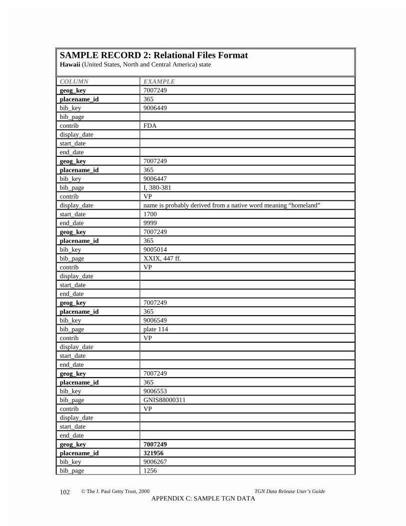
© The J. Paul Getty Trust, 2000 TGN Data Release User’s Guide
APPENDIX C: SAMPLE TGN DATA102
SAMPLE RECORD 2: Relational Files FormatHawaii (United States, North and Central America) state
COLUMN EXAMPLEgeog_key 7007249placename_id 365bib_key 9006449bib_pagecontrib FDAdisplay_datestart_dateend_dategeog_key 7007249placename_id 365bib_key 9006447bib_page I, 380-381contrib VPdisplay_date name is probably derived from a native word meaning “homeland”start_date 1700end_date 9999geog_key 7007249placename_id 365bib_key 9005014bib_page XXIX, 447 ff.contrib VPdisplay_datestart_dateend_dategeog_key 7007249placename_id 365bib_key 9006549bib_page plate 114contrib VPdisplay_datestart_dateend_dategeog_key 7007249placename_id 365bib_key 9006553bib_page GNIS88000311contrib VPdisplay_datestart_dateend_dategeog_key 7007249placename_id 321956bib_key 9006267bib_page 1256

© The J. Paul Getty Trust, 2000 TGN Data Release User’s Guide
APPENDIX C: SAMPLE TGN DATA103
SAMPLE RECORD 2: Relational Files FormatHawaii (United States, North and Central America) state
COLUMN EXAMPLEcontrib VPdisplay_datestart_dateend_date
GEOG_PLACETYPE
geog_key 7007249placetype_code 81175seqn 0pref_flag Page_flag Cgeog_key 7007249placetype_code 81100seqn 1pref_flag Nage_flag C
PLACETYPE_DATES
geog_key 7007249placetype_code 81175display_date since August 21, 1959start_date 1959end_date 9999
BIBLIO
bib_key 9001601bib_brief Random House English Dictionary (1987)bib_brief_sort RANDOMHOUSEENGLISHDICTIONARYcitation The Random House Dictionary of the English Language. Stuart Berg Flexner,
editor-in-chief. 2nd ed. New York: Random House, 1987.bib_key 9005014bib_brief Encyclop$70aedia Britannica (1988)bib_brief_sort ENCYCLOPAEDIABRITANNICAcitation The New Encyclop$70aedia Britannica. 15th ed. Chicago: Encyclop$70aedia
Britannica Inc., 1988.bib_key 9005681bib_brief LC Subject Headings, 11th edition (1988)bib_brief_sort LCSUBJECTHEADINGSTHEDITIONcitation Library of Congress Subject Cataloging Division. Library of Congress Subject
Headings. 11th ed. Washington: Cataloging Distribution Service, Library ofCongress, 1988.
bib_key 9006037

© The J. Paul Getty Trust, 2000 TGN Data Release User’s Guide
APPENDIX C: SAMPLE TGN DATA104
SAMPLE RECORD 2: Relational Files FormatHawaii (United States, North and Central America) state
COLUMN EXAMPLEbib_brief Times Atlas of the World (1992)bib_brief_sort TIMESATLASOFTHEWORLDcitation Times Atlas of the World. 9th comprehensive edition. New York: Times
Books, 1992.bib_key 9006048bib_brief National Zip Code Directory (1985)bib_brief_sort NATIONALZIPCODEDIRECTORYcitation National Five Digit Zip Code and Post Office Directory. Washington: U.S.
Postal Service, 1985.bib_key 9006267bib_brief Webster’s Geographical Dictionary (1988)bib_brief_sort WEBSTERSGEOGRAPHICALDICTIONARYcitation Webster’s New Geographical Dictionary. Sprinfield, MA: Merriam-Webster,
1988.bib_key 9006303bib_brief Columbia Lippincott Gazetteer (1961)bib_brief_sort COLUMBIALIPPINCOTTGAZETTEERcitation Columbia Lippincott Gazetteer of the World. Edited by Leon E. Seltzer.
Morningside Heights, NY: Columbia University Press, 1961.bib_key 9006447bib_brief Canby, Historic Places (1984)bib_brief_sort CANBYHISTORICPLACEScitation Canby, Courtlandt. The Encyclopedia of Historic Places. New York: Facts on
File Publications, 1984.bib_key 9006449bib_brief Webster’s Geographical Dictionary (1984)bib_brief_sort WEBSTERSGEOGRAPHICALDICTIONARYcitation Webster’s New Geographical Dictionary. Springfield, MA: Merriam-Webster,
1984.bib_key 9006553bib_brief USGS, GNIS Digital Gazetteer (1994)bib_brief_sort USGSGNISDIGITALGAZETTEERcitation United States Department of the Interior and U.S. Geological Survey.
Geographic Names Information System Digital Gazetteer. Reston, Virginia:U.S. Geological Survey, 1994.
bib_key 9893654bib_brief Times Atlas of the World (1994)bib_brief_sort TIMESATLASOFTHEWORLDcitation Times Atlas of the World. 9th comprehensive edition. New York: Times
Books, 1994.
PLACETYPE_LIST
placetype_code 81175placetype_search 81175

© The J. Paul Getty Trust, 2000 TGN Data Release User’s Guide
APPENDIX C: SAMPLE TGN DATA105
SAMPLE RECORD 2: Relational Files FormatHawaii (United States, North and Central America) state
COLUMN EXAMPLEplacetype stateplacetype_code 81100placetype_search 81100placetype first level subdivision
NAME_KEYWORDS
geog_key 7007249placename_id 365keyword HAWAIIgeog_key 7007249placename_id 321956keyword HI
BIB_KEYWORDS
bib_key 9001601keyword THEbib_key 9001601keyword RANDOMbib_key 9001601keyword HOUSEbib_key 9001601keyword DICTIONARYbib_key 9001601keyword OFbib_key 9001601keyword THEbib_key 9001601keyword ENGLISHbib_key 9001601keyword LANGUAGEbib_key 9001601keyword STUARTbib_key 9001601keyword BERGbib_key 9001601keyword FLEXNERbib_key 9001601keyword EDITORbib_key 9001601keyword INbib_key 9001601keyword CHIEF

© The J. Paul Getty Trust, 2000 TGN Data Release User’s Guide
APPENDIX C: SAMPLE TGN DATA106
SAMPLE RECORD 2: Relational Files FormatHawaii (United States, North and Central America) state
COLUMN EXAMPLEbib_key 9001601keyword NDbib_key 9001601keyword EDbib_key 9001601keyword NEWbib_key 9001601keyword YORKbib_key 9001601keyword RANDOMbib_key 9001601keyword HOUSEbib_key 9005014keyword THEbib_key 9005014keyword NEWbib_key 9005014keyword ENCYCLOPAEDIAbib_key 9005014keyword BRITANNICAbib_key 9005014keyword EDbib_key 9005014keyword CHICAGObib_key 9005014keyword ENCYCLOPAEDIAbib_key 9005014keyword BRITANNICAbib_key 9005014keyword INCkeywords for other citations are omitted for the sake of brevity
FORMER_GEOGKEYS
new_keymaster_keycollapse_key
FORMER_GEOGLINKS
new_keycollapse_keyold_link_key

© The J. Paul Getty Trust, 2000 TGN Data Release User’s Guide
APPENDIX C: SAMPLE TGN DATA107
SAMPLE RECORD 2: Relational Files FormatHawaii (United States, North and Central America) state
COLUMN EXAMPLE
FORMER_BIBKEYS
new_keymaster_keycollapse_key
FORMER_BIBLINKS
new_keycollapse_keyold_link_key

© The J. Paul Getty Trust, 2000 TGN Data Release User’s Guide
APPENDIX C: SAMPLE TGN DATA108
SAMPLE RECORD 3: Relational Files FormatFirenze (Firenze province, Italia, Europe) inhabited place
COLUMN EXAMPLE
GEOG_MAIN
geog_key 7000457descr_note Was Roman military center at head of navigation on Arno river & on Casian
Way; escaped capture by Goths 5th cen.; was thriving center by 12th cen.;torn by medieval Guelph/Ghibelline civil strife; ruled by Medici family from1434.
lat 43 47lat_dir Nlong 011 15long_dir Elat_num 43.783long_num 011.250
GEOG_PARENTS
geog_key 7000457parent_key 7003163pref_flag P
GEOG_NAME
geog_key 7000457placename_id 45063seqn 0place_name Firenzesort_name FIRENZEpref_flag Plang Vage_flag Cother_flags Ngeog_key 7000457placename_id 45064seqn 1place_name Florencesort_name FLORENCEpref_flag Nlang Oage_flag Cother_flags Egeog_key 7000457placename_id 139941

© The J. Paul Getty Trust, 2000 TGN Data Release User’s Guide
APPENDIX C: SAMPLE TGN DATA109
SAMPLE RECORD 3: Relational Files FormatFirenze (Firenze province, Italia, Europe) inhabited place
COLUMN EXAMPLEseqn 2place_name Florenciasort_name FLORENCIApref_flag Nlang Oage_flag Cother_flags Ngeog_key 7000457placename_id 139942seqn 3place_name Florenzsort_name FLORENZpref_flag Nlang Oage_flag Cother_flags Ngeog_key 7000457placename_id 165290seqn 4place_name Fiorenzasort_name FIORENZApref_flag Nlang Vage_flag Hother_flags Ngeog_key 7000457placename_id 164779seqn 5place_name Florentiasort_name FLORENTIApref_flag Nlang Vage_flag Hother_flags N
NAME_DETAIL
geog_key 7000457placename_id 45063bib_key 9006303bib_pagecontrib BHAdisplay_datestart_date

© The J. Paul Getty Trust, 2000 TGN Data Release User’s Guide
APPENDIX C: SAMPLE TGN DATA110
SAMPLE RECORD 3: Relational Files FormatFirenze (Firenze province, Italia, Europe) inhabited place
COLUMN EXAMPLEend_dategeog_key 7000457placename_id 45063bib_key 9004757bib_page 62 ff.contrib FDAdisplay_datestart_dateend_dategeog_key 7000457placename_id 45063bib_key 9006449bib_pagecontrib GRLPAdisplay_datestart_dateend_dategeog_key 7000457placename_id 45063bib_key 9006037bib_page 66contrib VPdisplay_datestart_dateend_dategeog_key 7000457placename_id 45064bib_key 9006449bib_pagecontrib FDAdisplay_datestart_dateend_dategeog_key 7000457placename_id 45064bib_key 9006449bib_pagecontrib GRLPAdisplay_datestart_dateend_dategeog_key 7000457placename_id 45064bib_key 9006447

© The J. Paul Getty Trust, 2000 TGN Data Release User’s Guide
APPENDIX C: SAMPLE TGN DATA111
SAMPLE RECORD 3: Relational Files FormatFirenze (Firenze province, Italia, Europe) inhabited place
COLUMN EXAMPLEbib_page I, 296contrib VPdisplay_datestart_dateend_dategeog_key 7000457placename_id 45064bib_key 9005014bib_page IV, 838contrib VPdisplay_datestart_dateend_dategeog_key 7000457placename_id 45064bib_key 9006267bib_page 400contrib VPdisplay_datestart_dateend_dategeog_key 7000457placename_id 139941bib_key 9006551bib_page 317contrib VPdisplay_datestart_dateend_dategeog_key 7000457placename_id 139941bib_key 9006541bib_page I-56contrib VPdisplay_datestart_dateend_dategeog_key 7000457placename_id 139942bib_key 9006561bib_pagecontrib VPdisplay_datestart_date

© The J. Paul Getty Trust, 2000 TGN Data Release User’s Guide
APPENDIX C: SAMPLE TGN DATA112
SAMPLE RECORD 3: Relational Files FormatFirenze (Firenze province, Italia, Europe) inhabited place
COLUMN EXAMPLEend_dategeog_key 7000457placename_id 165290bib_key 9004757bib_page 14contrib VPdisplay_date medievalstart_date 1100end_date 1700geog_key 7000457placename_id 164779bib_key 9006339bib_pagecontrib GRLPAdisplay_datestart_dateend_dategeog_key 7000457placename_id 164779bib_key 9006339bib_pagecontrib VPdisplay_date name of Roman colony on N bank of Arnostart_date -100end_date 1500geog_key 7000457placename_id 164779bib_key 9006548bib_page 343contrib VPdisplay_datestart_dateend_date
GEOG_PLACETYPE
geog_key 7000457placetype_code 83002seqn 0pref_flag Page_flag Cgeog_key 7000457placetype_code 83040seqn 1

© The J. Paul Getty Trust, 2000 TGN Data Release User’s Guide
APPENDIX C: SAMPLE TGN DATA113
SAMPLE RECORD 3: Relational Files FormatFirenze (Firenze province, Italia, Europe) inhabited place
COLUMN EXAMPLEpref_flag Nage_flag Cgeog_key 7000457placetype_code 83112seqn 2pref_flag Nage_flag Cgeog_key 7000457placetype_code 83115seqn 3pref_flag Nage_flag Cgeog_key 7000457placetype_code 81112seqn 4pref_flag Nage_flag Cgeog_key 7000457placetype_code 83433seqn 5pref_flag Nage_flag Cgeog_key 7000457placetype_code 83351seqn 6pref_flag Nage_flag Cgeog_key 7000457placetype_code 83154seqn 7pref_flag Nage_flag Cgeog_key 7000457placetype_code 83371seqn 8pref_flag Nage_flag Cgeog_key 7000457placetype_code 83505seqn 9pref_flag Nage_flag Cgeog_key 7000457placetype_code 83131

© The J. Paul Getty Trust, 2000 TGN Data Release User’s Guide
APPENDIX C: SAMPLE TGN DATA114
SAMPLE RECORD 3: Relational Files FormatFirenze (Firenze province, Italia, Europe) inhabited place
COLUMN EXAMPLEseqn 10pref_flag Nage_flag Cgeog_key 7000457placetype_code 83506seqn 11pref_flag Nage_flag Cgeog_key 7000457placetype_code 83360seqn 12pref_flag Nage_flag Cgeog_key 7000457placetype_code 83321seqn 13pref_flag Nage_flag Cgeog_key 7000457placetype_code 83110seqn 14pref_flag Nage_flag Hgeog_key 7000457placetype_code 83045seqn 15pref_flag Nage_flag H
PLACETYPE_DATES
geog_key 7000457placetype_code 83002display_date site of ancient settlement, later founded as colony by Romans in 1st cen. BC,
at foot of Etruscan hill town Fiesolestart_date -1000end_date 9999geog_key 7000457placetype_code 83433display_date developed on both sides of the Arno river, is subject to periodic flooding;
most bridges were destroyed in WWIIstart_date -100end_date 9999geog_key 7000457

© The J. Paul Getty Trust, 2000 TGN Data Release User’s Guide
APPENDIX C: SAMPLE TGN DATA115
SAMPLE RECORD 3: Relational Files FormatFirenze (Firenze province, Italia, Europe) inhabited place
COLUMN EXAMPLEplacetype_code 83154display_date bishops were established here early; today is famed for huge cathedral &
baptistry & for numerous other churchesstart_date 700end_date 9999geog_key 7000457placetype_code 83371display_date factories located in suburbs produce precision instruments & other itemsstart_date 1800end_date 9999geog_key 7000457placetype_code 83505display_date noted as great center of art & literature since Middle Ages, especially
fourished 14th-16th cen.start_date 1150end_date 9999geog_key 7000457placetype_code 83131display_date for road & river traffic since Roman times, now is also a major hub for rail
trafficstart_date -100end_date 9999geog_key 7000457placetype_code 83506display_date famed for traditional products, including textiles, glass, ceramics, metal
wares, leatherwork, art reproductions & furniturestart_date -100end_date 9999geog_key 7000457placetype_code 83321display_date Florentines were paramount bankers in Europe by 15th cen.start_date 1400end_date 9999geog_key 7000457placetype_code 83110display_date of duchy of Tuscanystart_date 1500end_date 1860
BIBLIO
bib_key 9004757bib_brief Companion Guide: Florence (1979)bib_brief_sort COMPANIONGUIDEFLORENCEcitation Borsook, Eve. The Companion Guide to Florence. 4th ed. London: Collins,

© The J. Paul Getty Trust, 2000 TGN Data Release User’s Guide
APPENDIX C: SAMPLE TGN DATA116
SAMPLE RECORD 3: Relational Files FormatFirenze (Firenze province, Italia, Europe) inhabited place
COLUMN EXAMPLE1979.
bib_key 9005014bib_brief Encyclop$70aedia Britannica (1988)bib_brief_sort ENCYCLOPAEDIABRITANNICAcitation The New Encyclop$70aedia Britannica. 15th ed. Chicago: Encyclop$70aedia
Britannica Inc., 1988.bib_key 9006037bib_brief Times Atlas of the World (1992)bib_brief_sort TIMESATLASOFTHEWORLDcitation Times Atlas of the World. 9th comprehensive edition. New York: Times
Books, 1992.bib_key 9006267bib_brief Webster’s Geographical Dictionary (1988)bib_brief_sort WEBSTERSGEOGRAPHICALDICTIONARYcitation Webster’s New Geographical Dictionary. Sprinfield, MA: Merriam-Webster,
1988.bib_key 9006303bib_brief Columbia Lippincott Gazetteer (1961)bib_brief_sort COLUMBIALIPPINCOTTGAZETTEERcitation Columbia Lippincott Gazetteer of the World. Edited by Leon E. Seltzer.
Morningside Heights, NY: Columbia University Press, 1961.bib_key 9006339bib_brief Princeton Encyclopedia (1979)bib_brief_sort PRINCETONENCYCLOPEDIAcitation The Princeton Encyclopedia of Classical Sites. 2nd ed. Princeton, NJ:
Princeton University Press, 1979.bib_key 9006447bib_brief Canby, Historic Places (1984)bib_brief_sort CANBYHISTORICPLACEScitation Canby, Courtlandt. The Encyclopedia of Historic Places. New York: Facts on
File Publications, 1984.bib_key 9006449bib_brief Webster’s Geographical Dictionary (1984)bib_brief_sort WEBSTERSGEOGRAPHICALDICTIONARYcitation Webster’s New Geographical Dictionary. Springfield, MA: Merriam-Webster,
1984.bib_key 9006541bib_brief Rand McNally Atlas (1994)bib_brief_sort RANDMCNALLYATLAScitation Rand McNally and Company. The New International Atlas. 25th Anniversary
Edition. Chicago: Rand McNally, 1994.bib_key 9006548bib_brief Times Atlas of World History (1994)bib_brief_sort TIMESATLASOFWORLDHISTORYcitation The Times Atlas of World History. Edited by Geoffrey Barraclough. 4th
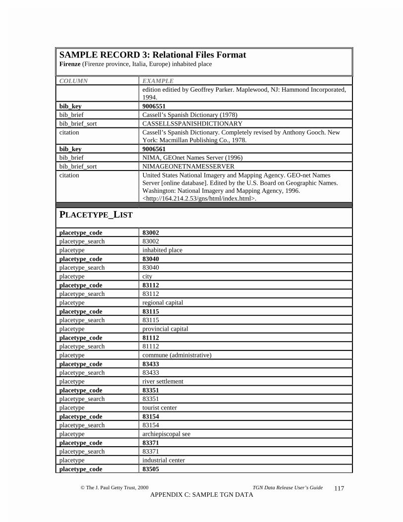
© The J. Paul Getty Trust, 2000 TGN Data Release User’s Guide
APPENDIX C: SAMPLE TGN DATA117
SAMPLE RECORD 3: Relational Files FormatFirenze (Firenze province, Italia, Europe) inhabited place
COLUMN EXAMPLEedition editied by Geoffrey Parker. Maplewood, NJ: Hammond Incorporated,1994.
bib_key 9006551bib_brief Cassell’s Spanish Dictionary (1978)bib_brief_sort CASSELLSSPANISHDICTIONARYcitation Cassell’s Spanish Dictionary. Completely revised by Anthony Gooch. New
York: Macmillan Publishing Co., 1978.bib_key 9006561bib_brief NIMA, GEOnet Names Server (1996)bib_brief_sort NIMAGEONETNAMESSERVERcitation United States National Imagery and Mapping Agency. GEO-net Names
Server [online database]. Edited by the U.S. Board on Geographic Names.Washington: National Imagery and Mapping Agency, 1996.<http://164.214.2.53/gns/html/index.html>.
PLACETYPE_LIST
placetype_code 83002placetype_search 83002placetype inhabited placeplacetype_code 83040placetype_search 83040placetype cityplacetype_code 83112placetype_search 83112placetype regional capitalplacetype_code 83115placetype_search 83115placetype provincial capitalplacetype_code 81112placetype_search 81112placetype commune (administrative)placetype_code 83433placetype_search 83433placetype river settlementplacetype_code 83351placetype_search 83351placetype tourist centerplacetype_code 83154placetype_search 83154placetype archiepiscopal seeplacetype_code 83371placetype_search 83371placetype industrial centerplacetype_code 83505

© The J. Paul Getty Trust, 2000 TGN Data Release User’s Guide
APPENDIX C: SAMPLE TGN DATA118
SAMPLE RECORD 3: Relational Files FormatFirenze (Firenze province, Italia, Europe) inhabited place
COLUMN EXAMPLEplacetype_search 83505placetype cultural centerplacetype_code 83131placetype_search 83131placetype transportation centerplacetype_code 83506placetype_search 83506placetype craftsman centerplacetype_code 83360placetype_search 83360placetype educational centerplacetype_code 83321placetype_search 83321placetype financial centerplacetype_code 83110placetype_search 83110placetype capitalplacetype_code 83045placetype_search 83045placetype municipium
NAME_KEYWORDS
geog_key 7000457placename_id 45063keyword FIRENZEgeog_key 7000457placename_id 45064keyword FLORENCEgeog_key 7000457placename_id 139941keyword FLORENCIAgeog_key 7000457placename_id 139942keyword FLORENZgeog_key 7000457placename_id 165290keyword FIORENZAgeog_key 7000457placename_id 164779keyword FLORENTIA
BIB_KEYWORDS

© The J. Paul Getty Trust, 2000 TGN Data Release User’s Guide
APPENDIX C: SAMPLE TGN DATA119
SAMPLE RECORD 3: Relational Files FormatFirenze (Firenze province, Italia, Europe) inhabited place
COLUMN EXAMPLEbib_key 9004757keyword BORSOOKbib_key 9004757keyword EVEbib_key 9004757keyword THEbib_key 9004757keyword COMPANIONbib_key 9004757keyword GUIDEbib_key 9004757keyword TObib_key 9004757keyword FLORENCEbib_key 9004757keyword EDbib_key 9004757keyword LONDONbib_key 9004757keyword COLLINSbib_key 9005014keyword THEbib_key 9005014keyword NEWbib_key 9005014keyword ENCYCLOPAEDIAbib_key 9005014keyword BRITANNICAbib_key 9005014keyword EDbib_key 9005014keyword CHICAGObib_key 9005014keyword ENCYCLOPAEDIAbib_key 9005014keyword BRITANNICAbib_key 9005014keyword INCkeywords for other citations are omitted for the sake of brevity
FORMER_GEOGKEYS
new_keymaster_key
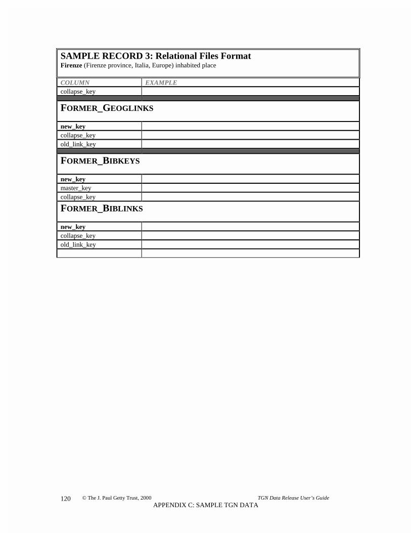
© The J. Paul Getty Trust, 2000 TGN Data Release User’s Guide
APPENDIX C: SAMPLE TGN DATA120
SAMPLE RECORD 3: Relational Files FormatFirenze (Firenze province, Italia, Europe) inhabited place
COLUMN EXAMPLEcollapse_key
FORMER_GEOGLINKS
new_keycollapse_keyold_link_key
FORMER_BIBKEYS
new_keymaster_keycollapse_key
FORMER_BIBLINKS
new_keycollapse_keyold_link_key

© The J. Paul Getty Trust, 2000 TGN Data Release User’s Guide
APPENDIX C: SAMPLE TGN DATA121
SAMPLE RECORD 4: REC FormatFirenze (Firenze province, Italia, Europe) inhabited place
FIELD LABEL EXAMPLE
*General Record InformationLEN 3955STATUS= nTGNIDNO= 7000457DATENT= 19980316*Hierarchy for DisplayDISPHIER= Firenze (Firenze province, Toscana, Italia, Europe)*Main HierarchyFACET= Current WorldPARENT= 7003163PARPREF= P*Simple HierarchyCONTINT= EuropeNATION= ItaliaFIRSTLEV= ToscanaSECNDLEV= Firenze province*Preferred NamePREFNAME= FirenzePNAFLAGS= C,VPNASORT= FIRENZEPNAID= 45063*Name DetailPNCONTR= FDAPNASOURC= Companion Guide: Florence (1979)PNASRCID= 9004757PNAPAGE= 62 ff.*Name DetailPNCONTR= VPPNASOURC= Times Atlas of the World (1992)PNASRCID= 9006037PNAPAGE= 66*Name DetailPNCONTR= BHAPNASOURC= Columbia Lippincott Gazetteer (1961)PNASRCID= 9006303*Name DetailPNCONTR= GRLPAPNASOURC= Webster's Geographical Dictionary (1984)PNASRCID= 9006449*Alternate NamesALTNAME= FlorenceANAFLAGS= C,O,ENGANASORT FLORENCE

© The J. Paul Getty Trust, 2000 TGN Data Release User’s Guide
APPENDIX C: SAMPLE TGN DATA122
SAMPLE RECORD 4: REC FormatFirenze (Firenze province, Italia, Europe) inhabited place
FIELD LABEL EXAMPLEANAID= 45064ANASEQN= 1*Name DetailANCONTR= VPANASOURC= Encyclop$70aedia Britannica (1988)ANASRCID= 9005014ANAPAGE= IV, 838*Name DetailANCONTR= VPANASOURC= Webster's Geographical Dictionary (1988)ANASRCID= 9006267ANAPAGE= 400*Name DetailANCONTR= VPANASOURC= Canby, Historic Places (1984)ANASRCID= 9006447ANAPAGE= I, 296*Name DetailANCONTR= FDAANASOURC= Webster's Geographical Dictionary (1984)ANASRCID= 9006449*Name DetailANCONTR= GRLPAANASOURC= Webster's Geographical Dictionary (1984)ANASRCID= 9006449*Alternate NamesALTNAME= FlorenciaANAFLAGS= C,OANASORT= FLORENCIAANAID= 139941ANASEQN= 2*Name DetailANCONTR= VPANASOURC= Rand McNally Atlas (1994)ANASRCID= 9006541ANAPAGE= I-56ANASOURC= Cassell's Spanish Dictionary (1978)ANASRCID= 9006551ANAPAGE= 317*Alternate NamesALTNAME= FlorenzANAFLAGS= C,OANASORT= FLORENZANAID= 139942

© The J. Paul Getty Trust, 2000 TGN Data Release User’s Guide
APPENDIX C: SAMPLE TGN DATA123
SAMPLE RECORD 4: REC FormatFirenze (Firenze province, Italia, Europe) inhabited place
FIELD LABEL EXAMPLEANASEQN= 3*Name DetailANCONTR= VPANASOURC= NIMA, GEOnet Names Server (1996)ANASRCID= 9006561*Alternate NamesALTNAME= FiorenzaANAFLAGS= H,V,NANASORT= FIORENZAANAID= 165290ANASEQN= 4*Name DetailANCONTR= VPANADSP= medievalANASTRT= 1100ANAEND= 1700ANASOURC= Companion Guide: Florence (1979)ANASRCID= 9004757ANAPAGE= 14*Alternate NamesALTNAME= FlorentiaANAFLAGS= H,V,NANASORT= FLORENTIAANAID= 164779ANASEQN= 5*Name DetailANCONTR= VPANADSP= name of Roman colony on N bank of ArnoANASTRT= -100ANAEND= 1500*Name DetailANCONTR= VPANASOURC= Princeton Encyclopedia (1979)ANASRCID= 9006339ANAPAGE= 331*Name DetailANCONTR= GRLPAANASOURC= Princeton Encyclopedia (1979)ANASRCID= 9006339*Name DetailANCONTR= VPANASOURC= Times Atlas of World History(1994)ANASRCID= 9006548ANAPAGE= 343

© The J. Paul Getty Trust, 2000 TGN Data Release User’s Guide
APPENDIX C: SAMPLE TGN DATA124
SAMPLE RECORD 4: REC FormatFirenze (Firenze province, Italia, Europe) inhabited place
FIELD LABEL EXAMPLE*Preferred Place TypePREFPTP= inhabited placePPTCODE= 83002PPTAGE= C*DatesPPTPDSP= site of ancient settlement, later founded as colony by Romans in 1st cen. BC,
at foot of Etruscan hill town FiesolePPTPSTRT= -1000PPTPEND= 9999*Other Place TypesOTHERPTP= cityOPTCODE= 83040OPTAGE= COPTSEQN= 1*Other Place TypesOTHERPTP= regional capitalOPTCODE= 83112OPTAGE= COPTSEQN= 2*Other Place TypesOTHERPTP= provincial capitalOPTCODE = 83115OPTAGE= COPTSEQN= 3*Other Place TypesOTHERPTP= commune (administrative)OPTCODE= 81112OPTAGE= COPTSEQN= 4*Other Place TypesOTHERPTP= river settlementOPTCODE= 83433OPTAGE= COPTSEQN= 5*DatesOPTPDSP= developed on both sides of the Arno river, is subject to periodic flooding;
most bridges were destroyed in WW IIOPTPSTRT= -100OPTPEND= 9999*Other Place TypesOTHERPTP= tourist centerOPTCODE= 83351OPTAGE= COPTSEQN= 6

© The J. Paul Getty Trust, 2000 TGN Data Release User’s Guide
APPENDIX C: SAMPLE TGN DATA125
SAMPLE RECORD 4: REC FormatFirenze (Firenze province, Italia, Europe) inhabited place
FIELD LABEL EXAMPLE*Other Place TypesOTHERPTP= archiepiscopal seeOPTCODE= 83154OPTAGE= COPTSEQN= 7*DatesOPTPDSP= bishops were established here early; today is famed for huge cathedral &
baptistry & for numerous other churchesOPTPSTRT= 700OPTPEND= 9999*Other Place TypesOTHERPTP= industrial centerOPTCODE= 83371OPTAGE= COPTSEQN= 8*DatesOPTPDSP= factories located in suburbs produce precision instruments & other itemsOPTPSTRT= 1800OPTPEND= 9999*Other Place TypesOTHERPTP= cultural centerOPTCODE= 83505OPTAGE= COPTSEQN= 9*DatesOPTPDSP= noted as great center of art & literature since Middle Ages, especially
flourished 14th-16th cen.OPTPSTRT= 1150OPTPEND= 9999*Other Place TypesOTHERPTP= transportation centerOPTCODE= 83131OPTAGE= COPTSEQN= 10*DatesOPTPDSP= for road & river traffic since Roman times, now is also a major hub for rail
trafficOPTPSTRT= -100OPTPEND= 9999*Other Place TypesOTHERPTP= craftsman centerOPTCODE= 83506OPTAGE= COPTSEQN= 11

© The J. Paul Getty Trust, 2000 TGN Data Release User’s Guide
APPENDIX C: SAMPLE TGN DATA126
SAMPLE RECORD 4: REC FormatFirenze (Firenze province, Italia, Europe) inhabited place
FIELD LABEL EXAMPLE*DatesOPTPDSP= famed for traditional products, including textiles, glass, ceramics, metal
wares, leatherwork, art reproductions & furnitureOPTPSTRT= -1100OPTPEND= 9999*Other Place TypesOTHERPTP= educational centerOPTCODE= 83360OPTAGE= COPTSEQN= 12*Other Place TypesOTHERPTP= financial centerOPTCODE= 83321OPTAGE= COPTSEQN= 13*DatesOPTPDSP= Florentines were paramount bankers in Europe by 15th cen.OPTPSTRT= 1400OPTPEND= 9999*Other Place TypesOTHERPTP= capitalOPTCODE= 83110OPTAGE= COPTSEQN= 14*DatesOPTPDSP= of duchy of TuscanyOPTPSTRT= 1500OPTPEND= 1860*Other Place TypesOTHERPTP= municipiumOPTCODE= 83045OPTAGE= COPTSEQN= 15*CoordinatesLAT= 43 47LATDIR= NLONG= 011 15LONGDIR= ELATNUM= 43.783LONGNUM= 11.250

© The J. Paul Getty Trust, 2000 TGN Data Release User’s Guide
APPENDIX C: SAMPLE TGN DATA127
SAMPLE RECORD 4: REC FormatFirenze (Firenze province, Italia, Europe) inhabited place
FIELD LABEL EXAMPLE*Descriptive NoteDESCNOTE= Was Roman military center at head of navigation on Arno river & on Cassian
Way; escaped capture by Goths 5th cen.; was thriving center by 12th cen.;torn by medieval Guelph/Ghibelline civil strife; was an early republic; ruledby Medici family from 1434.
$$

© The J. Paul Getty Trust, 2000 TGN Data Release User’s Guide
APPENDIX C: SAMPLE TGN DATA128
SAMPLE RECORD 5: USMARC FormatFirenze (Firenze province, Italia, Europe) inhabited place
FIELD LABEL EXAMPLE
Len 03786Sta nTyp zLevBas 00577Enc n001 7000457¶008 000602 n anznnbabn b ana d¶151 ‡aFirenze (Firenze province, Toscana, Italia, Europe) inhabited
place‡c43 47 N 011 15 E(7000457,scheme=TGN)‡dC,V,N‡eFIRENZE‡f45063¶
451 ‡aFlorence‡dC,O,ENG‡eFLORENCE‡f45064‡g1¶451 ‡aFlorencia‡dC,O,N‡eFLORENCIA‡f139941‡g2¶451 ‡aFlorenz‡dC,O,N‡eFLORENZ‡f139942‡g3¶451 ‡aFiorenza‡dH,V,N‡eFIORENZA‡f165290‡g4¶451 ‡aFlorentia‡dH,V,N‡eFLORENTIA‡f164779‡g5¶451 ‡aFlorentine‡dC,O,ADJE‡eFLORENTINE‡f1159547‡g6¶551 ‡wg‡aFirenze province (7003163,scheme=TGN)¶670 ‡aColumbia Lippincott Gazetteer (1961) [BHA]‡bFirenze¶670 ‡aCompanion Guide: Florence (1979) [FDA]‡bFirenze¶670 ‡aWebster's Geographical Dictionary (1984) [GRLPA]‡bFirenze;
Florence¶670 ‡aTimes Atlas of the World (1992) [VP]‡bFirenze¶670 ‡aWebster's Geographical Dictionary (1984) [FDA]‡bFlorence¶670 ‡aCanby, Historic Places (1984) [VP]‡bFlorence¶670 ‡aEncyclopædia Britannica (1988) [VP]‡bFlorence¶670 ‡aWebster's Geographical Dictionary (1988) [VP-ENG]‡bFlorence¶670 ‡aCassell's Spanish Dictionary (1978) [VP]‡bFlorencia¶670 ‡aRand McNally Atlas (1994) [VP]‡bFlorencia¶670 ‡aNIMA, GEOnet Names Server (1996) [VP]‡bFlorenz¶670 ‡aCompanion Guide: Florence (1979) [VP]‡bFiorenza¶670 ‡aPrinceton Encyclopedia (1979) [GRLPA]‡bFlorentia¶670 ‡aTimes Atlas of World History (1994) [VP]‡bFlorentia¶670 ‡aGRI Photo Study, Authority File (1998) [VP]‡bFlorentia¶670 ‡aPrinceton Encyclopedia (1979) [VP]‡bFlorentia¶670 ‡aOED2 on CD-ROM (1994) [VP-ADJE]‡bFlorentine¶678 ‡iWas Roman military center at head of navigation on Arno river &
on Cassian Way; escaped capture by Goths 5th cen.; was thrivingcenter by 12th cen.; torn by medieval Guelph/Ghibelline civilstrife; was an early republic; ruled by Medici family from 1434.¶
901 ‡ainhabited place‡b83002‡cC‡esite of ancient settlement, laterfounded as colony by Romans in 1st cen. BC, at foot of Etruscanhill town Fiesole‡f-1000‡g9999¶
902 ‡acity‡b83040‡cC‡d1¶902 ‡aregional capital‡b83112‡cC‡d2¶902 ‡aprovincial capital‡b83115‡cC‡d3¶902 ‡acommune (administrative)‡b81112‡cC‡d4¶902 ‡ariver settlement‡b83433‡cC‡d5‡edeveloped on both sides of the
Arno river, is subject to periodic flooding; most bridges weredestroyed in WW II‡f-100‡g9999¶
902 ‡atourist center‡b83351‡cC‡d6¶902 ‡aarchiepiscopal see‡b83154‡cC‡d7‡ebishops were established here
early; today is famed for huge cathedral & baptistry & for numerous

© The J. Paul Getty Trust, 2000 TGN Data Release User’s Guide
APPENDIX C: SAMPLE TGN DATA129
SAMPLE RECORD 5: USMARC FormatFirenze (Firenze province, Italia, Europe) inhabited place
FIELD LABEL EXAMPLEother churches‡f700‡g9999¶
902 ‡aindustrial center‡b83371‡cC‡d8‡efactories located in suburbsproduce precision instruments & other items‡f1800‡g9999¶
902 ‡acultural center‡b83505‡cC‡d9‡enoted as great center of art &literature since Middle Ages, especially flourished 14th-16thcen.‡f1150‡g9999¶
902 ‡atransportation center‡b83131‡cC‡d10‡efor road & river trafficsince Roman times, now is also a major hub for rail traffic‡f-100‡g9999¶
902 ‡acraftsman center‡b83506‡cC‡d11‡efamed for traditional products,including textiles, glass, ceramics, metal wares, leatherwork, artreproductions & furniture‡f-1100‡g9999¶
902 ‡aeducational center‡b83360‡cC‡d12¶902 ‡afinancial center‡b83321‡cC‡d13‡eFlorentines were leading bankers
in Europe by 15th cen.‡f1400‡g9999¶902 ‡acapital‡b83110‡cH‡d14‡eof duchy of Tuscany‡f1500‡g1860¶902 ‡amunicipium‡b83045‡cH‡d15¶903 ‡a43 47‡bN‡c011 15‡dE‡e43.783‡f11.250¶905 ‡aEurope‡bItalia‡cToscana‡dFirenze province¶

© The J. Paul Getty Trust, 2000 TGN Data Release User’s Guide
APPENDIX C: SAMPLE TGN DATA130

Copyright © 2022 FDOKUMEN