Introduction of Credit Default Swaps Draft Guidelines Purpose ...
Upload
khangminh22Category
view
0download
0
US 2 Westbound Trestle Project: Draft Purpose and Need
1 PURPOSE AND NEED
1.1 PURPOSE OF THE PROJECT
The purpose of the United States Highway Route 2 (US 2) Westbound Trestle Project (Figure 1) is to develop a
long-term solution that:
• Improves travel reliability for motorists, transit vehicles, freight, bicyclists, pedestrians, and emergency
responders
• Improves safety for all users
• Provides improved system linkages to support regional and local planned growth
• Provides a structurally sound solution that corrects roadway deficiencies and utilizes a full life-cycle cost
approach
• Incorporates WSDOT’s core value of sustainability
Because the US 2 eastbound structure better meets the transportation needs for eastbound travel, it is not
considered in the context of this Purpose and Need.
Figure 1: US 2 Westbound Trestle Vicinity

1.2 NEED FOR THE PROJECT
1.2.1 THE EXISTING CORRIDOR
US 2 was extended west from Idaho to Everett, Washington, in 1948 as part of the national highway system. US 2
is currently continuous between SR 529 in Everett and St. Ignace, Michigan. US 2 is one of three, year-round
routes that cross the Cascades in Washington State, and it provides access to many recreational opportunities in
local, state and national parks. The US 2 Westbound Trestle Project “project area” is the portion of US 2 between
the Interstate 5 (I-5) and SR 204/20th St SE interchanges, inclusive of the interchange areas with those facilities
(Figure 1). US 2 in the project area is a highway of statewide significance, an important T1 (carrying more than 10
million tons of freight per year) and Connector freight route, and is designated as a federal and state urban
principal arterial and scenic byway (WSDOT 2016). The western end of US 2 is a multi-modal, east-west corridor
connecting I-5 and the city of Everett to the businesses, industries and residential communities east of the
Snohomish River. US 2 is one of four routes that cross the Snohomish River, and it is the shortest-distance route
between Everett and communities east of the Snohomish River including Snohomish, Lake Stevens and
Marysville.
US 2 crosses the Snohomish River, Ebey Island, and Ebey Slough on parallel structures. The eastbound
structure was built in the 1990s and carries 2 general-purpose and one peak-period shoulder lane that operates
from 2 PM to 7 PM. The westbound trestle was completed in 1968 and carries 2 lanes of general-purpose traffic
on a 30-foot curb-to-curb roadway section.
1.2.2 EXISTING CAPACITY AND ABILITY TO ACCOMMODATE CURRENT AND FUTURE
TRANSPORTATION DEMAND
TRAFFIC
In 2017, US 2 trestle carried 81,000 vehicles (combined directions) across the Snohomish River on an average
day, of which 9 percent were trucks (WSDOT 2018b). Westbound morning traffic volumes begin to build before 5
AM and peak between 7AM and 9 AM with an AM-peak weekday hourly volume of 3,200 vehicles. Currently,
about 93 percent of the passenger vehicles that use the westbound trestle during the AM peak hour are single-
occupant vehicles (WSDOT 2018c).
illustrates distribution of traffic that crosses the US 2 trestle in the AM peak hour (WSDOT 2018c). The origins of
the westbound traffic demand on the trestle in the AM peak period are split between SR 204 and 20th St SE, and
US 2, which is the source of almost 40 percent of the traffic demand. At the west end of the trestle, most of the
traffic is heading into downtown Everett or onto southbound I-5 (includes traffic going to Boeing). Existing and
2040 demand volumes across the trestle are shown in Figure 3.
Figure 2. US 2 AM Peak-hour Trip Distribution

US 2 Westbound Trestle Project: Draft Purpose and Need
Source: WSDOT 2018c
Figure 3. US 2 AM Peak-hour Existing and 2040 Travel Demand Volume
Note: 2016 and (2040) travel demand volumes
Source: WSDOT 2018c
AM-peak corridor travel times for 2016 and projected for 2040 assuming the current corridor configuration are
shown in Table 1. Traffic delays for westbound trips across the US 2 trestle are expected to substantially worsen
by 2040.
30 (30) 130 (275)
Figure 2. US 2 AM Peak-hour Trip Distribution

Table 1. AM-peak US 2 Corridor Travel Times
Trip
Direction
2016 2040
From To Time
(min: sec)
Average Speed (mph)
Time (min: sec)
Average Speed (mph)
SR 204 at 81st Ave SE I-5 at Pacific Ave Westbound 13:45 19 32:00 8
20th St SE at 83rd Ave SE I-5 at Pacific Ave Westbound 9:05 25 28:05 8
US 2 at Bickford Ave I-5 at Pacific Ave Westbound 8:05 30 14:20 17
I-5 at Pacific Ave SR 204 at 81st Ave SE Eastbound 4:55 51 5:05 50
I-5 at Pacific Ave 20th St SE at 83rd Ave SE Eastbound 4:55 45 5:35 39
I-5 at Pacific Ave US 2 at Bickford Ave Eastbound 4:55 55 5:00 53
Source: WSDOT 2018c
The origin and destination districts (Figure 4) for existing AM peak period (6 AM to 9 AM) trips across the US 2
westbound trestle are tabulated in Table 2. The greatest number of trips originate in the Lake Stevens area, with
most of those trips traveling to Everett and South Everett.
Table 2. AM-peak Period Origin and Destination Pairs for Westbound Trestle Trips
ORIGIN
DESTINATION
King.
Co
SW Snohomish
Co.
SE Snohomish
Co.
S Everett
Everett E Snohomish Co.
Marysville/ Arlington
NW Snohomish
Co.
NE Snohomish
Co.
Skagit Others Total
1 2 3 4 5 6 7 8 9 10 11
King Co. 1 - - - 7 17 - 8 5 - 11 1 49
SW Snohomish Co.
2 - - - 0 72 - 43 19 6 61 18 219
SE Snohomish Co.
3 92 267 - 894 542 - 106 48 17 235 16 2,218
S Everett 4 - - - - - - - - - - - 0
Everett 5 - - - - - - - - - - - 0
E Snohomish Co.
6 466 1,559 - 2,201 2,097 - 43 42 11 16 62 6,496
Marysville/Arlington
7 24 140 - 79 42 - - - - - 1 285
NW Snohomish Co.
8 - - - - - - - - - - - 0
NE Snohomish Co.
9 1 8 - 8 4 - - - - - - 21
Skagit 10 - - - - - - - - - - - 0
Others 11 - - - - - - - - - 10 - 10
Total 583 1,974 0 3,189 2,774 0 201 114 33 332 98 9,298
Source: WSDOT 2019b
US 2 Westbound Trestle Project: Draft Purpose and Need
Figure 4. Map of Travel Districts
Source: WSDOT 2019b

WSDOT sets level of service (LOS) standards for state highways. The US 2 trestle has an LOS standard of “C”,
while the interchanges with I-5 and with SR 204/20th Street SE have an LOS standard of “D” (WSDOT 2019c).
LOS C is defined as stable traffic flow with speeds near free flow, while LOS D is approaching unstable flow with
speeds declining as volume increases. The average speeds for westbound traffic shown in Table 1 indicate that
these standards are not currently met.
FREIGHT
The US 2 westbound trestle is a T1 and Connector freight route with 9 percent of its daily traffic as trucks. Truck
traffic shares capacity with the general-purpose traffic and both contributes to and experiences the same
congestion as that traffic. Continuing east over Steven’s Pass, US 2 becomes a T3 (carries between 300,000 and
4 million tons of freight per year) and alternative freight route (WSDOT 2017b). As the most direct alternative
corridor to the I-90 T1 freight corridor crossing the Cascade Mountains to the Puget Sound region, US 2 provides
an important alternative if I-90 is closed to freight for any reason. WSDOT recognizes US 2 as an important link
in the aerospace supply chain, linking aerospace product and parts manufacturing business locations (WSDOT
2017b). Freight speed and reliability experience the same conditions as general purpose traffic in the corridor.
TRANSIT
The westbound US 2 trestle is currently used by Community Transit Routes 270/271, 280 and 425. These routes
connect communities on the US 2 corridor, including Gold Bar, Sultan, Monroe and Snohomish, and the US 92
corridor, including Granite Falls and Lake Stevens, to Everett Station, Boeing facilities at Paine Field, and
downtown Seattle. Collectively, they make 14 westbound trips across the trestle during the AM peak. Currently
approximately 400 westbound passenger trips are carried by transit across the US 2 trestle in the AM peak.
Because there are no HOV or transit-priority facilities, transit riders in the corridor currently experience the same
congestion and traffic delays as general-purpose traffic, and would experience the same increase in travel times
shown in Table 1.
NON-MOTORIZED
Based on pedestrian and bicycle counts collected once per year between 2009 and 2017, on average 18 bicycles
and 7 pedestrians use US 2 to cross the Snohomish River during the morning (7 to 9 AM) and afternoon (4 to 6
PM) commute periods (WSDOT 2019a). Low non-motorized transportation volumes often correspond to a lack of
safe or connected bicycle and pedestrian facilities.
There are no non-motorized facilities on westbound US 2, however the lower roadway (20th Ave SE) under the
US 2 trestle is open to pedestrians and cyclists traveling in either direction and it includes bike route signs, but no
separation from traffic. Traffic volumes on the lower roadway are low. Cyclists and pedestrians are required to
cross the Snohomish River on the eastbound US 2 bridge. The shared path on the eastbound structure is narrow
for two way cyclists to maneuver. In the east end of the corridor, the shoulder on the 20th Street SE bridge is
signed as a bike lane; however, the intersection with SR 204 is signed as end bike route. There are no
designated non-motorized facilities connecting through the 20th Street SE intersection with SR 204 from other
directions. Under current conditions, there is not a safe and continuous non-motorized connection into and
through the US 2 corridor between the vicinity of I-5 and vicinity of SR 204/ 20th Street SE.
1.2.3 SAFETY
Washington State has adopted Target Zero, a goal to reduce traffic fatalities and serious injuries on Washington's
roadways to zero by the year 2030. The state’s goal is zero deaths and serious injuries, because every life

US 2 Westbound Trestle Project: Draft Purpose and Need
counts. Westbound US 2 experiences a high frequency of collisions. Mapping collision frequency (Figure 5),
indicates concentrations of collisions in three areas along the US 2 westbound trestle project area: the US 2 and
I-5 interchange area, the Ebey Island on-ramp, and the SR 204/20th Street SE merge with westbound US 2.
Figure 5. Collision Locations and Frequency
Source: WSDOT 2018c
The US 2: Everett Port/Naval Station to SR 9 Corridor Study (WSDOT 2016) showed that a high percentage of
collisions on US 2—81 percent (464 collisions)—occurred between the I-5 interchange area and the SR 204/20th
Street SE interchange area (Table 3)1.
1 The US 2 Everett Port/Naval Station to SR 9 Corridor Study evaluated US 2 from Everett Port to SR 9. The US 2 Westbound Trestle Project project area is shorter and includes US 2 from the I-5 interchange to the SR 204/20th Street SE interchange.
Short merge,
high volume,
limited shoulder
Short merge,
limited shoulder,
weave to I-5
Highly congested
NB I-5
Highly congested
NB I-5
41st
Street
20th Street SE
US 2 Hewitt Ave

Table 3. US2: Everett Port/Naval Station to SR 9 Corridor Study Collision Data
US 2 Interchange Area
Number of Collisions
Percent of Corridor Collisions
I-5 to SR 204
I-5 140 25%
Ebey Island 145 25%
SR 204 179 31%
East of SR 204
Bickford Avenue 38 7%
SR 9 67 12%
Total 569 100%
Source: WSDOT Statewide Travel and Collision Data Office, October 2012; US 2: Everett Port/Naval Station to SR 9 Corridor Planning Study, August 2016.
Congestion on westbound US 2 near the I-5 interchange causes vehicles to frequently change lanes resulting in a
high percentage of rear-end and sideswipe collisions in the I-5 interchange area. As westbound travelers
approach the US 2/SR 204/20th Street SE interchange, congestion and merging also results in a high percentage
of rear-end and sideswipe collisions in this area.
Statewide, the number of pedestrian and bicyclist fatalities have increased every year between 2013 and 2017.
There is no designated bicycle facility on westbound US 2 or connections to other facilities east of the US 2/SR
204/20th Street SE interchange. [In 201x, a bicyclist was killed in a crash at the SR 204 and 20th Street SE
intersection].
1.2.4 SYSTEM LINKAGE AND REGIONAL PLANNED GROWTH
US 2 provides a critical east-west linkage between Everett, the state’s sixth most populated city and a major
employment center, and communities where many employees of Everett-based businesses reside, such as Lake
Stevens, Marysville, and Snohomish (Figure 4). Major employers in Everett include Port of Everett, Everett Naval
Yard, Boeing, Providence Regional Medical Center, Esterline Control Systems, Fluke Electronics, and Verizon
Communications. The Boeing plant in Everett has approximately 3,880 employees that reside east of the US 2
trestle and rely on this connection for their daily commute.
The Puget Sound region is expected to grow to 5.0 million people, with 3.0 million jobs by 2050 (PSRC 2017); as
this growth occurs, the US 2 connection between Everett and communities to the east will become increasing
critical. Consistent with the Washington State Growth Management Act, coordinated regional and local planning
efforts will focus growth in regional growth centers to protect rural and natural resource lands, minimize
environmental impacts, and make efficient use of new and existing infrastructure. The Puget Sound Regional
Council’s Vision 2040, Snohomish County Comprehensive Plan, and the cities’ comprehensive plans outline
objectives and policies to implement the GMA, directing future urban growth into the urban areas of Snohomish
County. These documents plan for population and employment growth in the communities that depend on US 2
as a critical transportation connection.
As the largest city in Snohomish County with 20% of the county’s population and 40% of the county’s jobs, Everett
is identified as a regional growth center in the Puget Sound Regional Council’s Vision 2040. The Puget Sound
Regional Council projects the population of Everett to grow by 76,695 people between 2015 and 2040, an increase
of 73% over a 25-year period, as shown in Table 4. Likewise, during this same 25-year period, Everett is planned
to add 62,710 jobs, an increase of 62%. Lake Stevens, Marysville, and Snohomish are also anticipated and planned

US 2 Westbound Trestle Project: Draft Purpose and Need
to experience substantial population and employment growth, resulting in many more people traveling across US 2
on a daily basis. These communities are growing at substantially higher rates than Snohomish County, the Puget
Sound Region as a whole and the state of Washington, as illustrated in Figure 6. Improvements to the US 2
Westbound Trestle are critical to implementing the population and employment growth planned under the Growth
Management Act, Vision 2040, and county and city comprehensive plans.
Table 4. Population and Employment 2015 and 2040
Area
Population Employment
2015 2040
Projection Change in
Population 2015
2040 Projection
Change in Employment
City of Everett 105,608 182,303 76,695 73% 100,817 163,527 62,710 62%
City of Lake Stevens 29,803 41,700 11,897 40% 5,246 8,087 2,841 54%
City of Marysville 63,682 93,003 29,321 46% 15,442 29,030 13,588 88%
City of Snohomish 9,422 14,009 4,587 49% 6,066 8,986 2,920 48%
Snohomish County 758,162 1,044,927 286,765 38% 311,069 458,937 147,868 48%
Puget Sound Region 3,914,972 4,957,920 1,042,948 27% 2,165,116 2,981,498 816,382 38%
Washington State 7,061,410 9,235,561 2,174,151 31% 3,546,000 4,601,800 1,055,800 30%
Notes: The Puget Sound Region consists of four counties: King County, Kitsap County, Pierce County, and Snohomish County. Sources: PSRC 2017; WOFM 2018a; WOFM 2018b.
Figure 6. Projected Population and Employment Growth 2015-2040
Notes: 1. The Puget Sound Region consists of four counties: King County, Kitsap County, Pierce County, and Snohomish County. Sources: PSRC 2017; WOFM 2018b.
While current ramp volumes to (30 vehicles in the AM peak) and from (130 vehicles in the AM peak) Ebey Island
are low (Figure 3), they are important for eastbound connectivity from the island.
73%
40%46%
49%
38%
27%31%
62%
54%
88%
48% 48%
38%
30%
0%
10%
20%
30%
40%
50%
60%
70%
80%
90%
100%
City of Everett City of LakeStevens
City of Marysville City ofSnohomish
SnohomishCounty
Puget SoundRegion
Washington State
Population Growth Employment Growth

1.2.5 ROADWAY DEFICIENCIES
Westbound US 2 is designated as a principal urban arterial with a 55 mile per hour posted speed. The existing US
2 Westbound Trestle was completed in 1968 and is 30 feet wide, curb to curb, with two 12-foot travel lanes and 3-
foot wide shoulders (Figure 7). WSDOT’s highway design manual specifies a 4-foot minimum lateral clearance
between the edge of the traveled way and curb or barrier for principal urban arterials with high speeds (posted 50
miles per hour and above); however, curb is not recommended (WSDOT 2017a). The current westbound trestle
has a capacity of around 3,900 vehicles per hour, which would increase to around 4,100 vehicles per hour if the
constraints at the US 2/SR 204/20th Street SE interchange were removed.
Figure 7. Existing Westbound US 2 Configuration
Traffic safety data can be an indicator of roadway deficiencies such as geometric conditions that warrant
correction to reduce the number of crashes (WSDOT 2018c). For example, clusters of accidents that occur evenly
throughout the day, independent of traffic demand, are a common indicator of a problematic geometric roadway
condition (WSDOT 2018c). Traffic data shows that for two segments along US 2, milepost 0 to 1 and milepost 1 to
2, crashes are spread throughout the day ( Figure 8).

US 2 Westbound Trestle Project: Draft Purpose and Need
Figure 8. Distribution of US 2 Westbound Trestle Crashes throughout Day
Source: WSDOT 2018c
The SR 204/20th Street SE on-ramps join westbound US 2, followed 1,800 feet later by a left exit to Ebey Island.
Although a small portion of maneuvers, vehicles that entered US 2 at the interchange and need to exit at the Ebey
Island off-ramp experience a weaving conflict with vehicles already traveling along westbound US 2 (Figure 9).
Additionally, the merge of SR 204 and 20th St SE (near milepost 2) has been cited by travelers as a location of

poor visibility due to an existing hill that makes seeing cars difficult (WSDOT 2018c). Difference in speed between
vehicles on 20th St SE and those on SR 204 is enough to create a challenging merge (WSDOT 2018c).
Figure 9. US 2/SR 204/20th Street Southeast Interchange and Ebey Island Off-ramp Maneuvers
The WSDOT Bridge Office began a retrofit pilot project in 1999 to remove cracked concrete and corrosion and
apply anti-corrosion treatment and carbon fiber to strengthen the girders. Based on the results from the pilot
project, additional rehabilitation was completed to the trestle between 2007 and 2011. In 2013, the WSDOT
Bridge Office assessed that with regular maintenance the trestle could be structurally maintained until
approximately 2045.
1.2.6 SUSTAINABLE TRANSPORTATION
WSDOT's Sustainable Transportation program advances a durable, adaptable and integrated statewide
transportation system that supports Washington's economy, preserves the environment and enhances our
communities. It includes specific benchmarks and strategies for reducing greenhouse gas emissions from
transportation and adapting our system to be better prepared for climate change.
Currently approximately 7 percent of vehicles using the existing US 2 Westbound Trestle in the morning-peak are
not single-occupant vehicles. This is lower transit and HOV use than the current target of 32 percent non-single-
occupant vehicle use for the Puget Sound Region (WSDOT 2018e).
Additionally, WSDOT must meet current stormwater treatment requirements for all new and reconstructed
facilities. Stormwater from the existing trestle flows off the trestle untreated.

US 2 Westbound Trestle Project: Draft Purpose and Need
REFERENCES Puget Sound Regional Council (PSRC) 2017. Land Use Vision version 2 Dataset. April 2017
WSDOT 2018a. US 2 Westbound Trestle Funding and Finance Study. January 2018.
WSDOT 2018b. WSDOT Traffic GeoPortal. Data retrieved January 8, 2019
WSDOT 2018c. US 2/SR 204/20th Street SE Interchange Justification Report. April 2018. Prepared by Parsons.
WSDOT 2018d. Gray Notebook. Quarterly performance analysis of WSDOT’s Multimodal Systems and Programs. Active Transportation: Annual Safety Report. March 2018.
WSDOT 2018e. 2018 Corridor Capacity Report. November 2018.
WSDOT 2019a. WSDOT Bicycle and Pedestrian Count Portal. http://wsdot.maps.arcgis.com/apps/webappviewer/index.html?id=12b44775815446159c6a240218c2cf5a. Date retrieved January 29, 2019.
WSDOT 2019b. US 2 Trestle Project Travel Demand Modeling – Base Year Validation Results. February 2019.
WSDOT 2019c. WSDOT Level of Service Standard. https://www.arcgis.com/home/item.html?id=3f840aeeb1ba481c905270ca103cd1db. Date retrieved May 16, 2019.WSDOT 2017a. Highway Design Manual. July 2017.
WSDOT 2017b. 2017 Washington State Freight System Plan
WSDOT 2016. US 2: Everett Port/Naval Station to SR 9 Corridor Planning Study, August 2016.
Washington State Office of Financial Management (WOFM) 2018a. State Population Forecast. November 2018
Washington State Office of Financial Management (WOFM) 2018b. Long-term Economic Forecast. June 2018

WSP USA
Suite 3200
999 Third Avenue
Seattle, WA 98104
Tel.: +1 206 382-5200
Fax: +1 206 382-5222
wsp.com
MEMO
TO: David Warner (WSP)
FROM: Brian Woodburn (Parametrix)
CC: Michael Horntvedt (Parametrix)
SUBJECT: 05.03.01 Preliminary Transportation Methods and Assumptions
DATE: December 13, 2018
TEAM PARTICIPANTS
EXECUTIVE TEAM MEMBERS, ROLES, AND RESPONSIBILITIES
Work underway as part of this phase of the project will involve an executive advisory group that
will be composed of elected officials from the state government and high-level management staff
from the affected jurisdictions and agencies. This team will be responsible for participating in the
executive advisory group (EAG) meetings as representatives of their constituents. They will
identify key issues that the project team should consider as they outline the needs of the project
and develop alternatives.
TECHNICAL TEAM MEMBERS, ROLES, AND RESPONSIBILITIES
Similar to the executive advisory group, a technical working group (TWG) will convene to discuss
technical issues related to the project team’s outline of the needs, development of the alternatives,
and description about potential outcomes. This group will consist of staff from the jurisdictions
and agencies that will be able to discuss the technical details and provide suggestions that could
improve the alternatives’ efficiency and cost effectiveness.
PLANNING LINKAGE
It is essential to link the transportation planning processes, outputs, and improvements considered
in this study with the planning processes in other agencies, including addressing multimodal
connectivity. The improvements considered should be consistent with local land use plans and
local, regional, and state transportation plans.
PERTINENT PLANNING DOCUMENTS
The analysis described in this methods and assumptions document will consider the regional plans
listed below to account for and ensure consistency with anticipated growth, development, and
transportation network improvements described in the regional plans:
WSP

Page 2
• US 2 Corridor Study
• SR 9/SR 204/20th Street Interchange Justification Report (IJR)
• US 2 West Trestle Funding and Finance Study
• US 2 – Everett Port/Naval Station to SR 9 Corridor Planning Study
• Comprehensive Plans and Transportation Improvement Programs for the following:
➢ Snohomish County
➢ City of Everett
➢ City of Lake Stevens
➢ City of Marysville
➢ City of Snohomish
• Puget Sound Regional Council (PSRC) Transportation 2040
• Washington State Department of Transportation (WSDOT) 2017 – 2020 Statewide
Transportation Improvement Program
• Community Transit 2016 – 2021 Transit Development Plan
• Sound Transit 2 and 3 funding packages
PRIOR COMMUNITY ENGAGEMENT
The SR 9/SR 204/20th Street IJR included a community engagement work element and gathered
input from key stakeholders and the general population through interviews and a public survey.
The stakeholders included surrounding municipalities, public transportation officials, and bicycle
and trucking interest groups. Several key themes were consistent throughout the interviews:
• The current interchange operations are poor during peak travel times, and stakeholders
are supportive of a study to identify near-term improvements to relieve congestion.
• The desired priority of improvements varied, but all agreed that the near-term
improvements must not adversely impact local streets and communities or hinder
potential for long-term improvements; i.e., the recommended improvements should
consider and complement regional and future transportation planning.
• Potential future improvements that reduce travel time and increase speed and reliability
are key indicators that the study is successful.
In addition to individual stakeholder interviews, a public survey was conducted to solicit input
directly from the general population regarding the issues at the study interchange. More than 2,700
surveys were collected, of which the majority represented daily users of the interchange. The
survey results included the following:

Page 3
• 73 percent of respondents reported that travel time through this interchange has increased
by more than 5 minutes in the last 5 years.
• 77 percent of respondents reported traveling through the interchange as a single vehicle
occupant.
• 56 percent of respondents reported avoiding using the interchange to access U.S.
Highway 2 (US 2) at least some of the time, instead using an alternate route to westbound
US 2.
CONTINUED COMMUNITY ENGAGEMENT
This project will include ongoing community engagement efforts, and the analysis will be updated
as appropriate based on information and input from the community.
ENVIRONMENTAL LINKAGE
The processes used in this study will be aligned with the environmental documentation process to
reduce duplication of effort. Environmental staff will be engaged in the process to ensure
compliance with the National Environmental Policy Act (NEPA)/State Environmental Policy Act
(SEPA) as the project progresses and a preferred alternative is identified.
COMMUNITY ENGAGEMENT
Maintaining a transparent outreach process is important for keeping the public engaged in the
project and informed about project findings.
Traffic operations data, evaluation, screening information, and results developed throughout the
project will be used to create community engagement materials. All community engagement
materials will follow the Quality Control (QC) process and be reviewed internally with the state to
ensure accuracy before being shared with the public.
ALTERNATIVES SELECTION
This section describes the process for determining reasonable alternatives (non-access and access),
including alternative development and screening.
PROJECT NEED AND PERFORMANCE MEASURES
The first step in the alternatives selection process is to establish the project need, which would
then be used toidentify performance measures or metrics for the transportation system. The
performance measures will be applied to determine the extent by which existing and future no-
build conditions fall short of meeting the project need (i.e. performance gaps), along with input
from project stakeholders. The evaluation of needs will consider the following:

Page 4
• Trip and travel characteristics of people who use the US 2 Trestle
• General purpose traffic, freight traffic, and transit operations
• Transit and HOV access
• Nonmotorized (bicycle, pedestrian) connectivity and access
• Safety
• Environmental impacts
ALTERNATIVES DEVELOPMENT
Reasonable non-access and access alternatives that address the performance gaps and support the
project need will identified and developed through coordination with WSDOT and project
stakeholders. This includes confirming assumptions about the benefits and implementation of
proposed alternatives.
A workshop will be held to determine the applicability of alternatives identified in previous
workshops, develop potential revisions to previously identified alternatives, and develop new
alternatives. This project will consider the interdependence of US 2 with other surrounding
roadways, and previously developed concepts that either meet the purpose and need, or can be
revised to meet the purpose and need, are open for evaluation.
ALTERNATIVES SCREENING
Following the alternatives development, the alternatives screening process will be conducted so
that a preliminary preferred alternative can be selected. The screening process will consist of three
levels, with the amount of detail evaluated increasing at each level. The alternatives may be
revised or redefined as they are being evaluated to better meet the purpose and need.
FIRST-LEVEL SCREENING – QUALITATIVE
The first-level screening will be used to eliminate from further consideration alternatives
determined to have physical or operational fatal flaws, or that do not meet the project need. No
quantitative analysis will be performed during the first-level screening. General purpose traffic,
transit and nonmotorized access, nonmotorized connectivity, and environmental impacts will be
qualitatively assessed. Up to 12 alternatives will pass through the first-level screening.
SECOND-LEVEL SCREENING – DYNAMIC TRAFFIC ASSIGNMENT MODEL
In the second-level screening, the alternatives will be evaluated quantitatively using the Dynameq
traffic model. The performance metrics used to screen the alternatives in Dynameq will be
developed in coordination with WSDOT and are anticipated to include the following:

Page 5
• Person throughput
• Vehicle throughput and demand
• Travel times
• Speeds
• Lengths of queue
• Duration of congestion
Transit and nonmotorized access, nonmotorized connectivity, and environmental impacts will be
qualitatively evaluated. Up to four alternatives will pass through the second-level screening.
THIRD-LEVEL SCREENING – MICROSIMULATION MODEL
The third-level screening process will further define and evaluate, at a more detailed level, the
remaining alternatives. All motorized traffic operations (general purpose, high-occupancy vehicle
[HOV], transit, and freight) will be quantitatively analyzed using the VISSIM traffic model. The
performance metrics used to screen the alternatives in VISSIM will be developed in coordination
with WSDOT and are anticipated to include the following:
• Person throughput
• Vehicle throughput
• Travel times
• Speeds
• Queues1
• Extents and duration of congestion2
TRAFFIC OPERATIONAL ANALYSIS SCOPE AND SCALE
STUDY YEARS
The study years include existing year (2018) and horizon year (2040).
DATA COLLECTION
Data collected in October 2018 will be used to validate, and update as necessary, the travel
demand model (EMME), dynamic traffic assignment model (Dynameq), and microsimulation
model (VISSIM) developed as part of the US 2/SR 204/20th Street IJR. Data collected in October
2018 includes the following:
1 Queues refer to the length of fully stopped traffic, e.g. at stop signs, traffic signals, or ramp meters. 2 Speeds will inform the extents and duration of congestion on highway corridor segments. Per WSDOT’s Handbook for Corridor Capacity Evaluation (2nd edition, 2016) roadways are congested when speeds are less than 75 percent of the posted speed, and severely congested when speeds are less than 60 percent of the posted speed.

Page 6
• 24-hour roadway segment volumes
➢ State Route (SR) 531 west of 67th Avenue NE
➢ 88th Street NE west of State Avenue
➢ 4th Street east of State Avenue
➢ SR 204 south of Sunnyside Boulevard
➢ 20th Street west of Cavalero Road
➢ US 2 west of SR 9
➢ SR 9 north of 30th Street
➢ US 2 east of Interstate 5 (I-5)
➢ SR 9 south of Cathcart Way
• 2-hour AM and 2-hour PM peak period turn movement counts
➢ I-5 northbound off-ramp and 4th Street
➢ I-5 southbound on-ramp and Marine View Drive NE
➢ SR 9 and 64th Street (SR 528)
➢ SR 9 and Granite Falls Highway (SR 92)
➢ SR 9 and SR 204
➢ Avenue D and 15th Street
➢ SR 9 and 108th Street SE
• Floating Car Travel Times were collected during the 5-hour morning (4:00–9:00 AM)
and evening (1:30–6:30 PM) commute periods between the following origins/destinations
(three locations west of the trestle and three locations east of the trestle equates to nine
origin/destination pairs and 18 pathways):
➢ I-5 north of Marine View Drive
➢ US 2 ramps to and from Downtown Everett
➢ I-5 at the SR 526 interchange
➢ SR 204 at 81st Avenue
➢ 20th Street at SR 9
➢ US 2 at Bickford Avenue
The floating car travel time runs were recorded with a dash camera and the videos will be
reviewed to observe locations and durations of congestion. The trips were also tracked using a
Global Positioning System (GPS) application to record the speed along the pathway. The speed
data will be reviewed in tandem with the dash camera video to determine the actual speed at each
point on the corridor during congested conditions.
• Streetlight data will be collected at a zone-group level to support travel demand model
validation by providing a general origin and destination pattern for traffic that uses the

Page 7
US 2 trestle and connecting facilities. This level of model validation will provide the
team with a better understanding of how people are making travel choices.
In addition to the data collection described above, this study will utilize data collected for the US
2/SR 204/20th Street IJR, listed below.
• Peak Hour Queuing was observed in November 2016, and January and February 2017
during the AM and PM peak periods at the following locations:
➢ I-5 and US 2 interchange
➢ US 2 and SR 204 interchange
➢ 20th Street SE corridor
➢ SR 204 corridor
• Travel Time Runs were conducted during the peak periods on the following corridors:
Table 1. Peak Period Travel Time Runs
Corridor Description Data Collection Dates
SR 204 I-5 from 41st Street across US 2 trestle to 81st
Avenue NE on SR 204 November 16 and 17, 2016
20th Street SE I-5 from 41st Street across US 2 trestle to 83rd
Avenue SE on 20th Street SE November 16 and 17, 2016
US 2 I-5 from 41st Street across US 2 trestle to US
2/SR 9 interchange
January 31 and February 1,
2017
• Seven-day Tube and Vehicle Classification Counts were collected at the following
locations:
Table 2. Seven-day Tube and Vehicle Classification Counts
Location Tube Count Location Dates of Collection
1 WB US 2 to SB I-5 11/17/16 – 1/23/16
2 WB US 2 to NB I-5 12/1/16 – 12/7/16
3 WB US 2 to California Street 11/17/16 – 11/23/16
4 WB US 2 to Walnut Street 11/14/16 – 11/19/16
5 NB I-5 to EB US 2 11/30/16 – 12/7/16
6 SB I-5 to EB US 2 11/17/16 – 11/23/16
7 Hewitt Avenue to EB US 2 12/1/16 – 12/7/16
8 NB I-5 to Pacific Avenue 11/13/16 – 11/20/16
9 Pacific Avenue to SB I-5 11/14/16 – 11/19/16
10 Everett Avenue to NB I-5 11/14/16 – 11/19/16
11 SB I-5 to Everett Avenue 11/17/16 – 11/23/16
12 EB US 2 on trestle WSDOT PTR (Oct. 2016)
13 WB US 2 on trestle WSDOT PTR (Oct. 2016)
Streetlight data will be collected at a zone-group level to support travel demand model validation by providing a general origin and destination pattern for traffic that uses the US 2 trestle and connecting facilities. This level of model validation will provide the team with a better understanding of how people are making travel choices.

Table 2. Seven-day Tube and Vehicle Classification Counts (continued)
Page 8
Location Tube Count Location Dates of Collection
14 EB US 2 East of Bickford Interchange 11/30/16 – 12/7/16
15 WB US 2 East of Bickford Interchange 11/30/16 – 12/7/16
16 Bickford to WB US 2 11/14/16 – 11/19/16
17 EB US 2 to Bickford 11/17/16 – 11/23/16
18 Bickford to EB US 2 11/14/16 – 11/19/16
19 WB US 2 to SR 204 12/11/16 – 12/17/16
20 SR 204 to EB US 2 12/11/16 – 12/17/16
21
EB US 2 to 20th Street SE (at west end
of trestle and at US 2/SR 204
interchange)
12/1/16 – 12/7/16
22 EB US 2 to SR 204 11/27/16 – 12/4/16
23
20th Street SE to WB US 2 (at US 2/SR
204 interchange and on west end of
trestle) 11/27/16 – 12/4/16
24 SR 204 to WB US 2 11/27/16 – 12/4/16
25 EB 20th Street east of SR 204 11/30/16 – 12/7/16
25 WB 20th Street east of SR 204 11/30/16 – 12/7/16
26 NB SR 204 north of 9th Street SE 12/8/16 – 12/14/16
26 SB SR 204 north of 9th Street SE 11/28/16 – 12/4/16
27 SB Sunnyside Boulevard SE south of 9th
Street SE 11/27/16 – 12/4/16
27 NB Sunnyside Boulevard SE south of 9th
Street SE 11/27/16 – 12/4/16
28 EB 20th Street SE east of Cavalero Road 11/27/16 – 12/4/16
28 WB 20th Street SE east of Cavalero Road 11/27/16 – 12/4/16
NB = northbound; SB = southbound; WB = eastbound; EB = eastbound

WSP USA
Suite 3200
999 Third Avenue
Seattle, WA 98104
Tel.: +1 206 382-5200
Fax: +1 206 382-5222
wsp.com
• Daily boardings and alightings by stop were provided by Community Transit for routes
280 and 425.
• Vanpool program information provided by Community Transit
• WSDOT collected occupancy data at two locations on I-5
• Peak period turning movement counts were collected at the following locations:
Table 3. Peak Period Turning Movement Counts
Intersection
# Intersection Location
Count Date
AM PM
1 SR 204 and 20th Street SE 11/29/16 12/6/16
2 SR 204 and Sunnyside Boulevard SE 12/7/16 12/1/16
3 SR 204 and 9th Street SE 11/17/16 12/1/16
4 20th Street SE and Cavalero Road 12/13/16 12/7/16
5 51st Avenue SE and 20th Street WB
ramps
11/30/16 12/1/16
6 51st Avenue SE and 20th Street EB
ramps
12/1/16 12/1/16
7 20th Street SE and 79th Avenue SE 11/17/16 12/7/16
8 83rd Avenue SE and 20th Street SE 2/2/17 2/2/17
9 91st Avenue SE and 20th Street SE 2/9/17 2/1/17
10 S Lake Stevens Road and 87th Avenue
SE
2/9/17 2/1/17
11 S Lake Stevens Road and SR 9 2/1/17 1/31/17
12 Sinclair Avenue and Bickford Avenue 2/9/17 2/1/17
13 SR 9 and 4th Street SE 2/1/17 1/31/17
14 SR 9 and 20th Street SE 2/1/17 1/31/17
WB = westbound; EB = eastbound

Page 10
TRAFFIC FORECASTING METHODOLOGY
Future year traffic volumes will be forecast using the procedures outlined in the National
Cooperative Highway Research Program (NCHRP) reports 255 and 765. The existing year and
future year no-build travel demand model and dynamic traffic assignment model will be validated
and finalized. The difference between the existing year and future year dynamic traffic assignment
model volumes will be applied to the existing count data to develop the forecasted future year
no-build traffic volumes.
During the alternatives development and screening processes, additional travel demand model and
dynamic traffic assignment model runs will be completed for some alternatives. The volumes from
the alternative model runs will be compared to the volumes from the no-build model runs, and the
forecasted no-build volumes will be post-processed to develop forecasted volumes for the
alternatives.
VALUE OF TIME
It is recommended that value of travel time (VOT) estimates adopted for the Puget Sound
Gateway Program be used in the modeling analysis. These values of time would be used in the
travel demand model and dynamic traffic assignment model, and are shown in the table below.
Table 4. Value of Travel Time Estimates
Trip Type
VOT (dollars/hour), 2015
dollars
Home-Based Work (HBW) Single-Occupancy Vehicle
(SOV) Income Group 1 $ 8.20
HBW SOV Income Group 2 $ 15.45
HBW SOV Income Group 3 $ 20.90
HBW SOV Income Group 4 $ 31.00
Non-Work SOV $ 19.95
HOV: 2 occupants $ 25.05
HOV: 3+occupants $ 25.05
Light Truck $ 22.25
Medium Truck $ 57.35
Large Truck $ 57.35
TOOLS
This section describes the modeling tools that will be used to develop forecast volumes and
analyze traffic operations.
TRAVEL DEMAND MODEL
• The PSRC EMME model will be used to produce travel demand forecasts for the US 2
Westbound Trestle project. This ensures consistency with the most recently adopted
regional travel demand (EMME) model developed by the PSRC. The most recent PSRC
travel demand model was adopted in June 2018 as part of the Regional Transportation
The PSRC EMME model will be used to produce travel demand forecasts for the US 2 Westbound Trestle project. This ensures consistency with the most recently adopted regional travel demand (EMME) model developed by the PSRC. The most recent PSRC travel demand model was adopted in June 2018 as part of the Regional Transportation Plan update. The updated PSRC model has a horizon year of 2040, compared to the Snohomish County EMME model used for the earlier IJR analysis that had a horizon year of 2035. The updated PSRC model for 2040 includes a per-mile vehicle pricing assumption for all facilities. The demand modeling-related undertakings include the following:

Page 11
Plan update. The updated PSRC model has a horizon year of 2040, compared to the
Snohomish County EMME model used for the earlier IJR analysis that had a horizon year
of 2035. The updated PSRC model for 2040 includes a per-mile vehicle pricing
assumption for all facilities. The demand modeling-related undertakings include the
following:
• Review the latest PSRC model for existing conditions within the study area and make
necessary network refinements to produce reasonable results for existing conditions. This
involves comparison of actual vehicle count data to model estimated vehicle volumes for
key locations within the study area. The targeted accuracy of the travel demand model
will be the industry standard of +/- 10 percent of the existing count data across
screenlines.
• Perform a base year (2017/2018) model validation analysis and prepare necessary
summary results. This will likely include using StreetLight origin-destination data to
adjust base year trip tables produced by the PSRC model. StreetLight data was obtained
conforming to 48 districts as shown in Figure 1 and was compared to the synthetic origin-
destination data from the PSRC model to confirm modest differences in some regional
travel. In addition to adjusting trip tables with StreeLight data, the base year validation
will include a matrix adjustment process using actual vehicle counts data to better match
estimated volumes.
• The outcome of the base year validation analysis will determine how to proceed in
developing 2040 traffic forecasts. Should the base year model validation require using
StreetLight data to adjust trip tables then the process of producing 2040 trip tables should
be dependent on base year trip tables. This will include using pertinent origin- and
destination-level growth rates from the base year to 2040 from the PSRC full demand
model applied to the Streetlight-adjusted base year trip tables to provide 2040 trip tables
for each alternative. This data will be used for assignment in the travel demand model to
produce 2040 traffic forecasts.
• Coordinate with WSDOT and Snohomish County regarding consistency between
demographic forecasts prepared by PSRC and Snohomish County for the City of Everett,
which have been used in previous modeling efforts. The PSRC model uses Land Use
Vision (LUV.2) Forecast for 2040, currently available at the PSRC website.
• Prepare networks for no-build and build alternatives. For the alternatives involving
tolling, a series of demand model runs will be performed for both intermediate and
horizon years to achieve appropriate toll rates. Subsequently, final model runs will be
performed for all alternatives and necessary model results will be prepared.
• Prepare necessary trip matrix inputs for the Dynamic Traffic Assignment (DTA)
modeling analyses. This will include use of Streetlight origin-destination data to refine
external/internal trip movements.
Planned screenline locations are shown in Figure 2, and the model study area focus for modeling
analysis is also shown in that figure.

Page 12
Figure 1. StreetLight Data Districts

Page 13
Figure 2. Travel Demand Model Validation Limits
STUDY TIME PERIODS
The travel demand model analysis will include output for the following study periods: AM peak
period, PM peak period, and average weekday. The AM and PM peak periods will align with
those in the PSRC model: 6:00–9:00 a.m. and 3:00–6:00 p.m., respectively. The existing 5-hour
The travel demand model analysis will include output for the following study periods: AM peak period, PM peak period, and average weekday. The AM and PM peak periods will align with those in the PSRC model: 6:00–9:00 a.m. and 3:00–6:00 p.m., respectively. The existing 5-hour AM (4:00 – 9:00 a.m.) and PM (1:30 – 6:30 p.m.) peak period volume profiles will be used to develop future traffic volume forecasts.

Page 14
AM (4:00 – 9:00 a.m.) and PM (1:30 – 6:30 p.m.) peak period volume profiles will be used to
develop future traffic volume forecasts.
BACKGROUND PROJECTS
Relevant roadway and transit projects will be documented for inclusion in the demand and DTA
models, after reviewed and agreed upon by the project team. Project lists will be developed for
both the representative year of opening and the horizon year. The projects included on these lists
should be in the Regional Transportation Plan, be funded, and expected to be open by the modeled
year, though some exceptions could be made to include additional projects as determined by the
project team.
DYNAMIC TRAFFIC ASSIGNMENT MODEL
The DTA model will be developed using the Dynameq software program. This will be based on
extending the existing DTA model network (previously developed and used in the IJR project)
north to Marysville, south to Lowell River Road, and east to cover SR 9 between the north and
south ends of the DTA network. The existing 5-hour peak periods will be used to develop traffic
volume inputs for the VISSIM modeling. The DTA model development and application includes
the following:
• Refine the existing DTA model network, including transportation analysis zone (TAZ)
structure conforming to the PSRC 4K zone system, vehicle classes, channelization,
intersection control type, and signal timings.
• Prepare trip matrices from the validated base year demand model for input to DTA model
(in 15-min intervals for two 5-hour peak periods and six vehicle classes)
• Calibrate and validate for the base year (2017/2018) models to the observed conditions.
Calibration/validation standards are assumed to be targeting +/- 10 percent in vehicle
volumes and travel speeds along the freeway segments and interchange ramps. The
validation will focus on the following metrics:
➢ Vehicle volumes
➢ Travel time and travel speed (speed contour map comparisons on I-5; other data
elsewhere)
➢ Approximate queue lengths on freeway segments and ramp terminals, including
ramp metered on-ramp sections
• Prepare networks and run the DTA model for existing conditions. Simulation runs for
each of these scenarios will be presented to and reviewed with/by WSDOT.
• Prepare model summary results and maps of modal volumes and travel times for internal
discussions and presentation. These model plots will be used to determine how the DTA
Prepare model summary results and maps of modal volumes and travel times for internal discussions and presentation. These model plots will be used to determine how the DTA model is shifting traffic related to congestion and tolls. Further metrics will be developed as part of the first- and second-level screening process.
Page 15
model is shifting traffic related to congestion and tolls. Further metrics will be developed
as part of the first- and second-level screening process.
• Prepare demand matrices required for VISSIM modeling analysis.
STUDY TIME PERIODS
The DTA models will be developed for and produce results for 5 hours for each peak period: AM
from 4:00–9:00 and PM from 13:30–18:30. The models will have warm-up and cool-down periods
of 60 minutes each that will be added before and after each day period with factored demand
based on available counts.
VEHICLE CLASSES AND MULTIMODAL PRIORITIES
The classes that will be modeled in the DTA are SOV, HOV 2, HOV 3+, Light Trucks, Medium
Trucks, and Heavy Trucks.
Additionally, the DTA model will reflect the existing bus routes operating on US 2, I-5, and
arterials in the model area. The model does not reflect occupancy of buses, so any reporting of
transit passenger volumes will be determined outside of the model. Where several transit routes
use the same stopping pattern, multiple routes may be combined into one for coding
simplification.
MEASURES OF EFFECTIVENESS
The key outputs and performance metrics for future year application of the US 2 trestle DTA
model will be the following:
• Person throughput volumes based on Average Vehicle Occupancy (AVO) values that will
be determined in the agreement from WSDOT
• Vehicle volumes
• Travel speeds
• Travel times
• Duration of congestion on highway corridor segments
• Length of queues for ramps
VISSIM – MICROSIMULATION MODEL
VISSIM version 10 will be used to model the study area outlined below and shown in Figure 3:

Page 16
• I-5 from 41st Street to Marine View Drive
• US 2 from I-5 to Bickford Avenue
• 20th Street SE from US 2 to SR 9
• SR 204 from US 2 to 81st Avenue
• I-5 and US 2 ramp terminal intersections in Everett
Figure 3. VISSIM Model Extents
The VISSIM network from the US 2/SR 204/20th Street SE IJR was modeled using VISSIM
version 8 and only includes I-5 as far south as the Pacific Avenue ramps.
VISSIM simulation models will be developed for the AM and PM peak periods. Model network
coding, parameters, and data input will be developed according to the WSDOT VISSIM Protocol
(September 2014), which provides in-depth instructions for freeway and urban street simulation
networks.

Page 17
Two separate criteria must be met to justify the validity of a particular model and its usefulness in
evaluating the transportation system:
• Confidence – Ensuring that the reported model results are representative of the model
• Calibration – Matching the model results to real-world conditions
CONFIDENCE
Given the varying results that inherently exist between micro-simulation runs (due to the random
seed number), every model is required to evaluate its reported results in a way that conveys they
are representative of the model and not skewed toward a statistical outlier. Per the WSDOT
VISSIM Protocol, the VISSIM model runs will use a simulation resolution of 10 time steps per
second. The analysis results will be based on an average of at least 11 model runs, each using a
different random seed value. These seed values will be reported so that the results can be verified.
For the existing conditions model, the statistical significance of 11 simulation runs will be
confirmed for model throughput volume outputs using a 95 percent confidence level at the US
2/SR 204 interchange.
CALIBRATION
Calibration is the process used to achieve adequate reliability of validity of the model by
establishing suitable parameter values so the model replicates local traffic conditions as closely as
possible. The existing conditions VISSIM model will be calibrated to traffic counts and
speeds/travel times. As a proxy for replication of throughput volumes, the GEH Statistics shall be
calculated for all entry/exit locations, freeway ramps, and roadway segments in the calibration
area of the model. Peak hour volume outputs will be broken down into four 15-minute intervals.
Tables 5 and 6 provide the recommended calibration criteria for GEH Statistics.
Table 5 GEH Statistic Guidelines
GEH Statistic Calibration Guideline
< 3.0 Acceptable fit
3.0 to 5.0 Acceptable for local roadway facilities
> 5.0 Unacceptable
Table 6 Throughput Traffic Volume (vehicle/hour/lane) Calibration Criteria
Criteria Acceptable Target
GEH < 3.0 All entry and exit locations within the calibration area
GEH < 3.0 All entry and exit ramps within the calibration area
GEH < 5.0 At least 85% of applicable local roadway segments
Sum of all segment flows within
the calibration area Within 5 percent of traffic counts
The key corridors measured by floating car travel times will be calibrated to the observed travel
times. The travel time calibration criteria are separated into two types of facilities: uninterrupted

Page 18
flow (e.g., freeways and ramps) and interrupted flow (e.g., signalized arterials). As described in
Figure 7 below, the amount of allowable travel time variation will be calculated for each time
interval as speeds (travel times) fluctuate through the analysis period. For interrupted flow
facilities, the allowable travel time variation is established using the free flow speed of the
corridor. If the free flow speed is unknown, the posted speed limit will be used.
Figure 7. Travel Time Calibration Criteria Equations
The visual inspection of freeway queuing will be compared with the VISSIM model to validate
that the model is reasonably replicating field queuing conditions.
Calibration according to the criteria described above will require the adjustment of several
VISSIM input parameters to reflect study-area driving conditions. These adjustments are described
below:
• The vehicle composition will be updated to reflect the North American vehicle model
distribution.
• Lane change distances will be adjusted to reflect driver behavior observed in the field
during the floating car travel time runs. This typically involves increasing the distance
that drivers will anticipate a downstream lane change. Adjustments to the lane change
distance will be documented in the confidence and calibration memo.
• Driving behavior will be modified to reflect the appropriate capacity using throughput at
known bottleneck locations as a guide.
Intersection timing parameters will be specified using the ring barrier controller method in
VISSIM. Signal timing plans will be adjusted as necessary to reflect changes proposed in the
alternatives.
Traffic volumes will be entered in 15-minute intervals, and routing decisions will be defined for
15-minute intervals.
Desired speeds in the model will be set based on the GPS data collected during free flow
conditions.
The key corridors measured by floating car travel times will be calibrated to the observed travel times. The travel time calibration criteria are separated into two types of facilities: uninterrupted flow (e.g., freeways and ramps) and interrupted flow (e.g., signalized arterials). As described Figure 7 below, the amount of allowable travel time variation will be calculated for each time interval as speeds (travel times) fluctuate through the analysis period. For interrupted flow facilities, the allowable travel time variation is established using the free flow speed of the corridor. If the free flow speed is unknown, the posted speed limit will be used.

Page 19
Simulation runs for every scenario that VISSIM is used will be presented to and reviewed
with/by WSDOT.
STUDY TIME PERIODS
The study time periods for the traffic analysis are anticipated to include up to a 5-hour AM peak
period and a 5-hour PM peak period. The anticipated peak periods are 4:00–9:00 AM and 1:30–
6:30 PM.
MULTIMODAL PRIORITIES AND ACCOMMODATION
The following modes will be explicitly modeled and analyzed in VISSIM:
• General purpose traffic
• HOV traffic
• Transit (bus) traffic
• Heavy vehicle (freight truck) traffic
MEASURES OF EFFECTIVENESS
The measures of effectiveness will be developed in coordination with WSDOT and are anticipated
to include:
• Person throughput by mode (vehicle throughput volumes by mode will be output from
VISSIM and occupancy factors will be applied to the various modes to estimate person
throughput)
• Vehicle throughput
• Freeway segment density and speed by lane
• Corridor travel times by mode
• 50th and 95th percentile queues at intersections
• Lengths of queue on highway segments
SAFETY PERFORMANCE ANALYSIS SCOPE AND SCALE
The safety analysis will follow the procedure for the basic crash analysis outlined in the Safety
Guidance for Corridor Planning Studies. This consists of analyzing the existing safety
performance and corridor characteristics, summarizing the findings, and reviewing the findings
with WSDOT and the stakeholders. The focus of the analysis is to provide the historic safety
performance of the corridor, including reporting on major contributing factors to fatal and serious
crashes.
It is anticipated that more detailed safety analysis will be completed at later stages of the project to
guide potential design revisions to the preferred alternative, including recommending
countermeasures for common fatal and serious injury crashes, and applying crash modification
factors to identify the effectiveness of recommended countermeasures.

Page 20
STUDY AREA
The study area for the safety analysis consists of US 2 between I-5 and Bickford Avenue,
including the ramps and ramp terminal intersections, 20th Street between US 2 and SR 9 including
intersections, and SR 204 between US 2 and 81st Avenue including intersections.
STUDY YEARS
Safety data will be collected for the most recent 5-year period available.
CHANGE MANAGEMENT
Frequent communication will limit the potential for changes that substantially impact the
agreed-upon methods and assumptions, and will allow the project team to anticipate possible
changes and outline a strategy to move forward prior to any rework. These strategies will be
developed on an ongoing basis to address issues as they are identified. Unanticipated changes will
still occur, and will need to be evaluated on a case-by-case basis to determine the extent of the
impacts to the methods and assumptions outlined in this document.

January 27, 2020 Page 1
US 2 Westbound Trestle Alternatives Development and Traffic
Evaluation
Introduction Travel times for commuters using the US 2 westbound trestle are slow and unreliable during the
morning commute period. Today’s trip across the westbound trestle includes congestion at the ends of
the trestle during peak hours which impacts US 2. In addition, the structure itself is approaching the
ends of its useful life. The purpose of the United States Highway Route 2 (US 2) Westbound Trestle
Project is to develop a long‐term, fundable solution that, among other needs, improves travel reliability,
improves safety, and provides improved system linkages to support regional and local planned growth.
In 2016 the Washington State Legislature directed WSDOT to study potential improvements to the US
2/SR 204/20th Street SE interchange east of Everett. WSDOT used findings from the support team and
public survey to develop an Interchange Justification Report (IJR), which was completed in April 2018.
The IJR outlined a preliminary preferred alternative for the US 2/SR 204/20th Street SE interchange that
included some primary assumptions about the US 2 westbound trestle that had not yet undergone full
study or environmental analysis. In an effort to confirm the assumptions and provide a more system-
level evaluation of the transportation system, this study was requested and funded by the Washington
State Legislature.
This phase of the US 2 Westbound Trestle Project begins the work to develop US 2 corridor concepts
that meet the project needs. Additionally, the findings from this study are planned to be used for future
environmental documentation and selection of a preferred alternative. This phase of work included
traffic analysis of the Existing Conditions, Year 2040 No Build, and Year 2040 Build Alternatives with
several sensitivity test scenarios.
This document summarizes the following elements of the traffic analysis:
• Existing data collection
• Traffic simulation methods
• Traffic volume forecasts
• Alternatives development and screening
• Traffic operations results

US 2 Westbound Trestle Alternatives Development and Traffic Evaluation
January 27, 2020 Page 2
Methods and Assumptions
Data Collection
The following information was collected in order to complete the traffic analysis for the US 2 Westbound
Trestle Project. The collected data is summarized below in the Existing Conditions section.
Volumes
The volume data collected for this project included 24-hour roadway segment volumes (also known as
tube counts) and 2-hour AM and PM peak intersection turning movement counts. Volume data was
provided by the following sources:
• US 2/SR 204/20th Street SE Interchange Justification Report (IJR)
• WSDOT Traffic Data GeoPortal
• Northwest Region
• I-5/Marine View Drive to SR 528 Project
• City of Everett
• Additional counts collected in October 2018
The locations of the tube counts and turning movement counts (TMCs) collected from the IJR, WSDOT,
and the additional October 2018 counts are summarized in Attachment 1. Tube counts and TMCs were
also provided by the City of Everett at and near six intersections in downtown Everett.
At the locations where 24-hour tube counts were collected in October 2018, vehicle classifications were
also collected. These were used to determine the percentage of heavy vehicle traffic.
Travel Times and Speed
Floating Car Travel Times were collected during the 5-hour morning (4:00–9:00 AM) and evening (1:30–
6:30 PM) commute periods in October 2018 between the origins/destinations listed below. There were
three locations west of the US 2 Trestle and three locations east of the US 2 Trestle, which equates to
nine origin/destination pairs and 18 pathways (nine westbound and nine eastbound).
West of the US 2 Trestle:
1. SR 204 at 81st Avenue
2. 20th Street SE at SR 9
3. US 2 at Bickford Avenue
East of the US 2 Trestle:
1. I-5 north of Marine View Drive
2. US 2 ramps to and from Downtown Everett
3. I-5 at the SR 526 interchange
The floating car travel time runs were recorded with a dash camera and the videos were reviewed to
observe locations and durations of congestion. The trips were also tracked using a Global Positioning
System (GPS) application to record the speed along the pathway. The speed data was reviewed in
tandem with the dash camera video to determine the actual speed at each point on the corridor during
congested conditions.

US 2 Westbound Trestle Alternatives Development and Traffic Evaluation
January 27, 2020 Page 3
The floating car travel time data was compared to travel time runs performed during peak periods in
November 2016 and January/February 2017 along SR 204, 20th Street SE, and US 2 as well as peak hour
queueing collected in November 2016 and January/February 2017 at the I-5/US 2 and US 2/SR 204/20th
Street SE interchanges and along the 20th Street SE and SR 204 corridors. These travel time runs and
peak hour queuing were performed for the IJR.
The floating car travel time data collected in October 2018 provided a more robust data set than the
travel time data collected in November 2016 and January/February 2017. The 2018 data sample size was
larger, as it was collected over a two-day period, and provided a broader understanding of where and
when congestion starts, builds, and dissipates over time because it was collected over a 5-hour period.
There are also annual trends in traffic volumes, and volumes during the month of October tend to be
higher than volumes during the November, January and February. The higher volume levels in October
correlate with higher congestion levels, and this was supported in the travel time data comparison. Peak
westbound travel times between SR 9 and US 2 (via 20th Street and via SR 204) were three to four
minutes longer in the October 2018 data.
Transit and High Occupancy Vehicle (HOV)
The following transit service and HOV data was collected from the IJR:
• Daily boardings and alighting’s by stop for routes 280 and 425, provided by Community Transit
• Vanpool program information, provided by Community Transit
• Occupancy data at two locations on I-5, provided by WSDOT
• Occupancy data at SR 204 and 20th Street SE prior to the US 2/SR 204/20th Street SE interchange
Safety
Existing crash data was collected from the IJR for the five-year period from 2011 to 2015.
VISSIM Model All alternatives were quantitatively analyzed using a VISSIM microsimulation traffic model. The traffic
analysis for the project encompassed the I-5 mainline, US 2, 20th Street SE, and SR 204 corridors, but was
focused on the US 2 westbound trestle during the morning commute. The limits of the VISSIM model are
displayed below in Figure 1.

US 2 Westbound Trestle Alternatives Development and Traffic Evaluation
January 27, 2020 Page 4
Figure 1. VISSIM Model Limits
The VISSIM model was originally developed as part of the IJR using VISSIM version 8 and only included I-
5 as far south as the Pacific Avenue ramps. VISSIM simulation models were developed for the AM and
PM peak periods, though only the AM peak period was analyzed for this phase of the project. Updates
to the VISSIM model network coding, parameters, and data input were completed according to the
WSDOT VISSIM Protocol (September 2014), which provides in-depth instructions for freeway and urban
street simulation networks. The original IJR model was only coded for a single peak hour of operation.
The existing year AM VISSIM model was updated and validated based on the new traffic volume counts
and updated travel time runs collected in October 2018. Two separate criteria were met to justify the
validity of the model and its usefulness in evaluating the transportation system: confidence and
calibration.
• Confidence – This criterion ensures that the reported model results for each micro-simulation
run are representative of the model and not skewed toward a statistical outlier. For the Existing
Conditions model, 20 simulation runs were performed.
US 2 Westbound Trestle Alternatives Development and Traffic Evaluation
January 27, 2020 Page 5
• Calibration – This criterion ensures that the model results match real-world conditions The
Existing Condition model was calibrated to traffic counts and speed/travel times. The key
corridors measured by floating car travel times were calibrated to the observed travel times.
The visual inspection of freeway queuing was compared with the Existing Conditions model to
validate that the model is reasonably replicating field queuing conditions.
For this analysis, the traffic team updated the VISSIM model to include a 5-hour AM peak period (4:00–
9:00 AM). The following modes were accounted for in the model and the following metrics were used to
analyze the Existing Conditions, Year 2040 No Build, and Year 2040 Build Alternatives.
• Modes:
o General purpose traffic
o HOV traffic
o Transit (bus) traffic
o Heavy vehicle (freight truck) traffic
• Performance Metrics:
o Person throughput
o Vehicle throughput
o Travel times
o Speeds
o Queues
o Extents and duration of congestion

US 2 Westbound Trestle Alternatives Development and Traffic Evaluation
January 27, 2020 Page 6
Traffic Volume Refinement
Traffic Volume Demand and Throughput
When collecting traffic data using tube counts or in person counts, the data collected only includes the
number of vehicles that pass a certain point during the counting period. This is referred to as traffic
throughput. If traffic is congested behind the counting location and is not counted during the time
period, it is referred to as demand. An example of this situation is that during the morning peak hour we
might count 1,500 vehicles passing a specific point on a roadway, but there might be another 100
vehicles sitting in congestion that do not get counted. This means that the “demand” for that hour is
actually 1,600 vehicles. When modeling existing conditions, it is important to use the traffic demand
when setting up the model so that the congestion develops similar to existing conditions. The following
text describes how the traffic volume count data was refined to reflect traffic volume demand data.
1. Traffic congestion information collected during the travel time runs was used to outline time
periods when congestion begins, is maximum, and then dissipates. This was then used to help
engineers develop a volume adjustment strategy.
2. The strategy involved using the VISSIM model with an initial set of input volumes that were
estimated to create existing levels of congestion and travel time. The model was then run, and
the output was reviewed in an iterative process until congestion, traffic throughput, and travel
time objectives were met.
3. The final adjusted traffic volumes represent the existing traffic demand volumes. The Existing
Condition demand volumes were the baseline for the traffic volume forecast for Year 2040 No
Build.
Traffic Volume Forecast
The forecasted volumes for Year 2040 No Build and Year 2040 Build Alternatives were produced
according to the process described below. The travel demand model analysis included the AM peak
period, PM peak period, and average weekday. The AM peak period of 6:00-9:00 AM aligned with the
PSRC model. The existing 5-hour morning (4:00–9:00 AM) commute period demand volumes were used
to develop future traffic volume forecasts for the same 5-hour period. The two-hour period from 4:00 –
6:00 AM is not represented in the PSRC model. The AM peak period growth rate from the 6:00 – 9:00
AM period was also applied to the existing demand volumes for the 4:00 – 6:00 AM period.
Travel Demand Model
The PSRC EMME model was used to produce travel demand forecasts for each of the study alternatives.
This ensured consistency with the most recently adopted regional travel demand (EMME) model
developed by the PSRC. The most recent PSRC model has a horizon year of 2040.
The EMME model was validated and updated for this study according to the following steps.
1. Compared additional 2018 traffic counts to model-estimate vehicle volumes at key locations in
the study area. The targeted accuracy of the travel demand model was the industry standard of
+/- 10 percent of the existing count data across screenlines.
2. Performed a base year (2017/2018) model validation analysis and prepared necessary summary
results. This included using StreetLight origin-destination data to adjust base year trip tables
produced by the PSRC model.

US 2 Westbound Trestle Alternatives Development and Traffic Evaluation
January 27, 2020 Page 7
3. Coordinated with WSDOT and Snohomish County regarding consistency between demographic
forecasts prepared by PSRC and Snohomish County for the City of Everett, which have been
used in previous modeling efforts.
4. Accounted for relevant roadway and transit projects listed in the Regional Transportation Plan,
both in the Existing Conditions and Year 2040 alternatives.
The regional projects included in the 2040 No Build Travel Demand Modeling are listed in Table 1.

Approved Highway and Transit Regional Projects for 2040 No Build Travel Demand Modeling
US2 Westbound Trestle Pre‐NEPA Documentation
(Note: Systewide per‐mile pricing assumption used in the PSRC 2040 RTP Model will not be used)
Project FundedOpening
Year
Include in Demand
ModelNotes
Roadway
US 2/SR 204/20th Street Interchange Improvements N NTBD for possible inclusion in build
network
US 2 ‐ Bickford to Monroe, widen to four lanes N 2040 NTo be considered in the
Cumulative Effects modeling
analysis
SR 9/SR 204 Interchange improvements Y 2021 Y
SR 9 ‐ US 2 to Lake Stevens Road Widening ‐ Y
SR 9 ‐ Snohomish River Bridge Replacement Y 2027 Y
SR 9 ‐ Marsh Rd to 2nd St Widening ‐ Y
SR 9 ‐ 176th Street SE to SR 96 ‐ YInterim improvements included.
Full widening has no construction
funding
SR 520 West
Montlake Interchange & West Approach Bridge South Y 2024 Y
Portage Bay Bridge Y 2029 Y
I‐5 Express Lanes Connection Y 2023 Y
Montlake Bridge Y ? Y
SR 520 @ 148th Ave. NE Interchange ‐ Overlake Access Ramp Y 2021 Y
Alaskan Way Viaduct
SR 99 Tunnel Y 2019 Y
Alaskan Way & Elliott Way Y 2023 Y
2‐Way Columbia Transit Corridor Y 2019 Y
Puget Sound Gateway Program
SR 509 Stage 1 Y 2025 Y
SR 509 Stage 2 Y 2031 Y
SR 167 Stage 1 Y 2025 Y
SR 167 Stage 2 Y 2031 Y
SR 518: Des Moines Memorial Drive Interchange Improvements Y 2019 Y
SR 99: S 359th St to S 340th St Widening Y 2018 Y
SR 524 (196th St SW): 48th Ave W to 37th Ave W Widening Y 2020 Y
I‐405: Bellevue to Renton Express Toll Lanes Y 2024 Y
I‐405: SR 167 Direct HOV Ramps Y 2019 Y
I‐5: Northbound Seneca to SR 520 Y 2020 Y
I‐5: Marine View Dr to SR 528 Peak Use Shoulder Y 2022 Y
I‐5: DuPont‐Steilacoom Rd to Thorne Ln ‐ Corridor Improvements Y 2021 Y
I‐5: SR 16 to Port of Tacoma Rd HOV Y 2021 Y
88th St NE: State Ave to 67th Ave NE Widening Y 2025 Y
Canyon Rd E, 187th St E to Frederickson Industrial Park Road E Y 2019 Y
SR 161: 36th to Vicinity 24th St E ‐ Widen to 5 lanes Y 2027 Y
SR 202: Sammamish River Bridge and Road Widening Y 2019 Y
NE 145th Street/SR 522 BRT Y 2024 Y
Lander Street Overpass Y 2020 ‐
NE 65th St Vision Zero Project Y 2019 Y
23rd Ave E Vison Zero Project (Channelization Changes) Y 2018 Y
15th Ave NE Paving Project (Channelization Changes) Y 2019 Y
Northgate Station Area Roadway Changes Y 2021 ‐
Transit
128th St SW/Airport Rd BAT Lanes N 2033 Y
20th Street BAT Lane (City of Lake Stevens) ‐ Y
RapidRide G Line (Madison BRT) Partial 2022 Y
Roosevelt RapidRide Partial 2024 Y
Center City Connector Streetcar Partial 2025 Y
CT SWIFT BRT Green Line ‐ Canyon Park to Paine Field/Boeing Y 2019 Y
CT SWIFT Orange Line ‐ Edmonds to Mill Creek Partial 2024 Y
CT SWIFT Red Line ‐ Everett to Smokey Point ‐ 2024 Y
Tacoma Link Expansion (Theater District to MLK/19th St) Y 2023 Y
Lynnwood Link Extension Y 2024 Y
Federal Way Link Extension Y 2024 Y
Downtown Redmond Link Extension Y 2024 Y
SR 522 & I‐405 BRT Y 2024 Y
Tacoma Dome Link Extension Y 2030 Y
West Seattle Link Extension Y 2030 Y
Sound Transit Infill Stations Y 2031 Y
Ballard Link Extension Y 2035 Y
Everett Link Extension Y 2036 Y
Notes: Regional trails, ferry dock relocation/replacement/expansion, and rail grade‐crossing projects not included in this list.
Sources:
‐ The 2015 Connecting Washington funding package: http://www.wsdot.wa.gov/construction‐planning/funding/connecting‐washington
Table 1
‐ PSRC's RTP 2018, Appendix G, Regional Capacity Projects List (Adopted May 2018 ‐ Updated January 2019): https://www.psrc.org/sites/default/files/rtp‐
appendixg‐regionalcapacityprojectlist.pdf. PSRC's project list includes both funding "approved" and "candidate" projects. The above list includes all PSRC's
projects designated as funding "approved" and a few "candidate" projects relevant to US 2.
US2_BY17&2040NB_Summaries&Screenlines_09Apr19.xlsx

US 2 Westbound Trestle Alternatives Development and Traffic Evaluation
January 27, 2020 Page 9
Forecasting
Future year traffic volumes were forecast using the procedures outlined in the National Cooperative
Highway Research Program (NCHRP) reports 255 and 765. Once the travel demand models were
completed, the differences between the Existing Conditions and Year 2040 No Build travel demand
model volumes were applied to the existing count data to develop the Year 2040 No Build traffic
volumes.
Additional travel demand model runs were completed for the Year 2040 Build Alternatives. Though each
alternative includes several design elements, the element that has the most impact on travel demand is
the number of lanes across the US 2 westbound trestle. Traffic volumes for two Year 2040 Build
Alternatives were forecast. The two alternatives included one alternative with 2 general purpose (GP)
lanes and an HOV lane and a second alternative with 3 GP lanes and 1 HOV lane.
Similar to the Year 2040 No Build volumes, the Year 2040 Build Alternative volumes were forecast using
the procedures outlined in the NCHRP reports 255 and 765. The volumes from the two Year 2040 Build
Alternative travel demand model runs were compared to the volumes from the Year 2040 No Build
model runs to produce volumes for the Year 2040 3-Lane Build Alternative and the Year 2040 4-Lane
Build Alternative.

US 2 Westbound Trestle Alternatives Development and Traffic Evaluation
January 27, 2020 Page 10
Existing Conditions
Corridor
The traffic analysis for the US 2 Westbound Trestle Project included 26 study intersections and the
following study corridors:
• I-5 mainline between (and including) the 41st Street interchange ramps and the Marine View
Drive interchange
• US 2 between (and including) I-5 and west of the SR 9 interchange
• 20th Street SE between (and including) US 2 and west of the SR 9 intersection
• SR 204 between (and including) US 2 and west of the SR 9 intersection
Attachment 2 illustrates the number and type of lanes and the mileposts of the gore points along the US
2 and I-5 corridors in the project area. The study intersections are also shown as signalized and stop
controlled intersections.
The existing channelization for westbound US 2 includes:
• One westbound lane at the SR 204/20th Street SE interchange
• One-lane on-ramp to westbound US 2 at the SR 204/20th Street SE interchange
• Two lanes across the US 2 westbound trestle with 2-foot shoulders on either side
• One-lane off-ramp to northbound I-5
• One-lane off-ramp to southbound I-5
• Two-lane off-ramp to downtown Everett, entering the local system at California Street/Maple
Street/Walnut Street
• No HOV-only facilities along westbound US 2
Traffic Volumes As discussed in the Methods and Assumptions section, the volume data was compiled from several
sources. Tube counts and turning movements counts were collected in October 2018 which were
validated by volume data collected from the IJR, WSDOT, and the City of Everett. As illustrated in
Attachment 3, there appears to be a decline in daily traffic along US 2 westbound trestle as well as a
shift from a 7:00 AM peak hour to 5:00 AM peak hour. However, it was determined that the 2018 tube
counts on the US 2 westbound trestle east of the I-5 interchange were faulty, as the data was not
consistent with annual data collected from WSDOT’s permanent data collection station at the same
location, as shown in Attachment 4. Because the field count data appeared to have an error, the traffic
team used information collected from the WSDOT data station for volume refinements and validation.
Attachment 5 illustrates the AM and PM peak hour mainline and ramp volumes along the US 2 and I-5
corridors in the project area. It also includes the percentages of heavy vehicles, where available, and the
daily volumes along the US 2 Trestle. Attachment 6 summarizes the AM and PM peak hour turning
movement volumes at the study intersections.
Average weekday traffic volumes crossing the US 2 westbound trestle on an average weekday are as
follows:

US 2 Westbound Trestle Alternatives Development and Traffic Evaluation
January 27, 2020 Page 11
• Daily – US 2 carries 77,000 vehicles in both directions across the Snohomish River
• Daily – US 2 carries 41,400 vehicles in the westbound direction across the Snohomish River
• Daily – US 2 carries 11 percent heavy vehicles in the westbound direction and 16 percent heavy
vehicles in the eastbound direction
• AM Peak Hour – US 2 carries 3,200 vehicles vph (vehicles per hour) in the westbound direction
• AM Peak Hour – US 2 carries 93 percent single-occupant passenger vehicles in the westbound
direction
Volume Throughput
The existing throughput volumes were refined based on the process discussed in Methods and
Assumptions. Attachment 7 illustrates the demand volume compared to the throughput volume for
westbound US 2 during the AM peak period. The total demand volume during the 5-hour study period is
the same as the total throughput volume during the 5-hour study period.
Operations
Travel Times and Speed
As discussed in Methods and Assumptions, floating car travel time runs were used to determine travel
times and speeds along the I-5 mainline, US 2, 20th Street SE, and SR 204 corridors. Attachment 8
illustrates the Existing Condition AM and PM peak hour travel times and speeds, both to and from
eastbound US 2 and westbound US 2.
Congestion
Attachment 9 illustrates the AM peak hour congestion along westbound US 2, westbound 20th Street SE,
westbound SR 204, and southbound I-5.
The congestion maps show the average travel speed at any given point along the corridors as a
percentage of the posted speed limit. Segments that are highlighted red are nearing 0% of the posted
speed limit, meaning traffic is not moving. Segments that are highlighted in dark green are operating at
100% of the posted speed limit.
Each congestion map shows the travel speeds in each lane1 for 15-minute intervals during the 5-hour
morning commute period. On the east-west corridors (US 2, 20th Street, SR 204) time of day is on the
vertical axis and location is on the horizontal axis, on the north-south corridor (I-5) the axes are
switched. The figures at the bottom of the congestion maps represent the lane configurations for each
corridor, including the approximate locations of the on-ramps and off-ramps along US 2 and I-5 and the
intersections along 20th Street SE and SR 204.
As shown in Attachment 9, the demand volume for Existing Conditions exceeds capacity at the US 2/ SR
204/20th Street SE interchange, causing substantial backups on westbound SR 204 and westbound 20th
Street SE. On 20th Street congestion (red and yellow) spills back from the on ramp to US 2 westbound to
83rd Avenue. On SR 204 congestion spills back from the on ramp to US 2 westbound to 81st Avenue.
Some specific issues contributing to the congestion on 20th Street and on SR 204 are:
• The combined volume from westbound SR 204 and westbound 20th Street SE exceeds 1,900 vph
which is the capacity for one lane of traffic under ideal conditions
1 On the I-5 corridor, the speeds are not shown in each lane. Instead, the average speed across all lanes is shown.

US 2 Westbound Trestle Alternatives Development and Traffic Evaluation
January 27, 2020 Page 12
• Traffic from westbound SR 204 travels along a 30 mph curve prior to a short merge with 20th
Street SE, the reduced speed through the ramp contributes to lower than ideal capacity at the
ramp.
• There is weaving along westbound US 2 between the US 2/ SR 204/20th Street SE interchange
and the off-ramp to the lower roadway. The weaving traffic causes speeds to drop to 70 to 80
percent of the posted speed for approximately one hour, contributing to the already congested
conditions through the 20th Street and SR 204 merge and on ramp.
At the on ramp from the lower roadway, speeds drop to approximately 60 percent of posted speed for
about 90 minutes, contributing to congestion on US 2 westbound that spills back to the lower roadway
off ramp.
The demand volume also exceeds capacity at the off-ramp from westbound US 2 to southbound I-5. The
US 2/ SR 204/20th Street SE interchange acts as a meter for westbound US 2 and reduces the traffic
demand that can reach the off-ramp to southbound I-5, but enough traffic still reaches the off-ramp to
cause backups on the US 2 westbound trestle. As shown in Attachment 9, the slowdown is more
pronounced in the left lane with speeds between 60 to 70 percent of the posted speed. Drivers are
lining up to access the ramp to southbound I-5, but the single-lane ramp does not have the capacity to
serve the demand volume.
Non-Motorized There is currently a barrier-separated trail along the south side of eastbound US 2. The US 2 trail extends
from the eastbound US 2 on-ramp at Hewitt Avenue to 43rd Avenue SE, where the trail turns and
provides access to Ebey Island. Pedestrians and bicycles are prohibited on the freeway shoulder.
Safety Existing crash data was collected from the IJR, which collected and analyzed crash data along US 2 and
SR 204 from January 2011 to December 2015. Over the five-year study period, there were 467 collisions
in the study area. Attachment 10 illustrates the locations of these collisions.
Along westbound US 2, the majority of collisions occur in the morning and between the 51st Ave SE on-
ramp and the I-5 off-ramps. There is congestion approaching the I-5 off-ramps which leads to frequent
lane changes and rear-end collisions. Collisions along westbound US 2 are also frequent at the SR
204/20th Street SE on-ramp and at the Bickford Avenue interchange, both of which experience
significant merging and diverging.
Of the 467 reported collisions, two resulted in serious injuries and one resulted in a fatality. The serious
injury collisions both occurred near the Bickford Avenue interchange, one during the AM peak period
and one occurring in the afternoon before the PM peak period. The fatality occurred west of the
Snohomish River shortly after midnight. An additional bicycle fatality occurred at the SR 204/20th Street
SE intersection after December 2015 and was not included in the IJR.
Collision rates were calculated for the intersections and roadway segments within the study area as part
of the IJR. The collision rates were calculated according to FHWA methodology, which considers the
total number of collisions and average daily traffic (ADT) entering the intersection or traveling along the
roadway segment. For the intersections studied, the collision rates per million entering vehicles (MEV)
were below average collision rates for similar intersections. Snohomish County averages 236 collisions
Collision rates were calculated for the intersections and roadway segments within the study area as part of the IJR. The collision rates were calculated according to FHWA methodology, which considers the total number of collisions and average daily traffic (ADT) entering the intersection or traveling along the roadway segment. For the intersections studied, the collision rates per million entering vehicles (MEV) were below average collision rates for similar intersections. Snohomish County averages 236 collisions per MVMT for all county roads according to the 2015 WSDOT Statewide Annual Collision Summary. For the roadway segments studied, the collision rates per 100 million vehicle miles traveled (MVMT) were mostly below the Snohomish County average. The following segments experienced collision rates greater than the county average.

US 2 Westbound Trestle Alternatives Development and Traffic Evaluation
January 27, 2020 Page 13
per MVMT for all county roads according to the 2015 WSDOT Statewide Annual Collision Summary. For
the roadway segments studied, the collision rates per 100 million vehicle miles traveled (MVMT) were
mostly below the Snohomish County average. The following segments experienced collision rates
greater than the county average.
• Westbound US 2 between 51st Ave SE on-ramp and the I-5 off-ramps (260 MVMT)
• SR 204 on-ramp to westbound US 2 (2,360 MVMT)
• SR 204/20th Street SE on-ramp to westbound US 2 (1,580 MVMT)
• 51st Ave SE on-ramp to westbound US 2 (890 MVMT)
Some possible factors contributing to higher than average collision rates are:
• The existing channelization along the US 2 westbound trestle includes narrow 2-foot shoulders
and narrow 11-foot lanes
• The ramp from US 2 to I-5 southbound is over capacity during the AM peak, causing congestion
on the US 2 westbound trestle
• The signed 30 mph ramp from SR 204 to US 2, followed by the short merge at the SR 204 and
20th Street on ramps

US 2 Westbound Trestle Alternatives Development and Traffic Evaluation
January 27, 2020 Page 14
Year 2040 Traffic Volume Forecast The process for forecasting volumes for the Year 2040 No Build and Year 2040 Build Alternatives was
discussed in the Traffic Volume Forecast section included in the Methods and Assumptions.
Daily Volumes
• For Year 2040 No Build, demand volumes across the US 2 westbound trestle would increase by
9,300 vehicles per day (vpd) compared to Existing Conditions. Volumes increase through most of
the day, except for volumes between 11:00 PM and 2:00 AM which match the Existing
Condition.
• For the Year 2040 3-Lane Build Alternative (2 GP, 1 HOV), demand volumes across the US 2
westbound trestle would increase by 8,300 vpd compared to Year 2040 No Build. Volumes
increase through most of the day, with volumes between 11:00 PM and 3:30 AM matching
those for the Year 2040 No Build Alternative.
• For the Year 2040 4-Lane Build Alternative (3 GP, 1 HOV), demand volumes across the US 2
westbound trestle would increase by 10,300 vpd compared to Year 2040 No Build. Volumes only
increase during the AM peak period, with volumes through the rest of the day matching those
for the 3-Lane Build Alternative.
Attachment 11 shows the hourly demand volume for the Existing Condition, Year 2040 No Build, and
Year 2040 Build Alternatives (3-Lane and 4-Lane) along the US 2 westbound trestle. The horizontal lines
reflect the approximate capacity of the trestle for three configurations, assuming a capacity of 2,000
vphpl for a GP lane and 1,500 vphpl for an HOV lane.
As shown, both the 3-Lane Build and 4-Lane Build configurations provide enough capacity to serve the
demand volume for all alternatives. The configuration that included 2 GP lanes and 1 HOV lane provides
enough capacity to serve the demand volumes under the 3-Lane Build Alternative and most of the
demand for the 4-Lane Build Alternative assuming a full HOV lane during the AM peak period. If the HOV
lane is not fully utilized, there would be some congestion in the GP lanes. Congestion in a GP lane would
incentivize any HOV bypass lane and higher occupancy mode of travel. If there is no congestion on the
corridor, there would be little incentive for people to coordinate carpools or transit schedules.
Peak Volumes For the Year 2040 Build Alternatives (3-Lane and 4-Lane), the westbound US 2 traffic flow approaching
the US 2/I-5 interchange would increase if the US 2/SR 204/20th Street SE interchange were improved
because the eastside interchange would no longer act as a meter for traffic to getting onto the US 2
westbound trestle.
Attachment 12 illustrates the forecasted 3-hour volumes for the morning commute period to and from
westbound US 2 for the Existing Condition, Year 2040 No Build, and Year 2040 Build Alternatives (3-Lane
and 4-Lane).
Attachment 13 summarizes the mode split for the 1-hour AM peak along westbound US 2. The modes
included are GP cars, GP freight, HOV, and transit.

US 2 Westbound Trestle Alternatives Development and Traffic Evaluation
January 27, 2020 Page 15
Some key takeaways from the forecasted traffic volumes include:
• Given the congestion that exists on the corridor today with 2 GP lanes, if an HOV lane were
added, all additional demand in the future would need to be in the HOV lane just to maintain
existing congestion levels. For context, in the Year 2040 No Build Alternative the 3-hour AM
peak period demand volume increases by over 1,800 vph. Assuming 60 people per bus, this is
the equivalent of 30 full busloads over the 3-hour peak (10 buses per hour, or a bus every 6
minutes). This would only maintain today’s congested conditions on the corridor.
• Peak hour demand volumes at the off-ramp from westbound US 2 to southbound I-5 would be
between 3,000 and 3,300 vph. 2 GP lanes would be required to serve this volume demand.
• Peak hour demand volumes at the off-ramp from westbound US 2 to downtown Everett would
be about 1,600 vph. One benefit of today’s exit ramps to downtown Everett is that it provides
multiple access points. This strategy should be maintained in the future to avoid overloading a
single point in the network.
• For the Year 2040 4-Lane Build Alternative, peak hour demand volumes on 20th Street SE are
high enough that the signalized intersections along 20th Street SE become a constraint, resulting
in backups on 20th Street SE that are unrelated to operations along the US 2/SR 204/20th Street
SE interchange or the US 2 westbound trestle.

US 2 Westbound Trestle Alternatives Development and Traffic Evaluation
January 27, 2020 Page 16
Year 2040 No Build Analysis
Corridor
The channelization for Year 2040 No Build is identical to the Existing Condition with the exception of
westbound 20th Street SE, which includes a BAT lane between 91st Avenue SE and Cavalero Road.
Traffic Volumes The forecasted volumes, as shown in Attachment 11 through Attachment 13, represent the demand
volumes for the intersections and corridors in the study area.
Operations
Travel Times
The anticipated AM peak hour travel times for the Existing Conditions, Year 2040 No Build, and Year
2040 Build Alternatives during the AM peak hour are illustrated in Attachment 14. Travel times are
shown for both GP and HOV traffic for the following segments:
A. SR 204 from SR 9 to westbound US 2
B. 20th Street SE from SR 9 to westbound US 2
C. US 2 from SR 9 to the SR 204/20th Street SE interchange
D. US 2 from the SR 204/20th Street SE interchange to the I-5 interchange
Travel times along westbound SR 204 (Segment A) and westbound 20th Street SE (Segment B) are
expected to increase significantly in the No Build Alternative because the existing 20th Street SE and SR
204 merge is already over capacity in the Existing Conditions, so the additional demand volume in the
No Build Alternative adds to the back of the existing queue on these two corridors. West of the US 2/SR
204/20th Street SE interchange, travel times across the US 2 westbound trestle (Segment D) increase
more modestly because while there is additional congestion spilling back from I-5 onto the US 2
westbound trestle, the eastside interchange still meters traffic accessing the corridor. The BAT lane on
20th Street provides substantial travel time benefits to transit and HOV traffic, compared to general
purpose traffic, but only along the 20th Street segment. Once on the westbound trestle, HOV and transit
traffic would travel in the congested GP lanes.
The No Build Alternative travel times compared to the Existing Conditions travel times are displayed in
Table 2 below.

US 2 Westbound Trestle Alternatives Development and Traffic Evaluation
January 27, 2020 Page 17
Table 2. Year 2040 No Build Travel Times
Segment Description Existing Conditions Travel Time (mins)
Year 2040 No Build Travel Time (mins)
A SR 9 to US 2 Trestle via SR 204 19 69
B SR 9 to US 2 Trestle via 20th St 13 95
(BAT Lane: 17)
C SR 9 to US 2 Trestle via US 2 3 49
D US 2 Trestle between Eastside Interchange and I-5
4 19
Congestion
Attachment 15 shows the demand and throughput volume for Existing Conditions and Year 2040 No
Build. As discussed in the Volume Forecast section above, AM peak period demand volumes on US 2
westbound increase between Existing Conditions (dashed blue line) and the Year 2040 No Build
Alternative (dashed yellow line). The existing throughput (solid blue line) was already less than the
demand volume early in the peak, meaning there are unserved vehicles on the corridor, i.e. congestion.
In the future No Build Alternative, there is no additional capacity on the corridor, so the additional
demand volume translates to more unserved vehicles and more congestion. However, the No Build
throughput volume (solid yellow line) is lower than the existing throughput volume (solid blue line). This
is because in the Year 2040 No Build Alternative, congestion on I-5 spills back onto the US 2 westbound
trestle. The combination of increased demand volume (due to population and employment growth in
the region) and the ability to serve fewer vehicles to I-5 southbound causes congestion to increase in the
future.
As shown in Attachment 12, the No Build traffic volume demand for the downtown Everett ramps grows
by 54% in the future. The traffic demand also increases at the ramp from US 2 to I-5 southbound by 7%.
As noted in the Existing Conditions section of this white paper, the ramp from US to I-5 southbound is
already at capacity. Early during the AM peak, the additional demand from the westbound US 2 off-
ramp to southbound I-5 is limited by congestion on southbound I-5, so the new traffic demand spills
back onto westbound US 2. This system level congestion results in longer travel times on westbound US
2 than in the Existing Condition. Later during the AM peak, southbound I-5 becomes constrained due to
queues from the Everett Avenue off-ramp backing up onto the I-5 mainline. This causes congestion on
southbound I-5 north of downtown Everett which meters traffic on southbound I-5 thus allowing more
traffic from US 2 to enter the I-5 corridor.
Congestion on I-5 and the inability for traffic from US 2 to enter the I-5 corridor results in congestion on
US 2 that extends across the trestle and out onto SR 204, onto 20th Street SE, and further east on US 2.
This congestion is more extensive than the Existing Condition.
Attachment 16 illustrates the AM peak hour congestion along westbound US 2, westbound 20th Street
SE, westbound SR 204, and southbound I-5 for No Build.

US 2 Westbound Trestle Alternatives Development and Traffic Evaluation
January 27, 2020 Page 18
As shown, US 2, SR 204 and 20th Street are congested for most of the 5-hour peak period. As discussed
above, the primary factor contributing to the congestion on US 2, SR 204 and 20th Street is congestion
on I-5 southbound limiting the receiving capacity of the US 2 westbound to I-5 southbound ramp. Some
specific issues include:
• Southbound I-5 congestion south of the Pacific Street on-ramp limits traffic from the US-2 on-
ramp from entering I-5. This limited I-5 capacity results in congestion on the US 2 corridor.
• Congestion on I-5 north of the westbound US 2 to southbound on-ramp worsens through the
peak period and eventually causes a metering affect at the Everett Avenue off-ramp. This
metering affect allows more traffic from US 2 to merge onto southbound I-5.
• Congestion from I-5 spills back across the US 2 westbound trestle and onto westbound SR 204
and westbound 20th Street SE. This congestion backs up past SR 9 to the east.
Sensitivity Analysis
The VISSIM model was run for the No Build Alternative, but the ramp from US 2 westbound to I-5
southbound was set to operate without any constraints from the I-5 corridor. The purpose for running
the simulation model in this manner was to determine how much of the I-5 corridor congestion impacts
operations on the US 2 corridor. Attachment 17 illustrates the AM peak hour congestion along
westbound US 2, westbound 20th Street SE, and westbound SR 204 for the No Build (Without I-5)
sensitivity test. Congestion on the US 2 Trestle without any constraints from the I-5 corridor would be
reduced compared to the No Build Alternative, indicating the degree to which conditions on southbound
I-5 southbound influence conditions on the US 2 westbound trestle.
The US 2 westbound trestle is still congested, primarily in the left lane approaching the ramp to I-5
southbound, indicating that the one-lane ramp from US 2 westbound to I-5 southbound does not
provide sufficient capacity to serve demand volumes. The merge from the lower roadway on ramp
exacerbates the congestion in the left lane, reducing speeds to 50 percent of the posted speed or lower
for approximately two hours.
SR 204, 20th Street, and US 2 east of the eastside interchange are all still congested, even when the I-5
constraint is removed. This indicates that the existing eastside interchange does not provide sufficient
capacity to serve the future demand volumes
Non-Motorized The channelization for the Year 2040 No Build is identical to the Existing Condition, which includes the
US 2 trail along the south side of eastbound US 2.
Safety The safety of the Year 2040 No Build Alternative was not analyzed qualitatively. The channelization for
the Year 2040 No Build Alternative is identical to the Existing Condition, but more congestion is expected
in the No Build Alternative, which is expected to have an impact on safety conditions. Crash severity
tends to decrease during traffic congestion due to lower travel speeds, but crash frequency tends to
increase.

US 2 Westbound Trestle Alternatives Development and Traffic Evaluation
January 27, 2020 Page 19
Alternatives Development Please see the Alternatives Development section of the Planning and Environmental Linkage document
for information about the development and preliminary screening of alternatives that meet the project
need.

US 2 Westbound Trestle Alternatives Development and Traffic Evaluation
January 27, 2020 Page 20
Year 2040 Build Alternative 1
Corridor
The proposed layout for Alternative 1, shown in Attachment 18, consists of the following:
• One westbound US 2 lane at the SR 204/20th Street SE interchange
• Two-lane on-ramp to westbound US 2 at the SR 204/20th Street SE interchange
• Three GP lanes across the US 2 westbound trestle
o On-ramp from lower roadway to westbound US 2 relocated to Cherry Avenue
• One-lane ramp from westbound US 2 to northbound I-5 widening to two lanes for ramp meter
storage
• Two-lane off-ramp from westbound US 2 to southbound I-5 merging to one lane prior to
accessing I-5
• Two-lane off-ramp from westbound US 2 to downtown Everett, entering the local system at the
Everett Avenue/I-5 Northbound On-Ramp intersection
• Additional one-lane transit-only off-ramp from westbound US 2 to downtown Everett, entering
the local system at California Street/Maple Street
• Local improvements, including:
o Two-way local bridge west of the SR 204/20th Street SE interchange
o Local improvements at 20th Street SE/SR 204 intersection
o Local improvements at Cherry Avenue
o Local improvements along Everett Avenue – potential diverging diamond interchange
(DDI)
Traffic Volumes Alternative 1 includes three lanes across the US 2 westbound trestle with 2 GP and 1 HOV lane. The 3-
Lane Build Alternative volumes described in in the Year 2040 Traffic Volume Forecast section were used
for the analysis of this alternative. Refer to Attachment 11 through Attachment 13.
Operations Prior to analyzing Alternative 1 in VISSIM, the preliminary alternative configuration and lane
assumptions was assessed qualitatively.
Over 1,500 vph would use the off-ramp from westbound US 2 to downtown Everett during the AM peak
hour. This level of traffic volume at a controlled intersection would require three left-turn lanes from the
off-ramp to westbound Everett Avenue to avoid having queues back onto westbound US 2. Triple left
turn lane configuration are constructed in some locations, but it is an uncommon practice. It is
uncommon because it requires three receiving lanes, operates with unbalanced lane utilization, and
requires several lanes with adequate storage length. As described in the Alternatives Development
section of the Planning and Environmental Report, Alternative 1 was screened out for further
consideration due to anticipated impact to I-5.
Alternative 1 was not analyzed in VISSIM.

US 2 Westbound Trestle Alternatives Development and Traffic Evaluation
January 27, 2020 Page 21
Year 2040 Build Alternative 2
Corridor
The proposed layout for Alternative 2, shown in Attachment 19, consists of the following:
• Two westbound US 2 lanes at the SR 204/20th Street SE interchange
• Two-lane on-ramp to westbound US 2 at the SR 204/20th Street SE interchange
o 20th Street westbound is two lanes east of Cavalero Road (one GP lane and one BAT
lane), but merges to one lane west of Cavalero Road, a direct connection between the
BAT lane and the HOV lane on the US 2 trestle is not provided.
o The on-ramp from 20th Street SE flies over the on-ramp from SR 204 to become the
northernmost ramp along westbound US 2
• Four lanes across the US 2 westbound trestle – 3 GP lanes + 1 HOV lane on the left
o On-ramp from lower roadway to westbound US 2 relocated to Cherry Avenue
• One-lane off-ramp from westbound US 2 to northbound I-5 widening to two lanes for ramp
meter storage
• Two-lane off-ramp from westbound US 2 to southbound I-5 merging to one lane prior to
accessing I-5
• Two-lane off-ramp (1 GP, 1 HOV) from westbound US 2 to downtown Everett, entering the local
system at Hewitt Avenue/Walnut Street
• Local improvements, including:
o Two-way local bridge west of the SR 204/20th Street SE interchange
o Local improvements at 20th Street SE/SR 204 intersection
o Local improvements at Cherry Avenue
o Local improvements along Hewitt Avenue
Traffic Volumes Alternative 2 includes four lanes across the US 2 westbound trestle, so the 4-Lane Build volumes were
used for the analysis of this alternative. Refer to Attachment 11 through Attachment 13.
Operations
Travel Times
The anticipated AM peak hour travel times for Alternative 2 are shown in Attachment 14. Travel times
on SR 204 between SR 9 and US 2 are worse compared to the No Build Alternative because congestion
from the westside interchange area spills back across the trestle and onto SR 204. GP travel times on
20th Street SE between SR 9 and US 2 improve compared to the No Build Alternative because the
congestion on the US 2 Trestle is worse in the center two lanes compared to the right lane, and the 20th
Street SE on-ramp flies over the SR 204 on-ramp to connect to the northernmost lane. There is
additional demand volume on the ramp from westbound US 2 to southbound I-5 compared to the No
Build Alternative, but the ramp is already over capacity in the No Build Alternative (in large part due to
limited receiving capacity on I-5 southbound), so the additional volume adds to the back of the queue.

US 2 Westbound Trestle Alternatives Development and Traffic Evaluation
January 27, 2020 Page 22
The HOV lane provides a travel time benefit compared to GP traffic, even though congestion from the
westside interchange spills into the HOV lane. HOV traffic destined for downtown Everett receive the
most benefit from the left-side HOV lane, as it provides a direct connection to the downtown Everett off
ramp. Despite the missing connection between the BAT lane on 20th Street and the HOV lane on the US
2 westbound trestle, the travel time savings for provide an incentive for would-be single occupant
drivers to use transit or organize carpools.
The Alternative 2 travel times compared to the No Build Alternative travel times are displayed in Table 3
below.
Table 3. Year 2040 Build Alternative 2 Travel Times
Segment Description Year 2040 No Build Travel Time (mins)
Year 2040 Build Alternative 2
Travel Time (mins)
A SR 9 to US 2 Trestle via SR 204 69 92
B SR 9 to US 2 Trestle via 20th St 95
(BAT Lane: 17) 69
(BAT Lane: 14)
C SR 9 to US 2 Trestle via US 2 49 80
D US 2 Trestle between Eastside Interchange and I-5
19 38
(BAT Lane: 26)
Congestion
Attachment 20 illustrates the AM peak hour congestion along westbound US 2, westbound 20th Street
SE, westbound SR 204, and southbound I-5 for Alternative 2.
Alternative 2 improves the eastside interchange compared to the No Build Alternative, allowing demand
volumes to reach the I-5/Downtown Everett interchange on the westside. However, I-5 southbound has
the same limited receiving capacity as in the No Build Alternative which is the primary factor
contributing to the congestion on US 2, SR 204 and 20th Street early during the peak period. Later during
the AM peak period, southbound I-5 becomes constrained due to queues from the Everett Avenue off-
ramp backing up onto the I-5 mainline. This causes congestion on southbound I-5 north of downtown
Everett which meters traffic on southbound I-5, increasing the receiving capacity south of US 2. But the
single lane off-ramp from US 2 westbound to I-5 southbound does not provide sufficient capacity to
serve the demand so backups on the US 2 westbound trestle that extend well beyond the eastside
interchange and past SR 9 do not dissipate during the five-hour AM peak period.

US 2 Westbound Trestle Alternatives Development and Traffic Evaluation
January 27, 2020 Page 23
Sensitivity Analysis
The congestion in Alternative 2 spilling back onto the 4-lane US 2 Westbound Trestle makes it difficult to
assess how well the alternative would function without the downstream constraint on southbound I-5.
The congestion in Alternative 2 also indicates that the increase in demand volumes over the No Build
Alternative may be less than the initial travel demand model results indicate. Future iterations of the
work should utilize a dynamic traffic assignment model to account for the effects of congestion when
developing future year demand volumes.
Additional sensitivity tests were run for Alternative 2 to test how the alternative would operate under
different conditions. These tests included:
• Alternative 2 (Ramp Location): this sensitivity test analyzed an alternate configuration for the
on-ramps from SR 204 and 20th Street SE. Instead of 20th Street SE flying over SR 204 to become
the northernmost ramp along westbound US 2, the on-ramps from SR 204 and 20th Street SE
would maintain the same relative positions as in existing conditions with SR 204 as the
northernmost ramp.
• Alternative 2 (Without I-5): this sensitivity test assumed a 2-lane off ramp from US 2 westbound
to I-5 southbound, and removed the downstream constraints on I-5, representing how
Alternative 2 would operate with enough ramp capacity to meet demand, and without
congestion on I-5 influencing conditions across the US 2 westbound trestle.
• Alternative 2 (No Build Volumes): this test used the demand volumes from the Year 2040 No
Build Alternative, representing how Alternative 2 would operate if demand volumes did not
increase above No Build levels. The vehicle inputs in the model were reduced to No Build
volumes, but the traffic patterns and origin destination percentages were maintained as in
Alternative 2.
Attachment 21 illustrates the AM peak hour congestion along westbound US 2, westbound 20th Street
SE, and westbound SR 204 for the Alternative 2 (Ramp Location) sensitivity test. The results of this test
indicate that while system operations are typically the same, the congestion levels and travel times on
20th Street SE and on SR 204 switch. The northernmost lane is the least congested GP lane on the
westbound trestle, and whichever ramp aligns with the northernmost lane will experience slightly less
congestion and faster travel times than the other ramp. Attachment 21. Alternative 2 (Ramp Location)
Congestion Diagram
Attachment 22 illustrates the AM peak hour congestion along westbound US 2, westbound 20th Street
SE, and westbound SR 204 for the Alternative 2 (Without I-5) sensitivity test. The results of this test
indicate that if there is sufficient receiving capacity on I-5 southbound, and a two-lane ramp from US 2
westbound to I-5 southbound is provided, the additional demand volume reaching downtown Everett
would cause congestion at downtown intersections that impacts the trestle. However, the impact of
downtown Everett congestion is less than the impact from I-5 congestion. The additional demand
volume reaching Everett Avenue would cause congestion at intersections on Maple Street, especially the
Maple Street and Pacific Avenue intersection.
This test also revealed that the intersections on 20th Street SE would be over capacity, resulting in
congestion between the Cavalero Road and SR 9 intersections.

US 2 Westbound Trestle Alternatives Development and Traffic Evaluation
January 27, 2020 Page 24
Attachment 23 illustrates the AM peak hour congestion along westbound US 2, westbound 20th Street
SE, westbound SR 204, and southbound I-5 for the Alternative 2 (No Build Volumes) sensitivity test. The
results of this test indicate that Alternative 2 would operate better than the No Build Alternative on SR
204 and across the Trestle. There is still congestion on the Trestle, but the HOV lane does provide a
bypass for buses and HOV traffic. Near the west interchange, the HOV lane begins to experience some
congestion as HOV vehicles destined for I-5 southbound merge into GP traffic

US 2 Westbound Trestle Alternatives Development and Traffic Evaluation
January 27, 2020 Page 25
Non-Motorized Non-motorized improvements like bike lanes, shared lanes, and pedestrian connectivity were assumed
to be an integral part of every alternative. As each of the alternative roadway configurations were being
developed, a clear understanding about the need to include non-motorized connectivity was
understood to be a final update to the alternatives. The US 2/SR 204/20th Street SE IJR identified the
lower roadway (20th Street) as the primary location for the non-motorized crossing of Ebey Island.
Including a shared-use path along one side of the new US 2 trestle was not excluded from consideration
and both concepts would require further coordination with the local agencies, non-motorized groups,
and WSDOT to finalize these concepts. No final analysis was completed for traffic operational impacts
caused by potential non-motorized connections, but it was clear that those connections would not be a
differentiator between the various alternatives.
Safety The safety of the Year 2040 Build Alternative 2 was not analyzed quantitatively at this phase. The
existing channelization along the US 2 westbound trestle includes two lanes with 2-foot shoulders on
either side. The Year 2040 Build Alternative 2 would provide standard shoulder widths of 8 to 10 feet,
which are expected to improve safety along the corridor. Without the sensitivity tests, there is more
congestion in Alternative 2 than in the No Build Alternative, which is expected to have an impact on
safety conditions. Crash severity tends to decrease during traffic congestion due to lower travel speeds,
but crash frequency tends to increase.

US 2 Westbound Trestle Alternatives Development and Traffic Evaluation
January 27, 2020 Page 26
Year 2040 Build Alternative 3
Corridor
The proposed layout for Alternative 3, shown in Attachment 24, consists of the following:
• Two westbound US 2 lanes at the SR 204/20th Street SE interchange
• One-lane on-ramp to westbound US 2 at the SR 204/20th Street SE interchange
• Three GP lanes across the US 2 Westbound Trestle
o On-ramp from lower roadway to westbound US 2 relocated to Cherry Avenue
• One-lane off-ramp from westbound US 2 to northbound I-5 widening to two lanes for ramp
meter storage
• One-lane HOV off-ramp and one-lane general purpose off-ramp from westbound US 2 to
southbound I-5, both merge to a one-lane ramp to I-5
• One-lane off-ramp from westbound US 2 to downtown Everett, entering the local system at
California Street/Maple Street
• Local improvements, including:
o Two-way local bridge west of the SR 204/20th Street SE interchange
o Local improvements at 20th Street SE/SR 204 intersection
o Local improvements at Cherry Avenue
Traffic Volumes Alternative 2 includes three lanes across the US 2 Westbound Trestle, so the 3-Lane Build volumes were
used for the analysis of this alternative. Refer to Attachment 11 through Attachment 13.
Operations
Travel Times
The anticipated AM peak hour travel times for Alternative 3 are shown in Attachment 14. Travel times
on SR 204 between SR 9 and US 2 improve compared to the No Build Alternative because the SR 204 and
20th Street SE merge is improved, and although there is congestion on the 3-lane US 2 Westbound
Trestle, the congestion is worse in the left two lanes compared to the right lane. Travel times on 20th
Street SE between SR 9 and US 2 and on US 2 both east and west of the SR 204/20th Street SE
interchange are worse compared to the No Build Alternative. There is additional demand volume on the
ramp from westbound US 2 to southbound I-5 compared to the No Build Alternative, but the ramp is
already over capacity in the No Build Alternative, so the additional volume adds to the back of the
queue.
The BAT lane on 20th provides a benefit for HOV traffic, but no connecting HOV facilities are provided on
US 2 and HOV and bus traffic would travel in the congested GP lanes.
The Alternative 3 travel times compared to the No Build Alternative travel times are displayed in Table 4
below.

US 2 Westbound Trestle Alternatives Development and Traffic Evaluation
January 27, 2020 Page 27
Table 4. Year 2040 Build Alternative 3 Travel Times
Segment Description Year 2040 No Build Travel Time (mins)
Year 2040 Build Alternative 3
Travel Time (mins)
A SR 9 to US 2 Trestle via SR 204 69 64
B SR 9 to US 2 Trestle via 20th St 95
(BAT Lane: 17) 130
(BAT Lane: 19)
C SR 9 to US 2 Trestle via US 2 49 75
D US 2 Trestle between Eastside Interchange and I-5
19 33
Congestion
Attachment 25 illustrates the AM peak hour congestion along westbound US 2, westbound 20th Street
SE, westbound SR 204, and southbound I-5 for Alternative 2. Similar to Alternative 2, Alternative 3
improves the eastside interchange compared to the No Build Alternative, allowing demand volumes to
reach the I-5/Downtown Everett interchange on the westside. However, I-5 southbound has the same
limited receiving capacity which is the primary factor contributing to the congestion on US 2, SR 204 and
20th Street early during the peak period. Later during the AM peak period, southbound I-5 becomes
constrained due to queues from the Everett Avenue off-ramp backing up onto the I-5 mainline. This
causes congestion on southbound I-5 north of downtown Everett which meters traffic on southbound I-
5, increasing the receiving capacity south of US 2. But the single lane off-ramp from US 2 westbound to
I-5 southbound does not provide sufficient capacity to serve the demand so backups on the US 2
westbound trestle that extend well beyond the eastside interchange and past SR 9 do not dissipate
during the five-hour AM peak period.

US 2 Westbound Trestle Alternatives Development and Traffic Evaluation
January 27, 2020 Page 28
Sensitivity Analysis
The congestion in Alternative 3 spilling back onto the 3-lane US 2 Westbound Trestle makes it difficult to
assess how well the alternative would function without the downstream constraint on southbound I-5.
The congestion in Alternative 3 also indicates that the increase in demand volumes over the No Build
Alternative may be less than the initial travel demand model results. Future iterations of the work
should utilize a dynamic traffic assignment model to account for the effects of congestion when
developing future year demand volumes.
Additional sensitivity tests were run for Alternative 3 to test how the alternative would operate under
different conditions. These tests included:
• Alternative 3 (I-5 SB Two Lanes): this test included two GP lanes on the off-ramp from
westbound US 2 to southbound I-5 with two lanes entering southbound I-5 and an added peak
use shoulder lane on I-5 southbound between US 2 and south of the 41st interchange,
representing how Alternative 3 would operate with enough ramp capacity to meet demand.
• Alternative 3 (Without I-5): this sensitivity test assumed a 2-lane GP off ramp from US 2
westbound to I-5 southbound, and cut the ramp, representing how Alternative 3 would operate
with enough ramp capacity to meet demand, and without congestion on I-5 influencing
conditions across the US 2 westbound trestle.
• Alternative 3 (No Build Volumes): this test used the demand volumes from the Year 2040 No
Build Alternative, representing how Alternative 3 would operate if demand volumes did not
increase above No Build levels. The vehicle inputs in the model were reduced to No Build
volumes, but the traffic patterns and origin destination percentages were maintained as in
Alternative 2.
Attachment 26 illustrates the AM peak hour congestions along westbound US 2, westbound 20th Street
SE, westbound SR 204, and southbound I-5 for the Alternative 3 (I-5 SB Two Lanes) sensitivity test. The
two-lane off-ramp allows volume from US 2 to access southbound I-5, but the additional volume from
US 2 onto would cause congestion on southbound I-5 between the on-ramps from US 2 and Pacific
Street and the off-ramp to 41st Street. The right lanes on I-5 become congested as people positioning to
exit at 41st Street mix with traffic entering from US 2 and Pacific Street. The congestion on I-5 would
back up on the US 2 Westbound Trestle, beyond the eastside interchange, and past SR 9. The results of
this sensitivity test indicate that without improvements to I-5, congestion from I-5 will impact trestle
operations in the future, even if sufficient capacity is provided on the off-ramp from westbound US 2 to
southbound I-5.
Attachment 27 illustrates the AM peak hour congestion along westbound US 2, westbound 20th Street
SE, and westbound SR 204 for the Alternative 3 (Without I-5) sensitivity test. The results of this test
indicate that if congestion on I-5 is not influencing conditions on the US 2 Westbound Trestle, the
additional demand volume reaching downtown Everett would cause congestion that impacts the trestle.
However, the congestion from downtown Everett is less than the impact from congestion on I-5.
Attachment 28 illustrates the AM peak hour congestion along westbound US 2, westbound 20th Street
SE, westbound SR 204, and southbound I-5 for the Alternative 3 (No Build Volumes) sensitivity test. The
results of this test indicate that Alternative 3 would operate better than the No Build Alternative on SR
204 and across the Trestle.

US 2 Westbound Trestle Alternatives Development and Traffic Evaluation
January 27, 2020 Page 29
Non-Motorized Non-motorized improvements like bike lanes, shared lanes, and pedestrian connectivity were assumed
to be an integral part of every alternative. As each of the alternative roadway configurations were being
developed, a clear understanding about the need to include non-motorized connectivity was
understood to be a final update to the alternatives. The US 2/SR 204/20th Street SE IJR identified the
lower roadway (20th Street) as the primary location for the non-motorized crossing of Ebey Island.
Including a shared use path along one side of the new US 2 trestle was not excluded from consideration
and both concepts would require further coordination with the local agencies, non-motorized groups,
and WSDOT to finalize these concepts. No final analysis was completed for traffic operational impacts
caused by potential non-motorized connections, but it was clear that those connections would not be a
differentiator between the various alternatives.
Safety The safety of the Year 2040 Build Alternative 3 was not analyzed qualitatively. The existing
channelization along the US 2 westbound trestle includes two lanes with 2-foot shoulders on either side.
The Year 2040 Build Alternative 3 would provide standard shoulder widths of 8 to 10 feet, which are
expected to improve safety along the corridor. Without the sensitivity tests, there is more congestion in
Alternative 3 than in the No Build Alternative, which is expected to have an impact on safety conditions.
Crash severity tends to decrease during traffic congestion due to lower travel speeds, but crash
frequency tends to increase.

US 2 Westbound Trestle Alternatives Development and Traffic Evaluation
January 27, 2020 Page 30
Attachments Attachment 1. Data Collection Summary
Attachment 2. Corridor Lanes and Milepost
Attachment 3. Tube Count Summary
Attachment 4. Tube Count Comparison
Attachment 5. Existing Corridor Segment Volumes
Attachment 6. Existing Intersection Volumes – AM and PM Peak
Attachment 7. Existing Volume Throughput
Attachment 8. Existing Travel Times and Speeds
Attachment 9. Existing Congestion Diagrams
Attachment 10. Existing Collision Locations
Attachment 11. Forecasted Volumes Chart
Attachment 12. Forecasted Volumes – AM 3-Hour Peak
Attachment 13. Forecasted Volumes – Mode Split
Attachment 14. No Build and Build Alternatives Travel Times
Attachment 15. No Build Volume Throughput
Attachment 16. No Build Congestion Diagram
Attachment 17. No Build (Without I-5) Congestion Diagram
Attachment 18. Alternative 1 Layout
Attachment 19. Alternative 2 Layout
Attachment 20. Alternative 2 Congestion Diagram
Attachment 21. Alternative 2 (Ramp Location) Congestion Diagram
Attachment 22. Alternative 2 (Without I-5) Congestion Diagram
Attachment 23. Alternative 2 (No Build Volumes) Congestion Diagram
Attachment 24. Alternative 3 Layout
Attachment 25. Alternative 3 Congestion Diagram
Attachment 26. Alternative 3 (I-5 SB Two Lanes) Congestion Diagram
Attachment 27. Alternative 3 (without I-5) Congestion Diagram
Attachment 28. Alternative 3 (No Build Volumes) Congestion Diagram

Appendix D. Long List of Concepts
US 2 Westbound Trestle Draft 02/12/2020
WEST INTERCHANGE CONCEPTS

US 2 Westbound Trestle Draft 02/12/2020
TRESTLE SPAN CONCEPTS

Appendix D. Long List of Concepts
US 2 Westbound Trestle Draft 02/12/2020
EAST INTERCHANGE CONCEPTS

MEMO TO: WSDOT US2 Westbound Trestle Project Office
FROM: Stephanie Sprague, WSP
SUBJECT: US 2 Westbound Trestle: Environmental Justice Baseline Data Summary
DATE: March 19, 2019
This memorandum identifies the project’s Environmental Justice Study Area (Figure 1) and summarizes the baseline demographic profile for the EJ study area compiled from the most recently released American Community Survey 2013-2017 5-year estimates1. Additionally, a list of community based organizations and social service providers that may be able to further inform the community engagement efforts is included.
The ACS data, when mapped, illustrates that there are areas with higher concentrations of minority, Hispanic/Latino, low-income and limited English proficient persons and households with no vehicle than the corresponding Snohomish County average.
Figure 1 illustrates areas where there are concentrations of minority persons. The southwest quadrant of the EJ study area near Lake Stickney, Paine Field and Mill Creek, as well as on the Tulalip Reservation, contains census block groups with substantially higher concentrations of minorities (43 percent or more minority) than the Snohomish County average (23 percent minority).
1 For the detailed ACS data tables, please see Attachment 1. The 2013-2017 5-year estimates are the most current estimates available at the time this memorandum was prepared.

Page 2
Figure 1. EJ Study Area Census Block Groups with Concentrations of Minority Persons
Figure 2 illustrates areas where there are concentrations of Hispanic/Latino persons. The southwest quadrant of the EJ study area near Lake Stickney, Paine Field and Mill Creek, as well as in Marysville and Lake Stevens, contains census block groups with substantially higher concentrations of Hispanic/Latino persons (30 percent or more Hispanic/Latino) than the Snohomish County average (10 percent Hispanic/Latino).

Page 3
Figure 2. EJ Study Area Census Block Groups with Concentrations of Hispanic/Latino Persons
Figure 3 illustrates areas where there are concentrations of low-income households. There are census block groups near Lake Stickney, Evergreen, Everett and Marysville that contain substantially higher concentrations of low-income households (28 percent or more low-income) than the Snohomish County average (8 percent low-income). Elementary schools with more than 50 percent of students qualifying for free lunch, based on household income, under the National School Lunch Program are also mapped on Figure 3.

Page 4
Figure 3. EJ Study Area Census Block Groups with Concentrations of Low-Income Households
Figure 4 illustrates areas where there are concentrations of households with no vehicle available. There are census block groups near Evergreen, Everett and North Marysville with substantially higher concentrations of households with no vehicle available (25 percent or more households with no vehicle available) than the Snohomish County average (5 percent households with no vehicle available).

Page 5
Figure 4. EJ Study Area Census Block Groups with Concentrations of Households with No Vehicle Available
Figure 5 shows census block groups where 5 percent or more of the population in that census block has limited English proficiency (LEP). WSDOT policy about translation services is contained in the agency’s Limited English Proficiency Plan. WSDOT is committed to providing equal access to project information in their language for LEP persons.
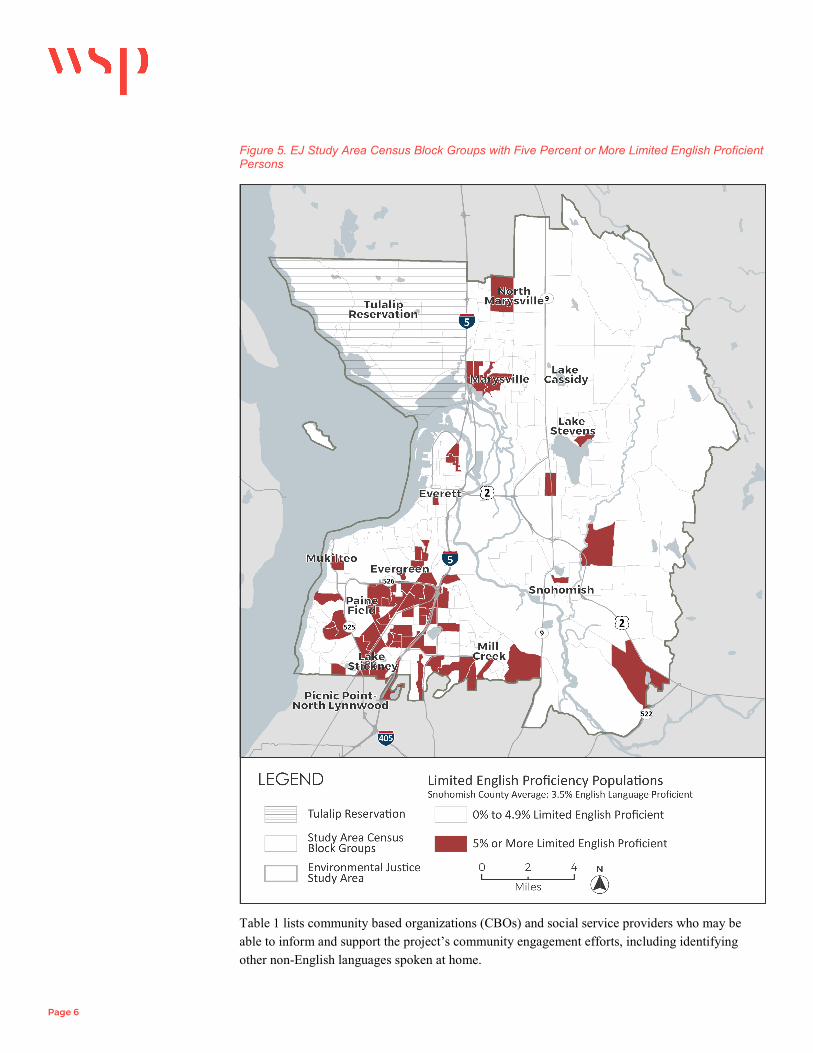
Page 6
Figure 5. EJ Study Area Census Block Groups with Five Percent or More Limited English Proficient Persons
Table 1 lists community based organizations (CBOs) and social service providers who may be able to inform and support the project’s community engagement efforts, including identifying other non-English languages spoken at home.

Page 7
Table 1. Community Based Organizations (CBOs) and Social Service Providers
Organization United Way of Snohomish County
BIKES Club of Snohomish County Community Foundation of Snohomish County FutureWise The Nature Conservancy - Washington Washington Vocational Services Boys & Girls Clubs of Snohomish County Familias Unidas Leadership Snohomish County Operation Homefront Sherwood Community Services Sierra Club Sno-Isle Group Everett Station District Alliance Lake Stevens Family Support Center YMCA of Snohomish County
The complete ACS 5-year estimate data tables that were used to generate the maps in this memorandum are provided in Attachment 1.

Attachment 1: American Community Survey (ACS) 2013-2017 5-Year Estimates

GEOID_2 Geography Description Total
Population Total Households Minority (%) Hispanic/Latino (%) Low-Income
(%) No Vehicle
Available (%) Limited English Proficiency (%)
Snohomish County 771904 284477 23 10 8 5 3.5 530610419034 Block Group 4, Census Tract 419.03, Snohomish County, Washington 2063 675 24 25 35 16 17 530610418061 Block Group 1, Census Tract 418.06, Snohomish County, Washington 1676 568 67 20 4 8 2 530610529033 Block Group 3, Census Tract 529.03, Snohomish County, Washington 1292 577 16 18 18 11 0 530610418113 Block Group 3, Census Tract 418.11, Snohomish County, Washington 2537 1103 27 9 5 11 3 530610527051 Block Group 1, Census Tract 527.05, Snohomish County, Washington 2253 707 14 14 2 0 1 530610408002 Block Group 2, Census Tract 408, Snohomish County, Washington 1656 995 27 8 17 20 4 530610404003 Block Group 3, Census Tract 404, Snohomish County, Washington 1807 744 16 13 22 9 1 530610415001 Block Group 1, Census Tract 415, Snohomish County, Washington 667 248 10 6 17 2 0 530610413031 Block Group 1, Census Tract 413.03, Snohomish County, Washington 2742 1247 23 4 10 5 2 530610412021 Block Group 1, Census Tract 412.02, Snohomish County, Washington 1033 382 28 26 24 13 4 530610412023 Block Group 3, Census Tract 412.02, Snohomish County, Washington 1559 495 27 10 11 0 2 530610413041 Block Group 1, Census Tract 413.04, Snohomish County, Washington 1549 483 12 12 2 2 0 530610409002 Block Group 2, Census Tract 409, Snohomish County, Washington 1783 696 10 6 13 1 0 530610413013 Block Group 3, Census Tract 413.01, Snohomish County, Washington 1390 637 11 15 0 4 0 530610414001 Block Group 1, Census Tract 414, Snohomish County, Washington 1177 381 11 10 10 6 1 530610414002 Block Group 2, Census Tract 414, Snohomish County, Washington 1241 582 22 19 33 38 0 530610414003 Block Group 3, Census Tract 414, Snohomish County, Washington 1041 418 28 27 0 2 0 530610414004 Block Group 4, Census Tract 414, Snohomish County, Washington 2183 694 22 28 4 1 4 530610520031 Block Group 1, Census Tract 520.03, Snohomish County, Washington 1855 617 47 4 3 0 10 530610417043 Block Group 3, Census Tract 417.04, Snohomish County, Washington 1388 433 44 0 0 0 3 530610527071 Block Group 1, Census Tract 527.07, Snohomish County, Washington 3147 911 24 2 1 1 2 530610413033 Block Group 3, Census Tract 413.03, Snohomish County, Washington 1043 335 22 20 0 0 7 530610413014 Block Group 4, Census Tract 413.01, Snohomish County, Washington 518 231 33 0 5 0 0 530619400012 Block Group 2, Census Tract 9400.01, Snohomish County, Washington 1650 511 34 15 6 4 3 530610411002 Block Group 2, Census Tract 411, Snohomish County, Washington 1356 454 37 24 23 13 9 530610416014 Block Group 4, Census Tract 416.01, Snohomish County, Washington 1172 398 30 3 17 11 7 530610412024 Block Group 4, Census Tract 412.02, Snohomish County, Washington 1334 414 7 25 19 0 9 530610529052 Block Group 2, Census Tract 529.05, Snohomish County, Washington 1317 480 29 17 31 21 0 530610521042 Block Group 2, Census Tract 521.04, Snohomish County, Washington 647 260 9 9 17 3 2 530610520042 Block Group 2, Census Tract 520.04, Snohomish County, Washington 1272 464 31 14 0 3 2 530610520043 Block Group 3, Census Tract 520.04, Snohomish County, Washington 1144 499 23 6 0 3 11 530610520044 Block Group 4, Census Tract 520.04, Snohomish County, Washington 2223 661 30 3 11 0 6 530610418102 Block Group 2, Census Tract 418.10, Snohomish County, Washington 2489 1171 32 17 8 0 8 530610418091 Block Group 1, Census Tract 418.09, Snohomish County, Washington 2139 756 65 43 15 12 22 530610419032 Block Group 2, Census Tract 419.03, Snohomish County, Washington 2802 1091 37 44 24 13 15 530610415002 Block Group 2, Census Tract 415, Snohomish County, Washington 631 235 2 1 3 2 2 530610416012 Block Group 2, Census Tract 416.01, Snohomish County, Washington 2204 657 17 12 0 0 5 530610416013 Block Group 3, Census Tract 416.01, Snohomish County, Washington 1360 506 36 5 8 0 4 530610521183 Block Group 3, Census Tract 521.18, Snohomish County, Washington 2988 929 13 4 2 2 3 530610420032 Block Group 2, Census Tract 420.03, Snohomish County, Washington 1715 675 14 8 2 0 2

GEOID_2 Geography Description Total
Population Total Households Minority (%) Hispanic/Latino (%) Low-Income
(%) No Vehicle
Available (%) Limited English Proficiency (%)
Snohomish County 771904 284477 23 10 8 5 3.5 530610420062 Block Group 2, Census Tract 420.06, Snohomish County, Washington 2048 926 36 9 4 0 7 530610521154 Block Group 4, Census Tract 521.15, Snohomish County, Washington 788 277 20 11 0 0 0 530610520041 Block Group 1, Census Tract 520.04, Snohomish County, Washington 1871 970 30 4 1 9 1 530610521153 Block Group 3, Census Tract 521.15, Snohomish County, Washington 472 199 7 0 0 0 4 530610527082 Block Group 2, Census Tract 527.08, Snohomish County, Washington 1292 344 23 10 3 0 2 530610529061 Block Group 1, Census Tract 529.06, Snohomish County, Washington 1621 612 1 4 2 3 0 530619400021 Block Group 1, Census Tract 9400.02, Snohomish County, Washington 1033 454 57 4 14 5 0 530610526071 Block Group 1, Census Tract 526.07, Snohomish County, Washington 2273 732 11 3 3 1 1 530610527053 Block Group 3, Census Tract 527.05, Snohomish County, Washington 1357 480 18 5 10 0 0 530619900020 Block Group 0, Census Tract 9900.02, Snohomish County, Washington 0 0 0 0 0 0 0 530610523012 Block Group 2, Census Tract 523.01, Snohomish County, Washington 1540 566 4 1 1 2 0 530610526052 Block Group 2, Census Tract 526.05, Snohomish County, Washington 1817 618 6 7 0 0 0 530610529032 Block Group 2, Census Tract 529.03, Snohomish County, Washington 623 244 27 30 22 16 10 530610536041 Block Group 1, Census Tract 536.04, Snohomish County, Washington 1711 647 7 5 7 0 1 530610527062 Block Group 2, Census Tract 527.06, Snohomish County, Washington 1572 527 13 16 14 5 5 530610525023 Block Group 3, Census Tract 525.02, Snohomish County, Washington 1660 597 8 3 4 3 2 530610401004 Block Group 4, Census Tract 401, Snohomish County, Washington 1613 305 19 9 5 3 1 530610535051 Block Group 1, Census Tract 535.05, Snohomish County, Washington 820 329 14 11 8 3 1 530610416011 Block Group 1, Census Tract 416.01, Snohomish County, Washington 1393 568 17 2 0 2 4 530619400022 Block Group 2, Census Tract 9400.02, Snohomish County, Washington 1814 608 27 6 13 5 1 530610536022 Block Group 2, Census Tract 536.02, Snohomish County, Washington 1029 397 1 2 21 4 0 530610418063 Block Group 3, Census Tract 418.06, Snohomish County, Washington 1170 382 30 10 22 0 3 530610420052 Block Group 2, Census Tract 420.05, Snohomish County, Washington 2044 686 37 2 6 3 3 530610407003 Block Group 3, Census Tract 407, Snohomish County, Washington 945 547 21 6 16 15 6 530610408001 Block Group 1, Census Tract 408, Snohomish County, Washington 972 363 6 1 5 5 0 530610409001 Block Group 1, Census Tract 409, Snohomish County, Washington 1335 538 17 6 11 14 1 530610404002 Block Group 2, Census Tract 404, Snohomish County, Washington 1042 445 17 9 4 7 0 530610527011 Block Group 1, Census Tract 527.01, Snohomish County, Washington 1795 588 5 7 4 1 0 530610528041 Block Group 1, Census Tract 528.04, Snohomish County, Washington 1820 877 6 3 13 0 0 530610413042 Block Group 2, Census Tract 413.04, Snohomish County, Washington 1463 596 24 4 5 3 2 530610520052 Block Group 2, Census Tract 520.05, Snohomish County, Washington 1851 608 22 0 9 0 0 530610522032 Block Group 2, Census Tract 522.03, Snohomish County, Washington 1345 455 9 6 0 3 0 530610535054 Block Group 4, Census Tract 535.05, Snohomish County, Washington 1542 525 7 4 5 1 0 530610522041 Block Group 1, Census Tract 522.04, Snohomish County, Washington 1188 372 10 14 0 0 9 530610416052 Block Group 2, Census Tract 416.05, Snohomish County, Washington 1932 557 14 2 5 0 1 530610536031 Block Group 1, Census Tract 536.03, Snohomish County, Washington 1133 369 13 3 7 4 1 530610521041 Block Group 1, Census Tract 521.04, Snohomish County, Washington 1575 432 34 18 8 2 0 530610416072 Block Group 2, Census Tract 416.07, Snohomish County, Washington 1545 500 14 8 3 2 2 530610419053 Block Group 3, Census Tract 419.05, Snohomish County, Washington 2074 891 45 31 7 2 12 530610529031 Block Group 1, Census Tract 529.03, Snohomish County, Washington 862 297 6 27 29 9 9 530610523011 Block Group 1, Census Tract 523.01, Snohomish County, Washington 1024 364 21 22 4 0 9 530610412022 Block Group 2, Census Tract 412.02, Snohomish County, Washington 2035 945 19 7 22 19 6

Page 11
GEOID_2 Geography Description Total
Population Total Households Minority (%) Hispanic/Latino (%) Low-Income
(%) No Vehicle
Available (%) Limited English Proficiency (%)
Snohomish County 771904 284477 23 10 8 5 3.5 530610535052 Block Group 2, Census Tract 535.05, Snohomish County, Washington 1607 507 7 5 2 0 1 530610521051 Block Group 1, Census Tract 521.05, Snohomish County, Washington 835 318 4 0 5 5 0 530610416071 Block Group 1, Census Tract 416.07, Snohomish County, Washington 2598 780 21 3 0 2 4 530610529042 Block Group 2, Census Tract 529.04, Snohomish County, Washington 2572 1039 20 11 12 9 5 530610521081 Block Group 1, Census Tract 521.08, Snohomish County, Washington 1824 738 9 0 8 14 0 530610523013 Block Group 3, Census Tract 523.01, Snohomish County, Washington 1208 402 6 1 2 0 0 530610521052 Block Group 2, Census Tract 521.05, Snohomish County, Washington 811 346 4 4 6 2 0 530610536033 Block Group 3, Census Tract 536.03, Snohomish County, Washington 1683 614 6 4 3 3 0 530610523014 Block Group 4, Census Tract 523.01, Snohomish County, Washington 980 332 13 5 0 0 0 530610527091 Block Group 1, Census Tract 527.09, Snohomish County, Washington 1591 575 3 10 0 0 3 530610526053 Block Group 3, Census Tract 526.05, Snohomish County, Washington 1355 455 5 0 14 22 0 530610523022 Block Group 2, Census Tract 523.02, Snohomish County, Washington 1183 382 4 0 8 6 0 530610525021 Block Group 1, Census Tract 525.02, Snohomish County, Washington 1666 656 4 5 10 5 1 530610404001 Block Group 1, Census Tract 404, Snohomish County, Washington 1567 719 22 23 22 20 4 530610407001 Block Group 1, Census Tract 407, Snohomish County, Washington 876 351 27 5 42 56 1 530610407002 Block Group 2, Census Tract 407, Snohomish County, Washington 1222 651 17 7 31 42 0 530610527083 Block Group 3, Census Tract 527.08, Snohomish County, Washington 806 335 4 8 0 2 3 530610527052 Block Group 2, Census Tract 527.05, Snohomish County, Washington 2741 831 34 5 5 2 0 530610527054 Block Group 4, Census Tract 527.05, Snohomish County, Washington 953 278 19 6 0 0 0 530610523021 Block Group 1, Census Tract 523.02, Snohomish County, Washington 1056 378 9 13 11 8 0 530610525022 Block Group 2, Census Tract 525.02, Snohomish County, Washington 1490 477 5 2 5 2 0 530610526031 Block Group 1, Census Tract 526.03, Snohomish County, Washington 1046 385 11 17 5 3 0 530610526041 Block Group 1, Census Tract 526.04, Snohomish County, Washington 1557 547 6 17 5 4 2 530619400014 Block Group 4, Census Tract 9400.01, Snohomish County, Washington 2048 722 18 9 4 1 1 530610401002 Block Group 2, Census Tract 401, Snohomish County, Washington 1339 486 30 4 8 4 2 530610401001 Block Group 1, Census Tract 401, Snohomish County, Washington 880 439 1 0 4 8 0 530610402001 Block Group 1, Census Tract 402, Snohomish County, Washington 2186 718 33 6 27 12 19 530610402002 Block Group 2, Census Tract 402, Snohomish County, Washington 1315 615 32 14 23 30 4 530610402003 Block Group 3, Census Tract 402, Snohomish County, Washington 1629 470 38 4 19 12 10 530610401003 Block Group 3, Census Tract 401, Snohomish County, Washington 941 416 8 5 6 2 1 530610402004 Block Group 4, Census Tract 402, Snohomish County, Washington 994 684 25 0 40 61 14 530610403001 Block Group 1, Census Tract 403, Snohomish County, Washington 1436 588 16 6 11 7 0 530610413012 Block Group 2, Census Tract 413.01, Snohomish County, Washington 2120 745 5 0 0 0 1 530610419011 Block Group 1, Census Tract 419.01, Snohomish County, Washington 665 250 40 9 0 3 2 530610523023 Block Group 3, Census Tract 523.02, Snohomish County, Washington 1812 587 4 1 0 4 0 530610529044 Block Group 4, Census Tract 529.04, Snohomish County, Washington 973 355 19 16 16 0 2 530610528042 Block Group 2, Census Tract 528.04, Snohomish County, Washington 3043 1012 21 7 7 2 9 530610528044 Block Group 4, Census Tract 528.04, Snohomish County, Washington 898 385 7 0 0 11 1 530610528052 Block Group 2, Census Tract 528.05, Snohomish County, Washington 1327 539 15 4 11 6 0 530610528053 Block Group 3, Census Tract 528.05, Snohomish County, Washington 1490 584 29 4 8 3 0 530610528051 Block Group 1, Census Tract 528.05, Snohomish County, Washington 1286 617 8 4 11 28 1 530610528062 Block Group 2, Census Tract 528.06, Snohomish County, Washington 1209 399 0 0 7 3 4

GEOID_2 Geography Description Total
Population Total Households Minority (%) Hispanic/Latino (%) Low-Income
(%) No Vehicle
Available (%) Limited English Proficiency (%)
Snohomish County 771904 284477 23 10 8 5 3.5 530610528063 Block Group 3, Census Tract 528.06, Snohomish County, Washington 1198 520 20 4 14 7 0 530610528064 Block Group 4, Census Tract 528.06, Snohomish County, Washington 791 345 32 5 0 0 4 530610529063 Block Group 3, Census Tract 529.06, Snohomish County, Washington 2447 739 16 15 12 3 2 530610529034 Block Group 4, Census Tract 529.03, Snohomish County, Washington 1727 649 24 8 10 15 5 530610527081 Block Group 1, Census Tract 527.08, Snohomish County, Washington 2071 691 17 2 0 1 4 530610527092 Block Group 2, Census Tract 527.09, Snohomish County, Washington 2223 598 10 11 2 0 3 530610529041 Block Group 1, Census Tract 529.04, Snohomish County, Washington 533 238 2 2 0 0 0 530610521155 Block Group 5, Census Tract 521.15, Snohomish County, Washington 1309 416 9 34 0 0 1 530610413011 Block Group 1, Census Tract 413.01, Snohomish County, Washington 1642 507 23 4 2 0 5 530610521152 Block Group 2, Census Tract 521.15, Snohomish County, Washington 1799 512 36 2 0 0 7 530610521043 Block Group 3, Census Tract 521.04, Snohomish County, Washington 1740 548 15 10 11 0 2 530610521151 Block Group 1, Census Tract 521.15, Snohomish County, Washington 1469 490 26 2 0 3 0 530610529053 Block Group 3, Census Tract 529.05, Snohomish County, Washington 1842 729 4 22 24 9 4 530610529062 Block Group 2, Census Tract 529.06, Snohomish County, Washington 1294 477 26 4 10 4 0 530610418093 Block Group 3, Census Tract 418.09, Snohomish County, Washington 1424 602 61 16 8 4 4 530610528065 Block Group 5, Census Tract 528.06, Snohomish County, Washington 2244 791 28 16 9 4 1 530610403002 Block Group 2, Census Tract 403, Snohomish County, Washington 1656 775 10 9 15 25 1 530610405002 Block Group 2, Census Tract 405, Snohomish County, Washington 1236 475 18 12 12 4 1 530610413032 Block Group 2, Census Tract 413.03, Snohomish County, Washington 439 202 23 2 9 4 2 530610410003 Block Group 3, Census Tract 410, Snohomish County, Washington 1245 543 28 14 10 5 3 530610412012 Block Group 2, Census Tract 412.01, Snohomish County, Washington 1750 605 34 3 6 4 0 530610418053 Block Group 3, Census Tract 418.05, Snohomish County, Washington 2402 919 31 14 8 2 6 530610416062 Block Group 2, Census Tract 416.06, Snohomish County, Washington 2961 925 31 9 10 5 4 530610521156 Block Group 6, Census Tract 521.15, Snohomish County, Washington 1206 391 11 2 6 0 0 530610529043 Block Group 3, Census Tract 529.04, Snohomish County, Washington 1747 493 35 36 16 0 1 530610526062 Block Group 2, Census Tract 526.06, Snohomish County, Washington 1117 448 5 3 6 0 1 530610524022 Block Group 2, Census Tract 524.02, Snohomish County, Washington 1272 678 19 2 19 9 1 530610529051 Block Group 1, Census Tract 529.05, Snohomish County, Washington 1295 677 32 12 9 11 1 530610410002 Block Group 2, Census Tract 410, Snohomish County, Washington 1237 525 15 2 10 9 1 530610411001 Block Group 1, Census Tract 411, Snohomish County, Washington 1130 508 8 2 15 2 3 530610410001 Block Group 1, Census Tract 410, Snohomish County, Washington 1445 653 11 12 27 16 0 530610410004 Block Group 4, Census Tract 410, Snohomish County, Washington 1664 645 15 3 20 10 4 530610407004 Block Group 4, Census Tract 407, Snohomish County, Washington 950 284 28 12 28 11 0 530610417041 Block Group 1, Census Tract 417.04, Snohomish County, Washington 1888 736 29 14 10 0 1 530610417042 Block Group 2, Census Tract 417.04, Snohomish County, Washington 2493 1080 23 10 9 0 6 530610417031 Block Group 1, Census Tract 417.03, Snohomish County, Washington 1855 611 39 7 3 2 10 530610418101 Block Group 1, Census Tract 418.10, Snohomish County, Washington 628 197 35 36 18 18 4 530610420053 Block Group 3, Census Tract 420.05, Snohomish County, Washington 1154 480 21 6 2 0 1 530610420011 Block Group 1, Census Tract 420.01, Snohomish County, Washington 1508 703 22 4 4 19 1 530610527072 Block Group 2, Census Tract 527.07, Snohomish County, Washington 1370 447 11 12 1 0 0 530610527061 Block Group 1, Census Tract 527.06, Snohomish County, Washington 4932 1618 21 17 5 1 2 530619400013 Block Group 3, Census Tract 9400.01, Snohomish County, Washington 1498 573 24 3 11 5 0

Page 13
GEOID_2 Geography Description Total
Population Total Households Minority (%) Hispanic/Latino (%) Low-Income
(%) No Vehicle
Available (%) Limited English Proficiency (%)
Snohomish County 771904 284477 23 10 8 5 3.5 530610521182 Block Group 2, Census Tract 521.18, Snohomish County, Washington 2601 833 29 8 2 2 7 530610520032 Block Group 2, Census Tract 520.03, Snohomish County, Washington 2681 709 43 4 0 3 9 530610526072 Block Group 2, Census Tract 526.07, Snohomish County, Washington 3249 1041 8 9 2 2 0 530610526073 Block Group 3, Census Tract 526.07, Snohomish County, Washington 806 282 10 0 6 3 0 530610525042 Block Group 2, Census Tract 525.04, Snohomish County, Washington 1633 588 20 7 10 1 4 530610526032 Block Group 2, Census Tract 526.03, Snohomish County, Washington 1465 488 6 4 4 1 0 530610536032 Block Group 2, Census Tract 536.03, Snohomish County, Washington 1208 425 12 1 4 0 0 530610528061 Block Group 1, Census Tract 528.06, Snohomish County, Washington 1669 473 16 29 0 0 1 530619400023 Block Group 3, Census Tract 9400.02, Snohomish County, Washington 709 311 9 3 7 5 2 530619400011 Block Group 1, Census Tract 9400.01, Snohomish County, Washington 1222 453 29 6 8 8 0 530610411003 Block Group 3, Census Tract 411, Snohomish County, Washington 1206 483 34 8 11 11 11 530610416051 Block Group 1, Census Tract 416.05, Snohomish County, Washington 2363 707 18 23 9 0 2 530610416053 Block Group 3, Census Tract 416.05, Snohomish County, Washington 2738 884 41 24 2 2 9 530610526063 Block Group 3, Census Tract 526.06, Snohomish County, Washington 1498 505 7 4 4 2 1 530610524012 Block Group 2, Census Tract 524.01, Snohomish County, Washington 1256 383 27 20 6 12 8 530610524013 Block Group 3, Census Tract 524.01, Snohomish County, Washington 940 406 12 4 17 9 0 530610524014 Block Group 4, Census Tract 524.01, Snohomish County, Washington 987 431 13 1 7 10 0 530610524021 Block Group 1, Census Tract 524.02, Snohomish County, Washington 1290 543 4 0 11 2 0 530610525033 Block Group 3, Census Tract 525.03, Snohomish County, Washington 2076 684 14 6 5 0 0 530610525034 Block Group 4, Census Tract 525.03, Snohomish County, Washington 1557 615 13 2 0 0 5 530610525041 Block Group 1, Census Tract 525.04, Snohomish County, Washington 1029 369 5 13 6 0 1 530610524011 Block Group 1, Census Tract 524.01, Snohomish County, Washington 1081 321 12 24 10 0 3 530610524023 Block Group 3, Census Tract 524.02, Snohomish County, Washington 1437 562 8 17 11 7 3 530610525031 Block Group 1, Census Tract 525.03, Snohomish County, Washington 2550 866 11 7 8 2 1 530610525032 Block Group 2, Census Tract 525.03, Snohomish County, Washington 820 333 0 0 0 0 0 530610526042 Block Group 2, Census Tract 526.04, Snohomish County, Washington 1305 620 7 28 18 7 3 530610526043 Block Group 3, Census Tract 526.04, Snohomish County, Washington 1704 564 15 11 13 3 0 530610526051 Block Group 1, Census Tract 526.05, Snohomish County, Washington 1673 597 18 1 5 3 1 530610526054 Block Group 4, Census Tract 526.05, Snohomish County, Washington 1529 429 10 37 0 3 6 530610526061 Block Group 1, Census Tract 526.06, Snohomish County, Washington 2780 817 22 17 14 1 0 530610420014 Block Group 4, Census Tract 420.01, Snohomish County, Washington 1033 378 18 0 17 0 0 530610420012 Block Group 2, Census Tract 420.01, Snohomish County, Washington 1485 550 23 25 6 2 7 530610420013 Block Group 3, Census Tract 420.01, Snohomish County, Washington 1937 651 21 0 0 0 4 530610419033 Block Group 3, Census Tract 419.03, Snohomish County, Washington 1823 807 30 8 3 0 8 530610419041 Block Group 1, Census Tract 419.04, Snohomish County, Washington 2505 880 32 73 10 9 22 530610420031 Block Group 1, Census Tract 420.03, Snohomish County, Washington 1396 486 18 12 0 0 2 530610420041 Block Group 1, Census Tract 420.04, Snohomish County, Washington 1711 626 25 4 10 2 6 530610420042 Block Group 2, Census Tract 420.04, Snohomish County, Washington 974 383 31 0 3 0 4 530610420043 Block Group 3, Census Tract 420.04, Snohomish County, Washington 1682 614 39 3 9 4 5 530610419042 Block Group 2, Census Tract 419.04, Snohomish County, Washington 1847 813 29 26 20 24 3 530610419043 Block Group 3, Census Tract 419.04, Snohomish County, Washington 1171 549 34 30 35 38 16 530610419051 Block Group 1, Census Tract 419.05, Snohomish County, Washington 2005 722 32 18 21 2 7

GEOID_2 Geography Description Total
Population Total Households Minority (%) Hispanic/Latino (%) Low-Income
(%) No Vehicle
Available (%) Limited English Proficiency (%)
Snohomish County 771904 284477 23 10 8 5 3.5 530610419052 Block Group 2, Census Tract 419.05, Snohomish County, Washington 1102 418 36 9 28 10 12 530610419054 Block Group 4, Census Tract 419.05, Snohomish County, Washington 1203 402 11 4 26 0 3 530610420051 Block Group 1, Census Tract 420.05, Snohomish County, Washington 2082 754 27 3 6 0 5 530610420061 Block Group 1, Census Tract 420.06, Snohomish County, Washington 1037 481 45 4 14 0 7 530610420063 Block Group 3, Census Tract 420.06, Snohomish County, Washington 1825 762 50 5 6 0 7 530610405001 Block Group 1, Census Tract 405, Snohomish County, Washington 1082 436 23 11 23 14 1 530610418065 Block Group 5, Census Tract 418.06, Snohomish County, Washington 977 330 28 0 10 0 11 530610411004 Block Group 4, Census Tract 411, Snohomish County, Washington 978 390 9 7 4 9 2 530610412011 Block Group 1, Census Tract 412.01, Snohomish County, Washington 1560 548 8 0 11 6 5 530610527084 Block Group 4, Census Tract 527.08, Snohomish County, Washington 1400 415 15 19 0 0 0 530610527055 Block Group 5, Census Tract 527.05, Snohomish County, Washington 1072 411 16 6 14 3 0 530610418052 Block Group 2, Census Tract 418.05, Snohomish County, Washington 2086 994 20 15 6 3 7 530610418062 Block Group 2, Census Tract 418.06, Snohomish County, Washington 2058 821 42 20 16 2 12 530610418064 Block Group 4, Census Tract 418.06, Snohomish County, Washington 1596 480 33 5 13 4 1 530610418066 Block Group 6, Census Tract 418.06, Snohomish County, Washington 1239 490 33 52 24 9 18 530610418082 Block Group 2, Census Tract 418.08, Snohomish County, Washington 1342 622 19 6 13 3 2 530610418103 Block Group 3, Census Tract 418.10, Snohomish County, Washington 1626 716 38 25 14 19 6 530610418092 Block Group 2, Census Tract 418.09, Snohomish County, Washington 1703 597 43 12 20 2 6 530610418081 Block Group 1, Census Tract 418.08, Snohomish County, Washington 1406 612 45 36 24 4 7 530610418083 Block Group 3, Census Tract 418.08, Snohomish County, Washington 1330 457 22 36 3 10 9 530610419012 Block Group 2, Census Tract 419.01, Snohomish County, Washington 1898 669 54 6 5 9 14 530610419013 Block Group 3, Census Tract 419.01, Snohomish County, Washington 2192 820 38 26 2 2 5 530610419031 Block Group 1, Census Tract 419.03, Snohomish County, Washington 1285 543 27 33 31 13 6 530610416061 Block Group 1, Census Tract 416.06, Snohomish County, Washington 1869 770 34 7 7 14 5 530610416063 Block Group 3, Census Tract 416.06, Snohomish County, Washington 1040 285 3 40 3 5 4 530610416081 Block Group 1, Census Tract 416.08, Snohomish County, Washington 1822 580 16 1 2 0 4 530610416082 Block Group 2, Census Tract 416.08, Snohomish County, Washington 859 308 28 6 0 0 4 530610416083 Block Group 3, Census Tract 416.08, Snohomish County, Washington 783 348 27 4 5 4 0 530610416084 Block Group 4, Census Tract 416.08, Snohomish County, Washington 1183 419 7 9 0 3 0 530610416085 Block Group 5, Census Tract 416.08, Snohomish County, Washington 1991 621 19 8 0 0 1 530610417011 Block Group 1, Census Tract 417.01, Snohomish County, Washington 2607 833 50 22 19 2 1 530610417012 Block Group 2, Census Tract 417.01, Snohomish County, Washington 2486 1025 30 22 3 12 6 530610417013 Block Group 3, Census Tract 417.01, Snohomish County, Washington 907 593 38 1 27 33 21 530610417032 Block Group 2, Census Tract 417.03, Snohomish County, Washington 1296 393 32 2 15 0 0 530610418112 Block Group 2, Census Tract 418.11, Snohomish County, Washington 1792 612 52 2 4 0 6 530610418121 Block Group 1, Census Tract 418.12, Snohomish County, Washington 4320 1496 55 28 9 10 20 530610418111 Block Group 1, Census Tract 418.11, Snohomish County, Washington 2434 762 47 9 5 6 1 530610418122 Block Group 2, Census Tract 418.12, Snohomish County, Washington 2417 987 44 16 31 20 12 530610418051 Block Group 1, Census Tract 418.05, Snohomish County, Washington 1394 649 49 14 13 9 5

CRC Project #1808G-1 Cultural Resources Approach Plan, US 2 Westbound Trestle Replacement Project, Snohomish County, WA
Page 1
CRC MEMO #1808G-1 DATE: November 30, 2018 TO: Lawrence Spurgeon WSP FROM: Margaret Berger, Principal Investigator RE: Cultural Resources Approach Plan, US 2 Westbound Trestle Replacement
Project, Snohomish County, WA Summary of Available Data Prior cultural resources studies in the involved corridors and a ~800 foot buffer are described below in Table 1. These were identified by searching the Washington State Department of Archaeology and Historic Preservation’s (DAHP) Washington Information System for Architectural and Archaeological Records Data (WISAARD) database (DAHP 2018). Cultural resources investigations directly within the involved corridors are limited to Ferland (2010), who reported archaeological and historic built environment survey that included US2 right-of-way in the vicinity of MP 4; Roedel et al. (2004) who surveyed portions of I-5 south of US2; and Chidley (2008), who surveyed portions of I-5 right-of-way in Marysville. Very few archaeological sites have been recorded in proximity to the project corridors (Table 2). None are directly within the corridors. Historic cemeteries have all been identified near the project corridors, as listed in Table 3. Thousands of historic inventory properties have been identified in proximity to the project corridors. Table 4 lists the 36 historic inventory properties located on the north side of the existing US 2 Westbound Trestle and east of I-5, as a sample of the types of historic resources that have been recorded in proximity to the project. Historic register listed properties are present in the vicinity of the project. None of them are directly within the corridors. Properties listed on the Washington Heritage Register (WHR) and National Register of Historic Places (NRHP) within approximately one block from the project corridors are listed in Table 5. WSDOT has identified five bridges in the vicinity of the project as historically significant (WSDOT 2018a). These are all on SR529 in northern Everett (Table 6). Other bridges that are historic in age are present in the project corridors. However, according to WSDOT (2018b),

CRC Project #1808G-1 Cultural Resources Approach Plan, US 2 Westbound Trestle Replacement Project, Snohomish County, WA
Page 2
The Program Comment for Common Post-1945 Concrete and Steel Bridges issued by the Advisory Council of Historic Preservation (ACHP) in 2012 eliminates the historic review requirements under Section 106 of the NHPA for common (mass produced) post-1945 concrete and steel bridges and culverts. The intent of the Program Comment is to streamline the review process for those structures that lack distinction; have not previously been listed or determined eligible for listing on the National Register; and are not located in or adjacent to historic districts.
As stated in the Program Comment (ACHP 2012), the following common bridge types are covered:
(A) Reinforced concrete slab bridges (i) Reinforced concrete cast-in-place slabs (ii) Reinforced concrete pre-cast slabs (iii) Pre-stressed concrete slabs
(B) Reinforced concrete beam and girder bridges (i) Reinforced concrete Tee Beams (ii) Reinforced concrete channel beams (iii) Pre-stressed concrete I-Beams and Bulb Tees (iv) Pre-stressed concrete box beams
(C) Steel Multi-Beam or Multi-Girder bridges (i) Steel-rolled multi-beams (ii) Steel fabricated (built up) girders
(D) Culverts and reinforced concrete boxes (i) Reinforced concrete boxes (ii) Concrete box culverts (iii) Concrete pipe culverts (iv) Steel pipe culverts
Based upon review of National Bridge Inventory data, the US2 Westbound Trestle and several other bridges in the project vicinity appear to meet the above criteria and it is expected that the Program Comment would apply (Table 7). A list of exceptions to the Program Comment, identified by state, includes common post-1945 concrete and steel bridges and culverts of exceptional quality that remain subject to Section 106 review (FHWA 2018a). One bridge in the vicinity of the project has been identified as an exception to the Program Comment (Table 8). Additionally, the 2005 Section 106 Exemption Regarding Effects to the Interstate Highway System by the ACHP excludes the majority of Interstate Highway Features from consideration as a historic property under Section 106 of the National Historic Preservation Act (NHPA). FHWA maintains a list of Nationally and Exceptionally Significant Features of the Federal Interstate Highway System not subject to the ACHP’s Exemption (FHWA 2018b). No such significant features are in the project corridors. Data Gaps The area adjacent to the north of the existing US 2 Westbound Trestle, which is expected to be involved in construction of the replacement trestle, has not been surveyed for cultural resources. It is known that 36 historic inventory properties are present in this area. Review of County Assessor records may identify as-yet uninventoried properties approaching the 50-year age threshold for review under Section 106. Archaeological sites have not been recorded in this area, but based upon review of prior investigations on the Snohomish River floodplain, it is considered

CRC Project #1808G-1 Cultural Resources Approach Plan, US 2 Westbound Trestle Replacement Project, Snohomish County, WA
Page 3
to have a high probability for as-yet unknown archaeological sites to be present due to its depositional setting, proximity to waterways and natural resources, and proximity to ethnographically reported place names. DAHP’s predictive model identifies the Snohomish River delta, including the area north of the US 2 Westbound Trestle, the western part of SR 529, and a small area of SR 526 as high risk to very high risk for archaeological sites. The I-5, SR 204, SR 9, majority of SR 526, and east end of SR 529 corridors in the project are classified as low, moderately low, or moderate risk (DAHP 2018). The existing developed highways in upland environments are generally considered to have low potential for as-yet unrecorded archaeological sites due to the extent of prior disturbance on glacial landforms with minimal soil development. Areas of the project in alluvial and deltaic environments, such as the area north of the existing US 2 Westbound Trestle are generally considered to have a high potential for as-yet unrecorded archaeological sites due to thick alluvial deposits that could preserve archaeological deposits beneath the extent of prior disturbance. Locations in proximity to shorelines or streams are typically considered higher probability due to their proximity to natural resources that would have been attractive to precontact populations. Historic resources are likely to be present throughout the project corridors. Work Plan As demonstrated by the above summary of existing cultural resources information, there are many prior cultural resources studies and known cultural resources in the vicinity of the project. Portions of I-5 and US 2 have been included in prior studies, but the majority of the project corridors have not been surveyed for cultural resources. When project alternatives are identified, it will be possible to assess more specifically which of the known cultural resources could potentially be affected and which areas are in need of cultural resources survey. Discussion of the project with cultural resources staff of affected Tribes may also identify specific areas of concern. Review of geological and soils surveys, ethnographic reports, historical maps, and other sources will provide more detailed information to refine low and high probability environments of the project. WSDOT cultural resources staff should be consulted to confirm which bridges involved in the project are subject to the Program Comment and identify any that may not meet the applicable criteria and would require historic review under Section 106. References Cited Advisory Council on Historic Preservation (ACHP)
2012 Program Comment Issued for Streamlining Section 106 Review for Actions Affecting Post-1945 Concrete and Steel Bridges. Federal Register Vol. 77, No. 222., pp. 68790-68795.
Blukis Onat, A. R., C. Walker Gray, T. L. Cowan
2007 Cultural Resources Inventory for the 20th Street SE Improvement Project from 91st Ave SE to Cavalero Road and From Cavalero Road to SR 2. BOAS Inc. Prepared for Snohomish County Public Works.

CRC Project #1808G-1 Cultural Resources Approach Plan, US 2 Westbound Trestle Replacement Project, Snohomish County, WA
Page 4
Baldwin, G. L. 2014 Letter to Adam Escalona RE: Cultural Resources Review for the AT&T Mobility
Project, SN2892 Maryville Grove. Drayton Archaeology. Prepared for Adapt Engineering, Inc.
BridgeReports.com
2018 National Bridge Inventory Data. Electronic resource, https://bridgereports.com/, accessed November 27, 2018.
Bush, K. R., T. S. Smart, and C. Leverett
2007 Archaeological Investigation Report - Blue Heron Slough Conservation Bank, Marysville. Equinox Research and Consulting International, Inc. Prepared for Wildlands of Washington, Inc.
Chidley, M.
2008 Letter to Allyson Brooks RE: Request for Determination of Effects Concurrence I-5 Marysville to Stillaguamish River Vic. Project. WSDOT, Northwest Region.
Cooper, J.
2018a Letter Report – SR 9 / SR 204 Intersection Improvements – Phase I Early Works Project, Snohomish County, Washington. WSDOT, Northwest Region.
2018b Cultural Resources Survey for the Steamboat Slough Advanced Mitigation Site, Snohomish County, Washington. WSDOT, Northwest Region.
Cooper, J., and S. Sparks
2007 Everett Rail Yard Improvement Project Cultural Resources Survey and Discipline Report. Jones & Stokes in association with InterMountain Resources. Prepared for Burlington Northern Santa Fe Railway.
Dailide, A. M.
2015 Archaeological and Historical Resources Identification Short Report: PL-84-99 Union Slough Levee Rehabilitation Project. U.S. Army Corps of Engineers Seattle District.
Dunnell, R. C., and J. W. Fuller
1975 An Archaeological Survey of Everett Harbor and the Lower Snohomish Estuary-Delta. University of Washington. Prepared for National Park Service.
Earley, A., and B. Rinck
2010 Cultural Resources Assessment of the Tulalip Water Pipeline, Snohomish County, Washington. Northwest Archaeological Associates, Inc. Prepared for MWH Global.
Engseth, M. F., and A. Sharley
2007 Cultural Resources Survey for the Washington State Department of Transportation SR 9: 20th Street SE Intersection Improvement Project, Snohomish County, Washington. Archaeological and Historical Services, Eastern Washington University, Cheney. Prepared for WSDOT.

CRC Project #1808G-1 Cultural Resources Approach Plan, US 2 Westbound Trestle Replacement Project, Snohomish County, WA
Page 5
Federal Highway Administration (FHWA)
2018a Bridge Program Comment Excepted Bridges List. Electronic resource, https://www.environment.fhwa.dot.gov/env_topics/historic_pres/bridges_list.aspx, accessed November 27, 2018.
2018b Final List of Nationally and Exceptionally Significant Features of the Federal Interstate Highway System. Electronic resource, https://www.environment.fhwa.dot.gov/env_topics/historic_pres/highways_list.aspx, accessed November 27, 2018.
Ferland, S. C.
2010 Cultural Resources Assessment for the Bickford Avenue Safety Improvements Project, Snohomish County, Washington. Northwest Archaeological Associates, Inc. Prepared for WSDOT, Northwest Region.
Iversen, D. R., S. Stringer-Bowsher, S. Davis, J. Krintz, N. Smith, and A. Sawyer
2012 Cultural Resources Field Inventory for 15 Action Areas within the Puget Sound Nearshore Ecosystem Restoration Projects Area (PSNERP). ASM Affiliates, Inc. Prepared for U.S. Fish and Wildlife Service.
Juell, K.
2003a Cultural Resources Assessment for the City of Everett’s Water Transmission Pipeline Replacement Project – Phases 6 and 7. Northwest Archaeological Associates, Inc. Prepared for City of Everett.
2003b Heritage Resources Investigations for the Everett Delta Lateral Pipeline Project: Pipeline Realignments, New Work Areas, and Access Road Corridors. Northwest Archaeological Associates, Inc. Prepared for PIC Technologies, Inc. and Northwest Pipeline Corporation.
Kanaby, K. M., L. N. Goetz, D. Tingwall, and T. C. Rust
2010 Cultural Resources Assessment for the Smith Island Restoration Project, Snohomish County, Washington. Landau Associates. Prepared for Snohomish County Public Works.
Lentz, F., and P. Johnson
2011 Everett Riverfront Redevelopment, Cultural Resources Supplement. Paragon Research Associates. Prepared for Macleod Reckord.
LeTourneau, P., and S. Davis
2005 Results of Archaeological Monitoring of Excavations for Olympic Pipe Line Company's North Ebey Slough Reroutes. BOAS, Inc. Prepared for GeoEngineers, Inc.
Maass, A.
2000 Cultural Resources Technical Report for the Everett Delta Pipeline Project. Historical Research Associates, Inc. Prepared for PIC Technologies, Inc.

CRC Project #1808G-1 Cultural Resources Approach Plan, US 2 Westbound Trestle Replacement Project, Snohomish County, WA
Page 6
Maass, A., and B. Smith-Steiner 2004 Cultural Resources Technical Report for the Williams Everett Delta Pipeline Project.
Historical Research Associates, Inc. Prepared for PIC Technologies, Inc.
Rinck, B., and J. Piper 2015 Cultural Resource Assessment for the SR 529/Interstate 5 Expansion Project, Marysville,
Snohomish County, Washington. SWCA Environmental Consultants. Prepared for HDR, Inc.
Roedel, K. W., L. A. Forsman, J. Koler, D. E. Lewarch, and L. L. Larson
2004 Everett HOV Cultural Resources Assessment, Interstate 5 HOV, SR 526 to SR 2 Vicinity, Snohomish County, Washington, Technical Report. Larson Anthropological Archaeological Services Limited. Prepared for WSDOT.
Rooke, L.
2008 Cultural Resources Assessment for SR 529 Ebey Slough Bridge Replacement Project, Marysville. AMEC Earth & Environmental, Inc. Prepared for WSDOT, Northwest Region.
Schumacher, J., and G. D. Hartmann
2005 Letter to Graham Anderson Regarding Port of Everett 12th Street Marina Redevelopment: Union Slough Mitigation Area. Western Shore Heritage Services, Inc. Prepared for Port of Everett.
Shantry, K., and C. M. Hodges
2007 Cultural Resources Assessment for the Everett Riverfront Master Plan and Redevelopment Project. Northwest Archaeological Associates, Inc. Prepared for City of Everett Public Works Department.
Shong, M.
2003 Letter to Mark Sadler Regarding Monitoring Results for the Everett Water Pipeline Replacement No. 2 and 3 (Phase 5). Northwest Archaeological Associates, Inc. Prepared for City of Everett.
Shong, M., and K. Juell
2002 Cultural Resources Inventory for the City of Everett's Water Transmission Pipeline Replacement Project - Phase 5, Snohomish County, Washington. Northwest Archaeological Associates, Inc. Prepared for City of Everett.
Shong, M., and C. J. Miss
2009 Results of Archaeological Monitoring for the Ebey Slough Transmission Line Replacement Project. Northwest Archaeological Associates, Inc. Prepared for GeoEngineers, Inc.

CRC Project #1808G-1 Cultural Resources Approach Plan, US 2 Westbound Trestle Replacement Project, Snohomish County, WA
Page 7
Tingwall, D. F., K. M. Kanaby, L. N. Goetz, and T. C. Rust 2009 Cultural Resources Feasibility Study Smith Island Restoration Project, Snohomish
County, Washington. Landau Associates. Prepared for Snohomish County Public Works.
Washington State Department of Archaeology and Historic Preservation (DAHP) 2018 Washington Information System for Architectural and Archaeological Records Data
(WISAARD) database. Electronic resource, https://secureaccess.wa.gov/dahp/wisaard/, accessed November 27, 2018.
Washington State Department of Transportation (WSDOT) 2018a Washington State Historic Highway Bridges. Electronic resource,
https://www.wsdot.wa.gov/environment/protecting-environment/history-archaeology-and-culture/historic-highway-bridges#LIST, accessed November 27, 2018.
2018b Historic Highway Bridges. Electronic resource, https://www.wsdot.wa.gov/environment/protecting-environment/history-archaeology-and-culture/historic-highway-bridges, accessed November 27, 2018.
Weaver, R., and M. Nelson
2002 Letter to Steve Shipe Re: SR 2/SR 9 Interchange, Cultural Resources Survey Hart Crowser and Northwest Archaeological Associates, Inc. Prepared for WSDOT.
Weitzel, C.
2004 Archaeological Monitoring for Construction of Northwest Pipeline Company Everett Delta Natural Gas Pipeline Lateral. Historical Research Associates, Inc. Prepared for Williams.

CRC Project #1808G-1 Cultural Resources Approach Plan, US 2 Westbound Trestle Replacement Project, Snohomish County, WA
Page 8
Tables Table 1. Prior cultural resources investigations (DAHP 2018). Author Date Title Summary Dunnell and Fuller
1975 An Archaeological Survey of Everett Harbor and the Lower Snohomish Estuary-Delta
Archaeological survey for proposed maintenance dredging and dredge spoils deposition in the Snohomish River delta. The survey included areas south of US 2 and identified archaeological site 45SN43.
Maass 2000 Cultural Resources Technical Report for the Everett Delta Pipeline Project
This report describes methods and results of background research and fieldwork to identify potential impacts to cultural resources from proposed gas pipeline construction on the Snohomish Delta, crossing I-5 north of Everett. Results were negative for historic or archaeological resources. Archaeological monitoring was recommended for open-trench excavations in previously undisturbed areas within 75 m of the high water mark where the pipeline would intersect the Snohomish River, Ebey Slough, and Union Slough.
Shong and Juell 2002 Cultural Resources Inventory for the City of Everett's Water Transmission Pipeline Replacement Project - Phase 5, Snohomish County, Washington
This report describes methods and results of background research and fieldwork to identify potential impacts to cultural resources from proposed water pipeline replacement on the south side of US 2 directly east of the Snohomish River and east of Ebey Slough. Results were negative for historic or archaeological resources. Archaeological monitoring was recommended for trench excavation in the area east of Ebey Slough, where it was considered possible for deeply buried archaeological deposits to be encountered.
Weaver and Nelson
2002 Letter to Steve Shipe Re: SR 2/SR 9 Interchange, Cultural Resources Survey
This report describes methods and results of background research and fieldwork to identify potential effects to historic properties from proposed improvements to the intersection of US 2 and SR 9. Results were negative for historic or archaeological resources.
Juell 2003 Cultural Resources Assessment for the City of Everett’s Water Transmission Pipeline Replacement Project – Phases 6 and 7
This report describes methods and results of background research and fieldwork to identify potential effects to historic properties from proposed water pipeline construction along the south side of the US 2 Eastbound Trestle. Results were negative for historic or archaeological resources. Archaeological monitoring of construction excavations was recommended for the portion of the project where the pipe would be buried in a trench in the west bank of Ebey Slough.
Juell 2003 Heritage Resources Investigations for the Everett Delta Lateral Pipeline Project: Pipeline Realignments, New Work Areas, and Access Road Corridors
This report describes methods and results of background research and fieldwork to identify potential effects to historic properties from proposed gas pipeline construction on the Snohomish Delta, crossing I-5 north of Everett. No archaeological or historic resources were identified near the current project. Archaeological monitoring was recommended for all pipeline trenching on the Snohomish River floodplain.
Shong 2003 Letter to Mark Sadler Regarding Monitoring Results for the Everett Water Pipeline Replacement No. 2 and 3 (Phase 5)
This report describes methods and results of archaeological monitoring of water pipeline construction on the south side of US 2 on the east banks of the Snohomish River and Ebey Slough. No archaeological sites were found.

CRC Project #1808G-1 Cultural Resources Approach Plan, US 2 Westbound Trestle Replacement Project, Snohomish County, WA
Page 9
Author Date Title Summary Maass and Smith-Steiner
2004 Cultural Resources Technical Report for the Williams Everett Delta Pipeline Project
This report describes methods and results of background research and fieldwork to identify potential effects to historic properties from proposed gas pipeline construction including an area on Smith Island on the east side of I-5. No archaeological or historic resources were identified near the current project. Archaeological monitoring was recommended for open-trench excavations in previously undisturbed areas within 75 m of the high water mark where the pipeline would intersect the Snohomish River, Ebey Slough, and Union Slough.
Roedel et al. 2004 Everett HOV Historic, Cultural, and Archaeological Resource Assessment, Interstate 5 HOV, SR 526 to SR 2 Vicinity
This report describes methods and results of background research and fieldwork to identify potential impacts to cultural resources from proposed HOV lanes on I-5 and associated water quality sites and drainage easements. No archaeological sites were found. 40 previously unrecorded historic resources were identified. Of these, 14 were inventoried evaluated for NRHP eligibility; 2 were recommended eligible and the other 12 were recommended not eligible. 23 previously inventoried historic resources were also identified and evaluated for NRHP eligibility; 4 were recommended eligible and the other 19 were recommended not eligible. It was not determined whether any of the identified NRHP-eligible resources would be adversely affected by the project, but potential mitigations were suggested (e.g., more detailed documentation, vibration monitoring). It was recommended that these resources be reviewed for potential adverse effects by a professional architectural historian.
Weitzel 2004 Archaeological Monitoring for Construction of Northwest Pipeline Company Everett Delta Natural Gas Pipeline Lateral
This report describes methods and results of archaeological monitoring of gas pipeline trenching in previously undisturbed locations within 75 m of the high water mark and where the pipeline crosses the Snohomish River, Ebey Slough, and Union Slough including areas on the east side of I-5 on Smith Island. No archaeological sites were found.
LeTourneau and Davis
2005 Results of Archaeological Monitoring of Excavations for Olympic Pipe Line Company's North Ebey Slough Reroutes
This report describes methods and results of archaeological monitoring of gas pipeline construction including an area crossing under US 2 north of Ebey Slough. No archaeological sites were found.
Schumacher and Hartmann
2005 Letter to Graham Anderson Regarding Port of Everett 12th Street Marina Redevelopment: Union Slough Mitigation Area
This report describes methods and results of background research and fieldwork to identify potential effects to historic properties from proposed habitat restoration activities on the west side of I-5 south of Union Slough. Results were negative for historic or archaeological resources. Archaeological monitoring was recommended for excavations exceeding the depth of existing fill sediments.
Blukis Onat et al. 2007 Cultural Resources Inventory for the 20th Street SE Improvement Project from 91st Ave SE to Cavalero Road and From Cavalero Road to SR 2
This report describes methods and results of background research and fieldwork to identify potential effects to historic properties from proposed road improvements just east of US2 and SR204. No archaeological sites were identified. 15 historic resources were inventoried and evaluated between US 2 and Cavalero Rd. None of these were recommended eligible for the NRHP. One resource east of Cavalero Rd was recommended eligible.
Bush et al. 2007 Archaeological Investigation Report - Blue Heron Slough Conservation Bank, Marysville
This report describes methods and results of background research and fieldwork to identify potential effects to historic properties from proposed habitat restoration activities east of I-5 between Union and Steamboat sloughs. Results were negative for historic or archaeological resources.

CRC Project #1808G-1 Cultural Resources Approach Plan, US 2 Westbound Trestle Replacement Project, Snohomish County, WA
Page 10
Author Date Title Summary Cooper and Sparks
2007 Everett Rail Yard Improvement Project Cultural Resources Survey and Discipline Report
This report describes methods and results of background research and fieldwork to identify potential effects to historic properties from proposed rail yard expansion and siding track construction on the west bank of the Snohomish River north of I-5. One previously recorded historic bridge was identified but it was determined it would not be affected by the project. 12 historic isolates were identified and recommended not eligible for historic registers. A finding of no historic properties affected was recommended.
Engseth and Sharley
2007 Cultural Resources Survey for the Washington State Department of Transportation SR 9: 20th Street SE Intersection Improvement Project
This report describes methods and results of background research and fieldwork to identify potential effects to historic properties from proposed widening of SR 9 in the vicinity of 20th St SE. No previously recorded archaeological or historic resources were identified. 7 historic resources were inventoried and evaluated for NRHP eligibility. All were recommended not eligible.
Shantry and Hodges
2007 Cultural Resources Assessment for the Everett Riverfront Master Plan and Redevelopment Project
This report describes methods and results of background research and field investigations to identify potential impacts to cultural resources from proposed redevelopment of riverfront property on the west bank of the Snohomish River, south of US2. One previously recorded historic-era archaeological site, 45SN397, was identified. The site form was updated and it was recommended not eligible for the NRHP. Archaeological monitoring of construction ground disturbance exceeding the depth of fill was recommended.
Chidley 2008 Letter to Allyson Brooks RE: Request for Determination of Effects Concurrence I-5 Marysville to Stillaguamish River Vic. Project
This report describes methods and results of background research and field investigations to identify effects to historic properties from proposed cable barrier replacement and associated median modifications and a detention pond in I-5 right-of-way in Marysville. Results were negative for historic or archaeological resources and it was determined that the project would not affect historic properties.
Rooke 2008 Cultural Resources Assessment for SR 529 Ebey Slough Bridge Replacement Project, Marysville
This report describes methods and results of background research and fieldwork to identify potential effects to historic properties from proposed replacement of the SR 529 bridge over Ebey Slough and associated wetland mitigation. One historic resource was inventoried and evaluated for historic register eligibility; it was recommended not eligible for the NRHP. Archaeological monitoring during construction excavations for new bridge abutments was recommended.
Tingwall et al. 2009 Cultural Resources Feasibility Study Smith Island Restoration Project, Snohomish County, Washington
This report describes methods and results of background research and preliminary field investigations to identify potential impacts to cultural resources from proposed habitat restoration activities on the east side of I-5 on Smith Island. Two historic resources were inventoried and evaluated for historic register eligibility; both were recommended not eligible for the NRHP. A historic dike and ditch system was identified but not inventoried. It was recommended that this resource be investigated further and that archaeological survey be conducted to meet compliance with Section 106.
Shong and Miss 2009 Results of Archaeological Monitoring for the Ebey Slough Transmission Line Replacement Project
This report describes methods and results of archaeological monitoring of construction ground disturbance for electrical transmission line replacement, including an area southwest of US 2, east of Ebey Slough. No archaeological sites were found.

CRC Project #1808G-1 Cultural Resources Approach Plan, US 2 Westbound Trestle Replacement Project, Snohomish County, WA
Page 11
Author Date Title Summary Earley and Rinck 2010 Cultural Resources Assessment of the
Tulalip Water Pipeline, Snohomish County, Washington
This report describes methods and results of background research and fieldwork to identify potential effects to historic properties from proposed water pipeline construction crossing under I-5 and US 2 on the west bank of the Snohomish River. One historic resource was inventoried and evaluated for historic register eligibility; it was recommended not eligible for the NRHP. Archaeological monitoring was recommended for construction excavations exceeding depth of fill on the Snohomish River floodplain, Snohomish River delta, and an area on the Quilceda Creek floodplain.
Ferland 2010 Cultural Resources Assessment for the Bickford Avenue Safety Improvements Project Snohomish County, Washington
This report describes methods and results of background research and fieldwork to identify potential effects to historic properties from proposed road improvements near US 2 on Fobes Hill. No previously recorded archaeological or historic resources were identified. Survey included in and adjacent to the highway right-of-way. One archaeological site, 45SN554, was recorded between Bickford Rd and US 2. Three historic resources were inventoried. The identified resources were evaluated for NRHP eligibility. One historic resource was recommended eligible but it was determined that it would not be adversely affected.
Kanaby et al. 2010 Cultural Resources Assessment for the Smith Island Restoration Project, Snohomish County, Washington
This report describes methods and results of background research and fieldwork to identify potential effects to historic properties from proposed habitat restoration activities on the east side of I-5 on Smith Island. One historic resource was inventoried and evaluated for historic register eligibility; it was recommended not eligible for the NRHP. Archaeological survey was recommended for locations of ditch or channel excavation.
Lentz and Johnson
2011 Everett Riverfront Redevelopment, Cultural Resources Supplement
This report is a supplement to the work done by Shantry and Hodges (2007), described above. It includes identification of aboveground archaeological and historic resources, and assessment of effects to historic properties. The site boundary of 45SN397 was expanded to encompass archaeological remains of all industrial and overwater structures. The site was recommended not eligible for the NRHP. One historic resource, the Eclipse Mill Hoist, was inventoried and determined not eligible for the NRHP.
Iversen et al. 2012 Cultural Resources Field Inventory for 15 Action Areas within the Puget Sound Nearshore Ecosystem Restoration Projects Area (PSNERP)
This report describes methods and results of background research and fieldwork to identify potential effects to historic properties from proposed habitat restoration activities, including an area east of I-5 on Smith Island. One historic resource was inventoried and evaluated for historic register eligibility; it was recommended not eligible for the NRHP.
Baldwin 2014 Letter to Adam Escalona RE: Cultural Resources Review for the AT&T Mobility Project, SN2892 Maryville Grove (Drayton for Adapt Engineering)
This report describes methods and results of background research and fieldwork to identify potential effects to historic properties from a proposed telecommunications facility east of I-5 in Marysville. Results were negative for historic or archaeological resources and a finding of no historic properties affected was recommended.
Dailide 2015 Archaeological and Historical Resources Identification Short Report: PL-84-99 Union Slough Levee Rehabilitation Project (US Army Corps of Engineers Seattle District)
This report describes methods and results of background research and fieldwork to identify potential effects to historic properties from proposed levee repairs along Union Slough crossing under I-5 on Smith Island. One historic resource was inventoried and evaluated for historic register eligibility; it was recommended not eligible for the NRHP.

CRC Project #1808G-1 Cultural Resources Approach Plan, US 2 Westbound Trestle Replacement Project, Snohomish County, WA
Page 12
Author Date Title Summary Rinck and Piper 2015 Cultural Resource Assessment for the
SR 529/Interstate 5 Expansion Project, Marysville, Snohomish County, Washington
This report describes methods and results of background research and fieldwork to identify potential effects to historic properties from proposed improvements to the I-5/SR 529 interchange. Results were negative for historic or archaeological resources. Archaeological monitoring was recommended for construction excavations that would exceed depth of existing fill.
Cooper 2018 Letter Report – SR 9 / SR 204 Intersection Improvements – Phase I Early Works Project, Snohomish County, Washington
This report describes methods and results of background research and fieldwork to identify potential effects to historic properties from proposed intersection improvements. Results were negative for historic or archaeological resources. A determination of no historic properties affected was made.
Cooper 2018 Cultural Resources Survey for the Steamboat Slough Advanced Mitigation Site, Snohomish County, Washington (WSDOT)
This report describes methods and results of background research and fieldwork to identify potential effects to historic properties from proposed environmental mitigation between I-5 and SR 529 on the north side of Steamboat Slough. One previously recorded historic resource was identified and evaluated for historic register eligibility; it was recommended not eligible for the NRHP. A determination of no historic properties affected was made.

CRC Project #1808G-1 Cultural Resources Approach Plan, US 2 Westbound Trestle Replacement Project, Snohomish County, WA
Page 13
Table 2. Recorded archaeological sites in the vicinity of the project (DAHP 2018). Site # Site Type Location Evaluation Status 45SN43 Precontact lithic material,
precontact feature, precontact shell midden
Deadwater Slough south bank, south of US 2
Not determined.
45SN387 Historic residential structure near Sunnyside Blvd, west of SR 204
Not determined.
45SN397 Historic logging property, historic water structures
Snohomish River west bank, east of I-5 and south of US 2
Not determined.
45SN482 Historic agriculture East side of I-5 between Union and Steamboat sloughs
Not determined.
45SN554 Historic residential structure in Bickford Ave ROW near US 2 Determined not eligible for NRHP. 45SN629 Precontact isolate west of SR 529 Not determined. 45SN85 Precontact isolate west of I-5 near McDougall Ave Not determined. Table 3. Recorded historic cemeteries in the vicinity of the project (DAHP 2018). Cemetery Record # Name Address Years Active 1717 Mount Carmel Cemetery Fobes Rd, Everett 1906 - ? 1699 Cypress Lawn Memorial Park 1615 SE Everett Mall Way 1934 – present 1702 Evergreen Cemetery 4230 Broadway 1898 - ? Table 4. Historic inventory properties recorded in the area likely to be involved in US2 Westbound Trestle replacement construction (DAHP 2018).
Property # Address Year Built Historic Function Evaluation Status
36050 2511 E Grand, Everett 1910 Domestic – Single Family Dwelling Not determined 159073, 158539, 184571, 12661
3816 Railway Ave, Everett 1920 Commerce / Trade – Business Not determined
224896 1605 51st Ave SE, Everett 1966 Domestic – Single Family Dwelling Not determined 246838 1628 Douglas Ave, Everett 1909 Domestic – Single Family Dwelling Not determined 248556 1711 Douglas Ave, Everett 1915 Domestic – Single Family Dwelling Not determined 225343 1712 50th Ave SE, Everett 1956 Domestic – Multi-Family Dwelling Not determined 226209 1724 Douglas Ave, Everett 1942 Domestic – Single Family Dwelling Not determined 266105 1804 51st Ave SE, Everett 1968 Domestic – Single Family Dwelling Not determined 226210 1814 Douglas Ave, Everett 1915 Domestic – Single Family Dwelling Not determined 225348 1825 Douglas Ave, Everett 1915 Domestic – Single Family Dwelling Not determined 247247 1907 Douglas Ave, Everett 1965 Domestic – Single Family Dwelling Not determined 225355 1923 51st Ave SE, Everett 1934 Domestic – Single Family Dwelling Not determined 270467 2630 Railway Ave, Everett 1958 Commerce / Trade – Warehouse Not determined 271099 2826 26th Pl, Everett 1968 Industry / Processing / Extraction –
Manufacturing Facility Not determined
271029 3821 Railway Ave, Everett 1969 Commerce / Trade – Business Not determined 270387 3830 Railway Ave, Everett 1920 Commerce / Trade – Warehouse Not determined 270191 3840 Railway Ave, Everett 1945 Commerce / Trade – Warehouse Not determined 159074, 158540, 184572, 126662
3850 Railway Ave, Everett 1910 Commerce / Trade – Business Not determined
270332 3918 Everett Ave, Everett 1969 Commerce / Trade – Warehouse Not determined 184573 Not provided Not provided Commerce / Trade – Business Not determined 126663 Not provided Not provided Commerce / Trade – Business Not determined 159075 XXX Railway Ave, Everett 1915 Commerce / Trade – Business 154190 Not provided Not provided Not provided Not determined

CRC Project #1808G-1 Cultural Resources Approach Plan, US 2 Westbound Trestle Replacement Project, Snohomish County, WA
Page 14
Property # Address Year Built Historic Function Evaluation Status
158541 Not provided Not provided Commerce / Trade – Business Not determined 18246 SW corner of Hewitt &
Chestnut, Everett 1892 Commerce / Trade – Business Not determined
270435 2807 Highland Ave, Everett 1968 Commerce / Trade – Professional Not determined 270424 2828 Highland Ave, Everett 1969 Commerce / Trade – Business Not determined 270664 2901 State St, Everett 1956 Commerce / Trade – Warehouse Not determined 126660, 158538, 159072, 184570, 270385
2916 State St, Everett 1900 Commerce / Trade – Warehouse? Business?
Not determined
270373 2925 Chestnut St, Everett 1946 Commerce / Trade – Warehouse Not determined 270199 2932 Chestnut St, Everett 1968 Commerce / Trade – Warehouse Not determined 18247 3000-02 Hewitt Ave 1922 Commerce / Trade – Business 18246, 126657 3120 Hewitt Ave, Everett 1892 Commerce / Trade – Business Not determined 159070, 159071, 270706, 270807, 158536, 158537, 184569
3210 Hewitt Ave, Everett 1900? 1915 Commerce / Trade – Warehouse Not determined
18248 3212-20 Hewitt Ave, Everett
1920 Commerce / Trade – Warehouse Not determined
270354 3217 Hewitt Ave, Everett 1949 Commerce / Trade – Warehouse Not determined Table 5. Register listed historic properties in the vicinity of the project (DAHP 2018).
Historic Name Address Year Built Historic Function Evaluation
Status Pioneer Block 2814-16 Rucker Ave 1892 Commerce / Trade – Business Listed on
WHR. Monte Cristo Hotel 1507 Wall St 1925 Domestic – Hotel Listed on
WHR and NRHP.
Hewitt Avenue Historic District
1620-1915 Hewitt Ave and portions of Wetmore, Rockefeller, Oakes, and Lombard Aves
1896-1959
Domestic, Commerce / Trade, Defense, Social, Government, Funerary, Transportation
Listed on WHR and NRHP.
McCabe Building 3120 Hewitt Ave 1892 Commerce / Trade – Business Listed on NRHP.
Swalwell Block & Adjacent Buildings
2901-2903, 2905, 2907, 2909, and 2915 Hewitt Ave
1892 Commerce / Trade Listed on NRHP.
Marion Building (Hotel Marion, Tontine Saloon)
1401 Hewitt Ave 1893-1894
Commerce / Trade – Business Listed on WHR.
Everett Theater 2911 Colby Ave 1901, 1924
Recreation and Culture – Theater Listed on WHR.
Everett Fire Station No. 2
2801 Oakes Ave 1925 Government - Fire Station Listed on WHR and NRHP.
Commerce Building 1801 Hewitt Ave, Everett 1910 Commerce / Trade – Business Listed on WHR and NRHP.
Steamboat Slough Bridge (529/20e)
SR 529 over Steamboat Slough, Marysville
1916 Transportation – Road-Related (vehicular)
Listed on WHR.
Snohomish River Bridge (529/10w)
SR 529 over the Snohomish River, Everett
1916 Transportation – Road-Related (vehicular)
Listed on WHR.

CRC Project #1808G-1 Cultural Resources Approach Plan, US 2 Westbound Trestle Replacement Project, Snohomish County, WA
Page 15
Historic Name Address Year Built Historic Function Evaluation
Status Weyerhaeuser Office Building
1710 W Marine View Dr 1924 Commerce / Trade – Business Listed on WHR and NRHP.
North Coast Casket Company Building
1210 W Marine View Dr 1916, 1925
Commerce/Trade – Warehouse; Industry / Processing / Extraction – Manufacturing Facility
Listed on WHR and NRHP.
Table 6. Historically significant bridges in the project vicinity (WSDOT 2018a). Structure ID. Bridge No. Bridge Name Date Built Evaluation Status 0000965A 529/10E Snohomish River 1926 Determined eligible for NRHP. 0004331A 529/10W Snohomish River 1954 Determined eligible for NRHP. 0000965B 529/15W Union Slough 1927 Determined eligible for NRHP. 0004373A 529/20E Steamboat Slough 1954 Determined eligible for NRHP. 0000965C 529/20W Steamboat Slough 1927 Recommended eligible for NRHP. Table 7. Historic bridges in the project corridors that are expected to be subject to the Program Comment (BridgeReports.com 2018). Structure ID Carries Crosses Location Design Year Built
0007888B US 2 W-N RAMP EVERETT AVE
JCT I-5 Concrete Box beam or girders – Multiple
1966
0007888C I-5 SR 529 / PACIFIC AVE
4.3 N JCT SR 527
Prestressed Stringer / Multi-beam or girder
1966
0007888D I-5 SR 529 - PACIFIC AVE
4.3 N JCT SR 527
Prestressed Stringer / Multi-beam or girder
1966
0008176B SR 204 EBEY SLOUGH JCT US 2 Concrete Slab (5 spans) 1967 0008085E SR 529
SPUR I-5 S-E RAMP JCT I-5 Concrete Tee beam 1967
0007923A US 2 EBEY SLOUGH 1.1 E JCT I-5 Concrete Channel beam (10 spans) 1967 0007923B US 2 EBEY SLOUGH 1.9 E JCT I-5 Concrete Channel beam (13 spans) 1967 0008085A US 2 S-E RAMP JCT I-5 Concrete Slab 1967 0008176A US 2 SR 204 2.4 E JCT I-5 Concrete Slab (14 spans) 1967 0008085B US 2 WB S-E RAMP JCT I-5 Concrete Slab 1967 0007651B US 2 EBEY SLOUGH AND
SR 204 2.1 E JCT I-5 Concrete Box beam or girders -
Multiple (5 spans) 1968
0008266B US 2 SNOHOMISH RIVER 0.2 E JCT I-5 Steel Stringer / Multi-beam or girder (5 spans)
1968
0008378E US 2 EBEY ISLAND 0.8 E JCT I-5 Prestressed Stringer / Multi-beam or girder
1968
Table 8. Historic bridges in the project corridors that are known exceptions to the Program Comment. Bridge Number Name Bridge Type Year Built Description of Significance 526/16P Beverly Lane
PED over SR 526 Concrete T-beam 1969 Exceptional significance in statewide
inventory 1960s-built bridges; first use of post-tensioning of a pedestrian T-beam on the state highway system

WASHINGTON STATE DEPARTMENT OF TRANSPORTATION
US 2 WESTBOUND TRESTLE DRAFT SUMMARY OF PROJECT ENVIRONMENTAL BASELINE AND PEL STUDY PLAN


US 2 WESTBOUND TRESTLE DRAFT SUMMARY OF PROJECT ENVIRONMENTAL BASELINE AND PEL STUDY PLAN WASHINGTON STATE DEPARTMENT OF TRANSPORTATION
PROJECT NO.: 160385S DATE: MAY 2019
WSP SUITE 3200 999 THIRD AVENUE SEATTLE, WA 98104 TEL.: +1 206 382-5200 FAX: +1 206 382-5222 WSP.COM


US 2 WESTBOUND TRESTLE Project No. 160385S WASHINGTON STATE DEPARTMENT OF TRANSPORTATION
WSP
Page v
TABLE OF CONTENTS
1 INTRODUCTION ........................................................ 6
2 ENVIRONMENTAL JUSTICE BASELINE DATA SUMMARY ................................................................. 7
3 NATIVE AMERICAN TRIBE OUTREACH AND COORDINATION FRAMEWORK ............................... 8
4 NATURAL RESOURCES APPROACH PLAN ........... 9
4.1 Surface Water ............................................................................. 9
4.2 Wetlands ...................................................................................... 9
4.3 Fish, Wildlife, and Vegetation ................................................. 10
5 CULTURAL RESOURCES APPROACH PLAN ....... 11
6 APPROACH STEPS FOR THE PEL STUDY ........... 12
APPENDICES A ENVIRONMENTAL JUSTICE BASELINE DATA SUMMARY
B TRIBAL WORK PLAN DRAFT
C ENVIRONMENTAL CONSTRAINTS DRAFT
D CULTURAL RESOURCES APPROACH PLAN
E COMMUNICATIONS PLAN

1 INTRODUCTION The United States Highway Route 2 (US 2) Westbound Trestle Project is to develop a long-term solution that improves travel reliability, safety, and system linkages to correct roadways and support planned growth. Currently, 93% of the passenger vehicles that use the westbound trestle during the AM peak hour are single-occupant vehicles. The origins of the westbound traffic demand on the trestle in the AM peak period are split between SR 204 and 20th St SE, while US 2 carries almost 40% of the traffic demand. Traffic delays for westbound trips across the US 2 trestle are expected to substantially worsen by 2040. US 2 provides a critical east-west linkage between Everett, the state’s sixth most populated city and a major employment center, and “bedroom” communities where many employees of Everett-based businesses reside, such as Lake Stevens and Marysville. The Puget Sound region is expected to grow to 5.8 million people, with 3.4 million jobs by 2050; as this growth occurs, the US 2 connection between Everett and communities to the east will become increasing critical. These documents plan for population and employment growth in the communities that depend on US 2 as a critical transportation connection. Improvements to the US 2 Westbound Trestle are critical to implementing the population and employment growth planned under the Growth Management Act, Vision 2040, and county and city comprehensive plans.
This report summarizes the attached memoranda related to Environmental Justice, Native American Tribe Outreach, Natural Resources, and Cultural Resources. It also includes approach steps for the PEL Study

2 ENVIRONMENTAL JUSTICE BASELINE DATA SUMMARY
The “US 2 Westbound Trestle: Environmental Justice Baseline Data Summary” memorandum (Attachment A) identifies the project’s Environmental Justice Study Area and summarizes the baseline demographic profile for the EJ study area compiled from the most recently released American Community Survey 2013-2017 5-year estimates (ACS). The ACS data illustrates that there are areas with higher concentrations of minority, Hispanic/Latino, low-income and limited English proficient persons and households with no vehicle than the corresponding Snohomish County average.
The southwest quadrant of the EJ study area near Lake Stickney, Paine Field and Mill Creek, as well as on the Tulalip Reservation, contains census block groups with substantially higher concentrations of minorities (43% or more) than the county average (23%).
The southwest quadrant of the EJ study area near Lake Stickney, Paine Field and Mill Creek, as well as in Marysville and Lake Stevens, contains census block groups with substantially higher concentrations of Hispanic/Latino persons (30% or more) than the county average (10%).
There are census block groups near Lake Stickney, Evergreen, Everett, and Marysville that contain substantially higher concentrations of low-income households (28% or more) than the county average (8%).
Elementary schools with more than 50 percent of students qualifying for free lunch, based on household income under the National School Lunch Program, are near Marysville, Everett, Evergreen, and Paine Field.
There are census block groups near Evergreen, Everett and North Marysville with substantially higher concentrations of households with no vehicle available (25% or more) than the county average (5%).
WSDOT policy about translation services is contained in the agency’s Limited English Proficiency Plan (LEP). WSDOT is committed to providing equal access to project information in their language for LEP persons and this memorandum outlines census block groups where 5% or more of the population in that census block has limited English proficiency (LEP).
Additionally, a list of community based organizations and social service providers that may be able to further inform the community engagement efforts is included.

3 NATIVE AMERICAN TRIBE OUTREACH AND COORDINATION FRAMEWORK
The draft “Tribal Work Plan” (Attachment B) outlines an approach for WSDOT to help identify key tribal issues as it prepares cost and feasibility studies for the project. There are five identified tribes with an interest in the Project: the Tulalip Tribes (Tulalip), Confederated Tribes and Bands of the Yakama Nation (Yakama), Stillaguamish Tribe of Indians (Stillaguamish), Snoqualmie Tribe (Snoqualmie), and the Sauk-Suiattle Indian Tribe (Sauk-Suiattle). These tribes have varying interests in the project. For example, the project lies immediately south of the Tulalip reservation and the Tulalip has treaty fishing rights in this area. Other tribes may have an interest in cultural or natural resource impacts from the project. The key objective is to gather information and create trust and transparency with interested tribes as WSDOT develops planning-level options that if funded will eventually be carried to a full environmental review. Key tribal issues will likely be economic, transportation, and treaty fishing topics expressed by the Tulalip, and any significant cultural or natural resource concerns raised by all interested tribes. At this stage in project development, WSDOT should factor these issues and considerations into cost, feasibility, and schedule plans. The WSDOT project team has been working to meet individually on cultural resources and other issues. These meetings focus on presenting project briefings to the tribes, soliciting their feedback, and identifying any significant issues that would affect project development.

4 NATURAL RESOURCES APPROACH PLAN
Project discipline leads reviewed existing natural environment data for surface water, wetlands, fish, wildlife, and vegetation within a larger geographic area and within 500 feet of the existing trestle (the “study area”). The “Draft Environmental Constraints” memorandum (Attachment C) provides a summary of the natural environment data reviewed, an overall characterization of existing conditions, and emphasizes issues that could influence the design or constructability of a project alternative; for both the broader area and within 500-feet of the study area.
4.1 SURFACE WATER Potential issues related to surface water could influence the design or constructability of a project alternative. Most of the study area is in the Snohomish River Watershed, which receives drainage from the Snoqualmie and Skykomish Rivers. The western extent of the study area in the Puget Sound Watershed and drains directly to Possession Sound. A small portion of the study area to the northeast is in the Stillaguamish Watershed. Throughout the study area, there are networks of dozens of tributary streams that convey runoff to the larger watercourses in each watershed. Issues related to stormwater management are likely to shape the design of an alternative. Within the project area, roadway improvements would be required to meet the WSDOT NPDES Municipal Stormwater Permit requirements for operation and construction. Alternatives that remove existing vegetation and/or add impervious surfaces may result in impacts to water resources. In many areas, the existing transportation infrastructure system does not include any stormwater management facilities or has facilities that do not meet current detention and water quality treatment standards. Most of the project area is located on Ebey Island, and crosses the Snohomish River, Deadwater Slough, and Ebey Slough, just upstream of the Snohomish River Estuary. Almost the entire project area is zoned for agricultural use, except for urban/residential uses on the west end in Everett the east end in Lake Stevens.
4.2 WETLANDS This section outlines potential issues related to wetlands, emphasizing issues that could influence the design or constructability of a project alternative. Wetlands and hydric soils are present throughout the study area, particularly in association with stream networks. Information about the locations of wetland mitigation sites in the study area is limited.
Issues related to wetlands are unlikely to substantially differentiate between project alternatives, given the widespread distribution of wetlands in the study area. Actions that may adversely affect wetlands are not strictly prohibited; rather, if an alternative is likely to result in unavoidable adverse effects on wetlands or their regulatory buffers, requirements to mitigate for those effects would be triggered. Compliance with federal, state, and local statutes and regulations could shape the design of an alternative.
Compliance with these mitigation sequencing requirements may necessitate adjustments to an alternative alignment (to avoid or minimize impacts to wetlands or wetland buffers), unless it can be demonstrated that such adjustments would be impracticable. The distribution of wetlands is especially dense in the Snohomish River valley bottom, where the US 2 trestle is. Mapped or modeled wetlands cover almost the entire area within 500 feet of the existing trestle. Several wetland types, including freshwater emergent, riverine, and freshwater forested/shrub wetlands, are present.
As in the broader study area, issues related to wetlands are unlikely to substantially differentiate between of a design alternative in the project area. As discussed above, impacts to wetlands and wetland buffers would need to be mitigated in accordance with federal, state, and local regulations. Compliance with mitigation sequencing requirements could influence the design or alignment of an alternative.

4.3 FISH, WILDLIFE, AND VEGETATION This section outlines potential issues related to fish, wildlife, and vegetation, emphasizing issues that could influence the design or constructability of a project alternative. The issue most likely to rise to this level would be associated with adverse effects on species listed under the Endangered Species Act (ESA) or designated critical habitat for such species. Streams throughout the study area support a wide variety of fish and aquatic fauna. Marine, estuarine, and intertidal habitats in the western portion of the study area also support numerous species and habitats that receive regulatory protection.
As with wetlands, issues related to fish, wildlife, or vegetation are unlikely to substantially differentiate between project alternatives. Actions that may adversely affect these resources are not strictly prohibited; rather, if an alternative is likely to result in unavoidable adverse effects on a sensitive species or habitat area, requirements to mitigate for those effects would be triggered. Compliance with mitigation sequencing requirements of local critical areas ordinances could influence the design or alignment of an alternative.
The presence of areas that provide habitat for ESA-listed species will necessitate additional consideration during the processes of project design and environmental review. The goal of these efforts will be to ensure that appropriate measures are implemented to avoid or minimize adverse effects on these species and, if necessary, to mitigate unavoidable impacts. ESA-listed Puget Sound Chinook salmon and Puget Sound steelhead have been documented in the segments of the Snohomish River and Ebey Slough in the project area. Bull trout use the Snohomish River in the project area as rearing habitat, and they are presumed to be present in Ebey Slough. The Ebey Island floodplain includes a network of ditches that are accessible to fish. All three of these species are presumed to be present in those ditches.
Based on the lack of state-owned fish passage barriers in the project area, culvert replacements are not expected to be a major consideration in the design of any alternatives.
The presence of a bald eagle nest was noted approximately 0.5 mile from the project area. If project construction entails any activities that generate extremely loud noises (e.g., impact pile driving) within 0.5 mile of an active bald eagle nest, it may be necessary to obtain an incidental take permit from USFWS, to ensure compliance with the Bald and Golden Eagle Management Act. Additional restrictions and permitting requirements apply to general construction activities within 660 feet of active bald eagle nests.
A field review of the area within 0.5 mile of the project alignment should be conducted before construction begins, to establish the location and status of any bald eagle nests. Some species of birds (e.g., peregrine falcon, cliff swallow, barn swallow) may build nests on structures such as the US 2 trestle. A field review should be conducted before construction begins, and any nests should be removed during the non-breeding season, to avoid violation of the take prohibitions in the Migratory Bird Treaty Act.

5 CULTURAL RESOURCES APPROACH PLAN
The “Cultural Resources Approach Plan” (Attachment D) identifies prior cultural resources studies and known cultural resources near the project. Portions of I-5 and US 2 have been included in prior studies, but most the project corridors have not been surveyed for cultural resources. When project alternatives are identified, it will be possible to assess more specifically which of the known cultural resources could potentially be affected and which areas need cultural resources survey. Discussion of the project with cultural resources staff of affected Tribes may also identify specific areas of concern.
Review of geological and soils surveys, ethnographic reports, historical maps, and other sources will provide more detailed information to refine low and high probability environments of the project. WSDOT cultural resources staff should be consulted to confirm which bridges involved in the project are subject to the Program Comment and identify any that may not meet the applicable criteria and would require historic review under Section 106.
Additionally, the 2005 Section 106 Exemption Regarding Effects to the Interstate Highway System by the ACHP excludes most Interstate Highway Features from consideration as a historic property under Section 106 of the National Historic Preservation Act (NHPA). FHWA maintains a list of Nationally and Exceptionally Significant Features of the Federal Interstate Highway System not subject to the ACHP’s Exemption (FHWA 2018b). No such significant features are in the project corridors. Attachment D includes the following tables:
Table 1: Prior cultural resources studies in the involved corridors and a ~800-foot buffer.
Table 2: Very few archaeological sites have been recorded in proximity to the project corridors.
Table 3: Historic cemeteries identified near the project corridors.
Table 4: 36 historic inventory properties located on the north side of the existing US 2 Westbound Trestle and east of I-5, as a sample of the types of historic resources that have been recorded in proximity to the project.
Table 5: Properties listed on the Washington Heritage Register (WHR) and National Register of Historic Places (NRHP) within approximately one block from the project corridors.
Table 6: Five bridges near the project identified by WSDOT as historically significant (these are all on SR529 in northern Everett).
Table 7: National Bridge Inventory data, the US2 Westbound Trestle and several other bridges in the project vicinity appear to meet the criteria and it is expected that the Program Comment would apply.
Table 8: One bridge near the project has been identified as an exception to the Program Comment.

6 APPROACH STEPS FOR THE PEL STUDY
Consistent with WSDOT’s draft Environmental Planning and PEL Handbook, the US 2 Westbound Trestle Pre-NEPA Documentation is anticipated to benefit the eventual delivery of the Project by incorporating environmental and community values into Project decisions and allow these decisions to be carried through project development. The study approach is intended to include the first steps towards:
• Identifying agency environmental priorities and project constraints
• Understanding and documenting community needs
• Identifying and addressing controversy
• Making informed decisions about the likely scope and budget for the future Project, and
• Consider NEPA concepts during planning to speed up delivery of the future Project when funded.
The approach for the US 2 Westbound Trestle Pre-NEPA Documentation is to identify a preliminary Purpose and Need considering the priorities, needs, and constraints identified by WSDOT, local and permitting agencies, and the public. Then to identify and review a range of alternatives to meet the Purpose and Need. Finally, the analysis results will be used to recommend one or more alternatives to be advanced for further consideration in the NEPA process. The attached Communications Plan (Attachment E) summarizes the involvement of a technical working group, resource advisory committee, and elected advisory group; interviews with community groups; coordination with Native American Tribes; and public information and input.
The PEL Study is being completed consistent with the considerations in 23 USC 168(d) as paraphrased below:
1. The study was conducted in accordance with federal law. 2. The study was developed in consultation with federal and state resource agencies and Native American tribes. 3. The study involved multidisciplinary consideration, including systems-level or corridor wide needs and
effects. 4. During the planning process, notice was provided and public participation took place. After initiation of the
environmental review process but prior to determining whether to use planning products, the WSDOT will make documentation available to stakeholders and consider any comments.
6. WSDOT does not anticipate significant new information or circumstance that has reasonable likelihood of affecting the continued validity of the planning product.
7. The study has a rational basis centered on reliable and reasonably current data and scientific methodologies. 8. The study will be documented in sufficient detail to support the decision or results of the analysis and to meet
requirements for use in the environmental process.
9. The study is appropriate for adoption and use in the environmental review process.
10. The study is anticipated to be approved not later than 5 years prior to date on which information is adopted in the NEPA review.

The following is a high-level outline proposed for the PEL study:
I. Introduction A. Purpose of this Planning and Environmental Linkages Study B. Background
II. Draft Purpose and Need A. Introduction B. Draft Purpose C. Draft Need
III. Affected Environment, Constraints and Considerations IV. Criteria for Evaluation
A. Alternative Evaluation Criteria based on the Purpose and Need B. Additional Evaluation Criteria based on WSDOT Mobility Performance Framework
V. Identified Range of Alternatives A. Process of Alternative Identification B. System Alternatives C. West End Alternatives D. Trestle E. East End Alternatives
VI. Initial Review of Alternatives A. Process of Alternative Review B. System Alternatives C. West End Alternatives D. Trestle E. East End Alternatives
VII. Alternatives Identified for Detailed Analysis A. Development of end-to-end Alternatives B. Identified Representative Alternatives C. Evaluation of Representative Alternatives to Evaluation Criteria
VIII. Alternatives Recommended for Further Consideration IX. Consultation and Coordination
Draft Environmental Constraints – US 2 Westbound Trestle NEPA Documentation
WSP
February 4, 2019 1
1.1 INTRODUCTION
Project discipline leads reviewed existing natural environment data for surface water; wetlands; and fish, wildlife, and vegetation within a larger area geographic area as shown on Figure X and within 500 feet of the existing trestle (the “study area”). Field studies were not conducted on behalf of this analysis and most of the information reviewed was specifically provided by WSDOT. Although not covering the entire extent of the trestle, the Draft 2017 Environmental Considerations Report (Appendix J of the US 2/SR 204 Interchange Justification Report) was an important resource for understanding conditions within the 500-feet buffer of the trestle. The following section provides a summary of the natural environment data reviewed, an overall characterization of existing conditions, and emphasizes issues that could influence the design or constructability of a project alternative; for both the broader area (Figure X) and within 500-feet of the existing trestle.
SURFACE WATER
Discussions in this section identify potential issues related to surface water, emphasizing issues that could influence the design or constructability of a project alternative. The following subsections address these issues at the broad (study area) scale and within the project area (i.e., within 500 feet of the existing US 2 trestle). Broader Geographic Area
Data reviewed
The following data sources were reviewed to support discussions in this section:
• USGS Hydrologic Unit Code (HUC) 4th-level (river basin) boundaries • Ecology Water Resource Inventory Area (WRIA) information • Ecology 303(d) list of impaired water bodies • Snohomish County water resource data • Snohomish County zoning map • Snohomish County Smith Island website
Summary of Findings
The majority of study area is located in Snohomish River Watershed, which receives drainage from the Snoqualmie and Skykomish Rivers. The western extent of the study area is located in the Puget Sound Watershed and drains directly to Possession Sound. A small portion of the study area to the northeast is in the Stillaguamish Watershed. Throughout the study area, there are networks of dozens of tributary streams that convey runoff to the larger watercourses in each watershed.
One of the most unique water resources in the study area is the Snohomish River Estuary. In this area, which is approximately 20 square miles in size, the fresh water of the Snohomish River mixes with the saltwater of Possession Sound. The estuary creates nutrient-rich habitat for plants and animals, stores tidal flows and flood waters, and acts as a natural water quality filter for Possession Sound. As of August

Draft Environmental Constraints – US 2 Westbound Trestle NEPA Documentation
WSP
2 February 4, 2019
2018, approximately 1,200 acres of Snohomish River tidal marsh estuary have been restored by the Tulalip Tribes, City of Everett, Snohomish County, and Washington Department of Fish and Wildlife in support of salmon recovery benchmarks identified in the Puget Sound Salmon Recovery Plan, the Puget Sound Partnership Action Agenda, and the Snohomish River Basin Salmon Conservation Plan. Restoration of another 420 acres of historic estuary is anticipated in 2019, with completion of Snohomish County’s Mid-Spencer Island Restoration project and the Port of Everett's Blue Heron Slough project. (Snohomish County , 2019).
In the study area and throughout all watersheds, land use characteristics affect the quality of streams and other water resources. Land development and other changes from the historical vegetation can cause changes in runoff frequency, intensity, pollutant content, and vegetation cover that can result in bank scour, water quality degradation, and harmful temperature increases. Approximately 70 percent of the study area is zoned as agricultural and rural, mostly inland in the eastern foothills. The remaining 30 percent of the study area on the west side is a mix of light residential development, with more urbanized areas around Everett and Marysville. The development within these zoned areas has likely had historical impact on the stream channels and water quality in the study area. Multiple water bodies in the study area have been identified on the Ecology 303(d) list for water quality impairment. Identified parameters and pollutants of concern include pH, temperature, dissolved oxygen, bacteria, ammonia, phosphorus, mercury, copper, and zinc.
Synthesis
Issues related to stormwater management are likely to shape the design of an alternative. Within the project area, roadway improvements would be required to meet – at a minimum – the WSDOT NPDES Municipal Stormwater Permit requirements for operation and construction. Alternatives that remove existing vegetation and/or add impervious surfaces may result in impacts to water resources as discussed above. In many areas, the existing transportation infrastructure system does not include any stormwater management facilities or has facilities that do not meet current detention and water quality treatment standards. Replacement and expansion of impervious surfaces in these areas would require all runoff to be treated based on current standards. Also, depending on the sensitivity of the water resources that would receive runoff from the alternative, minimization of adverse effects could require stormwater facilities that exceed the requirements specified in the Highway Runoff Manual (e.g.; stormwater treatment measures imposed through ESA Section 7 consultation).
Within 500 Feet of the Eastbound and Westbound US 2 Trestle (including interchanges)
Data reviewed
The following data sources were reviewed to support discussions in this section:
• USGS Hydrologic Unit Code (HUC) 4th-level (river basin) boundaries • Ecology Water Resource Inventory Area (WRIA) information • Ecology 303(d) list of impaired water bodies • Snohomish County water resource data • Snohomish County zoning map • Snohomish County Smith Island website • Ebey Island Habitat Restoration Feasibility Study (AMEC 2011)

Draft Environmental Constraints – US 2 Westbound Trestle NEPA Documentation
WSP
February 4, 2019 3

Draft Environmental Constraints – US 2 Westbound Trestle NEPA Documentation
WSP
4 February 4, 2019
Summary of Findings
Most of the project area is located on Ebey Island, and crosses the Snohomish River, Deadwater Slough, and Ebey Slough, just upstream of the Snohomish River Estuary. The ground surface of Ebey Island is below the average water surface elevation of the surrounding channels; and the island is drained by a system of drainage channels, one-way tide gates, and a pump system. The soils on the island are highly supportive of agricultural activities when drained; however, very little high-intensity agriculture has been recently practiced on the island and the diking district has chosen to limit the use of the pump system for now. Almost the entire project area is zoned for agricultural use, except for urban/residential uses on the west end in Everett the east end in Lake Stevens. Just downstream of the project area, the Snohomish River Estuary has an approved Multiparameter Total Maximum Daily Load (TMDL) for ammonia, carbonaceous oxygen demand (CBOD), and dissolved oxygen.
Synthesis
Issues related to stormwater management are likely to shape the design of an alternative. Within the project area, the design will be required to meet – at a minimum – the WSDOT NPDES Municipal Stormwater Permit requirements for operation and construction. As previously discussed, if the existing transportation infrastructure system in the project areas does not include any stormwater management facilities or has facilities that do not meet current detention and water quality treatment standards, replacement and expansion of impervious surfaces would likely require all runoff treatment to be upgraded to current standards. Also, because of the high groundwater conditions and frequent flooding on Ebey Island and challenges with constructing stormwater facilities on elevated structures and trestles, traditional stormwater facility design may not be suitable for the project. Furthermore, due to the potential sensitivity of the water resources that would receive runoff from the alternative, minimization of adverse effects could require stormwater facilities that exceed the performance requirements specified in the Highway Runoff Manual (e.g.; stormwater treatment measures imposed through ESA Section 7 consultation).
WETLANDS Discussions in this section identify potential issues related to wetlands, emphasizing issues that could influence the design or constructability of a project alternative. The following subsections address these issues at the broad (study area) scale and within the project area (i.e., within 500 feet of the existing US 2 trestle).
Broader Geographic Area
Data reviewed
The following data sources were reviewed to support discussions in this section:
• U.S. Fish and Wildlife Service National Wetlands Inventory data • Washington Department of Fish and Wildlife (WDFW) Priority Habitats and Species location data • Washington Department of Natural Resources (WDNR) Natural Heritage Program rare plant
distribution data

Draft Environmental Constraints – US 2 Westbound Trestle NEPA Documentation
WSP
February 4, 2019 5
• The Washington State Department of Ecology’s Modeled Wetlands Inventory (developed in partnership with the National Oceanic and Atmospheric Administration’s Coast Change Analysis Program
• Wetland mapping data from the Snohomish County Department of Planning and Development Services
• Natural Resources Conservation Service soils data • Locations of wetland mitigation sites delineated by WSDOT
Summary of Findings
Wetlands and hydric soils are present throughout the study area, particularly in association with stream networks. Wetlands—large wetland complexes, in particular—and hydric soils are densely distributed in the Snohomish River valley bottom for miles upstream and downstream of the existing trestle. Wetlands are less common and smaller in the hill and ridges that surround the Snohomish River valley.
Information about the locations of wetland mitigation sites in the study area is limited. The only sites for which location information was available for this analysis are in the immediate vicinity of the US 2 trestle (see Project Area discussion, below).
Synthesis
Issues related to wetlands are unlikely to substantially differentiate between project alternatives, given the widespread distribution of wetlands in the study area. Actions that may adversely affect wetlands are not strictly prohibited; rather, if an alternative is likely to result in unavoidable adverse effects on wetlands or their regulatory buffers, requirements to mitigate for those effects would be triggered.
Compliance with federal, state, and local statutes and regulations could shape the design of an alternative. Applicants with development proposals that may adversely affect wetlands must apply mitigation sequencing before permitting agencies will consider options for compensatory mitigation. Permitting agencies require applicants to demonstrate that they have avoided or minimized impacts to wetlands wherever practicable. Compliance with these mitigation sequencing requirements may necessitate adjustments to an alternative alignment (to avoid or minimize impacts to wetlands or wetland buffers), unless it can be demonstrated that such adjustments would be impracticable.
Statutes and regulations for the protection of wetlands are found at the federal, state, and local levels. Mitigation options include on-site and in-kind mitigation, participation in a local in-lieu fee program (if one exists), and/or mitigation banking. In general, mitigation requirements reflect the area and quality of the affected wetlands: impacts to greater areas of wetlands, and/or to higher-quality wetlands, necessitate greater amounts of mitigation area or credit. Broadly, wetland mitigation must be consistent with the statewide goal of achieving no overall net loss in acreage and function of Washington’s remaining wetlands, as well as furthering the long-term goal of increasing the quantity and quality of Washington’s wetlands resource base.

Draft Environmental Constraints – US 2 Westbound Trestle NEPA Documentation
WSP
6 February 4, 2019
Within 500 Feet of the Eastbound and Westbound US 2 Trestle (including interchanges)
Data reviewed
In addition to the data sources that were reviewed for the broader study area, several previously completed assessments of environmental conditions helped inform the characterization of existing conditions of wetlands in the project area. The following documents were reviewed:
• Environmental Considerations Report: US 2/ SR 204 & 20th St SE Interchange Justification Report (WSDOT 2017)
• US 2: Everett Port/Naval Station to SR 9 Corridor Planning Study (WSDOT 2016) • Ebey Island Habitat Restoration Feasibility Study (AMEC 2011)
Summary of Findings
As noted above, the distribution of wetlands is especially dense in the Snohomish River valley bottom, where the US 2 trestle is. Mapped or modeled wetlands cover almost the entire area within 500 feet of the existing trestle. Several wetland types, including freshwater emergent, riverine, and freshwater forested/shrub wetlands, are present. Many of the wetlands in the project area are likely to be rated as Category 1 or 2 (i.e., high-quality) (WSDOT 2017). The WDNR Natural Heritage Program has not identified any high-quality wetland ecosystems in the project area. The most common soils in the project area are Mukilteo muck, Puget silty clay loam, and Snohomish silt loam, all of which are classified as hydric. Non-hydric soils are present at the western and eastern ends of the trestle, on the valley walls.
An approximately 1.5-acre wetland mitigation site (for the Everett Bridges project) is present near western end of the existing trestle, east of the Snohomish River. The mitigation site lies primarily along the eastbound trestle, but some portions extend under the westbound trestle as well. Another wetland mitigation site, approximately 14 acres in size, is present along 51st Avenue SE immediately south of the project area.
Synthesis
As in the broader study area, issues related to wetlands are unlikely to substantially differentiate between of a design alternative in the project area. As discussed above, impacts to wetlands and wetland buffers would need to be mitigated in accordance with federal, state, and local regulations. Compliance with mitigation sequencing requirements could influence the design or alignment of an alternative.
Impacts to established wetland mitigation sites can complicate the permitting process. If an alternative is likely to adversely affect the Everett Bridges mitigation site, advance mitigation—i.e., establishing a new mitigation site or securing credit in an in-lieu fee program or mitigation bank before project construction begins—will likely be necessary.

Draft Environmental Constraints – US 2 Westbound Trestle NEPA Documentation
WSP
February 4, 2019 7
FISH, WILDLIFE, AND VEGETATION
Discussions in this section identify potential issues related to fish, wildlife, and vegetation, emphasizing issues that could influence the design or constructability of a project alternative. The issue most likely to rise to this level would be associated with adverse effects on species listed under the Endangered Species Act (ESA) or designated critical habitat for such species. Discussions in this section also address issues relating to (1) adverse effects on species and habitats that are protected under local critical areas ordinances, and (2) project work on state-owned culverts that have been identified as fish passage barriers. The following subsections address these issues at the broad (study area) scale and within the project area (i.e., within 500 feet of the existing US 2 trestle).
Broader Geographic Area
Data reviewed
The following data sources were reviewed to support discussions in this section:
• Lists of ESA-listed species under the jurisdiction of USFWS and NMFS • Mapped extents of critical habitat designated for ESA-listed species • WDFW Priority Habitats and Species location data • WDNR Natural Heritage Program rare plant distribution data • WDFW SalmonScape database • WSDOT Fish Passage Inventory
Summary of Findings
ESA-Listed Species and Critical Habitat
Species listed or proposed for listing under the ESA may use habitats in the study area. Some of these species fall under the jurisdiction of USFWS, while others (primarily those that use marine habitats for a substantial portion of their life histories) are under the jurisdiction of NMFS.
The USFWS Information for Planning and Consultation (IPaC) system was queried for ESA-listed species that may be found in the study area. That query generated the following list:
• Gray Wolf (Canis lupus) – Endangered • North American Wolverine (Gulo gulo luscus) – Proposed Threatened • Marbled Murrelet (Brachyramphus marmoratus) – Threatened • Streaked Horned Lark (Eremophila alpestris strigata) – Threatened • Yellow-billed Cuckoo (Coccyzus americanus) – Threatened • Oregon Spotted Frog (Rana pretiosa) – Threatened • Bull Trout (Salvelinus confluentus) – Threatened • Golden Paintbrush (Castilleja levisecta) – Threatened
With the exception of bull trout, it is unlikely that any of those species use habitats in the study area. Data from the WDFW Priority Habitats and Species Program and the WDNR Natural Heritage Program indicate

Draft Environmental Constraints – US 2 Westbound Trestle NEPA Documentation
WSP
8 February 4, 2019
that the only species that has been documented in the study area is bull trout, which may use freshwater or nearshore habitats. The other species are associated with habitats (e.g., old-growth forest, native prairie, remote areas) that are not found in the study area (although field reviews of wetlands in some parts of the study area may need to be conducted, to evaluate the capacity of those wetlands to support Oregon spotted frogs).
In addition to bull trout, two ESA-listed fish species under the jurisdiction of NMFS use freshwater habitats in the study area:
• Chinook salmon (Oncorhynchus tshawytscha), Puget Sound evolutionarily significant unit (ESU) – Threatened
• Steelhead (O. mykiss), Puget Sound distinct population segment (DPS) – Threatened
The study area also includes marine habitats that support ESA-listed species. Although it is unlikely that any corridor improvement alternatives would directly affect any such habitats, indirect effects may need to be taken into consideration. For example, if a proposed action is found to have a significant risk of adverse impacts on populations of Chinook salmon in freshwater habitats, these may translate into a potential adverse impact on southern resident killer whales, which prey primarily on Chinook salmon in marine habitats. In addition to Chinook salmon and steelhead, the following ESA-listed species may use marine habitats in the study area:
• Killer Whale (Orcinus orca), southern resident DPS – Endangered • Humpback Whale (Megaptera novaeangliae), Mexico DPS (Threatened) or Central America DPS
(Endangered) • Bocaccio Rockfish (Sebastes paucispinis), Puget Sound/Georgia Basin DPS – Endangered • Yelloweye Rockfish (S. ruberrimus), Puget Sound/Georgia Basin DPS – Threatened • North American Green Sturgeon (Acipenser medirostris), southern DPS – Threatened • Pacific Eulachon (Thaleichthys pacificus), southern DPS – Threatened • Leatherback Sea Turtle (Dermochelys coriacea) – Endangered
Critical habitat for the three ESA-listed salmonid species identified above (bull trout, Puget Sound Chinook salmon, and Puget Sound steelhead) has been designed in freshwater habitats in the study area. Some marine areas in the study area have also been designated as critical habitat for bull trout and Puget Sound Chinook salmon; critical habitat for bocaccio rockfish, yelloweye rockfish, and southern resident killer whales has also been designed in marine portions of the study area.
Other Species and Habitats of Concern
The following WDFW priority habitats and sites associated with priority species have been documented in the study area:
• Bald eagle nests and communal roost • Peregrine falcon nests • Merlin nest • Great blue heron nesting colonies • Purple martin nesting colonies

Draft Environmental Constraints – US 2 Westbound Trestle NEPA Documentation
WSP
February 4, 2019 9
• Arctic tern nesting colonies • Harlequin duck breeding area • Trumpeter swan night roost • Wood duck and hooded merganser nesting areas • Waterfowl concentration areas • Little brown bat maternity colony • Biodiversity areas and corridors • Harbor seal haulout (marine areas only) • Shorebird concentration areas (marine areas only) • Coastal cliffs and bluffs (marine areas only) • Eelgrass meadows (marine areas only) • Estuarine habitat (marine areas only) • Wetlands (see discussion of wetlands, above)
In addition, streams throughout the study area support a wide variety of fish and other aquatic fauna. Marine, estuarine, and intertidal habitats in the western portion of the study area also support numerous species and habitats that receive regulatory protection, such as under local critical areas ordinances.
Fish Passage Barriers
WSDOT Fish Passage Inventory data show that state-owned culverts impede fish passage at more than 40 locations in the study area. Roadways with fish passage barriers include Interstate 5, US 2 (southeast of the project area), and State Routes 9, 92, 96, 99, 204, 525, 526, and 528.
Synthesis
As with wetlands, issues related to fish, wildlife, or vegetation are unlikely to substantially differentiate between of a project alternatives. Actions that may adversely affect these resources are not strictly prohibited; rather, if an alternative is likely to result in unavoidable adverse effects on a sensitive species or habitat area, requirements to mitigate for those effects would be triggered.
Compliance with local critical areas ordinances could shape the design of an alternative, although the requirements are likely to depend on the jurisdiction. In unincorporated Snohomish County, for example, project proponents are required to make “all reasonable efforts to avoid and minimize impacts to wetlands, fish and wildlife habitat conservation areas, and buffers” (Snohomish County Code 30.62A.310(3)). Compliance with such mitigation sequencing requirements may necessitate adjustments to an alternative alignment (to avoid or minimize impacts to streams, stream buffers, or other fish and wildlife habitat conservation areas), unless it can be demonstrated that such adjustments would not be reasonable.
To expedite consultation with USFWS and NMFS under Section 7 of the ESA, it would be advisable to avoid a design that would require construction work or the placement of structures (e.g., roadway support columns, pilings for temporary work trestles) directly in waters that support ESA-listed fish species. Adverse effects resulting from in-water work may be avoided or minimized by (1) performing work during periods when ESA-listed species are unlikely to be present and (2) implementing impact reduction measures, such as bubble curtains to reduce the underwater sound pressure levels of in-water

Draft Environmental Constraints – US 2 Westbound Trestle NEPA Documentation
WSP
10 February 4, 2019
pile driving. Construction activities that entail in-water pile driving and/or fish removal are likely to trigger formal consultation under ESA Section 7—a process that can last several months and result in the imposition of conservation measures that are more restrictive those specified in other permitting documents such as the Hydraulic Project Approval issued by WDFW and the Clean Water Act Section 404 permit issued by the Army Corps of Engineers.
The potential impacts of stormwater runoff can be a major issue. Alternatives that remove existing vegetation and/or add impervious surfaces may result in increased peak flows, as well as delivering contaminants to waterbodies that support ESA-listed fish and other sensitive species. In many areas, the existing transportation infrastructure system does not include adequate facilities for the detention and/or treatment of stormwater runoff. If an alternative would add impervious surfaces in the study area, additional analysis would be necessary, to ensure the protection of hydrologic conditions and water quality that support sensitive aquatic species. The design of any such alternatives would need to include facilities that detain and/or treat stormwater runoff. Depending on the sensitivity of the affected resources, minimization of adverse effects on natural resources could lead to stormwater facilities that exceed the requirements specified in the Highway Runoff Manual.
If any alternatives entail work at locations of culverts that are identified as fish passage barriers, those culverts would need to be replaced with structures that are not barriers.
Within 500 Feet of the Eastbound and Westbound US 2 Trestle (including interchanges)
Data reviewed
In addition to the data sources that were reviewed for the broader study area, several previously completed assessments of environmental conditions in the project corridor helped inform the characterization of existing conditions of fish, wildlife, and vegetation in the project area. The following documents were reviewed:
• Environmental Considerations Report: US 2/ SR 204 & 20th St SE Interchange Justification Report (WSDOT 2017)
• US 2: Everett Port/Naval Station to SR 9 Corridor Planning Study (WSDOT 2016) • Ebey Island Habitat Restoration Feasibility Study (AMEC 2011)
Summary of Findings
ESA-Listed Species and Critical Habitat
ESA-listed Puget Sound Chinook salmon and Puget Sound steelhead have been documented in the segments of the Snohomish River and Ebey Slough in the project area. Bull trout use the Snohomish River in the project area as rearing habitat, and they are presumed to be present in Ebey Slough. The Ebey Island floodplain includes a network of ditches that are accessible to fish. All three of these species are presumed to be present in those ditches.
The segments of the Snohomish River and Ebey Slough crossed by the US 2 trestle have been designated as critical habitat for bull trout, Puget Sound Chinook salmon, and Puget Sound steelhead. In addition, Deadwater Slough, which is crossed by the trestle approximately 0.5 mile east of the Snohomish River

Draft Environmental Constraints – US 2 Westbound Trestle NEPA Documentation
WSP
February 4, 2019 11
bridge, has been designated as critical habitat for Puget Sound Chinook salmon and Puget Sound steelhead.
Other Species and Habitats of Concern
Of the WDFW priority species and habitats listed above, only peregrine falcon, waterfowl concentration areas, and wetlands have been documented in the project area.
Many fish species reside in or migrate through the lower Snohomish River and Ebey Slough in the project area, including eight salmonid species (Chinook, coho, chum, pink, and sockeye salmon, and cutthroat, steelhead, and bull trout). Outside of those major watercourses, AMEC (2011) reported that drainage ditches, canals, and a remnant reach of Deadwater Slough are the only areas that might contain enough water to support fish during certain times of the year, but fish access to these areas is prevented by a pump station and water quality is very poor. WSDOT (2017) noted that additional, unmapped ditches are present under the trestle. WSDOT (2016) found that the Snohomish River, Ebey Slough, other tributary crossings, and nearby wetlands will complicate transportation system improvements in the corridor.
In 2010 and 2011, WDFW conducted a study to investigate the technical and social feasibility of restoring estuarine functions on state-owned lands immediately south of the US 2 trestle, to support Chinook salmon recovery in the Snohomish River estuary. The study found that restoration is technically feasible but that the practical feasibility of restoring Chinook salmon habitat on WDFW holdings on Ebey Island is low (AMEC 2011). Reasons for the finding of low practical feasibility included high costs and limited support from local land owners and interest groups. If these practical considerations change in the next few years and a habitat restoration project becomes viable, the design and implementation of the trestle widening project will need to be compatible with the goals and objectives of the restoration project.
Fish Passage Barriers
The WSDOT Fish Passage Inventory identifies no state-owned culverts that impede fish passage along US 2 in the project area.
Synthesis
As in the broader study area, issues related to fish, wildlife, or vegetation are unlikely to substantially differentiate between a design alternative in the project area. Compliance with mitigation sequencing requirements of local critical areas ordinances could influence the design or alignment of an alternative. As discussed above, designs that would require construction work or the placement of structures (e.g., roadway support columns, pilings for temporary work trestles) directly in waters that support ESA-listed fish species should be avoided. Similarly, detention and treatment of stormwater runoff will likely need to be addressed during the project design phase.
Based on the lack of state-owned fish passage barriers in the project area, culvert replacements are not expected to be a major consideration in the design of any alternatives.
The US 2: Everett Port/Naval Station to SR 9 Corridor Planning Study found that the presence of areas that provide habitat for ESA-listed species will necessitate additional consideration during the processes of project design and environmental review. The goal of these efforts will be to ensure that appropriate
Draft Environmental Constraints – US 2 Westbound Trestle NEPA Documentation
WSP
12 February 4, 2019
measures are implemented to avoid or minimize adverse effects on these species and, if necessary, to mitigate unavoidable impacts.
WSDOT (2017) also noted the presence of a bald eagle nest approximately 0.5 mile from the project area. If project construction entails any activities that generate extremely loud noises (e.g., impact pile driving) within 0.5 mile of an active bald eagle nest, it may be necessary to obtain an incidental take permit from USFWS, to ensure compliance with the Bald and Golden Eagle Management Act. Additional restrictions and permitting requirements apply to general construction activities within 660 feet of active bald eagle nests. A field review of the area within 0.5 mile of the project alignment should be conducted before construction begins, to establish the location and status of any bald eagle nests.
Some species of birds (e.g., peregrine falcon, cliff swallow, barn swallow) may build nests on structures such as the US 2 trestle. A field review should be conducted before construction begins, and any nests should be removed during the non-breeding season, to avoid violation of the take prohibitions in the Migratory Bird Treaty Act.

DRAFT Tribal Work Plan
Introduction The Washington State Department of Transportation (WSDOT) is evaluating options for replacing the westbound US 2 trestle and making east side interchange improvements. Current efforts include examining and recommending financing and planning options to the legislature. The legislative direction for this study also included requirements to work in close collaboration with local project proponents and stakeholders. To meet this requirement WSDOT formed three groups: an Executive Advisory Group (EAG), a Technical Working Group (TWG), and a Resource Agency Committee (RAC). The EAG includes senior staff and elected or appointed officials. The TWG is comprised of technical experts focused on transportation planning. The RAC includes agencies and tribes with environmental interests and jurisdiction in the area.
There are five identified tribes with an interest in the Project: the Tulalip Tribes (Tulalip), Confederated Tribes and Bands of the Yakama Nation (Yakama), Stillaguamish Tribe of Indians (Stillaguamish), Snoqualmie Tribe (Snoqualmie), and the Sauk-Suiattle Indian Tribe (Sauk-Suiattle). These tribes have varying interests in the project. For example, the project lies immediately south of the Tulalip reservation and the Tulalip has treaty fishing rights in this area. Other tribes may have an interest in cultural or natural resource impacts from the project.
This work plan outlines an approach for WSDOT to help identify key tribal issues as it prepares cost and feasibility studies for the project. The approach is designed to ensure that interested tribes have the opportunity to provide input throughout the process, while acknowledging the Tulalip's reservation and treaty rights in the area.
Planning Study Objectives At this stage in development, the key objective is to gather information and create trust and transparency with interested tribes as WSDOT develops planning-level options that if funded will eventually be carried a full environmental review.
Approach Key tribal issues will likely be economic, transportation, and treaty fishing topics expressed by the Tulalip, and any significant cultural or natural resource concerns raised by all interested tribes. At this stage in project development, WSDOT should factor these issues and considerations into cost, feasibility, and schedule plans.
Due to the Tulalip Tribes’ interests in transportation to the reservation and treaty fishing rights in the area, WSDOT formally invited the tribe to participate in the EAG, TWG and RAC and has been making efforts to meet with the tribe.
WSDOT sent letters and followed up individually to the Stillaguamish, Snoqualmie, Yakama, and Sauk Suiattle inviting them to participate in the RAC and TWG work groups. The WSDOT project team has been also working to meet individually on cultural resources and other issues.

These meetings focus on presenting project briefings to the tribes, soliciting their feedback, and identifing any significant issues that would affect project development. For example, if a tribe identifies that there are significant cultural resources affected by an alternative, it could influence the alternatives under development.
Project Documentation As part of this early planning effort, documentation of all tribal outreach is maintained in Tribal Log. This will ensure that as the project moves from planning into environmental review, early efforts and feedback is carried forward without duplicative effort, and will help build trust with the tribes that their early efforts are being considered.

Tribe Contact Person Title Email
Tulalip Tribes
6406 Marine DrMarie Zackuse Chair
Tulalip, WA 98271 Kurt Nelson Environmental Department Manager [email protected]
360-716-4000 Richard Young Preservation Officer [email protected]
Debra (Debbie) Bray Planner [email protected]
Ray Fryberg Natural Resources Director [email protected]
Tim Brewer Tribal Counsel [email protected]
Snoqualmie Tribe
P.O. Box 969 Robert de los Angeles Chair
Snoqualmie, WA 98065 Cindy Spiry Environmental and Natural Resources Director [email protected]
425.888.6551 Steven Mullen Moses Director, Archaeology and Historic Preservation [email protected]
Jaime Martin Governmental Affairs [email protected]
Adam Osbekoff Cultural Resource Outreach Specialist [email protected]
Stillaguamish Tribe
3322 236th St. NE, PO Box 277 Shawn Yanity Chairman
Arlington 98223-0277 Pat Stevenson Environmental Manager [email protected]
360.652.7362 Kerry LysteTHPO/Cultural Resources
Confederated Tribes and Bands of the Yakama Nation
PO Box 151JoDe Goudy Chair [email protected]
Toppenish, WA 98948Philip Rigdon Deputy Director of Department of Natural Resources [email protected]
509.865.5121Johnson Meninick Cultural Resources Program Manager [email protected]
Elizabeth Sanchey Environmental Management Program Manager [email protected]
Jessica Lally Archaeologist [email protected]
Alvin Pinkham Planning Director [email protected]
Suak-Suiattle
5318 Chief Brown Lane Benjamin Joseph Chairman
Darrington, WA 98241 Kevin Joseph Cultural Resources [email protected]
(360) 436-0131 Stan Walsh Natural Resources [email protected]
Joni Soriano Tribal Planner [email protected]
Tribal Contacts

US 2 Westbound Trestle
US 2 Westbound Trestle Page 1 of 2 TWG Meeting #1 12/6/18
AGENDA Technical Working Group (TWG) Meeting #1
December 6, 2018, 9-10:30 a.m.
Snohomish County Admin East Building
3000 Rockefeller Ave, Everett, WA 98102
Time Topic Lead
9:00 a.m.
Welcome and introductions
• Safety briefing
• Introductions
• Operating guidelines
Tim Nau Suanne Pelley
9:20 a.m.
Project background
• US 2 / SR 204 / 20th St IJR
• US 2 Corridor Study
• US 2 Funding & Finance Study
Tim Nau Dave Warner
Michael Horntvedt
9:40 a.m. Project schedule David Warner
9:45 a.m.
Discussion: Purpose and Need
• TWG role in the P&N
• State, regional, and local plans
• Request for input on any other elements to consider
Emily Geralds Lawrence Spurgeon
10:15 a.m. TWG work plan and stakeholder outreach Suanne Pelley
10:25 a.m. Next Steps and Adjourn Suanne Pelley
Attendees
TWG Member Invitees
□ Corey Hert, City of Everett
□ Ryan Sass, City of Everett
□ Grace Kane, City of Lake Stevens
□ Jesse Hannahs, City of Marysville
□ Jeff Laycock, City of Marysville
□ Brad Feilberg, City of Monroe
□ Steve Schuller, City of Snohomish
□ Roland Behee, Community Transit
□ Scott Ritterbush, Community Transit
□ Tom Hingson, Everett Transit
□ John Pike, Everett School District
□ Jeff Horton, FHWA
□ Kelly McGourty, PSRC
□ Lisa Lefeber, Port of Everett
□ Steve Dickson, Snohomish County
□ Dave Lucas, Snohomish County
□ Doug McCormick, Snohomish County
□ Mohammad Uddin, Snohomish County
□ Kamuron Gurol, Sound Transit
□ Scott McCoy, WA State Patrol
□ Jason Beloso, WSDOT Freight
□ Ron Pate, WSDOT Freight
US 2 Westbound Trestle: Technical Working Group
Tim Nau; Suanne Pelley
Tim Nau; Dave Warner; Michael Horntvedt
Emily Geralds; Lawrence Spurgeon

US 2 Westbound Trestle
US 2 Westbound Trestle Page 2 of 2 TWG Meeting #1 12/6/18
WSDOT and Consultants:
□ Cathy George, WSDOT
□ Emily Geralds, WSDOT
□ Dean Moon, WSDOT
□ Tim Nau, WSDOT
□ Kyengo Ndile, WSDOT
□ Robert Woeck, WSDOT
□ Brent Baker, WSP
□ Ben Rodenbough, WSP
□ Lawrence Spurgeon, WSP
□ David Warner, WSP
□ Michael Horntvedt, Parametrix
□ Liz Mack, EnviroIssues
□ Suanne Pelley, EnviroIssues
Ben Rodenbough, WSP Lawrence Spurgeon, WSP
David Warner, WSP Michael Horntvedt, Parametrix
Liz Mack, EnviroIssues
Suanne Pelley, EnviroIssues

Page 1 of 4
US 2 Westbound Trestle Technical Working Group
Operating Guidelines - Draft 12/4/18
This document has been prepared to guide the role and operation of the US 2 Westbound Trestle Technical Working Group (TWG).
Purpose of the group
The purpose of the TWG is to provide input on the US 2 Westbound Trestle alternatives development, screening process and key technical issues.
Term of the group
These operating guidelines will be endorsed at the inaugural meeting of the TWG. The TWG and these operating guidelines are effective from December 2018 and will continue until the expected completion date of the group in late 2019 / early 2020.
Role of the TWG
The following are expectations of TWG members:
• Attend scheduled TWG meetings
• Review meeting materials in advance
• Ask questions of the technical team
• Communicate interests of the organization you represent
• Identify key technical issues for the team to address Feedback, discussion and outcomes from the TWG will be used to help inform the preliminary preferred alternative(s).
Membership of the group
The TWG will include be comprised of members invited from the following organizations:
• City of Everett
• City of Lake Stevens
• City of Marysville
• City of Monroe
• City of Snohomish
• Community Transit
• Everett Public Schools
• Everett Transit
• Federal Highway Administration
• Port of Everett
• Puget Sound Regional Council
• Snohomish County
• Sound Transit
• Washington State Patrol
• WSDOT Freight Office

Page 2 of 4
A list of the membership is attached to this document.
Should a member need to resign their membership from the TWG, they should do so by informing WSDOT in writing/email. At that time, WSDOT may request to fill the vacancy with another participant from the departing member’s organization.
Group operation
Meeting agenda
The goal is to provide the meeting agenda to group members approximately one week prior to the meeting. From time to time, background materials may be included with the agenda for pre-reading and meeting preparation.
Meeting summary
The consultant will provide a note taker at each meeting. The meeting summary will be distributed approximately two weeks after each meeting.
Formal spokesperson
The media spokesperson for this process is Kris Olsen, WSDOT communications. Group members are asked not to speak to the media on behalf of the TWG unless consent has been provided in writing from Tim Nau, Assistant Project Engineer, and agreed to by the group.
Meeting frequency and location
The group will meet approximately five times between December 2018 and December 2019. These meetings will be hosted by WSDOT and located at Snohomish County Administration Building unless otherwise noted.
Governance structure
The TWG is advisory in nature and has no formal delegated powers of authority to represent WSDOT or commit to the expenditure of any funds. Instead the group members will share their perspectives and considerations with project staff during TWG meetings.
Photography, recording and social media
A note taker may choose to record the meeting to ensure accuracy of the meeting summary. Other use of recording, video recording or social media during meeting times is not permitted to respect the iterative dialogue underway. From time to time photography may be required to capture meeting outcomes and process, however any members may choose to abstain from any photographs. Outcomes of the group process may be recorded and utilized in various media and social media channels for public information and reporting purposes.

Page 3 of 4
Roles and responsibilities
Group conduct
Members of the TWG are accountable to:
• Listen and appreciate a diversity of views and opinions • Actively participate in the group • Focus on the agreed scope of the group operation • Attend all meetings in a timely manner • Support and respect each other
Disagreement and differences of opinion should be acknowledged, explored, understood and appreciated. Should conflict arise, it should be addressed with the guidance of the facilitator. Any inappropriate conduct may result in permanent removal from the group.
Meeting attendance
Meeting attendance is a mandatory requirement unless previously negotiated with the chairperson/facilitator. Non-attendance for 3 or more meetings may result in removal from the TWG.
Proxy representation is permitted provided that the proxy member has been briefed prior to their participation in meetings.
From time to time, subject matter experts or guest speakers may be asked to present to the group.
Conflict of interest
Any apparent, potential or perceived conflict of interest in matters that may be considered by the group should be declared to Suanne Pelley so that these may be appropriately managed and ensure the group’s future accountability, transparency and success.

Page 4 of 4
TWG Members
Organization Members
City of Everett Corey Hert
City of Everett Ryan Sass
City of Lake Stevens Grace Kane
City of Lake Stevens John Spencer
City of Marysville Jeff Laycock
City of Marysville Jesse Hannahs
City of Monroe Brad Feilberg
City of Snohomish Steve Schuller
Community Transit Roland Behee
Community Transit Scott Ritterbush
Everett Public Schools John Pike
Everett Transit Tom Hingson
FHWA Jeff Horton
Port of Everett Lisa Lefeber
PSRC Kelly McGourty
Snohomish County Dave Lucas
Snohomish County Doug McCormick
Snohomish County Mohammad Uddin
Snohomish County Steve Dickson
Sound Transit Kamuron Gurol
Washington State Patrol Capt. Scott McCoy
WSDOT Freight Office Jason Beloso
WSDOT Freight Office Ron Pate

US 2 Westbound Trestle
Draft: 12/3/2018
US 2 Westbound Trestle Page 1 of 1 TWG Meeting #1 12/6/18
PURPOSE AND NEED
State, regional and local plans to consider
• US 2: Everett Port/Naval Station to SR 9 Corridor Planning Study, August 2016
• Puget Sound Regional Council Vision 2040 and Regional Transportation Plan,
December 2009, as amended 2018
• WSDOT US 2/SR 203 & 20th St SE Interchange Justification Report, March
2017
• US 2 Westbound Trestle Funding and Finance Study, January 2018
• WSDOT Strategic Plan, 2018
• WSDOT Practical Solutions
• Snohomish County Comprehensive Plan
• City of Lake Stevens Comprehensive Plan
• City of Everett Comprehensive Plan
• City of Snohomish Comprehensive Plan
• City of Marysville Comprehensive Plan
• City of Monroe Comprehensive Plan

Meeting #1December 6, 20189:00 - 10:30 a.m.
US 2 Westbound Trestle
Technical Working Group

Agenda
• Safety briefing – 5 min• Introductions – 10 min • TWG operating guidelines – 5 min• Project background and prior studies – 20 min• Project schedule – 5 min• Discussion: Purpose and Need – 35 min• TWG work plan and stakeholder coordination – 10 min• Next steps and adjourn – 5 min
2Slide Page 2

TWG Operating Guidelines
Purpose of the groupTo provide input on the US 2 Westbound Trestle alternatives development, screening and key technical issues.
3Slide Page 3

Legislative Direction
• In 2018, the legislature authorized new funding "for
getting to a preliminary preferred option in the
environmental process."
– Funding helps launch early environmental work– Funding is insufficient to complete the full NEPA
process
4Slide Page 4

Project Background
5Slide Page 5

US 2
Westbound
Trestle Project
Considerations
6Slide Page 6

Leveraging Previous Studies:
Planning & Environmental Linkages
• Early understanding of stakeholders’ positions expedites P&N process
• Early draft P&N
7
• Leverage F&F study to support EA funding options (federal, state, local)
• Consistent approach to cost estimating (menu of options) – helps legislative support
• Align US 2/SR 204 Preliminary Preferred Alternative with environmental effects early to define phasing
• Initiate resource agency plans early to develop and maintain momentum toward approval
Planning & Environmental Linkages
Benefit
Slide Page 7

US 2 Corridor Study
Purpose• Analyzed the existing and future congestion
levels in the corridor • Addressed the future operational and structural
adequacy needs of the US 2 westbound trestle• Considered near-term/lower-cost treatments
and longer-term unfunded improvements for the corridor – Including replacement of the westbound
trestle with a new three-lane facilityTiming
8
2009 Legislature provided funding along with Everett and Snohomish County
2016 Finalized
2009: Legislature provided funding along with Everett and Snohomish County
2016: Finalized
Slide Page 8

US 2 Corridor Study
Key Findings
• Heavy congestion levels • Operational deficiencies• Retrofits completed in
2011 to extend useful life of Westbound Trestle
9
Study informs: Purpose and Need Funding opportunities Environmental
assessment
Purpose and Need
Environmental assessment
Page 9
Does not inform Funding opportunities

US 2 Westbound Trestle
Funding and Financing Study
Purpose:• Updated cost estimates for replacing
the westbound trestle • Examined funding and financing
options
Timing:
10
2017 Legislature authorized studySept –Dec 2017
WSDOT formed two partnership groups: • Technical Working Group (TWG) • Executive Advisory Group (EAG)
Jan 2018 Finalized
2017: Legislature authorized studySept-Dec 2017: WSDOT formed two partnership groups:
Jan 2018: Finalized
Slide Page 10

US 2 Westbound Trestle
Funding and Financing Study
Key Findings
11
The project will likely require a combination of federal, state and local funding sources:
• Federal/state grant programs with local funding
• State gas tax• Tolling• Public-Private Partnership
Study informs: Purpose and Need Funding opportunities Environmental
assessment
Funding opportunitiesEnvironmental assessment
Slide Page 11

US 2 / SR 204 / 20th Street SE
Interchange Justification
Report
Purpose: • To study potential
improvements to the US 2, SR 204, and 20th Street Southeast interchange
Timing:
12
2016 Legislature authorized studySept 2018 Finalized
US 2 / SR 204 / 20th Street SE Interchange Justification Report
2016: Legislature authorized study
Sept 2018: Finalized
Slide Page 12

US 2 / SR 204 / 20th Street SE
IJR Key Findings
13
Preliminary Preferred Alternative
Study informs: Purpose and Need Funding opportunities Environmental assessment
• Ramps connect with new trestle segment north of existing• Align 20th St on-ramp with HOV Lane• Realign 20th St off-ramp to lower roadway• Provide trestle width that could accommodate up to 4 lanes• Non-motorized connection(s) included in all alternatives
Purpose and Need
Funding opportunitiesEnvironmental assessment
Slide Page 13

Project Schedule
Launch TWG and EAG – December 2018
Purpose and Need – Spring 2019
Alternatives Development – Spring through Summer 2019
Alternatives Refinement – Fall 2019
Short List Alternatives – Early 2020– Goal: Identify Preliminary Preferred Alternative
Draft Planning and Environmental Linkages Study –Spring 2020
14
Part 1 Funded 2018 – June 2020We are
here
Note: We are here (Launch)
Slide Page 14

Purpose and Need
15
Purpose and
Need
Agencies
Jurisdictions
Tribes
Elected officials
Corridor users
Businesses
Community organizations
Traditionally under-
represented populations
Agencies
Jurisdictions
Tribes Elected officials
Corridor users
Businesses
Community organizations
Traditionally under- represented populations
Slide Page 15

Purpose and Need Outline
Need for the Project Considers• Existing corridor• Operational conditions / demand• Safety• Supporting planning goals• Other factors
Core Purpose of the ProjectTo move people and freight safely and reliably across the US 2
Westbound Trestle
16Slide Page 16

Purpose and Need
Discussion:
What additional state, regional, or local plans should we consider?
17Slide Page 17

What else
should be
considered?
18
Additional feedback can be sent to: [email protected]
Slide Page 18

TWG Workplan
19
Dec 2018• Background• Purpose and
Need
Feb 2019• Review Purpose
and Need statement
• Metrics and measures
• Initial alternatives
Spring 2019• Planning for
open house• Alternatives
development
Fall 2019• Alternatives
refinement• Initial
screening• Planning for
open house
Open house
Open house
Goal: PreliminaryPreferred alternative
Early 2020• Quantitative
screening• Final
preliminary alternatives
Slide Page 19

Key stakeholder groups
20
Public
Corridor users
Regional businesses and business organizations
Adjacent businesses, property owners and residents
Community organizations and interest groupsLow income earners, seniors, those speaking diverse languages
Transit riders
Tribes, Jursdictions, Agencies & Elected Officials.Tulalip Tribes, Sauk-Suiattle Tribe
Snohomish County, Cities of Everett, Lake Stevens, Monroe, Marysville, and Snohomish
Federal, state and local regulatory agencies
Legislators from the 38th, 39th and 44th Districts
Transportation Committee leadership
Universities, colleges and schools
Transit agencies
Media/Social MediaThe Everett Herald
Local Community Papers
Social media venues with each of our stakeholders
Radio Stations
Slide Page 20

Communication tools
21
PublicStakeholder interviews
Statistically valid survey
Open houses/on-line open houses
Briefings
Drop-in sessions/informational tables
Comment tracking, responses and analysis (EnviroLytical)
Tribes, Jurisdiction, Agencies & Elected Officials
Technical Working GroupResource agency committee
Executive advisory group
Briefings
Project tours
Media/Social Media
Media releasesReport/editorial board briefings
Website/email/social mediaPrinted material
Slide Page 21

Final Discussion and Next
Steps
• December 2018: Executive Advisory Group• January-February 2019: Stakeholder interviews
to help determine need• February 2019: Resource Agency Committee
and Tribal coordination• February 2019: Next TWG Meeting
22
Action items
Page 22

23
US 2 Westbound Trestle Contacts
Tim Nau, P.E.
Assistant Project Engineer for Connecting Washington
Suanne Pelley
Communications Lead

US 2 Westbound Trestle
US 2 Westbound Trestle Page 1 of 7 TWG Meeting #1 Summary
Technical Working Group (TWG) Meeting #1 Summary
December 6, 2018
Attendees
TWG members/alternates
Name Organization
Ryan Sass City of Everett
Eric Durpos City of Lake Stevens
Grace Kane City of Lake Stevens
Jeff Laycock City of Marysville
Roland Behee Community Transit
Jeff Horton FHWA
Doug McCormick Snohomish County
Kirt Hanson Snohomish County
Mohammad Uddin Snohomish County
Gwen McCullough Sound Transit
Project team
• Amir Rasaie, WSDOT
• Cathy George, WSDOT
• Emily Geralds, WSDOT
• Kyengo Ndile, WSDOT
• Tim Nau, WSDOT
• Ben Rodenbough, WSP
• Dave Warner, WSP
• Jared Nakamoto, WSP
• Lawrence Spurgeon, WSP
• Michael Horntvedt, Parametrix
• Liz Mack, EnviroIssues
• Suanne Pelley, EnviroIssues
Welcome and introductions
Tim Nau, assistant project engineer, welcomed the group. Doug McCormick, Snohomish
County, provided a safety briefing for the building. Tim then led a round of introductions.
Suanne Pelley, communications lead for the consultant team, reviewed operating guidelines
including purpose of group, term of group, role of the TWG, membership, group operation, and
roles and responsibilities. The members all agreed to these guidelines.
Page 1 of 7

US 2 Westbound Trestle Page 2 of 7 TWG Meeting #1 Summary
Questions:
• Jeff Laylock asked if members could attend via phone. The team prefers that TWG
members attend in person since it is difficult to hear the discussion via phone.
However, WSDOT is willing to work with members if a situation prevents them from
attending.
Suanne reviewed the meeting agenda.
Project background
Tim Nau explained that the Legislature authorized new funding for this project "for getting to a
preliminary preferred option in the environmental process." Funding helps launch early
environmental work but is insufficient to complete the full NEPA process.
Tim provided additional background, noting:
• The US 2 trestle is part of a key corridor connecting Everett with SR 9 and eastern
Snohomish County.
• The westbound trestle was completed in 1968. The original eastbound timber bridge was
replaced with a concrete structure in the early 1990s.
• Snohomish County’s population has grown by over 130 percent since 1980.
o The US 2 corridor near the trestle faces operational deficiencies and capacity
needs, leading the State Legislature to commit funds to begin early
environmental analysis.
• Project scope/limits.
• Critical corridor components.
Tim presented a map showing project considerations and explained:
• WSDOT has identified three key areas on this map--each with various considerations:
o The dense urban area in Everett, which includes current and future transit
facilities.
o The environmentally-sensitive area underneath the US 2 trestle--including
farmlands, flood plains, and wetlands.
o The communities of Lake Stevens just east of the trestle.
• The yellow bar represents the potential area of influence from construction on the north
side of the bridge--though is much larger than actual right of way.
Tim introduced Dave Warner, project manager from WSP consulting, who explained how this
project will use a Planning and Environmental Linkages (PEL) Study to leverage previous
corridor studies, noting:
• The alternatives development process builds on previous studies, including the US 2/SR
204/20th Street SE Interchange Justification Report (IJR), US 2 Corridor Study, and US
2 Funding and Financing Study.
• The IJR feeds into all future environmental work, the other two studies also contribute.
• The PEL Study will tie together these studies.
Page 2 of 7

US 2 Westbound Trestle Page 3 of 7 TWG Meeting #1 Summary
US 2 Corridor Study
Dave noted that the US 2 Corridor Study was funded in 2009 and finalized in 2016. The purpose
was to:
• Analyze the existing and future congestion levels in the corridor.
• Address the future operational and structural adequacy needs of the US 2 westbound
trestle.
• Consider near-term/lower-cost treatments and longer-term unfunded improvements for
the corridor.
o Including replacement of the westbound trestle with a new three-lane facility.
Dave reviewed key findings from this study which included:
• Heavy congestion both existing and forecasted on the westbound US 2 trestle--
especially in the AM peak period.
• Congestion is especially heavy at the eastern end of the facility where US 2, SR 204,
and 20th Street Southeast merge.
• Operational deficiencies at the SR 204/20th Street Southeast and US 2 interchange.
• The rehabilitation projects completed in 2011 and continued maintenance extend the
useful life of the westbound trestle to approximately 2045.
• The trestle will eventually need to be replaced and will require significant lead time given
the complexity of environmental, funding and constructability issues involved.
US 2 Westbound Trestle Funding and Financing Study
Dave noted that the US 2 Westbound Trestle Funding and Financing Study was authorized in
2017, finalized in 2018, and included input from a TWG and Executive Advisory Group (EAG).
The purpose was to:
• Update cost estimates for replacing the westbound trestle.
• Examine funding and financing options.
Dave described the key findings:
• The project will likely require a combination of federal, state and local funding sources:
o Federal/state grant programs with local funding.
o State gas tax.
o Tolling.
o Public-Private Partnership.
Dave introduced Michael Horntvedt, the transportation planning lead for the consultant team.
US 2 / SR 204 / 20th Street SE Interchange Justification Report
Michael introduced the US 2 / SR 204 / 20th Street SE Interchange Justification Report. Its
purpose was to study potential improvements to the US 2, SR 204, and 20th Street Southeast
interchange. The Legislature authorized the study in 2016 and it was finalized in 2018.
Page 3 of 7

US 2 Westbound Trestle Page 4 of 7 TWG Meeting #1 Summary
Michael reviewed the key findings which include:
• Traffic congestion in the year 2040 was shown to be in excess of a mile long for people
trying to access the westbound trestle.
• Travel times more than double for most people.
• Safety was also shown to be an issue today and in the future.
• The problem is both the westbound trestle and the interchange.
• The forecast traffic volumes in the area show more demand than a two-lane trestle could
accommodate.
• The Preliminary Preferred Alternative would move traffic through the interchange and
across the wider trestle, but the roadway geometries and capacity on the west end could
not accommodate the full increase in traffic.
• There were issues with high traffic volumes destined for the expanding downtown of
Everett and to southbound I-5.
• Further study and design of a future west end is needed as part of the US 2 Westbound
Trestle NEPA project.
• When considering a different sequence of construction, the earliest benefit would be
realized by constructing the SR 204 and 20th Street Southeast ramps first.
• If there wasn’t a new trestle in place, WSDOT would need to build the east end of the
trestle out beyond the Ebey Slough so that it could minimize re-work when the rest of the
interchange is constructed.
Michael reviewed the Preliminary Preferred Alternative which includes:
• A new US 2 trestle is assumed to be built north of the existing US 2 corridor.
• Aligning 20th Street on-ramp with HOV lane.
• Realigning 20th Street off-ramp to lower roadway.
• Providing a trestle width that could accommodate up to four lanes.
• Non-motorized connection(s) are included in all alternatives.
Questions/comments:
• Ryan Sass clarified that the study assumed some sort of managed lane, it did not
specify an HOV lane.
• Eric Durpos noted that the City of Lake Stevens received a $1.8 million grant to add a
Business Access & Transit (BAT) lane on 20th Street Southeast and will be moving
forward with that project next year.
The project team agreed to send out links to these reports to the TWG members.
Project schedule
Dave Warner reviewed the project schedule, noting:
• These are key activities currently funded.
• The team knows the traffic and design analysis to reach a Preliminary Preferred
Alternative will be extensive.
• The goal is to reach a Preliminary Preferred Alternative at the end of this process, but
the team may need additional funding to complete the analysis.
• Project milestones include:
Page 4 of 7

US 2 Westbound Trestle Page 5 of 7 TWG Meeting #1 Summary
o Launch TWG and EAG – December 2018.
o Purpose and Need – Spring 2019.
o Alternatives Development – Spring through summer 2019.
o Alternatives Refinement – Fall 2019.
o Short List Alternatives – Early 2020.
o Draft Planning and Environmental Linkages Study – Spring 2020.
• During this process the team will engage with the public and the TWG, RAC, EAG and
Tribes at key milestones.
Questions/comments:
• Gwen McCullough asked how dependent the schedule is on additional funding. The
team responded that questions may arise that require more analysis than the current
funding allows.
Discussion: Purpose and Need
Emily Geralds, WSDOT environmental lead, introduced the Purpose and Need, explaining:
• The "Purpose" is a clear statement of objectives that the proposed action is intended to
achieve, and the "Need" is the documentation of issues to be addressed by the intended
action.
o The Purpose and Need establishes a basis for the development of reasonable
alternatives and selection of a preferred alternative.
• WSDOT will provide opportunity for participating agencies and public involvement in
defining the purpose and need for the project.
o Provide this opportunity as “early as practicable”.
• TWG members will provide input and comment on areas within “special expertise or
agency jurisdiction”.
• TWG members will continue to participate in the development of the Purpose and Need.
Emily introduced Lawrence Spurgeon, environmental lead for the consultant team, who
described considerations for the project need including:
• Existing corridor.
• Operational conditions / demand.
• Safety.
• Supporting planning goals.
• Other factors.
• The TWG noted that freight needs to be addressed in the Purpose and Need.
Lawrence noted that the core purpose of the project is to move people and freight safely and
reliably across the US 2 westbound trestle.
Lawrence presented a list of state, regional, and local plans that will be considered including:
• US 2: Everett Port/Naval Station to SR 9 Corridor Planning Study, August 2016.
• Puget Sound Regional Council Vision 2040 and Regional Transportation Plan,
December 2009, as amended 2018.
• WSDOT US 2/SR 204 & 20th Street SE Interchange Justification Report, March 2017. US 2 Westbound Trestle Funding and Finance Study, January 2018.WSDOT Strategic Plan, 2018.WSDOT Practical Solutions.
Page 5 of 7

US 2 Westbound Trestle Page 6 of 7 TWG Meeting #1 Summary
• US 2 Westbound Trestle Funding and Finance Study, January 2018.
• WSDOT Strategic Plan, 2018.
• WSDOT Practical Solutions.
Lawrence asked the group if there were any plans missing from the list.
• Roland Behee noted that work is underway for the PSRC Vision 2050 plan which
identifies a lot of growth in eastern Snohomish County which will be adopted in early
2020. Roland also suggested adding the Sound Transit 3 plan.
• Doug McCormick suggested adding Community Transit’s long-range plan.
• Dave Lucas noted that Snohomish County has documentation on sea-level rise and its
impacts to this area, especially Ebey Island.
Lawrence asked TWG members to send additional plans to [email protected].
(Please note that this is an updated email address that should be used.)
TWG work plan and stakeholder outreach
Suanne reviewed the TWG work plan noting:
• The team has developed a plan for five TWG meetings that should allow the group to
accomplish the necessary work.
• We also want to time our public engagement so that people can weigh in at key
milestones.
• Future TWG meetings topics include:
o February 2019 – review purpose and need statement, metrics and measures,
and initial alternatives.
o Spring 2019 – plan for open house and alternatives development.
o Fall 2019 – alternatives refinement, initial screening, and planning for open
house.
o Early 2020 (tentative) – quantitative screening and final preliminary alternatives.
Suanne reviewed the many audiences that have been identified as potential stakeholders,
including public, agency/jurisdictional/Tribal, and media/social media audiences. Reaching out
to numerous stakeholders will ensure that a broad set of constituents are represented in the US
2 trestle discussions.
Comments:
• Doug McCormick suggested adding the Stillaguamish Tribe. The team explained that
they have reached out to several tribes including the Stillaguamish.
• Roland Behee suggested adding the Snohomish County Economic Alliance. The team
noted that they are discussing the best way to engage with them.
• Several TWG members also suggested adding the Snohomish County for Improved
Transportation (SCIT) group.
• Grace Kane suggested including the BIKES Club of Snohomish County.
Suanne presented the communication tools that the team will use to reach these audiences
noting:
Page 6 of 7

US 2 Westbound Trestle Page 7 of 7 TWG Meeting #1 Summary
• With regard to stakeholder interviews, we will be utilizing the feedback from agency
interviews that were done for the US 2 / SR 204 / 20th Street SE IJR.
• Our goal is to engage community organizations and under-represented populations in
the new stakeholder interviews.
• A mix of outreach will provide multiple opportunities for the public to engage: open
houses, online open houses, community briefings or drop-in events, and community
events.
• All of the outreach work is aimed at informing the environmental work and providing
information to the legislature.
Comments:
• Amir Rasaie noted that the local paper in Lake Stevens has closed so the team will need
to find alternate ways to reach those residents.
Action items:
• The project team will send out links to the three previous US 2 corridor / trestle studies
that were summarized.
• TWG members will send any additional feedback on the Purpose and Need to the new
email address at: [email protected]
• The project team will make updates to the list of plans that inform the Purpose and Need
and the stakeholder lists.
• Dave Lucas agreed to provide climate change / flood plain research to the project team.
(Completed.)
The project team thanked the TWG for attending the first meeting and adjourned.

US 2 Westbound Trestle
US 2 Westbound Trestle Page 1 of 2 TWG Meeting #2 2/28/19
AGENDA Technical Working Group (TWG) Meeting #2
Thursday, February 28, 2019, 1 - 3 p.m.
Snohomish County Administration Building, Skykomish Room
3000 Rockefeller Ave, Everett, WA 98102
Time Topic Lead
1 – 1:15 p.m.
Welcome and introductions
• Safety briefing
• Introductions around the room
Tim Nau
1:15 – 1:20 p.m. TWG meeting #1 recap Tim Nau
1:20 – 1:50 p.m.
Context
• Transportation system
• Safety
• Regional planned growth
• Traffic demand
• Travel times and speeds
• Environmental conditions
• Existing infrastructure
• Stakeholder feedback
Dave Warner Michael Horntvedt
Lawrence Spurgeon Liz Mack
1:50 – 2:00 Break
2:00 – 2:45 p.m. Workshop: alternatives brainstorming Dave Warner
Ben Rodenbough All
2:45 – 2:55 p.m. Workshop report out All
2:55 – 3:00 p.m. Next steps and adjourn Suanne Pelley
Liz Mack
Attendees listed on reverse side
Dave Warner; Michael Horntvedt; Lawrence Spurgeon; Liz Mack
Dave Warner; Ben Rodenbough; All
Suanne Pelley; Liz Mack

US 2 Westbound Trestle
US 2 Westbound Trestle Page 2 of 2 TWG Meeting #2 2/28/19
Attendees
TWG Members
□ Corey Hert, City of Everett
□ Ryan Sass, City of Everett
□ Grace Kane, City of Lake Stevens
□ Jesse Hannahs, City of Marysville
□ Jeff Laycock, City of Marysville
□ Brad Feilberg, City of Monroe
□ Yosh Monzaki, City of Snohomish
□ Roland Behee, Community Transit
□ Scott Ritterbush, Community Transit
□ Tom Hingson, Everett Transit
□ John Pike, Everett School District
□ Jeff Horton, FHWA
□ Kelly McGourty, PSRC
□ Lisa Lefeber, Port of Everett
□ Steve Dickson, Snohomish County
□ Dave Lucas, Snohomish County
□ Doug McCormick, Snohomish County
□ Mohammad Uddin, Snohomish County
□ Lauryn Douglas, Sound Transit
□ Jason Knott, WA State Patrol
□ Jason Beloso, WSDOT Freight
□ Ron Pate, WSDOT Freight
□ Hannah Plummer, WSDOT Mobility
WSDOT and Consultants:
□ Cathy George, WSDOT
□ Emily Geralds, WSDOT
□ Kyengo Ndile, WSDOT
□ Tim Nau, WSDOT
□ Ben Rodenbough, WSP
□ Brent Baker, WSP
□ David Warner, WSP
□ Lawrence Spurgeon, WSP
□ Michael Horntvedt, Parametrix
□ Liz Mack, EnviroIssues
□ Suanne Pelley, EnviroIssues
David Warner, WSP
Lawrence Spurgeon, WSP
Michael Horntvedt, Parametrix
Liz Mack, EnviroIssues
Suanne Pelley, EnviroIssues
US 2 Westbound Trestle
US 2 Westbound Trestle Page 1 of 1 TWG Meeting #2 2/28/18
Technical Working Group (TWG) Meeting #2
Alternatives brainstorming workshop
Instructions
1. Break into working groups.
2. Brainstorm ideas to address draft Purpose and Need.
3. Consider environmental and design constraints.
4. Report out and discussion of ideas in 45 minutes.
Considerations
As you brainstorm alternatives, consider the following:
• Transit
• Non-motorized access
• HOV lanes
• Tolling
• Number of lanes
• Location/constructability
Documentation
Please document your ideas using the following:
• Onion skin
• Post-it notes
• Flip charts

Meeting #2
February 28, 2019
1:00 - 3:00 p.m.
US 2 Westbound Trestle
Technical Working Group
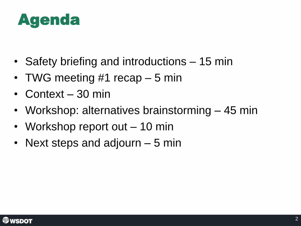
Agenda
• Safety briefing and introductions – 15 min
• TWG meeting #1 recap – 5 min
• Context – 30 min
• Workshop: alternatives brainstorming – 45 min
• Workshop report out – 10 min
• Next steps and adjourn – 5 min
2

TWG meeting #1 recap
Key discussion topics
• Project background
• Previous studies
• Purpose and Need
Action items✓ The project team to send out links to previous studies.
✓ TWG members to send any additional feedback on the Purpose
and Need.
✓ The project team to update the list of plans that inform the
Purpose and Need.
✓ Dave Lucas to provide climate change / flood plain research to
the project team.
3

Context
• Regional planned growth
• Transportation system
• Safety
• Traffic demand
• Travel times and speeds
• Environmental considerations
• Stakeholder feedback
4

Regional planned growth
2015 – 2040
5
Sources: PSRC 2017; WOFM 2018b.
73%
40%
46%49%
38%
27%31%
62%
54%
88%
48% 48%
38%
30%
0%
10%
20%
30%
40%
50%
60%
70%
80%
90%
100%
City of Everett City of LakeStevens
City of Marysville City ofSnohomish
SnohomishCounty
Puget SoundRegion
WashingtonState
Population Growth Employment Growth

Transportation system
6
• 81,000 daily trips
• 3,200 vph during the peak
• 8-10% freight traffic
• Three bus routes and 14 bus trips during peak period
• About 30 people per bus
• About 3% HOV
• Nearly 20 bicycles
Page 6

Safety
7
Short merge, high
volume, limited shoulder
Short merge, limited
shoulder, weave to I-5
Highly congested NB I-5
Highly congested NB I-5
41st Street
20th Street SEUS 2
Hewitt Ave
Support data from US 2/SR 204/20th Street SE IJR (2011 – 2015)
Page 7

Traffic demand
8

Travel times and speeds
9
Travel times and speeds
Travel time data collected during the week of October 20, 2019 using the floating car methodology. Data collected for the US 2 West Trestle pre-NEPA Project.
Figure X.US 2 TrestleAM WestboundObserved Travel Times and Speeds
*Peak Period Travel Speeds: Key points highlighted on the map: <30 mph, 31-35 mph, 36-40 mph, 41-50 mph, >50 mph. Travel displayed between markers. Snohomish County,
Washington
Page 9

Draft NEPA needs
• Local communities are growing faster in population and jobs than
the Puget Sound Region or the State as a whole.
• Morning traffic volumes into Everett and south on I-5 already exceed
interchange capacity at both the SR 204 and I-5 interchanges.
• The demand includes high truck volumes and occupancy of
available buses.
• Non-motorized connections don’t exist through the US 2 and SR 204
interchange.
• High volumes at merge points have increased collision frequency.
• The current trestle has 3-foot shoulders, with no refuge space.
10Page 10

Draft Purpose
The purpose of the US 2 Westbound Trestle project is to
develop a long-term solution that meets the following
objectives:
• Improve travel reliability for motorists, transit vehicles, freight,
bicyclists, pedestrians and emergency responders.
• Improve safety for all users.
• Provide improved system linkages to support regional and local
planned growth.
• Provide a structurally sound solution that corrects roadway
deficiencies and utilizes a full life-cycle cost approach.
11Page 11
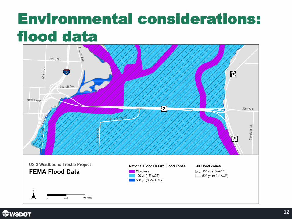
Environmental considerations:
flood data
12
US 2 Westbound Trestle ProjectFEMA Flood Data
National Flood Hazard Flood Zones:-Floodway (represented on the map with purple highlight)-100 yr. (1% ACE[represented on the map with light blue highlight])-500 yr. (0.2% ACE[represented on the map with dark blue highlights])
Q3 Flood Zones
-100 yr. (1% ACE) -500 yr. (0.2% ACE)
Page 12

Environmental considerations:
wetlands
13
US 2 Westbound Trestle Project: National Wetland Inventory (NWI) and Non-NWI Wetlands
NWI Wetlands
-Freshwater Emergent Wetland-Freshwater Forested/Shrub Wetland-Freshwater Pond-Lake-Riverine
Non-NWI Wetlands
-WSDOT Wetland Mitigation Site
Page 13

Environmental considerations:
fish species
14
US 2 Westbound Trestle ProjectFish Presence by Species
WDFW Fish Distribution by Species
-Chinook Salmon, Chum Salmon, Coho Salmon, Pink Salmon, Bull Trout, Cutthroat Trout, Steelhead Trout (all represented by their own colored areas)-Sockeye Salmon (represented by a purple line)-Largemouth Bass
-Fish Passage Barrier (labeled on the map with a plot point)
Page 14

Stakeholder interviews recap
Interviews conducted with:
• Washington Vocational Services
• Community Foundation of Snohomish County
• Futurewise
• BIKES Club of Snohomish County
• Snohomish County Economic Alliance
• WSDOT Freight Office
15Page 15

Baseline Needs
• Improve corridor safety.
• Improve the State's transportation system to support continued
regional center economic growth while managing environmental
impacts.
• Provide opportunities that facilitate competitive higher occupancy
travel in the system.
• Improve corridor travel time reliability.
• Provide non-motorized travel opportunities.
16Page 16

Design considerations
• Review roll plot of existing conditions:
– System operations from east to west
17Page 17

Workshop and report out
• Break into working groups.
• Brainstorm ideas to address draft Purpose and Need.
• Consider environmental and design constraints.
• Report out and discussion of ideas in 45 minutes.
18Page 18

Next steps
• February/March 2019: Stakeholder interviews
• March 2019: Resource Agency Committee and
Tribal coordination
• March/April 2019: Alternatives development and
metrics analysis
19
Action items
Page 19

20
US 2 Westbound Trestle Contacts
Tim Nau, P.E. Assistant Project Engineer for Connecting Washington
Suanne PelleyCommunications Lead
Page 20

US 2 Westbound Trestle
Page 1 of 12
Technical Working Group (TWG) Meeting #2 Summary
Feb. 28, 2019
Attendees
TWG members/alternates
Name Organization
Cory Hert City of Everett
Tim Miller City of Everett
Grace Kane City of Lake Stevens
Jeff Laycock City of Marysville
Roland Behee Community Transit
Dave Lucas Snohomish County
Doug McCormick Snohomish County
Mohammad Uddin Snohomish County
Gwen McCullough Sound Transit
Sargent Tom Burress Washington State Patrol
Project team:
• Cathy George, WSDOT
• Dean Moon, WSDOT
• Emily Geralds, WSDOT
• Hannah Plummer, WSDOT
• Harmony Weinberg, WSDOT
• Kyengo Ndile, WSDOT
• Miguel Gavino, WSDOT
• Tim Nau, WSDOT
• Ben Rodenbough, Consultant Team
• Brent Baker, Consultant Team
• Dave Warner, Consultant Team
• Jared Nakamoto, Consultant Team
• Lawrence Spurgeon, Consultant Team
• Liz Mack, Consultant Team
• Michael Horntvedt, Consultant Team
• Suanne Pelley, Consultant Team

US 2 Westbound Trestle
Page 2 of 12
Welcome and introductions
Tim Nau, WSDOT assistant project engineer, welcomed the group. Doug McCormick,
Snohomish County, provided a safety briefing for the building. Tim then led a round of
introductions.
Tim reviewed the meeting agenda, noting that the team will present context to prepare the group
for a workshop to brainstorm alternatives. The bulk of the meeting will be focused on this
workshop and hearing input on alternatives.
TWG meeting #1 recap
Tim recapped the first meeting in which the team provided background on the project, discussed
how the current work will build on previous studies, and gathered input on considerations for the
Purpose and Need. There were four action items from that meeting, all of which are complete.
Tim introduced Dave Warner, consultant team lead.
Context
Dave Warner introduced the context topics which included:
• Regional planned growth
• Transportation system
• Safety
• Traffic demand
• Travel times and speeds
• Environmental considerations
• Stakeholder feedback
Regional anticipated growth
Dave Warner reviewed data that showed Snohomish County and its cities growing at a fast rate
and above the average for the Puget Sound region and the state.
Comments:
• Doug McCormick noted that a lot of communities are feeling the growth projected for
2040 right now.
Dave then introduced Michael Horntvedt, consultant transportation lead.
Transportation system
Michael Horntvedt provided an overview of the existing transportation system, noting that:
• 81,000 daily trips is a pretty strong demand. It is higher than the SR 520 Portage Bay
bridge located between I-5 and the University of Washington.
• There are about 3,200 westbound vehicles per hour getting to the mid-span trestle
during the peak hour, but there are many more vehicles stuck in congestion that need
consideration.

US 2 Westbound Trestle
Page 3 of 12
• This is a T1 corridor—a primary freight corridor for the state, and the heavy trucks make
up three to five percent of the traffic stream during the peak. Nearly 10 percent of the
traffic is single unit trucks (UPS, local delivery).
• There are three bus routes operating on the corridor that make about 14 trips during the
morning peak period serving over 300 people. The average occupancy of a bus is about
30 people.
• HOV use is at about three percent along the corridor and the number of cyclists is quite
low. These last three modes have limited incentive for use and there is limited access for
non-motorized use.
Questions
• Doug McCormick asked how the HOV numbers compare with other facilities. The
project team responded that on I-5 northbound, HOVs make up 10 to 11 percent of
traffic in general purpose lanes. This area also has a three to five percent violation
rate in the HOV lane. In the Marine View Drive area about 24 percent of traffic is
HOV.
• Doug McCormick asked about the capacity of the buses on the trestle. Roland
Behee noted that there are six buses per hour, four of which are 40 feet (40-person
seated capacity) and two are double decker buses (80-person seated capacity).
There is a big opportunity to add trips.
Safety
Michael Horntvedt explained that safety issues are highly correlated with congestion in the area
and pointed out several areas with a high number of collisions, including:
• Highly congested northbound areas on I-5.
• A short merge zone of the trestle with limited shoulder near the weave to I-5.
• A short merge zone with high volume and limited shoulder at the east end of the trestle.
Michael shared that the existing design meets many of the state’s minimum design
requirements.
Traffic demand
Michael Horntvedt reviewed the existing and future (year 2040) traffic demand on the trestle.
This future demand assumes a three-lane trestle. Preliminary analysis in the US 2 Westbound
Trestle Funding and Finance study forecasts showed that tolling the trestle could lower the
traffic volume by about 30 percent.
Questions/Comments
• Miguel Gavino added that they have looked at the Puget Sound Regional
Council’s data and street light information and determined that about 45 percent
of all westbound traffic is an exchange between Lake Stevens and Everett.

US 2 Westbound Trestle
Page 4 of 12
• Gwen McCullough asked if the team knows what happens to the 30 percent of
riders who would avoid the trestle if tolled. The team explained that some riders
would go onto buses and some would use alternative routes, redistributing them
in the network. The team has only done a preliminary look and will need to
conduct additional evaluation to fully answer this question.
• Roland Behee asked if the numbers in the diagram are vehicle or person counts.
The team answered that they are vehicle data. Roland noted that it will be
important to also forecast person trips since that helps show the potential for
mass transit. The team agreed with this assessment and said that will be part of
future analysis.
• Mohammad Uddin asked what constraints the team used for the 2040 forecasts.
The team answered that the west end was the existing conditions with no
additional constraints. The east end was the no build from the Interchange
Justification Report (IJR) which assumed a three lane trestle and no
modifications to the US 2/SR 204/20th Street SE interchange.
Time and travel speeds
Michael Horntvedt presented the current travel times and speeds during the morning commute
which are:
• Trestle to I-5 at the Snohomish River: 1 minute
• Crossing the westbound trestle: 4-5 minutes
• SR 204 and Market Place to east end of the trestle: 12-18 minutes
• 91st Avenue SE and 20th Street SE to the east end of the trestle: 12-25 minutes
• US 2 at SR 9 to east end of the trestle:5-6 minutes
Questions
• Dave Lucas asked if congestion at the westbound exit to I-5 caused the slowed
down. The team answered that the traffic backups occur along the corridor at
different times and different locations during the morning peak. Traffic congestion on
the trestle begins at the SR 204/20th Street SE ramp. At the same time, congestion
on 20th Street SE begins at Cavalero Road. Sometimes, congestion at the I-5
interchange backs onto the trestle. Congestion from these various bottleneck
locations can also back up into the other bottlenecks.
Michael Horntvedt introduced Lawrence Spurgeon, consultant environmental lead.
Environmental considerations
Lawrence Spurgeon presented the draft NEPA needs, noting:
• Delay in the corridor during the data collection period ranges between eight and 24
minutes. Public input has expressed a wider range of travel time when crashes affect the
system. There is a need to improve travel time reliability to improve transit effectiveness,
freight delivery and personal livability.

US 2 Westbound Trestle
Page 5 of 12
• Hot spot safety analysis highlights locations where accidents occur more frequently due
to limited shoulders, acceleration lengths, and gap acceptance lengths. Improvements to
the corridor would reduce crash occurrences and improve corridor reliability.
• Regional system planning includes a new light rail station in downtown Everett that
would reliably move people between key economic centers along the I-5 corridor. There
are currently no plans for additional parking in downtown Everett and no HOV facilities to
encourage transit use for connectivity between the freeway and transit system.
Improvements to the corridor are needed to include HOV connectivity.
• The existing corridor does not have enough shoulder space for vehicle refuge in the
event of a crash or disabled vehicle. Provisions for refuge is needed to improve corridor
reliability and safety.
Lawrence Spurgeon then reviewed the Draft Purpose which is to develop a long-term solution
that meets the following objectives:
• Improve travel reliability for motorists, transit vehicles, freight, bicyclists, pedestrians and
emergency responders.
• Improve safety for all users.
• Provide improved system linkages to support regional and local planned growth.
• Provide a structurally sound solution that corrects roadway deficiencies and utilizes a full
life-cycle cost approach.
Next, Lawrence reviewed other environmental considerations including flood data, wetlands and
fish species. Then, Lawrence introduced Liz Mack from the consultant communications team.
Stakeholder feedback
Liz Mack explained the team is meeting with non-government organizations to hear their
perspectives on the trestle, the congestion, project considerations, and strategies for reaching a
diverse audience. The team has heard the following key themes:
• Many people are concerned about the reliability of the trestle and the impacts on
commuters and the economy.
• Non-motorized access between Lake Stevens and Everett is important.
• Concern that growth in the region will only make things worse.
• There are low-income and unrepresented populations on both sides of the corridor that
will need consideration.
• Improving transit across the trestle is important.
• Tolling came up in some conversations but wasn’t on the forefront as much as the
reliability issues.
• Lots of interest in the project and assisting with outreach to the public.
In addition, the team met with the Snohomish County Economic Alliance, and they are
amenable to pulling together some of their members to discuss the trestle work. They can help
pull together a freight/mobility meeting to discuss the specific needs of freight in the corridor.

US 2 Westbound Trestle
Page 6 of 12
The freight conversation continued with the WSDOT freight office, which will also be joining the
TWG when their new planner comes on board. They are happy to work with the team on a
freight coordination meeting, along with the Economic Alliance.
Questions
• Gwen McCullough asked if the stakeholder interview questions specifically
addressed tolling. The team explained that the interviewers informed the
stakeholders that the team is considering a wide range of options including tolling
but did not ask a question specifically about their view on tolling.
Workshop: alternatives brainstorming
Dave Warner presented the Baseline Needs which include:
• Improve corridor safety.
• Improve the state's transportation system to support continued regional center economic
growth while managing any effects on the environment.
• Provide opportunities that facilitate competitive higher occupancy travel in the system.
• Improve corridor travel time reliability.
• Provide non-motorized travel opportunities.
Next, Dave introduced Ben Rodenbaugh, consultant design lead who provided a quick overview
of the existing conditions shown on a roll plot. Then, Dave asked the TWG members to divide
into three group and brainstorm ideas to address draft Purpose and Need. These ideas should
consider:
• Transit
• Non-motorized access
• HOV lanes
• Tolling
• Number of lanes
• Location/constructability
Workshop report out
After about 30 minutes of small-group discussion, the TWG members reconvened and reported
the key findings from their small groups.
Group 1
The following ideas and questions were shared by this group.
• Could tolling be used to create a mode shift?
• Need to solve safety issues for cyclists. Could have a non-motorized bi-directional trail
on the new trestle. California Street is going to be a future bike corridor and would put
non-motorized traffic on the correct side of the interchange.

US 2 Westbound Trestle
Page 7 of 12
• Everett Avenue, north of US 2, is underutilized. It could be used for traffic going into
Everett to reduce traffic on California and Maple streets. This would also help to better
use the lanes under I-5.
• The grid system in Everett has capacity for an increase in traffic.
Group 2
The following ideas and questions were shared by this group.
• Agreed there is capacity available on local streets in Everett.
• Prioritize access to Everett Station, especially for Community Transit buses coming
across the trestle.
• Need to realign westbound to southbound transfer.
• Work with Maple Street signal to increase capacity for future traffic.
• Entice people to use the single lane north exit onto Walnut Street.
• Construction phasing will have an impact on cost and schedule. Recommend building
the east interchange, then the west, and then the trestle.
• The main trestle could have a bus on shoulder lane, peak-use shoulder lane, or
transit/HOV only lane combined with two general purpose lanes.
• Potential for express toll lane (ETL), but it will be challenging to get the traffic to separate
between general purpose and ETL. Could create connection below US 2/SR 204 with a
roundabout that provides access to ETL and the lower roadway.
• Four lanes across the trestle will be challenging to split near the I-5 interchange.
• If ETLS are on the southside of the trestle, then need to move lower roadway on ramp to
the northside.
Group 3
The following ideas and questions were shared by this group.
• Focused on transit-oriented solutions. There is a lot of potential for additional transit.
More bus trips could create a mode shift especially from Lake Stevens to Everett. Trestle
would need a priority HOV path to make this work.
• Could make California Street exit on the west end into an HOV-only exit. SOV traffic
would divert to Maple Street.
• Downtown Everett and the Everett Station will be the main transit destinations. There
may also be a demand for buses to continue south. These paths will influence the
location of the HOV lane.
• Could have all buses use westbound to southbound direct-access path and then direct
buses into Everett on Pacific Avenue.
• Eastbound structure could have one lane in the morning that is a westbound HOV.
• Instead of replacing the westbound trestle, add a separate structure with a reversible
two-lane ETL that can directly connect to the new transit facilities and be used
independent of the existing trestle. This would also help with construction phasing and
Instead of replacing the westbound trestle, add a separate structure with a reversible two-lane ETL that can directly connect to the new transit facilities and be used independent of the existing trestle. This would also help with construction phasing and could serve as an incident by pass for the existing trestle. The existing trestle would make connections to I-5, and the new trestle would provide local access into Everett.

US 2 Westbound Trestle
Page 8 of 12
could serve as an incident by pass for the existing trestle. The existing trestle would
make connections to I-5, and the new trestle would provide local access into Everett.
Please see Appendix A for copies of the drawings shared during the meeting.
Next steps
Suanne Pelley, consultant communications lead presented the next steps, including:
• February/March 2019: Stakeholder interviews
• March 2019: Resource Agency Committee and Tribal coordination
• March/April 2019: Alternatives development and metrics analysis
There were no action items from this meeting.
The project team thanked the TWG for attending the meeting and adjourned.

US 2 Westbound Trestle
Page 9 of 12
Appendix A. Drawings from alternatives discussion

US 2 Westbound Trestle
Page 10 of 12

US 2 Westbound Trestle
Page 11 of 12

US 2 Westbound Trestle
Page 12 of 12

US 2 Westbound Trestle
US 2 Westbound Trestle Page 1 of 2 TWG Meeting #3 6/20/19
AGENDA Technical Working Group (TWG) Meeting #3
Thursday, June 20, 2019, 1 - 4 p.m.
Everett Station, Dan Snow Room
3201 Smith Avenue Everett, WA 98201
Time Topic Lead
1 – 1:10 p.m.. Welcome and introductions
• Safety briefing Tim Nau
1:10 – 1:15 p.m. TWG meeting #2 recap Tim Nau
1:15 – 2:25 p.m.
Concept Screening Overview
• Draft Purpose and Need
• Develop concepts
• Rate concepts
Dave Warner
2:25 – 2:35 p.m. Break All
2:35 – 3:35 p.m. Representative alternatives Dave Warner
All
3:35 – 3:45 p.m. Next steps and adjourn Liz Mack
Attendees listed on reverse side

US 2 Westbound Trestle
US 2 Westbound Trestle Page 2 of 2 TWG Meeting #3 6/20/19
Attendees
TWG Members:
□ Corey Hert, City of Everett
□ Tim Miller, City of Everett
□ Ryan Sass, City of Everett
□ Grace Kane, City of Lake Stevens
□ Jesse Hannahs, City of Marysville
□ Jeff Laycock, City of Marysville
□ Brad Feilberg, City of Monroe
□ Yosh Monzaki, City of Snohomish
□ Roland Behee, Community Transit
□ Scott Ritterbush, Community Transit
□ Noah Tunick, Community Transit
□ Tom Hingson, Everett Transit
□ John Pike, Everett School District
□ Angel Rivera, FHWA
□ Kelly McGourty, PSRC
□ Lisa Lefeber, Port of Everett
□ Steve Dickson, Snohomish County
□ Kirt Hanson, Snohomish County
□ Doug McCormick, Snohomish County
□ Mohammad Uddin, Snohomish County
□ Gwen McCullough, Sound Transit
□ Tom Burress, WA State Patrol
□ Jason Knott, WA State Patrol
□ Scott McCoy, WA State Patrol
□ Jason Beloso, WSDOT Freight
□ Trevor Daviscourt, WSDOT Freight
□ Danny McReynolds, U.S. Coast Guard
WSDOT and Consultants:
□ Barb Briggs, WSDOT
□ Miguel Gavino, WSDOT
□ Cathy George, WSDOT
□ Ruth Park, WSDOT
□ Dean Moon, WSDOT
□ Tim Nau, WSDOT
□ Kyengo Ndile, WSDOT
□ Hannah Plummer, WSDOT
□ Amir Rasaie, WSDOT
□ Brent Baker, WSP
□ Jared Nakamoto, WSP
□ Ben Rodenbough, WSP
□ Lawrence Spurgeon, WSP
□ David Warner, WSP
□ Michael Horntvedt, Parametrix
□ Suanne Pelley, EnviroIssues
□ Liz Mack, EnviroIssues

Meeting #3
June 20, 2019
1:00 - 4:00 p.m.
US 2 Westbound Trestle
Technical Working Group

Agenda
• Safety briefing and introductions – 10 min
• TWG meeting #2 recap – 5 min
• Concept screening overview – 70 min
– Draft purpose and need
– Develop concepts
– Rate concepts
• Representative alternatives – 60 min
• Next steps and adjourn – 5 min
2Page 2

TWG meeting #2 recap (Feb. 28, 2019)
• West end
– Everett Ave is underutilized
– Transit access
– Westbound to southbound realignment
– California Street could be HOV-only
• Trestle
– Shoulder, HOV/transit lane
– Reversible lane
– Additional structure with reversible ETL
• East end
– Roundabout on lower roadway
– Move lower roadway ramp
3Page 3

Concept screening overview
4
Rate Concepts
Develop Concepts
Purpose and Need
Page 4

West end concepts
W2 W2A W3 W4
W5 W6 W7 W8
W9 W10 W11
Non-motorized connections will be considered in all concepts5Page 5

Greater footprint
over river = low
rating
Separating
Everett and
highway traffic
east of I-5 =
high rating
Reconstruction
of I-5 = low
rating
Findings from initial screening
West end
Inadequate
capacity= low
rating
Dedicated local
transit access =
high rating
6Page 6
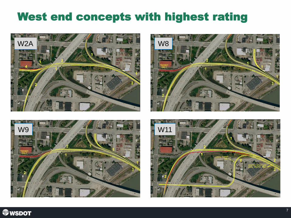
7
West end concepts with highest rating
W8W2A
W11W9
Page 7

8
Criteria W1
: No
Bu
ild
W2
: 2L
NB
, 2L
SB, 2
L Lo
cal
W2
A: 2
L N
B, 2
L SB
, 1L
Loca
l
W3
: 2L
NB
, 2L
SB o
ver
I-5
, 2L
Loca
l
W4
: Rev
ersi
ble
I-5
Insi
de
Co
nn
ecti
on
s
W5
: 1L
NB
, 2L
SB, 3
L Lo
cal
W6
: 1L
NB
, 2L
SB, 2
L Lo
cal
W7
: 1L
NB
, 2L
SB, 2
L Lo
cal o
n
Sep
arat
e St
ruct
ure
W8
: 1L
NB
, 2L
SB, 2
L Lo
cal t
o
Sum
mit
Ave
W9
: 1L
NB
, 2L
SB, 2
L Lo
cal t
o
Ever
ett
Ave
W1
0:
1L
NB
, 3L
SB, 2
L Lo
cal o
n
Exis
tin
g St
ruct
ure
W1
1:
1L
NB
, 3L
SB, 2
L Lo
cal o
n
Exis
tin
g St
ruct
ure
to
Hew
itt
Ave
Reliability 3 4 5 4 1 5 5 1 5 5 4 5
Safety 3 2 3 4 1 4 4 1 4 4 3 4System
Accessibility 3 4 4 4 1 4 4 1 4 4 4 4
Design Solution 3 3 3 2 1 1 2 1 4 4 2 4
Sustainability 3 3 3 2 1 1 2 1 2 2 2 2
Overall Rating: 3 3 3 1 3 1 4 4 3 4
Concept rating summary
West end
5 = highest 1 = lowest
3.5 3.5
1 = lowest 5 = highest Page 8

9
West end discussion
W8W2A
W11W9
Page 9

Trestle concepts
10
T2 T3 T4
T5 T6 T7
T8 T9 T10
T11 T12 T13
T14 T15
Page 10

Findings from initial screening
Trestle
11
• 3 and 4 lane = high rating
• 2 general purpose lanes = similar to existing
• Stormwater treatment (all concepts) = high rating
Page 11
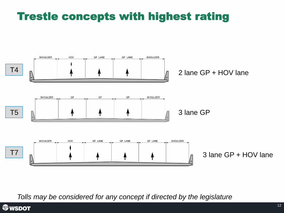
Trestle concepts with highest rating
12
2 lane GP + HOV lane
3 lane GP + HOV lane
T4
T5
T7
3 lane GP
Tolls may be considered for any concept if directed by the legislature
Page 12

13
Criteria T1: N
o B
uild
T2: 2
L R
etro
fit
w/
Exp
and
ed
Dec
k
T3: 2
L G
P +
Tra
nsi
t Sh
ou
lder
T4: 2
L G
P +
HO
V
T5: 3
L G
P
T6: 2
L G
P +
ETL
T7: 3
L G
P +
HO
V
T8: 3
L G
P +
HO
V
T9: 3
L G
P +
ETL
T10
: 2
L G
P +
2 E
TL
T11
: 2
L G
P +
1L
REV
T12
: 2
L G
P +
2L
Loca
l REV
T13
: 2
L G
P +
1/1
L Lo
cal
T14
: 3
L G
P +
1/1
L Lo
cal
(Via
du
ct)
T15
: 2
L G
P +
1/1
L Lo
cal
(Via
du
ct)
Reliability 3 3 4 4 5 4 5 5 5 4 4 4 4 5 5Safety 3 3 4 5 5 3 5 5 3 3 4 4 4 4 4
System Accessibility 3 3 3 3 3 3 3 3 3 3 3 3 3 3 3
Design Solution 3 2 4 5 5 5 4 4 4 4 4 2 2 1 1Sustainability 3 3 5 4 4 4 3 3 3 3 3 2 2 3 3
Overall Rating: 3 3 4 4 4 4 3 3 3 3
Concept rating summary
Trestle
5 = highest 1 = lowest
3.5 3.5 3.5 3.5
5 = highest 1 = lowest
Page 13

Trestle discussion
14
2 lane GP + HOV lane
3 lane GP + HOV lane
T4
T5
T7
3 lane GP
Tolls may be considered for any concept if directed by the legislature
Page 14

15
East end connection concepts
E2 E3 E4
E5 E6 E7
E8 E9
Non-motorized connections will be considered in all conceptsNon-motorized connections will be considered in all concepts Page 15

Findings from initial screening
East end
16
Adding capacity=
high rating
Compatibility with
local BAT lane =
high ratingLess lane merge=
high rating
Page 16

East end concepts with the highest rating
17
E2
E6 E7
E5

18
E1: N
o B
uild
E1A
: No
Bu
ild +
ITS
E2: 1
L SB
, 1L
NB
, 1L
WB
E3: 1
L SB
, 1L
NB
, 1L
WB
, 1L
WB
ETL
E4: 1
L SB
, 2L
NB
, 1L
WB
E5: 1
L SB
, 2L
NB
, 1L
WB
E6: 1
L SB
, 2L
NB
, 1L
WB
E7: 1
L SB
, 2L
NB
, 1L
WB
E8: 1
L SB
, 1L
NB
, 1L
WB
, 1L
NB
ET
L, 1
L W
B E
TL
E9: 1
L SB
, 1L
NB
, 1L
WB
, 1L
NB
ET
L, 1
L W
B E
TL
Reliability 3 3 4 4 4 4 4 4 3 3Safety 3 3 4 4 3 4 4 4 3 3
System Accessibility 3 3 3 2 3 3 3 3 3 3
Design Solution 3 3 5 4 4 4 4 4 4 4Sustainability 3 3 4 3 4 4 4 4 4 4
Overall Rating: 3 3 4 4 4 4 3 3
Concept rating summary
East end
5 = highest 1 = lowest
50/50 50/50 25/75 25/75 25/75 25/75 25/75 25/75 50/50 50/50
50/50 50/50 25/75 25/75 50/50 25/75 25/75 25/75 50/50 50/50
50/50 50/50 50/50 75/25 50/50 50/50 50/50 50/50 50/50 50/50
50/50 50/50 0/100 25/75 25/75 25/75 25/75 25/75 25/75 25/75
50/50 50/50 25/75 50/50 25/75 25/75 25/75 25/75 25/75 25/75
50/50 50/50 25/75 40/60 40/60 25/75 25/75 25/75 50/50 50/50

East end discussion
19
E2
E6 E7
E5
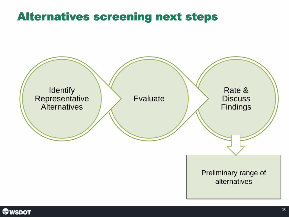
Alternatives screening next steps
20
Rate & Discuss Findings
EvaluateIdentify
Representative Alternatives
Preliminary range of
alternatives

Representative alternative 1:
• W9: Local ramp connections to Everett east of I-5
• T4: 3 lane trestle
• E2: 1 lane connections from all movements at 20th/204
21

Representative alternative 2:
• W11: Local ramp connections to Everett east of I-5
• T7: 4 lane trestle
• E6: 2 lanes NB to WB US 2 connection from 20th/204 vicinity
22

Representative alternative 3
• W2A: Local ramp connections to Everett same as existing with additional
SB I-5 ramp lane
• T5: 3 lane trestle
• E7: 2 lanes NB to WB US 2 connection from 20th/204 vicinity
23

24
Discussion of representative alternatives
West end Trestle East end
E2
E6
E7
E5W8
W2A
W11
W9
T4
T5
T7

• Further study representative alternatives
• Present results at August TWG
• Optional public outreach in Fall
25
Action items
Next steps

US 2 Westbound Trestle Contacts
Tim Nau, P.E. Assistant Project Engineer for Connecting Washington
Suanne PelleyCommunications Lead
26

US 2 Westbound Trestle
Page 1 of 8
Technical Working Group (TWG) meeting #3 summary
June 20, 2019
Attendees
TWG members/alternates
Name Organization
Corey Hert city of Everett
Grace Kane city of Lake Stevens
Jesse Hannahs city of Marysville
Scott Ritterbush Community Transit
Noah Tunick Community Transit
Steve Thomsen Snohomish County
Kirt Hanson Snohomish County
Trevor Daviscourt WSDOT Freight
Project team
• Barb Briggs, WSDOT
• Madelyn Cayton, WSDOT
• Miguel Gavino, WSDOT
• Tim Nau, WSDOT
• Kyengo Ndile, WSDOT
• Kris Olsen, WSDOT
• Ruth Park, WSDOT
• Hannah Plummer, WSDOT
• Brent Baker, Consultant Team
• Michael Horntvedt, Consultant Team
• Liz Mack, Consultant Team
• Jared Nakamoto, Consultant Team
• Suanne Pelley, Consultant Team
• Ben Rodenbough, Consultant Team
• Lawrence Spurgeon, Consultant Team
• Dave Warner, Consultant Team
Welcome and introductions
Tim Nau, WSDOT assistant project engineer, welcomed the group, provided a safety briefing for
the building, and led introductions.
US 2 Westbound Trestle
Page 2 of 8
Tim reviewed the meeting agenda, noting the bulk of the meeting will be the Consultant Team
presenting draft concepts by geographic areas of the US 2 corridor, and then a discussion of
representative alternatives.
TWG meeting #2 recap
Tim recapped the second meeting, noting:
• We launched the meeting by providing project context of key factors—including regional
growth, safety, and environmental considerations.
• We then broke into small groups that each focused on a geographic section of the
corridor:
o I-5 on the west end.
o The trestle.
o Where NE 20th, SR 204 and US 2 all converge.
• The results of the workshop gave the technical team analysis work for each geographic
area. The team will then develop representative alternatives that pull the geographic
areas together.
Tim introduced Dave Warner, consultant team lead.
Concept screening overview
Dave noted at our first TWG meeting we discussed the project’s purpose and need. When the
TWG met in February, we had a good working session with roll plots of the US 2 corridor from
SR 204 to I-5. These concepts were grounded in the purpose and need.
Lawrence Spurgeon, environmental lead for the consultant team, reminded the group of the five
key areas included in the draft Purpose & Need:
• Improves travel reliability for motorists, transit vehicles, freight, bicyclists, pedestrians,
and emergency responders.
• Improves safety for all users.
• Provides improved system linkages to support regional and local planned growth.
• Provides a structurally sound solution that corrects roadway deficiencies and utilizes a
full life-cycle cost approach.
• Incorporates WSDOT’s core value of sustainability.
The Technical Working Group and Resource Agency Committee reviewed the draft Purpose
and Need. Those groups want us to include environmental benefits of the project and continued
access to Ebey Island
After the last TWG, the technical team worked to define concepts by geography which include:
• I-5 connection: 11 concepts
• Trestle: 14 concepts
• 20th / SR 204 connection: 9 concepts
• The No Build concept is included in each of the geographic segments.

US 2 Westbound Trestle
Page 3 of 8
The technical team then rated the concepts against the Purpose and Need criteria:
• Travel reliability
• Safety
• System accessibility
• Design solution
• Sustainability
West end concepts
Dave presented the west end concepts noting some of these have fairly minor modifications
between the concepts, with the major differences being the number of lanes in each
configuration, as well as connecting points and configurations. The team is not making any
changes to the eastbound trestle nor its connections to I-5.
Dave reviewed the findings from the initial screening which include:
• Any modifications to I-5 received the lowest rating under design solution.
o Alternatives that add lane capacity under I-5 for access between westbound US
2 and SB I-5 or into downtown Everett would require some reconstruction of I-5.
o Reversible ramps connecting to the I-5 median HOV systems would require
significant reconstruction of I-5.
• Adding lanes or width of structure over the Snohomish River rates lower due to
environmental effects.
• Maintaining full local access to California Street results in low ratings for design solution
and safety due to limited space.
o Placing the WB to SB US 2 movement onto a ramp over I-5 would alleviate these
issues.
• Everett access to Everett Avenue east of I-5 and transit only to California Street results
in a high rating.
• Everett access, including transit, directly to Hewitt Avenue east of I-5 also results in a
high rating.
Dave discussed the west end concepts with the highest ratings and noted the option to bring
traffic onto Everett Avenue was a suggestion from the last TWG meeting and also reflects TWG
interest in transit-only access.
Dave showed a summary of the concept rankings for each of the 11 concepts for the west end.
The top-ranking concepts are: W2A, W8, W9, and W11. They rose to the top when considering
all of the criteria.
General feedback on the west end concepts:
Dave led a discussion about the west end concepts. TWG shared the following questions and
comments:
Questions
US 2 Westbound Trestle
Page 4 of 8
• How are you weighting the tradeoffs of mobility improvements and environmental effects?
• Have you examined freight routes for each of the concepts? We need to see to/from data for Everett, Lake Stevens, and Port of Everett.
• Where are cars queueing at the west end? Is it on Maple? Can there be transit signal priority?
• How many lanes are on the west end for the local connection to Everett?
• Which option is most compatible with transit to Everett Station?
• Are you reconstructing or re-striping local lanes?
• Will the HOV/transit lane be on the left or right side? We noted no decisions on placement yet—need more discussion about where the HOV traffic is headed.
Comments
• Everett and Sound Transit are considering light rail in locations beyond Everett Station.
• Community Transit likely prefers to cross Maple Street to Cedar though it depends on traffic models.
• city of Everett has plans for non-motorized access on California.
• Consider northbound I-5 to eastbound on the trestle for transit as well as westbound on the trestle to southbound on I-5. There may be future demand for southbound transit on I-5 from the trestle with light rail expansion. Eastbound transit will need to be considered on other projects. Need to include the movement to Mariner Park & Ride.
• Need further review of transit on Pacific/Smith or Pacific/Broadway.
Trestle concepts
Dave presented the trestle concepts noting some of these have minor modifications between
concepts, with major differences being the number of lanes in each configuration, as well as
connecting points and configurations.
Dave reviewed the findings from the initial screening which include:
• The highest ratings are 3 and 4 lane replacement bridges.
• Tolling improved the reliability, but it reduced the social effects by impacting low-income households, all-lane tolling was not included in the rating.
• All design solutions provide improvements to stormwater treatment and therefore rate highly for sustainability.
• Increased footprint resulted in lower environmental rankings; o 3 lanes with stormwater treatment rates higher than no build. o 4 lanes with stormwater treatment rates similar to no build. o Wider than 4 lanes with stormwater treatment rates below no build.
• Ingress and egress for reversible and express toll lane configurations varied based on weave conditions and access points.
• Now let’s look at the concepts with the highest ratings.
Dave discussed the trestle concepts with the highest rating which are: T4, T5, and T7. They
rose to the top when considering all the criteria we evaluated. Next, Dave showed a summary of
the concept rankings for each of the 15 concepts for the trestle.
Questions

US 2 Westbound Trestle
Page 5 of 8
General feedback on the trestle concepts:
Dave led a discussion about the trestle concepts. The following questions and comments were
shared by the TWG:
Questions
• Would the project improve the surface bike path for a safer ride?
• What happens to the eastbound bike path? Does it remain on the trestle?
• What is the incremental cost difference between the 3- and 4-lane options?
• What is the total width difference between the 3- and 4-lane options?
• Does that width difference impact the environment?
• Where in the criteria do you address mode shift? Is it in sustainability?
• How do we describe efficiency? Is that about vehicle travel times or person throughput?
• What are the differences between T5 and T7? The team noted they have different footprints which cause different amounts of shading.
Comments
• Need to show tolls could be on some lanes, but not all lanes, such as with express toll lanes.
• Plan for a future shoulder conversion. Potentially show 14-foot width for hard shoulder running. This could be in T-4 and T-5 so we build a 3-lane now with future options.
• Bike and pedestrian access should be considered and explained when presenting the concepts to the public.
• Reminder we’ll remove old piers with this project which will have an environmental benefit.
East end concepts
Dave presented the east end concepts noting some of these have fairly minor modifications
between the concepts, with the major differences being the number of lanes in each
configuration, as well as connecting points and configurations.
Dave reviewed the findings from the initial screening which include:
• Separating the merges onto the trestle resulted in a higher rating.
• Poor merge conditions lead to a low rating.
• Adding capacity to US 2 on-ramps resulted in a higher rating.
• Now let’s look at the concepts with the highest ratings.
Dave discussed the east end concepts with the highest rating which are: E2, E5, E6, and E7.
They rose to the top when considering all of the criteria. Next, Dave showed a summary of the
concept rankings for each of the nine concepts for the trestle.
General feedback on the east end concepts:
Dave led a discussion about the east end concepts. The following questions and comments
were shared by the TWG:

US 2 Westbound Trestle
Page 6 of 8
Questions
• Is there any value in a roundabout on the east end to help people determine where they’re going, rather than weaving on the trestle?
• How do you ensure the best connection to the new BAT lane?
Comments
• TWG was okay with refining the IJR preferred alternative.
• With E5 and E6, it makes sense to have HOV on the north side.
• With E2 and E7, it makes sense to have HOV on the south side.
• The west end is probably the bigger driver for the HOV/transit lane location.
• Community Transit assumes Northeast 20th Street will be the main transit access. The demand comes most from Lake Stevens (not US 2 to the south). Need to also understand where the HOV traffic is going to determine the lane placement.
Representative alternatives
Dave explained the approach to identifying the representative alternatives. The steps included:
• Combine the highest rated concepts.
• Identify up to 3 complete representative alternatives.
• When pairing, consider:
o Purpose & Need
o Transit and HOV compatibility
o Origin / destination
o Lane assignment, driver expectation
o Possibility for toll lane(s) ingress, egress
Dave walked through the three representative alternatives. The first alternative combines the
following:
• W9: Local ramp connections to Everett east of I-5.
• T4: 3-lane trestle.
• E2: 1-lane connections from all movements at 20th/204.
The second alternative combines:
• W11: Local ramp connections to Hewitt east of I-5.
• T7: 4-lane trestle.
• E6: 2 lanes NB to WB US 2 connection from 20th/204 vicinity.
The third alternative combines:
• W2A: Local ramp connections to Everett same as existing with additional SB I-5 ramp
lane.
• T5: 3-lane trestle.
• E7: 2 lanes NB to WB US 2 connection from 20th/204 vicinity.

US 2 Westbound Trestle
Page 7 of 8
General feedback on the representative alternatives:
Dave led a discussion about the east end concepts. The following questions and comments
were shared by the TWG.
Questions
• How can this project focus on people through-put instead of vehicles?
• What kind of weaves would there be with the HOV lane?
• Could you relocate the traffic coming on US 2 from Snohomish and Monroe to the
outside lane? This may also mean some buses coming from the south are forced to the
outside lane.
• Lots of freight going to the Port of Everett. What is their route to Marine View Drive?
• Are we trying to get to one Preferred Alternative at the end of this study/report?
o The team responded there will likely be options for final analysis as part of the
environmental process, but they would prefer to have one alternative moving
forward.
Comments
• Four lanes do not increase the footprint much more than three lanes, but it provides
capacity benefits.
• Need at least three lanes plus a shoulder that can be converted for peak use to account
for future capacity.
• Team confirmed there is enough room for a ramp on W11, but the impacts still need to
be determined.
• The public may interpret the shoulder as being an option for a bike lane when doing the
NEPA review. Be careful how it is presented. Need to find a clear way to represent
bike/ped access to the public.
• Having a large facility (trestle) takes away the transit incentive.
• Need to understand the weaving and merge conditions when looking at alternatives.
• HOV/transit in the alternatives seems more like queue jumps than an HOV/transit lane.
• Suggestion to use a roundabout to move HOV/transit to the outside and help position the
lanes on the east end.
• Lots of freight will weave on the east. Few trucks from Everett cross the mountains.
• Oversized loads are discouraged from downtown Everett.
• Modeling on the west end will be very important. May need to split the local access into
Everett as to not overwhelm an arterial. Need to consider future HOV use and transit.
• Getting the east end lane assignments correct will be very important.
• The preferred alternative needs to be the least environmentally damaging alternative
that still meets the need.
• Snohomish County cares most about throughput of people/vehicles and will default to
the cities on the specifics of the east and west end configurations.
• Need to know what the origin/destination of HOV users is before we can determine the
lane placement.

US 2 Westbound Trestle
Page 8 of 8
Summary of comments by jurisdiction/agency
Community Transit
• Would like to further examine what lanes are best for transit to reach their destinations.
city of Everett
• 1,700 vehicles accessing Everett Avenue
• Want California to be bike priority
• Likes all westbound options
• Need to see some modeling numbers
• Need to meet with CT and ST to discuss transit connections
• Need specific review of local connections
Snohomish County
• Throughput of people/vehicles is most important. The county will default to the cities on
the specifics of the east and west end configurations.
• Everett and transit need to figure out all the west end connections.
• Need to keep two ETL and two general-purpose lane alternatives on the table.
Next Steps:
Dave concluded by reviewing the next steps which include:
• A late summer TWG and a fall EAG meeting.
• Hold a meeting with the freight community prior to next TWG to review representative
alternatives.
• Wrap up this portion of the funded report.
• Ideally do some outreach this fall with this work today.
• Prepare for legislative session.
The project team thanked the TWG for attending the meeting and adjourned.

US 2 Westbound Trestle
US 2 Westbound Trestle Page 1 of 2 TWG Meeting #4 Dec. 5, 2019
AGENDA Technical Working Group (TWG) Meeting #4
Dec. 5, 2019, 1:30-3:30 p.m.
Everett Station – Dan Snow Room
3201 Smith Ave., Ste. 215, Everett, WA 98201
Time Topic Lead
1:30 p.m. Welcome and introductions
• Safety briefing Kyengo Ndile
1:40 p.m. TWG meeting #3 recap Kyengo Ndile
1:45 p.m. Purpose and Need review Dave Warner
1:50 p.m. Alternatives review Dave Warner
2:05 p.m. Overview of findings Dave Warner
2:15 p.m. Finding #1: Network congestion Michael Horntvedt
2:30 p.m. Break All
2:40 p.m. Finding #2: Managed lanes Michael Horntvedt
2:55 p.m. Finding #3: Three lane trestle Michael Horntvedt
3:10 p.m. Discussion, conclusions, and
recommendations Dave Warner
3:25 p.m. Next steps and adjourn Dave Warner
Attendees listed on reverse side

US 2 Westbound Trestle
US 2 Westbound Trestle Page 2 of 2 TWG Meeting #4 Dec. 5, 2019
Attendees
TWG Members:
□ Corey Hert, City of Everett
□ Tim Miller, City of Everett
□ Ryan Sass, City of Everett
□ Grace Kane, City of Lake Stevens
□ Jesse Hannahs, City of Marysville
□ Jeff Laycock, City of Marysville
□ Brad Feilberg, City of Monroe
□ Yosh Monzaki, City of Snohomish
□ Roland Behee, Community Transit
□ Scott Ritterbush, Community Transit
□ Noah Tunick, Community Transit
□ Tom Hingson, Everett Transit
□ John Pike, Everett School District
□ Angel Rivera, FHWA
□ Kelly McGourty, PSRC
□ Lisa Lefeber, Port of Everett
□ Steve Dickson, Snohomish County
□ Kirt Hanson, Snohomish County
□ Doug McCormick, Snohomish County
□ Mohammad Uddin, Snohomish County
□ Lauryn Douglas, Sound Transit
□ Tom Burress, WA State Patrol
□ Jason Knott, WA State Patrol
□ Scott McCoy, WA State Patrol
□ Jason Beloso, WSDOT Freight
□ Trevor Daviscourt, WSDOT Freight
□ Danny McReynolds, U.S. Coast Guard
WSDOT and Consultants:
□ Barb Briggs, WSDOT
□ Miguel Gavino, WSDOT
□ Cathy George, WSDOT
□ Ruth Park, WSDOT
□ Dean Moon, WSDOT
□ Tim Nau, WSDOT
□ Kyengo Ndile, WSDOT
□ Hannah Plummer, WSDOT
□ Amir Rasaie, WSDOT
□ Brent Baker, WSP
□ Jared Nakamoto, WSP
□ Ben Rodenbough, WSP
□ Lawrence Spurgeon, WSP
□ Laura Shabe, WSP
□ David Warner, WSP
□ Michael Horntvedt, Parametrix
□ Suanne Pelley, EnviroIssues
□ Liz Mack, EnviroIssues

Meeting #4December 5, 2019
1:30 – 3:30 p.m.
US 2 Westbound Trestle
Technical Working Group

Agenda
• Safety briefing, introductions, agenda review – 10 min
• TWG meeting #3 recap – 5 min
• Purpose and need review – 5 min
• Alternatives Review – 15 min
• Overview of findings – 10 min
• Finding #1: Network congestion – 15 min
• Finding #2: Managed lanes – 15 min
• Finding #3: Three lane trestle – 15 min
• Discussion – 15 min
• Conclusions and recommendations – 15 min
• Next steps and adjourn – 5 min
2

TWG meeting #3 recap (June 20, 2019)
3
Identify Alternatives
Rate Concepts
Develop Concepts
Purpose and Need
Discuss Findings
Evaluate, Model
Identify Representative
Alternatives
Conclusions and
recommendations

Draft purpose
The purpose of the US 2 Westbound Trestle project is to
develop a long-term solution that meets the following
objectives:
• Improves travel reliability for motorists, transit vehicles, freight,
bicyclists, pedestrians and emergency responders.
• Improves safety for all users.
• Provides improved system linkages to support regional and local
planned growth.
• Provides a structurally sound solution that corrects roadway
deficiencies and utilizes a full life-cycle cost approach.
• Incorporates WSDOT’s core value of sustainability.
4

Draft need
• Accommodates existing and future demand
• Addresses safety and roadway deficiencies
• Provides system linkages
• Sustainability
5
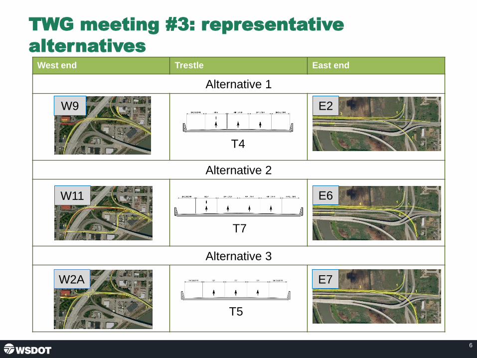
6
TWG meeting #3: representative
alternativesWest end Trestle East end
Alternative 1
Alternative 2
Alternative 3
E2
E6
E7W2A
W11
W9
T4
T5
T7

Alternatives finding review
• Finding #1: Network congestion
– Future congestion on I-5 limits the effectiveness of
US 2 westbound trestle improvements.
• Finding #2: Managed lanes
– Transit and HOV lanes with improved system
connections could provide people an option to bypass
system congestion.
• Finding #3: Three lane trestle
– Three lane trestle would provide sufficient capacity.
7

Finding #1: Network congestionAlternative 2: 2040 traffic analysis, 4 – 9 am
8
La
ne
1L
an
e 2
La
ne
3H
OV
To I-5
NB
To I-5
SB
To
Hewitt
From
SR 204
From
20th St
From
US 2
From
US 2To
Hewitt

Finding #1: Network congestionAlternative 3: 2040 traffic analysis, 4 – 9 am
9
Lane 1
Lane 2
La
ne
3
To Maple/
Walnut St
To Maple St
To I-5
SB
From
SR 204
From
20th St
From
US 2
To NB I-5

Finding #2: Transit and HOV Travel
Time Data (minutes)
10
A
B
C
D
Year 2040 AM Peak Hour travel times. Alt. 2 and 3 use No Build volumes.
0 30 60 90 120
2019 Existing Conditions
2040 No Build Conditions
2040 Alternative 2
2040 Alternative 3
From SR 9 to I-5 via SR 204 (A-D)
0 30 60 90 120
2019 Existing Conditions
2040 No Build Conditions
2040 Alternative 2
2040 Alternative 3
From SR 9 to I-5 via SE 20th Street (B-D)
0 30 60 90 120
2019 Existing Conditions
2040 No Build Conditions
2040 Alternative 2
2040 Alternative 3
From SR 9 to I-5 via US 2 (C-D)

Finding #3: Trestle cross section
11

12
Finding #3: Trestle cross section

Considering connectivity
13
US 2 Westbound
Trestle/ CorridorRegional
Network
• I-5 system capacity/
demand management• Trestle cross section
• 20th HOV lane
• HOV/transit
• West end improvements

Discussion
14

• EAG meeting – December 9, 2019
• Preliminary Draft Planning and Environmental
Linkage Report
15
Action items
Next steps

US 2 Westbound Trestle Contacts
Kyengo Ndile, P.E. Project Engineer
Suanne PelleyCommunications Lead
16

US 2 Westbound Trestle
Page 1 of 10
Technical Working Group (TWG) meeting #4 summary
December 5, 2019
Everett Station
Attendees
TWG members/alternates
Name Organization
Tim Miller City of Everett
Tom Hood City of Everett
Ryan Sass City of Everett
Grace Kane City of Lake Stevens
Scott Ritterbush Community Transit
Noah Tunick Community Transit
Angel Rivera* FHWA
Sharleen Bakeman* FHWA
Steve Dickson Snohomish County
Kirt Hanson Snohomish County
Mohammad Uddin Snohomish County
Nick Steele Washington State Patrol
Jason Beloso WSDOT Freight
Trevor Daviscourt WSDOT Freight
*Attended via phone
Project team
• Cathy George, WSDOT
• Kyengo Ndile, WSDOT
• Miguel Gavino, WSDOT
• Kris Olsen, WSDOT
• Hannah Plummer, WSDOT
• Dave Warner, Consultant Team
• Michael Horntvedt, Consultant Team
• Jared Nakamoto, Consultant Team
• Liz Mack, Consultant Team
• Suanne Pelley, Consultant Team
• Ben Rodenbough, Consultant Team
• Laura Shabe, Consultant Team
Note: The summary below recaps the presentation that was given with the attached slides. We
have noted the slide page numbers on each section below.

US 2 Westbound Trestle
Page 2 of 10
Welcome and introductions (slides 1 & 2)
Kyengo Ndile, WSDOT project engineer, welcomed the group, provided a safety briefing for the
building, and led introductions. Kyengo reviewed the meeting agenda, noting that Dave Warner
and Michael Horntvedt will walk through the analysis conducted since the last TWG meeting on
June 20, 2019, then finish the meeting with a discussion about next steps. Kyengo also noted
that this is likely the last TWG meeting since there is not additional funding to pursue additional
work related to the US 2 trestle.
TWG meeting #3 recap from June 2019 (slide 3)
Kyengo recapped the third meeting, noting:
• At the last meeting the team presented the screening overview for the west end, the
trestle, and east end concepts.
• We also discussed how these concepts could be arranged into representative
alternatives—including options for east end, trestle, and west end of the US 2 corridor.
• Today we will review and discuss the findings.
Kyengo introduced Dave Warner, consultant team lead.
Purpose and Need review (slides 4 & 5)
Dave Warner explained that over the course of the TWG work, beginning about a year ago, we
have developed the draft purpose for the project.
We are keeping this as draft until the project is ready to do public outreach and we have a
broader discussion with the stakeholders who will want to weigh in on the US 2 trestle.
The key purpose items identified by the TWG and Executive Advisory Group (EAG) are:
• Improving travel reliability
• Improving safety
• Providing system linkages
• Providing a structurally sound solution
• Incorporates sustainability
Dave explained that for each of the draft need statements, we considered a few specific
elements:
• Accommodate existing and future demand
o Peak a.m. traffic volumes exceed capacity
o No HOV/transit lanes; transit experiences the same congestion as general
purpose traffic
o Using Puget Sound Regional Council (PSRC) 2040 growth projections
o Provide non-motorized connections
• Safety and roadway deficiencies
o Frequent collisions at merge points.

US 2 Westbound Trestle
Page 3 of 10
o Existing shoulders don’t meet current standards.
o Trestle nearing end of service life: 2045
• System linkages
o Connect areas of high population and employment growth
o Important freight corridor
• Sustainability
o Address stormwater runoff and water quality
Alternatives Review (slides 6 & 7)
Dave reminded the group that at the June meeting, the team brought forward a number of
options for the east end, the trestle, and the west end. The TWG then developed three
representative alternatives.
The team used PSRC 2040 growth and demand projections to do the analysis on each of the
alternatives. The demand projections also include Sound Transit light rail reaching Everett by
2040.
Dave used roll plots to walk through the three alternatives, noting that the modifications on the
east end have similar refinements. Alternatives 1 and 2 included a full transit/HOV lane across
the trestle. Alternative 3 only included a short transit/HOV bypass at the I-5 interchange.
Alternative 1 was not further analyzed because of constraints with the existing I-5 bridges.
Widening Everett Avenue underneath I-5 would be prohibitively expensive so this alternative
was not considered practical to further analyze.
Overview of findings
Dave reviewed the three key findings from the analysis which include:
• Three-lane trestle. A three-lane trestle would provide sufficient capacity for vehicle
demands that can be expected in 2040.
• Network congestion. To improve movement of general-purpose traffic we need to
address network congestion.
• Managed lanes. Transit and HOV lanes with improved system connections could
provide people an option to bypass system congestion.
Dave introduced Michael Horntvedt, traffic lead for the consultant team.
Findings 1 – 3 (slides 8 – 12)
Michael Horntvedt presented a traffic chart, called a heat map, explaining:
• The chart illustrates Finding #1: That the network is congested.
• The first chart illustrates Alternative 2. From top to bottom, it shows four lanes across the
trestle from 20th Street, with two lanes exiting to I-5. The bottom of the page displays a
schematic layout of the corridor corresponding to the modeled configuration.

US 2 Westbound Trestle
Page 4 of 10
• The colors are similar to what you’d see on the WSDOT website for congestion, except
we don’t use the color black. The red color represents slow traffic that is 0-30% of the
posted speed and green is 100%+ of the posted speed.
• This chart displays the year 2040 morning commute times that start at about 4 a.m. and
run through 9 a.m.
• In keeping with the assigned scope of work, the team did not modify I-5 or its ramps but
merged the trestle concepts onto existing structures.
After orienting everyone to the chart, Michael explained some of the key findings for alternative
2:
• Slide 8 tells us that traffic congestion on the US 2 trestle would be severe with the future
system congestion on I-5 south of the US 2 merge.
• We see some low levels of congestion in the transit/HOV lane that feeds into downtown
Everett, as well as on the north lane that exits to northbound I-5.
• The middle two lanes serve trips into downtown Everett and southbound I-5.
• We know that anticipated 2040 levels of congestion on southbound I-5 congestion would
worsen with any new traffic entering from the US 2 trestle.
• Congestion on southbound I-5 will extend backups onto local streets, keeping downtown
Everett from being a viable bypass alternative.
• What this tells us is that unless we can figure out how to get traffic on I-5 moving, we
won’t see much benefit from added general-purpose capacity on the trestle.
• We might see some benefit for transit and HOV as demonstrated by the green in that
lane. Please note that without system level connectivity on either end, the benefits are
limited to a bypass section only on a portion of the trestle.
Question
• How far west does the model show green on the surface streets into Everett?
o The team responded that it turns red soon and that the I-5 congestion backs
up onto Pacific Street. City congestion is caused by a lack of I-5 receiving
capacity.
Next, Michael walked through slide 9, which has a similar heat-map chart for Alternative 3,
noting:
• Alternative 3 is similar to what we have on the corridor today except there is a third
general-purpose lane. We also included a short section of transit/HOV bypass at the I-5
interchange, but the benefits are minimal because transit and HOV have to cross the
trestle with general-purpose traffic to reach the bypass section.
• This shows us that the traffic headed for southbound I-5 will be backed up across the
trestle and affect all lanes of traffic, due to congestion on I-5.
• The outer lane starts to show some traffic flow, but that is because it feeds northbound
I-5 and downtown Everett, so those lower volumes can be accommodated by the
dedicated lane. Traffic destined to southbound I-5 begins to exit the outside lane prior to
the Snohomish River Bridge.

US 2 Westbound Trestle
Page 5 of 10
• Again, this demonstrates the effect I-5 congestion will have on any improvements
suggested for the US 2 trestle.
Next, Michael presented slide 10, which shows the travel time data for the three key travel
origins across the trestle to I-5:
• From 204 at SR 9
• From Southeast 20th Street at SR 9
• From US 2 at SR 9
For each of these three different origins, the team developed the same data:
• What are the travel times in existing conditions in the transit/HOV lane versus the
general-purpose lane?
• What about in the 2040 no-build condition?
• And finally, how do the HOV and general-purpose lanes perform from each location with
Alternative 2 and Alternative 3?
The team observed the following:
• Traffic from SR 204 and US 2 must wait to reach the transit/HOV lane on the trestle as
shown in Alternative 2 to realize transit/HOV lane benefits.
• Travel times for the transit/HOV lane are improved compared to general purpose.
• 20th Street Business Access Transit (BAT) lane connection to US 2 still provides a
benefit for bypassing congestion.
• I-5 congestion still affects the functionality of the westbound trestle and receiving
capacity.
Questions
• Does the no build consider the HOV lane that Lake Stevens is building on 20th
Street?
o The team responded that this is included but at the time of the modeling it
was assumed to be a BAT lane only.
• Did you consider having the intersections on 20th Street be changed to roundabouts
instead of signalized intersections?
o The team noted that Lake Stevens does not have roundabouts in their current
plans, so we didn’t model it. The team speculated that the benefits from
including roundabouts would be minimal during the time periods when I-5
congestion affects the trestle and the 20th Street corridor.
Next Michael reviewed slides 11 & 12 that show traffic volumes and capacity, and how different
trestle cross sections will work. This analysis does not consider the connections on either end of
the trestle.
On slide 11, total demand on the trestle is shown based on 2040 population and employment:
• The left axis shows the number of vehicles per hour for all lanes of the trestle

US 2 Westbound Trestle
Page 6 of 10
• At the bottom are the hours between 12 a.m. and 11 p.m.
• The four lines represent:
o Blue is existing demand
o Orange is 2040 no-build demand
o Gray is the demand associated with a three-lane trestle
o Gold is the demand associated with a four-lane trestle
These data show:
• No-build demand increases by over 700 vehicles per hour without improving the corridor.
• Three-lane trestle traffic volume during the peak is shown to increase by about 1,000
vehicles per hour over no build, but the only addition is an HOV lane and shoulder.
• Adding a general-purpose lane to the corridor adds nearly another 500 vehicles per hour
per hour only over the no build.
• HOV/transit vehicle volumes are nearly 10% of the traffic mix and freight is closer to
12%.
• Transit and HOV carry 20% of the people across the bridge in 10% of the vehicles.
Next Michael moved to slide 12 which looks at how capacity can meet these traffic demand
volumes.
On this chart we’ve carried over the same traffic volume lines that were on the previous slides.
We have added both the three-lane and four-lane scenarios across the top to see how each of
them can address the traffic volumes.
The data show:
• The green dashed line at the top is a three general-purpose lane and half full HOV lane.
• The red line shows three general-purpose lanes.
• The blue line shows two general-purpose lanes and a full HOV lane.
• The blue dashed line shows two general-purpose lanes and a half full HOV lane.
Michael explained that the peak hours between 5:30 – 7:30 a.m. show that:
• The traffic volumes do not justify the top green line that is a four-lane trestle.
• Even the three general-purpose lanes shown would provide enough capacity for the
anticipated 2040 traffic volumes.
• A three-lane trestle, with two general-purpose lanes and one HOV lane will
accommodate the traffic volumes on the trestle.
Finding #3 is that the three-lane trestle is the right size for the corridor to handle the 2040
projected traffic volumes.
Questions
• Does this assume the trestle is free flow and not constrained by I-5 congestion?
o The team confirmed that this trestle capacity discussion does not account for
I-5 congestion levels. If the congestion on the ends of the trestle were not an
The team confirmed that this trestle capacity discussion does not account for I-5 congestion levels. If the congestion on the ends of the trestle were not an issue, then three lanes would provide enough capacity to move the traffic across the trestle.

US 2 Westbound Trestle
Page 7 of 10
issue, then three lanes would provide enough capacity to move the traffic
across the trestle.
• Does the forecast include freight?
o Yes, with freight accounting for about 10% - 12% of the general traffic. The
team also noted that transit is also included and assumes light rail expansion
to Everett.
• Why does two general-purpose lanes and a full HOV lane have different capacity
than three general-purpose lanes?
o The team noted that industry standard assumes the HOV lane is full at 1,500
vehicles per hour and general-purpose lanes we assumed 2,000 vehicles per
hour. The 1,500 vehicles per hour in the HOV lane is a general guideline
used to keep the lane operating at 45 mph during the peak period. This is
desired to maintain transit and HOV speed and reliability. It was further
described that the general-purpose lane capacity could be assumed to be
even higher than 2,000 vehicles per hour per lane, but that would result in the
same finding about the required number of lanes on the trestle.
Dave returned to slide 13 to summarize the findings, noting that there were a few definitive
results of the study:
• All alternatives will improve safety, water quality, and non-motorized travel.
• The trestle alternatives won’t alleviate congestion due to I-5. The network and I-5 are
bigger issues for travel reliability than the trestle.
• A three-lane trestle (two general-purpose and one HOV) is enough for the demand.
• An HOV lane is necessary to meet the purpose and need.
• We don’t want to preclude future I-5 planning.
Discussion
Dave noted that the team knows these are not the answers the TWG wanted to hear about the
US 2 trestle, but the team knew that it was a strong possibility that I-5 congestion would be a
major hindrance in their effort to address the trestle.
Dave led a discussion, noting that the team will meet with the EAG on Monday, December 9
and wants to share some of the TWG’s ideas about next steps.
• TWG question: Have you looked at how vehicles could travel northbound on SR 9 to
bypass the trestle all together? Do you expect people to use alternative routes?
o The team responded that during the peak period there aren’t any alternative
routes that would save time.
• TWG question: Lots of freight goes north and south, could you divert truck traffic
north to get them from SR 9 to I-5?
o The team replied that it would depend on the freight destinations and noted
that many trucks do not want to take SR 9.
Another TWG member noted that trucks come down SR 9 to avoid the Everett weigh station and the state is working to correct that.

US 2 Westbound Trestle
Page 8 of 10
o Another TWG member noted that trucks come down SR 9 to avoid the
Everett weigh station and the state is working to correct that.
• TWG comment: Right now, it looks like transit gets a benefit during the a.m. peak.
We should also consider the p.m. peak as there will be a lot of traffic coming back
north to get to the eastbound trestle.
• Team comment: The origin and destination data show that the majority of westbound
trestle traffic ends up in downtown or South Everett. Only a small percent travels into
King County.
o TWG question: Do these origin and destination data include light rail?
▪ The team replied that these data are taken from Streetlight data and
do not show future trends.
o TWG comment: Snohomish County models show a large percentage of
people commuting from Snohomish into King County. That doesn’t seem to
align with your data.
▪ The team responded that those commuters going into King County
are not using the trestle. Most trestle users have a five- to ten-mile
commute.
• TWG comment: Given the long-term effort to prioritize transit on 20th Street,
Alternative 3 should include a.m. shoulder running for transit. The Interchange
Justification Report (IJR) assumed the north lane would be used for transit and have
direct access to the light rail station in Everett.
o TWG comment: Access to future light rail is still unresolved for Community
Transit. Some transit to light rail traffic may divert to the Mariner Station and
not to downtown Everett.
• TWG comment: When meeting with the EAG consider describing that one of the key
takeaways is that there’s a benefit to having HOV infrastructure go to light rail and
other I-5 projects can help move traffic into Everett.
• Team comment: All the alternatives have a single lane going to I-5 which is not
enough capacity to handle the demand. We need at least two lanes going to I-5
southbound.
o TWG question: Are the I-5 constraints only because the 41st Street
interchange or do they continue south?
▪ The team responded that they only modeled to 41st Street.
Dave asked if there were any thoughts on how to manage the lanes?
• TWG comment: Community Transit would like to see an HOV lane instead of a peak-
use shoulder since it provides more consistency outside of the peak hours. However,
they recognized that the trestle is short and usually HOV lanes are used for longer
distances to address weaves with the general-purpose lanes.
Dave asked if there was a preference for a right or left side HOV?
• TWG question: With the amount of weaving needed, would it be better to leave it as
three general-purpose lanes?
The team responded that those commuters going into King County are not using the trestle. Most trestle users have a five- to ten-mile commute.

US 2 Westbound Trestle
Page 9 of 10
o The team explained that two general-purpose lanes and one HOV lane
provides better travel times savings.
o TWG question: It doesn’t seem like two general-purpose lanes would meet
the demand; wouldn’t it be better to make three general-purpose lanes with a
shoulder running HOV lane?
▪ The team noted that based on the trestle traffic demand graph shown
on slide 12, two general-purpose lanes can provide enough capacity,
if at least half of the HOV lane is full. If we introduce three lanes of
general-purpose traffic into the west end, it’s going to bottle up.
Additional questions and comments
• TWG question: Are you suggesting we need an Interchange Justification Report
(IJR) for the west end?
o The team noted that yes that will be needed, but usually IJRs are done after
an alternative is identified and in concurrence with NEPA.
• TWG comment: I-5 is definitely a challenge, but I think the team should focus on the
trestle and the work that needs to be done to confirm a trestle configuration. The
trestle needs to at least have a shoulder available for emergencies and if you build a
shoulder you might as well include a peak-use lane like on the eastbound trestle.
o The team noted that the reason that configuration works eastbound is that I-5
regulates input onto the trestle eastbound. Right now, I-5 congestion is
masking the differences between the trestle configurations.
• TWG comment: The heat maps show an important part of your story. As a planning
study your findings are correct and important to show to leadership. From your
findings you know what’s not working and what you need to further study to make it
work. Also, your study is not able to show a benefit that meets the current Purpose
and Need.
• TWG comment: It may help to work backward from I-5 and determine its receiving
capacity and then determine how you can create a trestle that matches.
o The team noted that they also need to pay attention to the Everett city streets
and their capacity. The entire network needs to be considered.
• TWG question: Community Transit is doing a system redistribution analysis study.
Could you look at those results and how the trestle could further benefit transit?
o Community Transit clarified that they are planning for 2024 when Link gets to
Lynnwood and how transit routes will need to change in response.
• TWG question: Is WSDOT proposing to model the rest of I-5 down to the county
line? Snohomish County will be revisiting our east-west corridor study.
o The team responded that there is nothing funded at this point. There was an
I-5 planning study, but it wasn’t funded this biennium. The Management of
Mobility group submitted a build grant but did not receive funding either.
• TWG comment: The growth in Snohomish County has been different than what we
originally planned for. It’s not unreasonable to expect to see I-5 fully congested from
TWG comment: The growth in Snohomish County has been different than what we originally planned for. It’s not unreasonable to expect to see I-5 fully congested from the county line. This would make light rail the most efficient way to travel long distances. We shouldn’t delay the momentum on US 2 by making I-5 the focus.

US 2 Westbound Trestle
Page 10 of 10
the county line. This would make light rail the most efficient way to travel long
distances. We shouldn’t delay the momentum on US 2 by making I-5 the focus.
o The team agrees, but also doesn’t want to build a new trestle that turns into a
parking lot for vehicles trying to reach I-5.
The project team thanked the TWG for attending the meeting and adjourned.

US 2 Westbound Trestle
US 2 Westbound Trestle Page 1 of 2 EAG Meeting #1 12/17/18
AGENDA Executive Advisory Group (EAG) Meeting #1
December 17, 2018, 1 – 2:30 p.m.
Everett Station, 4th floor, Weyerhaeuser Room
3201 Smith Ave Everett, WA 98201
Time Topic Lead
1:00 p.m.
Introductions and overview
• Agenda review
• Safety moment
• Introductions: What are your interests in the US 2 Westbound Trestle?
• Purpose of the EAG • Legislative direction
Mike Cotten Cathy George
1:20 p.m.
Project background and previous studies
• US 2 / SR 204 / 20th St IJR
• US 2 Corridor Study
• US 2 Funding & Finance Study
Project schedule and EAG work plan
David Warner
1:40 p.m.
Discussion: Purpose and Need
• Report out from Technical Working Group
• Review plans and considerations
Lawrence Spurgeon
1:50 p.m.
Stakeholder outreach
• Communications and stakeholder engagement o Other audiences to engage?
Suanne Pelley
2:00 p.m.
Discussion: Upcoming state and local actions
• What are our next steps working together?
• Do you need anything from WSDOT?
Mike Cotten All
2:20 p.m. Next steps, action items and adjourn
Suanne Pelley

US 2 Westbound Trestle
US 2 Westbound Trestle Page 2 of 2 EAG Meeting #1 12/17/18
Attendees
EAG Invited Participants
□ Chairwoman Marie Zackuse, Tulalip Tribes
□ Senator John McCoy, 38th District
□ Senator Keith Wagoner, 39th District
□ Senator Steve Hobbs, 44th District
□ Representative Carolyn Eslick, 39th District
□ Representative Elect Jared Mead, 44th District
□ Representative John Lovick, 44th District
□ Representative June Robinson, 38th District
□ Representative Mike Sells, 38th District (Rachel Dean will be attending)
□ Representative Robert Sutherland, 39th District
□ County Executive Dave Somers, Snohomish County
□ Councilmember Brian Sullivan, Snohomish County
□ Councilmember Sam Low, Snohomish County
□ Mayor Cassie Franklin, City of Everett
□ Mayor John Spencer, City of Lake Stevens
□ Bob Bolerjack, City of Everett
□ Emmett Heath, Community Transit (Roland Behee will be attending)
□ Kenneth Klein, Snohomish County
□ Les Reardanz, Port of Everett
□ Mike Cotten, WSDOT
□ Ryan Sass, City of Everett
□ Steve Thomsen, Snohomish County
WSDOT and Consultants:
□ Amir Rasaie, WSDOT
□ Anthony Buckley, WSDOT
□ Cathy George, WSDOT
□ Debbie Driver, WSDOT
□ Ed Barry, WSDOT
□ Kyengo Ndile, WSDOT
□ Brent Baker, WSP
□ David Warner, WSP
□ Lawrence Spurgeon, WSP
□ Michael Horntvedt, Parametrix
□ Liz Mack, EnviroIssues
□ Suanne Pelley, EnviroIssues

Meeting #1
December 17, 2018
1:00 - 2:30 p.m.
US 2 Westbound Trestle
Executive Advisory Group
Page 1

Agenda
• Introductions and overview
• Project background and previous studies
• Project schedule and stakeholder outreach
• Discussion: Purpose and Need
• Discussion: Upcoming state and local actions
• Next steps and adjourn
2
Safety Moment
Page 2

Purpose of the EAG
• Provide input on alternatives development and
screening prior to public events
• Communicate interests of your constituents
• Identify key issues for the team to address
• Provide advice on moving the US 2
Westbound Trestle effort forward
• Participate in EAG meetings — anticipated to
be two to four meetings over the next 12
months
3Page 3

Legislative Direction
• In 2018, the legislature authorized new funding "for
getting to a preliminary preferred option in the
environmental process."
– Funding helps launch early environmental work
– Funding is insufficient to complete the full NEPA
process
4Page 4

Project Background
5Page 5

US 2
Westbound
Trestle Project
Considerations
6Page 6

Leveraging Previous Studies: Planning & Environmental Linkages
• Early understanding of
stakeholders’ positions expedites
P&N process
• Early draft P&N
7
• Leverage F&F study to support EA
funding options (federal, state, local)
• Consistent approach to cost
estimating (menu of options) – helps
legislative support
• Align US 2/SR 204 Preliminary
Preferred Alternative with
environmental effects early to define
phasing
• Initiate resource agency plans early
to develop and maintain momentum
toward approvalPlanning & Environmental Linkages
Page 7

US 2 Corridor Study
Purpose
• Analyzed the existing and future congestion
levels in the corridor
• Addressed the future operational and structural
adequacy needs of the US 2 westbound trestle
• Considered near-term/lower-cost treatments
and longer-term unfunded improvements for
the corridor
– Including replacement of the westbound
trestle with a new three-lane facility
Timing
8
2009 Legislature provided funding along with
Everett and Snohomish County
2016 Finalized
Page 8

US 2 Corridor Study
Key Findings
• Heavy congestion levels
• Operational deficiencies
• Retrofits completed in
2011 to extend useful life
of Westbound Trestle
9
Study informs:
Purpose and Need
Funding opportunities
Environmental
assessment
(Checkmark) Purpose and Need
(Checkmark) Environmental assessment
Page 9

US 2 Westbound Trestle
Funding and Financing Study
Purpose:
• Updated cost estimates for replacing
the westbound trestle
• Examined funding and financing
options
Timing:
10
2017 Legislature authorized study
Sept –
Dec 2017
WSDOT formed two partnership groups:
• Technical Working Group (TWG)
• Executive Advisory Group (EAG)
Jan 2018 Finalized
Page 10

US 2 Westbound Trestle
Funding and Financing Study
Key Findings
11
The project will likely include a
combination of federal, state and
local funding sources, such as:
• Federal/state grant
programs with local funding
• State gas tax
• Tolling
• Public-Private Partnership
Study informs:
Purpose and Need
Funding opportunities
Environmental
assessment
(Checkmark) Funding opportunities(Checkmark) Environmental assessment
Page 11

US 2 / SR 204 / 20th Street SE
Interchange Justification
ReportPurpose:
• To study potential
improvements to the US 2,
SR 204, and 20th Street
Southeast interchange
Timing:
12
2016 Legislature authorized study
Sept 2018 Finalized
Page 12

US 2 / SR 204 / 20th Street SE
IJR Key Findings
13
Preliminary Preferred Alternative
Study informs:
Purpose and Need
Funding opportunities
Environmental assessment
• Ramps connect with new trestle segment north of existing
• Align 20th St on-ramp with HOV Lane
• Realign 20th St off-ramp to lower roadway
• Provide trestle width that could accommodate up to 4 lanes
• Non-motorized connection(s) included in all alternatives
(Checkmark) Purpose and Need(Checkmark) Funding opportunities(Checkmark) Environmental assessment
Page 13

Project Schedule
Launch TWG and EAG – December 2018
Purpose and Need – Spring 2019
Alternatives Development – Spring through Summer
2019
Alternatives Refinement – Fall 2019
Short List Alternatives – Early 2020
– Goal: Identify Preliminary Preferred Alternative
Draft Planning and Environmental Linkages Study –
Spring 2020
14
Part 1 Funded 2018 – June 2020We are
here
We are here arrow points to first list item
Page 14

Project Work Plan
Launch TWG and EAG – December 2018
TWG, RAC, Tribal Coordination – February 2019
TWG, RAC, EAG, Tribal Coordination – May 2019
Open Houses – June 2019
TWG, RAC, EAG, Tribal Coordination – September 2019
Open Houses – October 2019
Goal: Preliminary Preferred Alternative
15
Part 1 Funded 2018 – June 2020We are
here
We are here arrow points to first list item
Page 15

EAG Work Plan
16
Dec 2018
• Background
• Purpose and
Need
Spring 2019
• Planning for
open house
• Alternatives
development
Open
house
Fall 2019
• Alternatives
refinement
• Initial
screening
• Planning for
open house
Open
house
Goal:
Preliminary
Preferred
alternative
Early 2020
• Quantitative
screening
• Final
preliminary
alternatives
Page 16

TWG Meeting Recap of Purpose
and Need
Need for the Project Considers• Existing corridor
• Operational conditions / demand
• Safety
• Supporting planning goals
• Other factors
Core Purpose of the ProjectTo move people and freight safely and reliably across the US 2
Westbound Trestle
17Page 17

What else
should be
considered?
18
Additional feedback
can be sent to:
Page 18

Key Stakeholder Groups
19
LEGISLATURE
Public
Corridor UsersRegional businesses and business organizations
Adjacent business, property owners and residents.
Community organizations and interest groups
Low income earners, seniors, those speaking diverse languages
Transit Riders
Bicycle/Multimodal groups
Tribes, Jurisdictions, Agences & Elected Officials
Tulalip Tribes, Sauk-Suiattle Tribe, Stillaguamish Tribe, other area tribes
Snohomish County, cities of Everett, Lake Stevens, Monroe, Marysville, and Snohomish
Federal, state, and local regulatory agencies
Legislators from the 38th, 39th and 44th districts
Transportation Committee leadership
Universities, Colleges, and schools
Transit AgenciesNaval Station Everett
Port of EverettMedia/Social Media
The Everett Herald
Local Community PapersSocial media venues with each of our stakeholders
Radio stations
Page 19

Communication Tools
20
LEGISLATURE
Public
Stakeholder interviewsStatistically valid survey
Open houses/ on-line open houses
Briefings
Drop in sessions/informational tables
Comment tracking, responses, and analysis (EnviroLytical)
Tribes, Jurisdictions, Agencies & Elected Officials
Technical working group
Resource agency committee
Executive advisory group
Briefings
Project tours
Media/Social Media
Media ReleasesReporter/editorial board briefings
Website/email/social media
Printed material
Page 20

Discussion
Next EAG meeting is in May 2019. What do you
need between now and then?
21Page 21

Next Steps
• January-February 2019: Stakeholder interviews
to help determine Purpose and Need
• February 2019: Resource Agency Committee
and Tribal coordination
• February 2019: Next TWG Meeting
• Spring 2019: Tentative next EAG Meeting
• Spring 2019: Open House
22
Action items
Page 22

23
US 2 Westbound Trestle Contacts
Mike Cotten, PE, DBIA Northwest Region Administrator
Cathy George, PEEngineering Manager, Connecting Washington
Page 23

US 2 Westbound Trestle
US 2 Westbound Trestle Page 1 of 8 EAG Meeting #1 Summary
Executive Advisory Group (EAG) meeting #1 summary
Dec. 17, 2019
Attendees
EAG members/alternates
Name Organization
Rachel Dean 38th District, alternate for Mike Sells
Representative Carolyn Eslick 39th District
Senator Keith Wagoner 39th District
Representative Robert Sutherland 39th District
Representative-elect Jared Mead 44th District
Senator Steve Hobbs 44th District
Bob Bolerjack City of Everett
Ryan Sass City of Everett
Roland Behee Community Transit, alternate for Emmett Heath
Les Reardanz Port of Everett
Doug McCormick Snohomish County
Steve Thomsen Snohomish County
Darcee Chessman Snohomish County, alternate for Sam Low
Mike Cotten WSDOT
Other attendees
• Jennifer Smolen – Legislative Aide for Steve Hobbs
• Dave Lucas – Snohomish County
• Lisa Lefeber – Port of Everett
WSDOT / Project team
• Amir Rasaie, WSDOT
• Cathy George, WSDOT
• Debbie Driver, WSDOT
• Ed Barry, WSDOT
• Kyengo Ndile, WSDOT
• Brent Baker, WSP
• Dave Warner, WSP
• Lawrence Spurgeon, WSP
• Michael Horntvedt, Parametrix
• Liz Mack, EnviroIssues
• Suanne Pelley, EnviroIssues
• Charla Skaggs – Consultant for Ed Barry and toll division

US 2 Westbound Trestle Page 2 of 8 EAG Meeting #1 Summary
Introductions and overview
WSDOT Regional Administrator Mike Cotten welcomed the group and noted the three key items
to accomplish during the meeting:
• Discuss the purpose of the Executive Advisory Group.
• Review legislative direction and project background.
• Confirm our project schedule, environmental work, and community engagement as we
work toward a Preliminary Preferred Alternative.
Next, Mike Cotten invited Sen. Steve Hobbs to provide some opening remarks. Sen. Hobbs
explained the importance of this project and noted the importance of elected officials being
unified so this project can receive funding and move forward.
Cathy George, WSDOT engineering manager for Connecting Washington projects, provided a
safety briefing for the building and led a round of introductions. Next, she described the purpose
of the EAG which is to:
• Provide input on alternatives development and screening prior to public events.
• Communicate interests of your constituents.
• Identify key issues for the team to address.
• Provide advice on moving the US 2 Westbound Trestle project effort forward.
• Participate in EAG meetings — anticipated to be two to four meetings over the next 12
months.
Next, Cathy George explained the legislative direction for this project noting:
• In 2018, the Legislature provided funding to start the early environmental work.
• The current funding will not allow WSDOT to compete the full NEPA process, however, it
does allow WSDOT to launch the early environmental work that will lead into the full
environmental analysis.
• The US 2 corridor has received other legislative action in recent sessions to conduct
several different studies.
Project background and previous studies
Cathy George introduced Dave Warner, consultant project manager, who reviewed the project
background, noting:
• The US 2 trestle is part of a key corridor connecting Everett with SR 9 and eastern
Snohomish County.
• With approximately 78,000 average daily trips across the trestle, this structure is
essential to freight and commuters.
• The westbound trestle was completed in 1968. The original eastbound timber bridge was
replaced with a concrete structure in the early 1990s.
• Snohomish County’s population has grown by over 130 percent since 1980.
o The US 2 corridor near the trestle faces operational deficiencies and capacity
needs, leading the State Legislature to commit funds to begin early
environmental analysis.
• Project scope/limits.
Critical corridor components.

US 2 Westbound Trestle Page 3 of 8 EAG Meeting #1 Summary
• Critical corridor components.
Dave Warner presented a map showing project considerations and explained:
• WSDOT has identified three key areas on this map, each with various considerations:
o The dense urban area in Everett, which includes current and future transit
facilities.
o The environmentally-sensitive area underneath the US 2 trestle, which includes
farmlands, flood plains, and wetlands.
o The community of Lake Stevens just east of the trestle.
• The yellow bar represents the potential area of influence from construction on the north
side of the bridge, though it is much larger than the actual right of way.
Next, Dave Warner explained how this project will use a Planning and Environmental Linkages
(PEL) Study to leverage previous corridor studies, noting:
• The alternatives development process builds on previous studies, including the US 2/SR
204/20th Street SE Interchange Justification Report (IJR), US 2 Corridor Study, and US
2 Funding and Financing Study.
• The IJR feeds into all future environmental work, the other two studies also contribute.
• The PEL Study will tie together these previous studies and allow WSDOT to lead into
NEPA with a preliminary preferred alternative.
US 2 Corridor Study
Dave Warner noted that the US 2 Corridor Study was funded in 2009 and finalized in 2016. The
purpose was to:
• Analyze the existing and future congestion levels in the corridor.
• Address the future operational and structural adequacy needs of the US 2 westbound
trestle.
• Consider near-term/lower-cost treatments and longer-term unfunded improvements for
the corridor. This includes replacement of the westbound trestle with a new three-lane
facility.
Dave Warner reviewed key findings from the US 2 Corridor Study which included:
• Heavy congestion both existing and forecasted on the westbound US 2 trestle,
especially in the morning peak period.
• Congestion is especially heavy at the eastern end of the facility where US 2, SR 204,
and 20th Street Southeast merge.
• Operational deficiencies at the SR 204/20th Street Southeast and US 2 interchange.
• The rehabilitation projects completed in 2011 and continued maintenance extend the
useful life of the westbound trestle to approximately 2045.
• The trestle will eventually need to be replaced and will require significant lead time given
the complexity of environmental, funding and constructability issues involved.

US 2 Westbound Trestle Page 4 of 8 EAG Meeting #1 Summary
US 2 Westbound Trestle Funding and Financing Study
Dave Warner noted that the US 2 Westbound Trestle Funding and Financing Study was
authorized in 2017, finalized in 2018, and included input from a TWG and Executive Advisory
Group (EAG). The purpose was to:
• Update cost estimates for replacing the westbound trestle.
• Examine funding and financing options.
Dave Warner described the key findings:
• The project will likely require a combination of federal, state and local funding sources:
o Federal/state grant programs with local funding.
o State gas tax.
o Tolling.
o Public-private partnership.
Questions/comments:
• Sen. Hobbs noted that the Legislature asked WSDOT to conduct this study and to look
at all the funding and financing tools available. WSDOT is not proposing a specific
funding or financing tool with this study.
US 2 / SR 204 / 20th Street SE Interchange Justification Report
Dave Warner introduced the US 2 / SR 204 / 20th Street SE Interchange Justification Report. Its
purpose was to study potential improvements to the US 2, SR 204, and 20th Street Southeast
interchange. The Legislature authorized the study in 2016 and it was finalized in 2018.
Dave Warner reviewed the key findings which include:
• Traffic congestion in the year 2040 was shown to be in excess of a mile long for people
trying to access the westbound trestle.
• Travel times more than double for most people.
• Safety was also shown to be an issue today and in the future.
• The problem is both the westbound trestle and the interchange.
• The forecasted traffic volumes in the area show more demand than a two-lane trestle
could accommodate.
• The Preliminary Preferred Alternative would move traffic through the interchange and
across the wider trestle, but the roadway geometries and capacity on the west end could
not accommodate the full increase in traffic.
• There were issues with high traffic volumes destined for the expanding downtown of
Everett and to southbound I-5.
• Further study and design of a future west end is needed as part of the US 2 Westbound
Trestle NEPA project.
• When considering a different sequence of construction, the earliest benefit would be
realized by constructing the SR 204 and 20th Street Southeast ramps first.
• If there wasn’t a new trestle in place, WSDOT would need to build the east end of the
trestle out beyond the Ebey Slough so that it could minimize re-work when the rest of the
interchange is constructed.

US 2 Westbound Trestle Page 5 of 8 EAG Meeting #1 Summary
Dave Warner reviewed the Preliminary Preferred Alternative which includes:
• A new US 2 trestle is assumed to be built north of the existing US 2 corridor.
• Aligning the 20th Street on-ramp with the HOV lane.
• Realigning the 20th Street off-ramp to lower roadway.
• Providing a trestle width that could accommodate up to four lanes.
• Non-motorized connection(s) are included in all alternatives.
Questions/comments:
• Rep. Sutherland asked during what period of time tolling was considered. The team
explained that tolling would last for 25 years if done by the state and 35 years if done
through a public-private partnership. WSDOT also considered tolling the existing
structure during construction.
• Les Reardanz asked how much funding tolling could generate. The team answered that
tolling could generate $330 to $660 million. The higher amount comes from tolling in
both directions.
• Sen. Wagoner asked if the eastbound lanes of the trestle are considered adequate. The
team noted the significant congestion is in the westbound lanes. The eastbound trestle is
much wider and does not have any structural issues since it is much newer.
The project team agreed to send out links to these reports to the EAG members.
Project schedule and EAG work plan
Dave Warner reviewed the project schedule, noting:
• These are key activities currently funded.
• The team knows the traffic and design analysis to reach a Preliminary Preferred
Alternative will be extensive.
• The goal is to reach a Preliminary Preferred Alternative at the end of this process, but
the team may need additional funding to complete the analysis.
• Project milestones include:
o Launch TWG and EAG – December 2018.
o Purpose and Need – Spring 2019.
o Alternatives Development – Spring through summer 2019.
o Alternatives Refinement – Fall 2019.
o Short List Alternatives – Early 2020.
o Draft Planning and Environmental Linkages Study – Spring 2020.
• During this process the team will engage with the public and the TWG, RAC, EAG and
Tribes at key milestones.
Dave Warner reviewed the project work plan which includes:
• Launching the TWG and EAG - December 2018
• TWG, RAC, Tribal coordination - February 2019
• TWG, RAC, EAG, Tribal coordination - May 2019
• Open Houses - June 2019
• TWG, RAC, EAG, Tribal coordination - September 2019
• Open Houses - October 2019

US 2 Westbound Trestle Page 6 of 8 EAG Meeting #1 Summary
Questions/comments:
• Sen. Hobbs added that the project team is willing to go to service clubs and other
organizations to provide briefings on this project.
Dave Warner reviewed the EAG work plan noting:
• The team has developed a plan for four TWG meetings that should allow the group to
accomplish the necessary work.
• The team will also time the public engagement so that people can weigh in at key
milestones.
• Future EAG meetings topics include:
o Spring 2019 – plan for open house and alternatives development.
o Fall 2019 – alternatives refinement, initial screening and planning for an open
house.
o Early 2020 (tentative) – quantitative screening and final preliminary alternatives.
Discussion: Purpose and Need
Dave Warner introduced Lawrence Spurgeon, environmental lead for the consultant team, who
described considerations for the project need including:
• Existing corridor
• Operational conditions / demand
• Safety
• Supporting planning goals
• Other factors
Lawrence Spurgeon noted that the core purpose of the project is to move people and freight
safely and reliably across the US 2 westbound trestle. He also explained that the team is
working with the TWG to gather input on additional factors to consider.
Stakeholder outreach
Lawrence Spurgeon introduced Suanne Pelley, communication lead for the consultant team,
who reviewed the many audiences that have been identified as potential stakeholders, including
public, agency/jurisdictional/Tribal, and media/social media audiences. Reaching out to
numerous stakeholders will ensure that a broad set of constituents are represented in the US 2
trestle discussions.
Suanne Pelley also showed tools that the team will use to reach the audiences, noting:
• Stakeholder interviews will be conducted and will utilize the feedback from interviews
that were done for the US 2 / SR 204 / 20th Street SE IJR.
• The new interviews will engage community organizations and under-represented
populations in the work.
• All of the work is aimed at informing people of the environmental process and providing
information to the Legislature.
Discussion: upcoming state and local actions
Mike Cotten opened the floor for discussion and questions.

US 2 Westbound Trestle Page 7 of 8 EAG Meeting #1 Summary
Questions/comments:
• Rep. Eslick cautioned about building for the current need as opposed to the need
anticipated 30 to 40 years from now.
• Representative-elect Mead asked if adding one or two lanes would be enough for the
population in another 30 years. The team explained that new project includes traffic
modeling to determine the current need and estimate the future need. WSDOT cannot
build its way out of congestion and needs to look at other modes to get people where
they need to go. The team thinks a four-lane foot print will provide enough options to
address the westbound congestion.
• Rep. Sutherland asked WSDOT to explain managed lanes. The team responded that
these lanes manage the capacity in order to move the greatest number of people.
• Rep. Sutherland asked if it would be possible to have the lanes reverse according to the
time of day. The team explained that it is possible but will probably be more expensive
since on/off ramps and interchanges would need to be converted and that work is
typically very costly.
• Sen. Wagoner asked how the team will guard against a well-organized interest group
dominating the public involvement process. The team explained that they will work to
engage a wide range of stakeholders by providing briefings and drop-in sessions that
make it easy for people to comment. The team will also host online open houses so
people can provide input from the convenience of their homes. The summary of
comments will be representative of all the groups involved.
• Representative-elect Mead asked if WSDOT has data on who uses the trestle currently.
The team answered that they have this information, but they must also consider future
use. For example, adding bike infrastructure would lead to higher amounts of bike use
than what is currently seen in the area. Light rail expansion to Everett may also change
the way people use the corridor.
• Les Reardon expressed appreciation for WSDOT including freight in the core purpose of
the project.
• Steve Thomsen noted that he is excited to see the project move forward. He explained
that Snohomish County is redoing its comprehensive plan and will be planning for a
multimodal westbound facility.
• Sen. Hobbs expressed desire for the Legislature to be unified and fight for this and other
Snohomish County projects.
• Lisa Lefeber noted that there is a lot of growth in eastern portion of the county that will
use the corridor. The Port of Everett has done a study looking at how freight travels to
the port and the most efficient way to keep trucks off the corridor during peak commute
hours.
• Rep. Eslick noted that there was a project to add a safety wall between the lanes of
traffic on US 2. She’s heard that it may not happen in 2019 as originally planned. The
team responded that Mike Cotten and Debbie Driver will meet with the 39th District soon
to discuss.
Next steps, action items and adjourn
Action items:

US 2 Westbound Trestle Page 8 of 8 EAG Meeting #1 Summary
• The project team will send out links to the three previous US 2 corridor / trestle studies
that were summarized.
• WSDOT will set up a meeting with the 39th District.
The project team thanked the EAG for attending the first meeting and adjourned.

US 2 Westbound Trestle
US 2 Westbound Trestle Page 1 of 2 EAG Meeting #2 12/9/19
AGENDA Executive Advisory Group (EAG) Meeting #2
December 9, 2019, 1:30 – 3:00 p.m.
Snohomish County Admin East Building
3000 Rockefeller Ave, Everett, WA 98102
Time Topic Lead
1:30 p.m.
Welcome
• Agenda overview
Mike Cotten
1:40 p.m.
Overview
• Safety briefing • Introductions • Legislative direction
Cathy George
1:50 p.m.
Project study progress
David Warner
2:00 p.m. Key findings
David Warner
2:10 p.m. Context
David Warner
2:30 p.m. Discussion Mike Cotten
2:50 p.m. Next Steps and Adjourn
Mike Cotten

US 2 Westbound Trestle
US 2 Westbound Trestle Page 2 of 2 EAG Meeting #2 12/9/19
Attendees
EAG Members
□ Chairwoman Teri Gobin, Tulalip Tribes
□ Senator Steve Hobbs, 44th District
□ Representative John Lovick, 44th District
□ Representative Jared Mead, 44th District
□ Senator John McCoy, 38th District
□ Representative June Robinson, 38th District
□ Representative Mike Sells, 38th District
□ Senator Keith Wagoner, 39th District
□ Representative Robert Sutherland, 39th District
□ Representative Carolyn Eslick, 39th District
□ Mayor Cassie Franklin, City of Everett
□ Bob Bolerjack, City of Everett
□ Mayor John Spencer, City of Lake Stevens
□ Les Reardanz, Port of Everett
□ Emmett Heath, CEO, Community Transit
□ County Executive Dave Somers, Snohomish County
□ Councilmember Brian Sullivan, Snohomish County
□ Councilmember Sam Low, Snohomish County
□ Kenneth Klein, Executive Director, Snohomish County
□ Steve Thomsen, Public Works Director, Snohomish County
WSDOT and Consultants:
□ Mike Cotten, WSDOT
□ Anthony Buckley, WSDOT
□ Ed Barry, WSDOT
□ Cathy George, WSDOT
□ Kyengo Ndile, WSDOT
□ Kris Olsen, WSDOT
□ Brent Baker, WSP
□ Lawrence Spurgeon, WSP
□ Laura Shabe, WSP
□ David Warner, WSP
□ Michael Horntvedt, Parametrix
□ Liz Mack, EnviroIssues
□ Suanne Pelley, EnviroIssues

Meeting #2
December 9, 2019
1:30 – 3:00 p.m.
US 2 Westbound Trestle
Executive Advisory GroupExecutive Advisory Group

Agenda
• Project study progress
• Key findings
• Context
• Discussion
• Next steps and adjourn
2
Safety Moment
Page 2

Legislative Direction
• In 2018, the Legislature authorized new funding "for
getting to a preliminary preferred option in the
environmental process."
– Funding helps launch early environmental work
– Funding is insufficient to complete the full NEPA
process
3Page 3

Process
4
Identify Configurations
Rate Concepts
Develop Concepts
Purpose and Need
Discuss Findings
Evaluate, Model
Identify Representative Configurations
Conclusions and
recommendations
Page 4

Considering connectivity
5
US 2 Westbound
Trestle/ CorridorRegional
Network
• I-5 system capacity/
demand management• Trestle cross section
• 20th HOV lane
• HOV/transit
• West end improvements
Page 5

Regional planned growth
2015 – 2040
6
Sources: PSRC 2017; WOFM 2018b.
73%
40%
46%
38%
27%
31%
62%
54%
88%
48%
38%
30%
0%
10%
20%
30%
40%
50%
60%
70%
80%
90%
100%
City of Everett City of Lake Stevens City of Marysville Snohomish County Puget Sound Region Washington State
Population Growth Employment Growth
Page 6

Transportation system
7
• 81,000 daily trips
• 3,200 vph during the peak
• 8-10% freight traffic
• Three bus routes and 14 bus trips during peak period
• About 30 people per bus
• About 3% HOV
• About 20 bicycles
Page 7
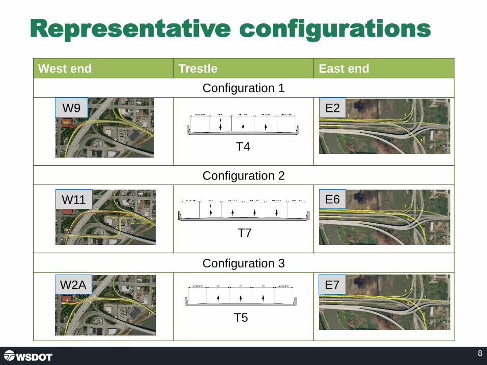
8
Representative configurations
West end Trestle East end
Configuration 1
Configuration 2
Configuration 3
E2
E6
E7W2A
W11
W9
T4
T5
T7
W9 Westbound project map with highlighted streets. T4 Configuration Shoulder, HDV lane, 2 lanes labeled GP lane, and shoulder
E2 Eastbound Highway project with highlighted streets
W11 Westbound project map with highlighted streets T7 Configuration: shoulder, HDV lane, 3 lanes labeled GP lane, and shoulder
E6 Eastbound highway project with highlighted streets
W2A Westbound project map with highlighted streets T5 Configuration: Shoulder, 3 lanes labeled GP lane, and shoulder
E7 Eastbound highway project with highlighted streets
Page 8

Finding #2: Transit and HOV Travel
Time Data (minutes)
9
A
B
C
D
Year 2040 AM Peak Hour travel times. Configuration 2 and 3 use No Build
volumes.
0 30 60 90 120
2019 Existing Conditions
2040 No Build Conditions
2040 Configuration 2
2040 Configuration 3
From SR 9 to I-5 via SR 204 (A-D)
0 30 60 90 120
2019 Existing Conditions
2040 No Build Conditions
2040 Configuration 2
2040 Configuration 3
From SR 9 to I-5 via SE 20th Street (B-D)
0 30 60 90 120
2019 Existing Conditions
2040 No Build Conditions
2040 Configuration 2
2040 Configuration 3
From SR 9 to I-5 via US 2 (C-D)
Page 9

Findings summary
• Finding #1: Network congestion
– Future congestion on I-5 limits the effectiveness of
US 2 westbound trestle improvements.
• Finding #2: Managed lanes
– Transit and HOV lanes with improved system
connections could provide people an option to bypass
system congestion.
• Finding #3: Three lane trestle
– Three lane trestle would provide sufficient capacity.
10Page 10

TWG Meeting Recap from 12/5/19
11
• Interest in continuing momentum of this latest work
• Concurrence for a 3-lane option with managed lane
• I-5 must be considered in the planning, but don’t want to
lose sight of trestle progress
• Need to integrate transit planning
• Local network planning in Everett should progress at
same pace
Page 11

Questions/Comments
• Does the Executive Advisory Group have any questions
regarding the information presented today?
• What else would the Executive Group like to share about
these findings?
12Page 12

Next Steps
• Preliminary Draft Planning and Environmental
Linkages Report
– Draft to WSDOT in early 2020
– Updated draft to FHWA after WSDOT review
• Additional steps to be determined based on
legislative funding
13Page 13

14
US 2 Westbound Trestle Contacts
Mike Cotten, PE, DBIA Northwest Region Administrator
Cathy George, PEEngineering Manager, Connecting Washington
Page 14

US 2 Westbound Trestle
US 2 Westbound Trestle Page 1 of 7 EAG Meeting #2 Summary
Executive Advisory Group (EAG) meeting #2 summary
Dec. 9, 2019
Attendees
EAG members/alternates
Name Organization
Representative Mike Sells 38th District
Representative Carolyn Eslick 39th District
Representative Robert Sutherland 39th District
Representative Jared Mead 44th District
Senator Steve Hobbs 44th District
Bob Bolerjack City of Everett
Roland Behee Community Transit, alternate for Emmett Heath
Sharleen Bakeman Federal Highway Administration
Lisa Lefeber Port of Everett
Darcee Chessman Snohomish County, alternate for Sam Low
Doug McCormick Snohomish County, alternate for Steve Thomsen
Other attendees
• Erica Bramlet* – Washington State Transportation Committee staff
• Gary Gill – Legislative aide for Jared Mead
• Jed Gonzales – Snohomish County Council Office
• Megan McPhaden* - Washington State Transportation Committee staff
• Jennifer Smolen – Legislative aide for Steve Hobbs
• Uriel Ybarra – Community Transit
WSDOT / Project team
• Ed Barry, WSDOT
• Anthony Buckley, WSDOT
• Mike Cotten, WSDOT
• Cathy George, WSDOT
• Kyengo Ndile, WSDOT
• Kris Olsen, WSDOT
• Amir Rasaie, WSDOT
• Laura Shabe, WSP
• Dave Warner, WSP
• Michael Horntvedt, Parametrix
• Liz Mack, EnviroIssues
• Suanne Pelley, EnviroIssues

US 2 Westbound Trestle Page 2 of 7 EAG Meeting #2 Summary
*Attended via phone
Introductions and overview
WSDOT Regional Administrator Mike Cotten welcomed the group and noted that during this
meeting the team would give an update on the US 2 westbound trestle study, discuss key
findings, consider the context that was used in the study, and discuss next steps. Mike then
introduced Cathy George, WSDOT engineering manager for Connecting Washington projects.
Cathy asked Doug McCormick from Snohomish County to provide a safety briefing for the
building, then she led a round of introductions. Next, she reviewed the legislative direction for
this project, noting:
• When this study effort began, the funding helped launch the environmental work, but
was insufficient to complete a full environmental evaluation.
• As you’ll see today, this study has advanced our understanding of the US 2 trestle, but
more work is needed.
Cathy introduced Dave Warner, the lead of the consultant team that has been conducting
analysis and working with the Technical Working Group (TWG) which includes staff from
agencies and jurisdictions.
Project study progress
Dave Warner gave a quick overview of the work that the TWG has completed over the past
year. On Dec. 5, 2019 the team held the fourth and final meeting with the TWG under the
current study. The TWG had a great discussion about the next steps for the US 2 trestle. In this
meeting, the EAG will review and discuss the findings and consider next steps for the trestle.
Key findings and context
The analysis completed to date led the team to an overall conclusion: That as much as we
wanted to separate the US 2 westbound trestle from the regional network, it is impossible to do
so. In order to improve operations on westbound US 2, we will have to also look at I-5 and the
connections to local streets in Everett.
Dave walked through a few definitive results of this study:
• All configurations will improve safety, water quality, and non-motorized travel.
• The trestle configurations won’t alleviate congestion due to I-5: The network and I-5 are
bigger issues for travel reliability than the trestle.
• A three-lane trestle is sufficient for demand.
• An HOV lane may be necessary to meet the Purpose and Need.
• Any solutions must be developed with future I-5 planning in mind.
Questions
• Lisa Lefeber asked if the team knew the configuration of the three-lane trestle.
o The project team replied that they may need some additional analysis to decide,
but they have received some feedback about this from the TWG.
Dave noted, that as we move forward, we will have to continue to explore some key topics:
US 2 Westbound Trestle Page 3 of 7 EAG Meeting #2 Summary
• System capacity
• Managing demand
• Managing capacity
• System connectivity
Dave explained that earlier in 2019, the team combined their review of various planning
documents to frame the draft Purpose and Need. In March, we presented the context for the
purpose of this project and framed the need in conjunction with the purpose.
Dave presented the regional planned growth context (slide 6) for the trestle study, noting:
• The graph is a daunting look at the planned population and employment growth locally,
regionally, and statewide.
• The blue bars show population growth, and the red bars show employment growth.
• According to the Puget Sound Regional Council and Washington Office of Financial
Management, Snohomish County and its cities are projected to grow at a much greater
rate than Puget Sound and Washington State.
• This is why the US 2 trestle is a critical project for Snohomish County.
Next, Dave reviewed the transportation system (slide 7) around the US trestle, noting:
• There are 81,000 trips which is a pretty strong demand. It is higher than the SR 520
Portage Bay bridge located between I-5 and Montlake near the University of
Washington.
• About 3,200 vehicles per hour get to the mid-span of the trestle during the peak hour,
but there are many more vehicles stuck in congestion that we need to consider.
• This is a T1 primary freight corridor for the state, and the heavy trucks make up 3-5% of
the traffic stream during the peak. Nearly 10% of the traffic is single-unit trucks (e.g.,
UPS, local delivery).
• There are three bus routes operating on the corridor that make about 14 trips during the
peak period serving over 300 people. The average occupancy of a bus is about 30
people.
• HOV use is at about 3% along the corridor and cyclist numbers are quite low. These last
three modes have limited incentive for use and there is limited non-motorized access.
Dave reviewed the representative configurations (slide 8), noting:
• In June the team brought forward to the TWG a number of options for the east end, the
trestle, and the west end.
• The TWG then developed these into three representative configurations.
• The team used PSRC 2040 growth and demand projections to do the analysis on each
of the configurations. The demand projections also include Sound Transit light rail
reaching Everett in 2036.
• Configuration 1 and 2 both included a transit/HOV lane. Configuration 3 only included a
short transit/HOV bypass at the I-5 interchange.

US 2 Westbound Trestle Page 4 of 7 EAG Meeting #2 Summary
Questions/comments
• Rep. Sutherland asked if E6 on the east end of Configuration 2 is expected to relieve the
congestion coming down SR 204 getting to the trestle.
o The project team replied that they will show data on the travel times a bit later in
the presentation, but overall this would help bring people down SR 204 if there
were no downstream effects.
• Lisa Lefeber noted that the transportation system graphic makes it appear that an
additional east-west corridor may be needed further south.
• Bob Bolerjack noted that light rail to Everett should have a positive effect.
Dave explained that Configuration 1 was not further analyzed with traffic modeling because of
constraints with the existing I-5 bridges. The team couldn’t widen Everett Avenue around these
existing structures.
Next, Dave presented the travel time data (slide 9) for the three key travel origins across the
trestle: SR 204, 20th Street Southeast, and SR 9. For each of these three different origins, the
team answered the following questions:
• What are the travel times with existing conditions for transit/HOV users and general-
purpose users?
• What are the travel times with the 2040 no-build condition?
• How do the HOV and general-purpose lanes perform from each location with
Configuration 2 and 3?
Dave walked through the data for each of the origins and noted:
• Traffic from SR 204 and US 2 must wait to reach the HOV lane to receive HOV lane
benefits.
• Travel times for the HOV lane are improved compared to the general-purpose travel
times.
• The 20th Street Southeast BAT lane connection to US 2 still provides a benefit for
bypassing congestion.
• I-5 congestion still affects the functionality of the westbound trestle and receiving
capacity.
Questions/comments
• Sen. Hobbs asked if the HOV lane made up a consistent percentage of users across all
scenarios.
o The team confirmed that is correct and that the model does not consider if the
increase in travel time would lead to mode shift.
• Rep. Sutherland asked if the team looked at eliminating access onto the westbound
trestle from SR 9 via US 2. He noted that having a different east-west route for these
users may free up traffic on the trestle.
o The team responded that they did not study a new corridor further south but
noted that a new crossing would be far more expensive than replacing the trestle.
They noted that the trestle would still need to be replaced at some point. They
also explained that most people headed north on SR 9 and then west on the
trestle are not continuing south on I-5.

US 2 Westbound Trestle Page 5 of 7 EAG Meeting #2 Summary
• Sen. Hobbs noted that a new east-west route would not address the problem of
congestion on I-5.
• Doug McCormick pointed out that a parallel east-west route would still introduce traffic
onto I-5.
• Rep. Sutherland noted that from the data, it doesn’t look like a new trestle would help the
problem.
o The team noted that the congestion on I-5 is masking the comparison of the
various trestle configurations.
• Sen. Hobbs asked if the expansion of SR 9 would help alleviate some of the congestion.
o The team confirmed that is likely.
Dave reviewed the three key findings from the analysis (slide 10):
1. Network congestion. To improve movement of general-purpose traffic we need to
address network congestion.
2. Managed lanes. Transit and HOV lanes with improved system connections could
provide people an option to bypass system congestion.
3. Three-lane trestle. Three-lane trestle would provide sufficient capacity.
Lastly, Dave presented the key discussion elements from the TWG meeting on Dec. 5, 2019:
• The TWG is committed to the forward progress of the US 2 westbound trestle.
• There was overall agreement that a three-lane option would handle the traffic demand
on the trestle. There needs to be more study on a transit/HOV lane vs. peak shoulder
use.
• The TWG was pleased that the east end Interchange Justification Report (IJR) that was
completed in 2018 supports the future trestle.
• TWG members understood that I-5 must be evaluated and considered as part of the
trestle planning, but they don’t want to delay the trestle work to fix I-5.
• Transit planning for light rail coming to Everett in 2036 is also a key part of trestle
planning. Right now, Community Transit is focused on rerouting for light rail to Lynnwood
in 2024.
• Local streets in Everett need to work as part of the future trestle solution.
Discussion
Mike Cotten opened the floor for discussion and questions.
Questions/comments:
• Doug McCormick asked if a three-lane trestle would provide enough capacity if I-5
congestion wasn’t a factor.
o The team confirmed this is accurate, assuming the congestion at either end of
the trestle was corrected.
• Bob Bolerjack asked if the data included Sound Transit 3’s (ST3) original ridership
projections, noting that current light rail ridership is exceeding the original projections.
o The team responded that they used the latest ST3 projections in the model.
• Lisa Lefeber asked how many of the people going southbound off of the trestle are
headed to Boeing.

US 2 Westbound Trestle Page 6 of 7 EAG Meeting #2 Summary
o The team replied that they don’t have that specific data, but they know the
majority is going into southwest Everett and only about 5% of people continue
into King County.
• Bob Bolerjack asked if there were ideas for how to fix I-5.
o The team responded that this will be an important next step. Right now, they
know traffic goes south to at least 41st Street and there’s significant weave in
that section of I-5. Travel demand management will likely be a key part of the
solution.
• Lisa Lefeber noted that backups in the SR 522/I-405 area often lead people to use
arterials as bypass options. She noted that this may be a risk if the team uses direct
ramps on the trestle.
• Roland Behee noted that the Purpose and Need has been focused on multimodal
improvements and that transit is looking to take advantage of an improved east-west
route.
• Lisa Lefeber noted that the City of Everett and the Port of Everett are working on a
freight route that will discourage trucks from going through downtown Everett. They are
considering a freight corridor via 41st Street then going across the trestle eastbound.
Westbound traffic would travel via Marine View Drive.
• Sen. Hobbs noted that it’s discouraging to see the problem with I-5. He stated that he’s
been consumed with I-976 lately and its effects on projects in the region. He encouraged
the team to continue to move forward with this work, so they’ll be ready for a future a
transportation package. He doesn’t anticipate a package next session (in 2020) and
noted that the Legislature probably won’t fund a new trestle without a toll. He also
stressed that Snohomish County legislators need to stick together to make sure projects
in the county get funding.
• Lisa Lefeber asked if there was an opportunity for a public-private partnership for this
project.
o Sen. Hobbs noted this may be more of a possibility now due to changes in the
Legislature.
o Anthony Buckley noted that the Legislature needs to clean up the language in the
statute to make it work for the private sector.
• Sharleen Bakeman pointed out the using the Planning and Environmental Linkages
(PEL) has helped make early findings before the team fully commits to a NEPA analysis
and will help streamline this process. The team has discovered valuable information that
will help to determine next steps.
• Rep. Sutherland noted that he hasn’t heard any more discussion about a double-decker
trestle and suggested that the trestle have a double-decker roadway that continue onto I-
5 and a portion of I-5 could also be built as a double deck.
o Sen. Hobbs noted that this idea would cost a tremendous amount of money.
• Rep. Eslick noted that it’s going to be important to make sure there is enough capacity
for the future. She also stated that the trestle has to have an HOV lane whether it’s tolled
or not.
• Rep. Sells noted that the problem with building more capacity is that if you build it, it will
increase the demand. He explained that you can’t build in a way that it won’t fill up.
• Sen. Hobbs responded that the group must think about transit improvements.

US 2 Westbound Trestle Page 7 of 7 EAG Meeting #2 Summary
• Lisa Lefeber added that more consumer goods are being shipped via barges on a north-
south route and this effort will take trucks off the corridor.
Next steps, action items and adjourn
Mike Cotten noted that the consultant team plans to submit the preliminary draft PEL report
early in 2020. WSDOT will review this and then submit to FHWA for its review. After that, the
consultant team’s work will be done and WSDOT will be in a holding pattern until the Legislature
determines next steps for the US 2 trestle.
The project team thanked the EAG for participating in this effort for the US 2 trestle and
attending the meeting, which was then adjourned.

US 2 Westbound Trestle
US 2 Westbound Trestle Page 1 of 2RAC Meeting #1 3/7/19
AGENDA Resource Agency Committee (RAC) Meeting #1
Thursday, March 7, 2019, 1 – 3 p.m.
WSP Conference Room, Floor 32
999 3rd Ave, Seattle, WA 98104
Time Topic Lead
1:00 – 1:10 p.m.
Welcome and introductions
• Safety briefing
• Operating guidelines
Emily Geralds
1:10 – 1:30 p.m.
Project background
• US 2 / SR 204 / 20th St IJR
• US 2 Corridor Study
• US 2 Funding & Finance Study
Emily Geralds Dave Warner
1:30 – 1:35 p.m. Project schedule and stakeholder outreach
David Warner Liz Mack
1:35 – 2:05 p.m.
Resources and constraints
• Already identified
• Group discussion
Lawrence Spurgeon Katheryn Seckel
2:05 – 2:25 p.m.
Discussion: Purpose and Need
• Draft needs
• Draft purpose
Emily Geralds Lawrence Spurgeon
2:25 - 2:55 p.m.
Alternatives Development
• Alternative identification
• Group thoughts, ideas, anddiscussion
Lawrence Spurgeon Ben Rodenbough
2:55 – 3:00 p.m. Next Steps and Adjourn Liz Mack
Attendees listed on reverse side
Emily Geralds, Dave Warner
David Warner, Liz Mack
Lawrence Spurgeon, Katheryn Seckel
Emily Geralds, Lawrence Spurgeon
Lawrence Spurgeon, Ben Rodenbough
Page 1 of 2

US 2 Westbound Trestle
US 2 Westbound Trestle Page 2 of 2RAC Meeting #1 3/7/19
Attendees
RAC Members (invited)
□ Michael Coffey, Bureau of Reclamation - Pacific Northwest Regional Office
□ Allen Giffen, City of Everett
□ Russell Wright, City of Lake Stevens
□ Chris Holland, City of Marysville
□ Allison Halpern, Conservation Commission
□ Susan Buis, Corps of Engineers
□ Mark Eberlein, Federal Emergency Management Agency
□ Jeff Horton, Federal Highway Administration
□ Sharleen Bakeman, Federal Highway Administration
□ Sharon Love, Federal Highway Administration
□ Michael MacDonald, NOAA Fisheries/USFWS
□ Erika Harris, Puget Sound Regional Council
□ Monte Marti, Snohomish Conservation District
□ Esther Moseichuk, Snohomish County
□ Sean Curran, Snohomish County
□ Sharon Swan, Snohomish County
□ Tracie Eastman, Snohomish County
□ Erik Stockdale, Snohomish County
□ James Yap, Snohomish County
□ Gregg Farris, Snohomish County Diking District
□ Jessica Lange, Sound Salmon Solutions
□ Sam Barr, Stillaguamish Tribe
□ Derek Marks, Tulalip Tribes
□ Kurt Nelson, Tulalip Tribes
□ Richard Young, Tulalip Tribes
□ Carl Smith, US Coast Guard
□ Elaine Somers, US Environmental Protection Agency
□ Dennis Wardlaw, Washington State Department of Archaeology and Historic Preservation
□ Caroline Corcoran, Washington State Department of Ecology
□ Marc Hershfield, Washington State Department of Ecology
□ Jamie Bails, Washington State Department of Fish and Wildlife
□ Tamra Zylstra, Washington State Department of Natural Resources
WSDOT and Consultants:
□ Cameron Kukes, WSDOT
□ Emily Geralds, WSDOT
□ Harmony Weinberg, WSDOT
□ Kyengo Ndile, WSDOT
□ Robert Woeck, WSDOT
□ Ryan Boyle, WSDOT
□ Tim Nau, WSDOT
□ Victoria Book, WSDOT
□ Ben Rodenbough, WSP
□ Lawrence Spurgeon, WSP
□ David Warner, WSP
□ Liz Mack, EnviroIssues
□ Katheryn Seckel, Parametrix
Page 2 of 2

Meeting #1
March 7, 2019
1:00 - 3:00 p.m.
US 2 Westbound Trestle
Resource Agency Committee

Agenda
• Safety briefing and introductions – 5 min
• Project background – 20 min
• Project schedule and stakeholder outreach – 5 min
• Discussion: Resources and constraints – 30 min
• Discussion: Purpose and Need – 20 min
• Discussion: Alternatives development – 30 min
• Next steps and adjourn – 5 min
2Slide Page 2

RAC operating guidelines
Purpose of the group
• Provide input on alternatives development and
screening
• Communicate your agency’s priorities and
concerns
• Identify key issues for the team to address
• Participate in RAC meetings – anticipated to be
1 additional meeting over the next year
3Slide Page 3

Project background
4
Slide Page 4

Legislative direction
• In 2018, the legislature authorized new funding "for
getting to a preliminary preferred option in the
environmental process."
– Funding helps launch early environmental work
– Funding is insufficient to complete the full NEPA
process
5
Slide Page 5

Leveraging previous studies: Planning & Environmental Linkages
6
Planning & Environmental Linkages
Slide Page 6

US 2 Corridor Study
Purpose
• Analyzed the existing and future congestion
levels in the corridor
• Addressed the future operational and
structural adequacy needs of the US 2
westbound trestle
• Considered near-term/lower-cost
treatments and longer-term unfunded
improvements for the corridor
– Including replacement of the westbound
trestle with a new three-lane facility
Timing
7
2009 Legislature provided funding along with
Everett and Snohomish County
2016 Finalized
2009: Legislature provided funding along with Everett and Snohomish County
2016: Finalized
Slide Page 7

US 2 Westbound Trestle
Funding and Financing Study
Purpose:
• Updated cost estimates for
replacing the westbound
trestle
• Examined funding and
financing options
Timing:
8
2017 Legislature authorized study
2017 WSDOT formed partnership groups
Jan 2018 Finalized
2017: Legislature authorized study
2017: WSDOT formed partnership groups
Jan 2018: Finalized
Slide Page 8
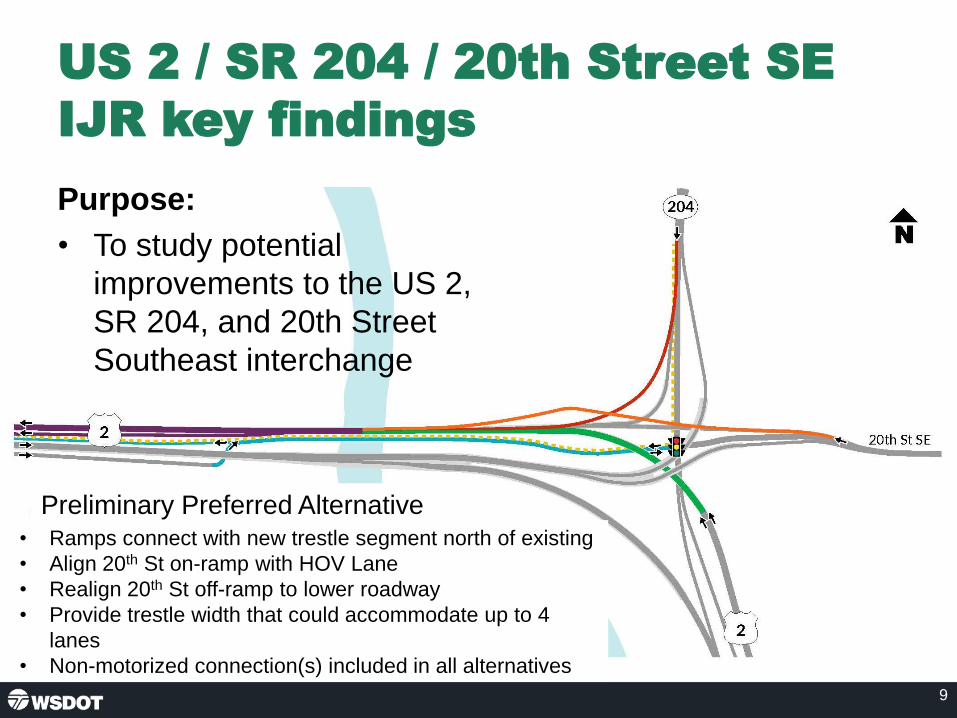
US 2 / SR 204 / 20th Street SE
IJR key findings
9
Preliminary Preferred Alternative• Ramps connect with new trestle segment north of existing
• Align 20th St on-ramp with HOV Lane
• Realign 20th St off-ramp to lower roadway
• Provide trestle width that could accommodate up to 4
lanes
• Non-motorized connection(s) included in all alternatives
Purpose:
• To study potential
improvements to the US 2,
SR 204, and 20th Street
Southeast interchange
Slide Page 9

Project schedule
Launch TWG and EAG – December 2018
Launch RAC – March 2019
Purpose and Need – Spring 2019
Alternatives Development – Spring through Summer
2019
Alternatives Refinement – Fall 2019
RAC Participation in Alternative Review 2019/2020
Short List Alternatives – Early 2020
– Goal: Identify Preliminary Preferred Alternative
10
Part 1 Funded 2018 – June 2020
We are
here
Note: We are here (At "Launch RAC")
Slide Page 10

Stakeholder involvement
Interviews conducted with:
• Washington Vocational Services
• Community Foundation of Snohomish County
• Futurewise
• BIKES Club of Snohomish County
Meetings with:
• Snohomish County Economic Alliance
• WSDOT Freight Office
11Slide Page 11

Environmental considerations
• Existing US 2 corridor
crosses:
– Floodplains
– Wetlands
– Fish-bearing streams
• Surrounding communities
have several indicators for
environmental justice
populations
• Publicly-owned land
managed as part of the
Snohomish River Estuary is
adjacent to the corridor
• Collecting information on
cultural resources12Slide
Page 12

Floodplains
13
FEMA Flood DataNational Flood Hazard Flood Zones: Floodway; 100 yr. (1% ACE); 500 yr. (0.2% ACE)
Q3 Flood Zones: 100 yr. (1% ACE); 500 yr. (0.2% ACE)
Slide Page 13

Wetlands
14
There are several wetland restoration projects in the area, including south of the eastbound trestle, to restore
freshwater wetlands to estuarine.
National Wetland Inventory (NWI) and Non-NWI Wetlands
NWI Wetlands
Types: Freshwater Emergent Wetland; Freshwater Forested/Shrub Wetland; Freshwater Pond; Lake; Riverine
Non-NWI Wetlands
WSDOT Wetland Mitigation Site
Slide Page 14

Fish presence
15
US 2 Westbound Trestle Project: Fish Presence by Species
WDFW Fish Distribution By Species:Chinook Salmon, Chum Salmon, Coho Salmon, Pink Salmon, Bull Trout, Cutthroat Trout, Steelhead Trout
Sockeye Salmon
Largemouth Bass
Map Marks Fish Passage Barrier
Slide Page 15

Environmental justice
16
Minority populations Hispanic/Latino populations Low Income population
Slide Page 16

Protected land uses
17Slide Page 17
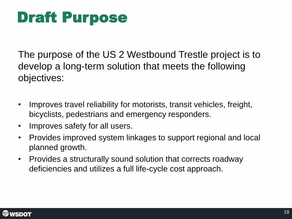
Draft Purpose
The purpose of the US 2 Westbound Trestle project is to
develop a long-term solution that meets the following
objectives:
• Improves travel reliability for motorists, transit vehicles, freight,
bicyclists, pedestrians and emergency responders.
• Improves safety for all users.
• Provides improved system linkages to support regional and local
planned growth.
• Provides a structurally sound solution that corrects roadway
deficiencies and utilizes a full life-cycle cost approach.
18Slide Page 18

Draft Need
• Local communities are growing faster in population and jobs than
the Puget Sound Region or the State as a whole.
• Morning traffic volumes into Everett and south on I-5 already exceed
interchange capacity at both the SR 204 and I-5 interchanges.
• The demand includes high truck volumes and occupancy of
available buses.
• Non-motorized connections don’t exist through the US 2 and SR 204
interchange.
• High volumes at merge points have increased collision frequency.
• The current trestle has 3-foot shoulders, with no refuge space.
19Slide Page 19

Regional planned growth
2015 – 2040
20
Sources: PSRC 2017; WOFM 2018b.
73%
40%
46%49%
38%
27%31%
62%
54%
88%
48% 48%
38%
30%
0%
10%
20%
30%
40%
50%
60%
70%
80%
90%
100%
City of Everett City of LakeStevens
City of Marysville City ofSnohomish
SnohomishCounty
Puget SoundRegion
WashingtonState
Population Growth Employment Growth
Slide Page 20

Existing transportation system
21
• 81,000 daily trips
• 3,200 vehicles/hour during the peak
• 8-10% freight traffic
• Three bus routes and 14 bus trips during peak period
• About 30 people per bus
• About 3% HOV
• Nearly 20 bicycles
Slide Page 21

Existing and 2040 traffic demand
22Slide Page 22

Existing travel times and speeds
23
Figure X. US 2 Trestle, AM Westbound. Observed Travel Times and Speeds
Snohomish County, Washington
Travel time data collected during the week of October 20, 2019 using the floating car methodology Data collected for the US 2 West Trestle pre-NEPA Project.
*Peak Period Travel Speeds Categories:Less then 30 mph;31-35 mph;36-40 mph;41-50 mph;Greater than 50 mph
Map icons for City Limits, as well as Travel Time between Markers
Slide Page 23

Safety
24
Short merge, high
volume, limited shoulder
Short merge, limited
shoulder, weave to I-5
Highly congested NB I-5
Highly congested NB I-5
41st Street
20th Street SEUS 2
Hewitt Ave
Support data from US 2/SR 204/20th Street SE IJR (2011 – 2015)
Support data from US 2/SR 204/20th Street SE IJR (2011 - 2015)
Slide Page 24

Alternatives development
• WSDOT is identifying a range of alternatives to consider against
the Purpose and Need.
• Physical alternatives in the corridor:
• West end interchange with I-5 and Everett
• Trestle structure concepts
• East interchange with 20th St. SE and SR 204
• Non-motorized and transit connections
• Policy and operational considerations
• Transit
• Non-motorized
• Tolling, managed lanes
• Operation with loss of trestle
25Slide Page 25

Conceptual corridor
26Slide Page 26
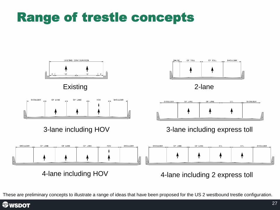
Range of trestle concepts
27
Existing 2-lane
3-lane including HOV 3-lane including express toll
4-lane including HOV 4-lane including 2 express toll
These are preliminary concepts to illustrate a range of ideas that have been proposed for the US 2 westbound trestle configuration.
Slide Page 27

Next steps
• February/March 2019: Stakeholder interviews
• March 2019: Resource Agency Committee and
Tribal coordination
• March/April 2019: Alternatives development and
metrics analysis
28
Action items
Slide Page 28

29
US 2 Westbound Trestle Contacts
Emily GeraldsEnvironmental Coordinator
Lawrence SpurgeonConsultant Environmental Lead
Slide Page 29

US 2 Westbound Trestle
Page 1 of 12
Resource Agency Committee (RAC) Meeting #1 Summary
March 7, 2019
Attendees
RAC members/alternates
Name Organization
Susan Buis* Corps of Engineers
Marc Hershfield Department of Ecology
Jeff Horton FHWA
Sharon Love FHWA
Erika Harris PSRC
Monte Marti* Snohomish County Conservation District
Sam Barr Stillaguamish Tribe
Kurt Nelson Tulalip Tribes
Carl Smith US Coast Guard
Danny McRynolds US Coast Guard
Jamie Bails* WDFW
*attended via phone
Project team:
• Cameron Kukes, WSDOT
• Emily Geralds, WSDOT
• Kyengo Ndile, WSDOT
• Tim Nau, WSDOT
• Ben Rodenbough, Consultant Team
• Dave Warner, Consultant Team
• Lawrence Spurgeon, Consultant Team
• Liz Mack, Consultant Team
• Diana Brown, Consultant Team
• Katheryn Seckel, Consultant Team

US 2 Westbound Trestle
Page 2 of 12
Welcome and introductions
Emily Geralds, WSDOT environmental lead, welcomed the group. Dave Warner, consultant
team project manager, provided a safety briefing for the building. Emily then led a round of
introductions.
Emily reviewed the meeting agenda. The bulk of the meeting will focus on providing project
background and discussing resources and constraints, draft Purpose and Need statements and
alternatives development.
Operating guidelines
Emily provided an overview of the purpose of the group. Highlighting that the group is expected
to meet twice over the next year.
Project background
Emily reviewed the project background, noting:
• The US 2 trestle is part of a key corridor connecting Everett with SR 9 and eastern
Snohomish County.
• The westbound trestle was completed in 1968. The original eastbound timber bridge
was replaced with a concrete structure in the early 1990s.
• Snohomish County’s population has grown by over 130 percent since 1980.
o The US 2 corridor near the trestle faces operational deficiencies and capacity
needs, leading the state legislature to commit funds to begin early environmental
analysis.
• Project scope and limits.
• Critical corridor components to be considered moving forward.
Emily shared that in 2018, the legislature authorized new funding and the US 2 corridor has
received other legislative action in recent sessions in the form of studies.
Emily introduced the concept of Planning & Environmental Linkages (PEL) then passed the lead
to Dave Warner.
Dave explained how this project will use a PEL Study to leverage previous corridor studies,
noting:
• The alternatives development process builds on previous studies, including the US 2/SR
204 Interchange Justification Report (IJR), US 2 Corridor Study, and US 2 Funding and
Financing study.
• The IJR feeds into all future environmental work, the other two studies also contribute.
• The PEL Study will tie together these studies.

US 2 Westbound Trestle
Page 3 of 12
US 2 Corridor Study
Dave Warner shared the purpose and key findings of the Corridor Study. Key findings include
heavy existing and future congestion levels, operational deficiencies, and the retrofits completed
in 2011 to extend useful life of the Westbound Trestle.
US 2 Westbound Trestle Funding and Financing Study
Dave Warner reviewed financing options, including public-private partnerships, transportation
benefit districts, loans, grants, and other alternative financing measures at the state and local
level, and various tolling scenarios, including tolling in both directions. The cost estimate
included the east side interchange improvements proposed within the IJR.
The study found that the project will likely require a combination of federal, state and local
funding sources, including: Federal/state grant programs with local funding, state gas tax,
tolling, Public-Private Partnership.
US 2 / SR 204 / 20th Street SE IJR key findings
Dave Warner reviewed the purpose and findings of the IJR, which include:
• Traffic congestion in the year 2040 was shown to be in excess of a mile long for people
trying to access the westbound trestle.
• Travel times more than double for most people.
• Safety was also shown to be an issue today and in the future.
• The Preliminary Preferred Alternative would move traffic through the interchange and
across the wider trestle, but the roadway geometries and capacity on the west end could
not accommodate the full increase in traffic.
• There were issues with high traffic volumes destined for the expanding downtown of
Everett and to southbound I-5.
• Further study and design of a future west end is needed as part of the US 2 Westbound
Trestle NEPA project.
The team will use these key findings and all that they learned through the IJR process as they
look at the more system wide needs related to the corridor.
Project schedule and stakeholder outreach
Dave Warner reviewed the project schedule to reach a Preliminary Preferred Alternative. Dave
emphasized that the traffic and design analysis to reach a Preliminary Preferred Alternative will
be extensive. While it is our goal to reach a Preliminary Preferred Alternative at the end of this
process, we may need additional funding to complete the analysis. The schedule reflects the
key milestones. During this process we will engage with the public and the TWG, RAC, EAG
and Tribes at key milestones.
Dave then introduced Liz Mack, consultant team communications, to discuss stakeholder
engagement.

US 2 Westbound Trestle
Page 4 of 12
Liz Mack explained that the team is meeting with non-government organizations to hear their
perspectives on the trestle, the congestion, project considerations, and strategies for reaching a
diverse audience. The team has heard the following key themes:
• Many people are concerned about the reliability of the trestle and the impacts on
commuters and the economy.
• Non-motorized access between Lake Stevens and Everett is important.
• Concern that growth in the region will only make things worse.
• There are low-income and unrepresented populations on both sides of the corridor that
will need consideration.
• Improving transit across the trestle is important.
• Tolling came up in some conversations but wasn’t on the forefront as much as the
reliability issues.
• Lots of interest in the project and assisting with outreach to the public.
In addition, the team met with the Snohomish County Economic Alliance, and they are
amenable to pulling together some of their members to discuss the trestle work. They can help
pull together a freight/mobility meeting to discuss the specific needs of freight in the corridor.
The freight conversation continued with the WSDOT freight office, which will also be joining the
TWG when their new planner comes on board. They are happy to work with the team on a
freight coordination meeting, along with the Economic Alliance.
Liz introduced Lawrence Spurgeon, consultant team environmental lead.
Resources and constraints
Lawrence Spurgeon provided an overview of environmental considerations in the project
corridor, then introduced Kathryn Seckel, consultant environmental team.
Kathryn provided an overview of existing floodplain data and reviewed a graphic showing FEMA
data of the floodway and National Flood Hazard Flood Zones.
Questions
o Kurt Nelson, Tulalip Tribes, asked if the image showed the floodway, flood fringe,
or the floodplain and asked if they were being treated differently in the analysis.
The team said they would follow up and clarify the definition. A follow up phone
call with Snohomish County after the meeting clarified that a majority of the
corridor is located within FEMA’s “density fringe” designation (from east end to
Deadwater Slough. The rest of the corridor (Deadwater Slough to I-5) is within
floodway.
Wetlands
Kathryn reviewed a map of National Wetland Inventory (NWI) and Non-NWI Wetlands. Mapped
or modeled wetlands cover almost the entire area within 500 feet of the existing trestle. Several
wetland types, including freshwater emergent, riverine, and freshwater forested/shrub wetlands,
Kathryn reviewed a map of National Wetland Inventory (NWI) and Non-NWI Wetlands. Mapped or modeled wetlands cover almost the entire area within 500 feet of the existing trestle. Several wetland types, including freshwater emergent, riverine, and freshwater forested/shrub wetlands, are present.

US 2 Westbound Trestle
Page 5 of 12
are present. Many of the wetlands in the project area are likely to be rated as Category 1 or 2
(i.e., high-quality). Source: Environmental Considerations Report: US 2/ SR 204 & 20th St SE
Interchange Justification Report (WSDOT 2017).
Questions
o Kurt Nelson asked if the team had looked at the Snohomish Estuary Wetland
Inventory by the City of Everett. The team responded that they had not but would
add it to the list of studies to review.
o Carl Smith, US Coast Guard, asked if the white areas on the map are wetlands.
The team confirmed that these areas do not contain wetlands based on the data
the team has gathered.
o Kurt Nelson asked if the team had considered the restoration sites of Ebey
Island. The team confirmed that they had.
Fish presence
Kathryn shared information about ESA-Listed Species and Critical Habitat, noting:
• Puget Sound Chinook salmon and Puget Sound steelhead are documented in the
segments of the Snohomish River and Ebey Slough.
• Bull trout use the Snohomish River in the project area as rearing habitat, and they are
presumed to be present in Ebey Slough.
• The Ebey Island floodplain includes a network of ditches accessible to fish. Puget Sound
Chinook salmon, Puget Sound steelhead, and bull trout are presumed to be present in
those ditches.
• The segments of the Snohomish River and Ebey Slough crossed by the US 2 trestle
have been designated as critical habitat for bull trout, Puget Sound Chinook salmon, and
Puget Sound steelhead.
• Dead Water Slough, which is crossed by the trestle approximately 0.5 mile east of the
Snohomish River bridge, is designated as critical habitat for Puget Sound Chinook
salmon and Puget Sound steelhead.
Other Species and Habitats of Concern (WDFW PHS mapping) include:
• Peregrine falcon, waterfowl concentration areas, and wetlands.
• Eight salmonid species (Chinook, coho, chum, pink, and sockeye salmon, and cutthroat,
steelhead, and bull trout).
• Bald eagle nest approximately 0.5 mile from the project area (USFWS compliance with
Bald and Golden Eagle Management Act)
• Some species of birds (e.g., peregrine falcon, cliff swallow, barn swallow) that may build
nests on structures such as the US 2 trestle.
The WSDOT Fish Passage Inventory identifies no state-owned culverts that impede fish
passage along the US 2 trestle. Some are identified along SR 204 to the north of the US 2/
SR204/20th Street Interchange.
Many of the wetlands in the project area are likely to be rated as Category 1 or 2 (i.e., high-quality). Source: Environmental Considerations Report: US 2/ SR 204 & 20th St SE Interchange Justification Report (WSDOT 2017).

US 2 Westbound Trestle
Page 6 of 12
Questions and comments
o Kurt Nelson noted that the Washington Department of Fish and Wildlife did a
study on restoration alternatives for Ebey Island and noted that there are
tidegates related to fish access and restoration. The team was aware of this
study.
o Sam Barr, Stillaguamish Tribe, shared that there are cultural resources on Dead
Water Slough and there is an established site under the surface near the
highway. There are additional sites on Ebey’s island. He requested that tribal
monitors be present when crews dig in the area. Sam also asked if there would
be a full cultural survey and if it would be possible to test before full construction
begins. Sam also asked if there is a plan to process the storm water on site. The
team confirmed that they plan to study and test these areas and that they are
looking at way to treat stormwater on site. The team is also meeting separately
with the area tribes to discuss these issues.
o Sharon Love, FHWA, stated that disturbances from construction could also occur
beyond the piers and include areas where construction equipment is being
staged, among other locations and encourage the study area to cover those
areas. The team confirmed that they would study all areas affected by
construction.
Environmental justice
Lawrence Spurgeon reviewed maps showing areas with higher concentrations of low-income
and/or minority persons than Snohomish County as a whole, identified through initial study of
US Census Bureau and Washington’s Office of Superintendent of Public Instruction data. The
team will work with community-based organizations serving these areas to conduct focus
groups and listening sessions aimed at understanding public perceptions about burdens and
equity.
Consideration of a tolling program requires a comprehensive understanding of public
perceptions of burden and equity. The project public engagement approach to developing that
comprehensive understanding of burden and equity related to tolling will begin with targeted
engagement in specific areas with substantially high concentrations of low-income and/or
minority populations.
Protected land uses
Lawrence Spurgeon reviewed a map identifying property owned by Snohomish County and
designated as part of the Snohomish River Estuary management area identified for
conservation and recreation.

US 2 Westbound Trestle
Page 7 of 12
Within 500 feet for the US2 trestle footprint (including interchanges), the land is zoned
agricultural between the Snohomish River and SR 204.
In Snohomish County’s comprehensive plan, the land use is listed as riverway commercial
farmland. It is a designated farmland area for Snohomish County and zoned A-10. Not allowed
in riverway commercial farmland: new government structures and facilities, except roads,
utilities, and flood protection, drainage, and irrigation structures and facilities. (Added by
Amended Ord. 02-064, Dec. 9, 2002, Eff date Feb. 1, 2003).
Properties shown as prime or important farmland are identified as such based on NRCS soil
types. None of the soil types are classified as Prime and Unique.
Questions and comments
o Kurt Nelson noted that WSDOT has parcels in this area and that it would be
helpful to see where those are as these might be good opportunities for
mitigation. Kurt also mentioned that the Snohomish County Conservation District
has better information for helping determine prime or important farmland. The
team agreed to look into this information and share it with the RAC.
o Erika Harris, PSRC, asked if the team is looking into climate change
considerations and noted that PSRC has recently released an EIS (Vision 2050)
about this issue which highlights the project area and offered to share the EIS
with the team. The team welcomed the suggestion and said they would add this
to their studies to review.
o Erika Harris noted that changes to the land uses and population growth will
continue in the project area and encourages an analysis of indirect land use
impacts. The team said that this is one of the next steps.
o Sharon Love suggested the team review the WSDOT Climate Vulnerability
Assessment. The team committed to reviewing the assessment.
o Marc Hershfield, Department of Ecology, asked if the Preferred Alternative is planned to be located north of the trestle and asked about the reasoning for this. The team clarified that the graphic illustrates construction impacts are likely to be on the north side because they must work around the eastbound structure. No decision has been made about a preferred alternative. The team needs to take into account phasing, constructability, the location of resources before making that determination.
o Sharon Love asked if the representatives from the Coast Guard had concerns about what had been presented thus far. Carl Smith and Danny McRynolds stated their main focus is protecting navigation on the waterways and noted that the new bridge would need to have similar or better characteristics than the current bridge to avoid navigation issues. They highlighted that there are likely permitting issues related to the construction of a new bridge. They noted that the Coast Guard would likely require a new navigation study to asses these waterways and recommended the team look into the permit application guide to better understand topics the Coast Guard is interested in. The project team stated that they are still in the early phases of the alternative analysis and that some of these issues are topics to be addressed at a later date.

US 2 Westbound Trestle
Page 8 of 12
Discussion: Purpose and Need
Draft Purpose
Lawrence Spurgeon shared the Draft Purpose: The purpose of the US 2 Westbound Trestle
project is to develop a long-term solution that meets the following objectives:
• Improves travel reliability for motorists, transit vehicles, freight, bicyclists, pedestrians
and emergency responders.
• Improves safety for all users.
• Provides improved system linkages to support regional and local planned growth.
• Provides a structurally sound solution that corrects roadway deficiencies and utilizes a
full life-cycle cost approach.
Questions and comments
o Kurt Nelson commented that residents of Ebey Island need to be considered.
The team confirmed they would take them into account.
o Erika Harris emphasized the importance of focusing on environmental
improvement, stormwater improvements and alternative modes of transportation,
including the regional bike and trail network. The team noted they will consider
these components.
Draft Need
Lawrence Spurgeon shared the Draft Need and highlighted four key needs, noting:
• Delay in the corridor during the data collection period ranges between 8 and 24 minutes.
Public input has expressed a wider range of travel time when there are crashes in the
system.
• Hot spot safety analysis highlights locations where accidents occur more frequently due
to limited shoulders, acceleration lengths, and gap acceptance lengths. Improvements to
the corridor would reduce crash occurrences and improve corridor reliability.
• Regional system planning includes a new light rail station in downtown Everett that
would reliably move people between key economic centers along the I-5 corridor. There
are currently no plans for additional parking in downtown Everett and no HOV facilities to
encourage transit use for connectivity between the freeway and transit system.
Improvements to the corridor are needed to improve transit connectivity.
• The existing corridor does not have enough shoulder space for vehicle refuge in the
event of a crash or disabled vehicle. Provisions for refuge is needed to improve corridor
reliability and safety.
Regional planned growth 2015 – 2040
Lawrence Spurgeon reviewed data that showed Snohomish County and its cities growing at a
fast rate and above the average for the Puget Sound Region and the state.
US 2 Westbound Trestle
Page 9 of 12
Existing transportation system
Lawrence Spurgeon provided an overview of the existing transportation system, noting that:
• 81,000 daily trips is a pretty strong demand. It is higher than the SR 520 Portage Bay
bridge located between I-5 and the University of Washington.
• There are about 3,200 vehicles per hour getting to the mid-span trestle during the peak
hour, but there are many more vehicles stuck in congestion that need consideration.
• This is a T1 corridor—a primary freight corridor for the state, and the heavy trucks make
up three to five percent of the traffic stream during the peak. Nearly 10 percent of the
traffic is single unit trucks (UPS, local delivery).
• There are three bus routes operating on the corridor that make about 14 trips during the
morning peak serving over 300 people. The average occupancy of a bus is about 30
people.
• HOV use is at about three percent along the corridor and the number of cyclists is quite
low. These last three modes have limited incentive for use and there is limited access for
non-motorized use.
Traffic demand
Lawrence Spurgeon reviewed the existing and future (year 2040) traffic demand on the trestle.
This future demand assumes a three-lane trestle. Tolling the trestle lowers the volume by about
30 percent. Lawrence clarified that these numbers are morning peak volumes.
Existing travel times and speeds
Lawrence Spurgeon presented the current travel times and speeds during the morning
commute which are:
• Trestle to I-5 at the Snohomish River: 1 minute
• Crossing the westbound trestle: 4-5 minutes
• SR 204 and Market Place to east end of the trestle: 12-18 minutes
• 91st Avenue SE and 20th Street SE to the east end of the trestle: 12-25 minutes
• US 2 at SR 9 to east end of the trestle:5-6 minutes
Safety
Lawrence Spurgeon explained that safety issues are highly correlated with congestion in the
area and pointed out several areas with a high number of collisions, including:
• Highly congested northbound areas on I-5
• A short merge zone of the trestle with limited shoulder near the weave to I-5
• A short merge zone with high volume and limited shoulder at the east end of the trestle

US 2 Westbound Trestle
Page 10 of 12
Questions and comments
• Jeff Horton, FHWA, asked if the project team was looking to address capacity
issues on I-5, related to the projected capacity increase on US 2. The team
answered that there may be elements of a new trestle that would impact I-5, but
the project isn’t far enough along to know what that might look like. The trestle
project is focused on a specific section and is not a project to solve issues on I-5.
• Jeff Horton asked if this is a major utility corridor. The team answered that there
are no known utilities on the northside of the existing westbound trestle.
• Dave Warner asked that Lawrence Spurgeon review the non-motorized routes.
Lawrence walked through how a bike would cross the trestle demonstrating that
the east end interchange is missing.
• Dave Warner noted that the team is also considering access to the future Everett
Station.
• A participant asked for the eastbound considerations of the 2040 traffic demand.
This information is available in the IJR.
Lawrence introduced Ben Rodenbough, design lead for the consultant team, who shared more
about alternatives development.
Alternatives development
Ben Rodenbough shared key takeaways from the TWG meeting and asked for feedback from
the RAC.
Questions and comments
• Cameron Kukes, WSDOT, asked if the team had found any seismic issues. The
team hasn’t looked into this yet but noted that soils will have a major role when
designing the structure.
• Carl Smith asked whether the existing bridge would be demolished or preserved.
The team responded that the current bridge is rated “fair” and reaches the end of
its lifespan in 2045. The existing trestle has been retrofitted once and further
retrofit could require substantial upgrades of major elements of the bridge. The
Snohomish River Bridge is a different structure and WSDOT may replace the
trestle structure and keep river bridge.
• Cameron Kukes asked for clarification of the extents of the Snohomish River
Bridge. The team noted that it’s generally the section that crosses the river.
• Kurt Nelson stated that the Army Corps recently fixed a levy just north of this
area and noted that there is unstable geology in the area. He also noted that
there is a pump station under the bridge that needs to be considered for potential
impacts. The team responded that they are familiar with this area and issue.
• Erika Harris stated that she appreciated the discussion of mode shift,
encouraging people to shift modes as much as possible to achieve greenhouse
gas goals and recommended that the team highlights how the plan would fit into
Erika Harris stated that she appreciated the discussion of mode shift, encouraging people to shift modes as much as possible to achieve greenhouse gas goals and recommended that the team highlights how the plan would fit into the state and region’s greenhouse gas goals. Several other participants reiterated the need for strong climate change considerations.

US 2 Westbound Trestle
Page 11 of 12
the state and region’s greenhouse gas goals. Several other participants
reiterated the need for strong climate change considerations.
Ben Rodenbough reviewed a roll plot of the corridor, highlighting existing conditions and
potential areas of change as highlighted by the team and RAC members.
Ben also shared the existing channelization of the westbound trestle and showed other options,
including 2-lanes with a shoulder, 3-lanes including an HOV lane, 3-lanes including express toll,
4-lanes including an HOV lane and 4-lanes including 2 express toll lanes.
Questions and comments
o Cameron Kukes asked if the shoulders in the graphics represent the design
safety standards. The team responded that this is typical design consistent with
design guidelines.
o Dave Warner noted that the current access to Ebey Island is a left side exit which
is less conventional, and that this consideration may impact the width.
o Dave Warner asked the team if there was anything discussed at the TWG
meeting that is worth sharing with the group. The project team reviewed the TWG
discussion about ways to use HOV lanes, interchanges and the overall system
changes.
o Cameron Kukes noted that the transportation committee in the Senate has
requested a new funding package and that this project is identified as a priority
along with others. It has been labeled a high priority corridor for transportation in
the state.
o Kurt Nelson challenged the team to construct a project that’s an overall
ecological gain for the area. Ways to do this include treating stormwater and
mitigating wetlands. He also noted that there is a pump station under the existing
bridge. The team responded that an overall ecological benefit is a goal of the
project. Elements of this project may be built in phases, but the whole program
will be evaluated together, and the most critical issues will be addressed first.
Next steps
Liz Mack and Dave Warner reviewed next steps for the RAC, including:
• The project team will share more detailed alternative development and analysis with the RAC
• Action items for the project team include: o Share WSDOT parcel information in regards to mitigation opportunities o Send out notes from this meeting and follow up with those who could not attend o Follow up on flood designations question o Review the Snohomish Estuary Wetland Inventory report o Review the draft EIS for PSRC Vision 2050 o Review WSDOT Climate Vulnerability Assessment

US 2 Westbound Trestle
Page 12 of 12
o Add access to Ebey Island and environmental and stormwater improvements to the Purpose and Needs Statement

Stakeholder Interview Plan January 2019
Page 1 of 4
US 2 westbound trestle – Stakeholder interview plan Draft: 1/23/19
Purpose
Stakeholder interviews conducted prior to project outreach will help inform communication tools
and tactics, as well as project Purpose and Need. Specifically, interviews will help the project
team to:
• Understand the community and specific populations that may be impacted by the project
• Identify project needs and concerns of the stakeholders
• Identify how different populations prefer to receive information
• Identify other potentially interested parties to engage during the project
• Tailor outreach to meet the needs of traditionally underrepresented populations
• Seek feedback that will help inform screening criteria
Format
Interviews will be conducted in person when possible but may be conducted via phone if an in-
person meeting is not possible. Each interview will last between 30 and 60 minutes and be
documented and summarized by the communication team. Two consultant staff and one
WSDOT staff member will attend each interview.
Organizations to interview
We will invite the following 13 organizations to participate in an interview and aim to complete a
total of 10 interviews. These organizations represent stakeholder groups in the project area as
well as social service providers that are working with traditionally underrepresented
communities. We will work with our Lake Stevens contacts to see if there are other specific Lake
Stevens organizations we should speak with.
Organization Address Mission statement/description
United Way of Snohomish County
3120 McDougall Ave. Suite 200, Everett, WA 98201
Funds five cross-sector Collaboratives — groups of community partners with a shared action plan — working together on long-term outcomes for children from birth to age 8 and their families struggling with low incomes.
Leadership Snohomish County
808 134th St. SW, Suite 101 Everett, WA 98204
Offers programs to develop current and future leaders to sharpen their civic and adaptive leadership skills for a stronger community. Program graduates serve on school boards, nonprofit boards and in corporate boardrooms.
Boys & Girls Clubs of Snohomish County
9502 19th Ave. SE, Suite F Everett, WA 98208
Has 24 clubs in the Northwest, including those in Arlington, Edmonds, Everett, Granite Falls, Lake Stevens, Lynnwood, Marysville, Monroe, Mukilteo,

Stakeholder Interview Plan January 2019
Page 2 of 4
Organization Address Mission statement/description
Snohomish, Sultan, Tulalip, Coupeville and Oak Harbor.
Sherwood Community Services
402 91st Ave. NE, Lake Stevens, WA 98258
Aims to provide innovative, inclusive services for children and adults with disabilities in their communities through early intervention, assistive technology and vocational services.
Washington Vocational Services
111 SE Everett Mall Way, Building C, Suite 100 Everett, WA 98208
Matches individuals with disabilities to jobs based on the employee’s talents and the specific needs of the employer
Community Foundation of Snohomish County
823 Rockefeller Ave. Everett, WA 98201
Connects people, opportunities and resources through grant making and by offering free training and workshops to local nonprofits. The Foundation manages more than 133 charitable funds
YMCA of Snohomish County
2720 Rockefeller Ave. Everett, WA 98201
Has branches in Everett, Marysville, Mill Creek, Monroe, Mukilteo, Stanwood-Camano, and a Big Brothers Big Sisters affiliate. It focuses on youth development, healthy living, social responsibility and strengthening communities.
Operation Homefront
Everett, WA Recently moved a regional office to Everett. The national nonprofit supports military families with financial assistance, transitional and permanent housing and family support services to prevent short-term needs from turning into long-term struggles
Familias Unidas
215 W Mukilteo Blvd Everett, WA 98203
Familias Unidas is the first Latino Resource Center in Snohomish County. It is open to all but provides bilingual services with a focus on the Hispanic Community in the area.
Sierra Club Sno-Isle Group
The Sno-Isle Group (formerly the Snohomish Group) serves two counties: Snohomish and Island (Whidbey and Camano Islands). Group leaders are all volunteers. In Snohomish and Island counties, it works on climate action, conservation issues, and political endorsements.
The Nature Conservancy - Washington
74 Wall Street, Seattle, WA 98121
Their vision is of thriving nature and thriving communities—a shared future that enables us to prosper while caring for the lands and waters that sustain us

Stakeholder Interview Plan January 2019
Page 3 of 4
Organization Address Mission statement/description
FutureWise 816 Second Avenue, Suite 200 Seattle, WA 98104
They focus on preventing the conversion of wildlife habitat, open space, farmland, and working forests to subdivisions and development, while directing most growth into our urbanized areas.
BIKES Club of Snohomish County
PO Box 5242 Everett, WA, 98206
Bike group that hosts recreation rides and provides grants to bike-related causes
Previous interviews
Stakeholder interviews were also conducted as part of the US 2/SR 204/20th Street SE
Interchange Justification Report in February 2017. The following groups were interviewed:
City/Agency/Organization Staff in Attendance
City of Monroe Brad Feilberg, Public Works Director
City of Snohomish Steve Schuller, Public Works Director
City of Marysville Jeff Laycock, City Engineer
City of Lake Stevens* Mick Monken, City Engineer
City of Everett Ryan Sass, Engineer
Snohomish County Steve Thomsen, Public Works Director
Community Transit Carol Thompson, Service Development Manager
Cascade Bicycle Club Jeff Aken, Regional Planning Director
Washington Trucking Association* Sheri Call, Vice President
Boeing Richard White, Government Relations
*Indicates phone interview
Key themes of previous interviews
• The current interchange operations are poor during peak travel times and stakeholders
are supportive of a study to identify near-term improvements to relieve congestion.
• Top priority improvements were varied for stakeholders, but all could agree that the
near-term improvements must not adversely impact local streets and communities or
hinder potential for long-term improvements, i.e., the recommended improvements
should consider and compliment regional and future transportation planning.
• Potential future improvements that reduce travel time and increase speed and reliability
are key indicators that the study is successful.
• Stakeholders confirmed there are plenty of ways to engage the public on the study.

Stakeholder Interview Plan January 2019
Page 4 of 4
Interview questions
The interviewer will start by providing a brief overview of the project. The following questions will
then guide the interview. Some questions may be omitted or revised depending on the
participant.
Background / Project Purpose and Need
1. Tell us about the transportation issues your organization is tracking or transportation
concerns of the communities you serve/work with.
2. How do those you serve/work with use the US 2 Trestle and how does the congestion on
the trestle affect them?
3. How does the trestle currently affect mobility options in the area? How would this project
affect mobility options in the future? [ask same question for equity and economy]
4. The team has identified a few potential impacts from this project including construction
detours/delays/noise/vibration, residential and business displacements, noise, air quality,
traffic diversion from US2 to other areas. Are there other potential impacts the project
team should consider? Which of these impacts is most important for the team to avoid or
minimize?
Communication and Engagement
5. How do you or those you serve/work with typically learn about things going on in your
community? What doesn’t work well for those you serve?
6. How do you or those you serve/work with prefer to engage in a project like this? (e.g.,
online, at in-person meetings, by reading print materials, etc.) What would make you
want to engage?
7. What barriers to participation exist for the community you serve/work with? What’s been
successful in addressing these barriers?
8. What are the top three things you’d like your community to learn about the project in the
next 12 months?
9. How frequently do you want/expect to hear from us during the project?
Wrap up
1. Have you worked with WSDOT before? If so, what went well and what didn’t go well?
2. Is there anything else you’d like us to know as we begin this project?
3. Are there other people or groups that we should be reaching out to about this project?
Closing Comments
Thank you so much for your time today. The input you’ve provided will be used to inform our
engagement strategy with the goal of making sure we involve the community in discussions
around issues most important to them, as related to the US 2 Westbound Trestle Project. We
plan to stay in touch with you as we have information to share or upcoming engagement
opportunities planned.
Do you have any questions for us?

Environmental Services Office Environmental Context Memo
To: Hannah Plummer and Ruth Park Through: Justin Zweifel From: Victoria Book Date: 3/31/2020 Re: US 2 Trestle PEL This planning-level environmental review focuses on select environmental assets that need to be protected, or have the potential to influence the scope of future investments. This evaluation, conducted by subject matter experts form the WSDOT Environmental Services office, is a desk review, capturing only information available at the time using GIS resources. The review does not examine the full range of environmental and social issues that will need to be addressed during site specific project development. The following is a summary of the environmental review, with additional information provided in the attached report. Contact Victoria Book at (360) 705-7408 if you have questions.
Environmental asset Summary Contact
Chronic Environmental Deficiencies None Jenni Dykstra
Climate vulnerability I-5 @ US2 I/C – High vulnerability US 2 Trestle -- Low vulnerability SR 204 – Low vulnerability
Victoria Book
Fish passage barriers One documented fish passage injunction barrier on SR 204 at MP 0.21. This site should be considered for correction if it is located within 1,000 feet of the project limits.
Susan Kanzler
Habitat connectivity Multiple high ranks for Urban Gateway pollinator habitat
Glen Kalisz
Historic bridges Did not review – evaluated in the PEL study
See PEL
Noise walls No existing, proposed, or non-WSDOT noise walls in the study area
Victoria Book
Stormwater retrofits Study area has 7 pond type, 1 vault type, and 3 ditch type BMPs; No medium or high priority stormwater retrofit areas; Fully within Snohomish River Estuary Multi-parameter TMDL
Cory Simon
Wetland mitigation sites Did not review – evaluated in PEL study (2 in study area)
See PEL

US 2 Trestle PEL – Environmental Asset Review
Climate Vulnerability Impacts WSDOT relies on the University of Washington Climate Impacts Group (CIG) as its primary source for climate information. The CIG’s Washington Climate Change Impacts Assessment provides sufficient information to enable planning-level considerations of Washington’s forecasted climate impacts. WSDOT’s Climate Impacts Vulnerability Assessment (2011) is a qualitative assessment of risks to the state’s transportation infrastructure from climate change. Climate impacts were assessed at baseline sea level rise – about 2 feet. The assessment included 3 sections within the study area, summarized below and shown in Figure 1. I-5 @ US2 I/C – High vulnerability Snohomish River basin to Quilceda Creek: This section is a low elevation, river delta with several diking districts. It is tidally influenced, and includes Union & Steamboat sloughs. Embankments are saturated. There are scour critical bridges. The I-5 Snohomish bridges are in good shape with deep piers. The county has a wetland mitigation bank in the intertidal area. US 2 Trestle – Low vulnerability Everett To Bickford: There are no scour critical bridges. The road is elevated but there are log jam issues on the bridge (Snohomish River). There are aggradation/storm events issues on Snohomish River. SR 204 – Low vulnerability US 2 to SR 9: This section has overarching issues of blocked culverts and overflowing ditches.
Fish Passage Barriers Presently, there is one documented fish passage barrier, site 995137 crossing SR 204 at MP 0.21, that is “near” the project area (Figure 1). This site is an injunction barrier and should be considered for correction if it is located within 1,000 feet of the project limits. Please contact ESO’s Stream Restoration Program Manager for more information about this site. All projects must be assessed for inclusion of fish barrier correction. Please see scoping instructions for Fish Barriers in Other Transportation Projects, last updated October 16, 2017, for guidance on determining when to correct a fish barrier during a transportation project. The WSDOT Fish Passage Barrier Removal Program coordinates with WDFW and Tribal governments to inventory culverts on fish-bearing streams within the jurisdiction of WSDOT and assess how well those structures are allowing fish passage. This corridor may not have been surveyed for fish passage barriers in several years. ESO’s Stream Restoration Program contracts with WDFW’s Fish Passage Program to re-survey stretches of roads in large transportation projects, to make sure all fish-bearing road crossings have been identified and assessed for fish passage within the project limits. As this project advances, please coordinate with ESO’s Stream Restoration Program Manager to have the fish passage inventory updated.
Habitat Connectivity Priorities Wildlife Collisions Carcass removals (either by WSDOT maintenance or citizens salvage road-killed deer or elk) and crashes involving deer or elk are used to identify high rank segments where actions to reduce collisions are warranted. There are no high ranked segments in this corridor.

Pollinators The entire Washington State highway system has been ranked, by half mile segment, for pollinator habitat
enhancement potential. The state highway system has received ranks for three types of investments to
benefit pollinators:
General pollinator rank -- intended to benefit nearby croplands and natural area. o No high priority segments in study area
Monarch rank - intended to benefit a declining butterfly. o No high priority segments in study area
Urban Gateway rank -- identify areas where local partnerships could be pursued to enhance conditions for pollinators for the appreciation of urban-dwellers and their gardens.
o 5 high priority segments in study area:
I-5 MP 191.94 – 192.94 I-5 MP 194.44 – 195.44 US2 MP 0.00 – 0.89 US2 MP 1.87 – 2.87 SR204 MP 0.00 – 0.50
Stormwater Retrofit and TMDL (Total Maximum Daily Load) Within the corridor, there are 7 pond, 1 vault, and 3 ditch type stormwater treatment and/or flow control BMPs. There are no medium or high priority areas for stormwater retrofit in the study area. The study area falls entirely within the Snohomish River Estuary Multi-parameter (Ammonia-N, CBOD, Dissolved Oxygen) TMDL.
Chronic Environmental Deficiencies Currently, no CEDs are located in the study area. A Chronic Environmental Deficiency (CED) is a location along the state highway system where recent, frequent, and chronic maintenance to WSDOT infrastructure from changing hydrologic conditions is causing impacts to fish or fish habitat. CED projects are constructed to improve maintenance and environmental conditions of these locations.
Noise Walls No existing noise walls or proposed retrofit noise walls were identified in the study area.

Figure 1. US 2 Trestle area -Climate vulnerability and Fish Passage

US 2 Westbound Trestle Study: Planning and Environmental Linkages Documentation
Appendix P Planning and Environmental Linkages Questionnaire
Introduction
A Planning and Environment Linkages (PEL) Study is a collaborative and integrated approach to
transportation decision-making authorized by 23 CFR 168. PEL considers environmental, community, and
economic goals early in the transportation planning process, generally at the corridor sketch or plan level.
The information, analysis, and products developed during planning will inform the environmental review
process under the National Environmental Policy Act (NEPA) and will help meet WSDOT requirements of
least cost planning and practical solutions.
The PEL questionnaire is a tool that state departments of transportation (DOT) and metropolitan planning
organizations (MPO) use to ensure that planning studies and decisions include environmental
considerations. Analysis and findings are documented so that they can inform future studies and the
environmental review process. The PEL questionnaire is used as a checklist to summarize the approach
to addressing environmental and project development issues as part of the planning study in anticipation
of a future NEPA study. The PEL questionnaire will be “handed off” to the NEPA practitioner as a starting
point for the environmental review process. This helps the NEPA practitioner consider the past work that
was done and avoid re-doing certain analysis or decisions made during planning.
The PEL questionnaire is intended to:
1) Provide planners a “checklist” detailing the requirements and options to consider when developing a
planning study with a goal to inform the NEPA process; and
2) Document and share relevant planning information with NEPA practitioners to build understanding
about a project – both the information studied and areas that require more analysis.
This completed PEL questionnaire has been included as an appendix to the PEL Study. FHWA will use
this questionnaire to assist it in determining if the study meets the requirements of 23 CFR §§ 450.212 or
450.318.
FHWA Draft 06/29/2020 P-1

1
US 2 Westbound Trestle Study: Planning and Environmental Linkages Documentation
Questions and Answers
Background:
A. Who is the sponsor of the planning study? (state DOT, Local Agency, Other)
Washington State Department of Transportation (WSDOT)
B. What is the name of the planning study/document and other identifying project information (e.g.,
sub-account or STIP numbers, long-range plan, or transportation improvement program years)?
The United States Route 2 Westbound Trestle Study
C. Who was included on the study team (Name and title of agency representatives, consultants, etc.)?
WSDOT Staff
The following WSDOT staff were part of the study team:
· Cathy George, Engineering Manager
· Kyengo Ndile, Project Engineer
· Tim Nau, Assistant Project Engineer
· Harmony Weinberg, Communications Lead
· Kris Olsen, Communications Lead
· Hannah Plummer, Management of Mobility Liaison
· Emily Geralds, Environmental Lead
· Ruth Park, Environmental Lead
· Vanessa Rogers, Environmental Lead
· Miguel Gavino, Traffic Engineer
· Barb Briggs, Traffic Engineer
Consultant Team
The following consultant staff were part of the study team:
· Dave Warner, Consultant Project Manager
· Jared Nakamoto, Consultant Deputy Project Manager
· Ben Rodenbough, Design Lead
· Michael Horntvedt, Traffic Lead
· Brian Woodburn, Traffic Operations
· Lawrence Spurgeon, Environmental Lead
· Laura Shabe, PEL Lead
· Brent Baker, Funding and Tolling Lead
· Bradley Brey, Transportation Planning
· Jessie Jones, Graphic Design
· Suanne Pelley, Communications Lead
· Liz Mack, Deputy Communications Lead
D. Provide a description of the existing transportation facility within the corridor being studied,
including project limits, modes, functional classification, number of lanes, shoulder width, access
control and type of surrounding environment (urban vs. rural, residential vs. commercial, etc.)
The project area of the US 2 Westbound Trestle PEL Study is defined as the westbound segment
of US 2 between and including the interchanges at Interstate 5 (I-5) and SR 204/20th St SE. US 2
is a crucial, multimodal, east-west highway corridor that connects I-5 and the city of Everett to the
FHWA Draft 06/29/2020 P-2

US 2 Westbound Trestle Study: Planning and Environmental Linkages Documentation
residential communities of Snohomish, Lake Stevens, and Monroe, and to businesses and
industries on both sides of the Snohomish River. VISION 20401, developed by the Puget Sound
Regional Council (PSRC), designates Everett as a regional growth center with Lake Stevens and
Snohomish as two of the region’s 24 small cities. For this growth strategy to be successful, the
US 2 westbound trestle must operate reliably and serve transit and active transportation in
addition to automobile traffic.
This segment of US 2 crosses the Snohomish River on elevated structures or “trestles.” The
westbound trestle runs parallel to the eastbound trestle and both traverse an estuarine
environment that includes Ebey Island, Ebey Slough, and Deadwater Slough.
The trestle span consists of two 12-foot travel lanes without a median and with three-foot
shoulders on each side. The travel lanes are bounded by WSDOT Type L barriers with a raised
11-inch-high by 18-inch-wide curb at the base.
Several previous WSDOT studies, described below in more detail, identified the need to address
the roadway geometries and capacity of the westbound trestle to accommodate future growth.
E. Provide a brief chronology of the planning activities including the year(s) the studies were
completed.
Several planning studies were undertaken recently to consider changes to the westbound trestle,
including
· The US 2: Everett Port/Naval Station to SR 9 Corridor Planning Study2 (US 2 Corridor
Study) focused on short and long-range improvements for the westbound trestle and was
completed by WSDOT in August 2016.
· The US 2-SR 204-20th Street SE Interchange Justification Report (IJR)3 was initiated by the
2016 Washington State Legislative session to evaluate the need for improvements to the
interchange and immediately surrounding highway system to improve traffic conditions and mobility
for people and freight in the project area. The report was finalized by WSDOT in April 2018.
· The US 2 Westbound Trestle Funding and Financing Study4 was completed by WSDOT
in January 2018. The Washington State Legislature directed WSDOT to prepare a cost
estimate for replacing the westbound trestle, including the east interchange improvements
proposed in the IJR, and to examine and recommend financing options.
F. Are there recent, current, or near future planning studies or projects in the vicinity? What is the
relationship of this project to those studies/projects (e.g., Are corridor connections described in
local transportation plans? Do those plans identify elements incorporated into the current plan?
How might WSDOT planning modify local plans, or vice versa?)?
The Puget Sound Regional Council (PSRC), the federally designated MPO for the region,
developed VISION 2040 and the associated Regional Transportation Plan (RTP). VISION 2040
provides a framework for how and where development occurs and how the region supports
efforts to manage growth. The RTP provides a blueprint for improving and coordinating mobility,
1 www.psrc.org/vision-2040-documents
2 www.wsdot.wa.gov/sites/default/files/2006/02/14/US2CorridorPlanningStudySigned20160901.pdf
3 www.wsdot.wa.gov/publications/fulltext/LegReports//17-19/US2_SR204_20thStSE_IJR_Report.pdf
4 www.wsdot.wa.gov/publications/fulltext/LegReports/17-19/US2WestboundTrestleFunding_FinanceStudy_WithAppendixA.pdf
FHWA Draft 06/29/2020 P-3

2
US 2 Westbound Trestle Study: Planning and Environmental Linkages Documentation
providing improved transportation choices, addressing special needs, moving the region’s freight,
and supporting the region’s economy and environment.
From this framework, the PEL Study utilized transportation and socio-economic data, the
classification of cities and towns, and plans for transit and growth centers. PSRC is currently
finalizing its VISION 2050, an update to VISION 2040 and is anticipated to begin the update of
the RTP during the second half of 2020
The city of Lake Stevens recently issued a notice of land use application for the US 2 Trestle
HOV/Transit Trestle Congestion Jump Project5 (also referred to as the Business Access and
Transit lane project). This project is listed in the city’s Capital Facilities Element of the
Comprehensive Plan as well as in the 20th Street SE Corridor Subarea Plan. It was included in
the transportation analysis of this PEL Study.
Looking forward, it is recommended that WSDOT planning continue to work with the city of Everett
to address traffic operations for the mutual benefit of US 2 travelers and downtown mobility.
Methodology used:
A. What was the scope of the study and the reason for completing it?
The scope of this PEL Study included the following tasks and actions:
· Preparation of a draft purpose and need statement.
· Coordination with federal, state, and local agencies.
· First phase of tribal coordination.
· Review and documentation of baseline information to determine the scope of issues.
· Development and documentation of concepts and configurations.
· Documentation of unreasonable concepts and configurations that could be eliminated.
· Initial screen of affected environmental resources.
· Preliminary transportation analysis.
· Recommendations and next steps.
The study was completed to develop options, at the conceptual level, that would address the
function of the westbound trestle. The completion of a quantitative transportation analysis offers
clarity to stakeholders and jurisdictions on the need for a replacement trestle. The high-level
assessment of environmental considerations places the project in a larger context and serves as
a framework for future NEPA phases. As the US 2 westbound trestle nears the end of its useful
life, WSDOT will continue to pursue plans to replace this important east-west connection.
B. Did you use NEPA-like language? Why or why not?
NEPA language was used except for the planning terms listed below. Planning terms listed below
were used to support continuity with the terms used in previous studies of the corridor. A term-by-
term description is provided in the response to C below.
5 www.lakestevenswa.gov/DocumentCenter/View/8287/NOA_20th-St-SE-BAT-Lane-Widening
FHWA Draft 06/29/2020 P-4

US 2 Westbound Trestle Study: Planning and Environmental Linkages Documentation
Crosswalk of Terminology between Planning and NEPA
Planning Term NEPA Term
Project or Study area limits Logical Termini Long list of Concepts Preliminary range of alternatives Highly-rated Concepts Selected Alternatives Ranking of Concepts Screening of alternatives analysis Recommendations Preferred Alternative Environmental Considerations Affected Environment
C. What were the actual terms used and how did you define them? (Provide examples or list)
The term “study area” was used instead of logical termini because this PEL Study used data and
findings from an earlier corridor study and an IJR which used the former term. The terms
“concept” and “configuration” were used instead of alternatives to reflect that this was not a
complete alternatives analysis as required under NEPA. It was determined early in the PEL Study
that the study area would need to be revisited in future NEPA phases and thus a robust,
quantitative evaluation of the configurations was not carried out. Similarly, the term
“environmental considerations” was used to reflect that a high-level review of key resources was
undertaken, rather than a project-level NEPA assessment.
D. How do you see these terms being used in NEPA documents?
The non-NEPA terms would be referenced in background documents. These terms can, in each
case, be replaced by the appropriate NEPA language in future NEPA phases without loss of the
knowledge gained in the PEL Study. For example, future NEPA phases would consider the
representative configurations as reasonable alternatives and utilize options within those
alternatives to work through the various design solutions at the interchanges (previously known
as “Concepts”).
E. Attach the project schedule and describe the planning process. Specifically: What were the key
steps and coordination points in the PEL decision-making process? Who were the decision-
makers and who else participated in those key steps? For example, for the corridor vision, “the
decision was made by state DOT and the local agency, with buy-in from FHWA, the USACE, and
USFWS and other resource/regulatory agencies”.
Throughout the PEL Study, key recommendations and decisions were made by the Technical
Working Group, which included representatives from the following jurisdictions:
· City of Everett
· City of Lake Stevens
· City of Marysville
· City of Monroe
· City of Snohomish
· Community Transit
· Everett School District
· Everett Transit
· FHWA
· Port of Everett
· Puget Sound Regional Council
FHWA Draft 06/29/2020 P-5

US 2 Westbound Trestle Study: Planning and Environmental Linkages Documentation
· Snohomish County
· Sound Transit
· US Coast Guard
· Washington State Patrol
· WSDOT Freight Office
Policy decisions and acceptance of recommendations were made by the Executive Advisory
Group, which included the following elected officials and staff.
· Chairwoman Teri Gobin, Tulalip Board of Directors
· Councilmember Brian Sullivan, Snohomish County
· Councilmember Sam Low, Snohomish County
· Emmett Heath, CEO of Community Transit
· Executive Dave Somers, Snohomish County
· Les Reardanz, CEO of the Port of Everett
· Mayor Cassie Franklin, City of Everett
· Mayor John Spencer, City of Lake Stevens
· Representative Carolyn Eslick, 39th District
· Representative Jared Mead, 44th District
· Representative John Lovick, 44th District
· Representative June Robinson, 38th District
· Representative Mike Sells, 38th District
· Representative Robert Sutherland, 39th District
· Senator John McCoy, 38th District
· Senator Keith Wagoner, 39th District
· Senator Steve Hobbs, 44th District
· Steve Thomsen, Director of Snohomish County Public Works
A Resource Agency Committee including tribes, federal, state, and local agencies was convened
at the start of the PEL process to provide input on resources and constraints that should be
considered during the PEL process and the Purpose and Need. The following agencies were
invited to participate in the RAC.
· Army Corps of Engineers
· Bureau of Reclamation
· City of Everett
· City of Lake Stevens
· City of Marysville
· Conservation Commission
· Federal Emergency Management Agency
· Federal Highway Administration
· NOAA Fisheries/US Fish and Wildlife
· Puget Sound Regional Council
· Snohomish Conservation District
· Snohomish County
· Sound Salmon Solutions
· Stillaguamish Tribe
· Tulalip Tribes
· US Coast Guard
FHWA Draft 06/29/2020 P-6

US 2 Westbound Trestle Study: Planning and Environmental Linkages Documentation
· US Environmental Protection Agency
· Washington Department of Archaeology and Historic Preservation
· Washington Department of Ecology
· Washington Department of Fish and Wildlife
· Washington State Department of Natural Resources
A milestone schedule of key decision and coordination points is included as Figure 1.
Figure 1. Milestone schedule
FHWA Draft 06/29/2020 P-7

3
US 2 Westbound Trestle Study: Planning and Environmental Linkages Documentation
F. What should be taken into consideration when presenting the PEL information in NEPA?
It is recommended that the study area limits of the PEL Study be expanded in future NEPA
phases. The key finding from the PEL Study is that a transportation solution for the westbound
trestle will need to involve capacity considerations on I-5. Congestion in downtown Everett streets
will also need to be considered. These factors were not part of the scope of the PEL Study.
Agency coordination:
A. Provide a synopsis of coordination with Federal, tribal, state and local environmental, regulatory
and resource agencies. Describe their level of participation and how you coordinated with them.
In addition to the agency coordination described in Section E, WSDOT initiated tribal coordination
with the following tribes to invite their participation in the PEL study:
· Tulalip Tribes
· Confederated Tribes and Bands of the Yakama Nation (Yakama Nation)
· Stillaguamish Tribe of Indians (Stillaguamish Tribe)
· Snoqualmie Tribe (Snoqualmie Tribe)
· Sauk-Suiattle Indian Tribe (Sauk-Suiattle Tribe)
The Tulalip Tribes have expressed interest in transportation to the reservation and treaty fishing
rights in the study area. WSDOT formally invited the Tulalip Tribes to participate in the EAG,
TWG, and RAC, and made efforts to meet with the tribe.
WSDOT sent written correspondence to the Stillaguamish Tribe, Snoqualmie Tribe, Yakama
Nation, and Sauk-Suiattle Tribe and followed up individually to invite them to participate in the
RAC and TWG work groups. The WSDOT project team also worked to meet individually with the
tribes on cultural resources and other issues. Tribal coordination meetings focused on presenting
project briefings to the tribes, soliciting their feedback, and identifying any significant issues that
would affect project development.
B. What transportation agencies (e.g. for adjacent jurisdictions) did you coordinate with or were
involved during the study?
The PEL Study sought to coordinate and involve with all potential partners during this process,
primarily through inclusion in the Technical Working Group. The following transportation agencies
participated in this process: Community Transit, Everett Transit, FHWA and Sound Transit.
Additionally, agencies with a major stake in transportation planning were also included: The
Puget Sound Regional Council, Port of Everett and the WSDOT Freight Office. The PEL study
involved participants from other jurisdictions with an interest in the facility, including the cities of
Everett, Lake Stevens, Marysville, Monroe and Snohomish; Everett School District, Snohomish
County, US Coast Guard, and Washington State Patrol.
C. What steps will need to be taken with each agency during NEPA scoping?
Future NEPA phases will focus on final determination of a study area and an advanced
transportation analysis; public and agency engagement and environmental concerns. During
NEPA scoping, the coordination that was started during this PEL study should continue with the
three advisory groups. Agencies should be invited to contribute to the production of the final
Purpose and Need statement. This task includes identifying and describing the needs of the
individual agencies now and in future scenarios, and how the project can contribute to meeting
those needs. Following that, agencies should be invited to participate in contributing to the
FHWA Draft 06/29/2020 P-8

US 2 Westbound Trestle Study: Planning and Environmental Linkages Documentation
evaluation of concepts/alternatives, and later to partake in validating the data analysis regarding
transportation and environmental concerns in the area.
4 Public coordination:
A. Provide a synopsis of your coordination efforts with the public and stakeholders. Provide
information regarding dates, level of involvement, issues identified and how the Public
coordination affected the planning process.
Throughout the duration of this study various stakeholders were engaged through the Technical
Working Group (TWG), Executive Advisory Group (EAG) and Resource Agency Committee
(RAC). To engage the general public, a public outreach plan was developed for this PEL study.
However, public outreach activities scheduled for early 2020 were placed on hold due to the
COVID-19 pandemic. Public outreach will commence in accordance with as local and state
guidelines.
5 Purpose and Need for the study:
A. What was the scope of the study and the reason for completing it?
In the 2018 legislative session, the Washington State Legislature authorized new funding to start
the process for additional high-level conceptual design on the US 2 Westbound Trestle. This
initial funding was provided to allow WSDOT to begin determining the final preferred alternative to
meet the project’s Purpose and Need.
This PEL Study began the work to develop high-level concepts for environmental impacts, to
answer questions raised by previous studies, and to begin developing options at a conceptual
level of design to address the function of the westbound trestle. The completion of this project
phase was intended to result in a PEL Study report that will be presented to the Legislature,
offering clarity on the project’s purpose and need, the scope of impacts and potential mitigation,
and a preferred alternative. A key goal of completing this PEL was to provide information to the
Legislature and affected jurisdictions that would support the funding of NEPA review, design and
construction.
B. Provide the purpose and need statement, or the corridor vision and transportation goals and
objectives to realize that vision.
Draft Purpose
The purpose of the US 2 Westbound Trestle Study is to develop a long-term solution that will:
· Increase travel reliability for all modes.
· Reduce the potential for fatal and serious injuries for all users.
· Improve multimodal system linkages to support regional and community growth.
· Modify roadway operations and geometrics to current standards.
Draft Need
A long-term solution for the US 2 Westbound Trestle will address the following primary issues:
· Mobility
· Safety
· Multimodal use
· Sustainability
FHWA Draft 06/29/2020 P-9

6
US 2 Westbound Trestle Study: Planning and Environmental Linkages Documentation
C. What steps will need to be taken during the NEPA process to make this a project-level purpose
and need statement?
One of the first key steps in the NEPA process will be a scoping exercise to determine the logical
termini of the corridor. Non-highway considerations, including providing access to historically
disadvantaged communities, will be added to the purpose and need statement. A definition of
success to measure the efficacy of multimodal system improvements will be identified, as well as
a person throughput approach. Goals that support human services transportation will be
addressed and added. Feedback from the public online open house (to be scheduled during the
second half of 2020) will be incorporated into the purpose and need statement.
Range of alternatives: Planning teams need to be cautious during the alternative screen process;
alternative screening should focus on purpose and need/corridor vision, fatal flaw analysis, and
possibly mode selection. This may help minimize problems during discussions with resource
agencies. Alternatives that have fatal flaws or do not meet the purpose and need/corridor vision will
not be considered reasonable alternatives, even if they reduce impacts to a particular resource. Detail
the range of alternatives considered, screening criteria, and screening process, including:
A. What types of alternatives were looked at? (Provide a one or two sentence summary and
reference document.)
For each section of the westbound trestle, a long list of conceptual designs or concepts was
developed, evaluated, and a short list of highly rated concepts was selected. Using these
concepts, representative configurations were assembled and refined. Transportation analyses
were performed to compare configurations and recommendations were developed to guide future
studies and inform NEPA review. See Section 3. Concept Development and Screening, Section 4. Configurations, and Section 5. Transportation Analysis in the PEL Study.
B. How did you select the screening criteria and screening process?
Criteria were adopted from the WSDOT Mobility Framework and additional criteria were
developed by the Technical Working Group.
C. For alternative(s) that were screened out, briefly summarize the reasons for eliminating the
alternative(s). (During the initial screenings, this generally will focus on fatal flaws.)
Configuration 1 was not moved forward for additional consideration and transportation analysis in
this PEL study. Configuration 1 included a concept for the west interchange that resulted in
significant modifications to the I-5 structures. Thus, Configuration 1 received a low rating due to
construction phasing requirements and potential adverse impacts on adjacent properties.
D. Which alternatives should be brought forward into NEPA and why?
Aspects of the representative configurations should be brought forward into NEPA. These include
a three-lane trestle span and further exploration of opportunities for managed lanes to ensure
reliable travel times.
E. Did the public, stakeholders, and agencies have an opportunity to comment during this process?
Representatives from surrounding jurisdictions and transportation agencies were part of the
technical working groups and provided input and comment throughout the process.
F. Were there unresolved issues with the public, stakeholders, and/or agencies?
Discussions with the city of Everett are ongoing to ensure connectivity and at the same time
address potential effects on levels of congestion on downtown Everett surface streets and
FHWA Draft 06/29/2020 P-10

US 2 Westbound Trestle Study: Planning and Environmental Linkages Documentation
intersections. Ongoing coordination with resource agencies and tribes will include discussions to
address stormwater concerns related to fish species.
7 Planning assumptions and analytical methods:
A. What is the forecast year used in the study?
2040
B. What method was used for forecasting traffic volumes?
The PSRC travel demand model was used to produce travel demand forecasts for each of the
study alternatives. The most recent PSRC model has a horizon year of 2040. The model was
validated and updated for this study according to the following steps.
1. Compared additional 2018 traffic counts to model-estimate vehicle volumes at key locations
in the study area.
2. Performed a base year (2017/2018) model validation analysis and prepared necessary
summary results. Analysis included using StreetLight origin-destination data to adjust base
year trip tables produced by the PSRC model.
3. Coordinated with WSDOT and Snohomish County regarding consistency between
demographic forecasts prepared by PSRC and Snohomish County for the city of Everett.
C. Are the planning assumptions and the corridor vision/purpose and need statement consistent with
each other and with the long-range transportation plan? Are the assumptions still valid?
Relevant roadway and transit projects listed in the Regional Transportation Plan were accounted
for in the existing conditions and year 2040 configurations.
The planning assumptions used in the traffic operations model are consistent with the corridor
vision/purpose and need statement. Future NEPA phases will incorporate WSDOT Human
Services Transportation Plan and the Active Transportation Plan currently being developed.
D. What were the future year policy and/or data assumptions used in the transportation planning
process related to land use, economic development, transportation costs, and network
expansion?
For land use and economic development, future year policies and data assumptions reflected the
PSRC VISION 2050. Transportation costs were not considered in this PEL Study. Network
expansion included all programmed and funded projects in the modeling study area, including
Sound Transit 3.
8 Environmental resources (wetlands, cultural, etc.) reviewed. For each resource or group of resources
reviewed, provide the following:
A. In the study, at what level of detail was the resource reviewed and what was the method of
review?
This section provides a planning-level review of selected environmental resources. These are
based on a WSDOT list of assets that need to be protected or have the potential to influence the
evaluation of transportation solutions in the region. It is important to note that this planning-level
review does not examine the full range of environmental and social issues, which will be
addressed during NEPA review.
The methodology of this planning-level environmental review is consistent with NEPA, FHWA,
and WSDOT guidelines. Information was compiled and mapped using readily available data from
FHWA Draft 06/29/2020 P-11

US 2 Westbound Trestle Study: Planning and Environmental Linkages Documentation
local, regional, state, and federal agencies. Field studies were not conducted during this PEL
Study.
As discussed in Section 5, it is anticipated that future studies of the US 2 westbound trestle will
reevaluate the limits of the study area. As a result, the study area limits for each resource may
need to be revised.
This planning-level environmental analysis was used to inform the development of concepts.
More detailed information is included in the following appendices:
· US 2 Westbound Trestle Draft Summary of Project Environmental Baseline and PEL Study
Plan (Appendix G)
· Draft Environmental Constraints – US 2 Westbound Trestle NEPA Documentation
(Appendix H)
· WSDOT Environmental Services Office, Environmental Context Memo (Appendix O).
B. Is this resource present in the area and what is the existing environmental condition for this
resource?
A summary of the environmental resources identified in this PEL Study is included in Table 1
below.
Table 1: Summary of Environmental Resources
Resource Context Evaluation Approach
Climate vulnerability
Areas of high vulnerability identified on the I-5 corridor near the interchange with US 2.
Qualitatively assessed in this PEL Study.
Historic bridges Five bridges have been identified on SR 529 in Everett. Low probability of impact owing to location separate from project area.
Identified in PEL Study and will be reevaluated in future NEPA phases given new study area limits
Archaeological sites
Very few archaeological sites have been recorded in proximity to the project corridors, and no sites are directly within the corridors.
Identified in PEL Study. Presence and potential need for cultural survey will be reevaluated in future NEPA phases.
Environmental Justice (EJ)
EJ populations are present in the study area.
Identified in PEL Study. Potential impact on EJ communities will be evaluated in future NEPA phases given a more detailed impact analysis of selected alternatives.
Habitat connectivity Five segments with high rankings as Urban Gateway pollinator habitat have been identified.
Identified in PEL Study. Potential effect on alternative development will be addressed in future NEPA phases.
Noise walls No existing, proposed, or non-WSDOT noise walls are in the study area.
Identified in PEL Study. Will be revised in future NEPA phases given potential new study area limits.
FHWA Draft 06/29/2020 P-12

US 2 Westbound Trestle Study: Planning and Environmental Linkages Documentation
Resource Context Evaluation Approach
Stormwater retrofits No medium or high priority areas for stormwater retrofit are found in the study area. Study area is within Snohomish River Estuary Multiparameter Total Maximum Daily Load.
Evaluate qualitatively and quantitatively in future NEPA phases given a more detailed design of selected alternatives.
Wetlands The potential impact on wetlands did not vary substantially among the Concepts and did not play a role in their evaluation and ranking.
Potential impacts to wetlands, including streams and buffer impacts, and associated mitigation will be evaluated quantitatively in future NEPA phases.
Wetland mitigation sites
Two WSDOT wetland mitigation sites were identified: 1.5 acres near the western end of the existing trestle, east of the Snohomish River; and 14 acres along 51st Avenue SE south of the westbound trestle. These two sites are currently in the maintenance phase.
Identified in PEL Study and will be reevaluated in future NEPA phases given potential new study area limits.
Fish passage One documented fish passage Identified in PEL Study. barriers injunction barrier on SR 204 at MP
0.21 near the study area. Consideration of fish passage barriers will continue as alternatives are developed during future NEPA phases.
Fish, wildlife, Endangered Species Act (ESA) - Identified in PEL Study. Will be vegetation listed species and areas that provide
habitat for them are present within 500 feet of the project area.
reevaluated in future NEPA phases given new study area limits. Adverse impacts will be avoided, minimized and/or mitigated as alternatives are developed in accordance with regulations.
Chronic None present in the study area. Identified in PEL Study. A Environmental modification to study area limits Deficiencies in future NEPA phases may
require a reassessment.
C. What are the issues that need to be considered during NEPA, including potential resource
impacts and potential mitigation requirements (if known)?
If changes are made to the project or study areas during future NEPA phases, a reassessment of
climate vulnerability will be undertaken.
Due to the location of the identified historic bridges, the potential for impacts from improvements
to the US 2 Westbound Trestle is low.
Updated socio-economic data will be collected and local communities engaged in future NEPA
phases. With more detailed planning, potential impacts will be evaluated to identify whether the
future project has the potential to cause adverse effects to these populations and households.
FHWA Draft 06/29/2020 P-13

9
US 2 Westbound Trestle Study: Planning and Environmental Linkages Documentation
Issues related to stormwater management are likely to shape the design of alternatives during
future NEPA phases. Depending on the sensitivity of the water resources, minimizing adverse
effects could require stormwater treatment measures. Detention and treatment of stormwater
runoff will be addressed in more detail during future NEPA phases.
The potential impact on wetlands does not vary substantially between the concepts and did not
play a role in their evaluation and ranking. Impacts to wetlands and associated mitigation will be
evaluated quantitatively in future NEPA phases.
If any alternatives would require work at locations of culverts that are identified as fish passage
barriers, those culverts would need to be replaced with structures that are not barriers.
Coordination with the WSDOT Fish Passage Barrier Program for guidance on fish barrier
corrections will continue as alternatives are developed during future NEPA processes.
A modification to study area limits in future NEPA phases may require a reassessment of whether
chronic environmental deficiencies are present.
D. How will the planning data provided need to be supplemented during NEPA?
Future studies will consider a systems level approach for the transportation analysis and include
a focus on the movement of people that use the westbound trestle and their travel characteristics.
This approach is likely to expand the project area and the limits of the transportation analysis as
compared to this PEL Study. Thus, all environmental resources will need to be reassessed to
reflect the new resource study areas.
List environmental resources you are aware of that were not reviewed in the PEL study and why.
Indicate whether or not they will need to be reviewed in NEPA and explain why.
This PEL focused on 10 key resources identified by the WSDOT Environmental Services Office.
Air quality and noise impacts were not reviewed and should be considered during NEPA due to the
increases in traffic volumes that are anticipated across the westbound trestle.
10 Were cumulative impacts considered in the study? If yes, provide the information or reference where
the analysis can be found.
Cumulative impacts were not considered in this PEL Study.
11 Describe any mitigation strategies discussed at the planning level that should be analyzed during
NEPA.
The need for potential mitigation for potential adverse effects on wetlands and established wetland
mitigation sites was identified in this PEL Study and should be analyzed further during future NEPA
phases.
12 What needs to be done during NEPA to make information from the study available to the agencies
and the public? Are there study products which can be used or provided to agencies or the public
during the NEPA scoping process?
A public outreach plan was developed during this PEL Study. Public open houses are part of that
outreach plan. WSDOT is planning to hold these open houses online and will align their planning with
the state’s COVID-19 response. The baseline environmental conditions document and the traffic
white paper are study products which could be used during the NEPA scoping process.
FHWA Draft 06/29/2020 P-14

US 2 Westbound Trestle Study: Planning and Environmental Linkages Documentation
13 Are there any other issues a future project team should be aware of?
A. Examples: Controversy, utility problems, access or ROW issues, encroachments into ROW,
problematic land owners and/or groups, contact information for stakeholders, special or unique
resources in the area, etc.
The US 2 westbound trestle is an important highway connector to I-5 and to Everett for the cities of
Lake Stevens and Snohomish, rapidly growing residential communities east of the trestle.
Congestion during the AM peak for westbound travelers is a significant concern highlighted and
discussed by elected officials and the public in the press and social media. Elected officials have
provided funding to develop transportation solutions to improve the traffic operations of the
westbound trestle. Most commuters that cross the trestle travel in single occupancy vehicles and
travel to destinations that may not be well served by transit. Some constituents may express
negative reactions to the PEL study conclusion that widening the trestle is not a workable solution
for addressing congestion on the westbound trestle.
FHWA Draft 06/29/2020 P-15

The following list of media, community blogs, local agencies and governments, and resource groups received information about the US 2 Trestle PEL online open house and survey:
· Asia Today · Associated Press (Seattle) · Auburn Reporter · Bellingham Herald · City of Arlington · City of Bothell · City of Everett · City of Marysville · City of Monroe · City of Snohomish · City of Stanwood · Community Transit · Daily Journal of Commerce · Everett Herald · Everett School District · Everett Transit · Global Traffic Network · Highways Today · KCPQ-TV · KING-TV · Kirkland Reporter · KIRO radio · KIRO-TV · KNKX radio · KOMO radio · KOMO-TV · KRKO Radio · KUNS-TV – Univision Seattle · KUOW Radio · KVI Radio · KWPZ · Living Snoqualmie · Mercer Island Reporter · Mukilteo Beacon · My Everett News · NW Asian Weekly · NW News Network · NW Progressive · Outdoors Northwest · Port of Everett

· Puget Sound Regional Council · Seattle Chinese Times · Seattle Post-Intelligencer · Seattle Times · Seattle weekly · Skagit Publishing · Snohomish County · Snohomish Times · Snohomish Tribune · Sound Transit · The News Tribune · AAA (vehicle association) · Tulalip Tribes · TVW · US Coast Guard · Washington State Patrol · Washington Trucking Association · Peachjar (online school district distribution platform to parents of schoolchildren)
o Lake Stevens Middle School o Skyline Elementary o Hillcrest Elementary o Cavelero Mid High School o Glenwood Elementary o Mt. Pilchuck Elementary o HomeLink o North Lake Middle School o Lake Steven High School o Sunnycrest Elementary o Stevens Creek Elementary o Early Learning Center o Highland Elementary

US 2 westbound trestle – Online survey questions
The westbound US 2 trestle is the only direct highway route across the Snohomish River to the
I-5 corridor in Everett. With significant population growth in Snohomish County, the westbound
structure is busier and more congested. In 2019, WSDOT began gathering information and
studied different replacement concepts. WSDOT also wants to hear from highway users about
their experiences on the trestle, interest in transit, car/van pooling, how to pay for a replacement
and concerns around the environment and potential construction of a new trestle. This survey
will take approximately 10 minutes to complete.1
1. What do you think are the top 3 problems with the westbound US 2 trestle
traveling toward Everett?2
1. Not enough lanes. - 58.28%
2. No HOV lane. - 11.04%
3. It’s too narrow. - 15.32%
4. The ramp to southbound I-5 can’t accommodate peak period westbound US 2
traffic. - 45.21%
5. The ramps to downtown Everett can’t accommodate peak period westbound US
2 traffic. - 5.92%
6. The ramp to northbound I-5 can’t accommodate peak period westbound US 2
traffic. - 28.92%
7. Southbound I-5 is so congested in the mornings that westbound trestle traffic
can’t merge onto it and backs up onto the trestle. - 28.96%
8. Downtown Everett streets are so congested in the mornings that westbound
trestle traffic can’t easily get into town. - 2.91%
9. The ramps to I-5 are too narrow with tight curves. - 13.82%
10. Snohomish County population growth has overwhelmed the trestle. - 52.80%
11. Drivers stay in the right lane across the trestle and then cut left into line at the
last moment, causing drivers in the left lane to stop (also known as jumping the
queue). - 28.08%
12. There’s no shoulder for stalled vehicles or crashes. - 40.53%
2. What is your usual starting location when traveling westbound on the US 2
trestle?
Starting location
1. Lake Stevens - 62.75%
2. Snohomish - 17.34%
3. Monroe - 9.62%
4. Ebey Island - 0.57%
5. Sultan - 1.19%
6. Other (please specify) - 17.21%
Online survey questions Updated August 2020
Page 1 of 6

3. When traveling westbound on the US 2 trestle what is your usual destination?
1. Downtown Everett - 48.22%
2. Marysville - 7.96%
3. North of Marysville - 8.28%
4. Lynnwood - 29.18%
5. Seattle - 25.84%
6. Bellevue - 5.90%
7. Other (please specify) - 26.73%
4. Prior to COVID-19, how many times per week did you cross the trestle toward
Everett?
1. 0 – 3.05%
2. 1 – 9.15%
3. 2 – 9.72%
4. 3 – 9.63%
5. 4 – 8.84%
6. 5 – 30.67%
7. 6 – 10.38%
8. 7 or more – 20.28%
5. How likely are you to return to your previous commute pattern?
1. Very likely – 60.80%
2. Somewhat likely – 24.16%
3. Somewhat unlikely – 9.20%
4. Not at all likely – 6.06%
6. Prior to COVID-19, what time of day did you normally travel westbound across the
trestle?
1. Before 6 a.m. – 19.42%
2. 6-7 a.m. – 27.60%
3. 7-8 a.m. – 24.84%
4. 8-9 a.m. – 10.58%
5. After 9 a.m. – 27.96%
7. Please describe your actions if the trestle is too congested or blocked by an
incident?
1. Leave at my normal time and travel on the trestle as usual – 31.83%
2. Delay trip – 10.70%
3. Cancel trip – 4.19%
4. Use alternate route 65.44%
5. Other (please specify) – 11.29%
8. Have you ever considered biking or walking to access transit that crosses the
trestle?
1. Yes – 10.50%
2. No – 89.59%
Online survey questions Updated August 2020
Page 2 of 6

9. Would you be more likely to bike or walk across the westbound bridge as part of
your normal commute or recreation if there was a dedicated path/trail across the
trestle?
1. More likely – 9.84%
2. Somewhat likely – 8.43%
3. Somewhat unlikely – 6.93%
4. Not at all likely – 75.07%
10. Which of the following would help you consider using transit (or using it more
often) for your trips across the trestle? (Choose up to three)
1. Improved stop amenities such as shelters and lighting – 9.67%
2. Direct service with no or fewer transfers – 29.41%
3. Service to more locations – 18.59%
4. More frequent bus service – 18.01%
5. Free ride home in case of emergencies – 7.90%
6. More reliable bus service – 8.70%
7. Earlier and/or later bus services – 10.47%
8. Transit provides a better travel time savings than driving alone – 21.43%
9. Lower fares – 5.41%
10. Comfortable bus seats – 1.82%
11. A dedicated bus lane across the trestle - 12.20%
12. Tolls for general passenger vehicles – 3.64%
13. Nothing will get me out of my car – 55.68%
11. Which of the following would help you consider car/vanpooling (or car/vanpooling
more often) for your trips across the trestle? (Choose up to three)
1. A dedicated HOV lane across the trestle – 26.14%
2. A faster trip across the trestle – 22.66%
3. Free parking at my destination – 8.95%
4. Preferred or nearby parking at my destination – 7.08%
5. A free ride home in case of emergencies – 13.22%
6. Help finding carpool or vanpool partners – 10.55%
7. Door to door pickup and drop off - 16.61%
8. Dedicated meeting locations near my home and work – 12.87%
9. Tolled lanes for single-occupant vehicles lanes – 5.92%
10. Nothing will get me to carpool or vanpool – 55.48%
12. Which of the following funding sources would you be most likely to support for
construction of a new westbound trestle?
1. Statewide gas tax – 41.06%
2. User fees, like tolls – 10.82%
3. Through a tax specifically in Snohomish County – 20.76%
4. A combination gas taxes, user fees/tolls and Snohomish County tax – 18.33%
Online survey questions Updated August 2020
Page 3 of 6

5. None of the above – 28.46%
6. Other (please specify) – 21.26%
13. What are your top two environmental concerns about a replacement bridge?
1. Disturbance or destruction of existing wetlands – 34.85%
2. Disturbance or destruction of existing or nearby wildlife, fish, birds and/or marine
life during construction – 46.47%
3. Noise and air quality during construction – 17.87%
4. Placing bridge piers in the Snohomish River 13.87%
5. Loss of residential and farm property/homes on Ebey Island, near the existing
westbound trestle – 29%
6. Other – 23.41%
14. What are your top two concerns about construction of a new bridge?
1. Construction-related traffic congestion – 65.77%
2. Construction will be a visual distraction to drivers using the existing bridges –
4.64%
3. Construction noise – 2.17%
4. Construction-related air quality deterioration 2.74%
5. The costs associated with building a bridge in an area with poor ground stability
and many wetlands. – 41.09%
6. A new bridge will remain congested when it opens due to population growth. –
60.16%
7. Other – 12.16%
15. What is the zip code where you live?3
16. Where do you live?
1. Lake Stevens – 64.34%
2. Snohomish – 17.20%
3. Monroe – 7.62%
4. Gold Bar - 0.82%
5. Skykomish - .05%
6. Everett – 10.45%
7. Other (please specify) – 27.22%
17. If you’re traveling for work, what modes of travel do you use? (Check all that
apply)
1. Driving alone in personal vehicle – 87.38%
2. Carpool – 14.15%
3. Vanpool – 1.53%
4. Public transit – 6.89%
5. Bicycle – 2.39%
6. Walk – 0.95%
7. Commercial freight – 0.95%
8. I don’t travel in this area for work. – 10.41%
Online survey questions Updated August 2020
Page 4 of 6

9. Other (please specify) – 5.95%
Demographic questions
WSDOT wants to hear from a wide range of people. By answering the following questions you’ll help us better understand who is participating in the study. All your answers are optional and confidential. We will combine your answers with others for analysis purposes only.
18. How did you hear about the study/survey?
1. Email – 15.37%
2. Social media – 52.33%
3. Word of mouth – 6.04%
4. At your place of work – 4.80%
5. At your school – 2.13%
6. News media (radio, newspaper) – 25.90%
19. What is your age
1. Under 18 – 0.13%
2. 19-24 – 3.72%
3. 25-34 – 18.09%
4. 35-44 – 32.18%
5. 45-54 – 23.49%
6. 55-64 – 15.56%
7. 65+ - 7.27%
20. How do you identify? Please check all that apply
1. Black/African-American – 2.84%
2. Hispanic, Latinx, or Spanish origin – 4.63%
3. Asian/Asian-American – 5.18%
4. White/Caucasian – 90.44%
5. American or Alaska Native/Indigenous – 3.98%
6. Native Hawaiian or Other Pacific Islander – 2.19%
7. Other (please specify) – 10.81%
21. What is your approximate yearly household income?
1. $0 to $24,999 – 3.35%
2. $25,000 to $49,999 – 8.31%
3. $50,000 to $74,999 – 14%
4. $75,000 to $99,999 – 17.35%
5. $100,000 to $124,999 – 19.14%
6. $125,000 to $149,999 – 13.31%
7. $150,000 to $174,999 – 11.06%
8. 175,000 to 199,999 – 5.32%
9. $200,000 or more – 8.17%
Online survey questions Updated August 2020
Page 5 of 6

22. What is the highest level of education you have completed or the highest degree
you have received?
1. Less than high school degree – 0.74%
2. High school degree or equivalent (e.g., GED) – 9.66%
3. Some college but no degree – 22.22%
4. Associate degree – 14.63%
5. Bachelor degree – 33.99%
6. Master’s degree – 14.08%
7. Trade school – 4.69%
8. Other (please specify) – 3.36%
1SurveyMonkey results. Survey responses received by email are available from WSDOT
2Response percentages are listed next to each question choice
3Zip codes available from WSDOT
Online survey questions Updated August 2020
Page 6 of 6
Copyright © 2022 FDOKUMEN