Representation of Dormant and Active Microbial Dynamics for Ecosystem Modeling
Upload
khangminh22Category
view
6download
0
ARCHITECTURE DEPARTMENT
MASTER OF ARCHITECTURE PROGRAMME
CHINESE UNIVERSITY OF HONG KONG
2006-2007 DESIGN REPORT
URBAN WASTELAND - DORMANT LAND: SPACE OF ART (FLEXIBLE SPACE)
TO Mei Ki May 2007

‘ J U
rban
Was
tela
nd-
Dor
man
t La
nd"
Spa
ce o
f Art
(Fle
xible
Spa
ce)
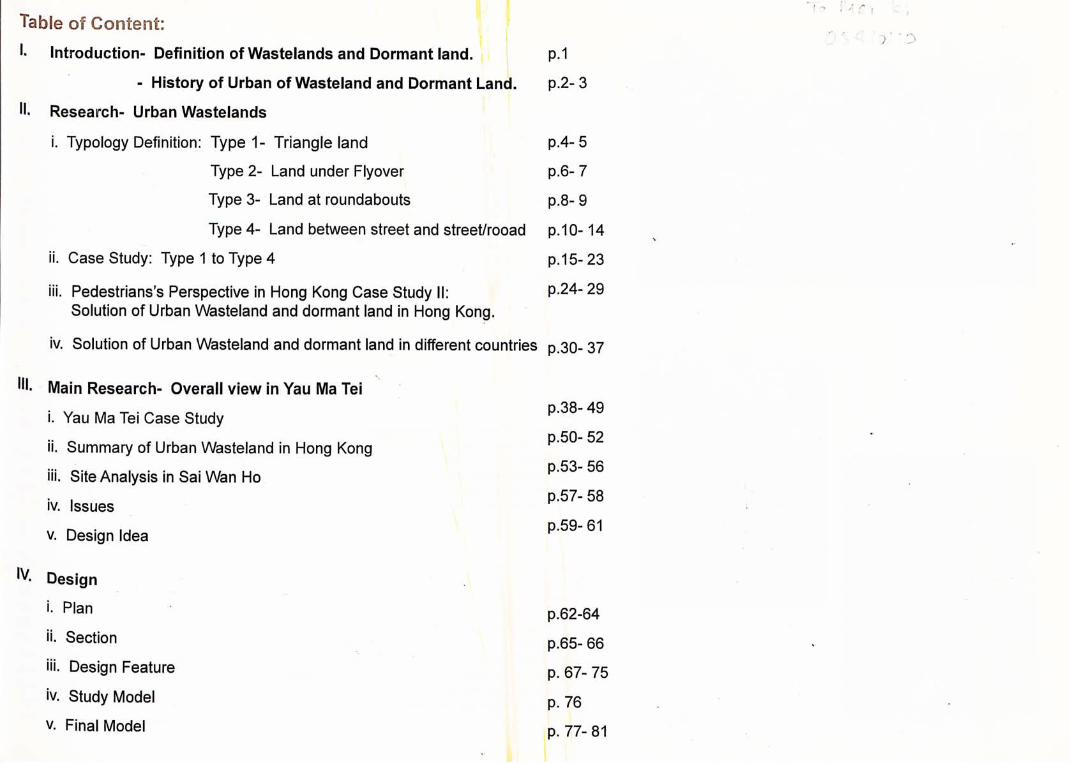
Table of Content: I. Introduction- Definition of Wastelands and Dormant land.
-History of Urban of Wasteland and Dormant Land.
Research- Urban Wastelands
i. Typology Definition: Type 1- Triangle land
Type 2- Land under Flyover
Type 3- Land at roundabouts
Type 4- Land between street and street/rooad
ii. Case Study: Type 1 to Type 4
iii. Pedestrians's Perspective in Hong Kong Case Study II: Solution of Urban Wasteland and dormant land in Hong Kong.
P.1
p.2-3
p.4- 5
p.6-7
p.8-9
p.10-14
p.15- 23
P.24- 29
iv. Solution of Urban Wasteland and dormant land in different countries p.30- 37
I", Main Research- Overall view in Yau Ma Tei
i. Yau Ma Tei Case Study
ii. Summary of Urban Wasteland in Hong Kong
iii. Site Analysis in Sai Wan Ho
iv. Issues
V. Design Idea
Design
i. Plan
ii. Section
iii. Design Feature
iv. Study Model
V. Final Model
p.38- 49
P.50- 52
p.53- 56
P.57- 58
p.59-61
p.62-64
P.65- 66
p. 67- 75
p. 76
p. 77- 81

tntroductson: l^ong Kong is a high-dense city, according the government statistics the land area has 1,099 square Kilometres of which about 17 per cent is built-up. Hong Kong has a population of more than six mil-丨丨on and average of 30 square meter of land per person. gince 1960's the flyovers construction ear began to exact its change on the urban fabric in Hong •^ong,a new kind of site emerged. Flyovers and multi-lane streets were imposed into the existing city grid structures in order to provide a faster linkage from one place to another. According to sta-jjstics from Highways Department in 2006, there are a total of 1154 flyovers, 700 footbridges and J fjlO subway underpasses in Hong Kong. However, there are about 275 licensed vehicles for every kilometre of road, and the topography makes it increasingly difficult to provide additional road capaci-ty in the heavily built-up areas. Flyovers and spread of roads often result an uncompromising impact upon the living environment. Urban land tends to be undesirable due to the flyovers and multi-land streets run through the district referred in this paper as "Urban Wasteland- Dormant Land". Some pulti-land streets which built on districts resulting in the diagonal bisection of traditional city blocks, borne district underneath the flyovers causing poor physiological conditions, such as garbage, stor-
carpark and habitants area of the homeless people. In present day Hong Kong we can hardly any Wasteland with empty lots. Land is expensive in the city and it cannot stay undeveloped,
he concept of Wasteland still continues to exist in Hong Kong. It is a numerous disasters which need a better idea to managing the problems of wasteland for future development.
D e f i n i t i o n o f W a s t e l a n d s and D o r i n a i i t f a o d :
Dormant land was described as land undamaged or only slightly damaged, which could be make useable without great works or reclamation and included demolished buildings, bomb sites, aban-
cned allotments and unused bits of land left over after development. Some of this land is vacant, ⑴e is in temporary use, for example, as car parking or storage.“‘
Wasteland is considered to be a wasted piece of land or a destroyed area in the midst of urban built j P f ^ a s and dormant land is considered to be a undamaged of land that is vacant or temporary use = t h e cities. Those leftover sites have generally produced low density use sites in Hong Kong. Usu-
二 urban wasteland and dormant land only serve as redundant, temporary car parking or storage, j " most of it seems to have potential for other use. In the 20's century wasteland can be regarded
ine with a number of other negative motifs, such as garbage, storage, disease, insects, etc.
r i i e s i s S t a t e m e n t :
JjJ?^" Wasteland and dormant land have now become a characteristic of Hong Kong. This thesis to b w that despite their inherent drawbacks urban 'dormant' land or wastelands can be developed lancT a Projects that restore community life to idle spaces. The characteristic of waste-and 广 e triangular shape, isolation from surrounding urban development, motor way intersections
bypasses, noise from traffic and industrial processes. In inner Hong Kong, the areas along flyo-denS'.f arks,waterfront and carparks that often has a wasteland character. This paper considers high how as the necessary criteria for sustainability. Therefore, the first approach includes explore to f in^^^teland can deal with the areas and buildings surround by flyover/ multi-land street, so that relat ew relationship between the urban environment and flyovers/ multi-land street. In this
lonship, topographies, edge condition, liveless and other factors that can also determine the new meaning of urban wasteland.
Moss, Graham. Britain's Wasting Acres, London. The Architectural Press, 1981, p. 56 •
I,一 kUAWL nmi and WAL«r :KCI,*7, iitrinmiCiiUi !SU44C、la I' tcff HC Ji2,uvV ut nwnum.. TILC vn»nc iKficnMrM^ "R." fi-fiHtlHi! ^liv-ot.ip. tttriuEllilnff.日tfi^k "A•‘ &ccui>i<x A »it« >t ui lifiWM tcAi tiit^ ptt a tHAVO Ln r^tius Thn vKcinc l U i - ' eKMn-£lN iu- JE.TOD tuuli aii'XBAHjrib Jiuiblnt:. i i T.vivint fnr s.DYarj.1 yLiftra, VOTE PROGRESSIVE Rate Lamd Values and Preven t Unemp loymen t ,
The Civic Trust, Urban Wasteland, 1977, p.6
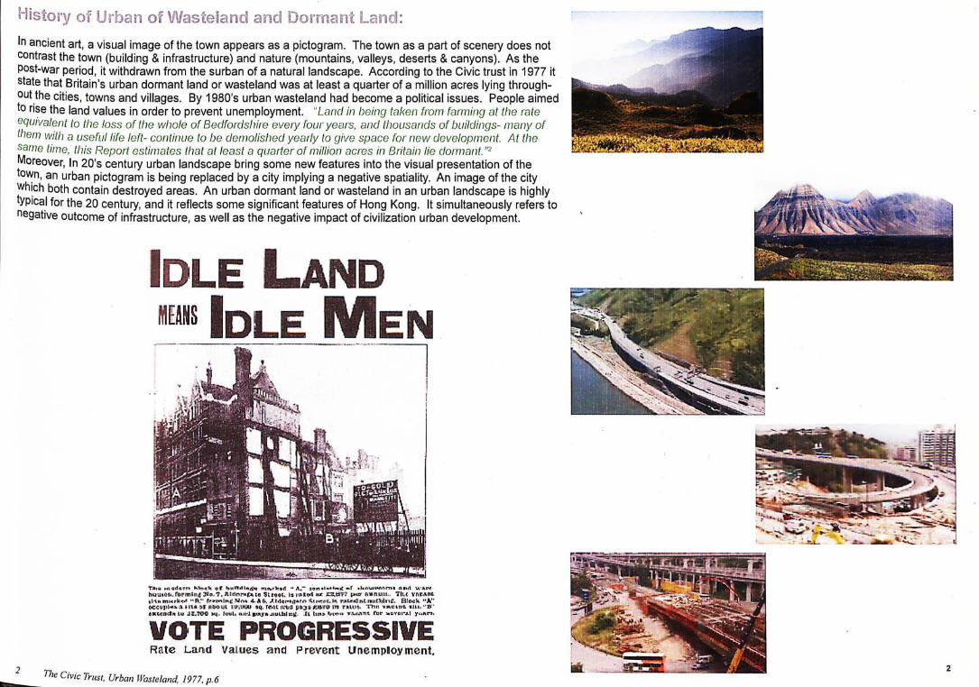
History of Urban of Wasteland and Oormaot Land: In ancient art, a visual image of the town appears as a pictogram. The town as a part of scenery does not contrast the town (building & infrastructure) and nature (mountains, valleys, deserts & canyons). As the post-war period, it withdrawn from the surban of a natural landscape. According to the Civic trust in 1977 it state that Britain's urban dormant land or wasteland was at least a quarter of a million acres lying through-, t h e cities, towns and villages. By 1980,s urban wasteland had become a political issues. People aimed to rise the land values in order to prevent unemployment. "Land in being taken from farming at the rate equivalent to the loss of the whole of Bedfordshire every four years, and thousands of buildings- many of them with a useful life left- continue to be demolished yearly to give space for new development. At the
time, this Report estimates that at least a quarter of million acres in Britain lie dormant. Moreover, in 20's century urban landscape bring some new features into the visual presentation of the to^n, an urban pictogram is being replaced by a city implying a negative spatiality. An image of the city 广h i ch both contain destroyed areas. An urban dormant land or wasteland in an urban landscape is highly typica.l for the 20 century, and it reflects some significant features of Hong Kong. It simultaneously refers to negative outcome of infrastructure, as well as the negative impact of civilization urban development. m.
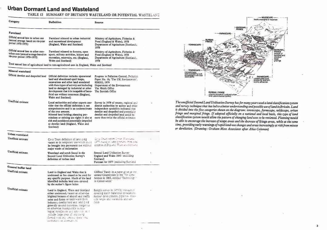
Urban Dormant Land and Wasteland TABLE 12 S U M M A R Y OF BRITAIN 'S W A S T E L A N D OR POTENTIAL WASTEL—.-、、:
Category Definition Source
Farmland Official annual loss to urban use
(annual average based on six-year
period 1970-1975)
Farmland released to urban industrial
and recreational dcvclopracnl
(England, Wales and Scotland)
Ministry of Agriculture, Fisheries &
Food (England & Wales), 1978
Department of Agricuhure (Scotland'.
OfTicial annual loss to other non-
urban uses (annual average based oi
sw-ycar period 1970-1975)
Farmland released to forestry, open
spacc, military activities, leisure and
rccreation, reservoirs, ctc. (England,
Wales and Scotland) 1978
Total annual loss of agricultural land to non-agricultural uses in England, Wales and Scotland
Ministry of Agriculture, Fisheries &
Food (England & Wales), 1978
Department of Agriculture (Scotland
Mineral wasteland
Official derelict and despoiled land Official definition includes operational
land and abandoned spoil heaps,
excavations and other land associated
with these types of activity and including
land so damaged by industrial or other
development that it is Incapable of bene-
ficial use without treatment (England,
Wales and Scotland)
Unofficial estimate
Urban wasteland Unofficial (
Unofficial <
Gcncrul buffer land Unofficial es t imate
Unofficial I
Local authorities and other experts con-
sider that the official definition is not
comprehensive and is an underestimate
of the true amount.
Mineral land holding planning per-
missions or existing use rights is also at
risk and considered potentially despoiled
or dcrclict land (England, Wales and
Scotland)
Progress in Pollution Control, Polluti:
Paper No. 16, ‘The U K Environir.cr.:
HMSO , 1979
Department of the Environnien:
The Welsh Officc
The Scottish Officc
Survey in 1979 of county,regional i
district authorities by author and ot:
independent specialists indicated :ha
dcrclict and despoiled and potcntiall;
derclict and despoiled land could be
more than twice the official
Civic Xrust dwilnitio*". c:' lir.二 •二:
vacant or in us; -at-.v.;
be brought into permanent us-e '.n:
major works of reclamation
Wnsitcland and scrub found in the
Sccond Land Utilisfltion Survey's
definition of rurbaii land
Second Land Utilisation Survey
England and Wales 1963 cxz:udi::z
Scotland)
Forecast for 1977 (excluding Scoz'.izz
Land in Hngland and Wales that ;
underused or has ceased i
any specific purpose. Much of thi
identified includes land uses covcred
by the author's figure below
Land in Hngland, Wales
either underused, vacant
blighted because of aircr^
noise and fumes or toxic
industry; dercHc: lar.i ar.
generally around incu?:::
r.d Sco:la:id
t XT.c
‘as::
Clifford Tandy in a paper
I Countryside ir. t h ; fercnce in 1965, cnritlei ''
in Conscrvaiior.'
Si::
SS斷eSJ®丨""知胁I I 、 ? 巧 恥 • ; - T FARMSCAPE-i
V RURBAN FRINGE .chaotic mixture of rural and i land uses in mutual conflict
The unofficial S econd Land Utilisation Survey has for manyyears used a land classification system and survey technique that has led to a better understanding and possible use of land in Britain. Land w divided into the five categories shown on the diagram: townscape, farmcape, wildscape, urban fringe and marginal fringe. If adopted officially on a national and local basis, this type of land classification system would allow the pattern of changing land uses to be reviewed. Planning would be able to encourage the increase o/scape areas and the decrease 0/fringe areas, while at the same “咖,providing early warnings of rapid land-use changes and areas increasingly at risk from misuse or dereliction. (Drawing: Graham Moss Associates after Alice Coleman)
loci.

^'Vpology Oefirsitiori: Type 1- Triangle land Definition: The triangles of land formed by the segregation of multi-land streets or flyovers, which often resulting in the diagonal bisection of traditional city block.
F u n c t i o n : Temporary carpark
Site Condition: This type of land usually found the edge in urban city. The sites has a surprisingly
high densities and high relative mixed use ratio, with apartments, business and park, however there are fewer than a dozen residents will go to the sites. The population in this area approaches lower densities.
Shek Tong Tsui- Shing Sai Road
S H E K
乂<
: 雄 g S
I . — p
-•V
:了、%
•免 ''•mi
V
T-'^i,-;.
2. Tsuen Wan- Tsuen Wan Road
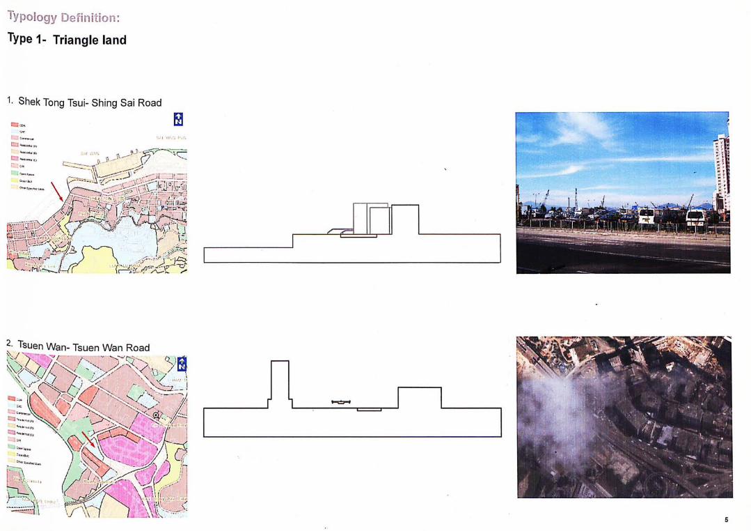
Tsuen Wan- Tsuen Wan Road 、?
父霄’:
Typology Definition:
Type 1- Triangle land
Shek Tong Tsui- Shing Sai Road
.IMW

apology Defiiirooii: Type 2- Land under Flyover D e f i n i t i o n : L a n d under the flyover formed by the earliest year of flyovers along the waterfront, to later the reclamation that carried out along the developed area from the old districts fabric. As the result, contrasting programme of land underneath the flyover and also causing poor physiological conditions, such as garbage, storage, carpark and habitants area of the homeless people.
3. North Point- Island Eastern Corridor
..、..--:- ..--iT: L-/ —
- 奚
\ \ � . ‘
-1.
厂
A /
4. Lai K ing- Tsing K w a i H i g h w a y
應
'.私
•‘ • : 一 / / j • 广 : 二 二 ^^
. s S ^ : ^ ; : ; : 編 續 S
M
々 . Y 之 ;
t、. V >- - . I
L j i i i , - " '「- 二'Jil'
——;
-〒1家::會i
M 麵
:碧
2i
f丨
Kwai Chung- West Kowloon Highway
K夺:
i…\ -、.、t:
'•丨 V > 、—PM、.
’ •
、-
!
二;
广
!
1 /I-
-丨
i
’ !
- -
§(...、「!! “L
身/ 一一
多/M
S//昏、
C,-/
、/
一貧松
專書
碧、又
V
\
^^^
E
f
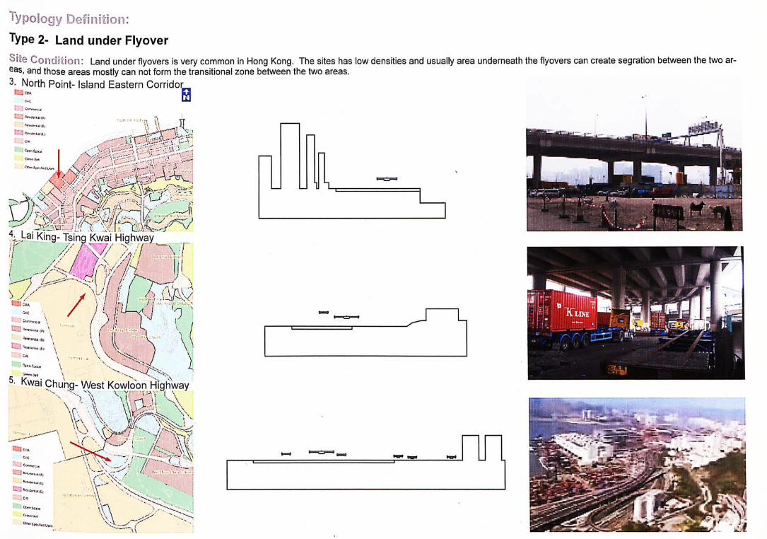
Typology Definition: Type 2- Land under Flyover Site Condition: Land under flyovers is very common in Hong Kong. The sites has low densities and usually eas, and those areas mostly can not form the transitional zone between the two areas. 3- North Point- Island Eastern Corridor
underneath the flyovers can create segration between the two
0
tri, WPW.UI |l>
. I . - ' --^vi...:^ J. A''. - vLl iV. Lx�J,‘�’<f King- Tsing Kwai Highway
r 夕為發-y/r、—
” • I..,
.i }
f.
CIJi‘: jjl
KY//., }
r \
/
aic .
: “ \ • .. J L j (A,
Oil
1 f\wai Chung- West Kowloon Highway
- . , , — , v o \s、.
C ^ 、
\ \ vo- i i
l l w • ^ 我
99199
typology Definition: Type 3- Land at roundabouts
Definition: Land at roundabouts is an unfit places for cities. The transport infrastructures are designed to fit narrow technical constraints, without allowing for the intensity of the time that users spend in it, however, the designers of transport find it hard to articulate the human activities and spaces dedicated to the improvement of the society. Yet is it possible to de-si^ning the roundabouts, carparks, stations, roads and streets that are functional, economical, attractive, comfortable and safe. In fact, there are certain localities have already succeed-ed in bringing those transport infrastructures into a useful features of the modern city. Today, architecture in Hong Kong faces new challenges of increasingly mobility, therefore it is very important to highlight the issues of wasteland due to the transport infrastructures and the potential solutions by presenting projects for building and infrastructure in this thesis.
Choi Hung- Kwung long Bybass
1 1 0 9 1
7. Sai Y ing Pun- C o n n a u g h t R o a d W e s t
__ 实 丨丨 11 ‘ I ‘ J 一 • , •• T 一 I. - ••丨
3 袋 广
通 遍 I 關 I
8. C a u s e w a y Bay- G louces te r R o a d
/ i . I
V'
A
mm. •
y. 1
霞 \t •_ ”
少/
A 71
A
m
、...VAV )
izw.v “
售多靈
書翼
/ 1/
二二
?
\ s
\\ \ •-三
a
/0
W
V裏
曙 麵 .
输 : ;
么 /
::少i
\\

TVpoiogy Defioit ioi i : Type 3- Land at roundabouts 6. Choi Hung- Kwung Tong Bybass
m^ A J : 狐 Lw:】 ^fsfls'imx'
^ S a i Ying Pun- Connaught Road West Eil CD; n
Ciic BJ i ^ni'tw.ujrf
r J Btt.jcfrtj
L J R«fl,fr)« It,
Of: 一
綱 _ _
•、‘ •、”7 . z 、 l ••"]•——T- 一 〜 • � • A V、义
• causeway Bay- Gloucester Road
终I
建^―rir.Lf
霧苏另
j翼
•It!
! IjJlJ.
- r^
S t l

typology i3efiriitioii: Type 4- Land between street and street
Definit ion: Land between street and street/road. In Hong Kong government tended to divide lots in many subdivisions zoning for development. Government usually misleading the use of those wasteland around the metropolitan region. However, These wasteland areas usually were lack the public space, transit, pedestrian amenities, and overall density is less than the traditional downtown area. The average size of those wasteland is very big compare the size of the near building. Wasteland had be-eome increasingly uncared for and uneconomic use, most of these wasteland were keep abandon for least 5 years.
9. North Point- Is land Eas te rn Cor r idor
二 二、::-维
; ’ J . :
A
. . , -I IJ
10.
/ .
、?—
/
.
V》XV 、\1
\
^mmMfMmr
應mA"
‘iij
ri^J
/二
ir
:!
//
/
/、§l一
〖
� 登y
二 键二\
J- J.
/111
,乂 I :')
嘴 丨
.
.r
r"
、y(
11. Kwa i Fong - Tsuen W a n R o a d
^X^^k 躺 i (站碎:::巧、-
、、:::.:•..!:.:::.:••;..":.::、:.:•?. ; / / I - • • • s r . .
纖 、 鍵 _ 麵
‘\ 礼.V.
/
〜-;劣
賺 隱 舉 零 、
m .
i 资;:; i 驗
隱 嗎 J
13. Yau Ma Tei- W e s t Kow loon H ighway
發:‘
、-,二-:::
.AV;:芒(
/...--‘-•「.-V,
:、. I
断 Vr r-
- :: . 1 <:
•••
•一 . r v f f J L :
7- \
一 二
^ M
\、二
...
?.K.
•
-
i ,.
、;
: 辆
• >(
V :'. . ' W - V,
.VI
fe?义'M ....
\ … 丨 / . 多
J •,
-
1
霞
12
Type 4- Land between street and street 12. Lai Chi Kok- W e s t Kow loon H ighway
•IT- . 輪
H. .-.:nj‘
::緣
i
. : . . . .,?、々:Vs . . . , .:作、•更
J..
- vv”々,/、、v々.7
.f.r\f:. <
- r
?
,>si,
、厂
L
.
i
cc
,
_ / 二
r
r
/ .
笠.
•c::
• • . f f • 1 '
:;喊:;礙:::.
、、^
Mil.
•I V
• • • � / . . . �
I
auY/ I

Defiiiitioii: Type 4- Land between street and rooad
12. Lai Chi Kok- W e s t K o w l o o n H ighway
fs. ( 1 籍1
.\s
i
谷 ,
13. Yau Ma Tei- W e s t K o w l o o n H i g h w a y 趣 . •
f
14
Ca$e S t i i dw 1: Type 1- Triangle land
, 夢 ; 權
爾 :
: 必 , 〈 ; , 〜 , 丨
1
、
-
.
審奢
f、”
1
/覆:、.xis
f 萄多t
/
d§fs
/ §s i
t - • ". • • 1 r . / , .
Urban Dormant Land and Wasteland
L'fltegofiBsTriangle land ,d.
Conriaouoii: Pedc5:rijin end skte w»!i<5 cxxnncct !ilc on ground and vcWolcs nDCciisiblo.
Distiot: Higi denaiiy resldemlal clatict.
Site The ct-araclonslic of ihis unlonjod land indud-Ccridilion; Ina vcblcuUif t'iol$c and m](ff&\a tor hi jhway
placement.
nmcllCHV rc/npory carsaik.
Shek Tong Tsui- Shing Sai Road
- - --^y-JmU -产-
: : 纖 S
丨i.r.r、
V •'.J-. * < - ' / 發 轉 丨 丨 H
;、• •::...: • . • . ‘ - , /. - • J ; i i 1
r ^ i l j Vehicular Irwress / Eon?s5
叙 A
mm : 躲 . .
11,
a 躲 箱 s s

Urban Dormant Land and Wasteland
CategorieaiTriangle land J.
Connaciion: Podcsfiflfln sttd scte vvaiks oomocl ire sile on ground and veMclea. accessible.
trict: HIgi donalty roaid^ntiEil ciMbt.
Silo l lndn*j?i;infiino Iho rnlnli(Yi5;hip nf rjonplu la Innri
CondRlon; can bring well lempered envlronmertis to diy, Urtan VEwem land Is a problenr. It is a oonae-que门OA of natural changs in population Iav9l&
and induslnsl noods. In gonoral planning in
Honjj Kong ne<sJs to live greoier aviidance and more postlw deredlon in l lopm^nl end invdatincTit in !arx.
Fundi oil: Tetfnpory carcark
V / / (
Case Study i: Type 1- Triangle land 2. Tsuen Wan- Tsuen Wan Road
s: 變:. •J 歸IX. 二
! i
K
!;〜*
•、/
:•; / f
灣 .
«
ilB
羅震it
MM
UEN W
Pec 14:哭缴 Vehicular I rare;
Srwii
, Type 2- Land under Flyover & ^ g n n e c t i a n from the Carpark ^ ^
3. North Point- Island Eastern Corri-
Vehicular Access to Waterfront
Public Waterfront Access
Private Watei-ffont Access
枝:翻 Vehicu ar Irvgress / Egress open spBce
Pedes t r ian AOCE
Construction
Peking along Waterfront Construction Site near Waterfront
m
Urban Dormant Land and Wasteland
Cstogorios: Land under Flyover
Ccnnacton: Pede&lrlBn connect the slt» cn
g w i d and vohidos acccssiWo.
bict: High dcnslly nnildcintUal fi-cdmrrjar-
cM dlflttct.
Firctiofft Tflmporay Carpa-k & Storflge
,e<»ss to Waterfront - Blocked by Vehicles & Stuff
Case Study I: Type 2- Land under Flyover 4. Lai King- Tsing Kwai Highway
Urban Dormant Land and Wasteland
CHltyuiius. Land under Flyover
Connection: Ons bridge to get across Ihc carpjrk and to sntranofi (or v«hl»dfiR nocftss la 1he Bites.
District: _ow density logstbs dislict
c to Mo potest* ooniect the sile on ground floor, Condition: onty oie bridge can get bctobs Kwai Chung
3oad an: MTFt statm.
Function- Tcmparory Cnrpark
Pubic Access
Vehicular Iraress / Eoress
Opftn f>fv»r:ft
Pecestrian Access
s 18

Type 2- Land under Flyover 5. Kwai Chung- West Kowloon Highway
\
Urban Dormant Land and Wasteland
CatogoriDS: iin^u-mJemyoTer'' — ‘
CCinneCllOO: VKmuisTi !«A*rs»iui» ail M'uiiinj me esiiea
UiBtnct: Ljov; dQns ity Icgistics district
No podcnlrir.n nnd side wnlkn, Q Inncs Kwni
Condition; Chung Roiid creals ssgre^aalioti btjliween rasl-
denial a n j IciglsllcR district.
Function: Tsmporary CarparH
Pubic Access
] V e h i c u l a r I rwress ! Earess
fjpfin Rjwinft
Peceslrian Access

Case Study 1: Type 3- Land at roundabouts 7. Sai Ying Pun- Connaught Road
Urban Dormant Land and Wasteland
CategoriSB: Land at roundabouts
Ccnnscton: Vohiclcs not occessiftle District: High density eommefci右丨 end realdanlial dl&lrlct
•Site I n their flffio^nrtly uswl nf tN* fite . tfiem is no pgdfleinan and s^d WRiks Ccn<i?.ion: thaL ccnnccl Connaun ". Road WmI TTho ovorhsadl bridco is Iho only wsy
to ge: across ir>c Oonn&uQht Roed, Punctc : Wsatsiaid
..-J'
r 二-- 、---…,.- •
-I- — •
r a 斤 巧 。 ' 请 ; : . 〒 : i n ; : I • t , „ 1 ' ^ ..: 一 . i -
Vi f J - 纪 丨 丨
;V:.: . ; : : ‘ : 、 、 . ! 二
5丨•^::“:〜?嶺 一 、 r r 丨 二 二 二 ::
捷
¥ Vehicular Irvnress / Eares?
Wasteland
;
Pecestrian Access
總謹隱麵
JiAl VIN(r I'lJN 、 m
-.A r- -VA r I
X -1 ,>:>驶 Sfi •?:組{〜 5 . 。 巧 义 ^ ! ; ^ 作 巧 碰 端
Type 3- Land at roundabouts 8. Causeway Bay- Gloucester Road
Vehicular Irvnress / Earess
"I 一職 ...又一...
Urban Dormant Land and Wasteland
OttogomB: rrn5 tmunclabouts
CrnnRctbn-1 bridpe to get across the par< and ve卜icJe& not accessible
District: High density comine_ and residential disirlci
Site nc pedestrian and Bide wa kB connect to tho Ccricifcion: silo on rouid flew, isoulion 'mm sjrr<wrdirg
ura in dewopTicnl; and vchiajln" naiw Mjr-rojrttlin^ Uvi eta wiLhOit eiDund tarrict:. Thd P rk jnd&rne^h ihG hi hv ays h \ri conplete darkness, thera am cnfy fewer than visitors wil 口o 1:3 Ihe sark.
Fuict on: (Permanent)
li— f i J — 一 :二二 -/ , V
;夕
» 一 If—T .
I I r-i f r ——-
丨jJ 卞 ‘"4 ‘ u …一
^ — 一 . I; —
- - 、 1
; , --- • ― 一 - — 厂 ' 1 — 「
• , . —r -」• I丨* Q_j"_X ‘― — ‘ 丨•LI •
II丨一:——』:‘;;, Li-,——-——‘••
;人―
' 1 :
21
Case S t u d y 1: Type 4- Land between street and street North Point- Island Eastern Corridor
Direct Access to the Waterfront
-i:
V
Promenade - public Access along the waterfront Human Activities in relation to the Waterfront
Fence a long t he W a t e r f r o n t i s s o h i g h t h a t it to ta l l y b l o c k s t h e v i s u a l connect iv i ty t o t h e w a t e r f r o n t l
The Site becomes Temporary Carpark (with Bus Terminus remained) After Demolition of North Point Estate
Ferry Ingress V Egress [ 1 j Vehicular Irvgress / Egress
Public Water f ror t Access
_
North Point Estate - Before Demolition
Urban Dormant Land and Wasteland
Categof ea: LanJ boUvocn &•.reel and elrocl
Conrtecllon; pedesl'^n end side walks connoct
Ihc sKc on yr-jund and whictas
rccMJsble
Dt3f.ria: High density 'esldentlal and eom-
nericB' district
Function; BusTcrmhus & Icnporary catp^aik
22
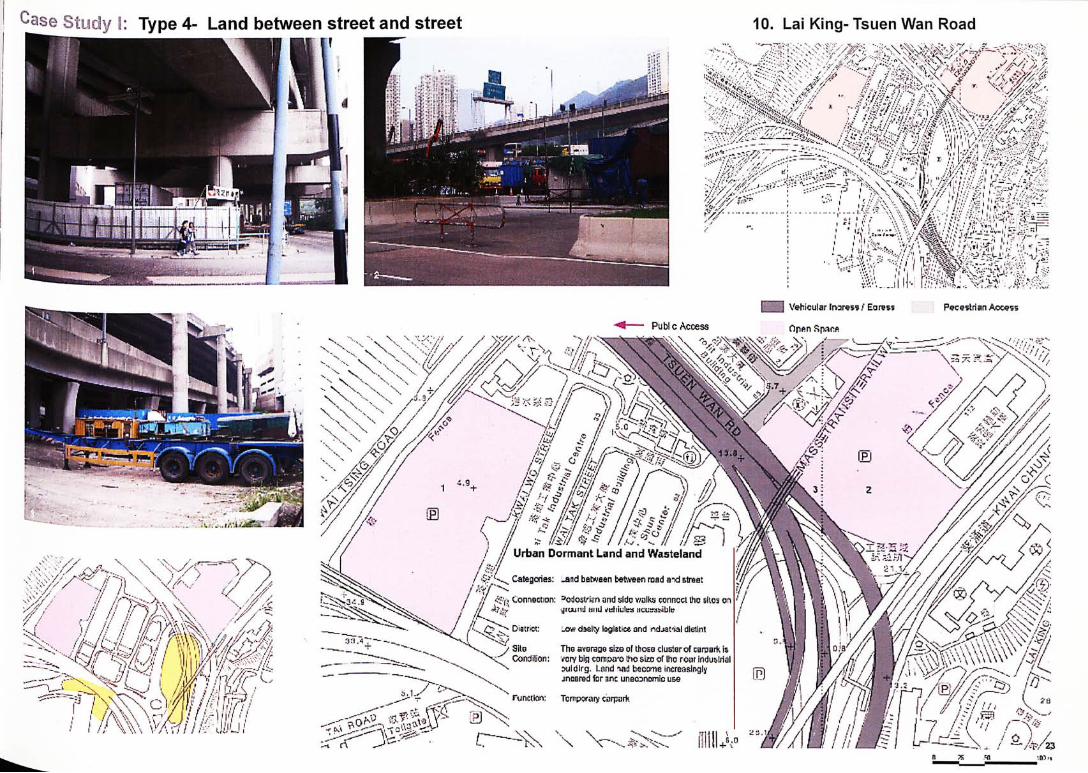
Case study 1: Type 4- Land between street and street 10. Lai King- Tsuen Wan Road
Pubic Acoess
Vehicular Irwress ! Earess
Open Spiir.fi
Pecestrian Access
Urban Dormant Land and Wasteland
Categories: _and between between road a -d street
, Connection: cdosirten and sido walks conncct tho sties on •jiuund MIILI ^hiiilra iicusaMble
• Diatria: lcw daal!y loglBtwx and rtdjafial dlellnt
• Site The average size of those cluster of CBrpBrk is ConcJilion: very bin cernwro iho steo or Ihc roar indu&lrial
suldlrg. Land iad beoo-ne increasingly jnnared for anc uneconomic u&e
' Function; Tcrripsrary carpark
23

^edestrians's Perspective in
Introduction: jj|rban Wasteland and dormant land have now become a characteristic of Hong Kong. Urban Y^steland and dormant land were such spaces have too often been neglected, if we look more closely we would have understood that these spaces are rich in potential, and that certain coun-II丨es have already succeeded in bringing out the solution of urban wasteland and that designers fi^ve turned them into a features of the city. In Hong Kong the city has gone through fundamen-p changes, the urban forms are indeed changing to be more compact, dense and vertical. The •"affic congestion is easy to found in Hong Kong, which overloaded highways and pedestrians !ose the sensation of the city floor. While some of the places in Hong Kong have not succeeded in Walking on the ground floor, the issue has become focused around the idea of concentration connection between offices, shops and transport. Moreover, most of the road infrastructures are surrounded by the urban wasteland and 'dormant' land which is hard to put the land in archi-ecture use. In Hong Kong space under the flyover, roundabouts and abandoned land usually j'ansforming it into car parks and parks offer a functional solution, but it is not enough to give hf rn a meaning. This paper considers high density as the necessary criteria for sustainability. herefore, the first approach includes explore how wasteland can deal with the areas and build-
IJgs surround by flyover/ multi-land street/highway, so that to find the new relationship between ® urban environment and road infrastructures. Is it necessary to create new types of public
space between urban environment and road infrastructures that suitable for individuals and groups? Study these urban wasteland and dormant land in pedestrians perspective can find etter understand and represent the vacancies, inefficiencies, and fragments of landscape left
from development. In order to create the methodology to reuse of waste landscapes in the urban world.
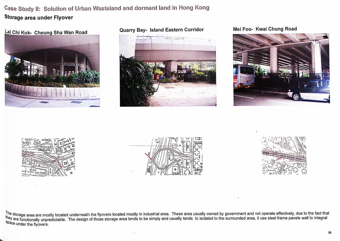
mm J ie storage area are mostly located underneath the flyovers located mostly in industrial area. These area usually owned by government and not operate effectively, due to the fact that they are functionally unpredictable. The design of those storage area tends to be simply and usually tends to isolated to the surrounded area, it use steel frame panels wall to integral space under the flyovers.
25
Case Study SI: Solution Storage area under Flyover
:3[ Chi Kok- Cheung Sha Wan Road
in Hong Kong
Quarry Bay- Island Eastern Corridor Mei Foo- Kwai Chung Road
Case Study !l: Container buildings under Flyover jjwai Fong- Tsuen Wan Road
in Hong Kong
n 一
Work耶 I'S J ^ '®cff|c C injury
27
Case Study 1!: Container buildings under Flyover Lai Chi Kok- Cheung Sha Wan Road
• K r i S H H p naniiayni 園 • • n
i
in Hong Kong
Lai Chi Kok- Lai Chi Kok Road
, ‘ : Mm
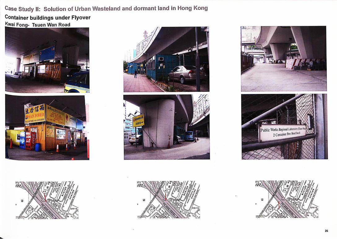
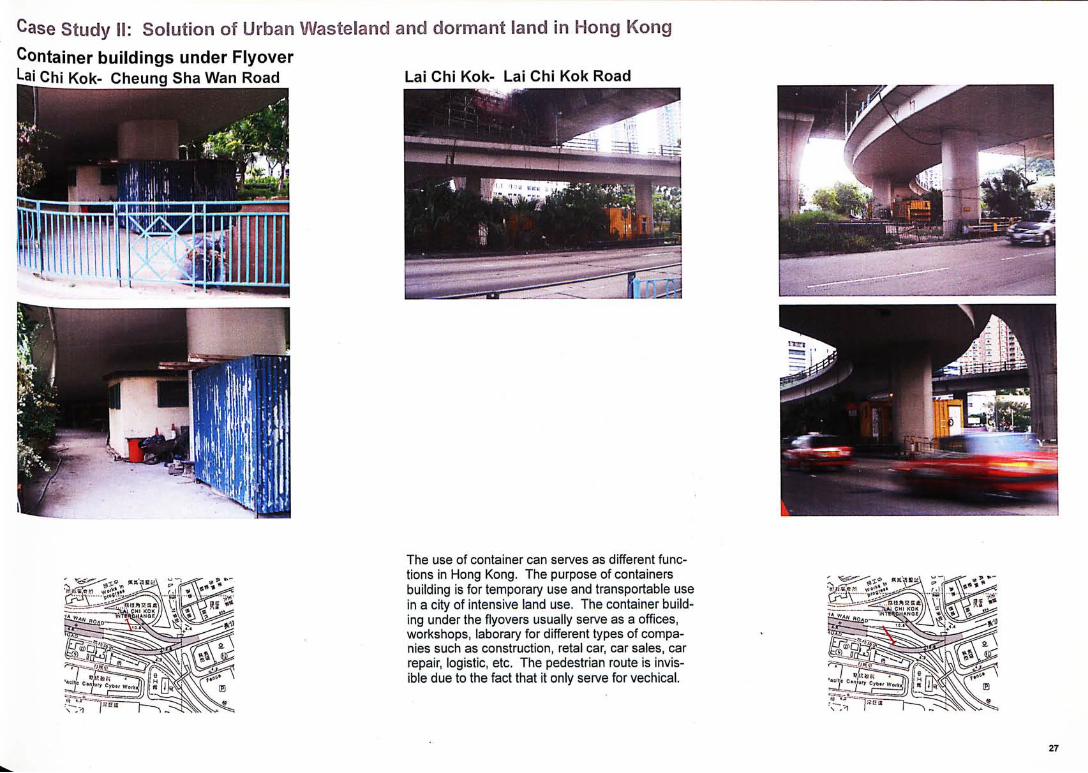
The use of container can serves as different func-tions in Hong Kong. The purpose of containers building is for temporary use and transportable use in a city of intensive land use. The container build-ing under the flyovers usually serve as a offices, workshops, laborary for different types of compa-nies such as construction, retal car, car sales, car repair, logistic, etc. The pedestrian route is invis-ible due to the fact that it only serve for vechical.
r
I _

Case Study 丨I: Solut ion
Park under Flyover
jjwai Fong- Tsuen Wan Road
in Hong Kong
1
The open space under the flyover used as a park. There are intensive program inside the park including mini football court, roller court and rest area. The pedestrian route is on both side surrounded by planters which make the pedes-trian is not visible. Poor daylighting and the spaces do not appear safe even during daytime.
28
Case Study SI: Bus Station under Flyover Mei Foo- Kwai Chung Road
dormant land in Hong Kong
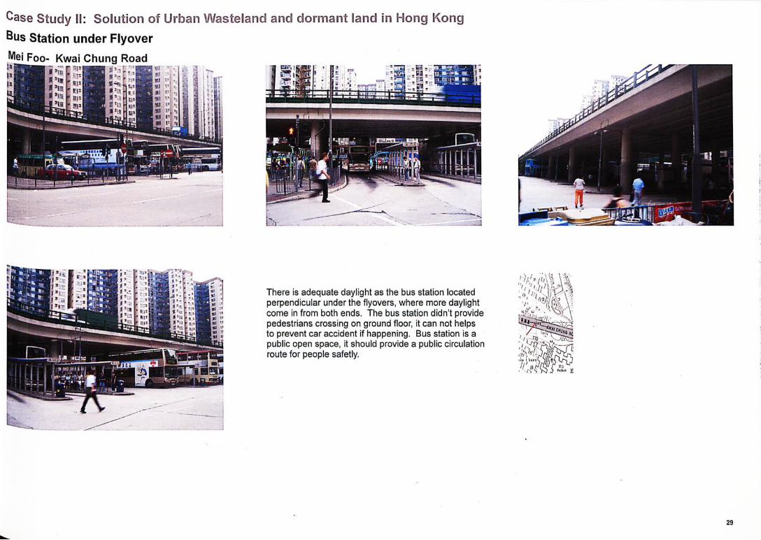
There is adequate daylight as the bus station located perpendicular under the flyovers, where more daylight come in from both ends. The bus station didn't provide pedestrians crossing on ground floor, it can not helps to prevent car accident if happening. Bus station is a public open space, it should provide a public circulation route for people safetly.
/ :
I 广?0:、
H!’ jHi m
in d i f ferent countr ies.
Type 2- Land under Flyover
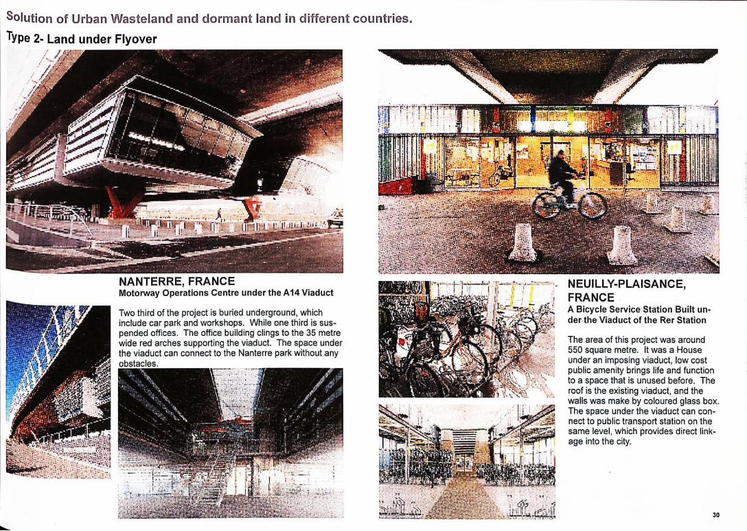
NANTERRE, FRANCE Motorway Operations Centre under the A14 Viaduct
Two third of the project is buried underground, which include car park and workshops. While one third is sus-pended offices. The office building clings to the 35 metre wide red arches supporting the viaduct. The space under the viaduct can connect to the Nanterre park without any obstacles.
NEUILLY-PLAISANCE, FRANCE A Bicycle Service Station Built un-der the Viaduct of the Rer Station
The area of this project was around 550 square metre. It was a House under an imposing viaduct, low cost public amenity brings life and function to a space that is unused before. The roof is the existing viaduct, and the walls was make by coloured glass box. The space under the viaduct can con-nect to public transport station on the same level, which provides direct link-age into the city.
• ; ” : » , .Mi 逾_
31
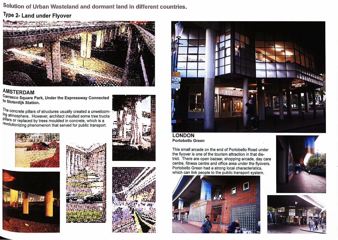
LONDON Portobel lo Green
This small arcade on the end of Portobello Road under the flyover is one of the tourism attraction in that dis-trict. There are open bazaar, shopping arcade, day care centre, fitness centre and office area under the flyovers. Portobello Green had a strong local characteristics, which can link people to the public transport system.
严e concrete pillars of structures usually created a unwelcom-atmosphere. However, architect insulted some tree trucks 卞
J illars or replaced by trees moulded in concrete, which is a !®•.巧. e州utionizing phenomenon that served for public transport.
wmMM
-改 -
u
r
I
^MSTERDAM J^arrasco Square Park, Under the Expressway Connected ^oSloterdijk Station.
Solution of Urban Wasteland and dormant land 5n different countries. Type 2- Land under Flyover
•、•—:-_• , • .‘•: * gy jgycmifln
a i (1;
Solution of Urban Wasteland and dormant land in different countries. Type 2- Land under Flyover
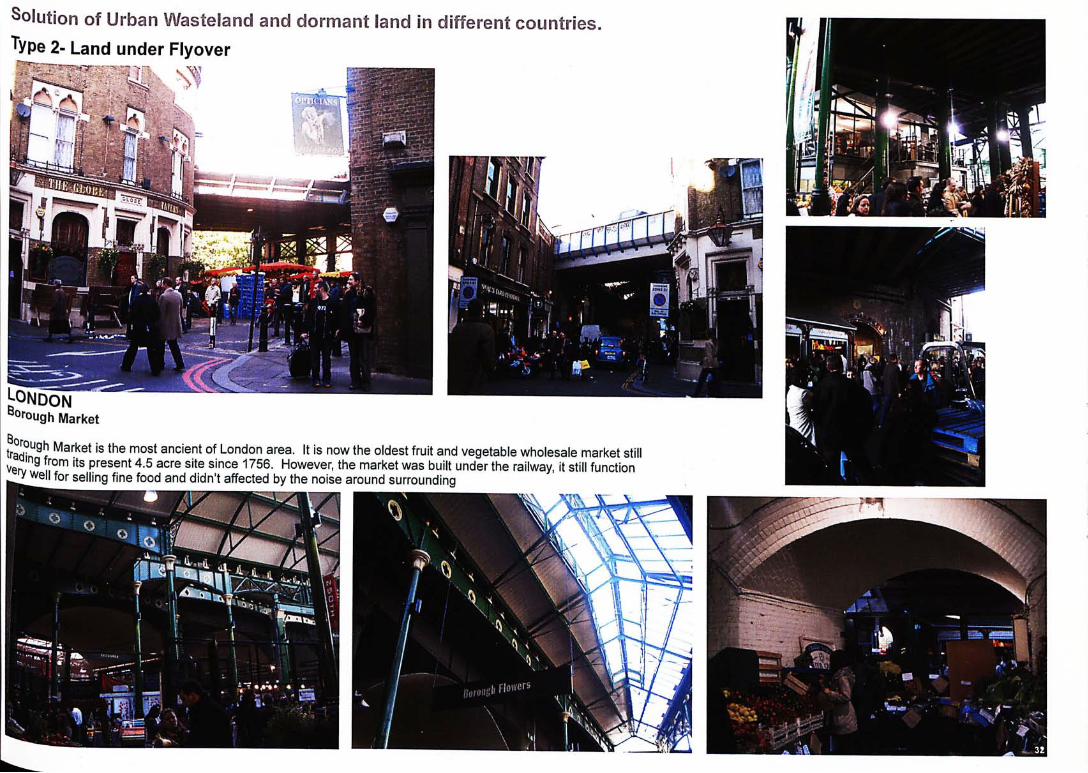
London M»"ough Market
t ^ S ^ ? Market is the most ancient of London area. It is now the oldest fruit and vegetable wholesale market still VerJ (rom its present 4.5 acre site since 1756. However, the market was built under the railway, it still function ‘ y 鄉丨丨 for selling fine food and didn't affected by the noise around surrounding I^IH

Solution of Urban Wasteland and dormant land in different countries. Type 2- Land under Flyover
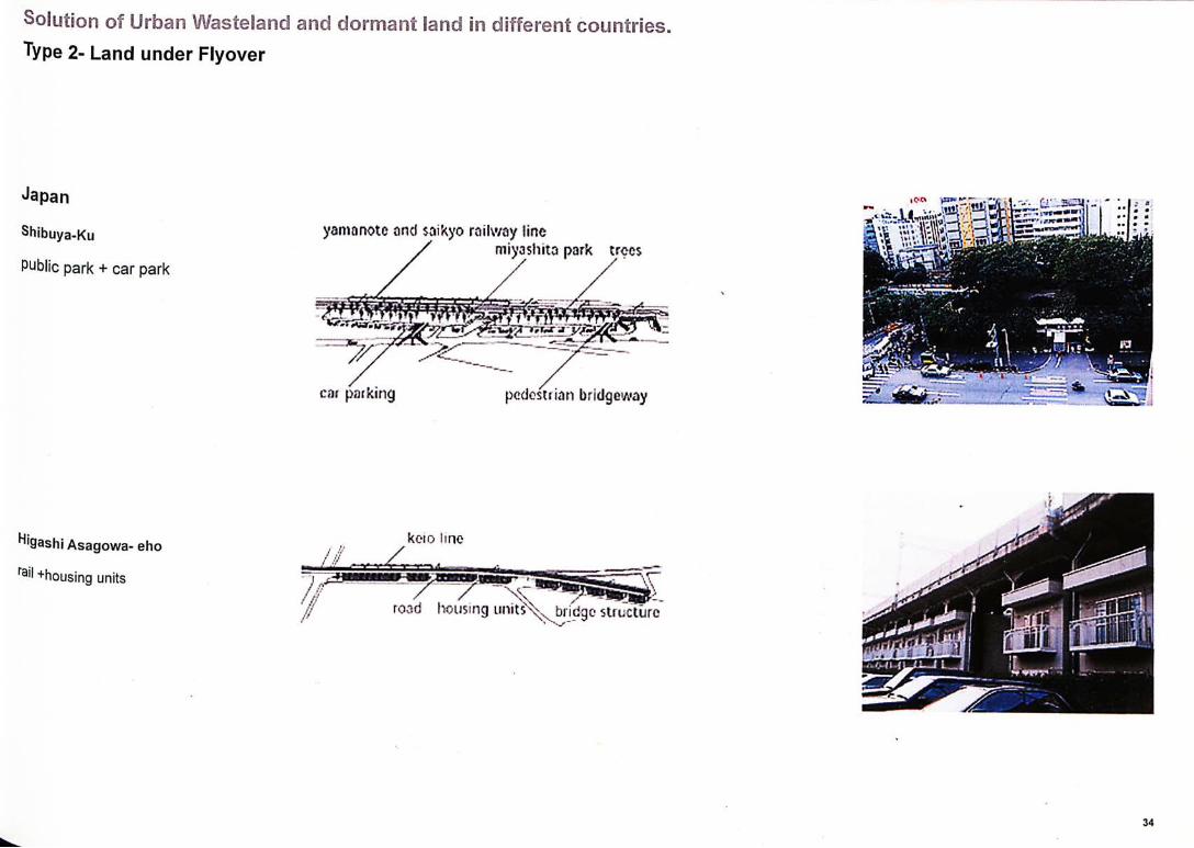
Japan
Akihabara Station
rail bridge + shopp ing arcade
kanda river 叫 m s / sobu railv'A^y line
cicctfic goods
Yurakuno, Chiyada-ku
e印ressway + department store
meiropolitan cxprcsswoy expressway toll g
(lepi'srlfnenl store r imp
Shibuya-Ku
P此lie park + car park
yam a note find saikyo railway line miyashitci park trees
pedestrian bridgeway
koto !SRC 1
•5A.
i ^ b i i d g c st ructure
Higash 丨 Asagowa- eho
rail +housing units
Type 2- Land under Flyover
Japan
Shibuya-Ku
public park + car park
yam a note and $ aikyo railway line miyashi ta park trees
cat park ing pcdosEiii in bridgc^way
m
road
countnes.
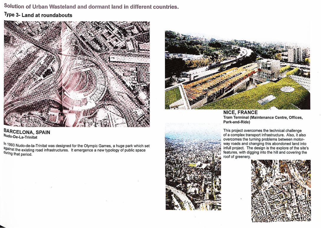
NICE, FRANCE Tram Terminal (Maintenance Centre, Offices, Park-and-Ride)
This project overcomes the technical challenge of a complex transport infrastructure. Also, it also overcomes the turning problems between motor-way roads and changing this abondoned land into infull project. The design is the explore of the site's features, with digging into the hill and covering the roof of greenery.
n 1993 Nudo-de-la-Trinitat was designed for the Olympic Games, a huge park which set ^gainst the existing road infrastructures. It emergence a new typology of public space aunng that period.
Solution Type 3- Land at roundabouts
in different
m
•BARCELONA, SPAIN Nudo-De-La-Trinitat
i n d i f f e r e n t c o u n t r i e s .
Type 4- Land between street and street
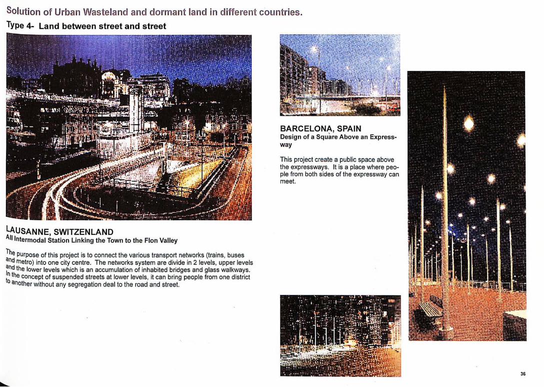
^AUSANNE, SWITZENLAND All Intermodal Station Linking the Town to the Flon Valley
purpose of this project is to connect the various transport networks (trains, buses nd metro) into one city centre. The networks system are divide in 2 levels, upper levels
二 t h e lower levels which is an accumulation of inhabited bridges and glass walkways. J the concept of suspended streets at lower levels, it can bring people from one district ° 如other without any segregation deal to the road and street.
i
i
1
i ?
-避;:、
si
�
1
m
1
_ M^mmmmi V
-1
BARCELONA, SPAIN Design of a Square Above an Express-way
This project create a public space above the expressways. It is a place where peo-ple from both sides of the expressway can meet.
Solution Type 4- Land between street and street
;
in di f ferent countr ies.
. S S i l i ®
- s
?
� 3
K0 h
*
_ *
“
、
>
V
m
f BARCELONA, SPAIN
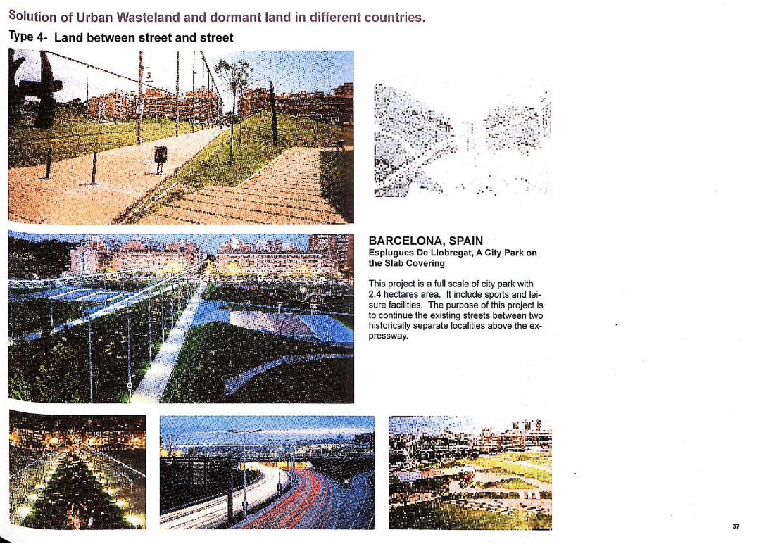
Esplugues De Llobregat, A City Park on the Slab Cover ing
This project is a full scale of city park with 2.4 hectares area. It include sports and lei-sure facilities. The purpose of this project is to continue the existing streets between two historically separate localities above the ex-pressway.
37
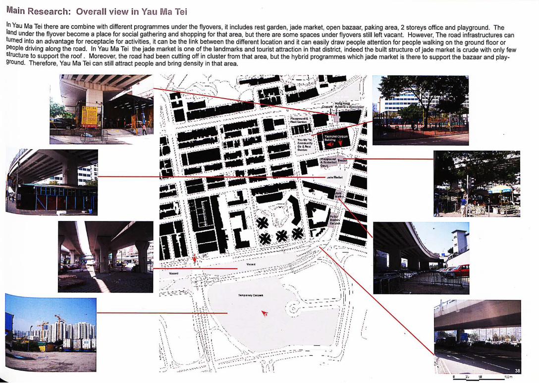
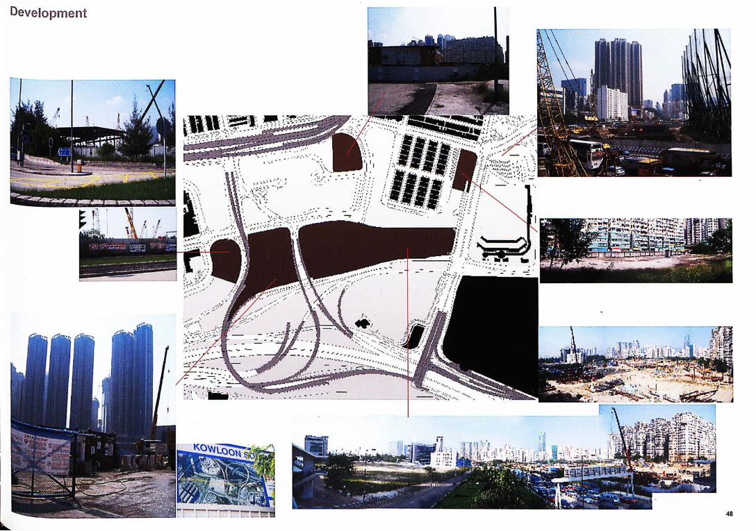
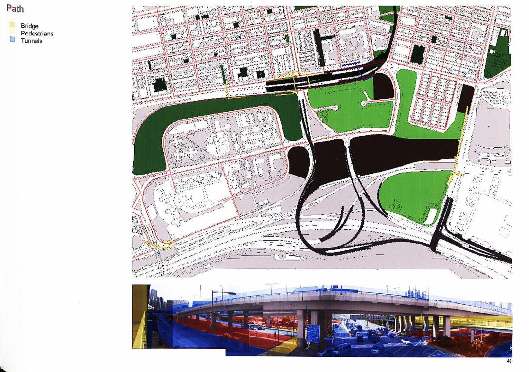
Main Research: Overall view in Yais Ha l e i In Yau Ma Tei there are combine with different programmes under the flyovers, it includes rest garden, jade market, open bazaar, paking area, 2 storeys office and playground. The and under the flyover become a place for social gathering and shopping for that area, but there are some spaces under flyovers still left vacant. However, The road infrastructures can turned into an advantage for receptacle for activities, it can be the link between the different location and it can easily draw people attention for people walking on the ground floor or people driving along the road. In Yau Ma Tei the jade market is one of the landmarks and tourist attraction in that district, indeed the built structure of jade market is crude with only few structure to support the roof. Moreover, the road had been cutting off in cluster from that area, but the hybrid programmes which jade market is there to support the bazaar and play-ground. Therefore, Yau Ma Tei can still attract people and bring density in that area.
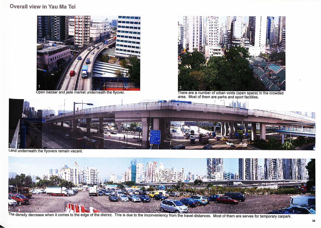
Open bazaar and jade market underneath the flyover.
i n d
Overall
serves for temporary carpark.
f. I
5--『、..rt
.
a
i
ces. Most of them The density decrease when it comes to the edge of the distr
「here are a number of urban voids (open space) in the crowded Most of them are parks and sport facilities.
••s C;
Land underneath the flyovers remain vacant.
Tei view m Yau
_ l l
好'xcrs “3憤:5
溜 TK%
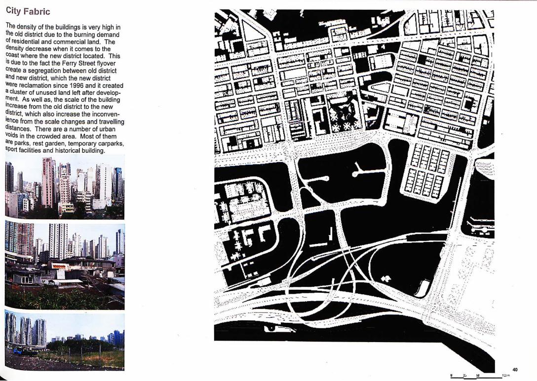
City Fabric The density of the buildings is very high in the old district due to the burning demand of residential and commercial land. The density decrease when it comes to the coast where the new district located. This is due to the fact the Ferry Street flyover create a segregation between old district and new district, which the new district Were reclamation since 1996 and it created 3 cluster of unused land left after develop-l^ent. As well as, the scale of the building increase from the old district to the new ?'Strict, which also increase the inconven-l^nce from the scale changes and travelling distances. There are a number of urban Voids in the crowded area. Most of them 針e parks, rest garden, temporary carparks, sport facilities and historical building.
40
I 1
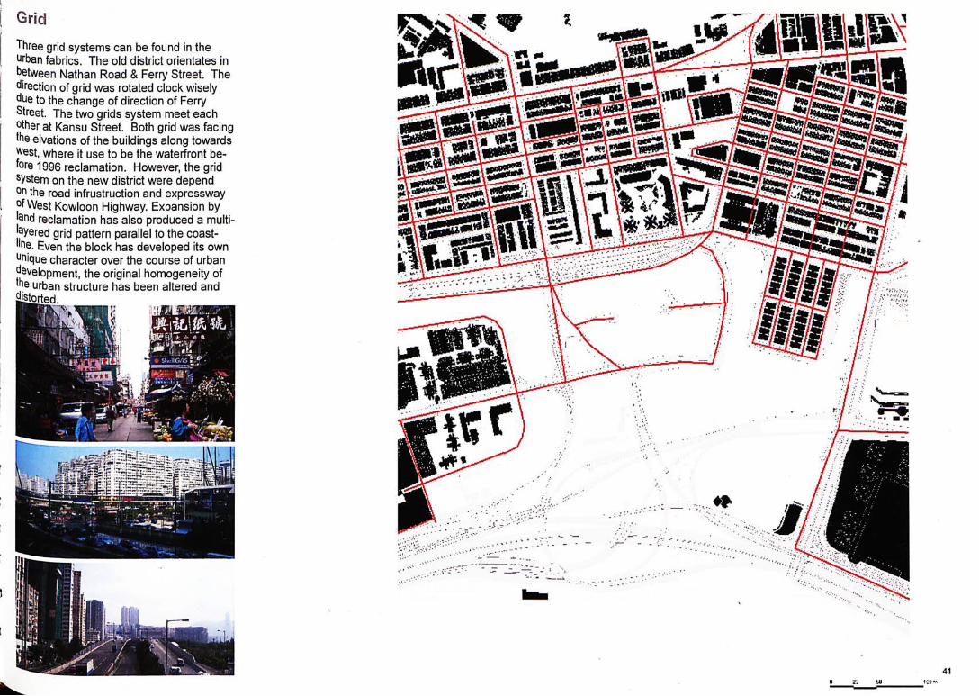
Grid Three grid systems can be found in the urban fabrics. The old district orientates in between Nathan Road & Ferry Street. The direction of grid was rotated clock wisely due to the change of direction of Ferry Street. The two grids system meet each other at Kansu Street. Both grid was facing the elvations of the buildings along towards West, where it use to be the waterfront be-fore 1996 reclamation. However, the grid system on the new district were depend on the road infrustruction and expressway jifWest Kowloon Highway. Expansion by and reclamation has also produced a multi-ayered grid pattern parallel to the coast-lin〒. Even the block has developed its own Jjnique character over the course of urban development, the original homogeneity of the urban structure has been altered and distorted.
Plan
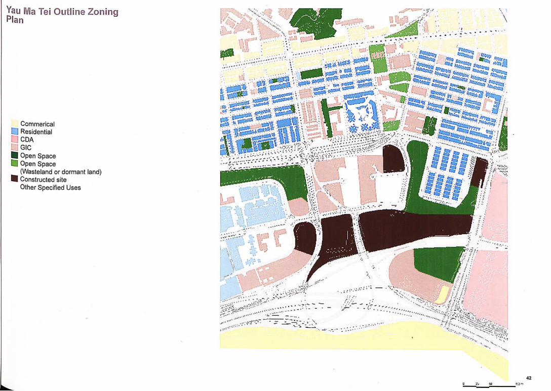
Commerical C] Residential • CDA DGIC _ Open Space D Open Space
(Wasteland or dormant land) _ Constructed site
Other Specified Uses
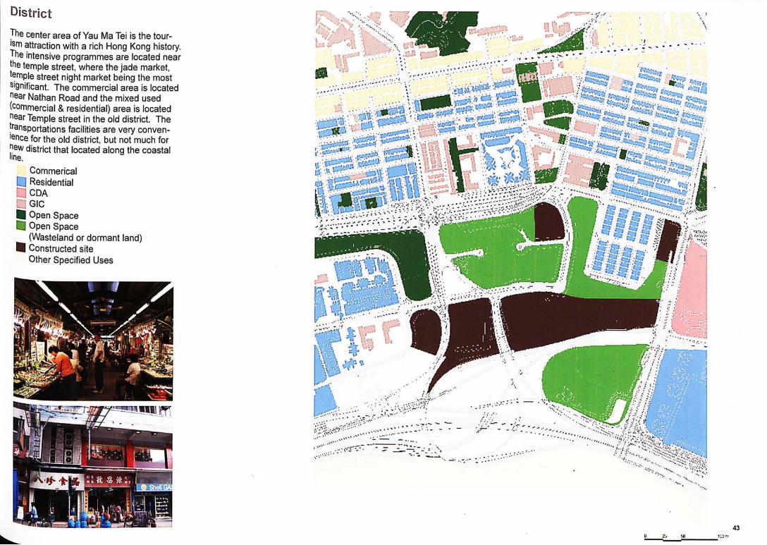
District The center area of Yau Ma Tei is the tour-!!attraction with a rich Hong Kong history. 丄he intensive programmes are located near jhe temple street, where the jade market, temple street night market being the most Significant. The commercial area is located near Nathan Road and the mixed used (commercial & residential) area is located near Temple street in the old district. The transportations facilities are very conven-lence for the old district, but not much for
district that located along the coastal
Commerical • Residential • CDA Q G I C _ Open Space S Open Space
(Wasteland or dormant land) _ Constructed site
Other Specified Uses
ii忍忽f
s i
ff
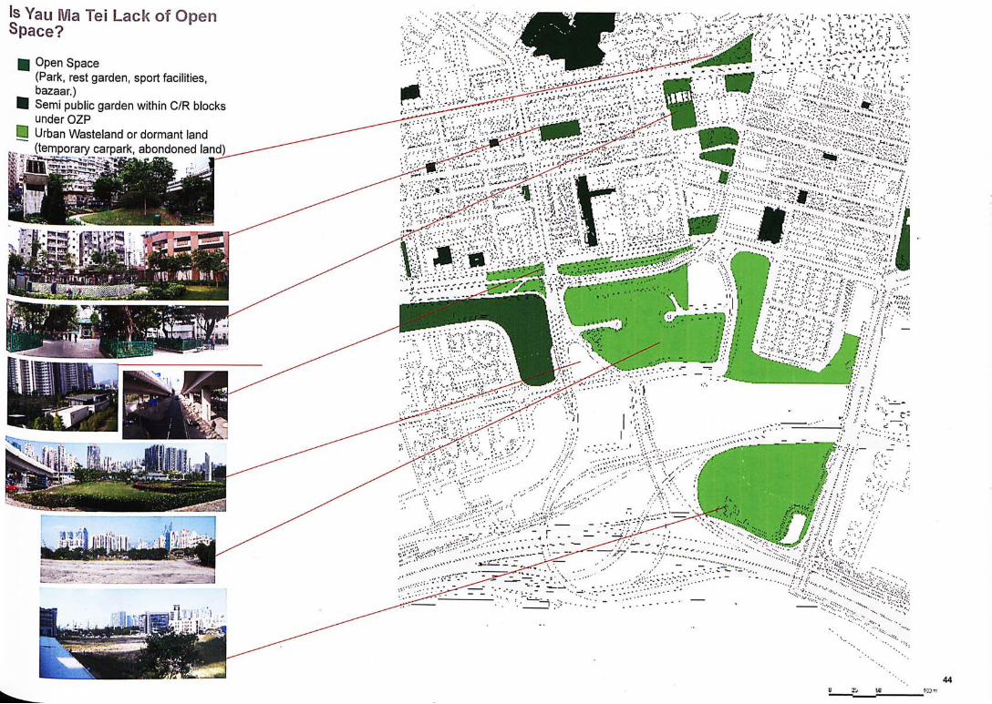
Yau 關a Tei Lack of Open Space?
_ Open Space (Park, rest garden, sport facilities, bazaar.)
_ Semi public garden within C/R blocks under OZP
0 Urban Wasteland or dormant land (temporary carpark, abondoned land)
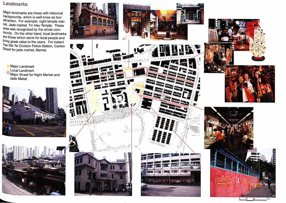
Landmarks Major landmarks are those with historical backgrounds, which is well know as tour attraction. For example, night temple mar-ket, Jade market, Tin Hau Temple. These 邮ea was recognized by the whole com-"^unity. On the other hand, local landmarks
those which serve for local people and ^ring great value to the users. For instant Yau Ma Tei Division Police Station, Canton Street for jade market, Market.
_ A • A
Hi* mm •?t.
• Major Landmark Local Landmark Major Street for Night Market and Jade Maket
, 1
a
M
m
.取
/
»
I 丨..卢
M UJ tCQr

Temporary Building (Residential with mixture use) Most of the residential is original and didn't demolished since it developed. Yau Ma 丁ei is a old district, which it keep the origi-nal grid system urban fabric. However, the temple were became the centre in Yau Ma 丁ei, where it has open space, shop, restau jsnt, tailor shop, hotel, lounge, jade mar-ket and temple night market along Temple Street. Yau Ma Tei old district has it histori caj value, and the mixed use programming 比at attract people to use the space even it IS a overcrowded area.
(>:(_)• t 職 ; 一
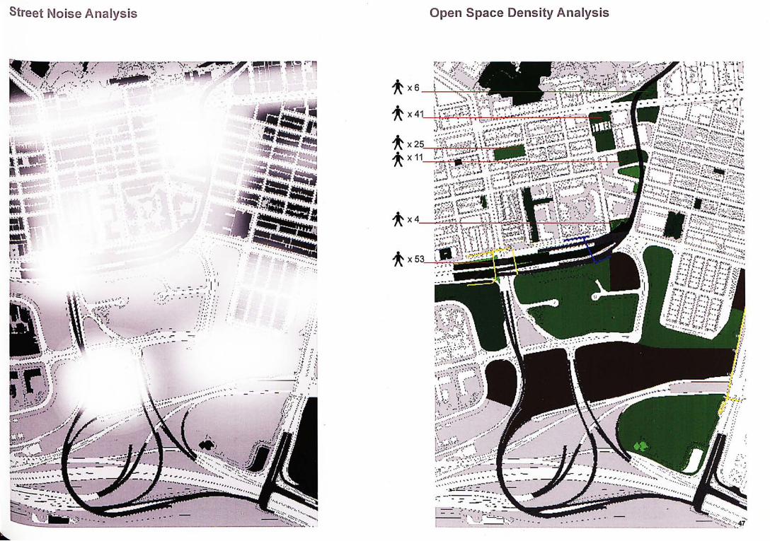
Open Space Density Analysis
’疼;:
,•, T U P > I , ,
r:::-:
、汝
.if
I ^ i J - v ^ i
; in 丨, 卞:-•-1 :口: ? -J。--〜、:
::•.〜h弥 :贺被i
、::纖•雜
二‘總mm
f 鄉 強 總 m
•磁::之:。餘 ‘•••、.. J
;’,斤、 w r -义:、
"^V-.v.
a纷
'ir'J:
47
• • . . I
fs--.
Street Moise Analysis
- 1.
5.
1-
6 4
2
1
X
X
X
X
食 X 4 —
食 X 5 3
:變 麗|
y'-r-.v'l; li;:- '"'';
一 I
1 f 1 �;1
DI^
_
Y•欧 々N.v 义4 '丄
• •
..
\ .s
vl
•
[.'•iKifv-.-^
终裕仏:.
•:娱 i..'. ••
寨、:-.
I )
隱
It'
#
_
i敢 劳V
n.
0:' I te
Development
纖 ••二二” "(-.it:.:.;:过^
fip
s|9uun 丄 口 SUBUJSGpacj
sBpug
柳d
Siimmary of Urban Wasteland in Hong Kong
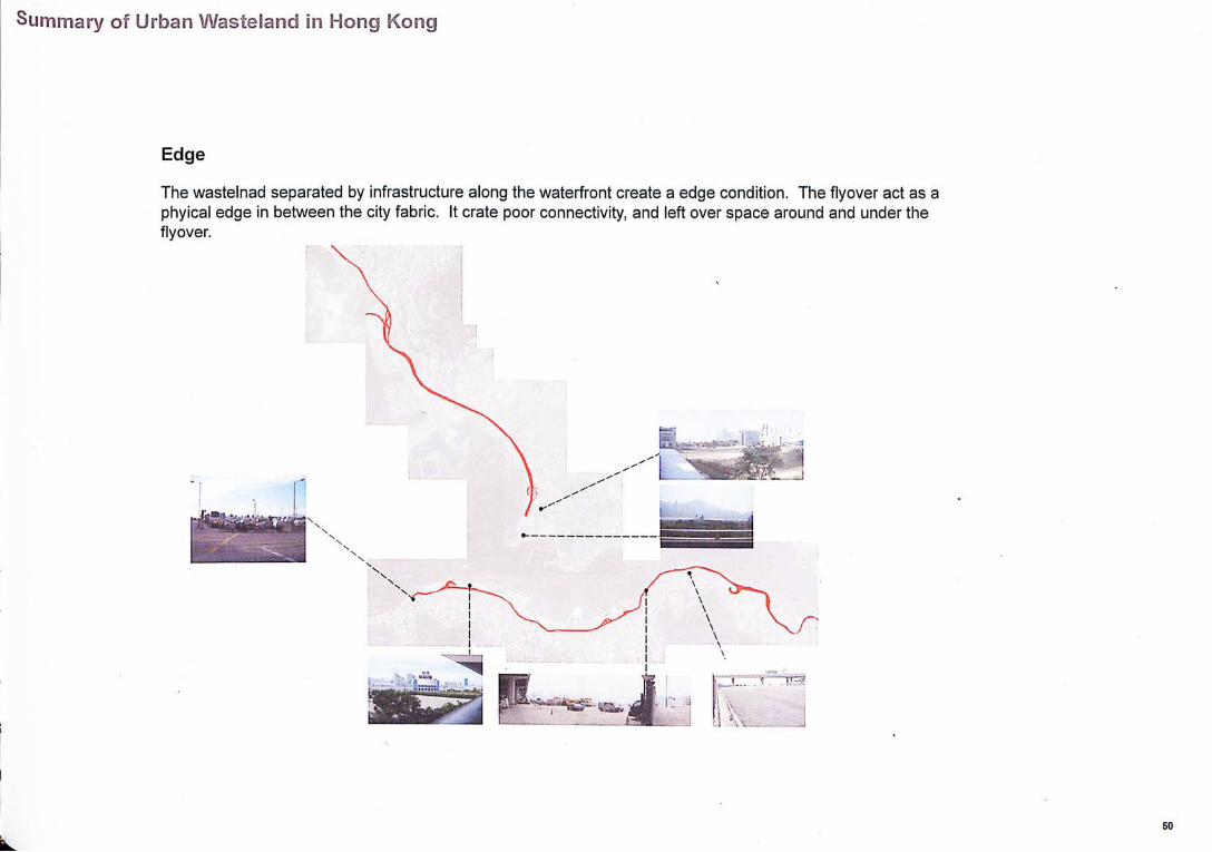
Edge
The wastelnad separated by infrastructure along the waterfront create a edge condition. The flyover act as a phyical edge in between the city fabric. It crate poor connectivity, and left over space around and under the flyover.

Summary of Urban Wasteland in Hong Kong
Segregation
The infrastructure travel through the inner city usually segregate the old and new city district, which affects lo-cal and tourist circulation.
Bi n ‘
51
Siimmary of Urban Wasteland in Hong Kong
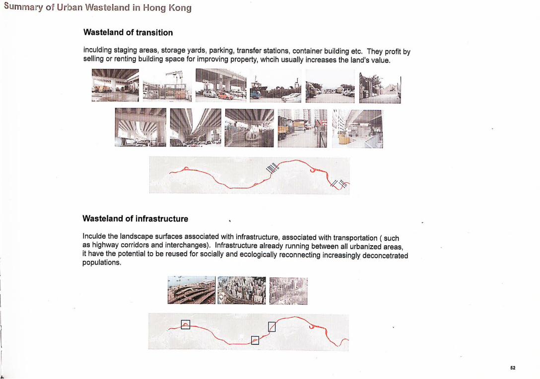
Wasteland of transition
inculding staging areas, storage yards, parking, transfer stations, container building etc. They profit by selling or renting building space for improving property, whcih usually increases the land's value.
镇遍
Wasteland of infrastructure ,
Inculde the landscape surfaces associated with infrastructure, associated with transportation ( such as highway corridors and interchanges). Infrastructure already running between all urbanized areas, it have the potential to be reused for socially and ecologically reconnecting increasingly deconcetrated populations.
編HI

Site Analysis in Sai Wan Ho
Site Analysis in Sai Wan Ho
Sai Wan Ho waterfront- disconnections parallel to waterfront

Site Analysis in Sai Wan Ho
Sai Wan Ho waterfront- disconnections along waterfront

The view from the new district to old district show that there are many leftover space around and under the flyover.
The flyover passing through the new district and old distict which create poor connectivity.
Visual disconnection from the pedestrian to the tram depot.
Pedestrian access disconnect on the ground floor
Untouchable green space in the wasteland.
The Park under the flyover didn't creat a pleaseant experience, it didn' have enough lighting and sitting area served for the public.
Site Analysis in Sai Wan Ho
,1| i
Aspirations
Sai Wan Ho dormant site increased land values are tied to serious questions about the city: Will private produces? Will if be permeable enough to absorb tourists into daily life wh/7 retaining fhe unique chorocter of Sal Wan Ho? The challenge is the integration of travelers and local residents in a way that revi-talizes the hold district.
Alleyway
The alleyways is an unique urban space in Sai Wan Ho. The alley ways are semi-public space, as they are less apparent and thefore less traversed. Being quite unpleasant from ground level, the al-leyway is preferable observed by residents from the external stair-case of surrounding apartments. However, many undefined activi-ties that describe the unique inhabitations of the city take place in the alleyway, such as extensions, cubist encroachments, unde-fined compositions of entrance. The alleyway plays a critical rote in joining and connecting homes and lives, presenting the oppor-tunlity for shortcuts and evidencing the inner workings of the urban system.
Material (Tram Depot)
There is no unique identity of the tram depot. Tram depot has his-torically been strongly asserted. Architectural should be brings to the forefront potential of it character.
57
Issues
Issues
Explore a flexible solution of urban wasteland The solution should retain their connection of the old dis-tricts
L
58

Design Idea
Creating pedestrian access under flyover.
2. Inserting new social space for different people like resident, working student and tourist.

3. Creating visual connection to different programme, while retaining their origina
-J/—
1
•'mm 1
f B
dB
I — Y 4. E x t e n d e d pedes t r i an a c c e s s o n uppe r f l oo r,creat ing c o n n e c t i o n to the o ld d is t r ic ts
60
Design idea

‘i
5. Elevated walkway along flyovers.
Design Idea
Fmal Design- Plan
Ground Floor Plan
Final Design
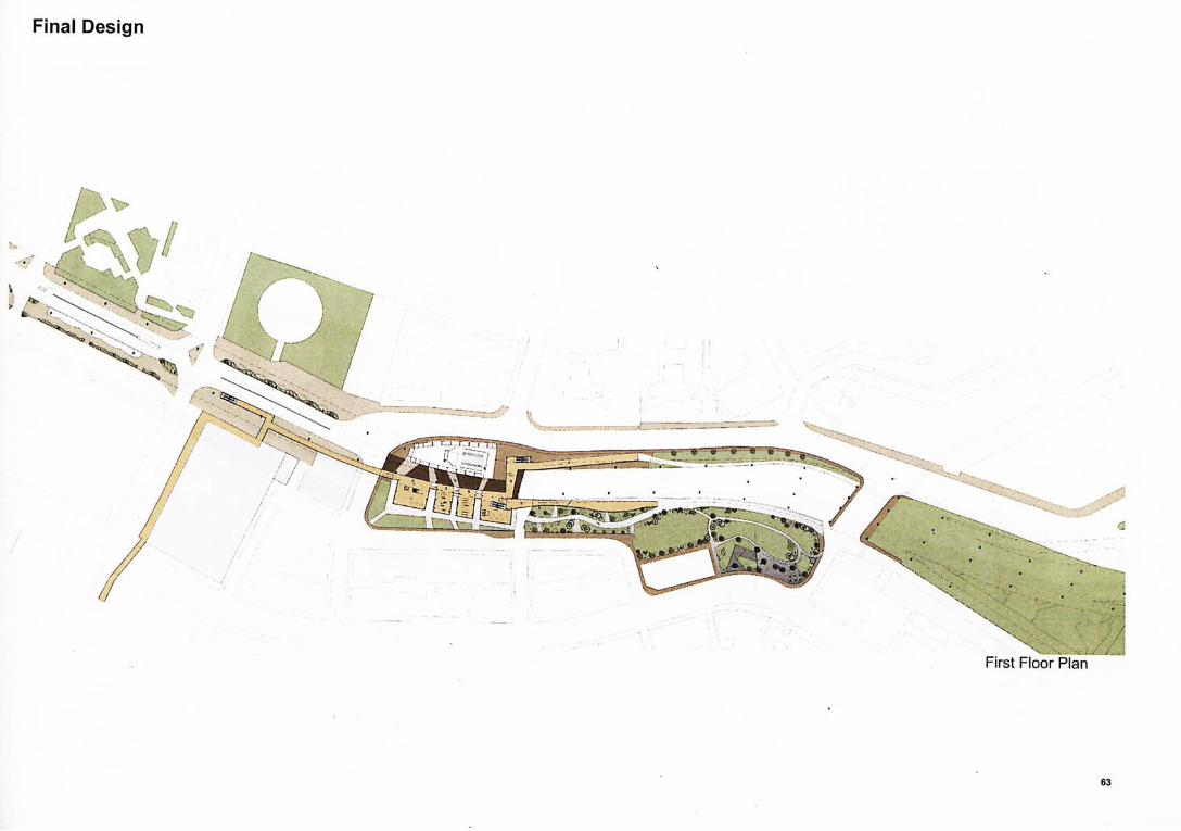
First Floor Plan
63
Final Design
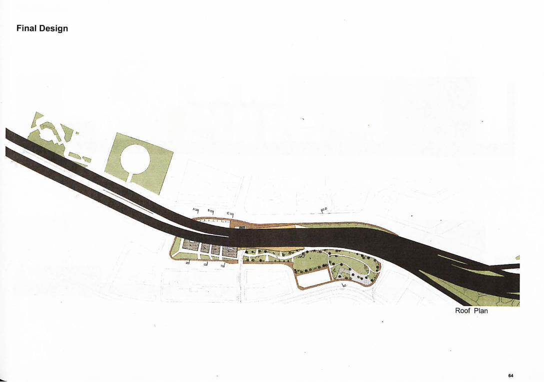
Roof Plan
64
•
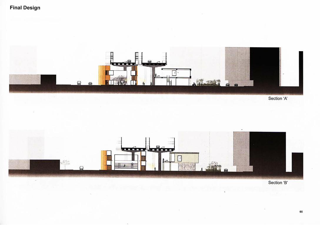
Sect ion ‘A'
Sect ion ‘B’
F inal Design
m
Final Design- Section
I I ; i .丨
P ^ R i i i i i ^ i S i i i R i M U l i m i
I T
memm u
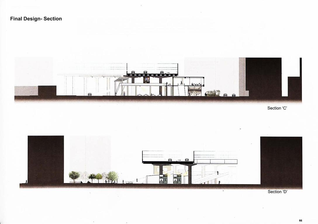
Sect ion 'C'
Sect ion 'D'
66
Park Design
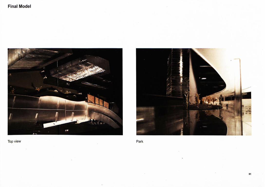
Park- The sites lies in between the old and new district. There are different tourist attraction and resident area near this site. Therefore, many people through the street everyday. Although there are many commercial area in the adjacent sites, but the if don't have much outdoor space to sit and relax. The design bend the people from the office, welcoming visitor and local resident to relax and rest inside the park. The site demolish all the fence sur-round it and use grass make a soft border between the commercial are and office area. Also, it can preserve the calm by putting sound barriers along the flyover.
Bend + Obstac les
The curvature of the site visually disconnects the end of the existing park. Additionally several building block are too high which create the problem of visually discontinuity.
Noise
The site is quite noisy. Without any sound barri-ers. the majority of the site would experience at least 70 decinels of noise generated by the flyo-
Length +Access
The design has 183 miles of street frontage and only 3 major entry points each within a 6 minute walk from the nearest MTR station
67
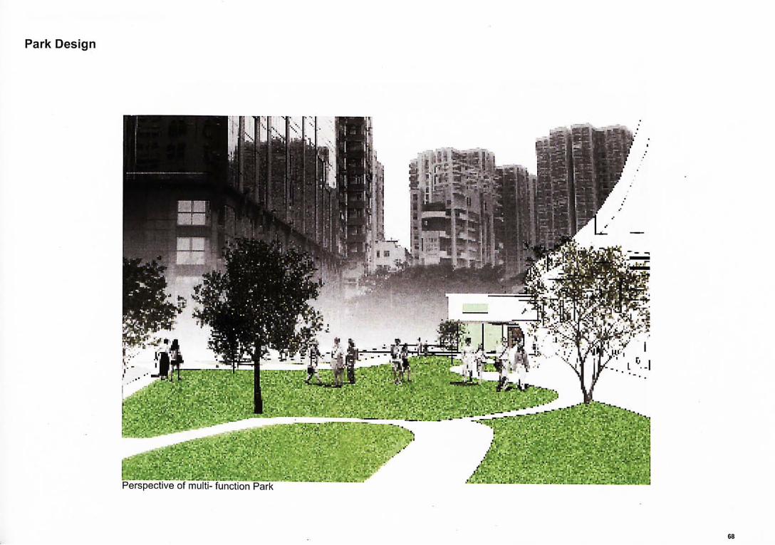
Perspect ive of multi- funct ion Park
Park Design
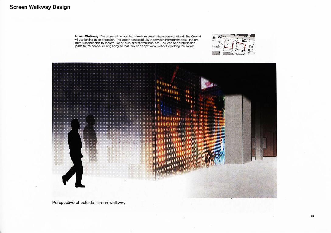
Screen Walkway Design
Screen Wa lkway - The propose is to inserting mixed use area in the urban wasteland. The Ground will use lighting as an attraction. The screen is make of LED in between transparent glass. The pro-gram is changeable by months, like art club, atelier, workshop, etc. The idea to is crate flexible space to the people in Hong Kong, so that they can enjoy various of activity along the flyover.
Perspect ive of outs ide screen wa lkway
69
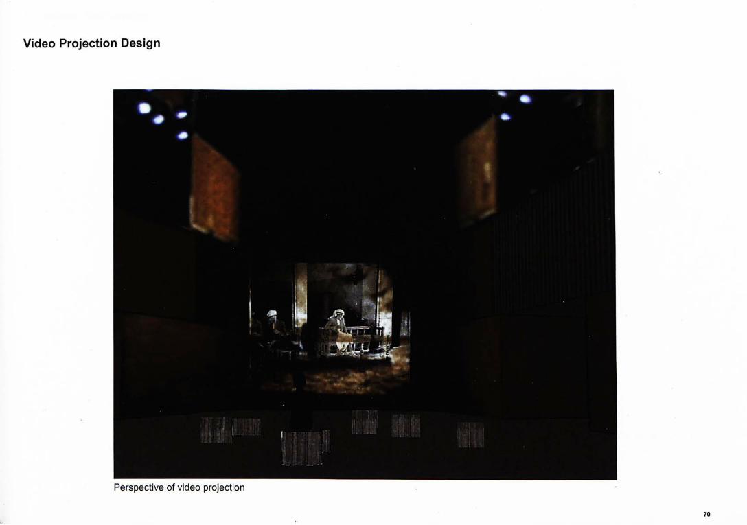
Video Projection Design
Perspect ive of v ideo project ion
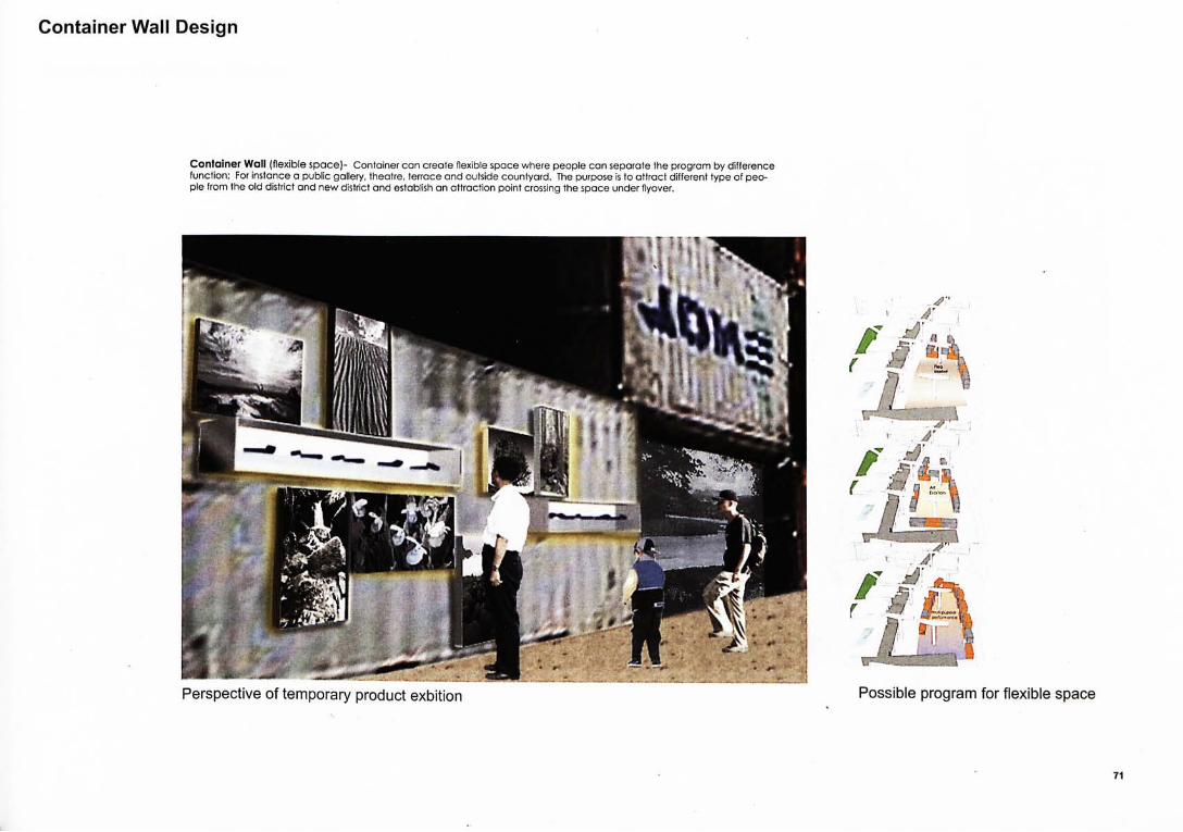
Perspect ive of temporary product exbit ion Possible program for f lexible space
71
Container Wall Design
Conta iner Wall (flexible space)- Container can create flexible space where people can separate the program by difference function; For instance a public gallery, theatre, terrace and outside countyard. The purpose is to attract different type of peo-ple from the old district and new district and establish an attraction point crossing the space under flyover.
fl 1
Motet
ft
t ' l .-r

Perspect ive of temporary exibit ion
Temporary Exibition Design
• I '
I
151:

Flexible Design for Container Wall
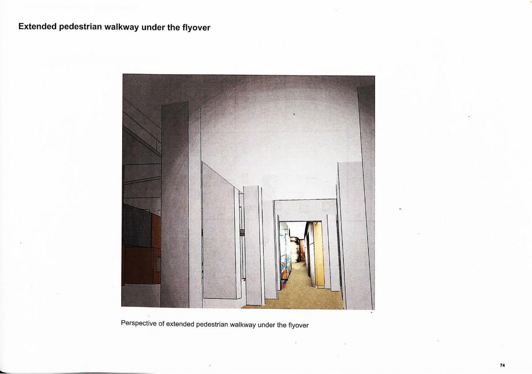
Perspect ive of ex tended pedestr ian wa lkway under the f lyover
Extended pedestrian walkway under the flyover

Visible Screen for Tram Depot
Visible Screen (Tram Depot)- The purpose is to create visual connection along the tram depot and the space under flyover
m D CHI
Q •
75
9Z
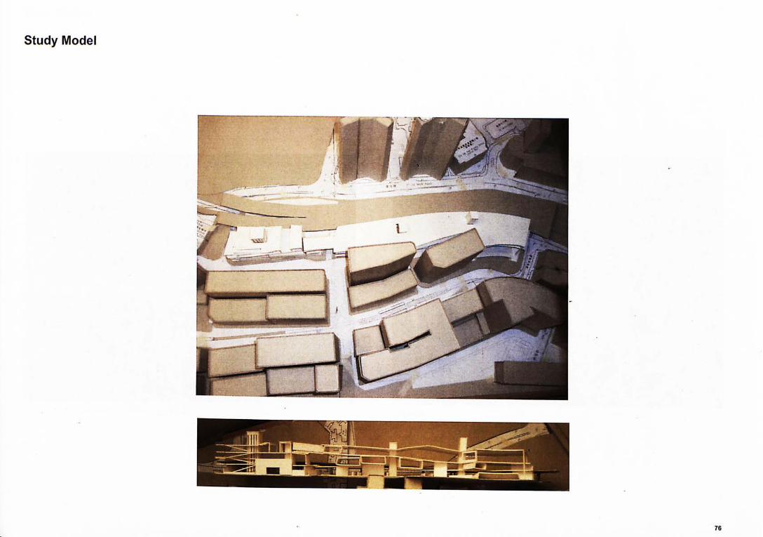
lepoiAl Aprus
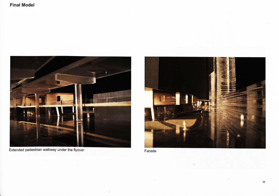
Final Model
Extended pedestr ian wa lkway under the f lyover
77
Final Model
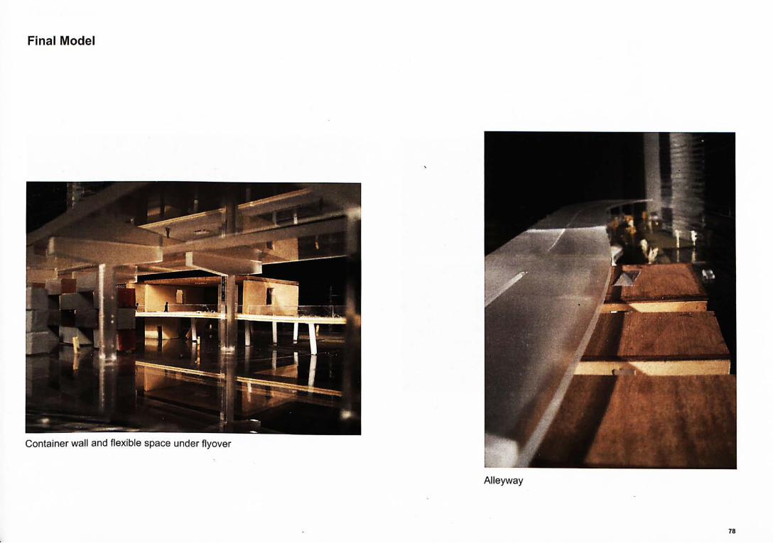
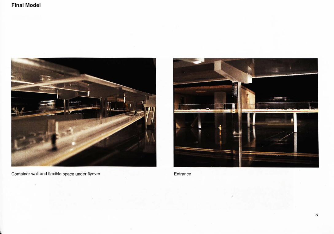
Conta iner wal l and f lexible space under f lyover
A l leyway
78
Final Model
Container wal l and f lexible space under f lyover Entrance
Final Model
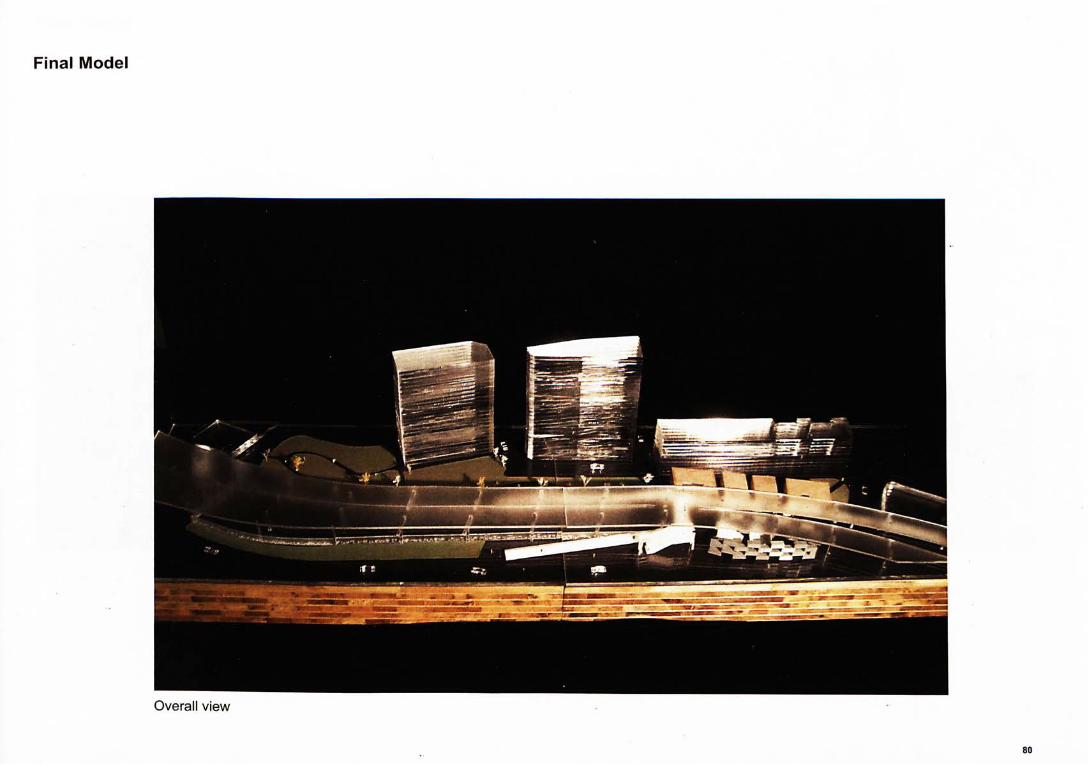
Overal l v iew
80
Me!A do丄
lepoiAl IBuid

ARCHITECTURE LIBRARY 建 築 學 圖 書 餘
AH items on loan are subject to RECALL. 所有借出項目均會受到催還。
30-day or longer loan periods are subject to shortening by Recall. The new due date will be shown in your Library Online Catalogue circulation record and in a Recall Notice to you. 三十天或以上的借期會因催還而縮短》新的還書日期將顯示於您的 圖書錄線上目錄之借書紀錄及發給您的催還通知。
DUE DATE還書日期 !
Display until Display until
X
Alth m^ 2009 1%@B2Q10
: : y
1 5 NOV 201T
1 p NOV 2012 O'-Ha /
0 0 4 3 6 6 6 0 6
Copyright © 2022 FDOKUMEN