Upper Salinas River - Watershed Action Plan
231
Upper Salinas - Las Tablas Resource Conservation District Upper Salinas River Watershed Action Plan Final Report to the State Water Resources Control Board
-
Upload
khangminh22 -
Category
Documents
-
view
1 -
download
0
Transcript of Upper Salinas River - Watershed Action Plan

Upper Salinas - Las Tablas Resource Conservation District
Upper Salinas River
Watershed Action Plan Final Report to the State Water Resources Control Board

TABLE OF CONTENTS Upper Salinas Watershed Action Plan
ACKNOWLEDGEMENTS
CHAPTER 1 Introduction
A. What is the Watershed Action Plan?
B. Who Should Use This Action Plan
1-1
1-1
1-2
C. How the Plan Was Prepared 1-2
D. Background and History 1-2
E. Changes in the Valley 1-7
F. Coordinated Resource Management and Planning Project 1-12
G. Completing the Plan: The US-LT RCD and USWC 1-14
H. Findings and Summary List of Problems 1-15
I. Organization of the Plan 1-16
CHAPTER 2 Setting, Planning Area and Land Use
A. Physical Setting of the Upper Salinas Valley
B. The Planning Area
2-1
2-1
2-3
C. Land Ownership in the Upper Salinas River Watershed 2-8
D. Landuse Issues 2-8
E. Economic Issues Impacting the Watershed 2-11

CHAPTER 3 Wildlife and Vegetation
A. Wildlife
A.1 Invertebrates
A.2 Fish
A.3 Reptiles and Amphibians
A.4 Birds
A.5 Mammals
B. Riparian Vegetation
8.1 Value of the Riparian Vegetation
3-1
3-1
3-2
3-7
3-10
3-14
3-16
3-16
8.2 Changes in Riparian Vegetation 3-18
8.3 Climatic Changes and Their Impact on Vegetation 3-24
8.4 Depletion of the Riparian Vegetation 3-25
CHAPTER 4 Erosion, Sediment, and Channel Conditions 4-1
A. Purpose for Channel and Erosion Study 4-1
B. Channel Study Methodology 4-1
C. Rural Watershed Streams 4-13
C.1 Study of Cattle Management Techniques 4-13
C.2 Rural Watershed of Atascadero Creek 4-32
C.3 Rural Watershed of Estrella River 4-36
D. Urban Watershed Streams 4-40
D.1 Study of Streams Impacted by Urban Landuses 4-41
D.2 Other Study Reaches 4-51
E. Comparison of Healthy Verses Unhealthy Channel 4-57
F. Conclusions Regarding Comparison of Urban and Agriculture
Impacted Portions of the Watershed 4-59
G. Sediment Transport
H. Causes of Channel and Upland Erosion
Attachments to Chapter 4:
Graphs of Morphological Surveys
4-61
4-62

CHAPTER 5 Water Quality in the Upper Salinas River Watershed 5-1
A. Characteristics of the Salinas River 5-2
A.1 Description of Monthly Monitoring Locations 5-6
A.2 Little Cholame Creek Monitoring Locations 5-9
A.3 Snapshot Day Monitoring Locations
B. Parameters Monitored and Results
5-9
5-9
B.1 Parameters at Monthly Monitoring Locations 5-9
B.2 Little Cholame Creek Monitoring Locations 5-27
8.3 Snapshot Day 5-27
Attachments to Chapter 5:
Water Quality Monitoring Data and Graphs 2003-2004
Snapshot Day Monitoring Data 2001-2003
CHAPTER 6 Outreach and Public Input
CHAPTER 7 Issues, Goals and Strategies
Attachment to Chapter 7:
List of Issues and Strategies
APPENDICES A. Task Force Meeting Attendee List
6-1
7-1

ACKNOWLEDGEMENTS
State Water Resources Control Board
Joanne Cox, Contract Manager
Bill Ray, Quality Assurance Project Plan
Regional Water Quality Control Board
Roger Briggs, Executive Officer
Amanda Bern
Donette Dunaway
Julia Dyer
Allison Jones
Karen Worcester
Department of Fish and Game
Margaret Roper, Contract Manager
Marty Gingras, Former Contract Manager
Chuck Marshall, Former Contract Manager
Javier Gloria, Contract Coordinator
Bob Coey, Watershed Program Supervisor
Mike Hill, Fisheries Biologist
Dave Highland, Fish Habitat Specialist
Upper Salinas-Las Tablas Resource Conservation District Board
Directors:
Chuck Pritchard, President
Gidi Pullen, Vice President
Mike Bonnheim
Ellalina Keller
Tom Mora
Jeff Palmeter
Jeff Pipes
Holly Sletteland (former Director)
Robert Sparling
Ben Work
Associate Directors:
Ray Allen
Jim Patterson

Technical Advisory Committee
Amanda Bern
Bruce Bonifas
Mike Bonnheim
Brady Cherry
Donette Dunaway
Joy Fitzhugh
Donald J. Funk
Dave Highland
Mike Hill
Bridget Hoover
Steve Kahn
Royce Larsen
Margy Lindquist
Adriana Morales
Daniel Mountjoy
John Nall
Jim Patterson
Jeffrey Pipes
Holly Sletteland
Karl Striby
John Warrick
Ben Work
RWQCB
California Conservation Corps
US-LT RCD, Land Owner (Cattleman)
City of Atascadero
RWQCB
Farm Bureau
US-LT RCD
Dept. of Fish & Game
Dept. of Fish & Game
Monterey Bay Sanctuary Monitoring Network
City of Atascadero
UC Cooperative Extension
NRCS
US-LT RCD
NRCS
County of San Luis Obispo
Upper Salinas Watershed Coalition
US-LT RCD, Land Owner (Vineyard/Winery)
US-LT RCD, Cal Poly
NRCS
SLO Ag Commissioner's Office
US-LT RCD, Land Owner
The US-LT RCD is very appreciative for the financial support from the David and Lucille Packard Foundation, Resources Legacy Fund Foundation, Natural Resources Conservation Service (NRCS), Monterey Bay National Marine Sanctuary (MBNMS), State Water Resources Control Board (SWRCB), Central Coast Regional Water Quality Control Board (RWQCB), and California Department of Fish and Game (CDFG) who helped fund the research, report preparation, and meeting facilitation.
We are especially grateful to the many volunteers. Their help made possible the many positive accomplishments and planning ideas described in this Upper
Salinas River Watershed Action Plan (WAP).

The work has required the cooperation of many agencies and organizations. Following is a partial list of those involved in this planning program:
• Property Owners, Business Owners, and Residents
• Upper Salinas-Las Tablas Resource Conservation District (US-LT RCD)
• Monterey Bay National Marine Sanctuary (MBNMS)
• Upper Salinas Watershed Coalition
• The Nature Conservancy
• San Luis Obispo County Farm Bureau
• Members of the Cattleman's Association
• U.S. Natural Resources Conservation Service (NRCS)
• Coastal Watershed Council • California State Water Resources Control Board (SWRCB)
• Central Coast Regional Water Quality Control Board (RWQCB)
• Central Coast Vineyard Team
• Members of the Paso Robles Vintners Association
• California State Department of Fish and Game (CDFG)
• U.S. Fish and Wildlife Service (F&WS)
• University of California Cooperative Extension
• California State Polytechnic State University at San Luis Obispo (Cal Poly)
• U.S. National Marine Fisheries Service (NMFS)
• City of Atascadero
• City of Paso Robles
• San Luis Obispo County
• American Watersheds
• Atascadero Native Tree Association
• Members of the Audubon Society
• California Conservation Corps (CCC)
• U.S. Bureau of Land Management (BLM)
• Central Coast Resource Conservation and Development Council
(CCRC&D)
• Resource Conservation District of Monterey County
• Members of the Atascadero Historical Society

Plan prepared by
Donald J. Funk, Project Manager Adriana Morales, Biologist/Watershed Coordinator Marti Johnson, Intern Planner Ellen Perryess, Biologist Mori Seyedan, District Engineer Rocio Pineda, Intern Planner Task Force Members
Assistance with Report Preparation, Surveying, Stream Water Quality Sampling, Mapping and Data Inputting:
Marti Johnson, Intern Planner Terry Hall, NRCS Margy Lindquist, NRCS Susan Litteral, NRCS Tina Vander Hoek, NRCS Ken Brown, NRCS Mori Seyedan, District Engineer Cheryl Zelus, NRCS (develop website) Bobby Jo Close, California Conservation Corps Paul Corci, California Conservation Corps Stacy Smith, California Conservation Corps Hillary Peterson, AmeriCorps Environmental Stewards Gary Johnston, AmeriCorps Environmental Stewards Kirby Chandler, AmeriCorps Environmental Stewards Peyton Davis, AmeriCorps Environmental Stewards Heather Johnson, AmeriCorps Environmental Stewards Elizabeth Eggers, AmeriCorps Environmental Stewards Jorgen Thompquist, AmeriCorps Environmental Stewards Eric Hunter, AmeriCorps Environmental Stewards Liz Handel, AmeriCorps Environmental Stewards
Editing Assistance: Marti Johnson, Intern Planner Gidi Pullen, US-LT RCD Susan Litteral, NRCS Margy Lindquist, NRCS Ken Oster, NRCS Kathleen lntorf, US-LT RCD
Photo Credits: The photos in this report were taken by: Kenneth Adelman (for CCAMP), Chuck Pritchard, Dave Highland (CDFG), D. J. Funk, and Adriana Morales.

Chapter 1 Introduction


Upper Salinas-Las Tablas RCD
FINALReport to State Water Resources Control Board
Upper Salinas RiverWatershed Action Plan
(Rio Santa Delfina)June 30, 2004
Upper Salinas-Las Tablas RCD65 Main Street, Suite 108Templeton, CA 93465
us-ltrcd.org
Chapter 1
INTRODUCTION
A. What is the Watershed Action Plan?The Watershed Action Plan (WAP) is a comprehensive planning document, a management plan, for the use by landowners, agencies, and groups in their individual and collective efforts to improve and restore natural resources within the 2,000 square mile area of the Upper Salinas River Watershed. The planning area comprises approximately one-quarter of the watersheds that affect the Monterey Bay National Marine Sanctuary (MBNMS). This document includes the input from hundreds of persons, agencies, and organizations.
The primary objectives of the WAP are:
� To improve water quality and to ensure adequate water resources to meet the various needs within the watershed.
� To foster the future well-being of agriculture.
� To reduce the loss of soil.
� To enhance habitat conditions.
� To improve land use policies

Upper Salinas RiverFinal Watershed Action Plan
Chapter 1, Page 2 Introduction
B. Who Should Use this Action Program?This document is intended for the use by all of the stakeholders within the Upper Salinas River Watershed. By stakeholders, we mean every resident, landowner, land manager, business person, and regulator within the region. We encourage all individuals, local agencies, and organizations to incorporate the planning principals and tools contained in the WAP in their own goals, strategies, and actions. These strategies are not an exhaustive all-inclusive list. Rather, they are a point of beginning; a way to live within our small world harmoniously without abusing or destroying the natural resources that are so very important for us to survive and prosper. The goal is not to create a list of regulations, but instead, instill a sense of respect and understanding of how our actions affect the sustainability of the resources that we rely upon.
C. How the Plan Was PreparedThe WAP describes the comprehensive planning work of the Upper Salinas-Las Tablas Resource Conservation District (US-LT RCD). It also includes the input of hundreds of stakeholders within the Upper Salinas River Watershed. From 2001 to 2004, meetings were held quarterly in which participants discussed problems and issues regarding the health of the watershed. During numerous "brainstorming" sessions, the participants prepared a list of strategies to address the problems.
D. Background and HistoryThe Salinas Valley is by far the largest watershed in the MBNMS area and, according to the Trust for Public Lands, "the most degraded by human activities." 1 Through the efforts of the US-LT RCD, NRCS, the San Luis Obispo County Farm Bureau, UC Cooperative Extension, and other organizations, the processes of degradation are beginning to be reversed. The watershed provides a significant opportunity to make changes that will positively affect all of the resources.
The waters of the Upper Salinas River are being used for many purposes. It supports a multi-billion dollar agricultural industry, one of the most productive in the world. It provides water for cities, both inside and outside of the valley. The river and the groundwater resources are being tapped to provide for the uses within the valley as well as providing water for the City of San Luis Obispo and the cities and the intensive agricultural uses of the Lower Salinas Valley. The watershed lies within the Central Coast Bioregion as defined by the State of California, an area with a diverse landscape, varied climates, and a wealth of wildlife. It provides a diverse habitat for hundreds of animal and plant species, including some of the most endangered in the nation. The ability of the river to provide for the expanding usages while still remaining healthy and viable for wildlife is a growing concern.
Since the late 1700's, the Upper Salinas River valley has been used for agriculture. Urban centers of Paso Robles, Atascadero, San Miguel, Templeton, Santa Margarita and Shandon have experienced significant growth during the last half of the 20th century. The Upper Salinas Watershed has been transformed by these changes. Steelhead fisheries within the Salinas River and tributaries have declined over a number of years and water quality has degraded. Eroded soil has polluted streams and riparian vegetation has disappeared. Trespass and vandalism have become rampant and contributed to the overall degradation of water supply and quality (California State Lands Commission, 1993).

Monterey
Bay
National
Marine
Sanctuary
T A . " "
Upper Salinas River Watershed Project Location

Upper Salinas RiverFinal Watershed Action Plan
Chapter 1, Page 4 Introduction
Photo 1.1The Salinas River begins as a small meandering creek at Garcia Mountain in the Santa Lucia Range.
Photo 1.2170 miles away, the Salinas River empties into Monterey Bay.
Photographer Kenneth Adelman for CCAMP Program

Upper Salinas RiverFinal Watershed Action Plan
Chapter 1, Page 5 Introduction
In the early 1940's, the Salinas River was dammed near the town of Santa Margarita to provide water for the community of San Luis Obispo as well as nearby Camp San Luis Obispo military training facility. During the 1950's, the Nacimiento and San Antonio Rivers were also dammed. The Monterey County Water Resources Agency operates both the Nacimiento and San Antonio Dams, using the water to recharge groundwater basins in the lower Salinas Valley. Nacimiento Lake and Santa Margarita Lake are within the Upper Salinas River Watershed. With approximately 160 miles of shoreline, Nacimiento Lake is a very popular recreational destination. The dams blocked steelhead migration to spawning grounds upstream. (See Photo 1.3) They also modified downstream flows, reducing potential flooding as well as affecting steelhead migration and riparian vegetation. For the 17 years prior to the construction of the dam, the average annual peak flow for the Nacimiento River was 25,313 cubic feet per second. For the 46 years after construction of the dam, the average annual peak flow was 2,357, less than 10 percent of the previous average peak flow.
The water from these dams is used to supply water needs outside of the Upper Salinas River Watershed. Nacimiento Lake is operated to provide water for the cities and agricultural uses in Monterey County. Water from Santa Margarita Lake is pumped via pipeline to water treatment facilities near the City of San Luis Obispo.
Photo 1.3Nacimiento Dam is proposed to be enlarged. It is hoped that the proposed dam expansion
project on the Nacimiento and Salinas Rivers will include offsite and onsite mitigation to addresserosion and to improve the habitat conditions within the remaining steelhead streams in the
Upper Salinas River Watershed.

Upper Salinas RiverFinal Watershed Action Plan
Chapter 1, Page 6 Introduction
The Salinas River is the principal river system on the central coast of California, flowing northward approximately 170 miles from San Luis Obispo County, through Monterey County and emptying into Monterey Bay near the town of Marina. (See Photo 1.2) The Upper and Lower Salinas River watershed is more than twice the size of any other river system from San Mateo to Santa Barbara. Originally named Rio Santa Delfina (River of the Dolphin Saint) by early explorers and soldiers, it was later named Rio Monterey by the explorer Portola. Because of the salt beds near Monterey Bay, the river was eventually renamed Salinas.
The river has been the subject of various authors, such as John Steinbeck and Anne B. Fisher. Mrs. Fisher provided a thorough chronology of the history of the Salinas Valley in her book, The Salinas, Upside Down River, written in 1945. She called it the "upside down river" because it flows north, while most western rivers flow west or south. In "California Rivers, A Public Trust Report" prepared by the California State Lands Commission, the Salinas River is described as one of the "largest submerged rivers" in the United States because of its significant subsurface flow.2
Photo 1.4Bitterwater Ranch, eastern San Luis Obispo County. Photographer: Chuck Pritchard

Upper Salinas RiverFinal Watershed Action Plan
Chapter 1, Page 7 Introduction
E. Changes in the ValleyBeginning with the first permanent inhabitants, the Salinan Indian Tribe, the Upper Salinas River Valley presented many opportunities for settlement, hunting, and agriculture. After 10,000 years of occupation, the Salinan communities were displaced by European settlers. Agriculture formed the original and most important economic base for the region. Today, the area is a complex mix of open space, agricultural, and urban land uses.
The Upper Salinas River Valley was originally settled by Native Americans. The Salinan Indian Nation extended from the Carmel Valley to Morro Bay. Their heartland was the San Antonio River Valley. The Salinan's thrived in the Salinas Valley. They traded with the coastal Chumash and central valley tribes.3 The permanent villages of the Salinan Indians were located along the river and near its tributaries. Plentiful fish and game provided staples for the survival of the Indian villages. Their trails undoubtedly became the routes for later roads constructed by early settlers. They used native plants for their medicines and to provide food. The Native Americans used fire to clear fields and encourage lush green grasses to attract deer.
According to Suzanne Pierce Taylor, Salinan elder and Playoño Salinan descendant, her ancestors lived in a "balance between need and availability..... Early visitors to California often remarked on how the land resembled a garden or park, with large open meadows and oak trees, free of brush and undergrowth. This was not accidental; the people practiced 'agriculture' by burning off the brush and under the oak trees to expose the ground where the acorns fell in the autumn. ..... They understood how vital it was to conserve plant and animal life to insure a constant food supply." 4
Favorite food and medicine plants of the Salinan's were "transplanted to village sites to be conveniently near when needed." The Salinan’s used the oak acorns to make flour to bake into pancakes. In a laborious process, the bitterness of the acorn flour was leached out. The flour was also used in soups as a thickener and cooked like a cereal. They also propagated berries, fruits and roots. Fish, dove, quail, squirrel, rabbit, deer and antelope were favorite foods. Their only major threat was the grizzly bear. 5
During the 1700's, the Spanish missionary priests built missions at San Luis Obispo, San Miguel, Santa Margarita, and at San Antonio. Early missionary trails followed along the Salinas River. In early 1776, Juan Bautista de Anza led an expedition through the valley and established a land route for futuresettlers. During his trip, de Anza stopped at Mission San Antonio, the largest of the early California missions. His expedition set into motion a large influx of new residents. Settlers began moving into the region, beginning with the Spanish, then Mexicans. During the mid-1800's American settlers began moving into the valley, hoping to make their fortunes producing supplies for the thousands of gold prospectors in the Sierras. Over time, the Indian population was decimated by a combination of diseaseand genocide. 6 Their enslavement and executions brought about the final Salinan downfall. Much of their culture and language disappeared.

Upper Salinas RiverFinal Watershed Action Plan
Chapter 1, Page 8 Introduction
The Spaniards and other immigrants brought grasses and animals from their European homelands. The valley was transformed into large ranchos. The predominant agriculture was cattle ranching. (See Photos 1.4 and 1.6) In addition to ranching, dryland farms and almond orchards were planted during the early 1900's. At that time towns in the valley were small agrarian communities. Water usage in the Upper Salinas Valley was minimal. Many of the streams in the western hills contained plentiful steelhead. 7
Fire was used as a management tool by the Salinan Indians to improve vegetation for wildlife. They opened up dense forest areas to enhance the habitat for deer and antelope.
The photo at left was taken a few days after the Highway 58-229 Fire, ease of Santa Margarita.
Note in this photo that the oak trees survived the fire, while the fuel load of underbrush was reduced. Many of the native shrubs also survived the fire. New grasses and bushes will sprout after the first winter rains.
Photo 1.5Photo after 2002 fire near Highway 58

Upper Salinas RiverFinal Watershed Action Plan
Chapter 1, Page 9 Introduction
Photo 1.6Ranching was early use of the Salinas Valley. Photo of Las Tablas Ranch, Adelaida area.
During the later part of the 1900's, grape vineyards, wineries and urban development replaced previous ranchlands. The little towns began to grow into small cities. The new urban and farming uses required more water and services than the former ranches. In order to meet the demands for increased water, large dams were constructed and the groundwater supplies were tapped. New roads were built and older roads were widened into highways.
While the Native Americans centered their lives around the waters of the Salinas River, the new urban communities often turned their backs to the river. In some areas, the river is now the backyard of industrial uses. In other areas, the river is abused by off-road enthusiasts who turn the river into a linear sand "highway" for their recreational use. (See Photos 1.7 and 1.8) Trash is dumped and vehicles are abandoned. (See Photo 1.11) Due to neglect, portions of the river have degraded significantly, habitat has been altered, riparian vegetation lost, and water quality has deteriorated. The Cities of Paso Robles and Atascadero have begun planning efforts to refocus their communities to the river. (See Photo 1.9) The County of San Luis Obispo has begun to modify its General Plan to place greater emphasis on restoring the river corridor.

Upper Salinas RiverFinal Watershed Action Plan
Chapter 1, Page 10 Introduction
Photo 1.7Off-Road vehicle damage in Salinas River channel, winter 2002, in Templeton.

Upper Salinas RiverFinal Watershed Action Plan
Chapter 1, Page 11 Introduction
Photo 1.8Illegal Off-Road usage of Salinas River near San Miguel causes displacement of river bed,
pollution of river, and destruction of riparian vegetation along 20 miles of the River.
Photo 1.9Salinas River at confluence with Atascadero Creek

Upper Salinas RiverFinal Watershed Action Plan
Chapter 1, Page 12 Introduction
F. Coordinated Resource Management & Planning Project (CRMP)Watershed wide concern for appropriate planning for the Salinas River resulted in a workshop sponsored in 1991 by San Luis Obispo County Supervisor, Harry Ovitt, and Monterey County Supervisor, Tom Perkins. As a result of the interest generated by this workshop, in 1992, a Coordinated Resource Management and Planning Project, or CRMP, planning program for the Upper Salinas Watershed was begun by the San Luis Obispo County Parks and Open Space Division. As part of the CRMP, a brief study of water resources, ecosystem, and land use was conducted. Thus, the State Lands Commission states that the Salinas River finally became “the focus of comprehensive management.” “In the future, the River will no longer be treated merely as a water supply or a flood threat, but as a renewable resource which needs to be managed for protection in perpetuity. Values of the River, other than water supply –such as fish and wildlife habitat and public recreation – will be part of long-term management goals.” 8
A CRMP steering committee comprised of landowners, agencies and concerned citizens worked for three years to discuss the issues facing the Salinas River and prepare a list of goals. They met regularly to discuss the issues facing the watershed. The CRMP steering committee was facilitated by staff from the County Parks and Open Space Division and the National Park Service.
A report of their findings was published. The following is the mission statement and goals of the Upper Salinas Watershed CRMP:
CRMP Mission Statement: Our mission is to ensure the health and integrity of the Upper Salinas River as a vital lifeline in our economic livelihood, the natural environment, and our communities.
CRMP Goals:Economic Livelihood
Promote importance of agriculture to our economy in the Salinas River Valley.
Provide for production and conservation of the mineral resources of the Salinas River while minimizing environmental impacts.
Promote conservation of the rural character and scenic qualities of the river landscape which contribute to visitor attraction and tourism.
Natural EnvironmentEnsure that the valuable water resources of the Salinas River and Paso Robles groundwater basin are not threatened.
Promote protection of wildlife, aquatic and riparian resources within the Salinas River and its tributaries.
Promote erosion control and restoration of riverbanks.

Upper Salinas RiverFinal Watershed Action Plan
Chapter 1, Page 13 Introduction
Community ResourcePromote understanding and appreciation of the importance of the river landscape to people in the past, present, and our emerging future.
Promote respect within the community for private ownership of the Salinas River corridor.
Promote public recreational opportunities on lands owned by a public agency or on lands where a willing landowner grants an easement or enters into a lease agreement.
Promote coordination of local, state, and federal agencies and ensure landowner and community involvement in river planning policies and programs.
The CRMP also established a "river watch" program. This program developed out of concerns about "off-road vehicles, dumping, vandalism, and other illegal and harmful activities occurring along the Salinas River." 9 (See Photo 1.10) A Trespass Task Group was organized to work with members of the law enforcement agencies. Unfortunately, the river watch program lacked funding and law enforcement support and there continues to be trespass problems along the Salinas River. In 2003, concerned citizens resurrected the river watch program with the cooperation and assistance of the Atascadero City Police Department. Because the vehicular use has severely impacted the Juan Bautista de Anza National Historic Trail along the river, the National Parks Service has also taken notice about the problem and has indicated that they may help in the effort to rid the channel of illegal vehicles.
Photo 1.10Abandoned vehicles and illegal dumping in the Salinas River continues to be a problem.
Photo taken within the river channel near San Miguel (US-LT RCD, 2003).

Upper Salinas RiverFinal Watershed Action Plan
Chapter 1, Page 14 Introduction
G. Completing the Plan: The Upper Salinas-Las Tablas RCD and Upper Salinas Watershed Coalition
In an effort to continue the work started with the CRMP, a group of individuals representing local, state and federal agencies and organizations began meeting in 1998 to discuss their concerns for the degradation of resources within the Salinas River Watershed. This group decided that a concerted effort was needed to reverse the loss of soil, riparian vegetation, and the destruction of wildlife habitat. They also decided that, in order to create a successful plan to reverse impacts on the resources, it was necessary to elicit the input and cooperation of the landowners.
The group eventually formed the Upper Salinas Watershed Coalition, including representatives from the Department of Fish and Game, NRCS, Atascadero Mutual Water Company, US-LT RCD, City of Atascadero, County of San Luis Obispo, RWQCB, California Conservation Corps, Audubon Society, and Nature Conservancy. The Coalition requested the assistance of the US-LT RCD to conduct the studies and prepare the conservation program for the watershed.
In January 2000, the US-LT RCD, with the help of other agencies and organizations, initiated the planning process for the preparation of the Watershed Action Plan for the Upper Salinas River. Their efforts were to renew and complete the watershed planning programs started by the CRMP. In order to obtain input from the public and agencies, an Upper Salinas Task Force was formed, comprised of the many stakeholders in the region. Also, an Upper Salinas Technical Advisory Committee (TAC) was appointed to provide guidance to the Task Force and the Resource Conservation District.
The US-LT RCD conducted studies of steelhead, water quality, stream flow, channel morphology, and vegetation throughout the watershed. Due to the large size of the watershed, two smaller subwatersheds were studied in more detail: Atascadero Creek and Little Cholame Creek. Atascadero Creek included a combination of urban and rural land uses. Little Cholame Creek is in an agricultural valley. Both watersheds have similar rainfall (16 to 17 inches per year). The study afforded an opportunity to observe the effectiveness of various land use management techniques.
While the emphasis of the studies and report are on water quality and nonpoint source pollution, many other interrelated elements of the watershed are included. During the course of the studies and meetings with the public, it became evident that a successful plan would require strategies to solve problems related to social, economic, wildlife, and land use issues as well as erosion and the use of fertilizers and chemicals.
The Salinas River is also part of a larger planning effort involving the watersheds that affect the MBNMS. Because the Salinas River Watershed is the primary source of both freshwater and fine sediment in Monterey Bay, the health of the Salinas River is critical to the health of Monterey Bay. The WAP is an implementing tool for the MBNMS Agriculture and Rural Lands Action Plan.
In preparing this watershed management plan, the US- LT RCD involved many stakeholder interest groups. A wide range of environmental, economic and social issues were integrated into the WAP, each tied to goals for improving water quality, protecting habitats and saving soil resources. This is a multi-jurisdictional approach requiring a great deal of cooperation. This document is the result of the input of the citizens, agencies, and organizations. It is intended to foster the cooperation of all of the stakeholders within the watershed in accomplishing the strategies identified in Chapter 7 of this plan.

Upper Salinas RiverFinal Watershed Action Plan
Chapter 1, Page 15 Introduction
H. Findings and Summary List of Problems
The study for the WAP resulted in a number of findings. Following is a summary of the list of findings and problems within the Upper Salinas River Watershed described by participants at Task Force meetings:
� Water quality is deteriorating and stream flows are dwindling
� The river and stream banks are eroding
� Soil erodes and washes into the streams and rivers
� Impermeable surfaces within urban areas significantly increase runoff and add to stream
channel erosion
� Roads change the natural drainage pattern and often result in concentration of runoff,
increasing the potential for upland and channel erosion
� Off-road vehicles and trash in the river channel destroy habitat
� Buildings are constructed too close to the river channel
� Buildings are constructed in the flood plain
� Vegetation is lost along stream banks, exposing the banks to erosion
� During small and large storm flows, significant levels of suspended sediment are carried by
the streams and rivers
� Pesticides and fertilizers sometimes wash into the river
� The river is an underused resource for passive recreation and education
� Steelhead numbers have dropped dramatically
� Habitat for natural species have been adversely impacted by loss of riparian vegetation, loss
of natural stream flow, degraded stream water quality, and encroachments into wildlife
corridors
� Permit regulations are complicated and sometimes impede beneficial projects
� Agriculture, which provides much of the open space, is threatened by urban encroachment,
rising land costs, and onerous tax laws

Upper Salinas RiverFinal Watershed Action Plan
Chapter 1, Page 16 Introduction
Photo 1.11Trash and vehicles in Atascadero Creek increase erosion and pollution.
I. Organization of the Plan
The following plan describes the results of the surveys of the wildlife, riparian vegetation, channel morphology, stream flow, and water quality. Improving the environmental quality of the Salinas River and the sustainability of the valley requires imaginative thinking and the cooperation of all of us. The strategies of this plan establish the initial tools needed to correct the problems and to maintain and enhance the valuable resources in the Upper Salinas Valley.
• Chapter 2 describes the physical setting, planning area, general land ownership, land use issues and economic issues.
• Chapters 3, 4 and 5 explain the results of the wildlife, vegetation, river morphology, erosion, and water quality studies conducted by the US-LT RCD.
• Chapter 6 describes how the public input about the watershed was generated during Task Force, Technical Advisory Committee, and US-LT RCD meetings.
• Chapter 7 contains the list of Issues, Goals, and Strategies for the Plan implementation.

Upper Salinas RiverFinal Watershed Action Plan
Chapter 1, Page 17 Introduction
Photo 1.12The Salinas River near the headwaters in the Santa Lucia Mountains.
1 Trust for Public Lands, Western Rivers Program, "The State of California Rivers," September 20012 California State Lands Commission, "California Rivers, A Public Trust Report," 19933 Pelican Network Website, "Salinan Indians," 20044 Suzanne Pierce Taylor, "The Salinan People," 20005 Suzanne Pierce Taylor, "The Salinan People," 20006 Anne B. Fisher, The Salinas, Upside Down River, 1945.7 Harold Franklin, "History of Steelhead in the Salinas River," 19988 “California’s Rivers, A Public Trust Report,” California State Lands Commission, 19939 CRMP, 1995

Chapter 2 Setting, Planning Area and Land Use


Chapter 2
SETTING, PLANNING AREA AND LAND USE
A. Physical Setting of the Upper Salinas ValleyThe Upper Salinas Valley study area is the 2,000 square mile portion of the watershed upstream of the confluence of the Salinas and Nacimiento Rivers. Elevations range from 550 feet near Bradley to 4,350 feet in the mountains east of Parkfield and 4,060 feet in Coastal Range southeast of Santa Margarita Lake. The watershed is bounded on the west and south by the Santa Lucia Range. The Temblor Range, which parallels the San Andreas Fault, bounds the eastern edge of the watershed. The San Andreas Fault separates the Pacific and Continental Plates. The northeastern boundary follows the ridges of the Diablo Range in Monterey County.
The headwaters of the main channel of the Salinas River begin in a small canyon in the Garcia Mountain region south of Pozo. There are several significant tributaries in the Upper Salinas Watershed: Nacimiento River, Estrella River (including Cholame and San Juan Creeks), and Huerhuero Creek. The western tributaries flow from the wetter Coastal Range. Annual rainfall in this region ranges from 15 to over 50 inches. Some reaches of these streams are perennial and they support most of the fish population of the Salinas River. The climate of the eastern part of the watershed, with the exception of the Parkfield area, is much dryer and the streams tend to be intermittent or ephemeral.
Known as the "Upside Down River," the Salinas River flows northward toward Monterey Bay from the headwaters in south central San Luis Obispo County. Conversely, three principal tributaries, the Nacimiento River, San Antonio River and Cholame Creek, flow southward before turning toward the main stem of the Salinas. Other principal tributaries, San Juan Creek and the Huerhuero Creek, flow northward, paralleling the Salinas River before turning westerly to their confluences with the Salinas River. These anomalies perhaps are due to the fact that the region is underlain by several major geologic fault fractures, the longest and most significant being the San Andreas. This fault runs northwest-southeast near the eastern edge of the watershed. All of the major mountain ranges and river channels parallel the alignment of the San Andreas Fault.
While the Estrella, with approximately 1,000 square miles, is by far the largest of the sub-watersheds, the Nacimiento, with only 349 square miles of watershed, has the largest flows. During storms, prior to the construction of the dam, the Nacimiento River often provided over one half of the entire peak annual flows of water in the Salinas River. From 1940 through 1956, the average maximum peak flow for each year (the highest peak flow for each year) on the Nacimiento River was 25,313 cubic feet per second. The average maximum annual peak flow on the Salinas River in Paso Robles is only 6,026 cubic feet per second. The Estrella River average annual peak flow is only 3,746 cubic feet per second. After construction of the dam, the average peak flows on the Nacimiento River were reduced to 2,357 cubic feet per second. This is believed to be the primary reason for the severe decline of steelhead in the Upper Salinas River watershed. (See discussion regarding steelhead in Chapter 3)

Upper Salinas RiverFinal Watershed Action Plan
Chapter 2, Page 2 Setting and Land Use
Photo 2.1Small beaver dam on Salinas River southeast of Santa Margarita. The canyons
of the southern reaches of the Salinas are chaparral and oaks.The wildlife is very diverse.
The western watersheds begin in the forest dominated Santa Lucia Mountains. These watersheds (including the Nacimiento, San Marcos, Paso Robles, Atascadero, and Santa Margarita) have a predominant mixture of oaks, manzanita, toyon, poison oak, and grasses. Many of the streams are perennial in the upper reaches, some having a few remaining steelhead. The middle of the watershed (including the lower Estrella and Huerhuero) is rolling hills and valleys covered by oaks and grasslands. The southern hills are predominated by chaparral, oaks, and gray pines. The eastern streams (including the San Juan and Cholame) are predominantly grasslands with a few interspersed

Upper Salinas RiverFinal Watershed Action Plan
Chapter 2, Page 3 Setting and Land Use
oaks. The southern hills of the San Juan Creek are predominantly chaparral with a few gray pines and oaks. The wet upper slopes of the Diablo Range near Parkfield have dense stands of oaks and pines while the valley is grassland with scattered oaks.
Photo 2.2Nacimiento River downstream of Nacimiento Lake (August 2003).
B. The Planning AreaThe 4,160 square mile Salinas River Watershed, half of which is within the Upper Salinas planning area, is critical to the health of the waters of Monterey Bay. The Salinas is one of the most productive agricultural valleys in the world. The combination of rich soils, ground water supplies, and accommodating climate has resulted in unexcelled agricultural production producing billions of dollars of produce, including lettuce, artichokes, wine grapes and cattle. The excellent soils are the result of thousands of years of flooding of the Salinas River and depositing of sediments from the watershed. Historically, floods periodically reached over three miles wide, continually renourishing the land.1 Today, the natural processes of rejuvenation have been altered by the construction of dams and levees. (See Photo 2.3)

Upper Salinas RiverFinal Watershed Action Plan
Chapter 2, Page 4 Setting and Land Use
Photo 2.3Older dam built on the Salinas River near Santa Margarita was an early barrier
to steelhead and began to change stream conditions.
Most of the Upper Salinas River Watershed is within the jurisdictional area of the US-LT RCD. The portions of the study area outside of the US-LT RCD boundary are the upper part of the Nacimiento River and part of Vineyard Canyon. Both of these areas are within the jurisdiction of the Resource Conservation District of Monterey County.
The following map shows the study area and the boundary of the US-LT RCD jurisdictional boundary.

Upper Salinas RiverFinal Watershed Action Plan
Chapter 2, Page 5 Setting and Land Use
Insert Map of project study area

Upper Salinas RiverFinal Watershed Action Plan
Chapter 2, Page 6 Setting and Land Use

Upper Salinas RiverFinal Watershed Action Plan
Chapter 2, Page 7 Setting and Land Use
The 2,000 square-mile Upper Salinas River Watershed generally comprises the drainage area of the Salinas River upriver of the confluence with the Nacimiento River. The planning area includes all of the rivers, streams, and arroyos, as well as the upland areas from which water flows into the river and tributaries. The principal tributaries of the Salinas River are the Estrella River which drains the large arid eastern region of San Luis Obispo and southeastern Monterey Counties; the Nacimiento River, the Huerhuero which drains the south-central area; the San Antonio River and the Arroyo Seco River which originate in the wet Santa Lucia Mountain Range along the coast; and the San Lorenzo River which flows from the Gabilan Range east of King City. The latter two are within the Lower Salinas Watershed and are not included in this report.
Photo 2.4Salinas River Near Bradley.
The planning area comprises approximately two-thirds of the County of San Luis Obispo and one-tenth of the County of Monterey. The following map shows the boundaries of the Upper Salinas River Watershed planning area and the jurisdictional boundary of the US-LT RCD.
While the majority of the land is in agricultural land use, there are numerous urban areas, cities and small towns, including Atascadero, Paso Robles, San Miguel, Templeton, Santa Margarita, Heritage Ranch, Pozo, Shandon, Creston, Parkfield, Whitley Gardens, and Garden Farms. Camp Roberts is the largest governmental facility. The study area also includes the upper portion of the Nacimiento River watershed, much of which is within the military training facility, Hunter Liggett. The western edge is bounded by Los Padres National Forest.

Upper Salinas RiverFinal Watershed Action Plan
Chapter 2, Page 8 Setting and Land Use
C. Land Ownership in the Upper Salinas River WatershedThe majority of the watershed is held in private ownership, with holdings ranging from a small city lots to large ranches. The largest single private landholder is the Hearst Corporation which owns the 70,000 acre Jack Ranch north of Cholame.
Approximately one-quarter of the watershed is held in public ownership, most of it federal lands. The U.S. Department of Defense has two military facilities, Fort Hunter Leggett and Camp Roberts, within the Nacimiento River watershed. The U.S. Forest Service manages the Los Padres National Forest, which extends northward into Monterey County and includes much of the Santa Lucia Range south of the town of Santa Margarita. Within the Los Padres National Forest are the Santa Lucia Wilderness Area, the Garcia Wilderness Area, and the Machesna Mountain Wilderness Area. The Bureau of Land Management has lands near Nacimiento Lake and in the southern portion of the watershed.
The largest non-federal agency land ownership within the watershed is the County of Monterey which manages the Nacimiento Lake Recreational Area, encompassing Nacimiento Lake and about 10,000 acres of the surrounding hills. These lands owned by the Monterey County Water Resources Agency are currently leased for grazing.
D. Land Use IssuesWhile the majority of land within the watershed is either open space or agriculture, urban land uses have a major impact on stream water quality and erosion. This is due to the intensity of the urban development and the fact that the cities and towns are nestled along the banks of the Salinas River and several of its tributaries. Approximately 30 lineal miles of the Salinas River and its tributaries are fronted with urban uses (including parts of these tributaries: Atascadero Creek, Paso Robles Creek, Santa Margarita Creek, Yerba Buena Creek, and Toad Creek). The cities and towns of Atascadero, Paso Robles, and Templeton have grown and now form one continuous strip of urban uses.
About ten miles of the Nacimiento River is within Camp Roberts military base. During World War II, Camp Roberts was developed as a major training facility, one of the largest in the nation. It housed over 40,000 soldiers. While the base only has a small fraction of that number today, most of the roads and housing still exists. National Guard training is conducted at Camp Roberts today. The impermeable surfaces and grading of this military establishment has a major impact on storm runoff.
Fort Hunter Liggett includes a large proportion of the upper reaches of the Nacimiento River. This facility is currently used for a multitude of military training exercises. The Fort is located within southern Monterey County. It encompasses the former center of activities for the Salinan Indian tribe.
These land uses have had a significant impact on water quality, water quantity within streams, and erosion. The following chapters address some of those impacts.

Upper Salinas RiverFinal Watershed Action Plan
Chapter 2, Page 9 Setting and Land Use
Pollutants come from both urban and agricultural areas. Increased channel erosion and upland erosion is caused by all types of land uses, including urban and agriculture. During the course of our studies of the watershed, we have found that some of the highest concentrations of pollutants are emanating from urban areas.
Poorly managed publicly owned open space lands can also cause erosion. For example, fire control has increased the presence of fuel load in some of the National Forest, increasing the potential for more catastrophic fires similar to the Highway 41 Fire in 1994. That fire, coupled with heavy rains, led to serious soil erosion the following winter within the Los Padres National Forest. The extent of the Highway 41 Fire was possibly greater because previous fires had been controlled for many years within that part of the Los Padres National Forest. Sediments caused by that fire severely impacted numerous coastal streams, including Chorro Creek near Morro Bay and Atascadero Creek downstream of three bridges (upstream of Portola Road).
The upper reaches of the Nacimiento River provided habitat for steelhead and salmon before the construction of the Nacimiento Lake Dam in 1956. This 2004 photo is taken in Fort Hunter Liggett approximately ten miles upstream of the lake, near the boundary between San Luis Obispo and Monterey County.
Photo 2.5Nacimiento River near the Palisades

Upper Salinas RiverFinal Watershed Action Plan
Chapter 2, Page 10 Setting and Land Use
Photo 2.6The upland areas of the valley are a mix of forests, grasslands, and chaparral.
In urban areas, roads, buildings, and parking lots prevent rainfall from percolating into the soil. (See Photo 2.7) Land coverage in some of the commercial areas approaches 100 percent. Vegetation removed from the land has also increased runoff. Stream channels in urban areas have exhibited high levels of pollutants and increased suspended sediment. (see Chapters 4 and 5)
Wetlands have been filled to accommodate development. Much of the center of the City of Atascadero was covered with wetlands before the City was subdivided in the early 1900’s. It is estimated that those wetlands extended from the Civic Center to Atascadero Lake Park. According to statements from older residents of the City, there were many ponds and lakes within this part of town. Over the years, the lowland areas and ponds were drained and these wetlands were filled with soil.Today, only a few small remnants of those wetlands exist. Before development, these wetlands served to slow runoff, provide habitat for wildlife, and help the soil to absorb rain.
The WAP investigates some of the impacts of land use planning and suggests several measures aimed at improving the way we use the land.

Upper Salinas RiverFinal Watershed Action Plan
Chapter 2, Page 11 Setting and Land Use
Photo 2.7Urban growth has changed the character of the Upper Salinas region.
Agricultural land has been converted to housing, commercial, and industrial uses.Impervious surfaces quickly shed rainfall, sending concentrated flows to the streams and rivers.
E. Economic Issues Impacting the WatershedThe primary economic base of the region includes agriculture, manufacturing, commercial, professional services, and tourism. Recent economic growth has occurred in the Salinas River Valley, causing changes in the character and appearance of the area. This growth has reaped benefits for the region, providing jobs and revitalizing the communities of Paso Robles and Atascadero, creating greater economic and cultural diversity. These towns have become more diversified and economically resilient. New jobs have brought an influx of new residents. Often, the new residential development is constructed at a very low density, using more agricultural land for housing. These urban areas require ever increasing water supplies and result in the conversion of open space and agricultural lands into housing developments.
Local land prices and taxes have created a greater burden on agriculture. Compared with other regions of the country, San Luis Obispo and Monterey Counties have very high land costs, resulting in correspondingly high property taxes. These factors, in combination with burdensome estate taxes, have impacted the economic sustainability of local farmers and ranchers. If farmers can't make a profit, they often find themselves selling their land to developers. As more and more lands are converted to urban land uses, the quality of the environment frequently degrades due to the removal of habitat, construction of impermeable surfaces, additional pollutants, and increased storm runoff.
1 Anne B. Fisher, The Salinas, Upside Down River, 1945.

Chapter 3 Wildlife and Vegetation


Chapter 3
WILDLIFE AND VEGETATION
In a statewide analysis designed to prioritize habitat linkages, the Upper Salinas River watershed was identified as a “high priority habitat linkage” in California. In the report that resulted from this analysis, Missing Linkages: Restoring Connectivity to the California Landscape, the Upper Salinas River linkage is described as “providing habitat connectivity for large and small mammals, southern steelhead, and neotropical migratory birds” with habitats ranging from valley foothill and riparian forest to oak woodland, and scrub. 1
The Upper Salinas River Watershed supports diverse habitat that is crucial to wildlife, but this habitat is vulnerable. It is pressured by dams, insufficient flow, and gaps in cover. Water diversion, flow regime, urbanization, agriculture and invasive species further jeopardize habitat viability for wild-life.1 In order to assess conditions of the habitat sustained by this watershed, the Upper Salinas-Las Tablas Resource Conservation District (US-LT RCD) initiated studies of disappearance of riparian vegetation, soil loss, degradation of water quality within the watershed. The results of the vegetation studies are presented in the latter half of this chapter (see Chapter 4 for a discussion of soil loss, and Chapter 5 for water quality).
Before presenting the results of the vegetation study, however, this chapter introduces some of the wildlife whose survival most depends on the continued availability of healthy riparian habitat. Though there is an abundance of species that rely on this habitat in the Upper Salinas River Watershed, a comprehensive discussion of them is beyond the range of this report. Instead, species listed in San Luis Obispo County's Listed and Candidate Wildlife Species list are given priority because of their critical status and because they are useful bioindicators of the health of habitat in this region.
A. Wildlife
There are three primary agencies responsible for protecting and enhancing listed and candidate species for the Federal Endangered Species List in this watershed. These are the National Marine Fisheries Service, the California Department of Fish and Game (CDFG) and the U.S. Fish and Wildlife Service.
A.1 Invertebrates:
Thousands of the minute animals classified as invertebrates are associated with California’s landscapes. Only two of those listed amongst San Luis Obispo County’s Listed and Candidate Wildlife and Plant Species dwell in the Upper Salinas River Watershed. These are the Longhorn fairy shrimp (Branchinecta longiantenna), Federally listed as Endangered, and the Vernal pool fairy shrimp (Branchinecta lynchi), Federally listed as Threatened.
Both the Longhorn fairy shrimp and Vernal pool fairy shrimp are common in vernal pools in Camp Roberts and in ranchland areas within the Upper Salinas River Watershed. The life cycle of these crustaceans are uniquely adapted to the temporary pools and springs, known as vernal pools that

Upper Salinas RiverFinal Watershed Action Plan
Chapter 3, Page 2 Wildlife and Vegetation
appear in the watershed region after winter rains. Vernal pools are one of the most threatened habitats in the world. Human efforts to drain and fill vernal pools watersheds for development and agriculture purposes have jeopardized invertebrates, such as the Longhorn fairy shrimp and the Vernal pool fairy shrimp, which rely on these pools for habitat.3
A.2 Fish:
Fifteen different species of fish inhabit the Upper Salinas River Watershed. Four of these species are native and the remaining eleven have been introduced for recreational purposes. The Southern Steelhead is the only fish species listed amongst San Luis Obispo County’s Listed and Candidate Wildlife and Plant Species.
A.2.1. Non-Native Species of Fish
The Sacramento pikeminnow (Ptychocheilus grandis) is native to the Sacramento and San Joaquin drainage and was introduced into the Salinas River watershed for angling activities. The juveniles of this species compete with steelhead for food because they feed on the same invertebrates.
White bass (Morone chrysops), a native from the central US west of the Appalachians, including the Great Lakes, as well as river systems in the Ohio and Mississippi river valleys, was introduced in dams and ponds within the Upper Salinas River Watershed for angling activity. This species is an aggressive predator of juvenile steelhead.13
Channel Catfish (Ictalurus punctatus), Brown Billhead (Ameiurus nebulosus), Largemouth Bass (Micropterus salmoides), Bluegill (Lepomis macrochirus) and Green sunfish (Lepomis cyanellus), are native to the St Lawrence – Great Lakes, Hudson Bay, Missouri and Mississippi basins. These species were introduced throughout the U.S. in lakes and rivers for commercial angling and aquacultural value. These species compete with steelhead for food and space in the watershed.13
Redear sunfish (Lepomis microlophus) and Golden shiner (Notemigonus crysoleucas), non-native species originating from Atlantic drainages, are widely distributed in ponds, lakes, and rivers throughout the U.S. Black crappie (Pomoxis nigromaculatus) was so widely introduced into lakes and rivers throughout the U.S. that its native range is now difficult to identify. The Common carp(Cyprinus carpio) is a native from Eurasia introduced in North America in 1831 and now widely distributed in the U.S.13
A.2.2. Native Species of Fish
Sacramento Sucker (Catostomus occidentalis), Hitch (Lavinia exilicauda), Threespine stickleback (Gasterosteus aculeatus) and Southern Steelhead (Oncorhynchus mykiss irideus) are the native fish of the Upper Salinas River Watershed. All are common in pools of clear, cool streams, lakes and river.2,5,13 The Southern Steelhead is Federally listed as Threatened and is a species of "Special Concern" in the State of California. It has also been designated a South-Central California Coast Evolutionarily Significant Unit (ESU).3,5,12,13

Upper Salinas RiverFinal Watershed Action Plan
Chapter 3, Page 3 Wildlife and Vegetation
Insert Steelhead Distribution Map

Upper Salinas RiverFinal Watershed Action Plan
Chapter 3, Page 4 Wildlife and Vegetation
Represents back of Steelhead Map for page numbering purposes

Upper Salinas RiverFinal Watershed Action Plan
Chapter 3, Page 5 Wildlife and Vegetation
Life Cycle of Southern Steelhead (Oncorhynchus mykiss irideus)
Steelhead migration from the sea to stream begins with the first substantial rainfall. Steelhead require clear, cool water with heavy in-stream cover, such as submerged branches, logs and rocks, well-vegetated stream banks, and, ideally, a 1:1 pool-to-riffle ratio. Spawning occurs in the spring. The eggs are laid in riffle sections of the stream where the substrate consists of clean, coarse gravel.
Upon hatching, the fry will stay within the gravel interstices for approximately two to three weeks. Juvenile steelhead remain in the stream system for one to three years. Migration out to sea occurs between March and July. Juvenile steelhead can be present in central coast streams year round, whereas adults are likely to be in the freshwater system between February and July.2
Alaska, and continue west along the shelf of the Aleutian Island chain to a vast marshaling ground near 50' N latitude and 170' W longitude. In this area of the Pacific Ocean, they mingle with Steelhead from other North American streams, and the Asian Steelhead from streams on the Kamchatka Peninsula. When they migrate back, they reverse the journey, returning to North American shores, then traveling south until they reach the estuary of their home stream14.
Steelhead adults spend from one to four years in fresh water and from one to three years in the ocean.Some individuals will remain in a stream, mature, and even spawn without ever going to the sea. Others will migrate to sea at less than a year old, and in wet years, the river and stream flows allow steel-head migration from inland water-sheds to the sea.2,12
Life for the Southern Steelhead is challenging. In the ocean, steel-head migrate north along the continental shelf, pass in a great eastern-southern crescent around the Gulf of
US-LT RCD staff assists Department of Fish and Game in stripping roe from female steelhead

Upper Salinas RiverFinal Watershed Action Plan
Chapter 3, Page 6 Wildlife and Vegetation
Habitat Conditions for Steelhead within the Upper Salinas River Watershed:
Many factors affect steelhead survival within the Upper Salinas River Watershed. These include pool-riffle channel characteristics, non-embedded cobbles and gravels in spawning areas, riparian vegetation to shade the channel, accessibility (migration barriers) of the river system, and water quality, quantity and temperature.
Though many factors have contributed to the decline of steelhead in the Upper Salinas River, dam construction is believed to be a major cause.2 Vast numbers of steelhead disappeared after the construction of the Salinas Dam (Santa Margarita Lake) in 1942, the Nacimiento Dam in 1956, and the San Antonio Dam in 1958. These dams had a dramatic effect on steelhead populations because they excluded steelhead from upstream habitat, reduced available water in downstream rivers, and released sediment that impedes access to gravels and cobbles necessary for spawning. Furthermore, the dams turned hundreds of miles of rapidly moving water into slow, calm pools. Steelhead are notadapted to slow water migrations.
Steelhead are considered a bioindicator of the health of water bodies in the Upper Salinas River Water-shed. Prior to the mid 20th century, the Salinas River maintained the largest steelhead population in central and southern California. Today, Steelhead have been relegated to a few remaining tributaries: Santa Margarita Creek, Tassajara Creek, Atascadero Creek, Hale Creek, Paso Robles Creek, Jack Creek and Arroyo Seco (near Greenfield). These streams contain a few hardy steelhead, remnants of a once thriving population.2, 12
The construction of the Nacimiento Dam created a barrier that obstructed passage to the largest and most important steelhead and salmon habitat south of San Francisco. This barrier prevented Steelhead access to over 150 miles of streams with catastrophic impact on Salinas River fisheries. Timing and quantity of winter and spring releases from the Dam further impact the steelhead’s ability to migrate up and down the Salinas River.2
Southern Steelhead
Nacimiento Lake and Dam

Upper Salinas RiverFinal Watershed Action Plan
Chapter 3, Page 7 Wildlife and Vegetation
Currently, the Monterey County Water Resources Agency is requesting new permits for management of the Nacimiento Dam. The permit approval process provides an opportunity to mitigate thesubstantial impacts caused by the dam's construction in 1956. It is hoped that mitigation measures will be adopted prior to approval of the modifications to the dam.
In addition to the impacts of dam construction, poor land use management has significantly impacted habitat and water quality. Agricultural and municipal water development has altered the natural hydrography of the Salinas River. Inadequate stream flows due to excessive diversions, increased water temperature, mining, and irrigation have made the amount of spawning and rearing habitat available negligible compared to historic levels.2
In the Upper Salinas River Watershed, illegal offroad vehicle use is a significant impact on habitat quality in certain locations. Recreational vehicular use in the channel destroys emerging vegetation and raises turbidity levels in the stream.
Historical, occasional and current locations for steelhead in this area are indicated in the fold-out map titled “Steelhead Distribution in the Upper Salinas River Watershed” on page 3 of this chapter.
A.3. Reptiles and Amphibians:
The Listed and Candidate Wildlife and Plant Species list for San Luis Obispo County includes two reptiles and three amphibians that inhabit the Upper Salinas River Watershed:
Reptiles1. Blunt-nosed leopard lizard (Gambelia silus)Federal Status: EndangeredState Status: Endangered
2. Southwestern pond turtle (Clemmys marmorata pallida)State Status: Special Concern.
Amphibians1. Arroyo southwestern toad (Bufo microscaphus californicus)Federal Status: EndangeredState Status: Special Concern
2. California red-legged frog (Rana aurora draytonii)Federally Status: ThreatenedState Status: Special Concern
3. California tiger salamander (Ambystoma californiense)Federal Status: CandidateState Status: Special Concern
In addition to these three amphibian species, the Coast Range Newt (Taricha torosa torosa) is also discussed in this chapter because it has been identified as a Species of Special Concern by CDFG.

Upper Salinas RiverFinal Watershed Action Plan
Chapter 3, Page 8 Wildlife and Vegetation
A.3.1. Reptiles
Blunt-nosed Leopard Lizard (Gambelia silus)
Destruction, disturbance and fragmentation of habitat threaten the remaining populations of blunt-nosed leopard lizards. A coordinated effort by several agencies is in progress to identify and protect remaining habitats of theses lizards.15
Southwestern Pond Turtle (Clemmys marorata pallida)
Southwestern pond turtles generally inhabit streams providing pools that are three or more feet deep and basking sites such as fallen trees or exposed boulders. Optimal habitat offers abundant underwater cover such as cut banks, root wads, and submerged logs. Despite their name, pond turtles also regularly utilize upland terrestrial habitat www.atlantismagazine.com/bettelheim/pondturtle.html
Southwestern Pond Turtle
The blunt-nosed leopard lizard is a relatively large reptile that favors expansive, arid areas with scattered vegetation. In San Luis Obispo County, this lizard finds shelter in the sandy soils of the Carrizo Plain and the San Juan Creek Watershed.
The lizards use small mammal burrows for shelter, spending the colder months of the year in a state of dormancy underground. Upon emergence, they initiate a breeding season that extends from April through June. Females typically lay one clutch each year.
In San Luis Obispo County, sightings of southwestern pond turtles have been reported in the Salinas River down-stream of Santa Margarita Lake.
Mating season for the turtle occurs from April through May.
Risks to the pond turtle include loss of habitat, non-native predators such as bullfrogs and mosquito fish, and poor flood control practices.3, 4
Blunt-nosed Leopard Lizard

Upper Salinas RiverFinal Watershed Action Plan
Chapter 3, Page 9 Wildlife and Vegetation
A.3.2. Amphibians
Arroyo Southwestern Toad (Bufo microscaphus californicus)
In the Upper Salinas River Watershed, these frogs find their habitat in the Salinas River in Paso Robles, Atascadero Creek and the headwaters of the Salinas River. The primary threats to the frogs are loss of riparian habitat and predation by non-native bullfrogs.4
California Tiger Salamander (Ambystoma californiense)
The California tiger salamander is found in the Central Valley and adjacent foothills and coastal grasslands. This species primarily inhabits annual grasslands and open woodlands and are rarely seen except during their nocturnal breeding migrations. Breeding sites are usually vernal ponds that fill during the winter and may dry by summer.17
California Red-legged Frog
Arroyo Southwestern Toad
The Arroyo Southwestern Toad is a relatively small frog, spanning 2-3 inches from snout to vent. These toads are most active during late winter and early spring after seasonal rains. These toads prefer riparian habitats with sandy streambeds covered by cottonwood, sycamore and willow trees.3,4,5
These toads can be found in coastal southern California from Salinas River Basin in Monterey and San Luis Obispo Counties to Arroyo SanSimón in northern Baja California, México.16
California Red-legged Frog (Rana aurora draytonii)
The California red-legged frog prefers habitat that offers the warmest water available. They favor still water with a depth of 8 inches or more that will persist long enough for tadpole metamorphosis. The frogs breed from December to April in ponds and streams. Eggs hatch in a few days, depending on temperature, and the tadpoles develop through the spring. The optimal habitat includes the presence of fairly robust emergent vegetation and overhanging willows.3

Upper Salinas RiverFinal Watershed Action Plan
Chapter 3, Page 10 Wildlife and Vegetation
Coast Range Newt (Taricha torosa torosa)
Juveniles mature by late summer or fall. 3,4. The greatest threat to the newt is riparian degradation due to urban development.
A.4. Birds:
San Luis Obispo County has around 250 species of birds; its geographical location guarantees movement of birds as they seasonally migrate to and from the Artic, Central and South America. The riparian, grassland and chaparrals habitats in this region supports find a wide variety of bird species, some of them listed on the Federal and State endangered and threatened list. Maintenance or enhancement of water sources is necessary to ensure the health of this habitat. Riparian corridors can be enhanced through the removal of non-native vegetation and the planting of native riparian vegetation such as cottonwoods and willows.
California Tiger SalamanderThe California Tiger Salamander is reported to inhabit the Carrizo Vernal Pool Region, which stretches northward into the Cholame vicinity of the Upper Salinas Watershed.
Statewide, these amphibians face a high to extreme degree of threat from the physical elimination of habitat, primarily due to urban and agricultural development. They are also threatened by hybridization with non-native tiger salamanders, introduced diseases, and predation by other non-native introduced species.3,5
The coast range newt favors valley-foothill hardwood forest associated with freshwater.Its habitat range stretches along the coast of California from San Diego through San Luis Obispo County. US-LT RCD have observed the Coast Range Newt at the three bridges area of Atascadero Creek.
Adults become active after the first fall rain, then migrate from land to freshwater for the mating season, from September to May. Egg masses are deposited on submergent vegetation from May to June.
Coast Range Newt

Upper Salinas RiverFinal Watershed Action Plan
Chapter 3, Page 11 Wildlife and Vegetation
The Upper Salinas River Watershed is inhabited by five species of birds, presented in the following list, which are included in San Luis Obispo County's Listed and Candidate Wildlife Species.
1. California condor (Gymnogyps californianus) Federal Status: EndangeredState Status: Endangered
2. American Peregrine Falcon (Falco peregrinus anatum)Federal Status: EndangeredState Status: Endangered
3. Least Bell's vireo (Vireo bellii pusillus)Federal Status: EndangeredState Status: Endangered
4. Bald Eagle (Haliaetus leucocephalus)Federal Status: ThreatenedState Status: Endangered
5. Swainson's Hawk (Buteo swansoni)State Status: Threatened
In addition to these five bird species, the Great Egret (Casmerodius albus) and Snowy Egret (Egretta Thula) are also discussed in this chapter because were formerly believed to be on the verge of extinction but have made a successful recovery.
California Condor (Gymnogyps californianus)
By 1900, the condor population began to plummet due to loss of food, shooting and poisoning. Prior to the importation of cattle, the condors subsisted on the meat from large wild herds of elk and deer. During the 1800's, the elk and deer were replaced with large herds of domesticated cattle. These cattle were used for their hides, so condors were able to find many dead carcasses to sustain their numbers. By the late 1800's and early 1900's, cattle ranching had changed to dairy and meat production. Due to the loss of the large wild herds of elk and deer and the changes in the dairy and cattle operations, the amount of food available for the condors declined 3,4,5,11,12.
California Condor
California Condors have become a local success story because of their resurgence in the Upper Salinas River and Coastal Watersheds. Condors are the largest North American land birds and among the largest flying birds in the world. An adult condor weighs about 22 pounds and can have a wingspan of up to 9.5 feet. Unfortunately, due to the impact of humans, the condor has come close to extinction.

Upper Salinas RiverFinal Watershed Action Plan
Chapter 3, Page 12 Wildlife and Vegetation
Least Bell's vireo (Vireo bellii pusillus)
Least Bell's vireo is a migratory songbird that depends on riparian habitat to breed, nest, feed, and reproduce. It favors willow-dominated riparian habitat with lush understory vegetation. Vireos build their nests in this understory, only two or three feet from the ground. Unfortunately, this leaves the birds visible and vulnerable to predators.
US-LT RCD staff monitors locations of condors atHi Mountain in the Santa Lucia Range.
Due to captive breeding and reintroductions, the American peregrine falcon is a recently recovered species according to the Federal Monitoring Program.
American peregrine falcons are monogamous and mate for life. They have a worldwide distribution and are most often observed along rivers or near large bodies of water.
These birds, with their distinctive bandit’s mask pattern, have been identified in the Upper Salinas River Watershed by US-LT RCD Staff at Templeton.4,7,11,12.
American Peregrine Falcon
Much of the habitat within the central coast is still intact to sustain a population of condors. In the 1980's, a successful captive breeding and reintroduction program was initiated to improve the numbers of surviving condors. As a volunteer member of this program, one of the US-LT RCD staff monitors locations of condors in the region from southern Monterey County to northern Santa Barbara County. lookout. Data collected is transmitted to the Ventana Wilderness Society at Big Sur; Hopper Mt. in Ventura County; Cal Poly; and to Steve Schubert, the condor research coordinator for the Hi Mountain
American Peregrine Falcon (Falco peregrinus anatum)

Upper Salinas RiverFinal Watershed Action Plan
Chapter 3, Page 13 Wildlife and Vegetation
The migratory journey of the vireo takes it as far south as Baja California Mexico in the winter. In the spring, the vireo returns north to reproduce in the riparian forests of southern California. The largest population of vireos builds their nests in San Diego, but smaller populations have been sighted in Ventura, Santa Barbara and San Luis Obispo Counties. Vireos fly by night, alighting to feed and sleep during the day.
During the early and mid portion of the nesting season, most foraging occurs in the vicinity of the nest site, predominately in willows. Both high and low shrub layers are used as foraging substrate. These birds use non-riparian habitats occasionally and will travel an average of 15m to forage.
The limited distribution of the vireo in San Luis Obispo County is primarily a result of the degradation and destruction of riparian habitat in this area. 18
Bald Eagle (Haliaetus leucocephalus)
The Bald Eagle, our national symbol, is protected under several and state and federal laws, including the Migratory Bird Treaty Act and the Bald Eagle Protection Act. Recently, the bald eagle was downgraded in status from federal endangered to federal threatened. Because of extensive recovery activities, including banning of certain pesticides in the U.S., this species has returned too much of its historical range in North America. The adult eagle’s most obvious physical characteristics are the white head and tail contrasting with its brown dark body. Its eyes, feet, and large bill are yellow. Bald eagles live only in North America and their distribution varies with the seasons. In the Upper Salinas River Watershed, they frequent the mountains near the Nacimiento River4,7,11,12.
Swainson’s Hawk (Buteo swansoni)
Bald Eagle
The Swainson’s Hawk is normally restricted to portions of the Central Valley where suitable nesting and foraging habitat still remain. It is possible to find it in open desert, grasslands or cropland with scattered large trees or small groves.
In the Upper Salinas River Watershed, Swainson’s hawks are found in riparian habitats, particularly in the eastern part of the county. According to CDFG this species fly through the Salinas River Valley but no nesting here. After breeding, this species migrates to South America for the winter4,7,11,12,19.
Swainson’s Hawk

Upper Salinas RiverFinal Watershed Action Plan
Chapter 3, Page 14 Wildlife and Vegetation
Great Egret (Casmerodius albus) and Snowy Egret (Egretta Thula)
A.5. Mammals:
The Upper Salinas River Watershed as well as the central coast region once supported a diverse range of large mammals such as Grizzly bear (extinct in the Central Coast around 100 years ago), black bear, mountain lion, tule elk, mule deer, pronghorn antelope and coyotes. 20 The accelerating rates of habitat loss and fragmentation of native vegetation likely threaten remaining large-bodied wildlife in the region. Hence, two of them, the Tule Elk (Cervus elaphus nannodes) and the Black Bear (Ursus americanus) are included in the discussion of mammals. The San Joaquin Kit Fox (Vulpes macrotis mutica) and the Giant Kangaroo Rat (Dipodomys ingens), both Endangered at the Federal and State levels, are also discussed.4
Great Egret
Tule elk (Cervus elaphus nannodes)
Tule elk was originally a valley animal found only in California and ranged from as far north as the north-central Sacramento Valley down to southwest Santa Barbara County. In 1885 they were only 28 individuals, but they have now increased to over 900, mainly because of three reserves in California’s chaparral region. This species is listed as endangered by the IUCN (International Union for Conservation of Nature and Natural resources)4.
Tule elk
Great Egret (Casmerodius albus) and Snowy Egret (Egretta Thula) are large wading birds found worldwide. They live along streams, ponds, marshes, inland lakes, mudflats and wooded swamp areas.
US-LT RCD Staff has often encountered snowy egrets in the stream channels of the watershed but their populations were not always so abundant. In the late 1800's, these species were nearly driven to extinction by hunters seeking their plumes. By World War II fashions changed and attitude towards wildlife protection improved. Hence, egret plumes on ladies hats all but disappeared.4,7

Upper Salinas RiverFinal Watershed Action Plan
Chapter 3, Page 15 Wildlife and Vegetation
Studies about the biology and distribution of the kit fox have been performed by Camp Roberts in San Luis Obispo and Monterey Counties. It lives in open dry country and prefers sandy areas that are inhabited by kangaroo rats, pocket mice, ground squirrels, black-tailed jackrabbits, desert cottontail, small birds, insects and reptiles. Many factors have contributed to the decline of the San Joaquin Kit fox, principally the loss, degradation and fragmentation of habitats as well as human-induced mortality factors such as shooting, trapping, poisoning, electrocution, road kills and suffocation.6
The population of this species has declined dramatically due to the conversion of habitat to agricultural uses, urban and industrial developments, including oil and gas exploration.3,5
Black Bear (Ursus americanus)
Black Bears can actually appear in a variety of colors. There are brown black bear, white black bear, and even the blue glacier bear. This species has managed to be quite prolificand successful. Its eighteen known subspecies can be found throughout United States and Canada.8 One bear, Ursus americanus californiensis, also called the California black bear, is found in the headwaters of the Upper Salinas River Watershed.
Black Bear
San Joaquin Kit fox
Giant Kangoroo Rat
San Joaquin Kit fox (Vulpes macrotis mutica)
The San Joaquin Kit fox, also called swift fox and desert fox, is a member of the dog family and is the smallest fox in America. They are found in arid grasslands, scrub lands, foothills and coastal ranges from San Benito to Santa Barbara Counties.
Giant Kangoroo Rat (Dipodomys ingens)
The Giant Kangoroo Rat inhabits the arid southwestern edge of central California’s San Joaquin Valley and adjacent valleys and plateaus of the Inner Coastal ranges in Monterey, Kern, San Luis Obispo and Santa Barbara Counties.

Upper Salinas RiverFinal Watershed Action Plan
Chapter 3, Page 16 Wildlife and Vegetation
B. Riparian Vegetation:
Riparian vegetation along the Nacimiento River
B.1. Value of the Riparian VegetationRiparian vegetation zones are the transition areas between terrestrial and aquatic ecosystems.9,10,11. Riparian plant communities both protect the river and depend on the river. Some of many functions of the riparian vegetation are:
• Bank stabilization and water quality protection. The roots of riparian trees and shrubs help hold streambanks in place, preventing erosion. Riparian vegetation also traps sediments and pollutants, helping keep the water clean. The riparian vegetation promotes water absorption and storage, recharges groundwater reserves, and regulates stream flow.
• Biofilter. Riparian vegetation acts as a filter for sediments, phosphorus and organic nitrogen which improves the quality of water entering watercourses. This is especially important along smaller streams which feed into the main channels. Riparian vegetation is essential for maintaining high water quality in streams and rivers.
• Fish and wildlife habitat. As dying or uprooted trees fall into the stream, their trunks, root wads, and branches slow the flow of water. Large snags create fish habitat by forming pools and riffles in the stream. Riffles are shallow gravelly sections of the stream where water runs faster. Many of the aquatic insects that salmon eat live in riffles. Salmon also require riffles for spawning. They use pools for resting, rearing and refuge from summer drought and winter cold.
• Food chain support. Steelhead during the freshwater stage of their cycle, eat mainly aquatic insects. Aquatic insects spend most of their life in water; they feed on leaves and woody material such as logs, stumps and branches that fall into the water from streambanks. Standing riparian vegetation is habitat for other insects that sometimes drop into the water, providing another food source for fish.
• Thermal cover. Riparian vegetation shields streams and rivers from summer and winter temperature extremes that may be very stressful or even fatal, to fish and other aquatic life. The cover of leaves and branches brings welcome shade, ensuring that the stream temperature remains

Upper Salinas RiverFinal Watershed Action Plan
Chapter 3, Page 17 Wildlife and Vegetation
cool in the summer and moderate in the winter. Cooler, shaded streams have fewer algae and are able to hold more dissolved oxygen, which fish need to breathe.
For four years, the US-LT RCD has conducted studies of the riparian vegetation near the water quality monitoring sites within the Upper Salinas watershed. The following table is a brief index of some the more representative riparian plant species identified in these areas: Table B.1.1. Riparian Vegetation at the Water Quality Monitoring Sites:
Riparian TreesCommon Name Scientific NameBlue Oak Quercus douglasiiCoast Live Oak Quercus agrifoliaElederberry Sambucus MexicanaFremont Cottonwood Populus fremontiiSycamore Platanus racemosaValley Oak or California White Oak
Quercus lobata
Riparian ShrubsCommon Name Scientific NameBrewer Saltbush Atriplex lentiformis breweriiBush Lupine Lupinus spp.California Buckwheat Eriogonum fasciculatumCalifornia Wild Rose Rosa californicaChristmas Berry (Toyon) Heteromeles arbutifoliaCoyote Brush Baccharis pilularisJuniper Juniperus spp.Mule Fat Baccharis vimineaQuail Bush Atriplex lentiformisWillow Salix spp.
Riparian GroundcoversCommon Name Scientific NameCalifornia Blackberry Rubus vitifolius
Aquatic PlantsCommon Name Scientific NameAquatic algae Cladophora sp.Aquatic grass Zanichellia sp.Coontail Ceratophyllum demersum L.Elodea Elodea canadensis.Mosquitofern Azolla spp.Myriophyllum Myriophyllum aquaticum

Upper Salinas RiverFinal Watershed Action Plan
Chapter 3, Page 18 Wildlife and Vegetation
B.2. Changes in the Riparian Vegetation within the Upper Salinas River Watershed
The percentage of the cover vegetation in the streams and rivers is estimated in the field on a quarterly basis, using a canopy densiometer following the EPA criteria. These evaluations are completed as part of the monthly water quality monitoring and are presented in Chapter 5, pages 16-18.
In addition to field evaluations, photo surveys are periodically conducted for approximately 15 locations within the watershed. Using historical aerial photographs from 1949 and 2003, evaluations of the riparian vegetation in two sample channel reaches were performed. Computer imaging was used to evaluate the coverage and extent of riparian vegetation for each of these years. These two reaches are the Salinas River downstream of the confluence with Atascadero Creek and the Salinas River upstream of the 13th Bridge in the City of Paso Robles.
Other channel areas of the Salinas River and two of its major tributaries, the Estrella River and Huerhuero Creek, were also assessed using 1949, 1978, and 2003 aerial photographs. These assessments indicated that more than two-thirds of the riparian vegetation that existed in 1949 has disappeared in the Estrella River, the Salinas River from Atascadero north to San Miguel and the Huerhuero Creek from Creston to its confluence with the Salinas River.
B.2.1. Atascadero Reach of the Salinas River: The average coverage of the riparian vegetation has changed dramatically throughout the years since 1949. Within this reach, there has been an overall loss of 271 acres of riparian vegetation over the past 54 years, slightly over 90 percent of the riparian vegetation within the reach.
This reach of the Salinas River stretches northeast 14,000 feet (2.65 miles) from the confluence with Atascadero Creek to the northern city limit of Atascadero, near Home Depot. The channel within this reach ranges from 500 feet to 1,800 feet in width, with an overall average of 990 feet.
Table B.2.1.1. Salinas River at Atascadero Study Reach
Year 1949 2003Length of Reach 14,000 ft. 14,000 ftChannel Average Width 1,200 ft. 990 ft.Channel Widest Width 2,100 ft. 2,100 ft.Channel Narrowest Width 990 ft 990 ftTotal Area of Channel Within Reach 385 ac. 378 ac.*Total Area of Riparian Vegetation 365 ac. 39 ac.Percentage of Riparian Vegetation Cover 95% 10%
* Since 1949, horizontal erosion added 5 acres of channel area. During that same time period, land encroachment by property owners subtracted 12 acres of channel area.

confluence with Atascadero Creek
Scale; 1"=2000 ft
1949 Aerial Photo
Average Riparian Vegetation Cover: 10%
Scale; 1 "=2000 ft
2.003 Aerial Photo
Loss of Riparian Vegetation
Percentages of loss between 1949 and 2003
Salinas River Vegetation Comparison Study

Average Riparian Vegetation Cover: 10%
Loss of Riparian Vegetation
Percentages of loss between 1949 and 2003
· Location: Salinas River northwest of~~~~ confluence with Atascadero Creek
Scale: 1 "::::2000 ft.
2003 Aerial Photo
Salinas River Vegetation Comparison Study
I 95-100%, loss I 80~95%
loss 50-80%
loss I 5-50% toss •
- New ripa.rian vegetation
Converted to Ag

Upper Salinas RiverFinal Watershed Action Plan
Chapter 3, Page 21 Wildlife and Vegetation
B.2.3. Paso Robles Reach of the Salinas River: This reach of the Salinas River has also experienced a severe loss of riparian vegetation. The total percentage of riparian cover went from 84 percent in 1949, to a low of 10 percent in 1978. Since 1978, the riparian vegetation has slightly recovered. Today, there is 23 percent cover of riparian vegetation. However, between 1949 and 2003, there has been an overall loss of 98 acres of riparian vegetation. During this 54 year period, 73 percent of the riparian vegetation within this reach has been lost.
This reach of the Salinas River in southern Paso Robles is 9,000 feet in length or approximately 1.7 miles. It stretches from the southern Paso Robles City limit line northward to the 13th Street Bridge in Paso Robles. The channel within this reach ranges from 500 feet to 1,100 feet in width, with an overall average of 790 feet.
Table B.2.3.1. Salinas River, Paso Robles Study Reach
Year 1949 1978 2003Length of Reach 9,000 ft. 9,000 ft 9,000 ftAverage Width of Channel 790 ft. 790 ft. 790 ft.Channel Widest Width 1,400 ft. 1,400 ft. 1,400 ft.Channel Narrowest Width 500 ft 500 ft 500 ftTotal Area of Channel Within Reach 163 ac. 163 ac. 161 ac.*Total Area of Riparian Vegetation 136 ac. 14 ac. 38 ac.Percentage of Riparian Vegetation Cover 84% 10% 23%
* Since 1949, land encroachment by property owners subtracted 2 acres of channel area.

Salinas River Vegetation Comparison Study
Average Riparian Vegetation Cover: 84% Average Riparian Vegetation Cover: 10% Average Riparian Vegetation Cover: 23%
1949 Aerial Photo 1978 Infrared Aerial Photo
Salinas River South of 13th Street Bridge
LOH Of Ri~ri1n V~utlon
PtrcenlAgn or lou~n
tt4t Ind ZOO~
2003 Aerial Photo

Loss of Riparian Vegetation
Percentages of loss between 1949 and 2003
Salinas River South Of 13th Street Bridge
95.100% I 80-95% loss loss
50-80',(, loss
5-50°.4 loss
. New riparian veg elation
Converted to Ag

Upper Salinas RiverFinal Watershed Action Plan
Chapter 3, Page 24 Wildlife and Vegetation
B.3. Climatic Impact on Riparian Vegetation:
While the Upper Salinas River Watershed is generally identified as a Mediterranean climate, the area is made up of many smaller climatic regions. Rainfall averages vary widely between these microclimates. The western Santa Lucia Range has rainfall averages of up to 50 inches or more per year. The center of the Salinas valley has rainfall averages closer to 15 inches per year. The eastern Estrella region has rainfall averages of less than 10 inches per year, with the exception of the Parkfield area, which averages about 15 to 16 inches per year.
In Paso Robles, the average annual rainfall is 14.9 inches.i Based upon rainfall records for the City of Atascadero, the average annual rainfall for the past 85 years has been 17.8 inches. However, median rainfall is a more important measurement, since averages include the extremely high rainfalls that occur only occasionally (during the winters of 1968-69 and 1982-83, rainfall exceeded 38 inches in Atascadero). The median rainfall in Atascadero is 16.03 inches per year.
Atascadero rainfall records show that the years 1915 through 1957 were, on average, dryer than the period from 1958 through 2000. The average rainfall for 1915 through 1957 was 17.5 while the average rainfall from the winter of '57 through 2000 was 18.16 inches. Annual rainfall from 1915 to 1949 was only 17.22 inches. The rainfall for the five years preceding the 1949 aerial photo was only 13.72 inches, four inches less than the 85 year average. Eight of the ten wettest years of the 1900's occurred between the winters of 1958 and 2000. Conversely, eight of the ten driest years also occurred during the same period.
During the past 100 years, rainfall has varied dramatically from wet to very dry periods. Neither floods nor serious droughts are uncommon. The missionary Father Junipero Serra created the first record of drought soon after his arrival in 1771. Irrigation ditches were built at the San Antonio Mission near the San Antonio River to help ward off the problems associated with that drought. Within 60 years, in 1830, another serious drought followed (Fisher). Droughts were often ensued by floods, then more droughts, then floods again. Some floods in the 1800's were described as being over two miles wide. Ann B. Fisher, author of The Upside Down River, reports that serious flooding followed 30 inches of rain fall in 1862. Then, in 1863 and again in 1898, the Salinas Valley experienced serious droughts.
Since 1900, the Salinas Valley has continued to experience periods of drought interspersed with brief periods of flooding. For example, during the period from 1923 to 1933, there were 7 years with less than the median rainfall and only 4 years with median or greater. Beginning in 1934 through 1943, there were 9 years of greater than median rainfall and only 1 year with less than median. Then, during the period from 1944 to 1960, there were 13 years with less than the median rainfall and only 4 years with greater than the median. The end of the 20th century was a slightly more wet period, with 8 of the last 10 years having greater then median rainfall. If the past trends continue, the region could be in for several years of lower than median rainfall.
The 1949 aerial photos of dense riparian forests in this area suggest that long term rainfall patterns are not a major factor in vegetation loss. The photos followed a five year period when recorded rainfall was lower than average. In contrast, the substantial loss of riparian vegetation evidenced in 1978 infrared photos and 2003 aerial photos was sustained in the latter half of the century, when Atascadero average rainfall, overall, was slightly higher.

Upper Salinas RiverFinal Watershed Action Plan
Chapter 3, Page 25 Wildlife and Vegetation
B.4. Depletion of the Riparian Vegetation:
Despite the vital importance of the riparian vegetation within the Upper Salinas River Watershed, it remains relatively unprotected from human activities and land use. The following list describes possible reasons for the loss of the riparian areas:
• Development both urban and rural within the watershed has increased stormwater runoff and reduced the infiltration of rain into the ground. Population in the City of Paso Robles grew by 14.7% between 1990 and 2004.21,22 The City of Atascadero grew by 8.3% in the same period. 21,23 Increased water use contributes to depletion of the groundwater and possibly reduced spring flow into the channel and tributaries. Increased runoff has also resulted in increased flood flow volumes and velocities, which in turn accelerates channel erosion and loss of riparian vegetation.
• Channel changes include bed and bank erosion, sedimentation of the channel and flood plain, and channel migration and avulsion can affect the riparian vegetation. During the US-LT RCD’s morphological study of the Salinas River and tributaries, accelerated channel erosion is very evident in both urban and rural areas. The loss of vegetation is also undoubtedly a major contributor to this increased channel erosion. Chapter 4 discusses particularly severe erosion problems identified at Atascadero Creek near West Mall Bridge, Morphological Study Reach F, and at Little Cholame Creek at Morphological Study Reaches A(1), B, and C.
• Unrestricted livestock access within channels results in the grazing and trampling of riparian vegetation, compacting soils which prevents regeneration, and making pathways which erode banks (Chapter 4 presents a detailed study comparison reaches with and without cattle management). They also transport weed seeds in fur and faeces, and contribute organic nutrients that are transported by runoff to the stream and rivers and adversely affect the water quality.
• Groundwater extraction by wells can affect the survival of riparian areas. Overall groundwater supplies within the study area have been impacted; in some areas water levels have declined but other regions have see increases. Wells are frequently placed near the rivers and streams. Water wells can create localized “depressions” or “troughs” in the groundwater level, making it difficult for riparian species to access sufficient water for survival.
• Dams have had a major impact on stream flow and riparian vegetation. There are three major dams within the Upper Salinas watershed: Nacimiento, San Antonio and Santa Margarita. Nacimiento and San Antonio Dams release stored water into the Salinas River in Monterey County, but the water from Santa Margarita is exported out of the basin. A study of flows through the Santa Margarita dam indicates a severe reduction of water reaching the main channel downstream of the dam. The exportation of water to other areas reduces the water necessary for sustaining riparian vegetation and aquatic habitats in the Upper Salinas River Watershed in San Luis Obispo County.
• Changes in flow regimes can also affect the riparian vegetation either directly by drowning, or indirectly through erosion and bank slumping. Drowning is not suspected to be a significant problem due to decreased surface flows.
• An increase in the intensity of fire reduces the successful regeneration of some plants species and encourages introduced plants to grow. Better fire management could improve conditions within the stream corridors.
• Vehicle access and adjacent landuses are a critical problem within the Upper Salinas River. Disturbances include creation of track paths, crushing and trampling of vegetation. Also, OHV’s (Off Highway Vehicles) can ignite fires, cause soil compaction, and spill fuels. In the Upper

Upper Salinas RiverFinal Watershed Action Plan
Chapter 3, Page 26 Wildlife and Vegetation
Salinas River Watershed, there is evidence of OHV use in the Salinas River from Santa Margarita to San Miguel. OHV use is appears to be frequent in Atascadero.
• Flood control. During high stream flows, riparian vegetation slows and dissipates floodwaters. This prevents erosion that damages fish spawning areas and aquatic insect’s habitats. In urban areas such as Atascadero and Paso Robles, floods have associated with the build up of sediments, debris and trash in the channels, minimizing the river and streams flow capacity.
Conclusion:
The streams and riparian areas of the Watershed have ecological and economic value. When properly managed they support wildlife, recreation and groundwater recharge.
Because of the extraction of water by agriculture and urban populations, the riparian areas within the Watershed are thirsty.
The water releases from the Salinas Dam and extractions from the sub-flow need to be reevaluated to ensure that enough water is available to support aquatic life, riparian vegetation and groundwater recharge. The urban and agricultural communities need to understand that excessive groundwater extraction contributes to water quality and water quantity problems.
Every use has an impact on every other user be they human, animal or plants. Water is a limited resource and we need to balance the use of it for ALL users.
OHV’s in the Upper Salinas River Watershed

Upper Salinas RiverFinal Watershed Action Plan
Chapter 3, Page 27 Wildlife and Vegetation
1. United States Geographical Survey (Biological Resources Division), California State Parks, California Wilderness Coalition, The Nature Conservancy and The Center for Reproduction of Endangered Species, Missing Linkages: Restoring Connectivity to the California Landscape (San Diego, California: South Coast Wildlands Project, 2000), 21, 45, Linkage Description Log sheet for Landscape Linkage CC20, Lower N. Salinas River [cited from South Coast Wildlands web site 28 June 2004]; available from http://scwildlands.org/pdf/ml_conf/Central_Coast_datasheets.pdf.
2. US-LT RCD, Watershed Fisheries Report and Early Actions – A Study of the Upper Salinas River and Tributaries (Templeton, CA: US-LT RCD, 2002).
3. U.S. Fish and Wildlife Service web site http://www.fws.gov/
4. www.eNature.com
5. National Marine Fisheries Service – NOOA. Listed and Candidate Wildlife and Plant Species web site. http://www.noaa.gov/
6. Camp Roberts California Army National Guard. The San Joaquin Kit Fox, Monterey and San Luis Obispo Counties, California. January 2003.
7. Oakland Zoo web site. http://www.oaklandzoo.org/
8. Bear-Tracker web site. http://www.bear-tracker.com/
9. Natural Resources and Parks web site. http://www.dcnr.state.pa.us/
10. Iowa Sierran Article web site. http://www.buffer.forestry.iastate.edu/Recent_News/news.htm
11. Land Use History of North America web site. www.missouri.edu
12. California Department of Fish and Game. http://atlas.dfg.ca.gov/
13. Page, M.I. & B.M. Burr. 1991. Fresh Water Fishes. Peterson Field Guides. 432 pp.
14. California Department of Fish and Game. 1996. Steelhead Restoration and Management Plan for California, 235.
15. Geocities web site. www.geocities.com
16. San Diego Natural History web site. http://www.sdnhm.org/fieldguide/index.html
17. Tiger Salamander web site (choose one)
18. Harvard web site httpe://www.harvard.edu/studios/bcr/report/23_vireo.html
19. www.eco-region (Swainson’s)
20. DFG Black Bear / Grizzly http://www.dfg.ca.gov
21. Census http://www.census.gov/population/www/index.html
22. City P.R. www.discoverourtown.com
23. City of Atascadero www.discoverourtown.com

Chapter4 Erosion, Sediment, and Channel Conditions


Chapter 4EROSION, SEDIMENT, AND CHANNEL CONDITIONS
A. Purpose for Channel and Erosion Study
The State Water Resources Control Board has determined that the Salinas River is impacted by excessive sediments. A Total Maximum Daily Load (TMDL) for sediments is proposed to be established for the Salinas River. This report provides information regarding the levels of sediment during storm and non-storm conditions.
Sediment enters the channels from erosion within upland areas and from erosion within the channel itself. Part of this sediment is from "natural" erosion processes. Nature creates a balance of erosion and soil production. It takes 500 years for nature to create one inch of soil, which amounts to about 0.26 cubic yards of soil annually for each acre of land. This system provides for the formation of deep fertile soils in lowland floodplains, healthy stream channels, and sands to replenish coastal beaches. Photo 4.1 shows an example of a healthy and stable river channel. Man's activities have altered the landscape and, in many cases, increase the rate of soil erosion. The system becomes out of balance. The purpose of the morphological study was to determine the rates and sources of channel erosion and possible areas of sedimentation. In addition, possible sources of upland erosion were evaluated.
B. Channel Study MethodologyIn order to determine the existing conditions of the stream channels, the Upper Salinas-Las Tablas RCD staff, with assistance from AmeriCorps, the California Conservation Corps and volunteers, has conducted channel and erosion studies within the Upper Salinas watershed.
1. Sediment and morphological studies: These studies include suspended sediment sampling and morphological surveys of rivers and streams. The primary work has involved the study of the Salinas River and three tributaries: Atascadero Creek, Little Cholame Creek, and the Estrella River. Photo surveys were conducted on Tassajara Creek, Paso Robles Creek, Toad Creek, Cholame Creek, and the Nacimiento River. Suspended sediment samples were taken in the Salinas River, Estrella River, Atascadero Creek, Little Cholame Creek, and Paso Robles Creek, during and after heavy rainstorms. (See Chapter 5) The results and conclusions contained in this report are based upon our surveys of this part of the stream network.
The US-LT RCD monitored the erosion rates within the surveyed channels over a course of five years. We used older aerial photos and maps to determine the changes in horizontal channel movement. Also, indicators such as exposed tree roots and old exposed pipelines were helpful in determining the progression of the streams from healthy stable channels to highly unstable conditions. Bankfull and twice-bankfull levels were overlaid onto the cross-section diagrams.

Upper Salinas RiverFinal Watershed Action Plan
Chapter 4, Page 2 Erosion & Channel Conditions
Photo 4.1Salinas River southeast of Santa Margarita near old Highway 58 bridge in July 2002Channel is stable and riparian vegetation provides 100 percent bank coverage.
2. Success of Alternative Grazing Management Methods: The study evaluated the success of different types of agricultural grazing management. During the course of the study, there are several grazing management techniques being used in the Little Cholame watershed. Two study reaches of the channel were unrestricted from cattle grazing. Another reach of the channel had limited duration cattle impact. The third portion of the stream channel was restricted from cattle. The study evaluated the channel characteristics within each of the three grazing management methods.
3. Comparison of Rural/Agricultural and Urban Watersheds: The study also includes a comparison of two similar but separate sub-watersheds: Little Cholame Creek and Atascadero Creek. These two watersheds were chosen for their similarity in rainfall and land area. Little Cholame Creek drainage basin at the confluence with Joaquin Canyon is 18.9 square miles. The Atascadero Creek drainage basin at the confluence with the Salinas River is 19.7 square miles. The annual rainfall in Atascadero Creek averages approximately 17.8 inches while the annual rainfall in the Little Cholame canyon averages around 16 to 17 inches. 1 They were also chosen for their different land use patterns. The Little Cholame watershed is mostly agriculture, with ranchland comprising over 90 percent of the land. The Atascadero watershed is impacted by both urban and agricultural land uses.

Upper Salinas RiverFinal Watershed Action Plan
Chapter 4, Page 3 Erosion & Channel Conditions
Insert Morphological Map of Upper Salinas Watershed (fold out)

Upper Salinas RiverFinal Watershed Action Plan
Chapter 4, Page 4 Erosion & Channel Conditions
(Back of fold out map)

Upper Salinas RiverFinal Watershed Action Plan
Chapter 4, Page 5 Erosion & Channel Conditions
In addition to field surveys, data and resources of the RCD, Farm Service Agency, and NRCS were used. Data from a variety of sources was obtained, including USGS gaging stations, Federal Emergency Management Agency (FEMA), and CDFG. FEMA Flood Insurance Maps were used to determine possible channel flows and the extent of projected flood events. USGS QUAD maps, USDA aerial photos, and other maps and aerials were used to determine changes in the streams and to evaluate the current stream conditions. Archive resources were researched to obtain historical data applicable to changes in stream courses and land use changes.
NRCS provided the US-LT RCD with USGS QUAD maps from the late 1800's and early 1900's. The Farm Service Agency provided aerial photos taken in 1949 and 1950. Electronic and mechanical planimeters were used to determine the acreage of sub-watershed areas. Map wheels and the ARCVIEW computer program were used to measure the length of stream channels on maps and aerial photos.
In order to conduct accurate surveys of the channels, the survey work included the placement of over thirty "control" bench marks throughout the watershed. At each survey location, ½ inch diameter steel rebars were buried in the ground for use as the bench mark controls. Where possible, these bench marks were tied to known elevations. Existing elevation data was derived from USGS Survey Bench Marks and previous surveys. If these were not available, the elevations of our control bench marks were estimated using USGS QUAD topographic maps. The City of Atascadero Public Works Department provided topographic maps and aerial photos for the reaches within the City.
These bench marks permit the periodic review of the changes in the channel configurations, indicating more precisely the amount of bank and bed erosion that is occurring in the upper portions of the watershed and how much aggradation is occurring in the lower portions. GIS assistance has also been provided by the CCC and NRCS. This data will be used in future surveys of the region. The field survey data is recorded manually in a typical form. Also, information regarding the general physical characteristics of the creek and surrounding channel and terraces is described during the field survey. This data is later inputted into a computer spreadsheet database and graphed for evaluation and presentation. This information has been cross-referenced with the vegetation data and biological study.
Primary Channel Survey Equipment:
Surveyor’s levels and tripods Stadia rods (measures in 100th foot)
GPS Survey Equipment 100 and 200 foot fiberglass tape measures
300 foot steel tape measures #4 rebar and pipe used for bench marks
Imhoff Sediment Cones and Stand 60 centimeter turbidity tubes w/ secchi disk
Flow Probe Hand-held Flowmeters Pencils and "Write in the Rain" Log Books
Hip waders Cameras
Hand levels (See also equipment for H2O survey)

Upper Salinas RiverFinal Watershed Action Plan
Chapter 4, Page 6 Erosion & Channel Conditions
This channel study focuses on selected reaches of the Salinas River, Atascadero Creek, Little Cholame Creek, and the Estrella River. Portions of these stream channels within the Upper Salinas River Watershed have been surveyed in detail. We also conducted visual and photo surveys of other portions of the watershed and used black and white, color and infrared aerial photographs. Sinuosity patterns in eroding portions of the channel were compared with more stable reaches. The work has been conducted in the alluvial valley areas and at the entrance to canyons. The chosen sites in meander turns were determined to be representative of similar reaches within the watershed.
The cross-sectional figures and longitudinal diagrams within and at the end of this chapter exhibit the conditions that are described in this report. Since there are no known previous morphological surveys of these creeks, our conclusions are necessarily based upon careful observations of the creek surroundings, detailed review of historic photos and previous topographic surveys, and discussions with persons who had witnessed previous creek conditions. Bankfull flows have been determined for each reach. This data was correlated with the "stable" stream type for that location and used to generate probable historic stream channel cross-sections.
Longitudinal sections follow along the thalweg of the stream. The thalweg is the lowest point of the channel. Longitudinal diagrams indicate the channel slope as well as locations of pools and riffles. The stream reaches that were surveyed included pool-riffle, step-pool, and braided channels.
Channel cross-sections are measured perpendicular to the thalweg. They are surveyed at both stable and unstable locations along the channel. Cross-sections are helpful in determining stream type, bank slope, entrenchment, and other characteristics. When cross-sections are taken of a location over the course of several years, it is possible to determine erosion or sedimentation in the channel. Cross-sections can also be used to determine the location of unstable channel banks. Survey reaches were selected for their representativeness of the stream channel. Reaches that had steelhead and other aquatic species or otherwise indicated a healthy and relatively stable condition were selected for survey. Also, channel reaches that had visibly eroding banks and lacked aquatic species were selected for survey.
Occasionally, other indicators are useful in determining the historical stream channel changes. During surveys at several locations along Atascadero and Little Cholame Creeks, historic channel beds were observed. Sometimes they were located many feet horizontally and several feet higher than the current creek thalweg, indicating the degree of bed degradation and bank erosion (a degrading channel is a condition in which the bed is eroding and lowering). Often, a historical creek bed was still evident by the observation of cobbles and gravels observed in eroded banks. Sometimes, structures such as culverts and bridges helped to identify creek channel changes. We surveyed the elevations of these "indicators" to assist in our evaluation of the channel morphology. The survey team also interviewed persons knowledgeable regarding historical conditions.
For the purposes of this report, moderate channel erosion is defined as a vertical or horizontal erosion rate of 0.05 feet per year to 0.1 feet per year. Severe erosion is defined as a vertical or horizontal erosion rate of greater than 0.1 feet per year. A stable channel is defined as eroding or aggrading at an average of less than 0.05 feet per year.

Upper Salinas RiverFinal Watershed Action Plan
Chapter 4, Page 7 Erosion & Channel Conditions
Channel Typing Using the Department of Fish and Game Method
It is important that the river channels in the Upper Salinas River watershed be assessed against stable and unstable stream channels. The streams and rivers evaluated in this study have been categorized by channel type using the California Department of Fish and Game, "Salmonid Stream Habitat Restoration Manual" stream classification system and the US Department of Agriculture, Forest Service “Stream Channel Reference Sites: An Illustrated Guide to Field Technique.” This system of channel classification is accepted and used by State Fish and Game and the U.S. Forest Service. It is helpful to understand the channel type in order to determine its stability. Former U.S. Forest Service Hydrologist, David Rosgen, states that "the stability of a stream is a major determinant of its condition and a prerequisite for its optimum functioning. Stream stability is morphologically defined as the ability of the stream to maintain, over time, its dimension, pattern, and profile in such a manner that it is neither aggrading nor degrading and is able to transport without adverse consequence the flows and detritus of its watershed."
The CDFG channel classification system categorizes channels based upon a number of factors, including:
� Channel slope
� Channel sinuosity
� Stream bed materials
� Entrenchment ratios
� Braided vs. non-braided conditions
� Bankfull width-depth ratios
The CDFG stream channel classification system helps us to understand the stability and habitat capabilities of the stream. If there are problems concerning channel erosion or habitat degradation, the classification system provides a means to determine possible causes and solutions.
"Aa" channels "Aa" type channels are very steep (over 10 percent slope), entrenched step-pool streams. These streams are typically found in mountain canyons. Sinuosity is generally less than 1.2 to 1.
"A" channels "A" type channels are steep (4 to 10 percent slope), entrenched step-pool streams. These streams are typically found in mountain canyons. Sinuosity is generally less than 1.2 to 1.
"B" channels "B" type channels are moderately steep (between 2 and 4 percent slope), moderately entrenched (1.4 to 2.2) step-pool streams. These streams are typically found in mountain canyons and near the bottoms of hills.

Upper Salinas RiverFinal Watershed Action Plan
Chapter 4, Page 8 Erosion & Channel Conditions
"C" channels "C" type channels meandering streams relatively flat (2 percent slope or less) with pools and riffles. "C" channels have low entrenchment (ratios of over 2.2). These streams are typically found in valleys. Sediment transport capability is good.
"D" channels "D" type channels are braded streams within flat valleys (less than 4 percent slope) and floodplains. "D" channels often have high bank erodability and are often very unstable. 2 (See Photos 4.2 and 4.3)
"DA" channels "DA" type channels are braided streams found at the river delta at bays and lakes.
"E" channels "E" type channels are meandering channels (under 2 percent slope) step-pool streams. "E" channels are hydraulically efficient channel forms and seldom exhibit serious erosion problems. These stable streams are often found in meadows and gently sloping valleys. 3
"F" channels "F" type channels are deeply incised meandering streams (2 percent slope or less) with highly erosive banks. These area entrenched unstable channels. They are frequently former stable "C" channels that have become unstable due to a variety of factors, including loss of riparian vegetation and increases in stream flows during storms due to urban development, roads and other changes in the watershed. Bank erosion can greatly increase sediments in the streams.
"G" channels "G" type channels are highly incised meandering streams (2 to 4 percent slope) with highly erosive banks. As with "F" channels, "G" channels are unstable and result in accelerated channel erosion and high levels of sediments.
The following diagram indicates the stream types that were used to evaluate the conditions of channel and habitat in the Upper Salinas River Watershed. The photos of Cholame Creek show an example of a rapidly eroding braided D-5 type channel.

Upper Salinas RiverFinal Watershed Action Plan
Chapter 4, Page 9 Erosion & Channel Conditions
Stream Channel Classification Diagram
Department of Fish & GameCalifornia Salmonid Stream Habitat Restoration Manual 1998
AndUSDA Forest Service
Stream Channel Reference Sites:An Illustrated Guide to Field Technique, 1994(Adapted from David Rosgen, Wildland Hydrology)
Figure 4.1

Upper Salinas RiverFinal Watershed Action Plan
Chapter 4, Page 10 Erosion & Channel Conditions
Photo 4.2Cholame Creek erosion in a braided channel. Location is downstream of confluence
with Little Cholame Creek. Riparian vegetation has disappeared.
Photo 4.3Cholame Creek bank erosion. This creek is one of the sources of sediment
in the Salinas River.

Upper Salinas RiverFinal Watershed Action Plan
Chapter 4, Page 11 Erosion & Channel Conditions
Photo 4.3aHuerhuero Creek at North River Road carried large concentrations of sediments during 2001 rainstorms.
Photo 4.3bWater samples were taken from streams and rivers during and after rainstorms to
Determine the percentages of suspended sediment. (See Section G, Sediment Transport)

Upper Salinas RiverFinal Watershed Action Plan
Chapter 4, Page 12 Erosion & Channel Conditions
Photo 4.3cSediment entering the ocean can impact water quality and marine habitat

Upper Salinas RiverFinal Watershed Action Plan
Chapter 4, Page 13 Erosion & Channel Conditions
C. Rural Watershed Streams
Agricultural Study Area (Little Cholame Creek and Upper Atascadero Creek)The agricultural study areas included four stream reaches in Little Cholame Valley and one at the edge of Atascadero (impacted by agricultural uses). A third rural site at the Estrella River was also evaluated. Sections and longitudinal profiles are provided at the end of this chapter.
C.1 A Study of Cattle Management Techniques and Their Impacts on Creek Channel Stability and Riparian Vegetation in Little Cholame Creek
One part of the study looked at the impact of different types of grazing management techniques on channel erosion and water quality. The study area was within the V-6 Ranch in the Little Cholame watershed, upstream of the confluence with Joaquin Canyon. The ranch owner, Jack Varian, uses several different management approaches on the ranch. Our goal was to determine what, if any, differences occur under various agricultural grazing management techniques.
Within the ranch, the owner has implemented a holistic approach to the management of his cattle. By holistic, we mean that he has installed water troughs outside of channels in an effort to draw the cattle out of the channel in areas where no riparian fencing exists. He also moves his cattle from pasture to pasture to mimic the natural movement of wild herds. This management has resulted in improvement of some of the unfenced riparian areas and river channels.
Comparison of Three Different Grazing Management Techniques, Little Cholame Creek:
Study Reaches A(1) and A(2), No Cattle ExclusionThe first study area includes two reaches of the channel, one of approximately 600 lineal feet on Little Cholame Creek and 1,800 feet on Pine Canyon (a major tributary of the Little Cholame). Both reaches have been grazed by cattle for extended time periods. There is no riparian fencing or other controls for cattle in these areas of the ranch.
Study Reach B, Short-Term Cattle Impact AreaA second reach of approximately 500 lineal feet received short duration but heavy animal impact.
Study Reach C, Cattle Exclusion AreaThe third study areas included one reach of approximately 1,800 lineal feet where cattle were initially excluded.

Upper Salinas RiverFinal Watershed Action Plan
Chapter 4, Page 14 Erosion & Channel Conditions
Photo 4.4CCC staff assists RCD in surveying bank erosion upstream in Study Reach B, Little Cholame Creek.
These three study areas were evaluated for extent of riparian vegetation and channel erosion. According to the landowner, agricultural grazing on the ranch began approximately 200 years ago, after establishment of the Mission in San Miguel. During most of this time, cattle had not been restricted from stream channels. Riparian vegetation disappeared and channels had begun to rapidly erode. In some areas, the stream was re-routed through the use of levees. According to the landowner, by the early 1900's, considerable damage had occurred within the channels. Some of the levees have been destroyed, as the stream returned to its natural meandering course. The channel erosion had alarmed the landowner. Some of his roads and structure were being threatened by the eroding banks. Usable land was being lost. Habitat was becoming degraded. Traditional methods of stabilization (i.e. the use of levees) were unsuccessful, and, in fact appeared to accelerate the erosion rather than stem it.
The landowner, Jack Varian, observed that the use of levees and channel straightening were not effective measures against erosion. One levee in a tributary of the Little Cholame had been severely damaged and appeared to aggravate erosion in the channel instead of reducing erosion. Several years ago, he began to install “softer” stream controls and to change his ranch management to protect his stream channels. He began to limit cattle in some parts of the channels. He planted thousands of willows and cottonwoods along the stream banks. He experimented with the use of small temporary steel mesh energy dissipaters to protect the newly planted riparian vegetation.

Legend • Water Quality Monitoring Site
Mo<phological survey Reach --Little Cholame Creek CJ Little Cholame Watershed Boundary

Upper Salinas RiverFinal Watershed Action Plan
Chapter 4, Page 16 Erosion & Channel Conditions
Back side of fold out map

Upper Salinas RiverFinal Watershed Action Plan
Chapter 4, Page 17 Erosion & Channel Conditions
The owner also decided to try to reestablish perennial grasses in his pasture areas. Perennials generally have deeper root systems than annual grasses. Frequently, the erosion potential is less with perennial grasses. The owner has planted several pastures with a variety of perennials. In 2000, Karl Striby, NRCS range conservationist, and Royce Larsen, U.C. Cooperative Extension, began a test plot pasture on 13 acres near the south end of the ranch. They planted different combinations of grasses to determine the success of each grass species.
During the first year of the study, the Parkfield area received average rainfall. However, 2002 and 2003 had less than normal rainfall. The winter and spring of 2003-2004 has also been relatively dry. Riparian vegetation regeneration was impacted, in part, by the lack of rainfall. Per communication with the landowner, only 6 inches of rain fell during the winter of 2003-2004 (Jack Varian).
Little Cholame Creek Study Reaches A(1) and A(2) (Cattle Not Restricted in Riparian Area)
Study reaches A(1) and A(2) do not have riparian fencing of the channel. Area A(1) is located immediately upstream of Study reach B, on the northwest side of the County Road Bridge. (See Figure 4.5) Area A(2) is upstream of the ranch headquarters entrance, on the Pine Canyon fork. (See Figure 4.7) Reach A(1) is 600 feet long. The most noticeable feature is a long eroding streambank. (See Photo 4.5) The vertical bank is over 20 feet high. Reach A(2) is 1,800 feet long. It is a gravel, cobble and sand braided channel impacted by cattle grazing. (See sections and longitudinal profiles at the end of this chapter.)
Photo 4.5Little Cholame Creek, Study Area A(1) upstream of bridge during a rainstorm in March 2001.

Upper Salinas RiverFinal Watershed Action Plan
Chapter 4, Page 18 Erosion & Channel Conditions
Reach A(1) is a C-5 and D-5 channel, characterized by rapidly eroding vertical banks. The channel has degraded 4.25 feet. An older abandoned channel is evident. It is over 100 feet to the left of the current channel. This older channel meanders through the pasture adjacent to the current channel. A projection of channel progression has been plotted and shown in Figures 4.2 and 4.3. Portions of the channel are braided and highly unstable. Very little riparian vegetation is evident two-hundred feet upstream of the County bridge. (Note that Stream Water Quality Monitoring Site #16 on Little Cholame Creek at the County Bridge on Parkfield Road had no surface flow during the winters of 2003 or 2004. According to the landowner, there were several short duration flows immediately after heavier rainstorms. Those flows only lasted for a very short period of time.)
During the three-year study, there has been some regeneration of willows upstream of the County Road bridge. Since this has been during an extended drought, the growth of willows may be due to the changes in cattle management by the landowner within the pasture along this channel reach.
Figure 4.2Site Location of Cross-Section: 403 feet upstream of bridge
Note: Historic dates on figures are estimated progression

Upper Salinas RiverFinal Watershed Action Plan
Chapter 4, Page 19 Erosion & Channel Conditions
In the wide meander turn, extreme erosion is evident. This is very active erosion, with each new bankfull flow bringing additional bank erosion. At the cross-section in Figure 4.2, approximately 520 square feet of cross-sectional area of channel has eroded. This meander turn has experienced a loss of approximately 450,000 cubic feet of soil, or almost 17,000 cubic yards.
The following cross-sectional diagram of Little Cholame Creek 539 feet upstream of the bridge indicates how the channel may have eroded. (See Figures 4.3 and 4.4) Based upon our evaluations and site indicators, the creek has degraded as it eroded horizontally. The bank height is 17 feet and the channel has eroded 95 feet to the right of the old channel. The channel has also degraded 2.75 feet from the old channel. The cross-sectional area of eroded bank is estimated to be 920 feet. In the vicinity of the two cross-sections upstream of the bridge, 600 lineal feet of channel bank has severely eroded and approximately 10,200 cubic yards of soil has been washed downstream (an average of about 17 cubic yard per lineal foot):
Figure 4.3Site Location of Cross-Section: 539 feet upstream of bridge
Note: Historic dates on figures are estimated progression

Assisted by NRCS & AmeriCorps
Little Cholame Creek STREAM CHANNEL
MORPHOLOGICAL ANALYSIS
Cross Section of Little Cholame Creek at Margy 3 Site: March 7, 2001 24,239 Feet (approx.) Upstream from Confluence with Cholame Creek
1 680.0lh--...b.l.~"'1de
1678.0n+----+----t--=--
l 676.oot----+-----1--
1674.o
1672.0M----+----.i,,,-
o catt e estnctzon '"'7--t----t-----+---1Retia1BM-at+-------J ~P.--t---+----t---ite~ce-line-"l'-1 =---1
E 1670.0
L 1 668.on+----t----+-~
E v A T I 0 N
i 660.oo-1----F-....._...._,--+.o::11.--+--,..--+----+ ..___ --.......... ---+.<
1----1---~-~r:..-..:+.-.~..::::;~-~._ .......... ....,8~a~~~Jl~~~l!~~_!'.;,_, 1658.0"' I _ _ __,
, 656.oo+----+--+--k--l-+---..J---+--~'-:::b.,,.,.~~~~~--l
1 654.0n-l----t-----t---/--+c--~~-+----+----+---F't----+----+----l
1652.0r>i---+----+----F
1 6so.o01----+----~---+----+----+---.... s_t_re_am_..._1_o_w_--1-----4----i 0.0 20.0 40.0 60.0 80.0 1 00.0 1 20.0 140.0 , 60.0 180.0 200.0
DISTANCE
Entrenchment Ratio: 2.76 Slightly Entrenched Figure 4.4 View Looking Downstream
Little Cholame Creek Longitudinal Proflle: February 6, 2004 23,200-24,300 Feet (approx.) Upstream from Confluence with Cholame Creek
1664.oo- (/) .... •I., >< ::
1662.00 "' ' 1660.00-
E L 1658.oo-
E 1656.00-
v A 1654.00
T 1652.00
1650.00 0
N 1648.00
1646.00
1644.00-i----+--+---+--+---+-- +---+-- +-- -+--+----1
23200 23300 23400 23500 23600 23700 23800 23900 24000 24100 24200 24300
Slope: 0.9% Sinuosity:
Area A(l): 1.74 Area B: 1.26
DISTANCE
Figure 4.5
Chapter 4, Page 20
__,,,,,,... Thalweg
Upp«SW..~WT•blu m Resource Conservation District 6

Upper Salinas RiverFinal Watershed Action Plan
Chapter 4, Page 21 Erosion & Channel Conditions
Pine Canyon Fork, Reach A(2)Pine Creek Fork, Reach A(2), is an extremely unstable D-4 channel. There are numerous braided channels. Cattle grazing has impacted the riparian vegetation. In places, this channel is over 200 feet wide, with numerous separate braided channels. (See Figure 4.6) Bed erosion is very evident. Pools are nonexistent and habitat value has degraded. There is very little protective riparian vegetation. Riparian vegetation cover is less than 5 percent. Adjacent terrace areas have very little grass cover. (See Photos 4.6 and 4.10)
Future management of cattle in this reach would be beneficial. (Note that Stream Water Quality Monitoring Site #15 on Pine Canyon Creek at the confluence with Little Cholame Creek had no surface flow during the winters of 2003 or 2004.)
Photo 4.6Reach A(2), Pine Canyon and Little Cholame Creek confluence.No cattle exclusion. Less than 1 percent riparian vegetation.

Assisted by CCC
E l E v A T
N
1792.00
1790.00
1788.00
178
Pine Canyon Creek STREAM CHANNEL
MORPHOLOGICAL ANALYSIS
Croaa Section of Pine Canyon Creek: September 11, 2002 347 Feet Upstream from Confluence with Little Cholame Creek
Upstream of Bridge at V6 HQ entrance
r Thalweg ' I Thalweg
ri
/11 /02
1ettlchannel center channE!I 1 780.00-f-----i-----,___...__~ _ _,, __ ._ _ _,_ _ __... _ _...,___..._ ______ .....__ .....;
0.0 20.0 40.0 60.0 80.0 100.0 1 20.0 140.0 1 60.0 180.0 200.0 220.0 240.0 260.0 280.0 300.0
[)STANCE
Entrenchment Ratio: NA Multiple Channels Figure 4.6 View Looking Downstream
Pine Canyon Creek Longitudinal Profile: September 11, 2002 0 - 1800 Feet Upstream from Confluence with Little Cholame Creek
Study Reach A ( 2) 1808.00
E 1796.00
v A 1792.00
T 1788.00-
_ .J!!o cattle restrictions)
o 1784.oo·-l----+---<--+-~-"'"---1--N
1780.00
1776.00 0
Slope: 1.3% Sinuosity: 1.07 D = Braided
200 400 600 800 1000
[)STANCE
Figure 4.7
Chapter 4, Page 22
barbed-wire fence 1256
No stream fl won 9111/02
1200 1400 1600 1800
-......- rhalweg
Upper Salinas-Las Tablas Resource Conservation District I

Upper Salinas RiverFinal Watershed Action Plan
Chapter 4, Page 23 Erosion & Channel Conditions
Little Cholame Creek Study Reach B (Cattle Management Area)
Study reach B is located approximately three-quarters mile upstream of Study Reach C and is separated from Study Reach A(2) by a bridge and fence. The watershed impacting Study Reach B is approximately 17 square miles or 11,000 acres. This reach is located immediately downstream of a County Road Bridge. This reach is a braided D-5 channel type. The land use along Reach B is grazing. While there is evidence of bank erosion, woody riparian vegetation has begun to stabilize the channel. There is significantly more riparian vegetation in Study Reach Area B than there is in Areas A or C. (See comparison of Photos 4.7 and 4.8)
Photo 4.7 Photo 4.8Reach A(1) immediately upstream of Reach B Reach B, immediately downstream of Reach A(1)
Unrestricted cattle use in this reach. Cattle managed in this reach.
An older abandoned channel is apparent in the existing gravel point bar downstream of the bridge. The old channel is located 80 feet to the right of the existing channel. The old channel downstream of the bridge is believed to be the continuation of the old channel upstream of the bridge. This reach has degraded from a former “C-5” channel to a less stable braided “D-5” channel. This may be due to the former influence from cattle grazing before the rancher began to limit and manage the cattle within the riparian area of this reach.
The following cross-sectional diagram of Little Cholame Creek 321 feet downstream of the County Road bridge indicates how the channel may have eroded. (See Figures 4.8, 4.9 and 4.10) Based upon our evaluations and site indicators, the creek has degraded as it eroded horizontally. Approximately 17 cubic yards per lineal foot of channel has been washed downstream. (See also sections and longitudinal profiles at the end of this chapter.)
Upper Salinas RiverFinal Watershed Action Plan
Chapter 4, Page 24 Erosion & Channel Conditions
Figure 4.8Site Location of Cross-Section: 321 Feet Downstream of bridge
Note: Historic dates on figures are estimated progression
This location has experienced severe erosion in the recent past, as evidenced by the 9-foot vertical left bank. A cross-sectional area of approximately 440 square feet has been lost to erosion. The landowner has planted willows along the bank. He has installed temporary steel mesh energy dissipaters to protect the new willow cuttings to allow the riparian vegetation to mature and protect the bank. These willows, in combination with the temporary mesh steel diverters, appear to be beginning to stabilize the channel and the toe of the bank. Adjacent to the new willows at the center of the meander turn, the channel has aggraded 1.5 feet and bank erosion has been reduced to a rate of less than 0.1 feet per year since 2000.
Grazing within Reach B is controlled by the landowner. The channel in this reach was fenced from the adjacent pasture. The rancher allows the cattle access to this reach for short periods. The landowner, Mr. Varian, manages the cattle within the Reach B riparian area in a holistic manner. This type of cattle management mimics the "natural" grazing of wild animals that occurred prior to ranching, when herds of elk, deer, and antelope occasionally entered the stream channel.
This managed grazing in the channel has resulted in a reduction of some of the nonnative weeds and a healthy stand of willows. Channel bank erosion has been reduced and the channel bed appears to be stabilized.

Assisted by NRCS & AmeriCorps
E L E v A T I 0 N
1658.
1654.00-
1652.
1650.
Little Cholame Creek STREAM CHANNEL
MORPHOLOGICAL ANALYSIS
Croes Section of Little Cholame Creek at Margy 2 Site: February 6, 2004 23,379 Feet (approx.) Upstream from Confluence with Cholame Creek
0.0 20.0 40.0 60.0 80.0 100.0 120.0 140.0 160.0 180.0 200.0 220.0 240.0 260.0 DISTANCE
Entrenchment Ratlo: 3.0 Slightly Entrenched
Figure 4.9 View Looking Downstream
Little Cholame Creek Longitud inal Profile: March 7, 2001 23,300-23,700 Feet (approx.) Upstream from Confluence with Cholame Creek
0 N 1649.00
1648.oo+--·~-· Vertidal left bank --A:-+--,a=-=p:-::p-:cro~x:r-! •1· OfeetliTg'.,._ __ ~-r-=
small Jl>ools I 1647.0011'------'i---------+----+----+-----+-----4-----i
23300
Slope: 1.2% Sinuosity: 1.26
23350 23400 23450 23500
DISTANCE
Figure 4.10
23550 23600 23650 23700
,....._,,- Water Surface
Chapter 4, Page 25
,___ Thalweg I '
Upper Salinas-Las Tablas Resource Conservation Dishict

Upper Salinas RiverFinal Watershed Action Plan
Chapter 4, Page 26 Erosion & Channel Conditions
Little Cholame Creek Study Reach C (Cattle Exclusion Area)
Study reach C is downstream of Study Reach B and located approximately three miles upstream of the confluence of Cholame Creek and Little Cholame Creek. The reach begins the V-6 Ranch boundary fence, about 1,000 feet upstream of the confluence of Little Cholame Creek and Joaquin Canyon. The total watershed area at this point is 12,084 acres, or 18.9 square miles.
Study reach C is bounded by grazing areas. After years of traditional grazing methods, the channel had become highly entrenched and lacked riparian vegetation. In 1999, the banks of the downstream part of this reach of Little Cholame Creek were graded at approximately 2 to 1 slope and the channel bottom widened as part of a restoration project designed by NRCS. The length of the channel restoration project was approximately 1,000 feet. Four small boulder veins were constructed in an attempt to direct the stream flow away from the banks. The owner planted willow cuttings along the lower part of the banks.
The upstream part of the reach, approximately 800 feet long, did not receive grading treatment. Attempts at riparian planting in the upstream portion of the reach were unsuccessful.
The west side of the channel, nearest the property boundary, is a fenced study area of 13 acres. NRCS and UC Cooperative Extension has established thirteen one-acre plots, each of which has a different grass seed mix. Range conservationists Karl Striby (NRCS) and Royce Larsen (UC Cooperative Extension) are monitoring the success of the seed mixtures. The landowner is working with them to develop grazing techniques that develop the best grasses for cattle production and the prevention of upland soil erosion.
This reach of the stream was fenced from the pastures. Beginning in 1998, the landowner restricted cattle from the channel. During the four years of this study, the riparian plantings did not fair well. Part of the reason may be due to poor soil fertility and lack of rainfall. In an effort to improve the channel vegetation, the US-LT RCD has recommended to the owner that heinclude "animal impact" techniques on this reach, including short-term cattle grazing within the channel.
Prior to the channel restoration project in 1999, the entire length of this reach was an F-5 stream type. The stream was a meandering channel with steep eroding banks. The bed was composed of sands, gravels and cobbles. The channel had degraded over 5 feet vertically and, as a result, had lost its capability of flooding onto the terrace. After modification, the lower 1,000 feet was changed to a C-5 stream type. The banks in this section were laid back at a 2 to 1 slope. Although the channel was graded to be relatively straight and wide, the stream is beginning to meander within the banks in a C stream type pattern, with small pools and alternating gravel bars.
The upper 800 feet of the reach was not modified. It remains an F-5 stream type, with steep and unstable banks. The bed degradation and vertical banks are attributed to the loss of riparian vegetation. 4

Upper Salinas RiverFinal Watershed Action Plan
Chapter 4, Page 27 Erosion & Channel Conditions
Photo 4.9Little Cholame Creek Reach C. Riparian vegetation is 5 percent after 4 years of cattle exclusion.
The channel condition of the lower 1,000 feet in Study Reach C is somewhat more stable after the restoration project of 1999. However, due to the lack of riparian vegetation, the banks continue to be subject to erosion during bankfull and greater streamflows. The owner has planted willows and cottonwoods along this portion of the reach. It should be noted that a strip of willows have begun growing along the left bank downstream of a lone oak tree. (Note that Stream Water Quality Monitoring Site #17 on Little Cholame Creek at the NRCS Test Plot had no surface flow during the winters of 2003 or 2004.)
The upper 800 feet of this reach remains very unstable due to the severe entrenchment and absence of riparian vegetation. It is estimated that approximately a cross-sectional area of 200 square feet has been lost to channel erosion in this upper reach. (See Figures 4.11, 4.12 and 4.13) The erosion potential remains very high. (See also sections and longitudinal profiles at the end of this chapter.)

Upper Salinas RiverFinal Watershed Action Plan
Chapter 4, Page 28 Erosion & Channel Conditions
Figure 4.11Site Location of Cross-Section: Near oak tree, Reach C
Note: Historic dates on figures are estimated progression

Assisted by NRCS & AmeriCorps Little Cholame Creek
STREAM CHANNEL MORPHOLOGICAL ANALYSIS
Cross Section of Little Cholame Creek: February 6, 2004 17,660 Feet (approx.) Upstream from Confluence with Cholame Creek
1608. L fib~ A' ht b k b ()() a an re ar !Kl 1an r ar at fence line I paralfel to I
at fence line I 1607.
1606.
1605.
1604.
f ~ 1603. A T 1602. 0 N 1601.
1600.
1599.
1598.
1597.
....._ I.IV
00
vv
00
--------
()()
vv
-o.oo
o~trae .-< - -r--. ~ --~ - -.
~ ' - \
\ Aigt t ban~ boar trail vertically j -
I 2 x Bankfull er0< ed 9' I +----
I l i I I I Ii
I -· ,_ I I I
I -I I I
I - J_ I I .1
1 Studv Reach C ,, __ !~~J..'~-12.::~!!:._ Cro~ .S ~ction ( 7,66() I
I . fCati / , ,...,.1 .. ,1. ,1 1 I I
' \
I - l ~ .-.. I No syeam ~ow on12/6/0~ , ... -...... 1
10.00 20.00 30.00 40.00 50.00 60.00 70.00 80.00 90.00100.00110.00120.00130.00140 DISTANCE
.00
Entrenchment Ratio: 1.07 Entrenched Figure 4.12 View Looking Downstream
Little Cholame Creek Longitudinal Profile: November 22, 2000 16,398-18,098 Feet (approx.) Upstream from Confluence with Cholame Creek
Study Reach C (Cattle excluded )
1602.0
1600.0
E 1 598.0..n-- ...--'---"--+ l
E 1596.0
v A 1594.0
T I 1592.0
0 1590.0.n----+---
I g1 ~-1 ,_
~><1 --+----!----- ---'-·'---:::;;J,11'!-'-----t I
--j-N u-.~-
---t---=1--t---""C~h=an"-"-"e~l:-"b=a"-'n=kS modifieCI in 1998 restor tion ro ect. Sparse grasses and very few willows. 1588.0
1586.0-----+----+---........ ---+----+----+----+---+----+-----1
16,200 16,400 16,600 16,800 17,000 17,200 17,400 17,600 17,800 18,000 18,200
DISTANCE
Slope: 0.7% Sinuosity: 1.04
Figure 4.13
Chapter 4, Page 29
__.,,.. Thalweg
UpP"'S•lino•t..•T•bt.o m Resource Conservation District 6

Upper Salinas RiverFinal Watershed Action Plan
Chapter 4, Page 30 Erosion & Channel Conditions
Conclusions Regarding Cattle Management Techniques Within Riparian Areas:
Some channel erosion occurred in the winter of 2001-2002. The Little Cholame Creek had moderately high flows during heavy rains in that period. Channel erosion during the past twoyears has been less due to infrequent storm flows and, in part, because of the erosion control measures implemented by the landowner.
The three management techniques observed at the study site indicate the following:1. Total rest from animal impact verses managed cattle impact shows that holistically managed
areas can have good riparian vegetation regeneration and a slowing of channel erosion. Limited cattle grazing in riparian areas can be beneficial, especially when soil conditions are poor. Cattle impact may improve soil fertility. Cattle can also be used as a tool to reduce undesired noxious weeds within the channels. This is an example of one “beneficial agricultural management practice” or BAMP. It should be noted that extended cattle impact in channels may, if for long durations, might be deleterious to the channel vegetation and increase erosion.
2. Unrestricted cattle grazing in stream channels can have an adverse impact on riparian vegetation and increase channel erosion. This is particularly apparent in Reach A(2) where riparian vegetation covers less than 1 percent of the bank and where there are multiple braided channels with few pools.
3. The right bank within Study Reach A(1) channel (unrestricted cattle area) immediately upstream of the County Road Bridge has less than 1 percent bank coverage. The right bank immediately downstream of the bridge (Study Reach B) has 35 percent coverage. The left bank immediately upstream of the County Road Bridge has 20 percent bank coverage. The left bank immediately downstream of the bridge has 85 percent coverage.
4. During the course of this study, the riparian areas upstream and downstream of the County Road Bridge at Study Reaches A(1) and B have increased in riparian coverage by approximately 25 percent. This has occurred during the period of drought. The reason for this improvement is unclear, but may be attributable to cattle and grassland management changes adopted by the landowner. Over a period of several years, the owner has increased movement of cattle from pasture to pasture. He has also re-introduced perennial grasses.These actions have improved upland grass coverage, which has slowed runoff and increased percolation of rain into the soil.
5. In areas where cattle have destroyed riparian vegetation, managed access for short periods of time is necessary in order to restore healthy riparian vegetation. Fencing buffers along channels is one way to achieve this management technique.
6. During the early stages of channel revegetation, short-term grazing within the riparian buffer should be accomplished during the springtime. Most of the growth of willows and cottonwoods occurs during the summer. Therefore, grazing should be limited during this season, since some riparian vegetation is more palatable than upland species in the later part of the year.
7. After riparian vegetation has become established, grazing for short periods within the buffer may be used as a means to manage weed species and to thin dense willow growth in the center of the channel.
8. Riparian vegetation and the removal of unwanted noxious weed species may be benefited by managed short-term cattle impact.

Upper Salinas RiverFinal Watershed Action Plan
Chapter 4, Page 31 Erosion & Channel Conditions
9. In areas where riparian vegetation is lacking, it may be necessary to actively plant willows and other hardy stream channel native vegetation. Prescribed methods of planting used by NRCS and the RCD should be used to plant willows and other native riparian vegetation.
10. The use of temporary small steel mesh screens energy dissipaters, anchored by steel rods, along eroding stream banks appears to have a beneficial affect on the establishment of riparian vegetation.
11. Bioengineering stream stabilization measures suggested in the 1997 report prepared by Christopher Rose should be considered. 5
Photo 4.10CCC assisting RCD in surveying Study Reach A(2) cross-section ofPine Canyon Creek, above confluence with Little Cholame Creek.

Upper Salinas RiverFinal Watershed Action Plan
Chapter 4, Page 32 Erosion & Channel Conditions
C.2 Rural Watershed of Atascadero Creek
The Atascadero Creek Watershed was divided into two study areas, one impacted by rural landuses and the other impacted by primarily urban landuses. Study Reaches D(1) and A(2) are upstream of the urban area. The watershed impacting the study reaches at three bridges (located west of San Gabriel Road) is primarily agriculture and Los Padres National Forest. The watershed above three bridges totals approximately 8,500 acres or 13.25 square miles. About 5,000 acres (60 percent) is in grazing land and the remaining 3,500 acres is national forest.
Atascadero Creek Study Reaches D(1) and D(2) Near 3 Bridges, West of Atascadero:
Atascadero Creek Study Reaches D(1) and D(2) are located 25,000 to 25,326 feet southwest of the confluence of Atascadero Creek and the Salinas River. Upstream of these reaches, the landuse adjacent to Atascadero Creek is primarily agriculture. At this location, Atascadero Creek exits a narrow canyon and enters a broad alluvial valley. The terrace upstream of the third bridge has been filled to construct Highway 41 through the canyon. Typically, these reaches have been populated by steelhead. 6 The stream was perennial during the years 1998 through 2000. (See Photo 4.11) The year 2001 was drier than normal. (Stream Water Quality Monitoring Site #2) During the fall of 2001 and winter 2002, the stream became intermittent at the bridge and only flowed perennially upstream of the bridge. Steelhead were not observed at this site during the drought period. Again, in 2002-2003, the creek became intermittent because of an extended drought.
Photo 4.11Atascadero Creek at 3 Bridges, spring 2003

• Water Quality Monitoring Sites
Morphological Survey Reach --Ala&cadero Creek - Salinas River c:::J Alascadero Watershed Boundary
....

Upper Salinas RiverFinal Watershed Action Plan
Chapter 4, Page 34 Erosion & Channel Conditions
Back site of Atas map

Upper Salinas RiverFinal Watershed Action Plan
Chapter 4, Page 35 Erosion & Channel Conditions
The survey area is located west and east of the third westernmost bridge. Reach D(1) of Atascadero Creek is a stable C-3 and C-4 meandering Channel Type. (See Photo 4.11) Reach D(2) immediately upstream of Reach D(1) is a B-3 step-pool Channel Type with a bed of predominantly cobbles and boulders. The area east (downstream) of the bridge is comprised of stable C-3 and C-5 Channel Types. The channel bed is predominantly sand near the bridge. A short riffle under the bridge as well as several short reaches downstream of the bridge is comprised of gravel and cobble beds.
The banks are relatively stable and do not exhibit the severe erosion evident in Study Reaches E and F within the urban area of the City of Atascadero. Much of the channel in this area is characterized by berry vines and willows. Caltrans has installed a rock gabion bank protection along the right bank under the bridge. Bank vegetation coverage is above 90 percent, except at the bridge, which has a base of both concrete and rock gabions. Immediately downstream of the bridge, the right bank is protected with concrete. The cobbles and gravels in riffles are not embedded and the numerous pools are relatively deep (some over 2 feet deep). The channel in close proximity to the bridge appears to have been modified by grading and bridge construction and is an entrenched F-5 channel. Downstream of the bridge, the channel types are stable C-3 and C-5, characterized by a series of pools and riffles. At the cross-section located along the north (downstream) side of the bridge, 25,000 feet from the confluence, the entrenchment ratio is 1.42 to 1. This ratio is higher than the typical entrenchment for this reach due to the filling of the channel conducted during construction of the highway bridge. (See sections and longitudinal profiles at the end of this chapter.)
The first 200 feet upstream of the bridge, the channel slope is 0.5 percent. Study Reach D(1) is a stable C-5 channel with a large pool over 2 feet in depth. Steelhead have been observed in this pool during years of perennial flow. The pool and adjacent banks have not changed significantly during the course of the study. (See Chapter 5 and Refer to Sectional Diagrams at the end of this report)
Study Reach A(2) is upstream of the pool. The channel transitions from C-5 to B-2. The slope increases to 3 percent and bank vegetation cover is over 90 percent. This reach is characterized by many small boulders with numerous step-pools as shown in the photo to the left. A cross-section was surveyed at 25,300 feet (300 feet upstream of the bridge). This portion of the channel has an entrenchment ratio of 1.85 to 1 and the channel appears to be relatively stable. Water quality has been consistently better at this site than at the two survey reaches within the urban portion of Atascadero Creek. (See Chapter 5)
Photo 4.12Atascadero Creek near 3 Bridges

Upper Salinas RiverFinal Watershed Action Plan
Chapter 4, Page 36 Erosion & Channel Conditions
An old historic stream bed is apparent about 40 feet to the right of the current active channel. This old channel bed is 3.5 feet higher than the elevation of the existing channel. The good vegetative cover is serving to help stabilize this part of the channel. However, upstream of this cross-section, there are several areas of recent bank erosion along the north bank. This erosion may have been caused by the filling of part of the left bank and terrace for construction of Highway 41.
C.3 Rural Watershed at Estrella River, Study Reach E, Near the Confluence with the Salinas River
While it typically does not have consistent stream flows, the Estrella River is by far the largest tributary system of the Salinas River. At the confluence with the Salinas River, the total drainage area of the Estrella watershed is 1,000 square miles, approximately double the drainage area of the Salinas River at the point of confluence with the Estrella and almost three times the size of the Nacimiento River watershed. The Estrella watershed is approximately one-quarter of the entire 4,160square mile Salinas River watershed area.
The survey site is bounded on the north and south by agricultural. A vineyard is southeast of the site. The watershed upstream is predominately agriculture. The only significant urban area is the small town of Shandon, about 20 miles upstream.
The Estrella River is an intermittent river. During the drought of the past two years, the river has not had a surface flow at North River Road. During this period, upstream, near Whitley Gardens, there have been surface flows during the winter and spring. Based upon aerial photo records, the riparian vegetation within the channel has slowly declined since 1949, perhaps due in part by increased groundwater extraction. As a result, sediment production is very high, even during moderate storm flows. Total suspended sediment approached 9 percent of the total volume of the samples collected in 2001. While the Estrella River has infrequent surface flows, it is a significant source of sediment during heavy rainstorms in the eastern part of the watershed. (Note that Stream Water Quality Monitoring Site #8 on the Estrella River at the North River Road crossing had no surface flow during the winters of 2003 or 2004.)
Compared with the wet western portion of the Salinas River Watershed, much of the 1,000 square-mile Estrella River Watershed is arid with rainfall averaging less than 10 inches per year over the majority of the drainage. The eastern part of the Estrella Watershed (San Juan Creek and lower Cholame Creek) has areas of annual rainfall of 6 inches or less. While average rainfall is low, major rainstorms occur every few years, sometimes causing flooding of adjacent terrace areas. For example, during the storms of 1969, the Salinas River Gaging Station in Paso Robles recorded a peak flow of 28,000 cfs, the second highest flow on record for the Salinas River. In that same year, a peak flow of 32,500 cfs was recorded at the Estrella River Gaging Station near the community of Whitley Gardens. In 1978, a peak flow of 14,500 cfs was recorded in Paso Robles on the Salinas River while the Estrella River had a peak of 31,900 cfs. But rainfall in the Upper Salinas Watershed seldom follows consistent patterns. For example, in 1995, when the Salinas had a record peak flow of 28,400 cfs, the Estrella experienced a peak of only 15,900 cfs.

Upper Salinas RiverFinal Watershed Action Plan
Chapter 4, Page 37 Erosion & Channel Conditions
Photo 4.13Gully erosion can impact Estrella and Salinas Rivers.

Upper Salinas RiverFinal Watershed Action Plan
Chapter 4, Page 38 Erosion & Channel Conditions
Photo 4.14Estrella River, upstream of North River Road, is often dry during the summer and fall.
During the winter and spring, it can carry heavy loads of suspended sediment.
The US-LT RCD conducted a morphological survey of the Estrella River in the vicinity of thecrossing of North River Road. The road crossing is an “Arizona” style crossing. The roadway is the same elevation as the channel bottom and it is inundated in even small flows. Upstream of the crossing, the Estrella River channel is experiencing numerous areas of serious bank erosion. Much of this erosion is because of the loss of channel riparian vegetation. Downstream of the road, there is a pronounced scour hole. Suspended sediment in the Estrella is very high. During large rainstorms, sediment levels of 90 cubic centimeters per 1000 milliliters have been recorded. The Estrella may be a major cause of excessive sediment in the Salinas River. (See Figure 4.14)
The Study Reach E is approximately one mile upstream of the confluence with the Salinas River. At the road, the river is 164 feet in width with a bankfull flow of only 120 cfs. Because of the severe lack of riparian vegetation and rapidly eroding banks, the location of bankfull flow indicators is difficult in the field. The sinuosity ratio is 1.42 to 1 and entrenchment is 1.18 to 1. The average slope of the Estrella near the confluence with the Salinas River is less than 1 percent. The Estrella River is a D-5 channel type in the vicinity of the survey site. Other reaches of the channel upstream and downstream are also D-5 and highly braided for much of its length.

Assisted by AmeriCorps & Calffomia Conservation Corps Estrella River
STREAM CHANNEL MORPHOLOGICAL ANALYSIS
Cross Section of Estrella River at River Road Site: June 1, 2001 6,000 Feet (approx.) Upstream from Confluence with Salinas River
Telephone Pole ---- Study Reach E
616.00
E 614.00
I 612.00
e 61 0.00
v
a 608.00
t 606.00
604.00 0
n 602.00
600.00
BM on telephone pole anctyr at 615.23 elev.
~ - . I I . ...,
- I \ , Quail_~~! ~~ Coyote ~sh r
Mustard
v I \ I
lrire Tra lks
Ne streaT f low t/1 /01 \. \. _v - ,
Thalwea ~ .r-.
I
I -->--·
I I
-I
I i
I I ,-'f!~ t~ I d f;J=I
I I j v I
I
I ' '
0 25 so 75 100 125 150 175 200 225 250 275 300 325
Distance
View Looking Downstream Figure 4.14 Entrenchment Ratio: 1.45
Chapter 4, Page 39 Upp« s.un-i.. T•bl" ~
Resource Conservation District U

Upper Salinas RiverFinal Watershed Action Plan
Chapter 4, Page 40 Erosion & Channel Conditions
D. Urban Watershed StreamsObserved Conditions and Conclusions, Comparison of Urban and Agricultural Landuses on Erosion and Water Quality
Urban Study Area (Atascadero, Paso Robles and San Miguel)
The urban study area evaluated stream channel stability and erosion as well as water quality impacts within channels impacted by urban uses. The urban landuses include the residential, commercial, and industrial uses within the Cities of Atascadero, Paso Robles, and San Miguel. Study sites included two stream channel reaches in the City of Atascadero, one reach in the City of Paso Robles and one in San Miguel.
Urban Channel Evaluation for Stability and Erosion
The urban stream channels evaluated in this study ranged from somewhat stable, non-eroding to very unstable, rapidly eroding. Generally, those channels that were found to be stable had the best water quality and provided the best habitat for aquatic species.
Photo 4.15Stream Flow, Salinas River near confluence with Atascadero Creek

Upper Salinas RiverFinal Watershed Action Plan
Chapter 4, Page 41 Erosion & Channel Conditions
D.1 Stream Channel Assessment Within Areas Impacted by Primarily Urban Landuses
Two reaches of Atascadero Creek were evaluated within the urban portion of the watershed in the City of Atascadero. One is about one mile upstream of the confluence, in the vicinity of the West Mall bridge crossing and the other is located at the confluence with the Salinas River.(See Photo 4.15)
Atascadero Creek Study Reach F near West Mall Bridge (Old Highway 41):
The distance of Study Reach F from the confluence with the Salinas River is 4,685 to 5,450 feet. The bridge is located at 4,950 feet or 0.94 miles. The portion northeast of the bridge is bounded by single-family and multi-family residential development. The portion of the reach southwest of the bridge is bounded on the left by a junior high school and the Atascadero Unified School District offices. The creek is bounded on the right by a road and multi-family residential development. The location of this reach starts northeast of the West Mall Bridge and extends upstream approximately 500 feet southwest of the bridge.
Photo 4.16Atascadero Creek, West Mall Bridge, winter 2003
The channel has cut through a broad, gently sloping alluvial plain. The stream channel is 0.5 percent slope. The terrace has a slope of less than 0.3 percent. During the course of this study, even during periods of drought, stream flow has been perennial at this reach. Flows vary greatly. During even small storms, the flow increases significantly, due, in large part to the impervious surfaces in the central city. (See Photo 4.15 and the data for Stream Water Quality Monitoring Site #3) Suspended sediment is frequently observed during even the lightest of

Upper Salinas RiverFinal Watershed Action Plan
Chapter 4, Page 42 Erosion & Channel Conditions
storms. Later in the year, during the fall, flows become very small, sometimes decreasing to less than 1 cubic foot per second.
Channel beds are sand and silt downstream of the bridge. The bed is cobble for approximately 100 feet (a short riffle) downstream of the bridge. Upstream, the channel is a combination of silt and sand. At the southwest edge of the bridge, there is a short reach of predominantly boulders. Recent deposits appear to contain significant quantities of silt, especially within the pool under the bridge and about 350 feet upstream. The source of these silts appears to be rapidly eroding channel banks and soil erosion from the nearby urban areas.
The channel is highly entrenched. At the bridge, the entrenchment ratio is 1.42. Several boulders have been placed by the City in an attempt to stabilize the channel near the bridge. It is likely that the upper portion of this reach of the channel has transitioned from a stable C-3 and C-5 channel to the current unstable F-3, F-5 and F-6.
350 feet upstream of the bridge, at the 5,300 cross-section, the entrenchment ratio is 1.15 to 1. The left channel bank is 23 feet in height and vertical. This area of the channel is extremely entrenched and unstable. Due to the extreme entrenchment, the channel velocities are very high. The Army Corps estimates velocities of 10.6 feet per second during a 100-year storm and flows of 6,625 cubic feet per second.
Figure 4.15Atascadero Creek Channel Estimated Erosion ProgressionSite Location of Cross-Section: 350 feet southwest of West Mall Bridge
The right bank has 95 percent vegetation coverage while the left bank has 0 percent coverage at this cross-section. A large oak tree roots provide limited stabilization of the left bank. However, the thalweg is about 10 feet below the majority of the oak tree roots, and the tree is quickly becoming undermined. The large oak tree on the left bank is being threatened; its roots have been undermined by bank erosion.

Upper Salinas RiverFinal Watershed Action Plan
Chapter 4, Page 43 Erosion & Channel Conditions
During the four years of study, the left bank has eroded horizontally four feet. (See Figures 4.15 and 4.16 and Photos 4.17 and 4.18)) Erosion has occurred even during drought conditions and fairly low channel flows during storms. During 2001-2003, an existing pool downstream of the oak tree has partially filled with sediment. Downstream of the oak tree, in 2001, the school district constructed a boulder and concrete rip-rap bank repair to protect existing buildings. That section of bank had eroded toward the school district offices.
The school district recently drilled a well and constructed a small water storage tank on theterrace near the riprap structure. If the bank near the oak tree is not stabilized soon, the weight of the oak tree will cause the bank to fail and the tree will topple into the stream channel. The tree will take with it much of the top terrace. Several small portable storage sheds located near the tree will possibly be carried into the stream when the bank fails.
Photo 4.17 Photo 4.18Left bank, January 2001, Cross-Section 5,300’ December 2003 survey shows 4 feet of bank erosion
According to Simon’s “Channel Evolution Model,” Atascadero Creek is beginning its widening cycle as it tries to create a new state of equilibrium.7 The channel will continue to broaden as Atascadero Creek tries to regain a new floodable terrace at a lower elevation. In this reach, it is estimated that approximately 15 cubic yards per lineal foot of channel have eroded and washed downstream.

Upper Salinas RiverFinal Watershed Action Plan
Chapter 4, Page 44 Erosion & Channel Conditions
Upstream of this reach, an existing bowling alley building has become undermined by recent bank erosion. The building was constructed within close proximity of the channel bank. The building and adjacent parking lot drainage is directed to the channel bank, increasing the rate and potential for erosion. The bowling alley site is another probable source of sediment impacting Atascadero Creek Reach B. Street surface drainage culverts also drain onto the creek banks in several locations, causing localized channel erosion.
Staff conducted reconnaissance surveys of the four miles of Atascadero Creek channel within the City. Study Reach F is similar in character to the stream channel between the Sycamore Street Bridge (Study Reaches G(1) and G(2)) and Study Reach F. It is also similar in character to the stream channel for the distance of two miles upstream of Study Reach F to the Curbaril Street sewer crossing. Within this three miles of entrenched channel, there are numerous points of serious bank erosion. Storm flows are very flashy, apparently as a result of urban runoff. Due to runoff from the City, even small storms result in significant stream flow changes at both Study Reaches F and G(2) (at the confluence with the Salinas River).
Berry vines and willows cover most of the stable banks. In some areas, non-native ground cover (such as periwinkle) stream banks. However, numerous portions of steep eroding bankshave little or no vegetation.
The channel bottom is degrading (the bed is eroding). It is estimated that the channel thalweg has eroded vertically almost 4 feet within the past 21 years, an average of 0.2 feet per year. At cross-section 4,950, the entrenchment ratio is 1.42 to 1. This site, located on the southwest side of the bridge, has been armored with 2 foot riprap boulders. At Study Reach B, the terrace is 20 to 23 feet above the thalweg. This is 10 to 15 feet higher than twice bankfull elevation. Storm flows are constrained within the narrow channel and natural flooding of the adjacent terrace is only probable during severe storm events. (See also sections and longitudinal profiles at the end of this chapter.)
Downstream of the bridge, the percentage of bare soil is between 0-10%. Approximately three-hundred feet downstream, there is additional bank erosion on the left bank. Further downstream, the bank is collapsing under an auto salvage yard. During an inspection in 2002, there were several vehicles and car parts strewn along the base of the bank within the channel.
During the course of the study, Atascadero Creek has experienced moderate to severe bank erosion along over 25 percent of the distance from the confluence with the Salinas River and the Curbaril sewer crossing. As a result, sediment has filled pools and gravels and cobbles have become embedded. Water quality and habitat for aquatic life has been affected. (See Water Quality analysis for the two monitoring sites #3 and #4.)

Assisted by AmeriCorps
Atascadero Creek STREAM CHANNEL
MORPHOLOGICAL ANALYSIS
Croaa Section of Atascadero Creek: December 4, 2003 5300 Feet (approx.) Upstream from Confluence with Sallnaa River
350 Feet Upstream from West Mall Bridge
Fence Manhole BM~ ~eberBM 11/ . ak at the edge of eroding bank
Right BM
' 848.00
846.00
844.00
842.00
E 840.00
I 838.00 e v 836.00 a t 834.00 i 0 832.00
n 830.00
828.00
826.00
824.00
822.00
,_
! Thalw~198
I Thal eg20'
~
.><
~
.~ ~ ! ~
l.. ,
13 -
100 ' r. Floe ~Level
Jj)_YJ:- E'loci UAvel
- I -'"' .,,,.;,,,,.,.~~ .... , ....... , t7"'
Ir-
I
Foad ~
.. ~ H
-~ '? '3ank cc vered with
'{) u.ir 1n~"J --
·' I
. "' fl ' .,
I
I .. ..., tuo. 'rV .f ·ea1 !h 1 Cro s S ect pn 53£() (VI palllnJ uence
I I 0.0 10.0 20.0 30.0 40.0 50.0 60.0 70.0 80.0 90.0 100.0 110.0 120.0 130.0 140.0 1 50.0
Entrenchment Ratio: 1.21 Entrenched
DISTANCE
Figure 4.16 View Looking Downstream
Atascadero Creek Longitudinal Profile: January 3-4, 2001 4,685-5,450 Feet a rox. U stream from Confluence with Sallnaa River
v
0
n
4700
Slope: 0.4% Sinuosity: 1.17
4800 4900 5000 5100 Distance
Figure 4.17
Chapter 4, Page 45
5200 5300 5400 5500
_..,,.. Water Surface
,._,,. Thalweg I Upper Salinas-Las Tablas
Resource Conservation District
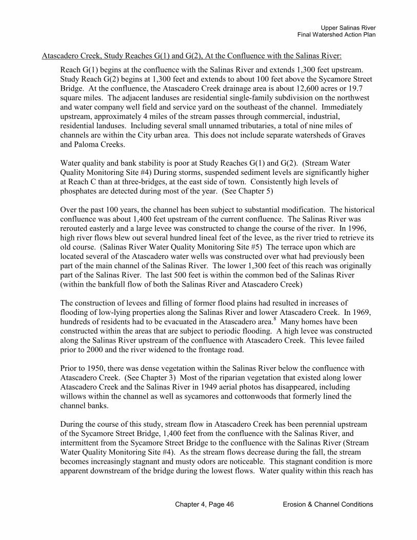
Upper Salinas RiverFinal Watershed Action Plan
Chapter 4, Page 46 Erosion & Channel Conditions
Atascadero Creek, Study Reaches G(1) and G(2), At the Confluence with the Salinas River:
Reach G(1) begins at the confluence with the Salinas River and extends 1,300 feet upstream. Study Reach G(2) begins at 1,300 feet and extends to about 100 feet above the Sycamore Street Bridge. At the confluence, the Atascadero Creek drainage area is about 12,600 acres or 19.7 square miles. The adjacent landuses are residential single-family subdivision on the northwest and water company well field and service yard on the southeast of the channel. Immediately upstream, approximately 4 miles of the stream passes through commercial, industrial, residential landuses. Including several small unnamed tributaries, a total of nine miles of channels are within the City urban area. This does not include separate watersheds of Graves and Paloma Creeks.
Water quality and bank stability is poor at Study Reaches G(1) and G(2). (Stream Water Quality Monitoring Site #4) During storms, suspended sediment levels are significantly higher at Reach C than at three-bridges, at the east side of town. Consistently high levels of phosphates are detected during most of the year. (See Chapter 5)
Over the past 100 years, the channel has been subject to substantial modification. The historical confluence was about 1,400 feet upstream of the current confluence. The Salinas River was rerouted easterly and a large levee was constructed to change the course of the river. In 1996, high river flows blew out several hundred lineal feet of the levee, as the river tried to retrieve its old course. (Salinas River Water Quality Monitoring Site #5) The terrace upon which are located several of the Atascadero water wells was constructed over what had previously been part of the main channel of the Salinas River. The lower 1,300 feet of this reach was originally part of the Salinas River. The last 500 feet is within the common bed of the Salinas River (within the bankfull flow of both the Salinas River and Atascadero Creek)
The construction of levees and filling of former flood plains had resulted in increases of flooding of low-lying properties along the Salinas River and lower Atascadero Creek. In 1969, hundreds of residents had to be evacuated in the Atascadero area.8 Many homes have been constructed within the areas that are subject to periodic flooding. A high levee was constructed along the Salinas River upstream of the confluence with Atascadero Creek. This levee failed prior to 2000 and the river widened to the frontage road.
Prior to 1950, there was dense vegetation within the Salinas River below the confluence with Atascadero Creek. (See Chapter 3) Most of the riparian vegetation that existed along lower Atascadero Creek and the Salinas River in 1949 aerial photos has disappeared, including willows within the channel as well as sycamores and cottonwoods that formerly lined the channel banks.
During the course of this study, stream flow in Atascadero Creek has been perennial upstream of the Sycamore Street Bridge, 1,400 feet from the confluence with the Salinas River, and intermittent from the Sycamore Street Bridge to the confluence with the Salinas River (Stream Water Quality Monitoring Site #4). As the stream flows decrease during the fall, the stream becomes increasingly stagnant and musty odors are noticeable. This stagnant condition is more apparent downstream of the bridge during the lowest flows. Water quality within this reach has

Upper Salinas RiverFinal Watershed Action Plan
Chapter 4, Page 47 Erosion & Channel Conditions
consistently been significantly poorer than at the 3-Bridges monitoring site on Atascadero Creek near the west edge of the City. The stream channel also is much more unstable at this reach.
This reach of Atascadero Creek channel appears to be degrading over time. Army Corps surveys of the channel in 1981 indicated channel bed drop of about 2 feet approximately 300 feet downstream of the Sycamore Street Bridge. Through a process of headcutting, by 1997, that channel drop moved upstream to the southwest side of the Sycamore Street Bridge. In 2002, the head cut began moving upstream of the bridge.
The average slope of the Atascadero Creek reach between the confluence and Sycamore Street Bridge is very flat, averaging only 0.4 percent. The channel downstream of the bridge is less than 0.3 percent slope. At the southerly edge of the bridge, until 2002, there was a two foot tall concrete grade control structure, originally constructed to protect a pipeline. During the storms of the winter of 2001-2002, the grade control structure partially failed. In 2002, the channel began degrading upstream of the Sycamore Street Bridge. This headcut will result in future channel erosion.
In an effort to stabilize this reach, the Atascadero Mutual Water Company, which owns the creek channel north of the Sycamore Street Bridge, has conducted several creek bank restoration projects. In the late 1990’s, they constructed two boulder deflectors along the east bank and installed a short rock riprap structure along the right bank at the middle of a long outside meander curve. In 2000, the Water Company regraded the left and right banks to a 2 to 1 slope and planted riparian vegetation. Later, the CCC and AmeriCorps assisted the Water Company in installing two willow wattles along the toe of the bank and planting willows. (Photos 4.19 and 4.20 show the transition after the banks were graded and planted) Oaks and sycamores were planted along the top of the bank. Due to lack of adequate near-surface groundwater and poor rainfall, much of the riparian vegetation died.
Prior to the bank grading, Reach G(1) was an unstable D-5 type channel and Reach G(2) was an F-5 channel type in this reach. Part of the reach 800 feet upstream of the confluence with the Salinas River is braided. After the banks were regraded within Reach G(1), braiding has decreased and the stream has begun to change to a C-5 channel type. The right bank was graded to a 2 to 1 slope. Due to a desire to retain an existing tree on the terrace, the left channel bank was graded back to a 1 to 1 slope. The channel now meanders within the wide bottom in a sinuous "C" pattern. The channel contains a series of relatively shallow pools, ranging from 0.5 to 2 feet in depth. However, the channel continues to be entrenched. The entrenchment ratio at the 500 foot cross-section prior to the restoration project was 1.15 to 1. After grading of the banks, the entrenchment ratio at this location was increased to 1.24 to 1.
At the 800 foot section, both the right and left bank were graded back to approximately a 2 to 1 slope. Sinuosity prior to the channel restoration in 2000 was low, with at ratio of 1.10 to 1 and entrenchment was moderate at 1.73. Prior to restoration, this reach of Atascadero Creek was a D-5 channel type. It was highly unstable with eroding steep banks. After the grading of the banks, the entrenchment ratio was improved to 1.94 to 1 and the stream has started to stabilize into a single channel. Correspondingly, the sinuosity of the channel has improved to 1.21 to 1. Several gravel bars and small pools have formed. The banks now have a grass cover. Riparian plantings have not been highly successful, due in part to a lack of subsurface water.

Upper Salinas RiverFinal Watershed Action Plan
Chapter 4, Page 48 Erosion & Channel Conditions
Before and After Photos
Photo 4.19Atascadero Creek at the confluence with Salinas River prior to restoration project November 1999Note that banks have no riparian vegetation, they are rapidly eroding and the channel is braided.
Photo 4.20Atascadero Creek at the confluence with Salinas River, March 2001.After bank regrading and stabilization by Atascadero Mutual Water Co.
The channel is no longer braided and erosion has been reduced.

Upper Salinas RiverFinal Watershed Action Plan
Chapter 4, Page 49 Erosion & Channel Conditions
1,300 feet upstream of the confluence with the Salinas River, Atascadero Creek has a sharp left meander turn. This is the point of the historic confluence location, which has since been moved downstream to the current confluence location. This is Reach G(2). Within this meander turn, the channel is very entrenched. At the 1,425 feet cross-section, the channel entrenchment ratio is 1.11 and the banks are very unstable. (See Figure 4.18) Reach G(2) remains a highly entrenched F-5 type channel.. At this point, the left bank is vertical, with a height of about 25 feet. The tall left bank has a potential for collapse. Unless bank stabilization is achieved, severe bank erosion will occur at this location in the future. Sloughing is anticipated. (See also sections and longitudinal profiles at the end of this chapter.)
There are numerous reasons for bank instability including bed degradation, the loss of riparian vegetation, and illegal off-road vehicle use in the channel. OHV’s disturb the bed and trample young riparian plants. Municipal and private wells along the Salinas River corridor may be creating a subsurface trough or depression in the groundwater, leaving riparian vegetation without adequate water to survive. Riparian vegetation on the banks was less than 25 percent prior to 1996. The left bank was vertical and had no vegetative cover upstream of the second boulder diverter prior to the Water Company's restoration project in 2000.
Now, as a result of the grading of the banks and the planting by the Water Company and volunteers, the bank coverage has improved to 75 percent on both the left and right banks. However, most of the new vegetation is fairly shallow rooted. At this time, most of the bank vegetation is grasses. A few willows have taken hold along the toe of the banks, but riparian vegetation remains very sparse. It is recommended that supplemental irrigation be added along the banks in this reach in order to restore the riparian vegetation.

Cuesta Collge Course #1188.200 ASSisted by Amerteorps Atascadero Creek
STREAM CHANNEL MORPHOLOGICAL ANALYSIS
In cooperation with the Atascadero Mutual Waler Commpany
and CalWomla Conservation Corps
E
Cross Section of Atascadero Creek: June 27, 1998 1,425 Feet Upstream from Confluence with Salinas River
Approx. Left Terrace 826 ·~
Ria ht Right Terrace/
f enlnsula 824
822
Renee ....... .00"
\ .o;; , 820
818
E 816 L
.Ov
.Ov \
' .o:: E
814 v .Ofr A T 812 .Ov I 0 N
810 .Ov
808 .o;;
806 .00"
804 .o;;
802 .Ov
800 .Ov 0 10
s tudv Rer., ch C Ci oss Sec ti• n JC ( t rban injl
FrG<j.ed__ - 1 Le~ Ba l'tk-
I 2X~mr
~(2) ~nee)
Ero Rig Bar
I I
.1
B~ / , ....... ~
' h11ildJ
ded / I ho~ ngs
~t /
>
~ ·
r U+#UU~ nRJITlf flO w: ron;b. n. ··-----r· ....... i:;j
I~ I ~
~ I
~ fbw
20 30 40 so 60 70 80 90 100 DISTANCE
No changes apparent as of 2002 survey
Entrenchment Ratio: 1.11 Entrenched
Figure 4.18 View Looking Downstream
Atascadero Creek Longitudinal Profile: June 1998 0·1,630 Feet Upstream from Confluence with Salinas River
>-------Study Reach G ( l )-------<!Study Area G (2( End of 72" (Urban ir,(luence "D" T ype Chmmel) ( Urban influence "F" Channel) D . . Sycamore Street Railroad
rampipe TW 785.66 ws 786.41 Bridge Bridge
793.0~,-~--~-~-~-~-~-~-~-~~-~-~~·-Channe ~931.-~~
Atas! Cr. & Salin s : -< : ; ' <.> I I 792.onDl--+-Rr ;re-on mmde- - ;; ·-+----+-- ; -----r----r----r----i----r---r-.1'......-r---1
: ~ I : cg _ ,_.g --h~rr-;----r---r--o..~v-r--i-r0-1-
-~ - S?i 791.0
L 790.0 E
-!!( , ' Ul --, - ·m--+---·i--+-•
, Ul , "-
-b -(.) .-J.--+--+--r--
0 100 200 300 400 500 600 700 800 900 l 000 11 00 1200 1300 1400 1 500 1600 1700
Slope : 0.3% Sinuosity: 1.05
DISTANCE
Figure 4.19
Chapter 4, Page 50
_.._,,,.. Water Surface
__,,.. Thalweg I Upper Salinas-Las Tablas
Resource Conservation District .

Upper Salinas RiverFinal Watershed Action Plan
Chapter 4, Page 51 Erosion & Channel Conditions
D.2 Other Study ReachesSalinas River at the 13th Street Bridge, Study Reach H, Paso Robles:
The US-LT RCD conducted a morphological survey of the Salinas River in the vicinity of the 13th
Street Bridge. At the bridge, the channel is approximately 500 feet wide from edge of the west terrace to the edge of the east terrace. (See Figure 4.20) The drainage area of Study Reach H is 390 square miles. Within the 2,000 square mile study area, the Salinas River is the second greatest contributor to stream flow to the Lower Salinas River. The Nacimiento River is the greatest contributor to flow within the entire Salinas River Watershed. Present day flows from both the Salinas River and the Nacimiento Rivers are affected by major dams.
The River splits the west and east parts of the City of Paso Robles. In the vicinity of this survey reach, the landuses on the east and west sides of the river are commercial and industrial. The channel banks have been modified by previous grading and some filling both upstream and downstream of this site.
During the course of the study, flow in the Salinas River was intermittent. Typically the channel flows on the surface until mid summer. In 2001, surface flow continued until late fall. During the other years of the study, surface flows disappeared in early or mid summer. After that time, flows are subsurface, until the first significant rains of the following fall or winter. Surface flow is generally very small after the end of spring, with one or more narrow stream flows meandering down the middle of the wide sandy bottom. (Stream Water Quality Monitoring Site #6)
After the San Simeon earthquake, a hot sulfur spring began flowing near City Hall at a rate of almost 1,000 gallons per minute. The City diverted the flow to the Salinas River upstream of the 13th Street Bridge. At the time of the preparation of this report, there were two active channel flows converging at the westerly bridge abutment. One flow is from the watershed upstream of the bridge and the other flow is from the diverted warm sulfur water (over 30 degrees Centigrade).
Flows at Study Reach H can vary dramatically, with storms resulting in flows over 28,000 cubic feet per second (Years 1969 and 1995 per USGS Gaging Station Data, Station No. 11148500). (See Photo 4.21) During storms in 1969 and 1995, the river almost reached the underside of the 13th Street Bridge, a depth of almost 27 feet. After construction of the Salinas Dam, the average annual peak flow at this study site is 6,026 cfs. A 100-year storm is projected by FEMA to have a peak flow of 43,000 cfs, or approximately 51 percent greater than the highest flows recorded at the gaging station near 13th Street.
The Flood Insurance Study for the City of Paso Robles prepared by FEMA in 1981 stated that the natural drainage patterns in Paso Robles had been “altered by urbanization. Runoff has increased due to the increase in impervious surfaces covering the soil. Many drainage channels in the city have been obliterated.” Erosion has been observed at some of the outlets of the drainage culverts along the river bank.
During the 1969 storm flows, roads in Paso Robles were flooded and the underpass on Highway 101 was impassible due to flooding. Many homes were in danger of flooding and some industrial buildings along North River Road were flooded.9 It is estimated by FEMA that floods of the magnitude of 1969 and 1995 would occur “once every 50 to 75 years.” 10

Upper Salinas RiverFinal Watershed Action Plan
Chapter 4, Page 52 Erosion & Channel Conditions
Photo 4.21Salinas River, 13th Street Bridge, after rainstorm, winter 2003
The bankfull flow has been altered by the affect of the Santa Margarita Lake Dam. The lake was constructed primarily to provide a water supply for the City of San Luis Obispo and Camp San Luis Obispo, and not to provide flood protection. While the lake has little affect on flooding, it often reduces peak flows for smaller storms (less than 50-year storms). At this site the bankfull flows are only 2,600 cfs. The channel is highly entrenched. The entrenchment ratio is only 1.13 to 1. Channel slope is 0.2 percent and the sinuosity ratio is 1.14 to 1.
The vegetation analysis indicated that the channel bed and banks had significant riparian vegetationprior to 1950. While much of the previous riparian vegetation is gone from the channel, there has been some improvement over the past ten years. Except for areas affected by recent off-road traffic, bank vegetation is fairly good, with an average of 80 percent ground coverage. This is an improvement from 65 percent bank coverage in 2000. There appears to be a significant reduction in illegal OHV use within the Paso Robles portion of the Salinas River. The reduced off-road use of the channel may be one of the contributing factors to the improvement of riparian vegetation cover within the channel in recent years.
The Salinas River at Reach H appears to be degrading slowly. However, the extent and rate of degradation is difficult to determine. Some of the channel is constrained by levees. Portions of the channel have been converted to urban and agricultural uses. From the City of Atascadero to Bradley, the riverbed is comprised mostly of sand and silts, with a small proportion of gravels and cobbles. The Salinas River at the 13th Street Bridge is a D-5 type braided channel. Both bank erosion and high levels of sediments are problems at this location.

Assisted by AmeriCorps & California Conservation Corps Salinas River
STREAM CHANNEL MORPHOLOGICAL ANALYSIS
Cross Section of Salinas River at Paso Robles 13th Street Bridge: June 1, 2001 645,200 Feet (approx.) Upstream from Confluence with Montery Bay
..-1~HS:~y~\~~I~~~m~~~13~~~s~1. ~sn~·dge~~1~~t~u~d~)~·~· ~l?..~e~a~c~}~z ~ll~~~~~~~~=J 700.00 •
698.00 ' •
696.00 .... - - --t-' -+---+-----+------1r11-:c:-:-'.,--t---:-:---...-----ir----• l .-J 694.00 \ oo Yr. Flood Le11< I ___l 692.00 -+l-\--\---+---t--11--+---Hl==i;;~--------i---•r----- / ---·--+---1
E 690.00 -- --·---;mi--·--t-_,__, --t---1
L 688.00 _ C01,<!1.e-~Bufll~'--lll-~---Hll-------1!------llll---l-----li----+l'----l----E H--.""~~ I 10 Yr. fflood Lev@ , f V 686.00 , ~""""u -i- • t.'lf'~ A~OO , _ ~-
i--~w~=~J=~==;;*l~~?v~•~·-~~~!!!11!.;;lt==;;;;F=_,,r~o___-j---_--jr---T 682.00 ~ I ~ 680.00 -l---t---'-\.~.-+-.... -•--+------'f-•---+---·-ill1 l---!--- -t--+-----+----+----·· N 678.00 ·--,-.. -11 1--~-----'"',t!A-1-i-----+----+-----~__,_kt_u_U-._-1•---+---#--1-----t--------
676.00 '{ •• ••• •••"= •-:_;;,~~••••••• I «>G• <>I•• , • ....._,.
674.00 -1--~-~~"11 .. _+---_- .+.l l ~l.~1~ 'Yl-i!l ..... ~~i--""'-... -.. -:..~-::.iJ;.-l:_:::1..1.:;==.-~j :~:._)l-_~f..!-~_!!!!_!!.!_~_~~-~-~-~-:L-_-_-_-= 672.00 ~~ - r-•---+---+---~4-- Co~t~_n_woo_d--+----+----+----+---+---670.00 - Tha1...,,,___.,. ~low 668.00-·~-_i,,,~~..J.-...!.!!!~lli.--~--J,,,~~...,;,,;:,.;.;._~'---~-'-~~_._~~+--~--+~----1
0.0
View Looking Downstream
50.0 100.0 150.0 200.0 250.0 300.0 DISTANCE
Figure 4.20
Chapter 4, Page 53
350.0 400.0 450.0 500.0 550.0
Entrenchment Ratio: 1.13 *Flood levels and bankful flow affected by Salinas dam
Upper Salinas-Las Tablas Resource Conservation Disbict I
Upper Salinas RiverFinal Watershed Action Plan
Chapter 4, Page 54 Erosion & Channel Conditions
Salinas River at the San Miguel Bridge, Study Reach I, San Miguel:
The US-LT RCD conducted a morphological survey of the Salinas River at the San Miguel Bridge. Study Reach I is 112 miles upstream of Monterey Bay. This is the lowest point that the US-LT RCD surveyed in the watershed. At the San Miguel Bridge, the Salinas River channel is 900 feet wide. The drainage area is approximately 1,500 square miles, which includes both the Upper Salinas Watershed as well as the Estrella River Watershed. The land use on the west side of the river is residential. On the east is agriculture. The river forms the eastern boundary of the town of San Miguel. (See Photo 4.22)
The channel at Reach I is heavily braided. At the cross-section, 618 feet downstream of the bridge, there are four distinct separate channels. (See Figure 4.21) As with the site in Paso Robles, duringthe course of the study, flow in the Salinas River in San Miguel was intermittent. Typically the channel flows on the surface until early summer. After that time, flows are subsurface, until the first significant rains of the following fall or winter. (Stream Water Quality Monitoring Site #7)
Off-road vehicle impact is very evident at this reach, both within the channel and adjacent to the channel. Vehicles were observed in the channel during the entire year. (See Photo 4.23)
At Study Reach I the bankfull flows are only 6,900 cfs. The entrenchment ratio is 1.8 to 1. Channel slope is only 0.1 percent and the sinuosity ratio is 1.1 to 1. The riverbed is comprised mostly of sand and silts. The Salinas River at the San Miguel Bridge is a D-5 type braided channel. High levels of sediments are evident at this location. (See Figure 4.22)
The existing bridge was damaged by storms several years ago. A new bridge is being constructed immediately upstream of the old bridge.
Photo 4.22Salinas River, San Miguel Bridge, winter 2003
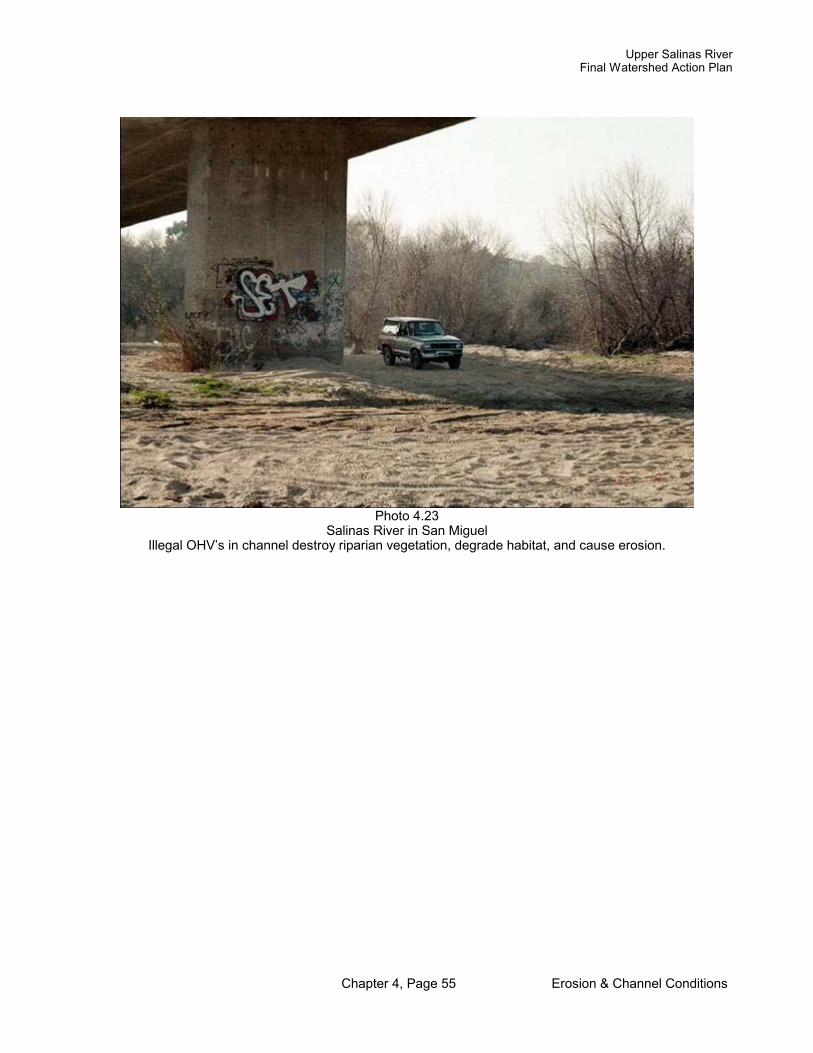
Upper Salinas RiverFinal Watershed Action Plan
Chapter 4, Page 55 Erosion & Channel Conditions
Photo 4.23Salinas River in San Miguel
Illegal OHV’s in channel destroy riparian vegetation, degrade habitat, and cause erosion.

Assisted by NRCS Salinas River STREAM CHANNEL
MORPHOLOGICAL ANALYSIS
Cross Section of Salinas River near San Miguel Bridge: May 20, 2004 593,799 Feet (approx.) Upstream from Confluence with Pacific Ocean
618 Feet Downstream from San Miguel Bridge
640~-~-t-~----r~~r---~--t-~----t-~----t~~-;----~--t-~-t-~~t---~--t--.::
E 630 +---!-~J:-+-~-f----+-~-+----l--+---+---+-..r L E v 620 A T 610 I 0 600~--"""~-.,._-,~--f---+---l!-'e-~~-P'+---+..~~.._, N
590~---+---+--f---+--=----+"==-=~--+---+---+--f---+---+--~--+--+----1
580 -1---t------r--1------t---+· ~ Thaweg Elevation• 5Q1 .7 FeE\t
570 -·~~--~-+-~-+~~+-~-+-~-+~~;--_.;;...;;.-~-+-~-+~~+-~-+---+~__,~--+
0 1 00 200 300 400 500 600 700 800 900 1 000 11 00 1 200 1300 1400 1 500
DISTANCE FROM LEFT BENCHMARK
Entrenchment: 1 .8 Slightly entrenched
Figure 4.21 View Looking Downstream
Longitudinal Section of Salinas River in San Miguel: May 20, 2004 592,819- 594,850 Feet Upstream from Confluence with Pacific Ocean
1598 Downstream -433 Feet Upstream from San Miguel Bridge
' ...... ::-----i--· , o 'H-e--j§ ·r ~ ~~~-~ .. '· : , -c: ' 4> •
r;Lrhl ~ ;~a; ....
595
594 E
L 593 -E v A 592
T I 591 -
0 N 590 ,
589
588
587 592800 1800
Slope: 0.1% Sinuosity: L l
Stur; \' Rec I I
l !
,----~ '
593000 593200 593400 1400 1200 1000
-- --11n ;g ~ (J) ' ·-~,~~ 0'u..('ll
·~ 01 'u;
~~ ~ ·~ ~ ..... , - ~
' ' ' ' I
' ' I
593600 593800 594000 800 600 400
DISTANCE
Figure 4.22
Chapter 4, Page 56
..0· - I igl ~ ~ : :, : -~ i ~ 'f . .~I
i- +~ ·· ' ,· 18 1 1.-.. hi.-"~ ' I r · i-- cotton ood
- v "I
I I
~o stream flow on 5120/04
I I
594200 594400 594600 594600 595000 200 0 200 400 600
_.._,,. Thalweg
Upp~ s.im .. i., T,blu Iii:! Resource Conservation Dishict 6

Upper Salinas RiverFinal Watershed Action Plan
Chapter 4, Page 57 Erosion & Channel Conditions
E Comparison of Longitudinal Profile of Healthy Verses Unhealthy Channels
A healthy meandering channel has characteristics that lend to both stability and healthy conditions for aquatic species. The following examples were chosen from the Little Cholame Creek watershed and Atascadero Creek watershed. Both have similar watershed areas, bankfull flows, and valley slope.
The longitudinal profile from the upper part of Reach B of Little Cholame Creek shows few pools. It is almost one continuous riffle condition. This channel has transitioned from a stable “C” type channel to an unstable “D” braided channel. This has resulted in the stream’s energy being used to erode the channel. As Luna Leopold, former Chief Hydrologist for USGS, stated, “if available stress is greater than the resisting force, erosion will occur.” He and hydrologist David Rosgen have determined that streams and rivers that follow the natural patterns of nature will be more stable. Further, Dr. Leopold states “that curves in river channels are the most probable condition is also indicated by the fact that meandering is the pattern most prevalent in nature.” 11
The meandering pattern, with pools and riffles as well as healthy riparian vegetation, will distribute the energy of storm flows in a manner that reaches a relative state of equilibrium. When the riparian vegetation has been reduced and/or where the natural meandering patterns have been altered, such as is shown in the top diagram, the channel will continue rapid erosion, until a new state of equilibrium is reached.
This reach of Little Cholame Creek is in a state of restoration by the landowner. In an effort to reduce erosion and improve habitat conditions, the owner has planted new willows and restricted cattle from this reach for extended periods of time.
In comparison, the longitudinal profile from Reach F from Atascadero Creek shows a series of pools and riffles. The interval of pool and riffle is an average of 90 feet. There is good riparian vegetation along this reach. This meandering stream has conditions that provide for good aquatic habitat. There is abundant aquatic life in the pools of this reach. (See Figure 4.23)

Comparison of Braided verses Meandering Pool-Riffle Channels Little Cholame Creek: 23,300-23,650 Feet Upstream from Confluence with Cholame Creek
Atascadero Creek: 4,800-5,200 Feet Upstream from Confluence with Salinas River
165S.OO
16S4.00 J
E 1653.00
~ 16S2.00 - '
x 16S1.00 _,
+-------'-------+-----+-- Low Ha~ltat Val ue1
T 1 6SO.OOJ~· . ~=: I ~ LittleCh6. lameCree~. 2 1649.00 '-=--~=---- . _ ownstream _pt Margy bnttg._e ___ +---_ 1648.oo - :·:·:·'· ..... ~ .... .. • March 7, 2001
1647.023300
828.00
827.00
826.00
82s.oo- ·
820.00 ' ' 4800
All distances in Feet
Figure 4.23
233SO 23400
Meandering] Channel with pools and riffles
4850 4900
234SO
49SO
23500 DISTANCE
5000 DISTANCE
23SSO
SOSO
23600 236SO
S100 51SO
Salinas River Watershed MORPHOLOGICAL ANALYSIS
Upper Salinas-Las Tablas Resource Conservation District
23700
5200

Upper Salinas RiverFinal Watershed Action Plan
Chapter 4, Page 59 Erosion & Channel Conditions
F. Conclusions regarding Comparison of Urban Portions of the Watershed and Agricultural Portions of the Watershed:
Significant soil erosion is occurring within both the urban and the agricultural watersheds. Of major consequence to the health of the Upper Salinas River Watershed, widespread channel erosion and upland erosion was evident in both the rural and urban study areas. In addition, high concentrations of suspended sediments were observed during even light rainstorm conditions. However, in general, it was found that water quality issues, channel erosion, and surface runoff containing sediments were greater within the urban areas than rural areas. Channel entrenchment occurs in both the rural streams as well as the urban streams. However, entrenchment was greater in the urban streams. Water quality within urban streams, especially for phosphates, was significantly worse in the urban stream monitoring sites than in the rural sites. (See Chapter 5)
Channel Instability: The stream channels that were surveyed in this report all exhibit conditions of erosion and instability. All have elements indicating that they are out of equilibrium at the current time. Portions of Reach C of Little Cholame Creek, Reaches B and C of Atascadero Creek and the Salinas River Reach at the 13th Street Bridge are moderately to severely entrenched. Reaches A(1), A(2), and B of Little Cholame Creek, Reach C of Atascadero Creek, the Salinas River Reaches at both the 13th Street Bridge and the San Miguel Bridge, and the Estrella River at North River Road are braided. Reaches A(1), A(2), B, and C of Little Cholame Creek, the left banks of Reach B of Atascadero Creek upstream of West Mall Bridge, Reach C of Atascadero Creek, and the Reach at Estrella River all have less than 50 percent riparian bank vegetation. Reaches A(1), A(2), B and C of Little Cholame Creek, Reach B and C of Atascadero Creek, the Reaches of the Salinas River at both the 13th Street Bridge and the San Miguel Bridge, and the Reach of the Estrella River at North River Road have eroding banks and/or channel beds.
Erosion During Periods of No Rain: The agricultural watersheds showed no evidence of soil erosion during periods between rain storms. The urban watersheds had occasional light sediment loads, probably coming from the washing of sands and clays from streets. The probable sources were irrigation water and car washing activities. These loads were negligible and not considered a major source of stream sediments. However, they may carry phosphates and nitrates from fertilizer use. (See Chapter 5).
Erosion During Light Rainstorm Events: The most obvious difference was observed during small storm events. In the agricultural watersheds, small storms did not generate significant sediment within the stream channels, as evidenced by high transparency, low turbidity, and negligible suspended sediment levels. Channel flows were unaffected by small storms within the agricultural areas studied by the US-LT RCD. However, during these storms, the channels within urban areas carried significant levels of suspended sediments. In addition, channel flows increased significantly during even the lightest of rainstorms. Widespread paving and buildings apparently caused runoff, which is carried through gutters and storm drains, directly to the stream and river channels. Both channel bank erosion and upland cleared land appear to the causes of suspended sediment in the channels during light storms. The surveys indicated

Upper Salinas RiverFinal Watershed Action Plan
Chapter 4, Page 60 Erosion & Channel Conditions
that measurable channel bank erosion in the agricultural areas only occurs during heavy rainstorms.
Erosion During Heavy Rainstorm Events: Channel and upland erosion occurs in both urban and agricultural areas during periods of heavy rainstorms. Since rainfall was not evenly dispersed between the urban and agricultural areas, it is difficult to determine if channel erosion is greater in urban or agricultural areas during heavy rainstorms. However, runoff accelerated by impervious surfaces in urban areas noticeably increased stream flows and aggravated unstable channel bank conditions. Upland erosion during heavy rainstorms appeared to be minimal in agricultural areas with widespread vegetation cover.
Channel riparian vegetation has a major impact on channel erosion. The only Reach that had good riparian bank vegetation cover (95% cover over both banks), Reach D(2), showed no significant bank or bed erosion during the study period. (0.01 or less feet change in bank andbed)
Findings:
1. Impervious surfaces in urban areas cause significant runoff and greatly increase channel erosion.
2. Good channel vegetation cover reduces the potential for bank erosion during light and heavy rainstorms.
3. Roads collect and concentrate surface runoff, increasing the potential for soil erosion.4. Upland vegetation cover greatly reduces soil erosion.5. Construction sites are major contributors to surface erosion during rainstorms. Measures to
improve soil percolation, such as the addition of surface mulches and erosion control blankets helps to reduce soil erosion at construction sites.
6. Silt fences and hay bales seldom provided significant protection against erosion or sediment transport to stream channels.
7. Debris in culvert pipes can cause overtopping of the structure and erosion. (See Photo 4.24)8. Riparian plant growth is adversely affected by increased groundwater extraction near the
channels.

Upper Salinas RiverFinal Watershed Action Plan
Chapter 4, Page 61 Erosion & Channel Conditions
Photo 4.24Blocked culverts in the Huerhuero River may cause flooding and erosion.Recent upland vegetation removal has resulted in increased soil erosion.
(Note that some of the soils in this watershed are highly erosive)
G. Sediment TransportAs mentioned in the preceding section, during moderate to heavy rainstorms, the Upper Salinas River Watershed generates a considerable amount of sediment to the streams and rivers. Some of this sediment is normal and necessary for the proper functioning of the streams, replacement of sands, gravels, cobbles and boulders, and for the reestablishment of beach sands along the coast during the late spring. However, when there is excessive sediment, the streams build up layers of silts and sands, chocking fish spawning grounds and reducing the capacity of the channels. This is a particular problem in the area of bridge crossings, since the lack of channel capacity can impair traffic flow and sometimes damage the bridge structure.
Suspended sediment during light rainstorms was rarely observed at the Atascadero Creek 3 Bridges Monitoring Site 2. However, during light rainstorms, suspended sediment often ranged from 0.1 to 0.5 percent of the total stream volume in the urban portions of the streams. Sediment levels during heavy storms sometimes approached 10 percent of the total stream volume.
The generation of sediment in the Upper Salinas River Watershed is complicated by a number of factors. In some instances, sediment transport is blocked by large dams. This occurs along the Nacimiento River at the Nacimiento Dam and the main stem of the Salinas River at the Salinas Dam (Santa Margarita Lake). These dams, as well as other smaller private dams hold back sediment. In

Upper Salinas RiverFinal Watershed Action Plan
Chapter 4, Page 62 Erosion & Channel Conditions
other areas, the upland areas and river channels are experiencing accelerated erosion and generating massive amounts of increased sediment to the streams and rivers. This has been observed in the urban areas as well as the eastern streams such as the Estrella River and the Huerhuero.
Sediment Transport in the Estrella River
The Estrella River has intermittent flows. Some of the tributaries have perennial flows for short reaches (Little Cholame Creek is typically perennial southwest of Parkfield for a short distance). During 2002 and 2003 there was no measured flow in the Estrella at North River Road. However, there were flows in the river during the winter of 2000-2001. During March of that year, the river had significant flows for several days and continued for over a month.
The sediments in the Estrella River were monitored during the storms that occurred on March 5 and 6, 2001. (See Photo 4.3b) The site is upstream of the crossing at North River Road. It is located approximately one mile upstream of the confluence with the Salinas River. During a 23 ½ hour period, samples were obtained and flows in cubic feet per second were determined. For the period from 11:30 a.m. on March 5 to 4 p.m. that same day, the river flow averaged 3,444 cfs. A suspended sediment sample taken at 11:30 indicated 79 cubic centimeters of sediment per 1,000 milliliters (1 liter). At 4:00 p.m. that afternoon, another sample was obtained from the river containing 81 cubic centimeters of sediment per 1,000 milliliters. The transparency of the samples was less than 0.2 centimeters. A 1,000 milliliter sample taken at 11:00 a.m. on March 6th contained 36 cubic centimeters of sediment. The flow had lessened to 1,781 cfs.
During that 23 ½ hour period, it is estimated that 688,000 metric tons of suspended sediment was transported down the Estrella River, into the Salinas River. That translates to about 16 million cubic feet of sediment, enough to cover 372 acres of land one foot deep. The sediment generated from that 23 ½ hour period is enough sediment to cover the Salinas River channel bottom one foot deep for about 7 miles.
H. Causes of Channel and Upland Erosion
There are many causes for increased soil erosion within the Upper Salinas River Watershed. Following is a summary of some of those causes:
Grading, construction and other disturbance of existing drainage flowOften, during grading and/or construction, the existing drainage flow is disturbed. Drainage courses are altered and flows are concentrated. Concentrating surface drainage is a major cause of upland and stream channel erosion. Erosion from grading and construction sites was witnessed throughout the Salinas River Watershed.
RoadsRoads often divert existing drainage, concentrating flows in drainage channels causing erosion. Roads are a major cause of upland and stream soil erosion. (See Photos 4.25 and 4.26)

Upper Salinas RiverFinal Watershed Action Plan
Chapter 4, Page 63 Erosion & Channel Conditions
Photo 4.25An example of poor erosion control. This erosion was caused by the construction of a road.
The US-LT RCD provides guidance to help preventerosion from roads that results in sediment in streams.
Photo 4.26This is an example of a creek clogged with sediment from soil erosion caused by road and improper
use of hay bales in photo above. Erosion control measures are needed to solve this problem.

Upper Salinas RiverFinal Watershed Action Plan
Chapter 4, Page 64 Erosion & Channel Conditions
Lack of vegetationMuch of the riparian vegetation within the Upper Salinas River and tributary channels has disappeared over the past 55 years. Vegetation has many functions. When there is less ground coverage with vegetation, there is increased runoff during storms and less infiltration of water into the ground. Good ground coverage can help the soil in absorbing more of the rainfall. When vegetation is removed, runoff increases. Also, bare ground erodes much more easily than ground covered with vegetation and/or mulch. A key to reducing upland and channel erosion is good vegetative cover.
Impermeable surfacesImpermeable surfaces prevent water from being absorbed by the soil. Paved surfaces and buildings result in increased runoff during storms and less infiltration of water into the ground. Streets, parking lots, driveways and buildings have been constructed within the urban areas of Atascadero, Paso Robles, Santa Margarita, San Miguel, Templeton, Heritage Ranch, and Shandon. Stream flows and sediment levels are significantly higher within urban areas than from agricultural areas. Water that normally would soak into the ground, runs off streets, driveways and rooftops draining quickly into the stream channels.
Off-road vehicle disturbanceUnmanaged off-road vehicle use kills vegetation, compacts soil, creates ruts, which over time results in soil erosion. Erosion caused from vehicles within the Salinas River is particularly evident.
Levees and stream diversionsLevees are usually constructed to protect land and structure from flooding. The natural flooding is restricted to narrower corridors, increasing stream velocities. The increased velocities, in turn, increase scouring of river and stream banks, causing erosion. Erosion was evident near the large levee constructed downstream of the Highway 41 bridge crossing of the Salinas River.
Groundwater extractionGroundwater extraction near rivers and streams usually creates a trough in the subsurface water surface level, limiting the ability of riparian plants to obtain needed moisture. The loss of riparian vegetation along the streams and rivers of the Salinas Valley has resulted in increased soil erosion. It was noted that one of the areas in which riparian vegetation loss was the greatest was along the Salinas River near the Atascadero Mutual Water Company’s domestic water wells.
Water exportationThe surface waters of the Salinas River are impounded at Santa Margarita Lake. A significant portion of that water is exported via pipeline to the City of San Luis Obispo. Also, additional water is lost due to evaporation from the lake. This exportation and evaporation significantly reduces the water available for fish and riparian vegetation downstream of the lake.

Upper Salinas RiverFinal Watershed Action Plan
Chapter 4, Page 65 Erosion & Channel Conditions
1 Statements per landowner Jack Varian2 Rosgen, David "Applied River Morphology,” 19963 Rosgen, David "Applied River Morphology,” 19964 Rose, Christopher, "Little Cholame Creek Description and Recommendation for Stabilization," 19975 Rose, Christopher, "Little Cholame Creek Description and Recommendation for Stabilization," 19976 Electrofish survey, 2000, Jennifer Nelson, CDFG7 “Stream Corridor Restoration: Principles, Processes, and Practices,” USDA, Simon, 19988 Telegram Tribune, San Luis Obispo, January 25, 1969.9 Telegram Tribune, San Luis Obispo, January 25, 1969.10 Flood Insurance Study for City of Paso Robles, Federal Emergency Management Agency, 1981.11 Leopold, Luna “A View of the River.” 1994.

Chapter 5 Water Quality


Chapter 5
Water Quality in the Upper Salinas River Watershed
San Miguel rapidly grew into importance, becoming one of the most prosperous and populous of the missions, though never so wealthy as that of San Luis Obispo. The fathers soon discovered the adaptability of the region for sheep grazing, and brought to it large flocks of these animals, which in course of time increased to many thousands, it being reported that at one time the mission, with its dependent ranchos, was the owner of 91,000 cattle, 1,100 tame horses, 3,000 mares, 2,00 mules, 340 oxen, and 47,000 sheep. The population increased with the material prosperity, and in the height of its power it numbered among its dependents 6,000 Indians, besides the soldiers and civilized people (gente de razon) necessary to have about such an establishment.1
The Missions of San Luis ObispoMyron Angel’s History of San Luis Obispo County, 1883
The Upper Salinas River Valley has been altered dramatically and irreversibly in less than 200 years. Since the arrival of the Spanish, the rise of heavy agricultural usage, population growth, and the resulting urbanization has been a steady and growing impact on the Salinas River. The watershed is under intense pressure as more and more land is irrigated or subject to infrastructure development. Demand for water resources is expanding rapidly and with it, the need to understand the impact of human activity on water quality.
Human demand is not the only cause for inquiry into water quality in the Upper Salinas River, however. As discussed in Chapter 3, this is the largest river system south of San Francisco still supporting an anadromous steelhead trout population. The riparian corridor sustained by the Salinas River supports a diverse wildlife community, some species unique in the United States.
The State of California has noted that water quality in this watershed is threatened. The California State Water Resources Control Board has listed the Salinas River as an “impaired water body,” indicating non-point source pollution impacts on water quality, as per Section 303(d) of the federal Clean Water Act (CWA).2,3 In addition, the Central Coast Regional Water Quality Control Board has identified the Salinas River as a “priority watershed,” a designation applied to watersheds with “documented water quality problems such as groundwater contamination by nitrates, excessive erosion and sedimentation, or pesticides in surface waters.”4
In response to such concerns, and because of the agricultural, economic, and ecological importance of the Upper Salinas River, the Upper Salinas – Las Tablas RCD (US-LT RCD) established its Water Quality Monitoring Program to obtain and evaluate information about the physical, chemical and biological conditions of the surface water, to promote conservation, protection, restoration and wise use of this natural resource. In addition, the US-LT RCD is promoting relationships between governmental agencies and stakeholders to enhancemanagement and conservation of the watershed.

Upper Salinas RiverFinal Watershed Action Plan
Chapter 5, Page 2 Water Quality
A. Characteristics of the Salinas River
The Salinas River is sometimes called the “upside down river” because it flows north toward the Pacific Ocean, while most western rivers flow west or south. It is one of the largest submerged rivers in the United States.5
As a submerged river, the Salinas River and some of its tributaries maintain year round flow. However, as indicated by US Geological Survey maps dating back to the late 1800s, surface flow is intermittent, disappearing in summer months when the river flows underground.
Water quantity is a serious problem in the Upper Salinas River Watershed. Due to exporting of the water from Santa Margarita Lake to the City of San Luis Obispo area, the water released downstream of this dam is a small percentage of the historic flows.6 The amount of water released into the Upper Salinas Watershed cannot support healthy riparian vegetation or terrestrial and aquatic habitats associated with the river. Pollutants in the water could be more concentrated due to the low flows.
US-LT RCD Staff MonitoringAtascadero Creek at West Mall Bridge
The US-LT RCD established the Water Quality Monitoring Program for the Upper Salinas River Watershed in the year 2000, with the collaboration of the Natural Resources Conservation Service (NRCS) staff and trained volunteers. This program was conducted for the State Water Resources Control Board (SWRCB) and the Regional Water Quality Control Board (RWQCB). The Monterey Bay National Marine Sanctuary (MBNMS) provided training, equipment and guidance.
From 2000-2002, the US-LT RCD standardized the methodology of sampling, identified monitoring locations, trained staff and volunteers, evaluated and obtained equipment, and prepared the Stream Monitoring Guide and Quality Assurance Project Plan (QAPP). The QAPP draft was submitted in 2001 to the State Water Resources Control Board for review, and was adopted by them in 2002.
By December 2002, the US-LT RCD acquired equipment to meet QAPP and Central Coast Ambient Monitoring Program (CCAMP) standards, and enlisted the support of the NRCS Water Quality Specialist for the Central Coast region.

Upper Salinas RiverFinal Watershed Action Plan
Chapter 5, Page 3 Water Quality
Insert fold-out map
Upper Salinas RiverFinal Watershed Action Plan
Chapter 5, Page 4 Water Quality
Even page number for fold-out map

Upper Salinas RiverFinal Watershed Action Plan
Chapter 5, Page 5 Water Quality
Monitoring Locations:
The US-LT RCD conducts water quality monitoring at 21 locations within the Upper Salinas River Watershed. Seven sites were selected for monthly monitoring beginning in January 2003. Four locations, situated on ranchland within the Little Cholame Creek watershed, are monitored on a seasonal basis with the help of the property owner. Fifteen locations, including five of the monthly monitoring sites, are included in the annual Central Coast Snapshot Day (Station IDs identifying Snapshot Day locations are given in parentheses in the list of monitoring sites provided below).
USLT-RCD Monitoring Locations Monthly Sites in bold. Snapshot Day Station IDs indicated in parentheses.
1) Tassajara Creek: 3 mi upstream from confluence with Santa Margarita Creek2) Atascadero Creek: Highway 41 at three bridges (309-ATASC-42)
Morphological Study Reach D(1)3) Atascadero Creek: West Mall Bridge in Atascadero (309-ATASC-41)
Morphological Study Reach F4) Atascadero Creek: Confluence with Salinas River
Morphological Study Reach G(1)5) Salinas River: Confluence with Atascadero Creek (309-SALIN- 44)
Morphological Study Reach G(1)6) Salinas River: 13th Street Bridge in Paso Robles (309-SALIN- 47)
Morphological Study Reach H7) Salinas River: San Miguel Bridge (309-SALIN-46)
Morphological Study Reach I8) Rinconada Creek: Pozo Road at 5 mi bridge (309-RINCO-41)9) Salinas River: Highway 58 bridge (309-SALIN-45)10) Trout Creek: Pozo Road at 1 mi bridge (309-TROUT-41)11)Yerba Buena Creek: Highway 58 near Santa Margarita Park (309-YERBA-41)12) Santa Margarita Creek: El Camino Real (309-SMARG- 41)13)Graves Creek: Monterey Road in west Atascadero (309-GRAVE-41)14) Paso Robles Creek: Santa Rita Road in Templeton (309-PASOR- 41)15) Little Cholame Creek: Pine Canyon Confluence
Morphological Study Reach A(2)16) Little Cholame Creek: County Road Bridge
Morphological Study Reach A(1)17) Little Cholame Creek: Varian property fenceline
Morphological Study Reach C18) Little Cholame Creek: San Andreas Fault19) Estrella River: Whitley Gardens (317-ESTRE-43)20) Estrella River: Airport Road (317-ESTRE-41)21) Estrella River: North River Road (317-ESTRE-42)
Morphological Study Reach E

Upper Salinas RiverFinal Watershed Action Plan
Chapter 5, Page 6 Water Quality
A1. Description of Monthly Monitoring LocationsLocations are described in order from southernmost (furthest upstream) to northernmost (furthest downstream) position in the Upper Salinas River watershed. Tassajara Creek and Atascadero Creek are Salinas River tributaries selected for monthly monitoring because they are known Steelhead streams. Area photographs of the monthly monitoring sites are pictured at page 7.
Location 1: Tassajara Creek 3 mi upstream from confluence with Santa Margarita Creekis situated in the southern region of the Upper Salinas River Watershed. Tassajara Creek flows into Santa Margarita Creek, which in turn drains into the Salinas River south of the City of Atascadero. The monitoring site is downstream of a single ranchette, the unpaved rural road leading to it, and the Los Padres National Forest. The ranchette is engaged in small -scale cultivation of native vegetation to restore the riparian vegetation. Downstream, Tassajara creek is surrounded by a small vineyard and ranchettes. Underground groundwater extraction is an impact. This location has good riparian vegetation (See Chapter 3).Location 2: Atascadero Creek at Three Bridges is situated in the central region of the Upper Salinas River Watershed. This site is the furthest upstream and southernmost of the monitoring sites in the Atascadero Creek Watershed, which drains into the Salinas River at the eastern end of the City of Atascadero. It is downstream of a large ranch, small ranchettes, and a few pavedrural roads. Because this stream is located upstream of the southern boundary of the City of Atascadero, it is an indicator of agricultural impact on water quality with no urban influence. However, groundwater extraction is the water source for domestic and agriculture use. This location has good riparian vegetation (See Chapter 3). Location 3: Atascadero Creek at West Mall Bridge is located almost four miles downstream of location 2. The reach between locations 2 and 3 flows through the City of Atascadero, passing through both residential and commercial areas. Comparison of these sites, therefore, indicates changes in the water quality of Atascadero Creek pre- and mid-urban influence. The monitoring location is immediately surrounded by a business neighborhood in Atascadero, adjacent to a Junior-High School and City streets.Groundwater extraction is an impact. This location has riparian vegetation on the left bank that is in the process of disappearing may be to severe erosion of stream banks shown in the surveys for Morphological Study Reach F (See Chapter 3-4).Location 4: Atascadero Creek at the confluence with the Salinas River is located near the northern end of the City of Atascadero, approximately 1 mile downstream of location 3. When Atascadero Creek approaches this monitoring site, it has flowed from the agricultural region of its headwaters through the entire length of the City of Atascadero. This location is stronglyaffected by urban development and channel gravels mining operation. Like Site 2, this location is a useful indicator of the urban impact on Atascadero Creek.Underground groundwater extraction is an impact. The riparian vegetation is very poor, with some small patches of grasses and shrubs (See Chapters 3 & 4).Location 5: Salinas River at Confluence with Atascadero Creek is located in the central area of the Upper Salinas River Watershed. When the Salinas River approaches this monitoring location, it has traveled over 30 miles from its headwaters, flowing through forested, agricultural and urban areas by turn, and passing through Santa Margarita Lake along the way. The monitoring site is located in the City of Atascadero, immediately upstream of the confluence

Upper Salinas RiverFinal Watershed Action Plan
Chapter 5, Page 7 Water Quality
with Atascadero Creek. It reflects similar influences to those of location 4: urban development and channel gravels mining operation. Underground groundwater extraction appears to be a significant impact on this location. This site, and the remaining downstream sites in the Salinas River, are affected by the San Luis Obispo dam (Santa Margarita Lake). The riparian vegetation is very poor, as in location 4 (See Chapters 3 & 4).Location 6: Salinas River at Paso Robles 13th Street Bridge is located in the center of the City of Paso Robles, just over 11 miles downstream of location 5. The site is affected primarily by urban development, more so than by agriculture. This location has an adjacent channel originating from a sulfur spring that erupted in downtown Paso Robles during the earthquake in December 2003. Samples from monitoring site 6 are taken from the natural channel, just upstream from the inflow from the Sulfur spring flow. Groundwater extraction is an impact. This site is affected by the San Luis Obispo dam (Santa Margarita Lake). The riparian vegetation in this channel was scarce in the 1970’s but has partially recovered due in part to restrictions on off-road vehicles enforced by the City of Paso Robles (See Chapter 3 & 4).Location 7: Salinas River at San Miguel Bridge, the northernmost monthly monitoring site, is located in a small agrarian community approximately 10 miles downstream from location 6. The furthest downstream of the seven locations, it is affected by a mixture of urban and agricultural activities. This site is about one mile downstream of the confluence of the Estrella and Salinas Rivers.Underground groundwater extraction is an impact. This site is affected by both the San Luis Obispo dam (Santa Margarita Lake). Flow following the December 2003 earthquake is affected by the sulfur hot springs in Paso Robles. The riparian vegetation is scattered and removed from the river channel. See cross-sectional survey of site in Chapter 4.Note: There is no March 2003 data at this location because of an unexpected equipment failure.
US-LT RCD and NRCS-Hollister StaffMonitoring Location 4

() -:3' Q)
"S?. (!) .., O'I
"'U Q)
<C (!)
00
~ (!) .., 0 c: Q)
~
Water Quality Monitoring Locations
1. Tassajara Creek
4. 5. Salinas River and Atascadero Creek Confluence
2. Atascadero Creek @ 3 Bridges
6. Salinas River@ Paso Robles 13 Bridge
3. Atascadero Creek @West Mall Bridge
7. Salinas River@ San Miguel

Upper Salinas RiverFinal Watershed Action Plan
Chapter 5, Page 9 Water Quality
A2. Little Cholame Creek Monitoring Locations
The Little Cholame Creek watershed intersects with the San Andreas Fault in southern Monterey County. The creek drains into Cholame Creek, which in turn flows into the Estrella River, finally emptying into the Salinas River at the southern end of San Miguel less than a mile upstream of monthly monitoring site 7. The Little Cholame Creek watershed is a ranchland area predominantly used for raising cattle. Alfalfa fields and grasses are grown to support the livestock, which depend on irrigation from wells.
A3. Snapshot Day Monitoring LocationsThe Annual Central Coast Snapshot Day employs over 100 volunteers to monitor water bodies from Pacifica to Morro Bay for basic water quality. The US-LT RCD coordinates monitoring of the fifteen locations situated within the Upper Salinas River Watershed.
B. Parameters Monitored and Results:
B.1. Parameters at the Monthly Monitoring Locations: The Upper Salinas – Las Tablas RCD Water Quality Monitoring Program recorded the parameters discussed below from January to December of 2003 and, to date, from January to June of 2004. At the end of this chapter, data is presented in graphs and tables for all sites with flow, with relevant standards indicated by dotted lines.
The Upper Salinas River and some of its tributaries are intermittent streams. Hence, some locations do not have data in late spring, summer and autumn months, when flow dries up. As mentioned in the description of site 7, data presented for March 2003 is an exception. Thoughthere was flow at this location, there is no data for the Salinas River at San Miguel Bridge in this month because of equipment failure.
Air Temperature: Temperature is a measure of how warm or cool the air is, expressed in degrees Celsius (°C). The US-LT RCD uses an alcohol thermometer to measure this parameter.
Air temperature fluctuates by hour, day and season of the year, and is typically higher than water temperature. When air temperature drops below water temperature, it is generally an indication of thermal pollution. Thermal pollution refers to any alteration to the channel resulting in excessive elevation of water temperature above normal seasonal ranges.7
All seven locations in the Upper Salinas River Watershed follow a seasonal pattern, with temperatures dropping in the winter and rising in the summer. From location to location, air temperature measurements reflect the time of the day. For example, measurements taken early in the morning, at location 1, show lower temperatures than location 7, measured last in the afternoon. In 2003 and 2004, the highest air temperatures were most frequently recorded at location 6, in Paso Robles, and the lowest in location 1, Tassajara Creek.

Upper Salinas RiverFinal Watershed Action Plan
Chapter 5, Page 10 Water Quality
Water Temperature: This parameter is expressed in degrees Celsius (°C) and is measured using an alcohol thermometer and/or YSI Multiprobe.
Water temperatures vary by day and season but fluctuation is more conservative than in air temperature. Water temperature is influenced by wind, air temperature, and the amount of sunlight penetrating a stream or river, which is in turn affected by the density of riparian vegetation shading the stream. Cooler temperatures are more favorable for fish habitat and slow the evaporation process.
According to the United States Environmental Protection Agency (EPA), the optimal water temperatures for salmonids range from 13 °C to 16 °C, but the California Department of Fish & Game (CDFG) suggests that “rainbow trout are known to exist in relatively high temperature regimes, some of which exceed the preferred temperatures for considerable lengths of time (e.g. steelhead in south coastal streams).”8,9 Accordingly, CCAMP reports that in the Central Coast region, “ideal temperatures for steelhead trout are between 13 °C (55 °F) and 21 °C (70 °F).10 In the Upper Salinas River Watershed, Steelhead have been identified in temperatures ranging from8 to 23 °C.
Of the seven monthly monitoring sites in the Upper Salinas River Watershed, Steelhead have been identified in only three locations (1-3). The riparian vegetation at these three sites is in very good condition (see Chapter 3). Correspondingly, the water temperatures recorded in 2003-04are lower than at other sites, falling well within the range necessary for steelhead survival, and often remaining within the EPA’s optimal range. By contrast, vegetative cover is scarcer at locations 4-7, and recorded water temperatures were higher, though still largely within the range necessary for steelhead survival. Although the US-LT RCD has not identified Steelhead at locations 4-7, it does not mean that they are not present. As indicated, locations are monitored consecutively, beginning with locations 1-3 in the cooler part of the day and finishing with locations 4-7 in the warmer afternoon when Steelhead are more likely to seek cover from sunlight and predators.
As mentioned in the description of the monitoring sites, location 6, the Salinas River at Paso Robles 13th Street Bridge, has developed a new adjacent channel originating from a sulfur hot springs that erupted during the earthquake in December 2003. At 9:00 a.m. in May 2004, the US-LT RCD measured a water temperature of 33 °C in this channel immediately upstream of its confluence with the Salinas River. At location 6, in the Salinas River channel immediately upstream of the confluence, water temperature was 25 °C at the same date and time.
pH: Also known as the “potential of hydrogen,” pH is a measure of the concentration of hydrogen ions in the water, which indicates acidity or alkalinity. The pH scale does not have a unit of measurement, but is expressed by a number within the 0-14 range. A reading of 7 is considered to be neutral. A number greater than 7 indicates alkaline or basic conditions while a number less than 7 indicates acidic conditions. pH is measured using a pH tester.
The pH of the water is important because it affects the solubility and availability of nutrients, and how they can be utilized by aquatic organisms. CCAMP uses Central Coast Basin Plan standards

Upper Salinas RiverFinal Watershed Action Plan
Chapter 5, Page 11 Water Quality
for Aquatic Life (Cold and Warm) to monitor pH. These standards allow for a pH range of 7.0 to 8.5.11
pH values for all monthly monitoring locations in 2003 and 2004 varied between 7 and 9. This parameter showed little fluctuation, and remained largely within the optimal range for the survival of aquatic life.
Dissolved Oxygen: This parameter indicates the amount of oxygen dissolved in water, measured in milligrams per liter (mg/L) or parts per million (ppm). The US-LT RCD measures dissolved oxygen using an Oxymeter.
The dissolved oxygen (DO) in water is critical to the survival of various aquatic life in streams, such as fish and macroinvertebrates. The ability of water to hold oxygen in solution is inversely proportional to the temperature of the water. This means that the cooler the water temperature, the more dissolved oxygen it can hold. According to the California Department of Fish & Game, “Steelhead have difficulty extracting oxygen from water at temperatures greater than 70 °F,” or 21 °C.12 DO values are influenced by the production of oxygen during photosynthesis by aquatic plants and phytoplankton, and by the consumption of oxygen during the process of decomposition.
Oxygen levels influence the balance and diversity of the aquatic ecosystem. If the oxygen levels change, so will the composition of the species in the aquatic system.
CCAMP uses Central Coast Basin Plan Standards to monitor DO. These standards allow for a minimum level of 7.0 ppm for Cold Water Fish Habitat, and a minimum of 5.0 ppm for Warm Water Fish Habitat “because of the more tolerant fish communities found in warmer waters.”13
Location 3, Atascadero Creek at West Mall Bridge, presented DO values below 5 ppm in Augustand October of 2003. The rest of the locations stayed within the acceptable range for warm water fish habitat, at or above 5 ppm in both years. Low DO values at Location 3 may result from an insufficient source of phytoplankton and aquatic plants conducting photosynthesis in the water and from the decomposition of algae blooms associated with high nitrate readings (see Nitrates discussion below).
Nitrates-N: Nitrates are a form of nitrogen found in several different forms in terrestrial and aquatic ecosystems. Nitrate is the most oxidized form of nitrogen, and is the primary form of biologically available nitrogen.14 The forms of nitrogen include ammonia (NH3), nitrates (NO3), nitrate-nitrogen (NO3-N) and nitrites (NO2). Nitrates are measured using Nitrate-Nitrogen (NO3-N) HI meter and/or YSI Multiprobe.
Nitrates are very soluble (therefore, mobile) in water, unlike phosphorous. The nitrate level in freshwater is usually found in the range of 0.1 to 4 mg/l NO3-N. Unpolluted waters generally have nitrate-nitrogen levels below 1 mg/l. The Basin Plan objective for drinking water is 10 mg/L nitrate as N, because of risk of Methemoglobinemia. The CCAMP Attention Level for Nitrate as N (NO3-N) is 2.25 mg/l. This value is not regulatory in nature, but is a level at which

Upper Salinas RiverFinal Watershed Action Plan
Chapter 5, Page 12 Water Quality
problems associated with nutrient overenrichment, and hence impacts to aquatic habitat, are common.15
According to CCAMP, “excessive nitrate and resulting nitrite concentrations have been shown to be toxic to aquatic life such as frogs and invertebrates. Excessive concentrations stimulate growth of algae and aquatic plants which can negatively affect creek health. Extensive growth of algae increases decaying vegetative material, resulting in low or fluctuating dissolved oxygen levels. Low dissolved oxygen can be lethal to fish and other aquatic species.” 16
High concentrations of nitrates can also be harmful to humans. Methemoglobinemia (Blue Baby Syndrome) in infants can result from concentrations greater than 10mg/L. Toxicity is the result of reduction NO3 to Nitrite (NO2), which reacts with hemoglobin and inhibits blood cells from delivering oxygen to tissues. Relationships with other health problems, including bladder cancer and non-Hodgkins Lymphoma, have been documented. 17
In March, June and September of 2003, all locations with flow presented values above 2.25 ppm, but below 10 ppm. Nitrate levels at locations 1 and 2 (primarily affected by agricultural areas) and location 3 (primarily under urban influence) show levels well above the Basin Plan Objective for drinking water in December 2003. This is probably the result of first winter storms flushing agricultural soils, roads and other impervious surfaces. Location 4, an urban area, presented levels significantly higher than any other location in January 2003. This is closely correlated to the presence of an algae bloom observed at this site at that time. Perennial algae blooms were observed at location 3, Atascadero Creek at West Mall Bridge, and are probably caused by the relatively high nitrate levels combined with the presence of orthophosphates (see discussion to follow).
In 2004, all locations presented nitrate values below the CCAMP Attention Level for aquatic life survival, except for location 7 in March 2004. In locations 3-7, algae blooms were observed, but less so than in 2003.
Nitrate levels in the Upper Salinas River in San Luis Obispo County are lower than the Salinas River in central and northern Monterey County. Also, when there is flow at all locations, nitrate levels in the Upper Salinas River are generally higher in urban influenced monitoring locations than in locations primarily influenced by agricultural areas. These findings resist trends in central and northern Monterey County, where The Center for Agroecology & Sustainable Food Systems (CASFS) has reported that “the locations of our sampling sites leave little doubt that agricultural practices are a major source of the elevated nutrients recorded at each stream sampled.”18
Orthophosphates (PO4-3): Orthophosphate, phosphorous dissolved in water (also referred to as
total dissolved phosphorus), is challenging to measure because of very low concentrations. Most of the phosphorous in soils is adsorbed to soil particles or incorporated into organic matter.19The US-LT RCD uses a Phosphate-Orthophosphate (P-PO4) HI meter and Reflectoquant (for high values).

Upper Salinas RiverFinal Watershed Action Plan
Chapter 5, Page 13 Water Quality
Phosphate itself does not have notable adverse health effects. However, phosphorous (as orthophosphate) is generally the limiting nutrient in freshwater aquatic systems. If all phosphorous is used, plant growth will cease, no matter how much nitrogen is available. If sufficient phosphorous is available, elevated concentrations of nitrates will lead to algal blooms. Although levels of 0.08 to 0.10mg/l orthophosphate may trigger periodic blooms, long-term eutrophication will usually be prevented if total phosphorous and orthophosphate levels are below 0.5mg/l and 0.05mg/l, respectively. 20
The USEPA water quality criteria state that phosphates should not exceed 0.05 ppm if streams discharge into lakes/reservoirs, and, 0.1 ppm in streams or flowing waters not discharging into lakes/reservoirs to control algal growth.21 CCAMP Attention Level for Orthophosphate as PO4 is 0.37 ppm.22
In urban areas, orthophosphate levels are influenced by domestic and industrial sewage. Formed primarily by biological processes, orthophosphates are contributed to sewage by body waste and food residues. Phosphorous is always present in animal waste because it is essential to metabolism. Orthophosphates can also be contributed by detergents, septic system effluents, fertilizers, development/paved surfaces (runoff), and forest fires which release phosphorus boundto soil particles.23
As with nitrates, orthophosphate levels in the Upper Salinas River Watershed show a reversal of trends from those in the Lower Salinas River Watershed. Contrasting with the central and northern regions of Monterey County, orthophosphate levels in San Luis Obispo County are generally higher in locations reflecting urban influence than in locations situated in agricultural areas.
In 2003, only Site 2 presented Orthophosphate levels consistently below the CCAMP permit limit for the survival of aquatic life. Locations 6 and 7 in April 2003 and location 4 in May 2003 show sharp rises in orthophosphate levels. Locations 4 and 6 are located in urban areas, while location 7 is located in small agrarian town, reflecting a mixture of urban and agricultural influence. These orthophosphate spikes, combined with the presence of nitrates, are correlated with algal blooms observed at these locations.
Orthophosphate monitoring in 2004 has presented startling results. In contrast with 2003, all seven monitoring sites have values well below CCAMP permit levels every month through June, the most recent monitoring month at the writing of this report. Nitrate levels show a parallel but less pronounced pattern, with 2004 levels markedly lower than values recorded in 2003. The US-LT RCD has hypothesized a potential cause for the dramatic difference in nutrient values between 2003 and 2004. The year 2004 is the most severe of three consecutive drought years in the Upper Salinas River Watershed. Generally, we expect lower flows to raise concentration of nutrients, but 2004 shows the opposite trend. Perhaps rainfall volume has dropped below a necessary threshold required to flush nutrients from the upland (non-channel) areas of the watershed. If this speculation is correct, we expect nitrate and orthophosphate levels to be higher than normal in coming years.

Upper Salinas RiverFinal Watershed Action Plan
Chapter 5, Page 14 Water Quality
Turbidity: Turbidity is a measure of the clarity of the water. It is the amount of solids suspended in the water. Solids can be in the form of minerals or organic matter. It is a measure of the light scattering properties of water, thus an increase in the amount of suspended solid particles in the water may be visually described as cloudiness or muddiness. 24 It is used to indicate water quality and filtration effectiveness (e.g., whether disease-causing organisms are present).25 Turbidity is measured in Nephelometric Turbidity Units (NTU) using a YSI Multiprobe and/or Hach 2100P Turbidimeter.
Turbidity levels as low as 25 Nephelometric turbidity units (NTU) have been reported to cause a reduction in juvenile steelhead growth. During winter, high turbidity values likely have an effect on the feeding of juvenile steelhead, with probability of damage to fish and other aquatic life increasing with longer duration of high turbidity.26
The CCAMP Attention Level for turbidity is set at 10 NTUs. The EPA Standard for Drinking Water requires less than 1 NTU.27
In 2003, all monthly monitoring locations measured below the CCAMP Attention Level. In 2004, all locations remained below except for locations 1, 2, 3 and 6 in the month of February. However, February 2004 data was gathered during a storm. According to CCAMP, “turbidity levels over 10 NTUs during storm events are not necessarily problematic.”28
Conductivity: Conductivity is measur ed in microSiemens (µS) or micromhos/cm (µmhos/cm), which are equivalent, using a TDS Tester 3 and/or YSI Multiprobe.
Conductivity is a measure of water’s ability to carry an electric current. Aquatic organisms require a relatively constant concentration of the major dissolved ions in the water, much as we required relatively constant concentrations of certain dissolved ions in our blood and other bodily fluids. Levels too high or too low may limit survival, growth or reproduction.29
The EPA reports a conductivity range of 150 to 500 µS for streams supporting good mixed fisheries.30 Only location 1, Tassajara Creek, consistently presented conductivity values within this range in both 2003 and 2004. Location 2 remains within range for the majority of months with flow in both years, gradually rising above 500 µS by July of 2003 and by May of 2004 , and drying up shortly thereafter.
All other sites never drop below 500 µS in either year, barring the month of February 2004. In this month, monitoring was completed mid-storm, and all sites with flow were within the EPA’s suggested range. Generally, TDS and conductivity show a direction relationship; as TDS rises, conductivity will also rise. However, in February 2004, the results were opposite. While conductivity dropped to 238-370 µS, TDS rose to 240-557 g/L. Though TDS and conductivity are related properties, the U.S. Geological Survey Water Resources in Kansas states that “this is not a simple relation; it is dependent on the ions present in the water. During high flows when a larger percentage of streamflow originates from precipitation than from ground water, the relation could change.”31 In a hard rain, for instance, concentration may decrease due to dilution

Upper Salinas RiverFinal Watershed Action Plan
Chapter 5, Page 15 Water Quality
by the increased volume of water even though dissolved and particulate solids are flushed into the stream.
TDS: Total Dissolved Solids (TDS) is measured in ppm using a TDS tester and/or YSI Multiprobe.
Dissolved solids can include both inorganic and organic matter dissolved in water. Most of the TDS of natural waters is comprised of inorganic compounds – minerals as opposed to the organic compounds derived from organisms. Although there are at least traces of many elements, the great majority of the TDS load is from four negative ions (bicarbonate, carbonate, chloride, sulfate) and four positive ions (calcium, magnesium, sodium and potassium). Since water collects a variety of solids, both dissolved and particulate, as it travels across the rocks and soils of a watershed toward the channel, the amount carried in streams increases during storms events, when sediments are washed from roads, parking lots, and other sources.32
The CCAMP Attention Level for TDS is 0.500 g/L.33 The Central Coast Basin Plan Objective for the Salinas River above Bradley is 0.250 g/L.34
Reflecting this trend, the highest TDS values in the Upper Salinas River Watershed were found in March and November of 2003, and in February of 2004, corresponding with the winter storms in this region. February 2004 TDS levels, recorded literally mid-storm, are far higher than in any other month, with values ranging from 240 to 557 ppm, as compared to the next highest value of 3.26 ppm in November 2003 following the first winter storm.
Locations 1 and 2, the two monitoring sites without urban influence, are the only streams that remain largely under the CCAMP Attention Level, though both sites show elevated levels during storm months. Location 1 presented the lowest values, often at or below the Central Coast Basin Plan Objective for the Salinas River above Bradley. All other locations were frequently above the CCAMP Attention Level, with values generally higher in 2004 than in 2003.
Sediment Cone: Sediment Cone is measured in cm/1000ml using an Imhoff Cone. An Imhoff Cone is a transparent, graduated, conical container used to measure the volume of settleable solids in a specified volume of water. Settleable solids are the particulates that settle out of a still fluid.
The Sediment Cone is primarily valuable for measuring sediment loads of storm flows. In the Upper Salinas River Watershed, stream flow clears rapidly once a storm passes. However, as demonstrated by the values recorded mid-storm in February 2004, stream flows at urban-influenced monitoring sites accumulate significant sediment loads in the midst of storms. Site 6,Salinas River at Paso Robles, 13th Street Bridge, presented the highest storm value, 6.0 cm/1000mL, followed by Site 5 (1.80 cm/1000mL) and Site 4 (1.50 cm/1000mL).
Transparency – Secchi Disk: This parameter is a measure of the clarity of the water in cm/1000ml using a column Secchi Disk. It is a measure of how deep an individual can see into the water, using a disk painted in alternate black and white quadrants. The depth where the disk disappears and reappears is the Secchi disk reading.

Upper Salinas RiverFinal Watershed Action Plan
Chapter 5, Page 16 Water Quality
Results from the Secchi Disk are closely related to those of the Imhoff Cone, since sediment loads impede clarity of water. Hence, all locations presented a value of 60 (indicating completely transparent water) in both 2003 and 2004, except for February of 2004, when high sediment loads clouded the water. Location 6, Salinas River at Paso Robles 13th Street Bridge had the lowest level of transparency (2.0 cm/1000mL) in this month, followed by location 5 (8.20 cm/1000mL), location 4 (9.00 cm/1000mL) and location 3 (17.30 cm/1000mL). Locations 1 and 2, which both exclude urban influence, maintained a Secchi Disk reading of 60 even during storm flows.
Vegetation Canopy: Vegetation canopy is measured using a modified concave spherical densiometer. The densiometer consists of a concave mirror surface with etched grid that reflects vegetations and other obstructions to sunlight over the stream surface. The grid is modified by enclosing 17 grid intersections with tape.35
The EPA reports that “loss of riparian vegetation and increases in channel cross-section length increase the water surface exposed to sunlight. Warming of the stream, especially during periods of low flow, can be large and abrupt. Even short duration high temperatures can decimate salmonids if they exceed the lethal limits.” 36
Quarterly stream evaluations have been completed on January, April, July and October of 2003 and 2004 to assess riparian vegetation in the Upper Salinas River Watershed. This chart represents the data recorded in the field with discussion to follow. For more in-depth discussion of riparian vegetation, see Chapter 3 and Chapter 4.
Locations 1 and 2 have the best riparian vegetation, probably correlated to low water temperatures throughout the summer months, as well as low sediment loads in both 2003 and 2004. Steelhead have been identified at both these locations, as well as newt salamanders at location 2.
Location 3 has good riparian vegetation but it is subject to frequent disruption by human traffic through the stream channel because of the site’s proximity to a Junior High School. This location is also impacted by severe erosion stretching half a mile upstream (see discussion in Chapter 4).
Locations 4 and 5 are both situated within 100 yards of a structure housing domestic wells managed by the Atascadero Mutual Water Company. Numerous additional private wells line the channel downstream of this area. Depletion of groundwater resources has negatively impacted the survival of riparian vegetation and all associated habitats. Vegetation furthers suffers from disruption by horseback riding and off-road vehicle use.

Upper Salinas RiverFinal Watershed Action Plan
Chapter 5, Page 17 Water Quality
Estimated Canopy Vegetation at Locations 1-7
% Bare soil % Vegetation ground coverage % Vegetation canopy cover
2003 2004Location
Jan Apr Jul Oct Jan Apr Jul Oct
10 0 0 0 10 0
90 100 100 100 90 100
1Tassajara
Creek
70 90 100 95 80 100
15 25 5 15 15
85 75 95 85 85
2Atascadero
Creek
at 3 Bridges 70 90 95 70 90
30 30 20 30 20 25
70 70 80 70 80 75
3Atascadero
Creek at
West Mall 50 60 80 70 70 80
70 75
30 25
4Atascadero
Creek at
Confluence 0 0
70 70 80
30 30 20
5Salinas River
Atascadero
Confluence 0 0 0
40 30 35 30 35
60 70 65 70 65
6Salinas River
Paso Robles
20 50 75 60 60
90 85 90
10 15 10
7Salinas River
San Miguel
0 0 0

Upper Salinas RiverFinal Watershed Action Plan
Chapter 5, Page 18 Water Quality
Location 6 also has City and private wells in its vicinity. However, riparian vegetation at this site has recovered significantly in recent years. The City of Paso Robles is working to restore and enhance the Salinas River within city limits, and has been successful at excluding off-road vehicle use in the channel.Location 7 is also impacted by groundwater extraction from wells, as well as heavy off-road vehicle traffic. Riparian vegetation at this site is intermittently dense or non-existent (see cross-section of Morphological Study Reach I ). The channel of the Salinas River in 2003 and 2004 was located approximately 50 yards from the riparian vegetation, exposing the river to full sunlight in all seasons. Tadpoles have been identified in late winter and early spring.
Flows: Flow refers to the quantity of water that moves past a fixed point during a specified interval of time. It is measured in cubic feet per second (ft3/sec) using a Flowmeter.
Stream flow affects water quality, living organisms, and habitat. Large, rapid flows can discharge greater volumes of pollution with less impact on the stream, while smaller streams are less able to dilute and degrade wastes.37
In 2003 and 2004, the water quality monitoring locations were markedly affected by climate conditions. The winter of 2003-04 was the most severe dry winter of three consecutive drought years. Last year, in 2003, lack of rain meant flow had completely dried at locations 5, 6 and 7 byMay. Surface flow at location 4 dried in June 2003, and location 2 dried in August 2003 (See pictures on page 23 and 24). Following winter storms, stream flow resumed at location 2 in December 2003, followed by location 6 in January 2004, locations 4 and 5 in February 2004 and location 7 in March 2004.
Flow periods in 2004 have been of a still shorter duration than in 2003. By May of 2004, stream flow had completely dried at locations 2, 4, 5 and 7. Curiously, location 6, the Salinas River at Paso Robles 13th Street Bridge, continues to have flow through the month of June, though it was dry by May in 2003, and though location 5, located upstream, has been dry since May of 2004.
US-LT RCD Staff Monitoring Flows in Salinas River at Paso Robles 13th Bridge
Diverse factors impact stream flow. Amongst natural factors are amountand timing of rainfall, watershed topography and size, geology, suspended sediment and vegetation profile.
Human factors also impact flow. These include groundwater extraction, water diversion, impervious surfaces, dams, culverts and other structures, as well as litter and debris which can obstruct pipes and culverts. 38

Upper Salinas RiverFinal Watershed Action Plan
Chapter 5, Page 19 Water Quality
This may be due to geological shifts that occurred during the December 2003 earthquake. Modifications in groundwater and stream flow patterns have been widely reported in the Upper Salinas River Watershed following the earthquake. These local reports suggest that new springs have appeared since the earthquake, adding to the flow of the Salinas River.
Locations that maintain perennial flows are more common in the portions of the Upper Salinas River that are situated upstream of the City of Atascadero. Groundwater extraction is associated with the lack of flows and loss of riparian habitats further north in the watershed.
The following charts illustrate the streams flows for the seven monthly monitoring locations. February 2004 had the highest flows because the monitoring was conducting during a heavy rain storm. Characteristically, flows decrease significantly during the summer and fall months at all locations. The site located highest in the watershed, Location 1 – Tassajara Creek has the most consistent flows during the entire year.
Perennial flows sustain lush habitat in the Salinas River south of Atascadero

() ~ Q)
-g. (1) .., 01
1J Q) cc (1)
"' 0
~ (1) .., 0 c: ~ ~
10.00"
9.00"
8.00"
7.00
F 6.00"
L s.oo· 0 w 4.00
3.00
2.00"
1.00
0.00"
Jan
2003-2004 Flow Levels in Cubic Feet per Second Site 1: Tassajara Creek at end of Tassajara Creek Road
Feb Mar Apr May Jun Jul Aug Sep Oct Nov Dec Jan Feb Mar Apr May
2003 MONTH/YEAR 2004
Tassajara Creek STREAM FLOW ANALYSIS

Atascadero Creek 2003-04 STREAM FLOW IN CUBIC FEET PER SECOND
50.00 45.00 40.00 35.00
F 30.00 6 25.00 w 20.00
F L 0 w
15.00 10.00
5.00 0.00
50.00 45.00 40.00 35.00 30.00 25.00 20.00 15.00 10.00
5.00
SITE 2: Three Bridges on Highway 41 West ------------------
2003- - - - ·--- -- 2604---
----~~
O'I ~- > 0 :::1 G.I 0 0 G.I < 00 0 z 0
MONTH
SITE 3: West Mall Bridge
-1-------2003~------------- A :
::'::::'::=::::::::::==---
-~
200-4 /\.---------- ----------------.. -rr~-.-......---- -.
-------~,
0.00 _..,.._....,...._~'""'-T-'--'--r'---Y"--'...,.._--'-T~~---i.~ ........ =~....,_..---..,-.>-,..-O-,...__...,._~.......,...__...,...__._,~~==-G.I - G.I 0 0 G.I G.I '"O ~ J < oo o z o ~ E
MONTH
SITE 4: Confluence with Salinas River 50.00 -------------200-4-·--45.00 40.00 35.00
F 30.00 -+-------~200·~----------L 25.00 0
20.00 w 15.00 10.00
5.00 0.00
O'I ~ -:::1 G.I 0 < 00 0
MONTH
Chapter 5, Page 21 Water Quality

Salinas River 2003-04 STREAM FLOW IN CUBIC FEET PER SECOND
SITE 5: Confluence with Atascadero Creek 100.00 - ---------------90.00 -+----------2-00_ 3 _ ________________ _ 80.00 --1---------___..._A __2Q_QA__ 70.00 . _-----------
F A L 60.00 ..,..-----= --------~-----------0 50.00 ,L-- ~ w 40.00
30.00 20.00 10.00
-------·--
0.00 - c .,, '"")
:; g ~ 1) '"") < (J) 0
MONTH
> 0 z
() Q.o
0
SITE6: 13th Street Bridge in Paso Robles 100.00 90.00 ---------2003.-80.00 70.00
F 60.00 L 50.00 0 w 40.00 e6ruary 2"00~
30.00 Storm Flow- ·· 20.00 500-6ttbi 10.00 Feet/Seeoflet
0.00 c .0 lo.. ,... :::r> c :; o> Q. - > () c .,, GI .,, Q. .,, :i ::i Q.o () 0 Q.o .,, ...., LI. I: < I: ...., '"") < (J) 0 z 0 '"")
MONTH
SITE?: San Miguel Bridge 100.00 ---
90.00 -------2-00:3 80.00 70.00
F 60.00 .,---=::. L 50.00 0 w 40.00
30.00 20.00 -
10.00 - ------
0.00 ::1> c :; o> Q. - > () c .,, ::i ::i Q.o () 0 Q.o .,,
I: ...., ...., < (J) 0 z 0 '"")
Chapter 5, Page 22
2004
.0 Q.o
LI.
2004 A ~
.0 lo.. ::1> Q.o Q. .,,
LL < I:
Water Quality

() =1" Q)
~ .., (1'I
"'U Q) (Q CD I\) (..)
~ CD" .., 0 c: ~ ~
Atascadero Cr @ 3 Bridges (L2)
Atascadero Cr@ Confluence with Salinas River (L4)
Summer 2003
-.~ ~~-4. •4•
• '.'21. ~
..... ' ~ ' . .. . -'(~" Salinas River@ Atascadero (LS)
Salinas River@San Miguel (L7)

G ~ Q)
"S <1> ~
!"' ""CJ Q)
<O <1>
"' ~
~ !la. <1> ~
0 c Q)
~
Spring 2004
Atascadero Cr@ Confluence with Salinas River (L4) Salinas River@ Atascadero (LS)
Salinas River@ San Miguel (L7)
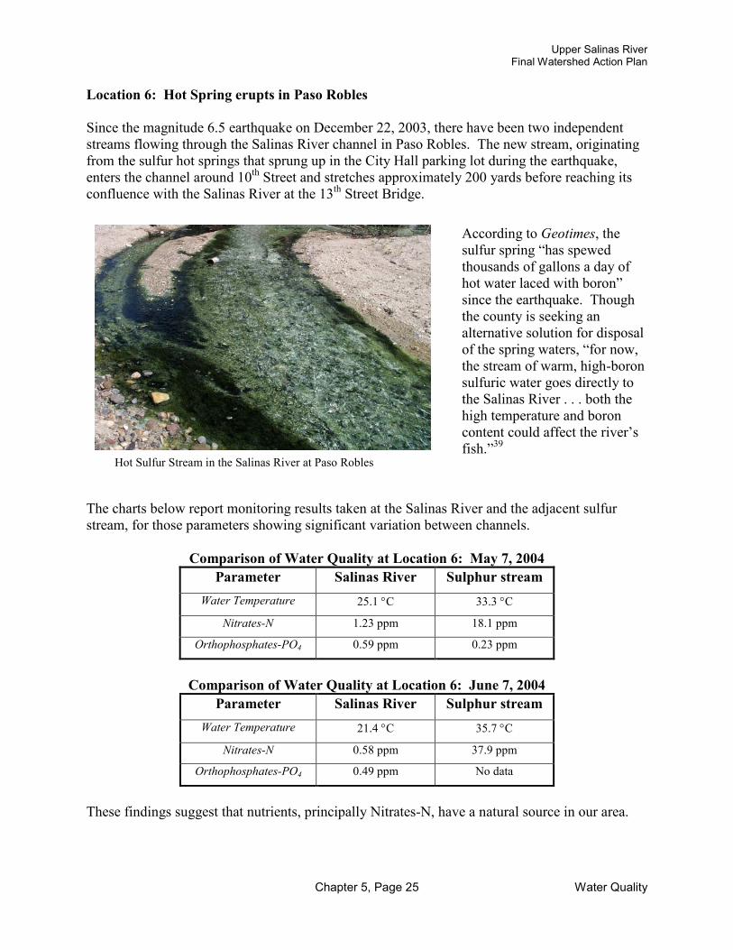
Upper Salinas RiverFinal Watershed Action Plan
Chapter 5, Page 25 Water Quality
Location 6: Hot Spring erupts in Paso Robles
Since the magnitude 6.5 earthquake on December 22, 2003, there have been two independent streams flowing through the Salinas River channel in Paso Robles. The new stream, originating from the sulfur hot springs that sprung up in the City Hall parking lot during the earthquake, enters the channel around 10th Street and stretches approximately 200 yards before reaching itsconfluence with the Salinas River at the 13th Street Bridge.
The charts below report monitoring results taken at the Salinas River and the adjacent sulfur stream, for those parameters showing significant variation between channels.
Comparison of Water Quality at Location 6: May 7, 2004Parameter Salinas River Sulphur stream
Water Temperature 25.1 °C 33.3 °C
Nitrates-N 1.23 ppm 18.1 ppm
Orthophosphates-PO4 0.59 ppm 0.23 ppm
Comparison of Water Quality at Location 6: June 7, 2004Parameter Salinas River Sulphur stream
Water Temperature 21.4 °C 35.7 °C
Nitrates-N 0.58 ppm 37.9 ppm
Orthophosphates-PO4 0.49 ppm No data
These findings suggest that nutrients, principally Nitrates-N, have a natural source in our area.
According to Geotimes, the sulfur spring “has spewed thousands of gallons a day of hot water laced with boron” since the earthquake. Though the county is seeking an alternative solution for disposal of the spring waters, “for now, the stream of warm, high-boron sulfuric water goes directly to the Salinas River . . . both the high temperature and boron content could affect the river’s fish.”39
Hot Sulfur Stream in the Salinas River at Paso Robles

Upper Salinas RiverFinal Watershed Action Plan
Chapter 5, Page 26 Water Quality
B2. Little Cholame Creek Monitoring Locations:
Monitoring of the Little Cholame Creek began in 2003. However, since 2002, there has been no extended flow in three (Sites 15-17) of the four monitoring locations. The remaining location,Little Cholame at San Andreas Fault (Site 18), is the only location within the Little Cholame Watershed with running water year around. This location has an adjacent channel originating from a sulfur spring that erupted during the earthquake in December 2003.
Orthophosphate was above the CCAMP attention level (<0.37 ppm) on May 2003 and 2004, but Nitrates were under the attention level.41
Water Quality Monitoring Data at Site 18: Little Cholame Creek at San Andreas Fault
Data
Air Tem
p.( °° °°C)
Water Tem
p.( °° °°C)
pH
Diss
olved Oxy
gen
(ppm
)
Nitr
ates-N
(ppm
)
Ortho
-pho
spha
te(ppm
)
Turb
idity
(NTU
)
Con
ductivity
(µS)
TDS
(ppm
)
Sedimen
t Coe
cm/100
0 ml
Secchi Disk
(cm/100
0 ml
5/20/03 35.00 23.20 7.78 10.50 1.20 6.00 0.00 1575.00 1.03 0.00 60.002/06/04 8.00 8.00 8.30 9.00 0.20 0.28 1.40 630.00 6.00 0.00 60.005/07/04 32.00 20.00 7.71 8.00 1.30 0.70 2.00 1542.00 1.00 0.00 60.006/07/04 22.00 19.67 7.62 7.00 0.86 0.27 0.90 1535.00 0.99 0.00 60.00
1: Little Cholame Creek @ San Andreas Fault2: Sulfur Stream adjacent to Little Cholame Creek
1 2
Prior to 2004, monitoring at Site 18 was completed only during scheduled meetings with the ranch owner to provide technical assistance in grassland and cattle management. Hence, there is only one data set presented for 2003.
In general terms, the parameters measuredat Site 18 satisfied water quality standards,except for conductivity. The EPA suggests conductivity values between 150 to 500 µS for stream fish habitat.40 In this location the values were always above of 500 µS, indicating that the geology of the area, in continuous movement because of the San Andreas Fault, is a probable source of mineral ions and dissolved solids in the stream water.

Upper Salinas RiverFinal Watershed Action Plan
Chapter 5, Page 27 Water Quality
B3. Snapshot Day Monitoring LocationsThe data results showed that most of the parameters met water quality standards . The conductivity parameter, however, was above 500 µS in 10 locations for 2001 and 2002, and in 9 locations for 2003. Hence, these values were above the range suggested by EPA (150 to 500 µS) for streams supporting fish habitats.42
Values of Dissolved Oxygen in general were within range in all locations, except for location 11 in Yerba Buena Creek for 2002 and 2003, where they were substantially below the range suggested by CCAMP for warm and cold water fish habitat.43Values of pH in all locations were within the range suggested by Central Coast Basin Plan Standards, except for location 20 in 2001.44Nitrates were between the range suggested by CCAMP for aquatic habitats, but locations 6 in 2001 and 7 in 2001 and 2003, presented values above this range.45
Snapshot Day data is presented in a table that follows the monthly monitoring tables and graphs.
Conclusion
This Water Quality Monitoring study is an ongoing project for the US-LT RCD. The monitoring results discussed in this chapter indicate that while the Upper Salinas River Watershed continues to be a rich source of natural resources for our community, it is threatened by a variety of factors. Problems such as high levels of nutrients, water quantity, loss of riparian vegetation, resultant water temperature elevation and increased sediment loads threaten valuable habitat from the headwaters of the Salinas River through to the Monterey Bay National Marine Sanctuary.
Studies of the Salinas River Watershed have tended to emphasize the Lower Salinas River to the exclusion of the Upper Salinas River. However, our monitoring results suggest that the conditions and behaviors of the Upper Salinas River Watershed are unique from the Lower Salinas. More research is crucial to accurate assessment and effective solutions. As mentioned already in this chapter, the negative impact of agricultural land use, relative to urban use, appears to be greater in the Lower Salinas River Watershed than in San Luis Obispo County. Overlooking such differences could prevent us from properly understanding and addressing water quality issues in the Upper Salinas River.________________________________________________________________________
1. Myron Angel, History of San Luis Obispo County (San Luis Obispo, CA: EZ Nature Books, 1986), 36.
2. Mary Bianchi, Alison Jones, John Harper, Priority Watersheds, Farm Water Quality Planning (FWQP) series, FWQP Reference Sheet 8.4 (Oakland, CA: Regents of the University of California, Division of Agriculture and Natural Resources, 2002 [cited 28 June 2004]), 1; available online from http://anrcatalog.ucdavis.edu/pdf/8074.pdf.
3. “TMDLs and Impaired Water Bodies,” in Surfrider Foundation’s Education Coastal A-Z [Surfrider web site] (San Clemente, CA: Surfrider Foundation [cited 28 June 2004]); available from http://www.surfrider.org/a-z/tmdl.asp.

Upper Salinas RiverFinal Watershed Action Plan
Chapter 5, Page 28 Water Quality
4. Central Coast Regional Water Quality Control Board, 2002 CWA 303(d) List of Water Quality Limited Segment (California Environmental Protection Agency, State Water Resources Control Board, July 2003) [cited 28 June 2004]; available online from http://www.swrcb.ca.gov/tmdl/docs/2002reg3303dlist.pdf
5. Anne B. Fisher, The Salinas, Upside Down River, (Fresno Valley Publishers, 1977) quoted in US-LT RCD, Watershed Fisheries Report and Early Actions – A Study of the Upper Salinas River and Tributaries(Templeton, CA: US-LT RCD, 2002), I-1.
6. US-LT RCD, Watershed Fisheries Report and Early Actions – A Study of the Upper Salinas River and Tributaries (Templeton, CA: US-LT RCD, 2002), III-19.
7. “Thermal Pollution” in BPA Definitions: Bonneville Power Administration Publications [online dictionary: cited 27 June 2004]; available from http://www.bpa.gov/corporate/pubs/definitions/tuv.cfm2.
8. Water Division of the U.S. Environmental Protection Agency, Monitoring Protocols to Evaluate Water Quality Effects of Grazing Management on Western Rangeland Streams (Moscow, Idaho: Idaho Water Resources Research Institute, 1993), 66.
9. California Department of Fish and Game, Steelhead Restoration and Management Plan for California (Sacramento, CA: Department of Fish and Game, 1996), 26.
10. Central Coast Ambient Monitoring Program Watershed Monitoring Data [database online] (“Information on Water Temperature (° Celsius)” in Region 3: Water Temperature [cited 27 June 2004]); available from http://www.ccamp.org/ca/3/Cwq/H2O_TEMP_H2O.htm.
11. Ibid., (“Criteria Exceedance (CRIT)” in Region 3: pH Units [cited 27 June 2004]); available from http://www.ccamp.org/ca/3/Cwq/PH_H2O.htm.
12. California Department of Fish and Game, 26.
13. Central Coast Ambient Monitoring Program Watershed Monitoring Data [database online] (“Criteria Exceedance (CRIT)” in Region 3: Oxygen, Dissolved mg/L [cited 27 June 2004]); available from http://www.ccamp.org/ca/3/Cwq/DO_PPM_H2O.htm.
14. Ibid., (“Information on Nitrate as N (mg/l)” in Region 3: Nitrate as N mg/L [cited 27 June2004]); available from http://www.ccamp.org/ca/3/Cwq/NO3_N_H2O.htm.
15. Ibid., (“Criteria Exceedance (CRIT)” in Region 3: Nitrate as N mg/L [cited 27 June 2004]); available from http://www.ccamp.org/ca/3/Cwq/NO3_N_H2O.htm.
16. Ibid., (“Information on Nitrate as N (mg/l)” in Region 3: Nitrate as N mg/L [cited 27 June 2004]); available from http://www.ccamp.org/ca/3/Cwq/NO3_N_H2O.htm.
17. Ibid.
18. Marc Los Huertos, Lowell Gentry, and Carol Shennan, “Land Use and Water Quality on California’s Central Coast: Nutrient Levels in Coastal Waterways” in University of California eScholarship Repository [online library] (University of California, Santa Cruz: The Center for Agroecology and Sustainable Food Systems, 2003, 4[cited 27 June 2004]); available from http://repositories.cdlib.org/cgi/viewcontent.cgi?article=1000&context=casfs.
19. Natural Resources Conservation Service (Hollister, CA) of the USDA, “Evaluating Water Quality” (Hollister, CA: NRCS, 2002), Farm Water Quality Planning: Phosphorous.
20. Ibid.

Upper Salinas RiverFinal Watershed Action Plan
Chapter 5, Page 29 Water Quality
21. Ibid.
22. Central Coast Ambient Monitoring Program Watershed Monitoring Data [database online] (“Criteria Exceedance (CRIT)” in Region 3: Orthophosphate as PO4 mg/L [cited 27 June 2004]); available from http://www.ccamp.org/ca/3/Cwq/OP_PO4_H2O.htm.
23. “General Information on Phosphorous” in Boulder Area Sustainability Information Network [database online] (Boulder County [cited 27 June 2004]); available from http://www.bcn.boulder.co.us/basin/data/NUTRIENTS/info/TP.html.
24. “Water Quality Monitoring—A How to Guide,” Turbidity Parameter (Centralia, WA: Chehalis River Council, 2004 [cited 27 June 2004]); available from www.crcwater.org/wqmanual.html.
25. U.S. Environmental Protection Agency, “Groundwater and Drinking Water: List of Drinking Water Contaminants and MCLs,” [cited 27 June 2004]; available from http://www.epa.gov/safewater/mcl.html.
26. “Stream Conditions: Sediment and Salmonid Habitat” in the Klamath Resource Information Service [database online] (The Institute for Fisheries Resources [cited 27 June 2004]); available from http://www.krisweb.com/stream/sediment.htm.
27. Central Coast Ambient Monitoring Program Watershed Monitoring Data [database online] (“Criteria Exceedance (CRIT)” in Region 3: Turbidity (NTU) [cited 27 June 2004]); available from http://www.ccamp.org/ca/3/Cwq/TURB_N_H2O.htm.
28. Ibid.
29. “Electrical Conductivity (EC25) and TDS” in duluthstreams.org [online database] (Understanding: Water Quality Primer [cited 27 June 2004]); available from http://www.duluthstreams.org/understanding/param_ec.html.
30. U.S. Environmental Protection Agency, Volunteer Stream Monitoring: A Methods Manual [online] (U.S. E.P.A, Office of Water, November 1997 [cited 27 June 2004]), Chapter 5.9: Conductivity; available from http://www.epa.gov/owow/monitoring/volunteer/stream/vms59.html.
31. U.S. Geological Survey, Regression Analysis and Real-Time Water-Quality Monitoring to Estimate Constituent Concentrations, Loads, and Yields in the Little Arkansas River, South-Central Kansas, 1995-99 [online] (City of Wichita, Kansas: U.S. Geological Survey Water Resources in Kansas; Water-Resources Investigations Report 00-4126 [cited 27 June 2004]); available from http://ks.water.usgs.gov/Kansas/pubs/reports/wrir.00-4126.html.
32. “Electrical Conductivity (EC25) and TDS” in duluthstreams.org, available from www.duluthstreams.org/understanding/param_ec.html.
33. Central Coast Ambient Monitoring Program Watershed Monitoring Data [database online] (“Criteria Exceedance (CRIT)” in Region 3: Dissolved Solids, Total mg/L [cited 27 June 2004]); available from http://www.ccamp.org/ca/3/Cwq/TDS_H2O.htm.
34. California State Water Resources Control Board, California Regional Water Quality Control Board, Central Coast Region, Water Quality Control Plan (Basin Plan) (September 8, 1994), Table 3.7.
35. Water Division of the U.S. Environmental Protection Agency, Monitoring Protocols to Evaluate Water Quality Effects of Grazing Management on Western Rangeland Streams (Moscow, Idaho: Idaho Water Resources Research Institute, 1993), 68.

Upper Salinas RiverFinal Watershed Action Plan
Chapter 5, Page 30 Water Quality
36. Ibid., 66.
37. “Community Clean Water Institute Citizen Monitoring Handbook” from Resources of the Community Clean Water Institute [online] (Occidental, CA [cited 27 June 2004]), Water Quality Parameters: Stream Flow; available from www.ccwi.org/resources/water_tests.html
38. Ibid.
39. Lubick, Naomi, “Hot spring pops up in Paso Robles,” Geotimes: Newsmagazine of the Earth Sciences, April 2004, [online magazine cited 27 June 2004]; available from www.geotimes.org/apr04/geophen.html#hotspring.
40. U.S. Environmental Protection Agency, Volunteer Stream Monitoring: A Methods Manual [online] (U.S. E.P.A, Office of Water, November 1997 [cited 27 June 2004]), Chapter 5.9: Conductivity; available from http://www.epa.gov/owow/monitoring/volunteer/stream/vms59.html
41. Central Coast Ambient Monitoring Program Watershed Monitoring Data [database online] (“Criteria Exceedance (CRIT)” in Region 3: Orthophosphate as PO4 mg/L [cited 27 June 2004]); available from http://www.ccamp.org/ca/3/Cwq/OP_PO4_H2O.htm.
42. U.S. Environmental Protection Agency, Volunteer Stream Monitoring: A Methods Manual [online] (U.S. E.P.A, Office of Water, November 1997 [cited 27 June 2004]), Chapter 5.9: Conductivity; available from http://www.epa.gov/owow/monitoring/volunteer/stream/vms59.html.
43. Central Coast Ambient Monitoring Program Watershed Monitoring Data [database online] (“Criteria Exceedance (CRIT)” in Region 3: Oxygen, Dissolved mg/L [cited 27 June 2004]); available from http://www.ccamp.org/ca/3/Cwq/DO_PPM_H2O.htm.
44. Ibid., (“Criteria Exceedance (CRIT)” in Region 3: pH Units [cited 27 June 2004]); available from http://www.ccamp.org/ca/3/Cwq/PH_H2O.htm.
45. Ibid., (“Information on Nitrate as N (mg/l)” in Region 3: Nitrate as N mg/L [cited 27 June 2004]); available from http://www.ccamp.org/ca/3/Cwq/NO3_N_H2O.htm.

Water Quality Monitoring Data and Graphs 2003 and 2004
Upper Salinas River Watershed


Air Temperature Between Locations in 2003
50
45
Location 40
- _A
~ -
~ ~
1£ I{ ........_ _/
~ -\ - ... - .A
,,,,
35
30
- 1
2
3 ~ - / : ~ & ~ I / -- Cjl" I \ ~ -, ..,,,,,,.,,.
~ ~~ ,,
" ~!A~ v ,,,,,,,,. '\ ... - "U' ll
20
15
- 4
- s
10 - e
5 - 1
0 Jan Feb Mar Apr May Jun Jul
Month Aug Sep Oct Nov Dec
Locations: 1: Tassajara Creek. 2: Atascadero Creek@ Three bridges. 3: Atascadero Creek@ Old 41 bridge. 4: Atascadero Creek @ Conf. Sal. River. 5: Sal. River @Atascadero. 6: Sal. River @ PR 13 bridge. 7: Sal. River @ San Miguel.
Air Temperature Between Locations in 2004
50 ~
45 Location
ll
I\ ,-
" ,/ v !~
'11 I \ •
40
35
30
- 1
2
3
~';" '\ , \ I
ft?:! -j (
.. ~V/7 ~v " ~ JI / ~j ·~
20
15
- 4
- s
- 6
- "Iii ,
• 10 - 1
5
0 Jan Mar May Oct Dec Nov Jun Jul
Month Aug Sep Feb Apr
Locations: 1: Tassajara Creek. 2: Atascadero Creek @ Three bridges. 3: Atascadero Creek @ Old 41 bridge. 4: Atascadero Creek @ Conf. Sal. River. 5: Sal. River @Atascadero. 6: Sal. River @ PR 13 bridge. 7: Sal. River @ San Miguel.

Water Temperature Between Locations In 2003
Location
1
2
3
4
- s
- 6
- 1
- - - - - - - - - - - - - - - - - - - ----3.9 °c 39.0 °F
Jan Feb Mar Apr May Jun Jul Aug Sep Oct Nov Dec Month
Locations: 1: Tassajara Creek. 2: Atascadero Creek@ Three bridges. 3: Atascadero Creek @ Old 41 bridge. 4: Atascadero Creek@ Conf. Sal. River. 5: Sal. River@Atascadero. 6: Sal. River@ PR 13 bridge. 7: Sal. River (!I San Miguel.
Water Temperat!,Jre Between Locations in 2004 CCAMP Optimal temperature range for Steelhead - - - RCD Steelhead ID temperature range
Location
- 1
2 -- · 3
- 4
- - - - - - - s
- s
5 - 1 - - - - - - - - - - - - - - - - - - - - - - · 3.9°C 39.0 °F
0 Jan Feb Mar Apr May Jun Jul Aug Sep Oct Nov Dec
Month
Locations: 1: Tassajara Creek. 2: Atascadero Creek @ Three bridges. 3: Atascadero Creek@ Old 41 bridge. 4: Atascadero Creek (!I Conf. Sal. River. 5: Sal. River @Atascadero. 6: Sal. River @ PR 13 bridge. 7: Sal. River @ San Miguel.

i
14
12
10
-8
-6
4
2
0
pH Between Locations In 2003
CCAMP/Basln Plan limits for Aquatic Life
~ - - . .. ..::::;; - - - - I -- - - - -- < 8.5 -- - -- -- ... - - - - ·- - - - -- - i:.1.Q... - - -- - - • lo - - - - . -
~r-P
- - . .. - • loo
Jan Feb Mar Apr May Jun Jul Aug Sep Oct Nov Dec Month
Location
- 1
2
3
- 4
- s
- s
- 1
Locations: 1: Tassajara Creek. 2: Atascadero Creek GI Three bridges. 3: Atascadero Creek@ Old 41 bridge. 4: Atascadero Creek GI Conf. Sal. River. 5 Sal. River @Atascadero. 6: Sal. River @ PR 13 bridge. 7: Sal. River @ San Miguel.
pH Between Location• In 2004
- - - CCAMP/Basln Plan limits for Aquatic Life 14
.,
Location
12
- 1
10 2
- - .. --- - E._ •• - - - - -· - - - - - - - -- - - - -- - - - -- - < ll" 8 3
....-=:- - - ~ -- -- - •• - - - - -· - - - - -· - - - >l.P- - - i-- - - - - ~ - - - - - - 4
6 - s
4 - s
- 7
2
0 Jan Feb Dec Mar Apr May Jun Jul
Month Aug Sep Oct Nov
Locations: 1: Tassajara Creek. 2: Atascadero Creek GI Three bridges. 3: Atascadero Creek@ Old 41 bridge. 4: Atascadero Creek@ Conf. Sal. River. 5: Sal. River @Atascadero. 6: Sal. River C PR 13 bridge. 7: Sal. River C San Miguel.

i
Dissolved Oxygen Between Locations in 2003
12 Location
- 1 10
2
8 3
-- 4 6
- s
4 - s
- 1 2
Jan Feb Mar Apr May Jun Jul Aug Sep Oct Nov Dec Month
Locations: 1: Tassajara Creek. 2: Atascadero Creek @ Three bridges. 3: Atascadero Creek @ Old 41 bridge. 4: Atascadero Creek @ Conf. Sal. River. 5: Sal. River @Atascadero. 6: Sal. River@ PR 13 bridge. 7: Sal. River@ San Miguel.
Dissolved Oxygen Between Locations in 2004
14
--- -I ,_
1: _) ........
~ , .. ~ ........ -u- - A .,,,.,-• ~-- ~ 7.0 ppm CCAMP Limit for ~old WatE r Fish Ha t>itat - -~-I -- - - - - ~ .. - - - - I -- - - - . . - - - - .. \.
~ . ~ 5.0 ppm CCAMP Limit for fVarm wa er Fish H lbltat -- - - - -- - - - - - - .. - - - - I -- - - - . . - - - - ...
12
10
8
6
Location
- 1
2
3
- 4
- s
4 - s
- 1 2
0
~ ~ ~ ~ - ~ ~ ~ Sep ~ ~ ~ Month
Locations: 1: Tassajara Creek. 2: Atascadero Creek@ Three bridges. 3: Atascadero Creek@ Old 41 bridge. 4: Atascadero Creek@ Conf. Sal. River. 5: Sal. River@Atascadero. 6: Sal. River@ PR 13 bridge. 7: Sal. River@ San Miguel.

Nitrates Between Locations in 2003 30
25 • Location
- 1 20
2
3
l - 4
- s
\ <10.0 :>pm: Ba~ In Plan O t>jectlv rinking wate1 I - 6
I - 7
~ .Ai... ,l ~~ ~ ~A...._
~ -V - -..... ...._ .... ~ ~-:- - - ~ ~ -~ - ·~ ,__ - - - ~ -- - ... - - - - ·-.,.? .,I: · -··-' ·--,., ... -
10
5
0 Jan Feb Mar Apr May Jun Jul Aug Sep Oct Nov Dec
Month
Locations: 1: Tassajara Creek. 2: Atascadero Creek@ Three bridges. 3: Atascadero Creek@ Old 41 bridge. 4: Atascadero Creek@ Conf. Sal. River. 5: Sal. River @Atascadero. 6: Sal. River @ PR 13 bridge. 7: Sal. River @ San Miguel.
Nitrates Between Locations in 2004
30
Location 25
- 1
20 2
3
- 4
10 - s < 0.0 ppn sin Pl• nObj ~· >r drlr {Ing v
- 6
5
- 1
_...._ ~ ~ -...._- - - ~ ·- - - - - .. - - - ~ .. - - - - -~ -- --···- .. ,__ - - · · -- r-F"'"" • -- ~· · · ·- ·- - ·- - - -,---- ,, ... ··-· 0
~ ~ ~ ~ - ~ ~ ~ Sep ~ ~ Dec Month
Locations: 1: Tassajara Creek. 2: Atascadero Creek@ Three bridges. 3: Atascadero Creek@ Old 41 bridge. 4: Atascadero Creek@ Conf. Sal. River. 5: Sal. Rlver@Atascadero. 6: Sal. River@ PR 13 bridge. 7: Sal. River@ San Miguel.

Orthophosphate Between Locations in 2003
25
20
~ 15
10
5
Jan Feb Mar Apr May Jun Jul Aug Sep Oct Nov Dec Month
Locations: 1: Tassajara Creek. 2: Atascadero Creek@ Three bridges. 3: Atascadero Creek @ Old 41 bridge. 4: Atascadero Creek @ Conf. Sal. River. 5: Sal. River @Atascadero. 6: Sal. River@ PR 13 bridge. 7: Sal. River@ San Miguel.
Orthophosphate Between Locations in 2004
Location
-lt-- 1
2
3
- 4
- s
- 6
- 1
Location
--------------- - - - ... - - - - .. - - - - .. - - - - .. <0.37 pp n: CCAMP Attention evel
__.....---_ - - ... - - - - .. - - - - .. - ---~::.i-~;;::j~-=~~~~~~irrnn~i-m~~-.mn~~ 0 ~ -~ <u.1 Pl"• : er-.. ·-- ,., ... nu"' 1 MUL 11111 • Jan Feb Aug Sep Oct Nov Dec
Locations: 1: Tassajara Creek. 2: Atascadero Creek@ Three bridges. 3: Atascadero Creek@ Old 41 bridge. 4: Atascadero Creek@ Conf. Sal. River. 5: Sal. River @Atascadero. 6: Sal. River @ PR 13 bridge. 7: Sal. River@ San Miguel.
- 1
2
3
- 4
- s
- 6
- 1

Conductivity Between Locations in 2003
- - - • Conductivltv ranae reoorted bv EPA for streams suooortina aood mixed fisheries 1500
1400
1300 Location
1200 - 1 1100
1000
900
800
.......... ,,,,.,,,,-..
' ~ ... I\.
..... / ,,, -
2
3
II) ~ / ~ -~ --- - 4
0 ~
700
600
500
400
""" '- ~,,
~ -- Jiii' n ....-- --l..--A --- - - - - :;.-- - - - -
-< 5oo µS (µmtms/ ::-m)- - - - - --l""l.. .-- - --.......: ~- ~ - - -- - - - - ----- ~
- s
- 6
300 - 1
200 - - -. - - - - -lo - - - - -. - - - - . .> J.!O ~ U!., m !:!£.>s! ~ml.. - - - . -- -100
0 Jan Feb Mar Apr May Jun Jul Aug Sep Oct Nov Dec
Month Locations: 1: Tassajara Creek. 2: Atascadero Creek G Three bridges. 3: Atascedero Creek G Old 41 bridge. 4: Atascadero Creek G Conf . Sal. River. 5: Sal. River @Atascadero. 6: Sal. River Q PR 13 bridge. 7: Sal. River Q San Miguel.
Conductivity Between Locations in 2004
- - - • Conductivity range reported by EPA for streams supporting good mixed ftsheries 1500
1400
1300
1200
1100
1000
900
800
700
600
500
400
300
, ~
_... \ / ~ \ / ~ \
- I -\ I - j , I ~
\ V' \ F \ I ~
,.,.-
' J ~-- - - - - - -- - - - <s~ ~µS(µm 110stcm)
- - -......... .._--...... ....:J - r - - - -...- - -
'
Location
- 1
2
3
- 4
- s
- 6
- 1
200
r- - -I - - - - -. - - - - . . - - - - . lot - - - ~11 ~~(LUIJ hQ_§/G,W) I
~ - - • 100
0 Jan Feb Mar Apr May Jun Jul Aug Sep Oct Nov Dec
Month Locations: 1: Tassajara Creek. 2: Atascedero Creek Q Three bficlges. 3: Atascadero Creek Q Old 41 bridge. 4: Atascadero Creek Q Conf. Sal. River. 5: Sal. River @Atascadero. 6: Sal. River Q PR 13 bridge. 7: Sal. River Q San Miguel.

Turbidity Between Locations in 2003
900
800 Location
700 1
600 2
500 3
400 4
300 - s
- 6 200
- 7 100
- - >10 NTU: CCAMI ~ Attentlo l Level _-,- --~ - - - - - - -- -· ----- - ' - ' 0 Jan Feb Mar Apr May Jun Jul Aug Sep Oct Nov Dec
Month Locations: 1: Tassajara Creek. 2: Atascadero Creek@ Three bridges. 3: Atascadero Creek@ Old 41 bridge. 4: Atascadero Creek@ Conf. Sal. River. 5: Sal. River @Atascadero. 6: Sal. River @ PR 13 bridge. 7: Sal. River @ San Miguel.
Turbidity Between Locations in 2004
900
800
~ l
I , 700
J \ I ' ' ' I February 2004 Data represents storm flow.
Turdidity levels over 10 NTUs during storm events are not necessarily problematic
600
500
400
' according to CCAMP.
I , \
I ~ \ I ~ ~~ j ,...... ( "' SL... - -....... -~
300
200
100
0 Jan Feb Mar Apr May Jun Jul Aug
Month
>10 NT J: CCAM > Attentlo
Sep Oct Nov
l Level • Dec
Location
- 1
2
3
-- 4 - s - 6
- 1
Locations: 1: Tassajara Creek. 2: Atascadero Creek@ Three bridges. 3: Atascadero Creek@ Old 41 bridge. 4: Atascadero Creek@ Conf. Sal. River. 5: Sal. River @Atascadero. 6: Sal. River @ PR 13 bridge. 7: Sal. River @ San Miguel.

Turbidity Between Locations in 2003
10 >1t 1NTU: C 'AMPAtt4 ntlon Lev~t
f\ I ' \ I ' ' \
I \ I ' - -
q
/_ \ JL --~,,,,.
'~ ~ ~ ...........
~, _/ -~ - - -
9
8
7
6
~ 5 z
4
3
2
·--~ ~~ - I
~ - - - . . - - ~-~_...:I ......- - - -~ . . - - - - .. rv ~ / 1.~ 1 PA Stand ard for Dr inking Wa ter
- - -- - -0 Jan Feb Mar Apr May Jun Jul Aug Sep Oct Nov Dec
Month
Locations: 1: Tassajara Creek. 2: Atascadero Creek G Three bridges. 3: Atascadero Creek G Old 41 bridge. 4: Atascadero Creek G Conf. Sal. River. 5: Sal. River @Atascadero. 6: Sal. River @ PR 13 bridge. 7: Sal. River G San Miguel.
Turbidity Between Locations in 2004
10 - - -
' , >10 NT J: CCAMF Attentio11 Level
9 -
8 -
7 -
6 -
J\ • .)\ I /\ //~ \
I ' t "1 ' A.
A r ~ \
~ 5 z
4
3
2
- . v- - - -~1 - 7 ,.. - -~- -- - - - . "' - - ci:'rd for i 5'r1,;jngV - - .. <1 NTU: EPASta1 Jater I
___J -0 Jan Feb Mar Apr May Jun Jul Aug Sep Oct Nov Dec
Month
Loutions: 1: Tnsajara Creek. 2: Atascadero Creek G Three bridges. 3: Atascadero Creek G Old 41 bridge. 4: Atucadero Creek G Conf. Sal. River. 5: Sal. River @Atascadero. 6: Sal. River Q PR 13 bridge. 7: Sal. River G San Miguel.
Location
- 1
2
3
- 4
- 5
- 6
- 7
Loc.tlon
- 1
2
3
- 4
- s - 6
- 1

TDS Between Locations in 2003
LocaUon
- 1
2
3
- 4
- s
- s
- 1
0.00 +--ll~ ................ --1 ... -+-•--1~•-+--Jan Feb Mar Apr May Jun Jul
Month Aug Sep Oct Nov Dec
Loe.lions: 1: Tassajara Creel<. 2: Atascadero Creek O Three bridges. 3: Atascadero Creek O Old 41 bridge. 4: Atascadero Creek O Conf. Sal. River. 5: Sal. River @Atascadero. 6: Sal. River 0 PR 13 bridge. 7: Sal. River 0 San Miguel.
TDS Between Locations in 2004
600.00 .,.,,
I
~ 550.00
500.00 Location
450.00 - 1
K I\ I \1 , ,., ' .A\
' I ' ( ' r \
~
400.00
350.00
'i 300.00
250.00
200.00
150.00
100.00
50.00
2
3
- 4
- s
- s
- 1
j l - - -- - - - -0.00
Jan Feb Mar Apr May Jun Month Jul Aug Sep Oct Nov Dec
Loe.lions: 1: Tasaajara Creek. 2: Atascadero Creek@ Three bridges. 3: Atascadero Creek@ Old 41 bridge. 4: Atascadero Creek@ Conf. Sal. River. 5: Sal. River @Atascadero. 6: Sal. River @ PR 13 bridge. 7: Sal. River 0 San Miguel.

TDS Between Locations in 2003
- - • 0.500 g/I CCAMP Attention Level - - - o.250 g/I Central coast Basin Plan Objective for Salina River above Bradley 5.00
4.50 Location
4.00 - 1
3.50 2
3.00 3
~ 2.50 - 4
J\ It , /\ j -l
I
2.00
1.50
- s
- 6
• • -
I ~ \ - J ~V'\'" '~ ~ -= - --- -
-~ ~ 7~~- --- -~ - -- -- - - - - "J - - ~ = ~~ - ;;;;;; - -- - - -- - - - - - - - - - -~ .... - - - -
- -
1.00
0.50
0.00
- 1
Jan Feb Mar Apr May Jun Jul Aug Sep Oct Nov Dec Month
Locations: 1: Tassajara Creek. 2: Atascadero Creek C Three bridges. 3: Ataacadero Creek C Old 41 bridge. 4: Atascadero Creek C Conf. Sal. River. 5: Sal. River @Atascadero. 6: Sal. River C11 PR 13 bridge. 7: Sal. River Cll San Miguel.
TDS Between Locations in 2004
5.00 - • 0.500 g/I CCAMP Attention Level - - - o.250 g/I Central Coast Basin Plan Objective for Salinas River above Bradley
4.50
Location
4.00 1
3.50 2
3.00 3
~ 2.50 4
2.00 - s
1.50 - e
- 1 II ---!! - -~ ,....-
~ ~
- I .. -. - - _ , --· - - - .!!!!!'9. --- - - .. - - - - .. - - - - ·- - -1.00
0.50
- 11 -~ -. - - - -. - - - - . .. - - - - .. - - - - .. - - -- ·- - - -0.00
Jan Feb Mar Apr May Jun Jul Month
Aug Sep Oct Nov Dec
Locations: 1: Tassajara Creek. 2: Atascadero Creek C Three bridges. 3: Atascadero Creek Cll Old 41 bridge. 4: Atascadero Creek O Conf. Sal. River. 5: Sal. River @Atascadero. 6: Sal. River G PR 13 bridge. 7: Sal. River @ San Miguel.

7.00 ~--~--~----.-----...----..----..---~----.---~--.,.---..,.----
e.oo LOCllllon
- 1
5.00 - 2
'd 4.00 3
I -· l 3.00
- s
2.00 - e
- 1 1.00
0.00 +-___ ..,_...,_.,_ ... --1-... --+---.... -· -
~ ~ ~ . ~ ~ ~ - - ~ ~ ~ Month
Loc.tions: 1: T ..... Creek. 2: AIMcldero Cr.k G Tine bridgee. 3: At8eclldllo Creek 0 Old 41 bridge. 4: At.:lldero Cr.k 0 Conf Sil. RllMI'. 5: Sil. River~· &: Sil. RllMI' 0 PR 13 bridge. 7: Sii. RllMI' 0 s.n Mlgu9!.
1.00 ·
LOCllllon e.oo
~
5.00
\ J I
I \ - 1
- 2
3
' -· - s
2.00
1.00
0.00
'\
~ \ J •'' -
' ~l - - --
- e
- 1
2 3 4 5 6 Month 7 8 9 10 11 12
LOCllllon: 1: T ..... Cr.k. 2: ~ Cr.k G Tine bridgee. 3: AtMclldero Cr.k G Old 41 bridge. 4: AtMc8dlro Cr.k 0 Conf. Sii. Ri'.w. 5: Sii. R!Ylr ~· &: Sii. River 0 PR 13 bridge. 7: Sil. R!Ylr 0 s.n Mlgu9!.

Secchi Disk Between Locations in 2003
60.00 I = ==C-Location
1 50.00
2
~ 40.00 3
§ 4 .... 5 30.00 - s
- s 20.00
- 1
10.00
Jan Feb Mar Apr May Jun Jul Aug Sep Oct Nov Dec Month
Locations: 1: Tassajara Creek. 2: Atascadero Creek@ Three bridges. 3: Atascadero Creek@ Old 41 bridge. 4: Atascadero Creek@ Conf. Sal. River. 5: Sal. River @Atascadero. 6: Sal. River @ PR 13 bridge. 7: Sal. River@ San Miguel.
Sacchi Disk Between Locations in 2004
70.00
Location - - - - - -
l - r - - -
\
\ !
' I
60.00
50.00
~ 40.00
§
i 30.00
- 1
2
3
- 4
\ \ '
20.00
10.00
- s
- s
- 1
0.00 Jan Feb Mar Apr May Jun Jul Aug Sep Oct Nov Dec
Month
Locations: 1: Tassajara Creek. 2: Atascadero Creek@ Three bridges. 3: Atascadero Creek@ Old 41 bridge. 4: Atascadero Creek@ Conf. Sal. River. 5: Sal. River @Atascadero. 6: Sal. River @ PR 13 bridge. 7: Sal. River @ San Miguel.


Upper Salinas River Watershed Snapshot Day
2001- 2003


Snapshot Days Data
2001 2002 2003
I 6 :;;- 5 ! l 6 'i i
Q,
t l .:. C~ §' ._ ~ 8 'i ~ 8
i e- °'
! z 'ti. ~ z
I ~
] ~ "' J f ~ :!! ~ 8
~ .§ ~ ·I ~ Q, u ~ j ! ~ ! ! Q, -
~ I; 8 -~ ~ ~ t • !!> _, .... ~ ;z: .., ,.;
J )()')-ATASC-41 8.0 700 8.0 s.o 11.0 323 0.10 0.o7
J )()')-ATASC-41 ModenU {<5pl'-) 17.0 1,100 8.2 7.0 60 0 14.0
J 309-A T ASC-'1 1 H.igh(>5~) 17.S 790 7.0 1.S 16.S 216 4,611 0 0.06
2 309· AT ASC-42 9.0 440 8.S 0.0 9.0 134 0.01 0.03
2 )()')-ATASC-'12 Triclle (> 1 'l'i-) 13.0 500 11.0 7.0 60 0 11.0
2 309-ATASC-'12 H.igh (>5 pl/oec) IS .O 460 7.0 7.0 14.S 231 1,313 0 0
13 )()')-GRAVB-41 10.S 750 8.0 0.0 10.0 435 0.20 0.02
13 )()')-GllAVB-41 Triclle (> l "'1-) 18.0 1,000 7.4 9.0 60 0 14.0
13 309-GRA VB-41 H.igh (>S pl/oec) 21.0 810 9.0 7.5 16.0 1,223 11, 199 0 0
14 309-PASO!l-'l l 10.5 710 8.0 100 12.5 119 0.01 0.03
14 309-PASO!l-'1 l H.igh (>S pl'-) 15.0 730 6.7 7.0 60 0 120 80
14 309-PASOR-'1 l H.igh (>5 pl'-) 19.0 640 7.0 8.5 17.0 201 1,725 0 0
• 309-RJNC0-4 l 7.0 560 8.0 8.5 80.0 10.0 2,098 0.20 0.1
• 309-RlNC0-4 l - (<Sp!'-) 14.0 675 S.5 7.5 60 0 10.0
• 309-RINC0-4 l Modenle (<Spl'-) 3 1.0 8.0 8.2 19.0 789 3,255 0 0
s )()')-SALIN-44 10.0 640 8.0 10.0 11.0 443 0.20 0.06
s )()')-SALIN-44 Modenle(<Spl'-) 16.0 720 9.8 8.0 60 0 14.0
5 309-SALlN-44 High (>5 pl/oec) 27.0 810 10.0 7.S 19.S 63 1,658 0 0
9 )()')-SALIN-'15 1.S 450 8.0 8.5 20.0 13.0 20 0.01 0.02
9 )()')-SAl.IN-'15 Modmle(<Spl'-) 13.0 472 7.0 7.0 60 0 13.0
9 309-SALIN-'15 Triclle (> 1 'l'i-) 29.0 7.0 8.2 20.0 41 1,354 0 0
1 )()')-SAJ.lN..46 12.0 840 8.0 60 10.0 15.S 368 0.70 0.24
1 )()')-SALIN-46 Modenle(<Spl'-) 19.0 1,460 9.0 7.0 60 0 20.0
1 309-SALIN-46 H.igh (>5 pl'-) 21.0 1,030 9.3 8.S 22.0 52 l,935 0.40 0.47
6 309-MLDl-'17 11.S 760 8.0 so 10.0 14.0 173 0.30 0.08
6 309-SAL!N-'17 -(<Sp!'-) 15.0 1,030 7.S 7.0 60 0 16.S
6 309-SALlN-'17 H.igh (>5 pl'-) 2S.O 740 8.5 8.3 17.0 3 1 2,014 0 0
12 309-SMAR0-'1 l 9.0 620 8.0 8.0 40.0 11.0 3,255 0.20 0.09
12 309-SMARO-'I 1 Modenle (<S pl/oec) 8.0 833 s.s 7.0 60 0 10.0
12 309-SMARO-'I 1 H.igh (>S pl/oec) 11.S 730 7.0 8.0 17.S 305 4, 106 0 0
10 309-TROIIT -'11 8.0 S40 8.0 8.5 60.0 11.0 759 0.20 0.36
10 309-TROIIT-'11 Modenle (<S pl/ooc) 10.0 SSS 6.8 7.0 60 0 9.0
10 309-TROIIT-'11 Modenle(<Spl/ooc) 27.0 1.S 8.2 IS .S 805 3,654 0 0.33
11 309-VERBA-'11
11 l09-YERBA-'l l Trxklo (>l <iJ-) 7.0 1,224 l.S 7.0 47 s 9.0
11 309-YERBA-'ll Triclle (> 1 qlioec) 26.0 1,605 4.S 7.8 15.0 987 4,352 0 0. 19
19 317-ESTRB-43
19 317-ESTRB-43 Dry
19 317-ESTRB-43 Modenle(<S pl'-) 26.0 1,270 9.S 8.3 24.0 1,274 6,488 0 0
20 317-ESTRE-4 l 13.0 2,600 9.0 40 5.0 18.5 253 0.01 O.o3
20 317-ESTRE-4 l Dry
20 317-ESTRB-4 1 Dry
21 317-ESTRE-4 2
21 317-ESTRE-42 Dry
2 1 317-ESTRE-42 Dry

Chapter 6 Outreach and Public Input


Chapter 6OUTREACH AND PUBLIC INPUT
A. Public Input
Photo 6.1Task Force meetings are held quarterly. Public and agencies provide input to the US-LT RCD.
The Upper Salinas-Las Tablas RCD began holding public meetings to obtain citizen and agency input in the fall of 2001. Over a period of three years, nine public Task Force meetings were held at the Atascadero Lake Pavilion. The meetings were announced in the Telegram Tribune Newspaper. In addition, invitation flyers were sent via mail to over two-hundred groups, agencies, and organizations announcing each of the Task Force meetings. Several other newspapers and local magazines carried articles about the Task Force: Atascadero News, Paso Robles Magazine, and New Times.
Task Force attendees included numerous governmental agency representatives, special interest groups, landowners, and farmers. At each meeting, the Task Force attendees were invited to provide their concerns, ideas, and dreams for the area. (See Photo 6.1) During the first several meetings, the Task Force attendees described a comprehensive list of perceived problems within the watershed. The attendees listed hundreds of problems. The problems were summarized into a list of issues that participants felt should be addressed by the plan.

Upper Salinas RiverFinal Watershed Action Plan
Chapter 6, Page 2 Public Input
A Technical Advisory Committee (TAC) made up of stakeholder groups and agencies met with staff to strategize meeting agendas, brainstorming techniques, and group facilitation methods to be used at the meetings. The TAC also provided input on the language of the issues and strategies. After the list of problems was created, the Task Force attendees created a comprehensive list of actions or strategies to solve the problems. Chapter 7 describes the list of strategies.
In May 2004, a final public hearing was held by the US-LT RCD Board at the Paso Robles City Council Chambers to receive input regarding the draft plan. After receiving public testimony, the Board directed modifications of the plan to be incorporated into the final plan. This plan includes those recommended changes.
Photo 6.2Atascadero High School Science Club students show how clean water benefits wildlife
at the US-LT RCD sponsored Watershed Educational Fair.
The US-LT RCD has used a number of other means of public outreach, including the Watershed Fair and Agricultural Short Courses, to inform the public about the strategies contained in the WAP.

Upper Salinas RiverFinal Watershed Action Plan
Chapter 6, Page 3 Public Input
Figure 6.3The US-LT RCD provides outreach and education in Spanish for farmers.

Upper Salinas RiverFinal Watershed Action Plan
Chapter 6, Page 4 Public Input
Upper Salinas Watershed Coalition
Name RepresentingMark Angelo RWQCBBill Arkfeld RWQCBAmanda Bern RWQCBBruce Bonifas California Conservation CorpsMike Bonnheim US-LT RCD, Land Owner (Cattleman)Brady Cherry City of AtascaderoGeri Clemens CitizenBobbyJo Close California Conservation CorpsDonette Dunaway RWQCBTom Edell CaltransFred Frank Retired from California Department of ForestryDonald J. Funk US-LT RCDDave Highland Dept. of Fish & GameMike Hill Dept. of Fish & GameAlison Jones RWQCBSteve Kahn City of AtascaderoMargy Lindquist NRCSSusan Litteral NRCS (County Engineering Dept. prior to 2003)Chuck Marshal Dept. of Fish and Game (now retired)Anne McMahon Nature ConservancyAdriana Morales US-LT RCDJody Olson CitizenJim Patterson Upper Salinas Watershed CoalitionEllen Perryess American WatershedsGidi Pullen US-LT RCD, Land OwnerOtto Schmidt LandownerHolly Sletteland US-LT RCD, Cal PolyKarl Striby NRCSJohn Warrick SLO Ag Commissioner's OfficeBen Work US-LT RCD, Land Owner

Upper Salinas RiverFinal Watershed Action Plan
Chapter 6, Page 5 Public Input
Upper Salinas Watershed Technical Advisory Committee
TAC Members List
Name Representing
Amanda Bern RWQCB
Bruce Bonifas California Conservation Corps
Mike Bonnheim US-LT RCD, Land Owner (Cattleman)
Brady Cherry City of Atascadero
Donette Dunaway RWQCB
Joy Fitzhugh Farm Bureau
Donald J. Funk US-LT RCD
Dave Highland Dept. of Fish & Game
Mike Hill Dept. of Fish & Game
Bridget Hoover Monterey Bay Sanctuary Monitoring Network
Steve Kahn City of Atascadero
Royce Larsen UC Cooperative Extension
Margy Lindquist NRCS
Adriana Morales US-LT RCD
Daniel Mountjoy NRCS
John Nall County of San Luis Obispo
Jim Patterson Upper Salinas Watershed Coalition
Jeffrey Pipes US-LT RCD, Land Owner (Vineyard/Winery)
Holly Sletteland US-LT RCD, Cal Poly
Karl Striby NRCS
John Warrick SLO Ag Commissioner's Office
Ben Work US-LT RCD, Land Owner

Upper Salinas RiverFinal Watershed Action Plan
Chapter 6, Page 6 Public Input
CRMP Steering Committee
CRMP Members List
Name Representing
Ed Ward, Chair Landowner & Terra Foundation (a local non-profit organization)
Steve Arnold Landowner
Lorraine Cagliero Landowner
Robin Chapman
David Chipping California Native Plant Society
Eric Greening
Marianne DeMarco Resident
Colleen Enk Landowner
Mary Alice Johns Landowner
Robert Johns Landowner
George Luna Atascadero City Council
Tom Mora Landowner and US-LT RCD
Tim O'Keefe Cal Poly
Chuck Pritchard Landowner and US-LT RCD
Gidi Pullen Landowner and US-LT RCD
Cliff Smith San Luis Obispo County Parks and Recreation Commission
Debbie Sullivan
John Tannehill Landowner
Roger Zachary Audubon Society

Chapter 7 Issues, Goals and Strategies


Chapter 7
ISSUES, GOALS AND STRATEGIES
After numerous meetings over a period of three years, the Task Force provided a comprehensive list of issues and strategies which focus on the goals of reducing erosion, improving water quality, and enhancing wildlife habitat. These strategies are the actions needed to accomplish the goals identified in the plan. The issues, goals, and strategies were condensed in the following table. These strategies include urban and rural land use management. They also address other actions needed to help maintain a healthy mix of agricultural, housing, and business opportunities.
These strategies are to be implemented by local agencies, organizations and individuals. You are encouraged to incorporate the strategies, planning principals, and tools contained in the Upper Salinas River Watershed Action Plan into your own goals, strategies, and actions. In most cases, more than one agency’s involvement is needed to accomplish each strategy. To effect the changes needed to make a difference, it will take everyone’s effort. It is also likely that there are other, unnamed agencies and organizations that can help to achieve the strategies.
When land use plans and zoning ordinances are adopted and modified by the cities and counties, the strategies in this plan are recommended to be integrated into the policies of those planning documents. This plan should be used as a tool to help individuals and agencies find solutions for resource problems and issues. The following photos show examples of how people can implement the WAP strategies.
Photo 7.1Volunteers help clean trash from the Salinas River.
Litter and trash in the streams contaminates the water and degrades the habitat.

Upper Salinas RiverFinal Watershed Action Plan
Chapter 7, Page 2 Issues, Goals and Strategies
Photo 7.2Example of stream restoration intended to protect stream banks and maintain healthy fisheries.
Photo 7.3Landowner, Richard Burchiel, (green shirt) explains how he manages his farm land to reduce soil erosion.

Upper Salinas RiverFinal Watershed Action Plan
Chapter 7, Page 3 Issues, Goals and Strategies
Photo 7.4US-LT RCD biologist, Adriana Morales, shows example of water sample impacted by soil erosion to a group of agricultural land managers. The RCD provides guidance to farmers and ranchers to help prevent erosion.
Photo 7.5Watershed Fair education outreach volunteer shows how the excessive use of pesticides,
herbicides, and fertilizers can result in the degradation of water quality.

Upper Salinas RiverFinal Watershed Action Plan
Chapter 7, Page 4 Issues, Goals and Strategies
Photo 7.6Landowner, Jack Varian, plants oak trees near a new wetland designed by the
US-LT RCD at his ranch near Parkfield
Photo 7.7NRCS instructs US-LT RCD and others in the construction of willow wattles and other bioengineering
techniques of stream channel restoration

Upper Salinas RiverFinal Watershed Action Plan
Chapter 7, Page 5 Issues, Goals and Strategies
Photo 7.8Department of Fish and Game staff assists landowner
in maneuvering rootwad at US-LT RCD designed channel restoration

Upper Salinas RiverFinal Watershed Action Plan
Chapter 7, Page 6 Issues, Goals and Strategies
Photo 7.9Example of good erosion control implementation measures.
Photo 7.10Creek Bank Stabilization and Restoration using rootwads, boulders and logs designed by RCD.

Upper Salinas RiverFinal Watershed Action Plan
Chapter 7, Page 7 Issues, Goals and Strategies
Photo 7.11Obtaining willow cuttings for streambank stabilization project

Upper Salinas RiverFinal Watershed Action Plan
Chapter 7, Page 8 Issues, Goals and Strategies
Photo 7.12At a Watershed Fair, Atascadero High School students show examples of aquatic species that
rely on clean water for survival.
Photo 7.13CCC and volunteers plant riparian vegetation along Atascadero Creek.This vegetation helps stabilize stream banks, provides shading to cool
the water for the fish, and improves water quality.(Project partially funded by Atascadero Mutual Water Company)

Upper Salinas RiverFinal Watershed Action Plan
Chapter 7, Page 9 Issues, Goals and Strategies
Photo 7.14Outreach and Education
2002 Ag Symposium Panel of Ranchers, Farmers and Agency Representatives in Paso Robles(Sponsored by US-LT RCD)
Photo 7.15Outreach and Education
Royce Larsen, U.C. Cooperative Extension, assisted Robert Levine in showing how holistic measures are utilized at Mondavi Vineyard/Santa Margarita Ranch, (2002 US-LT RCD Ag Symposium)


Upper Salinas RiverFinal Watershed Action Plan
Chapter 7, Page 10 Issues, Goals and Strategies
Attachment
Issues, Goals, and StrategiesFor the Upper Salinas River Watershed


Final Upper Salinas River Watershed Action Plan, 6/04
1
SALINAS RIVER WATERSHED GOALS AND STRATEGIES
Issue Statement Goals and Strategies Who WhenEach issue is a description of a general problem, or problem area that is needed to be solved in order to improve water quality and habitat conditions.
The intent of the goals and strategies is to improve water quality and habitat conditions within the watershed.
Agencies, organizations, individuals who are willing and able to implement the strategy.
Period of implementation of the strategy.
1. Communication and Trust IssuesSummary Issue Statement: There is a need to improve understanding about the social and economic issues to improve communication among stakeholders. There is a lack of commitment and trust between stakeholder groups which has created a barrier to defining problems and working toward solutions.
Goal: To remove barriers between all stakeholders by improving communication and providing education.
Note: There is a lack of understanding about watershed issues, social issues and problems among stakeholders, including government officials, elected officials, landowners, schools, business owners and the general public.
• Develop better lines of communication between stakeholder groups. Example: Invite agencies to attend landowner working groups.
• Create programs that build trust between stakeholder groups.
• Develop solutions that are site specific and locally driven. Small successes build layer solutions.
• Conduct field trips, demonstration sites, and workshops to promote successful accomplishments.
• US-LT RCD, NRCS, Farm Bureau, MBNMS, UC Cooperative Extension, Cal Poly, CDFG, Army Corps, RWQCB, NOAA NMFS, USFWS, San Luis Obispo County, Monterey County, City of Atascadero, City of Paso Robles, Water Agencies and Companies, Nature Conservancy, and landowners.
• On-going

Final Upper Salinas River Watershed Action Plan, 6/04
2
Note: There is a disconnect between elected officials, decision makers, and the general public concerning Salinas Watershed goals and strategies.
• Provide better NPDES education and outreach by governmental officials to the general public.
• Develop additional strategies with the input from a broad local coalition, not the desires of a select few.
• Ensure that the advice and strategies developed by this above coalition be given credence in the decision-making process.
• US-LT RCD, NRCS, Farm Bureau, MBNMS, UC Cooperative Extension, Cal Poly, CDFG, Army Corps, RWQCB, NOAA NMFS, USFWS, San Luis Obispo County, Monterey County, City of Atascadero, City of Paso Robles, Water Agencies and Companies, and landowners.
• Begin outreach and education Fall 2004 and then, on-going.
• Provide outreach and education to schoolso Watershed Fairso Science Fairso Conduct field tripso Envirothono Stream Keeper.o Adopt a Watershed.o 4H and FFA organizations.
• US-LT RCD, NRCS, Farm Bureau, MBNMS, UC Cooperative Extension, Cal Poly, CDFG, RWQCB, San Luis Obispo County, Monterey County, City of Atascadero, City of Paso Robles, Water Agencies and Companies, and landowners.
• On-going
Note: Property owners fear that voluntary environmental enhancement activities may become requirements or regulations at the grower’s expense.
• Encourage voluntary cooperation by use of incentives as the first means of creating interest in enhancing resources.
• Provide professional assistance neutral liaison facilitating cooperation with landowners.
• Develop programs that facilitate partnership between landowners and government agencies.
•US-LT RCD, MBNMS, RWQCB, NRCS, Farm Bureau, UC Cooperative Extension, Cal Poly, and landowners.
• On-going

Final Upper Salinas River Watershed Action Plan, 6/04
3
2. Economic Issues Goals and Strategies Who WhenSummary Issue Statement: There are inadequate financial incentives to encourage landowners to invest in conservation efforts resulting in landuse change.
Goal: Provide incentives for landowners who conserve the natural resources.
• Encourage the strengthening of the Williamson Act and other tax incentives to protect agricultural lands.
• Promote inheritance estate tax incentives that protect family farms and businesses.
• Encourage conservation easements.• Develop educational tools that help the public and agencies to understand the need for financial incentives for conservation.o Distribute NRCS and RCD information regarding the value of resources.
o Promote voluntary programs: i.e. EQIP, WHIP, CRP, Grassland Reserve Program, Cooperative Extension Programs, etc.
o Support farmer-to-farmer cooperation, i.e. Ag Symposiums, watershed groups, CCVT, landowner working groups, etc.
o Advocate goal setting, short and long-term.
• Assist in public outreach.• Encourage carbon banking, increasing carbon in the ground and reducing air emissions (i.e. “no til” planting reduces carbon emissions)
• Continue the search and/or creation of new, sound, voluntary incentive programs.
• US-LT RCD, NRCS, Farm Bureau, San Luis Obispo County, Monterey County, Nature Conservancy, Land Conservancy, and landowners.
• On-going for all except carbon-banking program. Establish committee for carbon-banking program Fall 2004 and form program by 2006.

Final Upper Salinas River Watershed Action Plan, 6/04
4
3. Information Needs Goals and Strategies Who WhenSummary Issue Statement: There is a lack of data to accurately assess current watershed conditions, monitor changes and determine potential solutions.
Goal: Obtain information needed to determine the effect of man’s activities and landuses on resources.
• Determine the impact of water usage on stream flows, riparian habitat ecosystems. (i.e. groundwater extraction, diversions, dams)
• US-LT RCD, RWQCB, NRCS, Farm Bureau, UC Cooperative Extension, and landowners.
• On-going
• Monitor water quality, habitat, channel morphology to identify the success of management and land use alternatives.
• US-LT RCD, RWQCB, NRCS, Farm Bureau, UC Cooperative Extension, and landowners.
• On-going
• Monitor and determine impacts of sand and gravel mining in the channels.
• US-LT RCD, RWQCB, and landowners.
• On-going
• Education. Research existing educational resources that focus on economic benefits on conservation.
• US-LT RCD, MBNMS, RWQCB, NRCS, Farm Bureau, UC Cooperative Extension, Cal Poly, and landowners.
• On-going
• RCD and UC Cooperative Extension should provide continuing education opportunities in holistic management.
• US-LT RCD, MBNMS, RWQCB, NRCS, Farm Bureau, UC Cooperative Extension, Cal Poly, Nature Conservancy, and landowners.
• On-going

Final Upper Salinas River Watershed Action Plan, 6/04
5
o4. Permitting Barriers to Conservation
Goals and Strategies Who When
Summary Issue Statement: Permitting for needed restoration in stream channels and wetlands is overly cumbersome, expensive, and difficult to understand since permits must be obtained from up to six different agencies with offices spread between Ventura in southern California and Napa in northern California.
Goal: Create a permit coordination program for the watershed.
• Create a permit coordination program with the US-LT RCD and NRCS as the lead agencies in order to simplify and improve the process of approval of beneficial restoration projects. Use successful existing coordination programs such as those adopted in the Morro Bay Watershed and Lower Salinas Valley.
• Obtain support of landowners in promoting the permit coordination program by attending landowner organization meetings and discussing with individual landowners.
• US-LT RCD, NRCS, CDFG, Army Corps, RWQCB, NOAA NMFS, USFWS, San Luis Obispo County, Monterey County, City of Atascadero, and City of Paso Robles.
• Begin research fall 2004, complete contracts 2006.

Final Upper Salinas River Watershed Action Plan, 6/04
6
5. Resources Issues - Soil Resources
Goals and Strategies Who When
Summary Issue Statement: The loss of soil is a severe economic and environmental problem. Sedimentation and polluted runoff diminish drinking water supplies and adversely affect aquatic species and other wildlife.
Goal: Reduce soil erosion within the watershed to naturally occurring levels.
• Conduct educational outreach on the prevention of soil losses.
• Implement beneficial management practices in agricultural and urban areas (with holistic management approaches) to minimize soil erosion and pollution:o The US-LT RCD ECAP programo Alternative Review ag grading programo Ranch and Farm Short Courseso NRCS Farm Bill Programso Continue updating the Erosion Control Handbook/Cover-Up Story
o Establish demonstration projects• Encourage landowner use of beneficial agricultural management practices (BAMP’s) identified in the Agricultural Handbook prepared by the US-LT RCD.
• Copy and distribute Agricultural Handbook.
US-LT RCD, NRCS, Farm Bureau, UC Cooperative Extension, Cal Poly, and landowners.
On-going

Final Upper Salinas River Watershed Action Plan, 6/04
7
6. Water Quality and Quantity Goals and Strategies Who WhenSummary Issue Statement: Water quality and quantity has been adversely impacted by both rural (including agricultural) and urban land use practices.
Goal: Improve water quality in streams, rivers, and lakes to levels that are suitable for the survival of all locally occurring aquatic species.• Implement landuse practices that reduce runoff and improve water percolation into the soil. Example: Adopt a criterion that reduces impervious surfaces in new development and provides for increased land coverage with vegetation.
• Work with agencies to manage water releases so that riparian vegetation and habitat conditions are positively affected.
• Conduct education and outreach communication programs to teach rural and urban communities about the efficient use of water, including programs such the Mobile Water Lab.
• Encourage landowner use of beneficial agricultural management practices (BAMP’s) identified in the Agricultural Handbook prepared by the US-LT RCD.
• Copy and distribute Agricultural Handbook.
• US-LT RCD, Cachuma RCD, NRCS, Farm Bureau, UC Cooperative Extension, Cal Poly, Water Agencies and Companies, and landowners.
• On-going

Final Upper Salinas River Watershed Action Plan, 6/04
8
• Promote nutrient management planning for urban and rural communities.
• Educate the mining sector about how they can minimize impacts on stream water quality.
• Provide assistance to landowners in reducing non-point water pollution.
• Monitor surface water quality to identify possible sources of non-point water pollution and the success of BMP programs.
• Implement pollution control measures. • Encourage the slowing of storm runoff by providing credits to landowners who construct off-stream water detention basins.
• US-LT RCD, RWQCB, NRCS, Farm Bureau, UC Cooperative Extension, Cal Poly, Water Agencies and Companies, and landowners.
• On-going
• Vehicular access in stream and river channels should be regulated to minimize degradation of water quality and wildlife habitats.
• Protect and restore wetlands.• Review and respond to EIR’s on local construction projects for maximum resource protection.
• US-LT RCD, NRCS, CCC, CDFG, Army Corps, RWQCB, NOAA NMFS, USFWS, San Luis Obispo County, Monterey County, City of Atascadero, City of Paso Robles, Water Agencies and Companies, National Parks Service, and landowners.
• On-going

Final Upper Salinas River Watershed Action Plan, 6/04
9
7. Loss of Habitat Goals and Strategies Who WhenSummary Issue Statement: Habitat within the Upper Salinas Watershed has degraded due to impacts from urban and rural (including Agricultural) management practices.
Goal: Protect and enhance existing natural wildlife and vegetative habitat.
• Create incentives/education programs for landowners who desire to enhance habitat.Example: Obtain conservation easements from willing landowners to protect against development in rural areas.
• Provide incentives for landowners to re-establish riparian vegetation. Use California Conservation Corps to do the work.
• Initiate pilot projects to re-establish native vegetation.
• Encourage landowner use of beneficial agricultural management practices (BAMP’s) identified in the Agricultural Handbook prepared by the US-LT RCD.
• Copy and distribute Agricultural Handbook.• Provide cost share to help landowner remove fish barriers.
• Identify/inventory remaining viable fisheries. • Promote programs that benefit endangered species such as California Condor, redlegged frog, pond turtles, and others.
• Recognize landowners for good environmental stewardship.
• Share known historic information on local resources. Publish and distribute Harold Franklin’s “History of the Steelhead in the Upper Salinas River".
• US-LT RCD, NRCS, CCC, CDFG, Army Corps, RWQCB, NOAA NMFS, USFWS, San Luis Obispo County, Monterey County, City of Atascadero, City of Paso Robles, Nature Conservancy, Water Agencies and Companies, and landowners.
• On-going for all except for inventory of fisheries and pilot projects for native vegetation. Begin inventory of fisheries summer 2005, then on-going. Identify locations and begin pilot projects for riparian vegetation re-establishment, fall 2004, then on-going.

Final Upper Salinas River Watershed Action Plan, 6/04
10
• Develop information on the economic benefits of fish and other wildlife species.
• Use CDFG money from fees they collect from sportsmen to develop a funding opportunity to maintain viable wildlife habitat.
• Establish cooperative efforts to ensure that inappropriate vehicular recreational use in the rivers and streams is prevented and that walking and riding trails are encouraged where feasible.
• Work with law-enforcement agencies to establish landowner “watch” groups to ensure that destructive activities are discouraged in the rivers.
• Create other places for OHV recreational as an option to their current use of the rivers..
• Encourage public access for walkers and horseback and reduce vehicles in the river.
• Raise public awareness about measures that can prevent pollution.o Educate the public about the environmental and economic value of habitat resources
o Provide places along the Upper Salinas for public to discover the wonder of this treasure.
o Prepare brochures, fact sheets available at planning departments and government offices.
o Prepare video for distribution and for presentation on the public access cable.
o Informational workshops for urban, rural and agricultural landowners. Outreach to local elementary schools.
o Sponsor water quality short courses for range, irrigated water quality and ranchette landowners (Goal could be to have 60% of landowners in Upper Salinas River with water quality plans for their land.
• US-LT RCD, NRCS, CCC, CDFG, Army Corps, RWQCB, NOAA NMFS, USFWS, San Luis Obispo County, Monterey County, City of Atascadero, City of Paso Robles, National Parks Service, Water Agencies and Companies, and landowners.
• On-going

Final Upper Salinas River Watershed Action Plan, 6/04
11
8. Invasive Species Goals and Strategies Who WhenSummary Issue Statement: The introduction of exotic species includesnoxious and invasive weeds have proliferated throughout the watershed threatening the economic wellbeing of farmers, pushing out native vegetation, and impacting wildlife habitats.
Goal: Work collectively to control the spread of invasive plant species.
• Work with the SLO County Weed Management District.
• Promote use of native plants through native plant sales. Promote awareness of value of native plants for protecting water quality and wildlife habitat.
• Assist landowners in implementing native plant restoration and demonstration projects.
• Develop BMP’s for restoration of native plants for the reduction of noxious weeds.
• Control invasive species along roadsides.• Encourage use of native plants in new development.
•Weed DISTRICT, US-LT RCD, NRCS, CCC, San Luis Obispo County, Monterey County, City of Atascadero, City of Paso Robles, and landowners.
• On-going

Final Upper Salinas River Watershed Action Plan, 6/04
12
9. Natural Corridors Goals and Strategies Who WhenSummary Issue Statement: Development often obstructs natural corridors for wildlife movement, adversely impacting the environment.
Goal: Work with landowners and agencies to ensure that wildlife corridors are provided and maintained.
• Assist landowners in developing riparian fencing and alternate water sources for wildlife on ag/rural lands with cost sharing.
• New urban developments should require access to creeks and maintain existing corridors for wildlife.
• Ensure the cooperation between agencies and organizations in efforts to identify the locations of existing corridors and measures to maintain those corridors. (i.e. road underpasses for wildlife)
• Work with cities and county planning to create reasonable setback standards for development next to creeks and rivers.
• Encourage the restoration of riparian vegetation within corridors.
• Ensure adequate stream flows for fish migration where feasible.
• Remove fish passage barriers where feasible.
• Conduct public outreach and use cable access channel program on value of riparian areas.
• Promote the provision of roadway crossings where wildlife corridors exist. (coordinate with CDFG regarding how and where to implement).
• US-LT RCD, NRCS, CCC, CDFG, Monterey County Water Resources Agency, Army Corps, RWQCB, NOAA NMFS, USFWS, San Luis Obispo County, Monterey County, City of Atascadero, City of Paso Robles, Caltrans, Nature Conservancy, and landowners.
• On-going

Final Upper Salinas River Watershed Action Plan, 6/04
13
10. Natural Processes (Fires and Floods)
Goals and Strategies Who When
Summary Issue Statement: Poor planning for potential wildfires, earthquakes, and floods has lead to the increased hazards to people and the degradation of water qualityand other resources.
Goal: Improve readiness and planning for natural disasters.
• Encourage the use of fire as a management tool (as applicable) to enhance habitat and reduce the potential for excessive erosion.
•
• US-LT RCD, SLO Fire Council, NRCS, Army Corps, San Luis Obispo County, Monterey County, City of Atascadero, City of Paso Robles, and landowners.
• On-going
• Encourage the provision of flood plains as a means in reducing channel erosion.
• Encourage drainage basins, eco-blocks in parking lots to slow runoff and enhance percolation into the soil.
• Encourage use of small detention basins in the upper watersheds to slow storm water runoff into stream channels.
• Build structures that can be flooded at lower level.
• Don't rebuild structures in flood plain. • Don't build in flood plain.
• US-LT RCD, NRCS, Army Corps, San Luis Obispo County, Monterey County, City of Atascadero, City of Paso Robles, and landowners.
• On-going

Final Upper Salinas River Watershed Action Plan, 6/04
14
• Use French Drains in levees to allow flooding gently onto flood plain.
• Use land use practices that lessen the need for levees.
• Where levees exist work to increase flows in remainder channel.
• Work to manage vegetation in channels that could increase erosion.
• US-LT RCD, NRCS, Army Corps, San Luis Obispo County, Monterey County, City of Atascadero, City of Paso Robles, and landowners.
• On-going
• Encourage landuses that are compatible with flooding use land wisely. Encourage policies to protect buildings and inventories from damage.
• Discourage flood insurance use when people do not plan responsibly (i.e. they knowingly build in the flood plain)
• Use all forms of bioremediation as a natural measure to slow stream flow. (See US-LT RCD Erosion Control Handbook)
• US-LT RCD, Army Corps, FEMA, NRCS, RWQCB, San Luis Obispo County, Monterey County, City of Atascadero, City of Paso Robles, and landowners.
• On-going
11. Land Management Issues -Upland Areas
Goals and Strategies Who When
Summary Issue Statement: Poor land management practices result in increased concentrations of storm runoff, greater erosion, and degradation of water quality.
Goal: Improve land planning to better protect the natural resources.
Develop guidelines for new development and re-development to: • Mitigate volume and speed of storm water runoff.
• The guideline should be included in planning of guidelines and ordinances, and in the Storm Water Management Plan Phase II RWQCB reviews for cities and county.
• Need public review of plans and encourageimplementation over next 5 years.
• US-LT RCD, NRCS, San Luis Obispo County, Monterey County, City of Atascadero, City of Paso Robles, and landowners.
• Begin meetings and guideline development Spring 2005, then on-going.

Final Upper Salinas River Watershed Action Plan, 6/04
15
• Work with local agencies in the revision of grading ordinances to include provisions for the review of the removal of vegetation removal and grubbing.
• US-LT RCD, NRCS, San Luis Obispo County, Monterey County, City of Atascadero, City of Paso Robles, and landowners.
• On-going
• Work with Camp Roberts and Hunter Liggett to develop plan for addressing erosion on training sites and fish passage issues on creeks.
• Camp Roberts, Hunter Liggett, US-LT RCD, Army Corps, RWQCB, NOAA NMFS, CDFG, and CCC.
• Begin meetings, fall 2004, then on-going.
• Educate public and politicians that storm water is a valuable resource, not a nuisance.
• Develop strategies for detaining or slowing runoff for Ag and urban areas (i.e. cisterns, good vegetation cover, detention basins, etc.)
• US-LT RCD, Army Corps, FEMA, NRCS, RWQCB, San Luis Obispo County, Monterey County, City of Atascadero, City of Paso Robles, and landowners.
• On-going
• Develop strategies for the proper management of concentrated animal keeping facilities
• US-LT RCD, NRCS, RWQCB, San Luis Obispo County, Monterey County, City of Atascadero, City of Paso Robles, and landowners.
• Establish committee of stakeholder groups Spring 2005, then on-going.
• Analyze the existing operation of septic systems and determine their impact on water quality...
• Promote the SLO County education course to landowners in areas on how septic systems work and need for maintenance.
• RWQCB, San Luis Obispo County, Monterey County, City of Atascadero, City of Paso Robles, and landowners.
• Begin program study, spring2004, then on-going.
• Encourage the clean-up of mercury mines and secure superfund assistance to reduce pollution of streams and lakes.
• US-LT RCD, EPA, RWQCB, San Luis Obispo County, Monterey County, and landowners.
• Establish committee of stakeholders, spring 2005, then on-going.

Final Upper Salinas River Watershed Action Plan, 6/04
16
12. Land Management Issues -Riparian Areas
Goals and Strategies Who When
Summary Issue Statement: Both urban and agricultural uses, if improperly managed, can adversely affect riparian areas.
Goal: Protect and enhance riparian areas.
• Identify and prevent uses and activities that adversely affect riparian areas. Example: Prevent the clearing of riparian vegetation on streambanks.
• Promote programs that maintain riparian vegetation on stream banks.
• Conduct assessment of stream channels to determine specific restoration measures.
• US-LT RCD, NRCS, CDFG, NOAA NMFS, RWQCB, CCC, San Luis Obispo County, Monterey County, City of Atascadero, City of Paso Robles, National Parks Service, and landowners.
• On-going
• Create strategies to solve problems related with loss of floodplain surface area and impacts on buildings and people.
• US-LT RCD, NRCS, CDFG, NOAA NMFS, RWQCB, CCC, San Luis Obispo County, Monterey County, City of Atascadero, City of Paso Robles, and landowners.
• Begin meetings of stakeholders, spring 2005, then on-going.
• Promote programs that discourage dumpingof trash in the rivers and streams.
• Organize frequently river/stream clean up days.
• US-LT RCD, CCC, San Luis Obispo County, Monterey County, City of Atascadero, City of Paso Robles, Groundwater Guardian, National Parks Service, and landowners.
• On-going
• Work with cities and county to develop trails, recreation on city owned portions of river.
• US-LT RCD, NRCS, San Luis Obispo County, Monterey County, City of Atascadero, City of Paso Robles, National Parks Service, and landowners.
• On-going

Final Upper Salinas River Watershed Action Plan, 6/04
17
13. Land Use Policies Goals and Strategies Who WhenSummary Issue Statement: Agricultural lands near urban areas are often under pressure for development and being converted to residential or commercial development.
Goal: Improve land planning to protect agricultural lands from development.
Note: Farmers must deal with complaints from neighbors over noise, use of chemicals, odors and dust.
• Landuses should include buffer zones between Agriculture and residential uses. New land uses should consider compatibility between adjacent uses.
• US-LT RCD, NRCS, San Luis Obispo County, Monterey County, City of Atascadero, City of Paso Robles, and landowners.
• Begin meetings with stakeholders Spring 2005, then on-going.
Note: Urban and industrial uses increase runoff and sometimes produce pollutants such as oils and chemicals that can impact water quality.
• Encourage public outreach, media and education in cities, counties and Ag areasto reduce use of chemicals and other pollutants that can impact water quality.
• Share resources for clean up cities, counties, stream and river banks and public areas.
• US-LT RCD, NRCS, UC Cooperative Extension, Cal Poly, San Luis Obispo County, Monterey County, City of Atascadero, City of Paso Robles, and landowners.
• On-going
Note: Some low intensity agricultural uses such as cattle grazing are being converted to vineyards which sometimes results in less vegetative coverage, the grading of stream channels, removal of oak trees, increased groundwater usage and greater soil erosion.
• Implement cooperative innovative grazing practices such as Grass Banking.
• In Ag lands promote cover vegetation and native trees restoration on range and cover crops in vineyards.
• US-LT RCD, MBNMS, RWQCB, NRCS, Farm Bureau, UC Cooperative Extension, Cal Poly, and landowners.
• On-going
• Integrate farm plans and actions, andcontinue to start new watersheds groups.
• Support farmer to farmer cooperation i.e. Ag symposium, watershed groups and CCVT.
• US-LT RCD, MBNMS, RWQCB, NRCS, Farm Bureau, UC Cooperative Extension, Cal Poly, and landowners.
• On-going
• Invite public land holders to planning meetings, including the US Forest Service and other agencies that have not attended Task Force meetings.
• US Forest Service, military, BLM and other agencies that have majorholdings in the region.
• First meetings, Spring 2005, then, on-going.

Final Upper Salinas River Watershed Action Plan, 6/04
18
14. Funding for Conservation Goals and Strategies Who WhenSummary Issue Statement: There is inadequate funding to implement needed conservation projects.
Goal: Obtain funding needed to support the conservation programs of local agencies and organizations.• Pool resources for grant applications with other local entities.
• Encourage funding agencies to simplify grant applications.
• Obtain funding for staff time needed to prepare grant applications.
• When possible, utilize volunteers.
• US-LT RCD, Six RCD Coalition, SWRCB, MBNMS, Coastal Conservancy, Granting Foundations, NRCS, Farm Bureau, UC Cooperative Extension, Nature Conservancy.
• Begin applications for grant funding, summer 2004, then on-going.
15. Mitigation of Development Impact
Goals and Strategies Who When
Summary Issue Statement: Development impacts are often not adequately mitigated.
Goal: Ensure that development includes adequate measures to protect and enhance the natural resources.• Incorporate RCD in the review of developments that may impact resources.
• Develop criteria which assure that newly developed sites will not adversely affect resources.
• Ensure that on and/or off-site mitigation measures are as good as or better than the original condition of the site prior to development.
• Ensure that there is adequate monitoring of the success of mitigation measures.
• US-LT RCD, NRCS, San Luis Obispo County, Monterey County, City of Atascadero, City of Paso Robles, and landowners.
• On-going
US-LT RCD=Upper Salinas-Las Tablas Resource Conservation District; NRCS=Natural Resources Conservation Service; MBNMS=Monterey Bay National Marine Sanctuary; UC Cooperative Extension=University of California Cooperative Extension; Cal Poly=California State Polytechnic State University at San Luis Obispo;CDFG=California Department of Fish and Game; RWQCB=Regional Water Quality Control Board, District 3; NOAA NMFS=National Oceanic and Air Administration, National Marine Fisheries Service; USFWS=United States Fish and Wildlife Service; EPA=Environmental Protection Agency; CCC=California Conservation Corps

Appendix A Task Force Meeting Attendee List

LIST OF UPPER SALINAS WATERSHED TASK FORCE ATTENDEES
1. Allen, Ray Rancher/Upper Salinas-Las Tablas RCD
2. Arkfield, Bill Regional Water Quality Control Board
3. Arnold, Debbie Representing Supervisor Mike Ryan
4. Arnold, Steve Landowner
5. Bern, Amanda Regional Water Quality Quality Control Board
6. Bianchi, Mary UC Cooperative Extension
7. Bojanowski, Melanie Monterey County RCD
8. Bonifas, Bruce Atascadero Native Tree Association
9. Bonnheim, Mike Rancher/Upper Salinas-Las Tablas RCD
10. Bouzer, Nick CalPoly Student
11. Brodi, Amanda SLO County Planning Department
12. Brooks, Laura Science Teacher, Templeton Unify School District
13. Brown, Colleen Salinan Indians
14. Brown, Lee Ann Landowner
15. Camino, Blanche Farm Bureau/Adelaide Farm Center
16. Camino, John Adelaide Farm Center
17. Cesena, Chuck Caltrans
18. Cherry, Brady City of Atascadero Administrator's Office
19. Chipping, David California Native Plant Society
20. Clemens, Geri Property owner/Upper Salinas Watershed Coalition
21. Close, Bobby Jo California Conservation Corps - CCC
22. Corsi, Paul California Conservation Corps - CCC
23. Davis, Chris CalPoly Student
24. Donaldson, Joe CalPoly Land Architecture Department
25. Dunaway, Donette Regional Water Quality Control Board
26. Fallon, Julie UC Cooperative Extension
27. Fitzhugh, Joy Farm Bureau/Rancher
1 Task Force

28. Franklin, Harold Retired Sciences Teacher
29. Funk, Donald Upper Salinas-Las Tablas RCD & American Watersheds
30. Ganer, Bryan CalPoly Student
31. Heatherington, Pam ECOSLO
32. Henderson, Gary City of San Luis Obispo
33. Highland, Dave California Department of Fish and Game
34. Hill, Mike California Department of Fish and Game
35. Hinds, Chris Landowner
36. Hoover, Bridget Monterey Bay National Marine Sanctuary
37. Irving, Jim Paso Robles Association of Realtors
38. Jardin, Adam The Tribune, Newspaper
39. Jennings, Dorothy Landowner and County Parks & Rec. Commission
40. Johnson, Korie National Marine Fisheries Service - NMFS, Santa Rosa, CA
41. Kaan, Steve Atascadero Public Works Department
42. Kiessig, Russ Port of San Luis Marine Institute
43. Larsen, Royce UC Cooperative Extension
44. Lasher, Nick Monterey County RCD
45. Le, Phuong CalPoly Student
46. Lea, Mary United States Fish and Wildlife Service - USF&W
47. Lenhoff, Rick Farmer
48. Lindquist, Margy USDA Natural Resources Conservation Services
49. Litteral, Susan USDA Natural Resources Conservation Services
50. Luna, George Atascadero City Council
51. Luna, Ursula Atascadero Historical Society
52. Marquis, Danny USDA Natural Resources Conservation Services
53. McMahon, Anne The Nature Conservancy
54. Miller Byford, Lynn Paso Robles Association of Realtors
55. Morales, Adriana Upper Salinas-Las Tablas RCD
56. Mountjoy, Daniel Natural Resources Conservation Services - NRCS
57. Nguyen, Hao CalPoly Student
2 Task Force

58. Olson, Jody Biologist, Camp Roberts
59. Oster, F.J. Rancher
60. Palmeter, Jeff Water Quality ConsultanUUpper Salinas-Las Tablas RCD
61. Parker, Alicia Monterey County RCD
62. Patterson, Jim Atascadero Mutual Water Co./Ground Water Guardian/USWC
63. Perryess, Ellen Biologist, US-LT RCD, Central Coast Biological Society
64. Pett Judith & Ethel Landowner
65. Phaklides, Peggy Landowner
66. Pritchard, Chuck Rancher & Upper Salinas-Las Tablas RCD
67. Pullen, Gidi Farmer/Upper Salinas-Las Tablas RCD
68. Ralph, Alison Heritage Ranch
69. Roos, Robert Landowner Rancher & Upper Salinas-Las Tablas RCD
70. Root, Roger Camp Roberts - US Army
71. Roper, Margaret California Department of Fish and Game
72. Seyedan, Mori Engineer, Upper Salinas-Las Tablas RCD
73. Sletteland, Holly Landowner, Upper Salinas-Las Tablas RCD
74. Smith, Stacy Central Coast Salmon EnhancemenUCCC
75. Sokol, Carolyne Landowner
76. Sparling, Bob Ag Review Reserve Committee/Upper Salinas-Las Tablas RCI
77. Sprague, Joy Landowner
78. Stark, Brian The Land Conservancy of SLO
79. Stone, Kurt Landowner
80. Striby, Karl Natural Resources Conservation Services
81. Thompson, E. Scott SLO County Sheriff-Coroner
82. Vanden,Jeff Atascadero Public Works
83. Warrick, John Agriculture Commissioners Office
84. Watts, Roy Landowner
85. Work, Ben Work Ranch/Upper Salinas-Las Tablas RCD
86. Yeh, Sam CalPoly Student
3 Task Force