Upper Mississippi River Spill Response Plan and Resource ...
Upload
khangminh22Category
view
3download
0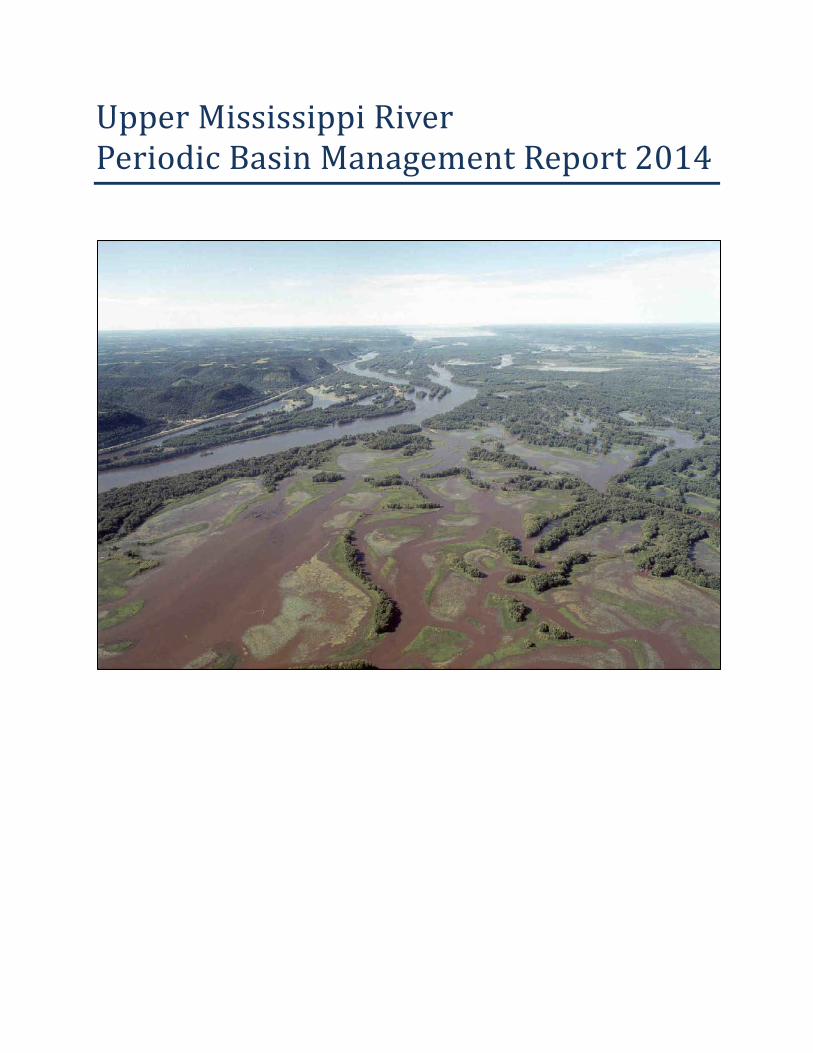
Upper Mississippi River Periodic Basin Management Report 2014


ES-I
Upper Mississippi River Periodic Basin Management Report 2014
EXECUTIVE SUMMARY The Upper Mississippi River Basin (UMR Basin) was identified as a Nationally Significant Ecosystem by the Presidential Administration in 1986. The Upper Mississippi River (UMR) flows approximately 1300 miles from its headwaters at Lake Itasca in Northern Minnesota to the confluence with the Ohio River at the southern tip of Illinois. The Basin drains roughly 189,000 square miles, including parts of Illinois, Iowa, Minnesota, Missouri, and Wisconsin. More than 30 million people reside in the Basin; millions visit the Basin each year to participate in recreational activities. Sixty percent of all grain exported from the U.S. is shipped via the Mississippi River, and 29 locks and dams form a water stairway for safe passage. The primary Corps’ mission areas in the UMR Basin are:
Navigation Flood Risk Management Regulatory Ecosystem Protection and Restoration Recreation Emergency Response and Management Hydropower Environmental Stewardship Water Supply
Upper Mississippi River Basin Management Report Purpose The intent of this document is to provide a comprehensive reference for all Corps programs and projects along the main stem of the UMR Basin. The Corps is responsible for a number of major mission responsibilities within the Basin. This document seeks to integrate these activities regardless of Corps District or Division boundaries or Program restrictions. The UMR Basin is cooperatively managed by three Corps Districts—St. Paul, Rock Island, and St. Louis.
This basin management report is intended to provide information to educate partners and customers, regional planners, Corps employees, and congressional representatives. This document provides a reference for Corps outreach activities and basin integration. Additionally, this report may be useful in augmenting the Corps Watershed Informed Budgeting approach for the UMR Basin pilot project.
Status of the Basin The UMR Basin provides unparalleled value to the Nation. The most important Corps’ mission areas in the UMR Basin are Navigation, Flood Risk Management (FRM), and Ecosystem Restoration. While each of these mission areas provides countless benefits and services, there are outstanding needs and issues in each mission area that must be addressed.
Navigation: The Corps’ UMR Inland Navigation System is vital to the economy of the Nation. The UMR navigation system (including the Illinois River) carries approximately 60 percent of the Nation’s corn and 45 percent of the Nation’s soybean exports. Other commodities shipped on the system

Periodic Basin Management Report - 2014
Upper Mississippi River
ES-II
include coal, chemicals, petroleum, materials (sand, gravel, iron ore, steel, and scrap), and manufactured goods. The existing navigation system generates an estimated $1 billion of transportation cost savings to the Nation.
However, constrained funding and the Nation’s fiscal deficit have led to reduced Operations and Maintenance (O&M) funding within the UMR Inland Navigation System. The O&M budget has not seen significant increases and has not been allowed to increase to match inflation. The O&M budget is not sufficient to fund the entire major maintenance costs for the locks and dams. The major maintenance improvements not funded are added to a list of backlog maintenance. The longer repairs to the system are delayed, the more they will cost the taxpayers and shippers in the future. Operations and Maintenance and Maintenance and Major Rehabilitation Programs are unable to adequately fund maintenance activities to ensure the navigation system operates at an acceptable level of performance. This backlog of major rehabilitation work and large number of priority unfunded maintenance items urgently requires funding so that the UMR Inland Navigation System can continue to provide un-interrupted service and value to the Nation.
The Water Resources Development Act 2007 authorized the Navigation & Ecosystem Sustainability Program (NESP) to construct small-scale navigation improvements, new lock chambers, and ecosystem/habitat restoration. The NESP is critical to the long-term sustainability of the UMR navigation system and ecosystem. The program purpose is to improve efficiency and capacity of this nationally significant navigation system while protecting preserving and enhancing the structure, diversity and function of the nationally significant ecosystem. At least 15 to 20 years of efficient funding would be required to implement NESP in order to construct the navigation and ecosystem projects to improve the ecosystem and navigation system. The NESP implementation has been suspended since June 2011 due to lack of appropriated construction funds.
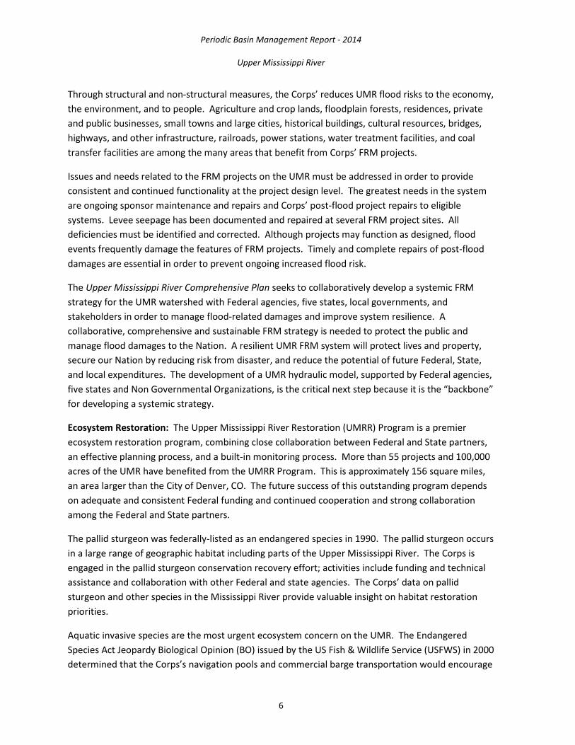
Flood Risk Management: The Corps’ constructed FRM projects on the UMR are vital to the resiliency of the environment, growth of a thriving economy, and to social health and well-being. In the Rock Island District alone, the FRM projects on the UMR prevented $1.3 million in damages in 2013. According to a St. Louis District water control report, St. Louis District FRM projects on the Mississippi (all of which are on the UMR) prevented over $3.2 billion in damages in 2013. In general, for every $1 invested in a Corps’ FRM program, it is estimated that Americans save $7. Through structural and non-structural measures, the Corps’ reduces UMR flood risks to the economy, the environment, and to people. Agriculture and crop lands, floodplain forests, residences, private and public businesses, small towns and large cities, historical buildings, cultural resources, bridges, highways, and other infrastructure, railroads, power stations, water treatment facilities, and coal transfer facilities are among the many areas that benefit from Corps’ FRM projects.
Issues and needs related to the FRM projects on the UMR must be addressed in order to provide consistent and continued functionality at the project design level. The greatest needs in the system are ongoing sponsor maintenance and repairs and Corps’ post-flood project repairs to eligible
Periodic Basin Management Report - 2014
Upper Mississippi River
ES-III
systems. Levee seepage has been documented and repaired at several FRM project sites. All deficiencies must be identified and corrected. Although projects may function as designed, flood events frequently damage the features of FRM projects. Timely and complete repairs of post-flood damages are essential in order to prevent ongoing increased flood risk.
The Upper Mississippi River Comprehensive Plan seeks to collaboratively develop a systemic FRM strategy for the UMR watershed with Federal agencies, five states, local governments, and stakeholders in order to manage flood-related damages and improve system resilience. A collaborative, comprehensive and sustainable FRM strategy is needed to protect the public and manage flood damages to the Nation. A resilient UMR FRM system will protect lives and property, secure our Nation by reducing risk from disaster, and reduce the potential of future Federal, State, and local expenditures. The development of a UMR hydraulic model, supported by Federal agencies, five states local governments, and stakeholders, is the critical next step because it is the “backbone” for developing a systemic strategy.
Ecosystem Restoration: The Upper Mississippi River Restoration (UMRR) Program is a premier ecosystem restoration program, combining close collaboration between Federal and State partners, an effective planning process, and a built-in monitoring process. More than 55 projects and 100,000 acres of the UMR have benefited from the UMRR Program. This is approximately 156 square miles, an area larger than the City of Denver, CO. The future success of this outstanding program depends on adequate and consistent Federal funding and continued cooperation and strong collaboration among the Federal and State partners.
The pallid sturgeon was federally-listed as an endangered species in 1990. The pallid sturgeon occurs in a large range of geographic habitat including parts of the UMR. The Corps is engaged in the pallid sturgeon conservation recovery effort; activities include funding and technical assistance and collaboration with other Federal and state agencies. Corps data on pallid sturgeon and other species in the Mississippi River provide valuable insight on habitat restoration priorities.
Aquatic invasive species are the most urgent ecosystem concern on the UMR. The Endangered Species Act Jeopardy Biological Opinion issued by the U.S. In 2000, the U.S. Fish and Wildlife Service determined that the Corps’s navigation pools and commercial barge transportation would encourage continued dispersion of the aquatic invasive zebra mussel throughout the UMR. Zebra mussels negatively affect the survival and recovery of federally-listed endangered mussels. The Corps leads a multi-agency panel known as the Mussel Coordination Team that has developed a conservation plan to try to save the endangered Higgins Eye Pearly mussel (Lampsilis higginsii) from possible extinction from zebra mussels. The Higgins Eye Relocation Plan is effective and the plan is in the 15th year of the implementation phase and the 9th year of monitoring. In addition, the Corps has studied the relocation and propagation of the federally-listed endangered Winged Mapleleaf, but the project has not yet been implemented. There is a continued need for funding and Corps leadership in federally-listed endangered mussels relocation and monitoring efforts.
Periodic Basin Management Report - 2014
Upper Mississippi River
ES-IV
Bighead and silver carp (Asian carp) are another aquatic invasive species of concern in the UMR. They grow rapidly to 60 pounds or more, potentially outcompeting native fish species for food. The Corps is working with other Federal and State partners to discuss options to slow or prevent the spread of Asian carp in the UMR.
Resource Significance The criteria for determining the significance of resources are provided in the Federal Economic and Environmental Principles and Guidelines for Water and Related Land Resources Implementation Studies (Water Resources Council 1983) and Corps planning guidance ER 1105-2-100. Protecting and restoring significant resources is in the national interest.
Institutional Significance: The formal recognition of the UMR Basin in laws, adopted plans, and other policy statements of public agencies and private groups illustrate the significance of the basin to a variety of institutions. The U.S. Congress recognized the UMRS as a unique, “…nationally significant ecosystem and a nationally significant commercial navigation system…” in Section 1103 of the Water Resources Development Act 1986.
Because the UMR Basin is so large and so prominent in the social development and structure of the Upper Midwest, there are many agencies and institutional arrangements supporting river and water-related activities in the region.
Public Significance: The UMR has a rich record of human history spanning over 12,000 years that is increasingly being documented as one of the most archeologically and historically significant regions in the country. The abundant and diverse ecological resources found along the UMR Inland Waterway have attracted and sustained human populations for thousands of years, providing food, water, shelter, and transportation. The Mississippi River is significant in its role in the development of the Nation.
The region hosts a sizable population, serving as home to more than 30 million people. Nearly 80 percent of the region’s population lives in urban areas along the river. These communities developed because of the transportation provided by the river; they are sustained by the water supply and waste assimilation capabilities of the river. Many industries depend on the system’s commerce route and water supply.
Technical Significance: Numerous scientific analyses and long-term evaluations of the UMR Basin have documented its significant ecological resources. Since the early 20th century, researchers, government agencies, and private groups have studied the large river floodplain system.
The UMR ecosystem consists of hundreds of thousands of acres of bottomland forest, islands, backwaters, side channels, and wetlands, all of which support more than 300 species of birds; 57 species of mammals; 45 species of amphibians and reptiles; 150 species of fish; and nearly 50 species of mussels. More than 40 percent of North America’s migratory waterfowl and shorebirds depends

Periodic Basin Management Report - 2014
Upper Mississippi River
ES-V
on the food resources and other life requisites (shelter, nesting habitats, etc.) that the ecosystem provides. It also provides boating, camping, hunting, trapping and other recreational opportunities.
There are also significant cultural resources within the UMR Basin including Native American cultural resources in floodplain and adjacent areas.


!(!(!(
!(
!(
!(
!(!(
!(
!(
!(
!(
!(
!(
!(
!(
!(!(
!(
!(
!(
!(
!(
!(
!(
!(
!(
!(
!(
!(
!(
!(
!(
!(
!(
!(
!(
!(
!(
!(
!(
!(
!(
!(
!(!(
!(
!(
!(!(
!(
!(!(
!(
!(
!(
!(
!(
!(
!(
!(
!(
!(
!(
!(
!(!(!(!(
!(
!(
!(!(!(!(
!(
!(
!(
!(
!(
!(
!(
!(
!(
!(
!(
!(
!(
!(
!(!(
!(
!(
!(
!(
!(
!(
!(
!(
!(
!(
USLS
1 23
455A
678
9101112
13
14
151617
1819
2021
22
24
25
26
27
72
73
74
75
76
77
78
50
51
54
56
58
596047
84
88
89
90
91
92
96
46
48
49
5253
55
57
61
81
82 83
85
86
87
93
2930
34
37
3842
31
32
33
35
36
40
41
43
44
45
79
80
6965
66
67
68
70
6494
95
9798
Lake Michigan
Rock IslandDistrict
St. LouisDistrict
St. PaulDistrict
Kansas City
Milwaukee
ChicagoF oxRi
ver
L i t tl e
S iou x River
M i n n e so t a Riv e r
Des
Mo i n e s R i ve r
Wol fR ive r
I o w a R i v e rW
is con
s in
R ive
r
F l am
b eau R i v e r
O s a g e R iv er
Neo sho
R iv e r
No r t h
R ac co o n R i ve r
CHip p e
waRi
ver
G ra n d R i v e r
Ceda rR i v e r
Co t ton w o o d R i v er
Ru m River
Racco
onRi
v e r
S k u n k Ri v e r
MI S S O U RI R I V E R
US Army Corps of EngineersRock Island District
R
ILLINOIS
WISCONSIN
IOWA
0 20 40 60 80 100 120 14010Miles
0 20 40 60 80 100 120 140 160 18010Km
¯1:4,000,000
Map Produced: Oct. 2014By: USACE MVR GIS
Upper Mississippi River Basin Projects - USACE 2014
MISSOURI
Ecosystem RestorationMap ID Project Program
46 Blackhawk Bottoms Pool 19, IA SEC 204
47 Chevron Dike Construction Oquawka, IL ECO
48 Chouteau Island, IL Sec 514 SEC 514
49 East St Louis & Vicinity, IL SEC 204
50 Horseshoe Lake , IL SEC 206
51 Capoli Slough Pool 19 SEC 1103
52 Conway Lake Lansing, IA SEC 1103
53 Harper's Slough Pool 9 SEC 1103
54 Mcgregor Lake Prairie Du Chien, WI SEC 1103
55 North & Sturgeon Lakes Pool 3 SEC 1103
56 Lake Winneshiek Ferryville, WI SEC 1103
57 Beaver Island Pool 14 ECO
58 Fox Island Pool 20 ECO
59 Huron Island Pool 18 ECO
60 Lake Odessa Pools 17-18 ECO
61 Overwintering Habitat Pool 12 ECO
81 Batchtown Pool 25 ECO
82 Clarence Cannon NWR Pool 25 ECO
83 Godar-Glades Wetland Illinois River ECO
84 Harlow-Wilkinson Islands ECO
85 Piasa-Eagle's Nest Islands Pool 26 ECO
86 Red's Landing Pool 25 ECO
87 Pool 24 Islands ECO
88 Pools 25 & 26 Islands ECO
89 Rip Rap Landing Pool 25 ECO
90 Swan Lake, Illinois River ECO
91 Ted Shanks Conservation Area Pool 24 ECO
92 West Alton Tract Pool 26 ECO
93 Horseshoe Lake , IL ECO
96 Asian Carp Barrier System ECO
HydropowerMap ID Project Program
65Xcel Energy Hydropower at St Anthony's Falls FPA
66Crown Hydropower at Lower St Anthony's Falls FPA
67SAF Hydropower at Lower St Anthony's Falls FPA
68Twin Cities Hydropower at Lock & Dam No 1 FPA
69Hastings Hydropower at Lock & Dam No 2 FPA
70 Hydropower at Lock & Dam No 19 FPA
Flood Risk ManagementMap ID Project Program
29 Bois Brule Levee FCA
30 Cape Girardeau, Mo Floodwall SEC 204
31 Chain of Rocks Canal Levee RHA
32 Davenport, IA Flood Risk Mgt PL 91-611
33 East St Louis, IL Levee System PL 100-202
35 Expedient Flood Fight Products FRM
37 Dubuque, IA Flood Risk Mgt Proj FRM
38 Big Five Levee System, IL FCA
39Degognia, Fountain Bluff & Grand Tower Levee FCA
40 Prairie Du Pont & Fish Lake Levee FCA
41 Great Rivers Confluence FRM
42 Ste Genevieve, Mo WRDA
43 St Louis Flood Protection PL 84-256
44 St Louis, Mo Combined Sewer WRDA
45 Wood River, IL Levee WRDA
79 2013 Spring Flood Event FRM
80 Alton to Gale Levee District FCA
Regulatory62 Joint Permit Applications in IA REG63 Hunt-Lima Drainage & Levee District SEC 404
Emergency Response and Management98 National Flood Fight Material Center FRM Projects by Primary Business Line
REGULATORY
EMERGENCY RESPONSE
RECREATION
ECOSYSTEM RESTORATION
HYDROPOWER
FLOOD RISK MANAGEMENT
NAVIGATION
District BoundariesMississippi River Basin
NavigationLS Lower St Anthony's Falls L&D O&M
1 Lock & Dam No 1 O&M
2 Lock & Dam No 2 O&M
3 Lock & Dam No 3 O&M
4 Lock & Dam No 4 O&M
5 Lock & Dam No 5 O&M
5a Lock & Dam No 5a O&M
6 Lock & Dam No 6 O&M
7 Lock & Dam No 7 O&M
8 Lock & Dam No 8 O&M
9 Lock & Dam No 9 O&M
10 Lock & Dam No 10 O&M
11 Lock & Dam No 11 O&M
12 Lock & Dam No 12 O&M
13 Lock & Dam No 13 O&M
14 Lock & Dam No 14 O&M
15 Lock & Dam No 15 O&M
16 Lock & Dam No 16 O&M
17 Lock & Dam No 17 O&M
18 Lock & Dam No 18 O&M
19 Lock & Dam No 19 O&M
20 Lock & Dam No 20 O&M
21 Lock & Dam No 21 O&M
22 Lock & Dam No 22 O&M
24 Lock & Dam No 24 O&M
25 Lock & Dam No 25 O&M
26 Lock & Dam No 26 O&M
Recreation64 Mississippi River Recreation & Env Stewardship REC
94 Blackhawk Park REC
95 St. Paul Recreation REC
97 Mississippi River Project REC


i
Table of Contents
EXECUTIVE SUMMARY ......................................................................................................................... ES-I
Upper Mississippi River Basin Management Report Purpose ................................................ ES-I
Status of the Basin .................................................................................................................. ES-I
Resource Significance ........................................................................................................... ES-IV
1. INTRODUCTION ........................................................................................................................... 1
2. REPORT PURPOSE ....................................................................................................................... 4
3. Basin Description and Location .................................................................................................. 7
3.1. Historical Overview ........................................................................................................... 9
3.2. Existing Conditions in the Watershed ............................................................................. 10
3.2.1. Main Stem ....................................................................................................................... 10
3.2.2. General Geography ......................................................................................................... 11
3.2.3. Upper Mississippi River Basin Facts ................................................................................ 11
3.2.4. Geology and Topography ................................................................................................ 12
3.2.5. Land Use .......................................................................................................................... 12
3.2.6. Water Quality .................................................................................................................. 13
4. Corps Missions in the Upper Mississippi River Basin ................................................................ 13
5. Navigation ................................................................................................................................. 13
5.1. Mississippi River Between the Missouri River and Minneapolis, MN (Upper River) ...... 14
5.2. Navigation: UMR 9-Foot Project -Locks & Dams, MN/WI/IA ......................................... 14
5.3. Navigation: UMR 9-Foot Project–Channel Maintenance, MN/WI/IA ............................ 16
5.4. Navigation: Lower Pool 2 Channel Management Study ................................................ 17
5.5. Small-Boat Harbor Dredging, St. Paul, MN ..................................................................... 19
5.6. Navigation: Mississippi River Locks & Dams 2 thru 10 Embankment Rehabilitation .... 20
5.7. Navigation: Mississippi River Locks & Dams 1–Ambursen Dam Downstream Repair ... 21
5.8. Dam Bridge & Gate Painting–Lower St. Anthony Falls through Lock & Dam 10 ............ 22
5.9. Navigation: Mississippi River Lock & Dam 8 Winter Maintenance, Genoa, WI ............. 24
5.10. Navigation: Level of Service Reduction at the Three Twin Cities Locks & Dams, MN ... 25
5.11. Backlog of Maintenance -Major Maintenance and Rehab –Mississippi R. & IWW L/D . 26
Periodic Basin Management Report - 2014
Upper Mississippi River
ii
5.12. Rock Island Dredged Material Management Program–Overview .................................. 27
5.13. St. Paul Dredge Material Management Program ............................................................ 28
5.14. St. Louis Dredged Material Management Program Cave Hollow Reach ......................... 29
5.15. Dredged Material Management Program: Keithsburg Reach ........................................ 29
5.16. Locks & Dam 15 Government Interceptor Sewer ........................................................... 30
5.17. Lock & Dam 11, Mississippi River, IA (Major Rehabilitation/Major Maintenance) ........ 31
5.18. Mississippi River Between Missouri River & Minneapolis -O&M ................................... 33
5.19. Mississippi River Maintenance Dredging (MVR O&M) ................................................... 34
5.20. Mississippi River Between the Ohio and Missouri Rivers, MO (Lower River) ................. 36
5.21. Melvin Price Locks & Dam, Mississippi River, IL & MO ................................................... 36
5.22. Mississippi River Between Ohio and Missouri Rivers (Regulating Works), MO & IL ....... 37
5.23. Southeast Missouri Port, MO .......................................................................................... 40
6. Flood Risk Management ........................................................................................................... 41
6.1. 2013 Spring Flood Event ................................................................................................. 43
6.2. 2008 & 2010 Flood Recovery PL84-99–Overview ........................................................... 44
6.3. Alton to Gale Organized Levee Districts, IL & MO .......................................................... 45
6.4. Bois Brule, MO and IL ...................................................................................................... 46
6.5. Cape Girardeau Floodwall, MO ....................................................................................... 47
6.6. Chain of Rocks Canal, IL ................................................................................................... 47
6.7. Davenport, IA Local Flood Risk Management Project, Reach 1 ...................................... 48
6.8. Minnesota Silver Jackets Team ....................................................................................... 49
6.9. Upper Mississippi River Basin: Regional Discharge-Frequency Study............................ 50
6.10. East St. Louis, Il Levee System ......................................................................................... 51
6.11. Expedient Flood Fight Products ...................................................................................... 52
6.12. Mississippi River, Dubuque, IA FRM Project ................................................................... 53
6.13. Big Five Levee System, IL ................................................................................................. 53
6.14. Degognia/Fountain Bluff and Grand Tower L&DD .......................................................... 55

Periodic Basin Management Report - 2014
Upper Mississippi River
iii
6.15. Prairie du Pont Levee and Sanitation District and Fish Lake D&LD ................................ 55
6.16. St. Louis, MO, Watershed Flooding Impacts at the Great Rivers Confluence ................ 57
6.17. National Levee Database ................................................................................................ 58
6.18. Ste. Genevieve, MO ........................................................................................................ 59
6.19. St. Louis Flood Protection, MO ....................................................................................... 59
6.20. Wood River Levee, IL ...................................................................................................... 60
7. Ecosystem Restoration ............................................................................................................. 61
7.1. Blackhawk Bottoms Pool 19, IA ...................................................................................... 63
7.2. Chevron Dike Construction Near Oquawka, IL ............................................................... 64
7.3. Chouteau Island, IL Section 514 ...................................................................................... 65
7.1. East St. Louis & Vicinity, IL .............................................................................................. 65
7.2. Endangered Species: Conservation of Native Mussels .................................................. 66
7.3. Zebra Mussels in the Upper Mississippi River System .................................................... 67
7.4. Asian Carp Barrier System, Upper Mississippi River ....................................................... 69
7.5. Horseshoe Lake Section 206 Aquatic Ecosystem Restoration, IL ................................... 70
7.6. Upper Mississippi River Restoration Program ................................................................ 70
7.6.1. Habitat Restoration: Mississippi River, Capoli Slough, Pool 9, WI ................................. 71
7.6.2. Habitat Restoration: Mississippi River, Conway Lake, Lansing Iowa ............................. 73
7.6.3. Habitat Restoration: Mississippi River, Harpers Slough, Pool 9, IA ............................... 74
7.6.4. Habitat Restoration: Mississippi River, McGregor Lake, Prairie du Chien, WI .............. 75
7.6.5. Habitat Restoration: North and Sturgeon Lakes, Pool 3, Mississippi River, MN ........... 76
7.6.6. Habitat Restoration: Mississippi River, Lake Winneshiek, Ferryville, WI ....................... 77
7.6.7. Habitat Restoration: Beaver Island, Pool 14, Mississippi River ..................................... 78
7.6.8. Habitat Restoration: Fox Island, Pool 20, Mississippi River ........................................... 80
7.6.9. Habitat Restoration: Huron Island Complex, Pool 18, Mississippi River........................ 81
7.6.10. Habitat Restoration: Lake Odessa, Pools 17-18, Mississippi River ................................ 82
7.6.11. Habitat Restoration: Overwintering Habitat, Pool 12, Mississippi River ....................... 84
7.6.12. Habitat Restoration: Batchtown, Pool 25, Mississippi River .......................................... 86
7.6.13. Habitat Restoration, Clarence Cannon NWR, Pool 25, Mississippi River ........................ 86

Periodic Basin Management Report - 2014
Upper Mississippi River
iv
7.6.14. Habitat Restoration, Godar-Glades Wetland Complex, , IL River ................................... 87
7.6.15. Habitat Restoration, Harlow-Wilkinson Islands, Open River, Mississippi River .............. 88
7.6.16. Habitat Restoration, Piasa-Eagle’s Nest Islands, Pool 26, Mississippi River ................... 89
7.6.17. Habitat Restoration, Red’s Landing, Pool 25, Mississippi River ...................................... 90
7.6.18. Habitat Restoration, Pool 24 Islands, Pool 24, Mississippi River .................................... 91
7.6.19. Habitat Restoration, Pools 25 & 26 Islands, Mississippi River ........................................ 92
7.6.20. Habitat Restoration, Rip Rap Landing, Pool 25, Mississippi River ................................... 92
7.6.21. Habitat Restoration, Swan Lake, IL River ........................................................................ 93
7.6.22. Habitat Restoration, Ted Shanks Conservation Area, Pool 24, Mississippi River ........... 94
7.6.23. Habitat Restoration, West Alton Tract, Pool 26, Mississippi River ................................. 95
8. Regulatory ................................................................................................................................. 95
8.1. Joint Permit Applications in Iowa and Illinois ................................................................. 96
8.2. Hunt-Lima Drainage & Levee District .............................................................................. 97
9. Recreation ................................................................................................................................. 98
9.1. Mississippi River Project .................................................................................................. 98
9.2. Mississippi River Recreation and Environmental Stewardship ..................................... 100
9.3. Blackhawk Park ............................................................................................................. 101
9.4. St. Paul District Recreation ............................................................................................ 101
10. Emergency Response and Management ................................................................................ 102
11. Hydropower ............................................................................................................................ 104
11.1. Upper St. Anthony Falls, Minneapolis MN .................................................................... 104
11.2. Crown Hydropower at Upper St. Anthony Falls, Minneapolis, MN .............................. 106
11.3. Lower St. Anthony Falls, Minneapolis, MN ................................................................... 107
11.4. Twin Cities Hydropower at Lock & Dam 1, Minneapolis/St. Paul, MN ......................... 108
11.5. Lock & Dam 2, Hastings, MN ......................................................................................... 110
11.6. Lock & Dam 19 .............................................................................................................. 111
11.7. FERC Licensing ............................................................................................................... 112
Periodic Basin Management Report - 2014
Upper Mississippi River
v
List of Tables
Table 5-1 Major Maintenance of Mississippi River and Illinois Waterways Locks & Dams ............. 27 Table 5-2 Summarized Financial Data Lock & Dam 11 ..................................................................... 32 Table 5-3 Summarized Financial Data for the Mississippi River Between ....................................... 34 List of Figures
Figure 2-1 Upper Mississippi River Basin ............................................................................................. 4 Figure 3-1 Upper Mississippi River System .......................................................................................... 8 Figure 3-2 Locks & Dams on the Upper Mississippi River .................................................................. 10 Figure 5-1 Upper Mississippi River Waterway Navigation Pools River Miles and Elevations ........... 14 Figure 5-2 MV Warren, Quarters Barge Taggatz and Dredge Goetz Underway ................................ 16 Figure 5-3 Lower Pool 2 Alternatives ................................................................................................. 18 Figure 5-4 St. Paul Small-Boat Harbor ............................................................................................... 19 Figure 5-5 Clear Lake Downstream of Lock & Dam 4, MN ............................................................... 21 Figure 5-6 View of Lock & Dam 1, Minneapolis, MN ......................................................................... 22 Figure 5-7 Dam Gates -Lower St. Anthony Falls, Minneapolis, MN ................................................... 23 Figure 5-8 Corroded Dam Gate Component ...................................................................................... 23 Figure 5-9 Lock & Dam 8, Genoa, WI ................................................................................................. 24 Figure 5-10 Melvin Price Locks & Dam ................................................................................................ 37 Figure 5-11 Mississippi River Between Ohio and Missouri Rivers ....................................................... 38 Figure 5-12 Southeast Missouri Port ................................................................................................... 41 Figure 6-1 Alton to Gale Levee System .............................................................................................. 46 Figure 6-2 Davenport Flood Risk Management ................................................................................. 49 Figure 6-3 Big Five Levee System Illinois ........................................................................................... 54 Figure 6-4 Prairie du Pont and Fish Lake ........................................................................................... 56 Figure 6-5 St. Louis, MO Watershed .................................................................................................. 57 Figure 6-6 St. Louis Flood Protection ................................................................................................. 60 Figure 7-1 Silver Carp Specimen ........................................................................................................ 69 Figure 7-2 Upper Mississippi River Restoration Funding ................................................................... 71 Figure 7-3 Capoli Slough Island Emergent Wetland Construction .................................................... 72 Figure 7-4 Conway Lake (upper left) in Big Lake Area in Pool 9 ........................................................ 73 Figure 7-5 Harpers Slough Area in Pool 9 of the Mississippi River .................................................... 74 Figure 7-6 McGregor Lake (center) in Pool 10 on the Mississippi River ............................................ 76 Figure 7-7 Lake Winneshiek Area in Pool 9 ....................................................................................... 78

Periodic Basin Management Report - 2014
Upper Mississippi River
vi
Figure 10-1 National Flood Fight Material Center ............................................................................. 103 Figure 10-2 Warehouse National Flood Fight Material Center.......................................................... 103 Figure 11-1 Hydropower Project at Upper St. Anthony Falls............................................................. 104 Figure 11-2 Proposed Crown Hydropower at Upper St. Anthony Falls ............................................. 106 Figure 11-3 Lower St. Anthony Falls Hydropower Facility–Minneapolis, MN ................................... 107 Figure 11-4 Twin Cities Hydropower Plant at Lock & Dam 1 ............................................................. 109 Figure 11-5 Hastings Hydropower at Lock & Dam 2 .......................................................................... 110 Figure 11-6 Lock & Dam 19 ................................................................................................................ 111 Figure 11-7 Potential Hydropower Site, Lock & Dam 5, Minnesota City, MN ................................... 112

1
Upper Mississippi River Periodic Basin Management Report 2014
1. INTRODUCTION The U.S. Army Corps of Engineers (Corps) is responding to the Nation’s water resource challenges through integrated water resources management with a watershed (river basin) focus. The benefit of the watershed approach is that it requires resource managers to think about water resources development and management in the context of a larger system, rather than a single project, function or business program and thus facilitates the search for comprehensive and integrated solutions to achieve objectives set by all concerned parties. By taking into account a multitude of water uses over a wide area as opposed to concentrating on a single use at one project site, it becomes possible to integrate a complex array of public values, institutional policies and priorities, regulatory procedures, planning criteria, public participation, and private sector business interests. The Corps has a historical presence in managing and solving the Nation’s water resource challenges and remains committed to providing future products and services to meet regional and national needs.
Watershed Perspective Policy Throughout the history of the Corps, a watershed approach has been, at varying levels, integrated into the process by which water resource systems have been investigated. The geographic “basin” organization of the Corps’ Civil Works programs supports the Corps’ historic understanding of the necessity of managing water resource activities within a watershed context.
There is a growing recognition that “locally perceived water resources problems” have regional dimensions and are of concern to numerous, diverse interest groups. Many activities occurring in a watershed are inter-related and, therefore, managing water resources has evolved to more of a holistic, collaborative effort. The Corps has developed its own watershed perspective to guide water resources development, protection, and management within the Civil Works program. This watershed perspective accommodates the multi-objective, multi-purpose planning and investigations necessary for exploring these concerns. The watershed perspective is adopted to help improve performance, customer satisfaction, and overall program efficiency and effectiveness and to assure use of the water resources in a sustainable manner, taking into account environmental protection, economic development, and social well-being. Although the watershed perspective applies, managing by watersheds is constrained by limited authorities for watershed budgeting.
Applicability: The watershed perspective applies to all Civil Works programs through planning, design, construction, operation, maintenance, restoration, rehabilitation, and regulatory activities. The application of this perspective into the Civil Works program encourages opportunities for enhancing the operations and maintenance (O&M) of existing projects, especially the management of the natural resources.

Periodic Basin Management Report - 2014
Upper Mississippi River
2
Definitions: For the purpose of Corps Civil Works initiatives, the following definitions apply:
Watershed perspective is the viewpoint which requires that all activities be accomplished within the context of an understanding and appreciation of the impacts of those activities on other resources in the watershed. The watershed perspective encourages the active participation of all interested groups and requires the use of the full spectrum of technical disciplines in activities and decision making. This viewpoint takes into account (1) the interconnectedness of water and land resources, (2) the dynamic nature of the economy and environment, and (3) the variability of social interests over time. It recognizes that watershed activities are not static, and that the strategy for managing the resources of the watershed needs to be adaptive.
A watershed is an area of land within which all surface waters flow to a single point. It encompasses the area necessary to adequately scope, analyze, and manage related water and land resources.
Watershed management is the administration of and potential adjustments to the level and type of interaction among various human activities and natural processes occurring in the watershed through the application of the watershed perspective. Watershed management includes the planning, development, use, monitoring, regulation and preservation of the water and land resources. It should achieve a desirable balance among multiple, and often competing, watershed goals and objectives.
Watershed studies are planning initiatives that have a multi-purpose and multi-objective scope and that accommodate flexibility in the formulation and evaluation process. The outcome of a watershed study will generally be a watershed management plan, which identifies the combination of recommended actions to be undertaken by various partners and stakeholders in order to achieve the needs and opportunities identified in the study and may or may not identify further Corps studies or implementation projects.
Policy: The Corps will integrate the watershed perspective into opportunities within, and among, Civil Works elements. Opportunities should be explored and identified where joint watershed resource management efforts can be pursued to improve the efficiency and effectiveness of the Civil Works Programs. The Corps will solicit participation from Federal, tribal, state, and local agencies, organizations, and the local community to ensure that their interests are considered in the formulation and implementation of the effort. Due to the complexity and interrelation of systems within a watershed, an array of technical experts, stakeholders, and decision-makers should be involved in the process. This involvement will provide a better understanding of the consequences of actions and activities and provide a mechanism for sound decision making when addressing the watershed resource needs, opportunities, conflicts, and trade-offs.
The watershed perspective encourages collaborative efforts, which advocate the integration of interests in the watershed by identifying, scoping, and developing comprehensive water resources

Periodic Basin Management Report - 2014
Upper Mississippi River
3
management goals. This approach improves opportunities for public and private groups to identify and achieve common goals by unifying on-going efforts and leveraging resources. The specific roles and amount of involvement by the Corps and other parties will vary depending on the initiative, and the level of involvement may also vary throughout the process. The analytical framework will be founded on factual scientific, social, and economic information, allowing for the assessment, evaluation, and comparison of alternative plans, including positive and negative effects on economic development, the environment, and social well-being.
Watershed informed budgeting identifies opportunities to create or strengthen partnerships with key stakeholders and identify which projects provide the greatest value to the Nation. The Corps integrated watershed approach is based on nine principles:
1. Use of the water resources in a manner that is sustainable, taking into account environmental protection, economic development, and social well-being;
2. Coordinated planning and management of water and related land resources by the responsible Federal, tribal, state or local government;
3. Interagency cooperation, including cost-shared collaboration on initiatives that incorporate local, tribal, regional, and national water resources management goals;
4. Consideration of adaptive management of resources in the watershed;
5. Leveraging resources and integrating programs and activities within and among Civil Works programs—with other Federal, tribal state and non-governmental organizations—to improve consistency and cost effectiveness;
6. Identification of future water resource use demands, including local, tribal, regional, and Federal goals;
7. Use of interdisciplinary teams to include a wide range of engineering and scientific expertise, as well as skills in public involvement, geographic information systems, alternative dispute resolution and other skills;
8. Public input to watershed resources development and management; and
9. Evaluation of the monetary and non-monetary trade-offs to be considered.
Implementation: The watershed perspective and principles will be incorporated into the existing guidance for the affected Civil Works programs. Guidelines are being developed to integrate the Corps watershed perspective into each Civil Works mission area. These guidelines will provide a useful tool for developing approaches, ranges of involvement, applications of process, and potential outcomes of Civil Works initiatives using the watershed perspective. The first guidelines will focus on the Corps Civil Works Planning mission. Additional guidelines will focus on the Regulatory Program, Natural Resources Management, Emergency Management, and Water Control Management. (Policy Guidance Letter #61–Application of Watershed Perspective to Corps of Engineer Civil Works Programs and Activities)

Periodic Basin Management Report - 2014
Upper Mississippi River
4
2. REPORT PURPOSE The intent of this document is to provide a comprehensive reference for all Corps programs and projects along the main stem (Figure 2-1) of the Upper Mississippi River (UMR) Basin. The Corps is responsible for a number of major mission responsibilities within the Basin. This document seeks to integrate these activities regardless of Corps District or Division boundaries or Program restrictions. The UMR Basin is cooperatively managed by three Corps Districts, St. Paul, Rock Island, and St. Louis.
This report is intended to provide information to educate partners and customers, regional planners, Corps employees, and congressional representatives. This document provides a reference for Corps outreach activities and basin integration. Additionally this report may be useful in augmenting the Corps Watershed Informed Budgeting approach for the UMR Basin pilot project.
Figure 2-1. Upper Mississippi River Basin

Periodic Basin Management Report - 2014
Upper Mississippi River
5
Status of the Basin The UMR Basin provides unparalleled value to the Nation. These important Corps’ mission areas in the UMR Basin are Navigation, Flood Risk Management (FRM), and Ecosystem Restoration. While each of these mission areas provides countless benefits and services, there are outstanding needs and issues in each mission area that must be addressed.
Navigation: The Corps UMR Inland Navigation System is vital to the economy of the Nation. The UMR navigation system (including the Illinois River) carries approximately 60 percent of the Nation’s corn and 45 percent of the Nation’s soybean exports. Other commodities shipped on the system include coal, chemicals, petroleum, materials (sand, gravel, iron ore, steel, and scrap), and manufactured goods. The existing navigation system generates an estimated $1 billion annually of transportation cost savings to the Nation.
However, constrained funding and the Nation’s fiscal deficit have led to reduced O&M funding within the UMR Inland Navigation System. The O&M budget has not seen significant increases and has not been allowed to increase to match inflation. The O&M budget is not sufficient to fund the entire major maintenance costs for the locks and dams (L&D). The major maintenance improvements not funded are added to a list of backlog maintenance. The longer repairs to the system are delayed, the more they will cost the taxpayers and shippers in the future. Operations and Maintenance and Maintenance and Major Rehabilitation Programs are unable to adequately fund maintenance activities to ensure the navigation system operates at an acceptable level of performance. This backlog of major rehabilitation work and large number of priority unfunded maintenance items urgently requires funding so that the UMR Inland Navigation System can continue to provide un-interrupted service and value to the Nation.
In the Water Resources Development Act (WRDA) 2007, the Navigation & Ecosystem Sustainability Program (NESP) was authorized to construct small-scale navigation improvements, new lock chambers, and ecosystem/habitat restoration. The NESP is critical to the long-term sustainability of the UMR navigation system and ecosystem. The program purpose is to improve efficiency and capacity of this nationally significant navigation system while protecting preserving and enhancing the structure, diversity and function of the nationally significant ecosystem. At least 15 to 20 years of efficient funding would be required to implement NESP in order to construct the navigation and ecosystem projects to improve the ecosystem and navigation system. NESP implementation has been suspended since June 2011 due to lack of appropriated construction funds.
Flood Risk Management: The Corps’s constructed FRM projects on the UMR are vital to the resiliency of the environment, growth of a thriving economy, and to social health and well-being. In the Rock Island District (MVR) alone, the FRM projects on the UMR prevented $1.3 million in damages in 2013. According to a St. Louis District (MVS) water control report, MVS FRM projects on the Mississippi (all of which are all on the UMR) prevented over $3.2 billion in damages in 2013. In general, for every $1 invested in a Corps’ FRM program, it is estimated that Americans save $7.
Periodic Basin Management Report - 2014
Upper Mississippi River
6
Through structural and non-structural measures, the Corps’ reduces UMR flood risks to the economy, the environment, and to people. Agriculture and crop lands, floodplain forests, residences, private and public businesses, small towns and large cities, historical buildings, cultural resources, bridges, highways, and other infrastructure, railroads, power stations, water treatment facilities, and coal transfer facilities are among the many areas that benefit from Corps’ FRM projects.
Issues and needs related to the FRM projects on the UMR must be addressed in order to provide consistent and continued functionality at the project design level. The greatest needs in the system are ongoing sponsor maintenance and repairs and Corps’ post-flood project repairs to eligible systems. Levee seepage has been documented and repaired at several FRM project sites. All deficiencies must be identified and corrected. Although projects may function as designed, flood events frequently damage the features of FRM projects. Timely and complete repairs of post-flood damages are essential in order to prevent ongoing increased flood risk.
The Upper Mississippi River Comprehensive Plan seeks to collaboratively develop a systemic FRM strategy for the UMR watershed with Federal agencies, five states, local governments, and stakeholders in order to manage flood-related damages and improve system resilience. A collaborative, comprehensive and sustainable FRM strategy is needed to protect the public and manage flood damages to the Nation. A resilient UMR FRM system will protect lives and property, secure our Nation by reducing risk from disaster, and reduce the potential of future Federal, State, and local expenditures. The development of a UMR hydraulic model, supported by Federal agencies, five states and Non Governmental Organizations, is the critical next step because it is the “backbone” for developing a systemic strategy.
Ecosystem Restoration: The Upper Mississippi River Restoration (UMRR) Program is a premier ecosystem restoration program, combining close collaboration between Federal and State partners, an effective planning process, and a built-in monitoring process. More than 55 projects and 100,000 acres of the UMR have benefited from the UMRR Program. This is approximately 156 square miles, an area larger than the City of Denver, CO. The future success of this outstanding program depends on adequate and consistent Federal funding and continued cooperation and strong collaboration among the Federal and State partners.
The pallid sturgeon was federally-listed as an endangered species in 1990. The pallid sturgeon occurs in a large range of geographic habitat including parts of the Upper Mississippi River. The Corps is engaged in the pallid sturgeon conservation recovery effort; activities include funding and technical assistance and collaboration with other Federal and state agencies. The Corps’ data on pallid sturgeon and other species in the Mississippi River provide valuable insight on habitat restoration priorities.
Aquatic invasive species are the most urgent ecosystem concern on the UMR. The Endangered Species Act Jeopardy Biological Opinion (BO) issued by the US Fish & Wildlife Service (USFWS) in 2000 determined that the Corps’s navigation pools and commercial barge transportation would encourage

Periodic Basin Management Report - 2014
Upper Mississippi River
7
continued dispersion of the aquatic invasive zebra mussel throughout the UMR. Zebra mussels negatively affect the survival and recovery of federally-listed endangered mussels. The Corps leads a multi-agency panel known as the Mussel Coordination Team that has developed a conservation plan to try to save the endangered Higgins Eye Pearly mussel (Lampsilis higginsii) from possible extinction from zebra mussels. The Higgins Eye Relocation Plan is effective and the plan is in the 15th year of the implementation phase and the 9th year of monitoring. In addition, the Corps has studied the relocation and propagation of the federally-listed endangered Winged Mapleleaf, but the project has not yet been implemented. There is a continued need for funding and Corps leadership in federally-listed endangered mussels relocation and monitoring efforts.
Bighead and silver carp (Asian carp) are another aquatic invasive species of concern in the UMR. They grow rapidly to 60 pounds or more, potentially outcompeting native fish species for food. The Corps is working with other Federal and State partners to discuss options to slow or prevent the spread of Asian carp in the UMR.
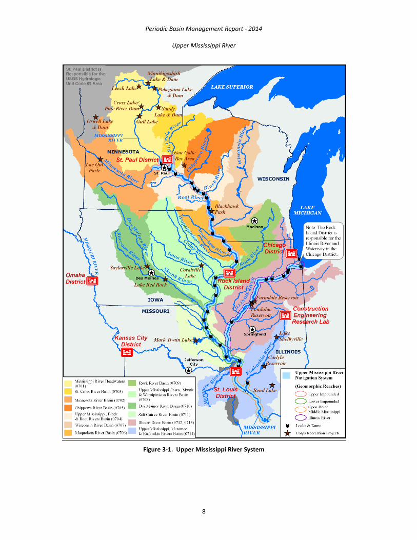
3. BASIN DESCRIPTION AND LOCATION The UMR System (UMRS) encompasses over 2.6 million acres and supports diverse and abundant populations of fish and wildlife, and provides immense social and economic benefits locally, regionally, and nationally (Figure 3-1). The UMR is internationally significant. The area is a major artery for transporting goods and supplies in the heart of the Nation; about 60 percent of all grain exported from the U.S. is shipped via the Mississippi River. The Mississippi River is a migratory flyway for 60 percent of all North American birds (326 species) and 40 percent of migratory waterfowl. The river and its floodplain are also home to 260 species of fish (a quarter of all found in North America), 50 species of mammals, as many as 60 types of mussels and at least 145 species of amphibians and reptiles. It provides drinking water and economic opportunities to those that live along its banks and provides millions of people abundant hunting, fishing, and other recreational opportunities.
The Mississippi River represents the largest riverine ecosystem in North America and the third largest in the world; only the Amazon and Congo Rivers are larger. In addition to the environmental, economic, and recreational benefits the Mississippi River provides, this mighty river is intrinsically valuable to the Nation and connects people to nature. A healthy Mississippi River offers therapeutic benefits and aesthetic value. The Mississippi River provides value to the Nation through the multitude of recreational opportunities available. Recreation experiences increase motivation to learn more about the environment; understanding and awareness of environmental issues; and sensitivity to the environment. Additionally, recreation benefits the local, regional, and national economy. Visitor spending represents a sizable component of the economy in many communities around Corps recreation areas.
Periodic Basin Management Report - 2014
Upper Mississippi River
8
Figure 3-1. Upper Mississippi River System
Periodic Basin Management Report - 2014
Upper Mississippi River
9
3.1. Historical Overview Native Americans knew of the Mississippi River and inhabited its banks and surrounding areas long before European explorers laid eyes on it. European explorations began in 1519 with an expedition sailing 20 miles up the river from the Gulf of Mexico. Explorations continued for centuries and it was in 1670 that the first European explorer traveled the length of Mississippi River.
The first steamboat traveled north of St. Louis in 1819, and became stuck in the Rock Island Rapids. Congress responded first with appropriations in 1820 and 1822 to improve navigation on the Lower Mississippi. The Rivers and Harbors Act of 1824 appropriated funds for removal of sandbars and other obstacles in the Mississippi River, including the Upper Mississippi and this responsibility was assigned to the Corps. The General Survey Act of 1824 authorized surveys to be made of routes for roads and canals, and this responsibility was also assigned to the Corps. In 1829, Congress authorized a 4.5 foot low water navigation channel from St. Louis, MO to St. Paul, MN.
As steamships began to string together barges to transport bulk goods, the new boats and barges needed more depth for navigation. In 1907 Congress authorized a 6 foot navigation channel from St. Louis, MO to St. Paul, MN. The 1927 River and Harbor Bill authorized a survey of the Mississippi River between St. Louis, MO and Minneapolis, MN to investigate a possible 9 foot navigation channel. In 1930 the 9 foot channel project was authorized and funds were appropriated (Figure 3-2).
In 1986, Congress declared the UMR as “a nationally significant ecosystem and a nationally significant commercial navigation system.” Following from this declaration, in Section 1103 of the 1986 WRDA, Congress authorized the Environmental Management Program to address the river’s ecological needs. This program was later changed to the Upper Mississippi River Restoration (UMRR) Program.

Periodic Basin Management Report - 2014
Upper Mississippi River
10
Figure 3-2. Locks & Dams on the Upper Mississippi River
3.2. Existing Conditions in the Watershed
3.2.1. Main Stem The Upper Mississippi River Basin Management Report covers the mainstem UMR from its headwaters in Lake Itasca downstream to Cairo, IL. Tributaries will not specifically be described in the report.

Periodic Basin Management Report - 2014
Upper Mississippi River
11
3.2.2. General Geography The UMR Basin drains approximately 189,000 square miles, including large parts of the states of Illinois, Iowa, Minnesota, Missouri, and Wisconsin. Small portions of Indiana, Michigan, and South Dakota are also within the basin. More than 30 million people live in the basin. Nearly 80 percent of the population lives in urban areas such as Minneapolis-St. Paul, MN; St. Louis, MO; Chicago, IL; the Quad Cities, IL and IA; Des Moines, IA; La Crosse, WI; and Peoria, IL. There are 12 major tributaries to the UMR, including the Missouri, Illinois, Wisconsin, and Iowa Rivers. The UMR Basin has 30,700 miles of streams. Over 60 percent of the basin is cropland or pasture. Major cash crops include corn and soybeans. There are over 3,000 reservoirs in the basin. The flood storage volume of 40 million acre-feet would take over 3 months to flow past St. Louis at average discharges.
3.2.3. Upper Mississippi River Basin Facts
• The UMR flows roughly 1,300 miles, from Lake Itasca in northern MN to the confluence with the Ohio River at the southern tip of Illinois, over half of the length of the entire Mississippi River.
• Approximately 850 miles of the river, extending from Minneapolis-St. Paul to the Ohio River, is commercially navigable. On the northern 670 miles, this is made possible by a series of 29 L&Ds, most built in the 1930s, which create a stairway of water. Navigation is also made possible by the use of river training structures. In addition, the river is dredged to maintain a minimum main channel depth of 9 feet.
• The Illinois River connects the Mississippi River to the Great Lakes. Together, the UMR; Illinois River; and small portions of the MN, St. Croix, Black, and Kaskaskia Rivers provide a 1200-mile commercially navigable river network in the upper Midwest.
• Barges transport more than 120 million tons of commodities on the UMR, over half of which is grain for world export. Approximately 60 percent of the Nation’s corn and 45 percent of the Nation’s soybean exports are carried on the UMRS, which includes the Illinois River.
• Along the MN-Wisconsin border, the river and its floodplain are between 1 and 3 miles wide.
• The average annual discharge on the UMR increases from 9,180 cubic feet per second (cfs) near St. Paul, MN to 204,800 cfs at Thebes, IL.
• Flood control levees protect about 3 percent of the floodplain north of Rock Island, IL; 53 percent of the floodplain in the middle reach between Rock Island and St. Louis; and 83 percent of the floodplain south of St. Louis.
• There are three national refuges along the UMR, totaling over 285,000 acres. They include the UMR National Wildlife and Fish Refuge (NWFR), Trempealeau National Wildlife Refuge (NWR), and Mark Twain NWR. The states manage another 140,000 acres of refuge lands along the river.
• Recreational visits to the UMR region exceed 11 million trips annually more than most national parks, including Yellowstone.

Periodic Basin Management Report - 2014
Upper Mississippi River
12
• There are approximately 500 boat access points and marinas along the UMR between the headwaters in MN and the confluence with the Ohio River in southern Illinois.
• The river supports 150 species of fish and nearly 50 species of freshwater mussels.
• Nearly 300 species of birds migrate through the river valley in spring and fall. The Mississippi Flyway is used by more than 40 percent of the migratory waterfowl traversing the U.S.
• Over 7 billion gallons of water are withdrawn from surface water sources each day in the 60 counties that border the navigable UMR. Over 80 percent of this water is used as cooling water for energy production and thus returned to rivers and streams.
• There are 29 power plants that use water from the 1,300 mile long UMR.
• From St. Cloud, MN in the north to Cape Girardeau, MO in the south, the UMR provides water to 23 public water suppliers serving a combined population of approximately 2.8 million people.
• Approximately 278 facilities discharge wastewater to the UMR, including industrial facilities and municipal sewage treatment plants.
3.2.4. Geology and Topography Prior to the construction of the L&Ds, the Mississippi River was a mosaic of braided channels, islands, and wetlands. The most significant geologic event explaining the nature of the UMR occurred at the end of the Pleistocene glaciation approximately 10,000 years ago. Tremendous volumes of glacial meltwater, primarily from the Red River Valley's glacial Lake Agassiz, eroded the pre-glacial MN and Mississippi River valleys. As meltwaters diminished, the deeply eroded river valleys aggraded substantially to about the present levels. Prior to impoundment, the broad floodplain of the river was depressions, sloughs, natural levees, islands, and shallow lakes. The sediment-laden waters began to build up numerous islands between the bluffs. It was not until the mid 1800's that the Mississippi River began to be changed significantly by humans.
Lake Pepin once extended up to near present day St. Paul, MN, but post-glacial sediment accumulation has filled much of the valley to several miles downriver from Red Wing, MN. Sediment from the Mississippi River headwaters and the Minnesota River accumulated downriver at a rate of about 25 ft/yr, forming a narrow channel bordered by low floodplain. As the river valley filled with sediment and the delta moved downstream past the mouth of the St. Croix River, the sediment dammed the lower 26 miles of the St. Croix River forming Lake St. Croix.
3.2.5. Land Use More than half the area of the UMR Basin is in corps, mostly corn and soybeans; the region accounts for more than 40 percent of the national corn grain harvest and than 30 percent of the national soybean harvest.
Extensive areas of emergent marsh and floodplain forest occur near the main channel and backwater areas along the UMR.

Periodic Basin Management Report - 2014
Upper Mississippi River
13
3.2.6. Water Quality Nonpoint source inputs from tributaries, major point source discharges, and river flow are the dominant factors influencing water quality in the UMR. Point source pollutant abatement activities implemented in the 1980s have noticeably reduced total and un-ionized ammonia nitrogen concentrations and increased dissolved oxygen concentrations. Contaminants in the UMR include PCBs, mercury, and a number of organic compounds associated with industrial and municipal wastes. Historically, PCBs and mercury have been the primary contaminants of concern, prompting fish consumption advisories. Emerging contaminants of concern include endocrine-disrupting and perfluoronated compounds such as pharmaceuticals products or perfluorooctane sulfonate and perfluorooctanoic acid.
The UMR Basin is identified as a major contributor of nutrients (about 43 percent of the nitrogen and 26 percent of the phosphorous loads) to the Gulf of Mexico. Nutrient runoff from the Mississippi River is a concern as it is a major contributor to the hypoxic “Dead Zone” in the Gulf of Mexico.
4. CORPS MISSIONS IN THE UPPER MISSISSIPPI RIVER BASIN The Corps is the Nation’s primary water resources development agency; this civil works responsibility is assigned by Congress. The Corps is responsible for the Inland Waterway Navigation System including the L&Ds on the UMR. The Corps has implemented many FRM projects on the UMR, and prevented millions of dollars of flood-related damages. Additionally, the Corps manages the UMRR Program, focused on habitat rehabilitation and enhancement projects as well as long-term resource monitoring (LTRM).The primary Corps’ mission areas in the UMR Basin are:
Navigation Flood Risk Management Regulatory Ecosystem Protection and Restoration Recreation Emergency Response and Management Hydropower Environmental Stewardship Water Supply
5. NAVIGATION The Corps’ Inland Navigation mission is to provide safe, reliable, efficient, effective and environmentally sustainable waterborne transportation systems for movement of commerce, national security needs, and recreation. The Inland Waterway Navigation System is vital to the economy of the Nation. The navigable portions of the UMR and the L&Ds that allow waterway traffic to move from one pool to another are integral parts of a regional, national, and international transportation network (Figure 5-1). The system is significant for certain key exports and the Nation’s balance of trade. For example, the UMRS annually carries approximately 60 percent of the Nation’s corn and 45 percent of the Nation’s soybean exports. Corn and soybeans are shipped via the waterway at roughly 60 to 70 percent of the cost of shipping over the same distance by rail. Other commodities shipped on the system include coal, chemicals, petroleum, materials (sand,
Periodic Basin Management Report - 2014
Upper Mississippi River
14
gravel, iron ore, steel, and scrap), and manufactured goods. The existing navigation system generates an estimated $1 billion of transportation cost savings to the Nation.
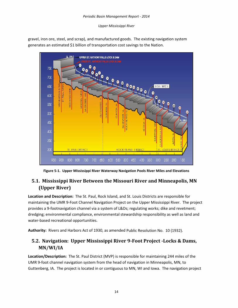
Figure 5-1. Upper Mississippi River Waterway Navigation Pools River Miles and Elevations
5.1. Mississippi River Between the Missouri River and Minneapolis, MN (Upper River)
Location and Description: The St. Paul, Rock Island, and St. Louis Districts are responsible for maintaining the UMR 9-Foot Channel Navigation Project on the Upper Mississippi River. The project provides a 9-footnavigation channel via a system of L&Ds; regulating works; dike and revetment; dredging; environmental compliance, environmental stewardship responsibility as well as land and water-based recreational opportunities.
Authority: Rivers and Harbors Act of 1930, as amended Public Resolution No. 10 (1932).
5.2. Navigation: Upper Mississippi River 9-Foot Project -Locks & Dams, MN/WI/IA
Location/Description: The St. Paul District (MVP) is responsible for maintaining 244 miles of the UMR 9-foot channel navigation system from the head of navigation in Minneapolis, MN, to Guttenberg, IA. The project is located in or contiguous to MN, WI and Iowa. The navigation project
Periodic Basin Management Report - 2014
Upper Mississippi River
15
within the MVP includes 13 sets of L&Ds that are operated and maintained by the Corps. In addition to the L&Ds, the project includes channel maintenance, recreation and natural resource activities.
Annually, approximately 17 million tons of cargo travels through the MVP. The system’s infrastructure is comprised of 10 lock chambers 600 feet long, 3 lock chambers 400 feet long, 13 operable locks, 170 dam gates, 8 fixed-crest spillways, and 16 miles of embankments acting as dams. Each lock chamber includes two sets of operable steel gates controlling entry to and exit from the lock.
Status: In fiscal year (FY) 2013, O&M funding was used to accomplish the following annually recurring activities necessary to maintain navigation:
• Contract maintenance from private industry (L&Ds 8 and 9 embankment rehabilitation contract was awarded late Sept 2013)
• Performed major maintenance and dewatering of Lock 6
• Repaired damages to L&D 5A miter gate caused by tow boat collision
In FY14, the District completed major maintenance/dewatering at Lock 8, rehabilitating the tow haulage rail at Lock 7, and preparing for Lock 5A dewatering/maintenance during FY15 winter shutdown.
The following projects are priority unfunded maintenance items that could be completed if additional funding were available:
• L&Ds 1 through 10 scour repairs
• L&Ds embankment rehabilitations
• L&Ds 5 and 5A–paint dam bridges and gates
• L&D 5A dike rehabilitation
• L&D 4 concrete repair
• Dam bulkhead repair and painting
• L&D 2 lock tainter valve repair
• Electrical system rehabilitation at Upper St. Anthony Falls (USAF) and Lower St. Anthony Falls (LSAF) Locks
• Improving shoreline docking conditions at the Corps Fountain City Service Base
Authority: The UMRS 9-Foot Channel Navigation Project was authorized as part of the Rivers and Harbors Act approved July 3, 1930. The act authorized the construction, repair, and preservation of public works on river and harbors, and for other purposes.

Periodic Basin Management Report - 2014
Upper Mississippi River
16
Fiscal: O&M of the project is funded annually under the Corps Civil Works O&M appropriation. Mississippi River funding allocated to the MVP in recent fiscal years has ranged from $45 to $55 million.
Contact: St. Paul District Operations Division 651-290-5807 [email protected]
5.3. Navigation: Upper Mississippi River 9-Foot Project–Channel Maintenance, MN/WI/IA
Location/Description: The MVP is responsible for maintaining 244 miles of the UMR 9-foot channel navigation system from the head of navigation at Minneapolis, MN, to Guttenberg, IA. Channel maintenance consists of dredging, the use of channel control structures such as wing dams, closing dams and bank revetments, snag removal, accurate channel marking, and close monitoring of conditions.
Since 1985 the MVP has dredged an average of 890,000 cys annually at 28 locations. Both government (such as the Dredge Goetz) and contract hydraulic and mechanical dredges are used (Figure 5-2). Dredged material placement is extensively planned for the long term and is actively managed to maximize beneficial use of the material. Channel control structures are maintained to minimize dredging quantities without affecting natural resources.
Figure 5-2. MV Warren, Quarters Barge Taggatz and Dredge Goetz Underway
Status: Annual O&M is required to ensure safe, reliable navigation. Coordination with project users, other river resource agencies and the public is crucial to a successful program. Channel maintenance policies and procedures are explained in the district’s Channel Maintenance Management Plan (CMMP).

Periodic Basin Management Report - 2014
Upper Mississippi River
17
Operational agreements have been developed with state regulatory agencies to facilitate channel maintenance. The channel maintenance program is flexible and allows for consideration of emerging river resource management initiatives such as pool-wide water level management and long-range environmental pool plans. From 2002 through 2013, 100 percent of the material dredged was placed at beneficial use sites.
Capacity at temporary placement sites is maintained by periodically unloading dredged material and moving it to permanent locations. A contract to unload at Grand Encampment was awarded in November 2013 with completion of construction expected in 2015. Planning continues for unloading contracts at McMillan Island (Pool 10), Crats Island (Pool 4), and Lost Island (Pool 5) sites with construction completion in 2015, 2016, and 2018 respectively. Planning continues on a channel management study in Lower Pool 2 to improve navigation safety and reduce future dredging requirements.
Authority: The UMRS 9-Foot Channel Navigation Project was authorized by the Rivers and Harbors Act approved July 3, 1930. It is 100 percent federally-funded with the exception of short segments of the Mississippi River in Minneapolis and on the Minnesota River. Non-Federal sponsors are responsible for furnishing dredged material placement sites on those segments.
Fiscal: The Federal cost of channel maintenance in the MVP is approximately $13 million annually.
Contact: St. Paul District Channels and Harbors Project Office 651-290-5807 [email protected]
5.4. Navigation: Lower Pool 2 Channel Management Study–Boulanger Bend to Lock & Dam 2, Hastings, MN
Location/Description: Pool 2 is the navigation pool created by the construction of L&D 2 at Hastings, MN, at river mile (RM) 815.2. The pool is approximately 32.4 miles long and stretches upstream to L&D 1 in Minneapolis at RM 847.6 (often referred to as the Ford Dam). Between RMs 818 and 820, the navigation channel switches from one bank of the river to the other and back again creating a near 90-degree bend in the river at mile 819. Navigation in the pool is maintained by dredging; the use of channel control structures such as wing dams, closing dams and bank revetments; snag removal; accurate channel marking; and close monitoring of conditions.
Issues: It is increasingly difficult to maintain the 9-foot navigation channel in Lower Pool 2, specifically between RMs 818-821. Lower Pool 2 has been a high frequency dredging location. Historically dredging is required once every 3 years. Since 2006, dredging has occurred almost annually. Between 2006 and 2012 (7 years), the Corps has performed more than 18 years’ worth of dredging compared to the average (based on quantity), increasing annual dredging costs in this reach. Placement site capacity has been reduced leading to accelerated unloading requirements. The make-up of the dredged material makes it difficult to manage (fine grain material).

Periodic Basin Management Report - 2014
Upper Mississippi River
18
The congressionally authorized channel width in Pools 1 and 2 is 200 feet, compared to 300 feet for areas downstream from L&D 2 and 150 feet for areas upstream of the Saint Anthony Falls L&Ds. The U.S. Coast Guard has expressed concern regarding the difficulty and expense to maintain the aids to navigation (buoys and day marks) in this stretch of Pool 2. The commercial navigation industry has experienced difficulty navigating the channel in this reach, resulting in reduced tow sizes and increased transport costs.
Alternatives: Alternatives considered in this study include no action, modification to channel control structures and channel realignment (Figure 5-3). The Corps’ preferred alternative is to realign the navigation channel into Boulanger Slough.
Figure 5-3. Lower Pool 2 Alternatives
Authority: The UMRS 9-Foot Channel Navigation Project was authorized by the Rivers and Harbors Act of 1930. It is 100-percent federally-funded with the exception of short segments in Minneapolis and on the Minnesota River.
Fiscal: The estimated Federal cost of this study and the construction of a preferred alternative is approximately $14 million.

Periodic Basin Management Report - 2014
Upper Mississippi River
19
Contact: St. Paul District Channels and Harbors Project Office 651-290-5807 [email protected]
5.5. Small-Boat Harbor Dredging, St. Paul, MN Location/Description: The St. Paul Small-Boat Harbor is on the lower end of Harriet Island in St. Paul, MN, at Upper Mississippi RM 839.6 on the right descending bank (Figure 5-4). The length of the harbor is 2,375 feet; the width varies from 200 to 400 feet. The Corps is authorized to maintain the harbor to a depth of 5.0 feet below low control pool elevation of 687.2 feet mean sea level (msl). The City of St. Paul is the non-Federal sponsor (NFS) for the project and is required to furnish a suitable placement site for the dredged material. The city or its designated operator, the St. Paul Yacht Club, is responsible for all docks and similar facilities at the harbor. The harbor is designed for use by small recreational craft.
Figure 5-4. St. Paul Small-Boat Harbor
Status: Original construction of this project was completed in 1949. Since 1990, the St. Paul Small-Boat Harbor has been dredged on 15 occasions. An average of 8,750 cys has been dredged per event. The harbor was last dredged in 2011. The MVP provided funds for dredging in 2002, which was the last year reprogramming of funds was allowed. In 2001 and 2006, the City of St. Paul performed dredging at its own expense because Corps funding was not available. In 2008 a congressional appropriation funded the dredging directly.

Periodic Basin Management Report - 2014
Upper Mississippi River
20
In August 2008 a portion of the project area upstream of the Wabasha Street Bridge was dredged to the authorized depth and width with removal of nearly 15,000 cys of material. A hydraulic model study report was completed in January 2011. It identified two potential future actions to reduce long-term dredging requirements. Both of these actions are being pursued by the City of St. Paul and the Corps. In September 2011 the remainder of the 2008 funding was used to accomplish a small amount of dredging. Hydrographic surveys will continue to be performed as needed to assess conditions, and the information will be provided to the City of St. Paul (NFS for the project). Dredging will be performed in the future as funds allow. In July 2013 the City of St. Paul funded removal of a large log jam at the bridge going to Navy Island.
Authority: Rivers and Harbors Act of 1945; House Document 547, 76th Congress, 3rd Session.
Financial: O&M of the project is funded under the Corps’ Civil Works O&M appropriation. In FY08, Congress appropriated $186,000 to fund maintenance dredging at the St. Paul Small-Boat Harbor. The dredging cost accounted for $133,525.50. After the study was completed in 2011 the remaining funds of the original appropriation were used to remove about 2,100 cys of material.
Contact: St. Paul District Channels and Harbors Project Office 651-290-5807 [email protected]
5.6. Navigation: Mississippi River Locks & Dams 2 through10 Embankment Rehabilitation
Location/Description: Earthfill embankments are integral to each of the Mississippi River L&Ds 2 through 10. Figure 5-5 illustrates an example of earthfill embankments at Clear Lake downstream of L&D 4. The purpose of this project is to reestablish and armor degraded embankments to prevent further erosion and potential failure during high water events. The existing rock protection is well past its intended design life and does not perform satisfactorily. Wave action from high water causes continued widespread erosion.
Embankment rehabilitation will address restoring embankments to meet current design standards. Overtopping protection adjacent to concrete structures is the first priority for design and construction. No increase in the height of the embankments is planned.
Status: L&Ds 8 and 9 embankments contract was awarded in FY13. Design for L&D 10 is in progress, with contract awarded in FY14. Work for all remaining sites is estimated to cost a total of $22.5 million. It will be scheduled when funding is made available.
Authority: The UMRS 9-Foot Channel Navigation Project was authorized as part of the Rivers and Harbors Act approved July 3, 1930.
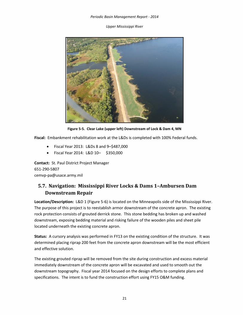
Periodic Basin Management Report - 2014
Upper Mississippi River
21
Figure 5-5. Clear Lake (upper left) Downstream of Lock & Dam 4, MN
Fiscal: Embankment rehabilitation work at the L&Ds is completed with 100% Federal funds.
• Fiscal Year 2013: L&Ds 8 and 9–$487,000 • Fiscal Year 2014: L&D 10– $350,000
Contact: St. Paul District Project Manager 651-290-5807 [email protected]
5.7. Navigation: Mississippi River Locks & Dams 1–Ambursen Dam Downstream Repair
Location/Description: L&D 1 (Figure 5-6) is located on the Minneapolis side of the Mississippi River. The purpose of this project is to reestablish armor downstream of the concrete apron. The existing rock protection consists of grouted derrick stone. This stone bedding has broken up and washed downstream, exposing bedding material and risking failure of the wooden piles and sheet pile located underneath the existing concrete apron.
Status: A cursory analysis was performed in FY13 on the existing condition of the structure. It was determined placing riprap 200 feet from the concrete apron downstream will be the most efficient and effective solution.
The existing grouted riprap will be removed from the site during construction and excess material immediately downstream of the concrete apron will be excavated and used to smooth out the downstream topography. Fiscal year 2014 focused on the design efforts to complete plans and specifications. The intent is to fund the construction effort using FY15 O&M funding.

Periodic Basin Management Report - 2014
Upper Mississippi River
22
Figure 5-6. View of Lock & Dam 1, Minneapolis, MN
Authority: The project was authorized as part of the Rivers and Harbors Act approved July 3, 1930.
Fiscal: Total project costs estimate: $2.75 million
• Fiscal year 2014 funding: $400,000 • Fiscal year 2015 funding: To be determined • The scour hole and erosion protection work at the L&Ds will be completed with 100%
Federal funds.
Contact: St. Paul District Project Manager 651-290-5807 [email protected]
5.8. Dam Bridge & Gate Painting–Lower St. Anthony Falls through Lock & Dam 10
Location/Description: The MVP operates and maintains 13 L&Ds from Upper St. Anthony Falls in downtown Minneapolis, MN, to L&D 10 in Guttenberg, IA. Each lock and dam is a critical step in the "stairway of water" that makes navigation possible between Minneapolis and St. Louis, MO. These facilities are aging structures, with L&Ds 2 through 10 originally constructed in the 1930s. These sites include a dam bridge and varying numbers of dam gates. The moveable dam gates (Figure 5-7) are one of the most critical system components because they control pool elevation for navigation, flood control and environmental purposes.
Typically the gates are partially submerged in flowing water and subjected to abrasion from sediment and debris (trees and ice) carried by the river. These factors degrade the paint systems, diminishing their protection of the gate structures. This degradation contributes to significant corrosion of the gates and, consequently, an escalating backlog of needed repairs such as replacing corroded dam

Periodic Basin Management Report - 2014
Upper Mississippi River
23
gate components as shown in Figure 5-8. The original hazardous lead-based paint remains on five bridges, which have not been painted since their original construction in the 1930s.
Figure 5-7. Dam Gates -Lower St. Anthony Falls, Minneapolis, MN
Figure 5-8. Corroded Dam Gate Component
Protecting the Nation’s investment in this critical component of the inland waterways infrastructure through preventive maintenance is prudent, particularly when replacement costs are considered. The average cost of painting and repairing corrosion of gates is estimated at $8.4 million per site. The average cost to replace gates is $62 million per site. The average annual replacement cost is 40 percent more than the average annual cost of regular painting. The life expectancy of modern paint systems ranges from 15 to 25 years.
Status: The MVP has been unable to award a painting contract for many years because of funding constraints. The L&D 5 contract is ready should funding become available.
Contact: St. Paul District Project Manager 651-290-5807 [email protected]

Periodic Basin Management Report - 2014
Upper Mississippi River
24
5.9. Navigation: Mississippi River Lock & Dam 8 Winter Maintenance, Genoa, WI
Location/Description: L&D 8 is located near the community of Genoa, WI. The Corps completed the facility in 1937 as part of the overall 9-Foot Navigation Channel Project. After more than 50 years of service, the Corps undertook a major maintenance program to replace much of the operating equipment and construct a new control building, which was completed in 2005.
L&D 8 (Figure 5-9) was dewatered first in 1974 and again in 1992 and 2014. The MVP locks are now dewatered on an approximate 20-year cycle. Between normal lower and upper pools is an 11-foot lift. The average flow is 40,000 cfs or 299,200 gallons per second. The dam consists of five roller gates and 10 Tainter gates.
Figure 5-9. Lock & Dam 8, Genoa, WI
The lock consists of 27 feet high upper miter gates and 30 feet high lower miter gates. The chamber is 110 feet wide by 600 feet long. The lock chamber is dewatered to perform maintenance on the miter gates and bubbler system and repair damaged concrete on the walls. The work is done during the traffic closure period to avoid impacts to users of the navigation system.
To stop the water from flowing into the chamber, bulkheads are placed upstream and downstream of the chamber. Once the water is pumped from the chamber, the miter gates, bubbler system and concrete are inspected. The miter gates are sandblasted and painted, and equipment is replaced as needed. Concrete repairs are made on the walls and floor as needed. The bubbler system is removed and replaced with stainless steel.
Due to a high volume of concrete work, a contract was awarded for concrete demolition. The Corps maintenance and repair crew performed the remaining work which included sandblasting, painting, welding, carpentry and equipment operation. They placed the sill beam and bulkheads, dewatered
Periodic Basin Management Report - 2014
Upper Mississippi River
25
the chamber, performed the inspections and repairs on the miter gates, sandblasted and painted the miter gates, removed and replaced the bubbler system and repaired damaged concrete.
Status: The L&D was closed to traffic in early December 2013; re-opened prior to 2014 navigation season.
Authority: The project was authorized as part of the Rivers and Harbors Act approved July 3, 1930.
Fiscal: Project design and construction costs are 100% Federal. Estimated total cost: $3.5M.
Contact: St. Paul District Project Manager 651-290-5807 [email protected]
5.10. Navigation: Level of Service Reduction at the Three Twin Cities Locks & Dams, MN
Location/Background: Constrained funding and the Nation’s fiscal deficit have led to reduced O&M funding within the Corps Inland Marine Transportation System (IMTS). When coupled with deteriorating infrastructure and increasing costs of operation, it became clear that the level of service the Corps has been providing at some L&Ds is not sustainable.
The three L&Ds in the Twin Cities—USAF, LSAF, and L&D 1—are part of the Corps’ IMTS consisting of 12,000 miles of inland waterways and more than 200 L&Ds.
The IMTS Board of Directors approved guidance that established six levels of operational service for all IMTS locks. The criteria were based on the number of commercial lockages and tonnage that passed through the locks on an annual basis.
Status: Based on the IMTS guidance, these three L&Ds transitioned from service level 1 to service level 2 in March 2013. During the navigation season, USAF & LSAF are open 8 a.m. to 3 a.m. and L&D 1 is open 3 a.m. to 10 p.m. daily. As a part of this effort, hours of operation and staffing during the non-navigation season were also reduced.
Based on the IMTS guidance, locks passing more than 1,000 commercial lockages per year should be operating at a service level 1 (24 hours per day/7 days per week). Navigation stakeholders concurred with this proposal. Stakeholders included Minneapolis terminal operators, commercial tow companies, cruise tour vessels, the U.S. Coast Guard, the MN Department of Transportation, and emergency responders. There continues to be interest to further reduce hours of operation and limit recreational lockages at these three locks to control the spread of Asian carp. The average annual tonnage from 2009 to 2013 was 750,339 tons.
Fiscal: The FY13 operational cost for these three L&Ds was $2.57 million. The estimated annual savings from implementing the proposed reduced level of service is $770,000.

Periodic Basin Management Report - 2014
Upper Mississippi River
26
Contact: St. Paul District Operations Division 651-290-5807 [email protected]
5.11. Backlog of Maintenance -Major Rehabilitation and Major Maintenance -Mississippi River & Illinois Waterway Locks & Dams
Location/Description: Mississippi River and Illinois Waterway (IWW) L&Ds, located in Iowa, Illinois, Missouri, and Wisconsin. The Major Rehabilitation and Major Maintenance Program for the L&Ds on the Mississippi River and IWW has been ongoing since 1975. Major rehabilitation consists of reliability or efficiency improvements. Reliability improvements are considered when they significantly extend the physical life of a component, have direct consequences to navigation and ecosystem, and can be economically justified by benefit-to-cost analysis. The region focuses on this method of major rehabilitation. Efficiency improvements are considered if they enhance operation efficiency of the component.
Funding mechanisms differ for Major Rehabilitation and Major Maintenance. Major Rehabilitation is cost shared 50/50 between Federal funding and the Inland Waterways Trust Fund; Major Maintenance is funded at 100% Federal.
Major maintenance is categorized as major repairs or improvements that do not qualify for major rehabilitation and must be funded out of the regular O&M Budget. The remainder of the regular O&M Budget dollars are used for baseline (routine) O&M. The O&M Budget has not seen significant increases and has not been allowed to increase to match inflation. The O&M Budget is not sufficient to fund the entire Major Maintenance costs for the L&Ds. The Major Maintenance improvements not funded are added to a list of deferred maintenance (Table 5-1). The longer repairs to the system are delayed, the more they will cost the taxpayers and shippers in the future.
Status: Operations and Maintenance and Maintenance and Major Rehabilitation Programs are unable to adequately fund maintenance activities to ensure the navigation system operates at an acceptable level of performance.
Authority: O&M --River and Harbor Act of 1930
Summarized Financial Data: The Mississippi Valley Division Regional Backlog of Maintenance is valued at around $1.0B, with close to 360 identified items (2014 values). MVR's portion of the list includes 183 items with an approximate total value of $725M; or more than 60 percent of the regional total. Some of the highest ranking MVR maintenance projects include:
• IWW LaGrange L&D Major Rehabilitation and Major Maintenance • Systemic Miter Gate Replacement @ multiple L&D Sites on the Mississippi River the IWW • Mississippi River L&Ds 11, 12, 13 Auxiliary Bay Gates Replacement • IWW O'Brien L&D Major Rehabilitation/Major Maintenance

Periodic Basin Management Report - 2014
Upper Mississippi River
27
• Systemic Bulkhead Slots @ multiple Locks on the Mississippi River • Mississippi River L&D 18 Dam Concrete Repairs (Safety) • IWW Lockport Forebay Concrete Repair-Major Rehabilitation • Mississippi River L&Ds 20, 21, 22 Auxiliary Bay Gate Bulkhead Slots • Mississippi River Systemic Miter Gate Replacement • Systemic Chamber Bulkhead Slots on the Mississippi River • IWW Systemic Miter Gate Replacement
Contact: Mississippi River Project Operations Manager 651-290-5807 [email protected]
Table 5-1 Major Maintenance of Mississippi River and Illinois Waterways Locks & Dams
L&D Components Not Justified For Major Rehabilitation Consequence of Not Doing Work
Lock Miter Gates Miter gate failure would cause closure of locks to all navigation and shipments.
Auxiliary Miter Gates Continued deterioration and potential loss of pools for navigation and ecosystem sustainability.
L&D Electrical Systems
Electrical failures cause temporary power outages to lock and dam operating machinery. Such failures would impact lock operation as well as pool regulation for navigation and ecosystem sustainability.
Repair Dam Roller and Tainter Gates Deterioration of gate structures is occurring with possible failure and inability to regulate pool for navigation and ecosystem management.
L&D Concrete
Concrete supports and protects lock and dam operating machinery and gates. Concrete is deteriorating exponentially. Concrete failures are now more frequent creating a greater probability of damage to miter gates by transiting tows. Also, allowing more potential for inability to manage pools for navigation and ecosystem sustainability.
5.12. Rock Island Dredged Material Management Program–Overview Location/ Description: Rock Island District IWW and Upper Mississippi Reaches. The MVR has been developing plans and acquiring and implementing sites for the long-term placement of channel maintenance dredged material since the completion of GREAT II (Great River Environmental Action Team) studies in the early 1980s. The Dredged Material Management Program (DMMP) evaluates and identifies preferred alternative dredged material placement site(s) using a six-step planning process and, where applicable, a matrix with six evaluation criteria: dredging cost; natural resources; beneficial use of dredged material; recreational resources; cultural resources; and social impacts.
Status: The MVR is preparing long-term (20-40 year capacity) DMMPs and CMMPs and acquiring and implementing sites for the placement of channel maintenance dredged material in support of the O&M of the UMR and IWW 9-foot navigation channels. The program ensures that all practicable and reasonable alternatives for the placement of dredged material are fully considered on an equal basis.

Periodic Basin Management Report - 2014
Upper Mississippi River
28
This includes the placement of dredged material in the least costly manner, at the most practicable location, and consistent with engineering and environmental requirements. Within the MVR, plans are being developed for 38 recurrent dredge cuts on the IWW and 44 recurrent dredge cuts on the UMR.
Summarized Financial Data: The DMMP is funded out of the District's O&M budget.
FY13 DMMP obligations and expenditures:
• UMR: $354,000; $351,000 • IWW: $568,000; $523,000
FY13 work allowances:
• UMR: $354,000 • IWW: $568,000
Authority: O&M - Rivers and Harbors Acts of 1927, 1930, and 1935 in accordance with the Section 404 CWA & 33CFR, Parts 335-338
Contact: Programs Management Branch 309-794-5605 E-mail: [email protected]
5.13. St. Paul Dredge Material Management Program Location/Description: The MVP is responsible for maintaining 243.6 miles of navigation channel to a depth of at least 9 feet on the Mississippi River from Minneapolis at RM 857.6 to Guttenberg, IA, at RM 614.0, and 40.6 miles on three tributaries, the Minnesota, St. Croix, and Black Rivers. Sedimentation in the channel is caused by the normal cycle of silt movement, erosion from high water or heavy rains and changes in river currents.
Status: To maintain the 9-Foot Navigation Channel, material that settles in the channel area must be removed. Mechanical or hydraulic dredging are methods for the removal of that material. This material is placed in designated areas along the river. Some of these areas are beneficial use placement areas. Beneficial use of dredged material is the productive use of the material by the public or private sectors. Examples of common beneficial uses of dredged material in the MVP are upland habitat development; wetland creation; aquatic habitat enhancement; creation of areas for bird nesting; beach nourishment; winter road maintenance; levee repair and improvement; aggregate for concrete; lining fly ash pits; bank protection; and general purpose fill. The DMMP evaluates and identifies preferred alternative dredged material placement site(s) using a six-step planning process and, where applicable, a matrix with six evaluation criteria: dredging cost; natural resources; beneficial use of dredged material; recreational resources; cultural resources; and social impacts.

Periodic Basin Management Report - 2014
Upper Mississippi River
29
Summarized Financial Data: The DMMP is funded out of the District's O&M budget.
Authority: O&M --Rivers and Harbors Acts of 1927, 1930, and 1935 in accordance with the Section 404 CWA & 33CFR, Parts 335-338
Contact: St. Paul District Operations Division 651-290-5807 [email protected]
5.14. St. Louis Dredged Material Management Program Cave Hollow Reach
Location/Description: Mississippi River Pool 24, Cave Hollow Reach (RMs 307.5 to 304.5). The Cave Hollow Reach includes the Cave Hollow dredge cut (RM 306.9 to 305.5). In FY10, this reach of the river was closed once and nearly closed a second time due to sedimentation in the navigation channel. This reach was dredged three times in FY10 to keep the channel open for navigation. A hydraulic placement site was acquired under a onetime placement permit to place over 250,000 CY of sand. This placement site was behind the Sny Island Levee and Drainage District (L&DD) levee. The Sny Island L&DD has indicated they will use all of the material within their levee district to fortify their sand levees. A plan is completed to acquire long term placement site(s) to contain the 20-year future dredging projections for this reach of the river. The approximate 20-year projection for dredging in this reach is 416,000 CY.
Status: A completed feasibility report recommends the acquisition of Site 305.5, a21-acre dredged material placement site. Acquisition phase has been initiated.
Fiscal:
• FY14: Complete the Real Estate Design Memorandum • FY15: Initiate the acquisition phase
Authority: The Rivers and Harbors Acts of July 3, 1930; February 24, 1932; and August 30, 1935
Contact: Program Manager E-mail: [email protected]
5.15. Dredged Material Management Program: Keithsburg Reach Location/ Description: Mississippi River, Pool 18, Keithsburg Reach, RMs 423.5 to 427.5. The Keithsburg Reach includes the Keithsburg Upper, Lower and Huron Island dredge cuts (RM 423.5 to 427.2). A 40 year plan, Site Plan for the Keithsburg Reach, Keithsburg Upper, Keithsburg Lower and Huron Island Dredge Cuts was completed in September of 2002 and called for the use of Sites 3, 4b, 13 & 14 to handle dredged material from the Keithsburg Upper, Lower and Huron Island dredge cuts. Since the plan was developed in 2002, the Keithsburg Lower dredge cut has been dredged each of

Periodic Basin Management Report - 2014
Upper Mississippi River
30
the last 8 years with approximately 50,000 cubic yards (cy) dredged at each event. This is a significant increase in volume compared to the 2002 projection of 35,000 cy every 3 years. Because of this dredging volume increase, the Keithsburg Reach is currently the most critical area of dredging for the MVR in terms of maintaining an open channel for navigation. As of October 2010, Sites 3 and 14 are full and Site 4b has not yet been acquired. Site 13 is too far down river from the Lower dredge cut to be reached feasibly and Site 13 was developed to handle material from the Huron Island dredge cut. The District has developed a plan to contain additional dredged material from the Lower dredge cut at Site 4. Site 4 is essentially an expanded Site 4b and is located on the Iowa side of the Mississippi River in Louisa County.
Status: A public meeting was held on October 26th, 2011 to discuss the Keithsburg Reach DMMP. There is local opposition to the project, as the Two Rivers L&DD wants the dredged material but does not want to lose tax revenue from Site 4 due to Federal acquisition of the Site. In addition, the L&DD wants the dredged material placed along their levee in a manner that is not the most cost effective placement option for the Federal government. The most cost effective option for placement of dredged material from the Keithsburg Reach Upper and Lower dredge cuts is placement Site 4. The Environmental Assessment (EA) has been completed for Site 4. A Finding of No Significant Impact was signed March 13, 2012. Acquisition and construction completed FY14.
Financial:
• FY14: o Acquire and construct Site 4.
• FY15: o Complete acquisition and utilize Site 4 for placement of dredged material from
the navigation channel.
Authority: The Rivers and Harbors Acts of July 3, 1930; February 24, 1932; and August 30, 1935
Contact: Project Manager 309-794-5403 E-mail: [email protected]
5.16. Locks & Dam 15 Government Interceptor Sewer Location/Description: Bettendorf and Davenport, IA. The government interceptor sewer system was constructed in 1934 concurrently with the construction of L&D 15. The sewer is an integral part of the 9-Foot Navigation Channel Project as it serves to collect and drain all storm water flows originating upstream of the L&D from the land side of Bettendorf and Davenport, IA to the downstream side of the L&D. These storm sewers originally drained directly to the Mississippi River prior to construction of the lock and dam system. The government interceptor collects all storm sewer flows from a distance of nearly 6 miles and eventually drains back to the Mississippi River at a location immediately downstream of L&D 15. The lengthy duration of high tailwater levels during

Periodic Basin Management Report - 2014
Upper Mississippi River
31
the 2011 flood event caused a backwater condition that extended most of the length upstream in the sewer. This condition, along with high interior flows, caused sediment to collect in the sewer. This has significantly restricted its carrying capacity which in turn has contributed to repeat flooding of streets and low lying areas during heavy rainfall events. During the construction of the Flood Protection Wall for the Iowa American Water Company located adjacent to the Government Box, a penetration for a storm water pipe revealed that one half of the Box was 100 percent blocked with debris. The MVR obtained funding to begin an inspection and form a plan to remove the blockage and in so doing discovered the gate valves designed to allow maintenance flushing were also inoperable. The sewer must be cleaned out, inspected, and repaired to restore original capacity as designed.
Fiscal:
• In FY14, funding used to award a construction contract to install manholes and bulkheads and perform cleanout operations.
• In FY15, the construction contract will be completed and functionality of the sewer will be obtained. No additional contract work is expected.
Authority: O&M -Operations and Maintenance
Contact: Project Manager 309-794-5704 E-mail: [email protected]
5.17. Lock & Dam 11, Mississippi River, IA (Major Rehabilitation/Major Maintenance)
Location/Description: L&D 11 is located at RM 583.0, in the town of Dubuque, IA. The structure was placed in operation 14 September 1937. The lock chamber is 600 feet long by 110 feet wide and has a maximum lift of 11 feet. An auxiliary lock is located adjacent to the Iowa side of the channel. The dam is 5,018 feet long and consists of a 1,278-foot gated section, a 200-foot long storage yard, and a 3,540-foot non-overflow earth dike. Breakdowns of mechanical and electrical equipment had become more frequent with resultant delays and loss of revenue to commercial waterway users. The electrical system presents safety concerns due to its age and insulation deterioration. The lock and dam rehab project first received funding by a Congressional add in FY02 and will be completed in three stages.
Stage I, Dam Scour Protection, involved placing additional scour protection upstream and downstream of the dam. The construction contract was awarded in July 2002 and completed in August 2003.
Stage II, Lock, involved the rehabilitation of the navigation lock chamber and associated appurtenances. Major work items included resurfacing the lock chamber, replacing the original lock

Periodic Basin Management Report - 2014
Upper Mississippi River
32
machinery and electrical systems, bulkhead slots, repairing guidewall concrete, repairing Tainter valves, and replacing the dam electrical system. Work was complete in June 2009.
Stage III, Dam, involves the rehabilitation of the navigation dam. Work includes rehabilitation of the dam gate machinery and concrete. Contracts for this work are substantially complete. Structural repairs to the dam gates and service bridge are currently unfunded.
Status: The Stage III-A contract was awarded in September 2008 and was substantially complete in July 2012. The contract included replacing Tainter gate chains, rehabilitating roller gate chains, rehabilitating dam gate motors, and replacing the service bridge decking. The Stage III-B contract (ARRA funded) was awarded in December 2009 and was substantially complete in July 2012 (Table 5-2). The contract included concrete repairs on the dam. The Stage III-C contract (O&M funded) will include structural repairs and painting of the dam gates and service bridge, and is currently on hold due to insufficient funding.
Table 5-2 Summarized Financial Data Lock & Dam 11
Rehabilitation Major Maintenance Estimated Federal Cost: $46,650,000 $27,680,000 Estimated Non-Federal Cost:
Estimated Total Cost: $46,650,000 $27,680,000
Allocations through FY13 including ARRA $46,650,0001 $14,680,0002 FY14 Allocation $0.00 $0.00 Budget for FY15 $0.00 $0.00 Balance to Complete: $0.00 $13,000,000
1 $3,615,000 ARRA Funds 2 $1,237,000 ARRA Funds
• Major Work Item FY14 o Completion and closeout of the Stage III-A and Stage III-B contracts.
• Major Work Item FY15 o If funds were available, Plans and Specifications for the Stage III-C construction
contract could be developed.
Authority: CG -Construction General --River and Harbor Act of 1930, S.D. #126/71/2.
Contact: Project Manager 309-794-5640 E-mail: [email protected]

Periodic Basin Management Report - 2014
Upper Mississippi River
33
5.18. Mississippi River Between Missouri River & Minneapolis -O&M Location/Description: The MVR is responsible for maintaining the 314-river-mile reach of 9-foot commercial navigation channel from Guttenberg, IA, downstream to Saverton, MO. It includes 14 locks and 11 dams at 12 sites from Lock 11 to Lock 22. The navigable portions of this river and the L&Ds that allow waterway traffic to move from one pool to another are integral parts of a regional, national, and international transportation network. Recreation facilities include 25 public recreation areas and the Visitor Center located at L&D 15. Typical recreation and lease receipts are $1,000,000, with regional economic impacts estimated at $377,000,000 with 13,900,000 visits. Financial data for O&M for the Mississippi River between Missouri River and Minneapolis is summarized in Table 5-3.

Periodic Basin Management Report - 2014
Upper Mississippi River
34
Table 5-3. Summarized Financial Data for the Mississippi River Between Missouri River & Minneapolis–O&M
Allocations thru FY13 $1,383,665,000 Budget for FY14 $63,739,000 House Allocation for FY14 $61,508,000 Senate Allocation for FY14 $63,739,000 FY14 Allocation $63,102,000 Budget Request for FY15 $52,900,000
• Major Work Items FY14
o Routine O&M of Project Navigation Infrastructure o Dredging and Dredged Material Management o O&M of Visitor Center and Recreation Areas o Procure Miter Gates Lock 11 o Design-Construct Bulkhead Recesses 12 & 13 o Replace Guard Gate at Lock 19 o Dewater Lock 22
• Major Work Items FY15 o Routine O&M of Project Navigation Infrastructure o Dredging and Dredged Material Management o O&M of Visitor Center and Recreation Areas o Procure Miter Gates Lock 14 o Construct Bulkhead Recesses Lock 17 o Dewater Lock 20
Authority: O&M --River and Harbors Act of 1927 & 1930
Contact: Mississippi River Operations Manager 309-794-4580
5.19. Mississippi River Maintenance Dredging (MVR O&M) Location/Description: In order to maintain the 9-foot navigation channel, maintenance dredging is performed at various locations in the reach of the UMR in the MVR. The affected reach of the Mississippi River extends approximately 314 river miles (RM) from L&D 10 at Guttenberg, IA, to L&D 22 just downstream from Saverton, MO. It is divided into 12 pools by navigation dams. Upstream of each dam and extending to the next dam is a slackwater navigation pool. Wing dams, closing dams, and revetment works are other physical structures that are an integral part of the channel project. Aside from routine physical maintenance on these structures, annual dredging is required at various locations in the main channel. Annual maintenance dredging of the MVR UMR 9-Foot Channel Project is generally required at 10 to 15 sites, and the volume of material dredged is approximately 400,000 cys per year.

Periodic Basin Management Report - 2014
Upper Mississippi River
35
Due to the large sediment load carried by the waterway and continually changing flows, specific dredging locations and quantities to be dredged vary from year-to-year. The dredged material is usually removed from the navigation channel by the hydraulic cutterhead dredge Goetz and discharged to placement sites by floating pipeline. The Goetz is a 20-inch hydraulic dredge owned and operated by the MVP. Under optimum conditions, the dredge can pump as much as 1,300 cys per hour as far as 1,650 feet and up to 800 feet inland. Booster pumps are sometimes used in combination with the Goetz to pump material up to approximately 10,000 feet. Dredged material is usually placed along the shoreline or in upland sites located in close proximity to the dredging site, or in the thalweg.
Shoreline placement: material is placed linearly along the shoreline to rejuvenate recreational beaches that have diminished because of erosion.
Upland placement: material is placed out of the river in bottomland forest, industrial sites, on levees, or in beneficial use sites.
Thalweg placement: material is placed into deep portions of the river channel where it becomes incorporated with the bed load sediment.
Prior to the discharge of any dredged material, representatives from the Corps and the On-Site Inspection Team (OSIT) meet to determine the preferred placement site for the dredged material. The OSIT is composed of representatives of the appropriate Federal and State agencies. The U.S. Department of the Interior and the Corps, along with representatives from Iowa, Illinois, Missouri, and Wisconsin, participate in the OSIT. At the end of each dredging season, the OSIT inspects each placement site and makes recommendations to the Corps for future maintenance dredging events. In addition, the OSIT prepares a Post Placement Evaluation Report and submits this information to each involved State agency for review. Coordination with Other Federal and State Agencies: Channel maintenance activities typically require coordination with the following agencies:
• U.S. Coast Guard Eighth District -New Orleans, Louisiana • U.S. Environmental Protection Agency, Region V -Chicago, IL • U.S. Environmental Protection Agency, Region VII -Kansas City, MO • U.S. Department of the Interior , USFWS -Rock Island, IL • Illinois Environmental Protection Agency -Springfield, IL • Illinois Department of Natural Resources -Springfield, IL • Iowa Department of Natural Resources -Des Moines, IA • Missouri Department of Natural Resources -Jefferson City, MO • Wisconsin Department of Natural Resources -La Crosse, WI
Authority: O&M --River and Harbor Act of 1930
Contact: Dredging Project Manager, Technical Support Branch, Operations Division 309- 794-5240

Periodic Basin Management Report - 2014
Upper Mississippi River
36
5.20. Mississippi River Between the Ohio and Missouri Rivers, MO (Lower River)
Location and Description: The MVS responsibility extends from the mouth of the Ohio River to the Missouri River at the northern boundary of the City of St. Louis, including 195 miles of river and 10,000 acres of public land. The project provides a 9-foot navigation channel with a lateral canal/Locks 27 at Chain of Rocks, fixed crest rock dam, channel maintenance, dredging, and environmental compliance. Project has environmental stewardship responsibility as well as land-and water-based recreational opportunities.
Authority: River and Harbor Acts of 1910, 1927, and 1930 as amended by the River and Harbor Acts of 1945 and 1958.
Contact: U.S. Army Corps of Engineers, St. Louis District 1222 Spruce St., St. Louis, MO 63103 www.mvs.usace.army.mil
5.21. Melvin Price Locks & Dam, Mississippi River, IL & MO Location and Description: Melvin Price L&D (Figure 5-10) is located in Madison County, IL, and St. Charles County, MO, at approximately mile 200.8 above the mouth of the Ohio River. The project includes one 1,200-foot lock; one 600-foot lock (authorized separately); a dam with nine tainter gates; an overflow dike; removal of most of the original structure; relocation/abandonment of the Burlington Northern Railroad bridge; and a visitor center. Mitigation lands were provided to compensate for wildlife losses due to creation of a new pool for the 2-mile distance downstream of the original structure. Several “punch list” items at the L&D continue to be constructed. In addition, a study is currently in progress to determine the underseepage impacts of the Melvin Price project on the adjacent Wood River Levee system as a Melvin Price design deficiency, and propose corrective actions that are authorized under original project authorization. Recreation facilities continue to be cost-shared with the City of Alton, IL, consistent with applicable authorizations.

Periodic Basin Management Report - 2014
Upper Mississippi River
37
Figure 5-10. Melvin Price Locks & Dam
Authority: The main lock and dam were authorized by the Internal Revenue Code of 1954, Title I–Replacement of L&D 26; other project features were authorized by WRDAs of 1986, 1990, 1992, and 1996; and the Consolidated Appropriations Act, 2001, Public Law (PL) 106-554.
Contact: U.S. Army Corps of Engineers, St. Louis District 1222 Spruce St., St. Louis, MO 63103 www.mvs.usace.army.mil
5.22. Mississippi River Between Ohio and Missouri Rivers (Regulating Works), MO & IL
Location and Description: The MVS is responsible for providing a safe and dependable navigation channel, 9 feet deep and not less than 300 feet wide, with additional width in the bends as required, on the Middle Mississippi River (MMR). The MMR (Figure 5-11) is defined as that portion of the Mississippi River that lies between the confluences of the Ohio and Missouri rivers. This is achieved through the authorized Regulating Works Project. Project improvements are achieved by means of dikes, revetment, construction dredging, and rock removal. The long-term goal of the Regulating Works Project, as authorized by Congress, is to alleviate or eliminate the amount of annual maintenance dredging and the occurrence of vessel accidents through the construction of river training structures to provide a sustainable navigation channel and reduce Federal expenditures.

Periodic Basin Management Report - 2014
Upper Mississippi River
38
Figure 5-11. Mississippi River Between Ohio and Missouri Rivers
Fiscal Year FY14 Regulating Works: Over $30M was obligated in contracts and labor in FY14 under Regulating Works (CG).
• Rock Removal Phase 2 Contract Award (Oct 2013) - $18M ($19M total with $1M from FY13) to remove 6,300 cys of material from the navigation channel at Thebes, Il (RM 45 -46). To date 750 cys of material have been removed.
• Mosenthein/Ivory Landing Phase 4 Contract Award (Aug 2014) - $3.3M and includes revetment and one dike (173.4L) within St. Louis Harbor. The purpose of this project is to stabilize the eroding banklines within St. Louis Harbor and to prevent channel widening.
Periodic Basin Management Report - 2014
Upper Mississippi River
39
• Dogtooth Bend Phase 5 Contract Award (Aug 2014) - $2.9M and includes the construction of eight weirs and one dike at RMs 35-30. This project is needed to alleviate a repetitive maintenance dredging location and to improve navigation channel alignment.
• Eliza Point Phase 3 Contract Award (Aug 2014) - $1.6M and includes the construction of four weirs and one dike near the confluence of the Ohio River at RMs 4-2. This project is needed to alleviate a repetitive maintenance dredging location and to improve navigation channel alignment.
• Thompson Bend Contract Award (Aug 2014) - $400K and includes removal of over seven acres of debris. This large mass of debris is continuing to advance landward, destroying previously planted tree screens thereby impacting the performance of the project.
• Supplemental Environmental Impact Statement - $1.1M executed in FY14 to complete the scoping for this effort. This is needed to supplement the 1976 EIS to which new information is available requiring the document to be supplemented. Scheduled completion date is late FY16.
Fiscal Year FY14 Operation and Maintenance River Works Upper (300–195): $1.8M was obligated in contracts and labor in FY14 under Upper River.
• Upper Dike & Revetment Contract (June 2014) - $1.4M contract award to construct the two upper weirs of the Westport project (RM 257–253) and provide traditional maintenance to existing dike and revetment structures.
• The flexible dredge pipe was used during channel maintenance operations to avoid and minimize the environmental impacts of dredging. Ephemeral islands were created and the new spill barge (Thomas George) was used.
Fiscal Year FY14 Operation and Maintenance River Works Lower (195–0): $4.8M was obligated in contracts and labor in FY14 under Lower River to include traditional O&M, BO and Avoid & Minimize.
• Lower Dike & Revetment Contract (July 2014) - $2.9M contract award to provide traditional maintenance to existing dike and revetment structures.
• Lower BO Contract (July 2014) -$600K contract award for the completion (third phase) of the side channel enhancement dike at Establishment Chute (RM 132). This effort is needed to enhance the connectivity of the side channel to the main channel for environmental enhancement.
• Lower Avoid & Minimize Contract (July 2014) - $300K contract award for the completion (third phase) of the side channel enhancement dike at Establishment Chute (RM 132). This effort is needed to enhance the connectivity of the side channel to the main channel for environmental enhancement.
• The flexible dredge pipe projects under BO were not executed on the lower river (195–0) in FY14 due to high river stages.

Periodic Basin Management Report - 2014
Upper Mississippi River
40
Applied River Engineering Center:
• The Mouth of the Meramec Hydraulic Sediment Response (HSR) Model (RM 167 -153) was completed under the Regulating Works Project. Multiple deign alternatives were evaluated to alleviate repetitive dredge locations. The General Plan will be submitted at this year’s E-Action Meeting with scheduled contract award in late FY16 and construction in FY17.
• The Upper Brown’s Chute HSR Model (RM 26–21) was completed under the Regulating Works Project. Multiple deign alternatives were evaluated to alleviate repetitive dredge locations and improve navigation channel alignment. The General Plan will be submitted at this year’s E-Action Meeting with scheduled contract award in late FY17 and construction in FY18.
• The Water’s Point HSR Model (165-154) is ongoing under the BO Program. The purpose of this model is to evaluate manipulations to existing dike fields in order to enhance environmental diversity through this river reach. This model is scheduled to be completed in the second quarter of FY15.
• The RM 183 HSR Model (192–177) is ongoing under the Regulating Works Project. The purpose of this project is to determine the cause of channel instability of the old river channel adjacent to the Chain of Rocks Canal. The old river channel instability is leading to a significant increase in channel maintenance within St. Louis Harbor. This model is scheduled to be completed in the third quarter of FY15.
Authority: River and Harbor Acts of 1910, 1927, and 1930.
Contact: U.S. Army Corps of Engineers, St. Louis District 1222 Spruce St. St. Louis, MO 63103 www.mvs.usace.army.mil
5.23. Southeast Missouri Port (SEMO), MO Location and Description: This Federal project is located on the right bank of the Mississippi River between RMs 47.5 and 48.8 above the Ohio River in Scott and Cape Girardeau Counties in Southeast Missouri (Figure 5-12). The project consists of a 1,800-foot slackwater harbor with a 9-foot navigation channel, docking facilities, barge-rail-truck transfers, bagging, warehousing, outdoor storage, and nearby fleeting. It links waterborne transportation to rail and truck and provides economic stimulus to the Southeast Missouri region. The project has a Federal responsibility to dredge the approach channel and the authorized channel within the port.

Periodic Basin Management Report - 2014
Upper Mississippi River
41
Figure 5-12. Southeast Missouri Port
Authority: Section 107 of River and Harbor Act of 1960 (PL 86-645)
Contact: U.S. Army Corps of Engineers, St. Louis District 1222 Spruce St. St. Louis, MO 63103 www.mvs.usace.army.mil
6. FLOOD RISK MANAGEMENT Federal involvement in flood risk management (FRM) began in the early 19th century in the Mississippi River Basin when interrelationships between navigation and FRM became apparent. As
Periodic Basin Management Report - 2014
Upper Mississippi River
42
the Nation developed, disastrous floods endangered life, property and transportation. In the Flood Control Act (FCA) of 1936, Congress extended Federal interest in FRM to the entire Nation.
The Corps has been authorized by Congress to perform FRM under two different types of authorities: 1) specifically authorized FRM projects and 2) the Continuing Authorities Program. Both authorities require a study process and a cost share sponsor before implementation of a project.
The purpose of FRM is to help prevent or manage flood risk by using either structural or non-structural means or a combination of the two.
Structural Measures: Structural measures are physical modifications designed to reduce the frequency of damaging levels of flood inundation. Structural FRM measures can include dams and reservoirs, channel modifications, levees or floodwalls.
Non-Structural Measures: Non-structural measures manage flood damages without significantly altering the nature or extent of the flooding by changing the use of floodplains or by accommodating existing uses to the flood hazard. Nonstructural measures include modifying homes, businesses, and other facilities to manage flood damages by elevating the structure or removing them from the floodplain. Remaining land can be used for ecosystem restoration, outdoor recreation, or natural open space. Flood warning systems are also considered non-structural measures.
The Corps’ FRM system is comprised of three major components—urban levees or floodwalls, agricultural levees, and reservoirs. When performance of a FRM system is evaluated, all components must be considered and evaluated as a whole system and not as separate features. As a Federal leader in FRM, it is the Corps’ vision to provide and sustain a comprehensive FRM system within the river basins that reliably minimizes risk to lives and property damage.
Urban levees are built high to protect cities and towns against floods of great magnitude. Agricultural levees are smaller levees that provide relatively lower levels of protection to thousands of acres of cropland against more frequent, less severe floods. Reservoirs provide flood storage capacity to minimize downstream flooding and support other Corps’ missions, such as water supply, hydropower, environmental stewardship and recreation.
Cost-shared Federal levees are built by the Corps and then turned over to the customer/sponsor (state, city, county, levee district) for O&M. Non-Federal levees are built by public entities or are publicly sponsored without Federal assistance or funding. Private levees, built by private concerns, are typically built to a lower level of protection than Corps standards, although some private levees may meet or exceed Corps standards. To qualify for Federal assistance following a flood event, levee systems must be active in the Corps’ PL 84-99 (PL 84-99) program. To become active in the program, non-Federal levees must be built to Corps standards and pass an eligibility inspection. Both federally- and privately-constructed levees must pass annual inspections to remain active in the PL 84-99 program.
Periodic Basin Management Report - 2014
Upper Mississippi River
43
The system in this region cannot prevent all damages caused by all floods because it is not designed to do so. The Corps is working with Federal, state and local officials, and levee districts and sponsors to study, design and construct solutions for these issues. In addition to building projects, the Corps, through its Flood Plain Management Services, advises communities, industries, and property owners on protection measures they can take themselves, such as zoning regulations, warning systems and flood proofing.
6.1. 2013 Spring Flood Event Location/Description: In 2013 heavy rains throughout the Midwest caused flooding on much of the Upper Mississippi and Illinois Rivers. Most areas experienced major flooding and many of the communities-along the Illinois River experienced record flood stages for over 100 years of record. The Corps provided boots on the ground in many of the affected communities. Those efforts included deploying specially trained Flood Area Engineers to provide technical assistance to local emergency managers and provided flood fighting equipment and supplies such as HESCO barriers, sandbags, pumps and plastic sheeting. The MVR stood up its main Emergency Operation Center (EOC) to 24 hour operations and two remote EOCs. Through the EOCs and multiple equipment and supplies staging areas, the District distributed 232,200 sandbags, 23 pumps, 213 rolls of sheeting, and 4,950 feet of HESCO Bastion flood fight barriers during the April flood fight. Additionally 93 District-employees were deployed to provide flood fighting support. It was an impressive, coordinated effort among the District and its partners, both state and local.
Following the record flooding in April, 2013 the MVR boundaries were hit with two additional flood emergencies during the week of May 26th and June 23rd, 2013. These floods were of a smaller extent but many locations were at major flood stage. Fortunately, no catastrophic incidences occurred, and the District’s Emergency Operation Center continued to perform seamlessly. The floods in late May and early June challenged the Federal reservoir operations in Iowa. Although there were concerns early on, the reservoirs at Lake Red Rock, Saylorville and Coralville combined to avert more than $115 million dollars in potential flood damages. Coralville Lake alone averted $105 million in damages. The floods of 2013 caused distress of many of the FRM projects in the District. Seven agricultural levees located on small tributaries to the Mississippi and Illinois Rivers were overtopped. Several other levee districts on the Mississippi and Illinois Rivers were impacted by erosion and other flood-related issues. Still, the FRM projects on the Mississippi and Illinois Rivers averted over $1.3 million in damages from the flood events.
Status: The UMR saw a tale of two extremes during 2013 as the Great Midwestern Drought of 2012 fed into 2013. The drought came to an abrupt end when spring rains drenched much of the region in mid April. The MVR team was up to the challenge and performed admirably -responding to the many emergencies presented by flooding on both the Mississippi and Illinois Rivers. Multiple FRM projects were damaged by the multiple flood events.

Periodic Basin Management Report - 2014
Upper Mississippi River
44
Financial:
• FY14 Flood Repair Projects: Design repairs and release for construction PL84-99 eligible rehabilitation projects. The current estimated Federal cost of repairs to the levee systems is approximately $12.4 million using PL 84-99 funds.
• FY15 Flood Repair Projects: Finalize any remaining closeout activities for the 2014 rehab projects.
Contact: U.S. Army Corps of Engineers, Rock Island District (309)-794-5230
6.2. 2008 & 2010 Flood Recovery PL84-99–Overview Location/Description: As of March 2014, Flood damages in the form of levee breach repairs are 100 percent complete, pump station repairs are 100 percent complete and wave wash repairs are 100 percent complete. Breach Repairs were complete by 15 March 2009; Pump Station Repairs were complete by 30 April 2010 and Wave Wash repairs were completed in Fall 2011. One pump station engine at Hunt-Lima Drainage & Levee District (D&LD) was replaced in February 2012 to address a warranty issue. Approximately 100 percent of the O&M manuals have been completed to incorporate the 2008 repairs. Approximately 99 percent of the projects are fiscally closed with the remaining two projects requiring additional fiscal management. It is expected that these projects will not close until sometime in FY16. July 2010 Flood damages to Iowa levee and drainage districts include 1) a levee breach at Green Island -Roger Tarr L&DD, Maquoketa River, in Jackson County; 2) levee erosion on Yellow Springs tieback levee in Two Rivers L&DD, Des Moines County; 3) levee erosion at Louisa #11 L&DD, IA River in Louisa County; 4) foreshore erosion at Oelwein, IA; and 5) foreshore erosion at Volga, IA. Projects 3-5 did not suffer damages greater than the $15,000 threshold for Federal assistance. Project 2 was approved for repairs and is currently in construction with a March 2012 physical completion date. Project 1 failed to reach a positive benefit/cost ratio, but is still being worked for non-structural options. For the Spring 2011 Flood damages, one Project Information Report was completed for the Mississippi-Fox D&LD (with four levee breaches). Repairs were completed by the D&LD with some technical input from the Corps. Three other areas that experienced damages from this flood event did not meet the $15,000 threshold for Federal assistance.
Financial:
Federal Cost: $73,972,937 Non-Federal Cost: $183,433 Total Cost: $74,156,370 Federal Allocations through FY10: $74,156,370 Scheduled Federal Allocation for FY12: $0.00
Authority: PL 84-99

Periodic Basin Management Report - 2014
Upper Mississippi River
45
Contact: PL84-99 Flood Recovery Program Manager, CEMVR-PM-M 309- 794-5704 Email: [email protected]
6.3. Alton to Gale Organized Levee Districts, IL & MO Location/Description: The Alton to Gale Levee System (Figure 6-1) is located adjacent to the Mississippi River between Alton and Gale, IL, and is made up of seventeen levees grouped together into a combined 200+ mile system extending from Alton, IL (RM 203) to Gale, IL (RM 46). Portions of the Alton to Gale levee system have experienced a significant number of recurrent levee embankment failures (slides) due to the highly plastic clays used during original construction. These levee slides can result in a reduction in the ability of individual levees and the system to provide the authorized level of flood protection. The levee slides have been repaired by the Corps since the 1960s. Repairs have been performed under the authorized Alton to Gale project and the PL84-99 program.
Status: Limited Reevaluation Report (LRR) currently being finalized to recommend permanent solution to the remaining 15 miles of deficient levee reaches which will address Assistant Secretary of the Army (Civil Works) [ASA(CW)], request for long term solution for entire levee system.
Authority: FCA 1936 (PL 74-738), FCA 1938 (PL 75-761), and FCA 1946 (PL 79-526)

Periodic Basin Management Report - 2014
Upper Mississippi River
46
Figure 6-1. Alton to Gale Levee System
Contact: U.S. Army Corps of Engineers, St. Louis District 1222 Spruce St. St. Louis, MO 63103 www.mvs.usace.army.mil
6.4. Bois Brule, MO and IL Location/Description: The project is located on the right bank of the Mississippi River and is predominately in Perry County, MO, but has a small part in Randolph County, IL. The existing project consists of 33.1 miles of levee, 341 relief wells, and 4 pump stations. The main deficiencies in the project are underseepage and inadequate levee grade (2 to 4 feet below net levee grade) along

Periodic Basin Management Report - 2014
Upper Mississippi River
47
sections of the back levee. Until these are corrected, the levee is at an increased risk of failure during a flood at net levee grade. The deficiency correction project will provide additional underseepage control measures in the form of 297 relief wells, seepage berms, and a seepage cutoff trench; ditching and culvert improvements; three additional pump stations; and restoring the elevation of some parts of the back levee. Ninety-nine relief wells have been constructed to date.
Authority: FCAs of 1936 and 1965.
Contact: U.S. Army Corps of Engineers, St. Louis District 1222 Spruce St. St. Louis, MO 63103 www.mvs.usace.army.mil
6.5. Cape Girardeau Floodwall, MO Location/Description: The Cape Girardeau, MO, project is located on the right bank of the Mississippi River floodplain between RMs 51.6 and 52.8 above the Ohio River in Missouri. The area protected by the Cape Girardeau flood protection project lies within the corporate limits of the City of Cape Girardeau, MO. The overall length of the project is 8,240 feet consisting of 2,175 feet of levee; 6,065 feet of floodwall; 2 pumping stations; 5 closure structures; and other appurtenant structures. The reconstruction includes rock berm to stabilize existing retaining wall; floodwall work (joint repairs, toe drain replacement, soil stabilization and closure gate seal replacement); and pump stations (mechanical, electrical, and miscellaneous structural and culvert work).
Status: Construction was completed in 2012.
Authority: Section 204 of FCA of 1950, Energy and Water Development Appropriations Act, 2004 (PL 108-137)
Contact: U.S. Army Corps of Engineers, St. Louis District 1222 St. Louis, MO 63103 www.mvs.usace.army.mil
6.6. Chain of Rocks Canal, IL Location/Description: The Chain of Rocks levee is located in Madison County, IL, in the vicinity of Granite City and East St. Louis. The Federal levee did not perform satisfactorily during the flood of 1993. Sand boils developed along a large portion of the levee, indicative of significant foundation underseepage problems. Recently completed construction restores the authorized level of protection for the 0.2 percent chance of exceedance (500-year event) due to project design deficiencies. The deficiency correction includes the installation of relief wells, construction of levee berms, a pump station, relocations, and mitigation. This federally-owned and operated levee is an integral part of the Metro East urban levee system which currently does not meet Corps criteria for providing protection for the 1.0 percent chance of exceedance (100-year event) and, because of this, it is not accredited by FEMA. Corps policy prohibits the Corps from certifying only a portion of a

Periodic Basin Management Report - 2014
Upper Mississippi River
48
levee system; therefore, the Corps’s role will be to provide data and documentation of the Chain of Rocks levee to the sponsor’s contractor, who will perform the certification of the system. The Metro East urban levee system provides protection for approximately 280,000 inhabitants and over $7.2 billion in economic value.
Authority: The Rivers & Harbor Act of 1945 authorized construction of the Chain of Rocks canal, levees, and locks.
Contact: U.S. Army Corps of Engineers, St. Louis District 1222 Spruce St. St. Louis, MO 63103 www.mvs.usace.army.mil
6.7. Davenport, IA Local Flood Risk Management Project, Reach 1 Location/Description: The Davenport FRM project was authorized for construction on 31 December 1970. A Phase II Design Memorandum recommending revisions to the project was completed in February 1982. In May 1984, the City declined to participate due to the cost of the project and poor economic conditions at that time. Record flood levels along the Mississippi River at Davenport, IA in 1993 were nearly matched in 2001, causing extensive flood damages and attracting national attention. The baseball stadium, a residential area, and significant reaches of the downtown area were flooded. The water treatment plant was threatened by flooding, but remained in service during the floods due to emergency flood-fighting actions. The Subcommittee on Energy and Water Development approved the Preconstruction Engineering and Design (PED) resumption in October 2001. A Limited Reevaluation Report (LRR) was completed in April 2002, to update the 1982 project costs and economic analysis. The LRR was approved in June 2002. The report determined that a Federal project to protect Reach 1, including the water treatment plant, was justified. No other improvements were justified.
Status: The Engineering Documentation Report (EDR) for the Mississippi River at Davenport, IA, Reach 1 project was approved in January 2006. The Project Partnership Agreement (PPA) was executed on 17 November 2008. Design was completed in March 2010. The construction contract was awarded in September 2011 and construction is completed (Figure 6-2).
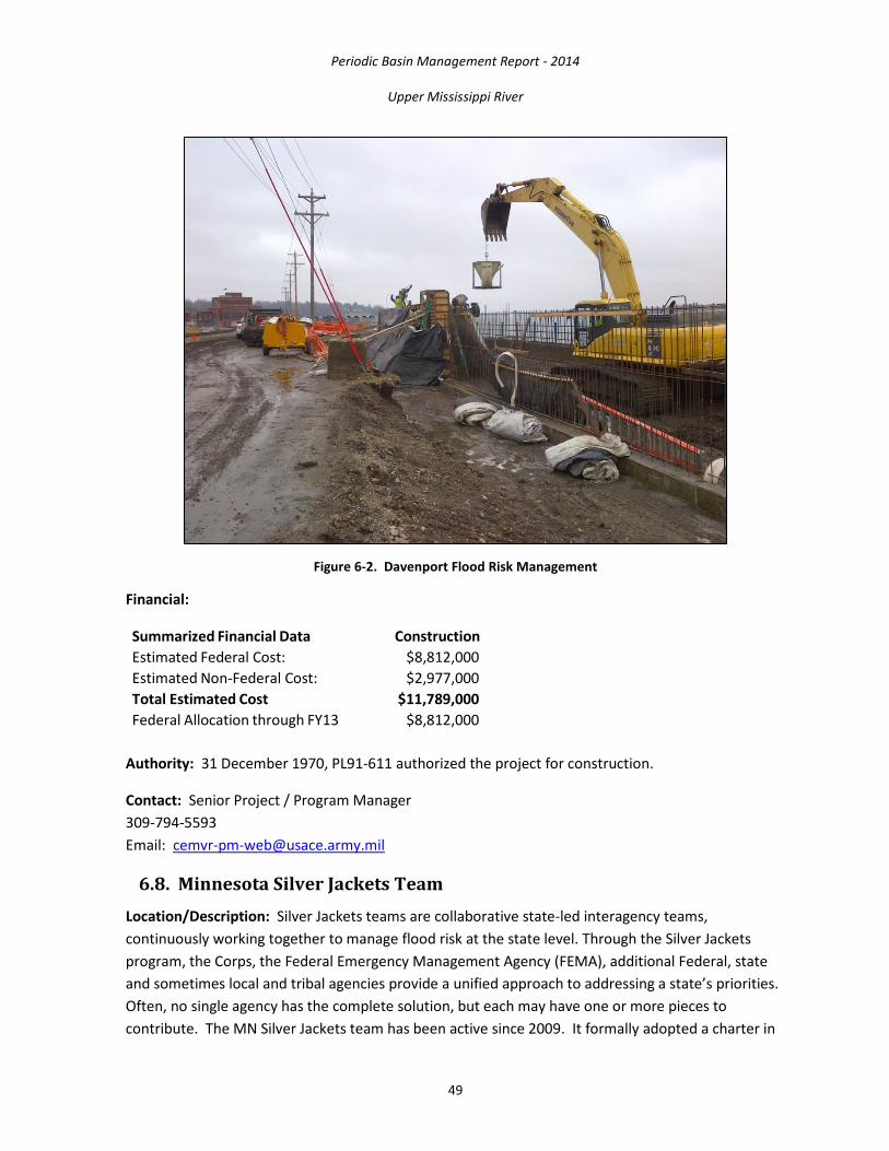
Periodic Basin Management Report - 2014
Upper Mississippi River
49
Figure 6-2. Davenport Flood Risk Management
Financial:
Summarized Financial Data Construction Estimated Federal Cost: $8,812,000 Estimated Non-Federal Cost: $2,977,000 Total Estimated Cost $11,789,000 Federal Allocation through FY13 $8,812,000
Authority: 31 December 1970, PL91-611 authorized the project for construction.
Contact: Senior Project / Program Manager 309-794-5593 Email: [email protected]
6.8. Minnesota Silver Jackets Team Location/Description: Silver Jackets teams are collaborative state-led interagency teams, continuously working together to manage flood risk at the state level. Through the Silver Jackets program, the Corps, the Federal Emergency Management Agency (FEMA), additional Federal, state and sometimes local and tribal agencies provide a unified approach to addressing a state’s priorities. Often, no single agency has the complete solution, but each may have one or more pieces to contribute. The MN Silver Jackets team has been active since 2009. It formally adopted a charter in

Periodic Basin Management Report - 2014
Upper Mississippi River
50
2011 and considers itself to be an all-hazards team. The team conducts monthly meetings and supplemental meetings as necessary. The team participates in regional and national FRM planning events. Team actions have also been instrumental in successful support of response to and recovery from recent flood events.
The primary goals of the Silver Jackets program are to:
• facilitate strategic life-cycle FRM; • create or supplement a continuous mechanism to collaboratively solve state-prioritized
issues and implement or recommend those solutions; • improve processes, identifying and resolving gaps and counteractive programs; • leverage and optimize resources; • improve and increase communication and present a unified interagency message; and • establish close relationships to facilitate integrated post-disaster recovery solutions.
Status: The MN Silver Jackets team currently has three pilot projects in Minnesota and three shared with North Dakota in the Red River of the North basin. The three Minnesota projects include:
• flood inundation mapping for the Mississippi River through downtown St. Paul, complete in spring 2014;
• identifying undocumented levees in the vicinities of Delano and Springfield, MN, complete in spring 2014; and
• bluff erosion hazard zoning guidelines in Blue Earth County, complete in fall 2014.
Other activities include updates of the MN all-hazard mitigation plan and support of FEMA RiskMAP flood hazard mapping meetings.
Fiscal: The following is a summary of the funds received for the MN Silver Jackets pilot projects: Total Federal funds allocated to date: $368,000 Authority: The Silver Jackets team is a national coordination program activity funded by various authorities.
Contact: St. Paul District Project Manager 651-290-5807 [email protected]
6.9. Upper Mississippi River Basin: Regional Discharge-Frequency Study Location/Description: The UMR corridor is a popular vacation and retirement area and is experiencing continued growth. Much of the area has not been previously studied, and flood risks have not been adequately defined.

Periodic Basin Management Report - 2014
Upper Mississippi River
51
The UMR Regional Discharge-Frequency Study is conducting hydrologic analyses for development of a consistent set of frequency distributions for discharge and elevation for the UMR from the headwaters area of Lake Bemidji downstream to St. Paul, MN. This study will directly inform floodplain management decisions in 13 counties in MN.
Status: Start-up funding was provided in FY10. It is estimated the complete study will cost $350,000 and will be done in phases, depending on funds available. The objective of the study is to develop discharge-frequency curves for general use and to provide the most current information possible for new and updated FEMA flood insurance maps.
The Minnesota Department of Natural Resources (DNR) and the Corps are coordinating work efforts so study products will be compatible with the FEMA RiskMAP flood insurance map program. Work is progressing using regional technical resources. An updated draft report was completed on July 22, 2013. The draft is being revised and then will go through interagency review in the summer of 2014.
Authority: The study is authorized by Section 206 of the 1960 FCA (PL 86-645), as amended. The study is being conducted under the Corps Floodplain Management Services Program.
Financial: The following is a summary of the funds received for the UMR Regional Discharge-Frequency study:
Total Estimated Project Cost: $350,000 Total Federal Funds to Date: $305,000 Federal Funds Required to Complete: $ 45,000
Contact: St. Paul District Project Manager 651-290-5807 [email protected]
6.10. East St. Louis, Il Levee System Location/Description: The East St. Louis levee system is located in St. Clair and Madison Counties, IL, along the left descending bank of the Mississippi River between RMs 175 and 195 above the Ohio River. The levee system was designed to withstand a flood at 54 feet on the St. Louis gage; approximately a 0.2 percent chance of exceedance (500-year event) and provides flood protection to approximately 250,000 residents and over $4.5 billion in economic value. The system is aged and requires rehabilitation. The East St. Louis, IL, project consists of the rehabilitation and/or closure of 21 small gravity drains, 10 large gravity drains (gatewells), 20 closure structures, and 300 relief wells; minor floodwall and levee rehabilitation work; rehabilitation of 12 pumping stations and 3 drainage control structures; replacement of 3 bridge structures; abandonment and removal of 4 bridge structures; and 6 segments of channel rehabilitation. All bridge work is 100 percent non-Federal. The rehabilitation project also includes the development of a Limited Reevaluation Report (LRR) that addresses design deficiencies in underseepage and through seepage controls. The deficiency
Periodic Basin Management Report - 2014
Upper Mississippi River
52
correction project consists of 305 new relief wells, grouting 312 wood stave relief wells, ditching and pipe collector systems, a seepage pump station, a lift station, a variable frequency drive, seepage berms, cutoff walls, riverside clay blanket, and environmental and archeological mitigation work.
Authority: FCA of 1936; Energy and Water Development Appropriations Act of 1988 (PL 100-202)
Contact: U.S. Army Corps of Engineers, St. Louis District 1222 Spruce St. St. Louis, MO 63103 www.mvs.usace.army.mil
6.11. Expedient Flood Fight Products Location/Description: The Rock Island District Emergency Management (MVR-EM) is the Corps’ National Expedient Flood Fight Product (EFFP) Program Manager. The EFFP is flood fight materiel designed to be an innovative and expeditious means of providing flood protection when there is not enough time to conduct typical sandbag operations. The use of EFFP can quickly enhance a community's flood protection and manage the risk of damages and loss of life. The addition of EFFP to the Corps’ flood fight inventory increases the Corps’s capability to supplement State and local flood fight operations. As the National Program Manager, MVR-EM is responsible for the Nation-wide inventory control of products, procurement of additional products, and refurbishment of used product for all of the Corps. MVR-EM ensures that the five distribution centers (Sacramento District, Seattle District, Omaha District, Rock Island District, and Philadelphia District) have an ample supply of three different types of EFFP (HESCO, Portadam, and Rapidly Deployable Floodwall). As a Distribution Center, MVR-EM's responsibilities include the acquisition of storage facilities, logistical control of local product, and regional deployment of the products within the Mississippi and Ohio River basins to support state and local flood fight operations.
The MVR also serves as the training coordinator of the EFFP. Responsibilities include training of multi-regional personnel including Corps’ Division and District personnel, state and local officials, and Federal/non-Federal sponsors. Training on how to use each product will include proper product storage; operational considerations; product setup; maintenance during operation; protection improvement; product removal; cleaning; repair; and repackaging for storage. The Corps’ Engineering Research and Development Center (ERDC) developed a comprehensive laboratory testing program for these types of products, and the results are available online at http://chl.erdc.usace.army.mil/ffs.
Contact: Chief, Emergency Management Division 309- 794-5230 Email: [email protected]

Periodic Basin Management Report - 2014
Upper Mississippi River
53
6.12. Mississippi River, Dubuque, IA FRM Project Location/Description: Existing FRM facilities in Dubuque, IA have experienced significant changes since they were constructed and it may be prudent to re-evaluate the costs and benefits of modifications and improvements to the system.
Financial:
Recon 1 Federal Cost: $100,000 Non-Federal Cost: $0.00 Total Cost: $100,000 Federal Allocations through FY13: $0.00 FY14 Allocations $0.00 FY15 Budget $0.00 Balance to Complete: $100,000
1 (Reconnaissance 905(b) only)
• Major Work Item FY14 o None (no funding)
• Major Work Item FY15 o Complete 905(b) Reconnaissance and initiate Feasibility Study (pending Federal
Interest Determination and funding)
Contact: Project Manager 309- 794-5885 Email: [email protected]
6.13. Big Five Levee System, IL Location/Description: The Big Five Levee System (Figure 6-3) is situated in Alexander and Union Counties, IL, comprising 54.6 miles of levee as detailed below within each individual D&LD. Preston D&LD system consists of 14.9 miles of levee in Union County on the left descending bank, adjacent to the Mississippi River from approximate Mississippi River Mile 66 to 76, above the Ohio River. Clear Creek D&LD includes 20.6 miles of levee in Alexander County on the left descending bank, adjacent to the Mississippi River from approximate RM 57 to 66 above the Ohio River. The East Cape Girardeau and Clear Creek Drainage District is located in Alexander County on the left descending bank, adjacent to the Mississippi River from approximate RM 46 to 57 above the Ohio River and includes 10.9 levee miles. The North Alexander County D&LD is located near the north end of Alexander County between RM 51 & 58 above the mouth of the Ohio River. The District includes bottomlands between the Clear Creek D&LD (north), bluffs on the East & South, East Cape Girardeau and Clear Creek D&LD’s on the West and covers 5.15 miles of levees. Miller Pond Drainage District is comprised of 3.1 levee miles at RM 66 to 68.
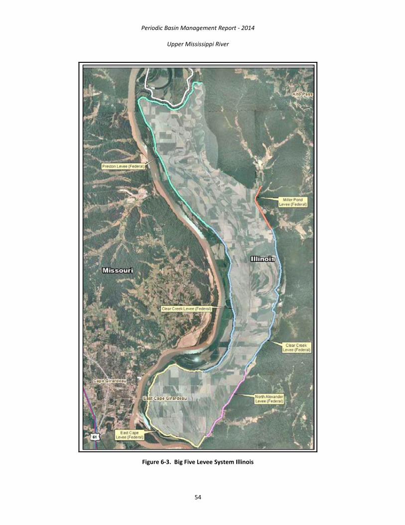
Periodic Basin Management Report - 2014
Upper Mississippi River
54
Figure 6-3. Big Five Levee System Illinois
Periodic Basin Management Report - 2014
Upper Mississippi River
55
This levee system, which is part of the Alton to Gale levee system, protects approximately 49,100 acres, the majority of which is agricultural or U.S. Forest Service lands. The protected area also includes residences, small businesses, and farm buildings. The Big Five Levee System has a documented history of uncontrolled underseepage and significant interior flooding from seepwater and rainfall.
A Reconnaissance Report for Big Five Levee System Reconstruction report was finalized on 3 May 2012. The purpose of this report was to further evaluate the potential for Federal interest in implementing levee reconstruction solutions for the Big Five Levee System. Based on the results of the report, a viable and implementable plan can be developed that will meet the necessary Federal interest criteria and supported by the sponsor.
Authority: FCA of 22 June 1936 and 28 June 1938 (existing projects); House Committee Resolution adopted May 7, 1997
Contact: U.S. Army Corps of Engineers, St. Louis District 1222 Spruce St. St. Louis, MO 63103 www.mvs.usace.army.mil
6.14. Degognia/Fountain Bluff and Grand Tower L&DD Location/Description: The Degognia and Fountain Bluff L&DD and the Grand Tower Drainage and Levee District comprise a single closed levee system protecting the Mississippi River floodplain of Jackson County, IL, approximately 70 miles south of St. Louis, MO. This levee system, which is part of the Alton to Gale levee system, is 36.6 miles in length and protects approximately 51,000 acres, the majority of which is agricultural or U.S. Forest Service lands. The protected area also includes residences, small businesses, farm buildings, the Cora coal transfer facility, two state highways and the towns of Grand Tower, Gorham, and Jacob. The study will address problems associated with these two existing projects which relate to deterioration of flood control features as a result of their advanced age associated with underseepage measures.
Authority: FCA of 1936 and 1938 (existing projects); House Committee Resolution adopted May 15, 2008
Contact: U.S. Army Corps of Engineers, St. Louis District 1222 Spruce St. St. Louis, MO 63103 www.mvs.usace.army.mil
6.15. Prairie du Pont Levee and Sanitation District and Fish Lake D&LD Location/Description: The study area is located on the east bank of the Mississippi River between RMs 166 and 175 above the Ohio River in St. Clair and Monroe Counties, IL, across from St. Louis County, MO (Figure 6-4). The area is protected by an urban design levee, completed in 1951, which consists of a 15.2 mile levee system with gravity drains and four pumping stations to evacuate

Periodic Basin Management Report - 2014
Upper Mississippi River
56
interior floodwaters. The flood of 1993 produced serious underseepage problems within this system (sand boils, quick soil conditions, and serious piping conditions). A deficiency correction study would investigate solutions such as rehabilitation/replacement of existing relief wells and the construction of additional relief wells. The local sponsors have maintained the levee system since 1951. A feasibility study is needed to assess the potential for reconstruction of deteriorated features such as gates and culverts, thru seepage and elevation deficiencies.
Figure 6-4. Prairie du Pont and Fish Lake
Authority: The FCA of 1936, as amended to include the Fish Lake Area by the FCA of 1954; Section 102(8) of WRDA 2000; and Section 5070 of WRDA 2007 authorized reconstruction.
Contact: U.S. Army Corps of Engineers, St. Louis District 1222 Spruce St., St. Louis, MO 63103 www.mvs.usace.army.mil

Periodic Basin Management Report - 2014
Upper Mississippi River
57
6.16. St. Louis, MO, Watershed Flooding Impacts at the Great Rivers Confluence
Location/Description: The study area is comprised of the large river floodplains within the greater Metropolitan St. Louis area and includes the City of St. Louis plus Franklin, St. Charles, St. Louis, and Jefferson Counties in Missouri and Calhoun, Jersey, Madison, St. Clair, and Monroe Counties in Illinois (Figure 6-5). Approximately 800,000 people are estimated to live in, work in or transit these floodplains. This study will examine the cumulative effects of various types of past development such as levees, flood control reservoirs, river navigation structures, transportation and other infrastructure as well as project the induced flooding effects associated with various types of potential future development. The impacts will broadly address impacts to wetlands, navigation, and commercial floodplain activities. These findings could be invaluable to local and regional decision makers as well as to the Corps and other Federal planners, such as FEMA, in making decisions on the full costs, benefits, and impacts associated with various Federal, state, and local projects.
Figure 6-5. St. Louis, MO Watershed
Authority: Senate Committee Resolution adopted June 23, 2004
Contact: U.S. Army Corps of Engineers, St. Louis District 1222 Spruce St. St. Louis, MO 63103 www.mvs.usace.army.mil
Periodic Basin Management Report - 2014
Upper Mississippi River
58
6.17. National Levee Database Location/Description: The need to develop a comprehensive national levees database was recognized as FEMA's Nation-wide digital flood insurance rate map (DFRIM) modernization program advanced. The criticality of this need was brought to the forefront by Hurricane Katrina. Subsequent Congressional action, specifically FY06 supplemental FCCE funding, provided the Corps with the resources necessary to design and build a National Levee Database (NLD). An initial levees survey instrument was fielded to quantify the magnitude of this effort. A Corps Project Development Team (PDT) was then tasked with development of the data model. PBS&J, the national surveying and database development firm, has been contracted to provide support to all aspects of the NLD project. 5 pilot Districts were designated to field test the data model, including development of standard operating procedures for data collection and populating the database. The initial development of the NLD included only those levees active in the Corps' PL84-99 program. There are approximately 829.9 linear miles of levees within in the MVR that qualify for NLD development.
Status: Field surveying and database development for ~437.1 linear miles of qualifying levee systems along the UMR has been completed.
Financial:
Federal Cost: $1,585,600 Non-Federal Cost: $0.00 Total Cost: $1,585,600 Federal Allocations through FY14: $1,585,600 Scheduled Federal Allocation for FY15: $0.00 Balance to Complete: $0.00
• FY14: No funding was available for NLD update and database maintenance in FY13 or FY14. Through the auspices of the Levee Safety Program critical elements of the NLD is updated with Program developed work products including: Annual and Periodic inspection Reports, Executive Summaries for Levee Systems and corrections to “protected areas” behind the levees. QA/QC refinements of the database include correction of extent of sponsor ownership of levees segments as well as inclusion of design documentation through the Levee Screening Tool submissions. • FY15: The critical elements of the NLD to Levee Safety Program will require update of the NLD with Program developed work products. The Corps is charged in WRDA 2007 with creating an inventory of federally-constructed levees. The 2013 discovery of archived documents from the 1940s indicate Federal involvement in construction of potentially several hundred miles of levees under the Works Progress Administration. These levees are not currently enrolled in the PL84-99 program. To fulfill the mandate contained in WRDA, the Corps is researching the potential and policy implications for the NLD survey, and subsequent inspection and levee risk screening tasks of the Levee Safety

Periodic Basin Management Report - 2014
Upper Mississippi River
59
Program and under what authority will the surveys be undertaken. Costs if required to conduct the NLD survey of these levees are likely to approach the FY12 allocation.
Authority: Flood Control & Coastal Emergencies (FCCE), PL84-99
Contact: Project Manager Phone: 309-794-5165 Email: [email protected]
6.18. Ste. Genevieve, MO Location/Description: The project is located in Ste. Genevieve County, MO, adjacent to the west bank of the Mississippi River between miles 121 and 125 above the confluence of the Ohio River. The project consists of a 3.5 mile long levee that provides Urban Design Flood protection from Mississippi River flooding; a gravity drain pump station facility with a 575 cfs capacity and three electric-powered pumps; a 505-acre ponding area; interior drainage ditching and grading; two closure structures; road, railroad, and utility relocations; 24 relief wells; tree screens; an environmental mitigation area; and other features. The authorized project includes channel widening and one small levee along North and South Gabouri Creeks and recreation facilities such as picnic areas and trails on flood control lands along the tributary improvements and the levee.
Authority: WRDA of 1986 (PL 99-662)
Contact: U.S. Army Corps of Engineers, St. Louis District 1222 Spruce St. St. Louis, MO 63103 www.mvs.usace.army.mil
6.19. St. Louis Flood Protection, MO Location/Description: The existing project is located in St. Louis, MO, on the right bank of the Mississippi River between Miles 176.3 and 187.2, above the mouth of the Ohio River 9 (Figure 6-6). The existing project consists of 11 miles of flood protection by a combination of floodwalls, levees, closure structures, pump stations, gravity drains, relief wells and other underseepage control measures, and pressure sewer emergency closure gatewells. The project reduces flood risk to approximately 3,160 acres of industrial and commercial development from Mississippi River flooding. The FRM system was constructed with inadequate closure structures and underseepage protection. These design deficiencies must be corrected to ensure that the system provides its authorized level of service. The corrections completed included replacing swing gates at 22 closure structures, permanently closing openings at 10 closure structures, installing 108 relief wells needed to improve underseepage control, and planting bottomland hardwoods to mitigate for 0.1-acre of impact.

Periodic Basin Management Report - 2014
Upper Mississippi River
60
Figure 6-6. St. Louis Flood Protection
Authority: PL 84-256 dated 9 August 1955
Contact: U.S. Army Corps of Engineers, St. Louis District 1222 Spruce St. St. Louis, MO 63103 www.mvs.usace.army.mil
6.20. Wood River Levee, IL Location/Description: The original Wood River levee project was authorized in the FCA of 1938 and constructed in the 1950s. It is the northernmost Metro East levee and is located in Madison County, IL between Mississippi River Miles 195 and 203 above the Ohio River confluence. The Wood River system consists of three hydraulically independent levees with a combined length of 20.8 miles–Upper Wood River, Lower Wood River, and East-West Fork. This system includes 170 relief wells, 26 closure structures, 41 gravity drains, and 7 pump stations. This system helps protect a high concentration of petrochemical infrastructure and heavy industry including oil refining, steel manufacturing, and ammunitions production. It also provides risk reduction to a residential population of approximately 20,000 in five towns–Alton, East Alton, Wood River, South Roxanna, and Hartford. In addition, a portion of Upper Wood River levee is adjacent to Melvin Price L&D and helps

Periodic Basin Management Report - 2014
Upper Mississippi River
61
maintain the navigational pool. Per the Annual Water Control Management Report, St. Louis District, Fiscal Year 2013, damages prevented by the system are $347,558,000.
In 2006, a General Reevaluation Report (GRR) was prepared to address the need for reconstruction/rehabilitation of several components of the Wood River system as well as the need for additional underseepage controls. The GRR was approved at HQ and the Chief’s report was transmitted to Congress in July 2006. The report recommended rehab/replacement of 38 gravity drains, 26 closure structures, and seven pump stations. It also recommended the replacement of 163 existing relief wells and 60 new wells under original project authority (to address underseepage design deficiencies). The Reconstruction component of the report was authorized in WRDA 2007 (the design deficiency component did not require additional authorization).
Authority: Section 4 of the FCA of 1938; Section 103 of WRDA 1986; Section 1001(20) of WRDA 2007
Contact: U.S. Army Corps of Engineers, St. Louis District 1222 Spruce St St. Louis, MO 63103 www.mvs.usace.army.mil
7. ECOSYSTEM RESTORATION Congress has authorized the Corps to perform ecosystem restoration in conjunction with water resource and related land resource issues. The purpose of the Corps’ ecosystem restoration mission is to restore degraded ecosystem structure, function, and dynamic processes to a less degraded, more natural condition. Ecosystem restoration seeks to provide a comprehensive approach for addressing the problems associated with disturbed and degraded ecological resources.
Congress authorized the UMRS Environmental Management Program in Section 1103 of the 1986 WRDA. The program proved to be one of this country’s premier ecosystem restoration programs, combining close collaboration between Federal and State partners, an effective planning process, and a built-in monitoring process. In 1999, the Upper Mississippi River Restoration (UMRR) Program was reauthorized in the WRDA (PL 106-53). Section 509 of the 1999 Act made several adjustments to the program and established the following two elements as continuing authorities:
• Planning, construction, and evaluation of fish and wildlife habitat rehabilitation and enhancement projects, known as Habitat Rehabilitation and Enhancement Projects (HREPs).
• LTRM, computerized data inventory and analysis, and applied research, known collectively as Long-Term Resource Monitoring (LTRM).

Periodic Basin Management Report - 2014
Upper Mississippi River
62
Habitat Rehabilitation and Enhancement Projects: The UMRR program for HREPs contributes to improved ecosystems that benefit native plants and animals and help to promote biodiversity. Biological diversity is a reflection of a healthy environment and provides resiliency. Furthermore, a healthy and biologically diverse ecosystem is important for better fishing, hunting, boating, and bird watching. The HREPs helps improve water quality and provide a clean source of drinking water. Through building islands and reduced wind and waves on the river, the sand and sediment in the river settles to the bottom; leaving cleaner water for plants, animals and people.
Shoreline stabilization projects help slow down and prevent erosion; this protects habitat and prevents sedimentation in backwater areas. Natural seasonal water levels and optimal growing conditions can be emulated through pool drawdowns. Drawing down the water level allows for sediment consolidation, creating clear and clean water in the river, and also increased vegetation growth on the newly exposed sediment. Wildlife thrive in this newly created habitat. Water quality in the Mississippi River backwaters is also improved by the use of flow control structures, which are built in side-channel inlets to manage flow and reduce sediment and erosion. Fishery habitat is improved by backwater dredging when sediment deposits are removed and deep water is restored for winter habitat. Fishing enthusiasts will be able to enjoy world-class fishing for generations to come.
Long-Term Resource Monitoring: The LTRM is a cutting-edge research program that helps scientists and water resource managers better understand river processes, assess the health of the river, forecast future trends, and manage for continuous improvement. The UMR Restoration Long Term Resource Monitoring is recognized internationally as a preeminent science program, contributing significant insights that expand beyond the Mississippi River. The U.S. Geological Survey runs LTRM out of six field stations where river data are collected according to scientific protocol. The data acquired from monitoring the river’s health and researching the river’s ecology are easily accessible to river managers and the community. This contribution to science helps managers better understand the system, forecast future conditions and provide early warning of potential problems. Data collected through decades of monitoring and research answer questions about how to improve habitat for important species such as paddlefish and sturgeon, and also how to manage habitat with the influx of exotic invasive species such as zebra mussels and Asian carp.
Long Term Resource Monitoring and the U.S. Geological Survey have acquired thousands of aerial photographs, maps, scientific reports, information on land cover and water depths, and many ecological models. All of this information is integrated to inform scientists and managers’ decisions and to implement effective ecosystem restoration projects.

Periodic Basin Management Report - 2014
Upper Mississippi River
63
7.1. Blackhawk Bottoms Pool 19, IA Location/Description: The State of Iowa owns and manages land near the confluence of the Skunk and Mississippi Rivers that is a former agricultural field. The State is interested in creating a moist soil unit on this former field using dredged material from the Kemps-Craigel dredge cut. Low level berms would be created with the dredged material. In addition, construction of a water control structure would allow water from Spring Creek, which flows through the proposed project area, to pond water to a depth of approximately 18 inches at certain times of the year. A water level management regime similar to the natural cycle would allow the creation of quality moist soil plants. This habitat would be complimented by seasonal flooding to attract water-loving birds while they migrate. These flooded wetlands provide a food source for a multitude of species. The Iowa DNR would serve as the sponsor for this project. The State's real estate interest will satisfy at least some of its 35 percent cost share.
Status: The Final Feasibility Report with Integrated Environmental Assessment was approved in August 2012 and the Project Partnership Agreement was executed in September of 2013. Plans and specs are underway with an anticipated contract award in August of 2014.
Financial:
Design & Implementation Estimated Federal Cost: $1,251,000 Estimated Non-Federal Cost: $674,000 Total Estimated Project Cost $1,925,000 Allocation thru FY12 $0.00 Allocation for FY13 $0.00 Budget for FY14 $0.00 Balance to Complete: after FY14 $1,251,000
• Major Work Item FY14
o Proceeding with design, scheduled to award construction contract • Major Work Item FY15
o Initiate Construction
Authority: Section 204 of the WRDA, as amended (Beneficial Use of Dredged Material for Ecosystem Restoration)
Contact: Section 206 Program Manager, Project Management Branch 309- 794-5399 Email: [email protected]

Periodic Basin Management Report - 2014
Upper Mississippi River
64
7.2. Chevron Dike Construction Near Oquawka, IL Location/Description: The MVR evaluated a variety of solutions to decrease the amount of dredging in the Oquawka Reach of Pool 18, near the town of Oquawka, IL (Mississippi River, RMs 415-416). The District determined that new construction of four chevrons is needed to redirect river flows toward the navigation channel. The chevrons will be built to an elevation of 531.5 msl, 3.5 feet above flat pool elevation of 528 msl. Each structure would be an average linear length of approximately 1,325 feet. The chevron is a V-or U-shaped rock structure pointing upstream. Not only do chevrons divert river flow toward the main channel similar to a wingdam, they also create several different types of river habitat, with variable depth and flow velocities. During high water events, river flows overtopping the structures would create a large scour hole just downstream of the structure's apex. After the flows drop below the crest of the structure, the scour hole formed at high flow becomes an area of deep slack water. This environment is conducive to the needs of overwintering fish, and provides the ideal conditions for a juvenile and larval fish nursery. The potential plant life established along the wetted edges and uneven rock structure would provide good escape cover and foraging habitat for young fish. Chevrons would also divert river flows toward the navigation channel thereby reducing the amount of erosional forces upon existing islands as well as potentially establishing islands at historic locations in this area.
Status: The District prepared an EA titled, Chevron Dike Construction Near Oquawka, IL, Pool 18, Mississippi River, dated March 2008, to help assess the potential impacts to the natural and human environments. This EA is attached to this project fact sheet under Supplemental Information. The EA details the District's decision-making efforts to meet the project's goals of reduce dredging, create habitat diversity, protection of existing islands and possible restoration of lost islands. The EA analyzes the practical alternatives, and evaluates the potential environmental impacts of each alternative. The EA includes a Clean Water Act, Section 404(b)1 Evaluation. This evaluation addresses the potential impacts to wetlands and water quality. The EA is attached under Supplemental Information. The District Engineer signed the Finding of No Significant Impact on June 24, 2008.
Financial:
Construction began in 2010 on Chevron No. 1. The District completed Chevron No. 2 in 2011 and continued to build Chevrons 3 and 4 from 2012 -2014.
• Major Work Item FY15 o Finish work
Contact: Rock Island District Biologist 309-794-5791 Email: [email protected]

Periodic Basin Management Report - 2014
Upper Mississippi River
65
7.3. Chouteau Island, IL Section 514 Location/Description: The study area includes approximately 1,500 acres on Chouteau and Gabaret Islands in Madison County, IL. The purpose is to restore the ecosystem of the area in partnership with several state and local government entities, as well as not-for-profit groups. The project will provide habitat restoration in the greater St. Louis, MO, metropolitan area. Alternatives include taking approximately 1,320 project acres and restore the natural floodplain ecosystem (a mixture of bottomland hardwoods, wet and dry prairie, and slough restoration).
Authority: Section 514 (Missouri and Middle Mississippi Rivers Enhancement Project) of the WRDA of 1999 (PL 106-53)
Contact: U.S. Army Corps of Engineers, St. Louis District 1222 Spruce St. St. Louis, MO 63103 www.mvs.usace.army.mil
7.4. East St. Louis & Vicinity, IL Location/Description: This project is located in Madison and St. Clair Counties, IL along the east bank of the Mississippi River between RMs 175 and 195 above the mouth of the Ohio River. The ecosystem restoration project would restore 1,700 acres of bottomland forest habitat; 1,100 acres of floodplain prairie habitat; 840 acres of marsh and shrub swamp habitat; 460 acres of lake habitat; 380 acres of upland riparian forest; and 10 miles of floodplain streams. The project lies within the Mississippi River Flyway and contributes to the life cycle requirements of more than 50 migratory bird species.
Status: An approved Chief’s report was signed in FY05 but was not supported by the ASA(CW). To address the concerns of the ASA(CW), the MVS is working on an Addendum that will be incorporated into a new Chief’s report.
Authority: Section 204 of the FCA of 1965 (PL) 89-298) authorized a project to provide FRM protection from interior flooding that was modified by Section 137 of the WRDA 1976 (PL 94-587) by authorizing construction of the Blue Waters Ditch segment independently of the other authorized segments. House Report 104-782, Appropriations for Energy and Water Development for FY97, provided for a reevaluation of the authorized project. Section 310 of WRDA 2000 (PL 106-541) modified the project authority to include ecosystem restoration as a project purpose. Section 1001(18) of WRDA 2007 (PL 110-114) authorized the ecosystem and recreation project per the Chief’s Report dated December 22, 2004
Contact: U.S. Army Corps of Engineers, St. Louis District 1222 Spruce St. St. Louis, MO 63103 www.mvs.usace.army.mil

Periodic Basin Management Report - 2014
Upper Mississippi River
66
7.5. Endangered Species: Conservation of Native Mussels Location/Description: The Corps is the lead agency on the Mussel Coordination Team (MCT). Other members of the MCT include the Corps, the U.S. Geological Survey, the National Park Service, the U.S. Coast Guard and the Illinois Iowa, Minnesota, and Wisconsin DNRs.
MCT biologists, including Corps biologists from MVP and MVR, are working to establish five new populations of the federally-endangered Higgins eye (Lampsilis higginsii) mussel. Relocation sites have been established in Illinois Iowa, Minnesota, and Wisconsin. These biologists also monitor the health and status of endangered and other native mussels by sampling various locations on the river. Data are entered into a Geographic Information System to facilitate long-term monitoring, data sharing and species management activities. MCT biologists are annually removing zebra mussels from approximately 600 Higgins eye mussels to increase their survival. Development of a relocation plan for the federally-endangered winged mapleleaf mussel (Quadrula fragosa) was initiated in 2006. Public outreach is being conducted.
The Higgins Eye Relocation Plan was developed in response to the USFWS’ 2000 BO, which stated that continued operation of the 9-Foot Navigation Channel project on the UMRS would likely jeopardize the continued existence of the federally-endangered Higgins eye and result in the incidental take of winged mapleleaf. The USFWS determined that O&M of the navigation pools and project-dependent commercial barge transportation would encourage continued zebra mussel dispersion throughout the system. Zebra mussels negatively affect the survival and recovery of these endangered mussels. The 10-year Higgins Eye Relocation Plan reestablishment phase has been completed, with long-term (20 years) monitoring afterward and augmentation of populations, if needed.
Status: Higgins eye relocation and monitoring efforts are in the 15th year of the implementation phase and the 9th year of monitoring. As of 2014, more than 40,000 2-to 3-year-old sub-adults have been placed in Mississippi River Pools 2, 3, 4 and 16 and the Wisconsin and Rock Rivers. Nearly 500 adults have been moved to relocation sites in Pools 2 and 3. Potentially, more than 4.3 million juveniles from more than 33,000 infested fish were free released or placed in open bottom cages from 2001 to 2012 in the Wisconsin, IA, Cedar and Wapsipinicon Rivers. Propagation and stocking was completed in 2010 for the northern strain. Propagation and stocking for the southern strain was completed in 2012. Monitoring populations for potential augmentation began in 2006 and will continue.
Winged mapleleaf host identification studies and pilot propagation efforts including genetics studies were conducted from 2004 to 2013. A final draft feasibility report with an approved tentatively selected plan was completed October 2013. Although it was determined there is a Federal interest to implement the project, the study does not recommend for further Corps action until a local NFS has been identified.

Periodic Basin Management Report - 2014
Upper Mississippi River
67
Authority: Formal authorization for the Corps to perform O&M activities on the UMRS was given in the Rivers and Harbors Acts of 1927, 1930, 1932 and 1935.
Financial:
• Funding through FY14: $7.8 million • Fiscal year 2014 funds: $206,000
Contact: St. Paul District Project Manager 651-290-5807 [email protected]
7.6. Zebra Mussels in the Upper Mississippi River System Location/Description: Since their initial introduction in 1985, zebra mussels have spread from the Great Lakes into several major river systems, including the Mississippi, Ohio, IL, Tennessee, and Arkansas, and are now spreading to numerous inland lakes and reservoirs. Zebra mussels attach to hard substrates on the bottom of the river, encrusting water intakes and smothering native mussels. Zebra mussel larvae (veligers) float passively in the water column while adults can move upriver or overland by attaching themselves to recreational or commercial vessels. Within one or two years of their colonization of a new area, zebra mussels typically undergo explosive population growth attaching in mass to a variety of substrates (i.e. plants, rocks, mussels, woody debris, etc.). For example, zebra mussel populations in the Illinois River exploded in 1993, reaching densities of nearly 100,000/m2. Since then Illinois River populations have experienced high mortality, resulting in greater than 99 percent reduction at most sites and have not returned. Researchers believe this decline is due to less than ideal temperature, flow, and suspended sediment levels. In comparison, zebra mussel populations in the UMR have developed more gradually. During 2000, researchers in Wisconsin described zebra mussel colonies in Pools 8-10, which formed mats four inches thick with densities estimated at 90,000/m2. In August of 2001 zebra mussels experienced a significant and unexplained die-off in much of the Mississippi River. This occurred again in the summer of 2003, but zebra mussel returned in 2004. Native mussels were unaffected by these die-offs. Zebra mussels are present in the Upper Mississippi, but are no longer found in the abundance of former years. Reasons for this smaller population size are poorly understood.
Status: The Corps leads a multi-agency panel known as the Mussel Coordination Team that has developed a conservation plan to try to save the endangered Higgins Eye Pearly mussel (Lampsilis higginsii) from possible extinction from zebra mussels. This panel was formed to carry out the reasonable and prudent measures as guided by the Endangered Species Act Jeopardy BO (BO) issued by the USFWS on May 15, 2000. In 2013 this group was involved with the propagation, relocation, and cleaning of these endangered mussels in critical habitat areas within the UMRS. The Corps continued its national effort to address invasive species spearheaded by the Invasive Species Leadership Team to examine agency strategies for dealing with invasive species like the zebra mussel

Periodic Basin Management Report - 2014
Upper Mississippi River
68
on Corps lands. This effort led to the development of guidance on invasive species in 2009 and implementation of this guidance in 2014 through the development of a Program Management Plan.
Additional Project Information: Transport and Spread. Many human-related transport mechanisms exist on the UMR including watercraft, buoys, marina and boatyard equipment, fishing equipment, fish cages, fish stocking water, bait and bait bucket transfer, marker buoys and floats, amphibious planes, recreational equipment, and litter. The abundant Lake Pepin population of zebra mussels is believed to be self-sustaining and a significant source of veligers (immature zebra mussels) that settle and mature downstream. Preliminary research performed by the Mussel Coordination Team indicated that control of zebra mussels within Lake Pepin might reduce the abundance of zebra mussels below Pool 4.
Control Strategies -The conservation plan outlines four broad goals for implementing feasible zebra mussel control measures:
1. No Action. Under the no action alternative, zebra mussels would continue to be transported throughout the UMRS via transport on barges and recreational vessels. This alternative would jeopardize the continued existence of endangered mussel species. In light of the jeopardy BO, this is not considered a feasible alternative.
2. Natural/Environmental Control Measures. Measures being investigated include the restoration of riverine conditions in the navigation pools and/or the mechanical removal of zebra mussel from native endangered species. The efficacy of zebra mussel specific toxicants (chemical molluscidcides: chlorine, chlorine dioxide) and/or diseases is also being investigated. The key to the success of any of these measures is gaining an understanding of biological controls such as natural cycles of abundance and habitat preferences of the zebra mussel.
3. Transport/Dispersal Control Measures. Methods for controlling upriver transport of zebra mussels fall into two categories, passive and active.
Passive control methods would include treatments that prevent zebra mussels from attaching to barge hulls. The use of toxic coatings (e.g. copper, zinc) or non-stick surfaces (silicone based) is being investigated.
Active control methods would include manual removal (scraping, high pressure wash), thermal treatments (steam injection, hot water >32 degrees C), electrical currents, dewatering, desiccation (freezing, heated air), acoustical vibration, ultraviolet light, etc. Active measures could be employed on individual barge hulls or on a larger scale, for instance on a lock and dam or lock chamber.
4. Barriers to Introduction of Exotics: A final alternative to be investigated would be the installation of behavioral, thermal, electrical or other barriers to prevent the spread of zebra mussels and other exotics to the UMRS. Additionally, methods for preventing the overseas transport of exotics to the US are being examined.

Periodic Basin Management Report - 2014
Upper Mississippi River
69
Contact: Biologist, CEMVP-PD-P 309-794-5385 Email: [email protected]
7.7. Asian Carp Barrier System, Upper Mississippi River Location/Description: Bighead and silver carp (Asian carp) continue to be species of concern in the UMR (Figure 7-1). They grow rapidly to 60 pounds or more, potentially outcompeting native fish species for food. A bighead carp was captured near the mouth of the St. Croix River in 2011, elevating the issue of the potential spread of Asian carp into central Minnesota waters. In 2012 and 2013 a silver carp was caught in Pool 6, the farthest upstream a silver carp has been confirmed. Both species have established populations only as far north as Pool 17 in southeastern Iowa.
Figure 7-1. Silver Carp Specimen
Status: Technologies for limiting upriver invasion of Asian carp were examined as part of the Upper Mississippi River-Illinois Waterway Navigation Study and independently by the Minnesota DNR. A sound projection array/acoustic bubble curtain system was identified as one option that could be installed at an UMR dam to test effectiveness in deterring fish from moving through the navigation locks. In 2012 the Minnesota DNR and other stakeholders voiced a preference for electronic barriers similar to those operating in the Chicago Area Waterway System.
The MVP is working with other Federal and State partners to discuss options to slow or prevent the spread of Asian carp; however, the Corps has received no funds to formally investigate alternatives. The MVP is engaged with the Minnesota DNR regarding the potential of a deterrent barrier at a Corps lock that would be designed, constructed and operated by the State of Minnesota. In September 2013 the Corps began review of preliminary plans developed by engineering consultants to the State for a proposed electrical barrier at L&D 1. A non-Corps-operated barrier at a Corps lock requires Corps approval of engineering documents and an EA. The project proponent would also be responsible for obtaining Section 10/404 regulatory permits from the Corps. Construction could begin in December 2014 if approved by the Corps and funded by the State.

Periodic Basin Management Report - 2014
Upper Mississippi River
70
Authority: Section 5016 of the WRDA of 2007 authorized the Corps to plan, design, construct and operate a deterrent barrier as a demonstration project on the UMR. The authorization is for $4 million. No funds have been appropriated to initiate this project.
The Corps is authorized by 33 U.S.C. 408 (Section 408) to permit alterations/modifications by others to existing Corps projects in certain circumstances. Any request for approval needs detailed engineering design, safety and security assurance, National Environmental Policy Act (NEPA) compliance, navigation compatibility, and possibly a real estate license.
Contact: St. Paul District Project Management 651-290-5807 [email protected]
7.8. Horseshoe Lake Section 206 Aquatic Ecosystem Restoration, IL Location/Description: Horseshoe Lake is a shallow oxbow lake located in the floodplain of the Mississippi River in Alexander County, IL. Over time, it has experienced declining fisheries and waterfowl habitat and declining cypress/tupelo regeneration. The Ecosystem Restoration Report (ERR) will examine the feasibility of a causeway construction, a dewatering pump, and well installation to help restore the lake’s ecosystem.
Authority: Section 206 of WRDA 1996 PL 104-303) as amended by WRDA 1999 (PL 106-53). This authority focuses on aquatic ecosystem and estuary restoration projects. The per-project Federal funding limit is $5M and the Section 206 national program limit is $50M. These are two-phase projects–Feasibility and Design & Implementation. Feasibility studies that exceed $100,000 are cost-shared 50% Federal and 50% non-Federal. Design & Implementation is cost-shared 65% Federal and 35% non-Federal.
Contact: U.S. Army Corps of Engineers, St. Louis District 1222 Spruce St. St. Louis, MO 63103 www.mvs.usace.army.mil
7.9. Upper Mississippi River Restoration Program Location/Description: The UMRR Program includes the main stem portions of the UMR (from the Twin Cities to the confluence with the Ohio River) and Illinois River, and the navigable portions of the Kaskaskia, St. Croix, and Minnesota Rivers. The UMRR Program is implemented through a strong partnership and consists of two primary elements: 1) Habitat Rehabilitation and Enhancement Projects (HREP) and 2) LTRM, which are integrated together to address the ecological needs of the UMRS. Habitat projects use construction techniques to mimic riverine processes to benefit the river at a system, reach, pool, and local scale. Restoration techniques include shoreline protection, island restoration, water level management, backwater dredging, secondary channel modification, and floodplain restoration. The science and monitoring element provides systemic resource monitoring,

Periodic Basin Management Report - 2014
Upper Mississippi River
71
data analysis, and applied research to increase understanding of both the regulated and open reaches of the UMRS.
Financial: The authorized program funding is $33.17 million annually. The President’s Budget for FY14 is $31.968 million for this program (Figure 7-2). A total of $ $455 million has been appropriated through FY13.
Figure 7-2. UMRR Funding * FY09 includes $13.1 million in ARRA funds
Authority: The UMRR Program was authorized by the WRDA of 1986, amended by WRDA 1990 and WRDA 1992. Over the course of its first 13 years, UMRR proved to be one of this country’s premier ecosystem restoration programs, combining close collaboration between Federal and State partners, an effective planning process, and a built-in science and monitoring process. This success led Congress to reauthorize UMRR in WRDA 1999 (PL 106-53). Section 509, WRDA 1999, reauthorized and amended the program and established it as a continuing authority; and required a report to Congress every six years. To implement the program, a partnership has been formed among the Corps; the U.S. Geological Survey; U.S. Environmental Protection Agency (USEPA), U.S. Department of Agriculture, U.S. Department of Transportation, and the states of Minnesota, Iowa, Wisconsin, Missouri, and Illinois, as well as the public and non-governmental organizations.
7.9.1. Habitat Restoration: Mississippi River, Capoli Slough, Pool 9, WI Location/Description: Part of the Corps' UMRR Program, the site is a side channel/island complex located on the Wisconsin side of the Mississippi River navigation channel in Pool 9, about 5 miles downstream of Lansing, IA (Figure 7-3). The site is in the UMR National Wildlife and Fish Refuge (NWFR). Many of the natural islands bordering the navigation channel and extending into the backwater have eroded and many are disappearing. Erosion from wave action and main channel
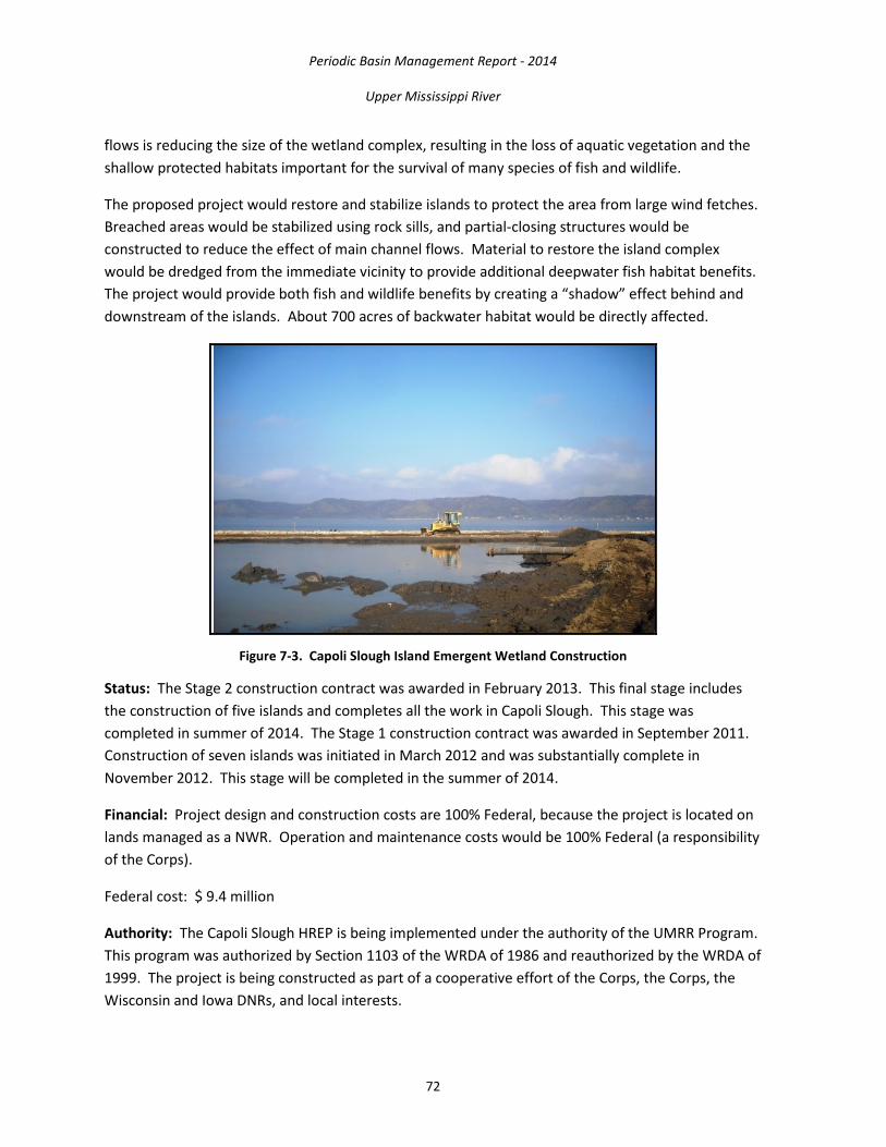
Periodic Basin Management Report - 2014
Upper Mississippi River
72
flows is reducing the size of the wetland complex, resulting in the loss of aquatic vegetation and the shallow protected habitats important for the survival of many species of fish and wildlife.
The proposed project would restore and stabilize islands to protect the area from large wind fetches. Breached areas would be stabilized using rock sills, and partial-closing structures would be constructed to reduce the effect of main channel flows. Material to restore the island complex would be dredged from the immediate vicinity to provide additional deepwater fish habitat benefits. The project would provide both fish and wildlife benefits by creating a “shadow” effect behind and downstream of the islands. About 700 acres of backwater habitat would be directly affected.
Figure 7-3. Capoli Slough Island Emergent Wetland Construction
Status: The Stage 2 construction contract was awarded in February 2013. This final stage includes the construction of five islands and completes all the work in Capoli Slough. This stage was completed in summer of 2014. The Stage 1 construction contract was awarded in September 2011. Construction of seven islands was initiated in March 2012 and was substantially complete in November 2012. This stage will be completed in the summer of 2014.
Financial: Project design and construction costs are 100% Federal, because the project is located on lands managed as a NWR. Operation and maintenance costs would be 100% Federal (a responsibility of the Corps).
Federal cost: $ 9.4 million
Authority: The Capoli Slough HREP is being implemented under the authority of the UMRR Program. This program was authorized by Section 1103 of the WRDA of 1986 and reauthorized by the WRDA of 1999. The project is being constructed as part of a cooperative effort of the Corps, the Corps, the Wisconsin and Iowa DNRs, and local interests.
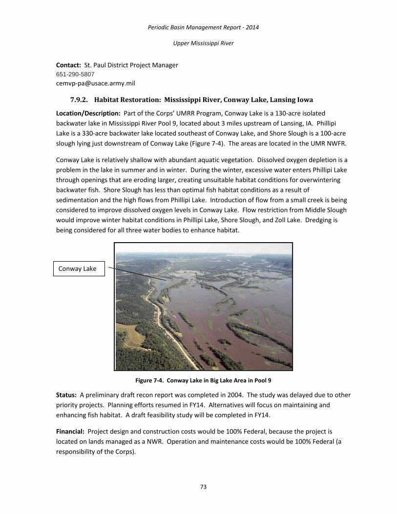
Periodic Basin Management Report - 2014
Upper Mississippi River
73
Contact: St. Paul District Project Manager 651-290-5807 [email protected]
7.9.2. Habitat Restoration: Mississippi River, Conway Lake, Lansing Iowa
Location/Description: Part of the Corps’ UMRR Program, Conway Lake is a 130-acre isolated backwater lake in Mississippi River Pool 9, located about 3 miles upstream of Lansing, IA. Phillipi Lake is a 330-acre backwater lake located southeast of Conway Lake, and Shore Slough is a 100-acre slough lying just downstream of Conway Lake (Figure 7-4). The areas are located in the UMR NWFR.
Conway Lake is relatively shallow with abundant aquatic vegetation. Dissolved oxygen depletion is a problem in the lake in summer and in winter. During the winter, excessive water enters Phillipi Lake through openings that are eroding larger, creating unsuitable habitat conditions for overwintering backwater fish. Shore Slough has less than optimal fish habitat conditions as a result of sedimentation and the high flows from Phillipi Lake. Introduction of flow from a small creek is being considered to improve dissolved oxygen levels in Conway Lake. Flow restriction from Middle Slough would improve winter habitat conditions in Phillipi Lake, Shore Slough, and Zoll Lake. Dredging is being considered for all three water bodies to enhance habitat.
Figure 7-4. Conway Lake in Big Lake Area in Pool 9
Status: A preliminary draft recon report was completed in 2004. The study was delayed due to other priority projects. Planning efforts resumed in FY14. Alternatives will focus on maintaining and enhancing fish habitat. A draft feasibility study will be completed in FY14.
Financial: Project design and construction costs would be 100% Federal, because the project is located on lands managed as a NWR. Operation and maintenance costs would be 100% Federal (a responsibility of the Corps).
Conway Lake

Periodic Basin Management Report - 2014
Upper Mississippi River
74
Federal cost: $ 3.5 million Funding allocated to date: $250,000
Authority: The Conway Lake HREP is being implemented under the authority of the UMRR Program. This program was authorized by Section 1103 of the WRDA of 1986 and reauthorized by the WRDA of 1999. The project will be planned and designed as part of a cooperative effort of the Corps, the Corps, the Iowa and Wisconsin DNRs and local interests.
Contact: St. Paul District Project Manager 651-290-5807 [email protected]
7.9.3. Habitat Restoration: Mississippi River, Harpers Slough, Pool 9, IA
Location/Description: Part of the UMRR Program, the Harpers Slough area is a 4,150-acre backwater area located primarily on the Iowa side of the Mississippi River in Pool 9, about 3 miles upstream of L&D 9 (Figure 7-5). The site is in the UMR NWFR. The area is used heavily by tundra swans, Canada geese, puddle and diving ducks, black terns, nesting eagles, bitterns and cormorants and is also significant as a fish nursery area. Many of the islands in the area have been eroded or lost because of wave action and ice movement. The loss of islands allows more turbulence in the backwater area, resulting in less productive habitat for fish and wildlife.
The proposed project would protect five existing islands and construct an additional seven islands using material from the backwater and main channel. The project would slow the loss of existing islands, reduce the flow of sediment-laden water into the backwaters, reduce turbidity and increase the diversity of land and shoreline habitat.
Figure 7-5. Harpers Slough Area in Pool 9 of the Mississippi River

Periodic Basin Management Report - 2014
Upper Mississippi River
75
Status: A definite project report (feasibility study) for public review was completed in spring 2014. Construction of the project would be in stages because of the estimated cost of the total project in relation to the anticipated program funding levels. The first construction contract was awarded in summer of 2014.
Financial: Project design and construction costs would be 100% Federal, because the project is located on lands managed as a NWR. Operation and maintenance costs would be 100% Federal(a responsibility of the Corps).
Federal cost: $ 18 million Funding allocated through Fiscal Year 2014: $ 6.75 million
Authority: The Harpers Slough HREP is being implemented under the authority of the UMRR Program. This program was authorized by Section 1103 of the WRDA of 1986 and reauthorized by the WRDA of 1999. The project will be planned and designed as part of a cooperative effort of the Corps, the Corps, the Iowa and Wisconsin.
Contact: St. Paul District Project Manager 651-290-5807 [email protected]
7.9.4. Habitat Restoration: Mississippi River, McGregor Lake, Prairie du Chien, WI
Location/Description: Part of the Corps’ UMRR Program, McGregor Lake is a 200-acre backwater lake in pool 10 of the Mississippi River near Prairie du Chien, WI. It is bordered on the west by islands separating it from the main channel and on the east by a peninsula separating it from the east channel (Figure 7-6). The lake lies within the UMR NWFR. It is relatively shallow, with an average depth of 2½ feet. In 1989, about 75 percent of the lake had aquatic vegetation. Since then, aquatic vegetation and depth have decreased because of increased sedimentation and turbidity resulting from erosion of the barrier islands.
The proposed project would include dredging the lake, restoring or strengthening the barrier islands and constructing small islands within the lake to reduce wave action. It would provide diversity and productive habitat for fish and protect the lake from main channel flows. It would allow fish movement into and out of the lake during the winter. Increased aquatic vegetation would provide cover and food for young fish.
Status: Planning of the project started in FY14. A draft feasibility study will be completed in 2015
Financial: Project design and construction costs would be 100% Federal, because the project is located on lands managed as a NWR. Operation and maintenance costs would be 100% Federal (a responsibility of the Corps).
Federal cost: $ 6.5 million Funding allocated through Fiscal Year 2014: $ 150,000

Periodic Basin Management Report - 2014
Upper Mississippi River
76
Figure 7-6. McGregor Lake (center) in Pool 10 on the Mississippi River
Authority: The McGregor Lake HREP is being implemented under the authority of the UMRR Program. This program was authorized by Section 1103 of the WRDA of 1986 and reauthorized by the WRDA of 1999. The project will be planned and designed as part of a cooperative effort of the Corps, the Corps, the Iowa and Wisconsin DNRs and local interests.
Contact: St. Paul District Project Manager 651-290-5807 [email protected]
7.9.5. Habitat Restoration: North and Sturgeon Lakes, Pool 3, Mississippi River, MN
Location/Description: North and Sturgeon Lakes are large backwater complexes located in Pool 3 of the UMR, west of the navigation channel. The project area includes a marshy area at the upstream end and encompasses Sharp Muskrat Lake as well. Historically, these two lakes had an extensive marshy fringe and considerable submersed aquatic plant beds. Today, both lakes today are shallow and subject to frequent wind and wave action that keeps sediments suspended and limits aquatic plant growth.
Major habitat concerns for North and Sturgeon Lakes are sedimentation, island dissection, vegetation loss and reduced depth for over-wintering fish. A significant loss of emergent and submerged aquatic vegetation has occurred throughout both lakes. Flood effects, wave generated erosion and resuspension of fine sediments caused by continual inundation reduced the fish and wildlife value of these areas, which once provided outstanding waterfowl hunting and winter fishing opportunities close to the Twin Cities.
The project goals include maintaining, enhancing and creating more natural sediment transport and deposition; reducing suspended solid concentrations; and reducing wind fetch.

Periodic Basin Management Report - 2014
Upper Mississippi River
77
Status: Project planning started in fall 2012. A pool wide mussel survey was conducted in August 2013. A preliminary draft definite project report is under development in FY14. Alternatives being considered within North and Sturgeon lakes are a series of small islands to reduce wind and wave generated erosion. Island construction and backwater dredging would improve conditions for growth of aquatic vegetation and promote increases in depth by concentrating flows to promote scour. In addition, a concurrent water level management drawdown (to consolidate sediments) in Pool 3 (between 6 and 18 inches) is also part of the study.
Financial: The project would be located on Federal, state and tribal lands and built in cooperation with the State of Minnesota and the Prairie Island Indian Community.
Federal cost: $2,400,000 Total estimated cost: $3,140,000 Federal Funding to date: $300,000
Authority: This project will be planned under the authority of the UMRR Program. This program was authorized by Section 1103 of the WRDA of 1986 and reauthorized by the WRDA of 1999. The project will be planned and designed as a cooperative effort of the state of MN, Prairie Island Indian Community, other interested organizations and the public.
Contact: St. Paul District Project Manager 651-290-5807 [email protected]
7.9.6. Habitat Restoration: Mississippi River, Lake Winneshiek, Ferryville, WI
Location/Description: Lake Winneshiek is a 6,000 acre backwater lake on the Wisconsin side of the Mississippi River navigation channel in lower Pool 9 about 4 miles downstream from Lansing, IA (Figure 7-7). The site lies within the UMR NWFR.
Many of the natural islands in Lake Winneshiek have eroded and disappeared. These islands served to break up wind fetch and wave action, reduce turbidity and provide protection to shallow aquatic areas supporting aquatic plant beds. The increased wave action and associated turbidity have contributed to the observed loss of aquatic plant beds used by migratory waterfowl.
The proposed project would create two islands, each about 8,000 feet long, in the center of Lake Winneshiek to reduce wave action in this large, open water area. If suitable construction material can be found in the backwater area, dredging would provide up to 20 acres of additional deepwater habitat. About 1,200 acres of backwater area would be directly affected by the project.

Periodic Basin Management Report - 2014
Upper Mississippi River
78
Figure 7-7. Lake Winneshiek Area in Pool 9
Status: Planning for the project is scheduled to begin in FY15, depending on program funding.
Financial: Project design and construction costs would be 100% Federal because the project is located on lands managed as a NWR. Operation and maintenance costs would be 100% Federal (a responsibility of the Corps).
Federal cost: $ 5 million Funding allocated through Fiscal Year 2014: $ 10,000
Authority: The Lake Winneshiek HREP will be planned under the authority of the UMRR Program. This program was authorized by Section 1103 of the WRDA of 1986 and reauthorized by the WRDA of 1999. The project will be planned and designed as part of a cooperative effort of the Corps, and the Wisconsin and Iowa DNRs and local interests.
Contact: St. Paul District Project Manager 651-290-5807 [email protected]
7.9.7. Habitat Restoration: Beaver Island, Pool 14, Mississippi River
Location/Description: The 2,300-acre Beaver Island Complex represents 16 percent of the backwater habitat in Pool 14. The complex of backwaters and sloughs has historically provided overwintering and spawning habitat for fish and feeding habitat for migratory water birds. The area has been degrading steadily due to sedimentation. Wetland functions have also been negatively affected.
Periodic Basin Management Report - 2014
Upper Mississippi River
79
Project Features:
• Dredge backwaters and connecting sloughs using a combination of hydraulic and/or mechanical dredging
• Construct sediment deflection embankments using dredged material from the backwaters and sloughs
• Create nesting islands • Plant mast-producing bottomland hardwoods on the embankments • Create isolated wetlands (potholes) • Install a water control structure or low maintenance high water diversion gate on the upper
end of the complex to reduce sediment loading, while introducing oxygen rich water into the complex when needed
Project Outputs: Dredging the backwater and connecting sloughs would provide critically important overwintering habitat for fish, such as bass, crappie, and bluegill. The isolated wetlands would restore feeding habitat for resident and migratory waterfowl, shorebirds, and wading birds. The mast tree plantings will increase species diversity and improve the existing timber stand. The project will enhance the quality and diversity of habitat in the largest backwater complex in Pool 14.
Status: General design of the project has been initiated and a Definite Project Report is scheduled for completion in 2016.
Financial: General design costs are estimated at $700,000. Estimated construction costs will be included in the draft Definite Project Report (DPR), although an initial estimate was set at $12,500,000. The Corps will be responsible for annual costs for operation, maintenance, and repair. The Iowa DNR is the project proponent.
Federal Cost: $12,500,000 Non-Federal Cost: $0.00 Total Cost: $12,500,000 Federal Allocations through FY12: $80,000 Scheduled Federal Allocation for FY13: $120,000 Balance to Complete: $12,420,000
• FY14
o Development and approval of the Project Management Plan and Organization and collection of existing data for the site, initiation of the DPR
o Hold public meeting.
• FY15 o Continue development of the DPR, collection of GIS data on Land Use Land Cover and
floodplain topography.

Periodic Basin Management Report - 2014
Upper Mississippi River
80
Contact: Regional Program Manager located at CEMVR -PM-M 309- 795-5428 Email: [email protected]
7.9.8. Habitat Restoration: Fox Island, Pool 20, Mississippi River
Location/Description: The Fox Island project area is located along the right descending bank of the UMR immediately downstream of Alexandria in the southeast corner of Clark County, MO. The project lies generally between the Mississippi River on the east and the Fox River on the west. The Fox Island Division (Division) lands are owned in fee title and managed by the Corps as part of the Great River NWR. The Division is comprised of 2,033 acres of land and water within the Mississippi River floodplain. Currently, about 925 acres are floodplain forest, 120 acres are wetlands, backwaters and sloughs, and the remaining 988 acres are a combination of farmland and abandoned fields. The extent and quality of forests, wetlands, and grasslands along the Mississippi River has been steadily declining over the years. The project area has historically provided substantial benefits to waterfowl and other wetland wildlife. Sedimentation reduced wetland depths to the point where they are dry most of the year.
Project Features:
• Reduce forest fragmentation and increase bottomland hardwood diversity by allowing 640 acres to reforest naturally and planting 275 acres of mast trees in existing forested areas and farmland and abandoned fields
• Enhance 78 acres of wetlands by providing wells for water supply and water control structures for flooding existing wetlands
• Restore native grasslands by planting 98 acres of native grasses and forbs adapted to conditions where the soils are periodically saturated and/or inundated
The project will restore historic wetland habitat, which is critical for resident and migratory waterfowl, shorebirds, and wading birds. The project will also provide greater habitat diversity through native grassland and mast tree plantings. The native grassland planting will provide feeding and nesting opportunities for a wide variety of wildlife. The mast tree plantings, coupled with natural regeneration, will create a large tract of continuous forest that is critical habitat for forest dwelling species.
Status: Construction began in the fall of 2011 and was scheduled to be complete in the summer of 2013. Spring flooding in 2013 caused some damages and delayed construction completion. Construction and repair of flood damages is expected to be completed in the summer to late fall of 2014.
Financial: Total estimated cost of the project, including general design and construction management is $5,000,000. The estimated annual costs for operation, maintenance, and repair is

Periodic Basin Management Report - 2014
Upper Mississippi River
81
$32,436, which is the responsibility of the Corps, the Federal project sponsor. The Missouri Department of Conservation is a non-Federal project sponsor.
Federal Cost: $5,000,000 Non-Federal Cost: $0.00 Total Cost: $5,000,000 Federal Allocations through FY14: $5,024,000 Scheduled Federal Allocation for FY15: $95,000 Balance to Complete: $0.00
• FY14
o Execute of contract modifications to repair 2013 flood damages • FY15
o Complete construction, tree re-planting, and begin development of the O&M Manual
Contact: Regional Program Manager located at CEMVR -PM-M 309- 795-5428 Email: [email protected]
7.9.9. Habitat Restoration: Huron Island Complex, Pool 18, Mississippi River
Location/Description: The Huron Island Complex is a 2,000 acre project that includes both Huron Island and Huron Chute located 9 river miles downstream from where the Iowa River enters the Mississippi River. Huron Island is heavily forested and dissected by a series of backwaters, secondary channels, and wetlands. Huron Chute separates Huron Island from the main land. The project includes 164 acres of backwater area, 500 acres of secondary channels, and 1336 acres of bottomland forest. The bottomland forests are dominated by even aged soft mast tree species of silver maple, ash, and cottonwood. The sloughs and wetlands within Complex have lost much of their fish and wildlife habitat value due to silt deposition. Huron Chute is experiencing bankline sloughing in the upper portion, which has degraded the near-shore habitat. Lands within the Complex are federally-owned by the Corps and are part of the NWR Complex. The Corps has been granted management responsibility for the Complex through an agreement with the USFWS. The USFWS has subsequently granted management of the complex to the Iowa DNR through a cooperative agreement.
Project Features:
• Dredge connecting sloughs using mechanical dredging • Utilize dredged material to construct several embankments and other high areas on which
mast-producing bottomland hardwood species will be planted • Provide bankline protection in Huron Chute • Plant aquatic vegetation

Periodic Basin Management Report - 2014
Upper Mississippi River
82
Project Outputs: Dredging the sloughs would provide critically important off-channel deep water habitat for fish. Shallow depression wetlands would provide feeding areas for resident and migratory waterfowl, shorebirds, and wading birds. The mast tree plantings will increase species diversity and improve the existing timber stand. The project will enhance and maintain the quality and diversity of habitat in a major backwater complex in Pool 18.
Status: General design of the project has been completed, P&S are underway. A construction contract was awarded in 2014.
Financial: General design costs are estimated at $900,000. Estimated construction costs will be included in the draft DPR, although an initial estimate was set at 12,800,000. The Corps will be responsible for annual costs for operation, maintenance, and repair. The Iowa DNR is the project proponent.
Federal Cost: $12,800,000 Non-Federal Cost: $0.00 Total Cost: $18,890,000 Federal Allocations through FY14: $18,740,000 Scheduled Federal Allocation for FY15: $150,000 Balance to Complete: $0.00
• FY14
o Complete P&S o Award construction contract
• FY15 o Develop O&M Manual
Contact: Regional Program Manager located at MVR -PM-M 309- 795-5428 Email: [email protected]
7.9.10. Habitat Restoration: Lake Odessa, Pools 17-18, Mississippi River
Location/Description: Lake Odessa is a 6,788 acre backwater complex located 15 miles south of Muscatine, IA, in Louisa County. While Lake Odessa has traditionally had high fall duck and geese populations and significant duck production, the existing water control structures, high amount of seepage due to sandy soil, and overall complex size limit water level management with regard to drawdown, excess water release, and fall reflooding. Breaches of existing levees have resulted in frequent losses of emergent aquatic vegetation used by migratory waterfowl. Sedimentation from frequent levee breaks and overtopping flood events has decreased the extent of deep water aquatic habitat. Fish winterkills and reduced circulation of well-oxygenated water are being experienced. The goals of the proposed project are to restore and protect wetland, terrestrial, and aquatic habitat. The objectives identified to meet these goals were to:

Periodic Basin Management Report - 2014
Upper Mississippi River
83
• reduce forest fragmentation; • increase bottomland hardwood diversity; • enhance migratory bird habitat; • restore native grasslands; • increase habitat for overwintering fish; • provide safe areas for developing fish; • protect habitat features; and • protect archeological sites.
Project Features:
• Restore the existing perimeter levee system that protects the Lake Odessa complex • Construct a spillway to control flood events and protect the levee • Enhance water management capability at moist soil management areas • Dredge deep holes/channels to enhance overwintering habitat for the fishery • Create a fish nursery area • Plant 93 acres of mast-producing hardwood trees • Re-establish a 36-acre native grassland
Enhancing water level management capability will provide more moist soil habitat, greater vegetation diversity and growth, and reliable food supplies to migratory waterfowl. Fisheries enhancement dredging will create areas of deeper water and/or access to deeper water for overwintering fish. Mast tree planting will improve the quality and quantity of forest habitat by re-introducing mast-producing species to a forest community increasingly dominated by silver maple and cottonwood. Levee restoration will provide reliable flood risk management measures, manage flood risks and levee failures, and protect archeological sites from further erosion. The native grassland planting will increase habitat complexity and provide feeding and nesting opportunities for a wide variety of wildlife. The fish nursery will allow fry to be reared to the fingerling stage in a predator free environment.
Status: A final DPR was approved for construction in August 2005. The construction contract for Stage I A was awarded in July 2006. Stage I A construction was delayed due to flooding in the spring and summer of 2008. Completion of Stage I A was completed in November 2011. The Stage II A construction contract was awarded in 2008 and was completed in March of 2011. Flooding along the Mississippi River restricted access to the site in the last 2 years. During this time, there were 427 possible construction days and adverse conditions resulting from high water and weather prevented work during 400 (93.7 percent) of those days. A construction contract was awarded in August of 2009 for Stage 1 B. Construction for this contract was scheduled for completion by the end of 2011, however, high water prevented completion until the spring of 2012. The final construction contract (Stage II B) was awarded in December of 2009 and was completed by the end of 2010.
Construction of all phases was functionally complete on September 30, 2011. However, portions of the main levee repair required reshaping which was complete as of August 31, 2012. Repair of

Periodic Basin Management Report - 2014
Upper Mississippi River
84
damages to the site from the 2008 floods were funded utilizing $5,000,000 provided to the program in a 2008 supplemental appropriation. Additional damages were incurred during 2013 spring flooding and P&S are underway to repair these damages. Construction repairs are expected to begin in late 2014 after completion of P&S and award of contract. Initial estimates to complete 2013 flood repair work range from $4,600,000 to $6,200,000.
Financial:
Federal Cost: $17,600,000 Non-Federal Cost: $0.00 Total Cost: $17,600,000 Federal Allocations through FY13: $17,883,000 Scheduled Federal Allocation for FY14: $4,900,000 Balance to Complete: $650,000
The project lands are federally-owned by the Corps and are managed by the Corps and the Iowa DNR.
Contact: Regional Program Manager located at CEMVR -PM-M 309- 795-5428 Email: [email protected]
7.9.11. Habitat Restoration: Overwintering Habitat, Pool 12, Mississippi River
Location/Description: The Pool 12 overwintering project area is located along the left descending bank of the UMR approximately 10 miles south of Dubuque, IA, in Jo Daviess County, IL. The project lies generally between the Mississippi River's main channel and the railroad tracks that parallel the river's east bank. The project lands are federally-owned by the Corps and are managed by the Corps as part of the Savanna Division of the UMR NWFR. . Presently, overwintering habitat for fish and backwater habitat for both waterfowl and fish are very limited in Pool 12. Sedimentation of backwater lakes and sloughs has reduced the value of historic overwintering areas. The Iowa DNR has documented that the overwintering habitat in Pool 12 has become a limiting factor for survival of riverine fish. The goals of the project are to restore and protect aquatic habitat and to improve topographic diversity and associated floodplain forest communities. The objectives identified to meet these goals are (1) Increase the amount of deep water habitat in the backwater lakes complex of Pool 12 as measured by acres to provide pool-wide overwintering habitat for fish. Target depth is 6 to 8 feet; (2) Increase depth diversity in backwater lakes complex of Pool 12 as measured by acres to provide year round habitat for fish; (3) Increase sustainability of aquatic habitat in the backwater lakes complex of Pool 12 as measured by acres by decreasing the sedimentation in the complex; and (4) Increase areal coverage in acres of forest stands with hard mast-producing trees as a dominant or component species in floodplain forest areas surrounding the backwater lakes of Pool 12.

Periodic Basin Management Report - 2014
Upper Mississippi River
85
Project Features:
• Deepen backwater lakes and sloughs using mechanical dredging • Construct land and aquatic berms to deflect sediment and increase project sustainability
using dredged material • Plant hard mast trees on land berms
Construction would occur at; Sunfish Lake, Stone Lake, Kehough Slough, and Tippy Lake. Dredging the identified lakes and sloughs would provide critical overwintering habitat for fish, such as bass, crappie, and bluegill. The dredging would also restore backwater habitat for resident and migratory waterfowl, shorebirds, and wading birds. The mast tree plantings will increase species diversity and improve the existing timber stand.
Status: The final Definite Project Report was approved and P&S for Sunfish Lake (Stage I) were completed in July 2013. A construction contract was awarded in August 2013 for Stage I construction. P&S for Stone Lake (Stage II) will be completed in FY14.
Financial:
Federal Cost: $20,600,000 Non-Federal Cost: $0.00 Total Cost: $20,600,000 FY13 Allocation: $4,100,000 Scheduled Federal Allocation for FY15: $478,000 Balance to Complete: $16,022,000
Estimated construction costs are $17.5 million. Estimated total project costs are $20.6 million. The USFWS is the non-Federal project sponsor. The Illinois DNR and Iowa DNR are project proponents. The Corps will be responsible for annual costs for operation, maintenance, and repair.
• FY14 o continue construction on Sunfish Lake (Stage I) o P&S for Stone Lake (Stage II) o award of the construction contract for Stone Lake (Stage II) o continue cooperative pre-project monitoring effort with the State of Iowa and the USGS to
document the current status of the fish population. This will be used to evaluate the biological response of the project once it is completed. Pre-and post-project monitoring will be applied using active adaptive management principal to inform the placement and design of future HREPs.
• FY15 o initiate Stage II construction of Stone Lake o continuation of the cooperative pre-project and during-construction monitoring program o initiate P&S for Kehough Slough (Stage III) construction

Periodic Basin Management Report - 2014
Upper Mississippi River
86
Contact: Regional Program Manager located at CEMVR -PM-M 309- 795-5428 Email: [email protected]
7.9.12. Habitat Restoration: Batchtown, Pool 25, Mississippi River
Location/Description: Batchtown is located upstream of L&D 25 between RMs 241.4 and 248.4. The Corps manages 1,407 acres as part of the Two Rivers NWR and the Illinois DNR manages 1,920 acres in the Mississippi River Fish and Wildlife Area. The resource problems identified included sedimentation of side channels and backwaters, fluctuating water levels, insufficient deep water during winter, limited water control capability throughout the project area, inability to dewater when the river is high, loss of wetlands, and decline in forest quality.
Recommended Plan Project Features:
• Pump station • Lowland sediment rap • Water control structures • Riverside berm improvements • Interior berm improvements • Dredging
Status: The feasibility report was approved in July 1996. The Project is currently under construction.
• Major Work Remaining: punch list items, channel excavation, additional stone protection.
Financial:
Total Cost: $18,095,000 Scheduled Federal Allocation for FY15: $100,000 Balance to Complete: $175,000
Contact: St. Louis UMRR Program Manager Phone: (314) 331 -8455 1222 Spruce St., St. Louis, MO 63103 www.mvs.usace.army.mil
7.9.13. Habitat Restoration, Clarence Cannon NWR, Pool 25, Mississippi River
Location/Description: Clarence Cannon NWR HREP is located along the right descending bank of the floodplain within the UMR Navigation Pool 25 between RM 261.1 and 263.8, adjacent to the town of Annada in Pike County, MO. Clarence Cannon NWR covers 3,750-acres of seasonally flooded wetlands, open marsh, mixed shrub/scrub/emergent wetlands, bottomland hardwood forest, agricultural fields, backwater lakes and sloughs, and floodplain forest. The Clarence Cannon NWR HREP would be constructed on land owned by the Federal Government with management responsibility provided by the USFWS.

Periodic Basin Management Report - 2014
Upper Mississippi River
87
In the early 1900s, the area was drained, ditched, leveed, and cleared for agricultural production in fragmented parcels which altered the site hydrology and resulted in large-scale conversion of native plant communities (floodplain forest and emergent wetland) leading to disturbed and degraded ecosystem structure and function. Currently, on the 3,750 acre refuge, approximately 3,200 acres are fragmented into 27 named units capable of limited manual water level alteration, and this fragmentation has eliminated the natural drainage, topography, and habitat connectivity of the project area. In addition, forest resources on the refuge, primarily pin oak and pecan, were impacted by the flood of 1993. Up to 80 percent of the floodplain forests in the approximate 400 acres of forest died due to the flood. Furthermore, backwater sloughs, lakes, and old meander scars have been cut-off from the river by the exterior berm. Almost all of these aquatic areas are greatly deteriorated due to lack of connectivity with the main stem Mississippi River. This has greatly reduced aquatic habitat diversity and important seasonal habitat for a diverse suite of aquatic organisms. Furthermore, due to the altered hydrology and loss of native wetland vegetation, non-native reed canary grass is spreading across the site resulting in further ecosystem degradation.
Recommended Plan Project Features:
• Riverside setback berm with partial exterior berm degrade • Interior berm degrades • Water control structures • Restoration of historic meanders • Pump station • Reforestation
Status: The feasibility report was approved in May 2014. Detailed design is underway.
• Major Work Remaining: Plans and specification development and construction
Financial:
Federal Cost: $29,817,000 Non-Federal Cost: 0 Total Cost: $29,817,000 Scheduled Federal Allocation for FY15: $1,100,000 Balance to Complete:
Contact: St. Louis UMRR Program Manager Phone: (314) 331–8455 1222 Spruce St., St. Louis, MO 63103 www.mvs.usace.army.mil
7.9.14. Habitat Restoration, Godar-Glades Wetland Complex, , IL River
Location/Description: The Godar-Glades Wetland Complex HREP is located on the lower Illinois River between approximate RMs 12 through 31 in Jersey and Calhoun Counties. Godar-Glades

Periodic Basin Management Report - 2014
Upper Mississippi River
88
Wetland Complex covers approximately 5,050-acres of backwaters, side channel, and island habitats. The proposed project area includes Glades Management Area (RM 12-15), Twelve Mile Island (RM 12.5-14) Helmbold Island (RM 13-16), Mortland Island (RM 18-19), Godar Management Area (RM 24-31), Diamond Island (RM 23-25), Hurricane Island (RM 26-28), Crater Island (RM 29), and Willow Island (RM 30.5). The project area is located on General Plan (GP) lands owned by the Corps and are managed by the Illinois DNR through a cooperative agreement with the USFWS. Illinois DNR will serve as the NFS.
The project area has been degraded due to sedimentation, altered river hydrology, and lack of connectivity with the lower Illinois River. Sedimentation has reduced quantity and quality of aquatic ecosystem resources within the backwaters and side channels. Sedimentation has filled in most of the side channels, with the remaining side channels isolated from the river for most of the year. The project area has limited capabilities in mimicking the historic natural river elevations through water level fluctuations which is needed to provide habitat and food for resident and migratory wetland wildlife species. The losses of deep water habitat, side channel connectivity, and aquatic habitat diversity, as well as the inability to mimic the historic river hydrograph, have degraded aquatic ecosystem structure and function within the project area.
Opportunities exist to restore, improve, and increase ecosystem resources before they are lost within the project area. Improving the hydrology (e.g., dependable controlled water movement) of the site will increase the reliability of seasonal food and cover for resident and migratory wetland wildlife. Restoring seasonal connectivity of the project area with the lower Illinois River will improve ecosystem structure (e.g., fish access to backwater habitat) and function (e.g., nutrient cycling) within the project area. Increasing aquatic habitat complexity and diversity will provide seasonal refugia for fish and other aquatic species. Restoring native vegetation and floodplain forests, provide additional opportunities to restore the mosaic of wetland habitat types that once occurred at Godar-Glades Wetland Complex.
Status: The project is currently in feasibility stage.
Financial:
Total Cost: $8,600,000 Scheduled Federal Allocation for FY15: $200,000 Balance to Complete:
Contact: St. Louis UMRR Program Manager Phone: (314) 331 -8455 1222 Spruce St., St. Louis, MO 63103 www.mvs.usace.army.mil
7.9.15. Habitat Restoration, Harlow-Wilkinson Islands, Open River, Mississippi River
Location/Description: The Harlow and Wilkinson Islands HREP covers two island complexes within the Middle Mississippi River NWR. Harlow Island (1,225 acres) is located on the right descending

Periodic Basin Management Report - 2014
Upper Mississippi River
89
bank of the Mississippi River between RMs 140.5 and 144.0. Wilkinson Island (2,700 acres) is located on left descending bank between RMs 88.5 and 95.0. The Project would be constructed on land owned by the Federal Government with management responsibility provided by the USFWS.
The primary resource problems include accretion of the islands to the mainland resulting in loss of important island-side channel habitat which historically occurred within the open river ecosystem; fragmented forest habitat with low diversity; and non-native invasive grass species. These problems have led to degraded aquatic and wetland ecosystem structures and functions.
Potential Project Features To Address These Problems May Include, But Not Limited To:
• Excavating secondary channel/slough habitat • Notching existing stone dikes and/or berms • Installing water control structures • Constructing river training structures • Constructing sediment deflection berm • Reforestation
Status: The project is currently in the feasibility phase.
• Major Work Remaining: continue design
Financial:
Total Cost: $9,000,000 Scheduled Federal Allocation for FY15: $400,000 Balance to Complete:
Contact: St. Louis UMRR Program Manager Phone: (314) 331 -8455 1222 Spruce St., St. Louis, MO 63103 www.mvs.usace.army.mil
7.9.16. Habitat Restoration, Piasa-Eagle’s Nest Islands, Pool 26, Mississippi River
Location/Description: The Piasa and Eagle’s Nest Islands HREP is located on the left descending bank of the Mississippi River, upstream of the city in Alton, IL in Madison and Jersey counties between RMs 207.5 and 211.5. The Project Area lies within Pool 26, a 40-mile reach of the UMRS, beginning below L&D 25 (RM 241.4) near Cap au Gris, MO, and ending at Melvin Price L&D (RM 200.8) at Alton, IL. The Project Area encompasses Piasa Island and Eagle’s Nest Island including the side channel between Piasa Island and the Illinois bankline, and the side channel between Piasa Island and Eagle’s Nest Island.
The Project Area is approximately 1,350 acres consisting of 115 acres of island habitat, 1,235 acres of side channel, sandbar, wetland and other aquatic areas. It is located solely on Corps fee-owned lands

Periodic Basin Management Report - 2014
Upper Mississippi River
90
and managed waters. Lands are managed by the St. Louis Corps of Engineer’s Rivers Project Office, with some in partnership with the Illinois DNR.
The key resource problems include loss of depth and flow in Piasa side channel; loss of diverse island complex; loss of emergent wetland; and loss of year-round connectivity between Piasa Island slough and main channel of the Mississippi River.
Status: A feasibility study is currently underway.
• Major Work Remaining: continue design
Financial:
Total Cost: $8,300,000 Scheduled Federal Allocation for FY15: $350,000 Balance to Complete:
Contact: St. Louis UMRR Program Manager Phone: (314) 331 -8455 1222 Spruce St.,, St. Louis, MO 63103 www.mvs.usace.army.mil
7.9.17. Habitat Restoration, Red’s Landing, Pool 25, Mississippi River
Location/Description: The proposed project includes Red's Landing and Gilead Slough. The project area is located along the east bank of the Mississippi River Pool 25 between RMs 252 and 255.5 in Calhoun County, IL. This property is General Plan lands owned by the Corps and is managed by the Illinois DNR through a cooperative agreement with the USFWS.
The area consists of a patchwork of habitat types including sloughs, backwater lakes, bottomland forest, and former agricultural fields. The Corps purchased this area to establish the UMR Navigation System. Historically, portions were leased back to the private sector, including Gilead Slough, which was subsequently managed primarily as a hunting and fishing club. The flood of 1993 destroyed most of the infrastructure used by the hunting club and led to the club terminating its long-standing lease with the Corps. Red's Landing, managed by the Illinois DNR, is adjacent to Gilead Slough and the old club levees and infrastructure provide the water level control to this area. However the degraded condition of these systems allows water levels to get lower than what is needed for good fish and wildlife habitat. On the northern end of the site, the silt load coming in during floods filled many of the old sloughs and backwaters. On the northern end of the site, flood silt loads have filled many of the sloughs and backwaters. The HREP’s goals include improving water management to improve wetland quality and fish access and restoring forest acreage and diversity.
Status: Fact Sheet approved 2010
• Major Work Remaining: continue design

Periodic Basin Management Report - 2014
Upper Mississippi River
91
Financial:
Total Cost: $4,500,000 Scheduled Federal Allocation for FY15: $10,000 Balance to Complete:
Contact: St. Louis UMRR Program Manager Phone: (314) 331 -8455 1222 Spruce St., St. Louis, MO 63103 www.mvs.usace.army.mil
7.9.18. Habitat Restoration, Pool 24 Islands, Pool 24, Mississippi River
Location/Description: The proposed project includes Gilbert, Blackbird, North Fritz, and South Fritz Islands in Pike and Ralls counties, MO. The islands are in Mississippi River Pool 24 between RMs 286 and 299.5 near Ashburn, MO. These islands are General Plan lands owned by the Corps and are managed by the Missouri Department of Conservation through a cooperative agreement with the USFWS.
The land cover on the four islands is predominantly floodplain forest with interspersed former agricultural fields. Cottonwoods and maples are the dominant tree species with occasional sycamores and pecans. The former agricultural fields are in various stages of succession. Each island has at least one interior side channel. These channels have frequent fallen trees, are shallow, and lack depth diversity.
There is a need for restoration of the Pool 24 Islands to prevent further degradation of these habitats. Sedimentation in the side channels continues to reduce their depth. Lack of an adequate influx of seeds and strong competition prevents bottomland hardwood establishment resulting in low forest diversity. Small islands within Gilbert Island's western side channel are eroding and will eventually disappear. Without restoration, side channel conditions will continue to deteriorate, erosion will continue, and bottomland hardwood establishment will be impaired. These factors combine to adversely affect the fish and wildlife resources along this reach of the Mississippi River.
The objectives of this proposed project include: 1) restoring and enhancing secondary channel depth, flow, and aquatic habitat; 2) improving floodplain forest diversity; and 3) reducing island erosion.
Status: Fact sheet approved 2009
• Major Work Item Remaining: continue design
Financial:
Total Cost: $5,700,000 Scheduled Federal Allocation for FY15: $10,000 Balance to Complete:

Periodic Basin Management Report - 2014
Upper Mississippi River
92
Contact: St. Louis UMRR Program Manager Phone: (314) 331 -8455 1222 Spruce St., St. Louis, MO 63103 www.mvs.usace.army.mil
7.9.19. Habitat Restoration, Pools 25 & 26 Islands, Mississippi River
Location/Description: The five islands addressed in this project are located in UMR Pool 25 and 26. Howard Island (43 acres) and an adjacent un-named island (8 acres) occur in Pool 25 near Annada, MO at RM 261. Westport Island (625 acres) is located in Pool 25 between RMs 258 and 254. Dardenne (790 acres) and Bolter Islands (560 acres) are located in Pool 26 at RMs 228 and 224.
The chutes, sloughs, and wetlands on islands in Pools 25 and 26 have been severely degraded by sedimentation reducing the quality of wetland and deep, off-channel water habitat. The project seeks to restore and rehabilitate wetland and aquatic habitats to provide breeding, nesting, feeding, and predator-escape habitats for many forms of waterfowl, mammals, and reptiles, and furnish productive fish spawning, overwintering, and nursery areas.
The primary objectives of this project are to 1) restore hard mast and floodplain forest to the islands; 2) restore and maintain backwater connection to the river; and 3) restore and maintain deep water habitat.
Status: Feasibility Report completed in 2008; currently under construction
• Major Work Item Remaining: continue construction
Financial:
Total Cost: $2,475,000 Scheduled Federal Allocation for FY15: $100,000 Balance to Complete:
Contact: St. Louis UMRR Program Manager Phone: (314) 331 -8455 1222 Spruce St., St. Louis, MO 63103 www.mvs.usace.army.mil
7.9.20. Habitat Restoration, Rip Rap Landing, Pool 25, Mississippi River
Location/Description: The Rip Rap Landing HREP is located in Pool 25 of the Mississippi River along the left descending bank between RMs 260.5 and 267 in Calhoun County, IL. Rip Rap Landing covers 2,338 acres of river bottomlands, of which 2,055 acres are owned by the Illinois DNR, and 283 acres are owned by the Corps as General Plan Lands, known as Dog Island.
The overall project goal is to increase the quality and quantity of aquatic, non-forested wetland, and forested wetland habitats. The objectives for the project are to 1) Improve aquatic ecosystem resources; 2) Increase native plant species diversity and reduce the number of acres impacted by

Periodic Basin Management Report - 2014
Upper Mississippi River
93
invasive plant species by improving water level management; 3) Reduce impacts of headwater flooding and river-borne sedimentation; and 4) Increase quantity and quality of bottomland hardwood forest.
Status: A feasibility study currently underway
• Major Work Item Remaining: complete feasibility report, detailed design, and construction
Financial:
Total Cost: $9,006,000 Scheduled Federal Allocation for FY15: $200,000 Balance to Complete:
Contact: St. Louis UMRR Program Manager Phone: (314) 331–8455 1222 Spruce St., St. Louis, MO 63103 www.mvs.usace.army.mil
7.9.21. Habitat Restoration, Swan Lake, IL River
Location/Description: The Swan Lake HREP is located in Calhoun County, IL, on the right descending bank of the Illinois River, between RMs 13.3 and 5.0. The project is operated by the Corps and the Illinois DNR. The project is located in the Calhoun Division of the Two Rivers NWR and the Illinois DNR Fuller Lake Management Area.
Swan Lake is bottomland lake approximately 2,900 acres in size with an average depth between 3 and 3.5 feet. This water body constitutes a significant portion of the backwater habitat in the UMR Valley and the Illinois River. This is the largest backwater complex in Pool 26 of the Mississippi River and one of the largest on the Illinois River. Bottomland lake habitat such as Swan Lake has significantly declined over the last century and the remaining backwater lakes are severely degraded due to sedimentation and altered hydrology for navigation and flood control. With the construction of L&D 26, water levels in the lower Illinois River were raised and stabilized. This also raised the water levels in Swan Lake, resulting in permanent inundation of a much larger area. The bottomland hardwoods adapted for wet-dry cycles were lost due to the prolonged flooding, and the sluggish backwater habitat quickly filled with sediment resulting in increased turbidity eradicating the aquatic vegetation.
Status: The feasibility report completed in 1993. Construction completed in 2013. Performance Evaluation Report completed in 2010. O&M Manual completed in 2014. Performance monitoring ongoing.
• Major Work Remaining: physical and financial project closeout
Periodic Basin Management Report - 2014
Upper Mississippi River
94
Financial:
Total Cost: $15,623,000 Scheduled Federal Allocation for FY15: $25,000 Balance to Complete:
Contact: St. Louis UMRR Program Manager Phone: (314) 331 -8455 1222 Spruce St., St. Louis, MO 63103 www.mvs.usace.army.mil
7.9.22. Habitat Restoration, Ted Shanks Conservation Area, Pool 24, Mississippi River
Location/Description: The Ted Shanks Conservation Area HREP is located on the right descending bank of the Mississippi River in Pike County, MO. The project area lies in Pool 24 RMs 284.5 to 288.5. The project area consists of 2,900 acres of the Ted Shanks Conservation Area and associated islands in the Upper Mississippi Conservation Area. These lands are managed under a cooperative agreement between the Department of Interior, USFWS, and the Corps. Management of these project lands has been assumed by the Missouri Department of Conservation under a successive cooperative agreement.
In addition to the construction and operation of L&D 24, many other ecosystem changes have occurred within the project area including construction of berms along the Mississippi and Salt Rivers, clearing forests and wet prairie for agricultural production, management of the area as a wetland impoundment, and altered vegetation composition and distribution. Following the prolonged Mississippi River flood in 1993, much of the bottomland hardwood and floodplain forest at Ted Shanks died and reed canary grass invaded these area. A major contributor to the tree mortality was the system of undersized water control structures through the berms that could not efficiently drain the area.
The goal of this HREP is to restore and enhance the quality and diversity of wetland habitat in the project area. The objectives include 1) improving water level management; 2) increasing quantity of bottomland and floodplain forest; and 3) improving aquatic habitat.
Status: The feasibility report was approved in 2011; project is currently under construction
• Major Work Item Remaining: continue construction
Financial:
Total Cost: $29,506,000 Scheduled Federal Allocation for FY15: $4,956,000 Balance to Complete:

Periodic Basin Management Report - 2014
Upper Mississippi River
95
Contact: St. Louis UMRR Program Manager Phone: (314) 331 -8455 1222 Spruce St., St. Louis, MO 63103 www.mvs.usace.army.mil
7.9.23. Habitat Restoration, West Alton Tract, Pool 26, Mississippi River
Location/Description: This proposed project is located in Pool 26 on the right descending bank of the Mississippi River between RMs 203 and 220.5. The areas are included in certain lands acquired for the navigation project and were identified in a General Plan and made available to the Department of Interior and States, through a cooperative agreement. These properties include West Alton Bay, Brickhouse Slough, Mile 215 Tract (Luesse Lake), Mason's Island, and Island No. 526 totaling 1,226 acres and which are collectively managed as part of the Missouri Department of Conservation UMR State Conservation Area. It also includes 230 acre Portage Island Division of the Two Rivers NWR managed by the USFWS.
The proposed project area consists of an open water bay, remnant sloughs, degraded wetlands, and islands. Sedimentation in West Alton Bay and other off-channel areas has led to a loss of spawning, rearing, and overwintering fish habitat.
The goals of this project include improve aquatic habitat, improve woody and herbaceous plant diversity, and improve water management capabilities
Status: The Fact Sheet approved in 2010
• Major Work Remaining: continue design
Financial:
Total Cost: $6,532,000 Scheduled Federal Allocation for FY15: $10,000 Balance to Complete:
Contact: St. Louis UMRR Program Manager Phone: (314) 331 -8455 1222 Spruce St., St. Louis, MO 63103 www.mvs.usace.army.mil
8. REGULATORY The mission of the Corps’ Regulatory Program is to protect the Nation’s aquatic resources, while allowing reasonable development through fair, flexible and balanced permit decisions. The Department of the Army (DA) Regulatory Program is one of the oldest in the Federal Government. Initially it served a fairly simple, straightforward purpose: to protect and maintain the navigable capacity of the Nation's waters. Time, changing public needs, evolving policy, case law, and new statutory mandates have changed the complexion of the program, adding to its breadth, complexity,

Periodic Basin Management Report - 2014
Upper Mississippi River
96
and authority. The Corps’ Regulatory Program is committed to protecting the Nation's aquatic resources, while allowing reasonable development through fair, flexible and balanced permit decisions.
The Corps evaluates permit applications for essentially all construction activities that occur in the Nation’s waters, including wetlands. Corps permits are also necessary for any work, including construction and dredging, in the Nation’s navigable waters. The Corps balances the reasonably foreseeable benefits and detriments of proposed projects, and makes permit decisions that recognize the essential values of the Nation’s aquatic ecosystems to the general public, as well as the property rights of private citizens who want to use their land. During the permit process, the Corps considers the views of other Federal, state and local agencies, interest groups, and the general public. The results of this careful public interest review are fair and equitable decisions that allow reasonable use of private property, infrastructure development, and growth of the economy, while offsetting the authorized impacts to the waters of the US. The adverse impacts to the aquatic environment are offset by mitigation requirements, which may include restoring, enhancing, creating and preserving aquatic functions and values. The Corps strives to make its permit decisions in a timely manner that minimizes impacts to the regulated public. The Corps regulatory program ensures that any environmental impact on aquatic resources from construction projects is avoided, minimized or mitigated. Thousands of permit requests a year for construction of structures and facilities, and the discharge of dredged material in wetlands and navigable waterways are reviewed by the Corps. In 2014, the MVP issued over 2,800 permits, Rock Island over 1,500 permits and St. Louis over 900 permits.
The Corps' Regulatory Programs includes Section 10 of the Rivers and Harbors Act of 1899 and Section 404 of the Clean Water Act. Under Section 10, a Corps permit is required to do any work in, over or under a 'Navigable Water of the U.S.' Waterbodies have been designated as 'Navigable Waters of the U.S.' based on their past, present or potential use for transportation for interstate commerce. Under Section 404, a Corps permit is required for the discharge of dredged or fill material into waters of the U.S. Many waterbodies and wetlands in the Nation are waters of the U.S. and are subject to the Corps' Section 404 regulatory authority.
8.1. Joint Permit Applications in Iowa and Illinois Location/Description: Joint application packets have been developed in cooperation with the Corps and State regulatory agencies, allowing one-stop shopping for permit applicants in each state. The one-stop shopping approach concurrently initiates independent processes required by respective State agencies and the Corps, and improves inter-agency communication, coordination and efficiency. For applicants, this approach eliminates the need for multiple application forms, makes it easier and faster to obtain necessary application forms, and reduces overall permit processing time. In Iowa and Illinois, one stop shopping has proven to be a very effective means to simplify the regulatory process/burden on the general public, yet allow for protection and regulation of natural resources through efficient and timely means. The one stop shopping concept was first developed

Periodic Basin Management Report - 2014
Upper Mississippi River
97
within Iowa (and the first nationwide) in 1978. In 1985, a new joint application packet, "Protecting Iowa Waters", was implemented. The joint application packet is currently utilized by the 2 Corps Regulatory Districts in Iowa (Omaha and Rock Island Districts) and the Iowa DNR, factions of which encompass numerous State regulatory functions. In 1981, joint application procedures were developed and instituted through the cooperative efforts of the Corps and Illinois State regulatory and resource agencies. "Protecting Illinois Waters" was developed and has been actively utilized since that time by 5 Corps Districts (Chicago, Louisville, Memphis, Rock Island, and St. Louis Districts), The Illinois EPA and the Illinois DNR. The concurrent process aids in obtaining Section 401 water quality certification from the Illinois EPA, review, input and a state floodplain construction permit from the Illinois DNR, and the Corps permit.
Contact: Rock Island District, Regulatory Branch 309-794-5370 Email: [email protected]
8.2. Hunt-Lima Drainage & Levee District Location/Description: The Hunt-Lima D&LD has applied for a DA permit for 20.5 miles of levee improvements along the Mississippi River from RMs 341 to 359 in Hancock and Adams Counties, IL. The improvements will bring the levee up to the 100-year Mississippi River elevation plus a sloping freeboard height (4 feet of freeboard at the north end to 3 feet of freeboard at the south end in accordance with FEMA guidelines). The project will provide additional flood protection for 28,500 acres of agricultural land. The sand for the project will be taken from three Mississippi River dredge sites. Fill dirt required for the project will be removed from an existing PL84-99 borrow site. There are 8.03 acres of wetland within the project construction limits which will be permanently impacted. Compensatory mitigation will be required. The project will require a DA Section 404 and Section 10 Individual Permit. A preliminary wetland mitigation plan has been prepared by Klingner & Associates, P.C. The mitigation site is south of Meyer, IL, adjacent to Martin Lake at the south end. The 19.5-acre site is a flood damaged area which previously consisted of wetland and farmland. 6.87 acres of wetland remain. As mitigation, 9.53 acres of non-wetland area will be restored to wetland composed of 2.28 acres forested wetland and 7.25 acres emergent wetland. A public notice was issued jointly with the Illinois DNR, Office of Water Resources, August 2, 2013, and expired August 31, 2013. Project review is also being coordinated with the Corps and the USEPA. The Preliminary Wetland Mitigation Plan, dated November 2012, was determined to be acceptable. The applicant was advised to proceed with the Final Wetland Mitigation Plan but not until after archaeological investigations of the site have been completed. A Phase I archaeological survey and geomorphological evaluation is in process of being completed. The Phase I survey, and any subsequent actions, are required to be completed, reviewed and approved by the Corps and the Illinois Historic Preservation Agency before the DA permit may be issued. The Illinois EPA is reviewing this project for a State Section 401 Water Quality Certification. The Illinois DNR, Office of Water Resources, is reviewing this project for a floodplain permit. Regulatory Branch is coordinating review with Emergency Management (EM) and

Periodic Basin Management Report - 2014
Upper Mississippi River
98
Programs & Project Management Division (PM). The project is being reviewed by EM and PM for required Section 408 project modification approval. This is a major modification of the flood protection levee system, and will require approval from Corps Headquarters.
Status: Further processing of the permit application has been withheld by the Corps and the Illinois DNR until the Phase I archaeological survey and geomorphological evaluation has been completed by the contract archaeologist for the Hunt-Lima D&LD, and reports submitted to the Corps.
Authority: Section 404 Clean Water Act; Section 10 Rivers and Harbors Act; 33 USC 408.
Contact: Regulatory Project Manager 309-794-5377 Email: [email protected]
9. RECREATION The Corps is the Nation’s largest provider of outdoor recreation, operating more than 2,500 recreation areas at 463 projects (mostly lakes) and leasing an additional 1,800 sites to State or local park and recreation authorities or private interests. The Corps hosts about 360 million visits a year at its lakes, beaches and other areas. Supporting visitors to these recreation areas generates 600,000 jobs. Natural and recreational resources at Corps lakes and rivers provide social, economic and environmental benefits for all Americans. By providing opportunities for active recreation, Corps lakes help combat one of the most significant of the Nation's health problems, the lack of physical activity.
Recreational programs and activities at Corps lakes also help strengthen family ties and friendships; provide opportunities for children to develop personal skills, social values, and self-esteem; and increase water safety. Recreation experiences increase motivation to learn more about the environment; understanding and awareness of environmental issues; and sensitivity to the environment.
The money spent by visitors to Corps lakes on trip expenses adds to the local and national economies by supporting jobs and generating income. Visitor spending represents a sizable component of the economy in many communities around Corps lakes.
Recreation is an important economic force in the UMR. Over $6.6 billion dollars in revenue are generated annually from some 12,000,000 visitor days of use by people who hunt, fish, boat, sightsee or otherwise visit the UMR. That recreation supports almost 150,000 jobs along the UMR corridor.
9.1. Mississippi River Project Location/Description: The Mississippi River Project Office is located at the heart of the UMRS in Pleasant Valley, IA, near L&D 14. It is the largest Project Office in the MVR. The office was

Periodic Basin Management Report - 2014
Upper Mississippi River
99
established in 1995 and is one of six Mississippi River Project Offices in the Mississippi Valley Division. The Project Office is the largest Federal employer in Scott County, IA, and employs 275 personnel with nearly 100 of them living and working in the Quad-Cities area. The Project Office manages nearly 75 percent of the District's funds for the central portion of the Mississippi River. The employees working in the office, and at its field sites, are charged with operating and maintaining navigation on the Mississippi River; maintaining, improving, and protecting natural resources and ecosystems on the Mississippi River; making repairs to Federal FRM projects; providing the public with high-quality recreation facilities and experiences; and assisting with emergency response during times of natural disaster.
On the Mississippi River, the Project Office provides boat access, camping, and recreation areas in portions of Wisconsin, IA, IL and Missouri. They operate 26 recreation sites along the Mississippi River, including the Mississippi River Visitor Center. Our facilities include 620 campsites and 22 boat ramps. To maintain safety at our recreation areas, the Project Office has 40 service and law enforcement contracts. The Mississippi River Visitor Center is located at L&D 15 on Arsenal Island in Rock Island, IL. This is the only visitor center on the UMR with an enclosed viewing area. From early April through mid December, visitors come to the center to watch boats pass through the lock. The center welcomes thousands of people annually. In the winter, visitors get a birds-eye view to some of the best regional eagle watching. The Project Office operates a National Recreation Trail on Smith's Island, IA, located near the office. The uniqueness of Smith's Island Nature Trail lies not only in the ecosystem and species present, but also in the historical significance of the island. Smith's Island's close proximity to L&D 14 minimizes the flooding effects of the Mississippi River, resulting in an ecosystem with species found in more upland communities.
Status:
Camping Total Campsites: Cass A–NRRS – 395; Total - 598 Class A Visitation: 1,118,855 Day Use Total Annual Passes Sold: 400 Total Fees -$9,210 Special Events Total Events: 36 Participants: 6252 Fees Collected: $600 Visitation FY13 Total Visits: 3,544,670

Periodic Basin Management Report - 2014
Upper Mississippi River
100
Service Contracts 44 Service Contracts for a Total Cost of $339,788 Interpretive Contacts Summary Total Number of Programs/Special Events: 397 Total Participants: 19,864 Volunteer Activities Total Number of Volunteers: 97 Total Hours Worked: 7,351 Value of Services: $165,776.33 Partnerships Active Partnerships: 15 Partnership Value: $104,310 Contact: Rock Island District 309-794-5791 Email: [email protected]
9.2. Mississippi River Recreation and Environmental Stewardship Location/Description: The Mississippi River recreation and environmental stewardship functions are headquartered in La Crescent, MN. The organization includes Blackhawk Park, a recreation area located 30 miles south of La Crescent with overnight camping, day-use areas and boat launching facilities. Operation and maintenance of three additional boat accesses at Bad Axe, Millstone and Jay’s Lake Landings are also administered by this organization.
A progressive forestry/wildlife program is actively managed under an existing memorandum of understanding with the Corps on approximately 50,000 acres held in Federal ownership in the project area. Much of this area makes up the Upper Mississippi NWFR.
Status: All recreation and environmental stewardship activities on the Mississippi River between USAF L&D and L&D 10 in Guttenberg, IA, are managed by Corps staff located at La Crescent, MN, and Blackhawk Park near De Soto, WI.
Funding represented in FY14 fully supports historical O&M activities on the Mississippi River, including water level management coordination, land/habitat management, endangered species mitigation, real estate management including encroachment resolution, and operations of developed recreation areas. The staff also completed several projects that support regional forest management goals including: timber harvest, reforestation, forest inventories, control of invasive reed canary

Periodic Basin Management Report - 2014
Upper Mississippi River
101
grass, and development of a hydrogeomorphic land management model identifying optimal habitat restoration projects.
Financial:
Site FY10
Allocation FY11
Allocation FY12
Allocation FY13
Allocation FY14 Mississippi River Recreation &
Environmental Stewardship 1,997k 2,034k 1,858k 1,680k 1,832k Contact: St. Paul District Operations Project Manager 651-290-5807 [email protected]
9.3. Blackhawk Park Location/Description: Located adjacent to the main channel of the Mississippi River, the park is three miles north of De Soto, WI, and 30 miles south of La Crosse, WI, just off Wisconsin State Highway 35 on County Road Bl. Blackhawk is the largest public use facility in Pool 9 of the Mississippi River.
Blackhawk offers a choice of single, double and pull through campsites with electrical hookups. Many sites are located along the shoreline and provide a picturesque view of the Mississippi River. A camping fee is required. Coin-operated showers, playgrounds, toilets, drinking water and a sanitary dump station are also available.
Picnic areas range from accessible, reservable shelters to individual tables and grills located in day-use areas adjacent to the Mississippi River. A sandy beach is open for sunbathing, building sand castles and cooling off on a hot summer day. Fishing is open to the public along any part of Blackhawk's shoreline. A fishing dock is available to the mobility impaired. There are two boat launching ramps that give access to the Mississippi's main channel. Courtesy docks and fish cleaning stations are also provided. A variety of programs and activities are provided by park rangers throughout the summer. Such programs may cover topics like recreation, local history and the environment. Activities range from guided walks and campfire talks to natural craft programs.
Contact: St. Paul District Operations Project Manager 651-290-5807 [email protected]
9.4. St. Paul District Recreation Location/Description: The MVP operates 49 recreation areas, ranging from public landings along the Mississippi River to lock and dam visitor centers to full-service campgrounds. The MVP manages

Periodic Basin Management Report - 2014
Upper Mississippi River
102
approximately 28,546 acres of fee title lands above the summer water levels and 447,187 water surface acres. The district has a wide variety of recreational opportunities available for the public. These recreation areas are an important component of the region’s tourism industry, and the impact on the local and regional economies is significant. Recent data shows an estimated 8.7 million visitors use MVP recreational sites each year and spend approximately $239 million. Approximately $165 million is captured by the local economy and this supports an estimated 3,060 jobs.
10. EMERGENCY RESPONSE AND MANAGEMENT The Corps is prepared to provide all hazard response and recovery assistance under the authority of PL 84-99 and PL 93-288. All hazard events include flooding, earthquakes, tornados, etc. On a national basis the Corps will respond to incidents of national significance such as hurricanes and weapons of mass destruction.
The Corps’ Crisis Management Teams consist of senior staff trained and ready to respond to disasters. Prior to flood season, trained Flood Area Engineer teams conduct annual inspections of flood protective systems in coordination with local sponsors. Flood fight supplies are stockpiled and flood fight equipment is serviced.
The Corps’ Combined Commodities Planning and Response Team is trained and prepared to assist FEMA with the tracking and distribution of ice and water, supporting disaster response and recovery operations in accordance with the Stafford Act (PL93-288) and the National Response Framework.
Under the National Response Plan, the Federal emergency response to a disaster is broken up into different Emergency Support Functions. The Corps has the lead for Emergency Support Function #3, which is Public Works and Engineering. Though the Corps has capabilities to support the FEMA or other Federal Agencies in a large number of ways, typical activities and mission assignments include:
Debris Clearance and Removal Drinking Water Emergency Power Ice Distribution Structural Safety Assessments Technical Assistance Temporary Housing Temporary Roofing Urban Search and Rescue Unwatering
National Flood Fight Material Center Location/Description: The Corps established the National Flood Fight Materiel Center (NFFMC), located in MVR, to serve as the Corps’ Center of Expertise for the emergency supply and distribution of flood fight materiel (Figures 10-1 and 10-2). The organization provides reach-back emergency contracting and direct assistance to facilitate expeditious delivery of critical flood fight resources before, during and after a flood event. The NFFMC maintains a vast inventory of flood fight supplies and equipment and administers multiple emergency Indefinite Delivery Indefinite Quantity Contracts which allows for more flexibility in the support that is available to impacted Corps districts. These
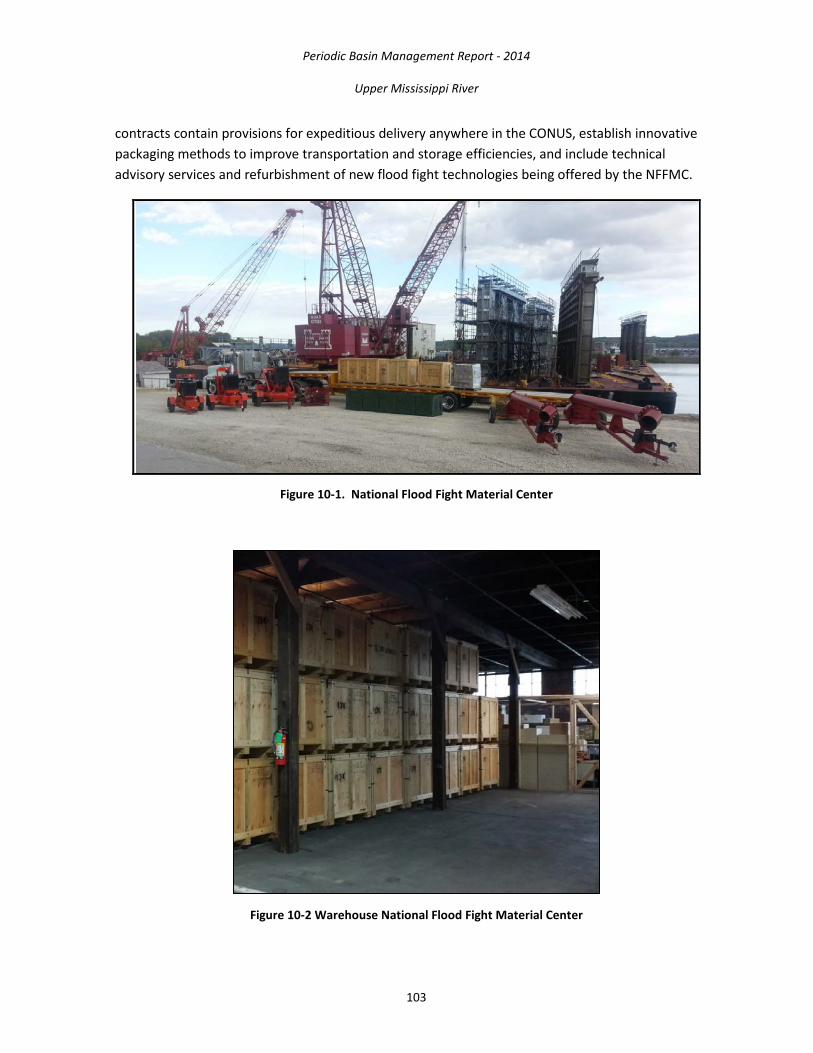
Periodic Basin Management Report - 2014
Upper Mississippi River
103
contracts contain provisions for expeditious delivery anywhere in the CONUS, establish innovative packaging methods to improve transportation and storage efficiencies, and include technical advisory services and refurbishment of new flood fight technologies being offered by the NFFMC.
Figure 10-1. National Flood Fight Material Center
Figure 10-2 Warehouse National Flood Fight Material Center

Periodic Basin Management Report - 2014
Upper Mississippi River
104
The NFFMC can provide the following materiel support:
• Sandbags (shipped in shipping containers or on pallets) • Large sandbags (airlift drop capable) • Polyethylene sheeting • Flood pumps (diesel and power-take-off driven) • Expedient Flood Fight Products (HESCO, Portadam, RDFW)
The NFFMC was established as a national center of expertise by HQ-USACE in the 2014 All Hazards Plan. Prior to 2014, the program operated as a Regional Flood Fight Materiel Center with responsibility for support to the Mississippi Valley Division. The program is administered by the MVR-EM and receives a significant amount of support from the MVR’s Contracting Division and Operations Division and Corps Logistics Activities.
11. HYDROPOWER The Corps Hydropower mission is to provide reliable hydroelectric power services at the lowest possible cost, consistent with sound business principles, in partnership with other Federal hydropower generators, the power marketing administrations, and preference customers, to benefit the Nation.
11.1. Upper St. Anthony Falls, Minneapolis MN Location/Description: Northern States Power Company (aka Xcel Energy) holds Federal Energy Regulatory Commission (FERC) license number 2056, granting it the authority to operate the hydropower facility located at USAF in Minneapolis, MN (Figure 11-1).
Figure 11-1. Hydropower Project at Upper St. Anthony Falls

Periodic Basin Management Report - 2014
Upper Mississippi River
105
The hydropower facility includes a transition wall extending from the Corps’ lock structure; a horseshoe dam, spillway and roll dam located across the river and several earthen and concrete dams at various locations to control water flows; a main powerhouse on Hennepin Island; two underground transmission lines connected to the Main Street substation; and several abandoned hydropower structures still listed on the license. The powerhouse includes five turbines with a total capacity of 12.4 megawatts, which is enough to provide power to 10,800 households.
The original hydropower license was granted on September 6, 1951. It included a 16-megawatt lower development hydropower facility at LSAF. In 1956, a 12.4-megawatt upper development hydropower facility at USAF was added to the license. In 1987, the lower development hydropower plant failed and has since been removed from the license. The license was reissued on March 8, 2004, for a period of 30 years and includes only the 12.4-megawatt upper development.
In December 2003, FERC, the Advisory Council on Historic Preservation and the MN State Historic Preservation Officer signed a programmatic agreement for managing the historic properties affected by the hydropower license.
Status: The hydropower facility continues to be owned and operated by Northern States Power. FERC conducts yearly safety inspections, sometimes requiring drawdown of the intermediate pool between the upper and lower dams to inspect the tailrace area.
The licensee is working with FERC, the MN State Historic Preservation Officer, the Minnesota DNR and others on the aesthetic flow plan to determine the minimum flows over the main spillway.
Pertinent correspondence and filings are posted on the FERC eLibrary (http://elibrary.ferc.gov) under docket number P-2056.
Authority: Licensing of hydropower facilities by the FERC is governed by Part I of the Federal Power Act, 16 U.S.C. §§ 791(a)–825(r). Licensing at Corps facilities is also governed by a 1981 Memorandum of Understanding between FERC and the DA.
Financial:
A fixed amount, generally $7,000 per year, is funded under the investigations account for FERC-related administrative activities and permit review. Activities such as pre-licensing, coordination during construction and relicensing are funded under the O&M program, and these costs are reimbursed by the licensee to the U.S. Treasury through annual charges by FERC.
Contact: St. Paul District, Project Manager, FERC Coordinator 651-290-5807 [email protected]

Periodic Basin Management Report - 2014
Upper Mississippi River
106
11.2. Crown Hydropower at Upper St. Anthony Falls, Minneapolis, MN Location/Description: The FERC issued License 11175 to Crown Hydro, LLC, in 1999, which granted it the exclusive rights to develop a hydropower facility in the Mill Ruins Park area on the Mississippi River near USAF L&D in Minneapolis, MN (Figure 11-2). The Crown Hydro Project was originally proposed to be located in the Crown Roller Building and then, later, underground on land owned by the Minneapolis Park and Recreation Board. Crown Hydro was unable to secure the needed real estate agreements with the Minneapolis Park and Recreation Board. Crown Hydro has recently developed a proposal to locate the project on Corps-managed government land at USAF L&D. The total 3.4-megawatt estimated capacity would be enough to provide power to more than 2,000 households.
Figure 11-2. Proposed Crown Hydropower at Upper St. Anthony Falls
Status: The project is located in the St. Anthony Falls Historic District. The FERC license requires the licensee to determine impacts on the historic district. Many parties are competing for use of the river flows above St. Anthony Falls, including the existing hydropower plant operated by Xcel Energy, recreation and navigation interests. The proposed hydropower facility will consist of an operations building, housing two 1.7-megawatt turbines installed below ground level, which will discharge via a 16-foot diameter conduit into the Mississippi River. The intake structure for the proposed hydropower plant is located behind the upper guide wall of USAF L&D. River conditions will allow the project to operate approximately 60 percent of the time. The project will draw up to 1,000 cfs of flow from the river.
Crown Hydropower held a public meeting on November 26, 2013. The next step is for Crown Hydro to submit a license amendment application to FERC, which will undergo Corps and other agency and stakeholder review.
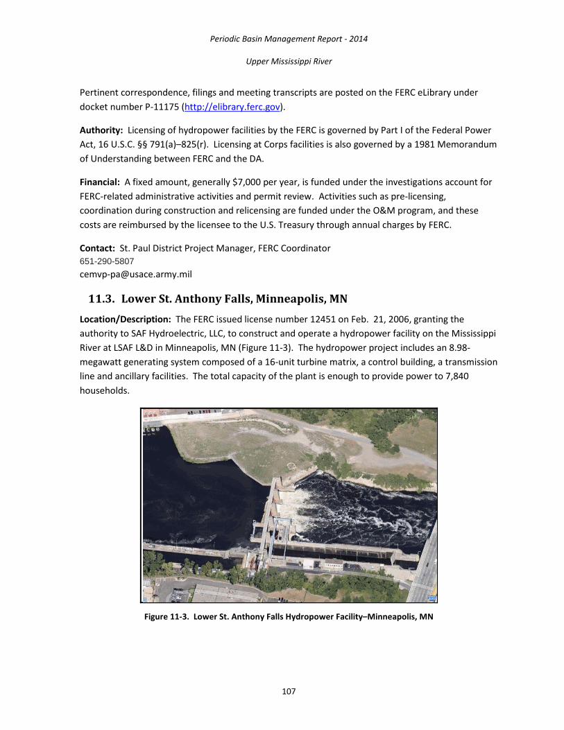
Periodic Basin Management Report - 2014
Upper Mississippi River
107
Pertinent correspondence, filings and meeting transcripts are posted on the FERC eLibrary under docket number P-11175 (http://elibrary.ferc.gov).
Authority: Licensing of hydropower facilities by the FERC is governed by Part I of the Federal Power Act, 16 U.S.C. §§ 791(a)–825(r). Licensing at Corps facilities is also governed by a 1981 Memorandum of Understanding between FERC and the DA.
Financial: A fixed amount, generally $7,000 per year, is funded under the investigations account for FERC-related administrative activities and permit review. Activities such as pre-licensing, coordination during construction and relicensing are funded under the O&M program, and these costs are reimbursed by the licensee to the U.S. Treasury through annual charges by FERC.
Contact: St. Paul District Project Manager, FERC Coordinator 651-290-5807 [email protected]
11.3. Lower St. Anthony Falls, Minneapolis, MN Location/Description: The FERC issued license number 12451 on Feb. 21, 2006, granting the authority to SAF Hydroelectric, LLC, to construct and operate a hydropower facility on the Mississippi River at LSAF L&D in Minneapolis, MN (Figure 11-3). The hydropower project includes an 8.98-megawatt generating system composed of a 16-unit turbine matrix, a control building, a transmission line and ancillary facilities. The total capacity of the plant is enough to provide power to 7,840 households.
Figure 11-3. Lower St. Anthony Falls Hydropower Facility–Minneapolis, MN

Periodic Basin Management Report - 2014
Upper Mississippi River
108
Status: SAF Hydroelectric, LLC, is co-owned by Brookfield Renewable Power and Spaulding Consultants and is operated by Brookfield Power. Construction began in April 2009 and was completed in October 2011. Commercial operation began in December 2011.
SAF Hydroelectric, LLC and the Corps signed an operating memorandum of agreement in November 2010 that included a draft hydropower regulating plan. The regulating plan will be updated as more is learned about how hydropower operations and the Corps navigation mission work together. Of primary concern is ensuring safety for small-boat operators. Several navigational testing sessions have been performed and will be used to formulate safe operating procedures and safety devices to be used in conjunction with hydropower operation.
The FERC license required the licensee to purchase land on the left (north) embankment, which was previously owned by Xcel Energy. This embankment, together with the Corps’ lock, dam and other structures make up the damming surface at the lower falls. The licensee has proposed to sell this property to the University of MN, retaining those rights necessary to ensure project safety.
Pertinent correspondence and filings are posted on the FERC eLibrary (http://elibrary.ferc.gov) under docket number P-12451.
Authority: Licensing of hydropower facilities by the FERC is governed by Part I of the Federal Power Act, 16 U.S.C. §§ 791(a)–825(r). Licensing at Corps facilities is also governed by a 1981 memorandum of understanding between FERC and the DA.
Financial: Coordination during construction and relicensing are funded under the O&M program, and these costs are reimbursed by the licensee to the U.S. Treasury through annual charges by FERC.
Contact: St. Paul District Project Manager, FERC Coordinator 651-290-5807 [email protected]
11.4. Twin Cities Hydropower at Lock & Dam 1, Minneapolis/St. Paul, MN Location/Description: Twin Cities Hydro, LLC, holds FERC license number 362, which allows it to operate the Ford Hydropower plant on the Mississippi River in St. Paul, MN (Figure 11-4). The hydropower facility consists of a powerhouse, four 5,800-horsepower Francis turbines and four 4,880-kilowatt generating units, a 2-foot-high inflatable flashboard system atop the concrete dam spillway and a power distribution system. The total capacity of the plant is 17.92 megawatts, or enough to provide power to 15,600 households.
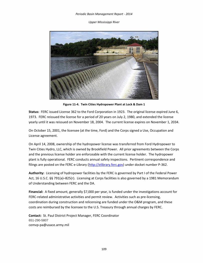
Periodic Basin Management Report - 2014
Upper Mississippi River
109
Figure 11-4. Twin Cities Hydropower Plant at Lock & Dam 1
Status: FERC issued License 362 to the Ford Corporation in 1923. The original license expired June 6, 1973. FERC reissued the license for a period of 20 years on July 2, 1980, and extended the license yearly until it was reissued on November 18, 2004. The current license expires on November 1, 2034.
On October 15, 2001, the licensee (at the time, Ford) and the Corps signed a Use, Occupation and License agreement.
On April 14, 2008, ownership of the hydropower license was transferred from Ford Hydropower to Twin Cities Hydro, LLC, which is owned by Brookfield Power. All prior agreements between the Corps and the previous license holder are enforceable with the current license holder. The hydropower plant is fully operational. FERC conducts annual safety inspections. Pertinent correspondence and filings are posted on the FERC e-Library (http://elibrary.ferc.gov) under docket number P-362.
Authority: Licensing of hydropower facilities by the FERC is governed by Part I of the Federal Power Act, 16 U.S.C. §§ 791(a)–825(r). Licensing at Corps facilities is also governed by a 1981 Memorandum of Understanding between FERC and the DA.
Financial: A fixed amount, generally $7,000 per year, is funded under the investigations account for FERC-related administrative activities and permit review. Activities such as pre-licensing, coordination during construction and relicensing are funded under the O&M program, and these costs are reimbursed by the licensee to the U.S. Treasury through annual charges by FERC.
Contact: St. Paul District Project Manager, FERC Coordinator 651-290-5807 [email protected]

Periodic Basin Management Report - 2014
Upper Mississippi River
110
11.5. Lock & Dam 2, Hastings, MN Location/Description: The City of Hastings, MN, holds FERC license number 4306, which granted it the authority to design, construct and operate a hydropower facility on the Mississippi River at L&D 2 in Hastings (Figure 11-5). The licensed facility consists of a powerhouse, which is adjacent to the dam and contains two 2,200-kilowatt turbine/generators and a power distribution system. An amendment to the license permitted the construction of two 100-kilowatt barge-mounted hydrokinetic generating units downstream of the traditional hydropower plant. The total 4.47-megawatt estimated capacity is enough to provide power to 3,900 households.
Figure 11-5. Hastings Hydropower at Lock & Dam 2
Status: FERC issued License 4306 to the City of Hastings on June 10, 1985. Construction began in 1986 and was substantially completed in 1987.
In 2006, Hydro Green Energy, LLC, a private company, approached the City of Hastings with a proposal to expand the capacity of the existing hydropower plant by installing two barge-mounted hydrokinetic generating units downstream of the plant to serve as a pilot project for their hydrokinetic technology.
FERC granted an amendment to the existing license on December 13, 2008. One barge-mounted hydrokinetic unit was installed in early 2009, and Hydro Green was able to demonstrate their operability. The hydropower license has been amended, removing the hydrokinetic unit from the project. The hydrokinetic unit was removed from the site.

Periodic Basin Management Report - 2014
Upper Mississippi River
111
The hydropower plant is fully operational. Pertinent correspondence and filings are posted on the FERC eLibrary (http://elibrary.ferc.gov) under docket number P-4306.
Authority: Licensing of hydropower facilities by the FERC is governed by Part I of the Federal Power Act (FPA), 16 U.S.C. §§ 791(a)–825(r). Licensing at Corps facilities is also governed by a 1981 Memorandum of Understanding between FERC and the DA.
Financial: A fixed amount, generally $7,000 per year, is funded under the “Investigations” account for FERC-related administrative activities and permit review. Activities such as pre-licensing, coordination during construction and relicensing are funded under the O&M program, and these costs are reimbursed by the licensee to the U.S. Treasury through annual charges by FERC.
Contact: St. Paul District Project Manager, FERC Coordinator 651-290-5807 [email protected]
11.6. Lock & Dam 19 Location/Description: L&D 19 is 364.2 miles above the confluence of the Mississippi and Ohio rivers (Figure 11-6). After the turn of the 19th century, the Mississippi River Power Company asked Congress for permission to build a dam across the River at Keokuk, IA. In 1905 Congress authorized the design and construction of the project. Construction was started in 1910 and completed in 1913 with the cost being borne by the power company. The Keokuk Power House was the largest capacity, single powerhouse electricity generating plant in the world. The power house provided electricity for Keokuk and cities as far away as St. Louis. The power house also attracted a lot of industry to the Keokuk area.
Figure 11-6. Lock & Dam 19

Periodic Basin Management Report - 2014
Upper Mississippi River
112
The lock, located on the Iowa shore, is 110 feet wide and 1,200 feet long, twice the size of the standard 9-Foot Channel Project lock. The upper lock gates consist of 23-foot high vertical lift gates, and the lower gates are miter gates, 53 feet, 2 inches high. The dam includes 119 rectangular sliding gates. The hydroelectric plant and dam is privately owned and operated by Ameren Missouri. The Corps has no oversight or control of the dam’s operation. The lock is owned and operated by the Corps. The project consists of a 4,649 foot long concrete gravity dam containing 119 spillways, a powerhouse containing fifteen generating units and appurtenances, transformers, transmission facilities and a partially developed future development area for fifteen additional generating units. Total Capacity is 141 MW. The dam was designed and is being operated as a “run of the river” type dam.
11.7. FERC Licensing Location/Description: Granting licenses for private hydropower development at Federal facilities falls within the purview of the FERC (Figure 11-7). Private hydropower facilities currently in operation at MVP sites include Xcel Energy at USAF, Minneapolis, MN; SAF Hydropower at LSAF Minneapolis, MN; Twin Cities Hydropower (aka Ford Hydropower) at L&D 1, Minneapolis/St. Paul, MN; and the City of Hastings, Hydropower at L&D 2, Hastings, MN.
Figure 11-7. Potential Hydropower Site, Lock & Dam 5, Minnesota City, MN
Status: FERC is responsible for issuing preliminary permits and licenses to private hydropower developers. A permit gives exclusive rights for three years to develop hydropower at a given location. The FERC permit holders are expected to coordinate with the Corps and other stakeholders during development of their draft licenses. At the end of three years, the developer must have conducted sufficient studies and coordination with interested parties to submit a draft license application to FERC. After review of the final license application, FERC will conduct an environmental review prior to issuing a license. The Corps will conduct a Section 408 analysis, which is required for making modifications to a Corps structure. The Corps will also issue a Section 404 permit.

Periodic Basin Management Report - 2014
Upper Mississippi River
113
In 1999, FERC granted a license to Crown Hydropower for a project at USAF, located on lands owned by the Minneapolis Park and Recreation Board. Crown Hydropower is now proposing that the project be located on Corps land at USAF and is preparing a license amendment. FERC granted a preliminary hydropower permit for “Project Oscar” at L&D 5 (Minnesota City, MN), which will expire in October 2014. FERC granted an extension to the City of Guttenberg, IA, for their preliminary permit at L&D 10, which will expire in 2016. Applicants have withdrawn or allowed permits to expire at L&Ds 3, 4, 5A, 6, 7, 8 and 9.
Authority: Licensing of hydropower facilities by the FERC is governed by Part I of the Federal Power Act, 16 U.S.C. §§ 791(a)–825(r). Licensing at Corps facilities is also governed by a 2010 Memorandum of Understanding between FERC and the DA. As part of this agreement, the licensee must provide free power to the Corps facility. The Corps must provide written approval of the design before FERC will allow construction to begin.
Financial: A fixed amount, generally $7,000 per year, is funded under the investigations account for FERC-related administrative activities and permit review. Activities such as pre-licensing, coordination during construction and relicensing are funded under the O&M program, and these costs are reimbursed by the licensee to the U.S. Treasury through an annual charge by FERC.
Contact: St. Paul District Project Manager, FERC Coordinator 651-290-5807 [email protected]

Copyright © 2022 FDOKUMEN