UPb zircon geochronology of late Neoproterozoic–Early Cambrian granitoids in Iran: Implications...
26
U-Pb zircon geochronology of late Neoproterozoic–Early Cambrian granitoids in Iran: Implications for paleogeography, magmatism, and exhumation history of Iranian basement Jamshid Hassanzadeh a,e, ⁎ , Daniel F. Stockli b , Brian K. Horton c,e , Gary J. Axen d,e , Lisa D. Stockli b , Marty Grove e , Axel K. Schmitt e , J. Douglas Walker b a School of Geology, University College of Science, University of Tehran, P.O. Box 14155-6455, Tehran, Iran b Department of Geology, University of Kansas, Lawrence, Kansas 66045, USA c Institute for Geophysics and Department of Geological Sciences, Jackson School of Geosciences, University of Texas, Austin, Texas 78712-0254, USA d Department of Earth and Environmental Science, New Mexico Institute of Mining and Technology, Socorro, New Mexico 87801, USA e Department of Earth and Space Sciences, University of California, Los Angeles, California 90095-1567, USA Received 15 October 2007; accepted 6 November 2007 Available online 15 December 2007 Abstract Eurasia has largely grown to its present enormous size through episodic addition of crustal blocks by recurring birth and demise of oceans such as Paleotethys and Neotethys. Excluding the Kopet Dagh Mountains in the northeast, crystalline basement rocks of various dimensions are exposed in all continental tectonic zones of Iran. These rocks have traditionally been viewed as continental fragments with Gondwanan affinity and summarily been assigned Precambrian or younger ages, despite the fact that evidence from isotopic dating has largely been lacking. This study presents new ion microprobe and thermal-ionization zircon U-Pb geochronological data from granitoids and orthogneisses from several locations in central Iran and the Sanandaj–Sirjan structural zones to determine crystallization ages and investigate the origin and continental affinity of these various crustal fragments. The resulting U-Pb crystallization ages for the granites and orthogneisses range from late Neoproterozoic to Early Cambrian, matching the mostly juvenile Arabian–Nubian shield and Peri-Gondwanan terranes constructed after the main phase of Pan-African orogenesis. TIMS analyses of zircons with inherited cores from western Iran suggest that the Neoproterozoic crust of Iran might not be entirely juvenile, pointing to the potential presence of inherited older Proterozoic components as is common in the eastern Arabian shield. More importantly, the new zircon U-Pb crystallization ages unequivocally demonstrate that crystalline basement underlying the Sanandaj–Sirjan zone, central Iran, and the Alborz Mountains is composed of continental fragments with Gondwanan affiliation, characterized by wide spread late Neoproterozoic subduction-related magmatism. The exposure of these late Neoproterozoic–Early Cambrian basement rocks in the Iranian regions north of the Zagros is structurally controlled and linked to both large-scale crustal extension and exhumation during Mesozoic and Tertiary time as well as Tertiary collisional tectonics associated with the closure of Neotethys. © 2008 Published by Elsevier B.V. Keywords: U-Pb dating; Zircon; Gondwana; Doran granite; Exhumation; Continental basement 1. Introduction Most paleogeographic and plate tectonic reconstructions for the margin of Gondwana facing the Paleo- and Neotethys oceans propose that crustal blocks making up the collage of Iranian microplates rifted away from Gondwana during the Paleozoic (e.g., Stampfli, 2000; Stampfli et al., 2001). In these reconstructions, a series of crustal fragments separated from the northern margin of Gondwana during the opening of Paleotethys, forming what is referred to as the Cimmerian superterrane. Subsequently, the individual fragments of this Cimmerian superterrane, such as the Sanandaj–Sirjan, Alborz, central Iranian, and Lut blocks were Available online at www.sciencedirect.com Tectonophysics 451 (2008) 71 – 96 www.elsevier.com/locate/tecto ⁎ Corresponding author. Department of Earth and Space Sciences, University of California, Los Angeles, California 90095-1567, USA. E-mail address: [email protected] (J. Hassanzadeh). 0040-1951/$ - see front matter © 2008 Published by Elsevier B.V. doi:10.1016/j.tecto.2007.11.062
-
Upload
independent -
Category
Documents
-
view
1 -
download
0
Transcript of UPb zircon geochronology of late Neoproterozoic–Early Cambrian granitoids in Iran: Implications...
Available online at www.sciencedirect.com
(2008) 71–96www.elsevier.com/locate/tecto
Tectonophysics 451
U-Pb zircon geochronology of late Neoproterozoic–Early Cambriangranitoids in Iran: Implications for paleogeography, magmatism,
and exhumation history of Iranian basement
Jamshid Hassanzadeh a,e,⁎, Daniel F. Stockli b, Brian K. Horton c,e, Gary J. Axen d,e,Lisa D. Stockli b, Marty Grove e, Axel K. Schmitt e, J. Douglas Walker b
a School of Geology, University College of Science, University of Tehran, P.O. Box 14155-6455, Tehran, Iranb Department of Geology, University of Kansas, Lawrence, Kansas 66045, USA
c Institute for Geophysics and Department of Geological Sciences, Jackson School of Geosciences, University of Texas, Austin, Texas 78712-0254, USAd Department of Earth and Environmental Science, New Mexico Institute of Mining and Technology, Socorro, New Mexico 87801, USA
e Department of Earth and Space Sciences, University of California, Los Angeles, California 90095-1567, USA
Received 15 October 2007; accepted 6 November 2007Available online 15 December 2007
Abstract
Eurasia has largely grown to its present enormous size through episodic addition of crustal blocks by recurring birth and demise of oceans suchas Paleotethys and Neotethys. Excluding the Kopet Dagh Mountains in the northeast, crystalline basement rocks of various dimensions areexposed in all continental tectonic zones of Iran. These rocks have traditionally been viewed as continental fragments with Gondwanan affinityand summarily been assigned Precambrian or younger ages, despite the fact that evidence from isotopic dating has largely been lacking. This studypresents new ion microprobe and thermal-ionization zircon U-Pb geochronological data from granitoids and orthogneisses from several locationsin central Iran and the Sanandaj–Sirjan structural zones to determine crystallization ages and investigate the origin and continental affinity of thesevarious crustal fragments. The resulting U-Pb crystallization ages for the granites and orthogneisses range from late Neoproterozoic to EarlyCambrian, matching the mostly juvenile Arabian–Nubian shield and Peri-Gondwanan terranes constructed after the main phase of Pan-Africanorogenesis. TIMS analyses of zircons with inherited cores from western Iran suggest that the Neoproterozoic crust of Iran might not be entirelyjuvenile, pointing to the potential presence of inherited older Proterozoic components as is common in the eastern Arabian shield. Moreimportantly, the new zircon U-Pb crystallization ages unequivocally demonstrate that crystalline basement underlying the Sanandaj–Sirjan zone,central Iran, and the Alborz Mountains is composed of continental fragments with Gondwanan affiliation, characterized by wide spread lateNeoproterozoic subduction-related magmatism. The exposure of these late Neoproterozoic–Early Cambrian basement rocks in the Iranian regionsnorth of the Zagros is structurally controlled and linked to both large-scale crustal extension and exhumation during Mesozoic and Tertiary time aswell as Tertiary collisional tectonics associated with the closure of Neotethys.© 2008 Published by Elsevier B.V.
Keywords: U-Pb dating; Zircon; Gondwana; Doran granite; Exhumation; Continental basement
1. Introduction
Most paleogeographic and plate tectonic reconstructions for themargin of Gondwana facing the Paleo- and Neotethys oceans
⁎ Corresponding author. Department of Earth and Space Sciences, Universityof California, Los Angeles, California 90095-1567, USA.
E-mail address: [email protected] (J. Hassanzadeh).
0040-1951/$ - see front matter © 2008 Published by Elsevier B.V.doi:10.1016/j.tecto.2007.11.062
propose that crustal blocks making up the collage of Iranianmicroplates rifted away fromGondwana during the Paleozoic (e.g.,Stampfli, 2000; Stampfli et al., 2001). In these reconstructions, aseries of crustal fragments separated from the northern margin ofGondwana during the opening of Paleotethys, forming what isreferred to as the Cimmerian superterrane. Subsequently, theindividual fragments of this Cimmerian superterrane, such as theSanandaj–Sirjan, Alborz, central Iranian, and Lut blocks were

72 J. Hassanzadeh et al. / Tectonophysics 451 (2008) 71–96
accreted to Laurasia during the Cimmerian orogeny as the result ofnorthward subduction and closure of Paleotethys and thesynchronous opening of theNeotethys in the Late Triassic (Sengör,1987; Stampfli, 2000). The crustal Iranian blocks were assigned aGondwanan affinity based on flora and excellent correlation ofPaleozoic facies with basins in Arabia or India (e.g., Ghavidel-Syooki, 1995; Stampfli, 2000). However, there is little geochro-nological or isotopic evidence that clearly ties Iranian crustalfragments to the original northern margin of Gondwana.
Historically, the National Iranian Oil Company compiled thefirst geologic map of Iran in 1959, identifying patches ofgranitic and orthogneissic basement rocks that crop out in manyplaces in northern, central, and east-central Iran. These blockswere tentatively assigned a Precambrian age and viewed asanalogs of the Precambrian basement rocks exposed in theArabian shield (e.g., Stöcklin, 1968). However, the ages ofthese rocks have remained poorly constrained and controversial.Reported crystallization ages have ranged from Archean(Haghipour, 1981) to Early Proterozoic (Nadimi, 2007), MiddleProterozoic (Crawford, 1977) and Late Proterozoic (Samani etal., 1994; Davoudzadeh, 1997), based on little or no solidgeochronological foundation. However, these age estimates
Table 1Sample information for twenty Neoproterozoic–Early Cambrian granitoids and gran
No. Locality, Sample ID GPS coordinates
N (deg, min) E (deg,
Soltanieh Mountains, east and south of Zanjan1 ZJ3, Sarv-e Jahan 36° 15.605′ 48° 57.2 ZJ4, Sarv-e Jahan 36° 15.586′ 48° 57.3 ZJ11, Khorram Darreh⁎ 36° 26.450′ 48° 36.4 ZJ2, Doran⁎ 36° 36.031′ 48° 23.5 ZJ10, west of Doran 36° 36.103′ 48° 20.
Takab-west Zanjan region6 MoEs24, Moghanlou⁎⁎ 36° 39.100′ 47° 55.7 ZJ9, Mahneshan⁎ 36° 41.890′ 47° 33.
Northwestern Sanandaj–Sirjan zone8 Bubaktan 36° 15.157′ 45° 59.9 Sheikh Chupan 36° 13.545′ 45° 54.
Muteh gold mine & Varzaneh area, north Golpaygan region10 06MT10, Chah Khatoon 33° 42.253′ 50° 45.11 06MT11B, Chah Khatoon 33° 42.253′ 50° 45.12 06MT24, North Varzaneh 33° 37.744′ 50° 31.
Torud, Khār Turan & Band-e Hezar Chāh, northeast central Iran13 TO40, N. Shotor Kuh, NE of Torud 35° 46.653′ 55° 20.14 EaBi 1a, W. Kuh-e Molhedou⁎⁎⁎ 35° 56.620′ 55° 52.15 EaBi22, S. Kuh-e Molhedou 35° 56.600′ 56° 02.16 EaBi32, Kuh-e Sefid Sang 35° 50.667′ 55° 45.17 EaBi 125, Delbar, SE Kuh-e Molhedou 35° 58.833′ 56° 04.18 G227, W. Kuh-e Molhedou⁎⁎⁎ 35° 54.100′ 55° 54.19 TO46, Band-e Hezar Chāh 36° 00.517′ 55° 34.20 TO50, Band-e Hezar Chāh 35° 57.534′ 55° 32.21 TO-He4, Band-e Hezar Chāh 36° 00..900′ 55° 31.
Lahijan area, northern west Alborz mountains (after Lam, 2002)22 LJ6, Leila Kuh, SW Langarud⁎ 37° 009.900′ 50° 07.
The Pliocene phase in the Doran intrusive complex and the Eocene Khorram DarreNotes: ‡See Table 2 for details. Rock samples were collected by JH excluding ⁎(JH
have directly influenced paleogeographic and plate tectonicreconstructions, illustrating the need for robust isotopic agedata. Earlier attempts at dating ancient granites in Iran employedavailable techniques deemed appropriate at the time, such asRb-Sr (e.g., Crawford, 1977) and K-Ar (e.g., Rachidnejad-Omran et al., 2002), but were unsuccessful in revealing theigneous crystallization ages because of complex and protractedthermal histories and post-intrusive metamorphism (Faure andMensing, 2005). Modern ion-microprobe and thermal-ioniza-tion (TIMS) zircon U-Pb geochronology used in the presentstudy are the preferred methods for determining crystallizationages of granitic magmas due to the closure temperature of the U-Pb system well in excess of the solidus N700–750 °C and therefractory nature of zircon. Thus far, only very sparse publishedU-Pb zircon age data have been available. Samani et al. (1994)presented the first TIMS U-Pb ages, although discordant, for thePrecambrian units in east-central Iran. Ramezani (1997) andRamezani and Tucker (2003) carried out the first extensiveresearch on Iran basement complexes employing TIMS U-Pbzircon dating of a correlative suite of rocks in central Iran. Morerecently, ion-microprobe zircon U-Pb dating of plutons in theAlborz Mountains by Axen et al. (2001), Lam (2002), and
ite mylonites from Iran included in this study
Rock type Age(Ma)‡
min) Elevation (m)
657′ 2270 Equi-granular beige leucogranite 559822′ 2220 Foliated biotite granite, chloritized 544620′ 2040 Equi-granular biotite granite 53.4105′ 1860 White leucogranite 2.8905′ 1835 Argillized leucogranite 567
500′ 2235 Biotite granite mylonite 548950′ 2050 Biotite granite mylonite 568
391′ 1685 Foliated biotite granite 544228′ 1783 Biotite granodiorite 551
436′ 2130 Beige leucogranite 578436′ 2130 Biotite granite 596056′ 1918 Biotite granite mylonite 588
940′ 1430 Biotite granite mylonite 566708′ 1414 Foliated leucogranite 551917′ 1230 Biotite-garnet granite mylonite 556383′ 1350 Biotite granite 554717′ 1177 Foliated leucogranite 534267′ 1316 Biotite-garnet granite 522867′ 1491 Pink foliated leucogranite 581757′ 1645 Biotite granite mylonite 601402′ 1780 Leucogranite mylonite 572
400′ 210 Pink biotite granite 551
h granite dated in this study are also shown.& DS), ⁎⁎(D. Esmaeily) and ⁎⁎⁎(A. R. Malekpour).
73J. Hassanzadeh et al. / Tectonophysics 451 (2008) 71–96
Guest et al. (2006) provided a first glimpse of the complexmagmatic evolution of the Alborz Mountains, with zircon U-Pbages yielding late Neoproterozoic, Cretaceous, Eocene, andMiocene ages.
In an attempt to shed light on the paleogeographic evolutionof Iran and to elucidate the nature of the purported Precambriangranitic and orthogneissic basement in Iran, this paper presentsnew ion-microprobe and TIMS U-Pb zircon crystallization agesfrom twenty-one rock samples from five different areas incentral Iran and the Sanandaj–Sirjan zone (Table 1). For theLahijan granite, northern Alborz, unpublished data of Lam(2002), generated in the same ion-probe lab, is incorporated.This new geochronological dataset, in combination with fieldobservations and data from published studies, is used to clarifythe magmatic evolution of the Iranian continental basement andto investigate the possible implications for paleogeography, oredeposits, and exhumation history of Iranian continental crust.
2. U-Pb geochronology
2.1. Ion-microprobe zircon U-Pb geochronology
Table 1 provides the pertinent sample information andlocations for all samples dated in this study. Table 2 summarizesthe data from ion microprobe isotopic analyses performed ontwenty rock specimens collected from different granitoidplutons and orthogneissic/mylonitic complexes of Iran. All ofthe reported ion-microprobe zircon U-Pb ages are based on U,Pb, and Th isotopic measurements employing spot analysisusing the Cameca IMS 1270 ion microprobe at the University ofCalifornia, Los Angeles (UCLA). Analytical methods followthe procedures described by Quidelleur et al. (1997) andSchmitt et al. (2003a,b). Following mineral separation usingconventional liquid and magnetic techniques, zircon grainswere hand selected, mounted in epoxy, and coated with ~100 Åof gold. The ion-microprobe spot analyses utilized a primary ionbeam focused to an ~30 µm diameter spot and a secondary ionbeam with a mass resolving power of 5000 and energy windowof 50 eV. Following a pre-sputtering period of ~180 s, eachanalysis collected data for 8–10 cycles. The sample chamberwas flooded with oxygen at ~3×10⁻⁵ Torr to enhance sec-ondary Pb+ ionization. The reported weighted-mean ages arebased on 206Pb/238U ages calculated using zircon standard AS3(1099±0.5 Ma; Paces and Miller, 1993). Common lead correc-tions were made using the measured values of 204Pb (Stacey andKramers, 1975) and the values of 208Pb corrected for 232Th-derived 208Pb (Compston et al., 1984), which are considered aproxy for common 206Pb and 207Pb. These corrections use theanthropogenic Pb compositions reported for the Los Angelesbasin (Sanudo-Wilhelmy and Flegal, 1994). All age uncertain-ties are reported at the 95% level (Table 2).
2.2. Thermal-ionization (TIMS) zircon U-Pb geochronology
Given the reconnaissance nature of our study in trying to shedlight on the timing and spatial distribution of Neoproterozoicmagmatism in Iran, we predominantly relied on ion-microprobe
U-Pb dating. However, in three cases we employed TIMS U-Pbgeochronology, to gain a more precise insight into the intrusionage and inherited zircon component of the Doran granite. TIMSU-Pb analyseswere carried out at theUniversity ofKansas. Singleand multi-grain zircon samples were carefully hand-selected andair-abraded to reduce radiogenic lead loss following the proceduresoutlined by Krogh (1982). Pressure-vessel HF-HNO3 dissolutionfollowed the methods of Krogh (1973) and Parrish (1987).Elemental separation was carried out using an HCl anion columnchemistry protocol for separating lead and uranium. Isotopicanalyses were determined on a VG Sector multicollector thermalionization mass spectrometer. A mass fractionation correction of0.16%±0.05%/amu, as determined by standard runs on NBS 981(common lead) and NBS 982 (equal atom lead), was applied to thelead data. A mass fractionation of 0.10%±0.05%/amu, asdetermined by standard runs on U500, was applied to the U data.Samples were spiked with a mixed 205Pb/235U spike. Errors on206Pb/204Pb were minimized by use of a Daly multiplier and aretypically on the order of 1%or less. Common lead correctionsweremade using values determined fromStacey andKramers (1975) forthe interpreted crystallization age. Decay constants used were238U=0.15513×10⁻⁹ yr−1 and 235U=0.98485×10⁻⁹ yr−1 (Stei-ger and Jager, 1977). All individual analyses are reported in Table 3(uncertainties at the 2σ level).
3. Geological setting
Iran is constructed chiefly of continental fragments initiallyrifted from Gondwana as Paleotethys and Neotethys oceansopened, then later re-amalgamated as both oceans closed(Berberian and King, 1981; Sengör, 1987). The major tectonicprovinces of western and central Iran (Fig. 1) include, from northto south: the Alborz mountains, a variety of small blockscomposing central Iran, the Urumieh–Dokhtar arc, the Sanandaj–Sirjan zone, the Zagros mountains, and the Zagros foreland(Arabian shield). Despite their varied histories, the continentalfragments composing Iran share a relatively similar stratigraphicrecord of mostly shallow-marine sedimentation from lateNeoproterozoic to Permian time (Stöcklin, 1968). The principaltectonic provinces are separated by two major suture zonesrepresenting closure of Paleotethys and Neotethys oceans.
Paleotethys Ocean closed during collision of Iran and theEurasian part of Pangea in the Late Triassic (Alavi et al., 1997;Stampfli, 2000). Although the suture position is accurately knownalong the trend of the Kopet Dagh and Caucasus mountains, itmay proceed either continuously (Stöcklin, 1974; Ruttner, 1993;Davoudzadeh, 1997) or discontinuously (Sengör, 1990) along thenorthern flank of the Alborz mountains of northern Iran. Whereexposed, the suture is overlapped by Upper Triassic–LowerJurassic nonmarine deposits of the Shemshak Formation,presumably derived from the Eurasian part of Pangea to thenorth (Dercourt et al., 1986).
The subduction of the Neotethys Ocean had a complexhistory involving collision of Arabia with Iran and growth of theZagros Mountains. Stampfli and Borel (2004) suggested that theIran portion of the Neotethys was already closed in the lateCretaceous, following obduction along the Arabian margin,

Table 2Iran zircon U-Pb ion-microprobe data
SampleID
207Pb⁎/235U Error207Pb⁎/235U1 r %
206Pb⁎/238U Error206Pb⁎/238U1 σ %
Errorcorr
207Pb⁎/206Pb⁎ Error207Pb⁎/206Pb⁎
1 r %
Age (Ma)206Pb/238U
Age (Ma)206Pb/238U1 r
Age (Ma)207Pb/235U
Age (Ma)207Pb/235U1 r
Age (Ma)207Pb/206Pb
Age (Ma)207Pb/206Pb1 r
ZJ3, Sarv-e Jahan, east Soltanieh mountainsg1 0.74900 5.63 0.09714 6.21 0.879 0.05592 2.96 597.6 35.4 567.6 24.5 449.2 66.0g2 0.78450 6.41 0.09653 7.07 0.919 0.05895 2.79 594.0 40.1 588.0 28.6 565.2 60.9g3 0.75050 5.47 0.09809 6.17 0.876 0.05549 2.98 603.2 35.5 568.5 23.8 432.0 66.6Weighted Mean=599±42 [7%] 95% conf.; MSWD=0.015
ZJ4, Sarv-e Jahan, east Soltanieh mountainsg10 0.63970 3.67 0.07897 4.31 0.799 0.05875 2.60 490.0 20.3 502.1 14.5 557.8 56.9g8 0.70270 4.20 0.08655 4.25 0.987 0.05889 0.69 535.1 21.8 540.4 17.6 563.0 15.8g7 0.69150 4.31 0.08702 4.67 0.924 0.05764 1.79 537.9 24.1 533.7 17.9 516.1 39.5g3 0.66190 4.72 0.08805 8.61 0.651 0.05452 6.60 544.0 44.9 515.8 19.1 392.6 148.0g6 0.70410 4.28 0.08878 4.39 0.976 0.05752 0.95 548.3 23.1 541.2 17.9 511.5 21.3g5 0.74270 4.59 0.09286 4.59 0.962 0.05801 1.26 572.4 25.1 564.0 19.9 530.1 28.0g1 0.76450 4.94 0.09436 5.29 0.875 0.05876 2.58 581.3 29.4 576.6 21.7 558.2 56.4g2 0.77240 4.73 0.09577 4.85 0.974 0.05849 1.10 589.6 27.3 581.1 20.9 548.2 24.4Weighted Mean=544±29 [5.3%] 95% conf.; MSWD=1.9
ZJ10, Chevarzagh, central Soltanieh mountains, south of Zanjan, west of Dorang9 0.70740 4.41 0.08987 4.63 0.965 0.05708 1.22 554.8 24.6 543.2 18.6 494.6 27.2g10 0.71250 4.55 0.09019 4.71 0.964 0.05729 1.25 556.7 25.1 546.2 19.2 502.7 28.0g6 0.74740 4.33 0.09036 4.35 0.961 0.05999 1.21 557.7 23.3 566.7 18.8 603.2 26.6g7 0.73970 4.61 0.09103 5.03 0.916 0.05893 2.02 561.6 27.1 562.2 19.9 564.5 44.3g1 0.73200 4.65 0.09272 4.87 0.978 0.05726 1.02 571.6 26.6 557.7 19.9 501.6 22.9g2 0.75400 4.35 0.09405 4.41 0.979 0.05815 0.90 579.4 24.5 570.5 19.0 535.4 20.1g8 0.77930 4.87 0.09702 4.98 0.979 0.05826 1.00 596.9 28.4 585.1 21.7 539.6 22.4Weighted Mean=567±19 [3.3%] 95% conf.; MSWD=0.34
MoEs24, Moghanlou, west Zanjan regiong2_s2 0.68530 6.47 0.08484 6.60 0.988 0.05858 1.04 524.9 33.3 530.0 26.7 551.5 23.1g2_s1 0.68780 6.57 0.08617 6.62 0.992 0.05789 0.83 532.8 33.8 531.5 27.2 525.6 18.8g5_s1 0.67520 9.45 0.08634 10.68 0.948 0.05672 3.47 533.9 54.7 523.9 38.7 480.7 76.9g4_s4 0.71660 9.21 0.08761 9.38 0.972 0.05932 2.21 541.4 48.7 548.7 39.0 578.9 48.2g4_s2 0.71980 9.13 0.08966 9.43 0.978 0.05823 1.97 553.5 50.0 550.5 38.8 538.4 43.4g5_s3 0.70970 8.61 0.08980 9.13 0.937 0.05732 3.19 554.4 48.5 544.6 36.3 503.9 70.4g1_s1 0.72950 9.48 0.09063 9.57 0.981 0.05837 1.87 559.3 51.3 556.3 40.6 543.7 41.1g5_s2 0.72790 9.64 0.09066 10.25 0.949 0.05823 3.23 559.4 54.9 555.3 41.2 538.4 70.8g3_s1 0.71510 9.83 0.09148 10.10 0.971 0.05670 2.40 564.3 54.6 547.8 41.6 479.9 53.2g4_s3 0.74930 10.74 0.09236 11.06 0.965 0.05884 2.91 569.5 60.3 567.8 46.7 561.2 63.5g4_s1 0.75370 9.71 0.09405 10.19 0.974 0.05813 2.34 579.4 56.5 570.4 42.4 534.7 51.4g3_s2 0.74430 10.14 0.09419 10.43 0.969 0.05731 2.58 580.3 57.9 564.9 43.9 503.5 57.0Weighted Mean=548±27 [4.9%] 95% conf.; MSWD=0.16
ZJ9, Mahneshan, Takab regiong10 0.56290 9.58 0.07214 9.77 0.984 0.05659 1.73 449.0 42.4 453.4 35.0 475.6 38.5g7 0.61950 8.64 0.07995 8.83 0.970 0.05620 2.14 495.8 42.1 489.5 33.6 460.3 47.6g12 0.71670 7.69 0.08817 7.76 0.932 0.05895 2.85 544.7 40.5 548.7 32.6 565.2 62.2g9 0.71870 7.57 0.08868 7.64 0.990 0.05878 1.05 547.7 40.1 549.9 32.1 559.0 23.4g2 0.74350 7.51 0.09276 7.52 0.998 0.05813 0.45 571.8 41.1 564.4 32.5 534.7 10.8g1 0.77840 8.01 0.09622 8.03 0.996 0.05868 0.70 592.2 45.4 584.6 35.6 555.2 15.8
74J.
Hassanzadeh
etal.
/Tectonophysics
451(2008)
71–96
g6_s1 0.78040 7.98 0.09734 8.07 0.984 0.05815 1.45 598.8 46.2 585.7 35.5 535.4 32.2g6_s2 0.82350 8.97 0.10150 8.93 0.993 0.05882 1.06 623.2 53.0 610.0 41.1 560.4 23.5g11 0.82890 8.03 0.10280 8.01 0.999 0.05845 0.34 630.8 48.1 613.0 36.9 546.7 8.8g8 0.87150 8.80 0.10800 8.79 0.999 0.05854 0.39 661.1 55.2 636.4 41.6 550.0 9.7g4 0.92070 9.26 0.11020 9.53 0.954 0.06057 2.86 673.9 61.0 662.7 45.1 624.0 61.8Weighted Mean=568±44 [7.8%] 95% conf.; MSWD=2.1
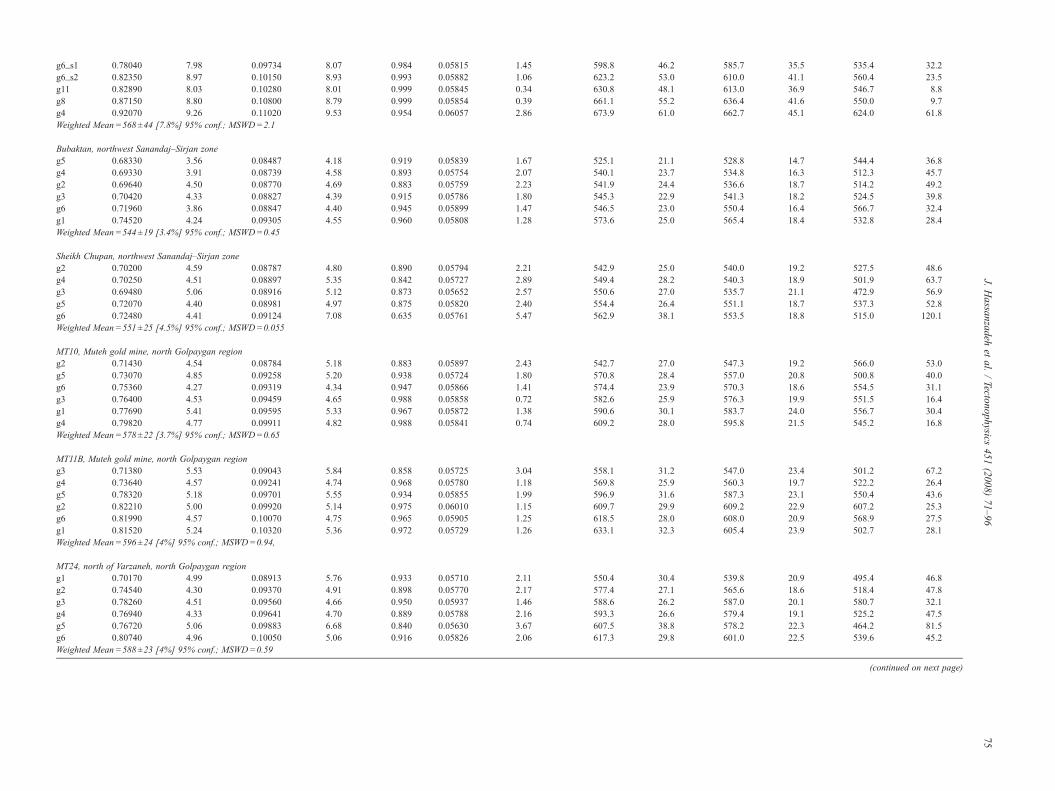
Bubaktan, northwest Sanandaj–Sirjan zoneg5 0.68330 3.56 0.08487 4.18 0.919 0.05839 1.67 525.1 21.1 528.8 14.7 544.4 36.8g4 0.69330 3.91 0.08739 4.58 0.893 0.05754 2.07 540.1 23.7 534.8 16.3 512.3 45.7g2 0.69640 4.50 0.08770 4.69 0.883 0.05759 2.23 541.9 24.4 536.6 18.7 514.2 49.2g3 0.70420 4.33 0.08827 4.39 0.915 0.05786 1.80 545.3 22.9 541.3 18.2 524.5 39.8g6 0.71960 3.86 0.08847 4.40 0.945 0.05899 1.47 546.5 23.0 550.4 16.4 566.7 32.4g1 0.74520 4.24 0.09305 4.55 0.960 0.05808 1.28 573.6 25.0 565.4 18.4 532.8 28.4Weighted Mean=544±19 [3.4%] 95% conf.; MSWD=0.45
Sheikh Chupan, northwest Sanandaj–Sirjan zoneg2 0.70200 4.59 0.08787 4.80 0.890 0.05794 2.21 542.9 25.0 540.0 19.2 527.5 48.6g4 0.70250 4.51 0.08897 5.35 0.842 0.05727 2.89 549.4 28.2 540.3 18.9 501.9 63.7g3 0.69480 5.06 0.08916 5.12 0.873 0.05652 2.57 550.6 27.0 535.7 21.1 472.9 56.9g5 0.72070 4.40 0.08981 4.97 0.875 0.05820 2.40 554.4 26.4 551.1 18.7 537.3 52.8g6 0.72480 4.41 0.09124 7.08 0.635 0.05761 5.47 562.9 38.1 553.5 18.8 515.0 120.1Weighted Mean=551±25 [4.5%] 95% conf.; MSWD=0.055
MT10, Muteh gold mine, north Golpaygan regiong2 0.71430 4.54 0.08784 5.18 0.883 0.05897 2.43 542.7 27.0 547.3 19.2 566.0 53.0g5 0.73070 4.85 0.09258 5.20 0.938 0.05724 1.80 570.8 28.4 557.0 20.8 500.8 40.0g6 0.75360 4.27 0.09319 4.34 0.947 0.05866 1.41 574.4 23.9 570.3 18.6 554.5 31.1g3 0.76400 4.53 0.09459 4.65 0.988 0.05858 0.72 582.6 25.9 576.3 19.9 551.5 16.4g1 0.77690 5.41 0.09595 5.33 0.967 0.05872 1.38 590.6 30.1 583.7 24.0 556.7 30.4g4 0.79820 4.77 0.09911 4.82 0.988 0.05841 0.74 609.2 28.0 595.8 21.5 545.2 16.8Weighted Mean=578±22 [3.7%] 95% conf.; MSWD=0.65
MT11B, Muteh gold mine, north Golpaygan regiong3 0.71380 5.53 0.09043 5.84 0.858 0.05725 3.04 558.1 31.2 547.0 23.4 501.2 67.2g4 0.73640 4.57 0.09241 4.74 0.968 0.05780 1.18 569.8 25.9 560.3 19.7 522.2 26.4g5 0.78320 5.18 0.09701 5.55 0.934 0.05855 1.99 596.9 31.6 587.3 23.1 550.4 43.6g2 0.82210 5.00 0.09920 5.14 0.975 0.06010 1.15 609.7 29.9 609.2 22.9 607.2 25.3g6 0.81990 4.57 0.10070 4.75 0.965 0.05905 1.25 618.5 28.0 608.0 20.9 568.9 27.5g1 0.81520 5.24 0.10320 5.36 0.972 0.05729 1.26 633.1 32.3 605.4 23.9 502.7 28.1Weighted Mean=596±24 [4%] 95% conf.; MSWD=0.94,
MT24, north of Varzaneh, north Golpaygan regiong1 0.70170 4.99 0.08913 5.76 0.933 0.05710 2.11 550.4 30.4 539.8 20.9 495.4 46.8g2 0.74540 4.30 0.09370 4.91 0.898 0.05770 2.17 577.4 27.1 565.6 18.6 518.4 47.8g3 0.78260 4.51 0.09560 4.66 0.950 0.05937 1.46 588.6 26.2 587.0 20.1 580.7 32.1g4 0.76940 4.33 0.09641 4.70 0.889 0.05788 2.16 593.3 26.6 579.4 19.1 525.2 47.5g5 0.76720 5.06 0.09883 6.68 0.840 0.05630 3.67 607.5 38.8 578.2 22.3 464.2 81.5g6 0.80740 4.96 0.10050 5.06 0.916 0.05826 2.06 617.3 29.8 601.0 22.5 539.6 45.2Weighted Mean=588±23 [4%] 95% conf.; MSWD=0.59
(continued on next page)
75J.
Hassanzadeh
etal.
/Tectonophysics
451(2008)
71–96
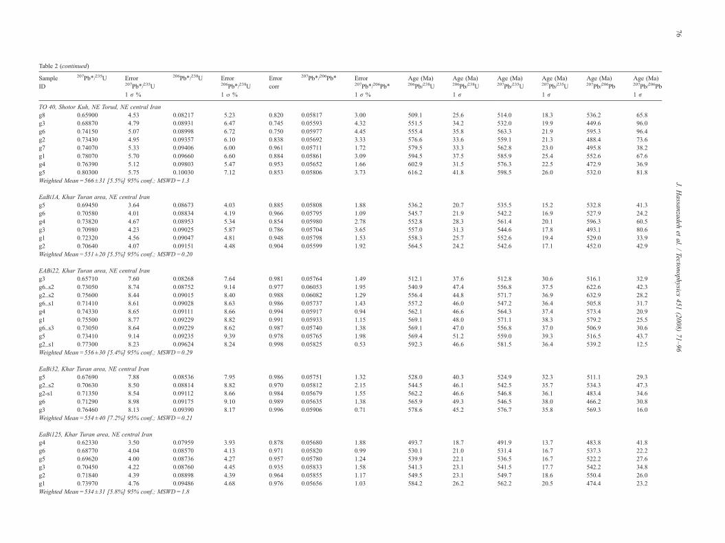
Table 2 (continued)
SampleID
207Pb⁎/235U Error207Pb⁎/235U1 r %
206Pb⁎/238U Error206Pb⁎/238U1 σ %
Errorcorr
207Pb⁎/206Pb⁎ Error207Pb⁎/206Pb⁎
1 r %
Age (Ma)206Pb/238U
Age (Ma)206Pb/238U1 r
Age (Ma)207Pb/235U
Age (Ma)207Pb/235U1 r
Age (Ma)207Pb/206Pb
Age (Ma)207Pb/206Pb1 r
TO 40, Shotor Kuh, NE Torud, NE central Irang8 0.65900 4.53 0.08217 5.23 0.820 0.05817 3.00 509.1 25.6 514.0 18.3 536.2 65.8g3 0.68870 4.79 0.08931 6.47 0.745 0.05593 4.32 551.5 34.2 532.0 19.9 449.6 96.0g6 0.74150 5.07 0.08998 6.72 0.750 0.05977 4.45 555.4 35.8 563.3 21.9 595.3 96.4g2 0.73430 4.95 0.09357 6.10 0.838 0.05692 3.33 576.6 33.6 559.1 21.3 488.4 73.6g7 0.74070 5.33 0.09406 6.00 0.961 0.05711 1.72 579.5 33.3 562.8 23.0 495.8 38.2g1 0.78070 5.70 0.09660 6.60 0.884 0.05861 3.09 594.5 37.5 585.9 25.4 552.6 67.6g4 0.76390 5.12 0.09803 5.47 0.953 0.05652 1.66 602.9 31.5 576.3 22.5 472.9 36.9g5 0.80300 5.75 0.10030 7.12 0.853 0.05806 3.73 616.2 41.8 598.5 26.0 532.0 81.8Weighted Mean=566±31 [5.5%] 95% conf.; MSWD=1.3
EaBi1A, Khar Turan area, NE central Irang5 0.69450 3.64 0.08673 4.03 0.885 0.05808 1.88 536.2 20.7 535.5 15.2 532.8 41.3g6 0.70580 4.01 0.08834 4.19 0.966 0.05795 1.09 545.7 21.9 542.2 16.9 527.9 24.2g4 0.73820 4.67 0.08953 5.34 0.854 0.05980 2.78 552.8 28.3 561.4 20.1 596.3 60.5g3 0.70980 4.23 0.09025 5.87 0.786 0.05704 3.65 557.0 31.3 544.6 17.8 493.1 80.6g1 0.72320 4.56 0.09047 4.81 0.948 0.05798 1.53 558.3 25.7 552.6 19.4 529.0 33.9g2 0.70640 4.07 0.09151 4.48 0.904 0.05599 1.92 564.5 24.2 542.6 17.1 452.0 42.9Weighted Mean=551±20 [5.5%] 95% conf.; MSWD=0.20
EABi22, Khar Turan area, NE central Irang3 0.65710 7.60 0.08268 7.64 0.981 0.05764 1.49 512.1 37.6 512.8 30.6 516.1 32.9g6_s2 0.73050 8.74 0.08752 9.14 0.977 0.06053 1.95 540.9 47.4 556.8 37.5 622.6 42.3g2_s2 0.75600 8.44 0.09015 8.40 0.988 0.06082 1.29 556.4 44.8 571.7 36.9 632.9 28.2g6_s1 0.71410 8.61 0.09028 8.63 0.986 0.05737 1.43 557.2 46.0 547.2 36.4 505.8 31.7g4 0.74330 8.65 0.09111 8.66 0.994 0.05917 0.94 562.1 46.6 564.3 37.4 573.4 20.9g1 0.75500 8.77 0.09229 8.82 0.991 0.05933 1.15 569.1 48.0 571.1 38.3 579.2 25.5g6_s3 0.73050 8.64 0.09229 8.62 0.987 0.05740 1.38 569.1 47.0 556.8 37.0 506.9 30.6g5 0.73410 9.14 0.09235 9.39 0.978 0.05765 1.98 569.4 51.2 559.0 39.3 516.5 43.7g2_s1 0.77300 8.23 0.09624 8.24 0.998 0.05825 0.53 592.3 46.6 581.5 36.4 539.2 12.5Weighted Mean=556±30 [5.4%] 95% conf.; MSWD=0.29
EaBi32, Khar Turan area, NE central Irang5 0.67690 7.88 0.08536 7.95 0.986 0.05751 1.32 528.0 40.3 524.9 32.3 511.1 29.3g2_s2 0.70630 8.50 0.08814 8.82 0.970 0.05812 2.15 544.5 46.1 542.5 35.7 534.3 47.3g2-s1 0.71350 8.54 0.09112 8.66 0.984 0.05679 1.55 562.2 46.6 546.8 36.1 483.4 34.6g6 0.71290 8.98 0.09175 9.10 0.989 0.05635 1.38 565.9 49.3 546.5 38.0 466.2 30.8g3 0.76460 8.13 0.09390 8.17 0.996 0.05906 0.71 578.6 45.2 576.7 35.8 569.3 16.0Weighted Mean=554±40 [7.2%] 95% conf.; MSWD=0.21
EaBi125, Khar Turan area, NE central Irang4 0.62330 3.50 0.07959 3.93 0.878 0.05680 1.88 493.7 18.7 491.9 13.7 483.8 41.8g6 0.68770 4.04 0.08570 4.13 0.971 0.05820 0.99 530.1 21.0 531.4 16.7 537.3 22.2g5 0.69620 4.00 0.08736 4.27 0.957 0.05780 1.24 539.9 22.1 536.5 16.7 522.2 27.6g3 0.70450 4.22 0.08760 4.45 0.935 0.05833 1.58 541.3 23.1 541.5 17.7 542.2 34.8g2 0.71840 4.39 0.08898 4.39 0.964 0.05855 1.17 549.5 23.1 549.7 18.6 550.4 26.0g1 0.73970 4.76 0.09486 4.68 0.976 0.05656 1.03 584.2 26.2 562.2 20.5 474.4 23.2Weighted Mean=534±31 [5.8%] 95% conf.; MSWD=1.8
76J.
Hassanzadeh
etal.
/Tectonophysics
451(2008)
71–96
G227, Khar Turan area, NE central Irang5 0.66500 6.05 0.08131 6.63 0.919 0.05932 2.61 503.9 32.1 517.7 24.5 578.9 57.0g7 0.65620 6.29 0.08190 6.39 0.977 0.05811 1.36 507.5 31.2 512.3 25.3 533.9 30.2g4 0.65200 6.79 0.08218 6.98 0.982 0.05754 1.32 509.1 34.2 509.7 27.2 512.3 29.4g3 0.66570 6.36 0.08361 6.32 0.992 0.05775 0.81 517.6 31.5 518.1 25.8 520.3 18.2g8 0.67050 5.95 0.08482 6.29 0.960 0.05733 1.76 524.8 31.7 521.0 24.3 504.3 39.0g6 0.68890 6.38 0.08636 6.68 0.964 0.05785 1.78 534.0 34.2 532.1 26.4 524.1 39.3g2 0.70510 7.17 0.08736 7.28 0.988 0.05853 1.13 539.9 37.7 541.8 30.1 549.7 25.1g1 0.71110 7.09 0.08945 7.30 0.986 0.05766 1.23 552.3 38.6 545.4 29.9 516.9 27.5Weighted Mean=522±23 [4.5%] 95% conf.; MSWD=0.24
TO 46, Band-e Hezar Chah, NE central Irang6 0.71810 4.30 0.08920 4.38 0.982 0.05839 0.83 550.8 23.1 549.5 18.3 544.4 18.8g3 0.75280 4.93 0.09393 4.91 0.976 0.05813 1.07 578.7 27.2 569.8 21.5 534.7 23.9g1 0.76010 4.84 0.09470 4.89 0.986 0.05821 0.81 583.3 27.3 574.1 21.2 537.7 18.3g2 0.75800 4.67 0.09492 4.80 0.985 0.05792 0.83 584.6 26.9 572.9 20.4 526.7 18.8g5 0.77540 4.69 0.09630 4.72 0.993 0.05839 0.54 592.7 26.7 582.9 20.8 544.4 12.7g4 0.79190 4.70 0.09824 4.73 0.990 0.05846 0.66 604.1 27.2 592.2 21.1 547.0 15.2Weighted Mean=581±21 [3.6%] 95% conf.; MSWD=0.53
TO 50, Band-e Hezar Chah, NE central Irang3 0.77620 4.61 0.09532 4.78 0.962 0.05906 1.31 586.9 26.8 583.3 20.5 569.3 29.0g6 0.75190 4.67 0.09572 4.90 0.960 0.05697 1.37 589.3 27.6 569.3 20.4 490.4 30.5g5 0.76930 4.84 0.09694 4.92 0.986 0.05756 0.81 596.5 28.1 579.4 21.4 513.1 18.4g1 0.78720 4.69 0.09814 4.76 0.982 0.05817 0.90 603.5 27.4 589.6 21.0 536.2 20.2g4 0.80630 4.70 0.09994 4.69 0.994 0.05851 0.52 614.1 27.5 600.4 21.3 548.9 12.2g2 0.81770 5.06 0.10140 5.15 0.988 0.05848 0.79 622.6 30.6 606.8 23.1 547.8 17.8Weighted Mean=601±22 [3.7%] 95% conf.; MSWD=0.24
TO-He4, Band-e Hezar Chah, NE central Irang5 0.64610 4.01 0.08415 4.40 0.928 0.05569 1.64 520.8 22.0 506.1 16.0 440.0 36.8g6 0.73780 4.61 0.09248 5.16 0.906 0.05786 2.19 570.2 28.1 561.1 19.9 524.5 48.2g1 0.77410 4.96 0.09500 5.37 0.925 0.05910 2.04 585.0 30.0 582.1 22.0 570.8 44.6g3 0.77800 4.84 0.09587 4.89 0.974 0.05886 1.11 590.2 27.6 584.3 21.5 561.9 24.7g2 0.75620 4.74 0.09676 4.87 0.976 0.05668 1.06 595.4 27.7 571.8 20.7 479.1 23.8g4 0.77800 4.81 0.09782 4.82 0.988 0.05768 0.75 601.6 27.7 584.3 21.4 517.6 17.2Weighted Mean=527±35 [6.2%] 95% conf.; MSWD=1.6
LJ6, Lahijan, northern west Alborz mountains (Lam, 2002)g3/10 0.70480 2.48 0.08892 2.00 0.866 0.05748 1.25 549.1 10.5 541.6 10.4 510.2 27.4g3/16s1 0.68010 3.41 0.08557 2.12 0.744 0.05764 2.31 529.3 10.8 526.8 14.0 516.2 50.8g3/16s2 0.66840 2.70 0.08526 2.04 0.841 0.05686 1.48 527.4 10.3 519.8 11.0 486.2 32.7g2/2 0.74190 2.01 0.09256 1.94 0.967 0.05813 0.51 570.7 10.6 563.5 8.7 534.8 11.2g2/3 0.73520 2.26 0.09172 1.91 0.915 0.05813 0.93 565.7 10.4 559.6 9.7 534.7 20.3g3/3 0.71520 4.33 0.09042 2.05 0.577 0.05737 3.57 558.0 11.0 547.8 18.3 505.6 78.5g2/13 0.75540 3.46 0.09380 3.37 0.880 0.05840 1.67 578.0 18.6 571.3 15.1 544.9 36.6g2/12 0.70020 2.98 0.08690 1.94 0.791 0.05843 1.87 537.2 10.0 538.9 12.4 546.1 40.8g2/11 0.69880 2.25 0.08805 1.96 0.887 0.05756 1.04 544.0 10.2 538.1 9.4 513.1 22.9g3/15 0.67730 4.34 0.08751 2.02 0.633 0.05613 3.44 540.8 10.5 525.1 17.8 457.6 76.2g2/15 0.72580 2.20 0.09003 1.85 0.919 0.05847 0.88 555.7 9.9 554.1 9.4 547.3 19.3g3/14 0.72170 2.32 0.08979 1.91 0.860 0.05830 1.19 554.3 10.2 551.7 9.9 540.9 25.9g3/7 0.74170 2.51 0.09289 1.96 0.841 0.05791 1.37 572.6 10.7 563.4 10.9 526.3 30.0g3/6 0.72360 3.04 0.08972 2.05 0.815 0.05850 1.82 553.9 10.9 552.8 13.0 548.4 39.7Weighted Mean=551±9 [1.6%] 95% conf.; MSWD=1.9
77J.
Hassanzadeh
etal.
/Tectonophysics
451(2008)
71–96
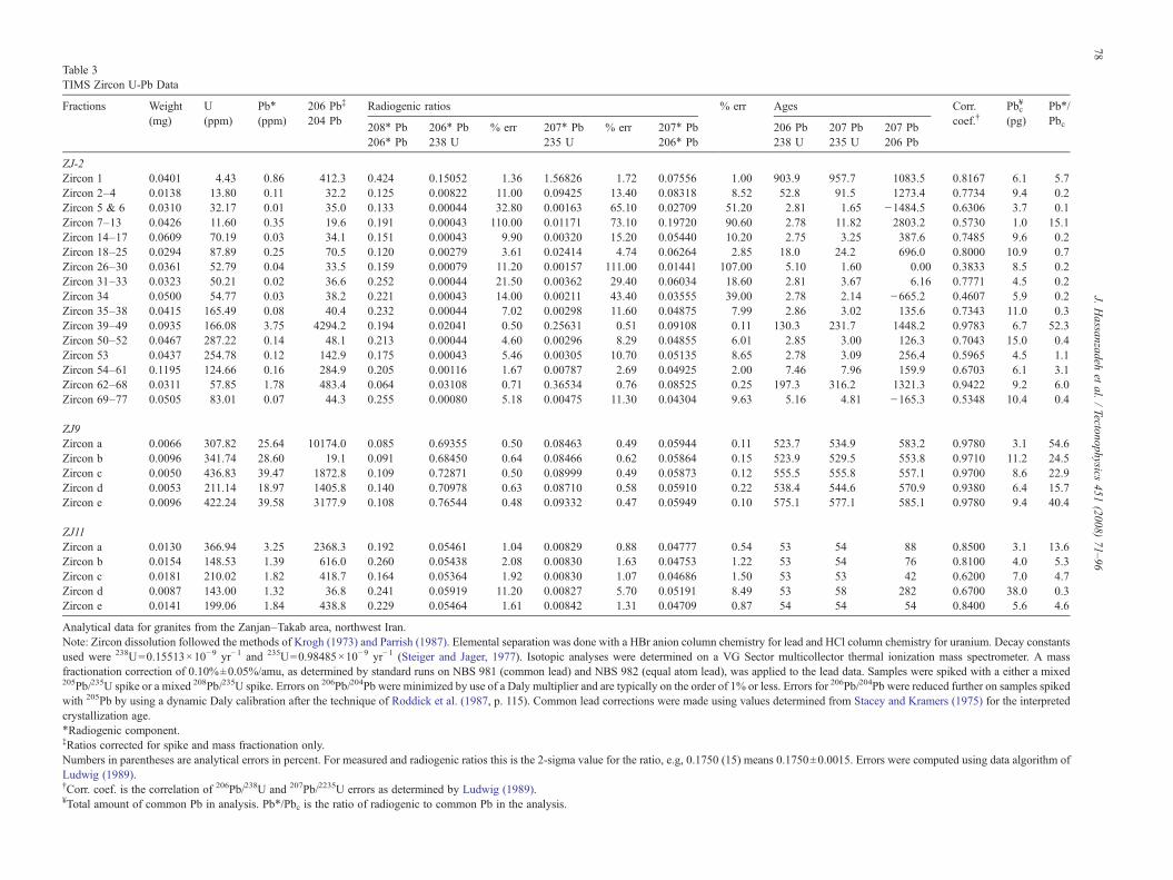
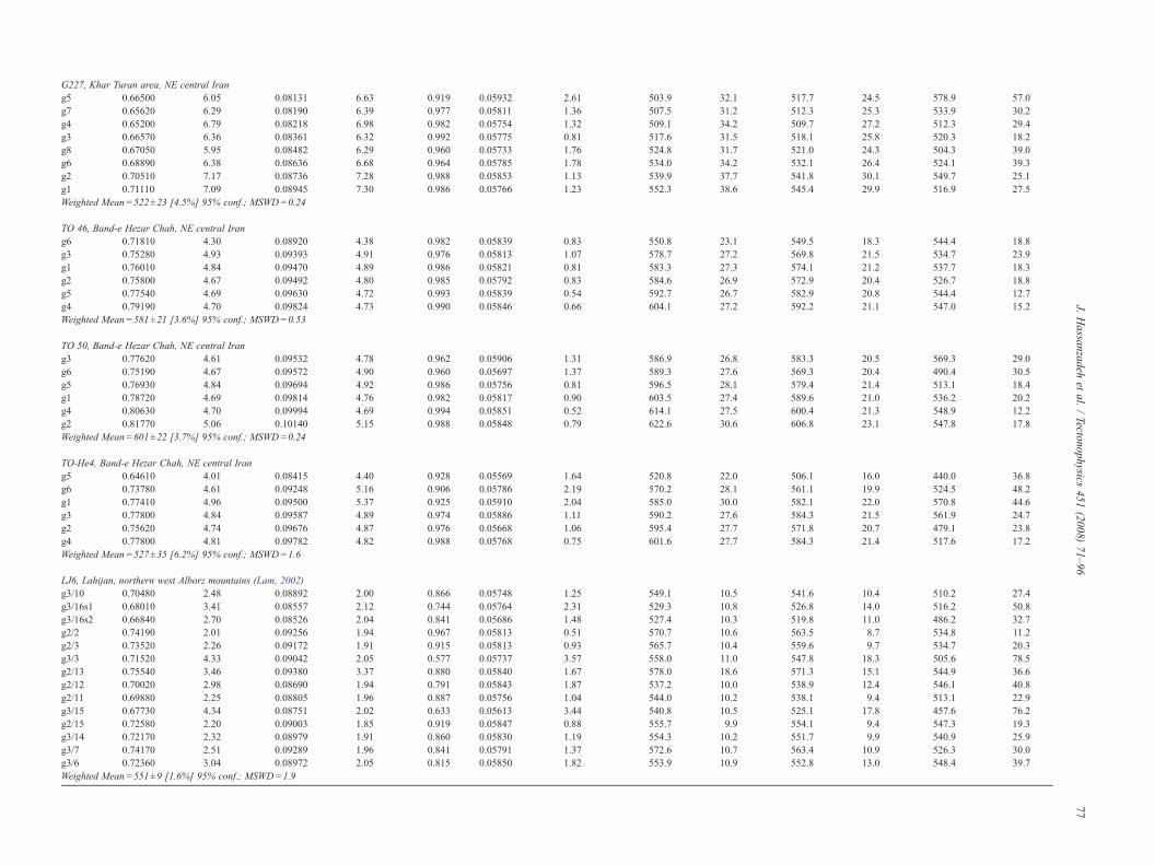
Table 3TIMS Zircon U-Pb Data
Fractions Weight(mg)
U(ppm)
Pb⁎
(ppm)206 Pb‡
204 PbRadiogenic ratios % err Ages Corr.
coef.†Pbc
¥
(pg)Pb⁎/Pbc208⁎ Pb
206⁎ Pb206⁎ Pb238 U
% err 207⁎ Pb235 U
% err 207⁎ Pb206⁎ Pb
206 Pb238 U
207 Pb235 U
207 Pb206 Pb
ZJ-2Zircon 1 0.0401 4.43 0.86 412.3 0.424 0.15052 1.36 1.56826 1.72 0.07556 1.00 903.9 957.7 1083.5 0.8167 6.1 5.7Zircon 2–4 0.0138 13.80 0.11 32.2 0.125 0.00822 11.00 0.09425 13.40 0.08318 8.52 52.8 91.5 1273.4 0.7734 9.4 0.2Zircon 5 & 6 0.0310 32.17 0.01 35.0 0.133 0.00044 32.80 0.00163 65.10 0.02709 51.20 2.81 1.65 −1484.5 0.6306 3.7 0.1Zircon 7–13 0.0426 11.60 0.35 19.6 0.191 0.00043 110.00 0.01171 73.10 0.19720 90.60 2.78 11.82 2803.2 0.5730 1.0 15.1Zircon 14–17 0.0609 70.19 0.03 34.1 0.151 0.00043 9.90 0.00320 15.20 0.05440 10.20 2.75 3.25 387.6 0.7485 9.6 0.2Zircon 18–25 0.0294 87.89 0.25 70.5 0.120 0.00279 3.61 0.02414 4.74 0.06264 2.85 18.0 24.2 696.0 0.8000 10.9 0.7Zircon 26–30 0.0361 52.79 0.04 33.5 0.159 0.00079 11.20 0.00157 111.00 0.01441 107.00 5.10 1.60 0.00 0.3833 8.5 0.2Zircon 31–33 0.0323 50.21 0.02 36.6 0.252 0.00044 21.50 0.00362 29.40 0.06034 18.60 2.81 3.67 6.16 0.7771 4.5 0.2Zircon 34 0.0500 54.77 0.03 38.2 0.221 0.00043 14.00 0.00211 43.40 0.03555 39.00 2.78 2.14 −665.2 0.4607 5.9 0.2Zircon 35–38 0.0415 165.49 0.08 40.4 0.232 0.00044 7.02 0.00298 11.60 0.04875 7.99 2.86 3.02 135.6 0.7343 11.0 0.3Zircon 39–49 0.0935 166.08 3.75 4294.2 0.194 0.02041 0.50 0.25631 0.51 0.09108 0.11 130.3 231.7 1448.2 0.9783 6.7 52.3Zircon 50–52 0.0467 287.22 0.14 48.1 0.213 0.00044 4.60 0.00296 8.29 0.04855 6.01 2.85 3.00 126.3 0.7043 15.0 0.4Zircon 53 0.0437 254.78 0.12 142.9 0.175 0.00043 5.46 0.00305 10.70 0.05135 8.65 2.78 3.09 256.4 0.5965 4.5 1.1Zircon 54–61 0.1195 124.66 0.16 284.9 0.205 0.00116 1.67 0.00787 2.69 0.04925 2.00 7.46 7.96 159.9 0.6703 6.1 3.1Zircon 62–68 0.0311 57.85 1.78 483.4 0.064 0.03108 0.71 0.36534 0.76 0.08525 0.25 197.3 316.2 1321.3 0.9422 9.2 6.0Zircon 69–77 0.0505 83.01 0.07 44.3 0.255 0.00080 5.18 0.00475 11.30 0.04304 9.63 5.16 4.81 −165.3 0.5348 10.4 0.4
ZJ9Zircon a 0.0066 307.82 25.64 10174.0 0.085 0.69355 0.50 0.08463 0.49 0.05944 0.11 523.7 534.9 583.2 0.9780 3.1 54.6Zircon b 0.0096 341.74 28.60 19.1 0.091 0.68450 0.64 0.08466 0.62 0.05864 0.15 523.9 529.5 553.8 0.9710 11.2 24.5Zircon c 0.0050 436.83 39.47 1872.8 0.109 0.72871 0.50 0.08999 0.49 0.05873 0.12 555.5 555.8 557.1 0.9700 8.6 22.9Zircon d 0.0053 211.14 18.97 1405.8 0.140 0.70978 0.63 0.08710 0.58 0.05910 0.22 538.4 544.6 570.9 0.9380 6.4 15.7Zircon e 0.0096 422.24 39.58 3177.9 0.108 0.76544 0.48 0.09332 0.47 0.05949 0.10 575.1 577.1 585.1 0.9780 9.4 40.4
ZJ11Zircon a 0.0130 366.94 3.25 2368.3 0.192 0.05461 1.04 0.00829 0.88 0.04777 0.54 53 54 88 0.8500 3.1 13.6Zircon b 0.0154 148.53 1.39 616.0 0.260 0.05438 2.08 0.00830 1.63 0.04753 1.22 53 54 76 0.8100 4.0 5.3Zircon c 0.0181 210.02 1.82 418.7 0.164 0.05364 1.92 0.00830 1.07 0.04686 1.50 53 53 42 0.6200 7.0 4.7Zircon d 0.0087 143.00 1.32 36.8 0.241 0.05919 11.20 0.00827 5.70 0.05191 8.49 53 58 282 0.6700 38.0 0.3Zircon e 0.0141 199.06 1.84 438.8 0.229 0.05464 1.61 0.00842 1.31 0.04709 0.87 54 54 54 0.8400 5.6 4.6
Analytical data for granites from the Zanjan–Takab area, northwest Iran.Note: Zircon dissolution followed the methods of Krogh (1973) and Parrish (1987). Elemental separation was done with a HBr anion column chemistry for lead and HCl column chemistry for uranium. Decay constantsused were 238U=0.15513×10⁻⁹ yr−1 and 235U=0.98485×10⁻⁹ yr−1 (Steiger and Jager, 1977). Isotopic analyses were determined on a VG Sector multicollector thermal ionization mass spectrometer. A massfractionation correction of 0.10%±0.05%/amu, as determined by standard runs on NBS 981 (common lead) and NBS 982 (equal atom lead), was applied to the lead data. Samples were spiked with a either a mixed205Pb/235U spike or a mixed 208Pb/235U spike. Errors on 206Pb/204Pb were minimized by use of a Daly multiplier and are typically on the order of 1% or less. Errors for 206Pb/204Pb were reduced further on samples spikedwith 205Pb by using a dynamic Daly calibration after the technique of Roddick et al. (1987, p. 115). Common lead corrections were made using values determined from Stacey and Kramers (1975) for the interpretedcrystallization age.⁎Radiogenic component.‡Ratios corrected for spike and mass fractionation only.Numbers in parentheses are analytical errors in percent. For measured and radiogenic ratios this is the 2-sigma value for the ratio, e.g, 0.1750 (15) means 0.1750±0.0015. Errors were computed using data algorithm ofLudwig (1989).†Corr. coef. is the correlation of 206Pb/238U and 207Pb/2235U errors as determined by Ludwig (1989).¥Total amount of common Pb in analysis. Pb⁎/Pbc is the ratio of radiogenic to common Pb in the analysis.
78J.
Hassanzadeh
etal.
/Tectonophysics
451(2008)
71–96
Fig. 1. Sample locations on SRTM image depicting topography, mountain belts and tectonic zones of Iran. Sample numbers follow sample order in Table 1. Town nameabbreviations: Biar: Biarjmand, S: Saqqez, Sh: Shahrud, Sz: Sabzevar, Tk: Takab.
79J. Hassanzadeh et al. / Tectonophysics 451 (2008) 71–96
creating the supra-subduction Semail oceanic plate. Theyattribute the final oceanic closure prior to continent–continentcollision due to the subduction of the remnant Semail plate.The suture lies in southern Iran between the Zagros and anaccretionary arc complex (Sanandaj–Sirjan zone and Urumieh–Dokhtar arc) of central Iran (Fig. 1) (Berberian and King, 1981).Considerable discussion persists as to whether the collisionis linked to deformation of Late Cretaceous, Paleogene, orlate Miocene age (e.g., Berberian and King, 1981; Axen et al.,2001).
As shown on the location map (Fig. 1) studied samples arefrom various localities across central Iran and the Sanandaj–Sirjan structural zone. We discuss the results of our investigationstarting in the Zanjan area, where the type locality of Precambriangranites of Iran is situated (Stöcklin and Setudehnia, 1970), andfrom there proceed counterclockwise to other occurrences,following the order presented in Table 1.
4. Analytical results and geological context
4.1. Northwest Iran
Stöcklin and Setudehnia (1970) proposed that the granitesexposed in northwestern Iran represent the oldest Precambrianbasement complex in all of Iran. The exposed crystallinebasement can overall be subdivided into two types of rocks:
sheared and foliated granitic orthogneisses and equigranular toporphyritic undeformed granites. In the following sections wewill discuss the geological setting and the new U-Pb zircon agesderived for a suite of granites and granitic orthogneissescollected in the Soltanieh ranges south of Zanjan and westZanjan-Takab highlands along the Qezel Ozan River, the largestdrainage system of this region (Fig. 1).
4.1.1. Soltanieh MountainsThe Soltanieh Mountains are located along the southern
margin of the Tarom Mountains (western Alborz) that arestructurally controlled by SW-vergent Pliocene thrust faults alongtheir southern margin, thrusting crystalline basement andmetasediment over Oligo-Miocene and younger sedimentarystrata. The Soltanieh Mountains are mainly underlain by LateProterozoic to Jurassic strata that are intruded by the followingthree major granitic plutons: (1) Sarv-e Jahan granite, (2) KhoramDarreh granite, and (3) Doran granite.
4.1.1.1. Sarv-e Jahan granite. A 7 by 2 km outcrop areaconsisting mostly of foliated granite represents the easternmostexample of Neoproterozoic plutons in the Soltanieh Mountains(Alavi-Naini, 1994). The granite clearly intrudes the LateProterozoic Kahar Formation (with Rb-Sr model age of 645 Ma,Crawford, 1977) and is cut by several thin hornblendelamprophyre dikes of unknown age. Zircons separated from
80 J. Hassanzadeh et al. / Tectonophysics 451 (2008) 71–96
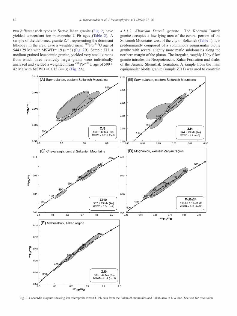
two different rock types in Sarv-e Jahan granite (Fig. 2) haveyielded concordant ion-microprobe U-Pb ages (Table 2). Asample of the deformed granite ZJ4, representing the dominantlithology in the area, gave a weighted mean 206Pb/238U age of544±29 Ma with MSWD=1.9 (n=8) (Fig. 2B). Sample ZJ3, amedium grained leucocratic granite, yielded very small zirconsfrom which three relatively larger grains were individuallyanalyzed and yielded a weighted mean 206Pb/238U age of 599±42 Ma with MSWD=0.015 (n=3) (Fig. 2A).
Fig. 2. Concordia diagram showing ion microprobe zircon U-Pb data from the
4.1.1.2. Khorram Darreh granite. The Khorram Darrehgranite occupies a low-lying area of the central portion of theSoltanieh Mountains west of the city of Soltanieh (Table 1). It ispredominantly composed of a voluminous equigranular biotitegranite with several slightly more mafic subdomains along thenorthern margin of the pluton. The irregular, roughly 10 by 6 kmgranite intrudes the Neoproterozoic Kahar Formation and shalesof the Jurassic Shemshak formation. A sample from the mainequigranular biotite granite (sample ZJ11) was used to constrain
Soltanieh mountains and Takab area in NW Iran. See text for discussion.
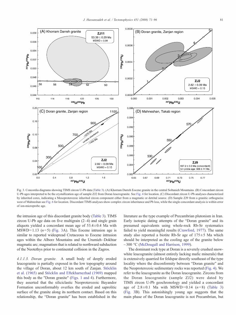
Fig. 3. Concordia diagrams showing TIMS zircon U-Pb data (Table 3). (A) Khorram Darreh Eocene granite in the central Soltanieh Mountains. (B) Concordant zirconU-Pb ages interpreted to be the crystallization age of sample ZJ2 from Doran leucrogranite. See Fig. 4 for location. (C) Discordant zircon U-Pb analyses characterizedby inherited cores, indicating a Mesoproterozoic inherited zircon component either from a magmatic or detrital source. (D) Sample ZJ9 from a granitic orthogneisswest of Mahneshan see Fig. 6 for location. Discordant TIMS analyses show complex zircon inheritance and Pb loss, while the single concordant analysis is within errorof ion-microprobe age.
81J. Hassanzadeh et al. / Tectonophysics 451 (2008) 71–96
the intrusion age of this discordant granite body (Table 3). TIMSzircon U-Pb age data on five multigrain (2–4) and single grainaliquots yielded a concordant mean age of 53.4±0.4 Ma withMSWD=1.13 (n=5) (Fig. 3A). This Eocene intrusion age issimilar to reported widespread Cretaceous to Eocene intrusionages within the Alborz Mountains and the Urumieh–Dokhtarmagmatic arc; magmatism that is related to northward subductionof the Neotethys prior to continental collision in the Zagros.
4.1.1.3. Doran granite. A small body of deeply erodedleucogranite is partially exposed in the low topography aroundthe village of Doran, about 12 km south of Zanjan. Stöcklinet al. (1965) and Stöcklin and Eftekharnezhad (1969) mappedthis body as the qDoran graniteq (Figs. 1 and 4). Furthermore,they asserted that the siliciclastic Neoproterozoic BayandorFormation unconformably overlies the eroded and saproliticsurface of the granite along its northern contact. Based on thisrelationship, the “Doran granite” has been established in the
literature as the type example of Precambrian plutonism in Iran.Early isotopic dating attempts of the “Doran granite” and itspresumed equivalents using whole-rock Rb-Sr systematicsfailed to yield meaningful results (Crawford, 1977). The samestudy also reported a biotite Rb-Sr age of 175±5 Ma whichshould be interpreted as the cooling age of the granite below~300 °C (McDougall and Harrison, 1999).
The dominant rock type at Doran is a severely crushed snow-white leucogranite (almost entirely lacking mafic minerals) thatis extensively quarried for feldspar directly southeast of the typelocality where the disconformity between “Doran granite” andthe Neoproterozoic sedimentary rocks was reported (Fig. 4). Werefer to the leucogranite as the Doran leucogranite. Zircons fromthe Doran leucogranite (sample ZJ2) were dated byTIMS zircon U-Pb geochronology and yielded a concordantage of 2.8±0.1 Ma with MSWD=0.14 (n=8) (Table 3)(Fig. 3B). This astonishingly young age suggests that themain phase of the Doran leucogranite is not Precambrian, but
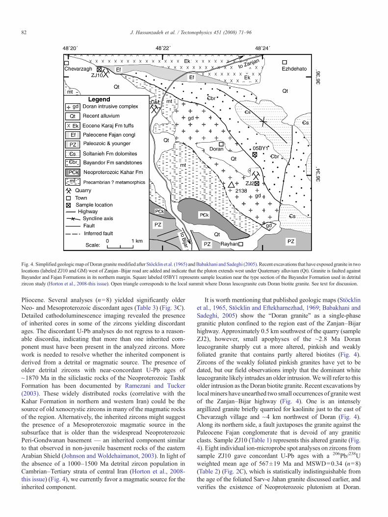
Fig. 4. Simplified geologicmap ofDoran granitemodified after Stöcklin et al. (1965) andBabakhani and Sadeghi (2005). Recent excavations that have exposed granite in twolocations (labeled ZJ10 and GM) west of Zanjan–Bijar road are added and indicate that the pluton extends west under Quaternary alluvium (Qt). Granite is faulted againstBayandor and Fajan Formations in its northern margin. Square labeled 05BY1 represents sample location near the type section of the Bayandor Formation used in detritalzircon study (Horton et al., 2008-this issue). Open triangle corresponds to the local summit where Doran leucogranite cuts Doran biotite granite. See text for discussion.
82 J. Hassanzadeh et al. / Tectonophysics 451 (2008) 71–96
Pliocene. Several analyses (n=8) yielded significantly olderNeo- and Mesoproterozoic discordant ages (Table 3) (Fig. 3C).Detailed cathodoluminescence imaging revealed the presenceof inherited cores in some of the zircons yielding discordantages. The discordant U-Pb analyses do not regress to a reason-able discordia, indicating that more than one inherited com-ponent must have been present in the analyzed zircons. Morework is needed to resolve whether the inherited component isderived from a detrital or magmatic source. The presence ofolder detrital zircons with near-concordant U-Pb ages of~1870 Ma in the siliclastic rocks of the Neoproterozoic TashkFormation has been documented by Ramezani and Tucker(2003). These widely distributed rocks (correlative with theKahar Formation in northern and western Iran) could be thesource of old xenocrystic zircons in many of the magmatic rocksof the region. Alternatively, the inherited zircons might suggestthe presence of a Mesoproterozoic magmatic source in thesubsurface that is older than the widespread NeoproterozoicPeri-Gondwanan basement — an inherited component similarto that observed in non-juvenile basement rocks of the easternArabian Shield (Johnson and Woldehaimanot, 2003). In light ofthe absence of a 1000–1500 Ma detrital zircon population inCambrian–Tertiary strata of central Iran (Horton et al., 2008-this issue) (Fig. 4), we currently favor a magmatic source for theinherited component.
It is worth mentioning that published geologic maps (Stöcklinet al., 1965, Stöcklin and Eftekharnezhad, 1969; Babakhani andSadeghi, 2005) show the “Doran granite” as a single-phasegranitic pluton confined to the region east of the Zanjan–Bijarhighway. Approximately 0.5 km southwest of the quarry (sampleZJ2), however, small apophyses of the ~2.8 Ma Doranleucogranite sharply cut a more altered, pinkish and weaklyfoliated granite that contains partly altered biotites (Fig. 4).Zircons of the weakly foliated pinkish granites have yet to bedated, but our field observations imply that the dominant whiteleucogranite likely intrudes an older intrusion.Wewill refer to thisolder intrusion as the Doran biotite granite. Recent excavations bylocalminers have unearthed two small occurrences of granite westof the Zanjan–Bijar highway (Fig. 4). One is an intenselyargillized granite briefly quarried for kaolinite just to the east ofChevarzagh village and ~4 km northwest of Doran (Fig. 4).Along its northern side, a fault juxtaposes the granite against thePaleocene Fajan conglomerate that is devoid of any graniticclasts. Sample ZJ10 (Table 1) represents this altered granite (Fig.4). Eight individual ion-microprobe spot analyses on zircons fromsample ZJ10 gave concordant U-Pb ages with a 206Pb/238Uweighted mean age of 567±19 Ma and MSWD=0.34 (n=8)(Table 2) (Fig. 2C), which is statistically indistinguishable fromthe age of the foliated Sarv-e Jahan granite discussed earlier, andverifies the existence of Neoproterozoic plutonism at Doran.
83J. Hassanzadeh et al. / Tectonophysics 451 (2008) 71–96
Given the relationship between the Neoproterozoic biotite graniteand the large Pliocene leucogranite body, we consider it likely thatthe biotite Rb-Sr age from a “Doran granite” of 175±5 Mareported by Crawford (1977) pertains to the older pink biotitegranite. It is also noteworthy that no Neoproterozoic cores werefound in the ~2.8 Ma Doran leucogranite.
Stöcklin et al. (1965) proposed that the contact between the“Doran granite” and the overlying Neoproterozoic BayandorFormation is an unconformity. However, the complex intrusivenature (Pliocene main body of the “Doran granite”) and thefaulted nature of the northern contact between the Neoproter-ozoic biotite granite and the Bayandor Formation (as well as theFajan conglomerate) question this assumption. Horton et al.(2008-this issue) have suggested a depositional age≤559±28Ma(2σ uncertainty) based on detrital zircon U-Pb analyses fromthe basal portion of the Proterozoic Bayandor Formation(~0.5 km north of Doran) (Fig. 4). The ages of the Doran biotite
Fig. 5. Simplified geologic map of Moghanlou core complex, west Za
granite and the Bayandor Formation are indistinguishableand the relative age relationship is therefore inconclusive interms of resolving the nature of the contact. However, the factthat the basal Bayandor Formation contains no locally-derivedbasal conglomerate and the basal red shales and sandstoneslack granitic clasts leads us to favor an intrusive or tectonicnature of the original contact between the Bayandor Form-ation and the Doran biotite granite. The so-called kaolinitelayer that Stöcklin et al. (1964, 1965) interpreted as a saprolitichorizon below an unconformity is likely a fault gouge relatedto a shallowly-dipping fault. This observation appears to besupported by the structural juxtaposition of both BayandorFormation and Fajan conglomerate against the granite acrossthis fault east of Chevarzagh (Fig. 4). This fault appears to bePliocene in age, as suggested by a newly excavated quarry justto the west of Zanjan–Bijar road that exhibits highly shearedDoran leucogranite (GM) in fault contact (Fig. 4).
njan area, east of Qezel Ozan River (modified after Lotfi, 2001).
84 J. Hassanzadeh et al. / Tectonophysics 451 (2008) 71–96
Our new zircon U-Pb data from the Doran area is of regionalimportance, since many presumed Precambrian granitoids inIran, especially in northwestern Iran, are often referred to as“Doran-type” granites. Additional U-Pb zircon dating onvarious intrusive phases within the granite complex aroundDoran and Takab (see below) is necessary and currently inprogress to further resolve these issues surrounding the age ofthe “Doran-type” granites.
4.1.2. Takab-west Zanjan areaAt its western extension, the Soltanieh Mountains join the
uplands bordering the Qezel Ozan River. Those uplandsbetween the cities of Zanjan and Takab in western Iran containa large crustal block made up of high-grade orthogneisses,granitic rocks, and Proterozoic to Cambrian sedimentary rocks.As we show below, Neoproterozoic plutonic rocks make up alarge portion of this coherent crustal block (Fig. 1). Thefollowing two localities were studied: (1) Moghanlou area, and(2) Mahneshan area.
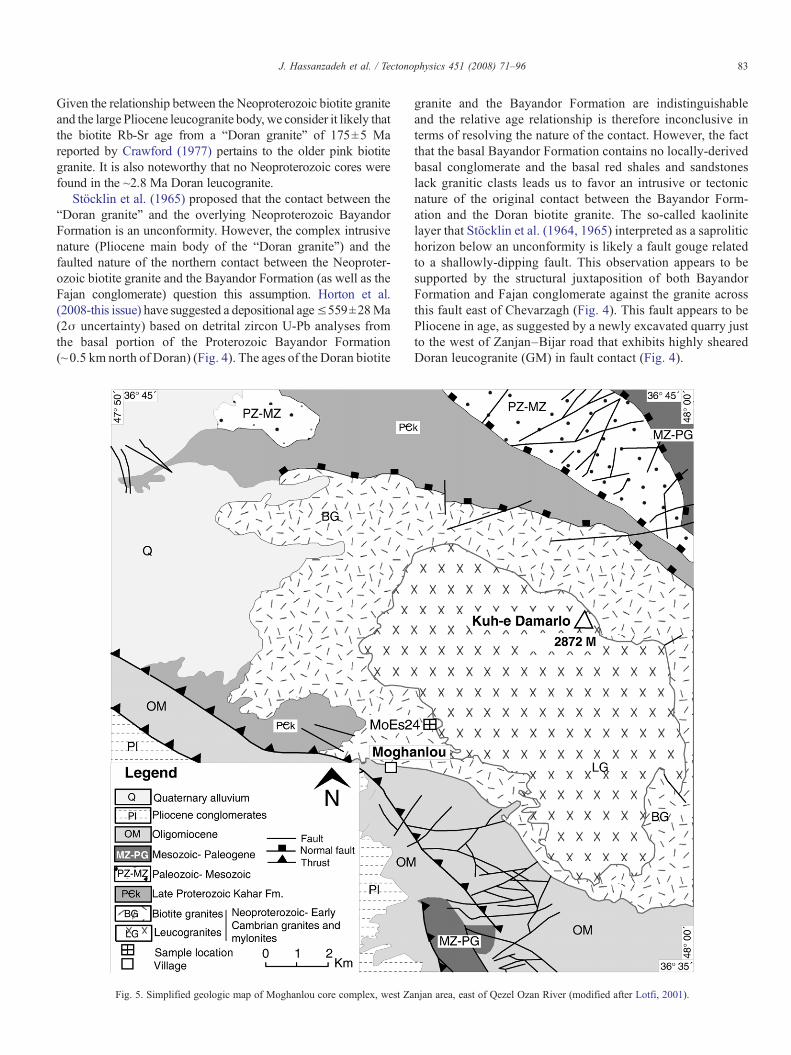
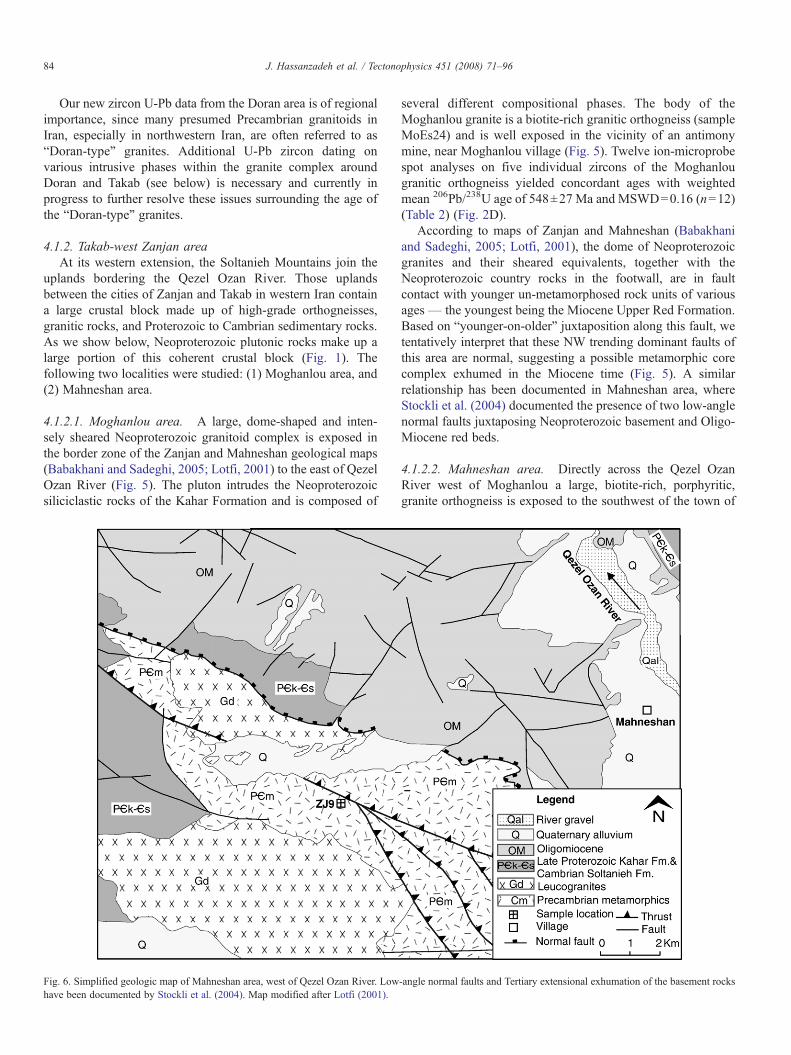
4.1.2.1. Moghanlou area. A large, dome-shaped and inten-sely sheared Neoproterozoic granitoid complex is exposed inthe border zone of the Zanjan and Mahneshan geological maps(Babakhani and Sadeghi, 2005; Lotfi, 2001) to the east of QezelOzan River (Fig. 5). The pluton intrudes the Neoproterozoicsiliciclastic rocks of the Kahar Formation and is composed of
Fig. 6. Simplified geologic map of Mahneshan area, west of Qezel Ozan River. Lowhave been documented by Stockli et al. (2004). Map modified after Lotfi (2001).
several different compositional phases. The body of theMoghanlou granite is a biotite-rich granitic orthogneiss (sampleMoEs24) and is well exposed in the vicinity of an antimonymine, near Moghanlou village (Fig. 5). Twelve ion-microprobespot analyses on five individual zircons of the Moghanlougranitic orthogneiss yielded concordant ages with weightedmean 206Pb/238U age of 548±27 Ma and MSWD=0.16 (n=12)(Table 2) (Fig. 2D).
According to maps of Zanjan and Mahneshan (Babakhaniand Sadeghi, 2005; Lotfi, 2001), the dome of Neoproterozoicgranites and their sheared equivalents, together with theNeoproterozoic country rocks in the footwall, are in faultcontact with younger un-metamorphosed rock units of variousages— the youngest being the Miocene Upper Red Formation.Based on “younger-on-older” juxtaposition along this fault, wetentatively interpret that these NW trending dominant faults ofthis area are normal, suggesting a possible metamorphic corecomplex exhumed in the Miocene time (Fig. 5). A similarrelationship has been documented in Mahneshan area, whereStockli et al. (2004) documented the presence of two low-anglenormal faults juxtaposing Neoproterozoic basement and Oligo-Miocene red beds.
4.1.2.2. Mahneshan area. Directly across the Qezel OzanRiver west of Moghanlou a large, biotite-rich, porphyritic,granite orthogneiss is exposed to the southwest of the town of
-angle normal faults and Tertiary extensional exhumation of the basement rocks
85J. Hassanzadeh et al. / Tectonophysics 451 (2008) 71–96
Mahneshan (Fig. 6). This orthogneiss is characterized by a high-temperature deformation fabric with a vertical foliation (sampleZJ9). It occurs as a large body that is bound on the north andsouth sides by two north-dipping detachment faults of Tertiaryage. Along the southern margin, the lower detachmentjuxtaposes it against an Oligocene granite (~25 Ma), formerlyconsidered a Doran-type granite (Stockli et al., 2004). Elevenindividual ion-microprobe U-Pb isotopic analyses on ten zircongrains from the orthogneiss sample ZJ9 yielded concordant U-Pb ages with weighted mean 206Pb/238U age of 568±44 Ma andMSWD=2.1 (n=11) (Table 2) (Fig. 2E). TIMS analyses on thesame sample exhibited a more complicated record of variableinheritance and lead loss, yielding a best-estimate intrusion ageof 557.2±3.0 Ma (Table 3) (Fig. 3D). Given the likelihood ofvariable inheritance and lead loss, we prefer the ion-microprobeage as the more reliable crystallization age.
Based on field reconnaissance and geo- and thermochrono-logical studies, Stockli et al. (2004) argued for an important
Fig. 7. Simplified geologic map of the Sheikh Chupan-Bubaktan sheared pluton andIran (modified after Omrani and Khabbaznia, 2003).
Oligo-Miocene intra-arc extensional event in this region thatwas subsequently overprinted by late Neogene, regionallywidespread contraction caused by the continent–continent col-lision between the Arabian plate and Iranian crustal fragments.It is noteworthy that the world class non-sulfide Zn deposit atAnguran is located nearby within this coherent basementcomplex. This ore deposit was previously known as an exampleof Precambrian mineralization in Iran (e.g., Samani, 1988) untilGilg et al. (2006) attributed the mineralization to the abovementioned Miocene intra-arc extension and formation of ametamorphic core complex identified by Stockli et al. (2004).
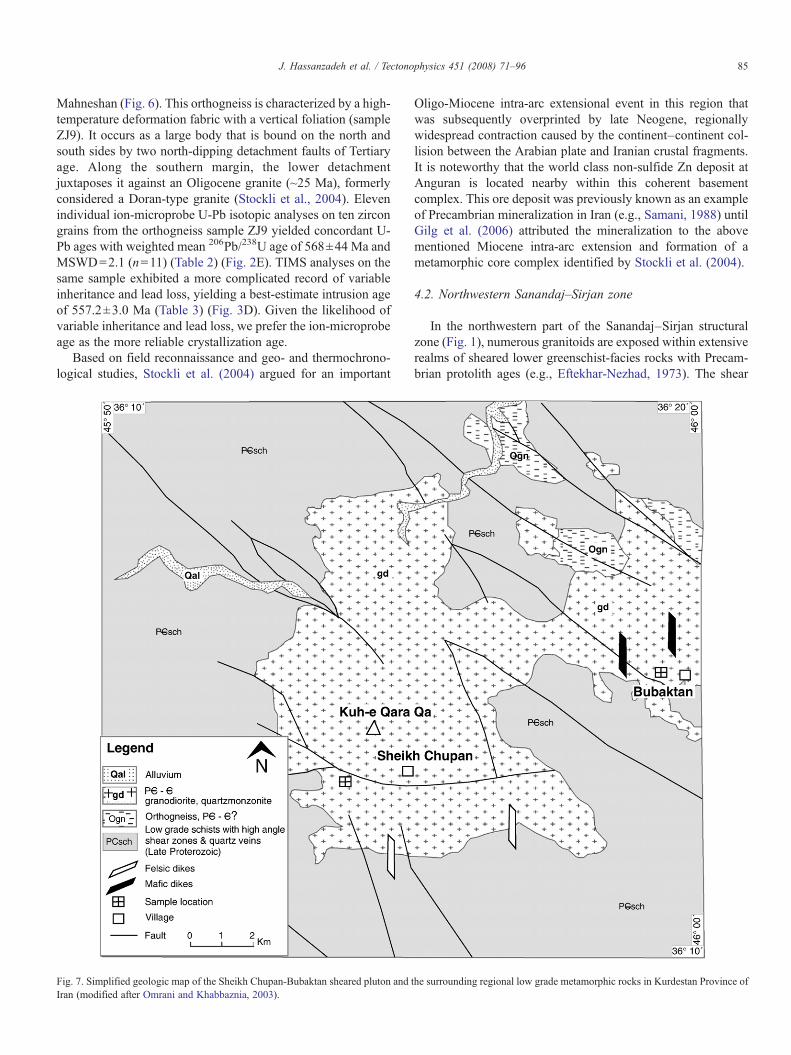
4.2. Northwestern Sanandaj–Sirjan zone
In the northwestern part of the Sanandaj–Sirjan structuralzone (Fig. 1), numerous granitoids are exposed within extensiverealms of sheared lower greenschist-facies rocks with Precam-brian protolith ages (e.g., Eftekhar-Nezhad, 1973). The shear
the surrounding regional low grade metamorphic rocks in Kurdestan Province of
86 J. Hassanzadeh et al. / Tectonophysics 451 (2008) 71–96
zones bear indications of gold mineralization in severallocations. The crystallization ages of these granitoids in thenorthwestern part of the Sanandaj–Sirjan, however, aredisputed; while Eftekhar-Nezhad (1973) assigned the plutonsto the so-called Doran-type granite (i.e., late Precambrian age),Omrani and Khabbaznia (2003) revised the age to post-Cretaceous. To resolve the debate, a large composite pluton tothe west of the city of Saqqez was targeted in this study and two
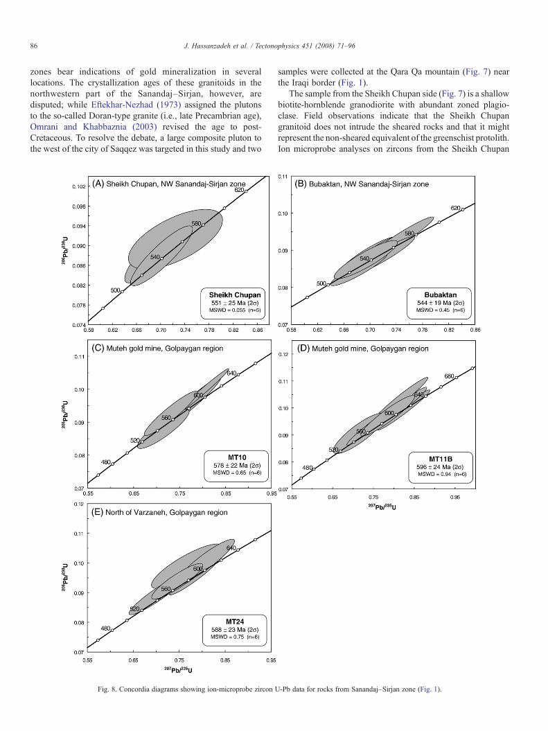
Fig. 8. Concordia diagrams showing ion-microprobe zircon U
samples were collected at the Qara Qa mountain (Fig. 7) nearthe Iraqi border (Fig. 1).
The sample from the Sheikh Chupan side (Fig. 7) is a shallowbiotite-hornblende granodiorite with abundant zoned plagio-clase. Field observations indicate that the Sheikh Chupangranitoid does not intrude the sheared rocks and that it mightrepresent the non-sheared equivalent of the greenschist protolith.Ion microprobe analyses on zircons from the Sheikh Chupan
-Pb data for rocks from Sanandaj–Sirjan zone (Fig. 1).

87J. Hassanzadeh et al. / Tectonophysics 451 (2008) 71–96
granodiorite yielded concordant U-Pb ages with 206Pb/238Uweighted mean age of 551±25 Ma and MSWD=0.055 (n=5)(Table 2) (Fig. 8A).
In contrast to the Sheikh Chupan granodiorite, the sample fromBubaktan farther east lacks hornblende and zoned plagioclase and ismore deformed (Fig. 7). Zircons from the Bubaktan foliated biotitegranite yielded concordant U-Pb ages with 206Pb/238U weightedmean age of 544±19Ma,MSWD=0.45 (n=6) (Table 2) (Fig. 8B).
4.3. Golpaygan area
The Golpaygan area lies along the border zone between theSanandaj–Sirjan zone and Urumieh–Dokhtar Tertiary mag-matic arc in central Iran (Fig. 1) and was the study area for thefirst geologic map published by Geological Survey of Iran.Granitic rocks within the Golpaygan region were first discussedby Thiele et al. (1968) and reported to be “Doran-type” granites.This age assignment was contested by Rachidnejad-Omranet al. (2002), who suggested these grantitic rocks to beconsiderably younger in age. To shed light on this controversy,we collected two undeformed granites and one graniticorthogneiss from two subdomains of Golpaygan area, theMuteh gold mine region and the Varzaneh region (Fig. 9).
Fig. 9. Simplified geologic map of Muteh core complex, northwes
4.3.1. Muteh Au mineThe Muteh gold deposit occurs within a lower greenschist
metamorphic complex of presumably Precambrian age approxi-mately 50 km northeast of Golpaygan (Fig. 1). According toThiele et al. (1968), the Muteh leucogranite intrudes Precam-brian metamorphic rocks and appears to be older than theNeoproterozoic/Cambrian Soltanieh dolomite. Rachidnejad-Omran et al. (2002), however, considered younger ages forthe meta-volcano-sedimentary host of Muteh granite, suggest-ing a Paleozoic protolith age and Mesozoic age for metamorph-ism. Based on their interpretation, one would expect theunmetamorphosed Muteh granite to be Mesozoic or Tertiary.Rachidnejad-Omran et al. (2002) reported the following K-Arages from the Muteh granite: 128.3±4.7 Ma and 124.4±4.4 Ma(whole rock), and 68.9±1.0 Ma and 67.5±1.0 Ma (biotite).
Our samples of the Muteh leucogranite were collected fromthe hills to the northwest of the Chah Khatoon open pit at theMuteh gold mine (Fig. 9) and are medium grained granites inintrusive contact with a dark gray to green hornfels (Table 1).Zircons separated from the Muteh leucogranite (sample MT10)gave concordant U-Pb ages with 206Pb/238U weighted mean ageof 578±22 Ma, MSWD=0.65 (n=6) (Table 2) (Fig. 8C).Zircons separated from a biotite-rich variety of the granite
t of Esfahan, central Iran (modified after Thiele et al., 1968).

Fig. 10. Concordia diagrams showing ion-microprobe zircon U-Pb data for rocks from Torud and Khar Turan area, northeast central Iran (Fig. 1).
88 J. Hassanzadeh et al. / Tectonophysics 451 (2008) 71–96
(sample MT11B) yielded somewhat older, but still concordant,U-Pb ages with 206Pb/238U weighted mean age of 596±24 Ma,MSWD=0.94 (n=6) (Table 2) (Fig. 8D). These new U-Pbzircon ages verify the existence of Neoproterozoic plutonicrocks in the Muteh area. A corollary of this result is that, unlikethe postulation by Rachidnejad-Omran et al. (2002), themetamorphosed sedimentary rocks hosting the Muteh graniteare not Paleozoic in age; rather, the Neoproterozoic KaharFormation or its equivalents initially proposed by Thiele et al.
(1968) are the likeliest choice for the metamorphosed countryrock.
4.3.2. Varzaneh metamorphic rocksA large dome of high grade metamorphic rocks is exposed in
the Haji Qara mountains, north of the village of Varzaneh andabout 25 km west of Muteh gold mine (Fig. 9). Part of thecomplex consists of biotite granite orthogneisses. Sample MT24is a biotite- and quartz-rich variety and was collected to

Fig. 11. Simplified geologic map of Khar Turan core complex between northeast central Iran and eastern Alborz (modified after Malekpour, 2005; Hassanzadeh et al., 2005).
89J.
Hassanzadeh
etal.
/Tectonophysics
451(2008)
71–96
90 J. Hassanzadeh et al. / Tectonophysics 451 (2008) 71–96
investigate the protolith age of the gneiss for comparison withMuteh granites. Zircons separated from sample MT24 yieldedconcordant U-Pb ages with 206Pb/238U weighted mean age of588±23 Ma, MSWD=0.59 (n=6) (Fig. 8E), indicating a Neo-proterozoic protolith (Table 2) that is within error of the crys-tallization age of the Muteh granites.
A brief discussion of the timing of metamorphism, Aumineralization, and exhumation in north Golpaygan region isrelevant here. Based on the Neoproterozoic protolith age of theMT24 granite orthogneiss, the metamorphic event(s) postdatesNeoproterozoic. A K-Ar age of 174.5±2.9Ma, that Rachidnejad-Omran et al. (2002) reported for a nearby amphibolite, clearlypoints to the peak of thermal recrystallization in Middle Jurassictime. Mica 40Ar/39Ar and K-Ar ages constrain the subsequentcooling path, with these rocks cooling below ~300 °C in Eocenetimes (Rachidnejad-Omran et al., 2002; Moritz et al., 2006). Inlight of detailed new 40Ar/39Ar ages, Aumineralization at Muteh,previously thought to be Precambrian (e.g., Samani, 1988), is nowconsidered to be Eocene in age (Moritz et al., 2006). Tillman et al.(1981) have described the effects of an important post-Cretaceousextensional event on a large area betweenGolpaygan and Esfahanand Verdel et al. (2007) have postulated that the crystalline terrainnorth of the Golpaygan region could represent a metamorphiccore complex (Fig. 9).
4.4. Northeast central Iran: Torud-Khār Turan-Band-e HezarChāh region
A large arid region of basin and range topography coveringN5000 km2 is located between the eastern Alborz and the GreatKavir (desert) depression of central Iran, exposing several largeand small Neoproterozoic granite and orthogneiss bodies (Fig. 1).
4.4.1. Torud areaAbout 50 km northeast of the small desert town of Torud, a
metamorphic complex containing abundant granite orthogneissesis exposed in the area of ShotorKuh.Hushmandzadeh et al. (1978)assumed a Precambrian age for these metamorphic rocks and theirmap shows that the foliation appears to continuously wrap aroundthemountain of ShotorKuh.Our field investigations have verifiedtheir findings and show that foliation radially dips away from thecore of the complex, demonstrating a characteristic gneiss dome.Previous attempts by Crawford (1977) of Rb-Sr radiometricdating of these metamorphic rocks failed. We analyzed a biotite-rich granite gneiss with augen fabric from the northwestern side ofShotor Kuh (sample TO-40). Zircons separated from TO-40yielded concordant U-Pb ages with 206Pb/238U weighted meanage of 566±31 Ma, MSWD=1.3 (n=8), indicating a Neoproter-ozoic protolith (Table 2) (Fig. 10A). Ilkhchi et al. (2006) havereported protolith crystallization age of these orthogneisses at ca.520 Ma by laser ablation ICP-MS analysis of zircon.
4.4.2. Khār Turan areaIn the mountains about 15 km SSW of the town of
Biarjmand, a northeast-trending metamorphic complex isexposed (Fig. 11). The complex mainly consists of amphibo-lite-grade gneisses and schists that Navai (1987) considered to
be Precambrian in age. Patches of less sheared granites can befound on various scales within gneisses and schists. These lessdeformed granitic lenses have previously been thought to beeither post-Jurassic to pre-Cretaceous (Navai, 1987) or post-Cretaceous (Huber, 1977). To resolve these issues, we collectedfour different granites and one strongly deformed granite gneisssamples from Khar Turan.
Sample EaBi32 was collected at Kuh-e Sefid Sang (Fig. 11)and is a biotite-rich granite containing distinctive zoned alla-nites. Seven individual ion microprobe spot analyses on zirconsyielded concordant ages with weighted mean 206Pb/238U age of554±40 Ma with MSWD=0.21 (n=5) (Table 2) (Fig. 10B).
Zircons separated from a white leucocratic variety of thegranite (sample EaBi125) yielded slightly younger concordantU-Pb ages with 206Pb/238U weighted mean age of 534±31 Ma,MSWD=1.8 (n=6) (Table 2) (Fig. 10C). Another sample of thewhite leucocratic variety of the granite (EaBi-1A) at the westerntip of the complex, embedded in orthogneisses, yieldedconcordant U-Pb ages with 206Pb/238U weighted mean age of551±20 Ma, MSWD=0.20 (n=6), indicating a Neoproterozoicprotolith (Fig. 10D). A fine grained biotite-garnet granodioritewith zoned plagioclase (sample G227) yielded the youngestconcordant U-Pb ages with 206Pb/238U weighted mean age of522±23 Ma, MSWD=0.24 (n=8) (Fig. 10E).
These results clearly indicate thatKuh-e Sefid Sang granite andits associated intrusions were emplaced in the Neoproterozoic–Early Cambrian and do not belong to either the post-Jurassic topre-Cretaceous or post-Cretaceous group of intrusions as spe-culated by Navai (1987) and Huber (1977), respectively.
Sample EaBi22 is a biotite-garnet mylonite and like theEaBi32 granite contains characteristic zoned allanites. Zirconsseparated from the EaBi22 gneiss yielded concordant U-Pb ageswith 206Pb/238U weighted mean age of 556 ± 30 Ma,MSWD=0.29 (n=9), indicating a Neoproterozoic protolith(Fig. 10F). Based on similar trace element patterns for allanites,Malekpour (2005) argued that the EaBi22 mylonite is derivedfrom the shearing of EaBi32-type granite. Our U-Pb resultssupport such a hypothesis by revealing statistically similarcrystallization ages for those rocks.
These new U-Pb ages clearly illustrate that the Biarjmandcomplex is cored by Neoproterozoic granites (Fig. 11). Thiscore of the Biarjmand complex is structurally overlain by: (1) alower greenschist-grade carapace of Jurassic volcaniclasticrocks and calcareous slates with a mylonitic fabric and (2) anunmetamorphosed cliff-forming cover section exposed at Kuh-e Molhedou consisting of Jurassic–Cretaceous carbonates,exhibiting only brittle deformation (Fig. 11). The core and thetwo overlying structural units are separated by two majorlow-angle faults suggestive of a metamorphic core complex(Malekpour, 2005). Recent thermochronologic investigationshave revealed slow Mesozoic cooling from ~550 to 180 °Cuntil ~70 Ma followed by abrupt rapid cooling (Hassanzadehet al., 2005).
4.4.3. Band-e Hezar ChāhBand-e Hezar Chāh is an area to the south of the city of
Shahrud (Fig. 1) and in contrast to the other two sub-domains of
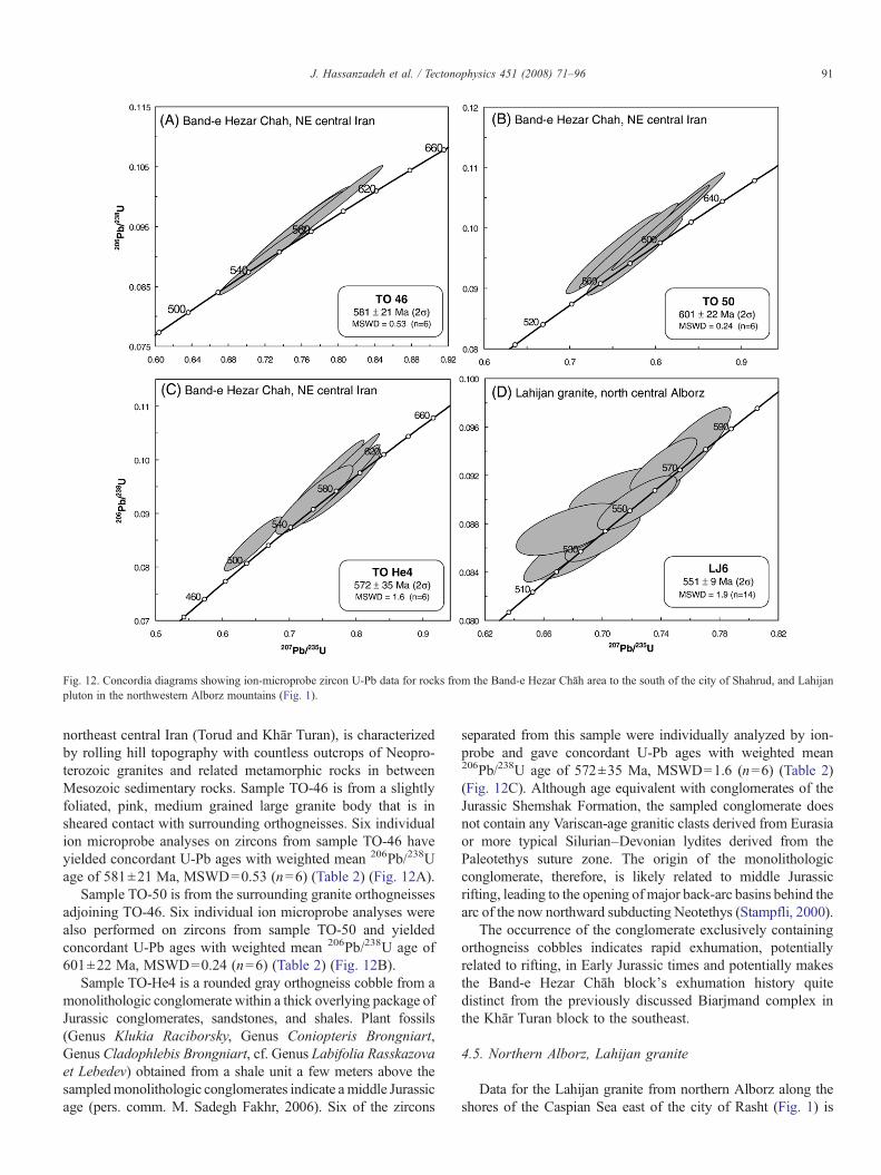
Fig. 12. Concordia diagrams showing ion-microprobe zircon U-Pb data for rocks from the Band-e Hezar Chāh area to the south of the city of Shahrud, and Lahijanpluton in the northwestern Alborz mountains (Fig. 1).
91J. Hassanzadeh et al. / Tectonophysics 451 (2008) 71–96
northeast central Iran (Torud and Khār Turan), is characterizedby rolling hill topography with countless outcrops of Neopro-terozoic granites and related metamorphic rocks in betweenMesozoic sedimentary rocks. Sample TO-46 is from a slightlyfoliated, pink, medium grained large granite body that is insheared contact with surrounding orthogneisses. Six individualion microprobe analyses on zircons from sample TO-46 haveyielded concordant U-Pb ages with weighted mean 206Pb/238Uage of 581±21 Ma, MSWD=0.53 (n=6) (Table 2) (Fig. 12A).
Sample TO-50 is from the surrounding granite orthogneissesadjoining TO-46. Six individual ion microprobe analyses werealso performed on zircons from sample TO-50 and yieldedconcordant U-Pb ages with weighted mean 206Pb/238U age of601±22 Ma, MSWD=0.24 (n=6) (Table 2) (Fig. 12B).
Sample TO-He4 is a rounded gray orthogneiss cobble from amonolithologic conglomerate within a thick overlying package ofJurassic conglomerates, sandstones, and shales. Plant fossils(Genus Klukia Raciborsky, Genus Coniopteris Brongniart,Genus Cladophlebis Brongniart, cf. Genus Labifolia Rasskazovaet Lebedev) obtained from a shale unit a few meters above thesampledmonolithologic conglomerates indicate amiddle Jurassicage (pers. comm. M. Sadegh Fakhr, 2006). Six of the zircons
separated from this sample were individually analyzed by ion-probe and gave concordant U-Pb ages with weighted mean206Pb/238U age of 572±35 Ma, MSWD=1.6 (n=6) (Table 2)(Fig. 12C). Although age equivalent with conglomerates of theJurassic Shemshak Formation, the sampled conglomerate doesnot contain any Variscan-age granitic clasts derived from Eurasiaor more typical Silurian–Devonian lydites derived from thePaleotethys suture zone. The origin of the monolithologicconglomerate, therefore, is likely related to middle Jurassicrifting, leading to the opening of major back-arc basins behind thearc of the now northward subducting Neotethys (Stampfli, 2000).
The occurrence of the conglomerate exclusively containingorthogneiss cobbles indicates rapid exhumation, potentiallyrelated to rifting, in Early Jurassic times and potentially makesthe Band-e Hezar Chāh block's exhumation history quitedistinct from the previously discussed Biarjmand complex inthe Khār Turan block to the southeast.
4.5. Northern Alborz, Lahijan granite
Data for the Lahijan granite from northern Alborz along theshores of the Caspian Sea east of the city of Rasht (Fig. 1) is
92 J. Hassanzadeh et al. / Tectonophysics 451 (2008) 71–96
integrated in this study after Lam (2002). According to Annellset al. (1975), the pluton intrudes presumably Carboniferousphyllitic metasedimentary rocks and clasts of the same graniteoccur in nearby Jurassic conglomerates; hence, a Triassic agewas originally assigned to the granite (e.g., Berberian andBerberian, 1981). However, zircons separated from sample LJ6yielded concordant U-Pb ages with 206Pb/238U weighted meanage of 551±9 Ma, MSWD=1.9 (n=14) (Fig. 12D), indicatinga Neoproterozoic Peri-Gondwanan origin (Table 2). TheNeoproterozoic crystallization age for Lahijan granite hasmajor consequences. In terms of local geology, this ageindicates that, unlike the previous interpretation by Annellset al. (1975), the contact with any possible Carboniferousmetasedimentary rocks are not intrusive. The abundance ofcataclastic zones supports a fault nature of the contact orsubsequent strain localization along an originally intrusivecontact.
More importantly, however, the occurrence of the Neopro-terozoic Lahijan granite at the northern edge of the AlborzMountains has profound implications for paleogeographic andplate tectonic reconstructions. The Lahijan granite seems tounequivocally indicate that the Alborz are underlain bybasement with Gondwanan affiliation, precluding a Paleotethysin the Alborz as previously proposed by Stöcklin (1974).
Fig. 13. Paleogeographic reconstruction at ~545 Ma after the amalgamation of eastdeformation within the northern portion of the East African Orogen (hatched patterdextral transcurrent deformation and extension. New U-Pb geochronology and integraAndean-style arc setting along the margin of Gondwana in what has been referred t
4.6. Synopsis of published data
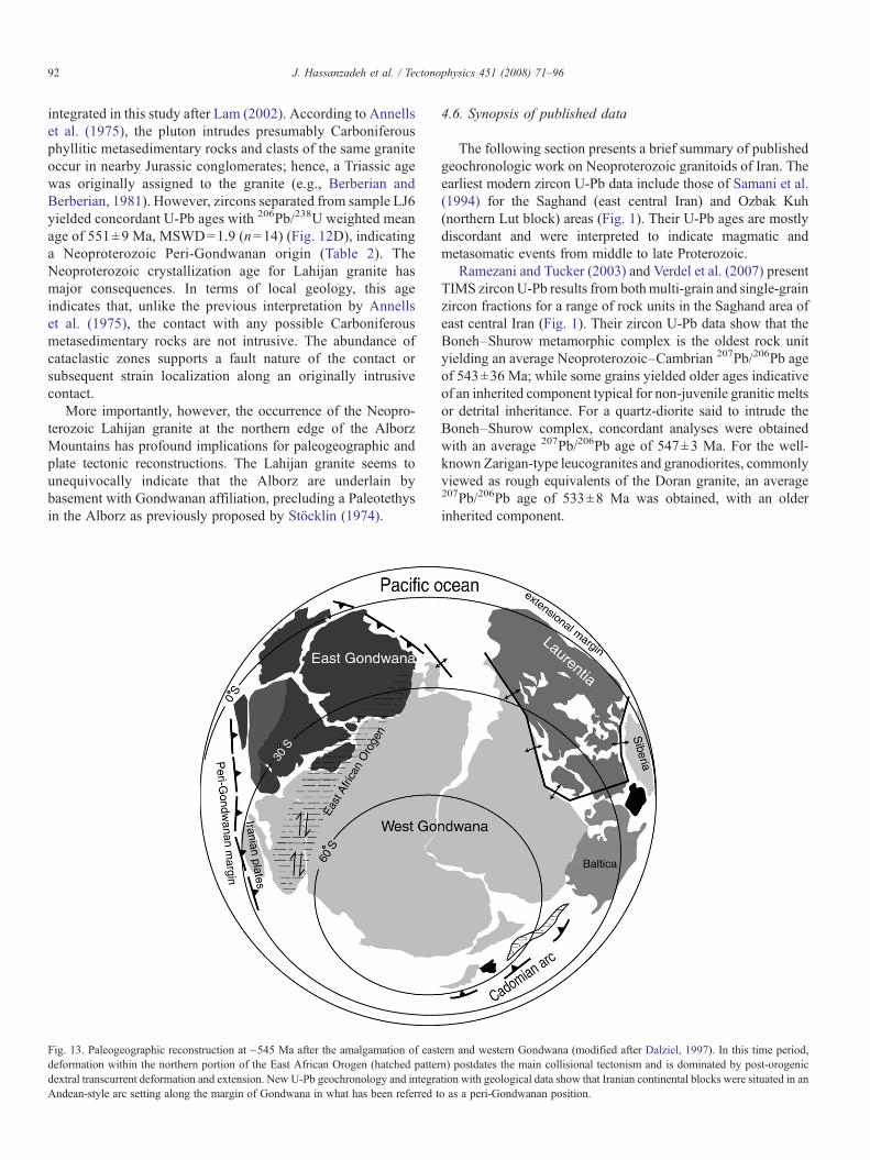
The following section presents a brief summary of publishedgeochronologic work on Neoproterozoic granitoids of Iran. Theearliest modern zircon U-Pb data include those of Samani et al.(1994) for the Saghand (east central Iran) and Ozbak Kuh(northern Lut block) areas (Fig. 1). Their U-Pb ages are mostlydiscordant and were interpreted to indicate magmatic andmetasomatic events from middle to late Proterozoic.
Ramezani and Tucker (2003) and Verdel et al. (2007) presentTIMS zirconU-Pb results from bothmulti-grain and single-grainzircon fractions for a range of rock units in the Saghand area ofeast central Iran (Fig. 1). Their zircon U-Pb data show that theBoneh–Shurow metamorphic complex is the oldest rock unityielding an average Neoproterozoic–Cambrian 207Pb/206Pb ageof 543±36 Ma; while some grains yielded older ages indicativeof an inherited component typical for non-juvenile granitic meltsor detrital inheritance. For a quartz-diorite said to intrude theBoneh–Shurow complex, concordant analyses were obtainedwith an average 207Pb/206Pb age of 547±3 Ma. For the well-known Zarigan-type leucogranites and granodiorites, commonlyviewed as rough equivalents of the Doran granite, an average207Pb/206Pb age of 533±8 Ma was obtained, with an olderinherited component.
ern and western Gondwana (modified after Dalziel, 1997). In this time period,n) postdates the main collisional tectonism and is dominated by post-orogeniction with geological data show that Iranian continental blocks were situated in ano as a peri-Gondwanan position.
93J. Hassanzadeh et al. / Tectonophysics 451 (2008) 71–96
5. Discussion
5.1. Paleogeography and plate tectonics
It is well accepted that crustal growth on Earth has not onlybeen episodic but also regionally partitioned (e.g., Patchett andChase, 2002). This perception allows certain age groups ofrocks to be used as excellent paleogeographic indicators. Agood example pertinent to this study is the prominent gap from~900–500 Ma in the Laurentia crustal growth curve andabundance of ~900–500 Ma rocks in Arabian–Nubian Shieldand adjoining regions of juvenile Gondwana (Veevers, 2003).Part of this time frame from ~900 to ~600 Ma, known as thePan-African orogenic event, encompassed one of the broadestorogenies in Earth history (Mallard and Rogers, 1997; Rogerset al., 1995) and resulted in the final assembly of Gondwana,accompanied by immense emplacements of syn- and post-tectonic granites (Veevers, 2003; Johnson and Woldehaimanot,2003).
Results of this study and other recent investigationsdiscussed above demonstrate that late Neoproterozoic to EarlyCambrian granitoids and granitic gneisses are present in allcontinental structural zones of Iran north of the Zagros, from theSanandaj–Sirjan zone to the northern margin of the AlborzMountains. Therefore, the crystalline basement of Iran can beconsidered to be the approximate northern continuation of theArabian platform. This assertion excludes the Kopet DaghMountains in extreme northeastern Iran that constitute part ofthe Turan (i.e. Eurasian) basement poorly exposed near AghDarband (Fig. 1) (Ruttner, 1993). Since definitive crust ofcomparable age is generally absent in cratonic Eurasia (e.g.,Veevers, 2003), the occurrences of granitoids with Neoproter-ozoic ages from the Zagros to the northern foothills of theAlborz point to a Gondwanan affinity for the continentalterranes composing Iran. It is noteworthy that not all of theabove mentioned blocks of Iran have been explicitly groupedwith Gondwana in previous paleogeographic reconstructions.For example, in considering Gondwanan fragments of Iran,Stern (1994) only mentions those of “western Iran”.
Most Neoproterozoic paleogeographic reconstructions placethe Iranian terranes along the Paleotethyan margin of Gond-wana between the Zagros margin of Arabia and the north-western margin of the Indian plate (e.g., Stampfli and Borel,2004). The closest Pan-African belt to Iran is the East AfricanOrogen which encompasses Proterozoic arc terranes of theArabian–Nubian Shield. The main phase of convergent-marginmagmatic activity along the Peri-Gondwanan margin of Iran(~550–530 Ma) coincided with strike-slip faulting and crustalextension within the East African Orogen (~640–550 Ma) (e.g.,Stern, 1994) and clearly post-dated the main episode of thecontinental collision. In addition, the early Paleozoic platformsedimentation record of the Iranian region does not support acontinental-collision magmatic scenario.
Therefore, based on the new age information and the tectonicsetting of the Neoproterozoic rocks, we conclude that the Iranianblockswere originally part of a series of Peri-Gondwanan terranes,similar to the Avalonia (640–540 Ma) and Cadomia (616–
540 Ma) arc terranes, occupying the northern margins of intactGondwana (e.g., Murphy et al., 2004). These Peri-Gondwananterranes were located long the active continental (Andean-style)margin of Gondwana and not part of the Pan-African beltsassociated with ocean closure and continent-continent collision(Fig. 13). Following Neoproterozoic-Early Cambrian intrusiveactivity, the Gondwanan blocks of Iran were separated from theArabian–Nubian Shield and joined with Eurasia by sequentialopening and closing of Paleotethys and Neotethys oceans.
The discovery of a Neoproterozoic–Early Cambrian granitealong the northern foothills of the Alborz Mountains (Lam,2002; Guest et al., 2006) questions the hypothesized position ofPaleotethys suture in northern Iran south of the Lahijan area. Thedata support the notion that the suture does not continuously runalong the northern flank of the Alborz mountains, south of theCaspian Sea (e.g., Sengör, 1990). The Paleotethys suture in thenorthwestern Alborz Mountains was originally envisaged byStöcklin (1974) to exist in the Masuleh region about 100 kmwest of the Lahijan granite. Such conjecture implies that themetamorphic rocks in the Masuleh region should be of Varsicanrather than Gondwanan origin (Davoudzadeh, 1997). Futureinvestigations of the granite crystallization ages within themetamorphic complexes around Masuleh are needed to settlethis critical debate and to shed further light on the position ofPaleotethys suture in the South Caspian realm.
5.2. Basement composition and tectonic setting
From the initial descriptions of presumed Precambriangranitoids (e.g., Stöcklin and Setudehnia, 1970), a generalmisconception has arisen that the crystalline basement of Iran isdominantly leucocratic. Neoproterozoic rocks dated in thisstudy display a wide range of compositions (including granites,granodiorites, and tonalites) and are commonly rich in biotiteand in some cases contain significant percentages of hornblende(Table 1). Ramezani and Tucker (2003) also have documentedthe existence of Early Cambrian biotite-hornblende granodior-ites in central Iran.
High alkalinity is also a quality that has been previouslyattributed to the Iranian basement granites (Berberian andBerberian, 1981, Lotfi, 2001, Omrani and Khabbaznia, 2003).However, the characteristicmineral phases of alkali granites, suchas alkali pyroxenes and amphiboles, are entirely absent in theserocks. Thus, these granites should be named “alkali feldspargranite” rather than “alkali granite” to avoid a misleading referralto a rift-related setting. In fact, Ramezani and Tucker (2003) havestrongly argued for a continental arc setting for the juvenile lateNeoproterozoic–Early Cambrian granites of the Saghand region.Although an exotic origin for the Saghand granites has beenproposed (Bagheri and Stampfli, 2008-this issue), the regionalextent of similar age granites (this study) supports an active arcdeveloped on Iranian crust in a Peri-Gondwanan setting.
5.3. Exhumation of Neoproterozoic–Early Cambrian basement
Neoproterozoic Peri-Gondwanan magmatism in Iran wasfollowed by deposition of several kilometers of Paleozoic and
94 J. Hassanzadeh et al. / Tectonophysics 451 (2008) 71–96
Mesozoic sedimentary and volcanic strata. It is, therefore,worthwhile to consider the mechanisms and timing ofexhumation of the exposed Neoproterozoic–Early Cambriangranites and orthogneisses investigated in this study. Within theZagros collision zone, the basement is entirely concealedbeneath 8–12 km of passive-margin sedimentary rocks of theArabian platform, with the exception of small basementfragments brought up in the Hormuz salt diapirs (Stöcklin andSetudehnia, 1970). No significant crystalline basement has beenexhumed within the external or internal portions of the Zagrosfold and thrust belt, although basement involvement has beenpostulated (e.g., McQuarrie, 2004).
Extensive exposures of granitic and metamorphic basementrocks are scattered throughout the remainder of central andnorthern Iran (Fig. 1). Based on field observations and a review ofavailable stratigraphic and structural literature, the earliestsignificant basement exhumation occurred duringEarly toMiddleJurassic back-arc extension. Structurally, exhumed domal base-ment complexes containing Neoproterozoic–Early Cambriangranites and mylonites (e.g., northeastern central Iran, Muteh,Takab-west Zanjan and Saghand) are characterized by low-anglefaults, juxtaposing this crystalline basement against younger, low-grade metamorphic or non-metamorphic rocks. Similar types ofgneiss domes are integral components of metamorphic corecomplexes (e.g., Davis and Lister, 1988) and could be interpretedas shear zones at mid-crustal levels that were extensionallyexhumed in Jurassic to Tertiary times (e.g., Hassanzadeh et al.,2005, Stockli et al., 2004; Verdel et al., 2007).
5.4. Neoproterozoic–Early Cambrian basement and oredeposits in Iran
Many Zn-Pb, Au and Fe-P ore deposits have traditionallybeen considered to have formed in Iran during the Precambrian(e.g., Samani, 1988). This inference was solely based on spatialassociation of ore bodies with presumed ancient rocks. However,recent radiometric dating suggests Tertiary mineralization agesfor the enormous Zn deposit at Anguran (Gilg et al., 2006) andthemodest Au deposit atMuteh (Moritz et al., 2006) discussed inthis paper. Timing of epigenetic Au mineralization associatedwith the extensive shear zones in the Neoproterozoic–EarlyCambrian basement of Kurdestan Province (northwesternSanandaj–Sirjan zone) discussed earlier in this paper, remainsunconstrained. Nevertheless, iron oxide-apatite ore deposits inthe greater Saghand area (Fig. 1) are indeed related to Cambrianmagmatic and metasomatic events (Samani, 1988; Samani et al.,1994; Ramezani, pers. comm.) based on isotopic age determina-tions. In summary, the aforementioned mineralizations in Irancan no longer be assumed to be Precambrian. Moderninvestigations have shown that the formation of major oredeposits in Iran is related to different distinct tectonic eventsspanning from the Precambrian to the Tertiary.
6. Conclusions
This study reveals that late Neoproterozoic to EarlyCambrian granitoids and granitic gneisses are present in all
structural zones of Iran north of the Zagros, from the Sanandaj–Sirjan zone to central Iran and the northern margin of the AlborzMountains. Since granites of this age range are ubiquitous in theGondwanan realm (including the Arabian-Nubian Shield) butabsent in Laurentia, we conclude that most crystalline basementof Iran (excluding the Kopet Dagh structural zone) was part ofGondwana at that time. An active Peri-Gondwanan continentalmargin best explains the distribution of these granitoids in Iran.
Occurrence of the Neoproterozoic–Early Cambrian Lahijangranite south of the Caspian challenges the assumed position ofPaleotethys suture in northern Iran south of the Lahijan area.Our data support the concept that the suture does notcontinuously run south of the Caspian Sea and show the needfor a modern geochronological investigation of the complexcrustal collage of northern Iran.
In contrast with the original descriptions of the Precambrian(i.e. Doran-type) granitoids of Iran, this work demonstrates thatthese rocks are neither typically leucocratic nor alkaline. Biotite-rich varieties are common in most cases and some granitoidscontain hornblende. Typical mineral phases of alkali granites,such as alkali pyroxenes and amphiboles, are non-existent;therefore, use of the term “alkali” for these granites should not beused to avoid misleading referral to a rift-related setting.
The fact that Precambrian basement is concealed in theZagros but is extensively exposed in the remainder of Iran maysuggest that mechanisms other than thrust tectonics have beenresponsible for exhumation of the rocks investigated in thisstudy. Extensional unroofing of Jurassic to Tertiary age issuggested for several cases. Understanding the tectonic historyof individual cases of the late Neoproterozoic to Early Cambriangranitoids and granitic gneisses will require integrated, moredetailed structural structural, petrological, and geochronologicalinvestigations.
Acknowledgements
This research was supported by Research Council ofUniversity of Tehran awarded to Hassanzadeh and NationalScience Foundation (grant EAR-0337775 to Horton and Axen)and (grant EAR-9902932 to Axen). We thank Dr. MohammadSadegh Fakhr for identifying plant fossils, Roghieh AkbarAshrafi, Safia Omidian, Ahmad Reza Malekpour and MortezaPirooz for help with figures, and David Gingrich, Jesse Mosolf,and Terrence Dewane for assistance with ion-microprobe andTIMS analyses. Extensive comments by reviewers JahandarRamezani and Gerard Stampfli, and editors Ezat Heydari andRasoul Sorkhabi contributed greatly to the improvement of thistext. The ion microprobe facility at UCLA is partly supportedby a grant from the Instrumentation and Facilities Program,Division of Earth Sciences, National Science Foundation.
References
Alavi-Naini, M., 1994. Geological map of Khodabandeh-Soltanieh (scale1:100,000). Geological Survey of Iran, Tehran, Iran.
Alavi, M., Vaziri, H., Seyed-Emami, K., Lasemi, Y., 1997. The Triassic andassociated rocks of the Nakhlak and Aghdarband areas in central and
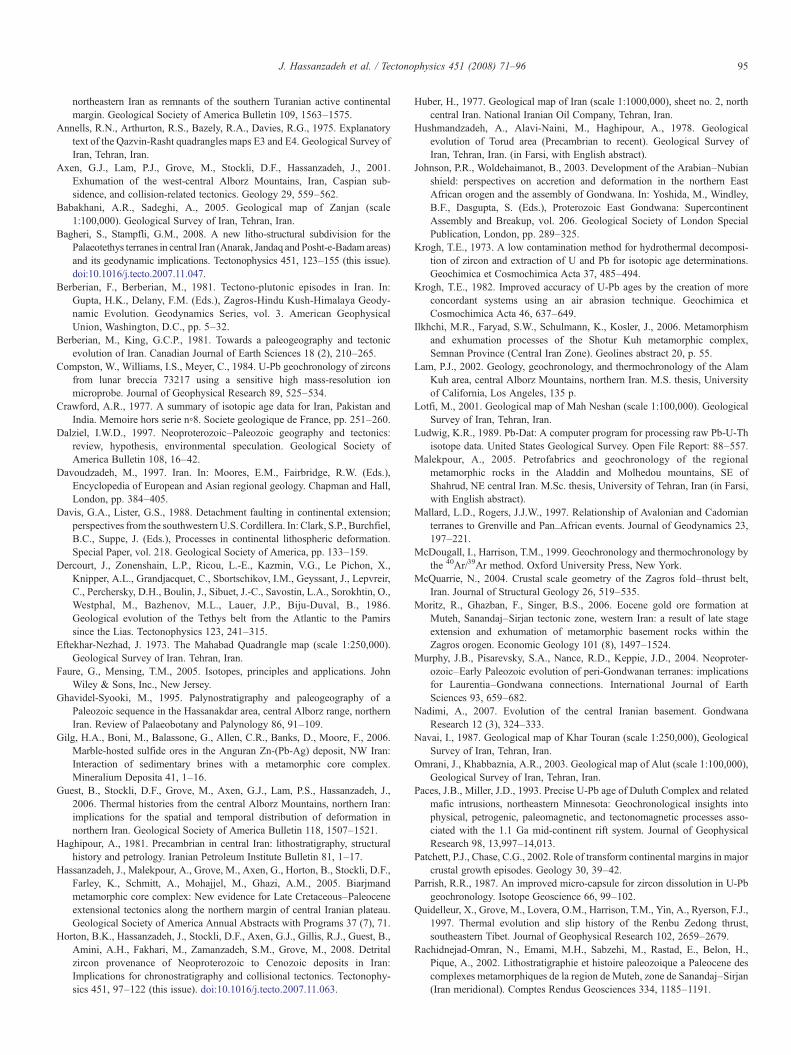
95J. Hassanzadeh et al. / Tectonophysics 451 (2008) 71–96
northeastern Iran as remnants of the southern Turanian active continentalmargin. Geological Society of America Bulletin 109, 1563–1575.
Annells, R.N., Arthurton, R.S., Bazely, R.A., Davies, R.G., 1975. Explanatorytext of the Qazvin-Rasht quadrangles maps E3 and E4. Geological Survey ofIran, Tehran, Iran.
Axen, G.J., Lam, P.J., Grove, M., Stockli, D.F., Hassanzadeh, J., 2001.Exhumation of the west-central Alborz Mountains, Iran, Caspian sub-sidence, and collision-related tectonics. Geology 29, 559–562.
Babakhani, A.R., Sadeghi, A., 2005. Geological map of Zanjan (scale1:100,000). Geological Survey of Iran, Tehran, Iran.
Bagheri, S., Stampfli, G.M., 2008. A new litho-structural subdivision for thePalaeotethys terranes in central Iran (Anarak, Jandaq and Posht-e-Badamareas)and its geodynamic implications. Tectonophysics 451, 123–155 (this issue).doi:10.1016/j.tecto.2007.11.047.
Berberian, F., Berberian, M., 1981. Tectono-plutonic episodes in Iran. In:Gupta, H.K., Delany, F.M. (Eds.), Zagros-Hindu Kush-Himalaya Geody-namic Evolution. Geodynamics Series, vol. 3. American GeophysicalUnion, Washington, D.C., pp. 5–32.
Berberian, M., King, G.C.P., 1981. Towards a paleogeography and tectonicevolution of Iran. Canadian Journal of Earth Sciences 18 (2), 210–265.
Compston, W., Williams, I.S., Meyer, C., 1984. U-Pb geochronology of zirconsfrom lunar breccia 73217 using a sensitive high mass-resolution ionmicroprobe. Journal of Geophysical Research 89, 525–534.
Crawford, A.R., 1977. A summary of isotopic age data for Iran, Pakistan andIndia. Memoire hors serie n◦8. Societe geologique de France, pp. 251–260.
Dalziel, I.W.D., 1997. Neoproterozoic–Paleozoic geography and tectonics:review, hypothesis, environmental speculation. Geological Society ofAmerica Bulletin 108, 16–42.
Davoudzadeh, M., 1997. Iran. In: Moores, E.M., Fairbridge, R.W. (Eds.),Encyclopedia of European and Asian regional geology. Chapman and Hall,London, pp. 384–405.
Davis, G.A., Lister, G.S., 1988. Detachment faulting in continental extension;perspectives from the southwesternU.S. Cordillera. In: Clark, S.P., Burchfiel,B.C., Suppe, J. (Eds.), Processes in continental lithospheric deformation.Special Paper, vol. 218. Geological Society of America, pp. 133–159.
Dercourt, J., Zonenshain, L.P., Ricou, L.-E., Kazmin, V.G., Le Pichon, X.,Knipper, A.L., Grandjacquet, C., Sbortschikov, I.M., Geyssant, J., Lepvreir,C., Perchersky, D.H., Boulin, J., Sibuet, J.-C., Savostin, L.A., Sorokhtin, O.,Westphal, M., Bazhenov, M.L., Lauer, J.P., Biju-Duval, B., 1986.Geological evolution of the Tethys belt from the Atlantic to the Pamirssince the Lias. Tectonophysics 123, 241–315.
Eftekhar-Nezhad, J. 1973. The Mahabad Quadrangle map (scale 1:250,000).Geological Survey of Iran. Tehran, Iran.
Faure, G., Mensing, T.M., 2005. Isotopes, principles and applications. JohnWiley & Sons, Inc., New Jersey.
Ghavidel-Syooki, M., 1995. Palynostratigraphy and paleogeography of aPaleozoic sequence in the Hassanakdar area, central Alborz range, northernIran. Review of Palaeobotany and Palynology 86, 91–109.
Gilg, H.A., Boni, M., Balassone, G., Allen, C.R., Banks, D., Moore, F., 2006.Marble-hosted sulfide ores in the Anguran Zn-(Pb-Ag) deposit, NW Iran:Interaction of sedimentary brines with a metamorphic core complex.Mineralium Deposita 41, 1–16.
Guest, B., Stockli, D.F., Grove, M., Axen, G.J., Lam, P.S., Hassanzadeh, J.,2006. Thermal histories from the central Alborz Mountains, northern Iran:implications for the spatial and temporal distribution of deformation innorthern Iran. Geological Society of America Bulletin 118, 1507–1521.
Haghipour, A., 1981. Precambrian in central Iran: lithostratigraphy, structuralhistory and petrology. Iranian Petroleum Institute Bulletin 81, 1–17.
Hassanzadeh, J., Malekpour, A., Grove, M., Axen, G., Horton, B., Stockli, D.F.,Farley, K., Schmitt, A., Mohajjel, M., Ghazi, A.M., 2005. Biarjmandmetamorphic core complex: New evidence for Late Cretaceous–Paleoceneextensional tectonics along the northern margin of central Iranian plateau.Geological Society of America Annual Abstracts with Programs 37 (7), 71.
Horton, B.K., Hassanzadeh, J., Stockli, D.F., Axen, G.J., Gillis, R.J., Guest, B.,Amini, A.H., Fakhari, M., Zamanzadeh, S.M., Grove, M., 2008. Detritalzircon provenance of Neoproterozoic to Cenozoic deposits in Iran:Implications for chronostratigraphy and collisional tectonics. Tectonophy-sics 451, 97–122 (this issue). doi:10.1016/j.tecto.2007.11.063.
Huber, H., 1977. Geological map of Iran (scale 1:1000,000), sheet no. 2, northcentral Iran. National Iranian Oil Company, Tehran, Iran.
Hushmandzadeh, A., Alavi-Naini, M., Haghipour, A., 1978. Geologicalevolution of Torud area (Precambrian to recent). Geological Survey ofIran, Tehran, Iran. (in Farsi, with English abstract).
Johnson, P.R., Woldehaimanot, B., 2003. Development of the Arabian–Nubianshield: perspectives on accretion and deformation in the northern EastAfrican orogen and the assembly of Gondwana. In: Yoshida, M., Windley,B.F., Dasgupta, S. (Eds.), Proterozoic East Gondwana: SupercontinentAssembly and Breakup, vol. 206. Geological Society of London SpecialPublication, London, pp. 289–325.
Krogh, T.E., 1973. A low contamination method for hydrothermal decomposi-tion of zircon and extraction of U and Pb for isotopic age determinations.Geochimica et Cosmochimica Acta 37, 485–494.
Krogh, T.E., 1982. Improved accuracy of U-Pb ages by the creation of moreconcordant systems using an air abrasion technique. Geochimica etCosmochimica Acta 46, 637–649.
Ilkhchi, M.R., Faryad, S.W., Schulmann, K., Kosler, J., 2006. Metamorphismand exhumation processes of the Shotur Kuh metamorphic complex,Semnan Province (Central Iran Zone). Geolines abstract 20, p. 55.
Lam, P.J., 2002. Geology, geochronology, and thermochronology of the AlamKuh area, central Alborz Mountains, northern Iran. M.S. thesis, Universityof California, Los Angeles, 135 p.
Lotfi, M., 2001. Geological map of Mah Neshan (scale 1:100,000). GeologicalSurvey of Iran, Tehran, Iran.
Ludwig, K.R., 1989. Pb-Dat: A computer program for processing raw Pb-U-Thisotope data. United States Geological Survey. Open File Report: 88–557.
Malekpour, A., 2005. Petrofabrics and geochronology of the regionalmetamorphic rocks in the Aladdin and Molhedou mountains, SE ofShahrud, NE central Iran. M.Sc. thesis, University of Tehran, Iran (in Farsi,with English abstract).
Mallard, L.D., Rogers, J.J.W., 1997. Relationship of Avalonian and Cadomianterranes to Grenville and Pan_African events. Journal of Geodynamics 23,197–221.
McDougall, I., Harrison, T.M., 1999. Geochronology and thermochronology bythe 40Ar/39Ar method. Oxford University Press, New York.
McQuarrie, N., 2004. Crustal scale geometry of the Zagros fold–thrust belt,Iran. Journal of Structural Geology 26, 519–535.
Moritz, R., Ghazban, F., Singer, B.S., 2006. Eocene gold ore formation atMuteh, Sanandaj–Sirjan tectonic zone, western Iran: a result of late stageextension and exhumation of metamorphic basement rocks within theZagros orogen. Economic Geology 101 (8), 1497–1524.
Murphy, J.B., Pisarevsky, S.A., Nance, R.D., Keppie, J.D., 2004. Neoproter-ozoic–Early Paleozoic evolution of peri-Gondwanan terranes: implicationsfor Laurentia–Gondwana connections. International Journal of EarthSciences 93, 659–682.
Nadimi, A., 2007. Evolution of the central Iranian basement. GondwanaResearch 12 (3), 324–333.
Navai, I., 1987. Geological map of Khar Touran (scale 1:250,000), GeologicalSurvey of Iran, Tehran, Iran.
Omrani, J., Khabbaznia, A.R., 2003. Geological map of Alut (scale 1:100,000),Geological Survey of Iran, Tehran, Iran.
Paces, J.B., Miller, J.D., 1993. Precise U-Pb age of Duluth Complex and relatedmafic intrusions, northeastern Minnesota: Geochronological insights intophysical, petrogenic, paleomagnetic, and tectonomagnetic processes asso-ciated with the 1.1 Ga mid-continent rift system. Journal of GeophysicalResearch 98, 13,997–14,013.
Patchett, P.J., Chase, C.G., 2002. Role of transform continental margins in majorcrustal growth episodes. Geology 30, 39–42.
Parrish, R.R., 1987. An improved micro-capsule for zircon dissolution in U-Pbgeochronology. Isotope Geoscience 66, 99–102.
Quidelleur, X., Grove, M., Lovera, O.M., Harrison, T.M., Yin, A., Ryerson, F.J.,1997. Thermal evolution and slip history of the Renbu Zedong thrust,southeastern Tibet. Journal of Geophysical Research 102, 2659–2679.
Rachidnejad-Omran, N., Emami, M.H., Sabzehi, M., Rastad, E., Belon, H.,Pique, A., 2002. Lithostratigraphie et histoire paleozoique a Paleocene descomplexes metamorphiques de la region de Muteh, zone de Sanandaj–Sirjan(Iran meridional). Comptes Rendus Geosciences 334, 1185–1191.
96 J. Hassanzadeh et al. / Tectonophysics 451 (2008) 71–96
Ramezani, J., 1997. Regional geology, geochronology and geochemistry ofthe igneous and metamorphic rock suites of the Saghand region, centralIran. Ph.D. thesis, Washington University, St. Louis, Missouri, USA.
Ramezani, J., Tucker, R.D., 2003. The Saghand region, central Iran: U-Pbgeochronology, petrogenesis and implications for Gondwana tectonics.American Journal of Science 303, 622–665.
Roddick, J.C., Loveridge, W.D., Parrish, R.R., 1987. Precise U-Pb dating ofzircon at the sub-nanogram Pb level. Chemical Geology 66, 111–121.
Rogers, J.J.W., Unrug, R., Sultan, M., 1995. Tectonic assembly of Gondwana.Journal of Geodynamics 19, 1–34.
Ruttner, A.W., 1993. Southern borderland of Triassic Laurasia in north-east Iran.Geologische Rundschau 82, 110–120.
Samani, B.A., 1988. Metallogeny of the Precambrian in Iran. PrecambrianResearch 39, 85–106.
Samani, B.A., Zhuyi, C., Xuetao, G., Chuan, T., 1994. Geology of Precambrianin central Iran: on the context of stratigraphy, magmatism and metamorph-ism. Geosciences Quarterly 3 (10), 40–63 (Geological Survey of Iran, inFarsi with English abstract).
Sanudo-Wilhelmy, S.A., Flegal, A.R., 1994. Temporal variations in leadconcentrations and isotopic composition in the Southern California Bight.Geochimica et Cosmchimica Acta 58, 3315–3320.
Schmitt, A.K., Grove, M., Harrison, T.M., Lovera, O.M., Hulen, J., Waters, M.,2003a. The Geysers–Cobb Mountain magma system, California (Part 1):U-Pb zircon ages of volcanic rocks, conditions of zircon crystallizationand magma residence times. Geochimica et Cosmochimica Acta 67,3423–3442.
Schmitt, A.K., Grove, M., Harrison, T.M., Lovera, O.M., Hulen, J., Waters, M.,2003b. The Geysers–Cobb Mountain Magma System, California (Part 2):timescales of pluton emplacement and implications for its thermal history.Geochimica et Cosmchimica Acta 67, 3443–3458.
Sengör, A.M.C., 1987. Tectonics of the Tethysides: Orogenic collagedevelopment in a collisional setting. Annual Review of Earth & PlanetarySciences 15, 213–244.
Sengör, A.M.C., 1990. A new model for the late Palaeozoic–Mesozoic tectonicsevolution of Iran and implications for Oman. In: Robertson, A.H.F., Searle,M.P.,Ries, A.C. (Eds.), The geology and tectonics of the Oman region, vol. 49.Geological Society of London Special Publication, London, pp. 797–831.
Stacey, J.S., Kramers, J.D., 1975. Approximation of terrestrial lead isotopeevolution by a two-stage model. Earth and Planetary Science Letters 26,207–221.
Stampfli, G.M., 2000. Tethyan oceans. In: Bozkurt, E., Winchester, J.A., Piper,J.D.A. (Eds.), Tectonics and magmatism in Turkey and surrounding area.Special Publication, vol. 173. Geological Society, London, pp. 1–23.
Stampfli, G.M., Borel, G.D., 2004. The TRANSMED transects in space andtime: constraints on the Paleotectonic evolution of the MediterraneanDomain. In: Cavazza, W., Roure, F., Spakman, W., Stampfli, G.M., Ziegler,P. (Eds.), The TRANSMED Atlas: the Mediterranean Region from Crust toMantle. Springer, pp. 53–80.
Stampfli, G.M., Mosar, J., Favre, P., Pillevuit, A., Vannay, J.C., 2001. Permo-Mesozoic evolution of the western Tethys realm: the Neotethys East-Mediterranean basin connection. In: Ziegler, P.A., Cavazza, W., Robertson,A.H.F., Crasquin-Soleau, S. (Eds.), Peri-Tethys Memoir 6: Peri-Tethyan rift/wrench basins and passive margins. Mémoires du Museum nationald'Historie naturelle, vol. 186, pp. 51–108.
Steiger, R.H., Jager, E., 1977. Subcommission on Geochronology: conventionon the use of decay constants in geo- and cosmochronology. Earth andPlanetary Science Letters 36, 359–362.
Stern, R.J., 1994. Arc assembly and continental collision in the Neoproterozoiceast African orogen: Implications for the consolidation of Gondwanaland.Annual Review of Earth and Planetary Sciences 22, 319–351.
Stockli, D.F., Hassanzadeh, J., Stockli, L.D., Axen, G.J., Walker, J.D., Dewane,T.J., 2004. Structural and geochronological evidence for Oligo-Mioceneintra-arc low-angle detachment faulting in the Takab–Zanjan area NW Iran.Geological Society of America Abstracts with Programs 36 (5), 319.
Stöcklin, J., 1968. Structural history and tectonics of Iran: a review. AmericanAssociation of Petroleum Geologists Bulletin 52, 1229–1258.
Stöcklin, J., 1974. Possible ancient continental margin in Iran. In: Burk,C.A., Drake, C.L. (Eds.), The geology of continental margins. Springer,pp. 873–887.
Stöcklin, J., Eftekharnezhad, J., 1969. Explanatory text of the Zanjan quadranglemap. Geological Survey of Iran, Tehran, Iran.
Stöcklin, J., Nabavi, M., Samimi, M., 1965. Geology and mineral resources ofthe Soltanieh mountains (Northwest Iran). Geological Survey of Iran,Tehran, Iran.
Stöcklin, J., Ruttner, A., Nabavi, M., 1964. New data on the Lower Paleozoicand Pre-Cambrian of north Iran. Geological Survey of Iran, Tehran, Iran.
Stöcklin, J., Setudehnia, A., 1970. Stratigraphic Lexicon of Iran. GeologicalSurvey of Iran, Tehran, Iran.
Thiele, O., Alavi, M., Assefi, R., Hushmandzadeh, A., Seyed-Emami, K.,Zahedi, M., 1968. Explanatory text of the Golpaygan quadrangle map.Geological Survey of Iran, Tehran, Iran.
Tillman, J.E., Poosti, A., Rossello, S., Eckert, A., 1981. Structural evolution ofSanandaj–Sirjan Ranges near Esfahan, Iran. American Association ofPetroleum Geologists Bulletin 65, 674–687.
Veevers, J.J., 2003. Pan-African is Pan-Gondwanaland: oblique convergencedrives rotation during 650–500 Ma assembly. Geology 31, 501–504.
Verdel, C., Wernicke, B.P., Ramezani, J., Hassanzadeh, J., Renne, P.R., Spell, T.L.,2007. Geology and thermochronology of Tertiary Cordilleran-style meta-morphic core complexes in the Saghand region of central Iran. GeologicalSociety of America Bulletin 119, 961–977.