University of Nevada, Reno Starch Residue Analysis from Two ...
204
University of Nevada, Reno Starch Residue Analysis from Two High Altitude Village Locations: High Rise Village, Wyoming and the White Mountain Village Sites, California A thesis submitted in partial fulfillment of the requirements for the degree of Master of Arts in Anthropology by Amanda M. Rankin Dr. Christopher T. Morgan/Thesis Advisor August, 2016
-
Upload
khangminh22 -
Category
Documents
-
view
1 -
download
0
Transcript of University of Nevada, Reno Starch Residue Analysis from Two ...

University of Nevada, Reno
Starch Residue Analysis from Two High Altitude Village Locations: High Rise Village,
Wyoming and the White Mountain Village Sites, California
A thesis submitted in partial fulfillment of the
requirements for the degree of Master of Arts in
Anthropology
by
Amanda M. Rankin
Dr. Christopher T. Morgan/Thesis Advisor
August, 2016

We recommend that the thesis
prepared under our supervision by
AMANDA M. RANKIN
Entitled
Starch Residue Analysis from Two High Altitude Village Locations: High Rise
Village, Wyoming and the White Mountain Village Sites, California
be accepted in partial fulfillment of the
requirements for the degree of
MASTER OF ARTS
Dr. Christopher T. Morgan, Advisor
Dr. Dave Rhode, Committee Member
Dr Robert Watters, Graduate School Representative
David W. Zeh, Ph.D., Dean, Graduate School
August, 2016
THE GRADUATE SCHOOL

i
Abstract
Starch residue analysis, ground stone, and use-wear analysis on milling
equipment from High Rise Village and the White Mountain Village sites reveals a
subsistence system that included geophyte processing at high elevation. High
altitude residential use is little understood in North America and has often been
thought to relate to intensive pine nut exploitation. This research indicates that
this is not the case, and that geophytes were a targeted resource at high elevation.
A closer look at the archaeological record in the two regions reveals that root
processing was a common occurrence in nearby lowland regions and that high
altitude villages may fit into this broader regional pattern of geophyte processing,
a fact that has been overlooked by archaeologists and ethnographers alike, and
something starch residue analysis is well suited to demonstrate.

ii
Dedication
To my family who have always supported me, and most of all to my mother who was my
greatest support, editor, and cheerleader. I wish you were here to see me finish.

iii
Acknowledgments
I would like to thank the Nevada Archaeological Association for the 2014 Student
Research Grant to conduct my research, the UNR Department of Anthropology for the
2014 William Self award, Dr. Dave Rhode at Desert Research Institute for teaching me
the process of starch residue extraction and analysis and for letting me use the facilities,
Dr. Christopher Morgan for allowing me to use the High Rise Village assemblage, and
Dr. Robert Bettinger for allowing me access to the White Mountain collections, and for
the tour of the White Mountain Village sites. Thank you to Shaun Richey for all the love
and support as well as help with editing. Finally, thank you to my graduate cohort for all
fun amid the stress. Portions of this project were funded by the U.S. National Science
Foundation (Grant No. BCS-1302054); the continued support of the American public for
scientific archaeological research is greatly appreciated.

iv
Table of Contents
ABSTRACT .................................................................................................................................................... I
DEDICATION ................................................................................................................................................II
ACKNOWLEDGMENTS ................................................................................................................................ III
TABLE OF CONTENTS ................................................................................................................................ IV
LIST OF TABLES ....................................................................................................................................... VIII
LIST OF FIGURES ........................................................................................................................................ X
CHAPTER 1 INTRODUCTION .................................................................................................................. 1
CHAPTER 2 RESEARCH CONTEXT ....................................................................................................... 5
HIGH RISE VILLAGE .................................................................................................................................... 5
SITE CONTEXT ............................................................................................................................................. 5
Flaked Stone Tools................................................................................................................................. 7
Subsistence Remains .............................................................................................................................. 9
Chronology ............................................................................................................................................ 9
ENVIRONMENTAL CONTEXT ...................................................................................................................... 10
Western Wyoming Paleoenvironmental Record................................................................................... 11
WESTERN WYOMING CULTURE HISTORY.................................................................................................. 13
The Early Archaic ................................................................................................................................ 15
The Middle Archaic ............................................................................................................................. 15
The Late Archaic .................................................................................................................................. 16
The Late Prehistoric Period................................................................................................................. 16
Historic Period .................................................................................................................................... 17
WHITE MOUNTAIN VILLAGE SITES ........................................................................................................... 18
SITE CONTEXT ........................................................................................................................................... 18
Archaeological Findings ...................................................................................................................... 19
CA-MNO-2198: Rancho Deluxe .......................................................................................................... 20

v
CA-MNO-2191: Crooked Forks .......................................................................................................... 21
CA-MNO-2194: Corral Camp South ................................................................................................... 21
Gate Meadows ..................................................................................................................................... 21
CA-MON-2193: Raven Camp .............................................................................................................. 22
CA-MNO-2196: Midway Village ......................................................................................................... 22
Chronology of the White Mountain Sites ............................................................................................. 22
Subsistence Remains: ........................................................................................................................... 24
Interpretation ....................................................................................................................................... 26
ENVIRONMENTAL CONTEXT ...................................................................................................................... 26
Great Basin and Owens Valley Paleoenvironmental Record .............................................................. 28
WHITE MOUNTAINS AND OWENS VALLEY CULTURE HISTORY ................................................................. 29
Western Great Basin: Newberry (4000 B.P.-1500 B.P.) ..................................................................... 31
Western Great Basin: Haiwee Period (ca. 1500-600 B.P.) ................................................................. 31
Western Great Basin: Marana Period (600 B.P.-historic) .................................................................. 32
Historic Period .................................................................................................................................... 32
Environmental and Culture History Comparisons .............................................................................. 34
CHAPTER 3 THEORY AND EXPECTATIONS .................................................................................... 38
HIGH ALTITUDE ARCHAEOLOGY ............................................................................................................... 38
High Altitude Land Use in North America ........................................................................................... 38
The “Pull” Hypothesis......................................................................................................................... 42
The “Push” Hypothesis ....................................................................................................................... 45
MODELING MOUNTAIN PLANT-BASED SUBSISTENCE................................................................................ 46
PREDICTIONS ............................................................................................................................................. 54
CHAPTER 4 METHODS ........................................................................................................................... 55
SAMPLING STRATEGY ............................................................................................................................... 55
GROUND STONE ANALYSIS ....................................................................................................................... 56

vi
Life History .......................................................................................................................................... 56
Form and Function .............................................................................................................................. 57
Morphology.......................................................................................................................................... 58
Occupation Strategy ............................................................................................................................ 58
GROUND STONE ANALYSIS METHODS ...................................................................................................... 59
USE-WEAR ANALYSIS ................................................................................................................................ 60
CHARACTERISTICS AND DEFINITIONS ........................................................................................................ 60
Granularity and Durability .................................................................................................................. 60
Topography .......................................................................................................................................... 61
Types of Wear ...................................................................................................................................... 61
Direction of Use ................................................................................................................................... 63
Rock Hardness ..................................................................................................................................... 63
STARCH RESIDUE ANALYSIS ..................................................................................................................... 64
STARCH RESIDUE ANALYSIS METHODS .................................................................................................... 66
Extraction ............................................................................................................................................ 66
Aqueous Sediment Reduction ............................................................................................................... 67
LST Flotation ....................................................................................................................................... 67
LST Dilution......................................................................................................................................... 68
Microscope Analysis ............................................................................................................................ 68
Starch Identification Methods .............................................................................................................. 69
CHAPTER 5 RESULTS ............................................................................................................................. 73
GROUND STONE ANALYSIS ....................................................................................................................... 73
High Rise Village ................................................................................................................................. 73
White Mountains .................................................................................................................................. 74
USE-WEAR ................................................................................................................................................. 75
High Rise Village ................................................................................................................................. 75
White Mountains .................................................................................................................................. 77

vii
STARCH RESIDUE ANALYSIS ..................................................................................................................... 80
Modern Starch Identifications ............................................................................................................. 80
Modern Starch Identification Summary ............................................................................................... 98
Archaeological Starch Identifications ............................................................................................... 101
Starch Analysis from High Rise Village ............................................................................................. 106
Starch Analysis from the White Mountain Village Sites .................................................................... 112
COMPARISON OF THE HIGH RISE VILLAGE AND WHITE MOUNTAINS STARCH ASSEMBLAGES ................ 124
Diversity and Evenness ...................................................................................................................... 125
Summary of Results ............................................................................................................................ 127
CHAPTER 6 DISCUSSION AND CONCLUSION ................................................................................ 129
Discussion of Results ......................................................................................................................... 129
Return Rates....................................................................................................................................... 130
Overall Utility .................................................................................................................................... 132
Culture History and the Ethnographic Record .................................................................................. 134
Why Were Roots Overlooked? ........................................................................................................... 137
Interpretation ..................................................................................................................................... 139
CONCLUSION ........................................................................................................................................... 140
REFERENCES CITED ................................................................................................................................. 143
APPENDIX A ............................................................................................................................................ 159
APPENDIX B ............................................................................................................................................ 164
APPENDIX C ............................................................................................................................................ 168
APPENDIX D ............................................................................................................................................ 170
APPENDIX E ............................................................................................................................................ 174
APPENDIX F ............................................................................................................................................. 179

viii
List of Tables
Table 2.1. Calibrated Radiocarbon Dates from High Rise Village. Adapted from Morgan
et al. 2016 .......................................................................................................................... 10
Table 2.2. Northwestern Plains and Wyoming Basin Chronologies ................................ 14
Table 2.3. Calibrated Radiocarbon Dates from The White Mountain Village Sites
Adapted from Bettinger 1991 ........................................................................................... 24
Table 2.4. Western Great Basin and Owens Valley Chronologies ................................... 30
Table 3.1. Return Rates for Rocky Mountain and Great Basin Resources ....................... 48
Table 3.2. Relevant Front and Back-loading Data: Pine Nuts versus Roots .................... 50
Table 4.1. Ground Stone Sample ...................................................................................... 55
Table 4.2. Starch Grain Attributes .................................................................................... 65
Table 4.3. Starch References ............................................................................................ 70
Table 5.1. High Rise Village Ground Stone Analysis Assemblage .................................. 74
Table 5.2. White Mountain Ground Stone Millingslab Analysis Assemblage ................. 75
Table 5.3. High Rise Village Micro Use-Wear Analysis.................................................. 78
Table 5.4. White Mountain Macro Use-Ware Analysis ................................................... 79
Table 5.5. Summary of Attributes used in Modern Taxonomic Identifications ............... 99
Table 5.6. Comparison of Typologies and Possible Taxonomic Identifications ............ 101
Table 5.7. High Rise Village Ground Stone Containing Starches .................................. 107
Table 5.8. High Rise Village Starches by Type .............................................................. 108
Table 5.9. High Rise Village Starch Frequency by Type ............................................... 110
Table 5.10. White Mountain Village Ground Stone Containing Starches ...................... 113

ix
Table 5.11. White Mountain Village Sites Quantity of Starches by Type ..................... 114
Table 5.12. Rancho Deluxe Quantity of Starches by Type ............................................. 116
Table 5.13. Corral Camp South Quantity of Starches by Type ...................................... 118
Table 5.14. Midway Villages Quantity of Starches by Type .......................................... 120
Table 5.15 Shannon Diversity and Evenness Index Comparison Between High Rise
Village and the White Mountain Village Sites ............................................................... 126
Table 5.16. Simpson’s Diversity and Evenness Index Comparison Between High Rise
Village and the White Mountain Village Sites ............................................................... 126
Table 6.1. Return Rates on Several Pine and Geophytes Species .................................. 132

x
List of Figures
Figure 2.1. Location of High Rise Village .......................................................................... 6
Figure 2.2. Location of Lodges at High Rise Village (Morgan et al. 2012a) ..................... 7
Figure 2.3. White Mountain Village Sites ........................................................................ 20
Figure 5.1. FR5891-15199 Use-Wear Illustrating Abrasion and Sheen ........................... 76
Figure 5.2. FR5891-2099 Use-Wear Illustrating Frosting and Fatigue Wear .................. 76
Figure 5.3. 382-12317 and 382-2045 Illustrating Pecking and Use-Wear Abrasion........ 77
Figure 5.4. Polarized and Regular Light Photo Illustrating Characteristics of Lomatium
roseanum ........................................................................................................................... 80
Figure 5.5. Polarized and Regular Light Photo Illustrating Characteristics of Lewisia
rediviva ............................................................................................................................. 82
Figure 5.6. Polarized and Regular Light Photo Illustrating Characteristics of Perideridia
bolanderi ........................................................................................................................... 84
Figure 5.7. Polarized and Regular Light Photo Illustrating Characteristics of Calochortus
leichtlinii ........................................................................................................................... 85
Figure 5.8. Polarized and Regular Light Photo Illustrating Characteristics of Typha
latifolia .............................................................................................................................. 87
Figure 5.9. Polarized Photo Illustrating Characteristics of Schoenoplectus acutus Root
and Seed ............................................................................................................................ 88
Figure 5.10. Polarized and Regular Light Photo Illustrating Characteristics of Cyperus
esculantis........................................................................................................................... 89

xi
Figure 5.11. Polarized and Regular Light Photo Illustrating Characteristics of Pinus
monophylla ........................................................................................................................ 90
Figure 5.12. Polarized and Regular Light Photo Illustrating Characteristics of Pinus
albicaulis ........................................................................................................................... 92
Figure 5.13. Polarized and Regular Light Photo Illustrating Characteristics of
Achnatherum hymenoides ................................................................................................. 93
Figure 5.14. Polarized and Regular Light Photo Illustrating Characteristics of Eleocharis
quinqueflora ...................................................................................................................... 94
Figure 5.15. Polarized and Regular Light Photo Illustrating Characteristics of Allenrolfea
occidentalis ....................................................................................................................... 95
Figure 5.16. Polarized and Regular Light Photo Illustrating Characteristics of
Chenopodium fremontii .................................................................................................... 96
Figure 5.17. Polarized and Regular Light Photo Illustrating Characteristics of Leymus
cinereus ............................................................................................................................. 97
Figure 5.18. Comparison of Starch Type G2 with Lewisia rediviva .............................. 109
Figure 5.19. Percent of Starches by Type at High Rise Village; blue bars indicate
geophytes and yellow bars indicate grasses and other small seeded plants. Deformed,
broken and otherwise unidentifiable taxa are in grey. .................................................... 111
Figure 5.20. Percent of White Mountain Village Starch Grain Types; blue bars indicate
geophytes and yellow bars indicate grasses and other small seeded plants. Deformed,
broken and otherwise unidentifiable taxa are in grey. .................................................... 115

xii
Figure 5.21. Rancho Deluxe Percent of Starches by Type; blue bars indicate geophytes
and yellow bars indicate grasses and other small seeded plants. Deformed, broken and
otherwise unidentifiable taxa are in grey. ....................................................................... 117
Figure 5.22. Corral Camp South Percent of Starches by Type; blue bars indicate
geophytes and yellow bars indicate grasses and other small seeded plants. Deformed,
broken and otherwise unidentifiable taxa are in grey. .................................................... 119
Figure 5.23. Midway Village Percent of Starches by Type; blue bars indicate geophytes
and deformed, broken and otherwise unidentifiable taxa are in grey. ............................ 121
Figure 5.24. Comparison of Starch Type G5 with Calochortus leichtlinii ..................... 121
Figure 5.25. Comparison of Starch Type G4 with Perideridia bolanderi ...................... 122
Figure 5.26. Comparison of Starch Type S2 with Achnatherum hymenoides Indian Rice
Grass ............................................................................................................................... 122
Figure 5.27. Comparison of Type S3 with Leymus cinereus Great Basin Rye .............. 123
Figure 5.28. Comparison of the Percentage of Starches by Taxon at each Location: blue
bars are High Rise Village and orange bars are White Mountain Village Sites ............. 124

1
Chapter 1 Introduction
This thesis presents the results of ground stone starch residue analysis from two of
only three known alpine village localities in western North America: The High Rise
Village site in the Wind River Range of western Wyoming and six of the 12 village sites
in the White Mountains of eastern California. These analyses were undertaken in order
to reconstruct the subsistence behaviors affiliated with high altitude residential use in
North America, which despite decades of faunal and floral analyses (Grayson 1991;
Rhode 2015; Scharf 2009) remain poorly understood.
Reconstructing high altitude subsistence is not only important to our
understanding of past human lifeways but is also essential to understanding the various
forces driving high altitude land use both regionally and globally. Results of this study
suggest that roots were a subsistence focus at these high altitude sites. This may indicate
that widening diet breadth and decreased foraging efficiency marked by a reliance on
low-return geophytes (but not the even lower-return pine nuts found in the subalpine
zone) played an important role in the shift from short-term hunting focused occupations
to more long-term residential use of the alpine zone.
Throughout the world, intensive residential use of the high altitudes is rare. High
altitudes are defined as areas more than 2500 meters above sea level; they are
characterized by decreased biotic productivity, less atmospheric oxygen, a shortened
growing season, and a lack of summer water when compared to lowland settings
(Aldenderfer 2006).

2
In North America, intensive high altitude residential use occurs only in the very
Late Holocene and is found in three areas, two within the Great Basin: Alta Toquima in
central Nevada, with the village pattern dating to perhaps 1500 B.P. (Thomas 1994) and
the White Mountains of California, with the village pattern dating to after 600 B.P. As
well as a similar but less intensive pattern found in the Wind River Range of Wyoming
dating between 2300 and 850 cal B.P. (Adams 2010; Koening 2010; Losey 2013; Morgan
et al. 2012a; 2016; Trout 2015). For these sites, the shift to residential use of the high
altitude zone is accompanied by shifts in subsistence strategies marked by more intensive
plant collecting and processing.
At each of the North American high altitude village localities, intensive
residential use is indicated by well-developed middens, rock ring or cut and fill lodge
structures, and large amounts of ground stone. This indicates either a shift in focus from
hunting to plant processing or an expansion of previously hunting-based diets to include
plant resources. Because of this, many researchers have sought to explain the scarcity of
high altitude sites in North America by their relationship to pine nut processing arguing
that pine nuts may have been a determining factor in high altitude occupation (Adams
2010; Hildebrandt 2013; Stirn 2014; Rhode 2010, Thomas 1983). Two of these locations
are the focus of this study. The White Mountain village sites located in southeastern
California include 12 residential sites in the alpine zone, with rock-ringed structures, well
developed middens, and large quantities of ground stone (Bettinger 1991). The other
location, High Rise Village, is located in the Wind River Range of western Wyoming at
an elevation of 3273 meters and contains large quantities of ground stone and cut and fill
residential features (Adams 2010; Morgan et al. 2012a; 2016).

3
This thesis focuses on answering subsistence related questions, specifically what
plants were being processed with the large quantities of ground stone at these sites. To
answer this question ground stone analysis, use-wear analysis, and starch residue analysis
was conducted on fifteen millingslabs from six of the White Mountain Village sites and
eleven millingslabs and ten handstone fragments from High Rise Village. Results of this
study indicate that geophytes were the resources being processed at these sites.
Chapter 1 and Chapter 2 provide an introduction to this study and an overview of
the High Rise Village (HRV) and White Mountain Village Pattern (WMVP) site contexts
as well as the environmental and cultural histories of the two regions.
Chapter 3 outlines the theoretical framework of this thesis, in regards to high
altitude archaeology in North America, and human behavioral ecological models in
general. Presented in this chapter is a comparison of pine nut resources and geophyte
resources and the overall utility of the two. Given this information, an expectation is
proposed for the results of the starch residue analysis.
Chapter 4 addresses the methods employed in ground stone analysis, use-wear
analysis, and starch residue analysis. Each analysis is discussed in depth in regards to
methods applied to the field of archaeology as a whole and methods used in this study.
Chapter 5 presents the results of the ground stone, use-wear, and starch analysis.
The results include a discussion of form, function, and degree of use of the ground stone
tools as well as a description of starch granule characteristics for all 20 of the plants used
as reference materials for this study. Following this, a description of the nine starch types
created for the archaeological samples is outlined and results of starch analysis for the

4
two locations is tabulated by type and most likely taxonomic identification. Finally,
diversity and evenness are considered between the two locations.
Chapter 6 concludes the study with a discussion of the results presented in
Chapter 5 and examines the relationship between the newly generated data on root
processing and the evidence for root processing in the two regions throughout prehistory
and into the ethnographic record. The study concludes with a discussion of starch residue
analysis and its application to the field of archaeology.

5
Chapter 2 Research Context
Two high elevation locations are the focus of this study; High Rise Village in
Wyoming’s Wind River Range, and the village sites of the White Mountains in
southeastern California. In both of these locations village sites are located above 3000
meters AMSL (9800 ft) and residential features, midden soils, large quantities of
artifacts, particularly ground stone characterize these sites. Following is a discussion of
the archaeological, cultural, and environmental context of each location.
High Rise Village
Site Context
High Rise Village is located in the Wind River Range of western Wyoming at an
elevation of 3320-3325 m AMSL (10,820-10,908 ft) (Figure 2.1) (Morgan et al. 2012a).
The sites straddles modern treeline, with roughly 1/3 of the site in the alpine ecozone and
the remaining 2/3 in a Whitebark pine (Pinus albicaulis) dominated subalpine forest. A
semi-permanent spring is on site and a mountain sheep migration corridor passes near the
site (Morgan et al 2012a). The site measures 440 by 220 m, and contains 52 cut-and-fill
residential foundations which, during initial recording were referred to as “lodges”
(Figure 2.2). Lodges are features constructed by cutting into the site’s steep (23 degree)
south facing slope and filling the down slope area with the resulting excavated material,
with some of the lodge features ringed by one or more courses of stacked rock. The
features represent house structure foundations that may have supported cribbed timber

6
supper structure with three of the features containing possible remnants of the cribbed
timber supper structure (Adams 2010; Morgan et al. 2012a).
Figure 2.1. Location of High Rise Village

7
Figure 2.2. Location of Lodges at High Rise Village (Morgan et al. 2012a)
Twenty-nine of the lodge features were excavated between 2008 and 2012
(Adams 2010; Koening 2010; Morgan et al. 2012a; Morgan et al. 2016). Based on these
excavations, it appears the most intensive occupation of the site ranges from 2300 to 850
cal B.P. (Morgan et al. 2016). Excavations produced an assemblage indicative of tool
manufacture and plant processing: diagnostic projectile points, bifacial tools, debitage, 52
ground stone pieces, 200 ceramic sherds, and very few fragmentary animal bones.
Flaked Stone Tools
Stone tools and debitage were analyzed from Lodge 10, 13, 16, 19, 21, 22, 26, 28,
49, SS, and W (Figure 2.2) (Losey 2013; Trout 2015). The low density and diversity of
tools suggest that hunting and animal processing occurred but was not a focal activity at
the site. Debitage analysis revealed that both expedient core reduction and biface
reduction occurred in nearly equal proportion at the site, both dominated by very late
stage reduction and retouch. Retouch flakes average about 45 percent of the total

8
debitage. Over 95 percent of the debitage is made from locally available chert with the
remaining five percent made of quartzite and extralocal obsidian and basalt (Trout 2015).
Edge modified flakes (n=61) all exhibit evidence of use for scraping. Bifaces and
edge modified flakes are mostly late stage reduction and show minimal variability in
material type or function, with over 86 percent made on local chert (Trout 2015).
Of the 69 bifaces, two are drills, one is a graver and 47 are stage four or five
bifaces (per Andrefsky 2005:187-188). Of the late stage bifaces 22 are diagnostic
projectile points, either Rosegate or corner-notched points dating roughly to the Medieval
Climatic Anomaly (MCA) or side-notched or tri-notched points dating to the Little Ice
Age (LIA) (Losey 2013, Trout 2015). All lodges contain bifaces with the exception of
Lodge 28. The bifaces are predominantly made from local chert and 91 percent are
broken. Only two expedient cores were recovered from the site. The lack of cores and
quantity of late stage core reduction debitage indicates that core reduction rarely took
place on-site (Trout 2015).
The majority of obsidian artifacts from the site were retouch and pressure flakes
indicating that most of the obsidian found on site arrived as finished tools. Obsidian
hydration and XRF sourcing of a 137 obsidian artifacts from the site demonstrate that the
majority (62 percent) of the obsidian found on site came from the Jackson Hole region
(Teton Pass and Crescent H) with distant but high quality obsidian from Obsidian Cliff
compromising 24 percent of the total assemblage (Morgan et al. 2016).

9
Subsistence Remains
The ground stone found on the site is made from either local quartzite or non-
local basalt. Handstones tend to be well formed and made from the non-local basalt
while millingslabs show less formal shaping and use and are made from the local
quartzite found throughout the area. Each lodge contains at least one ground stone
artifact if not more, indicating grinding was an important activity at High Rise Village.
Flotation samples were taken from several of the hearth features within the lodges;
however, no plant remains were recovered (Losey 2013; Morgan et al. 2012a). The
failure to identify any plant remains left determining the use of the ground stone tools all
the more problematic. Faunal remains are scarce and highly fragmented possibly due to
taphonomic issues. The few identifiable fragments likely represent artiodactyls like
mountain sheep (Ovis canadensis) and marmot (Marmota flaviventris). The small
number of animal bones, formal tools and finished bifaces may indicate animal
processing and even hunting was not a primary focus at the site (Losey 2013).
Chronology
Twenty five radiocarbon dates were obtained for HRV (Adams 2010; Morgan et
al. 2012a; 2016) (Table 2.1) with date ranges from 4010 ± 25 to 130 ± 40 rcy B.P. The
most recent dates have been rejected due to issues with context and the earliest dates are
in question because they may represent an old wood problem (sensu Schiffer 1986).
Dendrochronological assays from the vicinity of the site indicate that downed wood can
survive in the area more than seven centuries and thus wood burned in campfires on site
could have been much older than when the campfire was actually constructed. Lacking

10
in the subsurface site deposit at HRV are any diagnostic points from the Middle Archaic
and the lodge that produced the oldest dates, Lodge 16, only contains Rosegate projectile
points which date from 1500 to 900 cal B.P. on the Plains (Kornfeld et al. 2010) and 1500
to 600 cal B.P. in the mountains (Larson and Kornfeld 1994). Because of this, it seems
likely that the oldest dates are outliers and have thus been rejected. The remaining dates
indicate sporadic use between 2800 to 850 cal B.P. with the most intensive use between
2300 and 850 cal B.P. (Morgan et al. 2016).
Table 2.1. Calibrated Radiocarbon Dates from High Rise Village. Adapted from Morgan
et al. 2016
Lab Lab
Number Material Context Provenience a Radiocarbon
age
Calibrated
Date b
UGAMS 13690 Charcoal Charcoal
Lens Lodge 8 1460 ± 20 1360 ± 30
UGAMS 13689 Charcoal Hearth Lodge 13 3990 ± 25 4470 ± 40
UGAMS 13681 Charcoal Hearth Lodge 13 1380 ± 25 1310 ± 20
UGAMS 3 9756 Charcoal Hearth Lodge 16 4010 ± 25 4480 ± 40
UGAMS 13688 Charcoal Charcoal
Smear Lodge 19 1590 ± 20 1480 ± 40
UGAMS 13683 Charcoal Charcoal
Smear Lodge 19 1150 ± 20 1070 ± 50
UGAMS 3 8380 Charcoal Hearth Lodge 26 1480 ± 25 1380 ± 30
UGAMS 3 8382 Charcoal Hearth Lodge 26 1210 ± 25 1150 ± 50
a) Table only includes the lodges discussed in this study (see Morgan et al. 2016).
b) Dates calibrated using CalPal 2007 (Weninger et al. 2015) and the Hulu calibration curve
(Weninger and Jöris 2008).
Environmental Context
High Rise Village is located in the Wind River Mountain Range of western
Wyoming (Figure 2.1) between 3320 and 3325 meters AMSL (10,560-10,880 ft) on a 23

11
degree, south facing slope (Morgan et al. 2012a). The core of the mountain range is
plutonic in origin with meta-sedimentary rocks ringing the core with quartzite making up
the majority of the rock found on site (Morgan et al. 2014a). The site is located at the
edge of the sub-alpine ecotone and the alpine tundra ecotone. These two ecotones are
characterized by numerous edible plants species specifically: whitebark pine, huckleberry
(Vaccinium scoparium), currants (Ribes spp.), sego lily (Calochortus spp.), biscuitroot
(Lomatium spp.) bitterroot (Lewisia rediviva), and chenopods (Chenopodium spp.)
(Adams 2010; Reed 1976). Animals found in this ecotone are several mammal species
traditionally targeted by the regions hunter-gatherers: bighorn sheep (Ovis canadensis),
elk (Cervus elephas), mule deer (Odocoileus hemionus), yellow-bellied marmot
(Marmota flaviventris), and snowshoe hare (Lepus americanus) (Frison 2004; Kornfeld et
al. 2010; Reed 1976).
Analysis of remnant tree snags and stumps above modern treeline in the vicinity
of High Rise Village revealed that during the main occupation of the site (2300-850 cal
B.P.) the whitebark treeline was over 100 meters higher than at present, completely
encompassing the site boundaries within the subalpine whitebark pine zone (Losey 2013;
Morgan et al. 2012a; Morgan et al. 2014a).
Western Wyoming Paleoenvironmental Record
In the Late Holocene there were three main fluctuations in temperature and
moisture regimes throughout the Great Basin and Rocky Mountain regions: the Late
Holocene Dry Period 2800-1850 B.P. (Mensing et al. 2013), the Medieval Climatic
Anomaly (MCA) 1150-550 B.P. (Hughes and Diaz 1994; LaMarche 1974), and the Little

12
Ice Age (LIA) 550-100 B.P. (Mann 2002; LaMarche 1974). These three main
fluctuations however, are marked by considerable geographic and temporal variability.
In the Rocky Mountain Region pollen records indicate cooler and wetter
conditions after 5200 B.P with lowered treeline followed by an advance to modern
treeline and climate after 3000 B.P. (Mensing et al. 2012). In the Wyoming Region
before 4500 B.P. conditions were dry, treelines were lower, dune activity increased, and
drought tolerant species such as juniper moved into the area (Whitlock et al. 2002). After
4500 B.P. conditions cooled and precipitation increased. Glaciers became active in the
highest elevations, tree-lines moved upwards, dunes stabilized and juniper expansion
stopped (Eckerle 1997). This episode of cool and wet was followed by another dry
period starting around 1800 B.P. when dune activity increased, glaciers receded or
disappeared, and forest fire frequency increased. However, alpine treelines expanded and
stabilized due to warmer and longer alpine growing seasons (Losey 2013). This
corresponds with the tail end of the Late Holocene Dry Period, which was the longest
persistent dry period during the late Holocene in the Great Basin and Bonneville Basin,
though it is as-yet unclear the extent and expression of this phenomenon across the region
(Mensing et al. 2013).
Between 1100-650 B.P. multidecadal climatic variability took place in the Rocky
Mountain Region during the MCA (Whitlock et al. 2002). Increased temperature and
arguably increased moisture at higher elevations led to a whitebark treeline advance on
Union Peak in the Wind River Range between 1800 and 800 B.P., during the main period
of occupation at HRV (Morgan et al. 2014a). The death of the trees came about 200
years before the LIA, and may have been caused by a regional ‘mega drought’ at the end

13
of the MCA, 820-780 B.P. (Cook et al. 2010; Morgan et al. 2014a). Temperatures were
higher and precipitation was more stable and predictable (relative to the succeeding Little
Ice Age) during this interval which may have resulted in more predictable resource
productivity at high altitudes, in contrast to drier less favorable low-elevation settings
(Losey 2013).
Around 550-100 B.P., during the LIA, conditions became cooler and wetter
though also more variable than the preceding MCA. This cooling resulted in shortened
growing seasons and cooler summers. In the alpine zone, cooler summers meant
resource depletion. Tree ring evidence also points to severe winters during this time
period. Frequent changes in precipitation and temperature would have had an adverse
effect on pine nut production, and would have arguably made predictable pine nut
harvests less likely (Campell and McAndrews 1993; Mann 2002).
Western Wyoming Culture History
For the Late Holocene (i.e., after 5000 cal B.P.) Metcalfe (1987), denotes six
cultural phases spanning the Early Archaic through the Late Prehistoric for the Wyoming
Basin: (1) the Green River Phase, (2) the McKean Technocomplex, (3) the Pine Spring
Phase, (4) the Deadman Wash Phase, (5) Uinta Phase, and the (6) Firehole Phase.
Kornfeld et al. (2010) distinguish between the Early, Middle and Late Archaic, Late
Prehistoric, and the Protohistoric Periods for the northwestern Plains and Rocky
Mountains. These two chronologies are applied to the Wind River Range and are
summarized in Table 2.2.

14
Table 2.2. Northwestern Plains and Wyoming Basin Chronologies
Years
B.P.
Northwestern Plains
(Kornfeld et al. 2010) Wyoming Basin
(Metcalfe 1987) Phases
Historic
1000
2000
3000
4000
5000
6000
7000
8000
Late Prehistoric Late Prehistoric
Firehole
Uinta
Late Plains Archaic
Late Archaic
Deadman
Wash
Middle Plains Archaic
Pine Spring
Early Archaic
Green River
Early Plains Archaic
Great Divide

15
The Early Archaic
The Green River Phase dates between 5800-4300 years before present. This
phase is characterized by medium sized triangular side-notched points and a spike in
radiocarbon date frequencies indicating an increase in population density followed by a
short decline in populations (Kelly et al. 2013; Metcalfe 1987). In the nearby Wyoming
Basin, this time period marks a shift to a more diverse diet with an emphasis on plant
resources and specifically root processing. During this phase housepits are widely used
with slab lined storage features and small roasting pits and sites appear to be intensively
used and repeatedly used (Metcalfe 1987; Smith and McNees 2011).
The Middle Archaic
The beginning of the Middle Archaic is marked by the McKean Technocomplex
(5000-3000 B.P.). This complex is more common on the Plains and not as common in
the Wyoming Basin, which accounts in part for the overlap in dating terminology and
timespans between the Early, Middle and Late Archaic. The McKean Complex is
marked by three styles of long lanceolate points with either concave bases or high side
notches. Around 4500 B.P. there was a peak in population accompanied by wetter
climatic conditions (Kelly et al. 2013). This period marks a return to a focus on large
game hunting, specifically of bison, as well as a continued reliance on plant processing
evidenced by an increase in roasting features in the archaeological record (Bender and
Wright 1988; Metcalfe 1987). There is evidence in the Wyoming Basin of an increase in
habitation features containing slab lined storage and roasting pits indicating long-term,
repeated use of the area by hunter-gatherers that represents ties particular patches of

16
resources, specifically roots (Francis 2000; Smith and McNees 1999). This occurred
between about 5000-2800 B.P. with the peak of use of these sites around 4000-3500 B.P.
as populations were diminishing due to a period of increased aridity (Kelly et al. 2013;
Smith and McNees 1999).
The Late Archaic
The Late Archaic is divided into two phases. The first, the Pine Spring Phase
dates from 4600-2800 cal B.P., and is characterized by low populations, sporadic
occupation and a narrowing of the diet to mountain sheep and small game and a
decreased reliance on plant resources (Kelly et al. 2013; Metcalfe 1987; Smith and
McNees 2011). Medium sized dart points, either stemmed or corner notched, similar to
Elko series dart points from the Great Basin, become more common during this phase.
The second phase is known as the Deadman Wash Phase from 2800 to 1800 cal B.P.
(Metcalfe 1987), and is marked by a continued decline in radiocarbon date frequency
followed by a small increase around 2600 cal B.P. (Kelly et al. 2013).
The Late Prehistoric Period
This period is marked by a dramatic increase in radiocarbon date frequencies
corresponding with the introduction of the bow and arrow as well as pottery into the
region between 1500 and 1200 B.P. followed by a dramatic decline starting around 1000
B.P. (Kornfeld et al. 2010; Metcalfe 1987). The Late Prehistoric Period is subdivided
into the Uinta Phase from 1800 to 900 cal B.P. and the Firehole Phase from 1000 cal B.P.
to 250 cal B.P. In the Uinta Phase, Rose Spring points dominate tool assemblages and

17
ground stone and pottery are increasingly more common. However, bison and prong
horn kill sites are found dating to this phase as well, indicating a continued emphasis on
large game procurement (Metcalfe 1987). During this time in the Wind River Basin there
is an increase in house-pit construction and pit-oven construction indicating a broadening
of the diet to include plant, and specifically bulb resources (Smith et al 2001). The
Firehole Phase is marked by a steep decline in radiocarbon dates and the Rose Spring
points are replaced by small side-notched and tri-notched points (Metcalfe 1987). During
the Firehole Phase there is an increased focus on game and a shift away from plant
recourses. The end of this phase is marked by contact and trade of Euromerican goods
such as horses and firearms.
Historic Period
The Eastern Shoshone are thought to have inhabited western Wyoming since at
least 500 B.P. and possibly much earlier (Shimkin 1986). Initially Eastern Shoshone
lifeways reflected those of their Great Basin counterparts with the exception of the
adoption of bison hunting on the High-Plains and the introduction of the horse. The
Eastern Shoshone had a population between 1500-3000 people with three to five bands
dispersing in the winter months and early spring. Their diet was dominated by buffalo
which was hunted for short time periods in both the spring and fall. For plant species the
forests and high plans were important harvesting grounds for both berry and root
resources, with seeds playing a minor role in group subsistence. Berries were eaten raw
or pounded with meat to make pemmican, and roots were roasted in ovens for immediate
consumption and storage for winter (Shimkin 1986).

18
Within the Eastern Shoshone, the Shoshone of the Rocky Mountain region were a
band known as the Tukudeka or “Sheepeater” Shoshone (Shimkin 1999). The Sheepeater
Shoshone inhabited the Wind River Mountains and the mountains of northwestern
Wyoming and spent the summers in the Green River Basin as well as in the Yellowstone
National Park region. This group of Shoshone never adopted the horse and focused part
of their subsistence activities in the alpine environments. They moved in small family
groups following game animals and plants through the high alpine pastures throughout
the summer season (Shimkin 1999).
White Mountain Village Sites
Site Context
The White Mountain Village sites are located in the White Mountains of
southeastern California between 3150 m and 3854 m AMSL (10,350 ft-12,645 ft)
(Figure 2.3) (Bettinger 1991). Rock ringed structural foundations, considerable midden
development, and large quantities of ground stone and flaked stone tools indicate diverse
plant and animal processing and long-term residential occupations. These village sites
contrast with more typical high mountain sites, features, and isolates found in the range
which consist of hunting blinds, projectile points, and lithic scatters.

19
Archaeological Findings
Extensive survey of the alpine zone identified village sites, hunting blinds, and
sparse lithic scatters. Village sites, recognized by the presence of large multi-course
stone ring foundations of pole-and thatch houses, were the focus of excavations
(Bettinger 1991). In total, 12 village sites were excavated. Deposits within structures
and middens located outside of structures were sampled in 11 of the 12 sites. Village
sites contain a wide diversity of tools: bifaces and projectile points, plant processing tools
such as millingslabs and handstones, as well as battered cobbles, drills, cores, and
expedient flake tool debris (Bettinger 1991).
Hunting blinds occur in high frequencies within the alpine zone, some of which
are found within the boundaries of the village sites. Bettinger (1991) determined through
radiocarbon dating of features and lichenometry on rock ring structures that the two types
of features were not related and differ significantly in age and occupational intensity,
with hunting blinds used earlier in time and villages used later in time (Bettinger and
Oglesby 1985). Faunal analysis from the village sites indicates a focus on large
mammals, primarily artiodactyls in pre village times with a shift to a focus on marmot
and a continued use of large mammals during village times (Grayson 1991).
Ground stone from six of the White Mountain Village sites was analyzed for this
study; Rancho Deluxe, Crooked Forks, Corral Camp South, Gate Meadows, Raven
Camp, and Midway Village. Summary and site descriptions follow below.

20
Figure 2.3. White Mountain Village Sites
CA-MNO-2198: Rancho Deluxe
This site is located at 3571 m AMSL (11,715 ft) on a small ridgeline that faces
south. The site contains eight rock ringed structures with well-developed midden soils
and large quantities of ground stone (over 200 collected during excavation), with several
large millingslab features. Artifacts collected during excavation include more than 300
battered cobbles, almost 1000 projectile points, over 1300 bifaces, and 21 pieces of
worked bone (Bettinger 1991). Six radiocarbon dates were obtained from two of the rock

21
ring features and midden deposits with a date range between 1430-200 cal B.P. (Bettinger
1991).
CA-MNO-2191: Crooked Forks
The Crooked Forks village site is located at 3150 m AMSL (10,335 ft) along the
southeast side of Crooked Creek. The site contains three rock ring structures.
Excavations recovered 140 ground stone pieces, 600 battered cobbles, 1700 projectile
points, 1600 bifaces, and 134 pieces of worked bone. Six dates were obtained from two
of the rock ring features ranging between 1690-170 cal B.P. (Bettinger 1991).
CA-MNO-2194: Corral Camp South
This site is located at an elevation of 3364 m AMSL (11,036 ft) on the south side
of Cottonwood Creek. The site contains ten rock ring structures and midden soils.
Excavations resulted in the collection of 130 ground stone pieces, 68 battered cobbles,
280 projectile points, 260 bifaces, and 45 pieces of worked bone. Three dates were
obtained, all from structure five, they range from 1130-410 cal B.P. (Bettinger 1991).
Gate Meadows
Gate Meadows is a dispersed lithic scatter containing several ground stone
millingslabs and no rock ring features. The site is located on a saddle at an elevation of
3556 m AMSL (11,690 ft) just to the west of Rancho Deluxe in a low meadow of
bitterroot plants. The site was not excavated but surface collections include one ground
stone piece tested for this study.

22
CA-MON-2193: Raven Camp
Raven Camp is a small village site located up the drainage (to the south) of Corral
Camp South at an elevation of 3468 m AMSL (11,377 ft). The site contains one large
rock ring structure. Excavations of the site recovered 30 ground stone pieces, 45 battered
cobbles, 320 projectile points, 400 bifaces and 55 worked pieces of bone. Three
radiocarbon dates were obtained from the site. They range from 2610-280 cal B.P.
(Bettinger 1991).
CA-MNO-2196: Midway Village
Midway Village is the largest of the White Mountain Village sites. The site is on
the south side of Cottonwood Creek between Rancho Deluxe and Corral Camp North and
South. The site is located at an elevation of 3437 m AMSL (11,276 ft). The site has ten
rock ring structures and well developed midden soils. Excavations uncovered 150 pieces
of ground stone, 100 battered cobbles, 1700 projectile points, 2200 bifaces, 36 cores, and
22 pieces of worked bone. Six radiocarbon dates were obtained from two of the features
and from the midden soils ranging between 2430-310 cal B.P. (Bettinger 1991).
Chronology of the White Mountain Sites
Thirty-six radiocarbon assays were obtained from rock-ring features, 20 of which
were deemed reliable (Table 2.3). The dates cluster at 525-500 B.P., 460 B.P., and 310-
285 B.P. (Bettinger 1991). Lichenometric dating was also used to date rock-rings
foundations, all of which appear to postdate 1350 B.P. (Bettinger and Oglesby 1985).
Village sites contain primarily Rosegate points, dated from 1350 to 700 B.P., and Desert

23
Side-notched and Cottonwood points, dated from 700 B.P. to historic times (Garfinkel
2010; Thomas 1981). This contrasts with the hunting features which primarily contain
Little Lake and Elko series projectile points, which have been dated at other Great Basin
sites to 3200-1400 B.P. and 1350-700 B.P. (Thomas 1981). These differences suggest
that while both hunting features and villages may have been utilized throughout the
period between 3200 and 700 B.P., village sites were utilized more intensively after 700
B.P. while hunting blinds were used more intensively prior to 700 B.P. (Bettinger 1991).
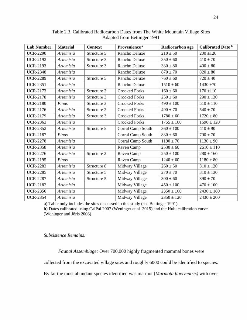
24
Table 2.3. Calibrated Radiocarbon Dates from The White Mountain Village Sites
Adapted from Bettinger 1991
Lab Number Material Context Provenience a Radiocarbon age Calibrated Date b
UCR-2290 Artemisia Structure 5 Rancho Deluxe 210 ± 50 200 ±120
UCR-2192 Artemisia Structure 3 Rancho Deluxe 350 ± 60 410 ± 70
UCR-2193 Artemisia Structure 3 Rancho Deluxe 330 ± 80 400 ± 80
UCR-2348 Artemisia Rancho Deluxe 870 ± 70 820 ± 80
UCR-2289 Artemisia Structure 5 Rancho Deluxe 760 ± 60 720 ± 40
UCR-2351 Artemisia Rancho Deluxe 1510 ± 60 1430 ±70
UCR-2173 Artemisia Structure 2 Crooked Forks 160 ± 60 170 ±110
UCR-2178 Artemisia Structure 3 Crooked Forks 250 ± 60 290 ± 130
UCR-2180 Pinus Structure 3 Crooked Forks 490 ± 100 510 ± 110
UCR-2176 Artemisia Structure 2 Crooked Forks 490 ± 70 540 ± 70
UCR-2179 Artemisia Structure 3 Crooked Forks 1780 ± 60 1720 ± 80
UCR-2363 Artemisia Crooked Forks 1755 ± 100 1690 ± 120
UCR-2352 Artemisia Structure 5 Corral Camp South 360 ± 100 410 ± 90
UCR-2187 Pinus Corral Camp South 830 ± 60 790 ± 70
UCR-2278 Artemisia Corral Camp South 1190 ± 70 1130 ± 90
UCR-2358 Artemisia Raven Camp 2530 ± 60 2610 ± 110
UCR-2276 Artemisia Structure 2 Raven Camp 250 ± 100 280 ± 160
UCR-2195 Pinus Raven Camp 1240 ± 60 1180 ± 80
UCR-2283 Artemisia Structure 8 Midway Village 260 ± 50 310 ± 120
UCR-2285 Artemisia Structure 5 Midway Village 270 ± 70 310 ± 130
UCR-2287 Artemisia Structure 5 Midway Village 300 ± 60 390 ± 70
UCR-2182 Artemisia Midway Village 450 ± 100 470 ± 100
UCR-2356 Artemisia Midway Village 2350 ± 100 2430 ± 180
UCR-2354 Artemisia Midway Village 2350 ± 120 2430 ± 200
a) Table only includes the sites discussed in this study (see Bettinger 1991).
b) Dates calibrated using CalPal 2007 (Weninger et al. 2015) and the Hulu calibration curve
(Weninger and Jöris 2008)
Subsistence Remains:
Faunal Assemblage: Over 700,000 highly fragmented mammal bones were
collected from the excavated village sites and roughly 6000 could be identified to species.
By far the most abundant species identified was marmot (Marmota flaviventris) with over

25
2800 NISP, followed by mountain sheep (Ovis canadensis), squirrel (Spermophilus
sp.)(most likely some bones are not cultural in origin), and cottontail rabbit (Sylvilagus
sp.) (Grayson 1991). The difference between pre-village and village-aged deposits show
an increase in species diversity through time; however, Grayson believes that this
increase is due to higher bone fragmentation in the pre village sites leading to less
taxonomic identification (Grayson 1991). The most notable change in taxa representation
is a 50 percent increase in marmot bones from pre-village to village times (Grayson
1991). Grayson notes that cut marks on the marmot bones suggest that the fur of the
animals was being removed. Grayson interprets the faunal data as representing a
continuum of large mammal exploitation with a widening diet breadth that incorporates
more small mammals, particularly marmot, and intensive plant processing into the diet
through time.
Botanical remains: Flotation samples taken from Midway Village, the largest and
longest occupied village in the White Mountains, were analyzed by Scharf (2009).
Pinyon (Pinus monophylla), goosefoot (Chenepodium spp.), and ricegrass (Achnatherum
hymenoides) were the most common taxa in both the village (N= 649) and pre-village
assemblages (N= 49). Pre-village sites and village sites have no significant difference in
taxonomic richness or diversity. Village samples contained more seeds overall than do
pre-village samples, and large seeds are overrepresented in the later contexts (with
pinyon driving that trend). Pinyon and ricegrass grow at elevations well below 3100 m,
the average elevation for the alpine sites, suggesting that groups transported lower-
elevation resources to higher elevations, likely in small quantities. Also, limber pine
grows in abundance at the elevation of the alpine sites but it appears it was not harvested

26
(Scharf 2009). According to this analysis, at least at the Midway Village site alpine
plants were not used to any great extent (Scharf 2009).
Interpretation
Bettinger (1991) argues that the pre-village White Mountain sites represent
typical alpine land use by hunter-gatherers in the Great Basin: logistical hunting parties
passed through the area to procure large game and left behind few tools and scant
residential features. In contrast, the village sites represent a shift in subsistence practices
with a focus on low-ranked alpine resource processing where whole families moved to
the alpine zone from early summer to fall to hunt marmot and collect some alpine plants,
while using low elevation resources to supplement their diet.
Environmental Context
The White Mountain village sites are located in the White-Inyo Mountains of
southeastern California. The White-Inyo Mountains are the western most range within the
Basin and Range physiographic province. The range is an uplifted, east-tilted block with
a large steep escarpment on both its western and eastern sides (Nelson et al. 1991). The
mountain range is quite high, between 3000 m AMSL (9800 ft) to over 4342 m AMSL
(14,245 ft) at White Mountain Peak (Spira 1991), with the village sites located between
3130 m and 3854 m AMSL (10,269 ft and 12,614 ft) (Bettinger 1991). The vegetation of
the White Mountains covers four major vegetation zones: the desert scrub zone found
below treeline (1219-1981 m, or 4000-6500 ft) which is dominated by shadscale (Artiplex
sp.), rabbit brush (Chysothamus latifolius), and sage brush (Artemisia tridentata); the

27
pinyon-juniper woodland (1981-2896 m or 6500-9500 ft) which is characterized by
pinyon pine (Pinus monophylla); the subalpine forest (2896-3505 m or 9500-11,500 ft)
characterized by both bristle cone pine (Pinus longaeva), and limber pine (Pinus flexilis);
and the above-treeline alpine tundra zone (3505-4342 m or 11,500-14,246 ft) (Spira
1991).
The village sites are all located within the alpine tundra zone. Plant growth in this
zone is sparse, with plant cover averaging about 10 percent of the total ground cover
(Lloyd and Mitchell 1973). Common plant species are dwarf sagebrush (Artemisia
arbuscular), fell-field buckwheat (Eriogonum ovalifolium), Cushion phlox (Phlox
condensata) blue flax (Linum lewisii), Mono clover (Trifolium monoens), fleabane
(Erigeron vagus), bitterroot (Lewisis pygmaea), and Labrador tea (Ledum sp.) (Lloyd and
Mitchell 1973; Spira 1991). A common characteristic of these alpine plants is that they
have more of their biomass stored underground than above ground in a well-developed
root and rhizome systems allowing them to store energy through the cold winter and are
thus a good source of nutrients for hunter-gatherers (Spira 1991). Common animal
species hunted by prehistoric groups in the White Mountain alpine zone include yellow-
bellied marmot (Marmota flaviventris), pika (Ochotona princeps) and mountain sheep
(Ovis canadensis) (Carey and Wehausen 1991).
Also of importance to the alpine villages of the White Mountains are the plants
and animals of the subalpine forest. Common edible plants found in this zone are three
species of pine that produce edible nuts: pinyon, limber, and bristlecone, as well as
grasses such as Indian rice-grass (Achnatherum hymenoides) and wild-rye (Elymus
cinereus) (Spira 1991). Sub-alpine zone mammals include mule deer (Odocoileus

28
hemionus) jack rabbit (Lepus californicus) and white-tailed hare (Lepus townsendii)
(Carey and Wehausen 1991).
Great Basin and Owens Valley Paleoenvironmental Record
Though its expression towards the south is as-yet somewhat unclear, in the Great
Basin the Late Holocene Dry Period (2800 to 1850 cal B.P.) was the longest persistent
dry period within the Holocene (Mensing et al. 2013). In the western Great Basin,
Pyramid Lake, Walker Lake, and Mono Lake all experienced significantly lowered levels
beginning around 2000 B.P. Increases in cheno-am pollen around these lakes indicate
dry conditions with significantly lower shorelines allowing for colonization by saltbrush
(Grayson 2011; Mensing et al. 2004). In the Sierra Nevada, Fallen Leaf Lake also shows
evidence for shoreline retreat between 2320-1620 B.P. (Mensing et al. 2013). In the
White Mountains tree-line moved as much as 30 meters downslope between 2800 and
2500 B.P. which indicates warmer and dryer temperatures (LaMarche 1974; Mensing et
al. 2013). In the central Great Basin an interval of alluvial fan building took place
between 2600 and 1850 B.P. triggered by increased run off from shifts in vegetation in
upland areas due to drought (Mensing et al. 2013). In the east, Lake Bonneville may
have experienced a high stand sometime around 3400 B.P. and then began to drop from
2600 to 1850 or possibly even as late as 1600 B.P. (Mensing et al. 2013). The Snake
Range experienced an upward advance of the treeline between 4400 and 2200 B.P. which
indicates a drier and warmer period in that region (Grayson 2011; Mensing et al. 2013).
The next effective period of climatic variability was the Medieval Climatic
Anomaly 1150-550 B.P. In the Great Basin this period was marked by warmer, arid

29
conditions that affected lake levels and treelines in the alpine setting. In the White
Mountains, between 1076-701 B.P. occurred one of eight most intensive droughts in the
last 8000 year record in the region punctuated by a significant wet interval (Grayson
2011). In the southern Sierra Nevada range near Owens Valley, trees thrived between
1185 and 650 B.P. due to an annual maximum temperatures of five degrees Fahrenheit
higher than at present (Grayson 2011). In the central and northern Sierra Nevada, now-
submerged tree stumps indicate substantial droughts ca. 800 and 600 cal B.P. (Kleppe et
al. 2011; Lindström 1990; Morgan and Pomerleau 2012; Stine 1994).
White Mountains and Owens Valley Culture History
Bettinger and Taylor (1974) delineate five cultural time periods for the desert
region of California and the western Great Basin: the Mojave, Little Lake, Newberry,
Haiwaee, and Marana periods. Alternatively, Warren and Crabtree (1972) delineate five
periods with different names; Lake Mojave, Pinto, Gypsum, Saratoga Springs, and
Shoshonean. A similar sequence was developed by Bettinger (1976) specifically for
Owen’s Valley divided into the Klondike, Baker, Cowhorn, and Clyde phases. Of
importance to the cultural history of the White Mountain Village sites are only the last
three periods which will be discussed below and are summarized in Table 2.4 using
Bettinger and Taylor’s (1974) general chronology.

30
Table 2.4. Western Great Basin and Owens Valley Chronologies
Years B.P. California Desert
(Bettinger and Taylor 1974)
Western Great Basin
(Warren and Crabtree
1972)
Owens Valley
Bettinger (1976)
200
400
600
800
1000
1200
1400
1600
1800
2000
2200
2400
2800
3000
3200
3400
3600
Historic Historic Historic
Marana Period Shoshonean Period V Klondike Phase
Haiwee Period Saratoga Springs Period IV
Baker Phase
Cowhorn Phase
Newberry Period Gypsum Period III

31
Western Great Basin: Newberry (4000 B.P.-1500 B.P.)
The Newberry Period is characterized by highly mobile hunter-gatherers who
moved in a north to south annual round focusing on large game hunting using atlatls. It is
also marked by a shift in plant exploitation from the riverine ecotone to plants in the
desert scrub ecotone (Bettinger 1977; Bettinger and Taylor 1974; Warren 1984). This
period is marked by the presence of Humboldt concave base, Elko eared, Elko corner-
notched, and Gypsum projectile points. Millingslab use was common and mortars and
pestles begin to appear in assemblages during this time period. Olivella and abalone
beads are first traded into the region from the coast. During the Late Newberry Period
(ca. 2000-1500 B.P.) split twig figurines depicting large mammals as well as an increase
in rock art depicting mountain sheep, deer, and rabbit appear to indicate an increase in the
importance of ritual based around hunting (Warren 1984). This time period also saw a
large increase in the use of obsidian (Bettinger 1980).
Western Great Basin: Haiwee Period (ca. 1500-600 B.P.)
This time period was marked by cultural continuity in artifact types, such as the
use of millingslabs and mortar and pestles, as well as continuity in rock art depictions and
trade goods. This time period corresponds with the Basketmaker III period in the
Southwest and influences and trade were felt along the edges of the southwestern Great
Basin (Warren 1984). Two important shifts took place in this time period: one was a
technological shift from large dart points to Rose Spring and Eastgate arrow points (or
Rosegate per Thomas 1981); the other was pinyon pine nut exploitation marked by the
appearance of pinyon camps in the archaeological record and a decrease in the
importance of large game hunting after 2000 B.P. (Bettinger 1977).

32
Western Great Basin: Marana Period (600 B.P.-historic)
This time period is characterized by Desert Side-notched and Cottonwood
triangular projectile points as well as Shoshonean or brown ware pottery (Eerkens 2003;
Warren 1984). This time period saw a decrease in mobility with semi-sedentary villages
and an increased focus on plant food production, especially small seed processing using
ground stone and pottery.
This time period, some would argue (Bettinger and Baumhoff 1982), marks a
cultural shift from the proceeding Haiwee period with the spread of Numic language
speaking populations northward and westward into the Great Basin and Rocky Mountain
region (Lamb 1958; Sutton 1994). Bettinger and Baumhoff (1982) suggest that shifts in
rock art styles from animals to geometric shapes, the advent of intensive green cone
pinyon exploitation, and the use of alpine villages, indicate a cultural shift occurring
during the Marana Period attributed to Numic-speaking groups entering the region
(Bettinger 1977; Delacort 1995).
Historic Period
By historic times much of the western and southern Great Basin region was
occupied by Numic speaking groups. In the Owens Valley several Paiute bands lived in
sedentary villages on the valley floor. Large permanent villages were occupied year-
round in Owens Valley, though logistical hunting and gathering trips and the yearly
pinyon harvest also occurred. There was a small degree of territoriality, with villages or
several villages organized into districts that controlled land, seed crops, irrigation ditches
and hunting and fishing grounds (Steward 1933). Population was estimated to be roughly

33
2.5 persons per square mile based on early Indian Service survey records and Steward’s
own estimations (Steward 1933).
The settlement patterns of the Owens Valley Piute were restricted to a 15 to 20-
mile radius from their villages on the valley floor, with foot hill and mountain foraging
areas for pinyon and seed harvesting, as well as hunting and fishing grounds (Steward
1933). Summer was spent on the valley floor and seed gathering and fishing were the
primary activities. In the fall, people would gather for communal rabbit drives and
feasting, and in the winter groups would disperse to winter camps in the mountains to
harvest pine nuts which they brought to villages in the valley in the spring. According to
Steward’s (1933; 1938) accounts, pinyon nuts and small seeds were the most important
plant species, however, the Owens Valley Paiute cultivated several wild species: spike
rush (Eleocharis), a type of lily (Brodiaea), a type of sunflower (Helianthus), and
goosefoot (Chenopodium) with crude irrigation ditches constructed on the alluvial fans
debouching from the sierra Nevada (Lawton et al. 1976; Steward 1933). This small scale
irrigation of wild plants is believed to predate Euro-American contact but it is unclear
when it actual began (Bouey 1979; Lawton et al. 1976). This small scale irrigation of
several root and seed bearing species indicates that roots were also included in the diet
even if Steward does not place much emphasis on these resources in his ethnographic
accounts.

34
Environmental and Culture History Comparisons
The cultural and environmental history of the Late Holocene in the Intermountain
West has undergone several reorganizations, both in demography, technologic shifts, and
reactions to changing environmental conditions
In the Wyoming Basin and the Rocky Mountain region the Middle Archaic saw
relatively low population densities, marked by low radiocarbon date frequencies with
mobile groups who constructed pit houses and slab lined storage pit and roasting features
(Francis 2000; Smith and McNees 1999). These sites show evidence of repeated and
long term use indicating that hunter-gatherers may have had strong ties to the landscape
and particular patches of resources, specifically roots (Smith and McNees 1999). There
is also evidence in the archaeological record of a broad diet and an intensive use of small
game and plant resources, possibly indicating resource depression (Kornfeld et al. 2010).
This pattern of site use peaked around 4000-3500 B.P. During this time, conditions were
initially dry and warm with lower treelines and increased expansion of drought tolerant
species such as juniper, yet after 4500 B.P. climate conditions cooled and precipitation
increased causing treelines to reach near modern levels by 3000 B.P. (Mensing et al.
2012; Whitlock et al. 2002).
In the Great Basin the picture is slightly different. Population densities were
arguably lower than the Late Archaic, with highly mobile hunter-gatherer groups moving
throughout the region. Evidence for plant processing and an expansion of the diet is
indicated by the presence of milling technologies at archaeological sites, however an
emphasis on large game hunting persisted (Byers and Broughton 2004; McGuire and

35
Hildebrandt 2005). After about 2500 B.P. residential sites with storage features become
more frequent across the Great Basin, marked by an increase in the frequency of rock
ring pinyon caches and pinyon camps (Bettinger 1999). Important to this study, a similar
pattern is seen in Owens Valley after 1,400 B.P. with large low-land village sites
associated with intentional irrigation of root fields, and pinyon caches in the mountain
zone, all indicating territorial circumscription, residential tethering, and long-term site
use (Bettinger 1977). This residential pattern corresponds with the Late Holocene Dry
Period (2800-1850 B.P.), the longest persistent dry period within the Holocene were lake
levels were significantly lower, treelines moved down slope, and drought tolerant species
dominated (Mensing et al. 2013).
During the Late Holocene, in both the Great Basin and Rocky Mountain region
population began to increase. In the Wyoming and Rocky Mountain region there is a
noticeable increase in radiocarbon dates between 1500 and 1200 B.P. followed by a
dramatic decline starting around 1000 B.P. (Kelly et al. 2013; Kornfeld et al. 2010;
Metcalfe 1987). For High Rise Village this timing is significant because intensive
occupation of the site occurred between 2300-850 cal B.P. at the peak of the population
boom and subsequently site use declined at the same time radiocarbon dates drop off in
the region (Losey 2013).
Across the Great Basin projectile point frequencies indicate a peak in population
after 1500 B.P. (Bettinger 1999). For the White Mountain villages, Owens Valley saw a
steady increase in population starting at 4000 B.P., reaching a high point around 1400 -
1000 B.P. This was accompanied by a reorganization of village settlements on the valley

36
floor (Bettinger 1991). This population increase corresponds with the beginning of
intensive alpine use in the White Mountains.
Increased temperatures had a positive effect on mountain tree populations leading
to expansion of treelines in several regions, particularly in the Wind River Range, at the
same time that High Rise Village was being used. This time of warmer and more stable
conditions (when compared to the last 600 or so years) would have favored higher
elevation species with longer growing seasons. Conversely, in the lowlands, resources
may have been adversely affected, causing streams and marshes to dry. This may have
stressed plant and animal populations, making low-land habitation and resource
exploitation more difficult. For example, more arid conditions stunted grass growth at
low elevations, which may have had an adverse effect on the ungulate populations hunted
by prehistoric groups (Lubinski 2000; Wigand and Rhode 2002). Across the
archaeological record there is widespread evidence of foragers broadening their diets to
include lower-ranked resources, and evidence for technological innovations for the
intensive procurement and processing of specific resources. This reflects a greater trend
during the Late Holocene that may be in response to the dryer and warmer climate
conditions that mark this time period (Bettinger 1999).
This increase in frequency in the number of archaeological sites, radiocarbon
dates, and projectile points, corresponds with changes in technology, specifically the
introduction of the bow and arrow, resource intensification, specifically of pinyon in the
Great Basin, and possible demographic shifts from the expansion of Numic speaking
groups across the Great Basin (Bettinger and Baumhoff 1982). The bow and arrow may
have had profound effects on social organization because single hunters could take down

37
large bodied prey without the assistance of hunting parties (Bettinger 1999). In the Great
Basin ceramic use becomes widespread, with Fremont and Puebloan influence from the
south, and the later introduction of Numic wares into the region (Bettinger 1999).
Ceramics are often cited as an indication of the importance of seed processing and
cooking (Bright et al. 2002; Eerkens 2004) and therefore, their increased frequency after
this time may indicate an importance in seeds and other low-ranked resources. Other
seed and plant harvesting and processing tools become more sophisticated and
strategically designed as well at this time; winnowing trays, basketry, and strategically
designed grinding slabs, all of which were present in the archaeological record
throughout the Holocene but increase dramatically in quantity during the Middle and Late
Archaic (Grayson 2011).
This evidence indicates a reorganization of technology to a more intensive
exploitation regime during the Late Holocene including the intensified use of the alpine
zone (Bettinger 1999). The question remains, if there was a general trend across the
Intermountain West towards intensification of both resources and site use, why is alpine
intensification only seen in a few locations and not a general pattern across the region?
This question will be addressed in the following chapters.

38
Chapter 3 Theory and Expectations
High Altitude Archaeology
The high altitude zone is defined as the area above 2500 meters AMSL (8200 ft)
and is characterized by a decrease in biotic productivity and an increase in human
metabolic requirements. Decreased biotic productivity results from a shortened growing
season, reduced effective temperature and oftentimes a lack of summer water (Benedict
2007). Increased metabolic demands are due mainly to less atmospheric oxygen (but also
cold) which causes basic metabolic rates to increase causing the body to work harder to
preform basic functions (Makinen 2007). Throughout the world, intensive and
permanent or semi-permanent human use of the alpine zone is rare and is generally
restricted to logistical hunting or stone tool procurement. Such use however, is
documented on the Tibetan Plateau, in the Andes Mountains, as well in the Sierra
Nevada, Great Basin, and central Rocky Mountain regions of North America
(Aldenderfer and Zhang 2004; Neme 2016).
High Altitude Land Use in North America
In North America, residential upland use was extremely rare (Canaday 1997) and
use of high altitudes was characterized mainly by large-game hunting, marked by sites
with hunting blinds, game drive features, and small hunting camps that date to as early as
the Early Holocene (Benedict 1992; Frison 2004). Evidence for alpine use in the Great
Basin is found in several mountain ranges and like elsewhere is mostly restricted to game
drives and logistical hunting (McGuire and Hatoff 1991; Canaday 1997). In the Sierra

39
Nevada, there is also evidence for logistical hunting at high altitudes during the Middle
and Late Holocene (Morgan 2006; Stevens 2005). Although alpine hunting is found in
the central Rocky Mountain region at the Lookingbill Site as early as 12,270 B.P.,
consistent upland use in the form of logistical hunting, game drives, and potential ritual
use is common only after about 5000 B.P. (Kornfeld et al. 2001; Benedict 1992).
In the Absaroka Range, alpine and subalpine residential use has also been
documented (Scheiber and Finley 2010). In Utah there is some evidence of high altitude
residential use in the Uinta Mountains (Knoll 2003; Nash 2012; Watkins 2000) the
Pahvant Range (Morgan et al. 2012b) and the Fishlake Plateau (Janetski 2010). These
sites appear to be seasonal residential camps occupied during the Formative Period, and
likely related to Fremont agricultural intensification.
In the Sierra Nevada there is evidence for several high altitude occupation sites.
One site located in the south central Sierra at an elevation of 2895 m AMSL (9793 ft)
contains nine rock-ringed structural foundations, a well-developed midden, and 41
bedrock mortars. While the site has not yet been excavated, the presence of Owens
Valley Brownware may indicate that the site is contemporaneous with the White
Mountain Village pattern dating from 600- 150 B.P. (Morgan 2006). The Southern Sierra
Nevada also may contain several additional high altitude residential sites. Stevens (2005)
identified at least five sites with rock ring structures, well-developed midden deposits and
ground stone, all at elevations between 3200 and 3300 m AMSL (10,498 and 10,826 ft).
Using obsidian hydration readings Stevens determined that these sites were in use after
1500 B.P. This pattern is also similar to the White Mountain Village pattern, but with

40
less intense residential use as seen by lower artifact density and slightly earlier dates
(Stevens 2005).
The two most substantial locations for alpine residential use are both found in the
Great Basin: the White Mountains village sites in California (a focus of this study) and
Alta Toquima Village in the Toquima Range of central Nevada.
At these sites, use of the alpine zone shifted over time. Small logistical groups
began using these areas primarily for bighorn sheep hunting with little long-term
residential stays. However, after 1500 B.P. in the Toquima Range and after 600 B.P. in
the White Mountains, a dramatic shift to intensive residential use replaced the previous
pattern. The Village pattern at the White Mountain sites is characterized by rock ring
structures, well developed midden soils, a wide range of flaked stone and ground stone
tools, and large quantities of mammal bone, in particular marmot bone (Bettinger 1991;
Grayson 1991). The Alta Toquima Village contains 30 rock-ringed structures, well
developed midden, over 500 ceramic sherds, 50 ground stone fragments, and over 225
diagnostic projectile points (Thomas 1982). Thomas (1994) reports 23 radiocarbon dates
for Alta Toquima Village that range from 180 to 1,750 B.P. The site is as a semi-
permanent residential site in a larger foraging system used during times of increased
aridity while the nearby Gatecliff Shelter was occupied in more mesic times (Thomas
2015). Alta Toquima has been interpreted as a camp located close enough to the limber
and pinyon forest to harvest nuts during arid times in the valleys below (Hildebrandt
2013).
A similar but less intensive residential pattern dating to between 2,300 and 850
cal B.P. is found in the Wind River Range of Wyoming. This is marked most notably at

41
High Rise Village (also a focus of this study) and several other documented, yet untested
village sites. (Adams 2010; Koenig 2010; Losey 2013; Morgan et al. 2012a; Trout 2015).
High Rise Village contains 52 lodge features, large quantities of ground stone, and low
quantities of flaked stone (primarily tool maintenance debris), weak midden soils, scant
faunal remains and no macrobotanical remains (Morgan et al. 2012a). This site has been
interpreted as a short term residential base for small forager groups working within a
larger alpine and subalpine foraging system (Trout 2015). Plant resources, specifically
whitebark pine are thought to be the resources driving this system (Adams 2010; Stirn
2014).
Integral to the discussion of high altitude occupation at these locations is which
plant resources were being targeted by their occupants. Because of the large quantities of
ground stone at each of these sites, it has been proposed (Adams 2010; Scharf 2009; Stirn
2014) that plant processing, specifically pine nut processing, was a key aspect of site use
at these alpine villages. In the White Mountains it has been suggested that transported
pinyon pine nuts were used to subsidize alpine villages (Scharf 2009; see also Watkins
2000 for a similar argument concerning maize from Utah’s Uinta Range). Flotation
samples from Midway Village confirmed this theory, containing more pine nut hulls than
any other alpine or sub-alpine resource (Scharf 2009).
In the Wind River Range researchers have for some time thought that alpine
villages were specifically occupied to target whitebark pine in the late summer to early
fall (Adams 2010; Stirn 2014), a hypotheses that on the surface seemed plausible given
that the main residential occupations of High Rise Village corresponded with an upward
advance of the whitebark treeline by over 100 m (Morgan et al. 2014a). To test this

42
hypothesis Stirn (2014) developed a predictive model for known village locations in the
Wind River Range and large whitebark pine stands and found a correlation. He then
ground-truthed his model and found 13 more small residential sites. This led him to
conclude that Wind River “village locations were targeted specifically for the optimal
procurement of pine nuts” (Stirn 2014:523).
A similar model was developed by Hildebrandt (2013) in the Toquima and
Toiyabe Ranges of central Nevada. He found that alpine villages in these ranges occur
only in areas where limber and pinyon pine groves have a large enough extent and are
easily accessible from the alpine zone. He argues that this explains the lack of village
sites in the Toiyabe Range and the presence of Alta Toquima in the Toquima Range
because at Alta Toquima large limber pine stands are near enough to subsidize its
occupants (but see Morgan et al. 2015).
While rare, this shift from low intensity logistical to intensive residential high
altitude occupation in North America may represent a shift in low land demography,
necessitating a more intensive use of the alpine zone. In this vein, there are those
(Benedict 1992; Black 1991; Walsh 2005; Wright et al. 1980) who see high altitude
resources as productive, “pulling” hunter-gatherers to the high altitude in summer and
early fall, and those (Bettinger 1991) whose see them as marginal, producing low-ranked,
high cost resources that are only exploited if “pushed” by external factors.
The “Pull” Hypothesis
To varying degrees, some researchers working in the Rocky Mountain region
hypothesize a “pull” toward the use of high altitude resources, and various terms have

43
been proposed for this cycle, including “high country adaptation” (Wright et al. 1980,
Bender and Wright 1988), the “mountain tradition” (Black 1991), and “seasonal
transhumance systems” (Benedict 1992). In general, however, these models are mostly
descriptive and argue more for how mountain environments were used as opposed to why.
Each of these models are characterized by people exploiting different elevation
ranges over the course of the year based on the variability, distribution, and abundance of
resources (Wright et al. 1980). Different elevation zones are biotically productive at
different times, a pattern termed “periodicity” by Wright et al. (1980). This variability
leads to a concentration of resources into specific altitude zones in single, short temporal
intervals, which results in small, concentrated and highly productive ecozones.
Productive elevation zones move up the mountain as the season progresses and the
snowpack recedes; thus, when the lowlands are dry in mid-summer the high elevations
are becoming productive and continue to be so throughout mid-autumn (Wright et al.
1980; Benedict 1992). Periodicity should lead to specific behavioral adaptations, leading
whole groups to sequentially exploit different elevation zones in order to maximize
returns. Thus, some form of residential mobility would be required, but may include
logistical forays from mountain base camps (Bender and Wright 1988).
Black’s (1991) model contrasts this idea slightly by viewing the mountainous
areas as a comprehensive resource system. In this way the “mountain tradition” is
differentiated from the lowland tradition. Groups will occupy the high country for the
whole year, moving between the high altitude zone in the summer and fall and the
foothill or inter-mountain valleys to overwinter, relying on stored foods from the summer
harvest (Black 1991). Black sees this system in contrast to the groups who exploit

44
lowland resources and use the uplands logistically in the summer. This model would also
require residential settlements at high altitude.
Benedict (1992) points to two separate transhumance systems, one occurring
during the Early Archaic around 5000 B.P. This was marked by seasonal movement
from lower elevations to Colorado’s Front Range in the early spring and then to spending
most of the summer and fall in the high country hunting game and collecting various
plant species. The other system was a more complex “circuit” of movement covering
over 400 km from winter camps in the Hogback region northward to the Front Range and
to North Park for gathering spring plants, and then on to the Continental Dived from the
west and back to the Front range in the fall from the east for communal hunting drives.
This patter is a Late Prehistoric phenomenon dating between 1400 and 750 B.P.
(Benedict 1992).
Bender and Wright (1988) see evidence for the high country adaptation persisting
in the Jackson Hole area of Wyoming. Black’s Mountain Tradition (1999) is seen in the
southern Rocky Mountains and Frison (1991) sees a similar pattern in western Wyoming.
Adams (2010) and more recently Morgan et al. (2016) recognize a similar mountain
pattern operating between High Rise Village, the Yellowstone Plateau and Jackson Hole,
while Benedict (1992) sees a Late Prehistoric rotary transhumance system in the
Colorado Front Range. Each model presented here may differ in the placement of alpine
resources in the settlement system, yet each argues that time-compressed and pronounced
seasonal montane and alpine biotic productivity was critical to conditioning prehistoric
transhumance and mobility patterns

45
The “Push” Hypothesis
Alternatively, some researchers view the high altitude zone as a marginal and
demanding environment. This is based on the idea that at high altitude the body has to
work harder and requires more calories to perform basic functions due to a decrease in
atmospheric oxygen (Aldenderfer 2006). High altitude alpine environments are seen as
less productive than lowland ones. Alpine environments also have greater resource
variability and unpredictability; in that snow often limits access to areas and water is
scarce (Morgan et al. 2012a). If alpine environments are as marginal as proposed, what
would draw hunter-gatherers to the uplands to exploit such marginal resources? Many
researchers (Aldenderfer 2006; Bettinger 1991; Brantingham and Xing 2006) have put
forward the idea of a “push” factor that led humans to intensively exploit high altitude
settings.
Environmental Degradation. One potential explanation along these lines is that a
change in climate led to a degradation of lowland resources “pushing” hunter-gatherers to
intensively exploit marginal areas such as the alpine zone (Bettinger 1991). The Late
Holocene is marked by paleoclimatic variability like the Late Holocene Dry Period 2800-
1850 cal B.P.(Mensing et al 2012; 2013), and the Medieval Climatic Anomaly (MCA)
1150-550 B.P., the latter corresponds with intensified use of alpine zones after 1000 B.P.
but does not account for the residential use of the White Mountains during the Little Ice
Age (550-150 B.P. ), a cooler and wetter time (LaMarche 1974), nor does it account for
the intensive residential use of the Wind River Range 2300-1150 B.P. Conversely, an
increase in temperature and moisture may have favored resources of the alpine zone,

46
causing treelines to rise and allowing longer growing seasons for plants to mature which
may be the case at High Rise Village (Stirn 2014; Morgan et al. 2014a).
Population Pressure. Bettinger (1991) hypothesizes that population pressure
from immigrating groups may have caused some hunter-gatherers to intensify high
altitude use of the White Mountains. If hunter-gatherer populations were large and
resources were at carrying capacity, hunter-gatherers may have adopted new and perhaps
more costly behaviors, such as alpine intensification, to weather lowland resource
shortfalls. If this shift allowed populations to continue to grow it may have become
incorporated into the groups’ overall seasonal procurement strategies and persisted
thereafter (Bettinger 1991).
In the various iterations of both the push and the pull scenarios, resource
procurement strategies and resource productivity are critical: the former entails behaviors
with measurable procurement and handling costs and the latter entails resources with
measurable caloric returns. Thus, evaluating push versus pull hypotheses necessitates a
basic understanding of the costs and benefits of resource procurement.
Modeling Mountain Plant-Based Subsistence
To properly understand and predict forager decisions regarding alpine plant
exploitation, specifically the choice between pine nuts or other plant resources such as
geophytes, the following factors must be considered: return rates for individual species,
storage decisions, availability, seasonality, predictability, and cultivation potential.
The diet breadth model is a basic microeconomic decision-making model used to
determine what resources should be included in the diet (MacArthur and Pianka 1966).

47
It works under the assumption that when confronted with an array of dietary choices, a
forager will select the combination of food types that maximizes energy intake per search
and handling time, the latter comprised of pursuit and processing time (Bettinger et al.
2015). This food combination is based on ranks, where the highest ranked item delivers
the most calories per handling (but not search) time with the highest ranked food always
selected upon encounter. Lower ranked foods are only added to the diet upon encounter
when search times for higher-ranked items (which would still have to be searched for)
increase to the point that taking the lower ranked item results in return rates that are equal
to or better than those of higher-ranked items. What this means is that it is the abundance
of higher-ranked items that determines whether or not the lower-ranked ones are taken
upon encounter (Bettinger et al. 2015).
The calculated return rates of the alpine nut species differ (Table 3.1). If we
assume that limber, pinyon, and whitebark pine nuts require a similar effort to process for
consumption and deliver similar nutritional benefit we can average their return rates and
get an average of 1100 kcal/hr for tree nuts. If we also average the various root species
available at high altitude, we get an average return rate of 1395 kcal/ hr. Given these
return rates, roots on average outrank nuts and would be the plant resource always taken
upon encounter. It must be noted, however, that return rates for nuts versus roots overlap
when taking into account the range of variability in these rates, meaning resource ranking
alone may not be enough to predict which resources ought to be taken in high elevation
settings. To gain a clearer picture of the actual value of the two types of resources we
need to also consider several other characteristics of these two types of resources as a
factor of their overall utility. Following in part Lepofsky and Peacock (2004) the

48
following assesses the storage potential, availability and abundance, seasonality,
predictability, and the cultivation potential of these two types of resources.
Table 3.1. Return Rates for Rocky Mountain and Great Basin Resources
Resource
Low
Return Rate
(Kcal/hr)
High
Return Rate
(kcal/hr)
Average
Return Rate
(kcal/hr)
References
Mtn. Sheep (Ovis
canadensis) 17,971 31,450 24,711 Simms 1987
Marmot (Marmot
flaviventris) 15,725 17,971 16,848 Losey 2013
Pinyon Pine (Pinus
monophylla) 841 1,404 1125
Simms 1987, Barlow and
Metcalfe 1996
Whitebark Pine
(Pinus albicaulis) 1941 (un processed) Adams 2010
Limber Pine (Pinus
flexilis)
178 hulled (5,387 un
hulled) Rhode and Rhode 2015
Biscuit root
(Cyompterus
bulbosus)
1054 1867 1461 Smith and McNees 2005
Biscuit root
(Lomatium
hendersonii)
3831 Couture et al. 1986
Biscuit root
(Lomatium cous) 1219 Couture et al. 1986
Bitterroot (Lewisia
rediviva) 1374 Couture et al. 1986
Sunflower
(Helianthus anus) 467 504 486 Simms 1987
Pickle weed
(Chenopodium) 402
Simms 1987, Barlow and
Metcalfe 1996
Storage Potential. Many researches have pointed to the value of pine nuts and
geophytes for their storability and as use as a resources for winter survival (Ames and
Marshall 1980; Steward 1938; Thoms 1989; Wandsnider and Chung 2003). It may be
that the value of pine nuts compared to geophytes can be determined by the overall return
rate delivered from caching and later consumption. To do this we would use a front-back
loading model (Bettinger 2009). This model is based on the idea that some resources

49
were stored for future use, that the cached resources vary in the amount of time required
to store, and that the resources vary in the amount of time required to process for
consumption. Resources that are easy to store but require large time investments for
consumption are called back-loaded resources, while resources that require large time
investment up front for storage preparation but require little time for consumption are
labeled front-loaded resources (Bettinger 2009). The decision to store one resource over
the other depends on the amount of time required in storage and consumption of each
resource as well as the probability the cache will in fact be used (Bettinger 2009).
Pine nut harvesting requires investment in cone collecting and the construction of
storage cairns, however, the bulk of the effort is in the separation of the nuts from the
cones and the removal of the hull prior to consumption, and the roasting and or milling of
the nuts (Bettinger 2009). Geophytes on the other hand require effort to harvest but
require a large amount of preparation time for storage including the drying or roasting of
the roots (which could take several days) and pounding or grinding of the roots either to
facilitate drying or to create root cakes to package and store or transport (Couture et al.
1986). Consequently, in this dichotomy pine nuts would be considered a back-loaded
resource and geophytes would be considered a front-loaded resource. To then determine
which resource should be exploited we must determine the storage time (z) and the
culinary time (c) for each resource and the probability (q) that the cache will be used
(Bettinger 2009) (Table 3.2).

50
Table 3.2. Relevant Front and Back-loading Data: Pine Nuts versus Roots
Pine
(Barlow and Metcalf 1996) Roots
(Couture et al. 1986)
Storage Time (z) 1.18 hours to procure 3000 kcal
2 hours to procure 3000 kcal
root
+ 1 hour to pound roots and
lay in sun to dry
+ 0.5 hour to rotate roots
throughout the next two days
= 3.5
z1 z2
Culinary Time (c)
5.4 hours to separate nuts from
cone, clean, parch, and hull nuts 1 min or 0.016hr
c1 c2
Overall handling
time 6.58 3.51
Using data generated from Barlow and Metcalf (1996) on pinyon harvesting and
processing culinary time (c) was calculated at 5.4 hours for 3000 kcal of energy. For root
species, culinary time (c) was calculated as 3.5 hours to dig, pound, and dry roots to
obtain 3000 kcal of energy based on Couture et al.’s (1986) study on ethnographic root
processing by the Burns Valley Paiute. Using these data, it is clear that the back loaded
resource (pine) appears to have an advantage because the initial investment in caching is
cheap, while the front loaded resource (roots) is cheaper overall (3.51 hr vs 6.58 hr).
However, we must also factor the probability (q) the catch will be used, determined by
the following equation solved using Table 3.2:
q=z2-z1/c1-c2: q=3.5-1.8/5.4-0.016; q=.430936
The probability switching point (q1↔2) between each resource is derived from the
same equation (with q1↔2 substituting for q). With 0 < q1↔2 <1 the resources are in a

51
classic front to back loaded relationship. In this situation, the resource with the lower
storage time (nuts) is initially favored. But when more than 43.09% (q1↔2) of the stored
resources end up being used (the probability switching point also stipulates the proportion
of use switching point), the resource with the lower overall handling time (roots) is
favored. In short, if more than about 43% of the resources end up being used, it is more
efficient to target roots instead of nuts. This means that if reliance on stored foods is
relatively high, then roots are a better option than nuts because their lower overall
handling costs eventually compensate for their greater up-front storage costs as stored
resources are accessed, processed, and consumed (see Bettinger 2009:50-52).
Availability and Abundance. The availability of a resource refers to its spatial and
temporal distribution. For example, whitebark pine is restricted to the subalpine forest
and only produces nuts in the fall. Roots on the other hand are found in multiple
ecozones and can be harvested throughout the spring and oftentimes into mid-summer
(Lepofsky and Peacock 2004). The abundance of a resource is a measure of its density.
Generally, the plants with higher density are more profitable to harvest due mainly to
decreased travel times between productive patches or plants (Lepofsky and Peacock
2004). In one related study, Lepofsky and Peacock (2004) found that root species
compared to pine nut species were generally more abundant on the landscape. In general,
this points to the greater utility of root species compared to nut species due to the fact that
they are generally more abundant and widely distributed across many western North
American landscapes (except of course the southern and central Great Basin, where
pinyon pine is widely distributed and thus pine nuts are generally more favored than roots
as a subsistence resource [Steward 1938]).

52
Seasonality. It is also important to consider the seasonality of the two types of
resources. Pine becomes ripe in the fall. At high elevations this time would be marked
by unpredictable weather with an increased threat of snow as well as a lack of water in
alpine springs and streams. Geophytes on the other hand, ripen in the early spring and
summer when snow is melting at high elevations. At this time alpine springs and streams
would be full and the threat of long stretches of inclement weather would be lower. If
seasonality is indeed a deciding factor in resource procurement decisions, then geophyte
harvesting would likely be the most favorable option.
Predictability. Predictability and stability of resources is paramount to hunter-
gather survival. During the Holocene large scale fluctuations in temperature and
effective moisture have greatly reordered the biotic landscape of the Intermountain
Region (Grayson 2011). Certain plant and animal species are more susceptible to
variability in climate. Artiodactyls and small mammals both respond negatively to
fluctuations in temperature. For example, increased winter precipitation and dry
summers decrease artiodactyl reproductive success (Broughton et al. 2008). Researchers
have also found that changes in moisture and temperature at key points in the
development of pine cones can cause fluctuations in masting years and no development
of seeds in some instances (Mutke et al. 2005). Specifically, high temperatures during
cone growing season have the most significant effect and trees located in higher generally
cooler elevations are the most susceptible to not setting seeds (Redmond et al. 2012).
Geophytes however, show evidence of a high resiliency or orthoselectivity (Prouty 1995).
By definition, geophytes are plants with underground storage organs (USO) that contain
high amounts of carbohydrates and polysaccharides used for survival during winter

53
dormancy. The nature of these USOs allow them to be well adapted to variations in
temperature and moisture (Smith and McNees 2005). This means that during large scale
fluctuations in weather, geophytes are able to remain in place without substantial changes
in distribution and production (Prouty 1995). If hunter-gatherers sought to avoid risk
though targeting predictable resources, then geophytes would likely be selected over pine
nuts.
Cultivation Potential. Many researchers (Lepofsky and Peacock 2004; Prouty
1995; Smith and McNees 2005; Thoms 1989; Wandsnider and Chung 2003) argue that
geophytes were an important resource because of their positive response to simple
management techniques which can greatly increase yields of certain root crops. For
example, the simple act of digging up and harvesting the roots results in soil aeration
which could encourage growth, a practice used by indigenous groups in the Pacific
Northwest (Thoms 1989). Intentional irrigation can greatly increase yields, a practice in
Owens Valley dating back to prehistoric times (Steward 1938). There is also evidence
that burning of meadows after root harvesting can increase growth the following year by
adding potassium to the soil and eliminating weeds. Periodic burning was practiced by
indigenous groups in the Pacific Northwest as well as selective breeding of particularly
large camas bulbs (Thoms 1989). The ability to minimally manage root crops to increase
yields may have added to their desirability by foragers.
It is important to consider that both pine nuts and geophytes were important
resources to hunter-gatherers in the Great Basin and Rocky Mountain region throughout
most of the Holocene (Simms 2008). These two resources can occur in high densities,
require considerable time investment to processes and store, and if stored can deliver

54
valuable nutrition during the winter months. While evidence for root processing is not as
common in the archaeological record, particularly where pinyon is the dominant ecozone,
it is likely that both resources were sought after for winter stores, if available.
Predictions
Given the considerations of the overall utility of both geophyte species and pine
nut species as a factor of return rates, storage decisions, availability, seasonality,
predictability, and cultivation potential, geophytes score higher in all categories. It is
therefore predicted that starch residue on ground stone from both High Rise Village and
six of the White Mountain Village sites should be dominated by geophyte starch grains,
indicating geophyte processing was occurring at these sites.

55
Chapter 4 Methods
This chapter presents the methods of ground stone analysis, use-wear and starch
residue analysis on artifacts from High Rise Village and the White Mountain Village
sites. Sixteen millingslabs were analyzed from six of the White Mountain Village Sites:
Rancho Deluxe, Crooked Forks, Corral Camp South, Gate Meadows, Raven Camp, and
Midway Village. Ten manos and eleven millingslabs were analyzed from High Rise
Village.
Sampling Strategy
Ground stone sample size was small for High Rise Village and the White
Mountain Village sites (Table 4.1). Sampling was based on choosing the pieces of
ground stone that came from dated contexts and were larger or more complete in size,
and would thus potentially yield more data.
Table 4.1. Ground Stone Sample
Site Date
(cal B.P.) Sample
High Rise Village 2300-850 11 millingslabs 5 manos
Rancho Deluxe 1421-180 8 millingslabs
Crooked Forks 1670-150 1 millingslab
Corral Camp South 800-410 3 millingslabs
Gate Meadows 1 millingslab
Raven Camp 2550-1155 1 millingslab
Midway Village 2440-300 1 millingslab

56
Ground Stone Analysis
The study of grinding technology is a study of behavioral choices, knowledge,
and ideas about how to alter, reduce, or process substances with stone (Adams 2002).
Detailed ground stone analysis includes defining the form and function of the tool as well
as its morphology, life history, and use-wear. The term ground stone refers to tools that
are either made by or made through mechanisms of pecking, pounding, grinding,
abrasion, or polish (Adams 2002; Dubreuil and Savage 2014). Common ground/grinding
tools include grinding implements such as: slabs, metates, manos or handstones;
pounding implements that include mortars and pestles; cutting implements including axes
and adzes; and percussive implements such as hammerstones and anvils; as well as
abraders, and polishers (Dubreuil and Savage 2014). For this study millingslab and
handstone implements used in grinding and pounding are considered.
Life History
Understanding the use of a ground stone implement begins with an understanding
of the five stages of the life history of the tool: (1) manufacture; (2) the primary function
the artifact was designed for; (3) the secondary use of the artifact (this can be single
reuse, where the tool is used for another function without alteration, or multi-use, where
the tool has several uses on differing surfaces of the same tool); (4) recycling, where the
tool is used for another purpose such as in a wall of a structure or as a hearth or boiling
rock (this is contrasted to a redesigned tool where the tool is reshaped to serve another
function); and (5) discard, which could be due to breakage, exhaustion, loss, interment or
deliberate discard of the tool (Adams 2002; Schiffer 1987).

57
Form and Function
There are two basic distinctions made linking shape to ground stone function:
mortars and pestles used for pounding and handstones and metates (or netherstone) used
for grinding or pulverizing. Metates are further divided into flat metates, concave
metates, basin metates, and trough metates. A handstone can be classified as an abrader,
polisher, mano (for grinding) or a pestle. Each form is different because of style of
strokes used in grinding as well as the type of processing being employed: i.e., dried
grain or fresh grain, root, seed, animal flesh or hide. Both Adams (1999) and Dubreuil
(2004) found that differences in ground stone form were linked to different processing
techniques such as fresh meal or dried flour for storage, demonstrating that the type of
processing may be more important to the form of the ground stone than what type of food
is being processed.
Per Adams (2002) manos are classified by size and shape. Shapes may include:
wedge shaped, triangular, round, and whether there are one or multiple ground surfaces.
Metates are classified as: basin, flat concave, flat, and trough. Basin metates have a
circular or elliptical shape with a deep trough due to use with a small mano using circular
strokes. Flat metates result from use with a mano that is as long as the metate is wide
using reciprocal strokes. Flat concave metates have shallow concavities and are most
often used with large manos and reciprocal strokes. Trough metates are intentionally
manufactured prior to use to have a deep trough in the center to hold grain and can only
be used with reciprocal strokes (Adams 2002).

58
Morphology
Morphology is determined by intensity of tool use, type of seed or plant being
processed, and the desired outcome (e.g., fine flour, meal, or mush) (Adams 1999).
Intensive tool use occurs when the tool is used for a long period in one sitting. Extensive
use of a tool occurs when a tool is used for a short period of time and perhaps many short
periods of time. Both may result in heavy wear and thus the difference can only be
morphologically differentiated through design features. For example, it is possible that a
manufacturer will invest more time into making a tool when the tool is intended for
intensive use. Alternatively, if a tool was made expediently, it may have been intended
for extensive use (Adams 2002).
Occupation Strategy
Ground stone tools can be used to gauge the intensity of a site’s occupation based
on the degree of strategic manufacture of a ground stone tool, the degree of use of the
tool (extensive versus intensive), and the degree of versatility of the tool. Expediently
made grinding slabs will have one grinding surface and no other design while a
strategically designed slab will have simple modifications for stability or will be
intentionally shaped. Expediently made handstones have one or two grinding surfaces
and no other design functions. Strategically designed handstones are intentionally
shaped. At short-term occupation sites, a higher percentage of expediently made, single
use or extensive use ground stone tools are expected. Conversely, at long-term
occupation sites, a higher percentage of ground stone tools that are strategically designed,

59
associated with a greater variety of activities (versatile), and displaying heavy wear or
intensive use are expected (Adams 2002).
Ground Stone Analysis Methods
Analyzing ground stone is a four stage process (Adams 2002) with several
subsidiary questions and steps defining each stage. In Stage 1 the life history of the
ground stone implement is assessed by asking the following questions: (1) was the tool
used for the primary function it was designed for?; (2) was the tool used for multiple
tasks?; (3) was the tool recycled and then used for a task different than the one it was
made for?; and (4) was the tool discarded because it was broken or exhausted? In Stage
2, morphology, type, and basic use of the artifact is described by determining answers to
the following questions: (1) handstone or metate (netherstone)?; (2) flat, basin, trough,
bowl?; (3) pestle or mano?; and (4) used for grinding, pulverizing, abrading, polishing,
or pounding? In Stage 3, use intensity is determined: (1) Intensive use: contains design
features for comfort and longevity such as intentionally manufactured features like hand
holds, troughs, ledges or feet or (2) Extensive use: worn from use and not intentionally
shaped. In Stage 4, occupational strategy is assessed by grading under three main
categories: (1) strategic manufacture of the tool: design features versus expediently made
tools; (2) degree of use: extensive versus intensive use; and (3) degree of versatility:
associated with a variety of tasks.

60
Use-wear Analysis
Use-wear analysis is the “examination of an item for macroscopic and
microscopic evidence that allows us to understand how it was altered through use.”
(Adams 2002:27). Use-wear of abrading and grinding implements relies on tribology
(the study of wear) with wear defined as “the progressive loss of substance from the
surface as a result of the relative motion between it and another contact surface”(Adams
2014:129). Progressive loss can be recorded on archaeological tools used for abrading
and grinding. Four types of wear are identified: adhesive, abrasive, fatigue, and
tribochemical. These four types of wear are not mutually exclusive but interact
depending on the contact surface, the nature of the intermediate substance (such as a food
item being ground), and which form of wear is dominant. Each will generate distinctive
wear patterns that can be attributed to specific tasks (Adams 2014).
Characteristics and Definitions
Granularity and Durability
Granularity of a rock is measured in degree from coarse to fine grained.
Durability is a materials’ ability to withstand wear (Adams 2002:20). Durability of the
ground stone implement is important for tool function. For example, in food processing
it is necessary to have a durable rock that will not weather into the meal being processed;
conversely, if a tool is needed for abrading, high granularity of the stone is important
(Adams 2002).

61
Topography
Topography is defined as the differential relief of the surface of the stone (Adams
2002). Surface topography can be analyzed first as macrotopography (the natural
roughness and angles of the surface of the rock) and then as microtopography (the
topography of the individual grains and interstices between grains). Macrotopography
and microtopography are important to understanding the formation of use-wear and in
determining the extent of and morphology of contact surfaces. If the contact surface is
rigid or hard, then only the high points on the surface of the ground stone will make
contact; conversely, if the contact surface is pliable, then wear will reach into the low-
lying interstices between high points (Adams 1995, 2002). Understanding how far the
wear extends into the interstices can shed light on the texture or material type of the
opposing surface (Adams 2002).
Types of Wear
Tribologists define wear as “the progressive loss of substance” (Adams 2014:1) and
this progressive loss can be quantified and recorded on tools used for abrading and
grinding.
A. Adhesive wear occurs when two surfaces come into contact with one another
creating frictional heat that can loosen rock grains (Adams 2002). This will leave
pits on the surface of the stone, deform the individual grains of the stone, and
leave wear particles from both grinding and ground surfaces (Adams 1989).
B. Abrasive wear occurs when a more aspirate surface abrades a softer, less aspirate
surface. This displaces the softer materials leaving abrasive scratches in the

62
direction of movement, referred to as striations, with deeper ones being gouges,
both referred to as abrasion (Adams 1993, 2014). Abrasive wear can also result
from dislodged particles that remain between surfaces and act as abrasive agents
(Adams 1993).
C. Fatigue wear occurs when pressure or stress is applied to the contact surfaces and
the topographic highs are crushed from bearing the majority of the load pressure.
This results in crushing, cracks, step fractures and pits on the grains (Adams
1995).
Abrasive and fatigue wear are the result of reductive processes where as
tribochemical wear and adhesive wear are additive. As surfaces move against each other
adhesive, abrasive, and surface fatigue mechanisms create cracks that generate frictional
heat. This heat and the object being ground create the environment for the tribochemical
interactions to take place.
D. Tribochemical wear is caused by bond formation and destruction as well as the
friction released due to abrasive, fatigue, and adhesive wear. This creates a
chemical interaction that produces a build-up on the surface, called sheen or
polish.
Each of these wear patterns can be present on a given grinding surface and the dominant
wear pattern must be identified (Adams 2002).

63
Direction of Use
The direction of use and type of stroke can be determined through identification
of the direction and type of striations on the ground surface. Direction of use
distinguishes from the active implement (upper tool) and the passive implement (lower
tool). Direction of use can be classified in three ways: (1) how the force was applied to
the tool such as direct percussion, indirect percussion, thrusting percussion, or abrasion;
(2) the direction of forces, either oblique, parallel, or perpendicular, or a combination of
both; and (3) the type of contact from the active implement, either linear for a sharp edge,
punctiform for a point, or diffused for a level surface (Dubreuil and Savage 2014). Direct
percussion tools such as hammerstones and anvils show impact marks concentrated on
the impact zone resulting in fractures and cupules. There is also a microscopic similarity
between abrasive and percussive use-wear, evident in the development of beveled surface
facets and a smoothing of micro-relief (Dubreuil and Savage 2014).
Researchers have identified common wear patterns associated with certain strokes
and certain materials. For example, Adams (1999) found that reciprocal, flat strokes are
most efficient for grinding oily nuts, such as pinyon or acorn.
Rock Hardness
Rock hardness is an important factor in the way use-wear develops. The hardness
of the rock, cohesion of the matrix of the rock, and mineral content are all important to
the asperity, durability, and type of wear the rock can produce and receive (Adams 2002).
Lerner et al. (2007) found that differences in raw material hardness and surface roughness
have differential effects on use-wear accrual and encourage including this information in

64
assessing use-wear. In experimental studies, Dubreuil et al. (2014) also found differing
wear patterns on sandstone and basalt when preforming the same function for the same
amount of time.
Starch Residue Analysis
Residue analysis uses chemical extraction and chemical and biomolecular
analysis to identify organic residue from archaeological contexts that cannot otherwise be
identified (Evershed 2008). It is founded on the idea that organic materials used by
humans have chemical and biomolecular structure that can survive in archaeological
deposits. This biomolecular structure serves as a “fingerprint” that can be identified,
either through chemical or optical analysis long after the actual organic material has
decomposed (Evershed 2008).
Starch is a carbohydrate molecule that serves as a plant’s stored energy. These
energy stores are formed by chloroplasts and amyloplasts that convert glucose, formed
during photosynthesis, into compact, insoluble high-energy starch granules. When a
plant is in need of the starch for energy it is converted back into glucose. Each starch
grain forms from an origin point or hilum and grows as annular layers are formed around
its origin. The reserve starch granules are mostly found in the storage organs of the
plants: e.g, roots, tubers, seeds, and fruits. Some starches are located in other parts of the
plants tissue such as leaves, shoots, stems, and pollen grains (Torrence and Barton 2006).
Starch grains enter the archaeological record through human consumption and
processing of roots, tubers, seeds, nuts, wood, and fibers. The microcrystalline structure
of starch grains makes them resistant to organic decay; they can therefore be recovered

65
long after the plant that produced them has decayed (Herzog 2014). Starch grains have
defining characteristics that can easily distinguish them from other organic substances
and that can serve as markers for specific taxon or species of plants (Torrence and Barton
2006). Such characteristics include: susceptibility to staining a dark blue color by iodine,
birefringence due to the highly ordered molecular structure of the grain, location of the
area of initial growth (hilum) within the grain, the size and shape of the grain (circular,
ovate, polyhedral), the morphology of the extinction cross (dark cross in polarized light)
and length of the arms and the angle at which they meet, and presence or absence of
lamellae or growth rings, fissures, or depressions (Table 4.2 and Appendix A) (Herzog
2014; Perry 2010; Rumold 2010; Torrence and Barton 2006).
Table 4.2. Starch Grain Attributes
Attribute Characteristics/ Comments
Grain type Simple, compound, aggregate
Size in microns Length and width
2-dimensional shape Circular, ovate, semicircular, polygonal, faceted
3-dimensional form Spherical, lenticular, pyriform, hemispherical, polyhedral
Hilum type Closed or open (with small or large vacuole)
Hilum position Centric, eccentric, very eccentric, unknown
Lamellae Faint or distinct, concentric or eccentric, coarse or fine
Fissures Presence/absence. Forms; longitudinal or transverse from the
long axis of the grain, stellate, branching
Surface
-Surface: smooth, rough, knobby
-Projections, compression facets, depressions
-Granularity
Extinction cross
-Degree of polarization or birefringence (weak, medium,
strong)
-Form of cross arms (straight, curved, multiple)
-Angle of cross: symmetric or asymmetric
-Form of margins: expanding, non-expanding, contracting
(after Rumold 2010 and ISCN 2011)
See Appendix A for definitions

66
Starch residue analysis has been conducted for over a century (Wittmack 1905)
but it has only been in the last two decades that starch analysis has been employed in
archaeological analysis to any great extent. Starch residue analysis thus far has been
concentrated in areas such as Australia and Papa New Guinea (Balme et al. 2014; Veth et
al. 2013), South America (Henry et al. 2009; Piperno 2009; Rumold 2010), Europe and
the Middle East (Henry et al. 2009; Hogberg et al. 2009). In North America starch
residue analysis is not common. Particularly in the Great Basin and Intermountain West,
the area of focus for this thesis, only a few studies using starch analysis to date. Herzog
(2014), for example, looked at starches from ground stone found in Surprise Valley
California. There is also a master’s thesis that analyzed ground stone from three locations
in northeastern California (Scholze 2011), an examination of starches on grinding
implements from North Creek Shelter, Utah (Louderback 2014), and analyses contained
in a few contract archaeology reports (e.g., Rhode 2014; Rhode et al. 2011).
Starch Residue Analysis Methods
Extraction
Before starch extraction occurred the working area in the lab as well as all tools
used in residue extraction and processing were washed with distilled water and a mild
soap (Sensifoam). This soap was tested for industrial starches and contained none. The
ground stone was air brushed to remove excess dirt from the surface, and then rinsed with
distilled water. Per Perry (2010), starches were then extracted by washing the ground

67
surface of the tool using a sonic toothbrush and more distilled water. All water and
accompanying residue was collected with pipettes.
Aqueous Sediment Reduction
The sediment water mix from each ground stone sample often filled several tubes,
which were consolidated into a single sample tube for further processing. To do this the
tubes containing sediment from the ground stone sample were placed in a centrifuge for
eight minutes at 5000 revolutions per minute (rpm). The sediment settled to the bottom
of the tube and the clean water was then decanted. The samples were then combined and
reduced again. This process took about four rounds in the centrifuge to consolidate the
sample into one tube, depending on the size of the ground stone sample.
LST Flotation
After consolidation of the sediment sample a heavy liquid, composed of
Lithiumheteropolytungstate (LST) mixed with water to a specific gravity weight of 2.0
g/cc is added to the tube. Silt and sand have a specific gravity weight of about 2.2 g/cc,
starches and pollen have a specific gravity weight of 1.7 g/cc, and distilled water has a
specific weight of 1 g/cc. Using LST results in a floatation of the starches and pollen
grains in the sample from the heavier silts so that the lighter fraction can be easily
removed by pipetting. LST was added to the sample and then the samples were
thoroughly mixed, and centrifuged for eight minutes at 5000 rmp. The light fraction
(starch residue and pollen) were then pipetted from the surface of the solution and placed
in a new tube (Perry 2010).

68
LST Dilution
The sample was then washed several times with distilled water to eliminate the
remaining LST from the sample and concentrate the starches in the tube. The sample
tube was filled with distilled water and again centrifuged for eight minutes. The water
was decanted from the sample, more distilled water was added, and the process was
repeated several times until all of the LST had been eliminated from the sample (Perry
2010). Once all of the LST was removed from the solution the sample was transferred to
a 2 ml microtube, a drop of ethanol was added to protect the sample from microbial
decay and the sample was stored for later examination.
Microscope Analysis
To conduct microscopic starch analysis a small sample was pipetted from the
microtube and one drop was placed on a microscope slide with a drop of glycerol and
then covered with a slide cover slip (Perry 2010). To ensure that no contamination was
occurring in the lab a control slide was also prepared at the same time using the method
described above but with only glycerol and distilled water. Both slides were then
analyzed using an Olympus BX51optical transmitted light microscope equipped with a
polarizing filter. The control slide was scanned first. The entirety of the slide was
scanned or transected using 400x magnification. When no starches were noted on the
control slide the sample was considered free of modern contaminants. The entirety of the
sample slide was then scanned at 400x using the darkfield illumination and a cross
polarized filter to illuminate the extinction cross on the starch grains making them stand
out compared to the other debris on the microscope slide. When a starch grain was

69
found, the morphology, size, and characteristics of the grain were noted and
photographed using an Infinity 2 Lumenera Camera in both polarized light and
brightfield light at 600x magnification. The grain was then rotated and photographed
again in both polarized and brightfield light to gain a three-dimensional perspective of the
grain shape.
Starch Identification Methods
Once photographed, starch grains were described using ten attributes listed in
table 4.2 and measured using Infinity Analyze software (Lumenera 2015) and all
information was stored in a Microsoft Access database. The photos were then compared
to reference photos of known plant species from the two study areas. The reference
samples are listed in (Table 4.3).
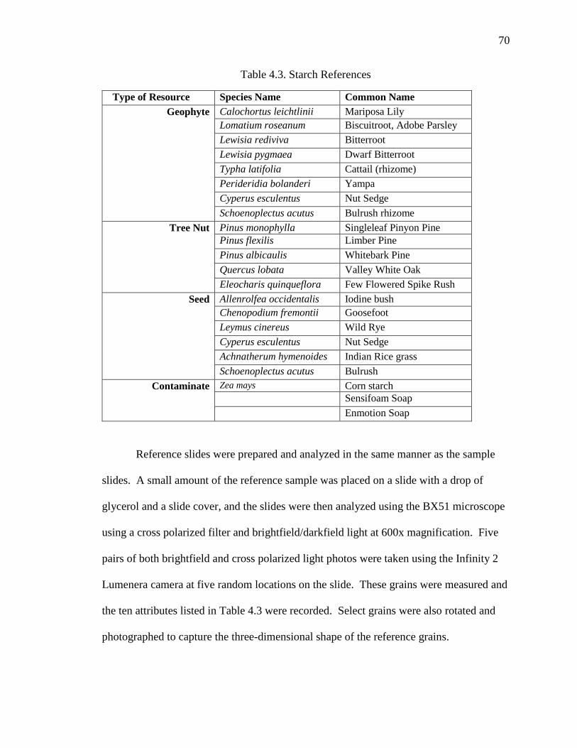
70
Table 4.3. Starch References
Type of Resource Species Name Common Name
Geophyte Calochortus leichtlinii Mariposa Lily
Lomatium roseanum Biscuitroot, Adobe Parsley
Lewisia rediviva Bitterroot
Lewisia pygmaea Dwarf Bitterroot
Typha latifolia Cattail (rhizome)
Perideridia bolanderi Yampa
Cyperus esculentus Nut Sedge
Schoenoplectus acutus Bulrush rhizome
Tree Nut Pinus monophylla Singleleaf Pinyon Pine
Pinus flexilis Limber Pine
Pinus albicaulis Whitebark Pine
Quercus lobata Valley White Oak
Eleocharis quinqueflora Few Flowered Spike Rush
Seed Allenrolfea occidentalis Iodine bush
Chenopodium fremontii Goosefoot
Leymus cinereus Wild Rye
Cyperus esculentus Nut Sedge
Achnatherum hymenoides Indian Rice grass
Schoenoplectus acutus Bulrush
Contaminate Zea mays Corn starch
Sensifoam Soap
Enmotion Soap
Reference slides were prepared and analyzed in the same manner as the sample
slides. A small amount of the reference sample was placed on a slide with a drop of
glycerol and a slide cover, and the slides were then analyzed using the BX51 microscope
using a cross polarized filter and brightfield/darkfield light at 600x magnification. Five
pairs of both brightfield and cross polarized light photos were taken using the Infinity 2
Lumenera camera at five random locations on the slide. These grains were measured and
the ten attributes listed in Table 4.3 were recorded. Select grains were also rotated and
photographed to capture the three-dimensional shape of the reference grains.

71
Trait-sets for the reference grains were compared to the sample starch grains.
When possible, each sample starch grain was classified based on attribute and size
overlap with reference grains. Grains that could not be classified were noted as non-
diagnostic. Grains that were too misshapen or deformed were classified as broken.
Damage or features related to the physical wear of the grain was also noted. This
included cracks on the center of the grain or along the edges, a misshaped or deformed
hilum, and an enlarged or broken vacuole.
To address contamination issues in both the lab and the field, three separate
controls were preformed: testing of soil found at each site, testing of basic materials
found in the lab for industrial starches, and the use of a test or control slide for each
sample. In addition, hands and work areas were cleaned with soap and distilled water
before each use.
Sediment contamination: To be sure contamination was not occurring from
starches naturally occurring in the soil one sediment sample was tested from Midway
Village, Corral Camp South, Crooked Forks, and Rancho Deluxe of the White Mountain
sites, and two from High Rise Village: Lodge 26 and Lodge 49. This was done following
the ISCN starch protocol for sampling sediments (Perry 2010).
First the sediments were dried and screened using a 250 micron mesh screen.
Then the sediments were deflocculated to separate and disperse the individual sediment
particles from one and other. This was done using a solution of 25 grams of
Hexametaphosphate in one liter of distilled water. Fifty milliliters of this solution was
then added to ten grams of sediment from each of the samples and agitated several times
over a 72 hour period. After 72 hours the samples were centrifuged for 8 minutes at 5000

72
rpm to separate the solution from the sample, and then the solution was discarded. The
samples were then processed using the same LST flotation and LST dilution process as
well as the microscope analysis used on the ground stone samples. No starches were
found in any of the sediment samples.
Lab contamination: To be sure contamination was not occurring in the lab both
types of commercial soap, En Motion and Sensiforam Soft Soap, were tested by placing a
small sample on a microscope slide and analyzing it under cross polarized light to
identify if the soap itself contained industrial starches. Both soaps contained no starches.
The paper towels in the lab were also tested by rubbing the towel on a microscope slide
and adding a drop of glycerol. This was also analyzed using cross polarized light and no
starches were detected. Finally, a microscope slide was prepared using one drop of
glycerol and left to sit out in the lab for one hour to test if there were industrial starches in
the air. This too, was analyzed using the cross polarized filter on the microscope and no
starches were detected.
As a final control against contamination concerns each archaeological sample
slide was prepared in conjunction with a blank test slide in exactly the same manner (the
sample slide only received a drop of glycerol and not a drop of sample) and was then
scanned using the cross polarized filter on the microscope before scanning the
archaeological sample. When no starches were found it was determined that the
archaeological sample was free of modern contaminates. Only once did one starch grain
appear on a test slide and the sample was re-prepared and analyzed; no additional
contaminate starches were noted.

73
Chapter 5 Results
This chapter discusses the results of ground stone analysis, micro- and macro- use-
wear analysis, and starch residue analysis from High Rise Village and six of the twelve
White Mountains village sites.
Ground Stone Analysis
High Rise Village
Ground stone analysis on sixteen ground stone pieces from High Rise Village
(HRV) revealed an assemblage of expedient millingslabs made from quartzite found
directly on site and well-used handstones made from extralocal basalt and quartzite
(Table 5.1). All of the handstones are complete, while all but one of the millingslabs are
fragmented. Only one of the ground stone pieces appears to have been intentionally
shaped for specific design features or intensive use; their feature characteristics come
from minimal shaping through extensive use. All of the millingslabs are flat and
unformed. All of the handstones are ovoid with a single flat, ground surface save Artifact
1788 which is 13cm long and has a narrow wedge shape. This handstone has one ground
surface and one pecked surface. The tip of Artifact 1788 appears to have been
intentionally shaped into a pestle tip via pecking. All ground stone tools appear to have
been used for their primary use, grinding, and there is no indication of reuse or use for
other tasks such as for cooking (as in the case of hot rock cookery). During excavation,
however, abundant FCR, some of which appears to have been ground, was identified,
suggesting some ground stone at the site was also used as cooking stones.

74
Table 5.1. High Rise Village Ground Stone Analysis Assemblage
Accession
Number Lodge Complete
Material
Type Form
Length
cm
Width
cm
Thickness
cm
FR5891-1923 19 Fragment Quartzite Millingslab 21 12 3.5
FR5891-1954 19 Fragment Quartzite Millingslab 21 12 3.5
FR5891-1562 26 Complete Basalt Handstone 10 8 5.5
FR5891-2273 8 Fragment Quartzite Millingslab 15 6.5 4
FR5891-15199 26 Complete Basalt Handstone 19 15 5
FR5891-1996 10 Fragment Quartzite Millingslab 19 11 5
FR5891-1762 16 Fragment Quartzite Millingslab 8 6 4
FR5891-1990 10 Fragment Quartzite Handstone 18 19 2
FR5891-2147 13 Fragment Quartzite Millingslab 15 13 3
FR5891-2157 13 Complete Quartzite Millingslab 17 6 3
FR5891-1788 16 Complete Granitic Handstone 9 8 3.5
FR5891-2171 3 Fragment Quartzite Millingslab 8 5.5 3
FR5891-2077 7 Fragment Quartzite Millingslab 13 4.5 3.5
FR5891-2099 7 Fragment Quartzite Millingslab 6 5 3.5
FR5891-2266 8 Fragment Quartzite Millingslab 6.5 4 2.5
FR5891-2276 8 Fragment Quartzite Handstone 13 9 3.5
White Mountains
The fifteen White Mountains ground stone millingslabs show extensive use and
little intentional shaping (Table 5.2). The millingslabs are all of a flat concave design,
with the concavities resulting mainly from heavy use. Six of the tools exhibit pecking of
the grinding surface: 12317, 14161, 14698, 11269, 1056, and 15801. The tools appear to
have only been used for their primary use of grinding foodstuffs with no evidence that the
tools were re-used or discarded due to exhaustion. The material types vary more than
those seen at HRV, but reflect locally available rocks found in the vicinity of the sites.

75
Table 5.2. White Mountain Ground Stone Millingslab Analysis Assemblage
Site Accession
Number Complete
Material
Type
Length
cm
Width
cm
Thickness
cm
Corral Camp
South 382-1628 Complete Quartzite 37 17 11
Corral Camp
South 382-2045 Complete Quartzite 38 20 9
Corral Camp
South 382-14698 Fragment Quartzite 15 11 5
Crooked Forks 382-14161 Fragment Granitic 36 27 9
Gate Meadows 382-10155 Complete Granitic 54 52 5
Midway Village 382-1056 Fragment Meta-
sedimentary 36 29 9
Rancho Deluxe 382-11269 Fragment FGV 25 14 10
Rancho Deluxe 382-9218 Fragment FGV 31 15 8
Rancho Deluxe 382-9275 Fragment FGV 17 12 6.5
Rancho Deluxe 382-9430 Complete Granitic 38 29 10
Rancho Deluxe 382-12317 Fragment Granitic 25 20 9
Rancho Deluxe 382-11271 Complete Granitic 39 19 19
Rancho Deluxe 382-16347 Fragment Granitic 39 20 12
Rancho Deluxe 382-11270 Fragment Granitic 58 39 12
Raven Camp 382-14801 Complete Limestone 54 28 10
Use-wear
High Rise Village
Microscopic use-wear analysis on the sixteen tools from High Rise Village
indicate varying degrees of use (Table 5.3 and Appendix B). The texture of all of the
rocks sampled is coarse-grained. The basalt is vesicular and quartzite is poorly
metamorphosed and granular. Three pieces display low levels of wear: 2147, 2171,
2273, with only the surface of individual grains showing fatigue wear. Seven pieces are
heavily worn. These include five millingslabs (Artifacts 2077, 1954, 2099, 2157, and
2266) and two handstones (Artifacts 2276 and 15199). Four ground stone pieces show

76
abrasion indicative of reciprocal strokes (Figure 5.1). These include one handstone
(Artifact 15199) and three millingslabs (Artifacts 1923, 2157, and 2099). Five ground
stone pieces have areas of frosted grains which is a result of abrasive wear (Figure 5.2).
These include handstones (Artifacts 1562 and 15199) and millingslabs (Artifacts 2077,
2099, and 17620). Seven pieces show signs of sheen (Artifacts 1562, 1954, 2077, and
2276) while Artifacts 1923, 1990, and 1996 have sheen and wear on their highest points.
Surface sheen can be caused by oily substances. These oils create tribochemical
reactions with the stone resulting in sheen build up (Adams 2002).
Figure 5.1. FR5891-15199 Use-Wear Illustrating Abrasion and Sheen
Figure 5.2. FR5891-2099 Use-Wear Illustrating Frosting and Fatigue Wear

77
White Mountains
Macroscopic use-wear analysis of the fifteen millingslabs from the White
Mountain village sites indicate heavy abrasive and tribochemical wear (Table 5.4). All of
the pieces exhibit varying degrees of sheen caused by tribochemical wear. Abrasive ware
is indicated by the large, smooth patches on the grinding surface, many of which have
been pecked to regain surface texture (Figure 5.3). In general, ground stone and use-wear
analysis indicate extensive and heavy use of these tools with constant re-roughening.
Microscopic use-wear analysis was not conducted on the White Mountain ground stone.
Figure 5.3. 382-12317 and 382-2045 Illustrating Pecking and Use-Wear Abrasion
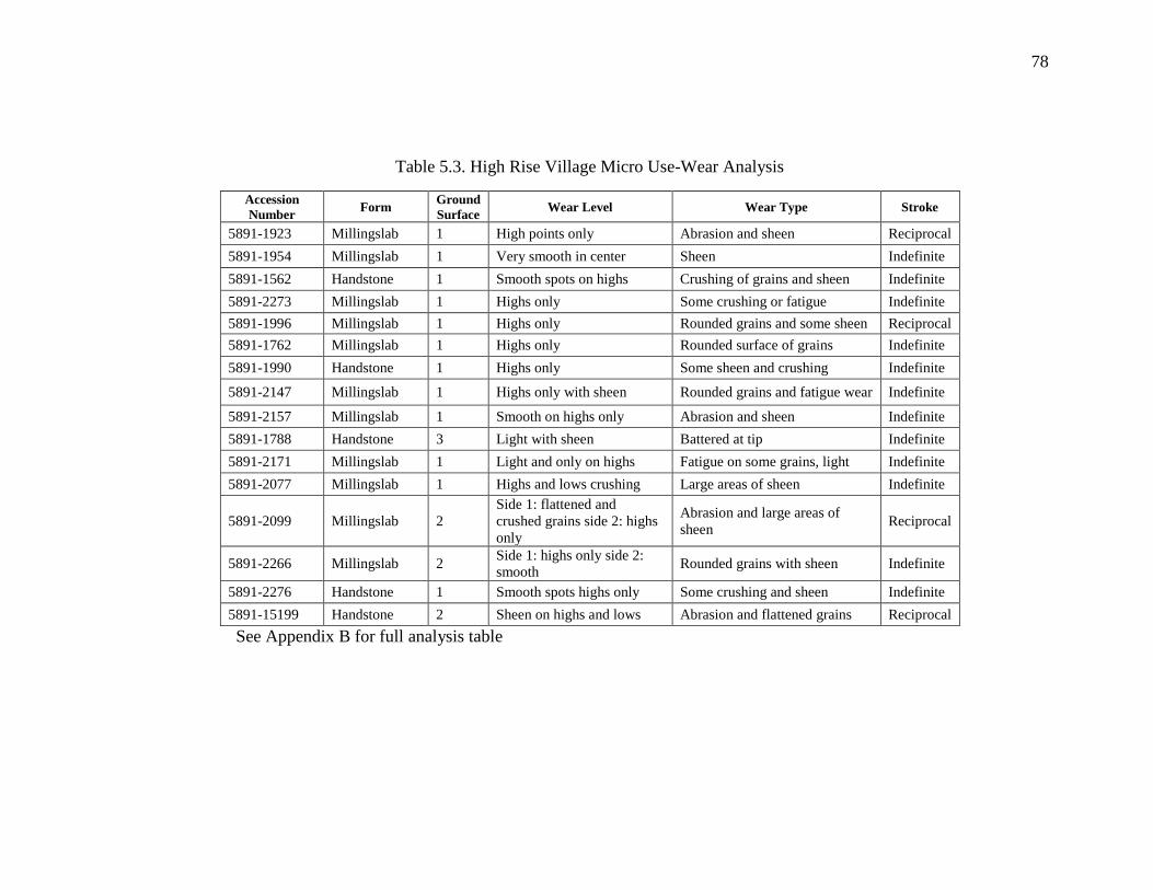
78
Table 5.3. High Rise Village Micro Use-Wear Analysis
Accession
Number Form
Ground
Surface Wear Level Wear Type Stroke
5891-1923 Millingslab 1 High points only Abrasion and sheen Reciprocal
5891-1954 Millingslab 1 Very smooth in center Sheen Indefinite
5891-1562 Handstone 1 Smooth spots on highs Crushing of grains and sheen Indefinite
5891-2273 Millingslab 1 Highs only Some crushing or fatigue Indefinite
5891-1996 Millingslab 1 Highs only Rounded grains and some sheen Reciprocal
5891-1762 Millingslab 1 Highs only Rounded surface of grains Indefinite
5891-1990 Handstone 1 Highs only Some sheen and crushing Indefinite
5891-2147 Millingslab 1 Highs only with sheen Rounded grains and fatigue wear Indefinite
5891-2157 Millingslab 1 Smooth on highs only Abrasion and sheen Indefinite
5891-1788 Handstone 3 Light with sheen Battered at tip Indefinite
5891-2171 Millingslab 1 Light and only on highs Fatigue on some grains, light Indefinite
5891-2077 Millingslab 1 Highs and lows crushing Large areas of sheen Indefinite
5891-2099 Millingslab 2
Side 1: flattened and
crushed grains side 2: highs
only
Abrasion and large areas of
sheen Reciprocal
5891-2266 Millingslab 2 Side 1: highs only side 2:
smooth Rounded grains with sheen Indefinite
5891-2276 Handstone 1 Smooth spots highs only Some crushing and sheen Indefinite
5891-15199 Handstone 2 Sheen on highs and lows Abrasion and flattened grains Reciprocal
See Appendix B for full analysis table

79
Table 5.4. White Mountain Macro Use-Ware Analysis
Site Accession
Number Complete Material type
Ground
Surfaces
Surface
Coverage
Surface
Configuration Surface Texture
Crooked Forks 382-14161 Fragment Granitic 1 Complete Side 1: concave side
2: flat
Smooth with pecking and sheen in
center
Corral Camp South 382-2045 Complete Quartzite 1 Complete Flat Smooth on high point
Corral Camp South 382-1628 Complete Quartzite 1 Only in
center Concave Smooth on high points only
Corral Camp South 382-14698 Fragment Quartzite 1 Complete Side 1: concave side
2: flat Smooth with pecking
Gate Meadows 382-10155 Complete Granitic 1 Complete Flat and slanted Smooth on highs only
Midway Village 382-1056 Fragment Meta-sedimentary 2 Only in
center Concave
Side 1: sheen and pecking side 2: on
small spot of sheen
Rancho Deluxe 382-9218 Fragment FGV 1 Only in
center Concave Smooth on highs only
Rancho Deluxe 382-9275 Fragment FGV 1 Only in
center Concave Only ground at high points
Rancho Deluxe 382-9430 Complete Granitic 1 Only in
center Slanted Medium sheen
Rancho Deluxe 382-12317 Fragment Granitic 2 Complete Slightly concave Smooth with pecking with sheen
Rancho Deluxe 382-11269 Fragment FGV 2 Only in
center Concave and slanted Smooth with pecking
Rancho Deluxe 382-11271 Complete Granitic 1 Complete Flat Smooth at high points
Rancho Deluxe 382-16347 Fragment Granitic 1 Complete Flat/sloped Smooth on high points with pecking
Rancho Deluxe 382-11270 Fragment Granitic 1 Complete Slanted Smooth on highs only
Raven Camp 382-14801 Complete Limestone 1 On one
corner
Flat and concave in
one place Course with pecking
See Appendix C for full analysis table

80
Starch Residue Analysis
Modern Starch Identifications
Modern starch identifications were conducted in order to provide reference
material for comparison to prehistoric specimens. Modern starch references were
analyzed using the same 10 characteristics as the prehistoric starch grains. Below is a
description of the reference starch grains by species. This is used as a comparison to the
typologies created for the prehistoric starches found in this study. The reference starch
descriptions are described first and the typologies are described second. The prehistoric
starch grains were assigned typologies as a conservative identification based on size,
morphology, and a comparison to modern specimens.
Geophytes
Biscuitroot (Lomatium roseanum, Apiaceae)
Figure 5.4. Polarized and Regular Light Photo Illustrating Characteristics of Lomatium
roseanum

81
Commonly referred to as biscuitroot, members of the Apiaceae or carrot family,
have long thick taproots, umbel flower clusters, and fern leaves that protrude from the
base of the stem (Smith and McNees 2005). They are perennial plants that are dormant
for most of the year and blossom in the early spring. When the flower dies in early
summer the tubers are at their greatest size, between 3 and 10 g (Prouty 1995). Members
of the Lomatium genus include Lomatium roseanum, cous, and hendersonii. These are
found throughout Oregon, Nevada, Utah, Idaho, and Wyoming at elevation from 1200 to
3000 m AMSL (4000 to 10,000 ft) (plants.usda.gov). Calorie and protein content ranges
from 189 to 127 calories per 100 g and 2.5- 1 g of protein depending on the species
(Couture et al. 1986). Lomatium hendersonii has the highest calorie content and thus
return rate of all the geophytes studied to date: 3831 kcal/hr (Couture et al. 1986).
However, this species is found mainly in Oregon and to a lesser extent in California and
Nevada. For consumption roots were dried in the sun and then ground down to meal for
storage, or they were cooked in roasting pits, or earth ovens (Couture et al. 1985).
Lomatium grains range in size from 8 to 18 µ in length and width and can be as
small as 5 µ. Average length is 11.85 µ and average width is 11.75 µ. Lomatium grains
often stick together as a compound grain, causing faceting or making the grain appear
oblong. Biscuitroot starch grains are similar in many ways to Perideridia starch grains
because they are both part of the Apiaceae family. They both have a circular or
semicircular shape with one to three facets, though Lomatium grains are more often round
than faceted. Both Lomatium and Perideridia have branching or longitudinal fissures at
the hilum. What distinguishes Lomatium grains from other geophyte grains is the
presence of a large vacuole at the hilum and the extinction cross arms. These are

82
symmetrical, orthogonally crossed, and straight-armed. Arms may expand at the margins
to form a Maltese cross.
Bitterroot (Lewisia rediviva and pygmaea, Portulacaceae)
Figure 5.5. Polarized and Regular Light Photo Illustrating Characteristics of Lewisia
rediviva
Bitterroot (a member of the Portulacaceae or Purslane family) is commonly found
in rocky soils at many elevations with pygmaea found in higher elevations (Prouty 1995).
Bitterroot plants can be found ranging from British Columbia to Arizona, and from
California to Colorado. Bitterroot is a succulent, low growing plant, with small pink-
white flowers and narrow cylindrical succulent leaves of dark green (Prouty 1995). The
plant blossoms in the early spring, losing its flowers quickly but maintaining distinctive
leaves throughout the summer. The tap root is 10-15 cm long, though some have been
found as long as 30-60 cm (Prouty 1995). The nutritional value of Lewisia rediviva is
98.76 calories per 100 grams and 2.48 grams of protein (Couture et al. 1986). As with
Lomatium, roots were dried in the sun and then ground down to meal for storage, or they
were cooked in roasting pits or earth ovens (Couture et al. 1985).

83
Lewisia starch grains range in size from 6 to 12 µ in length and width and can be
as large as 17µ. Average length for the grains is 10.39 µ and average width is 10.63 µ.
The grains are very similar to other geophyte starch grains, specifically Lomatium and
Perideridia. The grain shape is semicircular, with one to three facets resembling a bell
shape. The grains frequently are compound with two granules growing together; the
hemispherical shape occurs when a two-compound granule splits and results a flattened
facet on each. The grains are spherical with a distinct facet on each grain visible when
the grain is flipped, which contrasts with Lomatium and Perideridia in three dimensional
view. The hilum is centric, open, and contains a vacuole, yet the vacuole is smaller and
not as distinct as in the Lomatium grains. The surface characteristics of the grains are
also similar to other geophyte species, with longitudinal and transverse fissures and
longitudinal or round depressions at the location of the hilum. Lewisia grains have
faintly visible concentric lamellae that are concentric (these are not found on Lomatium
nor Perideridia). The extinction cross is centric and symmetrical, frequently with
straight arms similar to Lomatium, occasionally slightly ragged, and generally lacking the
Maltese cross appearance at the margins.

84
Yampa (Perideridia bolanderi, Apiaceae)
Figure 5.6. Polarized and Regular Light Photo Illustrating Characteristics of Perideridia
bolanderi
Commonly known as Yampa, another member of the Apiaceae family, this tuber
has umbel flowers and fern like leaves with a large taproot. Yampa has a wide range,
from the Rocky Mountains to the Pacific and into Canada (Adams 2010). This root
contains on average 20.5 grams of carbohydrates, 13 grams of protein and 635 calories
per 100 grams (Adams 2010). Plant density varies but tends to be around six plants per
square meter. Ethnographically (Couture et al. 1986; Gleason 2001), Yampa has been
documented as a staple in both subsistence and trade for groups in northern California,
Oregon and Idaho. Because of the roots’ thin skin, minimal processing was need prior to
consumption. Roots were washed and peeled, and then dried in the sun or roasted in pit
ovens. Yampa does not require long exposure to heat (Gleason 2001) and were often
boiled and mashed into cakes, and then dried and stored for winter use.
Perideridia starch granules have several characteristics that make them
distinguishable from other root species. Grain sizes range from 6 to 12 µ in length with
an average of 9.12 µ. Grain width ranges from 5 to 11 µ with an average of 9.06 µ.

85
Perideridia starch grain shape is semicircular to circular, having one to three facets which
makes them polygonal in two dimensions. In three dimensions the grain is lenticular to
polyhedral in shape. The hilum position is centric and closed. Surface characteristics of
the grains are very distinct with longitudinal depressions along the axis of the grain and a
branching or longitudinal fissures present on some of the grains. The extinction cross is
centric and elongate (the cross is not orthogonal but slightly diagonal) with curved arms.
Sego Lily (Calochortus leichtlinii, Liliaceae)
Figure 5.7. Polarized and Regular Light Photo Illustrating Characteristics of Calochortus
leichtlinii
Calochortus spp., known as either mariposa or sego lily, has nearly 60 species in
North America (Cronquist et al. 1977). The plant is part of the Liliaceae family as is the
onion. The bulb is layered like an onion and averages from 3 to 4 cm in diameter. In
general, the plant grows in sandy soils and dry areas at a range of elevations. The plant
flowers May through July. Density of the plant is relatively low with 4 to six plants per
square meter (Smith et al. 2001). The root contains 21 percent carbohydrates, 76 percent

86
moisture, 1.75 percent protein, less than 1 percent fat, and 92 calories per 100 grams
(Smith et al. 2001).
Surprise Valley Piaute collected sego lily in the spring and it was eaten fresh after
being skinned. The Piaute of western Nevada harvested sego in May and June and peeled
and roasted it in heated sand pit ovens, or ate it raw (Kelly 1932).
Calochortus starch granules have several characteristics that distinguish its grains
from other root species. The grains are large, ranging from 8 to 30 microns (µ) long with
and average length of 17.13 µ; they are 7 to 21 µ wide with an average width of 13.62 µ.
The grains have an ovate or pyriform shape that is lenticular in three dimensions. The
hilum is closed and very eccentric. Surface characteristics of the grain include the
presence of consecutive lamellae and transverse fissures at the hilum. The arms of the
extinction cross are strongly polarized, are slight ragged and expand at the margin of the
grain.

87
Cat Tail Rhizome (Typha latifolia, Typhaceae)
Figure 5.8. Polarized and Regular Light Photo Illustrating Characteristics of Typha
latifolia
Cattail is a perennial plant native to North and South America, Eurasia and
Africa. It is a wetland species that grows in many climates and at elevations ranging
from sea level to 2300 m AMSL (7200 ft) (Gucker 2008). Rhizomes and stalks were
harvested in the early spring and eaten fresh. Rhizomes were also harvested in the fall
and dried for latter consumption. The roots were often roasted. Dried rhizome was
ground for flour and made into mush or cakes. Cattail pollen was also harvested for food
in the early summer (Fowler 1992).
Typha rhizome starch grains are similar to other geophyte starch grains. The
grains range in length and width from 9 and 15 µ with only a few large than 18 µ. The
average length of a Typha grain is 13.36 µ and the average width is 13.01µ. The grains
are mostly circular with some having one to three facets. The grains are spherical in
three dimensions. The presence of a vacuole at the hilum is less common than with
Lewisia and Lomatium grains. The surface of the grain appears to be rough unlike the
smooth surface of both Lewisia and Lomatium grains. Fissures are uncommon.

88
However, round large depressions or branching depressions are present at the center of
the hilum. The extinction cross is centric and has slightly elongate or asymmetrical arms
that do not always meet.
Bulrush Root and Seed (Schoenoplectus acutus, Cyperaceae)
Figure 5.9. Polarized Photo Illustrating Characteristics of Schoenoplectus acutus Root
and Seed
Bulrush or tule is a perennial plant in the Sedge family (Cyperaceae), that grows
in wetland environments between elevations ranging from sea level to 2300 m AMSL
(7200 ft) (Tilley 2012). Ethnographic use of tule was primarily for making baskets and
cordage, thought roots and shoots were eaten raw in the early spring, roasted or boiled,
and stored for later consumption. Seeds from some bulrush plants were also collected in
the fall and parched and ground to make mush or stored for later use (Fowler 1992).
Schoenoplectus contains both an edible seed and an edible root and thus both
were sampled for starch characteristics. Schoenoplectus root starch grains are sparse in
the reference materials. The average size of the grain is 10.65 µ long and 9.59 µ wide.
The grains are round and very spherical. The hilum is centric and the extinction cross has

89
symmetrical and straight arms. The surface of the grain has a circular or longitudinal
depression. The starch grains of the Schoenoplectus seed are compound. They range in
size from 3 to 10 µ with an average length of 6.72 µ and a width of 6.65 µ. They are
polygonal in shape with a rough surface texture. The hilum is centric and there is a
stellate depression or fissure at the center of most of the grains.
Nut Sedge (Cyperus esculentus, Cyperaceae)
Figure 5.10. Polarized and Regular Light Photo Illustrating Characteristics of Cyperus
esculantis
Nut sedge, or yellow nut sedge is a perennial plant that grows in moist soils,
generally at marsh margins below 1500 m AMSL (5000 ft) (Horak et al. 1987). The
plant produces nut-like tubers that grow on root hairs. These tubers were harvested
directly or harvested from rodent caches. The tubers were often stored after drying and
were rehydrated through boiling for consumption (Fowler 1992). Nut sedge plants were
one of the plants that the Owens Valley Paiute managed through irrigation (Lawton et al.
1976).

90
Cyperus starch grains have several characteristics that differentiate them from
other grass and root starch grains investigated here. The grains range in size from 7 to 20
µ with an average size of 13.57 µ in length and 13.36 µ in width. The grains are ovate
yet slightly irregular in shape with a mostly polyhedral three dimensional form. The
hilum is centric and long and some appear to have an open vacuole. The surface of the
grain is very rough and knobby, with longitudinal depressions and large round
depressions covering most of the surface that give the margin of the grain ring or collar.
Tree Nut
Singleleaf Pinyon Pine (Pinus monophylla, Pinaceae)
Figure 5.11. Polarized and Regular Light Photo Illustrating Characteristics of Pinus
monophylla
Commonly known as pinyon pine or single leaf pinyon, this is a type of pine
whose range extends from the Great Basin states of Nevada, Utah, and California, into
New Mexico, Arizona, and as far south as Baja, California. Pinyon is found between
1200 m to 2800 m AMSL (4000 to 9500 ft) and one of the key components of the
Pinyon-Juniper woodland plant community (Steward 1938). Pinyon pine nuts were an

91
important resource to Great Basin foragers from the Middle Holocene and on into historic
times (Simms 1987). Pine cones could be harvested early, when the cones were still
green and closed in the late summer, and then stored for later use or roasted to open up
cones and access the pine nuts (Eerkens et al. 2004). They were more often harvested in
the fall when cones were open and nuts could be shaken out easily. Pine nuts were eaten
raw, roasted, parched, or ground and made into meal (Steward 1933; Steward 1938).
P. monophylla starch grains have certain attributes that distinguish them from
other starch grains (Scholze 2011). P. monophylla starch grains are much smaller than
geophyte starch grains: they range in length from 4 to10 µ, with an average length of 8.84
µ and an average width of 8.38 µ. P. monophylla grains are circular to ovate and
spherical in three dimensions. The grains have a centric hilum with a large vacuole.
These vacuoles are much larger, covering more than half the surface of the grains, than
that of the Lomatium grain. The P. monophylla grains have a rough surface with a large
lip around the margin of the grain as well as longitudinal depressions and branching
fissures. Because of the size of the vacuole, the extinction cross appears to be off-center
and the arms are short and curved, sometimes appearing to not cross at all but rather bend
outward from the central vacuole toward the margins. These starch granules are distinct
form other root and seed granules because of their small size range, the surface
characteristics, and the large vacuole.

92
Whitebark Pine (Pinus albicaulis, Pinaceae)
Figure 5.12. Polarized and Regular Light Photo Illustrating Characteristics of Pinus
albicaulis
Whitebark pine is a subalpine species of pine found throughout western North
America. This species is a timberline tree generally found at elevations above 2400 m
AMSL (8000 ft) (Grayson 2011). Though not heavily utilized by Great Basin and Rocky
Mountain groups there is some ethnographic indication that they were a subsistence
resource (Rhode and Madsen 1998; Steward 1938). Steward (1938) mentions the
possibility of whitebark and limber pine use by aboriginal groups but does not stress their
importance. The first evidence of pine use found in the Great Basin is of limber pine
hulls found at Danger Cave (Rhode and Madsen 1998); therefore the resource was
exploited but the degree of importance to the diet is unclear.
Whitebark starch grains are much smaller than singleleaf pinyon grains with an
average length of 5.32 µ and an average width of 4.76 µ. The grains are circular to ovate
in two dimensions and lenticular in three dimensions. The hilum is centric and open,
with a smaller vacuole than in pinyon starch granules. The extinction cross is
asymmetrical and has curved arms at the margin of the grains. There appear to be fewer

93
starch granules in the sample than for the pinyon sample. This could be because
whitebark pine has a higher oil content than pinyon and perhaps a lower carbohydrate
content (Adams 2010; Rhode and Rhode 2015). The starch grains appear mostly in
clumps composed of large circular granules that do not exhibit birefringence, it is
possible that these granules are oil.
Seeds
Indian Rice Grass (Achnatherum hymenoides, Poaceae)
Figure 5.13. Polarized and Regular Light Photo Illustrating Characteristics of
Achnatherum hymenoides
Indian ricegrass is a bunch grass that grows 30-50 cm tall in the salt desert shrub,
sagebrush steppe, and in the pinyon-juniper forest communities up to 3000 m AMSL
(10,000 ft) (Ogle et al. 2013). The small seeds were gathered in the late spring and early
summer and were often stored for later use, or ground and made into flour (Steward
1938).
Achnatherum starch grains are compound grains found in very large aggregates
(45 µ long or more). Individual grain characteristics are very small and difficult to

94
discern. The extinction cross is strongly expressed under polarized light and the cross
arms are curved. The hilum appears to be centric and the grains appear to be polygonal
due to the compound nature of the grains. The margins of each individual grain,
however, are not easily distinguished. The large aggregates have a rough, wrinkled
texture due to the membrane holding them together.
Spike Rush (Eleocharis quinqueflora, Cyperaceae)
Figure 5.14. Polarized and Regular Light Photo Illustrating Characteristics of Eleocharis
quinqueflora
Spike-rush is a perennial marsh or wet meadow plant with a rhizome, found in
North America, Asia, Europe, and North Africa (plants.usda.gov). Steward (1933; 1938)
mentions that the seeds of the spike-rush plant were eaten by the Owens Valley Paiute
but preparation of the seed for consumption as well as mention of the consumption of the
rhizome was not recorded.
Eleocharis grains are very small compared to other root and nut starch grains
analyzed for this study. Eleocharis grains are less than 8 µ in length with an average of
length of 6.98 µ and an average width of 6.62 µ. The grains are circular, smooth and

95
spherical. The hilum is centric and open with a small vacuole and the extinction cross
has curved and asymmetrical arms. The surface of the grain is generally smooth with
some depressions at the hilum.
Iodine Bush (Allenrolfea occidentalis, Chenopodiaceae)
Figure 5.15. Polarized and Regular Light Photo Illustrating Characteristics of Allenrolfea
occidentalis
Iodine bush or pickleweed is found in sandy soils and in salt flats in the Great
Basin and California (Barlow and Metcalfe 1996). The plant is a perennial shrub in the
Goosefoot family containing small seeds (0.4-0.9mm) that may have been processed by
Great Basin foragers (Metcalfe and Barlow 1992).
Allenrolfea starch grains are very small, less than 8 µ in length and are found in
aggregates or clumps. Some of the grains are so small that only iodine staining reveals
that they are in fact starch grains (see Torrance and Barton 2006 for description of
methods). The larger grains are irregular, exhibiting circular, triangular, or faceted
shapes. They include a centric hilum and an extinction cross with very curved arms that
do not meet in the center of the grain. The surface of some grains appear to have

96
transverse depressions. When individual grains are free of the aggregates they appear to
be smooth. The aggregates appear to have a rough texture due to some sort of membrane
holding the starches together.
Goosefoot (Chenopodium fremontii, Chenopodiaceae)
Figure 5.16. Polarized and Regular Light Photo Illustrating Characteristics of
Chenopodium fremontii
Goosefoot is an annual plant that is also a member of the Goosefoot family, native
to western North America. The plant grows in both desert habitats as well as the pinyon-
juniper community, with a range of 700 to 3100 m AMSL (2300-10,200 ft)
(plants.usda.gov). Seeds and greens were eaten by forgers across North America
(Steward 1938).
Chenopodium starch grains appear to be aggregates; grains formed from one
amyloplast (Perry 2010). This sample contained very few starch grains and a
representative sample of Chenopodium characteristics was difficult to obtain. The
average size of an individual grain is very small: 4.22 µ long and 4.73 µ wide. Grains
appear to be small, circular and smooth with a centric hilum and straight, symmetrical

97
extinction cross arms. The compound grains were in groups of four, giving each grain
two facets.
Wild Rye (Leymus cinereus, Poaceae)
Figure 5.17. Polarized and Regular Light Photo Illustrating Characteristics of Leymus
cinereus
Great Basin wild rye is a perennial bunch grass that can grow up to one to two
meters tall with seed heads of 10 cm or more in length (Ogle et al. 2012). The plant is
native to the Intermountain West and grows in the sagebrush and pinyon-juniper zones,
with a range of 600 to 3000 m AMSL (1900-9800 ft). The fresh new growth of a stalk
was eaten raw in the early spring and the seeds were gathered and stored or milled
(Steward 1933).
Leymus grains have several characteristics that differentiate them from other grass
seed starch grains. The starch grains range in size from 4 to 26 µ in length, they average
15.59 µ long and 16.01 µ wide. The grains are circular to ovate in shape and flat or
lenticular in three dimensions. The hilum is elongate and centric and the arms of the
extinction cross are wide. The surface of the grain is relatively smooth and has large,

98
round or longitudinal depressions that are wide and cover most of the surface of the grain.
There are either one or two concentric lamellae on the margins of most of the grains.
Leymus granules are dimorphic, with some grains occurring in aggregates of both large
and very small grains.
Modern Starch Identification Summary
With the modern starch samples, it is clear that there are certain characteristics
that can distinguish geophyte starch grains from tree nut and seed starch grains that are
summarized in Table 5.5. Geophyte grains are generally large, over 10 µ, are round in
two dimensions and spherical in three dimensions with one or more facets, and have a
depression at the hilum. Lomatium and Lewisia starch grains have very similar
characteristics making it difficult to distinguish the two. The presence of a Maltese Cross
on Lomatium granules and the distinct facet as well as the presence of lamellae on
Lewisia granules can distinguish them from each other. Compared to root starch grains,
seed starch grains are small, are found in smaller quantities, are often found in
aggregates, and more often than not have asymmetrical extinction cross arms.
Both P. monophylla starch grains and Calochortus spp. starch grains are
individually distinct and can be identified to genus. While not all starch grains contain
diagnostic characteristics that can differentiate them at the genus or species level we can
be confident in certain characteristics that can separate them into larger categories such as
geophytes, seeds, or tree nuts.

99
Table 5.5. Summary of Attributes used in Modern Taxonomic Identifications
Taxon
Av.
Length
µ
Av.
Width
µ
Shape Vacuole Hilum Extinction
Cross
Distinguishing
Characteristics.
Roots
Lomatium
roseanum 11.85 11.75 Semi circular Yes
Centric
Branching
Fissures
Symmetrical
Maltese cross
1 to 3 facets but
more often round
Lewisia rediviva 10.39 10.63
Semicircular
3D: bell
shaped
Yes
Centric
Depression
at hilum
Symmetrical
1 to 3 facets
Concentric
lamellae
Perideridia
bolanderi 9.12 9.06
Semicircular
3D:
polyhedral
No Centric Elongate with
curved arms
1 to 3 facets
Longitudinal
fissures
Calochortus
leichtlinii 17.13 13.62
Ovate
3D: lenticular No
Eccentric
Transverse
fissure
Polarized and
expanding at
margins
Concentric
lamellae
Typha latifolia 13.36 13.01
Circular/semi
circular
3D: spherical
Yes
sometimes
Centric
round
depression
at hilum
Elongate and
asymmetrical
1 to 3 facets
Rough surface
texture
Schoenoplectus
acutus
10.65 9.59 Round
3D: spherical No Centric
Symmetrical
and straight
Circular or
longitudinal
depression
Cyperus
esculentus 13.57 13.36
Ovate
3D:
polyhedral
Yes
sometimes Centric
Elongate and
curved at
margins
Rough knobby
texture
longitudinal and
round depressions

100
Taxon
Av.
Length
µ
Av.
Width
µ
Shape Vacuole Hilum Extinction
Cross
Distinguishing
Characteristics.
Tre
e N
uts
Pinus
monophylla 8.84 8.38
Circular/ovate
3D: spherical Large Centric
Elongate and
curved at
margin
Large round
depression and
rough surface
texture
Pinus albicaulis 5.32 4.76 Ovate
3D: lenticular Small Centric
Asymmetrical
and curved at
margins
Very few starch
grains in sample
See
ds
Shoenoplectus
acutus 6.72 6.65
Compound
Polygonal No
Centric
Stellate
depression
Elongate and
asymmetrical
Rough surface
texture
Achnatherum
hymenoides 45 40
Large
aggregate No Centric
Strongly
polarized Rough texture
Eleocharis
quinqueflora 6.98 6.62
Circular
3D: spherical Small Centric
Asymmetrical
and curved at
margin
smooth
Allenrolfea
occidentalis
Less
than 8
Less
than 8
Irregular:
triangular or
circular
No Centric Curved and
do not cross
Aggregates and
individual grains,
some very small
Chenopodium
fremontii 4.22 4.73 Circular No Centric Symmetrical
Compound: 3
facets
smooth
Leymus cinereus 15.59 16.01
Circular
3D: flat or
lenticular
No Centric Elongate
Wide arms
1 or 2 concentric
lamellae

101
Archaeological Starch Identifications
For the purpose of identification, archaeological starch grain typologies were
established and archaeological starches were then assigned one of nine types developed
specially for this study. Some of the types share characteristics with modern samples
described in the preceding subsection and are classified as such when possible (Table
5.6). The assignment of archaeological samples to a type listed below are the most likely
taxonomic identifications given the starch grain morphology and size. In general, the
typologies constructed for this study fall into three groups: geophyte starches represented
by Types G1-5; seed starches represented by Types S1-3; deformed starches represented
by Type Z.
Table 5.6. Comparison of Typologies and Possible Taxonomic Identifications
Starch Type Most Likely Taxonomic ID Common Name
G1 Lomatium spp. Biscuitroot
G2 Lewisia spp. Bitterroot
G1/G2 Lomatium or Lewisia Biscuitroot or Bitterroot
G3 Geophyte No ID
G4 Apiaceae Parsley Family
G5 Calochortus spp. Mariposa Lily
S1 Cyperaceae Sedge Family
S2 Achnatherum hymenoides Indian Ricegrass
S3 Leymus cinereus Wild Rye
Z Deformed or altered Broken or deformed starches

102
Type G1
Characteristics of Type G1 starches are that they are generally large, ranging from
8 to 20 µ in length and width, with an average length of 13.57 µ and an average width of
13.8 µ. They are circular in cross section, spherical in three dimensions, with one facet
that is often only visible when the starch is flipped. The hilum is centric and is open,
indicating a vacuole. The arms of the extinction cross are generally straight and
symmetrical, with slight curves at the margin. Many of the grains have a depression at
the hilum or a transverse fissure. This type shares characteristics with biscuitroot
(Lomatium spp.). In several instances, Type G1 appears nearly indistinguishable from
Type G2; in these cases the specimen is assigned to Type G1/G2, which subsumes the
two types and their likely taxonomic identification (Lomatium spp. or Lewisia spp.)
Type G2
This starch category is similar to Type G1. The grains range in size from 8 to 25
µ in length with an average length of 13.13 µ and an average width of 12.43 µ. The
grains are circular or semicircular resembling a bell shape with one flat faceted side. In
three dimensions the grain appears to be spherical making it elongate and hemispherical.
The hilum is centric and open, indicating a vacuole. The surface of the grain is generally
smooth with a deep depression at the hilum and or a transverse fissure. The extinction
cross arms are straight and symmetrical. This type shares characteristics with Bitterroot
(Lewisia). In several instances, Type G2 appears nearly indistinguishable from Type G1;
in these cases the specimen is assigned to Type G1/G2, which subsumes the two types
and their likely taxonomic identification (Lomatium spp. or Lewisia spp.).

103
Type G3
Type G3 is characterized by an oblong and lenticular shape, with an eccentric
hilum. The average length of the grains is 12.38 µ and the average width is 8.09 µ. The
arms of the extinction cross are asymmetrical and the arms are often ragged or curved at
the margins of the grain. The grains are smooth and the hilum is closed and occasionally
has a longitudinal depression. Some of these grains resemble Type G4. However, the
eccentric hilum and the long lenticular shape exclude them from being classified as Type
G4. It is possible that these grains are two grains stuck together and thus give the
appearance of a lenticular grain with ragged extinction cross arms. This can be a
common occurrence with Lomatium and Lewisia starch grains and it is possible that this
type could be Lewisia or Lomatium grains stuck together but it is hard to be sure.
Type G4
Type G4 has a wide range of sizes, but share certain diagnostic characteristics.
The grains range in size between 7 and 19 µ in length with an average of 8.24 µ and an
average width of 9.9 µ. The most diagnostic characteristic is the polyhedral shape in
three dimensions and an ovate or triangular shape in two dimensions. An additional
diagnostic characteristic is the longitudinal depression that runs more than half the length
of the long axis of the grain. Many have elongated hilums causing them to appear to be
eccentric. The arms of the extinction cross are curved at the margins and often meet in
the middle of the grain at asymmetric angles. The surface of the grains is generally
smooth and occasionally has no depressions at all. Type G4 grains include characteristics
similar to Perideridia and other geophyte species in the Apiaceae family. It can be

104
reasonably included among the geophytes, though the specific taxon represented remains
somewhat uncertain.
Type G5 Calochortus spp.
Type G5 includes several characteristics that indicate Type G5 represents a
species of Calochortus. These characteristics include: an ovate and pyriform shape, dark
concentric lamellae, eccentric hilum, transvers fissures at the hilum, and an extinction
cross with curved and sometimes ragged arms. The grains are all over 15 µ in length
with an average length of 23.13 µ and an average width of 20.74 µ.
Type S1
Type S1 is characterized by grains smaller than 10 µ, with an average length of
7.75 µ and an average width of 7.54 µ. This type includes a rounded shape and a smooth
texture. The grains are often circular if not slightly ovate, and appear spherical in three
dimensions. The surface of the grain is smooth possibly with a very small depression at
the hilum. The hilum is centric and the extinction cross is symmetrical and straight. This
type shares characteristics with Eleocharis, but the characteristics are not diagnostic and
cannot be positively identified as Eleocharis and is thus classified as Cyperaceae.
Type S2
Type S2 is a compound starch category. Large aggregates of starch granules
make individual grain characteristics difficult to determine. The extinction cross under
polarized light is strong and the hilum is centric. There appears to be a depression at the

105
hilum of each grain and a film that is rough in texture, binding the starches together. The
arms of the extinction cross are asymmetrical and straight. Individual grains appear
faceted. This compound tiny-granule category shares characteristics with both
Achnatherum hymenoides and to a lesser extent Allenrolfea occidentalis. The other
starch sampled that contains compound granules is Chenopodium fremontii, but type S2
does not share any other characteristics with this species.
Type S3
This category is characterized by large circular grains that range in size between 9
and 21 µ. The average length of the grains is 17.32 µ and the average width is 17.04 µ.
The grains are reniform or spherical when flipped. The extinction cross arms generally
do not meet in the middle and are v-shaped. The grains have concentric lamellae and no
surface features. Type S3 shares characteristics with Leymus cinereus.
Type Z
Type Z is a category for starch granules that exhibit some form of deformation
possibly due to heating or milling. The average length of the grains is 12.5 µ and the
average width is 11.9 µ. The starches have sharp or angular edges and a polyhedral
shape. The extinction cross has ragged or broken arms and there are stellate fissures at
the hilum and on the margins of the grain. Due to the deformation of this grain type, no
taxonomic identification is possible.

106
Starch Analysis from High Rise Village
Sixteen ground stone pieces from High Rise Village were processed for starch
residue. Of these, nine contained starch granules (Table 5.6 and Appendix D). On the
nine ground stone pieces containing starches, eighteen total starch granules were found
that represent three starch types (Table 5.7). Type G1 (Lomatium spp.) and G2 (Lewisia
spp.) are the most common with a total of eight complete starch granules and three
broken but possible Type G1 and G2 starches (Table 5.8; Figure 5.17). There were five
starches classified as Type Z which represent starch grains that have deformed
characteristics that could be indicative of milling or processing. The shape of the
individual grains, however, is not conducive to identification to a specific species. One
starch grain was classified as Type S3, a seed grain similar to Leymus cinereus.

107
Table 5.7. High Rise Village Ground Stone Containing Starches
Lodge Accession Number Artifact Type Quantity of
Starches
19 FR5891-1923 Millingslab 0
19 FR5891-1954 Millingslab 1
26 FR5891-1562 Handstone 2
26 FR5891-15199 Handstone 2
8 FR5891-2273 Millingslab 2
8 FR5891-2266 Millingslab 0
8 FR5891-2276 Handstone 1
10 FR5891-1996 Millingslab 0
10 FR5891-1990 Handstone 0
13 FR5891-2147 Millingslab 0
13 FR5891-2157 Millingslab 0
16 FR5891-1762 Millingslab 2
16 FR5891-1788 Handstone 4
3 FR5891-2171 Millingslab 0
7 FR5891-2077 Millingslab 2
7 FR5891-2099 Millingslab 2
Total 18
See Appendix D for detailed information of starch characteristics and measurements

108
Table 5.8. High Rise Village Starches by Type
Lodge Accession
Number
Specimen
Number Group Type
Most Likely
Taxonomic ID
19 FR5891-1954 01 Type Z
26 FR5891-1562 01 Type Z
26 FR5891-1562 02 Type Z
26 FR5891-15199 01 Type S3 Leymus cinereus
26 FR5891-15199 01 Type Z
8 FR5891-2273 01 Type G2 Lewisia
8 FR5891-2273 02 Type G2 Lewisia
16 FR5891-1762 01 Broken Type
G1/G2 Lomatium/Lewisia
16 FR5891-1762 02 Broken Type
G1/G2 Lomatium/Lewisia
16 FR5891-1788 04 Type G2 Lewisia
16 FR5891-1788 01 Type G1/2 Lomatium/Lewisia
16 FR5891-1788 02 Type G1/2 Lomatium/Lewisia
16 FR5891-1788 03 Type G1/2 Lomatium/Lewisia
7 FR5891-2077 01 Type G1/2 Lomatium/Lewisia
7 FR5891-2077 02 Type G1 Lomatium
7 FR5891-2099 01 Type Z
7 FR5891-2099 02 Broken Type
G1/G2 Lomatium/Lewisia
8 FR5891-2276 01 Broken Broken
See Appendix D for detailed information of starch characteristics and measurements

109
Figure 5.18. Comparison of Starch Type G2 with Lewisia rediviva

110
Table 5.9. High Rise Village Starch Frequency by Type
Group
Type Most Likely ID Common Name Number (n) Percent
Type
G1 Lomatium spp. Biscuitroot 1 5.56%
Type
G2 Lewisia spp. Bitterroot 3 16.67%
Type
G1/G2 Lomatium/Lewisia Bitterroot/Biscuitroot 7 38.89%
Type
G3 No ID 0 0.00%
Type
G4 Apiaceae Parsley Family 0 0.00%
Type
G5 Calochortus spp. Sego Lily 0 0.00%
Type
S1 Cyperaceae Sedge Family 0 0.00%
Type
S2
Achnatherum
hymenoides Indian Ricegrass 0 0.00%
Type
S3 Leymus cinereus
Great Basin Wild
Rye 1 5.56%
Type Z Deformed 5 27.78%
Broken 1 5.56%
Total 18 100%

111
Figure 5.19. Percent of Starches by Type at High Rise Village; blue bars indicate
geophytes and yellow bars indicate grasses and other small seeded plants. Deformed,
broken and otherwise unidentifiable taxa are in grey.
At High Rise Village all artifacts tested have geophyte starch grains except for the
artifacts from Lodge 26 which have the only grass seed starch grains for the site. Both
ground stone pieces, 1562 and 15199, are basalt handstones exhibiting sheen and
extensive levels of wear. Lodge 16 has the most starch grains, eight in total, from two
ground stone pieces. Artifact 1788 from Level 2, is a basalt handstone of wedge shape
with a battered type. This piece has the most starch grains at the site, all Type G1 or G2
indicating Lomatium or Lewisia. The other piece from Lodge 16, is a quartzite
millingslab, artifact 1762, from Level 4. This piece has two starch grains from Type G1
or G2 as well. This lodge contains the oldest dates of the site (Table 2.1), 4480 ±40 cal
B.P., however, this date has been argued to represent an old wood problem. Two
0.00%
5.00%
10.00%
15.00%
20.00%
25.00%
30.00%
35.00%
40.00%
45.00%

112
temporally diagnostic corner notched points which date to ca. 900 B.P. were found in this
lodge, suggesting that the AMS dates were indeed on old wood (Metcalfe 1987).
Starch Analysis from the White Mountain Village Sites
Fifteen millingslabs were processed for starch residue analysis. All but two
contained starch granules and a total of 179 starch granules were identified in total (Table
5.9 and Appendices E and F). The most common type of starch grains all fell into the
geophyte category: Type G4 (Apiaceae) with 60 grains in total, followed by Type G1 and
G2 (Lomatium spp. and/or Lewisia spp.) combined with 24 grains, and Type G5
(Calochortus spp) with 22 grains (Table 5.10). There were also several grains that fell
into the grass grain category: Type S1, S2, and S3 (Cyperaceae, Achnatherum
hymenoides and Leymus cinereus, respectively).

113
Table 5.10. White Mountain Village Ground Stone Containing Starches
Site Accession Number Quantity of
Starches
Corral Camp South 382-1628 3
Corral Camp South 382-2045 32
Corral Camp South 382-14698 0
Crooked Forks 382-14161 1
Gate Meadows 382-10155 0
Midway Village 382-1056 9
Rancho Deluxe 382-12317 2
Rancho Deluxe 382-11270 72
Rancho Deluxe 382-16347 35
Rancho Deluxe 382-11271 6
Rancho Deluxe 382-9430 8
Rancho Deluxe 382-9275 6
Rancho Deluxe 382-9218 1
Rancho Deluxe 382-11269 1
Raven Camp 382-14801 3
Total 179

114
Table 5.11. White Mountain Village Sites Quantity of Starches by Type
Group
Type Most Likely ID Common Name Number (n) Percent
Type
G1 Lomatium spp. Biscuitroot 12 6.70%
Type
G2 Lewisia spp. Bitterroot 5 2.79%
Type
G1/G2 Lomatium/Lewisia Bitterroot/Biscuitroot 5 2.79%
Type
G3 No ID 17 9.50%
Type
G4 Apiaceae Parsley Family 60 33.52%
Type
G5 Calochortus spp. Sego Lily 23 12.85%
Type
S1 Cyperaceae Sedge Family 21 11.73%
Type
S2
Achnatherum
hymenoides Indian Ricegrass 1 0.56%
Type
S3 Leymus cinereus
Great Basin Wild
Rye 8 4.47%
Type Z Deformed 6 3.35%
Broken 11 6.15%
Poor
Photo 10 5.59%
Total 179 100%

115
Figure 5.20. Percent of White Mountain Village Starch Grain Types; blue bars indicate
geophytes and yellow bars indicate grasses and other small seeded plants. Deformed,
broken and otherwise unidentifiable taxa are in grey.
The Rancho Deluxe site had the most starch grains; 128 in total were observed
from eight millingslabs. The most common starch grain was Type G4 (Apiaceae) with
42 grains, followed by Type G1 (Lomatium spp.) and G2 (Lewisia spp.) with 17 grains
(Table 5.11). The seed types; S1-3, have 24 grains in total. Type G5 (Calochortus spp.),
had 11 starch grains with 8 of them coming from one millingslab, 382-16347.
Millingslab 382-11270 had the majority of starch grains from the site with 72 grains in
total but only one Type G5 grain.
0.00%
5.00%
10.00%
15.00%
20.00%
25.00%
30.00%
35.00%
40.00%

116
Table 5.12. Rancho Deluxe Quantity of Starches by Type
Group
Type Most Likely ID Common Name Number (n) Percent
Type
G1 Lomatium spp. Biscuitroot 9 6.87%
Type
G2 Lewisia spp. Bitterroot 6 4.58%
Type
G1/G2 Lomatium/Lewisia Bitterroot/Biscuitroot 2 1.53%
Type
G3 No ID 15 11.45%
Type
G4 Apiaceae Parsley Family 42 32.06%
Type
G5 Calochortus spp. Sego Lily 11 8.40%
Type
S1 Cyperaceae Sedge Family 16 12.21%
Type
S2
Achnatherum
hymenoides Indian Ricegrass 1 0.76%
Type
S3 Leymus cinereus
Great Basin Wild
Rye 7 5.34%
Type Z Deformed 5 3.82%
Broken 10 7.63%
Poor
Photo 7 5.34%
Total 131 100%

117
Figure 5.21. Rancho Deluxe Percent of Starches by Type; blue bars indicate geophytes
and yellow bars indicate grasses and other small seeded plants. Deformed, broken and
otherwise unidentifiable taxa are in grey.
Corral Camp South is the second largest sample (in terms of recovery) with 35
starch grains in total from two ground stone millingslabs. Thirty-two starch grains came
from one millingslab, 382-2045, with 9 of the Type G5 (Calochortus spp.) grains 13 of
type G4 (Apiaceae) (Table 5.13).
0.00%
5.00%
10.00%
15.00%
20.00%
25.00%
30.00%
35.00%

118
Table 5.13. Corral Camp South Quantity of Starches by Type
Group
Type Most Likely ID Common Name Number (n) Percent
Type
G1 Lomatium spp. Biscuitroot 2 5.71%
Type
G2 Lewisia spp. Bitterroot 0 0.00%
Type
G3 No ID 2 5.71%
Type
G4 Apiaceae Parsley Family 14 40.00%
Type
G5 Calochortus spp. Sego Lily 10 28.57%
Type
S1 Cyperaceae Sedge Family 4 11.43%
Type
S2
Achnatherum
hymenoides Indian Ricegrass 0 0.00%
Type
S3 Leymus cinereus
Great Basin Wild
Rye 1 2.86%
Type Z Deformed 1 2.86%
Broken 1 2.86%
Total 35 100%

119
Figure 5.22. Corral Camp South Percent of Starches by Type; blue bars indicate
geophytes and yellow bars indicate grasses and other small seeded plants. Deformed,
broken and otherwise unidentifiable taxa are in grey.
Midway Village had 9 starch grains from one millingslab. The grain types all fall
into the geophyte category but one (Table 5.13). One millingslab was tested from Raven
Camp and contain 3 starch grains, two of Type G4 (Apiaceae) and one of Type S1
(Cyperaceae). Crooked Forks had one millingslab tested with one starch grain of Type
G4 (Apiaceae).
0.00%
5.00%
10.00%
15.00%
20.00%
25.00%
30.00%
35.00%
40.00%
45.00%

120
Table 5.14. Midway Villages Quantity of Starches by Type
Group
Type Most Likely ID Common Name Number (n) Percent
Type
G1 Lomatium spp. Biscuitroot 1 11.11%
Type
G2 Lewisia spp. Bitterroot 0 0.00%
Type
G1/2 Lomatium/Lewisia
Biscuitroot or
Bitterroot 3 33.33%
Type
G3 No ID 1 11.11%
Type
G4 Apiaceae Parsley Family 1 11.11%
Type
G5 Calochortus spp. Sego Lily 2 22.22%
Type
S1 Cyperaceae Sedge Family 0 0.00%
Type
S2
Achnatherum
hymenoides Indian Ricegrass 0 0.00%
Type
S3 Leymus cinereus
Great Basin
Wild Rye 0 0.00%
Type Z Deformed 0 0.00%
Broken 1 11.11%
Total 9 100%

121
Figure 5.23. Midway Village Percent of Starches by Type; blue bars indicate geophytes
and deformed, broken and otherwise unidentifiable taxa are in grey.
Figure 5.24. Comparison of Starch Type G5 with Calochortus leichtlinii
0.00%
5.00%
10.00%
15.00%
20.00%
25.00%
30.00%
35.00%

122
Figure 5.25. Comparison of Starch Type G4 with Perideridia bolanderi
Figure 5.26. Comparison of Starch Type S2 with Achnatherum hymenoides Indian Rice Grass

123
Figure 5.27. Comparison of Type S3 with Leymus cinereus Great Basin Rye
To summarize, in the White Mountain assemblage, the Rancho Deluxe site has
the largest number of starch grains with 129 in total. Type G5 Calochortus, has 11 starch
grains with 8 of them coming from one millingslab, 16347. Millingslab 11270 has the
majority of starch grains from the site with 72 grains in total but only one Type G5 grain.
Interestingly, millingslab 16347 has only 6 of the 26 grass species starches and 31
starches from various geophyte species. Corral Camp South has 35 starch grains from
two millingslabs all of them in the geophyte categories with 9 being Calochortus grains.
One ground stone from Midway Village was tested and contains nine starch grains all but
one in the geophyte category. Raven Camp and Crooked Forks each have one
millingslab with geophyte starch grains and one grass starch grain.

124
Comparison of the High Rise Village and White Mountains Starch Assemblages
In comparing both the White Mountain and the High Rise Village starch analysis
results, it is clear that both assemblages are dominated by geophytes with a greater
diversity of geophytes represented in the White Mountain assemblage (Figure 5.28).
Seed starch granules are present at both sites but with a higher diversity and quantity at
the White Mountain sites.
Figure 5.28. Comparison of the Percentage of Starches by Taxon at each Location: blue
bars are High Rise Village and orange bars are White Mountain Village Sites
0.00%
5.00%
10.00%
15.00%
20.00%
25.00%
30.00%
35.00%
40.00%
45.00%
High Rise Village White Mountain Village Sites
Geophytes Grasses &
Other Small
Seeds
No ID

125
Diversity and Evenness
The preceding suggests substantial differences between the High Rise Village and
White Mountains starch assemblages; these are explored in more depth using Shannon’s
diversity (H) and evenness (EH) index and Simpson’s diversity (D) and evenness (ED)
index (Beals et al. 2000). Diversity refers to the number of types in the sample and
evenness refers to the proportional representation of typologies in the sample. For the
Shannon Index the larger the value of H the more diverse the sample. For the Simpson’s
Index the closer D is to 0 the higher the diversity. Evenness is a ratio between the
observed diversity and the maximum diversity possible in the sample, the closer to 1 the
more even the sample.
The results of these indices are tabulated in Table 5.14 and Table 5.15. For High
Rise Village, H= 1.07 and D= 2.4 and for the White Mountains, H=1.66 and D= 4.5
illustrating that the White Mountains assemblage is slightly more diverse than that of the
High Rise Village assemblage. If we reduce the number of species by combining Type
G1, G2 and Type G1/G2 which all represent either Lomatium or Lewisia (the “lumped”
data in the figures below) the diversity changes for HRV (H=0.2 and D=1.18) meaning
there is very little diversity in the HRV starch assemblage. Evenness is similar at both
locations with HRV EH=0.77 and ED=0.6. For the White Mountains EH=0.75 and
ED=0.5. However, if we lump Type G1-G3 together the evenness changes with HRV
becoming less even (EH=0.41 and ED=0.59) and with the White Mountains remaining
even (EH=0.84 and ED=0.61).

126
In general, the White Mountain Village site assemblage shows more diversity in
plants being processed, with more evenness of species processed compared to HRV, but
still substantial evidence for geophyte processing. HRV shows little diversity and
evenness with only geophyte processing occurring on site.
Table 5.15 Shannon Diversity and Evenness Index Comparison Between High Rise
Village and the White Mountain Village Sites
Equation HRV White Mountains
Shannon Diversity Index (H) 1.08 1.66
Shannon Evenness index
(EH) 0.78 0.76
Total Number of Species (N) 4 9
Lumped
Shannon Diversity Index (H) 0.29 1.64
Shannon Evenness index
(EH) 0.41 0.84
Total Number of Species (N) 2 7
Table 5.16. Simpson’s Diversity and Evenness Index Comparison Between High Rise
Village and the White Mountain Village Sites
Equation HRV White Mountains
Simpson’s Diversity Index (D) 2.4 4.51
Simpson’s Evenness Index
(ED) 0.6 0.50
Total Number of Species (N) 4 9
Lumped
Simpson’s Diversity Index (D) 1.18 4.27
Simpson’s Evenness Index
(ED) 0.59 0.61
Total Number of Species (N) 2 7

127
Summary of Results
The ground stone assemblage from High Rise Village indicates use of expedient
technology where quartzite slabs were used as millingslabs with no shaping or
modifications. The millingslabs all exhibit abrasive use-wear. Abrasive wear is the first
level of wear that will occur on a ground surface after minimal use. More extended use
will produce tribochemical wear, specifically the buildup of sheen. Five millingslabs
have patches of sheen with wear extending only to the surface of the grains. This
indicates that the ground stone was not used intensively in order to build up additional
levels of wear. Also of note is that none of the millingslabs show evidence of pecking,
which indicates the ground surfaces never reached a point of exhaustion where the
surfaces need to be re-roughened. The handstones exhibit higher levels of wear. Only
one of the handstones exhibits intentional shaping and is well worn. Four of the five
have patches of sheen on the grinding surface. The one handstone with no sheen appears
to have been shaped into a wedge with a battered tip, which indicates some degree of
intentional design. According to Adams (2002), ground stone with expedient design, one
ground surface and low levels of sheen indicate shorter use and therefore possibly shorter
occupations (which corresponds to Trout’s [2015] interpretation of the site’s flaked stone
assemblage and Morgan et al.’ [2016] general interpretation of the site’s occupational
history).
In contrast, the millingslabs from the White Mountain sites exhibit extensive use
but more concentrated levels of wear. The ground stone shows few signs of intentional
shaping but do show higher levels of use indicated by concave grinding surfaces, surface

128
pecking, smooth grinding surfaces, and patches of sheen. Seven pieces have evidence of
pecking and four have patches of sheen visible macroscopically. The White Mountain
ground stone assemblage appears more heavily used than the High Rise Village ground
stone which is not surprising because residential use is believed to have been more
intensive at the White Mountain sites (compare Bettinger [1991] to Morgan et al. [2016]).
As with the ground stone analysis, starch residue analysis indicates more starches,
and perhaps more use of the White Mountain millingslabs than at High Rise Village. At
both of these localities, however, geophytes are the dominate resource being processed on
the ground stone recovered from these sites. At High Rise Village, 85 percent of the
starch grains fall into the geophyte category (excluding broken starch grains from the
typologies). At the White Mountain sites, 80 percent of the starch grains fall into the
geophyte category (excluding broken starch grains from the typologies) and 16 percent
fall into the grass seed categories.
In sum, starch residue analysis from both locations indicates a focus on geophyte
processing. High Rise Village ground stone was almost exclusively used to process roots
compared to the White Mountain sample which indicated a wider range of processed
plants with a dominance of geophytes. These findings fit well with the two
interpretations of the sites; High Rise Village as single family short term base camp, and
the White Mountain Sites are multi-use, long term summer villages.

129
Chapter 6 Discussion and Conclusion
The shift to high altitude residential use at High Rise Village and the White
Mountain Village sites is poorly understood. What is clear is that plant and especially
root processing took place during the intensive residential use of these sites. With no
macrobotanical remains recovered from High Rise Village (Losey 2013); and low
quantities recovered from the White Mountain Village sites (Scharf 2009), the specific
plant resources being processed at these sites was not clear. My aim in conducting starch
residue analysis was to identify the specific resources being targeted at these high altitude
village sites. My expectations in conducting residue analysis were that geophytes were
the object of processing at these locations. Starch residue analysis confirmed this
prediction.
Discussion of Results
Starch analysis from both High Rise Village and the White Mountain Village sites
indicates geophyte species were the focus of plant processing at all of these high altitude
locations. HRV was dominated by two geophyte species Lomatium spp. (biscuitroot) and
Lewisia spp. (bitterroot). The White Mountain ground stone had more diversity in the
amount of geophyte species represented: Lomatium spp., Lewisia spp., Calochortus spp.
(Mariposa Lily), and two unknown types that look similar to Perideridia (Yampa) and
possibly compound Lomatium or Lewisia grains (Type G3) but could not be positively
identified as such. There are also 33 seed starch grains in the White Mountain sample but
the grass grains lack diagnostic characteristics to positively identify them to a species.

130
None of the starch grains exhibited characteristics of either whitebark or limber pine and
one starch grain cluster shares characteristics with pinyon pine starch grains but could not
be positively identified as such due to a lack of diagnostic attributes.
The results of this study contradict previous researchers’ assertions (Adams 2010,
Scharf 2009, Stirn 2014, Rhode 2010; Thomas 1983) who have pointed to the use of pine
species as the most likely plant resource being processed at these sites. I argue that if one
considers the return rates of pine species and geophyte species, as well as the availability,
predictability, storage potential, and seasonality of these two types of resources,
geophytes appear to be the better choice overall. Further, if one considers the
archaeological record of the two study areas, there is widespread evidence for root
consumption, processing and storage in the valleys adjacent to the ranges containing high
altitude village locales.
It seems that the reason many researchers failed to recognize the importance of
geophytes to high altitude settlement and subsistence intensification is the lack of direct
evidence for root processing and consumption. This is due to the lack of preservation of
root harvesting tools, the lack of disposable or inedible parts of roots prior to
consumption, and the general use of ground stone for diverse food processing tasks. I
explore each of these points in more depth in the discussion that follows.
Return Rates
Very limited research has been done on return rates for root species (Adams 2010,
Couture et al. 1986, Simms 1987, Smith and McNees 2005), with some consideration of
yields of root grounds (Prouty 1995, Thoms 1989, Wandsneider and Chung 2003), as

131
well as yields of root cooking features (Francis 2000, Smith 2001). With these limited
data, the average return rates for both pine and root species fall nearly within the same
range, with root species having consistently higher returns despite some overlap (because
of the difference in return rates for un-hulled compared to processed limber pine nuts, the
average return rate for pine as a category is skewed) (Table 6.1). If we solely consider
pinyon return rates compared to the average geophyte return rate, geophytes are still
higher ranked and all geophyte species individually have a higher return rate than pinyon
with the exception of C. constancei. Given the lack of adequate data for calculating
return rates on these two types of resources, the small difference in return rates alone may
not fully explain the selection of root harvesting over pine harvesting at these locations.
If we then consider several other characteristics of these two types of resources as a
factor of their overall utility, we gain a clearer picture of the total value of each type of
resources and which ones would likely be included in the diet of prehistoric foragers in
these two regions.

132
Table 6.1. Return Rates on Several Pine and Geophytes Species
Resource Return Rate (kcal/hr) References
Pine
Pinus monophylla 1,125
Simms 1987, Barlow
and Metcalfe 1996
Pinus albicaulis 1,941 (un processed) Adams 2010
Pinus flexilis
178 (hulled)
5,387 (un hulled) Rhode and Rhode 2015
Average
2,157 (un processed/hulled)
651 (processed)
Geophytes
Cyompterus bulbosus 1,461 Smith and McNees 2005
Lomatium hendersonii 3,831 Couture et al. 1986
Lomatium cous 1,219 Couture et al. 1986
Cyompterus constancei 306 Adams 1010
Lewisia rediviva 1,374 Couture et al. 1986
Average 1,638
Overall Utility
In considering pine resources in comparison to geophyte resources, return rates
alone may not fully account for the utility of the two types of resources. Using six
additional characteristics such as availability, abundance, seasonality, predictability,
cultivation potential, and storage potential, the utility of each type of resources is much
clearer, particularly at high altitude, with geophytes scoring higher in all categories. The
first quality is the availability and abundance of a resource, which refers to the spatial
distribution, resource density, and the frequency in which a resource is encountered on
the landscape. Lepofsky and Peacock (2004) ranked resources in the Pacific Northwest
based on their availability and abundance and root species out ranked tree nut species in
every case. Whitebark pine is a good example, it is only found in restricted habitats at

133
high elevations while species such as bitterroot and biscuitroot are found in many habitats
and elevation zones. In the two study areas, Whitebark pine is found in the Wind River
Mountains at the location of High Rise Village so availability of Whitebark pine
compared to geophytes may be negligible at this site. Although pinyon pine has a less
restricted range than that of whitebark pine, it was not included in their study because
pinyon does not grow in the Pacific Northwest. Overall, their study indicates that root
species may be encountered more frequently and in higher abundance than some pine
species. These criteria indicate that geophytes are a more favorable resource.
If we then consider the seasonality of the two types of resources, specifically at
high elevation, geophytes are favored over pine. Pine nuts ripen in the late summer and
early fall when weather in the high altitude would be less predictable, the threat of snow
would be greater, and water would be scarce. Geophytes ripen in the late spring and
early summer when snow is melting at high elevation thus making water more available,
weather is increasingly predictable, and the threat of snow is reduced. It is also the
period of time when artiodactyls move back into the high country to graze on newly
productive alpine meadow flora.
The predictability of these two resources categories also favors geophytes over
nuts. The nature of a geophyte is its ability to survive winter dormancy by living of
carbohydrate and polysaccharides stores in an underground storage organ. This feature
allows geophytes to be highly resilient to fluctuations in climate and moisture (Prouty
1995). Conversely, researchers (Mutke et al. 2005; Redmond et al. 2012) have found that
pinyon pine is susceptible to fluctuations in moisture and temperature during periods of
cone growth. This causes greater instability in the frequency of masting years.

134
Many researchers have shown that geophytes also have high cultivation potential
(Lepofsky and Peacock 2004; Prouty 1995; Smith and McNees 2005; Thoms 1989;
Wandsnider and Chung 2003). Minimal management techniques such as aerating the soil
through harvesting, periodic burning, and irrigation, can greatly increase yields of root
crops which is not the case with pinyon and whitebark pine trees. The ability to
minimally manage geophyte grounds may have made geophytes are more desirable
resources. Pine might be favored only when considering the effort needed to prepare the
two resources for storage. If we consider pine as a back-loaded resources and geophytes
as a front-loaded resource it is clear that roots will be favored when reliance on stored
foodstuffs is high (see Chapter 3).
When ranking geophyte and pine nut species based on multiple qualities, not just
on the caloric returns, geophytes are higher ranked in five out of six categories. This
information supports my findings that geophytes were the targeted resources harvested at
the White Mountain Village sites and at High Rise Village.
Culture History and the Ethnographic Record
If we consider the culture history of the lower elevations before and during
occupation of both High Rise Village and the White Mountain Village sites, there appears
to be a consistent pattern of root processing, housepit construction, and use of ‘persistent
places’ (Smith and McNees 2011; Smith and McNees 1999).
In the Yellowstone and Jackson Hole region, Bender and Wright (1988) and
Wright et al. (1980), have identified a ‘high country adaptation’ focused on plant
procurement between 1800 and 2400 m AMSL (6000 and 8000 ft) and possibly higher.

135
This adaptation is based on the periodicity of certain alpine plant resources, specifically
blue camas and other geophytes available in the spring and summer. Hunter-gatherers of
the region moved their settlements up to the high altitude during these seasons for
optimal procurement of geophytes. This pattern holds constant for nearly 10,000 years.
Bender and Wright (1988) see evidence for this adaptation persisting in the Jackson Hole
area of Wyoming while Frison (1991) and Adams (2010) see this pattern in western
Wyoming, and Benedict (1992) in the Colorado Front Range.
A similar pattern for geophyte procurement, processing, and storage is found in
the Green River Basin, Washakie Basin, and the Great Basin Divide just south and east of
the Wind River Mountains. Thousands of rock lined hearths, slab lined pits, fire cracked
rock features, and housepit features have been recorded dating from 6500 to 3100 B.P.
(Smith and McNees 1999). The archaeological record suggests that long-term intensive
root procurement was an integral part of prehistoric food-ways during the Middle
Holocene in Wyoming. Roots were an import food source that were harvested both for
immediate consumption and on a large scale for storage (Francis 2000; Smith and
McNees 1999). These root crops were stable and predictable and this pattern of root
processing holds constant for more than 4000 years (Smith and McNees 1999, Smith et
al. 2001). Following this, around 1800 to 1000 B.P. in north-central Wyoming there is
evidence for a broadening of the diet to include sego lily and other bulbs, evidenced by
deep bell-shaped pits at many sites within the Big Horn and Wind River basins (Smith et
al. 2001). This period is characterized by pit-oven construction and a broadening of the
diet in the Wyoming Basin corresponds with the most intensive occupation of High Rise
Village.

136
Ethnographic accounts of the Rocky Mountain or Tukudeka Shoshone appear to
fit this high country adaptation pattern. The Tukudeka inhabited the high mountain zones
throughout the spring and fall to forage for roots and seeds and to hunt mountain sheep
moving down to the Green River Basin in the winter following game (Shimkin 1999).
Given the evidence for ‘persistent places’ in the Green River Basin and adjacent
areas, and evidence from Yellowstone and the Jackson Hole regions, it appears that the
same foraging strategies were applied in high elevation settings as in low elevation
settings, a pattern which persisted for over four millennia. Both of these models base
settlement and subsistence practices on the predictability, cultivation potential, and
availability of geophyte species as the reasons for the settlement patterns observed in the
archaeological record. If the dominant resource processed at High Rise Village consisted
of geophytes, as my research suggests, perhaps High Rise Village conforms to this high
country adaptation model (Wright et al. 1980).
Similarly, the archaeological record during the Marana period throughout the
White Mountain, Owens Valley, and Mojave share many similar characteristics. Large
permanent villages were occupied year-round in Owens Valley and share similarities
with village sites found in the White Mountains in regards to artifact types, floral and
faunal remains, hearths, rock ringed structures, and well developed midden soils
(Bettinger 1982). In the archaeological record there is also some evidence of root
processing in this region. In the Northern Mojave, just south of Owens Valley, Eerkens
(2002) found that pit features used to roast roots and seeds were common in the Haiwee
and Marana Periods (1500 cal B.P. to historic). Shallow pit hearths varying in size from
1.50-.07 meters in diameter and 7-25 cm deep with large fire cracked rock toss zones are

137
interpreted as root roasting features. These features in the Northern Mojave date to as
early as 1730 ± 90 B.P. but most date between 930 to 290 B.P. Interestingly, a shift from
pit hearths to smaller hearths with seed remains takes place around 270 B.P. Eerkens
attributes this to the introduction of pottery technology in cooking which may have made
seeds a more favorable resource over roots (Eerkens 2002). The widespread us of pit
hearths in the Haiwee and especially Marana periods corresponds with the timing for
occupation of the White Mountain Village sites (Bettinger 1991).
It appears that these high altitude sites are at odds with the ethnographic record as
Bettinger (1991) and Morgan et al. (2014b) argue. In his ethnographic accounts Steward
places such an importance on pinyon harvesting and to a lesser extent summer seed
harvesting that the use of the high altitude was overlooked as well as the importance of
root use in the native diets. Steward’s work with the Shoshone and Paiute showed that
valley and foothill resources dominated subsistence patterns with high altitude resources
playing only a minor role for hunting (Steward 1933). Given the fact that several wild
root and seed species were cultivated, including: spike rush (Eleocharis), a type of lily
(Brodiaea), a type of sunflower (Helianthus), and goosefoot (Chenopodium) with
irrigation ditches constructed on the alluvial fans debouching from the Sierra Nevada
(Steward 1933), roots and seeds appear to have been an important part of the subsistence
regime in the region during ethnohistoric times.
Why Were Roots Overlooked?
In considering the overall utility of these two resources, geophyte use by
prehistoric foragers is not surprising. Why is it that some researchers have overlooked

138
geophyte use? I argue that this is due to a bias in the archaeological and ethnographic
record. Evidence for root procurement in the archaeological record is scarce due to the
lack of preservation of root remains, their lack of inedible parts in need of disposal prior
to consumption, and the minimal amount of processing tools required for root
procurement, the most important of which, the digging stick, does not preserve well in
archaeological contexts (Smith and McNees 2005).
Prehistoric root use has been documented in the ethnographic record as having
varying importance in hunter-gatherer diets in the western United States (Smith and
McNees 2005). In the Pacific Northwest, root procurement was an integral part of
forager diets, with some researchers (Ames and Marshall 1995; Prouty 1995; Thoms
1989) concluding that root use provided a stable, storable resource that allowed for a
seasonal sedentary settlement pattern. Ethnographic work has demonstrated that for
Northwestern groups, root procurement was an important social and subsistence activity
in the late spring and early summer (Couture et al. 1986). This importance of roots in the
diets of the Pacific Northwest groups may be due, in part to the lack of pine nut resources
available in those regions. In the Great Basin however, Steward (1933 and 1938) does
not emphasize root procurement as integral to the diets of the Shoshone and Paiute,
though he recognizes their importance to Numic-speaking groups, especially in the
northern parts of the Great Basin. His research focused on pinyon nut harvesting and to a
lesser extent on seed harvesting. Several root species are mentioned as food but no
mention of their importance is noted. Another place that is lacking in the ethnographic
accounts of the Great Basin groups is a use of the high altitude. Morgan et al. (2014b)
hypothesize that this omission may be due to an emphasis on low and middle elevation

139
pursuits as well as a possible deliberate omission on the part of Steward’s informants.
The question is then, did Great Basin people not focus on these resources and locations or
did their use not get recorded in the ethnographic record? I would argue that because of
this lack of focus on root harvesting, many archaeologists have overlooked their potential
as a valuable resource worth investigating.
The appearance of ground stone in archaeological sites indicates some sort of
plant processing but cannot indicate specific plants. Because of the biased archaeological
record towards preservation of small hard seeds and nuts, as well as the biased
ethnographic record towards a focus on pinyon, archaeologist have overlooked the
potential of geophyte use at Great Basin sites in particular and at high altitude sites in
general. I would argue that starch residue analysis can help ameliorate this bias because
it is well suited to answers questions of which, if any, plants were being processed at
archaeological sites.
Interpretation
Given the archaeological data of the two regions analyzed for this study, and the
new information on a geophyte processing focus at these sites, a new interpretation is in
order. With a focus on geophyte processing in the Wind River Range and adjacent areas,
it appears that HRV fits into an existing pattern of transhumance from the valley to alpine
zone in a yearly foraging cycle, with HRV serving as a short term root harvesting camp,
before moving on to other root pastures or mountain sheep hunting grounds. Given the
ethnographic record in the Pacific Northwest of root camps and patch use, HRV was
likely occupied by several families for a few weeks every two to five years to target

140
specific root fields within the vicinity of the site (Couture et al. 1986; Morgan et al.
2016).
For the White Mountain sites, the picture is somewhat different. Steward (1933)
states that the Owens Valley Piute did not use the high altitude for plant gathering or for
living but the archaeological record indicates otherwise. The White Mountain sites are
upland villages that are markedly similar to the villages in Owens Valley (Bettinger
1989). Tool assemblages, house construction, and a broad based plant and animal diet all
conform to the valley pattern. The only confounding part of this pattern is the dramatic
shift in land use of the alpine zone from logistical hunting to residential living in order to
hunt marmot and large mammals as well as to process roots. The large amounts of
ground stone at each of these sites, as well as the degree of wear on these tools indicates
extensive plant processing. However, the diversity of artifacts particularly the large
quantity of flaked stone tools, implies that the White Mountain sites were not specialized
root camps as in the Wind River Range, but were in fact residential villages geared
towards a wide variety of tasks (Bettinger 1991).
Conclusion
Starch analysis, ground stone, and use-wear analysis was conducted on milling
equipment from High Rise Village and six of the White Mountain Village sites to answer
the question of which resources were the focus of intensive processing at these locations.
Starch residue analysis indicates that geophytes were the main focus of this intensive
processing.

141
At high altitude, researchers have thought that pine nuts (Scharf 2009, Stirn 2014;
Thomas 1983) and to a lesser extent roots (Adams 2010) were the target of intensive
processing. In considering the archaeological record of the two regions root processing
appears to have been part of a broad based subsistence pattern. Archaeologically,
evidence for root consumption does not preserve well, specifically tools used in
procurement and a lack of inedible parts removed prior to consumption.
Ethnographically root consumption in the Great Basin and Wyoming regions was
not considered an important activity and thus archaeologist are slow to consider the
possibility that ground stone may have been used to process geophytes. Starch residue
analysis is well suited to fill this gap in the archaeological and ethnographic record.
While analysis for this study was unable to positively identify starches to the species
level with the exception of sego lily starch grains, the analysis was able to point to the use
of roots as well as seeds in a context that was otherwise lacking that data, specifically at
High Rise Village where no floral remains were uncovered. It is for this reason that
starch analysis should be considered in further investigations of high altitude residential
locations.
It has long been assumed that alpine environments were mainly used to procure
high-ranked animal resources. In the Great Basin and the Rocky Mountain region,
however, there is evidence of high altitude residential sites in both the White Mountains
of eastern California and the Wind River Range of western Wyoming. These sites appear
to be anomalous in that they contradict previously held ideas about hunter-gatherer
adaptive choices, specifically that groups will intensively utilize plant resources in lieu of
hunting (Bettinger 1991). Starch residue analysis from two high altitude village locations

142
shows that hunter-gatherers were intensively processing roots. This may indicate that
root processing was a contributing factor mitigating the shift toward residential use of the
alpine zone in western North America.

143
References Cited
Adams, Jenny L.
1989 Experimental Replication of the Use of Ground Stone Tools. Kiva
54(3):261-271.
2002 Ground Stone Analysis: A Technological Approach. University of Utah
Press, Salt Lake City.
2014 Ground Stone Use-Wear Analysis: A Review of Terminology and
Experimental Methods. Journal of Archaeological Science 48:1-10.
Adams, Richard
2010 Archaeology with Altitude: Late Prehistoric Settlement and Subsitence in
the Northern Wind River Range, Wyoming. Ph.D. Dissertation, Department of
Anthropology, University of Wyoming.
Aldenderfer, Mark
2006 Modelling Plateau Peoples: The Early Human Use of the World’s High
Plateaux. World Archaeology 38(3):357-370.
Aldenderfer, Mark, and Yinong Zhang
2004 The Prehistory of the Tibetan Plateau the Seventh Century A.D.:
Perspectives from China and the West Since 1950. Journal of World Prehistory
19:1-55.
Ames, Kenneth M., and Alan G. Marshall
1980 Villages, Demography and Subsistence Intensification on the Southern
Columbia Plateau. North American Archaeologist 2(1):25-52.
Andrefsky, William Jr.
2005 Lithics: Macroscopice Approaches to Analysis. 2nd ed. Cambridge
University Press, Cambridge.
Babot, P.
2003. Starch Grain Damage as an Indicator of Food Processing. In Phytolith and
Starch Research in the Australian-Pacific-Asian Regions: The State of the Art,
edited by Hart, D.M. and Wallis, L.A. Terra Australis 19, Pandanus Books,
Canberra, pp. 69-81.
Barlow, Renee K., and Michael D. Metcalfe
1996 Plant Utility Indices: Two Great Basin Examples. Journal of
Archaeological Science 23(August 1994):351-371.

144
Beals, Monica, Louis Gross, and Susan Harrell.
2000 Diversity Indices: Shannon's H and E. The Institute for Environmental
Modelling (TIEM), University of Tennessee.
Bender, Susan J., and Gary A. Wright
1988 High-Altitude Occupations, Cultural Process, and High Plains Prehistory:
Retrospect and Prospect. American Anthropologist 90(3):619-639.
Benedict, James B.
1992 Footprints in the Snow : Cultural Ecology of the Colorado Front Range,
U.S.A. Arctic and Alpine Research 24(1):1-16.
2007 Effects of Climate on Plant-Food Availability at High Altitude in the
Colorado Front Range, U.S.A. Journal of Ethnobiology 27(2):143-173.
Bettinger, Robert L, and Robert Oglesby
1985 Lichen Dating of Alpine Villages in the White Mountains, California.
Journal of California and Great Basin Anthropology 7(2):202-224.
Bettinger, Robert L.
1977 Aboriginal Human Ecology in Owens Valley: Prehistoric Change in the
Great Basin. American Antiquity 42(1):3-17.
1989 The Archaeology of Pinyon House, Two Eagles, and Crater Middens:
Three Residential Sites in Owens Valley, Eastern California. Anthropological
Papers of the American Museum of Natural History No. 67. American Museum of
Natural History, New York.
1980 Obsidian Hydration Dates for Owens Valley Settlement Categories. Journal
of California and Great Basin Anthropology 2(2):286-292.
1991 Aboriginal Occupation at High Altitude: Alpine Villages in the White
Mountains of Eastern California. American Anthropologist 93(3):656-679.
1999 What Happened in the Medithermal. In Models for the Millenium: Great
Basin Anthropology Today, edited by Charlotte Beck. University of Utah Press,
Salt Lake City, Utah.
2009 Hunter-Gatherer Foraging: Five Simple Models. Eliot Werner Publications
Inc., New York.
Bettinger, Robert L., and Martin A. Baumhoff
1982 The Numic Spread: Great Basin Cultures in Competition. American
Antiquity 47(3):485-503.

145
Bettinger, Robert L., Raven Garvey, and Shannon Tushingham
2015 Hunter-Gatherers: Archaeological and Evolutionary Theory. Second Ed.
Springer, New York.
Bettinger, Robert L., and R.E. Taylor
1974 Suggested Revisions in Archaeological Sequences in the Great Basin and
Interior Southern California. Nevada Archaeological Survey Research Papers
5:1-26.
Black, Kevin D.
1991 Archaic Continuity in the Colorado Rockies : The Mountain Tradition.
Plains Anthropologist 36(133):1-29.
Bouey, Paul
1979 Population Pressure and Agriculture in Owens Valley. Journal of
California and Great Basin Anthropology 1(1):162-170.
Brantingham, P. Jeffrey, and Gao Xing
2006 Peopling of the Northern Tibetan Plateau. World Archaeology 38(3):387-
414.
Bright, Jason, Andrew Ugan, and Lori Hunsaker
2002 The Effect of Handling Time on Subsistence Technology. World
Archaeology 34(1):164-181.
Broughton, Jack M., David A. Byers, Reid A. Bryson, William Eckerle, and David B.
Madsen
2008 Did Climatic Seasonality Control Late Quaternary Artiodactyl Densities in
Western North America? Quaternary Science Reviews 27(19-20):1916-1937.
Byers, David A, and Jack M. Broughton
2004 Holocene Environmental Change, Artiodactyl Abundances, and Human
Hunting Strategies in the Great Basin. American Antiquity 69(2):235-255.
Campell, Ian D., and John H. McAndrews
1993 Forest Disequilibrium Casued by Rapid Little Ice Age Cooling. Nature
366:336-388.
Canaday, Timothy W.
1997 Prehistoric Alpine Hunting Patterns in the Great Basin. Ph.D. Dissertation,
Department of Anthropology, University of Washington.

146
Carey, Hannah V., and John D. Wehausen
1991 Mammals. In Natural History of the White-Inyo Range: Eastern California,
edited by Clarence A. Hall, Jr. pp. 438-461. University of California Press,
Berkley and Los Angeles.
Cook, Edward R., Richard Seager, Richard R. Heim, Russel S. Vose, Celine Herweijer,
and Connie A. Woodhouse
2010 Megadroughts in North America: Placing the IPCC Projects of
Hydroclimatic Change in a Long-Term Paleoclimate Context. Journal of
Quaternary Science 25(1):48-61.
Couture, Marilyn D., Mary F. Ricks, and Lucile Housley
1986 Foraging Behavior of a Contemporary Northern Great Basin Population.
Journal of California and Great Basin Anthropology 8(2):150-160.
Cronquist, A., A. H. Holmgren, N. H. Holmgren, J.L. Reaveal, and P.K. Holmgren
1977 Intermnountain Flora: Volume 6, the Monocotyledons. The New York
Botanical Garden, New York.
Delacort, Michael G.
1995 Desert Side-Notched Points as a Numic Population Marker in the West-
Central Great Basin. In Proceedings of the 29th Annual Meeting of the Society for
California Archaeology. Eureka, California.
Dubreuil, Laure, and Daniel Savage
2014 Ground Stones: a Synthesis of the Use-Wear Approach. Journal of
Archaeological Science 48:139-153.
Eckerle, William P.
1997 Eolian Geoarchaeology of the Wyoming Basin. In Changing Persepectives
of the Archaic on the Northwest Plains and Rocky Mountains, edited by Mary Lou
Larson and Julie E. Francis, pp. 138-167. University of South Dakota Press,
Vermillion, South Dakota.
Eerkens, Jelmer W.
2003 Towards a Chronology of Brownware Pottery in the Western Great Basin:
A Case Study From Owens Valley. North American Archaeologist 24(1):1-27.
2004 Privitization, Small-Seed Intesification, and the Orgins of Pottery in the
Western Great Basin. American Archaeology 69(4):653-670.
Eerkens, Jelmer W., Jerome King, and Eric Wohlgemuth
2004 The Prehistoric Development of Intensive Green-Cone Piñon Processing in
Eastern California. Journal of Field Archaeology 29:18-27.

147
Esau, Katerine
1977 (1960). Anatomy of Seeds Plants. John Wiley and Sons, New York.
Fahn, A.
1990 (1967). Plant Anatomy. Pergamon Press, Oxford.
Fowler, Catherine S.
1992 In the Shadow of Fox Peak: an Ethnography of the Cattail-Eater Northern
Paiute People of Stillwater Marsh. Cultural Resource Series Number 5. U.S.
Department of the Interior Fish and Wildlife Service, Region 1 Stillwater National
Wildlife Refuge
Francis, Julie E.
2000 Root Procurment in the Upper Green River Basin: Archaeological
Investigations at 48SU1002. In Intermountain Archaeology, eddited by David B.
Madsen and Michael D. Metcalfe. University of Utah Press, Salt Lake City, Utah.
Frison, George C.
2004 Survival by Hunting: Prehistoric Huan Preditors and Animal Prey.
University of California Press, Berkeley, California.
Garfinkel, Alan P.
2010 Rose Spring Point Chronology and Numic Population Movements in
Eastern California. Pacific Coast Archaeological Society Quarterly 43(1 and
2):42-49.
Gleason, Susan Marie
2001 In Search of the Intangible: Geophyte Use and Management Along the
Upper Klamath River Canyon. Ph.D. Dissertation, Department of Anthropology,
University of California Riverside.
Grayson, Donald K
1991 Alpine Faunas from the White Mountains, California: Adaptive Change in
the Late Prehistoric Great Basin? Journal of Archaeological Science 18:483-506.
Grayson, Donald K.
2011 The Great Basin: A Natural Prehistory. University of California Press,
Berkley and Los Angeles.
Gucker, Corey L.
2008 Typha Latifolia. Fire Effects Information Systems. U.S. Department of
Agriculture, Forest Service, Rocky Mountain Reserach Station, Fire Science
Laboratory.

148
Henry, Amanda G., Holly F. Hudson, and Dolores R. Piperno
2009 Changes In Starch Grain Morphologies From Cooking. Journal of
Archaeological Science 36(3):915-922.
Hildebrandt, Tod W.
2013 Intensification, Storage, and the Use of Alpine Habitats in the Central Great
Basin: Prehistoric Subsistence Strategies in the Toquima and Toiyabe Ranges.
Masters Thesis, Department of Anthropology and Sociology, Utah State
University, Logan Utah.
Horak, Michael J., Jodie S. Holt, and Norman C. Ellstrand
1987 Genetic Variation in Yellow Nutsedge (Cyperus esculentus). Weed Science
35(4): 506-512.
Hughes, Malcom K., and Henry F. Diaz (editors).
1994 The Midieval Warm Period. Academic, Dordrecht, Netherlands.
ISCN
2011 The International Code for Starch Nomenclature,
(http://fossilfarm.org/ICSN/Code.html), accessed (12/10/15)
Jane, J., Leas, S., Zobel, H., Robyt, J.F.
1994. Anthology of Starch Granule Morphology by Scanning Electron
Microscopy. Starch/Stärke 46:121-129.
Janetski, Joel C.
2010 Archaeology and Native American History at Fish Lake, Central Utah.
Occasional Paper, Museum of Peoples and Cultures. Brigham Young University,
Provo Utah.
Kelly, Isabel T.
1932 Ethnography of the Surprise Valley Paiute. University of California Press,
Berkeley, California.
Kelly, Robert L, Todd a Surovell, Bryan N Shuman, and Geoffrey M. Smith
2013 A Continuous Climatic Impact on Holocene Human Population in the
Rocky Mountains. Proceedings of the National Academy of Sciences of the United
States of America 110(2):443-7.
Kleppe, John A., Daniel S. Brothers, Graham M. Kent, Franco Biondi, S. Jensen, Neil W.
Driscoll
2011 Duration and Severity of Medieval Drought in the Lake Tahoe Basin.
Quaternary Science Reviews 30(23-24): 3269-3279.

149
Knoll, Michelle K.
2003 Prehistoric Timberline Adaptations in the Eastern Uinta Mountains, Utah.
Ph.D. Dissertation, Department of Anthropology, Brigham Young University,
Provo Utah.
Koening, Orrin R.
2010 Does This Hearth Have a Home? A Hearth-Centered Spatial Analysis.
Masters Thesis, Department of Anthropology, University of Wyoming, Laramie
Wyoming.
Kornfeld, Marcel, George C. Frison, and Mary Lou Larson
2010 Prehistoric Hunter-Gatherers of the High Plains and Rockies. 3rd ed. Left
Coast Press, Walnut Creek.
Kornfeld, Marcel, Mary Lou Larson, David J. Rapson, and George C. Frison
2001 10,000 Years in the Rocky Mountains: The Helen Lookingbill Site. Journal
of Field Archaeology 28(3):307-324.
LaMarche, Valmore C.
1974 Paleoclimatic Inferences from Long Tree-Ring Records. Science
183(4129):1043-1048.
Lamb, Sydney
1958 Lingusitic Prehistory in the Great Basin. International Journal of American
Linguistics 24(2):95-100.
Larson, Mary Lou, and Marcel Kornfeld
1994 Betwixt and Between the Basin and the Plains: The Limits of Numic
Expansion. In Human Population Movement and the Expansion of the Numa,
edited by David B. Madsen and David Rhode, pp. 200-209. University of Utah
Press, Salt Lake City.
Lawton, W H, Philip J Wilke, Mary DeDecker, and Willam M Mason
1976 Agriculture Among the Paiute of Owens Valley. Journal of California
Anthropology 3(1):13-50.
Lepofsky, Dana, and Sandra L Peacock
2004 A Question of Intensity: Exploring the Role of Plant Foods in the Northern
Plateau Prehistory. In Complex Hunter-gatherers: Evolution and Orginization of
Prehistoric Communities on the Plateau of Northwestern North America, edited
by William C. Prentiss and Ian Kuijt, pp. 115-139. University of Utah Press, Salt
Lake City.

150
Lerner, Harry, Xiangdong Du, Andre Costopoulos, and Martin Ostoja-Starzewski
2007 Lithic Raw Material Physical Properties and Use-Wear Accrual. Journal of
Archaeological Science 34(5):711-722.
Lindeboom, N., Chang, P.R., Tyler, R.T.
2004. Analytical, Biochemical and Physicochemical Aspects of Starch Granule
Size, with Emphasis on Small Granule Starches: A Review. Starch/Stärke 56:89-
99.
Lindstrom, Susan
1990 Submerged Tree Stumps as Indicators of Mid-Holocene Aridity in the Lake
Tahoe Basin. Journal of California and Great Basin Anthropology 12(2).
Lloyd, Robert M., and Mitchell Sheppard
1973 A Flora of the White Mountains, Califronia and Nevada. University of
California Press.
Losey, Ashley
2013 Risk and Climate at High Eleveation: A Z-Score Model Case Study for
Prehistoric Human Occupation of Wyoming’s Wind River Range. Masters Thesis,
Department of Anthropology and Sociology, Utah State University, Logan Utah.
Louderback, Lisbeth
2014 The Ecology of Human Diets During the Holocene at North Creek Shelter,
Utah. Ph.D. Dissertation, Department of Anthropology, University of
Washington, Seattle.
Lubinski, Patrick M.
2000 Of Bison and Lesser Mammals: Prehistoric Hunting Patterns in the
Wyoming Basin. In Intermountain Archaeology, edited by David B. Madsen and
Michael D. Metcalfe, pp. 176-185. University of Utah Anthropological Papers
Number 122, Salt Lake City, Utah.
Infinity Analyze 2015 (version 15-SCI-01) Lumenera Corporation Ottawa, Ontario.
MacArthur, Robert H., and Eric R. Pianka
1966 On Optimal Use of a Patchy Environment. The American Naturalist
100(916):603-609.
Makinen, Tina M.
2007 Human Cold Exposure, Adaptation, and Preformance in HighLlatitude
Environments. American Journal of Human Biology 19(2):155-165.

151
Mann, Michael
2002 Little Ice Age. In Encyclopedia of Global Environmental Change, edited by
M.C. McCracken and J.S. Perry, pp.504-509. John Wiley and Sons, Hoboken,
New York.
McGuire, Kelly R., and Brian W. Hatoff
1991 A Prehistoric Bighorn Sheep Drive Complex, Clan Alpine Mountains,
Central Nevada. Journal of California and Great Basin Anthropology 13(1):95-
109.
McGuire, Kelly R., and William R. Hildebrandt
2005 Re-Thinking Great Basin Foragers, Prestige Hunting and Costly Signaling
During the Middle Archaic Period. American Antiquity 70(4):695-712.
Mensing, S., J. Korfmacher, T. Minckley, and R. Musselman
2012 A 15,000 Year Record of Vegetation and Climate Change from a Treeline
Lake in The Rocky Mountains, Wyoming, USA. The Holocene 22:739-748.
Mensing, Scott a, Larry V Benson, Michaele Kashgarian, and Steve Lund
2004 A Holocene Pollen Record of Persistent Droughts from Pyramid Lake,
Nevada, USA. Quaternary Research 62(1):29-38.
Mensing, Scott a., Saxon E. Sharpe, Irene Tunno, Don W. Sada, Jim M. Thomas, Scott
Starratt, and Jeremy Smith
2013 The Late Holocene Dry Period: Multiproxy Evidence for an Extended
Drought Between 2800 and 1850 cal yr BP Across the Central Great Basin, USA.
Quaternary Science Reviews 78:266-282.
Metcalfe, Michael D.
1987 Contributions to the Prehistoric Chronology of the Wyoming Basin. In
Perspectives on Archaeological Resources Management in the “Great Plains,”
edited by A.J. Osborn and C. Hassler, pp. 233-261. Omaha I and O Publishing
Company.
Metcalfe, Michael D., and Renee K. Barlow
1994 A Model for Exploring the Optimal Trade-off Between Field Processing
and Transport. American Anthropologist 34:340-356.
Morgan, Christopher T.
2006 Late Prehistoric Territorial Expansion and Maintenance in the South-
Central Sierra Nevada, California. Ph.D. Dissertation, Department of
Anthropology, University of California, Davis.

152
Morgan, Christopher T., Robert L. Bettinger, and Mark Giambastiani
2014b Aboriginal Alpine Ceremonialism in the White Mountains, California.
Journal of California and Great Basin Anthropology 34(2):161-179.
Morgan, Christopher T., Jacob L. Fisher, and Monique Pomerleau
2012c High-Altitude Intensification and Settlement in Utah’s Pahvant Range.
Journal of California and Great Basin Anthropology 32(1):27-45.
Morgan, Christopher T., David C. Harvey, and Lukas Trout
2016 Obsidian Conveyance and Late Prehistoric Hunter-Gathere Mobility as
Seen from the High Wind River Range, Western Wyoming. Plains Anthropologist
in press.
Morgan, Christopher T., Ashley Losey, and Lukas Trout
2014a Late-Holocene Paleoclimate and Treeline Fluctuation in Wyoming’s Wind
River Range, USA. The Holocene 24:209-219.
Morgan, Christopher T., Ashley Losey, and Richard Adams
2012a High-Altitude Hunter-Gatherer Residential Occupations in Wyoming’s
Wind River Range. North American Archaeologist 33(1):35-79.
Morgan, Christopher T., and Monique Pomerleau
2012b New Evidence for Extreme and Persistent Terminal Medieval Drought in
California’s Sierra Nevada. Journal of Paleoliminology 47(4):707-713.
Morgan, Christopher T., Mark Giambastiani, Robert Bettinger, Marielle Black, and
Amanda Rankin
2015 Environmental Limitations, Alpine Villages and Logistical Strategies in
the Northern White Mountains. Paper presented for the 80th Annual Meeting for
the Society for American Archaeology San Francisco, California.
Mutke, Sven, Javier Gordo, and Luis Gil
2005 Variability of Mediterranean Stone Pine Cone Production: Yield Loss as
Response to Climate Change. Agricultural and Forest Meteorology 132(3-4):263-
272.
Nash, Robert B.
2012 The Role of Maize in Low-Level Food Production Among Northern
Peripheral Fremont Groups in the Northeastern Uinta Mountains of Utah. Ph.D.
Dissertation, Department of Anthropology, University of California Davis.
Nelson, Clemens A., Clarence A. Jr. Hall, and W. G. Ernst
1991 Geologic History of the White-Inyo Range. In Natural History of the White-
Inyo Range: Eastern California, edited by Clarence A. Hall, Jr., pp. 42-55.
University of California Press, Berkley and Los Angeles.

153
Neme, Gustavo
2016 El Indigino and High-Altitude Human Occupation in the Southern Andes.
Latin American Antiquity in press.
Ogle, D., L. John, and T. Jones
2013 Plant Guide for Indian Ricegrass (Achnatherum hymenoides). USDA-
Natural Resources Conservation Service, Aberdeen Plant Materials Center,
Aberdeen.
Ogle, D.G., D. Tilley, and L. St. John
2012 Plant Guide for Basin Rye (Leymus cinereus). USDA-Natural Resources
Conservation Service, Aberdeen Plant Materials Center, Aberdeen.
Perry, Linda
2010 Starch Extraction Protocol.
Piperno, Dolores R.
2009 Identifying Crop Plants With Phytoliths (and Starch Grains) In Central and
South America: A Review and an Update of The Evidence. Quaternary
International 193:146-159.
Prouty, Guy Lee
1995 Root and Tubers: Prehistoric Plant Use, Settlement and Subsistence
Intesification, and Storage in the Fort Rock Basin, Northern Great Basin, Oregon.
Ph.D. Dissertation, Department of Anthropology, University of Oregon, Eugene.
Redmond, Miranda, Frank Forcella, and Nichole Barger
2012 Declines in Pinyon Pine Cone Production Associated with Regional
Warming. Ecosphere 3(12): art120.
Reed, Robert M
1976 Coniferous Forest Habitat Types of the Wind River Mountains, Wyoming.
The American Midland Naturalist 95(1):159-173.
Reichert, E.T.
1913. The Differentiation and Specificity of Starches in Relation to Genera,
Species, etc., Carnegie Institute, Washington DC.

154
Rhode, David
2010 Food Values and Return Rates for Limber Pine (Pinus flexilis). Paper
presented at the 32nd Great Basin Conference, Layton, Utah.
2014 Starch-Grain Study In, Cultural Resources Investigations for the Ruby
Pipeline Project in Nevada, Volume II: Prehistory of Nevada’s Northern Tier:
Results of the Data Recovery Program, by William Hildebrandt, Kelly McGuire,
Jerome King, Allika Ruby, and D. Craig Young. Far Western Anthropological
Research Group, Davis CA, for US Bureau of Land Management.
Rhode, David, and David B. Madsen
1998 Pine Nut Use in the Early Holocene and Beyond: The Danger Cave
Archaeobotanical Record. Journal of Archaeological Science (25):1199-1210.
Rhode, David and Allise A. Rhode
2015 Energetic Return Rates from Limber Pine Seeds. Journal of California and
Great Basin Anthropology 35(2): 291-304
Rhode, David, David Schmitt, D Page, J Feathers, and R Quist
2011 Starch Grains, Luminescence Dates, and Bunny Bones from FCR Features
at 42To567, Dugway Proving Ground, Utah. Poster presented at the Society for
American Archaeology Annual Meeting, Sacramento, CA.
Rumold, Claudia Ursula
2010 Illuminating Women’s Work and the Advent of Plant Cultivation in the
Highland Titicaca Basin of South America: New Evidence from Grinding Tool
and Starch Grain Analyses. Ph.D. Dissertation, Department of Anthropology,
University of California, Santa Barbara.
Scharf, Elizabeth A.
2009 Foraging and Prehistoric Use of High Elevations in the Western Great
Basin: Evidence from Seed Assemblages at Midway (CA-MNO-2196),
California. Journal of California and Great Basin Anthropology 29(1):11-27.
Scheiber, Laura L., and Judson Byrd Finley
2010 Mountain Shoshone Technological Transitions Across the Great Divide. In
Across a Great Divide: Change and Continuity in Native North America, 1400-
1900, edited by Laura L. Scheiber and Mark D. Mitchell, pp. 128-148. University
of Arizona Press, Tucson.

155
Schiffer, Michael B.
1986 Radiocarbon Dating and the “Old Wood” Problem: The Case of the
Hohokam Chronology Journal of Archaeological Science 13(1):13-30.
1987 Formation Processes of the Archaeological Record. University of New
Mexico Press, Albuquerque.
Scholze, Gary J.,
2011 The Application of Starch Grain Analysis to Late Prehistorice Subsistence
in Northeastern California. Masters Thesis, Department of Anthropology,
Califronia State University, Sacramento.
Shimkin, Demitri B.
1986 Eastern Shoshone. In Handbook of North American Indians - Volume 11
Great Basin, edited by Warren L. D’Azevedo, pp. 308-335. Smithsonian
Institution, Washington D.C.
Shimkin, Demitri B.
1999 Before the Wilderness: Native Peoples and Yellowstone. In Dispossessing
the Wilderness: Indian Removal and the Making of the National Parks, pp. 41-54.
Oxford University Press, New York.
Simms, Steven R.
1987 Behavioral Ecology and Hunter-Gatherer Foraging: An Example from the
Great Basin. Oxford, England.
Simms, Steven R.
2008 Ancient People of the Gret Basin and Colorado Plateau. Left Coast Press,
Walnut Creek, Ca.
Smith, Craig S, and Lance M. McNees
1999 Facilities and Hunter-Gatherer Long -Term Land Use Patterns: An Example
from Southwest Wyoming. American Antiquity 64(1):117-136.
Smith, Craig S., and Lance M. McNees
2005 Cymopterus bulbosus and Prehistoric Foragers: Patch Size, Plant Density,
and Return Rates. Journal of Ethnobiology 25(1):1-23.
Smith, Craig S., and Lance M. McNees
2011 Persistent Land Use Patterns and the Mid-Holocene Housepits of
Wyoming. Journal of Field Archaeology 36:298-311.

156
Spira, Timothy P.
1991 Plant Zones. In Natural History of the White-Inyo Range: Eastern
California, edited by Clarence A. Hall, Jr. pp. 77-243. University of California
Press, Berkley and Los Angeles.
Stevens, Nathan E.
2005 Changes in Prehistoric Land Use in the Alpine Sierra Nevada: A Regional
Exploration Using Temperature-Adjusted Obsidian Hydration Rates. Journal of
California and Great Basin Anthropology 25(2):187-206.
Steward, Julian H.
1933 Ethnography of the Owens Valley Paiute. University of California
Publications in American Archaeology and Ethnology 33(3):233-250.
1938 Basin-Plateau Aboriginal Sociopolitical Groups. Smithsonian Institutin
Bureau of American Ethnology Bulletin 120,Washington D.C.
Stine, Scott
1994 Extreme and Persistent Drought in California and Patagonia During
Medieval Time. Nature 369:546-549.
Sutton, Mark Q.
1994 The Numic Expansion as Seen from the Mojave Desert. In Across the West:
Human Population Movement and the Expansion of the Numa, edited by David B.
Madsen and David Rhode. University of Utah Press, Salt Lake City.
Thomas, David H.
1981 How to Classify the Projectile Points from Monitor Valley, Nevada.
Journal f California and Great Basin Anthropology 3:7-43.
1982 The 1981 Alta Toquima Village Project: A Preliminary Report. Desert
Research Institue and American Museum of Natural History
1983 The Archaeology of Monitor Valley 2. Gatecliff Shelter. Anthropological
Papers Vol. 59, Pt. 1. American Museum of Natural History, New York.
1994 Chronology and the Numic Expansion. In Across the West: Human
Population Movement and the Expansion of the Numa, edited by David B.
Madsen and David Rhode, pp. 56-61. University of Utah Press, Salt Lake City.
2015 Alpine Adaptive and Paleoenvironmental Change at Alta Toquima (Central
Nevada). From The 80th Annual Meeting of the Society for American
Archaeology, San Francisco.

157
Thoms, Alston Vern
1989 The Northern Roots of Hunter-Gatherer Intesification: Camas and the
Pacific Northwest. Ph.D. Dissertation, Department of Anthropology, Washington
State University, Pullman.
Tilley, D.
2012 Plant Guide for Hardstem Bulrush (Schoenoplectus acutus). Aberdeen, ID.
Trout, W. Lukas
2015 Subsistence, Mobility, and Intensity of Residential Site Use: Results of
Flaked Stone Analysis at High Rise Village. Masters Thesis, Department of
Anthropology, University of Nevada, Reno.
Walsh, Kevin
2005 Risk and Marginality at High Altitudes: New Interpretations From
Fieldwork on The Faravel Plateau, Hautes-Alpes 79(May 2004):289-305.
Wandsnider, LuAnn, and Yi-Shing Chung
2003 Islands of Geophytes: Sego Lilies and Wild Onion Patch Density in the
High Plains Habitat. In Islands on the Plains: Ecological, Social, and Ritual Use
of Landscapes, edited by Marcel Kornfeld and Alan J. Osborn. University of Utah
Press, Salt Lake City.
Warren, Claude N.
1984 The Dessert Region. In California Archaeology, edited by Michael
Morratto, pp. 339-430. Academic Press, Inc.
Warren, Claude. N., and R. H. Crabtree
1972 The Prehistory of the Southwestern Great Basin. In Handbook of North
American Indians-Volume 11 Great Basin. Smithsonian Institution, Washington
D.C.
Watkins, Robyn
2000 Site 42DC823: Evidence for High Elevation Foraging in the Uinta
Mountains. Utah Archaeology 12(1):45-51.
Weninger, Bernhard, and Olaf Jöris
2008 A 14C Age Calibration Curve For the Last 60 ka: The Greenland-Hulu
U/Th Timescale and Its Impact on Understanding the Middle to Upper Paleolithic
Transition in Western Eurasia. Journal of Human Evolution 55(5):772-781.
Weninger, Bernhard, Olaf Jöris and Uwe Danzeglocke
2015 CalPal-2007. Cologne Radiocarbon Calibration and Palaeoclimate Research
Package. Available at http://www.calpal-online.de/, accessed April 10, 2015.

158
Whitlock, Cathy, Mel A. Reasoner, and Carl H. Key
2002 Paleoenvironmental History of the Rocky Mountain Region During the Last
20,000 Years. In Rocky Mountain Futures: An Ecological Perspective, edited by
Jill S. Baron. Island Press, Washington D.C.
Wigand, Peter E., and David Rhode
2002 Great Basin Vegitation History and Aquatic Systems: The Last 150,000
Years. In Great Basin Aquatic Systems History, edited by R Hershler, David B.
Madsen, and D.R. Currey.
Wright, Gary A., Susan Bender, and Stuart Reeve
1980 High Country Adaptations. Plains Anthropologist 25(89):181-197.

159
Appendix A
Starch Analysis Definitions and Basic Terminology (from Perry 2010)
Starch grain / granule – a semi-crystalline ergastic substance formed in amyloplasts via
the layering of amylose and amylopectin carbohydrate molecules around a central point
(Fahn 1990, Esau 1977).
Simple starch grain – grains that form singly (Fahn 1990)
Compound starch grain – grains that form in aggregates, or grains that have more than
one center of formation within a single amyloplast (Fahn 1990)
Aggregates / Clumps – groupings of starch granules (Fahn 1990, Lindeboom et al. 2004)
Terms for defining assemblages of starch grains
Diagnostic – describing a set of morphological features that is unique to a plant taxon
and allows identification of that form. Can refer to both a single "type" grain and to an
assemblage (Reichert 1913)
Characteristic – describing a set of morphological features that are typical of a
taxonomic group or plant organ, but that do not necessarily allow for a secure
identification (sensu Reichert 1913)
Isomorphic – all of the grains from the species have the same general shape
Heteromorphic – the starches from the species have a variety of shapes
Shape
When at all possible, a three-dimensional term should be used to describe the basic
morphology of a starch grain. When not possible, two-dimensional terms may be used to
describe the shape in plan view and in profile, or they may be used to augment a three-
dimensional description.
Two-Dimensional Terms
Circular – appearing as a circle in which all radii are of equal length
Ovate– having a rounded and slightly elongated outline

160
Semicircular – part of a circle or oval
Square – having four equal sides
Rectangular – having four sides with opposite sides parallel and of equal length
Reniform – kidney-shaped (Reichert 1913)
Trapezoidal – having four sides, one pair of which are parallel
Polygon – having more than four sides; note number of sides in description
Triangular – having three well-defined sides
Three-dimensional terms
Spherical – a sphere in which all radii are equal length (defined in Reichert 1913, used in
Lindeboom et al. 2004)
Hemispherical – half a sphere (Reichert 1913)
Ovoid – egg-shaped, one end smaller than the other (Reichert 1913)
Ellipsoid – ovoid with both ends equal in size (Jane 1994)
Pyriform – shaped like a pear (Reichert 1913)
Cylindrical – having a circular base and top, both of equivalent size (Reichert 1913)
Conical – having a flat circular base and tapering to a pointed top (Reichert 1913)
Conoid – one half of the grain is conical (two straight suB.P.arallel sides), while the
other is ovoid or hemispherical. Differs from conical in that the base is ovoid, not a flat
circle.
Lenticular – bi-convex (Reichert 1913)
Reniform – kidney-shaped (Reichert 1913)
Prismatic – any three dimensional shape that has two equivalent two-dimensional faces
on opposite ends and a parallel axis between the faces, e.g., a cylinder (Reichert 1913)

161
Polyhedral – having many faces that are not necessarily of the same two-dimensional
shape (Reichert 1913)
Terms to use with basic three-dimensional descriptors
Angular – having acute angles where sides meet (Reichert 1913)
Compressed/Flattened – having a smaller dimension in one plane than in another
(Reichert 1913)
Rounded off – having smooth corners (Reichert 1913)
Sharp-edged – having angular corners (Reichert 1913)
Areas of the Starch Grain and Features
Details of the starch grain including the hilum, cross, lamellae, fissures, and surface
features should be described in detail. The area of the grain in which these features occur
should be specified in the description.
Areas
Margin / Outline – the edge of the grain in any view (Reichert 1913)
Proximal – in the end of the grain where an eccentric hilum occurs (Reichert 1913)
Mesial – referring to the central part of the grain (Reichert 1913)
Distal – in the end of the grain away from the eccentric hilum (Reichert 1913)
Features
Hilum – The central point around which the layers of a starch grain form (Fahn 1990,
Esau 1977) Descriptors of hila follow:
Centric/Eccentric – occurs within or outside of the geometric center of the grain
(Reichert 1913, Fahn 1990)
Distinct/Indistinct – can be seen easily or has less clarity (Reichert 1913)
Open: containing a vacuole

162
Extinction Cross – an optical interference pattern that occurs when objects that form
with layers, such as starch grains, are viewed using cross-polarized light. Descriptors for
the cross follow:
Centric/Eccentric – in or outside of the geometric center of the grain (Reichert
1913)
Symmetric/Asymmetric – having similarity in corresponding components of the
cross, or having lack of similarity
Lines Thick/Thin – width of cross arms (Reichert 1913)
Lines Straight/Curved – extending in one direction or bending (Reichert 1913)
Confused – distorted from a distinct X form, often by interference from fissures
(Reichert 1913)
Ragged/Clean Cut – irregular and jagged or regular and well-defined (Reichert
Quadrants – the areas between the dark lines of the figure (Reichert 1913)
Length of arms – short, long, etc.
Degree of Polarization – a somewhat subjective assessment of the prominence of
the cross. Described as Low, Fair, High, Very High etc. (Reichert 1913)
Cracks / Fissures – fissure lines in a starch grain, frequently emanating from the hilum,
and often due to pressure between grains as they form within the plant (Reichert 1913).
Descriptors of cracks as related to hilum position follow:
Branching – having subdivisions of the main fissure, often Lateral (Reichert
1913)
Perpendicular – at a right angle to the plane of the hilum (Reichert 1913)
Parallel – in the same plane and equidistant along the line of the hilum (Reichert
1913)
Stellate – star-shaped (Reichert 1913)
Transverse – extending at a right angle to the long axis of the grain (Reichert
1913)
Longitudinal – extending along the long axis of the grain (Reichert 1913)

163
Lamellae – growth layers of a starch grain (Reichert 1913). Descriptors of lamellae
follow:
Concentric/Eccentric – lamellae of uniform or of non-uniform thickness
(Reichert 1913)
Distinct/Indistinct – clearly or not clearly defined (Reichert 1913)
Coarse /Fine – wide or narrow lines (Reichert 1913)
Surface descriptions
Knobby – having rounded projections (Reichert 1913)
Rough – coarse in texture (Reichert 1913)
Smooth – having a surface free from irregularities (Reichert 1913)
Granular – appearing to be covered with small particles (Reichert 1913)
Projections – areas that extend beyond the main surface of the grain (Reichert 1913)
Depressions – indentations not necessarily due to formation in compound grains
(Reichert 1913)
Indentations – depressions that are larger than Depressions (Reichert 1913)
Wrinkled – having many irregular shallow fissures (Reichert 1913)
Modified starch terms: descriptions of damage to starches
Fragment – a part of an entire grain (Babot 2003)
Crack – a fissure in the grain resulting from processing. The area of the grain in which
crack occurs should be specified, e.g., surface, interior, margin, etc.
Fractured – when the fissures dividing a grain are so complete that portions of the grain
are removed.

164
Appendix B
Table B- 1. High Rise Village Ground Stone and Use-Wear Analysis
Acc
ession
Nu
mb
er
Co
mp
lete/
Fra
gm
ent
Ma
teria
l
Ty
pe
Fo
rm
Gro
un
d
Su
rface
s
SC
OV
SW
EA
R
SC
ON
ST
EX
T
WR
LV
WR
TP
ST
RK
Sta
rches
Len
gth
Wid
th
Th
ickn
ess
FR5891-
1167
No Data 2 N
FR5891-
15199
(S-1)
Co Basalt Hand-
stone
2 complete heavy convex smooth smooth all over reciprocal Y 13 9 3.5
FR5891-
15199
(S-2)
Co Basalt Hand-
stone
2 complete heavy flat smooth sheen on highs
and lows
abrasion
and
flatten-
ed
grains
reciprocal Y 13 9 3.5
FR5891-
1562
Co Basalt Hand-
stone
1 complete moderate flat medium/
smooth
smooth spots on
highs
crushing
of
grains
and
sheen
indefinite Y 10 8 5.5
FR5891-
1762
Fr Quartzite Milling-
slab
1 light flat medium highs only rounded
surface
of
grains
indefinite Y 19 11 5

165
Acc
ession
Nu
mb
er
Co
mp
lete/
Fra
gm
ent
Ma
teria
l
Ty
pe
Fo
rm
Gro
un
d
Su
rface
s
SC
OV
SW
EA
R
SC
ON
ST
EX
T
WR
LV
WR
TP
ST
RK
Sta
rches
Len
gth
Wid
th
Th
ickn
ess
FR5891-
1788
Co Granitic Hand-
stone/-
pestle
3 battered
end and
two
smooth
surfaces
not
ground
course convex medium
with
pecking
light with sheen battered
at tip
indefinite Y 17 6 3
FR5891-
1923
Fr Quartzite Milling-
slab
1 complete medium flat
edge
to
edge
smooth
at high
points
at high points
only and
abrasion
abrasion
and
sheen
reciprocal N 21 12 3.5
FR5891-
1954
Fr Quartzite Milling-
slab
1 indefinite high in
center
flat
and
worn
only in
center
medium smooth spots
and very
smooth in
center but only
on high spots on
edges
sheen indefinite Y 21 12 3.5
FR5891-
1990
Fr Quartzite Hand-
stone
1 light flat
edge-
edge
smooth
with
small
striations
highs only some
sheen
and
crushing
indefinite N 8 6 4
FR5891-
1996
Fr Quartzite Milling-
slab
1 complete moderate flat smooth
with
pecking
highs only rounded
grains
and
some
sheen
reciprocal N 19 15 5

166
Acc
ession
Nu
mb
er
Co
mp
lete/
Fra
gm
ent
Ma
teria
l
Ty
pe
Fo
rm
Gro
un
d
Su
rface
s
SC
OV
SW
EA
R
SC
ON
ST
EX
T
WR
LV
WR
TP
ST
RK
Sta
rches
Len
gth
Wid
th
Th
ickn
ess
FR5891-
2077
Fr Quartzite Milling-
slab
1 complete heavy flat all
over
fine highs and lows
crushing
large
areas of
sheen
indefinite Y 8 5.5 3
FR5891-
2099
Fr Quartzite Milling-
slab
2 side 1:
heavy
Side 2:
medium
side:
flat all
over
side 2:
flat all
over
side 1:
fine with
pecking
side 2:
medium
side 1: flattened
and crushed
grains 2:highs
only
abrasion
and
large
areas of
sheen
reciprocal Y 13 4.5 3.5
FR5891-
2147
Fr Quartzite Milling-
slab
1 indefinite light flat course Highs only with
sheen
rounded
grains
and
fatigue
wear
indefinite N 18 19 2
FR5891-
2157
Co Quartzite Milling-
slab
1 complete heavy flat Re-
sharpene
d
(pecked)
worn
smooth on highs
only
abrasion
and
sheen
indefinite N 15 13 3
FR5891-
2171
Fr Quartzite Milling-
slab
1 indefinite light flat
edge-
to-
edge
course light and only
on highs
fatigue
on some
grains,
light
indefinite N 9 8 3.5

167
Acc
ession
Nu
mb
er
Co
mp
lete/
Fra
gm
ent
Ma
teria
l
Ty
pe
Fo
rm
Gro
un
d
Su
rface
s
SC
OV
SW
EA
R
SC
ON
ST
EX
T
WR
LV
WR
TP
ST
RK
Sta
rches
Len
gth
Wid
th
Th
ickn
ess
FR5891-
2266
Fr Quartzite Milling-
slab
2 side 1:
moderate
side 2:
heavy
Side 1:
flat
side 2:
flat in
places
but the
surface
was
spalled
side 1:
medium
side 2:
fine
side 1: highs
only side 2:
smooth
rounded
grains
with
sheen
indefinite N 6 5 3.5
FR5891-
2273
Fr Quartzite Milling-
slab
1 complete medium flat medium highs only some
crushing
or
fatigue
indefinite YES 15 6.5 4
FR5891-
2276
Fr Quartzite Hand-
stone
1 complete heavy flat
edge-
edge
medium/
smooth
smooth spots
highs only
some
crushing
and
sheen
indefinite YES 6.5 4 2.5

168
Appendix C
Table C- 1. White Mountain Ground Stone and Use-Wear Analysis
Acc
ession
Nu
mb
er
Co
mp
lete
/Fra
gm
ent
Ma
teria
l
typ
e
Fo
rm
Gro
un
d
Su
rface
s
SC
OV
SW
EA
R
SC
ON
ST
EX
T
WR
LV
WR
TP
ST
RK
Sta
rch
es
Len
gth
Wid
th
Th
ickn
ess
Gro
un
d L
Gro
un
d T
h
382-
10155 Co Granitic
Milling-
slab 1
Com-
plete medium
slightly
concave medium
highs
only IND N 54 52 5
382-
1056 Fr Metased
Milling-
slab 2
Com-
plete
Side 1:
heavy
side 2:
light
Side 1:
concave
side 2:
flat
side 1:
sheen and
pecking
side 2: on
small spot
of sheen
side 1:
sheen
and
pecking
IND Y 36 29 9
382-
11269 Fr
Metased
or FGV
Milling-
slab 2
side 1:
com-
plete
side 2:
only in
center
medium
side 1:
concave
side 2:
flat
smooth
with
pecking
IND Y 25 14 10 16 15
382-
11270 Fr Granitic
Milling-
slab 1
Com-
plete medium
flat and
slanted medium
smooth
on highs
only
IND Y 58 39 12
382-
11271 Co Granitic
Milling-
slab 1
only in
center medium
concave
and
slanted
medium
smooth
at high
points
some
sheen IND Y 39 19 19
382-
12317 Fr Granitic
Milling-
slab 2
only in
center heavy concave
smooth
with
pecking
sheen sheen IND Y 25 20 9 13 11

169
382-
14161 Fr Granitic
Milling-
slab 1
only in
center heavy concave
smooth
with
pecking
smooth
all over
with
polish in
center
IND Y 36 27 9 21 18
382-
14698 Fr
Sandston
e/
Quartzite
Milling-
slab 1
only in
center heavy slanted
smooth
with
pecking
only
highs IND N 15 11 5
382-
14801
Comp
lete
Limeston
e
Milling-
slab 1
on one
corner medium
flat and
concave
in one
place
course pecking IND Y 54 28 10 28 12
382-
1628 Co Quartzite
Milling-
slab 1 medium flat smooth
high
points
only
small
patch
es of
sheen
IND Y 37 17 11
382-
16347 Fr Granitic
Milling-
slab 1
Com-
plete medium flat medium
smooth
on high
points
with
pecking
IND Y 39 20 12
382-
2045 Co Quartzite
Milling-
slab 1
Com-
plete medium
flat/slop
ed smooth
smooth
on high
points
abrasi
on IND Y 38 20 9
382-
9218 Fr
Fine-
grained
but
granitic
Milling-
slab 1
only in
center medium concave medium
highs
only IND Y 31 15 8 16 6
382-
9275 Fr FGV
Milling-
slab 1
Com-
plete light slanted
only
ground at
high
points
high
points IND Y 17 12
6.
5
382-
9430 Co Granitic
Milling-
slab 1
in
center
only
medium concave medium sheen IND Y 38 29 10 12 12

170
Appendix D
Table D- 1. High Rise Village Starch Residue Analysis
Acc
ession
Nu
mb
er
Sp
ec. N
Len
gth
Wid
th
Hilu
m L
en
gth
Gra
in T
yp
e
2-D
Sh
ap
e
3-D
Sh
ap
e
Hilu
m T
yp
e
Hilu
m P
ositio
n
La
mella
e
Fissu
res
Su
rface
Ex
tinctio
n
Cro
ss
Gro
up
Ty
pe
FR5891-
15199 S1 01 17.32 17.04 8.98
Sim
ple
Circu
lar
Sp
herical
closed centric concentric longitudinal
at margin no
symmetrical
and straight Type S3
FR5891-
15199 S2 02 15.74 21.65 12.31
Sim
ple
An
gu
lar
Sp
herical
open centric no branching at
hilum no ragged Type Z
FR5891-
1562 01 18.6 15.76 7.37
Sim
ple
Faceted
Po
lyh
edral
closed slightly
eccentric no
transverse at
hilum no ragged Type Z
FR5891-
1562 02 14.95 18.25 8.95
Sim
ple
Faceted
Po
lyh
edral
closed centric no transverse at
hilum rough ragged Type Z
FR5891-
1762 01 11.49 na na
Sim
ple
Faceted
Bro
ken
open centric no no depression
at hilum straight
Broken
G1/G2

171
Acc
ession
Nu
mb
er
Sp
ec. N
Len
gth
Wid
th
Hilu
m L
en
gth
Gra
in T
yp
e
2-D
Sh
ap
e
3-D
Sh
ap
e
Hilu
m T
yp
e
Hilu
m P
ositio
n
La
mella
e
Fissu
res
Su
rface
Ex
tinctio
n
Cro
ss
Gro
up
Ty
pe
FR5891-
1762 02 17.18 23.32 9.15
Sim
ple
Faceted
Po
lyh
edral
open/
broken centric no no
depression
at hilum straight
Broken
G1/G2
FR5891-
1788 01 24.61 23.96 14.5
Sim
ple
Circu
lar
Na closed centric no no no
slightly
curved at
margin
Type
G1/2
FR5891-
1788 02 16.63 15.20 10.85
Sim
ple
Circu
lar
Na closed
slightly
eccentric no no no
slightly
curved at
margin
Type
G1/2
FR5891-
1788 03 16.93 17.38 10.37
Sim
ple
Circu
lar
Na open eccentric no
longitudinal
at hilum no do not meet
Type
G1/2
FR5891-
1788 04 22.45 23.64 11.148
Sim
ple
Circu
lar
with
on
e
facet
Na closed centric no
transverse at
hilum no
asymmetrica
l and
straight
Type G2

172
Acc
ession
Nu
mb
er
Sp
ec. N
Len
gth
Wid
th
Hilu
m L
en
gth
Gra
in T
yp
e
2-D
Sh
ap
e
3-D
Sh
ap
e
Hilu
m T
yp
e
Hilu
m P
ositio
n
La
mella
e
Fissu
res
Su
rface
Ex
tinctio
n
Cro
ss
Gro
up
Ty
pe
FR5891-
1954 01 14.8 18.48 7.98
Sim
ple
Faceted
Po
lyh
edral
closed centric no no depression
at hilum
ragged and
do not meet Type Z
FR5891-
2077 01 13.84 13.79 8.46
Sim
ple
Circu
lar
Na open centric no no no
symmetrical
and straight
Type
G1/2
FR5891-
2077 02 19.12 21.61 9.95
Sim
ple
Circu
lar
Sp
herical
open centric no no depression
at hilum
slightly
asymmetrica
l
Type G1
FR5891-
2099 01 14.33 15.19 8.73
Sim
ple
Circu
lar
Na open centric no no
round
depression
at hilum
curved at
margin Type Z

173
Acc
ession
Nu
mb
er
Sp
ec. N
Len
gth
Wid
th
Hilu
m L
en
gth
Gra
in T
yp
e
2-D
Sh
ap
e
3-D
Sh
ap
e
Hilu
m T
yp
e
Hilu
m P
ositio
n
La
mella
e
Fissu
res
Su
rface
Ex
tinctio
n
Cro
ss
Gro
up
Ty
pe
FR5891-
2099 02 14.11 13.45 6.62
Sim
ple
Faceted
Po
lyh
edral
open centric no no no curved at
margin
Broken
G1/G2
FR5891-
2273 01 12.57 12.29 6.43
Sim
ple
Faceted
Na closed centric no no
depression
at hilum
symmetrical
and straight Type G2
FR5891-
2273 02 17.6 14.49 11.34
Sim
ple
Circu
lar w/
on
e facet
Sp
herical
open eccentric no no depression
at hilum straight Type G2
FR5891-
2276 01 Broken

174
Appendix E
Table E- 1. White Mountain Starch Residue Table Measurements by Site
Accession Number Specimen Number Length Width Hilum
Length
382-1056 01 11.06 8.48 8.25
382-1056 02 10.8 7.42 6.56
382-1056 03 18.06 16.26 10.19
382-1056 04 16.59 13.9 9.89
382-1056 05 9.82 7.85 5.86
382-1056 06 11.97 13.66 6.72
382-1056 07 9.54 7.59 5.03
382-1056 08 28.22 31.05 15.13
382-1056 09 11.27 9.76 6.56
382-11269 01 13.10 11.28 6.32
382-11270 01 13.73 9.39 8.64
382-11270 02 11.41 8.02 7.57
382-11270 03 11.49 9.12 6.38
382-11270 04 11.06 7.38 6.32
382-11270 05 9.15 8.02 5.42
382-11270 06 9.34 6.72 6.11
382-11270 07 11.31 7.74 7.82
382-11270 08 9.62 7.61 4.68
382-11270 09 7.0 6.5 4.85
382-11270 10 11.35 7.74 7.38
382-11270 11 12.64 9.54 8.68
382-11270 12 13.04 11.78 7.85
382-11270 13 12.17 9.15 8.09
382-11270 14 10.19 6.29 6.75
382-11270 15 7.74 6.81 5.92
382-11270 16 8.78 8.89 4.85
382-11270 17 9.02 7.18 6.47
382-11270 18 8.05 8.28 3.02
382-11270 19 14.11 9.44 9.78
382-11270 20 12.45 9.78 5.65
382-11270 21 7.54 5.95 4.17
382-11270 22 8.94 7.38 4.52
175
Accession Number Specimen Number Length Width Hilum
Length
382-11270 23 7.11 5.65 4.39
382-11270 24 12.94 12.15 7.06
382-11270 25 7.0 6.21 4.33
382-11270 26 11.15 9.11 6.63
382-11270 27 13.88 9.39 8.91
382-11270 28 13.87 5.63 8.91
382-11270 29 10.15 7.27 6.05
382-11270 30 17.95 18.68 9.99
382-11270 31 8.37 7.18 5.59
382-11270 32 12.13 11.45 5.63
382-11270 33 12.94 10.73 6.58
382-11270 34 15.36 9.46 9.44
382-11270 35 11.34 11.11 5.78
382-11270 36 17.7 11.08 8.91
382-11270 37 12.13 8.23 7.76
382-11270 38 14.49 7.69 10.28
382-11270 39 8.18 7.08 4.39
382-11270 40 11.16 10.97 4.94
382-11270 41 10.15 10.84 5.07
382-11270 42 11.74 8.16 6.29
382-11270 43 9.02 7.06 4.39
382-11270 44 13.87 14.87 7.52
382-11270 45 6.62 7.96 3.49
382-11270 46 15.18 9.98 10.44
382-11270 47 10.97 12.42 NA
382-11270 48 12.72 8.84 7.76
382-11270 49 10.94 11.06 4.95
382-11270 50 13.54 8.42 9.22
382-11270 51 9.99 7.58 4.33
382-11270 52 8.44 5.55 5.53
382-11270 53 9.74 7.47 7.29
382-11270 54 10.47 11.69 4.94
382-11270 55 14.36 13.28 7.31
382-11270 56 17.18 8.58 9.5
382-11270 57 13.78 10.21 5.35
382-11270 58 11.57 10.19 6.47
382-11270 59 9.95 7.74 5.46
382-11270 60 8.09 6.89 4.94
382-11270 61 12.41 8.84 7.48

176
Accession Number Specimen Number Length Width Hilum
Length
382-11270 62 8.05 6.72 3.47
382-11270 63 10.49 6.75 6.95
382-11270 64 11.52 8.18 6.02
382-11270 65 7.06 7.82 3.26
382-11270 66 9.02 9.15 4.56
382-11270 67 9.82 6.5 4.99
382-11270 68 15.22 10.41 9.62
382-11270 69
382-11270 70 10.7 8.48 5.78
382-11270 71 8.89 7.83 3.92
382-11270 72 9.74 9.76 5.9
382-11271 01 18.24 20.71 9.41
382-11271 02 17.3 14.96 9.27
382-11271 03 14.32 13.55 7.23
382-11271 04 13.92 13.19 8.15
382-11271 05 5.59 9.89 7.0
382-11271 06 15.87 16.42 8.23
382-12317 01 9.21 7.82 4.93
382-12317 02 96.48 65.72 NA
382-14161 01 9.15 7.59 5.63
382-14801 01 7.66 9.6 4.94
382-14801 02 5.22 6.07 1.96
382-14801 03 11.27 9.58 5.53
382-1628 01 7.85 7.41 4.12
382-1628 02 20.16 20.43 10.31
382-1628 03 41.63 30.72 21.77
382-16347 01 11.35 13.78 5.89
382-16347 02 8.48 8.59 3.15
382-16347 03 10.85 11.93 8.09
382-16347 04 18.06 17.63 7.27
382-16347 05 10.64 10.25 5.89
382-16347 06 24.15 19.79 19.21
382-16347 07 20.93 17.16 8.48
382-16347 08 11.08 10.19 6.05
382-16347 09 13.23 11.51 5.92
382-16347 10 9.02 9.98 4.94
382-16347 11 8.25 9.32 5.03
382-16347 12
382-16347 13 6.95 10.21 5.53

177
Accession Number Specimen Number Length Width Hilum
Length
382-16347 14 10.88 13.31 7.0
382-16347 15 9.19 9.62 4.52
382-16347 16 7.18 11.35 4.85
382-16347 17 10.44 9.11 6.52
382-16347 18 16.77 13.87 8.02
382-16347 19 15.52 13.68 9.52
382-16347 20 19.69 22.99 16.81
382-16347 21 15.9 10.64 6.72
382-16347 22 24.11 26.35 NA
382-16347 23 10.85 9.10 4.67
382-16347 24 21.29 23.74 14.73
382-16347 25 21.99 20.86 10.85
382-16347 26 NA NA NA
382-16347 27 10.84 8.48 3.99
382-16347 28 6.99 6.95 3.69
382-16347 29 12.17 10.85 5.7
382-16347 30 11.84 6.81 6.9
382-16347 31 8.52 9.39 5.21
382-16347 32 10.88 11.41 5.63
382-16347 33 5.36 5.9 3.5
382-16347 34 10.88 8.52 4.99
382-16347 35 10.01 10.84 5.2
382-2045 01 9.15 10.44 4.56
382-2045 02 14.14 14.66 8.0
382-2045 03 11.28 10.28 5.7
382-2045 04 15.74 11.16 9.82
382-2045 05 12.38 12.59 6.63
382-2045 06 13.27 10.42 8.71
382-2045 07 11.06 10.45 8.10
382-2045 08 26.07 18.0 19.75
382-2045 09 12.81 10.06 7.57
382-2045 10 15.28 11.08 11.93
382-2045 11 7.91 8.77 5.10
382-2045 12 6.94 6.08 4.36
382-2045 13 12.36 9.76 8.34
382-2045 14 20.68 19.30 14.67
382-2045 15 52.34 37.83 37.42
382-2045 16 17.0 8.59 11.38
382-2045 17 9.2 8.68 5.46

178
Accession Number Specimen Number Length Width Hilum
Length
382-2045 18 8.68 6.72 6.08
382-2045 19 29.14 32.37 20.86
382-2045 20 23.63 19.08 17.48
382-2045 21 29.94 27.77 17.43
382-2045 22 12.81 10.85 7.8
382-2045 23 8.68 7.91 4.42
382-2045 24 13.19 9.55 9.22
382-2045 25 15.15 13.24 7.75
382-2045 26 15.64 12.89 6.74
382-2045 27 36.45 21.26 27.21
382-2045 28 12.38 11.72 6.05
382-2045 29 16.07 16.07 9.54
382-2045 30 24.03 18.16 15.62
382-2045 31 12.38 10.41 7.99
382-2045 32 12.42 7.68 7.29
382-9218 01 7.41 (both
12.94) 7.23 3.47
382-9275 01 9.76 9.82 6.05
382-9275 02 15.09 11.06 8.89
382-9275 03 18.22 18.43 9.54
382-9275 04 14.4 15.18 6.73
382-9275 05 24.62 26.49 11.51
382-9275 06 15.64 18.65 8.05
382-9430 01 6.29 7.37 3.26
382-9430 02 13.45 16.3 6.7
382-9430 03 8.24 9.97 4.99
382-9430 04 46.14 20.63 NA
382-9430 05 9.82 10.98 5.86
382-9430 06 6.29 6.75 3.15
382-9430 07 9.44 8.4 6.05
382-9430 08 9.6 9.3 6.04

179
Appendix F
White Mountain Starch Analysis Attributes by Site
Table F- 1. Raven Camp
Accessio
n
Nu
mb
er
Sp
ecimen
Nu
mb
er
Gra
in T
yp
e
2-D
Sh
ap
e
3-D
Sh
ap
e
Hilu
m T
yp
e
Hilu
m
Po
sition
La
mella
e
Fissu
res
Su
rface
Ex
tinctio
n
Cro
ss
Gro
up
Ty
pe
382-
14801 02 simple
circular
with
facets
NA closed centric no no depression at hilum symmetrical Type
S1
382-
14801 03 simple ovate polyhedral closed eccentric no no
branching
depression asymmetrical
Type
G4
382-
14801 01 simple ovate lenticular closed eccentric no no rough asymmetrical
Type
G4
Table F- 2. Rancho Deluxe
Accessio
n
Nu
mb
er
Sp
ecimen
Nu
mb
er
Gra
in T
yp
e
2-D
Sh
ap
e
3-D
Sh
ap
e
Hilu
m
Ty
pe
Hilu
m
Po
sition
La
mella
e
Fissu
res
Su
rface
Ex
tinctio
n
Cro
ss
Gro
up
Ty
pe
382-
16347 27 simple ovate lenticular closed eccentric no no
longitudinal
depression asymmetrical
Type
G4
382-
16347 33 simple circular spherical closed centric no no no
symmetrical and
straight Type S1
382-
16347 32 simple faceted NA closed centric no no
longitudinal
depression ragged
Type
G4

180
Accessio
n
Nu
mb
er
Sp
ecimen
Nu
mb
er
Gra
in T
yp
e
2-D
Sh
ap
e
3-D
Sh
ap
e
Hilu
m
Ty
pe
Hilu
m
Po
sition
La
mella
e
Fissu
res
Su
rface
Ex
tinctio
n
Cro
ss
Gro
up
Ty
pe
382-
16347 31 simple circular NA closed centric no no
round depression
at hilum symmetrical
Type
G4
382-
16347 30 simple ovate lenticular closed eccentric no no
longitudinal
depression
curved and do not
meet
Type
G3
382-
16347 20 simple circular spherical closed eccentric concentric
longitudinal
at margin no ragged
Type
G5
382-
16347 28 simple ovate spherical closed
slightly
eccentric no no
depression at
hilum
asymmetrical and
do not meet Type S1
382-
16347 26 simple circular spherical NA NA concentric
multiple on
margins no NA
Type
G5
382-
16347 25 simple circular flat closed centric no no no
symmetrical and
straight Type S3
382-
16347 24 simple circular spherical closed eccentric concentric
branching at
hilum no curved at margin
Type
G5
382-
16347 23 simple ovate lenticular closed eccentric no no
depression at
hilum asymmetrical
Type
G3
382-
16347 22 simple circular spherical closed NA NA no no NA
Type
G5
382-
16347 21 simple ovate lenticular closed eccentric no no
depression at
hilum asymmetrical
Type
G4
382-
16347 29 simple faceted NA closed centric no no
branching
depression
asymmetrical and
do not meet Type Z
382-
16347 08 simple circular spherical closed
slightly
eccentric no no no asymmetrical
Poor
Photo
382-
11270 06 simple ovate polyhedral closed eccentric no no
longitudinal
depression
asymmetrical and
curved at margin
Type
G4
382-
11270 05 simple circular spherical closed centric no no smooth symmetrical Type S1
382-
11270 04 simple ovate polyhedral closed eccentric no no
longitudinal
depression
curved and do not
meet
Type
G4
382-
11270 03 simple circular spherical closed centric no no no curved at margin
Type
G2
382-
11270 02 simple ovate polyhedral closed eccentric no no
longitudinal
depression
asymmetrical and
ragged
Type
G3

181
Accessio
n
Nu
mb
er
Sp
ecimen
Nu
mb
er
Gra
in T
yp
e
2-D
Sh
ap
e
3-D
Sh
ap
e
Hilu
m
Ty
pe
Hilu
m
Po
sition
La
mella
e
Fissu
res
Su
rface
Ex
tinctio
n
Cro
ss
Gro
up
Ty
pe
382-
11270 01 simple ovate polyhedral closed eccentric no no
depression at
hilum
asymmetrical and
ragged
Type
G3
382-
16347 34 simple circular polyhedral closed centric no no
longitudinal
depression
asymmetrical and
straight
Type
G4
382-
16347 09 simple circular NA closed centric no no no asymmetrical
Poor
Photo
382-
16347 35 simple circular NA closed centric no no
depression at
hilum
curved and wide at
margin Type S1
382-
16347 07 simple ovate lenticular closed eccentric no no no curved at margin
Type
G5
382-
16347 05 simple faceted spherical closed centric no no no asymmetrical
Poor
Photo
382-
12317 01 simple
circular
with
facets
NA closed centric no no depression at
hilum
symmetrical and
straight Broken
382-
16347 03 simple circular spherical closed centric no no no
asymmetrical and
straight
Poor
Photo
382-
16347 02 simple circular spherical closed centric no no no
asymmetrical and
straight
Poor
Photo
382-
16347 01 simple circular spherical closed centric no no no
asymmetrical and
straight
Poor
Photo
382-
16347 17 simple ovate lenticular closed
slightly
eccentric no no
longitudinal
depression
curved and do not
meet Type S1
382-
16347 10 simple faceted NA closed centric no no no asymmetrical
Poor
Photo
382-9275 01 simple circular spherical NA centric no no depression at
hilum
can’t tell it is
distorted Broken
382-9430 05 simple circular spherical closed centric no no no ragged Type S1
382-9430 04 compound faceted na closed centric no no depression at
hilum
symmetrical and
straight Type S2
382-9430 03 simple circular spherical closed slightly
eccentric no no no
asymmetrical and
straight
Type
G4
382-9430 02 simple circular spherical open centric no stellate at
hilum
round depression
at hilum
asymmetrical and
do not meet Type S3

182
Accessio
n
Nu
mb
er
Sp
ecimen
Nu
mb
er
Gra
in T
yp
e
2-D
Sh
ap
e
3-D
Sh
ap
e
Hilu
m
Ty
pe
Hilu
m
Po
sition
La
mella
e
Fissu
res
Su
rface
Ex
tinctio
n
Cro
ss
Gro
up
Ty
pe
382-9430 01 simple circular spherical closed centric no no smooth curved and do not
meet Type S1
382-
16347 19 simple
circular
with
facets
polyhedral closed slightly
eccentric no
transverse at
hilum no ragged
Type
G5
382-9275 02 simple faceted polyhedral closed centric no no round depression
at hilum ragged Type Z
382-9430 08 simple faceted spherical closed eccentric no no no symmetrical and
straight
Broken
G2
382-9275 06 simple
circular
with
facets
spherical open centric no no depression at
hilum ragged
Type
G1
382-9275 05 simple circular spherical closed centric no no no curved and do not
meet Type S3
382-9275 04 simple angular spherical closed centric no branching at
hilum no ragged Type Z
382-9218 01 compound
circular
with one
facet
spherical closed centric no no depression at
hilum
asymmetrical and
straight
Type
G2
382-
11269 01 simple ovate polyhedral closed eccentric no no no symmetrical
Type
G4
382-
12317 02 simple ovate lenticular closed eccentric no
multiple on
margins no NA
Type
G5
382-9275 03 simple circular spherical closed centric NA no no do not meet Type S3
382-
11271 06 simple circular spherical closed centric no no
depression at
hilum
curved and do not
meet
Type
G2
382-
16347 18 simple ovate polyhedral closed
slightly
eccentric no no
depression at
hilum
slightly curved at
margin
Type
G5
382-
16347 06 simple ovate lenticular closed eccentric no no no curved at margin
Type
G5
382-
16347 16 simple reniform lenticular closed
slightly
eccentric no no
depression at
hilum
asymmetrical and
curved at margin
Type
G4
382-
16347 15 simple circular lenticular closed centric no no
round depression
at hilum curved at margin
Type
G4

183
Accessio
n
Nu
mb
er
Sp
ecimen
Nu
mb
er
Gra
in T
yp
e
2-D
Sh
ap
e
3-D
Sh
ap
e
Hilu
m
Ty
pe
Hilu
m
Po
sition
La
mella
e
Fissu
res
Su
rface
Ex
tinctio
n
Cro
ss
Gro
up
Ty
pe
382-
16347 14 simple ovate spherical closed
slightly
eccentric no no
longitudinal
depression
curved and do not
meet
Type
G4
382-
16347 13 simple ovate lenticular closed centric no no
longitudinal
depression
curved and do not
meet Type S1
382-9430 06 simple circular spherical closed centric no no depression at
hilum
symmetrical and
straight Type S1
382-
16347 11 simple ovate polyhedral closed centric no no
depression at
hilum
asymmetrical and
curved at margin
Type
G4
382-9430 07 simple circular spherical open centric no no
deep branching
depression and or
round depression
symmetrical and
wide at margin Type S3
382-
11271 05 simple ovate lenticular closed eccentric no no no symmetrical Broken
382-
11271 04 simple circular spherical closed
slightly
eccentric concentric no
depression at
hilum
symmetrical and
wide at margin
Type
G5
382-
11271 03 simple
circular
with
facets
spherical closed centric no no depression at
hilum ragged
Broken
G1/G2
382-
11271 02 simple circular spherical closed centric no no
depression at
hilum do not meet Type S3
382-
11271 01 simple
circular
with one
facet
spherical open centric no stellate at
hilum
depression at
hilum ragged
Type
G1
382-
11270 07 simple ovate polyhedral closed eccentric no no
longitudinal
depression curved and ragged
Type
G3
382-
16347 12 no no
Poor
Photo
382-
11270 44 simple circular spherical open centric no
branching at
hilum rough symmetrical
Type
G1
382-
11270 36 simple ovate spherical closed centric NA no no symmetrical
Type
G5
382-
11270 08 simple ovate spherical closed centric no no
depression at
hilum
curved and do not
meet
Type
G4
382-
11270 51 simple ovate polyhedral closed eccentric no no
depression at
hilum symmetrical
Type
G4

184
Accessio
n
Nu
mb
er
Sp
ecimen
Nu
mb
er
Gra
in T
yp
e
2-D
Sh
ap
e
3-D
Sh
ap
e
Hilu
m
Ty
pe
Hilu
m
Po
sition
La
mella
e
Fissu
res
Su
rface
Ex
tinctio
n
Cro
ss
Gro
up
Ty
pe
382-
11270 50 simple ovate polyhedral closed eccentric no no
longitudinal
depression
asymmetrical and
ragged
Type
G4
382-
11270 49 simple circular spherical closed centric no
multiple on
margins rough symmetrical
Type
G1
382-
11270 48 simple ovate polyhedral closed eccentric no no
longitudinal
depression symmetrical
Type
G3
382-
11270 47 simple faceted NA NA NA NA no no NA Broken
382-
16347 04 simple circular spherical open centric no no no asymmetrical Broken
382-
11270 45 simple circular spherical closed centric no no
depression at
hilum
symmetrical and
curved at margin
Type
G4
382-
11270 55 simple circular spherical open centric no
branching at
hilum and
margin
rough
asymmetrical and
wide arms at
margin
Type
G1
382-
11270 43 simple ovate polyhedral closed eccentric no no
depression at
hilum
curved and do not
meet Type S1
382-
11270 42 simple ovate polyhedral closed centric no no
longitudinal
depression curved at margin
Type
G4
382-
11270 41 simple circular NA closed centric no no rough curved at margin
Type
G4
382-
11270 40 simple ovate polyhedral closed eccentric no no
round depression
at hilum curved at margin Type S3
382-
11270 39 simple ovate polyhedral closed centric no no
depression at
hilum
curved and do not
meet
Type
G4
382-
11270 38 simple ovate lenticular closed eccentric no no
longitudinal
depression
asymmetrical and
ragged
Type
G3
382-
11270 37 simple ovate polyhedral closed eccentric no no
longitudinal
depression
asymmetrical and
ragged
Type
G4
382-
11270 46 simple ovate lenticular closed eccentric no no
longitudinal
depression
asymmetrical and
straight
Type
G3
382-
11270 63 simple ovate spherical closed eccentric no
branching at
hilum
branching
depression symmetrical
Type
G4
382-
11270 72 simple circular spherical closed centric no
branching at
hilum no asymmetrical
Type
G1

185
Accessio
n
Nu
mb
er
Sp
ecimen
Nu
mb
er
Gra
in T
yp
e
2-D
Sh
ap
e
3-D
Sh
ap
e
Hilu
m
Ty
pe
Hilu
m
Po
sition
La
mella
e
Fissu
res
Su
rface
Ex
tinctio
n
Cro
ss
Gro
up
Ty
pe
382-
11270 71 simple circular spherical closed centric no no
transverse
depression un clear
Type
G1
382-
11270 70 simple ovate polyhedral closed eccentric no no
longitudinal
depression curved at margin
Type
G4
382-
11270 69 no no Broken
382-
11270 68 simple ovate polyhedral closed eccentric no
branching at
hilum no
asymmetrical and
wide at margin
Type
G4
382-
11270 67 simple ovate polyhedral closed eccentric no no
longitudinal
depression symmetrical
Type
G4
382-
11270 66 simple ovate polyhedral closed centric no no
longitudinal
depression asymmetrical
Type
G4
382-
11270 53 simple ovate polyhedral closed eccentric no no
depression at
hilum curved at margin
Type
G4
382-
11270 64 simple ovate polyhedral closed eccentric no no
longitudinal
depression curved at margin
Type
G4
382-
11270 52 simple ovate polyhedral closed eccentric no no
depression at
hilum curved at margin
Type
G4
382-
11270 62 simple circular NA closed centric NA no no symmetrical Type S1
382-
11270 61 simple ovate polyhedral closed eccentric no no
longitudinal
depression
curved and do not
meet
Type
G4
382-
11270 60 simple ovate polyhedral closed eccentric no no
longitudinal
depression curved at margin
Type
G4
382-
11270 59 simple ovate polyhedral closed eccentric no no
longitudinal
depression asymmetrical
Type
G4
382-
11270 58 simple circular NA closed centric no no rough symmetrical Broken
382-
11270 57 simple ovate polyhedral closed eccentric no
branching at
hilum
longitudinal
depression asymmetrical
Type
G4
382-
11270 56 simple ovate polyhedral closed eccentric no
transverse at
hilum
longitudinal
depression symmetrical
Type
G4
382-
11270 65 simple ovate polyhedral closed centric no no
depression at
hilum symmetrical
Type
G4

186
Accessio
n
Nu
mb
er
Sp
ecimen
Nu
mb
er
Gra
in T
yp
e
2-D
Sh
ap
e
3-D
Sh
ap
e
Hilu
m
Ty
pe
Hilu
m
Po
sition
La
mella
e
Fissu
res
Su
rface
Ex
tinctio
n
Cro
ss
Gro
up
Ty
pe
382-
11270 10 simple ovate polyhedral closed eccentric no
branching at
hilum
longitudinal
depression ragged
Type
G3
382-
11270 17 simple ovate polyhedral closed eccentric no no
longitudinal
depression
asymmetrical and
straight
Type
G3
382-
11270 16 simple
circular
with one
facet
spherical closed centric no no depression at
hilum symmetrical
Type
G2
382-
11270 15 simple ovate lenticular closed eccentric no no no asymmetrical
Type
G3
382-
11270 54 simple
circular
with
facets
spherical closed eccentric no no rough asymmetrical and
ragged Type Z
382-
11270 35 simple circular spherical open centric no no rough symmetrical Broken
382-
11270 14 simple ovate lenticular closed eccentric no no no
asymmetrical and
ragged
Type
G3
382-
11270 13 simple ovate polyhedral closed eccentric no no
longitudinal
depression
asymmetrical and
ragged
Type
G4
382-
11270 11 simple ovate polyhedral closed eccentric no no
branching
depression asymmetrical
Type
G4
382-
11270 09 simple
circular
with
facets
polyhedral closed slightly
eccentric no no
depression at
hilum asymmetrical Broken
382-
11270 18 simple circular spherical closed centric no no smooth asymmetrical Type S1
382-
11270 19 simple ovate polyhedral closed eccentric no
transverse at
hilum
longitudinal
depression asymmetrical
Type
G4
382-
11270 20 simple ovate polyhedral closed
slightly
eccentric no no
longitudinal
depression
curved and do not
meet
Type
G1/2
382-
11270 21 simple ovate lenticular closed eccentric no no smooth asymmetrical Type S1
382-
11270 31 simple circular spherical closed eccentric no no no asymmetrical Type S1

187
Accessio
n
Nu
mb
er
Sp
ecimen
Nu
mb
er
Gra
in T
yp
e
2-D
Sh
ap
e
3-D
Sh
ap
e
Hilu
m
Ty
pe
Hilu
m
Po
sition
La
mella
e
Fissu
res
Su
rface
Ex
tinctio
n
Cro
ss
Gro
up
Ty
pe
382-
11270 22 simple
circular
with one
facet
lenticular closed centric no no depression at
hilum
slightly
asymmetrical
Type
G2
382-
11270 30 simple circular spherical
open/bro
ken centric no
stellate at
hilum no
broken and wide
arms Broken
382-
11270 29 simple ovate polyhedral closed eccentric no no
longitudinal
depression
asymmetrical and
ragged
Type
G3
382-
11270 28 simple ovate lenticular closed eccentric no no
transverse
depression
ragged and do not
meet
Type
G3
382-
11270 12 simple circular spherical closed eccentric no
stellate at
hilum rough ragged
Type
G4
382-
11270 27 simple ovate polyhedral closed eccentric no
transverse at
hilum
longitudinal
depression
asymmetrical and
curved at margin
Type
G4
382-
11270 26 simple ovate polyhedral closed eccentric no no
depression at
hilum asymmetrical
Type
G4
382-
11270 32 simple circular spherical open centric no no rough
straight and wide
at margins
Type
G1
382-
11270 33 simple circular polyhedral closed
slightly
eccentric no no rough
asymmetrical and
wide at margin Type Z
382-
11270 25 simple ovate spherical closed eccentric no no
depression at
hilum asymmetrical Type S1
382-
11270 34 simple ovate polyhedral closed eccentric no no
depression at
hilum
asymmetrical and
straight
Type
G4
382-
11270 24 simple circular spherical open centric no? no rough symmetrical
Type
G1
382-
11270 23 simple
ovate/cir
cular polyhedral closed eccentric no no
depression at
hilum asymmetrical Type S1

188
Table F- 3. Midway Village
Accessio
n
Nu
mb
er
Sp
ecimen
Nu
mb
er
Gra
in T
yp
e
2-D
Sh
ap
e
3-D
Sh
ap
e
Hilu
m
Ty
pe
Hilu
m
Po
sition
La
mella
e
Fissu
res
Su
rface
Ex
tinctio
n
Cro
ss
Gro
up
Ty
pe
382-1056 07 simple circular NA closed centric no no no symmetrical Poor
Photo
382-1056 02 simple ovate polyhedral closed eccentric no no smooth curved and do not
meet
Type
G4
382-1056 03 simple circular spherical open centric no no depression at hilum symmetrical Type
G1
382-1056 01 simple ovate lenticular closed eccentric no no depression at hilum ragged Type
G3
382-1056 04 simple ovate lenticular closed eccentric can’t see
them no depression at hilum curved at margin
Type
G5
382-1056 06 simple circular spherical closed centric no no no symmetrical Type
G1/2
382-1056 08 simple circular spherical open centric concentric no no symmetrical Type
G5
382-1056 09 simple circular polyhedral closed centric no no depression at hilum symmetrical Type
G1/2
382-1056 05 simple ovate/
circular spherical closed centric no no depression at hilum
curved and do not
meet
Type
G1/2
Table F- 4. Crooked Forks
Accessio
n
Nu
mb
er
Sp
ecimen
Nu
mb
er
Gra
in T
yp
e
2-D
Sh
ap
e
3-D
Sh
ap
e
Hilu
m
Ty
pe
Hilu
m
Po
sition
La
mella
e
Fissu
res
Su
rface
Ex
tinctio
n
Cro
ss
Gro
up
Ty
pe
382-
14161 01 simple ovate lenticular closed eccentric no no depression at hilum
asymmetrical and
curved at margin
Type
G4

189
Table F- 5. Corral Camp South
Accessio
n
Nu
mb
er
Sp
ecimen
Nu
mb
er
Gra
in T
yp
e
2-D
Sh
ap
e
3-D
Sh
ap
e
Hilu
m
Ty
pe
Hilu
m
Po
sition
La
mella
e
Fissu
res
Su
rface
Ex
tinctio
n
Cro
ss
Gro
up
Ty
pe
382-2045 24 simple ovate polyhedral closed eccentric no no longitudinal
depression ragged
Type
G4
382-2045 03 simple ovate spherical closed slightly
eccentric no no depression at hilum
asymmetrical and
ragged
Type
G4
382-1628 01 simple faceted NA closed centric no no depression at hilum symmetrical and
straight
Type
G1
382-1628 02 simple circular polyhedral closed centric no no depression at hilum do not meet Type
S3
382-2045 20 simple ovate spherical closed eccentric concentric branching
at hilum no
symmetrical and
wide at margin
Type
G5
382-2045 21 simple ovate spherical closed eccentric concentric no no ragged Type
G5
382-2045 22 simple ovate polyhedral closed eccentric no no longitudinal
depression
asymmetrical and
straight
Type
G4
382-2045 23 simple circular spherical closed centric no no no symmetrical and
straight
Type
S1
382-2045 07 simple ovate lenticular closed eccentric no no no asymmetrical Type
G4
382-1628 03 simple ovate lenticular closed slightly
eccentric concentric no no
symmetrical and
wide at margin
Type
G5
382-2045 19 simple ovate spherical closed eccentric concentric stellate at
hilum no
symmetrical and
wide at margin
Type
G5
382-2045 18 simple circular spherical closed eccentric no no depression at hilum asymmetrical and
curved at margin
Type
S1
382-2045 17 simple ovate polyhedral closed slightly
eccentric no no
longitudinal
depression
asymmetrical and
curved at margin
Type
G4
382-2045 16 simple ovate lenticular closed eccentric no no longitudinal
depression
asymmetrical and
ragged
Type
G3
382-2045 15 simple ovate lenticular closed eccentric concentric branching
at hilum no ragged
Type
G5
382-2045 14 simple ovate Spherical closed eccentric concentric transverse
at hilum no
symmetrical and
wide at margin
Type
G5

190
382-2045 13 simple ovate polyhedral closed eccentric no no longitudinal
depression asymmetrical
Type
G4
382-2045 12 simple circular spherical closed slightly
eccentric no no smooth curved at margin
Type
S1
382-2045 11 simple circular spherical closed centric no no no curved at margin Type
S1
382-2045 10 simple ovate lenticular closed eccentric no no longitudinal
depression ragged
Type
G3
382-2045 01 simple ovate spherical closed centric no no longitudinal
depression
slightly curved at
margin
Type
G4
382-2045 08 simple ovate lenticular closed eccentric concentric transverse
at hilum no
asymmetrical and
ragged
Type
G5
382-2045 25 simple ovate polyhedral closed eccentric no no longitudinal
depression asymmetrical
Type
G4
382-2045 06 simple ovate polyhedral closed eccentric no no depression at hilum asymmetrical and
curved at margin
Type
G4
382-2045 05 simple circular spherical closed centric no no no asymmetrical and
straight
Type
G4
382-2045 04 simple ovate spherical closed eccentric no no longitudinal
depression
asymmetrical and
curved at margin
Type
G4
382-2045 02 simple knobby polyhedral closed slightly
eccentric no no depression at hilum ragged Type Z
382-2045 32 simple ovate polyhedral closed eccentric no no longitudinal
depression asymmetrical
Type
G4
382-2045 31 simple ovate polyhedral closed eccentric no no longitudinal
depression curved at margin
Type
G4
382-2045 30 simple ovate lenticular closed eccentric no transverse
at hilum no
asymmetrical and
ragged
Type
G5
382-2045 29 simple circular reniform closed slightly
eccentric concentric
transverse
at hilum no symmetrical
Type
G5
382-2045 28 simple circular spherical closed centric NA no no NA Broken
382-2045 27 simple ovate lenticular closed eccentric concentric no no asymmetrical and
wide at margin
Type
G5
382-2045 26 simple ovate polyhedral closed slightly
eccentric concentric no no ragged
Type
G1
382-2045 09 simple ovate polyhedral closed slightly
eccentric no no
longitudinal
depression
weak and
asymmetrical and
curved at margin
Type
G4