University of Calgary Press - Open Research Library
579
University of Calgary Press PARKS, PEACE, AND PARTNERSHIP: GLOBAL INITIATIVES IN TRANSBOUNDARY CONSERVATION Edited by Michael S. Quinn, Len Broberg, and Wayne Freimund ISBN 978-1-55238-643-9 THIS BOOK IS AN OPEN ACCESS E-BOOK. It is an electronic version of a book that can be purchased in physical form through any bookseller or on-line retailer, or from our distributors. Please support this open access publication by requesting that your university purchase a print copy of this book, or by purchasing a copy yourself. If you have any questions, please contact us at [email protected] Cover Art: The artwork on the cover of this book is not open access and falls under traditional copyright provisions; it cannot be reproduced in any way without written permission of the artists and their agents. The cover can be displayed as a complete cover image for the purposes of publicizing this work, but the artwork cannot be extracted from the context of the cover of this specifc work without breaching the artist’s copyright. www.uofcpress.com COPYRIGHT NOTICE: This open-access work is published under a Creative Commons licence. This means that you are free to copy, distribute, display or perform the work as long as you clearly attribute the work to its authors and publisher, that you do not use this work for any commercial gain in any form, and that you in no way alter, transform, or build on the work outside of its use in normal academic scholarship without our express permission. If you want to reuse or distribute the work, you must inform its new audience of the licence terms of this work. For more information, see details of the Creative Commons licence at: http://creativecommons.org/licenses/by-nc-nd/3.0/ UNDER THE CREATIVE COMMONS LICENCE YOU MAY: • read and store this document free of charge; • distribute it for personal use free of charge; • print sections of the work for personal use; • read or perform parts of the work in a context where no fnancial transactions take place. UNDER THE CREATIVE COMMONS LICENCE YOU MAY NOT: • gain fnancially from the work in any way; • sell the work or seek monies in relation to the distribution of the work; • use the work in any commercial activity of any kind; • proft a third party indirectly via use or distribution of the work; • distribute in or through a commercial body (with the exception of academic usage within educational institutions such as schools and universities); • reproduce, distribute, or store the cover image outside of its function as a cover of this work; • alter or build on the work outside of normal academic scholarship. Acknowledgement: We acknowledge the wording around open access used by Australian publisher, re.press, and thank them for giving us permission to adapt their wording to our policy http://www.re-press.org/content/view/17/33/
-
Upload
khangminh22 -
Category
Documents
-
view
0 -
download
0
Transcript of University of Calgary Press - Open Research Library
University of Calgary Press
PARKS, PEACE, AND PARTNERSHIP:
GLOBAL INITIATIVES IN TRANSBOUNDARY
CONSERVATION
Edited by Michael S. Quinn, Len Broberg,
and Wayne Freimund
ISBN 978-1-55238-643-9
THIS BOOK IS AN OPEN ACCESS E-BOOK. It is an electronic version of a book that can be purchased in physical form through any bookseller or on-line retailer, or from our distributors. Please support this open access publication by requesting that your university purchase a print copy of this book, or by purchasing a copy yourself. If you have any questions, please contact us at [email protected]
Cover Art: The artwork on the cover of this book is not open access and falls under traditional copyright provisions; it cannot be reproduced in any way without written permission of the artists and their agents. The cover can be displayed as a complete cover image for the purposes of publicizing this work, but the artwork cannot be extracted from the context of the cover of this specific work without breaching the artist’s copyright.
www.uofcpress.com
COPYRIGHT NOTICE: This open-access work is published under a Creative Commons licence. This means that you are free to copy, distribute, display or perform the work as long as you clearly attribute the work to its authors and publisher, that you do not use this work for any commercial gain in any form, and that you in no way alter, transform, or build on the work outside of its use in normal academic scholarship without our express permission. If you want to reuse or distribute the work, you must inform its new audience of the licence terms of this work. For more information, see details of the Creative Commons licence at: http://creativecommons.org/licenses/by-nc-nd/3.0/
UNDER THE CREATIVE COMMONS LICENCE YOU MAY:
• read and store this document free of charge;
• distribute it for personal use free of charge;
• print sections of the work for personal use;
• read or perform parts of the work in a context where no financial transactions take place.
UNDER THE CREATIVE COMMONS LICENCE YOU MAY NOT:
• gain financially from the work in any way;
• sell the work or seek monies in relation to the distribution of the work;
• use the work in any commercial activity of any kind;
• profit a third party indirectly via use or distribution of the work;
• distribute in or through a commercial body (with the exception of academic usage within educational institutions such as schools and universities);
• reproduce, distribute, or store the cover image outside of its function as a cover of this work;
• alter or build on the work outside of normal academic scholarship.
Acknowledgement: We acknowledge the wording around open
access used by Australian publisher, re.press, and thank them
for giving us permission to adapt their wording to our policy http://www.re-press.org/content/view/17/33/
PARKS, PEACE, A N D PARTNERSHIPGlobal Initiatives in Transboundary Conservation
Edited by
MICHAEL S. QUINN, LEN BROBERG, AND WAYNE FREIMUND
PARKS, PEACE, A N D PARTNERSHIP

ENERGY, ECOLOGY, AND THE ENVIRONMENT SERIES
ISSN 1919-7144
This series explores how we live and work with each other on the planet, how we use its resources,
and the issues and events that shape our thinking on energy, ecology, and the environment. The
Alberta experience in a global arena is showcased.
No. 1 · Places: Linking Nature, Culture and Planning J. Gordon Nelson and Patrick L. Lawrence
No. 2 · A New Era for Wolves and People: Wolf Recovery, Human Attitudes, and Policy Edited by Marco Musiani, Luigi Boitani, and Paul Paquet
No. 3 · The World of Wolves: New Perspectives on Ecology, Behaviour and Management
Edited by Marco Musiani, Luigi Boitani, and Paul Paquet
No. 4 · Parks, Peace, and Partnership: Global Initiatives in Transboundary Conservation
Edited by Michael S. Quinn, Len Broberg, and Wayne Freimund
Edited by
MICHAEL S . QUINN, LEN BROBERG , AND WAYNE FRE IMUND
PARKS, PEACE, A N D PARTNERSHIPGlobal Initiatives in Transboundary Conservation
Energy, Ecology, and the Environment SeriesISSN 1919-7144

© 2012 Michael S. Quinn, Len Broberg, and Wayne Freimund
University of Calgary Press2500 University Drive NWCalgary, AlbertaCanada T2N 1N4www.uofcpress.com
This book is available as an ebook which is licensed under a Creative Commons license. The publisher should be contacted for any commercial use which falls outside the terms of that license.
Library and Archives Canada Cataloguing in Publication
Parks, peace, and partnership [electronic resource] : global initiatives in transboundary conservation / edited by Michael S. Quinn, Len Broberg, and Wayne Freimund.
(Energy, ecology, and the environment series, 1925-2935 ; no. 4) Based on papers presented at the Parks, peace and partnerships conference, held at Waterton Park, Alta., Sept. 9-12, 2007. Includes bibliographical references and index. Electronic monograph. Issued also in print format. ISBN 978-1-55238-643-9 (PDF).--ISBN 978-1-55238-644-6 (PDF).--ISBN 978-1-55238-645-3 (HTML)
1. Transfrontier conservation areas--Congresses. I. Quinn, Michael S., 1965- I. Freimund, Wayne A. III. Broberg, Len, 1956- IV. Series: Energy, ecology, and the environment series (Online) ; no. 4
S944.5.P78P42 2012 333.72 C2012-905121-7
The University of Calgary Press acknowledges the support of the Government of Alberta through the Alberta Multimedia Development Fund for our publications. We acknowledge the financial support of the Government of Canada through the Canada Book Fund for our publishing activities. We acknowledge the financial support of the Canada Council for the Arts for our publishing program.
Financial and in-kind support was provided by the Alberta Division of Parks, Conservation, Recreation and Sport, Alberta Real Estate Foundation, Burlington Northern Santa Fe Foundation, Glacier Fund, Henry P. Kendall Foundation, Miistakis Institute, Nature Conservancy of Canada, Parks Canada, Shell Canada, U.S. National Park Service, Rotary International, Suncor, Town of Cardston, University of Calgary, University of Lethbridge, University of Montana, the Yellowstone to Yukon Conservation Initiative, and two anonymous private donors.
Cover design, page design, and typesetting by Melina Cusano
v
TABLE OF CONTENTS
Foreword by Nikita Lopoukhine
Acknowledgments
Introduction
Michael S. Quinn
SECTION 1 . LESSONS FROM THE FIELD
1. Waterton-Glacier International Peace Park: Observations and Retrospection on Cooperation Issues
David A. Mihalic
2. Enhancing Connectivity through Cooperative Management: Lessons Learned from Twenty-One Years of Transboundary Programs in the Australian Alps
Peter Jacobs and Gillian Anderson
3. The Australian Alps Transboundary Partnership: Analyzing its Success as a Tourism/Protected Area Partnership
Betty Weiler, Jennifer Laing, and Susan A. Moore
4. Transboundary Protection of Mont Blanc: Twenty Years of Tri-national Negotiation around the Roof of the European Alps
Barbara Ehringhaus
ix
xi
xiii
3
21
51
79
PARKS, PEACE, A N D PARTNERSHIPvi
5. On the Edge: Factors Influencing Conservation and Management in Two Border Mexican Parks
Angeles Mendoza Sammet and Michael S. Quinn
6. Environmental Peace-building in Peru and Bolivia: The Collaboration Framework for Lago de Titicaca
J. Todd Walters
SECTION 2 . THE SOUTHERN AFRIC AN EXPERIENCE
7. Transfrontier Conservation Areas: The Southern African Experience
David Mabunda, Freek Venter, Danie Pienaar, and Piet
Theron
8. Building Robustness to Disturbance: Governance in Southern African Peace Parks
Michael L. Schoon
9. Community-based Wildlife Management in Support of Transfrontier Conservation: The Selous–Niassa and Kawango Upper Zambezi Challenges
Goetz Schuerholz and Rolf D. Baldus
10. Fast-Track Strengthening of the Management Capacity of Conservation Institutions: The Case of the Effect of the Great Limpopo Transfrontier Park in Mozambique’s Capacity
Bartolomeu Soto
11. The Maloti Drakensberg Transfrontier Conservation and Development Project: A Cooperative Initiative between Lesotho and South Africa
Kevan Zunckel
95
135
157
205
237
265
283
viiTable of Contents
SECTION 3 . EDUC ATION AND INTERNATIONAL PEACE
PARKS
12. Transboundary Environmental Education: A Graduate Program Case Study
Len Broberg and Michael S. Quinn
13. Transboundary Conservation Management, Research, and Learning: A South African and United States Perspective
Wayne Freimund and Robert Fincham
14. Successes and Challenges that Face a Peace Park’s Training and Education Facility
Theresa Sowry
SECTION 4 . PEACE PARK PROPOSALS
15. The Siachen Peace Park Proposal: Reconfiguring the Kashmir Conflict?
Kent L. Biringer and K. C. Cariappa
16. Korean Demilitarized Zone Peace and Nature Park
Hall Healy
17. Feasibility of a Corridor between Singhalila National Park and Senchal Wildlife Sanctuary: A Study of Five Villages between Poobong and 14th Mile Village
Animesh Sarkar and Milindo Chakrabarti
18. Under the Penumbra of Waterton-Glacier and Homeland Security: Could a Peace Park Appear along the U.S.–Mexican Border?
Charles C. Chester and Belinda Sifford
311
325
347
365
383
411
437
PARKS, PEACE, A N D PARTNERSHIPviii
19. The Niagara International Peace Park: A Proposal
Lynda H. Schneekloth, Kerry Mitchell, Patrick Robson,
and Robert G. Shibley
Notes on Contributors
Index
465
497
511
ix
FOREWORD
The number of protected areas globally has exceeded 200,000 and now covers over 14 per cent terrestrially and just over 1 per cent of the world’s oceans. There is a global agreement for further expansion by 2020 to 17 per cent and 20 per cent respectively. This burgeoning protected estate is symptomatic of the world’s recognition that there is value in protected areas. The principal purpose is of course conserving biodiversity. Achieving this primary objective is obligatory for a protected area, but there are many other benefits derived from a well-managed protected area.
For example, a protected area with ecological integrity yields clean water. Over a third of the most populous cities of the world depend on water flowing from an adjoining protected area. Without this ecosystem service, the cost of water treatment would be debilitating for many of these cities. Then, on the climate change front, a cautious estimate is that there is at least 15 per cent of the world’s carbon stored within protected areas. Protected areas, a stable long-term land use, do not contribute to the 20 per cent of emissions originating from land use conversions. Marine pro-tected areas keep yielding evidence of their usefulness for stocking ad-joining areas and thus assuring a continued sustainable fishery. Coastal protected areas are effective in preventing erosion and severe effects from storms and indeed even tsunamis. Landslides are prevented. The genetic stock of crops is conserved. Where spiritual, cultural, and aesthetic values occur in a protected area, they uplift the human spirit. The list of benefits can go on and on.
Let me now focus on this book and its chapters that lead us to bet-ter understand another benefit of a set of specialized protected areas. These are trans-boundary protected areas that adjoining jurisdictions have agreed to establish and in many cases jointly manage. The benefits enumerated above apply equally to these areas but the trans-boundary areas have an additional importance. They yield evidence of a common purpose among people with a different background, form of government, and often culture. These areas represent an overcoming of human selfish-ness and a willingness of working together for a higher value than the pedestrian “what is in it for me.” Nature protected beyond one’s boundary
PARKS, PEACE, A N D PARTNERSHIPx
is a clear outcome. In some cases, these areas celebrate existing peaceful co-existence and others are proposed as a wish for such in the future. Each chapter in this book has been selected to explore in depth the intricacies of the establishment and the benefits of these areas. Lessons learned are shared and challenges are enumerated.
I congratulate the authors and the editors of this book. It contains the latest views of authorities on the subject of trans-boundary protected areas and will serve students and professionals alike.
Nikita Lopoukhine, ChairIUCN World Commission on Protected Areas
xi
ACKNOWLEDGMENTS
This volume is the result of generous efforts and contributions from many people and supporting organizations. Like international peace parks, this collection clearly represents an international, transboundary, collabora-tive effort. One of the perils of listing individuals here is that we are likely to miss someone; we apologize for any such omission.
First we would like to thank all of the authors and contributors to this volume for their dedication and patience. The collection of chapters pre-sented herein was catalyzed by an international conference held at Waterton Lakes National Park in September 2007. Maddy Pinto was indispensable in her organizational efforts. We are grateful for the efforts of staff from both Waterton Lakes (Parks Canada) and Glacier National Parks (United States National Park Service); in particular, we would like to recognize Rod Blair, Dave Dahlen, Bill Dolan, Brace Hayden, Mick Holm, Dee Jessome, Janice Smith, Mark Wagner, and Melissa Wilson. Participation from members of the Blackfoot Confederacy/Niitsitapi (Piikani, Siksika, Kainai, and South Peigan/Blackfeet Tribe) was essential to the success of the event and this volume. We are grateful that they welcomed us into their territory and honoured us with a powerful and emotional headdress ceremony. Regional Rotary Clubs were not only responsible for facilitating the creation of the world’s first International Peace Park but also contributed financially and organizationally to the efforts that resulted in this volume. Special thanks here are owed to Monty Audenart, Gerald Beazer, Paul Broughton, Bill Campbell, Bruce Christensen, Cliff Elle, Donald Gatzke, Dale Gillespie, Al Jensen, Marilyn Morris, Carl Prinzing, Bill Spath, Rick West, and Arlene Weber. The leadership of the Crown Managers Partnership is greatly ap-preciated and Ian Dyson deserves special recognition here. The IUCN World Commission on Protected Areas made significant contributions, and we would like to thank Larry Hamilton and Nik Lopoukhine in par-ticular. Rachelle Haddock at the Miistakis Institute, University of Calgary, and Julie Tompkins from Environmental Studies, University of Montana, both made substantial contributions to formatting and editing the chap-ters. The Miistakis Institute was instrumental in all facets of organization

PARKS, PEACE, A N D PARTNERSHIPxii
and administration of this project. Sincere appreciation is extended to Danah Duke, Guy Greenaway, Tracy Lee, and Ken Sanderson. Volunteer graduate students from the Universities of Calgary and Montana were critical to our success; many thanks to all of you.
Financial and in-kind support was provided by the Alberta Division of Parks, Conservation, Recreation and Sport, Alberta Real Estate Foundation, Burlington Northern Santa Fe Foundation, Glacier Fund, Henry P. Kendall Foundation, Miistakis Institute, Nature Conservancy of Canada, Parks Canada, Shell Canada, U.S. National Park Service, Rotary International, Suncor, Town of Cardston, University of Calgary, University of Lethbridge, University of Montana, the Yellowstone to Yukon Conservation Initiative, and two anonymous private donors.
Finally, we are grateful for the patience, persistence and assistance from the University of Calgary Press. John King, Donna Livingstone, Judy Powell, and Melina Cusano were all instrumental to the success of this volume. Marilyn Croot drafted the majority of maps that support the text and often worked with challenging spatial data.
The Editors
xiii
Introduction
Michael S. Quinn
BACKGROUND
The history of civilization is a saga of linearization or geomet-rization of the land. The soft curves of nature have been replaced by the hard lines of humans. What are the ecological gains and losses from this seemingly inevitable process? (Forman 1995, 106).
“The mountains jump right out of the prairie” is a comment often heard from an awe-inspired tourist. For the locals, the same thought is in the nerve endings (Stenson and Laycock 2006, 3).
On the eastern side of the North American Rockies, the mountains meet the prairies in a extraordinary juxtaposition of geographies. Near the cen-tre of the 4,800-kilometre-long Rocky Mountain Cordillera, rises a flat-topped mountain that cuts a singular silhouette against the perennially
INTRODUCTIONxiv
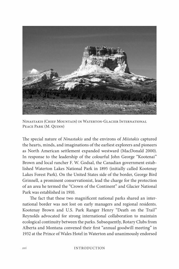
blue sky. Ninastakis (Chief Mountain) sits at the centre of a continuous ecological and cultural system that connects the landscapes, cultures and wildlife along and across the Rocky Mountains.
Ninastakis is the most sacred and powerful site to the indigenous people of the Blackfoot Confederacy (they call themselves Niitsitapi, which means ‘the original people’), a proud nation who have made this region their home for at least eight thousand years (Reeves 2007). Situated near the centre of a region the Niitsitapi call Miistákis or the ‘backbone of the world,’ Chief Mountain holds a central place in the spirituality of these people (Craig 2008). It was here that the three tribes of the Blackfoot were created. The mountain figures prominently in Blackfoot stories; for example, the first medicine pipe was given to the people by Thunder (Ksiistsikomm), the most powerful of the Up-Above-People in the long ago time, whose lodge was near the summit of Chief Mountain. The mountain, its surroundings, and the diverse biota that dwell in this special place are woven into the identity the Niitsitapi, and the region continues to provide a physical and spiritual home for its people.
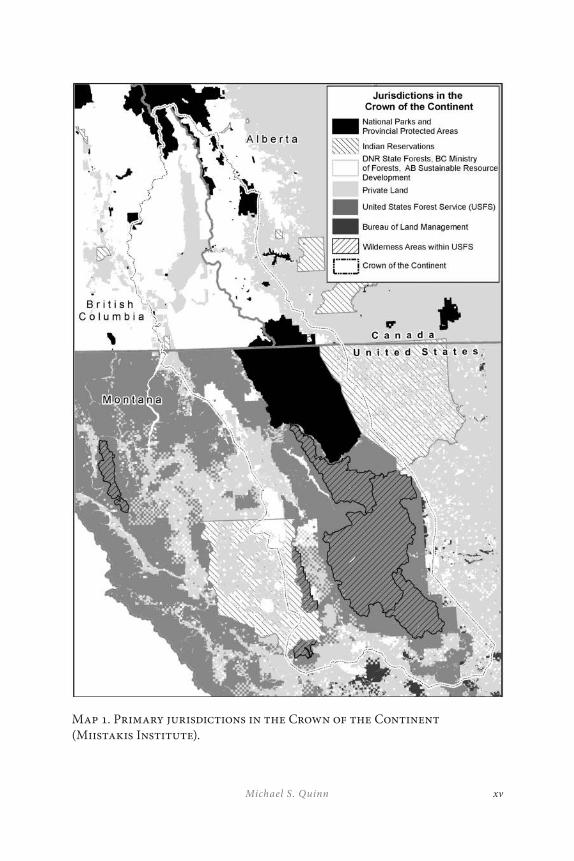
In 1818 a convention between the United States and the United Kingdom established a sovereign border along the forty-ninth parallel between Lake of the Woods and the Rocky Mountains; a line that would come to mark the boundary between the United States and Canada. In 1846, with the signing of the Oregon Treaty, this line drawn across the map of western North America sliced through the northern flank of Ninastakis severing the once seamless lands of the Niitsitapi, and dividing the Rockies between nations. This was the first of many administrative boundaries that would come to fragment an area now known as the Crown of the Continent into smaller units of jurisdictional authority (Map 1). Although most of these boundaries are not marked by the physical pres-ence of fences, the policy, planning, and management differences between adjoining jurisdictions have profound effects on the flow of ecological and social processes, including the traditional use activities of the Niitsitapi and the transboundary movement of such charismatic species as the bull trout and the grizzly bear (Grant and Quinn 2007).
xvMichael S. Quinn
Map 1. Primary jurisdictions in the Crown of the Continent (Miistakis Institute).
INTRODUCTIONxvi
The special nature of Ninastakis and the environs of Miistakis captured the hearts, minds, and imaginations of the earliest explorers and pioneers as North American settlement expanded westward (MacDonald 2000). In response to the leadership of the colourful John George “Kootenai” Brown and local rancher F. W. Godsal, the Canadian government estab-lished Waterton Lakes National Park in 1895 (initially called Kootenay Lakes Forest Park). On the United States side of the border, George Bird Grinnell, a prominent conservationist, lead the charge for the protection of an area he termed the “Crown of the Continent” and Glacier National Park was established in 1910.
The fact that these two magnificent national parks shared an inter-national border was not lost on early managers and regional residents. Kootenay Brown and U.S. Park Ranger Henry “Death on the Trail” Reynolds advocated for strong international collaboration to maintain ecological continuity between the parks. Subsequently, Rotary Clubs from Alberta and Montana convened their first “annual goodwill meeting” in 1932 at the Prince of Wales Hotel in Waterton and unanimously endorsed
Ninastakis (Chief Mountain) in Waterton-Glacier International Peace Park (M. Quinn)
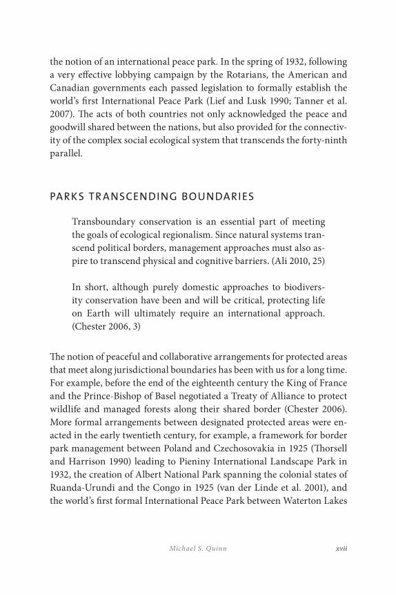
xviiMichael S. Quinn
the notion of an international peace park. In the spring of 1932, following a very effective lobbying campaign by the Rotarians, the American and Canadian governments each passed legislation to formally establish the world’s first International Peace Park (Lief and Lusk 1990; Tanner et al. 2007). The acts of both countries not only acknowledged the peace and goodwill shared between the nations, but also provided for the connectiv-ity of the complex social ecological system that transcends the forty-ninth parallel.
PARKS TR ANSCENDING BOUNDARIES
Transboundary conservation is an essential part of meeting the goals of ecological regionalism. Since natural systems tran-scend political borders, management approaches must also as-pire to transcend physical and cognitive barriers. (Ali 2010, 25)
In short, although purely domestic approaches to biodivers-ity conservation have been and will be critical, protecting life on Earth will ultimately require an international approach. (Chester 2006, 3)
The notion of peaceful and collaborative arrangements for protected areas that meet along jurisdictional boundaries has been with us for a long time. For example, before the end of the eighteenth century the King of France and the Prince-Bishop of Basel negotiated a Treaty of Alliance to protect wildlife and managed forests along their shared border (Chester 2006). More formal arrangements between designated protected areas were en-acted in the early twentieth century, for example, a framework for border park management between Poland and Czechosovakia in 1925 (Thorsell and Harrison 1990) leading to Pieniny International Landscape Park in 1932, the creation of Albert National Park spanning the colonial states of Ruanda-Urundi and the Congo in 1925 (van der Linde et al. 2001), and the world’s first formal International Peace Park between Waterton Lakes

INTRODUCTIONxviii
National Park (Canada) and Glacier National Park (United States) in 1932 (Sandwith et al. 2003).
In recent decades, the ideas of transboundary protected areas and peace parks have spread across international borders around the globe. The 2007 list of transboundary protected areas (TBPA) compiled by the UNEP World Conservation Monitoring Centre (UNEP-WCMC) identified 227 TBPA complexes incorporating 3,043 individual protected areas or inter-nationally designated sites covering some 460 million hectares. These pro-tected areas contribute to the protection of biodiversity, the establishment of peaceful relations between neighbouring countries and the well-being of people living in and around the protected environs. The proliferation of TBPAs is a clear indicator that historical and geo-political constraints imposed on ecosystems, species, and communities are abating. Moreover, the experience garnered by TBPA practitioners in a myriad of ecological and socio-political contexts offers the opportunity to develop new models and approaches for effective management (Vasilijević and Pezold 2011).
There are a variety of labels applied to cross-jurisdictional collab-oration for cultural and biodiversity conservation. The IUCN World Commission on Protected Areas, Global Transboundary Conservation Network (2011) proposed the following four definitions:
Transboundary Protected Area – An area of land and/or sea that straddles one or more borders between states, sub-national units such as provinces and regions, autonomous areas and/or areas beyond the limit of national sovereignty or jurisdiction, whose constituent parts are especially dedicated to the protection and maintenance of biological diversity, and of natural and associated cultural resources, and managed co-operatively through legal or other effective means.
Parks for Peace – Transboundary protected areas that are formally dedicated to the protection and maintenance of biological diversity, and of natural and associated cultural resources, and to the promotion of peace and co-operation.
xixMichael S. Quinn
Transboundary Conservation and Development Area – Areas of land and/or sea that straddle one or more borders between states, sub-national units such as provinces and regions, autonomous areas and/or areas beyond the limit of national sovereignty or jurisdiction, whose constituent parts form a matrix that contributes to the protection and maintenance of biological diversity, and of natural and associated cultural resources, as well as the promotion of social and economic development, and which are managed co-operatively through legal or other effective means.
Transboundary Migratory Corridors – Areas of land and/or sea in two or more countries, which are not necessarily contiguous, but are required to sustain a biological migratory pathway, and where co-operative management has been secured through legal or other effective means.
The primary focus of the chapters in the current collection align with the Parks for Peace category; however, there are many other terms that ap-pear in the contributions that follow. The unifying element throughout these chapters is an interest and commitment to collaborate across juris-dictional boundaries or frontiers. The particular nomenclature needs to be meaningful in the context of the socio-political realities of the region.
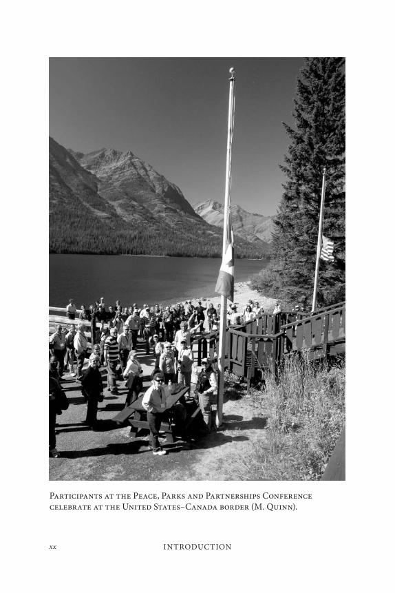
A PEACE, PARKS AND PARTNERSHIPS CONFERENCE
To celebrate the seventy-fifth anniversary of the world’s first formal Peace Park, a group of park managers, academics and Rotarians collaborated to convene a gathering of practitioners and experts on international peace parks and transboundary management initiatives. The central idea for the conference was that the International Peace Park designation legitimized a spirit of cooperation that has been used to seek ongoing designations and other forms of cooperation that may not have been anticipated in 1932. The conference aimed to document that ripple effect and to consider
INTRODUCTIONxx
Participants at the Peace, Parks and Partnerships Conference celebrate at the United States–Canada border (M. Quinn).
xxiMichael S. Quinn
its potential and realization around the world. The intent was to advance the theory and practice of transboundary management, especially in the context of international peace parks.
In September 2007, the town of Waterton Park played host to nearly two hundred delegates, representing more than thirty countries, to dis-cuss the history, best practices, challenges and future international efforts to manage for peace and conservation across borders. Beneath the shadow of Ninastakis the world’s leading practitioners and transboundary experts shared their frustrations and successes through formal presentations, informal discussions and a full-day field trip in the Waterton-Glacier International Peace Park and its surrounding environs. The events in-cluded an emotionally moving ‘headdress’ ceremony wherein the super-intendents of the Peace Park were initiated into the indigenous Blackfoot Confederacy. The ceremony punctuated the long history of indigenous dwelling in the landscape and emphasized the artificiality of jurisdiction-al boundaries.
The purpose of this volume is to capture and advance some of the ideas proffered by international transboundary experts and practitioners. We have attempted to select a suite of chapters that represent the breadth of topics and geography encompassed by current peace park initiatives. The chapters have been selected and organized under four broad themes: lessons from around the world, a special focus on southern African peace parks, peace parks and education, and proposals for new peace parks. Although the chapters adhere well to this structure, like the landscapes they represent, there are many elements and themes that cut across the topical borders we have imposed for convenience. The hope is that this volume will help to improve and advance the praxis of peace parks and other transboundary initiatives and will serve as a catalyst to convene the next international gathering on this topic.
INTRODUCTIONxxii
OVERVIEW OF THIS VOLUME
Lessons from the Field
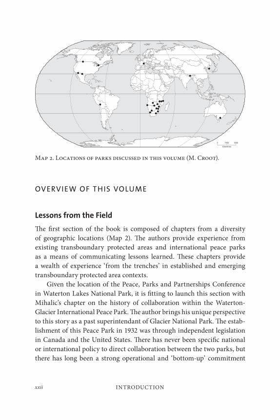
The first section of the book is composed of chapters from a diversity of geographic locations (Map 2). The authors provide experience from existing transboundary protected areas and international peace parks as a means of communicating lessons learned. These chapters provide a wealth of experience ‘from the trenches’ in established and emerging transboundary protected area contexts.
Given the location of the Peace, Parks and Partnerships Conference in Waterton Lakes National Park, it is fitting to launch this section with Mihalic’s chapter on the history of collaboration within the Waterton-Glacier International Peace Park. The author brings his unique perspective to this story as a past superintendant of Glacier National Park. The estab-lishment of this Peace Park in 1932 was through independent legislation in Canada and the United States. There has never been specific national or international policy to direct collaboration between the two parks, but there has long been a strong operational and ‘bottom-up’ commitment
Map 2. Locations of parks discussed in this volume (M. Croot).
xxiiiMichael S. Quinn
to mutually beneficial cooperation. Rangers and wardens convene meet-ings and communicate to facilitate effective professional natural and cul-tural resource management and visitor services (e.g., interpretation, fire management, search and rescue, wildlife management). Park leadership has also been instrumental in the establishment of the Crown Managers Partnership, a voluntary organization of public land managers whose jurisdiction encompasses the greater ecosystem in which the national parks are embedded.
The following two chapters provide a shift in geographic focus from the North American Rocky Mountains to the Australian Alps. Jacobs and Anderson describe a cooperative management program across eleven protected areas and three Australian jurisdictions. A formal adminis-trative structure that includes both top-down and bottom-up program elements provides a contrast to the preceding chapter. The success of having high-level strategic commitment through to operational imple-mentation is clearly illustrated through this case study. The Australian Alps Cooperative Management Program also highlights the importance of dedicated financial support and a well-developed system of communi-cation. Weiler et al. examine the tourism partnerships in the Australian Alps and seek to identify the characteristics of effective collaboration. The authors stress the importance of both process and outcomes in evaluating partnerships. Characteristics contributing to the success in the Australian Alps include: shared vision and common goals, good communication, ministerial to field-level engagement, strong leadership, and an equal distribution of power. Challenges include the lack of adequate financial resources, enforcement of decisions and coping with legislative difference between jurisdictions.
The chapters on the Australian Alps are followed by a contribution from the European Alps. Eringhaus describes the conditions in the Mont Blanc region shared between France, Italy, and Switzerland. The region typifies the political challenges associated with transboundary protection even when economic conditions and relative stability prevail. Moreover, Eringhaus describes the differences that often exist between government and non-government organizations and agendas. The need for a formal

INTRODUCTIONxxiv
organizational structure and legal authority is also raised and is a recur-rent theme in this section.
Mendoza and Quinn provide a rationale for continental-scale col-laboration between protected areas for long-distance migratory species. Transboundary conservation, protection, and peace are not limited to dir-ectly adjacent landscapes. The chapter outlines connections between pro-tected areas in Canada and Mexico via the movements of species such as the Burrowing Owl and the monarch butterfly. Governance of protected areas is analyzed and evaluated based on interviews with managers from both countries. A multi-level governance model is proposed as a mech-anism to achieve greater effectiveness in transboundary collaboration for continental migratory species. Effective governance affects not only eco-systems and biodiversity, but also human health and well-being. The chap-ter identifies the disparity that often exists between the intent of protected area establishment and the reality of management practice.
In a chapter on international collaboration around Lago de Titicaca, Walters outlines the value of joint efforts between Peru and Bolivia. The Lago de Titicaca situation is contrasted with the failure of Kazakhstan and Uzbekistan to reach similar working arrangements around the Aral Sea following the collapse of the former Soviet Union. A binational au-thority created in 1986 to address water management issues has provided the catalyst for a wide array of ecosystem management activities. As with the Waterton-Glacier example, Walters stresses the tremendous benefits that accrue from the development of professional and personal relation-ships across international borders. The mutual respect and trust that are developed through such arrangements provide the necessary traction for implementation. The engagement of the two navies to assist with scientific studies on the lake is a prime example of the connection between environ-mental conservation and international peace.
The Southern African Experience
The rapid and extensive expansion of transfrontier protected area com-plexes in southern Africa is reflected in the second group of chapters. Mabunda et al. launch this section with an historical and contemporary account of transfrontier conservation activities in the region. Connecting
xxvMichael S. Quinn
ecological systems in conjunction with promoting social and economic development has been the hallmark of the initiatives in southern Africa. The collaborative networks built through these efforts are helping to pro-mote greater peace and stability across the region. Fences have been com-ing down, animals are being relocated and economic benefits are being shared more equitably between the participating countries. In addition to transcending state boundaries, southern African efforts are also embra-cing private-public partnerships for conservation and community well-being. Schoon’s chapter describes the challenges associated with multi-partite governance of these new transfrontier complexes. New approaches require an evolution of management structures and institutional design for ecological resilience and institutional robustness. Schoon uses case studies from the Greater Limpopo and Kgalagadi Transfrontier Parks to demonstrate how different contexts and responses lead to different results. Overall, the “new” southern Africa (post-apartheid and post-Mozambique civil war) protected areas have seen a transformation from a fortress men-tality to a more progressive model, engaging with surrounding commun-ities. However, although political support has been strong, transfrontier protection still suffers from a mismatch between political timeframes and the real time required to institute change.
Schuerholz and Baldus provide a critical examination of transbound-ary efforts in two southern Africa contexts: the Selous-Niassa Corridor between Tanzania and Mozambique, and Kavango-Upper Zambezi Tranfrontier Conservation Area between Namibia, Botswana, Angola, Zambia, and Zimbabwe. The chapter is predicated on the premise that the success of such efforts is contingent upon the cooperation of surrounding and affected communities. The authors compare the community-based natural resource management (CBNRM) models employed in the two cases and describe the importance of generating both direct economic benefits through wildlife utilization and community empowerment. Transboundary initiatives are shown to provide a strong impetus for en-gagement at multiple political levels and may help to attract the financial and logistic support of other international interests. Enabling legislation and clearly defined programs that include devolution of decision-making
INTRODUCTIONxxvi
to the community level are required to ensure that benefits reach the ap-propriate participants in an equitable manner.
Mozambique figures prominently in the subsequent chapter as well. Soto contributes an insightful discussion of the history and management of the Great Limpopo Transfrontier Park (GLTP), a cooperative initiative of South Africa, Zimbabwe, and Mozambique. Soto’s direct experience as the project manager from Mozambique is particularly valuable in pre-senting an understanding of the differing social, economic, and ecological contexts that exist across administrative boundaries. At the outset of the project, Mozambique had considerably less management capacity and fi-nancial resources than its transboundary neighbours. Although the GLTP initiative greatly increased the complexity of the overall management con-text, Mozambique benefited significantly through the ability to develop greater institutional and local capacity. Moreover, the international profile of the GLTP has helped to leverage financial resources for development that would not otherwise be available. The case clearly indicates the range of values as well as the myriad of challenges that face transboundary ef-forts. Perhaps more importantly, the case of Mozambique illustrates the kinds of benefits that accrue to participants of transboundary initiatives that go well beyond the biodiversity objectives of ‘conventional’ protected areas.
The final chapter in southern Africa section provides an overview and reflections on a long-term management strategy for the Maloti-Drakensberg Transfrontier Conservation and Development Area (MDTFCA) shared between Lesotho and South Africa. Beyond the valuable descriptive and historical context, Zunckel includes a discussion of the most significant critical factors necessary to work within the complex socio-political en-vironment of transboundary protected areas. Institutionalization of any transboundary effort is a prerequisite for effectiveness. Participants must embrace the planning and management activities as a core part of their respective mandates and not as an ‘add on’ to be addressed as time per-mits in an already overloaded work environment. This necessitates high level support of project ‘champions,’ but must also transcend hierarchical management structures from the political to the operation. The aims of the transboundary initiatives must be clearly articulated, shared between
xxviiMichael S. Quinn
partners, and also achievable within the timeframes set out by plans and strategies. Moreover, the efforts must be accompanied by an adequate level of financial resources to achieve project goals. Finally, Zunckel under-scores the critical requirement for linking conservation to the livelihoods of people in the region. This final point is echoed across all the contribu-tions in the southern Africa section, and it is here that the impressive and rapid expansion of transboundary peace parks and related reserves has much to teach other practitioners from around the world.
Education and International Peace Parks
The third section of the book highlights three unique education-based in-itiatives that occur in the context of international peace parks. The chapters provide examples of programs that provide educational opportunities for university students, park practitioners, and community members. All of the authors stress the importance of experiential approaches that include direct exposure to activities in and around peace parks. Moreover, there is a clear recognition that academic participation in this milieu must be socially and politically relevant. The collaborative nature of international peace parks and related transboundary efforts provide an ideal context and role for academic engagement and capacity building with benefits that reach far beyond the boundaries of protected areas.
Broberg and Quinn profile a collaborative graduate initiative be-tween a U.S. and a Canadian university, the University of Montana and the University of Calgary. Graduate students and faculty members engage in interdisciplinary research that transcends not only political bound-aries but also traditional academic disciplines. The Waterton-Glacier International Peace Park serves as the focal geography for an annual field course and a wide variety of research projects. Although the United States and Canada are similar in many ways, the initiative offers a unique cross-cultural opportunity for graduate students. The initiative began in 1999 and graduates are now assuming professional positions in the region.
The University of Montana is engaged in another transboundary pro-tected areas program, but rather than collaborating across an adjacent border, it reaches across the globe to southern Africa and the University of KwaZulu-Natal. Freimund et al. discuss how the two universities along
INTRODUCTIONxxviii
with key individuals from the United States Forest Service as well as the Wilderness Action Group (a South African NGO) developed an initiative to provide education for field rangers, middle level managers, and execu-tives from the conservation and protected areas profession. The collabora-tion has resulted in an array of innovations and management outcomes including a master’s degree program in Protected Area Management for park practitioners that is entirely delivered through distance education, in order to make it accessible to those who need it most, and an executive seminar series for managers. The initiative places significant emphasis on the social context of protected area management and embraces the chal-lenges of managing for uncertainty in complex social-ecological systems. Based on a decade of collaborative experience, the authors stress the im-portance of players viewing themselves as part of a learning organization and offer a systems framework for capacity-building that includes manag-ing demands, managing constituencies, and managing learning.
In the third chapter of the education section, Sowry summarizes the experience of Southern Africa Wildlife College (SAWC) and the Southern Africa College of Tourism (SACT) in providing capacity-building for staff of transfrontier conservation areas (TFCAs) in southern Africa. Both col-leges are initiatives of the Peace Parks Foundation in collaboration with World Wide Fund for Nature (South Africa) and the Southern Africa Development Community. The SACT provides a crucial regional role in training female community members from areas surrounding TFCAs. The SAWC is committed to a hands-on, practical, and highly participatory approach to education for field staff and middle level managers. With its vision to become the most sought after Centre of Excellence in conserva-tion education and wildlife management training in the southern African sub-region, the College has since its inception, and with the support of the Peace Parks Foundation, trained over 5,000 people from 26 African coun-tries in natural resource management. The greatest challenge facing these innovative education programs is funding. Strategies are being developed to increase financial capacity in order to ensure the continuance of this critical education. Finally, the cultural, linguistic, political, and manag-erial diversity of the region create challenges to instructors and students.
xxixMichael S. Quinn
Creating ways to teach and learn in this complex environment contributes significantly to the long-term viability of TCFAs.
Peace Park Proposals
The final section of this volume includes a suite of examples where inter-national peace parks are currently being proposed to address a spec-trum of regional challenges. Biringer and Cariappa open the section with a discussion of a proposal for a Siachen Peace Park between India and Pakistan in the Karakoram Mountains of northern Kashmir in the western Himalayas. At the core of this transboundary region lies 2,500 km2 of disputed territory. The elevation of the region rises above 6,000 metres, making this the world’s highest battlefield. Hostile climatic condi-tions have resulted in more deaths of soldiers than have been caused by enemy fire. The location and elevation also make this an area of global significance for glaciers, water production, and downstream biodiversity. The financial, human, and environmental degradation resulting from this conflict is in drastic need of a solution. A transboundary peace park was first proposed in 1994 and discussions that include demilitarization and the establishment of an international science centre seem to offer an at-tractive option.
Although an international peace park has existed for over seventy-five years on the northern boundary of the United States with Canada, the same outcome remains elusive along the southern border. Chester and Sifford chronicle the ongoing challenges of trying to establish coopera-tive transboundary protection between the United States and Mexico. The most significant of the current challenges is associated with meet-ing conservation goals while maintaining homeland security. The auth-ors highlight the degree to which a park could enhance conservation and economic sustainability in the regions discussed. Although no formal designation is currently in place between the two countries, a variety of successful non-government efforts have helped to promote transboundary conservation. Chester and Sifford explore the potential for international peace parks within both the Sonoran and Chihuahuan deserts and con-clude that the near-term reality for such a prospect remains doubtful. The authors recommend that, rather than simply giving up on the potential for
INTRODUCTIONxxx
an international peace park on the Mexico–U.S. border, conservationists who care about the border region should develop strategies that seek to understand the forces aligned against international designations, then use that understanding to shore up and stabilize support within the broader North America conservation community, joining particularly the grow-ing voices from Mexico.
Healy addresses the potential mechanisms and benefits of an inter-national peace park between North Korea and South Korea. The demili-tarized zone (DMZ) established in 1953 between the two Koreas has been off-limits to virtually all human access for more than fifty years. An area of incredible biodiversity richness, the DMZ could become the core of a na-ture and peace park with a multitude of economic and ecological benefits shared by North and South Korea. International support for the initiative has come from such notable figures as Nelson Mandela and Ted Turner. Establishing a peace park in this region remains a significant challenge, but considerable logistic and financial support is building.
Sarkar and Milindo’s contribution describes a unique opportunity to protect a biodiversity hotspot in the Darjeeling Himalayas of India. The transboundary efforts described in the chapter are not across internation-al borders but transcend multiple state and local jurisdictions between Singalila National Park and Senchal Wildlife Sanctuary over a distance of approximately twenty kilometres. The authors examine the issue of connectivity in the context of maintaining resilience within the complex social ecological system that defines the region. Sarkar and Milindo delve deep beyond the basic ecology of connectivity for wildlife to explore the socio-economic intricacies of intervening for long-term sustainability. The ultimate success of any program to address ecological connectivity will rely on its concurrent ability to meet the social needs of the regional communities.
The final chapter of the book appropriately ends with a proposal for another peace park between Canada and the United States. Schneekloth et al. present an opportunity to commemorate almost two hundred years since the War of 1812. Niagara Falls and the Niagara Escarpment are iconic landscapes for both countries and the authors point out that an international peace park designation “facilitate[s] better coordination and
xxxiMichael S. Quinn
resource management in the face of climate change, cross-border political relations in a time of terrorism, economic partnerships in an expanding global market, and a celebration of our shared culture yet unique differ-ences in a world increasingly interested in the balance between globalism and localism.” The proposal is unique in that the designation would en-compass a ‘park without borders’ through a strong regional approach to sustainable development, international cooperation, and environmental leadership. The recent events to mark the bicentennial of the War of 1812 provided additional momentum to move the peace park idea to fruition.
CONCLUSION
Although the Waterton-Glacier International Peace Park is a model that has been emulated globally, a poignant story from the conference illus-trates ongoing challenges, even between countries with a long history of peace and good will. The conference was held on the Canadian side of the International Peace Park and organizers were committed to having delegates participate in a fieldtrip as part of the program. The intent was to highlight some of the many International Peace Park collaborative ac-tivities and initiatives on both sides of the international border. However, partly due to the events of September 11, 2001, heightened border secur-ity made it logistically impossible for a bus load of people from as many as thirty different countries to cross from Canada into the United States. The conference fieldtrip was a great success and participants did actually manage to cross into the United States on a boat trip down Waterton Lake with interpreters from both Waterton and Glacier. Nevertheless, it seems ironic that an international gathering to celebrate the birth of the world’s first International Peace Park was unable to easily move between the con-stituent national parks.
The formalization of the International Peace Park idea is clearly rooted in the history of Waterton and Glacier National Parks. The Parks, Peace, and Partnerships Conference and the contents of this volume capture the grand evolution of transboundary ideas for the betterment of nature and society. The complex challenges that face us and the biosphere require
INTRODUCTIONxxxii
new approaches to break down barriers to the flow of ecological processes and remove the obstacles to cooperating across borders. The experience of innovative practitioners and insightful leaders from around the world demonstrates our capacity for peaceful collaboration across jurisdictional divides. Our very survival depends on our ability to grow and implement such ideas around the world. Nelson Mandela, a strong proponent of peace parks and a founding patron of the Peace Parks Foundation, captured the essence of this message in a speech to open the gates between the national parks of South Africa and Mozambique:
I know of no political movement, no philosophy, and no ideol-ogy which does not agree with the peace parks concept as we see it going into fruition today. It is a concept that can be em-braced by all. In a world beset by conflict and division, peace is one of the cornerstones of the future. Peace parks are building blocks in this process, not only in our region, but potentially the entire world. (Peace Parks Foundation 2011)
We are pleased to provide this volume of thoughts and ideas to advancing the praxis of transboundary protection and peaceful collaboration.
REFERENCES
Ali, S. H. 2010. Transboundary Conservation and Peace-building: Lessons from Forest Projects. Yokohama, Japan: International Tropical Timber Organization (ITTO) and the United Nations University Institute of Advanced Studies.
Chester, C. C. 2006. Conservation across Borders: Biodiversity in an Interdependent World. Washington, D.C.: Island Press.
Craig, D. 2008. “Blackfeet belong to the mountains: Blackfeet relationships with the Glacier National Park landscape and institution.” M.Sc. thesis. University of Montana.
Forman, R.T.T. 1995. Land Mosaics: The Ecology of Landscapes and Regions. Cambridge, MA: Cambridge University Press, 1995.
xxxiiiMichael S. Quinn
Grant, J. A., and M. S. Quinn. 2007. “Factors influencing transboundary wildlife management in the North American ‘Crown of the Continent.’” Journal of Environmental Planning and Management 50(6): 765–82.
IUCN (World Conservation Union) World Commission on Protected Areas, Global Transboundary Conservation Network. 2011. “Types of transboundary conservation practice.” Accessed November 22, 2011. http://tbpa.net/page.php?ndx=83.
Lieff, B., and G. Lusk. 1990. “Transfrontier cooperation between Canada and the U.S.” In Parks on the Borderline: Experience in Transfrontier Conservation, ed. J. Thorsell, 39–50. Gland: IUCN.
MacDonald, G. 2000. Where the Mountains Meet the Prairies: A History of Waterton Country. Calgary: University of Calgary Press.
Peace Parks Foundation. 2011. “Words from Dr. Nelson Mandela.” Accessed December 1, 2011. http://www.peaceparks.org.
Reeves, B.O.K. 2007. “Native peoples and archaeology of Waterton Glacier International Peace Park.” In Sustaining Rocky Mountain Landscapes: Science, Policy and Management for the Crown of the Continent Ecosystem, ed. T. Prato and D. Fagre, 39–54. Washington, D.C.: Resources for the Future.
Sandwith, T., C. Shine, L. Hamilton, and D. Sheppard. 2003. Transboundary Protected Areas for Peace and Co-operation. Gland, Switzerland: IUCN.
Stenson, F., and B. R. Laycock. 2006. Waterton Brush and Pen. Calgary: Fifth House.
Tanner, R., W. Freimund, B. Hayden, and B. Dolan. 2007. “The Waterton-Glacier International Peace Park: Conservation amid border security.” In Peace Parks: Conservation and Conflict Resolution, ed. S. H. Ali, 183–99. Cambridge, MA: MIT Press.
Thorsell, J., and J. Harrison. 1990. “Parks that promote peace: A global inventory of transfrontier nature reserves.” In Parks on the Borderline: Experience in Transfrontier Conservation, ed. J. Thorsell , 3–24, Gland, Switzerland: IUCN.
van der Linde, H., J. Oglethrope, T. Sandwith, D. Snelson, and Y. Tessema. 2001. Beyond Boundaries: Transboundary Natural Resource Management in Sub-Saharan Africa. Washington, D.C.: Biodiversity Support Program.
Vasilijević, M., and T. Pezold, eds. 2011. Crossing Borders for Nature. European Examples of Transboundary Conservation. Gland, Switzerland and Belgrade, Serbia: IUCN Programme Office for South-Eastern Europe.

Section 1 LESSONS FROM
THE FIELD

3
Waterton-Glacier International Peace Park: Observations and Retrospection on Cooperation Issues
David A. Mihalic
INTRODUCTION
Waterton Lakes and Glacier National Parks were both established by their respective governments within fifteen years of each other more than a century ago. The people living in Canada and the United States came to these decisions – to set aside this particular place along their nation’s national frontier – independently. Upon reflection, it is obvious this particular landscape possessed attributes recognized at that time by people as somehow being “special.” Certainly the scenery was spectacu-lar. Moreover, those special attributes were recognized during a period of natural resource exploitation in both countries as having greater value to the nation’s citizenry than the use and exploitation that occurred on other public lands.
1

WATERTON-GLACIER INTERNATIONAL PEACE PARK4
This was not the first expression of the national park idea. But it may have been the first to have occurred in almost the same place, about the same time, by two different nations, separated only by a national boundary.
HOW IT STARTED
It is hard to speculate just what people in Canada and the United States at that time thought about Waterton Lakes and Glacier National Parks, and the two parks’ relationship to each other. Within a couple of decades, however, people on both sides of the national frontier came together for other reasons because they were drawn to this place.
Rotary clubs had their beginning around this same time (1905) in Chicago, Illinois, when businessman Paul Harris envisioned a profes-sional club that captured the same friendly spirit found in the small towns of his youth (Rotary International 2011). He invited a group of people who
Where the mountains meet the prairies along the Waterton-Glacier International Peace Park (M. Quinn).

5David A. Mihalic
Map 1. Waterton-Glacier International Peace Park (M. Croot).
represented each profession to gather together once a week. This first “ser-vice club” rotated their meetings among one another’s offices, to better understand what each member’s profession contributed to community welfare. From the beginning, the idea was to give back to the local com-munity through service, hold each other to high ethical standards, and thus build goodwill and peace in the world.
By 1921 Rotary Clubs had spread throughout the United States and abroad and adopted the name Rotary International a year later. Clubs met
WATERTON-GLACIER INTERNATIONAL PEACE PARK6
within their own regions, or districts, once a year to coordinate activ-ities and service projects. In 1931, Rotarians from the clubs in Montana and Alberta came together at a joint meeting in Waterton Lakes for what became their first annual international goodwill meeting. In the early 1930s, the scars of World War I were still fresh, much of the world was gripped in economic crisis and the first hints of World War II were begin-ning to emerge. While no exact transcript exists, the idea of creating a “peace park” along the international boundary where both nations had already established national parks is widely attributed to leaders in the Cardston (Alberta) Rotary Club (Waterton-Glacier International Peace Park Association 2011). Such a designation was seen as a way to cement harmonious relations between allies while providing a model of peace for nations around the world. Within a year, these citizen Rotarians sought political support and laid the groundwork that led to both the Canadian Parliament and the U.S. Congress passing laws establishing Waterton Lakes and Glacier National Parks together as an international peace park. This was the first joint national expression of its kind in the world (Map 1).
WHAT IS AN “INTERNATIONAL PEACE PARK”
SUPPOSED TO BE?
A key thought at the time was that the two parks, while a model, should become more than just a symbolic idea. For example, most do not realize that the U.S. legislation “upon the enactment by the proper authority of the Canadian Government” of similar legislation, formally made Glacier National Park “a part of an international park known as the Waterton-Glacier International Peace Park” (emphasis added) (U.S. National Archives and Records Administration 2009). It can be argued that from the beginning, it was the intent of Congress that this be one park, the man-agement of which is shared between the two countries.
So what has transpired since? Since its inception, the idea of a place along a transnational boundary where two countries could celebrate their own unique cultures as well as their commonality has been inspiring. Certainly it inspired members of Rotary in Canada and the United States
7David A. Mihalic
of America to politically connect two national parks in a formal way as an inspiration to other countries. But the genesis of the idea likely had germinated in the minds of the park staffs that had learned first hand that the values of the two parks were more than just scenery.
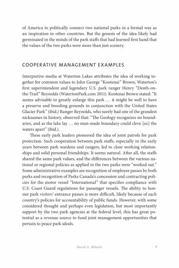
COOPER ATIVE M ANAGEMENT EX A MPLES
Interpretive media at Waterton Lakes attributes the idea of working to-gether for common values to John George “Kootenai” Brown, Waterton’s first superintendent and legendary U.S. park ranger Henry “Death-on-the-Trail” Reynolds (WatertonPark.com 2011). Kootenai Brown stated: “It seems advisable to greatly enlarge this park … it might be well to have a preserve and breeding grounds in conjunction with the United States Glacier Park” (ibid.) Ranger Reynolds, who surely had one of the grandest nicknames in history, observed that: “The Geology recognizes no bound-aries, and as the lake lay … no man-made boundary could cleve [sic] the waters apart” (ibid.).
These early park leaders pioneered the idea of joint patrols for park protection. Such cooperation between park staffs, especially in the early years between park wardens and rangers, led to close working relation-ships and solid personal friendships. It seems natural. After all, the staffs shared the same park values, and the differences between the various na-tional or regional policies as applied in the two parks were “worked out.” Some administrative examples are recognition of employee passes by both parks and recognition of Parks Canada’s concession and contracting poli-cies for the motor vessel “International” that specifies compliance with U.S. Coast Guard regulations for passenger vessels. The ability to hon-our park visitors’ entrance passes is more difficult, likely because of each country’s policies for accountability of public funds. However, with some considered thought and perhaps even legislation, but most importantly support by the two park agencies at the federal level, this has great po-tential as a revenue source to fund joint management opportunities that pertain to peace park ideals.
WATERTON-GLACIER INTERNATIONAL PEACE PARK8
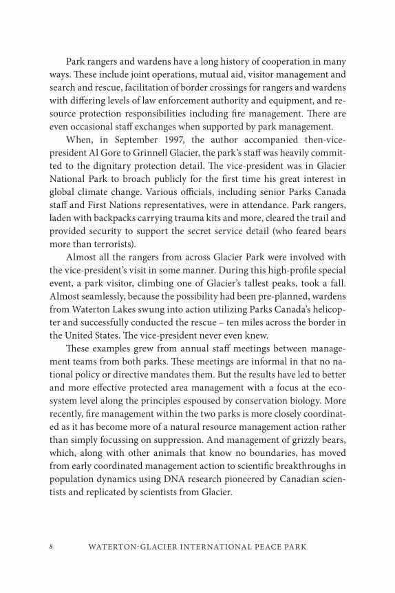
Park rangers and wardens have a long history of cooperation in many ways. These include joint operations, mutual aid, visitor management and search and rescue, facilitation of border crossings for rangers and wardens with differing levels of law enforcement authority and equipment, and re-source protection responsibilities including fire management. There are even occasional staff exchanges when supported by park management.
When, in September 1997, the author accompanied then-vice-president Al Gore to Grinnell Glacier, the park’s staff was heavily commit-ted to the dignitary protection detail. The vice-president was in Glacier National Park to broach publicly for the first time his great interest in global climate change. Various officials, including senior Parks Canada staff and First Nations representatives, were in attendance. Park rangers, laden with backpacks carrying trauma kits and more, cleared the trail and provided security to support the secret service detail (who feared bears more than terrorists).
Almost all the rangers from across Glacier Park were involved with the vice-president’s visit in some manner. During this high-profile special event, a park visitor, climbing one of Glacier’s tallest peaks, took a fall. Almost seamlessly, because the possibility had been pre-planned, wardens from Waterton Lakes swung into action utilizing Parks Canada’s helicop-ter and successfully conducted the rescue – ten miles across the border in the United States. The vice-president never even knew.
These examples grew from annual staff meetings between manage-ment teams from both parks. These meetings are informal in that no na-tional policy or directive mandates them. But the results have led to better and more effective protected area management with a focus at the eco-system level along the principles espoused by conservation biology. More recently, fire management within the two parks is more closely coordinat-ed as it has become more of a natural resource management action rather than simply focussing on suppression. And management of grizzly bears, which, along with other animals that know no boundaries, has moved from early coordinated management action to scientific breakthroughs in population dynamics using DNA research pioneered by Canadian scien-tists and replicated by scientists from Glacier.
9David A. Mihalic
M ANAGEMENT EVOLUTION: MEMOR ANDA OF
AGREEMENT
In a sense, these kinds of visitor protection, resource management and emergency services examples are similar to what takes place in any pro-tected area working with neighbours to achieve common goals. It is impor-tant to note they are not directly the result of the “peace park” designation.
Other park staffs elsewhere, whether from the Canadian mountain parks or Yellowstone and the Grand Tetons, coordinate in a similar manner. Sequoia and Kings Canyon National Parks share a joint staff. Memoranda of understanding have been established between North Cascades National Park in Washington and Manning Provincial Park in British Columbia. But, except for national park units that share com-mon boundaries (such as the Canadian mountain parks or Sequoia-Kings Canyon), these are usually the result of local initiative rather than some broad national policy or purpose.
Local commitment seems to be the key, and formalizing relationships seems to be the next iteration of a management strategy. In the 1990s, management at the U.S. National Park Service’s Redwoods National Park believed the best way to manage the remaining coastal redwoods eco-system was to absorb the three California State Parks on their boundaries. This set up a strained local conflict between the parks agencies, despite their almost identical missions (U.S. National Park Service 2003). An independent review by experts concluded that a shared park operation, using the collective resources of both agencies, offered greater advantages than a transfer. Management is now conducted through a negotiated five-year memorandum of agreement. Time has shown a successfully integrat-ed management operation that benefits natural values while park visitors notice little difference across park boundaries.
M ANAGEMENT EVOLUTION: STAFF COMMITMENT
In the Waterton-Glacier International Peace Park, local initiative has also led to the next level of cooperation, but in a different manner. Out of an
WATERTON-GLACIER INTERNATIONAL PEACE PARK10
annual management meeting between the two parks in Waterton and with the support of both park superintendents, key staff worked with oth-ers to develop what is known as the Crown of the Continent Managers Partnership (CMP) (Crown Managers Partnership 2011a). This partner-ship’s purpose is to improve the management of a large, complex ecore-gion that crosses the international boundary and has multiple jurisdic-tions. These jurisdictions include the two parks agencies, two provinces, the state of Montana, native peoples, and various federal, provincial, and state agencies from both countries. The model is similar to the Flathead Basin Commission, which was established by the State of Montana to help facilitate resource and water quality issues in the transbounday water-shed that lies to the west of Waterton-Glacier International Peace Park. Membership on the Flathead Basin Commission includes a representative appointed by British Columbia’s Premier.
The CMP, however, is broader than most comparable examples in both the scope of its purpose and the number of jurisdictions involved. It is a complex organization in the sense that it addresses principles of con-servation biology at the ecosystem level, including connectivity corridors, ecosystem threats, and various partners’ management and research oper-ations. But it is managed simply by a steering committee of members and utilizes a secretariat by contract; initially through the Miistakis Institute of the Rockies in Calgary, Alberta (Crown Managers Partnership 2011b).
The CMP has been extraordinarily successful, since it was founded in 2001. It has developed a regional noxious weed identifier, initiated a metadata portal project for the Crown region that is resulting in the CMP managers working to break down data access problems, and has spon-sored several well-attended forums that have focussed on wider issues such as fire and water management. Some projects, such as populating a cumulative effects model, have not been as successful, but despite growing pains the partnership seems to enjoy the confidence of the agency admin-istrators who sponsor it. CMP managers have developed a memorandum of agreement between the State of Montana and the Province of Alberta pledging long-term funding support and a signing ceremony is pending. Insiders hope this will act as a catalyst for British Columbia to also sign the agreement.

11David A. Mihalic
While such partnerships cannot exist without support of the agen-cies which form them, the important point to note is that this example is driven by the personal commitment of individual staff members in both parks who care about the ideals expressed in Waterton and Glacier’s vari-ous designations and international recognition. In the author’s opinion, the success of this partnership is due to the support from the bottom up. Would it be the same if driven from the top down?
IMPORTANT CONSIDER ATIONS FOR ANY
COOPER ATIVE M ANAGEMENT STR ATEGY
The kinds of day-to-day operational and management actions described above are important indicators of the success of any joint management paradigm. Support from staff is not only important, but critical. Like the
A clear fall day in Glacier National Park (M. Quinn).
WATERTON-GLACIER INTERNATIONAL PEACE PARK12
Redwoods example, which was born in conflict, the staff has seen positive results and supports the concept.
This is true too of the Crown Managers Partnership. But while the broader CMP is working well, the direct relationships between the two national parks that comprise Waterton-Glacier International Peace Park have remained little changed over the last several years.
This is not to say they have necessarily deteriorated. Positive examples of cooperation abound. Waterton’s conservation biologist is involved in Glacier’s development of its “Vital Signs” monitoring program. Similarly, Glacier’s biologists are involved with ecological integrity monitoring in Canada. Glacier’s native plant specialists have helped in the development of Waterton Lakes’ Peace Park Garden. Waterton and Glacier have es-tablished a common fishing season and creel limits on Waterton Lake, which crosses the international boundary. A bull trout study on the Belly River (a transboundary stream) required cooperation between Glacier and Alberta Fish and Wildlife with the concurrence of Waterton Lakes National Park. When Glacier was developing its general management plan that proposed to ban Jet Skis, planners drew heavily from the research on Jet Ski impacts that Waterton and Parks Canada had already completed. And there are countless other examples from wolf management to com-mon descriptors for vegetation maps and fire histories. These cooperative efforts open windows and build bridges between agencies, but are they due to the imprimatur of “international peace park” or any of the other international designations the two parks enjoy?
It is important to note that, in the author’s opinion, these success stories are the direct result of the tremendous dedication and long-term commitment by park staff (of both parks) to the ideals represented by the parks’ nomenclature. Time and again, the Waterton Lakes and Glacier park region has been recognized by humans as something extraordin-ary. This includes the Piegan Nation of native peoples for whom the re-gion is the “miistakis” or “backbone” of their world and for whom Chief Mountain is a sacred place. Then came the national park designations: the international peace park in 1932, and the biosphere reserve and world heritage inscriptions in the last twenty years. Each of these recognitions is the embodiment of an idea conceived in the minds of humans and laid
13David A. Mihalic
upon the landscape. As staff come on board, they become invested in these ideals and their work is thus driven by them. This alludes to the power of the ideas represented in words such as “national park,” “peace,” and “international.”
But it is important to also note that each park operates independently, following their respective management policies and directives as set by higher authority. During the author’s tenure there were no specific poli-cies or directives at the national level of either Parks Canada or the U.S. National Park Service that pertained specifically to the management of either international peace parks or even transboundary parks (such as Kluane-Wrangells in Alaska-Yukon, North Cascades in Washington and Manning in B.C., or Big Bend National Park in Texas and the Maderas del Carmen protected area in Mexico). Where cooperation existed, it was usually because of the efforts of the park staffs involved. While U.S. parks superintendents along the national borders had delegated authority to ap-prove transboundary travel in conjunction with joint management activ-ities, it was not because of the international designations but to facilitate travel. Similar authority was not granted to Waterton Lakes superintend-ents by regional officials in Calgary, and, in fact, staff had to secure ap-proval for joint annual management meetings when they were held in the United States.
This disparity in management policy was noted by park superintend-ents of U.S. world heritage sites during a meeting in 1992 (World Heritage Committee 1992) at which superintendents noted little common direc-tion from headquarters that pertained to world heritage site management. The same is true of the “international peace park” designation. Other than the original legislation, there is little to guide Glacier’s superintend-ent in managing the park any differently than any other national park area. So, while both parks’ interpretive programs explain the ideals of the international peace park, do the visitors really understand? One park’s entrance sign touts the designation while the other does not. Even the approval to wear a Waterton-Glacier International Peace Park logo pin above the breast pocket on the uniform is at the regional level for the U.S. National Park Service. The practice actually conflicts at the national level with the Director’s Orders for uniform wear.
WATERTON-GLACIER INTERNATIONAL PEACE PARK14
CURRENT PERCEPTIONS
Though many visitors still perceive Waterton Lakes and Glacier as two separate parks in spite of the national legislation that says each is a compo-nent of a larger whole – a peace park – they are intrigued by the “interna-tional peace park” moniker. Yet a once-open border along Waterton Lake, celebrated as the peace park’s most potent symbol, has hardened due to security concerns. Once, all visitors crossed the international boundary freely in this “peace park,” hiking from one unit to the other, “reporting” to the customs office, the Royal Canadian Mounted Police, or park war-dens at the Waterton townsite or at the Goat Haunt Ranger Station. But new security precautions initiated after the September 11, 2001 incident effectively prevent visitors from countries other than the United States or Canada from entering the United States at the U.S. end of Waterton Lake. Non-U.S. or Canadian citizens are allowed to disembark from tour boats but are then restricted to a limited area around the Ranger Station before returning to the tour boat. The nearest entrance to Glacier, for non-U.S. or Canadian visitors, is at the Customs Station at the Chief Mountain Highway Crossing, which is quite a distance away.
Visitors once could dock at the border from tour boats and gain firsthand the idea of “hands across the border” as Canadian and United States citizens stood side-by-side, separated only by an imaginary line. No more. The Rotary Clubs had a new mission: to “grow up” the border in the spirit of the peace park, by allowing the clear-cut swath to reveget-ate and connect wildlife populations rather than separate them. But se-curity concerns nixed that. Question: do terrorists really want to chance an encounter with Ursus arctos at this point on the border? Even a major event that developed support and fostered broader understanding – the Superintendents’ Hike – has not been as successful as it once was. Started some twenty years ago, the park superintendents of Waterton Lakes and Glacier each invited ten local, regional and national dignitaries to hike for three days across the two parks, including the international border, which culminated in a discussion on the last day of how the peace park idea could become more meaningful. Federal officials, ministry officials,
15David A. Mihalic
elected officials, locals, NGO executives, and park employees gained first-hand knowledge of park values and each other’s ideas for future emphasis.
And why is this event less successful today than in previous years? All due to terrorism and border security concerns. Wait, what was the idea of a peace park all about anyway?
WHO BENEFITS?
The peace park idea is not dead. It has resurfaced in other places with new energy and new champions. While Nelson Mandela’s name may be one of the most notable, others have championed the potential of peace parks for many years, beyond the benefits they may bring to the protected areas which comprise them. Dr. Anton Rupert, who along with Mandela is a founder of the Peace Parks Foundation, reinvented the idea to use eco-tourism to help confront poverty in Africa, professionalize park manage-ment, and make it easier for others to see the magnificence of Africa’s wild places (Peace Parks Foundation 2011) And, there have been numerous people who have suggested that the Demilitarized Zone between North and South Korea could become a “peace park” (Healy this volume).
As the idea spreads to other nations, what can seventy-five years of management at Waterton-Glacier International Peace Park by both Parks Canada and the U.S. National Park Service model to the rest of the world? Have world events negated the values that led to the designation?
In the Waterton-Glacier example, the author suggests that the benefits are directed inward. The parks themselves and the values they embody benefit most directly, due to the dedication and commitment of park staff. Even though cooperation through park neighbours extends these benefits, they accrue primarily to the natural and conservation values for which the two parks were established.
Even the challenge of the Crown Managers Partnership now is to use their success to engage in similar efforts to manage cooperatively with other agencies in the Crown of the Continent region. The “peace park” provides the example of what can be accomplished cooperatively and the CMP can expand and develop more inter-agency and Canada-U.S.

WATERTON-GLACIER INTERNATIONAL PEACE PARK16
cooperative projects. There are certainly other cooperative efforts across borders besides those directly related to Waterton Lakes and Glacier National Parks. And, if the broad concept of international corridors (such as Yellowstone-to-Yukon) is to ever succeed, it must do so first at the inter-national border. Certainly Waterton-Glacier International Peace Park can serve as a model for such conservation strategies.
The author proposes that, as important as the conservation values are in this model and its direct benefit to nature, it is the potential for world peace that may be more important. While there are those who would argue that if an expanded Crown of the Continent conservation regime that led to a successful Yellowstone-to-Yukon initiative is a mark of broader “societal benefits,” the base values are the same. However, the Waterton-Glacier model is almost totally dependent on staff dedication and commitment; it lacks a similar commitment and dedication at the agency level. The broader the management regime (the CMP area), the greater the potential that even the strong dedication of park professionals will not be enough for long-term success. Besides, the benefits – great as they are – are limited to the conservation and natural values of the core units and to that landscape which is similar. As greater scale is reached, and especially when private land and interests are introduced, the shared values of the participants changes. Thus, these values translate to the gen-eral population only to those who share those values specifically, or see an example to be used elsewhere in similar situations.
If the values are limited to only those that directly benefit the pro-tected area, then a peace park is no different from any other transbound-ary system of protected areas. In fact, the Waterton-Glacier model is fre-quently cited in the conservation plans of transboundary protected areas elsewhere in the world. This is not altogether bad, but it is not dependent on the designation of “peace park.” The evolution of the Waterton-Glacier idea to the broader, and equally successful, Crown Managers Partnership is an example that can form a regional strategy to extend conservation values beyond park boundaries through partners. By starting with the transboundary area and extending it through partnerships, a greater im-pact can be realized. This is perhaps a model that lends itself to the grand idea of a Yellowstone-to-Yukon initiative.
17David A. Mihalic
DO BET TER MODELS EXIST?
But can there be more? The broader question must be, are there bet-ter examples elsewhere? Are there transboundary protected areas and peace parks elsewhere in the world that can serve as better models, even to Waterton-Glacier? And, when the designation “peace park” is added, should there be more than just the values inherent in transboundary parks? Perhaps the peace parks in Africa, envisioned to both benefit the parks and benefit the citizens and nations in which they exist will become a better example. And, leaders have long cited the potential for peace parks as solutions to conflict. These, too, are “ideas” that go beyond conserva-tion biology principles. That conflict can adversely affect conservation and cultural values – the world’s heritage especially – has been seen too readily in the last decade.
It may be that transboundary protected areas, especially those that may have once used the Waterton-Glacier model, have evolved to a differ-ent level because of circumstances. The recently inscribed Primeval Beech
Forests of the Carpathians World Heritage Site is a transboundary serial property in the Slovak Republic and the Ukraine. Ten individual proper-ties stretch along a 185-kilometre axis across the national frontier to make up the heritage site. All the nominated properties are in management re-gimes that conform to International Union for Conservation of Nature Management Categories 1a or II. Buffer zones are a mixture of Category I, II, and VI. The nomination identifies ecological “connecting corridors” that are all within protected forests or existing national park, biosphere reserve or nature protected area boundaries. It is not a peace park but it has generated discussion and agreement on a joint management regime between the two countries.
What impressed the author most was the “joint management plan” (Ministry of Environmental Protection of Ukraine and State Nature Conservancy of the Slovak Republic 2006), which was already in place prior to inscription. The existing management framework comprises a series of various protected landscapes, national parks and biosphere re-serves that, due to the conjunction of national boundaries, has already led to a certain level of cooperation in management activities, including
WATERTON-GLACIER INTERNATIONAL PEACE PARK18
the nominated sites. Because of the previous government structure, the joint management plan is very much a “top-down” plan. But managers have built in a “bottom-up” process that includes stakeholders, local gov-ernments, and citizens. This management plan could become a model for joint cooperative management and certainly equals or exceeds many of the existing management schemes for transboundary world heritage properties. Could a similar plan, based on bottom-up success but with top-down support, implemented at Waterton-Glacier take the first inter-national peace park from “good” to “great?”
The author closes with a story. In late September, 1998, when the au-thor was superintendent at Glacier National Park, he was contacted by high government officials who wanted to set up a field visit “to the peace park.” Little information was given – it was all so “hush-hush” – only that the visitors were foreign diplomats who wanted to meet with those “re-sponsible” for the idea of how land could be managed as a park for peace. While there was a reluctance on the part of the callers to give information, we complied as best we could with the request, in spite of customs stations about to close for the winter and many visitor facilities already closed for the season. But, a few days later, it was all called off due to “problems securing visas for some of the participants.” We connected the dots, one of which was the agreement earlier that year by Yassar Arafat to exchange land for peace, and the agreement in late August by Benjamin Netanyahu to that proposal as long as “three percent was set aside as a nature re-serve.” While we were exchanging phone calls, Netanyahu and Arafat were negotiating at the Aspen Institute’s Wye River Conference Center on Maryland’s Eastern Shore. A few days after the visit was called off, news reports said they reached agreement on what was called “land for peace.” Setting aside three percent of the land for nature was not part of the final agreement.
19David A. Mihalic
CONCLUSION: WHAT MIGHT HAVE BEEN?
While the dedicated staffs of Waterton and Glacier National Parks have tried for seventy-five years to bring the idea of an “international peace park” to life as a meaningful example in southwestern Alberta and north-central Montana, those staffs have focussed on what they know best: pro-fessional natural and cultural resource management and visitor service. It was left to others, who are dedicated similarly to ideals, only those of world peace not conservation biology, who were almost the catalyst to take the idea of Waterton-Glacier International Peace Park to the next level.
But do we need a catalyst? It will always be people with ideals who envision what can be, if only we seek to achieve it. Those people are al-ready involved directly. They are the staffs of the two parks. Now we need to engage the senior executives at the national level, gain their support, and then that of the politicians. They only need to give the park staffs the authority and resources to move forward to make the idea of an inter-national peace park relevant in today’s world. For Waterton Lakes and Glacier National Parks are not just special places to their respective na-tions. Their world heritage inscription has already recognized their larger value. But what awaits if the idea that sprang to life in Waterton back in 1931 to commemorate peace among two countries, were to lead to peace among many?
WATERTON-GLACIER INTERNATIONAL PEACE PARK20
REFERENCES
Crown Managers Partnership. 2011a. “History.” Accessed December 2, 2011. http://www.crownmanagers.org/history.php.
———. 2011b. “Strategic Plan.” Accessed December 2, 2011. http://www.crownmanagers.org/strat.php.
Ministry of Environmental Protection of Ukraine, and State Nature Conservancy of the Slovak Republic. 2006. Integrated Management Plan for the Serial Nomination: Beech Primeval Forests of the Carpathians. Ukraine and Slokia: Joint Management Committee.
Peace Parks Foundation. 2011. “Origins.” Accessed December 2, 2011. http://www.peaceparks.org/story.php?pid=1&mid=2.
Rotary International. 2011. “History.” Accessed December 2, 2011. http://www.rotary.org/aboutrotary/history/index.html.
U.S. National Archives and Records Administration. 2009. Code of Federal Regulations. Title 7. Conservation. Sec 161a – Part of Waterton-Glacier International Peace Park.
U.S. National Park Service. 2003. “Partnerships. Redwood National and State Parks.” Accessed December 2, 2011. http://www.nps.gov/partnerships/redwood_nsp.htm.
Waterton-Glacier International Peace Park Association. 2011. “History.” Accessed December 2, 2011. http://sites.google.com/site/wgippa/home/photos/history-1.
WatertonPark.com. 2011. “Special status of Waterton Park.” Accessed December 2, 2011. http://www.watertonpark.com/reference/special_status.htm.
World Heritage Committee. 1992. Convention Concerning the Protection of the World Cultural and Natural Heritage, 16th session. Paris: UNCESCO.
21
Enhancing Connectivity through Cooperative Management: Lessons Learned from Twenty-One Years of Transboundary Programs in the Australian Alps
Peter Jacobs and Gillian Anderson
INTRODUCTION
The Australian Alps: The Place
The Australian Alps occur in the southeastern corner of mainland Australia, stretching hundreds of kilometres from Canberra to the Victorian Central Highlands west of Melbourne. They include regions known as the Brindabella Ranges in the Australian Capital Territory (ACT), the Snowy Mountains of New South Wales (NSW) and the Victorian Alps (Map 1).
2
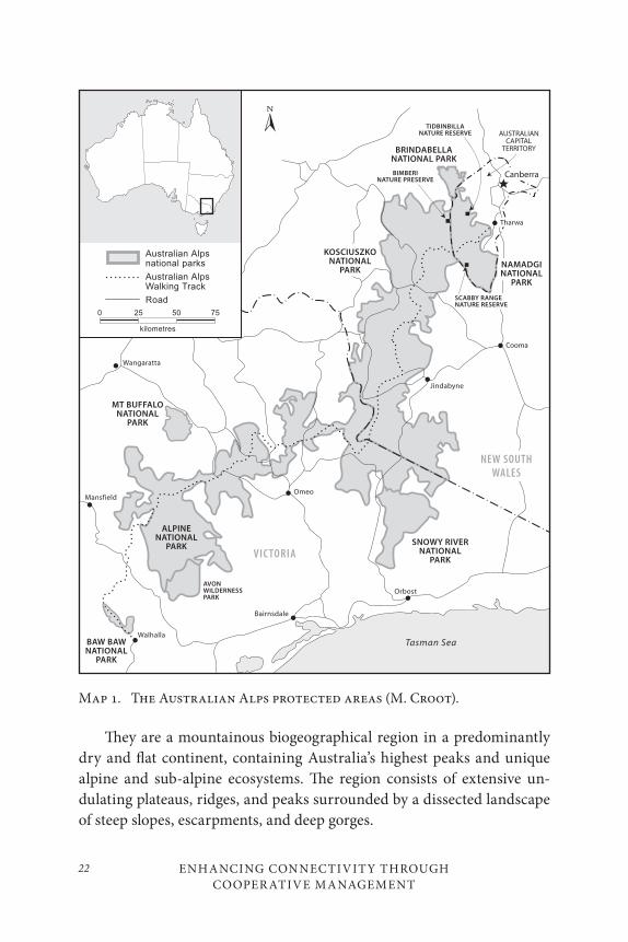
ENHANCING CONNECTIVITY THROUGH COOPER ATIVE MANAGEMENT
22
They are a mountainous biogeographical region in a predominantly dry and flat continent, containing Australia’s highest peaks and unique alpine and sub-alpine ecosystems. The region consists of extensive un-dulating plateaus, ridges, and peaks surrounded by a dissected landscape of steep slopes, escarpments, and deep gorges.
Map 1. The Australian Alps protected areas (M. Croot).
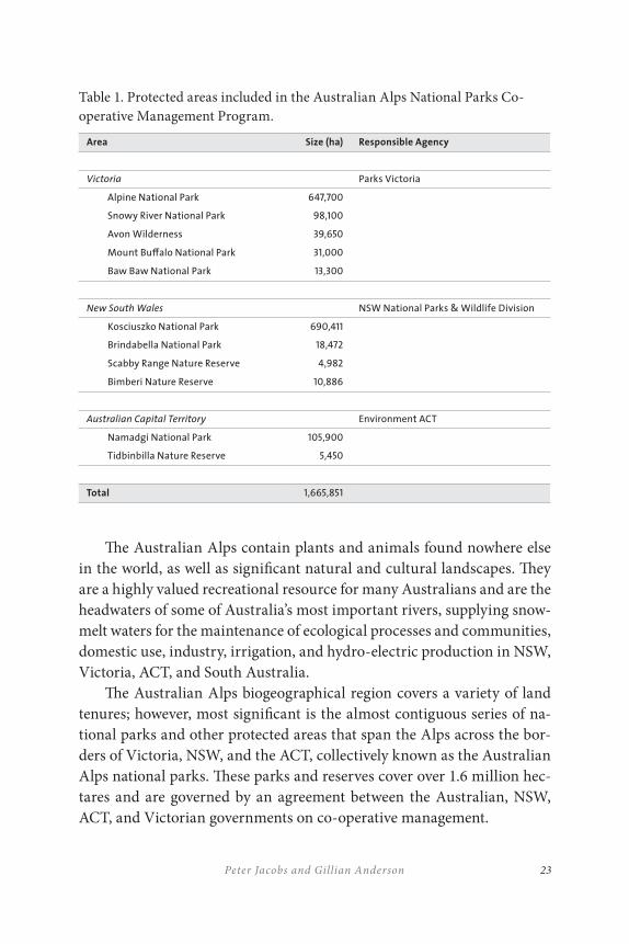
23Peter Jacobs and Gillian Anderson
The Australian Alps contain plants and animals found nowhere else in the world, as well as significant natural and cultural landscapes. They are a highly valued recreational resource for many Australians and are the headwaters of some of Australia’s most important rivers, supplying snow-melt waters for the maintenance of ecological processes and communities, domestic use, industry, irrigation, and hydro-electric production in NSW, Victoria, ACT, and South Australia.
The Australian Alps biogeographical region covers a variety of land tenures; however, most significant is the almost contiguous series of na-tional parks and other protected areas that span the Alps across the bor-ders of Victoria, NSW, and the ACT, collectively known as the Australian Alps national parks. These parks and reserves cover over 1.6 million hec-tares and are governed by an agreement between the Australian, NSW, ACT, and Victorian governments on co-operative management.
Table 1. Protected areas included in the Australian Alps National Parks Co-operative Management Program.
Area Size (ha) Responsible Agency
Victoria Parks Victoria
Alpine National Park 647,700
Snowy River National Park 98,100
Avon Wilderness 39,650
Mount Bu≠alo National Park 31,000
Baw Baw National Park 13,300
New South Wales NSW National Parks & Wildlife Division
Kosciuszko National Park 690,411
Brindabella National Park 18,472
Scabby Range Nature Reserve 4,982
Bimberi Nature Reserve 10,886
Australian Capital Territory Environment ACT
Namadgi National Park 105,900
Tidbinbilla Nature Reserve 5,450
Total 1,665,851
ENHANCING CONNECTIVITY THROUGH COOPER ATIVE MANAGEMENT
24
This paper presents the key lessons of the last twenty-one years of the Australian Alps co-operative management program from the perspective of park managers.
THE AUSTR ALIAN ALPS CO - OPER ATIVE
M ANAGEMENT PROGR A M
Management Arrangements
The Australian Government is not responsible for managing all nation-al parks. In the case of the protected areas that make up the Australian Alps national parks, the states of Victoria, NSW, and the ACT are sepa-rately responsible for legislation, policy-setting, and management of the protected areas within their jurisdictions. Together with the Australian Government, they have combined their efforts to ensure that management of the Australian Alps national parks reflects a single bio-geographical unit across state jurisdictions.
This coordinated management and conservation of the Australian Alps is the subject of an agreement or Memorandum of Understanding (MOU) between the Australian, NSW, ACT, and Victorian governments. The vi-sion of the Australian Alps National Parks Co-operative Management Program is agencies working in partnership to achieve excellence in con-servation management of its natural and cultural values and sustainable use through an active program of transboundary co-operation.
Organization and Structure
The following entities have functional roles in the Australian Alps Co-operative Management Program under the MOU:
Australian Alps Ministerial Council: The government ministers responsible for participating agencies, which are in turn responsible for high-level inter-government relationships and the MOU.
25Peter Jacobs and Gillian Anderson
Australian Alps Heads of Agencies Group: The heads, or their delegates, of participating agencies meet annually to consider strategic issues and to give direction to the Australian Alps Liaison Committee on policy, priority areas, and emerging issues.
Australian Alps Liaison Committee (AALC): The AALC facilitates the development, coordination and implementation of the Australian Alps Co-operative Management Program. Its members include a senior officer from each of the participating agencies in NSW, Victoria, and the ACT, and from the relevant Australian government department. The remainder of the structure is functional to best achieve delivery of the program as needed, particularly though the program manager and working groups.
T WENT Y- ONE YEARS OF THE AUSTR ALIAN ALPS
CO - OPER ATIVE M ANAGEMENT PROGR A M: ELEVEN
KEY LESSONS LEARNED
1. Making a Start: Establish a Champions Group
Cross-jurisdictional management arrangements are complex and often highly political. To establish such a co-operative agreement, it is impor-tant to establish an influential champions group. They need to be politi-cally savvy and represent all the potential partners to ensure endorsement at a range of levels in each agency or organization.
ENHANCING CONNECTIVITY THROUGH COOPER ATIVE MANAGEMENT
26
Case Study 1A: Establishing the Australian Alps Program
In 1985, a group of policy-makers and planners from the four protected area agencies in the Australian Alps met at Howman’s Gap in the Victorian Alps to discuss the state of the alps and po-tential co-operative management arrangements. The discussions produced a “Framework for Co-operation” that gained senior bu-reaucratic and political support (Crabb 2003).
A number of influential and dedicated senior managers repre-senting the agencies across the Australian Alps evolved as a group to establish more formal transboundary co-operative manage-ment arrangements. The “Framework for Co-operation” became the more formal “Memorandum of Understanding in Relation to the Co-operative Management of the Australian Alps National Parks,” first signed by government ministers in 1986.
The memorandum of understanding has since been revised in 1989, 1996, 1998, and 2003.
Lesson learned: Where a need is identified for inter-jurisdictional ar-
rangements, establish a champions group of influential and politic-
ally savvy o≤cers to drive the concept through organizations and
government.

27Peter Jacobs and Gillian Anderson
Case Study 2A: Integration of Executive and Field Staff
at Climate Change Workshop
As part of the science management workshop series, a recent workshop was held on climate change and management implica-tions for the Australian Alps targeted at field staff. Running con-currently with that was the Australian Alps Heads of Agencies meeting that is held every one to two years. Immense value was gained by integrating the two to gain a wide view on management implications, while approving a number of other Alps initiatives and facilitating wide networking.
Lesson learned: Have an established structure involving agencies
“top to bottom,” and take opportunities to integrate and involve
all levels at events.
2. Have a Solid Program Structure: Top Down – Bottom Up
and Getting the Right Balance
The strength of the Australian Alps program lies in having a solid pro-gram structure with the right balance of operational and planning level staff involvement, and high-level support through the formal signing of each agency to the Australian Alps Memorandum of Understanding. This commits governments at the highest level to co-operation and collabo-ration. While the heavy lifting of cross-jurisdictional politics and high-level strategy is dealt with through the Ministerial Council and Heads of Agencies, the majority of program outcomes derive from officer-level staff through programs developed by the working groups and managed through the program manager. This occurs under the leadership of the Australian Alps Liaison Committee (AALC) that is made up of the senior park manager from each state. The program would fail without support and involvement at each end; facilitating that continued broad level of support is fundamental to the program.
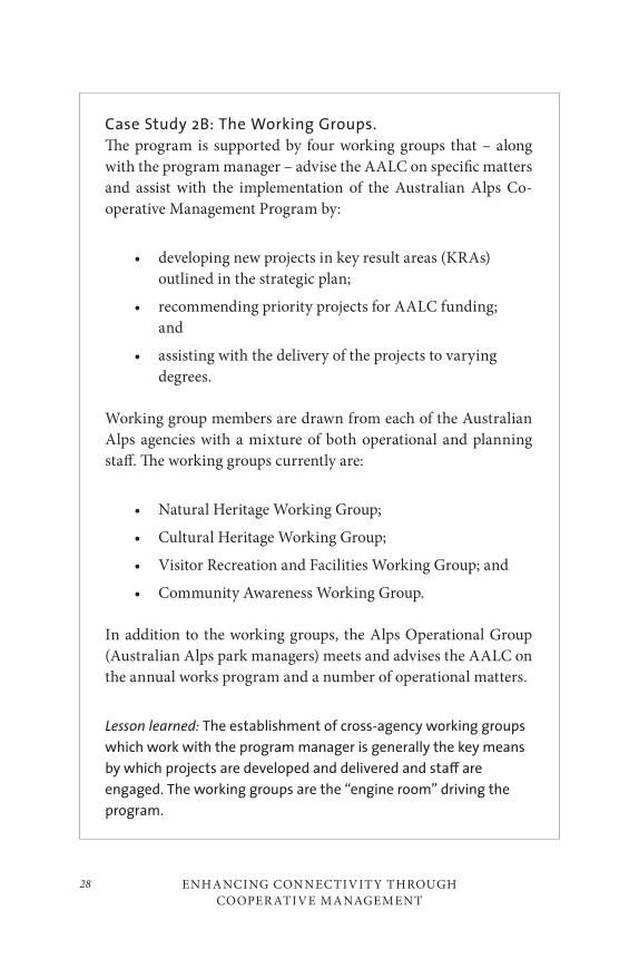
ENHANCING CONNECTIVITY THROUGH COOPER ATIVE MANAGEMENT
28
Case Study 2B: The Working Groups.
The program is supported by four working groups that – along with the program manager – advise the AALC on specific matters and assist with the implementation of the Australian Alps Co-operative Management Program by:
• developing new projects in key result areas (KRAs) outlined in the strategic plan;
• recommending priority projects for AALC funding; and
• assisting with the delivery of the projects to varying degrees.
Working group members are drawn from each of the Australian Alps agencies with a mixture of both operational and planning staff. The working groups currently are:
• Natural Heritage Working Group;
• Cultural Heritage Working Group;
• Visitor Recreation and Facilities Working Group; and
• Community Awareness Working Group.
In addition to the working groups, the Alps Operational Group (Australian Alps park managers) meets and advises the AALC on the annual works program and a number of operational matters.
Lesson learned: The establishment of cross-agency working groups
which work with the program manager is generally the key means
by which projects are developed and delivered and sta≠ are
engaged. The working groups are the “engine room” driving the
program.

29Peter Jacobs and Gillian Anderson
3. The Program Must Have a Sense of Belonging: Building
a Sense of Pride, Ownership, and Empowerment with Sta≠
and the Community
For a program like this to succeed across such a broad range of jurisdic-tions, a key objective has been to involve staff at all levels and to build a sense of personal and professional ownership. It is often said the suc-cess of the Australian Alps program is in the ground-level support and involvement of the staff. Feedback from staff indicates this is best achieved through a program that is tangible, output-focussed, and contemporary that relates on an inter-jurisdictional and landscape scale.
The strategic plan and programs aim to focus projects on tangible out-comes that can occur outside the sphere or ability of normal agency busi-ness to demonstrate value of co-operation, networking, and engagement across borders. Staff, and to some extent the community, is invited annu-ally to submit project proposals for funding that meet the strategic plan key result areas. The AALC evaluates the project proposals on achievabil-ity, stimulation, and relevance to staff and the community. Through dis-cussion with the operational area managers group, the AALC also ensures that the majority of projects have an “on the ground” focus. Particular emphasis is on ensuring that at least two workshops are held each year where staff can come together. Experience indicates that, in the first stages of program establishment, picking off the ‘lower fruit’ with clear achieve-ments results in quick support.
Tangible Outcomes
Case Study 3A: Australian Alps Walking Track (AAWT)
The AAWT extends for 655 kilometres along the spine of the Australian Alps. Although the “Alpine Track” was in place in spirit for decades, one of the first initiatives of the Alps program was to facilitate co-operation across the agencies to have the track formally established and branded as the Australian Alps Walking Track. This was highly successful and gained early recognition of
ENHANCING CONNECTIVITY THROUGH COOPER ATIVE MANAGEMENT
30
the program value in terms of a tangible example of cross-border co-operation and connectivity for staff and community members.
Lesson learned: Focus on projects that can show clear and tan-
gible evidence of successful outcomes of co-operation across
jurisdictions.
Workshops and NetworkingThe consistent message from staff and stakeholders is that they most ben-efit from the ability to come together at workshops to discuss and collabo-rate on common issues across a large landscape, which would otherwise be difficult. The more common focus on workshops as opposed to confer-ences reflects the desire to interact and collaborate in an informal sense amongst staff and, now more commonly, interested stakeholders.
Case Study 3B: Alpine Human Waste Workshop
The matter of managing human waste in remote alpine settings is complex. Although there has been a lot of research and ex-perimentation, a lack of communication often results in a dupli-cation of effort when new facilities are planned. This was a key knowledge gap identified by Alps staff. Under the auspices of the Australian Alps program, a travelling human waste management workshop was held to include invited international and national experts, industry providers, recreationalists, and staff. This was very successful and led to the translation of the proceedings into a manual that has guided planning for some years.
Lesson learned: Workshops that share information on contempor-
ary and common landscape-scale management issues have great
value.
31Peter Jacobs and Gillian Anderson
Engaging the Wider CommunityAs the program matures, it is becoming more focussed on expanding en-gagement with the broader community.
Case Study 3C: Australian National Landscapes Program.
Tourism Australia is developing a new international tourism branding campaign for Australia focussing on Australia’s best nature-based landscape-scale experiences. Fundamental to be-ing part of that program is being able to demonstrate to Tourism Australia that the region has full co-operation and support of the community that will present those experiences. The Australian Alps region is a prime candidate due to its unique experience and established infrastructure. It also has, through the co-operative management agreement, a unique inter-jurisdictional arrange-ment to support such an innovative and sensitive tourism pro-gram. The Australian Alps program has been the backbone of community discussions regarding national landscapes and the ‘glue that holds them together.’ It has also been a great opportu-nity for the Australian Alps program to widen its base and in-fluence, to work more closely with local government, the tourism industry, and regional and state tourism organizations and to gain their partnership and support.
Lesson learned: Inter-jurisdictional arrangements may need to look
inward during their establishment to get key agency support, but
in time grow to seize opportunities to engage in the wider com-
munity be it for tourism, natural resource management, or social
and cultural areas management. Transboundary programs can be
the glue to connect the parts to achieve great regional and na-
tional connectivity outcomes.
ENHANCING CONNECTIVITY THROUGH COOPER ATIVE MANAGEMENT
32
Going the Next StepA more recent initiative of the program as it matures is to investigate le-veraging off the strength and positioning of the program to invest small funding into seeking considerable external funds for substantial strategic programs.
Case Study 3D: Strategic Water Program
The Australian Alps – while being a very small part of Australia – contribute a relatively large proportion of fresh water to river systems due to high rainfall, topography, and snow melt. The catchments have been degraded over decades from domestic stock grazing, fire, weeds, and direct human impact. The Australian Alps program is investing in a positioning project to attract sub-stantial sums to invest in catchment restoration, which has other-wise struggled for adequate funding.
Lesson learned: Inter-jurisdictional management arrangements
across landscapes may, in collaboration with the states, leverage
funds into large national-scale strategic projects.
4. Synthesize the cross-jurisdictional arrangements into
normal agency identity to build trust and overcome
concerns regarding loss of corporate identity of agencies
and inconsistencies in policies and procedures
The risk with cross-jurisdictional arrangements that involve a small part of multiple organizations is that, while they may work across the broader landscape, they do not pick up wide corporate support or understanding across each agency.
33Peter Jacobs and Gillian Anderson
Issues can arise around:
• dedicated recurrent funding support to the program when there are limited agency resources; and
• concern over cross-jurisdictional branding, priorities, and management systems conflicting with agency policy and positioning.
To alleviate these concerns, it is important to position the co-operative management program to ensure:
• that the borders between core state jurisdictional responsibility and the objectives of co-operative management are clear and don’t conflict;
• that consistent inter-jurisdictional policy on issues may not be achievable and indeed may not be necessary but the co-operative program facilitates a way to achieve best outcomes across the landscape; and
• that co-operative management branding doesn’t conflict or compete with agency branding and positioning.
The individual agency corporate support for the co-operative manage-ment program needs to be strong, and to achieve that the program must be defendable. A defendable program is achieved through staff support but also must have the ability to report on outcomes that meet strategic plan objectives and a clear position on the relationship between the pro-gram and agency corporate priorities and policies.
ENHANCING CONNECTIVITY THROUGH COOPER ATIVE MANAGEMENT
34
Case Study 4A: Australian Alps Signage Branding Project
As part of the Australian Alps co-operative management pro-gram, the strategic plan identified the need to identify Australian Alps national parks on the ground with signage, incorporating “Welcome to Country” from the indigenous communities, and on staff uniforms. A number of options were considered for signage from a complete newly branded sign, Australian Alps brand com-bined with agency brand, through to completely separate signage. The agencies at corporate communication levels were understand-ably concerned with the loss of individual agency branding either through signage or uniform. The agreed outcome was separate signage at strategic locations to present both brands as comple-mentary but not competing.
Lesson learned: Branding and positioning of inter-jurisdictional
programs should complement and not compete with jurisdictional
agencies.
Case Study 4B: Deer Management Workshop
Introduced wild deer are an emerging problem across the Australian Alps landscape. For various reasons, the three states have different legislation relating to the management of deer as game or pest species, and this is unlikely to change in the short term due to differing circumstances and politics. In Victoria, a formal partnership agreement has been signed off between Parks Victoria and the Australian Deer Association. As part of the Australian Alps best practice workshop series, a deer man-agement workshop was held to network and collaborate on deer management. Conflicting views emerged about the involvement of stakeholders in the workshop. Some states were concerned that
35Peter Jacobs and Gillian Anderson
it was an internal issue and the involvement of stakeholders would become political, while others felt the involvement of stakeholders was critical to the open and honest partnership approach. The lat-ter view was upheld but caused a rift amongst staff.
Lesson learned: Agencies involved in inter-jurisdictional co-oper-
ative agreement must accept that policy di≠erences will occur
and use the strengths of co-operative management programs to
achieve an outcome that is acceptable. Co-operative e≠orts must
also look outward for solutions and be prepared to involve the
community.
5. Dedicated Program Support: Have a Strong, Defendable
and Well-positioned Funding Base
The Australian Alps Memorandum of Understanding calls for each agen-cy to contribute funds “as appropriate.” To achieve successful outcomes, the program must have a reasonable level of funding. However, with co-operation and dedication of staff and agencies, a little money invested in establishing formal program co-ordination and management, coupled with support to the working groups, adds substantially to outcomes.
The MOU commits an agreed level of funds each year to support the program commensurate with the area and resource covered by the agree-ment. Currently, the two agencies with larger areas – Parks Victoria and NSW Department of Environment, Conservation and Climate Change – contribute $120,000 each, while the ACT Parks, Conservation and Lands gives $40,000 and the federal government normally contributes around $30,000. To consolidate ongoing funding, the program needs to report back to sponsor agencies on achievement of targets, effective use of funds, and community and staff support.
ENHANCING CONNECTIVITY THROUGH COOPER ATIVE MANAGEMENT
36
Case Study 5A: Program Manager
The key to success over the last two decades has been the establish-ment of a program manager position and targeted support where needed to drive, grow, and communicate on the program, and in particular support and co-ordinate the four working groups. Of the $310,000 annual program budget, over one-third goes to pro-gram co-ordination while the remainder goes to funding projects. The work of staff and working groups is a substantial in-kind con-tribution to the significant annual works program. The organic nature of the program leads to a very favourable cost-benefit-out-come ratio. To ensure agency engagement, the program manger is drawn from within the agencies on a three-year rotation basis.
Lesson learned: Investment of funds into dedicated and e≠ective
program co-ordination adds significantly to outcomes and har-
nesses the organic nature of the program. This produces enormous
in-kind benefits and substantial output relative to cash invest-
ment. A three-year rotation is a preferred minimum period of time
for the program manager to come to terms with the complexity of
the program and for jurisdictions to share ownership.
6. Develop the Program to Stay Relevant and Fresh
Many staff have said they enjoy involvement in the Australian Alps pro-gram as it aims to take leadership on sharing information on strategic issues that normal agency business at the operational level may not have exposure to. To continue to achieve this, it is important to stay abreast of, and communicate on, contemporary issues that affect park management. It is also important to be fresh on ideas and directions for the program to continue to engage staff and community, and to be relevant to government and agencies.
37Peter Jacobs and Gillian Anderson
Case Study 6A: Fire workshops and expert panel
The 2003 fires were a megafire event for the Australian Alps, burn-ing out 1.8 million hectares across three states, resulting in the largest fire in south-eastern Australia in over sixty years. While the states dealt with fire suppression and recovery in their juris-dictions, the Australian Alps program played the co-ordination role for reporting of research results, monitoring the effects of fire on the wider alps landscape, and identifying issues for the states to address. The outcome was three different alps-wide workshops of scientists and mangers on the effect of fire on alps biodiversity and cultural values and the facilitation of an expert panel to report on effects and action required.
Lesson learned: Be flexible and proactive in response to contempor-
ary issues as they arise. Leadership is needed on transboundary
landscape-scale issues, which provide the mechanism and forum to
bring people together.
7. Build on Strengths of a Cross-Jurisdictional Approach
The primary basis for cross-jurisdictional co-operative management pro-grams is the focus on landscape-scale management across administrative borders to improve connectivity outcomes. It is therefore fundamentally important that there is a clear separation of output-based programs that are delivered by agencies and the true nature of cross-border-focussed out-puts. When evaluating projects for funding and support, the Australian Alps program carefully considers that the outcome has benefits for all states with Alps landscape-scale benefits that cannot be achieved through agency programs. It is not a fund source for the latter.

ENHANCING CONNECTIVITY THROUGH COOPER ATIVE MANAGEMENT
38
Case Study 7A: Feral Pig Workshop – Pigs Know No
Borders
Feral pigs are an established pest in some parts of the Alps and are emerging in others with spread occurring across borders. They are highly destructive in Alps environments and a serious threat to native biodiversity. While operational feral pig control is clearly an agency responsibility, there is a wealth of experience across the Alps accrued through decades of feral pig management and new research to consider. The role of the Alps co-operative management program is to bring together staff, contractors and researchers regularly to discuss pig movement intelligence, recent successes, concerns and new information on methods to improve program efficacy, and hopefully significant reduction or elimina-tion of the species.
Lesson learned: Co-operative management programs across bor-
ders must avoid being a fund source for agency operational issues,
and focus on strategic support across the landscape to facilitate
best practices and improved e≤cacy that can be achieved through
sharing of knowledge and information.
8. Look Outward to Build Partnerships and Expand
Connectivity Opportunities
The earlier stages of the development of the co-operative management program naturally looked inward to establish interagency relationships and engagement, and to develop the program. As the program has ma-tured and consolidated, more focus is directed to looking outward to the community and developing further partnerships with stakeholders and adjacent land managers to connect a wider region beyond the traditional protected area boundaries.
39Peter Jacobs and Gillian Anderson
Case Study 8A: Alpine Resorts
In Victoria, four large alpine resorts act as the “holes in the dough-nut” of the Australian Alps national parks. They have not been included in the co-operative management agreement to date on the basis that they have not been considered protected areas and were seen as a potentially weak point in the agreement. However, in New South Wales, similar resorts are included by the fact that they are within the Kosciuszko National Park. As stated earlier, inter-jurisdictional inconsistency is not a difficulty if the same outcomes can be achieved through co-operative management. The resorts are integral to managing the alpine area estate and in-tegrated planning for visitor use and natural and cultural values is vital. All the benefits of the Australian Alps co-operative equally apply to resorts to manage the big picture. The alpine resorts in Victoria have now been invited to be included in the MOU and have gladly accepted.
Lesson learned: In establishing inter-jurisdictional agreements, be
focussed on what is achievable early but allow the arrangements
to broaden as the program matures and strengthens to perhaps
include non-traditional partners to gain better connectivity
outcomes.
Case Study 8B: Indigenous Cultural – “The First People’s
Gathering”
Australian indigenous people have a long and rich history in the Alps, albeit largely disconnected from European culture and in-deed park managers until more recent times. Settlement of the al-pine areas by non-indigenous people resulted in major disruption and decline to the indigenous population due to disease, massacre,
ENHANCING CONNECTIVITY THROUGH COOPER ATIVE MANAGEMENT
40
and relocation to missions. The states have been slowly rebuilding relationships with communities and starting to engage them in partnerships. Different state legislation can mean different ap-proaches are used. However, the indigenous community bound-aries and interests cross the landscape and are not constrained by state boundaries. The megafires of 2003 (see Case Study 6A) were a significant step in bolstering engagement. The Australian Alps program built on this for the first time in known history by bringing together the Traditional Owners from across the Alps to the “First People’s Gathering” at Mount Hotham. This was a major historic event with a number of outcomes for furthering the partnership, including a “treaty” made possible through the co-operative management program. Essential to this achievement was the fact that the indigenous groups understood the Australian Alps agreement is a facilitator and does not replace state and fed-eral legislative requirements.
Lesson learned: Cross-jurisdictional programs can achieve wide
engagement and partnerships for landscapes that are not pos-
sible when working only within jurisdictional boundaries. Once an
agreement is established, it is important that partners understand
the jurisdictional roles of state and other agreements.
9. Develop a Strategic Plan and Evaluate Achievements
The development of a strategic plan agreed upon by all partners is vital to set direction, identify outputs, ensure desired outcomes are clear, and give direction to program development and projects. The ‘sign off’ on the plan builds confidence and support in the partners. The plan is a contract with the states to secure funding and a reporting mechanism to measure delivery.
41Peter Jacobs and Gillian Anderson
Case Study 9A: Australian Alps Strategic Plan.
Developed on a three-year cycle, the strategic plan identifies six key result areas:
i. Integrated Landscape Management. This area targets networking, linkages and sharing information. The co-opera-tive program is a mechanism, providing access to a great body of knowledge that is used in all kinds of ways, which is of great value to individuals as well as agencies. Projects include input into agency planning, policy development and review, visitor advice, and compliance activities across borders. The program has pre-pared values statements actively promoting the Australian Alps for National Heritage Listing under the Federal Environment Protection and Biodiversity and Conservation Act and for the National Landscapes Program (see Case Study 3C) adding weight to the “One Park” connectivity concept and a precursor to po-tential UNESCO World Heritage Site listing. The recent twenty-one-year celebration of the MOU brought together key drivers of the past and present program and hopefully, through younger participants, the new drivers to discuss future direction (see The Next Twenty-One Years).
ii. Natural Heritage Conservation. The significant natural values of the Australian Alps national parks have been defined by the program and are now being widely used as a basis for plan-ning, research, and operational management. The AALC commis-sioned a study entitled “Protecting the Natural Treasures of the Australian Alps.” It identified more than 1,300 significant natural features in the Australian Alps and nearly a hundred threats to their continued survival. This area targets achieving best practices and co-ordinated plant and animal pest threatened species and re-habilitation programs through networking, workshops, engaging experts, publications, and support to research and monitoring.
ENHANCING CONNECTIVITY THROUGH COOPER ATIVE MANAGEMENT
42
iii. Cultural Heritage Conservation. The Australian Alps has very high indigenous and historic heritage values from thousands of years of Aboriginal occupation to more recent mining and grazing activity. The latter is now mostly finished with protected area establishment. This area targets facilitating involvement of indigenous people in park management, research into historic cultural heritage, cultural landscape management guidelines, and workshops on cultural themes such as hut management and re-cording of history.
iv. Visitor Recreation and Facilities. The Australian Alps are an attraction for visitors seeking a very wide range of recreation and leisure activities that occur across the landscape, with the Australian Alps Walking Track being an example (see Case Study 3A). While the program does not provide facilities, the aim is to provide best practice advice on visitor impacts, visitor planning, and facility products and management though workshops, manu-als, and networking.
v. Community Awareness. The aim of this area is for the Australian Alps to be widely perceived and understood in gov-ernment and the community as a single biogeographical unit of national significance and that co-operative management across states is a worthy outcome. To achieve this, customer services – needed by visitors to understand the wider landscape – are tar-geted through the production of a suite of visitor resources (maps, publications, signs, and displays) that promote enjoyment, appre-ciation, and sustainable use. Media campaigns through television, print, and radio outlets are also used to achieve this aim.
vi. Capacity building. Australian Alps national parks agen-cies employ about two hundred staff, working more or less dir-ectly in the parks. Many others contribute less directly. In addi-tion, many stakeholders and volunteers contribute to programs. This area aims to increase the technical and functional capacity of staff and stakeholders by bringing together staff and experts to
43Peter Jacobs and Gillian Anderson
share experiences and knowledge related to programs that occur across the landscape, such as the best practice workshops men-tioned above.
Lesson learned: A strategic plan is vital for functioning co-operative
programs. It should be an output-focussed contract with partners
that outlines agreed-upon key result areas and mechanisms for
reporting back on achievements.
10. Education and Science Give Powerful Support and
Knowledge Base
An area often identified by managers, scientists, and educators is the lack of collaboration and integration of these streams into protected area man-agement. These streams can be silos and often blame each other for lack of engagement. This is an immensely wasted opportunity when managing a landscape. Education and science are pillars to good management and when working together are a powerful support and knowledge base. A re-cent example is the science-based case put to government to remove the last cattle-grazing in the Alps, which was successful.
A strength of the Australian Alps program is its role as a facilitator of networking and partnerships. The Australian Alps Liaison Committee, with the support of the International Union for Conservation of Nature (IUCN) has identified a direction for the program to broaden understanding of op-portunities for the integration of science and management in the Alps.
ENHANCING CONNECTIVITY THROUGH COOPER ATIVE MANAGEMENT
44
Case Study 10A: Science-Management Workshops and
Partnership with IUCN
The Australian Alps Program now has the annual science-man-agement-themed workshop as part of the annual works program. The 2007 workshop was on climate change and implications for management and was hosted jointly with the IUCN. Scientists were carefully briefed to ensure that they understood the work-shop was not about science methodology or arguing the science case but presenting the best information on expected outcomes. It targeted at how managers may be able to develop suitable re-sponses and assist further science enquiry. The workshop ended with managers having a clear picture of expected climate change effects on the Alps and importantly the direction that manage-ment needs to consider to mitigate and adapt.
Lesson learned: Science and education are fundamental to good
management and positioning and must be engaged in co-opera-
tive programs. A benefit of co-operative management programs
can be facilitating science and education to also work across juris-
dictions where landscape-scale issues are being considered. The
program is also strengthened with the assistance of well-respected
partners in science and management such as the IUCN.
11. Communication is All: Build Awareness Both Internally
and Externally
The fundamental key to success or failure of cross-jurisdictional co-oper-ative programs is communication, both internal and external. The sup-port base from government, staff, and community will not grow without communication excellence by a variety of means, reporting on outcomes, successes and values to individuals and communities of these programs.
45Peter Jacobs and Gillian Anderson
Perceived values will vary with the diversity of stakeholders, so communi-cation must be targeted in a variety of means to suit the need. Evaluation of success from time to time is also needed.
Case Study 11A: Communication within Government,
Agencies and Key Stakeholders – Annual Reports and
Regular Newsletters
The annual report informs of achievement against the strategic plan and presents the case that funds are well-targeted and out-comes achieved. The audience is largely government and agencies.
In addition, well-presented newsletters give regular updates of achievements, upcoming events, and general networking news. The audience for the newsletter is staff and closer stakeholders that have more intimate interests in the Alps.
Lesson learned: To achieve support and commitment from govern-
ment, agency, sta≠, or stakeholders, it is vital to communicate
achievements, news, program successes, and general network
information in a variety of means at the right level, time, and
medium.
Case Study 11B: Communication with Wider Non-
aligned Community – Map, Website, and Community
Announcements
The three pillars of community communication have been an ef-fective website, a good map and community announcements sup-ported by a range of other collateral. The map is aimed at car-based touring visitors and presents the whole area under co-operative management. The map also provides additional information on facilities, walks, drives, and natural and cultural values with links for further information. It is a key communication tool.
ENHANCING CONNECTIVITY THROUGH COOPER ATIVE MANAGEMENT
46
The Australian Alps website is very well visited and targets visitors, students, staff, and general audiences. It contains all rel-evant visitor information and the range of publications and reports that the program has produced, along with current information updates as needed and links to agencies for further information.
The community announcements are high-quality video im-ages linked with short, very simple messages designed for tele-vision that merely raise or re-enforce awareness of the Australian Alps as a bioregion.
Lesson learned: External communication is achieved through tools
that the public find useful and will use, such as maps and websites.
For simple first step awareness or re-enforcement, quick television
grabs using free community services o≠ered by media are very
e≠ective.
THE NEX T T WENT Y- ONE YEARS
The Thredbo Meeting and Declaration
Past, present, and future staff and stakeholders involved in the Australian Alps co-operative management program gathered at Thredbo, NSW, in June 2007 to celebrate twenty-one years of the program and take part in a futures planning exercise to support the development of the next stra-tegic plan. A declaration was made to present to government recognizing the successes of the program, re-enforcing its ongoing need for high-level government support, and refocussing where needed, such as enhancing indigenous community involvement (Australian Alps Liaison Committee 2008).
47Peter Jacobs and Gillian Anderson
A selection of views from the meeting regarding the future directions of the program, which the Australian Alps Liaison Committee will con-sider for advice to the heads of agencies, include:
a. Maintain strong recurrent funding and seek outside funding support for larger more strategic programs;
b. Seize opportunities to widen the program to go outside existing protected areas to enhance connectivity values and be more outward-focussed and encompassing of others;
c. Take leadership with major issues such as climate change, water, and fire;
d. Improve collaboration with indigenous communities;
e. Ensure the program maintains relevance to new generations of staff and community;
f. Recognize the aging factor of the current generation of leaders involved in the first twenty-one years;
g. Develop a program that encourages retired and soon-to-be-retired Australian Alps leaders to continue to engage in voluntary program support; and
h. Ensure the program is robust to survive in a range of political circumstances.
SUMM ARY AND CONCLUSION
The Australian Alps co-operative management program has been in exis-tence for twenty-one years. It is still a robust program with firm support and a sound future. It is a fine example of making cross-jurisdictional protected area management work though co-operation and dedication.
The eleven key lessons that have contributed to the success of the pro-gram as it has matured are:
ENHANCING CONNECTIVITY THROUGH COOPER ATIVE MANAGEMENT
48
1. Making a start: establish a champions group. Create a prominent and politically savvy group representing agencies that can influence and convince government.
2. Have a solid program structure: top down – bottom up. Get the right balance of high-level support and ground-level engagement.
3. The program must have a sense of belonging. Build a sense of pride, ownership, and empowerment with staff and the community. This is the key to success.
4. Build trust within governments and agencies to ensure that cross-jurisdictional arrangements don’t impinge on individual agency policy, identity, and responsibility. Inconsistencies in policies and procedures may not be as much of an issue if they can be managed through co-operation.
5. Dedicated program support is vital and needs to have a strong, defendable and well-positioned funding base to achieve program goals, but a little money can go a long way when there is co-operation.
6. Develop the program to stay relevant and fresh in order to continue to engage and interest staff, stakeholders, and the community and to be attractive to government and agencies.
7. Build on the strengths of a cross-jurisdictional approach and do not become distracted by individual agency business. Ensure programs are strategically targeted at benefits to most, if not all, partners in the landscape.
8. Look outward to build partnerships to expand connectivity opportunities. While the focus might initially be on protected areas and staff, there are many

49Peter Jacobs and Gillian Anderson
partners that might contribute to expanding the benefits and thereby enable the program to gain more relevance in the community. However, don’t lose the organic nature, which is a key strength: that is the fundamental support, engagement, and work of the staff and stakeholders.
9. Develop a strategic plan and evaluate achievements. This is the contract with partners regarding what is expected to be delivered. Evaluating achievements will build confidence in the program direction.
10. Co-operative management can be the mechanism for integrating education, science, and management to give a powerful support and knowledge base to decision-making.
11. Communication is all. Build awareness and report effectively both internally and externally through a variety of mediums to target a diverse market.
The future challenges and directions of the program are likely to be to:
• Consolidate and expand funding;
• Develop a more outward focus;
• Take leadership with major issues such as climate change, water, and fire;
• Improve collaboration with indigenous communities;
• Ensure the program maintains relevance to new generations;
• Engage retired leaders; and
• Ensure the program is robust to survive in a range of political circumstances.
ENHANCING CONNECTIVITY THROUGH COOPER ATIVE MANAGEMENT
50
REFERENCES
Australian Alps Liaison Committee. 2008. Strategic Plan Summary 2008–2011. Accessed December 2, 2011. http://www.australianalps.environment.gov.au/publications/alps-program/strat-plan-08-11-summary.html.
Crabb, P. 2003. Managing the Australian Alps: A history of co-operative management. Canberra: Australian Alps Liaison Committee and the Centre for Resource and Environmental Studies, Australian National University.
51
The Australian Alps Transboundary Partnership: Analyzing its Success as a Tourism/Protected Area Partnership
Betty Weiler, Jennifer Laing, and Susan A. Moore
INTRODUCTION
In Australia, as is the case elsewhere in the world, there is a call for change in the way protected areas are managed. Constrained by limited resources and driven by legal, ethical, and moral imperatives, protected area man-agement agencies are engaging with partners to achieve their goals, and nowhere is this more apparent than in their efforts to fulfill the tourism services side of their dual protection/use mandate. While protected areas are clearly essential for a viable and sustainable tourism industry, tourism in turn offers an important vehicle for garnering and maintaining public support. Eagles (2002) notes that “generally the trend is for government to
3

THE AUSTR ALIAN ALPS TR ANSBOUNDARY PARTNERSHIP52
demand that parks earn much higher amounts of their budget from tour-ism sources” (139). Moreover, there is increasing evidence that working in partnership can lead to “more constructive and less adversarial attitudes” (De Lacy et al. 2002, 10). Thus, tourism/protected area partnerships are increasingly viewed as a valuable tool for both park management and the tourism industry.
Paralleling this move toward more innovative forms of management, as observed by Timothy (1999), has been a growth in the numbers of parks that straddle or are located adjacent to political borders. Transboundary parks offer additional challenges and opportunities for balancing the dual protection/use mandate that underpins most protected area manage-ment. Tourism, like nature, does not stop at jurisdictional borders – as with native animals, water, and other resources, tourists may have little or no interest in the boundary lines that determine legislative authority. Transboundary partnerships seem to offer a logical and efficient approach to developing and managing these shared resources for the benefit of both resource protection and tourism.
This chapter draws on the work of a two-year Australia-wide research project which seeks to identify the attributes of successful tourism/pro-tected area partnerships and the factors contributing to and inhibiting partnership success. While much has been written on partnerships in the context of protected areas and tourism management, most studies have used a descriptive case study approach focussing exclusively on examples of successful partnerships rather than trying to identify and understand how particular factors might contribute to effective vs. failed partner-ships. Moreover, they tend to fall short of synthesizing the literature and extracting theoretical constructs that can inform both study design and interpretation of results, and thus provide valuable lessons for partner-ships elsewhere. The present study examines past tourism/protected area partnership research against a backdrop of a wider literature, in order to strengthen further theorizing and empirical research in this area.
The chapter begins by defining some key terms used in our study and then draws on theory from several bodies of literature to identify a number of partner-, process-, and context-related factors that potentially contribute to partnership success. This is followed by an overview of the

53Betty Weiler, Jennifer Laing, and Susan A. Moore
Australian Alps National Parks (AANP) as an example of a particular type of partnership – a transboundary partnership seeking to address a range of issues, many of which are tourism-related. Indicators (both process and outcomes) of success are then used to analyze the tourism elements of this partnership, followed by identification of some key factors that may explain this success. This analysis serves to illustrate the relevance of the theory, methods, and findings of this study to other transboundary part-nerships and as a basis for recommendations for establishing, assisting, and monitoring transboundary partnerships.
DEFINING PARTNERSHIPS, SUCCESS, AND
SUSTAINABLE TOURISM
Partnerships
As a starting point, it is useful to define the term partnership and examine the explicit differences between it and related terms such as collaboration, cooperation, and joint management, which appear to have been used inter-changeably in some of the literature (Hall 1999; Miller and Ahmad 2000; Dowling et al. 2004; Selin 2004). For example, Bramwell and Lane (2000) observe that “collaboration is commonly used in the academic tourism literature,” while “in government and practitioner circles the term part-nership is widely used … to denote a collaborative arrangement” (2–3).
A useful approach in defining partnerships is to identify the key ele-ments of a partnership. For example, Brinkerhoff (2002) advocates the need for mutuality (mutual dependence, influence, accountability, and transpar-ency), and Leach and Pelkey (2001) and others note that, while the degree of formality can vary, duration is important. In the context of natural re-source management, Selin and Chavez (1995) argue that partnerships exist in order to solve a problem or an issue that cannot be solved individually, and Bramwell and Lane (2000) stress the need for agreement on rules or norms. For the purposes of this study, partnerships are defined as:
THE AUSTR ALIAN ALPS TR ANSBOUNDARY PARTNERSHIP54
Regular, cross-sectoral interactions over an extended period of time between parties, based on at least some agreed rules or norms, intended to address a common issue or to achieve a specific policy goal or goals, which cannot be solved by the partners individually, and involving pooling and sharing of appreciations or resources, mutual influence, accountability, commitment, participation, trust, respect and transparency. (Laing et al. 2008, 4)
In considering Timothy’s (1999) continuum of “cross-border partnerships” that ranges from alienation, to coexistence, to cooperation, to collabora-tion, and finally to integration, then, the former three are seen as being outside the scope of a true partnership, while collaboration is viewed as a mechanism to achieve partnership.
Success
While the meaning of a successful partnership has been assumed to be self-evident in many studies, in fact, success can have multiple dimen-sions. In the context of our study, both process (what is achieved in terms of ongoing relationships among partners) and outcomes (what is achieved in terms of sustainable tourism) are considered to be important.
With regard to determining or measuring the success of a partner-ship’s processes, the Watershed Partnerships Project (2002) suggests gauging success in terms of the effect of the partnership on human or social capital and on the “long-term policy implementation and conflict resolution” (14) of the organization. Leach and Pelkey (2001) note this ap-proach as being particularly appropriate where the partnership has not been in place for very long or has had its progress thwarted by high levels of internal conflict. Leach and Pelkey (2001) also include trust-building, conflict resolution, satisfying the stakeholders, and strengthening the long-term organizational capacity of the partnership as process-related measures of success (380). Using these and other sources, the indicators that we included in our study as measures of a successful process were efficiency/productivity gains, social gains (e.g., equity and empower-ment), stimulation of innovation, building social capital, strengthening
55Betty Weiler, Jennifer Laing, and Susan A. Moore
organizational capacity, and creating indirect benefits (e.g., local employ-ment) (Laing et al. 2008).
Partnership success can also be measured in terms of the results or outcomes of the partnership arrangement. Notwithstanding the observa-tion by Bramwell and Lane (2000) that it can be difficult to distinguish process from outcome, Buckley and Sommer (2001) suggest that success in the context of tourism/protected area partnerships includes outcomes such as:
• Conservation outcomes such as reforestation, protection of wildlife, enhanced stewardship across local communities (Mburu and Birner 2007), assistance with research and monitoring programs and protection of land from high-impact activities;
• Economic outcomes such as providing funding for various conservation or restoration programs or protected area management, financial assistance for local communities, and encouraging economic growth in regions without alternative sources of revenue;
• Social outcomes such as public education or creation of local jobs; and
• Management outcomes such as business skills development.
Following a similar approach, in our study we gauge the success of a part-nership as one that achieves not only process outcomes as described above but also sustainable tourism outcomes. In order to determine what these outcomes should be, it was important to review, critically evaluate, and settle on a suitable definition and operationalization of sustainable tour-ism, as it is also widely contested in the literature.
Sustainable Tourism
Macbeth (1994) notes the long-term nature of sustainable tourism and argues for its importance in setting a “moral agenda” and providing “a
THE AUSTR ALIAN ALPS TR ANSBOUNDARY PARTNERSHIP56
practical route map” for tourism. “Put simply, our task is to facilitate a tourism that will carry on, that will endure but that will also contribute, nourish and tolerate” (42). He identifies four principles within the sustain-ability model – ecological sustainability, economic sustainability, social sustainability, and cultural sustainability. This model, applied in a tourism context, goes beyond a focus on maintaining steady numbers of tourists and involves a holistic approach or quadriga, to use Macbeth’s metaphor, with each “horse” (principle) required to pull the “chariot” (sustainability) evenly and in the same direction to optimize the outcomes.
Building on these principles, our search for an operational defin-ition of sustainable tourism turned to the United Nations Environment Programme and World Trade Organization (2005) and their twelve aims for an agenda for sustainable tourism. Using Macbeth’s (1994) categories, the twelve indicators include economic sustainability (economic viability, local prosperity, employment quality), social sustainability (social equity, visitor fulfillment, local control, community well-being), cultural sustain-ability (cultural richness), and ecological sustainability (physical integrity, biological diversity, resource efficiency, and environmental purity). These twelve indicators are used as measures of successful outcomes.
SUCCESS FACTORS
In addition to gauging the success of a number of tourism/protected area partnerships, our study sought to identify the factors that contribute to or inhibit such success. To achieve such explanatory power and to avoid “re-inventing the wheel,” we reviewed a wide range of literature, from which we identified a large number of factors from areas such as environmental dispute resolution (e.g., Bingham 1986; Moore and Lee 1999; Crowfoot and Wondolleck 1990), social capital theory (Coleman 1988; Macbeth et al. 2004; Leach and Sabatier 2005), institutional analysis and development (Ostrom 1999; Imperial 1999), adoption and diffusion of innovations (Rogers 1995; Lundblad 2003; Braun 2004) and network theory (Pavlovich 2003; Saxena 2005; Dredge 2006a, 2006b). These were then grouped into
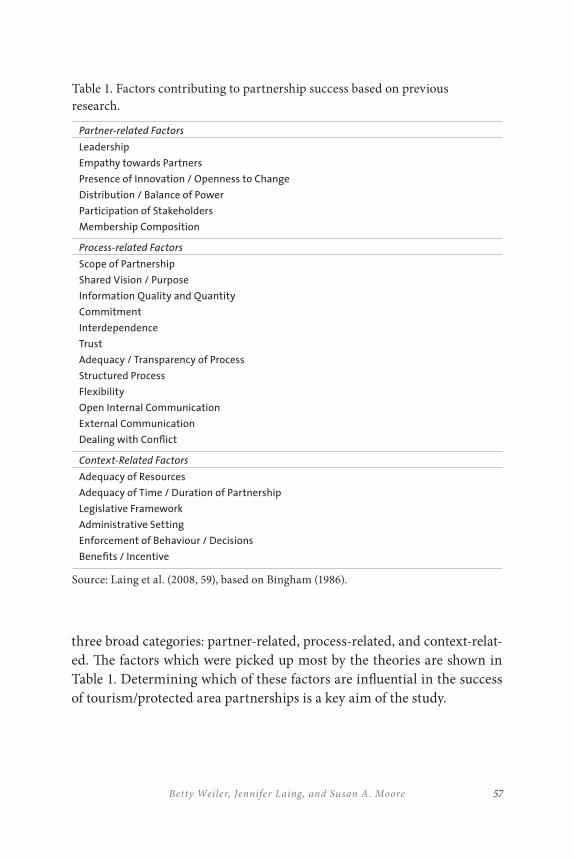
57Betty Weiler, Jennifer Laing, and Susan A. Moore
three broad categories: partner-related, process-related, and context-relat-ed. The factors which were picked up most by the theories are shown in Table 1. Determining which of these factors are influential in the success of tourism/protected area partnerships is a key aim of the study.
Table 1. Factors contributing to partnership success based on previous research.
Partner-related Factors
Leadership
Empathy towards Partners
Presence of Innovation / Openness to Change
Distribution / Balance of Power
Participation of Stakeholders
Membership Composition
Process-related Factors
Scope of Partnership
Shared Vision / Purpose
Information Quality and Quantity
Commitment
Interdependence
Trust
Adequacy / Transparency of Process
Structured Process
Flexibility
Open Internal Communication
External Communication
Dealing with Conflict
Context-Related Factors
Adequacy of Resources
Adequacy of Time / Duration of Partnership
Legislative Framework
Administrative Setting
Enforcement of Behaviour / Decisions
Benefits / Incentive
Source: Laing et al. (2008, 59), based on Bingham (1986).
THE AUSTR ALIAN ALPS TR ANSBOUNDARY PARTNERSHIP58
OPER ATIONALIZ ATION OF CONSTRUCTS AND STUDY
METHODS
This review of literature on success factors provides a rich basis upon which to critically examine specific partnerships in order to try to ex-plain why some tourism/protected area partnerships are more successful than others. The remainder of the chapter provides information about one of the twenty-one partnerships being analyzed for this purpose – the Australian Alps National Parks (AANP) – selected primarily because it provides an opportunity to examine these issues in the context of a trans-boundary partnership. Its value to this chapter is greatly enhanced by the longevity of the partnership between the three protected area manage-ment agencies in New South Wales (NSW), Victoria, and the Australian Capital Territory (ACT) together with the Commonwealth government of Australia who, in the view of many including the International Union for Conservation of Nature (IUCN), have achieved and sustained a highly successful partnership.
Data collection via self-completed structured questionnaires and in-depth interviews is in progress, however, much of the history and achieve-ments as well as the many challenges of this particular partnership can be gleaned from published sources. These include the work of the Australian Alps Liaison Committee (AALC) itself (including annual reports, regu-lar newsletters, three-year strategic plans, and education kits), which are freely available via their website; the publication of the proceedings of the International Year of Mountains Conference held in the Alps in 2002 (Mackay & Associates 2003), which included several papers about the partnership; and Crabb’s (2003a) comprehensive review of the coopera-tive management of the AANP. This latter study included interviews with over forty people at all levels of involvement and covering all of the agen-cies in the partnership (Crabb 2003b, 84). Thus, the preliminary findings included here provide considerable insight into the degree of success of this partnership and the factors contributing to its success.

59Betty Weiler, Jennifer Laing, and Susan A. Moore
BACKGROUND TO THE PARTNERSHIP: AUSTR ALIAN
TOURISM , PROTECTED AREAS, AND THE ALPINE
NATIONAL PARKS
Much of Australia’s nature-based tourism, ecotourism, and adventure tourism activity occurs in protected areas such as national parks, conservation reserves, marine parks, and world heritage areas (Buckley and Sommer 2001). As tourism in and around Australia’s protected areas continues to grow at a steady pace (Buckley 2000; Cole 2001; Worboys et al. 2001; Eagles 2002; Newsome et al. 2002), protected areas are taking on even greater importance to the tourism industry.
In Australia, most protected areas including national parks are managed at the state level. Thus, as noted in the chapter by Jacobs and Anderson (this volume), prior to the mid-1980s, the various national parks located in the alpine region of southeast Australia were managed independently by the states of New South Wales, Victoria, and the ACT, with some arm’s-length involvement by the Commonwealth government.
In their chapter, Jacobs and Anderson provide an overview of the biogeography and significance of the Australian Alps (Map 1). The resources protected by these park agencies include rare and endemic species, the headwaters of several major river systems and a rich and diverse Aboriginal and European cultural heritage. Population growth and demand for recreation and tourism in recent decades has increased the pressure to find ways to provide opportunities for visitors to enjoy these very special alpine areas while protecting these natural and cultural resources.
In 1986, a memorandum of understanding (MOU) was signed by the Commonwealth and three state governments, encouraging these four jurisdictions to share responsibility for managing this linked, fragile eco-system. Today the AANP includes seven national parks, one wilderness area and three nature reserves in three different states.
As outlined in greater detail by Jacobs and Anderson (this volume), the vision of the AANP is to work in partnership to achieve excellence in con-servation management of its natural and cultural values and sustainable use through an active program of cross-border cooperation. Co-operative
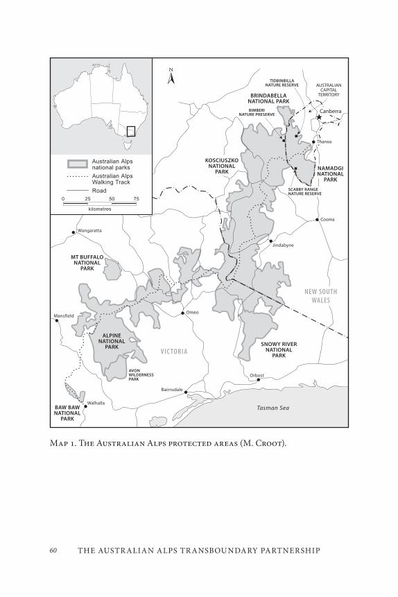
THE AUSTR ALIAN ALPS TR ANSBOUNDARY PARTNERSHIP60
Map 1. The Australian Alps protected areas (M. Croot).
61Betty Weiler, Jennifer Laing, and Susan A. Moore
management of the AANP is guided in the first instance by an MOU which is regularly updated, an AANP Co-operative Management Program, a strategic plan which is rewritten every three years, the Australian Alps Liaison Committee (AALC) consisting of one senior officer from each of the four government jurisdictions (Commonwealth, ACT, NSW, and Victoria), and special task groups. There is also an Alps Ministerial Council (which meets occasionally and is responsible for the MOU) and an Alps Head of Agencies Group (which meets annually and approves the strategic plan, advises the AALC on policy and priorities, and negotiates for funding and in-kind support by the participating agencies) (Crabb 2003a). Jacobs and Anderson’s chapter provides further insight into the mandate and activities of the Australian Alps Co-operative Management Program beyond its tourism initiatives.
INDIC ATORS OF SUCCESS FOR THE A ANP TOURISM/
PROTECTED AREA PARTNERSHIP
As outlined earlier, indicators that any particular tourism/protected area partnership has been successful can include a number of process out-comes such as efficiency/productivity gains, strengthening organizational capacity, social gains (e.g., equity and empowerment), building social cap-ital, stimulation of innovation, and creating indirect benefits (e.g., local employment) as well as sustainable tourism outcomes such as economic, social, cultural, and ecological sustainability. Analysis of AANP-related published reports reveals many indicators of success in these categories, as illustrated by the following examples.
E≤ciency/Productivity Gains and Strengthening
Organizational Capacity
One major impetus for the creation of the original MOU was the need for more efficient and effective interstate law enforcement. This has been an important outcome, with staff now trained and authorized to carry out
THE AUSTR ALIAN ALPS TR ANSBOUNDARY PARTNERSHIP62
law enforcement in adjacent border areas and rangers appointed as autho-rized officers for more than one agency (Crabb 2003b).
The AALC has achieved outcomes in many other areas of organiza-tional understanding and capacity-building. For example, with respect to Aboriginal heritage, a number of staff-training activities and skill-build-ing workshops have been run over a period of several years. The AALC was also instrumental in the development of an indigenous interpretive strat-egy for the Alps (Crabb 2003b). As detailed in the Jacobs and Anderson chapter, many non-tourism areas of resource management such as fire management, research into and reduction of feral animal and exotic pest species, water management, wilderness protection, and, more recently, cli-mate change management have all benefited from the considerable train-ing and professional development activities of the AALC. It appears that the partnership has achieved more than what could have been achieved without its existence, both through fostering collaboration and through economies of scale and reduction of duplication.
Building Social Capital and Stimulation of Innovation
The AALC has been very active in training and awareness-building be-yond the park agencies. With respect to tourism, much effort has been devoted to raising the awareness and knowledge of those working in the tourism industry, including the production of a tour operators’ manual, delivery of training programs and workshops for commercial tourism op-erators, and the development and accreditation of a training module for tour guides focussed on interpreting the AANP (Crabb 2003b), although this latter initiative has yet to be fully implemented.
Another major contribution of the AALC has been to schools and teachers throughout Australia via its Australian Alps Education Kits. These are available online and are comprehensive and of high quality. There are several modules, for example, a seventeen-page kit entitled “Recreation and Tourism in the Australian Alps” covers the history of recreation and ski resort development in the Alps, horse-riding, cycling, the Australian Alps walking track, the Australian Alps eight codes of con-duct (Care for the Alps: Leave No Trace) program, the effects of recreation, and recreation planning, monitoring, and management. The AALC also
63Betty Weiler, Jennifer Laing, and Susan A. Moore
delivers teacher-awareness workshops (Crabb 2003b) and distributes CDs, brochures, and other resources to teachers and others.
The Australian Alps long-distance walking track is itself an innovation that almost certainly could not have been achieved without the existence of the AANP. First suggested as early as the 1930s, major construction on the track did not begin until the 1970s. The establishment of the AANP together with funding from the Bicentennial Authority in 1988 facilitated the extension of the Alps walking track to include all three states. To walk the entire walking track takes several weeks, along which a walker:
… climbs over the highest mountain in Australia as well as the highest peaks in the ACT, NSW and Victoria. It traverses country covered by snow for much of the year, descends to riv-ers that can become impassable when in flood, follows solitary roads, fire access tracks … and can be a pleasant stroll under clear blue skies or a battle to survive as the elements vent their fury upon innocuous travelers (Siseman 2003, 337).
The AALC supports the Australian Alps walking track by maintaining a series of web pages under the AANP banner and providing prospec-tive walkers with track-condition information, safety notes, trip planning notes, a track brochure, maps, track signage information, and minimal impact messages.
Finally, the three-day International Year of Mountains Conference held in 2002 was co-sponsored by the AALC. It included a mountains-for-tourism stream across the three days that featured several valuable papers on best practice tourism management in alpine areas by both Australian and overseas experts.
Creating Indirect Benefits
The existence of the AALC has generated only limited local employment, as much of the work of the AALC is undertaken by staff of the parks agen-cies who serve on the various committees. There is one secretariat posi-tion (a community projects officer) responsible for the marketing, public
THE AUSTR ALIAN ALPS TR ANSBOUNDARY PARTNERSHIP64
relations, and media work of the AALC, including the website. There is also a program coordinator position which is filled on a secondment ba-sis from within the existing park management agencies, and this person oversees the program and budget of the AALC and executes other aspects of the strategic plan.
In reviewing the various process outcomes that this partnership has achieved, it is the areas of relationship-building that are most in evidence – the development of a culture of cooperation among the participating agencies as well as those outside the actual partnership (AALC 2004). According to Crabb (2003b), there is enormous goodwill, understanding, and trust, with one interviewee describing the partnership as “a brother-hood” and another as “a fantastic experience” (85). “[Notwithstanding] very tangible achievements, perhaps of most value have been the intan-gibles, the day-to-day activities and on-ground work, networking, learn-ing from others, peer support, things that are so hard to value in dollar terms but which are so valuable” (Crabb 2003a, 40).
Indicators that the AANP partnership has been successful in terms of sustainable tourism outcomes include economic, social, cultural, and ecological sustainability.
Economic Sustainability (Economic Viability, Local
Prosperity, Employment Quality)
It is difficult to attribute economic success solely to the existence of the AANP or the work of the AALC; however, it was the AALC who together with the Sustainable Tourism Cooperative Research Centre (STCRC) funded a study assessing the economic value of tourism in the Australian Alps (Mules and Stoecki 2003). The research involved a twelve-month sur-vey of a sample of visitors to the parks in all three states, resulting in a useable sample of nearly five thousand visitor-completed questionnaires. The study concluded that the capital value of the Alps for recreation, not including other use values, option values, or existence values, is in the order of AUS$40 billion. It also concluded that the expenditure of inter-state visitors to the AANP contribute an annual gross product of AUS$322 million and the equivalent of 5,155 full-time jobs described in the report
65Betty Weiler, Jennifer Laing, and Susan A. Moore
as “jobs and income which would not occur in the absence of the parks” (Mules and Stoecki 2003, 154).
The AALC has contributed to the economic sustainability of tour-ism in the Alps by playing a very active role in tourism marketing and promotion, including the funding of marketing strategies, contribution to tourism promotional displays, and the publication of a touring guide. A recent marketing plan includes activities targeted at two main audi-ences: rural neighbours and park visitors (AALC 2001, as cited by Crabb 2003b). Considerable AALC resources are committed to promoting the Alps through the community projects officer’s time producing media re-leases and other marketing collateral, and through the funding of displays, newspaper inserts, and radio and television announcements. Finally, the AALC funds a very comprehensive and effective website which potentially reaches a global tourism audience.
Social Sustainability (Social Equity, Visitor Fulfillment, Local
Control, Community Well-being) and Cultural Sustainability
(Cultural Richness)
The AALC runs frequent community awareness training courses aimed at public contact staff but open to local residents. In 2001, the commu-nity awareness program received an award for excellence in the general tourism services category of the Canberra Region Tourism Awards (Crabb 2003b, 84) for its suite of marketing publications and products, including its website, community service announcements, workshops, and efforts to develop links with the tourism industry. That said, there has been a continuing lack of community involvement, as well as a lack of involve-ment by important non-park organizations such as the Victorian Alpine Resorts Coordinating Council and land managers outside the national parks (Crabb 2003, 41). In spite of this lack of active participation in the AANP by the alpine resorts, the AALC has promoted the development of uniform and coordinated tourism planning approaches, consistent mes-sages and information, visitor advice, and visitor resources such as sig-nage and interpretive materials that foster enjoyment, appreciation, and sustainable use, to the benefit of both local residents and tourists (Crabb 2003b; AALC 2004).
THE AUSTR ALIAN ALPS TR ANSBOUNDARY PARTNERSHIP66
The AALC’s commitment to Aboriginal cultural heritage conserva-tion and interpretation has already been mentioned. In addition to the significant gathering of Aboriginal people facilitated by the International Year of the Mountains celebrations in 2002, respect for the Aboriginal val-ues and heritage of the Alps, and improved engagement and involvement with Aboriginal people with connections to the Alps, has been achieved via the Alps Co-operative Management Program (AALC 2004). With respect to European heritage, the AALC assisted with inventorying and surveying of the historic huts found throughout the Alps (see Jacobs and Anderson this volume), the outcomes of which have been of relevance and benefit not only to the parks themselves but to a wide range of volunteer groups (Crabb 2003b).
Ecological Sustainability (Physical Integrity, Biological
Diversity, Resource E≤ciency, and Environmental Purity)
There is little doubt that the AALC has been directly responsible for achieving improvements in the level of understanding and management of natural ecosystems, and some of this is evident in the considerable envi-ronmental research that has been ongoing in the parks. The AALC main-tains an Australian Alps Scientific Sites Database with plots that enable monitoring of environmental change caused by fire, climate change, in-troduced plant species, and land-use practices such as cattle-grazing and tourism resort operation. With regard to the latter, one important focus of the AALC has been on the implications of climate change, including the increasing need for snow-making for the ski resorts and the impact of increased demands for more water on the alpine ecosystems (Whetton 2002, cited in Crabb 2003b).
Topical work that has had potential ecological benefits on a much wider scale has occurred. For example, in March 2000, an international five-day human waste management workshop was held in the Alps, which dealt with contemporary approaches to human faecal waste manage-ment at visitor facilities, at trailheads, and in backcountry protected areas (AALC 2000, cited by Crabb 2003b).
At the level of the individual visitor, the AALC’s main contribution has been the development of minimal impact codes of practice, largely
67Betty Weiler, Jennifer Laing, and Susan A. Moore
through the development and distribution of visitor codes of conduct (Beckmann 2003). With AALC funding and direction, a suite of minimal impact messages were developed, tested, and then refined for a range of target audiences including: independent visitors, special-interest recrea-tion groups, teachers and educational leaders, students, local residents, and commercial tour operators. These have been disseminated via a range of media including the mass media (newspapers), visitor information cen-tres, schools, fliers, posters, signs, shelter displays, and accessories (e.g., water bottles), and incorporated into the Alps walking track brochure and the AANP website (Beckmann 2003). However, the effectiveness of these in terms of influencing visitor behaviour is largely unknown.
On the other hand, some major cross-border issues have yet to be ad-dressed, such as wild horses and dogs, which can cause severe effects on vegetation and pose significant threats to local wildlife and the integrity of the alpine environment (Crabb 2003a). Coyne (2001) outlines a range of additional environmental threats to the Alps that are directly attributable to tourism and have not been addressed by the AANP, including:
• decreasing water quality (due to urban runoff from resort buildings, roads, and car parks, and the disposal of sewage, which is discharged from treatment plants into streams);
• reduction of mountain pygmy-possum habitat (due to disturbance particularly during the ski season);
• effects on terrestrial vegetation and the spread of weeds (due to resort development, snowmaking, and bushwalking);
• increasing pollution (due to sewage generation and accidental spills); and
• increase and spread of pest animals (due to road and resort development).
A number of additional recreation- and tourism-related issues were identi-fied by Crabb’s (2003b) interviewees as areas where the partnership has so far failed to deliver cross-agency cooperation and consistency, including
THE AUSTR ALIAN ALPS TR ANSBOUNDARY PARTNERSHIP68
backcountry recreation use issues, horseback-riding licences, management of mountain-biking, and monitoring of visitor behaviour and impacts.
In summary, it appears that this particular partnership is credited with having achieved a considerable number of successes that extend well beyond the tourism elements that are the focus of this chapter. Moreover, the AALC appears to be held responsible for relatively few failures with re-spect to both process and sustainable tourism outcomes. There is no doubt that the feeling of those who have written about the AANP perceive it to be an example of a very successful partnership.
FACTORS CONTRIBUTING TO THE SUCCESS OF THE
A ANP TOURISM/PROTECTED AREA PARTNERSHIP
As illustrated in Table 1, factors that can contribute to the success of a partnership include partner-related factors, process-related factors, and context-related factors. The perceptions of those who have written about the AANP suggest that a number of the factors identified in Table 1 have contributed to the success of the partnership. Many of these are also de-scribed as lessons learned in Jacobs and Anderson’s chapter.
Partner-related factors that appear to have helped facilitate the suc-cess of the AANP partnership include:
• Membership composition: From the ministerial level through to field staff, there is involvement by staff from all of the partner (Commonwealth, state, and territory protected area management) agencies. At the initiation of the partnership, Crabb (2003a) notes that “the right people came together at the right time, with a concern about the one place, the Australian Alps” (38). A strength of the partnership today is that it operates at many levels, although its real strength is seen by many to be at the field-staff level (Crabb 2003b);
• Participation by the relevant protected area management
agencies: This has been considerable at the level of the AALC
69Betty Weiler, Jennifer Laing, and Susan A. Moore
and the working parties but has also included a commitment by decision-makers (heads of agencies) to meet annually. Crabb (2003a) notes that certain internal agendas such as the state of Victoria wanting to establish an alpine national park helped initially in getting the partnership off the ground (40);
• Non-agency leadership and commitments: Crabb (2003a) notes support from other organizations such as the Australian Conservation Foundation, particularly in the start-up phase of the partnership;
• Empathy toward partners: The frequent professional development and regular training activities provide opportunities for relationship-building, networking, and peer support, at least by those directly involved in the partnership;
• Leadership: This has come from the agencies themselves, with some evidence of a sustained effort by particular individuals over many years, although there has been concern expressed by some (Crabb 2003b) that this has not always carried through to implementation; and
• Distribution of power: There appears to be a commitment to sharing the implementation role among the agencies by way of the rotational program coordinator position, but it is not known how well other aspects of the partnership such as decision-making are shared.
Some factors that do not appear to have been present include:
• Membership by non-government agencies: Links are lacking with tourism peak bodies and many key organizations and community groups including the Federation of Victorian Walking Clubs, the Australian Conservation Foundation, National Parks Associations, and special interest groups such as horse-riders and off-road vehicle groups (Crabb
THE AUSTR ALIAN ALPS TR ANSBOUNDARY PARTNERSHIP70
2003b, 93). This appears to have hindered some aspects of the partnership; and
• Inclusion of all people affected by the partnership: Some of the partners are very large protected area management agencies and inclusion of staff throughout these organizations can be difficult. Crabb (2003a) notes a lack of commitment by some agency staff and a lack of recognition of its achievements (40). Several of Crabb’s (2003b) interviewees commented that many agency staff fail to see the AALP’s work as core business.
Process-related factors that appear to have helped facilitate success of the AANP partnership include:
• Scope of the partnership and a shared vision: These appear to be clear to all parties by way of the MOU, the three-year strategic plan, and the AANP Co-operative Management Program. There is evidence of a shared informal concern for the natural environment, a shared desire for uniform management policy and control, and a shared vision to do things better (Crabb 2003a, 38);
• Information quality, quantity, and transparency: Documentation suggests that there are regular meetings and transparency about the activities and programs of the AANP partnership. What is less clear is how meetings are run, decisions are made, and the outcomes of the various projects are disseminated and taken up;
• External communication: There is evidence of extensive external communication by the AANP with some stakeholders, although, as noted above, there are many stakeholders with whom communication is inadequate or nonexistent; and
71Betty Weiler, Jennifer Laing, and Susan A. Moore
• Interdependence, commitment, trust: As mentioned earlier, the perceptions of those who have written about the AANP are that there is a considerable degree of goodwill and a long-term commitment by those involved in the partnership.
There is no evidence from published sources of the following:
• Dealing with conflict and change: It is not clear how the AANP partnership deals with internal issues nor how well it copes with change. Staff turnover was mentioned as an issue as was the tendency to focus on new projects rather than persisting with long-term tasks (Crabb 2003b); and
• Internal communication: There appears to be a need for better communication about the AANP’s activities and uptake of some of its findings on a broader scale within each agency. Communication between the AALC and other levels of the partnership was also mentioned by Crabb’s (2003b) interviewees as an issue. Crabb (2003a) notes that there is sometimes conflict with agencies’ internal tasks that precludes implementation, which relates to the point made earlier about the work of the partnership not being seen as core business. It also reflects a lack of resources, a key issue we return to below.
Context-related factors that appear to have helped facilitate success of the AANP partnership include:
• Adequacy of time / duration of partnership: The partnership has been in existence for over twenty years, and this has clearly contributed to the partners’ sense of commitment and to its success. On the other hand, there are those (Crabb 2003b) who describe the partnership as being “on a plateau,” “at a low point,” and even “declining” (96).
THE AUSTR ALIAN ALPS TR ANSBOUNDARY PARTNERSHIP72
There is evidence that the following issues may have hindered the success of the AANP partnership:
• Legislative and administrative framework: Despite the fact that all partners are state or Commonwealth government bodies responsible for protected areas and with similar mandates to facilitate tourism opportunities, Coyne (2001) sees the differences in legislation across the parks as problematic, and Crabb (2003b) identifies the ministerial side of the MOU as needing attention. Coyne (2001) calls on the AALC in particular to strive for the resolution of differences in management objectives and standardization of approaches and procedures to better facilitate environmental management;
• Enforcement of decisions: Crabb (2003a) notes a lack of uptake and implementation of some of the decisions emanating from the partnership, making reference to the lack of legal and administrative authority of the AALC. The lack of resources for implementation and enforcement was raised by many of Crabb’s (2003b) interviewees; and
• Adequacy of resources: Inadequate staffing and lack of resources were the two issues most consistently mentioned in publications about the AANP partnership and by Crabb’s (2003b) interviewees. The withdrawal of Commonwealth government funding in particular was seen as a significant threat to the partnership.
Results to date suggest that a wide range of partner-, process-, and con-text-related factors have contributed to the success of the partnership. If anything has inhibited its success, our analysis of published reports sug-gests that context factors such as disparate legislative and administrative frameworks, inadequate resources, and the absence of legal authority on the part of the AALC have most constrained the partnership. Jacobs and
73Betty Weiler, Jennifer Laing, and Susan A. Moore
Anderson highlight these and other factors as challenges that need to be addressed going forward.
LIMITATIONS, REFLECTIONS, RECOMMENDATIONS
AND CONCLUSIONS
While indicators of success or at least perceptions of success can be gleaned from published sources, it has proven more difficult to identify the factors that contribute to or inhibit partnership success. Field work involving the administration of questionnaires and in-depth interviewing of participants will be necessary to either bolster or undermine the claims and information in published sources. It has also been difficult to sepa-rate out the tourism element of the partnership, as the AALC has a focus and range of responsibilities well beyond tourism. In any case, putting boundaries around what constitutes tourism, let alone its impacts, can be problematic.
On a more positive note, this chapter serves to illustrate the relevance of this kind of analysis to other transboundary partnerships and as a basis for recommendations for establishing, assisting and monitoring trans-boundary partnerships. The categories identified from the literature pro-vide a rapid and apparently accurate means of identifying the outcomes from such partnerships, as well as the influences on them. The preliminary findings suggest the potential benefits that can be accrued from focussing further on elements of the context that may hinder partnerships, influ-ences such as legislative and administrative incongruities and inadequate resourcing. The context can then, potentially, be actively managed to ad-dress these hindrances.
In conclusion, despite the plethora of studies which have looked at tourism/protected area partnerships to date, partnerships remain “an evolving concept and practice” (Brinkerhoff 2002, 28). This study lever-ages off existing theory from fields such as environmental dispute resolu-tion, social capital, and network theory to identify a series of partner-, process-, and context-related elements and examines the extent to which each of these contributes to or inhibits the success of tourism/protected
THE AUSTR ALIAN ALPS TR ANSBOUNDARY PARTNERSHIP74
area partnerships. This preliminary analysis of the Australian Alps trans-boundary partnership suggests that the partnership has been on the whole a very successful one, while highlighting ways in which to strengthen and enhance its outcomes. In particular, it provides evidence that even a modestly funded partnership can deliver economic, social, cultural, and ecological sustainability outcomes, although greater resourcing might further enhance these outcomes. We conclude that the partnership has made a real contribution to managing tourism sustainably in a multi-jurisdictional protected area context.
REFERENCES
Australian Alps Liaison Committee (AALC). 2000. Australian Alps Best Practice Human Waste Management Workshop Papers and Presentations. Canberra: Australian Alps Liaison Committee.
———. 2001. 2000-01 Annual Report. Canberra: Australian Alps Liaison Committee.
———. 2004. Strategic Plan 2004–2007. Accessed December 2, 2011. http://www.australianalps.environment.gov.au/publications/alps-program/strat-plan-04-07.html.
Beckmann, E. 2003. “Communicating minimal impact messages in the Australian Alps national parks.” In Proceedings of an International Year of Mountains Conference, ed. Mackay & Assoc., 283–94. Canberra: Australian Alps Liaison Committee.
Bingham, G. 1986. Resolving Environmental Disputes: A Decade of Experience. Washington, D.C.: The Conservation Foundation.
Bramwell, B., and B. Lane. 2000. “Collaboration and partnerships in tourism planning.” In Tourism Collaboration and Partnerships: Politics, Practice and Sustainability, ed. B. Bramwell and B. Lane, 1–19. Clevedon: Channel View.
Braun, P. 2004. “Regional tourism networks: The nexus between ICT diffusion and change in Australia.” Information Technology and Tourism 6: 231–43.
Brinkerhoff, J. M. 2002. “Government-nonprofit partnership: A defining framework.” Public Administration and Development 22: 19–30.
75Betty Weiler, Jennifer Laing, and Susan A. Moore
Buckley, R. 2000. “Wilderness in Australia: What’s happening in a world context.” In Wilderness Science in a Time of Change Conference Proceedings, Volume 2, ed. S. F. McCool, D. N. Cole, W. T. Borrie, and J. O’Loughlin, 190–93. Ogden, UT: U.S. Department of Agriculture, Forest Service, Rocky Mountain Research Station.
Buckley, R., and M. Sommer. 2001. Tourism in Protected Areas: Partnerships in Principle and Practice. Gold Coast: CRC for Sustainable Tourism.
Cole, D. N. 2001. “Management dilemmas that will shape wilderness in the 21st century.” Journal of Forestry 99: 4–11.
Coleman, J. 1988. “Social capital in the creation of human capital.” American Journal of Sociology 94: 95–120.
Coyne, P. 2001. Protecting the Natural Treasures of the Australian Alps. Canberra: Australian Alps Liaison Committee.
Crabb, P. 2003a. “Co-operative management of the Australian Alps national parks: Past, present and future.” In Proceedings of an International Year of Mountains Conference, ed. Mackay & Assoc., 37–42. Canberra: Australian Alps Liaison Committee.
———. 2003b. Managing the Australian Alps: A History of Cooperative Management of the Australian Alps National Parks. Canberra: Centre for Resource and Environmental Studies, Australian National University.
Crowfoot, J., and J. Wondolleck. 1990. Environmental Disputes: Community Involvement in Conflict Resolution. Washington, D.C.: Island Press.
De Lacy, T., B. Battig, S. Moore, and S. Noakes. 2002. Public/Private Partnerships for Sustainable Tourism: Delivering a Sustainability Strategy for Tourism Destinations. Gold Coast: CRC for Sustainable Tourism.
Dowling, B., M. Powell, and C. Glendinning. 2004. “Conceptualising successful partnerships.” Health and Social Care in the Community 12: 309–17.
Dredge, D. 2006a. “Policy networks and the local organisation of tourism.” Tourism Management 27: 269–80.
———. 2006b. “Networks, conflict and collaborative communities.” Journal of Sustainable Tourism 14: 562–81.
Eagles, P.F.J. 2002. “Trends in park tourism: Economics, finance and management.” Journal of Sustainable Tourism 10: 132–53.
Hall, C. M. 1999. “Rethinking collaboration and partnership: A public policy perspective.” Journal of Sustainable Tourism 7: 274–89.
Imperial, M. 1999. “Institutional analysis and ecosystem-based management: The institutional analysis and development framework.” Environmental Management 24: 449–65.
THE AUSTR ALIAN ALPS TR ANSBOUNDARY PARTNERSHIP76
Laing, J., A. Wegner, S. Moore, B. Weiler, S. Pfueller, D. Lee, J. Macbeth, G. Croy, and M. Lockwood. 2008. Understanding Partnerships for Protected Area Tourism: Learning from the Literature. Gold Coast: CRC for Sustainable Tourism.
Leach, W. D., and N. W. Pelkey. 2001. “Making watershed partnerships work: A review of the empirical literature.” Journal of Water Resources Planning and Management 127: 378–85.
Leach, W., and P. Sabatier. 2005. “Are trust and social capital the keys to success? Watershed partnerships in California and Washington.” In Swimming Upstream: Collaborative Approaches to Watershed Management, ed. P. Sabatier et al., 233–58. Cambridge, MA: MIT Press.
Lundblad, J. 2003. “A review and critique of Rogers’ Diffusion of Innovation Theory as it applies to organizations.” Organization Development Journal 21: 50–64.
Macbeth, J. 1994. “To sustain is to nurture, to nourish, to tolerate and to carry on: Can tourism?” TRENDS 31: 42–45.
Macbeth, J., D. Carson, and J. Northcote. 2004. “Social capital, tourism and regional development: SPCC as a basis for innovation and sustainability.” Current Issues in Tourism 7: 502–22.
Mackay & Associates, ed. 2003. Proceedings of an International Year of Mountains Conference. Canberra: Australian Alps Liaison Committee.
Mburu, J., and R. Birner. 2007. “Emergence, adoption, and implementation of collaborative wildlife management or wildlife partnerships in Kenya: A look at conditions for success.” Society and Natural Resources 20: 379–95.
Miller, C., and Y. Ahmad. 2000. “Collaboration and partnership: An effective response to complexity and fragmentation or solution built on sand?” International Journal of Sociology and Social Policy 20: 1–38.
Moore, S., and R. Lee. 1999. “Understanding dispute resolution processes for American and Australian public wildlands: Towards a conceptual framework for managers.” Environmental Management 23: 453–65.
Mules, T., and N. Stoecki. 2003. “Tourism value of the Australian Alps.” In Proceedings of an International Year of Mountains Conference, ed. Mackay & Assoc., 147–55. Canberra, Australian Alps Liaison Committee.
Newsome, D., S. A. Moore, and R. K. Dowling. 2002. Natural Area Tourism Ecology, Impacts and Management. Sydney: Channel View Publications.
Ostrom, E. 1999. “Institutional rational choice: An assessment of the institutional analysis and development framework.” In Theories of the Policy Process, ed. P. Sabatier, 35–71. Boulder, CO: Westview Press.
77Betty Weiler, Jennifer Laing, and Susan A. Moore
Pavlovich, K. 2003. “The evolution and transformation of a tourism destination network: The Waitomo Caves, New Zealand.” Tourism Management 24: 203–16.
Rogers, E. 1995. Diffusion of Innovations, 4th ed. New York: Free Press.
Saxena, G. 2005. “Relationships, networks and the learning regions: Case evidence from the Peak District National Park.” Tourism Management 26: 277–89.
Selin, S. 2004. “Natural resource partnerships: Bridging practice and science.” Paper presented at International Symposium on Society and Natural Resources (ISSRM), Keystone, Colorado.
Selin, S., and D. Chavez. 1995. “Developing an evolutionary tourism partnership model.” Annals of Tourism Research 22: 844–56.
Siseman, J. 2003. “History of the Australian Alps walking track – A Victorian perspective.” In Proceedings of an International Year of Mountains Conference, ed. Mackay & Assoc., 335–38. Canberra: Australian Alps Liaison Committee.
Timothy, D. J. 1999. “Cross-border partnership in tourism resource management: International parks along the US–Canada border.” Journal of Sustainable Tourism, 7: 182–205.
United Nations Environment Programme (UNEP) and World Tourism Organization (WTO). 2005. Making Tourism More Sustainable – A Guide for Policy Makers. Paris: UNEP, Division of Technology, Industry and Economics.
Watershed Partnerships Project. 2002. “Watershed partnerships in California and Washington: Final report for the Watershed Partnerships Project.” Davis, CA: University of California, 2002.
Whetton, P. 2002. “Climate change projections for the Australian Alps and their impact on snow Conditions.” In Celebrating Mountains: an International Year of Mountains Conference, 66–67. Canberra: Australian Alps Liaison Committee.
Worboys, G., M. Lockwood, and T. De Lacy. 2001. Protected Area Management Principles and Practice. South Melbourne: Oxford University Press.

79
Transboundary Protection of Mont Blanc: Twenty Years of Tri-national Negotiation around the Roof of the European Alps
Barbara Ehringhaus
INTRODUCTION
The Mont Blanc region refers to a mountain range centred on Mont Blanc, the highest peak in the European Alps at 4,810 metres (Map 1). The sur-rounding massif and valleys encompass areas in France and Italy and to a smaller extent in Switzerland. This part of the Alps is characterized by a unique diversity of natural phenomena including glaciers, alpine geo-logical processes, and mountain landscape biodiversity, all occurring in a relatively compact area in the middle of highly populated Europe (pro-MONT-BLANC 2011). The convergence of different climate zones and the continued existence of active glaciers are of heightened importance in the face of climate change and its threats.
4
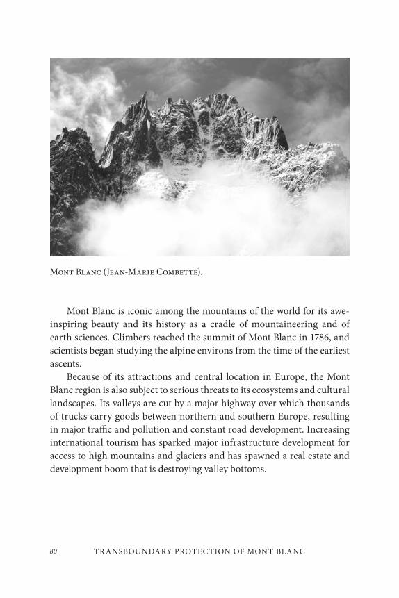
TR ANSBOUNDARY PROTECTION OF MONT BLANC80
Mont Blanc is iconic among the mountains of the world for its awe-inspiring beauty and its history as a cradle of mountaineering and of earth sciences. Climbers reached the summit of Mont Blanc in 1786, and scientists began studying the alpine environs from the time of the earliest ascents.
Because of its attractions and central location in Europe, the Mont Blanc region is also subject to serious threats to its ecosystems and cultural landscapes. Its valleys are cut by a major highway over which thousands of trucks carry goods between northern and southern Europe, resulting in major traffic and pollution and constant road development. Increasing international tourism has sparked major infrastructure development for access to high mountains and glaciers and has spawned a real estate and development boom that is destroying valley bottoms.
Mont Blanc (Jean-Marie Combette).
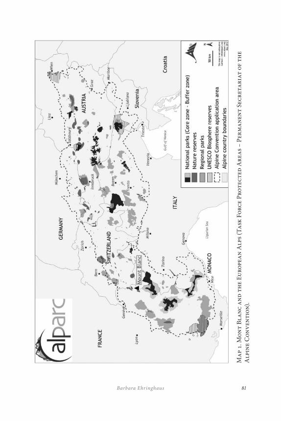
81Barbara Ehringhaus
Ma
p 1.
Mo
nt
Bla
nc
an
d t
he
Eu
rope
an
Alp
s (T
ask
Fo
rce
Pro
tec
ted
Ar
eas
– P
erm
an
ent
Secr
eta
ria
t o
f th
e A
lpin
e C
on
ven
tio
n).
TR ANSBOUNDARY PROTECTION OF MONT BLANC82
CONSERVATION ACHIEVEMENTS AND CHALLENGES
While there are several protected areas in the Mont Blanc range, the sum-mit itself and parts of the surrounding central massif are only site classé on the French side and recently became a site of European importance (SIC) on the Italian side. In 1986, at the two hundredth anniversary of its first ascent, a group of the world’s most famous mountaineers petitioned for formal and consistent international protection and founded Mountain Wilderness as a kind of ‘Greenpeace of the Alps.’ Subsequently, in 1991, all three Ministers of the Environment of France, Italy, and Switzerland agreed to establish an International Park. In order to promote this inter-national park, an umbrella non-governmental organization (NGO) was created by alpine clubs and environmental organizations. Today, this group is called ProMONT-BLANC (pMB).
However, a number of politicians from the region immediately op-posed what they called an “Indian Reserve” that would freeze development out of the region and maintain its inhabitants as “Indians” in a museum to be visited by tourists. Instead, they proposed to create a much larger tri-national Espace Mont Blanc (EMB), where they themselves would drive a model case of sustainable regional development across national bound-aries. The countries conceded the funding with high expectations, but after several years gradually withdrew their active involvement owing to a lack of progress. Yet, all three governments continue to finance the EMB. Also, the European Union (EU) increasingly allocates funds from its INTERREG (an EU funding initiative that aims to stimulate interregional cooperation in the European Union) program towards Mont Blanc trans-boundary cooperation, but without the requirements for, and monitoring of, particular investments for conservation purposes.
ProMONT-BLANC tried to actively promote the tri-national park as a goal beyond Espace Mont Blanc and was later invited by the countries to be an ‘observer’ inside Espace Mont Blanc in 1997. This step helped to influence the transfrontier conservation aim from within this forum, and resulted in the proposal to create a UNESCO World Natural Heritage site and a tri-national biosphere reserve that would surround it. Further, ProMONT-BLANC worked on concrete conservation projects and on a
83Barbara Ehringhaus
management plan and maps, and contributed decisive inputs into an ac-tion plan or scheme of sustainable development created by Espace Mont Blanc which was completed in 2005. However, in spite of initial optimism, very little of this action plan has been implemented.
LESSONS LEARNED
More than twenty years of experience in the Mont Blanc region provide a unique opportunity for reflection and evaluation. The following section offers a number of “lessons learned” which might be useful for trans-boundary protection efforts elsewhere (Ehringhaus 2004a, 2004b).
Lesson One: It is more di≤cult to achieve protected areas at
the centre of a prosperous booming tourist region than in
poor peripheral border areas.
Although Mont Blanc is internationally recognized for its historical, cul-tural, and natural significance, regional economic interests present a bar-rier to adequate protection. Evidently, it seems to be much easier to estab-lish transbounday protected areas or international peace parks in frontier areas where there are larger expanses of natural areas with low human population densities and difficult access as is the case with many protected areas worldwide.
The Mont Blanc area, however, is quite densely inhabited and easily accessible though unevenly developed. It is a tourism hot spot with two world famous ski and mountaineering resorts: Chamonix in France and Courmayeur in Italy. On the Swiss side you can still find better preserved mountain agriculture and its associated cultural landscape. Many nearby urban centres and airports make the region a favourite holiday site for millions of international tourists.
After centuries of marginalization and poverty in these agricultural valleys, recent prosperity owing to tourism has made local stakeholders confident enough to deny “outsiders” (national and international author-ities alike) any right to interfere with further exploitation of what they
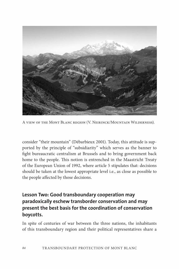
TR ANSBOUNDARY PROTECTION OF MONT BLANC84
consider “their mountain” (Débarbieux 2001). Today, this attitude is sup-ported by the principle of “subsidiarity” which serves as the banner to fight bureaucratic centralism at Brussels and to bring government back home to the people. This notion is entrenched in the Maastricht Treaty of the European Union of 1992, where article 5 stipulates that: decisions should be taken at the lowest appropriate level i.e., as close as possible to the people affected by those decisions.
Lesson Two: Good transboundary cooperation may
paradoxically eschew transborder conservation and may
present the best basis for the coordination of conservation
boycotts.
In spite of centuries of war between the three nations, the inhabitants of this transboundary region and their political representatives share a
A view of the Mont Blanc region (V. Neirinck/Mountain Wilderness).
85Barbara Ehringhaus
long history of common culture, of intensive exchange, and they share the same language – French (even similar dialects of French). The Italian border region of Val d’Aosta has obtained the right to bilingual education (French and Italian) with its status as an autonomous province at the end of World War II; this is quite common in the Alps: In other transbound-ary cooperation initiatives like the so-called “magical triangle” between Austria’s Western Tirol, Switzerland’s Lower Engadin, and Italy’s Venosta Valley (formerly Austrian until 1919) people also speak the same lan-guage, German. In the tri-national border area between Slovenia, Austria, and Italy most people speak either German or Italian, though Slovenian belongs to the Slavic language family.
A common language facilitates frequent communication and cooper-ation, as do traditional economic activities: raising cattle on mountain pastures, cheese-making and – a surprise for high mountain regions – wine production. Another common specialty of the region, in contrast to other alpine areas, is the combative festivals of cows which fight for leader-ship during the move of the cattle herds to the high alpine pastures in the early summer after a winter of confinement in the valleys, in a process called transhumance. These traditional cow fights have recently become more and more of a unifying ritual all around Mont Blanc. This ritual gives high social prestige to the owner of the winning cow. On these and other social occasions, the respective local varieties of the same products such as cheese, air-dried meat, sausages, and wine are abundantly tasted and compared with connoisseur sophistication.
Thanks to frequent transboundary communication, the local polit-icians jointly succeeded in avoiding the establishment of the tri-national park. They also were entrusted with the task of receiving the funds for the large development and conservation project in the transboundary region. Espace Mont Blanc, with its intentionally vague terminology, managed to encompass both development and conservation while aptly avoiding any commitment to concrete conservation goals and targets and even words like ‘park’ or ‘reserve.’
Part of the lesson then is that the three countries should have set clear
conditions, clear deadlines, and clear monitoring criteria for funding Espace Mont Blanc. Such established conditions, deadlines, and criteria
TR ANSBOUNDARY PROTECTION OF MONT BLANC86
are missing as there is no founding document for Espace Mont Blanc. Therefore, after eighteen years of existence, the EMB has neither achieved progress in joint conservation nor in socio-economic development of the region in its other proclaimed priority fields of public transport, mountain agriculture, and ecotourism. Today the EMB is almost unknown by the general public of the region, though the bulk of funds from the EU and the partner countries have been almost exclusively invested in communica-tion, which always announces the imminent beginning of concrete pro-jects which almost never materialize. One notable exception is a book on nature and cultural trails in 2001. Many project proposals have been pre-pared by ProMONT-BLANC, Mountain Wilderness, and consultants, but none of them have been implemented by EMB on the ground yet. Those municipalities, which do participate in the Espace Mont Blanc meetings, are exceedingly frustrated by the eternal promises of sustainable develop-ment without follow-up. Meanwhile, huge outside investments in heavy infrastructure, mass tourism, and real estate go on unhindered. For the time being, the local and outside forces with short-term financial interests still dominate over those of the local stakeholders who would prefer long-sighted sustainable development planning.
Lesson Three: Inter-regional funding galvanizes
transboundary cooperation, but not necessarily towards
transboundary conservation.
In counter-balance to the uniformization among European countries, there has also been a growing encouragement of transboundary coopera-tion within particular regions (Europe des régions) and of the principle of subsidiarity. The European Union has been supporting both these ten-dencies with its multiple interregional funds (INTERREG I-III, since 1988) both among its member countries as well as with non-member neighbours (like Switzerland which contributes matching funds). Though the large-scale EU priorities like transcontinental road traffic, industri-alization, commerce, and agro-industry receive the bulk of the euro mil-lions, these relatively modest INTERREG projects certainly do promote transboundary cooperation on a smaller scale. However, they do not tend to support transboundary conservation. The clear prioritization of
87Barbara Ehringhaus
economic development over conservation is mainly due to the classifica-tion of these mountain regions as “disadvantaged peripheral areas” in need of economic development. Nevertheless, the ongoing multi-year program, INTERREG IV 2007–2013, now includes so-called integrated projects linking themes such as innovative development, environment, and quality of life (European Commission 2011).
Lesson Four: Without a legal structure and a joint authority
with su≤cient regulatory jurisdiction, transboundary
protection is very di≤cult to achieve.
“Soft cooperation,” such as shared participation in research, conferences, and cultural exchanges are useful but not sufficient to solve urgent prob-lems on the ground. This is the story we learn from handling problems transcending jurisdictions within countries, like crime, traffic, river and air pollution, migratory birds, and many others. The jurisdiction of the authority has to be compatible with the nature and transboundary dimen-sion of the problems at hand.
There is no lack of treaties and conferences: sixteen years ago, all eight alpine countries and the European Union signed the Alpine Convention for the joint protection of the alpine environment, resulting in meetings at the level of ministers, annual meetings of experts, and a joint office. However, the convention is rarely applied on the ground; the office has no power and still is practically unnoticed by local communities.
A joint legal structure has been discussed within Espace Mont Blanc and new legal options have been proposed. However, these processes are stalled for a variety of complex political reasons rooted mainly in jurisdic-tional differences.
Lesson Five: No progress can be made without multiple
partnerships.
NGOs are important players in the creation of protected areas but their power is insufficient due to their volunteer structure, occasional profes-sional input, and their limited resources and access to political channels. In the everyday practice of conservation, the managers of protected areas
TR ANSBOUNDARY PROTECTION OF MONT BLANC88
might be more easily inclined and able to cooperate in practice than na-tional or regional governments are willing and able to officially agree upon at a political level. For instance, the official unification of the two ad-jacent national parks in the German Harz Mountains on both sides of the former Iron Curtain took a whole decade after Germany’s reunification, while rangers and park managers had long been closely cooperating. A worldwide meeting of national parks practitioners linked to the Hannover World Exhibition in 2000 offered the political opportunity to formalize this unification.
Active cooperation also exists between non-adjacent nature reserves – both in the wider Mont Blanc area and throughout the whole Alpine region, as is the case in the Alpine Network of Protected Areas (ALPARC). However, this network of cooperation is not strong enough to enforce conservation in a context of growing mass tourism and real estate busi-ness, where state and national conservation authorities are considered as unwelcome interference.
In its drive for transboundary protection ProMONT-BLANC has forged multiple partnerships on the local, regional, national, and inter-national level, with local stakeholders (local NGOs, tourism sector rep-resentatives, mountain guides, farmers, amenity in-migrants, seasonal workers, etc.), conservation experts, scientists, politicians, and journalists, and with multiple international NGOs and networks.
Although various member NGOs of ProMONT-BLANC explored different strategies of cooperation and pressure with Espace Mont Blanc ranging from provocative demonstrations with strong media involvement to local development and training projects, ProMONT-BLANC is still at odds with Espace Mont Blanc, which would be the most logical partner from a technical point of view.
Espace Mont Blanc, however, still refuses to cooperate with or to jointly implement NGO initiatives, despite stressing this type of initia-tive in its own action plan or scheme of sustainable development. EMB is also not interested in looking at and learning from other similar initia-tives in the Alps or elsewhere, such as the Alpine Convention, ALPARC, CIPRA-Alliance des Alpes, the French and Italian regional parks, nor from international expertise of the International Union for Conservation
89Barbara Ehringhaus
of Nature (IUCN) , the World Wide Fund for Nature, and the United Nations Environment Programme, which have headquarters in the re-gion. This underscores the conclusion that EMB is not a body that actively seeks to shape and implement an effective sustainable development and conservation strategy for the region but rather seeks to maintain busi-ness as usual with some minor conservation contributions. In this light, EMB has increasingly become official partner of, and funding source for, successful management initiatives that already are established in the area (gastronomic and folkloric festivals, huge sports events, publicity events for mountain gear and existing information centres with the respective nature guides).
In this context, NGOs have struggled to find a difficult balance be-tween their different and sometimes diametrically opposed partners. The Mont Blanc conservation lobby therefore is refraining from using ex-clusively green and conservationist arguments and allies, as it has been shown to not be very effective. For example, the three international IUCN resolutions adopted at different World Conservation congresses (1994, 2000, and 2004) in favour of the Mont Blanc’s international protection did not yet help much on the local scene. On the contrary, these contribu-tions are deliberately ignored if not rejected as irrelevant pronouncements from international actors who do not really have any say in this particular negotiation.
Despite these tensions and difficulties, the long-term partnerships and networks and the many positive examples worldwide have provided tre-mendous encouragement to ProMONT-BLANC and its member NGOs to continue their engagement and maintain momentum despite their struggles.
Nevertheless, in addition to this kind of moral support, ProMONT-BLANC and other conservation groups will need much stronger spon-soring and financial partners in order to professionalize its work, which is still based on sporadic volunteer engagement. There are relatively few businesses located in the immediate area which offer support as several foundations have done. Neither the three countries nor the EU have pro-vided a continuous financial basis for stronger NGO involvement.
TR ANSBOUNDARY PROTECTION OF MONT BLANC90
Ironically enough, in the middle of prosperous Europe which spends a lot of money protecting nature in far-away places, the only substantial sponsor ProMONT-BLANC has had during one year came from South Africa: the Peace Parks Foundation. And, until recently (2011), the luxury mark “Montblanc” pen manufacturer, which uses a logo of the white summit of Mont Blanc and made the number of 4,810 diamonds on its most exclusive pens correspond to the altitude of the Mont Blanc, declined sponsoring the protection of its own very symbol. “Montblanc” had indeed sued Espace Mont Blanc because of the use of the Mont Blanc name, which is their protected trademark!
Lesson Six: An approach focussing on protection without
adequate consideration for economic development will no
longer be accepted.
The creation of many new national parks all over Europe up to the 1990s probably allowed conservationists to put forward proposals with a strong conservation bias at the expense of social and economic development considerations concerning local stakeholders. Thus local politicians successfully opposed the creation of an international Mont Blanc park and still continue to seek socio-economic progress over environmental conservation. After thirty years of strong nature protection, the national park laws of both Italy and France are now being revised and softened towards increased influence of local administrations. All three countries currently favour the creation of regional nature parks with weaker protection measures and stronger development aims. In Switzerland, these regional nature parks have only recently been introduced as an instrument to promote regional development rather than nature protection, much to the chagrin of the conservation lobby. In order to realize the creation of future protected areas across borders, and even across three countries, a way forward must be found that can better reconcile development goals and conservation by creating local employment opportunities and thus adjust to the development and prosperity concerns of local inhabitants.
91Barbara Ehringhaus
CONCLUSION
The case of incomplete transboundary protection of the Mont Blanc re-gion teaches us, among other lessons, that there are historical moments of opportunity which might be missed or seized. It is not always easy to create the right political moment with different actors demonstrating the same political will towards such a goal. There are a number of examples of transboundary cooperation efforts that demonstrate such opportunities. One such example is the swift creation of five national parks in Eastern Germany’s military zone along the iron curtain, in the middle of the po-litical confusion after the fall of the Berlin Wall when Western real es-tate speculation had not yet started. Only one year later this conservation achievement would have been impossible.
Conservation efforts for the last twenty years within the Mont Blanc region have advanced slowly, encountered numerous setbacks, and had to adapt strategies to changing political conditions, stronger local gov-ernment, accelerated development and tourism, and new opportunities among partners. While difficult, the engagement within multiple net-works, political spaces, and stakeholders has brought about better condi-tions to grasp future opportunities.
There might also be other signs of improving conditions in the next years:
• Environment and conservation are more prominently integrated into the EU INTERREG funds, explicitly in its Alpine Space sub-program.
• Climate change and environmental risks are moving to the top of the agenda of world politics. The visibly melting small- and medium-sized glaciers in the Alps enhance the value of the few longer-lasting big glaciers such as on the Mont Blanc.
• In the run-up to the Copenhagen climate conference, a higher ecological awareness has developed among the general public. The French government launched a wide bottom-up process, la Grenelle, which collected proposals for environmental
TR ANSBOUNDARY PROTECTION OF MONT BLANC92
improvements. In the Chamonix Valley a surprising 30% of the inhabitants voted for Europe Ecologie in the 2009 European election. The Swiss Canton of Valais voted in favour of the right to opposition by environmental NGOs – contrary to its anti-green tradition so far.
• The call for Mont Blanc as World Heritage Site has been taken up by regional, national, and international decision-makers and echoed by the media. Italy and France have both included Mont Blanc in their tentative nomination list, and the five Italian municipalities in the Espace Mont Blanc have officially asked for its nomination.
• Within the European Union, there are more and more transboundary cooperation initiatives, often including Switzerland, which integrate cultural, technical, economic, and environmental aspects.
Time will tell whether a stronger tri-national conservation of Mont Blanc is politically viable, and whether it will indeed take the shape of a tri-national park and a World Heritage site. After almost twenty years of opposition to stronger conservation measures, Espace Mont Blanc has proposed the creation of a tri-national regional park. Hopefully, these op-portunities can be seized, the partnerships leveraged towards that goal, and concrete commitments and responsibilities can be negotiated among different stakeholders.
93Barbara Ehringhaus
REFERENCES
Débarbieux, B. 2001. Chamonix-Mont Blanc 1860–2000. Servoz: Edimontagne.
Ehringhaus, B. 2004a. “The transfrontier protection of the Mont Blanc region, Europe.” In Managing Mountain Protected Areas: Challenges and Responses for the 21st Century, ed. D. Harmon and G. Worboys, 149–56. Colledara, Italy: Andromeda Editrice.
———. 2004b. “Ist der Mont Blanc noch zu retten?” In: Wildnis, ein Wegbegleiter durchs Gebirge, ed. E. Flueler, M. Volken, and M. Diemer, 219–25. Zürich: Rotpunktverlag.
European Commission. 2011. “Regional Policy.” Accessed December 2, 2011. http://ec.europa.eu/regional_policy/index_en.cfm
proMONT-BLANC. 2011. Accessed December 2, 2011. http://www.pro-mont-blanc.org/.

95
On the Edge: Factors Inf luencing Conservation and Management in Two Border Mexican Parks
Angeles Mendoza Sammet and Michael S. Quinn
INTRODUCTION
The conservation and management of migratory wildlife and ecosystems that extend across North America requires cooperation among Mexico, Canada, and the United States. Political structures have been created to address transboundary conservation issues and/or foster specific goals. An example of tri-lateral cooperation is the Trilateral Committee for Wildlife and Ecosystem Conservation and Management (TCWECM), which ad-dresses, among other issues, the preservation of migratory and shared species and the management of biodiversity and ecosystems (IBIP 2007). An example of bi-lateral cooperation is the program Wildlife Without Borders (U.S.A.-Mexico), which fosters capacity-building for manage-ment of natural resources in Mexico (USFWS 2007c).
Despite cooperative initiatives and resource allocations, the popula-tions of endangered species in Mexico, and of migratory species that cross
5
ON THE EDGE96
international borders within North America, continue to be imperiled (e.g., AP 2007). The national systems of protected areas play a key role in the conservation of biodiversity (SEMARNAP n.d.; Parks Canada 2007). International parks such as the Waterton-Glacier International Peace Park are a tool to ensure protection of ecosystems and wildlife that span national borders. Although there are no international parks along the U.S.A.-Mexico border, since the 1930s there has been an initiative to cre-ate an international park with the Big Bend National Park (U.S.A.) and the Cañón de Santa Elena-Maderas del Carmen areas (Mexico). Differences in political priorities on both sides of the border kept the plan on hold until 2009, when the two governments expressed the intention to strengthen cooperation for conservation of ecosystems along that part of the border (LoBello 2007; U.S. Department of the Interior 2009). In 2010, the U.S. and Mexican governments agreed to pursue nomination of the area as a nat-
ural area of bi-national interest. Despite the absence of joint management of U.S.-Mexico border ecosystems, there is ongoing cooperation among protected areas agencies and staff on both sides of the border to share in-formation and resources (Chester and Sifford, this volume).
The continuing decline in populations of (and habitat quality for) mi-gratory and endangered species suggests a need to examine the status of protected areas and international agreements as effective tools to protect biodiversity. Therefore, it is worth asking what factors are influencing the success of conservation and park management. Presuming that effective management results in effective conservation, the objective of this paper is to determine the main factors that influence park management and con-servation of species of interest for North America using two Mexican bor-der parks as case studies: El Pinacate y Gran Desierto de Altar Biosphere Reserve (Pinacate, hereafter) and Sierra de los Ajos Bavispe National Forest Reserve and Wildlife Refuge (Ajos, hereafter).
Six clusters of indicators have been used by Kaufmann et al. (1999) to measure governance effectiveness and study the consequences of govern-ance on development. We employ those clusters to discuss how the factors influence conservation and management in the two border parks. These clusters include:

97Angeles Mendoza Sammet and Michael S. Quinn
• Voice and accountability: aspects of the political process, civil liberties, political rights, citizens’ ability to participate in the selection of governments, and independence of the media;
• Political instability and violence: perception of the likelihood of government destabilization by unconstitutional or violent means;
• Government effectiveness: quality of public service provision and bureaucracy, competence of public servants, independence of public service from political pressures, and credibility of government’s commitment to policies;
• Regulatory burden: perception of burdens imposed by excessive regulation and incidence of unfriendly policies, controls, or supervision;
• Rule of law: confidence in, and abiding by, the rules of society, crime, enforceability, and effectiveness and predictability of the judiciary; and
• Graft: corruption, lack of respect for the rules that govern interactions.
METHODS
This study relied on case studies, interviews with fifteen key informants, literature and document reviews, and direct observations within the parks. The case studies were two Mexican parks located along the U.S.A.–Mexican border, in the State of Sonora: Pinacate y Gran Desierto de Altar Biosphere Reserve and Sierra de los Ajos-Bavispe National Forest Reserve and Wildlife Refuge (Map 1).
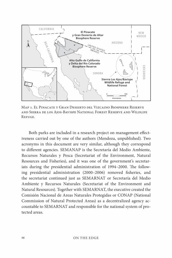
ON THE EDGE98
Both parks are included in a research project on management effect-iveness carried out by one of the authors (Mendoza, unpublished). Two acronyms in this document are very similar, although they correspond to different agencies. SEMANAP is the Secretaría del Medio Ambiente, Recursos Naturales y Pesca (Secretariat of the Environment, Natural Resources and Fisheries), and it was one of the government’s secretar-iats during the presidential administration of 1994–2000. The follow-ing presidential administration (2000–2006) removed fisheries, and the secretariat continued just as SEMARNAT or Secretaría del Medio Ambiente y Recursos Naturales (Secretariat of the Environment and Natural Resources). Together with SEMARNAT, the executive created the Comisión Nacional de Areas Naturales Protegidas or CONAP (National Commission of Natural Protected Areas) as a decentralized agency ac-countable to SEMARNAT and responsible for the national system of pro-tected areas.
Map 1. El Pinacate y Gran Desierto del Vizcaino Biosphere Reserve and Sierra de los Ajos-Bavispe National Forest Reserve and Wildlife Refuge.
99Angeles Mendoza Sammet and Michael S. Quinn
Pinacate was created by a presidential decree on June 10, 1983. El Pinacate is considered a consolidated protected area. It is located on the northwest end of the state, on one of roughest parts of the Sonoran Desert (Fig. 1). It has an area of 714,556 hectares. Its geological diversity includes sand dunes and numerous craters and landforms of volcanic origin. The vegetation is composed of 560 vascular species, including xerophilic plants and shrubs. Its biodiversity includes approximately 184 species of birds, forty-two reptile species, four amphibian species, and two native fresh-water fish species. Pinacate contains archaeological remains dating from the early occupation of America. It is also a place of cultural and spiritual value for the Pápago Indians (CONANP 2007; SEMARNAP 1995).
Sierra de los Ajos Bavispe National Forest Reserve and Area for Protection of Flora and Fauna, or Ajos, was created by a presidential de-cree on June 30, 1936 (Fig. 2); however, it remained without management until 1997. In 1996, it was recognized among the twenty-five priority pro-tected areas. The next year it was provided with a management team for the first time. It is located in the northeast portion of the state of Sonora and is composed of five units that are spread among five mountain ranges in the state. Ajos is a source of two rivers of national importance (Sonora River and Yaqui River), and one of international importance (San Pedro River). It has an area of 184,776 hectares and contains various landforms, from riparian valleys to mountains. The vegetation varies from semi-arid shrubs, to grasslands, to pine-oak mixed forest. There are an estimated 1,234 species of vascular plants, 448 species of vertebrates, and 156 spe-cies of butterflies. Ajos is a stepping stone for the Monarch butterfly on its migration to southern Mexico (SEMARNAP, unpublished).
Ajos and Pinacate provide insight into the issues faced by parks in different stages of consolidation. Several municipalities overlap both parks and have jurisdiction over sections of each. Pinacate lies within two mu-nicipalities: Puerto Peñasco and Plutarco Elias Calles. Another munici-pality, San Luis Rio Colorado, is influenced by the park. Ajos lies within the boundaries of four municipalities: Bacoachi, Cananea, Fronteras, and Nacozari (SEMARNAP 1995, unpublished).
ON THE EDGE100
The two parks were chosen as case studies for the following reasons:
• Location in the same state;
• Existence of a management plan;
• Presence of migratory and/or species of common concern (IBIP 2003, 2007);
• Presence of species included in official lists of imperiled;
• Recognition of important bird conservation areas (CONABIO 2004, 2007); and
• Cooperation with parks and organizations in the U.S.A.
To determine the factors that influence management and conservation ef-fectiveness, we used a pluri-dimensional model of governance interactions modified from Mendoza and Thompson (2005). The factors influencing conservation and management are the driving forces (facilitating posi-tive outcomes), barriers (impeding positive outcomes), and ambivalent forces (both facilitating and impeding positive outcomes) that affect the achievement of desired conservation and protected area (PA) management outcomes. Examples of factors include: stakeholders, interests, statutes, or codes of conduct. The term ‘stakeholder’ refers to individuals and formal or informal organizations that have common interests and/or goals. The model was used to identify relationships the park has in four dimensions: regulatory, administrative, geographical/economic, and social (e.g., park and local communities). These dimensions represent four types of gover-nance: national, economic, environmental, and protected areas (Fig. 3). The relationships are used to identify factors at five levels: internal, local, regional, national, and international. The terms ‘park’ and ‘protected area’ are used interchangeably.
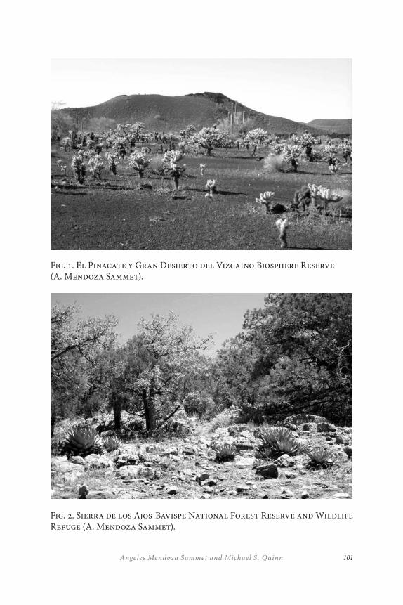
101Angeles Mendoza Sammet and Michael S. Quinn
Fig. 1. El Pinacate y Gran Desierto del Vizcaino Biosphere Reserve (A. Mendoza Sammet).
Fig. 2. Sierra de los Ajos-Bavispe National Forest Reserve and Wildlife Refuge (A. Mendoza Sammet).
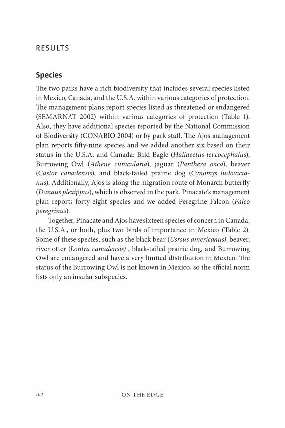
ON THE EDGE102
RESULTS
Species
The two parks have a rich biodiversity that includes several species listed in Mexico, Canada, and the U.S.A. within various categories of protection. The management plans report species listed as threatened or endangered (SEMARNAT 2002) within various categories of protection (Table 1). Also, they have additional species reported by the National Commission of Biodiversity (CONABIO 2004) or by park staff. The Ajos management plan reports fifty-nine species and we added another six based on their status in the U.S.A. and Canada: Bald Eagle (Haliaeetus leucocephalus), Burrowing Owl (Athene cunicularia), jaguar (Panthera onca), beaver (Castor canadensis), and black-tailed prairie dog (Cynomys ludovicia-
nus). Additionally, Ajos is along the migration route of Monarch butterfly (Danaus plexippus), which is observed in the park. Pinacate’s management plan reports forty-eight species and we added Peregrine Falcon (Falco
peregrinus).Together, Pinacate and Ajos have sixteen species of concern in Canada,
the U.S.A., or both, plus two birds of importance in Mexico (Table 2). Some of these species, such as the black bear (Usrsus americanus), beaver, river otter (Lontra canadensis) , black-tailed prairie dog, and Burrowing Owl are endangered and have a very limited distribution in Mexico. The status of the Burrowing Owl is not known in Mexico, so the official norm lists only an insular subspecies.
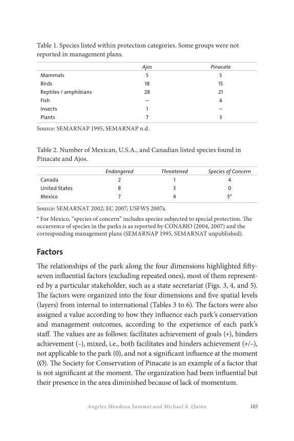
103Angeles Mendoza Sammet and Michael S. Quinn
Table 1. Species listed within protection categories. Some groups were not reported in management plans.
Ajos Pinacate
Mammals 5 5
Birds 18 15
Reptiles / amphibians 28 21
Fish – 4
Insects 1 –
Plants 7 3
Source: SEMARNAP 1995, SEMARNAP n.d.
Table 2. Number of Mexican, U.S.A., and Canadian listed species found in Pinacate and Ajos.
Endangered Threatened Species of Concern
Canada 2 1 4
United States 8 3 0
Mexico 7 4 5*
Source: SEMARNAT 2002; EC 2007; USFWS 2007a.
* For Mexico, “species of concern” includes species subjected to special protection. The occurrence of species in the parks is as reported by CONABIO (2004, 2007) and the corresponding management plans (SEMARNAP 1995, SEMARNAT unpublished).
Factors
The relationships of the park along the four dimensions highlighted fifty-seven influential factors (excluding repeated ones), most of them represent-ed by a particular stakeholder, such as a state secretariat (Figs. 3, 4, and 5). The factors were organized into the four dimensions and five spatial levels (layers) from internal to international (Tables 3 to 6). The factors were also assigned a value according to how they influence each park’s conservation and management outcomes, according to the experience of each park’s staff. The values are as follows: facilitates achievement of goals (+), hinders achievement (–), mixed, i.e., both facilitates and hinders achievement (+/–), not applicable to the park (0), and not a significant influence at the moment (Ø). The Society for Conservation of Pinacate is an example of a factor that is not significant at the moment. The organization had been influential but their presence in the area diminished because of lack of momentum.
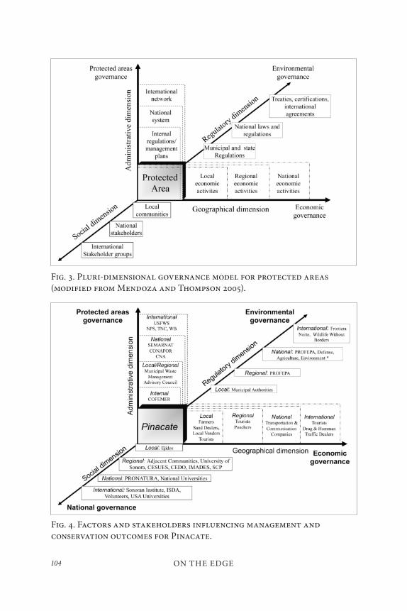
ON THE EDGE104
Fig. 3. Pluri-dimensional governance model for protected areas (modified from Mendoza and Thompson 2005).
Fig. 4. Factors and stakeholders influencing management and conservation outcomes for Pinacate.
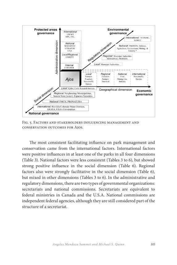
105Angeles Mendoza Sammet and Michael S. Quinn
The most consistent facilitating influence on park management and conservation came from the international factors. International factors were positive influences in at least one of the parks in all four dimensions (Table 3). National factors were less consistent (Tables 3 to 6), but showed strong positive influence in the social dimension (Table 6). Regional factors also were strongly facilitative in the social dimension (Table 6), but mixed in other dimensions (Tables 3 to 6). In the administrative and regulatory dimensions, there are two types of governmental organizations: secretariats and national commissions. Secretariats are equivalent to federal ministries in Canada and the U.S.A. National commissions are independent federal agencies, although they are still considered part of the structure of a secretariat.
Fig. 5. Factors and stakeholders influencing management and conservation outcomes for Ajos.
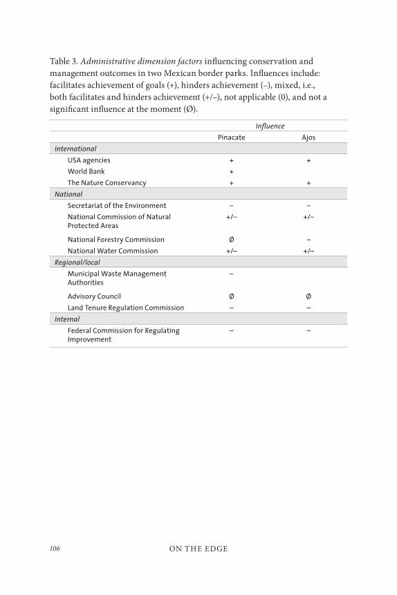
ON THE EDGE106
Table 3. Administrative dimension factors influencing conservation and management outcomes in two Mexican border parks. Influences include: facilitates achievement of goals (+), hinders achievement (–), mixed, i.e., both facilitates and hinders achievement (+/–), not applicable (0), and not a significant influence at the moment (Ø).
Influence
Pinacate Ajos
International
USA agencies + +
World Bank +
The Nature Conservancy + +
National
Secretariat of the Environment – –
National Commission of Natural Protected Areas
+/– +/–
National Forestry Commission Ø –
National Water Commission +/– +/–
Regional/local
Municipal Waste Management Authorities
–
Advisory Council Ø Ø
Land Tenure Regulation Commission – –
Internal
Federal Commission for Regulating Improvement
– –
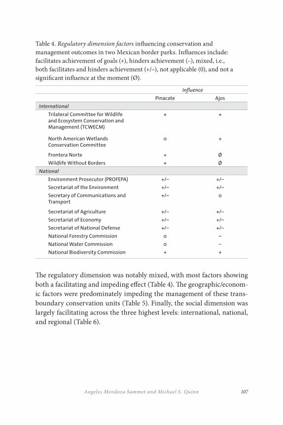
107Angeles Mendoza Sammet and Michael S. Quinn
Table 4. Regulatory dimension factors influencing conservation and management outcomes in two Mexican border parks. Influences include: facilitates achievement of goals (+), hinders achievement (–), mixed, i.e., both facilitates and hinders achievement (+/–), not applicable (0), and not a significant influence at the moment (Ø).
Influence
Pinacate Ajos
International
Trilateral Committee for Wildlife and Ecosystem Conservation and Management (TCWECM)
+ +
North American Wetlands Conservation Committee
0 +
Frontera Norte + Ø
Wildlife Without Borders + Ø
National
Environment Prosecutor (PROFEPA) +/– +/–
Secretariat of the Environment +/– +/–
Secretary of Communications and Transport
+/– 0
Secretariat of Agriculture +/– +/–
Secretariat of Economy +/– +/–
Secretariat of National Defense +/– +/–
National Forestry Commission 0 –
National Water Commission 0 –
National Biodiversity Commission + +
The regulatory dimension was notably mixed, with most factors showing both a facilitating and impeding effect (Table 4). The geographic/econom-ic factors were predominately impeding the management of these trans-boundary conservation units (Table 5). Finally, the social dimension was largely facilitating across the three highest levels: international, national, and regional (Table 6).
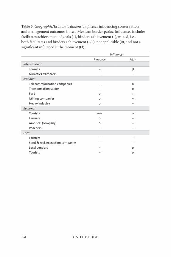
ON THE EDGE108
Table 5. Geographic/Economic dimension factors influencing conservation and management outcomes in two Mexican border parks. Influences include: facilitates achievement of goals (+), hinders achievement (–), mixed, i.e., both facilitates and hinders achievement (+/–), not applicable (0), and not a significant influence at the moment (Ø).
Influence
Pinacate Ajos
International
Tourists – Ø
Narcotics tra≤ckers – –
National
Telecommunication companies – 0
Transportation sector – 0
Ford 0 +
Mining companies 0 –
Heavy industry 0 –
Regional
Tourists +/– 0
Farmers 0 –
Americal (company) 0 –
Poachers – –
Local
Farmers – –
Sand & rock extraction companies – –
Local vendors – 0
Tourists – 0
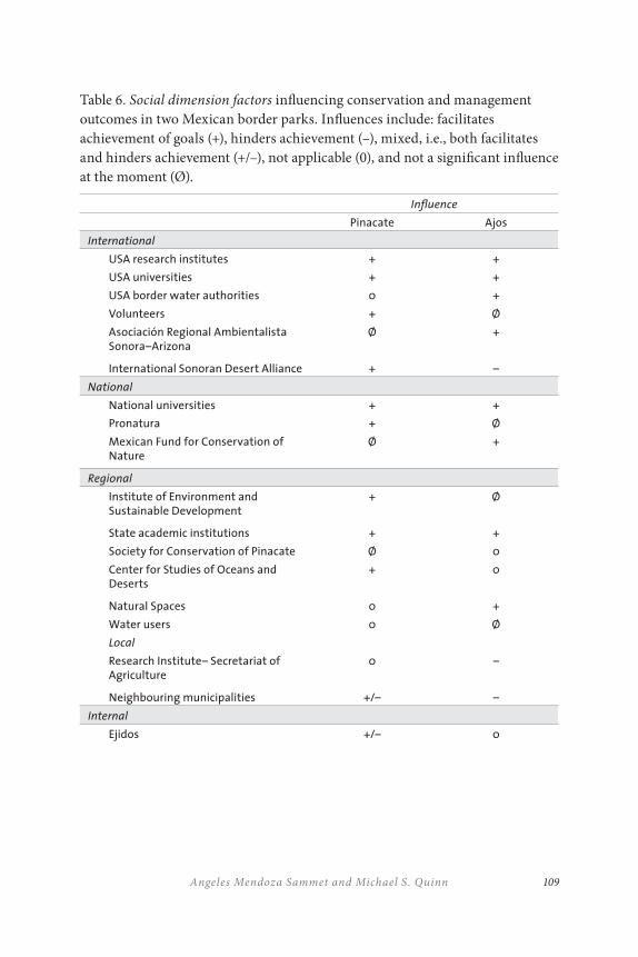
109Angeles Mendoza Sammet and Michael S. Quinn
Table 6. Social dimension factors influencing conservation and management outcomes in two Mexican border parks. Influences include: facilitates achievement of goals (+), hinders achievement (–), mixed, i.e., both facilitates and hinders achievement (+/–), not applicable (0), and not a significant influence at the moment (Ø).
Influence
Pinacate Ajos
International
USA research institutes + +
USA universities + +
USA border water authorities 0 +
Volunteers + Ø
Asociación Regional Ambientalista Sonora–Arizona
Ø +
International Sonoran Desert Alliance + –
National
National universities + +
Pronatura + Ø
Mexican Fund for Conservation of Nature
Ø +
Regional
Institute of Environment and Sustainable Development
+ Ø
State academic institutions + +
Society for Conservation of Pinacate Ø 0
Center for Studies of Oceans and Deserts
+ 0
Natural Spaces 0 +
Water users 0 Ø
Local
Research Institute– Secretariat of Agriculture
0 –
Neighbouring municipalities +/– –
Internal
Ejidos +/– 0

ON THE EDGE110
State Secretariats and CommissionsThe presence in both Pinacate and Ajos of species and ecosystems of con-cern for North America puts the parks among the priority-protected areas in Mexico. In addition, their location along the international boundary makes them areas of interests for various international stakeholders, es-pecially in the U.S.A. Each of the fifty-seven factors influences parks’ out-comes to a greater or lesser degree, although some are specific to one park (Tables 3 to 6). Some factors can have different roles at different levels and dimensions. Thus, those factors can influence conservation and manage-ment in different ways. Secretariats at the state level of government are a good example.
State secretariats can favour or hinder conservation and management. Through their regulatory role they can push for legal changes to promote sustainable development and reduce environmental impacts. Also, they can establish mechanisms to make inter-secretariat coordination more effective and efficient. At regional and local levels, secretariat offices ful-fill administrative functions and have greater involvement on the imple-mentation of programs. In the case of the two parks, management was affected by the lack of congruency among policies developed by different secretariats and their contradictory objectives. Ajos was the park more affected by the inefficient coordination between local and central offices of secretariats and commissions. At regional and local levels, the admin-istrative role of secretariats’ offices reflected problems in governance such as corruption, poor effectiveness, and excessive regulatory burden. Eight secretariats and one national commission are most relevant because the activities they regulate have a direct influence on the environment or on the design of regulatory or development policies. Therefore, their deci-sions and actions can favour or hinder conservation and management. Table 7 shows the areas of responsibility of the main secretariats and com-missions. The following sections explain their influence on the parks.
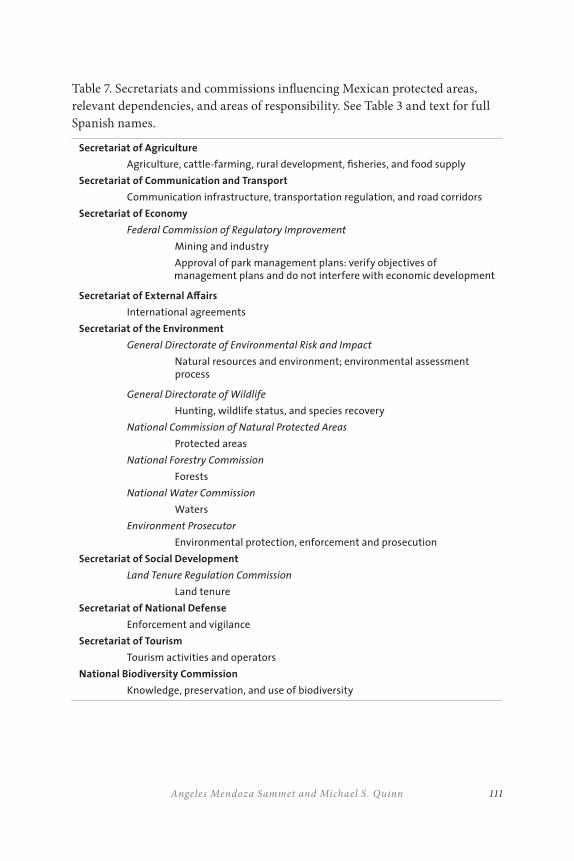
111Angeles Mendoza Sammet and Michael S. Quinn
Table 7. Secretariats and commissions influencing Mexican protected areas, relevant dependencies, and areas of responsibility. See Table 3 and text for full Spanish names.
Secretariat of Agriculture
Agriculture, cattle-farming, rural development, fisheries, and food supply
Secretariat of Communication and Transport
Communication infrastructure, transportation regulation, and road corridors
Secretariat of Economy
Federal Commission of Regulatory Improvement
Mining and industry
Approval of park management plans: verify objectives of management plans and do not interfere with economic development
Secretariat of External A≠airs
International agreements
Secretariat of the Environment
General Directorate of Environmental Risk and Impact
Natural resources and environment; environmental assessment process
General Directorate of Wildlife
Hunting, wildlife status, and species recovery
National Commission of Natural Protected Areas
Protected areas
National Forestry Commission
Forests
National Water Commission
Waters
Environment Prosecutor
Environmental protection, enforcement and prosecution
Secretariat of Social Development
Land Tenure Regulation Commission
Land tenure
Secretariat of National Defense
Enforcement and vigilance
Secretariat of Tourism
Tourism activities and operators
National Biodiversity Commission
Knowledge, preservation, and use of biodiversity
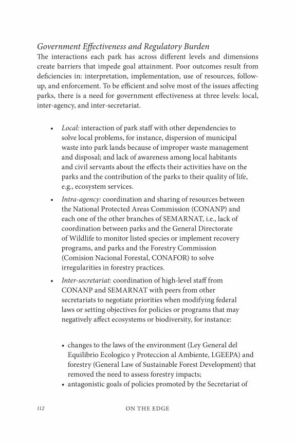
ON THE EDGE112
Government Effectiveness and Regulatory BurdenThe interactions each park has across different levels and dimensions create barriers that impede goal attainment. Poor outcomes result from deficiencies in: interpretation, implementation, use of resources, follow-up, and enforcement. To be efficient and solve most of the issues affecting parks, there is a need for government effectiveness at three levels: local, inter-agency, and inter-secretariat.
• Local: interaction of park staff with other dependencies to solve local problems, for instance, dispersion of municipal waste into park lands because of improper waste management and disposal; and lack of awareness among local habitants and civil servants about the effects their activities have on the parks and the contribution of the parks to their quality of life, e.g., ecosystem services.
• Intra-agency: coordination and sharing of resources between the National Protected Areas Commission (CONANP) and each one of the other branches of SEMARNAT, i.e., lack of coordination between parks and the General Directorate of Wildlife to monitor listed species or implement recovery programs, and parks and the Forestry Commission (Comision Nacional Forestal, CONAFOR) to solve irregularities in forestry practices.
• Inter-secretariat: coordination of high-level staff from CONANP and SEMARNAT with peers from other secretariats to negotiate priorities when modifying federal laws or setting objectives for policies or programs that may negatively affect ecosystems or biodiversity, for instance:
• changes to the laws of the environment (Ley General del Equilibrio Ecologico y Proteccion al Ambiente, LGEEPA) and forestry (General Law of Sustainable Forest Development) that removed the need to assess forestry impacts;
• antagonistic goals of policies promoted by the Secretariat of
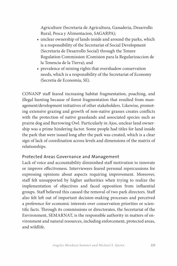
113Angeles Mendoza Sammet and Michael S. Quinn
Agriculture (Secretaria de Agricultura, Ganaderia, Desarrollo Rural, Pesca y Alimentacion, SAGARPA);
• unclear ownership of lands inside and around the parks, which is a responsibility of the Secretariat of Social Development (Secretaria de Desarrollo Social) through the Tenure Regulation Commission (Comision para la Regularizaccion de la Tenencia de la Tierra); and
• prevalence of mining rights that overshadow conservation needs, which is a responsibility of the Secretariat of Economy (Secretia de Economia, SE).
CONANP staff feared increasing habitat fragmentation, poaching, and illegal hunting because of forest fragmentation that resulted from man-agement/development initiatives of other stakeholders. Likewise, promot-ing extensive grazing and growth of non-native grasses creates conflicts with the protection of native grasslands and associated species such as prairie dog and Burrowing Owl. Particularly in Ajos, unclear land owner-ship was a prime hindering factor. Some people had titles for land inside the park that were issued long after the park was created, which is a clear sign of lack of coordination across levels and dimensions of the matrix of relationships.
Protected Areas Governance and Management
Lack of voice and accountability diminished staff motivation to innovate or improve effectiveness. Interviewees feared personal repercussions for expressing opinions about aspects requiring improvement. Moreover, staff felt unsupported by higher authorities when trying to realize the implementation of objectives and faced opposition from influential groups. Staff believed this caused the removal of two park directors. Staff also felt left out of important decision-making processes and perceived a preference for economic interests over conservation priorities or scien-tific facts. Through its commissions or directorates, the Secretariat of the Environment, SEMARNAT, is the responsible authority in matters of en-vironment and natural resources, including enforcement, protected areas, and wildlife.
ON THE EDGE114
One of the main factors that hindered management efficiency was the workload of park staff. A basic management team has five people who are assigned responsibilities that overlap those of other jurisdic-tions and diverted staff time and resources. Although the Secretariats of Social Development and Agriculture are responsible for social and rural development respectively, CONANP’s work plan for 2001–2006 made protected areas staff responsible for promoting Programs for Sustainable Development (Programas de Desarrollo Sostenible, PRODERS) among in-ternal and surrounding communities (CONANP 2001). One staff member at the park had been promoting three PRODERS without much success:
• nurseries for palo fierro (Olneya tesota), a tree subjected to special protection found in Pinacate and used for carving handcrafts;
• agricultural practices or restoration of grazing lands; and
• ecotourism.
Since the administration of President Vicente Fox, there has been a pro-gram of presidential targets to improve areas such as coordination among different secretariats. CONANP and SEMARNAT have to report how co-ordination occurs. The results are not evident yet. So far, the indicators used by CONANP have dealt more with processes or inputs rather than outcomes (CONANP 2006).
Sponsorships from private companies and partnerships with inter-national organizations such as The Nature Conservancy are helping parks improve management and conservation. Nevertheless, their reporting requirements contribute to the regulatory burden. Staff felt there was ex-cessive reporting required for partners, sponsors, park authorities, and other government departments. This has to be added to the complexity of administrative processes and the bureaucracy characterizing inter-agency procedures. Also, some problems have resulted from lack of clarity re-garding the benefits and conditions for private sponsorship.
115Angeles Mendoza Sammet and Michael S. Quinn
Rule of LawMexico has laws to ensure effective and efficient management of natural resources. Protected areas should be an example of places where citizens abide by the rules. Nevertheless, both parks have been affected by inappro-priate public behaviour and inefficient vigilance and enforcement. Creating the position of an environmental prosecutor (Procuraduría Federal de Protección al Ambiente, PROFEPA) responsible for vigilance, inspection, enforcement, and prosecution was well-intentioned and may have sought to use resources more efficiently. However, limitations on environmental prosecutor resources, training, and staff, in addition to the remoteness and vastness of park lands, have resulted in insufficient vigilance and en-forcement that favours destruction of habitat and biodiversity. The insuf-ficient number of inspectors and the bureaucracy involved in processing violators promotes the proliferation of illegal uses. Moreover, infringers are charged fines but there are no provisions to repair or mitigate dam-ages. Common problems in parks include extraction of flora and fauna and illegal hunting. In Ajos, for example, black bears have been killed to get gallbladders for the illicit market in animal parts. Other problems in-volve local or nearby communities that use park lands for illegal grazing or farming. Some community members have helped in Pinacate by serv-ing as volunteer guards or working on some restoration projects. Parks can employ local people as labour for specific projects, which are funded through temporary employment funds.
There is no equivalent of a park warden or park ranger service in Mexico. CONANP staff lacks capacity and training to deal with crime or violators, so park authorities or staff may request the assistance of local or federal police. Commonly the Environmental Prosecutor (PROFEPA) has to ask for the intervention of the military (Secretaria de la Defensa Nacional) for dealing with crime inside protected areas. In Ajos, violations to law included the use of remote areas by drug gangs to grow marijuana, illegal hunting, and use of park lands by local people for cattle-grazing. In Pinacate, violations included use of remote areas by crime groups to move illegal immigrants and drugs across the U.S.A.-Mexico border. The military helps fight illegal activities, although the way it conducts its oper-ations generates environmental impacts, for instance, clearing areas for
ON THE EDGE116
camps, use of heavy machines, unauthorized hunting, and inappropriate waste disposal.
Ultra Vires ActivitiesThere were complaints of corruption observed at various levels. Staff at Ajos commented that some municipal employees: favoured industrial ac-tivities by obstructing conservation activities, received bribes to skip steps on approvals, favoured friends, or altered results to get petitions approved. Some of the complaints involved functionaries within SEMARNAT. Finally, there were also complaints of military authorities protecting the interests of drug growers and dealers inside parks by simulating opera-tions to destroy crops and capture violators.
Corporate GovernanceOne of the obstacles hindering conservation and effective management stems from poor corporate governance and social responsibility. Corporate behaviour can have great repercussions on protected areas and biodiver-sity. Companies that strive to show good corporate social responsibility and improve environmental management of their operations will benefit themselves and their surroundings. The Ford Foundation, for instance, provided funds for a nursery in Ajos to grow native trees.
On the other hand, companies that focus on the bottom line are prone to use bribery to get approvals. Mining companies in the area have a bad reputation because of corruption, illegal use of protected lands, damage to wildlife habitat, and effects on human health. Other extractive indus-tries have behaved similarly. There were complaints that mining compan-ies paid people to threaten environmental leaders and spread rumours against the park and the proposed annexations.
Management of Natural Resources
Wildlife Management
The National Biodiversity Commission (Comisión Nacional para el Conocimiento y Uso de la Biodiversidad) is the institution leading
117Angeles Mendoza Sammet and Michael S. Quinn
conservation of biodiversity in Mexico. It distributes federal funds to sup-port projects that generate information about Mexico’s biodiversity. Its functions include compiling information about national biodiversity and ecosystems, identifying priority areas for conservation, and participating in the development of policies for protection of ecosystems and species.
The Trilateral Committee for Wildlife and Ecosystem Conservation and Management (TCWECM) have established working tables for spe-cies of concern (IBIP 2007), although specific actions have not been taken. CONANP took over jurisdiction on endangered species in 2009. Prior to that, the Dirección General de Vida Silvestre (DGVS) was responsible for endangered species and their recovery plans (SEMARNAT 2007b). The DGVS prepared management plans for some of the species such as the prairie dog (n.d.), Golden Eagle (Aquila chrysaetos) (1999), black bear (1999), and bighorn sheep (Ovis Canadensis) (2000); however, they have not yet been implemented. Park staff had no knowledge of the programs nor had they been involved in their design. Staff was not involved in the TCWECM working tables either. Interviews with staff in other Mexican parks (Mendoza unpublished) revealed a similar situation. For instance, the Piping Plover is endangered in Canada, the U.S.A., and Mexico. Nevertheless, there were no actions focussing on this species. Political instability and conflicts with communities interested in logging has ob-structed TCWECM initiatives and efforts to make the Monarch Butterfly Biosphere Reserve work. At Pinacate, the two primary causes of wildlife mortality have been road kills and poaching. Staff commented that farm-ers continue killing wildlife, especially Golden Eagles and jaguars because of the belief that the species attack cattle.
Forest Management
The forest in Ajos has been subject to a natural fire regime, which makes it a good reference system for forest management in other jurisdictions that have implemented fire control. Ajos also has species of economic value, so efficient forest management is a must for maintaining ecosystem and watershed health. Pinacate staff had concerns about overexploitation of palo fierro (iron wood). In Ajos, staff commented on various issues that reduced harmonization of Forestry Commission goals and activities with those of the park:
ON THE EDGE118
• reforestation with exotic and non-native tree species;
• approval of logging without follow-up on licences or established quotes;
• extraction of tree species different from those authorized;
• lack of programs for training on control of forest fires; and
• lack of support toward local initiatives compatible with conservation, e.g., establishing Christmas tree plantations.
Water and Watershed Management
Water is increasingly scarce in Mexico, especially in the northwest. The geographic management units composing Ajos, and the proposed annexa-tions, are a significant source of water for the state and of great interest to industry. Staff said the park land base provides nearly 70 per cent of the state’s water requirements. The reserve and proposed annexations are of interest for water users on the U.S. side of the border, too. The Rio San Pedro, which borders habitat for prairie dog, Burrowing Owl, and native grasses, is a tributary of the U.S.A.’s Gila River, itself a tributary of the Colorado River. A U.S. proposal to protect part of the San Pedro River watershed and expand Ajos was presented to the Mexican authorities. Nevertheless, the proposal has not been implemented.
Economic PolicyThe Secretariat of Economy (SE) has a great influence in park manage-ment. Its Federal Commission of Regulatory Improvement (Comisión Federal de Mejora Regulatoria) reviews and approves park management plans and regulations. Parks experience regulatory burden because this process is usually restrictive and time-consuming. For instance, the Ajos management plan has been in progress since 1999 and at the time of writ-ing this chapter (May 2012) it has not yet been approved. Staff in both parks commented that they were not allowed to introduce into the man-agement plans new regulations considered necessary to achieve conserva-tion of species or ecosystems. Neither could they include conservation or
119Angeles Mendoza Sammet and Michael S. Quinn
management actions that, in the opinion of the reviewers, might affect economic activities. SE is also responsible for mining and industry, two activities that generate most of the environmental effects in the region. Staff in headquarters commented on the inappropriate control of mining and industry effects on ecosystems and human health.
Management of Mining and Industrial ActivitiesLegal and illegal extraction of mineral resources was a problem in both parks. In the case of Pinacate, companies extract sand and/or rock for construction, disrupting flora and fauna. Some extraction of sand was au-thorized for upgrading the highway; however, restoration was not evident afterward. Often people that were awarded permits to extract sand from one site but extracted it from another. In one case, a company extracted sand from the river, causing a drop in water levels. This drawdown endan-gered aquatic species, especially the pupo del desierto (Cyprinodon macu-
larius), an endemic fish at risk of extinction.There are noticeable effects from these activities in the Ajos area, both
on ecosystems and human populations. Local people have a high incidence of respiratory diseases and cancer, and the forests suffer from acid depos-ition. Mining companies and other industries build reservoirs to contain wastewater. However, there is no water treatment and the reservoirs are abandoned when they fill up, leaving water quality at risk. Also, building and mining zones are left abandoned without mitigation of impacts.
Agricultural PoliciesFarming, especially cattle-grazing, was the other economic activity that negatively affected conservation and management. One reason for agri-cultural-park management conflict was the incompatibility of actions to implement agricultural policies with the conservation needs of parks. This affected particularly the grasslands and the remaining habitat for prairie dog and Burrowing Owl. Noteworthy effects are the following:
ON THE EDGE120
• experimentation with genetically modified grasses that could change vegetation composition just outside the boundaries of the reserve;
• promotion of extensive grazing on zones of low capacity which reduces wildlife habitat and contributes to land degradation;
• promotion of exotic grasses that displace native grasses; and
• changes in floristic composition because of invasion of non-palatable species and soil compaction due to overgrazing.
Another source of conflict between agricultural and park management was the effect of inappropriate practices used by farmers and cattle-growers, sometimes driven by ignorance and sometimes driven by per-sonal gain, including: unauthorized use of park lands for growing crops or cattle-grazing, illegal acquisition of titles for park lands, and disregard of grazing zoning and quotas.
Tourism ManagementTourism is not a significant source of income for the parks. Pinacate had around 6,500 visitors in one year, which staff considered low visitation. This park has some day-use facilities. Common problems with tourism were damage to facilities, improper garbage disposal, inappropriate hu-man waste disposal, damage to flora and fauna, and damage to geologi-cal resources. In addition, some local residents established roadside food stands whose main effect would be inappropriate garbage disposal and damage to soil and vegetation from unregulated parking. Some local in-habitants would use the park for racing with trucks or cars. Ajos was not open to the public; nevertheless, local people entered the park for various purposes. As a result, garbage from occasional visitors and visitor-related damage to flora or fauna can still be found.
In 2002, changes in the Federal Law of Rights enabled park authorities to collect fees for the recreational use of natural marine and terrestrial resources. Nevertheless, it was not until 2006 that CONANP issued the Conservation Pass, an annual park pass that gives a person the right to
121Angeles Mendoza Sammet and Michael S. Quinn
visit any of the federal protected areas as many times as desired 250 pesos (CONANP 2007). No information was found regarding plans to monitor visitor-related impacts in protected areas.
Environmental Impact Assessment (EIA) ProcessThe work of the General Directorate of Environmental Impact and Risk (Direccion General de Impacto y Riesgo Ambiental, DGIRA) could be one of the main forces to control and minimize the impacts from human ac-tivities on human populations and on park biodiversity and ecosystems. However, irregularities in the environmental assessment process reduce EIA’s usefulness as a tool for decision-making. EIA reports for approved projects submitted to the parks were of poor quality (Mendoza 2004). Some of the flaws included:
• alteration of park boundaries and location of proposed activities;
• analysis of impacts based mainly on outdated literature search;
• inappropriate sampling;
• lack of field work;
• lack of – or inappropriate – mitigation measures;
• neglectful treatment of relevant environmental impacts; and
• insufficient time for park staff to review EIA report and submit comments.
Mexico’s environmental law does not have provisions for assessing the en-vironmental impacts of laws, programs, policies, or projects. Consequently, environmental assessments are not sufficient to achieve effective manage-ment of environmental impacts.

ON THE EDGE122
Other Factors
Foreign AssistanceLack of funding and training are ongoing issues. Ajos staff commented that most of the funds available nationally were destined for parks with tropical forests, affecting parks with other vegetation types. Having pro-tected areas across the international border is one of the main factors that favours conservation and management in the region. The relationships that Mexican park staff have established with their American peers fa-cilitates information sharing and access to resources from agencies such as the U.S. National Park Service (NPS). Pinacate established cooperation with Organ Pipe Cactus National Monument in Arizona with which it shares resources for monitoring air quality and visibility. Ajos estab-lished cooperation with Chiricahua National Monument and Coronado National Memorial (both in Arizona) to address issues such as control of forest fires.
The U.S. Fish and Wildlife Service (USFWS) in Arizona is another important stakeholder that assists the border parks with technical know-ledge and experience, and with funding options for capacity-building through programs like Wildlife Without Borders and the Program of the Committee for the North American Wetlands Conservation Act (USFWS 2007b). For instance, the Wildlife Without Borders grant program funds training of protected area managers (USFWS 2007c).
Pinacate was able to access funds provided by the World Bank and the program Frontera Norte (North Frontier), a U.S.A.-Mexico bilateral program. This program fosters cooperation in areas such as water, eco-systems, and biodiversity, and minimizing pollution from industrial ac-tivities (SEMARNAT 2007a).
The Nature Conservancy is an organization with significant influence in both parks. Its program “Parks in Peril” has provided funds to help consolidate both parks. Its tools, such as the site consolidation scorecard and the Five-S Framework, help organize management and measure suc-cess. Nevertheless, TNC’s management tools focus on conservation tar-gets and reporting requirements are very different from SEMARNAT
123Angeles Mendoza Sammet and Michael S. Quinn
requirements. This increases the regulatory burden for park managers and staff.
The Trilateral Committee for Wildlife and Ecosystem Conservation and Management favours information exchange on topics of common in-terest. Commonly, it is staff from the headquarters or other high-level staff who attend the meetings. However, failure to include lower-level agency staff, park staff, or outside experts reduces the effectiveness of the working groups of the Trilateral Committee. This lack of involvement causes slow information gathering, delayed implementation of adopted action plans, and reduced effectiveness.
Academic and research institutions from the U.S.A. contribute by generating knowledge about species or ecosystems. Pinacate had a good relationship with the International Sonoran Desert Alliance, a bi-national non-profit. At Ajos, the University of New Mexico conducted a study about jaguar and the University of Arizona researched prairie dog and associated bird species. Foreign volunteers have participated in research or monitoring activities. Additionally, both parks have had support from foreign non-governmental organizations. The relationships, however, are not regular and projects are transitory.
National OrganizationsAcademic and research institutions within Mexico also contribute to re-search. Institutions such as the University of Sonora, the Centre of Superior Studies of the State of Sonora (Centro de Estudios Superiores del Estado de Sonora), and the Centre for Studies of Deserts and Oceans (Centro de Estudios de Desiertos y Oceanos) conducted research in Pinacate. The Institute of Ecology is an academic institution that promoted the designa-tion of Pinacate as a biosphere reserve.
The failure of researchers to share results with park staff hinders man-agement and conservation. Especially in Mexico, it is common to have students doing professional practice or thesis work in parks. However, parks do not always receive copies of the final documents. Also, research is often focussed on the researcher’s interests rather than on the informa-tion needs of parks.
ON THE EDGE124
Different national governmental and non-governmental organiza-tions (NGOs) help parks improve relationships with local communities through environmental education or other activities. Natural Spaces and the Regional Environmental Association Sonora-Arizona (Asociación Regional Ambientalista Sonora-Arizona or ARASA) were two NGOs that have collaborated with Ajos. ARASA was active in trying to neutralize rumours spread amongst local people that their land would be taken away for the park. In Pinacate, advocacy and public support for the park were expressed through the Society for Conservation of Pinacate (SCP), which involved people from the state and some of the academics that worked for the protected designation of the area. However, the society lost momen-tum a few years after the creation of the park.
In Ajos, the Mexican Fund for Conservation of Nature (Fondo Mexicano para la Conservacion de la Naturaleza) and the Institute of Environment and Sustainable Development (Instituto de Medio Ambiente y Desarrollo Sostenible) have provided funds for projects. A national NGO, Pronatura, expressed interest in partnering with the park, although no projects have been created yet.
Species of Concern
Inclusion of species on the corresponding endangered species lists or among the species of concern in North America is the main driver to implement protection and recovery actions to improve their conservation status. Listing, however, is not a guarantee of conservation action. The Burrowing Owl is an example. Its status in Mexico is unknown and there are no programs for this species. To date, park staff in Mexico is not al-lowed to participate in research, just to coordinate it. In addition, there are no funds available for research or monitoring in parks, and staff is expected to recruit institutions interested in research. If that happens, the projects correspond primarily to academic interests.
125Angeles Mendoza Sammet and Michael S. Quinn
CONCLUSIONS AND RECOMMENDATIONS
Whether a protected area is able to achieve its conservation and manage-ment objectives depends on a wide variety of factors. Pinacate y Gran Desierto de Altar Biosphere Reserve and Sierra de los Ajos-Bavispe National Forest Reserve and Wildlife Refuge are two case studies used in this chapter to analyze their interactions with stakeholders to identify the factors that have more influence on each park’s ability to achieve its goals. A pluri-dimensional model of governance was used to organize each park’s actors into four types of governance (protected areas, environmen-tal, economic, and social) and four levels (local, regional, national, and in-ternational). The interrelationships across levels and types of governance highlighted fifty-seven factors that influence conservation and manage-ment effectiveness. A factor may act in different ways at various spatial levels and dimensions. Thus, it may influence park outcomes in different ways. For instance, municipalities are influential locally in their admin-istrative role through the provision of services such as garbage collection. Similarly, a secretariat may have local influence in its administrative role when authorizing permits and may have national influence when it drafts laws or designs national policies and programs. Similarly, the same factor may influence outcomes in more than one way. For example, there may be good national regulations in place; however, their implementation locally may face challenges that reduce the regulations’ effectiveness.
Although the National Commission of Natural Protected Areas (CONANP) is a decentralized agency, it is still subjected to the SEMARNAT. The secretariat still has a big influence on CONANP’s out-comes because of its roles as regulatory entity (drafting laws and regula-tions, policy-making, and inter-secretariat coordination) and as authority responsible for the environmental assessment process. SEMARNAT is the authority that sees over the implementation of the environmental policy, so it should intervene if there are conflicts between conservation and de-velopment policies set by other secretariats. For example, the Secretariat of the Environment should assess areas where Secretariat of Agriculture programs and policies conflict with protected area management in these desert parks and seek to arrange program modifications in those areas
ON THE EDGE126
that guide development in a more harmonious manner with conservation goals.
Ineffective governance affects not only ecosystems and biodiversity but also human health and well-being. National agencies and regulators had an overall negative influence because of governance factors such as corruption, inefficient enforcement, and the dominance of economic interests. Lack of a strategic assessment of laws, policies, and programs propitiated conflicts among policies pursued by dependencies of the gov-ernment who should cooperate to achieve sustainable development goals. In this case, the effects of poor governance are more evident at lower levels (local/regional) when policies are implemented and the corresponding actions result in environmental impacts on the human population, the environment, and biodiversity.
Several challenges impact park staff and their capacity for manage-ment effectiveness. One of the most significant issues is the lack of en-forcement authority held by park staff. This means that when park staff discover legal violations they must rely on another level of authority for enforcement. Modelling many other nations’ park law enforcement ap-proaches – giving such authority to a trained and adequately staffed park warden service – would avoid delay, improve deterrence, and promote conservation. The current role of park staff in enforcement is also ineffi-ciently structured, requiring reporting that burdens actual management time. While there is a need for accountability and information transmis-sion, such needs should be balanced against staff time priorities to achieve conservation within the parks. Freeing staff time to conduct needed re-search directed toward answering management-related questions, along with granting staff authority to directly participate in research rather than just coordinate it, would contribute to building the knowledge base neces-sary for effective conservation within the parks. Just one example would be a population and habitat survey of Burrowing Owls, which are listed as sensitive species but cannot be managed in an information vacuum. Addressing staff capacity is a critical element of improving park manage-ment efficiency.
The location along the international border and the existence of shared natural resources, ecosystems, and species of concern increases
127Angeles Mendoza Sammet and Michael S. Quinn
the opportunities of parks to access foreign aid. For both parks, foreign actors have a positive influence in achieving outcomes through sharing knowledge and resources (human and material). In addition, the inter-national recognition of the scarcity and value of resources such as water and biodiversity is a factor that may promote positive changes in policies to achieve management and conservation goals. Tapping these external re-sources can be an important part of improving management effectiveness.
The following actions may help improve conservation and manage-ment of El Pinacate y Gran Desierto de Altar Biosphere and of Sierra de los Ajos Bavispe National Forest Reserve:
• Currently only senior staff and directors of CONANP participate on the so-called working tables of the Trilateral Committee for Wildlife and Ecosystem Conservation and Management (TCEWCM). These discussion tables are set to share knowledge and promote multi-lateral cooperation. Park staff are usually more knowledgeable of the needs and challenges to implement conservation policy, so getting park staff involved in these tables would contribute to improving the design of cooperative initiatives and would empower them to implement programs more effectively.
• The allocation of five staff as a management team for a park marks great progress, considering that before the creation of the CONANP there were practically no staff working in the parks. However, the number is not enough and park staff are getting overloaded by the regulatory burden from the different national authorities and the other sponsors they get individually (e.g., The Nature Conservancy). It is necessary to evaluate the effectiveness of administrative procedures to reduce the regulatory burden on staff and help improve their efficiency.
• The lack of financial resources dedicated to protected areas in Mexico results in a dearth of staff assigned to each park. Consequently, there is little capacity to conduct research. Park
ON THE EDGE128
staff are aware of the information needs, although there is not an official research agenda. Personnel carrying out research or monitoring normally work for a specific project and are not park staff. In addition, CONANP’s policy has been to open PAs for people or institutions interested in conducting research. Both factors determine that whatever research is done responds to the interests of the researchers or funding institutions rather to the information needs to manage parks. Two actions would be beneficial for the parks:
• Allowing staff to participate in monitoring and research to ensure a direct link between research and park information needs. Ideally, each park should have allocated one or more research and/or monitoring positions for staff. PAs in the national system could be assigned a priority to get the positions. A starting point could be to create a position for a research coordinator per region. This person should be in charge of determining that the research that is carried out is consistent with the objectives and, if it is the case, that the results are directly applicable to management issues. This staff position could also coordinate with researchers and track information to ensure that each park receives copies of the data and/or information generated.
• Having a research agenda with priorities for each park and ensuring seed money to create a research fund for protected areas would empower PAs and CONANP to focus research on their respective conservation and management needs. This would not exclude opening parks to other projects not directed to that end. Establishing such a fund could make it easier to attract partners and donations for research.
• Although the initiatives arising from the TCEWCM are considered official commitments to collaborate, progress is slow and there is not enough information available on the
129Angeles Mendoza Sammet and Michael S. Quinn
website to show the progress made and whether collaboration has been successful in improving the population status of the species of mutual concern or to reduce the threats they face. It is necessary to promote the adoption of mechanisms to evaluate the outcomes and to promote more accountability among the agencies participating in TCEWCM. This would create greater incentive to establish multi-lateral projects for the recovery of species of concern. Such projects should involve park staff from the three member countries as well as outside experts.
• In Mexico, it is necessary to change the mindset that a park warden service is a cost that can be spared rather than an investment for ensuring conservation of biodiversity and maintaining the ecological integrity of ecosystems. To make enforcement and vigilance economic, effective, and efficient, park wardens need to have some prosecutorial authority and responsibility for vigilance, inspection, and enforcement in protected areas. Wardens must be provided with adequate training and equipment to deal with violators and operate with the military or other organizations in certain situations as required.
• In Mexico, there are conflicts among policies and actions from different agencies and/or levels of authority. Thus, there is need to promote requirements for overarching strategic assessments of federal laws and related policies, projects, and programs to minimize conflicts among objectives.
• The intervention of the military and other law enforcement groups brings with it environmental impacts that may be very detrimental for the integrity of ecosystems. The damage to vegetation, soil, and wildlife that result from operations to dismantle structures used for illegal activities could be minimized. Further work is needed to negotiate with the military the design and adoption of guidelines to reduce the impacts of operations on the environment and wildlife.
ON THE EDGE130
• The extraction of metallic and non-metallic materials affects both parks. Of more concern, however, are the impacts of mining at Ajos. The effects of open mining on the air, soil, and water are not fully known. Nevertheless, informants reported impacts not only the health of ecosystems but also the health of human populations in the area of influence of the park. Because of the combination of mining with other activities such as agriculture, it would beneficial to conduct an assessment of cumulative effects in the area to adopt mitigation measures, where needed.
• Park staff indicated that a considerable part of their time is devoted to administrative functions and to meeting reporting requirements from national authorities and international funding organizations. Regulatory and reporting burdens reduce the time park staff could put into implementing conservation and management actions on the ground. This burden could be minimized if CONANP and park staff negotiate reporting requirements with national and international agencies and sponsors.
• Staff from Ajos and Pinacate Parks commented on the lack of support for the parks from local and regional communities. This seemed to be caused in part by the lack of awareness among the population about the objectives of the protected areas, the ecological services they provide at various geographical scales, and how the existence of the parks is related to their quality of life. It could be useful to review the content of education and outreach programs to emphasize those points. Delivering such programs to other public servants could help to increase that awareness and, perhaps, contribute to making inter-government coordination more effective.
These recommendations address the main factors influencing the ability of the two parks to achieve their conservation and management goals.
131Angeles Mendoza Sammet and Michael S. Quinn
Implementing all the recommendations may be difficult in the short-term because of the current scarcity of human and material resources. The parks and CONANP staff could work together to prioritize and decide which recommendations should be implemented first. Based on our findings, the following actions are suggested as the most relevant (from most to least relevant) to gain public support for protected areas and to improve the effectiveness of park management and conservation projects:
1. Implement programs to educate communities and public servants about the ecosystem services both parks provide from a local to an international level. These should have an emphasis on how those services support the quality of life of human populations.
2. Consider alternatives to improve the effectiveness of law enforcement. Creating a law enforcement service exclusive for protected areas (similar to park wardens) is a preferable option since it would ensure a permanent presence of trained personnel in protected areas. Providing training to all or selected staff on how to coordinate with other law enforcement authorities, such as the military or the federal police, should be a priority because the variety of law infractions in both parks goes from relatively minor, such as drinking or vandalizing signage, to highly dangerous, such as dealing with armed drug dealers. Temporarily, one staff person in each park could be trained in vigilance and law enforcement. He or she should be empowered with authority to do intelligence and information-gathering, patrolling, enforcement, and referring perpetrators to PROFEPA for prosecution.
3. Promote the adoption of performance/accountability mechanisms for the agencies participating on the Trilateral Committee for Wildlife and Ecosystem Conservation and Management. This may include the
ON THE EDGE132
evaluation of the working tables’ conservation outcomes, for instance, the recovery of a population of the species of common concern or an analysis of the factors that impede successful collaboration to improve the status of species and ecosystems on the ground. This would help focus resources where they may have a more positive influence and would show the commitment of each country to collaborate and improve the quality of the environment in North America.
The prompt implementation of these three suggestions, even if done one by one, would be a step forward for park management effectiveness. This would also signal that the Mexican government takes conservation seri-ously and would assist in attracting international resources to support the needed changes. Both Ajos and Pinacate play a key role in maintaining national biodiversity, but, most important, they are crucial for preserv-ing ecosystem services and species for the entire North American region. Their proximity to the U.S.A./Mexico border has made them the focus of illegal activities that threaten their integrity, but their location is also a great advantage for the development and enhancement of formal and informal mechanisms for international collaboration.
133Angeles Mendoza Sammet and Michael S. Quinn
REFERENCES
Associated Press (AP). 2007. “U.S., Mexico and Canada to protect threatened monarch butterflies and porpoises.” Accessed June 30, 2007. http://www.enn.com/animals/article/6832.
Comisión Nacional para el Conocimiento y Uso de la Biodiversidad (CONABIO). 2002. “Áreas de Importancia para la Conservación de las Aves (AICAS).” Accessed January 4, 2004. http://conabioweb.conabio.gob.mx/aicas/doctos/aicas.html.
Comisión Nacional de Áreas Naturales Protegidas (CONANP). 2001. Programa de Trabajo 2001–2006, 2nd ed. México, DF: Secretaria del Medio Ambiente y Recursos Naturales.
———. 2006. “Informe SIMEC 2006.” Accessed April 15, 2007. http://www.conanp.gob.mx/dcei/simec/ (April 15, 2007), 2006.
———. 2007. “Cobro de derechos de los elementos naturales marinos y terrestres.” Accessed August 20, 2007. http://www.conanp.gob.mx/derechos/.
Environment Canada (EC). 2007. “Species at Risk Act Public Registry.” Accessed August 15, 2007. http://www.sararegistry.gc.ca/default_e.cfm.
International Biological Informatics Program (IBIP). 2003. “Working tables.” Trilateral Committee for Wildlife and Ecosystem Conservation and Management. IBIP-U.S. Geological Survey. Accessed January 4, 2004. http://www.trilat.org/.
———. 2007. “Trilateral Committee for Wildlife and Ecosystem Conservation and Management.” IBIP-U.S. Geological Survey. Accessed August 25, 2007. http://www.trilat.org/.
Kaufmann, D., A. Kraay, and P. Zoido-Lobaton. 1999. Governance Matters. Washington, D.C.: The World Bank Institute.
LoBello, R. 2007. “U.S.-Mexico International Park.” Accessed August 15, 2007. http://www.iloveparks.com/peaceparks/index.htm (August 15, 2007).
Mendoza Duran, A. 2004. “Environmental impact assessment as management tool for protected areas in Canada and Mexico.” In Proceedings, 24th Annual Conference, International Association for Impact Assessment. IAIA’04-Impact Assessment for Industrial Development: Whose Business Is It? Accessed December 5, 2011. http://www.iaia.org/conferences/iaia04/.
Mendoza Duran, A., and D. Thompson. 2005. “Governance for protected areas in Mexico and Canada.” In Towards better regulation, governance and accountability: global perspectives from corporations and civil society, ed. I. Demirag, 198–215. Sheffield, UK: Greenleaf Publishing.
ON THE EDGE134
Parks Canada (PC). 2007. “National Parks of Canada.” Accessed August 10, 2007. http://www.pc.gc.ca/progs/np-pn/index_E.asp.
Secretaria del Medio Ambiente, Recursos Naturales y Pesca (SEMARNAP). n.d. “Programa de Manejo de la Reserva Forestal Nacional y Refugio de Fauna Silvestre Ajos – Bavispe, fracción número 4 (Draft).” Mexico, D.F.: SEMARNAP.
———. n.d. SINAP. (pamphlet) Mexico, D.F., SEMARNAP.
———. 1995. “Programa de Manejo Áreas Naturales Protegidas. Reserva de la Biosfera El Pinacate y Gran Desierto de Altar.” Secretaria del Medio Ambiente, Recursos Naturales y Pesca, Mexico, D.F.
Secretaria del Medio Ambiente y Recursos Naturales (SEMARNAT). 2002. “NOM-059-SEMARNAT-2001. Protección ambiental – especies nativas de México de flora y fauna silvestres – categorías de riesgo y especificaciones para su inclusión, exclusión o cambio – lista de especies en riesgo.” Diario Oficial de la Federación, March 6, 2002.
———. 2007a. “Cooperación internacional.” Dirección General de Vida Silvestre, Mexico, D.F., SEMARNAT.
———. 2007b. “Proyectos de repoblación.” Dirección General de Vida Silvestre, Mexico, D.F., SEMARNAT. Accessed August 18, 2007. http://www.semarnat.gob.mx/gestionambiental/vidasilvestre/Pages/proyectosderepoblacion.aspx.
U.S. Department of the Interior (USDOI). 2009. “U.S. Secretary of the Interior Ken Salazar and Mexican Minister of Environment and Natural Resources Juan Elvira decide to strengthen conservation cooperation in Big Bend Area of the U.S. – Mexico border.” DOI News Release, 11 August 2009. Accessed August 13, 2009. http://www.doi.gov/news/09_News_Releases/081109.html.
U.S. Fish and Wildlife Service. (USFWS). 2007a. “Endangered Species Program.” Accessed August 28, 2007. http://www.fws.gov/endangered/.
———. 2007b. North American Wetlands Conservation Act. Washington, D.C.: Division of Bird Habitat Conservation-USFWS. Accessed August 28, 2007. http://www.fws.gov/endangered/.
———. 2007c. “Wildlife Without Borders Mexico Program.” Washington, D.C.: International Affairs-USFWS. Accessed August 12, 2007. http://www.fws.gov/international/DICprograms/mexico.htm.
135
Environmental Peace-building in Peru and Bolivia: The Collaboration Framework for Lago de Titicaca
J. Todd Walters
INTRODUCTION
The case of Lago de Titicaca, and the evolution of a “culture of coopera-tion” between Bolivia and Peru, is a little-known but highly successful example of how cooperation generated around the joint management of a natural resource can extend far beyond the resource itself and have positive collaborative spill-over effects in many other aspects of society – from scientific, military, congressional, and legal regulations to com-munity-based collaboration (Map 1). An additional unique nuance of this case is the fact that it is an example that utilized a case study of joint re-source management failure in another ecosystem (Aral Sea – Uzbekistan and Kazakhstan) to help justify the need for collaboration to domestic
6
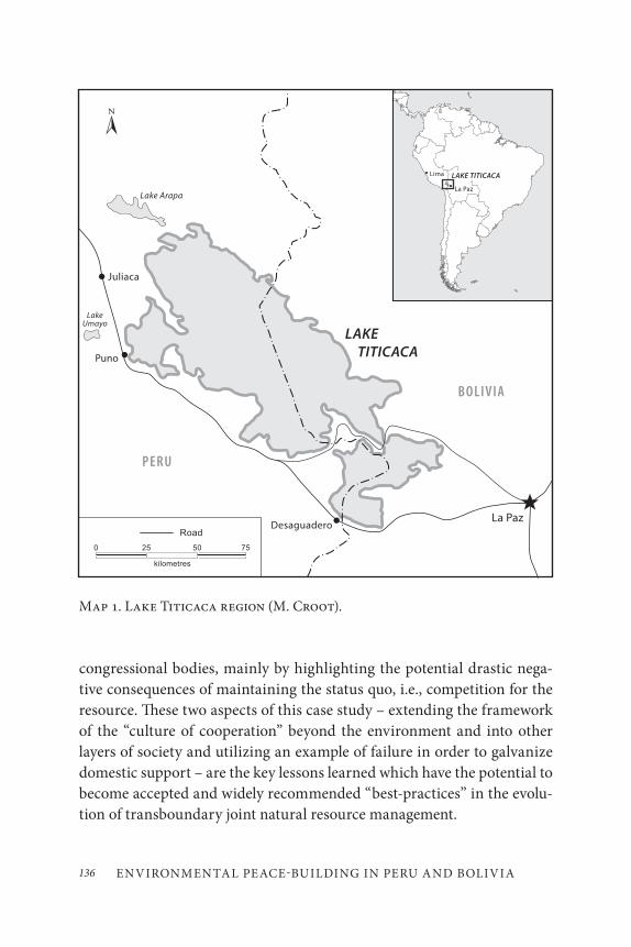
ENVIRONMENTAL PEACE-BUILDING IN PERU AND BOLIVIA136
congressional bodies, mainly by highlighting the potential drastic nega-tive consequences of maintaining the status quo, i.e., competition for the resource. These two aspects of this case study – extending the framework of the “culture of cooperation” beyond the environment and into other layers of society and utilizing an example of failure in order to galvanize domestic support – are the key lessons learned which have the potential to become accepted and widely recommended “best-practices” in the evolu-tion of transboundary joint natural resource management.
Map 1. Lake Titicaca region (M. Croot).
137J. Todd Walters
EVOLUTION OF COLL ABOR ATION
The most important dynamic that the Lago de Titicaca example of en-vironmental peace-building exemplifies is the progression through the various levels of collaboration – how each successive level of collabora-tion strengthens the bonds between the two countries in multiple as-pects of society. As Alexander Carius notes in his article Environmental
Peacebuilding: Conditions for Success, “the exchange of information or environmental agreements alone will not result in peace. Yet such efforts can provide the initial impetus for broader cooperation” (Carius 2007, 12). It is as though the two countries were weaving a tapestry of their historical relationship, and this environmental peace-building opportunity around the joint-management of the waters of Lago de Titicaca was interweaving new threads into that tapestry – adding strength and resiliency to the his-torical relationship with each additional layer of collaboration. This was a gradual evolutionary process that occurred over several decades and was made possible through the hard work of individuals from both countries at many different steps along the way. Julio Sanjines, the Bolivian co-founder of the ALT (Binational Autonomous Authority of Lago de Titicaca – the joint management agency created to coordinate the management of the water resources throughout the ecosystem) characterized the evolution of this relationship as if “Lago de Titicaca was a mirror – where two twins are looking at each other” (Sanjines 2005).
The initial cooperation was economic – by two water companies from each respective country who were intent upon assuring their businesses would be able to supply the water to La Paz, Bolivia, and to Cusco and Manchu Picchu, in Peru. Essentially, the economic incentive of wanting to maintain control of commodity supply, combined with maintaining the water level in the lake so that supply did not dwindle, helped to stimulate recognition of the business claims of the companies from both countries and the need to collaborate in order to ensure that both companies and countries would have a sufficient and sustainable water supply for now and for the future. Economic planning lengthened the time horizon and helped create the recognition that cooperation in the present, coupled with the construction of a strategic plan for the future, would help create a
ENVIRONMENTAL PEACE-BUILDING IN PERU AND BOLIVIA138
situation of mutual dependency which would, in turn, contribute to mini-mizing the potential for conflict. As Wolf et al. (2003) note in their article International Waters: Identifying Basins at Risk, “Water has also proven to be a productive pathway for confidence building, cooperation, and argu-ably, conflict prevention. Cooperative incidents outnumbered conflicts by more than two to one from 1945–1999” (p. 66).
Economic collaboration soon evolved into a scientific collaborative project between hydrologists from both countries, initially in the form of sharing data that had been gathered independently, and then developing into a comprehensive scientific ecosystem analysis which both countries created and conducted together. It was at this point that the two militaries were drawn into the process. The navies of both countries were needed to provide the actual watercraft for the scientists to be able to conduct the study and had a unique combination of skills that made them the only resources available that could actually complete the tasks in a man-ner that ensured accuracy and legitimacy. Their expertise lay in intimate knowledge of the intricacies of the local shorelines and with the naviga-tion skills needed to ensure that data could be collected at regular grid system intervals in order to complete a total ecosystem map. This new function for the military, as an implementer of scientific data collection, helped to carve out a new role in the militaries’ sphere of influence – help-ing protect the environment. The jointly gathered data were then analyzed by the hydrologists from both countries and used to come to an agree-ment in order to coordinate the amount of pollution the ecosystem could tolerate, as well as the amount and types of human water usage allowable, in order to maintain the ecological integrity and viability of the lake in a long-term sustainable manner (Sanjines 2005). The Peruvian Congress approved the measure to jointly manage the water resources of the lake almost immediately, while the Bolivian Congress clung to traditionalist arguments about national sovereignty, which resulted in rejection of the measure for almost three decades (Sanjines 2005). “In the joint Presidential Declaration of 1955, subscribed among Bolivia and Peru, both presidents stated that because both countries have an indivisible condominium on the Titicaca lake’s waters, they would be able to utilize them only by means of expressed agreement by both parts. They ordered the preparation of a
139J. Todd Walters
Preliminary Study for the Use of its waters to a Binational Commission” (Revollo et al. 2005, 384).
In conjunction with the process of congressional approval, an innova-tive strategy was conceived by the men from both countries responsible for the jointly managed scientific study of the lake. As they monitored other global water issues, they learned of an example of what not to do – the Aral Sea.
In the early 1990s, Kazakhstan and Uzbekistan competed over water resources after the fall of the Soviet Union, which had previously dictated the terms of the resource usage to each of the then republics. The dissolu-tion of the Soviet Union created a power vacuum, which led to both coun-tries zealously proclaiming their newfound sovereignty, and expressing that through competition over water for agricultural irrigation, instead of trying to manage the resource in a long-term and sustainable manner. As a result of that competition, about 60 per cent of the Aral Sea’s volume had been lost, its depth had declined by 14 metres, and its salt concentration had doubled, killing the commercial fishing trade.
By developing a presentation on the Aral Sea to use as an example of what not to do, in order to justify something which must be done, Sanjines was ultimately successful in 1986 at spurring the Bolivian Congress to pass the legislation. The legislation formally created the ALT (Binational Autonomous Authority of Lago de Titicaca) and led to official collabora-tion on the legal level, as the two countries agreed upon a course in which regulatory policy in both countries was written embodying exactly the same legal standards.
This step is important because, as Carius notes, “ecological cooperation can potentially play a role in preventing the kind of violence that erupts due to the uncontrolled exploitation of natural resources, the destruction of ecosystems or the devastation of livelihoods based on natural resour-ces” (Carius 2007, 6). By agreeing on the letter of the law, and coordinating the regulations to be the same, it allowed for an implementation and man-agement process that was simplified and streamlined. Thus, use of the re-source could be coordinated and managed from an ecosystem perspective, instead of a political one. In order to help facilitate the implementation of the policy, both countries took advantage of cultural similarities that
ENVIRONMENTAL PEACE-BUILDING IN PERU AND BOLIVIA140
transcend political boundaries and encourage sustainable water usage as a part of their inherent respect for the environment, which goes back gen-erations in both the Aymara and Quechua cultures. As Carius notes, this is a crucial and often overlooked step: “Broad-based stakeholder partici-pation is an important prerequisite for transferring the positive impacts of water cooperation to wider society” (Carius 2007, 21). An often-cited example is the Friends of the Earth Middle East (FOEME) and the “Good Neighbors Water Project” between three neighbouring communities in Palestine, Israel, and Jordan (FOEME 2011). The Good Neighbors Project created a mayors network and a series of community stakeholder meet-ings. The results from both were published to keep the public informed of the developments and the effect their feedback had in terms of creating course corrections to improve the effectiveness of the program.
In order to encourage involvement and participation of citizens and local stakeholders in Bolivia and Peru, different channels were established depending on the degree of participation and the various levels of citizen groups involved. The ALT coordinated an information dissemination campaign utilizing various mediums (articles, publications, conferences, studies, reports, and others). Conversely, the ALT also helped to estab-lish a community feedback mechanism in the form of local “town hall style meetings” allowing the local population to get answers to their ques-tions and to provide input on how the programs could be more effective (Revollo et al. 2005). Through this mechanism, the culture of collaboration was able to trickle down into the community level in a conscious manner, and begin to involve ordinary citizens from both nations in the process of jointly managing the water resources upon which they all depend.
All of these actions and circumstances have generated significant mo-mentum for a number of joint projects, including additional opportunities with international teams from the UN and private international scientific organizations and development agencies.
The evolution of environmental peace-building around the joint man-agement of the water resources of the Lago de Titicaca bio-region is an excellent, but under-studied, example of how a framework for cooperation between two countries can be stimulated and replicated on multiple levels around an environmental issue, leading to stronger bonds between the

141J. Todd Walters
countries, the governments, the politicians, the militaries, and the cit-izens. “Developing the human, technical, and administrative capacity to generate and analyze data, to develop sustainable management plans, and to implement these plans is necessary to enable water institutions to ful-fill their management tasks and to prevent water-related disputes over the long term” (Carius et al. 2004, 64).
ECONOMIC COLL ABOR ATION
Initial aspects of collaboration occurred around fisheries in 1935. Next came a joint commission to study human water usage and a railway feas-ibility study – both were conducted in 1955 (ALT 2003). In 1957, there was an agreement to complete an economic study for the “joint utiliza-tion” of the water resources (Sanjinés-Goytia 2001). Julio Sanjinés-Goytia identified this as a crucial shift in consciousness as this was the point that the recognition for the need to collaborate around this resource began to enter the consciousness of key individuals from both countries. These initial economic reasons highlighted the interconnected nature of the two countries’ relationship around this essential ecosystem and resource. Another nuance that was beginning to be understood was the potentially limited effectiveness of any decision made unilaterally, as it could only be implemented throughout part of the ecosystem while the effects would af-fect the ecosystem as a whole, regardless of where the political boundaries stand or who acted on their side of the lake. It was these two aspects of economic collaboration that allowed the initial formation of a “culture of cooperation,” helping to forge the foundation upon which a framework of collaboration was extended into other aspects of the two societies.
SCIENTIFIC COLL ABOR ATION
The prolonged rains and the massive floods of 1986, and the resulting damage (which included the relocation of entire villages, destruction of over 50,000 hectares of farmland, and the loss of 50,000 homes as entire
ENVIRONMENTAL PEACE-BUILDING IN PERU AND BOLIVIA142
lake communities became internally displaced people – numbering over 150,000) served as a “flashpoint” that highlighted the human need to more effectively manage the water resources of the lake and its rivers (ALT 2003). A mechanism was needed to protect the human settlements on the lakeshore from other potential floods, as well as for maintaining water levels during years of drought, and ensuring water quality and consistency of supply. Both countries were hit hard by the flood and came to these conclusions independently. It became clear to politicians and practitioners that water is essential to human survival and that it does not recognize boundaries of sovereign nations. Water bodies form linkages across juris-dictional boundaries and the impacts of pollution and water use extend to all who share the water, regardless of national citizenship. In 1986, the Binational Autonomous Authority of Lago de Titicaca (ALT) was created as an independent, scientifically based organization which would become the mechanism by which both countries coordinated the joint manage-ment of the lake ecosystem. Both countries established the ALT through a congressional act, and they both contributed money to its initial budget and expertise in the form of scientists and political leadership (Sanjines 2005).
The initial task of the ALT was to develop the “master plan” for the management of the lake ecosystem and its rivers and flood plains. This development was significant, for it led to the creation of ecoregion maps without political boundaries. The ALT effectively reprioritized collabora-tion from an economic and political issue into one of overarching environ-mental significance. The complete scientific mapping and monitoring of the lake (depth, temperatures, rainfall) involved cooperation of the nav-ies of both Bolivia and Peru, as well as collaborative scientific studies for specific purposes, including: water usage projections for rerouting water to cities and for irrigation of agriculture; environmental degradation of the lake (water quantity and quality) and land (erosion); biodiversity con-cerns in terms of both flora and fauna; and, finally, man-made impacts (the uses and demands that the humans living in the ecosystem placed on the resource). This process led to the creation of jointly designed pro-grams for the purposes of flood mitigation and dam-building (ALT 2003), as well as international studies on climate change (Schnurrenberger and
143J. Todd Walters
Hiatt 2004) and applications to be named a UNESCO World Heritage Site (UNESCO 2003). The next logical stage in the process of the master plan is beginning to occur at this point in time but has yet to become as wide-spread as the previous stages. It includes the joint development of sustain-able projects that will address flood mitigation and drought management, as well as poverty alleviation and delivery of basic water services from running water to sewage management.
MILITARY COLL ABOR ATION
The military collaboration aspects of the story were born out of neces-sity. The only reliable fleets of water craft available to complete the long-term, comprehensive study of the entire lake belonged to the navies of both Bolivia and Peru. Fortunately, they could trust the skill of the navies’ crews and they could reliably collect samples at regular intervals along a grid system in order to conduct a comprehensive study. The relationships between the two navies as institutions, as well as between the men from both sides who made up these institutions, were respectful to begin with and evolved over the years of closely working together into deep intercon-nected bonds between the men, as well as a tighter more resilient working relationship between the institutions, where previously unconsidered pos-sibilities became a reality. There was no longer a need for protecting and maintaining sovereign territorial integrity where the political border lay in the middle of the lake.
Under the “master plan,” both countries’ boats could freely cross into the other country’s “waters” and it was not viewed as threatening. Over time, hydrologists from Peru spent time on the Bolivian navy ships and vice versa, slowly extending and strengthening the collaboration with each evolutionary step. Eventually, joint manoeuvres involving ships from both countries, containing scientists from both countries on each ship, led to prolonged cooperation over time, involving both navies and an intermixed group of hydrologists from each country. The necessity for military collaboration in this case is unique and cannot be anticipated to be a characteristic in other cases in other areas of the world; however, the
ENVIRONMENTAL PEACE-BUILDING IN PERU AND BOLIVIA144
general concept of “out of the box” thinking to create ways to stimulate military cooperation around environmental issues is something that can be applied more widely. Being involved in this project led to the creation of in-depth personal relationships based on mutual professional respect and the building of trust – all of which was created by the bonds developed working together to complete the comprehensive scientific data gathering project and the ecosystem map (Sanjines 2005).
CONGRESSIONAL COLL ABOR ATION
The Committee on Foreign Relation, through resolution 2905/97-CR, ap-proved the agreement for the creation of the Authority of Binational Lago de Titicaca to manage the establishment of rules and regulations to handle environmental decisions with economic and financial autonomy in the Lago de Titicaca system, which includes the Desaguadero River, Lake Popó, and the Coipasa water system. Resolution 2905/97-CR was signed by the Governments of Peru and Bolivia on May 29, 1996 (Revolloet al. 2005). According to Julio Sanjines, the process of congressional approval was a story of vastly different political situations. In Bolivia, it was a chal-lenging process that took decades of testimony and lobbying, and, finally, the use of the Aral Sea catastrophe (USGS 2001) as an example of what would happen if they continued with the status quo of competition for the water resources with Peru instead of pursuing a course of collabora-tion. This is one of the unique aspects of this particular case, which can become a best practices tool for all people who seek to foster cooperative environmental projects.
According to UNEP data and charts (UNEP, n.d.), the demise of the Aral Sea was caused primarily by the diversion of the inflowing Amu Dar’ya and Syr Dar’ya rivers to provide irrigation water for local cropland, particularly the region’s main cash crop – cotton. Under the USSR, an irrigation program was created that diverted water flowing into the Aral Sea. Due to the top-down leadership regime, strict quotas were placed on the amount of water that could be diverted, and for several decades satel-lite data shows that the Aral Sea was slowly shrinking. However, upon the
145J. Todd Walters
collapse of the USSR, top-down regulations were ignored, and newfound autonomy was exercised in the form of newly independent nations seek-ing to maximize their revenue and competitive advantage. Kazakhstan and Uzbekistan began to simultaneously increase the amount of water that they diverted to their cotton fields, essentially competing over the resource. In the subsequent decade, the rate of contraction of the Aral Sea was dramatically increased to the point where the resource itself has become almost unusable due to increased salinity and more highly con-centrated chemical composition. In addition, a number of unanticipated spillover effects have had a dramatic impact upon the people of the region as fishing is no longer a viable livelihood, dust storms have become chem-ically charged due to the exposed former seabed, and young people are be-ing faced with dramatic incidences of health problems, including typhoid fever, viral hepatitis, tuberculosis, and throat cancer, which are three times the national average in the area surrounding the Aral Sea (UNEP, n.d.).
According to Sanjines, the ALT hydrologists from both Peru and Bolivia were monitoring this and other cases around the world to see if they could glean any “best practices” that they could apply to the joint scientific studies or the technical management regime. Sanjines also men-tioned that they were consciously looking for data and examples to sup-port their case to the domestic Bolivian Congress to sign the resolution 2905/97-CR, which would create, formally mandate, and fund the ALT. He described the day when he presented the argument before the Bolivian Congress and for the first time included the Aral Sea example complete with a dramatic visual representation of the consequences of choosing competition over cooperation. In contrast, in Peru it was politically ex-pedient to pass the legislation quickly and so the 1955 joint presidential decree was formally approved by the Peruvian Congress and signed into law in 1957 (Revollo et al. 2005). Despite the differing circumstances and the elongated timeframe, the “culture of cooperation” eventually reached the congressional level, though the other areas of cooperation continued to develop over time while waiting on the formal legal approval.
With the formal creation of the ALT, elected officials had made a sig-nificant and groundbreaking collaborative policy decision: the written regulations governing the use and management of the water resources
ENVIRONMENTAL PEACE-BUILDING IN PERU AND BOLIVIA146
of the entire Lago de Titicaca system would be exactly the same in both countries. Coordinating the laws and regulations of both governments was the next step in the progression of the “culture of cooperation.” While it was done in order to ensure consistency in the interpretation and imple-mentation of the regulations, it also set the precedent that the two coun-tries could collaborate so closely on the political level that they could write laws that would be the same in both countries. After Bolivia finally passed the act commissioning the creation of the ALT in 1986, they committed themselves to a course that would allow the science to dictate the terms of the policy – in terms of the joint management of the water resources in the lake and the pursuit of a course of stewardship in the management of those resources. The joint ownership model not only applied to the waters of Lago de Titicaca but also to the watershed and the five rivers flowing out of the lake, as a way of ensuring integrated management of the entire water system, including floodplains, the lake, rivers, tributaries, and wetlands. This model created mechanisms to promote cooperation among different government jurisdictions and organizations, as well as communities in the entire watershed. Further, it widened the web of collaboration, and strengthened the “culture of cooperation” between Bolivia and Peru.
CULTUR AL COLL ABOR ATION
Emmanual Adler asserts in his article “Imagined (security) communities: Cognitive regions in international relations” that “As environmental co-operation develops, and societal and political stakeholders come together in systematic negotiations, such efforts can build trust, initiate cooperative action, and encourage the creation of a common regional identity, as well as establish mutually recognized rights and expectations” (Adler 1997). Extending the “culture of cooperation” down to the community level of interaction, as well as consciously tapping into generations of indigenous knowledge of the lake ecosystem is part of the hands-on implementation of the recommendations of the “master plan.” One aspect of this indigenous knowledge is the Pachamamma creation myth: in Aymara and Quechua culture, Lago de Titicaca is the birthplace of the universe, and thus must
147J. Todd Walters
be treated with reverence and respect as being sacred. There are a number of rituals and ceremonies that reaffirm this myth and intertwine it in the local culture, as well as evoke a sacred duty for the people of the lake to be caretakers or stewards of the ecosystem (Sanjines 2005). This myth and these rituals are not specific to Bolivia or Peru; they are culturally specific to all who live around the lake, regardless of citizenship. It is an overarch-ing aspect of the culture of the people who live around the lake that binds them tightly to each other and to the lake which allowed for the creation of a single plan, specific to the lake culture, to facilitate the dissemination of information and to stimulate local community involvement and feedback.
The Bolivian and Peruvian governments took advantage not only of the myth but also of the shared cultural flow of the livelihoods of the com-munities that live around the lake, which is neither Bolivian nor Peruvian, but unique to Lago de Titicaca. Lake communities primarily consist of fishermen, herders, farmers, and those who cater to tourists – workers who start their day before dawn so that they can leave at first light. So many of the radio programs that were developed to encourage environmental pro-tection and the mindset of sustainable use were broadcast in the pre-dawn hours before people left to work, as well as in the evening hours when people returned from their work. The two governments cooperated to develop consistent methods of disseminating information, from a media plan that used the radio show, culturally specific posters and flyers, and the creation of a network of meetings held in the town meeting format to allow average citizens access and input into the joint-management “mas-ter plan.” In a number of different ways the “culture of cooperation” was extended down to the community level in a manner that was cognizant of the uniqueness of the local culture, and utilized this cognizance in an effective manner.
The network of town meetings was complemented by a regular meet-ing which was instituted with the local governors of each of the lake com-munities. These were more representative in nature and were used as plat-forms on which to develop additional complementary pieces of the strat-egy, as well as to adjust pieces of the strategy that may not be as effective as they had hoped. This strategy was identical on both sides of the border and effective in translating the sacred Aymara and Quechua relationship
ENVIRONMENTAL PEACE-BUILDING IN PERU AND BOLIVIA148
with the lake and the surrounding land into today’s modern terms. Julio Sanjines discussed what many people brought up at the town meetings and told their local governors – that they did not need training in environ-mental stewardship. Rather they needed development that would help lift them out of poverty and create basic services such as sewage treatment systems and basic water filtration and delivery infrastructure. As Sanjines states, “sustainable development is a new word for an ancient concept” (Sanjines 2005). The ‘lake people’ have lived for millennia as an intricate part of a unique ecosystem, building their lives in harmony with their environment. Yet poverty has stopped them short of taking advantage of the advances in technology, such as sewage treatment systems or water filtration systems. This conflict continues today, as many of the sustain-able development projects are delayed or have been cancelled due to lack of government and international funding. The “culture of cooperation” has not yet reached a level that can alleviate the poverty that affects both Bolivians and Peruvians who live within the ecosystem.
CONTINUED COLL ABOR ATION
Carius (2007) asserts that “Water cooperation evolves into broader forms of political cooperation if it is integrated into an economic and political institutional context.” This is exactly what occurred in this case: the re-lationships, the mutual respect, and the framework of cooperation that developed between multiple levels of the two societies over the course of the preceding decades has established strong working and interpersonal relationships, as well as the more formal national relationship between the two countries. This has generated momentum which has progressed be-yond the initial layers of cooperation into much more intricate and inter-twined programs and projects that both countries are pursuing together for their mutual benefit. This is where the environmental peace-building effects become evident, as many of these programs and projects would have been highly improbable without the previously established positive working relationships that were generated throughout the process of es-tablishing the ALT and the joint management mechanism and structure.
149J. Todd Walters
Case study research ground is ripe here in terms of examining through the lens of environmental peace-building the various examples of collabo-ration that have evolved in the wake of the experience of developing the master plan for the joint management of the waters of Lago de Titicaca. This detailed analysis would reveal the roots of the collaboration that has evolved and expose the degree to which the collaboration rippled through various layers of the two countries social and political fabric.
New programs and projects that grew out of the initial cooperation include the UNESCO World Heritage Site application process for Lago de Titicaca, which is being compiled and submitted by scientists and govern-ment officials from both countries (UNESCO 2003). Authorities are mon-itoring the lake for compliance with the RAMSAR convention designation which includes protecting various endangered species, such as native fish (the karachi [Orestia sp.] and boga [Trichomicterus sp.]) (ALT 2003). This is done by visiting local markets to make sure that these species are not being caught and sold, as well as by scientific studies that monitor the populations and health of both of these fish.
Both Bolivia and Peru agreed to participate in the World Water Conference and together the ALT compiled and wrote a joint World Water Assessment Program Case Study (UNESCO 2004), which highlighted the results of all the scientific data that had been gathered and assessed the health of the lake in a snapshot sense. The case study also identified chal-lenges and opportunities for the future. The ALT is comprised of Ministry of Foreign Affairs (Peru and Bolivia); National Development Institute (INADE); Ministry of Planning and Sustainable Development; Lake Titicaca Special Project (PELT), and the Bolivian Operational Unit (UOB) (UNESCO 2004).
In conjunction with the United Nations Development Programme/Global Environment Facility (GEF/UNDP), the Autoridad Binacional Autonoma (ALT) has created a joint project on biodiversity conservation in the TDPS system (ALT 2003). This comprehensive plan looks at both flora and fauna in the entire ecosystem, from the lake to the rivers, to the surrounding land and flood plains, and at the impacts that human use has had on biodiversity. It also looks at what the two countries can do
ENVIRONMENTAL PEACE-BUILDING IN PERU AND BOLIVIA150
to further collaborate to protect such endangered species as the Andean Condor and the two fish species mentioned above – the karachi and the boga.
Finally, in conjunction with the Intergovernmental Panel on Climate Change (IPCC), Lago de Titicaca and the ALT have taken part in the Global Lakes Drilling Project (in conjunction with the U.S. National Science Foundation and the International Continental Scientific Drilling Program, with technical expertise provided by DOSECC Inc.) (Schnurrenberger 2004). Lake bed core samples were taken in multiple areas around the lake to subject them to a similar analysis as ice core samples to conduct a cli-mate change analysis of the sediments in the lake bed at different periods in time. Lago de Titicaca is a unique and valuable case as it is the highest lake in the world to be included in the program (over 3,800 metres above sea level), and it has some of the longest intact sediment because of its depth.
These programs have helped to maintain the bonds between the two countries. They have also created new ones, as people from both countries – whether scientists, government officials, local governors, or the people who live around the lake – have developed an expectation that when it comes to the lake, they must work together. So science is conducted jointly, policy is developed in lock step, the two navies help in the imple-mentation, and the two national governments continue to pursue projects and programs around the lake that would be impossible or ineffective if implemented unilaterally. Now the framework for the “culture of cooper-ation” has grown so ingrained that the two countries are pursuing: inter-national engagement for help with scientific program funding, UNESCO recognition, and sustainable development funding under the Millennium Development goals as though they were representing the Lago de Titicaca ecosystem and not their national sovereign countries of citizenship. These multiple forms of interaction between scientists, government and civil so-ciety actors create opportunities to establish and strengthen mutual trust, to provide a communications channel for feedback to reach the policy-makers, and to formally codify political cooperation.

151J. Todd Walters
CONCLUSION
It is clear that the level of additional collaboration that developed between Bolivia and Peru as a result of the decision to jointly manage the resources of Lago de Titicaca is a prime example of how to extend the “culture of cooperation” framework beyond just natural resources and into other as-pects of society. The results of such efforts include creating and strength-ening additional bonds between the two neighbouring countries, and establishing deep interpersonal relationships between citizens from both countries within many different layers of society. Julio Sanjines describes the environmental peace-building dividends of the evolution of the “cul-ture of cooperation” when he states: “Even though relations between the two countries were good before this project; the cooperative efforts, and coordination that have occurred have strengthened the bonds between the governments, the local community leaders, and the scientists from both countries” (Sanjines 2005). While not an example that is easily replicated in other political or regional contexts, the case of Lago de Titicaca offers up some clear lessons for the international community, and provides an example of a number of practical ways to extend collaboration over an environmental issue into many other areas of society in a meaningful and lasting way.
To paraphrase George Santayana, “if we do not learn from our mis-takes then we are doomed to repeat them.” In this case, Bolivia and Peru represent the savvy recognition of a parallel case on the other side of the world from which they took key “lessons learned” about how not to handle the management of a shared water resource. They recognized the negative feedback loop that would be created by choosing the road of competition – which would lead to the ultimate destruction of the resource and the loss of all its benefits to both countries. In turn, they chose to navigate the twists and turns on the road of collaboration which led to the establish-ment of a framework for the sustainable joint management of the resource. The framework will likely perpetuate the benefits of the resource for both countries for generations to come. This logic of applying what we learn from the failure of competition over resources can be applied elsewhere
ENVIRONMENTAL PEACE-BUILDING IN PERU AND BOLIVIA152
around the world and should be able to help establish cooperation as pref-erable to competition.
As Jared Diamond stated (2004): “The politics of sustainability are about issues of fairness, risk, human rights, animal rights, and ecological rights. They are about how much we take from our descendants and what we leave behind. We need to create a politics of the earth to protect the biosphere, and we need to reinvent politics at the ecosystem level.”
The systematic progression of the “culture of cooperation” around the joint management of the water resources in Lago de Titicaca – from eco-nomic, to scientific, to military, to congressional, to legal regulations, to community-based cultural collaboration – is an example that should be highlighted to the world as a potential roadmap to successful environ-mental peace-building efforts across political boundaries. The use of a parallel “story of failure,” utilized under the rubric of not repeating the mistakes of the past, can become a universal “best practice” and act as a powerful stimulant that points towards a path of collaboration instead of the path of competition. Both of these aspects of the Lago de Titicaca case study make it a valuable success story of environmental peace-building that can serve as an example of how to approach collaborative joint man-agement of an essential natural resource. As Patricia Kmeri-Mbote states: “Successful environmental peacemaking demands that resources are managed equitably and in a sustainable manner, requiring inclusive and participatory environmental decision-making processes and the recogni-tion of environmental resource rights for all” (Kmere-Mbote2007).
REFERENCES
Adler, E. 1997. “Imagined (security) communities: Cognitive regions in international relations.” Millennium: Journal of International Studies 26(2): 249–77.
Autoridad Binacional del Lago Titicaca Bolivia-Perú (ALT). 2003. “Lake Titicaca Basin, Bolivia and Peru.” In The UN world water development report – Water for People, Water for Life, ed. UNESCO, 466–80. http://www.unesco.org/water/wwap/case_studies/titicaca_lake/titicaca_lake.pdf
153J. Todd Walters
———. 2007. “Home page.” Accessed December 5, 2011. http://www.pnud.bo/biodiversidadtdps/alt/.
Carius, A. 2007. “Environmental peacebuilding: Conditions for success.” In Environmental Change and Security Program Report (Issue 12), ed. G. D. Dabelko, 59–75. Washington, D.C.: Woodrow Wilson International Center for Scholars.
Carius, A., G. D. Dabelko, and A. T. Wolf. 2004. “Water, conflict, and cooperation.” In Environmental Change and Security Program Report (Issue 10), ed. G. D. Dabelko, 60–66. Washington, D.C.: Woodrow Wilson International Center for Scholars.
Diamond, J. 2004. “Environment, Population, and Health: Strategies for a More Secure World.” In Environmental Change and Security Program Report (Issue 10), ed. G. D. Dabelko, 8–11. Washington, D.C.: Woodrow Wilson International Center for Scholars.
Friends of the Earth Middle East (FOEME). 2011, “Projects – Good Water Neighbors.” Accessed November 29, 2011. http://foeme.org/www/?module=projects.
Kmeri-Mbote, P. 2007. “Conflict and cooperation: Making the case for environmental pathways to peacebuilding in the Great Lakes Region.” In Environmental Change and Security Program Report (Issue 12), ed. G. D. Dabelko, 50–54. Washington, D.C.: Woodrow Wilson International Center for Scholars.
Revollo, M. F., M. L. Cruz, and A. L. Rivero. 2005. “Lake Titicaca: Experience and lessons learned brief.” In Managing Lakes and their Basins for Sustainable Use: A Report for the Lake Basin Managers and Stakeholders, International Lake Environment Committee Foundation, 377–87. Kusatsu, Japan: International Lake Environment Committee Foundation.
Sanjines, Julio. 2005. Interview by the author. November. ALT office, La Paz, Bolivia.
Sanjinés-Goytia, J. 2001. “Antecedentes del Plan Director Binacional para la Conservación y Preservación del Lago Titicaca.” Paper presented at the Simposio internacional sobre el sistema del lago Titicaca. La Paz, Bolivia.
Schnurrenberger, D. W., and V. Hiatt. 2004. “The global lakes drilling effort.” Geotimes 49(3): 22–25.
UNESCO. 2003. “Sacred Titicaca Lake. World Heritage Site Application.” Accessed December 5, 2011. http://whc.unesco.org/en/tentativelists/1817/.
———. 2004. “World Water Assessment Program – Lake Titicaca Basin (ALT 1992),” 2004. Accessed December 5, 2011. http://www.unesco.org/water/wwap/case_studies/titicaca_lake/titicaca_lake.pdf.
ENVIRONMENTAL PEACE-BUILDING IN PERU AND BOLIVIA154
Wolf, A. T., S. B. Yoffe, and M. Giordano. 2003. International Waters: Identifying Basins at Risk. Paris: UNESCO.
USGS. 2001. “EarthShots: Satellite images of environmental change. Accessed December 30, 2002. http://edc.usgs.gov/earthshots/slow/Aral/Aral.
UNEP. Vital Water Graphics – slide 25. n.d. Accessed December 5. 2011. http://www.unep.org/dewa/assessments/ecosystems/water/vitalwater/25.htm.
Section 2 THE SOUTHERN
AFRICAN EXPERIENCE


157
Transfrontier Conservation Areas: The Southern African Experience
David Mabunda, Freek Venter, Danie Pienaar, and Piet Theron
INTRODUCTION
Good progress has been made in the implementation of the transfrontier conservation areas (TFCAs) projects in southern Africa (Map 1). This in-itiative constitutes some of the most exciting, exhilarating, and ambitious conservation projects in the world today. These projects aim to establish large conservation and wildlife areas not only through the integration of vast landscapes and re-connecting ecological systems, but also through development of cross-border tourism linkages, ensuring sustainable bene-fits to local communities through socio-economic improvement, and the promotion of peace and stability in the region. The development of TFCAs is also an exemplary process of partnerships between governments and the private sector. While the main players are the relevant governments and implementing agencies, donors and NGOs have also greatly contributed towards the creation of transfrontier parks and transfrontier conservation areas.
7
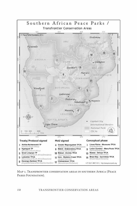
TR ANSFRONTIER CONSERVATION AR EAS158
Map 1. Transfrontier conservation areas in southern Africa (Peace Parks Foundation).
159David Mabunda, Freek Venter, Danie Pienaar, and Piet Theron
Southern Africa’s first TFCA, the Kgalagadi Transfrontier Park, was formally opened on May 12, 2000, by the presidents of Botswana and South Africa. In the same year, the governments of Mozambique, South Africa, and Swaziland signed five protocols on the establishment of the Lubombo Transfrontier Conservation and Resource Area. These mile-stones were followed by the signing of a memorandum of understanding between the governments of the Kingdom of Lesotho and South Africa on June 11, 2001, which paved the way for the establishment of the Maloti-Drakensberg Transfrontier Conservation and Development Area (now known as the Maloti-Drakensberg Transfrontier Project). On December 9, 2002, the Great Limpopo Transfrontier Park (GLTP) was proclaimed with the signing of the International Treaty at Xai-Xai, Mozambique by the Heads of State of Mozambique, South Africa and Zimbabwe. Following this, the treaty for the establishment of the |Ai-|Ais/Richtersveld Transfrontier Park was signed on August 1, 2003, in Windhoek by the presidents of Namibia and South Africa. Finally, following an extensive process, the memorandum of understanding for the establishment of the Limpopo/Shashe Transfrontier Conservation Area was signed by the three ministers of Environment and/or Tourism of Botswana, South Africa and Zimbabwe on June 22, 2006.
The South African National Parks (SANParks) – which administers twenty-one national parks in South Africa, including the Kruger National Park – is the sole South African implementing agent for four transfrontier parks and renders all the professional and logistical support to these pro-jects. The four transfrontier parks that fall under SANParks are: the Great Limpopo Transfrontier Park, the |Ai-|Ais/Richtersveld Transfrontier Park, the Kgalagadi Transfrontier Park, and the proposed Limpopo/Shashe Transfrontier Conservation Area. In addition to these, SANParks is also involved as one of four South African implementing agencies in the establishment of the Maloti-Drakensberg Transfrontier Project.
TR ANSFRONTIER CONSERVATION AR EAS160
INTERNATIONAL CONTEX T
Growth of Transboundary Conservation in the Global
Conservation Arena
The Albert National Park was the first transboundary protected area to be established in 1925 by Belgium to conserve natural resources between the colonial states of Rwanda-Burundi and the Belgian Congo (Wilkie et al. 2001). During the same time period, Poland and Czechoslovakia signed the Krakow Protocol in 1925 to manage border parks in both coun-tries for conservation purposes (Thorsell 1990). The Waterton-Glacier International Peace Park followed in 1932 to commemorate the long his-tory of peace and friendship between Canada and the United States of America (Sandwith et al. 2001). Since these early initiatives, the establish-ment of transboundary conservation areas globally has grown signifi-cantly, now totalling 169 transboundary protected area complexes which involve 666 protected areas in 113 countries. In establishing the protected area complexes, different levels of cooperation and formalization of coop-erative agreements exist. These initiatives were established to realize the potential of biodiversity and cultural resource conservation at a landscape level, to foster peace and prosperity between countries, and to promote regional socioeconomic growth and integration (IUCN 2005).
REGIONAL CONTEX T
South African Development Community (SADC) Protocol on
Wildlife Conservation and Law Enforcement
Biodiversity conservation is taken to be the overriding rationale for the existence of transfrontier parks and transfrontier conservation areas (Theron 2007). The major value of the concept of creating TFCAs is taken to be the enhancement of biodiversity and ecosystem conservation across international boundaries. However, a strong supporting reason in many
161David Mabunda, Freek Venter, Danie Pienaar, and Piet Theron
cases is for socioeconomic development through the development of cross-border tourism. In addition, the enhancement of cooperation between states, government agencies, and communities across political boundaries are also viewed by governments and stakeholders as a key deliverable of TFCA projects. All of the SADC members are signatories of the Protocol on Wildlife Conservation and Law Enforcement. This Protocol, signed on August 18, 1999, in Maputo, under Article 4(f) commits members to pro-mote the conservation of shared wildlife resources through the establish-ment of transfrontier conservation areas (Hall-Martin and Modise 2002).
Action Plan of the Environment Initiative of NEPAD
(New Partnership for Africa’s Development)
The African continent with its rich resource base offers real potential for socioeconomic development. However, the impacts of population growth, poverty, and inappropriate development and the associated impacts of natural resource depletion are key factors in the state of the environment in Africa. These, combined with the ever-present occurrence of natural disasters, global climate change and an often-ineffective policy environ-ment, lead to continued environmental degradation.
In order to address challenges associated with Africa’s future, the heads of state initiated the New Partnership for Africa’s Development (NEPAD). This initiative outlines a common vision to eradicate poverty and place all the countries in the continent on a path of sustainable growth and development that will allow them to participate effectively in the world economy. NEPAD initiated the development and adoption of an environ-mental action plan and strategy to address the region’s environmental challenges while at the same time combating poverty and promoting socioeconomic development. This action plan, which was adopted at the Johannesburg World Summit on Sustainable Development (WSSD), was prepared through a participatory process with all key stakeholders under the leadership of the African Ministerial Conference on Environment (AMCEN) and provides an implementation strategy for the first decade of the twenty-first century. It is a body of collective and individual respon-sibilities and actions that African countries adopt and will implement to maintain the integrity of the environment and ensure sustainable use of
TR ANSFRONTIER CONSERVATION AR EAS162
their natural resources through partnerships. In so doing, it recognizes that partnerships among African countries and the international com-munity are key elements of a shared common vision to achieve sustainable development and eradicate poverty.
The Environment Action Plan is a coherent long-term program which has been prepared to promote Africa’s sustainable development. It is further embedded in the main philosophy of NEPAD which aims to balance short-term economic growth challenges with long-term environmental, poverty eradication, and social development imperatives. The Action Plan outlines project activities to be implemented over the next ten years. The key program areas cover the following priority sectors and cross-cutting issues: combating land degradation, drought and desertification, wetlands, invasive species, marine and coastal resources, cross-border conservation of natural resources, and climate change.
The implementation of the action plan provides a challenge to the continent that can only be successfully implemented through the support and active participation of all African countries and their development partners.
Leadership in Conservation for Africa Initiative
The Leadership for Conservation in Africa (LCA) initiative is the brain-child of Dr. David Mabunda, chief executive of South African National Parks (SANParks). This initiative was launched in August 2006, aiming to bring together a core group of African conservation leaders and business-men to establish long-term business and development frameworks. It is also envisaged that through the LCA initiative, issues of sustainable bio-diversity and conservation and related socioeconomic advancement will be promoted. The initiative is a joint partnership with Gold Fields Limited (funding patron) and the International Union for Conservation of Nature (IUCN) as the conservation patron.
The vision statement for LCA is: “To harness the collective will and capacity of business and conservation leaders for sustainable conserva-tion-led socio-economic development in Africa” (LCA 2007). In so do-ing, the initiative aims to create a sustainable institutional partnership
163David Mabunda, Freek Venter, Danie Pienaar, and Piet Theron
of influential, credible and committed business and conservation leaders striving to reach the following objectives:
• Significantly advance the discourse and practice of conservation-led development in Africa through advocacy and action;
• Facilitate a formal process for the sharing and development of knowledge, skills, and capacity, so as to promote conservation-led development across the African continent;
• Support and promote integration of conservation and development strategies across the African continent; and
• Create an environment conducive to the generation of significant returns for conservation, business and communities.
The LCA was launched in the Kruger National Park August 22–27, 2006, involving conservation leaders in Africa and a number of local and inter-national business experts. Key issues that were addressed at this workshop included capacity-building, good corporate governance, issues of skills development, and investment opportunities.
TFCAs as Regional Conservation Based Development
Initiatives
Based on the aforementioned, it is evident that the development of trans-boundary conservation areas in the region could potentially play a signifi-cant role from both a conservation and socioeconomic development per-spective. In other words, transboundary conservation initiatives should be instituted as an effective and legitimate land use which contributes to regional economic development and integration, sustainable livelihoods, peace and security, and increased capacity for biodiversity conservation.
In so doing, TFCAs should aim to contribute to the following broad regional priorities:
TR ANSFRONTIER CONSERVATION AR EAS164
• Sustainable local and regional livelihoods;
• Increased capacity for biodiversity conservation in the region;
• Stability, peace, and security;
• Long-term sustainability of conservation development initiatives, including legitimate participation of all stakeholders; and
• Integrated local and regional economic development programs (Fakir and Fourie 2004).
BACKGROUND TO TR ANSFRONTIER PARKS/
CONSERVATION AREAS IN SOUTHERN AFRIC A
Transfrontier Parks/Transfrontier Conservation Areas
Generally, two different types of transboundary conservation area proj-ects or initiatives are being established in southern Africa. These are transfrontier parks and transfrontier conservation areas.
A Transfrontier Park (TFP) is established when the authorities re-sponsible for areas where the primary focus is wildlife conservation, which border on one another across international boundaries, formally agree to manage those areas as one integrated unit according to a joint management plan. These authorities also undertake to remove all human barriers within the transfrontier park so that animals can roam freely. The purpose of these parks is to employ conservation as a land-use option to the benefit of local people.
A Transfrontier Conservation Area (TFCA) usually refers to a cross-border region where the conservation status of the various component areas differs. These areas may include private game reserves, communal natural resource management areas, and even hunting concession areas. Fences, major highways, railway lines, or other barriers may also separ-ate the various parts. However, they nevertheless border on one another and are managed for long-term sustainable use of natural resources, even
165David Mabunda, Freek Venter, Danie Pienaar, and Piet Theron
though the free movement of all animals amongst the various parts may not be possible. The SADC Protocol on Wildlife Conservation and Law Enforcement defines a TFCA as “the area or component of a large eco-logical region that straddles the boundaries of two or more countries, en-compassing one or more protected areas as well as multiple resource use areas” (SADC 2011).
Projects are generally either implemented as TFCAs from the outset or in a phased approach where the TFP is established first as the core of the transboundary conservation project, followed with the establishment of the TFCA as a buffer area around the core.
Most TFPs established to date in southern Africa consist of formally proclaimed conservation areas managed by government authorities. Based on the aforementioned, the various institutions established to date consist mainly of government officials and representatives from the imple-menting agencies.
The planning and development of TFCAs, which include communal and private land and the formation of appropriate institutions to man-age these, presents a bigger challenge than when only state-owned land is involved. However, since the formation of TFPs and TFCAs often entails international agreements and treaties, only the state/central government has the mandate to enter into an agreement with the government of an-other country.
Finally, in order to have effective management of these areas, the rel-evant institution should also ensure effective participation of, and com-munication with, the various key stakeholders involved in the process. These stakeholders will often include local and provincial government, local communities, and the private sector.
Key Objectives for the Establishment of TFPs/TFCAs
Transfrontier parks and conservation areas are usually regional proj-ects aimed at establishing large conservation and wildlife areas, not only through the integration of vast landscapes and re-connecting ecological systems, but also through development of cross-border tourism linkages, ensuring sustainable benefits to local communities through socioeco-nomic upliftment, and the promotion of peace and stability in the region.
TR ANSFRONTIER CONSERVATION AR EAS166
In so doing, TFCA projects in southern Africa are usually underpinned by the following objectives, which are outlined in various international agreements and/or treaties between the countries involved in the project:
• Fostering transnational collaboration and cooperation among the parties, which in turn facilitates effective ecosystem management in the TFCA area;
• Promoting alliances in the management of biodiversity by encouraging social, economic and other partnerships among the parties, including the private sector, local communities, and non-governmental organizations;
• Enhancing ecosystem integrity and natural ecological processes by harmonizing environmental management procedures across international boundaries and striving to remove artificial barriers impeding the natural movement of wildlife;
• The establishment and maintenance of a sustainable sub-regional economic base through appropriate development frameworks, strategies, and work plans;
• Fostering regional socioeconomic development by the creation of transborder ecotourism; and
• The exchange of technical, scientific, and legal information for the joint management of ecosystems.
Key Role Players
The establishment of transfrontier conservation areas is an exemplary process of partnerships between governments and the private sector. While the main players are the relevant governments and implementing agencies, donors and non-governmental organizations (NGOs) have also greatly contributed towards the creation of transfrontier parks.
In developing transfrontier conservation areas, SANParks works closely with the Department of Water and Environmental Affairs (DWEA), which is the lead national department for the development of

167David Mabunda, Freek Venter, Danie Pienaar, and Piet Theron
TFCAs in South Africa. The department plays a critical role under the political leadership of the minister of Water and Environmental Affairs in maintaining the momentum needed for the successful planning, develop-ment, and implementation of transfrontier projects. Support from other partners and role players including government departments, relevant governments and implementing agencies of partner countries, the private sector, donors, and NGOs, such as the Peace Parks Foundation, are also critical to the successful implementation of these projects.
The role that the Peace Parks Foundation (PPF) has played in the region needs special mentioning. Under the visionary leadership of Dr. Anton Rupert, who founded the South African branch of the World Wildlife Fund, the idea of promoting peace in southern Africa through conserva-tion led to the establishment of the Peace Parks Foundation in 1990. He invited the presidents of the countries of the region to serve as patrons of the Peace Parks Foundation, thus indicating their support of the ideals of the organization. The Peace Parks Foundation is thus an international partnership working to promote wildlife conservation, ecotourism, and job creation in southern Africa, playing a facilitating role when it comes to the establishment of transfrontier conservation areas. In so doing, the primary objective of the PPF is to promote transfrontier conservation areas in southern African regions that embrace the land of more than one nation, unifying fragmented ecological habitats and promoting envi-ronmental and political stability. Through these proposed “Peace Parks,” the foundation is working with governments, the private sector and local communities to protect our environment and unlock the huge economic potential of the region’s tourist industry. The Peace Parks, or transfrontier conservation areas, will help to bind together southern Africa’s nations in a vast network of sustainable and environmental partnerships, protecting their unique natural inheritance for generations and promoting a culture of peace and cooperation.
Other key role-players that have made major contributions to-wards the TFCA Programme in southern Africa include the Global Environmental Facility, the World Bank, United States Agency for International Development (USAID), Regional Centre for Southern Africa, the German Ministry of Cooperation through Kreditanstalt
TR ANSFRONTIER CONSERVATION AR EAS168
für Wiederaufbau (KfW), the Deutsche Gesellschaft für Technische Zusammenarbeit (GTZ), Conservation International (CI), the Wildlife Conservation Society (WCS), World Wide Fund for Nature in Netherlands (WWF-Netherlands), the Dutch National Postcode Lottery, the Deutsche Bank, Südliches Afrika Initiative der Deutschen Wirtschaft (SAFRI)/DaimlerChrysler, Novamedia, the Rufford Maurice Laing Foundation, and the African Wildlife Foundation.
C ASE STUDIES
Kgalagadi Transfrontier Park
The Kgalagadi Transfrontier Park (KTP) is 37,991 km2 in extent, of which 27 per cent is in South Africa with the remainder in Botswana. This park has been de facto in existence since 1948 through a verbal agreement between South Africa and Botswana and consists of the Gemsbok National Park in Botswana (proclaimed in 1971) and the Kalahari Gemsbok National Park in South Africa (proclaimed in 1931). It subsequently incorporated the Mabuasehube Game Reserve in Botswana in 1992. The area represents a large ecosystem relatively free of human influence, an increasingly rare phenomenon in Africa. The boundary between the two parks, which is also the international border between the two countries, never had any physical barriers, thus always allowing for the free movement of animals.
In June 1992, representatives from the South African National Parks Board (now SANParks) and the Department of Wildlife and National Parks of Botswana set up a bilateral committee to manage the area as a sin-gle ecological unit. This undertaking led to the drafting of a management plan, which was reviewed and approved by the two conservation agencies early in 1997. An integral feature of the agreement was that each country would provide and maintain its own tourism facilities and infrastructure, giving particular attention to developing and involving communities liv-ing adjacent to the park. On April 7, 1999, Botswana and South Africa signed a historic bilateral agreement whereby both countries undertook to manage their adjacent national parks, the Gemsbok National Park in
169David Mabunda, Freek Venter, Danie Pienaar, and Piet Theron
Botswana and the Kalahari Gemsbok National Park in South Africa, as a single ecological unit. Following the signing of the agreement, southern Africa’s first Peace Park was opened on May 12, 2000, by President Festus Mogae of Botswana and President Thabo Mbeki of South Africa.
Joint Zoning Plan
Background
Tourism is recognized as having an essential role to play in stimulating economic activity in the region and providing employment and business opportunities to local communities. Botswana and South Africa under-took to develop the tourism potential of the park in a manner compatible with its conservation and wilderness qualities.
A draft management plan for the Kgalagadi Transfrontier Park (KTP) was produced in 1996, detailing joint approaches in dealing with environ-mental, conservation, and wildlife protection issues in the park. This management plan sets out the framework for joint management of the area by the Department of Wildlife and National Parks of Botswana and SANParks.
The management plan is, however, inadequate in two important areas, namely tourism and community economic empowerment. Due to these shortcomings, the management plan is in the process of being revised, with the main focus being on tourism development and community eco-nomic empowerment. The first step in the revision of the management plan was to commission the development of the tourism development component of the management plan, which has been sponsored by the PPF. This component also included the drafting of a joint zoning plan.
The development of a joint zoning plan for transfrontier parks has always been aimed at harmonizing the various existing zoning plans of the component parks in order to minimize conflict. However, in the case of KTP it was decided by the bilateral committee that the approach to the development of the joint zoning plan should be a joint process involving both national parks from the outset, jointly agreeing on the zoning process and the use zones. The committee also felt that this process should inform

TR ANSFRONTIER CONSERVATION AR EAS170
the tourism development in the park and should therefore be developed as part of the integrated tourism plan for the KTP.
Joint Zoning Plan Process
SANParks and the Botswana Department of Wildlife and National Parks (BDWNP) initiated the compilation of a joint tourism development plan for the KTP. As part of the tourism plan, the joint zoning plan process was facilitated by a group of specialists from the Peace Parks Foundation (Beyond Horizons Consulting and Peace Parks Foundation 2006). The joint zoning system for KTP was compiled by studying the zoning sys-tems as applied by SANParks in all national parks and by BDWNP in the Moremi and Chobe National Parks.
A preliminary draft, combining features of both systems, was sent to a representative working group for comment. The joint zoning system was modified as a result of feedback from the group. The resulting first draft was then presented and discussed at a workshop held in Pretoria, South Africa, on April 6, 2006. After discussion, the system was extensively modified and a draft zoning map was compiled. The system was further modified as the zoning process proceeded and was finalized at a workshop held in Gaborone, Botswana, on June 27, 2006.
The outcome of the aforementioned process resulted in a zoning sys-tem comprised of the following:
a) Visitor use zones covering the entire park; and
b) Special management overlays which designate specific areas of the park that require special management interventions.
The visitor use zones reflect a gradation of wilderness quality experiences, levels of tourism development, and the density of visitor use. The broad categories of intended experiences are indicative of the visitor experi-ence intended for the zones in that category. The various zones were then defined in terms of levels of visitor density within the intended visitor experience.
171David Mabunda, Freek Venter, Danie Pienaar, and Piet Theron
Outcome
The outcome of this exercise was a joint zoning plan, which now forms an integral part of the integrated tourism development plan and the joint management plan. The main objective for the development of the zon-ing plan was to provide for a wide range of visitor experiences without compromising the integrity of the park. The use zones applied in the KTP ranged from areas where one can have a pure wilderness experience with no infrastructure development to development nodes providing for tour-ist rest camps. The boundaries of the various zones, and the various nodes within these were carefully located on the desert landscape in order to minimize interaction between users. The zones were also used to ensure that high intensity facilities and activities are placed in areas that are ro-bust enough to tolerate intensive use. Visitor use zones also served to pro-tect more sensitive areas of the park from over-use.
Upgrading of a portion of the Nossob Road
Background
The existing 540 kilometres of tourist roads on the South African side of the KTP are largely restricted to the dry Nossob and Auob riverbeds owing to their flat consolidated surfaces, combined with the difficulty of constructing roads in the unconsolidated sand dunes and lack of perma-nent water. The roads in and next to the river were never designed and constructed as new roads and follow the routes of farm roads that existed before the area was proclaimed a national park.
Along the entire length of the Auob River and the middle and north-ern section of Nossob River, the road has been largely moved out of the riverbed onto the calcrete foot slope. However, along the southern sec-tion of the Nossob River, the road has remained in the riverbed owing to high dunes on the western bank and calcrete cliffs on the Botswana eastern bank. This particular section remains a management problem as the present ungravelled road has been lowered below the riverbed sur-face through continual maintenance grading and loss of soil in the form of dust through traffic movement. This has made it particularly prone to flooding when water concentrates on the road causing it to act as a water

TR ANSFRONTIER CONSERVATION AR EAS172
canal, making it inaccessible to tourist traffic for extended periods during the summer months. The water in the road prevents precious water from reaching the sensitive riverine ecosystems.
Following the above, it seemed inevitable that this section of the Nossob road is in dire need of upgrading. The primary motivation be-hind the upgrading of the road stems from the difficulties in road passage during times of heavy rainfall, when the road becomes impassable due to flooding. From a tourism perspective, the current positioning of the road in the riverbed provides good game viewing opportunity during the day as game congregates in the riverbed. Most of the park roads associated with the primary rivers run within the river courses. Thus, tourists are not exposed to the other various aesthetic environments offered within the park.
Planning Process
In order to investigate and evaluate the various alternatives associated with the proposed upgrade/re-alignment of the lower section of the Nossob Road (approximately thirty-one km), an inter-disciplinary team was constituted by the KTP Bi-lateral Committee to conduct an initial as-sessment of the proposed project. The task team consisted of the two park managers of the Botswana and South African component of the KTP, a park road engineer, a park planner, an ecologist, and the tourism consul-tant appointed to develop the integrated tourism plan. It is submitted that relocating the road out of the riverbed, while retaining the opportunity for views over the riverbed, would provide visitors with the opportunity to experience different landscape facets and the associated fauna and flora.
Outcome
Given the requirements of the park to provide a good tourism product, the preferred action of upgrading the road would require a compromise between ecological and aesthetic requirements in order to provide reason-able tourism opportunities. Although relocation of the road on the South African side of the river could also be considered an option, this is largely impractical owing to the nature of the riverbed margin habitat of steep dunes.
173David Mabunda, Freek Venter, Danie Pienaar, and Piet Theron
Four alternatives to solving the problem were identified. These in-cluded: upgrading the present road within the riverbed, moving the road onto the eastern river margin, moving the road onto the eastern calcrete terrace, or a combination of the three.
Following the identification of alternatives, an environmental scop-ing process was undertaken to evaluate the potential opportunities and constraints associated with each of the alternatives. A scoring system was used to identify positive and negative impacts associated with each of the road alternatives. Based on the outcome of this process, it was rec-ommended that moving the road, or its most problematic sections, is the preferred option mainly because: (1) roads should not be constructed in rivers in national parks as a matter of principle; (2) the road reduces, and has a negative impact on, scarce riverine habitat in this arid national park; (3) tourists will experience a variety of new habitats if the road is moved; and (4) this would also allow the potential development of an exclusive tourism node for the Botswana side at Rooiputs. The rest of the river sites have been monopolized for general tourist usage due to the placement of the roads.
This process led to the drafting of a project proposal, which has cur-rently been submitted to various donors and funders for their considera-tion. If the funding applications are successful, and the project gets imple-mented, it would benefit the overall development and management of the KTP significantly. Not only will it provide a sustainable solution to the current difficulties in road passage during times of heavy rainfall to the lower section of the Nossob Road, but it will also rehabilitate the section of the Nossob River ecosystem to a state nearest its natural condition and restore the ecosystem services and processes. At the same time, it will pro-vide tourists visiting the park with an alternative tourism experience by exposing them to the different facets of the Nossob River Valley landscape.
Great Limpopo Transfrontier Park
The Great Limpopo Transfrontier Park (GLTP) project is a joint agreement between Mozambique, South Africa, and Zimbabwe to establish a 3,577,144-hectare transfrontier park comprised of three national parks, one in each of the respective countries involved. The three areas involved
TR ANSFRONTIER CONSERVATION AR EAS174
are the recently proclaimed Limpopo National Park (formerly known as Coutada 16) in Mozambique, the Kruger National Park and Makuleke region in South Africa, and the Gonarezhou National Park, including the Manjinji Pan Sanctuary and Malipati Safari Area in Zimbabwe.
The establishment of the GLTP is the first phase in the establishment of a bigger transfrontier conservation area (GLTFCA) encompassing almost 10 million hectares and including Banhine and Zinave National Parks, the Massingir and Corumana areas and interlinking regions in Mozambique, as well as various private- and state-owned conservation and communal areas in South Africa and Zimbabwe bordering on the transfrontier park. The final delineation of the area will be determined by way of broadly consultative processes that are currently underway.
Co-management in the Kruger National Park Context
Background
As described above, large areas surrounding the Gonarezhou National Park in Zimbabwe and occurring to the east and south of the Limpopo National Park in Mozambique have been earmarked by these respective countries to be part of the GLTFCA. In South Africa, the areas to the west of the Kruger National Park present few opportunities to allocate addi-tional land for conservation due to the land being occupied by communi-ties, agricultural activities, and other land uses that are not compatible with conservation. The KNP have thus embarked on a program to include as much as possible of the unoccupied land as part of the GLTFCA. This program addresses the various interlinked components of the broader vi-sion to effectively “expand” the boundaries of the KNP through various strategies and approaches. In so doing, a few key objectives of the KNP are addressed simultaneously, namely the regional integration into the socio-ecological system with enhanced buffer effects to the core KNP protected area, as well as the provision of “benefits beyond boundaries.” This overall program consists of a number of components, namely the transfrontier conservation area program, non-SANParks land within the boundaries of KNP, buffer areas (including arrangements with provincial and private nature reserves), communal land incorporations, and land claims.
175David Mabunda, Freek Venter, Danie Pienaar, and Piet Theron
The main objectives of the approach of SANParks to expand the land under conservation are the positive spin-offs this may have for both the KNP ecosystems and for local communities adjacent to the KNP. Thus, for example, one of the spin-offs is the enabling of sustainable resource use practices as embedded in the National Environmental Management:
Protected Areas Act.The philosophy behind including contractual parks and other areas
into the greater KNP ecosystem hinges on three important aspects:
• Such areas along the boundaries of the KNP function as important buffer areas against several potentially significant impacts on KNP. These include poaching, spread into the park of invasive alien biota, feral animals or diseases, as well as impacts related to incompatible land use and developments that may impact on the ecosystem functioning and sense of place such as visible infrastructure, light pollution, diminishing of habitats and ecosystem services, fragmentation of migration routes, etc.
• It increases ecosystem size which positively enhances and enables the maintenance of natural disturbance regimes and re-colonization sources and events, and minimizes possible extinctions. Crucial habitats, that may not be present within the boundaries of the park and are important for specialized biota, can be included in the expanded protected area. This will be especially important in the face of predicted climate change over the next few decades, as well as burgeoning elephant populations, enabling highly desirable “source-sink” ecosystem dynamics.
• Including adjacent areas into the greater KNP will significantly increase the benefits to neighbouring communities and may be an important step in the fight against poverty. Direct and indirect benefits to neighbours, particularly communities dependent on the land for their livelihoods, will encourage and facilitate KNP’s sustainability
TR ANSFRONTIER CONSERVATION AR EAS176
and future existence. In this way, a strong constituency will be built.
Co-management Arrangements
As land adjacent to the KNP has become prohibitively expensive, it is en-visaged that potential conservation land earmarked for conservation pur-poses, should be effectively incorporated by means of management agree-ments and/or on a formal contractual basis. The exact nature of such in-corporation will depend on the status of the adjacent area under consider-ation, which is by choice of the individual property owners. Proclamation of these areas as formal conservation land can follow different routes that will influence the extent of involvement of the KNP in the management of those areas. Essentially, two types of contractual arrangements can be entered into with areas that are connected to the KNP, namely:
• areas where the KNP conducts all the necessary management activities and the land owner contributes financially towards the management of the area; or
• the land owner conducts the conservation management according to the conditions of agreement and the management plan of the area.
The ultimate goal is for all areas within the open conservation system around the KNP to be governed by some form of contractual agreement.
Outcome
In order to facilitate the ideal of free movement of people and animals between the different transfrontier parks, certain infrastructure had to be created and fences removed. A new tourist crossing point has been es-tablished at Giriyondo, and the Pafuri border post has been upgraded to facilitate tourists moving between the KNP and Limpopo National Park in Mozambique.
A total of 45 kilometres of fence separating KNP and the parks in Mozambique has been removed. It is hoped to have the remaining 100-kilometre fence between LNP and KNP removed by the end of 2012.
177David Mabunda, Freek Venter, Danie Pienaar, and Piet Theron
In order to link KNP with Gonarezhou National Park in Zimbabwe, a new tourist crossing point needs to be established over the Limpopo River. An environmental impact assessment process is currently underway to establish the most suitable crossing point and type of structure. The differ-ent role players in both South Africa and Zimbabwe have diverse preferred sites and types of structures in mind, and sensitive negotiations will be required to get agreement on this important issue.
It is believed that an effectively designed and implemented TFCA will enhance the achievability of the desired state within and around KNP. For this purpose, a discussion paper and an integrated conserva-tion development plan for the South African component of the GLTCA have been drafted to guide the relationship between key partners. Due to the existing memorandum of understanding between SANParks, DEAT, and Peace Parks Foundation (PPF), it was recommended that SANParks enters into an agreement with PPF to undertake this project. Additional potential stakeholders envisaged to be included are: World Wide Fund for Nature, the South African members of the GLTP JMB, Department of Water Affairs and Forestry, Department of Agriculture, South African Biodiversity Institute, Provincial Government of Mpumalanga, Provincial Government of Limpopo, relevant local authorities, traditional leaders, non-government organizations, affected private land-owners and land-owner associations, Wits Rural Facility, and the South African Wildlife Ranchers Association.
An additional challenge is the establishment of private nature re-serves across international boundaries, as this is also covered by the GLTP Treaty. The private reserves on the Mozambican side of the border be-tween Massingir Dam and the Inkomati River are planned to be included into the Greater GLTCA. Negotiations on the ground were found to be complex as the specific land in Mozambique falls under the jurisdiction of the Mozambican Department of Agriculture. Nevertheless, it was agreed between the KNP, Mozambique GLTP officials, and Mozambique Department of Agriculture officials that the following conditions for in-clusion of this land will apply:
TR ANSFRONTIER CONSERVATION AR EAS178
• The formation of an association by all the private properties (this has been completed);
• The drafting of a management plan that is acceptable for the KNP, Mozambique GLTP officials, and Mozambique Department of Agriculture officials – the PPF is facilitating this process and significant progress has been made;
• Fencing of the Mozambican eastern boundary to a specific standard – this has been completed for approximately 30% of the properties as the costs related to the fencing are prohibitive for some of the leaseholders at present; and
• Adequate resources in terms of area integrity protection and fence maintenance need to be in place.
Non-SANParks lands within the boundaries of the KNP are areas that have been successfully claimed by communities and fall within the bound-aries of the KNP. The areas are under individual community ownership. These areas came about as a result of land restitution and/or community areas that were fenced in but not necessarily proclaimed as part of the KNP historically. Currently, there are three such areas in the KNP, namely Makuleke Contractual Park (land claim), Mdluli land, and Nkambeni land (communal land fenced into the KNP). The day-to-day conservation management of these areas, which includes law enforcement and biodi-versity management and monitoring, is performed jointly by KNP offi-cials and the respective communities. Commercial activities within these areas have been contracted out by the communities as concessions and the concession-holders are responsible for commercial developments. A signed settlement agreement exists in the case of the Makuleke land, but no agreements exist yet with the Mdluli and Nkambeni communities.
The Makuleke people were compensated in 1998 for their relocation from the far northern KNP with the restitution of their land and the creation of a contractual park. A twenty-five-year agreement was forged between the Makuleke and SANParks to return the ownership and title of the land to the people, although the title specifies that the land may only be used for wildlife conservation. The contract that governs the
179David Mabunda, Freek Venter, Danie Pienaar, and Piet Theron
incorporation of the Makuleke land into KNP enables them to make sus-tainable use of specified natural resources, and they have the option to construct six small tourist camps with a cumulative capacity of 224 beds.
The land is owned by the Makuleke Community Property Association (CPA) and occurs between the Limpopo to the Luvhuvhu rivers. The area is at the centre of the GLTFCA. Since acquiring ownership of the land, the Makuleke awarded four concessions in their area, i.e., one trophy hunting by Wayne Wagner Safaris (now terminated), one training camp (Makuleke Ecotraining) that trains guides, and two lodge concessions operated by Matswani Safaris (The Outpost) and Wilderness Safaris (Pafuri Tented Camp).
The Makuleke contractual park is managed according to the signed management agreement as well as the management plan for the area. There is a joint management board (JMB) that consists of three members from both parties – SANParks and the Makuleke CPA. The JMB is the decision-maker in terms of the management of the Makuleke contractual park to ensure that the area is managed according to the agreement. There is also an operations officer who is responsible for implementing JMB de-cisions. The Makuleke contractual park in the KNP has been in operation for twelve years, and although teething problems did occur along the way, operations are starting to become smoother. One reason for this is that the capacity in and understanding of conservation management issues of the CPA members on the JMB has increased considerably.
The Mdluli land (Daannel farm) as well as the Nkambeni land is within the KNP, close to the Numbi Entrance Gate and Pretoriuskop Rest Camp. These areas are not contractually bound due to certain legisla-tive processes that need to be completed. It is envisaged that the agree-ments with these areas would be completed and signed within two years. Unfortunately, due to the lack of contractual direction, developments on these areas have been conducted without consultation with SANParks and structures that do not comply with environmental and aesthetic standards for the KNP have been erected.
Provincial nature reserves have been proclaimed in the past under provincial legislation and are managed by the provincial authorities

TR ANSFRONTIER CONSERVATION AR EAS180
according to draft open conservation area management agreements with the KNP. In the case of KNP, these provincial nature reserves include:
• Manyeleti (managed by Mpumalanga Tourism and Parks Agency [MTPA]);
• Letaba Ranch (managed by Limpopo Department of Economic Development, Environment and Tourism [LEDET]);
• Makuya (managed by LEDET); and
• Mthimkhulu (managed jointly by LEDET and the concessionaire of the land).
The fences between all these reserves and the KNP have been removed. Co-management agreements have been drafted but not finalized due to the changes regarding new legislation over the past few years.
The Mthethomusha area, managed by MTPA, along the southern part of the KNP is separated from the KNP by a fence and the railway line run-ning along the Nsigazi River. In the future, it would be possible to drop fences if a similar arrangement with the rail authorities can be reached as that which is in place where the railway line runs through the Klaserie and Balule Private Nature Reserves.
Private nature reserves in South Africa bordering the KNP are currently proclaimed as nature reserves under provincial legislation (Mpumalanga and Limpopo). These areas are Sabie Sand Wildtuin and the Associated Private Nature Reserves (APNR), which include Timbavati, Klaserie, Umbabat, and Balule Private Nature Reserves. There is a signed management agreement between SANParks and APNR and the latter area is managed according to a master plan drafted in compliance with the pre-vious KNP management plan. Only a draft agreement between SANParks and Sabie Sand Wildtuin exists, and there is currently no agreed man-agement plan in place. These agreements give the private nature reserves autonomy in the management of their areas, but within the limits of the agreed management plan.
181David Mabunda, Freek Venter, Danie Pienaar, and Piet Theron
As part of the contractual obligation of the APNR, an agreed hunting protocol was drafted to regulate the species of animals hunted, where they are hunted and the numbers involved. The proposed take-off quotas are based on the annual aerial wildlife survey conducted during the late dry season as well as veld condition assessments and previous climatic condi-tions. The take-off quotas are generally less than 3 per cent of the various species totals and are well below average annual population growth rates of the various species. The actual take-off percentages could be expected to be even lower as many large herbivore species are generally under-counted during total area aerial counts, particularly for species such as impala (Aepyceros melampus), kudu (Tragelaphus strepsiceros), and wart-hog (Phacochoerus africanus). The annual take-off quotas can therefore be considered to be well within acceptable removal limits, which would not impact the various species and are considered in line with sustainable utilization practices.
Certain communities that occupy land adjacent to the KNP (cur-rently belonging to the Department of Land Affairs but under claim or utilized by communities) have expressed the desire that parts of their land be included into the KNP as natural resource use and ecotourism zones. Areas that fall in this category include Mjejane and Mthimkhulu (fence removal agreements concluded). Mthimkhulu is managed by LEDET and the concessionaire, but Mjejane is managed by the KNP with funds made available by Mjejane. The Mahumani, Ndindani, Mahlathi, Muyexe, and Mhinga areas are not yet formally included and fences are still in-tact. These areas were formerly referred to as the Mariyeta Buffer Area – a project that did not get off the ground. The relevant traditional leaders of these areas have shown interest to proclaim and incorporate these areas into KNP as protected environment or contractual national park land that will then be managed by the KNP.
It is envisaged that sustainable resource use within these areas will be conducted under controlled conditions that will be captured in the agree-ments with these areas. Significant income can be generated from trophy hunting while utilization of renewable resources such as meat, mopane worms (Gonimbrasia belina), and thatch will be able to be sourced at
TR ANSFRONTIER CONSERVATION AR EAS182
sustainable levels, thus allowing the communities access to food sources as well as to earn an income (e.g., from trophy hunting, ecotourism ventures, etc.).
Development of the Giriyondo Tourist Access Facility
Background
One of the key objectives of the Great Limpopo Transfrontier Park is to “develop trans-border ecotourism as a means of fostering regional socio-economic development” (SANParks 2011a). This can only be achieved if adequate access facilities are provided to facilitate the flow of tourists be-tween the three countries involved.
The GLTP area is rich in ecological heritage, resulting in the primary economic activity being nature-based tourism. From a tourism devel-opment perspective, the key components in the GLTP are the Kruger National Park and the Makuleke region in South Africa, which have had more than one hundred years of tourism development and currently host more than one million visitors a year. The established, sophisticated tour-ism infrastructure in this part of the GLTP serves as an ideal springboard for increasing tourism throughout the rest of the transfrontier park and conservation area.
In light of the above, the planning process for the establishment of the GLTP identified the need to establish a number of border posts be-tween Kruger National Park (South Africa) and Limpopo National Park (Mozambique), and Kruger National Park and Gonarezhou National Park (Zimbabwe). Once developed, these access facilities would then provide an opportunity for South Africa’s neighbouring countries to capitalize on the approximately 1.3 million people who visit the Kruger National Park each year. As part of this development strategy, it was envisaged that one of the proposed new border posts be developed on the international bound-ary between Mozambique and South Africa at an area called Giriyondo, linking the Limpopo National Park (LNP) and the Kruger National Park (KNP). This facility would also promote the development of the “bush-beach ecotourism” concept, which aims to link world-class game viewing
183David Mabunda, Freek Venter, Danie Pienaar, and Piet Theron
opportunities to the magnificent Mozambican coast with its beautiful coastal resorts in the Gaza and Inhambane provinces.
Planning Process
In the 2002/2003 financial year, the South African government allocated an amount of approximately US$5 million (or about 40 million South African rands) to infrastructure development on the South African side of the Great Limpopo Transfrontier Park. The projects identified for funding in the Kruger National Park were in accordance with the GLTP develop-ment plan and included an amount of approximately US$750,000 for the planning and construction of the proposed Giriyondo Border Post. Based on a condition by the South African National Treasury Department, the funds had to be committed before the end of the financial year (March 31, 2003). As a result, the planning, development, and implementation process for the proposed infrastructure developments in the KNP commenced at the beginning of December 2002. This included conceptual planning and design and the commissioning of an Environmental Impact Assessment (EIA) in terms of the relevant South African legislation.
At a GLTP Ministerial Committee meeting held in November 2002, the planning and development process for the proposed tourism infra-structure was initiated. At the beginning of December 2002, consultants were appointed by SANParks (Kruger National Park) to develop a con-ceptual layout for the proposed border post and conduct an EIA on the proposed development. The EIA identified four alternative development sites and a draft conceptual layout plan was developed and presented to the relevant stakeholders.
In terms of the GLTP process at that time, it was understood that Mozambique would house its customs and immigration facility at Massingir (a town located approximately 60 kilometres from Giriyondo). The choice for this location was motivated by the fact that there was an existing airstrip with the possibility of being upgraded to an international airport at a later stage. The recently upgraded infrastructure (housing, the dam, offices, etc.) at Massingir and the airstrip would lift the profile of the whole town as the main gateway into Limpopo National Park (LNP).
Regular discussions between stakeholders in Mozambique and South Africa took place as part of the planning process. One of the key outcomes
TR ANSFRONTIER CONSERVATION AR EAS184
was that Mozambique felt it should move its planned border post facility from Massingir to Giriyondo. This led initially to the design of a single facility, which would house dual customs and immigration services (i.e., one-stop concept – immigration facilities from both countries in one building straddling the international boundary). A single border cross-ing facility was successfully opened in 2006 allowing for the movement of tourists between Mozambique and South Africa within the GLTP.
It became clear that Mozambique had to source separate funding for its component of the Giriyondo Border Post. In addition, Mozambique was of the opinion that the existing road to Massingir needed upgrading before tourists could travel into the LNP. To complicate matters, the Limpopo National Park development plan did not make any provision for the development of tourist facilities for at least the next two to three years. This meant that the LNP was not in a position to provide overnight facili-ties to tourists once the border became operational.
Due to a condition that the funds had to be committed by the end of March 2003, South Africa had no option other than to proceed with the project. In so doing, the planning phase for the facility was completed by March 2003 and construction commenced in July 2003. Construction of the South African component was completed by December 2004. Mozambique sourced government funding for the project from its Ministry of Finance and, after a delay in the release of the project funds by an administrative tribunal responsible for the project, construction ac-tivities on the Mozambican component of the Giriyondo Border Post only commenced in January 2005. This resulted in the project being twenty-two weeks behind schedule, with the possibility of further delays as a re-sult of the rainy season, which normally stretches to March or April. The Mozambican component of the project was completed at the beginning of November 2005, in time for the operationalization of the border post on December 7, 2005.
Outcome
Following the postponement of the official opening ceremony of the Giriyondo Tourist Access Facility (renamed from a border post to a tourist access facility), the border post became operational on December 7, 2005. The facility was proclaimed as a tourist border post with the implication
185David Mabunda, Freek Venter, Danie Pienaar, and Piet Theron
that no commercial traffic would be allowed to make use of the facility. Th e first tourists made use of the facility at eight o’clock in the morning on Wednesday, December 7, 2005. In the first week of operation, approxi-mately one hundred tourists made use of the facility. To date, the facil-ity has significantly enhanced tourism flow between Mozambique and South Africa as part of the further development of the Great Limpopo Transfrontier Park (GLTP). In the first six months of operation, 3,409 vehicles (10,934 people) made use of the facility. This provided LNP with an additional source of revenue through the collection of gate and camping fees. In so doing, tourists travelling through the Giriyondo Tourist Access Facility provided an additional income of approximately US$65,000 for the Limpopo National Park. This is a significant income given the fact that the overall five-year budget for the development of the LNP is around US$8 million.
However, given the fact that this was a new type of facility not previ-ously used elsewhere in TFCAs, it provided implementers and managers with a range of challenges. In order to address these, a set of standard operating procedures (SOP) were developed by the two countries (and the respective stakeholders in each) to guide the day-to-day management of the project. The SOP provides guidelines for the operation of the facil-ity, which incorporate the legislative and policy requirements as per the relevant conservation and immigration legislation, and also the relevant guidelines and procedures as per the management plans for LNP and KNP. These procedures are reviewed on a regular basis in order to allow for an adaptive management approach in dealing with issues relating to the operation of the facility.
Wildlife Translocation Program
Background
Wildlife populations in Limpopo National Park have declined drastically over the past twenty-five years, primarily because of the uncontrolled hunting that occurred mostly during the civil war. The hunting was done by residents within the area for subsistence, but also by residents and out-siders for the commercial sale of meat and of trophies.
TR ANSFRONTIER CONSERVATION AR EAS186
The erection of the eastern boundary fence of Kruger National Park (KNP) in 1976 had a negative impact on those species that historically undertook seasonal east–west movements between KNP and Mozambique. This was, however, minor compared to the impact of illegal hunting. After the war, localized increases in the numbers of some of the species such as waterbuck and nyala have been observed. Nevertheless, overall game numbers are still very low, given the size of the area and are not nearly adequate enough to support a non-consumptive tourism industry. Game numbers are especially important in enhancing the tourism product of the park, which in turn will provide much needed job opportunities to the local communities residing within the Limpopo National Park. Because of the enormous size of the LNP, management decided that it was im-perative that the wildlife numbers in LNP had to be increased as soon as possible. In addition, the translocation of large numbers of common and non-threatening wildlife species from KNP was considered critical to the successful (biodiversity and economic) development of Limpopo National Park as an integral part of the Great Limpopo Transfrontier Park.
Development of a Wildlife Translocation Program
A wildlife translocation program was initiated as part of the overall devel-opment of the GLTP. This program was based on two key activities: (1) the active translocation of wildlife from KNP to LNP, and (2) passive translo-cation of wildlife through the dropping of sections of the fence located on the international boundary between these two parks.
The active translocation project, which is aimed at delivering approxi-mately 6,000 head of game over a period of five years, started on October 4, 2001, when South Africa’s Minister of Environmental Affairs and Tourism at the time, Mr. Mohammed Valli Moosa, initiated the process of relocat-ing wildlife to Limpopo National Park. The South African government, with its implementing agency, SANParks, officially presented the first twenty-five African elephants (Loxodonta africana) to the Mozambican minister of Tourism, Mr. Fernando Sumbana, at a ceremony on the inter-national boundary hosted by ex-president Nelson Mandela. At this cere-mony, the captured elephants were released into LNP. The Peace Parks Foundation made approximately US$1 million available for the wildlife

187David Mabunda, Freek Venter, Danie Pienaar, and Piet Theron
relocation project. SANParks as the implementing agent renders all the professional and logistical support towards this project.
The passive translocation project, which was aimed at dropping three sections of the fence (totalling approximately fifty kilometres) identi-fied by the GLTP Safety and Security Committee, started at the end of 2002. On December 11, 2002, Minister Mohammed Valli Moosa and the Mozambican minister of Tourism, Fernando Sumbana, symbolic-ally removed part of the fence that divided the two national parks. The area where this twenty-metre section of the fence was dropped is lo-cated in the far northern region of the two parks. The ceremony to re-move the fence followed the signing of a treaty to formally establish the GLTP by South Africa’s President Thabo Mbeki, Mozambican President Joachim Chissano, and Zimbabwe’s President Robert Mugabe in Xai-Xai, Mozambique on December 9, 2002.
Outcome
In August 2002, 1,130 wild animals were translocated to Limpopo National Park. These included blue wildebeest (Connochaetes taurinus), giraffe (Giraffa camelopardalis), impala, warthog, waterbuck (Kobus el-
lipsiprymnus), and zebra. In addition, forty-eight elephants were released into LNP between September 11 and 16, 2002. All the game was caught in the Kruger National Park by the SANParks game capture team. These ani-mals were all translocated to a fenced 300-km2 wildlife enclosure located in the south-eastern corner of LNP. The main reason for the development of this enclosure was to minimize human–animal conflict between the translocated wildlife and the approximately 6,000 people living in the core area of the park. Following the outcome of a community consultation pro-cess, the program continued in 2003 with the translocation of another 893 animals, and 499 animals in 2004, 737 animals in 2005, and 567 animals in 2006 (Table 1).
At the ministerial committee meeting held on June 20, 2003, in Maputo, Mozambique, it was decided that, based on a recommendation from the joint management board (JMB), the activities relating to the fence removal would commence on August 15, 2003. Site establishment by the KNP construction team took place on August 15, 2003, and activities relating to the removal of the 14.85 kilometres of fence commenced on
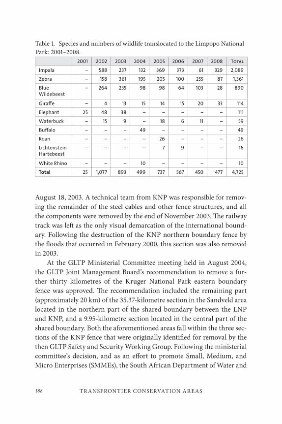
TR ANSFRONTIER CONSERVATION AR EAS188
August 18, 2003. A technical team from KNP was responsible for remov-ing the remainder of the steel cables and other fence structures, and all the components were removed by the end of November 2003. The railway track was left as the only visual demarcation of the international bound-ary. Following the destruction of the KNP northern boundary fence by the floods that occurred in February 2000, this section was also removed in 2003.
At the GLTP Ministerial Committee meeting held in August 2004, the GLTP Joint Management Board’s recommendation to remove a fur-ther thirty kilometres of the Kruger National Park eastern boundary fence was approved. The recommendation included the remaining part (approximately 20 km) of the 35.37-kilometre section in the Sandveld area located in the northern part of the shared boundary between the LNP and KNP, and a 9.95-kilometre section located in the central part of the shared boundary. Both the aforementioned areas fall within the three sec-tions of the KNP fence that were originally identified for removal by the then GLTP Safety and Security Working Group. Following the ministerial committee’s decision, and as an effort to promote Small, Medium, and Micro Enterprises (SMMEs), the South African Department of Water and
Table 1. Species and numbers of wildlife translocated to the Limpopo National Park: 2001–2008.
2001 2002 2003 2004 2005 2006 2007 2008 Total
Impala – 588 237 132 369 373 61 329 2,089
Zebra – 158 361 195 205 100 255 87 1,361
Blue Wildebeest
– 264 235 98 98 64 103 28 890
Gira≠e – 4 13 15 14 15 20 33 114
Elephant 25 48 38 – – – – – 111
Waterbuck – 15 9 – 18 6 11 – 59
Bu≠alo – – – 49 – – – – 49
Roan – – – – 26 – – – 26
Lichtenstein Hartebeest
– – – – 7 9 – – 16
White Rhino – – – 10 – – – – 10
Total 25 1,077 893 499 737 567 450 477 4,725
189David Mabunda, Freek Venter, Danie Pienaar, and Piet Theron
Environmental Affairs (DWEA) made US$40,000 available for the fence removal. Three contractors were appointed towards the end of May 2005 and their work was completed by the end of August of the same year.
To date, the combination of active and passive translocation has in-creased wildlife numbers in LNP to over 5,000 animals. This has allowed the park to embark on a tourism development program, which has already started but will be phased in over the next five years.
GLTP Joint Research Policy
Background
The Tri-lateral Treaty establishing the Great Limpopo Transfrontier Park and Conservation Area was signed in 2002 and yet a lot remains unknown regarding the real and potential costs and benefits of these initiatives to stakeholders from the community to the regional level. Whilst there has been research undertaken to understand the contribution of transfrontier conservation projects to wildlife and biodiversity conservation, there are still several knowledge gaps that inhibit understanding of the broader im-plications of transfrontier conservation projects to economic, social, and political development.
Research within the GLTP was conducted largely in an ad hoc man-ner, driven primarily by the fashions of academic institutions. The three parks also have big differences in capacity to manage and coordinate re-search at the park level.
Research work in Limpopo National Park is limited in quantity and scope, it is not consolidated, and the results are not feeding into manage-ment. There is also no internal research capacity in the park to coordin-ate, guide, and assist visiting researchers and to facilitate the link between science and management. To overcome these problems, park authorities have designed a research program whose objective is to generate environ-mental, social, and economic information and promote monitoring that is necessary for effective management of the LNP.
The Kruger National Park is the most advanced in terms of conducting research and has had internal research capacity since 1950 (Du Toit et al. 2003). The Scientific Services Department coordinates research and
TR ANSFRONTIER CONSERVATION AR EAS190
monitoring activities, does knowledge harvesting, and provides technical information to support park management. Scientific Services has a skilled staff complement of about twenty-five people and has various facilities to help stimulate science, including short-term visiting researcher accom-modation, logistical support, and access to long-term datasets. The main task of these scientific staff is to attract and support external research pro-jects of value to the park and re-integrate the ensuing knowledge into park understanding and management.
Much of the research carried out in the Gonarezhou National Park (GNP) is done through the scientific branch of the Parks and Wildlife Management Authority (PWMA). The scientific branch carries out re-search to establish baseline quantitative data on biology of species, the structure and functions of ecosystems, and the ecological relationships between species and their habitats. PWMA encourages outsiders to con-duct research in the Parks and Wildlife Management Estates, given the limited number of researchers within. Priority is given to researchers who undertake research that is in line with the PWMA research program either jointly or independently. Researchers from outside the country apply through the PWLMA to the Research Council of Zimbabwe in terms of a permit to conduct research, and to the immigration department for a temporary residence permit. The fee payable is US$500 to the Research Council and US$500 to the PWMA to process the application.
The GLTP/TFCA is premised on the need to promote regional cooper-ation in biodiversity conservation and socio-economic development, and yet understanding of basic ecology, conservation status and trends, func-tionality of social-ecological-systems, and the costs and potential benefits of transboundary natural resource management in the area as a whole is limited. It is important that knowledge around these issues is generated through joint research. The GLTP has a complexity of stakeholders from the local, national, and regional levels all with different socio-cultural, political, and economic attributes. These attributes are not fully known, especially at the community level. Levels of existing data and knowledge are very uneven among the three parks, such that comparing performance in terms of wildlife management and tourism development is difficult. At the park level, data are also very fragmented and limited primarily to
191David Mabunda, Freek Venter, Danie Pienaar, and Piet Theron
wildlife. The GLTP/TFCA has the potential to perform better (in social, ecological, and economic terms) than the sum of the separate entities and so gaining an understanding of the value addition from the creation of the transfrontier conservation areas is imperative. Policy decisions made by the Trilateral Ministerial Committee need to be better informed by em-pirical data. So far research has been too ad hoc in nature, with inadequate feedback of research results to park managers and insufficient incorpora-tion of research findings into park management and policies.
Given the discrepancies in research capacity that exist between the three parks, it was agreed that research should be more coordinated, sys-tematic and demand-driven, and research findings used to guide decision-making for the GLTP/TFCA.
Policy Development Process
Tri-national workshops were thus held to draft the GLTP research policy. Once completed, the policy was ratified by the GLTP JMB.
This policy has been designed to guide joint research activities and initiatives within the GLTP/TFCA due to the realization that there is need for knowledge that will lead to adaptive management of the project as it unfolds. In this policy document, research is defined as:
The creation and development of intellectual infrastructure of subjects and disciplines, the invention or generation of ideas, images, performances, artefacts, new developed insights, or the use of existing knowledge to produce new or substantially im-proved materials, devices, policies or processes, etc.
It was agreed that stakeholders within and around the GLTP/TFCA should be involved in the planning, implementation, and analysis of re-search to ensure buy-in and build research capacity and understanding. The development of an integrated research program to cross international borders, rather than three separate national programs is preferable, and this should include tri-lateral research programs, to build capacity and disseminate information across the region. The need for open and pub-lic access to data and knowledge should be considered but always taking

TR ANSFRONTIER CONSERVATION AR EAS192
into account confidential or sensitive economic data, rare and threatened species, copyright, etc. The GLTP should strive to align resources and fa-cilitate research permit processes between the countries for prioritized GLTP/TFCA research.
Outcome
A GLTP research policy was drafted and was ratified by the GLTP JMB in 2008. The overall objective for joint research was specified as “To assess and evaluate the potential and real contribution of economic, socio-cultural attributes, biodiversity and ecosystems toward sustainable development (including principles of governance, institutional, policy and planning).”
The specific research objectives stated for the GLTP are:
1) To fully understand the costs and benefits of establishing the GLTP and GLTFCA. This would include to assess costs and benefits of the GLTFCA in terms of per capita income, quantity and quality of employment opportunities and access to natural resources;
2) To understand the contribution of the GLTP and GLTFCA to social, cultural and economic development of communities. To do this one will need to identify linkages between GLTFCA and community incomes, identify empowerment opportunities, identify needs of target communities and land claimants, and identify feasible opportunities and determine priority focus areas;
3) To determine the land use options that best promote regional development as stipulated in the treaty. This will entail conducting conservation priority setting exercises, assessing potential for complementary land use planning (e.g., development of irrigation schemes for re-settlement of people in parks), identifying appropriate leasing systems taking into account possible future land uses; and
193David Mabunda, Freek Venter, Danie Pienaar, and Piet Theron
4) To assess whether the GLTP/GLTFCA is contributing to natural resource conservation. This will entail the establishing of appropriate, long-term monitoring programs for vegetation, mammal and bird population abundance and diversity.
An exciting collaborative, multi-disciplinary research program involving government, academic, and NGO stakeholders is the AHEAD (Animal & Human Health for the Environment And Development) program, which was launched by the Wildlife Conservation Society (WCS) at the 2003 IUCN World Parks Congress in Durban, South Africa. Under the AHEAD banner, a range of programs addressing conservation, health, and con-comitant development challenges have been launched with growing sup-port of implementing partners and donors who see the intrinsic value of what WCS has called the “One World, One Health” approach. AHEAD is a convening, facilitative mechanism, working to create enabling environ-ments that allow different and often competing sectors to literally come to the same table and find collaborative ways forward to address challenges at the interface of wildlife health, livestock health, and human health and livelihoods. AHEAD recognizes the need to look at health and disease not in isolation but within a given region’s environmental and socioeconomic context (www.wcs-ahead.org).
The joint research policy and research priorities document is valu-able to focus future research opportunities. There is however a real need to conduct joint research projects and programs involving staff from the three parks to foster learning, knowledge transfer, and the building of a more cohesive research network.
|Ai-|Ais/Richtersveld Transfrontier Park
The |Ai-|Ais/Richtersveld Transfrontier Park (ARTP) is a joint project between Namibia and South Africa (SANParks 2011b). The park mea-sures 6,045 km2 and spans some of the most spectacular arid and desert mountain scenery in southern Africa. It incorporates the 4,420 km2 |Ai-|Ais Hotsprings Game Park in Namibia and the 1,625 km2 Richtersveld
TR ANSFRONTIER CONSERVATION AR EAS194
National Park in South Africa. This arid zone is characterized by a unique and impressive variety of succulent plant species and is part of the Succulent Karoo Biodiversity Hotspot. The park is bisected by the Orange River, which forms the international boundary between the two countries. One of the key landscape features of the transfrontier park is the world’s second largest canyon – the Fish River Canyon. This 161-kilometre long and 550-metre deep canyon meanders between deep, spectacular cliffs that divide the Nama Plateau.
The Richtersveld area (including the Richtersveld National Park) is regarded as one of the world’s richest succulent areas. This is due to a large variety of geological formations, rugged landscapes, and diverse soils, which brings about an unusual number of habitats with great differences in moisture condensation, sunlight exposure, and temperature. The vege-tation of the area has evolved within a water-stressed environment and is thus mainly succulent, comprising more than 900 known species.
Community Participation in Transfrontier Conservation
Background
As a result of this biodiversity significance, efforts to obtain formal protec-tion of the area started in the early 1970s (Hendricks 2001). However, most local residents remained unaware of the plans until the 1980s when the notion of a contractual national park for the Richtersveld was developed and legislation for the designation of the park was tabled. At the time, it was argued that the biodiversity value of the area had to be protected from the local population and the national park was thus justified on aesthetic, moral, and scientific grounds. In so doing, negotiations around the es-tablishment of the new national park at the time basically excluded the involvement of the local communities.
However, 1989 saw a complete reversal of this trend. The local com-munity established a community committee, which proceeded to acquire legal assistance on the issue. On March 19, 1989, the day before the con-tract for the ark was to be signed, the community committee obtained an urgent court order from the Cape of Good Hope Supreme Court inter-dicting the parties to the contract from signing it. This was followed by an
195David Mabunda, Freek Venter, Danie Pienaar, and Piet Theron
eighteen-month period which resulted in the drafting of a new agreement. Contrary to the previous one, the new agreement established the principle that there would be no expropriation or forced removals from any part of the park. In addition, the existing pastoralist farmers could continue graz-ing their livestock in the park with the exception that the overall numbers of stock would be limited. On July 20, 1991, the signing ceremony was held for the formal establishment of the Richtersveld National Park (RNP). The signing of the contract allowed the RNP to be proclaimed on August 14, 1991.
Approximately ten years later, the process to make the RNP part of a transfrontier park with Namibia gained momentum. One of the key issues that needed to be addressed as part of the transfrontier process was to provide for adequate representation (from a South African perspective) on the joint management structures for the current land owners of the Richtersveld National Park.
Community Participation in Joint Management
The RNP has, since its proclamation in 1991, been managed jointly by representatives from both the local communities and South African National Parks (SANParks) through a joint management and planning committee. This committee, which meets every three months, consists of nine members in total, including: one representative of each of the local communities (i.e., Kuboes, Lekkersing, Eksteenfontein, and Sanddrift), a stock farmer representative, and four representatives (including the park manager and park researcher) of SANParks. The work of the committee is aimed at promoting and ensuring discussions and decision-making re-garding the management plan of the park, and ensuring effective local community participation.
In light of the aforementioned, the transboundary conservation pro-cess had to take cognisance and incorporate the existing institutional ar-rangements on the South African side into any proposed joint manage-ment structures between Namibia and South Africa. This issue was also highlighted in the extensive stakeholder participation processes that led to the drafting and signing of the memorandum of understanding (MOU) between the governments of Namibia and South Africa, and the subse-quent participatory process for the development of the treaty.
TR ANSFRONTIER CONSERVATION AR EAS196
Outcome
In June 2002, the governments of the Republic of Namibia and the Republic of South Africa entered into an agreement by means of an MOU to initiate and actively participate in a process that would result in the establish-ment and management of a transfrontier park. Following the signing of the MOU, which provided the political foundation for the development of the proposed transfrontier park, the necessary processes were set in mo-tion for the development of an international treaty to formally proclaim the area. On August 1, 2003, then president Sam Nujoma of Namibia and President Thabo Mbeki of South Africa signed an international treaty es-tablishing the |Ai-|Ais/Richtersveld Transfrontier Park (ARTP).
The treaty provides for the formation of a joint management board (JMB) which is responsible for the overall planning and management of the ARTP. The ARTP JMB deals specifically with the management of joint issues, whilst each park still retains its own administrative structures and the right to administer its own area as deemed appropriate.
However, in contrast to other transfrontier parks in the region, the ARTP JMB consists of five members instead of the four member template which has been used in the other projects. The key objective of this diver-gence was to reflect the current contractual park institutional arrange-ments in South Africa in the composition of the joint management struc-ture for the transfrontier park. In so doing, the treaty states that the JMB will include “two representatives from each of the national implementing agencies of the parties of which one in the case of South Africa shall be a community member of the Richtersveld Management Committee” (ARTP International Treaty, 2003). This effectively ensures local community par-ticipation, not only in the management of the Richtersveld National Park, but also in the overall development of the ARTP.
Limpopo / Shashe Transfrontier Conservation AreaThe Limpopo/Shashe Transfrontier Conservation Area is situated at the confluence of the Limpopo and Shashe Rivers, encompassing areas in three countries – Botswana, South Africa, and Zimbabwe. This TFCA currently includes the Botswana Northern Tuli Game Reserve, in South Africa the Mapungubwe National Park, and in Zimbabwe the Tuli Circle Safari Area.
197David Mabunda, Freek Venter, Danie Pienaar, and Piet Theron
The inclusion of the various other areas is however still under negotiation, and these may be included in the future when the international treaty gets signed to formally proclaim the area. Underpinning the establishment of the Limpopo/Shashe area is its rich biodiversity, its scenic beauty, and the cultural importance of the archaeological treasures of the Mapungubwe World Heritage Site. The area supports populations of big game, includ-ing the famous Tuli elephant, all major predators, and offers potential for the development of a viable consumptive and non-consumptive tourism industry.
Partnership between Governments, the Private Sector and
Local Communities
Background
In Botswana, land committed to the Limpopo/Shashe TFCA encompasses the Northern Tuli Game Reserve (Notugre), an association of private landowners who have removed the fences that separated their properties and now jointly manage wildlife resources. Notugre presently embraces thirty-six farms with a combined area of 70,000 hectares. It is renowned for its Tuli elephants, the largest elephant population on private land in Africa. Notugre is also a conservation success story, given its abundant level wildlife today that was virtually wiped out in the late 1960s and early 1970s.
On the South African side, land allocated to the TFCA comprises a complex mosaic of private land, state-owned land, and national parks. South African National Parks, with the assistance of the World Wide Fund for Nature (South Africa), De Beers Consolidated Mines Ltd., the National Parks Trust, and the Peace Parks Foundation, has been involved in land purchases to create the Mapungubwe National Park since 1998. This park forms the core area of South Africa’s contribution to the Limpopo/Shashe TFCA and will include eighteen properties of 25,800 hectares in total. To date, roughly 80 per cent of the park’s core area has been consolidated by means of purchase or contract. Mapungubwe National Park was officially opened on September 24, 2004, and has already become a popular des-tination for tourists.
TR ANSFRONTIER CONSERVATION AR EAS198
The area that Zimbabwe can commit to the proposed TFCA is the Tuli Circle Safari Area (government owned) covering an area of 41,100 hectares. This area is contiguous with the northern end of Notugre and has no physical barriers to impede the movement of wildlife. The potential also exists to incorporate portions of the Maramani Communal Land.
Given the fact that the establishment of transfrontier conservation areas is mainly (on an international level) a government-to-government process, one of the key challenges for the establishment of the Limpopo /Shashe TFCA was how to include the Botswana portion of the proposed project. Given the fact that it was solely privately owned, mechanisms had to be developed and put in place to facilitate the inclusion of the area as part of the TFCA.
Setting up the Partnership
In response to the challenge, the Government of Botswana and the Northern Tuli Game Reserve embarked on a process to develop an agree-ment between the two parties. The outcome of this process was an agree-ment between the Department of Wildlife and National Parks (on behalf of Botswana Government) and Notugre. The main assumption of the aforementioned agreement was that both parties believed a transfrontier conservation area extending across the boundaries of Botswana, South Africa, and Zimbabwe in the areas of land adjacent to the confluence of the Limpopo and the Shashe rivers could bring considerable benefits to the people of Botswana, the landowners in the area, and the flora and fau-na therein. In so doing, the agreement outlines the relationship between them with respect to the establishment, operation, and management of the proposed TFCA. The parties also recognize and agree that international negotiations shall remain the responsibility of the respective governments of these countries.
Outcome
On June 22, 2006, an MOU signalling the three nations’ intent to estab-lish and develop a transfrontier park was signed by Mr. Kitso Mokaila, Botswana’s Minister of Environment, Wildlife and Tourism, Mr. Marthinus van Schalkwyk, South Africa’s Minister of Environmental Affairs and Tourism, and Mr. Francis Nhema, Zimbabwe’s Minister of
199David Mabunda, Freek Venter, Danie Pienaar, and Piet Theron
Environment and Tourism. Prior to the signing of the MOU by the three ministers (and after an extensive negotiation process followed by cabinet approval), the agreement between DWNP and Notugre was also signed. This signalled the start of a major milestone in the development of public-private partnerships to the benefit of transboundary conservation.
Subsequent to the signing ceremony, the first meeting of the Limpopo/Shashe TFCA Technical Committee was held in November 2006. The tri-lateral technical committee, initially comprised of six public sector rep-resentatives from each of the participating states, has been broadened to include participation by the private sector (NOTUGRE). Given the fact that NOTUGRE represents an association of private land owners with vast experience in the tourism development and business management field, their contribution to the overall development process could potentially be quite significant.
LESSONS LEARNED AND KEY CHALLENGES
Lessons Learned
Based on experience to date, the following key issues are critical to the success of the planning and development process for the establishment of TFPs and TFCAs:
• High-level political buy-in often results in a high level of exposure and funding.
• Effective collaboration and co-operation between countries often results in peace and stability in the region.
• A key strength of transboundary conservation projects is the ability to create opportunities for collaboration and partnership-building on various levels and scales, i.e., international, national, regional, and local levels.

TR ANSFRONTIER CONSERVATION AR EAS200
• Lack of political will and understanding will impede the process. This includes a lack of understanding and/or commitment from other relevant government agencies and key role players in the TFCA development process.
• Capacity to lobby for and secure funds for TFCA-related activities could potentially impede the rate of implementation of the project.
• Rates of planning, development, and implementation processes may not be suitable to all the parties involved, especially when there are disparities relating to institutional capacity, financial resources, and level of community/stakeholder participation.
• Effective local community and key stakeholder participation in the planning, development, and implementation process is critical to the long-term success of the project. In other words, an effective stakeholder involvement strategy must be formulated in the very early stages of the project and be immediately implemented. It must also be monitored and updated regularly to ensure that it remains effective.
• Potential incompatibility of goals when countries are in different stages of development, or when the components of the TFCA differ in the level of tourism infrastructure investment, could impede progress.
• Social, cultural, language, and related barriers may have to be overcome to ensure effective communication and an understanding of the operating environment within each of the participating countries.
201David Mabunda, Freek Venter, Danie Pienaar, and Piet Theron
Key Challenges
Based on experience to date, the following key challenges would be critical to the success of the planning, development, and implementation of TFPs and TFCAs:
• The ability to realize the potential of regional conservation-based development initiatives. This would include the development of more effective and appropriate responses to the socioeconomic context in which these projects are embedded.
• Ensuring that projects develop and implement mechanisms to ensure sustainability and self-reliance. These would include the identification of appropriate means for sustainable financing, ensuring the equitable distribution of costs and benefits in future, and also guard against donor-dependency and conditions often associated with these.
• Measuring the effectiveness of the implementation of transboundary conservation projects through the development of tools for monitoring and evaluation (M&E), and ensuring effective feedback loops to ensure that results are incorporated into adaptive management and iterative planning processes.
• The development and implementation of effective institutional models and approaches that respond to all levels of collaboration and cooperation between key stakeholders involved in transboundary conservation projects.
• Establishing a global and regional framework for transboundary conservation, which would also act as a network where managers and key role players can share lessons learned and in so doing continue with the development of appropriate approaches and strategies.
TR ANSFRONTIER CONSERVATION AR EAS202
CONCLUSION
The global growth in transfrontier conservation areas (TFCAs) is indica-tive of a belief of the potential of these exciting initiatives to conserve bio-diversity and cultural resources at a landscape level, foster peace and pros-perity between nations, and promote regional socio-economic integration and development. This has led to these projects achieving the highest level of political support in southern Africa, underpinned by key regional pro-grams and objectives providing for the conservation of natural resources as a means to achieve cross-border tourism development and the allevia-tion of poverty. In so doing, the TFCA program in Southern Africa is not only in line with the objectives of key regional initiatives such as the New Partnership for African Development (NEPAD) and the Leadership for Conservation in Africa (LCA) initiative but is also featured as one of the key recommendations of the 5th IUCN World Parks Congress held in September 2003 in Durban, South Africa.
Guided by the above, the various TFCA projects in the southern Africa have responded well to the challenge of realizing the potential of conservation-based initiatives to promote peace and prosperity in the re-gion through the exchange of information and transfer of skills and by building partnerships between government, NGOs, communities, and the private sector. However, it has been realized that these benefits may take time to materialize, some of them only becoming a reality in the medium to long term. In the meantime, governments, implementing agencies, and protected area managers will continue to strive to find appropriate ways and means to plan, develop, implement, and manage these projects more effectively. These actions will always be guided by regional priorities and programs, and inspired by the vision of realizing an African ideology.
203David Mabunda, Freek Venter, Danie Pienaar, and Piet Theron
REFERENCES
Beyond Horizons Consulting and Peace Parks Foundation. 2006. “Kgalagadi Transfrontier Park Joint Zoning Plan.” Pretoria, South Africa: Document commissioned by South Africa National Parks.
Du Toit, J. T., K. H. Rogers, and H.C. Biggs, eds. 2003. The Kruger Experience: Ecology and Management of Savanna Heterogeneity. Washington, D.C.: Island Press.
Fakir, S., and M. Fourie. 2004. Measuring Success: A Development Effectiveness Toolkit for Transboundary Conservation Areas. Harare: Policy and Research Unit, IUCN South Africa
Hall-Martin, A., and S. Modise. 2002. Existing and potential transfrontier conservation areas in the SADC region. Stellenbosch : Peace Parks Foundation.
IUCN. 2005. Benefits Beyond Boundaries. Proceedings of the Vth IUCN World Parks Congress. Gland, Switzerland: IUCN.
Leadership in Conservation for Africa Initiative (LCA). 2007. “Overview.” Accessed September 30, 2007. http:// www.sanparks.org/about/media/2006/.
Sandwith, T., C. Shine, L. Hamilton, and D.Sheppard. 2001. Transboundary Protected Areas for Peace and Co-operation. Gland, Switzerland: IUCN.
Southern Africa Development Community (SADC). 2011. “SADC Transfrontier Conservation Areas (TCFAs).” Accessed December 6, 2011. http://www.sadc.int/fanr/naturalresources/transfrontier/index.php.
South African National Parks (SANParks). 2011a. “Great Limpopo Transfrontier Park.” Accessed December 6, 2011. http://www.sanparks.org/conservation/transfrontier/great_limpopo.php.
———. 2011b. “|Ai-|Ais/Richtersveld Transfrontier Park.” Accessed December 6, 2011. http://www.sanparks.org/conservation/transfrontier/Ai-Ais-Richtersveld.php.
Theron, P. 2007. Lessons Learned in the Development of Transfrontier Conservation Areas in Southern Africa. Gland, Switzerland: IUCN Ecosystems, Protected Areas and People (EPP) Project, Protected Areas Learning Network (PALNet – www.parksnet.org).
Thorsell, J. 1990. “Through hot and cold wars, parks endure.” Natural History 6(90): 59–60.
Wilkie, D.S., E. Hakizumwami, N. Gami, and B. Difara. 2001. Beyond Boundaries: Regional Overview of Transboundary Natural Resource Management in Central Africa. Washington, D.C.: Biodiversity Support Programme, Beyond Boundaries.

205
Building Robustness to Disturbance: Governance in Southern African Peace Parks
Michael L. Schoon
INTRODUCTION
Transboundary protected areas, or TBPAs, create an ideal means of ex-ploring cross-border governance and the coordination of management across an international frontier. In the following study, the research looked at this particular form of transfrontier conservation from a decid-edly institutional perspective, delving into the political and operational struggles of jointly managing a complex social-ecological system divided by political borders. It will examine a number of questions of interest to academics and practitioners alike, as both groups grapple with how to im-prove management across a border, whether the boundary line is between nations, municipalities, public and private partners, state and communal authorities, or other areas necessitating cross-border management. These questions include:
8
BUILDING ROBUSTNESS TO DISTURBANCE206
• When and how do park managers and government officials from partner countries work together across borders in transboundary protected areas?
• Why do these actors foster or facilitate cooperation in some areas and not others?
• How can these actors design or modify institutions to improve cooperation in areas that would benefit from more collaborative efforts?
• In turn, how can we design these institutions to be more robust to future challenges or disturbances?
• Finally, how do we effectively manage within a multi-level, polycentric governance system?
In addressing these questions, the study focusses on two TBPAs in south-ern Africa, the Kgalagadi Transfrontier Park and the Great Limpopo Transfrontier Park (Map 1). By looking at how officials in these parks address and react to disturbances, create cross-border institutions, and engender cooperation, the study attempts to answer these questions and provide policy-makers with pragmatic suggestions for the future. Likewise, the analysis endeavours to advance theoretical discussions on institutional robustness, multi-level and multi-scale studies of gover-nance and cross-border cooperation, and managing for the resilience of complex social-ecological systems. In what follows, this study first will look at the two transboundary protected areas as case studies and explore the political situation behind their creation. Next, it will identify the key policy puzzles and theoretical challenges undertaken. Theories on the re-silience of complex social-ecological systems and institutional robustness, literature on international cooperation, coordination, and governance at multiple scales and levels provide the theoretical framework for the rest of the research. Building on these theories, the study uses the notion of “disturbances” and responses to these disturbances faced by park man-agers as a means to explore and test several hypotheses on institutional development and cooperation levels in the two case studies. From here, a
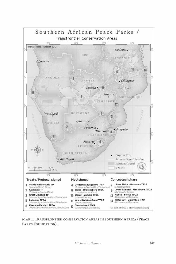
207Michael L. Schoon
Map 1. Transfrontier conservation areas in southern Africa (Peace Parks Foundation).
BUILDING ROBUSTNESS TO DISTURBANCE208
few short vignettes on specific disturbances will delve into some formal and informal institutional changes within the park service. The paper will conclude by then linking these changes back to theories of institutional design.
INTRODUCTION TO THE C ASE STUDIES
The two featured cases in this study have both been frequently mentioned in the history of transfrontier conservation in the southern African region (De Villiers 1998; Duffy 2001; Hanks 2003; Singh 1999; Wolmer 2003a, 2003b; among others). The first of these is the original southern African transfrontier park – the Kgalagadi Transfrontier Park or KTP. As will be discussed in more detail later, this transfrontier park provides an example of a relatively smoothly run system of transfrontier management. This high functionality arises, in part, from the unique circumstances that cre-ated the park and the relative simplicity of the park in terms of a generally uniform climate, geomorphology, and ecosystem, coupled with a remote location which minimizes tourism levels and conflict with neighbouring communities. In the words of one interviewee, “the KTP is a very low intensity management. It’s a simplistic ecosystem, very homogeneous.” (South African researcher 2006). The second case, regarded as the flag-ship transfrontier park of the region, is the Great Limpopo Transfrontier Park or the GLTP. In contrast to the Kgalagadi, the management of the Great Limpopo is always challenging and often contentious (Büscher and Schoon 2009). In what follows, the historical introduction to the two parks will be augmented with a brief presentation covering their biophysical en-vironments, the populations surrounding the parks, and a few of the key issues of concern to park management.
The Kgalagadi Transfrontier Park
The KTP has existed in one form or another since the 1940s but was only officially proclaimed as a “peace park” in 2000. One important feature of the park’s inception is the grassroots or bottom-up movement in the cre-ation of the park, with local rangers and on-site park managers working
209Michael L. Schoon
across the border to collectively manage a borderless park from the very beginning. By contrast, most other transfrontier initiatives come from top-down movements within the national governments or from interna-tional conservation groups. This unique beginning, along with many of the exceptional physical characteristics of the park, has helped to build a stable situation and relatively simplistic transboundary circumstances for park managers to work. The park encompasses vast tracts of land, with the South African contribution comprising 9,591 km2 and the Botswana portion of 28,400 km2. In perspective, the total area roughly equals the Netherlands or the combined area of New Jersey and Connecticut (U.S. Census Bureau 2000). Biophysically, while often described as the Kalahari Desert, the area is more appropriately denoted as an arid savanna, and the park crosses two distinct ecotypes – the Kalahari duneveld in the south-west and the Kalahari plains thornveld in the northeast (SANParks 2006). Rainfall, in this dry region, typically averages between 150 and 350 mil-limetres per annum, while temperatures range from winter lows of –10°C to summer highs of 45°C in the shade (ibid).
While neither ecoregion has high levels of endemism and the bio-diversity figures are not extremely high, the fence-free system contains one of the few large-scale migrations remaining anywhere (Cumming 1999). Due to the arid landscape and the low levels of soil productivity, animal populations require vast tracts of land to support themselves through the dry times. This migration makes the well-being of the KTP vitally import-ant. The migratory paths for thousands of gemsbok oryx and springbok range from the southwestern region of the park in South Africa, through the Botswana section of the park and continue through wildlife manage-ment areas to the northeast of the park, ultimately culminating in the Central Kalahari Game Reserve (CKGR) in Botswana. The introduction of cattle fences in the corridor to the CKGR is believed to have contributed to declines in springbok populations in the past fifteen years (SANParks staff 2007). The fauna of the region, as expected, are generally less water-de-pendent, with larger ungulate species including eland (Taurotragus oryx), gemsbok (Oryx gazella), and springbok (Antidorcus marsupialis) pre-dominating. These are accompanied by the charismatic predators of the region – the Kalahari black-maned lion (Panthera leo), leopard (Panthera
BUILDING ROBUSTNESS TO DISTURBANCE210
pardus), spotted hyena (Crocuta crocuta), brown hyena (Hyaena brunnea), black-backed jackal (Canis mesomelas), the ever-present meerkat (Suricata
suricata), and one of the few remaining genetically pure populations of the African wild cat (Felis lybica). In total, the region holds populations of sixty-six mammal species, over 280 bird species, fifty-five reptile, five amphibia, and hundreds of flora species.
The Kgalagadi Transfrontier Park lies in a sparsely populated, remote area centred around the point where Botswana, Namibia, and South Africa all meet – the place called Union’s End. The entire border of the park with-in Namibia is fenced, with commercial and communal cattle farms along the western edge of the park. The Botswana section of the park is partially fenced, with the southeastern border separated from the nearby cattle-posts by a fence from the park entrance running northeast past Khawa to the Wildlife Management Area KD/15. This border of the park has six to ten cattleposts in the vicinity and is the area with the most problems associated with damage-causing animals (Funston 2001). Wildlife man-agement areas (WMAs) surround the remainder of the Botswana section of the park, clockwise from the north – KD/1, KD/2, KD/12, and KD/15. These are all considered multiple-use zones, often filled with free-range cattle, but they are very sparsely populated by people. Historically, the re-gion also housed Basarwa or San people, but the population has not lived near the park in Botswana in recent years. The same is not true in South Africa.
The creation of the original national park intended to provide the resi-dent San population with the opportunity to continue to live traditionally as hunter gatherers, with the park patronizingly seen as a refuge for flora, fauna, and indigenous populations (Holden 2007). This policy changed over time, and in the mid-1970s park management forcibly removed the last of the Khomani San from the park. With the governmental regime change in South Africa in 1994, the San and the local coloured or baster community, known as the Mier, filed claims demanding the return of historical land holdings forcibly acquired by the government. In 1999, on Human Rights Day (March 21), the litigants settled their claim with the government, acquiring title to six farms totalling 36,000 hectares near the KTP and an additional 25,000-hectare plot to each group within the
211Michael L. Schoon
KTP. The 50,000 hectares inside the KTP became a contractual “heritage” park under the collective management of the communities and SANParks (Hughes 2005). Under the terms of the contractual park, community members have specific use rights and access to the park; however, the heritage park must remain under conservation. The joint management of the contractual park falls under the jurisdiction of a joint management board comprised of representatives from the community and the national park staff. In addition, the two communities have recently opened a com-munity-owned resort, !Xaus Lodge, within the heritage park, as a means of earning rent from the concessionaire, providing jobs to community members, and teaching traditional lessons to both community youth and tourists (Community representative 2007).
In general, the management of the transfrontier park has advanced relatively smoothly. Much of the ease of cross-border management stems from the long history of partnership between the two countries and the view of the landscape as a single borderless system from the beginning (South African park staff 2007). No doubt the relative simplicity of the park from a management perspective helps as well, with relatively low levels of tourism, few surrounding communities or adjacent neighbours, a homogeneous ecosystem, and a laissez-faire management approach (Botswana park staff 2006). Current transfrontier management decisions have focussed on creating a joint logo, and re-branding and marketing the park solely as a transfrontier park rather than individual national parks (SANParks official 2007). However, a few key disturbances continue to surface in discussions with park staff, community members, and non-governmental organization officials working in the area.
On the South African side, many mentioned the difficulties in co-ordinating between the two communities and the park staff in the con-tractual park. Past contentious relations between park and local residents, differences in management styles and techniques, and differences in both world views and management goals have led to many challenges for all parties in the collective governance of the contractual park. In addition, while not yet a problem, the joint management of a contractual park with-in a transfrontier park puts SANParks in the delicate situation of hav-ing to play a two-level strategic game. In these two-tiered negotiations,
BUILDING ROBUSTNESS TO DISTURBANCE212
SANParks tries to achieve its organizational goals while at the same time appeasing its management partners at both the community/contractual park and transfrontier levels.
A second disturbance, the problem of damage-causing animals, frequently emerged in discussions with both South Africans and the Batswana. Particularly along the southeastern border of the KTP, several cattleposts directly lie against the park border. In spite of the park fence, lion and leopard can quite easily leave the park and often end up preying on what are known as “slow eland” or cattle. Because of the proximity of grazing animals and the difficulties and expenses of maintaining hundreds of kilometres of fence line across terrain of constantly shifting sand dunes, the park’s response has been to recapture escapees and relocate them to areas in the park far from the border. Offenders are also branded to al-low rangers to identify frequent offenders. However, this solution requires ranchers to find the animals, generally losing livestock in the process. It also involves a great deal of time and expense, as well as expertise on the part of the rangers (Funston 2001). Differences also arise between South Africa and Botswana on the payment of cash restitution for lost livestock, with only Botswana providing any compensation (DWNP 2006). Human-wildlife conflict creates one of the largest and ongoing challenges facing the joint management of the KTP.
A third disturbance, frequently mentioned from the Botswana side of the park, concerns unequal levels of tourism between the South African and Botswana sides of the park. The South African side of the park boasts nine lodges and several campsites while the Botswana side has little tour-ism infrastructure other than primitive campsites. As a result, many tourists stay exclusively on the South African side, resulting in higher revenues for the South African park. While the two countries share gate revenues equally, discrepancies still arise over how to proceed with tour-ism development.
The Great Limpopo Transfrontier Park
In 1898, the South African government, under the leadership of Paul Kruger, created the Sabie Game Reserve as a place to preserve the lowveld natural environment (Carruthers 1994). In the following years, the reserve
213Michael L. Schoon
expanded to cover an area of 20,000 km2 and, following the National Parks Act of 1926, became one of the world’s first national parks – Kruger National Park (Carruthers 1995). Spanning an area of roughly the size and shape of Israel, today the Kruger Park hosts over one million visitors per year, many with the hopes of spotting Africa’s Big Five – lion, leopard, Cape buffalo (Syncerus caffer), white rhinoceros (Ceratotherium simum), and the African elephant (Loxodonta africana) (Apps 2000).
Meanwhile, Zimbabwe created the Gonarezhou National Park in 1975 along the southeastern border of the country out of game reserves and forestry land placed under conservation in the 1940s. Known as the place of the elephant and blessed with beautiful cliffs and rock formations run-ning along the Save and Runde rivers, the park soon became popular with sportsmen and tourists alike (Saunders 2006). By 1980, several thousand tourists visited each year. However, with the ongoing collapse of the gov-ernment and lack of emphasis on conservation, the park slowly drifted into its present state of decline. Mozambique took steps toward the creation of a national park in between Kruger and Gonarezhou, establishing the Limpopo National Park in 1999 (DNAC 2003). Using the former hunting concessions, Coutada 16, as a starting point, the government hoped to re-habilitate the flora and fauna in an area decimated by decades of civil war. In the late 1990s, under the guidance of several non-governmental and international organizations, including the World Bank, the Peace Parks Foundation, and the African Wildlife Foundation, the three national gov-ernments began working toward the establishment of a transfrontier park. In 2002, the governments of Mozambique, South Africa, and Zimbabwe signed a treaty formally creating the Great Limpopo Transfrontier Park.
Building on the well-known Kruger National Park in South Africa, the long-established Gonarezhou National Park of Zimbabwe, and the newly created Limpopo National Park in Mozambique, the combined en-tity spans over 35,000 km2 and is home to 146 mammal species, 114 types of reptile, and over 550 bird species (DuToit et al. 2003). The new park, pri-marily southern savanna woodland and grassland, encompasses seventeen distinct ecozones, ranging from relatively open acacia lowlands to thick scrubby mopane bushveld. Yet while the transfrontier park, in aggregate, places enormous tracts of land under conservation, the significance of the

BUILDING ROBUSTNESS TO DISTURBANCE214
ecological benefits is not fully clear. Basic conservation biology outlines the benefits of reducing landscape fragmentation and increasing a park’s perimeter to area ratio, and island biogeography theory indicates that lar-ger areas under conservation will more effectively prevent local species extinctions. However, with huge amounts of African savanna landscape already under conservation and few, if any, additional endemic species protected by enlarging the previously existing parks, it is unclear if the newly formed GLTP furthers conservation goals more effectively than previous plans. Furthermore, unlike the migrations in the Kgalagadi, it is not readily apparent whether significant migrations or large-scale sea-sonal movements historically took place between any of the three national parks. In fact, from an ecological perspective, few baseline studies have been conducted to ascertain the true biodiversity benefits to the transfron-tier park (Van Aarde and Jackson 2007). This fact is not meant to discount other political, social, or economic benefits arising from park creation but
Lions on a roadway in a southern African TCFA (M. Schoon).
215Michael L. Schoon
rather to indicate current knowledge gaps and flaws in the argumentation of park promotions.
Another significant difference between the KTP and the GLTP, and one of the major disturbances facing park management, is that the GLTP has much more formidable relationships with neighbouring communities. Unlike the sparsely populated areas of the Kalahari, the lowveld land of the GLTP is densely populated. The western border of Kruger has sev-eral million residents in dozens of communities immediately adjacent to the park. Additionally, Kruger continues to negotiate several land claims with communities previously displaced in the creation of the park. One of these has resulted in the creation of the Makuleke Contractual Park, an area in the north of Kruger now owned and managed under the guid-ance of a communal property association (Reid et al. 2004). In Zimbabwe, communal land, known as the Sengwe Communal Corridor, comprises the area connecting Kruger and Gonarezhou Parks. In Mozambique, the newly proclaimed park still has over 28,000 people living within the park, of which several thousand are undergoing the process of relocation. These tight quarters create challenging relations between local communities and park management.
Compounding the challenges of working, managing, and collab-orating within this crowded environment, two other disturbances fre-quently arise. The first, similar to the problems in the Kgalagadi, arises from human–wildlife conflict. In particular, the communities adjacent to the western border of the park and the villages still living along the Shingwedzi River within the Limpopo Park, continually face the risk of predation of livestock by predators, the destruction of crops by elephant, warthog (Phacochoerus africanus), chacma baboon (Papio ursinus), and other sources of crop raiders, and direct risk to their lives in living side by side with dangerous animals.
Another risk threatening such lives and livelihoods comes from close interaction between humans, their domestic stock, and wild animals (Cumming et al. 2007). The threat of transmission of veterinary diseases between wildlife and domestic animals worries veterinary authorities in each of the three countries and has resulted in the formation of a working group, the Animal Health for Environment and Development or AHEAD
BUILDING ROBUSTNESS TO DISTURBANCE216
group. The threats of veterinary disease and damage-causing animals dir-ectly link to one of the most challenging and problematic issues facing the GLTP – removing fencing and the subsequent threats to border secur-ity (Peddle et al., 2004). With the GLTP, security officials had multiple disturbances to address regarding the transboundary nature of the park. First, in addition to the problems of human–wildlife conflict and veter-inary disease control, the need to remove fencing created problems for border control with respect to smuggling, illegal migration, and general border security. Second, security officials and tourism leaders disagreed on how to allow the flow of park visitors between the three national parks. Questions arose about whether the transfrontier park would be internally “borderless,” whether border posts would be placed along the external border of the park, or whether border posts would be placed within the park. Third, beyond the flow of animals and tourists, park management wanted to know whether staff could freely travel across the border in the course of the daily business of following poachers, researching animals, or other routine tasks. Each of these disturbances and many more specific security issues continued to create debate and dissention over how the transfrontier park should operate.
Similar to the situation in the KTP, tourism provides additional chal-lenges for transfrontier park managers. With twenty-three rest camps and over 3,000 kilometres of road in Kruger, and only one camping conces-sion and a few 4 × 4 tracks in Limpopo, tourism infrastructure in the three national parks is highly unequal. While Kruger Park hosts over a million tourists per year, Limpopo hosted roughly 15,000 day visitors in 2006, and less than a few thousand currently visit Gonarezhou (DNAC official 11/21/2006). Like the KTP, the GLTP has vastly unequal levels of tourism development between the partner countries. Unlike the KTP, however, park officials believe that tourism numbers in Kruger are at the park’s carrying capacity (SANParks official 5/18/2007). As a result, Mozambique and Zimbabwe hope to share in Kruger’s largesse. In the words of a Zimbabwean representative, “We want Kruger’s tourists, not their animals.” (DWLNP official 6/19/2007). The resulting debate has pit-ted the national governments against each other in the sharing of gate revenue, the development of infrastructure, and the joint marketing of the

217Michael L. Schoon
transfrontier park. These disturbances, and the ones facing the Kgalagadi, challenge management and form the heart of this study, with managers confronting classic collective action problems of a complex nature. The task remains to determine how to effectively manage disparate visions for the resolution of these ‘wicked’ problems in transfrontier parks through their collective management (Rittel and Webber 1973).
THEORETIC AL AND PR ACTIC AL QUESTIONS ABOUT
TR ANSBOUNDARY PROTECTED AREA GOVERNANCE
The two case studies and the challenges identified within them serve as the foundation for studying some of the theoretical and practical questions emerging in transfrontier conservation management. Whether responses to large-scale disturbances influence the actions of a protected area’s in-ternational management group involve only management at the level of the national park service or include narrower levels of management de-pends on several factors. These include the size, location, and salience of the disturbance, the social surroundings and its interlinked ecosystem, the existing governance system, the path dependency of prior institutional arrangements, and many others.
The first theoretical puzzle I explore consists of how to manage with-in a multi-level, polycentric governance system where multiple levels of representation are consistent with the underlying goals of peace parks (biodiversity conservation, regional development, and the promotion of peace and good neighbourliness). In this case, a polycentric governance system is where many elements are capable of making mutual adjustments for ordering their relationships with one another within a general system of rules where each element acts with independence of other elements (Ostrom 1999). In other words, decision-making is not all top-down, but there is “coordinated” autonomy between governance groups at various levels as is the case in the transfrontier parks. Decisions arise from within the sovereign states, and the joint management boards seek to coordinate action rather than dictate it. Rather than viewing the governance of the transfrontier parks in the typical manner of a hierarchical structure of
BUILDING ROBUSTNESS TO DISTURBANCE218
national government, a more appropriate view would take the perspective of a network of interconnected entities working for the collective advance-ment of the park. The network goes beyond national governmental actors, although they remain many of the main players. It also includes the inter-national management bodies – the joint management board in the case of the GLTP and the bi-lateral committee for the KTP. In addition, NGOs and international organizations play key roles in the ongoing advance of TFCAs. From the complexity, this analysis intends to provide insight into managing between, across, and through such a disparate group of policy actors. In studying this theoretical puzzle and the other intellectual quer-ies below, an institutional perspective guides the way, taking a view of in-stitutions as products of collective interests that serve to increase cooper-ation (North 1990). More specifically, institutions are the rules, norms, and codes of conduct for specific social interactions (Ostrom 1990; Young 1994).
The second theoretical puzzle under examination is how to improve the robustness of governance institutions in general. In doing so, I seek insight into what enables long-lasting institutions to withstand the shocks and pressures encountered over time. In the words of Popper, “Institutions are like fortresses. They must be well-designed and manned” (1966, p. 126). In the design of institutions for transfrontier conservation, many have emerged from the experience and knowledge of intelligent and seasoned park experts. Few, however, have had the luxury of time for reflection or purposeful re-design. My humble hope is that the findings of this study may help to shed light into the improvement of transboundary govern-ance of peace parks.
In seeking to provide pragmatic advice to policymakers and park of-ficials, this study also intends to address real world management dilem-mas as well. In this pursuit, the policy puzzle concerns making explicit what roles the joint management board of a transboundary protected area could play vis-à-vis the national parks’ staff. Particularly due to the higher transaction costs inherent in negotiating and coordinating decisions by consensus across an international border, not all decisions should be made through the international governing body. Instead, decisions made at the national park level or within groups of technical specialists can often lead

219Michael L. Schoon
to more efficient and effective outcomes. The challenge lies in determining the appropriate level at which to resolve crises and the appropriate degree of cooperation at these levels of governance. In ordering relations within a TFCA, the national partners may choose to work together on interests vital to both parties (such as current efforts on veterinary disease control in the GLTP), may decide to keep the other parties informed about other issues (like ongoing KTP research initiatives), and/or work completely autonomously at a national level (as is the case with local community relations in both the GLTP and the KTP). As one of the GLTP officials stated, “We don’t manage across the border. Both sides manage their own areas, and we (the joint management board) try to coordinate their work.” (SANParks staff interview, 04/19/2007).
A second practical challenge that this project intends to inform is how to improve transboundary cooperation in areas so desired. In addressing these questions, I will focus primarily on the capacity of institutional ar-rangements to be robust or long-enduring in environments with shifting ecological, political, and demographic challenges. As a consequence of these theoretical and pragmatic puzzles, the principle research question that I hope to answer is “how does the institutional design of transbound-ary protected areas change in response to various types of disturbance?”
Disturbances
With the question of how institutions change in the face of disturbance, I pursue a goal of informing park management about the linkages between institutional development and cooperation in transfrontier conservation. Because management across a boundary entails increasing transaction costs at the same time that transfrontier park managers work with limited budgets and human resources, we face an optimization problem necessi-tating difficult choices (Singh 1999). Many advocates of transfrontier con-servation tend to ignore these costly realities and propose transfrontier conservation as a rapid progression towards a single unified, cross-border entity with cooperation occurring anywhere and everywhere. By contrast, this proposal endorses a careful and detailed analysis to identify key areas for cooperation and helps to prioritize competing and often-conflicting choices. For example, should transboundary park management work

BUILDING ROBUSTNESS TO DISTURBANCE220
toward improving relations with communities along its borders, attempt to prevent the spread of veterinary disease, or improve international river governance? The answer from many appears to be an unqualified “yes.” However, this answer fails to recommend a prioritization of rapidly di-minishing finances and limited staff resources. It also fails to acknowledge that management will always reach finite limits regarding levels of cooper-ation desired, their ability to achieve this cooperation, and their capacity to move beyond conflict and contention. Instead, the methodology proposed here uses the results from over 150 interviews and codes them to identify key challenges or disturbances facing management. By then looking at the disturbances facing park staff on both sides of a transboundary protected area and in different sectors of the park (biodiversity conservation, tour-ism, etc.), we can see what concerns arise most frequently, with what levels of intensity, and whether cooperation occurs in these areas or not.
Often, as expected, we see high levels of cooperation in areas of com-mon concern or interest. However, careful examination also shows areas of low interest coupled with high levels of cooperation, perhaps due to the ease of collaboration in non-confrontational areas, as well as areas of great cross-border concern with little cooperation transpiring. Ultimately, what we find is a mixture of varying levels of cooperation with little immediate discernable order. Levels of cooperation vary because of ease of partner-ship and ideas about what to do, differing thoughts on how to act, political considerations, and financial and technical constraints, among others.
In what follows, I will introduce a typology of “disturbances” or challenges facing park management, noting how these disturbances vary temporally, spatially, and at different levels of governance. Next, I will introduce the methods used to identify these disturbances as well as areas of cooperation between park administrations across borders. The identification of these disturbances then serves as a base for the exam-ination of institutional responses to these disturbances. The disturbances and responses then help to test the hypotheses posed below. In that man-ner, I intend to provide useable, scientific feedback to park management to facilitate the prioritization of transfrontier conservation initiatives and begin to answer the theoretical and policy puzzles identified earlier.
221Michael L. Schoon
A T YPOLOGY FOR DISTURBANCES
The use of the term “disturbance,” rather than simply talking about man-agement issues, challenges, crises, or something else, emerges from lit-erature on the resilience of social-ecological systems. Resilience theory introduces the concept of a system in a particular state that may then be perturbed by a disturbance. Depending on the size of the disturbance and the resilience of the system, the system would either “absorb” the distur-bance or be pushed (shift) into another state (Holling 1973; Gunderson 2000). In ecology, research often distinguishes between large, infrequent disturbances or LIDs and smaller, micro-disturbances (Turner and Dale 1998; Dale et al. 1998). These LIDs would include major fires, flood events, and other similar phenomena that occur over a relatively short period of time. Meanwhile, political scientists, economists, and other social scien-tists often discuss policy pressures and shocks (Baumgartner and Jones 1994; Fullerton and Stavins 1998). Interesting examples of shocks and pressures in both the natural and social sciences build upon the work of Gould and Eldridge (1993). In this work, the authors draw upon archaeo-logical records to build a case for punctuated equilibriums in the natural evolution of species. Their hypotheses explore how systems undergo rapid change in response to major disturbances rather than through a slow, continuous process of evolution or – as it is known in the policy world – incrementalism (Lindblom 1959). Drawing upon this idea, political sci-entists have re-examined political events, such as the policy process and elections, also looking for punctuated equilibria and key disturbances that may create rapid, fundamental systems changes, or in resilience jargon – state shifts (Jones et al. 2003; Sabatier 1999). But are there fundamental differences between the disturbances of the ecologists and the perturba-tions of the economists? Do multiple micro-disturbances impact a system substantively different from LIDs? Can we contrast the effects of shocks occurring over a short timeframe and pressures that build over time? Is there any direct comparison between types of disturbances?
One of the first challenges in studying disturbances in a social-eco-logical system is semantic – how to define and delimit a disturbance. Very few answers emerge from the literature. Some view disturbances as

BUILDING ROBUSTNESS TO DISTURBANCE222
anything that creates a change in policy (Jones et al. 2003) or that can cause a state shift (Gallopin 2006), but this view can become all-encompassing, and defining a state or a state shift within social-ecological systems, while theoretically simple, is difficult in practice. In this study, the system under analysis is a transboundary protected area and its affected surroundings, bounded spatially and temporally to this geographic area over the TBPA’s history and its component national parks. The disturbances, as external-ities to the system, however, can emerge at multiple levels and scales. These may range from global climate change trends and market globalization effects down to local impacts of alien species invasions and relations be-tween park staff and local populations. Rather than explicitly delimiting disturbances impacting a transboundary protected area, park managers self-defined disturbances as the events that challenged them in the day-to-day management of the TFCA.
To understand state shifts in response to disturbances in a social-ecological system, this study draws upon a typological design to help categorize how different types of disturbances influence a system in di-verse ways. The typology must equally handle predominantly ecological disturbances, predominantly social challenges, and various mixtures in between. Likewise, it attempts to differentiate where in the policy pro-cess or at what level of governance the impacts of the disturbance are felt within the system (Lasswell 1971; Brewer and de Leon 1983). In so doing, the intent is to first provide a means of understanding and mapping dis-turbances systematically in order to more effectively analyze their effects upon a system. The more relevant goal for this study is to then see when and where cooperation arises in relation to these disturbances and if the size and type of disturbance has any relation with the level of cooperation thus achieved or fosters cooperation due to political considerations, ease of action, or some other reason. From there, analysis can shift to look at institutional responses to the disturbance. As the previous discussion al-ludes, analysts have identified several factors along which to characterize disturbances, including size, duration of effect, the type of system it im-pacts, where in the policy process its influence is felt, and others.
Of direct relevance to the hypotheses identified below, this study fo-cusses on two of these dimensions – the disturbance spectrum ranging
223Michael L. Schoon
from short, high-impact shocks to persistent, slow-building pressures and the level of governance most influenced by the disturbance (either oper-ational or political). Let us look at two pertinent examples of disturbances at opposite ends of both spectrums to gain insight into the categorization. The challenge of veterinary disease control in the Great Limpopo provides a continuous pressure seen by park veterinarians in an operational con-text. By contrast, regime change immediately “shocks” the political en-vironment. And, of course, other cases provide examples of shocks felt at the operational level (dealing with the aftermath of a one-hundred-year flood on infrastructure) or pressures felt at the political level (settling land claims of historically disadvantaged peoples). Obviously, many disturb-ances lie between the extremes of this two-by-two categorization matrix, the dimensions of which are continua rather than dichotomous classifica-tions. Additionally, it may not always be clear as to the level of governance most impacted.
The first step in answering the questions highlighted above entailed gaining background and history on the two cases discussed previously. With this accomplished, semi-structured interviews with key individ-ual actors crucial to the management and development of the two parks began. Between 2005 and 2007, during eighteen months of field work, the author interviewed over 150 individuals in the five partner countries. Interviewees were selected through a snowball sampling method where twenty-five key players were identified for initial interviews and addi-tional target interviewees emerged in the course of the original interviews (Bernard 2005). Interviewees were asked about the key challenges facing the national park and transfrontier park that they worked in, researched, or were knowledgeable about. These challenges, what I label “management disturbances,” form the heart of this study. From the interviews, over 700 disturbances from the trivial to the most vital were disclosed. These disturbances group into roughly two dozen distinct areas of disturbance confronting park management. I then identified institutional responses to those disturbances most frequently mentioned – the disturbances dis-cussed earlier in the case introductions. With these disturbances, I looked for areas where policies and operating procedures changed, at what gov-ernance level the response took place, and if any coordination or cooper-ation occurred either through the JMB or autonomously.
BUILDING ROBUSTNESS TO DISTURBANCE224
TESTABLE HYPOTHESES
Using institutional responses to disturbance, this research seeks to test several hypotheses in an effort to provide answers to the questions out-lined earlier. The first hypothesis, H1, states that large disturbances, or disturbances of immediate concern to multiple countries, will generate greater degrees of transboundary cooperation. This hypothesis directly links to the theoretical puzzle regarding cooperation in a multi-level, cross-border governance system, the desire to flesh out the concepts of resilience and robustness, and, when connected with the following two, provides a link to studies of polycentricity by looking at how different governance levels may cooperate and under what circumstances. While at first glance, it may seem self-evident that large disturbances may gen-erate greater levels of cooperation, these may also serve as flash points of conflict. Often these disturbances serve as issues of conflict, as in the literature on water wars and environmental scarcity (Homer-Dixon 1999). Instead small, incremental challenges may prove easier areas in which to build cooperation through either the slow, progressive building of trust and social capital (Coleman 1988) or through a more functionalist path of harmonizing legislation and moving forward on smaller issues first (Haas 1964).
The second hypothesis, H2, asserts that cases of bottom-up transfron-tier conservation, such as in the origins of the Kgalagadi Transfrontier Park, will have higher degrees of operational cooperation than situations of the top-down TFCA origination. Basically, when ground-level work-ers begin working across a border on issues of concern to them, this type of work will continue. In the case of the KTP, rangers began collabor-ating on cross-border issues prior to 1948. The recent “inauguration” of a transfrontier park builds on the foundations established over the past sixty years. By contrast, rangers and scientists in the Great Limpopo have had little cross-border interaction until recently. Rather, efforts in support of border security have inhibited cross-border relations at the operational level.
By contrast, the third hypothesis, H3, takes the opposite approach. In cases of top-down transfrontier conservation, such as in the origins of
225Michael L. Schoon
the Great Limpopo Transfrontier Park, higher degrees of political cooper-ation will be found than in cases of bottom-up TFCA origin. With high-level political actors working for the GLTP from the very beginning, we would expect political involvement to remain high. The GLTP emerged from the efforts of the World Bank, influential policy entrepreneurs like Anton Rupert, and the presidents of South Africa and Mozambique. The challenge will be to avoid conflating cooperation levels within a dynamic-ally shifting policy process with other factors contributing to or limiting the success of institutional responses to crises.
The fourth hypothesis, H4, posits that the higher transaction costs of international coordination and the lack of direct enforcement abilities will minimize the amount of institutional development at the international level relative to national and sub-national levels. As mentioned earlier, this possibility often gets neglected in many discussions on peace parks. Rather than assume that it makes little difference in cost to bring activities to the international level or not, we can test this hypothesis by comparing costs associated with different choices of institutional design. Similar to hypothesis H4, we can further speculate that transaction costs will decline over time as levels of cooperation improve. This may be due to increasing trust, allowing for the specialization of tasks or the streamlining of inter-national administration. Finally, we can conjecture that different types of disturbance may lead to different degrees of cooperation at either a pol-itical or an operational level, depending on whether the disturbance is a shock or a pressure, whether the issue is politically salient in its timing (Kingdon 2002) or is a recurring issue. To test these hypotheses, the chap-ter now turns to the institutional responses to several of the key disturb-ances mentioned earlier.
UNDERSTANDING INSTITUTIONAL RESPONSES TO
DISTURBANCE
From the list of several hundred disturbances that emerged in the course of interviews with park officials and protected area experts, several sur-faced repeatedly. Many of these disturbances closely interlinked with each
BUILDING ROBUSTNESS TO DISTURBANCE226
other, particularly regarding relations between the parks and local com-munities. The most frequently mentioned disturbances in the GLTP in-clude veterinary disease control, border security, human–wildlife conflict, and relations between the park and local communities. Loosely grouping several key disturbances under the category of relations with local com-munity, management faced a multitude of challenges ranging from the co-management of contractual parks and their coordination within a trans-frontier park to the resettlement of local communities, the creation of multi-use zones and park buffers, and the implementation of the “People and Conservation” program. The KTP also featured many of the same disturbances – particularly with regard to local community relations and the challenge of human–wildlife conflict, in addition to facing challenges with joint tourism development.
Drawing upon theories of resilience and robustness, park manage-ments’ responses to these disturbances were assessed to see whether the park went through a transformative change, adapted to the disturbance without significantly altering the state of the system, or whether no major changes took place. Walker et al. (2004) note that a transformation oc-curs “when ecological, economic, or social conditions make the existing system untenable,” (p. 3) resulting in a new system. By contrast, adapt-ability involves the capacity to manage resilience. In other words, the system can adapt to “absorb” disturbances without significantly changing its underlying function or structure, and the system remains in the same general state (ibid.). Partly as a consequence of the “New South Africa” in the post-apartheid world and the end of civil war in Mozambique, many of the transformations experienced in southern Africa in transfrontier con-servation and in conservation in general tie to the relations between park management and local communities.
As the early discussions regarding the creation of the GLTP in the late 1990s moved from the idea of a multi-use transfrontier conservation area pushed by the World Bank and the Mozambican government toward the creation of a transfrontier park, as advocated by international NGOs and the South African government, relations with local communities became contentious (Van Amerom and Büscher 2005). In the process several trans-formative events took place. First, with the creation of SANPark’s Social
227Michael L. Schoon
Ecology program in 1995, and its subsequent re-vitalization in 2003 as the People and Conservation group, SANParks began to transform itself from an old-school “fortress conservation” mode of thinking to a more progres-sive model, engaging with surrounding communities. This process slowly continues, waxing and waning over time. In response to land claims de-manding restitution of land where people had been forcibly removed in the past, South Africa began to draw up plans for contractual parks (Reid 2001; Ramutsindela 2003). Originally conceived as contractual arrange-ments between conservation groups and private owners for land that the state could not afford to purchase, such as in the West Coast National Park, officials began to view contractual parks as a means to peacefully resolve land claims by returning a partial set of ownership rights back to communities while still keeping the land under conservation and ensur-ing state oversight (Schlager and Ostrom 1993). In this manner, owner-ship rights split between community property associations and the state, with a joint management board helping to coordinate decision-making. In both the GLTP and the KTP, South African park officials worked with community members to establish the Makuleke contractual park in the Pafuri section of Kruger National Park (Steenkamp 1999) and the Ae!Hai Kalahari Heritage Park in the Kgalagadi (Hughes 2005).
Meanwhile, Mozambique’s National Directorate for Conservation Areas (DNAC) was undergoing a rebirth in the park service, resulting in the rapid expansion and development of several conservation areas. One of these, the Limpopo National Park, created in 1999 to become a part of the Great Limpopo, resulted in a major transformation for the park ser-vice and local communities. Formerly a Coutada or hunting concession, Limpopo National Park began the slow process of relocating communities outside the park. In doing so, they created an IUCN Category II protected area managed primarily for ecosystem protection without people within it (Sandwith et al. 2001). As of this writing, relocation had not yet begun, but the intent is to move a “pilot” group before October to provide time to put in crops before the end of the growing season (DNAC interview 2007). In total, roughly 6,000 people living in the interior of the park will move. A further 20,000 living within the park borders will remain in a park buffer zone. In an effort to respect human rights and conduct the
BUILDING ROBUSTNESS TO DISTURBANCE228
resettlement in accordance with international standards, the resettlement program has taken over four years of planning and still has not resulted in the movement of a single person. The government hopes that a successful outcome will result in support for the national park and improved living conditions for its constituents. It is not yet clear whether such success is possible. It is evident, however, that such policies stand in stark contrast with the creation of contractual parks and ongoing restitution underway in South Africa. Under current arrangements, the management of rela-tions between the park and local communities resides completely under the guidance of the national government, and the international joint man-agement of the transfrontier park completely relinquishes claim to this issue (DEAT official 2006; DNAC official 2006).
Partially as a response to the struggles with local communities, the controversial decision to shift from a TFCA to a TFP is now being re-visited. The initial decision to focus on a transfrontier park is frequently referred now to as a “decision of political expediency” (DNAC official 2007). Discussions have started again to expand thinking beyond the park borders to a giant multiple-use conservation area. With this decision, more discussions with communities along the Limpopo River focus on the cre-ation of an unfenced buffer zone rather than a hard, fenced boundary. Past philosophy in South Africa used fences as hard barriers to keep animals in and people out. With the removal of sections of fencing between South Africa and Mozambique in creating the GLTP and with further decisions not to fence the eastern boundary of the transfrontier park, management reliance on this philosophy has weakened. Instead, park managers in South Africa have even started to discuss the possibility of creating buffer zones along the western border of Kruger and possible changes in resource use by community members (SANParks official 2006).
While relations between local communities and the park have often involved transformative change and the shifting from a fortress conserva-tion mindset to more of an open partnership, other institutional responses to disturbances have taken a more incremental, adaptive approach. One of the major concerns in the GLTP has always been the control of veterinary disease. With parks as “conservation islands” with high concentrations of game, park veterinarians view their role as mitigating the outbreak of
229Michael L. Schoon
disease epidemics (SANParks staff 2007). Linked to the changing phil-osophies behind the use of fencing discussed above, as fences come down, the spread of diseased animals across international boundaries, the spread from wildlife to domestic stock, and the risk to human populations all in-crease. As a result, the veterinary sub-committee in the GLTP has worked closely together by sharing expertise, trying to minimize risk, and increas-ing adaptive capacity (DNAC official 2007). Working with the Wildlife Conservation Society, GLTP staff has organized a working group for the AHEAD (Animal Health for the Environment and Development) project (Cumming et al. 2007). As a result, an epistemic community has evolved out of previously separate national initiatives.
Another major concern in both the GLTP and the KTP that is impact-ed by the removal of fencing concerns human–wildlife conflict. Whether this conflict takes the form of crop loss to elephants in the Limpopo, loss of livestock to predation in the KTP, or direct threats to human life, hu-man–wildlife conflict has the potential to destroy lives and livelihoods and tear relations between park and community asunder. Compounding this, current policies in South Africa and Mozambique minimize compensa-tion of loss by the state while still preventing civilian killing of wildlife in response to damage-causing animals. In the Kgalagadi, park rangers respond to the threat, capturing lions and leopards and returning them to the park (Funston 2001). Regardless of whether the animal escapes into Namibia, Botswana, or South Africa, South African rangers play the lead role in returning the animal to the confines of the park. In doing so, they work closely with park rangers across the border, border control officials, and local ranchers. Actions over the past few years to improve cooper-ation have resulted in joint training on animal recovery and improved communication networks with ranchers. Such tight cooperation does not yet occur in the GLTP, with a different set of challenges than the KTP: the destructiveness of elephants and the difficulty of recapture, the higher concentrations of people living in and around the park, and the higher density of wildlife.
One final disturbance of critical importance is border security. Early discussions in both parks viewed transfrontier parks as an opportunity for wildlife, staff, and tourists to have a completely borderless view of the
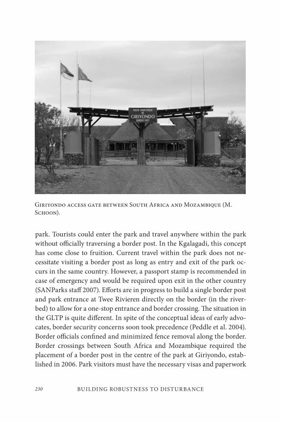
BUILDING ROBUSTNESS TO DISTURBANCE230
park. Tourists could enter the park and travel anywhere within the park without officially traversing a border post. In the Kgalagadi, this concept has come close to fruition. Current travel within the park does not ne-cessitate visiting a border post as long as entry and exit of the park oc-curs in the same country. However, a passport stamp is recommended in case of emergency and would be required upon exit in the other country (SANParks staff 2007). Efforts are in progress to build a single border post and park entrance at Twee Rivieren directly on the border (in the river-bed) to allow for a one-stop entrance and border crossing. The situation in the GLTP is quite different. In spite of the conceptual ideas of early advo-cates, border security concerns soon took precedence (Peddle et al. 2004). Border officials confined and minimized fence removal along the border. Border crossings between South Africa and Mozambique required the placement of a border post in the centre of the park at Giriyondo, estab-lished in 2006. Park visitors must have the necessary visas and paperwork
Giriyondo access gate between South Africa and Mozambique (M. Schoon).
231Michael L. Schoon
to visit both sides of the park. Travel into the Zimbabwean section of the park still requires leaving the GLTP frontiers and crossing through a stan-dard border post at Beitbridge, although efforts are underway to build a bridge across the Limpopo River connecting South Africa and Zimbabwe. The difficulties of border crossings affect park staff and researchers alike. While joint research projects and collective staff efforts continue, border crossings require the standard border post experience. For a variety of reasons – threat of illegal migration and smuggling, population densities, historic relations – border security in the GLTP has remained far stricter and less willing to adapt within a new transfrontier entity than in the KTP. It is doubtful whether this fact will change in the near future.
PRELIMINARY CONCLUSIONS
Initial analysis of the institutional changes in response to various distur-bances appears to be inconclusive and without pattern. However, by closely examining the disturbances and responses in the two transfrontier parks, a few insights emerge. First, through the evolution of the GLTP from a TFCA to a TFP and the current movement back toward a TFCA, from the recent organizational change from a rotating international coordinator to a permanent secretariat, and from the primacy of border security in the decision-making process, the political considerations behind transfron-tier park formation appear to drive park development in the early stages. Political expediency overrides ecological goals, economic development plans, and day-to-day park administration. Perhaps this notion surprises few, but it directly impacts management and the implementation plans for a new park. Second, of the several institutional responses outlined, trans-formative events often emerged at the political level, not at the operational level. Philosophical shifts from “fortress conservation” to “people and conservation,” the move toward contractual parks, and changing views to-ward fencing emerged at a political level first. However, implementation of these shifts takes considerable time. The “People and Conservation” pro-gram in SANParks is only now beginning to make progress after thirteen
BUILDING ROBUSTNESS TO DISTURBANCE232
years of effort, with efforts being slower at the park level. It takes time to shift thinking and to implement new policies and operating procedures.
One of the constant challenges in TFCA development emerges from this discrepancy between political time frames and the time requirements of implementation. Both politicians and donor organizations often want rapid results, but the creation and management of a contractual park, the development and rollout of a veterinary disease control program, or changes in response to damage-causing animals all take considerable time, often years longer than the expectations of politicians. Likewise, increasing adaptive capacity to manage disturbances arising at a more operational level often takes time before changes are noticeable. In mov-ing from political decision-making to implementation, cooperation at an operational level takes precedence. In comparing the Kgalagadi and the Great Limpopo, implementation often moves faster in the KTP in part due to the historical cooperation and experience of cross-border management. The bottom-up approach to park development seems to make a difference in operational cooperation. By contrast, the GLTP had high levels of pol-itical buy-in and cross-border collaboration, but it still struggles to move forward as a combined entity at an operational level. Of course, these dif-ferences are not exclusively due to the different development tracks, but path dependency clearly plays a significant role.
In these early stages of analysis, decisive answers to the guiding ques-tions outlined previously are still emerging. However, it is safe to say that institutional responses to disturbances vary at a political and operational level. Cooperation levels also vary at the two levels and depend, in part, on the historical trajectory of institutions. As to providing specific advice to park managers, it is still too early to give specifics, but a few general-izations can be made. First, the time-lag between political decisions and operational fulfillment needs to be expected to keep expectations realistic. Second, joint management boards are not panaceas, so JMB management plans for the transfrontier park must nestle within the management plans for each of the national parks. The benefits of transboundary initiatives must outweigh the costs of coordination. Finally, early stage successes pro-vide support that TFCAs can, but will not always, make progress toward
233Michael L. Schoon
their goals of biodiversity conservation, economic development, and the promotion of peace.
REFERENCES
Apps, P., ed. 2000. Smithers’ Mammals of Southern Africa: A Field Guide. 3rd ed. Cape Town, South Africa: Struik Publishing.
Baumgartner, F., and B. Jones. 1994. Agendas and Instability in American Politics. Chicago: University of Chicago Press.
Bernard, H. R. 2005. Research Methods in Anthropology: Qualitative and Quantitative Approaches, 4th ed. New York: AltaMira Press.
Brewer, G. D., and P. de Leon. 1983. Foundations of Policy Analysis. Belmont, CA: Dorsey Press.
Büscher, B., and M. L. Schoon. 2009. “Competition over conservation: Collective action and negotiating transfrontier conservation in Southern Africa.” Journal of International Wildlife Law and Policy 12: 33–59.
Carruthers, J. 1994. “Dissecting the myth: Paul Kruger and the Kruger National Park.” Journal of Southern African Studies 20: 263–83.
———. 1995. The Kruger National Park: A Social and Political History. Pietermaritzburg, South Africa: University of Natal Press.
Coleman, J. S. 1988. “Social capital in the creation of human capital.” American Journal of Sociology 94: 95–120.
Cumming, D. 1999. Study on the Development of Transboundary Natural Resource Management Areas in Southern Africa. Environmental Context: Natural Resources, Land Use, and Conservation. Washington, D.C.: Biodiversity Support Program.
Cumming, D., H. Biggs, M. Kock, N. Shongwe, and S. Osofsky. 2007. The Ahead (Animal Health for Environment and Development) Great Limpopo Transfrontier Conservation Area (GLTFCA) Programme: Key Questions and Conceptual Framework Revisited.
Dale, V. H., A. E. Lugo, J. A. MacMahon, and S.T.A. Pickett. 1998. “Ecosystem management in the context of large, infrequent disturbances.” Ecosystems 1: 546–57.
De Villiers, B. 1998. “Establishing the Kgalagadi Transnational Park – A first for Africa.” South African Public Law 13: 99–110.
BUILDING ROBUSTNESS TO DISTURBANCE234
DNAC (National Directorate of Conservation Areas). 2003. Parque Nacional do Limpopo Management and Development Plan. Maputo, Mozambique: DNAC.
———. 2001. “Peace parks: The paradox of globalisation.” Geopolitics 6: 1–26.
DuToit, J. T., K. H. Rogers, and H. C. Biggs, eds. 2003. The Kruger Experience: Ecology and Management of Savanna Heterogeneity. Washington, D.C.: Island Press.
Department of Wildlife and National Parks (DWNP). 2006. Briefing Notes for Director of Department of Wildlife and National Parks – 2006. Gaborone, Botswana: DWNP.
Fullerton, D., and R. N. Stavins. 1998. “How economists see the environment.” Nature 395: 433–34.
Funston, P. J. 2001. Kalahari Transfrontier Lion Project: Final Report. Johannesburg, South Africa: Endangered Wildlife Trust.
Gallopin, G. C. 2006. “Linkages between vulnerability, resilience, and adaptive capacity.” Global Environmental Change 16: 293–303.
Gould, S. J., and N. Eldridge. 1993. “Punctuated equilibrium comes of age.” Nature 366: 223–27.
Gunderson, L. 2000. “Ecological resilience – In theory and application.” Annual Review of Ecology and Systematics 31: 425–39.
Haas, E. 1964. Beyond the Nation-State: Functionalism and International Organization. Stanford, CA: Stanford University Press.
Hanks, J. 2003. “Transfrontier Conservation Areas (TFCA) in Southern Africa: Their role in conserving biodiversity, socioeconomic development and promoting a culture of peace.” Journal of Sustainable Forestry 17: 127–48.
Holden, P. 2007. “The case of the Khomani San (Bushmen) and the Kgalagadi Transfrontier Park, South Africa.” Policy Matter 15: 57–68.
Holling, C. S. 1973. “Resilience and stability of ecological systems.” Annual Review of Ecology and Systematics 4: 1–23.
Homer-Dixon, T. F. 1999. Environment, Scarcity, and Violence. Princeton, NJ: Princeton University Press.
Hughes, C. 2005. “The Ae!Hai Kalahari Heritage Park Agreement and community co-management in Practice.” In Report on Findings of Social Science Research for University of Cape Town. Cape Town, South Africa.
Jones, B. D., T. Sulkin, and H. A. Larsen. 2003. “Policy punctuations in American political institutions.” American Political Science Review 97: 151–69.
Kingdon, J. W. 2002. Agendas, Alternatives, and Public Policies, 2nd ed. New York: Longman.
235Michael L. Schoon
Lasswell, H. D. 1971. A Pre-View of Policy Sciences. New York: American Elsevier.
Lindblom, C. E. 1959. “The science of “muddling through.” Public Administration Review 19: 79–88.
North, D. C. 1990. Institution, Institutional Change, and Economic Performance. New York: Norton.
Ostrom, E. 1990. Governing the Commons: The Evolution of Institutions for Collective Action. New York: Cambridge University Press.
Ostrom, V. 1999. “Polycentricity (part 1).” In Polycentricity and Local Public Economies: Readings from the Workshop in Political Theory and Policy Analysis, ed. M. McGinnis, 52–74. Ann Arbor: University of Michigan Press.
Peddle, D., L. Braack, T. Petermann, and T. Sandwith. 2004. Security Issues in the Planning and Management of Transboundary Conservation Areas. Cape Town, South Africa: Internationale Weiterbildung und Entwicklung.
Popper, K. R. 1966. The Open Society and Its Enemies: Volume 1 – Plato, 5th ed. Princeton, NJ: Princeton University Press.
Ramutsindela, M. 2003. “Land reform in South Africa’s National Parks: A catalyst for the human-nature nexus.” Land Use Policy 20: 41–49.
Reid, H. 2001. “Contractual national parks and the Makuleke Community.” Human Ecology 29: 135–55.
Reid, H., D. Fig, H. Magome, and N. Leader-Williams. 2004. “Co-Management of contractual national parks in South Africa.” Conservation and Society 2: 377–409.
Rittel, H.W.J., and M. Webber. 1973. “Dilemmas in a general theory of planning.” Policy Sciences, 4: 155–69.
Sabatier, P. A. 1999. Theories of the Policy Process. Boulder, CO: Westview Press.
Sandwith, T., C. Shine, L. Hamilton, and D. Sheppard. 2001. Transboundary Protected Areas for Peace and Cooperation. Gland, Switzerland: IUCN.
SANParks. 2006. Kgalagadi Transfrontier Park Management Plan. Pretoria, South Africa: SANParks.
Saunders, C. 2006. Gonarezhou: A Place for Elephants. Mutare, Zimbabwe: Lowveld Lodge Enterprises.
Schlager, E., and E. Ostrom. 1993. “Property rights regimes and coastal fisheries: An empirical analysis.” In The Political Economy of Customs and Culture: Informal Solutions to the Commons Problem, ed. T. L. Anderson and R. T. Simmons, 13–41. Lanham, MD: Rowman and Littlefield.
BUILDING ROBUSTNESS TO DISTURBANCE236
Singh, J. 1999. Study on the Development of Transboundary Natural Resource Management Areas in Southern Africa – Global Review: Lessons Learned. Washington, D.C.: Biodiversity Support Program.
Steenkamp, C. 1999. “The Makuleke Land Claim: Power relations and community-based natural resource management.” In Evaluating Eden Series, discussion paper 18. London: IIED.
Turner, M. G., and V. H. Dale. 1998. “Comparing large, infrequent disturbances: What have we learned?” Ecosystems 1: 493–96.
Van Aarde, R. J., and T. P. Jackson. 2007. “Megaparks for metapopulations: Addressing the causes of locally high elephant numbers in Southern Africa.” Biological Conservation 134: 289–97.
Van Amerom, M., and B. Büscher. 2005. “Peace parks in southern Africa: Bringers of an African renaissance?” Journal of Modern African Studies 43: 159–82.
Walker, B., C. S. Holling, S. Carpenter, and A. Kinzig. 2004. “Resilience, adaptability, and transformability in social-ecological systems.” Ecology and Society 9: 5.
Wolmer, W. 2003a. “Transboundary conservation: The politics of ecological integrity in the Great Limpopo Transfrontier Park.” Journal of Southern African Studies 29: 261–78.
———. 2003b. “Transboundary protected areas governance: Tensions and paradoxes.” Paper presented at the Workshop on Transboundary Protected Areas in the Governance Stream of the 5th World Parks Congress, Durban, South Africa.
Young, O. R. 1994. International Governance: Protecting the Environment in a Stateless Society. Ithaca, NY: Cornell University Press.
237
Community-based Wildlife Management in Support of Transfrontier Conservation: The Selous–Niassa and Kawango Upper Zambezi Challenges
Goetz Schuerholz and Rolf D. Baldus
INTRODUCTION
Over the last two decades, there has been recognition worldwide that the successful conservation of natural resources and wildlife depends on the cooperation of the communities living with or around it. This is the basic driving force behind the community-based natural resource management (CBNRM) approach promoted in the two target areas that are the sub-jects of this paper: the ecological corridor connecting the conservation areas Selous in Tanzania and Niassa in Mozambique, and the ecologi-cal corridor(s) crossing the Caprivi Strip of Namibia providing a critical
9
COMMUNITY-BASED WILDLIFE MANAGEMENT
IN SUPPORT OF TR ANSFRONTIER CONSERVATION
238
ecological link between Botswana and Angola, and Botswana, Zambia, and Zimbabwe.
Tanzania has seen numerous CBNRM initiatives such as the Ruaha Ecosystem Wildlife Management Project, the Cullman Wildlife Project, Ngorongoro Conservation Area Strategy, Serengeti Regional Conservation Strategy, Tanzania National Parks Community Conservation Service, Selous Conservation Project, and other more localized efforts (Baldus et al. 2003). The experience gained in the implementation of these initia-tives in the wildlife sector have been combined and a national CBNRM policy adopted largely based on the wildlife management area (WMA) approach as pioneered around the Selous Game Reserve. Although the largely outdated Wildlife Conservation Act of 1974 has not yet been amended to include this new CBNRM approach, it has been given a legal foundation through the “Wildlife Conservation Regulations” in 2002. The regulations confirm the right of communities to conditionally man-age and utilize wildlife and other renewable resources on communal land registered under the WMA legal framework. In January 2003 the Wildlife Management Area Regulations and the Guidelines for the Designation and Management of WMAs were endorsed by the Ministry of Natural Resources and Tourism of Tanzania. A new draft Wildlife Act entailing provisions for community involvement has been in the legislative process since 2005.
The WMA approach is based on a system of land-use plans formulated by the member communities. WMA status gives communities immediate recognition of communal land boundaries and rights to the management and use of specified game species. WMAs compliant with all legal require-ments are officially gazetted. The WMA approach ensures that conserva-tion is done in true collaboration with local communities.
In Namibia, determined lobbying by the Namibian non-govern-mental organization (NGO) Integrated Rural Development and Nature Conservation (IRDNC) has led to one of the most progressive policy en-vironments for community-based natural resource management in south-ern Africa, culminating in the Namibian Government passing the Nature Conservation Amendment Act (Act 5 of 1996). The Act enables com-munal-area residents to form conservancies and to realize direct social,
239Goetz Schuerholz and Rolf D. Baldus
ecological, and economic benefits from wildlife and tourism in their areas (Murphy et al. 2004).
The Namibian conservancy model is similar to the Tanzanian ap-proach. Conservancies compliant with all legal requirements are gazetted just like the WMAs in Tanzania. Communities have conditional rights to controlled and limited resource use on conservancy land. This includes an annually assessed hunting quota, provided the conservancy is in com-pliance with its obligations under the Conservancy Act, with focus on proven conservation success.
Prompted by the community-friendly Nature Conservation Act of 1996, the conservancy movement in Namibia has rapidly gained momen-tum, enjoying growing popularity with rural communities. To date thirty-one communal area conservancies have been registered with an additional fifty under development benefiting more than 30,000 people.
LOC ATION AND DESCRIPTION OF THE TARGET AREAS
The Selous–Niassa Corridor (Tanzania-Mozambique)
With an area of 154,000 km2 the Selous–Niassa miombo woodland ecosys-tem of southern Tanzania and northern Mozambique forms part of one of the largest transboundary ecoregions in Africa. To the north it is bordered by the 48,000 km2 Selous Game Reserve and to the south by the 42,400 km2 Niassa Game Reserve. The northern boundary of the Niassa Game Reserve coincides with the Ruvuma River, which forms the international boundary between Tanzania and Mozambique. The two protected areas are linked by a corridor (Selous–Niassa Wildlife Corridor) of approxi-mately 120 kilometres in length and about 50 kilometres in width (Maps 1 and 2). The Selous–Niassa miombo woodland ecosystem is dominated by Brachystegia spp., Julbernardia spp., and Isoberlinia spp. It forms part of the Zambezian biome, the largest biome in southern Africa, typifying the Great African Plateau – the region’s original landscape prior to being bisected by the tectonic origin of the Rift Valleys (Zambezi, Luangwa).
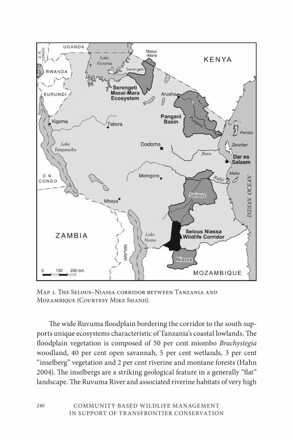
COMMUNITY-BASED WILDLIFE MANAGEMENT
IN SUPPORT OF TR ANSFRONTIER CONSERVATION
240
The wide Ruvuma floodplain bordering the corridor to the south sup-ports unique ecosystems characteristic of Tanzania’s coastal lowlands. The floodplain vegetation is composed of 50 per cent miombo Brachystegia woodland, 40 per cent open savannah, 5 per cent wetlands, 3 per cent “inselberg” vegetation and 2 per cent riverine and montane forests (Hahn 2004). The inselbergs are a striking geological feature in a generally “flat” landscape. The Ruvuma River and associated riverine habitats of very high
Map 1. The Selous–Niassa corridor between Tanzania and Mozambique (Courtesy Mike Shand).
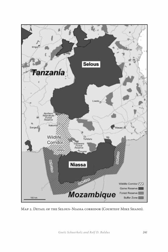
241Goetz Schuerholz and Rolf D. Baldus
Map 2. Detail of the Selous–Niassa corridor (Courtesy Mike Shand).
COMMUNITY-BASED WILDLIFE MANAGEMENT
IN SUPPORT OF TR ANSFRONTIER CONSERVATION
242
biodiversity value have been described as one of southern Africa’s least known and pristine major river systems (Norton 2005), known to support significant populations of large mammals, especially African elephants (Loxodonta africana).
The elephant population of the Selous–Niassa range, estimated to ex-ceed 65,000 animals, constitutes one of the largest elephant populations in Africa. Other significant populations of large mammal species include Roosevelt’s sable antelope (Hippotragus niger roosevelti) (17,000 individ-uals) and Nyasa wildebeest (Connochaetes taurinus johnstoni) (120,000 individuals) – both subspecies are endemic to the area. Lichtenstein’s hartebeest (Alcelaphus lichtensteinii), Cape buffalo (Syncerus caffer), gir-affe (Giraffa camelopardalis), zebra (Equus burchelli), eland (Taurotragus
oryx), greater kudu (Tragelaphus strepsiceros), common waterbuck (Kobus
ellipsiprymnus), bushbuck (Tragelaphus scriptus), impala (Aepyceros mel-
ampus), and common reedbuck (Redunca arundinum), as well as lion (Panthera leo), African wild dog (Lycaon pictus), leopard (Pandera par-
dus) and spotted hyaena (Crocuta crocuta) also exist within the area. Black rhinos (Diceros bicornis) are still found in both Selous and Niassa, but numbers are low, especially in Niassa (Hahn 2004). Genetic exchange be-tween the Niassa and Selous ecosystems is known to take place across the proposed ecological corridor.
The Niassa Game Reserve in Mozambique covers an area of approxi-mately 23,400 km2. It is surrounded by four hunting blocks (coutadas) on its western, southern, and eastern sides, which cover a further 19,000 km2. Together these areas protect more than 42,000 km2 of habitat.
The Selous–Niassa ecological corridor covers 6,000 km2 of sparsely settled miombo woodlands. The northern section of the corridor extends from the Selous Game Reserve southwards to the Songea-Tunduru Trunk Road. This section is protected through the “North East Undendeule Forest Reserve” and the new, village-based provisional Wildlife Management Areas Songea and Tunduru. The southern corridor section (4,000 km2) falls within the Namtumbo and Tunduru Districts of the Ruvuma region extending southwards for about 70 kilometres from the Songea-Tunduru Trunk Road to the Ruvuma River.
243Goetz Schuerholz and Rolf D. Baldus
The northern corridor section has been subject to a conservation pro-ject implemented jointly by the Tanzanian Wildlife Department and the Selous Conservation Program under the Tanzanian CBNRM concept, an effort currently extended to the southern corridor section. Formalizing and conserving the currently unprotected southern corridor section will allow permanent biological linkage between the two protected area sys-tems in Tanzania and Mozambique. It is a priority issue for a number of reasons: (1) the importance of the corridor ecosystem for sustainable bio-diversity conservation; (2) its importance in linking two major protected areas enabling both animal movements and gene flow between wildlife populations of global importance; (3) the improvement of local liveli-hoods by demonstrating wildlife as a viable form of land-use; and (4) the contribution the corridor is expected to make to developing a national network of community managed WMAs (UNDP 2003).
Complementary grants from the Global Environment Facility (GEF) and the German Government (KfW) have been secured to extend the net-work of WMAs across the southern part of the corridor to the Ruvuma River. Rapid rural assessment involving half of the thirty-three villages located within the corridor showed an exceptionally high level of support for the creation of the proposed WMAs in the southern corridor section (Schuerholz and Bossen 2005).
The economy of the corridor communities is based on subsistence agriculture (95%). Staple crops grown are maize and cassava, with cash crops predominantly of tobacco, sesame, sunflower, rice, groundnuts, beans, and occasionally red pepper. Livestock is mostly restricted to goats, sheep, and chicken. Cattle are rare due to the presence of tsetse in the region (Schuerholz and Bossen 2005).
Dependency on natural resources by corridor dwellers is rated as “very high.” Natural products collected regularly include poles for house construction, grass for thatching, reeds, firewood, wild fruits, mush-rooms, traditional medicines, and (legally or illegally) fish and bush meat. Firewood is the main source of domestic energy for cooking for over 96 per cent of all households in the two districts with no affordable energy alternatives in the foreseeable future.
COMMUNITY-BASED WILDLIFE MANAGEMENT
IN SUPPORT OF TR ANSFRONTIER CONSERVATION
244
Uncontrolled resource use and unplanned and unregulated conver-sion of land for agricultural and ribbon strip development are the main threats to the biodiversity within the Selous–Niassa Corridor (UNDP 2003, 11), exacerbated by the high human population growth rate in the corridor area of 4.3 per cent. Unless efforts are made to ensure the in-tegrity of the corridor, this development could convert much of the still biologically intact corridor to cultivation, losing a unique opportunity to link the two largest conservation areas of Tanzania and Mozambique.
The Kavango–Upper Zambezi Transfrontier Conservation
Area (Namibia, Botswana, Angola, Zambia, and Zimbabwe)
The proposed Kavango–Zambezi Transfrontier Conservation Area (KAZATFCA) concept evolved from the earlier Okavango Upper Zambezi International Tourism Initiative (OUZIT) that was launched by Angola, Botswana, Namibia, Zambia, and Zimbabwe with support of the Southern African Development Community (SADC) and the Development Bank of Southern Africa (DBSA) in 1993. The development process of OUZIT and its current status has been described in detail by Kohler et al. (2004) and Hanks (2006).
The former tourism-based OUZIT initiative that appears to have failed because of its poorly defined scope and lack of ownership has been redefined by the ministers responsible for tourism, wildlife and pro-tected areas of the five partner countries and converted into the current KAZATFCA Program in 2003. The newly defined focus of the KAZATFCA is conservation as the primary form of land use, with tourism as a valuable by-product. The overall goal of the KAZATFCA is an integrated land-use concept that will strengthen the regional economy and rural livelihoods, provide for sustainable transboundary biodiversity conservation, and pro-mote good neighbourly relationships between the five participating na-tions (Schuerholz 2006).
The partner countries have confirmed the establishment of the KAZATFCA by signing a formal memorandum of agreement in 2006. The final boundaries of the TFCA still have to be defined.
The proposed TFCA covers approximately 300,000 km2 of very com-plex ecosystems ranging from some of southern Africa’s most significant
245Goetz Schuerholz and Rolf D. Baldus
wetlands to extensive and contiguous miombo and mopane woodlands described in detail by Hanks (2006) and UNEP (2005). The KAZATFCA encompasses the greater part of the Okavango River Basin, an integral part of an extended ecoregion connected to the Upper Zambezi River Basin shared by Angola, Namibia, and Botswana. Hanks (2006) consid-ers eight main areas within the TFCA of particular conservation inter-est: (i) Okavango Swamps; (ii) Kavango/Okavango river fringes; (iii) Makgadikgadi Pans and Nata River Delta; (iv) Zambezi riparian woodland (below Senanga); (v) Zambezi riparian woodland (between Kazungula and Victoria Falls); (vi) Victoria Falls and Batoka Gorge; (vii) Kazuma Pan; and (viii) Southern Hwange dunes and Nata mudflats.
The KAZATFCA supports the largest contiguous population of African elephants Loxodonta africana, mostly concentrated in the Okavango Delta of Botswana. More than 120,000 elephants were recorded in aerial surveys (2005–2006) from this region and over 50,000 elephants in northwestern Zimbabwe and 16,000 in northeastern Namibia (Chase 2006). Chase (2006) estimates an annual 5 per cent growth rate of the Botswana elephant population.
Research supported by Conservation International (CI) and the Wildlife Department of Botswana has confirmed elephant movements between Botswana and Angola and Botswana and Zambia via “corridors” across the Caprivi Strip in Namibia. Growing elephant populations and increasing elephant traffic across the densely settled Caprivi Strip have resulted in a noticeable increase of human–elephant conflicts with sig-nificant adverse impacts on the predominantly rural communities of this area – communities that depend on subsistence agriculture. Crop dam-age by marauding elephants and other wildlife originating particularly from Botswana’s Chobe National Park have become a permanent threat to the livelihood of frontline farmers in the Caprivi. On the other hand, elephants are recognized as a critical source of income from consumptive and non-consumptive uses with direct financial benefits to conservancies in Namibia and wildlife trust communities in Botswana.
In view of the current and future challenges posed by increasing elephant populations in the region and growing elephant movements across the Caprivi, Namibia has elaborated an elephant management plan
COMMUNITY-BASED WILDLIFE MANAGEMENT
IN SUPPORT OF TR ANSFRONTIER CONSERVATION
246
that addresses both the challenges and opportunities. The plan signals Namibia’s willingness to cooperate with the four neighbouring coun-tries and the world community at large in developing joint policies that permit a stabilization of ecologically viable elephant populations in the KAZATFCA. This is expected to be accomplished partly through the ac-celerated establishment of community-based wildlife management areas which will protect game species in return for harvest quotas of specified game species to be allocated to the participating communities. It is hoped that the revenues to be generated by the conservancies and equivalent models in the neighbouring countries through trophy-hunting, together with development assistance expected from the international donor com-munity in support of the conservation efforts, will counter-balance the current and increasing adverse impacts of wildlife on rural communities. It is evident that, without full cooperation of the local communities liv-ing in the Caprivi centring on a “win-win” approach to wildlife manage-ment, the ambitious goals of the KAZATFCA cannot be achieved (Hanks 2006). If successful, the KAZATFCA would link some of Africa’s most well-known and most popular national parks and provide protection to large parts of the TFCA that are still unaltered.
Land conversion for agriculture and uncontrolled settlements – most visible in the northern part of the TFCA where forests and woodlands have turned into shrublands or wooded grasslands – is recognized as a serious threat to the region’s ecological integrity. These problems are compounded by excessive elephant browsing, over-grazing by domestic livestock, falling water tables in wetlands, increasing droughts, and systematic fire suppression.
The elephant work in the KAZATFCA substantiates the need for harmonized management and policy guidelines of the five partner countries and the need to officially designate transfrontier ecological corridors that permit free movements of wildlife between established conservation areas. The Caprivi Strip of Namibia, located strategically in the heart of the TFCA bordering all four other TFCA member states, will play a pivotal role in the future development of the KAZATFCA.
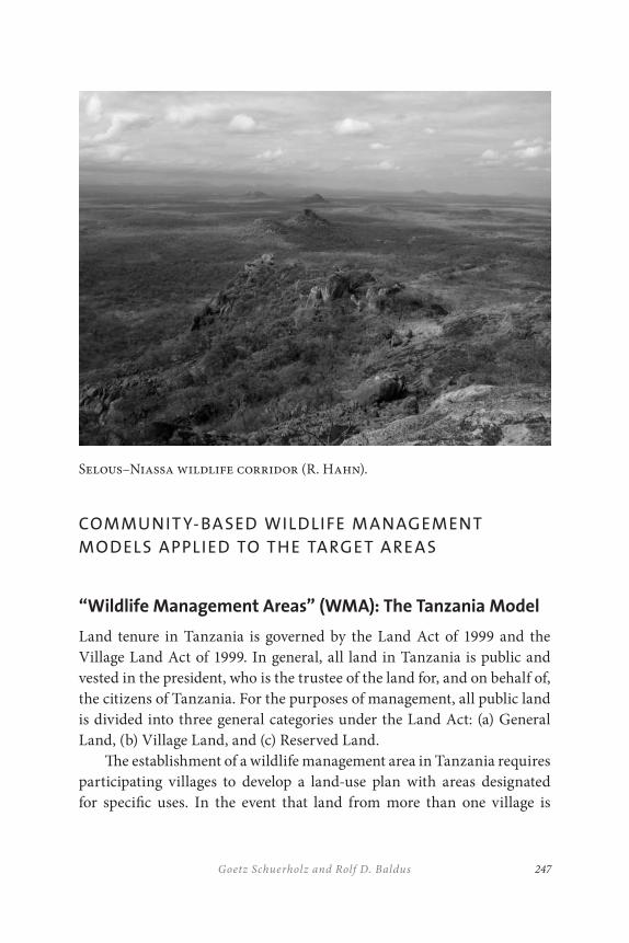
247Goetz Schuerholz and Rolf D. Baldus
Selous–Niassa wildlife corridor (R. Hahn).
COMMUNIT Y-BASED WILDLIFE M ANAGEMENT
MODELS APPLIED TO THE TARGET AREAS
“Wildlife Management Areas” (WMA): The Tanzania Model
Land tenure in Tanzania is governed by the Land Act of 1999 and the Village Land Act of 1999. In general, all land in Tanzania is public and vested in the president, who is the trustee of the land for, and on behalf of, the citizens of Tanzania. For the purposes of management, all public land is divided into three general categories under the Land Act: (a) General Land, (b) Village Land, and (c) Reserved Land.
The establishment of a wildlife management area in Tanzania requires participating villages to develop a land-use plan with areas designated for specific uses. In the event that land from more than one village is
COMMUNITY-BASED WILDLIFE MANAGEMENT
IN SUPPORT OF TR ANSFRONTIER CONSERVATION
248
covered by a single WMA, a joint village land-use plan (LUP) is developed. Demarcation of individual village boundaries as part of the land-use plan-ning process is required under the Tanzanian Village Land Policy. The actual land-use planning process is conducted by the village assemblies of the corresponding villages with assistance from a multi-sectoral team from the district offices. The village then forms a community-based or-ganization (CBO), officially registers it, and submits an application for “Authorised Association Status” to the Director of the National Wildlife Division.
The entire land-use planning process is estimated to take about six weeks per village, provided timely processing by the Wildlife Department. Currently topographic maps of a 1:50,000 scale are used as a basis for map-ping the LUP. In the actual land-planning process, villagers designate and quantify areas for the categories: (a) wildlife management (conservation); (b) village forest; (c) agriculture and livestock grazing; (d) residential; (e) reforestation; (f) and/or any other area-category the concerned village wishes to designate. Land-use plans typically cover a period of up to fifteen years. Land-use allocations give due consideration to village expansion.
Once a CBO has been granted the status of “Authorised Association (AA),” it is allocated user rights to wildlife occurring within the WMA. The user rights can include a quota for “bush meat” (community consump-tion), trophy-hunting, non-consumptive tourism, and live animal capture to be re-sold for stocking purposes. Conditional resource utilization re-quiring licences from the responsible authorities include forest products, honey collection from wild bees, and fish resources. Activities not permit-ted are mining, wildlife cropping and wildlife farming/ranching.
An AA may also enter into investment agreements or joint ventures with the private sector concerning natural resources within the WMA. The AA is accountable to the village council. It is responsible for the day-to-day management of the WMA.
Numerous institutions and organizations are involved in the estab-lishment and management of WMAs. The most important institutions for day-to-day management are the AA, the wildlife division via the respect-ive district game officer and the district natural resource advisory body.
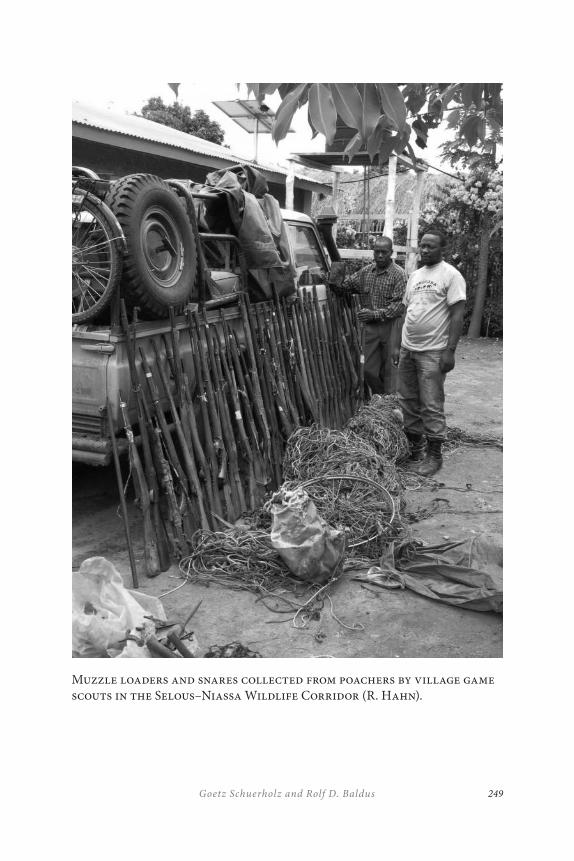
249Goetz Schuerholz and Rolf D. Baldus
Muzzle loaders and snares collected from poachers by village game scouts in the Selous–Niassa Wildlife Corridor (R. Hahn).

COMMUNITY-BASED WILDLIFE MANAGEMENT
IN SUPPORT OF TR ANSFRONTIER CONSERVATION
250
Once established and gazetted, a WMA is managed jointly by the vil-lage government and the WMA resource committee who also appoint vil-lage game scouts responsible for law enforcement, fire management, the hunting of game allocated as “village quota,” and the control of trophy-hunting, and tourism. The game meat is sold by the scouts to villagers at market value. The so-called “bush meat,” legally not accessible to rural communities outside of WMAs, is a highly valued commodity. The rev-enues generated from the sale of bush meat and trophy-hunting are used to cover the expenses of community scouts and the WMA resource com-mittee. Existing and future WMAs in the corridor are represented in the corresponding district natural resources committees. The land-use plan in support of a WMA provides village councils with a powerful tool in com-bating illegal land occupation by squatters and prevents wildlife habitat fragmentation as a result of squatting and land conversion for agriculture.
“Conservancies”: The Namibia Model
Similar to the Tanzania WMA model, the Namibia CBNRM approach is based on wildlife and tourism, common to most other CBNRM models developed and applied in Africa. Central to both CBNRM approaches is how to effectively and sustainably manage common property resources including wildlife and forests for the benefit of the people who derive their livelihood from such areas.
In Namibia, a precedent was set by new legislation in 1968, provid-ing private landowners the right to commercially farm and use common property wildlife resources. A 1975 amendment to this law gave private landowners the exclusive right to retain all the proceeds from the sale of trophy-hunting and live game specimens. Realizing that sustainable wild-life management can only be achieved through viable game populations in need of sufficiently large and contiguous habitat, freehold farmers in Namibia started to form “conservancies.” The conservancies are man-aged by a committee in accordance with the conservancy constitution that regulates common interests in wildlife resources. The conservancy committee is composed of democratically elected conservancy members, a powerful lobby of common interests on deeded lands.
251Goetz Schuerholz and Rolf D. Baldus
Encouraged by Namibia’s legal framework and policies applied to conservancies on freehold land, IRDNC successfully pioneered the idea to transfer this model to people living on state-owned land. This in-volves transfer of proprietorship over wildlife as a common resource to a group of people living on public land with interest in communal resource management.
Key partners of IRDNC are local traditional leaders and community members concerned about declining wildlife populations resulting from poaching and habitat destruction. Since its early involvement, the IRDNC assisted local communities in training and deploying community game scouts and linking communities with the tourism sector in order to gener-ate revenues as an incentive for local wildlife conservation.
The conservancy approach involving rural communities on public land gained momentum when the “Namibia Association of Community based natural resource management Support Organizations” (NACSO) was established in 1996. NACSO is an association of twelve autonomous CBNRM service organizations providing quality services to communal area communities with interest in managing and utilizing their natural resources in an equitable and sustainable manner. NACSO is based on the rationale of forming synergies by pooling a wide range of expertise for the benefit of the country’s rural poor with interest in communal land and resource management.
The combined initiatives of NGOs and rural communities, supported by the private sector and fully endorsed by a highly committed Ministry of Environment and Tourism (MET), led to the development of power-ful CBNRM policies and legislation. In 1995 the Cabinet of Namibia ap-proved the new policy for communal area conservancies, put into law by the parliament in 1996. The policy entitles communal area residents to form conservancies with conditional rights to wildlife and tourism, and the right to retain the revenues generated in the process.
Growing international interest in the successful conservation efforts by Namibian NGOs at a grassroots level on public lands has resulted in substantial donor funding in support of CBNRM and conservancies in particular. The 1993 launch of the community conservancy model known as “Living in a Finite Environment (LIFE) Programme” has brought major
COMMUNITY-BASED WILDLIFE MANAGEMENT
IN SUPPORT OF TR ANSFRONTIER CONSERVATION
252
donor funding by the United States Agency for International Development (USAID) and the World Wide Fund for Nature (WWF) to the country. But it was not until 1997 that the first communal area conservancy was gazetted.
The process of forming a communally owned and operated conserv-ancy on public land involves the following steps: The community (a) de-fines its membership and geographical boundaries; (b) elects a committee from its members; (c) decides on a plan for the equitable distribution of benefits; and (d) adopts a legally recognized constitution.
Once a conservancy has been gazetted, the Nature Conservation Amendment Act (Act 5 of 1996) gives the conservancy committee, on behalf of its constituents, “rights and duties” related to the consumptive and non-consumptive use and sustainable management of identified game species for their economic benefit in return for proven conservation ef-forts. The act provides the conservancy committee the same rights, priv-ileges, duties, and obligations that the Nature Conservation Ordinance confers on a commercial farmer (Jones 1999).
A public interest legal firm assists the fledgling conservancy in de-veloping the conservancy constitution and negotiating contracts with the private sector regarding tourism initiatives and the use of hunting quotas. Further assistance is provided by the “Wildlife Council,” a regional gov-ernment institution under the umbrella of the Ministry of Environment and Tourism, in the process of developing a candidate conservancy.
The policies and legal framework related to conservancies in Namibia have triggered a nation-wide conservation and development movement that now covers an area of 71,000 km2 of registered conservancy land with a combined total of 95,000 conservancy constituents. Within the Eastern Caprivi, five conservancies with a membership of 7,500 persons have been registered to date, covering an area of approximately 1,760 km2. Eight other conservancies have applied for registration and numerous other communities are actively pursuing conservancy status.
It is widely recognized that Namibia’s conservancy movement has significantly changed the attitude of communal area residents who have begun integrating wildlife and tourism enterprises into their live-lihood strategies. As a consequence, land-use patterns across Namibia’s
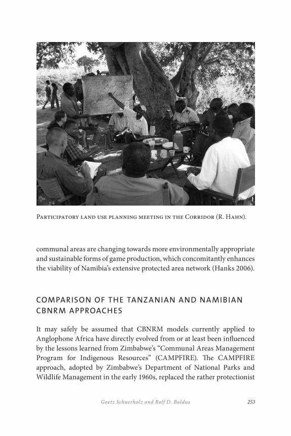
253Goetz Schuerholz and Rolf D. Baldus
communal areas are changing towards more environmentally appropriate and sustainable forms of game production, which concomitantly enhances the viability of Namibia’s extensive protected area network (Hanks 2006).
COMPARISON OF THE TANZ ANIAN AND NA MIBIAN
CBNRM APPROACHES
It may safely be assumed that CBNRM models currently applied to Anglophone Africa have directly evolved from or at least been influenced by the lessons learned from Zimbabwe’s “Communal Areas Management Program for Indigenous Resources” (CAMPFIRE). The CAMPFIRE approach, adopted by Zimbabwe’s Department of National Parks and Wildlife Management in the early 1960s, replaced the rather protectionist
Participatory land use planning meeting in the Corridor (R. Hahn).
COMMUNITY-BASED WILDLIFE MANAGEMENT
IN SUPPORT OF TR ANSFRONTIER CONSERVATION
254
colonial style wildlife and nature conservation policies that had domi-nated Anglophone Africa for the past century. This new approach to con-servation management focussed on the step-by-step integration of com-munities living in support zones of protected areas. It was based on the rationale that community empowerment, which manifested itself through providing communities with legal rights to the sustainable use of wildlife on communal lands, would gradually lead to community “ownership” in conservation management. Jones (1999) argues that rural communities receiving income related to the sustainable use and management of wild-life under CAMPFIRE will actively engage in wildlife and habitat conser-vation as long as the perceived benefits exceed the costs associated with being part of the CAMPFIRE program. This will be true for all offshoots of the CAMPFIRE model developed to date. The major shortcoming of CAMPFIRE was that revenues generated from wildlife were channelled through government institutions prone to corruption. This also limited the participating communities’ decision-making powers, contributing to the growing alienation of communities from the system.
The basic principles of the CAMPFIRE approach are also common to both CBNRM models investigated by this paper. Revenues generated within the targeted models, however, are collected directly by the com-munities with shares to be provided to government agencies. Community empowerment is central to the Selous–Niassa ecological corridor con-necting prime conservation areas of Mozambique and Tanzania. It is also central to the two proposed ecological corridors transecting Namibia’s Caprivi Strip connecting key conservation areas of Botswana, Namibia, Angola, and Zambia. In both cases, communities are given access to wild-life and other resources in lieu of wildlife and wildlife habitat conserva-tion commitments.
Both models, the WMA of Tanzania and the conservancy of Namibia (generically called “CBNRM models”), result in tangible and indirect community benefits. Benefits common to both CBNRM models are:
• designated and gazetted CBNRM areas and officially recognized boundaries of communal lands;
255Goetz Schuerholz and Rolf D. Baldus
• ultimate allocation of wildlife quotas for communal and commercial use under own management;
• rights to retain a portion of revenues generated from common property resources;
• controlled CBNRM membership rights to sustainable use of forest resources and minor products;
• community rights to capitalize on nature-based tourism opportunities and to issue tourism-related land leases;
• strengthened community identity and community cohesiveness;
• mobilization of community members;
• democratization of communal decision-making processes;
• a participatory approach to CBNRM;
• cooperation between traditional leaders and CBNRM administrative structures;
• accountability and transparency of CBNRM structures (good governance);
• communal institution building and capacity development;
• creation of employment opportunities;
• training of community scouts for law and community policy enforcement;
• CBNRM membership engagement in voluntary conservation activities;
• skill development and leadership training;
• forging of partnerships between communities and institutions;
• creation of joint venture opportunities between communities and private sector;
• attraction of assistance from NGOs and international donor community; and
COMMUNITY-BASED WILDLIFE MANAGEMENT
IN SUPPORT OF TR ANSFRONTIER CONSERVATION
256
• leadership to integrated spatial land-use planning as part of a regional planning approach.
It is evident that the direct benefits and spin-offs of the two CBNRM mod-els compared by this study exceed the original scope of CAMPFIRE, indi-cating the steep learning curve in CBNRM since its early origin. Some of the more visible differences between the two approaches are highlighted as follows.
In contrast to the policy framework of Namibia’s conservancy model, the Tanzanian policy and legal framework associated with WMAs:
• provides legal tenure to communal lands registered under a WMA;
• requires that community boundaries within a WMA have to be fine-tuned, agreed upon with neighbouring communities, and free of disputes and conflicts prior to application for WMA status;
• requires the elaboration of a spatial land-use plan with designated categories defined by the WMA policies;
• requires the designation of a wildlife conservation area to be contiguous with wildlife conservation areas of joining WMAs and/or designated protected areas respectively (of critical importance to WMAs created in support of ecological corridors); and
• requires joint management boards of communities deciding to jointly form a WMA.
It is suggested that the greater security of village land as a spin-off of the Tanzanian WMA model may well be of even greater importance to a village than the potential economic benefits derived from an allocated wildlife quota. This particular aspect plays an important role in the de-velopment process of the two proposed WMAs located in the southern
257Goetz Schuerholz and Rolf D. Baldus
section of the Selous–Niassa ecological corridor. It may also be a further explanation of the surprising enthusiasm and positive response to the cre-ation of the WMAs by villagers of the corridor surveyed in this context by Schuerholz and Bossen (2005). Village councils appeared to be fully cog-nizant of the powerful tool provided to them in defence against the alarm-ing and ever-growing number of squatters migrating from the drought-ridden northwestern part of Tanzania to the more fertile southwestern part of the country in search of arable land. Recognition of WMAs on village land and a well-structured spatial land-use plan will allow village governments to more effectively control and manage settlements and land and resource use.
In comparison, the Namibian legal framework related to conservan-cies does not affect land tenure. It rather empowers conservancies to “ad-minister” natural resources on communal lands and to allocate leases for tourism-related infrastructure. Although the Namibian model requires the production of a “management plan” as part of the conservancy regis-tration process, no spatial land-use plan with areas exclusively designated to wildlife conservation is required as mandatory for a Tanzanian WMA. Schuerholz (2006) suggests that the lack of spatial land-use plans and the absence of designated wildlife areas in particular may be of serious future consequence to frontline conservancies of the Caprivi Strip located in the proposed wildlife corridors. The author argues that in the absence of inter-linked conservation areas, which are free of human settlements and which permit free movements of megafauna, growing wildlife–human conflicts encountered by the thirteen registered and proposed frontline conservan-cies of the Caprivi Strip eventually may outweigh the economic incen-tives provided through wildlife allocations. This will be exacerbated if the income generated by a conservancy through safari-hunting and tourism will not reach the household level of the conservancy’s constituents and if wildlife damage to crops and livestock is not sufficiently compensated.
At present, most of Namibia’s conservancies permit livestock-graz-ing throughout a conservancy. In the absence of spatial land-use plans, subsistence farmers and their fields are widely scattered, exacerbating wildlife–human conflicts. Salambala, at present, appears to be the only
COMMUNITY-BASED WILDLIFE MANAGEMENT
IN SUPPORT OF TR ANSFRONTIER CONSERVATION
258
frontline conservancy in the Eastern Caprivi Strip having set aside land for wildlife habitat conservation.
In comparison, livestock-grazing within a Tanzanian WMA is con-fined to specially designated livestock-grazing areas. Designated conserv-ation areas are kept free of livestock and any other land use, thus reducing the risk of livestock predation while at the same time providing high qual-ity wildlife habitat without human disturbance.
In the absence of designated and clearly defined viable conservation areas within the frontline conservancies of Namibia, the direct contribu-tions of the conservancies to biodiversity conservation appears compara-tively low. Actual benefits are more aligned with community empower-ment than biodiversity conservation.
Schuerholz (2006) argues that the widely praised economic benefits derived from wildlife and tourism-benefiting conservancies, WMAs and other CBNRM models are overrated. He observes that, although financial sustainability of Caprivi frontline conservancies may be achieved through revenues generated from trophy-hunting and community-based tour-ism, revenues rarely reach conservancy members. Most of the revenues generated are currently absorbed by the conservancy’s administrative structures, leaving little for disbursement amongst members. The auth-ors conclude that Caprivi conservancies could significantly be improved through better budget transparency, greater accountability, and improved communication between conservancy administrators and conservancy members.
A serious constraint related to WMAs in Tanzania is that the Wildlife Department, as the institution responsible for allocating wildlife quotas (trophy-hunting) to gazetted WMAs, rarely complies with its legal obliga-tion. Frequently, quotas are directly supplied to commercial safari oper-ators for areas located within WMAs, thus circumventing WMA councils and depriving WMAs of their legal rights to generate much needed rev-enue, the key incentive to participate in conservation efforts (Schuerholz and Bossen 2005). As a result WMAs are unable to generate sufficient revenue for covering operational costs and no funds are available for dis-bursement amongst WMA constituents.

259Goetz Schuerholz and Rolf D. Baldus
The Tanzanian Wildlife Administration initiated its own version of CBNRM in the late 1980s, convinced that this would benefit game man-agement and biodiversity conservation alike. This replaced the country’s traditional “fines and fences” approach to wildlife management and the “fortress conservation” philosophy prevalent throughout Anglophone Africa during the last century. When confronted however with actually empowering communities by giving them their rights in accordance with the official Wildlife Policy of Tanzania (1998), the Wildlife Administration proved to be reluctant to relinquish its powers affiliated in the past with significant informal and illegal income from tourist hunting. Commercial hunting operators proved to be equally opposed to community empower-ment, being afraid of losing privileges traditionally provided to them by the Wildlife Department under highly favourable conditions (i.e., receiv-ing rights to hunting blocks for unusually long periods of time at fees below market value and hunting blocks awarded without public tender). To date, this continues to be the biggest challenge to the effective func-tioning of WMAs in Tanzania (Baldus 2006).
In their analysis of Tanzania’s current hunting system, Baldus and Cauldwell (2006) criticize the lack of transparency and accountability of the country’s Wildlife Department, resulting in substantial losses in rev-enue to the central government. The authors suggest that the revenues are going to a group of civil servants intimately cooperating with influential members of the hunting industry instead. The condition of “poor govern-ance” within certain sectors of Tanzania’s Ministry of Natural Resources and Tourism appears to be common knowledge in Tanzania and has be-come subject to public and parliamentarian debate. Resistance to reform appears to be the major reason why CBNRM so far has not had the success it deserves, in spite of efforts by cooperating communities and the inter-national donor community. It is apparent that unless the Government of Tanzania fully complies with its legal obligation to CBNRM, the ambi-tious goals of WMAs cannot be achieved.
The successful establishment of “transboundary fora” which promote transboundary cooperation between conservancies in the Eastern Caprivi that share common boundaries with neighbours from Botswana, Zambia, and Angola should receive special recognition in a

COMMUNITY-BASED WILDLIFE MANAGEMENT
IN SUPPORT OF TR ANSFRONTIER CONSERVATION
260
transfrontier conservation context. This applies in particular to the four emerging TransBoundary Fora of Imushi-Kwando (Namibia and Zambia), Salambale-Chobe Community Trust (Namibia and Botswana), Impalila/Kasika-Sekuti (Namibia and Zambia) and Tocadi-Kyaramacan (Namibia and Botswana). Common interest areas of the transboundary fora are: fire management, combating cattle theft, wildlife monitoring, problem ani-mals, anti-poaching, fishing, and information exchange. To achieve this, IRDNC and Conservation International, with financial assistance from international donors, facilitate transboundary exchange visits between neighbouring communities, implement workshops and seminars, pro-vide training, and assist in the preparation of memoranda of cooperation between neighbouring communities. Schuerholz (2006) suggests that the establishment of transboundary fora and transfrontier cooperation at the grassroots level is “key” to the success of the KAZATFCA, leading to a valuable mutual learning process and creating important synergies and friendship between neighbouring communities. This initiative is highly relevant and a high priority in the framework of any TFCA.
Transfrontier cooperation between Tanzania and Mozambique is cur-rently also being promoted in context with the Selous–Niassa Ecological Corridor Project co-financed by the German government and the Global Environment Facility.
CONCLUSIONS
It is suggested that the ambitious conservation goals of transfrontier con-servation areas and ecological corridors can only be achieved through participatory spatial land and resource use planning and management, securing the livelihood of the rural poor, generating tangible benefits, and fair equity sharing down to the household level. Local empower-ment and synchronized land and resource use policies by neighbouring countries sharing a designated conservation area will play a decisive role in this process. Lessons show that the CBNRM approach chosen for the Selous–Niassa ecological corridor linking the largest conservation areas of Tanzania and Mozambique and for the ecological corridors traversing the
261Goetz Schuerholz and Rolf D. Baldus
Caprivi Strip of Namibia in the heart of the KAZATFCA may well be the right strategy in support of reaching the highly ambitious transfrontier conservation goals.
Since Tanzania’s WMA and Namibia’s conservancy models both hinge on the conditional economic utilization of wildlife, the link between community income and wildlife conservation is emphasized. It is argued that without devolving management participation and economic benefits derived from CBNRM to the household level, members of neither model are likely to develop the much-desired ownership in CBNRM.
Community empowerment rather than direct economic benefits ap-pear of foremost importance to the WMA approach in Tanzania. On the other hand, the WMA approach will not fully achieve its conservation goals, as long as the Government of Tanzania does not honour its legal obligation in providing game quotas directly to the WMAs and the right of WMAs to fully retain revenues generated through the game harvest for communal benefits.
In comparison, the Government of Namibia is fully committed to its highly successful conservancy approach, willing to devolve management authority and the right to generate and retain the revenue generated from wildlife allocations to groups of people applying for conservancy status on communal land. Namibia has created an enabling legal and adminis-trative framework, actively promoting and supporting conservancies to become established.
The efforts of the Namibian government are complementary to the CBNRM programs of IRDNC and other NGOs assisting existing and emerging conservancies to function effectively while reaching social, eco-nomic, and environmental sustainability and to effectively manage and conserve their natural resources in partnership with government. The IRDNC program in particular has been instrumental in empowering communal frontline conservancies of the Eastern Caprivi, guiding them through the process of becoming self-sufficient. Furthermore, synergies are created through good cooperation with complementary NGO pro-grams supported by the international donor community, all operating at a grassroots level. Preliminary findings also show that strong conservancy structures open doors for new business opportunities and joint ventures.
COMMUNITY-BASED WILDLIFE MANAGEMENT
IN SUPPORT OF TR ANSFRONTIER CONSERVATION
262
It is suggested that the Namibian conservancy model would benefit from the participatory elaboration of spatial land-use plans with focus on designated conservation areas which are free of other uses. Spatial land-use planning and designated conservation areas as an important land-use category should become an integral part of the conservancy’s legal framework.
Mainstreaming conservation into all facets of conservancy life has to become a key objective. Without the appreciation of the full value of goods and services provided through ecosystem conservation, conserv-ancy members will continue to focus on anti-poaching measures and on how to solve wildlife-human conflicts. A holistic ecosystem approach to conservation is needed in order to realize full benefits for conservancy members and biodiversity alike.
REFERENCES
Baldus, R. D. 2006. “The crucial role of governance in ecosystem management – Results and conclusions of the Selous Conservation Programme.” In: TANAPA, ed. FZSociety and BMU. Managing Africa’s Natural Ecosystems. Report of the Information Sharing and Best Practices Workshop. Serengeti National Park.
Baldus, R. D,. and A. Cauldwell. 2004. “Tourist hunting and its role in development of wildlife management areas in Tanzania (incl. Selous Hunting Database).” Dar Es Salaam: GTZ.
Baldus, R., R. Hahn, D.G. Mpanduji, and L. Siege. 2003. “The Selous-Niassa Wildlife Corridor.” Tanzania Wildlife Discussion Paper No. 34. Dar es Salaam, Tanzania: Wildlife Division.
Chase. 2006. Personal communication.
Hahn, R. 2004. “Environmental baseline study for the Ruvuma Interface.” Pre-feasibility study report to GTZ. GTZ Archives Dar es Salaam, Tanzania.
Hanks, J. 2006. “Prefeasibility Study of the proposed Kavango-Zambezi Transfrontier Conservation Area.” Unpublished Report, Archives Peace Parks Foundation, Stellenbosch, South Africa.
Jones, B.T.B. 1999. Community Management of Natural Resources in Namibia. London: IIED Bookshop.
263Goetz Schuerholz and Rolf D. Baldus
Kohler, W., D. Nill, and J. Perkins. 2004. Analysis of the State of Implementation of the Expanded OUZIT Programme. Gabarone, Botswana: SDAC Secretariat.
Murphy, C., H. Suich, S. Slater-Jones, and R. Diggle. 2004. “Big can be beautiful – Ensuring regional transboundary conservation supports local community resource management in the proposed Okavango/Upper Zambezi TFCA, southern Africa.” Paper presented at the 2004 International Association of the Study of Common Property conference, Mexico, August 9–13, 2004.
Norton, P. 2005. “Niassa Game Reserve Rovuma River Interface Tourism Destination: Assessment Mtwara Development Corridor.” Report to the National Development Corporation, Dar es Salaam, Tanzania.
Schuerholz, G. 2006. “SDC supported KAZATFCA Project Mid-Term Evaluation.” Report submitted to the Swiss Agency for Development and Cooperation. Bern, Switzerland.
Schuerholz, G., and B. Bossen. 2005. “Feasibility assessment of financial support to the establishment of the Selous-Niassa Ecological Corridor.” Report submitted to the Kreditanstalt für Wiederaufbau (KfW) Frankfurt, Germany.
UNDP. 2003. “The development and management of the Selous-Niassa Wildlife Corridor in Tanzania.” Medium-sized Project Brief submitted to GEF.

265
Fast-Track Strengthening of the Management Capacity of Conservation Institutions: The Case of the Effect of the Great Limpopo Transfrontier Park in Mozambique’s Capacity
Bartolomeu Soto
INTRODUCTION
The Great Limpopo Transfrontier Park (GLTP) was established in December 2002, when the Head of the States of Mozambique, South Africa, and Zimbabwe signed a treaty in Xai-Xai city in Mozambique. The treaty that establishes the Great Limpopo Transfrontier Park has the fol-lowing objectives:
10
FAST-TR ACK STR ENGTHENING OF THE MANAGEMENT
CAPACITY OF CONSERVATION INSTITUTIONS
266
(i) foster transnational collaboration and co-operation among the parties which will facilitate effective ecosystem management in the area;
(ii) promote alliances in the management of biological natural resources by encouraging social, economic, and other partnerships among parties, including private sector, local communities, and non-governmental organizations;
(iii) enhance ecosystem integrity and natural ecological process by harmonizing environmental management procedures across international boundaries and striving to remove artificial barriers impeding the natural movement of wildlife;
(iv) facilitate the establishment and maintenance of a sustainable sub-regional economic base through appropriate development frameworks, strategies, and work plans;
(v) develop transborder ecotourism as a means of fostering regional socio-economic development; and
(vi) establish a mechanism to facilitate the exchange of technical, scientific, and legal information for the joint management of the ecosystem.
Mozambique’s system of protected areas was in a bad state as the country has just faced a long period of war (1976–92) that affected the country’s wealth, destroyed the infrastructure in protected areas, and disturbed the development of human resources in conservation. According to the World Bank (1996), Mozambique was one of the poorest countries in the world, with a per capita income of US$80 in 1995.
Government priorities were directed to support emergency programs, the people who were affected by the war, and poverty reduction. However the political commitment of government was demonstrated by the fact that it pursued the funds from Global Environment Facility (GEF) and
267Bartolomeu Soto
after accessing it, the government had taken the step to lead the process of establishing transfrontier conservation areas with its neighbours in 1997. These efforts resulted in the establishment of three transfrontier conservation areas five years later, namely the Lubombo TFCA, involv-ing Mozambique, Swaziland, and South Africa, established in 1999, the Chimanimani TFCA involving Mozambique and Zimbabwe, established in 2001, and the Great Limpopo Transfrontier Park, established in 2002, involving Mozambique, South Africa, and Zimbabwe.
One of the greatest benefits of TFCA formation is the increase in cap-acity among respective national partner institutions to manage resources. Capacity-building in less-developed partner nations is also an area where donor organizations need to focus to create a long-term option for sus-tainable management (Metcalf 1999).
South Africa and Zimbabwe were regarded as the most advanced countries in southern Africa in terms of parks and wildlife management. Kruger National Park is one of the largest parks of the region with a highly capable technical team in the field, operating with sufficient means. The Gonarezhou Park in Zimbabwe has less capacity and fewer resources than Kruger, but Zimbabwe had a highly successful community-based natural resource management (CBNRM): the Communal Areas Management Program for Indigenous Resources (CAMPFIRE).
Local non-governmental organizations and the private sector were very active in the conservation practices within both South Africa and Zimbabwe. In Mozambique, however, the majority of non-governmental organizations were international and devoted to emergency actions and less to conservation and development. In addition, the Mozambican private sector was still relatively new to, and did not have experience in, conservation-based business.
Mozambique has defined two fundamental considerations for en-tering the GLTP: (i) the need for rural communities to benefit from new economic activities associated with natural resource utilization; and (ii) the need for these resources to be managed on a sustainable basis so as to safeguard biodiversity and maintain options for the future (DNFFB 2001). To achieve the needs mentioned, the Mozambican government faced the challenge of providing the required capacity for all role players, namely

FAST-TR ACK STR ENGTHENING OF THE MANAGEMENT
CAPACITY OF CONSERVATION INSTITUTIONS
268
government institutions at all levels (which are the leaders of the initia-tive), the private sector, non-governmental organizations, and local com-munities. An important challenge for government was to build consensus and common goals with stakeholders in the GLTP through effective inter-institutional coordination.
Although capacity-building for conservation and sustainable de-velopment is a complex endeavour, TFCA initiatives can act as catalysts for developing countries to increase expertise and the implementation of best practices. Working across borders can help to share resources more equitably across a region. Less-developed countries can benefit from the financial resources and capacity of more-developed countries, while all parties share the benefits of transboundary connections.
This paper aims to discuss the effect of the decision taken by the Government of Mozambique to engage in transfrontier conservation area projects. There were significant challenges associated with this decision because Mozambique did not have a fully functional national system of protected areas and was suffering from a lack of financial resources, professional capacity, institutional frameworks necessary to implement TCFAs, and the necessary partnerships with the private sector.
MOZ A MBIQUE’S INSTITUTIONAL CONTEX T FOR
CONSERVATION AREAS
Protected areas and wildlife were under the Ministry of Agriculture and Rural Development (MADER), specifically within the National Directorate for Forestry and Wildlife (DNFFB), until 2001. Prior to the independence of Mozambique (1975) from the Portuguese, parks and wildlife were man-aged by Veterinary Services.
The Department of Wildlife within the DNFFB was responsible for execution of the TFCA project. It was this department that led the prep-aration of the TFCA project, and it was within the department that the TFCA Project Unit functioned for the implementation of the project, which started in 1997. The Department of Wildlife of the DNFFB had an insufficient budget for protected areas. In addition, about 95 per cent of
269Bartolomeu Soto
the budget was committed to paying salaries. There were few qualified and experienced staff at all levels (senior management, middle level, and game scouts) and their numbers were reduced. However, DNFFB had a number of expatriates working for a donor-funded project, mainly implemented by the FAO, on a forest plantation of exotic trees and forest management. However, none of them had skills in wildlife and parks management. In addition, the donors were not supporting any activity of the Department of Wildlife.
The Department of Wildlife faced serious communication problems between headquarters and the provincial offices, which were all under equipped. The lack of manpower and capacity at all levels of government (district, provincial, and central) was considered as the most serious con-straint to the implementation of the TFCA concept, which was recognized as demanding an appropriate integrated land-use plan and practices to realize its success (DNFFB 2001.
The Ministry of Tourism was established for the first time in Mozambique in 2000. In the past, tourism was under other institutions such as the Secretary of State of Tourism and then the Ministry of Trade and Industry. In 2001, the government determined the transfer of con-servation areas from the Ministry of Agriculture and Rural Development to the Ministry of Tourism (MITUR). The areas transferred were: (i) na-tional parks and game reserves, (ii) controlled hunting areas (iii) projects for exploitation and development of ecotourism, and (iv) ecotourism community programs. The transferred areas were put under the National Directorate of Conservation Areas (DNAC). The transference of conserva-tion areas from MADER to MITUR caused a lack of clarity regarding the roles of each ministry. While national parks and game reserves and con-trolled hunting areas are declared by law and are well-defined areas, the projects for exploitation and development of ecotourism and the ecotour-ism community program areas were not defined in any of the existing regulatory frameworks of the country. This was caused due to technical level disputes of what would be transferred from one ministry to another following the government determination. It resulted in drafting a list of services to be transferred in an attempt to keep part of the services of the Department of Wildlife of the DNFFB within the Ministry of Agriculture.
FAST-TR ACK STR ENGTHENING OF THE MANAGEMENT
CAPACITY OF CONSERVATION INSTITUTIONS
270
This fact imposed challenges in management of protected areas and wildlife as the remaining ambiguity over the responsibility of the two ministries with regard to wildlife causes conflicts despite the fact that subsequently the Government of Mozambique passed a regulation of forest and wildlife (2002). This regulation attempted to specify the roles of the MADER and MITUR in administration of wildlife-related activ-ities, stating that the wildlife that is outside protected areas is under the management of MADER and within protected areas it is under MITUR. Similarly, it was clarified that the TFCA project would be implemented by the Ministry of Tourism. However, this project is implemented in areas between the protected areas.
The establishment of the Ministry of Tourism by the Government of Mozambique in 2000 was done with the intent of unlocking the tourism business in the country, recognizing that the country’s natural resources were the main tourism attraction. The intention was to establish strong links between wildlife and protected areas with tourism of coastal areas. This institutional arrangement has played a key role in strengthening the position of the TFCA within government agencies. The project was sup-porting biodiversity conservation inside and outside protected areas and providing direct linkages to developing socioeconomic benefits through tourism.
The TFCA project was under the National Directorate of Conservation Areas in the Ministry of Tourism until 2002. Subsequently the Ministry of Tourism decided to create a TFCA Unit that was directly under the Minister of Tourism. The TFCA Unit was created due to the fact that the main activity of the project was interaction with the neighbouring coun-tries and there was an increasing demand on its services that required high-level government decisions. The placement directly under the Minister of Tourism helped to reduce the bureaucratic steps and provided more power to the project unit to make decisions that were referred to the National Director of Conservation Areas.
271Bartolomeu Soto
THE ESTABLISHMENT AND DEVELOPMENT OF GLTP
The GLTP establishment achieved an objective that was identified as early as 1938 when Gomes the Sousa proposed that the Kruger National Park could be linked to the former Coutada 16 in Mozambique. Since then, the issue of linking the two areas was sporadically raised by both countries. In 1989, Dr. Rupert from WWF South Africa paid a visit to the President Chissano of Mozambique and proposed that actions be taken to hatch the idea of a transfrontier park. In 1991 the proposal was discussed in the Council of Ministers of Mozambique, which supported the project but felt that there was a need prior to implementation for some political condi-tions to be resolved such as ending the war in Mozambique (it ended in 1992) and establishment of democracy in South Africa (first elections took place in 1994).
Nonetheless, Mozambique started to discuss the transboundary park project in 1991 with the World Bank. The intention was to prepare to ac-cess the GEF and be ready when the implementation conditions were fa-vourable. In 1994 the country completed a final preparation study of the project that led to a change from the idea of a transboundary park to the concept of the transfrontier conservation areas and identified the three TFCAs, namely Lubombo, GLTP, and Chimanimani. These were later de-fined on the project appraisal document concluded in 1996 as relatively large areas, which straddle frontiers between two or more countries and cover large-scale natural systems encompassing one or more protected areas. These are areas where human and animal populations have trad-itionally migrated across or straddled political boundaries.
The Government of the Republic of Mozambique signed a legal agree-ment with the World Bank for financing the Mozambique Transfrontier Conservation Areas and Institutional Strengthening Project. The project became effective in 1997. This project was the first phase of a long-term TFCA program of fifteen years in order to ensure the consolidation and sustainability of the initiative.
In 1998, wildlife officials of Kruger National Park, Kwa Zulu Natal Nature Conservation Services, Swaziland Wildlife Trust Commission, and Zimbabwe Department of National Parks and Wildlife Management
FAST-TR ACK STR ENGTHENING OF THE MANAGEMENT
CAPACITY OF CONSERVATION INSTITUTIONS
272
discussed the need for moving ahead with the establishment of pilot TFCAs. The group achieved consensus and an interim International Technical Committee (ITTC) was created. The ITTC completed the follow-ing activities: (i) defined a vision for the TFCA development; (ii) drafted terms of reference for sub-committees, which were formed for each TFCA, namely Chimanimani, Gaza-Kruger-Gonarezhou (the current GLTP), and Lubombo; and (iii) drafted an international agreement, which could be re-viewed and signed by the respective ministers of the participating countries.
In 1999, the first ministerial meeting was convened in Maputo with a purpose of introducing the TFCA concept and reviewing the draft international agreement. The ministers approved in principle the need to establish TFCAs, and signed a memorandum of understanding (MOU) to that effect. The MOU showed the road map that would lead to the establishment of the GLTP. With the ministerial committee leadership, the countries undertook long negotiations that resulted in the signing of: the Gaza Kruger Gonarezhou Agreement by the ministers of the three countries in 2000 at Skukuza, South Africa, and the treaty between Mozambique, South Africa, and Zimbabwe in Xai-Xai, Mozambique.
The extent of the area that was delineated by the Treaty for the Great Limpopo Transfrontier Park was the following (Map 1):
(a) in Mozambique, the area known as – Limpopo National Park;
(b) in South Africa, the areas known as –
(i) Kruger National Park; and (ii) the Makuleke Region;
(c) in Zimbabwe, the areas known as –
(i) Gonarezhou National Park; (ii) Malipati Safari Area; (iii) Manjinji Pan Sanctuary; and (iv) The community areas which constitute the
biodiversity corridor linking Gonarezhou to the Kruger National Park further south.

273Bartolomeu Soto
Map 1. Transfrontier conservation areas in southern Africa (Peace Parks Foundation).

FAST-TR ACK STR ENGTHENING OF THE MANAGEMENT
CAPACITY OF CONSERVATION INSTITUTIONS
274
The establishment of the GLTP required adequate expertise, performance, and dedication from the parties. The Mozambican institutions were forced to apply a considerable effort. The development of the GLTP is continuing to demand more capacity of national institutions, which makes the insti-tutional strengthening a continuous challenge.
INSTITUTIONAL STRENGTHENING IN MOZ A MBIQUE
Following protracted periods of armed conflict, governance structures are often weakened and unable to control or effectively manage natural re-sources. A common underlying factor in conflict situations is a weak state system, which reduces the ability to maintain territorial integrity and thus the authority to control access to resources (Shambaugh et al. 2001). One of the most important results expected from the first phase of the TFCA program was the institutional strengthening of Mozambican institutions to be able to adequately manage the natural resources.
According to Hall-Martin and Modise (2002), capacity will have been established when: (i) there has been general development of skills and competence in government agencies responsible for TFCA implementa-tion; (ii) there has been the particular enhancement of the TFCA project staff capabilities; (iii) the number of staff in national parks and game re-serves has reached the critical threshold required to manage and protect these areas effectively; and (iv) the establishments are adequately financed and equipped to carry out their work.
The TFCA project was executed directly by government, which had the responsibility of leading and involving various stakeholders. For the implementation of the project, there were national committees and inter-national committees. At the national level, the TFCA Project Unit was re-sponsible for coordinating the participation of local communities, the pri-vate sector, and the government sector, e.g., customs, migration, human health, veterinary, and security. Internationally, the GLTP established the joint management committee and the ministerial committee through the treaty (2002). The joint management committee has the following roles:
275Bartolomeu Soto
(a) be responsible for periodic revision and implementation of the Joint Management Plan for the Transfrontier Park;
(b) determine mechanisms for administering funds received specifically for the transfrontier park;
(c) be responsible for identifying financial needs and sourcing such funds as are required to achieve the effective implementation of the joint management plan;
(d) establish such committees as may be necessary; and
(e) provide reports to the ministerial committee.
The ministerial committee has the following roles:
(a) be responsible for the overall policy guidance in the management of the transfrontier park;
(b) be chaired on a rotational basis;
(c) meet at least once a year; and
(d) monitor the effectiveness of the implementation of the joint management plan.
Over the years, implementation of the TFCA project has helped to leverage other donors’ support for the TFCAs which has contributed to the rapid development of capacity of various stakeholders in the country. The GLTP received the support of the KfW, which was instrumental in determining the current development of the Limpopo National Park and the support of USAID. Recently, the French Development Agency has joined the group of donors who are supporting the Limpopo National Park. Further, the World Bank is financing the second phase of the TFCA program with a larger project, which in addition to conservation is supporting the devel-opment of tourism. The second phase started in 2006 and will last up to 2011. This set of support mechanisms is playing an important role in in-fluencing the development of capacity within the country. Table 1 shows the evolution of government staff working in conservation areas in the country from 1994 to 2007.
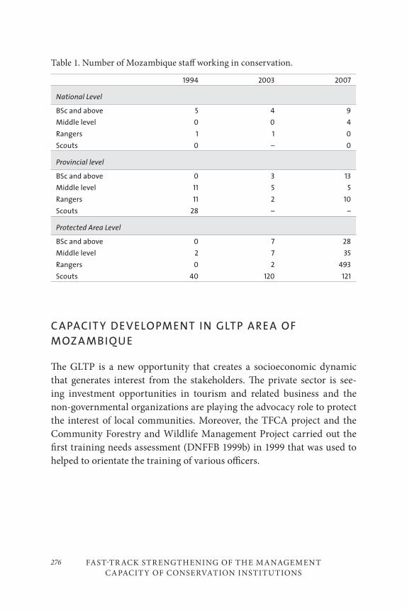
FAST-TR ACK STR ENGTHENING OF THE MANAGEMENT
CAPACITY OF CONSERVATION INSTITUTIONS
276
Table 1. Number of Mozambique staff working in conservation.
1994 2003 2007
National Level
BSc and above 5 4 9
Middle level 0 0 4
Rangers 1 1 0
Scouts 0 – 0
Provincial level
BSc and above 0 3 13
Middle level 11 5 5
Rangers 11 2 10
Scouts 28 – –
Protected Area Level
BSc and above 0 7 28
Middle level 2 7 35
Rangers 0 2 493
Scouts 40 120 121
C APACIT Y DEVELOPMENT IN GLTP AREA OF
MOZ A MBIQUE
The GLTP is a new opportunity that creates a socioeconomic dynamic that generates interest from the stakeholders. The private sector is see-ing investment opportunities in tourism and related business and the non-governmental organizations are playing the advocacy role to protect the interest of local communities. Moreover, the TFCA project and the Community Forestry and Wildlife Management Project carried out the first training needs assessment (DNFFB 1999b) in 1999 that was used to helped to orientate the training of various officers.
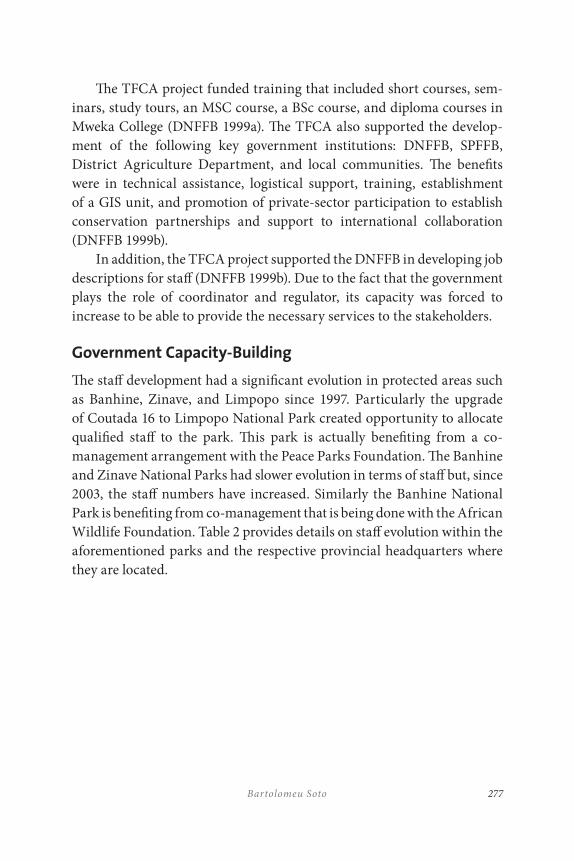
277Bartolomeu Soto
The TFCA project funded training that included short courses, sem-inars, study tours, an MSC course, a BSc course, and diploma courses in Mweka College (DNFFB 1999a). The TFCA also supported the develop-ment of the following key government institutions: DNFFB, SPFFB, District Agriculture Department, and local communities. The benefits were in technical assistance, logistical support, training, establishment of a GIS unit, and promotion of private-sector participation to establish conservation partnerships and support to international collaboration (DNFFB 1999b).
In addition, the TFCA project supported the DNFFB in developing job descriptions for staff (DNFFB 1999b). Due to the fact that the government plays the role of coordinator and regulator, its capacity was forced to increase to be able to provide the necessary services to the stakeholders.
Government Capacity-Building
The staff development had a significant evolution in protected areas such as Banhine, Zinave, and Limpopo since 1997. Particularly the upgrade of Coutada 16 to Limpopo National Park created opportunity to allocate qualified staff to the park. This park is actually benefiting from a co-management arrangement with the Peace Parks Foundation. The Banhine and Zinave National Parks had slower evolution in terms of staff but, since 2003, the staff numbers have increased. Similarly the Banhine National Park is benefiting from co-management that is being done with the African Wildlife Foundation. Table 2 provides details on staff evolution within the aforementioned parks and the respective provincial headquarters where they are located.
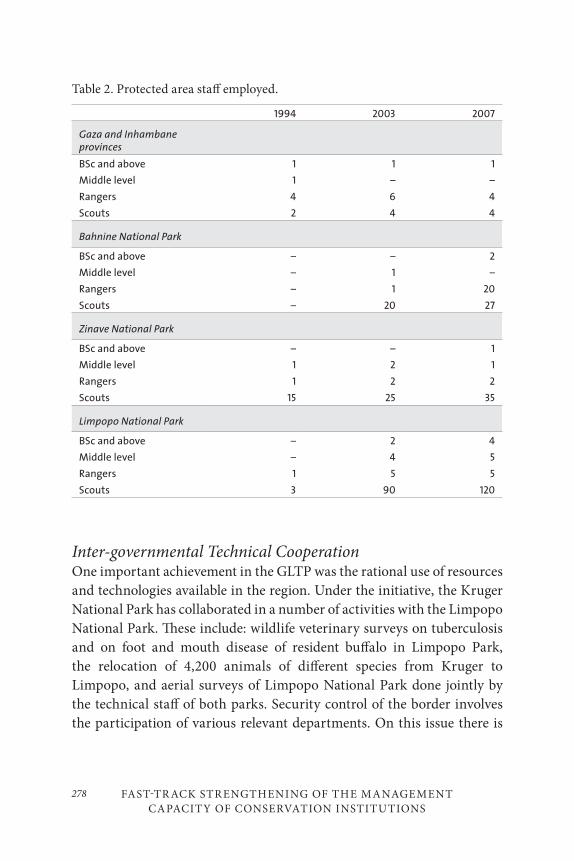
FAST-TR ACK STR ENGTHENING OF THE MANAGEMENT
CAPACITY OF CONSERVATION INSTITUTIONS
278
Table 2. Protected area staff employed.
1994 2003 2007
Gaza and Inhambane provinces
BSc and above 1 1 1
Middle level 1 – –
Rangers 4 6 4
Scouts 2 4 4
Bahnine National Park
BSc and above – – 2
Middle level – 1 –
Rangers – 1 20
Scouts – 20 27
Zinave National Park
BSc and above – – 1
Middle level 1 2 1
Rangers 1 2 2
Scouts 15 25 35
Limpopo National Park
BSc and above – 2 4
Middle level – 4 5
Rangers 1 5 5
Scouts 3 90 120
Inter-governmental Technical CooperationOne important achievement in the GLTP was the rational use of resources and technologies available in the region. Under the initiative, the Kruger National Park has collaborated in a number of activities with the Limpopo National Park. These include: wildlife veterinary surveys on tuberculosis and on foot and mouth disease of resident buffalo in Limpopo Park, the relocation of 4,200 animals of different species from Kruger to Limpopo, and aerial surveys of Limpopo National Park done jointly by the technical staff of both parks. Security control of the border involves the participation of various relevant departments. On this issue there is
279Bartolomeu Soto
a remarkable collaboration as well between the Gonarezhou Park and the Limpopo Park.
Private Sector
The Mozambican private sector is still in its emerging phase. At the same time that the government has promoted foreign investment, it is providing incentives to support the growth of the national private sector. The major concern is that the Mozambican private sector is particularly weak, inexperienced, and of limited capacity to undertake business based on conservation. To get involved in this type of business, the Mozambican private sector establishes partnerships with foreign investors most of the time, which result in a robust investment with adequate technical and financial capacity. Most of partners that are invited to establish partnerships are from South Africa.
The Limpopo National Park is implementing the first phase of a tourism development program. As part of the implementation of the Limpopo National Park Tourism Plan, the first phase included the establishment of facilities for camping, wilderness trails and 4 × 4 paths, including one luxurious eight-bed tenting camp. The park is currently preparing the implementation of a second phase. According to the minutes of a park meeting (2007), the second phase will be composed of three opportunities that were put out to tender late in 2007:
(i) Madonse Concession, consisting of a three- to four-star lodge which could be expanded during the concession period to include a second four- to five-star lodge;
(ii) Massingir Resort consisting of seventeen self-catering units and twenty-six camping stands, which can expand during the concession period to include an additional twenty-nine self-catering units; and
(iii) House Boats in Massingir dam with eight beds each.
FAST-TR ACK STR ENGTHENING OF THE MANAGEMENT
CAPACITY OF CONSERVATION INSTITUTIONS
280
A further option will include Aguia Pesqueira, a popular campsite cur-rently managed by the park, as a private concession opportunity for Mozambican businesses. The advantage for a local business opportunity is that infrastructure is already in place and visitation rates are very good. There is also good potential for facility expansion as park visitation is increasing.
Non-governmental Organizations and the Local
Communities
The non-governmental organizations that are working on the GLTP in Mozambique have been playing primarily an advocacy role. Like others, their attention was attracted by the beginning of the negotiations toward establishment of the GLTP. Before the park was proclaimed, they worked with local communities on awareness of Mozambique’s policy and legal framework. The Mozambican land law recognizes that communities liv-ing in an area for more than ten years automatically have the same rights equivalent to a title. So, if the government makes another decision on that land they deserve fair compensation. The land law also allows for delimi-tations of the community land. This is a reinforcing mechanism to help the community and government to clearly recognize the boundaries of the land that is for community. In this land any intention of use is subject to previous consultations and consent by the communities. Due to the need to strengthen the presence and better coordinate their actions, the NGOs established an NGO Forum, consisting of a number of local NGOs that are interested in issues of GLTP.
The government decided in 2004 to resettle 6,000 people that are liv-ing within the park. Based on the resettlement policy and process frame-works developed under the TFCA Program, the government conducted a process through a consultative committee for resettlement, composed of government representatives, leaders of the affected communities, and a representative of local NGOs appointed by the NGO forum.
The NGOs are also working on promoting income-generating ac-tivities for local communities. There is a community lodge that has been built with support of an NGO located south of Limpopo National Park.
281Bartolomeu Soto
Currently there are intentions of expanding the capacity of the lodge and initiating similar activities with other communities surrounding the park.
PREVENTION, MEDIATION, AND RESOLUTION OF
CONFLICTS
The participation in the GLTP is steadily demanding more capacity from the stakeholders as the current dynamics are leading to increased com-plexity. The area covered by the GLTP became a prime area for investment. The land is becoming scarce and conflicts over the land are rising. In the GLTP, the committees established at both national and international lev-els are continuously working. The participating countries have decided to establish a permanent secretariat that will be based in South Africa and will have the responsibility of supporting the development of the GLTP. This will ensure that stakeholders will be maintained in constant collabo-ration and the upcoming challenges will be addressed properly and in a timely manner.
CONCLUSION
While the situation in Mozambique after the war in 1992 was very difficult for conservation, the hope was that peace was opening an opportunity for the country to develop conservation areas in a fashion that would cap-ture the most advanced approaches. This implied that the participation of stakeholders was crucial. One important aspect to ensure effective partici-pation is that the stakeholders have to have adequate capacity. With the few resources available to the Mozambique Government, it opted to estab-lish regional partnerships. These partnerships have resulted in increased capacity and a rebuilding of the institutions involved in conservation.
In fact, the GLTP resulted in significant capacity-building of many stakeholders. It played a role in fostering national awareness and debates on the value of biodiversity and opening new opportunities for socioeconomic development mainly through nature-based tourism development. At same
FAST-TR ACK STR ENGTHENING OF THE MANAGEMENT
CAPACITY OF CONSERVATION INSTITUTIONS
282
time, the current developments in GLTP are attracting the attention of the local stakeholders positioning this TFCA as one of the most important in the country. This poses the challenge that the country will increasingly need to improve the capacity of its institutions and their effectiveness.
REFERENCES
DNFFB. 1999a. “TFCA Annual Work Plan for 1999.” Maputo, Mozambique: DNFFB.
———. 1999b. “TFCA progress report of 1998.” Maputo, Mozambique: DNFFB.
———. 2001. Transfrontier Conservation Area and Institutional Strenghthening Project Revised Project Implementation Plan. Maputo, Mozambique: DNFFB.
Hall-Martin, A., and S. Modise. 2002. Transfrontier Conservation Area and Institutional Strengthening Project. Design of a Monitoring and Evaluation System. Maputo, Mozambique.
Metcalfe, S. C. 1999. Study on the Development of Transboundary Natural Resources Management Areas in Southern Africa. Washington, D.C.: Biodiversity Support Program.
Shambaugh, J., J. Oglethorpe, and R. Ham, with contributions from S. Tognetti. 2001. The Trampled Grass. Mitigating the Impacts of Armed Conflicts on the Environment. Washington, D.C. Biodiversity Support Program.
World Bank. 1996. “Mozambique Transfrontier Conservation Areas Pilot and Institutional Strengthening Project.” Report number 15534-Moz. Washington, D.C.: World Bank.
283
The Maloti Drakensberg Transfrontier Conservation and Development Project: A Cooperative Initiative between Lesotho and South Africa
Kevan Zunckel
INTRODUCTION
LOC ALIT Y AND BROAD DESCRIPTION
Locality
The Maloti Drakensberg Transfrontier Conservation and Development Area (MDTFCA) covers the 700-kilometre stretch of mountains from its southern extreme near the Eastern Cape Province town of Elliot in South Africa and straddling the eastern Lesotho-South Africa border north-wards to Golden Gate Highlands National Park in the Free State Province
11
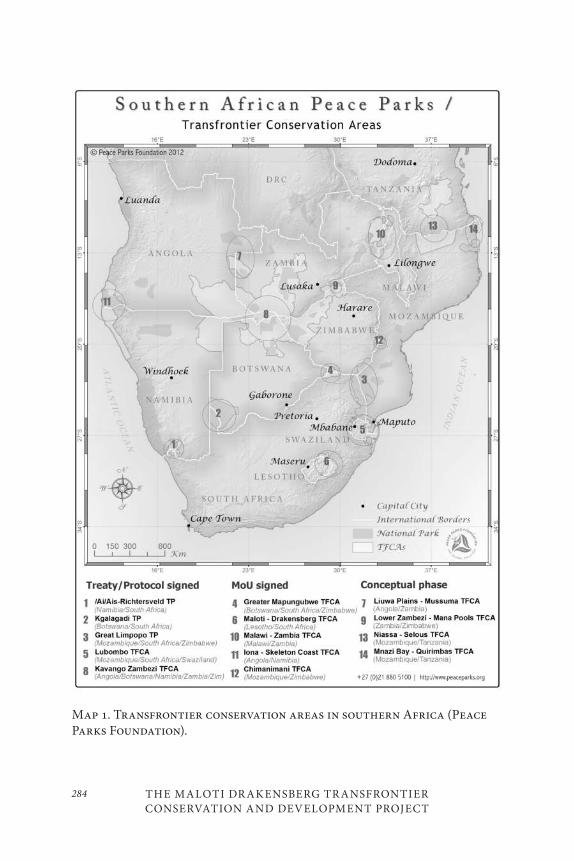
THE MALOTI DR AKENSBERG TR ANSFRONTIER CONSERVATION AND DEVELOPMENT PROJECT
284
Map 1. Transfrontier conservation areas in southern Africa (Peace Parks Foundation).
285Kevan Zunckel
of South Africa (Map 1). Included in the MDTFCA are the Maloti, Drakensberg, and Witteberg Mountain ranges above an altitude of ~1,400 metres, varying with local topography, covering an area of ~55,000 km2. The boundary of the MDTFCA is largely defined by the biodiversity as-sociated with the high-lying ground, being represented by alpine, sub-alpine, and montane vegetation types.
The International BoundaryWhile the two countries share this montane bioregion in broad terms, the vegetation types reflect the topographic reality that the majority of the international boundary is well placed in terms of ecosystem function-ing. With the exception of the far northern portion of the area where the Caledon River is the international boundary, the largest portion of the international boundary is on the watershed, which in most cases is on the edge of the escarpment. The drop-off from the edge into South Africa is close to 1,000 metres in places, which explains the distinct differences in the vegetation types. The topographical distinction is less extreme in the south and this is also evident as the vegetation types begin to become com-mon to both countries. Given this distinction between the two countries, one could question the need for a transfrontier initiative based purely on ecological reasoning, but the information provided in this chapter will provide the necessary motivation for all the work that has gone into this initiative thus far and that which is still to come.
Land-Tenure SystemsIn Lesotho the dominant land-tenure system is communal and there is only one declared protected area, namely the Selhabathebe National Park (6,795 ha). Two other areas have been set aside for proclamation, namely Ts’ehlanyane National Park (5,394 ha) and Bokong Nature Reserve (1,953 ha). South Africa has three land-tenure systems including communal, pri-vate and state land. The latter includes the Golden Gate Highlands National Park / Qwa Qwa Nature Reserve complex (30,000 ha), Sterkfontein Dam Nature Reserve (17,000 ha), Ukhahlamba Drakensberg Park World Heritage Site (243,000 ha), Coleford Nature Reserve (1,300 ha), Ntsikeni Nature Reserve (9,000 ha), Malekgalonyane Nature Reserve (13,000 ha),
THE MALOTI DR AKENSBERG TR ANSFRONTIER CONSERVATION AND DEVELOPMENT PROJECT
286
and the Matatiele Nature Reserve (4,600 ha). These protected areas vary in status from a World Heritage Site to a municipal nature reserve and collectively cover just more than 6 per cent of the area. In addition to the inadequacy of this coverage, the protected areas are mostly located in the high-lying areas, and it has been recognized that this situation needs to be addressed.
The communal areas are characterized by subsistence agricultural activities, these being primarily extensive livestock grazing and dry land cropping. The private land is also dominated by agricultural activities but these are more diverse and strongly commercially oriented. They enjoy the support of a variety of bulk infrastructure such as water, power, and trans-port. A number of urban nodes exist in the MDTFCA, and they are mostly associated with the prevailing agricultural land use that surrounds them.
Background to the Maloti Drakensberg Transfrontier
Conservation and Development Project
The Maloti Drakensberg Transfrontier Conservation and Development Project (MDTP) exists as the institutional mechanism to support the conservation and development of the Maloti Drakensberg Transfrontier Conservation Area (MDTFCA). Officials in Lesotho first recognized the need to collaborate on common management issues in the Maloti Drakensberg mountains and approached the then Natal Parks Board in this regard in the 1980s. These early discussions culminated in a meet-ing of all key role players at Giant’s Castle on 14 September 1997, where a declaration was signed by all to work towards the establishment of a trans-frontier conservation area, including a transfrontier park. A two-year pre-paratory phase was then entered into by the two countries (1999–2000) us-ing funding from the Global Environment Facility (GEF) and the Japanese Government. The essence of this phase was to undertake baseline studies into a variety of aspects relevant to the area and to use this improved un-derstanding to formulate a more detailed funding application to GEF.
On 11 June 2001, an international Memorandum of Understanding was signed at the Sehlabathebe National Park by the environment minis-ters of Lesotho and South Africa. At the same time, the funding applica-tion had been processed and resulted in separate Grant Agreements being

287Kevan Zunckel
signed between the two countries and the World Bank on 26 July 2002. This funding provided for the establishment of multi-disciplinary project coordinating units (PCUs) in each country with the specific task of fa-cilitating a five-year initial implementation phase designed to build the foundation to take the initiative into the future on a long-term basis. This phase began in 2003 and is set to be completed at the end of 2007.
The overall approach of this phase has been to provide the key imple-menting agencies with a robust strategic and action planning framework and to facilitate the processes necessary to produce the related products. A twenty-year transfrontier conservation and development strategy has been produced through an extensive stakeholder involvement process and has been based on all the data, both spatial and qualitative, that has been gathered through the duration of this first phase. The twenty-year strategy has been divided into five-year outputs and the first five years (2008–2012) has been captured in a detailed action plan for the implementing agencies and their strategic partners. This will be discussed in more detailed below.
The Significance of the Maloti Drakensberg TFCAThe features listed and briefly discussed below are the reasons the uKhahlamba Drakensberg Park World Heritage Site (UDP WHS) received its listing in 2000 as one of the twenty-three mixed World Heritage Sites in the world. While these features are prevalent in the UDP WHS, they abound throughout the Maloti Drakensberg Transfrontier Conservation and Development Area and in places are of greater significance. The ex-pansion the existing site is already in process, and establishing a series of sites is also a distinct possibility. The latter has been captured in the strategy and could be realized within the next five to ten years.
Biodiversity
The high level of biodiversity, species richness, and prevalence of endem-ics in the MDTFCA is a result of the diversity of habitat types created by the combination of extremes in topography, altitude, climate, and ge-ology. Conservation International recognizes the area as an Eastern AfroMontane biodiversity hotspot, while Birdlife International sees the Lesotho Highlands and the southern African Grasslands as two endemic
THE MALOTI DR AKENSBERG TR ANSFRONTIER CONSERVATION AND DEVELOPMENT PROJECT
288
bird areas (Mittermeier et al., 2005). In addition to this, the majority of the area above 1,800 metres has been documented as the Drakensberg Alpine Centre of plant endemism (Cowling and Hilton-Taylor, 1994, Carbutt and Edwards, 2004). Of the 2,520 flowering plant species, 334 (13%) are locally endemic to the area, with a further 594 (23%) being near-endemic.
As far as the animal kingdom is concerned, it appears as if the in-vertebrates could provide a more dramatic picture with there being high levels of species turnover at scales much finer than the vegetation. The specialist studies that will confirm this picture were not yet complete at the time of writing. The mammalian and herpeto-fauna are not as diverse as in other biomes, but there are some significant endemic and red-listed species that characterize the MDTFCA. There are approximately seventy mammal species, dominated by the charismatic eland (Taurotragus oryx) and including interesting endemics. There are nineteen mammals that are both transfrontier in distribution and in need of conservation attention. However, of these, only the De Winton’s long-eared bat (Laephotis wintoni) is endemic to the MDTFCA. Population sizes and conservation status of these important species remain largely unknown. All the other species have distributions that cover areas much greater than the MDTFCA.
As already stated, the Lesotho Highlands and the Southern African Grasslands are recognized as Important Bird Areas by Birdlife International and of the avifauna important to the area the most signifi-cant is the bearded vulture. Although there are populations of this bird in Ethiopia and the Mediterranean, it is endemic to the MDTFCA as far as the sub-Saharan distribution is concerned. In addition to this, its sig-nificance comes from the fact that it is a charismatic transfrontier species and the flagship of the program. A recent population and habitat viability assessment and related aerial survey has confirmed that the population is in decline and collaborative efforts are essential to ensure its survival.
Cultural Heritage
The most obvious feature of the cultural landscape of the MDTFCA is the rock paintings of the San. There are approximately 45,000 images in 600 rock art sites within the boundaries of the UDP WHS with approximately 160,000 images in the MDTFCA as a whole. These images constitute one of the finest outdoor art galleries in the world. The MDTFCA is also the
289Kevan Zunckel
last areas in the Africa south of the Zambezi River where San people still continued with this tradition until the beginning of the twentieth century. In addition, the area is the heartland of the so-called shamanistic inter-pretation of rock art, an interpretive framework that is now also used to understand the meaning of rock art in parts of northern America, west-ern Europe and Asia. The San were hunter-gathers who lived in the area for about 20,000 years. They were unable to resist the movement of other people into the area and from the beginning of the 1800s they were sys-tematically persecuted until they were eventually considered extinct by the 1920s. A succession of people from the Zulu King Shaka kaSenzangak-hona and the subsequent period of tribal turmoil known as the Mfecane, then Dutch followed by British colonialism, resulted in the demise of the Drakensberg San, although there are still some descendants who have been integrated into the communities living in the area today.
In addition to the rock art, there are numerous other features includ-ing the history that is briefly alluded to above. The palaeontology of the area is captured in the sedimentary rock which dominates the lower strata and reflects the prehistoric fauna and flora that occurred. There are num-erous sites where dinosaur footprints and other markings can be seen, as well as fossil evidence of their presence. The most spectacular of these are the intact eggs of the Massospondylus, which have provided the oldest dinosaur embryos known to man. Iron and Stone Age sites increase the richness of the cultural landscape as does the existence of many Living Heritage sites, i.e. sites of ritual or sacred significance.
Scenic Beauty
Tourism statistics reveal that approximately 90 per cent of the visitors to the MDTFCA do not leave the comfort of the establishment at which they are staying but are satisfied that by viewing the mountains from rela-tively close proximity is sufficient for them to be satisfied with a visit to the Drakensberg. The other 10 per cent are treated to closer views of the extremely dramatic landscape that has been created by years of erosive action on the volcanic basalts, which overlay the sedimentary sandstones. The MDTFCA is host to the highest point south of Mount Kilimanjaro, namely Thaba Ntlenyana at 3,482 metres and the second highest waterfall in the world, the Tugela Falls, which plunges 948 metres in five clear leaps.
THE MALOTI DR AKENSBERG TR ANSFRONTIER CONSERVATION AND DEVELOPMENT PROJECT
290
The sheer cliffs, buttresses, spires, and ramparts inspired the early settlers to call these mountains the Drakensberg, or “The Dragon Mountains” after the spines on the back and tail of a dragon. The Zulu people call them uKhahlamba, which means “The Barrier of Spears.” Viewed from the foothills in South Africa, the wall of rock is very impressive, and, once the effort has been expended to summit the escarpment, the views along the summit and back down into the foothills is breathtaking. Although the topography in Lesotho is less dramatic, the almost continuous spread of deeply incised valleys covered in alpine vegetation delivering crystal clear water into the streams provides the visitor with spectacular scenery.
Dramatic seasonal variations enhance the scenic beauty with the vege-tation being lush and green in summer and the streams flowing strongly with clear mountain water (although this rapidly becomes turbid with high silt loads as soon as the agricultural areas are reached). This chan-ges as winter approaches and the grasslands become dry and brown. The streams drop to their winter low flows and many of the higher waterfall and cascades freeze into walls and pillars of ice. This season is also dom-inated by fire as the vegetation is dominated by fire-climax grassland and smoke haze can hide much of the scenic beauty.
As discussed above, the areas surrounding the higher lying mountains are dominated by agricultural activities. This rural agricultural landscape provides the visitor with a sense of space and relative calm before they reach their destination closer to the mountains.
Ecosystem Services
Amongst a suite of ecosystem services produced by the MDTFCA, the supply and regulation of water is the most significant. South Africa has a low long-term annual average precipitation (approximately 510 mm/an-num) and the MDTFCA is one of only five areas where the annual average precipitation exceeds evaporation. Of these areas, only one other, namely the Western Cape, has catchments that are strategically placed to capital-ize on the redistribution of this water. The MDTFCA is, however, the most strategically significant as it is located between the economic centres of South Africa. An existing bilateral agreement between Lesotho and South Africa recognizes this as it has brought a massive engineering project into being, namely the Lesotho Highlands Water Scheme. Through a system
291Kevan Zunckel
of impoundments and tunnels almost 50 per cent of the water required for South Africa’s economic hub, the Gauteng province, is provided from Lesotho. Other schemes are in place to move water to other areas of South Africa and plans are in place to increase the spread of this ecosystem ser-vice. It is predicted that by the year 2030, 70 per cent of the water avail-able for distribution will come from the MDTFCA, i.e., 0.4 per cent of the regional land cover (Diederichs and Mander 2004).
The significance of the above to the MDTP is the close relationship that exists between catchment integrity and biodiversity. While assessing the possibility of introducing systems of trading in ecosystem services, it has become apparent that the most meaningful currency to trade in when it comes to water is basal cover. The MDTFCA is dominated by fire-cli-max grasslands and when these are managed well they maintain the basal cover at levels that ensure the protection of the soil during precipitation events, effective absorption of water into the soil, and the slow release of the water into the system thereafter. Although it appears that grass species dominate the landscape, closer inspection reveals a greater proportion and diversity of forbs, as stated in the biodiversity discussion above. This diversity implies a resilience which is what is needed to provide the guar-antee for catchment integrity and water provision and regulation. Any man-induced actions that affect the biodiversity, such as the injudicious use of fire (too frequent or too infrequent burns) or over-utilization by livestock will have a negative impact on catchment integrity.
THE NEED FOR THE M ALOTI DR AKENSBERG
TR ANSFRONTIER PROJECT – DEALING WITH
THE THREATS
All of the above features are under threat as unsustainable land use prac-tices dominate the area. The systematic conservation planning process has revealed that there are vast areas with high levels of irreplacability. The MDTP is a collaborative intervention designed to address these threats through the pooling of resources and coordination of effort. The nature of

THE MALOTI DR AKENSBERG TR ANSFRONTIER CONSERVATION AND DEVELOPMENT PROJECT
292
the MDTP is discussed in more detail later, after the brief expansion on the threats below.
Population Dynamics and Livelihoods
History and, more specifically, recent history has impacted significantly on the people of the MDTFCA. The engineering of population dynamics by the former South African Apartheid regime created a disparate distri-bution of access to resources and unnaturally high concentrations of peo-ple into certain areas. The land-tenure system in these areas has remained communal and the ‘tragedy of the commons’ is a scenario that prevails. High levels of unemployment are common. The situation in Lesotho is not significantly different, although the population densities are much lower. The influence of colonial power restricted the Basotho nation to an area that is now smaller than it originally was and, whereas agriculture was an income-generating activity, it has been largely reduced to one of subsis-tence. The colonial influence was entrenched by the Apartheid regime of the former South Africa, and migrant labour to South African mines was at one time the most important source of revenue to the Lesotho govern-ment, exacerbating the unemployment situation today.
Most households, especially in the deep rural areas, employ multiple livelihood strategies. Although some of these are directly dependent on natural resources, it has been suggested that agriculture (rangeland graz-ing and cultivation) has been over-estimated in terms of its role in deter-mining livelihood outcomes (Turner 2001). Dependency on the natural heritage of the region for most of the poor rural communities is an issue of concern. In some isolated cases, a few households actually benefit from job-creation in tourism, with resultant benefits to livelihoods. For private lands, commercial agriculture continues to thrive in specific areas, with farmers continuing to enhance existing livelihoods or diversifying into new ones, often in response to market forces and/or stock theft (change from beef-farming to afforestation, or to potatoes) and new mechanized technologies. In addition, tourism has been developed, with some suc-cess in some areas of the MDTFCA, more specifically in the Free State and KwaZulu-Natal provinces of South Africa. In other areas, like the private lands in the southern sections of the Eastern Cape portion of the
293Kevan Zunckel
MDTFCA, tourism is very low-key, but with the potential to increase with resultant livelihood benefits. Livestock production and sale of wool and mohair are a critical component in Lesotho’s economy and an important income activity for most farmers in the highlands (Sechaba Consultants 2000). Remittances from a migrant labour system and farm labour still forms part of the income source for the highland communities in Lesotho, as are social grants, particularly in RSA.
An interesting dynamic which requires further research but cannot be ignored is the relative importance of employment and occupation. With the majority of the MDTFCA being classified as an emerging or Third World economy, First World standards are often imposed and pov-erty is equated to monetary income as this relates to formal employment. Although it may not be a common occurrence in the area, it is possible that families who are “unemployed” and “impoverished” could have members who are fully occupied and thus provide for their needs. It is important that livelihood analysts keep these possibilities in mind before measuring the well-being of rural people.
Land Management Issues
Crop ProductionThe relationship between crop production and the conservation of biodi-versity is largely negative. Moist grasslands are relatively stable systems but they do not recover from transformation activities such as ploughing and the establishment of timber plantations. Where such activities have occurred in the area, it is safe to consider these areas lost in terms of con-tributions to meeting conservation targets. If these areas are well managed in terms of soil erosion control and other conservation practices, however, they could still contribute to the delivery of some ecosystem services, al-though the extent of delivery will be at a reduced rate of what it would have been under natural conditions.
THE MALOTI DR AKENSBERG TR ANSFRONTIER CONSERVATION AND DEVELOPMENT PROJECT
294
Fire and GrazingWhere the natural grasslands have been converted to intensive and ir-rigated pastures, biodiversity loss is on a par with crop production. The delivery of some ecosystem services will, however, be maintained. Where the natural grasslands are being used as extensive pastures, the use of fire as a management tool and the subsequent application of livestock to this resource base is a significant determinant of the extent to which such areas can contribute to biodiversity targets. The grasslands are fire-climax and it is necessary when fire is applied as a management tool that it be done in way that simulates natural processes. Unfortunately, this is not the case in the majority of the area and fire is generally applied at too frequent intervals to encourage a “spring flush” with resultant negative impacts on biodiversity and ecosystem functionality.
The above situation is exacerbated where grazing is applied shortly after burning. Unfortunately due to the seasonal palatability of the grass-lands in the MDTFCA, this is a common management strategy for both commercial and subsistence farmers. The ramifications of such a practice are severe loss of biodiversity, significant loss of basal cover, increased soil loss through sheet and gully erosion, and an increase in the occurrence and spread of alien invasive vegetation.
Alien Invasive SpeciesThe MDTFCA is threatened by extensive and expanding infestations of various invasive alien plant species. Some species are obvious and well-known and have existing programs to manage their spread, such as black wattle (Acacia mearnsii), gum (Eucalyptus spp.) and pine (Pinus spp.) trees. Others, despite their obvious invasion, such as American bramble (Rubrus americana), have no strategic control program, although some landowners do personally invest in control on their land. Still other spe-cies are considered as emerging alien invasive species and are thus neither well-known nor obvious, and very little is known about their current dis-tributions, spread rates, or impacts.
Alien invasive plants can totally alter the functioning of an ecosystem and reduce the productive value of the land significantly. In so doing, there are often significant effects on the hydrology of an area, depending
295Kevan Zunckel
on the scale of the invasion and the type of alien species. There is a large body of evidence to demonstrate the huge reduction in stream flow rates in infested catchments and the significant site or local impacts on species composition and structure. Alien infestations can cause local extinction of entire communities of plants and animals. Furthermore, there are also effects on nutrient cycling and associated soil integrity (erosion), fire man-agement (where stands of aliens can change the nature of fire in a land-scape), and management access (where dense stands can prevent manage-ment access to key parts of a landscape).
In terms of livelihoods, invasive alien plants can affect tourism and agricultural production. Alien trees frequently disrupt tourism view-sheds, and thorny infestations of bramble can block access paths. Extensive infestations of wattle and bramble cause the loss of rangeland and reduce stock productivity. This loss of productive land to alien plant invasions is a significant concern as it often results in increasing pressures on the remaining land. Ultimately, a negative and destructive escalation ensues, with degradation of the remaining lands through the loss of indigenous vegetation making it more susceptible to further invasion. In many cases, the cost of clearing a dense infestation exceeds the value of the land, re-sulting in significant management costs that need to be borne by the land-owner, thus reducing profit margins (in commercial ventures) or increas-ing the vulnerability of the rural poor. There is, however, the opportunity for contributions to rural livelihoods through employment opportunities in eradication operations. In addition, some of the alien species provide a benefit by way of materials for the production of various household and saleable items such as building material, fuel wood, crafts, and furniture.
Incompatible Development TrendsOver the last ten to twenty years, there has been a proliferation of up-mar-ket housing estate developments that are often associated with fly-fishing, golf, or equestrian activities. While this trend is country-wide in South Africa, it has begun to emerge in increasing measure within the MDTFCA. These estates target the rural areas and base their marketing strategies on attracting affluent urbanites or foreign investors into the country, which inevitably means that the homes are second or third dwellings from which
THE MALOTI DR AKENSBERG TR ANSFRONTIER CONSERVATION AND DEVELOPMENT PROJECT
296
people either undertake their business dealings via the internet or they simply commute to the business centres. While these developments do offer the promise of short-term employment for impoverished local com-munities, they inevitably bring with them an increased demand for bulk services such as water. They also set in motion development precedents that are proving difficult for environmental authorities to manage.
SecurityDespite the extreme topography and climatic conditions along the interna-tional boundary, the illegal movement of people happens at unacceptably high levels. Some of these movements, while illegal, do not have criminal intent, but the majority are associated with stock theft, drug (marijuana) smuggling, or the trade in fire arms. The former two activities have been part of the culture of the MDTFCA for hundreds of years and are thus dif-ficult to address. The cultivation and movement of marijuana contributes to the livelihoods of people, and, until alternatives have been established, a crackdown on this activity could have negative economic ramifications. It is, however, essential that the situation be addressed as these activities are affecting the conservation authorities’ ability to apply resource man-agement strategies. Arson fires are often associated with the movement of stolen livestock and drugs, and it is thus difficult to maintain sound fire management regimes. Many of the access routes between Lesotho and South Africa have become severely trampled and erosion in sensitive areas is a constant threat.
In addition to the threat to the natural and cultural resources of the area, these activities also pose a threat to existing and potential tourism development opportunities. With the tourism industry being as fickle as it is, the MDTFCA cannot afford to have negative incidents turning visitors away. Hosting the 2010 Soccer World Cup provided additional incentive and great strides were made to unite the tourism authorities and operators into a common marketing and branding strategy that included protecting the safety of visitors
297Kevan Zunckel
Protected Area Network and Management EffectivenessThe fact that the existing protected area network covers only 6 per cent of the area and that these areas are predominantly located in the high lying portions has already been alluded to. Besides the coverage that needs to increase, the distribution of these areas needs to bring more of the lower-lying areas into the network . This is of particular relevance when the pos-sible ramifications of climate change are considered where the altitudinal movement of species will need to be taken account of.
With regard to management effectiveness, there is a need for a uni-form and high standard to be attained and maintained in order to en-hance and ensure the integrity of the network. The relative strength of the conservation authorities in the area varies quite significantly and thus their ability to achieve and maintain the acceptable level of management effectiveness. It is thus important that the coverage alone is not considered as the ultimate target, but this must be coupled with management effect-iveness supported by committed governance and effective administration.
The ability of conservation authorities to implement effective manage-ment is inextricably linked their financial status. Protected areas in many parts of the world, and particularly in Africa, are experiencing a hand-to-mouth financial condition, are dependent upon insecure national budget allocations, have sporadic support from non-governmental conservation organizations, and rely on short-term international project funding (The Nature Conservancy 2001). Unfortunately, the protected areas in the MDTFCA are characterized by a long history of insufficient funding and the symptoms described here are prevalent. In some cases, the association with the MDTP has been used by some of the conservation authorities to leverage external funding to support conservation actions. In the face of dwindling budgets, such initiatives are understandable, but when core business, such as alien invasive plant control is used to motivate for such funding, the wisdom of this must be questioned. Conservation actions generally have long-term application and dependence on donor funding can negatively affect such action.
THE MALOTI DR AKENSBERG TR ANSFRONTIER CONSERVATION AND DEVELOPMENT PROJECT
298
Country DifferencesThis aspect may be listed under the discussion on threats; however, it is not the differences themselves that are a threat but rather the failure of the role players and stakeholders to recognize, understand, and function in spite of these differences. Implementation of this current phase of the MDTP suffered from this in the first year until the coordinators recog-nized the need to convene a workshop for the key role players where an effort was made to identify and understand the differences and find ways of working constructively despite them. The main areas of concern relate to South Africa’s relatively stronger socio-economic position as well as its more complex legal, policy, and institutional frameworks.
The different implementation environments presented by the different aspects suggested above resulted in significantly different approaches to implementation in each country, which remained despite the workshop. The South African Project Coordinating Unit challenged and altered the implementation plan that it was presented at the start of this phase, while Lesotho adopted theirs without challenge. South Africa adopted a bioregional planning approach to implementation, whereas Lesotho fol-lowed one that was more focussed on community-based natural resource management principles. A detailed investigation and review of these dif-ferent approaches was undertaken and is being written up for publication (Büscher 2010). This paper documents the difficulties experienced by the two units as they attempted to work within the prevailing differences and with different approaches aimed at achieving the same thing. In hindsight, it has been suggested that the blame for the disparate approach could be levelled at the fact that two separate grant agreements were in place for this phase and that these ignored the differences from the outset. Had there been one agreement and one coordinating unit, things may have turned out differently. As a result of the lessons that have been learnt, a more unified approach has been taken for the next phase.
299Kevan Zunckel
TAKING THE M ALOTI DR AKENSBERG TR ANSFRONTIER
PROJECT FORWARD
The vision for the current phase of implementation was to establish a framework of cooperation between the two countries, and this has largely been achieved in spite of the differences discussed briefly above. A vital decision was taken by the Bilateral Steering Committee in November 2006, when it was agreed that the MDTP would be guided by one strategy and one action plan. It was further agreed that these guiding documents would reflect consensus on actions required, irrespective of their locality within the MDTFCA.
Strategy and Action Planning
Key to ensuring transfrontier cooperation was the development of a single strategy and action plan for the MDTFCA, thus facilitating joint respon-sibility for achieving targets and associated actions irrespective of their locality within the area. As a result an overall bioregional planning pro-cess was developed and implemented by both countries and was facilitated by the two PCUs. This process entailed an exhaustive series of country-specific meetings alternating with bilateral workshops.. Essential feedback mechanisms were in place to ensure that the country-specific stakeholders were kept up to date with how their inputs were being treated within the collective.
As an overall point of departure, it was agreed that the MDTP is an ongoing intervention required to support conservation and development in the MDTFCA and as such the strategy would require a long-term vi-sion. The timeframe set for the strategy is twenty years with five-year action-planning intervals. It was also agreed that both the planning pro-cess and the products are equally important, given that the strategy and action plans are being designed for implementation within a complex and dynamic environment. The concept of three- to five-year planning itera-tions has been accepted and will be supported by a database that will be maintained and regularly updated.
THE MALOTI DR AKENSBERG TR ANSFRONTIER CONSERVATION AND DEVELOPMENT PROJECT
300
The Vision and PurposeThe Twenty Year Conservation and Development Strategy for the Maloti Drakensberg Transfrontier Conservation Area has the following vision: “Conserving the MDTFCA’s Natural and Cultural Heritage for the people of
the region and beyond.” This is supported by a Purpose Statement, which reads as follows: “Effective cooperation among capacitated partners secures
the MDTFCA’s priority natural and cultural heritage and supports sustain-
able livelihoods.”
Strategic OutcomesIn order to achieve these, six strategic outcomes have been identified, the first of which is a cross-cutting aspect that seeks to establish and maintain the enabling environment necessary for implementation of the others. Aspects related to this are cooperative governance, capacity-building, the regular review and updating of legal and policy frameworks, safety and security, stakeholder involvement, an institutionalized planning process, and coordinated research. Four of the strategic outcomes relate to vari-ous approaches needed for meeting conservation targets. The first of these has to do with the establishment and maintenance of a protected area network, while the next two relate to the application of regulatory and incentive mechanisms as well as land-use planning processes. While the conservation of natural and cultural resources could have been integrated, these have been addressed separately merely to enable the practitioners within these disciplines to easily identify and translate their responsibili-ties into actions. The fifth outcome thus relates solely to the conservation of cultural heritage. Lastly, an attempt has been made to separate out all livelihood-related aspects in order to highlight the effect the strategy will have on livelihoods. It remains to be seen how successful this attempt will be as critics at this early stage have suggested that most aspects within the strategy will positively affect livelihoods and the distinction should not have been attempted.
301Kevan Zunckel
Action PlanningAs stated above, the strategy has a twenty-year vision and therefore broad statements that needed to be translated into more specific and achievable actions. The process followed to achieve this was through the establish-ment of working groups responsible for focussing on each of the strategic outcomes. For each of the strategic outcomes, a series of strategic outputs were identified with the assumption that if these are achieved the out-comes will be achieved, and if the outcomes are achieved the purpose and vision will be achieved. The link between the twenty-year strategy and the five-year action plan is the strategic outputs. For each of these, the respec-tive focus groups were tasked with breaking the twenty-year outputs into five-year targets. Each five-year target has then been broken down into specific actions with associated timeframes, budgets, responsibilities, and targets and indicators. The targets and indicators will serve as the basis for the monitoring and evaluation plan and its link with the action plan.
While the objective is to compile an overall action plan for the MDTFCA, the basis of determining the required actions has been the existing plans of each of the implementing agencies, where these are avail-able. In this way, it is assumed that the action plan will be more achiev-able and will fit within the budgets of the implementing agencies and thus enjoy ownership. The latter is absolutely crucial if the MDTP is to move forward, and this is a fact that has been recognized and reinforced by the PCUs from the outset. Fortunately, it has also been accepted that, where the overall MDTP planning process can be used to inform those of implementing agencies, they will be open to adapt theirs accordingly. Ultimately, the individual implementing agencies will have to take the overall action plan and extract from it whatever is of specific relevance to them. They will need to ensure that this is integrated into their organ-izational frameworks and that it is captured in annual plans of operation.
PresentationThe nature of the strategy document is very technical as it is based on a substantial amount of work and information gathered through the du-ration of this current phase of implementation. All of the studies that have been undertaken within the various disciplines associated with the
THE MALOTI DR AKENSBERG TR ANSFRONTIER CONSERVATION AND DEVELOPMENT PROJECT
302
MDTFCA have been written up as reference documents and these will be included in the strategy document in digital format as a CD in an envelope at the back of the document. It is recognized that this is a bulky product and only technically oriented officials and other stakeholders will be pre-pared to either review it in detail or use it often as a reference source. In order to market the product and encourage its use, a summary version in a popular format was produced with additional maps, illustrations, and photographs. The action plan, on the other hand, is a more concise docu-ment that very quickly provides the reader with a clear and specific picture of what needs to be done, who is responsible to see that it is done, when it must be completed, and how often and what resources are required.
Institutional Arrangements
International ArrangementsAs already mentioned, the vision of this first phase of implementation was to establish the institutional framework and this has been achieved. The current structure will therefore remain but will be adjusted and added to. It has been recommended that a ministerial committee be established in order to ensure that there is always political support for and buy-in to the MDTP. The existing Bilateral Steering Committee will then remain as the international coordinating mechanism. The Memorandum of Understanding (MoU) that was signed in 2001 has been revised and up-dated to reflect the vision, purpose, and strategic outcomes of the twenty-year strategy. The description of the MDTFCA boundary has also been updated as the detailed vegetation mapping exercise that was undertaken to support the systematic conservation planning process has provided a rigourous and more defendable boundary. Together with these revisions, the MoU has been upgraded to an International Agreement.
National ArrangementsThe Project Coordinating Committees (PCCs) are to be referred to as National Coordinating Committees (NCCs) and the Lesotho NCC, which is already a multi-ministerial structure, will retain its current structure.
303Kevan Zunckel
The South African PCC, however, has been dominated by the conserva-tion agencies, and it has been recognized that national departments or structures representing tourism, culture, agriculture, and water need to be represented. An existing inter-agency MoU is to be revised in order to better reflect the strategy and to accommodate the broader representa-tion. An additional level of coordination has been recommended and that is for discipline-specific working groups to be formed in order to ensure representation at the next political level. In South Africa, this would be at the provincial level and in Lesotho at the district level.
The possibility of multi-disciplinary structures being required at a level below the NCCs must not be discarded. South Africa has passed national legislation, namely the Intergovernmental Relations Framework Act, which came into effect on 15 August 2005, which could be used to strengthen existing structures and to guide the establishment of new ones. The Eastern Cape province, which has a number of bioregional planning initiatives that cover various portions of the province, has established a multi-stakeholder forum known as the Eastern Cape Implementation Committee (ECIC). A MoU commits signatories to work together to implement the outcomes of the bioregional planning processes. More re-cently, the province has produced its own provincial conservation plan, and the ECIC will be used as the mechanism to facilitate the cooperative governance required to ensure meaningful implementation and collective responsibility for its monitoring and evaluation.
Assistance with Coordination and AccountabilityThis current phase has been supported by grants and two multi-disciplin-ary coordinating units. Implementation of the next phase is to be financed by the two countries themselves, and implementation will be the respon-sibility of the key implementing agencies and their partners as identified by the strategy and action plan. The functional work that has been car-ried out by the two PCUs is to be absorbed by the implementing agencies, except where specific capacity is lacking, and two smaller units will be maintained to simply assist the BSC and NCCs with coordination.
At one point, the possibility of the establishment of an international coordination unit was discussed, but the improved level of cooperation
THE MALOTI DR AKENSBERG TR ANSFRONTIER CONSERVATION AND DEVELOPMENT PROJECT
304
that had been achieved between the PCUs encouraged the BSC to decide against an international unit.
A clear distinction is to be made between the present and the com-ing phase with regard to accountability. The current PCUs have been re-sponsible for implementing plans that related to the grant-funding from GEF and as such were accountable to the World Bank, their respective PCCs, and the BSC. At the same time, the PCUs endeavoured to hold the implementing agencies accountable, through the PCC representatives, for their contributions to implementation. While this proved to be a relatively complicated task for the PCUs, their role in the next phase will be simpler. The action plan that is being formulated will be the responsibility of the implementing agencies and the PCUs will assist them to hold themselves accountable to deliver.
CRITIC AL SUCCESS FACTORS
In closing, it is necessary to briefly allude to some critical success fac-tors. In the complex and dynamic socio-political environment of the MDTFCA, there are many but the few listed and discussed below are seen by the author to be of particular significance.
Institutionalization
It has been a struggle of the PCUs to get the implementing agencies to recognize that work associated with the MDTP has not been additional to, but rather part of, their existing legal mandate. It is now apparent that this has become more accepted and institutional blinkers have been removed to embrace a more cooperative governance approach. Much work still has to be achieved to improve the NCCs and related structures as discussed above. In addition to this, local government structures need to be inte-grated into the MDTP structures some how. The MDTP also needs to be integrated into local government.
Much effort has been expended by the PCUs to have the MDTP inte-grated into the key implementing agencies, and achievements are seen in places where organizational business plans and specific job descriptions
305Kevan Zunckel
reflect elements of the MDTP. These achievements are limited to some of the key implementing agencies, and they need to spread to all of them, as well as the new partners that need to be brought on board.
The degree of institutionalization must extend beyond specific cham-pions and into the fibre of their respective institutions. Although it is en-couraging to encounter and work with such people, the possibility that they will move on must always be kept in mind.
Financial Resources
It is encouraging to see that the key implementing agencies have taken on the responsibility of continuing with the MDTP without external fund-ing. This does not rule out the possibility that specific parcels of work may be packaged in order to attract donations, but every effort must be put in to ensure that both governments are well aware of the strategic and global significance of the MDTFCA and the work of the MDTP. The above dis-cussion on the strategy and action planning process alluded to the need to package the strategy so that it would draw support from decision-makers. This packaging needs to go further to the extent that decision-makers are well aware that the actions required to meet the conservation targets for the MDTFCA are the least-cost option to securing vital ecosystem ser-vices upon which the economies of each country depend.
The Realities of Conservation Targets and Institutional
Capacity
In the process of developing strategies, and particularly action plans, it is important to ensure that they are achievable. In order to do so, the existing capacities of the responsible agencies must be considered and built into the plans. This process must, however, be superimposed on the realities of the conservation targets that are to be met. It is possible that the resources needed to meet the conservation targets are not available at the time of compiling the action plan. In this case, it is critical that the implications of not meeting the targets must be clearly understood and every effort made to close the gap.
THE MALOTI DR AKENSBERG TR ANSFRONTIER CONSERVATION AND DEVELOPMENT PROJECT
306
It is understandable that an implementing agency will produce an action plan that is realistic so that it can report positively on its achieve-ments, but if such an implementing agency is responsible for achieving conservation targets, surely it should rather be measured against these. The MDTFCA is too important an area to be lost under a pile of glowing annual reports that show the achievement of organizational targets but ignore the failures to achieve the conservation targets.
Linking Conservation and Livelihoods
According to the principles of sustainability, it is understood that, in order to secure the conservation of the natural and cultural resource base of an area, there has to be relevance to the livelihoods of affected communities. The MDTP’s recognition of this is reflected in the title of the initiative, i.e., conservation and development, and in the detail of the twenty-year strategy. It was also recognized that nature-based tourism would only provide a relatively small contribution to livelihoods and that a more di-verse approach was required. To this end, models to support the payment for ecosystem services are being developed. The possibility of brokering agreements between the recipients, or consumers, of ecosystem services from the MDTFCA, and the rural communities, or producers, of these services holds great promise. It is critical that these models are applied once completed and that other ecosystem service opportunities are ex-plored to ensure the social acceptability of the MDTP and support for the continued conservation of the MDTFCA.
ACKNOWLEDGMENTS
This paper is essentially a summary of the Twenty-Year Transfrontier Conservation and Development Strategy (2008–2028) that has been com-piled for the Maloti Drakensberg Transfrontier Project. As such, all who have been involved in this endeavour are acknowledged and honoured for their hard work. The strategy in its complete form is available on our web site, www.maloti.org.

307Kevan Zunckel
REFERENCES
Büscher, B. E. 2010. “Anti-politics as political strategy: Neoliberalism and transfrontier conservation and development in Southern Africa.” Development and Change 41(1): 29–51.
Diederichs, N. and M. Mander. 2004. Payments for environmental services baseline study. Final report to the Maloti Drakensberg Transfrontier Project. Everton: Futureworks!
Carbutt, C., and T. J. Edwards. 2004. “The flora of the Drakensberg Alpine Centre.” Edinburgh Journal of Botany 60(3): 581–607.
Cowling, R. M., and C. Hilton-Taylor. 1994. “Patterns of plant diversity and endemism in southern Africa: an overview.” In Botanical Diversity in Southern Africa, ed. B. J. Huntley, 31–52. Pretoria: National Botanical Institute.
Mittermeier, R. A., C. F. Kormos, C. G. Mittermeier, P. R. Gil, T. Sandwith, and C. Besançon. 2005. Transboundary Conservation: A New Vision for Protected Areas. Mexico: CEMEX.
The Nature Conservancy. 2001. Long-term Financial Planning for Parks and Protected Areas. Arlington, VA: The Nature Conservancy.
Sechaba Consultants. 2000. Poverty and Livelihoods in Lesotho; More Than a Mapping Exercise. Maseru: CLC Printers.
Turner, S. 2001. Livelihoods in Lesotho. Lesotho: CARE.


Section 3 EDUCATION AND INTERNATIONAL
PEACE PARKS

311
12
Transboundary Environmental Education: A Graduate Program Case Study
Len Broberg and Michael S. Quinn
The Crown of the Continent region of Canada and the United States cov-ers some 43,700 km2 and offers a unique confluence of biodiversity, wa-tersheds, and human communities (Prato and Fagre 2007, 3). Stretching along the Rocky Mountain Cordillera from roughly the Highwood River on the northern end to Rogers Pass (Montana) on the southern bound-ary; extending east and west to include communities in British Columbia, Alberta, and Montana; and spanning the international border between Canada and the United States, the area is rich with history, scenic beauty, and intact natural communities. The intersection of northern and south-ern ranges of plant communities, persistence of intact large carnivore populations, history of traditional tribal/First Nations territories and confederations tied to a common history of bison use, and presence of a major modern trade and travel corridor between countries enhance the value of the region. Trans-jurisdictional management of shared water re-sources and far-ranging species like bull trout, grizzly bear, and wolves has evolved between neighbouring governments and agencies across the
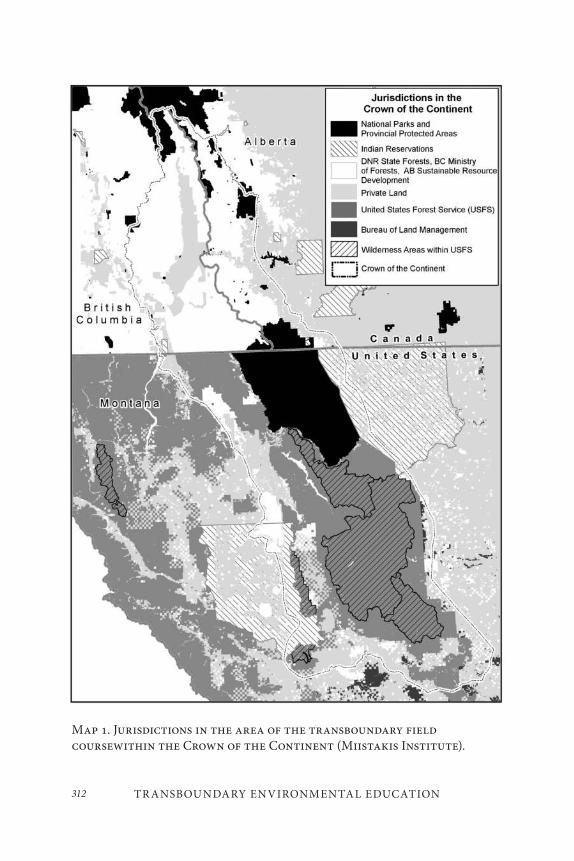
TR ANSBOUNDARY ENVIRONMENTAL EDUCATION312
Map 1. Jurisdictions in the area of the transboundary field coursewithin the Crown of the Continent (Miistakis Institute).
313Len Broberg and Michael S. Quinn
region. The Crown of the Continent contains just 17 per cent private land with the vast majority of the landbase and its resources under the man-agement of numerous public agencies (Map 1) at the provincial/state and federal level and Indian Tribes/First Nations (Long 2007, 17).
International and domestic borders pose numerous obstacles to man-agement within this common ecosystem. The creation and subsequent development of the Crown Managers Partnership (CMP) promises to ease some of those challenges. The CMP is a professional network or-ganization made up of members from federal, state-provincial, and tribal agencies with land management responsibilities in the Crown of the Continent region (CMP 2009). Initiated through a meeting in Cranbrook, British Columbia, in 2001, the CMP provides an annual forum for bring-ing together the agencies to meet and share experiences, activities, and goals. In addition, it is taking on a regional-level ecological health assess-ment encompassing many different jurisdictions within the Crown of the Continent as a knowledge-based tool to inform management. It also has spawned a Crown Invasive Plant Network and promoted the publica-tion of a Crown of the Continent weed guide (USDI 2009). Despite the success the CMP has had in establishing relationships and improving communications among agencies in the two countries, the multiple and sometimes conflicting management mandates of the numerous institu-tions, the limited funding and human resources available to deal with a large landscape, and the numerous demands and desires of the public for use of the landscape continue to plague efforts to coordinate management. Such challenges are certainly not unique to management in the Crown of the Continent; Landres et al. (1998, 39–40) reviewed the issues surround-ing transboundary management and found: “[a]n administrative border is like a glass wall that may not be readily apparent, but because nearly all terrestrial and aquatic ecosystems are open systems requiring contin-ual flows or fluxes of energy and matter, differences in management goals and land-use practices on either side of the border inevitably disrupt these flows, causing changes in ecological conditions and processes.”
In contrast to the lack of formal connections between adjacent jurisdic-tions, two agencies in the Crown of the Continent, Parks Canada and the United States National Park Service, have been linked by their designation
TR ANSBOUNDARY ENVIRONMENTAL EDUCATION314
as an International Peace Park. Glacier National Park (GNP) in the United States and Waterton Lakes National Park (WLNP) in Canada have a shared boundary and international recognition as a unified entity. Both Glacier and Waterton have been designated as shared International Peace Parks, Biosphere Reserves, and World Heritage sites (USDI 1999; Parks Canada 2000). In the heart of the patchwork of land management responsibilities lie two agencies from different countries working with shared ecosystems, forests, water bodies and, importantly, missions. The International Peace Park, therefore, provides a natural fulcrum to leverage coordination on a larger scale. This partnership and its public recognition provide a unique opportunity to study the evolution, potential, and limitations of shared management within a common ecosystem, together with the surrounding management authorities. This rich environment attracted scholars from across the two nations (see for example Pedynowski 2003; Prato and Fagre 2007; Sax and Keiter 2006) and then the world for the Peace Parks 2007 conference.
The Transboundary Policy, Planning and Management Initiative (TPPMI) was created to take advantage of this outstanding opportunity for research and study. Initiated in 1999 between the University of Montana’s Environmental Studies Program and the University of Calgary’s Faculty of Environmental Design, TPPMI is a graduate-level higher education partnership, bringing together students and faculty of the two institutions and countries to study and research the region between the two schools. Support from the Henry P. Kendall Foundation has facilitated the part-nership, as have the geographic proximity of the two universities and the common interest of the two programs in land management and munici-pal planning within the region. This chapter will explore the role of the Peace Parks in the creation and sustenance of the initiative and the lessons learned from the partnership so far, in hopes of encouraging other univer-sities to build programs around common protected areas and landscapes.
315Len Broberg and Michael S. Quinn
THE PEACE PARK– UNIVERSIT Y PARTNERSHIP
The Peace Parks are at the core of the Crown of the Continent Ecosystem (CCE). This position makes them an essential partner in any landscape-scale management scheme, and thus key players in the development of the region. The public education mandates of both national park systems legitimizes staff time spent with students and facilitates the development of park-relevant research opportunities (USDI 1999). In addition, each park competes for attention and resources within their administrative re-gion with other higher profile parks. In Canada, Waterton Lakes competes with Banff and Jasper National Parks. In Montana, Glacier competes with Yellowstone National Park. The Peace Park–University partnership brings both attention and resources to the Peace Parks. From a university unit point of view, Waterton and Glacier Parks were understudied and other universities had very active research programs in the competing parks, providing necessary space at the International Peace Park to carve out a unique course of study and research. Thus, attention to the research needs of the parks and the neighbouring management entities is mutually ben-eficial for the universities and the parks.
PEACE PARKS AS A UNIQUE EDUC ATIONAL
OPPORTUNIT Y
Due to the long-standing peace park designation, the parks have a rather well-developed system of communication and shared management that is far ahead of many of the neighbouring land managers. The parks have long held regular management team meetings (B. Hayden, pers. comm.) combining staff from both agencies. They have a shared trail system and a shared border that necessitates communication and coordination (USDI 1999). Waterton Lakes National Park is roughly one seventh the size of Glacier (Long 2007, 17). WLNP is therefore dependent on Glacier National Park and other neighbouring land owners for sustaining far-ranging car-nivore populations (Parks Canada 2000, 10). Fire management has also promoted communication and sharing of resources between the parks
TR ANSBOUNDARY ENVIRONMENTAL EDUCATION316
(USDI 2003; B. Dolan, pers. comm.). This leadership in transboundary management coordination is an excellent opportunity for learning. The extensive cooperative experience of the parks provides a contrast with many other agency relationships and is fertile ground for study and research.
TR ANSBOUNDARY FIELD COURSE
The annual TPPMI transboundary field course has emerged as the flag-ship of the initiative, serving as an introduction to the area and prompting student interest and subsequent research. Each year we strive to take six to eight students from each program out into the CCE. This unique format intentionally combining students from the two universities in a week-long field experience has proven very powerful for the students. Experiential education in the field, speaking with the people responsible for decisions and actions that shape the state of the region, is eye-opening for students and makes it real in a way that classroom meetings cannot match. The exploration of the parks co-management efforts is a central part of each transboundary field course, but the course extends well beyond the ad-ministrative borders of the two national parks. One student commented: “traveling throughout the transboundary region was key to the success of the course, as it gave a sense of place and community to the issues at hand” (course participant). We have held meetings in rancher’s homes, city council chambers, sour-gas plants, timber company boardrooms, open-pit coal mines, and tribal wildlife offices and on roadless area ridges. The uninhabited, but managed, nature of the British Columbia Flathead Valley or the scale of an open-pit coal mine is captured when you travel through them. We meet with staff and managers in the parks and gener-ally stay in, or on the border of, the two parks for at least half of each course. Students can grasp the spatial limitations facing WLNP managers when they stand on the shores of Waterton Lake in the Waterton town-site and look across the border into Glacier National Park, or travel in a few short minutes through the WLNP north entrance grasslands to the edge of the mountains. Moreover, the danger of fire spread from WLNP to
317Len Broberg and Michael S. Quinn
neighbouring properties becomes apparent to them once they experience a steady 50–100 km/h Waterton wind.
The field course format also supports an intensive learning context between faculty and students. Unlike classroom experiences that last from an hour three times a week to a three-hour session once a week, students have the leisure to listen to speakers, formulate their thoughts and then discuss them later that day or evening with peers and faculty. There is substantial testing and exploration of ideas that takes place over the week, not only for students but for faculty as well. Travel in two large vans also promotes interaction and sharing of ideas. Many intense discussions occur on the road between speakers and lodging. In view of this part of the learning experience, we encourage the two university cohorts to mix and get into different travel groups in the two vehicles exposing students to the full diversity of their peers and ideas.
We promote this digestion of information by having students journal about their thoughts during the field trip, providing blocks of time when this work can be done. Students are often adept at factual reporting, but reflective journaling is a new experience for many of them. We take the time to discuss the kind of analytical approach we are seeking in the journal at the outset of the course and throughout the trip. The journals also offer the faculty insight into learning that occurs outside of our presence. The following is a student journal entry that reflects such outcomes (names have been changed to protect the students’ identities):
Good times hanging out with everyone tonight. [Fred] trig-gered a fantastic group discussion of what we’ve been exposed to so far on the trip. It lasted for at least a couple hours and it may have been the highlight of the trip so far. Once again [Sally] butted heads with some of us and we got into another discussion, the crux of it being how do we as environmentalists appeal to people who work in industry and have deep connec-tions to the land but don’t want anything to do with our ‘rad-ical approach.’ I think that may be the question. It’s a toughy.
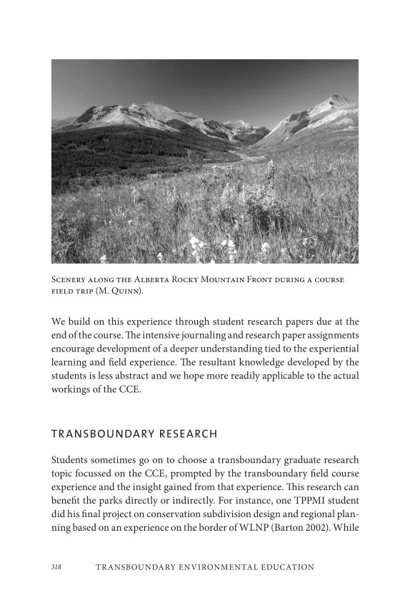
TR ANSBOUNDARY ENVIRONMENTAL EDUCATION318
We build on this experience through student research papers due at the end of the course. The intensive journaling and research paper assignments encourage development of a deeper understanding tied to the experiential learning and field experience. The resultant knowledge developed by the students is less abstract and we hope more readily applicable to the actual workings of the CCE.
TR ANSBOUNDARY RESEARCH
Students sometimes go on to choose a transboundary graduate research topic focussed on the CCE, prompted by the transboundary field course experience and the insight gained from that experience. This research can benefit the parks directly or indirectly. For instance, one TPPMI student did his final project on conservation subdivision design and regional plan-ning based on an experience on the border of WLNP (Barton 2002). While
Scenery along the Alberta Rocky Mountain Front during a course field trip (M. Quinn).
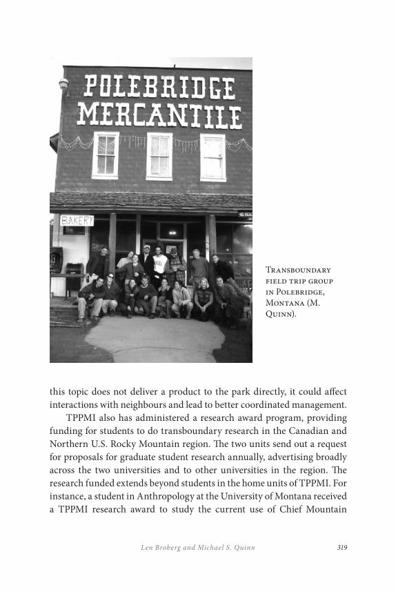
319Len Broberg and Michael S. Quinn
Transboundary field trip group in Polebridge, Montana (M. Quinn).
this topic does not deliver a product to the park directly, it could affect interactions with neighbours and lead to better coordinated management.
TPPMI also has administered a research award program, providing funding for students to do transboundary research in the Canadian and Northern U.S. Rocky Mountain region. The two units send out a request for proposals for graduate student research annually, advertising broadly across the two universities and to other universities in the region. The research funded extends beyond students in the home units of TPPMI. For instance, a student in Anthropology at the University of Montana received a TPPMI research award to study the current use of Chief Mountain
TR ANSBOUNDARY ENVIRONMENTAL EDUCATION320
in GNP by Blackfeet tribal members (Henderson-Matthews 2005). A portion of that research was also funded through GNP, facilitated by the GNP Learning Center (L. Welling, pers. comm.). This research has been influential in GNP visitor management, thus benefiting both GNP and the Blackfeet Tribe and its members. The research award tool has extended the reach of TPPMI beyond the immediate units and has built useful research partnerships for a relatively modest investment of US$5,000 or less in student projects.
INTERNATIONAL EDUC ATION: A PL ATFORM FOR
FACILITATING SHARED KNOWLEDGE
Universities around the world have long held an interest in international education for their students and international research and exchange for their faculty (Heater 1985, 266). Such programs are too numerous to mention here. However, the institutional imperative for international education and the presence of structures within universities to promote and manage such interactions cannot be discounted in the success of educational programs like TPPMI. The University of Montana mission statement includes: “integration of the liberal arts, graduate study, and professional training with international and interdisciplinary empha-ses” (University of Montana 2011). The University of Calgary policy on international linkage agreements concurs: “international linkages are a widespread, normal, and desirable feature of academic life” (University of Calgary 2011). In contrast with the land management agencies of the region, universities have a primary mission of education and research that is not tied to particular outcomes or states of the ecosystems in which they work. That is not to say that many higher education institutions do not have direct ties to either supporting or creating commodity markets (the land grant universities of the United States are an obvious example) or that they do not have land to manage within the CCE. The University of Montana, for instance, manages the Lubrecht Experimental Forest within the boundaries of the Crown of the Continent Ecosystem. Nonetheless, they are not viewed by the public or decision-makers as having that task as
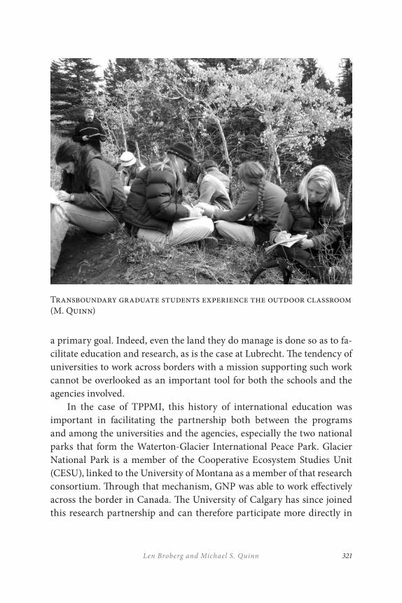
321Len Broberg and Michael S. Quinn
a primary goal. Indeed, even the land they do manage is done so as to fa-cilitate education and research, as is the case at Lubrecht. The tendency of universities to work across borders with a mission supporting such work cannot be overlooked as an important tool for both the schools and the agencies involved.
In the case of TPPMI, this history of international education was important in facilitating the partnership both between the programs and among the universities and the agencies, especially the two national parks that form the Waterton-Glacier International Peace Park. Glacier National Park is a member of the Cooperative Ecosystem Studies Unit (CESU), linked to the University of Montana as a member of that research consortium. Through that mechanism, GNP was able to work effectively across the border in Canada. The University of Calgary has since joined this research partnership and can therefore participate more directly in
Transboundary graduate students experience the outdoor classroom (M. Quinn)
TR ANSBOUNDARY ENVIRONMENTAL EDUCATION322
research in GNP. TPPMI facilitated this opportunity, and it is likely that other transboundary education and research partnerships with parks of this nature can help build mutually beneficial knowledge and practice.
CONCLUSION
TPPMI has built a productive partnership with the Waterton-Glacier International Peace Park that benefits all parties and the broader academic and management community of the region. By bringing the educational and research foci of the universities into the parks and learning from the parks’ experience, TPPMI has fostered the growth and professional de-velopment of students and faculty and served the knowledge generation needs of the parks and their neighbours. The tools of a field course, re-search awards and CESU are prominent among the features of TPPMI that drive the success of the partnership to date. The independent, interna-tionally focussed nature of the academy also facilitates dynamic interac-tions across borders that help to transcend them and to build cooperation. TPPMI and similar transboundary educational efforts are not a solution to all the challenges of transboundary management, but they can provide an important tool in resolving at least some of those issues over the longer term.
REFERENCES
Barton, K. 2002. “Conservation design guidelines for rural residential subdivisions conserving wildlife habitat in the Rocky Mountain Regions of Alberta and Montana.” Master’s degree project, University of Calgary.
Crown Managers Partnership (CMP). “History.” Accessed December 6, 2011. http://www.rockies.ca/cmp/history.php.
Heater, D. 1985. “International education: educational programmes.” In The International Encyclopedia of Education: Research and studies, ed. T. Husen and T. N. Postlethwaite, 2666–2667. London: Pergamon Press.
Henderson-Matthews, B. 2005. “For as long as the sun shall rise and the mountains cast their shadows.” Master’s thesis, University of Montana.

323Len Broberg and Michael S. Quinn
Landres, P. B., R. L. Knight, S.T.A. Pickett, and M. L. Cadenasso. 1998. “Ecological effects of administrative boundaries.” In Stewardship Across Boundaries, ed. P. Landres and R. L. Knight, 39–64. Washington, D.C.: Island Press.
Long, B. 2007. “The Crown of the Continent ecosystem: Profile of a treasured landscape.” In Sustaining Rocky Mountain Landscapes: Science, Policy and Management for the Crown of the Continent ecosystem, ed. T. Prato and D. Fagre, 17–35. Washington, D.C.: RFF Press.
Parks Canada. 2000. Waterton Lakes National Park of Canada Management Plan: A Portion of Waterton-Glacier International Peace Park. Waterton, Alberta: Parks Canada.
Pedynowski, D. 2003. “Prospects for ecosystem management in the Crown of the Continent ecosystem, Canada–United States: Survey and recommendations.” Conservation Biology 17: 1261–69.
Prato, T., and D. Fagre. 2007. “The Crown of the Continent: Striving for sustainability.” In Sustaining Rocky Mountain Landscapes: Science, Policy and Management for the Crown of the Continent Ecosystem, ed. T. Prato and D. Fagre, 3–16. Washington, D.C.: RFF Press.
Sax, J., and R. Keiter. 2006. “The realities of regional resource management: Glacier National Park and its neighbors revisited.” Ecology Law Quarterly 33: 233–310.
University of Calgary. 2011. “Policy on international linkage agreements.” Accessed September 30, 2011. https://pr1web.ucalgary.ca/UofCPandPA_R1/PublicViewPPDocument.aspx?docType=0&version=52&view=true
University of Montana. 2011. “UM Mission Statements.” Accessed September 30, 2011. http://www.umt.edu/president/umms.htm
United States Department of Interior (USDI). 1999. Glacier National Park General Management Plan. West Glacier, MT : Glacier National Park, National Park Service, U.S. Dept of Interior.
———. 2003. Fire Management Plan and Environmental Assessment. West Glacier, MT: Glacier National Park, National Park Service, U.S. Dept. of Interior.
———. 2009. Invasive Plants of the Crown of the Continent. West Glacier, MT: Glacier National Park, National Park Service, U.S. Dept. of Interior.

325
Transboundary Conservation Management, Research, and Learning: A South African and United States Perspective
Wayne Freimund and Robert Fincham
A CHALLENGE OF TR ANSBOUNDARY CONSERVATION
The Waterton-Glacier International Peace Park is an icon of collabora-tion. Not only does one find ready cooperation between the formal con-servation agencies in the contemporary peace park, but civic society has been a critical factor since its inception. It was Rotary International and its chapters in Alberta and Montana that resulted in the ceremonious joining of the two parks in 1932 (Mittermeier et al. 2005). Since then a range of other government and non-government agencies have added their sup-port to this and other international transboundary conservation areas. In southern Africa, and just over sixty years later in 1997, Nelson Mandela endorsed the collaborative idiom of transboundary conservation at the
13
TR ANSBOUNDARY CONSERVATION MANAGEMENT, R ESEARCH, AND LEARNING
326
launch of the Peace Parks Foundation and the first transboundary conser-vation area in the region:
I know of no political movement, no philosophy, and no ideol-ogy which does not agree with the peace parks concept as we see it going into fruition today. It is a concept that can be em-braced by all. In a world beset by conflict and division, peace is one of the cornerstones of the future. Peace parks are building blocks in this process, not only in our region, but potentially the entire world. (Peace Parks Foundation 2010)
In spite of the success of Waterton-Glacier International Peace Park as a transboundary entity and the utterance of the revered Nelson Mandela, the imperatives for transboundary conservation remain contentious and in many parts of the world are invariably juxtaposed with tenuous finan-cial support, rapid social and ecological change, and the broader expecta-tions, competition and demands that emanate from local, national, and global role players. The contentious nature is epitomized in the comment from Wolmer (2003, 10), who maintains that transboundary natural re-source management “is the latest in a line of top-down, market orientated [initiatives that have been] … pushed on Africa since the 1980s by interna-tional bureaucracies … and the private sector.” He quotes an interviewee from his research who maintains that “trans-frontier conservation [areas] are drawn by Cecil Rhodes clones – rather than seeing greater expanses of red on the map they want to see great wedges of green as their legacy to Africa!”
In contrast, others underscore the value of transboundary conserva-tion areas since they make biodiversity conservation feasible across pol-itical entities. Mabunda (pers. comm.), reflecting on the thirteen trans-boundary complexes in southern Africa, highlighted their value in a systems management context in which the common goals of biodiversity and community development can emerge. Similarly, Tanner et al. (2007) stressed the positive impacts of the Waterton-Glacier International Peace Park in creating tourism and related opportunities in the surrounding communities. These and similar writings endorse the contested territory

327Wayne Freimund and Robert Fincham
of transboundary conservation and the importance of the contemporary challenges of fostering positive management, research, and education pro-cesses and outcomes from these entities.
It is within the above context and in celebrating seventy-five years of conservation in the Waterton-Glacier International Peace Park that it is opportune to reflect on the challenges that remain for international ac-ceptance and effective political, social, and economic support of trans-boundary conservation. In like manner, the pedagogical contributions to address these challenges are of particular concern for this paper. The purpose of the paper is, therefore, to underline specific contestations we have understood conservation managers to face in the broader context of conservation management and the way in which our academic program of collaboration has addressed those issues. Against this backdrop, we set out the framework of collaboration between our two universities, the University of KwaZulu-Natal and the University of Montana, and the in-novations and management outcomes they have produced.
THE M ANAGEMENT PERSPECTIVE
From a conservation management perspective, the need to address the plethora of challenges from financial stringency and social and ecologi-cal change bears consideration. Transboundary conservation raises new concerns in an era when approaches to management are themselves facing a revolution (Pollard and Du Toit 2007). A great deal of thought has gone into notions of partnerships and co-management between public, private, and non-government organizations and the importance of management within the framework of organizational culture (Fincham and Hay 2006, 2007, 2008; Graham and Kruger 2002; Nyambe et al. 2007; Pollard 2004; Reutenbeek and Cartier 2001). Furthermore, managers recognize the im-portance of biodiversity conservation but must temper efforts in this di-rection with the realization that these areas are in themselves complex so-cial and ecological systems from which partners have other expectations. So, the managerial challenge emerges as one that must meet defined park mandates and concurrently address the tensions that arise from perceived
TR ANSBOUNDARY CONSERVATION MANAGEMENT, R ESEARCH, AND LEARNING
328
direct and indirect values that society and partners place on these self-same entities.
Dealing with complex social and ecological systems requires man-agers to develop frameworks to assist them in understanding these sys-tems. That is no easy task when the central focus must be on short-term, specific management planning. What emerges is for managers to confront the inescapable need to transform their organizations from management entities to learning organizations, ones in which a culture of learning predisposes them to successfully anticipate and adapt to the longer-term dynamics and processes of the systems in which they work and manage (Pollard and Du Toit 2007; Senge et al. 1999 2008).
THE AC ADEMIC CHALLENGE
The academic challenge to work concertedly alongside managers to con-tribute to the execution of their mandates has been far from satisfactory. Often, the approach has been parochial with a failure to address conserva-tion concerns at effective spatial, temporal, and political scales (Cumming et al. 2006; Reutenbeek and Cartier 2001). From a spatial perspective, transboundary conservation has thrown into relief the challenges of working across political boundaries and the need for a new form of politi-cal endowment for policy-making (Nyambe et al. 2007).
While such boundaries have existed at the intra- and inter-country level and the significance of their jurisdictions have been appreciated, the same cannot readily be said for jointly managed transboundary areas. Homogeneity is too readily assumed and the impact of differing social value systems and the resultant heterogeneity underestimated (Carruthers 2003; Carton et al. 2009). The concept of the sovereignty of governance systems has to be acknowledged to appreciate the effect of their contrast-ing approaches to management and hence of governance itself. It is only with this understanding in mind that collaborative management on the ground can emerge.
In a similar vein, social histories transcend boundaries. For example, contrasts in communal and private ownership of land will lead to differing
329Wayne Freimund and Robert Fincham
perspectives of the relevance of the private sector and other institutional structures. One needs to simply contemplate the conservancy move-ments in Namibia and South Africa to appreciate this point. In Namibia the conservancy movement is based on communal property rights where they form a critical component of livelihood strategies. However, in South Africa, conservancies come out of a need to provide security for commer-cial farmers who have often combined private properties to form part of game management areas, moving away from the less-lucrative practice of extensive cattle-ranching (Mwango 2009). On the other hand, both forms of conservancies are now being perceived as potential buffer zones around formerly protected conservation areas and new transboundary conserva-tion areas (Mwango 2009). It follows that the intrinsic social values of these less formally protected areas will also assume similar, differing, and invariably new meanings.
Not only have we, as educators, struggled to come to terms with scale, the same can be said of broader temporal concerns. For example, a focus on the problems of contemporary planning systems pays little attention to the principle of future skills acquisition in our students. We often still perpetuate quick-fix solutions, developing policies for nearly everything in response to immediate management concerns. Such short-sighted plan-ning, and by implication learning, comes out of a philosophy that has been so often focussed on event-based thinking, when our true mission should have been the preparation of graduates to have the conceptual skills to address the unknown dimensions of systems that we are still struggling to understand (Holling 2001; Resilience Alliance 2007).
In this chapter, we propose that the ability to address challenges at dif-fering spatial and temporal scales requires a systems approach to under-standing protected area management. There is considerable evidence to support the notion that social, economic, and biophysical sciences have developed enormously in the last 150 years. However, that development has been within discipline-specific situations (Georg 2005) and in rela-tive isolation from other scientific disciplines. It amounts to a reductionist science, providing answers but not for the most pressing of our problems.
The notion of science as the sacred cow (Illich 1993) is no longer ten-able as society requires science to perform in terms of human needs and
TR ANSBOUNDARY CONSERVATION MANAGEMENT, R ESEARCH, AND LEARNING
330
societal concerns (Nyambe et al. 2007). Reutenbeek and Cartier (2001) talk of the entry into the age of panarchy, where our task is to understand adaptive, interactive, and evolutionary characteristics of human and nat-ural complex systems. They describe panarchy as the complex system in which nature interacts with its human elements. Importantly, panarchy (through its nested systems levels) allows for the understanding of differ-ent scales and their cycles and how knowledge and novelty are created and incorporated at these scales.
The task of incorporating complex systems thinking into research and teaching, and by extension management, is fraught with problems, not the least being that many contemporary situations remain a product of “poli-cies and interventions that are based on non-systems thinking. Reforming these policies may yet prove to be our greatest challenge” (Nyambe et al. 2007, 8). Nevertheless, the excitement of complex systems thinking holds much that will help in our understanding of protected area management.
BRINGING THE M ANAGEMENT, RESEARCH AND
LEARNING IMPER ATIVES TOGETHER
A process of iterative consultation between our partner universities and managers led to a focus on three issues that have been particularly problematic to managers: (1) managing demands; (2) managing relation-ships with constituencies; and (3) sensing and evaluating the external environment.
Managing Demands
In a dynamic society, such as exists in southern Africa, the public interest is fluid and difficult to discern. Agencies given missions at one specific point may find public support for those missions waning at a later time. They may find new interests being stated, and they may find that the social meanings attached to specific places change dramatically. Conservation agencies, developed in an era of relative political stability and with specific mandates such as the recovery of individual species, may find that this mission has broadened: from species recovery to population enhancement
331Wayne Freimund and Robert Fincham
in other places; from a species orientation to an ecosystem one; from pro-tection of a single species to biodiversity conservation; from providing wildlife viewing opportunities to tourism development. In general, these changes have moved from narrow, biologically focussed definitions to broader issues of economic development and social justice.
Often society imposes mandates on conservation organizations with-out consideration of the fact these mandates may be at least partially con-flicting: developing expectations that biodiversity will be protected and employment as a result of tourism will be generated, for example. Since it is impossible to maximize two related variables at the same time, tradeoffs must be made. But the tradeoffs, while subject to technical analysis, often reflect social values and priorities at the time. Biodiversity and economic opportunity cannot both be maximized at the same scale at the same time. Technical analyses can show the consequences of emphasizing one or the other but cannot suggest which one should be emphasized.
Responding to these changing public interests is particularly prob-lematic for conservation agencies, primarily because of their strong, mission-oriented, often military-like organization and the professional passion with which they have traditionally pursued their goals. While this organizational structure and culture has distinct advantages when goals are widely shared, societal change has brought new and diversifying demands upon protected area organizations. And thus, management of these demands – identifying them, determining their compatibility, mak-ing resource allocations – has become a major organizational challenge. Unfortunately, typical protected area organizations are poorly equipped to conduct these activities, principally because protected area stewardship has been historically defined as primarily an applied biology problem.
Managing Relationships with Constituencies
Because demands arise from established and emerging norms of society, they can be conveniently linked to the constituencies defined by those norms. Consequently, managing demand must involve managing rela-tionships with constituencies that are promoting accommodation of a particular value or use within the operations of a protected area. From a demand management perspective, it appears to be important that
TR ANSBOUNDARY CONSERVATION MANAGEMENT, R ESEARCH, AND LEARNING
332
protected area agencies acknowledge the heterogeneous nature of society (i.e., many constituencies each with different demands).
At the same time as demands on protected areas have diversified, there has been a corresponding public desire to open decision-making processes and to make those decisions transparent and accessible. This demand represents a critique of progressive-era approaches that may be briefly characterized as scientifically based and expert-driven. Such ap-proaches marginalize public input and exclude social values and mean-ings. While no one argues that decisions should be informed by the best science available, other forms of knowledge, such as experiential and trad-itional knowledge, may also inform decisions. Since a lot of planning is in reality about managing trade-offs among competing values and public preferences, choices need to be informed directly through engaging the public in decision-making processes.
But interacting with protected area constituencies involves more than holding a few meetings now and then. Public engagement is a process of developing and maintaining relationships with various constituencies. Useful and constructive public input should be strategic and involves long-term interaction, where both members of the public and protected area agencies learn from each other – about process, preferences, modes of behaviour, and expectations. Such a functional, healthy relationship based on mutual respect, trust, and legitimacy forms the basis for constructing and implementing the public interest. However, the definition of protec-tion as a purely biological construct has limited the ability of agencies to interact, understand, and respond to the public. Such interactions require social science and facilitation skills, which are traditionally outside the normal domain of biological training.
Managing relationships involves a host of questions: How are values within protected areas to be determined? Who are the constituencies for values within a protected area? How should one interact with them? What functions would such interactions serve? Who benefits from engaging con-stituencies? Does engagement of constituencies involve a loss of political power for protected area organizations? How do agencies, working with their constituencies, broaden support for conservation? What information and skills/expertise do constituencies hold that is useful for protected area
333Wayne Freimund and Robert Fincham
organizations? How would the stewards of a protected area know if their interactions were successful?
Managing Learning
In the changing environment that characterizes the context for conserva-tion organizations, learning becomes an important step to not only the survival of the organization but its capacity to meet new challenges and mandates. Being an organization that learns is a new objective for many bureaucracies because routine problem-solving does not normally require much learning, just carrying out repetitive tasks. A focus on learning for protected area organizations represents a realization that the organiza-tion’s mandate is anything but routine. This is a particularly dynamic challenge for conservation agencies because of the tradition of a narrow, biologically oriented mission using a hierarchal top-down, command and control structure and decision-making process.
Learning may be defined as the detection and correction of error. It requires ability to sense the external environment (in a number of dif-ferent domains), to understand the changes occurring, to evaluate them, and then to act appropriately upon them. But learning also has a strategic dimension: anticipating alternative futures and building robust strategies to deal with them.
The organization, its culture, leadership, structures, and processes dir-ectly influence its ability to learn and act upon new insights. For example, personnel evaluation processes could be an incentive or a deterrent to learning and using new knowledge in decision-making. While protected area organizations have often incorporated new biological knowledge into management plans, they typically have had more difficulty in sensing and responding to changes in the social and political environment. One ex-ample is the U.S. Forest Service moving from fire suppression to fire man-agement once it was understood that fire was a natural process in western U.S. situations; similar realizations have characterized fire management within South Africa’s parks (Pollard and du Toit, 2007; Mabunda pers. comm.). In the past, this occurred because systems modelling progressed further in the biophysical domain than it had in the social domain.
TR ANSBOUNDARY CONSERVATION MANAGEMENT, R ESEARCH, AND LEARNING
334
Of the three dimensions of capacity-building, learning is fundamen-tal. Without learning, organizations are unable to effectively anticipate and respond to the changing demands expressed by development of new constituencies and emerging alliances with varying preferences. We note here that the notion of response does not necessarily include forsaking the mission of the protected area organization. Public agencies normally lack the legal ability to do so, which is typically held by a legislative entity such as parliament or legislature. In addition, the response to changing demands, such as needs for resource commodities, may be fulfilled else-where. The protected area organization may work with constituencies to find places, outside the protected area where such demands can be met.
DEVELOPING AND SUSTAINING A PRODUCTIVE
TR ANSBOUNDARY RESEARCH AND LEARNING
PROGR A M
Origins of Cooperation
The universities of Montana and KwaZulu-Natal (then the University of Natal) began exploring their potential for collaboration in 1998. They were brought together by a South African NGO called the Wilderness Action Group (WAG). WAG had been cooperating with the United States Department of Agriculture (USDA) Forest Service for several years on a training program for wilderness field managers in southern Africa. WAG officials were interested in credentialing their courses. The University of Montana was well known in wilderness education and was a logical resource.
At that time, WAG saw no viable university partner within South Africa but was interested in seeing capacity for protected area education and re-search develop within the region. Their exploration within South Africa uncovered the Centre for Environment, Agriculture and Development or CEAD (then the Centre for Environment and Development), an in-novative group within the University of KwaZulu-Natal interested in
335Wayne Freimund and Robert Fincham
multidisciplinary and interdisciplinary approaches to land management issues. Given the notable role the KwaZulu-Natal region has played in the southern African wilderness movement, this form of capacity-building was immediately interesting to CEAD.
Defining a Niche and an Audience
This assembly of actors, consisting of two universities, an NGO and mem-bers of the USDA Forest Service, began a discussion on what each group could bring to, and gain from, formal collaborative activity. Into 1999 and 2000, a framework for activity was formalized in a memorandum of understanding between the two universities. We agreed that, while the wilderness niche provided clear entry to the professional ranks, we needed a broader conceptual rubric, given the diversity of needs relative to our in-terests and strengths. The concept of protected areas provided that rubric. We initially saw three primary audiences within our scope of activity: field rangers, mid-level land managers, and executive managers involved with land management policy and decision-making. Field rangers remained the target audience for short course trainings that were provided by WAG, certified by the University of KwaZulu-Natal, and reviewed and advised by the University of Montana. These courses are designed around the ba-sics of wilderness management and planning. They occur within a wilder-ness setting and include numerous practical exercises.
While the training of rangers was quite successful, it was also apparent that the mid-level management community would need to be engaged to increase the chance of field rangers having a fertile professional environ-ment in which ideas that emerged via field training could be implemented. This audience was particularly interesting to the University of KwaZulu-Natal, which was in the process of retooling its education programs to better accommodate the opportunities for education that were emerging after the democratic government was established in 1994.
The result of the retooling was the development of a Master of Science degree in Protected Area Management (PAM), the first of its kind in Africa. This degree program targeted the professional audience and pro-vided conceptual, historic, and practical material on protected area man-agement. Campus residential requirements were minimized and students
TR ANSBOUNDARY CONSERVATION MANAGEMENT, R ESEARCH, AND LEARNING
336
were able to complete their field research in the protected areas they man-aged. This mitigated the challenges of being away from work and family for managers, while quickly pushing the results of the students’ educa-tion into the field. Since its inception in 2001, the PAM program has mi-grated to a completely distanced-based, named degree program (Masters in Environment and Development – Protected Area Management), which has made it far more accessible to the management community in the African region.
Recognizing that the mid-level manager could face the same difficulty of convincing their superiors that new ideas should be used, we identi-fied the need for an executive training opportunity that would function at the policy level. In 2006, this seminar became a reality with the first annual African Leadership Seminar (ALS) in People and Conservation taking place in South Africa and Mozambique (Fincham and Hay 2006). In the first two years of ALS, conservation leaders from nine southern African countries, the United States, and Wales have studied important issues such as HIV/AIDS, co-management, transboundary management, leadership, and concessions policy (Fincham and Hay 2006, 2007).
Reflecting on our foundation from a systems perspective, infusing higher education into the protected area management arena of south-ern Africa could only be successful if the infusion points occurred at places within the broader system that provided leverage (Meadows 1999). Training professionals horizontally across the organization (e.g., only field rangers) is likely to exert forces for change within organizations that may result in counter forces of resistance. For example, a majority of the land in the South African National Parks system is under land claim by residents who have been displaced from those lands over time.
Reconciling those claims is leading to many joint management ar-rangements, increased concessions within protected areas, and increased demands on protected areas to produce revenue. These kinds of changes in the protected area management system pose significant threats to people who are highly invested in the previous centralized system of protected area governance. By providing training on these issues at various levels and sectors of organizations, change can begin from many sources and new paradigms may seem less threatening.
337Wayne Freimund and Robert Fincham
The Emergence of a Common Vision
Our preliminary work in education and training provided a good platform for our faculty and agency partners to explore our common expertise, in-terests, and strengths. Protected area management, however, includes a very broad range of topics and disciplines. Soon students in Montana and Pietermaritzburg were enthusiastically approaching professors to study everything from wild dog behaviour and guinea fowl habits within ex-otic plantations to transboundary governance systems. While the need for a research program was apparent, especially to build so-called African scholarship for the above-mentioned training and education programs, it was also evident that we would need some restrictive parameters to our work. What could a small group of committed colleagues contribute to such a broad topic beyond an education and training program? What would the leverage point be for this collaborative program? To answer this question, we needed to be self-critical about our specific academic strengths relative to the demands. We began with a set of principles to help us develop a focussing framework. We concluded that our work should be:
• relevant to contemporary problems and issues;
• applicable to systems in both the United States and southern Africa;
• play to the strengths of the committed faculty; and
• provide the greatest leverage and complement to the existing state of knowledge.
Given the rapid pace of social change described above, we concluded that a focus on the social context of protected area management would best fit the criteria above. While a deep body of ecological research exists in both the United States and South Africa, the social issues of protected area management are becoming paramount in both countries. Additionally, systems of governance and basic tensions between conservation and so-cial utility are common to both areas. We also recognized that the social
TR ANSBOUNDARY CONSERVATION MANAGEMENT, R ESEARCH, AND LEARNING
338
science strengths within the U.S. faculty provided a sound complement to the essentially biological backgrounds of the South African partners.
Merging a Research Agenda with the Management
Community: The Treehouse Program
To ensure the relevance of our research program, the South African partners organized a meeting of several key management organiza-tions in South Africa. They included South African National Parks, the Department of Environmental Affairs and Tourism, KwaZulu-Natal Wildlife, and the Council for Scientific and Industrial Research (CSIR). It was out of these meetings that the Treehouse Program emerged. A central tenant of the program was to build capacity within conservation organiza-tions. The three-pronged focus on managing demands, relationships, and learning, set out in the academic challenges section of this chapter, epito-mized the ideas that emerged from the partner discussions.
That focus, however, did not emerge overnight but through intense discussions and deliberations at a further series of meetings among aca-demicians and agency staff held in Kruger National Park during the period 2001–2005. Essentially, the fundamental question addressed was: “what could be done to enhance the capacity of protected area organizations to respond to changing demands, the need for sensing and responding to the external environment, and managing relationships with its growing and diversifying constituencies?” The result was a series of decisions to further examine these three components, both conceptually and empiric-ally. A framework was developed and given the name “Treehouse” after the place in Kruger National Park where particularly significant decisions were made.
The framework is illustrated in Figure 1. It is designed to display the dimensions of the capacity-building challenge, to be used as a heuristic device for understanding how different components relate to each other, and as a model for identifying information needs and research directions. Our objective is to enhance the performance of the protected area organ-ization in meeting its stewardship mandate in an era of change, complex-ity, and uncertainty.
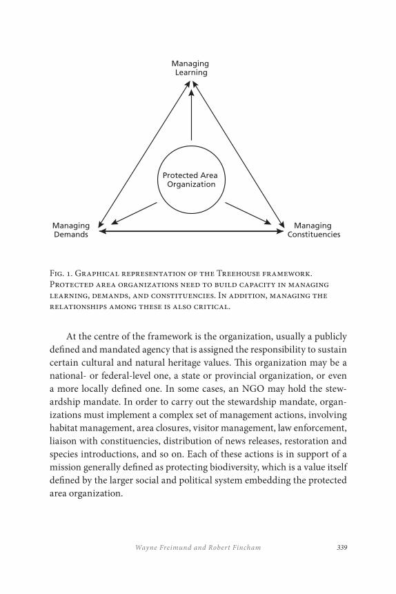
339Wayne Freimund and Robert Fincham
At the centre of the framework is the organization, usually a publicly defined and mandated agency that is assigned the responsibility to sustain certain cultural and natural heritage values. This organization may be a national- or federal-level one, a state or provincial organization, or even a more locally defined one. In some cases, an NGO may hold the stew-ardship mandate. In order to carry out the stewardship mandate, organ-izations must implement a complex set of management actions, involving habitat management, area closures, visitor management, law enforcement, liaison with constituencies, distribution of news releases, restoration and species introductions, and so on. Each of these actions is in support of a mission generally defined as protecting biodiversity, which is a value itself defined by the larger social and political system embedding the protected area organization.
Fig. 1. Graphical representation of the Treehouse framework. Protected area organizations need to build capacity in managing learning, demands, and constituencies. In addition, managing the relationships among these is also critical.
Protected Area Organization
Managing Learning
Managing Constituencies
ManagingDemands
TR ANSBOUNDARY CONSERVATION MANAGEMENT, R ESEARCH, AND LEARNING
340
Such actions are not without conflict and contention in this broader system. With diversifying societies, there are evolving definitions of bio-diversity protection and strategies to accomplish it. The results are impacts to public interests and demands, some predictable, some unknown, and some unanticipated. These consequences often generate further impacts conflicting with the mandate at best and political opposition and hostil-ity at worst. Thus, the organization must constantly sense its external en-vironment, including the new demands and expectations of society, now and into the future. The constituencies that make these demands have different amounts of political savvy and power; many hold political veto power over agency implementation.
Using the framework illustrated in Figure 1, a group of scientists, managers, and students developed a research agenda that would enable us to synthesize the findings of varied research projects as insights that con-nect the factors at the corners of the framework triangle. By focussing on the system’s processes that would link the management of demands, con-stituencies, and learning, students were able to provide depth on specific issues while helping us better see the leverage points within protected area management systems. The range of dissertations and theses that were completed within this program includes the following topics:
• Changing missions of conservation organizations;
• The relationship between international law and community engagement on transboundary conservation;
• Effective public/private partnerships in conservation;
• Barriers to implementation of successful land claims on protected areas;
• How private property rights are negotiated in voluntary conservancies;
• Protected areas and community displacement;
• Protected areas and private enterprise;
• Strategies to cope with HIV/AIDS in the conservation sector;
341Wayne Freimund and Robert Fincham
• The role of social capital in conservation systems;
• Understanding the legitimacy of extractive resource use in protected areas;
• Managing for high quality natural experiences that build deep meaning and require pristine conditions; and
• Understanding and managing social relationships in protected area systems.
LESSONS LEARNED
Of our ten years of collaboration, the final five have been focussed on the Treehouse Research Program. Our experience attests to the value of a multinational approach that uses a systems framework for distilling knowledge from research and informing education and training with that knowledge. Multinational systems, examined in concert, illustrate the complexities of each system. It is through the comparative perspectives available when viewing similar phenomena through the lens of differing cultures that underlying processes, rather than events, associated with protected area management become readily apparent.
By comparing cultures, system properties like time lags between cause and effect become useful tools for building understanding. For example, while we have seen the process of governance devolution occur in both the United States and South Africa over the past decade, the pace of change in the South African system has been more rapid. Given South Africa’s ac-celerated pace of devolution, we are able to see the associated time effects (e.g., impatience in civil society, and reconciliation of land tenure) more apparently than in the United States, and perhaps prepare better here as the beneficiaries of that knowledge. Likewise, the long-term success of the Waterton Glacier International Peace Park provides a model for new peace parks to see how the system can evolve in the longer term.
The complexities associated with international peace parks as a form of protected area management illustrate quite well the need to structure con-tinuous feedback and learning systems into the management philosophy
TR ANSBOUNDARY CONSERVATION MANAGEMENT, R ESEARCH, AND LEARNING
342
for the area. In peace parks, your management space will necessarily be shaped by the social history of the area. That history may be to celebrate peace, as is the case at Waterton-Glacier, but it may also be to promote the goal of peace as it is in many other parts of the world. That history will dictate that managers do not make decisions in a way that will dishon-our the work that was required for the peace park to be developed. In the present, the combination of differing political systems adds an additional layer of complexity to the management system. This complexity can be better confronted if the players involved view themselves as learning or-ganizations. In our case, we embarked on a program to improve capacity for making good management decisions for protected areas. The use of a simple framework assisted us in learning how to do that.
Our process, perhaps similar to the management of a transboundary park, required us to learn how to sustain collaboration over an extended period of time. This required developing a common vision, building inter-personal and inter-institutional trust and recognizing that our potential was largely unknown. As is often the case, our success or failure depended on communication. Fortunately, today’s technology reduces communica-tion obstacles associated with global scale geography. What this has meant is that ties, instituted formerly within the Treehouse program, are likely to continue long after the formal program of research is terminated. Ideas travel digitally and so continue to stimulate new and creative offshoots from the original program of work.
CONCLUSION
Transboundary management occurs in a system in which the parts on each side of the boundary move at differing paces, are subject to differ-ing social and political forces, and have differing levels of certainty about existing and future conditions. Thus, these types of protected areas are extremely well-suited for study with a systems approach. A systems ap-proach requires agencies to view themselves as learning organizations who cannot anticipate the range of events that will occur in the mid- to long-term futures.

343Wayne Freimund and Robert Fincham
Our academic experience demonstrates that this type of approach will assist managers developing knowledge about existing issues in a way that will help them in seeing the broader scale at which these issues play out. It is at this broader temporal and spatial scale that events can be situated and responded to. In the post-9/11 management era, for example, border security realized a heightened importance. Waterton-Glacier absorbed this change to the system quite readily, however, due to its longer-term set of formal and informal managerial relationships (Tanner et al. 2007). A system with less-developed relationships may have had much greater difficulty absorbing such a shock.
The experience described in this chapter has guided us to the conclu-sion that, when we began collaboration, our internal capacities as organ-izations did not match up to our ambitions. Over time, the collaboration has assisted us in building our own capacity as learning organizations, improved our ability to develop sustainable partnerships, and contributed to the education of current and future protected area managers. By taking an approach that sought to build learning rather than knowledge alone, we have developed a group of scholars in the United States and southern Africa who will continue to create knowledge in a way that will connect their specific issues to protected area management worldwide. The peace park ideal has the same potential. Each peace park developed in the past seventy-five years has a lesson to teach all of us. We suggest that we use a systems approach and work together as scientists and managers to under-stand and assemble those lessons.
TR ANSBOUNDARY CONSERVATION MANAGEMENT, R ESEARCH, AND LEARNING
344
REFERENCES
Carruthers, J. 2003. “Past and future landscape ideology.” In Social History and African Environment, ed. W. Beinart and J. McGregor, 255–66. Athens, OH: James Currey and Ohio University Press.
Carton, B., J. Laband, and J. Sithole, eds. 2009. Zulu Identities: Being Zulu, Past and Present. Scottsville: University of KwaZulu-Natal Press.
Cumming, G. S., D.H.M. Cumming, and C. L. Redman. 2006. “Scale mismatches in social-ecological systems: Causes, consequences, and solutions.” Ecology and Society 11: 20.
Fincham, R., and D. Hay. 2006. “Report on the first African Leadership Seminar, People and Conservation, August 12–19. 2006.” Centre for Environment, Agriculture and Development, University of KwaZulu-Natal.
———. 2007. “Report on the second African Leadership Seminar, People and Conservation, June 30–July 7, 2007.” Centre for Environment, Agriculture and Development, University of KwaZulu-Natal.
———. 2008. “Report on the third African Leadership Seminar on People and Conservation, June 21–28, 2008.” Centre for Environment, Agriculture and Development, University of KwaZulu-Natal.
Georg, S. 2005. “Research collaboration – the challenges of transgressing boundaries.” In Sustainable Development and the University: New Strategies for Teaching, Research and Practice, ed. R. Fincham, S. Georg, and E. Holm-Nielsen, 34–52. Howick: Brevitas.
Graham, A. C., and L. E. Kruger. 2002. Research in Adaptive Management: Working Relations and the Research Process. Portland, OR: United States Department of Agriculture, Forest Service.
Holling, C. S. 2001. “Understanding the complexity of economic, ecological, and social systems.” Ecosystems 4: 390–405.
Illich, I. 1993. Limits to Medicine: Medical Nemesis: The Appropriation of Health. New York: Penguin.
Meadows, D. H. 1999. Leverage Points: Places to Intervene in a System. Hartland, VT: The Sustainability Institute.
Mittermeier, R. A., C. F. Kormos, C. G. Mittermeier,, P. R. Gil, T. Sandwith, and C. Besancon. 2005. Transboundary Conservation: A New Vision for Protected Areas. Mexico: CEMEX.
Mwango, N. 2009. “The history of conservancies.” Working Paper. Centre for Environment, Agriculture and Development, University of KwaZulu-Natal.
345Wayne Freimund and Robert Fincham
Nyambe, N., C. Breen, and R. Fincham. 2007. “Organisational culture as a function of adaptability and responsiveness in public service agencies.” In Governance as a Trialogue: Government-Society-Science in Transition, ed. A. R. Turton, H. J. Hattingh, G. A. Maree, D. J. Roux, M. Claassen, and W. F. Strydom, 197–214. Berlin: Springer.
Peace Parks Foundation. 2010. “Words from Dr Nelson Mandela.” Accessed 13 December 2010. http://www.peaceparks.org.
Pollard, D. 2004. “We did that!: the lost instinct of collaboration.” Accessed 30 September 2007. http://blogs.salon.comm/0002007/2004/10/06.html.
Pollard, S., and D. Du Toit. 2007. “Planning and managing protected areas for global change.” Gland, Switzerland: IUCN.
Resilience Alliance. 2007. “Assessing and managing resilience in social-ecological systems: a practitioner’s handbook, version 1.” Accessed 30 September 2007. http://www.resalliance.org/index.php/resilience_assessment.
Reutenbeek, J., and C. Cartier. 2001. “The invisible wand: Adaptive and co-management as an emergent strategy in complex bio-economic systems.” Centre for International Forest Research Occasional Paper No. 34, 2001.
Senge, P., A. Kleiner, C. Roberts, R. Ross, G. Roth, and B. Smith. 1999. The Dance of Change: The Challenge of Sustaining Momentum in Learning Organizations. London: Nicholas Brealey Publishing.
Senge, P., B. Smith, N. Kruaschwitz, J. Laur, and S. Schley. 2008. The Necessary Revolution: How Individuals and Organizations are Working Together to Create a Sustainable World. London: Nicholas Brealey.
Tanner, R., W. A. Freimund, , B. Hayden, and B. Dolan. 2007. “The Waterton-Glacier International Peace Park: Conservation and Border Security.” In Peace Parks: Conservation and ConflictRresolution, ed. S. H. Ali, 183–204. Cambridge, MA: MIT Press.
Wolmer, W. 2003. “Transboundary conservation: The politics of ecological integrity in the Great Limpopo Transfrontier Park.” Institute of Development Studies Research Paper No. 4.

347
14
Successes and Challenges that Face a Peace Park’s Training and Education Facility
Theresa Sowry
INTRODUCTION
The Southern African Wildlife College (SAWC) was established in 1997 by the World Wide Fund for Nature–South Africa (WWF–SA) with money obtained from the German government, and with the support of major conservation stakeholders both within South Africa and regionally across the Southern African Development Community (SADC). The SAWC is a not-for-profit organization that operated initially with financial support primarily from WWF–SA and other donor agencies. The establishment of the SWAC was due to the ever-increasing need to have an institution dedicated to the training of protected area managers within the SADC region (Map 1). The aim of the SAWC was to meet SADC training needs within the sphere of natural resource management. From its inception, the SAWC offered full-time qualification course programs (certificates
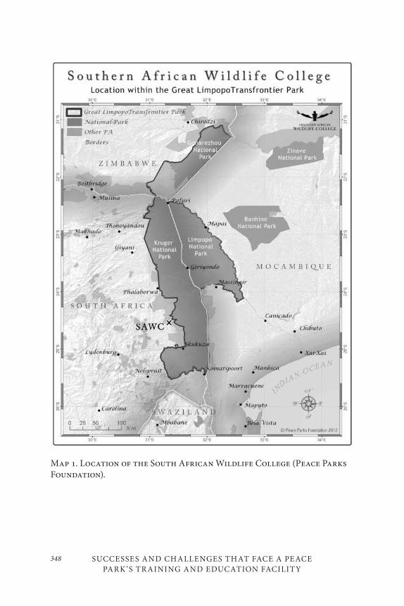
SUCCESSES AND CHALLENGES THAT FACE A PEACE PARK’S TR AINING AND EDUCATION FACILITY
348
Map 1. Location of the South African Wildlife College (Peace Parks Foundation).
349Theresa Sowry
and diplomas). The curriculum covered a broad range of conservation management skills, as well as a range of specialist short courses that in-cluded: wildlife management, nature-based tourism, community-based natural resource management, and other environmentally related topics. Custom-made short courses were also developed for those organizations wanting specialist training courses designed to meet specific needs. The SAWC’s courses were all designed with input from conservation organiza-tions across the SADC and remain relevant to training needs identified across the region. The establishment of the Peace Parks Foundation (PPF) and the realization of transfrontier conservation areas (TFCAs) across the SADC region, resulted in the SAWC and the Southern African College of Tourism (SACT) becoming training institutions primarily focussed on training staff of these TFCAs. The SAWC is now dedicated to the empower-ment, support, and capacity-building of the conservation sector through-out the region, specifically to those communities associated with TFCAs. The SAWC has become a SADC-recognized centre of specialization and continues to work closely with conservation organizations across the re-gion to train according to current needs – both within formal protected areas and in surrounding communities. The Peace Parks Foundation is now the main fundraiser for the SAWC; however, WWF–SA still plays an active role in this important function.
SOUTHERN AFRIC AN WILDLIFE COLLEGE
Training Philosophy
The Southern African Wildlife College understands that the most effec-tive training combines action with reflection. This training perspective encourages mentors and students alike to embrace different ways of learn-ing. The courses offered at SAWC are characterized by a hands-on, practi-cal and highly participatory approach, which is complemented by group discussions and lectures. Unlike other training institutions, the SAWC does not employ a large permanent staff, but contracts practising profes-sionals with relevant experience to ensure that the training is as practical,
SUCCESSES AND CHALLENGES THAT FACE A PEACE PARK’S TR AINING AND EDUCATION FACILITY
350
relevant, and current as possible. The trainers are selected from a large pool of natural resource management experts within southern African en-vironmental and conservation agencies, as well as from the private sector. The course methodology focusses on outcomes-based instruction, which ensures improved performance when learners implement these skills in the workplace.
The SAWC offers two categories of training programs. The first cat-egory consists of qualification courses (diploma and certificate), while the other category focusses on skills development courses.
Qualification Courses
Qualification courses are held on campus and target protected area and natural resource managers from southern Africa who are already in the service of conservation and environmental agencies. The course struc-ture emphasizes practical, hands-on skills, rather than using a strictly academic or theoretical approach. Individuals must be selected by their organization as having the potential to become a junior or mid-level man-ager within their organization. These individuals may not have the neces-sary formal qualifications to become protected area or natural resource managers. Thus, the necessary bridging skills are provided so that these individuals may return to their places of work equipped with the means to manage their areas efficiently and effectively. Training interventions gen-erally evolve around the diverse practical field experiences of both trainers and students. This allows students to apply knowledge to their workplaces, thereby not only benefiting themselves but also their individual organiza-tions and their local communities.
The certificate qualification course is aimed at individuals who have been identified as having the necessary skills to develop into junior managers within their reserves. A learner who has achieved this quali-fication will be able to integrate supervisory knowledge and skills within the operational specifics of a conservation area. Modules covered in this qualification include: Tourism Management, Philosophy and Ethics of Conservation, Legislative Guidelines and Implications for Law Enforcers, Personnel Management, Basic Ecology, Vegetation Management and Monitoring, Animal Management, Integrated Catchment Management,
351Theresa Sowry
Infrastructure Management, Management of Cultural Heritage Resources, Introduction to Protected Area Management Plans, Introduction to Community Development and Conservation, Environmental Education, and Ensuring Ecosystem Integrity.
The diploma qualification course is aimed at mid-level protected area managers. Modules covered in this qualification include: Research Skills, Human Resource Management, Protected Area Management, Freshwater Ecology, Environmental Development Plans, Landscape Management, Introduction to Applied Resource Economics, Project Management, Community Development and Conservation, Environmental Education, Tourism Management, and Natural Resource Protection–Strategic Operations.
The course content for both of these qualifications is frequently up-dated to cover training needs expressed by conservation organizations. For example, a formal training needs analysis (TNA) (Pullen and Petersen 2001) was conducted in 2001 with the aim of identifying conservation training needs within the SADC region for the period from 2001 to 2006. These recommendations were given to the SWAC, and course content was updated accordingly. One need identified from this TNA was the need for off-campus training for staff of conservation organizations across the SADC region. This led to the SAWC delivering high quality skills train-ing, not only on campus, but also off site within protected areas (see Skills Development Courses section). During 2006, course content was updated with funds made available from World Wide Fund for Nature–Southern African Regional Program Office (WWF–SARPO). This update focussed mainly on regional community issues and incorporated relevant case studies from SADC. Since the development of TFCAs, the course content has been aligned to specific TFCA needs, namely community involve-ment (including educational awareness, conflict resolution, leadership skills, and community participation), animal management (including problem animal control, and disease spread), alien vegetation manage-ment, landscape management (as opposed to reserve management), and tourism development. A subsequent evaluation of training needs was con-ducted in 2009 as part of an extensive conservation outreach field trip to
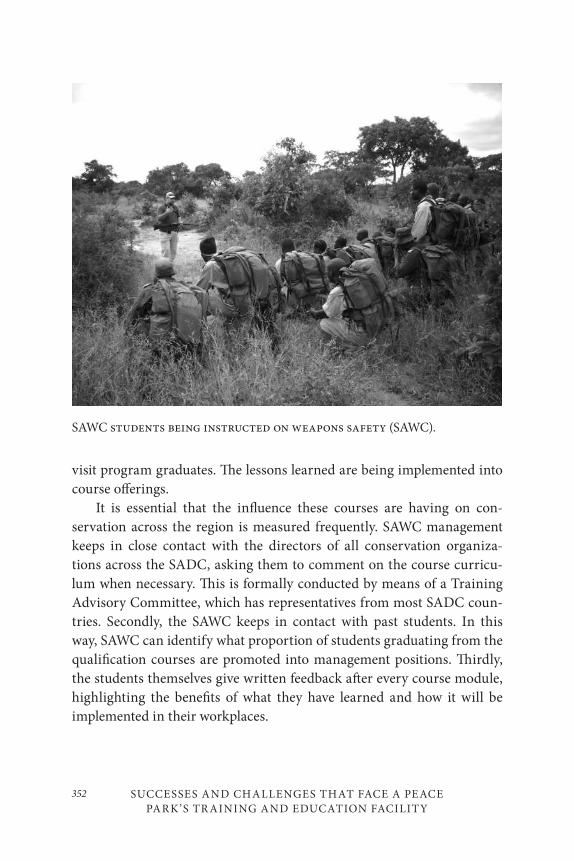
SUCCESSES AND CHALLENGES THAT FACE A PEACE PARK’S TR AINING AND EDUCATION FACILITY
352
visit program graduates. The lessons learned are being implemented into course offerings.
It is essential that the influence these courses are having on con-servation across the region is measured frequently. SAWC management keeps in close contact with the directors of all conservation organiza-tions across the SADC, asking them to comment on the course curricu-lum when necessary. This is formally conducted by means of a Training Advisory Committee, which has representatives from most SADC coun-tries. Secondly, the SAWC keeps in contact with past students. In this way, SAWC can identify what proportion of students graduating from the qualification courses are promoted into management positions. Thirdly, the students themselves give written feedback after every course module, highlighting the benefits of what they have learned and how it will be implemented in their workplaces.
SAWC students being instructed on weapons safety (SAWC).
353Theresa Sowry
Since its inception, and with the support of the Peace Parks Foundation, the SAWC has trained over 5,000 people from 26 African countries in natural resource management. SAWC management keeps in contact with past students and monitors their progress when they return to their work-places. Most of these students have returned to their organizations and been promoted to a higher level of authority within their workplace.
Case Studies of Success and Benefits
On successful completion of the diploma course, Henry Kadauma (a Malawian student in 2005) was promoted to assistant park warden and transferred from Liwonde National Park to Nyika National Park in the northern part of Malawi. Nyika National Park forms part of a transfron-tier conservation area with Zambia. The Nyika TFCA is centred on the Nyika plateau. Henry contacted SAWC through a contribution to the stu-dent newsletter (the Mvelaphanda) and wrote: “In my own view, conser-vation in Africa can be achieved through the combination of community participation and stringent law enforcement. The knowledge and skills I acquired from my studies at the college have placed me at a better position to handle such enormous tasks in Nyika, the paradise on earth” (Southern African Wildlife College 2007).
Mirriam Namushi was the first female recipient of the Southern African Conservation Education Trust (SACET) scholarship and com-pleted her diploma in 2005. She has been promoted to park ranger, based in Mongu in the western part of Zambia. Her duties now include plan-ning and supervising field operations for the protection, conservation, and management of wildlife resources in areas under the Zambia Wildlife Authority. In her contribution to the newsletter she states: “The conserva-tion training that was presented at the Southern African Wildlife College through the support of SACET has empowered me to meet the challenges of conserving wildlife alongside men. I am now applying the knowledge I have acquired from the course to my subordinates to the benefit of my country” (Southern African Wildlife College 2007).
William Soko studied at SAWC towards a Certificate in Natural Resource Management in 2004. He was employed by the Zambian Wildlife Authority as a senior wildlife police officer. He was the top graduate in his
SUCCESSES AND CHALLENGES THAT FACE A PEACE PARK’S TR AINING AND EDUCATION FACILITY
354
class and was subsequently awarded a SACET scholarship to attend the diploma course. William successfully completed his diploma and upon re-turning to Zambia was sent to the Eastern Region of the Zambia Wildlife Authority and was subsequently promoted to park ranger. He is presently in charge of Lukusuzi National Park and the Lower Lumimba Game Management Area, where his responsibilities include supervising twenty-nine wildlife police officers, two senior wildlife police officers, and fifteen Community Resource Board village scouts. Two national parks have been identified under the Transfrontier Conservation Areas Programme in the Eastern Region of Zambia due to their proximity to neighbouring Malawi; these are Lukusuzi National Park and Nyika National Park. William wrote to the newsletter to explain the communities’ support of the new TFCAs. He wrote:
There has been overwhelming response from the local com-munity members. Over 15 villagers have volunteered free ser-vices in three wildlife camps on the eastern end of Lukusuzi. The villagers are supporting anti-poaching operations by ac-companying wildlife police officers on patrol. There are also community resource village scouts based in three camps in the buffer zone in Lumimba Game Management Area on the Western end of Lukusuzi National Park. These are paid from community funds generated from safari and resident hunting. The volunteer village scouts in the corridor between Kasungu and Lukusuzi National Parks hope to find permanent employ-ment once the TFCA is fully operational. (Southern African Wildlife College 2007)
Beatrice Zvobara was employed by the Department of Parks and Wildlife, Zimbabwe, in 1999 as a scout II. She completed her certificate course in 2003. She was subsequently appointed warden of operations in Matusadona and was later transferred to Sengwa Research Unit. Beatrice completed her diploma in 2005, and a year later she was transferred to Lake Mcllwaine Recreational Park on the North Bank, where she is presently the officer in charge of the station. Beatrice explains:
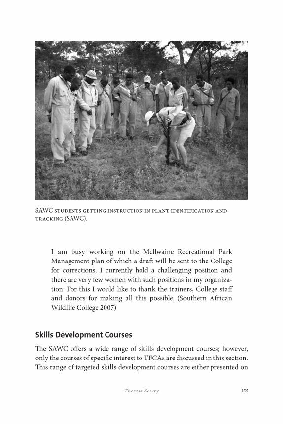
355Theresa Sowry
I am busy working on the Mcllwaine Recreational Park Management plan of which a draft will be sent to the College for corrections. I currently hold a challenging position and there are very few women with such positions in my organiza-tion. For this I would like to thank the trainers, College staff and donors for making all this possible. (Southern African Wildlife College 2007)
Skills Development Courses
The SAWC offers a wide range of skills development courses; however, only the courses of specific interest to TFCAs are discussed in this section. This range of targeted skills development courses are either presented on
SAWC students getting instruction in plant identification and tracking (SAWC).
SUCCESSES AND CHALLENGES THAT FACE A PEACE PARK’S TR AINING AND EDUCATION FACILITY
356
campus or in the workplace, depending on the needs of the specific con-servation organization, and are aimed at a number of different levels – from workforce to manager. A number of the skills development courses are registered skills programs on the National Qualifications Framework of South Africa. These programs have been designed by sectoral training authorities in consultation with relevant parties (such as conservation or-ganizations) and approved by the South African Qualifications Authority. The development of such skills programs is the result of a need to train ac-cording to job competency requirements in the industry. Skills programs that the SAWC is approved to train include field ranger training and gen-eral field assistant training. Both these courses are aimed at a very basic level and can be offered in a country’s official language. Basic field ranger training is essential for any wildlife area, specifically TFCAs, as law en-forcement and conservation guardianship are the fundamental principles that govern protected area management.
Field RangerA field ranger within South Africa needs to have been trained to do the following:
• organize;
• understand and apply personal values and ethics;
• demonstrate an understanding of HIV/AIDS and its implications;
• maintain occupational health and safety;
• cooperate as part of a team;
• practice conservation guardianship;
• identify and monitor local wildlife;
• understand nature conservation issues; and
• handle a weapon.
357Theresa Sowry
The SAWC trains field rangers from a number of TFCAs to meet the same standards as required in South Africa. It is important to standardize training across a TFCA so that field rangers from different countries have, as much as possible, the same training and will respond to incidents in a similar way. In other words, the TFCA should be seen as one homogenous area as far as law enforcement and conservation guardianship are con-cerned. It is beneficial to train field rangers within their workplace, as they can become familiar with real-life situations they will face after the train-ing. The trainer is also able to identify potential problems in the workplace and possibly overcome them during the training session.
General Field AssistantA general field assistant, commonly referred to as a “general worker,” is required to fix a number of infrastructural problems, conduct road and fence maintenance, control veldt fires, remove alien plants, attend to soil erosion, and attend to a number of other day-to-day activities. A skills program has been designed by the relevant sector training authority in South Africa to address all these issues. An individual having completed this skills program will be able to competently perform to his or her job requirements. This skills program should become the standard training for any “general worker” within a TFCA.
Geographic Information SystemsOne particularly successful skills development course offered on campus is the Geographic Information Systems (GIS) course. This course deals specifically with spatial data analysis, cartography and mapping, GIS/Global Positioning System (GPS) capturing and remote sensing data, and GIS as a conservation application. This course is therefore high on the priority list for training in any TFCA. The Peace Parks Foundation devel-oped this course and the SAWC uses staff from PPF to present this course at SAWC.
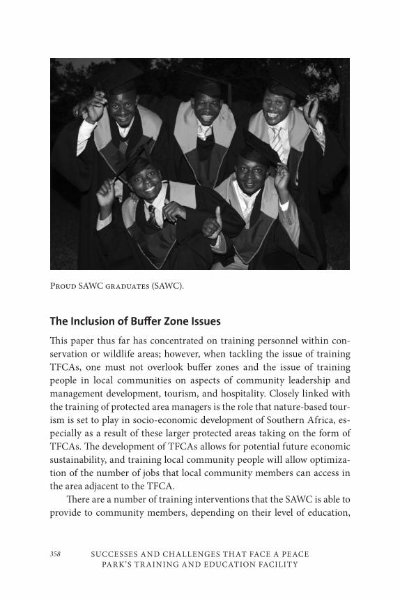
SUCCESSES AND CHALLENGES THAT FACE A PEACE PARK’S TR AINING AND EDUCATION FACILITY
358
Proud SAWC graduates (SAWC).
The Inclusion of Bu≠er Zone Issues
This paper thus far has concentrated on training personnel within con-servation or wildlife areas; however, when tackling the issue of training TFCAs, one must not overlook buffer zones and the issue of training people in local communities on aspects of community leadership and management development, tourism, and hospitality. Closely linked with the training of protected area managers is the role that nature-based tour-ism is set to play in socio-economic development of Southern Africa, es-pecially as a result of these larger protected areas taking on the form of TFCAs. The development of TFCAs allows for potential future economic sustainability, and training local community people will allow optimiza-tion of the number of jobs that local community members can access in the area adjacent to the TFCA.
There are a number of training interventions that the SAWC is able to provide to community members, depending on their level of education,

359Theresa Sowry
their training needs, and the funds available for training. Some of most popular training interventions as part of buffer zone development of TFCAs are discussed in the next section.
Community Leadership DevelopmentThis program is designed to develop understanding, skills and confidence in community leaders, where they are faced with development options in tourism. This program is an integrated development program and is de-signed to assist the community leaders to decide which tourism develop-ment option would be most beneficial to their situation, to plan and imple-ment tourism development on a project basis, and to efficiently manage the implementation targets, project team performance, and finances. It also provides a range of soft skills that will support them in the manage-ment of their working relationships and when dealing with private-sector investors and government officials.
New Venture CreationThis program exposes community members to new ideas and opportuni-ties available to them. They learn about entrepreneurial profiles and are trained how to write in business language. Business management is a ma-jor component of this training.
Tourist Guide (Nature and Culture)A vast number of community members have excellent knowledge of their local indigenous plants, animals, birds, and cultures. Most new venture creations around TFCAs incorporate community-based tourism (CBT), and this would necessitate the training of local people to become nature-based or culture-based guides for interpretation purposes. Some of these guides would possibly be hired by tourism concessions within the pro-tected area itself, while others would form an essential interpretation role for the CBT enterprises in the areas adjacent to the TFCAs.
SUCCESSES AND CHALLENGES THAT FACE A PEACE PARK’S TR AINING AND EDUCATION FACILITY
360
HospitalityCBT enterprises would undoubtedly need trained chefs, waiters, room attendants, and reception staff trained from the local community. The Southern African College of Tourism (SACT) trains women from local communities adjacent to TFCAs in courses ranging from three weeks to nine months in length, covering all essential hospitality services. The SACT, funded solely by the Peace Parks Foundation, aims to train women to competently work in concession lodges within protected areas or with-in CBT initiatives. Students from nine African countries have graduated from SACT.
CHALLENGES
The SAWC is a non-profit organization, relying heavily on donor funds. This is probably the ultimate challenge for this institution. However, the movement of the fiduciary responsibility from WWF–SA to the Peace Parks Foundation has been a positive move, as the Peace Parks Foundation aims to create space and train people to manage that space. Therefore, the SAWC – now strategically placed as the training wing of the Peace Parks Foundation – is in a better situation than ever to overcome this challenge.
Conservation organizations need to budget for training and not rely solely on donor funding for aid. Bursaries granted by the WWF–SA and the Peace Parks Foundation are becoming partial bursaries to motivate organizations to budget for a small contribution towards the training. Unfortunately, when budgets are cut, training budgets are always first in line. Training needs, identified within the organization, must be elevated on the priority list. Capacity-building within an organization cannot hap-pen without training. Perceptions need to change for this challenge to be overcome.
Organizations that fund the development and park planning of TFCAs need to budget for training and capacity-building from the initial planning phase of a project. A training plan and budget must be devel-oped and must incorporate community involvement and possible new venture creation in areas adjacent to the protected areas. The Peace Parks
361Theresa Sowry
Foundation and the SAWC are working together on projects to ensure this happens and is not overlooked.
Differences in language, levels of education, expectations, and govern-mental policies between countries need to be addressed. TFCA training must identify and tackle these differences through the training provider. Presently, SAWC provides basic level training in a number of different languages, as unskilled people are often the very individuals to be tar-geted for skills development. Training only in English would discriminate against these individuals. Training of more educated people takes place in English.
New trainees usually start their training once negotiations and promises have been made to both employed and unemployed members of a community. It is essential that the trainer and learners discuss these expectations that training outcomes are realistic and that opportunities exist for employment.
A specific challenge that SAWC faces is the issue of accreditation. It is essential that SAWC remains a SADC centre of specialization and contin-ues to keep course content current with a regional perspective. However, SAWC is based in South Africa, and therefore the curriculum needs to comply with South African legislation. This remains an intricate balanc-ing act, as regional case studies need to be used in the training arena to effectively cover country-specific training needs. SAWC strives to be le-gally compliant within South Africa but simultaneously strives to update course content to cover regional issues.
CONCLUSION
Since the inception of the college, over fifty million South African rands of donor funding has been spent on training to develop skills of conserva-tion staff across the SADC region. It is now time for conservation orga-nizations to raise a proportion of the funds within their own organiza-tions for their staff to attend the SAWC. WWF–SA and the Peace Parks Foundation continue to donate partial bursaries to cover 50% of partici-pants program costs. The SAWC has an evolving strategy to encourage
SUCCESSES AND CHALLENGES THAT FACE A PEACE PARK’S TR AINING AND EDUCATION FACILITY
362
active participation from organizations in the ever-challenging activity of fundraising. The SAWC is currently placing an emphasis on the develop-ment and implementation of training plans for TFCAs. These plans will entail a three- to five-year roll-out strategy for the development of skills within the TFCAs. Training local skills is essential for the success of the TFCA, and it is stressed that if local community skills are ignored, the very basis of what a TFCA should achieve will be in jeopardy.
REFERENCES
Pullen, L. and L. Petersen. 2001. “Training needs analysis for the Southern African Wildlife College.” Report prepared for World Wildlife Fund for Nature–South Africa.
Southern African Wildlife College. 2007. “Interesting news from past students across the continent.” Mvelaphanda 2007: 2–6.

Section 4 PEACE PARK PROPOSALS

365
The Siachen Peace Park Proposal: Reconfiguring the Kashmir Conf lict?1
Kent L. Biringer and K. C. Cariappa
INTRODUCTION
One of the longest military conflicts in recent history continues high in the mountains of South Asia. It is taking place in the Karakoram Mountains at the western end of the Himalayas at elevations that exceed six thou-sand metres. While there is a long history of dispute in Kashmir, the cur-rent dispute between India and Pakistan in the Siachen Glacier region of northern Kashmir has been underway since 1984 (Raghavan 2002). The history of the confrontation stems, in part, from an undelineated portion of the Line of Control (LOC) that was established after the 1948 war be-tween India and Pakistan. This line defined the separation of forces in Kashmir and has remained in effect with only minor deviations over six
15
1 A previous version of this chapter was published in Peace Parks, Conservation and Conflict
Resolution, edited by Saleem H. Ali (MIT Press, 2007).

THE SIACHEN PEACE PARK PROPOSAL366
decades. The dominant geographical feature here is the Siachen Glacier, the longest glacier outside the polar caps.
In recent years, there have been several attempts by the countries in-volved to resolve the dispute. To date, these have been unsuccessful. One goal is to achieve a military disengagement from the region, eliminating the exorbitant human and financial costs associated with this conflict and reducing the military conflict in Kashmir that is and has been a flash-point in South Asian security since the time of partition (Kanwal 2007). There also exists a strong environmental interest in resolving the dispute and minimizing the impacts of maintaining troops on the highest battle-field in the world (Ali 2002; Tallone 2003). Those addressing these issues include individuals in government, the military, academia, and the non-governmental community.
During the sixty years since the partition of India, the region has often been plagued by conflict. Three major wars have been fought be-tween India and Pakistan over that period, and one was fought between China and India (Ganguly 2001; Sidhu and Yuan 2003). In the aftermath of nuclear testing by India and Pakistan in 1998, there have been further series of events that led again to the brink of war. These included armed military manoeuvres by both sides as well as terrorist incidents, such as the attack on the Indian parliament in December 2001.
After the first India/Pakistan war in 1948, a ceasefire line (CFL) div-ided the princely state of Jammu and Kashmir under the terms of the Karachi agreement for most, but not all, of the disputed region. Once the CFL reached a particular point high in the Karakoram Mountains, referred to by its map coordinates as NJ9842, the agreement specified its extension as “thence north to the glaciers” (Government of India and Government of Pakistan 1949). Pakistan interpreted the line to proceed northeastward to the Karakoram Pass on the Chinese border (Wirsing 1986; Sehgal 1996), whereas the Indians construed it to go along the Saltoro Ridge and Siachen Glacier in a north-northwesterly direction to the Chinese border (Singh 1989; Sidhu 1992). These separate perceptions are reflected in Map 1 overlaid on a satellite map of the region.
With only slight adjustments in the CFL after subsequent wars, Kashmir remains divided. However, in 1984, believing that Pakistan was about to occupy the region, Indian troops moved into the area of the
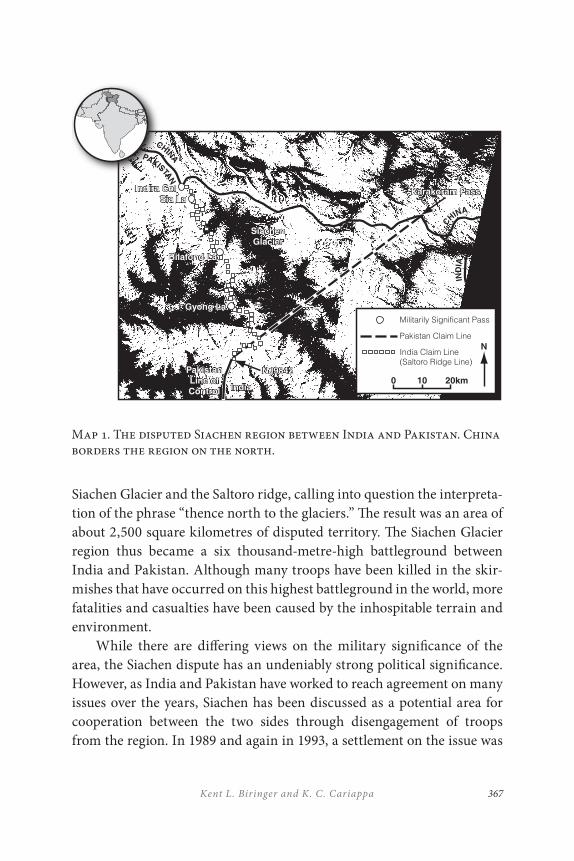
367Kent L. Biringer and K . C. Cariappa
Siachen Glacier and the Saltoro ridge, calling into question the interpreta-tion of the phrase “thence north to the glaciers.” The result was an area of about 2,500 square kilometres of disputed territory. The Siachen Glacier region thus became a six thousand-metre-high battleground between India and Pakistan. Although many troops have been killed in the skir-mishes that have occurred on this highest battleground in the world, more fatalities and casualties have been caused by the inhospitable terrain and environment.
While there are differing views on the military significance of the area, the Siachen dispute has an undeniably strong political significance. However, as India and Pakistan have worked to reach agreement on many issues over the years, Siachen has been discussed as a potential area for cooperation between the two sides through disengagement of troops from the region. In 1989 and again in 1993, a settlement on the issue was
Map 1. The disputed Siachen region between India and Pakistan. China borders the region on the north.
KarakoramPassKarakoramPassIndiraColSiaLa
BilafondLa
GyongLa
IndiraColSiaLa
BilafondLa
SiachenGlacierSiachenGlacier
GyongLa
IndiaIndia
NJ9842NJ9842PakistanLineofControl
PakistanLineofControl
CHINA
CHINA
PAKISTAN
IND
IA
0 10 20km
NPakistanClaimLine
IndiaClaimLine(SaltoroRidgeLine)
MilitarilySignificantPass
C
M
Y
CM
MY
CY
CMY
K
siachenglacier_Kent_b&w.pdf2/25/200511:54:32AM
THE SIACHEN PEACE PARK PROPOSAL368
nearly reached. In 2004, Siachen was designated as one of eight topical areas for dialogue between India and Pakistan in the “composite dia-logue” (Manjunath et al. 2006). The costs in financial and human terms of continuing this confrontation make it an excellent candidate for bilateral cooperation while minimizing strategic or military disadvantage.
General Raghavan, who has served in Siachen, has suggested that, if the opposing military positions do not pose a threat or if the conten-tious area does not have strategic significance, then a solution is possible. He quotes the late Lt. Gen. I. S. Gill, who said, “You cannot build roads on glaciers which are moving rivers of ice. We have no strategic-tactical advantage in this area, and nor has Pakistan” (Raghavan 2002). Admiral Koithara, agreeing with this assessment, states “the area has … no stra-tegic value. No military threat can be mounted from or through it.” He suggests that both forces should withdraw and a “wilderness reserve” be created (Koithara 2004).
Many factors will influence a resolution of the Siachen conflict. While political will is the predominant one, it will also be affected by other issues. The imperatives of reducing human suffering, saving wasteful ex-penditures, and ending ecological degradation are three irresistible deter-minants that justify speedy and positive decision-making. Mechanisms that support political will, by providing assurance that terms of agree-ments are met, will be required. These may include monitoring systems, inspection regimes, and cooperative projects, all of which can help ensure compliance. While a variety of resolutions and many monitoring options are possible, this paper will address a set of concepts associated with peace parks and science centres that may contribute to resolution of the Siachen dispute.
Impacts of War
An onerous responsibility rests on the governments of India and Pakistan, whose troops are deployed in the inhospitable reaches of Siachen. The im-pacts of the war can be measured by the human, financial and environ-mental impacts.
369Kent L. Biringer and K . C. Cariappa
The Human ImpactClearly the most dramatic impacts of the war on Siachen are on those troops who must operate on this high battleground. While estimates vary, in over twenty years of fighting, thousands of troops have lost their lives to not only enemy fire but more so to the harsh conditions of life at altitudes of six thousand metres and above (Ramachandran 2007). At temperatures of –50°C, the two armies have hammered at each other.
Solutions are needed that can reduce the need for manned presence at these altitudes and conditions. Concepts for demilitarization have been proposed. In April 2007, the Indian and Pakistani defence secretaries met in Islamabad to discuss the Siachen and Sir Creek disputes. “Pakistan in-sists that there must be some tangible progress on Kashmir for the rap-prochement to gather momentum and India continues to reiterate that it is necessary to first build confidence by resolving relatively less intractable problems” (Kanwal 2007).
The Financial ImpactDespite significant increases in the South Asian Human Development Index (HDI) from 0.4 to 0.6 over the past three decades, the region still remains low on the global scale, second from the bottom only to sub-Saharan Africa. India ranks as number 134 and Pakistan as number 145 among the 187 nations ranked in HDI in 2011 (UNDP 2011). The high costs of maintaining large numbers of troops on Siachen saps financial resources needed to advance the standards of living in both nations. The cost of maintaining forces has been reported to be approximately $1 mil-lion a day in India and somewhat less in Pakistan.
The Environmental ImpactThere is also a need to reduce the negative environmental consequences of the continued conflict. Because of the high costs and difficulty of supply-ing troops stationed in and around Siachen, no effort is taken to remove the military and human accumulation of debris. By some estimates, as many as four thousand containers of materials a year have been dumped in the glacial crevasses or left strewn across the landscape (Chatterjee
THE SIACHEN PEACE PARK PROPOSAL370
2001). These will eventually work their way to the headwaters of the Nubra River. The ecological consequences of this accumulated waste can have a significant impact on this otherwise pristine and fragile ecosystem.
But beyond that is a need to address a broader range of regional en-vironmental concerns that affect not only the region itself but more broad-ly the entire subcontinent. Resolution of the conflict in Siachen can open the door to addressing this broader range of regional concerns.
Degradation of the Himalayan Ecosystem
The future of South Asia’s teeming population is at risk if the ongoing environmental degradation and ecological imbalance continues much longer. One of the great concerns of the moment must be the irrevocable damage that is being caused to the environment. This is due to a combina-tion of human depredations and natural causes that have been exacer-bated by rapidly increasing populations and industrialization. Together, these forces have combined to create a possible environmental crisis. The Himalayas are not merely a geographical feature or a range of magnificent mountains; they also embody a people’s civilization. If this great range with its towering peaks was not there, the Indo-Gangetic plains of the subcontinent would not exist as the one-time ‘bread basket’ of undivided India. These mountains give birth to nine giant river systems of Asia, in-cluding the Brahmaputra, the Ganges, and the Indus. It was along their valleys that great civilizations grew and flourished. But as things are today, the quality of these watersheds is threatened. Together these basins are a lifeline for “half a billion people in the Himalayas, and also for 1.3 billion people living in the nine river basins” (Liu and Rasul 2007).
One such area of environmental concern is the area referred to as the Hindu Kush–Himalayan (HKH) region, and the Siachen area specifically, that is being defiled by negative forms of human activity at an alarming rate. The presence of thousands of troops has turned the region into a vast dumping ground of the detritus of war; empty oilcans, ammunition cases, derelict vehicles, and a vast amount of human waste that is to eventually emerge in the Nubra River (Ali 2002). An end to the conflict could lead to efforts to clean up the fragile environment and help protect this endan-gered ecosystem against further degradation.

371Kent L. Biringer and K . C. Cariappa
One observer has remarked: “Siachen has also experienced large-scale loss of plant and animal diversity as a result of the conflict. The glacial habitats of ibex [Capra ibex], brown bears [Ursus arctos], cranes [Grus spp.], snow leopards [Panthera uncial], and many other species are threatened” (Kemkar 2006). The end of conflict also permits greater opportunities to assess the impacts of biodiversity losses in the region.
Effects of Global Warming
The rapid melting rate of the nearly 15,000 Himalayan glaciers is a ma-jor environmental issue in the region. These glaciers comprise the larg-est bodies of ice and snow outside the polar caps and cover an area of nearly 32,000 square kilometres. In a report prepared for the G-8 meeting in March 2005, the World Wide Fund for Nature (WWF) estimated that the glaciers in the region are receding between 7.5 and 23 metres every year (Rai 2005). According to Professor Hasnain, the head of International Commission for Snow and Ice (ICSI), there is a possibility that the glaciers could disappear by 2035. It is estimated that 70 per cent of the water in the perennial rivers of the subcontinent is snow/glacier-fed. Only about 30 per cent is from the monsoons. Climate change in the high elevation desert areas has led to extreme weather events in the form of heavy cloudbursts. This increase in participation threatens local communities and world-class heritage sites with flood damage. For example, in 1999, the walls of the fa-mous 1,000-year-old Hemis Buddhist monastery in Ladakh crumbled as a result of unseasonable rain, mudslides, and flooding. Climatologists have warned of large meltwater lakes that build up behind glaciers in the high Himalayan ranges. If their icy barriers are breached due to rising global temperatures, whole communities downhill would be at risk of being swept away. Environmental assessment programs have determined there are twenty-six such potentially dangerous lakes in Bhutan and Nepal. This threat could be avoided if concerted action is taken immediately (Times of India 2005). Cooperative scientific collaboration in this region could be one step leading to such action.
In addition, the melting of glaciers “seriously threaten[s] water avail-ability in the region, particularly during lean flow seasons when meltwater contribution is crucial to sustain the river flow which supports human activities and ecosystem services” (Liu and Rasul 2007). Because of these
THE SIACHEN PEACE PARK PROPOSAL372
growing climate concerns in the region and around the world, the attract-iveness of resolving disputes and making these areas available for scien-tific study as well as potentially freeing resources for this purpose give added incentive for resolution to the Siachen conflict.
CONCEPTS FOR ALTERNATIVE FUTURES
Over the last decade, an increasing set of ideas has been proposed that could provide a peaceful future for Siachen and an opportunity to ad-dress many of the environmental issues highlighted above. Many in the mountaineering community, who have historically been the most engaged in the Siachen region, helped initiate concepts for conflict resolution. Subsequently, government agencies, academic and non-government orga-nizations, and other research institutions have contributed refinements to the ideas and initial efforts to engage in regional cooperation to address is-sues in Siachen. Their concepts include military disengagement, monitor-ing, and scientific collaborations. Representative ideas from among these concepts are outlined here.
Siachen Peace Park
Aamir Ali, an Indian mountaineer now settled in Switzerland, proposed the idea of the Siachen Peace Park in a 1994 publication (Ali 1992). He has, with many other mountaineers and environmentalists, deplored the degradation of the magnificent Himalayan chain that stretches from the northern borders of Afghanistan to the junction of the borders between India, China, and Myanmar. His proposal would not only help to prevent the further degradation of the Siachen area but would constitute a confi-dence-building measure through the demilitarization of this volatile area. The idea found widespread support among like-minded colleagues and was endorsed at an open meeting at the India International Centre, New Delhi, on 23 June 2001. The meeting addressed an appeal to Indian Prime Minister Vajpayee on the eve of his summit with General Musharraf, then President of Pakistan, proposing that a transboundary peace park be es-tablished that would allow the armed forces of both countries to withdraw,
373Kent L. Biringer and K . C. Cariappa
under strict guarantees and surveillance, in conditions of honour and dig-nity. Though the summit ended in disarray, the idea of a Siachen Peace Park has found support in India and Pakistan, and indeed in many parts of the world. This support is evidenced by the forums on this issue held by government, academia, and non-government organizations that are refer-enced throughout this chapter.
While there can be no doubt that establishing such a transboundary peace park covering the entire Siachen area would prevent further armed confrontation and save thousands of lives and millions of dollars, it would also permit the two governments to assure their respective electorates that there has been no ‘sell out’ of interests. Because of the tremendous costs in human and financial terms associated with twenty-five years of conflict, there is a great need to convince the populations in both countries that neither side is capitulating to the other and thereby reducing the value of the sacrifices made. It would also help ensure that the countries meet their constitutional obligations to protect the Siachen environment. “A princi-pal feature of both the Indian and Pakistani constitutions is the guarantee of several judicially enforceable ‘fundamental rights.’ These fundamen-tal rights may serve as legal justifications in their respective countries for the protection of the environment generally, and the Siachen specifically” (Kemkar 2006). Further, both nations have ratified UNESCO’s World Heritage Convention that encourages “identification, protection, con-servation, and transmission to future generations of the cultural and nat-ural heritage” (UNESCO 1972). The World Conservation Union (IUCN) believes that “protected areas along national frontiers can not only con-serve biodiversity but can also be powerful symbols and agents of cooper-ation especially in areas of territorial conflict” (WCPA 2000). The loss of biodiversity and degradation of ecosystems can reshape the continental landscape directly affecting cultural and economic development. This is precisely what has taken place in the demilitarized zone between the two Koreas as has been brought out by Ke Chung Kim in his recipe for con-servation of the Korean peninsula (Kim 2007).
In concluding an article in the Mountain Research and Development journal in November 2002, Aamir Ali (2002) says, “It is said on both sides of the Line of Control that to honour the blood of brave soldiers that has
THE SIACHEN PEACE PARK PROPOSAL374
been spilled, not an inch of territory should be given up. One could say with even more emphasis that the sacrifice of brave men could best be honoured by protecting a spectacular area consecrated with their blood.” A prior review of the peace park concept for the region has suggested that demilitarization is a viable option and that collaborative work on ecosystems could benefit both nations. It further recommended a three-step phased approach to the demilitarization process that suggests an end to the conflict while disengaging for a mutually agreed period of time, next a negotiated force reduction to be monitored by appropriate tech-nical means, and thereafter an agreed and complete demilitarization plan (Kemkar 2006). Such a phased approach will likely be required to help de-velop the confidence needed to ensure a lasting settlement of the conflict.
The Science Centre Concept
The concept of a science centre in the Himalayas is to replace a military presence with a scientific presence in the Siachen region. A “Siachen Science Centre” (Biringer 1998) would satisfy the requirement for a na-tional presence by both India and Pakistan that would help ensure terms of a military disengagement agreement, while advancing the cause of high-altitude scientific study. The project could initially be conducted co-operatively by India and Pakistan. Later, other regional and international participants and sponsors could be included in this effort to bring peace as well as establish transboundary environmental protection. Already there are 227 transboundary protected areas worldwide (UNEP-WCMC 2007).
Particularly pertinent to the Siachen issue is the precedent of the Antarctic Treaty of 1959 that set aside the entire continent for peaceful scientific use only. Since entry into force in 1961, forty-three countries have become its signatories, including the seven states that originally laid claim to portions of the continent. Under terms of the treaty, all claims are held in abeyance for the term of the treaty and no new territorial claims can be submitted. India acceded to the treaty in 1983 and maintains the Maitri research station as a permanent presence there. Pakistan is not a signatory; however, it maintains the Jinnah Station. Prospects for collab-oration in Antarctica can certainly be expanded as discussed by Michele Zebick-Knos (2007).
375Kent L. Biringer and K . C. Cariappa
The Antarctic Treaty bans any military activity in the defined area and prohibits nuclear testing. It limits national programs to those of sci-entific research and ensures the free exchange of information and scien-tists between countries. Inspection rights are granted to the facilities and operations of other countries with a presence on the continent. Provisions are made to have an open skies regime, enabling aerial observation at any time over any and all areas of Antarctica by any of the contracting parties having the right to designate observers. Regular consultative meetings of the signatory states are held and disputes are resolved by peaceful negotia-tion, including recourse to the International Court of Justice (Joyner and Chopra 1988).
While not a perfect model for South Asia, there are many features of the Antarctic Treaty that might be considered for application in Siachen. Some of these include demilitarizing the area and dedicating it to scientif-ic research and establishing a joint research centre. Other useful concepts include some aspects of the Kuril Island and Korean peninsula proposals that could be adapted to meet the peculiarities of the Himalayas.
While the nature of an agreement on Siachen could take many forms, the science centre concept assumes an agreement in which a designated area would be set aside for peaceful scientific use only. The signatories to such an agreement would seek peaceful coexistence. Other parties could become signatories in various support or participation categories. Establishing a centre for scientific research in the Himalayas would pro-vide a unique location for specialized research as well as the possibility of being integrated into other regional and international networks of scien-tific research such as the Himalayan Research and Cultural Foundation (2001) and the International Centre for Himalayan Biodiversity (Bhandari 2004). International participation could take the form of providing any combination of funding, research, or operational manpower, guidance, or administration.
The Siachen Science Centre would consist of a manned scientific re-search facility within a designated zone in the Karakoram Range. A base camp would be established with the potential for outlying field sites where scientific instruments could be placed. Smaller-scale manned outposts in the vicinity of the base station could also be considered. Scientists,
THE SIACHEN PEACE PARK PROPOSAL376
engineers, and technicians conducting research and experiments would staff the centre. Infrastructure support would have to be provided to meet administrative requirements by staff that could be a mix of bilateral, regional, or multinational personnel. The location high in the Karakoram Range in the western part of the Himalayan Mountains offers many ad-vantages as a base for conducting a wide spectrum of scientific research in a unique geographic region. The facility has the potential to be the highest altitude manned research station in the world. Among the highest in the world currently are astronomical sites in northern Chile at elevations in excess of five thousand metres.
A number of scientific missions are possible. Examples include:
• astronomy, high above much of the earth’s atmosphere;
• geology in an area of interesting tectonics;
• atmospheric sciences in the complex terrain of the Himalayas including climate change and global warming impacts;
• glaciology to provide insight into climatic variations throughout history;
• hydrologic studies to provide insight into relationships between snowfall, glacial activity, and river flows of critical water resources impacting agriculture as well as potential flooding concerns;
• life science studies of this harsh environment;
• physiology research to study the effects of high altitude on humans; and even
• psychological studies investigating the effects of a multinational group working together for prolonged periods in this hostile climatic environment.
In addition to scientific research, engineering knowledge can be obtained in the Siachen. Studies of the design, deployment, and operation of severe climate shelters, logistical issues of supplying and maintaining a remote
377Kent L. Biringer and K . C. Cariappa
installation, and characterization and operation of monitoring systems in a severe environment are all ideally suited to the Siachen.
International Karakoram Science Project (IKSP)
The IKSP is a multinational, interdisciplinary effort by American, Indian, and Pakistani scientists to carry forward the best possible research op-tions and methodologies into the Karakoram Himalayas. Offices have been established in the three countries by university professors, with plans for further development if the concept succeeds. Collateral efforts in-clude the American Association for the Advancement of Science (AAAS), Himalayan High Ice Symposium, a Global Land Ice Measurements from Space (GLIMS) Project, a University of Nebraska IKSP Expedition to K2 Mountain, and an IKSP Workshop in South Asia. The GLIMS Project is a worldwide effort supported by the United States Geological Survey (USGS) and the National Aeronautics and Space Administration (NASA) to as-sess the global ice mass with a view to addressing the many problems that result from global warming and glacier diminution. Depletion of fresh water sources for irrigation, hazards resulting from weakened rock walls following glacier melt, catastrophic meltwater floods, and many other re-lated factors are part of the assessment process using the new ASTER sat-ellite imagery and state-of-the-art analytical techniques. Combining these remote sensing techniques with eventual ground truth measurements in Siachen can help improve the analytical efforts to understand the water-shed and environmental impacts.
Future plans call for joint Pakistani–Indian IKSP workshops on improving scientific knowledge in the Karakoram Mountains. The goals of these workshops are to facilitate cross-border communication and collaboration between geoscientists. Details of this effort were also pre-sented in 2005 at the annual meeting of the American Association for the Advancement of Science. The army could also play a constructive role in the transition phase of this project by acting as rangers and engineers to coordinate the post-conflict clean-up effort (Ali 2005). While the IKSP has not established a permanent science centre in the region, the ideas of cooperative scientific research in the region are a first step in achieving a more permanent cooperative scientific presence in the region.
THE SIACHEN PEACE PARK PROPOSAL378
CONCLUSION
A variety of concepts, whether a peace park or science-based initiative, hold promise for reconfiguring the conflict and initiating peaceful and productive uses of the unique Siachen region environment. Finding ways to end the conflict will reduce human, financial, and environmental costs and its impact on the populations of the bordering countries. It would pro-vide a positive frame for the withdrawal of both armies with dignity and honour and would be a fitting monument to the soldiers of both countries to memorialize lives lost. In addition, it would be an appropriate follow-up to the International Year of the Mountains (2002) and to the International Year for Water (2004).
The Siachen Glacier and the surrounding areas form a remarkable eco-system and are part of the world’s cultural and geographic heritage. The proposed peace park would, in effect, become a ‘Transboundary National Park’ that would straddle the frontier. It would be a powerful force in pro-moting peace, protecting the environment, and safeguarding the cultural values of indigenous peoples. This park would be unique; its size, bound-aries, management plan, environmental protection, and research facili-ties would be negotiated by India and Pakistan for their mutual benefit. Although there can be no magic formula, the following may be possible:
• a joint declaration by the two prime ministers stressing their political commitment to the establishment of the peace park;
• a joint body to delineate the boundaries and plan the phased withdrawal of troops;
• a joint planning team with an alternating chairperson who would seek assistance and guidance from NGOs, such as IUCN, the International Mountaineering and Climbing Federation, and others;
• a memorandum of understanding for the cooperative management of the park; and

379Kent L. Biringer and K . C. Cariappa
• an international treaty on the establishment of the park to be signed by the two heads of government.
Political will is the key to making progress. The future looks brighter, now that relations between India and Pakistan are improving. Cooperation on Siachen and development of a peace or science park could pave the way for a broader set of confidence-building measures to benefit the diverse peoples of South Asia.
REFERENCES
Ali, A. 1992. Himalayan Journal: Vol. III (1931). Himalayan Journal 50, no page numbers. http://www.himalayanclub.org/journal/article-9-himalayan-journal-vol-ii-1931/
———. 2002. “A Siachen Peace Park: The solution to a half-century of international conflict?” Mountain Research and Development 22(4): 316–19.
Ali, S. H. 2005. “Siachen: Ecological peace between India and Pakistan.” Sanctuary Asia, February: 76–77.
Bhandari, R. 2004. “Himalayan Biodiversity Conservation.” The 3rd IUCN World Conservation Congress, Bangkok, Thailand, 17–25 November 2004.
Biringer, K. L. 1998. “Siachen Science Center: A Concept for Cooperation at the Top of the World.” CMC Occasional Paper, SAND98-0505/2. Albuquerque, NM: Sandia National Laboratories.
Chatterjee, M. 2001. “A park to give peace a chance.” The Times of India, June 23, 2001.
Ganguly, S. 2001. Conflict Unending: India Pakistan Tensions since 1947. New York: Columbia University Press.
Government of India and Government of Pakistan. 1949. “Agreement between Military Representatives of India and Pakistan regarding the Establishment of a Cease-fire Line in the State of Jammu and Kashmir,” Annex 26 of UNCIP Third Report-S/1430 Add 1 to 3, 29 July, 1949.
Himalayan Research and Cultural Foundation. 2001. http://www.himalayanresearch.org
THE SIACHEN PEACE PARK PROPOSAL380
Joyner, C. C., and S. K. Chopra. 1988. The Antarctic Legal Regime. Norwalk, MA: Kluwer Academic.
Kanwal, G. 2007. “Demilitarization of the Siachen Conflict Zone: An Idea whose Time Has Come.” Institute of Peace and Conflict Studies, New Delhi, Issue Brief No. 46, June 2007.
Kemkar, Neal A. 2006. “Environmental peacemaking: Ending conflict between India and Pakistan on the Siachen Glacier through the creation of a transboundary peace park.” Stanford Environmental Law Journal 25: 67–121.
Kim, K. 2007. “The demilitarized zone: Transforming a default conservation zone into a peace park on the Korean Peninsula.” In Peace Parks: Conservation and Conflict Resolution, ed. Saleem Ali, Cambridge, MA: MIT Press.
Koithara, V. 2004. Crafting Peace in Kashmir: Through a Realist Lens. New Delhi: Sage.
Liu, J., and G. Rasul. 2007. “Climate Change, the Himalayan Mountains, and ICIMOD.” Sustainable Mountain Development 53: 12.
Manjunath, K. S., S. Sridhar, and B. Anand. 2006. “Indo-Pak Composite Dialogue 2004–05: A Profile,” IPCS Special Report 12, Institute for Peace and Conflict Studies, New Delhi, February 2006.
Raghavan, V. R. 2002. Siachen: Conflict without End. New Delhi: Viking.
Rai, S. C., ed. 2005. “An Overview of Glaciers, Glacial Retreat and Subsequent Impacts in Nepal, India and China.” Kathmandu: World Wildlife Fund Nepal Program, March 2005. http://assets.panda.org/downloads/himalayaglaciersreport2005.pdf
Ramachandran, S. 2007. “India takes glacier tussle to new heights.” Asia Times Online, September 19, 2007.
Sehgal, I. 1996. “The Siachen Battleground: Withering Heights,” Globe (nos.10 and 11): 67.
Sidhu, W.P.S. 1992. “They shall not pass.” India Today, May 31, 1992, 90.
Sidhu, W.P.S., and J. Yuan. 2003. China and India Cooperation and Conflict. Boulder, CO: Lynne Rienner.
Singh, J. 1989. “Siachen glaciers: Facts and fiction,” Strategic Analysis 12(8): 700–701.
Tallone, G. 2003. “Siachen Peace Park: A case study for the valorisation of high mountain ecosystems,” 5th World Parks Congress, Durban, South Africa, September 2003.
Times of India. 2005. “Predicting Peril.” Editorial, Times of India, Feb. 19, 2005.
381Kent L. Biringer and K . C. Cariappa
UNDP. 2006. “Human Development Report 2011.” United Nations Development Programme. http://hdr.undp.org/en/statistics/hdi/
UNESCO. 1972. “Article 4, Convention Concerning the Protection of the World Cultural and Natural Heritage.” United National Educational, Scientific and Cultural Organization (UNESCO), Nov. 16, 1972.
UNEP-WCMC. 2007. UNEP-WCMC Transboundary protected areas inventory. http://www.tbpa.net/docs/78_Transboundary_PAs_database_2007_WCMC_tbpa.net.pdf; accessed June 22, 2009.
WCPA. 2000. Protected Areas, Benefits beyond Boundaries. Gland, Switzerland: World Commission on Protected Areas (WCPA) International Union for Conservation of Nature and Natural Resources (IUCN).
Wirsing, R. G. 1986. “The Siachen Glacier Dispute–I: The territorial dimension.” Strategic Studies 10(1): 60–66.
Zebick-Knos, M. 2007. “Conflict avoidance and environmental protection: The Antarctic paradigm.” In Peace Parks: Conservation and Conflict Resolution, ed. Saleem Ali, 163–82. Cambridge, MA: MIT Press.

383
16
Korean Demilitarized Zone Peace and Nature Park
Hall Healy
INTRODUCTION
With the idea of dividing Korea into spheres of influence in 1896, Japan and Russia conducted negotiations that almost resulted in the partition of the country along a mid-peninsula boundary line, though not at the 38th parallel, where the Demilitarized Zone (DMZ) now is nominally situated (Cumings 1997). A division was not to take place until more than fifty years later, and then as a consequence of World War II and the Korean War. Subsequently, the DMZ became a symbol of the United States’ Cold War containment policy. Now it is a stark remnant of that standoff, but at the same time a reminder of nature’s tremendous resilience and the hope which that affords (Map 1).
Since the end of the Korean War in 1953, the DMZ has been essen-tially off limits to all but a few residents living in two showcase villages, one in North Korea and one in South Korea in the heart of the DMZ near Panmunjom. It has been part of a geopolitical vacuum and memory of
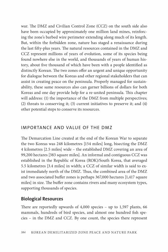
KOR EAN DEMILITARIZED ZONE PEACE AND NATUR E PARK384
war. The DMZ and Civilian Control Zone (CCZ) on the south side also have been occupied by approximately one million land mines, reinforc-ing the zone’s barbed wire perimeter extending along much of its length. But, within the forbidden zone, nature has staged a renaissance during the last fifty-plus years. The natural resources contained in the DMZ and CCZ represent millions of years of evolution, some of its species being found nowhere else in the world, and thousands of years of human his-tory, about five thousand of which have been with a people identified as distinctly Korean. The two zones offer an urgent and unique opportunity for dialogue between the Koreas and other regional stakeholders that can assist in creating peace on the peninsula. Properly managed for sustain-ability, these same resources also can garner billions of dollars for both Koreas and one day provide help for a re-united peninsula. This chapter will address: (1) the importance of the DMZ from multiple perspectives; (2) threats to conserving it; (3) current initiatives to preserve it; and (4) other potential steps to conserve its resources.
IMPORTANCE AND VALUE OF THE DMZ
The Demarcation Line created at the end of the Korean War to separate the two Koreas was 248 kilometres [154 miles] long, bisecting the DMZ 4 kilometres [2.5 miles] wide – the established DMZ covering an area of 99,200 hectares [383 square miles]. An informal and contiguous CCZ was established in the Republic of Korea (ROK)/South Korea, that averaged 5.5 kilometres [3.4 miles] in width; a CCZ of similar width is said to ex-ist immediately north of the DMZ. Thus, the combined area of the DMZ and two associated buffer zones is perhaps 367,000 hectares [1,417 square miles] in size. The buffer zone contains rivers and many ecosystem types, supporting thousands of species.
Biological Resources
There are reportedly upwards of 4,000 species – up to 1,597 plants, 66 mammals, hundreds of bird species, and almost one hundred fish spe-cies – in the DMZ and CCZ. By one count, the species there represent
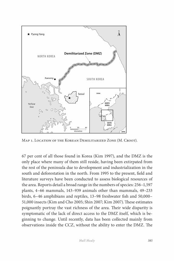
385Hall Healy
Map 1. Location of the Korean Demilitarized Zone (M. Croot).
67 per cent of all those found in Korea (Kim 1997), and the DMZ is the only place where many of them still reside, having been extirpated from the rest of the peninsula due to development and industrialization in the south and deforestation in the north. From 1995 to the present, field and literature surveys have been conducted to assess biological resources of the area. Reports detail a broad range in the numbers of species: 256–1,597 plants, 4–66 mammals, 143–939 animals other than mammals, 49–233 birds, 6–46 amphibians and reptiles, 13–98 freshwater fish and 50,000–51,000 insects (Kim and Cho 2005; Shin 2007; Kim 2007). These estimates poignantly portray the vast richness of the area. Their wide disparity is symptomatic of the lack of direct access to the DMZ itself, which is be-ginning to change. Until recently, data has been collected mainly from observations inside the CCZ, without the ability to enter the DMZ. The
KOR EAN DEMILITARIZED ZONE PEACE AND NATUR E PARK386
variety of species that studies have identified are described below. The lists illustrate and underscore the importance and breadth of flora and fauna diversity existing within the DMZ and CCZ and what an unusual treasure trove it is.
MammalsMany charismatic mammal species, including Asiatic black bear (Selenarctos thibetanus), musk deer (Moschus moschiferus), spotted seal (Phoca largha), and leopard (Panthera pardus) are reported to inhabit and depend on the DMZ and CCZ. The Cultural Heritage Administration of South Korea has designated several DMZ species as “natural monuments,” including:
• Korea-Okhotsk gray whale (Eschrichtius robustus), in waters off the DMZ’s east coast;
• Chinese water deer (Hydropotes inermis);
• Amur goral (Naemorhedus caudatus raddeanus), a rare type of goat;
• otter (Lutra lutra), re-introduced just south of the DMZ in Hwacheon County;
• leopard cat (Prionailurus bengalensis); and
• Korean yellow-necked marten (Martes flavigula koreana).
Reportedly, in the late twentieth century there were even tigers in the mountains around Seoul, the capital of South Korea; and there has been anecdotal evidence of tigers in the DMZ, CCZ area since that time. However, to date, no scientifically based studies have been conducted to verify their presence.
BirdsThe DMZ forms a vital link between ecosystems throughout Northeast Asia. Hundreds of bird species migrate twice a year through the DMZ
387Hall Healy
going to and from Mongolia, China, Russia, Vietnam, Japan, the Philippines, and Australia, essentially from the top to the bottom of the planet! If the DMZ green belt were destroyed, what would happen to this globe-spanning chain? Species include many that, according to IUCN (International Union for Conservation of Nature), are endangered. For example, most of the Black-faced Spoonbills (Platelea minor), with a total estimated world population of 1,679, breed on the western coastal islands off the DMZ (Yu and Wong 2006; Coulter 2007). Two former DMZ inhab-itants, the Oriental White Stork (Ciconia boyciana) and the Crested Ibis (Nipponia nippon), are potential candidates to re-introduce into the area.
Spending part of their life cycle here are other species, many of which also are already endangered, including:
• Black Vulture (Aegypius monachus);
• Stellar’s Sea Eagle (Haliaeetus pelagicus);
• White-tailed Sea Eagle (Haliaeetus albicilla);
• Mandarin Duck (Aix galericulata);
• Broad-billed Sandpiper (Limicola falcinellus);
• Bean Goose (Anser fabalis);
• Swan Goose (Anser cygnoides);
• Great Bustard (Otis tarda);
• Whooper Swan (Cygnus cygnus);
• Chinese Egret (Egretta eulophotes);
• Tristram Woodpecker (Dryocopus javensis);
• Ruddy Shelduck (Tadorna ferruginea); and
• White-fronted Goose (Anser albifrons).
Red-crowned Cranes have a special place in Korean culture as symbols of long life and good luck and are frequently depicted in folklore and art. In historic times, Red-crowned Cranes (Grus japonensis), White-naped Cranes (Grus vipio), and Hooded Cranes (Grus monacha) wintered at

KOR EAN DEMILITARIZED ZONE PEACE AND NATUR E PARK388
many widespread lowland sites. Today the DMZ and CCZ provide a rest-ing area for White-naped Cranes migrating to Japan. Satellite telemetry studies of these cranes have shown that during their long journey from wintering grounds in southern Japan to breeding grounds in northern China and southeast Russia, the DMZ is their major resting area. From October through March, the DMZ is a winter home for Red-crowned Cranes and for other White-naped Cranes that end their passage on the peninsula. Approximately one-third of the world’s 2,500 Red-crowned Cranes and half of the world’s White-naped Cranes depend on the wet-lands and agricultural fields in and near the DMZ. The most important areas are the Han River estuary in the west and the Cheorwon [some-times spelled “Ch’olwon”] Basin in the central highlands. Hooded Cranes are now only found wintering at Sunch’ŏn Bay in the far south end of South Korea and in southern Japan (Archibald 2007; Chong and Pak 1994; Higuchi et al. 1996).
Freshwater Fish, Amphibians, Reptiles, and InsectsBy current estimates, almost a hundred freshwater fish species, some of which are endangered, inhabit DMZ and CCZ rivers and their tributar-ies. These include perch, shiners, dace, Golden Mandarin (Siniperca scher-
zeri), Bitterling (Rhodeus uyekii), Asian Gudgeon (Pseudorasbora parva), and Manchurian Trout (Brachymystax lenok (Pallas)). At least eighteen of them are endemics – found nowhere else in the world (Kim 2004). The Chinese mitten crab (Eriocheir sinensis), now causing significant issues as an exotic species in San Francisco Bay, also naturally resides there. With the area’s many waterways, lakes, and reservoirs and relatively low lev-els of pollution, there are estimated to be up to forty-six amphibians and reptiles, including the narrow-mouthed frog (Kaloula borealis), Korean fire-bellied toad (Bombina orientalis), Asian keelback snake (Amphiesma
vibakari), rat snake (Elaphe schrenckii), Korean magpie viper (Agkistrodon
saxatilis), and a freshwater turtle.An integral component in the overall biologic system, according to a
1992–93 survey, insect phyla in the DMZ and CCZ (Table 1) encompass up to 1,000 insect species, some of which are protected (Kim 2001).
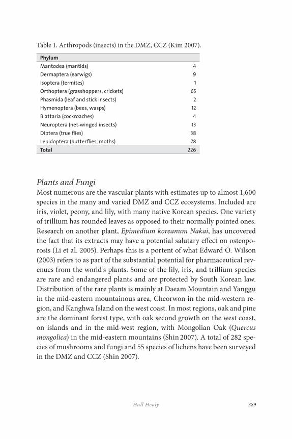
389Hall Healy
Table 1. Arthropods (insects) in the DMZ, CCZ (Kim 2007).
Phylum
Mantodea (mantids) 4
Dermaptera (earwigs) 9
Isoptera (termites) 1
Orthoptera (grasshoppers, crickets) 65
Phasmida (leaf and stick insects) 2
Hymenoptera (bees, wasps) 12
Blattaria (cockroaches) 4
Neuroptera (net-winged insects) 13
Diptera (true flies) 38
Lepidoptera (butterflies, moths) 78
Total 226
Plants and FungiMost numerous are the vascular plants with estimates up to almost 1,600 species in the many and varied DMZ and CCZ ecosystems. Included are iris, violet, peony, and lily, with many native Korean species. One variety of trillium has rounded leaves as opposed to their normally pointed ones. Research on another plant, Epimedium koreanum Nakai, has uncovered the fact that its extracts may have a potential salutary effect on osteopo-rosis (Li et al. 2005). Perhaps this is a portent of what Edward O. Wilson (2003) refers to as part of the substantial potential for pharmaceutical rev-enues from the world’s plants. Some of the lily, iris, and trillium species are rare and endangered plants and are protected by South Korean law. Distribution of the rare plants is mainly at Daeam Mountain and Yanggu in the mid-eastern mountainous area, Cheorwon in the mid-western re-gion, and Kanghwa Island on the west coast. In most regions, oak and pine are the dominant forest type, with oak second growth on the west coast, on islands and in the mid-west region, with Mongolian Oak (Quercus
mongolica) in the mid-eastern mountains (Shin 2007). A total of 282 spe-cies of mushrooms and fungi and 55 species of lichens have been surveyed in the DMZ and CCZ (Shin 2007).
KOR EAN DEMILITARIZED ZONE PEACE AND NATUR E PARK390
Physical Resources
The total land area of the DMZ is fairly evenly divided between North Korea and South Korea. Forest occupies about 75 per cent, grasslands about 20 per cent, agricultural land about 3 per cent, wetlands 1 per cent, with water bodies and ‘bare land’ taking up the remainder (Shin, JH, 2007, VI-6). The DMZ and CCZ can be grouped into four regions: (1) east coast, including lagoons, wetlands, and lowlands/valleys; (2) mid-eastern moun-tains and highland moors; (3) mid-west inland with the upper Han River watershed, farmland, and a lava plateau; and (4) west coast and islands with hills and wetlands, although the islands are not, strictly speaking, part of the DMZ (Shin 2007). A more detailed view of habitats is seen in Table 2.
Five major rivers and their watersheds run through the DMZ and CCZ: on the west side are the Imjin, Han, Bukhan, with Soyang and Nam to the north. Most tributaries and the main stems of these rivers run north to south and empty into the West or Yellow Sea. The Han and Nam rivers originate in the DMZ. The Nam goes south through the DMZ and CCZ and finally flows into the East or Japan Sea. These rivers are “first quality streams,” with low levels of dissolved oxygen, at 11.0 milligrams/litre, and suspended solids, at 2.5 milligrams/litre. Average pH is 7.26 (Kwon and Song 2007).
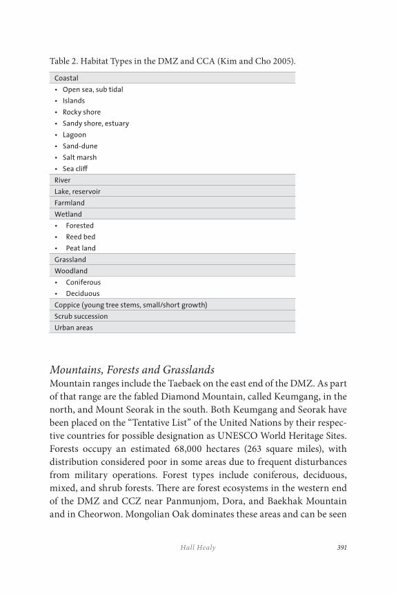
391Hall Healy
Table 2. Habitat Types in the DMZ and CCA (Kim and Cho 2005).
Coastal
• Open sea, sub tidal
• Islands
• Rocky shore
• Sandy shore, estuary
• Lagoon
• Sand-dune
• Salt marsh
• Sea cli≠
River
Lake, reservoir
Farmland
Wetland
• Forested
• Reed bed
• Peat land
Grassland
Woodland
• Coniferous
• Deciduous
Coppice (young tree stems, small/short growth)
Scrub succession
Urban areas
Mountains, Forests and GrasslandsMountain ranges include the Taebaek on the east end of the DMZ. As part of that range are the fabled Diamond Mountain, called Keumgang, in the north, and Mount Seorak in the south. Both Keumgang and Seorak have been placed on the “Tentative List” of the United Nations by their respec-tive countries for possible designation as UNESCO World Heritage Sites. Forests occupy an estimated 68,000 hectares (263 square miles), with distribution considered poor in some areas due to frequent disturbances from military operations. Forest types include coniferous, deciduous, mixed, and shrub forests. There are forest ecosystems in the western end of the DMZ and CCZ near Panmunjom, Dora, and Baekhak Mountain and in Cheorwon. Mongolian Oak dominates these areas and can be seen
KOR EAN DEMILITARIZED ZONE PEACE AND NATUR E PARK392
at Keumgang Mountain, just north of the DMZ, as well. Some pine spe-cies in the DMZ and CCZ appear to have been deliberately planted. In the Cheorwon area of the CCZ, intentional fires have been set to main-tain visibility for military exercises. The result is domination of these areas by broad-leaved shrubs. Grasslands exist in low, flat areas, on rice paddy levees, and at the edges of agricultural areas in the west, on hill and mountain sides on the eastern side and in bottom lands in the central and eastern portions of the DMZ and CCZ. Some of these areas have been sub-jected to significant numbers of purposeful and natural fires. On sloping lowlands are geranium among other species (Kim and Cho 2005).
WetlandsDue to the presence of lowlands, there are extensive wetlands at the western end of the DMZ and CCZ, especially in the Cheorwon Plain, which serves as a wintering site for globally endangered Red-crowned and White-naped Cranes. Riverine wetlands are present near the Imjin, Han, and Sachon rivers on the west coast, along with palustrine – gener-ally small, shallow and inland – wetlands near Yeoncheon. At the eastern end are valley and lacustrine wetlands, those that are located at the same elevation as a lake and influenced by lake water levels. Extensive tidal flats exist on the western coast, near Kanghwa Island and Gimpo. Tidal flats, a unique type of habitat, are under pressure to be developed, with some being transformed at the present time. At the summit of Mount Daeam, there is a high moor, the Yong neub peat land, reportedly the only one in Korea (Kim 2001). It is a registered Ramsar Convention (an international treaty to protect wetlands) site and has been designated a wetland protec-tion district, an ecosystem conservation area, and a natural monument by the ROK Ministry of Environment.
393Hall Healy
Cultural Resources
The DMZ area contains numerous historically and archeologically signifi-cant locations. On the east and just above the DMZ, Mountain Keumgang has four Buddhist temples, including the remains of one from 519 CE Kaesŏng on the west, at the northern border of the DMZ in North Korea, which was the capital of the Koryŏ dynasty (918–1392 CE) and has numer-ous archeological sites. It is now the scene of a large development being es-tablished to create an estimated 600,000 to 700,000 jobs for North Koreans. On the southern side of the DMZ is Panmunjom, where armistice negotia-tions took place at the end of the Korean War. Battle sites like ‘Ice Cream Mountain’ and the ‘Iron Triangle’ graveyards and museums dedicated to commemorating war dead are plentiful throughout the region and attract thousands of visitors annually. In recent years, military-based Missing in Action (MIA) searches also have drawn significant attention to the area.
Ecosystem/Economic Services
Ecosystem services are defined as any service or product of nature that benefits humans. There are numerous techniques for placing a monetary value on those services, including travel cost, contingent valuation, contingent choice or conjoint analysis, hedonic pricing, market price, and the productivity method (Pagiola et al. 2004). The above discussion of DMZ and CCZ biodiversity emphasizes the resources that are clearly available and that, when managed sustainably, could generate billions of dollars to the Korean people far into the future (Healy 2007). These ecosystem services can include: food, ecotourism, water purification, carbon sequestration, and many more. Table 3 depicts some of the services the DMZ and CCZ can, and to some extent already do, provide. Tangible and monetarily significant values can be attached to and derived from them.
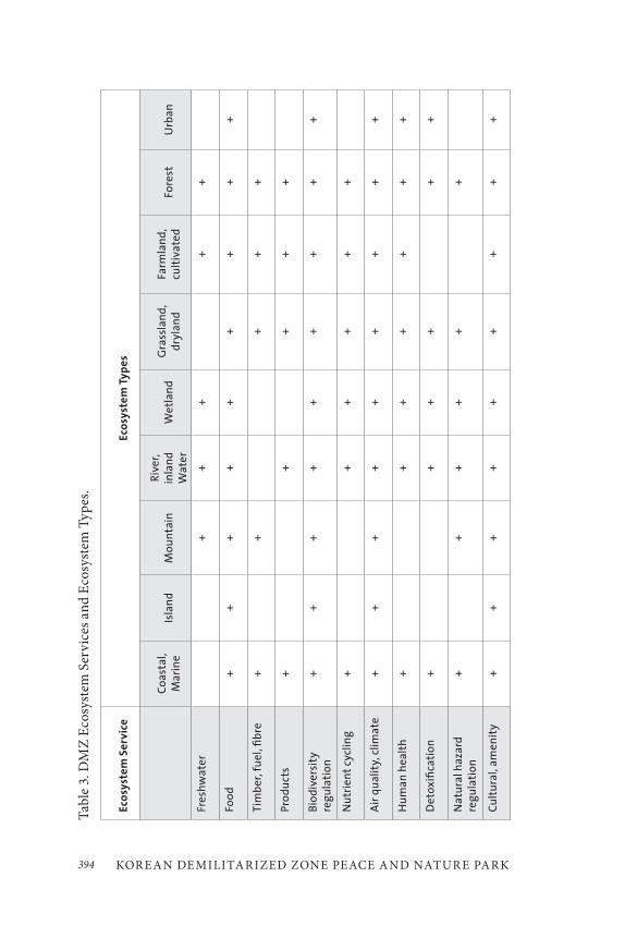
KOR EAN DEMILITARIZED ZONE PEACE AND NATUR E PARK394
Tab
le 3
. DM
Z E
cosy
stem
Ser
vice
s an
d E
cosy
stem
Typ
es.
Eco
syst
em
Se
rvic
eEc
osy
ste
m T
yp
es
Co
asta
l, M
arin
eIs
lan
dM
ou
nta
inR
iver
, in
lan
dW
ate
rW
etl
and
Gra
ssla
nd
, d
ryla
nd
Farm
lan
d,
cult
iva
ted
Fore
stU
rban
Fres
hw
ate
r+
++
++
Foo
d+
++
++
++
++
Tim
ber
, fu
el, fi
bre
++
++
+
Pro
du
cts
++
++
+
Bio
div
ersi
ty
reg
ula
tio
n+
++
++
++
++
Nu
trie
nt
cycl
ing
++
++
++
Air
qu
alit
y, c
lima
te+
++
++
++
++
Hu
man
hea
lth
++
++
++
+
De
tox
ifica
tio
n+
++
++
+
Na
tura
l haz
ard
re
gu
lati
on
++
++
++
Cu
ltu
ral,
amen
ity
++
++
++
++
+
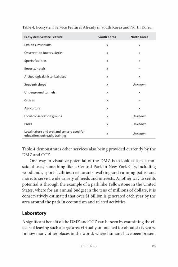
395Hall Healy
Table 4. Ecosystem Service Features Already in South Korea and North Korea.
Ecosystem Service Feature South Korea North Korea
Exhibits, museums x x
Observation towers, decks x x
Sports facilities x x
Resorts, hotels x –
Archeological, historical sites x x
Souvenir shops x Unknown
Underground tunnels x x
Cruises x –
Agriculture x x
Local conservation groups x Unknown
Parks x Unknown
Local nature and wetland centers used for education, outreach, training
x Unknown
Table 4 demonstrates other services also being provided currently by the DMZ and CCZ.
One way to visualize potential of the DMZ is to look at it as a mo-saic of uses, something like a Central Park in New York City, including woodlands, sport facilities, restaurants, walking and running paths, and more, to serve a wide variety of needs and interests. Another way to see its potential is through the example of a park like Yellowstone in the United States, where for an annual budget in the tens of millions of dollars, it is conservatively estimated that over $1 billion is generated each year by the area around the park in ecotourism and related activities.
Laboratory
A significant benefit of the DMZ and CCZ can be seen by examining the ef-fects of leaving such a large area virtually untouched for about sixty years. In how many other places in the world, where humans have been present
KOR EAN DEMILITARIZED ZONE PEACE AND NATUR E PARK396
for thousands of years, are we able to determine what such a lengthy hiatus can do to help restore the land and its inhabitants? In The World without
Us, author Alan Weisman suggests just that kind of importance be given the DMZ and CCZ (Weisman 2007). Habitats and species of the DMZ can be destroyed or preserved. It is our choice. Either way we decide, this area is a window to what our future as a species might be. One way to posit a world without humans is to study what the natural succession process is when left largely uninterrupted, as it has been in the DMZ. In this ‘labo-ratory,’ of course, there could be numerous schools and universities for research, training and educating of Koreans and people from all around the globe, as is being done in transboundary parks of South Africa and its neighbours.
Tension Reduction, Improved Relations
A major potential benefit of devising ways to sustainably manage the DMZ and CCZ is reduction of tension between the two Koreas and other na-tions with a stake in the region, such as those that have been involved with North and South Korea in the Six Party Talks – the United States, China, Russia, and Japan. In the context of these talks and their Working Groups, or through a separate set of discussions, conservation of DMZ and CCZ habitats and species would be a constructive topic to address collabora-tively, with identifiable economic, social, cultural, and biological benefits for all Koreans. In fact, these talks and working groups have addressed economic issues. Including discussion of impacts on the peninsula’s envi-ronment, inside and outside of the DMZ and CCZ, could help ameliorate negative effects of existing environmental conditions in the two Koreas.
DMZ THREATS AND OPPORTUNITIES
Numerous threats exist in the path of conserving DMZ and CCZ ecosys-tem service resources. But each threat can be treated as an opportunity to improve the situation. We will focus here on two of the highest prior-ity threats, development and pollution. Some solutions to these and other threats can be leveraged and help address more than one area of concern.
397Hall Healy
Development
Development is the largest threat to sustainably conserving DMZ and CCZ natural and cultural resources. It comes in many forms and is al-ready present. Much of the pressure to develop emanates from the fact that there are over twenty million people living in the Seoul metropolitan area. In recent years, plans have been announced to build several entirely new cities between Seoul and the CCZ and DMZ, one of which has been all but completed. These activities have led to increasing encroachment on the CCZ, with, for example, an ROK Ministry of Defence proposal to reduce the size of the CCZ by five kilometres, from twenty to fifteen.
In the transportation sector, on May 17, 2007 rail and road links were re-opened on both ends of the DMZ, after having been closed since the end of the Korean War. There is increased road-building in the area and throughout Korea. Before the Korean War, there were six national and six local roads and four important railways passing through the DMZ (Kwon and Song 2007). Now there is discussion of expanding Inch’ŏn International Airport. Plans are also afoot to build large ports on the Han and Imjin rivers, and work is underway to join the two rivers, which move has the potential to seriously impact water quality (through increased sedimentation), flow regimes and habitats for birds and other riverine spe-cies like otter. Dams are being planned on some rivers that run through the DMZ, with one near Yeoncheon.
While not in the DMZ, filling in the Saemangeum tidal flats, southwest of Seoul in the Yellow or West Sea, sets a potential precedent for, and is prompting discussion of, similarly filling in other tidal flats near the DMZ.
Unequivocally, these activities provide many benefits to the Korean people. But, much depends on how they are implemented. The opportun-ity comes in looking at development and conservation from a systems perspective, holistically, with an eye towards societal values. The Korean culture has always placed a high importance on nature and things natural with, for instance, “quite remarkable attachment to the pine tree and to the many pine-covered mountains that range across the peninsula.” King Wang Kŏn, who re-united the country under the Koryŏ dynasty in 935 CE, is quoted as saying in one of his Ten Injunctions, “I carried out the
KOR EAN DEMILITARIZED ZONE PEACE AND NATUR E PARK398
great undertaking of re-unifying the country by availing myself of the latent virtue of the mountains and streams.” Koryŏ, which Wang Kŏn shortened from Koguryŏ, means “high mountains and sparkling waters,” and this became the basis for the country’s name (Cumings 1997).
These long-standing values can be the foundation of planning that in-volves all stakeholders and a systems approach to find the right balance in important habitats between development and conservation. The ROK gov-ernment used that tack when looking at the feasibility of the proposed Tong Dam and determined it was not economically feasible after conducting a contingent valuation of the project (Ministry of Environment, Republic of Korea 2003). Another opportunity to minimize harmful development effects is to require environmental impact assessments (EIA) before con-struction, as was done prior to rebuilding the rail lines and roads between North and South Korea. Also mitigating impacts of development is the use of structures to accommodate wildlife, exemplified by putting animal bridges over the western DMZ rail link. Additional approaches to manage and minimize detrimental development impacts can include:
• determining the most critical habitats to preserve through studies, some of which already have been initiated;
• conducting valuation studies like that of the Tong Dam and those in the United States and other countries to determine the value and extent of ecosystem services which the DMZ and CCZ can support sustainably;
• transparently involving all stakeholders in the area to ensure their voices are heard and needs responded to in the planning process;
• developing national, regional, and local legislation and regulations, including appropriate enforcement, to ensure preservation; and
• compensating local citizens for land put into conservation or crops impacted by wildlife use, as has been done in Cheorwon.
399Hall Healy
Pollution and Contamination
There are already numerous forms of pollution and contamination that have impacted or could adversely affect the DMZ and CCZ:
• over one million land mines present in the DMZ (970,000) and CCZ (38,000), though the south has begun to clear several areas of mines in the CCZ (Landmine Monitor Report, 2006);
• ordinance from military testing grounds and exercises in the CCZ;
• air emissions from nearby Inch’ŏn airport, cars from Seoul residents, and intentional and accidental fires;
• agricultural chemicals used in rice fields near the DMZ;
• deforestation, particularly in North Korea, that has caused extensive erosion and flooding in that country, with some serious effects also occurring in South Korea; and
• runoff into the East and West seas from agricultural operations.
According to the 2005 Yale University Sustainability Index, South Korea and North Korea ranked 122 and 146 respectively out of 146 countries (Yale University 2006). But, therein lies the opportunity presented by sustainably managing the DMZ and CCZ. Preserving critical habitats of these two areas can enhance linkages between other existing natural areas within Korea and North Asia, improving all of them in the pro-cess and enhancing ecosystem services available for the region. There is a South Korean government agreement to allow protection of the DMZ for two years after reunification. Planning now underway can optimize that agreement. Safeguarding the DMZ will depend on the political will to create and implement plans and to develop and enforce legislation and regulations governing use of the DMZ.
KOR EAN DEMILITARIZED ZONE PEACE AND NATUR E PARK400
Developing baseline data will be of significant assistance in managing the effects of pollution, climate change, military operations, fires, and de-forestation. These data will help determine changes that have taken place in the DMZ over about sixty years, and in assessing impacts from future changes. The installation of appropriately placed monitoring stations can facilitate data collection and could be done collaboratively between North Korea and South Korea. Other monitoring devices also could assist both countries in weather forecasting, predicting potentially disruptive storms and “yellow dust” from the Gobi Desert.
DMZ and CCZ land mines offer an opportunity to work with the world community towards a safer, more cost-effective solution to re-moving those mines that is not as destructive of surrounding habitat as conventional technology. Currently, mines can cost up to $1,000 each to remove, which for the DMZ and CCZ would amount to about $1 billion (UNICEF). Numerous organizations, like Roots of Peace in the United States, are dedicated to safe removal of mines in Afghanistan and other war-torn countries. Their assistance can be enlisted in this task.
Military operations also create the potential for contamination, with both exploded and unexploded ordinance. As has been the case with transboundary parks in South Africa and neighbouring countries, mil-itary personnel can be trained in conservation stewardship to provide fu-ture job opportunities as game wardens and guides. Such local jobs and a micro -oan program also could help alleviate income disparities for North Koreans near the DMZ.
Other potential threats to the DMZ and CCZ include: deforestation, legal claims to land, costs of implementing plans, river channelization, unsustainable farming practices, balance of power among stakeholders, increasing population, exotic species, and income disparities in and near areas being conserved.
401Hall Healy
INITIATIVES TO SAFEGUARD DMZ RESOURCES
A number of mechanisms to help preserve DMZ and CCZ species and habitats already have been suggested, including some studies to identify species and possible actions steps:
• In valuing the DMZ through the lens of the IUCN (International Union for Conservation of Nature) 1997 Red Data Book criteria for assessing sites, there are at least twenty species at risk of extinction, including the Red-crowned and White-naped Crane.
• The DMZ contains a number of resources that satisfy UNESCO World Heritage Site criteria, including: endangered
animals like the Amur Goral; natural habitats like the wetlands; earth’s evolutionary processes such as rice paddy wetlands, and peat lands; physical and geological formations such as the limestone caves in Cheorwon; and reserves for
large numbers of animals like the Han, Imjin, and Nam rivers.
• According to criteria of the Ramsar Convention, there are numerous important wetland areas including: Yong neub area of Daeam Mountain – already a Ramsar designated site, wetlands in Paju and Cheorwon, and the island of Kanghwa with its adjoining tidal flats and estuary wetlands.
• The DMZ meets all UNESCO Transboundary Biosphere Reserve (TBR) program criteria: ecosystem representing a biogeographic region; containing a variety of species and habitats to be conserved; where sustainable development can be applied; and where public institutions, regional communities, and the private sector may participate (Kim and Cho 2005).
• Mt. Keumgang and Mt. Seorak of North Korea and South Korea respectively are on the “Tentative List” of UNESCO for potential designation as biosphere reserves under UNESCO’s World Heritage Site program.
KOR EAN DEMILITARIZED ZONE PEACE AND NATUR E PARK402
• The DMZ possesses several features that would make it a candidate for the Man and Biosphere (MAB) program of UNESCO, whose “main lines of action” are: (1) minimizing
biodiversity loss through research and capacity-building for ecosystem management, including research, training, and education; (2) biosphere reserves-promoting sustainability, including the concept of using biosphere reserves as a platform for conflict prevention, increasing knowledge of environmental sustainability, and involving young people; and (3) enhancing linkages between cultural and biological
diversity, including local-level sustainable use of biodiversity and raising awareness of the role that cultural landscapes play in ecosystem management (UNESCO).
• A Green Belt like the one that replaced the Cold War wall between East and West Germany. A similar concept has been explored for East European borders with former Soviet bloc countries. A green belt was established in Kenya that has inspired similar efforts in other parts of Africa.
Numerous Korean non-governmental organizations (NGOs) are active in DMZ conservation, including the Korean Federation for Environmental Movement (KFEM) and Green Korea United. There also are numerous government initiatives, including:
• Korea Environment Institute (KEI), a government research organization, conducting research on the DMZ;
• National Institute of Environmental Science (NIES) work on DMZ species;
• National Museum of Biodiversity Resources;
• Forestry Administration;
• Presidential Commission on Sustainable Development, including work on a river estuary project;

403Hall Healy
• Gyeonggi and Gangwon Provinces – planning activities. In addition, individual counties that border the DMZ, such as Cheorwon, have been conducting their own planning activities.
• Ministry of Maritime Affairs and Fisheries – promoting designation of an international marine peace park in the marine borders of South Korea and North Korea;
• Ministry of Administration – conducting a land survey in the southern portion of and inside the DMZ;
• Ministry of Defense – creating and publicizing audiovisual materials on ecosystems for officer training programs; and
• Office for Government Policy Coordination – operating the National Council of the Master Plan for DMZ Ecosystem Conservation. (Lim 2007)
Dozens of conferences have been held on the subject in Korea and in the United States since the early 1990s. They have promoted dialogue on the global uniqueness of the DMZ and CCZ and on potential ways of preserving these habitats and species, including the possibility of desig-nating the DMZ as a TBR under UNESCO. Participants, like the Peace Park Foundation of South Africa, have shared their experiences in creat-ing such parks. Visionaries like Nelson Mandela and CNN founder Ted Turner, have lent their support. Mr. Turner and the Turner Foundation have helped to sponsor conferences and have travelled to North and South Korea to discuss DMZ preservation with high-ranking government officials.
The DMZ Forum, Inc. has conducted numerous conferences in the United States and Korea, twice with sponsorship from Gyeonggi Province. It also formed a DMZ Coalition, patterned after similar groups in the United States and elsewhere to provide assistance in preserving DMZ resources. The International Crane Foundation initiated a project in North Korea in 2008. Its purpose is to help local farmers improve their crop yield, provide more food for humans and cranes, and restore habitat
KOR EAN DEMILITARIZED ZONE PEACE AND NATUR E PARK404
for migratory cranes. Significant progress has been made on this project. Examples include: designation of the Anbyon Plain nature reserve near the port of Wonsan, increased rice crop yields using organic fertilizer, and education and training of farmers and residents.
DISCUSSION AND CONCLUSIONS
The following are some of the many potential steps that could assist in preserving the globally unique assets of the DMZ and CCZ:
Diplomacy
As has been done by South Korea in the case of migratory birds, it may be helpful to link into already existing international conventions and trea-ties, such as the Migratory Bird Treaty and the Ramsar Convention. These two and other instruments create an opportunity to develop common understanding and goals. Other nations and organizations like IUCN can facilitate collaboration and coordination between the two Koreas in creating conservation zones, procedures, and processes. These treaties provide examples of successfully implemented programs; they also can aid in establishing plans and standards, in obtaining funding and creating linkages with natural areas in the region, thus enhancing the ecosystem service and conservation values of these resources.
In recent years there has been the “Six-Party Talks” process amongst North Korea, South Korea, the United States, China, Russia, and Japan to deal with nuclear weapons issues in the DPRK. While these talks have a checkered history, they have at times improved dialogue between area stakeholders. They have provided a means for discussing issues of mutual interest and concern. The involved countries have conducted dialogue on additional topics of common interest, including a devastating flood in the summer of 2009 and periodic reunions between North and South Korean families separated by the Korean War. All of these activities provide the opportunity to build trust and to create a web of interdependence and a platform for talking about issues like DMZ conservation.
405Hall Healy
Education
In South Africa, the Peace Parks Foundation (PPF) and other organiza-tions have established educational institutions to train people who will work in and benefit from sustainable use of their transboundary parks. These can serve as an example of what could be done in the DMZ and CCZ, including technical schools, a university/universities or a ‘virtual’ institution, like the “Great Rivers Partnership,” initiated with a grant from Illinois-based farm equipment manufacturer Caterpillar Inc. to bring together and disseminate information learned on four continents about protecting rivers, under auspices of The Nature Conservancy (TNC). Local schools, civil society organizations, churches, and governments can establish programs to increase awareness of DMZ resources and teach about values of protecting the DMZ. They also can offer job training pro-grams in ecotourism and related fields. These classes would help offset the concern on the part of some communities near the DMZ that they don’t have enough trained workers to fill jobs created by DMZ conservation. Particularly in less-robust economic times, these jobs could be a boon to the local work force.
Also helpful would be the development of programs to enhance pub-lic and decision-maker awareness regarding values and benefits of DMZ and CCZ resources. These can create the foundation for other educational offerings and activities. Since the DMZ border area has been on a war footing for so long, an awareness-building program will help engender the basic values as to why the DMZ is important, how globally unique it is and why it is in people’s best interest to sustain it.
Legislative, Legal
One of the elements essential to conserving land is precise knowledge of who owns the land. This information facilitates appropriate compensation of present and past landowners and helps to ensure fairness for local land holders; it also encourages their buy-in to the conservation process when they know that they will be properly remunerated. The opposite also can be true – if they are not included or compensated, they could be a signifi-cant impediment to the process. Therefore, it is suggested that a study be
KOR EAN DEMILITARIZED ZONE PEACE AND NATUR E PARK406
conducted of ownership claims for DMZ and CCZ lands, some of which predate the Korean War and are in various languages. Land claims may involve documents that have been destroyed or are in the possession of descendants no longer living in Korea.
As part of conserving the land, legislation and regulations will be required to keep it protected. The legal framework will need to include enforcement, monitoring, and appropriate levels of funding as well as clear and transparent standards of protection.
Planning
Planning at many different levels of society will be helpful in ensuring the sustainability of DMZ conservation. Through coordination of the plan-ning process and including all stakeholders on an open and transparent basis with “free, prior and informed consent” future disputes, conflict, and disenfranchisement will be more manageable. Included in the process should be a method of dispute-resolution.
Suggested also is a plan for land mine removal, providing funding for experimental technology and research to identify or create lower-cost methods that do not destroy surrounding landscapes. Current estimates for removing land mines will make it beneficial and economically feasible to investigate and conduct research on lower-cost technologies. Minimally destructive land mine removal will help avoid destroying the natural re-sources around the mines that ultimately are to be protected.
Numerous species, like the Oriental White Stork and Crested Ibis, have been removed from the Korean peninsula over recent decades. Conserving the DMZ and parts of the CCZ provide an opportunity to reintroduce some of them. Conservation organizations within and outside Korea are working on these prospects. They can work together to develop re-introduction programs for species that once were prevalent in Korea and that could live successfully in the DMZ/CCZ.
When planning, it is suggested that a holistic approach be used in assessing DMZ and CCZ value by looking at the areas from a watershed and ecosystem or ecoregional point of view. Many species in the DMZ and CCZ live throughout Asia. Cranes migrate from Russia. Large fauna, such as leopard, travel throughout the peninsula. Tigers, once common in
407Hall Healy
mountains outside of Seoul, live in the Russian Far East. With a watershed and ecosystem-wide perspective, it also is easier to involve and motivate people living in the area.
Studies
Some species inventories already have been conducted within the DMZ and CCZ under auspices of the South Korean Ministry of Environment. Various academics and non-governmental organizations have participated in this work. Due to current controls on and landmines within the DMZ, it is difficult to carry out in-depth studies in that area. However, when pos-sible, assessments of habitats and species and cultural assets are a first step essential to determining critical areas for conservation. Using Geographic Information Systems (GIS) and Global Positioning Systems (GPS) will help to create systematic and coordinated surveys; they also will facilitate making data available to the public and all other stakeholders for decision-making.
One tool that can assist decision-makers in conserving DMZ resour-ces will be ecosystem services studies to value resources on a sustainable basis. By valuing the resources in financial terms, it will be possible to create a common framework understandable to everyone. There are some eco-system service experts within South Korea who can collaborate with others elsewhere in the world. One centre of this expertise now exists at Stanford University, California, where a study of “natural capital” is being sponsored jointly by Stanford, the World Wildlife Fund, and TNC.
Numerous techniques from around the globe exist for conserving large tracts of land such as the DMZ. For many years, TNC, one of the world’s lar-gest conservation organizations, has successfully employed debt-for-nature swaps, conservation easements, and trade lands to name a few. Increasingly, partnerships between the public and private sectors are facilitating the pres-ervation of land for ecological purposes while also allowing landowners to fulfill their goals. Debt-for-nature swaps have helped countries like Costa Rica reduce their national debt and at the same time save large amounts of land for conservation, and in the process attract unprecedented revenues from ecotourism.
KOR EAN DEMILITARIZED ZONE PEACE AND NATUR E PARK408
CONCLUSIONS
It is important in any of these efforts to obtain the perspective of all stake-holders, especially the Korean people. North Koreans do not want to “pro-tect the DMZ” in its present state. It is a symbol of war, suffering, and separation. The emphasis here is on preserving the natural and cultural resources in the DMZ and CCZ that are irreplaceable and globally unique for the ecosystem service and intrinsic benefits to Koreans and people around the world.
Extremely important cultural, biological, and financial benefits can accrue to the Korean people and the world by preserving natural and cul-tural resources of the DMZ and CCZ. Due to a host of potential threats to these areas, there is obvious urgency to the preservation process. In Korea vital initiatives already are underway to assist preservation. More steps can and will be taken to ensure future sustainability of DMZ and CCZ resources as well as the people who depend on them.
REFERENCES
Archibald, G. 2007. Co-founder, International Crane Foundation, conversation, 4 September 2007.
Chong, J. R., and H. H. Pak. 1994. “The migration routes and important rest-sites of cranes on the Korean Peninsula.” In The Future of Cranes and Wetlands, ed. H. Higuchi and J. Minton, 41–50. Tokyo: Wild Bird Society of Japan.
Coulter, M. 2007. Co-Chair-IUCN Specialist Group of Storks, Ibises and Spoonbills, conversation, 4 September 2007.
Cumings, B. 1997. Korea’s Place in the Sun, A Modern History. New York: W. W. Norton.
Ministry of Environment, Republic of Korea. 2003. “Guidelines of benefit-cost analysis of environmental policy.” Seoul, South Korea.
Healy, H. 2007. “Korean Demilitarized Zone: Opportunity to help reduce economic asymmetries on the Korean Peninsula.” Journal of Economic Asymmetries 4(1): 99–110.
409Hall Healy
Higuchi, H., K. Ozaki, G. Fujita, J. Minton, M. Ueta, M. Soma, and N. Mita. 1996. “Satellite tracking of white-naped crane migration and the importance of the Korean Demilitarized Zone.” Conservation Biology 10(3): 806–12.
Kim, K. C. 1997. “Preserving biodiversity in Korea’s Demilitarized Zone.” Science 278: 242–43.
———. 2001. “A study on the feasibility as well as an operational strategy to develop DMZ transboundary biosphere reserve between DPR Korea and Republic of Korea – Final Report.” A research report submitted to the UNESCO Jakarta Office under the Special Agreement Contract #850.
———. 2007. “The DMZ conservation in global climate change.” Paper presented at International Conference on Korea’s DMZ Conservation: Science and Impact Assessment, 4 June 2007, Seoul, Korea.
Kim, K., and D.-G. Cho. 2005. “Status and ecological resource value of the Republic of Korea’s De-militarized Zone.” Landscape and Ecological Engineering 1(1): 3–15.
Kwon, Y.H., and Y.I. Song. 2007. “EIA and economic cooperation for conservation of the DMZ region-Pan-Korea’s perspective.” Paper presented at International Conference on Korea’s DMZ Conservation: Science and Impact Assessment, 4 June 2007, Seoul, Korea.
Li, F. M., J. ZhiMing, M. FanHao, and X. ZhiLi. 2005. “Osteoblastic proliferation stimulating activity of Epimedium koreanum Nakai extracts and its flavonol glycosides.” Pharmaceutical Biology 43(1): 92–95.
Lim, C. 2007. “Master Plan for DMZ Ecosystem Conservation.” Paper presented at International Conference on Korea’s DMZ Conservation: Science and Impact Assessment, 4 June 2007, Seoul, Korea.
Pagiola, S., K. von Ritter, and J. Bishop. 2004. Assessing the Economic Value of Ecosystem Conservation. Washington, D.C. The World Bank Environment Department.
Shin, J. H. 2007. “Unique Biodiversity and Landscapes of Korea’s Demilitarized Zone (DMZ): Overviews.” Paper presented at International Conference on Korea’s DMZ Conservation: Science and Impact Assessment, 4 June 2007, Seoul, Korea.
Weisman, A. 2007. The World without Us. New York: Thomas Dunne.
Wilson, E. O. 2003. The Future of Life. New York: First Vintage.
Yale University. “Pilot 2006 Environmental Performance Index (EPI), Appendix C, Country Profiles.” http://www.yale.edu/epi/
Yu, Y., and C. Wong. 2006. The International Black-faced Spoonbill Census: January 2006. Hong Kong: Hong Kong Bird Watching Society.
KOR EAN DEMILITARIZED ZONE PEACE AND NATUR E PARK410
ACKNOWLEDGMENTS
The DMZ Forum, Inc. is a New York State-based 501 (c) 3 organization dedicated to preservation of the Korean Demilitarized Zone, its species, habitats, and cultural resources. The International Crane Foundation is a Wisconsin-based non-governmental organization dedicated to preserving the world’s fifteen species of cranes and habitats on which they depend. The author gratefully acknowledges concepts for this paper provided by Dr. George Archibald, Co-founder of International Crane Foundation; Fred Carriere, Syracuse University; Daniel K. Darnell, Senior Director of Marketing, Baynote Inc; Michael Finley, President, Turner Foundation; Dr. Kai Frobel, Green Bund Germany; Dr. Kim, Ke Chung, Chairman and Co-founder of the DMZ Forum; Environmental Economics Professor Kim, Il Chung, Dongguk University, Seoul, Korea; Landscape Architecture Professor Kim, Kwi-gon, Seoul National University; Dr. Lee, Seung-ho, Co-founder of the DMZ Forum; William H. Shore, Secretary of the DMZ Forum (deceased); Dr. Willem Van Riet, Vice President, International Affairs, Peace Parks Foundation, South Africa; and Dr. Arthur H. Westing, Principal, Westing Associates in Environment, Security and Education. The author is grateful for the input of others, though he is entirely respon-sible for the paper’s contents and views are his own.
411
17
Feasibility of a Corridor between Singhalila National Park and Senchal Wildlife Sanctuary: A Study of Five Villages between Poobong and 14th Mile Village
Animesh Sarkar and Milindo Chakrabarti
INTRODUCTION
The rate of species extinction has been increasing rapidly during last couple of decades worldwide, and so has been the concern to protect wildlife and their habitats. Hunger for economic development has led to conversion of a substantial amount of land inhabited by wild animals into land suitable only for human use. Very often these conversions were carried out in un-planned ways, leading to discontinuities in wildlife habitat. Establishing
FEASIBILITY OF A CORRIDOR BETWEEN SINGHALILA NATIONAL PARK AND SENCHAL WILDLIFE SANCTUARY
412
corridors to restore wildlife habitat connectivity is considered a possible solution to sustaining species in the face of development pressure.
India is rich in biodiversity, harbouring about 8 per cent of the total world biodiversity. Around 45,000 plant species and approximately 81,250 of animal species are present in India (MoEF 2005a). However, fragmentation of wildlife habitat continues unabated, with a sharp increase since 1990 (FAO 2005). The extent of annual depletion of forest cover prior to 1990 was 0.03 per cent (MoEF 2005b). Thanks to recent policy initiatives, the decline in forest cover has been arrested. Forest cover increased at an annual rate of 0.57 per cent (0.36 million ha) between 1990 and 2000 (FAO 2005; 2007). However, the tempo could not be maintained and the annual rate of increase fell to 0.04 per cent (0.03 million ha) between 2000–2005 (FAO 2005). Further, it would be wrong to assume that such a positive national trend is visible uniformly across the country. For example, the trend of deforestation has been continuing unabated in Eastern Himalaya region (Wikramanayake 2003). It should be noted that around 15.6 million hectares (23 per cent) of recorded forest area is under Protected Area (PA) network in India (FAO 2005), containing the last available habitat for different endangered species like lion, tiger, elephant, rhinoceros, red panda, Himalayan black bear, and clouded leopard.
Although such reserves are the cornerstone of biodiversity conserva-tion within a region (Folke et al. 2002), more recent work finds that islands of biodiversity (protected areas) are not viable. Rather, those interested in biodiversity conservation should think in terms of a landscape-based pro-tective strategy (Chang 2007; Metcalfe 2005; FAO 2005). The Darjeeling Himalayas are part of the Eastern Himalaya biodiversity hotspot identi-fied by conservation organizations like the Critical Ecosystem Partnership Fund (CEPF). Areas must have high species endemism, more than 1,500 species of vascular plants and have lost at least 70 per cent of the origin-al wildlife habitat to qualify as a CEPF hotspot (CEPF 2010). Thus, the Darjeeling Himalayas must be managed with the landscape view, inte-grating habitat connectivity, in order to conserve the biodiversity within the region.
Wildlife habitat in the Darjeeling Himalayas decreased over the last couple of centuries. Trees were felled with impunity to facilitate tea
413Animesh Sarkar and Milindo Chakrabarti
plantations and build factories and labour lines, carve out land for settled agriculture, and construct roads, railways, bridges, and urban settlements. Indigenous species of trees in the remaining forests were cut down and replaced mostly by plantations of exotic species to increase the commer-cial value of forests. Introduction of cleaning, weeding, and fire protection lines for better forest management weakened the resilience of the entire ecological system in this location (Ray 1964). For example, the area that is the focus of this paper between Singalila National Park (SNP) and Senchal Wildlife Sanctuary (SWS) was once covered with sub-tropical montane forest that has been largely cleared (Chhetri et al. 2005). A larger share of this area is under tea cultivation. There are a few sub-tropical forest patches existing here and there on land belonging to private individuals. Land recorded as forests and lying with the Department of Forests has converted to shrub land with sporadic existence of trees and the forest cover is only maintained on private land (Chakrabarti et al. 2002). Such activities have gradually created discontinuities within formerly continu-ous wildlife habitat that extended all the way from the Singalila National Park to what is known today as Neora Valley National Park (Map 1).
The result of fragmentation and its effect on the natural system is increased endangerment of a number of species in this region like red panda (Ailurus fulgens), Himalayan black bear (Ursus thibetanus), clouded leopard (Neofelis nebulosa), Monal Pheasant (Lophophorus
impejanus), Western Tragopan (Tragopan melanocephalus), Chestnut-breasted Partridge (Arborophila mandellii), and Himalayan salamander (Tylotrotriton verrucosus). In addition to these fauna, several floral species like bikhumma (Aconitum sp.), rudraksha (Elaeocarpos granites), jatama-asi (Nardostachys jatamansi), salanay/panch pattey (Panax pseudogin-
seng), kutki (Picrorhiza kurroa), taxus (Taxus baccata), and tsuga (Tsuga
dumosa) are threatened or critically rare (see Chetri et al. 2005). Flora like Abutilon indicum and Gloriosa superba have already become extinct in the wild and are surviving only in some nurseries. Members of the resident communities surveyed for this study report eighty different plant species formerly common in the region between SNP and SLWS. Nine of them have become extinct by now. Thirty-four bird species and thirty other
FEASIBILITY OF A CORRIDOR BETWEEN SINGHALILA NATIONAL PARK AND SENCHAL WILDLIFE SANCTUARY
414
animal species are sighted by the locals at present. To improve landscape connectivity and thereby preserve species diversity, immediate bridging of habitat discontinuities is necessary.
In direct conflict with maintenance of a viable biodiversity corridor, a high density of hooved game (wild boar [Sus scrofa], red [Cervus elap-
hus] and roe [Capreolus capreolus] deer) is maintained by supplementary feeding. The artificially high density of herbivores depletes natural food sources, eliminates undergrowth, and changes the tree stand structure, negatively affecting habitat structure and natural resource availability. As a result, natural regeneration stops, forest and river ecosystems lose their integrity, and functioning of the natural ecosystems are disturbed (Parfenov 1996). Villagers from each and every settlement surveyed have reported an increased incidence of crop depredation by wild boar and sighting of Himalayan black bear, wild boars, leopards, deer, porcupines, and rabbits during recent times.
This analysis seeks to answer the following questions:
• Is it possible to establish suitable corridors for ensuring free movement of the wildlife across the Darjeeling Himalayas?
• Is a corridor network feasible in view of the existence of multiple stakeholders and land ownership pattern in this region?
The international biodiversity significance of this area and rapid degrada-tion of forests and wildlife habitat during the last few decades, combined with the experience of Joint Forest Management (JFM) as a potential remedy – in terms of both success and failure, compel such questions (Chakrabarti et al. 2004; 2005).
The objective of this chapter is to determine the location of a possible corridor and its socio-economic feasibility between Singalila National Park (SNP) and Senchal Wildlife Sanctuary (SWS). Restoration of a cor-ridor involves conversion of a particular patch of land from its present use to forest cover. Such conversion may involve change in ownership, restricted use, or even dislocation of human habitat, depending on the
415Animesh Sarkar and Milindo Chakrabarti
present land use and ownership pattern. Obviously, such an intended change will involve simultaneous gains to some with possible losses being incurred by some others. A corridor is socially feasible if the net gains (gain-loss) are positive and those gaining are willing to compensate for the losses incurred by the other group. We conducted socio-ecological studies in five villages during 2004–2005 (Poobong phatak, Pussumbeng phatak and Alubari, Ghoom bhanjyang, Bhalukhop & 14th Mile) to understand the issues involved: investment requirements, generation of livelihood op-tions through employment and surplus, compatibility with the available land, and other floral and faunal resources. Corridor feasibility through-out the region is then judged in terms of the net gains generated.
CONCEPTUAL FR A MEWORK
The concern for conservation is perhaps more influenced by the selfish in-terest of mankind to survive than out of sheer love for non-human living species. Researchers are convinced that social variables that influence the quality of human lives are intimately linked to a host of biophysical vari-ables – biodiversity and global warming being the prominent ones (Stern et al. 2006). Interactions between biophysical and social variables produce what is known as a Social-Ecological System (SES) (Hadjibiros et al. 2005; Janssen et al. 2007; Vincent 2007). The stability of the socio-ecological sys-tem is at the centre of the issue of conservation.
The loss of biological connectivity (Metcalfe 2005; Natural Resource Committee 2006) potentially undermines long-term environmental secur-ity of human residents and, therefore, poses a threat to the sustainability of the existing SES (GMS 2005). The key task of the world community, ac-cording to one school of thought, is to maintain contiguous natural habi-tats and sustain ecological diversity (Daming 2007; Johns 2000) around the world. However, biodiversity often tends to be undervalued from an economic, if not always from a socio-politico-economic perspective (GMS 2005). Recent attempts that argued in favour of increased economic value of biodiversity include Stern et al. (2006), Chopra (2006), Datta et al. (2006), and Gundimeda et al. (n.d.). A proper valuation of biodiversity
FEASIBILITY OF A CORRIDOR BETWEEN SINGHALILA NATIONAL PARK AND SENCHAL WILDLIFE SANCTUARY
416
necessarily requires a thorough understanding of the functioning and the sources of vulnerability to an SES (Daming 2007). The issue of the resili-ence of an SES becomes key to such valuations.
The paper begins with a premise that the SES in this location has almost reached a threshold of system change and seeks to ascertain if a corridor can increase SES resilience. Sudden flip of a system damages the habitat structure and destroys wild animals and several plant species, which are key elements of the ecological environment in this region. This also affects the existing relationship of human society with the natural system. A social-ecological system implies a set of people, their natural and human-made resources, and the relationships among them (Janssen 2006; Anderies et al. 2004 provides a conceptual framework of an SES; also see Janssen et al. 2005). Resilience has been defined from many per-spectives like ecological, social, systemic, operational, sociological, eco-nomic-ecological, and social-ecological. An ecological definition is the amount of disturbance that a system can absorb before it changes state (Brand and Jax 2007; Gunderson et al. 2002). From a social-ecological perspective, resilience denotes the capacity of a social-ecological system to absorb recurrent disturbances so as to retain essential structures, pro-cesses, and feedbacks (Adger et al. 2005). The magnitude of resilience in a system is measured by its capacity to absorb disturbances under sudden and undesirable internal or external changes (Folke et al. 2002; Janssen et al. 2007) before the system redefines its structure by changing the vari-ables (Gunderson et al. 2002). We then looked separately into the eco-logical (vegetation type, plant and animal species including avifauna, and non-timber plant species extracted for human use and status of different plant and animal species along with the underlying causes behind present status) and social systems existing in this area (demographic, educational, occupational, and skill profiles in the settlements and institutions) and then considered the SES that results from interaction between these two systems. We generated an inventory of the problems of settlement resi-dents in the study area and the possible remedial measures perceived by them. We then estimate the financial implications of implementing the plans suggested and identify a few institutional hitches that may crop up in implementing them. Before concluding, we suggest a possible road map
417Animesh Sarkar and Milindo Chakrabarti
to begin restoring connectivity through the area, focussing on the social dimensions of such a project.
Apparently, the JFM program – introduced to strengthen SES – has not remedied several important challenges to SES resilience. It could nei-ther make the ecological system more resilient, nor could it strengthen the social system. However, this program sensitized locals to the necessity to create and protect forests to re-organize the SES in the interest of social system resilience (Chakrabarti et al. 2004). This effort should come from within the villages, instead of imposing any new mechanism from above (Ostrom 2007). Some feel setting up a corridor across the villages may add to the resilience of the existing SES. The villagers are also keen to actively participate. However, such a change involves several costs. For example:
• Social cost: Restoration of a corridor will provide benefits to a section of the community/society while another section may lose out in the process. If the gain of the former is not big enough to compensate for the loss of the latter, it will be difficult to establish a corridor and manage it sustainably.
• Cost of property rights transfer: The present property right regime that vests the ownership of the forest land in the state, may not be effective in ensuring sustainable management of the proposed corridor. Any proposal to integrate privately owned land with the proposed corridor would also require changes in existing property right structure. Transaction costs can vary 6 to 45 per cent across different states (Cacho et al. 2005, cited in Wunder 2007)
• Research cost: A corridor may not be effective unless and until the existing migratory behaviour of wildlife is known for certain and such knowledge is incorporated while laying out the spatial location of the corridor. Such knowledge base is scanty, necessitating a considerable research cost to develop the relevant database. Further, effective management of the corridor, once established, will also be dependent on creation of a knowledge base that enlarges through continuous
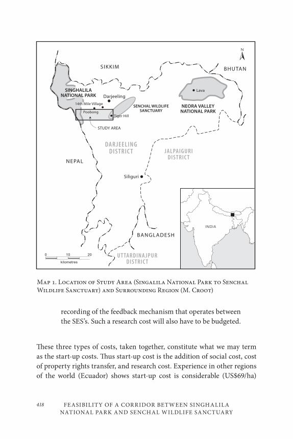
FEASIBILITY OF A CORRIDOR BETWEEN SINGHALILA NATIONAL PARK AND SENCHAL WILDLIFE SANCTUARY
418
recording of the feedback mechanism that operates between the SES’s. Such a research cost will also have to be budgeted.
These three types of costs, taken together, constitute what we may term as the start-up costs. Thus start-up cost is the addition of social cost, cost of property rights transfer, and research cost. Experience in other regions of the world (Ecuador) shows start-up cost is considerable (US$69/ha)
DARJEELINGDISTRICT JALPAIGURI
DISTRICT
UTTARDINAJPURDISTRICT
SIKKIM
NEPAL
BANGLADESH
Darjeeling
Siliguri
STUDY AREA
NEORA VALLEYNATIONAL PARK
BHUTAN
Lava
Tiger Hill
SINGHALILANATIONAL PARK
14th Mile Village
Poobong
SENCHAL WILDLIFESANCTUARY
INDIA
0 10 20
kilometres
Map 1. Location of Study Area (Singalila National Park to Senchal Wildlife Sanctuary) and Surrounding Region (M. Croot)
419Animesh Sarkar and Milindo Chakrabarti
(Wunder 2007). A collaborative and site-specific partnership between government departments, landholders, and private investors has to evolve to shoulder this responsibility in large part. We attempt to provide a qualitative estimate of a substantial component of social costs necessary to implement a corridor in the area, elaborated in the activity plan. The rest of the costs, like the costs involved in transfer of property rights or to carry out relevant research, have not been factored in.
SITE DESCRIPTION
Our study area is located between Singalila National Park (SNP) and Senchal Wildlife Sanctuary (SWS) (Map 1). The distance between these two protected areas is approximately twenty kilometres. We studied five of about twenty-five villages located in this area. The area lies mainly on the catchment area of river Balason on the south and the river Chhota (little) Rangit on the north. The average elevation varies between 125 metres and 200 metres.
METHODOLOGY
Information about all the households residing in these settlements was first collected through structured questionnaires. The information gath-ered included the profiles of the households in terms of their: demo-graphic characteristics, educational attainments, seasonal engagements, occupational characteristics, and skill sets. To complement the informa-tion gathered at the household level, Appreciative Participatory Planning and Action (APPA) was utilize to generate village-level information about (ECOSS 2005): ecological profile, infrastructural profile, and institu-tional profile. In addition, APPA also helped identify villagers’ perception about conflict, possible remedies, and a plan to implement the measures suggested.
FEASIBILITY OF A CORRIDOR BETWEEN SINGHALILA NATIONAL PARK AND SENCHAL WILDLIFE SANCTUARY
420
SOCIAL SYSTEM
There were 216 households with a total population of 931 in the five vil-lages studied. 478 of them were male and 453 female. Twenty-three per cent of the population was aged below fourteen years. Literacy rate in this area was quite high (72.9%) compared to national average (64.8%). Out of those who received education:
• 632 (82.7%) are educated up to primary level;
• 106 (13.9%) studied up to secondary level; and
• 26 (3.4%) went for studies beyond secondary level.
Four hundred and four (52.9%) dropped out after receiving primary-level education. Table 1 provides a summary of occupations held by the high-est-earning members of the surveyed households.
Average annual income of the households from different economic activities works out to be approximately Rs.58,000 (about US$1,090). Twenty-six per cent of the households were below the poverty line.
Infrastructure:
Inhabitants of all the five villages under review have access to metalled (crushed rock) road, a health centre within an average distance of 3 kilome-tres, and a market within an average distance of 2 kilometres. The supply of safe drinking water from the Public Health Engineering Department of the Darjeeling Gorkha Autonomous Hill Council (DGAHC) is not equal-ly assured across all these villages. However, the villages are all electri-fied and all the households have access to electricity. Children from these villages can go to a primary school located within one kilometre from their settlements. Opportunities for pursuing secondary/higher second-ary education exist at Ghoom-Jorebunglow. Recently a new degree college has come up at Jorebunglow offering degree courses in humanities and social science.
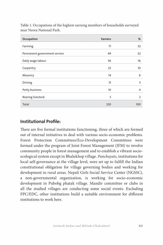
421Animesh Sarkar and Milindo Chakrabarti
Table 1. Occupations of the highest-earning members of households surveyed near Neora National Park.
Occupation Earners %
Farming 71 32
Permanent government service 49 22
Daily wage labour 36 16
Carpentry 22 10
Masonry 14 6
Driving 13 5
Petty business 10 4
Rearing livestock 5 2
Total 220 100
Institutional Profile:
There are five formal institutions functioning, three of which are formed out of internal initiatives to deal with various socio-economic problems. Forest Protection Committees/Eco-Development Committees were formed under the program of Joint Forest Management (JFM) to involve community people in forest management and to establish a vibrant socio-ecological system except in Bhalukhop village. Panchayats, institutions for local self-governance at the village level, were set up to fulfill the Indian constitutional obligation for village governing bodies and working for development in rural areas. Nepali Girls Social Service Center (NGSSC), a non-governmental organization, is working for socio-economic development in Pubobg phatak village. Mandir committee or clubs in all the studied villages are conducting some social events. Excluding FPC/EDC, other institutions build a suitable environment for different institutions to work here.
FEASIBILITY OF A CORRIDOR BETWEEN SINGHALILA NATIONAL PARK AND SENCHAL WILDLIFE SANCTUARY
422
SOCIAL-ECOLOGIC AL SYSTEM
Since 1856, migrants serving as tea garden (TG) labour established dif-ferent settlements. Initially the TG management provided them shelter to stay and fuel wood to cook. However, in course of time migrants and members of split families settle and take up permanent residence. This increased population settled in adjacent forest areas and used forest re-sources for their sustenance. Clearance of forestland for agriculture and collection of fuel wood, fodder, and non-timber forest products (NTFPs) for their sustenance was a general practice. As a result forest area shrunk and changed its state. However, they still depend on the adjacent or cap-tive forest for their daily needs of fuel wood, fodder, and some available NTFPs. Average annual value of the resources collected free from the for-ests (fuel wood, fodder, NTFPs, and timber) per household has been esti-mated at Rs.22,000. The extent of dependence of the households on forests appears to be 37.6%. A quantitative estimation of present dependence on forest resources is:
• Household mean fuel wood consumption is 20.4 kilograms daily, although only 2.7 kg/day for 14th mile;
• On average, each household consumes 36 kilograms of fodder daily; although only 0.5 kg/day for 14th Mile;
• Twenty-eight floral species are in use as NTFPs by the communities and only ‘Chirato’ is harvested commercially.
• Household mean timber consumption is 0.6 cubic feet annually. Only people living in Bhalukhop area derive timber from the forest, residents of the rest of the villages buy it from the market.
• On average, each household consumes 1 kilogram of NTFP annually.
• Mean household water consumption is 234.4 litres daily, procured from the jhoras lying within the forests.
423Animesh Sarkar and Milindo Chakrabarti
It is evident that the villagers surveyed depend a lot on the resources avail-able from forests for their livelihood requirements. If the forests are not managed properly to ensure that such extraction of resources – fodder, timber, fuel wood, NTFPs, and water – are confined to the natural regen-eration capacity (resilience) of the forests, the ecological system centred around the forest vegetation will disappear. The destruction of the eco-logical system will also endanger the existence of the social system built around the forest resources available therein. Both the systems, and the social-ecological system as a whole will reach a threshold of irreversible change.
However, the extent of dependence is gradually shrinking. Such de-clines may be caused by two prominent drivers: first, reduction in the availability of resources from the forests, and, second, increase in the availability of alternative substitute resources from the non-forest based economic system.
Our survey revealed that resources that were easily available earlier have become scarce. Harvesting of fuel wood has become a time-consum-ing task. People are travelling longer distances to harvest the resource and getting less quantity of fuel wood. Residents are increasingly adopting fossil fuel (kerosene and liquid petroleum gas), even though such fuels are not readily available locally. Fragmentation and clearing of watershed areas reduced the availability of water, with a simultaneous deterioration in its quality. Villagers have to go farther to collect drinking water. Less availability of fodder in the forest forced the residents to reduce the num-ber of cattle. They are using part of their land as pasture and part as a fodder/fuel wood plantation. People use cement houses in place of cul-turally preferred wooden homes, as wood has become a scarce resource. Non-timber forest products collection is reduced abruptly, even though it is a part of their subsistence livelihood system. Man-animal conflict has increased. Recurring incidence of landslides during the monsoon season causes the loss of 1.2 to 1.6 hectares of land every year. These constraints on resources from the forest push the SES toward crossing a threshold be-yond which the ecological system will not recover, followed by a collapse of the social system. Anderies (2006) documents an example of such a col-lapse of the prehistoric Hohokam society that flourished for around 1,450
FEASIBILITY OF A CORRIDOR BETWEEN SINGHALILA NATIONAL PARK AND SENCHAL WILDLIFE SANCTUARY
424
years in central and southern Arizona. There is substantial evidence that the social system in this eastern Himalayan region is tightly linked to the availability of ecosystem services from the traditional forest ecosystem, suggesting that a similar outcome is possible.
GENER AL TRENDS OF VISIBLE CHANGES IN RECENT
PAST (1984 AS BASE YEAR) AND THE VILL AGERS’
EXPECTATIONS ABOUT THE FUTURE
During an interactive session employing the Appreciative Participatory Planning and Action (APPA) technique, the villagers came up with the following visible changes in the studied area since 1984 and revealed their expectations about the future.
• Forest cover has been dwindling rapidly in all villages.
• Depredation of agricultural crops and livestock by wild animals reduces agricultural production and earnings from livestock rearing.
• Agricultural production has decreased.
• The livestock population has decreased.
• Milk and milk-based production has decreased.
• Income and quality of life, as measured by modern standards, have increased. The villagers are aware that their persistent improvement in quality of life has been achieved through unsustainable extraction of forest resources and a possible reduction in the availability of forest-based resources beyond a threshold that would lead to a sudden fall in the present level of income and quality of life, breaking the SES simultaneously.
425Animesh Sarkar and Milindo Chakrabarti
Villagers want to reverse these trends and want to start new enterprises enabling them to re-organize the SES. Locals consider that their social existence cannot be separated from that of the existing ecological system and that both the systems are mutually beneficial if a system of adaptive co-management is in place.
The villagers prepared a plan considering the different suggested activities and anticipated outcomes (Table 2). To summarize, it may be noted that such a plan will involve a one-time investment of about 7 million Indian rupees (about US$130,000). Per capita investment is estimated to be US$138. Such investments are capable of creating 47,564 man-days annually (about fifty-one days per capita). Annual per capita surplus that can be potentially generated through such investments is estimated at US$108 (Table 3). However, given the estimated per capita income of about US$215, the villagers cannot manage to generate the investment funds out of their own resources to come out of the vicious circle.
REMEDIES SUGGESTED BY THE LOC ALS
The following are the remedies which the villagers feel will help to regain resilience within the SES:
• To prevent the wild animals from entering the villages and reducing the incidence of landslides, more trees should be planted in the areas adjoining the villages. The villagers are willing to plant trees on their own land, provided they are supplied the seedlings or saplings.
• A possible solution to wild animal conflict is putting up barbed wire fencing around the village boundary. The villagers are willing to contribute free labour and also to identify locations requiring immediate fencing.
• Adequate funds are necessary to ensure regular and adequate supply of water for both drinking and irrigation purposes.
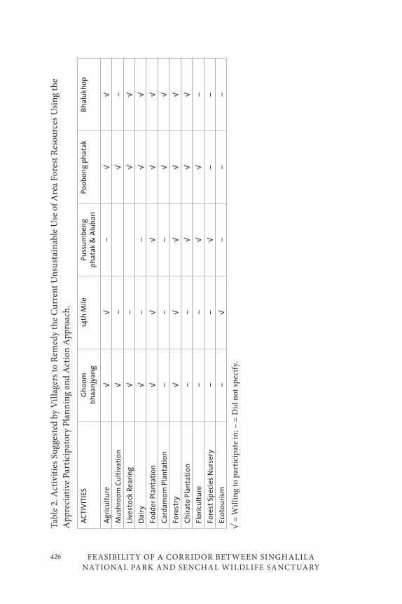
FEASIBILITY OF A CORRIDOR BETWEEN SINGHALILA NATIONAL PARK AND SENCHAL WILDLIFE SANCTUARY
426
Tab
le 2
. Act
ivit
ies
Sugg
este
d by
Vil
lage
rs to
Rem
edy
the
Cu
rren
t Un
sust
ain
able
Use
of A
rea
Fore
st R
esou
rces
Usi
ng
the
App
reci
ativ
e P
arti
cipa
tory
Pla
nn
ing
and
Act
ion
App
roac
h.
AC
TIV
ITIE
SG
ho
om
b
ha
anjy
ang
14th
Mil
eP
uss
um
ben
g
ph
ata
k &
Alu
bar
iP
oo
bo
ng
ph
ata
kB
hal
ukh
op
Ag
ricu
ltu
re√
√–
√√
Mu
shro
om
Cu
ltiv
ati
on
√–
√–
Live
sto
ck R
eari
ng
√–
√√
Dai
ry
√–
–√
√
Fod
der
Pla
nta
tio
n√
√√
√√
Car
dam
om
Pla
nta
tio
n–
––
√√
Fore
stry
√√
√√
√
Ch
ira
to P
lan
tati
on
––
√√
√
Flo
ricu
ltu
re–
–√
√–
Fore
st S
pe
cies
Nu
rser
y–
–√
––
Eco
tou
rism
–√
––
–
√ =
Wil
lin
g to
par
tici
pate
in; –
= D
id n
ot s
pec
ify.
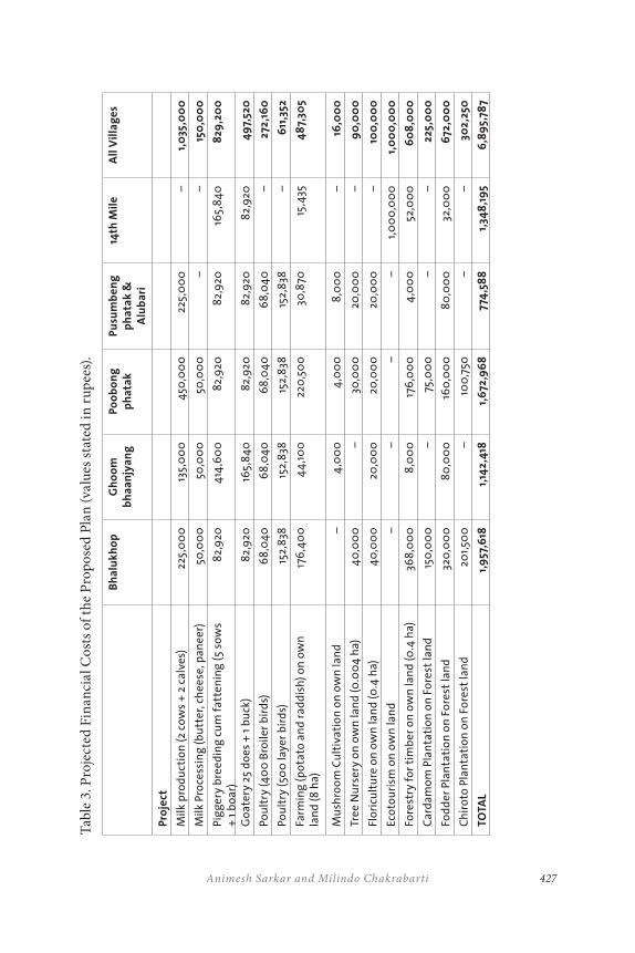
427Animesh Sarkar and Milindo Chakrabarti
Tab
le 3
. Pro
ject
ed F
inan
cial
Cos
ts o
f the
Pro
pose
d P
lan
(val
ues
stat
ed in
rup
ees)
.
Bh
alu
kh
op
Gh
oo
m
bh
aa
njy
an
gP
oo
bo
ng
p
ha
tak
Pu
sum
be
ng
p
ha
tak
&
Alu
ba
ri
14th
Mil
eA
ll V
illa
ge
s
Pro
ject
Milk
pro
du
ctio
n (2
co
ws
+ 2
cal
ves)
225,
00
013
5,0
00
450
,00
022
5,0
00
–1,
035
,00
0
Milk
Pro
cess
ing
(b
utt
er, c
he
ese,
pan
eer
)50
,00
050
,00
050
,00
0–
–15
0,0
00
Pig
ger
y b
ree
din
g c
um
fa
tten
ing
(5
sow
s +
1 b
oar
)8
2,9
204
14,6
00
82,
920
82,
920
165,
84
08
29,2
00
Go
ate
ry 2
5 d
oes
+ 1
bu
ck)
82,
920
165,
84
08
2,9
208
2,9
208
2,9
204
97,
520
Po
ult
ry (
40
0 B
roil
er b
ird
s)6
8,0
40
68
,04
06
8,0
40
68
,04
0–
272,
160
Po
ult
ry (
500
laye
r b
ird
s)15
2,8
3815
2,8
3815
2,8
3815
2,8
38–
611
,352
Farm
ing
(p
ota
to a
nd
ra
dd
ish
) o
n o
wn
la
nd
(8 h
a)17
6,4
00
44
,10
022
0,5
00
30,8
7015
,435
48
7,30
5
Mu
shro
om
Cu
ltiv
ati
on
on
ow
n la
nd
–
4,0
00
4,0
00
8,0
00
–16
,00
0
Tre
e N
urs
ery
on
ow
n la
nd
(0.0
04
ha)
40
,00
0–
30,0
00
20,0
00
–9
0,0
00
Flo
ricu
ltu
re o
n o
wn
lan
d (0
.4 h
a)4
0,0
00
20,0
00
20,0
00
20,0
00
–10
0,0
00
Eco
tou
rism
on
ow
n la
nd
––
––
1,0
00
,00
01,
00
0,0
00
Fore
stry
fo
r ti
mb
er o
n o
wn
lan
d (0
.4 h
a)36
8,0
00
8,0
00
176
,00
04
,00
052
,00
06
08
,00
0
Car
dam
om
Pla
nta
tio
n o
n F
ore
st la
nd
15
0,0
00
–75
,00
0–
–22
5,0
00
Fod
der
Pla
nta
tio
n o
n F
ore
st la
nd
320
,00
08
0,0
00
160
,00
08
0,0
00
32,0
00
672
,00
0
Ch
iro
to P
lan
tati
on
on
Fo
rest
lan
d20
1,50
0–
100
,750
––
302,
250
TOTA
L1,
957
,618
1,14
2,4
181,
672
,96
877
4,5
88
1,34
8,1
95
6,8
95,
787
FEASIBILITY OF A CORRIDOR BETWEEN SINGHALILA NATIONAL PARK AND SENCHAL WILDLIFE SANCTUARY
428
The villagers are willing to contribute free labour for development of the necessary infrastructure.
• Speedy and timely supply of relief materials needs to be ensured during natural calamities like landslides.
• The forest department should act in a more people-friendly manner and find ways to gain villager participation in the conservation of forest resources.
• A possible process remedy would be to institutionalize a social forestry or community forestry approach that will have as a goal restoration of contiguous forest cover to address wildlife habitat connectivity as well as the local community resource problems.
• Forest ownership issues should be discussed and an amicable solution crafted. The villagers feel that the ownership of forests should lie with them.
EXISTING INFORM ATION GAPS TO BE FILLED AND A
POSSIBLE ROAD M AP
The following steps might be taken to re-establish the missing link between social-ecological systems:
• Identify the migration routes of different wild animals. Even if the corridor is socio-economically feasible, it may not turn out to be a practical solution if the proposed location does not fall on the natural migration routes of wild species inhabiting SNP and SWS. Unfortunately, no such information is available in the public domain. However, sighting of a good number of faunal species by the residents of this region lends partial credence to the argument of having a corridor in this region as proposed in the present paper.
429Animesh Sarkar and Milindo Chakrabarti
• The species composition of the standing forests lying at both ends of the proposed corridor needs to be altered to facilitate habitation by the wild animals. Monoculture of Cryptomeria
japonica in the forests under consideration should be replaced by indigenous mixed species forest in a phased manner.
• Once the corridor is found to be ecologically, socially, and economically practicable, identification of the exact location of the corridor should be taken up with active participation of different stakeholders. Such an identification process will be influenced by the characteristics (slope, aspect, soil quality), ownership, and use pattern of the land available. A thorough social cost-benefit analysis of the possible alternatives will help identify the exact location of the proposed corridor.
• Identification of the exact location of the corridor will simultaneously help locate the households who may be affected as a result. All the residents of the village may be affected in some locations.
• A proper rehabilitation plan for those affected in particular and for the village in general is to be developed. The planning process has to be participatory in the real sense of the term.
• Setting up of the corridor is expected to generate net benefit through enhanced biodiversity status, including arrested species extinction, and creation of other ecological and environmental values for the global community. Even so, some within the community may reap positive benefits. Necessary resources to compensate those being affected directly are to be raised from those deriving a net benefit out of the decision to lay the corridor.
• The restored forest in this proposed corridor should be of mixed type to provide suitable habitat to the wild animals and sustenance opportunities to the residents. The proposed area has been without substantial forest canopy cover for some time, resulting in altered soil condition. The suitability of the
FEASIBILITY OF A CORRIDOR BETWEEN SINGHALILA NATIONAL PARK AND SENCHAL WILDLIFE SANCTUARY
430
soil for restoration of different indigenous species must be studied.
• Promotion of fodder and NTFP species restoration, a practice still not recognized as a policy option in and around state-owned forests, necessary to sustain the livelihood of the villagers needs to be ascertained.
• Introduction of appropriate technology for resource production and provision of proper training to the villagers for developing skills will be of paramount importance to ensure higher productivity and efficiency, promoting sustainable use in the long run. Identification, documentation, and dissemination of traditional knowledge bases (like cropping pattern, rainwater harvesting, etc.) that helped ensure the past sustainable livelihood of the villagers, as well as of the wild animals, are to be encouraged.
• The new plantations could be linked to the carbon credit market to provide sustainable incentive to the locals as well as the conservation issue at hand.
• Local-level institutions are to be strengthened and the villagers are to be encouraged to participate more aggressively in conservation and sustainable forest uses so that the issues regarding the share of harvesting rights among the different stakeholders may be resolved.
• Relevant and measurable ecological and social indicators need to be developed to monitor the status of the corridor and the SES. Examples of such indicators could include improvement increases in endemic species populations, increased migration of wild animals between the protected areas, and reduced man–animal conflict reports.
431Animesh Sarkar and Milindo Chakrabarti
CONCLUSION
We identified the social-economic intricacies involved in creating a possible corridor to facilitate movement of wildlife between Darjeeling Himalayan protected areas in India. It is found that anthropogenic intervention in the name of development, establishment of human settlements, and for-estry operations initiated a land-use change and added to the fragility of the forest ecosystem in this region that was contiguous historically. The commercial exploitation of timber and planting of fast-growing species changed the phytosociological integrity of the socio-ecological system. Large-scale removal of broad-leaved indigenous trees with dense canopies and subsequent plantations of exotic Cryptomaria japonica (a coniferous species not even of much use to indigenous wildlife) induced reduction in water-trapping capacity of forests, minimized soil water, and often ren-dered the land unsuitable for natural regeneration. Controlled weeding and fire-protection methods introduced to maximize timber production of some commercially viable species weakened the resilience of the entire forest system to any sudden disturbance. The present study of feasibility of restoring a wildlife connectivity between the Singhalila National Park and Senchal Wildlife Sanctuary does find that the community members:
1. are concerned about the rapid deterioration of the ecological system around them;
2. consider the ecological system as an inseparable part of the social system they belong to and hence feel themselves to be a part of a larger social-ecological system;
3. prepared a detailed plan that would help strengthen the linkage between social and ecological system restoration and add to the resilience of the resulting social-ecological system; and
4. are ready to contribute meaningfully to the investable resources through provision of voluntary labour necessary to arrive at the required changes.
FEASIBILITY OF A CORRIDOR BETWEEN SINGHALILA NATIONAL PARK AND SENCHAL WILDLIFE SANCTUARY
432
However, the feasibility of the corridor is still uncertain. It is quite clear that the start-up costs are too high for the local communities to bear. They are sensitive enough to realize the impending destabilization in the SES but cannot act unless supported with resources from outside – federal, regional, or even international support from institutions that also stand to gain considerably from such an effort. The latest census report on medium, small, and marginal enterprises (MSME) carried out by the Development Commissioner, MSME, Government of India in 2000–2001 reveals that 1.39 person years of employment is generated per Rs. 100,000 (roughly US$1,860). The investments in the corridor will generate 1.92 person-years of employment and have the capacity to help protect the forests as well. Thus, the investments, even though beyond the capacity of the commu-nities under consideration, are well within the capability of the outside world, provided there exists a willingness to contribute towards the social gain that accrues to mankind as a whole and adds to the resilience of the social-ecological system under review.
433Animesh Sarkar and Milindo Chakrabarti
REFERENCES
Adger, W. L., T. P. Hughes, C. Folke, S. R. Carpenter, and J. Rockstrom. 2005. “Social ecological resilience to coastal disasters.” Science 309: 1036–39.
Anderies, J. M. 2006. “Robustness, institutions, and large-scale change in social-ecological systems: The Hohokam of the Phoenix Basin.” Journal of Institutional Economics 2(2): 133–55.
Anderies, J. M., M. A. Janssen, and E. Ostrom. 2004. “A framework to analyze the robustness of social ecological systems from an institutional perspective.” Ecology and Society 9(1): 18. http://www.ecologyandsociety.org/vol9/iss1/art18/
Brand, F. S., and K. Jax. 2007. “Focusing the meaning(s) of resilience: Resilience as a descriptive concept and a boundary object.” Ecology and Society 12(1): 23. http://www.ecologyandsociety.org/vol12/iss1/art23/.
CEPF. 2010. Investing in Life: The Critical Ecosystem Partnership at 10. Arlington, VA: Critical Ecosystem Partnership Fund.
Chakrabarti, M., A. Sarkar, S. R. Ghosh, and A. Sarkar. 2002. “Forest structure, resource and institutions: Experiences from Poobong, Darjeeling Forest Division.” CREATE, St. Joseph’s College, Darjeeling.
Chakrabarti, M., S. K. Datta, and A. Sarkar. 2004. “How governance issues influence joint forest management in India: A perspective from Sub-Himalayan West Bengal.” In Silver Jubilee Symposium on Governance in Development, 76–101. Anand: Institute of Rural Management.
Chakrabarti, M., S. K. Datta, E. L. Howe, and J. B. Nugent. 2005. “Joint forest management: Experience and modeling.” In Economics, Sustainability, and Natural Resources: Economics of Sustainable Forest Management, ed. S. Kant and R. A. Berry, 223–52. Dordrecht: Springer.
Chang, E. 2007. “Conserving biological diversity, fostering sustainability in Mesoamerica.” Accessed May 23, 2007. http://www.wri.org/wri.
Chhetri, D. R., D. Basnet, P. F. Chiu, S. Kalikotay, G. Chhetri, and S. Parajuli. 2005. “Current status of ethnomedicinal plants in the Darjeeling Himalaya.” Current Science 89(2): 264–68.
Chopra, K. 2006. “Report of the Expert Committee on Net Present Value.” Submitted to the Honourable Supreme Court of India.
Daming, H., and D. Ping. 2007. “Under the auspices of the National Key Project for Basic Research of P. R. China.” Accessed May 25, 2007. http://www.lancang-mekong.org.
FEASIBILITY OF A CORRIDOR BETWEEN SINGHALILA NATIONAL PARK AND SENCHAL WILDLIFE SANCTUARY
434
Datta, S. K., S. Kapoor, K. B. Gupta, and M. Chakrabarti. 2006. Study on NPV Calculations for Diversion of Forest Land for Mining Purposes. New Delhi: Federation of Indian Mineral Industries.
Ecotourism and Conservation Society of Sikkim (ECOSS). 2005. “Report on Appreciative Participatory Planning and Action (APPA).” Kalimpong: ECOSS.
FAO. 2005. India Country Report. Rome: Global Forest Resources Assessment, FAO Forestry Department.
FAO. 2007. State of the World’s Forests. Rome, FAO, United Nations.
Folke, C., S. Carpenter, T. Elmqvist, L. Gunderson, C. S. Holling, B. Walker, J. Bengtsson, F. Berkes, J. Colding, K. Danell, et al. 2002. “Resilience and sustainable development: Building adaptive capacity in a world of transformations.” Scientific background paper on Resilience for the process of the World Summit on Sustainable Development on behalf of the Environmental Advisory Council to the Swedish Government.
Greater Mekong Subregion (GMS) Economic Cooperation. 2005. “GMS Biodiversity Conservation Corridors Initiative.” Strategic Framework And Technical Assessment (Executive Summary), 1–9.
Gunderson, L., C. S. Holling, L. Pritchard, and G. D. Peterson. 2002. “Resilience.” In Encyclopedia of Global Environmental Change, ed. H. A. Mooney and J. G. Canadell, 530–31. New York: Wiley.
Gundimeda, H., S. Sanyal, R. Sinha, and P. Sukdev. n.d. “The value of biodiversity in India’s forests.” Green Accounting for Indian States Project: Monograph 4.
Hadjibiros, K., A. Katsiri, A. Andreadakis, D. Koutsoyiannis, A. Stamou, A. Cristofides, A. Efstratiadis, and G. Sargentis. 2005. “Multi-criteria reservoir water management.” Global NEST Journal 7(3): 386–94.
Janssen, M. A. 2006. “Historical institutional analysis of social-ecological systems: Introduction to the special issue on institutions and ecosystems.” Journal of Institutional Economics 2(2): 127–31.
Janssen, M. A., J. M. Anderies, and E. Ostrom. 2007. “Robustness of social-ecological systems to spatial and temporal variability.” Society and Natural Resources 20: 307–22.
Johns, M. 2000. “Ovenbird.” Raleigh: North Carolina Wildlife Resources Commission.
Metcalfe, S. 2005. Transboundary Protected Area Impacts on Communities: Case Study of Three Southern African Transboundary Conservation Initiatives. Washington, D.C.: African Wildlife Foundation Working Papers.
435Animesh Sarkar and Milindo Chakrabarti
Ministry of Environment and Forest (MoEF). 2005a. “2004 forests and wildlife statistics.” In National Focal Point for APFISN, India Country Report, Ministry of Environment and Forests, Government of India. Accessed February 24, 2007. http://www.ifs.nic.in/rt.
———. 2005b. “State of forest report 2003.” Dehradun: Forest Survey of India.
Natural Resource Committee. 2006. “Technical approach to define highlands forest integrity.” Draft for consideration at the meeting of Natural Resource Committee of the Highlands Council, April 27, 2006.
Ostrom, E. 2007. “Sustainable social-ecological systems: An impossibility?” Paper presented at the Annual Meetings of the American Association for the Advancement of Science, Science and Technology for Sustainable Well-Being, in San Francisco, February 15–19, 2007: 1–29.
Parfenov, V. 1996. “Preservation of biological diversity in transboundary protected areas of Belarus and Poland.” In Biodiversity Conservation in Transboundary Protected Areas, ed. A. Breymeyer and R. Noble. Washington, D.C.: Academy Press.
Ray, T. N. 1964. “History of forest management in North Bengal.” In Centenary Commemoration Volume, 79–90. Forest Directorate, Government of West Bengal.
Stern, N., S. Peters, V. Bakhshi, A. Bowen, C. Cameron, S. Catovsky, D. Crane, S. Cruickshank, S. Dietz, N. Edmonson, S. L.Garbett, L. Hamid, G. Hoffman, D. Ingram, B. Jones, N. Patmore, H. Radcliffe, R. Sathiyarajah, M. Stock, C. Taylor, T. Vernon, H. Wanjie, and D. Zenghelis. 2006. Stern Review: The Economics of Climate Change. London: HM Treasury.
Vincent, K. 2007. “Uncertainty in adaptive capacity and the importance of scale.” Global Environmental Change 17: 12–24.
Wikramanayake, E. ed. 2003. Ecosystem Profile, Eastern Himalayas Region of the Indo-Burma Biodiversity Hotspot: Bhutan, Nepal, Northeastern India. Arlington, VA: Critical Ecosystem Partnership Fund (CEPF), Conservation International.
Wunder, S. 2007. “The efficiency of payments for environmental services in tropical conservation.” Conservation Biology 21(1): 48–58.

437
18
Under the Penumbra of Waterton-Glacier and Homeland Security: Could a Peace Park Appear along the U.S.–Mexican Border?
Charles C. Chester and Belinda Sifford
INTRODUCTION
The 1932 designation of Waterton-Glacier International Peace Park (WGIPP) inspired efforts to create a similar institution between the U.S. and Mexico. Yet despite the greater need for symbolic inspiration on the U.S.’s southern border, the seventy-fifth anniversary of WGIPP passed without a complementary Mexico–U.S. peace park. To blame are a host of political disputes, cultural misunderstandings, and any number of other factors. Given the divergent governmental priorities and periodic acrimo-ny between the U.S. and Mexico, it is hardly surprising that advocates on
UNDER THE PENUMBR A OF WATERTON-GLACIER
AND HOMELAND SECURITY
438
both sides of the border have yet to ordain a park celebrating conservation and peace.
Despite the failure to establish a formal peace park, Mexican and U.S. land managers have participated in various cooperative endeavours with a large-scale impact across the international border. Conservationists have repeatedly celebrated these efforts as potential precursors to an inter-national park, though such hopes may seem absurdly aspirational as ex-tensive border fences now stand with more authorized for construction. In an era so dominated by border security, immigration, and trafficking issues, there is good reason not only to question the political feasibility of a peace park, but as well to critically assess the degree to which a park could enhance conservation and economic sustainability in the region.
Nonetheless, examining the history of efforts to establish an inter-national park in both the Sonoran and the Chihuahuan deserts justifies the conclusion that an international park is not only worthy but possible. Despite existing barriers, the cumulative weight of beneficial collabora-tive cross-border work may yet lead to an international park symbolizing peace and land stewardship.
THE SONOR AN DESERT
The Sonoran Desert lies largely in Mexico, surrounding the Gulf of California and engulfing most of the Mexican states of Sonora, Baja California, and Baja California Sur (Map 1). Yet a sizable portion extends across the border, covering most of southwestern Arizona and significant portions of southeastern Arizona and southeastern California (Dimmitt 2000; MacMahon 2000).
The region’s indigenous O’odham peoples have lived in the region for centuries. During the late seventeenth century, the first wave of coloniza-tion came via a network of Spanish missionaries in the eastern portion of the Sonoran Desert. Although the region’s arid conditions did not attract significant numbers of colonists, a treacherous path through the desert to accommodate the wave of gold rushers from the Mexican frontier to California – a route still known as the “Devil’s highway” – did encourage
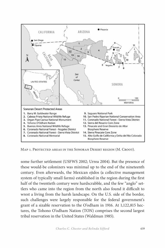
439Charles C. Chester and Belinda Sif ford
Map 1. Protected areas in the Sonoran Desert region (M. Croot).
some further settlement (USFWS 2002; Urrea 2004). But the presence of these would-be colonizers was minimal up to the end of the nineteenth century. Even afterwards, the Mexican ejidos (a collective management system of typically small farms) established in the region during the first half of the twentieth century were hardscrabble, and the few “anglo” set-tlers who came into the region from the north also found it difficult to wrest a living from the harsh landscape. On the U.S. side of the border, such challenges were largely responsible for the federal government’s grant of a sizable reservation to the O’odham in 1916. At 1,122,815 hec-tares, the Tohono O’odham Nation (TON) comprises the second largest tribal reservation in the United States (Waldman 1985).
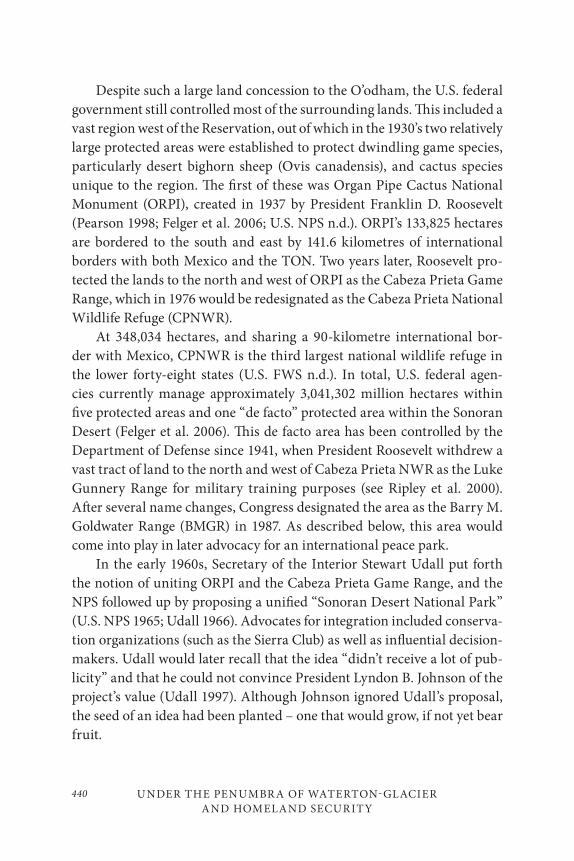
UNDER THE PENUMBR A OF WATERTON-GLACIER
AND HOMELAND SECURITY
440
Despite such a large land concession to the O’odham, the U.S. federal government still controlled most of the surrounding lands. This included a vast region west of the Reservation, out of which in the 1930’s two relatively large protected areas were established to protect dwindling game species, particularly desert bighorn sheep (Ovis canadensis), and cactus species unique to the region. The first of these was Organ Pipe Cactus National Monument (ORPI), created in 1937 by President Franklin D. Roosevelt (Pearson 1998; Felger et al. 2006; U.S. NPS n.d.). ORPI’s 133,825 hectares are bordered to the south and east by 141.6 kilometres of international borders with both Mexico and the TON. Two years later, Roosevelt pro-tected the lands to the north and west of ORPI as the Cabeza Prieta Game Range, which in 1976 would be redesignated as the Cabeza Prieta National Wildlife Refuge (CPNWR).
At 348,034 hectares, and sharing a 90-kilometre international bor-der with Mexico, CPNWR is the third largest national wildlife refuge in the lower forty-eight states (U.S. FWS n.d.). In total, U.S. federal agen-cies currently manage approximately 3,041,302 million hectares within five protected areas and one “de facto” protected area within the Sonoran Desert (Felger et al. 2006). This de facto area has been controlled by the Department of Defense since 1941, when President Roosevelt withdrew a vast tract of land to the north and west of Cabeza Prieta NWR as the Luke Gunnery Range for military training purposes (see Ripley et al. 2000). After several name changes, Congress designated the area as the Barry M. Goldwater Range (BMGR) in 1987. As described below, this area would come into play in later advocacy for an international peace park.
In the early 1960s, Secretary of the Interior Stewart Udall put forth the notion of uniting ORPI and the Cabeza Prieta Game Range, and the NPS followed up by proposing a unified “Sonoran Desert National Park” (U.S. NPS 1965; Udall 1966). Advocates for integration included conserva-tion organizations (such as the Sierra Club) as well as influential decision-makers. Udall would later recall that the idea “didn’t receive a lot of pub-licity” and that he could not convince President Lyndon B. Johnson of the project’s value (Udall 1997). Although Johnson ignored Udall’s proposal, the seed of an idea had been planted – one that would grow, if not yet bear fruit.
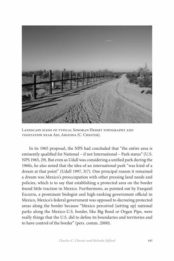
441Charles C. Chester and Belinda Sif ford
In its 1965 proposal, the NPS had concluded that “the entire area is eminently qualified for National – if not International – Park status” (U.S. NPS 1965, 29). But even as Udall was considering a unified park during the 1960s, he also noted that the idea of an international park “was kind of a dream at that point” (Udall 1997, 317). One principal reason it remained a dream was Mexico’s preoccupation with other pressing land needs and policies, which is to say that establishing a protected area on the border found little traction in Mexico. Furthermore, as pointed out by Exequiel Ezcurra, a prominent biologist and high-ranking government official in Mexico, Mexico’s federal government was opposed to decreeing protected areas along the border because “Mexico perceived [setting up] national parks along the Mexico-U.S. border, like Big Bend or Organ Pipe, were really things that the U.S. did to define its boundaries and territories and to have control of the border” (pers. comm. 2000).
Landscape scene of typical Sonoran Desert topography and vegetation near Ajo, Arizona (C. Chester).
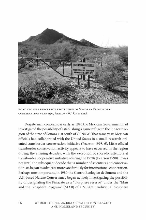
UNDER THE PENUMBR A OF WATERTON-GLACIER
AND HOMELAND SECURITY
442
Despite such concerns, as early as 1943 the Mexican Government had investigated the possibility of establishing a game refuge in the Pinacate re-gion of the state of Sonora just south of CPNRW. That same year, Mexican officials had collaborated with the United States in a small, research-ori-ented transborder conservation initiative (Pearson 1998, 6). Little official transborder conservation activity appears to have occurred in the region during the ensuing decades, with the exception of sporadic attempts at transborder cooperative initiatives during the 1970s (Pearson 1998). It was not until the subsequent decade that a number of scientists and conserva-tionists began to advocate more vociferously for international cooperation. Perhaps most important, in 1980 the Centro Ecológico de Sonora and the U.S.-based Nature Conservancy began actively investigating the possibil-ity of designating the Pinacate as a “biosphere reserve” under the “Man and the Biosphere Program” (MAB) of UNESCO. Individual biosphere
Road closure fences for protection of Sonoran Pronghorn conservation near Ajo, Arizona (C. Chester).
443Charles C. Chester and Belinda Sif ford
reserves were conceived as a tiered land-management strategy, each to include “core zones,” “buffer zones,” and “cooperation/transition zones.”
The essential goals of a biosphere reserve were to conserve biodivers-ity, to provide baselines for scientific research, to establish educational facilities, and to promote sustainable development. Although ORPI was one of the first areas to receive designation as a biosphere reserve in 1976, the new appellation did not lead to any significant changes in the manage-ment of the area or its surrounding lands.
Much of the rest of the 1980s would see a series of similar and related investigations into the Pinacate, and a 1988 “Symposium on the Pinacate Ecological Area” would generate considerable momentum toward inter-national cooperation in the region – as well as toward the establishment of biosphere reserves in Mexico. The Symposium not only attracted scientists and conservationists from both sides of the border but constituted the first time that the O’odham had been included in such a transborder forum (Sonoran Institute & ISDA n.d.; Laird et al. 1997). Representatives from one subgroup of O’odham, the Hia Ced O’odham, raised strong concerns over whether the designation of the Pinacate region as an international bio-sphere reserve would further trespass on their rights to the region (Joquin 1988). Although the message appears to have received a cool reception among many – if not most – of the Symposium’s participants, there was agreement over the need for “a larger public forum … to promote dialogue among residents of the Sonoran Desert” (Laird et al. 1997).
After the four subsequent years of networking and planning, a well-at-tended “Land Use Forum” finally took place in 1992 in the small, close-to-the-border town of Ajo, Arizona. Bringing together conservationists, land managers, scientists, indigenous groups, and others from both sides of the border, the forum had two important outcomes. First, several connections made at the forum would be instrumental in pushing the Mexican federal government to formally designate the Pinacate and the adjoining lands to the west as la Reserva de la Biosfera El Pinacate y Gran Desierto de Altar (Chester 2006). Concurrently and further to the west, it also designated la Reserva de la Biosfera Alto Golfo de California y Delta del Rio Colorado, with the result that the two biosphere reserves combined covered over 1.6 million hectares (Felger et al. 2006).

UNDER THE PENUMBR A OF WATERTON-GLACIER
AND HOMELAND SECURITY
444
The biosphere designation allowed Mexico both to highlight a desert landscape as worthy for protection and to adopt an approach to land con-servation that was quite different from that found in the United States. This was because the geographic application of biosphere reserves incorpor-ated the existence of communities within its boundaries – most notably in this case the presence of 67 ejidos (though many were only “minimally inhabited” due to lack of water and other resources) (Simon 1997, 160; Walker n.d.). In contrast, even though ORPI had received a biosphere re-serve designation in 1976 (being thus among the first worldwide), the new appellation did not lead to any significant changes in the area’s operations.
Second, the 1992 forum sparked the genesis of the International Sonoran Desert Alliance (ISDA), a tri-national grassroots network that covered a wide range of objectives ranging from improved border crossings to better access to health care. While much of ISDA’s agenda was focussed on such social issues, it also became enmeshed in the effort to establish an International Sonoran Desert Biosphere Reserve. By the mid-1990s the effort seemed close to achieving its goals, only to die a sudden political death in 1996 when an anti-internationalist movement concentrated its efforts on U.S. cooperation in international land management programs, including the Man and the Biosphere Program. Yet despite the ultimate demise of the international biosphere proposal, the effort helped inspire two related yet distinct land management initiatives, one emanating from within the government, the other from the conservation community.
Regarding the governmental initiative, land management officials and politicians on either side of the border were still interested in effecting some sort of cross-border conservation agreement. A state-level agreement was reached in November 1996, when Sonora Governor Manlio Fabio Beltrones and Arizona Governor Fife Symington signed a Memorandum of Understanding that jointly endorsed the idea of a “Binational Network of Sonoran Desert Biosphere Reserves” (U.S. NCMABP 1997; Pearson 1998, 13). Incorporating most of the public lands in the Sonoran Desert’s border region, the purposes of the network were to protect the region’s cultural values, to support sustainable economic and community develop-ment in the region, and to promote “cooperation between the contiguous protected areas on both sides of the border so as to motivate collaborative
445Charles C. Chester and Belinda Sif ford
resource management of the region’s shared resources” (U.S. NCMABP 1997).
A few months later, a Letter of Intent for Adjacent Protected Areas (LOI) was signed between the Secretary of the Department of Interior Bruce Babbit and his Mexican counterpart, Julia Carabias of the Secretaría del Medio Ambiente, Recursos Naturales y Pesca (renamed in 2001 as the Secretaría del Medio Ambiente y Recursos Naturales, or SEMARNAT) (Carabias and Babbitt 2001). Although the phrase “biosphere reserve” was nowhere in sight, the LOI did mean that both federal governments were now at least nominally working together in the Sonoran Desert on man-aging “sister areas” (U.S.–Mexico Border Field Coordinating Committee 2001).
Distinct from this governmental initiative, a number of conservation-ists continued to focus on international protection for the region – but now forgoing the “international biosphere reserve” approach in favour of an “International Sonoran Desert Peace Park.” Perhaps the most promin-ent of these activists was retired teacher Bill Broyles who catalyzed the or-ganization of the NGO, Sonoran Desert National Park Friends (SDNPF). Though the group’s ultimate goal was an international peace park, it chose pragmatically to focus first on integrating land management on the U.S. side of the border.
In 1999 and 2000, SDNPF ran a publicity campaign centred around a “citizen’s proposal” for a Sonoran Desert National Park and Preserve that generated substantial press attention through a website and a full-colour pamphlet with compelling photos and text. The approach harkened back to Udall’s longstanding idea of conjoining ORPI and CPNWR, but now included the Barry M. Goldwater Range to the north and west of the protected areas. Controlled by various departments of the U.S. military (although the Department of the Interior’s Bureau of Land Management has played a traditional role in managing the area), the Range has seen numerous conservation activities within its bounds. And, as the SDNPF’s proposal noted, the Air Force required only 6 per cent of the Goldwater range. Although the proposal allowed for continued military activities, it argued that under NPS management “the heart of the Sonoran Desert would be preserved and the responsibility for this preservation would fall
UNDER THE PENUMBR A OF WATERTON-GLACIER
AND HOMELAND SECURITY
446
into dedicated and able hands” (SDNPF 2002). This accounts for the title of the proposed area – “Sonoran Desert National Park and Preserve” – the latter being the NPS designation for areas still open to hunting and certain military uses.
With a 1999 opinion poll concluding that Arizonans supported the park idea at an “astounding” rate of 84 per cent (BRC 1999), the cam-paign mustered enough momentum for the submission of a bill and re-lated hearings within the Arizona’s State Senate in 2003. Specifically, the Arizona State Senate’s Natural Resources and Transportation Committee reviewed a “memorial” bill that urged “the United States Congress and the Department of the Interior to take the necessary steps to establish the Sonoran Desert Peace Park” (Arizona State Senate 2003b, 2003d). The bill’s sponsors argued that the redesignation “will be cost free for the State and federal government.” One opposing argument was that the bill could impede the military’s use of the Goldwater Range (Arizona State Senate 2003c). For reasons still unknown, but likely involving lack of consensus, the Committee never voted on the bill (Arizona State Senate 2003a), and a similar bill appears not to have been submitted since 2003.
According to Broyles (pers. comm.), there are three primary reasons why no Sonoran Desert Peace Park exists despite the momentum of the 1990s. The first has simply been chronic under-funding from the federal government for conservation. The second has been the increase in drug smuggling and illegal immigration on this stretch of the border), mak-ing the region instinctively less appealing for collaborative efforts. The third reason has been the diversion of funds by the Homeland Security Department away from border conservation and cooperation to the con-struction of steel border fences and 100-foot-high towers with radar, high definition cameras, and virtual fences (see, for instance, Archibold 2007; Cohn 2007; Kerasote 2007; and Marosi 2011). For all these reasons, the campaign for an international peace park has at least temporarily lowered its sights to redesignating ORPI as a national park instead of a national monument – a strategy based on the fact that compared to monuments, “parks generally receive higher budgets and stronger support from the public and Congress” (Broyles 2004, 35).
447Charles C. Chester and Belinda Sif ford
THE CHIHUAHUA DESERT
From a national perspective, much of the media’s attention on the U.S.–Mexican border has focussed on the Sonoran Desert, a land seemingly consumed by Homeland Security risks. Further east, the 500,000 km2 Chihuahuan Desert originates in southeast Arizona and southern New Mexico, sweeps over southwest Texas, and spreads into northern Mexico. Because of its distance from population centres, the media’s glare passes this desert by – mostly. The Secure Fence Act of 2006 authorized Homeland Security to take “operational control over the entire international land and maritime borders” and construct fences in set locales, including 153 miles in Texas (H. R. 6061). This made the news (Blumenthal 2007).
Big Bend National Park on the Texan border with Mexico has still managed to elude mandated fence construction, as well as the public spotlight. Certainly the latter is a mysterious oversight, for the park’s ecosystem offerings are dramatic. Considering the landscape itself – 90 per cent Chihuahuan desertscape – Big Bend contains a vast array of plant and animal species, including returning black bears (Ursus ameri-canus), and the greatest diversity of bat, cactus, and bird species of any U.S. National Park. Although the Chisos Mountains constitute Big Bend’s most noticeable feature, the area is named for the Rio Grande (called the Rio Bravo in Mexico), which “bends” north forming the distinctive curve of southwestern Texas as well as the southern boundary of the park. The river’s chiselled canyons – Mariscal, Santa Elena, and Boquillas – reveal an antiquity long on geology and solitude.
Although Big Bend is remote, it is part of a contiguous protected land network including Black Gap Wildlife Management Area (established 1948 by the state of Texas), the Rio Grande Wild and Scenic River (315 km designated 1978), Big Bend Ranch State Park (established 1988), and U.S. land conserved by corporate CEMEX (a Mexico-based global cement and aggregates producer). On the Mexican side, the biosphere reserves of Cañón de Santa Elena and Maderas del Carmen, along with the extensive Mexican holdings conserved privately by CEMEX, individual landowners, and non-profit environmental groups are producing a dynamic collabora-tive model (Map 2). Mexican initiatives deserve particular note for they
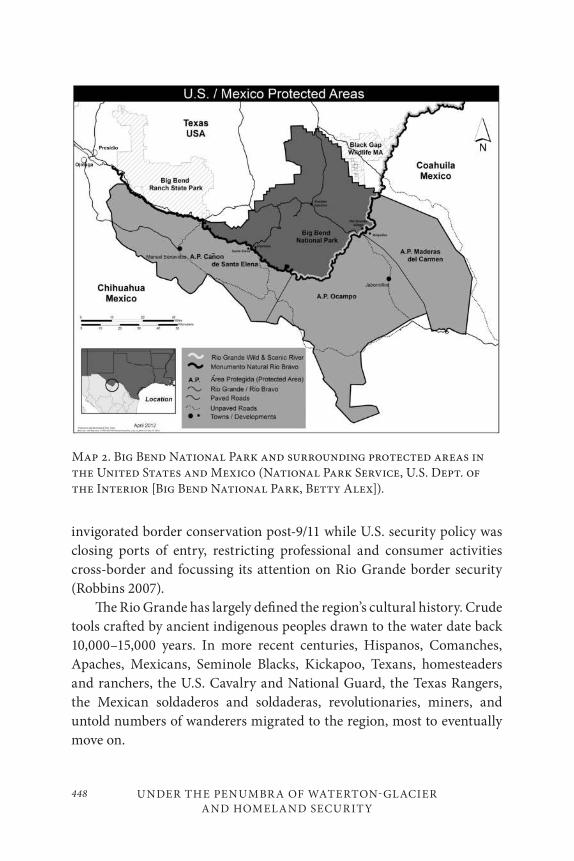
UNDER THE PENUMBR A OF WATERTON-GLACIER
AND HOMELAND SECURITY
448
invigorated border conservation post-9/11 while U.S. security policy was closing ports of entry, restricting professional and consumer activities cross-border and focussing its attention on Rio Grande border security (Robbins 2007).
The Rio Grande has largely defined the region’s cultural history. Crude tools crafted by ancient indigenous peoples drawn to the water date back 10,000–15,000 years. In more recent centuries, Hispanos, Comanches, Apaches, Mexicans, Seminole Blacks, Kickapoo, Texans, homesteaders and ranchers, the U.S. Cavalry and National Guard, the Texas Rangers, the Mexican soldaderos and soldaderas, revolutionaries, miners, and untold numbers of wanderers migrated to the region, most to eventually move on.
Map 2. Big Bend National Park and surrounding protected areas in the United States and Mexico (National Park Service, U.S. Dept. of the Interior [Big Bend National Park, Betty Alex]).
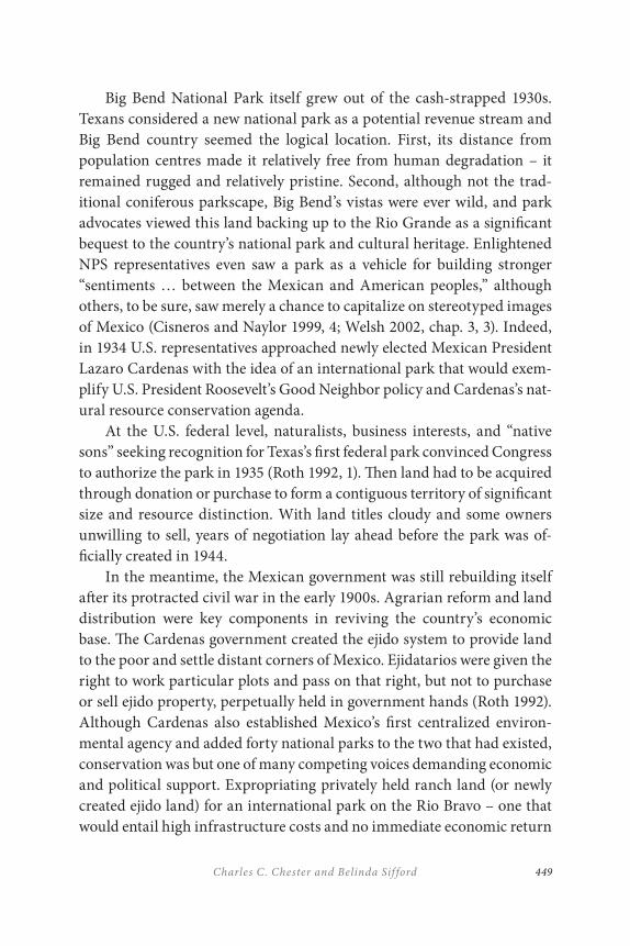
449Charles C. Chester and Belinda Sif ford
Big Bend National Park itself grew out of the cash-strapped 1930s. Texans considered a new national park as a potential revenue stream and Big Bend country seemed the logical location. First, its distance from population centres made it relatively free from human degradation – it remained rugged and relatively pristine. Second, although not the trad-itional coniferous parkscape, Big Bend’s vistas were ever wild, and park advocates viewed this land backing up to the Rio Grande as a significant bequest to the country’s national park and cultural heritage. Enlightened NPS representatives even saw a park as a vehicle for building stronger “sentiments … between the Mexican and American peoples,” although others, to be sure, saw merely a chance to capitalize on stereotyped images of Mexico (Cisneros and Naylor 1999, 4; Welsh 2002, chap. 3, 3). Indeed, in 1934 U.S. representatives approached newly elected Mexican President Lazaro Cardenas with the idea of an international park that would exem-plify U.S. President Roosevelt’s Good Neighbor policy and Cardenas’s nat-ural resource conservation agenda.
At the U.S. federal level, naturalists, business interests, and “native sons” seeking recognition for Texas’s first federal park convinced Congress to authorize the park in 1935 (Roth 1992, 1). Then land had to be acquired through donation or purchase to form a contiguous territory of significant size and resource distinction. With land titles cloudy and some owners unwilling to sell, years of negotiation lay ahead before the park was of-ficially created in 1944.
In the meantime, the Mexican government was still rebuilding itself after its protracted civil war in the early 1900s. Agrarian reform and land distribution were key components in reviving the country’s economic base. The Cardenas government created the ejido system to provide land to the poor and settle distant corners of Mexico. Ejidatarios were given the right to work particular plots and pass on that right, but not to purchase or sell ejido property, perpetually held in government hands (Roth 1992). Although Cardenas also established Mexico’s first centralized environ-mental agency and added forty national parks to the two that had existed, conservation was but one of many competing voices demanding economic and political support. Expropriating privately held ranch land (or newly created ejido land) for an international park on the Rio Bravo – one that would entail high infrastructure costs and no immediate economic return
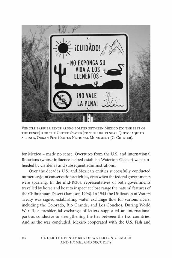
UNDER THE PENUMBR A OF WATERTON-GLACIER
AND HOMELAND SECURITY
450
Vehicle barrier fence along border between Mexico (to the left of the fence) and the United States (to the right) near Quitobaquito Springs, Organ Pipe Cactus National Monument (C. Chester).
for Mexico – made no sense. Overtures from the U.S. and international Rotarians (whose influence helped establish Waterton-Glacier) went un-heeded by Cardenas and subsequent administrations.
Over the decades U.S. and Mexican entities successfully conducted numerous joint conservation activities, even when the federal governments were sparring. In the mid-1930s, representatives of both governments travelled by horse and boat to inspect at close range the natural features of the Chihuahuan Desert (Jameson 1996). In 1944 the Utilization of Waters Treaty was signed establishing water exchange flow for various rivers, including the Colorado, Rio Grande, and Los Conchos. During World War II, a presidential exchange of letters supported an international park as conducive to strengthening the ties between the two countries. And as the war concluded, Mexico cooperated with the U.S. Fish and
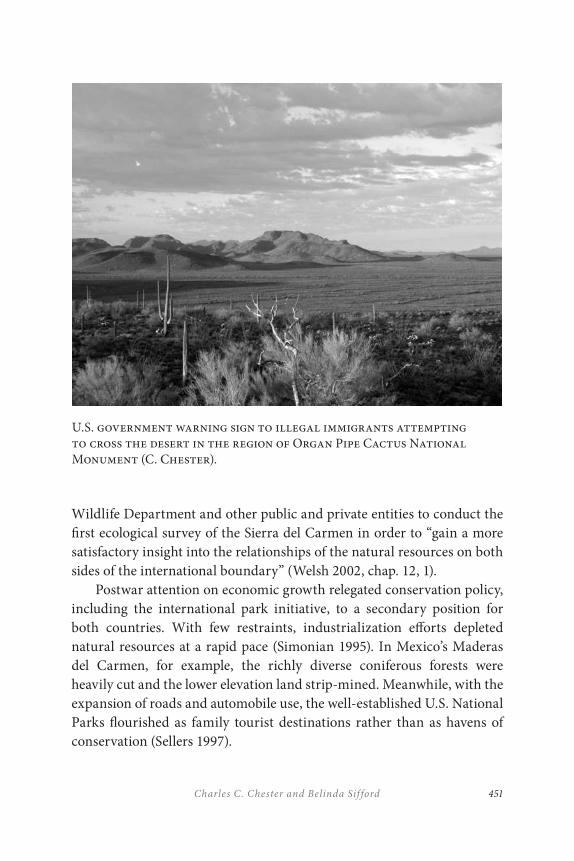
451Charles C. Chester and Belinda Sif ford
U.S. government warning sign to illegal immigrants attempting to cross the desert in the region of Organ Pipe Cactus National Monument (C. Chester).
Wildlife Department and other public and private entities to conduct the first ecological survey of the Sierra del Carmen in order to “gain a more satisfactory insight into the relationships of the natural resources on both sides of the international boundary” (Welsh 2002, chap. 12, 1).
Postwar attention on economic growth relegated conservation policy, including the international park initiative, to a secondary position for both countries. With few restraints, industrialization efforts depleted natural resources at a rapid pace (Simonian 1995). In Mexico’s Maderas del Carmen, for example, the richly diverse coniferous forests were heavily cut and the lower elevation land strip-mined. Meanwhile, with the expansion of roads and automobile use, the well-established U.S. National Parks flourished as family tourist destinations rather than as havens of conservation (Sellers 1997).
UNDER THE PENUMBR A OF WATERTON-GLACIER
AND HOMELAND SECURITY
452
As U.S. National Park attendance grew, park enthusiasts again looked to Mexico, envisioning an international park as another opportunity. Rotary International, for example, continued to promote peace through parks, as did certain local and national park employees. This included Big Bend’s Superintendent in 1954 discussing an international park with the Rotary Club in Saltillo Mexico. A related proposal for an “international free zone” in the Big Bend-Sierra del Carmen area would have moved customs and immigration back to park peripheries in each country, with visitors moving unfettered back and forth across the border. Notably, the Five State Good Neighbor Council passed international park resolutions in 1954 and 1956 (Roth 1992). Other interests, however, ruled the day, in-cluding U.S. citizens with ranches in Coahuila and Chihuahua who feared the Mexican government would expropriate their land to create a park. Moreover, the U.S. State Department resented the ad hoc international efforts of the Park Service and private groups. This tension culminated in the 1962 creation of the NPS’s Office of International Affairs instead of an international park.
In the early 1960s, concerned citizens and emerging environmental groups backed by emerging scientific evidence brought public attention to the environmental degradation of the landscape. As both the Mexican and U.S. governments began passing major pieces of environmental legislation in the 1960s and early 1970s, the NPS began to understand that sustainable land management meant following sound environmental science and that no-holds-barred visitation was damaging the land. Particularly relevant to the borderlands was increased attention to the influence of land-use practices on adjoining lands. Park managers came to recognize regional ecosystems as at least deserving of consideration, if not primary attention (Sellers 1997). This changed thinking was reflected in the designation of Big Bend as a biosphere reserve in 1976.
In keeping with biosphere philosophy, Big Bend’s managers in the 1980s reassessed the Park’s historical relationship with Mexico (Welsh 2002). Rather than continue to ignore the Mexican villages on the border – Santa Elena, San Vicente, and Boquillas del Carmen – park administra-tors viewed them as part of an ecological, cultural, and economic base of the region. Superintendent Gil Lusk, for example, arranged meetings with
453Charles C. Chester and Belinda Sif ford
Mexican state officials and local villagers to learn more about the region’s ejidos and colonias. Park management encouraged employees to speak Spanish and visitors to hire Mexican villagers to row them across the Rio Grande for a meal or beverage in Mexico. As resource planning benefited from improved relations with Mexican officials, the NPS regional office encouraged cooperative attitudes in selecting its own staff (Welsh 2002; G. Lusk, pers. comm. 2005). In 1990 Los Diablos firefighting program began, providing U.S. training to Mexican nationals living in the villages adjacent to Big Bend. When wildfires broke out, firefighters from both countries formed crews to extinguish the fires in either country.
By 1991, relations between the government agencies were strong enough so that the NPS Director and the Secretary of Mexico’s Secretaría de Desarrollo Urbano y Ecología (SEDUE) attempted to obtain funding for an international park. Unfortunately, heightened awareness of trans-border drug trafficking and illegal migration prevented support for such benign collaboration. Rio Grande water quality was also becoming a fric-tion point. Both mercury run-off from abandoned mines and fecal bacteria from livestock made recreational use under the U.S Wild and Scenic River program problematic. Big Bend staff readily understood that managing half a river, i.e., to the midway point in the Rio Grande, was meaningless for water quality purposes.
To add to the sensitivity of border issues, debate over the North American Free Trade Agreement (NAFTA) and the supplemental North American Agreement on Environmental Cooperation (NAAEC), fol-lowed by their passage on January 1, 1994, left hard feelings and biases in both countries. That same year, however, the Mexican Congress passed legislation that changed the international conversation across the Big Bend region forever: the formal creation of “Áreas de Protección de Flora y Fauna” Maderas del Carmen and Cañón de Santa Elena adjacent to Big Bend. Each was of significant size and natural resource richness.
The “protected area” designation recognized certain lands for natural distinction and mandated conservation with limited natural resource ex-traction. Approximately 80–85 per cent of the two protected areas were (and remain) in private hands (pers. comm., Dan Roe, CEMEX, February 2005). With little government staffing to enforce the “limited” resource
UNDER THE PENUMBR A OF WATERTON-GLACIER
AND HOMELAND SECURITY
454
extraction proviso – particularly in light of the remote location of these areas, their sparse human populations, and poor roads – private landhold-ers were entrusted with responsibility for protecting the region.
The region’s status as a protected area, in fact, increased, thanks largely to the conservation work of CEMEX in conjunction with Mexican NGOs such as Agrupación Sierra Madre. In the mid-1990s CEMEX sought to invest in a large-scale conservation project as part of its corporate so-cial responsibility strategy. When Agrupación Sierra Madre introduced CEMEX to the Maderas del Carmen area, the company was persuaded of the land’s significance and the company began to purchase and lease land in Coahuila under the advice of Agrupación. A 1990 change in the federal ejido law, enabling ejidatarios to sell their land, made more land available for ranchers and CEMEX. CEMEX has been a lightning rod for border activity generally, including working with the provincial government of Coahuila and the federal government (usually CONANP, the department overseeing Mexican protected areas) to implement species conservation programs and develop management plans. It invested in training other landowners to sign on to long-term land conservation agreements, which in turn attracted international attention to rejuvenating landscapes through corporate vision and financial commitment.
During this period, formal U.S.-Mexico exchanges continued to pro-mote lasting relationships based on conservation. In 1996, for example, Mexican officials travelled to Waterton-Glacier at the invitation of Big Bend’s and Glacier’s superintendents for a firsthand view of cooperative practices. Subsequently, Babbitt and Carabias signed the aforementioned letter of intent (LOI) in Mexico City. While expressly recognizing the sovereignty of the two countries, the LOI created pilot projects “in the conservation of contiguous natural protected areas” in the border zones of the northern Chihuahuan Desert and the Western Sonoran Desert (Carabias and Babbitt 2001).
In 1998, Big Bend Superintendent Jose Cisneros organized a 1998 meeting with over sixty participants to jumpstart an international park effort. Enthusiasm ran high, but ultimately funding, and Congressional legislation were not forthcoming (Cisneros and Naylor 1999). Regardless, shared natural resource initiatives, e.g., controlling invasive species,
455Charles C. Chester and Belinda Sif ford
studying air quality, and observing wild life habitat, continue even in this time of heightened border surveillance. The multi-agency BRAVO project, for example, published combined bilateral (notably in the early research) public and private resources to inventory the sources of visibility impair-ment in BBNP and produce a wealth of scientific data for both countries (Pitchford 2004).
Most noteworthy is the Mexican government’s 2009 decree establish-ing the Área de Protecíon de Flora y Fauna Ocampo (a 334,270-hectare area linking Cañón Santa Elena with Maderas del Carmen) and soon after the Monumento Natural Rio Bravo, a narrow 221-kilometre strip along the Rio Bravo (Rio Grande) on the Mexican side of the river. It is no co-incidence that the government action occurred with the energetic work of conservation groups on both sides of the border (Carrington 2009; Ferris 2011). Collaboration with these groups helped the government expand its vision and convince the local population, including many ejidatarios, of the value of these conservation initiatives. Various government propos-als seek to employ local inhabitants in the future to sustain the protected lands they have traditionally worked.
The U.S. National Park Service has faced restricted budgets to com-pensate for expanded security spending. Given the still-limited budgets of the Mexican protected areas, collaboration across the Texas, Coahuila, and Chihuahua protected areas has relied heavily on established goodwill and internet communication. Today technology is helping to continue shared conservation efforts and build valued relations. Meanwhile private and NGO activities have infused local transborder initiatives with additional support, even funding. While the narrow security focus in the region has presented often a pessimistic perspective following 9/11, as discussed below, it appears once again the United States and Mexican are poised to take new collaborative steps on the Rio Grande, using technology to build on the historic and look to the future.
UNDER THE PENUMBR A OF WATERTON-GLACIER
AND HOMELAND SECURITY
456
CONCLUSION: SECURING A PEACE PARK UNDER
HOMEL AND SECURIT Y
When asked in August 2007 what initiatives were continuing between Big Bend and its Mexican counterparts, Vidal Davila, Big Bend’s then Chief of Resource Management and Science, responded: “Lost Diablos are alive!” (V. Davila pers. comm. 2007). Cooperative efforts such as Los Diablos firefighters honour the lands and people of “la frontera,” the distinctive binational border region between the United States and Mexico. Similarly, joint projects that inventory bats in the Sonoran Desert, track black bears in the Chihuahuan Desert, study border air quality, or remove invasive salt cedar trees on international river banks all deserve attention for their global benefits, big and small. Such projects involve, not only U.S. and Mexican scientists, conservationists, and land managers, but also local Mexican villagers who find employment in such projects, for example, removing invasive species while planting native cottonwoods. As cross-border relationships grow, new commitments arise to expand horizons. The 2005 donation of a generator and sewing machines by Friends of Big Bend to economically strapped Mexican border villages demonstrates an economic initiative arising from the recognized need of a neighbour (J. King, pers. comm. 2005).
Unfortunately, the steadily increasing commitments are over-shadowed publicly by media preoccupation with U.S. security. In the Sonoran desert area, the highway network and proximity to towns and transport have meant the most rapid federal fence building, of various types and materials, to stop trafficking and illegal immigration. The mul-tiple impacts on the desert landscape – by pedestrian, ATV, or a Border Patrol Chevy Suburban – have been severe, and although Border Patrol officers understand first-hand the stress their activities place on the land, their priorities lie with securing the border under the mandates of the Homeland Security Act.
As mentioned previously the Big Bend region has been shielded from fence building even though covering 13 per cent of the U.S.-Mexican border. With more than a hundred miles on a poorly maintained road separating the Rio Bravo’s off-the-grid villages from the nearest Mexican
457Charles C. Chester and Belinda Sif ford
towns and paved roads, the locale is inhospitable to trafficantes and se-curity alike. Yet Homeland Security policy devastated these villages – not with fences, but by cutting off economic opportunities. This included pro-hibiting villagers from rowing Big Bend visitors across the Rio Grande for a Mexican village meal and beverage, and purchasing food supplies in the park, a practice saving them the long, dirt road drive to the nearest Mexican town. Such seemingly insignificant practices were themselves the village economy.
Change, however, is once again coming to this challenged area, change that makes talk of a binational protected area or park not appear dreamy-eyed. With different federal administrations in both countries, environmental and security assessment, formal public comment and local popular support, the reopening of a Class B Port of Entry (POE) in Big Bend National Park, to be named the Boquillas Crossing, is expected to open in 2012 (Walters 2011).
Considering the Boquillas economy, this under-construction port of entry should bring people and a jolt to the village with its cutting-edge technology – the first robotic, unstaffed border crossing with Mexico. (The northern U.S.-Canada border has had such entry points since 1991 (e.g., CANPASS Remote Area Border Crossing Program in the Lake of the Woods Region). This new development can’t but help to cause one to think of future possibilities, say a joint U.S.–Mexican decree establishing the Boquillas–Big Bend International Peace Park or International Protected Area. A Sonoran Desert International Park might be established as well. Now assume that the decrees were very general, containing ambiguous phrases such as “shall share information” and “shall participate in joint management activities.” Here’s the essential question: What would hap-pen next?
We of course do not know. Disastrous consequences could ensue were widespread publicity over these two areas to serve as attractants to higher levels of both illegal immigrants and narcotrafficking. “Peace Park,” in other words, could be interpreted by nefarious citizens on both sides of the border as a kind of parallel-universe Maquiladora Zone where anything goes and no questions are asked. Alternatively, from a less cynical though still critical lens, such national decrees could have the all-too-common
UNDER THE PENUMBR A OF WATERTON-GLACIER
AND HOMELAND SECURITY
458
effect of inspiring celebration throughout the cloistered halls of the insu-lar conservation community – only to be subsequently ignored, and then forgotten by all parties within a few months.
Although we cannot exclude the chance of such unfortunate out-comes, current activities in the region do not lead us to see such scenar-ios panning out. To the contrary, such decrees would likely give rise to conditions conducive to transborder conservation without a deterioration in border security. Most particularly, these new designations would have the two principle effects of: (1) giving local land managers a visible and enduring mandate to work and coordinate with their colleagues across the border, and (2) generating a new constituency of advocates who care about these landscapes and who value international collaboration.
On the first account, the establishment of these international parks would help justify new financial and material resources for transborder exchanges of personnel and information, as well as realistic support for economically modest ejido residents, indigenous groups, local ranchers, conservation groups, and others. The sister park collaborations that con-tinue to provide platforms for more efficient local and international land management, e.g., the 2008 Shared Heritage, Shared Stewardship confer-ence, might have had greater funding and public acknowledgment of their work had existing peace parks been part of the participating mix. At an absolute minimum, an international peace park designation would help institutionalize and enhance extant cooperative programs such as Los Diablos.
On the second account, conservationists are well-versed in the threats caused by increased visitation rates – and one can reasonably ask whether attracting new visitors to these regions would make any sense at all. Without discounting the real and deleterious effects associated with increased visitation, we believe that at least some increased park visitor levels, particularly on the U.S. side today, would constitute a net environ-mental and political benefit for the region by strengthening the “core con-stituencies” for the peace parks. Virtual tourism, principally through the involvement of schools and media outlets, would also build constituen-cies. Schools might even log in to watch robots conduct border business at Boquillas Crossing. Likewise, the desert bighorn reintroduction and
459Charles C. Chester and Belinda Sif ford
repopulation story alone could create passionate supporters, young and old, close-by and far-afield. As with other protected areas, such constitu-encies would give the broader, more politically connected conservation community a greater presence in policy debates in the region.
Beyond the potential conservation benefits brought on in this thought-experiment, what difference could a peace park designation make in re-gard to border security? Homeland Security has helped to design Boquillas Crossing. It’s use (and abuse) will help develop security practices in the future with fences or not. Voices still argue for green initiatives to comple-ment or replace steel, chain link, and cement barriers. The governor of Coahuila’s planting a 400,000-tree “green wall” to oppose the U.S. fence building and complement life is the type of conservation activity that an international peace park would embody. Homeland Security indirectly prompted the tree planting; a peace park would help sustain it.
In the Big Bend region, an international park would strengthen the growing capacity for conservation in Mexico. The El Carmen Wilderness designation, the facilities for breeding desert bighorn and their increas-ing repopulation into the region, and the binational dialogue about the El Carmen–Big Bend Conservation Corridor Initiative are important examples of regional conservation enthusiasm and vitality. The inclusion of a peace park in the corridor could solidify the “green curtain,” across which land managers and park visitors would journey to acknowledge their commitment to land conservation and international cooperation. Rotary chapters that continue to promote a peace park on this border should play a role as well.
Designating areas as protected and winning over local landowners to manage the land could build a somewhat figurative green wall that would keep out the trafficantes who find the natural terrain inhospitable and thus fear the possibility of losing themselves in “el gran desierto” (Stevenson 2006). Generally, however, because concerns over the current risks associ-ated with the international border are unlikely to change significantly in the near future, green fences must be encouraged publicly and tested along with other protective measures, e.g., say Normandy fences over three-tier steel fences. Both countries must contribute to solving the border issues
UNDER THE PENUMBR A OF WATERTON-GLACIER
AND HOMELAND SECURITY
460
and to keeping the cross-border conservation phenomenon internation-ally recognized.
In the decades since the establishment of Waterton-Glacier, conserva-tion advocacy for a similar peace park on the Mexico–U.S. border has sim-ply never coalesced at a national level in either country. Yet cross-border dialogue has continued and extant collaborative initiatives, particularly involving private and non-profit entities, are robust. The 2005 creation of the El Carmen Wilderness Area, the first ever Latin American wilderness designation and the first private wilderness protected by the Mexican gov-ernment (on CEMEX-owned land), is a stunning example of conservation community thinking “outside the park.” The new Boquillas Crossing is another powerful symbol of the regional potential.
In total, protected land in the Big Bend–Mexican region extends now beyond 1,300,000 hectares, one of the largest expanses of protected land in the world. In comparison, Yellowstone National Park contains 898,321 hectares and the international Waterton-Glacer International Peace Park 462,799 hectares. The border land will provide the lessons. Rather than giving up on the potential for an international park on the Mexico–U.S. border, conservationists from both countries who care about the border region should observe and build long-term strategies in this transforma-tive moment.
461Charles C. Chester and Belinda Sif ford
REFERENCES
Archibold, R. C. 2007. “28-mile virtual fence is rising along the border.” New York Times, 26 June, A12.
Arizona State Senate. 2003a. “Bill status overview: Sonoran Desert Peace Park. SM 1001.” http://www.azleg.state.az.us/legtext/46leg/1r/bills/sm1001o.asp.
———. 2003b. “Fact sheet for S. M. 1001: Sonoran Desert Peace Park.” http://www.azleg.state.az.us/legtext/46leg/1r/summary/s.sm1001nrt.doc.htm.
———. 2003c. “Minutes of Committee on Natural Resources and Transportation. 18 February.” http://www.azleg.state.az.us/legtext/46leg/1r/comm_min/senate/021803 nrt.dot.htm.
———. 2003d. “Sonoran Desert Peace Park. SM 1001.” http://www.azleg.state.az.us/legtext/46leg/1r/bills/sm1001p.htm.
Blumenthal, R. 2007. “Some Texans fear border fence will sever routine of daily life.” New York Times, 20 June.
BRC. 1999. “Huge support for Sonoran Desert park proposal.” Phoenix: Behavior Research Center. News Release [99-II-03].
Broyles, B. 2004. “The desert sisters.” Earth Island Journal 19: 35–38.
Carabias, J., and B. Babbitt. 2001. “Letter of Intent between the Department of Interior (DOI) of the United States and Secretariat of Environment, Natural Resources and Fisheries (SEMARNAP) of the United Mexican States for Joint Work in Natural Protected Areas on the United States – Mexico Border.” 5 May. Last revised 22 January 2001, 1997. Accessed 30 January 2001. http://www.cerc.usgs.gov/fcc/protected_agreement.htm.
Carrington, C. 2009. “Latest Mexico protected area creates a massive binational conservation region.” The Nature Conservancy. October. http://www.nature.org/ourinitiatives/regions/northamerica/unitedstates/texas/explore/ocampo-flora-and-fauna-protected-area-natureorg-page.xml.
Chester, C. C. 2006. Transborder Conservation: Biodiversity in an Interdependent World. Washington, D.C.: Island Press.
Cisneros, J. A. and V. J. Naylor. 1999. “Uniting la frontera: The ongoing efforts to establish transboundary park.” Environment 41:12-21.
Cohn, J. P. 2007. “The environmental impacts of a border fence.” BioScience 57: 96–97.
Dimmitt, M. A. 2000. “Biomes & communities of the Sonoran Desert Region.” In A Natural History of the Sonoran Desert, ed. S. J. Phillips and P. W. Comus, 3–18. Tucson: Arizona-Sonora Desert Museum Press.
UNDER THE PENUMBR A OF WATERTON-GLACIER
AND HOMELAND SECURITY
462
Felger, R. S., B. Broyles, M. Wilson, G. P. Nabhan, and D. S. Turner. 2006. “Six grand reserves, one Sonoran Desert.” In Dry Borders: Great Natural Reserves of the Sonoran Desert, ed. Richard Stephen Felger and Bill Broyles, 3–26. Salt Lake City: University of Utah Press.
Ferris, C. 2011. “New natural monument connects more than 3 million acres.” The Nature Conservancy, February. http://www.nature.org/ourinitiatives/regions/northamerica/mexico/explore/new-natural-monument-connects-more-than-3-million-acres.xml.
Jameson, J. 1996. The Story of Big Bend. Austin: University of Texas Press.
Joquin, Sr., A. 1988. “The Tohono O’odham Nation: A position statement.” In Simposio de Investigación sobre la Zona Ecológica de El Pinacate, ed. Environment Committee of the Arizona-Mexico Commission, 13–14. Hermosillo, Sonora, Mexico.
Kerasote, T. 2007. “Borders without fences.” New York Times, February 24.
Laird, W., J. Murrieta-Saldivar, and J. Shepard. 1997. “Cooperation across borders: A brief history of biosphere reserves in the Sonoran Desert.” Journal of the Southwest 39: 307–13.
MacMahon, J. A. 2000. “Warm Deserts.” In North American Terrestrial Vegetation, ed. M. G. Barbour and W. D. Billings, 285–322. New York: Cambridge University Press.
Marosi, R. 2011. “U.S. to extend border fence 300 feet into Pacific.” Los Angeles Times, November 25.
Pearson, G. 1998. Organ Pipe Cactus National Monument tri-national management challenges and opportunities for cooperation with Mexico and the Tohono O’odham Nation: A historical perspective. Organ Pipe National Monument: U.S. Department of the Interior and Instituto Nacional de Ecología (SEMARNAP).
Pitchford, M.. 2004. Big Bend Regional Aerosol and Visibility Observational Study (BRAVO), September. http://vista.circa.colostate.edu/improve/.
Ripley, J. D., T. H. Lillie, S. E. Cornelius, and R. M. Marshall. 2000. “The U.S. Department of Defense embraces biodiversity conservation through ecoregional partnerships in the Sonoran Desert.” Diversity 15: 3–5.
Robbins, M. W. 2007. “The treasure of the Sierra del Carmen.” National Wildlife Magazine 45, no. 2 (Feb./Mar.); http://www.nwf.org/nationalwildlife/printerFriendly.cfm?issueID=113&article ID=1445.
Roth, D. L. 1992. “Mexican and American policy alternatives in the Big Bend Region – An updated study of the proposed Mexican National Park in the Sierra Del Carmen.” Master of Public Affairs thesis, University of Texas at Austin.
463Charles C. Chester and Belinda Sif ford
SDNPF. 2002. “Sonoran Desert National Park: A citizens’ proposal. Sonoran Desert National Park Friends.” Accessed 30 August 2007. http://www.sonorandesertnp.org.
Sellers, R. W. 1997. Preserving Nature in the National Parks. New Haven, CT: Yale University Press.
Simon, J. 1997. Endangered Mexico. San Francisco: Sierra Club.
Simonian, L. 1995. Defending the Land of the Jaguar. Austin: University of Texas Press.
Sonoran Institute and International Sonoran Desert Alliance. n.d. “Cooperative resource management (proposal to the Ford Foundation).” Files of the International Sonoran Desert Alliance, Ajo, Arizona.
Stevenson, M. 2006. “Mexico’s ‘green walls’ stop border crossers naturally.” Daily Bulletin.com. Fall.
U.S. FWS. n.d. Cabeza Prieta National Wildlife Refuge. U.S. Fish and Wildlife Service. Accessed 28 March 2005. http://www.fws.gov/southwest/refuges/arizona/cabeza.html.
U.S. NCMABP. 1997. Governors Symington and Beltrones endorse biosphere reserve agreement. U.S. MAB Bulletin (National Committee for the Man and the Biosphere Program) 21: no. 1 (March). http://www.state.gov/www/global/oes/bul_3_97.html.
U.S. NPS. n.d. “Organ Pipe Cactus National Monument.” U.S. National Park Service. Accessed 28 March 2005. http://www.nps.gov/orpi/.
———. 1965. “Sonoran Desert National Park, Arizona: A proposal.” Southwest Region, U.S. National Park Service, Department of the Interior.
U.S.-Mexico Border Field Coordinating Committee. 2001. “U.S.-Mexico Sister Areas Issue Team.” U.S. Department of the Interior. Last revised 1 April. Accessed 23 September 2001. http://www.cerc.usgs.gov/fcc/letter-of_intent.htm.
Udall, M. K. 1966. “A national park for the Sonoran Desert.” Audubon Magazine 105–9. http://dizzy.library.arizona.edu/branches/spc/udall/sonoran_htm.html.
Udall, S. 1997. “Stewart Udall: Sonoran Desert National Park. Interview by Jack Loeffler.” Journal of the Southwest 39, nos. 3&4: 315–20.
Urrea, L. A. 2004. The Devil’s Highway. New York: Little Brown and Co.
USFWS. 2002. “El Camino Del Diablo: Highway of the Devil.” U.S. Fish & Wildlife Service. 15 April. Accessed 27 April 2005. http://www.fws.gov/southwest/refuges/arizona/diablo.html.
Waldman, C. 1985. Atlas of the North American Indian. New York: Facts on File.
UNDER THE PENUMBR A OF WATERTON-GLACIER
AND HOMELAND SECURITY
464
Waters, John. 2011. “Boguillas Crossing Gets Legal Green Light; Facility to Cost $3.7 Million.” Big Bend Gazette. Nov. 4.
Walker, S. n.d. “El Pinacate Biosphere Reserve.” San Antonio, TX: Nature Conservancy. http://parksinperil.org/files/page_4_el_pinacate_biosphere_reserve.pdf.
Welsh, M. 2002. The Administrative History of Big Bend National Park – Landscape of Ghosts, River of Dreams: A History of Big Bend National Park. National Park Service, U.S. Department of the Interior.
465
19
The Niagara International Peace Park: A Proposal
Lynda H. Schneekloth, Kerry Mitchell, Patrick Robson, and
Robert G. Shibley
INTRODUCTION
Surely to those who will implement the purpose of the United Nations, it will be inspiring to execute their high duties in a locality steeped in traditions of peace and good-neighborliness, among peoples of various ancestry who have forged indissol-uble bonds of international good will and co-operation, and who have made peace work. (McGreevy 1994, 66)
This language was drawn from a 1945 proposal by an international com-mittee to establish the United Nations at Navy Island near Niagara Falls, Ontario. This uninhabited Niagara River island was considered an ideal site for the world peace capital for its location at the international, peaceful, boundary between Canada and the United States. The spiritual qualities

THE NIAGAR A INTERNATIONAL PEACE PARK466
found in Niagara’s natural environment further inspired the proposal and its promoters. While not chosen as the final site for the UN, the pro-posal reflects the historical significance of the peaceful, undefended, 3,145 mile/5,061-kilometre-long border that joins Canada and the United States.
As Canada and the United States commemorate of the Bicentennial of the War of 1812, one is reminded that peace was not always the condi-tion along the Canada/U.S. border. After the War of 1812, Canada, Great Britain, and the United States “were beggared by the conflict, their people bereaved, their treasure emptied, their graveyards crowded. In North America, the charred houses, the untended farms, the ravaged fields along the border left a legacy of bitterness and distrust” (Berton 1981, 424).
The two hundred years that followed have witnessed allied Canada–U.S. engagements on the international stage: the entrance into historic treaties and agreements related to the Canada–U.S. boundary, defence, trade, the management of shared of natural resources, the erection of na-tional peace monuments and bridges, and the designation of the world’s first International Peace Park. All testify to the lasting peace that has been forged between the two countries. The joint actions of the United States and Canada have left a lasting imprint on the global discourse of peace and cooperation.
Sir Winston Churchill, addressing the Canada Club (1939) in London at the dawn of World War II, reflected on the peaceful relationship be-tween Canada and the United States stating: “That long frontier from Atlantic to the Pacific Oceans, guarded only neighbourly respect and hon-ourable obligations, is an example to every country and a pattern for the future of the world” (www.reagan library.utexus.edu). These qualities can be found in communities all along the Canada–U.S. border, but it is in the highly populated border regions where the military history, the shared natural environment, the pressures of international trade, and long-stand-ing cultural and personal relationships find some of the richest and most complex expressions.
Of these border regions, Niagara stands apart. The cross-border Niagara region has had a unique tradition of peace and conflict resolution before and after the War of 1812; a tradition that celebrated its bicenten-nial in 2012. Among other traditions, the White Roots of Peace of the
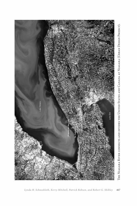
467Lynda H. Schneekloth, Kerry Mitchell , Patrick Robson, and Robert G. Shibley
Th
e N
iag
ar
a R
iver
co
nn
ects
an
d d
ivid
es t
he
Un
ited
Sta
tes
an
d C
an
ad
a a
t N
iag
ar
a (
Ur
ban
Des
ign
Pro
jec
t).
THE NIAGAR A INTERNATIONAL PEACE PARK468
Iroquois Nation, the African American civil rights movements, the his-tory of treaties and a considered proposal to locate the United Nations at Niagara, all focus on the history of peaceful relations. Symbols of peace and friendship between Canada and the United States are evident in local monuments, agreements, festivals, bridges, official statements, and indi-vidual relationships. Even in the post-9/11 world, the people of Niagara are working to maintain an open and friendly border in support of our strong economic partnership and cultural exchanges while addressing the security concerns of both nations.
Moreover, Canada and the United States are jointly responsible for the Great Lakes through the Boundary Waters Treaty of 1909, an agree-ment that set up the International Joint Commission to manage the waters and settle disputes. The cross-border Niagara region shares the Niagara River and Niagara Falls as its centre and is bounded by Lake Erie and Lake Ontario on the south and north.
Niagara Falls was first proposed as an international park in 1878, and, although that vision resulted in two separate but adjoining parks, the vision of an international park still inspires. The nineteenth-century proposal re-mains viable today with the region’s history of peace and management of the environment. A shared park would facilitate better coordination and resource management in the face of climate change, cross-border political relations in a time of terrorism, economic partnerships in an expanding global market, and a celebration of our shared culture, yet unique differ-ences, in a world increasingly interested in the balance between globalism and localism.
This chapter explores the possibility of establishing a Niagara International Peace Park. We first present the region and its history to build an argument of why Niagara is a good candidate for a Peace Park. This is followed by a discussion of the bi-national regional context and the work being done that would contribute to the designation criteria. We conclude with proposed next steps to achieve this goal.
469Lynda H. Schneekloth, Kerry Mitchell , Patrick Robson, and Robert G. Shibley
NIAGAR A: CULTUR AL AND NATUR AL HERITAGE
The bi-national Niagara region has a rich cultural heritage and natural heritage embedded in the historic stories of people and the land and their struggles and conflicts to live in Niagara.
Niagara as Contested Terrain: The Practice of War and the
Practice of Peace
Niagara has been the site of important North American episodes of con-flict and peacemaking. In some cases, Niagara was the ground of battle; in other cases, the ground of reconciliation. This region, the only continuous theatre of battle during the War of 1812, is commemorating in 2013–14 not only the war, but the two hundred years of peace between the United States and Canada/Great Britain following the end of the war. This peace does not just represent the absence of war but reflects a concerted effort to maintain peaceful relations.
As a theatre for the practice of peace, Niagara hosted important Peace Conferences in 1864 and again in 1914, both of which contributed to new insights on issues of slavery, conflict resolution, and hemispheric relations. Common sense and vested interest in friendly cross-border relations were strong enough to thwart actions of aggression such as the McKenzie Rebellion of 1837 and the infamous Fenian Raid on Fort Erie in 1866. As described below, Niagara was the ground from which the great peace-makers, the Haudenosaunee, developed the White Roots of Peace and it was also here in the cross-border region where the issues of slavery and civil rights were debated and resolutions enacted.
The War of 1812 and the Beginning of Peace
The War of 1812 had its origin in the many conflicts and battles fought on the American continent and in Europe. To the United States, the war was the final chapter in the Revolutionary War; to Canada, it was nation-building. Still, like most wars, much was lost. In the end, the British re-turned Fort Niagara to the Americans and the Americans returned Fort Erie to the British; the borders remained the same as before the war. But
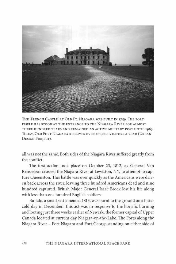
THE NIAGAR A INTERNATIONAL PEACE PARK470
The ‘French Castle’ at Old Ft. Niagara was built in 1759. The fort itself has stood at the entrance to the Niagara River for almost three hundred years and remained an active military post until 1963. Today, Old Fort Niagara receives over 100,000 visitors a year (Urban Design Project).
all was not the same. Both sides of the Niagara River suffered greatly from the conflict.
The first action took place on October 23, 1812, as General Van Rensselear crossed the Niagara River at Lewiston, NY, to attempt to cap-ture Queenston. This battle was over quickly as the Americans were driv-en back across the river, leaving three hundred Americans dead and nine hundred captured. British Major General Isaac Brock lost his life along with less than one hundred English soldiers.
Buffalo, a small settlement at 1813, was burnt to the ground on a bitter cold day in December. This act was in response to the horrific burning and looting just three weeks earlier of Newark, the former capital of Upper Canada located at current day Niagara-on-the-Lake. The Forts along the Niagara River – Fort Niagara and Fort George standing on either side of
471Lynda H. Schneekloth, Kerry Mitchell , Patrick Robson, and Robert G. Shibley
the Niagara River at Lake Ontario, and Fort Erie at the confluence of the Lake Erie and the Niagara – were actively engaged in the battles. Many soldiers on both sides were lost in the Battle of Chippawa, Battle of Lundy’s Lane, and later sieges on Fort Erie (Berton 1981; Percy 2007). These battle fields and forts are commemorated and regularly receive visitors from both sides of the Niagara River.
After the signing of the Treaty of Ghent (1814) that ended the war, one of the first acts of peace was the signing of the Rush-Bagot Treaty of 1817 (Percy 2007, 133). This was the only disarmament agreement reached between the two countries and limited naval forces in the Great Lakes. It was a significant act and established a precedent for future relations along the border that runs through these waters. The monument to this treaty today stands at Fort Niagara.
Deeper Roots of Peace: The Haudenosaunee
The tradition of peace in Niagara reaches back centuries before Europeans set foot in the Americas.
A loose military alliance among the Seneca, Cayuga, Onondaga, Oneida, Mohawks and, after about 1720, the Tuscarora, the Haudenosaunee were probably the greatest indigenous polity north of the Rio Grande in the two centuries before Columbus and definitely the greatest in the two centuries after. (Mann 2005, 370)
The traditional story of the Five Nations (later the Six Nations) recounts the emergence of a shamanic outsider, Deganawidah, who brought a message of peace to the warring tribes that lived in upstate New York and Southern Ontario between AD1090 and 1150. Deganawidah, the Peacemaker was assisted by the great orator, Ayenwatha (Hiawatha). Together they brought the Great Law of Peace that granted powers to the council, but also outlined the limits of power. Among the Law’s 117 codicils is a process for conflict resolution and requirement that all decisions to be made unanimously.
THE NIAGAR A INTERNATIONAL PEACE PARK472
The White Roots of the Great Tree of Peace will continue to grow advancing the good Mind and Righteousness and Peace, moving into territories of peoples scattered far through the for-est. And when a nation … shall approach the Tree, you shall welcome her here and take her by the arm and seat her.… She will add a brace or leaning pole to the longhouse and will thus strengthen the edifice of Reason and Peace. (Wallace 1986, 106)
The Niagara region played a major role in the ending of the Indian wars and the bringing of peace. Jikonsahseh, from the Neutral Nation, lived along the Niagara Escarpment and was an early convert to the Great Law of Peace. She worked among the warring nations to end the cycle of vio-lence and was so effective that Jikonsahseh or “Peace Queen” became a title and office in the confederacy through the centuries. This position ended, however, with Caroline Mount Pleasant, who died in 1892. Her family home, located on the Tuscarora Reservation, was burned to make way for the Robert Moses hydro power plant and now lies at the bottom of the Niagara Power Project Reservoir (Wooster 2008, 19–20).
The Haudenosaunee used their diplomacy to maintain a position of power with Europeans even as pressure on their land by settlers increased. In the late eighteenth and early nineteenth centuries, disagreements on strategies for managing relationships with the colonists – remain neutral, side with the Europeans (French or British), or support the patriots – div-ided the nation. The inability to stay within the Great Law of Peace and to maintain their union eventually caused the Iroquois to falter both in war and peace.
Yet the Great Law of Peace still serves the Six Nations who continue to hold their council. With the exception of Iceland’s Althing (AD930 ), the Haudenosaunee have the oldest continuously existing representative parliament on earth (Mann 2005, 373). The people of the Haudenosaunee, like many pre-Columbian cultures in North America, had a tradition of functioning but limited government and personal autonomy unknown in Europe during the eighteenth and nineteenth centuries (Mann 2005, 375) and some scholars maintain that the Great Law of Peace influenced the U.S. Constitution. Its foundation in democratic self-governance and
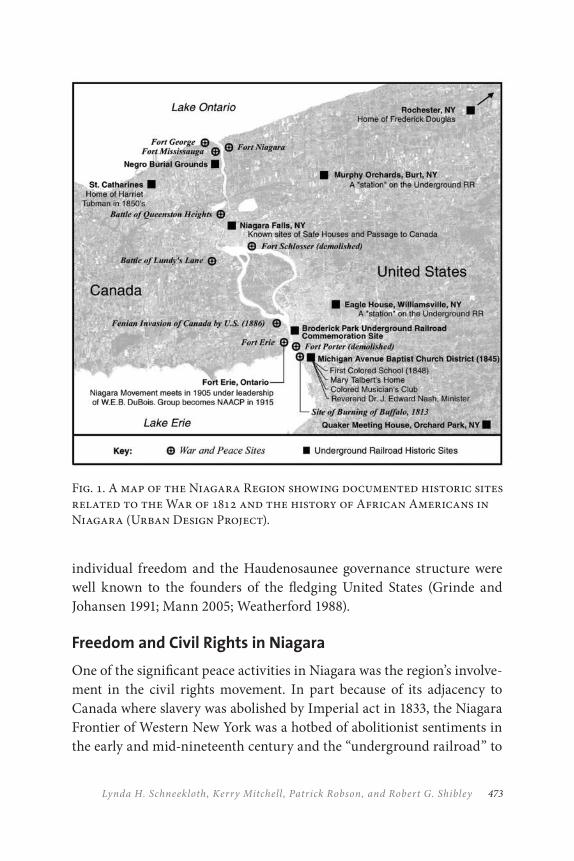
473Lynda H. Schneekloth, Kerry Mitchell , Patrick Robson, and Robert G. Shibley
Fig. 1. A map of the Niagara Region showing documented historic sites related to the War of 1812 and the history of African Americans in Niagara (Urban Design Project).
individual freedom and the Haudenosaunee governance structure were well known to the founders of the fledging United States (Grinde and Johansen 1991; Mann 2005; Weatherford 1988).
Freedom and Civil Rights in Niagara
One of the significant peace activities in Niagara was the region’s involve-ment in the civil rights movement. In part because of its adjacency to Canada where slavery was abolished by Imperial act in 1833, the Niagara Frontier of Western New York was a hotbed of abolitionist sentiments in the early and mid-nineteenth century and the “underground railroad” to
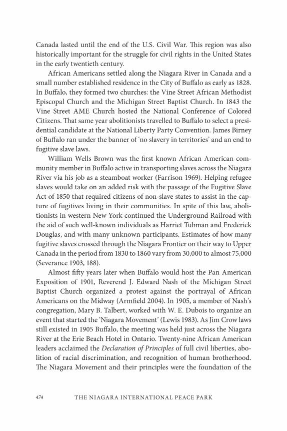
THE NIAGAR A INTERNATIONAL PEACE PARK474
Canada lasted until the end of the U.S. Civil War. This region was also historically important for the struggle for civil rights in the United States in the early twentieth century.
African Americans settled along the Niagara River in Canada and a small number established residence in the City of Buffalo as early as 1828. In Buffalo, they formed two churches: the Vine Street African Methodist Episcopal Church and the Michigan Street Baptist Church. In 1843 the Vine Street AME Church hosted the National Conference of Colored Citizens. That same year abolitionists travelled to Buffalo to select a presi-dential candidate at the National Liberty Party Convention. James Birney of Buffalo ran under the banner of ‘no slavery in territories’ and an end to fugitive slave laws.
William Wells Brown was the first known African American com-munity member in Buffalo active in transporting slaves across the Niagara River via his job as a steamboat worker (Farrison 1969). Helping refugee slaves would take on an added risk with the passage of the Fugitive Slave Act of 1850 that required citizens of non-slave states to assist in the cap-ture of fugitives living in their communities. In spite of this law, aboli-tionists in western New York continued the Underground Railroad with the aid of such well-known individuals as Harriet Tubman and Frederick Douglas, and with many unknown participants. Estimates of how many fugitive slaves crossed through the Niagara Frontier on their way to Upper Canada in the period from 1830 to 1860 vary from 30,000 to almost 75,000 (Severance 1903, 188).
Almost fifty years later when Buffalo would host the Pan American Exposition of 1901, Reverend J. Edward Nash of the Michigan Street Baptist Church organized a protest against the portrayal of African Americans on the Midway (Armfield 2004). In 1905, a member of Nash’s congregation, Mary B. Talbert, worked with W. E. Dubois to organize an event that started the ‘Niagara Movement’ (Lewis 1983). As Jim Crow laws still existed in 1905 Buffalo, the meeting was held just across the Niagara River at the Erie Beach Hotel in Ontario. Twenty-nine African American leaders acclaimed the Declaration of Principles of full civil liberties, abo-lition of racial discrimination, and recognition of human brotherhood. The Niagara Movement and their principles were the foundation of the
475Lynda H. Schneekloth, Kerry Mitchell , Patrick Robson, and Robert G. Shibley
The Niagara River Gorge was formed by the erosion of the Niagara Escarpment and is today an important habitat. (Urban Design Project, Photo by Ana Hernández-Balzac).
THE NIAGAR A INTERNATIONAL PEACE PARK476
National Association for the Advancement of Colored People (NAACP), formed a few years later in 1909.
The extent of Rev. Nash’s role in the cause for equality was revealed in October of 1999 when members of the Michigan Street Preservation Corporation were granted permission to enter the Nash House at 36 Potter Street. Inside was a record of Buffalo’s African American history, includ-ing a collection of Nash’s personal papers containing his correspondence with Booker T. Washington and W. E. Dubois.
NIAGAR A: THE FALLS, THE RIVER, AND THE
ESC ARPMENT
The Niagara River flows between the United States and Canada as both separator and connector. The boundary was established at the end of the Revolutionary War, and since the end of the War of 1812 the nation states on either side have never taken up arms against each other. This river is a symbol of stability and friendship as well as a shared resource and bound-ary between the two countries.
The Niagara River, Niagara Falls, and the Niagara Escarpment were formed over thousands of years through successive ice ages. One of the geological remnants is the Niagara Escarpment, a cuesta that runs 1,448 kilometres from western New York, through Ontario, and back down into the states in Wisconsin. The Canadian part of the Niagara Escarpment has been a UNESCO Biosphere Reserve in Canada since 1990, a designation that gave international recognition to the work of the Niagara Escarpment Commission that has had oversight of the resource since 1973. But the primary geological remnant of the successive ice ages is the Great Lakes, a basin of lakes and connecting channels that today contains 20 per cent of the world’s fresh water.
The Niagara River is not really a river at all but a connecting chan-nel that carries all the water from the upper lakes across the Niagara Escarpment into Lake Ontario. It is 56 kilometres long, has an average flow of 6,003 cubic metres per second, and drops 99 metres from Lake Erie to Lake Ontario, 46 metres of that drop occurring at the falls themselves.
477Lynda H. Schneekloth, Kerry Mitchell , Patrick Robson, and Robert G. Shibley
The world-famous Niagara Falls and ecological rich Niagara Gorge were formed by the action of the river on the escarpment, and over the last 12,000 years, Niagara Falls has moved 11 kilometres upstream, leaving the Niagara Gorge, a unique habitat because of the geological and ecological conditions (Eckel 2001).
The Conflicting Imaginations: Natural Wonder or Resource
Niagara Falls has captured the human imagination in myth and in real-ity (McGreevy 1994). The Niagara River and Falls were a sacred place to indigenous people; they were a source of wonder reflected in drawings and literature to early Europeans; they are also known as the honeymoon capital of the world, the place of heroic acts (or foolish stunts); they are seen as the handiwork of God, and a source of energy. The Falls have gen-erated conflicting imaginations and cultural battles have been fought over their meaning. The power of Niagara Falls, even today, attracts 12 million people annually.
During the nineteenth and twentieth centuries, alternative visions fought for control over Niagara. One vision saw the falls as a natural won-der, a romantic vision of the Creator’s hand revealed. The other vision saw the falls as a resource for their potential to fuel the growing nations by harnessing them for power or exploiting them for tourism. The ten-sion between these two visions – technological utopian vision or natural wonder – inspired two of the most interesting and provocative stories of cooperation in the cross-border Niagara region.
The “Free Niagara” Movement was formed in reaction to a utilitar-ian treatment of the falls on the U.S. side where factories and businesses were built along the rapids and property owners alongside the Niagara River built fences and charged to see the falls. For people such as Frederick C. Church and Frederick Law Olmsted, this was a denial of the power and beauty of Niagara Falls. They and many others worked for over fif-teen years to protect this resource starting around 1869 and eventually were successful with the establishment of the Niagara Reservation. The Canadians had a different relationship with the falls and focussed on tour-ism, leaving most industrial development to St. Catharines and Hamilton further up the isthmus.
THE NIAGAR A INTERNATIONAL PEACE PARK478
Although there were many efforts to preserve the beauty of the falls, it was the Earl of Dufferin, then Governor-General of Canada, who first promoted the idea of establishing an international park at Niagara in a speech to the Ontario Society of Artists in Toronto on September 26, 1878:
In your neighborhood there exists, as you are aware, one of the most wondrous, beautiful and stupendous scenes which the forces of Nature have ever constructed. Indeed, so majestic is the subject that though many skillful hands have endeavored … few have succeeded in adequately depicting its awe-inspir-ing characteristics.… Some weeks ago … I … suggested to him [the Governor of the State of New York] … that the govern-ments of New York and Ontario, Canada, should combine to acquire whatever rights may have been established against the public and to form around the Falls a small international park. (Horton 1947, 222)
Within four months of this speech, Governor Luscius Robinson addressed the New York State Legislature on January 9, 1879:
The civil jurisdiction over the Falls of Niagara, as well as the shore and waters of the Niagara River, is divided between the State and the province of Ontario, Canada. But, in one sense, the sublime exhibition of natural power there witnessed is the property of the whole world. It is visited by tourists from all quarters of the globe, and it would seem to be incumbent upon both governments to protect such travelers from improper an-noyance on either side. (Horton 1947, 221)
Although talks did proceed between the governments, the subsequent ac-tions were separate yet groundbreaking. The first conservation effort of natural resources in North America was created in separate acts by the New York State Legislature and by the Ontario Government in 1885. The
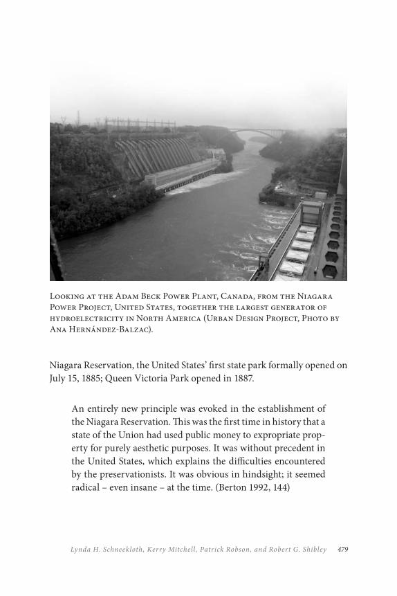
479Lynda H. Schneekloth, Kerry Mitchell , Patrick Robson, and Robert G. Shibley
Niagara Reservation, the United States’ first state park formally opened on July 15, 1885; Queen Victoria Park opened in 1887.
An entirely new principle was evoked in the establishment of the Niagara Reservation. This was the first time in history that a state of the Union had used public money to expropriate prop-erty for purely aesthetic purposes. It was without precedent in the United States, which explains the difficulties encountered by the preservationists. It was obvious in hindsight; it seemed radical – even insane – at the time. (Berton 1992, 144)
Looking at the Adam Beck Power Plant, Canada, from the Niagara Power Project, United States, together the largest generator of hydroelectricity in North America (Urban Design Project, Photo by Ana Hernández-Balzac).
THE NIAGAR A INTERNATIONAL PEACE PARK480
Even with the establishment of parks on both sides of the border at Niagara Falls, early industrialists still had visions of using the tremendous force of the falls. The water from the Niagara River moved through mill races and later through canals to produce power by mechanical devices. Jacob Schoellkopf saw the potential for manufacturing at Niagara Falls and expanded the Hydraulic Canal and early machinery to supply direct current (DC) electricity to the City of Niagara Falls and local businesses in 1881. But it wasn’t until 1895 when Edward Dean Adams built the Adams Power Plant that first employed the technology of alternating current (AC) invented by Nikola Tesla, that hydroelectric power truly became available. The vision of an electric, clean, utopian world seemed at hand. The vision was summarized by Lord Kelvin: “I look forward to the time when the whole water from Lake Erie will find its way to the lower level of Lake Ontario through machinery.… I do not hope that our children’s children will ever see the Niagara cataract” (McGreevy 1994, 115).
Once the technology was perfected, U.S. and Canadian financiers and industrialists developed power plants on both sides of the Niagara River – five of them located at Niagara Falls itself. Three additional power plants were built at the edge of the Niagara Escarpment downstream, Adam Beck #1 and #2 (in 1922 and 1951) and Niagara Power Project (in 1961).
The Niagara power plants have had an agreement regarding the shar-ing of the waters of the Niagara River since the 1909 Boundary Waters. This treaty can be called the second ‘Free Niagara’ Movement because its enactment maintained water flows in the Niagara River by limiting the amount of water that could be diverted for hydroelectricity and to fuel the myriads of industries that followed the power.
Today, water withdrawals from the Niagara River for hydroelectricity are regulated by the Niagara Diversion Treaty of 1950 that stipulates how much water has to actually flow over the falls (“tourist water”) and how much can be shared by the United States and Canada for hydroelectricity. These international agreements are acts that both protect the economic interests of the two nations but also serve to preserve the natural resource shared between the two nations.
481Lynda H. Schneekloth, Kerry Mitchell , Patrick Robson, and Robert G. Shibley
Love Canal and the Beginning of Bi-National Environmental
Protection
Harnessing the formidable energy at Niagara brought great innovation, progress, industry, and, also, unintended consequences. On the U.S. side of the Niagara River, the shoreline from Buffalo to Niagara Falls was lined with industry, as were the waterfront communities of Hamilton and St. Catharines in Canada. Enormous wealth was built on hydroelectricity, the Erie and Welland canals, and railroads.
But the industry that dominated the Niagara River shoreline came with extraordinary environmental peril. The large chemical plants at Niagara were dumping untold gallons of chemicals directly into the river. The accumulation of chemical companies’ dumping of toxins, in com-bination with the reduction in water flow resulting from diversions for greater hydro-electricity generation, all began to show their effects in the 1950s with waning fish stocks, occasional oil slicks, detectable phosphor-ous concentrations, and human feces in surface water.
In a wake-up call heard the world over, Niagara became the poster child for environmental degradation when in the late 1970s Love Canal became the first toxic waste disaster in America. Ironically, the canal was a failed utopian project of the early 1900s by developer William Love who envisioned a model industrial city based on hydroelectric power from Niagara Falls. Abandoned for many years, the canal was used during and after World War II by Hooker Chemical and the U.S. Army for dumping chemical waste that eventually overflowed into the adjacent communities causing series health problems.
If there were a positive outcome to the environmental tragedy, it is in the new understanding of the consequences of toxins and the require-ment of government responsibility for hazardous waste. From Love Canal originated the environmental justice movement that has grown across the world, and it was the impetus for the U.S. Superfund program to clean up toxic waste sites across the United States and the establishment of ‘right-to-know’ legislation to inform residents of the existence of hazardous waste in their neighbourhoods.
THE NIAGAR A INTERNATIONAL PEACE PARK482
While the magnitude of the toxic inputs to the Niagara River emanat-ed from point sources in western New York, point and non-point sources in the Niagara Peninsula also contributed to the problem. In 1973, the International Joint Commission (IJC), in an effort to improve the quality of water on the Great Lakes, identified the rivers and communities that were contributing the most concentrated pollution to the lakes. Both the Buffalo River and the Niagara River were designated as AOCs (Area of Concern) and both sides of the Niagara River have had to address their contribution to the pollution. The differing inputs and clean-up demands led to a cooperative, yet separate, approach to the development of remedial action plans (RAPs).
In the decade that followed, a comprehensive toxics study led to the signing of the Niagara River Declaration in 1987 and, with it, the develop-ment of the bi-national Niagara River Toxics Management Plan (NRTMP) to significantly reduce toxic chemical pollutants in the Niagara River with a stated goal of 50 per cent reduction by 1996. A June 2002 assessment of the Niagara River Area of Concern by the IJC pointed to the NRTMP as a model for cooperation and a ‘Great Lakes remediation success story,’ all the while making clear that restoring beneficial uses in the Niagara will require more action, funding, bi-national coordination, and public consultation (IJC 2002).
A priority of the early twenty-first century is to protect the water re-source from diversions and external threats such as invasive species. After four years of intensive negotiations aimed at building consensus around watershed management, the Great Lakes states and provinces entered into a cooperative management agreement in 2005 to provide critical new pro-tections to the waters of the Great Lakes/St. Lawrence River system. The primary objective of the negotiating teams was to ensure the sustainable use of the bi-national resource for future generations while the manage-ment plan has created a new international model for multi-jurisdictional management and resource conservation.
483Lynda H. Schneekloth, Kerry Mitchell , Patrick Robson, and Robert G. Shibley
‘PARKS FOR PEACE’ AND NIAGAR A
We must ask ourselves if we are leaving for future genera-tions an environment that is as good or better than we found. (Theodore Roosevelt, 26th President of the United States and New York State legislator credited with legislation creating the Niagara Reservation, America’s first state park)
The Niagara region has a history of peace and international cooperation following the armed struggle of 1812–14 and clearly that practice of peace extends beyond the avoidance of war. In spite of tension and conflict, the two nations have found ways to address and resolve differences. Many of the issues of border communities are federal in scope such as the pro-tection of water quality, security, and international trade agreements, but these issues often come to the ground locally in places such as Niagara. The cross-border work accomplished so far is a testament to the patience, ingenuity, and imagination of governments and citizens to identify, nego-tiate, and mediate and to come to agreements regarding political differ-ences, economic interests, and environmental protection.
However, even with this rich Niagara history of peacemaking and conflict resolution, and with the extraordinary natural resources and ef-forts to work bi-nationally to protect them, this region has not organized itself to bring any international designation to recognize the place, the his-tory, or the governance efforts, nor have we created substantive structures to facilitate and enable much-needed and broader cooperative agreements.
The idea of Niagara as an International Peace Park was first raised dur-ing a gathering at the Chautauqua Institution in August 2001. Canadian Maurice Strong, the former director of the UN Environmental Program, leader of the ’92 Earth Summit in Rio, and then vice rector for the UN University for Peace, was the featured speaker. Strong spoke of the UN University for Peace’s role in establishing Peace Parks and encouraged the small western New York delegation to pursue the idea of Niagara as an International Peace Park.
The IUCN ‘Parks for Peace’ Program of protected areas seemed par-ticularly relevant to our context.
THE NIAGAR A INTERNATIONAL PEACE PARK484
Parks for Peace are transboundary protected areas that are formally dedicated to the protection and maintenance of bio-logical diversity and of natural and associated cultural resour-ces, and to the promotion of peace and cooperation. (Sandwith et al. 2001, 3)
Responding to the environmental destruction and aggression that plagued many world regions in the last decades of the twentieth century as well as to the growing attention being given to environmental issues by the international community, the World Conservation Union (IUCN) began promoting Parks for Peace in 1997. The goals are to enhance regional co-operation, conserve biodiversity, prevent conflict, and support sustainable regional development. The designation does not separate political from environmental concerns. Long-term action regarding the conservation of biodiversity and shared landscape-level ecosystem management are en-listed as vehicles to protect sensitive environmental areas if conflict should occur, and to develop the relationships and agreements necessary to avoid conflict through increased cooperation and communication.
Contemporary Sustainable Planning E≠orts
The living quality of bi-national relationships and active cooperation is as important as the historic rationale for a Peace Park. Over the past two decades, the cross-border Niagara region has seized and weathered shifts in policy with regard to the border and continues forward. What follows is a brief summary of some of the contemporary efforts in the bi-national re-gion – first with attention to the cooperative efforts followed by planning and governance efforts on either side that demonstrate concern with sus-tainable development and that offer opportunities for more collaboration.
One of the most critical cross-border stimuli that affected the Niagara Region was the Canada–U.S. Free Trade Agreement (FTA) of 1989, an economic policy aimed at deepening the economic integration be-tween Canada and the United States. This has spawned an atmosphere of continual exploration with new forms of cooperation and reasons for
485Lynda H. Schneekloth, Kerry Mitchell , Patrick Robson, and Robert G. Shibley
cross-border arrangements at Niagara: strategic business alliances, cross-border marketing and promotion, international event planning, coopera-tive research and academic conferences, expanded sports and broadcast markets, emergency planning, border security, etc. A series of cross-bor-der conferences and meetings (2000–2003) attracted a large and diverse audience to discuss a full range of environmental, economic, and equity issues that would make of Niagara a more clearly defined region. While not all cross-border pursuits in Niagara since the signing of the FTA have been successful nor have all strategies to achieve sustainability been im-plemented, each attempt has tested the merits of reaching cross-border. Important ‘seeds of need’ have been planted and a cross-border sense of ‘region’ has taken root.
The June 2001 Niagara Bi-National Region Economic Roundtable, organized by the Province of Ontario and the State of New York, called for “adopting a vision and strategy that facilitates a view of Niagara Bi-National as an internationally integrated economic region, capitalizing on shared regional assets, building on our synergistic strengths of com-munity; and resolving constraints to the binational region’s collective well-being” (Niagara Bi-National Region Economic Roundtable 2003, 5). The lack of any formal institutional capacity or network with a truly bi-national mandate underscored the need for greater regional coordination and capacity.
At the close of the twentieth century, new concepts about border man-agement were emerging: ‘Moving the border away from the border’ and ‘perimeter security’ were notions generating lively debate (and a mix of views) in spheres of government, public, and the media. These approaches became largely irrelevant with the tragic events of 9/11 that brought in-creased attention to borders throughout North America. A history of joint operational planning, communication, and overall plan readiness was evident in the December 2001 announcement of the Smart Border Action Plan by the United States and Canada.
Even so, the repercussions of 9/11 on the management of the Canada–U.S. border have significantly tested Niagara’s ‘sense of region.’ Niagara area politicians at all levels of government have been at the fore-front of the national agendas in both countries and leading on many of

THE NIAGAR A INTERNATIONAL PEACE PARK486
The Peace Bridge between Buffalo and Fort Erie was dedicated in 1927 as a symbol of Canada–U.S peaceful relations and economic partnerships (Buffalo Enterprise Development Corporation, 1997).
487Lynda H. Schneekloth, Kerry Mitchell , Patrick Robson, and Robert G. Shibley
the border-related policy recommendations, especially as concerns the Western Hemisphere Travel Initiative (WHTI). While appreciative of the critical need for security at the border, efforts to advocate security re-sponses tempered to the cross-border reality and the historic Canada/U.S. partnership have been bolstered by the strong support, advocacy, and guidance of the regional tourism industry, business, academe, and even members of the public for whom “home” is the entire cross-border region. Organizing to address the recent challenges has helped to fuel a renewed sense of direction in the cross-border Niagara region. The 2011 Obama–Harper Accord on Perimeter Security and Economic Competitiveness of-fers important new opportunities for cooperation at the Niagara border and across the forty-ninth parallel to ensure security while enhancing the movement of goods and people across the border.
All of this joint cross-border work manifests an emerging sense of re-gion. Yet the efforts of municipalities and individual country initiatives are also important. The planning jurisdictions have evolved largely in parallel, not coincidentally (or in unison), yet have demonstrably complementary initiatives. For example, on the U.S. side, the recent efforts surrounding the Niagara River Greenway and the National Historic Designation for the Niagara Falls, New York, area are two complementary efforts (i.e., com-plementary to the Niagara Escarpment Plan and its eventual UNESCO recognition) with very similar objectives. In the latter example, clear state-ments are made regarding cultural and historic connectivity to Canada as part of the supporting rationale for the U.S. national historic designation. Taken together – Canada, Ontario, and Regional Niagara on one side of the border, and United States, New York, and Erie/Niagara Counties on the other – represent an emergent trajectory of the cross-border region sensibility.
In Canadian Niagara, the sustainability planning journey started with the Regional Policy Plan in 1970, one of the first North American plans to describe urban growth boundaries and model policies for agri-cultural and environmental protection. Next was the adoption of smart growth principles for brownfield and urban redevelopment, Model Urban Design Guidelines, and community design awards. Since 2001, Smarter
Niagara, a process facilitated by a citizen advisory committee, has held

THE NIAGAR A INTERNATIONAL PEACE PARK488
regular summits focussing on the development and implementation of smart growth principles that apply to the current dynamics of the region.
An assessment of Regional Niagara (CA) against the UN-endorsed Melbourne Principles clarified the necessity of cross-border dialogue. Building Communities, Building Lives: A Blueprint for an Even Better,
Smarter Niagara (Niagara Region 2004), a more contemporary plan pre-pared in partnership with Environment Canada, chronicles achievements where sustainability efforts are in place and identifies gaps in such direc-tions. For Regional Niagara in Canada to move to the next level of sustain-ability, it is crucial to align environmental, social, economic, educational, and cultural directions on both sides of the Niagara River. Niagara is regarded as one of the leaders in Canadian sustainability planning. This positions it for federal support as recent funding is tied a demonstrated commitment to ‘integrated community sustainability planning.’
Across the border in western New York, the Erie-Niagara Framework
for Regional Growth (Erie and Niagara Counties 2006) has established a new foundation for nurturing vital urban centres throughout the two counties bordering the Niagara River, Erie and Niagara. The framework proposes a mechanism for protecting valuable farmlands and sensitive ecological areas and frames new strategies for the protection of fragile ecologies. Capacity for protection was boosted through the creation of the Niagara River Greenway in 2004 to create a continuous green space from Lake Erie to Lake Ontario – a mirror to the Canadian Niagara Parks Commission established in 1885. The newly established Erie Canalways National Heritage Area (2000) and the U.S. Niagara Heritage Area (2008) centerd at Niagara Falls reinforce the framework even while the Ontario Places to Grow Act (S.O. 2005) and the Green Belt Act (S.O. 2005) expand the smart growth planning across the entire region of Niagara.
Much of the impetus of a sustainable Niagara on the U.S. side has come from non-profits. The Western New York League of Women vot-ers’ program on the dynamics of sprawl received an award from National American Planning. “Partners for a Livable Western New York” have offered public forums and lectures on smart growth in the region. This work, in part, has formed the basis of acceptance for the first comprehen-sive plan in the City of Buffalo in thirty years, The Queen City of the 21st
489Lynda H. Schneekloth, Kerry Mitchell , Patrick Robson, and Robert G. Shibley
Century (City of Buffalo 2006), as well as the new Comprehensive Plan for
City of Niagara Falls (City of Niagara Falls 2009), both grounded in the concept of sustainability.
A coalition of non-profit environmental organizations has brought a clear voice to environmental issues on the region’s waterways under the leadership of the Buffalo Niagara Riverkeeper. The non-profit environ-mental community convened by the Community Foundation for Greater Buffalo recently framed the Western New York Environmental Alliance (2009), a federation of more than 150 regional organizations to work on a shared agenda to protect and restore the environment.
U.S. communities on the Niagara River, struggling to restructure their economy from the largely manufacturing base, understand the con-sequences of a non-sustainable economy. Many sectors – governmental, academic, and non-profit – are demonstrating commitments to sustain-ability in the cross-border region, often in correspondence with Canadian efforts.
Planning the Niagara International Peace Park
There have been a number of significant events and processes in the region since the turn of the millennium that have opened opportunities for more cross-border collaborative efforts: first, a working group to do research and consider options; second, the formalizing of the Bi-National Niagara Mayors Coalition and the “Niagara 10” structures; and third, the planning and implementation of two major international events, the Centennial of the Boundary Waters Treaty (2009) and the Bicentennial of the War of 1812.
Given the awareness that there was no international recognition of Niagara Falls/Gorge and the challenge by Maurice Strong, a cross-border working group of individuals from both sides of the border representing the environment, tourism, cultural interests, academe, and government began to discuss the concept of Niagara as an International Peace Park in April 2002. The proposal that ensued was a vision for a new kind of park – one that reaches across the region – from Lake Erie to Lake Ontario and from the Welland Canal to the Erie Canal. Unlike Waterton-Glacier National Parks, where clear legal boundaries frame the parkland itself,
THE NIAGAR A INTERNATIONAL PEACE PARK490
people would live, work, and play throughout the ‘park land.’ Sensitive natural areas would enjoy environmental protection, and principles of sustainable development would be applied throughout this “park without borders.”
In an effort to begin to frame the concept of Niagara as an International Peace Park, the self-named Cross-border Working Group crafted Draft First Principles for the bi-national Niagara Region that are closely aligned with the Parks for Peace criteria. They include preserving the natural and cultural heritage, promoting sustainable economic development, fostering peaceful and creative cooperation, and fostering education and research.
With the leadership of the Consulate General of Canada in Buffalo and the Urban Design Project of the University at Buffalo, we have met with parties experienced with the Parks for Peace and other international desig-nations and explored various options for designation, criteria, how long it would take to achieve, and what benefit might accrue to the bi-national region. A significant effort has been the formalization of the Bi-National Niagara Mayor Coalition, a structure for cross-border communication among the elected officials on both sides of the border. Organized in the late 1990s initially to consider international trade and joint infrastructure such as the bridges, its focus shifted after 9/11 to address the likely negative consequences of the Western Hemisphere Travel Initiative (WHTI). The mayors of the seven municipalities along the Niagara River regularly meet and work together to lobby in the interest of the bi-national region.
This mayors group was supplemented in 2007 by an expanded cross-border leadership council, ‘The Niagara 10,’ that also included the elected officials of the two counties in western New York and the Municipality of Regional Niagara. This group established an agenda for action – iden-tifying projects, initiatives, campaigns, and governance structures that would be facilitated by cross-border planning. The Niagara 10 has been instrumental in achieving a series of new cross-border efforts in infor-mation sharing, emergency planning, shared events, and transportation connections.
The planning and conduct of important international events is an op-portunity for cross-border communication across sectors, shared infor-mation, and recognition of the regional as an international border. It was
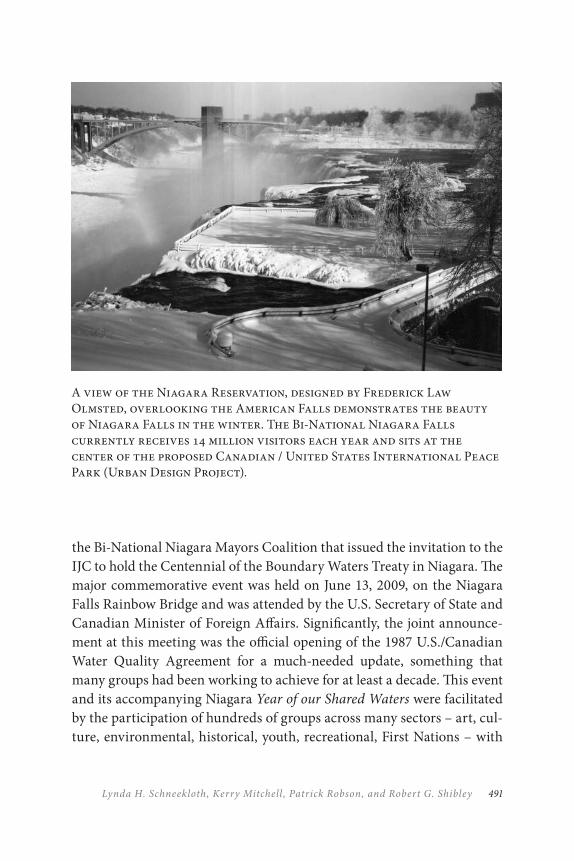
491Lynda H. Schneekloth, Kerry Mitchell , Patrick Robson, and Robert G. Shibley
the Bi-National Niagara Mayors Coalition that issued the invitation to the IJC to hold the Centennial of the Boundary Waters Treaty in Niagara. The major commemorative event was held on June 13, 2009, on the Niagara Falls Rainbow Bridge and was attended by the U.S. Secretary of State and Canadian Minister of Foreign Affairs. Significantly, the joint announce-ment at this meeting was the official opening of the 1987 U.S./Canadian Water Quality Agreement for a much-needed update, something that many groups had been working to achieve for at least a decade. This event and its accompanying Niagara Year of our Shared Waters were facilitated by the participation of hundreds of groups across many sectors – art, cul-ture, environmental, historical, youth, recreational, First Nations – with
A view of the Niagara Reservation, designed by Frederick Law Olmsted, overlooking the American Falls demonstrates the beauty of Niagara Falls in the winter. The Bi-National Niagara Falls currently receives 14 million visitors each year and sits at the center of the proposed Canadian / United States International Peace Park (Urban Design Project).
THE NIAGAR A INTERNATIONAL PEACE PARK492
the support of all the municipalities on both side of the Niagara River. This event demonstrated the competence and capacity of the region to forge important relationships that would be required for the implementation of the upcoming commemoration of the War of 1812. It has been proposed that the legacy project for the bicentennial international celebrations be the institution of a Niagara International Peace Park through the IUCN Congress.
To that end, the working group has determined that it is time to make some critical decisions and began an implementation process. Issues to be resolved include:
1. Boundaries: Should there be an open park that encompasses the entire region of Niagara or should a designation be limited to existing governing entities such as the Niagara Parks Commission, the Niagara River Greenway, the Canal Commissions, and the Niagara Heritage Area? What is the best way to proceed?
2. Nominator: Obviously, parallel bodies on both sides of the border that have standing should make the formal request. But exactly who should forward the resolution?
3. Jurisdiction: By whom should the designation be made and, subsequently, who has responsibility to manage and operate? Niagara is an international border, but it is also the connector among local/regional entities within the framework of the Province of Ontario and State of New York.
Once these issues have been resolved through further consultation with others involved in Parks for Peace and with local/regional players, the Cross-Border Working Group will prepare a detailed proposal and pro-motional materials. Further, it is anticipated that a resolution will be sub-mitted to the 2016 IUCN Congress promoting the Niagara International Peace Park to bring international support to our cross-border efforts.
493Lynda H. Schneekloth, Kerry Mitchell , Patrick Robson, and Robert G. Shibley
CONCLUSIONS
A significant advantage of working toward an international designation lies in the dialogue required to advance the vision. The process requires the coordination of efforts among officials, scholars, and citizens to gath-er, cohere, and present the region. Niagara already has some practice in bi-national cooperative work, but regional entities will have to articulate how it will work toward a sustainable future through: (1) conservation of natural and cultural heritage – landscapes, ecosystems, monuments, and stories; (2) development that is innovative, vibrant, and socio-culturally and ecologically sustainable; (3) cooperative structures and relationships among communities, agencies, and nations; and (4) scientific and cultural research, monitoring, and education. Niagara will benefit from an orga-nized and broadly based conversation about how it might achieve these goals and manage itself over time to ensure the balance among the ecol-ogy, economy, equity, and culture of the region we share.
An International Peace Park status through the World Conservation Union’s Global Peace Parks Initiative would provide the cross-border Niagara region with a progressive framework to conserve and manage its enduring and important connections – the Niagara River and the Niagara Escarpment. The over-arching themes of sustainable development, pro-tection, cooperation, and environmental stewardship would naturally support a broad range of initiatives currently underway: natural heritage initiatives, cross-border tourism, economic development, and improved regional cooperation. Demonstrating environmental leadership embraced in the language of peace, the Niagaras draw from history to compose a new embodiment of long-standing cooperation and enterprise.
The designation of this cross-border region as the Niagara International Peace Park would highlight the reputation of the region as environmental stewards of the internationally significant Great Lakes and Niagara River and demonstrate the ongoing leadership of this region in tackling critical Canada/U.S. transboundary issues. Further, such a designation would support investment in the natural, physical and, promotional asset base of the regional tourist economy and position the region to take full ad-vantage of important upcoming events such as the commemoration of
THE NIAGAR A INTERNATIONAL PEACE PARK494
the Bicentennial of the War of 1812 and the 1817 Rush-Bagot Treaty. All of these efforts require attention and academic investment in the region from our colleges and universities, focussing on local as well as global issues. At its core, this proposal aims to carve out an International Peace Park characterized by the successful integration of a healthy environment with the often conflicting pressures of international trade, transportation, development, and, since September 11, border security.
By moving forward from parallel stewardship of shared natural re-sources to a point where environmental/whole-systems thinking truly informs political and economic decision-making, this first-world inter-national peace park seeks to elevate the notion of environmental govern-ance as a path forward to peace and prosperity.
Such could be the Niagara International Peace Park; a legacy of a twenty-first century symbol of peace between Canada and the United States.
REFERENCES
Armfield, F. 2004. “The Rev. J. Nash House: A cornerstone of history and culture.” Western New York Heritage 6: 30–37.
Berton, P. 1981. Flames across the Border: The Canadian-American Tragedy 1813–1814. Boston: Little Brown.
———. 1992. Niagara: A History of the Falls. Toronto: McClelland & Stewart.
City of Buffalo. 2006. Queen City in the 21st Century: Buffalo’s Comprehensive Plan. Buffalo: City of Bufflao.
City of Niagara Falls. 2009. Comprehensive Plan for City of Niagara Falls, USA. Niagara Falls: City of Niagara Falls.
Eckel, P. M. 2001. The Vascular Flora of the Vicinity of the Falls of Niagara. Buffalo: Buffalo Museum of Science.
Erie and Niagara Counties. 2006. Erie-Niagara Framework for Regional Growth. Sanborn and Buffalo: Erie and Niagara Counties.
Farrison, W. E. 1969. William Wells Brown: Author and Reformer. Chicago: University of Chicago Press.
Grinde, D. A., and B. E. Johansen. 1991. Exemplar of Liberty: Native America and the Evolution of Democracy. Los Angeles: University of California Press.
495Lynda H. Schneekloth, Kerry Mitchell , Patrick Robson, and Robert G. Shibley
Horton, J. T. 1947. History of Northwestern New York. New York: Lewis Historical Publishing.
IJC. 2002. Niagara River Area of Concern Status Assessment.Ottawa and Washington” International Joint Commission.
Jackson, J. N. 2003. The Mighty Niagara: One River – Two Frontiers. Amherst, NY: Prometheus Books.
Kennedy, R. G. 1994. Hidden Cities: The Discovery and Loss of Ancient North American Civilization. New York: The Free Press.
Lewis, D. L. 1983. W. E. Dubois: Biography of a Race 1868–1919. New York: Henry Holt.
Mann, C. C. 2005. 1491: New Revelations of the Americans before Columbus. New York: Vintage Books.
McGreevy, P. 1994. Imagining Niagara: The Meaning and Making of Niagara Falls. Amherst, MA: University of Massachusetts Press.
Niagara Region. 2004. Building Community – Building Lives: A Blueprint for an Even Better,Smarter Niagara. Thorold, ON: Regional Municipality of Niagara.
Niagara Bi-National Region Economic Roundtable. 2003. Realizing a Vibrant Niagara BiNational Region. Final Report of the Niagara BiNational Region Economic Roundtable. Niagara: Niagara BiNational Region Economic Roundtable.
Percy, J. W. 2007. Buffalo-Niagara Connections. Buffalo, NY: Western New York Heritage Press.
Sandwith, T., Shine, C., Hamilton, L., and Sheppard D. 2001. Transboundary Protected Areas for Peace and Cooperation. Gland, Switzerland, and Cambridge, UK: IUCN/The World Conservation Union.
Severance, F. H. 1903. Narratives of Early Mission Work on the Niagara Frontier and Buffalo Creek. Cornell: Cornell University Library.
Wallace, P. A. 1986. The White Roots of Peace. Saranac Lake, NY: Chauncey Press.
Weatherford, J. 1988. Indian Givers: How the Indians of the Americas Transformed the World. New York: Fawcett Columbine.
Wooster, M. 2008. Living Waters: Reading the Rivers of the Lower Great Lakes. Albany, NY: SUNY Press.

497
Notes on Contributors
GILLIAN ANDERSON is a past program manager for the Australian Alps national parks Co-operative Management Program and has had a long career in protected area management with Parks Victoria, focussed on management of visitor experience, education, and cultural heritage programs. She now runs “People in Nature,” a consultancy that provides project management and interpretation design services.
ROLF D. BALDUS, a German economist, born in 1949, was a univer-sity staff member, a family company manager and an international consultant before he became a ministerial ghost writer and personal as-sistant to the minister for Development Cooperation. He managed the Selous Conservation Programme in Tanzania from 1987 to 1994. Back in Germany, he was put in charge of the Development Policy Section in Chancellor Helmut Kohl’s office until returning to Tanzania in 1998 at the invitation of the Wildlife Division. As government advisor for Community Based Natural Resources Management, he was involved in developing the new Wildlife Policy and in revising the Wildlife Act. He also assisted in creating the Selous-Niassa Wildlife Corridor in southern Tanzania. He now lives in Germany’s oldest protected area on the River Rhine near Bonn.
PEACE, PARKS, A N D PARTNERSHIP498
KENT L. BIRINGER serves as a manager in the Global Security Programs at Sandia National Laboratories promoting cooperative threat reduction objectives in the Middle East, South Asia, and East Asia. From 2005 to 2010, he served as manager of Government Relations at Sandia. Earlier he was manager of the Regional Security and Multilateral Affairs Department at Sandia, where his department conducted research, analysis, training, and experimentation on technologies useful for monitoring international treaties and agreements and for regional confidence-building. Prior to management, he was a distinguished member of the technical staff and managed the South Asia program at Sandia’s Cooperative Monitoring Center, exploring options for cooperative approaches to nuclear, conven-tional, and non-traditional security in the subcontinent. He has worked at Sandia for thirty-six years in energy research, systems analysis, global security, and government affairs. His educational training is in mechani-cal engineering with degrees from Rice University.
LEN BROBERG is the director of the Environmental Studies Program at the University of Montana and, since 1999, has led the UM Transboundary Policy, Planning and Management Initiative (TPPMI), an international graduate program. As a professor in the program, he teaches courses concerning the implementation of science into policy with a focus on biodiversity, forests, and climate change, drawing on his experience as a lawyer and a biologist. His research focusses on biodiversity monitoring, forest restoration, conservation, planning, and policy in both the United States and Canada and domestic and international climate change policy. He is most recently the co-author of Yellowstone Bison: The Science and
Management of a Migratory Wildlife Population (University of Montana Press, 2011) a book on transboundary management of the Yellowstone National Park bison herd.
AIR MARSHAL K. C. CARIAPPA (Retd) was commissioned in to the Indian Air Force in May 1957. He participated in the Indo-Pak Wars of 1965 and 1971 where he commanded a helicopter unit and a fighter squad-ron. He retired as Air Officer Commanding in Chief of Southwestern Air Command in January 1996. He graduated from the Defence Services Staff College with a M Phil degree in Military Science and attended a course
499Notes on Contributors
at the Royal College of Defence Studies, London, in 1988. His interests include wildlife and the environment, and his hobbies include trekking and angling. He lives in Madikeri in Karnataka State, India.
MILINDO CHAKRABARTI is a professor at the School of Business Studies, Sharda University, Greater Noida, India. He also serves as the ex-ecutive director of Development Evaluation Society of India, New Delhi. Besides publishing a number of research papers in national and interna-tional journals, he also served as consultants to the World Bank, IFAD, UNDP, the British Council, and IDRC. His research interests include natural resource management and development evaluation.
CHARLES CHESTER teaches on global environmental politics at Brandeis University and the Fletcher School at Tufts University, where he is an adjunct assistant professor of International Environmental Policy. He is a co-editor of Climate and Conservation: Landscape and Seascape Science,
Planning and Action (Island Press, 2012) and author of Conservation across
Borders: Biodiversity in an Interdependent World (Island Press, 2006). The latter book originated in his 2003 Fletcher PhD dissertation, focussing on case studies of transborder conservation in North America, including the Sonoran Desert. He has consulted for the Union of Concerned Scientists, the Henry P. Kendall Foundation, and other environmental organiza-tions. He is currently co-chair of the Board of the Yellowstone to Yukon Conservation Initiative and has served on the boards of Bat Conservation International and Root Capital.
BARBARA EHRINGHAUS (MA) was born and raised in Germany. She has been working as sociologist and as environmental educator in Europe and abroad (mainly in Latin America, Africa, and Asia), in foreign-aid programs, in conservation projects, for the World Scout movement, and with Indigenous peoples. During the last decade, she has turned her moun-taineering hobby into a full-time volunteer activity of Alpine protection, focusing on the tri-national transborder area of Mont Blanc as a potential model for balancing sustainable mountain development and conservation of natural resources under strong pressure from tourism and transport.
PEACE, PARKS, A N D PARTNERSHIP500
ROBERT FINCHAM holds a master’s degree from Western Michigan University and a PhD from Rhodes University in South Africa and is pro-fessor emeritus at the University of KwaZulu-Natal. He is director of the Msunduzi Innovation and Development Institute (MIDI), a trust formed by the University of KwaZulu-Natal, the Chamber of Business, and the Msunduzi Municipality. MIDI is responsible for facilitating key socio-economic and environmental developments in the Pietermaritzburg City Region. He has developed collaborative research programs at universities in the United States, Canada, UK, Europe, and Asia, as well as in several African countries. His research interests are in food security, human nu-trition, and conservation development. He is chairperson of the board of trustees of the Wildlands Conservation Trust (WCT), a major non-gov-ernment organization in South Africa, and a board member of the Msinsi Resorts and Game Reserve, the latter tasked with managing the peripher-ies of the major water bodies in KwaZulu-Natal.
WAYNE FREIMUND is the Arkwright Professor of Protected Area Studies and director of the UM Wilderness Institute. He has been on the faculty of the University of Montana, College of Forestry and Conservation, since 1993. He teaches upper-division and graduate-level courses in wilderness philosophy, wildland recreation management, park management, managing visitors and resources, and theoretical perspectives of outdoor recreation experiences. He conducts a line of re-search in environmental perception and behaviour, visitor experiences, administrative capacity-building, and emerging issues in National Park Management. He has directed the International Seminar on Protected Area Management for twelve years. That seminar has included over 320 land-management professionals from seventy-one countries. He was pro-moted to associate professor in 1998 and full professor in 2004. He chaired the Department of Society and Conservation from 2003 to 2007 before returning to the directorship of the Wilderness Institute. He was execu-tive editor for Electronic Communication for the International Journal of
Wilderness and has served as a reviewer for numerous journals. He has served as major professor for nine PhD and fifteen MSc students. He has been a member of the World Commission on Protected Areas since 2005.
501Notes on Contributors
HALL HEALY is board chair of International Crane Foundation, an NGO preserving the world’s fifteen species of cranes. He is a professional envi-ronmental facilitator for NGOs and government agencies in the United States, Russia, China, and Korea. He earned a BA in Political Science from Colgate University and an MBA from the University of Chicago, Executive Program. He has written “Environmental Management” for American Management Association’s (AMA) Manufacturers Handbook and co-authored Packaging and Solid Waste and papers on natural resource con-servation in the Korean Demilitarized Zone (DMZ). He is past president of the DMZ Forum, dedicated to preserving DMZ species and habitats and emeritus director of The Nature Conservancy of Illinois. He is on the governing board of the Chicago Zoological Society. He is a member of IUCN’s Transboundary Protected Areas (TBPA) and Specialist Group on Storks, Ibises, and Spoonbills and of the National Committee on North Korea, which facilitates engagement with North Korea.
PETER JACOBS is the chief ranger for the Alpine District with Parks Victoria, Australia. The Alpine District comprises 900,000 hectares of parks and reserves from high-use facilities through to extensive wilderness areas across some of the highest and wildest mountains in Australia. He has many years of experience with managing protected areas across state borders in the Australian Alps through being convenor of the Australian Alps Liaison Committee, inaugural chair of the Australian Alps National Landscapes Committee and inaugural co-chair of the Australian Alps Traditional Owners Reference Group.
JENNIFER LAING is a senior lecturer in Tourism in the Department of Management and deputy director of the Australia and International Tourism Research Unit at Monash University, Australia. She has a law and marketing background. Her research interests include tourism partner-ships, extraordinary tourist experiences, the role of events in society, and heritage tourism. She has published in journals such as Annals of Tourism
Research, Tourism Analysis, and Journal of Sustainable Tourism and has co-written Books and Travel: Inspiration, Quests and Transformation (2012) for Channel View. She was the recipient of the 2010 CAUTHE (Council
PEACE, PARKS, A N D PARTNERSHIP502
for Australian Tourism and Hospitality Education) Fellows Award for Tourism and Hospitality Research. She is an editorial board member of the Journal of Travel Research and Tourism Review International. In 2011, she became co-editor of the Routledge Advances in Events Research series.
DAVID MABUNDA (PhD Tourism Management) was the first black di-rector of the Kruger National Park and currently is the Chief Executive Officer of the South African National Parks (SANParks). He has wide experience in the education, land reform, conservation and tourism sec-tors of South Africa. As CEO of SANParks, David is responsible for the management of twenty-one national parks in South Africa. This includes balancing the requirements of the conservation mandate with providing public benefits as well as making SANParks financially sustainable and connecting conservation land to the broader society. David advises the South African government on various policies on conservation matters and contributes to the country’s conservation template and subsequently enhances South Africa’s role in global conservation debates and platforms. David serves on the World Protected Areas Leadership Forum represent-ing major global conservation agencies. He has been involved as author or co-author of several scientific papers and chapters in books.
ANGELES MENDOZA SAMMET is the president of White Eagle Sustainable Development, a non-for-profit organization recently created to support community development in Mexico. She is a consultant on im-pact assessment and a member of the World Commission on Protected Areas. Her current research focusses on Social Responsibility and the so-cio-environmental impacts of foreign investment in Mexico. She is an avid rock climber. She has an interdisciplinary PhD on Environmental Design, speciality in Environmental Management (University of Calgary) and an MSc in Ecology and Environmental Sciences and a BSc in Biology from the National Autonomous University of Mexico (UNAM). She worked at UNAM as assistant researcher (Institute of Ecology, 1990–99) and as pro-fessor (Department of Geography, 1994–99). She is a certified mediator and facilitator on Consensus-Decision Making. Her distinctions include a regional award for Major Contributions to the Regional Development of
503Notes on Contributors
Impact Assessment, granted by the International Association for Impact Assessment in 2011.
DAVE MIHALIC is a management consultant in planning, managing and advising on visitor services for both public and private entities in some of the world’s most special places. He has lead and participated in both eval-uation and monitoring missions for IUCN of world heritage properties across the United States, Europe, and the Russian Federation. A retired se-nior executive with the U.S. National Park Service, he was superintendent at Yosemite, Glacier, and Mammoth Cave national parks, deputy at Great Smokies and Chief of Policy at the Washington headquarters. He started his career as a ranger at Glacier, researched visitor attitudes toward grizzly bears, and was District Ranger at Old Faithful in Yellowstone when tapped as the first superintendent at Yukon-Charley Rivers in Alaska, along the Yukon border. His undergraduate studies were in parks and recreation at Southern Illinois University and a masters in natural resource manage-ment from Michigan State. He is a graduate of Northwestern University’s Kellogg Graduate School of Management Advanced Executive Program. He lives in Missoula, Montana.
KERRY MITCHELL is the manager of the Foreign Policy and Diplomacy Services division at the Consulate General of Canada in Buffalo, New York. She holds a BBA from Pace University in New York and a Maîtrise de la langue française from the Sorbonne in Paris, France. She has spent her career involved in the development of cross-cultural and international education programs, including: Pace University’s Center for International Business Studies and Brazilian Institute; the YMCA International Program Services’ World Issues Program; and Calasanctius School’s International Enrichment Program. Since taking up the position at the Consulate General of Canada in 1989, she has placed continued priority on building new bridges to cooperation and collaboration in the cross-border Niagara region.
SUSAN MOORE is associate professor of Environmental Policy in the School of Environmental Science, Murdoch University, Australia. She
PEACE, PARKS, A N D PARTNERSHIP504
leads the Nature Based Tourism Research Group at Murdoch University and has expertise in natural area tourism, protected area management, and biodiversity conservation policy. Her 150 publications include journal articles, books, and reports. She currently leads the national ARC Project on National Park Positioning and Visitor Loyalty, the Policy Research Program of WA Centre of Excellence for Climate Change and Tree Health, and the Social and Institutional Futures Program within the Landscapes and Policy National Research Hub at the University of Tasmania. Current honorary roles relevant to parks include governor, World Wide Fund for Nature–Australia, and member, IUCN World Commission on Protected Areas.
DANIE PIENAAR (MSc Wildlife Management) is the Head of Research in the South African National Parks and is based in the Kruger National Park. He has experience in managing research across twenty-one national parks, science-management-academic partnerships, protected area plan-ning and management, rare species research and management, research and conservation policy drafting and trans-boundary conservation, which he gained in the Kruger and other national parks over the past twenty-four years. Main areas of personal research have been habitat pref-erence of white rhino, rhino horn characteristics, black rhino monitoring and population dynamics, rare ungulate monitoring and conservation and crocodile research in the rivers of the Kruger National Park. He is a member of the Joint Management Board of the Great Limpopo Trans-frontier Park and chairs the Conservation and Veterinary Committee of the Great Limpopo Trans-frontier Park. He has been involved as author or co-author of several scientific papers and chapters in books.
MICHAEL QUINN is a full professor in the Faculty of Environmental Design at the University of Calgary and the director of Research and Liaison for the Miistakis Institute – a research support organization spe-cializing in spatial data and analysis. He holds a BSc in Forest Science from the University of Alberta, an MSc in Forest Wildlife from the University of Alberta and a PhD in Environmental Studies from York University. His teaching and research interests are in the areas of ecosystem management,
505Notes on Contributors
watershed management, landscape ecology, land-use planning, protected areas management, community-based natural resource management and urban ecology. He co-manages the Transboundary Environmental Policy, Planning, and Management initiative between the University of Calgary and University of Montana.
PATRICK ROBSON, commissioner of Integrated Community Planning, Regional Municipality of Niagara, holds a Bachelor of Applied Arts in Urban and Regional Planning from Ryerson, a Master of Arts in Politics from Brock University, has completed the Municipal Clerk’s and Treasurer’s program at Niagara College, and is a Certified Municipal Manager III through the Ontario Municipal Management Institute. His work has included being a private sector planning consultant, a communi-ty planner with the Niagara Escarpment Commission, and an investigator with the Ontario Human Rights Commission, as well as holding several progressive positions in the Niagara region. Also, he served three terms as an alderman in Wainfleet, Ontario. He teaches Public Policy at Brock University.
ANIMESH SARKAR is pursuing his PhD at the University of North Bengal on non-timber forest products (NTFPs). He was associated with the International Forestry Resources and Institutions (IFRI) project at Indiana University. He served as a consultant to International Centre for Integrated Mountain Development (ICIMoD), Kathmandu. Besides pub-lishing a number of papers in national and international journals, he also worked with IDRC, Planning Commission India. He served CREATE – the research centre of St. Joseph’s College, Darjeeling. He also taught in the Department of Ecotourism as a lecturer. His research interests include socio-ecological system and development evaluation.
LYNDA SCHNEEKLOTH is professor emerita at the School of Architecture and Planning, the University at Buffalo/SUNY since 1982 and continues to serve as the Director of Landscape at the Urban Design Project. Her scholarly research is focussed on the idea of placemaking, that is, how people transform the world, including natural processes and built
PEACE, PARKS, A N D PARTNERSHIP506
form, from spaces in which they live into places they can love and care for. She has authored or co-authored five books: Olmsted in Buffalo and
Niagara (2011); Reconsidering Concrete Atlantis: Buffalo Grain Elevators (editor, 2007); The Power Trail: History of Hydroelectricity at Niagara (2006); Placemaking: The Art and Practice of Building Communities (with R. Shibley, 1995), and Ordering Space: Types in Architecture and Design (with K. Franck, 1994), and has published over fifty scholarship articles and chapters.
MICHAEL SCHOON is currently the assistant director of Arizona State University’s Complex Adaptive Systems Initiative, focussing on building a complexity approach within several schools at Arizona State. His disserta-tion work, as an environmental policy and governance student at Indiana University’s Workshop in Political Theory and Policy Analysis, focussed on transboundary protected areas or peace parks in southern Africa, which won the American Political Science Association’s best dissertation award in 2008. Following that, he began as a research associate for the Center for the Study of Institutional Diversity, also at ASU, where he conducted research on collaboration across borders. For these projects, he looked at collaborative, cross-border institutional arrangements covering a range of environmental issues from biodiversity conservation to water sharing to fire management in the Arizona borderlands. His work combines multiple methodological approaches and looks at causal clusters for the formation and governance outcomes of institutional arrangements.
GOETZ SCHUERHOLZ is an adjunct professor at the University of Victoria and president of Transamerica Environmental Consultants Ltd. He is interested in many aspects of biodiversity conservation but special-izes in community-based natural resource management. He also has ex-pertise in conflict resolution and project management. He is a contributor to many international reports on transboundary and community-based natural resource management.
ROBERT SHIBLEY is dean of the School of Architecture and Planning at the University at Buffalo/SUNY. As the director of the Regional Institute/
507Notes on Contributors
Urban Design Project, a centre at the school, he led the development of Buffalo’s national award-winning plan series for its downtown, waterfront, Olmsted park system, and its comprehensive plan. As the senior advisor to the president for Campus Planning and Design at the university, he led the development of Building UB: The Comprehensive Physical Plan. He is also an author or editor of eleven books on American urbanism, includ-ing Placemaking: The Art and Practice of Building Community, and the McGraw-Hill compendium on the state of the art in the field, Time Savers
Standards for Urban Design. He is a registered architect, certified planner, and a fellow of the American Institute of Architects.
BELINDA SIFFORD is an attorney practising in the San Francisco Bay area. After working eight years at Vermont Law School in South Royalton, Vermont, as a professor and program administrator, she currently works as an adjunct professor supervising VLS students on externships in the western United States. She has had a long-standing interest in the U.S.–Mexican border after living and travelling in Mexico, doing immigration work on the border, and taking groups of students to the border for cross-border conversation trips.
BARTOLOMEU SOTO is the Mozambique project manager for Transfrontier Conservation Areas. Prior to that, he was national direc-tor of Conservation Areas for Mozambique (2007–2009) and head of the Wildlife Department (1992–97). He has an MSc from the University of Natal, a BVSc Honors in wildlife diseases from the University of Pretoria, and a BSc in Veterinary Science from Mozambique. He has a long and distinguished career in wildlife and protected areas.
THERESA SOWRY, CEO of the Southern African Wildlife College, holds a Master of Science degree in Botany from the University of the Witswatersrand, South Africa. She gained conservation experience while employed by South African National Parks, working on their rare ante-lope program in the Kruger National Park. Starting in the education field as a training manager and lecturer in Natural Resource Management, she was later promoted to executive manager: training and more recently to
PEACE, PARKS, A N D PARTNERSHIP508
CEO of the Wildlife College. Whilst capacitating protected area manag-ers across the SADC region to manage and conserve their wildlife areas and associated fauna and flora sustainably and in cooperation with lo-cal communities, the Wildlife College also works closely with the Peace Parks Foundation in identifying capacity-building needs and funding op-portunities to train protected area managers and uplift communities in and around Transfrontier Conservation Areas across Africa. Of real sig-nificance is the development of ecotourism opportunities in and around Africa’s wildlife areas, thereby providing tangible benefits to communities and in so doing contributing to poverty alleviation and providing sustain-able livelihood options.
PIET THERON (B Landscape Architecture, MPhil Environmental Science) is a professional landscape architect working in the environmen-tal planning and management field. He has more than seventeen years of experience working on a wide range of natural resource management projects in southern Africa. His key skills and expertise are focussed on planning, managing, and implementing large and complex multi-nation-al, multi-sectoral and multi-stakeholder integrated conservation and de-velopment projects, which often involve setting up effective partnerships between governments, the private sector, and NGOs. This includes being closely involved in the planning, development, and implementation of five transfrontier conservation areas (TFCAs) projects in southern Africa. His other fields of expertise include landscape level planning, environmental impact assessments, site assessments and comparative site analysis, visual impact assessments, project management, stakeholder management and participation (including workshop facilitation), and conflict resolution. His specific areas of professional interest include integrated conservation and development projects, environmental planning and management, community based natural resource management, and project develop-ment and management.
FREEK VENTER (PhD in land classification for management planning of a large protected area) is General Manager: Conservation Management in the Kruger National Park (KNP). He has experience in soil studies, river

509Notes on Contributors
research and management, PA management, trans-boundary manage-ment, environmental impact assessments, park planning and park zoning which he gained in the KNP over the past thirty-four years. He initially fo-cused on the classification and description of land in the KNP to assist in the zoning and management planning of this great park, and currently ap-plies that knowledge in PA management (including adaptive management such as ecosystem restoration), wilderness protection and development initiatives. He has been involved with the Kruger National Park Rivers Research Program as research coordinator and leader of the Integrated River Management sub-Programme, several Joint Management Boards and serves on the Conservation and Veterinary Committee of the Great Limpopo Transfrontier Park and Conservation Area. He chairs the KNP Conservation Management Committee and has been involved as author or co-author of several scientific papers and chapters in books.
TODD WALTERS is the founder and executive director of International Peace Park Expeditions (IPPE), an organization that applies experiential learning within international peace parks to foster an interdisciplinary approach to leadership and collaboration, build a network dedicated to the advancement of peace parks, and support the development of lo-cal communities. He holds a master’s degree in International Peace and Conflict Resolution from the School of International Service at American University. He is a National Outdoor Leadership School-certified ad-venture guide with wilderness first responder (WFR) medical training and has led expeditions around the globe. His published work includes: “Balkans Peace Park: Cross-Border Cooperation and Livelihood Creation through Coordinated Environmental Conservation” and “The Social-Ecological Aspects of Conducting a Transboundary Peace and Conflict Impact Assessment in Waterton-Glacier International Peace Park.” He wrote the entry “Experiential Peacebuilding” for the Oxford International
Encyclopedia of Peace.
BETTY WEILER is research professor of Tourism in the School of Tourism and Hospitality Management, Southern Cross University, Australia. Much of her twenty-five years of research has been in nature-based and heritage

PEACE, PARKS, A N D PARTNERSHIP510
tourism, particularly in relation to sustainability. She has managed many national and international research projects on tourists, tours, and tour guiding in North America, Latin America, Southeast Asia, and Australia, including in national parks, zoos, and heritage attractions. More recently, her work has focussed on the use of persuasive communication to influ-ence tourist behaviour and on visitor planning and management, particu-larly in protected areas and at heritage and nature-based attractions. In addition to some 150 publications, she is an editorial board member of five international tourism journals and a multi-award-winning researcher and PhD supervisor.
KEVAN ZUNCKEL, at the time the chapter was prepared, was appointed to coordinate the South African contribution to the Maloti Drakensberg Transfrontier Conservation and Development Project (MDTP) with Lesotho. He had accumulated eighteen years of experience in conserva-tion. His career began as a conservation planner in the timber industry, but he soon moved across to the formal conservation agencies in South Africa, where he grew to head up the Research and Development component of the Mpumalanga Parks Board before he moved across to the MDTP. His contract with the MDTP extended for just over five years, in which time he established and managed the project implementation team and built the platform for the project to continue well beyond the GEF funded term. After working as an ecological consultant with a multi-national firm for two years, he joined his wife in a partnership that now offers ecological and environmental management services.
511
AAboriginal cultural heritage conservation and
interpretation, 59, 62, 66Abutilon indicum, 413academic and research institutions, xxvii, 123,
325, 487, 489. See also names of individual institutions; research
challenges of working across political boundaries, 328
Adams, Edward Dean, 480Adams Power Plant, 480Adler, Emmanuel, 146administrative boundaries, xiv, xxvi. See also
jurisdictional boundariesadventure tourism, 59Ae!Hai Kalahari Heritage Park in the
Kgalagadi, 227Afghanistan, 400African American civil rights movements, 466,
468African Americans, 474African elephants (Loxodonta africana), 186,
213, 242, 245African Leadership Seminar (ALS), 336African Ministerial Conference on
Environment (AMCEN), 161African wild cat (Felis lybica), 210African wild dog (Lycaon pictus), 242African Wildlife Foundation, 168, 213, 277agricultural and environmental protection,
487–88agriculture, 119–21, 130, 144, 290, 487–88. See
also cattle farms (and cattleposts)commercial agriculture, 292, 329dry land cropping, 286mountain agriculture (traditional), 83
runoff from, 399unsustainable farming practices, 400
Agrupación Sierra Madre, 454Aguia Pesqueira (campsite), 280AHEAD (Animal & Human Health for the
Environment and Development), 193, 215, 229
|Ai-|Ais Hotsprings Game Park in Namibia, 193|Ai-|Ais/Richtersveld Transfrontier Park
(ARTP), 159, 193–96air quality, 122, 455–56Ajo, Arizona, 443Ajos, 96–97, 99–100, 125, 127
biodiversity, 102, 132collaboration with NGOs, 124cooperation with U.S. parks, 122effects from mining companies, 119forest management, 117illegal activities, 115, 132international stakeholders, 110lack of funding and training, 122land ownership, 113management plan, 102, 118Monarch butterfly, 99natural fire regime, 117species of concern, 102species of economic value, 117tourism management, 120University of New Mexico study on jaguar,
123U.S. proposal to expand, 118use by local people for cattle-grazing, 115vegetation, 99water, 118–19
Alaska, 13
Index
PARKS, PEACE, A N D PARTNERSHIP512
Área de Protecíon de Flora y Fauna Ocampo, 455
“Áreas de Protección de Flora y Fauna” Maderas del Carmen and Cañón de Santa Elena, 453
Arizona, 122, 447Arizona State Senate
Natural Resources and Transportation Committee, 446
arson fires, 296Asian Gudgeon (Pseudorasbora parva), 388Asian keelback snake (Amphiesma vibakari),
388Asiatic black bear (Selenarctos thibetanus), 386Asociación Regional Ambientalista Sonora-
Arizona (ARASA), 124Aspen Institute’s Wye River Conference Center,
18Associated Private Nature Reserves (APNR),
180hunting protocol, 181
ASTER satellite imagery, 377Auob River, 171Australia, 387Australian Alps, 21–49Australian Alps Cooperative Management
Program, xxiii, 24–27, 59–61, 70champions group, 25–26, 48communication with community, 31, 45cross-agency working groups, 28Deer Management Workshop, 34funding, 35, 37, 48future challenges and directions, 49indigenous community involvement, 46organization and structure, 24–25program manager position, 36protected areas (table), 23Science-Management Workshops, 44staff involvement, 29strategic plan, 40–43Strategic Water Program, 32Thredbo meeting, 46workshops and networking, 30
Australian Alps Education Kits, 62Australian Alps eight codes of conduct, 62Australian Alps for National Heritage Listing,
41Australian Alps Heads of Agencies Group, 25,
27Australian Alps Liaison Committee (AALC),
25, 27–29, 41, 43, 58, 61–62Aboriginal cultural heritage conservation, 66community awareness training courses, 65
Albert National Park (Rwanda-Burundi and the Belgian Congo), xvii, 160
Alberta, xvi, 6, 10, 19, 311, 325Alberta Fish and Wildlife, 12Ali, Aamir, 372–73alien invasive species, 66, 162, 175, 294–95, 297,
313, 456, 482. See also names of specific invasive species
contributions to rural livelihoods, 295effects on tourism and agricultural
production, 295non-native grasses and tree species, 113, 118shared initiatives on, 454
Alpine Convention, 87–88Alpine Human Waste Workshop, 30Alpine Network of Protected Areas (ALPARC),
88alpine resorts, 39, 65Alps Co-operative Management Program, 66Alps Head of Agencies Group, 61Alps Ministerial Council, 61Alps Operational Group, 28Alps walking track brochure, 67ALT (Binational Autonomous Authority of
Lago de Titicaca), 137, 139–40, 142, 144–45, 148–50
Alubari, 415American Association for the Advancement of
Science (AAAS), 377American bramble (Rubrus americana), 294Amu Dar’ya river, 144Amur goral (Naemorhedus caudatus
raddeanus), 386, 401Anbyon Plain nature reserve, 404Andean Condor, 150Anderson, Gillian, xxiii, 497Angola, xxv, 238, 244–45, 254, 259animal bridges, 398animal movement across international borders,
168. See also migrationanimal rights, 152Antarctic Treaty of 1959, 374–75anti-international movement, 444anti-poaching, 260, 262, 354AOC (Area of Concern), 482Apaches, 448Apartheid regime (former South Africa)
engineering of population dynamics, 292Appreciative Participatory Planning and Action
(APPA), 419, 424Arafat, Yassar, 18Aral Sea catastrophe, xxiv, 135, 139, 144–45
513Index
Basotho nation, 292Batoka Gorge, 245bats, 447, 456Battle of Chippewa, 471Battle of Lundy’s Lane, 471bean goose (Anser fabalis), 387bearded vulture, 288beaver (Castor canadensis), 102Beck, Adam, 480Beitbridge, border post at, 231Belgium, 160Belly River, 12Beltrones, Manlio Fabio, 444“benefits beyond boundaries,” 174Berlin Wall, 91best practices, 63, 136, 144–45, 152Bhalukhop village, 415, 421Bhutan, 371Bi-National Niagara Mayors Coalition, 489–91Bicentennial of the War of 1812, 466, 489, 492,
494Big Bend designation as biosphere reserve, 452Big Bend National Park (U.S.), 13, 96, 447, 449,
452–53Big Bend Ranch State Park, 447big game, 197. See also wildlifebighorn sheep (Ovis Canadensis), 117, 440, 458bikhumma (Aconitum sp.), 413“Binational Network of Sonoran Desert
Biosphere Reserves,” 444biodiversity, xxix, 95–96, 122, 127, 142, 160,
326, 415biodiversity hotspots, 287economic values of, 415
biodiversity and economic opportunity conflicts, 331
biodiversity conservation, 117, 164, 484regional cooperation, 190
biodiversity management and monitoring, 178biodiversity protection
evolving definitions, 340biological connectivity, loss of, 415biological diversity, xviii, xixbiosphere reserves, 12, 17, 82, 123, 314, 443, 452
communities within, 444bird areas, 288bird species, 447Birdlife International, 287–88Biringer, Kent L., xxix, 498Birney, James, 474bison, 311bitterling (Rhodeus uyekii), 388black-backed jackal (Cania mesomelas), 210
contribution to schools and teachers, 62–63efficiency/productivity gains, 54, 61legal and administrative authority, 72, 126minimal impact codes of practice, 66professional development activities, 62tourism marketing, 65
Australian Alps Memorandum of Understanding, 61, 70
Australian Alps Ministerial Council, 24Australian Alps National Parks (AANP), 23,
53, 58, 63capacity building, 42cross-border cooperation, 59lack of community involvement, 65lack of participation by alpine resorts, 65
Australian Alps Scientific Sites Database, 66Australian Alps Signage Branding Project, 34Australian Alps Transboundary Partnership
legislative and administrative framework, 72Tourism / Protected Area Partnership, 51–74
Australian Alps Walking Track (AAWT), 29, 42, 62–63
Australian Alps website, 46, 63–65, 67Australian Capital Territory (ACT), 21, 23–24,
58–59, 63Parks, Conservation and Lands, 35
Australian Conservation Foundation, 69Australian Deer Association, 34Australian government, 24, 58–59
funding contribution to Cooperative Management Program, 35
Australian indigenous people, 39, 66Australian National Landscapes Program, 31Austria’s Western Tirol, 85Ayanwatha (Hiawatha), 471Aymara culture, 140, 146–47
BBabbit, Bruce, 445, 454Bacoachi (municipality), 99Baekhak Mountain, 391Baja California, 438Baja California Sur, 438Balason River, 419Bald Eagle (Haliaeetus leucocephalus), 102Baldus, Rolf D., xxv, 497Balule Private Nature Reserve, 180Banff National Park, 315Banhine National Park, 174, 277Barry M. Goldwater Range (BMGR), 440,
445–46Basarwa people (or San people), 210
PARKS, PEACE, A N D PARTNERSHIP514
Broberg, Len, xxvii, 498Brock, Isaac, 470Brown, John George “Kootenai,” xvi, 7Brown, William Wells, 474brown bears (Ursus arctos), 371brown hyena (Hyaena hrunnea), 210Broyles, Bill, 445–46Brussels, 84Buddhist temples, 393Buffalo, 470, 474, 481, 488Buffalo Niagara Riverkeeper, 489Buffalo River, 482buffer zones, 17, 174–81, 228, 329Building Communities, Building Lives, 488Bukhan River, 390bull trout, xiv, 12, 311Burrowing Owl (Athene cunicularia), xxiv, 102,
113, 124, 126habitat, 118–19
“bush-beach ecotourism,” 182bush meat, 243, 248, 250bushbuck (Tragelaphus scriptus), 242
CCabeza Prieta National Wildlife Refuge
(CPNWR), 440, 445cactus species, 440, 447Caledon River, 285Canaanea (municipality), 99Canada, xxvii, xxx, 3, 95, 117, 160, 468Canada–Mexico connections between protected
areas, xxivCanada–U.S. border, xiv, 311, 465–66, 485. See
also Niagara International Peace Park proposal; Waterton-Glacier International Peace Park
Canada–U.S. Free Trade Agreement (FTA), 484–85
Canadian Niagara Parks Commission, 488Canberra Region Tourism Awards, 65Cañón de Santa Elena, 453, 455Cañón de Santa Elena biosphere reserve, 447Cañón de Santa Elena-Maderas del Carmen
areas (Mexico), 96capacity-building, xxviii, 122, 163, 267–68,
276–77, 281, 300, 334Cape buffalo (Syncerus caffer), 213, 242Cape of Good Hope Supreme Court, 194Caprivi Strip in Namibia, 237, 245–46, 257,
259, 261community empowerment, 254
Carabias, Julia, 445, 454
black bear (Ursus americanus), 102, 117, 447, 456
black-faced spoonbills (Platelea minor), 387Black Gap Wildlife Management Area, 447black rhinos (Diceros bicornis), 242black-tailed prairie dog (Cynomy ludovicianus),
102black vulture (Aegypius monachus), 387black wattle (Acacia mearnsii), 294Blackfoot Confederacy, xiv, xxi, 320boga (Trichomicterus), 149–50Bokong Nature Reserve, 285Bolivia, xxiv, 135, 137–38, 140, 143, 146, 151
participation in World Water Conference, 149
Bolivian Congress, 138–39, 145Bolivian government, 147Bolivian Operational Unit (UOB), 149Boquillas canyon, 447Boquillas Crossing, 457, 460Boquillas del Carmen (Mexican border village),
452border fences (U.S.–Mexico border), 438, 446,
456, 459border security, 14–15, 438, 448, 455, 459, 483,
487, 494Great Limpopo Transfrontier Park, 216, 224,
226, 229–31‘Moving the border away from the border,’
485‘perimeter security,’ 485post-9/11 management era, xxxi, 15, 343 (See
also post-9/11 world)Rio Grande border security, 448robotic, unstaffed border crossings, 457–58
Botswana, xxv, 159, 168, 196–97, 210, 238, 244–45, 254, 259
cash restitution for lost livestock, 212Botswana Northern Tuli Game Reserve, 196Botswana–South Africa bilateral agreement
(Kgalagadi Transfrontier Park), 168bottom-up commitment, xxii–xxiii, 11, 18, 91,
224–25, 232, 260Boundary Waters Treaty, 468, 480
Centennial, 489, 491Brahmaputra River, 370Brindabella Ranges, Australian Capital
Territory (ACT), 21British colonialism, 289British Columbia, 9–10, 13, 311British Columbia Flathead Valley, 316broad-billed sandpiper (Limicola falcinellus),
387
515Index
Chicago, 4Chief Mountain
importance to Blackfeet, 319–20sacred place for Peigan Nation, 12
Chihuahua desert, xxix, 438, 447–55Chimanimani Transfrontier Conservation
Area, 267, 271–72China, 366, 387–88, 396, 404Chinese egret (Egretta eulophotes), 387Chinese mitten crab (Eriocheir sinensis), 388Chinese water deer (Hydropotes inermis), 386Chiricahua National Monument, 122Chisos Mountains, 447Chissano, Joachim, 187, 271Chobe National Park, 170, 245Church, Frederick C., 477Churchill, Winston, 466CIPRA-Alliance des Alpes, 88Cisneros, Jose, 454civil liberties, 97civil rights, 469civil rights movements, 468, 474Civilian Control Zone (CCZ), 384–85climate change, ix, 8, 44, 62, 66, 142, 161–62,
297, 371, 468importance in Mont Blanc region, 79in world politics, 91
Climate Change Workshop, 27clouded leopard (Neofelis nebulosa), 412–13co-management, 180, 277, 327, 336co-operative management, 33–34, 38
community involvement, 35facilitating science and education to work
across jurisdictions, 44funding, 40strategic plans, 43
Coahuila, 454Coipasa water system, 144Cold War, 383Coleford Nature Reserve, 285collaboration, xxviii, 149
peace and stability from, 199collaboration (term), 53–54Colorado River, 118, 450Comanches, 448Comisión Nacional de Areas Nataurales
Protegidas. See CONAPcommercial agriculture, 292, 294, 329commercial and communal cattle farms, 210Committee on Foreign Relation, 144common reedbuck (Redunca arundinum), 242common waterbuck (Kobus ellipsiprymnus), 242
Cardenas, Lazaro, 449Cardston Rotary Club, 6Cariappa, xxixCarius, Alexander, 139–40
Environmental Peacebuilding, 137El Carmen – Big Bend Conservation Corridor
Initiative, 459El Carmen Wilderness, 459El Carmen Wilderness Area, 460cassava, 243Caterpillar Inc., 405cattle farms (and cattleposts), 210, 212. See also
livestockcattle fences, 209cattle-grazing, 43, 66, 85, 115, 119–20cattle raising on mountain pastures, 85cattle-ranching, 329cattle theft, 260CBNRM. See community-based natural
resource management (CBNRM) modelsCEMEX, 447, 454Central Kalahari Game Reserve (CKGR) in
Botswana, 209cattle fences, 209
Central Park in New York City, 395Centre for Environment, Agriculture and
Development (CEAD), 334–35Centre for Studies of Deserts and Oceans, 123Centre of Superior Studies of the State of
Sonora, 123Centro de Estudios de Desiertos y Oceanos, 123Centro de Estudios Superiores del Estado de
Sonora, 123Centro Ecológico de Sonoro, 442certificate qualification course (SAWC), 350–52chacma baboon (Papio ursinus), 215Chakrabarti, Milindo, 498Chamonix, France, 83Chamonix Valley, 92charismaic eland (Taurotragus oryx), 288charismatic predators, 209charismatic transfrontier species, 288Chautauqua Institution, 483chemical companies, 481Cheorwon, 389, 391–92, 398, 401, 403
limestone caves, 401Cheorwon Basin, 388Cheorwon Plain, 392Chester, xxixChester, Charles, 499Chestnut-breasted Partridge (Arborophila
mendellii), 413Chhota River, 419
PARKS, PEACE, A N D PARTNERSHIP516
enforcing in context of growing tourism and real estate business, 88
growing capacity in Mexico, 459guardianship, 356as land-use option to the benefit of the
people, 164linking to livelihoods, xxvii, 306postwar attention on economic growth and,
451conservation and management (Pinacate and
Ajos)factors influencing, 95–132recommendations to improve, 127–32
conservation and social utility, tensions between, 337
conservation biology at ecosystem level, 8, 10Conservation International (CI), 168, 245, 260,
287conservation management, 59, 327conservation outcomes (as measure of
partnership success), 55Conservation Pass (park pass), 120conservation targets, 305–6conservationists (U.S. and Mexican), 456Consulate General of Canada in Buffalo, 490contractual parks, 211, 228, 231
as means of resolving land claims, 227cooperation (term), 53Cooperative Ecosystem Studies Unit (CESU),
321cooperative governance, 300cooperative management, 12, 17, 38
of the AANP, 58communication, 45individual agency support for, 33integrating education, science, and
management, 48park staff support for, 11, 13
Copenhagen climate conference, 91Coronado National Memorial, 122corporate governance, 116, 163corridor across Darjeeling Himalayas, 414,
431. See also Senchal Wildlife Sanctuary; Singalila National Park
cost-benefit analysis, 417, 419, 429, 432feasibility, 414–15, 432forest composition needs to be changed, 429identifying migration routes, 428research cost, 417restored forest, 429social system of five villages studied, 420
corridors to restore wildlife connectivity, 412, 414. See also names of specific corridors
Communal Areas Management Program for Indigenous Resources (CAMPFIRE), 267
communal land, 215, 328–29communal land tenure systems, 285–86, 292.
See also conservancies (Namibia model)communal natural resource management areas,
164Community Awareness Working Group
(Australian Alps), 28community-based natural resource
management (CBNRM) models. See also conservancies; WMA
comparison of Namibia and Tanzania, 237–38, 253–60
donor funding in support of, 251policies and legislation, 251
community-based tourism (CBT), 258, 359community-based wildlife management,
237–62community development, 326community empowerment, 169, 254, 259, 261Community Forestry and Wildlife
Management Project, 276Community Foundation for Greater Buffalo,
489Community Leadership Development (skills
development course), 359community participation in transfrontier
conservation, 194–96complex systems thinking, 330Comprehensive Plan for the City of Niagara
Falls, 489CONANP, 98, 112–14, 117, 125, 127–28, 130,
454Conservation Pass, 120staff capacity to deal with crime or violators,
115CONAP, 98conflict. See political instability and violencecongressional collaboration (Bolivia and Peru),
144–46conservancies (Namibia model), 239, 250, 261,
329community benefits, 254–60conditional rights to wildlife and tourism,
251donor funding, 251–52
conservancies (South Africa), 329conservation, 82, 85, 333, 449, 454
in Barry M. Goldwater Range (BMGR), 445boycotts, 84development goals and, 90, 163easements, 407
517Index
DDaeam Mountain, 389, 392, 401damage-causing animals, 67, 210, 260. See also
crop depredation by wild animalscompensation by the state, 212, 229Kgalagadi Transfrontier Park, 212loss of livestock to predation, 229relocating, 212
Darjeeling Himalayas of India, xxxartificially high density of herbivores, 414biodiversity hotspot, 412corridor (See corridor across Darjeeling
Himalayas)deforestation, 413, 424land ownership pattern, 414security of human residents, 415stakeholders, 414wildlife habitat, 412
Davila, Vidal, 456De Beers Consolidated Mines Ltd., 197De Winton’s long-eared bat (Laephotis wintoni),
288debt-for-nature swaps, 407Declaration of Principles (African American
leaders), 474Deer Management Workshop, 34deforestation, 399–400, 412–13, 424, 451Deganawidah (the Peacemaker), 471Demilitarized Zone (DMZ) between the two
Koreas, 15, 373–74, 383–408biological resources, 384–89candidate for Man and Biosphere (MAB)
program, 402cultural resources, 393ecosystem services, 393forest types, 391grasslands, 392initiatives to safeguard resources of, 401–3as laboratory, 395–96legal framework, 405mountains, 391planning, 406pollution and contamination, 399as potential peace park, xxx, 401, 403tension reduction, 396threats, 396–400wetlands, 392
Department of Parks and Wildlife, Zimbabwe, 354
Department of Water and Environmental Affairs (DWEA), 166–67
corruption, 97, 116, 126Corumana area, 174Costa Rica, 407cotton, 144–45Council for Scientific and Industrial Research
(CSIR), 338Courmayeur, Italy, 83Cranbrook, British Columbia, 313cranes (Grus spp.), 371crested ibis (Nipponia nippon), 387, 406Critical Ecosystem Partnership Fund (CEPF),
412crop depredation by wild animals, 229, 414,
424. See also damage-causing animals; human-wildlife conflict
crop productionbiodiversity loss from, 93, 294negative effect on biodiversity, 293
cross-border tourism, 157, 165, 202, 493. See
also tourismsocioeconomic development through, 161–62
Crown Invasive Plant Network, 313Crown Managers Partnership (CMP), xxiii, 10,
12, 15, 313Crown of the Continent, xiv, xvi, 16, 313Crown of the Continent Ecosystem, 315, 320Crown of the Continent Managers Partnership.
See Crown Managers Partnership (CMP)Crown of the Continent region, 311, 313Crown of the Continent weed guide, 313Cryptomeria japonica
monoculture, 429, 431Cullman Wildlife Project, 238cultural collaboration, 146–48Cultural Heritage Administration of South
Korea, 386cultural heritage conservation, 42, 59, 62, 66,
80, 300Cultural Heritage Working Group, 28cultural resource conservation, 160cultural similarities, 139–40cultural sustainability, 56, 65cultural values, 378, 444“culture of cooperation,” 135, 146, 150, 152
congressional level, 145extending into other layers of society, 136,
140, 151culture of people who live around Titicaca lake,
146–47Cusco, 137cycling, 62Czechoslovakia, xvii, 160
PARKS, PEACE, A N D PARTNERSHIP518
dry land cropping, 286Dubois, W.E., 474, 476Dufferin and Ava, Frederick Temple
Blackwood, Marquis of, 478dust storms (chemically charged), 145Dutch colonialism, 289Dutch National Postcode Lottery, 168
Eearth sciences, 80Eastern AfroMontaine biodiversity hotspot, 287Eastern Cape area, 292Eastern Cape Implementation Committee
(ECIC), 303Eastern Germany’s military zone
creation of national parks, 91Eastern Himalaya biodiversity hotspot, 412Eco-Development Committee, 421eco-system destruction
endangerment of social system from, 423ecological “connecting corridors,” xxiv–xxv, 17,
237. See also corridor across Darjeeling Himalayas
reconnecting, 165, 238, 417ecological cooperation, 139ecological integrity, ixecological integrity monitoring in Canada, 12ecological regionalism, xviiecological rights, 152ecological sustainability, 56, 66economic collaboration, 138, 141economic development. See developmenteconomic governance, 100economic interests
dominance of, 126 (See also development goals, conservation and)
priority over conservation, 83, 113economic partnerships in global market, 468economic planning, 137economic sustainability, 56, 64–65ecoregion maps without political borders, 142ecosystem maps, 144ecosystem or ecoregional point of view, 406ecosystem services, 393, 407ecosystem services (table), 394–95ecosystems, 80, 96, 122ecosystems that extend across North America,
95ecotourism, 15, 59, 167, 182, 269, 407Ecuador, 418education, xxviii, 405, 490
international, 319
Department of Wildlife and National Parks of Botswana, 168–70, 198–99
Department of Wildlife (Mozambique), 268–69Desaguadero River, 144Deutsche Bank, 168Deutsche Gesellschaft für Technische
Zusammenarbeit (GTZ), 168development, 85, 87, 90–91, 148, 246, 397, 493
habitat loss from, 411development agencies, 140Development Bank of Southern Africa (DBSA),
244development goals, conservation and, 83, 90,
113, 398development (inappropriate development), 161,
295“Devil’s highway,” 438devolution of decision-making to community
level, xxv, xxviDiamond, Jared, 152Diamond Mountain, 391diploma qualification course (SAWC), 351diplomacy, 404, 472Dirección General de Vida Silvestre (DGVS),
117District Agriculture Department, 277“disturbance,” use of term, 221disturbances, 208, 215
building robustness to, 205–32cooperation arising from, 222–23Great Limpopo Transfrontier Park, 215–17how institutions change in face of
disturbance, 219Kgalagadi Transfrontier Park, 211–12level of governance most influenced by, 223responses to, 206, 222–24spectrum, 222–23
disturbances, typology of, 220–23DNA research in managing grizzly bears, 8donors, 157, 166–67, 267, 297
international donor community, 259–61Dora, 391Douglas, Frederick, 474“The Dragon Mountains.” See Drakensberg
Mountain rangeDrakensberg Alpine Centre of plant endemism,
288Drakensberg Mountain range, 285, 290drought and desertification, 162drought management, 143drug gangs, 115drug smuggling, 296, 446drug trafficking, 438, 453, 456–57
519Index
Europe des régions, 86Europe Ecologie, 92European Alps, xxiii, 79European cultural heritage, 59European heritage, 66European Union (EU), 82, 84, 86–87, 89, 92exotic pest species, 62. See also alien invasive
speciesexotic species, 388, 400exotic trees, 118experimental technology, 406extinct species, 413Ezcurra, Exequiel, 441
FFederal Environment Protection and
Biodiversity and Conservation Act (Australia), 41
Federal Law of Rights (Mexico), 120Federation of Victorian Walking Clubs, 69fences, xxv, 164, 178, 180–81, 186–88, 197, 210
border fences (U.S.–Mexico border), 438, 446, 456, 459
cattle fences, 209changing philosophies behind, 228–29, 231fence-free systems, 209removal, 176, 189
Fenian Raid on Fort Erie, 469feral animals, 62Feral Pig Workshop, 38festival of cows, 85Field Ranger (skills development course), 356financial support, xxiii, xxviFincham, Robert, 499fire-climax grasslands, 291, 294fire management, 62, 250, 260, 294, 316, 333,
392, 413, 453communication and sharing (Waterton/
Glacier), 8, 315fire workshops and expert panel, 37fires, 66, 399
arson fires, 296forest fires, 117–18
firewood, 243Firinger, xxixFirst Nations. See also indigenous people;
names of First Nations and indigenous groups
land in Crown of the Continent region, 313First Nations representatives, 8, 491“First People’s Gathering” at Mount Hotham,
39–40
public education mandate (national parks), 315
schools (five villages), 420transboundary environmental education,
311–22wilderness education, 334
education and international peace parks, xxvii, 315
education and outreach programs, 130–31education and protected area management, 336education and science
for good management, 43–44educational facilities, biosphere reserves as, 443ejidatarios, 455ejido law, 454ejido system, 449ejidos, 438–39, 444, 453eland (Taurotragus oryx), 209, 242electricity, 480–81electricity, access to, 420elephants, 187, 215, 229, 412Elliot, South Africa, 283emergency planning, cross-border efforts in,
490endangered species, 95, 117, 124, 149–50, 387,
401, 412endemic species, 287–88, 388, 412, 430engineering knowledge, 376environment, 87Environment Canada, 488environmental change caused by fire, 66environmental conservation / international
peace connection, xxiv, 494environmental degradation, 161environmental dispute resolution, 56, 73environmental groups (emerging), 452environmental impact assessments (EIA), 121,
125, 177, 398environmental justice movement, 481environmental leadership, xxxienvironmental peace-building, 140, 149Environmental Peacebuilding (Carius), 137environmental prosecutor. See PROFEEPAenvironmental risks (in world politics), 91environmental security of human residents, 415environmental stewardship, 493environmental/whole-systems thinking, 494Erie Canal, 481, 489Erie Canalways National Heritage Area, 488Erie-Niagara Framework for Regional Growth,
488Eringhaus, xxiiiEspace Mont Blanc (EMB), 82–83, 85–88, 92
PARKS, PEACE, A N D PARTNERSHIP520
game allocated as “village quota,” 250game management areas, 329. See also WMAgame reserves, 164, 197, 269, 329. See also
names of individual game reservesGanges River, 370Gangwon Province, 403Gaza Kruger Gonarezhou Agreement, 272Gaza-Kruger-Gonarezhou TFCA, 272Gaza province, 183GEF. See Global Environment Facility (GEF)Gemsbok National Park in Botswana, 168gemsbok (Oryx gazellai), 209General Field Assistant (skills development
course), 357genetically modified grasses, 120Geographic Information Systems (GIS), 277,
357, 407geoscientists, collaboration between, 377geranium, 392German Government, 243, 260, 275, 347German Harz Mountains, 88German language, 85German Ministry of Cooperation through
Kreditanstalt für Wiederaufbau (KfW), 167
Ghoom bhanjyang, 415Giant’s Castle, 286Gila River (U.S.), 118Gill, I.S., 368Gimpo, 392giraffe (Giraffa camelopardalis), 187, 242Giriyondo Border Post, 184, 229–30
Environmental Impact Assessment, 183Giriyondo Tourist Access Facility, 182–85Giriyondo tourist crossing point, 176Glacier National Park, xvi, xviii, 4, 14, 18, 316
able to work effectively across the border in Canada, 321
in competition with Yellowstone, 315designated as shared International Peace
Park, 314set up independently, xxii, 3visitor management, 8, 320“Vital Signs” monitoring program, 12
glaciers, xxix, 79, 91, 377. See also names of individual glaciers
Global Environment Facility (GEF), 167, 243, 260, 266, 271, 286, 304
Global Lakes Drilling Project, 150Global Land Ice Measurements from Space
(GLIMS) Project, 377Global Positioning Systems (GPS), 407
fish and fishing, ix, 141, 145, 243, 260, 481Fish River Canyon, 194Five Nations, 471Five State Good Neighbor Council, 452Flathead Basin Commission, 10Flathead Valley, 316flood (Korea, 2009), 404flood mitigation, 143flood (one hundred year flood), 223flooding (2000), 188flooding (1986) Peru/Bolivia, 141–42Fondo Mexicano para la Conservacion de la
Naturaleza, 124Ford Foundation, 116foreign assistance (Ajos and Pinacate), 122–23,
127forest fires, 117–18forest management, 117forest ownership issues, 428Forest Protection Committee, 421Forestry Administration (Korea), 402forests, 431. See also deforestation
replacing with indigenous species, 429sustenance opportunities to local residents,
422–23, 429–30Fort Erie, 471Fort George, 470Fort Niagara, 470“fortress conservation,” 231forty-ninth parallel (border between U.S. and
Canada), xivcomplex social ecological system of, xvii,
14th Mile, 415Fox, Vicente, 114“Framework for Cooperation,” 26France, xxiii, 79, 82, 90, 92“Free Niagara” Movement, 477, 480Free State Province, South Africa, 292Freimund, Wayne, xxvii, 499French Development Agency, 275French language, 85freshwater fish, 385, 388freshwater turtles, 388Friends of Big Bend, 456Friends of the Earth Middle East (FOEME), 140Frontera Norte (North Frontier), 122Fronteras (municipality), 99Fugitive Slave Act (1850), 474
GG-8 meeting (March 2005), 371Gaborone, Botswana, 170
521Index
fencing, 216funding from South African government,
183grassroots or bottom-up movement in
creation, 208high level political actors working for, 225human wildlife conflict, 229inter-governmental technical cooperation,
278joint management board, 177, 218, 274Joint Research Policy, 189–93objectives, 265–66planning process, 183–84relationships with neighbouring
communities, 215stakeholders, 183, 189–90, 268, 274–76, 281tourism, 185, 189, 216veterinary disease control, 215–16, 226, 228wildlife translocation Program, 185–89
Great Limpopo Transfrontier Park (GLTP) Ministerial Committee, 188
“Great Rivers Partnership,” 405greater kudu (Tragelaphus scriptus), 242Green Belt Act (2005), 488green belts, 402Green Korea United, 402“green wall,” 459la Grenelle, 91Grinnell, George Bird, xviGrinnell Glacier, 8grizzly bear, xiv, 8, 311groundnuts, 243gum (Eucalyptus spp.), 294Gyeonggi Province, 403
Hhabitat connectivity, 412, 414habitat fragmentation, 113, 411–14habitat types in DMZ and CCA (table), 391Hamilton, 477, 481Han River, 392, 397, 401Han River estuary, 388Han River watershed, 390Hannover World Exhibition, 88Harriss, Paul, 4Hasnain, Professor, 371Haudenosaune, 469, 471–73Healy, Hall, xxx, 500Hemis Buddhist monastery Ladakh, 371Henry P. Kendall Foundation, 314Hia Ced O’odham, 443Highwood River, 311
global warming, 371, 377, 415. See also climate change
Gloriosa superba, 413Goat Haunt Ranger Station, 14Godsal, F.W., xviGold Fields Limited (funding patron), 162golden eagle (Aguila chrysaetos), 117Golden Gate Highlands National Park, 283Golden Gate Highlands National Park / Qwa
Qwa Nature Reserve complex, 285golden mandarin (Siniperca scherzeri), 388Gonarezhou National Park, 174, 177, 182, 267,
279research carried out in, 190visitors, 213
“Good Neighbours Water Project,” 140Gore, Al, 8governance, 100, 126, 217, 259, 300
corporate governance, 116, 163national governance, 100
governance at multiple scales and levels, 206governance devolution, 341governance in southern African peace parks,
205–32governance institutions, robustness, 218government effectiveness, 96–97
intra-agency, 112governments, 157, 162, 166–67Goytia, Julio Snjinés, 141grassroots. See bottom-up approachgrazing, 113, 195, 294
illegal grazing, 115livestock grazing, 257–58, 286
Great African Plateau, 239great bustard (Otis tarda), 387Great Lakes, 476, 482, 493Great Lakes states and provinces
cooperative management agreement (2005), 482
Great Law of Peace, 471–72Great Limpopo Transfrontier Conservation
Area (GLTFCA), 174, 179, 190–91Great Limpopo Transfrontier Park (GLTP),
xxv–xxvi, 159, 173–93, 206, 212–17, 227border security, 224capacity development in Mozambique,
176–282donors’ support, 275ecological heritage, 182ecozones, 213establishment and development, 208, 271–74evolution from a TFCA to TFP and move
back toward TFCA, 231
PARKS, PEACE, A N D PARTNERSHIP522
Iibex (Capra ibex), 371‘Ice Cream Mountain,’ 393IKSP Workshop in South Asia, 377illegal hunting, 113, 115, 186illegal immigration, 115, 216, 296, 438, 446, 453,
456–57Imjin River, 390, 392, 397, 401impala (Aepyceros melampus), 181, 187, 242Impalila/Kasika-Sekuti (Namibia and Zambia),
260implementing agencies, 157, 159, 165–67, 303–4Inch’ŏn International Airport, 397, 399income disparities, 400India, xxix, 365–66
biodiversity, 412deforestation, 412fragmentation of wildlife habitat, 412Maitri research station, 374
India/Pakistan wars, 365–67, 369–70India International Centre, New Delhi, 372Indian parliament, attack on, 366Indian Tribes/First Nations. See also indigenous
peopleland in Crown of the Continent region, 313
indigenous communities, 438involvement in park management, 42, 46state boundaries and, 40
indigenous interpretive strategy for the Alps, 62indigenous knowledge of the lake ecosystem
(Titicaca), 146indigenous people, xiv, 39, 66, 378. See also
First Nations; names of First Nations and indigenous groups
cultural values of, 59, 62, 68, 378partnerships with, 40tools crafted by, 448
Indo-Gangetic plains, 370Indus River, 370industrial activities, management of, 119, 122industry, 487information dissemination, 70–71, 140
Lago de Titicaca, 147information exchange, 260information sharing
cross-border efforts in, 44–45, 490Inhambane province, 183Inkomati River, 177innovation, 54, 56, 62innovative development, 87inselbergs, 240Institute of Ecology, 123
Himalayan black bear (Ursus thibetanus), 412–14
Himalayan Ecosystem, degradation of, 370, 372Himalayan glaciers, 371Himalayan High Ice Symposium, 377Himalayan Mountains, 376Himalayan Research and Cultural Foundation,
375Himalayan salamander (Tylotrotriton
verrucosus), 413Hindu Jush-Himalayan (HKH) region, 370HIV/AIDS, 336, 340, 356Hohokam, prehistoric society, 423Homeland Security Act, xxix, 447, 456, 459
impact on Mexican border villages, 457Homeland Security Department, 446hooded cranes (Grus monacha), 387–88Hooker Chemical, 481horse-riding, 62horse-riding, interest groups, 69horseback-riding licences, 68Hospitality (skills development course), 360household level ,economic benefits to, 261households (five villages) occupations (table),
421Howman’s Gap, 26human health, xxiv, 116, 130, 193
Aran Sea catastrophe, 145human rights, 152, 227Human Rights Day, 210human waste in alpine settings, 30human waste management workshop, 66human–wildlife conflict, 245, 257, 424–25. See
also crop depredation by wild animalsGreat Limpopo Transfrontier Park, 215–16,
226impacted by removal of fencing, 229Kgalagadi Transfrontier Park, 212, 226
hunting, 181, 446. See also bush meat; game reserves
controlled hunting areas, 269game allocated as “village quota,” 250game management areas, 329illegal hunting, 113, 115, 186poaching, 113, 117, 175trophy hunting, 179, 181–82, 246, 248, 250,
258uncontrolled hunting, 185
hunting blocks, 242hunting concession areas, 164, 213, 227hydrologists, 143
523Index
International Technical Committee (ITTC), 272international tourism, 80international trade, 494international trade agreements, 483International Treaty at Xai-Xai, Mozambique,
159International Union for Conservation of Nature
(IUCN), xviii, 43–44, 58, 88–89, 162, 378, 387
Management Categories, 17‘Parks for Peace’ Program, 483Red Data Book criteria, 401World Parks Congress in Durban, 193, 202
International Waters (Wolf), 138International Year for Water, 378International Year of Mountains Conference,
58, 63, 66International Year of the Mountains, 378internet communication, 455INTERREG, 82, 86–87
Alpine Space sub-program, 91investment opportunities, 163IRDNC. See Integrated Rural Development and
Nature Conservation (IRDNC)iris, 389Iron and Stone Age sites, 289Iron Curtain, 88‘Iron Triangle’ graveyards, 393Iroquois, 472. See also HaudenosauneIslamabad, 369Israel, 140Italian language, 85Italy, xxiii, 79, 82, 85, 90, 92Italy’s Venosta Valley, 85IUCN. See International Union for
Conservation of Nature (IUCN)
JJacobs, Peter, xxiii, 501jaguar (Panthera oncai), 102, 117, 123Japan, 286, 383, 387–88, 396, 404Jasper National Park, 315jatamasi (Nardostachys jatamansi), 413Jet Ski impacts, 12Jikonsahseh (Peace Queen), 472Jim Crow laws, 474Johannesburg World Summit on Sustainable
Development (WSSD), 161Johnson, Lyndon B., 440Joint Forest Management (JFM), 414, 417, 421joint management
community participation in, 195
Institute of Environment and Sustainable Development, 124
institutional analysis and development, 56institutional responses to disturbance, 225–31institutional robustness, 206, 219institutional strengthening in Mozambique,
274–75institutionalization of transboundary efforts,
xxviInstituto de Medio Ambiente y Desarrollo
Sostenible, 124integrated landscape management, 41Integrated Rural Development and Nature
Conservation (IRDNC), 238, 251, 260–61interdisciplinary approaches, 335interdisciplinary research, xxviiIntergovernmental Panel on Climate Change
(IPCC), 150Intergovernmental Relations Framework Act
(South Africa), 303“international,” 13international agreements as tools to protect
biodiversity, 96International Centre for Himalayan
Biodiversity, 375International Commission for Snow and Ice
(ICSI), 371international corridors (such as Yellowstone-to-
Yukon), 16International Court of Justice, 375International Crane Foundation, 403international donor community, 246, 259–61“international free zone” in the Big Bend-Sierra
del Carmen area (proposal), 452International Joint Commission (IJC), 468, 482International Karakoram Science Project
(IKSP), 377International Mountaineering and Climbing
Federation, 378international parks, 441. See also names of
individual parkseffort to create on U.S.–Mexico border, 96protection of ecosystems and wildlife that
span national borders, 96International Peace Park status, 13, 457, 493. See
also names of individual peace parksInternational Sonoran Desert Alliance (ISDA),
123, 444International Sonoran Desert Biosphere
Reserve (proposed), 444International Sonoran Desert Peace Park
(proposed), 445international stakeholders, 110
PARKS, PEACE, A N D PARTNERSHIP524
smoothly run system of transfrontier management, 208, 211
South African land contribution, 209tourism, 169–71, 212tourist roads, 171–72
Kickapoo, 448Kings Canyon National Park, 9Klaserie Private Nature Reserve, 180Kluane-Wrangells in Alaska-Yukon, 13Kmeri-Mbote, Patricia, 152Knambeni land (communal land fenced into
the KNP), 178Koithara, Verghese, 368Kootenay Lakes Forest Park, xviKorea Environment Institute (KEI), 402Korea-Okhotsk gray whale (Eschrichtius
robustus), 386Korean culture
emphasis on nature, 397Korean Federation for Environmental
Movement (KFEM), 402Korean fire-bellied toad (Bombina orientalis),
388Korean magpie viper (Agkistrodon saxatilis),
388Korean NGOs, 402Korean peninsula proposals, 375Korean War, 383, 393Korean yellow-necked marten (Martes flavigula
koreana), 386Koryŏ, 398Koryŏ dynasty, 393Kosciuszko National Park, 39Krakow Protocol, 160Kruger, Paul, 212Kruger National Park (KNP), 159, 163, 182, 213,
227, 271, 278, 338co-management in context of, 174–81communal land incorporations, 174contractual parks in, 175funding, 183including adjacent areas into the greater
KNP, 174–76internal research capacity, 189Makuleke Contractual Park in, 215Scientific Services Department, 189–90sustainability and future existence, 175–76technical team, 267translocation of wildlife species to LNP,
186–87visitors per year, 213
kudu (Tragelaphus strepsiceros), 181Kuril Island, 375
joint management (term), 53joint resource management failure, 135. See also
Aral SeaJordan, 140jurisdictional boundaries, xxi, xxiii, 99jurisdictional roles of states and other
agreements, 40
KKadauma, Henry, 353Kaesŏng, 393Kalahari black-maned lion (Panthera leo), 209Kalahari Gemsbok National Park in South
Africa, 168Kanghwa Island, 389, 392, 401Karachi agreement, 366karachi (Orestia), 149–50Karakoram Himalayas, 377Karakoram Mountains, xxix, 365–66, 375–76Karakoram Pass, 366Kashmir, xxix, 365, 369Kavango/Okavango river fringes, 245Kavango-Upper Zambezi Transfrontier
Conservation Area (KAZATFCA), xxv, 244–46
African elephants, 245–46ecosystems, 244–45integrated land-use concept, 244
Kazakhstan, xxiv, 135, 139, 145Kazuma Pan, 245Ke Chung Kim, 373Kelvin, William Thomson, Baron, 480Keumgang Mountain, 391–93, 401Kgalagadi Transfrontier Park (KTP), xxv, 159,
168–73, 206, 208–11, 227, 230Africa’s first Peace Park, 168bi-lateral committee, 218Botswana land contribution, 209comparison With Great Limpopo
implementation, 232contractual “heritage” park under collective
management, 211disturbances, 211–12ecotypes, 209fencing, 209–10grassroots or bottom-up movement, 208joint zoning plan, 169–71large-scale migration, 209local community relations, 211, 226management plan, 168refuge for flora and indigenous people, 210
525Index
kutki (Picrorhiza kurroa), 413KwaZulu-Natal Nature Conservation Services,
271KwaZulu-Natal Province, South Africa, 292KwaZulu-Natal region, 335KwaZulu-Natal Wildlife, 338
Llacustrine wetlands, 392Lago de Titicaca, xxiv, 135–52
ALT (See ALT (Binational Autonomous Authority of Lago de Titicaca))
birthplace of the universe (creation myth), 146
ecosystem, 150environmental peace-building, 140, 152evolution of collaboration, 137–41extending “culture of cooperation”
framework, 151joint ownership model, 146master plan, 143sacred relationship (Aymara and Quechua)
to the lake, 147–48UNESCO World Heritage site application,
143, 149Laing, Jennifer, 501Lake Erie, 476, 489Lake McIlwaine Recreational Park, 354Lake Ontario, 476, 489Lake Popó, 144Lake Titicaca Special Project (PELT), 149Land Act (Tanzania), 247land claims, 174, 178, 215, 223, 336, 340, 400,
405–6contractual parks as means of resolving, 227San people and local coloured (Mier), 210
land degradation, 162“land for peace,” 18land managers (U.S. and Mexican), 456land mines, 399–400, 406–7Land Use Forum (Pinacate region), 443landscape connectivity. See habitat connectivitylandslides, 423law enforcement, 131, 178, 250, 356leadership, xxiii, 37, 69, 336Leadership for Conservation in Africa (LCA)
initiative, 162–63, 202learning, 333–34, 343. See also educationleopard cat (Prionailurus bengalensis), 386leopard (Panthera pardus), 209–10, 212–13, 229,
242, 386, 414Lesotho, xxvi, 159, 298
communal land-tenure system, 285economy, 293migrant labour to South African mines, 292population dynamics, 292
Lesotho Highlands, 287recognized as Important Bird Area, 288
Lesotho Highlands Water Scheme, 290Lesotho NCC, 302Lesotho-South Africa bilateral agreement, 290Lesotho-South Africa border, 283, 285Letaba Ranch, 180Lewiston, NY, 470Lichtenstein’s hartebeest (Alcelaphys
lichtensteinii), 242Limpopo/Shashe Transfrontier Conservation
Area, 196–99cultural importance, 197setting up the partnership, 198
Limpopo National Park in Mozambique, 174, 176, 182–84, 213, 275, 278–79
aerial surveys, 278comanagement with Peace Parks
Foundation, 277local communities, 186relocating communities outside the park,
227–28, 280research work, 189Tourism Plan, 189, 279uncontrolled hunting, 185–86
Limpopo Provincial Government, 177Limpopo River, 179, 196, 198Limpopo River tourist crossing point
environmental impact assessment, 177Limpopo/Shashe Transfrontier Conservation
Area, 159lion (Panthera leo), 212–13, 229, 242, 412live animal capture (resold for stocking
purposes), 248livestock, 243, 293livestock grazing, 257–58, 286. See also cattle
grazingLiving Heritage sites (sites of ritual or sacred
significance), 289“Living in a Finite Environment (LIFE)
Programme,” 251Liwonde National Park, 353local communities, 115, 147, 165–66, 169, 200,
238, 251, 277, 455–56. See also Mexican villages on the border
access to food sources and income, 182adjacent to Kruger National Park, 175damage to parks, 120employment, 55, 90, 115, 296
PARKS, PEACE, A N D PARTNERSHIP526
Makuya provincial nature reserve, 180Malawi, 353Malekgalonyane Nature Reserve, 285Malipat Safari Area in Zimbabwe, 174Maloti Drakensberg mountains, 286Maloti Drakensberg Transfrontier
Conservation and Development Area (MDTFCA), xxvi, 283–306
background, 286–87biodiversity, 287–88boundary, 302cultural heritage, 288–89ecosystem services, 290–91funding, 286–87, 303, 305land management, 293–98land-tenure in, 285, 292locality, 283–86paleontology, 289rock art sites, 288–89scenic beauty, 289–90security, 296stakeholders, 287, 299topography, 285vegetation, 285water, 290–91
Maloti Drakensberg Transfrontier Project (MDTP), 159, 286, 291, 302
National Coordinating Committees (NCCs), 302–4
Project Coordinating Committees (PCCs), 302, 304
strategy and action planning, 299–302vision and purpose, 300
Maloti Mountain range, 285Man and Biosphere (MAB) program, 402, 442,
444management outcomes (as measure of
partnership success), 55Manchu Picchu, 137Manchurian trout (Brachymystax leno (Pallas)),
388Mandarin duck (Aix galericulata), 387Mandela, Nelson, xxx, xxxii, 15, 186, 325–26,
403Mandir committees, 421Manjinji Pan Sanctuary, 174Manning Provincial Park, 9, 13Manyeleti provincial nature reserve, 180Maphugubwe World Heritage Site, 197Mapungubwe National Park, 196–97Maputo, 161–62, 272Maramani Communal Land, 198marijuana, 296. See also drug trafficking
importance to successful conservation of natural resources, 237
income-generating activities for, 280lack of support for parks (Mexico), 130local livelihoods, 243, 296, 405need to benefit from development, 148, 267resettlement, 215, 280sustainable benefits to, 157training people in, 358
local governments, 18, 91, 112, 304local land holders, fairness for, 405local residents (KTP), 211local stakeholders, 90local stakeholders (Mont Blanc)
denial to “outsiders,” 83resistance to conservation, 88
lodge concessions, 179logging, 117–18logistical support training, 277Los Conchos River, 450Los Diablos firefighting program, 453, 456, 458Love, William, 481Love Canal, 481Lower Engadin, 85Lower Lumimba Game Management Area, 354Lubombo Transfrontier Conservation and
Resource Area, 159, 267, 271–72Lubrecht, 321Luke Gunnery Range, 440Lukusuzi National Park, 354Lusk, Gil, 452Luvhuvhu river, 179
MMaastricht Treaty, 84Mabuasehube Game Reserve in Botswana, 168Mabunda, David, xxiv, 162, 501MADER (Ministry of Agriculture and Rural
Development), 269–70Maderas del Carmen, 453Maderas del Carmen biosphere reserve, 447,
451, 455Maderas del Carmen Park, Mexico, 13Madonse Concession, 279Mahlathi area, 181Mahumani area, 181Makgadikgadi Pans and Nata River Delta, 245Makuleke Community Property Association,
179Makuleke Contractual Park, 178–79, 215, 227Makuleke Ecotraining, 179Makuleke region, 174, 182
527Index
Mexico–U.S. collaborative cross-border work, 438, 442, 444–45, 447, 450, 453–54, 456
internet communication, 455Mexico–U.S. peace park (proposals), 437–60Mfecane (tribal turmoil), 289Mhinga area, 181Michigan Street Baptist Church, 474Michigan Street Preservation Corporation, 476Mier people, 210migration, 176, 386, 388, 430migration across political boundaries (human
and animal), 271migration routes, 428migrations (large-scale migrations), 209migratory and shared species, preservation of,
xxiv, 95–96Migratory Bird Treaty, 404migratory cranes, 404, 406Mihalic, Dave, xxii, 502Miistakis, xviMiistakis Institute of the Rockies, Calgary,
Alberta, 10“miistakis” or backbone, 12Milindo, xxxmilitary
cooperation around environmental issues, 138, 143–44
corruption, 116environmental impact, 115, 129navies, 138, 142–43, 150training in conservation stewardships, 400U.S., 445
military use (areas open to), 446Millennium Development goals, 150minimal impact codes of practice, 66mining, 113, 119, 130
corruption, illegal use of protected lands, 116strip-mining, 451
Ministry of Agriculture (Mozambique), 269Ministry of Environment and Tourism
(Namibia), 251Ministry of Environmental Protection of
Ukraine, 17Ministry of Foreign Affairs (Peru and Bolivia),
149Ministry of Maritime Affairs and Fisheries
(Korea), 403Ministry of Natural Resources and Tourism
(Tanzania)Wildlife Management Area Regulations, 238
Ministry of Planning and Sustainable Development, 149
marine and coastal resources, 162Mariscal canyon, 447Mariyeta Buffer Area, 181mass tourism, 86Massinger Dam, 177Massingir, Mozambique, 183–84Massingir area, 174Massingir Resort, 279Massospondylus, eggs of, 289Master of Science degree in Protected Area
Management (PAM), 335Masters in Environment and Development –
Protected Area Management, 336Matatiele Nature Reserve, 286Matswani Safaris (The Outpost), 179Matusadona, 354Mbeki, Thabo, 169, 187, 196McIlwaine Recreational Park Management
Plan, 355McKenzie Rebellion of 1837, 469Mdluli land, 178Mdluli land (Daannel farm), 179media, independence of, 97media campaigns, 42, 67, 92media preoccupation with U.S. security policy,
456meerkat (Suricata suricata), 210Melbourne Principles, 488meltwater floods and lakes, 371, 377Mendoza Sammet, Angeles, xxiv, 502Mexican collaborative initiatives (Chihuahua
Desert border), 447Mexican Fund for Conservation of Nature, 124Mexican NGOs, 454Mexican villages on the border, 452, 456
Homeland Security policy, 457park visitors, 453
Mexico, xxiv, xxix–xxx, 13, 95, 117, 443, 455academic and research institutions, 123agrarian reform and land distribution (post-
civil war), 449 (See also ejidos)approach to land conservation, 444conflicts among policies from different
agencies and government levels, 129conservation of biodiversity, 117disinterest in international park idea, 441economic policy, parks and, 118environmental legislation, 115, 121, 452lack of financial resources dedicated to
protected area, 127ownership of lands inside and around parks,
113
PARKS, PEACE, A N D PARTNERSHIP528
Mozambique, xxv–xxvi, 159, 173, 213, 225, 237, 243, 272, 336
capacity development, 276–77customs and immigration facility, 183end of civil war, 226, 271, 281institutional context for conservation areas,
268–70institutional strengthening, 274–75land law, 280need for rural communities to benefit from
GLTP, 267poverty, 266–67private sector/foreign investor partnerships,
279relocation of people living within the park,
215tourist movement, 184–85
Mozambique coast (coastal resorts), 183Mozambique government, 213, 226Mozambique Transfrontier Conservation Areas
and Institutional Strengthening Project, 271
Mpumalanga Provincial Government, 177Mthethomusha area, 180Mthimkhulu provincial nature reserve, 180–81Mugabe, Robert, 187multi-agency BRAVO project, 455multi-jurisdictional management and resource
conservation, 482multi-level governance models, xxivmulti-use zones, 226multidisciplinary and interdisciplinary
approachesland management, 335
multinational systems, 341Musharraf, Pervez, 372musk deer (Moschus moschiferus), 386Muyexe area, 181Mvelaphanda (student newspaper), 353Mweka College, 277
NNacosari (municipality), 99Nam River, 390, 401Nama Plateau, 194Namibia, xxv, 159, 193, 196, 210, 237, 244
Caprivi Strip (See Caprivi Strip in Namibia)Conservation Amendment Act, 238–39elephant management plan, 245–46
Namibia Association of Community based natural resource management Support Organizations, 251
Ministry of Tourism (Mozambique) (MITUR), 269–70
miombo and mopane woodlands, 245miombo Brachystegia woodland, 240, 242Missing in Action (MIA) searches, 393Mitchell, Kerry, 503Mjejane, 181Model Urban Design Guidelines, 487Mogae, Festus, 169Mohawks, 471Mokaila, Kitso, 198Monal Pheasant (Lophophorus impejanus), 413monarch butterfly, xxiv, 99, 102Monarch Butterfly Biosphere Reserve, 117Mongolia, 387Mongolian Oak (Quercus mongolica), 389, 391Mongu, 353Mont Blanc conservation lobby, 89Mont Blanc region, xxiii, 79–92
classified as “disadvantaged peripheral areas,” 87
common culture and language, 85conservation efforts, 91history of mountaineering and earth
sciences, 80lessons learned, 83–90protected areas, 82real estate and development boom, 80regional economic interests, 83tourism hot spot, 83
Mont Blanc transboundary cooperation, 82Mont Blanc tri-national park and World
Heritage site (proposal), 82, 92blocked by local politicians, 85
Montana, xvi, 6, 10, 19, 311, 325montane forests, 240“Montblanc” pen manufacturer, 90Monumento Natural Rio Bravo, 455Moore, Susan, 503Moosa, Mohammed Valli, 186–87mopane worms (Gonimbrasia belina), 181Moremi National Park, 170Mount Daeam, 392, 401Mount Hotham, 40Mount Kilimanjaro, 289Mount Pleasant, Caroline, 472Mount Seorak, 391, 401mountain agriculture (traditional), 83mountain-biking, 68mountain landscape biodiversity, 79Mountain Wilderness, 82, 86mountaineering community, 80, 82, 372mountaineering resorts, 83
529Index
native fish, 149–50native grasses, 118–20native peoples, 10. See also First Nations;
indigenous peoplenatural and cultural resource management,
xviii–xix, xxiii, 19“natural capital,” study of, 407natural disasters, 161natural ecosystems, 66natural grasslands, 294natural heritage conservation, 41natural heritage initiatives, 493Natural Heritage Working Group, 28“natural monuments,” 386, 392natural resource depletion, 161
violence from, 139natural resource exploitation, 3natural resource extraction
protected area designation and, 453natural resource management, xviii–xix, 19, 31,
341. See also community-based natural resource management (CBNRM) models
education, xxviiitraining (SADC needs), 347
natural resources, cross-border conservation of, 162
Natural Spaces and the Regional Environmental Association Sonora-Arizona, 124
nature-based tourism, 59, 281. See also ecotourism
contribution to livelihoods, 306Nature Conservancy (TNC), 114, 127, 405, 407,
442“Parks in Peril” program, 122
Nature Conservation Amendment Act (Namibia), 252
navies (Bolivia and Peru), 150cooperation, 138, 142–43
Navy Island, 465Ndindani area, 181Neora Valley National Park, 413Nepal, 371Nepali Girls Social Service Center (NGSSC),
421Netanyahu, Benjamin, 18network theory, 56, 73New Mexico, 447New Partnership for African Development
(NEPAD), 202environmental action plan, 161–62
“New South Africa” in the post-apartheid world, 226
Namibia–South Africa border, 194Namibian conservancy model, 239, 250–52,
254–62, 329Namtumbo District, 242Namushi, Mirriam, 353narrow-mouthed frog (Kaloula borealis), 388Nash, J. Edward, 474, 476Nata mudflats, 245Nata River Delta, 245National Aeronautics and Space
Administration (NASA), 377national agencies and regulators influencing
Mexican parks, 126National American Planning, 488National Association for the Advancement of
Colored People (NAACP), 476National Commission of Biodiversity
(CONABIO), 102, 116National Commission of Natural Protected
Areas. See CONAPnational commissions influencing Mexican
protected areas (table), 111National Conference of Colored Citizens, 474National Coordinating Committees (NCCs),
302–4National Council of the Master Plan for DMZ
Ecosystem Conservation, 403National Development Institute (INADE), 149National Directorate for Conservation Areas
(Mozambique), 227National Directorate for Forestry and Wildlife
(DNFFB) (Mozambique), 268–69, 277National Directorate of Conservation Areas
(DNAC) (Mozambique), 269National Environmental Management:
Protected Areas Act, 175national governance, 100National Historic Designation for the Niagara
Falls, New York, 487National Institute of Environmental Science
(NIES), 402National Landscapes Program (Australia), 41National Liberty Party Convention, 474National Museum of Biodiversity Resources
(Korea), 402“national park,” 13national park idea, 4National Parks Act (South Africa, 1926), 213National Parks Association, 69National Parks Trust, 197National Qualifications Framework of South
Africa, 356national sovereignty, 138

PARKS, PEACE, A N D PARTNERSHIP530
Niagara Reservation (U.S.’s first state park), 477, 479, 483
Niagara Riverdesignated AOC (Area of Concern), 482industry, 481power plants, 480symbol of stability and friendship( and
shared resource and boundary), 476Niagara River Declaration (1987), 482Niagara River Greenway, 487–88Niagara Rivers Toxics Management Plan
(NRTMP), 482“Niagara 10” structures, 489–90Niassa Game Reserve, 239, 242Niitsitapi (Blackfoot Confederacy), xivNinastakis (Chief Mountain), xvi
place in spirituality of the Blackfoot, xivNkambeni land, 179non-profit environmental organizations, 489.
See also NGOsnon-profits
impetus for sustainable Niagara on U.S. side, 488
North America Free Trade Agreement (NAFTA), 453
North American Agreement on Environmental Cooperation (NAAEC), 453
North Cascades National Park, 9, 13“North East Undendeule Forest Reserve,” 242North Korea, xxx, 15, 396, 403–4, 408Northern Tuli Game Reserve (Notugre), 197–99Nossob River, 171Nossob Road upgrading, 171–73Novamedia, 168Nsigazi River, 180Ntsikeni Nature Reserve, 285Nubra River, 370nuclear testing, 375nuclear weapons, 404Nujoma, Sam, 196nyala, 186Nyasa wildebeest (Connochaetes taurinus
johnstoni), 242Nyika National Park, 353–54Nyika TFCA, 353
Ooak, 389, 391Obama–Harper Accord on Perimeter Security
and Economic Competitiveness (2011), 487
off-road vehicle groups, 69
New South Wales (NSW), 21, 23–24, 58–59, 63Alpine Resorts, 39
New South Wales (NSW) Department of Environment, Conservation and Climate Change, 35
New Venture Creation (skills development course), 359
New York State, 485, 488New York State Legislature, 478Newark, 470Ngorongoro Conservation Area Strategy, 238NGOs, 123, 213, 251, 261, 455. See also names of
specific NGOsenvironmental education, 124helping parks improve relationships with
local communities, 124international NGOs, 88–89, 226, 267players in creation of protected areas, 87, 157,
166–67, 218work with local communities, 276, 280
Nhema, Francis, 198Niagara area
Peace Conferences (1864, 1914), 469Niagara Bi-National Region Economic
Roundtable, 485Niagara Diversion Treaty, 480Niagara Escarpment, xxx
UNESCO Biosphere Reserve (Canadian section), 476
Niagara Escarpment Commission, 476Niagara Escarpment Plan, 487Niagara Falls, xxx, 465, 476, 480–81Niagara Falls, New York
National Historic Designation, 487Niagara Falls Rainbow Bridge, 491Niagara Gorge, 477Niagara International Peace Park proposal, xxx,
465–94Cross-border Working Group, 490, 492first proposed 1878, 468implementation process, 492“park without borders,” 490
Niagara Movement, 474Niagara-on-the-Lake, 470Niagara Power Project (1961), 480Niagara Power Project Reservoir, 472Niagara region, 468
commitments to sustainability, 489history of peace and international
cooperation, 483involvement in civil rights movement, 466,
477site of conflict and peacemaking, 469
531Index
relationships with American peers, 96, 122research results not shared with, 123staff capacity, 126staff participation in research (need for), 126workload, 114, 127
park warden serviceneeded in Mexican parks, 126, 129, 131
‘park without borders,’ xxxiParks, Peace, and Partnerships Conference,
xxxiParks and Wildlife Management Authority
(PWMA)scientific branch of, 190
Parks Canada, 13, 313Parks for Peace, xviii–xix, 484, 490, 492“Parks in Peril” program, 122Parks Victoria, 34
funding contribution to Cooperative Management Program, 35
“Partners for a Livable Western New York,” 488partnership success, 54, 57, 59, 70–71, 78
factors contributing to (table), 57measured by outcomes, 55partner-related factors contributing to, 57social outcomes as measure of, 55
partnerships, 31, 38, 92, 114, 166, 277, 327among African countries and the
international community, 162cross-border partnerships, 54definition, 53–54evolving concept and practice, 73extending conservation beyond parks
through, 16indirect benefits of, 55, 63Limpopo/Shashe TFCA, 197–98multiple, 88Peace Park–university partnership, 315public/private partnerships, xxv, 199, 340,
407path dependency, 217, 232La Paz, Bolivia, 137“peace,” 13Peace, Parks and Partnerships Conference,
xix–xxi, xxiipeace and prosperity, 160, 202peace and stability, xxv, 157, 164–65, 199“Peace Park,” 457Peace Park–university partnership, 315peace park designation, 6, 16–17, 459peace parks, xxix–xxxi, 167, 169
educational opportunity, 315example of what can be accomplished
cooperatively, 15
oil slicks, 481Okavango Delta of Botswana, 245Okavango River Basin, 245Okavango Swamps, 245Okavango Upper Zambezi International
Tourism Initiative, 244Olmsted, Frederick Law, 477“One World, One Health” approach, 193Oneida, 471Onondaga, 471Ontario Government, 478, 485, 488O’odham people, 438, 443
land concession (reserve), 439–40Orange River, 194Oregon Treaty, xivOrgan Pipe Cactus National Monument
(ORPI), 122, 440, 445–46biosphere reserve designation, 443–44
organizational capacity, 55, 61Oriental White Stork (Ciconia boyciana), 387,
406osteoporosis, 389otter (Lutra lutra), 386
PPachamamma creation myth, 146Pafuri border post, 176Paju, 401Pakistan, xxix, 365
Jinnah Station, 374Palestine, 140palo fierro (iron wood), 117palustrine wetlands, 392PAM program, 335–36Pan American Exposition (1901), 474panarchy, 330Panchayats (institutions for local self-
governance), 421Panmunjom, 383, 391, 393Pápago Indians, 99park buffer zones, 226–27park staff, 29, 208
local initiatives, 9promotion of peace through parks, 452regulatory burden, 97, 112, 114, 118, 123,
127, 130park staff leaders, 96
cooperation across borders, 220pioneered cooperation, 7–8
park staff (Mexico)help from local or federal police, 115lack authority to enforce decisions, 126
PARKS, PEACE, A N D PARTNERSHIP532
preserving ecosystem services and species for North American region, 102, 132
relationship with International Sonoran Desert Alliance, 123
role in maintaining national biodiversity, 132tourism management, 120vegetation, 99volunteer guards (local community
members), 115El Pinacate y Gran Desierto de ltar Biosphere
Reserve. See Pinacatepine (Pinus spp.), 294, 389, 392piping plover, 117Places to Grow Act (2005), 488Plutarco Elias Calles, 99Poland, xvii, 160political challenges of transboundary
protection, xxiiipolitical considerations
importance to park development, 199, 231political cooperation, 148political instability and violence, 17, 97, 117, 139political rights, 97political will, 200, 368, 379, 399politics at the ecosystem level, 152politics of sustainability, 152pollution, 67, 122, 138, 399, 482polycentric governance systems, 217Poobong phatak, 415population dynamics, 292population increases, 161, 400post-9/11 world, xxxi, 14, 343, 448, 468, 485,
490, 494poverty, 15, 148, 161–62, 293poverty alleviation, 143, 202poverty reduction, 266PPF. See Peace Parks Foundation (PPF)prairie dog, 113, 117, 123prairie dog habitat, 118–19Presidential Commission on Sustainable
Development (Korea), 402Pretoria, South Africa, 170Primeval Beech Forests of the Carpathians
World Heritage Site, 17private game reserves, 164, 197, 329private international scientific organizations,
140private land, 178, 285–86, 313, 328, 340, 453–54private landowners, 250private nature reserves across international
boundaries, 177, 180private sector, 165–67, 251, 267, 276–77PRODERS, 114
as solutions to conflict, 17Peace Parks, 2007 conference, 314Peace Parks Foundation (PPF), xxxii, 15, 403
co-management arrangement with Limpopo National Park, 277
establishment of, 349funding for wildlife translocation program,
186launch of, 326South African Wildlife College and, xxviii,
353, 357, 360sponsor for ProMONT-BLANC, 90support for TFCA Programme in southern
Africa, 167, 170, 177, 197, 214peony, 389People and Conservation group, 227, 336“People and Conservation” program, 226, 231perch, 388Peregrine Falcon (Falco peregrinus), 102performance-accountability mechanisms for
agencies participating on TCWECM, 131‘perimeter security,’ 485Peru, 137–38, 140, 143, 146, 151
participation in World Water Conference, 149
Peru–Boliviajoint UNESCO World Heritage Site
application, 150Peru–Bolivia joint efforts, xxiv, 135Peruvian Congress, 138, 145Peruvian government, 147pest animals. See damage-causing animalsPhilippines, 387Piegan Nation, 12Pienaar, Danie, 503Pieniny International Landscape Park, xviiPinacate, 97, 99–100, 123, 125, 127, 443
archaeological remains in, 99biodiversity, 99, 102biosphere reserve proposal, 442causes of wildlife mortality in, 117collaboration with NGOs, 124cooperation with Organ Pipe Cactus
National Monument, 122cultural and spiritual value to Pápago
Indians, 99forest management, 117game refuge possibility, 442geological diversity, 99illegal activities in, 115, 132international stakeholders, 110management plan, 102mining (problems with), 119
533Index
pupo del desierto (Cyprinodon macularius), 119Pussumbeng phatak, 415pygmy-possum habitat, 67
Qquality of life, 87Quechua culture, 140, 146–47The Queen City of the 21st Century, 488–89Queen Victoria Park, 479Queenston, 470Quinn, Michael, xxiv, xxvii, 504
Rradio programs, 147Raghavan, General, 368railroads, 164, 481railway lines, 180, 188, 397–98, 413Ramsar Convention, 149, 392, 401, 404rat snake (Elaphe schrenckii), 388real estate and development booms, 80, 295–96Red-crowned Cranes (Grus japonensis), 388,
392, 401symbol in Korean culture, 387
red deer (Cervus elaphus), 414red panda (Ailurus fulgens), 412–13Redwoods National Park, 9, 12regime change “shocks” to the political
environment, 223Regional Centre for Southern Africa, 167regional conservation, 160–64, 190, 459regional ecosystems, 452regional factors influencing conservation and
management, 105regional nature parks, 90Regional Niagara (CA), 488
leader in Canadian sustainability planning, 488
Regional Policy Plan, 1970 (Canadian Niagara), 487
regional socio-economic development, 202through trans-border ecotourism, 182
regional tourism, 487regulatory burden, 97, 114, 118, 123, 127, 130regulatory dimension factors influencing
conservation and management outcomes (table), 107
reintroduction program (Korea), 406Republic of Korea. See ROK governmentresearch, xxvii, 406, 490
PROFEEPA, 115Program of the Committee for the North
American Wetlands Conservation Act (USFWS), 122
Programas de Desarrollo Sostenible. See PRODERS
Programs for Sustainable Development. See PRODERS
Project Coordinating Committees (PCCs), 302ProMONT-BLANC (pMB), 82, 86, 88–90Pronatura, 124“protected area” designation, 453protected area education and research, 334
systems approach, 342protected area management, 335
defined as primarily biological, 331–32demands have diversified, 332, 338lack of voice and accountability for staff, 113social context of, xxviii, 337systems approach to understanding, 329
Protected Area Management (master’s degree program), xxviii
protected area managers, training of, 122protected area networks, 300, 412Protected Area (PA) network in India, 412protected areas, ix, 17, 285–86
across international borders, 122and community displacement, 340dual protection/use mandate, 51extractive resource use in, 341, 453funding, 297national systems of, 96and private enterprise, 340responding to changes in social and political
environment, 333as tools to protect biodiversity, 96
protected areas (Australia), 59protected areas governance, 100, 113protected land in the Big Bend-Mexican region,
460“Protecting the Natural Treasures of the
Australian Alps,” 41Protocol on Wildlife Conservation and Law
Enforcement (SADC), 161–62, 165provincial nature reserves, 179–80public/private partnerships in conservation,
199, 340Public Health Engineering Department of the
Darjeeling Gorkha Autonomous Hill Council (DGAHC), 420
public interest, 330–31Pubok phatak village, 421Puerto Peñasco, 99
PARKS, PEACE, A N D PARTNERSHIP534
ROK Ministry of Environment, 392Rooiputs tourism node, 173Roosevelt, Franklin D., 440
Good Neighbor policy, 449Roosevelt, Theodore, 483Roosevelt’s sable antelope (Hippotragus niger
roosevelti), 242Roots of Peace, 400Rotary Clubs, xvi, xix, 4–6, 14, 459Rotary International, 5, 325, 450, 452Royal Canadian Mounted Police, 14Ruaha Ecosystem Wildlife Management
Project, 238Ruddy Shelduck (Tedorna ferruginea), 387rudraksha (Elaeocarpos granites), 413Rufford Maurice Laing Foundation, 168rule of law, 97, 115Runde River, 213Rupert, Anton, 15, 167, 225, 271rural communities. See also subsistence
agriculturethreat from wildlife, 246
Rush-Bagot Treaty (1817), 471, 494Russia, 383, 387–88, 396, 404, 406Ruvuma region, 242Ruvuma River, 239, 242–43
SSabie Game Reserve, 212Sabie Wand Wildtuin, 180Sachon River, 392Saemangeum tidal flats, 397Salambala conservancy, 257Salambale-Chobe Community Trust (Namibia
and Botswana), 260salanay/panch patter (Panax pseudoginseng),
413Saltoro Ridge, 366San Francisco Bay, 388San Luis Rio Colorado, 99San Pedro River, 99San people, 210, 289San Vicente (Mexican border village), 452Sandveld area, 188Sanjines, Julio, 137, 139, 144, 148, 151SANParks, 159, 162, 166, 168–70, 186, 195, 197,
336, 338difficulties around contractual park, 211–12from “fortress conservation” to more
progressive model, 227joint management board with Makuleke
CPA, 179
AHEAD (Animal & Human Health for the Environment and Development) program, 193
on elephant movements, 245in Gonarezhou National Park, 190interdisciplinary research, xxviiLimpopo National Park in Mozambique, 189park-relevant research opportunities, 315protected area education and research, 334in Rocky Mountain region, 319scientific research, 376, 443transboundary research, 318, 334–41
Research Council of Zimbabwe, 190research (GTLP Joint Research Policy), 189–93research (Mexican border parks), 123, 128la Reserva de la Biosfera Alto Golfo de
California y Delta del Rio Colorado, 443la Reserva de la Biosfera El Pinacate y Gran
Desierto de Altar, 443resilience and robustness, 206, 224, 226, 416–17resilience theory, 221restored forests, 429–30Reynolds, Henry “Death on the Trail,” xvi, 7rhinoceros, 412Rhodes, Cecil, 326Richtersveld National Park in South Africa,
193–94managed jointly by local communities and
SANParks, 195Rift Valleys (Zambezi, Luangwa), 239right-to-know legislation, 481Rio Bravo (Rio Grande), 447, 449, 455Rio Grande, 447, 450, 455
cultural history, 448Rio San Pedro, 118river channelization, 400river otter (Lontra canadensis), 102river systems (headwaters of), 59river systems of Asia, 370riverine forests, 240riverine wetlands, 392Rivuma floodplain, 240road kill, 117Robert Moses hydro power plant, 472Robinson, Luscius, 478robotic, unstaffed border crossings, 457–58Robson, Patrick, 504rock art sites, 288–89Rocky Mountain Cordillera, xiii, 311roe deer (Capreolus capreolus), 414Rogers Pass (Montana), 311ROK government, 398ROK Ministry of Defence, 397

535Index
SEMARNAT, 98, 112–13, 122, 125, 445corruption, 116
Seminole Blacks, 448Senchal Wildlife Sanctuary (SWS), xxx, 413–14,
419, 431Seneca, 471Sengwe Communal Corridor, 215Seoul, 386, 407Seoul metropolitan area, 397September 11, 2001. See post-9/11 worldSequoia National Park, 9Serengeti Regional Conservation Strategy, 238sewage management, 143sewage services, 148Shaka kaSenzangakhona, King of the Zulus,
289shared culture, 85, 139, 468Shared Heritage, Shared Stewardship
conference, 458Shashe River, 196, 198Shibley, Robert, 506shiners, 388Shinwedzi River, 215Siachen Glacier, 365, 367, 378Siachen Glacier region
area of environmental concern, 370battleground between India and Pakistan,
367effects of global warming, 371loss of plant and animal diversity, 371military debris, 369–70science centre concept, 374
Siachen Peace Park (proposal), xxix, 365–79Siachen Science Centre proposal, 375–76Sierra Club, 440Sierra de los Ajos Bavispe National Forest
Reserve and Wildlife Refuge. See AjosSierra del Carmen, 452
ecological survey, 451Sifford, Belinda, xxix, 506Singalila National Park (SNP), xxx, 413–14,
419, 431Sir Creek dispute, 369Six Nations, 471–72Six Party Talks, 396, 404ski resort development in the Alps, 62, 83skills development, 163Skukuza, South Africa, 272slavery, 469, 474Slovak Republic, 17Slovenia, 85Small, Medium, and Micro Enterprises
(SMMEs), 188
Social Ecology program, 226–27wildlife relocation project, 187
Santa Elena canyon, 447Santa Elena (Mexican border village), 452Santayana, George, 151Sarkar, Animesh, xxx, 505Save river, 213Schneekloth, Lynda, xxx, 505Schoellkopf, Jacob, 480schools (five villages), 420Schoon, Michael, xxv, 505Schuerholz, Goetz, xxv, 506science, human needs and, 329science and education
fundamental to good management, 43–44science centre concept in the Himalayas, 375Science-Management Workshops, 44scientific collaboration, 138, 141–43, 150, 371,
377, 456scientific evidence, 452scientific research, 376, 440, 443Secretaría de Desarrollo Urbano y Ecología
(SEDUE), 453Secretaria del Medio Ambiente Recursos
Naturales. See SEMARNATSecretaria del Medio Ambiente Recursos
Naturales y Pesca. See SEMANAPSecretariat of Economy (SE) (Mexico), 118–19Secretariat of the Environment, Natural
Resources. See SEMARNATSecretariat of the Environment, Natural
Resources and Fisheries. See SEMANAPSecretariats of Social Development and
Agriculture, 114Secure Fence Act (2006), 447security concerns. See border securitySehlabathebe National Park, 285–86Selous Conservation Project, 238, 243Selous Game Reserve, 238–39, 242Selous-Niassa Corridor between Tanzania and
Mozambique, xxv, 237, 239–44, 257, 260biodiversity, 242CBNRM approach, 260community empowerment, 254crops and livestock, 243funding, 260miombo woodlands, 239, 242population growth, 244subsistence agriculture, 243
Selous–Niassa miombo woodland ecosystem, 239
SEMANAP, 98
PARKS, PEACE, A N D PARTNERSHIP536
tourist movement, 184–85training of military personnel in
conservation stewardship, 400South Africa–Botswana border, 168South African Biodiversity Institute, 177South African Department of Water and
Environmental Affairs (DWEA)funding for fence removal, 188–89
South African Development Community (SADC), 161–62, 165
South African government, 183, 213, 226South African National Parks. See SANParksSouth African PCC (Project Coordinating
Committee), 303South African Project Coordinating Unit, 298South African Wildlife Ranchers Association,
177South Asia, 370South Asian Human Development Index (HDI)
Siachen region, 369South Australia, 23South Korea, xxx, 15, 396, 399South Korean law, 389South Korean Ministry of Environment, 407southern Africa, xxv, xxviii, 205–32, 325, 330
job creation in, 167transfrontier conservation areas (TFCAs),
157–202Southern Africa College of Tourism (SACT),
xxviii, 349, 360Southern Africa Development Community,
xxviiiSouthern Africa Wildlife College (SAWC),
xxviiiaccreditation, 361buffer zone issues, 358case studies, 353–55challenges, 360–61curriculum, 349, 351–52funding, 347, 360qualification courses, 350–53skills development courses, 355–57training in different languages, 361training philosophy, 349–50training staff of TFCAs, 349
Southern African Conservation Education Trust (SACET) scholarships, 354
first female recipient, 353Southern African Development Community
(SADC), 244, 347, 352Southern African Grasslands, 287
recognized as Important Bird Area, 288Southern Hwange dunes, 245
Smart Border Action Plan (U.S. and Canada), 485
Smarter Niagara, 487smuggling, 216snow leopards (Panthera uncial), 371snow-making, 66Snowy Mountains, New South Wales (NSW), 21Soccer World Cup (2010), 296social, cultural, language barriers, 200social and cultural areas management, 31social and economic development, xxvsocial capital, 54, 62, 73, 341social capital theory, 56social development, 162social dimension factors influencing
conservation and management, 105, 107, 109
Social-Ecological Systems (SES), 415, 421–23Social-Ecological Systems (SES) resilience, 206,
416–17, 430local villagers suggestions, 425–28, 431
social grants, 293social sustainability, 56, 65Society for Conservation of Pinacate (SCP), 124socioeconomic benefits through tourism, 270socioeconomic development, 162–63, 166
regional cooperation, 190through cross-border tourism, 161
“soft cooperation,” 87soil erosion, 294Soko, William, 353–54Songea-Tunduru Trunk Road, 242Songea Wildlife Area, 242Sonora, 438Sonora River, 99Sonoran desert, 99, 438–47
colonization, 438potential for peace park in, xxix
Sonoran Desert National Park and Preserve (proposed), 440, 445–46
Sonoran Desert National Park Friends (SDNPD), 445
Soto, Bartolomeu, xxvi, 507Sousa, Gomes the, 271South Africa, 159, 168, 173, 193, 196, 198, 210,
225, 265, 267, 272, 281approach to implementation, 298democracy (end of apartheid), 271land-tenure systems, 285“New South Africa” in the post-apartheid
world, 226precipitation, 290social issues of protected area management,
337
537Index
sustainable tourism, 55–56, 64, 68Sustainable Tourism Cooperative Research
Centre (STCRC), 64sustainable water supply, 137sustainable water usage, 140swan goose (Anser cygnoides), 387Swaziland, 159, 267Swaziland Wildlife Trust Commission, 271Swiss Canton of Valais, 92Switzerland, xxiii, 79, 82, 86
regional nature parks, 90Switzerland’s Lower Engadin, 85Symington, Fife, 444“Symposium on the Pinacate Ecological Area,”
443Syr Dar’ya river, 144systems framework, 341–43systems modeling, 333systems perspective, 336, 398
TTaebaek Mountain range, 391Talbert, Mary B., 474Tanzania, xxv, 237–38, 240, 243, 261. See also
WMA of Tanzanialand tenure, 247land-use planning process, 248
Tanzania National Parks Community Conservation Service, 238
Tanzanian Village Land Policy, 248Tanzanian Wildlife Department, 243, 259Tanzania’s Ministry of Natural Resources and
Tourism, 259Tanzania’s WMA. See WMA of Tanzaniataxus (Taxus baccata), 413TCEWCM, 127–29tea garden (TG) labour migrants, 422tea plantations, 412–13technical, scientific, and legal information
exchange of, 166technical assistance, 277–78technical knowhow, 122, 267technology, 148, 342, 430
funding for experimental technology, 406internet communication, 455
terrorism, 15, 366, 468Tesla, Nikola, 480Texas, 13, 447–48
saw Big Bend National Park as potential revenue stream, 449
Texas Rangers, 448Thaba Ntlenyana, 289
Soviet Union, xxiv, 139, 144–45Sowry, Theresa, xxviii, 507Soyang River, 390Spanish, 453species and ecosystems of concern for North
America in Pinacate and Ajos, 110species at risk of extinction, 401species listed in Mexico, Canada, and U.S., 102species listed within protection categories
(table)Pinacate and Ajos, 103
species of concern, 102, 110, 124, 127SPFFB, 277sponsorships from private companies and
partnerships, 114spotted hyena (Crocuta crocuta), 210, 242spotted seal (Phoca largha), 386springbok (Antidorcus marsupialis), 209St. Catharines, 477, 481Stanford University, 407State Nature Conservancy of the Slovak
Republic, 17state secretariats influencing Mexican protected
areas (table), 111Stellar’s Sea Eagle (Haliaeetus albicilla), 387Sterktontein Dam Nature Reserve, 285stock theft, 292, 296strategic plans, 40, 49, 61, 70, 137strip-mining, 451Strong, Maurice, 483, 489subsidiarity, 84, 86subsistence agriculture, 245, 286, 292, 294Succulent Karoo Biodiversity Hotspot, 194Südliches Afrika Initiative der Deutschen
Wirtschaft (SAFRI)/DaimlerChrysler, 168Sumbana, Fernando, 186–87Sunch’ŏn Bay, 388sunflower, 243Superintendents’ Hike (Waterton-Glacier), 14sustainability, 489sustainability planning, 488sustainable biodiversity and conservation, 162,
267sustainable development, xxxi, 83, 86, 162,
443–44, 493delayed for lack of funding, 148funding under Millennium Development
goals, 150new word for ancient concept, 148regional, 82
sustainable fishery, ixsustainable land management, 452sustainable resource use, 181
PARKS, PEACE, A N D PARTNERSHIP538
traditional economic activities, 83, 85traditional knowledge, 430traditional leaders, 177, 181, 251traditional medicines, 243traditional tribal / First Nations territories tied
to common history, 311traditional use activities of the Niitsitapi
administrative boundaries and, xiv‘tragedy of the commons,’ 292training needs analysis (TNA), 351trans-border ecotourism, 166, 182trans-jurisdictional management, 311transboundary conservation, 160, 325, 327
contentious in many parts of the world, 326inter-regional funding and, 86
Transboundary Conservation and Development Areas
definition, xixtransboundary conservation management
academic program of collaboration (South Africa, U.S.), 325
transboundary environmental education, 311–22
transboundary fora, 259–60Transboundary Fora of Imushi-Kwando
(Namibia and Zambia), 260transboundary management, xxi, 313, 336Transboundary Migratory Corridors
(definition), xixtransboundary movement of charismatic
species, xivtransboundary partnerships, 73Transboundary Policy, Planning and
Management Initiative (TPPMI), 314, 321–22
field course, 316–18research award program, 319–20
transboundary protected areas (TBPA), xviii, 17, 217–19
transboundary research and learning program, 334–41
transformative change, 226–28, 231Transfrontier Conservation Area (TFCA),
164–65, 232catalysts to increase expertise, 268global growth in, 202key challenges in implementation of, 201may include communal and private land, 165as regional conservation based development
initiatives, 163–64stakeholders, 277
Transfrontier Conservation Area (TFCA) development, 358–59
Theron, Piet, 507Thredbo Meeting, 46Thunder (Ksiistsikomm), xivtidal flats, 392, 397tigers, 386, 406, 412Timbavati Private Nature Reserve, 180Titicaca lake culture, 146–47Titicaca lake’s waters, 138
scientific mapping and monitoring, 142TNC, 114, 122, 127, 405, 407, 442Tocadi-Kyaramacan (Namibia and Botswana),
260Tohono O’odham Nation (TON), 439–40Tong Dam (proposed), 398tourism, 176, 275–76, 295
adventure tourism, 59in Australian Alps, xxiii, 51, 64–65, 67community-based tourism (CBT), 258, 359cross-border tourism, 157, 161–62, 165, 202,
493ecotourism, 15, 59, 167, 182, 269, 407flow between Mozambique and South Africa,
185game numbers and, 186Great Limpopo Transfrontier Park, 216importance to local communities, 169, 186integrating wildlife and tourism enterprises,
252job creation from, 292–93Kavango–Upper Zambezi Transfrontier
Conservation Area, 244, 250–51Kgalagadi Transfrontier Park, 212–13, 226local employment, 186Maloti Drakensberg TFCA, 289mass tourism, 86Mont Blanc, 91nature-based tourism, 59, 281, 306Niagara Falls, 477non-consumptive tourism, 197, 248Pinacate and Ajos, 120protected areas and, 83sustainable tourism, 55–56, 64, 68training programs for tourism operators, 62
Tourism Australia, 31tourism industry, 66, 197tourism/protected area partnerships, 52, 74
success, 55–57Tourist Guide (Nature and Culture), 359town hall meetings, 147–48toxic waste, 481TPPMI. See Transboundary Policy, Planning
and Management Initiativetrade in fire arms, 296
539Index
Umbabat Private Nature Reserve, 180UN, 140, 465–66, 468UN Development Programme/Global
Environment Facility (GEF/UNDP), 149UN Environment Programme, 56, 89UN University for Peace, 483Underground Railroad, 473–74UNEP data on Aral Sea catastrophe, 144UNEP–World Conservation Monitoring
Centre, xviiiUNESCO World Heritage Convention, 373UNESCO World Heritage Site applications,
150, 391UNESCO World Heritage Sites, 41, 82, 143, 149,
286–87, 314United Kingdom, xivUnited Nations. See UNUnited States. See U.S.University of Arizona, 123University of Calgary, xxvii, 319, 321
Faculty of Environmental Design, 314University of Kwa Zulu-Natal, xxvii, 327,
334–35University of Montana, xxvii, 319, 321, 327, 334
social science strengths, 337–38University of Montana’s Environmental Studies
Program, 314University of Nebraska IKSP Expedition to K2
Mountain, 377University of New Mexico study on jaguar, 123University of Sonora, 123unsustainable farming practices, 400Up-Above-People, xivUpper Zambezi River Basin, 245Urban Design Project of the University at
Buffalo, 490urban growth boundaries, 487urban settlements (Darjeeling Himalayas), 413U.S., xiv, xxvii, xxx, 3, 95, 117, 160, 396, 404,
468social issues of protected area management,
337U.S. Agency for International Development
(USAID), 167, 252, 275U.S. Army, 481U.S. Cavalry and National Guard, 448U.S. Civil War, end of, 474U.S. Cold War containment policy, 383U.S. Constitution, 472U.S. Department of Agriculture (USDA) Forest
Service, 334–35U.S. Fish and Wildlife Department, 450–51U.S. Fish and Wildlife Service (USFWS), 122
Transfrontier Conservation Area (TFCA) formation, 267
Transfrontier Conservation Area (TFCA) project (Mozambique)
staff development, 277Transfrontier Conservation Areas (TFCA),
162, 349southern Africa, 157–202
Transfrontier Park (TFP), 164–66transhumance, 85transportation, 490, 494Treaty for the Great Limpopo Transfrontier
Park, 272Treaty of Alliance (between France and Basel),
xviiTreaty of Ghent (1814), 471Treehouse Program, 338–42Trialateral Committee for Wildlife and
Ecosystem Conservation and Management. See TCEWCM
Trilateral Committee for Wildlife and Ecosystem Management (TCWECM), 95, 123, 128, 131
lack of staff involvement, 117, 127Tristram Woodpecker (Drycopus javensis), 387trophy hunting, 179, 182, 248, 250
conservancies (Nambia model), 258income from, 181, 246
trransboundary cooperation, 219Ts’ehlanyane National Park, 285tsuga (Tsuga dumosa), 413tuberculosis, 145Tubman, Harriet, 474Tugela Falls, 289Tuli Circle Safari Area, 196, 198Tuli elephant, 197Tunduru District, 242Turner, Ted, xxx, 403Tuscarora, 471Tuscarora Reservation, 472Twee Rivieren, 230typhoid fever, 145
UUdall, Stewart, 440–41, 445uKhahlamba Drakensberg Park World Heritage
Site (UDPWHS), 285, 287–88uKhahlamba or “The Barrier of Spears,” 290Ukraine, 17Ukraine and Slovak Republic joint management
plan, 17ultra vires activities, 116
PARKS, PEACE, A N D PARTNERSHIP540
viral hepatitis, 145visitor management, 42, 68, 120–21, 452
backcountry recreation use issues, 68threats caused by visitation rates, 458Waterton-Glacier, 7–8
Visitor Recreation and Facilities Working Group, 28
visitor services, xxiii, 19“Vital Signs” monitoring program, 12
WWalters, Todd, xxiv, 509Wan Kŏn, King, 397–98War of 1812, xxx–xxxi, 469–71
Bicentennial, 466, 492warthog (Phacochoerus africanus), 181, 187, 215Washington, Booker T., 476Washington (state), 9, 13water, 122, 127, 138, 296. See also flood (Korea,
2009)from adjacent protected areas, ixfor agriculture, 142, 144for cities, 142competition over, 139cooperation, 148diverted for hydroelectricity, 480for irrigation, 377quality of Asian watersheds, 370snow-melt waters, 23supply and regulation, 66, 290–91, 420, 423,
425threatened by melting glaciers, 371trans-jurisdictional management, 311water production, xxixwater-trapping capacity of forests, 431
water and watershed management (Pinacate and Ajos), 118
water filtration, 148water management, 62, 118–19water quality, 67, 370, 397, 483
Great Lakes, 482Niagara River (Love Canal), 481Rio Grande, 453risk from mining, 119
waterbuck (Kpbus ellipsiprymnus), 186–87watershed management, 118, 482Watershed Partnerships Project, 54Waterton-Glacier International Peace Park, xxi,
3–19, 96, 342, 460, 489annual field course and research projects,
xxviibenefits, 15–16
U.S. Forest Service, xxviii, 333U.S. Geological Survey (USGS), 377U.S. government environmental legislation, 452U.S. military, 445U.S. National Park Service (NPS), 9, 13, 122,
313, 441, 455U.S. National Parks
family tourist destinations, 451park attendance, 452
U.S. Niagara Heritage Area, 488U.S. proposal to protect San Pedro River
watershed and expand Ajos, 118U.S. security policy, 448, 456. See also border
securityU.S. Superfund program, 481U.S. Wild and Scenic River program, 453U.S.–Canada border. See Canada–U.S. borderU.S./Canadian Water Quality Agreement, 491U.S.–Mexican border
effort to create international park, 454funding for international park, 454
U.S.–Mexico border, 97differences in political priorities, 96ecosystems along, 96media attention, 447
U.S.–Mexico governmentsnomination of area as natural area of bi-
national interest, 96USSR. See Soviet UnionUtilization of Waters Treaty (U.S. and Mexico),
450Uzbekistan, xxiv, 135, 139, 145
VVajpayee, Atal Bihari, 372Van Rensselear, Stephen, 470Van Schalkwyk, Marthinus, 198Venosta Valley, 85Venter, Freek, 508veterinary disease control, 215–16, 223, 226, 228Victoria, 23–24, 58–59, 63, 69
Alpine Resorts, 39deer management, 34
Victoria Falls, 245Victorian Alpine Resorts Coordinating
Council, 65Victorian Alps, 21Vietnam, 387Vine Street African Methodist Episcopal
Church, 474violence. See political instability and violenceviolet, 389
541Index
white rhinoceros (Ceratotherium simum), 213White Roots of Peace (of the Iroquois Nation or
Haudenosaune), 466, 468–69white-tailed eagle (Haliaeetus albicilla), 387whooper swan (Cygnus cygnus), 387wild boar (Sus scrofa), 414wild dogs, 67wild fruits, 243wild horses, 67wildebeest (Connochaetes taurinus), 187Wilderness Action Group (South African
NGO), xxviii, 334–35wilderness education, 334wilderness protection, 62“wilderness reserve” proposal for Siachen
region, 368Wilderness Safaris (Pafuri Tented Camp), 179wildlife, 252. See also names of specific animals
carnivore populations, 315charismatic predators, 209live animal capture (resold for stocking
purposes), 248user rights to, 248
wildlife and tourism as livelihood strategies, 252
wildlife conservation, 167“Wildlife Conservation Regulations”
(Tanzania), 238Wildlife Conservation Society (WCS), 168,
193, 229Wildlife Department of Botswana, 245wildlife habitat, shared initiatives on, 455. See
also habitat connectivitywildlife-human conflicts. See human-wildlife
conflictwildlife management areas. See WMAwildlife monitoring, 260wildlife translocation programs, 185–89, 278
funding for, 186wildlife veterinary surveys, 278Wildlife Without Borders (U.S.–Mexico), 95,
122Wilson, Edward O., 389Windhoek, 159Wits Rural Facility, 177Witteberg Mountain range, 285WMA, 210, 247–50WMA approach, 243
conservation in collaboration with local communities, 238
WMA of Songea and Tunduru, 242WMA of Tanzania, 261
challenges to effective functioning, 258–59
bottom up support, 11carnivore populations, 315common fishing season and creel limits, 12cooperative management, 7–8, 12dedication and long-term commitment by
park staff, 9–12, 15–16, 19each park operates independently also, 13establishment of, xxii, 160icon of collaboration, 325international education and, 321–22, 327lacks commitment at agency level, 16logo pin, 13long-term success, 341management evolution, 9–11Mexican officials’ visit, 454model for new peace parks, xxxi, 341post-9/11 management era, 14, 343success as transboundary entity, 326top-down support (need for), 18–19tourism from, 326as unique educational opportunity, 315visitor understanding of, 13–14well developed communication and shared
management, 315Waterton Lake, 316Waterton Lakes National Park, xvi, xvii–xviii,
3–4, 6, 8, 12, 14, 314in competition with Banff and Jasper, 315needs Glacier National Park for sustaining
carnivore populations, 315Peace Park Garden, 12spatial limitations, 316
Waterton townsite, xxi, 14, 316Wayne Wagner Safaris, 179weeds, spread of, 67Weiler, Betty, xxiii, 509Weisman, Alan, The World without Us, 396Welland Canal, 481, 489Western Cape, 290Western Hemisphere Travel Initiative (WHTI),
487, 490Western New York Environmental Alliance,
489Western New York League of Women voters’
program on dynamics of sprawl, 488Western Sonoran Desert, 454Western Tirol, 85Western Tragopan (Tragopan melanocephalus),
413wetlands, 162, 240, 245, 392, 401white-fronted goose (Anser albifrons), 387white-naped cranes (Grus vipio), 387–88, 392,
401
PARKS, PEACE, A N D PARTNERSHIP542
YYale University Sustainability Index (2005), 399Yanggu, 389Yaqui River, 99Year of our Shared Waters, 491Yellowstone National Park, 315, 395, 460Yellowstone-to-Yukon (international corridor),
16Yeoncheon, 392Yong neub area of Daeam Mountain, 392, 401Yukon, 13
ZZambesian biome, 239Zambezi riparian woodland, 245Zambia, xxv, 238, 244, 254, 259, 353Zambia Wildlife Authority, 353–54Zebick-Knos, Michele, 374zebra (Equus burchelli), 187, 242Zimbabwe, xxv–xxvi, 159, 173, 196, 198, 213,
231, 238, 244, 265, 272communal land, 215community-based natural resource
management (CBNRM), 267Tuli Circle Safari Area, 198
Zimbabwe Department of National Parks and Wildlife Management, 271
Zimbabwe government, 213Zimbabwe Research Council, 190Zimbabwe’s “Communal Areas Management
Program for Indigenous Resources” (CAMPFIRE), 253–54, 256
Zinave National Park, 174, 277Zulu people, 290Zunckel, Kevan, xxvi–xxvii, 509Zvobara, Beatrice, 354
community benefits, 254–60livestock grazing, 258positive response, 257security of village land, 256
WMA of Tanzania / conservancies (Namibia model)
differences, 256Wolf, A.T., International Waters, 138wolves, trans-jurisdictional management, 311Wonsan, 404World Bank, 122, 167, 213, 225–26, 266, 271,
275, 286–87, 304World Conservation Union (IUCN), 373, 484
Global Peace Parks Initiative, 493world heritage inscriptions, 12World Heritage Sites, 41, 82, 143, 149, 286–87,
314World Trade Organization, 56World War II, 383, 450, 481World Water Assessment Program Case Study,
149World Water Conference, 149World Wide Fund for Nature, 89, 177, 252World Wide Fund for Nature – South Africa
(WWF-SA), xxviii, 197, 347, 360funding for SAWC, 349, 351
World Wide Fund for Nature in Netherlands, 168
World Wide Fund for Nature (WWF), 371World Wildlife Fund, 167, 407World Wildlife Fund (South Africa), 271The World without Us (Weisman), 396
XXai-Xai, Mozambique, 159, 187, 265, 272!Xaus Lodge (community-owned resort), 211
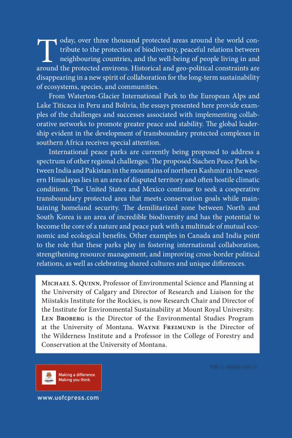
oday, over three thousand protected areas around the world con-tribute to the protection of biodiversity, peaceful relations between neighbouring countries, and the well-being of people living in and
around the protected environs. Historical and geo-political constraints are disappearing in a new spirit of collaboration for the long-term sustainability of ecosystems, species, and communities.
From Waterton-Glacier International Park to the European Alps and Lake Titicaca in Peru and Bolivia, the essays presented here provide exam-ples of the challenges and successes associated with implementing collab-orative networks to promote greater peace and stability. The global leader-ship evident in the development of transboundary protected complexes in southern Africa receives special attention.
International peace parks are currently being proposed to address a spectrum of other regional challenges. The proposed Siachen Peace Park be-tween India and Pakistan in the mountains of northern Kashmir in the west-ern Himalayas lies in an area of disputed territory and often hostile climatic
conditions. The United States and Mexico continue to seek a cooperative transboundary protected area that meets conservation goals while main-taining homeland security. The demilitarized zone between North and South Korea is an area of incredible biodiversity and has the potential to become the core of a nature and peace park with a multitude of mutual eco-nomic and ecological benefits. Other examples in Canada and India point to the role that these parks play in fostering international collaboration, strengthening resource management, and improving cross-border political relations, as well as celebrating shared cultures and unique differences.
www.uofcpress.com
Michael S. Quinn, Professor of Environmental Science and Planning at
the University of Calgary and Director of Research and Liaison for the
Miistakis Institute for the Rockies, is now Research Chair and Director of
the Institute for Environmental Sustainability at Mount Royal University.
Len Broberg is the Director of the Environmental Studies Program
at the University of Montana. Wayne Freimund is the Director of
the Wilderness Institute and a Professor in the College of Forestry and
Conservation at the University of Montana.
T