tude des structures sédimentaires associées à des phénomènes de liquéfaction des sols induits...
12
SURVEY OF LIQUEFACTION STRUCTURES INDUCED BY RECENT MODERATE EARTHQUAKES , , , , , , ETUDE DES STRUCTURES SEDIMENTAIRES ASSOCIEES A DES PHENOMENES DE LIQUÉFACTION DES SOLS INDUITS PAR DEUX ÉVENEMENTS SISMIQUES DE MAGNITUDE MOYENNE Franck A. AUDEMARD* and Feliciano de SANTIS* Abstract In April-May 1989. the eastern coastlands of Falcon State (Northwestern Venezuela) were affected by a seismic swarm of over 2000 weak sha11ow events located on the continental platform. Nevertheless two moderate earthquakes (mb 5.7 and 5.0) occurred during this swarm. panicking inhabitants and producing scarce structural damage but frequent fissures. fractures and wall falls of house masonry in the mesoseismal area. The most relevant geological features observed in the mesoseismal area, as a consequence of these main events, are related to liquefaction of saturated sand-Iayers and are concentrated in the flood plains and delta of the Tocuyo river, located less than 20 km away from the epicentral area. Both shocks triggered liquefaction with ground acceleration values ranging between 0.1 and 0.3 g. The FUNVISIS Earth Sciences Workgroup carried out a prospect-pit survey across these features (sand boils and vent-fractures) to have a better understanding of this phenomenon and to evaluate the liquefaction potential of sand layers in the mesoseismal area. The liquefied material carne to the surface from subsurficial silty-sand layers deposited in fluvio-deltaic environments and located between 0.2 and 4.0 m in depth. The pathways used by liquefied sands correspond to pre-existing crab burrows and soil fractures. Résumé Au cours d'une crise sismique de plus de 2000 événements localisés en mer, non loin de la cóte de Falcon (Vénézuela nord-occidental), des phénomenes de liquéfaction des soIs ont été déclenchés par deux secousses plus importantes atteignant des magnitudes de 5, 7 et 5,0. Dans la zone épicentrale correspondant a ces deux événements majeurs, des effets géologiques spectaculaires ont été observés en surface a la suite de la liquéfaction de niveaux sableux saturés d'eau appartenant aux dépóts alluviaux de la plaine d'inondation et du delta du Río Tocuyo, distants de moins de 20 kilometres des épicentres et a la faveur d'accélérations du terrain comprises entre 0,1 et 0,3 g. Par suite de l'intérct de ces phénomenes de liquéfaction tant sur le plan géologique que sur celui du génie sismique, le Département des Sciences de la Terre appartenant a la Fondation Vénézuélienne de Recherche Sismologique (FUNVISIS) a procédé a l'excavation d'un certain nombre de fosses exploratoires qui ont perrnis de trancher les structures sédimentaires associées aux évidences de surface et ont conduit a mieux comprendre les mécanismes de ce phénomene et évaluer le potentiel de liquéfaction des niveaux sableux. Le matériel liquéfié est remonté en surface par des terriers de crabes et des fractures pré-existantes dans le sol a partir de nivéaux de sables limoneux d' origine fluvio-deltai:que situés entre 0.2 et 4.0 m de profondeur. lntroduction Lócation The studied area is situated in the eastem coastlands of Falcon State, near the Tocuyo river mouth, in Nor- thwestem Venezuela (Fig. 1) which corresponds to an active alluvial plain of very low and flat topography (Audemard et al., 1990). The most relevant vil1ages in the area are: Tocuyo de la Costa, Tucacas and Chichi- riviche (Fig. 1). Very few cases of .1iquefaction linked to earthquakes of magnitude 5 have been reported wor1dwide. Never- the1ess Atkinson et al. (1984) consider M 5 as the 10- west magnitude which contributes to the probability of liquefaction because earthquakes of magnitude less than 5 are not of sufficient duration to cause 1iquefaction. We here confirm Atkinson et al. 's consideration and present evidence of liquefaction caused by moderate shal10w earthquakes (Mb 5.7 and 5.0) 10cated less than 25 km away. Geomorphological and geological setting The area of study is located on the seacoast of a de- veloping alluvial plain, centered on the Boca de Tocuyo village, near the Tocuyo river mouth (Fig. I). Topogra- phically, the area is very flat and decreases progressi- vely in altitude towards the sea. This plain is fed mainly * FUNVISIS. Apdo. Postal 76880. Caracas 1070-A. Venezuela.
Transcript of tude des structures sédimentaires associées à des phénomènes de liquéfaction des sols induits...
SURVEY OF LIQUEFACTION STRUCTURES INDUCED BY RECENTMODERATE EARTHQUAKES
, , , , , ,ETUDE DES STRUCTURES SEDIMENTAIRES ASSOCIEES A DES PHENOMENES DELIQUÉFACTION DES SOLS INDUITS PAR DEUX ÉVENEMENTS SISMIQUES DEMAGNITUDE MOYENNE
Franck A. AUDEMARD* and Feliciano de SANTIS*
Abstract
In April-May 1989. the eastern coastlands of Falcon State (Northwestern Venezuela) were affected by a seismic swarm of over 2000 weaksha11ow events located on the continental platform. Nevertheless two moderate earthquakes (mb 5.7 and 5.0) occurred during this swarm.panicking inhabitants and producing scarce structural damage but frequent fissures. fractures and wall falls of house masonry in the mesoseismalarea. The most relevant geological features observed in the mesoseismal area, as a consequence of these main events, are related to liquefactionof saturated sand-Iayers and are concentrated in the flood plains and delta of the Tocuyo river, located less than 20 km away from the epicentralarea. Both shocks triggered liquefaction with ground acceleration values ranging between 0.1 and 0.3 g. The FUNVISIS Earth Sciences Workgroupcarried out a prospect-pit survey across these features (sand boils and vent-fractures) to have a better understanding of this phenomenon andto evaluate the liquefaction potential of sand layers in the mesoseismal area. The liquefied material carne to the surface from subsurficialsilty-sand layers deposited in fluvio-deltaic environments and located between 0.2 and 4.0 m in depth. The pathways used by liquefied sandscorrespond to pre-existing crab burrows and soil fractures.
Résumé
Au cours d'une crise sismique de plus de 2000 événements localisés en mer, non loin de la cóte de Falcon (Vénézuela nord-occidental), desphénomenes de liquéfaction des soIs ont été déclenchés par deux secousses plus importantes atteignant des magnitudes de 5, 7 et 5,0. Dans lazone épicentrale correspondant a ces deux événements majeurs, des effets géologiques spectaculaires ont été observés en surface a la suite dela liquéfaction de niveaux sableux saturés d'eau appartenant aux dépóts alluviaux de la plaine d'inondation et du delta du Río Tocuyo, distantsde moins de 20 kilometres des épicentres et a la faveur d'accélérations du terrain comprises entre 0,1 et 0,3 g. Par suite de l'intérct de cesphénomenes de liquéfaction tant sur le plan géologique que sur celui du génie sismique, le Département des Sciences de la Terre appartenanta la Fondation Vénézuélienne de Recherche Sismologique (FUNVISIS) a procédé a l'excavation d'un certain nombre de fosses exploratoiresqui ont perrnis de trancher les structures sédimentaires associées aux évidences de surface et ont conduit a mieux comprendre les mécanismesde ce phénomene et évaluer le potentiel de liquéfaction des niveaux sableux. Le matériel liquéfié est remonté en surface par des terriers decrabes et des fractures pré-existantes dans le sol a partir de nivéaux de sables limoneux d' origine fluvio-deltai:que situés entre 0.2 et 4.0 m de
profondeur.
lntroduction Lócation
The studied area is situated in the eastem coastlandsof Falcon State, near the Tocuyo river mouth, in Nor-thwestem Venezuela (Fig. 1) which corresponds to anactive alluvial plain of very low and flat topography(Audemard et al., 1990). The most relevant vil1ages inthe area are: Tocuyo de la Costa, Tucacas and Chichi-riviche (Fig. 1).
Very few cases of .1iquefaction linked to earthquakesof magnitude 5 have been reported wor1dwide. Never-the1ess Atkinson et al. (1984) consider M 5 as the 10-west magnitude which contributes to the probability ofliquefaction because earthquakes of magnitude less than5 are not of sufficient duration to cause 1iquefaction.
We here confirm Atkinson et al. 's consideration andpresent evidence of liquefaction caused by moderateshal10w earthquakes (Mb 5.7 and 5.0) 10cated less than25 km away.
Geomorphological and geological setting
The area of study is located on the seacoast of a de-veloping alluvial plain, centered on the Boca de Tocuyovillage, near the Tocuyo river mouth (Fig. I). Topogra-phically, the area is very flat and decreases progressi-vely in altitude towards the sea. This plain is fed mainly
* FUNVISIS. Apdo. Postal 76880. Caracas 1070-A. Venezuela.
6
68° 30'W 68°00'W
IloOO'N
, ...
IOO3dN!
..
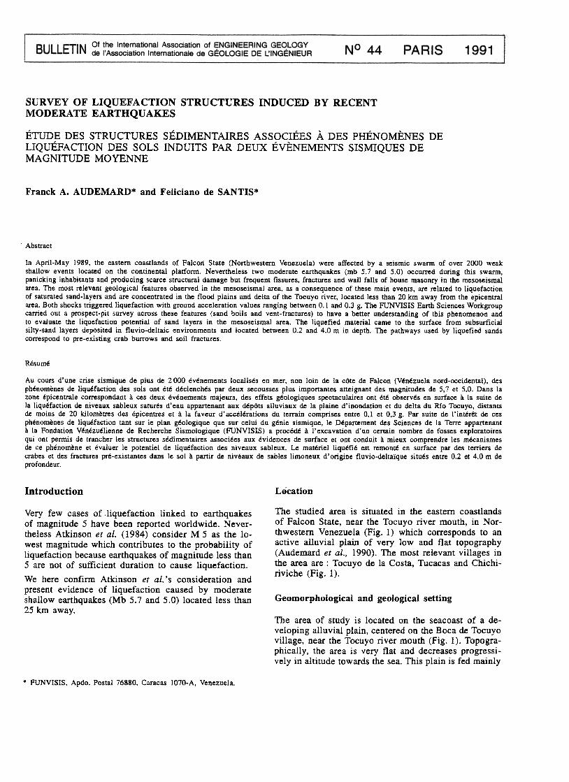
* ..AIN- ~HOCK Ei'ICENTRES O TOWNS WITH DAMAGES .L IOUEFACTION SI TES
...Fig. 1 : Location of liquefaction sites and damaged villages, related to the two main-shock epicentres (modified from Be1tran & De Santis,
1990).
The stratigraphica1 sequences consist of unconsolidatedQuaternary sediments of either alluvia1 or marine ori-gin. The al1uvial co1umn comprises interstratified layersof grey or brown c1ays, si1ts, si1ty sands and sands. Onthe other hand, the marine sediments consist of well-sorted loose sands (Audemard et al., 1990). These del-taic sediments can even be of present age as plasticbags were found buried 1/2 m in depth.
by the Tocuyo river, which is a meandering stream inits lower section. A Miocene reef limestone constitutesthe only sharp relief in the area and limits the plain tothe south. Flat smooth hills developed in Oligo-Mio-cene mudstones are northwest of Tocuyo de la Costa.
This plain is an active feature and its genesis is dueto the interaction of alluvial and marine processes. Be-hind a sand barrier deposited by marine currents, verycomplex alluvial sedimentation takes place. The Tocuyoriver cuts across the sand-barrier forming a small delta.The Boca de Tocuyo village is partially built on thedelta and Tocuyo de la Costa on the t1oodplains of theTocuyo river (Fjg. 2).
Seismological setting
A seismic swarm oí over 2000 events was recorded bythe Funvisis seismological network (Funvisis, 1989) du-

r::::¡SANO-8ARRIER r:-:'! OELTA~ OEPOSITS L..:..J OEPOSITS
D ALLUVIAL
DEPDSITS
~ FLATTENED (-;:::::-., ABANDONED/ LIQUEFACTION ~ SURFACE ,;:::;::;WEANOER ROADS .SI TE
Fig. 2 : Geological map oí actual sedimentar y units near the Tocuyo river mouth. Observe how liquefaction is related to delta deposits andabandoned meanders.
ring the second trimester 89. However the area is stillundergoing decreasing seismic activity. This swarm hasbeen located less than 20 km offshore on the eastemcoast of Fa1con State, on the continental platform (Fun-visis, op. cit. ).
Dtiring this swarm, two shocks of magnitude 5.7 and, .5.0 occurred on April 30th and May 03rd 1989 respec-
tively (Funvisis, op. cit. ). These two sha1low events(Iess than 15 km deep) produced damage in the coastvillages of San Juan de los Cayos; Boca de Tocuyo,Tocuyo de la Costa, Chichiriviche, Tucacas and PuertoCabello (Beltran & De Santis, 1990) (Fig. I). Most ofobserved damage corresponded to fissures or wall fallsof defective house masonry and tilting of houses andwater-tanks (Audemard et al.. 1990. Beltran & De San-tis. 1990) these damages were concentrated in the me-soseismal area (MM Intensity of VII) (Fig. 3). On theotherhand, structural damage was rare. These shockswere felt in almost all northwestem and central Vene-zuela (Fig. 3) : Zulia, Fa1con. Lara, Yaracuy. Portugue-sa, Carabobo, Aragua and Miranda States and FederalDistrict (Funvisis, 1989).
Besides the former damage, field observation revealedspectacular liquefaction features : isolated and a1ignedsandboils, sand vent-fractures and lateral spread of ri-ver levees and beach front in the villages of Boca deMangle, Boca de Tocuyo, Tocuyo de la Costa and Chi-chiriviche (Fig. 1) (Audemard et al., op. cit. ; Beltran& De Santis, op. cit. ).
The instrumental seismicity before 1989 of this areawas moderate and no historica1 seismicity is reportedfor Chichiriviche and its surrounding vil1ages (Lugo,per: com., 1990).
Field observation
Liquefaction has occurred occasiona11y in Venezueladuring this century associated with 1arge historical ear-thquakes (Singer. et al.. 1983) : Río Chivo and Capaya( 10-29-1900). Ciudad Bolívar (05-06-1926). Cumaná(01-17-1929), Barcelona (05-31-1939) and Guigue,Santa María de Ipire and Capaya (07-29-1967). TheGuigue case was interpreted by De Santis et al. ( 1989)many years later. As liquefaction in Venezuela has ne-ver been documented before. we decided, first of a11.

8
66°68°700
12°
100
Fig. 3: Isoseismal map of the two main shocks which occurred in April-May 1989 (Audemard et al.. 1990).
to map thoroughly all superficial liquefaction features :a first survey was carried out during the seismic swarmunder flooded conditions ( due to water expelled duringthe main shocks) (Beltran & De Santis, 1990) andcompleted lO months later during a later survey(Fig. 4 ), and then, to survey the liquefaction sites byprospect pits aiming to establish the liquefied layersand to observe the structures produced and pathwaysused by liquefied sands. In addition data acquisitionwas completed by a boring survey which provided ád-ditional information about the stratigraphical sequenceand some geotechnical parameters obtained from SPT
essays.
Field observation allowed us to identify the followingliquefaction features : isolated sand-boils, aligned sand-boils, vent-fractures and small lateral spread of mean-der borders (Fig.4). On occasion, aligned sand-boilswere so clustered that they became vent fractures.Sandboils were up to 4 m in diameter and up to 0.35 mthick and vent-fractures as long as 30 m (Audemard etaJ., 1990). Aligned sand-boils and vent-fractures sho-wed four preferential orientations : N-S, E- W, N 020-040 and N140-160 (Fig. 4) (Audemard et al.. op. cit. ;Beltran & De Santis, 1990).
Therefore the prospect-pit and boring surveys were cen-tered in those sites (Fig. 4).
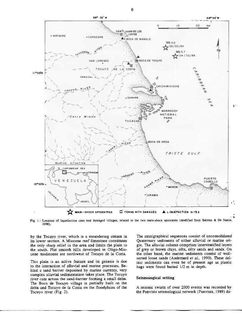
Nineteen prospect pits were excavated and studied.They were 1.5 m deep (when possible) and 1.5 X 1.0m2 in surface area and were distributed as follows :
-Seventeen in the vil1age of Boca de Tocuyo : 1 inthe sand-barrier unit (pit 19) and the rest in the de1taic. .deposits (pits 1 to 16) (Fig. 4 ).
-Two in the vi1lage of Tocuyo de la Costa situatedin an artificia11y-fi1led abandoned meander (pits 17 aná ~
18).
The boring survey. which confirmed the site geologyobserved in the pits, comprised 11 borings placed asfo1lows :
-Seven in Boca de Tocuyo : 5 in the delta sediments(Fig. 4). 1 beside an abandoned meander c1ose to thebridge over the Tocuyo river (Fig. 2) and by the schoolin the sand-barrier unit.
-Four in Tocuyo de la Costa : 3 on the artificia11y-filled meander and 1 by the church, in the flood plain
(Fig. 2).
Geotechnical information was obtained from this boringsurvey which was used by De Santis et al. ( 1990) toevaluate the liquefaction potential of this area.
Evidence of superficial liquefaction were all concen-trated in ihe Tocuyo river delta and along some aban-doned meanders and along the Tocuyo river (Fig. 2).
9
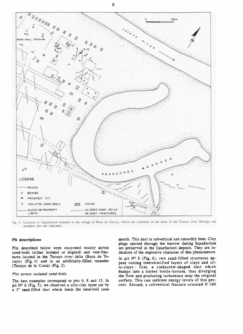
mouth. This duct is subvertical and smoothly bent. Clayplugs ejected through the burrow during liquefactionare preserved in the liquefaction deposit. They are in-dicators of the explosive character of this phenomenon.
In pit N° 8 (Fig. 6), two sand-fil1ed structures ap-pear cutting interstratified layers of clays and sil-ty-clays : first. a corkscrew-shaped duct whichbumps into a buried bottle-bottom, thus divergingthe flow and producing turbulence near the originalsurface. This can indicate energy levels of this pro-cess. Second, a subvertical fracture oriented N 160
Pit descriptions
Pits described below were excavated mainly acrosssand-boils (either isolated or aligned) and vent-frac-tures located in the Tocuyo river delta (Boca de To-cuyo) (Fig. 4) and in an artificially-filled meander(Tocuyo de la Costa) (Fig. 2).
Pits across isolated sand-boils
The best examples correspond to pits 6, 8 and 15. Inpit N° 6 (Fig. 5), w~ observed a silty-clay layer cut bya 3" sand-filled duct which feeds the sand-boil cone

10
LIOU...CTION\,.~0.'T
CONO NOUfN However, in pit N° 15 another situation was observed(Fig. 7) : at the footwall appears a sand-filled fractureplane that connects to a sand-filled crab burrow. Bothstructures combined allowed liquefied-sand flowage upto the surface. Besides, settlement of the west blockoccurred due to void generation as sand flowed up.
A rare example of isolated sand-boil corresponds to PitN° 7 where two converging crab burrows fed the samecone (Fig. 8), producing the largest sand-boil reportedin this area (diameter: 4 m).
N 6LOg
ICLAY PLuGI
~:=====~~'::~~~;.~:.
~
-,-..~ ,
E======
I ~~~~~~
¡:======
-fILL[D DuCT
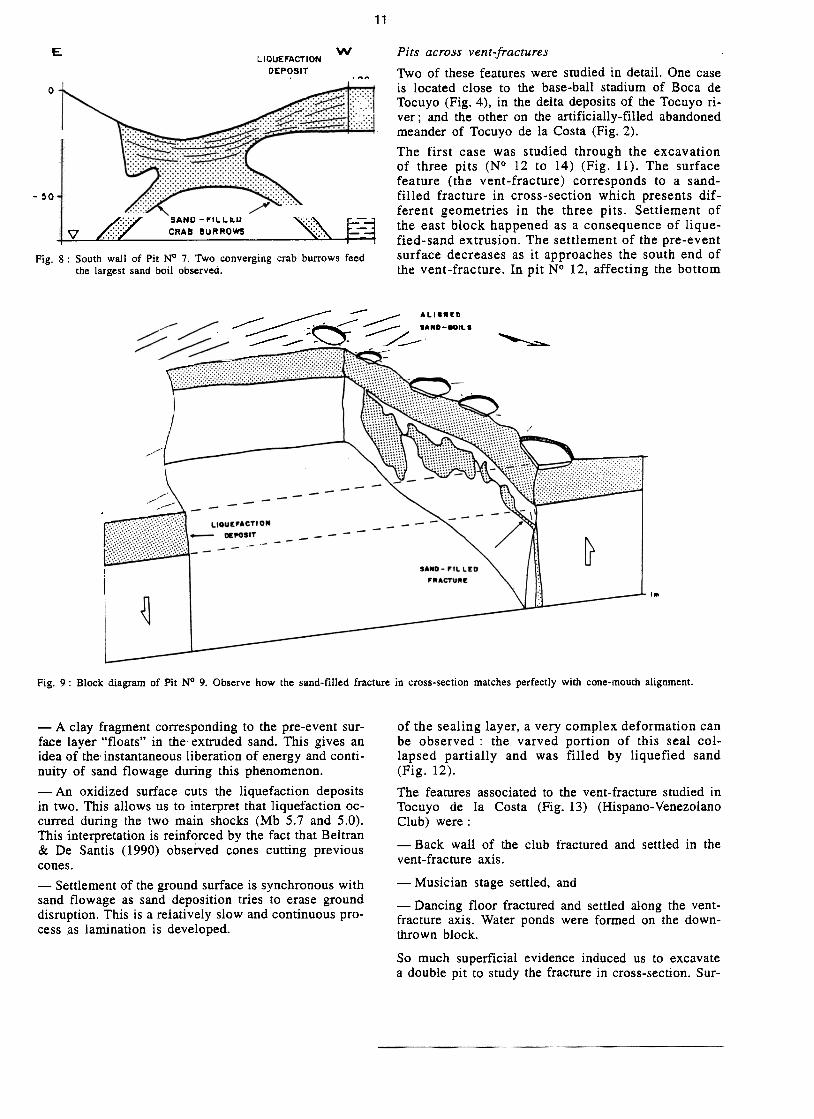
Pits across aligned sand-boils
One of the aligned sand-boils located in the delta ofthe Tocuyo river (Fig. 4, pits N° 9 and 10) was studiedin detail. A double pit was cut parallel to the main axisof the sand-boils (Fig. 9). In figure 9 we can observehow an irregular sand-filled fracture matches precisely , .
..o k -TE~ TA.LE ~.;:':,:::~ ---, L.""" 1.-- .=tca
Fig. 5 : East wall of Pit N° 6. Liquefied-sand used a crab burrow toextrude and deposit on the pre-event surface.
Fig. 6 : South wall of Pit ~ 8. Crab burrow usedby liquefied sand. Bottle bottom interfereswith the upward flowage. producing turbu-lence.
Fig.7: North wall of Pit N° 15. Combi-nation of fracture and crab bur-row allowed extrusion of the
liquefied-sand.
that did not reach the surface. The sand-source layerconstitutes the pit bottom (0.55 m in depth). In bothcases (Pit N° 6 and N° 8), the pathways used byliquefied sands correspond to pre-existing crab bur-rows.
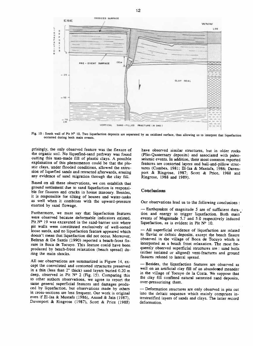
with the alignment of cone mouths on the surface. ButPit N° 10 (Fig. 10) allowed us to make several inter-esting observations :
-The fracture plane filled with liquefied sand cuts thepre-event surface, allowing sand flowage up to the sur-face.
11
wEL IQUEFACTION
DEPOSIT
\
LOG,COLLAPSED
CONE- MOUTH
o
, .o,
Pits across vent-fractures
Two of these features were studied in detail. One caseis located close to the base-ball stadium of Boca deTocuyo (Fig. 4), in the delta deposits of the Tocuyo ri-ver; and the other on the artificially-filled abandonedmeander of Tocuyo de la Costa (Fig. 2).
The first case was studied through the excavationof three pits (N° 12 to 14) (Fig. 11). The surfacefeature (the vent-fracture) corresponds to a sand-filled fracture in cross-section which presents dif-ferent geometries in the three pits. Settlement ofthe east block happened as a consequence of lique-fied-sand extrusion. The settlement of the pre-eventsurface decreases as it approaches the south end ofthe vent-fracture. In pit N° 12, affecting the bottom
~
-~o
SAND-FILLED~CRAB BURROWS
Fig. 8 : South wall of Pit N° 7. Two converging crab burrows feedthe largest sand boil observed.
//",/ '
'4
/'i!/ :/ !
-ALI.W[D~r-<: ::::::::: SA"D-80ILS~ ~ ::: J- / --~ ~
~-- ---~- ~
, / -- .-." .-~ -
--
-.--/ -""' -
, ~--
---
--
~-~
/"/ I
-::.-:::' // /"/
-----
--
lIOU~'aCTION
~POSIT
//
--~!--:::.
~
--------/
~
---
'AND-~'l.l.tD
~~ACTU~t
I~
~
Fig. 9 : Block diagram of Pit N° 9. Observe how the sand-filled fracture in cross-section matches perfectJy with cone-mouth aJignment.
-A clay fragment corresponding to the pre-event sur-face layer "floats" in the extruded sand. This gives anidea of the' instantaneous liberation of energy and conti-nuity of sand flowage during this phenomenon.
-An oxidized surface cuts the liquefaction depositsin tWO. This allows us to interpret that liquefaction OC-curred during the two main shocks (Mb 5.7 and 5.0).This interpretation is reinforced by the fact that Beltran& De Santis (1990) obseÍ:ved cones cutting previouscones.
-Settlement of the ground surface is synchronous withsand flowage as sand deposition tries to erase grounddisruption. This is a relatively slow and continuous pro-cess as lamination is developed.
of the sealing layer, a very complex deformation canbe observed : the varved portion of this seal col-lapsed partially and was fil1ed by liquefied sand(Fig. 12).
The features associated to the vent-fracture studied inTocuyo de la Costa (Fig. 13) (Hispano-VenezolanoClub) were :
-Back wall of the club fractured and settled in thevent-fracture axis.
-Musician stage settled, and
-Dancing floor fractured and settled along the vent-fracture axis. Water ponds were formed on the down-thrown block.
So much superficial evidence induced us to excavatea double pit to study the fracture in cross-section. Sur-
12
have observed similar structures. but in older rocks(Plio-Quaternary deposits) and associated with paleo-seismic events. In addition. their most common reportedfeatures are contorted layers and ball-and-pillow struc-tures (Combes. 1981; El-Isa & Mustafa. 1986; Daven-P°rt & Ringrose, 1987; Scott & Price. 1988 andRingrose, 1988 and 1989).
Conclusions
prisingly, the only observed feature was the flexure ofthe organic soil. No liquefied-sand pathway was foundcutting this man-made fill of plastic clays. A possibleexplanation of this phenomenon could be that the pla-stic clays, under flooded conditions, allowed the extru-sion of liquefied sands and retracted afterwards, erasingany evideDce of sand migration through the clay fill.
Based on a11 these observations. we can establish thatground settlement due to sand liquefaction is responsi-ble for fissures and cracks in house masonry. Besides,it is responsible for tilting of houses and water-tanksas well when it combines with the upward-pressureexerted by sand flowage.
Furthermore, we must say that liquefaction featureswere observed because deformable indicators existerl.Pit N° 19 was excavated in the sand-barrier unit wherepit walls were constituted exclusively of well-sortedloose sands, and no liquefaction feature appeared whichdoesn .t mean that liquefaction did not occur. Moreover.Beltran & De Santis (1990) reported a beach-front fis-sure in Boca de Tocuyo. This feature could have beenproduced by beach-front relaxation (beach spread) du-ring the main shocks.
All our observations are summarized in Figure 14. ex-cept the convoluted and contorted structures preservedin a thin (less than 2" thick) sand layers buried 0.20 mdeep, observed in Pit N° 2 (Fig. 15). Comparing thisto other authors observations, we agree to report thesame general superficial features and damages produ-ced by liquefaction. but observations made by othersin cross-sections are less frequent. Our work is originaleven if E1-Isa & Mustafa (1986), Anand & Jain (1987),Davenport & Ringrose ( 1987). Scott & Price ( 1988)
Our observations lead us to the following conclusions :
-Earthquakes of magnitude 5 are of sufficient dura-tion and energy to trigger liquefaction. Both main.events of Magnitude 5.7 and 5.0 respectively inducedliquefaction. as is evident in Pit N° 10.
-AII superficial evidence of liquefaction are relatedto fluvial or deltaic deposits, except the beach fissureobserved in the village of Boca de Tocuyo which isinterpreted as a beach front relaxation. The most fre-quently observed superficial structures are: sand boils(either isolated or aligned) vent-fractures and groundfissures related to lateral spread.
-Besides. the liquefaction features are observed aswell on an artificial clay fill of an abando*d meanderin the village of Tocuyo de la Costa. We suppose thatthe clay fill confined natural saturated sand deposits.over-pressurizing them.
-DefoI11lation structures are only observed in pits cutinto the deltaic sequence which mainly comprises in-terstratified layers of sands and clays. The latter recorddefoI11lation.

13
¡--1 FRACTU RE FOLLOWS"-- I TO THE NORTH
1-WNW PIT N2 13 ESE
o
-2~
-~o ~
-7~..J
~ ~ ~ :
--~ ,"--<.I"'--~ ~
"'
LIOUEFACTION DEPOSIT
EPIT N~ 14w
o
-2~-
~O-
-7~-
~!~~w PIT Ni 12 E
o
-2~ CLAY SEAL
-50
SOUTH END OF THE FRACTURE
Fig. II: The vent fracture located east of the baseball stadium of Boca de Tocuyo was studicd by the excavation of three pits. Gcomctrics arediffcrent but thc scttlement of the eastern bjock is consistent.

14
V[NT-..~ACTU~[LIOUf:..ACTION Df:~OSIT
".
w E~
LOG
o
CLAY SIAL-2~
-~o
I::: ; : : : : :
.1l ',',', , ,
r:"',,','-7~cm t
COLLA~S! O, VARVEO LAYER
Fig. 12: North wa11 of Pit N° 12. Void generation produced by the extrusion of liquefied sands induced the collapse of the bottom of thevarved layer.
(0:.:0:0;0
"'.
"'
,VENT-FRACTURE /'
AXIS ,Fig. 13 Location oí Pit N° 18 related lO deformed fealures in the Hispano- Venezolano Club of Tocuyo de la Costa.

15
VENT-FRACTURE
~ \\ I' / .-/
.:;;;;; ...1- 'I TED SAND-80IL~.-.::. , / ,
--1-\//1'- -/ I\1-/>\-\ \ ...
,/",1/, 1 ALIGNED/,/\ /, 1 ,/>.- SAND-80ILS
/-\ ,7 \-,/ 1 \/,-:, I /'-! 1 : .
I '"-/ ..-t / 1 !-, 4/ I ' /"1-/-C
c'\/ 1-/ / I
, /
;.:;, I I
LIQUEFIEDSANO OEPOSITS
\
---::r
)'~-..'II~:.~ .-
Á,'\ ~ y WATER TABLE
~
-SOURCE
LAYER
SLIGHTLY
SETTLED BLOCK
E""SAND DlKE
~
~SAND-f"'LLED
NARROWER BURROWS
//
SAND- FILLED
CRAB BURROW
"" CRAB BURROW PARTIALLY
USED BY LIQUEFIED-SANDCLAY-PWG
I/
/
SAND-FIL1.ED FRACTURESANO OIKE
Fig. 14 : Block diagram showing cross-section and superficial features associated with liqueíaction in the delta oí the Tocuyo river. (Audemard
et al.. 1990).
sN -The sand-source layers between 0.20 and 4 m indepth are commonly constituted of grey loose silty-sands. These layers are commonly well saturated as thewater table frequently stands between 0.6 and 0.75 m
deép.
-The pathways used by liquefied sands are pre-exis-ting crab burrows (Pit N° 6 and 8), ground fractures(Pit N° 12 to 14) and the combination of both featurespreviously mentioned (Pit N° 15).
Superficial features are closely related to cross-sectionstructures : isolated sand-boils to crab burrows ; alignedsand-boils and vent-fractures to ground fractures.
Recommendations
-For those who are involved in minimizing seismicrisk, this experience and these observations could beof relevant geotechnical interest if liquefaction is consi-dered as an important factor of seismic hazard in areaswith site conditions similar to those observed in thecoastlands of the eastem Falcon State.Fig. 15 : Contorted sand layer observed in east wall of Pit N° 2.
'f
16
-Comparing pit-wall liquefaction features to faultedoutcrops, some similarities exist. Therefore, neotecto-nics workers should avoid confusing these deformedstructures with others which are similar but are gene-rated by mechanisms so different.
Acknowledgements
Data for this paper were produced by the Funvisis Earth SciencesWorkgroup under contract to /NTEVEP. Permission to publish thismaterial is gratefully acknowledged by the authors. Jean-ClaudeBousquet prompted the authors to write this papel: André Singer ofFunvisis and Antonio Casas Sainz of University of Zaragoza -Spaingave a rigorous review to an earlier draft and helped to improve itgreatly. Our thanks to Yris Pane for typing and Marina Peña for
drafting.
References
COMBES. P.. 1981 : Néotectonique de la Basse Vallée de I'Hérault(Rive droite) et de la faille des Cévennes. D.E.A., U.S.7:L. Mont-
pellie1:
DAVENPORT. C. & RINGROSE, S.. 1987: Deformation of ScottishQuaternary sediments sequences by strong earthquake motions. InDeformation of Sediments and Sedimentary Rocks. ed : JONES &PRESTON. Geol. Soc. of London.. Sp. Publ. ; 29: 299-314.
DE SANTIS, F., SINGER, A. & AUDEMARD. Fr., 1989: .'Mani-festaciones de "Lateral Spread" en el delta lacustre de Guique,costa sur del Lago de Valencia, durante el terremoto de Caracasdel 29-07-1967". Mem. VII Gong. Geol. Venezolano. Bqto. ; 3 :1123-1136.
DE SANTIS. F. et al.. 1990: Los sismos de Abril y Mayo de 1989.Evidencias de licuación. XI Sem. Venezolano de Geotecnia,SVMSIF. (In print).
EL-ISA. Z. & MUSTAFA, H., 1986: Earthquake deformations in theLisan deposits and seismotectonic implications. Geophys. J.R.astl: Soc. ; 86: 413-424.
FUNVISIS, 1989 : Bolet(n Sismol6gico de Venezuela. Dpto. de Sis:\mología. 6 (2) : 1-60.
LUGO. M., 1990 : Personal communication. FUNVISIS. ,RINGROSE, P.. 1988 : Palaeoseismic (?) liquefaction event in late ~
Quaternary lake sediment at Glen Roy, Scotland. Terra Research.I: 57-62.
RINGROSE, P.. 1989 : Illustrations of a liquefied sediment body atMeikleour. East Scot1and. Bullo. INQUA N.G. ; 12: 9-13.
SCOTT, B. & PRICE, S.. 1988: Earthquake-induced structures inyoung sediments. Tectonophysics. 147: 165-170.
SINGER. A., ROJAS, C. & LUGO. M.. 1983: Inventario Nacionalde riesgos geol6gicos ( estudio preliminar). Dpto. de Ciencias dela Tierra, FUNVISIS, Serie Técnica 03-83. 126 p.
ANAND. A. & JAIN. A.. 1987 : Earthquake and deformational struc-tures (seismites) in Holocene sediments from the Himalayan-San-daman Arc. India. Teclonophysics; 133: 105-120.
ATKINSON. o. el al., 1984: Simple Computation of LiquefactionProbability for seismic Hazard Applications. Earthquake Speclra ;I (1) : 107-123.
AUDEMARD. Fr. et al., 1990 : Liquefaction of the eastem coastlandsof Falcon State (Northwestem Venezuela). induced by moderateshallow earthquakes. Bull. INQUA N.C. ; 13: 47-50.
BELTRAN. C. & DE SANTIS. F., 1990: Manifestaciones de licua-ción en Falcón oriental. a consecuencia de los sismos de los mesesde abril y mayo de 1989. Funvisis. Informe interno, 34 pp.
, ,-