Tsunami Deposits beneath Tidal Marshes on Northwestern Vancouver Island, British Columbia
13
QUATERNARY RESEARCH 48, 192–204 (1997) ARTICLE NO. QR971911 Tsunami Deposits beneath Tidal Marshes on Northwestern Vancouver Island, British Columbia Boyd E. Benson 1 Earth and Ocean Sciences, University of British Columbia, 6339 Stores Road, Vancouver, British Columbia V6T 1Z4, Canada Kurt A. Grimm 2 Earth and Ocean Sciences, University of British Columbia, 6339 Stores Road, Vancouver, British Columbia V6T 1Z4, Canada and John J. Clague 3 Geological Survey of Canada, 101-605 Robson Street, Vancouver, British Columbia V6B 5J3, Canada Received September 24, 1996 plate boundary that is storing elastic strain to be released in Two sand sheets underlying tidal marshes at Fair Harbour, Ner- a future earthquake, as is happening at subduction zones off outsos Inlet, and Koprino Harbour on the northwestern coast of Chile and Alaska (Heaton and Hartzell, 1986). Geophysical Vancouver Island, British Columbia, were probably deposited by models and geodetic measurements (Heaton and Hartzell, tsunamis. The sand sheets become thinner and finer-grained land- 1987; Rogers, 1988; Savage et al., 1991; Hyndman and Wang, ward, drape former land surfaces, contain marine microfossils, are 1993, 1995; Dragert et al., 1994) suggest that strain now locally graded or internally stratified, and can be correlated with accumulating on this 1000-km-long plate boundary may be earthquakes that generated tsunamis in the region. 137 Cs dating released either in a series of great, magnitude-8 earthquakes and historical accounts indicate that the upper sand sheet was or a single giant, magnitude-9 earthquake. deposited by the tsunami from the great Alaska earthquake in 1964. Radiocarbon ages on plant fossils within and on top of the In the late 1980s and early 1990s researchers identified lower sand sheet show that it was deposited sometime after about in coastal wetlands three types of geologic evidence best A.D. 1660. We attribute the lower sand sheet to a tsunami from explained by earthquakes at the Cascadia subduction zone the most recent plate-boundary earthquake on the Cascadia sub- (Atwater et al., 1995, and references therein): (1) buried soils duction zone about 300 yr ago, extending the documented effects of that were submerged suddenly, consistent with coseismic this earthquake north of the Nootka fault zone. The 1964 tsunami subsidence; (2) sand sheets, interpreted to be tsunami depos- deposits differ little in thickness and continuity among the three its, which overlie buried soils, thin and fine landward, and marshes. In contrast, the lower sand sheet becomes thinner and contain marine microfossils; and (3) intruded and extruded less continuous to the north, implying a tsunami source south of sand bodies produced by liquefaction resulting from intense the study area. q 1997 University of Washington. ground shaking. Studies of this geologic evidence have shown that intervals between successive earthquakes range from less than a few centuries to perhaps more than 1000 INTRODUCTION yr (Atwater et al., 1995; Atwater and Hemphill-Haley, in press). The most recent earthquake or series of earthquakes There are no written accounts of earthquakes along the occurred between about A.D. 1700 and 1720 (Atwater and offshore boundary between the North America plate and sub- Yamaguchi, 1991; Nelson et al., 1995), probably in January ducting Juan de Fuca and Gorda plates (Cascadia subduction 1700 (Satake et al., 1996). zone, Fig. 1). The lack of historical seismicity has been attrib- The purpose of this paper is to characterize tsunami depos- uted to aseismic creep (Ando and Balazs, 1979) or to a locked its in Holocene peat at tidal marshes on northwestern Van- couver Island, British Columbia. We studied the architecture, 1 Now at GeoEngineers, 8410 154th Avenue N.E., Redmond, WA, 98052. stratigraphy, and sedimentology of two sand sheets at Fair Fax: (206) 861-6050. E-mail: [email protected]. Harbour, Neroutsos Inlet, and Koprino Harbour (Fig. 1) to 2 Fax: (604) 822-6088. E-mail: [email protected]. 3 E-mail: [email protected]. understand their deposition, preservation, identifying charac- 192 0033-5894/97 $25.00 Copyright q 1997 by the University of Washington. All rights of reproduction in any form reserved. AID QR 1911 / a60d$$$$$1 09-24-97 15:41:13 qral AP: QR
Transcript of Tsunami Deposits beneath Tidal Marshes on Northwestern Vancouver Island, British Columbia

QUATERNARY RESEARCH 48, 192–204 (1997)ARTICLE NO. QR971911
Tsunami Deposits beneath Tidal Marshes on NorthwesternVancouver Island, British Columbia
Boyd E. Benson1
Earth and Ocean Sciences, University of British Columbia, 6339 Stores Road, Vancouver, British Columbia V6T 1Z4, Canada
Kurt A. Grimm2
Earth and Ocean Sciences, University of British Columbia, 6339 Stores Road, Vancouver, British Columbia V6T 1Z4, Canada
and
John J. Clague3
Geological Survey of Canada, 101-605 Robson Street, Vancouver, British Columbia V6B 5J3, Canada
Received September 24, 1996
plate boundary that is storing elastic strain to be released inTwo sand sheets underlying tidal marshes at Fair Harbour, Ner- a future earthquake, as is happening at subduction zones off
outsos Inlet, and Koprino Harbour on the northwestern coast of Chile and Alaska (Heaton and Hartzell, 1986). GeophysicalVancouver Island, British Columbia, were probably deposited by models and geodetic measurements (Heaton and Hartzell,tsunamis. The sand sheets become thinner and finer-grained land- 1987; Rogers, 1988; Savage et al., 1991; Hyndman and Wang,ward, drape former land surfaces, contain marine microfossils, are
1993, 1995; Dragert et al., 1994) suggest that strain nowlocally graded or internally stratified, and can be correlated withaccumulating on this 1000-km-long plate boundary may beearthquakes that generated tsunamis in the region. 137Cs datingreleased either in a series of great, magnitude-8 earthquakesand historical accounts indicate that the upper sand sheet wasor a single giant, magnitude-9 earthquake.deposited by the tsunami from the great Alaska earthquake in
1964. Radiocarbon ages on plant fossils within and on top of the In the late 1980s and early 1990s researchers identifiedlower sand sheet show that it was deposited sometime after about in coastal wetlands three types of geologic evidence bestA.D. 1660. We attribute the lower sand sheet to a tsunami from explained by earthquakes at the Cascadia subduction zonethe most recent plate-boundary earthquake on the Cascadia sub- (Atwater et al., 1995, and references therein): (1) buried soilsduction zone about 300 yr ago, extending the documented effects of that were submerged suddenly, consistent with coseismicthis earthquake north of the Nootka fault zone. The 1964 tsunami
subsidence; (2) sand sheets, interpreted to be tsunami depos-deposits differ little in thickness and continuity among the threeits, which overlie buried soils, thin and fine landward, andmarshes. In contrast, the lower sand sheet becomes thinner andcontain marine microfossils; and (3) intruded and extrudedless continuous to the north, implying a tsunami source south ofsand bodies produced by liquefaction resulting from intensethe study area. q 1997 University of Washington.
ground shaking. Studies of this geologic evidence haveshown that intervals between successive earthquakes rangefrom less than a few centuries to perhaps more than 1000INTRODUCTIONyr (Atwater et al., 1995; Atwater and Hemphill-Haley, inpress). The most recent earthquake or series of earthquakesThere are no written accounts of earthquakes along theoccurred between about A.D. 1700 and 1720 (Atwater andoffshore boundary between the North America plate and sub-Yamaguchi, 1991; Nelson et al., 1995), probably in Januaryducting Juan de Fuca and Gorda plates (Cascadia subduction1700 (Satake et al., 1996).zone, Fig. 1). The lack of historical seismicity has been attrib-
The purpose of this paper is to characterize tsunami depos-uted to aseismic creep (Ando and Balazs, 1979) or to a lockedits in Holocene peat at tidal marshes on northwestern Van-couver Island, British Columbia. We studied the architecture,
1 Now at GeoEngineers, 8410 154th Avenue N.E., Redmond, WA, 98052. stratigraphy, and sedimentology of two sand sheets at FairFax: (206) 861-6050. E-mail: [email protected].
Harbour, Neroutsos Inlet, and Koprino Harbour (Fig. 1) to2 Fax: (604) 822-6088. E-mail: [email protected] E-mail: [email protected]. understand their deposition, preservation, identifying charac-
1920033-5894/97 $25.00Copyright q 1997 by the University of Washington.All rights of reproduction in any form reserved.
AID QR 1911 / a60d$$$$$1 09-24-97 15:41:13 qral AP: QR

193TSUNAMI DEPOSITS IN BRITISH COLUMBIA
FIG. 1. (a) Lithospheric plates and the seaward edge of the Cascadia subduction zone (study area outlined in box). (b) Study area; solid circles arestudy sites.
teristics, and paleoseismic significance. The two sand sheets Hutchinson, 1993; Clague and Bobrowsky, 1994a). Thissand and gravel may have been deposited during a transgres-are similar in age, stratigraphic position, and morphology to
tsunami deposits farther south that have been attributed to sion about 6000 to 7000 yr ago and then reworked duringa late Holocene regression. The marshes, characterized bythe 1964 Alaska earthquake and to the last great earthquake
on the Cascadia subduction zone about 300 yr ago. salt-tolerant plants, are situated within the upper half of theintertidal zone between unvegetated tidal flats and supratidalgrass and forest. The mean tide range at the three study sitesSETTINGis about 2.9 m, and the maximum range is 4.5 m (Fisheriesand Oceans, 1995).The study area is situated at the north end of the Cascadia
subduction zone, a 1000-km-long area of plate convergenceMETHODSand subduction (Fig. 1). The Nootka fault zone, just south of
the study area, may mark the northern limit of the Cascadiasubduction zone (Rohr and Furlong, 1995). The small Ex- We studied sediments at the aforementioned marshes in
channel-bank outcrops, pits, and cores. Gridded transectsplorer plate, which is separated from the Juan de Fuca plateby the Nootka fault, is probably a broad deformational zone with data points 5 m apart were installed by tape and Brunton
compass in areas of minimal fluvial influence. The elevationwhere convergence on the Cascadia subduction zone to thesouth changes into strike-slip motion along the North of each grid point, relative to a temporary benchmark, was
measured with an automatic leveling instrument or a handAmerica–Pacific plate boundary to the north (Rohr and Fur-long, 1995). The subducting Juan de Fuca plate, south of the level. Benchmarks were linked to high tide levels which
were determined from regional tide gauge data correctedNootka fault, is currently locked against the overriding NorthAmerica plate (Dragert et al., 1994; Hyndman and Wang, for local differences in time and magnitude (Fisheries and
Oceans, 1995). Depths of stratigraphic contacts, sediment1995). Evidence for locking and for the buildup of strain atthe plate boundary includes geodetic measurements that reveal types, colors, and textures were recorded at each grid point
from continuous cores retrieved with a 2.5-cm-diameteruplift and crustal shortening in coastal British Columbia andWashington (Savage et al., 1991; Dragert et al., 1994). gouge corer. Stratigraphic cross sections and three-dimen-
sional fence diagrams were constructed from these data.Tidal marshes at Fair Harbour, Neroutsos Inlet, and Ko-prino Harbour were chosen for study because they are exten- Block samples of the sand sheets and enclosing peat were
collected for laboratory study of sedimentology, internalsive, easily accessible, and north of the area previouslyshown to have been affected by earthquakes on the Cascadia stratigraphy, and microfossils. Samples of sand were col-
lected from the two sand sheets at each grid point at the Fairsubduction zone. The three marshes are underlain by about1 m of peat containing two unique sand sheets. This peat Harbour marsh for grain-size analysis. Particle-size trends
in the sand-sized fraction were determined with a semiauto-is underlain by Pleistocene glaciomarine clayey silt or byHolocene sand and gravel deposits similar to those found matic visual settling tube (Inter-Agency Committee on Wa-
ter Resources, 1958).elsewhere on the coast of Vancouver Island (Friele and
AID QR 1911 / a60d$$$$$2 09-24-97 15:41:13 qral AP: QR

194 BENSON, GRIMM, AND CLAGUE
FIG. 2. (a) View north–northwest across Fair Harbour marsh; study site in the foreground. Bridges (B) were rebuilt after their destruction by the1964 Alaska tsunami. (b) Bank of tidal channel at Fair Harbour; scale Å 30 cm.
Fossil plant material for radiocarbon dating, including farther south on Vancouver Island described by Clague andBobrowsky (1994b).sticks, conifer cones, bark, and leaf bases of growth-position
herbaceous plants, was retrieved from near and within the Both sand sheets at each marsh become thinner and finer-grained landward and blanket paleosurfaces with relief likelower sand sheet and at the base of the peat sequence. Eight
samples were radiocarbon dated at IsoTrace Laboratory, the that of the present-day marshes. Each sheet is commonly nomore than 2 cm thick and consists of moderately sorted siltGeological Survey of Canada Radiocarbon Laboratory, and
the Quaternary Isotope Laboratory of the University of and very fine to very coarse sand composed of quartz, feld-spar, and lithic fragments. The sand also contains sticks,Washington. Calendric ages were calculated from the radio-
carbon ages using the decadal tree-ring dataset of Stuiver cones, bark, sparse shell fragments, foraminifera, and dia-toms. In grain size and lithology the sand resembles adjacentand Becker (1993).
Ten samples from the upper 24 cm of the peat sequence tidal-channel sediments.The sand sheets range from massive through normallyat Fair Harbour were analyzed for 137Cs using an X-ray
spectrometer at the Pacific Geoscience Centre (Geological graded to internally stratified. Locally, they consist of twoor three couplets of sand and mud. Each sand–mud coupletSurvey of Canada). The samples provided coverage from
the marsh surface to a depth of 12 cm below the upper sand. comprises a layer of normally graded, sharply based, fine tocoarse sand abruptly overlain by a layer of sandy mud.
STRATIGRAPHY AND SEDIMENTOLOGYFair Harbour
Fair Harbour, the southernmost of the three study sites,Two thin, stratigraphically unique sand sheets occur insimilar peat sequences at the Fair Harbour, Neroutsos Inlet, is located 30 km north of the Nootka fault zone. The 30-ha
marsh at the east end of Fair Harbour (Figs. 2a and 3a) isand Koprino Harbour marshes. The sand sheets are similarto seismogenic tsunami deposits at Port Alberni and Tofino protected from the open ocean, 20 km away, by numerous
AID QR 1911 / a60d$$$$$2 09-24-97 15:41:13 qral AP: QR

195TSUNAMI DEPOSITS IN BRITISH COLUMBIA
FIG. 2—Continued
islands and a narrow inlet. The tsunami from the great Alaska where it grades down into a peaty mud; the peaty mud, inturn, overlies up to at least 3 m of sand and gravel of probableearthquake of March 27, 1964 destroyed two bridges that
crossed the marsh and moved buildings at a nearby logging intertidal origin (Fig. 2b). The sand and gravel overlie athick sequence of clayey silt (AGRA Earth and Environmen-camp (Glen Griffiths, B.C. Ministry of Forests, personal
communication, 1995). tal Group, 1993), probably a glaciomarine deposit.The two sand sheets thin and fine landward and awayWe made 215 borings in a 50 1 90-m grid in the tidally
dominated, southeastern part of the marsh, far from fluvial from tidal channels. Fair Harbour Mainline transect (Fig. 4)is interrupted by two 15-m-wide tidal channels. Sediment isinfluences to the north and open water to the west (Figs. 2a
and 3a). The marsh in this area is underlain by about 1 m coarsest adjacent to both channels and fines away from them(Fig. 5). The sand sheets also thin inland away from theseof peat that contains the sand sheets (Fig. 4). The peat is
uniform in texture and color to within 20 cm of its base, channels and pinch out near the forest edge. Similar trends
AID QR 1911 / a60d$$$$$3 09-24-97 15:41:13 qral AP: QR

FIG. 3. (a) Fair Harbour marsh; study site outlined in white box. Bridges (B) near the seaward edge of the marsh were rebuilt after being destroyedby the 1964 Alaska tsunami (see also Fig. 2a). Province of British Columbia airphoto BC87033-195. (b) Neroutsos Inlet marsh; white square with anasterisk indicates the study site. The upper sand sheet extends into forest near the site of a cabin (C) that was destroyed by the 1964 Alaska tsunami.Province of British Columbia airphoto BC80092-37. (c) Koprino Harbour marsh, showing locations of transects. The stratigraphy along the transectparallel to the axial channel is shown in Figure 8. Province of British Columbia airphoto BC80092-190.
AID QR 1911 / a60d$$1911 09-24-97 15:41:13 qral AP: QR

197TSUNAMI DEPOSITS IN BRITISH COLUMBIA
FIG. 3—Continued
were seen elsewhere at Fair Harbour and in outcrops at are entombed in the sand. The lower sand sheet rises topo-graphically 1.4 m from the open marsh to the forest edge.Neroutsos Inlet and Koprino Harbour.
The lower sand sheet consists of fine to very coarse sand; Diatoms in the peat directly above and below the lowersand sheet are typical middle marsh species (Ian Hutchinson,some gravel is present near the banks of tidal channels facing
open water. The sand sheet averages 1.5 to 2.5 cm in thick- written communication, 1996). However, the sand itself con-tains marine diatoms that are absent on the modern marsh,ness, but is locally up to 10 cm thick. It is commonly 60 to
70 cm below the marsh surface. Though typically massive including Navicula marina (Ian Hutchinson, written commu-nication, 1996). The presence of marine diatoms in the sandor normally graded, the lower sand sheet locally comprises
up to three couplets of basal clean coarse to fine sand over- indicates landward transport of the sand from the sea (Hem-phill-Haley, 1996).lain by muddy fine sand and silt (Fig. 6). Sticks, conifer
cones, and bark are common in the sand. Leaf bases of marsh The upper sand sheet is composed of fine to mediumsand. It averages 0.5 to 1 cm thick, has a maximum thick-plants that had been growing prior to sand sheet deposition
FIG. 4. Fair Harbour marsh stratigraphy. The peat contains two sand sheets. See Figure 3a for location of Mainline (ML) transect. Vertical datumis lower low water.
AID QR 1911 / a60d$$$$$3 09-24-97 15:41:13 qral AP: QR

198 BENSON, GRIMM, AND CLAGUE
FIG. 5. Particle-size trends in the sand-size fraction of the lower sand sheet along two Fair Harbour transects (see Fig. 4 for location). The sandsheet fines away from tidal channels, which are probably the primary sediment source.
FIG. 6. Couplets in the lower sand sheet at Fair Harbour. Each couplet is composed of a coarse basal layer and an overlying finer layer; the twocoarse basal layers in this sample are bracketed by pins. Each couplet may record a separate surge of water in a tsunami wave train.
AID QR 1911 / a60d$$1911 09-24-97 15:41:13 qral AP: QR
199TSUNAMI DEPOSITS IN BRITISH COLUMBIA
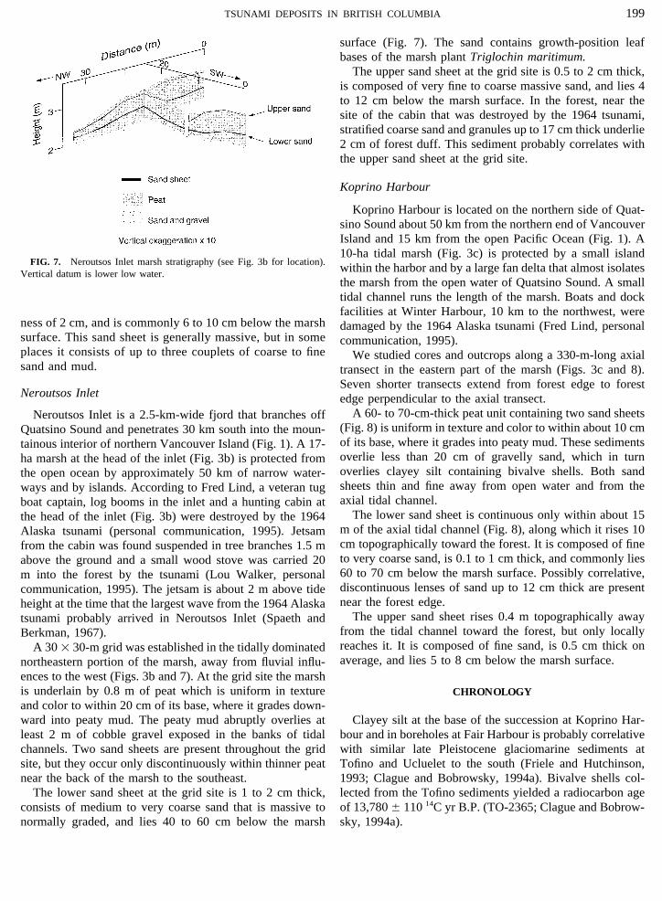
surface (Fig. 7). The sand contains growth-position leafbases of the marsh plant Triglochin maritimum.
The upper sand sheet at the grid site is 0.5 to 2 cm thick,is composed of very fine to coarse massive sand, and lies 4to 12 cm below the marsh surface. In the forest, near thesite of the cabin that was destroyed by the 1964 tsunami,stratified coarse sand and granules up to 17 cm thick underlie2 cm of forest duff. This sediment probably correlates withthe upper sand sheet at the grid site.
Koprino Harbour
Koprino Harbour is located on the northern side of Quat-sino Sound about 50 km from the northern end of VancouverIsland and 15 km from the open Pacific Ocean (Fig. 1). A10-ha tidal marsh (Fig. 3c) is protected by a small island
FIG. 7. Neroutsos Inlet marsh stratigraphy (see Fig. 3b for location). within the harbor and by a large fan delta that almost isolatesVertical datum is lower low water.the marsh from the open water of Quatsino Sound. A smalltidal channel runs the length of the marsh. Boats and dockfacilities at Winter Harbour, 10 km to the northwest, were
ness of 2 cm, and is commonly 6 to 10 cm below the marsh damaged by the 1964 Alaska tsunami (Fred Lind, personalsurface. This sand sheet is generally massive, but in some communication, 1995).places it consists of up to three couplets of coarse to fine We studied cores and outcrops along a 330-m-long axialsand and mud. transect in the eastern part of the marsh (Figs. 3c and 8).
Seven shorter transects extend from forest edge to forestNeroutsos Inlet edge perpendicular to the axial transect.
A 60- to 70-cm-thick peat unit containing two sand sheetsNeroutsos Inlet is a 2.5-km-wide fjord that branches off(Fig. 8) is uniform in texture and color to within about 10 cmQuatsino Sound and penetrates 30 km south into the moun-of its base, where it grades into peaty mud. These sedimentstainous interior of northern Vancouver Island (Fig. 1). A 17-overlie less than 20 cm of gravelly sand, which in turnha marsh at the head of the inlet (Fig. 3b) is protected fromoverlies clayey silt containing bivalve shells. Both sandthe open ocean by approximately 50 km of narrow water-sheets thin and fine away from open water and from theways and by islands. According to Fred Lind, a veteran tugaxial tidal channel.boat captain, log booms in the inlet and a hunting cabin at
The lower sand sheet is continuous only within about 15the head of the inlet (Fig. 3b) were destroyed by the 1964m of the axial tidal channel (Fig. 8), along which it rises 10Alaska tsunami (personal communication, 1995). Jetsamcm topographically toward the forest. It is composed of finefrom the cabin was found suspended in tree branches 1.5 mto very coarse sand, is 0.1 to 1 cm thick, and commonly liesabove the ground and a small wood stove was carried 2060 to 70 cm below the marsh surface. Possibly correlative,m into the forest by the tsunami (Lou Walker, personaldiscontinuous lenses of sand up to 12 cm thick are presentcommunication, 1995). The jetsam is about 2 m above tidenear the forest edge.height at the time that the largest wave from the 1964 Alaska
The upper sand sheet rises 0.4 m topographically awaytsunami probably arrived in Neroutsos Inlet (Spaeth andfrom the tidal channel toward the forest, but only locallyBerkman, 1967).reaches it. It is composed of fine sand, is 0.5 cm thick onA 30 1 30-m grid was established in the tidally dominatedaverage, and lies 5 to 8 cm below the marsh surface.northeastern portion of the marsh, away from fluvial influ-
ences to the west (Figs. 3b and 7). At the grid site the marshis underlain by 0.8 m of peat which is uniform in texture CHRONOLOGYand color to within 20 cm of its base, where it grades down-ward into peaty mud. The peaty mud abruptly overlies at Clayey silt at the base of the succession at Koprino Har-
bour and in boreholes at Fair Harbour is probably correlativeleast 2 m of cobble gravel exposed in the banks of tidalchannels. Two sand sheets are present throughout the grid with similar late Pleistocene glaciomarine sediments at
Tofino and Ucluelet to the south (Friele and Hutchinson,site, but they occur only discontinuously within thinner peatnear the back of the marsh to the southeast. 1993; Clague and Bobrowsky, 1994a). Bivalve shells col-
lected from the Tofino sediments yielded a radiocarbon ageThe lower sand sheet at the grid site is 1 to 2 cm thick,consists of medium to very coarse sand that is massive to of 13,780 { 110 14C yr B.P. (TO-2365; Clague and Bobrow-
sky, 1994a).normally graded, and lies 40 to 60 cm below the marsh
AID QR 1911 / a60d$$$$$3 09-24-97 15:41:13 qral AP: QR

200 BENSON, GRIMM, AND CLAGUE
FIG. 8. Koprino Harbour marsh stratigraphy (see Fig. 3c for location). The two sand sheets are continuous only near the axial tidal channel. Verticaldatum is lower low water.
A stick from the base of the peat at Fair Harbour gave bases of T. maritimum, which were living on the marsh andmost closely date the time of sand deposition, correspondages of 290 { 80 and 300 { 80 14C yr B.P. (sample 8, Table
1), indicating that peat accumulation began there less than to calendric ages younger than A.D. 1659 (samples 5 and 6in Table 1). Radiocarbon ages of sticks, bark, and other550 cal yr ago. Sand and gravel below the peat are probably
a lag deposit that spans much of Holocene time (Clague and detrital material associated with the sand sheet provide onlymaximum dates for sand deposition. The youngest of theBobrowsky, 1994a).
The age of the lower sand sheet is constrained by seven ages on detritus (sample 4) corresponds to calendric agesmore recent than A.D. 1653 and is compatible with the Trig-radiocarbon ages (Table 1, Fig. 9). Radiocarbon ages of leaf
TABLE 1Radiocarbon Ages
No., Radiocarbon agea Calendar age rangeb LaboratoryFig. 10 Location (14C yr B.P.) (yr A.D.) number c Dated material and stratigraphic position
1 Fair Harbour 510 { 80, 420 { 80 d,f 1331–1628e GSC–6006 Stick, 6–10 cm above lower sand2 Fair Harbour 6930 { 80 6115–5599 B.C. TO–5317 Stick, 0.5 cm above lower sand3 Neroutsos Inlet 230 { 50 1444–1950 TO–5314 Bark fragment on lower sand4 Fair Harbour 60 { 50 1653–1950 TO–5316 Tsuga heterophylla cone on lower sand5 Koprino Harbour 40 { 50 1659–1950 TO–5315 Growth-position Triglochin in lower sand6 Koprino Harbour 161 { 16 1670–1950 QL–4806 Growth-position Triglochin in lower sand7 Fair Harbour 270 { 80 g 1444–1950 GSC–6018 Stick, 2–3 cm below lower sand8 Fair Harbour 300 { 80h, 290 { 80d,i 1449–1950e GSC–6030 Juniperus stick at base of peat
a Laboratory-reported uncertainties are 2s for GSC ages and 1s for all others. Ages normalized to d 13C Å 025.0‰ PDB.b Radiocarbon ages were calibrated using the decadal tree-ring dataset of Stuiver and Becker (1993). The range represents the 95% confidence interval
based on the 2s error limits of the radiocarbon age (error multipliers Å 1.6 (QL age) and 2.0 (GSC and TO ages) to expand laboratory-quoted errors tocover uncertainties in reproducibility and systematic bias; see Stuiver and Pearson, 1993).
c Laboratories: GSC, Geological Survey of Canada; TO, Isotrace Laboratory; QL, University of Washington Quaternary Isotope Laboratory.d The same sample was dated twice.e Calibrated age range calculated from the weighted mean of the two radiocarbon ages.f d 13C Å 024.18.g d 13C Å 028.25.h d 13C Å 024.47.i d 13C Å 026.14.
AID QR 1911 / a60d$$$$$3 09-24-97 15:41:13 qral AP: QR

201TSUNAMI DEPOSITS IN BRITISH COLUMBIA
(Fig. 11): (1) the sand layers are landward-thinning sheetsthat blanket paleo-marsh surfaces; (2) the sand sheets risetoward the forest edge; (3) the sediment fines landwardaway from tidal channels; (4) the sands contain marinemicrofossils; (5) some sands are normally graded or locallycomprise two or more couplets consistent with depositionby multiple waves of a wave train; (6) the sand sheets aresimilar in age and stratigraphic position to identified tsu-nami deposits farther south along the Cascadia subductionzone (Clague and Bobrowsky, 1994b; Atwater et al., 1995;Nelson et al., 1995).
Other processes, such as floods and storm surges, do notaccount for all these characteristics. The deposit of a riverflood should fine toward the sea and contain few or no marinemicrofossils. By contrast, the lower sand sheet at Fair Har-bour fines inland and contains marine diatoms, showing thatit was deposited by a landward-directed surge of water. Fur-thermore, all three study sites are distant from fluvial influ-ences. The presence of only two sand sheets at the study
FIG. 9. Calibrated radiocarbon ages of dated plant material. The strati- sites, the lack of sedimentary structures indicative of pro-graphic section is generalized from observations at the three studied marshes.
longed inundation, and the remoteness of the sites from openHorizontal lines are 2s calibrated age ranges (see Table 1). The verticalwater and Pacific storms argue against storm surges as thebar represents the probable age range of the most recent plate boundary
earthquake(s) at the Cascadia subduction zone (Nelson et al., 1995). agent of deposition for the sand sheets.Both sand sheets at Fair Harbour are locally layered (Fig.
6). Three couplets in the upper sand sheet may record theflood and return flows of successive discrete waves of thelochin ages. The stick dated at 6930{ 80 14C yr B.P. (sample1964 tsunami. Tide gauge records from Tofino show that2) is much older than the enclosing sediment and must havethe 1964 tsunami arrived on the west coast of Vancouverbeen recycled from an older deposit.Island as three 1- to 3-m-high waves over a period of aboutPeat just below the upper sand sheet at Fair Harbour has3 hr (Spaeth and Berkman, 1967).a high concentration of 137Cs (Fig. 10), related to atmospheric
nuclear testing which began in 1953 and peaked around 1964Age of Sand Sheets(Clague et al., 1994). The cesium data show that the upper
sand sheet dates to the late 1950s or early 1960s and support Radiocarbon ages on fossil plant material associated withthe conclusion that this sand was deposited by the 1964 the lower sand sheet show that it was deposited after aboutAlaska tsunami (see Discussion).
DISCUSSION
Origin of Sand Sheets
Two sand sheets preserved in coastal marshes at Fair Har-bour, Neroutsos Inlet, and Koprino Harbour are best ex-plained as tsunami deposits. The upper sand sheet probablywas deposited by the tsunami of the 1964 Alaska earthquake.The lower sand sheet is similar in stratigraphic position,sedimentology, and age to other sand layers on the Pacificcoasts of Oregon, Washington, and southern Vancouver Is-land that have been attributed to the tsunami of a largeearthquake on the Cascadia subduction zone about 300 yrago (references in Atwater et al., 1995). The stratigraphic
FIG. 10. Cesium activity (pCi/g) in the upper part of the peat at Fairposition and age of the lower sand sheet are similar at theHarbour. The increase in 137Cs activity between 15 and 12 cm marks athree studied marshes; thus the deposit likely records a singlemajor increase in atmospheric nuclear testing in the early 1950s (Anderson
tsunami that affected all three sites. et al., 1957; Rankama, 1963, pp. 439–441); the peak in testing and 137CsMany stratigraphic and sedimentological observations activity occurred around 1964. The rectangles represent samples used for
137Cs analysis.from our study sites are consistent with tsunami deposition
AID QR 1911 / a60d$$$$$3 09-24-97 15:41:13 qral AP: QR

202 BENSON, GRIMM, AND CLAGUE
into the 20th century (Dragert, 1995; Hyndman and Wang,1995), probably accounts for this short record.
Comparison of 1964 and 300-Yr-Old Tsunamis
Although local bathymetry, shoreline aspect, onshore to-pography, and other factors affect wave amplitude and run-up (Van Dorn, 1965), the deposit of the 1964 Alaska tsunamican be used as a modern analog to evaluate the 300-yr-old event. Site comparisons can be made between the twotsunamis because the local bathymetry and topography arenot likely to have changed by much over the past 300 yr.These comparisons ignore differences in tidal conditions,wave directions, and tsunami source characteristics. Differ-ences in the amount of sediment available for transport andthe depositional and erosional characteristics of the tsunamisFIG. 11. General characteristics of tsunami deposits in our study areas.also complicate these comparisons, but cannot be resolvedat present.
We compared the sand sheets at the three marshes andA.D. 1660. The lack of any written record of a tsunami prior found that the 1964 sand sheet is similar in thickness at eachto 1964 since the first significant European settlement on marsh, whereas the 300-yr-old sand sheet is thicker and moreVancouver Island in about A.D. 1850 further limits the age continuous at the southernmost site than at the two northernof the sand sheet to before 1850. This age control allows sites. At Fair Harbour, the southernmost site, the lower sandcorrelation with a plate-boundary earthquake, or a series sheet has an average thickness of 2 cm and is as continuousof such earthquakes, that produced very similar deposits in as the 0.75-cm-thick upper sand sheet. This comparison im-coastal Oregon, in Washington, and on central Vancouver plies that the 300-yr-old tsunami was larger there than theIsland about 300 yr ago (Atwater et al., 1995; Nelson et al., 1964 tsunami (Fig. 12). In contrast, at Koprino Harbour, the1995). This correlation is strengthened by the absence of northernmost site, the 300-yr-old deposit has an averagestratigraphic evidence for more than one sand sheet of about thickness of less than 0.5 cm and is not as continuous as thethis age at the three study sites and at other sites on Vancou- 0.5-cm-thick 1964 deposit (Fig. 12). This suggests that thever Island where similar deposits have been found (Clague 300-yr-old tsunami was smaller there than the 1964 tsunami.and Bobrowsky, 1994b). These observations collectively suggest that the 300-yr-old
137Cs data (Fig. 11) and eyewitness accounts of wave dam- tsunami may have attenuated to the north. The tsunami ofage at or near all three study sites indicate that the upper a far-field earthquake or an earthquake directly off northernsand sheet was deposited by the 1964 Alaska tsunami. Thesimilarity of this sand sheet to well-dated deposits of the1964 tsunami at Port Alberni (Clague et al., 1994) furthersupports this conclusion.
High-precision radiocarbon ages show that the most re-cent Cascadia plate-boundary earthquake occurred betweenA.D. 1700 and 1720 (Nelson et al., 1995). Unavoidableimprecision in this numerical dating allows for two inter-pretations of the seismicity: multiple magnitude-8 earth-quakes may have affected different parts of the subductionzone during this 20-yr period, or one magnitude-9 earth-quake may have ruptured the entire plate boundary. Thesingularity of the lower sand sheet and the lack of peatlaminae within the sand preclude a hiatus of more than afew years between any successive tsunamis ca. 300 yr agoat our sites.
The presence of only two tsunami deposits at the threeFIG. 12. Thickness of the 1964 and 300-yr-old sand sheets at Fairstudy sites is due to the youthfulness of tidal marshes on
Harbour and Koprino Harbour. The 300-yr-old sand sheet is thicker andnorthern Vancouver Island. Late Holocene emergence at net more continuous than the 1964 sand sheet at Fair Harbour. In contrast, therates of up to a few millimeters per year (Clague et al., 300-yr-old sand sheet is about the same thickness as the 1964 sand sheet
at Koprino Harbour.1982; Friele and Hutchinson, 1993), which has continued
AID QR 1911 / a60d$$$$$4 09-24-97 15:41:13 qral AP: QR

203TSUNAMI DEPOSITS IN BRITISH COLUMBIA
for Great Earthquakes of the Past 3500 Years at Northeastern WillapaVancouver Island would probably not attenuate in this fash-Bay, Washington.’’ U.S. Geological Survey Professional Paper 1576.ion. We infer that this tsunami came from south of the
Atwater, B. F., and Yamaguchi, D. K. (1991). Sudden, probably coseismicNootka fault zone.submergence of Holocene trees and grass in coastal Washington State.Geology 19, 706–709.
CONCLUSIONS Atwater, B. F., Nelson, A. R., Clague, J. J., Carver, G. A., Yamaguchi,D. K., Bobrowsky, P. T., Bourgeois, J., Darienzo, M. E., Grant, W. C.,Hemphill-Haley, E., Kelsey, H. M., Jacoby, G. C., Nishenko, A. P.,Peat beneath three marshes on northwestern VancouverPalmer, S. P., Peterson, C. D., and Reinhart, M. A. (1995). Summary ofIsland contains sand sheets deposited by the 1964 Alaskacoastal geologic evidence for past great earthquakes at the Cascadia
tsunami and by an older tsunami that we attribute to the subduction zone. Earthquake Spectra 11, 1–18.most recent plate-boundary earthquake(s) on the Cascadia Benson, B. E. (1996). ‘‘The Stratigraphy and Neotectonic Significance ofsubduction zone about 300 yr ago. The sand sheets are strati- Tsunami Deposits beneath Tidal Marshes on Vancouver Island, Britishgraphically unique, landward-thinning, and landward-fining Columbia.’’ M. Sc. thesis, University of British Columbia, Vancouver.
deposits that blanket paleomarsh surfaces. The deposits are Clague, J. J., and Bobrowsky, P. T. (1994a). Evidence for a large earthquakeand tsunami 100–400 years ago on western Vancouver Island, Britishcommonly massive, but in places are normally graded orColumbia. Quaternary Research 41, 176–184.consist of couplets that probably record the surge and return
Clague, J. J., and Bobrowsky, P. T. (1994b). Tsunami deposits beneath tidalflows of successive waves in a tsunami wave train. Themarshes on Vancouver Island, British Columbia. Geological Society of
sands contain marine microfossils, indicating that they were America Bulletin 106, 1293–1303.deposited by landward-directed flows. Clague, J. J., Bobrowsky, P. T., and Hamilton, T. S. (1994). A sand sheet
The discovery of ca. 300-yr-old tsunami deposits on north- deposited by the 1964 Alaska tsunami at Port Alberni, British Columbia.Estuarine, Coastal and Shelf Science 38, 413–421.western Vancouver Island extends the documented effects
Clague, J. J., Harper, J. R., Hebda, R. J., and Howes, D. E. (1982). Lateof Cascadia subduction zone seismicity to north of theQuaternary sea levels and crustal movements, coastal British Columbia.Nootka fault zone. The presence of only one sand sheet ofCanadian Journal of Earth Sciences 19, 597–618.this age at the studied marshes and at other sites farther south
Dragert, H. (1995). Application of geodetic techniques in seismic hazardis consistent with a single, very large (moment magnitude-9)studies in southwestern British Columbia. Geological Association of Can-
Cascadia earthquake or with two or more smaller earth- ada, Program and Abstracts 20, A–26.quakes separated by no more than a few years. Dragert, H., Hyndman, R. D., Rogers, G. C., and Wang, K. (1994). Current
Relative to the 1964 sand sheet, the 300-yr-old deposit deformation and the width of the seismogenic zone of the northern Cas-cadia thrust. Journal of Geophysical Research 99, 653–658.is thinner and less continuous to the north. This indicates a
Fisheries and Oceans (1995). ‘‘Canadian Tide and Current Tables 1995,southerly tsunami source, probably south of the NootkaVolume 6, Barkley Sound and Discovery Passage to Dixon Entrance.’’fault, as opposed to a source directly off northern VancouverCanada Department of Fisheries and Oceans, Ottawa.Island.
Friele, P. A., and Hutchinson, I. (1993). Holocene sea-level change on thecentral west coast of Vancouver Island, British Columbia. Canadian
ACKNOWLEDGMENTS Journal of Earth Sciences 30, 832–840.
Heaton, T. H., and Hartzell, S. H. (1986). Source characteristics of hypo-This work was part of a M.Sc. research project at the University of thetical subduction earthquakes in the northwestern United States. Bulle-
British Columbia (Benson, 1996). Funding was provided by the Natural tin of the Seismological Society of America 76, 675–708.Science and Engineering Research Council of Canada, the Geological Sur- Heaton, T. H., and Hartzell, S. H. (1987). Earthquake hazards on the Cas-vey of Canada, and the Geological Society of America. We thank Lorin cadia subduction zone. Science 236, 162–168.Amidon and Craig Churchill for assistance in the field, Roger McNeely
Hemphill-Haley, E. (1996). Diatoms as an aid in identifying late-Holoceneand Minze Stuiver for radiocarbon ages, Tark Hamilton for cesium analyses,tsunami deposits. The Holocene 6, 439–448.Ian Hutchinson for diatom identification, and Michael Church for the use
Hyndman, R. D., and Wang, K. (1993). Thermal constraints on the zoneof a settling tube. Thane Anderson, Jody Bourgeois, and Martitia Tuttleof major thrust earthquake failure: The Cascadia subduction zone. Journalreviewed drafts of the manuscript. This is Geological Survey of Canadaof Geophysical Research 98, 2039–2060.Contribution No. 1996251.
Hyndman, R. D., and Wang, K. (1995). The rupture zone of Cascadia greatearthquakes from current deformation and thermal regime. Journal of
REFERENCES Geophysical Research 100, 22,133–22,154.
Inter-Agency Committee on Water Research (1958). ‘‘Operators ManualAGRA Earth and Environmental Group (1993). ‘‘Proposed Bridge Replace- on the Visual-Accumulation-Tube Method for Sedimentation Analysis
ment-Fair Harbour R.S.R. (km 0.9 and km 1.5), Rupert Land District, of Sands.’’ Project Offices of Cooperating Agencies, St. Anthonies FallsLot 79, Fair Harbour, B.C.’’ B.C. Ministry of Forests, Burnaby, File No. Hydraulic Laboratory, Minneapolis.NX01315.
Nelson, A. R., Atwater, B. F., Bobrowsky, P. T., Bradley, L.-A., Clague,Anderson, E. C., Schuch, R. L., Fisher, W. R., and Lanham, W. (1957). J. J., Carver, G. A., Darienzo, M. E., Grant, W. C., Krueger, H. W.,
Radioactivity of people and foods. Science 125, 1273–1278. Sparks, R., Stafford, T. W., Jr., and Stuiver, M. (1995). RadiocarbonAndo, M., and Balazs, E. I. (1979). Geodetic evidence for aseismic subduc- evidence for extensive plate-boundary rupture about 300 years ago at the
tion of the Juan de Fuca plate. Journal of Geophysical Research 84, Cascadia subduction zone. Nature 378, 371–374.2023–3028. Rankama, K. (1963). ‘‘Progress in Isotope Geology.’’ Wiley–Interscience,
New York.Atwater, B. F., and Hemphill-Haley, E. (in press). ‘‘Recurrence Intervals
AID QR 1911 / a60d$$$$$4 09-24-97 15:41:13 qral AP: QR

204 BENSON, GRIMM, AND CLAGUE
Rogers, G. C. (1988). An assessment of the megathrust earthquake potential Spaeth, M. G., and Berkman, S. C. (1967). ‘‘The Tsunami of March 28,1964, as Recorded at Tide Stations.’’ Coast and Geodetic Survey, Bulletinof the Cascadia subduction zone. Canadian Journal of Earth Sciences
25, 844–852. No. 33.Rohr, K. M. M., and Furlong, K. P. (1995). Ephemeral plate tectonics at Stuiver, M., and Becker, B. (1993). High precision decadal calibration of
the Queen Charlotte triple junction. Geology 23, 1035–1038. the radiocarbon time scale, AD 1950-6000 BC. Radiocarbon 35, 35–65.Satake, K., Shimazaki, K., Tsuji, Y., and Ueda, K. (1996). Time and size
Stuiver, M., and Pearson, G. W. (1993). High-precision bidecadal calibra-of a giant earthquake in Cascadia inferred from Japanese tsunami recordstion of the radiocarbon time scale, AD 1950-500 BC and 2500-6000 BC.of January 1700. Nature 379, 246–249.Radiocarbon 35, 1–23.Savage, J. C., Lisowski, M., and Prescott, W. H. (1991). Strain accumula-
Van Dorn, W. G. (1965). Tsunamis. In ‘‘Advances in Hydroscience’’ (V. T.tion in western Washington. Journal of Geophysical Research 96,14,493–14,507. Chow, Ed.), pp. 1–48. Academic Press, New York.
AID QR 1911 / a60d$$$$$5 09-24-97 15:41:13 qral AP: QR