Translating aboveground cosmic-ray neutron intensity to high-frequency soil moisture profiles at...
17
Hydrol. Earth Syst. Sci., 18, 4363–4379, 2014 www.hydrol-earth-syst-sci.net/18/4363/2014/ doi:10.5194/hess-18-4363-2014 © Author(s) 2014. CC Attribution 3.0 License. Translating aboveground cosmic-ray neutron intensity to high-frequency soil moisture profiles at sub-kilometer scale R. Rosolem 1 , T. Hoar 2 , A. Arellano 3 , J. L. Anderson 2 , W. J. Shuttleworth 4 , X. Zeng 3 , and T. E. Franz 5 1 Queens School of Engineering, University of Bristol, Bristol, UK 2 NCAR Data Assimilation Research Section, Boulder, USA 3 Department of Atmospheric Sciences, University of Arizona, Tucson, USA 4 Department of Hydrology and Water Resources, University of Arizona, Tucson, USA 5 School of Natural Resources, University of Nebraska-Lincoln, Lincoln, USA Correspondence to: R. Rosolem ([email protected]) Received: 15 April 2014 – Published in Hydrol. Earth Syst. Sci. Discuss.: 27 May 2014 Revised: 9 September 2014 – Accepted: 16 September 2014 – Published: 4 November 2014 Abstract. Above-ground cosmic-ray neutron measurements provide an opportunity to infer soil moisture at the sub- kilometer scale. Initial efforts to assimilate those measure- ments have shown promise. This study expands such anal- ysis by investigating (1) how the information from above- ground cosmic-ray neutrons can constrain the soil moisture at distinct depths simulated by a land surface model, and (2) how changes in data availability (in terms of retrieval frequency) impact the dynamics of simulated soil moisture profiles. We employ ensemble data assimilation techniques in a “nearly-identical twin” experiment applied at semi-arid shrubland, rainfed agricultural field, and mixed forest biomes in the USA. The performance of the Noah land surface model is compared with and without assimilation of observations at hourly intervals, as well as every 2 days. Synthetic obser- vations of aboveground cosmic-ray neutrons better constrain the soil moisture simulated by Noah in root-zone soil lay- ers (0–100 cm), despite the limited measurement depth of the sensor (estimated to be 12–20 cm). The ability of Noah to re- produce a “true” soil moisture profile is remarkably good, regardless of the frequency of observations at the semi-arid site. However, soil moisture profiles are better constrained when assimilating synthetic cosmic-ray neutron observations hourly rather than every 2 days at the cropland and mixed for- est sites. This indicates potential benefits for hydrometeoro- logical modeling when soil moisture measurements are avail- able at a relatively high frequency. Moreover, differences in summertime meteorological forcing between the semi-arid site and the other two sites may indicate a possible control- ling factor to soil moisture dynamics in addition to differ- ences in soil and vegetation properties. 1 Introduction The water stored in soils controls the hydrometeorology of a region by partitioning the rainfall into surface runoff and in- filtration. In addition, soil water controls the amount of avail- able energy used for water vapor exchanges with the atmo- sphere, as opposed to sensible or ground heat exchange. Soil moisture can also potentially impact biogeochemical interac- tions between land and atmosphere. With the increased fre- quency of relevant hydrometeorological events (Coumou and Rahmstorf, 2012; IPCC, 2012), such as floods and droughts, a more accurate representation of the soil water is needed for improved weather and climate predictions and for better practices in agriculture and water resources planning (Koster et al., 2004; Seneviratne, 2012). In weather and climate models, the exchanges of water, heat, and momentum between land and atmosphere are sim- ulated by so-called land surface models (LSMs). Such mod- els have evolved over the last few decades (Best et al., 2011; Bonan et al., 2002; Clark et al., 2011; Niu et al., 2011; Ole- son et al., 2008; Pitman, 2003; Sellers et al., 1997; Yang et al., 2011), in part due to comparison studies using flux tower measurements (e.g., Baker et al., 2008, 2003; Rosolem et al., 2012a, b; Sakaguchi et al., 2011; Sellers et al., 1989; Wang et al., 2010), such as the AmeriFlux network (Baldocchi, 2003). Published by Copernicus Publications on behalf of the European Geosciences Union.
-
Upload
independent -
Category
Documents
-
view
0 -
download
0
Transcript of Translating aboveground cosmic-ray neutron intensity to high-frequency soil moisture profiles at...

Hydrol. Earth Syst. Sci., 18, 4363–4379, 2014www.hydrol-earth-syst-sci.net/18/4363/2014/doi:10.5194/hess-18-4363-2014© Author(s) 2014. CC Attribution 3.0 License.
Translating aboveground cosmic-ray neutron intensity tohigh-frequency soil moisture profiles at sub-kilometer scale
R. Rosolem1, T. Hoar2, A. Arellano3, J. L. Anderson2, W. J. Shuttleworth4, X. Zeng3, and T. E. Franz5
1Queens School of Engineering, University of Bristol, Bristol, UK2NCAR Data Assimilation Research Section, Boulder, USA3Department of Atmospheric Sciences, University of Arizona, Tucson, USA4Department of Hydrology and Water Resources, University of Arizona, Tucson, USA5School of Natural Resources, University of Nebraska-Lincoln, Lincoln, USA
Correspondence to:R. Rosolem ([email protected])
Received: 15 April 2014 – Published in Hydrol. Earth Syst. Sci. Discuss.: 27 May 2014Revised: 9 September 2014 – Accepted: 16 September 2014 – Published: 4 November 2014
Abstract. Above-ground cosmic-ray neutron measurementsprovide an opportunity to infer soil moisture at the sub-kilometer scale. Initial efforts to assimilate those measure-ments have shown promise. This study expands such anal-ysis by investigating (1) how the information from above-ground cosmic-ray neutrons can constrain the soil moistureat distinct depths simulated by a land surface model, and(2) how changes in data availability (in terms of retrievalfrequency) impact the dynamics of simulated soil moistureprofiles. We employ ensemble data assimilation techniquesin a “nearly-identical twin” experiment applied at semi-aridshrubland, rainfed agricultural field, and mixed forest biomesin the USA. The performance of the Noah land surface modelis compared with and without assimilation of observations athourly intervals, as well as every 2 days. Synthetic obser-vations of aboveground cosmic-ray neutrons better constrainthe soil moisture simulated by Noah in root-zone soil lay-ers (0–100 cm), despite the limited measurement depth of thesensor (estimated to be 12–20 cm). The ability of Noah to re-produce a “true” soil moisture profile is remarkably good,regardless of the frequency of observations at the semi-aridsite. However, soil moisture profiles are better constrainedwhen assimilating synthetic cosmic-ray neutron observationshourly rather than every 2 days at the cropland and mixed for-est sites. This indicates potential benefits for hydrometeoro-logical modeling when soil moisture measurements are avail-able at a relatively high frequency. Moreover, differences insummertime meteorological forcing between the semi-aridsite and the other two sites may indicate a possible control-
ling factor to soil moisture dynamics in addition to differ-ences in soil and vegetation properties.
1 Introduction
The water stored in soils controls the hydrometeorology of aregion by partitioning the rainfall into surface runoff and in-filtration. In addition, soil water controls the amount of avail-able energy used for water vapor exchanges with the atmo-sphere, as opposed to sensible or ground heat exchange. Soilmoisture can also potentially impact biogeochemical interac-tions between land and atmosphere. With the increased fre-quency of relevant hydrometeorological events (Coumou andRahmstorf, 2012; IPCC, 2012), such as floods and droughts,a more accurate representation of the soil water is neededfor improved weather and climate predictions and for betterpractices in agriculture and water resources planning (Kosteret al., 2004; Seneviratne, 2012).
In weather and climate models, the exchanges of water,heat, and momentum between land and atmosphere are sim-ulated by so-called land surface models (LSMs). Such mod-els have evolved over the last few decades (Best et al., 2011;Bonan et al., 2002; Clark et al., 2011; Niu et al., 2011; Ole-son et al., 2008; Pitman, 2003; Sellers et al., 1997; Yang etal., 2011), in part due to comparison studies using flux towermeasurements (e.g., Baker et al., 2008, 2003; Rosolem et al.,2012a, b; Sakaguchi et al., 2011; Sellers et al., 1989; Wang etal., 2010), such as the AmeriFlux network (Baldocchi, 2003).
Published by Copernicus Publications on behalf of the European Geosciences Union.
4364 R. Rosolem et al.: Translating cosmic-ray neutron intensity to soil moisture profiles
However, until recently, soil moisture measurements at spa-tial scales comparable to the horizontal footprint of flux tow-ers and grid sizes employed in LSMs (Wood et al., 2011) hadbeen difficult and costly (Robinson et al., 2008).
Traditional point-scale soil moisture measurements areusually available at high frequency (e.g., hourly), but sufferfrom having a small support volume (a few tens of centime-ters). On the other hand, large-scale soil moisture measure-ments are available globally through satellite remote sensing(Brown et al., 2013; Entekhabi et al., 2010; Kerr et al., 2010),but have low-frequency retrievals (1–3 days) and shallowpenetration depths (1–5 cm). This potentially limits knowl-edge of the root-zone soil moisture that provides the link be-tween land and atmosphere via evapotranspiration (Senevi-ratne et al., 2010).
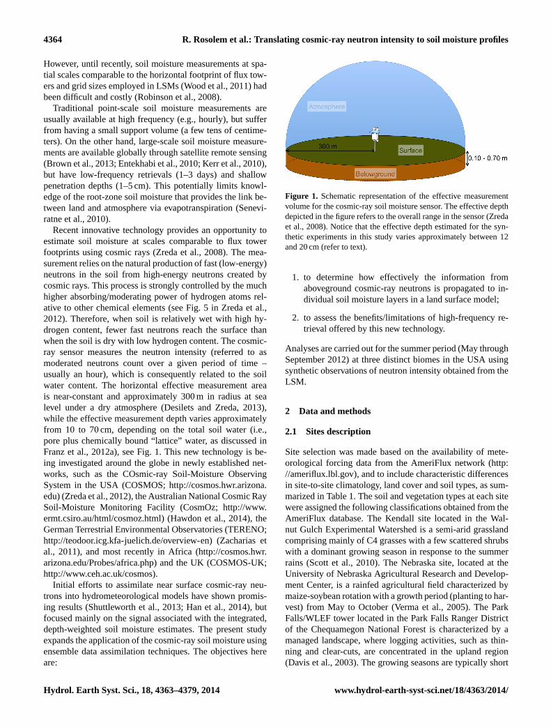
Recent innovative technology provides an opportunity toestimate soil moisture at scales comparable to flux towerfootprints using cosmic rays (Zreda et al., 2008). The mea-surement relies on the natural production of fast (low-energy)neutrons in the soil from high-energy neutrons created bycosmic rays. This process is strongly controlled by the muchhigher absorbing/moderating power of hydrogen atoms rel-ative to other chemical elements (see Fig. 5 in Zreda et al.,2012). Therefore, when soil is relatively wet with high hy-drogen content, fewer fast neutrons reach the surface thanwhen the soil is dry with low hydrogen content. The cosmic-ray sensor measures the neutron intensity (referred to asmoderated neutrons count over a given period of time –usually an hour), which is consequently related to the soilwater content. The horizontal effective measurement areais near-constant and approximately 300 m in radius at sealevel under a dry atmosphere (Desilets and Zreda, 2013),while the effective measurement depth varies approximatelyfrom 10 to 70 cm, depending on the total soil water (i.e.,pore plus chemically bound “lattice” water, as discussed inFranz et al., 2012a), see Fig. 1. This new technology is be-ing investigated around the globe in newly established net-works, such as the COsmic-ray Soil-Moisture ObservingSystem in the USA (COSMOS;http://cosmos.hwr.arizona.edu) (Zreda et al., 2012), the Australian National Cosmic RaySoil-Moisture Monitoring Facility (CosmOz;http://www.ermt.csiro.au/html/cosmoz.html) (Hawdon et al., 2014), theGerman Terrestrial Environmental Observatories (TERENO;http://teodoor.icg.kfa-juelich.de/overview-en) (Zacharias etal., 2011), and most recently in Africa (http://cosmos.hwr.arizona.edu/Probes/africa.php) and the UK (COSMOS-UK;http://www.ceh.ac.uk/cosmos).
Initial efforts to assimilate near surface cosmic-ray neu-trons into hydrometeorological models have shown promis-ing results (Shuttleworth et al., 2013; Han et al., 2014), butfocused mainly on the signal associated with the integrated,depth-weighted soil moisture estimates. The present studyexpands the application of the cosmic-ray soil moisture usingensemble data assimilation techniques. The objectives hereare:
Figure 1. Schematic representation of the effective measurementvolume for the cosmic-ray soil moisture sensor. The effective depthdepicted in the figure refers to the overall range in the sensor (Zredaet al., 2008). Notice that the effective depth estimated for the syn-thetic experiments in this study varies approximately between 12and 20 cm (refer to text).
1. to determine how effectively the information fromaboveground cosmic-ray neutrons is propagated to in-dividual soil moisture layers in a land surface model;
2. to assess the benefits/limitations of high-frequency re-trieval offered by this new technology.
Analyses are carried out for the summer period (May throughSeptember 2012) at three distinct biomes in the USA usingsynthetic observations of neutron intensity obtained from theLSM.
2 Data and methods
2.1 Sites description
Site selection was made based on the availability of mete-orological forcing data from the AmeriFlux network (http://ameriflux.lbl.gov), and to include characteristic differencesin site-to-site climatology, land cover and soil types, as sum-marized in Table 1. The soil and vegetation types at each sitewere assigned the following classifications obtained from theAmeriFlux database. The Kendall site located in the Wal-nut Gulch Experimental Watershed is a semi-arid grasslandcomprising mainly of C4 grasses with a few scattered shrubswith a dominant growing season in response to the summerrains (Scott et al., 2010). The Nebraska site, located at theUniversity of Nebraska Agricultural Research and Develop-ment Center, is a rainfed agricultural field characterized bymaize-soybean rotation with a growth period (planting to har-vest) from May to October (Verma et al., 2005). The ParkFalls/WLEF tower located in the Park Falls Ranger Districtof the Chequamegon National Forest is characterized by amanaged landscape, where logging activities, such as thin-ning and clear-cuts, are concentrated in the upland region(Davis et al., 2003). The growing seasons are typically short
Hydrol. Earth Syst. Sci., 18, 4363–4379, 2014 www.hydrol-earth-syst-sci.net/18/4363/2014/

R. Rosolem et al.: Translating cosmic-ray neutron intensity to soil moisture profiles 4365
Table 1.Site information obtained from AmeriFlux database (http://ameriflux.lbl.gov). MAT = mean annual temperature, and MAP= meanannual precipitation. Notice the analyzed period in this study is a subset of the available data from each site and it is defined from 1 May 2012,00:00 UTC to 30 September 2012, 23:00 UTC.
Site Latitude Longitude Land cover Soil type MAT (◦C) MAP (cm) Spin-up period (one cycle)
Kendall 31◦74′ N 109◦94′ W Grasslands Loam 16 41 1 January 2010, 00:00 UTC to31 December 2012, 23:00 UTC
Nebraska 41◦10′ N 96◦26′ W Croplands Silty clay loam 10 78 1 January 2011, 00:00 UTC to31 December 2012, 23:00 UTC
Park Falls 45◦56′ N 90◦16′ W Mixed forest Sandy loam 4 82 1 January 2011, 00:00 UTC to31 December 2012, 23:00 UTC
and the winters long and cold (Mackay et al., 2002). Soilmoisture availability controls summer evapotranspiration atthe Kendall and Nebraska sites and, to a lesser extent, at thePark Falls (Teuling et al., 2009).
In order to produce a continuous set of hourly meteorolog-ical forcing data for each site for the period of interest (Maythrough September 2012), the following data gap filling ruleswere applied following Rosolem et al. (2010):
1. if the gap was less than 3 h, it was filled by linear inter-polation;
2. if the gap was greater than 3 h, the missing hours werereplaced by values for the same hours averaged over theprevious and subsequent 15 days;
3. if any additional gap filling was needed, the missingdata were replaced by the average value for the specifichour calculated in the monthly mean diurnal cycle.
2.2 Noah Land Surface model
The Noah model, used operationally at the National Centersfor Environmental Prediction (NCEP) for coupled weatherand climate modeling (Ek, 2003), was adopted in this study.This LSM is also used in the NASA land information sys-tem (LIS) (Kumar et al., 2008), and in the Global (Rodell etal., 2004) and North American (Mitchell, 2004) Land DataAssimilation Systems (GLDAS and NLDAS, respectively).
The model contains four soil layers that extend two metersbelow the surface; specifically, a 10 cm thick surface layer,a 30 cm thick root-zone layer, a 60 cm thick deep root-zonelayer, and a 1 m thick deep layer. The present study focuseson the first three layers of the model, where roots are pre-scribed to be present (0 to 1 m total depth). Soil-moistureparameterization is based on the one-dimensional Richardsequation (Chen et al., 1996; Ek, 2003). Soil and vegeta-tion parameters were defined from look-up tables and theNoah simulation run at hourly time steps at each selectedsite. A full description of Noah can be found in Chen andDudhia (2001) and in Ek (2003), and the model is avail-able from the Research Applications Laboratory at the Na-
tional Center for Atmospheric Research (RAL/NCAR) athttp://www.ral.ucar.edu/research/land/technology/lsm.php.
2.3 Cosmic-ray Soil Moisture Interaction Code(COSMIC)
In this study, the COsmic-ray Soil-Moisture Interaction Code(Shuttleworth et al., 2013) is the forward observational oper-ator used in data assimilation. COSMIC is characterized bya simple, physically based parameterization of belowgroundprocesses relevant for soil moisture estimates using cosmic-ray sensors, which includes (1) the degradation of the incom-ing high-energy neutron flux with soil depth, (2) the produc-tion of fast neutrons at a given depth in the soil, and (3) theloss of the resulting fast neutrons before they reach the soilsurface. Despite its simplicity, COSMIC is robust and muchmore efficient than the traditional Monte Carlo neutron par-ticle model commonly employed in cosmic-ray soil mois-ture applications (Franz et al., 2012b, 2013b; Rosolem et al.,2013). Here, the COSMIC is used to convert soil moistureprofiles derived from the Noah into an equivalent neutron in-tensity, as seen by a cosmic-ray sensor. The code has beendeveloped as part of the COSMOS network and is availableathttp://cosmos.hwr.arizona.edu/Software/cosmic.html.
2.4 Ensemble data assimilation
Data assimilation combines the information from observa-tions and model predictions in order to estimate the state of aphysical system, while recognizing both have some degreeof uncertainty. Given the complexity of geophysical mod-els in general, ensemble data assimilation techniques wereoriginally developed to decrease the computational cost ofthe nonlinear filtering problem patterned after the Kalmanfilter (Kalman, 1960; Kalman and Bucy, 1961) by using asample of model-state vectors to compute their statisticalmoments (i.e., mean and covariance) (Evensen, 1994, 2003;Houtekamer and Mitchell, 1998). In the hydrometeorologicalcommunity, interest in ensemble data assimilation methods isgrowing rapidly for flood forecasting (Clark et al., 2008) and
www.hydrol-earth-syst-sci.net/18/4363/2014/ Hydrol. Earth Syst. Sci., 18, 4363–4379, 2014

4366 R. Rosolem et al.: Translating cosmic-ray neutron intensity to soil moisture profiles
cosmic-ray neutrons
forward observational operator (COSMIC)
NOAH LSM
Figure 2. Schematic representation of the data assimilation andstate update procedures in the Data Assimilation Research Testbed(DART) used in this study. Adapted from original DART diagramavailable athttp://www.image.ucar.edu/DAReS/DART.
soil moisture applications (e.g., Draper et al., 2012; Kumaret al., 2012; Li et al., 2012).
The ensemble data assimilation method used in this studyis an approximation of a general filtering algorithm devel-oped using Bayes’ theorem (Wikle and Berliner, 2007), andthe method is described in detail by Anderson (2003, 2009).The probability distribution of a model state is approximatedby anN -member sample ofM-dimensional state vectors (x i ;i = 1, 2, . . . ,N), whereN is the ensemble size (in this study,N = 40) and eachxi is anM vector (e.g., soil moisture ateach model layer). Because the error distributions for obser-vations taken at different times are usually assumed indepen-dent in geophysical applications, each available observationcan be assimilated sequentially. Hence, for simplicity, theassimilation of a single scalar observation,y, is used here.Bayes’ theorem is as follows:
p(x|Y,y) = p(y|x)p(x|Y)/η, (1)
wherex is the model state variable,Y is the set of all obser-vations that have already been assimilated, which does notinclude the new observation,y, available at the current time,andη refers to a normalization factor. The ensemble assimi-lation procedure is summarized below.
1. Each ensemble member is advanced from the time ofthe most recently used observation to a time sufficientlyclose to the time of the next available observation usingthe Noah.
2. A prior ensemble estimate ofy is created by applyingthe forward operatorh (in this case, COSMIC) to eachsample of the prior state.
3. An updated ensemble estimate ofy conditioned on thenew observation is computed from the prior ensembleestimate ofy and the observed value,yo, using Eq. (1).In this study, the Ensemble Adjustment Kalman Filter(EAKF) (Anderson, 2001) is used.
In order to account for uncertainty in the model,the prior ensemble estimate ofy is approximated asNormal(yp, σ 2
p ), whereyp andσ 2p are the sample mean
and variance computed from the model ensemble, whilethe uncertainty in the observation,yo, is defined asσ 2
o .Given the nature of the cosmic-ray sensor and the largenumber of counts per integration time (i.e., hourly), theassumption of observation uncertainty to be normallydistributed (withσ 2
o = yo) is appropriate. The productof Normal(yp, σ 2
p ) and Normal(yo, σ 2o ) in Eq. (1) is
computed resulting in a Gaussian updated distributionfor y, Normal(yu, σ 2
u ) with an updated variance (σ 2u ) and
mean (yu), defined as:
σ 2u =
[(σ 2
p
)−1+
(σ 2
o
)−1]−1
(2)
and
yu = σ 2u
[(σ 2
p
)−1yp +
(σ 2
o
)−1yo
], (3)
respectively. In the EAKF, the prior ensemble distribu-tion of y is then shifted and linearly contracted to createan updated ensemble with sample statistics as in Eqs. (2)and (3). Observation increments are computed as:
1yi =
√σ 2
u /σ 2p
(yp,i − yp
)+ yu − yp,i;
i = 1,2, . . .,N, (4)
where the subscripti refers to ensemble member.
4. Increments to the prior ensemble of each state-vectorelement (xj,i , wherej refers to an element of the statevector, whilei refers to an ensemble member) are com-puted by linearly regressing the observation increments(1yi) onto each state-vector component independentlyusing the prior joint sample statistics, so that
1xj,i =
(σp,j/σ
2p
)1yi ; j = 1,2, . . .,M;
i = 1,2, . . .,N. (5)
Hydrol. Earth Syst. Sci., 18, 4363–4379, 2014 www.hydrol-earth-syst-sci.net/18/4363/2014/

R. Rosolem et al.: Translating cosmic-ray neutron intensity to soil moisture profiles 4367
Table 2.Perturbation magnitudes of meteorological inputs used byNoah for individual ensemble members in this study. The pertur-bation distribution is either Lognormal (i.e., multiplying the ref-erence variable) or Normal (i.e., adding to or subtracting from areference value). Values within parentheses correspond respectivelyto mean and standard deviation. Notice, vegetation greenness frac-tion has been added to the list given its strong sensitivity in Noah(Miller et al., 2006). The adopted magnitude values follow stan-dard procedures described in the literature, including Dunne andEntekhabi (2005), Kumar et al. (2012), Margulis et al. (2002), Re-ichle and Koster (2004), Reichle et al. (2008, 2007, 2002), Sabateret al. (2007), Walker and Houser (2004), Zhang et al. (2010), andZhou et al. (2006).
Noah forcing Perturbation magnitude
Wind speed (m s−1) Lognormal(1,0.3)Air temperature (K) Normal (0,5)Relative humidity (fraction) Lognormal (1,0.2)Surface pressure (Pa) Normal (0,10)Incoming shortwave radiation (W m−2) Lognormal (1,0.3)Incoming long-wave radiation (W m−2) Normal (0,50)Precipitation rate (kg m−2 s−1) Lognormal(1,0.5)Vegetation greenness fraction (-) Normal(0,0.05)
The Noah, the COSMIC operator and COSMOS obser-vations have all been implemented into the Data Assim-ilation Research Testbed (DART) framework (Ander-son et al., 2009). Figure 2 shows a schematic diagramof the assimilation and state update procedures used inthis study. DART is an open-source community facil-ity that provides software tools for ensemble data as-similation research in geosciences. The modularity ofDART makes the interface to new models and obser-vations straightforward and clean. The DART code isavailable athttp://www.image.ucar.edu/DAReS/DART.
3 Experimental setup
3.1 Perturbed meteorological forcing and initialconditions
In order to ensure that appropriate ensemble spread through-out the assimilation procedure, time series of cross-correlated perturbation fields were generated for all meteo-rological forcing inputs from Noah and applied to each indi-vidual ensemble member (a total of 40 members), similar tothe approach used by Shuttleworth et al. (2013); see Table 2for more details. In all cases, the Latin Hypercube randomsampling method (McKay et al., 1979) was used to generateuniformly distributed soil moisture values (for each modellayer), varying between minimum and saturated soil watercontents in the model. We therefore assume no informationabout the soil moisture profiles prior to the initial simula-tion time step (i.e., 1 May 2012). All remaining model states
Unperturbed (original) forcing data (all data available)
Spin-up (three cycles)
Final cycle generated
Initial conditions corresponding for 2012-05-01 00Z for all state variables except for soil moisture
Initial conditions corresponding for 2012-05-01 00Z for soil moisture using Latin Hypercube Sampling strategy
Perturbed forcing data (all data available)
For 40 individual ensemble member
simulations
Single simulation for synthetic observation
generation
Noah LSM unperturbed (original) parameter sets
Noah LSM unperturbed (original) parameter sets
Begin data assimilation experiments
Spin-up (three cycles)
Final cycle generated
Noah LSM perturbed parameter sets
‘True’ soil moisture and neutron counts (through
COSMIC)
Synthetic observation generated by perturbing
‘true’ neutron counts
Sub-section 3.1 Sub-section 2.4 Sub-section 3.2
Figure 3.Experimental setup used in this study for data assimilationof synthetic observations of cosmic-ray neutrons.
were obtained from the previous time step (30 April 2012at 23:00 UTC) from a spin-up simulation with four repeatedcycles (spin-up periods shown in Table 1) using the originalmeteorological forcing data (i.e., unperturbed) and originalmodel parameters (Fig. 3).
3.2 Synthetic observations
We employ the use of synthetic observations in this studyin order to better assess the advantages and limitations ofthis novel cosmic-ray technology. The approach allows a di-rect comparison between simulated and “true” soil moisturestates at the three sites at which no additional soil moistureobservations are available at the same spatial scale measuredby the cosmic-ray sensors. The use of synthetic observa-tions in data assimilation studies targeted at satellite remote-sensing soil moisture missions continues to show great im-portance for advancing our understanding of regional hy-drometeorological modeling (Kumar et al., 2012; Nearing etal., 2012; Reichle et al., 2008).
For each studied location, synthetic neutron intensity ob-servations (referred to in the rest of the article simply as “ob-servations”) are generated directly from the Noah in com-bination with the COSMIC. An additional set of perturbedmeteorological forcing (not from the original pool of en-semble members) is generated following the same proce-dure described in the previous section. Additionally, 10 pa-rameters, originally identified as influential using a simple“one-at-a-time” sensitivity analysis approach (not shown),are perturbed within a±10 % range from their default val-ues to generate a single parameter set (for each location)used in Noah for the synthetic output generation in a “nearly-identical twin experiment”. The idea is to emulate some un-expected (or unidentifiable) variability observed in soil mois-ture due to small spatial-scale heterogeneities (Crow et al.,2012; Famiglietti et al., 2008; Western and Blöschl, 1999)through changes in key parameter values in the Noah model.Identified parameters includefxexp (bare soil evaporation
www.hydrol-earth-syst-sci.net/18/4363/2014/ Hydrol. Earth Syst. Sci., 18, 4363–4379, 2014

4368 R. Rosolem et al.: Translating cosmic-ray neutron intensity to soil moisture profiles
exponent),refdk(reference value for saturated hydraulic con-ductivity), refkdt (reference value for surface infiltration pa-rameter),bb (Clapp and Hornberger “b” parameter),ref-smc(soil moisture threshold for onset of some transpirationstress),drysmc(top-layer soil moisture threshold at which di-rect evaporation from soil ceases),wltsmc(soil moisture wilt-ing point), satdk (saturated hydraulic conductivity),satdw(saturated soil diffusivity), andrs (minimum stomatal re-sistance). Soil porosity was not included and hence the de-fault values were used for each site. We use the coefficientof variation from the in situ dry-soil bulk density collectedwithin the cosmic-ray footprint at all three sites combinedas a proxy for the perturbation magnitude (i.e.,±10 %) ap-plied to parameter variations to account for uncertainty dueto spatial heterogeneity embedded in the single-point sim-ulation (please refer to the Table S1 in the Supplement fordetailed description of Noah parameter values). Such per-turbations applied both to the meteorological forcing and toabove-mentioned parameters produce slightly different soilmoisture dynamics (and hence “true” neutron counts) whencompared to COSMIC-derived neutron counts when forcedwith Noah with the original parameter set (not shown). Foreach site, the spin-up corresponds to the period shown in Ta-ble 1, repeated four times (i.e., four cycles).
After the spin-up period, the simulated soil moisture ateach soil layer from May through September 2012 was thenused as input data for the COSMIC to generate a “true”equivalent neutron intensity time series (counts per hour).This “true” neutron intensity is finally perturbed followinga probability distribution associated with the uncertainty ob-served in the actual cosmic-ray sensors, as described byZreda et al. (2008) (σ 2
Ncounts= Ncounts; whereNcounts is the
neutron intensity), and a time series of hourly synthetic ob-servations is produced for each site. In addition, a subsetfrom the hourly time series is produced assuming obser-vations are available every other day (for simplicity, de-fined always at noon GMT). The 2-day frequency was se-lected because it is similar to the temporal resolution likelyto be achieved by the most recent satellite remote-sensingsoil moisture missions (Brown et al., 2013; Entekhabi et al.,2010; Kerr et al., 2010). In order to avoid undesired insta-bilities at the beginning of the simulation, no observation isassimilated during the first 24 h. A schematic diagram of theexperimental setup is shown in Fig. 3.
We use these observations in our experiments to evaluatethe ability of Noah to reproduce the synthetically observedneutron intensity, and consequently to analyze the updatedsoil moisture profile against the “true” soil moisture state.Notice that the neutron intensity time series produced in thisstudy are not rescaled to correspond to the location of theoriginal COSMOS probe site in the San Pedro, as discussedby Zreda et al. (2012). This is because we want to preservethe site-specific count statistics to better describe measure-ment uncertainty (lower count rates, on average, will tend tobe more uncertain compared to locations at which count rates
are relatively high). Moreover, there are no systematic biasesbetween observed and simulated neutron counts (not shown),and data assimilation is performed with zero-mean randomerrors only (Dee, 2005). Observing System Simulation Ex-periments (OSSEs), such as those proposed in this study, al-low us to accurately isolate the signal in the neutron measure-ments that comes directly from the soil moisture (through theCOSMIC) for more rigorous analyses. Model structural defi-ciencies, which could potentially result in systematic biases,are therefore not accounted for, and observation uncertain-ties not related to soil moisture (e.g., atmospheric water va-por, changes in biomass) do not impact the simulations. Inaddition, independent observations of soil moisture profilesrepresenting similar horizontal effective measurement areasare generally not available.
4 Results
4.1 Assimilation of neutron counts
For all analyzed sites, the assimilation of summertime neu-tron observations in Noah improves the dynamics relative tothe true neutron count time series in comparison with the nodata assimilation case (i.e., “no DA”) (Fig. 4). The ensem-ble mean of the prior distribution is used for all ensemblesimulations throughout this study. As discussed in Section 1,the higher the neutron counts at a specific location, the lowerthe integrated soil moisture is expected to be. Rainfall eventsare therefore associated with sharp decreases in the neutroncounts followed by a relatively slower dry-down period. No-ticeably, the Kendall site (Fig. 4a) is characterized by an ini-tial long period with very low or no rain (pre-monsoon) untilearly July, followed by more frequent rainfall events (mon-soon) between July and early September. Both the Nebraskaand Park Falls sites (Fig. 4b and c, respectively) show theopposite rainfall pattern with an initial period with frequentrainfall (slightly more frequent at Park Falls) until about mid-June–early July, followed by a relatively dry period for about1–2 months (slightly longer at Park Falls). Notice that 2012was one of the driest years on record for the Midwestern USA(Blunden and Arndt, 2013).
Both assimilation cases (i.e., with hourly available obser-vations – “DA 1-hour” shown as the red line, with observa-tions available once every 2 days, and “DA 2-day” shown asgreen circles) suggest superior performance compared withthe case without assimilation (blue line; Table 3). Overall,the DA 1-hour case approaches more rapidly to the true neu-tron counts and also exhibits a tendency for relatively smallerdifferences when compared to the DA 2-day case. Notably,at the onset of the monsoon at Kendall (i.e., early July), thelow-frequency assimilation case neither reproduces the high-frequency dynamics nor the DA 1-hour case (Fig. 4a). At theNebraska and Park Falls sites (Fig. 4b and c), there is notmuch improvement in Noah-derived neutron counts from the
Hydrol. Earth Syst. Sci., 18, 4363–4379, 2014 www.hydrol-earth-syst-sci.net/18/4363/2014/

R. Rosolem et al.: Translating cosmic-ray neutron intensity to soil moisture profiles 4369
Figure 4. Equivalent neutron intensity (counts per hour – cph) simulated by Noah coupled to COSMIC without (no DA) and with dataassimilation characterized by low- and high-frequency retrievals (respectively, DA 2-day and DA 1-hour) compared to synthetic observations(obs) and true intensities. The ensemble mean of the prior distribution is shown for all ensemble simulations.
Table 3. Summary of statistics computed for Noah for assimilation of synthetic neutron intensity measurements in counts per hour (cph).Metrics are computed with respect to both true counts and synthetic observations, respectively “w.r.t. True” and “w.r.t. Obs”. The ensemblemean of the prior distribution is used for all ensemble simulations.
Site SimulationMean bias RMSE
Total spreadR2
w.r.t. Obs w.r.t. True w.r.t. Obs w.r.t. True w.r.t. Obs w.r.t. True
Kendallno DA −89 −90 119 109 96 0.89 0.94
DA 2-day −9 −13 63 60 57 0.91 0.92DA 1-hour 0 −1 63 60 50 0.91 0.92
Nebraskano DA −15 −14 49 32 51 0.90 0.97
DA 2-day −13 −15 45 28 40 0.89 0.97DA 1-hour −8 −8 38 12 37 0.93 1.00
Park Fallsno DA −8 −8 30 15 36 0.82 0.98
DA 2-day −6 −8 27 14 27 0.81 0.96DA 1-hour −2 −2 25 3 26 0.84 1.00
DA 2-day relative to the no DA in periods where little or norainfall occurs.
The use of synthetic observations ensures that the neutronsignal from the measurement solely comes from direct con-tribution of soil moisture dynamics, and that any model struc-tural deficiency does not impact the results. Hence, a poten-tial limitation of an OSSE is that the results can be very opti-mistic in comparison to a data assimilation experiment usingreal observations. For instance, when comparing against realobservations, one would like the RMSE (which representsthe accuracy of the ensemble mean state relative to the obser-vations) to be comparable to the total spread (which containsboth the ensemble spread and observational error signals). In
that case, the RMSE is defined as the square root of the aver-age squared difference between the model estimates and the
observations, while the total spread is defined as√
σ 2p + σ 2
o ,
where(σ 2
p + σ 2o
)represents the total variance (i.e., the sum
of the ensemble variance,σ 2p , plus the observational error
variance,σ 2o ). In our case, however, one way to test the suc-
cess of an OSSE is to compare the RMSE computed withrespect to the “true” observations with the ensemble spread(σp) directly because the variance of the “true” observations(σ 2
o ) is, by definition, zero.
www.hydrol-earth-syst-sci.net/18/4363/2014/ Hydrol. Earth Syst. Sci., 18, 4363–4379, 2014
4370 R. Rosolem et al.: Translating cosmic-ray neutron intensity to soil moisture profiles
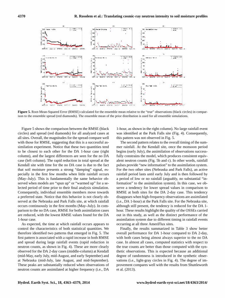
Figure 5. Root-Mean-Squared Error (RMSE) calculated for the ensemble mean relative to the “true” observations (black circles) in compar-ison to the ensemble spread (red diamonds). The ensemble mean of the prior distribution is used for all ensemble simulations.
Figure 5 shows the comparison between the RMSE (blackcircles) and spread (red diamonds) for all analyzed cases atall sites. Overall, the magnitudes for the spread compare wellwith those for RMSE, suggesting that this is a successful as-similation experiment. Notice that these two quantities tendto be closest to each other for the DA 1-hour case (rightcolumn), and the largest differences are seen for the no DAcase (left column). The rapid reduction in total spread at theKendall site with time for the no DA case is due to the factthat soil moisture presents a strong “damping” signal, es-pecially in the first few months when little rainfall occurs(May–July). This is fundamentally the same behavior ob-served when models are “spun up” or “warmed up” for a se-lected period of time prior to their final analysis simulation.Consequently, individual ensemble members move towardsa preferred state. Notice that this behavior is not clearly ob-served at the Nebraska and Park Falls site, at which rainfalloccurs continuously in the first months (May–July). In com-parison to the no DA case, RMSE for both assimilation casesare reduced, with the lowest RMSE values found for the DA1-hour case.
As expected, the time at which rainfall occurs appears tocontrol the characteristics of both statistical quantities. Wetherefore identified two patterns that emerged in Fig. 5. Thefirst pattern is associated with a rapid increase in both RMSEand spread during large rainfall events (rapid reduction inneutron counts, as shown in Fig. 4). These are more clearlyobserved for the DA 2-day cases (middle-column) at Kendall(mid-May, early July, mid-August, and early September) andat Nebraska (mid-July, late August, and mid-September).These peaks are substantially reduced when observations ofneutron counts are assimilated at higher frequency (i.e., DA
1-hour, as shown in the right column). No large rainfall eventwas identified at the Park Falls site (Fig. 4). Consequently,this pattern was not observed in Fig. 5.
The second pattern relates to the overall timing of the sum-mer rainfall. At the Kendall site, once the monsoon periodbegins (early July), the assimilation of observations success-fully constrains the model, which produces consistent equiv-alent neutron counts (Fig. 5b and c). In other words, rainfallpulses provide “new information” to the assimilation system.For the two other sites (Nebraska and Park Falls), an activerainfall period lasts until early July and is then followed bya period of low or no rainfall (arguably, no substantial “in-formation” to the assimilation system). In this case, we ob-serve a tendency for lower spread values in comparison toRMSE at both sites for the DA 2-day case. This tendencydisappears when high-frequency observations are assimilated(i.e., DA 1-hour) at the Park Falls site. For the Nebraska site,although still present, the tendency is reduced for the DA 1-hour. These results highlight the quality of the OSSEs carriedout in this study, as well as the distinct performance of theassimilation system due to different timing in rainfall eventsoccurring at all three AmeriFlux sites.
Finally, the results summarized in Table 3 show betteroverall performance for DA 1-hour compared to DA 2-day,with both cases being almost always superior to the no DAcase. In almost all cases, computed statistics with respect tothe true counts are better than those computed with the syn-thetic observations. This is expected because an additionaldegree of randomness is introduced in the synthetic obser-vations (i.e., light-gray circles in Fig. 4). The degree of im-provement compares well with the results from Shuttleworthet al. (2013).
Hydrol. Earth Syst. Sci., 18, 4363–4379, 2014 www.hydrol-earth-syst-sci.net/18/4363/2014/
R. Rosolem et al.: Translating cosmic-ray neutron intensity to soil moisture profiles 4371
05/01/12 06/01/12 07/01/12 08/01/12 09/01/12 10/01/120
0.1
0.2
0.3
0.4
Soil layer: 0-10 cm
θ (m
3 m-3
)
(a)
trueno DADA 1-hourDA 2-days
05/01/12 06/01/12 07/01/12 08/01/12 09/01/12 10/01/120
0.1
0.2
0.3
0.4
Soil layer: 10-40 cm
θ (m
3 m-3
)
(b)
05/01/12 06/01/12 07/01/12 08/01/12 09/01/12 10/01/120
0.1
0.2
0.3
0.4
Soil layer: 40-100 cm
θ (m
3 m-3
)
(c)
05/01/12 06/01/12 07/01/12 08/01/12 09/01/12 10/01/12
-0.05
0
0.05
0.1
0.15 Soil layer: 0-10 cm
Δθ (
m3 m
-3)
(d)
05/01/12 06/01/12 07/01/12 08/01/12 09/01/12 10/01/12
-0.05
0
0.05
0.1
0.15 Soil layer: 10-40 cm
Δθ (
m3 m
-3)
(e)
05/01/12 06/01/12 07/01/12 08/01/12 09/01/12 10/01/12
-0.05
0
0.05
0.1
0.15 Soil layer: 40-100 cm
Δθ (
m3 m
-3)
(f)
05/01/12 06/01/12 07/01/12 08/01/12 09/01/12 10/01/120
20
40
60
80
100Soil layer: 0-10 cm
Cvg
θ (
%)
(g)
05/01/12 06/01/12 07/01/12 08/01/12 09/01/12 10/01/120
20
40
60
80
100Soil layer: 10-40 cm
Cvg
θ (
%)
(h)
05/01/12 06/01/12 07/01/12 08/01/12 09/01/12 10/01/120
20
40
60
80
100Soil layer: 40-100 cm
Cvg
θ (
%)
(i)
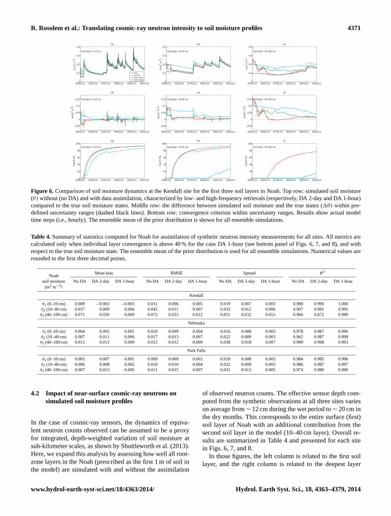
Figure 6. Comparison of soil moisture dynamics at the Kendall site for the first three soil layers in Noah. Top row: simulated soil moisture(θ) without (no DA) and with data assimilation, characterized by low- and high-frequency retrievals (respectively, DA 2-day and DA 1-hour)compared to the true soil moisture states. Middle row: the difference between simulated soil moisture and the true states (1θ) within pre-defined uncertainty ranges (dashed black lines). Bottom row: convergence criterion within uncertainty ranges. Results show actual modeltime steps (i.e., hourly). The ensemble mean of the prior distribution is shown for all ensemble simulations.
Table 4.Summary of statistics computed for Noah for assimilation of synthetic neutron intensity measurements for all sites. All metrics arecalculated only when individual layer convergence is above 40 % for the case DA 1-hour (see bottom panel of Figs. 6, 7, and 8), and withrespect to the true soil moisture state. The ensemble mean of the prior distribution is used for all ensemble simulations. Numerical values arerounded to the first three decimal points.
NoahMean bias RMSE Spread R2
soil moisture No DA DA 2-day DA 1-hour No DA DA 2-day DA 1-hour No DA DA 2-day DA 1-hour No DA DA 2-day DA 1-hour(m3 m−3)
Kendall
θ1 (0–10 cm) 0.009 −0.003 −0.003 0.011 0.006 0.005 0.019 0.007 0.003 0.988 0.990 1.000θ2 (10–40 cm) 0.037 0.009 0.006 0.042 0.011 0.007 0.033 0.012 0.006 0.907 0.981 0.995θ3 (40–100 cm) 0.071 0.030 0.009 0.072 0.033 0.012 0.051 0.032 0.015 0.906 0.872 0.989
Nebraska
θ1 (0–10 cm) 0.004 0.005 0.001 0.010 0.009 0.004 0.016 0.008 0.003 0.978 0.987 0.996θ2 (10–40 cm) 0.007 0.011 0.006 0.017 0.013 0.007 0.022 0.009 0.003 0.962 0.987 0.998θ3 (40–100 cm) 0.012 0.012 0.009 0.012 0.012 0.009 0.038 0.018 0.007 0.999 0.998 0.993
Park Falls
θ1 (0–10 cm) 0.005 0.007 0.001 0.009 0.009 0.003 0.018 0.008 0.003 0.984 0.985 0.996θ2 (10–40 cm) 0.006 0.008 0.002 0.010 0.010 0.004 0.022 0.009 0.003 0.986 0.987 0.997θ3 (40–100 cm) 0.007 0.013 0.005 0.011 0.015 0.007 0.031 0.013 0.005 0.974 0.980 0.990
4.2 Impact of near-surface cosmic-ray neutrons onsimulated soil moisture profiles
In the case of cosmic-ray sensors, the dynamics of equiva-lent neutron counts observed can be assumed to be a proxyfor integrated, depth-weighted variation of soil moisture atsub-kilometer scales, as shown by Shuttleworth et al. (2013).Here, we expand this analysis by assessing how well all root-zone layers in the Noah (prescribed as the first 1 m of soil inthe model) are simulated with and without the assimilation
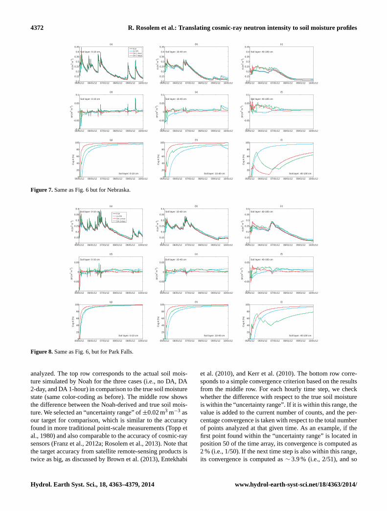
of observed neutron counts. The effective sensor depth com-puted from the synthetic observations at all three sites varieson average from∼ 12 cm during the wet period to∼ 20 cm inthe dry months. This corresponds to the entire surface (first)soil layer of Noah with an additional contribution from thesecond soil layer in the model (10–40 cm layer). Overall re-sults are summarized in Table 4 and presented for each sitein Figs. 6, 7, and 8.
In those figures, the left column is related to the first soillayer, and the right column is related to the deepest layer
www.hydrol-earth-syst-sci.net/18/4363/2014/ Hydrol. Earth Syst. Sci., 18, 4363–4379, 2014
4372 R. Rosolem et al.: Translating cosmic-ray neutron intensity to soil moisture profiles
05/01/12 06/01/12 07/01/12 08/01/12 09/01/12 10/01/120.1
0.15
0.2
0.25
0.3
0.35
0.4
0.45
Soil layer: 0-10 cm
θ (m
3 m-3
)
(a)
trueno DADA 1-hourDA 2-days
05/01/12 06/01/12 07/01/12 08/01/12 09/01/12 10/01/120.1
0.15
0.2
0.25
0.3
0.35
0.4
0.45
Soil layer: 10-40 cm
θ (m
3 m-3
)
(b)
05/01/12 06/01/12 07/01/12 08/01/12 09/01/12 10/01/120.1
0.15
0.2
0.25
0.3
0.35
0.4
0.45
Soil layer: 40-100 cm
θ (m
3 m-3
)
(c)
05/01/12 06/01/12 07/01/12 08/01/12 09/01/12 10/01/12-0.1
-0.05
0
0.05
0.1
Soil layer: 0-10 cm
Δθ (
m3 m
-3)
(d)
05/01/12 06/01/12 07/01/12 08/01/12 09/01/12 10/01/12-0.1
-0.05
0
0.05
0.1
Soil layer: 10-40 cm
Δθ (
m3 m
-3)
(e)
05/01/12 06/01/12 07/01/12 08/01/12 09/01/12 10/01/12-0.1
-0.05
0
0.05
0.1
Soil layer: 40-100 cm
Δθ (
m3 m
-3)
(f)
05/01/12 06/01/12 07/01/12 08/01/12 09/01/12 10/01/120
20
40
60
80
100
Soil layer: 0-10 cm
Cvg
θ (
%)
(g)
05/01/12 06/01/12 07/01/12 08/01/12 09/01/12 10/01/120
20
40
60
80
100
Soil layer: 10-40 cm
Cvg
θ (
%)
(h)
05/01/12 06/01/12 07/01/12 08/01/12 09/01/12 10/01/120
20
40
60
80
100
Soil layer: 40-100 cm
Cvg
θ (
%)
(i)
Figure 7. Same as Fig. 6 but for Nebraska.
05/01/12 06/01/12 07/01/12 08/01/12 09/01/12 10/01/120.1
0.15
0.2
0.25
0.3
0.35
0.4Soil layer: 0-10 cm
θ (m
3 m-3
)
(a)
trueno DADA 1-hourDA 2-days
05/01/12 06/01/12 07/01/12 08/01/12 09/01/12 10/01/120.1
0.15
0.2
0.25
0.3
0.35
0.4Soil layer: 10-40 cm
θ (m
3 m-3
)
(b)
05/01/12 06/01/12 07/01/12 08/01/12 09/01/12 10/01/120.1
0.15
0.2
0.25
0.3
0.35
0.4Soil layer: 40-100 cm
θ (m
3 m-3
)
(c)
05/01/12 06/01/12 07/01/12 08/01/12 09/01/12 10/01/12-0.1
-0.05
0
0.05Soil layer: 0-10 cm
Δθ (
m3 m
-3)
(d)
05/01/12 06/01/12 07/01/12 08/01/12 09/01/12 10/01/12-0.1
-0.05
0
0.05Soil layer: 10-40 cm
Δθ (
m3 m
-3)
(e)
05/01/12 06/01/12 07/01/12 08/01/12 09/01/12 10/01/12-0.1
-0.05
0
0.05Soil layer: 40-100 cm
Δθ (
m3 m
-3)
(f)
05/01/12 06/01/12 07/01/12 08/01/12 09/01/12 10/01/120
20
40
60
80
100
Soil layer: 0-10 cm
Cvg
θ (
%)
(g)
05/01/12 06/01/12 07/01/12 08/01/12 09/01/12 10/01/120
20
40
60
80
100
Soil layer: 10-40 cm
Cvg
θ (
%)
(h)
05/01/12 06/01/12 07/01/12 08/01/12 09/01/12 10/01/120
20
40
60
80
100
Soil layer: 40-100 cm
Cvg
θ (
%)
(i)
Figure 8. Same as Fig. 6, but for Park Falls.
analyzed. The top row corresponds to the actual soil mois-ture simulated by Noah for the three cases (i.e., no DA, DA2-day, and DA 1-hour) in comparison to the true soil moisturestate (same color-coding as before). The middle row showsthe difference between the Noah-derived and true soil mois-ture. We selected an “uncertainty range” of±0.02 m3 m−3 asour target for comparison, which is similar to the accuracyfound in more traditional point-scale measurements (Topp etal., 1980) and also comparable to the accuracy of cosmic-raysensors (Franz et al., 2012a; Rosolem et al., 2013). Note thatthe target accuracy from satellite remote-sensing products istwice as big, as discussed by Brown et al. (2013), Entekhabi
et al. (2010), and Kerr et al. (2010). The bottom row corre-sponds to a simple convergence criterion based on the resultsfrom the middle row. For each hourly time step, we checkwhether the difference with respect to the true soil moistureis within the “uncertainty range”. If it is within this range, thevalue is added to the current number of counts, and the per-centage convergence is taken with respect to the total numberof points analyzed at that given time. As an example, if thefirst point found within the “uncertainty range” is located inposition 50 of the time array, its convergence is computed as2 % (i.e., 1/50). If the next time step is also within this range,its convergence is computed as∼ 3.9 % (i.e., 2/51), and so
Hydrol. Earth Syst. Sci., 18, 4363–4379, 2014 www.hydrol-earth-syst-sci.net/18/4363/2014/

R. Rosolem et al.: Translating cosmic-ray neutron intensity to soil moisture profiles 4373
on. With this simple metric, we can not only determine theoverall percentage of hours when the difference was withinthis uncertainty range (obtained at the end of the simulation),but also how the convergence evolves as the simulation pe-riod progresses.
At the Kendall site, the results suggest overall improvedperformance of Noah for all soil layers (including thosebeyond the sensor effective depth) when observed neutroncounts are assimilated, regardless of the availability of obser-vations (Fig. 6a–f). Differences between DA 1-hour and DA2-day cases are larger at deeper soil layers, with DA 1-hourshowing superior performance. For the no DA case, only thesoil moisture at the first layer in the model is within the un-certainty range for the majority of the simulated period. Thesoil moisture for the DA 2-day case compares relatively wellwith the true soil moisture at the first two layers, but esti-mated soil moisture in the third layer is almost always out-side of the uncertainty range. The DA 1-hour case, however,shows a remarkable response to neutron count and effectivelysimulates the soil moisture dynamics at all Noah soil layers(basic statistics are calculated and presented in Table 4).
The convergence calculated for the Kendall site suggeststhat, overall, soil moisture is constrained more effectivelywhen observations of cosmic-ray neutrons are assimilatedinto Noah (Fig. 6g–i). For the first soil layer, total conver-gence levels are high in all cases and little difference is ob-served between the two DA cases. The benefit of assimilat-ing observed neutron counts is more clear in the results forthe second layer, with no substantial differences between thehigh- and low-frequency assimilation strategies. However,the impact of higher-retrieval frequency becomes evident inthe third soil layer in which soil moisture is only successfullyconstrained in the DA 1-hour case.
The results from the Nebraska and Park Falls sitesare comparable and they show superior performance ofNoah when assimilating neutron counts at high-frequency(Figs. 7a–f and 8a–f). Surprisingly, for the first two soil lay-ers in Noah, the dynamics of soil moisture obtained from theensemble average for DA 2-day is similar to the model be-havior for the no DA case. In addition, no DA soil moistureat the deepest analyzed layer at the Nebraska site follows thetrue soil moisture states quite well. This is likely related tothe fact that the initial conditions randomly obtained in themodel were already similar to the true soil moisture state (interms of ensemble averages) for the no DA case, although theoverall magnitude of the spread is much larger compared toassimilation cases (Table 4). At Park Falls, the results fromthe deepest soil layer analyzed show superior performance ofDA 1-hour while no DA and DA 2-day have similar dynam-ics, especially after late June.
The convergence criterion computed for the first two soillayers in Noah at the Nebraska and Park Falls sites (Figs. 7g–h and 8g–h) are slightly different from the results discussedfor the Kendall site (Fig. 6g–h). First, the percentage ofpoints within the uncertainty range at these two sites is
greater than the percentage values obtained at Kendall (com-pare, for instance, the DA 1-hour case across all sites). Thereis a much sharper increase in the convergence criterion withtime at these two sites, as opposed to the pattern observed forKendall. However, unlike the Kendall site, where the patternsof both DA cases were somewhat similar, it is much clearerfor both the Nebraska and Park Falls cases that the DA 1-hour is able to update soil moisture much more rapidly thanthe DA 2-day when compared to the response to the no DAcase. As mentioned previously, the convergence results forthe no DA case at the third soil layer in the model are likelyto be related to the initial conditions from the ensemble meanbeing already too close to the true states (Figs. 6i and 7i).
4.3 Impact of retrieval frequency on simulated soilmoisture dynamics
The previous sub-section reports the improved ability ofNoah to estimate soil moisture profiles when assimilatingcosmic-ray neutron counts measured aboveground, and in-cluded some initial comparison between assimilation fre-quencies (DA 1-hour and DA 2-day). In this section, we com-pare the “average” performance of Noah for continuous pe-riods of 2 days after the cosmic-ray neutron measurementis assimilated into the model throughout the simulation pe-riod. The aim is to evaluate the Noah performance withinindividual time windows when neutron measurements are as-similated every 2 days, every hour, or not assimilated at all.In this study, the RMSE of soil moisture is calculated withrespect to the true state for a fixed time window of 2 daysapplied throughout the entire simulation period. For com-parison, the results discussed in the previous section werebased on actual model simulations at hourly timescales. Theresults are presented in Fig. 9 with top, middle, and bottomrows, corresponding respectively to the Kendall, Nebraska,and Park Falls sites, with left and right columns correspond-ing to the shallowest and deepest Noah soil layers analyzed inthis study (same color coding as shown in previous figures).
The first noticeable result from Fig. 9 is that the aver-age performance of Noah (i.e., using the 2-day time win-dows) when trying to simulate true soil moisture profiles isbest when neutron measurements are assimilated at hourlytimescales (i.e., DA 1-hour) at all sites. At the Kendall site,which is characterized by a long dry period followed by themonsoon onset early in July, the performance of Noah forthe DA 2-day case is similar to that obtained with DA 1-hourat the first two layers of the model (Fig. 9a–b), and slightlyworse at the deepest layer (Fig. 9c). Surprisingly, a differ-ent pattern emerges from both the Nebraska and Park Fallssites at which an initial period of frequent rainfall is fol-lowed by a relatively long dry period, which also starts inJuly (Fig. 9d–i). In those cases, the performance of DA 2-day is not improved substantially in comparison to no DA,and a noticeable increase in RMSE is observed in both casesright after rainfall ceases in July. Unlike the DA 1-hour case,
www.hydrol-earth-syst-sci.net/18/4363/2014/ Hydrol. Earth Syst. Sci., 18, 4363–4379, 2014

4374 R. Rosolem et al.: Translating cosmic-ray neutron intensity to soil moisture profiles
05/01/12 06/01/12 07/01/12 08/01/12 09/01/12 10/01/120
0.02
0.04
0.06
0.08
0.1
0.12
0.14
RM
SE
θ (
m3 m
-3)
(a)
Kendall: Soil layer 0-10 cm no DADA 2-daysDA 1-hour
05/01/12 06/01/12 07/01/12 08/01/12 09/01/12 10/01/120
0.02
0.04
0.06
0.08
0.1
0.12
0.14
RM
SE
θ (
m3 m
-3)
(b)
Kendall: Soil layer 10-40 cm
05/01/12 06/01/12 07/01/12 08/01/12 09/01/12 10/01/120
0.02
0.04
0.06
0.08
0.1
0.12
0.14
RM
SE
θ (
m3 m
-3)
(c)
Kendall: Soil layer 40-100 cm
05/01/12 06/01/12 07/01/12 08/01/12 09/01/12 10/01/120
0.01
0.02
0.03
0.04
0.05
0.06
RM
SE
θ (
m3 m
-3)
(d)
Nebraska: Soil layer 0-10 cm
05/01/12 06/01/12 07/01/12 08/01/12 09/01/12 10/01/120
0.01
0.02
0.03
0.04
0.05
0.06
RM
SE
θ (
m3 m
-3)
(e)
Nebraska: Soil layer 10-40 cm
05/01/12 06/01/12 07/01/12 08/01/12 09/01/12 10/01/120
0.01
0.02
0.03
0.04
0.05
0.06
RM
SE
θ (
m3 m
-3)
(f)
Nebraska: Soil layer 40-100 cm
05/01/12 06/01/12 07/01/12 08/01/12 09/01/12 10/01/120
0.005
0.01
0.015
0.02
0.025
0.03
0.035
RM
SE
θ (
m3 m
-3)
(g)
Park Falls: Soil layer 0-10 cm
05/01/12 06/01/12 07/01/12 08/01/12 09/01/12 10/01/120
0.005
0.01
0.015
0.02
0.025
0.03
0.035
RM
SE
θ (
m3 m
-3)
(h)
Park Falls: Soil layer 10-40 cm
05/01/12 06/01/12 07/01/12 08/01/12 09/01/12 10/01/120
0.005
0.01
0.015
0.02
0.025
0.03
0.035
RM
SE
θ (
m3 m
-3)
(i)
Park Falls: Soil layer 40-100 cm
Figure 9. Comparison of Noah performance in representing soil moisture dynamics for the first three soil layers with respect to the true soilmoisture state. The metric used is the Root-Mean-Squared Error (RMSE) calculated over individual 2-day periods continuously. Results areshown for Noah without (no DA) and with data assimilation, characterized by low- and high-frequency retrievals (respectively, DA 2-dayand DA 1-hour). The ensemble mean of the prior distribution is used for all ensemble simulations.
the DA 2-day case allows for Noah to freely advance in timefor the rest of the 2-day period once it has assimilated theneutron count measurement, and, because the true simula-tion was generated with a different set of parameters than thecases analyzed here, model simulations in the DA 2-day caseare unable to represent the dynamics of dry-down appropri-ately due to different soil properties. The lack of rainfall, inthis case, reduces the potential magnitude for soil moistureupdates (i.e., “model innovation”), and hence the dynamicsof the model are little improved. The results shown here sug-gest that the performance of summertime cosmic-ray neutrondata assimilation may be slightly dependent on climatologi-cal conditions (i.e., meteorological forcing) and the periodduring which rainfall occurs in the summer. Moreover, it de-pends on model uncertainties due to lack of representative-ness of key soil and vegetation properties at the scale of in-terest (here, accounted for by the fact that true soil moistureis generated from a model simulation obtained with slightlyperturbed parameter values).
5 Summary and conclusions
The use of cosmic-ray neutron sensors for soil moisture mon-itoring has been fast growing because the technique providesroot-zone soil moisture estimates at unprecedented spatialscales and at high temporal resolution. This paper evaluatesthe ability of a land surface model to translate the infor-mation obtained from cosmic-ray neutrons observed above-ground into soil moisture estimates for individual soil layers.A nearly-identical twin experiment approach is adopted in
which observations of cosmic-ray neutrons were generatedfrom a land surface model with a slightly different configu-ration (perturbed key soil and vegetation parameters). Below,we discuss the implications and summarize the main findingsof this work.
How effectively is the information from abovegroundcosmic-ray neutrons translated to individual soilmoisture layers in the model?
When assimilating neutron counts at high frequency, the per-formance of the land surface model is remarkably improvedin comparison with the soil moisture profiles simulated with-out data assimilation. This finding is observed for all threebiomes with a degree of improvement varying slightly fromsite to site. Of importance, we found that water in the soilis better estimated at depths well below the effective sen-sor depth and encompassing the entire rooting zone in themodel. Therefore, the high observational frequency of thecosmic-ray sensors can potentially introduce additional ben-efits relative to assimilating local/regional soil moisture ob-servations from satellite remote-sensing products availableat coarser temporal resolution. However, care must be takenwhen accounting for measurement uncertainty by removingany potential signal in the measurement from other sourcesof hydrogen (atmospheric water vapor, water in biomass),hence isolating or maximizing the soil moisture informationcontent in the measurement. Another important aspect is toensure sufficient ensemble spread from the model to avoid,for instance, filter divergence (overconfidence in the model),
Hydrol. Earth Syst. Sci., 18, 4363–4379, 2014 www.hydrol-earth-syst-sci.net/18/4363/2014/

R. Rosolem et al.: Translating cosmic-ray neutron intensity to soil moisture profiles 4375
or, alternatively, directly inserting observations with little orno model influence (overconfidence in the observations) (An-derson, 2007; Hamill et al., 2001; Houtekamer and Mitchell,1998).
How does frequency of available observations ofcosmic-ray neutrons influence model performance?
We use the RMSE calculated for every 2-day time windowas a metric for model performance. At the Kendall site, DA1-hour and DA 2-day showed good agreement for soil mois-ture in the first two layers of the model (0–10 and 10–40 cm).However, the benefits of high-frequency retrievals in the caseof cosmic-ray neutron observations is also observed for thethird soil layer in Noah (40–100 cm), where DA 1-hour ismuch superior to DA 2-day. Particularly to the Noah, the dis-tribution of roots is directly proportional to the thickness ofeach soil layer. Therefore, the third layer of the model plays asignificant role in determining evapotranspiration rates at thesurface. Summertime is characterized by an initial relativelydry period, which lasts for about 2 months, followed by themonsoon.
Unlike the results at Kendall, the comparison between DA1-hour and DA 2-day for Nebraska and Park Falls suggestthat the performance of Noah for the DA 1-hour case is al-ways superior to that from DA 2-day in all soil layers ana-lyzed. Surprisingly, the model performance for the DA 2-daycase is not much different from simulations made withoutassimilating cosmic-ray neutron counts (i.e., no DA case).A distinct characteristic from both the Nebraska and ParkFalls sites in comparison to Kendall is the overall dynam-ics of soil water in the summertime. At Nebraska and ParkFalls, a relatively wet period with frequent rainfall is ob-served at the beginning of the summertime period, lasting forabout 2 months, and followed by a relatively dry period withlow or no rainfall. Overall, the benefits of assimilating neu-tron measurements at relatively higher frequency are moreclearly observed at the Nebraska and Park Falls sites rela-tive to the semi-arid Kendall. This could indicate that theassimilation performance of summertime cosmic-ray mea-surements at high temporal resolution may depend not onlyon heterogeneity of soil properties (accounted for by slightlyperturbing model parameter from true soil moisture states),but also slightly on meteorological forcing and its climatol-ogy (namely, rainfall). Also, these findings suggest an im-portant role of high-frequency measurements to better con-strain soil moisture states simulated by hydrometeorologicalmodels when applied to drought monitoring, given that thesummer of 2012 was one of the driest on record in the Mid-western USA region.
Due to the characteristics of the sensor, the integrationtime used to compute neutron intensity should potentially belonger than 1 h at some locations. In practice, this is done toreduce the uncertainty in the measurement and consequently
ensure an accurate estimate of soil moisture. For instance,neutron count rates integrated over the entire day were usedin a humid forest ecosystem located in the west of Germany,because hourly count rates were too low for accurate soilmoisture measurements (Bogena et al., 2013). The resultspresented in our study show that care must be taken whenintegrating the cosmic-ray measurements over a longer pe-riod while combining with models, suggesting a potentialtrade-off between individual sensor accuracy and successfulrepresentation of soil moisture profile dynamics. This couldimply in an “optimal range” for integration of neutron countsfor a specific site location, but the investigation is beyond thescope of this study. For example, our initial preliminary anal-ysis indicated little difference between the DA 2-day casewith another assimilation case where neutron measurementswere assimilated daily.
This study focused on the analysis using synthetic ob-servations, mainly because (1) there is a lack of indepen-dent soil moisture observations corresponding to a similareffective horizontal area measured by the cosmic-ray sen-sor, and (2) the neutron intensity signal is entirely derivedfrom soil moisture dynamics, which allows us to focus onthe key aspects of the neutron–soil moisture interactions.Neither the COSMIC operator nor the Noah have explic-itly dealt with additional sources of hydrogen (Franz et al.,2013a) other than the lattice water (explicitly described by aparameter in COSMIC; see Shuttleworth et al., 2013). Typi-cal sources include surface water (Franz et al., 2012a), atmo-spheric water vapor (Rosolem et al., 2013), biomass (Franzet al., 2013b), and litter layer, soil organic matter and below-ground biomass (Bogena et al., 2013). For instance, changesin biomass over time may become important, especially atthe Nebraska (cropland) site. However, as with any OSSE,there are some limitations in our approach because the uncer-tainties due to the above-mentioned sources of hydrogen arenot introduced in the measurements. Furthermore, any poten-tial structural deficiency in Noah when simulating soil mois-ture is ignored in this OSSE, hence model adjustments neednot be applied to remove or reduce systematic biases (Draperet al., 2011; Kumar et al., 2012; Yilmaz and Crow, 2013).As a consequence, the results from this OSSEare likely toindicate better agreement relative to those obtained from as-similation of real neutron measurements. The assimilationof actual cosmic-ray neutron measurements will be inves-tigated in the near future (e.g.,http://www.bris.ac.uk/news/2014/august/soilmoistureand-cosmic-rays.html).
Finally, these results can also give some additional insightsinto applications of data assimilation to satellite remote-sensing products, whose measurements are provided glob-ally at coarser temporal resolution. However, it is not theintention of the present study to directly compare the valueof the cosmic-ray observations with more traditional satelliteremote-sensing products, especially because their horizontaleffective measurement areas are quite different (Robinson etal., 2008) and hence are likely to be influenced differently
www.hydrol-earth-syst-sci.net/18/4363/2014/ Hydrol. Earth Syst. Sci., 18, 4363–4379, 2014

4376 R. Rosolem et al.: Translating cosmic-ray neutron intensity to soil moisture profiles
by distinct factors (see Fig. 1 in Crow et al., 2012). Suchanalyses are beyond the scope of this study, but we encour-age the use of cosmic-ray sensors in combination with satel-lite remote-sensing products for hydrometeorological appli-cations because the information content from each measure-ment can be strongly linked to their individual dynamics.
The Supplement related to this article is available onlineat doi:10.5194/hess-18-4363-2014-supplement.
Acknowledgements.This study was partially supported by At-mospheric Science, Hydrology, and Ecology Programs of the USNational Science Foundation (grant ATM-0838491) under theCOsmic-ray Soil-Moisture Observing System (COSMOS) project.We also thank NASA (grant NNX09A021G) and NASA ACMAP(grant NNX11A110G). We acknowledge the AmeriFlux networkfor providing access to meteorological forcing data for all sites.The first author would like to thank Michael Barlage (NCAR) forvaluable information on the Noah parameterizations; Kevin Raederand Nancy Collins (both at NCAR) for additional support on theuse of DART; Darin Desilets (Hydroinnova LLC) for additionaldiscussion on cosmic-ray sensors; James Broermann (University ofArizona) for computer and technical support.
Edited by: W. J. Timmermans
References
Anderson, J. L.: An ensemble adjustment Kalman filter for data as-similation, Mon. Weather Rev., 129, 2884–2903, 2001.
Anderson, J. L.: A local least squares framework for ensemble fil-tering, Mon. Weather Rev., 131, 634–642, 2003.
Anderson, J. L.: Exploring the need for localization in en-semble data assimilation using a hierarchical ensemblefilter, Physica D: Nonlinear Phenomena, 230, 99–111,doi:10.1016/j.physd.2006.02.011, 2007.
Anderson, J. L.: Ensemble Kalman filters for large geophys-ical applications, IEEE Control Syst. Mag., 29, 66–82,doi:10.1109/MCS.2009.932222, 2009.
Anderson, J. L., Hoar, T., Raeder, K., Liu, H., Collins, N., Torn,R., and Avellano, A.: The Data Assimilation Research Testbed:A Community Facility, B. Am. Meteorol. Soc., 90, 1283–1296,doi:10.1175/2009BAMS2618.1, 2009.
Baker, I. T., Denning, A. S., Hanan, N., Prihodko, L., Uliasz, M.,Vidale, P. L., Davis, K., and Bakwin, P.: Simulated and observedfluxes of sensible and latent heat and CO2 at the WLEF-TV towerusing SiB2. 5, Global Change Biol., 9, 1262–1277, 2003.
Baker, I. T., Prihodko, L., Denning, A. S., Goulden, M., Miller, S.,and da Rocha, H. R.: Seasonal drought stress in the Amazon:Reconciling models and observations, J. Geophys. Res., 113,G00B01, doi:10.1029/2007JG000644, 2008.
Baldocchi, D. D.: Assessing the eddy covariance technique forevaluating carbon dioxide exchange rates of ecosystems: past,present and future, Global Change Biol., 9, 479–492, 2003.
Best, M. J., Pryor, M., Clark, D. B., Rooney, G. G., Essery, R .L.H., Ménard, C. B., Edwards, J. M., Hendry, M. A., Porson, A.,Gedney, N., Mercado, L. M., Sitch, S., Blyth, E., Boucher, O.,
Cox, P. M., Grimmond, C. S. B., and Harding, R. J.: The JointUK Land Environment Simulator (JULES), model description –Part 1: Energy and water fluxes, Geosci. Model Dev., 4, 677–699,doi:10.5194/gmd-4-677-2011, 2011.
Blunden, J. and Arndt, D. S.: State of the Climatein 2012, B. Am. Meteorol. Soc., 94, S1–S258,doi:10.1175/2013BAMSStateoftheClimate.2, 2013.
Bogena, H. R., Huisman, J. A., Baatz, R., Hendricks Franssen, H.-J.,and Vereecken, H.: Accuracy of the cosmic-ray soil water contentprobe in humid forest ecosystems: The worst case scenario, Wa-ter Resour. Res., 49, 5778–5791, doi:10.1002/wrcr.20463, 2013.
Bonan, G. B., Oleson, K. W., Vertenstein, M., Levis, S., Zeng, X.,Dai, Y., Dickinson, R. E., and Yang, Z. L.: The Land Surface Cli-matology of the Community Land Model Coupled to the NCARCommunity Climate Model, J. Climate, 15, 3123–3149, 2002.
Brown, M. E., Escobar, V., Moran, S., Entekhabi, D., O’Neill, P.E., Njoku, E. G., Doorn, B., and Entin, J. K.: NASA’s SoilMoisture Active Passive (SMAP) Mission and Opportunitiesfor Applications Users, B. Am. Meteorol. Soc., 94, 1125–1128,doi:10.1175/BAMS-D-11-00049.1, 2013.
Chen, F. and Dudhia, J.: Coupling an advanced land surface-hydrology model with the Penn State-NCAR MM5 modelingsystem. Part I: Model implementation and sensitivity, Mon.Weather Rev., 129, 569–585, 2001.
Chen, F., Mitchell, K., Schaake, J., Xue, Y., Pan, H. L., Koren, V.,Duan, Q. Y., Ek, M., and Betts, A.: Modeling of land surfaceevaporation by four schemes and comparison with FIFE obser-vations, J. Geophys. Res., 101, 7251–7268, 1996.
Clark, D. B., Mercado, L. M., Sitch, S., Jones, C. D., Gedney, N.,Best, M. J., Pryor, M., Rooney, G. G., Essery, R. L. H., Blyth, E.,Boucher, O., Harding, R. J., Huntingford, C., and Cox, P. M.: TheJoint UK Land Environment Simulator (JULES), model descrip-tion – Part 2: Carbon fluxes and vegetation dynamics, Geosci.Model Dev., 4, 701–722, doi:10.5194/gmd-4-701-2011, 2011.
Clark, M. P., Rupp, D. E., Woods, R. A., Zheng, X., Ibbitt,R. P., Slater, A. G., Schmidt, J., and Uddstrom, M. J.: Hy-drological data assimilation with the ensemble Kalman fil-ter: Use of streamflow observations to update states in a dis-tributed hydrological model, Adv. Water Resour., 31, 1309–1324, doi:10.1016/j.advwatres.2008.06.005, 2008.
Coumou, D. and Rahmstorf, S.: A decade of weather extremes, Nat.Clim. Change, 2, 1–6, doi:10.1038/nclimate1452, 2012.
Crow, W. T., Berg, A. A., Cosh, M. H., Loew, A., Mohanty, B. P.,Panciera, R., de Rosnay, P., Ryu, D., and Walker, J. P.: Upscal-ing sparse ground-based soil moisture observations for the vali-dation of coarse-resolution satellite soil moisture products, Rev.Geophys., 50, RG2002, doi:10.1029/2011RG000372, 2012.
Davis, K. J., Bakwin, P. S., Yi, C. X., Berger, B. W., Zhao, C. L.,Teclaw, R. M., and Isebrands, J. G.: The annual cycles of CO2and H2O exchange over a northern mixed forest as observed froma very tall tower, Global Change Biol., 9, 1278–1293, 2003.
Dee, D. P.: Bias and data assimilation, Q. J. Roy. Meteorol. Soc.,131, 3323–3343, doi:10.1256/qj.05.137, 2005.
Desilets, D. and Zreda, M.: Footprint diameter for a cosmic-ray soilmoisture probe: Theory and Monte Carlo simulations, Water Re-sour. Res., 49, 3566–3575, 2013.
Draper, C. S., Mahfouf, J. F., Calvet, J. C., Martin, E., and Wagner,W.: Assimilation of ASCAT near-surface soil moisture into the
Hydrol. Earth Syst. Sci., 18, 4363–4379, 2014 www.hydrol-earth-syst-sci.net/18/4363/2014/

R. Rosolem et al.: Translating cosmic-ray neutron intensity to soil moisture profiles 4377
SIM hydrological model over France, Hydrol. Earth Syst. Sci.,15, 3829–3841, doi:10.5194/hess-15-3829-2011, 2011.
Draper, C. S., Reichle, R. H., De Lannoy, G. J. M., andLiu, Q.: Assimilation of passive and active microwavesoil moisture retrievals, Geophys. Res. Lett., 39, L04401,doi:10.1029/2011GL050655, 2012.
Dunne, S. and Entekhabi, D.: An ensemble-based reanalysis ap-proach to land data assimilation, Water Resour. Res., 41,W02013, doi:10.1029/2004WR003449, 2005.
Ek, M. B.: Implementation of Noah land surface model advancesin the National Centers for Environmental Prediction oper-ational mesoscale Eta model, J. Geophys. Res., 108, 8851,doi:10.1029/2002JD003296, 2003.
Entekhabi, D., Njoku, E. G., O’Neill, P. E., Kellogg, K. H.,Crow, W. T., Edelstein, W. N., Entin, J. K., Goodman, S.D., Jackson, T. J., and Johnson, J.: The soil moisture ac-tive passive (SMAP) mission, Proc. IEEE, 98, 704–716,doi:10.1109/JPROC.2010.2043918, 2010.
Evensen, G.: Sequential data assimilation with a nonlinear quasi-geostrophic model using Monte Carlo methods to forecast errorstatistics, J. Geophys. Res., 99, 10–10, 1994.
Evensen, G.: The Ensemble Kalman Filter: theoretical formula-tion and practical implementation, Ocean Dynam., 53, 343–367,doi:10.1007/s10236-003-0036-9, 2003.
Famiglietti, J. S., Ryu, D., Berg, A. A., Rodell, M., and Jackson, T.J.: Field observations of soil moisture variability across scales,Water Resour. Res., 44, W01423, doi:10.1029/2006WR005804,2008.
Franz, T. E., Zreda, M., Ferré, T. P. A., Rosolem, R., Zweck, C.,Stillman, S., Zeng, X., and Shuttleworth, W. J.: Measurementdepth of the cosmic ray soil moisture probe affected by hy-drogen from various sources, Water Resour. Res., 48, W08515,doi:10.1029/2012WR011871, 2012a.
Franz, T. E., Zreda, M., Rosolem, R., and Ferré, T. P. A.: FieldValidation of a Cosmic-Ray Neutron Sensor Using a DistributedSensor Network, Vadose Zone J., 11, doi:10.2136/vzj2012.0046,2012b.
Franz, T. E., Zreda, M., Rosolem, R., and Ferré, T. P. A.: A uni-versal calibration function for determination of soil moisturewith cosmic-ray neutrons, Hydrol. Earth Syst. Sci., 17, 453–460,doi:10.5194/hess-17-453-2013, 2013a.
Franz, T. E., Zreda, M., Rosolem, R., Hornbuckle, B. K., Irvin,S. L., Adams, H., Kolb, T. E., Zweck, C., and Shuttleworth,W. J.: Ecosystem-scale measurements of biomass water us-ing cosmic ray neutrons, Geophys. Res. Lett., 40, 3929–3933,doi:10.1002/grl.50791, 2013b.
Hamill, T. M., Whitaker, J. S., and Snyder, C.: Distance-dependentfiltering of background error covariance estimates in an ensembleKalman filter, Mon. Weather Rev., 129, 2776–2790, 2001.
Han, X., Hendricks Franssen, H.-J., Rosolem, R., Jin, R., Li, X.,and Vereecken, H.: Correction of systematic model forcing biasof CLM using assimilation of cosmic-ray neutrons and land sur-face temperature: a study in the Heihe catchment, China, Hydrol.Earth Syst. Sci. Discuss., 11, 9027–9066, doi:10.5194/hessd-11-9027-2014, 2014.
Hawdon, A., McJannet, D., and Wallace, J.: Calibration and cor-rection procedures for cosmic-ray neutron soil moisture probeslocated across Australia, Water Resour. Res., 50, 5029–5043,doi:10.1002/2013WR015138, 2014.
Houtekamer, P. L. and Mitchell, H. L.: Data assimilation using anensemble Kalman filter technique, Mon. Weather Rev., 126, 796–811, 1998.
IPCC: Summary for Policymakers, in: Managing the Risks of Ex-treme Events and Disasters to Advance Climate Change Adap-tation, edited by: Field, C. B., Barros, V., Stocker, T. F., Qin,D., Dokken, D. J., Ebi, K. L., Mastrandrea, M.,D., Mach, K. J.,Plattner, G.-K., Allen, S. K., Tignor, M., and Midgley, P. M., ASpecial Report of Working Groups I and II of the Intergovern-mental Panel on Climate Change, Cambridge University Press,Cambridge, UK, and New York, NY, USA, 1–19, 2012.
Kalman, R. E.: A new approach to linear filtering and predictionproblems, J. Basic Eng., 82, 35–45, 1960.
Kalman, R. E. and Bucy, R. S.: New results in linear filtering andprediction theory, J. Basic Eng., 83, 95–108, 1961.
Kerr, Y. H., Waldteufel, P., Wigneron, J.-P., Delwart, S., Cabot, F.,Boutin, J., Escorihuela, M.-J., Font, J., Reul, N., Gruhier, C., Ju-glea, S. E., Drinkwater, M. R., Hahne, A., Martin-Neira, M., andMecklenburg, S.: The SMOS Mission: New Tool for MonitoringKey Elements of the Global Water Cycle, Proc. IEEE, 98, 666–687, doi:10.1109/JPROC.2010.2043032, 2010.
Koster, R. D., Dirmeyer, P. A., Guo, Z., Bonan, G., Chan, E., Cox,P., Gordon, C. T., Kanae, S., Kowalczyk, E., and Lawrence, D.:Regions of strong coupling between soil moisture and precipita-tion, Science, 305, 1138–1140, 2004.
Kumar, S. V., Reichle, R. H., Peters-Lidard, C. D., Koster, R. D.,Zhan, X., Crow, W. T., Eylander, J. B., and Houser, P. R.: A landsurface data assimilation framework using the land informationsystem: Description and applications, Adv. Water Resour., 31,1419–1432, doi:10.1016/j.advwatres.2008.01.013, 2008.
Kumar, S. V., Reichle, R. H., Harrison, K. W., Peters-Lidard, C. D.,Yatheendradas, S., and Santanello, J. A.: A comparison of meth-ods for a priori bias correction in soil moisture data assimilation,Water Resour. Res., 48, W03515, doi:10.1029/2010WR010261,2012.
Li, B., Toll, D., Zhan, X., and Cosgrove, B.: Improving esti-mated soil moisture fields through assimilation of AMSR-E soilmoisture retrievals with an ensemble Kalman filter and a massconservation constraint, Hydrol. Earth Syst. Sci., 16, 105–119,doi:10.5194/hess-16-105-2012, 2012.
Mackay, D. S., Ahl, D. E., Ewers, B. E., Gower, S. T., Burrows, S.N., Samanta, S., and Davis, K. J.: Effects of aggregated classifi-cations of forest composition on estimates of evapotranspirationin a northern Wisconsin forest, Global Change Biol., 8, 1253–1265, 2002.
Margulis, S. A., McLaughlin, D., Entekhabi, D., and Dunne,S.: Land data assimilation and estimation of soil mois-ture using measurements from the Southern Great Plains1997 Field Experiment, Water Resour. Res., 38, 35-1–35-18,doi:10.1029/2001WR001114, 2002.
McKay, M. D., Beckman, R. J., and Conover, W. J.: Comparison ofthree methods for selecting values of input variables in the analy-sis of output from a computer code, Technometrics, 21, 239–245,1979.
Miller, J., Barlage, M., Zeng, X., Wei, H., Mitchell, K., and Tarp-ley, D.: Sensitivity of the NCEP/Noah land surface model to theMODIS green vegetation fraction data set, Geophys. Res. Lett.,33, L13404, doi:10.1029/2006GL026636, 2006.
www.hydrol-earth-syst-sci.net/18/4363/2014/ Hydrol. Earth Syst. Sci., 18, 4363–4379, 2014

4378 R. Rosolem et al.: Translating cosmic-ray neutron intensity to soil moisture profiles
Mitchell, K. E.: The multi-institution North American LandData Assimilation System (NLDAS): Utilizing multiple GCIPproducts and partners in a continental distributed hydro-logical modeling system, J. Geophys. Res., 109, D07S90,doi:10.1029/2003JD003823, 2004.
Nearing, G. S., Crow, W. T., Thorp, K. R., Moran, M. S., Reichle, R.H., and Gupta, H. V.: Assimilating remote sensing observationsof leaf area index and soil moisture for wheat yield estimates: Anobserving system simulation experiment, Water Resour. Res., 48,W05525, doi:10.1029/2011WR011420, 2012.
Niu, G.-Y., Yang, Z.-L., Mitchell, K. E., Chen, F., Ek, M. B.,Barlage, M., Kumar, A., Manning, K., Niyogi, D., Rosero, E.,Tewari, M., and Xia, Y.: The community Noah land surfacemodel with multiparameterization options (Noah-MP): 1. Modeldescription and evaluation with local-scale measurements, J.Geophys. Res., 116, D12109, doi:10.1029/2010JD015139, 2011.
Oleson, K. W., Niu, G. Y., Yang, Z. L., Lawrence, D. M., Thornton,P. E., Lawrence, P. J., Stöckli, R., Dickinson, R. E., Bonan, G.B., Levis, S., Dai, A., and Qian, T.: Improvements to the Com-munity Land Model and their impact on the hydrological cycle, J.Geophys. Res., 113, G01021, doi:10.1029/2007JG000563, 2008.
Pitman, A. J.: The evolution of, and revolution in, land surfaceschemes designed for climate models, Int. J. Climatol., 23, 479–510, doi:10.1002/joc.893, 2003.
Reichle, R. H. and Koster, R. D.: Bias reduction in short recordsof satellite soil moisture, Geophys. Res. Lett., 31, L19501,doi:10.1029/2004GL020938, 2004.
Reichle, R. H., Walker, J. P., Koster, R. D., and Houser, P. R.: Ex-tended versus ensemble Kalman filtering for land data assimila-tion, J. Hydrometeor, 3, 728–740, 2002.
Reichle, R. H., Koster, R. D., Liu, P., Mahanama, S. P. P., Njoku,E. G., and Owe, M.: Comparison and assimilation of globalsoil moisture retrievals from the Advanced Microwave Scan-ning Radiometer for the Earth Observing System (AMSR-E) andthe Scanning Multichannel Microwave Radiometer (SMMR), J.Geophys. Res., 112, D09108, doi:10.1029/2006JD008033, 2007.
Reichle, R. H., Crow, W. T., and Keppenne, C. L.: An adaptive en-semble Kalman filter for soil moisture data assimilation, WaterResour. Res., 44, W03423, doi:10.1029/2007WR006357, 2008.
Robinson, D. A., Campbell, C. S., Hopmans, J. W., Hornbuckle, B.K., Jones, S. B., Knight, R., Ogden, F., Selker, J., and Wendroth,O.: Soil moisture measurement for ecological and hydrologicalwatershed-scale observatories: A review, Vadose Zone J., 7, 358–389, 2008.
Rodell, M., Houser, P. R., Jambor, U., Gottschalck, J., Mitchell,K., Meng, C.-J., Arsenault, K., Cosgrove, B., Radakovich, J.,Bosilovich, M., Entin, J. K., Walker, J. P., Lohmann, D., and Toll,D.: The Global Land Data Assimilation System, B. Am. Meteo-rol. Soc., 85, 381–394, doi:10.1175/BAMS-85-3-381, 2004.
Rosolem, R., Shuttleworth, W. J., Zeng, X., Saleska, S. R., andHuxman, T. E.: Land surface modeling inside the Biosphere2 tropical rain forest biome, J. Geophys. Res., 115, G04035,doi:10.1029/2010JG001443, 2010.
Rosolem, R., Gupta, H. V., Shuttleworth, W. J., de Gonçalves, L. G.G., and Zeng, X.: Towards a comprehensive approach to parame-ter estimation in land surface parameterization schemes, Hydrol.Process., 27, 2075–2097, doi:10.1002/hyp.9362, 2012a.
Rosolem, R., Gupta, H. V., Shuttleworth, W. J., Zeng, X., and deGonçalves, L. G. G.: A fully multiple-criteria implementation of
the Sobol’ method for parameter sensitivity analysis, J. Geophys.Res., 117, D07103, doi:10.1029/2011JD016355, 2012b.
Rosolem, R., Shuttleworth, W. J., Zreda, M., Franz, T. E., Zeng, X.,and Kurc, S. A.: The Effect of Atmospheric Water Vapor on Neu-tron Count in the Cosmic-Ray Soil Moisture Observing System,J. Hydrometeor, 14, 1659–1671, doi:10.1175/JHM-D-12-0120.1,2013.
Sabater, J. M., Jarlan, L., Calvet, J.-C., Bouyssel, F., and de Ros-nay, P.: From Near-Surface to Root-Zone Soil Moisture UsingDifferent Assimilation Techniques, J. Hydrometeor, 8, 194–206,doi:10.1175/JHM571.1, 2007.
Sakaguchi, K., Zeng, X., Christoffersen, B. J., Restrepo-Coupe, N.,Saleska, S. R., and Brando, P. M.: Natural and drought scenar-ios in an east central Amazon forest: Fidelity of the CommunityLand Model 3.5 with three biogeochemical models, J. Geophys.Res., 116, G01029, doi:10.1029/2010JG001477, 2011.
Scott, R. L., Hamerlynck, E. P., Jenerette, G. D., Moran, M. S., andBarron-Gafford, G. A.: Carbon dioxide exchange in a semidesertgrassland through drought-induced vegetation change, J. Geo-phys. Res., 115, G03026, doi:10.1029/2010JG001348, 2010.
Sellers, P. J., Shuttleworth, W. J., Dorman, J. L., Dalcher, A., andRoberts, J. M.: Calibrating the simple biosphere model for Ama-zonian tropical forest using field and remote sensing data. Part I:Average calibration with field data, J. Appl. Meteorol., 28, 727–759, 1989.
Sellers, P. J., Dickinson, R. E., Randall, D. A., Betts, A. K., Hall,F. G., Berry, J. A., Collatz, G. J., Denning, A. S., Mooney, H.A., and Nobre, C. A.: Modeling the exchanges of energy, wa-ter, and carbon between continents and the atmosphere, Science,275, 502–509, 1997.
Seneviratne, S. I.: Climate science: Historical drought trends revis-ited, Nature, 491, 338–339, doi:10.1038/nclimate1633, 2012.
Seneviratne, S. I., Corti, T., Davin, E. L., Hirschi, M., Jaeger,E. B., Lehner, I., Orlowsky, B., and Teuling, A. J.: In-vestigating soil moisture–climate interactions in a chang-ing climate: A review, Earth Sci. Rev., 99, 125–161,doi:10.1016/j.earscirev.2010.02.004, 2010.
Shuttleworth, J., Rosolem, R., Zreda, M., and Franz, T.: TheCOsmic-ray Soil Moisture Interaction Code (COSMIC) for usein data assimilation, Hydrol. Earth Syst. Sci., 17, 3205–3217,doi:10.5194/hess-17-3205-2013, 2013.
Teuling, A. J., Hirschi, M., Ohmura, A., Wild, M., Reichstein,M., Ciais, P., Buchmann, N., Ammann, C., Montagnani, L.,and Richardson, A. D.: A regional perspective on trendsin continental evaporation, Geophys. Res. Lett., 36, L02404,doi:10.1029/2008GL036584, 2009.
Topp, G. C., Davis, J. L., and Annan, A. P.: Electromagnetic De-termination of Soil-Water Content – Measurements in CoaxialTransmission-Lines, Water Resour. Res., 16„ 574–582, 1980.
Verma, S. B., Dobermann, A., Cassman, K. G., Walters, D. T.,Knops, J. M., Arkebauer, T. J., Suyker, A. E., Burba, G. G.,Amos, B., Yang, H. S., Ginting, D., Hubbard, K. G., Gitelson,A. A., and Walter-Shea, E. A.: Annual carbon dioxide exchangein irrigated and rainfed maize-based agroecosystems, Agr. For-est Meteorol., 131, 77–96, doi:10.1016/j.agrformet.2005.05.003,2005.
Walker, J. P. and Houser, P. R.: Requirements of a globalnear-surface soil moisture satellite mission: accuracy, repeat
Hydrol. Earth Syst. Sci., 18, 4363–4379, 2014 www.hydrol-earth-syst-sci.net/18/4363/2014/

R. Rosolem et al.: Translating cosmic-ray neutron intensity to soil moisture profiles 4379
time, and spatial resolution, Adv. Water Resour., 27, 785–801,doi:10.1016/j.advwatres.2004.05.006, 2004.
Wang, Z., Zeng, X., and Decker, M.: Improving snow processesin the Noah land model, J. Geophys. Res., 115, D20108,doi:10.1029/2009JD013761, 2010.
Western, A. W. and Blöschl, G.: On the spatial scaling of soil mois-ture, J. Hydrol., 217, 203–224, 1999.
Wikle, C. K. and Berliner, L. M.: A Bayesian tutorial for dataassimilation, Physica D: Nonlinear Phenomena, 230, 1–16,doi:10.1016/j.physd.2006.09.017, 2007.
Wood, E. F., Roundy, J. K., Troy, T. J., van Beek, L. P. H., Bierkens,M. F. P., Blyth, E., de Roo, A., Döll, P., Ek, M., Famiglietti,J., Gochis, D., van de Giesen, N., Houser, P., Jaffé, P. R., Kol-let, S., Lehner, B., Lettenmaier, D. P., Peters-Lidard, C., Siva-palan, M., Sheffield, J., Wade, A., and Whitehead, P.: Hyperres-olution global land surface modeling: Meeting a grand challengefor monitoring Earth’s terrestrial water, Water Resour. Res., 47,W05301, doi:10.1029/2010WR010090, 2011.
Yang, Z.-L., Niu, G.-Y., Mitchell, K. E., Chen, F., Ek, M.B., Barlage, M., Longuevergne, L., Manning, K., Niyogi, D.,Tewari, M., and Xia, Y.: The community Noah land surfacemodel with multiparameterization options (Noah-MP): 2. Eval-uation over global river basins, J. Geophys. Res., 116, D12110,doi:10.1029/2010JD015140, 2011.
Yilmaz, M. T. and Crow, W. T.: The Optimality of Potential Rescal-ing Approaches in Land Data Assimilation, J. Hydrometeor., 14,650–660, doi:10.1175/JHM-D-12-052.1, 2013.
Zacharias, S., Bogena, H., Samaniego, L., Mauder, M., Fuß, R.,Pütz, T., Frenzel, M., Schwank, M., Baessler, C., Butterbach-Bahl, K., Bens, O., Borg, E., Brauer, A., Dietrich, P., Hajnsek,I., Helle, G., Kiese, R., Kunstmann, H., Klotz, S., Munch, J. C.,Papen, H., Priesack, E., Schmid, H. P., Steinbrecher, R., Rosen-baum, U., Teutsch, G., and Vereecken, H.: A Network of Terres-trial Environmental Observatories in Germany, Vadose Zone J.,10, 955–973, doi:10.2136/vzj2010.0139, 2011.
Zhang, S.-W., Zeng, X., Zhang, W., and Barlage, M.: Revisingthe Ensemble-Based Kalman Filter Covariance for the Retrievalof Deep-Layer Soil Moisture, J. Hydrometeor, 11, 219–227,doi:10.1175/2009JHM1146.1, 2010.
Zhou, Y., McLaughlin, D., and Entekhabi, D.: Assessing the perfor-mance of the ensemble Kalman filter for land surface data assim-ilation, Mon. Weather Rev., 134, 2128–2142, 2006.
Zreda, M., Desilets, D., Ferré, T. P. A., and Scott, R. L.: Measuringsoil moisture content non-invasively at intermediate spatial scaleusing cosmic-ray neutrons, Geophys. Res. Lett., 35, L21402,doi:10.1029/2008GL035655, 2008.
Zreda, M., Shuttleworth, W. J., Zeng, X., Zweck, C., Desilets, D.,Franz, T., and Rosolem, R.: COSMOS: the COsmic-ray SoilMoisture Observing System, Hydrol. Earth Syst. Sci., 16, 4079–4099, doi:10.5194/hess-16-4079-2012, 2012.
www.hydrol-earth-syst-sci.net/18/4363/2014/ Hydrol. Earth Syst. Sci., 18, 4363–4379, 2014