Towards an integrated approach of disaster and environment management: A case study of Thua Thien...
12
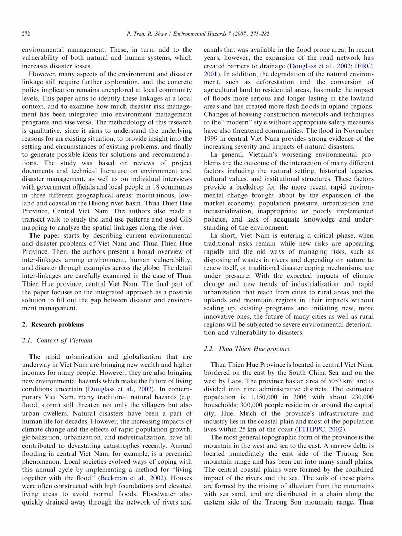
Environmental Hazards 7 (2007) 271–282 Towards an integrated approach of disaster and environment management: A case study of Thua Thien Hue province, central Viet Nam Phong Tran , Rajib Shaw 1 Graduate School of Global Environmental Studies, Kyoto University, Yoshida Honmachi, Sakyo-ku, Kyoto 606 8501, Japan Abstract Disasters and environmental degradation create serious problems all around the world. They are inherently linked, but little attention is paid to their interaction, particularly at local levels. The degree of integration of disaster management and risk analysis with environmental management programs in relation to human vulnerability has been examined in Thua Thien Hue Province, Central Viet Nam. Unsustainable agricultural practices, and inappropriate development programs have contributed substantially to the increase of disaster risks. On the other hand, disasters damage natural resources and reduce environmental quality, indirectly contributing to increasing poverty which in turn, adds to the vulnerability of both natural and human systems, so further increasing disaster losses. Notwithstanding, in Viet Nam, there is a big gap between disaster and environment management policies and programs. In order to bridge the gap, an integrated approach in which environment-disaster linkage, rural–urban linkage, and poverty are brought into focus as core aspects of disaster management. r 2007 Elsevier Ltd. All rights reserved. Keywords: Disaster; Environment; Vulnerability; Environment-disaster linkage; Poverty; Vietnam 1. Introduction As a consequence of the huge losses and damage caused by natural disasters throughout the world, an impressive amount of attention is currently being given to holistic approaches to disaster management (McEntire et al., 2002). The world experiences more and more natural disaster impacts despite numerous efforts, scientific ad- vances, and more powerful technologies. Indeed, current disasters are more complex and climate change poses a greater potential for adverse impacts (Aalst and Burton, 2002). Doubtless, new theoretical perspectives and policy guidance are urgently required to reduce the impacts of disasters. Accordingly, researchers have called for a broader view of disaster problems and even for a revolution in approach (Guzman, 2002; McEntire et al., 2002). One of the most important paradigm shifts and policy guides, is the integrated disaster risk management approach in which the link between environment manage- ment and disaster management is strongly promoted, and integrated into the development plan (Shaw, 2006; WMO and GWP, 2006; Guzman, 2002). In disaster literature, the linkage between disaster and environment has been recognized, yet it appears that not enough attention was paid in the design and implementa- tion of risk reduction strategies, particularly at grassroots levels. Recently, this gap has received increasing attention and many scholars and researchers conclude that the environment and disasters are inherently linked particu- larly in the areas where the natural and social issues merge (Shaw, 2006; Dolcemascolo, 2004; ISDR, 2004; Aalst and Burton, 2002). In fact, the degradation of environmental quality has been mentioned as both causes and effects of natural disasters, for instance, disasters cause direct damage to natural resources and environment, and indirect damage by increasing poverty, which in itself leads to the unsustainable practices of natural resources use and ARTICLE IN PRESS www.elsevier.com/locate/hazards 1747-/$ - see front matter r 2007 Elsevier Ltd. All rights reserved. doi:10.1016/j.envhaz.2007.03.001 Corresponding author. Tel.: +81 80 5365 0795; fax: +81 75 753 5708. E-mail addresses: [email protected] (P. Tran), [email protected] (R. Shaw). 1 Tel./fax: +81 75 753 5708.
-
Upload
independent -
Category
Documents
-
view
0 -
download
0
Transcript of Towards an integrated approach of disaster and environment management: A case study of Thua Thien...
ARTICLE IN PRESS
1747-/$ - see fro
doi:10.1016/j.en
�CorrespondE-mail addr
(P. Tran), shaw1Tel./fax: +8
Environmental Hazards 7 (2007) 271–282
www.elsevier.com/locate/hazards
Towards an integrated approach of disaster and environmentmanagement: A case study of Thua Thien Hue province,
central Viet Nam
Phong Tran�, Rajib Shaw1
Graduate School of Global Environmental Studies, Kyoto University, Yoshida Honmachi, Sakyo-ku, Kyoto 606 8501, Japan
Abstract
Disasters and environmental degradation create serious problems all around the world. They are inherently linked, but little attention
is paid to their interaction, particularly at local levels. The degree of integration of disaster management and risk analysis with
environmental management programs in relation to human vulnerability has been examined in Thua Thien Hue Province, Central Viet
Nam. Unsustainable agricultural practices, and inappropriate development programs have contributed substantially to the increase of
disaster risks. On the other hand, disasters damage natural resources and reduce environmental quality, indirectly contributing to
increasing poverty which in turn, adds to the vulnerability of both natural and human systems, so further increasing disaster losses.
Notwithstanding, in Viet Nam, there is a big gap between disaster and environment management policies and programs. In order to
bridge the gap, an integrated approach in which environment-disaster linkage, rural–urban linkage, and poverty are brought into focus
as core aspects of disaster management.
r 2007 Elsevier Ltd. All rights reserved.
Keywords: Disaster; Environment; Vulnerability; Environment-disaster linkage; Poverty; Vietnam
1. Introduction
As a consequence of the huge losses and damage causedby natural disasters throughout the world, an impressiveamount of attention is currently being given to holisticapproaches to disaster management (McEntire et al.,2002). The world experiences more and more naturaldisaster impacts despite numerous efforts, scientific ad-vances, and more powerful technologies. Indeed, currentdisasters are more complex and climate change poses agreater potential for adverse impacts (Aalst and Burton,2002). Doubtless, new theoretical perspectives and policyguidance are urgently required to reduce the impacts ofdisasters. Accordingly, researchers have called for abroader view of disaster problems and even for arevolution in approach (Guzman, 2002; McEntire et al.,
nt matter r 2007 Elsevier Ltd. All rights reserved.
vhaz.2007.03.001
ing author. Tel.: +8180 5365 0795; fax: +8175 753 5708.
esses: [email protected]
@global.mbox.media.kyoto-u.ac.jp (R. Shaw).
1 75 753 5708.
2002). One of the most important paradigm shifts andpolicy guides, is the integrated disaster risk managementapproach in which the link between environment manage-ment and disaster management is strongly promoted, andintegrated into the development plan (Shaw, 2006; WMOand GWP, 2006; Guzman, 2002).In disaster literature, the linkage between disaster and
environment has been recognized, yet it appears that notenough attention was paid in the design and implementa-tion of risk reduction strategies, particularly at grassrootslevels. Recently, this gap has received increasing attentionand many scholars and researchers conclude that theenvironment and disasters are inherently linked particu-larly in the areas where the natural and social issues merge(Shaw, 2006; Dolcemascolo, 2004; ISDR, 2004; Aalst andBurton, 2002). In fact, the degradation of environmentalquality has been mentioned as both causes and effects ofnatural disasters, for instance, disasters cause directdamage to natural resources and environment, and indirectdamage by increasing poverty, which in itself leads to theunsustainable practices of natural resources use and
ARTICLE IN PRESSP. Tran, R. Shaw / Environmental Hazards 7 (2007) 271–282272
environmental management. These, in turn, add to thevulnerability of both natural and human systems, whichincreases disaster losses.
However, many aspects of the environment and disasterlinkage still require further exploration, and the concretepolicy implication remains unexplored at local communitylevels. This paper aims to identify these linkages at a localcontext, and to examine how much disaster risk manage-ment has been integrated into environment managementprograms and vise versa. The methodology of this researchis qualitative, since it aims to understand the underlyingreasons for an existing situation, to provide insight into thesetting and circumstances of existing problems, and finallyto generate possible ideas for solutions and recommenda-tions. The study was based on reviews of projectdocuments and technical literature on environment anddisaster management, as well as on individual interviewswith government officials and local people in 18 communesin three different geographical areas: mountainous, low-land and coastal in the Huong river basin, Thua Thien HueProvince, Central Viet Nam. The authors also made atransect walk to study the land use patterns and used GISmapping to analyze the spatial linkages along the river.
The paper starts by describing current environmentaland disaster problems of Viet Nam and Thua Thien HueProvince. Then, the authors present a broad overview ofinter-linkages among environment, human vulnerability,and disaster through examples across the globe. The detailinter-linkages are carefully examined in the case of ThuaThien Hue province, central Viet Nam. The final part ofthe paper focuses on the integrated approach as a possiblesolution to fill out the gap between disaster and environ-ment management.
2. Research problems
2.1. Context of Vietnam
The rapid urbanization and globalization that areunderway in Viet Nam are bringing new wealth and higherincomes for many people. However, they are also bringingnew environmental hazards which make the future of livingconditions uncertain (Douglass et al., 2002). In contem-porary Viet Nam, many traditional natural hazards (e.g.flood, storm) still threaten not only the villagers but alsourban dwellers. Natural disasters have been a part ofhuman life for decades. However, the increasing impacts ofclimate change and the effects of rapid population growth,globalization, urbanization, and industrialization, have allcontributed to devastating catastrophes recently. Annualflooding in central Viet Nam, for example, is a perennialphenomenon. Local societies evolved ways of coping withthis annual cycle by implementing a method for ‘‘livingtogether with the flood’’ (Beckman et al., 2002). Houseswere often constructed with high foundations and elevatedliving areas to avoid normal floods. Floodwater alsoquickly drained away through the network of rivers and
canals that was available in the flood prone area. In recentyears, however, the expansion of the road network hascreated barriers to drainage (Douglass et al., 2002; IFRC,2001). In addition, the degradation of the natural environ-ment, such as deforestation and the conversion ofagricultural land to residential areas, has made the impactof floods more serious and longer lasting in the lowlandareas and has created more flash floods in upland regions.Changes of housing construction materials and techniquesto the ‘‘modern’’ style without appropriate safety measureshave also threatened communities. The flood in November1999 in central Viet Nam provides strong evidence of theincreasing severity and impacts of natural disasters.In general, Vietnam’s worsening environmental pro-
blems are the outcome of the interaction of many differentfactors including the natural setting, historical legacies,cultural values, and institutional structures. These factorsprovide a backdrop for the more recent rapid environ-mental change brought about by the expansion of themarket economy, population pressure, urbanization andindustrialization, inappropriate or poorly implementedpolicies, and lack of adequate knowledge and under-standing of the environment.In short, Viet Nam is entering a critical phase, when
traditional risks remain while new risks are appearingrapidly and the old ways of managing risks, such asdisposing of wastes in rivers and depending on nature torenew itself, or traditional disaster coping mechanisms, areunder pressure. With the expected impacts of climatechange and new trends of industrialization and rapidurbanization that reach from cities to rural areas and theuplands and mountain regions in their impacts withoutscaling up, existing programs and initiating new, moreinnovative ones, the future of many cities as well as ruralregions will be subjected to severe environmental deteriora-tion and vulnerability to disasters.
2.2. Thua Thien Hue province
Thua Thien Hue Province is located in central Viet Nam,bordered on the east by the South China Sea and on thewest by Laos. The province has an area of 5053 km2 and isdivided into nine administrative districts. The estimatedpopulation is 1,150,000 in 2006 with about 230,000households; 300,000 people reside in or around the capitalcity, Hue. Much of the province’s infrastructure andindustry lies in the coastal plain and most of the populationlives within 25 km of the coast (TTHPPC, 2002).The most general topographic form of the province is the
mountain in the west and sea to the east. A narrow delta islocated immediately the east side of the Truong Sonmountain range and has been cut into many small plains.The central coastal plains were formed by the combinedimpact of the rivers and the sea. The soils of these plainsare formed by the mixing of alluvium from the mountainswith sea sand, and are distributed in a chain along theeastern side of the Truong Son mountain range. Thua

ARTICLE IN PRESSP. Tran, R. Shaw / Environmental Hazards 7 (2007) 271–282 273
Thien Hue comprises two basins with four main rivers, theO Lau, Bo, Huong, and Truoi Rivers. From the westernthe Truong Son mountain range the topography slopesdownwards to the coast and is divided into three areasgeomorphologically, i.e., higher mountain area (25 kmwide and over 250m in elevation), low-lying area (19 kmwide) and coastal plain (Fig. 1). Like other provinces ofViet Nam, Thua Thien Hue is vulnerable to disasters. Infact, it is considered amongst the most disaster prone areasof Viet Nam.
The province has a varied geography including, forestedmountains and hills, rivers, streams, paddy fields, coastallagoons and marine areas, and is located in the tropicalmonsoon climate zone. The main river basins are the areaswhere agriculture has been the main economic activitysince ancient time, and these areas are extremely vulnerableto natural disasters due to both geographical andmeteorological conditions. During the rainy seasons, crops,infrastructure, natural environment, and the inhabitants ofthese river basins suffer huge losses due to disastrous floodsand storms (CCFSC, 2001). Loss and damage to propertyand homes coupled with insecurity to human lives causedby disasters keep many households trapped in a cycle ofpoverty. Moreover in the dry season, low rainfall andsaline water intrusion around the river estuary also badlyaffect agriculture, lagoon and aquatic resources. Together
Fig. 1. Location of Thua
this, the cycle of natural disasters inhibit the social andeconomic stabilization and growth of Thua Thien HueProvince (TTHPPC, 2002, 2005).
2.3. Climate change impact at local level
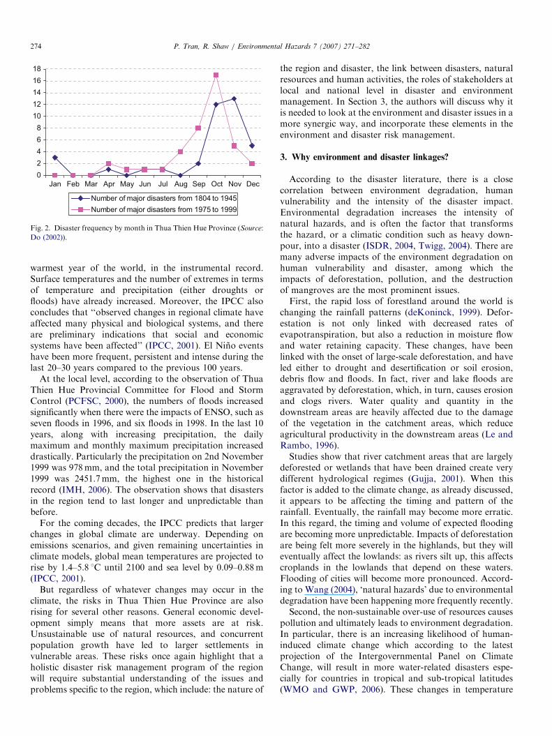
In the past few decades, in Thua Thien Hue Province thefrequency and severity of disasters increased significantly.In fact, during the 19th and the first half of 20th centuryfrom 1804 to 1945, there were only 38 floods and typhoonsin the historical record. In contrast, between 1975 and2000, there were 41 disasters with one storm, 18 floods, and22 storm-floods (Do, 2000). These severe disasters includedevents such as the severe flood of 1983, a destructive stormin 1985, and the historic flood in 1999. There is also atendency that the disaster season to come earlier thanbefore. As can be seen from Fig. 2, the major disasters from1975 to 1999 occurred mainly from August to Decemberwhile those between 1804 and 1945 happened mostly fromSeptember to January.Climate change may already have contributed to a rise in
intensity and frequency of these adverse meteorologicalphenomena. In reality, climate change is already happen-ing. The Third Assessment Report of the Intergovern-mental Panel on Climate Change (IPCC, 2001) observesthat the 1990s was the warmest decade, and 1998 the
Thien Hue Province.
ARTICLE IN PRESS
0
2
4
6
8
10
12
14
16
18
Jan Feb Mar Apr May Jun Jul Aug Sep Oct Dec
Number of major disasters from 1804 to 1945
Number of major disasters from 1975 to 1999
Nov
Fig. 2. Disaster frequency by month in Thua Thien Hue Province (Source:
Do (2002)).
P. Tran, R. Shaw / Environmental Hazards 7 (2007) 271–282274
warmest year of the world, in the instrumental record.Surface temperatures and the number of extremes in termsof temperature and precipitation (either droughts orfloods) have already increased. Moreover, the IPCC alsoconcludes that ‘‘observed changes in regional climate haveaffected many physical and biological systems, and thereare preliminary indications that social and economicsystems have been affected’’ (IPCC, 2001). El Nino eventshave been more frequent, persistent and intense during thelast 20–30 years compared to the previous 100 years.
At the local level, according to the observation of ThuaThien Hue Provincial Committee for Flood and StormControl (PCFSC, 2000), the numbers of floods increasedsignificantly when there were the impacts of ENSO, such asseven floods in 1996, and six floods in 1998. In the last 10years, along with increasing precipitation, the dailymaximum and monthly maximum precipitation increaseddrastically. Particularly the precipitation on 2nd November1999 was 978mm, and the total precipitation in November1999 was 2451.7mm, the highest one in the historicalrecord (IMH, 2006). The observation shows that disastersin the region tend to last longer and unpredictable thanbefore.
For the coming decades, the IPCC predicts that largerchanges in global climate are underway. Depending onemissions scenarios, and given remaining uncertainties inclimate models, global mean temperatures are projected torise by 1.4–5.8 1C until 2100 and sea level by 0.09–0.88m(IPCC, 2001).
But regardless of whatever changes may occur in theclimate, the risks in Thua Thien Hue Province are alsorising for several other reasons. General economic devel-opment simply means that more assets are at risk.Unsustainable use of natural resources, and concurrentpopulation growth have led to larger settlements invulnerable areas. These risks once again highlight that aholistic disaster risk management program of the regionwill require substantial understanding of the issues andproblems specific to the region, which include: the nature of
the region and disaster, the link between disasters, naturalresources and human activities, the roles of stakeholders atlocal and national level in disaster and environmentmanagement. In Section 3, the authors will discuss why itis needed to look at the environment and disaster issues in amore synergic way, and incorporate these elements in theenvironment and disaster risk management.
3. Why environment and disaster linkages?
According to the disaster literature, there is a closecorrelation between environment degradation, humanvulnerability and the intensity of the disaster impact.Environmental degradation increases the intensity ofnatural hazards, and is often the factor that transformsthe hazard, or a climatic condition such as heavy down-pour, into a disaster (ISDR, 2004, Twigg, 2004). There aremany adverse impacts of the environment degradation onhuman vulnerability and disaster, among which theimpacts of deforestation, pollution, and the destructionof mangroves are the most prominent issues.First, the rapid loss of forestland around the world is
changing the rainfall patterns (deKoninck, 1999). Defor-estation is not only linked with decreased rates ofevapotranspiration, but also a reduction in moisture flowand water retaining capacity. These changes, have beenlinked with the onset of large-scale deforestation, and haveled either to drought and desertification or soil erosion,debris flow and floods. In fact, river and lake floods areaggravated by deforestation, which, in turn, causes erosionand clogs rivers. Water quality and quantity in thedownstream areas are heavily affected due to the damageof the vegetation in the catchment areas, which reduceagricultural productivity in the downstream areas (Le andRambo, 1996).Studies show that river catchment areas that are largely
deforested or wetlands that have been drained create verydifferent hydrological regimes (Gujja, 2001). When thisfactor is added to the climate change, as already discussed,it appears to be affecting the timing and pattern of therainfall. Eventually, the rainfall may become more erratic.In this regard, the timing and volume of expected floodingare becoming more unpredictable. Impacts of deforestationare being felt more severely in the highlands, but they willeventually affect the lowlands: as rivers silt up, this affectscroplands in the lowlands that depend on these waters.Flooding of cities will become more pronounced. Accord-ing to Wang (2004), ‘natural hazards’ due to environmentaldegradation have been happening more frequently recently.Second, the non-sustainable over-use of resources causes
pollution and ultimately leads to environment degradation.In particular, there is an increasing likelihood of human-induced climate change which according to the latestprojection of the Intergovernmental Panel on ClimateChange, will result in more water-related disasters espe-cially for countries in tropical and sub-tropical latitudes(WMO and GWP, 2006). These changes in temperature
ARTICLE IN PRESSP. Tran, R. Shaw / Environmental Hazards 7 (2007) 271–282 275
and related local rainfall variations affect the environmentthrough accelerated desertification, land degradation, theavailability of water resources as well as reducing theoverall agricultural output. In addition, climate change isexpected to affect sea levels and cause climate extremes. Allthese factors have a compound effect on the occurrenceand impact of disasters.
Third, many mangrove swamps are under severe threatfrom various river basin development activities and floodmanagement projects. Flood prevention projects distort theflow variability and can cause severe deteriorations of thecoastal ecosystems. The degradation of mangrove forestssignificantly reduces their valuable functions such asshoreline stabilization and storm protection. The coastalforests become too degraded to absorb the energy ofcoastal storms, thereby increasing the flood and storm risksin the coastal zone.
In contrast, natural disasters are the factor directlycausing impediments to the economic development, sus-tainable development, environmental degradation, andintensifying poverty. In Viet Nam, natural disasters happenand take away many achievements of the national socio-economic development process. Only in the last 5 years ofthe 1990s (1996–2000), natural disasters caused damagesand losses of 2.3 billion USD, and killed on the average2117 people and caused losses of 459 million USD everyyear (CCFSC, 2006). Moreover, disasters have dislocatedfamilies who become refugees as they are forced to migrateelsewhere.
Natural disasters intensify the poverty gap in thepopulation and rapidly increase the poverty rate, especiallyin disaster-prone areas. In fact, poverty and vulnerabilityto disasters are integrally linked and mutually reinforcing(Wisner et al., 2004). The poor are forced to exploitenvironmental resources for survival, thereby increasingboth the risk and exposure to disasters, in particular thosetriggered by floods, drought and landslides. Deforestationand agriculture on marginal land, or destruction of forestsfor firewood collection, are often induced, or at leastexacerbated, by poverty. These practices directly affect thenatural environment, and may hurt the very resource basethat these poor people are depending on. Indeed, the ruralcommunities, which depend on resource-based activities,are the worst sufferers of the disaster impacts (Shaw, 2006).
Natural disasters cause the natural systems less resilienceto the disaster impacts and the poor lose their little assetsthey had. As a consequence, both human and naturalsystems are left poorer. Such cycles again demonstrate thatsustainable development requires a holistic view, of whichnatural hazards concerns are essential part.
In order to incorporate these dimensions into generaldisaster reduction, one needs a good understanding of therole of the local environment in natural hazards, and theway human activities are affecting it (Aalst and Burton,2002). In the case of inland flood risk for instance, one canlook at the upper watershed area, examine the meteorol-ogy, topology, geology and natural vegetation, land use
and agricultural practices, as well as the socio-economicrealities behind them.Incorporating natural hazard concerns can, in fact,
boost some projects that would be beneficial for otherreasons, but did not get appropriate attention. Protectingthe forest in an upper watershed area that feeds ahydropower plant and an irrigation system may becomemore feasible when the protective effect of the forests ondownstream sedimentation, landslides and floods are takeninto account (Aalst and Burton, 2002).Sustainable and integrated management of natural
resources, including reforestation schemes, proper landuse and good management of rivers and coastal areas willincrease the resilience of communities to disasters byreversing current trends of environmental degradation. TheInternational Decade of Natural Disaster Reduction(IDNDR) concluded that ‘‘environmental protection, as acomponent of sustainable development and consistent withpoverty alleviation, is imperative in the prevention andmitigation of natural disasters’’ (ISDR, 2002).
4. Evidence of environment disaster linkages
In this research, the authors find strong evidences thatland degradation, unsustainable agricultural practices,inappropriate infrastructure development, backward wastemanagement system, and poor coastal zone managementthat have contributed substantially to the natural hazardrisks.Firstly, there is a significant impact of land degradation
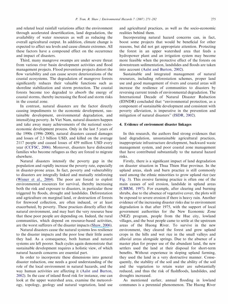
on disaster situation in Thua Thien Hue province. In theupland areas, slash and burn practice is still commonlyused among the ethnic minorities to grow upland rice (seeFig. 3). This erosive farming practice is often one of themain causes of soil erosion, landslide in upland areas(CBRM, 1997). For example, after clearing and burningshrubs, due to the absence of vegetative cover, the plots willbe exposed to severe erosion if there is heavy rain. Anotherevidence of the increasing disaster risks due to environmentdegradation is that after 1975, with the support of localgovernment authorities for the New Economic Zone(NEZ) program, people from the Hue city, lowlandvillages, and the boat people came to settle at the upstreamareas of the Huong River. To survive in the newenvironment, they cleared the forest and grew uplandcrops in the hills and wet rice in the small valleys andalluvial areas alongside springs. Due to the absence of amaster plan for proper use of the abundant land, the newsettlers used the land at their disposal for short-termbenefits. Without experience in sloping upland farming,they used the land in a very destructive manner. Conse-quently, the stability of the soil and the ability of the soiland the vegetation to retain water are substantiallyreduced, and thus the risk of flashfloods, landslides, anddroughts increased.As mentioned earlier, annual flooding in lowland
communes is a perennial phenomenon. The Huong River
ARTICLE IN PRESS
Fig. 3. Cause and effect of environment degradation and disasters.
P. Tran, R. Shaw / Environmental Hazards 7 (2007) 271–282276
and lagoon system play an important role in local people’slivelihoods, such as providing food, water, and transport.The flood-borne sediment provides the nutrients thatmaintain one of the Southeast Asia’s largest lagoons, andalso serves as a natural irrigation system for the region. Forcenturies, farmers, fishermen, and others have made theriver, delta and its vast lagoon their home.
Huong River functions have been hindered by extensivedeforestation in the region. Deforestation increases theseverity of flooding, as rainfall on deforested areas flowsinto stream channels quickly instead of being partiallyabsorbed by forests. These ‘quick-rising’ big floods poserisks to farmers who plant rice and vegetables on the banksof rivers in anticipation of beneficial silt-laden ‘slow rising’floods. The fear is that, in the context of the low capacity inthe past to prevent serious deforestation, an acceleration ofunfettered market-driven economic development will wor-sen such disasters.
The most recent flooding in November 1999 had causeda great deal of suffering for the inhabitants of the province,particularly in lowland and coastal areas. It inundated 90%of the lowlands. The province became isolated. The floodthat lasted for 1 week broke five new floodgates andcreated a new river mouth near the lagoon. The heavyrainfall in the uplands caused numerous landslides. Strongwinds caused fierce waves, which made mobility even more
difficult. The flood caused 352 deaths and 1700 billionVND (USD 120 million) in damage. This flooding isregarded to be the worst disaster in history of Viet Nam.Secondly, the construction of dams has been proposed as
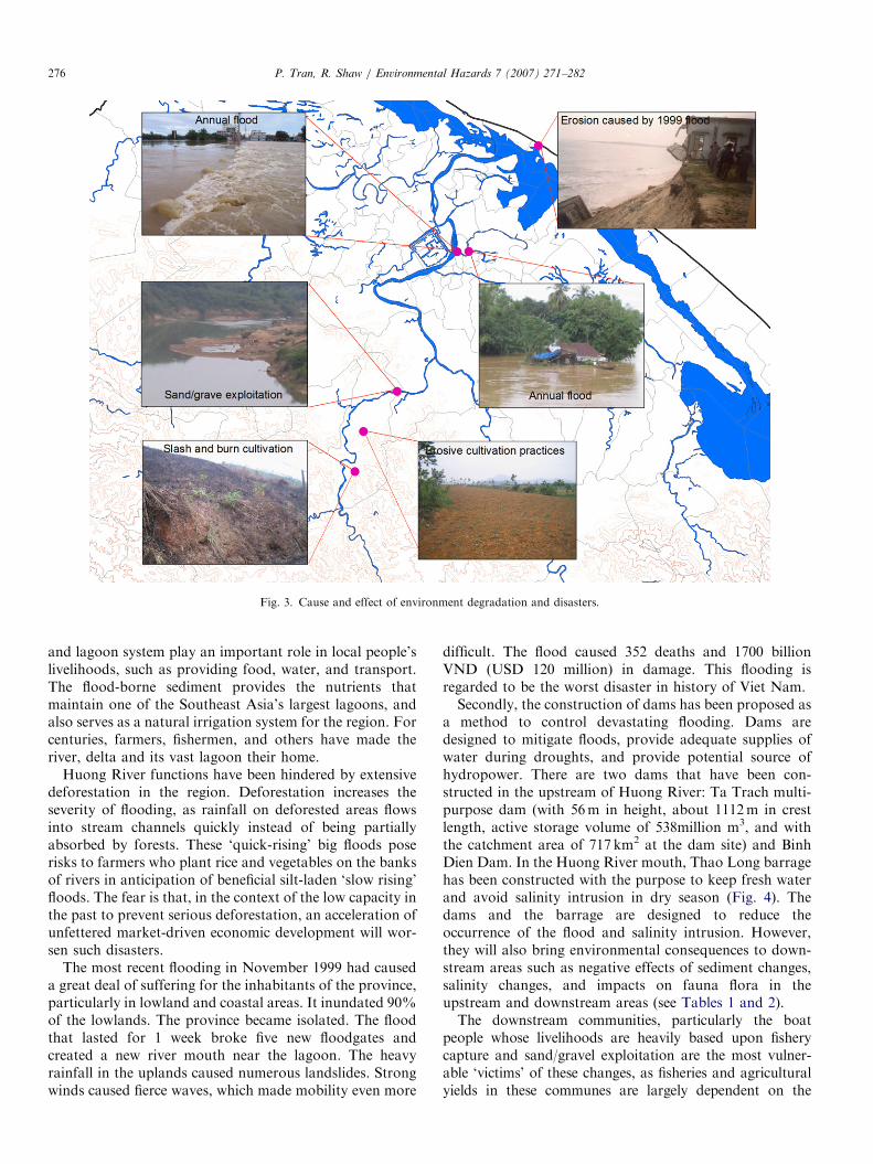
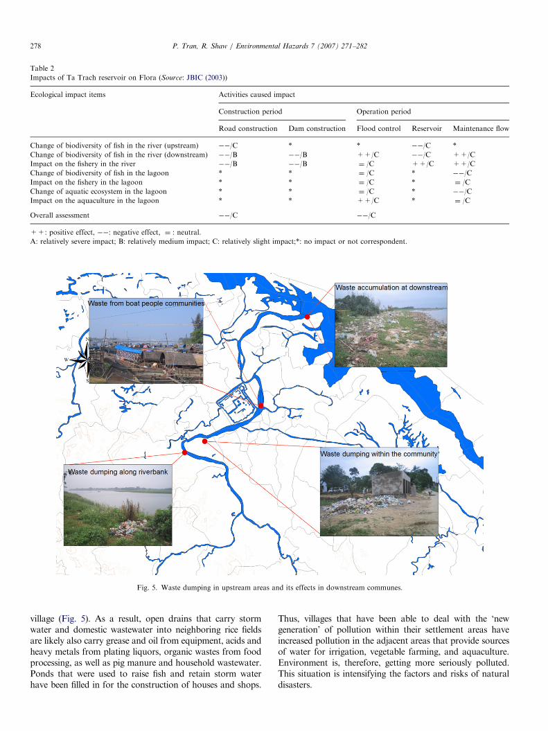
a method to control devastating flooding. Dams aredesigned to mitigate floods, provide adequate supplies ofwater during droughts, and provide potential source ofhydropower. There are two dams that have been con-structed in the upstream of Huong River: Ta Trach multi-purpose dam (with 56m in height, about 1112m in crestlength, active storage volume of 538million m3, and withthe catchment area of 717 km2 at the dam site) and BinhDien Dam. In the Huong River mouth, Thao Long barragehas been constructed with the purpose to keep fresh waterand avoid salinity intrusion in dry season (Fig. 4). Thedams and the barrage are designed to reduce theoccurrence of the flood and salinity intrusion. However,they will also bring environmental consequences to down-stream areas such as negative effects of sediment changes,salinity changes, and impacts on fauna flora in theupstream and downstream areas (see Tables 1 and 2).The downstream communities, particularly the boat
people whose livelihoods are heavily based upon fisherycapture and sand/gravel exploitation are the most vulner-able ‘victims’ of these changes, as fisheries and agriculturalyields in these communes are largely dependent on the
ARTICLE IN PRESS
Fig. 4. Vulnerable communities, and dam and barrage locations.
Table 1
Impacts of Ta Trach reservoir on fauna (Source: JBIC (2003))
Ecological Impact Items Activities caused impact
Construction period Operation period
Road construction Resettlement Logging Dam construction Road Reservoir New resettlement
Vegetation change surrounding reservoir ��/C ��/C ��/C ��/C ��/C * ��/C
Impact on terrestrial flora ��/C ��/C ��/C ��/C ��/C ¼ /C ��/C
Impact on terrestrial fauna ��/C ��/C ��/C ��/C ��/C ¼ /B ��/C
Micro climate change ��/C * ��/C * ��/C ++/C *
Overall assessment ��/C ��/C
++: positive effect, ��: negative effect, ¼ : neutral.
A: relatively severe impact; B: relatively medium impact; C: relatively slight impact;
*: no impact or not correspondent.
P. Tran, R. Shaw / Environmental Hazards 7 (2007) 271–282 277
normal water flow cycle of the Huong River, and thequantity of sand/gravel sedimentation (see Fig. 4). At thesame time, intensive logging has been implemented to clearthe area that will be submerged in the dam reservoir. TaTrach reservoir will affect 714 households with a populationof 3460; most of them are resettlers under NEZ policy.
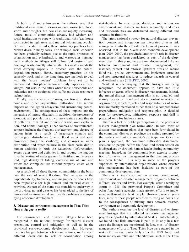
Thirdly, the traditional waste management system is underpressure and contributes to intensify the disaster risks.Indeed, in lowland communes in Thua Thien Hue, most of
villagers have historically relied on a traditional land usesystems that consist mainly of a garden and livestock areas.They continue to follow traditional practices they learnedfrom earlier generation in dealing with their wastes. Ingeneral, villagers lack the ability and experience to deal withthe ‘new wastes’ such as industrial wastes, emissions, mineralexploitations, and pesticide uses in agricultural production.For example, they dump waste collected in settlement areasinto ponds or along the banks of rivers within or around the
ARTICLE IN PRESS
Table 2
Impacts of Ta Trach reservoir on Flora (Source: JBIC (2003))
Ecological impact items Activities caused impact
Construction period Operation period
Road construction Dam construction Flood control Reservoir Maintenance flow
Change of biodiversity of fish in the river (upstream) ��/C * * ��/C *
Change of biodiversity of fish in the river (downstream) ��/B ��/B ++/C ��/C ++/C
Impact on the fishery in the river ��/B ��/B ¼ /C ++/C ++/C
Change of biodiversity of fish in the lagoon * * ¼ /C * ��/C
Impact on the fishery in the lagoon * * ¼ /C * ¼ /C
Change of aquatic ecosystem in the lagoon * * ¼ /C * ��/C
Impact on the aquaculture in the lagoon * * ++/C * ¼ /C
Overall assessment ��/C ��/C
++: positive effect, ��: negative effect, ¼ : neutral.
A: relatively severe impact; B: relatively medium impact; C: relatively slight impact;*: no impact or not correspondent.
Fig. 5. Waste dumping in upstream areas and its effects in downstream communes.
P. Tran, R. Shaw / Environmental Hazards 7 (2007) 271–282278
village (Fig. 5). As a result, open drains that carry stormwater and domestic wastewater into neighboring rice fieldsare likely also carry grease and oil from equipment, acids andheavy metals from plating liquors, organic wastes from foodprocessing, as well as pig manure and household wastewater.Ponds that were used to raise fish and retain storm waterhave been filled in for the construction of houses and shops.
Thus, villages that have been able to deal with the ‘newgeneration’ of pollution within their settlement areas haveincreased pollution in the adjacent areas that provide sourcesof water for irrigation, vegetable farming, and aquaculture.Environment is, therefore, getting more seriously polluted.This situation is intensifying the factors and risks of naturaldisasters.
ARTICLE IN PRESSP. Tran, R. Shaw / Environmental Hazards 7 (2007) 271–282 279
In both rural and urban areas, the authors reveal thattraditional risks remain serious or even worse (i.e. flood,storm and drought), but new risks are rapidly increasing.Before, most of communities already had wisdom andsocial institutions to cope with traditional risks (e.g. houseconstructed in high areas, and mutual help among people).But with the shift of risks, these customary practices havebroken down in many cases. For example, social cohesionhas been gradually reduced due to the rapid processes ofurbanization and privatization, and wastewater manage-ment methods in villages still follow ‘old customs’ anddischarge waste directly into canals. This waste exceeds thewater carrying capacity to proceed with the naturaldegradation process. Hence, customary practices do notcurrently work and at the same time, new methods to dealwith the ‘more modern’ problems have yet to bematerialized. This phenomenon not only happens in ruralvillages, but also in the cities where most households andindustries are not equipped with sufficient waste treatmenttechnologies.
Finally, the conversion of mangrove forest to shrimpponds and other aquaculture cultivation has seriousimpacts on the lagoon ecosystem and surrounding naturalenvironment. The consequences of these impacts are theincreasing of natural disasters. In addition, the pressures ofeconomic and population growth are creating acute threatsof pollution from oil and domestic waste, over exploita-tion, and habitat damage. Other sources of environmentalconcern include: the frequent displacement and closure oflagoon inlets as a result of large-scale climatic andhydrological disturbance (due to flood water and sandmovement along the seashore); and changes in waterdistribution and water balance in the river basin due tohuman activities in both the watershed (deforestation,excess water use) and activities in and around the lagoons(over harvesting of water grasses for fertilizer and livestockfeed, high density of fishing, excessive use of land andwaters for shrimp culture without properly waste watermanagement).
As a result of all those factors, communities in the basinface the risk of severe flooding. The increases in theunpredictability, frequency, and magnitude of floods havebeen responsible for high human and material costs inprovince. As part of the many risk transitions underway inthe province, natural disaster has been added to the lists ofunresolved environmental and health problems accompa-nying economic development.
5. Disaster and environment management in Thua Thien
Hue: a big gap in reality
The environment and disaster linkages have beenrecognized in the national strategy for natural disasterprevention, control and mitigation as well as in theprovincial socio-economic development plan. However,there is a big gap between policies and actions, and betweendifferent levels due to lack of coordination among
stakeholders. In most cases, decisions and actions onenvironment and disaster are taken separately, and rolesand responsibilities are distributed among different andseparate institutions.The latest national strategy for natural disaster preven-
tion, control and mitigation has integrated disaster riskmanagement into the overall development process. It wasobserved that in the 5-year-socio-economic-developmentplan (2006–2010), the provincial authority’s role in disastermanagement has been considered as part of the develop-ment plan. In this plan, there are well documented linkagesbetween environment and disaster management, forinstance, protect and reforest upstream areas to reduceflood risk, protect environment and implement structureand non-structural measures to reduce hazards in coastaland wetland areas (TTHPPC, 2005).While it is encouraging that the linkages are being
recognized, the document appears to have had littleinfluence on actual efforts in disaster management. Indeed,the annual disaster management plan is not detailed andmainly focuses on flood and storm control in which theorganization, structure, roles and responsibilities of mem-bers are mostly mentioned rather than on a comprehensivepreparedness, mitigation and response plan. A detailedplan for preparedness, mitigation, response and drill isprepared only for high-risk area.There is a lack of public participation in the process of
disaster management plan formulation. In fact, most ofdisaster management plans that have been formulated inthe commune, district or province are mainly prepared bythe leaders without community’s participation. Once theplan is approved, the commune authorities disseminatedecisions to people before the flood and storm season onloudspeakers or through hamlet leader during communitymeeting. Indeed, at the community-level exercise promo-tion of disaster risk management in the planning processhas been limited. It is only in some of the projectssupported by international organizations where disasterrisk management has been included as part of thecommunity development plan.There is a weak coordination among development,
environment and disaster management programs betweendifferent sectors and levels. For example, after a terrifyingstorm in 1985, the provincial People’s Committee andother functioning agencies made greater efforts to imple-ment settlement for boat people. However, several yearslater, most of these people returned to living on boats dueto the consequences of missing links between disaster,environment and economic development.The authors examine the level of disaster and environ-
ment linkages that are reflected in disaster managementprojects supported by international NGOs. Unfortunately,we found that little attention is paid to it; only in a fewcases the linkages are mentioned. In fact, most of disastermanagement efforts in Thua Thien Hue were started in thewake of disasters, particularly after the 1999 flood, andfocus mostly on relief and rehabilitation, such as the Thua
ARTICLE IN PRESSP. Tran, R. Shaw / Environmental Hazards 7 (2007) 271–282280
Thien Hue reconstruction project implemented by CECI(CECI, 2000), Disaster Resistant House RehabilitationProgram implemented by International Federation of RedCross and Red Crescent Societies (IFRC), and post-disaster housing program implemented by Catholic ReliefServices (IFRC, 2001).
More recent projects often contain some elements aimedat disaster mitigation. However, while they may sometimesrecognize the effect of environmental degradation onnatural hazard risk, they usually take other angles toaddress the hazard risks, such as building codes, infra-structure design, and attention to the location of humansettlements. For instance, Development Workshop Franceprojects aim to reinforce houses and community buildingsagainst typhoon winds, to raise the awareness among localcommunity and local authorities in the impact of disasters(Norton and Chantry, 2002), or the Spanish Red Crossproject aims to enhance disaster preparedness capacity withtraining and small-scale infrastructure improvements inparticularly vulnerable communities (Bufala, 2005).
There are only two projects: ‘‘Capacity building foradaptation to climate change in Central Vietnam’’ fundedby the Canadian International Development Agency(2002–2005), and currently ‘‘Enhancing Human Securityfor Environment and Disaster Management’’ funded bythe Asian Development Bank (2005–2006) that havestrongly addressed the linkages between disaster, livelihoodand environments, and have promoted activities linked toenvironmental degradation, particularly pay attention tocommunity-based disaster mitigation and institutionalstrengthening (CECI, 2004; Uitto and Shaw, 2006).However, with the time constrain coupled with limitedresources, implementation has faced challenges. Thus, theprojects’ main focus remains on more traditional riskfactors (including some trainings for livelihood climatechange adaptation regarding animal husbandry, agricul-ture, aquaculture activities, or physical protection worksand attention for the institutional capacity to address issueslike the location of settlements, infrastructure vulnerability,building codes, and disaster preparedness).
The authors also examine the extent to which naturalhazard risk concerns have been taken into account in thearea of natural resources and environmental management.At the national levels, there are some programs that haveaddressed only environmental improvements but they alsobring positive effect to disaster management. For instance,the program efforts encourage community involvement inthe protection of trees and agricultural land by, in essence,contracting out parcels of land to highland dwellers. Peopleare then to act as stewards of the land, caring for the forestsand engaging in sustainable agricultural practices (Dou-glass et al., 2002). There are some initiatives, which try toincorporate multiple sectors such as agriculture, aquacul-ture, environment, disaster management, tourism andhealth into natural resource management. Integratedapproaches have been gradually accepted through thedevelopment of new planning paradigms, Integrated
Coastal Zone Management (ICZM) and currently Inte-grated Management of Lagoon Activities (IMOLA) inThua Thien Hue.However, the authors can conclude that, although the
situation may currently be improving, the linkages have,again, not received much attention. In some communes,land use appears somewhat irregular; forest trees are grownon low slope plots and crops are grown on steep slope plotsdue to lack of disaster management concerns in thisprograms (Bui, 2001). For instance, reforestation activitiesbegan quite extensively in the early 1990s when the UnitedNations’ World Food Program had implemented itsinitiative. Through this program, capital and othermaterial incentives were given to villagers to enable themto establish forest plantations. The more trees people grew,the more incentives they got. So, to gain more from theprogram, villagers grew forest trees in gently sloping areasthat should have been used for crop production. In fact,the program had notice that erosion and flood in down-stream due to deforestation and unsustainable agriculturalpractices in the watershed area were becoming crucialproblems, but did not explicitly link that to natural hazardrisk management, and did not even attempt to address theunderlying problems (Bui, 2001). In addition, there alsohave been a number of environmental or agriculturalprojects that do not explicitly aim to reduce natural hazardrisk (CBRM, 1997).In conclusion, there are many important linkages
between natural resources and environmental managementand hazard risks as mentioned earlier, however only limitedefforts have been made to identify and address theselinkages. While the linkages may have been neglected, it isclear that both disaster mitigation and environmentaldegradation have been recognized as serious issues in ThuaThien Hue. Nevertheless, despite all the attention andefforts, hazard risks keep rising, and environmentaldegradation continues.
6. Towards an integrated approach: a possible way
to fill the gap
By analyzing the linkages between disaster and environ-ment with a spatial perspective: upstream, downstream,and rural–urban relation, the authors reveal importantdimensions regarding environment and disaster issues. Themore obvious insight is that the specifics of these issuesvary greatly over space, and thus call for localizedcapacities to respond to them. Beyond this observation,there are many insights from understanding how theimpacts regarding disaster and environment occurring inone region are resulting from many aspects from natural tosocial environment, and the connection of localities intothe process of urbanization and globalization. Deforesta-tion in the highlands is not taking place in an isolationfrom urban demands for timber, relocation of people fromone region to another, and the push for export cropproduction. The difficulties in sustaining traditional
ARTICLE IN PRESSP. Tran, R. Shaw / Environmental Hazards 7 (2007) 271–282 281
systems of environmental management in lowland areas orcities are not simply a problem of too many people in theselocations or lack of knowledge, but are instead an outcomeof gross increases in degree and type of environmentalproblem linking to broader processes over space.
Another concern is that the spatial linkages are notreflected in current environment and disaster managementpolicies of the province. In addition, the low level ofcommunity participation in the process of formulatingdisaster and environment management plan makes theconnection of provincial levels and local communities veryweak. As a result the policies and programs designed fordisaster management are impractical. Therefore, to miti-gate impacts of disasters we should recognize that naturaldisasters are an integral component of the challenges ofdevelopment and environment, not just a matter ofemergency aid and humanitarian assistance. Nor is thecurrently popular focus on building and infrastructuredesign and land use planning by itself is sufficient.
This perspective brings rural–urban linkage, poverty,empowerment, and the allocation of public and privatefunctions and responsibilities into focus as core aspects ofdisaster management. This integrated approach requiresmore local and community stakeholder involvement. Localcommunities should not be passive recipients or victims, butpartners with a real voice, and thus some power. Localknowledge and concerns should be a key aspect of efforts toaddress these issues, and the decision-making and incentivestructures should reflect a large degree of local ownershipand responsibility. An integrated approach should promotethe activities that have been already implemented and thathave been known to make good sense from all perspectives(poverty alleviation, economic development, natural hazardrisk, sustainable natural resources management, biodiversityconservation, urban–rural development, etc.). Second, thisapproach should find out where trade-offs may come intoplay (e.g. foregoing short-term benefits for long-termsustainability in the case of investments in forestry inhigh—instead of low-risk areas or decisions not to developcertain forested or coastal areas). In the latter case, one mustmake sure that all aspects, including information aboutnatural hazard risks (e.g. hazard maps), are taken intoaccount when such decisions are being made, and ensurethat all those involved are able to contribute to and benefitfrom the changes.
Further studies on integrated disaster managementapproach will be carried out, focusing on six communesin three different geographical areas along the HuongRiver to examine the actual importance of the linkagesbetween environment and disaster management. Thepurpose is to identify parameters to enhance the awarenessof and knowledge about these linkages in the localcommunities including individuals as well as the publicand the private sector from which the ways to address someof these issues as integral aspects of development, disaster,and environment concerns, and to promote stronginvolvement from the local community.
Acknowledgements
The first author highly acknowledges the scholarship ofGovernment of Japan, Ministry of Education SportCulture Science and Technology (MEXT) and the ProjectFund of the Gradate School of Global EnvironmentalStudies, Kyoto University for this study. The researchwould not have been possible without the cooperation oflocal communities and governments from commune toprovincial levels of Thua Thien Hue. The authors wouldlike to convey the sincere thanks to Mr. Phan Thanh Hung,Director of the Committee for Flood and Storm Control ofThua Thien Hue Province, for sharing valuable data.Another special thank should go to Dr. Fausto Marincionifor his valuable comments on this paper and Dr. Le VanAn for his great support during the field research.
References
Aalst, M., Burton, I., 2002. The Last Straw: Integrating Natural Disaster
Mitigation with Environmental Management. Disaster risk Manage-
ment Working Paper Series no. 5. The World Bank, Washington, DC.
Beckman, M., An, L., Bao, L., 2002. Coping and Adaptation strategies of
households and local institutions in Central Vietnam. Stockholm
Environment Institute, SEI/REPSI Report Series No. 5.
Bui, T., 2001. The Economics of Soil Erosion and the Choice of Land Use
Systems by Upland Farmers in Central Vietnam. College of
Economics, Hue University, Thua Thien Hue, Vietnam.
Bufala, T., 2005. Community based disaster risk management: the
challenge for sustainable development in South East Asia: the case
of Spanish Red Cross. The PDRSEA 3 Newsletter vol. 3, number 1.
Retrieved 2 June 2006 from ohttp://www.adpc.net/pdrsea/pdrsea3-
news-1.pdf4.
CBRM, 1997. Community-Based Upland Resource Management Re-
search Project. Final Technical Report. College of Agriculture and
Forestry, Hue University, Thua Thien Hue, Vietnam.
CCFSC, 2001. Second National Strategy and Action Plan for Disaster
Mitigation and Management in Vietnam—2001 to 2020. December
2001, Government of Vietnam, Ministry of Agriculture and Rural
Development, Central Committee for Flood and Storm Control,
Hanoi, Vietnam.
CCFSC, 2006. Government of Vietnam, Ministry of Agriculture and
Rural Development, Central Committee for Flood and Storm Control.
National Strategy and Action Plan for Disaster Prevention, Control
and Mitigation in Vietnam—2001 to 2020. September 2006, Hanoi,
Vietnam.
CECI, 2000. Hue construction project. Retrieved 2 June 2006, Web site:
ohttp://www.cecivietnam.com/PDFs/HueReconstruction.pdf4.
CECI, 2004. Community Vulnerability Assessment Report of Canadian
Center for International Cooperation and Studies. CECI, Hue,
Vietnam.
deKoninck, R., 1999. Deforestation in Vietnam. International Develop-
ment Research Centre, Quebec.
Do, B., 2002. Floods and Storms in Central Viet Nam in 19th and 20th
centuries. Da Nang Publishing House, Vietnamese.
Dolcemascolo, G., 2004. Environment Degradation and Disaster Risk—
Issue Paper Prepared by Asian Disaster Preparedness Center For
Embassy of Sweden/Sida Bangkok. Asian Disaster Preparedness
Center (ADPC).
Douglass, M., DiGregorio, M., Pichaya, V., Boonchuen, P., Brunner, M.,
Bunjamin, W., Foster, D., Handler, S., Komalasari, R., Taniguchi, K.,
2002. The Urban Transition in Vietnam. Department of Urban and
Regional Planning, University of Hawai’i at Manoa, UN Center for
Human Settlements, Fukuoka and UNDP.
ARTICLE IN PRESSP. Tran, R. Shaw / Environmental Hazards 7 (2007) 271–282282
Gujja, B., 2001. Dam accused of role in flooding. Research paper: ‘‘dams
and floods’’. World Wide Fund for Nature. Retrieved 2 June 2006,
Web site: ohttp://www.reliefweb.int/, http://www.reliefweb.int/
www.reliefweb.int/4.
Guzman, E., 2002. Towards total disaster risk management approach.
Asian Disaster Reduction Center (ADRC) and the Office of the
Coordinator for Humanitarian Affairs (OCHA), Retrieved 10 May
2006, from ohttp://unpan1.un.org/intradoc/groups/public/documents/
APCITY/UNPAN009657.pdf4.
IFRC, 2001. World disaster report, chapter 5. Retrieved 2 June 2006, Web
site: ohttp://www.palestinercs.org/Downloads/report2001.pdf4.
IMH, 2006. Data of meteorology and hydrology of Thua Thien Hue
province. Institute of Meteorology and Hydrology.
IPCC, 2001. Climate Change 2001: Synthesis Report. Cambridge
University Press, Cambridge, UK.
ISDR, 2002. Disaster reduction and sustainable development: under-
standing the links between vulnerability and risk related to develop-
ment and environment. Background document for the World Summit
on Sustainable Development (WSSD) No. 5, revised version 17 May
2002.
ISDR, 2004. Living with Risk—A Global Review of Disaster Reduction
Initiatives. United Nations, New York and Geneva.
JBIC, 2003. Special assistance for project formation for Ta Trach
Reservoir Project, Phase II. Draft Final Report. Japan Bank for
International Corporation.
Le, C., Rambo, T., 1996. Red Books, Green Hills: The Impact of
Economic Reform on Restoration Ecology in the Midlands of
Northern Vietnam, vol. 75. East-West Center, Honolulu.
McEntire, D., Fuller, C., Johnston, C., Weber, R., 2002. A comparison of
disaster paradigms: the search for a holistic policy guide. Public
Administration Review 62.
Norton, J., Chantry, G., 2002. More to lose: establishing community
capacity to reduce vulnerability to economic loss caused by storm
damage to houses in central Viet Nam. In: Regional Workshop on Best
Practices in Disaster Mitigation, September 2002, Bali, Indonesia.
PCFSC, 2000. Assessment of extreme climatic phenomena and their
impacts on the contemporary natural disasters in Thua Thien Hue
Province (in Vietnamese).
Shaw, R., 2006. Community base climate change adaptation in Vietnam:
inter-linkage of environment, disaster and human security. In: Sonak,
S. (Ed.), Multiple Dimension of Global Environmental Changes.
TERI Publication.
TTHPPC, 2002. Land Use Planning for Thua Thien Hue Province to
2010. Thua Thien Hue Provincial People’s Committee (in Vietnamese).
TTHPPC, 2005. Five year social-economic development plan, from 2006
to 2010. Thua Thien Hue Provincial People’s Committee (in
Vietnamese).
Twigg, J., 2004. Mitigation and Preparedness in Development and
Emergency Programming. Good Practice Review. Publish-on-Demand
Ltd., UK.
Uitto, J., Shaw, R., 2006. Adaptation to Changing Climate: Promoting
Community-based Approaches in the Developing Countries. Graduate
School of Global Environmental Studies, Kyoto University. Available
at: ohttp://www.iedm.ges.kyoto-u.ac.jp/top_e.htm4.
Wang, Y., 2004. Environmental degradation and environmental threats in
China. Environmental Monitoring and Assessment 90, 161–169.
Wisner, B., Blaikie, P., Cannon, T., Davis, I., 2004. At Risk Second
Edition: Natural Hazards, People’s Vulnerability, and Disasters.
Routledge, London, New York.
WMO, GWP, 2006. Environmental Aspects of Integrated Flood Manage-
ment, Second Draft. World Meteorological Organization and Global
Water Partnership-Associated Program on Flood Management.