towards 4D hydrogeology - HESS
55
1 Advancing measurements and representations of subsurface heterogeneity and dynamic processes: towards 4D hydrogeology Thomas Hermans 1 , Pascal Goderniaux 2 , Damien Jougnot 3 , Jan Fleckenstein 4 , Philip Brunner 5 , Frédéric Nguyen 6 , Niklas Linde 7 , Johan Alexander Huisman 8 , Olivier Bour 9 , Jorge Lopez Alvis 6,a , Richard Hoffmann 6,8 , Andrea Palacios 10,b , Anne-Karin Cooke 11,12,c , Álvaro Pardo-Álvarez 5 , Lara Blazevic 3,d , Behzad Pouladi 9,e , Peleg Haruzi 8,13 , Meruyert Kenshilikova 9 , Philippe 5 Davy 9 , Tanguy Le Borgne 9 1 Department of Geology, Ghent University, 9000 Gent, Belgium 2 Department of Geology and Applied Geology, University of Mons, 7000 Mons, Belgium 3 UMR 7619 METIS, Sorbonne Université, UPMC Université Paris 06, CCNRS, EPHE, F-75005 Paris, France 10 4 Department of Hydrogeology, Helmoltz Centre for Environmental Research, 04318 Leipzig, Germany 5 Laboratory of Hydrogeological Processes, University of Neuchâtel, 2000 Neuchatel, Switzerland 6 Urban and Environmental Engineering, Liege University, 4000 Liege, Belgium 7 Institute of Earth Sciences, University of Lausanne,1015 Lausanne, Switzerland 8 Agrosphere (IBG 3), Institute of Bio- and Geosciences, Forschungszentrum Jülich GmbH, 52425 Jülich, Germany 15 9 Geosciences Rennes, UMR 6118, Université de Rennes 1, CNRS, 35000 Rennes, France. 10 Institute of Environmental Assessment and Water Research (IDAEA), Consejo Superior de Investigaciones Científicas (CSIC), Barcelona, 08034, Spain 11 Géosciences Montpellier, University of Montpellier, CNRS, Univ. des Antilles, 34095 Montpellier, France 12 Institut d’Optique d’Aquitaine, Muquans, 33400 Talence, France 20 13 Department of Environmental Physics and Irrigation, Agricultural Research Organization – Volcani Institute, 7505101 Rishon LeZion, Israel a Now at Centro de Geociencas , Universidad Nacional Autonoma de Mexico, 76230 Querétaro, Mexico. b Now at Amphos 21 Consulting, 08019 Barcelona, Spain. c Now at Federal Institute for Geosciences and Natural Resources (BGR), 13593 Berlin, Germany 25 d Now at Ruden SA, 0349 Oslo, Norway e Now at Silixa Ltd, London, UK. Correspondence to: Thomas Hermans ([email protected]) 30 Abstract. Essentially all hydrogeological processes are strongly influenced by the subsurface spatial heterogeneity and the temporal variation of environmental conditions, hydraulic properties, and solute concentrations. This spatial and temporal variability needs to be considered when studying hydrogeological processes in order to employ adequate mechanistic models https://doi.org/10.5194/hess-2022-95 Preprint. Discussion started: 14 March 2022 c Author(s) 2022. CC BY 4.0 License.
-
Upload
khangminh22 -
Category
Documents
-
view
1 -
download
0
Transcript of towards 4D hydrogeology - HESS

1
Advancing measurements and representations of subsurface heterogeneity and
dynamic processes: towards 4D hydrogeology
Thomas Hermans1, Pascal Goderniaux2, Damien Jougnot3, Jan Fleckenstein4, Philip Brunner5, Frédéric Nguyen6, Niklas
Linde7, Johan Alexander Huisman8, Olivier Bour9, Jorge Lopez Alvis6,a, Richard Hoffmann6,8, Andrea Palacios10,b, Anne-Karin
Cooke11,12,c, Álvaro Pardo-Álvarez5, Lara Blazevic3,d, Behzad Pouladi9,e, Peleg Haruzi8,13, Meruyert Kenshilikova9, Philippe 5
Davy9, Tanguy Le Borgne9
1 Department of Geology, Ghent University, 9000 Gent, Belgium
2 Department of Geology and Applied Geology, University of Mons, 7000 Mons, Belgium
3 UMR 7619 METIS, Sorbonne Université, UPMC Université Paris 06, CCNRS, EPHE, F-75005 Paris, France 10
4 Department of Hydrogeology, Helmoltz Centre for Environmental Research, 04318 Leipzig, Germany
5 Laboratory of Hydrogeological Processes, University of Neuchâtel, 2000 Neuchatel, Switzerland
6 Urban and Environmental Engineering, Liege University, 4000 Liege, Belgium
7 Institute of Earth Sciences, University of Lausanne,1015 Lausanne, Switzerland
8 Agrosphere (IBG 3), Institute of Bio- and Geosciences, Forschungszentrum Jülich GmbH, 52425 Jülich, Germany 15
9 Geosciences Rennes, UMR 6118, Université de Rennes 1, CNRS, 35000 Rennes, France.
10 Institute of Environmental Assessment and Water Research (IDAEA), Consejo Superior de Investigaciones Científicas
(CSIC), Barcelona, 08034, Spain
11 Géosciences Montpellier, University of Montpellier, CNRS, Univ. des Antilles, 34095 Montpellier, France
12 Institut d’Optique d’Aquitaine, Muquans, 33400 Talence, France 20
13 Department of Environmental Physics and Irrigation, Agricultural Research Organization – Volcani Institute, 7505101
Rishon LeZion, Israel
a Now at Centro de Geociencas , Universidad Nacional Autonoma de Mexico, 76230 Querétaro, Mexico.
b Now at Amphos 21 Consulting, 08019 Barcelona, Spain.
c Now at Federal Institute for Geosciences and Natural Resources (BGR), 13593 Berlin, Germany 25
d Now at Ruden SA, 0349 Oslo, Norway
e Now at Silixa Ltd, London, UK.
Correspondence to: Thomas Hermans ([email protected])
30
Abstract. Essentially all hydrogeological processes are strongly influenced by the subsurface spatial heterogeneity and the
temporal variation of environmental conditions, hydraulic properties, and solute concentrations. This spatial and temporal
variability needs to be considered when studying hydrogeological processes in order to employ adequate mechanistic models
https://doi.org/10.5194/hess-2022-95Preprint. Discussion started: 14 March 2022c© Author(s) 2022. CC BY 4.0 License.

2
or perform upscaling. The scale at which a hydrogeological system should be characterized in terms of its spatial heterogeneity
and temporal dynamics depends on the studied process and it is not always necessary to consider the full complexity. In this 35
paper, we identify a series of hydrogeological processes for which an approach coupling the monitoring of spatial and temporal
variability, including 4D imaging, is often necessary: (1) groundwater fluxes that control (2) solute transport, mixing and
reaction processes, (3) vadose zone dynamics, and (4) surface-subsurface water interaction occurring at the interface between
different subsurface compartments. We first identify the main challenges related to the coupling of spatial and temporal
fluctuations for these processes. Then, we highlight some recent innovations that have led to significant breakthroughs in this 40
domain. We finally discuss how spatial and temporal fluctuations affect our ability to accurately model them and predict their
behavior. We thus advocate a more systematic characterization of the dynamic nature of subsurface processes, and the
harmonization of open databases to store hydrogeological data sets in their four-dimensional components, for answering
emerging scientific question and addressing key societal issues.
45
Short summary. Although invisible, groundwater plays an essential role for the society as a source of drinking water or for
ecosystems by providing baseflow to rivers, but is also facing important challenges in term of contaminations. Characterizing
groundwater reservoirs with their spatial heterogeneity and their temporal evolution is therefore crucial for their sustainable
management. In this paper, we review some important challenges and recent innovations in imaging and modelling
groundwater reservoirs. 50
1 Introduction
While the surface components of continental water, such as streams, lakes and glaciers, are a very familiar part of our
landscape, the vast majority of continental water resources resides and flows in the subsurface, and is thus generally
inaccessible to direct observation (McDonnell, 2017). Growing societal needs imply that subsurface environments, which form
part of the critical zone of the Earth (Brantley et al., 2007; Fan et al., 2019), are increasingly subject to pressure and multiple 55
(possibly competing) uses for water resources such as groundwater abstraction, artificial recharge and storage (Dillon et al.,
2019; Russo and Lall, 2017; Aeschbach-Hertig and Gleeson, 2012), nuclear waste storage (e.g., Ewing, 2015, Butler, 2010),
geothermal energy (Rivera et al., 2017; Fleuchaus et al., 2018; Lu, 2018), oil and gas extraction (e.g., Wang et al., 2014) and
climate change mitigation such as energy storage (Arbabzadeh et al., 2019) and CO2 sequestration (Hamza et al., 2021, Kumar
et al., 2020) while being threatened by anthropogenic contamination (e.g., Riedel et al., 2020). As a result, subsurface systems 60
are experiencing profound modifications that affect their basic environmental functions and ecosystem services (Erostate et
al., 2020; Fattorini et al., 2020; Luijendijk et al., 2020). These modifications include, both at the local and the catchment scales,
water level depletion (Jasechko et al., 2021), which affects baseflow of many rivers and associated ecosystem services (Conant
et al., 2019), a growing input of chemicals and pathogens, which threaten water quality (e.g., Szymczycha et al., 2020),
seawater intrusion (Werner et al., 2013) and soil salinization (Litalien and Zeeb, 2020; Singh, 2021) threatening soil- and water 65
https://doi.org/10.5194/hess-2022-95Preprint. Discussion started: 14 March 2022c© Author(s) 2022. CC BY 4.0 License.

3
resources as well as food security in many arid and semi-arid regions of the world, and massive fluid injections at depth related
to CO2 sequestration or gas extraction, which may lead to increased seismicity (Rathnaweera et al., 2020; Schultz et al., 2020;
Keranen and Weingarten, 2018).
The last decade has seen great advances in stochastic subsurface hydrology (e.g., Scheidt et al., 2018), microscale imaging
(e.g., Gouze et al. 2008, Blunt et al. 2013, Heyman et al. 2020), and geophysical characterization (e.g., Binley at al., 2015; 70
Singha et al., 2015). Although geological heterogeneity has been long recognized, these advances have made it even more
clear that the subsurface is highly heterogeneous at multiple scales and that this heterogeneity substantially controls many
flow, transport and biochemical processes (e.g., Hartmann et al., 2017; Comte et al., 2019 Zamrsky et al., 2020). Recent efforts
have led to an improved ability for monitoring surface-water dynamics or characterizing the state of aquatic systems, but this
has not been matched by a significant increase in our ability to quantify the dynamics of fluxes and processes in the subsurface 75
(e.g., Schilling et al., 2018). A wide gap between common modelling approaches (e.g., homogeneous or multi-Gaussian
representations of parameters, steady state or transient simulations, upscaling approaches) and field reality prevails. On the
one hand, data sets often have a very limited 3D spatial extent and are characterized by a low sampling density, preventing a
full description of the complex nature of the aquifer (e.g., Xu and Valocchi, 2015). On the other hand, studies concerning the
temporal dynamics of hydrological processes and structures are generally based on point data typically acquired in wells in 80
hydrogeology, potentially missing the underlying spatial variability (e.g., Johnson et al., 2012). The persistent observation gap
between data points results in a lack of knowledge and contributes significantly to the current lack of understanding of
subsurface processes and our ability to accurately predict the evolution of subsurface systems.
This deficiency in the characterization of aquifer limits our ability to answer critical scientific questions of significant societal
and industrial impacts. For example, the magnitude, spatial distribution and temporal dynamics of fluxes between subsurface 85
and surface compartments of the Earth are relevant for the management of water quantity, quality and ecology (Fleckenstein
et al., 2006, 2010; Brunner et al., 2017; Conant et al., 2019). Similarly, the dispersion and residence time distribution of
dissolved chemical species in heterogeneous porous and fractured media, as well as the coupling between fluid mixing and
reactions and the localization of hotspots of subsurface biogeochemical reactions, are key aspects to study the fate of
contaminations (e.g., Wallis et al., 2020; Pannecoucke et al., 2020; Robinson and Hasenmueller, 2017; Bailey, 2017) or 90
understand the contribution of subsurface processes to global cycles of carbon (Zhang and Planavsky, 2020; Liu et al., 2014)
and nitrogen (Marzadi et al., 2012) (Figure 1). The above-mentioned processes are both highly dynamical and strongly
influenced by small-scale and across-scale heterogeneity (e.g., Salehikhoo et al., 2013, Dentz et al., 2011). In particular, the
location and reactivity of biogeochemical hot spots (e.g. McClain et al. 2003), which are thought to have a disproportionate
influence on macroscale critical zone processes relative to their size, may be largely influence by spatial heterogeneity coupled 95
to temporal fluctuations (e.g. Rolle and Le Borgne 2019). The potential of a characterization for coupled spatio-temporal
monitoring of parameters and state variables and their temporal evolution, including 4D imaging, to understand these processes
remains largely unexplored. This temporal component should not only include the evolution of state variables under transient
conditions, but also the evolution of system properties because of coupled processes such as hydromechanical effects impacting
https://doi.org/10.5194/hess-2022-95Preprint. Discussion started: 14 March 2022c© Author(s) 2022. CC BY 4.0 License.

4
the pore space or fracture apertures (Davy et al., 2018), colmatation and erosion processes in streambeds (Partington et al., 100
2017) or reactive transport inducing changes in the pore space (Izumoto et al., 2020).
A grand challenge of subsurface imaging methods for dynamic hydrogeological processes (Figure 1) is to deal with systems
characterized by pronounced structure and process heterogeneity, including preferential flow paths, evolving properties or
geometry, unsaturated flow processes, fluctuating redox conditions, and multifunctional microbial communities. Recent
breakthroughs in hydrogeophysical imaging techniques (Binley et al., 2015; Singha et al., 2015) and the emergence of 105
interdisciplinary approaches combining new sensors such as fiber optics (Bense et al., 2016; Zhan, 2020), new experimental
methodologies like ambient seismic noise correlation (Garambois et al., 2019) and coupled modelling techniques (e.g., Hinnell
et al., 2010; Jardani et al., 2013; Linde and Doetsch, 2016) may profoundly change our vision and representation of the
dynamics of processes that take place in these environments (Binley et al., 2015; St. Clair et al., 2015). However, monitoring
and characterizing dynamical fluxes, transport, reactions and hydromechanical processes that evolve spatially in 3D with 110
geophysical imaging is still in its infancy in environmental sciences and engineering. The efficiency of those new methods and
the full complexity that emerges from their coupling can only be revealed through in-situ exploration with interdisciplinary
approaches. In that sense, field observatories and case studies constitute a key component of the current research effort (e.g.,
Folch et al., 2020, Palacios et al., 2020).
Although heterogeneity influences all the processes occurring in the subsurface, an exhaustive characterization of the 115
subsurface is not always necessary and strongly depends on the objective of the studies. Large-scale water balance approaches,
average advection velocity or aquifer recharge through the vadose zone might be approximated with scarce hydrogeological
data. However, the integration of recent advances in imagining the spatial and temporal variability in hydrological model is
still in its early stage and has a huge potential to improve the mechanistic understanding of hydrological processes, the
upscaling of models and the assessment of model simplifications. The objective of this opinion paper is, therefore, to identify 120
and discuss when, why, and for which processes and applications the characterization of dynamic hydrogeological processes
is crucial. We discuss the potential and value of exploring and monitoring dynamic in hydrogeology, including 4D imaging,
for understanding groundwater fluxes, transport, mixing and reactions processes, soil moisture dynamics in the vadose zone
and surface-subsurface water interactions (Figure 1). Based on a non-exhaustive overview of recent advances, we identify key
scientific challenges and their relation to the heterogeneous and dynamic nature of the subsurface for each of the above-125
mentioned processes. We then highlight some recent breakthroughs which allowed to advance our understanding of these
processes. We also discuss the feasibility, advances and challenges of numerical modelling of the identified processes in terms
of 4D complexity as well as the important role of instrumented field observatories and corresponding case studies to tackle the
scientific challenges and evaluate the performance and scope of recent innovations.
https://doi.org/10.5194/hess-2022-95Preprint. Discussion started: 14 March 2022c© Author(s) 2022. CC BY 4.0 License.

5
2 Key processes in hydrogeology and their 4D nature 130
In this section, we highlight hydrogeological processes at different scales for which the considerations of coupled spatial
heterogeneity and temporal dynamics are important, present the main challenges related to the representation and inference of
spatial and temporal variability and point towards a few recent innovations that could help to address these challenges in the
future.
2.1 Groundwater fluxes 135
Inferring and modeling groundwater Darcy fluxes and fluid velocities is crucial in most hydrogeological processes and related
applications, both for quantitative (e.g., water storage, groundwater discharge, residence time) and qualitative (e.g.,
contaminant transport, reaction and mixing processes) purposes. Pore-scale advection flow, along with the other transport
processes and the influence of the macro-scale geological heterogeneity, controls propagation and spreading of natural or
contaminant solutes, from fast transfers to late time tailings (e.g. Dentz et al. 2011; Hoffmann et al., 2020; Kang et al., 2015). 140
In the context of risk assessment, measuring natural solutes or contaminant concentrations may be of limited value if not
supported by quantitative flux rates allowing to estimate solute mass transfers (Brouyère et al., 2008). Groundwater fluxes
drive mixing processes prevailing at aquifer interfaces such as subsurface-surface interactions in hyporheic zones or transition
zones along coastal saltwater intrusion (e.g. Werner et al. 2013, Hester et al. 2017). They also influence hydrogeochemical and
biogeochemical reactions by transporting reactants, such as nutrients, to these interfaces. They impact the feasibility of storage 145
applications including the injection and recovery of heat or CO2 in the subsurface (Niemi et al. 2017, Fleuchaus et al. 2018)
and control residence times distributions across watersheds (Goderniaux et al., 2013).
The range of variation of expected groundwater fluxes may be very large, making them difficult to image, with their spatial
and temporal variation. For decades, the basic approach consisted in first measuring the hydraulic conductivity and then predict
fluxes, based on the hydraulic gradient. This approach however presents the serious disadvantage to average local variations 150
and offers a limited understanding of the groundwater flux spatial distribution in heterogeneous media (Palmer, 1993; Brouyère
et al., 2008; Jamin et al., 2015). In addition, many subsurface processes are time-dependent and exhibit an inherent periodicity.
If deep systems are not expected to vary rapidly, shallow aquifers can exhibit fluctuations ranging from lower (e.g. multi-
annual or seasonal recharge fluctuations) to higher frequencies (e.g. tide dependent saltwater intrusion, aquifer exploitation or
artificial storage applications). The accurate quantification of groundwater flux rates including their spatial distribution and 155
transient conditions is, therefore, needed to understand and manage these processes. This should be performed at the relevant
scale(s), with the appropriate resolution, in adequation with the objectives of the study and the geological context (Jimenez-
Martinez et al., 2013).
Recent research efforts have focused on the development of direct or indirect methods allowing for a more accurate assessment
of groundwater fluxes, including their amplitude, spatial distribution and temporal dynamics, with application in highly 160
heterogeneous media. As groundwater fluxes influence many processes, some approaches, discussed in the next sections, have
https://doi.org/10.5194/hess-2022-95Preprint. Discussion started: 14 March 2022c© Author(s) 2022. CC BY 4.0 License.
6
been developed for specific contexts, such as surface-subsurface interactions or solute transport, allowing indirect
quantification of the fluxes, for example through tracer experiments (Popp et al., 2021). Some other techniques are more
general and available to directly and accurately measure local groundwater fluxes (e.g., Jamin et al., 2015; Le Borgne et al.,
2006 ; Brouyère et al., 2008 ; Burnett et al., 2006). For instance, point measurements of darcy fluxes are classically done from 165
dilution methods (Drost et al., 1968; Klotz et al., 1980; Pitrak et al., 2007; Novakowski et al., 2006; Jamin et al., 2015). Well-
points velocity probes have been also recently developed (Labaky et al., 2009; Devlin, 2020) to provide promising and
complementary velocity measurements although ranges of measurements are still limited. A key aspect of some recent
approaches is to allow the monitoring of groundwater fluxes dynamics (Jamin and Brouyère, 2018). Important challenges, also
depending on the media type, however, remain. The number of available methods for direct measurement is limited and most 170
methods are suited for porous media rather than fractured aquifers where fluxes are expected to show stronger spatial
variations. Current methods are still deficient in providing full 3D high-resolution datasets as they must be performed in wells.
Current geophysical imaging techniques are still unable to directly estimate fluxes, as they are based on the contrast in water
properties induced through tracers. Nevertheless, very promising results were obtained through the combination of ambient
noise surface wave tomography (ANSWT), and self-potential (SP) measurements to image the complex hydrogeology 175
structure and associated groundwater flow paths at a coastal site (Grobbe et al., 2021). The joint interpretation of the SP and
seismic data permits to show that groundwater flow occurs in the identified paleo-channels at the erosional surface of the
basaltic bedrock (Grobbe et al., 2021). Despite these improvements, monitoring the dynamics of fluxes remains resource
expensive. Accurate measurements, which often imply complex experimental needs and designs, must be repeated regularly,
with an adequate time resolution, for example to understanding cyclic process evolution. Passive flux methods (e.g., Hatfield 180
et al., 2004) integrate flux measurements over specific periods, providing mean representative value while avoiding repetitive
field operations, but do not capture the dynamics.
Fiber Optic Distributed Temperature Sensing (DTS) allows for the measurement of temperature with high spatial and temporal
resolution over large distances from a few hundreds m up to several km, using buried or borehole cables (Selker et al., 2006;
Bense et al., 2016; Simon et al., 2020, see table 1.C). By estimating the rates of temperature change along the cable, this kind 185
of system allows an indirect estimation of groundwater fluxes intercepting the cable, provided that conditions are changing
fast enough and that the temperature change is large enough to be detected. Read et al. (2013) for example resolved
groundwater fluxes in fractured granite, by combining DTS measurements and hot water injections in a borehole. Long-term
changes can also be detected by using DTS systems as permanent monitoring tools (Susanto et al., 2017; McCobb et al., 2018).
A new generation of active fiber-optics with heated cables designed for hydrogeological investigations is currently being 190
developed and is a promising approach for inferring borehole or in-situ groundwater fluxes (Read et al., 2014; des Tombes et
al., 2019; Maldaner et al., 2019; Simon et al., 2021; Del Val et al., 2021). The thermal response during the active heating of
the cable and the subsequent cooling period is monitored as it depends strongly on the water fluxes intercepting the cable,
allowing an accurate groundwater flux assessment (Simon et al., 2021). Although challenges still remain to deploy such set-
https://doi.org/10.5194/hess-2022-95Preprint. Discussion started: 14 March 2022c© Author(s) 2022. CC BY 4.0 License.
7
ups on the field, possible DTS applications extend to various domains, including 3D hydraulic tomography (Pouladi et al., 195
2021) or groundwater-surface water interactions (see section 2.4).
In summary, the spatial distribution and dynamics of fluxes constitute a key component to many hydrogeological processes
but are still poorly resolved. Although integrating 4D aspects in flux assessment might not be needed in larger scale water
balance studies, they still influence residence time at the catchment scale. The development of innovative in-situ methods to
characterize fluxes is an important element, unravelling the 4D distributions of fluxes remain a major challenge in 200
hydrogeology for process understanding or environment characterization.
2.2 Transport, mixing and reaction
Three-dimensional heterogeneity and temporal fluctuations of fluxes have a first-order impact on transport and reaction
processes (e.g. Dentz et al. 2011, Rolle and Le Borgne 2019, Valocchi et al. 2019). The inherent heterogeneity of subsurface
environments leads to strong dispersion, which do not follow the conventional Fickian dispersion framework (e.g. Berkowitz 205
et al. 2006, Neuman and Tartakovsky 2009). Furthermore, mixing dynamics can be fundamentally different than predicted
from 2D or steady representations of the subsurface (Lester et al. 2013). At the pore scale, recent 3D imaging techniques
(Figure 2) have shown that 3D flow topologies driven by pore scale flow patterns lead to chaotic flows that strongly enhance
mixing rates (Heyman et al. 2020, Souzy et al. 2020). At the Darcy scale, anistropic permeability fields can generate helical
flow that play a similar role (Ye et al. 2015). In fractured media, intersection of fractures with fluids of different chemical 210
compositions can create microbial hot spots with intermittent activity (Bochet et al. 2020). Modelling and laboratory
investigations have shown that these transport and reaction rates can be further altered by temporal fluctuations in head levels
(Pool and Dentz, 2018) and variable water content (Jiménez-Martínez et al., 2017). Modelling studies have provided evidence
that heterogeneity and temporal fluctuations can exert a strong control on biogeochemical reaction rates (Li et al., 2010; Sanz-
Prat et al., 2016). However, there is increasing evidence that reactive transport processes are not well captured by the 215
macrodispersion framework (Gramling et al. 2002, de Anna et al. 2014). Yet, in the absence of an alternative upscaling
framework, the macrodispersion model is still the main reference for field applications.
Characterizing and imaging transport and reaction dynamics in the field is a critical challenge for a range of fundamental and
applied questions, such as designing efficient remediation strategies for contaminated sites (Kitanidis and McCarty, 2012) or
characterizing transport and reaction dynamics in mixing zones (Rolle and Le Borgne, 2019). Such reactive hot spots tend to 220
develop at the interfaces between surface and subsurface compartments (Mcclain et al. 2003), which includes the vadose zone
(Jimenez-Martinez et al., 2017, see section 2.3), the hyporheic zone (Hester et al., 2017, see section 2.4) or the groundwater-
seawater interface (Pool and Dentz, 2018).
Classical artificial tracer tests are commonly used to estimate solute transport properties and related parameters. Their use in
highly heterogeneous media is, however, challenging due to the difficulty of positioning a limited amount of recovering points 225
leading to low mass recovery (Kemna et al., 2002; Sanford et al., 2006). When interpreting or inverting the breakthrough data,
with little information on the spatial heterogeneity, the range of possible interpretation in terms of parameter values can be
https://doi.org/10.5194/hess-2022-95Preprint. Discussion started: 14 March 2022c© Author(s) 2022. CC BY 4.0 License.

8
quite large or misleading (Hoffmann et al., 2019). Combining tracer test recovery with other monitoring methods, such as
geophysics, and model inversion provides complementary information (e.g.,. Robert et al., 2012) that can narrow down the
uncertainty in the interpretation. Combining multiple tracers can also provide more constraints on tracer test interpretation 230
(Hoffmann et al., 2019, 2021a,b, table 1.E). Tirado-Conde et al. (2019) combined 180 seepage meter measurements with heat
used as a tracer in 30 locations, to study and characterize surface water-groundwater interactions and saltwater intrusion around
a coastal lagoon inlet. Hoffmann et al. (2019), Klepikova et al. (2016) combined classical tracers with heat injection, taking
advantage of heat conduction processes in rocks and sediments to better image the heterogeneity (Figure 3). They coupled
these different tracer experiments with electrical imaging (ERT) and fiber optics (Hermans et al., 2015b, table 1.A.1) to image 235
highly heterogeneous alluvial deposits with high resolution (3), in the context of experimental pumping operations performed
at short time-scale. DTS fiber optics techniques provide the opportunity for spatial monitoring of thermal tracers (de La
Bernardie et al., 2018; Klepikova et al., 2016, see also section 2.1 and table 1.C.3). The combination of tracer experiments
under different configurations (convergent, push pull,…) provides new constraints on transport models, highlighting the
possibility to capture the effect of complex 3D fracture networks architectures in effective transport models (Kang et al., 2015; 240
Guilhéneuf et al., 2017).
New mobile mass spectrometers have opened up new opportunities to use dissolved gas as tracers and measure them
continuously in the field (Brennwald et al., 2016; Chatton et al., 2017;Popp et al., 2021). Dissolved gases, such as Helium or
Argon, are conservative tracers with larger diffusivity compared to solute tracers, thus, allowing the exploration of diffusive
processes such as fracture-matrix or mobile-immobile water interactions. Hoffmann et al. (2020) combined dye tracers with 245
dissolved gases (Helium, Argon, Xenon) to study preferential flowpaths and mobile-immobile water effects within a dual
porous/fractured rock chalk aquifer (table 1.E.2). Reactive tracers have offered new methods for characterizing transport
dynamics, including hyporheic exchange (Knapp et al., 2017, see also section 2.4).
The use of time-lapse geophysical techniques provides a promising avenue to characterize the spatial distribution and temporal
evolution of transport and reaction processes, at scale up to a few hundred meters (e.g. Binley et al. 2015, table 1). Extensive 250
geophysical imaging of transport processes has mainly been performed using Electrical Resistivity Tomography (ERT) and
Ground Penetrating Radar (GPR) even if immediate successes have often been hampered by issues of mass recovery due to
unresolved concentration gradients (Slater et al., 2002; Singha and Gorelick, 2005; Müller et al., 2010; Doetsch et al., 2012;
Dorn et al., 2012b, Fernandez-Visentini et al. 2020). A major challenge is, thus, to upscale the non-stationary and non-ergodic
solute concentration fields as well as the macroscopic heterogeneity unresolved by geophysics (Gueting et al., 2015, 2017, 255
table 1.D.2) to derive relevant petrophysical relationships. Accounting for realistic heterogeneity patterns in inversion remains
difficult (both flow and transport) and upscaling is not straightforward (Singha et al., 2015). In smoothness-constrained
tomography inversion, there is usually underprediction of magnitudes and overprediction of target sizes (Day-Lewis et al.,
2006). Overcoming this challenge requires advanced hydrogeophysical imaging (Hermans et al., 2016b, 2018, Oware et al;,
2019), adapted regularization consistent with the studied process (e.g., Karaoulis et al., 2014; Hermans et al., 2016a, Nguyen 260
et al., 2016; Lopez-Alvis et al., 2021), geostatistical post-processing (Moysey et al., 2005; Nussbaumer et al. 2019) or coupled
https://doi.org/10.5194/hess-2022-95Preprint. Discussion started: 14 March 2022c© Author(s) 2022. CC BY 4.0 License.

9
inversion (e.g., Hinnel et al. 2010). Recent modelling results suggest that key geostatisical properties of permeability fields
may be inferred from time-lapse ERT imaging (Fernandez Visentini et al., 2020). New geophysically sensitive tracers, allowing
density matching with the resident fluid (Shakas et al., 2017, table 1.B.3), provide images of tracer pathways that are not
influenced by density effects, a key limitation of geophysical techniques based on dense saline tracers. Theoretical work has 265
suggested that tracers that change their electrical conductivity when reacting could be imaged by electrical methods, providing
new opportunities to characterize mixing processes in situ (Ghosh et al., 2018). This idea remains to be tested in the laboratory
and field. Geophysical techniques that have the potential to map and monitor reactive processes, such as Spectral Induced
Polarization (SIP), which consists in measuring the phase shift of an alternating electrical signal occurring because of
polarization phenomena in the electrical double layer, by mineral precipitation (Leroy et al., 2017), or by the activity of 270
microorganisms (Kessouri et al., 2019) are highly sensitive to pore scale processes and concentration distributions (Izumoto
et al., 2020), which make their interpretation challenging but potentially very rewarding. The coupling of geophysical
techniques with pore scale imaging techniques, including micro and millifluidics, represents a new avenue of research to
understand and quantify the geophysical signature of unresolved pore scale processes (Jougnot et al., 2018; Fernandez
Visentini et al., 2021). 275
Geophysical methods are also increasingly used for mapping biogeochemical processes (Atekwana and Slater, 2009; Knight
et al., 2010). Self-potential (SP) signals have, under specific conditions, been shown to be sensitive to redox conditions in
contaminated groundwater (Naudet et al., 2003; Revil et al., 2009; Arora et al., 2007). Laboratory studies have shown the
correlation between SIP and bacteria activity using column experiments (Davis et al., 2006; Abdel Aal et al., 2010; Zhang et
al., 2014) and the SIP method has been applied to detect biogeochemical reactions or root activities in the field (Wainwright 280
et al., 2016; Flores Orozco et al., 2012; Ehosioke et al, 2020). However, current interpretations are largely qualitative or
empirical through correlation. It remains challenging to mechanistically relate the SIP signal to biological and physiological
processes or simply to the biomass itself. For many applications, the underlying mechanisms of the observed polarization are
still subject of active research and debate (see e.g., Leroy et al. 2017, Ehosioke et al., 2020), while field applications remain
limited (Flores Orozco et al., 2021). 285
The coupling of heterogeneity, transport and reaction often lead to scale effects influencing effective reactive transport
parameters (Salehikhoo et al., 2013, Dentz et al., 2011), making upscaling a major challenge in transport characterization and
reactive transport modelling at the catchment scale (Li et al., 2017). As discussed above, hydrogeophysical imaging of transport
and reaction processes is very attractive, but it requires upscaling the effects of sub-scale transport dynamics to the scales
resolved by geophysical techniques (Fernandez Vissentini et al., 2020). Processes occurring at unresolved scales require 290
imaging by combining multiple methods across scales, different tracers, and use of integrating data with geostatistics, modeling
and inversion (Linde and Doetsch, 2016). Similar challenges occur when imaging the water content distribution in the vadose
zone as discussed in section 2.3.
Recent innovations have demonstrated promising research avenues for overcoming the above-mentioned challenges. Recent
modelling and field work have provided a new understanding of the role of heterogeneity and temporal fluctuations in the 295
https://doi.org/10.5194/hess-2022-95Preprint. Discussion started: 14 March 2022c© Author(s) 2022. CC BY 4.0 License.

10
development of mixing and reaction hot spots and hot moments. In fractured rocks, three-dimensional fracture patterns trigger
localized mixing of fluids of different chemical compositions, leading to highly reactive hot spots at fracture intersections that
develop intermittently depending on hydrological fluctuations (Bochet et al., 2020). In coastal aquifers, mixing between
freshwater and saline water trigger reactions, including rock dissolution that leads to increased permeability and karst
formation, which develop as hot spots due to medium heterogeneity (De Vriendt et al., 2020). Improved time and space 300
resolution of geophysical techniques, inverse modeling advances to monitor time-dependent processes, and the development
of systems capable of surveying large areas repeatedly with multiple hydrogeophysical methods open new perspectives for
mapping and monitoring these dynamics in the field (Folch et al., 2020; Palacios et al., 2020, table 1.B.6).
In summary, there is increasing evidence that conventional sampling techniques are not able to capture mechanisms underlying
the 3D heterogeneity and temporal fluctuations playing a key role in transport and reaction processes. Recent advances 305
combined with 4D imaging open new opportunities for the exploration of transport and reaction processes from lab to field
scales, which will help to enable the development of new mechanistic models that effectively capture these dynamics and
allow for accurate upscaling approaches.
2.3 Water content dynamics in the vadose zone
The vadose or unsaturated zone is the upper part of the critical zone. The distribution of fluid phases and their evolution with 310
time makes it a very complex media, where root systems and soil micro-organisms further complexify this dynamic
environment. Understanding, monitoring and predicting the quantity (i.e. water content) and movement (i.e., water flow) of
water are needed to address water quality and availability issues (e.g., Vereecken et al., 2015). Vadose zone hydrology usually
relies on punctual measurements of physical variables with established sensors: TDR (Time-Domain Reflectometry, to infer
the water content from dielectric permittivity) or tensiometers (to determine the matric potential). Vadose zone hydrology is 315
still too often viewed by hydrogeologists as a vertical 1D transit compartment with homogeneous sources (rainwater
infiltration) and sinks (evaporation or evapotranspiration) on the way to the aquifer. If such approach might be sufficient to
estimate average aquifer recharge rate, punctual measurements and 1D modelling approaches provide limited information for
the characterization of this strongly 3D environment and its dynamics. The varying water content (in time and space) and
biological interactions (e.g. with the roots) are adding a layer of complexity compared to the saturated zone, making its spatial 320
and dynamical characterization even more challenging.
While geophysical methods can provide fast and integrated measurements to characterize the spatial heterogeneity of the
vadose zone and imaging the water content distribution (within the limitation of their resolution: e.g., Daily et al. 1992, Day-
Lewis et al. 2005), the quantifications of dynamic processes related to water flow and (reactive) transport still remain an
important challenge. 325
In vadose zone hydrogeophysics, the most promising approaches to tackle these challenges rely on using multiple methods
and integrating the measured data in 4D numerical simulations with joint inversion strategies together with appropriate
petrophysical knowledge (e.g., Hubbard and Linde, 2011, table 1). Surface-based and cross-borehole imaging of the water
https://doi.org/10.5194/hess-2022-95Preprint. Discussion started: 14 March 2022c© Author(s) 2022. CC BY 4.0 License.
11
content in the vadose zone through measurements of the electrical conductivity or dielectric permittivity distribution is well
established (e.g., Carrière et al., 2015, 2022, table 1.B.5). The electrical conductivity can be obtained using low-frequency 330
electrical and electromagnetic methods such as Electrical Resistivity Tomography and Induced Polarization (e.g., Kemna et
al., 2012; Revil et al., 2012). Higher frequency methods such as the Time Domain or Frequency Domain Electromagnetics can
also be employed from the surface (e.g., Pelerin, 2002) or the air (Auken et al., 2020) allowing to cover large areas in a limited
amount of time, but show generally a poor vertical resolution at the scale of the vadose zone. Electrical and electromagnetic
methods are well established in static conditions but also in monitoring applications (e.g., Singha et al. 2015). The main 335
limitation of these methods is the downside of their integrative nature: a limited resolution that masks heterogeneities and can
mislead quantitative estimation of water content or solute concentration using petrophysical relationships established in the
laboratory (Day-Lewis et al., 2005; Jougnot et al., 2018) as already discussed in section 2.2. Combining several methods (e.g.,
Blazevic et al., 2020, table 1.B.1) and improving the petrophysical-based approaches (e.g., Day-Lewis et al., 2017) is needed
to move towards a more quantitative use of electrical and electromagnetic methods. 340
Ground-Penetrating Radar (GPR) is the most developed geophysical method to obtain the water content at high spatio-temporal
resolution through the dielectric permittivity (e.g., Huisman et al., 2003, Roth et al. 1990; Klotzsche et al., 2018; Looms et al.,
2008). Time-lapse studies using GPR to monitor water infiltration can provide insights about the hydrodynamic (e.g., Léger
et al., 2014; Klotzsche et al., 2019a) and transport properties (e.g., Haarder et al. 2015) of the vadose zone. Commonly,
geophysical studies of vadose zone processes use 1D approximations although the 3D nature of the heterogeneous vadose zone 345
can obviously result in lateral flow (Scholer et al., 2012).
Nuclear Magnetic Resonance (NMR) allows to obtain a signal that is directly related to the quantity of water in the subsurface.
It is based on the resonance of the magnetic moment of the protons from water molecules. NMR can be used from the surface
or boreholes to infer the water content in the vadose zone (e.g., Schmidt and Rempe, 2020). Recent works have also shown its
value for monitoring the water dynamics through time-lapse measurements (e.g., Mazzili et al. 2020, Lesparre et al. 2020). 350
From established P-wave velocity tomography (e.g., Bradford, 2002) to more recent imaging of surface wave velocities and
Poisson ratios (e.g., Pasquet et al., 2015, table 1.B.4), active seismic methods are developing toward a much more quantitative
characterization of the water content distribution (e.g., Pride, 2005). Surface waves appear promising for monitoring of water
content dynamics in the vadose zone (Dangeard et al., 2018, table 1.B.4) and combining time-lapse imaging of seismic
tomography and ERT will allow providing a more quantitative imaging (Blazevic et al., 2020, table 1.B.1). Figure a show the 355
acquisition set-up used by Blazevic et al. (2020) to jointly monitor the infiltration of water in a delimited area above a pit
instrumented with TDR (Fig. Figure b). Figure c and Figure d show the developments of the relative changes in ERT and
seismic inversions results during the infiltration along the North-South line, respectively. One can see the preferential water
flow from North to South, indicating lateral flow in the vadose zone. This use of complementary methods, in terms of resolution
and sensitivity to properties (electrical conductivity and mechanical properties), opens up new perspective such as joint 360
inversion (e.g., Doetsch et al., 2010) and petrophysical-based inversion (e.g., Wagner et al., 2019)
https://doi.org/10.5194/hess-2022-95Preprint. Discussion started: 14 March 2022c© Author(s) 2022. CC BY 4.0 License.

12
Passive seismic is also receiving increasing attention as ambient noise can be used as a source to monitor hydrosystems. Recent
works on seismic noise monitoring have been conducted using ballistic waves to monitor water table variations (Garambois et
al., 2019). The development of distributed acoustic sensing will allow the acquisition of denser and larger-scale monitoring
data in this direction (e.g., Zhan, 2020). 365
Another passive method that is increasingly used in the vadose zone is the self-potential method (e.g., Revil and Jardani, 2013).
It consists in measuring naturally occurring electrical voltages that results from various coupling mechanisms, for instance,
electrokinetic coupling when water flows in a porous medium or in a fractured system (e.g., Jougnot et al. 2020; Robert et al,
2011). A promising approach to monitor water movement in the vadose zone is to implant the SP electrodes in the ground at
different locations and depths, the measured signal is then integrated over the volume delimited by the electrodes, allowing 370
vertical and lateral monitoring. Recent works of SP monitoring have shown the usefulness of SP to monitor infiltration (Jougnot
et al. 2015, Hu et al., 2020, see table 1.C.6) and root water uptake (Voytek et al., 2019). These works have shown the need for
further improving petrophysical models to shift the use of SP towards a more quantitative paradigm.
Lastly, gravity is a well-established passive geophysical method that is suitable to monitor water movement in the vadose zone
(Fores et al., 2017, 2018, table 1.C.4). Due to its very large footprint that integrate the density distribution from the center of 375
the Earth, there is a crucial need for more accurate and sensitive gravimeters, such as e.g. quantum absolute gravimeters (Cooke
et al., 2021). The non-uniqueness of gravity signals requires the inclusion of complementary information (e.g. geodetic or
hydrological data) for signal separation. Time-lapse gravimetry has been used to identify and constrain subsurface water
storage changes, e.g. in artificial recharge facilities (Kennedy et al., 2016), to separate precipitation and groundwater mass
signals (Delobbe et al., 2019), to locate karst storage dynamics (Pivetta et al., 2021) and identify evapotranspiration patterns 380
(Carrière et al., 2021). Further data acquisition procedures and treatments that enhance sensitivity to local processes (e.g.,
gravity gradients and hydrological modelling coupled with gravity measurements (Cooke et al., 2020, table 1.C.5) are needed
to provide more quantitative interpretations.
In summary, the 3D nature of the subsurface is made even more complex in the vadose zone by its partial saturation and the
evolution of the water phase, both in term of saturation and spatial distribution, as well as by the presence of root systems and 385
microorganisms. While quantitative assessment of aquifer recharge can often be achieved by integrative approaches, the spatial
and temporal distribution of the water content in the vadose zone is crucial for assessing water available to the plants through
their roots, to identify preferential flow paths for contaminants or infiltration in karstic aquifers, or for optimizing irrigation
practices.
2.4 Groundwater – surface water interactions 390
The interface between groundwater (GW) and surface water (SW) is a structurally complex, dynamic transition zone that
modulates fluxes of water, solutes and heat between the two adjoining compartments (Lewandowski et al., 2019). These fluxes
in turn affect several processes that are relevant for the management of water quantity (e.g. water supply via bank filtration,
https://doi.org/10.5194/hess-2022-95Preprint. Discussion started: 14 March 2022c© Author(s) 2022. CC BY 4.0 License.

13
groundwater recharge), quality (e.g. pollutant attenuation, nutrient transformations – eutrophication) and aquatic ecology (e.g.
environmental flows, habitat and refugia) (Fig. 5). 395
Exchange and turnover patterns in the GW-SW transition zone are defined by nested spatial controls ranging from regional
topography and geology (Winter 1999) to local variability of streambed permeability (Kalbus et al. 2009, Irvine et al. 2012;
Tang et al., 2017) and morphology evolution (Trauth et al. 2015; Partington et al., 2017), the spatial arrangement of subsurface
hydrofacies (Fleckenstein et al. 2006, Frei et al. 2009; Carlier et al., 2018) and their anisotropy (Gianni et a., 2018) and reactive
zones (Frei et al. 2012, Loschko et al. 2016). Temporal dynamics are mainly imposed by the surface water system (Dudley–400
Southern and Binley 2015, Trauth and Fleckenstein 2017, Song et al. 2020), as SW heads can change significantly over short
– event – time scales while head changes in GW occur more gradually (e.g. at seasonal time scales). The resulting fluctuations
in hydraulic gradients affect subsurface mixing (Hester et al. 2017, Bandopadhyay et al. 2018), as well as transit times and
reactive turnover (Zarnetske et al. 2012, Trauth and Fleckenstein 2017). Understanding the linkages and feedbacks between
spatial and temporal controls of flow and turnover is needed for a sound management of coupled GW-SW systems and their 405
ecosystem services (Hester and Gooseff 2010, Morén et al. 2017, Hester et al. 2018). This understanding clearly hinges on
innovative methods and the ability to test them at dedicated field sites. The insights gained at these sites may provide a basis
for simplifications and generalizations, which can be used to improve modeling concepts for management of GW-SW systems
beyond the specific field sites.
Recent years have seen significant advances in methods and technologies for the characterization and simulation of coupled 410
GW-SW systems. Methods particularly suited for the study of GW-SW interactions, to name a few, include in situ and high
resolution sensing of temperatures (Constantz 2008, Vogt et al. 2010) and solute concentrations (Blaen et al. 2016, Brandt et
al. 2017), tracer techniques to characterize exchange flows (Mallard et al. 2014; Schilling et al., 2017a; Popp et al., 2021),
transit times and reactions (Schmidt et al. 2012, Knapp and Cirpka 2017), as well as process-based, integrated modeling of
coupled GW-SW systems (Schilling et al. 2017b, Trauth and Fleckenstein 2017, Broecker et al. 2019) and geophysics (McGarr 415
et al., 2021). Here, we briefly discuss some key research fields related to the heterogeneous and dynamical nature of the GW-
SW interaction, which have, and likely will continue to contribute to an improved understanding of GW-SW interactions.
The use of heat as a natural tracer has become a popular tool to characterize GW-SW exchange patterns due to the natural
temperature differences between GW and SW and the relative ease and accuracy of temperature measurements using standard
sensors. This field has evolved significantly since some of the earlier seminal works (Stonestrom and Constantz 2003, Schmidt 420
et al. 2006) and has embraced novel technologies such as DTS (Krause et al. 2012, Rose et al. 2013) and hand-held (Glaser et
al. 2016, Marruedo Arricibita et al. 2018) or airborne infrared imagery (Lewandowski et al. 2013). The suite of methods
available today allows for high-resolution assessment of temperatures in space and time for a qualitative mapping of GW-SW
exchange patterns (Anibas et al. 2011, Krause et al. 2012) or a quantification of exchange fluxes (Schornberg et al. 2010, Munz
and Schmidt 2017). Temperature data can further be used to constrain and improve numerical models of coupled GW-SW 425
systems (Munz et al. 2017). Due to their relative ease of use, heat-based methods have become a robust and standard tool to
characterize GW-SW exchange patterns. New opportunities may arise from a smart combination of different techniques
https://doi.org/10.5194/hess-2022-95Preprint. Discussion started: 14 March 2022c© Author(s) 2022. CC BY 4.0 License.

14
(Tirado-Conde et al. 2019) or the use of actively heated fiber optics (Simon et al. 2021), a technique (see also section 2.1) that
has been used punctually to quantify streambed flow dynamics in zones of groundwater upwelling (Briggs et al. 2016), and
which is in current development for quantifying GW-SW exchange patterns along stream sections (Simon et al., 2022). 430
The concentration of oxygen is a key variable that defines the redox state of the transition zone between GW and SW and with
that the potential for important reactions like denitrification (Zarnetske et al. 2012). Understanding the dynamics of oxygen
consumption is therefore important for evaluating nutrient turnover in hyporheic and riparian zones (Marzadri et al. 2012,
Trauth et al. 2015, 2018). A key reaction consuming oxygen in these zones is aerobic respiration, which has been shown to
depend on transit times (Zarnetzke et al. 2011a, Diem et al. 2014) and the availability of labile organic carbon as the main 435
electron donor (Zarnetske et al. 2011b). Field deployable optode-based oxygen sensors have enabled high-resolution
measurements of oxygen concentrations in time (Diem et al. 2014, Vieweg et al. 2016) and space (Brandt et al. 2017) allowing
for robust assessments of respiration dynamics at the GW-SW interface (Vieweg et al. 2016). Based on such data, the strong
temperature dependence of aerobic respiration rates has been demonstrated (Diem et al. 2014), which may dominate turnover
rates compared to the effects of variable transit times (Nogueira et al.,2021a). Similar effects were found to affect complex 440
spatio-temporal patterns of riparian denitrification, which seem to be jointly controlled by hydraulically driven variability in
exchange fluxes and transit times, supply of organic carbon as an electron donor from stream water and riparian sediments and
seasonal temperature variations (Trauth et al. 2018, Lutz et al. 2020, Nogueira et al. 2021b). Besides high-resolution data sets
of key variables like oxygen concentration, it is often the combination of these rich data sets with innovative methods for
analysis and modeling (e.g. Diem et al. 2014, Lutz et al. 2020, Nogueira et al. 2021a, 2021b) that advances our mechanistic 445
understanding of the processes and feedbacks that define the functionality of GW-SW interfaces.
Another promising and still evolving field in the area of GW-SW interactions has been the use of mechanistic models in
explorative mode to test hypotheses and to investigate process interactions and feedbacks (Fleckenstein et al. 2010, Brunner
et al. 2017). Important insights into physics of flow, transport and turnover processes in the hyporheic zone (HZ) have been
gained based on such modeling studies. This includes the effects of ambient groundwater flow on hyporheic exchange 450
(Cardenas and Wilson 2007, Trauth et al. 2013, 2015), intermeander and parafluvial flows (Boano et al. 2006), reactions and
turnover in the HZ (Boano et al. 2010, Trauth et al. 2014, 2015), effects of geologic heterogeneity on hyporheic flows and
reactions (Laube et al. 2018, Bardini et al 2013) as well as the influence of stream flow dynamics on hyporheic exchange and
turnover (Trauth and Fleckenstein 2017, Singh et al. 2020). Similar modeling studies have been conducted for riparian zones
and river corridors addressing aspects such as the effects of streamflow variations on riparian solute turnover (Gu et al. 2012), 455
effects of bank filtration processes on solute mobilization from riparian zones (Mahmood et al. 2019),the effects of riverbed
heterogeneity on GW-SW exchange patterns (Tang et al. 2017) or the presence and dynamics of unsaturated conditions at the
stream-aquifer interface (Schilling et al. 2017). Some studies have also used modeling experiments to address mixing processes
at GW-SW interfaces, which are important for mixing-dependent reactions (Hester et al. 2017). These studies have addressed
effects of flow geometries and hydraulics on mixing in hyporheic zones (Bandopadhyay et al. 2018; Lee et al., 2021) or effects 460
of geologic heterogeneity at the groundwater-seawater interface on calcite dissolution and karstification (De Vriendt et al.
https://doi.org/10.5194/hess-2022-95Preprint. Discussion started: 14 March 2022c© Author(s) 2022. CC BY 4.0 License.
15
2020) as discussed in more detail in section 2.2. Advances in modeling capabilities, including a seamless, integral simulation
of GW-SW systems (Broeker et al. 2019; Li et al., 2020), together with rich data sets from highly instrumented field sites to
confront these models with, will help to improve our mechanistic understanding of GW-SW interactions. Such approach will
provide a solid basis for generalizing and developing new concepts allowing the use of more parsimonious models, focusing 465
on the dominant processes, which could be more largely applied for management-relevant scales (Gomez-Velez and Harvey,
2014).
In summary, the functionality of the GW-SW interface is clearly defined by processes operating in 4D. A suite of field methods
and modeling tools exists to characterize process patterns and dynamics. New methodological developments as well as
innovative improvements to existing methods, and their systematic use at dedicated field sites, will open up new opportunities 470
to advance our mechanistic understanding of GW-SW interactions and to develop more parsimonious models, which are
needed to develop appropriate measures for the management of coupled GW-SW systems.
3 Numerical methods development for 4D data integration and inversion
Numerical representation methods and numerical techniques have become essential tools in both understanding and forecasting
subsurface models (e.g., Karatzas, 2017). Most common software suites in hydrogeology allow to model the subsurface using 475
properties distributed in 3D. The temporal derivatives being an essential component of underlying physical equations, the
transient character of hydrogeological processes is most often already included. When a mathematical formulation of the
process exists, numerical methods allow simulating the response to any scenarios as long as the distribution of the involved
hydrogeological parameters is provided. Specific models can handle non-linearity related to time-varying properties as
illustrated by coupled models for unsaturated flow or geomechanics (Simunek et al., 2018; Davy et al., 2018). However, next 480
to accuracy related to solvers and their parameterization (numerical dispersion, instability, non-convergence), numerical
models remain dependent on the accuracy of the underlying mathematical representation of the modelled process. Previous
sections have highlighted that experimental work remains necessary to characterize complex processes such as mixing and
transport or GW-SW interactions (Heyman et al., 2020).
Nevertheless, several challenges remain to properly simulate heterogeneous groundwater reservoirs and their dynamics with 485
numerical models. As highlighted in the previous sections, a key aspect is to feed the models with the appropriate data input
(e.g., Schilling et al., 2019). Subsurface processes are influenced by the heterogeneity in subsurface properties. If the latter is
essential for the purpose of the model, this should be reflected in the data input (e.g., Guillaume et al., 2019). Even with
powerful computers, simulating the transient response of a catchment-scale model with limited resolution might still take
several hours, days or even weeks (e.g., Hayley et al., 2014). The same is true for high-resolution geophysical models such as 490
full-waveform GPR or 3D electromagnetics (e.g., Oldenburg et al., 2013; Klotzsche et al., 2019b; Zhou et al., 2020; Haruzi et
al., 2022) and coupled approaches (Coulon et al., 2021). Including geophysical data in hydrogeological models is thus even
more challenging. Surrogate models can be used to speed up simulation processes, but their accuracy remains dependent on
https://doi.org/10.5194/hess-2022-95Preprint. Discussion started: 14 March 2022c© Author(s) 2022. CC BY 4.0 License.

16
the training process, which can be problematic in highly heterogeneous media (Linde et al. 2017; Köpke et al., 2018; Mo et
al., 2020). Small-scale heterogeneity is present in many geological contexts (e.g., Bayer et al., 2011). Even if it is relevant for 495
the objective of the model, it must thus often be neglected due to limited computational resources. This sometimes leads to
unrealistic outputs, in particular for transport processes (e.g., Hoffmann et al., 2019). This may be addressed by upscaling
heterogeneous systems and defining equivalent properties at larger scale, but this is very challenging for transport processes
with multiple physical scales and non-equilibrium phenomena (Li et al., 2017; Icardi et al., 2019).
Even if simulating small-scale heterogeneity would become possible, the actual distribution of properties is always unknown. 500
The limited amount of noise-contaminated data does not allow to unequivocally recover this distribution through inverse
modeling (Zhou et al., 2014), even when distributed geophysical data is available (Hermans et al., 2015a; Mari et al., 2009,
table 1.D.1). On the one hand, deterministic approaches have to simplify the parameter estimation problem to make it well-
posed (e.g., smoothing, zonation or pilot-points) and are therefore, limited, for tackling uncertainty related to 4D processes.
On the other hand, stochastic approaches such as Markov chain Monte Carlo (McMC) methods (e.g., Vrugt et al., 2013), using 505
more or less complex and realistic geostatistical representations of the heterogeneity and more or less wide prior distribution
(Linde et al., 2015b), often require thousands to millions of simulations to converge, especially when spatial uncertainty is
included (e.g., De Pasquale et al., 2019). The transient aspects are also commonly simplified, due to a lack of data or the
simplification of boundary conditions. In most applications, resolving numerically a time-dependant system of partial
derivative equations based on spatially distributed parameters in 3D with a high spatial and temporal resolution to represent a 510
relatively large system remains utopic. It is therefore of uttermost importance to understand which simplifying assumptions
can be applied without degrading the predictive capability of the model (Schilling et al., 2019).
Fractured aquifers are even more complicated to model. Fracture networks have complex 3D geometries and are, therefore,
difficult to characterize from mostly 1D or 2D data (Le Goc et al., 2017; Day-Lewis et al., 2017). Modeling flow in fractures
requires another scale compared to matrix flow, which brings additional challenges in terms of gridding (Schädle et al., 2019) 515
and inversion (Ringel et al., 2019). Combined with a higher degree of heterogeneity and uncertainty than in porous media, it
increases the above-mentioned issues preventing efficient modeling.
Nevertheless, recent advances shed light on some innovative solutions to tackle those problems. For fractured aquifers, recent
studies in fracture modeling such as realistic flow characterization and mechanical coupling using discrete fracture networks
(Davy et al., 2018; Maillot et al., 2016; Lei et al., 2017), innovative inverse methodologies (Pieraccini, 2020) and 520
characterization techniques (Dorn et al., 2013; Shakas and Linde, 2017; Molron et al., 2020, 2021, table 1.B.2) pushed forward
our ability to account for the complexity of fractured media.
Cloud computing combined with increasing computational power should allow to model the subsurface at a higher 4D
resolution for an increasing number of applications in the future, including for (small) consulting companies and field
practitioners (Hayley, 2017; Kurtz et al., 2017). The ongoing efforts for coupling different simulators, both in hydrogeology 525
and hydrogeophysics will also favor the incorporation of larger, more informative data sets in modelling efforts (e.g., Commer
et al., 2020).
https://doi.org/10.5194/hess-2022-95Preprint. Discussion started: 14 March 2022c© Author(s) 2022. CC BY 4.0 License.

17
Although Bayesian methods such as McMC are widely recognized in the scientific literature for inversion, prediction and
uncertainty quantification (Ferré, 2020), they have not been widely adopted by practitioners because of their computational
burdens, especially for complex uncertain geometries. Recent developments in machine learning such as deep neural networks 530
(DNN) have shown that complex spatial patterns can be efficiently reduced to a manageable number of dimensions. DNNs
allow to simplify complex subsurface models with millions of cells to a few tens of dimensions, while maintaining their
geometrical complexity represented by a prior parameter distribution. This opens the possibility to apply McMC or global
optimization methods at a reasonable cost as recently demonstrated by Laloy et al. (2018) and Lopez-Alvis et al., (2021) (see
Figure ). Since the parameterization of the prior is a key to obtain realistic solutions, the identification of realistic geological 535
scenarios through falsification techniques (e.g., Hermans et al., 2015a; Linde et al., 2015a; Lopez-Alvis et al., 2019, 2022) can
further improve stochastic inversion by reducing the range of the prior.
Another recent innovation is to propose physically-based geostatistical upscaling allowing to translate the small-scale spatial
uncertainty at a larger scale (Benoit et al., 2021). Combining those recent advances with accurate fast approximations of the
forward model (Linde et al., 2017) should allow for more accurate representations of spatial variability within affordable 540
computational time. As an alternative, approximations of the inverse problems using Ensemble Kalman generator (e.g.,
Nowak, 2009, Bobe et al., 2020, Tso et al., 2021) or normalization and linearization approaches (e.g., Holm-Jensen and Hansen,
2019) can also provide a relatively fast, though realistic, approximation of the solution to the inverse problem.
Alternatively, recent studies have proposed to investigate more prediction-oriented strategies to simulate complex
hydrogeological systems (Sun and Sun, 2015; Ferré, 2017; Scheidt et al., 2018). For example, Bayesian Evidential Learning 545
(BEL) proposes to use a set of simulations from realistic numerical models including the 4D complexity to learn a statistical
relationship between a predictor (data set) and a target (model output, see Figure ), making it a model-driven machine-learning
approach, circumventing the challenges of non-linear inversion while providing a proxy for global sensitivity analysis
(Hermans et al., 2018). The statistical learning requires reducing the dimensionality of the problem, so that part of the
complexity may remain unresolved (Park and Caers, 2020). If such a statistical relationship exists, this approach has the 550
advantage to require only a limited amount of simulations to derive the posterior distribution of the prediction, typically only
a few hundreds to a few thousands. The latter are independent and can be fully parallelized. Propagating noise in the statistical
relationship is also straightforward (Hermans et al., 2016). Such direct forecasting is possible because predictions often have
a much-lower dimensionality than models. Nevertheless, when the data-prediction relationship is complex and highly non-
linear, BEL might overestimate uncertainty (Michel et al., 2020a), for instance when the prior uncertainty is large (Hermans 555
et al., 2019). In such a case, classical inversion might still be needed (Scheidt et al., 2018). Recent advances have shown that
BEL can also estimate the model parameter distributions and be used as a more traditional inversion technique (Yin et al.,
2020; Michel et al., 2020a). However, such more advanced applications require further development of appropriate tools to
identify highly non-linear relationships (Park and Caers, 2020) which will inevitably come at a larger computational cost
(Michel et al., 2020b). 560
https://doi.org/10.5194/hess-2022-95Preprint. Discussion started: 14 March 2022c© Author(s) 2022. CC BY 4.0 License.

18
Although these recent developments are promising solutions to integrate large 4D data sets within efficient simulation and
inversion framework to forecast the behavior of aquifers, they still need to be more widely evaluated and used, including for
complex field cases. Their validation with case studies in different contexts will demonstrate if they are adapted for the
incorporation of the 4D complexity of hydrogeological processes.
4 The added-value of instrumented field sites 565
Previous sections have demonstrated how the acquisition of spatially and temporally distributed data is crucial for hydrological
processes understanding. Observation gaps can severely impede our understanding of subsurface processes, while the
acquisition of dense 4D data sets may provide new insights into internal mechanisms and process hierarchies. These insights
can enable the identification of dominant processes, which govern a specific response of the system and in turn allow for
conceptual simplifications. For example, they can help us to characterize with a higher accuracy the influence of heterogeneity 570
and to understand how the small-scale processes must be upscaled to larger scales. More importantly, an increase in the number
of applications including 4D investigations can help us to identify in which hydrogeological contexts, at which scales, and for
which purposes the characterization of the role of spatial heterogeneity and dynamic processes is required; or which data and
at which sampling rate is necessary to properly account for the underlying subsurface complexity. This would then allow to
release the need for dense 4D data for practical applications with limited budget based on sound scientific observations. 575
Over the last decades, highly instrumented field sites have been equipped to explore and monitor subsurface processes, often
with detailed geological models available (e.g. Bogena et al. 2018). Long-term observations of subsurface environments,
typically more than ten years, are motivated by the broad range of responses and residence times of these systems that provide
resilience to hydrological systems to environmental changes. When characterizing processes beyond the laboratory scales, the
exhaustive 4D characterization of processes becomes an insurmountable task. While it is illusory and not necessary to equip 580
all subsurface systems with 4D imaging techniques, the use of high spatial and temporal resolution techniques in few highly
instrumented field observatories during passive monitoring and active experiments may be a key step to upscale laboratory
observations to a scale relevant for practical applications. In particular, these datasets should allow unraveling the importance
of 4D dynamics and the influence of different processes on hydrogeophysical signals. We argue that these field observatories
provide a key step between theory and laboratory experiments on one side and practical field applications on the other side. 585
Available datasets related to such sites often combine fixed geophysical and hydrogeological sensing systems for the short-
term monitoring of experimental campaigns, but also for the long-term monitoring of natural systems required to characterize
physical and chemical heterogeneity and target hotspots, which cannot be easily accessed by classical observations. Related
studies often provide parametrized hydrological models for the interpreration.
A non-exhaustive list of time-lapse hydrogeological and hydrogeophysical datasets available online, selected based on their 590
on-line availability and relevance for illustrating this study, is given in Table 1. As can be seen, 4D data openly available are
still scarce. Because such extensive spatially and temporally resolved imaging can only be achieved on few sites, we argue
https://doi.org/10.5194/hess-2022-95Preprint. Discussion started: 14 March 2022c© Author(s) 2022. CC BY 4.0 License.
19
that it is important to archive and share such datasets. In particular, these data are critical to i) test and validate model
hypotheses and predictive capabilities, ii) to develop appropriate inverse modeling approaches adapted to the high level of
heterogeneity of subsurface environments, iii) evaluate the added value of different imaging techniques in order to optimize 595
the design of monitoring strategies on other sites. Table 1 will be made available through the website
https://hplus.ore.fr/en/database/4d-hydrogeology-dataset, which will be open to contributions to enrich the datasets with new
data.
5 Concluding remarks
In this paper, we have illustrated that advances in our understanding of complex subsurface processes hinge on our ability to 600
observe/image key parameters and state variables with the relevant spatial and temporal resolution.
Although spatial heterogeneity and temporal variations by default influence all the processes occurring in the subsurface, a
full 4D characterization coupled with a numerical model is not always necessary. For example, the management of water
resources based on meteorological and production data using simple water balance approaches has been applied successfully
in many contexts for decades. We may obtain reasonable estimates of groundwater volumes and fluxes from sparse 605
hydrogeological data, so that a fine scale characterization of the heterogeneity might not be needed or working in steady-state
conditions might be sufficient. Estimating an average recharge rate for by-passing the complex processes occurring in the
vadose zone has been proved to be efficient in many contexts.
Nevertheless, key applications where the coupling of spatial heterogeneity and temporal fluctuations might be essential include
heat and solute transport, mixing and reaction processes occurring in the subsurface and at the interface of rivers. Identifying 610
spatial and temporal fluctuations of groundwater flow is, thus, key to unravel important processes such as the transport of
contaminant or the biodegradation of pollutants. In specific applications, data availability is always limited, due to budget,
time and space constraints, and conceptual simplifications are required. In this context, field observatories linked to open
database and techniques dedicated to the acquisition of spatially and temporally resolved data sets are essential to built
appropriate models based on spatially and temporally resolved measurements. 615
New technologies are advancing our ability to close observation gaps and image the subsurface heterogeneity and dynamics
for processes of relevance in hydrogeology. The development of techniques and sensors directly sensitive to transient fluxes
(finite-volume point dilution method, active-DTS), constitutes a major advance towards understanding the complex processes
taking place in the subsurface, although further developments are still needed to combine these techniques with classical
geophysical methods to allow full 4D imaging. Similarly, the combination of classical salt and dye tracer with heat and 620
dissolved gasses has the potential to further discriminate the different transport processes and to understand the exchanges
between mobile and immobile water, both in porous and fractured media, but also for surface-subsurface interactions. Such
data collected across scales and with dense networks could lead to a better description of the processes and the development
https://doi.org/10.5194/hess-2022-95Preprint. Discussion started: 14 March 2022c© Author(s) 2022. CC BY 4.0 License.

20
of new mechanistic models as well as the proper definition of effective parameters and upscaling approaches to do away with
the complexity at larger scales. 625
Considering the spatial heterogeneity of the subsurface quickly requires the use of efficient and reliable numerical models.
Including small-scale heterogeneity automatically calls for high-resolution models with refined grids leading to high if not
unacceptable computation times. In addition, the uncertainty inherent to subsurface systems can only be properly dealt with
by stochastic approaches that require many simulations to characterize the ensemble of possible outcomes. The current
computational power available for the scientific community, and for practitioners in the industry, is not sufficient to 630
systematically tackle groundwater reservoirs with their full 4D complexity.
Simplifications, such as ignoring the small-scale heterogeneity or ignoring some transient processes, are always needed and
can in many cases provide useful results for groundwater management. Nevertheless, the hydrogeological community is still
often facing model predictive outcomes that are not consistent when validation data become available. Even though the 4D
complexity is not always the cause, it can probably explain why some models have poor predictive capability. Ideally, 635
hydrogeological conceptual models should initially consider the 4D complexity of the system, and only deviate from this
rigorous description when there is no significant effect on the prediction or decision-making process. Such conceptual
simplifications of hydrogeological systems should be based on strong experimental or numerical evidences, and should not
constitute the default hypothesis because of lack of data or computational power. In that sense, the existence of large 4D data
sets linked to field observatories and models can only be beneficial for the community. Similarly, the more systematic use of 640
Monte Carlo simulations, prediction-oriented approaches or global sensitivity analyses, although computationally expensive,
can provide the necessary background information, at least for processes that can be properly characterized by mathematical
models.
Acknowledgement
This work has received funding from the European Union’s Horizon 2020 research and innovation program under the Marie 645
Sklodowska-Curie grant agreement number 722028 (ENIGMA ITN). We thank all the ENIGMA beneficiaries and partners
for their direct and indirect contributions to this article.
References
Abdel Aal, G. Z., Atekwana, E. A., and Atekwana, E. A. Effect of bioclogging in porous media on complex conductivity
signatures. Journal of Geophysical Research: Biogeosciences, 115(G3), G00G07, 2010. 650
Aeschbach-Hertig, W., and Gleeson, T. Regional strategies for the accelerating global problem of groundwater depletion.
Nature Geoscience, 5(12), 853–861, 2012. https://doi.org/10.1038/ngeo1617
https://doi.org/10.5194/hess-2022-95Preprint. Discussion started: 14 March 2022c© Author(s) 2022. CC BY 4.0 License.

21
Anibas, C., K. Buis, R. Verhoeven, P. Meire, and O. Batelaan. A simple thermal mapping method for seasonal spatial patterns
of groundwater-surface water interaction, J Hydrol, 397(1-2), 93-104, 2011.
Arbabzadeh, M., Sioshansi, R., Johnson, J. X., and Keoleian, G. A. The role of energy storage in deep decarbonization of 655
electricity production. Nature Communications, 10(1), 3413, 2019. https://doi.org/10.1038/s41467-019-11161-5
Arora, T., Linde, N., Revil, A., and Castermant, J. Non-intrusive characterization of the redox potential of landfill leachate
plumes from self-potential data. Journal of contaminant hydrology, 92(3-4), 274-292, 2007.
Atekwana, E. A., and Slater, L. D. Biogeophysics: A new frontier in Earth science research. Reviews of Geophysics, 47(4),
RG4004, 2009. 660
Auken, E., Foged, N., Andersen, K. R., Nyboe, N. S., and Christiansen, A. V. On-time modelling using system response
convolution for improved shallow resolution of the subsurface in airborne TEM. Exploration Geophysics, 51(1), 4-13,
2020.
Bailey, R. T. Review: Selenium contamination, fate, and reactive transport in groundwater in relation to human health.
Hydrogeology Journal, 25(4), 1191–1217, 2017. https://doi.org/10.1007/s10040-016-1506-8 665
Bandopadhyay, A., P. Davy, and T. Le Borgne. Shear Flows Accelerate Mixing Dynamics in Hyporheic Zones and Hilslopes,
Geophys Res Lett, 45(21), 11659-11668, 2018.
Bardini, L., Boano, F., Cardenas, M. B., Sawyer, A. H., Revelli, R., and Ridolfi, L. Small-scale permeability heterogeneity has
negligible effects on nutrient cycling in streambeds. Geophysical Research Letters, 40(6), 1118–1122, 2013.
https://doi.org/10.1002/grl.50224 670
Bayer, P., Huggenberger, P., Renard, P., and Comunian, A. Three-dimensional high resolution fluvio-glacial aquifer analog:
Part 1: Field study. Journal of Hydrology, 405, 1–9, 2011.
Benoit, N., Marcotte, D., Molson, J. Stochastic correlated hydraulic conductivity tensor calibration using gradual deformation.
Journal of Hydrology, 594, 125880, 2021.
Bense, V. F., Read, T., Bour, O., Le Borgne, T., Coleman, T., Krause, S., et al. Distributed Temperature Sensing as a downhole 675
tool in hydrogeology. Water Resources Research, 52(12), 9259–9273, 2016. https://doi.org/10.1002/2016WR018869
Berkowitz, B., Cortis, A., Dentz, M., and Scher, H. Modeling non‐Fickian transport in geological formations as a continuous
time random walk. Reviews of Geophysics, 44(2), RG2003, 2006.
Binley, A., Hubbard, S. S., Huisman, J. A., Revil, A., Robinson, D. A., Singha, K., and Slater, L. D. The emergence of
hydrogeophysics for improved understanding of subsurface processes over multiple scales. Water resources research, 680
51(6), 3837-3866, 2015.
Blaen, P. J., K. Khamis, C. E. M. Lloyd, C. Bradley, D. Hannah, and S. Krause. Real-time monitoring of nutrients and dissolved
organic matter in rivers: Capturing event dynamics, technological opportunities and future directions, Sci Total Environ,
569, 647-660, 2016.
https://doi.org/10.5194/hess-2022-95Preprint. Discussion started: 14 March 2022c© Author(s) 2022. CC BY 4.0 License.
22
Blazevic, L.., L. Bodet, S. Pasquet, N. Linde, D. Jougnot, and L. Longuevergne. Time-Lapse Seismic and Electrical Monitoring 685
of the Vadose Zone during a Controlled Infiltration Experiment at the Ploemeur Hydrological Observatory, France. Water
12, 1230, 2020. https://doi.org/10.3390/w12051230
Blunt, M. J., Bijeljic, B., Dong, H., Gharbi, O., Iglauer, S., Mostaghimi, P., et al. Pore-scale imaging and modelling. Advances
in Water Resources, 51, 197–216, 2013. https://doi.org/10.1016/j.advwatres.2012.03.003
Boano, F., A. Demaria, R. Revelli, and L. Ridolfi. Biogeochemical zonation due to intrameander hyporheic flow, Water Resour 690
Res, 46, W02511, 2010.
Boano, F., C. Camporeale, R. Revelli, and L. Ridolfi. Sinuosity-driven hyporheic exchange in meandering rivers, Geophys
Res Lett, 33(18), L18406, 2006.
Bobe, C., Hanssens, D., Hermans, T., and Van De Vijver, E. Efficient Probabilistic Joint Inversion of Direct Current Resistivity
and Small-Loop Electromagnetic Data. Algorithms, 13(6), 144, 2020. https://doi.org/10.3390/a13060144 695
Bochet, O., Bethencourt, L., Dufresne, A., Farasin, J., Pédrot, M., Labasque, T., et al. Iron-oxidizer hotspots formed by
intermittent oxic–anoxic fluid mixing in fractured rocks. Nature Geoscience, 13(2), 149-155, 2020.
Bogena, H. R., White, T., Bour, O., Li, X., and Jensen, K. H. Toward better understanding of terrestrial processes through
long‐term hydrological observatories. Vadose Zone Journal, 17(1), 1-10, 2018.
Bradford, J. H. Depth characterization of shallow aquifers with seismic reflection, Part I—The failure of NMO velocity 700
analysis and quantitative error prediction. Geophysics, 67(1), 89-97, 2002.
Brandt, T., M. Vieweg, G. Laube, R. Schima, T. Goblirsch, J. H. Fleckenstein, and C. Schmidt. Automated in Situ Oxygen
Profiling at Aquatic-Terrestrial Interfaces, Environ Sci Technol, 51(17), 9970-9978, 2017.
Brantley, S.L., M.B. Goldhaber and K.V. Ragnarsdottir. Crossing Disciplines and Scales to Understand the Critical Zone,
Elements, 3, 307-314, 2007. 705
Brennwald, M. S., M. Schmidt, J. Oser, and R. Kipfer. A portable and autonomous mass spectrometric system for on-site
environmental gas analysis, Environ. Sci. Technol., 50 (24), 13455–13463, 2016.
Briggs, M. A., S. F. Buckley, A. C. Bagtzoglou, D. D. Werkema, and J. W. Lane. Actively heated high-resolution fiber-optic-
distributed temperature sensing to quantify streambed flow dynamics in zones of strong groundwater upwelling, Water
Resour Res, 52(7), 5179-5194, 2016. 710
Broecker, T., K. Teuber, V. S. Gollo, G. Nutzmann, J. Lewandowski, and R. Hinkelmann. Integral Flow Modelling Approach
for Surface Water-Groundwater Interactions along a Rippled Streambed, Water, 11(7), 1517, 2019.
Brouyère, S., Batlle-Aguilar, J., Goderniaux, P., Dassargues, A. A new tracer technique for monitoring groundwater fluxes:
the Finite Volume Point Dilution Method. J. Contam. Hydrol. 95, 121–140, 2008.
Brunner, P., R. Therrien, P. Renard, C. T. Simmons, and H. J. H. Franssen. Advances in understanding river-groundwater 715
interactions, Rev Geophys, 55(3), 818-854, 2017.
Burnett, W.C., Aggarwal, P.K., Aureli, A., Bokuniewicz, H., Cable, J.E., Charette, M.A., Kontar, E., Krupa, S., Kulkarni,
K.M., Loveless, A., Moore, W.S., Oberdorfer, J.A., Oliveira, J., Ozyurt, N., Povinec, P., Privitera, A.M.G., Rajar, R.,
https://doi.org/10.5194/hess-2022-95Preprint. Discussion started: 14 March 2022c© Author(s) 2022. CC BY 4.0 License.

23
Ramessur, R.T., Scholten, J., Stieglitz, T., Taniguchi, M., Turner, J.V. Quantifying submarine groundwater discharge in
the coastal zone via multiple methods. Science of the Total Environment 367, 498–543, 2006. 720
https://doi.org/10.1016/j.scitotenv.2006.05.009
Butler, D. France digs deep for nuclear waste. Nature, 466(7308), 804–805, 2010. https://doi.org/10.1038/466804a
Cardenas, M. B., and J. L. Wilson. Exchange across a sediment-water interface with ambient groundwater discharge, J Hydrol,
346(3-4), 69-80, 2007.
Carlier, C., Wirth, S. B., Cochand, F., Hunkeler, D., and Brunner, P. Geology controls streamflow dynamics. Journal of 725
Hydrology, 566, 756–769, 2018. https://doi.org/10.1016/j.jhydrol.2018.08.069
Carrière S.D., Chalikakis K., Danquigny C., Clément R., Emblanch C. Feasibility and Limits of Electrical Resistivity
Tomography to Monitor Water Infiltration Through Karst Medium During a Rainy Event. In: Andreo B., Carrasco F.,
Durán J., Jiménez P., LaMoreaux J. (eds) Hydrogeological and Environmental Investigations in Karst Systems.
Environmental Earth Sciences, vol 1. Springer, Berlin, Heidelberg, 2015. https://doi.org/10.1007/978-3-642-17435-3_6 730
Carrière, S. D., Loiseau, B., Champollion, C., Ollivier, C., Martin-StPaul, N. K., Lesparre, N., et al. First evidence of
correlation between evapotranspiration and gravity at a daily time scale from two vertically spaced superconducting
gravimeters. Geophysical Research Letters, 48, e2021GL096579, 2021. https://doi.org/10.1029/2021GL096579
Chatton, E., Labasque, T., de La Bernardie, J, Guihéneuf, N., Bour, O. and L. Aquilina. Field continuous measurement of
dissolved gases with a CF-MIMS: Applications to the physics and biogeochemistry of groundwater flow, Environmental 735
Science and Technology, Volume: 51 (2), pp 846-854, 2017. doi: 10.1021/acs.est.6b03706
Commer, Finsterle, S., Hoversten, G.M. Three-dimensional fracture continuum characterization aided by urface time-domain
electromagnetics and hydrogeophysical joint inversion – proof-of-concept. Computational Geosciences, 24, 1895-1909,
2020. https://doi.org/10.1007/s10596-020-09942-9.
Comte, J.-C., Ofterdinger, U., Legchenko, A., Caulfield, J., Cassidy, R., and Mézquita González, J. A. Catchment-scale 740
heterogeneity of flow and storage properties in a weathered/fractured hard rock aquifer from resistivity and magnetic
resonance surveys: Implications for groundwater flow paths and the distribution of residence times, Geological Society,
London, Special Publications,479(1), 35, 2019. https://doi.org/10.1144/SP479.11
Conant, B., Robinson, C. E., Hinton, M. J., and Russel, H. A. J. A framework for conceptualizing groundwater-surface water
interactions and identifying potential impacts on water quality, water quantity, and ecosystems. Journal of Hydrology, 19, 745
609-627, 2019.
Constantz, J. Heat as a tracer to determine streambed water exchanges. Water Resources Research, 44(4), W00D10, 2008.
https://doi.org/10.1029/2008WR006996
Cooke, A. K., Champollion, C., Vermeulen, P., Janvier, C., Desruelle, B., Le Moigne, N., and Merlet, S. Detection of
subsurface water storage dynamics with combined gravity-vertical gravity gradient monitoring and hydrological 750
simulation. In EGU General Assembly Conference Abstracts, 9020, 2020.
https://doi.org/10.5194/hess-2022-95Preprint. Discussion started: 14 March 2022c© Author(s) 2022. CC BY 4.0 License.

24
Cooke, A. K., Champollion, C., and Le Moigne, N. First evaluation of an absolute quantum gravimeter (AQG# B01) for future
field experiments. Geoscientific Instrumentation, Methods and Data Systems, 10(1), 65-79, 2021.
Coulon, C. Pryet, A., Lemieux, J.-M., Ble, J.F.Y., Bouchedda, A., Gloaguen, E. Comte, J.C., Dupuis, J.C., Banton, O. A
framework for parameter estimation using sharp-interface seawater intrusion models, Journal of Hydrology, 600, 126509, 755
2021. 10.1016/j.jhydrol.2021.126509
Daily, W., Ramirez, A., LaBrecque, D., and Nitao, J. Electrical resistivity tomography of vadose water movement. Water
Resources Research, 28(5), 1429-1442, 1992.
Dangeard, M., Bodet, L., Pasquet, S., Thiesson, J., Guérin, R., Jougnot, D., and Longuevergne, L. Estimating picking errors
in near‐surface seismic data to enable their time-lapse interpretation of hydrosystems. Near Surface Geophysics, 16(6), 760
613-625, 2018.
Davis, C.A., E. Atekwana, E. Atekwana, L.D. Slater, S. Rossbach, and M.R. Mormile. Microbial growth and biofilm formation
in geologic media is detected with complex conductivity measurements, Geophys. Res. Lett. 33, L18403, 2006.
Davy, P., Darcel, C., Le Goc, R., and Mas Ivars, D. Elastic properties of fractured rock masses with frictional properties and
power law fracture size distributions. J. Geophys. Res.: Solid Earth, 123(8), 6521-6539, 2018. 765
doi:https://doi.org/10.1029/2017JB015329
Day-Lewis, F. D., Lane, J. W., and Gorelick, S. M. Combined interpretation of radar, hydraulic, and tracer data from a
fractured-rock aquifer near Mirror Lake, New Hampshire, USA. Hydrogeology Journal, 14(1-2), 1-14, 2006.
Day-Lewis, F. D., Linde, N., Haggerty, R., Singha, K., and Briggs, M. A. Pore network modeling of the electrical signature of
solute transport in dual‐domain media. Geophysical Research Letters, 44(10), 4908-4916, 2017. 770
Day-Lewis, F. D., Singha, K., and Binley, A. Applying petrophysical models to radar travel time and electrical resistivity
tomograms: Resolution-dependent limitations. Journal of Geophysical Research, 110, B08206, 2005.
https://doi.org/10.1029/2004JB003569
Day-Lewis, F. D., Slater, L. D., Robinson, J., Johnson, C. D., Terry, N., and Werkema, D. An overview of geophysical
technologies appropriate for characterization and monitoring at fractured-rock sites. Journal of Environmental 775
Management, 204, 709–720, 2017. https://doi.org/10.1016/j.jenvman.2017.04.033
de Anna, P., Jimenez-Martinez, J., Tabuteau, H., Turuban, R., Le Borgne, T., Derrien, M., and Meheust, Y. Mixing and reaction
kinetics in porous media: An experimental pore scale quantification. Environmental science and technology, 48(1), 508-
516, 2014.
de La Bernardie, J., Bour, O., Le Borgne, T., Guihéneuf, N., Chatton, E., Labasque, T.et al. Thermal attenuation and lag time 780
in fractured rock: theory and field measurements from joint heat and solute tracer tests. Water Resources Research, 54(12),
10-053, 2018.
Delobbe, L., Watlet, A., Wilfert, S., and Camp, M. V. Exploring the use of underground gravity monitoring to evaluate radar
estimates of heavy rainfall. Hydrology and Earth System Sciences, 23(1), 93-105, 2019.
https://doi.org/10.5194/hess-2022-95Preprint. Discussion started: 14 March 2022c© Author(s) 2022. CC BY 4.0 License.

25
de Pasquale, G., Linde, N., Doetsch, J., and Holbrook, W. S. Probabilistic inference of subsurface heterogeneity and interface 785
geometry using geophysical data. Geophysical Journal International, 2(217), 816–831, 2019.
De Vriendt, K., M. Pool, and M. Dentz. Heterogeneity-Induced Mixing and Reaction Hot Spots Facilitate Karst Propagation
in Coastal Aquifers, Geophys Res Lett, 47(10), e2020GL087529, 2020.
Del Val., L., Carrera, J., Pool, M., Martinez, L., Casanovas, C., Bour, O. and Folch, A. Heat dissipation test with fiber-optic
distributed temperature sensing to estimate groundwater flux. Water Resources Research, 57, e2020WR027228, 2021. 790
Dentz, M., Le Borgne, T., Englert, A., and Bijeljic, B. Mixing, spreading and reaction in heterogeneous media: A brief review.
Journal of contaminant hydrology, 120, 1-17, 2011.
des Tombe, B. F., Bakker, M., Smits, F., Schaars, F., and van der Made, K.-J. Estimation of the variation in specific discharge
over large depth using distributed temperature sensing (DTS) measurements of the heat Pulse response. Water Resources
Research, 55, 811–826, 2019. 795
Devlin, J.F. Groundwater Velocity. The Groundwater Project, Guelph, Ontario, Canada, 2020.
Diem, S., O. A. Cirpka, and M. Schirmer. Modeling the dynamics of oxygen consumption upon riverbank filtration by a
stochastic-convective approach (vol 505, pg 352, 2013), J Hydrol, 509, 631-631, 2014.
Dillon, P., Stuyfzand, P., Grischek, T., Lluria, M., Pyne, R. D. G., Jain, R. C., et al. Sixty years of global progress in managed
aquifer recharge. Hydrogeology Journal, 27(1), 1–30, 2019. https://doi.org/10.1007/s10040-018-1841-z 800
Doetsch, J., Linde, N., Coscia, I., Greenhalgh, S. A., and Green, A. G. Zonation for 3D aquifer characterization based on joint
inversions of multimethod crosshole geophysical data. Geophysics, 75(6), G53-G64, 2010.
Doetsch, J., Linde, N., Vogt, T., Binley, A., and Green, A. G. Imaging and quantifying salt-tracer transport in a riparian
groundwater system by means of 3D ERT monitoring. Geophysics, 77(5), B207-B218, 2012.
Dorn C., Linde N., Le Borgne T., O. Bour and L. Baron. Single-hole GPR reflection imaging of solute transport in a granitic 805
aquifer, Geophysical Research Letters, Vol.38, L08401, 2011.
Dorn, C., Linde, N., Doetsch, J., Le Borgne, T., Bour, O. Fracture imaging within a granitic rock aquifer using multiple-offset
single-hole and cross-hole GPR reflection data, Journal of Applied Geophysics, 78, 123-132, 2012a.
Dorn, C., Linde, N., Le Borgne, T., Bour, O., and de Dreuzy, J. R. Conditioning of stochastic 3-D fracture networks to
hydrological and geophysical data. Adv Water Resour, 62, 79-89, 2013. doi: 810
https://doi.org/10.1016/j.advwatres.2013.10.005
Dorn, C., Linde, N., Le Borgne, T., Bour, O., and Klepikova, M. Inferring transport characteristics in a fractured rock aquifer
by combining single‐hole ground‐penetrating radar reflection monitoring and tracer test data. Water Resources Research,
48(11), W11521, 2012b.
Drost, W., Klotz, D., Koch, A., Moser, H., Neumaier, F., Rauert, W. Point dilution methods of investigating ground water flow 815
by means of radioisotopes. Water Resour. Res. 4 (1), 125–146, 1968.
Dudley-Southern, M., and A. Binley. Temporal responses of groundwater-surface water exchange to successive storm events,
Water Resour Res, 51(2), 1112-1126, 2015.
https://doi.org/10.5194/hess-2022-95Preprint. Discussion started: 14 March 2022c© Author(s) 2022. CC BY 4.0 License.

26
Ehosioke, S., Nguyen, F., Rao, S., Kremer, T., Placencia‐Gomez, E., Huisman, J. A., et al. Sensing the electrical properties of
roots: A review. Vadose Zone Journal, 19(1), e20082, 2020. https://doi.org/10.1002/vzj2.20082 820
Erostate, M., Huneau, F., Garel, E., Ghiotti, S., Vystavna, Y., Garrido, M., and Pasqualini, V. Groundwater dependent
ecosystems in coastal Mediterranean regions: Characterization, challenges and management for their protection. Water
Research, 172, 115461, 2020. https://doi.org/10.1016/j.watres.2019.115461
Ewing, R. C. Long-term storage of spent nuclear fuel. Nature Materials, 14(3), 252–257, 2015.
https://doi.org/10.1038/nmat4226 825
Fan, Y., Grant, G., and Anderson, S. P. Water within, moving through, and shaping the Earth's surface: Introducing a special
issue on water in the critical zone. Hydrological Processes, 33(25), 3146-3151, 2019.
Fattorini, S., Fiasca, B., Di Lorenzo, T., Di Cicco, M., and Galassi, D. M. P. A new protocol for assessing the conservation
priority of groundwater-dependent ecosystems. Aquatic Conservation: Marine and Freshwater Ecosystems, 30(8), 1483–
1504, 2020. https://doi.org/10.1002/aqc.3411 830
Fernandez Visentini, A., N. Linde, T. Le Borgne, M. Dentz. Inferring geostatistical properties of hydraulic conductivity fields
from saline tracer tests and equivalent electrical conductivity time-series. Advances in Water Resources, 146, 103758,
2020.
Fernandez Visentini, A., de Anna, P., Jougnot, D. Le Borgne T., Méheust Y. and Linde N. Electrical Signatures of Diffusion-
Limited Mixing: Insights from a Milli-fluidic Tracer Experiment. Transp Porous Med., 2021. 835
https://doi.org/10.1007/s11242-021-01607-0
Ferre, T. P. A. Revisiting the Relationship Between Data, Models, and Decision-Making. Groundwater, 55(5), 604–614, 2017.
https://doi.org/10.1111/gwat.12574
Ferre, T. P. A. Being Bayesian: Discussions from the Perspectives of Stakeholders and Hydrologists. Water, 12(2), 461, 2020.
https://doi.org/10.3390/w12020461 840
Fleckenstein, J. H., R. G. Niswonger, and G. E. Fogg. River-aquifer interactions, geologic heterogeneity, and low-flow
management, Ground Water, 44(6), 837-852, 2006.
Fleckenstein, J. H., S. Krause, D. M. Hannah, and F. Boano. Groundwater-surface water interactions: New methods and models
to improve understanding of processes and dynamics, Adv Water Resour, 33(11), 1291-1295, 2010.
Fleuchaus, P., Godschalk, B., Stober, I., and Blum, P. Worldwide application of aquifer thermal energy storage – A review. 845
Renewable and Sustainable Energy Reviews, 94, 861–876, 2018. https://doi.org/10.1016/j.rser.2018.06.057
Flores Orozco, A. , A. Kemna, C. Oberdörster, L. Zschornack, C. Leven, P. Dietrich, and H. Weiss. Delineation of subsurface
hydrocarbon contamination at a former hydrogenation plant using spectral induced polarization imaging J. Contam. Hydrol.
136–137, 131, 2012.
Flores Orozco, A., Ciampi, P., Katona, T., Censini, M., Petrangeli Papini, M., Deidda, 507 G.P., Cassiani, G. Delineation of 850
hydrocarbon contaminants with multi-frequency complex conductivity imaging. Science of the Total Environment, 768,
144997, 2021.
https://doi.org/10.5194/hess-2022-95Preprint. Discussion started: 14 March 2022c© Author(s) 2022. CC BY 4.0 License.

27
Folch, A., del Val, L., Luquot, L., Martínez-Pérez, L., Bellmunt, F., Le Lay, H., et al. Combining fiber optic DTS, cross-hole
ERT and time-lapse induction logging to characterize and monitor a coastal aquifer. Journal of Hydrology, 588, 125050,
2020. 855
Fores B., C. Champollion, N. Le Moigne, R. Bayer, J. Chéry. Assessing the precision of the iGrav superconducting gravimeter
for hydrological models and karstic hydrological process identification, Geophysical Journal International, 208, 269–280,
2017. https://doi.org/10.1093/gji/ggw396
Fores, B., Champollion, C., Mainsant, G., Albaric, J., and Fort, A. Monitoring saturation changes with ambient seismic noise
and gravimetry in a karst environment. Vadose Zone Journal, 17(1), 1-12, 2018. 860
Frei, S., J. H. Fleckenstein, S. J. Kollet, and R. M. Maxwell. Patterns and dynamics of river-aquifer exchange with variably-
saturated flow using a fully-coupled model, J Hydrol, 375(3-4), 383-393, 2009.
Frei, S., Knorr, K. H., Peiffer, S., and Fleckenstein, J. H. Surface micro-topography causes hot spots of biogeochemical activity
in wetland systems: A virtual modeling experiment. Journal of Geophysical Research: Biogeosciences, 117(G4), G00N12,
2012. https://doi.org/10.1029/2012JG002012 865
Garambois, S., Voisin, C., Romero Guzman, M. A., Brito, D., Guillier, B., and Réfloch, A. Analysis of ballistic waves in
seismic noise monitoring of water table variations in a water field site: added value from numerical modelling to data
understanding. Geophysical Journal International, 219(3), 1636-1647, 2019.
Ghosh, U., Borgne, T. L., Jougnot, D., Linde, N., and Méheust, Y. Geoelectrical signatures of reactive mixing: a theoretical
assessment. Geophysical Research Letters, 45(8), 3489-3498, 2018. 870
Gianni, G., Doherty, J., and Brunner, P. Conceptualization and Calibration of Anisotropic Alluvial Systems: Pitfalls and
Biases. Groundwater, 57(3), 409-419, 2018.
Glaser, B., J. Klaus, S. Frei, J. Frentress, L. Pfister, and L. Hopp. On the value of surface saturated area dynamics mapped with
thermal infrared imagery for modeling the hillslope-riparian-stream continuum, Water Resour Res, 52(10), 8317-8342,
2016. 875
Goderniaux, P., Davy, P., Bresciani, E., De Dreuzy, J.R., Le Borgne, T. Partitioning a regional groundwater flow system into
shallow local and deep regional flow compartments. Water Resour. Res. 49, 2274–2286, 2013.
Gomez-Velez, J. D., and J. W. Harvey. A hydrogeomorphic river network model predicts where and why hyporheic exchange
is important in large basins, Geophys Res Lett, 41(18), 6403-6412, 2014.
Gouze, P., Melean, Y., Le Borgne, T., Dentz, M., and Carrera, J. Non-Fickian dispersion in porous media explained by 880
heterogeneous microscale matrix diffusion. Water Resources Research, 44(11), WR006690, 2008.
https://doi.org/10.1029/2007WR006690
Gramling, C. M., Harvey, C. F., and Meigs, L. C. Reactive transport in porous media: A comparison of model prediction with
laboratory visualization. Environmental science and technology, 36(11), 2508-2514, 2002.
https://doi.org/10.5194/hess-2022-95Preprint. Discussion started: 14 March 2022c© Author(s) 2022. CC BY 4.0 License.

28
Grobbe, N., Mordret, A., Barde‐Cabusson, S., Ellison, L., Lach, M., Seo, Y.‐H., et al. A multi‐hydrogeophysical study of a 885
watershed at Kaiwi Coast (Oʻahu, Hawaiʻi), using seismic ambient noise surface wave tomography and self‐potential data.
Water Resources Research, 57, e2020WR029057, 2021.
Gu, C., Anderson, W., and Maggi, F. Riparian biogeochemical hot moments induced by stream fluctuations. Water Resources
Research, 48(9), W09546, 2012. https://doi.org/10.1029/2011WR011720
Gueting, N., Klotzsche, A., van der Kruk, J., Vanderborght, J., Vereecken, H., & Englert, A. Imaging and characterization of 890
facies heterogeneity in an alluvial aquifer using GPR full-waveform inversion and cone penetration tests, Journal of
hydrology, 524, 680-695, 2015.
Gueting, N., Vienken, T., Klotzsche, A., van der Kruk, J., Vanderborght, J., Caers, J., et al. High resolution aquifer
characterization using crosshole GPR full-waveform tomography: Comparison with direct-push and tracer test data. Water
Resources Research, 53(1), 49–72, 2017. https://doi.org/10.1002/2016WR019498 895
Guihéneuf, N., Bour, O., Boisson, A., Le Borgne, T., Becker, M. W., Nigon, B., et al. Insights about transport mechanisms
and fracture flow channeling from multi-scale observations of tracer dispersion in shallow fractured crystalline rock.
Journal of contaminant hydrology, 206, 18-33, 2017.
Guillaume, J.H.A., Jakeman, J.D., Marsii-Libelli S., Asher, M., Brunner P., Croke, B., Hill M.C., Jakeman, A.J., Keesman,
K.J., Razavi, S., Stigter J.D. Introductory overview of identifiability analysis: A guide to evaluating whether you have the 900
right type of data for your modeling purpose. Environmental Modelling and Software, 119, 418-432, 2019.
Haarder, E. B., Jensen, K. H., Binley, A., Nielsen, L., Uglebjerg, T. B., and Looms, M. C. Estimation of recharge from long‐
term monitoring of saline tracer transport using electrical resistivity tomography. Vadose Zone Journal, 14(7), 1-13, 2015.
Hamza, A., Hussein, I. A., Al-Marri, M. J., Mahmoud, M., Shawabkeh, R., and Aparicio, S. CO2 enhanced gas recovery and
sequestration in depleted gas reservoirs: A review. Journal of Petroleum Science and Engineering, 196, 107685, 2021. 905
https://doi.org/10.1016/j.petrol.2020.107685
Hartmann, A., Gleeson, T., Wada, Y., and Wagener, T. Enhanced groundwater recharge rates and altered recharge sensitivity
to climate variability through subsurface heterogeneity. Proceedings of the National Academy of Sciences of the United
States of America, 114(11), 2842–2847, 2017. https://doi.org/10.1073/pnas.1614941114
Haruzi, P., Schmäck, J., Zhou, Z., van der Kruk, J., Vereecken, H., Vanderborght., J., Klotzsche, A. Detection of tracer plumes 910
using full-waveform inversion of time-lapse ground penetrating radar data: a numerical study in a high-resolution aquifer
model, Water Resources Research, 2022, in review.
Hatfield, K., Annable, M., Cho, J., Rao, P.S.C., Klammler, H. A direct passive method for measuring water and contaminant
fluxes in porous media. J. Cont. Hydrol. 75, 155–181, 2004.
Hayley, K. The Present State and Future Application of Cloud Computing for Numerical Groundwater Modeling. 915
Groundwater, 55(5), 678–682, 2017. https://doi.org/10.1111/gwat.12555
Hayley, K., Schumacher, J., MacMillan, G.J., Boutin, L.C. Highly parameterized model calibration with cloud computing: an
example of regional flow model calibration in northeast Alberta, Canada. Hydrogeology Journal, 22, 729-737, 2014.
https://doi.org/10.5194/hess-2022-95Preprint. Discussion started: 14 March 2022c© Author(s) 2022. CC BY 4.0 License.
29
Hermans, T., Kemna, A., and Nguyen, F. Covariance-constrained difference inversion of time-lapse electrical resistivity
tomography data. Geophysics, 81(5), E311–E322, 2016a. https://doi.org/10.1190/geo2015-0491.1 920
Hermans, T., Lesparre, N., De Schepper, G., and Robert, T. Bayesian evidential learning: a field validation using push-pull
tests. Hydrogeology Journal, 27(5), 1661–1672, 2019. https://doi.org/10.1007/s10040-019-01962-9
Hermans, T., Nguyen, F., Klepikova, M., Dassargues, A., and Caers, J. Uncertainty quantification of medium-term heat storage
from short-term geophysical experiments using Bayesian Evidential Learning. Water Resources Research, 54, 2931–2948,
2018. https://doi.org/10.1002/ 2017WR022135 925
Hermans, T., Oware, E. K., and Caers, J. Direct prediction of spatially and temporally varying physical properties from time-
lapse electrical resistance data. Water Resources Research, 52, 7262–7283, 2016b.
Hermans, T., Wildemeersch, S., Jamin, P., Orban, P., Brouyère, S., Dassargues, A., Nguyen, F. Quantitative temperature
monitoring of a heat tracing experiment using cross-borehole ERT. Geothermics 53, 14–26, 2015b.
https://doi.org/10.1016/j.geothermics.2014.03.013 930
Hermans, Thomas, Nguyen, F., and Caers, J. Uncertainty in training image-based inversion of hydraulic head data constrained
to ERT data: Workflow and case study. Water Resources Research, 51(7), 5332–5352, 2015a.
https://doi.org/10.1002/2014WR016460
Hester, E. T., and M. N. Gooseff. Moving Beyond the Banks: Hyporheic Restoration Is Fundamental to Restoring Ecological
Services and Functions of Streams, Environ Sci Technol, 44(5), 1521-1525, 2010. 935
Hester, E. T., K. E. Brooks, and D. T. Scott Comparing reach scale hyporheic exchange and denitrification induced by instream
restoration structures and natural streambed morphology, Ecol Eng, 115, 105-121, 2018.
Hester, E. T., M. B. Cardenas, R. Haggerty, and S. V. Apte. The importance and challenge of hyporheic mixing, Water Resour
Res, 53(5), 3565-3575, 2017.
Heyman, J., Lester, D. R., Turuban, R., Méheust, Y., and Le Borgne, T. Stretching and folding sustain microscale chemical 940
gradients in porous media. Proceedings of the National Academy of Sciences, June 2016, 117(24), 13359-13365, 2020.
Hinnell, A. C., Ferré, T. P. A., Vrugt, J. A., Huisman, J. A., Moysey, S., Rings, J., and Kowalsky, M. B. Improved extraction
of hydrologic information from geophysical data through coupled hydrogeophysical inversion. Water Resources Research,
46, W00D40, 2010. https://doi.org/10.1029/2008WR007060
Hoffmann, R., Dassargues, A., Goderniaux, P., and Hermans, T. Heterogeneity and prior uncertainty investigation using a 945
joint heat and solute tracer experiment in alluvial sediments. Frontiers in Earth Sciences - Hydrosphere, 7, 108, 2019.
Hoffmann, R., Goderniaux, P., Jamin, P., Chatton, E., de La Bernardie, J., Labasque, T., Le Borgne, T., Dassargues, A.,
Continuous dissolved gas tracing of fracture‐matrix exchanges. Geophysical Research Letters, 47, e2020GL088944, 2020.
Hoffmann, R., Maréchal, J.C., Selles, A., Dassargues, A., Goderniaux, P. Heat tracing in a fractured aquifer with injection of
hot and cold water, Groundwater, 2021b. https://doi.org/10.1111/gwat.13138 950
Hoffmann, R., Goderniaux, P., Jamin, P., Orban, P., Brouyère, S., Dassargues, A.. Differentiated influence of the double
porosity of the chalk on solute and heat transport. In: Farrell, R. P., Massei, N., Foley, A. E., Howlett, P. R. and West, L.
https://doi.org/10.5194/hess-2022-95Preprint. Discussion started: 14 March 2022c© Author(s) 2022. CC BY 4.0 License.

30
J. (eds) The Chalk Aquifers of Northern Europe. Geological Society, London, Special Publications, 517, 2021a.
https://doi.org/10.1144/SP517-2020-170.
Holm-Jensen, T., and Hansen, T. M. Linear Waveform Tomography Inversion Using Machine Learning Algorithms. 955
Mathematical Geosciences, 52, 31-50, 2019. https://doi.org/10.1007/s11004-019-09815-7
Hu, K., Jougnot, D., Huang, Q., Looms, M.C., and Linde, N. Advancing quantitative understanding of self-potential signatures
in the critical zone through long-term monitoring, Journal of Hydrology, 585, 124771, 2020.
https://doi.org/10.1016/j.jhydrol.2020.124771.
Hubbard, S. S., and Linde, N. Hydrogeophysics. In: Treatise on Water Science (Ed.: Peter Wilderer), Vol 2, Elsevier, 2011. 960
Huisman, J. A., Hubbard, S. S., Redman, J. D., and Annan, A. P. Measuring soil water content with ground penetrating radar:
A review. Vadose zone journal, 2(4), 476-491, 2003.
Icardi, M., Boccardo, G., and Dentz, M. Upscaling Flow and Transport Processes. In F. Toschi and M. Sega (Eds.), Flowing
Matter (pp. 137–176). Cham: Springer International Publishing, 2019. https://doi.org/10.1007/978-3-030-23370-9_5
Irvine, D. J., P. Brunner, H. J. H. Franssen, and C. T. Simmons. Heterogeneous or homogeneous? Implications of simplifying 965
heterogeneous streambeds in models of losing streams, J Hydrol, 424, 16-23, 2012.
Izumoto, S., Huisman, J. A., Wu, Y., and Vereecken, H. Effect of solute concentration on the spectral induced polarization
response of calcite precipitation. Geophysical Journal International, 220(2), 1187-1196, 2020.
Jamin, P., Brouyère, S. Monitoring transient groundwater fluxes using the Finite Volume Point Dilution Method. Journal of
Contaminant Hydrology 218, 10-18, 2018. 970
Jamin, P., Goderniaux, P., Bour, O., Le Borgne, T., Englert, A., Longuevergne, L., Brouyère, S. Contribution of the finite
volume point dilution method for measurement of groundwater fluxes in a fractured aquifer. Journal of Contaminant
Hydrology 182, 244–255, 2015. https://doi.org/10.1016/j.jconhyd.2015.09.002
Jardani, A., Revil, A., and Dupont, J. P. Stochastic joint inversion of hydrogeophysical data for salt tracer test monitoring and
hydraulic conductivity imaging. Advances in water resources, 52, 62-77, 2013. 975
Jasechko, S., Seybold, H., Perrone, D., Fan, Y., and Kirchner, J. W. Widespread potential loss of streamflow into underlying
aquifers across the USA. Nature, 591(7850), 391–395, 2021. https://doi.org/10.1038/s41586-021-03311-x
Jiménez-Martınez J., L. Longuevergne, T. Le Borgne, P. Davy, A. Russian, and O. Bour. Temporal and spatial scaling of
hydraulic response to recharge in fractured aquifers: Insights from a frequency domain analysis, Water Resour. Res., 49,
2013. doi:10.1002/wrcr.20260. 980
Jiménez-Martínez, J., Le Borgne, T., Tabuteau, H., and Méheust, Y. Impact of saturation on dispersion and mixing in porous
media: Photobleaching pulse injection experiments and shear‐enhanced mixing model. Water Resources Research, 53(2),
1457-1472, 2017.
Johnson, T. C., Slater, L. D., Ntarlagiannis, D., Day-Lewis, F. D., and Elwaseif, M. Monitoring groundwater-surface water
interaction using time-series and time-frequency analysis of transient three-dimensional electrical resistivity changes. 985
Water Resources Research, 48(7), W07506, 2012. https://doi.org/10.1029/2012WR011893
https://doi.org/10.5194/hess-2022-95Preprint. Discussion started: 14 March 2022c© Author(s) 2022. CC BY 4.0 License.
31
Jougnot, D., Jiménez-Martínez, J., Legendre, R., Le Borgne, T., Méheust, Y., and Linde, N. Impact of small-scale saline tracer
heterogeneity on electrical resistivity monitoring in fully and partially saturated porous media: Insights from geoelectrical
milli-fluidic experiments. Advances in Water Resources, 113, 295-309, 2018.
Jougnot, D., Linde, N., Haarder, E. B., and Looms, M. C. Monitoring of saline tracer movement with vertically distributed 990
self-potential measurements at the HOBE agricultural test site, Voulund, Denmark. Journal of Hydrology, 521, 314-327,
2015.
Jougnot, D., Roubinet, D., Guarracino, L., and Maineult, A. Modeling streaming potential in porous and fractured media,
description and benefits of the effective excess charge density approach. In Advances in Modeling and Interpretation in
Near Surface Geophysics (pp. 61-96). Springer, Cham, 2020. 995
Kalbus, E., C. Schmidt, J. W. Molson, F. Reinstorf, and M. Schirmer Influence of aquifer and streambed heterogeneity on the
distribution of groundwater discharge, Hydrol Earth Syst Sc, 13(1), 69-77, 2009.
Kang, P. K., Le Borgne, T., Dentz, M., Bour, O., and Juanes, R. Impact of velocity correlation and distribution on transport in
fractured media: Field evidence and theoretical model. Water Resources Research, 51(2), 940-959, 2015.
Karaoulis, M., Tsourlos, P., Kim, J.-H., and Revill, A. 4D time-lapse ERT inversion: Introducing combined time and space 1000
constraints. Near Surface Geophysics, 12(1), 25–34, 2014. https://doi.org/10.3997/1873-0604.2013004
Karatzas, G. P. Developments on Modeling of Groundwater Flow and Contaminant Transport. Water Resources Management,
31(10), 3235–3244, 2017. https://doi.org/10.1007/s11269-017-1729-z
Kemna, A., Binley, A., Cassiani, G., Niederleithinger, E., Revil, A., Slater, L., et al. An overview of the spectral induced
polarization method for near-surface applications. Near Surface Geophysics, 10(1957), 453–468, 2012. 1005
https://doi.org/10.3997/1873-0604.2012027
Kemna, A., Kulessa, B., and Vereecken, H. Imaging and characterisation of subsurface solute transport using electrical
resistivity tomography (ERT) and equivalent transport models. Journal of Hydrology, 267(3–4), 125–146, 2002.
Kennedy, J., Ferré, T. P., and Creutzfeldt, B. Time‐lapse gravity data for monitoring and modeling artificial recharge through
a thick unsaturated zone. Water Resources Research, 52(9), 7244-7261, 2016. 1010
Keranen, K. M., and Weingarten, M. Induced Seismicity, Annual Review of Earth and Planetary Sciences. 46, 149-174, 2018.
https://doi.org/10.1146/annurev-earth-082517-010054
Kessouri, P., A. Furman, J.A. Huisman, T. Martin, A. Mellage, D. Ntarlagiannis, M. Bücker, S. Ehosioke, P. Fernandez, A.
Flores‐Orozco, A. Kemna, F. Nguyen, T. Pilawski, S. Saneiyan, M. Schmutz, N. Schwartz, M. Weigand, Y. Wu, C. Zhang,
and E. Placencia‐Gomez. Induced polarization applied to biogeophysics: recent advances and future prospects. Near Surf. 1015
Geophys. 17, 595, 2019.
Kitanidis, P. K., and McCarty, P. L. (Eds.). Delivery and Mixing in the Subsurface: Processes and Design Principles for in
Situ remediation (Vol. 4). Springer Science and Business Media, 2012.
https://doi.org/10.5194/hess-2022-95Preprint. Discussion started: 14 March 2022c© Author(s) 2022. CC BY 4.0 License.
32
Klepikova, M., Wildemeersch, S., Hermans, T., Jamin, P., Orban, P., Nguyen, F., Brouyère, S., Dassargues, A. Heat tracer test
in an alluvial aquifer: Field experiment and inverse modelling. Journal of Hydrology 540, 812–823, 2016. 1020
https://doi.org/10.1016/j.jhydrol.2016.06.066
Klotz, D., Seiler, K.P., Moser, H., Neumaier, F. Dispersivity and velocity relationship from laboratory and field experiments.
J. Hydrol. 45 (3–4), 169–184, 1980.
Knapp, J. L. A., and O. A. Cirpka. Determination of hyporheic travel time distributions and other parameters from concurrent
conservative and reactive tracer tests by local-in-global optimization, Water Resour Res, 53(6), 4984-5001, 2017. 1025
Knapp, J. L., González‐Pinzón, R., Drummond, J. D., Larsen, L. G., Cirpka, O. A., and Harvey, J. W. Tracer‐based
characterization of hyporheic exchange and benthic biolayers in streams. Water Resources Research, 53(2), 1575-1594,
2017.
Knight, R., Pyrak‐Nolte, L. J., Slater, L., Atekwana, E., Endres, A., Geller, J. et al. Geophysics at the interface: Response of
geophysical properties to solid‐fluid, fluid‐fluid, and solid‐solid interfaces. Reviews of Geophysics, 48(4), RG4002, 2010. 1030
Köpke, C., Irving, J., and Elsheikh, A. H. Accounting for model error in Bayesian solutions to hydrogeophysical inverse
problems using a local basis approach. Advances in Water Resources, 116, 195–207, 2018.
https://doi.org/10.1016/j.advwatres.2017.11.013
Krause, S., T. Blume, and N. J. Cassidy. Investigating patterns and controls of groundwater up-welling in a lowland river by
combining Fibre-optic Distributed Temperature Sensing with observations of vertical hydraulic gradients, Hydrol Earth 1035
Syst Sc, 16(6), 1775-1792, 2012.
Kumar, S., Foroozesh, J., Edlmann, K., Rezk, M. G., and Lim, C. Y. A comprehensive review of value-added CO2
sequestration in subsurface saline aquifers. Journal of Natural Gas Science and Engineering, 81, 103437, 2020.
https://doi.org/10.1016/j.jngse.2020.103437
Kurtz, W., Lapin, A., Schilling, O. S., Tang, Q., Schiller, E., Braun, T., et al. Integrating hydrological modelling, data 1040
assimilation and cloud computing for real-time management of water resources. Environmental Modelling and Software,
93, 418–435, 2017. https://doi.org/10.1016/j.envsoft.2017.03.011
Labaky, W., J. F. Devlin, and R. W. Gillham. Field comparison of the point velocity probe with other groundwater velocity
measurement methods, Water Resour. Res., 45, W00D30, 2009. doi:10.1029/2008WR007066
Laloy, E., Hérault, R., Jacques, D., and Linde, N. Training-Image Based Geostatistical Inversion Using a Spatial Generative 1045
Adversarial Neural Network. Water Resources Research, 54(1), 381–406, 2018. https://doi.org/10.1002/2017WR022148
Laube, G., C. Schmidt, and J. H. Fleckenstein. The systematic effect of streambed conductivity heterogeneity on hyporheic
flux and residence time, Adv Water Resour, 122, 60-69, 2018.
Le Borgne, T., Bour, O., Paillet, F.L., Caudal, J.-P. Assessment of preferential flow path connectivity and hydraulic properties
at single-borehole and cross-borehole scales in a fractured aquifer. Journal of Hydrology 328, 347–359, 2006. 1050
https://doi.org/10.1016/j.jhydrol.2005.12.029
https://doi.org/10.5194/hess-2022-95Preprint. Discussion started: 14 March 2022c© Author(s) 2022. CC BY 4.0 License.

33
Lee, A., Aubeneau, A., Liu, X., and Cardenas, M. B. Hyporheic exchange in sand dunes under a freely deforming river water
surface. Water Resources Research, 57, e2020WR028817, 2021. https://doi.org/10.1029/2020WR028817
Le Goc, R., Darcel, C., and Davy, P. Advanced DFN models from multi-support data for underground facilities. Procedia
engineering, 191, 1015-1022, 2017. doi: https://doi.org/10.1016/j.proeng.2017.05.274 1055
Léger, E., Saintenoy, A., and Coquet, Y. Hydrodynamic parameters of a sandy soil determined by ground‐penetrating radar
inside a single ring infiltrometer. Water Resources Research, 50(7), 5459-5474, 2014.
Lei, Q., Latham, J.-P., and Tsang, C.-F. The use of discrete fracture networks for modelling coupled geomechanical and
hydrological behaviour of fractured rocks. Comput. Geotech., 85, 151-176, 2017.
Leroy, P., Li, S., Jougnot, D., Revil, A., and Wu, Y. Modelling the evolution of complex conductivity during calcite 1060
precipitation on glass beads. Geophysical Journal International, 209(1), 123-140, 2017.
Lesparre, N., Girard, J.-F., Jeannot, B., Weill, S., Dumont, M., Boucher, M., et al. Magnetic resonance sounding dataset of a
hard-rock headwater catchment for assessing the vertical distribution of water contents in the subsurface. Data in Brief, 31,
105708, 2020. https://doi.org/10.1016/j.dib.2020.105708
Lester, D. R., Metcalfe, G., and Trefry, M. G. Is chaotic advection inherent to porous media flow?. Physical review letters, 1065
111(17), 174101, 2013.
Lewandowski, J., K. Meinikmann, T. Ruhtz, F. Poschke, and G. Kirillin. Localization of lacustrine groundwater discharge
(LGD) by airborne measurement of thermal infrared radiation, Remote Sens Environ, 138, 119-125, 2013.
Lewandowski, J., Arnon, S., Banks, E., Batelaan, O., Betterle, A., Broecker, T., Coll, C., Drummond, J. D., Gaona Garcia, J.,
Galloway, J., Gomez-Velez, J., Grabowski, R. C., Herzog, S. P., Hinkelmann, R., Höhne, A., Hollender, J., Horn, M. A., 1070
Jaeger, A., Krause, S. et al. Is the Hyporheic Zone Relevant beyond the Scientific Community? Water, 11(11), 2230, 2019.
https://doi.org/10.3390/w11112230
Li, B., Liu, X., Kaufman, M. H., Turetcaia, A., Chen, X., and Cardenas, M. B. Flexible and modular simultaneous modeling
of flow and reactive transport in rivers and hyporheic zones. Water Resources Research, 56, e2019WR026528, 2020.
https://doi.org/10.1029/2019WR026528 1075
Li, L., Maher, K., Navarre-Sitchler, A., Druhan, J., Meile, C., Lawrence, C.et al. Expanding the role of reactive transport
models in critical zone processes. Earth-science reviews, 165, 280-301, 2017.
Li, L., Steefel, C. I., Kowalsky, M. B., Englert, A., and Hubbard, S. S. Effects of physical and geochemical heterogeneities on
mineral transformation and biomass accumulation during biostimulation experiments at Rifle, Colorado. Journal of
contaminant hydrology, 112(1-4), 45-63, 2010. 1080
Linde, N., and Doetsch, J. Joint inversion in hydrogeophysics and near-surface geophysics. In:Integrated imaging of the Earth:
Theory and applications (Eds. M. Moorkamp, P. Lelievre, N. Linde, and A. Khan), 218, 119-135, 2016.
Linde, N., Ginsbourger, D., Irving, J., Nobile, F., and Doucet, A. On uncertainty quantification in hydrogeology and
hydrogeophysics. Advances in Water Resources, 110, 166–181, 2017. https://doi.org/10.1016/j.advwatres.2017.10.014
https://doi.org/10.5194/hess-2022-95Preprint. Discussion started: 14 March 2022c© Author(s) 2022. CC BY 4.0 License.

34
Linde, N., Lochbühler, T., Dogan, M., and Van Dam, R. L. Tomogram-based comparison of geostatistical models: Application 1085
to the Macrodispersion Experiment (MADE) site. Journal of Hydrology, 531, 543–556, 2015a.
https://doi.org/10.1016/j.jhydrol.2015.10.073
Linde, N., Renard, P., Mukerji, T., and Caers, J. Geological realism in hydrogeological and geophysical inverse modeling: A
review. Advances in Water Resources, 86, 86–101, 2015b. https://doi.org/10.1016/j.advwatres.2015.09.019
Litalien, A., and Zeeb, B. Curing the earth: A review of anthropogenic soil salinization and plant-based strategies for 1090
sustainable mitigation. Science of the Total Environment, 698, 134235, 2020.
https://doi.org/10.1016/j.scitotenv.2019.134235
Liu, Q., Charette, M. A., Henderson, P. B., McCorkle, D. C., Martin, W., and Dai, M. Effect of submarine groundwater
discharge on the coastal ocean inorganic carbon cycle. Limnology and Oceanography, 59(5), 1529–1554, 2014.
https://doi.org/10.4319/lo.2014.59.5.1529 1095
Looms, M. C., Jensen, K. H., Binley, A., & Nielsen, L. Monitoring unsaturated flow and transport using cross-borehole
geophysical methods, Vadose Zone Journal, 7, 227-237, 2008.
Lopez-Alvis, J, Hermans, T., Looms, M., and Nguyen, F. Geophysical inversion using a variational autoencoder to model an
assembled spatial prior uncertainty. Journal of Geophysical Research: Solid Earth, 2022. 10.1029/2021JB022581
Lopez-Alvis, J., Hermans, T., and Nguyen, F. (2019). A cross-validation framework to extract data features for reducing 1100
structural uncertainty in subsurface heterogeneity. Advances in Water Resources, 133, 103427.
Lopez-Alvis, J., Laloy, E., Nguyen, F., and Hermans, T. Deep generative models in inversion: The impact of the generator’s
nonlinearity and development of a new approach based on a variational autoencoder. Computers and Geosciences, 152,
104762, 2021. https://doi.org/10.1016/j.cageo.2021.104762
Loschko, M., Woehling, T. Rudolph, D.L., and Cirpka, O.A. Cumulative relative reactivity: A concept for modeling aquifer-1105
scale reactive transport, Water Resour. Res., 52, 8117–8137, 2016. doi:10.1002/2016WR019080.
Lu, S.-M. A global review of enhanced geothermal system (EGS). Renewable and Sustainable Energy Reviews, 81, 2902–
2921, 2018. https://doi.org/10.1016/j.rser.2017.06.097
Luijendijk, E., Gleeson, T., and Moosdorf, N. Fresh groundwater discharge insignificant for the world’s oceans but important
for coastal ecosystems. Nature Communications, 11(1), 1260, 2020. https://doi.org/10.1038/s41467-020-15064-8 1110
Lutz, S. R., N. Trauth, A. Musolff, B. M. Van Breukelen, K. Knoller, and J. H. Fleckenstein. How Important is Denitrification
in Riparian Zones? Combining End-Member Mixing and Isotope Modeling to Quantify Nitrate Removal from Riparian
Groundwater, Water Resour Res, 56(1), 2020.
Klotzsche, A., Jonard, F., Looms, M. C., van der Kruk, J., & Huisman, J. A. Measuring soil water content with ground
penetrating radar: A decade of progress. Vadose Zone Journal, 17(1), 1-9, 2018. 1115
Klotzsche, A., Lärm, L., Vanderborght, J., Cai, G., Morandage, S., Zörner, M., et al. Monitoring soil water content using time-
lapse horizontal borehole GPR data at the field-plot scale, Vadose zone journal, 18(1), 190044 ,2019a.
https://doi.org/10.5194/hess-2022-95Preprint. Discussion started: 14 March 2022c© Author(s) 2022. CC BY 4.0 License.
35
Klotzsche, A., Vereecken, H., & van der Kruk, J. Review of crosshole ground-penetrating radar full-waveform inversion of
experimental data: Recent developments, challenges, and pitfalls. Geophysics, 84(6), H13-H28, 2019b.
Mahmood, M. N., C. Schmidt, J. H. Fleckenstein, and N. Trauth. Modeling the Impact of Stream Discharge Events on Riparian 1120
Solute Dynamics, Groundwater, 57(1), 140-152, 2019.
Maldaner, C. H., Munn, J. D., Coleman, T. I., Molson, J. W., and Parker, B. L. Groundwater flow quantification in fractured
rock boreholes using active distributed temperature sensing under natural gradient conditions. Water Resources Research,
55, 3285–3306, 2019.
Maillot, J., Davy, P., Le Goc, R., Darcel, C., and de Dreuzy, J. R. Connectivity, permeability, and channeling in randomly 1125
distributed and kinematically defined discrete fracture network models. Water Resources Research, 52(11), 8526–8545,
2016. https://doi.org/10.1002/2016WR018973
Mallard, J., B. McGlynn, and T. Covino. Lateral inflows, stream-groundwater exchange, and network geometry influence
stream water composition, Water Resour Res, 50(6), 4603-4623, 2014.
Mari, J.L., G. Porel and B. Bourbiaux. From 3D Seismic to 3D Reservoir Deterministic Model Thanks to Logging Data: the 1130
Case Study of a Near Surface Heterogeneous Aquifer. Oil and Gas Science and Technology - Rev. IFP, 64, pp. 119-131,
2009.
Marruedo Arricibita, A. I., S. J. Dugdale, S. Krause, D. M. Hannah, and J. Lewandowski. Thermal infrared imaging for the
detection of relatively warm lacustrine groundwater discharge at the surface of freshwater bodies, J Hydrol, 562, 281-289,
2018. 1135
Marzadri, A., D. Tonina, and A. Bellin. Morphodynamic controls on redox conditions and on nitrogen dynamics within the
hyporheic zone: Application to gravel bed rivers with alternate-bar morphology, J Geophys Res-Biogeo, 117, G00N10,
2012.
Mazzilli, N., Chalikakis, K., Carrière, S. D., and Legchenko, A. Surface Nuclear Magnetic Resonance Monitoring Reveals
Karst Unsaturated Zone Recharge Dynamics during a Rain Event. Water, 12(11), 3183, 2020. 1140
McClain, M. E., Boyer, E. W., Dent, C. L., Gergel, S. E., Grimm, N. B., Groffman, P. M. et al. Biogeochemical hot spots and
hot moments at the interface of terrestrial and aquatic ecosystems. Ecosystems, 6, 301-312, 2003.
McCobb, T. D., Briggs, M. A., LeBlanc, D. R., Day-Lewis, F. D., and Johnson, C. D. Evaluating long-term patterns of
decreasing groundwater discharge through a lake-bottom permeable reactive barrier. Journal of environmental
management, 220, 233-245, 2018. 1145
McDonnell, J. J. Beyond the water balance. Nature Geoscience, 10(6), 396, 2017. https://doi.org/10.1038/ngeo2964
McGarr, J. T., Wallace, C. D., Ntarlagiannis, D., Sturmer, D. M., and Soltanian, M. R. Geophysical mapping of hyporheic
processes controlled by sedimentary architecture within compound bar deposits. Hydrological Processes, 35(9), e14358,
2021. https://doi.org/10.1002/hyp.14358
Michel, H., Nguyen, F., and Hermans, T. Improving Bayesian Evidential Learning 1D imaging (BEL1D) accuracy through 1150
iterative prior resampling. American Geophysical Union, 2020b. https://doi.org/10.1002/essoar.10501770.1
https://doi.org/10.5194/hess-2022-95Preprint. Discussion started: 14 March 2022c© Author(s) 2022. CC BY 4.0 License.

36
Michel, H., Nguyen, F., Kremer, T., Elen, A., and Hermans, T. 1D geological imaging of the subsurface from geophysical data
with Bayesian Evidential Learning. Computers and Geosciences, 138, 104456, 2020a.
https://doi.org/10.1016/j.cageo.2020.104456
Mo, S., Zabaras, N., Shi, X., and Wu, J. Integration of Adversarial Autoencoders With Residual Dense Convolutional Networks 1155
for Estimation of Non‐Gaussian Hydraulic Conductivities. Water Resources Research, 56(2), e2019WR026082, 2020.
https://doi.org/10.1029/2019WR026082
Molron, J., Linde, N., Baron, L., Selroos, J.-O., Darcel, C., and Davy, P. Which fractures are imaged with Ground Penetrating
Radar? Results from an experiment in the Äspö Hardrock Laboratory, Sweden. Engineering Geology, 273, 105674, 2020.
https://doi.org/10.1016/j.enggeo.2020.105674 1160
Molron, J., Linde, N., Davy, P., Baron, L., Darcel, C., Selroos, J.-O., Le Borgne, T. and Doolaeghe, D. GPR-inferred fracture
aperture widening in response to a high-pressure tracer injection test at the Äspö Hard Rock Laboratory, Sweden, Eng.
Geol., 292, 106249, 2021.
Morén, I., Worman, A., and Riml, J. Design of remediation actions for nutrient mitigation in the hyporheic zone. Water
Resources Research, 53, 8872–8899, 2017. https://doi.org/10.1002/2016WR020127 1165
Moysey, S., Singha, K., and Knight, R. A framework for inferring field-scale rock physics relationships through numerical
simulation. Geophysical Research Letters, 32(8), L08304, 2005. https://doi.org/10.1029/2004GL022152
Müller, K., Vanderborght, J., Englert, A., Kemna, A., Huisman, J. A., Rings, J., & Vereecken, H. Imaging and characterization
of solute transport during two tracer tests in a shallow aquifer using electrical resistivity tomography and multilevel
groundwater samplers. Water Resources Research, 46(3), W03502, 2010. 1170
Munz, M., and C. Schmidt. Estimation of vertical water fluxes from temperature time series by the inverse numerical computer
program FLUX-BOT, Hydrol Process, 31(15), 2713-2724, 2017.
Munz, M., S. E. Oswald, and C. Schmidt. Coupled Long-Term Simulation of Reach-Scale Water and Heat Fluxes Across the
River-Groundwater Interface for Retrieving Hyporheic Residence Times and Temperature Dynamics, Water Resour Res,
53(11), 8900-8924, 2017. 1175
Naudet, V., Revil, A., Bottero, J. Y., and Bégassat, P. Relationship between self‐potential (SP) signals and redox conditions
in contaminated groundwater. Geophysical research letters, 30(21), 2091, 2003.
Neuman, S. P., and Tartakovsky, D. M. Perspective on theories of non-Fickian transport in heterogeneous media. Advances in
Water Resources, 32(5), 670-680, 2009.
Nguyen, F., Kemna, A., Robert, T., and Hermans, T. Data-driven selection of the minimum-gradient support parameter in 1180
time-lapse focused electric imaging. Geophysics, 81(1), A1–A5, 2016. https://doi.org/10.1190/GEO2015-0226.1
Niemi, A., Bear, J., and Bensabat, J.. Geological storage of CO2 in deep saline formations. Dordrecht, Netherlands: Springer,
2017.
https://doi.org/10.5194/hess-2022-95Preprint. Discussion started: 14 March 2022c© Author(s) 2022. CC BY 4.0 License.

37
Nogueira, G.E.H., Schmidt, C., Brunner, P., Graeber, D. Fleckenstein, J.H. Transit-time and temperature control the spatial
patterns of aerobic respiration and denitrification in the riparian zone, Water Resources Research, e2021WR030117, 2021a 1185
https://doi.org/10.1029/2021WR030117
Nogueira, G.E.H., Schmidt, C., Trauth, N., Fleckenstein, J.H. Seasonal and short-term controls of riparian oxygen dynamics
and the implications for redox processes, Hydrological Processes, 25(2), e14055, 2021b. https://doi.org/10.1002/hyp.14055
Nowak, W. Best unbiased ensemble linearization and the quasi-linear Kalman ensemble generator. Water Resour. Res. 45,
W04431 doi:10.1029/2008WR007328, 2009. 1190
Novakowski, K., Bickerton, G., Lapcevic, P., Voralek, J., Ross, N. Measurements of groundwater velocity in discrete rock
fractures. J. Contam. Hydrol. 82 (1–2), 44–60, 2006.
Nussbaumer R, Benoit L, Mariethoz G, Liechti F, Bauer S, Schmid B. A Geostatistical Approach to Estimate High Resolution
Nocturnal Bird Migration Densities from a Weather Radar Network. Remote Sensing. 11(19):2233, 2019.
https://doi.org/10.3390/rs11192233 1195
Oldenburg, D. W., Haber, E., and Shekhtman, R. Three dimensional inversion of multisource time domain electromagnetic
data. GEOPHYSICS, 78(1), E47–E57, 2013. https://doi.org/10.1190/geo2012-0131.1
Oware, E., Irving, J., and Hermans, T. Basis-Constrained Bayesian-MCMC Difference Inversion for Geoeletrical Monitoring
of Hydrogeological Processes. Geophysics, 84(4), A37–A42, 2019.
Palacios, A., Ledo, J. J., Linde, N., Luquot, L., Bellmunt, F., Folch, A., et al. Time-lapse cross-hole electrical resistivity 1200
tomography (CHERT) for monitoring seawater intrusion dynamics in a Mediterranean aquifer. Hydrology and Earth
System Sciences, 24(4), 2121–2139, 2020. https://doi.org/10.5194/hess-24-2121-2020
Palmer, C.D. Borehole dilution tests in the vicinity of an extraction well. J.Hydrol., 146:245 266, 1993.
Pannecoucke, L., Le Coz, M., Freulon, X., and de Fouquet, C. Combining geostatistics and simulations of flow and transport
to characterize contamination within the unsaturated zone. Science of the Total Environment, 699, 134216, 2020. 1205
https://doi.org/10.1016/j.scitotenv.2019.134216
Park, J., and Caers, J. Direct forecasting of global and spatial model parameters from dynamic data. Computers and
Geosciences, 143, 104567, 2020. https://doi.org/10.1016/j.cageo.2020.104567
Partington, D., Therrien, R., Simmons, C. T., and Brunner, P. Blueprint for a coupled model of sedimentology, hydrology, and
hydrogeology in streambeds: Coupling Sedimentology, Hydrology, and Hydrogeology. Reviews of Geophysics, 55(2), 1210
287–309, 2017. https://doi.org/10.1002/2016RG000530
Pasquet, S., Bodet, L., Dhemaied, A., Mouhri, A., Vitale, Q., Rejiba, F. et al. Detecting different water table levels in a shallow
aquifer with combined P-, surface and SH-wave surveys: Insights from VP/VS or Poisson's ratios. Journal of Applied
Geophysics, 113, 38-50, 2015.
Pellerin, L. Applications Of Electrical And Electromagnetic Methods For Environmental And Geotechnical Investigations. 1215
Surveys in Geophysics 23, 101–132, 2002. https://doi.org/10.1023/A:1015044200567
https://doi.org/10.5194/hess-2022-95Preprint. Discussion started: 14 March 2022c© Author(s) 2022. CC BY 4.0 License.

38
Pieraccini, S. Uncertainty quantification analysis in discrete fracture network flow simulations. GEM - International Journal
on Geomathematics, 11(1), 12, 2020. https://doi.org/10.1007/s13137-020-0148-0
Pitrak, M., Mares, S., Kobr, M. A simple borehole dilution technique in measuring horizontal ground water flow. Groundwater
45 (1), 89–92, 2007. 1220
Pivetta, T., Braitenberg, C., Gabrovšek, F., Gabriel, G., and Meurers, B. Gravity as a tool to improve the hydrologic mass
budget in karstic areas. Hydrology and Earth System Sciences, 25(11), 6001-6021, 2021.
Pool, M., and Dentz, M. Effects of heterogeneity, connectivity, and density variations on mixing and chemical reactions under
temporally fluctuating flow conditions and the formation of reaction patterns. Water Resources Research, 54(1), 186-204,
2018. 1225
Popp, A. L., Pardo‐Álvarez, Á., Schilling, O. S., Scheidegger, A., Musy, S., Peel, M., et al. A Framework for Untangling
Transient Groundwater Mixing and Travel Times. Water Resources Research, 57(4), e2020WR028362, 2021.
https://doi.org/10.1029/2020WR028362
Pouladi B., N. Linde, L. Longuevergne and O. Bour, Individual and joint inversion of head and flux data by geostatistical
hydraulic tomography, Advances in Water resources 154 (2021) 103960, 2021. 1230
Pride, S. R. Relationships between seismic and hydrological properties. In Hydrogeophysics (pp. 253-290). Springer,
Dordrecht, 2005.
Rathnaweera, T. D., Wu, W., Ji, Y., and Gamage, R. P. Understanding injection-induced seismicity in enhanced geothermal
systems: From the coupled thermo-hydro-mechanical-chemical process to anthropogenic earthquake prediction. Earth-
Science Reviews, 205, 103182, 2020. https://doi.org/10.1016/j.earscirev.2020.103182 1235
Read, T., Bour, O., Bense, V., Le Borgne, T., Goderniaux, P., Klepikova, M.V., Hochreutener, R., Lavenant, N., Boschero, V.
Characterizing groundwater flow and heat transport in fractured rock using fiber-optic distributed temperature sensing.
Geophysical Research Letters 40, 2055–2059, 2013.
Read, T., Bour, O., Selker, J.S., Bense, V.F., Le Borgne, T., Hochreutener, R., Lavenant, N. Active-distributed temperature
sensing to continuously quantify vertical flow in boreholes. Water Resources Research 50, 3706–3713, 2014. 1240
https://doi.org/10.1002/2014WR015273
Revil, A., and Jardani, A. The self-potential method: Theory and applications in environmental geosciences. Cambridge
University Press, New York, 2013.
Revil, A., Karaoulis, M., Johnson, T., and Kemna, A. Some low-frequency electrical methods for subsurface characterization
and monitoring in hydrogeology. Hydrogeology Journal, 20(4), 617-658, 2012. 1245
Revil, A., Trolard, F., Bourrie, G., Castermant, J., Jardani, A., and Mendonça, C. A. Ionic contribution to the self-potential
signals associated with a redox front. Journal of Contaminant Hydrology, 109(1-4), 27-39, 2009.
Riedel, T., Weber, T.K.D. Review: The influence of global change on Europe’s water cycle and groundwater recharge
Hydrogeology Journal, 28 (6), 1939-1959, 2020.
https://doi.org/10.5194/hess-2022-95Preprint. Discussion started: 14 March 2022c© Author(s) 2022. CC BY 4.0 License.

39
Ringel, Somogyvári, Jalali, and Bayer. Comparison of Hydraulic and Tracer Tomography for Discrete Fracture Network 1250
Inversion. Geosciences, 9(6), 274, 2019. https://doi.org/10.3390/geosciences9060274
Rivera, J. A., Blum, P., and Bayer, P. Increased ground temperatures in urban areas: Estimation of the technical geothermal
potential. Renewable Energy, 103, 388–400, 2017. https://doi.org/10.1016/j.renene.2016.11.005
Robert, T., Dassargues, A., Brouyère, S., Kaufmann, O., Hallet, V., and Nguyen, F. Assessing the contribution of electrical
resistivity tomography (ERT) and self-potential (SP) methods for a water well drilling program in fractured/karstified 1255
limestones. Journal of Applied Geophysics, 75(1), 42–53, 2011. https://doi.org/10.1016/j.jappgeo.2011.06.008
Robert, T., Caterina, D., Deceuster, J., Kaufmann, O., Nguyen, F. A salt tracer test monitored with surface ERT to detect
preferential flow and transport paths in fractured/karstified limestones. Geophysics 77, B55–B67, 2012.
https://doi.org/10.1190/geo2011-0313.1
Robinson, H. K., and Hasenmueller, E. A. Transport of road salt contamination in karst aquifers and soils over multiple 1260
timescales. Science of the Total Environment, 603–604, 94–108, 2017. https://doi.org/10.1016/j.scitotenv.2017.05.244
Rolle, M., and Le Borgne, T. Mixing and reactive fronts in the subsurface. Reviews in Mineralogy and Geochemistry, 85(1),
111-142, 2019.
Rose, L., S. Krause, and N. J. Cassidy. Capabilities and limitations of tracing spatial temperature patterns by fiber-optic
distributed temperature sensing, Water Resour Res, 49(3), 1741-1745, 2013. 1265
Roth, K., Schulin, R., Flühler, H., and Attinger, W. Calibration of time domain reflectometry for water content measurement
using a composite dielectric approach. Water resources research, 26(10), 2267-2273, 1990.
Russo, T. A., and Lall, U. Depletion and response of deep groundwater to climate-induced pumping variability. Nature
Geoscience, 10(2), 105–108, 2017. https://doi.org/10.1038/ngeo2883
Salehikhoo, F., Li, L., and Brantley, S. L. Magnesite dissolution rates at different spatial scales: The role of mineral spatial 1270
distribution and flow velocity. Geochimica et Cosmochimica Acta, 108, 91-106, 2013.
Sanford, W. E., Cook, P. G., Robinson, N. I., and Weatherill, D. Tracer mass recovery in fractured aquifers estimated from
multiple well tests. Groundwater, 44(4), 564-573, 2006.
Sanz-Prat, A., Lu, C., Amos, R. T., Finkel, M., Blowes, D. W., and Cirpka, O. A. Exposure-time based modeling of nonlinear
reactive transport in porous media subject to physical and geochemical heterogeneity. Journal of contaminant hydrology, 1275
192, 35-49, 2016.
Schädle, P., Zulian, P., Vogler, D., Bhopalam, S. R., Nestola, M. G. C., Ebigbo, A., et al. 3D non-conforming mesh model for
flow in fractured porous media using Lagrange multipliers. Computers and Geosciences, 132, 42–55, 2019.
https://doi.org/10.1016/j.cageo.2019.06.014
Scheidt, C., Li, L., and Caers, J. Quantifying Uncertainty in Subsurface Systems. Hoboken, NJ and Washington D.C.: John 1280
Wiley and Sons and American Geophysical Union, 2018.
https://doi.org/10.5194/hess-2022-95Preprint. Discussion started: 14 March 2022c© Author(s) 2022. CC BY 4.0 License.

40
Schilling, O. S., C. Gerber, D. J. Partington, R. Purtschert, M. S. Brennwald, R. Kipfer, D. Hunkeler, and P. Brunner.
Advancing Physically-Based Flow Simulations of Alluvial Systems Through Atmospheric Noble Gases and the Novel Ar-
37 Tracer Method, Water Resour Res, 53(12), 10465-10490, 2017a.
Schilling, O. S., Irvine, D. J., Hendricks Franssen, H.-J., and Brunner, P. Estimating the spatial extent of unsaturated zones in 1285
heterogeneous river-aquifer systems. Water Resources Research, 53, 10,583–10,602, 2017b.
https://doi.org/10.1002/2017WR020409
Schilling, O.S., Cook, P.G., Brunner, P. Beyond classical observations in hydrogeology: The advantages of including exchange
flux, temperature, tracer concentration, residence time, and soil moisture observations in groundwater model calibration.
Reviews of Geophysics, 57, 146–182, 2018. https://doi.org/10.1029/2018RG000619 1290
Schmidt, C., A. Musolff, N. Trauth, M. Vieweg, and J. H. Fleckenstein. Transient analysis of fluctuations of electrical
conductivity as tracer in the stream bed, Hydrol Earth Syst Sc, 16(10), 3689-3697, 2012.
Schmidt, C., M. Bayer-Raich, and M. Schirmer. Characterization of spatial heterogeneity of groundwater-stream water
interactions using multiple depth streambed temperature measurements at the reach scale, Hydrol Earth Syst Sc, 10(6),
849-859, 2006. 1295
Schmidt, L., and Rempe, D. Quantifying Dynamic Water Storage in Unsaturated Bedrock with Borehole Nuclear Magnetic
Resonance. Geophysical Research Letters, 47(22), e2020GL089600, 2020.
Scholer, M., Irving, J., Looms, M. C., Nielsen, L., and Holliger, K. Bayesian Markov‐chain‐Monte‐Carlo inversion of time‐
lapse crosshole GPR data to characterize the vadose zone at the Arrenaes Site, Denmark. Vadose Zone Journal, 11(4),
vzj2011-0153, 2012. 1300
Schornberg, C., Schmidt, C., Kalbus, E., and Fleckenstein, J. H. Simulating the effects of geologic heterogeneity and transient
boundary conditions on streambed temperatures — Implications for temperature-based water flux calculations. Advances
in Water Resources, 33(11), 1309–1319, 2010. https://doi.org/10.1016/j.advwatres.2010.04.007
Schultz, R., Skoumal, R. J., Brudzinski, M. R., Eaton, D., Baptie, B., and Ellsworth, W. Hydraulic fracturing‐induced
seismicity. Reviews of Geophysics, 58(3), 1–43, 2020. https://doi.org/10.1029/2019RG000695 1305
Selker, J.S., Thévenaz, L., Huwald, H., Mallet, A., Luxemburg, W., van de Giesen, N., Stejskal, M., Zeman, J., Westhoff, M.,
Parlange, M.B. Distributed fiber-optic temperature sensing for hydrologic systems. Water Resources Research 42,
W12202, 2006. https://doi.org/10.1029/2006WR005326
Shakas, A., and Linde, N. Apparent apertures from ground penetrating radar data and their relation to heterogeneous aperture
fields. Geophys. J. Int., 209(3), 1418-1430, 2017. doi: https://doi.org/10.1093/gji/ggx100 1310
Shakas, A., Linde, N., Baron, L., Bochet, O., Bour, O., and Le Borgne, T. Hydrogeophysical characterization of transport
processes in fractured rock by combining push‐pull and single‐hole ground penetrating radar experiments. Water Resources
Research, 52(2), 938-953, 2016.
Shakas, A., Linde, N., Baron, L., Selker, J., Gerard, M. F., Lavenant, N. et al. Neutrally buoyant tracers in hydrogeophysics:
Field demonstration in fractured rock. Geophysical Research Letters, 44(8), 3663-3671, 2017. 1315
https://doi.org/10.5194/hess-2022-95Preprint. Discussion started: 14 March 2022c© Author(s) 2022. CC BY 4.0 License.

41
Simon, N., Bour, O., Lavenant, N., Porel, G., Nauleau, B., Pouladi, B., Longuevergne, L. A comparison of different methods
to estimate the effective spatial resolution of FO-DTS measurements achieved during sandbox experiments. Sensors
(Switzerland) 20, 570, 2020. https://doi.org/10.3390/s20020570
Simon, N., Bour, O., Lavenant, N., Porel, G., Nauleau, B., Pouladi, B., et al. Numerical and experimental validation of the
applicability of active-DTS experiments to estimate thermal conductivity and groundwater flux in porous media. Water 1320
Resources Research, 57, e2020WR028078, 2021.
Simon, N., Bour, O., Faucheux, M., Lavenant, N., Le Lay, H., Fovet, O., Thomas, Z., and Longuevergne, L. Combining
passive- and active-DTS measurements to locate and quantify groundwater discharge into streams, Hydrol. Earth Syst.
Sci., 2022. https://doi.org/10.5194/hess-2021-293.
Šimůnek, J., M. Šejna, and M. Th. van Genuchten, New Features of the Version 3 of the HYDRUS (2D/3D) Computer 1325
Software Package, Journal of Hydrology and Hydromechanics, 66(2), 133-142, 2018. doi: 10.1515/johh-2017-0050,
Singh, A. Soil salinization management for sustainable development: A review. Journal of Environmental Management, 277,
111383, 2021. https://doi.org/10.1016/j.jenvman.2020.111383
Singh, T., Gomez‐Velez, J. D., Wu, L., Wörman, A., Hannah, D. M.,and Krause, S. Effects of successive peak flow events on
hyporheic exchange and residence times, Water Resour Res, 56, e2020WR027113, 2020. 1330
Singha, K., and Gorelick, S. M. Saline tracer visualized with three‐dimensional electrical resistivity tomography: Field‐scale
spatial moment analysis. Water Resources Research, 41(5), W05023, 2005.
Singha, K., Day-Lewis, F. D., Johnson, T., and Slater, L. Advances in interpretation of subsurface processes with time-lapse
electrical imaging. Hydrological Processes, 29(6), 1549–1576, 2015.
Slater, L., Binley, A., Versteeg, R., Cassiani, G., Birken, R., and Sandberg, S. A 3D ERT study of solute transport in a large 1335
experimental tank. Journal of Applied Geophysics, 49(4), 211-229, 2002.
Song, X., Chen, X., Zachara, J. M., Gomez‐Velez, J. D., Shuai, P., and Ren,H., et al. River dynamics control transit time
distributions and biogeochemical reactions in a dam‐regulated river corridor. Water Resources Research, 56,
e2019WR026470, 2020.
Souzy, M., Lhuissier, H., Méheust, Y., Le Borgne, T., and Metzger, B. Velocity distributions, dispersion and stretching in 1340
three-dimensional porous media. Journal of Fluid Mechanics, 891, A16, 2020. doi:10.1017/jfm.2020.113
St. Clair, J., Moon, S., Holbrook, W. S., Perron, J. T., Riebe, C. S., Martel, S. J. et al. Geophysical imaging reveals topographic
stress control of bedrock weathering. Science, 350(6260), 534-538., Science, 350, 2015.
Stonestrom, D.A. and Constantz, J. Heat as a tool for studying the movement of ground water near streams. US Geol Surv
Circ. 1260, 2003. 1345
Sun, N.-Z., and Sun, A. Model calibration and parameter estimation: for environmental and water resource systems. New
York: Springer, 2015.
https://doi.org/10.5194/hess-2022-95Preprint. Discussion started: 14 March 2022c© Author(s) 2022. CC BY 4.0 License.

42
Susanto, K., Malet, J. P., Gance, J., and Marc, V. Fiber Optics Distributed Temperature Sensing (FO-DTS) for Long-term
Monitoring of Soil Water Changes in the Subsoil. In EAGE/DGG Workshop 2017 (pp. cp-508). European Association of
Geoscientists and Engineers, 2017. 1350
Szymczycha, B., Borecka, M., Białk-Bielińska, A., Siedlewicz, G., and Pazdro, K. Submarine groundwater discharge as a
source of pharmaceutical and caffeine residues in coastal ecosystem: Bay of Puck, southern Baltic Sea case study. Science
of The Total Environment, 713, 136522, 2020. https://doi.org/10.1016/j.scitotenv.2020.136522
Tang, Q., W. Kurtz, O. S. Schilling, P. Brunner, H. Vereecken, and H. J. H. Franssen. The influence of riverbed heterogeneity
patterns on river-aquifer exchange fluxes under different connection regimes, J Hydrol, 554, 383-396, 2017. 1355
Tirado-Conde, J., P. Engesgaard, S. Karan, S. Muller, and C. Duque. Evaluation of Temperature Profiling and Seepage Meter
Methods for Quantifying Submarine Groundwater Discharge to Coastal Lagoons: Impacts of Saltwater Intrusion and the
Associated Thermal Regime, Water, 11(8), 1648, 2019.
Trauth, N., A. Musolff, K. Knoller, U. S. Kaden, T. Keller, U. Werban, and J. H. Fleckenstein. River water infiltration enhances
denitrification efficiency in riparian groundwater, Water Res, 130, 185-199, 2018. 1360
Trauth, N., and J. H. Fleckenstein. Single discharge events increase reactive efficiency of the hyporheic zone, Water Resour
Res, 53(1), 779-798, 2017.
Trauth, N., C. Schmidt, M. Vieweg, S. E. Oswald, and J. H. Fleckenstein. Hydraulic controls of in-stream gravel bar hyporheic
exchange and reactions, Water Resour Res, 51(4), 2243-2263, 2015.
Trauth, N., C. Schmidt, M. Vieweg, U. Maier, and J. H. Fleckenstein. Hyporheic transport and biogeochemical reactions in 1365
pool-riffle systems under varying ambient groundwater flow conditions, J Geophys Res-Biogeo, 119(5), 910-928, 2014.
Trauth, N., C. Schmidt, U. Maier, M. Vieweg, and J. H. Fleckenstein. Coupled 3-D stream flow and hyporheic flow model
under varying stream and ambient groundwater flow conditions in a pool-riffle system, Water Resour Res, 49(9), 5834-
5850, 2013.
Tso C.H.M., Iglesias M., Wilkinson P., Kuras O., Chambers J., and Binley A. 2021. Effcient multi-scale imaging of subsurface 1370
resistivity with uncertainty quantification using ensemble Kalman inversion. Geophysical journal International, 225, 887-
905, 2021.
Valocchi, A. J., Bolster, D., and Werth, C. J. Mixing-limited reactions in porous media. Transport in Porous Media, 130(1),
157-182, 2019.
Vereecken, H., J.A. Huisman, H.-J. Hendricks Franssen, N. Brueggemann, H.R. Bogena, S. Kollet, M. Javaux, J. van der Kruk, 1375
and J. Vanderborght. Soil hydrology: recent methodological advances, challenges and perspectives. Water Resources
Research, 51(4), 2616 – 2633, 2015.
Vieweg, M., M. J. Kurz, N. Trauth, J. H. Fleckenstein, A. Musolff, and C. Schmidt. Estimating time-variable aerobic
respiration in the streambed by combining electrical conductivity and dissolved oxygen time series, J Geophys Res-Biogeo,
121(8), 2199-2215, 2016. 1380
https://doi.org/10.5194/hess-2022-95Preprint. Discussion started: 14 March 2022c© Author(s) 2022. CC BY 4.0 License.

43
Vogt, T., E. Hoehn, P. Schneider, A. Freund, M. Schirmer, and O. A. Cirpka. Fluctuations of electrical conductivity as a natural
tracer for bank filtration in a losing stream, Adv Water Resour, 33(11), 1296-1308, 2010.
Voytek, E. B., Barnard, H. R., Jougnot, D., and Singha, K. Transpiration‐and precipitation‐induced subsurface water flow
observed using the self‐potential method. Hydrological Processes, 33(13), 1784-1801, 2019.
Vrugt, J. A., ter Braak, C. J. F., Diks, C. G. H., and Schoups, G. Hydrologic data assimilation using particle Markov chain 1385
Monte Carlo simulation: Theory, concepts and applications. Advances in Water Resources, 51, 457–478, 2013.
https://doi.org/10.1016/j.advwatres.2012.04.002
Wagner, F. M., Mollaret, C., Günther, T., Kemna, A., and Hauck, C. Quantitative imaging of water, ice and air in permafrost
systems through petrophysical joint inversion of seismic refraction and electrical resistivity data. Geophysical Journal
International, 219(3), 1866-1875, 2019. 1390
Wainwright, H.M., A. Flores Orozco, M. Bücker, B. Dafflon, J. Chen, S.S. Hubbard, and K.H. Williams. Hierarchical Bayesian
method for mapping biogeochemical hotspots using induced polarization imaging Water Resour. Res. 52, 533-551, 2016.
Wallis, I., Prommer, H., Berg, M., Siade, A. J., Sun, J., and Kipfer, R. The river–groundwater interface as a hotspot for arsenic
release. Nature Geoscience, 13(4), 288–295, 2020. https://doi.org/10.1038/s41561-020-0557-6
Wang, Q., Chen, X., Jha, A. N., and Rogers, H. Natural gas from shale formation - The evolution, evidences and challenges 1395
of shale gas revolution in United States. Renewable and Sustainable Energy Reviews, 30, 1–28, 2014.
https://doi.org/10.1016/j.rser.2013.08.065
Werner, A. D., Bakker, M., Post, V. E. A., Vandenbohede, A., Lu, C., Ataie-Ashtiani, B., et al. Seawater intrusion processes,
investigation and management: Recent advances and future challenges. Advances in Water Resources, 51, 3–26, 2013.
https://doi.org/10.1016/j.advwatres.2012.03.004 1400
Winter, T. C. Relation of streams, lakes, and wetlands to groundwater flow systems, Hydrogeol J, 7(1), 28-45, 1999.
Xu, T., and Valocchi, A. J. A Bayesian approach to improved calibration and prediction of groundwater models with structural
error. Water Resources Research, 51(11), 9290–9311, 2015. https://doi.org/10.1002/2015WR017912
Ye, Y., Chiogna, G., Cirpka, O. A., Grathwohl, P., and Rolle, M. Experimental evidence of helical flow in porous media.
Physical review letters, 115(19), 194502, 2015. 1405
Yin, Z., Strebelle, S., and Caers, J. Automated Monte Carlo-based Quantification and Updating of Geological Uncertainty with
Borehole Data (AutoBEL v1.0). Geosci. Model Dev, 2020. https://doi.org/10.5194/gmd-2019-232
Zamrsky, D., Karssenberg, M. E., Cohen, K. M., Bierkens, M. F. P., and Oude Essink, G. H. P. Geological Heterogeneity of
Coastal Unconsolidated Groundwater Systems Worldwide and Its Influence on Offshore Fresh Groundwater Occurrence.
Frontiers in Earth Science, 7, 2020. https://doi.org/10.3389/feart.2019.00339 1410
Zarnetske, J. P., R. Haggerty, S. M. Wondzell, and M. A. Baker. Labile dissolved organic carbon supply limits hyporheic
denitrification, J Geophys Res-Biogeo, 116, 2011a.
Zarnetske, J. P., R. Haggerty, S. M. Wondzell, and M. A. Baker. Dynamics of nitrate production and removal as a function of
residence time in the hyporheic zone, J Geophys Res-Biogeo, 116, 2011b.
https://doi.org/10.5194/hess-2022-95Preprint. Discussion started: 14 March 2022c© Author(s) 2022. CC BY 4.0 License.

44
Zarnetske, J. P., R. Haggerty, S. M. Wondzell, V. A. Bokil, and R. González-Pinzón. Coupled transport and reaction kinetics 1415
control the nitrate source-sink function of hyporheic zones, Water Resour. Res., 48, 2012.
W11508,doi:10.1029/2012WR011894
Zhan, Z. Distributed acoustic sensing turns fiber‐optic cables into sensitive seismic antennas. Seismological Research Letters,
91(1), 1-15, 2020.
Zhang, C., A. Revil, Y. Fujita, J. Munakata-marr, and G. Redden. Quadrature conductivity: A quantitative indicator of bacterial 1420
abundance in porous media Geophysics 79(6), D363-D375, 2014.
Zhang, S., and Planavsky, N. J. Revisiting groundwater carbon fluxes to the ocean with implications for the carbon cycle.
Geology, 48(1), 67–71, 2020. https://doi.org/10.1130/G46408.1
Zhou, H., Gómez-Hernández, J. J., and Li, L. Inverse methods in hydrogeology: Evolution and recent trends. Advances in
Water Resources, 63, 22–37, 2014. https://doi.org/10.1016/j.advwatres.2013.10.014 1425
Zhou, Z., Klotzsche, A., Hermans, T., Nguyen, F., Schmäck, J., Haruzi, P., and Vereecken, H. 3D aquifer characterization of
the Hermalle-sous-Argenteau test site using crosshole ground-penetrating radar amplitude analysis and full-waveform
inversion, Geophysics, 85(6), H133-H148, 2020.
1430
https://doi.org/10.5194/hess-2022-95Preprint. Discussion started: 14 March 2022c© Author(s) 2022. CC BY 4.0 License.

45
Figure 1: Illustration of the 4D nature of hydrogeological processes inaccessible from punctual data only: a) imaging subsurface
fluxes and their contribution to surface fluxes through the combination of borehole and surface imaging; b) monitoring water
content and temperature fluctuations for quantifying preferential flows and heat transfer; c) characterizing tracer motion to 1435 elucidate transport processes and related parameters; d) analyzing and upscaling pore-scale signals produced by microscale reactive
transport processes.
https://doi.org/10.5194/hess-2022-95Preprint. Discussion started: 14 March 2022c© Author(s) 2022. CC BY 4.0 License.

46
Figure 2: A. Experimental evidence of helical flow at Darcy scale (top, modified from Ye et al., 2015): the black lines show simulated
streamlines, the colored surfaces iso-pressure surfaces and the red dots are experimental sampling points. B. Experimental evidence 1440 of chaotic mixing at the pore scale in three-dimensional porous media (bottom modified from Heyman et al., 2020): the color field
shows the concentration of a continuously injected fluorescent dye, the red line is the intersection of the plume with a 2D plane
transverse to the mean flow, which shos the stretching and folding patterns that produce chaotic mixing, the grey spheres represent
selected grains in the bead pack that create the first successive folding of the plume.
https://doi.org/10.5194/hess-2022-95Preprint. Discussion started: 14 March 2022c© Author(s) 2022. CC BY 4.0 License.

47
1445
Figure 3. Hydraulic conductivity fields (A-B) and related simulations (C-D) obtained by inversion of temperature (A-C) and solute
tracer concentration data (B – D) from heat and solute tracer experiments (modified from Hoffmann et al., 2019, table 1.A.1).
https://doi.org/10.5194/hess-2022-95Preprint. Discussion started: 14 March 2022c© Author(s) 2022. CC BY 4.0 License.
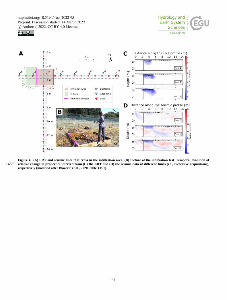
48
Figure 4. (A) ERT and seismic lines that cross in the infiltration area. (B) Picture of the infiltration test. Temporal evolution of
relative change in properties inferred from (C) the ERT and (D) the seismic data at different times (i.e., successive acquisitions), 1450 respectively (modified after Blazevic et al., 2020, table 1.B.1).
https://doi.org/10.5194/hess-2022-95Preprint. Discussion started: 14 March 2022c© Author(s) 2022. CC BY 4.0 License.

49
Figure 5. Conceptual depiction of the GW-SW interface and the nested controls of spatio-temporal patterns of exchange and solute
turnover in the transition zone between GW and SW (using a river-aquifer system as an example). A: primary spatial controls 1455 defined by regional topography and geology, B: secondary spatial controls defined by local aquifer and stream bed geologic
heterogeneities as well as streambed morphology, C: temporal controls caused by river flow dynamics. Processes and management
aspects that are affected by these exchange and turnover patterns are shown in light blue.
https://doi.org/10.5194/hess-2022-95Preprint. Discussion started: 14 March 2022c© Author(s) 2022. CC BY 4.0 License.
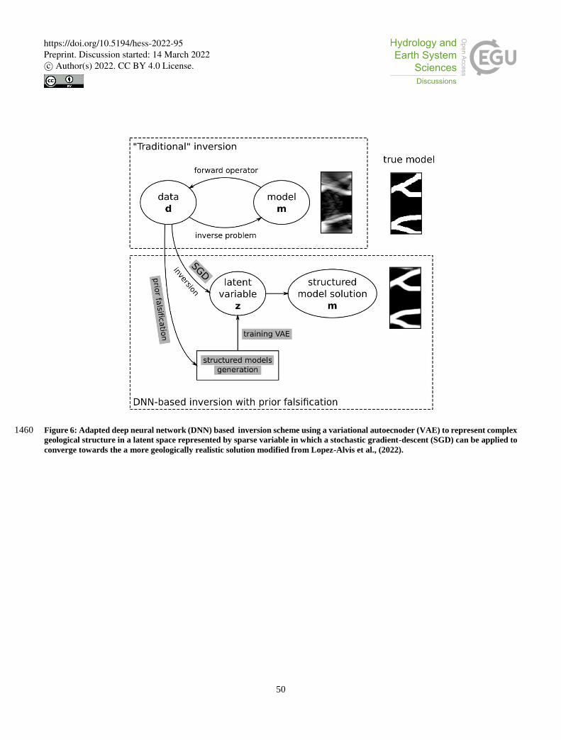
50
Figure 6: Adapted deep neural network (DNN) based inversion scheme using a variational autoecnoder (VAE) to represent complex 1460 geological structure in a latent space represented by sparse variable in which a stochastic gradient-descent (SGD) can be applied to
converge towards the a more geologically realistic solution modified from Lopez-Alvis et al., (2022).
https://doi.org/10.5194/hess-2022-95Preprint. Discussion started: 14 March 2022c© Author(s) 2022. CC BY 4.0 License.

51
Figure 7: Framework of Bayesian Evidential Learning applied to the prediction of heat storage in an aquifer from a tracer
experiment monitored by geophysics. 1. A prior model of the spatial heterogeneity is defined and sampled. 2. Both the predictor 1465 (data set such as a tracer experiment) and the target (prediction of heat storage) are simulated. For the predictor, a petrophysical
transform is used to generate the corresponding geophysical data. 3. Dimension reduction techniques are applied to both data and
prediction. 4. A statistical relationship between data and prediction is learned. 5. The posterior distribution of the prediction for
field observed data is generated using the statistical relationship. 6. The posterior is backtransformed in the physical space (modified
from Hermans et al., 2018) 1470
1475
https://doi.org/10.5194/hess-2022-95Preprint. Discussion started: 14 March 2022c© Author(s) 2022. CC BY 4.0 License.

52
Table 1: Selection of datasets available on-line for multi-dimensional hydrogeological system characterization and monitoring.
Datasets were selected based on their on line availability, their link with a dynamic component of the subsurface and their relevance
for illustrating the paper. This table will be available on line https://hplus.ore.fr/en/database/4d-hydrogeology-dataset with the
possibility to contribute to enrich the datasets with new data.
Dimension Dataset Site Link to dataset Publications
A+
3D
+ t
ime
A.1 Time-lapse geophysical
monitoring of heat transport:
2D time-lapse ERT cross-
sections + 3D multiple nested
wells data during heat tracer test
Hermalle,
Belgium
https://hplus.ore.fr/en/associated-sites/enigma/data-
hermalle
Hermans et
al.,(2015b, 2018)
(Hoffmann et al.
2019)
A.2 Time-lapse geophysical
monitoring of hyporheic zone
processes: 2D surface
Electromagnetic Induction + 2D
time-lapse ERT (section)
Theis site,
Ohio, USA
https://doi.org/10.4211/hs.69204f1ee49c4176a8aab5f
4832c7b76
McGarr et al.,
(2021)
B.
2D
+ t
ime
B.1 Time-lapse geophysical
monitoring of water
infiltration in the vadose zone:
2D time-lapse ERT and seismic
cross-sections + TDR
monitoring of water content
during irrigation
Ploemeur,
France
http://hplus.ore.fr/en/blazevic-et-al-2020-water-data1 Blazevic et al.
(2020)
B.2 GPR imaging of fracture
opening during hydraulic test:
borehole and surface GPR+
optical televiewer + core
logging during high pressure
injection test
Aspö hard
rock
laboratory,
Sweden
http://hplus.ore.fr/en/molron-et-al-2021-eg-data1
http://hplus.ore.fr/en/molron-et-al-2020-eg-data1
Molron et al. (2020,
2021)
B.3 GPR imaging of tracer
transport in fractured media:
borehole GPR + conductivity
Ploemeur,
France
http://hplus.ore.fr/en/shakas-et-al-2017-grl-data1
Shakas et al. (2017,
2016)
1 with login and password provided upon request
https://doi.org/10.5194/hess-2022-95Preprint. Discussion started: 14 March 2022c© Author(s) 2022. CC BY 4.0 License.

53
and fluorescence monitoring
during tracer test
B.4 Use of Vp/Vs ratio to
monitor subsurface water
content: 2D time-lapse seismic
cross-sections P- and surface-
wave survey, SH-wave
refraction acquisition, travel-
time tomography
Ploemeur,
France
http://hplus.ore.fr/en/pasquet-et-al-2015-nsg-data Pasquet et al.
(2015)
Dangeard et al.
(2018)
B.5 Time-lapse geophysical
monitoring of water
infiltration in karstic
environment:
2D time-lapse ERT cross-
sections during rainfall events
LSBB, France https://hplus.ore.fr/en/carriere-et-al-2022-dib-data
http://hplus.ore.fr/public/requests/lsbb/LSBB_ERT_d
ata_Carriere_24102011.csv.tgz
Carrière et al.
(2015, 2022)
B.6 Time-lapse geophysical
monitoring of seawater
intrusion: 2D time-lapse cross-
hole ERT in coastal aquifer
Argentona,
Spain
http://hplus.ore.fr/en/palacios-et-al-2020-hess-data1 Palacios et al.
(2020)
C.
1D
+ t
ime
C.1 Nuclear Magnetic
resonance monitoring of water
in a headwater catchments:
Time-lapse magnetic resonance
sounding
Strengbach,
France
http://hplus.ore.fr/en/lesparre-et-al-2020-joh-data Lesparre et al.
(2020)
C.2 Fiber optic DTS
monitoring for estimating
thermal conductivity and
groundwater flux in porous
media: fiber optic DTS and heat
tracer experiments in a sand
tank
Poitiers,
France
http://hplus.ore.fr/en/simon-et-al-2020-wrr-data Simon et al. (2020,
2022)
https://doi.org/10.5194/hess-2022-95Preprint. Discussion started: 14 March 2022c© Author(s) 2022. CC BY 4.0 License.

54
C.3 Fiber-optic monitoring of
heat transfer in fractured
media: Fiber optic-DTS
monitoring during thermal and
solute tracer tests,
Ploemeur,
France
http://hplus.ore.fr/en/delabernardie-et-al-2018-wrr-
data1
De La Bernardie et
al. (2018)
C.4 Use of gravimeter time
series for hydrological model
calibration in a karst aquifer:
Ten years gravimetry time
series using iGrav
superconducting gravimeter
Larzac, France http://hplus.ore.fr\documents\requests\larzac\Larzac_
gravimetry_2011_igrav002.csv.tgz
http://hplus.ore.fr\documents\requests\larzac\Larzac_
gravimetry_2012_igrav002.csv.tgz
http://hplus.ore.fr\documents\requests\larzac\Larzac_
gravimetry_2013_igrav002.csv.tgz
http://hplus.ore.fr\documents\requests\larzac\Larzac_
gravimetry_2014_igrav002.csv.tgz
http://hplus.ore.fr\documents\requests\larzac\Larzac_
gravimetry_2015_igrav002.csv.tgz
http://hplus.ore.fr\documents\requests\larzac\Larzac_
gravimetry_2016_igrav002.csv.tgz
http://hplus.ore.fr\documents\requests\larzac\Larzac_
gravimetry_2017_igrav002.csv.tgz
http://hplus.ore.fr\documents\requests\larzac\Larzac_
gravimetry_2018_igrav002.csv.tgz
http://hplus.ore.fr\documents\requests\larzac\Larzac_
gravimetry_2019_igrav002.csv.tgz
http://hplus.ore.fr\documents\requests\larzac\Larzac_
gravimetry_2020_igrav002.csv.tgz
https://hplus.ore.fr/documents/requests/larzac/Larzac
_gravimetry_2021_igrav002.csv.tgz
Fores et al. (2018,
2017)
C.5 Time-lapse absolute
quantum gravity
measurements to monitor
water storage in kartic
environments: gravimeter time
series
Larzac, France https://zenodo.org/record/4279110#.YdlFqWCZOM
8
(Cooke et al, 2021)
https://doi.org/10.5194/hess-2022-95Preprint. Discussion started: 14 March 2022c© Author(s) 2022. CC BY 4.0 License.

55
C.6 Self-potential monitoring
of natural rainfall and saline
tracer infiltrations at the
agricultural test site of
Voulund, Denmark (HOBE
network): Self-potential, time
series
Voulund,
Denmark
https://data.mendeley.com/datasets/6r8898657w/1 (Hu et al., 2020)
D.
Hig
h r
eso
luti
on
im
ag
ing
of
het
ero
gen
eity
com
bin
ed w
ith
tra
cer
test
s
D.1 3D Seismic imaging of a
karstic aquifer combined with
multiple cross borehole tracer
tests: 3D seismic bloc and
tracer tests
Poitiers,
France
http://hplus.ore.fr/en/mari-et-al-2009-ogst-data1
https://hplus.ore.fr/en/poitiers/data-poitiers1
Mari et al. (2009)
D.2 GPR Imaging of sand
layered aquifer with multiple
2D profiles and tracer tests:
Crosshole GPR and tracer tests
Krauthausen,
Germany
https://teodoor.icg.kfa-
juelich.de/geonetwork/aaps/search/?uuid=ad404c9f-
419a-4b14-b6e0-6ee9acd8f80e1
Gueting et al.
(2015, 2017)
E.
Mu
ltip
le t
race
r ex
per
imen
ts
E.1 solute and heat tracer
tests for characterizing heat
transfer in fractured granite:
Convergent and push-pull tests
with injection of hot water, cold
water and salt
Choutuppal,
India
http://hplus.ore.fr/en/hoffmann-et-al-2021-
groundwater-data
Hoffmann et al.
(2021b)
E.2 solute and dissolved gaz
tracer tests for characterizing
transport in Chalk:
Convergent and push-pull tests
with heat, helium, argon, xenon
and uranine
Mons,
Belgium
https://hplus.ore.fr/en/hoffmann-et-al-2020-
hydrogeology-of-the-chalk-data1
http://hplus.ore.fr/en/hoffmann-et-al-2020-grl-data1
Hoffmann et al.
(2020, 2021a)
1480
https://doi.org/10.5194/hess-2022-95Preprint. Discussion started: 14 March 2022c© Author(s) 2022. CC BY 4.0 License.