TOTORAL MINE, BOLIVIA: DUMP EVALUATION PROGRAM; SEPTEMBER-OCTOBER 1997
47
TOTORAL MINE BOLIVIA DUMP EVALUATION PROGRAM SEPTEMBER - OCTOBER 1997 BY N. LeBOUTILLIER BSc PGCE CGeol FGS Senior Geologist, South Crofty Mine, Cornwall. A report for the CREW GROUP, Vancouver, Canada.
Transcript of TOTORAL MINE, BOLIVIA: DUMP EVALUATION PROGRAM; SEPTEMBER-OCTOBER 1997

TOTORAL MINE BOLIVIA
DUMP EVALUATION PROGRAM
SEPTEMBER - OCTOBER 1997
BY N. LeBOUTILLIER BSc PGCE CGeol FGS
Senior Geologist, South Crofty Mine, Cornwall. A report for the CREW GROUP, Vancouver, Canada.
Totoral Mine, Bolivia – Dump Evaluation Program Report, November 1997.
CONTENTS 1. INTRODUCTION Page 3 1.1 Position& geography Page 3 1.2 Mine location and layout Page 6 2. GEOLOGY Page 9 2.1 Local geology Page 9 2.2 Vein morphology & mineralogy Page 12 3. THE SAMPLING PROGRAM Page 15 3.1 Sampling rationale & strategy Page 15 3.2 Dump sampling program Page 22 3.3 Colas dump sampling program Page 30 4.RESULTS Page 32 4.1 The mine dumps Page 32 4.2 The mill colas dump Page 42 4.3 Total identified reserve Page 44 4.4 Potential reserves Page 44 5. RECOMMENDATIONS Page 45 6. ACKNOWLEDGEMENTS Page 46 7. POSTSCRIPT: 2005 Page 47
2
Totoral Mine, Bolivia – Dump Evaluation Program Report, November 1997.
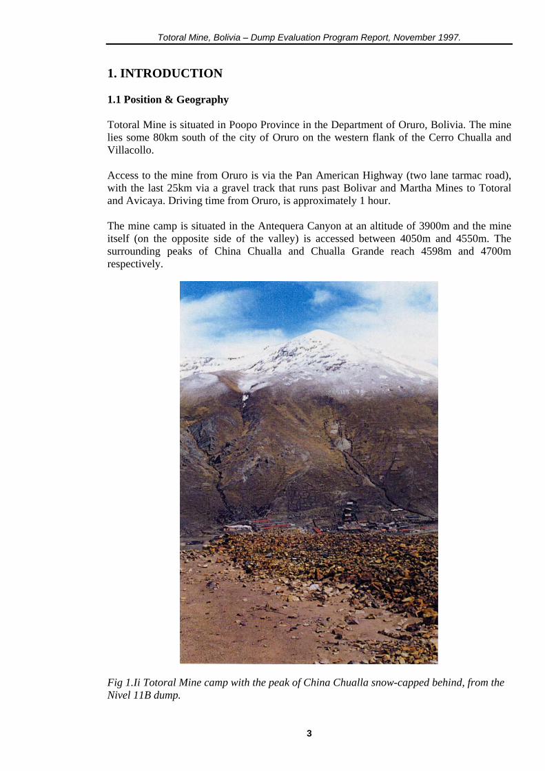
1. INTRODUCTION 1.1 Position & Geography Totoral Mine is situated in Poopo Province in the Department of Oruro, Bolivia. The mine lies some 80km south of the city of Oruro on the western flank of the Cerro Chualla and Villacollo. Access to the mine from Oruro is via the Pan American Highway (two lane tarmac road), with the last 25km via a gravel track that runs past Bolivar and Martha Mines to Totoral and Avicaya. Driving time from Oruro, is approximately 1 hour. The mine camp is situated in the Antequera Canyon at an altitude of 3900m and the mine itself (on the opposite side of the valley) is accessed between 4050m and 4550m. The surrounding peaks of China Chualla and Chualla Grande reach 4598m and 4700m respectively.
Fig 1.Ii Totoral Mine camp with the peak of China Chualla snow-capped behind, from the Nivel 11B dump.
3
Totoral Mine, Bolivia – Dump Evaluation Program Report, November 1997.
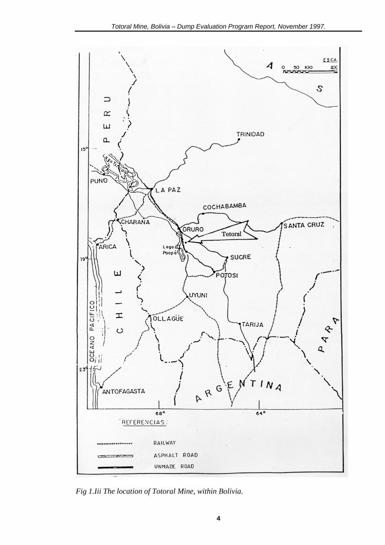
Fig 1.Iii The location of Totoral Mine, within Bolivia.
4
Totoral Mine, Bolivia – Dump Evaluation Program Report, November 1997.
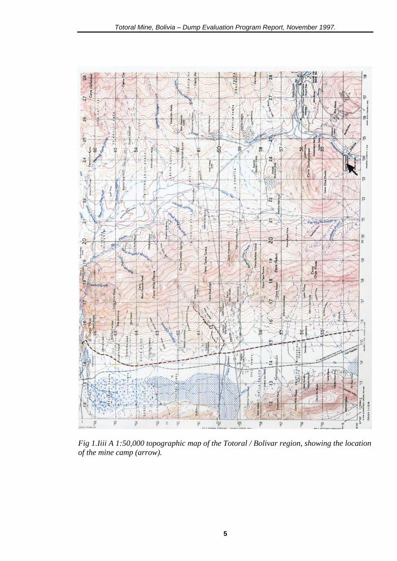
Fig 1.Iiii A 1:50,000 topographic map of the Totoral / Bolivar region, showing the location of the mine camp (arrow).
5
Totoral Mine, Bolivia – Dump Evaluation Program Report, November 1997.
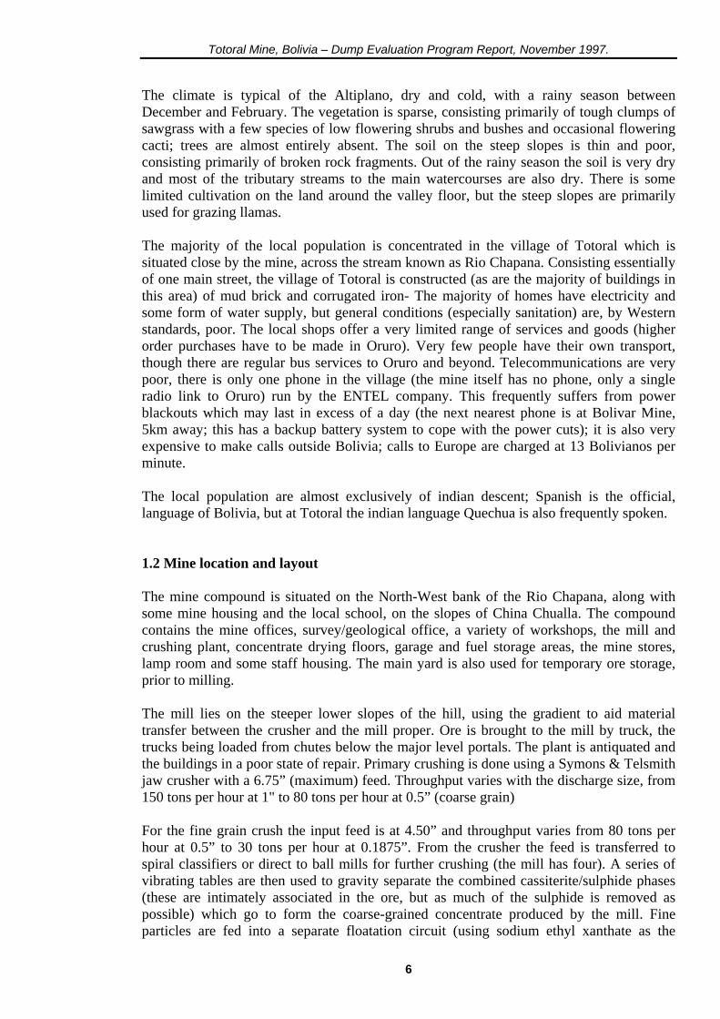
The climate is typical of the Altiplano, dry and cold, with a rainy season between December and February. The vegetation is sparse, consisting primarily of tough clumps of sawgrass with a few species of low flowering shrubs and bushes and occasional flowering cacti; trees are almost entirely absent. The soil on the steep slopes is thin and poor, consisting primarily of broken rock fragments. Out of the rainy season the soil is very dry and most of the tributary streams to the main watercourses are also dry. There is some limited cultivation on the land around the valley floor, but the steep slopes are primarily used for grazing llamas. The majority of the local population is concentrated in the village of Totoral which is situated close by the mine, across the stream known as Rio Chapana. Consisting essentially of one main street, the village of Totoral is constructed (as are the majority of buildings in this area) of mud brick and corrugated iron- The majority of homes have electricity and some form of water supply, but general conditions (especially sanitation) are, by Western standards, poor. The local shops offer a very limited range of services and goods (higher order purchases have to be made in Oruro). Very few people have their own transport, though there are regular bus services to Oruro and beyond. Telecommunications are very poor, there is only one phone in the village (the mine itself has no phone, only a single radio link to Oruro) run by the ENTEL company. This frequently suffers from power blackouts which may last in excess of a day (the next nearest phone is at Bolivar Mine, 5km away; this has a backup battery system to cope with the power cuts); it is also very expensive to make calls outside Bolivia; calls to Europe are charged at 13 Bolivianos per minute. The local population are almost exclusively of indian descent; Spanish is the official, language of Bolivia, but at Totoral the indian language Quechua is also frequently spoken. 1.2 Mine location and layout The mine compound is situated on the North-West bank of the Rio Chapana, along with some mine housing and the local school, on the slopes of China Chualla. The compound contains the mine offices, survey/geological office, a variety of workshops, the mill and crushing plant, concentrate drying floors, garage and fuel storage areas, the mine stores, lamp room and some staff housing. The main yard is also used for temporary ore storage, prior to milling. The mill lies on the steeper lower slopes of the hill, using the gradient to aid material transfer between the crusher and the mill proper. Ore is brought to the mill by truck, the trucks being loaded from chutes below the major level portals. The plant is antiquated and the buildings in a poor state of repair. Primary crushing is done using a Symons & Telsmith jaw crusher with a 6.75” (maximum) feed. Throughput varies with the discharge size, from 150 tons per hour at 1" to 80 tons per hour at 0.5” (coarse grain) For the fine grain crush the input feed is at 4.50” and throughput varies from 80 tons per hour at 0.5” to 30 tons per hour at 0.1875”. From the crusher the feed is transferred to spiral classifiers or direct to ball mills for further crushing (the mill has four). A series of vibrating tables are then used to gravity separate the combined cassiterite/sulphide phases (these are intimately associated in the ore, but as much of the sulphide is removed as possible) which go to form the coarse-grained concentrate produced by the mill. Fine particles are fed into a separate floatation circuit (using sodium ethyl xanthate as the
6

Totoral Mine, Bolivia – Dump Evaluation Program Report, November 1997.
floatation agent), which only runs as and when necessary, to produce a fine-grained concentrate.
Fig 1.2i The Totoral Mill with the crusher housing uppermost, taken from the colas dump outside the main compound. Recovery of payable tin in concentrate can be as low as 40% and a number of buddles and settling ponds treat the mill water before it is allowed to leave the mill to recover more of the fine cassiterite in the 'tail'. However, traces of cassiterite are visible in the sands in the braided channel of the leat which bisects the colas (mill) dump and there is a small tin streaming operation, working with four buddles, a few hundred metres downstream of the leat exit from the mill which supports some three or four independent workers. Above the mill, on the higher slopes, are a small number of dumps outside adit portals which are reputedly workings for gold. These workings were not investigated during the evaluation project, but four samples were obtained from the dumps.
7
Totoral Mine, Bolivia – Dump Evaluation Program Report, November 1997.
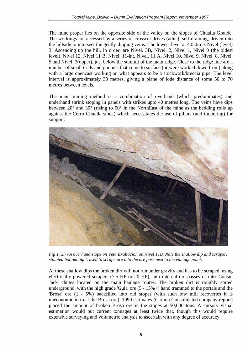
The mine proper lies on the opposite side of the valley on the slopes of Chualla Grande. The workings are accessed by a series of crosscut drives (adits), self-draining, driven into the hillside to intersect the gently-dipping veins. The lowest level at 4050m is Nivel (level) 3. Ascending up the hill, in order, are Nivel. 3B, Nivel. 2, Nivel 1, Nivel 0 (the oldest level), Nivel 12, Nivel 11 B, Nivel. 11-int, Nivel. 11 A, Nivel 10, Nivel 9, Nivel. 8, Nivel. 5 and Nivel. 3(upper), just below the summit of the main ridge. Close to the ridge line are a number of small trials and gunnies that come to surface (or were worked down from) along with a large opencast working on what appears to be a stockwork/breccia pipe. The level interval is approximately 30 metres, giving a plane of lode distance of some 50 to 70 metres between levels. The main mining method is a combination of overhand (which predominates) and underhand shrink stoping in panels with strikes upto 40 metres long. The veins have dips between 20° and 30° (rising to 50° in the NorthEast of the mine as the bedding rolls up against the Cerro Chualla stock) which necessitates the use of pillars (and timbering) for support.
Fig 1. 2ii An overhand stope on Veta Exaltacion on Nivel 11B. Note the shallow dip and scraper, situated bottom tight, used to scrape ore into the ore pass next to the vantage point. At these shallow dips the broken dirt will not run under gravity and has to be scraped, using electrically powered scrapers (7.5 HP or 20 HP), into internal ore passes or into 'Cousin Jack' chutes located on the main haulage routes. The broken dirt is roughly sorted underground, with the high grade 'Guia' ore (5 - 15%+) hand trammed to the portals and the 'Brosa' ore (1 - 5%) backfilled into old stopes (with such low mill recoveries it is uneconomic to treat the Brosa ore). 1990 estimates (Carnon Consolidated company report) placed the amount of broken Brosa ore in the stopes at 50,000 tons. A cursory visual estimation would put current tonnages at least twice that, though this would require extensive surveying and volumetric analysis to ascertain with any degree of accuracy.
8
Totoral Mine, Bolivia – Dump Evaluation Program Report, November 1997.
The miners use Swiss built rock drills and legs, though these are in a poor state of repair and most of the mines stock are being cannibalised for spare parts; such is the scarcity of good equipment that some miners work by hand labour (small sledgehammers and chisels). Anfo is used for blasting. Machinery underground is scarce, old and in a poor state of repair (only one loco and one 12B mucker were seen in operation underground) as is the loco track. Working practices at the mine are very unsafe and unsatisfactory (there appears to be little in the way of Health & Safety regulations); there is no regulation in the use of explosives, making areas safe or in the use of faulty/poorly maintained equipment. First aid boxes/posts and underground communications do not exist. There are large areas on Veta Exaltacion and other veins blocked out for future stoping, there are also long strike lengths of a number of veins that have been developed, but not yet been brought into production or an advanced state of preparation. Sampling of the drives is done by taking channel samples across the veins and contact rocks, but does not appear to be systematic in spacing or orientation; sample points are outlined in paint on the drive walls and numbered. From the amount of blocked out ground it would appear the mine has a healthy production base for some time to come. The major dumps investigated in this evaluation project lie close to the adit portals of each level and have been built up over a number of years by continuous tipping of waste and 'low grade' ore from the workings (see section 3.2 for a full description) to give extensive, layered, fan-shaped dumps. Those investigated during the project were: Nivel 3B, Nivel 2, Nivel 1, Nivel 0, Nivel. 11 B, Nivel 11-int and Nivel 11 A; which contain the majority of all the available material on the site. 2. GEOLOGY 2.1 Local Geology The Eastern Cordillera of the Central Andes of Bolivia is an elongated massif comprising an extensive thickness of Ordovician/Silurian clastic sedimentary rocks (greywackes, siltstones, sandstones, etc). These are underlain by the Precambrian rocks of the Brazilian Craton which subcrop extensively, beneath the thick vegetation and lateritic soils, of Eastern Bolivia (e.g in the Department of Trinidad, now a focus for intensive gold exploration). In the Bolivar - Poopo region these Lower Palaeozoic sediments are known to be at least 2000m. thick and have been folded into a series of anticlines and synclines trending to the North-Northwest. The sandstones and siltstones of the Silurian LIallagua Formation are generally exposed along the anticlinal axes and form the prominent mountainous ridges of the area. The overlying Devonian Uncia Formation consists mainly of shales and mudstones and forms the low ground. Some small Tertiary quartz latite and dacite/microadamellite stocks are also exposed in the region (including one close to Totoral). Extensive glacial moraines, terraces, talus fans and alluvial deposits occur in the valleys; some of these placers have in the past been worked for tin.
9

Totoral Mine, Bolivia – Dump Evaluation Program Report, November 1997.
Fig 2.1i The regional geology of Bolivia.
10
Totoral Mine, Bolivia – Dump Evaluation Program Report, November 1997.
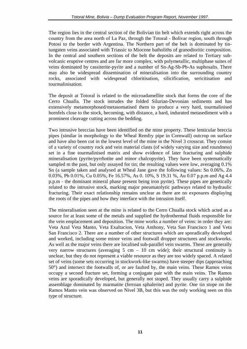
The region lies in the central section of the Bolivian tin belt which extends right across the country from the area north of La Paz, through the Totoral - Bolivar region, south through Potosi to the border with Argentina. The Northern part of the belt is dominated by tin-tungsten veins associated with Triassic to Miocene batholiths of granodioritic composition. In the central and southern sections of the belt the deposits are related to Tertiary sub-volcanic eruptive centres and are far more complex, with polymetallic, multiphase suites of veins dominated by cassiterite-pyrite and a number of Sn-Ag-Sb-Pb-As suphosalts. There may also be widespread dissemination of mineralisation into the surrounding country rocks, associated with widespread chloritisation, silicification, sericitisation and tourmalinisation. The deposit at Totoral is related to the microadamellite stock that forms the core of the Cerro Chualla. The stock intrudes the folded Silurian-Devonian sediments and has extensively metamorphosed/metasomatised them to produce a very hard, tourmalinised hornfels close to the stock, becoming, with distance, a hard, indurated metasediment with a prominent cleavage cutting across the bedding. Two intrusive breccias have been identified on the mine property. These lenticular breccia pipes (similar in morphology to the Wheal Remfry pipe in Cornwall) outcrop on surface and have also been cut in the lowest level of the mine in the Nivel 3 crosscut. They consist of a variety of country rock and vein material clasts (of widely varying size and roundness) set in a fine tourmalinised matrix and show evidence of later fracturing and sulphide mineralisation (pyrite/pyrrhotite and minor chalcopyrite). They have been systematically sampled m the past, but only assayed for tin; the resulting values were low, averaging 0.1% Sn (a sample taken and analysed at Wheal Jane gave the following values: Sn 0.06%, Zn 0.03%, Pb 0.01%, Cu 0.05%, Fe 16.57%, As 0. 10%, S 19.31 %, Au 0.07 p.p.m and Ag 4.4 p.p.m - the dominant mineral phase present being iron pyrite). These pipes are genetically related to the intrusive stock, marking major pneumatolytic pathways related to hydraulic fracturing. Their exact relationship remains unclear as there are no exposures displaying the roots of the pipes and how they interface with the intrusion itself. The mineralisation seen at the mine is related to the Cerro Chualla stock which acted as a source for at least some of the metals and supplied the hydrothermal fluids responsible for the vein emplacement and deposition. The mine works a number of veins: in order they are: Veta Azul Veta Manto, Veta Exaltacion, Veta Anthony, Veta San Francisco 1 and Veta San Francisco 2. There are a number of other structures which are sporadically developed and worked, including some minor veins and footwall dropper structures and stockworks. As well as the major veins there are localised sub-parallel vein swarms. These are generally very narrow structures (averaging 5 cm – 10 cm wide); their structural continuity is unclear, but they do not represent a viable resource as they are too widely spaced. A related set of veins (some sets occurring in stockwork-like swarms) have steeper dips (approaching 50°) and intersect the footwalls of, or are faulted by, the main veins. These Ramos veins occupy a second fracture set, forming a conjugate pair with the main veins. The Ramos veins are sporadically developed, but generally not stoped. They usually carry a sulphide assemblage dominated by marmatite (ferroan sphalerite) and pyrite. One tin stope on the Ramos Manto vein was observed on Nivel 3B, but this was the only working seen on this type of structure.
11
Totoral Mine, Bolivia – Dump Evaluation Program Report, November 1997.
The mine workings are cut by a three important faults; the Villacollo Fault, cutting diagonally through the mine and striking northeast, the Silla Loma Fault and the high angle Palca Palca Fault. These faults have horizontal displacements of between 3 and 6 metres and can be observed on most levels. They appear as gouge-filled fractures upto 1 metre wide and require wooden support where they cut through drives. A number of minor faults also occur throughout the mine, often in small swarms. 2.2 Vein Morphology & Mineralogy The 'veins' carry two (possibly more) phases of mineralisation; an early hypothermal assemblage of Fe-rich cassiterite and quartz (oxide/silicate dominated) and a later mesothermal assemblage of pyrite and pyrrhotite (often seen ‘net-veining’ the earlier cassiterite). There were observed crosscutting relationships between these two phases in a number of instances, but the relationship was more often unclear with apparent simultaneous deposition of both oxide and sulphide. On Nivel 3 (the lowest level of the mine) Veta Azul is dominated by sphalerite (which also occurs on Nivel 11B on Veta Exaltacion). It is not clear, from the limited exposure, whether this represents a part of the Fe-rich sulphide phase or a later phase of mineralisation overprinting that seen elsewhere in the mine. In any event this sphalerite-dominated phase is complex, carrying significant amounts of tin and silver in addition to very high levels of zinc. The nearby Bolivar Mine also demonstrates this change from tin dominated mineralisation in the upper levels to a zinc dominated mineralogy in the lower levels. At Bolivar zinc is now the main product of the mine and is being exploited at depth below the valley floor. Silver is a valuable accessory. The 'veins' at Totoral are not typical infill veins (throughout most of their exposure), rather they are 'vein zones', representing country rock impregnated and preferentially fractured/mineralised within the whole rock sequence. They are essentially those beds most susceptible to fracturing and replacement which provided the pathways for the hydrothermal fluids emanating from the Cerro Chualla intrusion. The veins often do not have clear contacts, though some exposures were observed where mineralisation was cut off abruptly along a bedding plane (which formed the hangingwall of the vein – see Figure 2.2i). As a general rule, the narrower the veins become (main vein widths vary from 0.25m. to 1.50m, averaging between 0.80m. and 1.00m.) the sharper the contacts are. The veins have a tendency to pinch and swell; Veta Manto demonstrates this on a number of levels, with the swells enriched in cassiterite and the pinches dominated by sulphides. The dip of the veins follows that of the bedding (20°-30°, steepening to 50° in places on Veta San Francisco) in the majority of cases, though there is a section of Veta Manto that follows a shallow angle fault to a higher stratigraphic level, faulting Veta Azul in the process (the vein appears twice, either side of Veta Manto on Nivel 3B). The vein material shows a combination of impregnation and brecciation/fracturing textures. Cassiterite (jet black and Fe rich) occurs massive as pods, seams and veinlets as well as finely disseminated grains. The grain size varies from fine to medium and is commonly easily visible (1-2 mm) to the naked eye. Euhedral crystals are rare. Slides taken from specimens show the cassiterite is zoned with oscillatory rings, indicative of relatively slow growth under stable conditions. The rings (alternately dark and light) probably relate to pulses of iron-rich hydrothermal fluids reaching the crystallisation site. Intimately associated with the cassiterite are small areas of quartz and some pyrite.
12
Totoral Mine, Bolivia – Dump Evaluation Program Report, November 1997.
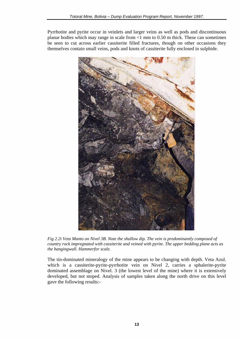
Pyrrhotite and pyrite occur in veinlets and larger veins as well as pods and discontinuous planar bodies which may range in scale from <1 mm to 0.50 m thick. These can sometimes be seen to cut across earlier cassiterite filled fractures, though on other occasions they themselves contain small veins, pods and knots of cassiterite fully enclosed in sulphide.
Fig 2.2i Veta Manto on Nivel 3B. Note the shallow dip. The vein is predominantly composed of country rock impregnated with cassiterite and veined with pyrite. The upper bedding plane acts as the hangingwall. Hammerfor scale. The tin-dominated mineralogy of the mine appears to be changing with depth. Veta Azul. which is a cassiterite-pyrite-pyrrhotite vein on Nivel 2, carries a sphalerite-pyrite dominated assemblage on Nivel. 3 (the lowest level of the mine) where it is extensively developed, but not stoped. Analysis of samples taken along the north drive on this level gave the following results:-
13
Totoral Mine, Bolivia – Dump Evaluation Program Report, November 1997.
No: %Sn %Zn %Pb %Cu %Fe %As %S ppm Ag 1 0.09 31.24 4.54 0.18 11.82 0.14 33.17 88.5 2 5.30 30.44 9.62 0.33 - - - 1641 3 5.57 24.72 11.68 0.57 - - - 1603 4 2.06 0.55 0.28 0.09 43.31 0.41 53.88 94.5 Samples 1 to 3 are sphalerite-dominated vein samples taken at 10 metre spacings along the drive (vein widths ranged from 0.40 m to >1 m), sample 4 is from a pyrite-dominated vein assemblage, taken some 10 m south of the first sphalerite sample. The hand specimens (1 to 3) are almost exclusively sphalerite with minor carbonate. The results show very high concentrations of zinc, but also high lead, silver and tin values. It is likely that the lead occurs as fine intergrowths of galena (lead sulphide) within the sphalerite crystals (which would explain why it is not visible to the naked eye). The silver will occur as a solid solution phase within the galena lattice or as discrete intergrowths of silver sulphides within the galena. The high silver content (ranging from 88 g per ton to 1.60 kg per ton based on these assays) is a feature of the ore at Totoral previously unrecognised there. Sample 4 also has a high silver content, though this must be hosted within the pyrite (as exsolution lamellae) as opposed to galena (which is far more common). This, together with a further assay quoted below, suggests that the occurrence of silver at the mine may be far more widespread within the sulphide phases than was anticipated and is not confined to the 'Bolivar'-type mineralogy seen on Nivel 3; it also means that if some of this material has reached the dumps, the samples from there should also be analysed for silver and possibly zinc and lead The high tin values were not originally anticipated in the sphalerite samples. The continued presence of tin, as fine disseminated cassiterite, suggests a rapid 'telescoping' of the isotherms in the locality during deposition to produce what could be called a xenothermal deposit. The combined metal content of this ore, together with the area of undeveloped ground around and below it, make this a prime future exploration target. Three further samples taken underground gave the following assays:- No: %Sn %Zn %Pb %Cu ppm Ag 5 0.96 4.23 0.10 0.63 132.5 6 0.34 0.11 0.06 0.12 18.4 7 17.29 0.15 0.03 0.35 36 Sample 5 came from a current underhand stope onVeta Exaltacion on Nivel 11 B and consisted primarily of sphalerite with minor pyrite and carbonate. Once again cassiterite was not visible to the naked eye. The most interesting feature of this sample is, again, its high silver content and the fact that it is from the upper area of the mine, proving the extent of silver-bearing ore. Sample 6 was predominantly of pyrrhotite from Ramo Antony on Nivel 3B, taken on the last bench of an overhand stope. This material is uneconomic, though the elevated silver content (most likely hosted by pyrite, rather than pyrrhotite) is of interest. Sample 7 came from Veta Manto on Nivel 3B and consisted of pyrite with occasional 'dark streaks' of what must be very fine cassiterite (the sample was very dense, reflected by the very high tin assay). Once again, an elevated silver content was found.
14
Totoral Mine, Bolivia – Dump Evaluation Program Report, November 1997.
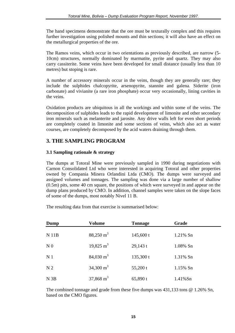
The hand specimens demonstrate that the ore must be texturally complex and this requires further investigation using polished mounts and thin sections; it will also have an effect on the metallurgical properties of the ore. The Ramos veins, which occur in two orientations as previously described, are narrow (5-10cm) structures, normally dominated by marmatite, pyrite and quartz. They may also carry cassiterite. Some veins have been developed for small distance (usually less than 10 metres) but stoping is rare. A number of accessory minerals occur in the veins, though they are generally rare; they include the sulphides chalcopyrite, arsenopyrite, stannite and galena. Siderite (iron carbonate) and vivianite (a rare iron phosphate) occur very occasionally, lining cavities in the veins. Oxidation products are ubiquitous in all the workings and within some of the veins. The decomposition of sulphides leads to the rapid development of limonite and other secondary iron minerals such as melanterite and jarosite. Any drive walls left for even short periods are completely coated in limonite and some sections of veins, which also act as water courses, are completely decomposed by the acid waters draining through them. 3. THE SAMPLING PROGRAM 3.1 Sampling rationale & strategy The dumps at Totoral Mine were previously sampled in 1990 during negotiations with Carnon Consolidated Ltd who were interested in acquiring Totoral and other properties owned by Compania Minera Orlandini Ltda (CMO). The dumps were surveyed and assigned volumes and tonnages. The sampling was done via a large number of shallow (0.5m) pits, some 40 cm square, the positions of which were surveyed in and appear on the dump plans produced by CMO. In addition, channel samples were taken on the slope faces of some of the dumps, most notably Nivel 11 B. The resulting data from that exercise is summarised below: Dump Volume Tonnage Grade N 11B 88,250 m3 145,600 t 1.21% Sn N 0 19,825 m3 29,143 t 1.08% Sn N 1 84,030 m3 135,300 t 1.31% Sn N 2 34,300 m3 55,200 t 1.15% Sn N 3B 37,868 m3 65,890 t 1.41%Sn The combined tonnage and grade from these five dumps was 431,133 tons @ 1.26% Sn, based on the CMO figures.
15
Totoral Mine, Bolivia – Dump Evaluation Program Report, November 1997.
In addition the mill tailings (colas) dump was investigated; however, the original plan data was found to be wholly inaccurate when re-examined in early 1997 and the information discounted. The original sampling program was seriously flawed in that the dumps, having been built up over a number of years from crosscut material (waste) and Brosa ore, have strong internal layering. This runs at a shallow angle, or sub-horizontally, on the upper surface of each dump and parallels the main slope surface down the dump, with each successive layer draping the one below. Any shallow pits will only sample the uppermost layer, as will a channel down the main slope. Depending on whether ore or waste was the last material to be tipped, the sample will have an overwhelming bias and will be totally unrepresentative of the dump as a whole. The original 1990 results were discounted and a new sampling strategy developed. The larger dumps (11B, 1, 2, 3B) have, according to the sections supplied by CMO, maximum thicknesses of approximately 20 metres. A sample through this portion of the dump, from upper surface to bedrock, would cut all the layers present and furnish a complete sample profile. The way to achieve this objective would be to sink a shaft to intersect bedrock and sample the excavated material.
Fig 3. Ii Nivel 11B dump seenfrom above. The shaft is immediately adjacent to the wagons on the upper surface. Part of the Totoral Mine camp can be seen in the valley below.
16
Totoral Mine, Bolivia – Dump Evaluation Program Report, November 1997.
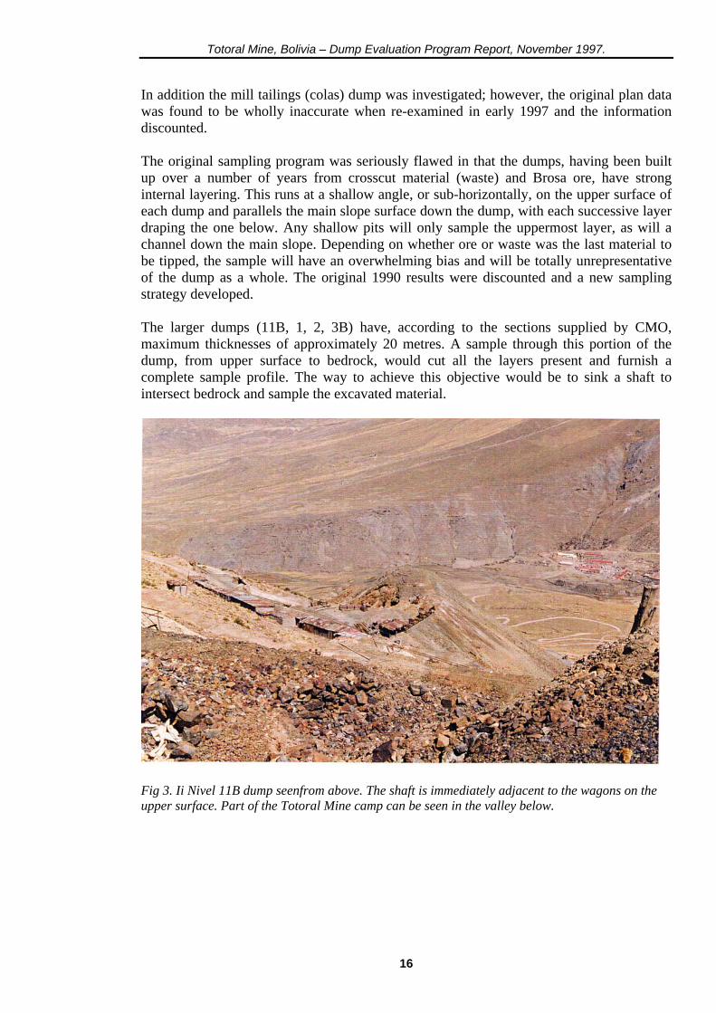
Prior to leaving the U.K it was agreed that CMO would supply all labour, materials, tools, sampling bags & equipment, crushing facilities and transport for the program A total of 14 shafts were planned (initially) for the dumps, with a dozen auger holes planned for both the colas dump and for the placer deposits in the river valley southwest of the mine. Once on site the shafts were positioned (see relevant dump plans), to give the greatest degree of coverage. Their dimensions were set at 1.20 m square. All the material extracted to each successive metre in depth was placed in consecutive piles and quartered down to yield a 20kg sample.
Fig 3. 1 ii The upper surface of the Nivel 0 dump, showing the staked positions of shafts 2 and 3 with the first two 1 m samples from shaft 2 in the foreground. A total of seven dumps were sampled. The lowest level dump, that of Nivel 3, was ignored as it is composed entirely of waste material; the small upper dumps (representing a relatively small tonnage) were of secondary importance and went unsampled due to lack of time. The shafts were positioned (where possible) to give a spacing of approximately 40 metres. The dumps sampled , the number of shafts and the anticipated depths are listed below (in descending topographic order) (see overleaf)
17

Totoral Mine, Bolivia – Dump Evaluation Program Report, November 1997.
Dump No: of shafts Expected depth to bedrock. Nivel 11 A 1 shaft approximately 10 metres Nivel 11 int 1 shaft 10 metres Nivel 11 B 1 shaft 20 metres Nivel 0 3 shafts 5 metres Nivel 1 2 shafts 20 metres Nivel 2 1 shaft 20 metres Nivel 3B 5 shafts 20 metres The dump material was found to be highly compacted just below the surface, with a limonitic cement binding the individual fragments. Grain size varied from fine dust to large rocks upto 0.5 m in diameter, averaging 5 – 10 cm. The material consisted of a mixture of country rock with quartz veinstone fragments and large amounts of sulphide in various stages of decomposition. Cassiterite occurs on the dumps also and forms the livelihood of the Piccarillo's (the widows of deceased miners who have the right dig and pick over the dumps for cassiterite, which they sell to the mine; it is also where they live, in rock 'huts' built from dump material and scrap metal) who are active on a number of dumps, particularly Nivel 1 and 11 B.
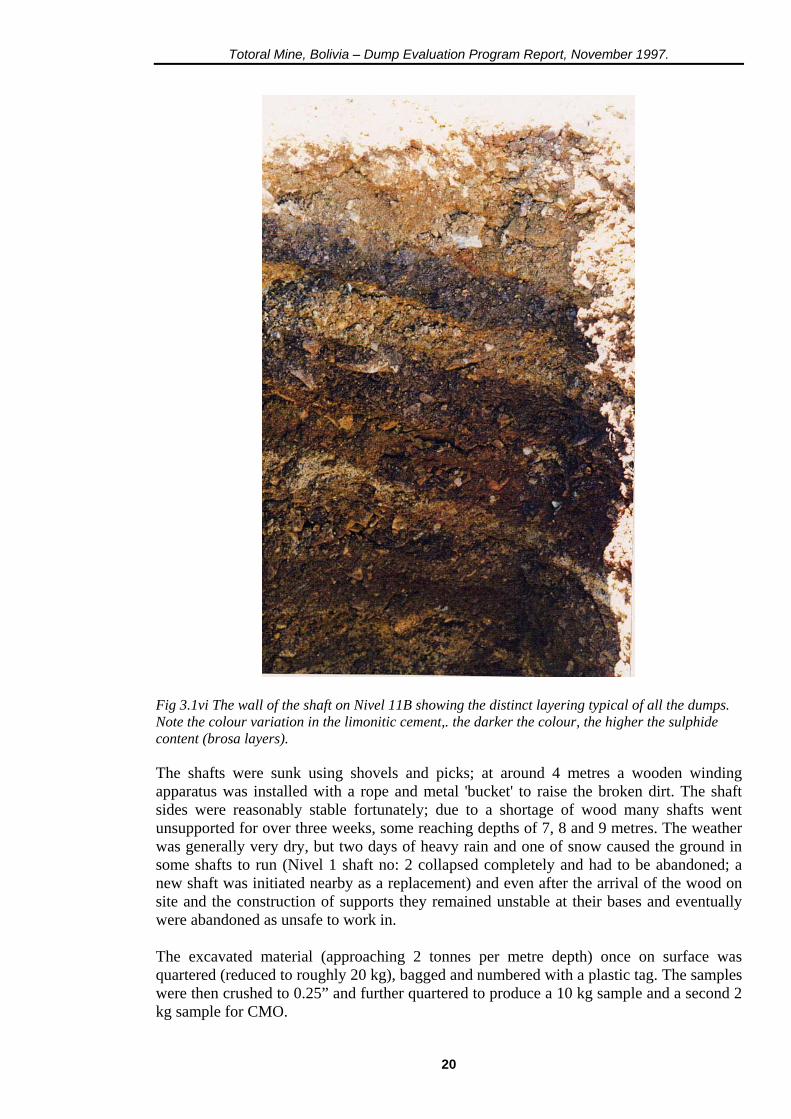
Fig 3. 1 iii The makeshift 'huts' of the Piccarillo's on Nivel 1 dump. The level's tool shed, offices and workshops are in the background. Strong layering was evident in all the dumps, the Brosa layers being marked by the greater degree of sulphide decomposition (giving more limonite and a resulting darker colour) and cementation, leading to the frequent production of duricrusts or 'iron pans' within the sequence.
18
Totoral Mine, Bolivia – Dump Evaluation Program Report, November 1997.
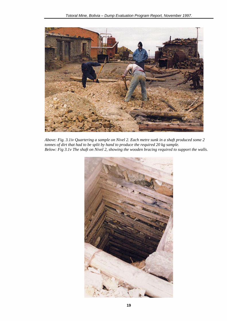
Above: Fig. 3.1iv Quartering a sample on Nivel 2. Each metre sunk in a shaft produced some 2 tonnes of dirt that had to be split by hand to produce the required 20 kg sample. Below: Fig 3.1v The shaft on Nivel 2, showing the wooden bracing required to support the walls.
19
Totoral Mine, Bolivia – Dump Evaluation Program Report, November 1997.
Fig 3.1vi The wall of the shaft on Nivel 11B showing the distinct layering typical of all the dumps. Note the colour variation in the limonitic cement,. the darker the colour, the higher the sulphide content (brosa layers). The shafts were sunk using shovels and picks; at around 4 metres a wooden winding apparatus was installed with a rope and metal 'bucket' to raise the broken dirt. The shaft sides were reasonably stable fortunately; due to a shortage of wood many shafts went unsupported for over three weeks, some reaching depths of 7, 8 and 9 metres. The weather was generally very dry, but two days of heavy rain and one of snow caused the ground in some shafts to run (Nivel 1 shaft no: 2 collapsed completely and had to be abandoned; a new shaft was initiated nearby as a replacement) and even after the arrival of the wood on site and the construction of supports they remained unstable at their bases and eventually were abandoned as unsafe to work in. The excavated material (approaching 2 tonnes per metre depth) once on surface was quartered (reduced to roughly 20 kg), bagged and numbered with a plastic tag. The samples were then crushed to 0.25” and further quartered to produce a 10 kg sample and a second 2 kg sample for CMO.
20
Totoral Mine, Bolivia – Dump Evaluation Program Report, November 1997.
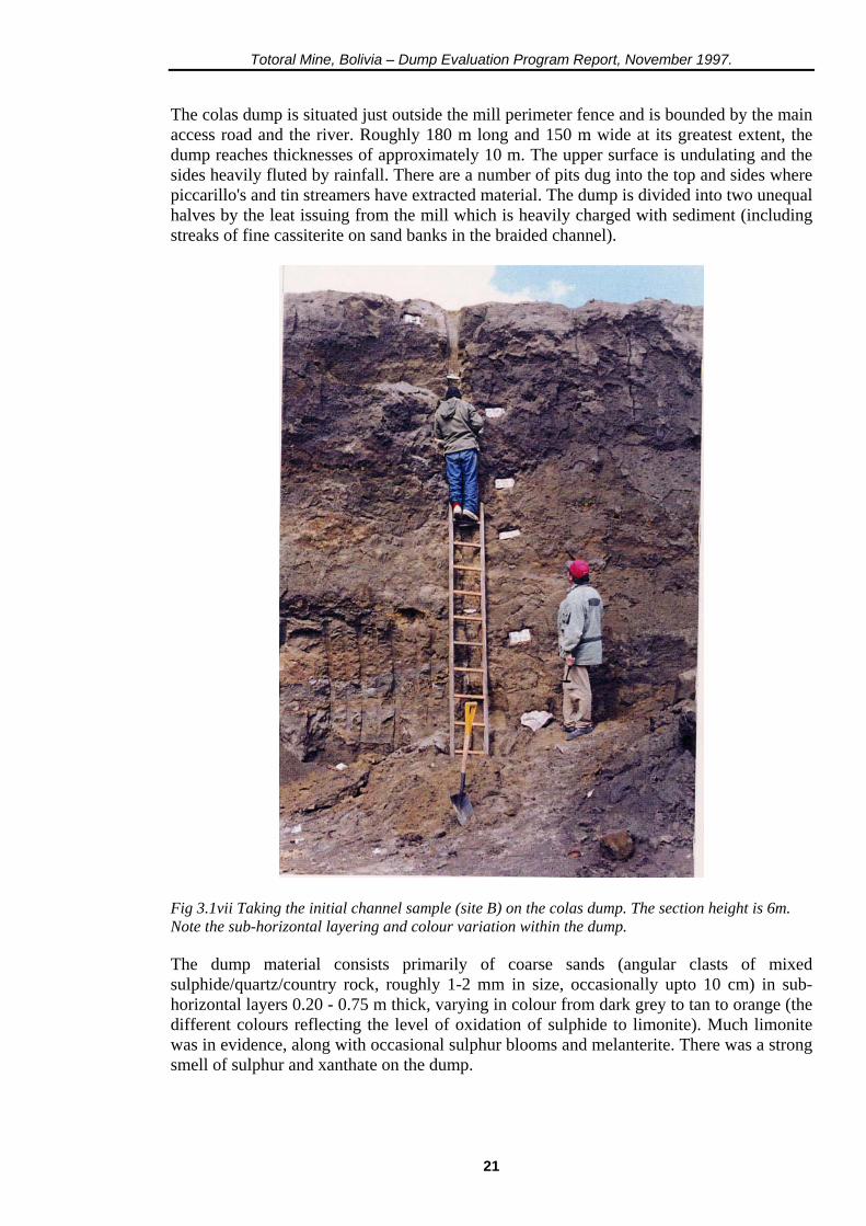
The colas dump is situated just outside the mill perimeter fence and is bounded by the main access road and the river. Roughly 180 m long and 150 m wide at its greatest extent, the dump reaches thicknesses of approximately 10 m. The upper surface is undulating and the sides heavily fluted by rainfall. There are a number of pits dug into the top and sides where piccarillo's and tin streamers have extracted material. The dump is divided into two unequal halves by the leat issuing from the mill which is heavily charged with sediment (including streaks of fine cassiterite on sand banks in the braided channel).
Fig 3.1vii Taking the initial channel sample (site B) on the colas dump. The section height is 6m. Note the sub-horizontal layering and colour variation within the dump. The dump material consists primarily of coarse sands (angular clasts of mixed sulphide/quartz/country rock, roughly 1-2 mm in size, occasionally upto 10 cm) in sub-horizontal layers 0.20 - 0.75 m thick, varying in colour from dark grey to tan to orange (the different colours reflecting the level of oxidation of sulphide to limonite). Much limonite was in evidence, along with occasional sulphur blooms and melanterite. There was a strong smell of sulphur and xanthate on the dump.
21

Totoral Mine, Bolivia – Dump Evaluation Program Report, November 1997.
Prior to the start of the auger drilling program two exposed sections of the dump, either side of the leat, were channel sampled. The first section, to the left of the leat, was 4 metres high; the second section, to the right, was 6 metres high (see plan of colas dump for locations). The sample results are tabulated below
Section 1 Section 2 Depth Grade (Sn%) Depth Grade (Sn%) lm 0.70% lm 0.82% 2m 0.68% 2m 0.59% 3m 0.60% 3m 0.63% 4m 0.58% 4m 0.65% 5m 0.60% 6m 0.58% 4m @ 0.64% 6m @ 0.65% Based on these results it was decided to go ahead with a sampling program on the colas dump. A total of 10 holes were laid out (see section 3.3) in two rows across the dump, following its longest axis. A further 3 holes wore also planned, time permitting, between the rows to give a polygonal sample pattern. The equipment used was a hand-held auger, carrying a 2cm diameter by 30cm cutting/sampling tool with a set of twelve 1 metre extension tubes (maximum sample depth was, therefore, 12.30 metres). The holes were drilled in sequence beginning on the left hand side of the dump (see plan). Problems with the sampling tool (a number of tools were damaged or broken, hitting rocks or hard cemented layers) and a lack of manpower to either work with the auger or effect repairs, meant that for long periods the auger was unusable. In the event only seven holes were completed, four in a square on the left hand portion of the dump (holes 1 to 4), two on the right hand side close to the leat (holes 5 and 6) and one final hole in the centre of the left hand square (hole 11) to give a polygonal sample set. All the sample holes hit bedrock between 4 and 7 metres (which was anticipated), with a complete sample over each metre depth. Sample recoveries were generally very good (the lowest being 60%), often reaching 90%. The colas samples were quartered and bagged, requiring no further processing. The mine dump samples were transported to Oruro (Spectrolab laboratory, University of Oruro) where they were crushed and put through a Tema Mill to produce a 100 g pulp sample (the residue held for metallurgical testing in the UK). A total of 37 colas samples and 79 mine dump samples were produced during the program over a period of 31 working days. These samples were then flown to the UK for analysis at Wheal Jane. 3.2 Dump sampling program The following pages contain the topographic plans of each dump. The information was digitised from original plans supplied by CMO, using SURPAC software to calculate the volume of the dumps and generate a series of solid models (this was done using the depths of those shafts that hit bedrock as well as an approximated slope angle for the underlying hillside). A specific gravity for the dump material of 2.00 (allowing for 30% void space, with a corresponding reduction in density) was calculated at Wheal Jane (the average density of
22
Totoral Mine, Bolivia – Dump Evaluation Program Report, November 1997.
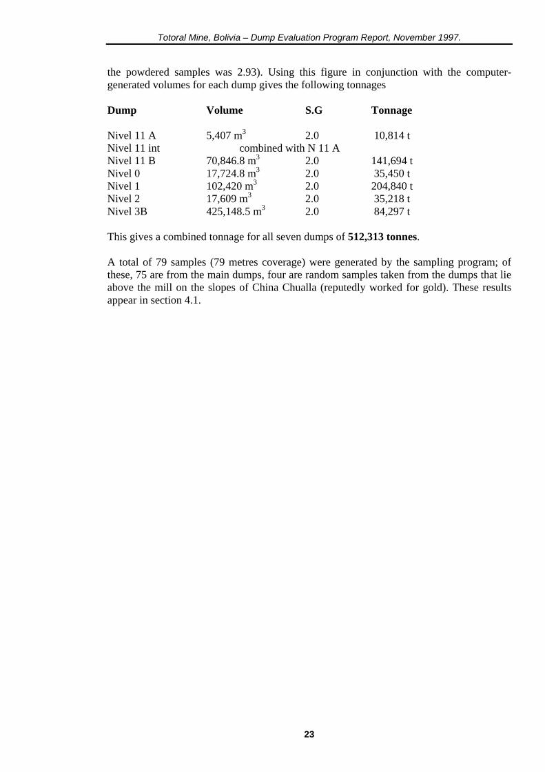
the powdered samples was 2.93). Using this figure in conjunction with the computer-generated volumes for each dump gives the following tonnages Dump Volume S.G Tonnage Nivel 11 A 5,407 m3 2.0 10,814 t Nivel 11 int combined with N 11 A Nivel 11 B 70,846.8 m3 2.0 141,694 t Nivel 0 17,724.8 m3 2.0 35,450 t Nivel 1 102,420 m3 2.0 204,840 t Nivel 2 17,609 m3 2.0 35,218 t Nivel 3B 425,148.5 m3 2.0 84,297 t This gives a combined tonnage for all seven dumps of 512,313 tonnes. A total of 79 samples (79 metres coverage) were generated by the sampling program; of these, 75 are from the main dumps, four are random samples taken from the dumps that lie above the mill on the slopes of China Chualla (reputedly worked for gold). These results appear in section 4.1.
23
Totoral Mine, Bolivia – Dump Evaluation Program Report, November 1997.
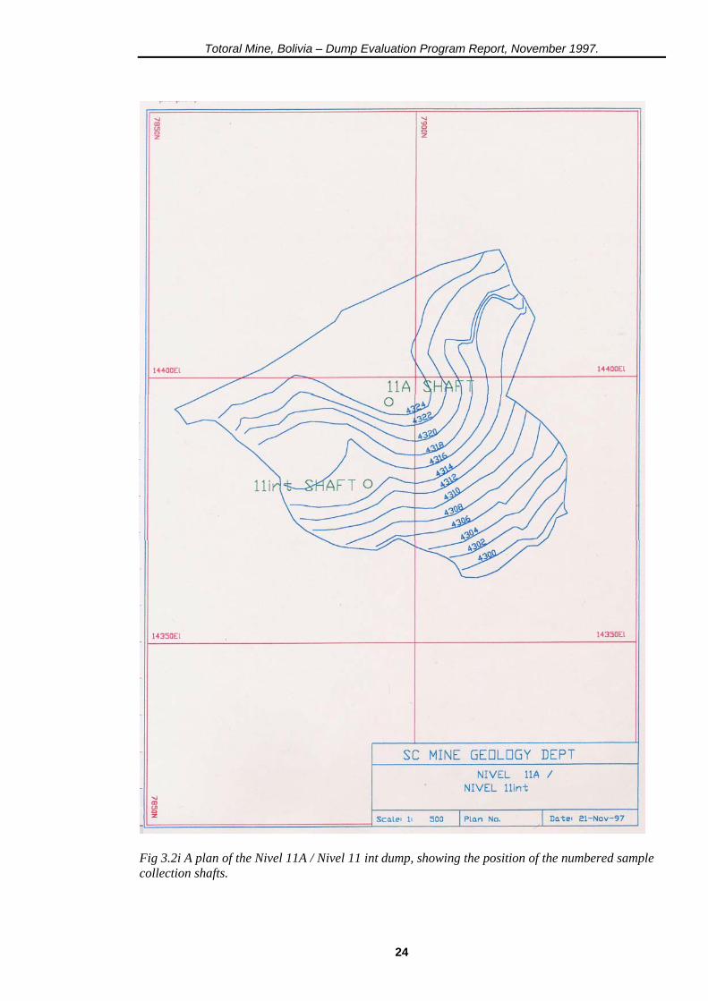
Fig 3.2i A plan of the Nivel 11A / Nivel 11 int dump, showing the position of the numbered sample collection shafts.
24
Totoral Mine, Bolivia – Dump Evaluation Program Report, November 1997.
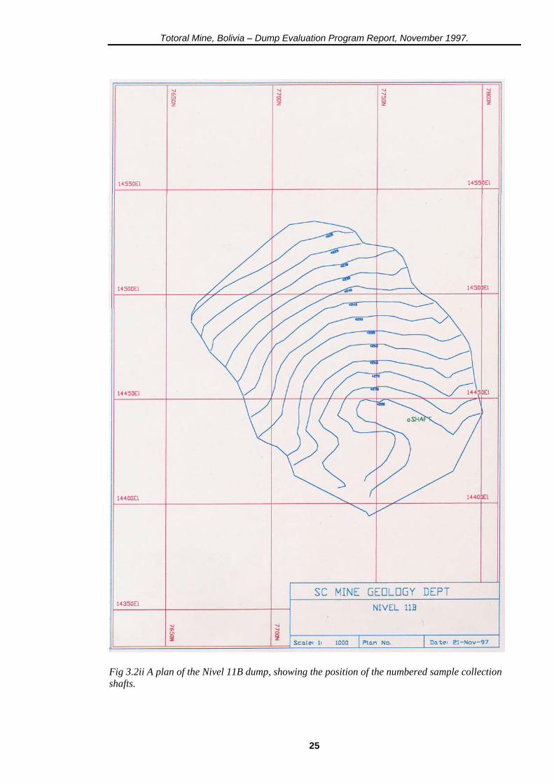
Fig 3.2ii A plan of the Nivel 11B dump, showing the position of the numbered sample collection shafts.
25
Totoral Mine, Bolivia – Dump Evaluation Program Report, November 1997.
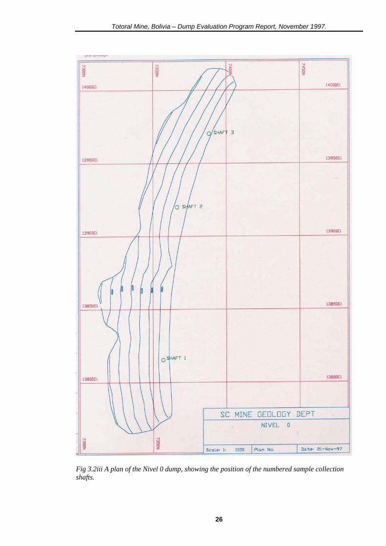
Fig 3.2iii A plan of the Nivel 0 dump, showing the position of the numbered sample collection shafts.
26
Totoral Mine, Bolivia – Dump Evaluation Program Report, November 1997.
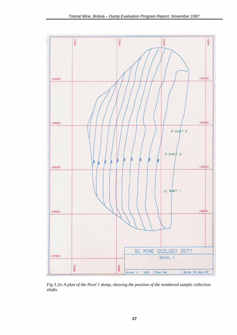
Fig 3.2iv A plan of the Nivel 1 dump, showing the position of the numbered sample collection shafts.
27

Totoral Mine, Bolivia – Dump Evaluation Program Report, November 1997.
Fig 3.2v A plan of the Nivel 2 dump, showing the position of the numbered sample collection shafts.
28

Totoral Mine, Bolivia – Dump Evaluation Program Report, November 1997.
Fig 3.2vi A plan of the Nivel 3B dump, showing the position of the numbered sample collection shafts.
29
Totoral Mine, Bolivia – Dump Evaluation Program Report, November 1997.
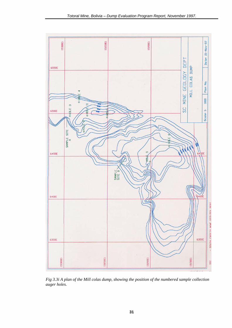
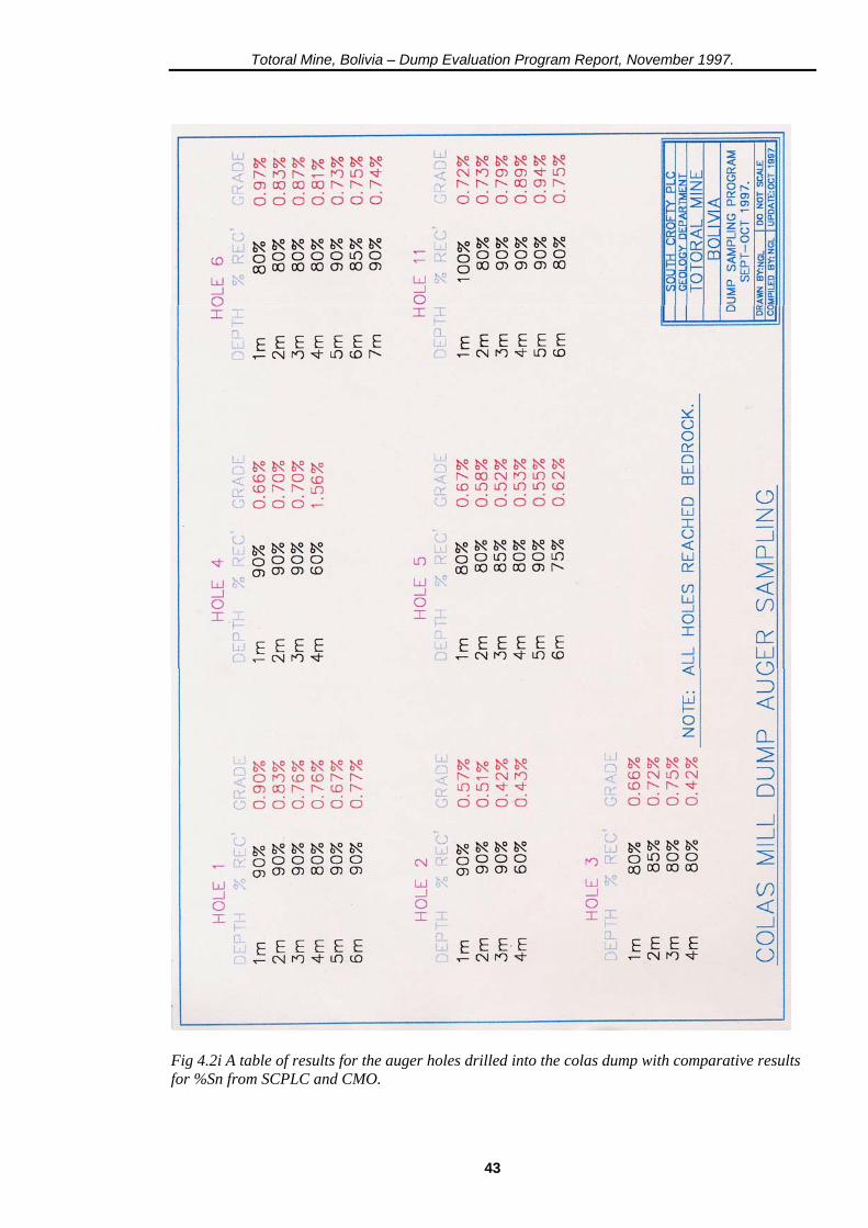
3.3 Colas dump sampling program The following page (Fig. 3.3i) shows the topographic plan of the colas dump along with the auger hole positions. The plan was digitised into SURPAC from a newly made original plan supplied by CMO. The specific gravity of the sands in the dump was calculated at 2.64; 90% of the density of the powdered samples (allowing for 10% void space) analysed by Wheal. Jane. This combined with the computer-generated volume of the dump of 78,103.4 m3, gives a tonnage figure of 206,193 tonnes. A total of 37 samples (37 metres coverage) were generated by the sampling program; the results appear in section 4.2.
30
Totoral Mine, Bolivia – Dump Evaluation Program Report, November 1997.
Fig 3.3i A plan of the Mill colas dump, showing the position of the numbered sample collection auger holes.
31

Totoral Mine, Bolivia – Dump Evaluation Program Report, November 1997.
4. RESULTS 4.1 The mine dumps The assay results (both for SCPLC and CMO) and shaft depths are shown for each shaft (by dump, in descending order), together with the weighted average results on the following 8 pages:
32

Totoral Mine, Bolivia – Dump Evaluation Program Report, November 1997.
Fig 4.1i Schematic sections through the shafts on Nivel 11B and Nivel 11A with comparative results for %Sn from SCPLC and CMO.
33
Totoral Mine, Bolivia – Dump Evaluation Program Report, November 1997.
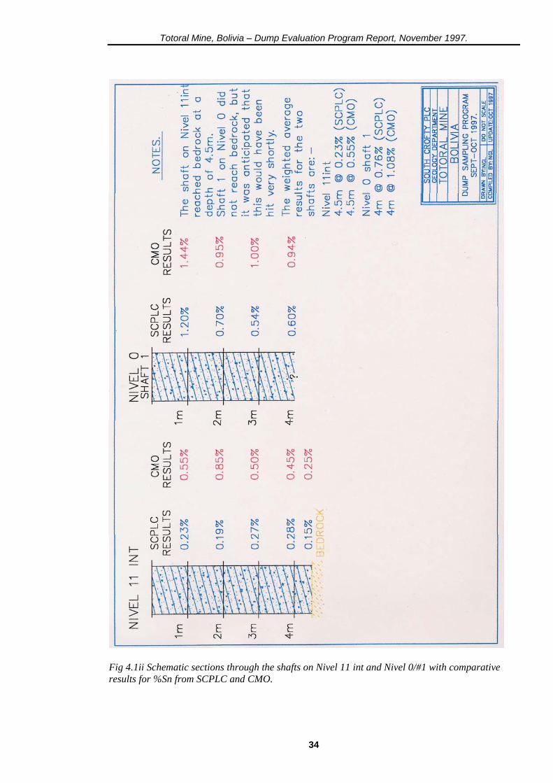
Fig 4.1ii Schematic sections through the shafts on Nivel 11 int and Nivel 0/#1 with comparative results for %Sn from SCPLC and CMO.
34
Totoral Mine, Bolivia – Dump Evaluation Program Report, November 1997.
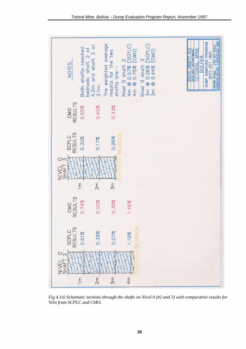
Fig 4.1iii Schematic sections through the shafts on Nivel 0 (#2 and 3) with comparative results for %Sn from SCPLC and CMO.
35
Totoral Mine, Bolivia – Dump Evaluation Program Report, November 1997.
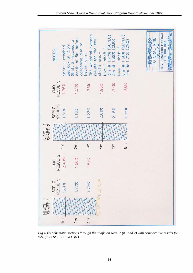
Fig 4.1iv Schematic sections through the shafts on Nivel 1 (#1 and 2) with comparative results for %Sn from SCPLC and CMO.
36
Totoral Mine, Bolivia – Dump Evaluation Program Report, November 1997.
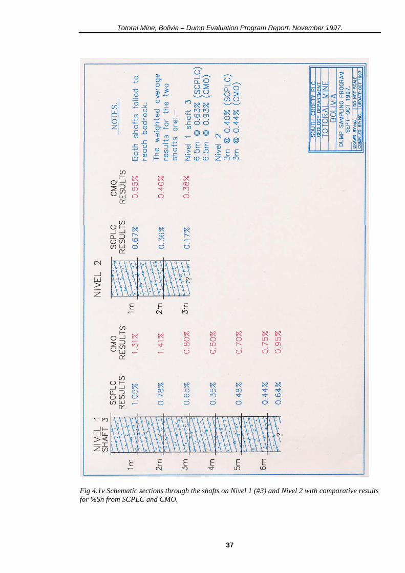
Fig 4.1v Schematic sections through the shafts on Nivel 1 (#3) and Nivel 2 with comparative results for %Sn from SCPLC and CMO.
37
Totoral Mine, Bolivia – Dump Evaluation Program Report, November 1997.
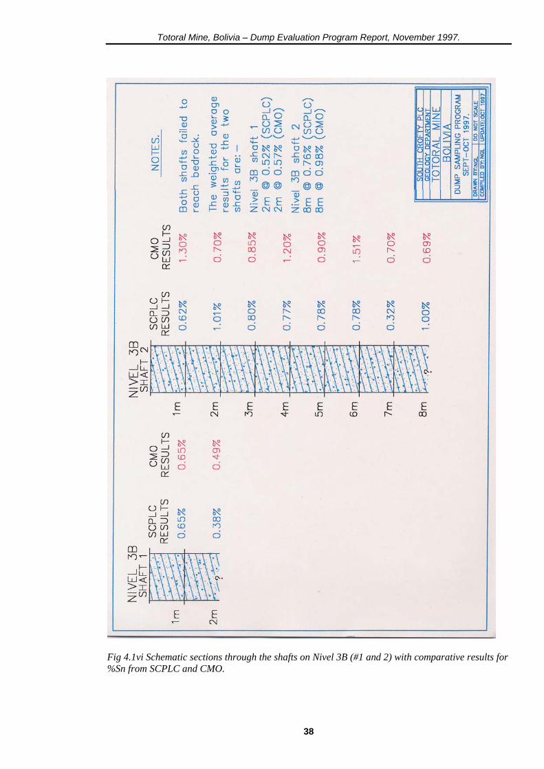
Fig 4.1vi Schematic sections through the shafts on Nivel 3B (#1 and 2) with comparative results for %Sn from SCPLC and CMO.
38
Totoral Mine, Bolivia – Dump Evaluation Program Report, November 1997.
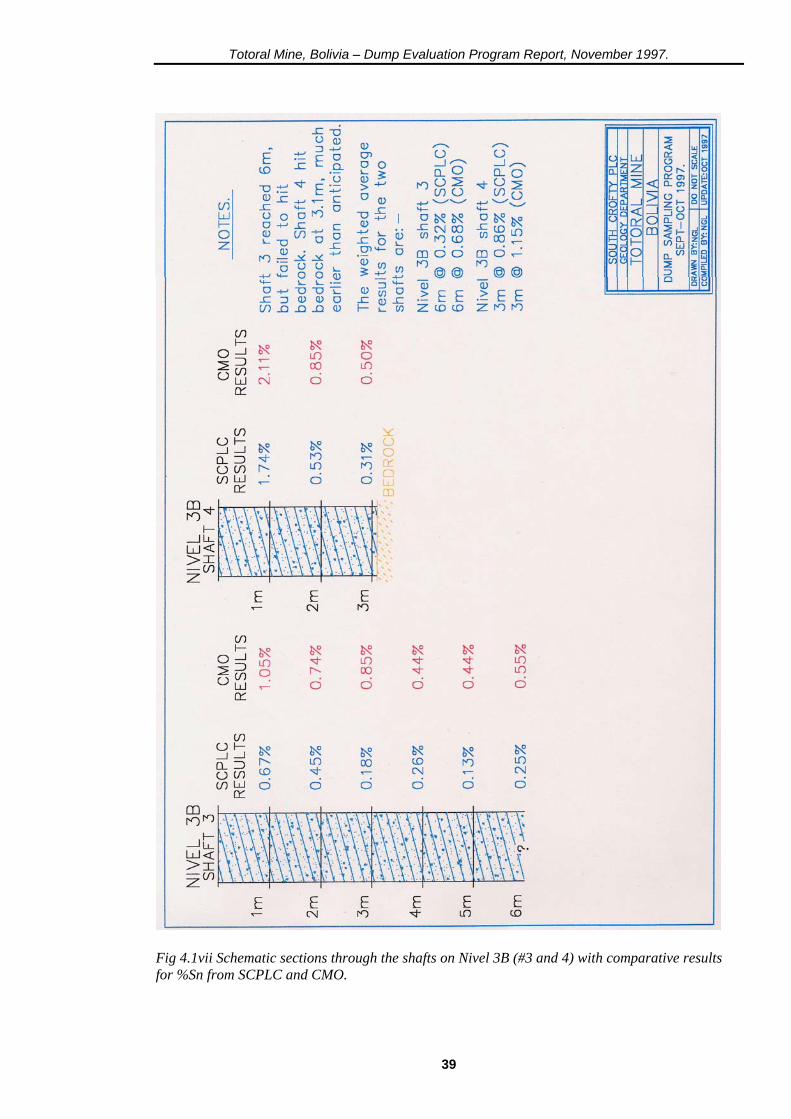
Fig 4.1vii Schematic sections through the shafts on Nivel 3B (#3 and 4) with comparative results for %Sn from SCPLC and CMO.
39
Totoral Mine, Bolivia – Dump Evaluation Program Report, November 1997.
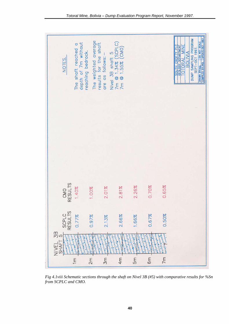
Fig 4.1viii Schematic sections through the shaft on Nivel 3B (#5) with comparative results for %Sn from SCPLC and CMO.
40

Totoral Mine, Bolivia – Dump Evaluation Program Report, November 1997.
The combined weighted average grade per shaft/ tonnage for each of the seven dumps is as follows:- Dump W.A Grade Tonnage Nivel 11 A 4.7 m @ 0.55% 7,138 t Nivel 11 int 4.5 m @ 0.23% 3,676 t Nivel 11 B 9.0 m @ 1.48% 141,694 t Nivel 0 11.0 m @ 0.55% 35,450 t Nivel 1 15.5 m @ 1.21% 204,840 t Nivel 2 3.0 m @ 0.40% 35,218 t Nivel 3B 26.0 [email protected]% 84,297 t This gives a total combined tonnage and grade of:- 512,313 t @ 1. 10% Sn Subtracting a tonnage of 3,676 tonnes for the sub-economic Nivel 11 int (estimated to account for 33% of the total combined 11A/11 int dump by volume) gives a definitive tonnage and grade for the dumps of:-
508,637 tonnes @ 1.11% Sn The current data and that arrived at during the 1990 exercise by CMO show a marked variance; the general trend being an increase in the available tonnage and a decrease in grade in comparison with the 1990 figures. The % variance with the previous data is stated below (using 1990 data as a base) :- Dump Volume Tonnage Grade Nivel 11 B -20% -3% +22% Nivel 0 -11% +21% -49% Nivel 1 +22% +51% -8% Nivel 2 -49% -37% -65% Nivel 3B +11% +28% -43% The variance can be largely explained by the use of low specific gravity figures by CMO (in the range of 1.6 to 1.7) which lead to lower tonnage figures; the use of too few sections applied to their topographic plans, which lead to inaccurate volume figures, and the sampling method employed which lead to an inaccurate approximation of the grade. Using the resources at our disposal the current data set represents a much higher level of confidence in the identified reserves at Totoral.
41

Totoral Mine, Bolivia – Dump Evaluation Program Report, November 1997.
4.2 The mill colas dump The assay results for the seven auger holes (along with % sample recovery per metre) are shown on the following page:- The combined weighted average grade for each hole is as follows:- Hole No: W.A Grade 1 6 m @ 0.78% 2 4 m @ 0.48% 3 4 m @ 0.64% 4 4 m @ 0.91% 5 6 m @ 0.58% 6 7 m @ 0.81% 11 6 m @ 0.80% W/A total = 37m @ 0.72% This gives a total combined tonnage and grade of 206,193 tonnes @ 0.72% Sn
42
Totoral Mine, Bolivia – Dump Evaluation Program Report, November 1997.
Fig 4.2i A table of results for the auger holes drilled into the colas dump with comparative results for %Sn from SCPLC and CMO.
43
Totoral Mine, Bolivia – Dump Evaluation Program Report, November 1997.
The four samples from the China Chualla dumps returned tin assay grades of between 0.06% and 0.39%. All the gold assays were below 0.01 ppm. The dumps are small and inaccessible and further investigation would be of a low priority in light of these results. 4.3 Total identified reserve The combined tonnage and grade of the mine dumps and colas dump gives a total in-situ reserve of:- 714,830 tonnes @ 1.00% Sn This would give a total contained tin content of 7,148 tonnes. With the building of a new mill and with a 88% (comparable to Wheal Jane) recovery rate, some 6,291 tonnes would be recoverable. At the current tin price of approximately £3,300 ($5,557) per tome, the recoverable reserves would generate a revenue (at N.S.R of 86%) of some £17,854,000 ($30,173,260). 4.4 Potential reserves This evaluation program was confined to the lower dumps of the Totoral property. There are equally extensive dumps located immediately adjacent to Totoral belonging to Avicaya. Mine (which uses the same road system on the hillside) and, also, back towards Bolivar Mine, the now defunct Martha Mine. Bolivar Mine itself has extensive dumps and tailings that could produce tin. Agreements with these companies to mill their dumps would potentially double the reserve base (subject to evaluation). At Totoral the practice of backfilling the stopes with Brosa ore has produced a significant underground reserve that would be relatively easy to access. The tonnage and grade of this reserve is presently unquantifiable (though CMO reports speak of some 100,000 tonnes of broken dirt being present in the mine) and would require an extensive surveying/sampling program to resolve (South Crofty's Survey Department using SURPAC with a total station would be ideal candidates for this work). This practice of backfiffing with ore is likely to prevail at Avicaya Mine also, which works the extensions of the veins seen at Totoral. A contract made with the Avicaya company to process this ore would provide a further source of feed for the mill. The river valley between Bolivar and Avicaya contains numerous placer deposits which have been insufficiently investigated. The valley section (the former Antequera Canyon has been silted up over time with the mill tailings of the mines which formerly operated here – a process which continues with the mill tailings of Totoral at present) between Totoral and Avicaya was the subject of a study in the late 1970's and showed several cassiterite-bearing horizons in a sediment column that reached a maximum thickness of nearly 40 metres (reputedly containing some 5 million tonnes of material). Some of the assay grades obtained were very high, suggesting this area would be suitable for working with a dragline to expose the rich horizons (the valley section around Avicaya was formerly worked by a dredge). This area would warrant an evaluation program of its own, requiring a mobile auger rig capable of drilling deep holes. It represents a significant exploration target and is again a potential feed source for the proposed new mill.
44
Totoral Mine, Bolivia – Dump Evaluation Program Report, November 1997.
5. RECOMMENDATIONS In the first instance the processing characteristics and mineralogy/geochemistry of the ore and dump materials need to be assessed; this will require:- (i) Metallurgical testing of sample residues currently held in Oruro. Taking out the samples from China Chualla and Nivel 11 int (numbers 8842, 8844, 8845, 8856, 8858 and 8876 - 8879) will leave a maximum of 70, 9kg, samples weighing 630kg to be transported to the UK. (ii) Polished mount/slide/probe studies of ore samples to be undertaken at South Crofty / Camborne School of Mines to establish the mineralogical/textural relationships and the host/nature of the silver component. (iii) With the knowledge that silver is not confined to one area of the mine, the full 116 samples should be re-assayed for this element to explore the potential for silver recovery as a by-product. Depending on the nature and areas of responsibility of any companies that arise to work the reserves, both surface and underground, at Totoral, the following is recommended:- (iv) A thorough survey and sampling program is undertaken to establish the tonnage, grade and accessibility of broken Brosa ore backfilled into stopes at Totoral. (v) An auger sampling program is undertaken to establish the nature and distribution of cassiterite deposits in the river valley sediments with a view to constructing an ore reserve and feasibility study for this area. (vi) A program of diamond drilling is undertaken to explore the down-dip potential of the polymetallic mineral assemblage seen on Veta Azul on Nivel 3; to explore this vein and examine if the observed mineralogical changes extend to other veins (and potential new structures) within the mine. Should this project proceed and lead to the building of a new mill on the Totoral site, it would be pertinent to:- (vii) Seek an agreement with the surrounding mines to process their dumps. This would require a sampling program similar to that carried out at Totoral which could be done by South Crofty either directly or acting on a consultancy basis for one of the other companies involved. The establishment of a hi-tech, high recovery mill would put the company in a pre-eminent position from which to make further acquisitions and form preferential processing agreements with mines in the hinterland.
45
Totoral Mine, Bolivia – Dump Evaluation Program Report, November 1997.
6. ACKNOWLEDGEMENTS This project would not have been possible without the considerable assistance of the following people, to whom I would like to express my thanks:- At South Crofty:- Mark Owen (Chief Geologist) for logistics and support during the entire project; Robin Boon (Chief Surveyor) for the production of the digitised plans, DTM models and volumes of the Totoral dumps. At Totoral:- Daniel Ortega, my driver and Raul Salazar & Gustavo Aguilar, my sampling assistants and translators, for all their hard work and 'team spirit'; the staff of CMO, Senors Orlandini, Zubieta & Alvarez for their assistance in all aspects of the work; Alberto Guzman (mine superintendent) for his help and time spent conveying some of his profound knowledge of Totoral (and mining in general) to me during his extensive underground and surface ‘tours'; and, finally, to the workers of Totoral who sank the shafts, quartered, crushed and transported the samples, working extremely hard under very difficult conditions (especially the ‘A’ team of Maximo & Fortunato Cayo who sank two deep shafts in record time), this project would not have been possible without their enthusiasm and commitment.
N. LeBOUTILLIER 21 st November 1997 Geology Department, South Crofty Mine, Dudnance Lane, Pool, Redruth Comwall TR15 3QH U.K.
46
Totoral Mine, Bolivia – Dump Evaluation Program Report, November 1997.
7. POSTSCRIPT: 2005 This report, reproduced here essentially as written (with the more glaring grammatical errors edited out), was submitted to the directors of the Crew Group in late November 1997. Despite being a low-tech endeavour, with a relatively inexperienced geologist (it was my first international assignment), it did highlight the potential of Totoral to become the hub of highly profitable milling operation, with a ready, and extensive, supply of low-cost mill feed from Totoral’s dumps and, potentially, those of the wider hinterland. A working ethic of transparency and prompt & fair payment could have potentially drawn in contracts from mines further afield, where small operations could not afford to develop modern milling technology. Shortly after the report was handed in, the directors of the Crew Group began the closure of South Crofty Mine, deciding to re-invest in South Africa; the Totoral report was shelved and then, presumably, forgotten. Those of us involved with the project found ourselves out of work instead of planning the next stage in the development of Totoral. With the long overdue rise in metal prices now established, it would be prudent to look at Totoral again. The original project was aimed directly at the establishment of a mill, with little regard for the mine itself; as a mineralogist/structural geologist I was very interested in the geology of the mine, though had very little time in which to examine it. The increasingly complex nature of the vein infills with depth (with high grades of tin, zinc and silver), the enormous down-dip potential of the ground below Nivel 3B and the ‘interesting’ possibilities of the intersection of the highly profitable veins of the Bolivar Mine and those of Totoral below the valley floor, would make this mine a worthy exploration target. A program of systematic sampling, mineralogical examination and mapping, coupled with a diamond drilling program would establish if Totoral has the potential to rival its larger neighbour.
N. LeBOUTILLIER BSc PhD MCSM CGeol EurGeol FGS 2nd February 2005. Camborne Cornwall UK.
47