Topography controlling the wind regime on the karstic coast: late Pleistocene coastal calcareous...
21
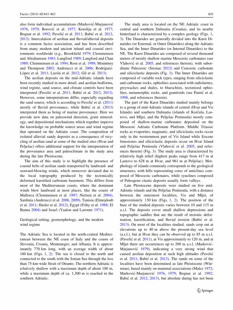
ORIGINAL ARTICLE Topography controlling the wind regime on the karstic coast: late Pleistocene coastal calcareous sands of eastern mid-Adriatic, Croatia Davor Pavelic ´ • Marijan Kovac ˇic ´ • Igor Vlahovic ´ • Oleg Mandic • Frane Markovic ´ • Lara Wacha Received: 25 March 2014 / Accepted: 25 July 2014 / Published online: 26 August 2014 Ó Springer-Verlag Berlin Heidelberg 2014 Abstract Aeolian dunes controlled by regional climate have been formed in many coastal areas of the Mediter- ranean Sea during the Quaternary. Generally, they are formed under a landward-blowing wind, and comprise numerous reworked penecontemporaneous shallow-marine carbonate grains. Along the eastern mid-Adriatic Sea, late Pleistocene aeolian and alluvial sands occur as isolated patches in karstic depressions on several islands and the Peljes ˇac Peninsula. At most localities, the sands consist of a mixture of mostly carbonate rock fragments and silici- clastic material. A higher proportion of shallow-marine bioclasts was found only at one locality. The terrestrial material was transported to the coastal area by at least two rivers: paleo-Cetina and paleo-Neretva River, and was subsequently reworked and transported by wind, resulting in aeolian deposition. Sandy units of various thicknesses exhibiting sharp erosional bedding planes and cross-bed- ding are interpreted as representing aeolian dunes and sand sheets controlled by a complex wind regime. The miner- alogical composition at almost all localities indicates near- river flood plains as the main sand source. Although the area was affected by strong winds blowing landward and parallel to the coast, they significantly deviated due to the local topography produced by the tectonically deformed and karstified carbonate basement. In this way, the late Pleistocene aeolian deposits on the mid-Adriatic islands differ from deposits from most Quaternary Mediterranean coastal aeolian belts, as they contain very small quantities of penecontemporaneous shallow-marine carbonate grains and were deposited by winds blowing in varying directions instead of prevailing landward-blowing winds. Keywords Inland aeolian dunes Á Alluvial deposits Á Provenance Á Wind regime Á Late Pleistocene Á Mid-Adriatic islands Introduction Aeolian dunes in coastal areas share some common char- acteristics, even if formed in different climatic belts char- acterized by specific regional wind regimes. Along many coasts of the world, dunes are formed by landward-blowing winds, causing onshore movement of sand (Pye and Tsoar 2009). This is also a characteristic feature of Mediterranean coasts, where seaward sand migration is uncommon and has been found at just a few localities, such as the Libyan coast where bimodal paleowind directions prevailed in the Pleistocene (Hoque 1975), and the Croatian mid-Adriatic islands (Pavelic ´ et al. 2011; Babic ´ et al. 2012, 2013). The modern Tunisian coast is also characterized by strong seasonal changes in wind directions. Landward-blowing winds control dune migration during the summer, whereas the winter is characterized by seaward blowing winds causing truncation of the dunes formed in the summer (Hasler et al. 2012). Coastal aeolian sands may contain a D. Pavelic ´(&) Á I. Vlahovic ´ Faculty of Mining, Geology and Petroleum Engineering, University of Zagreb, Pierottijeva 6, 10000 Zagreb, Croatia e-mail: [email protected] M. Kovac ˇic ´ Á F. Markovic ´ Faculty of Science, University of Zagreb, Horvatovac 95, 10000 Zagreb, Croatia O. Mandic Geological–Paleontological Department, Natural History Museum Vienna, Burgring 7, 1010 Wien, Austria L. Wacha Croatian Geological Survey, Sachsova 2, 10000 Zagreb, Croatia 123 Facies (2014) 60:843–863 DOI 10.1007/s10347-014-0411-7
Transcript of Topography controlling the wind regime on the karstic coast: late Pleistocene coastal calcareous...
ORIGINAL ARTICLE
Topography controlling the wind regime on the karstic coast:late Pleistocene coastal calcareous sands of easternmid-Adriatic, Croatia
Davor Pavelic • Marijan Kovacic • Igor Vlahovic •
Oleg Mandic • Frane Markovic • Lara Wacha
Received: 25 March 2014 / Accepted: 25 July 2014 / Published online: 26 August 2014
� Springer-Verlag Berlin Heidelberg 2014
Abstract Aeolian dunes controlled by regional climate
have been formed in many coastal areas of the Mediter-
ranean Sea during the Quaternary. Generally, they are
formed under a landward-blowing wind, and comprise
numerous reworked penecontemporaneous shallow-marine
carbonate grains. Along the eastern mid-Adriatic Sea, late
Pleistocene aeolian and alluvial sands occur as isolated
patches in karstic depressions on several islands and the
Peljesac Peninsula. At most localities, the sands consist of
a mixture of mostly carbonate rock fragments and silici-
clastic material. A higher proportion of shallow-marine
bioclasts was found only at one locality. The terrestrial
material was transported to the coastal area by at least two
rivers: paleo-Cetina and paleo-Neretva River, and was
subsequently reworked and transported by wind, resulting
in aeolian deposition. Sandy units of various thicknesses
exhibiting sharp erosional bedding planes and cross-bed-
ding are interpreted as representing aeolian dunes and sand
sheets controlled by a complex wind regime. The miner-
alogical composition at almost all localities indicates near-
river flood plains as the main sand source. Although the
area was affected by strong winds blowing landward and
parallel to the coast, they significantly deviated due to the
local topography produced by the tectonically deformed
and karstified carbonate basement. In this way, the late
Pleistocene aeolian deposits on the mid-Adriatic islands
differ from deposits from most Quaternary Mediterranean
coastal aeolian belts, as they contain very small quantities
of penecontemporaneous shallow-marine carbonate grains
and were deposited by winds blowing in varying directions
instead of prevailing landward-blowing winds.
Keywords Inland aeolian dunes � Alluvial deposits �Provenance � Wind regime � Late Pleistocene �Mid-Adriatic islands
Introduction
Aeolian dunes in coastal areas share some common char-
acteristics, even if formed in different climatic belts char-
acterized by specific regional wind regimes. Along many
coasts of the world, dunes are formed by landward-blowing
winds, causing onshore movement of sand (Pye and Tsoar
2009). This is also a characteristic feature of Mediterranean
coasts, where seaward sand migration is uncommon and
has been found at just a few localities, such as the Libyan
coast where bimodal paleowind directions prevailed in the
Pleistocene (Hoque 1975), and the Croatian mid-Adriatic
islands (Pavelic et al. 2011; Babic et al. 2012, 2013). The
modern Tunisian coast is also characterized by strong
seasonal changes in wind directions. Landward-blowing
winds control dune migration during the summer, whereas
the winter is characterized by seaward blowing winds
causing truncation of the dunes formed in the summer
(Hasler et al. 2012). Coastal aeolian sands may contain a
D. Pavelic (&) � I. Vlahovic
Faculty of Mining, Geology and Petroleum Engineering,
University of Zagreb, Pierottijeva 6, 10000 Zagreb, Croatia
e-mail: [email protected]
M. Kovacic � F. Markovic
Faculty of Science, University of Zagreb, Horvatovac 95,
10000 Zagreb, Croatia
O. Mandic
Geological–Paleontological Department, Natural History
Museum Vienna, Burgring 7, 1010 Wien, Austria
L. Wacha
Croatian Geological Survey, Sachsova 2, 10000 Zagreb, Croatia
123
Facies (2014) 60:843–863
DOI 10.1007/s10347-014-0411-7

substantial proportion of shallow-marine carbonate grains,
such as bioclasts, foraminifers, peloidal grains, and ooids
(McKee and Ward 1983). These carbonate grains typically
originate from subaerially exposed marine beach sands that
are picked up by wind together with detrital grains and
subsequently were deposited on the backshore creating
calcareous dunes (McKee and Ward 1983; Brooke 2001;
Le Guern and Davaud 2005; Frebourg et al. 2008; Mauz
et al. 2013).
Late Pleistocene aeolian sands occur at several places
along the northeastern coast of the Adriatic Sea and are
exposed on the mid-Adriatic islands of Hvar, Vis, Mljet,
Lastovo, and Korcula (Fig. 1). The aeolian sands are
intercalated with alluvial sands and breccias, which may
Fig. 1 Location map showing position of Croatia (in grey) within SE
Europe and localities studied. The Dinarides are subdivided into the
Karst Dinarides (or External, or Outer Dinarides) along the Adriatic
Sea, and the Inner Dinarides (or Internal Dinarides) between the Karst
Dinarides and the Pannonian Basin as shown in the upper right figure.
Numbers in the lower figure represent present-day heights above sea
level and water depths around the mid-Adriatic islands and the
Peljesac Peninsula. The locations studied are marked by black dots
and bold lettering. Rose diagrams represent relative frequency of
individual wind directions measured at the weather stations from
1981–2012 (data provided by Croatian Meteorological and Hydro-
logical Service, Zagreb). Partly modified after Pavelic et al. (2011)
844 Facies (2014) 60:843–863
123
also form individual accumulations (Markovic-Marjanovic
1976, 1979; Borovic et al. 1977; Korolija et al. 1977;
Bognar et al. 1992; Pavelic et al. 2011; Babic et al. 2012,
2013). Intercalation of aeolian and fluvial/alluvial deposits
is a common facies association, and has been described
from many modern and ancient inland and coastal envi-
ronments worldwide (e.g., Brookfield 1979; Clemmensen
and Abrahamsen 1983; Langford 1989; Langford and Chan
1989; Clemmensen et al. 1994; Rose et al. 1999; Mountney
and Thompson 2002; Andreucci et al. 2006; Rodrıguez-
Lopez et al. 2011; Luzon et al. 2012; Gil et al. 2013).
The aeolian deposits on the mid-Adriatic islands have
been recently studied in more detail, and aeolian bedforms,
wind regime, sand source, and climate controls have been
interpreted (Pavelic et al. 2011; Babic et al. 2012, 2013).
However, some interpretations differ, especially regarding
the sand source, which is according to Pavelic et al. (2011)
mostly of fluvial provenance, while Babic et al. (2013)
interpreted them as being of marine provenance. Here we
provide new data on paleowind direction, grain mineral-
ogy, and depositional mechanisms which together improve
the knowledge on probable source areas and wind regime
that operated on the Adriatic coast. The composition of
isolated alluvial sandy deposits as a consequence of recy-
cling of aeolian sand at some of the studied sites (Hvar and
Peljesac) offers additional support for the interpretation of
the provenance area and paleoclimate in the study area
during the late Pleistocene.
The aim of this study is to highlight the presence of
coastal belts of aeolian sands transported by landward- and
seaward-blowing winds, which moreover deviated due to
the local topography produced by the tectonically
deformed karstified carbonate basement. This differs from
most of the Mediterranean coasts, where the dominant
winds blew landward at most places, like the coasts of
Mallorca (Clemmensen et al. 1997; Nielsen et al. 2004),
Sardinia (Andreucci et al. 2006, 2009), Tunisia (Elmejdoub
et al. 2011; Hasler et al. 2012), Egypt (Frihy et al. 1988; El
Banna 2004) and Israel (Yaalon and Laronne 1971).
Geological setting, geomorphology, and the modern
wind regime
The Adriatic Sea is located in the north-central Mediter-
ranean between the NE coast of Italy and the coasts of
Slovenia, Croatia, Montenegro, and Albania. It is approx-
imately 770 km long, with an average width of about
160 km (Figs. 1, 2). The sea is closed to the north and
connected to the south with the Ionian Sea through the less
than 75-km-wide Strait of Otranto. The northern Adriatic is
relatively shallow with a maximum depth of about 100 m,
while a maximum depth of ca. 1,300 m is reached in the
southern Adriatic.
The study area is located on the NE Adriatic coast in
central and southern Dalmatia (Croatia), and its nearby
hinterland is characterized by a complex geology (Figs. 1,
3). The Dinarides are generally divided into the Karst Di-
narides (or External, or Outer Dinarides) along the Adriatic
Sea, and the Inner Dinarides (or Internal Dinarides) to the
NE. The Karst Dinarides are composed of several thousand
meters of mostly shallow-marine Mesozoic carbonates (see
Vlahovic et al. 2005, and references therein), with subor-
dinate Paleozoic (Sremac 2012) and Cenozoic carbonate
and siliciclastic deposits (Fig. 3). The Inner Dinarides are
composed of variable rock types, ranging from siliciclastic
and carbonate rocks, ophiolites associated with radiolarites,
greywackes and shales, to blueschists, tectonized ophio-
lites, metamorphic rocks, and granitoids (see Pamic et al.
1998, and references therein).
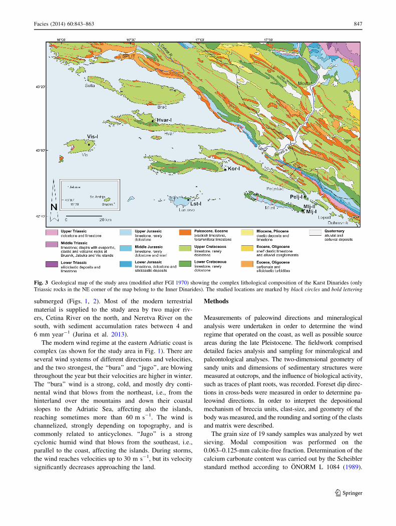
The part of the Karst Dinarides studied mainly belongs
to a group of mid-Adriatic islands of central (Hvar and Vis
Islands) and southern Dalmatia (islands of Korcula, Las-
tovo, and Mljet, and the Peljesac Peninsula) mostly com-
posed of shallow-marine carbonates deposited on the
Mesozoic Adriatic Carbonate Platform. Middle Triassic
rocks as evaporites, magmatic, and siliciclastic rocks occur
only in the westernmost part of Vis Island while Eocene
limestones and siliciclastic deposits occur on Hvar Island
and Peljesac Peninsula (Vlahovic et al. 2005, and refer-
ences therein) (Fig. 3). The study area is characterized by
relatively high relief (highest peaks range from 417 m at
Lastovo to 628 m at Hvar, and 961 m at Peljesac). Mor-
phology of islands commonly corresponds to the geological
structures, with hills representing cores of anticlines com-
posed of Mesozoic carbonates, while synclines composed
of Paleogene clastic deposits usually form valleys.
Late Pleistocene deposits were studied on five mid-
Adriatic islands and the Peljesac Peninsula, with a distance
between the outermost localities, Vis and Mljet, of
approximately 130 km (Figs. 1, 2). The position of the
base of the studied deposits varies between 10 and 115 m
a.s.l. The deposits cover small shallow depressions and
topographic saddles that are the result of tectonic defor-
mation, karstification, and fluvial erosion (Babic et al.
2013). On most of the localities studied, sands crop out at
elevations up to 40 m above the present-day sea level
(a.s.l.), but at Hvar they can be observed up to 85 m a.s.l.
(Pavelic et al. 2011), at Vis approximately to 120 m, and at
Mljet there are occurrences up to 200 m a.s.l. (Markovic-
Marjanovic 1979), indicating a very strong wind that
caused aeolian deposition at such high altitudes (Pavelic
et al. 2011; Babic et al. 2013). The sands on some of the
localities have been determined as late Pleistocene (Wur-
mian), based mainly on mammal associations (Malez 1972;
Markovic-Marjanovic 1976, 1979; Bognar et al. 1992;
Babic et al. 2012, 2013), but absolute dating has not been
Facies (2014) 60:843–863 845
123
provided so far. In the Northern Adriatic, loess intercalated
with aeolian sand has been dated by infrared stimulated
luminescence and radiocarbon dating, showing good cor-
relation with Marine Isotope Stage (MIS) 3 (Wacha et al.
2011a).
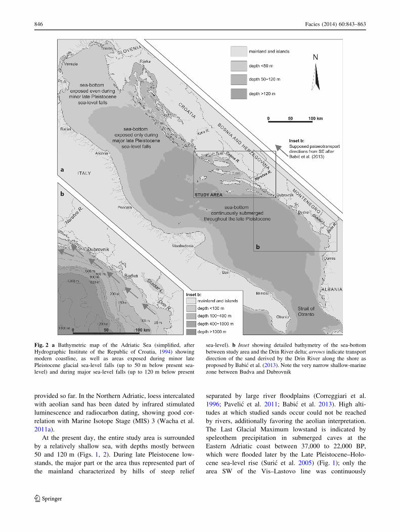
At the present day, the entire study area is surrounded
by a relatively shallow sea, with depths mostly between
50 and 120 m (Figs. 1, 2). During late Pleistocene low-
stands, the major part or the area thus represented part of
the mainland characterized by hills of steep relief
separated by large river floodplains (Correggiari et al.
1996; Pavelic et al. 2011; Babic et al. 2013). High alti-
tudes at which studied sands occur could not be reached
by rivers, additionally favoring the aeolian interpretation.
The Last Glacial Maximum lowstand is indicated by
speleothem precipitation in submerged caves at the
Eastern Adriatic coast between 37,000 to 22,000 BP,
which were flooded later by the Late Pleistocene–Holo-
cene sea-level rise (Suric et al. 2005) (Fig. 1); only the
area SW of the Vis–Lastovo line was continuously
Fig. 2 a Bathymetric map of the Adriatic Sea (simplified, after
Hydrographic Institute of the Republic of Croatia, 1994) showing
modern coastline, as well as areas exposed during minor late
Pleistocene glacial sea-level falls (up to 50 m below present sea-
level) and during major sea-level falls (up to 120 m below present
sea-level). b Inset showing detailed bathymetry of the sea-bottom
between study area and the Drin River delta; arrows indicate transport
direction of the sand derived by the Drin River along the shore as
proposed by Babic et al. (2013). Note the very narrow shallow-marine
zone between Budva and Dubrovnik
846 Facies (2014) 60:843–863
123
submerged (Figs. 1, 2). Most of the modern terrestrial
material is supplied to the study area by two major riv-
ers, Cetina River on the north, and Neretva River on the
south, with sediment accumulation rates between 4 and
6 mm year-1 (Jurina et al. 2013).
The modern wind regime at the eastern Adriatic coast is
complex (as shown for the study area in Fig. 1). There are
several wind systems of different directions and velocities,
and the two strongest, the ‘‘bura’’ and ‘‘jugo’’, are blowing
throughout the year but their velocities are higher in winter.
The ‘‘bura’’ wind is a strong, cold, and mostly dry conti-
nental wind that blows from the northeast, i.e., from the
hinterland over the mountains and down their coastal
slopes to the Adriatic Sea, affecting also the islands,
reaching sometimes more than 60 m s-1. The wind is
channelized, strongly depending on topography, and is
commonly related to anticyclones. ‘‘Jugo’’ is a strong
cyclonic humid wind that blows from the southeast, i.e.,
parallel to the coast, affecting the islands. During storms,
the wind reaches velocities up to 30 m s-1, but its velocity
significantly decreases approaching the land.
Methods
Measurements of paleowind directions and mineralogical
analysis were undertaken in order to determine the wind
regime that operated on the coast, as well as possible source
areas during the late Pleistocene. The fieldwork comprised
detailed facies analysis and sampling for mineralogical and
paleontological analyses. The two-dimensional geometry of
sandy units and dimensions of sedimentary structures were
measured at outcrops, and the influence of biological activity,
such as traces of plant roots, was recorded. Foreset dip direc-
tions in cross-beds were measured in order to determine pa-
leowind directions. In order to interpret the depositional
mechanism of breccia units, clast-size, and geometry of the
body was measured, and the rounding and sorting of the clasts
and matrix were described.
The grain size of 19 sandy samples was analyzed by wet
sieving. Modal composition was performed on the
0.063–0.125-mm calcite-free fraction. Determination of the
calcium carbonate content was carried out by the Scheibler
standard method according to ONORM L 1084 (1989).
Fig. 3 Geological map of the study area (modified after FGI 1970) showing the complex lithological composition of the Karst Dinarides (only
Triassic rocks in the NE corner of the map belong to the Inner Dinarides). The studied locations are marked by black circles and bold lettering
Facies (2014) 60:843–863 847
123
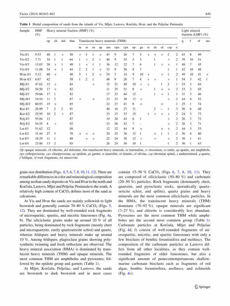
Heavy and light mineral fractions (HMF and LMF) were
separated by bromoform liquid (CHBr3; d = 2.86 g cm-3).
Qualitative and quantitative analyses of HMF and LMF
were performed by identifying 300–350 grains per sample
under the polarization microscope (following method by
Mange and Maurer 1992). Composition of five weakly
cemented sandstone samples was determined by thin-sec-
tion image analysis under a polarization microscope.
Results
Mineralogical analysis
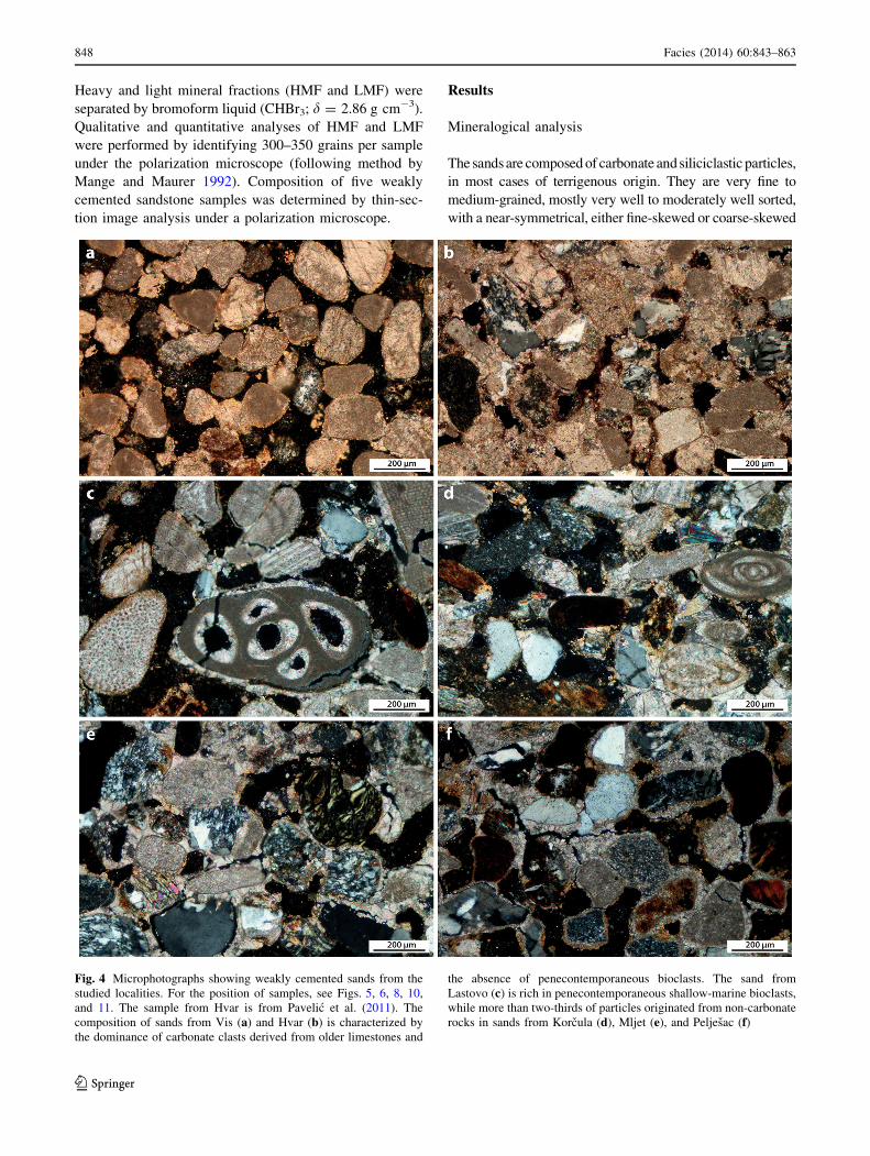
The sands are composed of carbonate and siliciclastic particles,
in most cases of terrigenous origin. They are very fine to
medium-grained, mostly very well to moderately well sorted,
with a near-symmetrical, either fine-skewed or coarse-skewed
Fig. 4 Microphotographs showing weakly cemented sands from the
studied localities. For the position of samples, see Figs. 5, 6, 8, 10,
and 11. The sample from Hvar is from Pavelic et al. (2011). The
composition of sands from Vis (a) and Hvar (b) is characterized by
the dominance of carbonate clasts derived from older limestones and
the absence of penecontemporaneous bioclasts. The sand from
Lastovo (c) is rich in penecontemporaneous shallow-marine bioclasts,
while more than two-thirds of particles originated from non-carbonate
rocks in sands from Korcula (d), Mljet (e), and Peljesac (f)
848 Facies (2014) 60:843–863
123
grain-size distribution (Figs. 4, 5, 6, 7, 8, 10, 11, 12). There are
remarkable differences in color and mineralogical composition
among aeolian sandy deposits on Vis and Hvar to the north and
Korcula, Lastovo, Mljet and Peljesac Peninsula to the south. A
relatively high content of CaCO3 defines most of the sand as
calcareous.
At Vis and Hvar the sands are mainly yellowish to light
brownish and generally contain 70–80 % CaCO3 (Figs. 5,
12). They are dominated by well-rounded rock fragments
of microsparitic, sparitic, and micritic limestones (Fig. 4a,
b). The siliciclastic grains make up around 20 % of all
particles, being dominated by rock fragments (mostly chert
and microquartzite, rarely quartzsericite schist) and quartz,
whereas feldspars and heavy minerals make up around
10 %. Among feldspars, plagioclase grains showing poly-
synthetic twinning and fresh orthoclase are observed. The
heavy mineral association (HMA) is dominated by trans-
lucent heavy minerals (THM) and opaque minerals. The
most common THM are amphiboles and pyroxenes, fol-
lowed by the epidote group and garnets (Table 1).
At Mljet, Korcula, Peljesac, and Lastovo, the sands
are brownish to dark brownish and in most cases
contain 15–50 % CaCO3 (Figs. 6, 7, 8, 10, 11). They
are composed of siliciclastic (50–80 %) and carbonate
(20–50 %) particles. Rock fragments (dominantly chert,
quartzite, and pyroclastic rocks, sporadically quartz-
sericite schist, and spilite), quartz grains and heavy
minerals are the most common siliciclastic particles. In
the HMA, the translucent heavy minerals (THM)
dominate (70–92 %), opaque minerals are significant
(7–27 %), and chlorite is considerably less abundant.
Pyroxenes are the most common THM while amphi-
boles are the second most common group (Table 1).
Carbonate particles at Korcula, Mljet and Peljesac
(Fig. 4d, f) consist of well-rounded fragments of mi-
crosparitic, micritic, and sparitic limestones with only a
few bioclasts of benthic foraminifera and molluscs. The
composition of the carbonate particles at Lastovo dif-
fers from all other localities, as they contain well-
rounded fragments of older limestones, but also a
significant amount of penecontemporaneous shallow-
marine carbonate bioclasts such as fragments of red
algae, benthic foraminifera, molluscs, and echinoids
(Fig. 4c).
Table 1 Modal composition of sands from the islands of Vis, Mljet, Lastovo, Korcula, Hvar, and the Peljesac Peninsula
Sample HMF
(%)
Heavy mineral fraction (HMF) (%) Light mineral
fraction (LMF) (%)
op ch dol thm Translucent heavy minerals (THM) q f rf ms
tu zr ru ap am opx cpx ep ga st tit ol csp x
Vis-I/1 9.53 40 1 ? 58 ? 3 1 ? 43 9 26 7 5 ? ? ? 2 2 43 8 49
Vis-I/2 7.71 34 1 1 64 1 ? 2 1 40 9 35 5 3 1 ? 2 39 10 51
Vis-I/3 13.03 58 ? 1 40 1 ? 1 1 36 12 32 7 6 1 ? ? 1 48 7 45
Vis-I/4 11.88 54 ? 1 44 2 2 1 ? 33 9 36 8 7 1 1 42 10 48
Hvar-I/1 5.12 60 ? 40 3 1 2 ? 54 3 14 9 10 ? ? 1 2 49 10 41 ?
Hvar-I/3 6.67 42 58 1 2 1 48 9 26 7 4 ? ? ? 1 54 3 42 1
Mlj-I/1 47.62 15 ? 84 ? 15 21 49 10 ? ? 1 2 1 33 3 64
Mlj-I/2 54.50 17 ? 82 11 25 51 9 ? 1 ? ? 2 33 2 65
Mlj-I/3 59.66 17 1 82 17 23 44 12 1 ? 1 1 31 3 66
Mlj-II/1 34.54 11 2 87 ? ? 23 23 38 12 ? ? 2 44 4 52
Mlj-II/2 60.93 15 ? 85 22 27 41 8 ? ? 1 25 1 74
Kor-I/1 26.99 7 2 2 91 40 16 27 11 2 – 1 3 26 6 68
Kor-I/2 25.95 10 2 ? 87 33 15 33 15 ? ? ? ? 2 24 3 73
Pelj-I/1 55.84 13 87 19 28 44 6 1 ? 2 26 2 72
Pelj-I/2 54.55 8 ? 92 23 26 42 7 – ? 2 26 3 71
Lst-I/1 51.62 12 88 12 32 44 9 ? ? ? 2 44 3 53
Lst-I/2 31.44 27 3 70 ? ? ? 20 25 36 12 1 ? 1 1 2 36 4 60
Lst-I/3 18.29 11 1 88 ? ? 22 24 38 12 ? ? ? 2 38 1 61
Lst-I/4 23.86 13 2 85 26 24 36 10 1 1 2 36 1 63
Op opaque minerals, ch chlorite, dol dolomite, thm translucent heavy minerals, tu tourmaline, zr zirconium, ru rutile, ap apatite, am amphibole,
opx orthopyroxene, cpx clinopyroxene, ep epidote, ga garnet, st staurolite, tit titanite, ol olivine, csp chromian spinel, x undetermined, q quartz,
f feldspar, rf rock fragments, ms muscovite
Facies (2014) 60:843–863 849
123
Ta
ble
2M
ain
faci
es
Fac
ies
Lo
cali
tyD
escr
ipti
on
Inte
rpre
tati
on
Ref
eren
ces
Aeo
lian
Aeo
lian
du
nes
Vis
,M
ljet
,
Ko
rcu
la
Mo
stly
fin
e-g
rain
ed,
ver
yw
ell
tow
ell-
sort
edp
lan
aro
r
tan
gen
tial
cro
ss-b
edd
edsa
nd
.T
abu
lar
and
late
rall
y
exte
nsi
ve
un
its
0.9
–9
.5m
thic
k.
So
me
fore
sets
cem
ente
d.
Fo
rese
td
ips
usu
ally
bet
wee
n2
3an
d3
3�,
reac
hin
g3
6�.
Fo
rese
tstr
un
cate
db
yd
ow
n-d
ipp
ing
pla
nar
ero
sio
nsu
rfac
es.
Bo
tto
mse
tla
min
atio
nd
ips
1–
5�.
Dev
elo
ped
bo
un
din
gsu
rfac
esb
etw
een
sets
.
Yel
low
ish
bro
wn
ish
colo
r.R
are
iso
late
db
iotu
rbat
ion
Ste
eper
fore
sets
dep
osi
ted
by
san
dfl
ow
s,le
ssst
eep
fore
sets
by
win
dri
pp
lem
igra
tio
n.
Do
wn
-dip
pin
g
pla
nar
ero
sio
nsu
rfac
esre
pre
sen
tre
acti
vat
ion
surf
aces
.B
ott
om
set
isa
resu
lto
fa
flo
wse
par
atio
n
and
gra
infa
lld
epo
siti
on
.B
iotu
rbat
ion
pro
du
ced
by
pla
nt
roo
tsp
enet
rati
ng
or
by
inse
cts
dig
gin
g
McK
ee(1
96
6),
Hu
nte
r(1
97
7),
Ko
cure
k(1
99
1),
Cle
mm
ense
nan
dA
bra
ham
sen
(19
83
),
Mo
un
tney
(20
06
),R
od
rıg
uez
-Lop
ezet
al.
(20
11
),B
abic
etal
.(2
01
2,
20
13
)
San
d
shee
ts
Mlj
et,
Las
tov
o
Fin
e-to
med
ium
-gra
ined
,m
ost
lyw
ell
sort
edlo
w-a
ng
le
pla
nar
or
tan
gen
tial
cro
ss-b
edd
edsa
nd
.T
abu
lar
and
late
rall
yex
ten
siv
eu
nit
s4
0–
20
0cm
thic
k.
So
me
fore
sets
cem
ente
d.
Fo
rese
td
ipan
gle
s2
–1
5�.
So
me
fore
sets
con
tin
ue
do
wn
war
din
tob
ott
om
sets
ina
gen
tle
tan
gen
tial
man
ner
.B
row
nis
hco
lor
Win
d-r
ipp
lean
dg
rain
flo
wd
epo
siti
on
Fry
ber
ger
etal
.(1
97
9),
Cle
mm
ense
nan
d
Ab
rah
amse
n(1
98
3),
Bab
icet
al.
(20
12
,2
01
3)
All
uvi
al
Sh
eet
flo
w
san
ds
Mlj
et,
Las
tov
o,
Hv
ar
Fin
e-to
med
ium
-gra
ined
,p
oo
rly
tow
ell-
sort
ed
ho
rizo
nta
lly
bed
ded
san
dy
un
its
0.1
–2
.9m
thic
k.
In
pla
ces,
ho
rizo
nta
lb
edd
ing
wit
hb
eds
fro
ma
few
up
to
60
cmth
ick
.S
catt
ered
iso
late
dcl
asts
mo
stly
up
to
2cm
insi
ze.
Bro
wn
ish
tore
dd
ish
colo
r.T
erre
stri
al
gas
tro
po
ds
ind
icat
ing
war
mcl
imat
e.A
sso
ciat
edw
ith
bre
ccia
inp
lace
s
Dep
osi
tio
nb
ytr
acti
on
fro
msh
eet
flo
ws.
Aff
ecte
db
y
ped
og
enes
is.
Aeo
lian
san
das
sou
rce
Nem
ecan
dS
teel
(19
84
),G
ard
ner
and
Py
e
(19
81
),L
oze
k(1
96
4),
Fra
nk
(20
06
),B
abic
etal
.(2
01
2)
Sh
eet
flo
w
san
ds
Pel
jesa
cF
ine-
gra
ined
,v
ery
wel
lso
rted
san
d.
Pla
nar
-str
atifi
ed
lam
inae
and
bed
sfe
wm
mto
35
cmth
ick
,la
tera
lly
exte
nsi
ve
and
incl
ined
bet
wee
n2
0�
and
34�.
So
me
bed
sth
ick
ensl
igh
tly
do
wn
hil
l
Dep
osi
tio
nb
ytr
acti
on
fro
msh
eet
flo
ws
inan
un
con
fin
edst
ream
on
am
od
erat
eto
stee
ph
ill
slo
pe.
Aeo
lian
san
das
sou
rce
Nem
ecan
dS
teel
(19
84
)
All
uv
ial
no
n-
con
fin
ed
and
chan
nel
dep
osi
ts
Mlj
et,
Hv
ar
Bre
ccia
s.A
ng
ula
rcl
asts
mo
stly
1–
15
cmin
size
.P
oo
rly
sort
edan
dcl
ast-
tom
atri
x-s
up
po
rted
.E
rosi
on
alan
d
shee
t-li
ke
un
its
up
to1
30
cmth
ick
,re
stin
gin
dee
p
sco
urs
inp
lace
sw
her
eth
eysh
ow
ach
ann
elg
eom
etry
.
San
dy
mat
rix
.B
imo
dal
com
po
siti
on
,cl
ast
seg
reg
atio
n
and
amal
gam
ated
bed
sin
pla
ces.
Ass
oci
ated
wit
h
cro
ss-b
edd
edo
rh
ori
zon
tall
yb
edd
ed
san
d
Sh
eet
flo
ws.
Hig
hse
dim
ent
con
cen
trat
ion
flo
ws
and
dep
osi
tio
nin
shal
low
chan
nel
s
Nem
ecan
dS
teel
(19
84
),B
abic
etal
.(2
01
2,
20
13
)
850 Facies (2014) 60:843–863
123

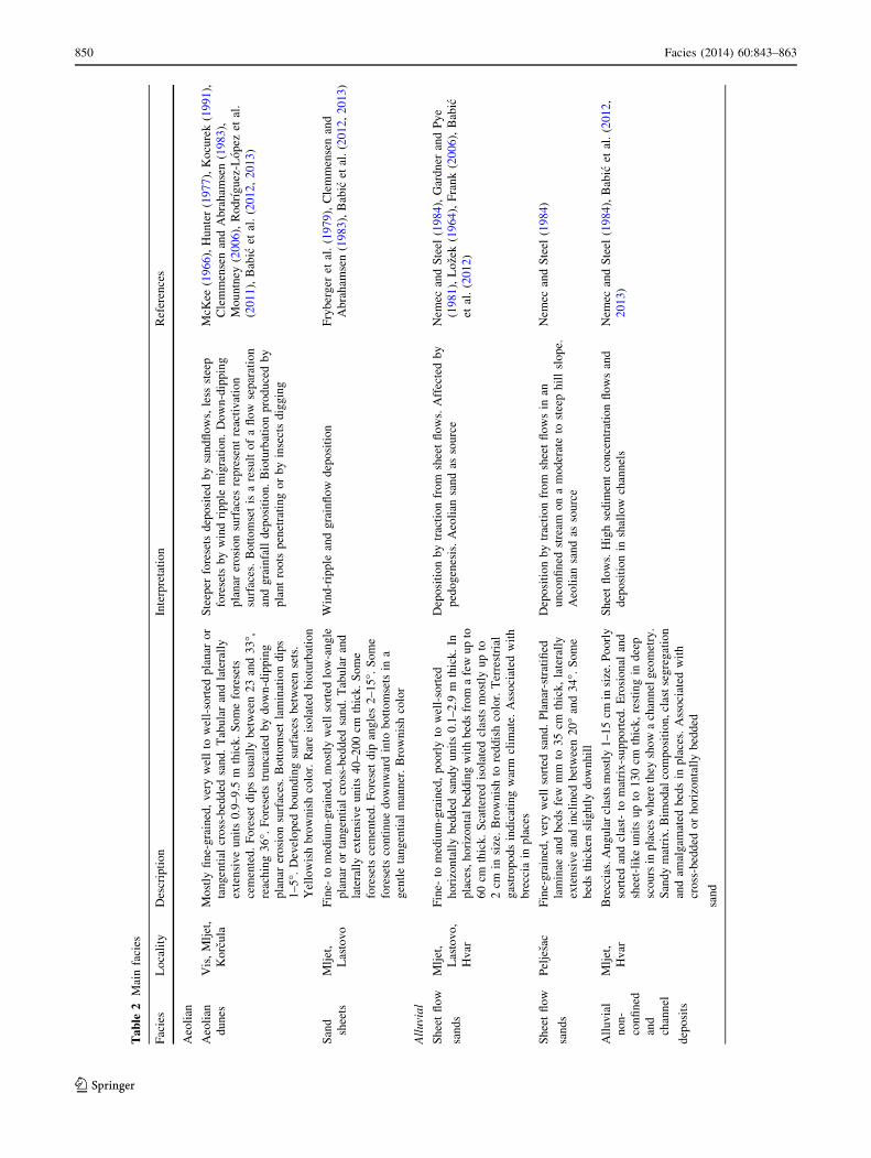
Facies and vertical facies associations
The sand bodies are composed of cross-bedded co-sets that
can be followed laterally over several tens of meters on some
localities. The bodies are characterized by a variety of foreset
dip directions. Subordinate horizontally bedded sandy units
also occur. The sands are intercalated with breccia lenses in
some places. Most of the deposits belong to five main
facies––two interpreted as aeolian, and three as alluvial
deposits (Table 2).
Vis
The outcrop studied at Vis (Figs. 1, 3) is located in a
shallow NE–SW elongated valley. It is represented by a
140-m-long sand pit of irregular curved shape in plan view,
oriented SE–NW, with the base at 117 m a.s.l. The sand
body is more than 10 m thick, but due to sand slides, only
the upper and occasionally middle parts of the vertical
exposure were available for study (Fig. 5). The body is
composed of a sub-horizontally laminated unit separated
by a sharp bounding surface from an overlying cross-
bedded unit (Table 2).
Sub-horizontally laminated sand crops out at the base of
the southern part of the profile (Fig. 5c, lower part). The
visible thickness of this unit is 50 cm but its lateral extent
is unknown due to a cover of weathered sand. The lami-
nation has a primary dip of 1–5� with a mean direction to
the NNW. The unit probably represents a bottomset of the
aeolian dune (Table 2).
The cross-bedded unit is up to 9.5 m thick and can be
traced along the whole profile (Table 2; Fig. 5b, c). The upper
part of the unit is eroded, so the original thickness is not
known. The foresets dip is unimodal with mean direction
towards 340�, i.e., towards the NNW (Fig. 5). Within less
steep dune foresets, rare isolated cross-laminated intrasets
occur. The unit is interpreted as an aeolian dune (Table 2).
The intrasets may represent faster migrating secondary bed-
forms such as small dunes or ripples developed on the slopes
of a large, primary bedform (cf. Hunter 1977; Kocurek 1991;
Mountney and Thompson 2002).
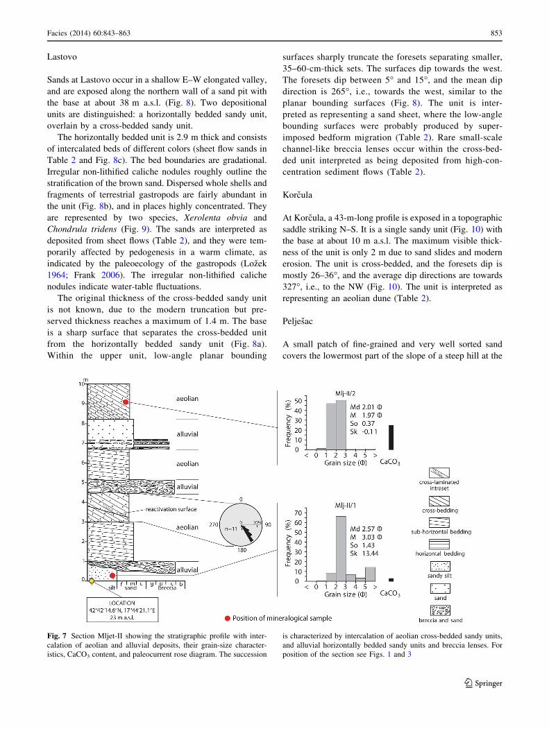
Mljet
The sandy deposits of Mljet were studied in a small shal-
low valley striking NE–SW. Two adjacent sections were
measured, Mljet-I and Mljet-II (Figs. 1, 3). Mljet-I is
exposed in a small profile, 7 m long and 4.2 m high
(Fig. 6). The base of the section is located at about 16 m
a.s.l. At Mljet-II, only a 10-m-thick succession was
Fig. 5 Sketch of the Vis-I outcrop showing aeolian deposits, their
grain-size distribution, CaCO3 content, and paleocurrent rose dia-
gram. a In the middle of the photograph, a small isolated set of cross-
laminated sand within foresets is visible. b Sub-horizontally
laminated sands, separated by a major bounding surface marked by
the dotted line (lower part; hammer is 31 cm long). c The aeolian
deposits are mostly represented by cross-bedded sands with well-
defined foresets. For position of the section, see Figs. 1 and 3
Facies (2014) 60:843–863 851
123
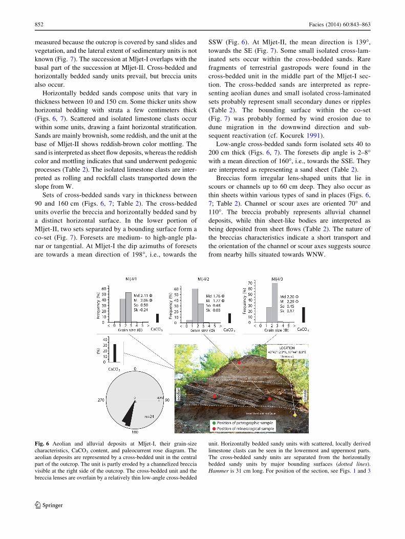
measured because the outcrop is covered by sand slides and
vegetation, and the lateral extent of sedimentary units is not
known (Fig. 7). The succession at Mljet-I overlaps with the
basal part of the succession at Mljet-II. Cross-bedded and
horizontally bedded sandy units prevail, but breccia units
also occur.
Horizontally bedded sands compose units that vary in
thickness between 10 and 150 cm. Some thicker units show
horizontal bedding with strata a few centimeters thick
(Figs. 6, 7). Scattered and isolated limestone clasts occur
within some units, drawing a faint horizontal stratification.
Sands are mainly brownish, some reddish, and the unit at the
base of Mljet-II shows reddish-brown color mottling. The
sand is interpreted as sheet flow deposits, whereas the reddish
color and mottling indicates that sand underwent pedogenic
processes (Table 2). The isolated limestone clasts are inter-
preted as rolling and rockfall clasts transported down the
slope from W.
Sets of cross-bedded sands vary in thickness between
90 and 160 cm (Figs. 6, 7; Table 2). The cross-bedded
units overlie the breccia and horizontally bedded sand by
a distinct horizontal surface. In the lower portion of
Mljet-II, two sets separated by a bounding surface form a
co-set (Fig. 7). Foresets are medium- to high-angle pla-
nar or tangential. At Mljet-I the dip azimuths of foresets
are towards a mean direction of 198�, i.e., towards the
SSW (Fig. 6). At Mljet-II, the mean direction is 139�,
towards the SE (Fig. 7). Some small isolated cross-lam-
inated sets occur within the cross-bedded sands. Rare
fragments of terrestrial gastropods were found in the
cross-bedded unit in the middle part of the Mljet-I sec-
tion. The cross-bedded sands are interpreted as repre-
senting aeolian dunes and small isolated cross-laminated
sets probably represent small secondary dunes or ripples
(Table 2). The bounding surface within the co-set
(Fig. 7) was probably formed by wind erosion due to
dune migration in the downwind direction and sub-
sequent reactivation (cf. Kocurek 1991).
Low-angle cross-bedded sands form isolated sets 40 to
200 cm thick (Figs. 6, 7). The foresets dip angle is 2–8�with a mean direction of 160�, i.e., towards the SSE. They
are interpreted as representing a sand sheet (Table 2).
Breccias form irregular lens-shaped units that lie in
scours or channels up to 60 cm deep. They also occur as
thin sheets within various types of sand in places (Figs. 6,
7; Table 2). Channel or scour axes are oriented 70� and
110�. The breccia probably represents alluvial channel
deposits, while thin sheet-like bodies are interpreted as
being deposited from sheet flows (Table 2). The nature of
the breccias characteristics indicate a short transport and
the orientation of the channel or scour axes suggests source
from nearby hills situated towards WNW.
Fig. 6 Aeolian and alluvial deposits at Mljet-I, their grain-size
characteristics, CaCO3 content, and paleocurrent rose diagram. The
aeolian deposits are represented by a cross-bedded unit in the central
part of the outcrop. The unit is partly eroded by a channelized breccia
visible at the right side of the outcrop. The cross-bedded unit and the
breccia lenses are overlain by a relatively thin low-angle cross-bedded
unit. Horizontally bedded sandy units with scattered, locally derived
limestone clasts can be seen in the lowermost and uppermost parts.
The cross-bedded sandy units are separated from the horizontally
bedded sandy units by major bounding surfaces (dotted lines).
Hammer is 31 cm long. For position of the section, see Figs. 1 and 3
852 Facies (2014) 60:843–863
123
Lastovo
Sands at Lastovo occur in a shallow E–W elongated valley,
and are exposed along the northern wall of a sand pit with
the base at about 38 m a.s.l. (Fig. 8). Two depositional
units are distinguished: a horizontally bedded sandy unit,
overlain by a cross-bedded sandy unit.
The horizontally bedded unit is 2.9 m thick and consists
of intercalated beds of different colors (sheet flow sands in
Table 2 and Fig. 8c). The bed boundaries are gradational.
Irregular non-lithified caliche nodules roughly outline the
stratification of the brown sand. Dispersed whole shells and
fragments of terrestrial gastropods are fairly abundant in
the unit (Fig. 8b), and in places highly concentrated. They
are represented by two species, Xerolenta obvia and
Chondrula tridens (Fig. 9). The sands are interpreted as
deposited from sheet flows (Table 2), and they were tem-
porarily affected by pedogenesis in a warm climate, as
indicated by the paleoecology of the gastropods (Lozek
1964; Frank 2006). The irregular non-lithified caliche
nodules indicate water-table fluctuations.
The original thickness of the cross-bedded sandy unit
is not known, due to the modern truncation but pre-
served thickness reaches a maximum of 1.4 m. The base
is a sharp surface that separates the cross-bedded unit
from the horizontally bedded sandy unit (Fig. 8a).
Within the upper unit, low-angle planar bounding
surfaces sharply truncate the foresets separating smaller,
35–60-cm-thick sets. The surfaces dip towards the west.
The foresets dip between 5� and 15�, and the mean dip
direction is 265�, i.e., towards the west, similar to the
planar bounding surfaces (Fig. 8). The unit is inter-
preted as representing a sand sheet, where the low-angle
bounding surfaces were probably produced by super-
imposed bedform migration (Table 2). Rare small-scale
channel-like breccia lenses occur within the cross-bed-
ded unit interpreted as being deposited from high-con-
centration sediment flows (Table 2).
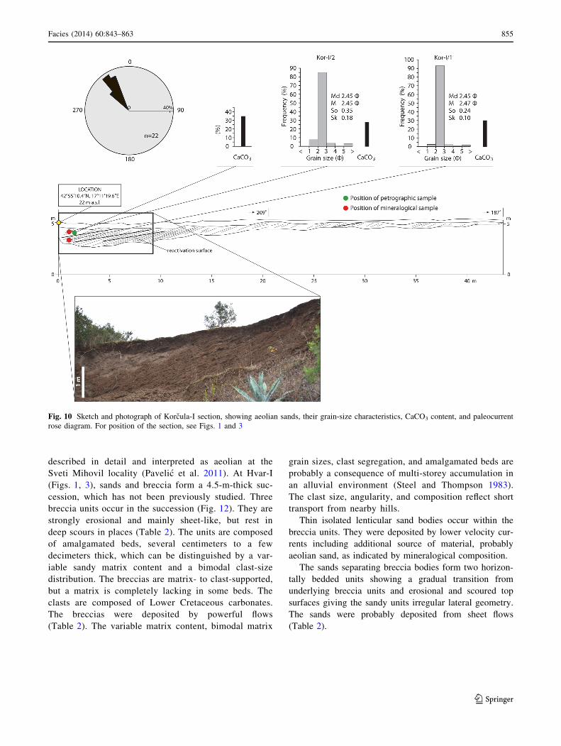
Korcula
At Korcula, a 43-m-long profile is exposed in a topographic
saddle striking N–S. It is a single sandy unit (Fig. 10) with
the base at about 10 m a.s.l. The maximum visible thick-
ness of the unit is only 2 m due to sand slides and modern
erosion. The unit is cross-bedded, and the foresets dip is
mostly 26–36�, and the average dip directions are towards
327�, i.e., to the NW (Fig. 10). The unit is interpreted as
representing an aeolian dune (Table 2).
Peljesac
A small patch of fine-grained and very well sorted sand
covers the lowermost part of the slope of a steep hill at the
Fig. 7 Section Mljet-II showing the stratigraphic profile with inter-
calation of aeolian and alluvial deposits, their grain-size character-
istics, CaCO3 content, and paleocurrent rose diagram. The succession
is characterized by intercalation of aeolian cross-bedded sandy units,
and alluvial horizontally bedded sandy units and breccia lenses. For
position of the section see Figs. 1 and 3
Facies (2014) 60:843–863 853
123

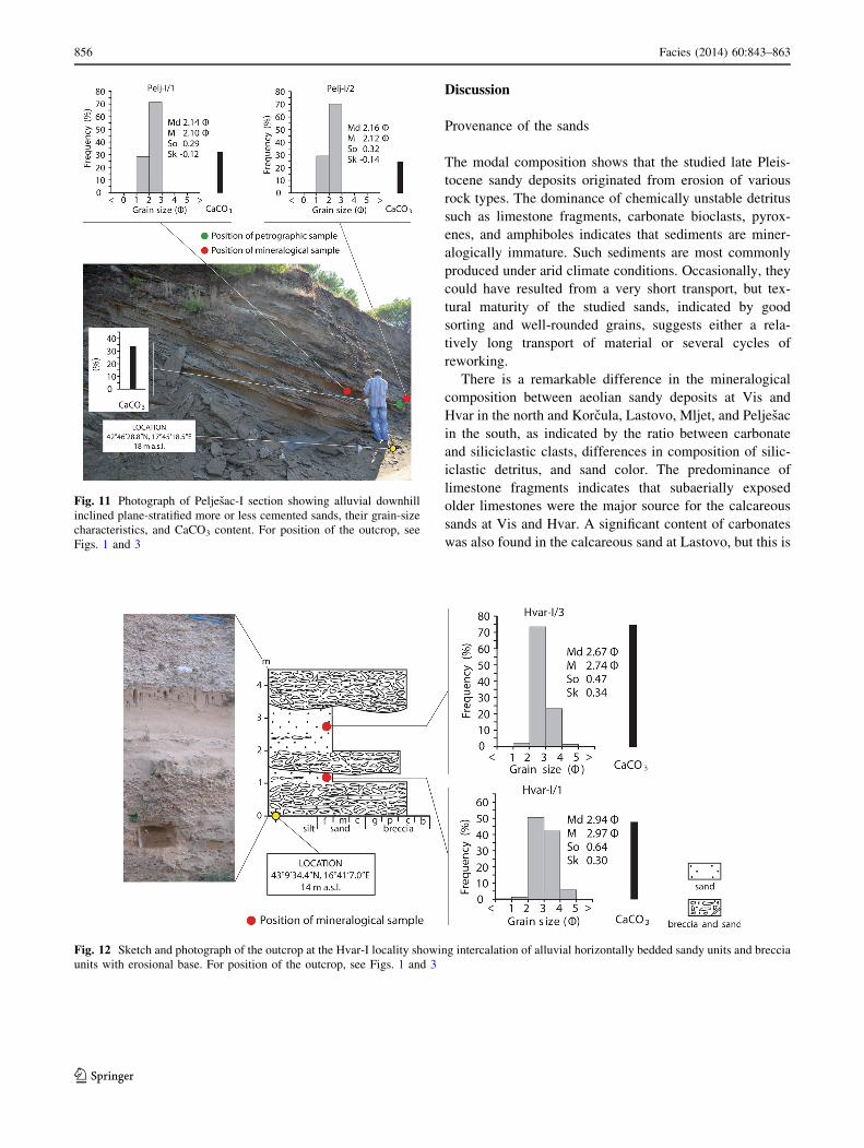
southeastern-most part of the Peljesac Peninsula (the top of
the hill is at 282 m a.s.l.). A section through a 31-m-long
profile was measured in a road cut at about 18 m a.s.l.
(Fig. 11). It is a sandy unit, 7 m thick, which shows a
planar-stratification and planar-lamination (Fig. 11). The
beds and laminae are moderately to steeply inclined
(18–34�) with the mean dip direction of 256�, i.e., down-
hill. The sand is interpreted as a sheet flow deposit on the
hill slope (Table 2). The interpretation is supported by the
uniform grain size and the planar stratification and planar
lamination inclined downhill that indicates aeolian sand
erosion during periods of intense rainfall and deposition in
a small-scale alluvial fan (Sweeney and Loope 2001).
Hvar
Sands are found at several localities at the island of
Hvar (Markovic-Marjanovic 1976) and have been
Fig. 8 Sketch of the outcrop at Lastovo-I section showing aeolian
and alluvial deposits, their grain-size characteristics, CaCO3 content,
and paleocurrent rose diagram. a Aeolian deposits represented by
cross-bedded sands in the uppermost part of the cross section are
laterally extensive. b Terrestrial gastropods occurring within
horizontally bedded sands, which are characterized by intercalations
of light brown and reddish brown layers indicating pedogenesis (c).
The cross-bedded sandy unit overlies the horizontally bedded sandy
unit. Scale is 2 m long. For position of the section, see Figs. 1 and 3
Fig. 9 Pleistocene terrestrial gastropods from Lastovo-I section. a, b, c Xerolenta obvia, sample Lst-I/1. d, e Chondrula tridens, sample Lst-I/2.
For position of samples see Fig. 8
854 Facies (2014) 60:843–863
123
described in detail and interpreted as aeolian at the
Sveti Mihovil locality (Pavelic et al. 2011). At Hvar-I
(Figs. 1, 3), sands and breccia form a 4.5-m-thick suc-
cession, which has not been previously studied. Three
breccia units occur in the succession (Fig. 12). They are
strongly erosional and mainly sheet-like, but rest in
deep scours in places (Table 2). The units are composed
of amalgamated beds, several centimeters to a few
decimeters thick, which can be distinguished by a var-
iable sandy matrix content and a bimodal clast-size
distribution. The breccias are matrix- to clast-supported,
but a matrix is completely lacking in some beds. The
clasts are composed of Lower Cretaceous carbonates.
The breccias were deposited by powerful flows
(Table 2). The variable matrix content, bimodal matrix
grain sizes, clast segregation, and amalgamated beds are
probably a consequence of multi-storey accumulation in
an alluvial environment (Steel and Thompson 1983).
The clast size, angularity, and composition reflect short
transport from nearby hills.
Thin isolated lenticular sand bodies occur within the
breccia units. They were deposited by lower velocity cur-
rents including additional source of material, probably
aeolian sand, as indicated by mineralogical composition.
The sands separating breccia bodies form two horizon-
tally bedded units showing a gradual transition from
underlying breccia units and erosional and scoured top
surfaces giving the sandy units irregular lateral geometry.
The sands were probably deposited from sheet flows
(Table 2).
Fig. 10 Sketch and photograph of Korcula-I section, showing aeolian sands, their grain-size characteristics, CaCO3 content, and paleocurrent
rose diagram. For position of the section, see Figs. 1 and 3
Facies (2014) 60:843–863 855
123
Discussion
Provenance of the sands
The modal composition shows that the studied late Pleis-
tocene sandy deposits originated from erosion of various
rock types. The dominance of chemically unstable detritus
such as limestone fragments, carbonate bioclasts, pyrox-
enes, and amphiboles indicates that sediments are miner-
alogically immature. Such sediments are most commonly
produced under arid climate conditions. Occasionally, they
could have resulted from a very short transport, but tex-
tural maturity of the studied sands, indicated by good
sorting and well-rounded grains, suggests either a rela-
tively long transport of material or several cycles of
reworking.
There is a remarkable difference in the mineralogical
composition between aeolian sandy deposits at Vis and
Hvar in the north and Korcula, Lastovo, Mljet, and Peljesac
in the south, as indicated by the ratio between carbonate
and siliciclastic clasts, differences in composition of silic-
iclastic detritus, and sand color. The predominance of
limestone fragments indicates that subaerially exposed
older limestones were the major source for the calcareous
sands at Vis and Hvar. A significant content of carbonates
was also found in the calcareous sand at Lastovo, but this is
Fig. 11 Photograph of Peljesac-I section showing alluvial downhill
inclined plane-stratified more or less cemented sands, their grain-size
characteristics, and CaCO3 content. For position of the outcrop, see
Figs. 1 and 3
Fig. 12 Sketch and photograph of the outcrop at the Hvar-I locality showing intercalation of alluvial horizontally bedded sandy units and breccia
units with erosional base. For position of the outcrop, see Figs. 1 and 3
856 Facies (2014) 60:843–863
123

primarily caused by a high content of penecontemporane-
ous shallow-marine bioclasts. Sandy deposits at Mljet,
Korcula, and Peljesac contain between 66 and 80 % par-
ticles of non-carbonate rocks, and at other localities their
content varies between 20 and 60 %. Microquartzite,
quartzite, and quartzsericite schist clasts were derived from
metamorphic rocks, while pyroxenes, amphiboles, epidote,
garnets, and titanite could have been produced by weath-
ering of various metamorphic and magmatic rocks. Minor
presence of chrome spinel and olivine in most of the sands
indicate an ultramafic magmatic source, while part of the
quartz grains, plagioclase with polysynthetic lamellae, and
alkali feldspars were probably derived from acidic mag-
matic rocks. Tephra fragments as well as very fresh green
clinopyroxenes (augite) in sands at Mljet, Korcula, and
Peljesac are probably products of the Quaternary volca-
nism (Lugovic et al. 2006; Mikulcic Pavlakovic et al. 2011;
Wacha et al. 2011b; Babic et al. 2012). The presence of
chert rock fragments and rounded quartz grains in all sands,
and of the ultra-stable translucent heavy minerals tourma-
line, rutile, and zircon in sands at Vis and Hvar indicate
that part of the detritus was produced by recycling of older
sedimentary rocks.
The source area of siliciclastic, carbonate clastic and
bioclastic detrital sands had to be lithologically complex.
The siliciclastic and carbonate clastic detritus was most
probably released by breakdown of sedimentary, igneous,
and metamorphic rocks in the Dinarides that are composed
of different, mostly carbonate rocks (Karst Dinarides), and
siliciclastic sedimentary rocks, magmatic and metamorphic
rocks (Inner Dinarides). During the Late Pleistocene gla-
ciations, glaciers formed within the Dinarides (Bognar and
Prugovecki 1997; Marjanac and Marjanac 2004; Hughes
et al. 2011; Velic et al. 2011) that probably caused strong
erosion, and the products were transported by local rivers to
the coastal area during seasons characterized by warm cli-
mate. Huge amounts of sand deposited in river channels and
on flood plains were later reworked by wind, generating
aeolian deposits at the coast under drier and cooler condi-
tions (Bognar et al. 1992; Pavelic et al. 2011; Babic et al.
2012, 2013). This interpretation can be partly compared to
the Pleistocene Ebro Basin in Spain, where an outwash
plain was deflated generating aeolian sand deposition (Lu-
zon et al. 2012). Additional sand provenances may be from
numerous small Pleistocene alluvial cones composed of
sands and sandstones in the lower parts, and breccias in the
upper parts. They developed locally along steep slopes of
the eastern Adriatic coastal hills and mountains, whose
distal zones might have been flooded during the Holocene
sea-level rise (Borovic et al. 1977; Marincic et al. 1977;
Magas et al. 1979).
Penecontemporaneous shallow-marine biogenic grains
represent an important calcareous component of the aeolian
sand only in Lastovo section (Table 3). The occurrence of
penecontemporaneous marine bioclasts and foraminifera in
aeolian sand has also been observed on other mid-Adriatic
islands (Babic et al. 2012, 2013), but in very small
amounts, even on Korcula and Vis where aeolian deposi-
tion was controlled by landward-blowing winds that could
have potentially caused significant deflation of shallow-
marine bioclastic material. This suggests that deflated
shallow-marine sands did not play an important role in
producing of clastic detritus except in the case of Lastovo,
where the drift of marine sand probably increased due to
wind approaching oblique to parallel to the coast (Table 3)
(Hesp 1983).
The position of the modern Cetina and Neretva Rivers,
which supply the mid-Adriatic coast with material derived
from the Dinaric Mountains, allows interpretation of the
different mineralogical compositions between the northern
and southern localities (Fig. 3 and Table 2). The northerly
located Cetina River flows through the Karst Dinarides,
which are mostly composed of carbonates, including
Miocene lacustrine carbonates in the hinterland (de Leeuw
et al. 2010, 2012). If such a river existed in the Late
Pleistocene it probably supplied the coastal area with sand
produced by glacial processes in the mountains, passing
into wide flood plains towards the sea. This reconstruction
suggests that yellowish to light-brownish calcareous-rich
aeolian deposits at Hvar and Vis were probably generated
Table 3 Summarized major
characteristics of aeolian sands
studied
Data for the island of Hvar are
from this study and Pavelic
et al. (2011). Maximal altitude
from Mljet after Markovic-
Marjanovic (1979)
Locality CaCO3
content
Bioclasts
occurrence
Prevailing source
material
Bedforms Wind direction Max. altitude
m a.s.l.
Vis 74–80 No Limestones Dune Landward 125
Hvar 62–96 No Limestones Dunes, sand sheets Seaward 84
Mljet 15–32 Rare Metamorphics,
magmatics
Dunes, sand sheets Seaward 200
Lastovo 25–58 Common Biogenic,
metamorphics,
magmatics
Dunes Parallel to the
coastline
46.5
Korcula 28–35 Rare Metamorphics,
magmatics
Dune Landward 12
Facies (2014) 60:843–863 857
123

by deflation of the Cetina paleo-river deposits (Pavelic
et al. 2011). Brownish to dark-brownish sands at Korcula,
Lastovo, Mljet, and Peljesac, rich in siliciclastic material,
can be related to the southerly located Neretva River
(Buljan et al. 2012) (Fig. 3), with a headwater drainage
system situated in the Inner Dinarides that are composed
mostly of magmatic, metamorphic, and siliciclastic sedi-
mentary rocks (Fig. 3). The different mineralogical com-
position of the two groups of coastal aeolian sands may
thus be explained by the presence of two independent
fluvial systems with drainage in areas characterized by
different lithologies. Additionally, the different mineral-
ogical composition may also have been caused by exotic
material transported by glaciers from distant parts of the
Dinarides.
This interpretation differs from that of Babic et al.
(2013), who suggested a marine origin of most of the
aeolian sand and indicated that a transport towards mid-
Adriatic islands was by presumed strong marine currents
and waves alongshore from the SE reinforced by wind in
the late Pleistocene. As a major source of siliciclastic sand
for Korcula, Lastovo, Mljet, and Peljesac, they suggested
the Albanian coast where the large Drin River enters the
Adriatic Sea. According to Babic et al. (2013), the sand
was transported further towards the NW along the Mon-
tenegrian and Croatian coasts where it was subsequently
uplifted and reworked by wind action. However, the
modern bathymetric map documents a more than 50-km-
long very narrow and relatively steep nearshore fringe in
the Budva–Dubrovnik zone (Fig. 2b), which could not
have been passed by such a large amount of sand needed
for deposition in the study area. Moreover, the coastline
was located more seaward during lowstands, in the position
where the nearshore fringe was even steeper, additionally
reducing the sand passing capacity. This indicates that most
of the riverine material was deposited in the deltaic zones
without significant along-shore redistribution by marine
processes, and that deposition was predominantly con-
trolled by progradation and retrogradation of the coastline
due to the glacio-eustatic sea-level changes. Additionally,
strong and unidirectional longshore currents capable of
significant redistribution of river-derived material form
asymmetric or deflected wave-influenced deltas where the
river mouth runs subparallel to the coast (Wright 1977;
Bhattacharya and Giosan 2003), while the Drin River delta
is characterized by a symmetric morphology.
Wind regime and paleogeography
Transport directions of the aeolian sands show the pre-
vailing wind direction responsible for the formation and
migration of the aeolian dunes and sand sheets. Each
locality studied represented by the aeolian sands showed a
uniform wind direction with a spread in foreset dip direc-
tions mostly within 45�. However, comparison of these
directions shows a non-uniform and irregular wind regime
in the area (Fig. 13). Hvar (Pavelic et al. 2011) and Las-
tovo indicate westward wind directions, with a subordinate
southward deviation at Hvar. Vis and Korcula are charac-
terized by a north–northwestward transport direction. Mljet
differs from other localities, showing directions towards
the south-southwest and southeast, i.e., overall towards the
south. Reconstruction of the paleocoastline position based
on the modern bathymetric data and last maximal sea-level
drop of 120 m during the last glacial maximum (Corr-
eggiari et al. 1996) indicates that the localities studied were
part of the mainland at the time of sand deposition (Fig. 3).
The main aeolian bedforms show three general wind
directions: (1) landward at Vis and Korcula, (2) seaward at
Hvar and Mljet, and (3) parallel to the coastline at Lastovo
(Fig. 13, Table 3) that is similar to the modern wind
regime (Fig. 1).
If a wind regime similar to the modern wind regime
(Fig. 1) was active during the time of sand deposition on
the mid-Adriatic islands and Peljesac Peninsula, it is pos-
sible to relate these paleowind systems to deposits only
partly, because reconstructed wind directions mostly cor-
respond to the strike of the valleys or topographic saddles
as the sand depocenters. On Hvar, the eastern wind cor-
responds to the E–W elongated valley probably repre-
senting a deviated NE ‘‘paleo-bura’’ wind (Fig. 13). The
‘‘paleo-bura’’ probably controlled deposition on Mljet, too,
where the NE wind coincides with the NE–SW strike of the
saddle. The SE wind on Korcula partly corresponds to the
N–S-oriented saddle, while the eastern wind on Lastovo
corresponds to the E–W elongated valley, indicating
deviation of the SE ‘‘paleo-jugo’’ wind. The topography
did not affect the wind in the E–W valley on Vis where the
NNW wind direction reflects an influence of the ‘‘paleo–
jugo’’. Such wind deviations indicate that aeolian deposi-
tion at the coast was strongly controlled by local topogra-
phy characterized by a steep relief. Despite deviations, the
wind was still very strong, causing aeolian deposition at
very high altitudes: on Hvar up to 84 m and at Mljet up to
200 m a.s.l. (Markovic-Marjanovic 1979) (Table 3).
The wind directions that controlled aeolian deposition
on the mid-Adriatic islands differ strongly from most
Quaternary localities studied at other Mediterranean coasts,
where the dominant wind blew landward at most places,
such as the coasts of Mallorca (Clemmensen et al. 1997;
Nielsen et al. 2004), Sardinia (Andreucci et al. 2006, 2009),
Tunisia (Elmejdoub et al. 2011; Hasler et al. 2012), Egypt
(Frihy et al. 1988; El Banna 2004), and Israel (Yaalon and
Laronne 1971). This can be interpreted by their geographic
position within the Mediterranean realm, i.e., the influence
of the dominant wind that blew from the large open sea
858 Facies (2014) 60:843–863
123

towards coastal areas. Aeolian deposition was forced
especially during low stands when wide surfaces of sub-
aerially exposed marine beach sands were deflated by
onshore-blowing winds and the sand was subsequently
deposited on the backshore, resulting in a significant per-
centage of marine bioclasts. Aeolian deposition on the mid-
Adriatic islands was generated mainly by the wind that
blew more or less parallel to the coast as a consequence of
the narrow and NW–SE elongated semi-closed Adriatic
Sea, and by the wind that blew seaward. However, due to
the morphology of the islands that corresponds to the
geological structures and to the orientation of karst
depressions where the aeolian sand accumulated, it caused
local wind deviation in different directions. A remarkable
difference between aeolian sand at mid-Adriatic and
Mediterranean localities is also the mineralogical compo-
sition. The Mediterranean coastal aeolian sand is mostly
rich in marine bioclasts as the result of beach sand defla-
tion, while the sand on the mid-Adriatic islands is char-
acterized by relatively low content of bioclasts, as the
predominant source of sands were river flood plains where
material derived from the hinterland was deposited.
The existence of aeolian sands with marine bioclasts in the
proximity of the supposed paleo-coastline may define them
as coastal (Figs. 1, 13). However, a sequence of events
indicates inland dunes that have been formed by several
phases: (1) mechanical weathering of sand source, probably
by ice, (2) glacial and fluvial transport and deposition, (3)
aeolian transport and deposition, and (4) influence of land-
ward-blowing winds, corresponding to case 3 of Pye and
Tsoar (2009). This interpretation is supported by the complex
wind regime, including seaward-blowing winds.
Late Pleistocene deposition along the mid-Adriatic coast
was characterized by alternation of two phases. The aeolian
phase was characterized by deflation and reworking of flu-
vial sand seasonally supplied by rivers from the Dinarides
along the coast, by a complex wind regime partly controlled
by the local topography during a dry and cold climate
(Fig. 14a). The sand constructed dunes and sand sheets that
migrated in different directions across the land. Marine sand
was of minor importance as a source. A change to a wetter
and warmer climate resulted in an alluvial phase charac-
terized by a marked change in depositional style (Fig. 14b).
Small alluvial systems developed producing accumulations
of locally derived coarse-grained material and recycled
aeolian sand. Reduced wind influence caused stabilization of
aeolian bedforms, supported by vegetation and water-table
fluctuation, which colored the sand reddish and produced
Fig. 13 Schematic representation of the late Pleistocene paleogeog-
raphy of the study area showing wind directions and migrating dunes
in the area of the mid-Adriatic islands and Peljesac Peninsula, which
represented a part of the mainland during sea-level lowstands. Winds
blew towards the north–northwest, west and south, or landward,
seaward, and parallel to the approximated paleo-coastline. For
position of the area, see Fig. 1
Facies (2014) 60:843–863 859
123
Fig. 14 Depositional model for alternation of aeolian and alluvial
phases on the mid-Adriatic coast during the late Pleistocene related to
the alteration of dry and cold glacial and wet and warm interglacial
stages. a Deposition during the aeolian phase was characterized by a
strong seasonal sediment supply by rivers and dune and sand sheet
migration. Local wind deviation caused by morphology generated the
aeolian deposition in the karst depression. b During the alluvial phase,
erosion caused weathering of basement rocks and deposition of
produced fragments together with recycled aeolian sand deposited in
locally developed alluvial systems. The sediment supply by rivers was
low and the flood plain was affected by pedogenesis. Aeolian
bedforms were stabilized by increased humidity and vegetation in
places. c During the subsequent aeolian phase, the flood plain was
deflated by wind that constructed sand into dunes and sand sheets
860 Facies (2014) 60:843–863
123
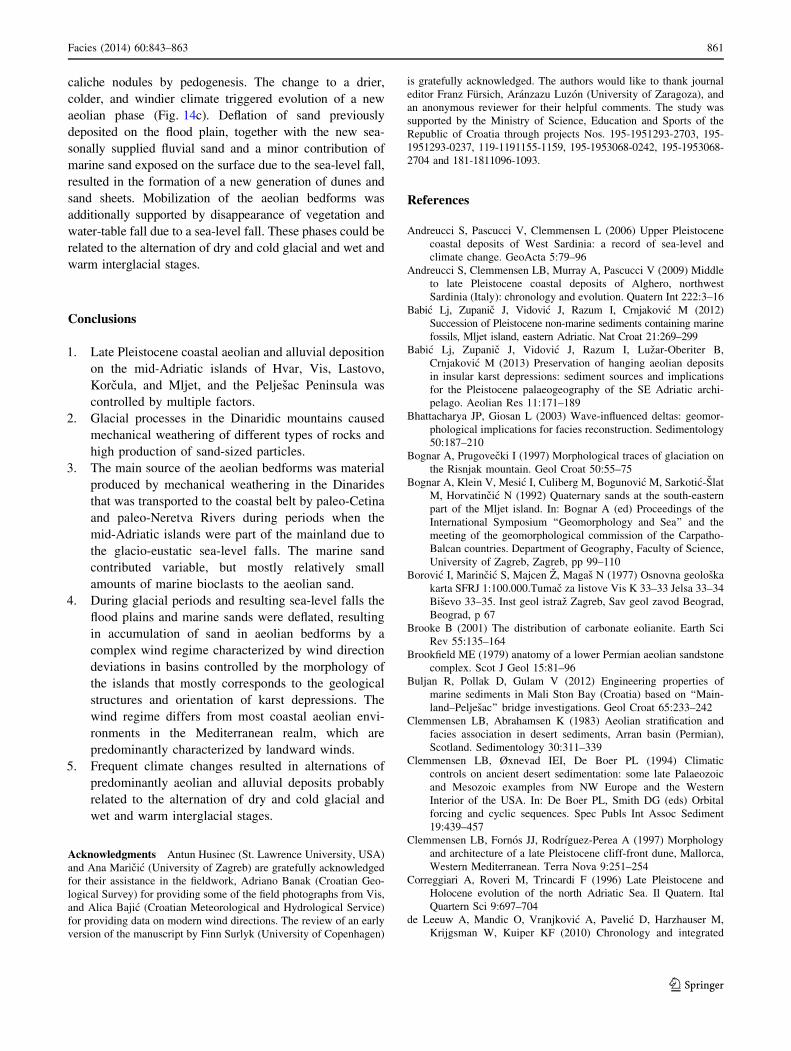
caliche nodules by pedogenesis. The change to a drier,
colder, and windier climate triggered evolution of a new
aeolian phase (Fig. 14c). Deflation of sand previously
deposited on the flood plain, together with the new sea-
sonally supplied fluvial sand and a minor contribution of
marine sand exposed on the surface due to the sea-level fall,
resulted in the formation of a new generation of dunes and
sand sheets. Mobilization of the aeolian bedforms was
additionally supported by disappearance of vegetation and
water-table fall due to a sea-level fall. These phases could be
related to the alternation of dry and cold glacial and wet and
warm interglacial stages.
Conclusions
1. Late Pleistocene coastal aeolian and alluvial deposition
on the mid-Adriatic islands of Hvar, Vis, Lastovo,
Korcula, and Mljet, and the Peljesac Peninsula was
controlled by multiple factors.
2. Glacial processes in the Dinaridic mountains caused
mechanical weathering of different types of rocks and
high production of sand-sized particles.
3. The main source of the aeolian bedforms was material
produced by mechanical weathering in the Dinarides
that was transported to the coastal belt by paleo-Cetina
and paleo-Neretva Rivers during periods when the
mid-Adriatic islands were part of the mainland due to
the glacio-eustatic sea-level falls. The marine sand
contributed variable, but mostly relatively small
amounts of marine bioclasts to the aeolian sand.
4. During glacial periods and resulting sea-level falls the
flood plains and marine sands were deflated, resulting
in accumulation of sand in aeolian bedforms by a
complex wind regime characterized by wind direction
deviations in basins controlled by the morphology of
the islands that mostly corresponds to the geological
structures and orientation of karst depressions. The
wind regime differs from most coastal aeolian envi-
ronments in the Mediterranean realm, which are
predominantly characterized by landward winds.
5. Frequent climate changes resulted in alternations of
predominantly aeolian and alluvial deposits probably
related to the alternation of dry and cold glacial and
wet and warm interglacial stages.
Acknowledgments Antun Husinec (St. Lawrence University, USA)
and Ana Maricic (University of Zagreb) are gratefully acknowledged
for their assistance in the fieldwork, Adriano Banak (Croatian Geo-
logical Survey) for providing some of the field photographs from Vis,
and Alica Bajic (Croatian Meteorological and Hydrological Service)
for providing data on modern wind directions. The review of an early
version of the manuscript by Finn Surlyk (University of Copenhagen)
is gratefully acknowledged. The authors would like to thank journal
editor Franz Fursich, Aranzazu Luzon (University of Zaragoza), and
an anonymous reviewer for their helpful comments. The study was
supported by the Ministry of Science, Education and Sports of the
Republic of Croatia through projects Nos. 195-1951293-2703, 195-
1951293-0237, 119-1191155-1159, 195-1953068-0242, 195-1953068-
2704 and 181-1811096-1093.
References
Andreucci S, Pascucci V, Clemmensen L (2006) Upper Pleistocene
coastal deposits of West Sardinia: a record of sea-level and
climate change. GeoActa 5:79–96
Andreucci S, Clemmensen LB, Murray A, Pascucci V (2009) Middle
to late Pleistocene coastal deposits of Alghero, northwest
Sardinia (Italy): chronology and evolution. Quatern Int 222:3–16
Babic Lj, Zupanic J, Vidovic J, Razum I, Crnjakovic M (2012)
Succession of Pleistocene non-marine sediments containing marine
fossils, Mljet island, eastern Adriatic. Nat Croat 21:269–299
Babic Lj, Zupanic J, Vidovic J, Razum I, Luzar-Oberiter B,
Crnjakovic M (2013) Preservation of hanging aeolian deposits
in insular karst depressions: sediment sources and implications
for the Pleistocene palaeogeography of the SE Adriatic archi-
pelago. Aeolian Res 11:171–189
Bhattacharya JP, Giosan L (2003) Wave-influenced deltas: geomor-
phological implications for facies reconstruction. Sedimentology
50:187–210
Bognar A, Prugovecki I (1997) Morphological traces of glaciation on
the Risnjak mountain. Geol Croat 50:55–75
Bognar A, Klein V, Mesic I, Culiberg M, Bogunovic M, Sarkotic-Slat
M, Horvatincic N (1992) Quaternary sands at the south-eastern
part of the Mljet island. In: Bognar A (ed) Proceedings of the
International Symposium ‘‘Geomorphology and Sea’’ and the
meeting of the geomorphological commission of the Carpatho-
Balcan countries. Department of Geography, Faculty of Science,
University of Zagreb, Zagreb, pp 99–110
Borovic I, Marincic S, Majcen Z, Magas N (1977) Osnovna geoloska
karta SFRJ 1:100.000.Tumac za listove Vis K 33–33 Jelsa 33–34
Bisevo 33–35. Inst geol istraz Zagreb, Sav geol zavod Beograd,
Beograd, p 67
Brooke B (2001) The distribution of carbonate eolianite. Earth Sci
Rev 55:135–164
Brookfield ME (1979) anatomy of a lower Permian aeolian sandstone
complex. Scot J Geol 15:81–96
Buljan R, Pollak D, Gulam V (2012) Engineering properties of
marine sediments in Mali Ston Bay (Croatia) based on ‘‘Main-
land–Peljesac’’ bridge investigations. Geol Croat 65:233–242
Clemmensen LB, Abrahamsen K (1983) Aeolian stratification and
facies association in desert sediments, Arran basin (Permian),
Scotland. Sedimentology 30:311–339
Clemmensen LB, Øxnevad IEI, De Boer PL (1994) Climatic
controls on ancient desert sedimentation: some late Palaeozoic
and Mesozoic examples from NW Europe and the Western
Interior of the USA. In: De Boer PL, Smith DG (eds) Orbital
forcing and cyclic sequences. Spec Publs Int Assoc Sediment
19:439–457
Clemmensen LB, Fornos JJ, Rodrıguez-Perea A (1997) Morphology
and architecture of a late Pleistocene cliff-front dune, Mallorca,
Western Mediterranean. Terra Nova 9:251–254
Correggiari A, Roveri M, Trincardi F (1996) Late Pleistocene and
Holocene evolution of the north Adriatic Sea. Il Quatern. Ital
Quartern Sci 9:697–704
de Leeuw A, Mandic O, Vranjkovic A, Pavelic D, Harzhauser M,
Krijgsman W, Kuiper KF (2010) Chronology and integrated
Facies (2014) 60:843–863 861
123
stratigraphy of the Miocene Sinj Basin (Dinaride Lake System,
Croatia). Palaeogeogr Palaeoclimatol Palaeoecol 292:155–167
de Leeuw A, Mandic O, Krijgsman W, Kuiper K, Hrvatovic H (2012)
Paleomagnetic and geochronologic constraints on the geody-
namic evolution of the Central Dinarides. Tectonophysics
530–531:286–298
El Banna MM (2004) Nature and human impact on Nile Delta coastal
sand dunes. Egypt. Environ Geol 45:690–695
Elmejdoub N, Mauz B, Jedoui Y (2011) Sea-level and climatic
controls on Late Pleistocene coastal aeolianites in the Cap Bon
peninsula, northeastern Tunisia. Boreas 40:198–207
FGI (1970) Geoloska karta SFR Jugoslavije 1:500.000 (Geological
Map of SFR Yugoslavia, 1:500,000 scale). Federal Geological
Institute, Belgrade
Frank C (2006) Plio-pleistozane und holozane Mollusken Osterreichs.
Verlag der Osterreichischen Akademie der Wissenschaften, Wien
797 p
Frebourg G, Hasler C-A, Le Guern P, Davaud E (2008) Facies
characteristics and diversity in carbonate eolianites. Facies
54:175–191
Frihy OE, Fishawy NM, El Askary M-A (1988) Geomorphological
features of the Nile Delta coastal plain: a review. Acta Adriat
29:51–65
Fryberger SG, Ahlbrandt TS, Andrews S (1979) Origin, sedimentary
features, and significance of eolian sand ‘‘sand sheet’’ deposits,
Great Sand Dunes National Monument and vicinity, Colorado.
J Sediment Petrol 49:733–746
Gardner RAM, Pye K (1981) Nature, origin and palaeoenvironmental
significance of red coastal and deserts dune sands. Progr Phys
Geogr 5:514–534
Gil H, Luzon A, Soriano MA, Casado I, Perez A, Yuste A, Pueyo E,
Pocovı A (2013) Stratigraphic architecture of alluvial-aeolian
systems developed on active karst terrains: an early Pleistocene
example from the Ebro basin (NE Spain). Sediment Geol
296:122–141
Hasler C-A, Frebourg G, Davaud E (2012) Anatomy, internal
heterogeneities, and early fracture network of a Pleistocene
carbonate coastal dune (Rejiche formation, southeastern Tuni-
sia). Facies 58:509–522
Hesp PA (1983) Morphodynamics of incipient foredunes in N.S.W.,
Australia. In: Brookfield ME, Ahlbrandt TS (eds) Eolian
sediments and processes. Elsevier, Amsterdam, pp 325–342
Hoque M (1975) An analysis of cross-stratification of Gargaresh
calcarenite (Tripoli, Libya) and Pleistocene palaeowinds. Geol
Mag 112:393–401
Hughes PD, Woodward JC, van Calsteren PC, Thomas LE (2011) The
glacial history of the Dinaric Alps, Montenegro. Quatern Sci Rev
30:3393–3412
Hunter RE (1977) Basic types of stratification in small eolian dunes.
Sedimentology 24:361–387
Hydrographic Institute of the Republic of Croatia (1994) Jadransko
more, Batimetrijska karta, M 1:1,000.000. Split
Jurina I, Ivanic M, Troskot-Corbic T, Barisic D, Vdovic N, Sondi I
(2013) Activity concentrations and distribution of radionuclides
in surface and core sediments of the Neretva Channel (Adriatic
Sea, Croatia). Geol Croat 66:143–150
Kocurek G (1991) Interpretation of ancient eolian sand dunes. Ann
Rev Earth Planet Sci 19:43–75
Korolija B, Borovic I, Marincic S, Jagacic T, Magas N, Milanovic M
(1977) Osnovna geoloska karta SFRJ 1:100.000. Tumac za listLastovo K 33–46 Korcula K 33–47 Palagruza K 33–57. Inst geol
istraz Zagreb, Sav geol zavod Beograd, Beograd, p 53
Langford RP (1989) Fluvial–aeolian interactions: part I, modern
systems. Sedimentology 36:1023–1035
Langford RP, Chan MA (1989) Fluvial–aeolian interactions: part II,
ancient systems. Sedimentology 36:1037–1051
Le Guern P, Davaud E (2005) Recognition of ancient carbonate wind
deposits: lessons from a modern analogue, Chrissi island, Crete.
Sedimentology 52:915–926
Lozek V (1964) Quartarmollusken der Tschechoslowakei. Rozpr Ust
Geol 31:1–374
Lugovic B, Crnjakovic M, Bisevac V (2006) Mineralogical signatures
of weathered Late Holocene ash layer from the island of Mljet in
Croatia. In: Vlahovic I, Tibljas D, Durn G, Bisevac V (eds) 3rd
mid-European clay conference–MECC 06. Abstract Book,
Prirodoslovno-matematicki fakultet and Rudarsko-geolosko-na-
ftni fakultet, p 78
Luzon A, Rodrıguez-Lopez JP, Perez A, Asuncion Soriano M, Gil H,
Pocovı A (2012) Karst subsidence as a control on the accumu-
lation and preservation of aeolian deposits: a Pleistocene
example from a proglacial outwash setting, Ebro Basin, Spain.
Sedimentology 59:2199–2225
Magas N, Marincic S, Bencek Ð (1979) Osnovna geoloska karta
SFRJ 1:100 000. Tumac za list Ploce K 33-35. Inst geol istraz
Zagreb, Sav geol zavod Beograd, Beograd, p 52
Malez M (1972) Rasprostranjenost hladnoljubivih zivotinja u gornjem
pleistocenu jugoistocne Evrope. Rad Jugosl akad znan i umjet
346:133–180
Mange MA, Maurer HFW (1992) Heavy minerals in colour. Chapman
& Hall, London 151 p
Marincic S, Korolija B, Mamuzic P, Magas N, Majcen Z, Brkic M,
Bencek Ð (1977) Osnovna geoloska karta SFRJ 1:100 000.
Tumac za list Omis K 33-22. Inst geol istraz Zagreb, Sav geol
zavod Beograd, Beograd, p 51
Marjanac Lj, Marjanac T (2004) Glacial history of Croatian Adriatic
and coastal Dinarides. In: Ehlers J, Gibbard PL (eds) Quaternary
glaciations––extent and chronology. Elsevier, Amsterdam,
pp 19–26
Markovic-Marjanovic J (1976) Kvartarni sedimenti ostrva Hvara––
Srednji Jadran. Glasnik prirodnjackog muzeja, Serija A
31:199–214
Markovic-Marjanovic J (1979) Kvartarna istorija ostrva Mljeta.
Glasnik prirodnjackog muzeja, Serija A 34:179–200
Mauz B, Hijma MP, Amorosi A, Porat N, Galili E, Bloemendal J
(2013) Aeolian beach ridges and their significance for climate
and sea level: concept and insight from the Levant coast (east
Mediterranean). Earth Sci Rev 121:31–54
McKee ED (1966) Structures of dunes at White Sands National
Monument, New Mexico (and comparison with structures of
dunes from other selected areas). Sedimentology 7:1–69
McKee ED, Ward WC (1983) Eolian environments. In: Scholle PA,
Bebout DG, Moore CH (eds) Carbonate depositional environ-
ments. Mem Am Assoc Petrol Geol 33:132–170
Mikulcic Pavlakovic S, Crnjakovic M, Tibljas D, Soufek M, Wacha
L, Frechen M, Lackovic D (2011) Mineralogical and geochem-
ical characteristics of Quaternary sediments from the Island of
Susak (Northern Adriatic, Croatia). Quatern Int 234:32–49
Mountney NP (2006) Periodic accumulation and destruction of
aeolian erg sequence in the Permian Cedar Mesa Sandstone.
White Canyon, southern Utah USA. Sedimentology 53:789–823
Mountney NP, Thompson DB (2002) Stratigraphic evolution and
preservation of aeolian dune and damp/wet interdune strata: an
example from the Triassic Helsby Sandstone Formation, Chesh-
ire Basin, UK. Sedimentology 49:805–833
Nemec W, Steel RJ (1984) Alluvial and costal conglomerates: their
significant features and some comments on gravelly mass-flow
deposits. In: Coster EH, Steel RJ (eds) Sedimentology of gravels
and conglomerates, Can Soc Petrol Geol Mem 10:1–31
Nielsen KA, Clemmensen LB, Fornos JJ (2004) Middle Pleistocene
magnetostratigraphy and susceptibility stratigraphy: data from
carbonate aeolian system, Mallorca, Western Mediterranean.
Quatern Sci Rev 23:1733–1756
862 Facies (2014) 60:843–863
123

ONORM L 1084 (1989) Chemische Bodenuntersuchungen. Bestim-
mung von Carbonat, Osterreichisches Normungsinstitut, Wien
Pamic J, Gusic I, Jelaska V (1998) Geodynamic evolution of the
Central Dinarides. Tectonophysics 297:251–268
Pavelic D, Kovacic M, Vlahovic I, Wacha L (2011) Pleistocene
calcareous aeolian–alluvial deposition in a steep relief karstic
coastal belt (island of Hvar, eastern Adriatic, Croatia). Sediment
Geol 239:64–79
Pye K, Tsoar H (2009) Aeolian sand and sand dunes. Springer, Berlin
458
Rodrıguez-Lopez JP, Liesa CL, Van Dam J, Lafuente P, Arlegui L,
Ezquerro L, De Boer P (2011) Aeolian construction and alluvial
dismantling of a fault-bounded intracontinental aeolian dune field
(Teruel Basin, Spain); a continental perspective on late Pliocene
climate change and variability. Sedimentology 59:1536–1567
Rose J, Xingmin M, Watson C (1999) Paleoclimate and palaeoen-
vironmental responses in the western Mediterranean over the last
140 ka: evidence from Mallorca. Spain J Geol Soc 156:435–448
Sremac J (2012) Influence of terrestrial sedimentation in Pennsylva-
nian rocks of Croatia. Geol Croat 65:273–282
Steel RJ, Thompson DB (1983) Structures and textures in Triassic
braided-stream conglomerates (Bunter Pebble Beds) in the
Sherwood Sandstone Group, North Staffordshire, England.
Sedimentology 30:341–367
Suric M, Juracic M, Horvatincic N, Krajcar Bronic I (2005) Late
Pleistocene-Holocene sea-level rise and pattern of coastal karst
inundation: records from submerged speleothems along the
eastern Adriatic coast (Croatia). Mar Geol 214:163–175
Sweeney MR, Loope DB (2001) Holocene dune-sourced alluvial fans
in the Nebraska Sand Hill. Geomorphology 38:31–46
Velic J, Velic I, Kljajo D (2011) Sedimentary bodies, forms and
occurrences in the Tudorevo and Mirovo glacial deposits of
northern Velebit (Croatia). Geol Croat 64:1–16
Vlahovic I, Tisljar J, Velic I, Maticec D (2005) Evolution of the
Adriatic carbonate platform: palaeogeography, main events and
depositional dynamics. Palaeogeogr Palaeoclimatol Palaeoecol
220:333–360
Wacha L, Mikulcic Pavlakovic S, Novothny A, Crnjakovic M,
Frechen M (2011a) Luminescence dating of upper Pleistocene
loess from the island of Susak in Croatia. Quatern Int 234:50–61
Wacha L, Mikulcic Pavlakovic S, Frechen M, Crnjakovic M (2011b)
The loess chronology of the Island of Susak. Croatia. Eiszeitalter
und Gegenwart-Quatern. Sci J 60:153–169
Wright LD (1977) Sediment transport and deposition at river mouths:
a synthesis. Bull Geol Soc Am 88:857–868
Yaalon DH, Laronne J (1971) Internal structures in eolianites and
palaeowinds, Mediterranean Coast, Israel. J Sediment Petrol
41:1059–1064
Facies (2014) 60:843–863 863
123