Doral Mineral Sands - Shire of Serpentine Jarrahdale
93
10.1.4 - Attachment 2 Ordinary Council Meeting - 19 April 2021
-
Upload
khangminh22 -
Category
Documents
-
view
0 -
download
0
Transcript of Doral Mineral Sands - Shire of Serpentine Jarrahdale

10.1.4 - Attachment 2
Ordinary Council Meeting - 19 April 2021

Doral Mineral Sands Keysbrook Mineral Sands Project
Mosquito Management Plan
February 2020
10.1.4 - Attachment 2
Ordinary Council Meeting - 19 April 2021

Table of Contents 1 Introduction .......................................................................................................................................... 3
1.1 Overview of report ....................................................................................................................... 3
2 Mosquito Management ........................................................................................................................ 6
2.1 Objectives ..................................................................................................................................... 6
2.2 Environmental Conditions ............................................................................................................ 6
2.3 Site Conditions .............................................................................................................................. 6
3 Management Actions to Minimise Mosquito Breeding Habitat .......................................................... 7
3.1 Biological....................................................................................................................................... 7
3.2 Chemical ....................................................................................................................................... 7
3.3 Physical ......................................................................................................................................... 7
3.4 Cultural ......................................................................................................................................... 8
4 Monitoring ............................................................................................................................................ 8
5 Non Compliances .................................................................................................................................. 8
6 Corrective actions ................................................................................................................................. 8
7 Reporting .............................................................................................................................................. 8
8 Appendices ........................................................................................................................................... 9
LIST OF FIGURES
Figure 1 :Site Location .................................................................................................................................. 4
Figure 2: Current EPA approved mining area ............................................................................................... 5
Figure 3: Process Water Management Circuit .............................................................................................. 7
LIST OF APPENDICES
Appendix 1 – Tails Inspection Checklist
10.1.4 - Attachment 2
Ordinary Council Meeting - 19 April 2021

1 Introduction
1.1 Overview of report Keysbrook Leucoxene Pty Ltd (KLPL), a subsidiary of Doral Mineral Sands is required to prepare a Mosquito
Management Plan in response to Condition (d) of the Shire of Serpentine Jarrahdale Development
Approval for Lot 57 for the extraction and processing of mineral sands.
KLPL have prepared a second, separate Development Application seeking approval to develop blocks 101,
103, 104 and 105 Diagram 92169.
This amended version of the Mosquito Management Plan has been produced to satisfy condition (d) as
well as mosquito management objectives for blocks 101, 103, 104 and 105.
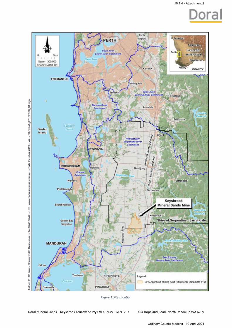
The site is located due west of South Western Highway, 3km north of North Dandalup town site. Figure 1
below indicates the site’s location.
The site is bounded by local roads, and extraction will only occur in part of the site. The approved mining
area is detailed in Figure 2.
10.1.4 - Attachment 2
Ordinary Council Meeting - 19 April 2021

Figure 1:Site Location
10.1.4 - Attachment 2
Ordinary Council Meeting - 19 April 2021

Figure 2:Current EPA approved mining area
10.1.4 - Attachment 2
Ordinary Council Meeting - 19 April 2021
2 Mosquito Management
2.1 Objectives The objectives of this Mosquito Management Plan are to:
• Prevent increases in the number of new mosquito breeding sites as a result of mineral sands
mining and processing operations.
• Prevent the transmission of mosquito‐borne diseases as a result of mineral sands mining and
processing operations.
2.2 Environmental Conditions The environmental conditions that contribute to the breeding generally include the following:
• Stagnant freshwater pools
• Marshes
• Tall grasses and weeds
• Ground that is wet for at least part of the year
The majority of land within the extractive area is cleared and used for beef or dairy cattle grazing.
Remnant native vegetation occurs in pockets and as scattered trees over pasture. Long term grazing has
resulted in removal of the understorey in the remnant areas within the approved mining footprint and
consequently the vegetation condition within the mine footprint is predominantly degraded.
The extractive area is slightly undulated from east to west, with minor seasonal ephemeral drainage lines
traversing the area. Waterflow associated with the drainage lines is seasonal with flows limited to the
winter months. Post winter months, standing water bodies are limited to isolated pools within the
ephemeral drainage lines. These pools dry up rapidly post winter.
2.3 Site Conditions
2.3.1 Process Water The primary processing of mineral sands is relatively simple, using water, spirals and gravity separation,
the heavy mineral concentrate (HMC) product is separated from sand. Water utilised for the Process
Water Management Circuit is sourced from multiple sources including groundwater bores and tailings
pits. The water is returned to the Process Water Pond (PWP) via pumps and pipelines. From here the
water is pumped from the PWP into the Wet Concentrator Plant (WCP). Post processing, the water is then
utilised to transport the tails sand from the WCP to the mine voids. Tailings water then reports to a sump
where it is pumped back to the PWP. The water within the circuit is constantly moving and therefore is
not considered a breeding habitat for mosquitos. The Process Water Management Circuit is represented
graphically in Figure 3.
No standing water bodies associated with the processing of mineral sands will be present onsite with the
exception of plant shutdowns. During plant shutdowns processing water pumps are shutoff to undertake
routine maintenance. During shutdowns the water circuit ceases to flow for approximately 12 to 24 hours.
2.3.2 Emergent Vegetation No emergent vegetation is located within the Process Water Management Circuit, with all vegetation
cleared prior to the areas being mined. Routine weed control of the Process Water Pond banks occurs to
ensure vegetation growth does not occur. This is undertaken to ensure the integrity of the pond liner and
to increase the water flows within the Process Water Pond.
10.1.4 - Attachment 2
Ordinary Council Meeting - 19 April 2021

Figure 3: Process Water Management Circuit
3 Management Actions to Minimise Mosquito Breeding Habitat
3.1 Biological • On‐site facilities will be screened and air conditioned.
• Lights will be fitted where practicable with yellow bulbs to discourage mosquitoes.
3.2 Chemical • All crib facilities are equipped with mosquito repellent.
3.3 Physical • As detailed in Section 2.3, no standing water associated with the extraction and processing of
mineral sands will be present onsite with the exception of plant shutdowns
• Any depressions created in the ground surface will be filled or drained as soon as reasonably
practicable to prevent the ponding of water
• Inspections will be undertaken of the PWP and mined out tails voids for the presence of mosquito
larvae. If significant presence of larvae are detected, the ponds or excavations shall be filled or
drained and if required the Medical Entomology Branch of the Department of Health will be
consulted on what actions should be taken
• Rehabilitation of mining areas in a manner that will prevent the creation of new mosquito
breeding sites
• Drainage channels/spoon drains will be kept as shallow as possible to prevent ponding.
10.1.4 - Attachment 2
Ordinary Council Meeting - 19 April 2021
3.4 Cultural • Storage containers capable of ponding water will be managed to reduce the risk and duration of
ponded water by discarding after use or storing in an inverted position. Attention will be given
to ensure that ponding does not occur in rubbish storage areas
• Staff and contractors will be made aware of the potential risk of mosquito borne diseases and the
high risk periods
• Staff and contractors will be advised to wear long sleeved shirts and trousers, avoid risk periods
where possible (i.e. sundown), and to use insect repellent. Insect repellent will be provided at
work sites
• Workers will be educated about the early symptoms associated with exposure to mosquito‐borne
arbovirus and will be instructed on the need to report any symptoms to their direct supervisor.
4 Monitoring Daily visual inspections will be undertaken on tails pits (mined out voids), water courses and the Process
Water Pond as part of normal operations. During these visual inspections, voids and the process water
pond will be inspected for evidence of mosquito breeding in the form of larvae and adults. The daily Tails
Inspection Checklist is provided in Appendix 1.
Staff are encouraged to report excessive numbers of mosquito bites, utilising KLPL’s online Hazard
Reporting System. The hazard reporting system provides an efficient way for hazards to be reported
directly to the appropriate personnel via email, allowing for management actions to be employed rapidly.
5 Non Compliances During monitoring or as a result of the submission of hazard reports, if any of the following are identified
they will be documented as a non-compliance and corrective action will be implemented:
• Mosquito breeding sites are identified and determined to be created by mining activities
• Excessive numbers of larvae and/or mature mosquitoes are evident on‐site
• Significant incidences of mosquito bites are reported
• Confirmed infection by Ross River or other mosquito‐borne disease which is likely to be
attributable to the KLPL site.
6 Corrective actions The following corrective actions will be implemented in the event of any non-compliance:
• All incidents will be reported and managed through to resolution via KLPL’s incident reporting
system
• Management actions will be reviewed to minimise mosquito breeding habitat detailed in
Section 3 and to ensure the controls are adequate and are being implemented
• Staff will be re-educated on the importance of Mosquito Management at prestart meetings
• Controls in Section 3 will be reviewed and changed where necessary.
7 Reporting The results of KLPL’s Mosquito Monitoring and Management Program will be documented in KLPL’s
Annual Report of Performance against the Compliance Assessment Plan. Any significant mosquito activity
will be reported to KLPL’s Mine Manager.
10.1.4 - Attachment 2
Ordinary Council Meeting - 19 April 2021

8 Appendices Appendix 1 – Tails Inspection Checklist
10.1.4 - Attachment 2
Ordinary Council Meeting - 19 April 2021

Appendix 1 – Tails Inspection Checklist
10.1.4 - Attachment 2
Ordinary Council Meeting - 19 April 2021

TAILINGS INSPECTION CHECKLIST
Tailings Storage Area:
Inspected by: Date:
General Item Specific Criteria Comments Actions
Embankment, Bunds, Roads & Perimeter
General condition
Available storage capacity
Erosion or damage
Evidence of seepage
Evidence of spillage
Presence of wet areas
Condition of pipes & valves
Evidence of mosquito breeding (e.g. larvae / adults)
Tails Voids Erosion
Sediment within drains
Excess vegetation in drains
Evidence of mosquito breeding (e.g. larvae / adults)
Creek crossings Pipes crossing creeks
adequately contained in
culverts
Pipe corridor adequality
bunded at creek crossings to
prevent spills into creeks
Process Water Ponds
Evidence of mosquito breeding
(e.g. larvae / adults)
Sign off
Dewatering Team Leader Mining Superintendent
Name: Name:
Signature: Signature:
10.1.4 - Attachment 2
Ordinary Council Meeting - 19 April 2021

Doral Mineral Sands – Keysbrook Leucoxene Pty Ltd ABN 49137091297 1424 Hopeland Road, North Dandalup WA 6209
Doral Mineral Sands Keysbrook Mineral Sands Project
Visual Management Plan
December 2019
10.1.4 - Attachment 2
Ordinary Council Meeting - 19 April 2021
Doral Mineral Sands – Keysbrook Leucoxene Pty Ltd ABN 49137091297 1424 Hopeland Road, North Dandalup WA 6209
Table of Contents 1 Introduction .................................................................................................................................... 3
1.1 Overview of report .................................................................................................................. 3
2 Visual Management ........................................................................................................................ 5
2.1 Objective ................................................................................................................................. 5
2.2 Broader Visual Landscape Character ...................................................................................... 5
2.3 Key Issues ................................................................................................................................ 5
3 Visual Management Response ........................................................................................................ 5
3.1 Visual Management Response ................................................................................................ 6
4 Monitoring and Performance Criteria .......................................................................................... 10
4.1 Monitoring Regime and Reporting Methodology ................................................................. 10
4.2 Key Performance Indicators .................................................................................................. 10
5 Appendices .................................................................................................................................... 10
LIST OF FIGURES
Figure 1:Site Location .............................................................................................................................. 4
Figure 2: Site Plan including Topsoil Bunds............................................................................................. 9
LIST OF TABLES
Table 1: Visual Management Response .................................................................................................. 7
LIST OF APPENDICES
Appendix 1 – Visual Amenity Impact Assessment
Appendix 2 – Conceptual Revegetation Plan
Appendix 3 – Visual Assessment Locations
Appendix 4 - Annual Visual Assessment Report
10.1.4 - Attachment 2
Ordinary Council Meeting - 19 April 2021

Doral Mineral Sands – Keysbrook Leucoxene Pty Ltd ABN 49137091297 1424 Hopeland Road, North Dandalup WA 6209
1 Introduction
1.1 Overview of report Keysbrook Leucoxene Pty Ltd (KLPL), a subsidiary of Doral Mineral Sands is required to prepare a Visual
Management Plan in response to Condition (f) of the Shire of Serpentine Jarrahdale Development
Approval for Lot 57 Plan 739. The plan was first authored in 2011 by EPCAD Landscape Architects and
Environmental Planners (EPCAD). KLPL have also prepared a separate submission seeking approval to
develop blocks 101, 103, 104 and 105 Diagram 92169. This amended version of the management plan
has been produced to satisfy condition (f) as well as the visual management objectives for blocks 101,
103, 104 and 105. This plan should be read in conjunction with the additional reports attached as
Appendix 1- 4 and referred to throughout.
The site is located due west of South Western Highway, 3km north of North Dandalup town site. The
site is bounded by local roads, and extraction will only occur in part of the site. Portions of the
extractive area are adjacent to local roads. Figure 1 below indicates the sites location.
10.1.4 - Attachment 2
Ordinary Council Meeting - 19 April 2021
Doral Mineral Sands – Keysbrook Leucoxene Pty Ltd ABN 49137091297 1424 Hopeland Road, North Dandalup WA 6209
Figure 1:Site Location
10.1.4 - Attachment 2
Ordinary Council Meeting - 19 April 2021
Doral Mineral Sands – Keysbrook Leucoxene Pty Ltd ABN 49137091297 1424 Hopeland Road, North Dandalup WA 6209
2 Visual Management
2.1 Objective The objectives of this Visual Management Plan are;
• for the long-term reinstatement of the broader visual landscape character (as a minimum
benchmark);
• to minimise visual intrusion of the extraction operations on the broader visual landscape
character; and,
• to minimise views to the operations of the extractive development during the period of
extractive works.
2.2 Broader Visual Landscape Character As identified in the Preliminary Visual Amenity Impact Assessment (see Appendix 1), the
characteristics of the local landscape are:
• Gently rolling to flat, expansive plains to the west of the SW Highway;
• Primarily open, pastoral land which is divided into properties and paddocks by low post and
wire stock fences;
• Rural land-use within the area is diverse and includes, but is not limited to equestrian stud,
sheep and cattle farming, straw and feed production, hobby style farming, and rural-
residential living. Some properties feature built form such as sheds, barns, workshops and
private dwellings etc, which scatter the landscape:
• Small pockets of mature vegetation in the form of:
o Planted windbreaks
o Shelter belts
o Replanted groves of vegetation
o Verge-side vegetation;
• Seasonal variation due to rotating agricultural activities; and,
• Numerous fence and train lines along with tree belts and the distant horizon add to the
horizontal, linear nature of the landscape.
2.3 Key Issues The following issues are to be addressed in terms of Visual Management of the development site:
• Views from publicly accessible locations;
• Views from private properties adjacent to the southern-most boundary of the site;
• Visual landscape restoration driven by the Rehabilitation Management Plan. The conceptual
Revegetation plan, which outlines the native revegetation plating corridors is available in
Appendix 2.
• Lighting associated with the extraction and proposed built forms; and,
• Off-site commercial signage.
3 Visual Management Response To reduce the visibility of the extractive operations within the development site, the following
management responses (identified in Table 1) are recommended to be adopted by the proponent.
Table 1 should be read in conjunction with Figure 2 of this Visual Management Plan. The
recommended actions in Table 1 may be applied at the same time or the same area as another action
10.1.4 - Attachment 2
Ordinary Council Meeting - 19 April 2021

Doral Mineral Sands – Keysbrook Leucoxene Pty Ltd ABN 49137091297 1424 Hopeland Road, North Dandalup WA 6209
and should be considered independent of one another. For example, where verge side vegetation is
supplemented, topsoil bunds may also be utilised in a temporary manner to provide additional
screening.
3.1 Visual Management Response
10.1.4 - Attachment 2
Ordinary Council Meeting - 19 April 2021
Doral Mineral Sands – Keysbrook Leucoxene Pty Ltd ABN 49137091297 1424 Hopeland Road, North Dandalup WA 6209
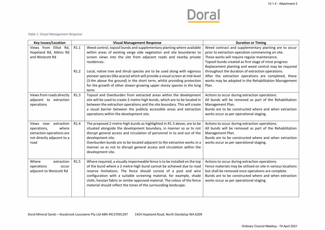
Table 1: Visual Management Response
Key Issues/Location Visual Management Response Duration or Timing
Views from Elliot Rd, Hopeland Rd, Atkins Rd and Westcott Rd
R1.1 R1.2
Weed control, topsoil bunds and supplementary planting where available within areas of existing verge side vegetation and site boundaries to screen views into the site from adjacent roads and nearby private residences. Local, native tree and shrub species are to be used along with vigorous pioneer species (like acacia) which will provide a visual screen at mid-level (3-4m above the ground) in the short term, whilst providing protection for the growth of other slower-growing upper storey species in the long term.
Weed contract and supplementary planting are to occur prior to extraction operation commencing on site. These works will require regular maintenance. Topsoil bunds created as first stage of mine progress Replacement planting and weed control may be required throughout the duration of extraction operations. After the extraction operations are completed, these works may be adopted in the Rehabilitation Management Plan.
Views from roads directly adjacent to extraction operations
R1.3 Topsoil and Overburden from extracted areas within the development site will be used to create 2-metre-high bunds, which are to be located in between the extraction operations and the site boundary. This will create a visual barrier between the publicly accessible areas and extraction operations within the development site.
Actions to occur during extraction operations. All bunds will be removed as part of the Rehabilitation Management Plan. Bunds are to be constructed where and when extraction works occur as per operational staging.
Views near extraction operations, where extraction operations are not directly adjacent to a road
R1.4 The proposed 2-metre-high bunds as highlighted in R1.3 above, are to be situated alongside the development boundary, in manner so as to not disrupt general access and circulation of personnel in to and out of the development site. Overburden bunds are to be located adjacent to the extractive works in a manner so as not to disrupt general access and circulation within the development site.
Actions to occur during extraction operations. All bunds will be removed as part of the Rehabilitation Management Plan. Bunds are to be constructed where and when extraction works occur as per operational staging.
Where extraction operations occur adjacent to Westcott Rd
R1.5 Where required, a visually impermeable fence is to be installed on the top of the bund where a 2-metre-high bund cannot be achieved due to road reserve limitations. The fence should consist of a post and wire configuration with a suitable screening material, for example, shade cloth, hessian fabric or similar approved material. The colour of the fence material should reflect the tones of the surrounding landscape.
Actions to occur during extraction operations. Fence materials may be utilised on site in various locations but shall be removed once operations are complete. Bunds are to be constructed where and when extraction works occur as per operational staging.
10.1.4 - Attachment 2
Ordinary Council Meeting - 19 April 2021
Doral Mineral Sands – Keysbrook Leucoxene Pty Ltd ABN 49137091297 1424 Hopeland Road, North Dandalup WA 6209
Key Issues/Location Visual Management Response Duration or Timing
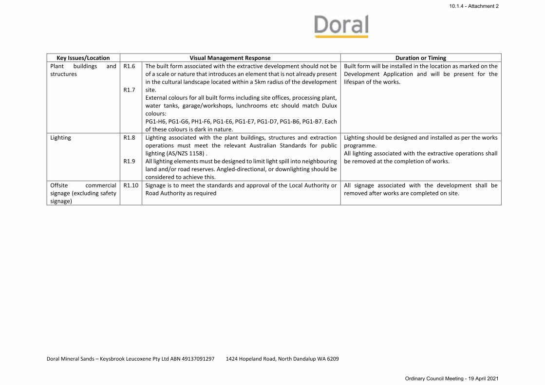
Plant buildings and structures
R1.6 R1.7
The built form associated with the extractive development should not be of a scale or nature that introduces an element that is not already present in the cultural landscape located within a 5km radius of the development site. External colours for all built forms including site offices, processing plant, water tanks, garage/workshops, lunchrooms etc should match Dulux colours: PG1-H6, PG1-G6, PH1-F6, PG1-E6, PG1-E7, PG1-D7, PG1-B6, PG1-B7. Each of these colours is dark in nature.
Built form will be installed in the location as marked on the Development Application and will be present for the lifespan of the works.
Lighting R1.8 R1.9
Lighting associated with the plant buildings, structures and extraction operations must meet the relevant Australian Standards for public lighting (AS/NZS 1158) . All lighting elements must be designed to limit light spill into neighbouring land and/or road reserves. Angled-directional, or downlighting should be considered to achieve this.
Lighting should be designed and installed as per the works programme. All lighting associated with the extractive operations shall be removed at the completion of works.
Offsite commercial signage (excluding safety signage)
R1.10 Signage is to meet the standards and approval of the Local Authority or Road Authority as required
All signage associated with the development shall be removed after works are completed on site.
10.1.4 - Attachment 2
Ordinary Council Meeting - 19 April 2021

105 101
104103
57
0
Scale 1:50,000MGA94 (Zone 50)
1km
Legend
Approved Mining Area (Ministerial Statement 810)
ResidenceLot BoundaryConservation Covenant Area
Rehabilitation to May 2019Cover Crop 2019
Auth
or: D
. O'H
ara~
Dra
wn:
CAD
Res
ourc
es ~
Tel
924
6 32
42 ~
UR
L w
ww
.cad
reso
urce
s.co
m.a
u ~
Dat
e O
ctob
er 2
019
~ A4
~ C
AD R
ef g
2510
F101
_01.
dgn
~ Ae
rial P
hoto
grap
hy: L
andg
ate
(May
201
9)
Visual Management PlanProposed Topsoil Bunds
10.1.4 - Attachment 2
Ordinary Council Meeting - 19 April 2021

Doral Mineral Sands – Keysbrook Leucoxene Pty Ltd ABN 49137091297 1424 Hopeland Road, North Dandalup WA 6209
4 Monitoring and Performance Criteria
4.1 Monitoring Regime and Reporting Methodology Throughout the duration of the extractive operations, monitoring visits are to be undertaken at regular
intervals, twice yearly to review the Visual Management Response and to evaluate their success in
mitigating visual impact. Annual Monitoring Reports should be prepared and submitted to Local Authority
by the proponent, to highlight any discrepancies, issues and recommendations for rectification identified
during the course of the year. Appendices 3 and 4 provide a map of the Visual Assessment monitoring
locations and an example of an Annual Visual Assessment report.
The monitoring process and subsequent Visual Management Report should address the following:
• Establishing whether or not predicted impacts have actually occurred;
• Identifying unforeseen impacts and omissions from the original Preliminary Visual Impact
Assessment ad ensuring an appropriate response;
• Checking compliance with proposed visual management responses and planning conditions and,
• Checking the effectiveness of visual management responses in avoiding or reducing visual impact.
4.2 Key Performance Indicators To evaluate the success of the Visual management Plan at the development site the following general
performance indicators should be addressed:
• The development site will be barely discernible from within 5km radius around the site, during the
period of the extraction operations;
• Plantings are performing a screening function, two growing seasons from when the plants were
initially planted within the verge planting;
• 80% of the plants are successfully established, healthy and exhibiting signs of growth,
characteristic of the species in this location within verge planting;
• Fencing should be maintained to for fill its role as a screening device and,
• The scale and nature of all off site signage must fit into the context of the broader landscape and
meet the standards of both Local and Road Authorities. This excludes signage which is required as
per part of legislative requirements.
Once all extraction operations within the development site have taken place, the objective, as a minimum
benchmark of the Visual Management Plan is to return the local landscape to its original condition.
5 Appendices Appendix 1 – Visual Amenity Impact Assessment
Appendix 2 – Conceptual Revegetation Plan
Appendix 3 – Visual Assessment Locations
Appendix 4 - Annual Visual Assessment Report
10.1.4 - Attachment 2
Ordinary Council Meeting - 19 April 2021

Doral Mineral Sands – Keysbrook Leucoxene Pty Ltd ABN 49137091297 1424 Hopeland Road, North Dandalup WA 6209
Appendix 1 – Visual Amenity Impact Assessment
10.1.4 - Attachment 2
Ordinary Council Meeting - 19 April 2021

10.1.4 - Attachment 2
Ordinary Council Meeting - 19 April 2021

10.1.4 - Attachment 2
Ordinary Council Meeting - 19 April 2021
10.1.4 - Attachment 2
Ordinary Council Meeting - 19 April 2021

10.1.4 - Attachment 2
Ordinary Council Meeting - 19 April 2021
10.1.4 - Attachment 2
Ordinary Council Meeting - 19 April 2021

10.1.4 - Attachment 2
Ordinary Council Meeting - 19 April 2021

Doral Mineral Sands – Keysbrook Leucoxene Pty Ltd ABN 49137091297 1424 Hopeland Road, North Dandalup WA 6209
Appendix 2 – Conceptual Revegetation Plan
10.1.4 - Attachment 2
Ordinary Council Meeting - 19 April 2021

0
Keysbrook Mineral Sands Mine
Scale 1:25,000MGA94 (Zone 50)
500m
Author: T. Read
2016 CompletedMining Area
2018Mining Area
Conceptual Revegetation Plan
2017Mining Area
LegendProposed Revegetation Area (365.48ha)Revegetation Area (3.67ha)Proposed Habitat Enhancement Area (17.62ha)Proposed Tree Planting Area (2.27ha)Tree Planting Area (2.68ha)Approved Mining AreaConservation Covenant Areas (77ha)Tree Protected AreaConservation Category WetlandWatercourse (with 20m buffer either side)
Author: T. Read ~ Drawn: CAD Resources ~ Tel 9246 3242 ~ URL www.cadresources.com.au ~ Date January 2019 ~ A3 ~ CAD Ref g2510F018_ReVeg01.dgn ~ Aerial Photography: Landgate (August 2018)
Date: January 2019
10.1.4 - Attachment 2
Ordinary Council Meeting - 19 April 2021

Doral Mineral Sands – Keysbrook Leucoxene Pty Ltd ABN 49137091297 1424 Hopeland Road, North Dandalup WA 6209
Appendix 3 – Visual Assessment Locations
10.1.4 - Attachment 2
Ordinary Council Meeting - 19 April 2021

0
Scale 1:40,000MGA94 (Zone 50)
800m
Keysbrook Operations
Locations
LegendApproved Mining AreaLicence Premises BoundaryVisual Assessment Location
Visual Assessment
Author: T. Read
Auth
or: T
. Rea
d~ D
raw
n: C
AD R
esou
rces
~ T
el 9
246
3242
~ U
RL
ww
w.c
adre
sour
ces.
com
.au
~ D
ate:
Oct
201
8 ~
Rev
: A ~
A4
~ C
AD R
ef g
2510
F034
_01.
dgn
Date: October 2018
10.1.4 - Attachment 2
Ordinary Council Meeting - 19 April 2021

Doral Mineral Sands – Keysbrook Leucoxene Pty Ltd ABN 49137091297 1424 Hopeland Road, North Dandalup WA 6209
Appendix 4 - Annual Visual Assessment Report
10.1.4 - Attachment 2
Ordinary Council Meeting - 19 April 2021
17File ref: Keysbrook Compliance Assessment Report Audit Table 231019Radix: 166624
ATTACHMENT
Visual Assessment of the Keysbrook Project
Visual Assessment 1
Location Description: 20m north of the intersection of Page Road and Atkins Road, along the westernrailway access track.
Photo Orientation: West North West in line with stone retaining wall, view across Lot 105.
Coordinates: MGA94 Zone 50 403496mE 6408076mN
Date and Description Photo
28th September, 2016
Mining Activities Visible: None.
5th October, 2017
Mining Activities Visible: None.
4th October, 2018
Mining Activities Visible: None.
10.1.4 - Attachment 2
Ordinary Council Meeting - 19 April 2021

18File ref: Keysbrook Compliance Assessment Report Audit Table 231019Radix: 166624
Visual Assessment 1
Location Description: 20m north of the intersection of Page Road and Atkins Road, along the westernrailway access track.
Photo Orientation: West North West in line with stone retaining wall, view across Lot 105.
Coordinates: MGA94 Zone 50 403496mE 6408076mN
Date and Description Photo
2nd October, 2019
Mining Activities Visible: None.
10.1.4 - Attachment 2
Ordinary Council Meeting - 19 April 2021
19File ref: Keysbrook Compliance Assessment Report Audit Table 231019Radix: 166624
Visual Assessment 2
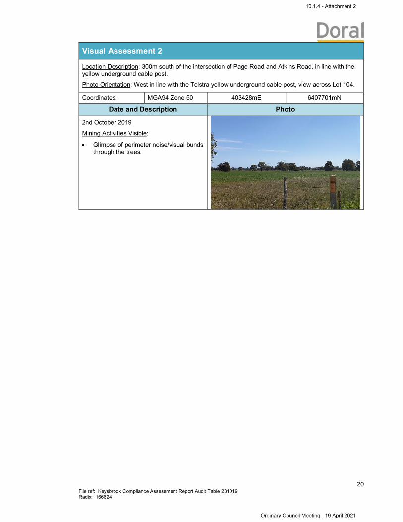
Location Description: 300m south of the intersection of Page Road and Atkins Road, in line with theyellow underground cable post.
Photo Orientation: West in line with the Telstra yellow underground cable post, view across Lot 104.
Coordinates: MGA94 Zone 50 403428mE 6407701mN
Date and Description Photo
28th September 2016
Mining Activities Visible:
· Glimpse of earthworks through thetrees.
5th October 2017
Mining Activities Visible:
· Glimpse of earthworks through thetrees.
4th October 2018
Mining Activities Visible:
· Glimpse of perimeter noise/visual bundsthrough the trees.
10.1.4 - Attachment 2
Ordinary Council Meeting - 19 April 2021
20File ref: Keysbrook Compliance Assessment Report Audit Table 231019Radix: 166624
Visual Assessment 2
Location Description: 300m south of the intersection of Page Road and Atkins Road, in line with theyellow underground cable post.
Photo Orientation: West in line with the Telstra yellow underground cable post, view across Lot 104.
Coordinates: MGA94 Zone 50 403428mE 6407701mN
Date and Description Photo
2nd October 2019
Mining Activities Visible:
· Glimpse of perimeter noise/visual bundsthrough the trees.
10.1.4 - Attachment 2
Ordinary Council Meeting - 19 April 2021
21File ref: Keysbrook Compliance Assessment Report Audit Table 231019Radix: 166624
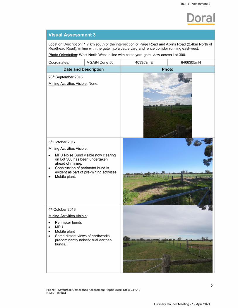
Visual Assessment 3
Location Description: 1.7 km south of the intersection of Page Road and Atkins Road (2.4km North ofReadhead Road), in line with the gate into a cattle yard and fence corridor running east-west.
Photo Orientation: West North West in line with cattle yard gate, view across Lot 300.
Coordinates: MGA94 Zone 50 403359mE 6406305mN
Date and Description Photo
28th September 2016
Mining Activities Visible: None.
5th October 2017
Mining Activities Visible:
· MFU Noise Bund visible now clearingon Lot 300 has been undertakenahead of mining.
· Construction of perimeter bund isevident as part of pre-mining activities.
· Mobile plant.
4th October 2018
Mining Activities Visible:
· Perimeter bunds· MFU· Mobile plant· Some distant views of earthworks,
predominantly noise/visual earthenbunds.
10.1.4 - Attachment 2
Ordinary Council Meeting - 19 April 2021
22File ref: Keysbrook Compliance Assessment Report Audit Table 231019Radix: 166624
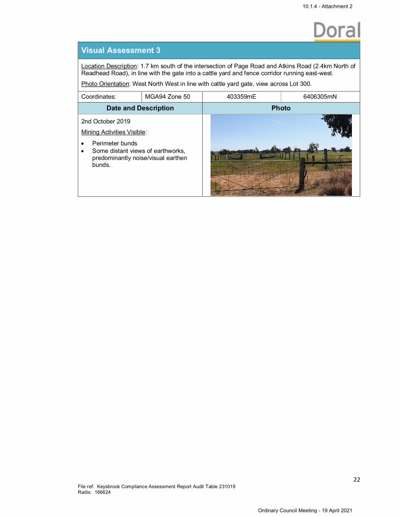
Visual Assessment 3
Location Description: 1.7 km south of the intersection of Page Road and Atkins Road (2.4km North ofReadhead Road), in line with the gate into a cattle yard and fence corridor running east-west.
Photo Orientation: West North West in line with cattle yard gate, view across Lot 300.
Coordinates: MGA94 Zone 50 403359mE 6406305mN
Date and Description Photo
2nd October 2019
Mining Activities Visible:
· Perimeter bunds· Some distant views of earthworks,
predominantly noise/visual earthenbunds.
10.1.4 - Attachment 2
Ordinary Council Meeting - 19 April 2021

23File ref: Keysbrook Compliance Assessment Report Audit Table 231019Radix: 166624
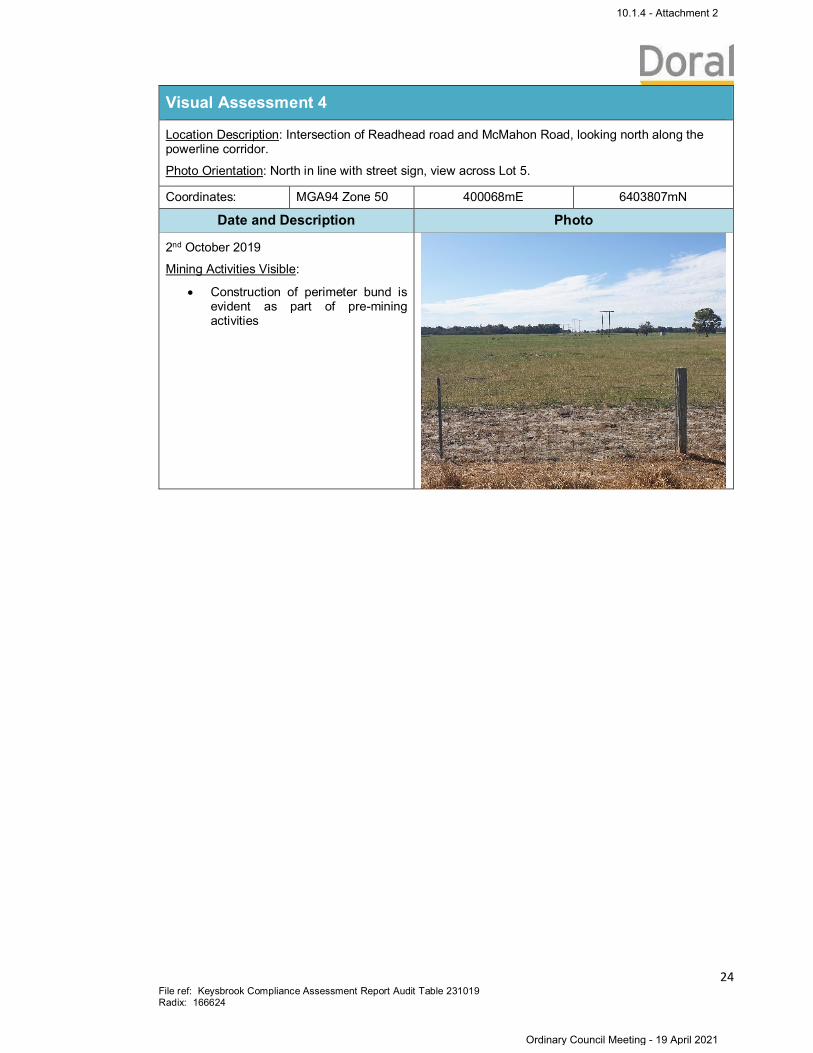
Visual Assessment 4
Location Description: Intersection of Readhead road and McMahon Road, looking north along thepowerline corridor.
Photo Orientation: North in line with street sign, view across Lot 5.
Coordinates: MGA94 Zone 50 400068mE 6403807mN
Date and Description Photo
28th September, 2016
Mining Activities Visible: None.
5th October, 2017
Mining Activities Visible: None
4th October, 2018
Mining Activities Visible: None.
10.1.4 - Attachment 2
Ordinary Council Meeting - 19 April 2021
24File ref: Keysbrook Compliance Assessment Report Audit Table 231019Radix: 166624
Visual Assessment 4
Location Description: Intersection of Readhead road and McMahon Road, looking north along thepowerline corridor.
Photo Orientation: North in line with street sign, view across Lot 5.
Coordinates: MGA94 Zone 50 400068mE 6403807mN
Date and Description Photo
2nd October 2019
Mining Activities Visible:
· Construction of perimeter bund isevident as part of pre-miningactivities
10.1.4 - Attachment 2
Ordinary Council Meeting - 19 April 2021
25File ref: Keysbrook Compliance Assessment Report Audit Table 231019Radix: 166624
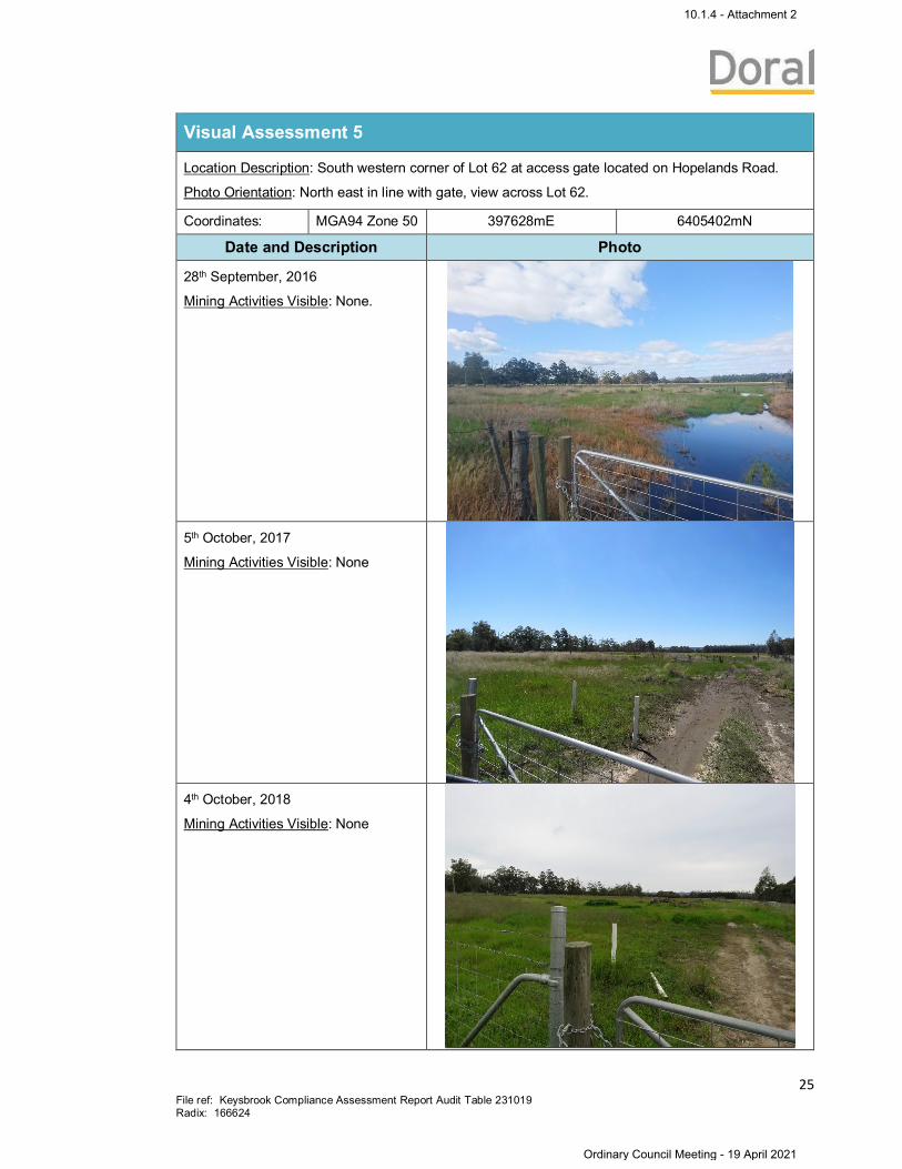
Visual Assessment 5
Location Description: South western corner of Lot 62 at access gate located on Hopelands Road.
Photo Orientation: North east in line with gate, view across Lot 62.
Coordinates: MGA94 Zone 50 397628mE 6405402mN
Date and Description Photo
28th September, 2016
Mining Activities Visible: None.
5th October, 2017
Mining Activities Visible: None
4th October, 2018
Mining Activities Visible: None
10.1.4 - Attachment 2
Ordinary Council Meeting - 19 April 2021
26File ref: Keysbrook Compliance Assessment Report Audit Table 231019Radix: 166624
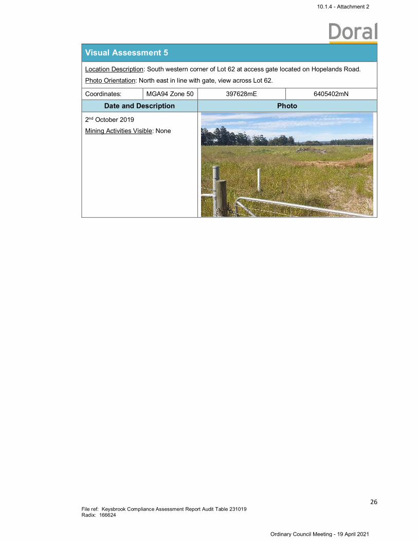
Visual Assessment 5
Location Description: South western corner of Lot 62 at access gate located on Hopelands Road.
Photo Orientation: North east in line with gate, view across Lot 62.
Coordinates: MGA94 Zone 50 397628mE 6405402mN
Date and Description Photo
2nd October 2019
Mining Activities Visible: None
10.1.4 - Attachment 2
Ordinary Council Meeting - 19 April 2021
27File ref: Keysbrook Compliance Assessment Report Audit Table 231019Radix: 166624
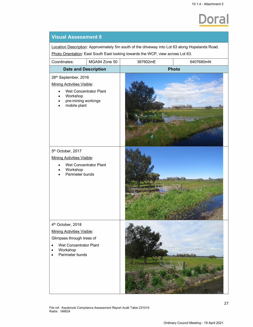
Visual Assessment 6
Location Description: Approximately 5m south of the driveway into Lot 63 along Hopelands Road.
Photo Orientation: East South East looking towards the WCP, view across Lot 63.
Coordinates: MGA94 Zone 50 397602mE 6407680mN
Date and Description Photo
28th September, 2016
Mining Activities Visible:
· Wet Concentrator Plant· Workshop· pre-mining workings· mobile plant
5th October, 2017
Mining Activities Visible:
· Wet Concentrator Plant· Workshop· Perimeter bunds
4th October, 2018
Mining Activities Visible:
Glimpses through trees of
· Wet Concentrator Plant· Workshop· Perimeter bunds
10.1.4 - Attachment 2
Ordinary Council Meeting - 19 April 2021
28File ref: Keysbrook Compliance Assessment Report Audit Table 231019Radix: 166624
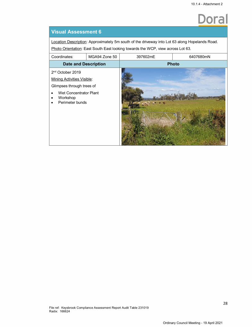
Visual Assessment 6
Location Description: Approximately 5m south of the driveway into Lot 63 along Hopelands Road.
Photo Orientation: East South East looking towards the WCP, view across Lot 63.
Coordinates: MGA94 Zone 50 397602mE 6407680mN
Date and Description Photo
2nd October 2019
Mining Activities Visible:
Glimpses through trees of
· Wet Concentrator Plant· Workshop· Perimeter bunds
10.1.4 - Attachment 2
Ordinary Council Meeting - 19 April 2021

29File ref: Keysbrook Compliance Assessment Report Audit Table 231019Radix: 166624
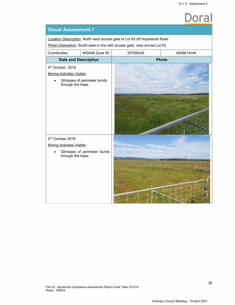
Visual Assessment 7
Location Description: North west access gate to Lot 63 off Hopelands Road.
Photo Orientation: South west in line with access gate, view across Lot 63.
Coordinates: MGA94 Zone 50 397595mE 6408614mN
Date and Description Photo
28th September, 2016
Mining Activities Visible:
· pre-mining workings· mobile plant (PC1250)
5th October, 2017
Mining Activities Visible:
· Perimeter bunds· Early stage rehabilitation
works
10.1.4 - Attachment 2
Ordinary Council Meeting - 19 April 2021
30File ref: Keysbrook Compliance Assessment Report Audit Table 231019Radix: 166624
Visual Assessment 7
Location Description: North west access gate to Lot 63 off Hopelands Road.
Photo Orientation: South west in line with access gate, view across Lot 63.
Coordinates: MGA94 Zone 50 397595mE 6408614mN
Date and Description Photo
4th October, 2018
Mining Activities Visible:
· Glimpses of perimeter bundsthrough the trees.
2nd October 2019
Mining Activities Visible:
· Glimpses of perimeter bundsthrough the trees.
10.1.4 - Attachment 2
Ordinary Council Meeting - 19 April 2021
31File ref: Keysbrook Compliance Assessment Report Audit Table 231019Radix: 166624
Visual Assessment 8
Location Description: Along Elliott Road, 1km west of the railway line.
Photo Orientation: South west, view across Lot 1.
Coordinates: MGA94Zone 50
402791mE 6410278mN
Date and Description Photo
28th September, 2016
Mining Activities Visible: None
5th October, 2017
Mining Activities Visible:
· MFU Noise Bund· Early stage
rehabilitation works
10.1.4 - Attachment 2
Ordinary Council Meeting - 19 April 2021

32File ref: Keysbrook Compliance Assessment Report Audit Table 231019Radix: 166624
Visual Assessment 8
Location Description: Along Elliott Road, 1km west of the railway line.
Photo Orientation: South west, view across Lot 1.
Coordinates: MGA94Zone 50
402791mE 6410278mN
Date and Description Photo
4th October, 2018
Mining Activities Visible:
· MFU noise bund· Rehabilitation works
(pasture)· Perimeter bunds· Mobile plant
2nd October 2019
Mining Activities Visible:
· Rehabilitation works(pasture)
· Perimeter bunds
10.1.4 - Attachment 2
Ordinary Council Meeting - 19 April 2021

33File ref: Keysbrook Compliance Assessment Report Audit Table 231019Radix: 166624
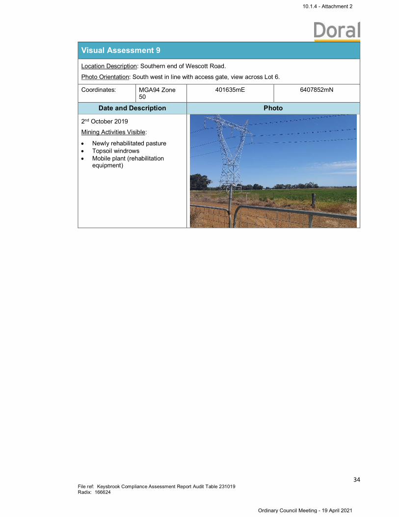
Visual Assessment 9
Location Description: Southern end of Wescott Road.
Photo Orientation: South west in line with access gate, view across Lot 6.
Coordinates: MGA94 Zone50
401635mE 6407852mN
Date and Description Photo
28th September, 2016
Mining Activities Visible:
· Topsoil windrows· Early stage rehabilitation
works
5th October, 2017
Mining Activities Visible:
· Topsoil windrows· Rehabilitation works
4th October, 2018
Mining Activities Visible:
· Newly rehabilitated pasture· Topsoil windrows· Mobile plant (rehabilitation
equipment)· Rehabilitation works
10.1.4 - Attachment 2
Ordinary Council Meeting - 19 April 2021
34File ref: Keysbrook Compliance Assessment Report Audit Table 231019Radix: 166624
Visual Assessment 9
Location Description: Southern end of Wescott Road.
Photo Orientation: South west in line with access gate, view across Lot 6.
Coordinates: MGA94 Zone50
401635mE 6407852mN
Date and Description Photo
2nd October 2019
Mining Activities Visible:
· Newly rehabilitated pasture· Topsoil windrows· Mobile plant (rehabilitation
equipment)
10.1.4 - Attachment 2
Ordinary Council Meeting - 19 April 2021

35File ref: Keysbrook Compliance Assessment Report Audit Table 231019Radix: 166624
Visual Assessment 10
Location Description: Southern end of Wescott Road.
Photo Orientation: South east in line with access gate, view across Lot 113.
Coordinates: MGA94 Zone 50 401635mE 6407850mN
Date and Description Photo
28th September, 2016
Mining Activities Visible: None
5th October, 2017
Mining Activities Visible:
· Perimeter bund
4th October, 2018
Mining Activities Visible:
· Perimeter bund
10.1.4 - Attachment 2
Ordinary Council Meeting - 19 April 2021

36File ref: Keysbrook Compliance Assessment Report Audit Table 231019Radix: 166624
Visual Assessment 10
Location Description: Southern end of Wescott Road.
Photo Orientation: South east in line with access gate, view across Lot 113.
Coordinates: MGA94 Zone 50 401635mE 6407850mN
Date and Description Photo
2nd October, 2019
Mining Activities Visible:
· Newly rehabilitated pasture· Topsoil windrows· Mobile plant (rehabilitation
equipment)· Rehabilitation works
10.1.4 - Attachment 2
Ordinary Council Meeting - 19 April 2021

37File ref: Keysbrook Compliance Assessment Report Audit Table 231019Radix: 166624
Visual Assessment 11
Location Description: 800m south along Wescott Road (from the intersection with Elliott Road), onthe western side of the road.
Photo Orientation: South west, view across Lot 57.
Coordinates: MGA94 Zone 50 401617mE 6409410mN
Date and Description Photo
28th September, 2016
Mining Activities Visible:
· MFU· Wet Concentrator Plant· Mobile plant (PC1250)
5th October, 2017
Mining Activities Visible:
· Wet Concentrator Plant
4th October, 2018
Mining Activities Visible:
· Wet Concentrator Plant
10.1.4 - Attachment 2
Ordinary Council Meeting - 19 April 2021

38File ref: Keysbrook Compliance Assessment Report Audit Table 231019Radix: 166624
Visual Assessment 11
Location Description: 800m south along Wescott Road (from the intersection with Elliott Road), onthe western side of the road.
Photo Orientation: South west, view across Lot 57.
Coordinates: MGA94 Zone 50 401617mE 6409410mN
Date and Description Photo
2nd October 2019
Mining Activities Visible:
· MFU noise bund· Rehabilitation works (pasture)· Perimeter bunds· Mobile plant
10.1.4 - Attachment 2
Ordinary Council Meeting - 19 April 2021
39File ref: Keysbrook Compliance Assessment Report Audit Table 231019Radix: 166624
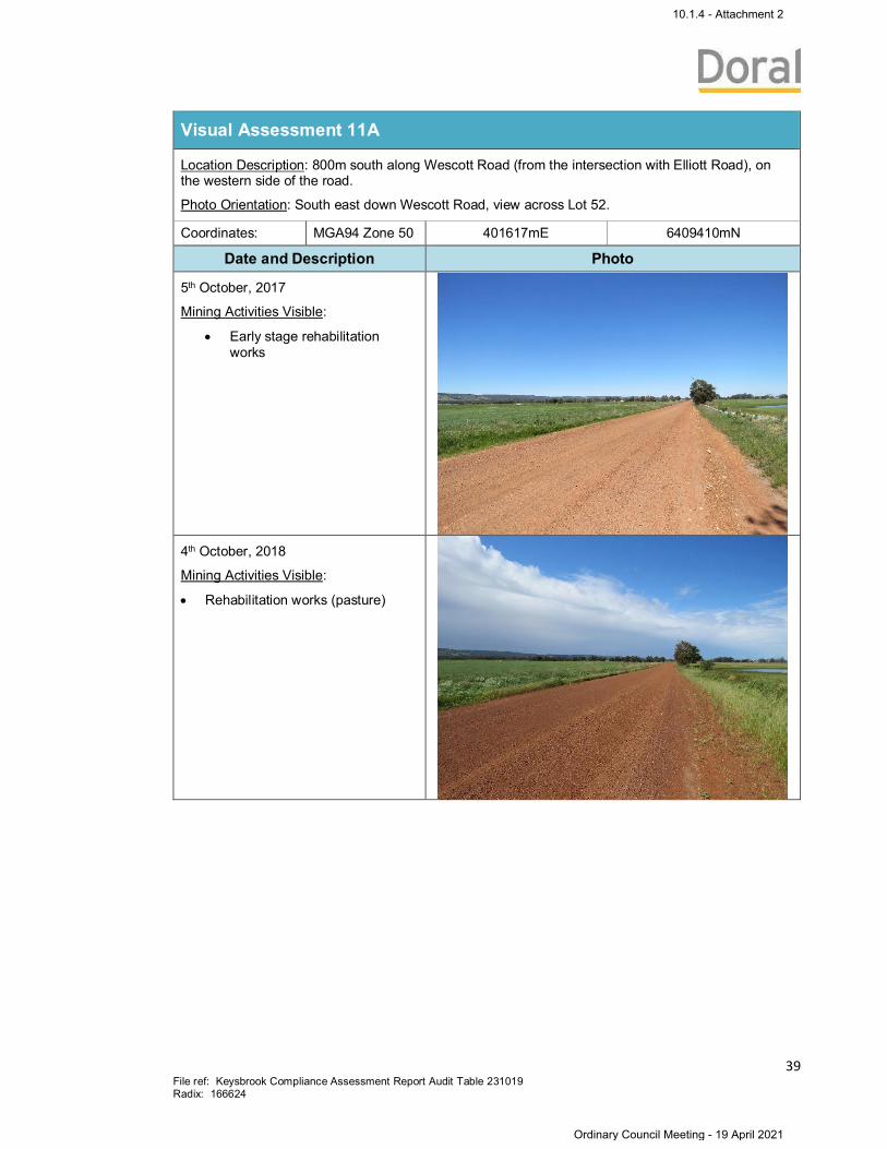
Visual Assessment 11A
Location Description: 800m south along Wescott Road (from the intersection with Elliott Road), onthe western side of the road.
Photo Orientation: South east down Wescott Road, view across Lot 52.
Coordinates: MGA94 Zone 50 401617mE 6409410mN
Date and Description Photo
5th October, 2017
Mining Activities Visible:
· Early stage rehabilitationworks
4th October, 2018
Mining Activities Visible:
· Rehabilitation works (pasture)
10.1.4 - Attachment 2
Ordinary Council Meeting - 19 April 2021
40File ref: Keysbrook Compliance Assessment Report Audit Table 231019Radix: 166624
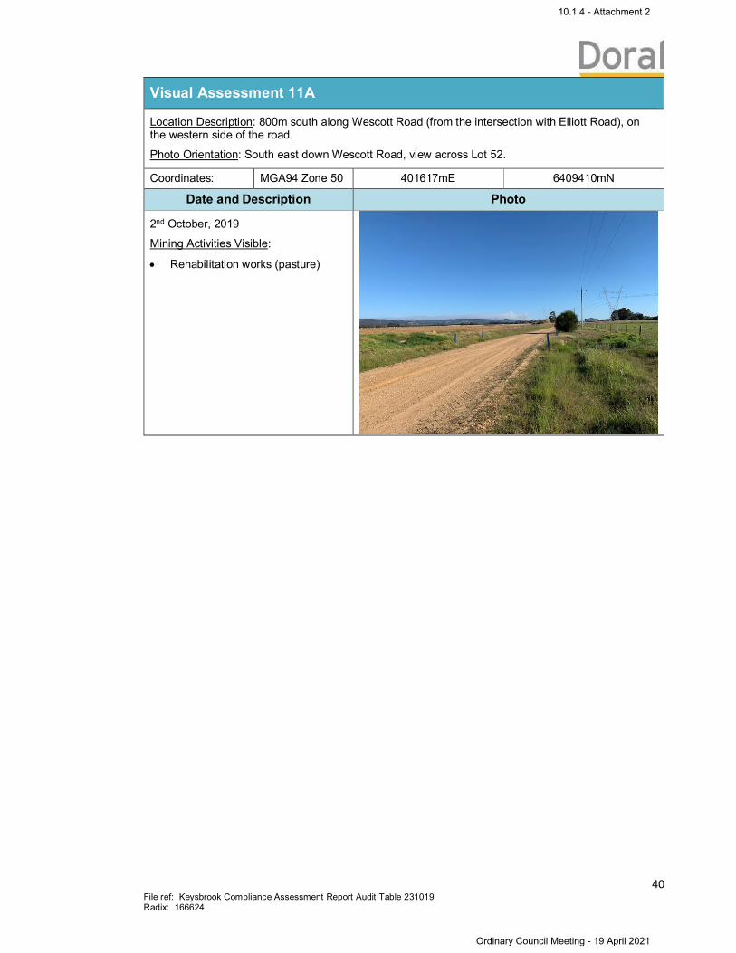
Visual Assessment 11A
Location Description: 800m south along Wescott Road (from the intersection with Elliott Road), onthe western side of the road.
Photo Orientation: South east down Wescott Road, view across Lot 52.
Coordinates: MGA94 Zone 50 401617mE 6409410mN
Date and Description Photo
2nd October, 2019
Mining Activities Visible:
· Rehabilitation works (pasture)
10.1.4 - Attachment 2
Ordinary Council Meeting - 19 April 2021

41File ref: Keysbrook Compliance Assessment Report Audit Table 231019Radix: 166624
Visual Assessment 12
Location Description: Along Elliott Road 800m west of the Wescott Road intersection under the highvoltage power lines.
Photo Orientation: South in line with SEC gate, view across Lot 57.
Coordinates: MGA94 Zone 50 400793mE 6410255mN
Date and Description Photo
28th September, 2016
Mining Activities Visible (in thedistance):
· Wet Concentrator Plant· Pre-mining area
5th October, 2017
Mining Activities Visible (in thedistance):
· Wet Concentrator Plant· Pre-mining area
10.1.4 - Attachment 2
Ordinary Council Meeting - 19 April 2021

42File ref: Keysbrook Compliance Assessment Report Audit Table 231019Radix: 166624
Visual Assessment 12
Location Description: Along Elliott Road 800m west of the Wescott Road intersection under the highvoltage power lines.
Photo Orientation: South in line with SEC gate, view across Lot 57.
Coordinates: MGA94 Zone 50 400793mE 6410255mN
Date and Description Photo
4th October, 2018
Mining Activities Visible:
· Wet Concentrator Plant· Pre-mining area
2nd October 2019
Mining Activities Visible:
· Wet Concentrator Plant· Pre-mining area
10.1.4 - Attachment 2
Ordinary Council Meeting - 19 April 2021
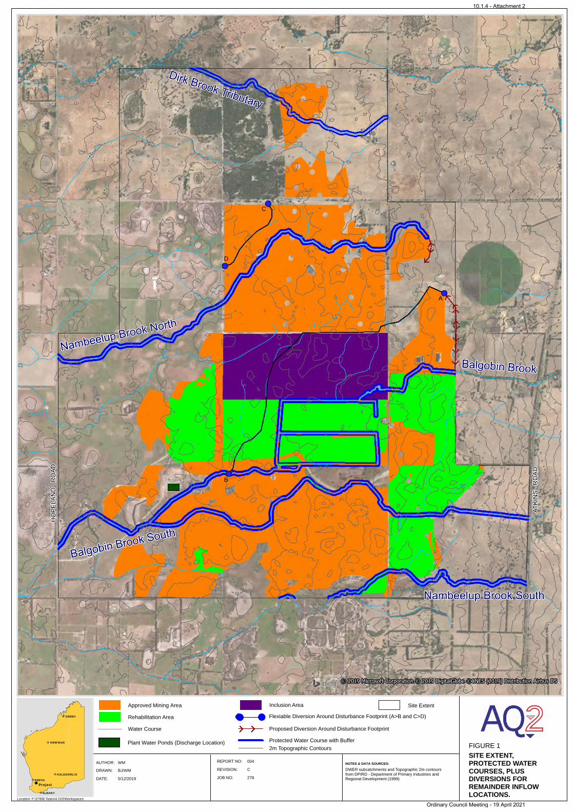
LOCATION MAP
FIGURE 1
SITE EXTENT,PROTECTED WATER COURSES, PLUS DIVERSIONS FOR REMAINDER INFLOW LOCATIONS.
Location: F:\278\B Tasks\4.GIS\Workspaces
NOTES & DATA SOURCES:AUTHOR: REPORT NO:
DRAWN: REVISION:
DATE:
WM 004
BJ/WM C
5/12/2019 JOB NO: 278PERTH
ALBANY
KALGOORLIE
Project
NEWMAN
DERBY
DWER subcatchments and Topographic 2m contours from DPIRD - Department of Primary Industries and Regional Development (1999)
Flexiable Diversion Around Disturbance Footprint (A>B and C>D)
Proposed Diversion Around Disturbance FootprintWater Course
Protected Water Course with Buffer
Rehabilitation Area
Approved Mining Area
A
B
C
D
Plant Water Ponds (Discharge Location)
Inclusion Area
2m Topographic Contours
Site Extent
10.1.4 - Attachment 2
Ordinary Council Meeting - 19 April 2021
COMMUNITY CONSULTATION FRAMEWORK
KEYSBROOK PROJECT
February 2020
1. INTRODUCTION
This Community Consultation Framework has been prepared to ensure effective community engagement
during all phases of the Keysbrook mineral sands project. The plan outlines Doral Mineral Sands Pty Ltd’s
(Doral) commitment to a program of genuine engagement with the community and stakeholders which
values their contribution and involvement in the project. Its purpose is to communicate developments and
key milestones in a timely and transparent manner and which allows for stakeholder feedback to be
considered and integrated into the project.
2. PRINCIPLES AND OBJECTIVES
To provide an opportunity for input by local communities and individuals, the following principles and
objectives form the basis of the Community Consultation Framework:
Identification of key stakeholders
Identification of issues and concerns through the consultation process
Communicate appropriate information with key stakeholders, through a number of communication
methods, with integrity and respect
Provide an opportunity for key stakeholders to provide input into the project
Document and record interactions with stakeholders into the Company’s records management
database
Implement the Stakeholder Interaction Policy and Procedure
Outline the role of the Keysbrook Community Consultation Group (CCG) to key stakeholders
The Keysbrook Community Consultation Framework outlines how Doral will share information with the
community. It includes activities that have been approved by the Shire of Serpentine Jarrahdale, Shire of
Murray (Appendix B: Community Engagement Plan) or the State Government which may affect the
community and keep the community informed.
The Community Consultation Framework provides the community with opportunities to share information
about the activities on site, express views about those activities and gain feedback on how those views
have been considered and integrated into the project.
This Framework will be regularly reviewed and will continue to be shaped and adapted to reflect the
needs of the community and key stakeholders as the Keysbrook operation develops.
Communication Principles
The Community Engagement Plan is underpinned by a number of communications principles, based on:
Commitment to the consultation process as demonstrated in this plan including established time lines
and identification of responsibilities;
Integrity of communication where the interactions between Doral and the community foster mutual respect and trust, achieved by clearly stating the intent of the consultation and communicating the outcomes;
10.1.4 - Attachment 2
Ordinary Council Meeting - 19 April 2021

Respect by ensuring the rights, values and interests of the community are taken into consideration through the implementation of a range of management plans;
Transparency demonstrated by responding to community concerns in a timely, open and effective manner through the established stakeholder interaction procedures;
Inclusiveness achieved through identifying a diverse representation of community stakeholders;
Developing trusting relationships built through exploring opportunities for common ground and disseminating information on how community feedback contributed to decision making;
Proactive engagement with the community to reduce reactive responses and communicate timely information to all stakeholders.
Review this Plan as and when necessary, based on project and operational developments.
The Mine Manager is responsible for all activities on site, and a Community Relations representative will undertake community consultation in accordance with the above principles and the Community Engagement Plan across the life of the operation.
3. KEY STAKEHOLDERS
Stakeholder Groups
A range of key stakeholders have been identified as having an interest and influence over the project
stages including the planning, approval, design, construction, operation and closure of the Keysbrook
project [Appendix A].
Stakeholders will have a varying influence level on issues arising from the project and/or operations. Not
all issues can be negotiated to the satisfaction of all and this will be managed as part of the stakeholder
engagement process. To ensure consultation is as effective as possible, communication tools will be
tailored to the level of influence or interest in the project.
A stakeholder is defined as anyone who (currently, or in the future):
Has an influence on the project (including its process and outcomes);
Has an interest in the project; and
Is directly impacted by the project.
Stakeholders and their level of influence and participation may change as the project progresses, in which
case this Plan will be modified accordingly.
Stakeholder Group 1: Local residents and community. These are stakeholders with whom the Company
has entered into an agreement with or is based on proximity to the operations, local Government, local
MP’s, State Government;
Stakeholder Group 2: Broader stakeholders, who represent a wider audience and belong to local
community groups, catchment, environmental, emergency services and local suppliers.
Stakeholder Group 3: Internal stakeholders are also important in terms of the progress of the project, as
well as developing alliance culture and internal communications.
The Company will endeavor to employ locally and source local supplier opportunities.
The Community Engagement Plant refers to each Stakeholder Group and has been developed to identify
the level of influence and interest in order to tailor the communications content accordingly.
10.1.4 - Attachment 2
Ordinary Council Meeting - 19 April 2021
LEVEL 1: Stakeholders directly involved in the decision making process for the project or having the ability to influence the decision making process.
LEVEL 2: Stakeholders important to the project that may have the ability to influence project outcomes, but do not necessarily influence the decision making process.
LEVEL 3: Stakeholders important to the project that need to be kept informed of its status, schedule and issues.
Keysbrook Community Consultative Group (CCG)
A community consultation group was established in October 2012 to draw upon local knowledge to
minimize impacts and maximise benefits from the Keysbrook project. Upon commencement, the CCG
met every 8 weeks and more recently, now meets every quarter. The CCG is made up of a Chairperson,
community members, local government (Councillors) and Doral personnel. The CCG liaises directly with
Doral in respect to the views of the community allowing input to be conveyed to Doral management and
feedback provided on implementation or other suggestions.
A Terms of Reference [Appendix D] has been developed for the CCG which guides the format for the
CCG including the term of nominated representatives, generally being 2 years. Minutes of each meeting
is placed on the Doral website, www.doral.com.au. The CCG does not have any legislative, operational or
financial control over Doral however does provide an opportunity for regular and formal engagement with
stakeholders than would otherwise be required under the statutory processes and controls.
4. COMMUNICATIONS WITH STAKEHOLDERS
Communication activities for the Keysbrook mineral sands project have been developed in order to
maintain open communication channels with stakeholders through ongoing engagement activities. A
Community Engagement Plan (approved in 2012 by both Shires and used as the basis for reporting in the
annual Community Consultation Framework Compliance Report) is outlined in Appendix B.
To ensure the effective implementation of this Plan a variety of communication activities have been
implemented, in addition to the Plan, which include:
24/7 Mobile Phone number – 0499 000 365 which is held by the Shift Supervisor and
communicated to all near neighbours should a matter arise from site requiring assistance outside
of business hours;
Contact Card – provided to all near neighbours and provides quick and easy contact information,
including the 24/7 mobile number and business hours details;
Contact Form – located on the Doral website, stakeholders can provide comment if they choose
not to telephone the office or after-hours number;
Project information - including environmental management plans for the Keysbrook project as
per agency and environmental requirements, available on the Doral website (www.doral.com.au).
Community updates – regularly sent to near neighbours, depending on key project
developments and milestones. The focus is to keep neighbours informed of key developments,
inviting input or requesting participation in site related activities.
Keysbrook Newsletter – distributed bi-annually to all stakeholders;
Consultation Manager – electronic consultation database to ensure accuracy of stakeholder
addresses and details and to document all interactions;
Community meetings – held when the Keysbrook operation commences a new phase which
could include moving the Wet Concentrator Plant (WCP) to a new location, final land use pending
mine closure or other key developments that may impact on the local community;
Fact Sheets – Keysbrook Fact Sheet, Noise Fact Sheet and others as required;
10.1.4 - Attachment 2
Ordinary Council Meeting - 19 April 2021
Community Displays – commitment to attending key events in the local community to raise
awareness and educate the public on mineral sands mining and the Company’s contribution to
the region;
Sponsorship – funding of key community groups and events and where possible, attendance of
Doral personnel at these events. A Sponsorship Application Form is available on the Doral
website and funding outcomes are managed through the CCG;
Internal community relations training - training provided to staff and contractors when dealing
with community members and site related issues and exercising due diligence in relation to
environmental, heritage and site specific information. This is delivered as part of the normal site
induction;
Website – updated regularly with the Keysbrook newsletter, management plans and compliance
reports as required;
Media – Media Releases generated based on key events;
Site tours – arranged for near neighbours, key stakeholders, local government, volunteer
bushfire brigades and groups as requested;
Mine Open Day – Mine Open Day was held in 2017 to provide first-hand view of mineral sands
mining operation;
Advertisements – as required, Doral will advise of employment opportunities through SEEK or
through regular community updates to near neighbours;
Community Relations Officer – provision of a dedicated person to effectively manage the
Community and Stakeholder Engagement Plan.
5. STAKEHOLDER INTERACTION PROCEDURE
Doral has a comprehensive Complaints Management Procedure [Appendix C] which describes how
stakeholder complaints are responded to and resolved in a timely and responsive manner. It provides the
steps to be followed when a complaint is made, and the protocols or code of behaviour that should be
followed when managing stakeholder complaints. There will also be interactions that will be non-
complaint based and relate to positive feedback, which will also be logged in this register.
All feedback is recorded in Doral’s Consultation Manager database and personnel logging a complaint will
use the designated Stakeholder Interaction Report Form.
6. REVIEW AND REPORTING
Doral will review the Community Consultation Framework on an annual basis. It will also ensure internal
plans remain current, new issues are documented and included in key messaging to the community and
communication methods and targets remain relevant. In addition, Doral is required to submit an annual
Compliance Report to both the Shire of Murray and the Shire of Serpentine Jarrahdale which documents
the Company’s community engagement activities and log of stakeholder interactions over the period.
This Report is also made public on Doral’s website.
From time to time, Doral will commission a community attitudinal survey to ensure that it upholds its
commitment to ‘being a good neighbour’ and strive for continual improvement in the areas identified
through community feedback.
7. ADDITIONAL COMMITMENTS
A number of approvals are required for the Keysbrook project from a range of regulatory authorities,
making it quite complex. To assist in this process, a table of approvals is provided (Appendix E) which
outlines:
10.1.4 - Attachment 2
Ordinary Council Meeting - 19 April 2021

The principal management plan or other document(s);
The name of the responsible authority for regulatory approvals.
It should be noted however, that the primary responsibility for site management remains with Doral
Mineral Sands Pty Ltd, and as such, enquiries, ideas and complaints should be made to Doral in the first
instance rather than to the relevant government agency.
10.1.4 - Attachment 2
Ordinary Council Meeting - 19 April 2021
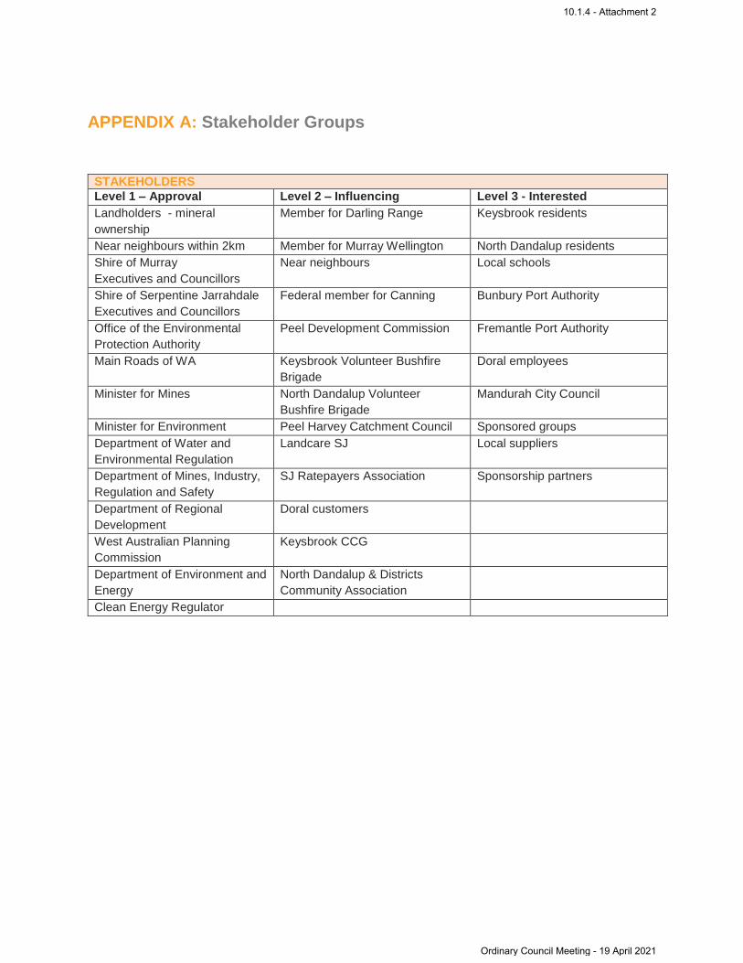
APPENDIX A: Stakeholder Groups
STAKEHOLDERS
Level 1 – Approval Level 2 – Influencing Level 3 - Interested
Landholders - mineral
ownership
Member for Darling Range Keysbrook residents
Near neighbours within 2km Member for Murray Wellington North Dandalup residents
Shire of Murray
Executives and Councillors
Near neighbours Local schools
Shire of Serpentine Jarrahdale
Executives and Councillors
Federal member for Canning Bunbury Port Authority
Office of the Environmental
Protection Authority
Peel Development Commission Fremantle Port Authority
Main Roads of WA Keysbrook Volunteer Bushfire
Brigade
Doral employees
Minister for Mines North Dandalup Volunteer
Bushfire Brigade
Mandurah City Council
Minister for Environment Peel Harvey Catchment Council Sponsored groups
Department of Water and
Environmental Regulation
Landcare SJ Local suppliers
Department of Mines, Industry,
Regulation and Safety
SJ Ratepayers Association Sponsorship partners
Department of Regional
Development
Doral customers
West Australian Planning
Commission
Keysbrook CCG
Department of Environment and
Energy
North Dandalup & Districts
Community Association
Clean Energy Regulator
10.1.4 - Attachment 2
Ordinary Council Meeting - 19 April 2021
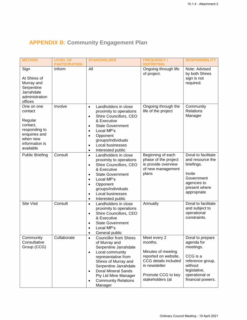
APPENDIX B: Community Engagement Plan
METHOD LEVEL OF PARTICIPATION
STAKEHOLDER FREQUENCY / REPORTING
RESPONSIBILITY
Sign At Shires of Murray and Serpentine Jarrahdale administration offices
Inform All Ongoing through life of project.
Note: Advised by both Shires sign is not required.
One on one contact Regular contact, responding to enquiries and when new information is available
Involve Landholders in close proximity to operations
Shire Councillors, CEO & Executive
State Government
Local MP’s
Opponent groups/individuals
Local businesses
Interested public
Ongoing through the life of the project
Community Relations Manager
Public Briefing Consult Landholders in close proximity to operations
Shire Councillors, CEO & Executive
State Government
Local MP’s
Opponent groups/individuals
Local businesses
Interested public
Beginning of each phase of the project ie provide overview of new management plans
Doral to facilitate and resource the briefings. Invite Government agencies to present where appropriate
Site Visit Consult Landholders in close proximity to operations
Shire Councillors, CEO & Executive
State Government
Local MP’s
General public
Annually Doral to facilitate and subject to operational constraints.
Community Consultative Group (CCG)
Collaborate
Councillor from Shires of Murray and Serpentine Jarrahdale
Local community representative from Shires of Murray and Serpentine Jarrahdale
Doral Mineral Sands Pty Ltd Mine Manager
Community Relations Manager
Meet every 2 months. Minutes of meeting reported on website, CCG details included in newsletter Promote CCG to key stakeholders (at
Doral to prepare agenda for meetings. CCG is a reference group, without legislative, operational or financial powers.
10.1.4 - Attachment 2
Ordinary Council Meeting - 19 April 2021

METHOD LEVEL OF PARTICIPATION
STAKEHOLDER FREQUENCY / REPORTING
RESPONSIBILITY
Independent Chair
Executive Officer
least once every 6 months)
Terms of Reference established at first meeting prior to commencement of works on site
Newsletter / Letters
Inform Landowners within the excavation area
Landowners within 1km of the excavation area
Shire Councils
Local MP’s
Opponent groups / individuals
Local business
Min of once every 6 months and at the beginning of each phase. Increase frequency when and if required.
Doral Mineral Sands Pty Ltd
Website updates
Inform All Ongoing Doral Mineral Sands Pty Ltd
Council Briefings
Consult Shire Councillors Annually in addition to site visit and when required and subject to operational constraints
Doral Mineral Sands Pty Ltd
Local MP’s Consult Local members of Parliament
Annually in addition to the site visit, subject to operational constraints
Doral Mineral Sands Pty Ltd
Meetings and presentations to community groups
Consult Landcare SJ
Landcare (Shire of Murray)
North Dandalup and Districts Community Association
Peel Harvey Catchment Council
Annually (ie at the beginning of each phase) and subject to operational constraints
Doral Mineral Sands Pty Ltd
Complaints procedure / feedback
Consult All Ongoing and reported in accordance with MS810. Response provided in 24 hours
Doral Mineral Sands Pty Ltd
Annual Review Document / Community Engagement Compliance Assessment Report
Shire of Murray / Shire of Serpentine Jarrahdale
Summary of engagement activities, issues, feedback, sponsorship commitments
October each year Doral Mineral Sands Pty Ltd
10.1.4 - Attachment 2
Ordinary Council Meeting - 19 April 2021

APPENDIX C: Stakeholder Interaction Policy & Procedure
1. Purpose
The purpose of this policy and procedure is to set out the guidelines to manage and adequately respond
to all stakeholder interactions over the life of Doral Mineral Sands Pty Ltd (Doral) projects and operations.
2. Scope
This procedure applies to all Doral employees and contractors.
3. Policy
At Doral, we recognise the importance of positive and enduring relationships to secure stakeholder
support.
A Community and Stakeholder Engagement Plan is developed for each project and operational site.
These plans identify opportunities for proactive stakeholder engagement to communicate timely and
accurate information in relation to key activities.
One of the aims of regular and open communication with our stakeholders is to encourage individuals to
contact us directly for a quick resolution before possible escalation.
The Stakeholder Interaction Policy and Procedure enables us to adequately manage and address
concerns and grievances raised by stakeholders that typically could include: noise, dust, transport issues,
water, general disturbance to amenity, behavioural issues etc.
Contractors engaged by DoraI will adhere to the Company’s Community Relations standards,
expectations and appropriate behaviours when dealing with landholders, neighbours or members of the
community. Doral has responsibility for all contractors on site.
On being notified of an issue or complaint, the call or interaction is logged by Doral personnel using the
Stakeholder Interaction Report Form (SIRF), paying particular attention to the nature of the complaint i.e.
how is that person affected, what do they see or hear, what time did it occur etc.
The SIRF is completed by the person taking the call / receiving the email, filling in all details and sending
to a designated email address. All endeavours will be made to rectify the issue immediately, noting the
necessary actions taken.
Feedback is to be provided to the complainant within a 24-hour period. This may be to advise the matter
has been rectified, or to advise that the matter is being investigated. The aim is to close out all
investigations and provide notice in writing within 5 working days.
All Stakeholder Interaction Report Forms are logged into the Company’s consultation database and the
environmental database for reporting and auditing purposes.
Analysis of feedback and complaints will be reviewed as required to identify trends and possible
concentration of complaints and target areas of improvement.
This Policy will be reviewed annually with the view of determining the adequacy and identify areas that
are not being covered by this Policy and Procedure.
10.1.4 - Attachment 2
Ordinary Council Meeting - 19 April 2021
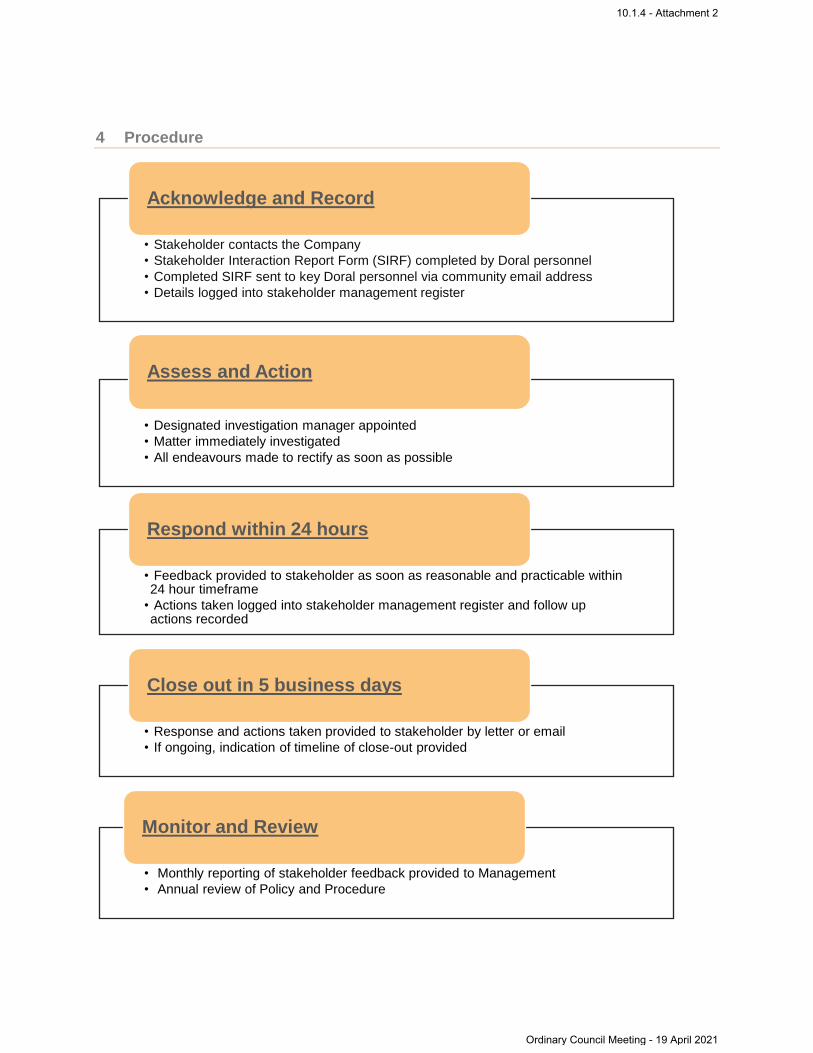
4 Procedure
• Stakeholder contacts the Company
• Stakeholder Interaction Report Form (SIRF) completed by Doral personnel
• Completed SIRF sent to key Doral personnel via community email address
• Details logged into stakeholder management register
Acknowledge and Record
• Designated investigation manager appointed
• Matter immediately investigated
• All endeavours made to rectify as soon as possible
Assess and Action
• Feedback provided to stakeholder as soon as reasonable and practicable within 24 hour timeframe
• Actions taken logged into stakeholder management register and follow up actions recorded
Respond within 24 hours
• Response and actions taken provided to stakeholder by letter or email
• If ongoing, indication of timeline of close-out provided
Close out in 5 business days
• Monthly reporting of stakeholder feedback provided to Management
• Annual review of Policy and Procedure
Monitor and Review
10.1.4 - Attachment 2
Ordinary Council Meeting - 19 April 2021
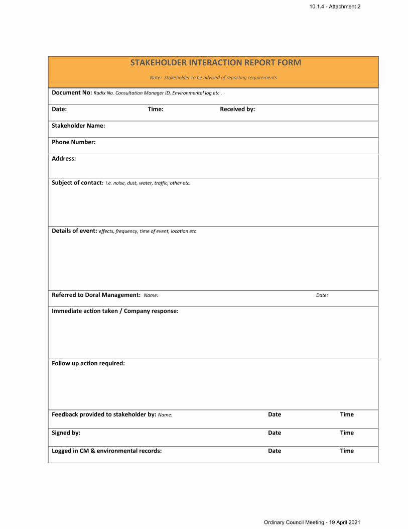
Document No: Radix No. Consultation Manager ID, Environmental log etc .
Date: Time: Received by:
Stakeholder Name:
Phone Number:
Address:
Subject of contact: i.e. noise, dust, water, traffic, other etc.
Details of event: effects, frequency, time of event, location etc
Referred to Doral Management: Name: Date:
Immediate action taken / Company response:
Follow up action required:
Feedback provided to stakeholder by: Name: Date Time
Signed by: Date Time
Logged in CM & environmental records: Date Time
STAKEHOLDER INTERACTION REPORT FORM
Note: Stakeholder to be advised of reporting requirements
10.1.4 - Attachment 2
Ordinary Council Meeting - 19 April 2021

APPENDIX D: Keysbrook CCG – Terms of Reference
1. Introduction
Doral Mineral Sands Pty Ltd (Doral or the Company) operates the Keysbrook Mineral Sands mine located
in Keysbrook / North Dandalup. The Keysbrook Community Consultation Group (CCG) is formed with the
objective of facilitating open and honest dialogue between the local communities in the Shire of Murray, the
Shire of Serpentine Jarrahdale and Doral.
The CCG is a formal way for the Company to draw on local knowledge to minimise impacts and maximise
benefits from the proposed mineral sands extraction operation.
2. Scope
The Keysbrook Community Consultation Group Terms of Reference (the Terms) apply to the Keysbrook
operation and related activities. The Terms will also cover the consideration and assessment of
Sponsorship applications received from community groups in both the Shire of Murray and the Shire of
Serpentine Jarrahdale.
3. Code of Conduct
In fulfilling their responsibilities outlined here within, all members of the CCG shall adhere to the following
Code of Conduct:
Openness and honesty.
Respect for others’ opinions.
Recognition that diversity in opinions can facilitate the development of appropriate solutions.
A commitment to be flexible, listen and value other members’ views.
Outcome and solutions focused discussion.
Staying on topic.
Being concise when presenting views, no unnecessary repetition of views.
A commitment to discussing issues within the agreed agenda and timeframes.
Media announcements as agreed by CCG and Doral.
Conduct to be in accordance with the decisions of the CCG, code of conduct and responsibilities and
obligations.
Confidentiality of specific matters discussed at CCG meetings or information sent to members when
requested by Doral.
4. Confidentiality
Any formal release or statement from the CCG must be in agreement with the CCG and Doral. Any
document or views expressed ‘for limited consultation’ must be managed in accordance with the parameters
for maintaining confidentiality as defined and agreed upon by Doral, CCG or any relevant working group.
Any breach of the code of conduct may be tabled for discussion at the next scheduled CCG meeting. The
Company, in its absolute discretion, maintains the right to revoke the membership of any member of the
CCG in response to any misconduct by a member under the Code of Conduct and these Terms.
10.1.4 - Attachment 2
Ordinary Council Meeting - 19 April 2021
5. Structure
The CCG is the primary consultation vehicle. From time to time it may be deemed necessary for the CCG
to establish working or reference groups that may include additional members outside the CCG to deal with
shorter term projects / issues as defined by the CCG. These groups generally have a limited life as defined
by the CCG.
These groups have an obligation to report on proceedings and outcomes back to the CCG. These
additional members and groups are bound by the code of conduct.
The CCG is a strategic level consultation group with a commitment to the long-term interests of the
community and Doral.
6. Responsibilities
The CCG will be a strategic level, two-way consultation group for dissemination of information between
Doral and the communities, and to provide Doral with an understanding of issues of interest within the
communities.
CCG members will:
Identify appropriate community groups that represent the key elements of the community.
Liaise with community groups to determine their views.
Represent and reflect the views of the communities or groups they represent by actively engaging with
those groups.
Provide feedback to and from the community they represent in the manner agreed to by the CCG and
Doral.
Manage concerns sensitively.
Attend CCG meetings where possible and actively participate in discussions.
Provide feedback on issues of interest to the CCG.
CCG will:
Continually explore improved means of communicating with the community throughout the life of the
approval.
Provide recommendations for Doral to consider.
Actively communicate, via approved communication methods identified in the Community Engagement
Plan, to interested residents within the locality of Keysbrook regarding the ongoing operations of the
Keysbrook project.
Actively and positively promote the role of the CCG where possible within the local Community.
Doral will:
Consider the recommendations presented by the CCG however the final operational and financial
decisions will be made by Doral.
10.1.4 - Attachment 2
Ordinary Council Meeting - 19 April 2021

7. Meeting Procedures
The CCG meetings will be held regularly and in accordance with the following procedures.
Procedures include:
The meetings will be held at a central location within the local community. An Independent Chairperson
will manage the meetings process;
The meetings will be held quarterly;
If the CCG agrees that important matters require consideration between the scheduled meeting dates, out
of session meetings can be called;
The CCG can agree to establish a more or less regular schedule of meetings; and
Meeting dates for the following calendar year will be agreed to at the last meeting of the prior year.
The sequence of the meetings will be:
Welcome, attendance and apologies;
Consideration and agreement of previous minutes, and review actions;
Progress through agenda items as specified; and
General business.
The Independent Chair will ensure that an agenda has been prepared prior to the next meeting. The
Executive Officer will distribute the agenda to CCG members. The meeting notes of the previous meeting,
agenda, and all relevant documents are distributed to members at least one week before the next meeting.
The CCG will use whatever means of communicating with each other between meetings that is most
appropriate: email/personal contact etc.
If out of session meetings occur it must include the Independent Chair and Corporate Affairs Manager and
records must be kept of the out of session procedures and outcomes, and distributed to the CCG.
8. Reporting
The CCG will ensure a written record occurs from each meeting which is reviewed and agreed on at the
next meeting.
A summary report of meeting discussion items will be prepared by the Executive Officer, agreed by the
CCG and communicated via approved media as agreed by the CCG at a frequency agreed by Doral and
the CCG. A copy of the Minutes will be provided to both Shires following each meeting.
9. Membership
Membership aims to be a cross section of the various groups within the local community. Membership of
the CCG should consist of the following:
One (1) x Independent Chair;
One (1) x Executive Officer;
Two (2) x Doral Managers;
10.1.4 - Attachment 2
Ordinary Council Meeting - 19 April 2021
One (1) x Community representative from each Shire; and
One (1) x elected member from each Shire.
In the event of commencing the CCG, nominations will be called by Doral for membership to the CCG in
the local newspaper and newsletter. The nomination period will be a minimum of 60 days, including
advertising for expressions for interest. One Officer from each Shire (2 in total) and two representatives
from Doral will determine the initial membership of the CCG, with the aim of broad community
representation and management of any surplus nominations. In time, some of the membership may change
as the CCG identifies a change in community representation.
In the event of the need of a new representative of a community or other group, expressions of interest
from representatives of that group will be sought by the CCG through the appropriate forum (including
advertising).
Nominations for new members of the CCG will be called for a minimum of 60 days. In general the term of
membership to the CCG is two years. The Independent Chairperson and representatives of Doral are
appointed to the CCG by Doral.
10. Independent Chairperson
An independent person will be appointed to chair the CCG. The role of the Independent Chair will be to
support the CCG achieve its purpose and facilitate efficient meetings. Doral will fund and resource the
Independent Chair.
The Independent Chair does not have any voting rights except where there is a breach of the code of
conduct. The Independent Chair will have a casting vote in matters of code of conduct.
11. Executive Officer
Doral will fund and resource administrative support (Executive Officer) to the Independent Chair and the
CCG, for CCG matters. The Executive Officer will prepare and distribute the agenda and meeting minutes.
The agenda for each meeting will be formulated by the Executive Officer under direction of the Independent
Chair, in consultation with the CCG. Agenda items should be sent to the Executive Officer two weeks prior
to the meeting for inclusion in the Agenda. Agendas will be sent out to participants one week prior to the
meeting. Minutes will be circulated to participants within one month of the meeting. The summary of the
meeting will be posted on the Doral website, subject to endorsement from the CCG.
The Executive Officer does not have any voting rights. The Executive Officer can only act under instruction
from an agreed resolution of the CCG. No individual member of the CCG can instruct the Executive Officer
without the agreement of the CCG.
12. Decision-making
Wherever possible, decision making will be by the consensus view of the CCG. A minimum of half the
CCG is required to achieve a quorum. A quorum cannot be achieved without the Independent Chairperson,
Executive Officer, Corporate Affairs Manager and one community representative in attendance. Where
agreed, the CCG can appoint an acting Executive Officer to obtain quorum. The CCG will then present a
10.1.4 - Attachment 2
Ordinary Council Meeting - 19 April 2021

resolution to Doral for consideration. Doral is committed to considering the resolutions presented by the
CCG, but is not bound to follow or implement the recommendations.
13. Period of Operation
The CCG will meet approximately quarterly for the duration of the life of mine of Keysbrook mineral sands
project. The members of the CCG will endorse the meeting frequency. Pending a decision from the CCG,
the group may continue to meet less frequently during the operation period of the project to monitor activities
and continue to provide feedback.
14. Terms of Reference Review
This is an active Terms of Reference, which will be formally reviewed by Doral every second year. The
amended Terms of Reference will be sent to CCG members for their review and comment. Comments
shall be discussed by the CCG in meeting and a decision to present the Terms to the Independent
Chairman for ratification made by a quorum. The Independent Chairman will ratify the revised Terms of
Reference prior to the close of that meeting.
10.1.4 - Attachment 2
Ordinary Council Meeting - 19 April 2021
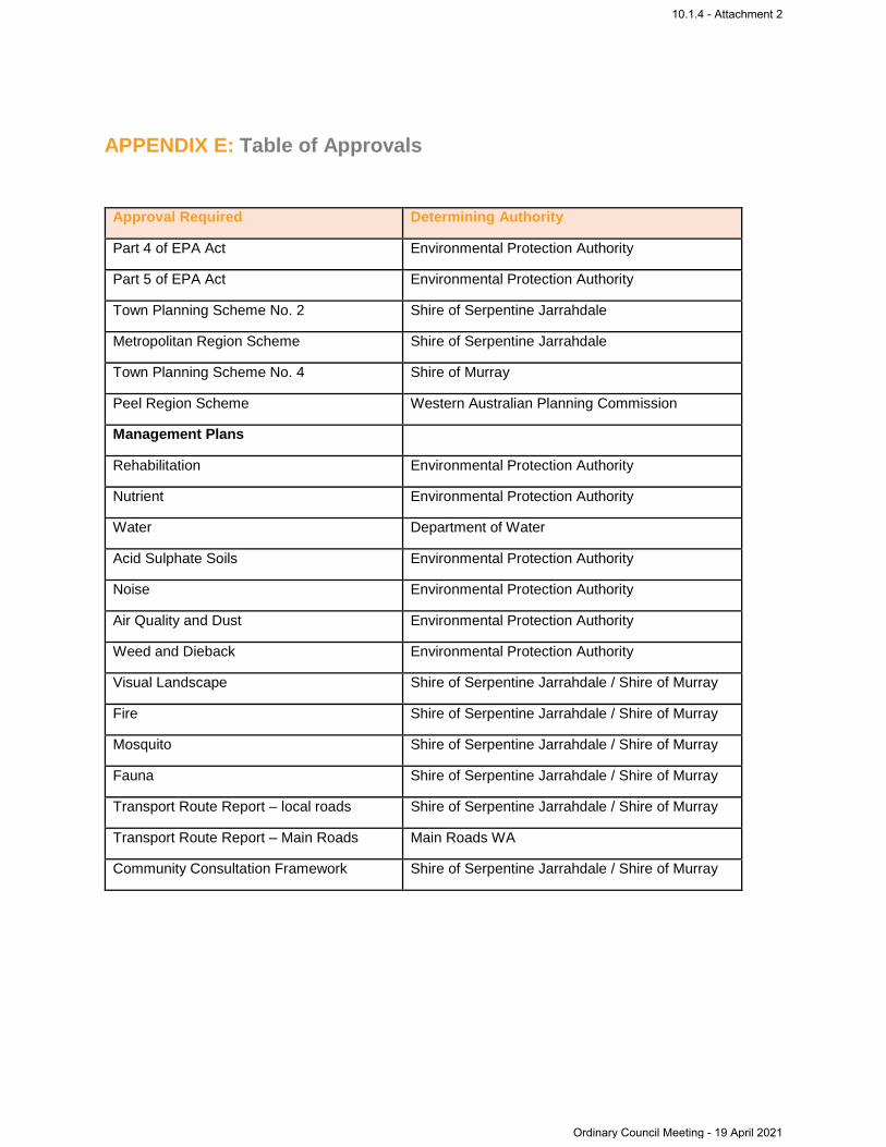
APPENDIX E: Table of Approvals
Approval Required Determining Authority
Part 4 of EPA Act Environmental Protection Authority
Part 5 of EPA Act Environmental Protection Authority
Town Planning Scheme No. 2 Shire of Serpentine Jarrahdale
Metropolitan Region Scheme Shire of Serpentine Jarrahdale
Town Planning Scheme No. 4 Shire of Murray
Peel Region Scheme Western Australian Planning Commission
Management Plans
Rehabilitation Environmental Protection Authority
Nutrient Environmental Protection Authority
Water Department of Water
Acid Sulphate Soils Environmental Protection Authority
Noise Environmental Protection Authority
Air Quality and Dust Environmental Protection Authority
Weed and Dieback Environmental Protection Authority
Visual Landscape Shire of Serpentine Jarrahdale / Shire of Murray
Fire Shire of Serpentine Jarrahdale / Shire of Murray
Mosquito Shire of Serpentine Jarrahdale / Shire of Murray
Fauna Shire of Serpentine Jarrahdale / Shire of Murray
Transport Route Report – local roads Shire of Serpentine Jarrahdale / Shire of Murray
Transport Route Report – Main Roads Main Roads WA
Community Consultation Framework Shire of Serpentine Jarrahdale / Shire of Murray
10.1.4 - Attachment 2
Ordinary Council Meeting - 19 April 2021

Point of Contact OSH & E Superintendent
Document Owner OSH & E Superintendent
Audit Frequency Biennial
Version Description Originator Approved Date
A Initial Plan FirePlan
WA
November 2010
2 Draft MZI - July 2016
3 Revision for operational
relevance PG DL 23/11/2017
4 Revision following consult with
Shire of SJ Smith
Consulting PG 26/01/19
5 Updated based on legislation
changes and approvals PC DO’H 18/11/2020
10.1.4 - Attachment 2
Ordinary Council Meeting - 19 April 2021

Table of Contents
1. Purpose ................................................................................................................................ 2
2. Scope ................................................................................................................................... 2
3. References ........................................................................................................................... 2
4. Goals/Aims/Targets .............................................................................................................. 2
5. Location and Details ............................................................................................................. 3
6. Keysbrook Mine Key Risks and Mitigation ........................................................................... 6
6.1 Hot Works ....................................................................................................................... 6
6.2 Vegetation clearing ......................................................................................................... 6
6.3 Mining, Tailings and Rehabilitation ................................................................................. 6
6.4 Processing ...................................................................................................................... 6
6.5 General Workforce ......................................................................................................... 7
6.6 Total Fire Bans ............................................................................................................... 7
6.7 Harvest and Vehicle Movement Bans ............................................................................ 7
7. Resources at Hand .............................................................................................................. 7
8. Emergency Response .......................................................................................................... 8
9. Bushfire Prevention .............................................................................................................. 8
9.1 Firebreaks ....................................................................................................................... 8
9.1.1 Mining Area ............................................................................................................. 8
9.1.2 Remnant Vegetation Areas ..................................................................................... 8
9.1.3 Conservation Areas ................................................................................................. 8
9.2 Building Protection Zone ................................................................................................ 9
9.3 Site Familiarization with Local Brigades ......................................................................... 9
10. Shire Notices ........................................................................................................................ 9
11. Contacts ............................................................................................................................. 10
12. Bush Fire Hazard Assessment (after FirePlan, 2010) ........................................................ 10
13. Site Revegetation Post Mining ........................................................................................... 10
Appendix A – Examples of Moderate Bushfire Hazard ............................................................... 11
Appendix B – Examples of Extreme Bushfire Hazard ................................................................. 12
List of Figures
Figure 1: Keysbrook Mineral Sands Mine Location ...................................................................... 4 Figure 2: Site Access Map Shire of Serpentine Jarrahdale .......................................................... 5 Figure 3: Sample Photographs of Moderate Bush Fire Hazard .................................................. 11 Figure 4: Sample Extreme Bush Fire Hazards ........................................................................... 12
10.1.4 - Attachment 2
Ordinary Council Meeting - 19 April 2021

1. Purpose
The purpose of this Fire Management Plan is to detail provisions and resources to ensure Keysbrook operations (i) minimise the risk of bushfires; and (ii) are prepared for potential bushfire events.
This plan is a revision of the Fire Management Plan prepared prior to the commence of operations and referenced in planning/development approvals issued by the Shire of Murray and the Shire of Serpentine Jarrahdale (Fire Management Plan, FirePlan January 2011). The plan has been updated to reflect actual operating conditions, site management procedures and the progression of mining, and in so doing now serves as an operational management plan.
The provisions of the Guidelines for Planning in Bushfire Prone Areas (Department of Planning, Lands and Heritage and Department of Fire and Emergency Services, Version 1.3, December 2017) and Guidelines for Plantation Fire Protection (Fire and Emergency Services Authority, 2011) were considered in the review and update of the plan. The advice of the Shire of Serpentine Jarrahdale staff was sought and applied to this review.
2. Scope
This plan applies to the operational footprint of the Keysbrook Mineral Sands Mine operated by Keysbrook Leucoxene Pty Ltd (KLPL), which is a wholly owned subsidiary of Doral Mineral Sands.
Excluded from the scope are land holdings which KLPL own or lease which buffer mining operations and on which non-mining rural land uses occur in accordance with local government fire management requirements.
3. References
▪ Emergency Management Plan.
▪ Emergency Response Procedures.
▪ Guidelines for Planning in Bushfire Prone Areas (Department of Planning, Lands and Heritage and Department of Fire and Emergency Services, Version 1.2, August 2017).
▪ Bush Fire Regulations 1954 – Total Fire Ban Activities.
4. Goals/Aims/Targets
▪ Operations bushfire ready by 1 November each year
▪ Site adequately resourced with fire suppression vehicles including earth moving machinery to deal with the initial attack of an emergency event involving bushfire. See Section 7 for a full list of fire suppression vehicles and machinery.
▪ Site adequately resourced to deal with a localised fire which has the potential to cause a widespread bushfire event. The resources available to support the localised fire suppression is restricted to licensed fire suppression pumpers and unlicensed earth moving machinery if legally able to travel on the road.
▪ Positive relationship established with local bushfire brigades
▪ Positive relationship established with Shire representatives
▪ Be trained and prepared should a bushfire arise.
10.1.4 - Attachment 2
Ordinary Council Meeting - 19 April 2021

5. Location and Details
Entry to the site is via the access road which intersects 1424 Hopelands Road, North Dandalup. Figure 1 details the location of the Keysbrook Mine.
The general site overview includes the following fixed areas:
▪ Administration office and carpark area ▪ Production office and carpark area ▪ Wet Concentrator Plant ▪ Workshop and laydown yards
The active mining area and location of the Mine Field Unit changes as the operation progresses into the mine plan.
Mining occurs 12 hours a day 7 days a week and processing occurs 24 hours a day, 7 days a week.
10.1.4 - Attachment 2
Ordinary Council Meeting - 19 April 2021

Figure 1: Keysbrook Mineral Sands Mine Location
10.1.4 - Attachment 2
Ordinary Council Meeting - 19 April 2021

Figure 2: Site Access Map Shire of Serpentine Jarrahdale
10.1.4 - Attachment 2
Ordinary Council Meeting - 19 April 2021

Figure 3: Site Access Map Shire of Murray
10.1.4 - Attachment 2
Ordinary Council Meeting - 19 April 2021
6. Keysbrook Mine Key Risks and Mitigation
KLPL applies a risk assessment process for all operational activities. The bushfire risk assessment is based on the nature of mining activities (risk of ignition) and hazard assessment based on site characteristics as determined by FirePlan 2010 (Section 12) and as modified to reflect progression of the mine path. This hazard assessment is based on the vegetation present prior to clearing for mining operations.
Bushfire is identified as a major external hazard item to the Keysbrook Mine and resources and controls commensurate with this rating are applied to mitigate the risk. The potential bushfire ignition on the mine site is restricted through the work being undertaken only on appropriate locations, and with the appropriate internal permits, fire suppression and mitigation. The current key access points in the event of a bushfire are detailed in Figures 2 and 3.
6.1 Hot Works
Hot works such as welding, cutting and grinding are the primary source of ignition across our operations.
A dedicated hot works area has been established at the Workshop and laydown area as this location holds fixed infrastructure to immediately respond to a fire source. Where possible, all hot works will be undertaken at this location.
All other hot works onsite are deemed a high-risk activity and only permitted under the sites High Risk Permit. The Hot Works Permit is signed off by a competent KLPL representative who has received training in hot works and permit issuing and will ensure the mandatory controls are implemented before works commence.
6.2 Vegetation clearing
Native vegetation clearing and pastoral land clearing is undertaken sequentially based on the mining plan. KLPL only disturb areas which are required for operations in the next 6-12 months. Where possible, vegetation clearing is undertaken outside of bushfire season. Vegetation clearing ultimately serves to reduce bushfire risk.
Milling grade timber and firewood is salvaged from the cleared vegetation. Remaining cleared vegetation is used in rehabilitation (as is or mulched/chipped) or removed from site for composting. No vegetation is burnt on the mine site.
The ground being cleared is generally sandy clay which poses minimal fire risk during clearing when compared to hard rock mining operations. Much of the land is rural agriculture with potential for buried rubbish, steel posts, fencing etc. which has the potential to cause a spark when cleared with earthmoving machinery.
Topsoil is pushed up into a perimeter bund to separate mining operations from non-cleared areas.
6.3 Mining, Tailings and Rehabilitation
Apart from vegetation clearing and topsoil removal, all other heavy vehicles operate within previously cleared areas inside of our mining footprint. Vehicles are inspected daily for defects as a safety precaution which also includes fire emergency devices.
All heavy vehicles are fitted with approved exhaust systems and fire extinguishers and contractor’s heavy vehicles are fitted with fire suppression.
6.4 Processing
Once mined and initially screened at the Mine Field Unit, the ore is combined with water and pumped as a slurry to the Wet Concentrator Plant. The slurry greatly reduces the fire potential of processing operations. Various pieces of infrastructure, such as pumps, electrical substations and
10.1.4 - Attachment 2
Ordinary Council Meeting - 19 April 2021

pipework transport the material back to mining voids. This infrastructure is within a previously cleared footprint to reduce fire risk.
6.5 General Workforce
Employees of KLPL who smoke are only authorised to do so in designated smoking areas. These areas have butt bins for the safe disposal of cigarette butts.
6.6 Total Fire Bans
In the event of a Total Fire Ban, Hot Work and Off-Road prescribed activities may only be undertaken in accordance with the Bush Fires Act 1954 without an exemption, provided:
▪ A Hot Works Permit has been completed; and,
▪ Mine Manager approval is obtained; and
▪ The fire danger rating is not Catastrophic; and
▪ There is no Harvest and Vehicle Movement Ban; and
▪ Notification is forwarded to DFES and local government authority at least 30 minutes prior to the activity using the online notification form https://dfeswa.tod.net.au/incidents/new/3d2fd2f6598ce7bb63b923363ef6a04b.
6.7 Harvest and Vehicle Movement Bans
The Mine Manager will be notified by the local shires of a Harvest and Vehicle Movement Ban. In the event of a Harvest and Vehicle Movement Ban the operation of heavy and light vehicle and mobile plant will not occur on or within 30m of land where there is bush, crop, pasture, stubble or grassland.
7. Resources at Hand
In the event of a localised fire onsite or a bushfire, KLPL have the following resources available to assist:
▪ A fleet of heavy machinery, including Trucks, Front End Loaders, Dozers, Graders and Excavators.
▪ One permanent 32,000 litre watercart
▪ One additional 30,000 litre watercart for the summer season
▪ Overhead standpipes to refill watercarts
▪ Two Fire tender trailers, which each include a 1000L water tank, pump and hoses.
▪ Process water dams which hold 26,000kL litres and are maintained at a full capacity during normal operations
▪ Diesel fire pump system which operates independently of electricity which feeds:
o Fire hoses within the Wet Concentrator Plant
o Hydrants at the Workshop, Wet Concentrator Plant and Administration Offices.
The resources listed above are available in the event of a localised fire or a bushfire (onsite). The heavy machinery and water carts are not licenced and will therefore require escorts and/or transport to travel on public roads, if required.
Subject to site operational requirements a water cart may be available for a period after initial suppression efforts to assist in ongoing suppression and mop up.
10.1.4 - Attachment 2
Ordinary Council Meeting - 19 April 2021
8. Emergency Response
The site operates under an Emergency Response Procedure. The document outlines how to deal with an emergency relating to fire.
In the event of a bushfire onsite, KLPL have a legal responsibility to immediately call 000 and extinguish or attempt to extinguish the fire. KLPL will assist all external agencies with a bushfire emergency, including access to our site resources.
KLPL employees are periodically trained in Emergency Management and Emergency Response.
Refer to the Emergency Response Procedure.
9. Bushfire Prevention
Prior to the bushfire season commencing (described as the restricted burning season and prohibited burning season declared by the Shire of Serpentine Jarrahdale), KLPL is committed to ensuring the site is ‘fire ready’.
9.1 Firebreaks
9.1.1 Mining Area
Mine areas are fenced from surrounding agricultural land. Trafficable firebreaks clear of all flammable material to a minimum of 4 metres wide are constructed inside all fenced active mineral extraction areas, with all overhanging branches and trees trimmed or pruned with a clear vertical axis over the firebreak. The company is to provide access into the site through the provision of 4.2-metre-wide gates and suitable hard stands. During a bushfire emergency the Volunteer Bush Fire Brigade or Shire employees can cut the fence to provide access to the site if this is deemed a safer or better option to assist the fire suppression activities. If the fence is cut by the Volunteer Bush Fire Brigade or Shire employees, they must notify the company as soon as practical so the fence can be repaired.
Mine Areas on Lot 56 Westcott Rd and Lot 57 Elliot Road
The approved mine areas on Lot 56 Westcott Rd and Lot 57 Elliot Road abut and are south and north respectively of Elliott Road. When operational, emergency access will be provided from Elliott Road to the mine areas on both lots. The access will be hard stand and gated in accord with safety requirements. The actual location of the gates (north and south) will be determined in advance of mining these areas in consultation with the Shire of Serpentine Jarrahdale.
9.1.2 Remnant Vegetation Areas
Remnant native vegetation areas comprising woodland overstorey on pasture occurs on Lot 59 Westcott Road and Lot 62 Hopelands Road. Much of this area will be progressively cleared, mined and rehabilitated in accord with environmental approvals and landholder agreements.
Firebreaks shall be maintained on the perimeter of applicable lots. A fire break of minimum 4 metres shall be established around the perimeter of the active excavation area.
9.1.3 Conservation Areas
Two areas subject to conservation covenants and associated revegetation obligations are associated with the project. The areas comprise:
1. 25ha on Lot 62 (within the current approved mine area); and 2. Lot 202 - 50ha partially vegetated (remote from the currently approved mine area).
A trafficable (4x4) firebreak 4 metres wide is to be installed within 15 metres of the fence demarcating the conservation area (Lot 62) and immediately inside the boundary of Lot 202.
10.1.4 - Attachment 2
Ordinary Council Meeting - 19 April 2021

9.2 Building Protection Zone
A 30-metre-wide building protection zone is to be maintained around all buildings whether operations, administrative, processing plant or other structures. Any building protection zone is to comply with the following specifications:
▪ Bushfire fuels (<6mm diameter dead material and <3mm diameter for live material) to be maintained at or below 2 tonnes per hectare and dry grass must be maintained below a height of 50mm;
▪ The first 5 metres around all building is to be cleared of all flammable material. Reticulated gardens may be located in this zone;
▪ The spacing of trees should be 15-20 metres apart to provide for a separation of 10 metres between crowns;
▪ Trees are to be under/low pruned, to a height of 2 metres;
▪ There are no tree crowns over hanging the building;
▪ Shrubs within the building protection zone have no dead material within the plant;
▪ Fences and sheds within the Building Protection Zone are to be constructed using non-combustible materials (e.g. colour bond iron, brick, limestone);
▪ Branches must be removed to at least 2 metres back from the eaves of all buildings;
▪ All leaves, twigs, logs, branches must be removed from within the building protection zone. Annual falls of leaf litter must be raked up and removed or burnt.
Additional clearing is not required if the buildings requiring protection are located on cleared land.
A production bore and field pumps for which hay bales have been or may be deployed as noise bunding, is considered ancillary equipment and not subject to the building protection zone requirement.
9.3 Site Familiarization with Local Brigades
Each year prior to the bushfire season, KLPL will arrange an invitation to the local Bush Fire Brigades to familiarise themselves with access, firebreaks, water supplies, equipment available and contact details.
10. Shire Notices
Local Authorities have powers under the Bush Fires Act and Regulations to control the movement of vehicles and the undertaking of activities which have the potential to create ignition sources. Any notice given by a Local Authority must be complied with.
The communication of such notices is by means of:
▪ Emails to KLPL representatives
▪ SMS messages to KLPL representatives
▪ Local radio
Upon receipt of a vehicle movement ban notice issued by the Shire, KLPL will cease all vehicle activities in uncleared areas.
Upon receipt of a total fire ban issued by the Shire, KLPL will cease all non-business critical tasks which have the potential to be a source of ignition.
With all notices, KLPL will work with the local authorities to reduce the fire risk of operations.
10.1.4 - Attachment 2
Ordinary Council Meeting - 19 April 2021

11. Contacts
Position Organisation Name Contact details
Mine Manager KLPL Bruce Trepp 6557 5341
Senior Environmental Officer
KLPL Dan O’Hara 6557 5311
OSH&E Superintendent KLPL Craig Bovell 9725 5416
Reception KLPL N/A 6557 5340
Captain North Dandalup volunteer
bushfire brigade Michael Webster
0448 135 671
9530 1038
Captain Keysbrook volunteer bushfire
brigade Chris Burgess
0417 173 410
9525 2551
Fire Control Officers Shire of Murray N/A 9531 7777
Fire Control Officers Shire of Serpentine Jarrahdale N/A 9526 1111
Department of Fire and
Emergency Services 000
12. Bush Fire Hazard Assessment (after FirePlan, 2010)
The assessment of fire risk takes into account existing site conditions which include:
▪ Topography with particular reference to ground slopes and accessibility;
▪ Vegetation cover – both remnant and likely revegetation; and
▪ Relationship to surrounding development.
The Bush Fire Hazard Assessment across the approved mine area is extreme in remnant native vegetation and low-moderate in the remainder. Similarly, the bushfire hazard assessment in adjoining lots is rated extreme in remnant vegetation and low-moderate in cleared areas.
The Mediterranean climate experienced by this area is such that the majority of rain falls in late autumn through to early spring. This rainfall supports substantial vegetation growth which dries off in Summer/Autumn, contributing to the fire risk.
13. Site Revegetation Post Mining
The area approved for mining is predominantly pasture, with some sections of remnant native vegetation. Areas disturbed by mining are, or will be, rehabilitated to pasture. Under the conditions of approval for the mine, KLPL will also be reinstating native vegetation in some areas and enhancing the quality of several other designated native conservation areas. These native vegetation areas are considered outside the scope of the Guidelines for Plantation Fire Protection (Fire and Emergency Services Authority, 2011).
10.1.4 - Attachment 2
Ordinary Council Meeting - 19 April 2021

Appendix A – Examples of Moderate Bushfire Hazard
Figure 3: Sample Photographs of Moderate Bush Fire Hazard
10.1.4 - Attachment 2
Ordinary Council Meeting - 19 April 2021

Appendix B – Examples of Extreme Bushfire Hazard
Figure 4: Sample Extreme Bush Fire Hazards
10.1.4 - Attachment 2
Ordinary Council Meeting - 19 April 2021

0
Keysbrook Mineral Sands Mine
Scale 1:25,000MGA94 (Zone 50)
500m
Legend
Approved Mining AreaConservation Covenant Areas (77ha)Conservation Category WetlandWatercourse (with 20m buffer either side)
Author: D. O'Hara ~ Drawn: CAD Resources ~ Tel 9246 3242 ~ URL www.cadresources.com.au ~ Date Novembr 2020 ~ A3 ~ CAD Ref g2510F018_ReVeg04.dgn ~ Aerial Photography: Nearmap (July 2020)
Author: D. O'Hara Date: November 2020
Current RevegetationStatus 2020
2016 CompletedMining Area
2018Mining Area
2017Mining Area
Proposed Revegetation Area (296.7ha)
Proposed Habitat Enhancement Area (17.6ha)Revegetation Area (74.7ha)
10.1.4 - Attachment 2
Ordinary Council Meeting - 19 April 2021
daniel.ohara
Polygon