Top 100 + Indian Geography MCQs Questions for UPSC NDA ...
23
1 www.bankersadda.com | www.sscadda.com | www.careerpower.in | Adda247 App Top 100 + Indian Geography MCQs Questions for UPSC NDA & CDS II 2021 Q1. Consider the following statements 1. It is found in those regions of the country which receive heavy rainfall with an alternate dry and wet period - mainly, near the coasts. 2. They are formed from the decomposition of rocks and contain iron oxide 3. It lacks fertility due to a lower base-exchanging capacity and a lower content of nitrogen, phosphorus, and potassium Identify the above soil type (a) Red soil (b) Black soil (c) Laterite soil (d) Desert soil Q2. Consider the following pairs 1. Niti Pass Uttarakhand 2. Jelepla Pass Jammu and Kashmir 3. Bom Di La Arunachal Pradesh Which of the pairs given above are correct? (a) 1 and 2 (b) 2 and 3 (c) 1 and 3 (d) 1,2 and 3 Q3. The Camp David Accords is some times seen in the news, it was signed between (a) Isreal and Palestine (b) Israel and Egypt (c) Saudi Arab and Yemen (d) Saudi Arab and Qatar Q4. Which of the landforms given below are not erosional landforms formed by the action of groundwater? (a) Stalagmites (b) Sinkholes (c) Uvalas (d) Lapies Q5. Strait of Dover is located between (a) England and France (b) Finland and Estonia (c) Greece and Spain (d) Morocco and Spain Q6. Consider the following statements 1. An estuary is an area where a freshwater river or stream meets the ocean. 2. In estuaries, the salty ocean mixes with a freshwater river, resulting in brackish water. 3. Pulicat lake is a brackish water lake Which of the statements given above is/are correct? (a) 1 and 2 (b) 2 and 3 (c) 1 and 3 (d) 1,2 and 3 Q7. Consider the following statements 1. Shear waves (S-waves) produced by an earthquake can travel only through liquid materials. 2. ‘Shadow zone’ of an earthquake refers to the zone where the tendency of experiencing an earthquake is the minimum. Which of the statements given above is/are correct? (a) 1 only (b) 2 only (c) Both 1 and 2 (d) Neither 1 nor 2 Q8. The salal dam in Jammu Kashmir is located on- (a) Jhelum river (b) Chenab River (c) Indus river (d) Ravi river Q9. Which of the following ocean currents blow in the Indian Ocean? (a) Agulhas Current (b) Kuroshio current (c) Humboldt current (d) Labrador current Q10. Which of the following groups are correctly matched. 1. Hezbollah: Lebanon 2. Houthis: Yemen 3. Boko Haram: Nigeria 4. Al-Shabab: Somalia Choose the correct code from below (a) 1, 2, 3 (b) 2, 3, 4 (c) 1, 3, 4 (d) 1, 2, 3, 4
-
Upload
khangminh22 -
Category
Documents
-
view
1 -
download
0
Transcript of Top 100 + Indian Geography MCQs Questions for UPSC NDA ...
1 www.bankersadda.com | www.sscadda.com | www.careerpower.in | Adda247 App
Top 100 + Indian Geography MCQs Questions for UPSC NDA & CDS II 2021
Q1. Consider the following statements
1. It is found in those regions of the country which
receive heavy rainfall with an alternate dry and wet
period - mainly, near the coasts.
2. They are formed from the decomposition of rocks and
contain iron oxide 3. It lacks fertility due to a lower base-exchanging
capacity and a lower content of nitrogen, phosphorus,
and potassium Identify the above soil type
(a) Red soil (b) Black soil
(c) Laterite soil (d) Desert soil
Q2. Consider the following pairs
1. Niti Pass Uttarakhand
2. Jelepla Pass Jammu and Kashmir
3. Bom Di La Arunachal Pradesh
Which of the pairs given above are correct?
(a) 1 and 2 (b) 2 and 3
(c) 1 and 3 (d) 1,2 and 3
Q3. The Camp David Accords is some times seen in the
news, it was signed between (a) Isreal and Palestine (b) Israel and Egypt
(c) Saudi Arab and Yemen (d) Saudi Arab and Qatar
Q4. Which of the landforms given below are not erosional
landforms formed by the action of groundwater?
(a) Stalagmites (b) Sinkholes
(c) Uvalas (d) Lapies
Q5. Strait of Dover is located between
(a) England and France (b) Finland and Estonia
(c) Greece and Spain (d) Morocco and Spain
Q6. Consider the following statements
1. An estuary is an area where a freshwater river or
stream meets the ocean.
2. In estuaries, the salty ocean mixes with a freshwater
river, resulting in brackish water. 3. Pulicat lake is a brackish water lake
Which of the statements given above is/are correct?
(a) 1 and 2 (b) 2 and 3
(c) 1 and 3 (d) 1,2 and 3
Q7. Consider the following statements
1. Shear waves (S-waves) produced by an earthquake
can travel only through liquid materials.
2. ‘Shadow zone’ of an earthquake refers to the zone
where the tendency of experiencing an earthquake is
the minimum.
Which of the statements given above is/are correct?
(a) 1 only (b) 2 only
(c) Both 1 and 2 (d) Neither 1 nor 2
Q8. The salal dam in Jammu Kashmir is located on-
(a) Jhelum river (b) Chenab River
(c) Indus river (d) Ravi river
Q9. Which of the following ocean currents blow in the
Indian Ocean?
(a) Agulhas Current (b) Kuroshio current
(c) Humboldt current (d) Labrador current
Q10. Which of the following groups are correctly
matched.
1. Hezbollah: Lebanon
2. Houthis: Yemen
3. Boko Haram: Nigeria
4. Al-Shabab: Somalia
Choose the correct code from below
(a) 1, 2, 3 (b) 2, 3, 4
(c) 1, 3, 4 (d) 1, 2, 3, 4

2 www.bankersadda.com | www.sscadda.com | www.careerpower.in | Adda247 App
Q11. Consider the following statements
1. Horticulture contributes about 20 per cent to the GDP
of agriculture.
2. India is the largest producer and exporter of spices.
3. India is the largest producer of fruits and vegetables
in the world.
Which of the statements given above is/are correct?
(a) 1 and 2 (b) 2 only
(c) 1 and 3 (d) 1,2 and 3
Q12. Consider the following statements regarding
National Beekeeping and Honey Mission
1. The scheme is implemented by the National Bee
Board (NBB) and is approved for four years from
2020 to 2024.
2. The scheme aims to achieve the objectives of the
Sweet Revolution.
3. It is a central sector scheme (100% central
government funding).
Which of the statements given above is/are correct?
(a) 1 and 2 (b) 2 and 3
(c) 1 and 3 (d) 2 only
Q13. Consider the following statements
1. A lunar eclipse occurs when the earth passes in
between the moon and the sun casting its shadow on
the moon and hiding it fully or partly for some time.
2. A solar eclipse happens on a full moon day.
Which of the statements given above is/are correct?
(a) 1 only (b) 2 only
(c) Both 1 and 2 (d) Neither 1 nor 2
Q14. Recently, Agalega Island was in the news. It is
located in which of the following oceans?
(a) The Indian Ocean (b) The Atlantic Ocean
(c) The Pacific Ocean (d) The Arctic Ocean
Q15. Which of the following are the items which have
been recently put in the Minor Forest Produce (MFP)
items in the Minimum Support Price (MSP) list
1. Van Tulsi seed
2. Van Jeera
3. Mushroom
4. Black Rice
5. Johar Rice
Select the correct code from below:
(a) 1, 2 and 3 (b) 2, 4 and 5
(c) 2, 3, 4 and 5 (d) 1, 2, 3, 4 and 5
Q16. Consider the following statements
1. In the Mediterranean region, the summer months
receive more rain.
2. In China type climate; rainfall occurs throughout the
year
3. Tropical highlands exhibit vertical zonation of
different climates
Which of the statements given above is/are correct?
(a) 1 and 2 (b) 2 only
(c) 1 and 3 (d) 1,2 and 3
Q17. Which of the following are among the landlocked
countries in Africa?
1. Ethiopia
2. South Africa
3. South Sudan
Select the correct answer using the code given below:
(a) 1 and 2 (b) 1 and 3
(c) 2 and 3 (d) 1, 2 and 3
Q18. Consider the following statements regarding the
Inter-Tropical Convergence Zone:
1. It is a zone of high pressure due to the convergence of
trade winds.
2. This zone experiences low precipitation and high
humidity.
Which of the statements given above is/are correct?
(a) 1 only (b) 2 only
(c) Both 1 and 2 (d) Neither 1 nor 2
Q19. Consider the following statements regarding the
combined phenomenon of southern oscillation - ENSO
1. The appearance of warm water off the coast of Peru is
closely associated with the pressure changes in the
Central Pacific and Australia during Southern
Oscillation
2. When the ENSO is strong, Australia and India receive heavy rainfall and China experiences drought.
Which of the statements given above is/are correct?
(a) 1 only (b) 2 only
(c) Both 1 and 2 (d) Neither 1 nor 2
Q20. Recently hydropower project at Zangmu was in
news. It is located in
(a) Nepal (b) Myanmar
(c) Bhutan (d) Tibet
Q21. Recently, the world’s oldest known cave painting
was found in the limestone cave of Leang Tedongnge. It is
located in-
(a) Malaysia (b) Indonesia
(c) Sikkim (d) China

3 www.bankersadda.com | www.sscadda.com | www.careerpower.in | Adda247 App
Q22. The strait of Dover is closely located near- (a) Black sea (b) Aegon sea (c) North Sea (d) Sea of Azov Q23. Consider the following statements 1. Continental islands are bodies of land connected by
the continental shelf to a continent. 2. Islets are part of the largest islands. Which of the statements given above is/are correct? (a) 1 only (b) 2 only (c) Both 1 and 2 (d) Neither 1 nor 2 Q24. Consider the following statements 1. Fluvial islands are accumulations of sand deposited
by sea currents on the continental shelves 2. Barrier islands are formed in river deltas or
midstream within large rivers. Which of the statements given above is/are correct? (a) 1 only (b) 2 only (c) Both 1 and 2 (d) Neither 1 nor 2 Q25. Consider the following statements 1. Australia is the smallest continent that lies entirely in
the Southern Hemisphere. 2. Africa is the It is the only continent through which the
Tropic of Cancer, the Equator, and the Tropic of Capricorn pass.
Which of the statements given above is/are correct? (a) 1 only (b) 2 only (c) Both 1 and 2 (d) Neither 1 nor 2 Q26. Consider the following statements 1. India presently has two research stations in
Antarctica namely ‘Maitri’ and ‘Bharati’ to understand the Polar processes and phenomena.
2. Indian Arctic station ‘Himadri’ is located in Greenland Which of the statements given above is/are correct? (a) 1 only (b) 2 only (c) Both 1 and 2 (d) Neither 1 nor 2 Q27. Consider the following statements 1. During the low tide, more fishes come closer to the
shore. 2. Low tide helps marine navigators to reach early on
the shores Which of the statements given above is/are correct? (a) 1 only (b) 2 only (c) Both 1 and 2 (d) Neither 1 nor 2 Q28. Almost all the weather phenomena like rainfall, fog, and hailstorm occur in this layer of the atmosphere (a) Stratosphere (b) Thermosphere (c) Troposphere (d) Mesosphere
Q29. Arrange the following passes from north to south-
1. Shipki- la
2. Baralach-la
3. Khardung-La
4. Chang-la
Select the correct code from below:
(a) 1-2-3-4 (b) 2-1-3-4
(c) 3-1-2-4 (d) 4-2-3-1
Q30. Consider the following pairs
1. Kunchikal Falls: Odisha
2. Barehipani Falls: Karnataka
3. Dudhsagar Falls: Goa
Which of the pair/s given above is/are correct?
(a) 1 and 2 (b) 1 and 3
(c) 2 and 3 (d) 3 only
Q31. The Arctic Circle passes through
1. Russia
2. Greenland
3. Sweden
Select the correct code from below:
(a) 1 and 2 (b) 2 and 3
(c) 1 and 3 (d) 1,2 and 3
Q32. Consider the following statements
1. Igneous rocks are also known as primary rocks.
2. Fossil deposits are only found in igneous rocks.
Which of the statements given above is/are correct?
(a) 1 only (b) 2 only
(c) Both 1 and 2 (d) Neither 1 nor 2
Q33. Deccan plateau is majorly made of
(a) Basalt rocks (b) Slate rocks
(c) Limestone rocks (d) Granite rocks
Q34. Which of the following force(s) are fundamental to
the formation of deltas and ox-bow lakes?
1. Erosional forces
2. Depositional forces
Select the correct code from below:
(a) 1 only (b) 2 only
(c) Both 1 and 2 (d) Neither 1 nor 2
Q35. Maas–Hoffman model provides the relation
between-
(a) crop yield and soil salinity
(b) demographic dividend and migration
(c) carbon sequestration and forest area coverage
(d) income inequality and healthcare access

4 www.bankersadda.com | www.sscadda.com | www.careerpower.in | Adda247 App
Q36. What is common to the places known as Aliyar, Isa
pur and Kangsabati?
(a) Recently discovered uranium deposits
(b) Tropical rain forests
(c) Underground cave systems
(d) Water reservoirs
Q37. Consider the following statements
1. Agricultural soils release nitrogen oxides into the
environment.
2. The poultry industry releases reactive nitrogen
compounds into the environment.
3. Cattle release ammonia into the environment.
Which of the statements given above is/are correct?
(a) 1 and 2 (b) 2 and 3
(c) 1 and 3 (d) 1,2 and 3
Q38. Consider the following statements
1. India has the world's 3rd largest hydropower capacity
2. Koyna Hydroelectric Project is India’s largest
completed hydroelectric power plant
3. Tanakpur dam is located on Tons river
Which of the statements given above is/are correct?
(a) 1 and 2 (b) 2 and 3
(c) 2 only (d) 1,2 and 3
Q39. Consider the following pairs
Dam - State
1. Khopoli- Tamilnadu
2. Kodasalli-Karnataka
3. Panchet-Bihar
Which of the pair/s given above is/are correct?
(a) 1 and 2 (b) 2 and 3
(c) 3 only (d) 1,2 and 3
Q40. Why are dewdrops not formed on a cloudy night?
(a) Clouds absorb the radiation released from the Earth’s
surface.
(b) Clouds reflect back the Earth’s radiation.
(c) The Earth’s surface would have low temperatures on
cloudy nights.
(d) Clouds deflect the blowing wind to ground level.
Q41. The tropic of cancer passes does not through which
of the following state in India?
(a) Gujarat (b) Rajasthan
(c) Chhattisgarh (d) Bihar
Q42. Standard Meridian of India which is 82°30′ East
longitude passes through
1. Madhya Pradesh
2. Chattisgarh
3. Odisha
4. Andhra Pradesh
5. Tamilnadu
Select the correct code from below:
(a) 1,2,4 and 5 (b) 2,3,4 and 5
(c) 1,2,3 and 4 (d) 1,2,3,4 and 5
Q43. Which among the following city lies closest to the
Standard Meridian of India which is 82°30′ East
longitude?
(a) Lucknow (b) Hyderabad
(c) Raipur (d) Bhubneshwar
Q44. Consider the following statements
1. Alluvial soil is also known as ‘self-ploughing’ soil.
2. Black soil is important for the growth of plantation
crops.
Which of the statements given above is/are correct?
(a) 1 only (b) 2 only
(c) Both 1 and 2 (d) Neither 1 nor 2
Q45. Port of Galle is a natural harbor, located in-
(a) Srilanka (b) Myanmar
(c) Indonesia (d) Mauritius
Q46. Which of the following rivers is a tributary of River
Krishna
1. Tungabhadra
2. Koyna
3. Sabari
Select the correct code from below:
(a) 1 and 2 (b) 2 and 3
(c) 1 only (d) 1,2 and 3
Q47. Consider the following statements regarding Jet
streams
1. Jet streams are bands of strong wind that generally
blow from east to west all across the globe.
2. Jet streams form when warm air masses meet cold air
masses in the atmosphere.
3. If an airplane flies in a powerful jet stream and they
are traveling in the same direction, the airplane can
get a boost.
Which of the statements given above is/are correct?
(a) 1 and 2 (b) 2 and 3
(c) 1 only (d) 1,2 and 3

5 www.bankersadda.com | www.sscadda.com | www.careerpower.in | Adda247 App
Q48. Jet streams follow the curved and meandering path due to- (a) The pressure gradient between the equator and Polar
regions (b) Vertical wind shear (c) Coriolis Force (d) Differences in temperatures at places due to night and
day Q49. Consider the following statements 1. In the Hadley, cell air should move north to south, but
it is deflected to the right by Coriolis. 2. In the Ferrel cell air should move south to north, but
the winds actually blow from the southwest. Which of the statements given above is/are correct? (a) 1 only (b) 2 only (c) Both 1 and 2 (d) Neither 1 nor 2 Q50. Tropic of cancer and IST meridian intersect at- (a) Allahabad in Uttar Pradesh (b) Koriya district in Chhattisgarh (c) Jabalpur in Madhya Pradesh (d) Dumka in Jharkhand Q51. Which of the following statement is correct about October heat? (a) It happens in northern plains and eastern regions
only (b) It happens due to the formation of the high-pressure
region on the landmass in India and is accompanied by the withdrawal of the monsoon and cloud cover
(c) Both (a) and (b) (d) Neither(a) nor (b) Q52. Which among the following are west-flowing rivers- 1. Ghaghra 2. Shravasti 3. Brahmani Select the correct code from below: (a) 1 and 2 (b) 2 and 3 (c) 1 and 3 (d) 1,2 and 3 Q53. Which of the following states do not share a border with Bangladesh? (a) Mizoram (b) Meghalaya (c) Tripura (d) Manipur Q54. Consider the following pairs 1. Gerusoppa Dam- Karnataka 2. Omkareshwar Dam- Madhya Pradesh 3. Nathpa Jhakri Dam-Assam Which of the pair/s given above is/are correct? (a) 1 and 2 (b) 2 and 3 (c) 1 and 3 (d) 1,2 and 3
Q55. What is/are likely reasons for a higher frequency of cyclones in the Bay of Bengal when compared to The Arabian Sea? 1. Higher surface temperature of Arabian Sea 2. Higher Rainfall received in the Bay of Bengal. Select the correct code from below: (a) 1 only (b) 2 only (c) Both 1 and 2 (d) Neither 1 nor 2 Q56. Sirocco, mistral and Khamin are- (a) Types of clouds in the middle atmosphere (b) Cyclones originating in Pacific oceans (c) Types Local winds (d) Glaciers in the polar regions Q57. Consider the following statements 1. Bangar is the new alluvium and is deposited by floods
periodically. 2. Khadar is the older alluvium, deposited away from the
flood plains. Which of the statements given above is/are correct? (a) 1 only (b) 2 only (c) Both 1 and 2 (d) Neither 1 nor 2 Q58. Arrange the following countries from North to south 1. Kazakstan 2. Turkmenistan 3. Uzbekistan 4. Afghanistan Select the correct code from below: (a) 2-1-3-4 (b) 1-2-3-4 (c) 3-2-1-4 (d) 2-1-4-3 Q59. Consider the following statements regarding Malwa Plateau 1. This Plateau has a senile topography and is marked by
various gorging channels like Tons, Ken, Dhasan, and Betwa.
2. The Plateau comprises tropical dry teak forests 3. It is mostly covered with alluvial soil Which of the statements given above is/are correct? (a) 1 and 2 (b) 2 and 3 (c) 2 only (d) 1,2 and 3

6 www.bankersadda.com | www.sscadda.com | www.careerpower.in | Adda247 App
Q60. Consider the following statements regarding Satluj river 1. Sutlej is an antecedent river 2. It is the westernmost tributary of the Indus River. 3. The drainage basin is in India includes Himachal
Pradesh, Punjab, Jammu and Kashmir, and Haryana states
Which of the statements given above is/are correct? (a) 1 and 2 (b) 2 and 3 (c) 1 and 3 (d) 1,2 and 3 Q61. The Iberian Peninsula is surrounded by which among the following? 1. Gulf of Lion 2. Balearic Sea 3. Bay of Biscay Select the correct code: (a) 1 and 2 (b) 2 and 3 (c) 1 and 3 (d) 1,2 and 3 Q62. Recently tribals of ‘Greater Tipraland'was seen in the news due to the long due demand for the creation of the separate state. It is located in which state (a) Mizoram (b) Manipur (c) Chattisgarh (d) Tripura Q63. Consider the following statements 1. The Gandhisagar dam has been built on the tributary
of Yamuna. 2. The Yamuna originates from the eastern slopes of the
Banderpunch range. Which of the statements given above is/are correct? (a) 1 only (b) 2 only (c) Both 1 and 2 (d) Neither 1 nor 2 Q64. Consider the following statements 1. The tropical evergreen forests are restricted to
Western Ghats and hills of the northeastern regions only.
2. The sholas are montane forests of Nilgiris and Annamalai Hills.
Which of the statements given above is/are correct? (a) 1 only (b) 2 only (c) Both 1 and 2 (d) Neither 1 nor 2 Q65. Consider the following statements 1. Drip irrigation is the most efficient irrigation system
and it reduces leaching significantly. 2. Kaleshwaram Lift Irrigation Project (KLIP) has been
constructed to tap the water potential of the river Krishna.
Which of the statements given above is/are correct? (a) 1 only (b) 2 only (c) Both 1 and 2 (d) Neither 1 nor 2
Q66. Which of the following strait separate North America from Asia? (a) Bering Strait (b) Cabot Strait (c) Strait of Canso (d) Cebu Strait Q67. Consider the following statements 1. Dharwar rocks have 98% coal deposits of India. 2. Volcanic eruption at the end of the Mesozoic era led to
the formation of Gondwana rocks. Which of the statements given above is/are correct? (a) 1 only (b) 2 only (c) Both 1 and 2 (d) Neither 1 nor 2 Q68. Consider the following pairs 1. Kunchikal falls -Sharavathi river 2. Jog falls- Varahi river 3. Gautamdhara falls-Raru river Which of the pair/s given above is/are correct? (a) 1 and 2 (b) 3 only (c) 1 and 3 (d) 2 only Q69. Consider the following statements regarding Polar front jet (PFJ) or mid-latitude jet streams 1. These are formed in the junction between the Ferrell
and Polar cells 2. In summer, its position shifts towards the poles and in
winter towards the equator 3. It greatly influences the temperature difference of two
different air masses lying close to 50°-60° N/S region is where the polar jet located
Which of the statements given above is/are correct? (a) 1 and 2 (b) 2and 3 (c) 1and 3 (d) 1,2 and 3 Q70. Which among the following are Temporary jet streams 1. Polar night jets 2. Somali Jet 3. The African Easterly jet Select the correct code: (a) 1 and 2 (b) 2and 3 (c) 1and 3 (d) 1,2 and 3 Q71. Motihari-Amlekhgunj Oil pipeline connects India with which of the countries? (a) Bangladesh (b) Nepal (c) Bhutan (d) Myanmar Q72. Bamboo drip irrigation system to water plantation crops is widely used by traditional farmers of which one of the following Indian state? (a) Uttar Pradesh (b) Punjab (c) Meghalaya (d) Kerala

7 www.bankersadda.com | www.sscadda.com | www.careerpower.in | Adda247 App
Q73. Consider the following statements 1. The pressure gradient is strong where the isobars are
close to each other. 2. Coriolis force deflects the wind to the right direction
in the southern hemisphere. Which of the statements given above is/are correct? (a) 1 only (b) 2 only (c) Both 1 and 2 (d) Neither 1 nor 2 Q74. Consider the following pairs 1. katabatic wind -winds that move upwards along a
slope. 2. Haboob- A Local cold wind that blows in Siberian
regions 3. Chinook wind -Winds that form when low pressure
draws air over a mountain range. Which of the pair/s given above is/are correct? (a) 1 and 2 (b) 3 only (c) 2 and 3 (d) 1 only Q75. Consider the following statements 1. Irrawaddy River has its source of origin from
Himalayan glaciers 2. Irrawaddy river flows through China, Myanmar, and
Bangladesh 3. Irrawady river finally drains into Andaman sea Which of the statements given above is/are correct? (a) 1 and 2 (b) 2 and 3 (c) 1 and 3 (d) 1,2 and 3 Q76. Consider the following pairs River- Drains into 1. Salween- Yellow sea 2. Volga-Caspian sea 3. Yangtze- South China sea Which of the pairs given above is/are correct? (a) 1 and 2 (b) 2 and 3 (c) 1 and 3 (d) 2 only Q77. ‘Ladang’ is a local name of shifting cultivation practiced in: (a) Southeast Asia (b) Africa (c) Central America (d) Europe Q78. The River Orange forms the international boundary between which of the following countries? (a) Niger and Nigeria (b) South Africa and Namibia (c) Mali and Zimbabwe (d) Nigeria and Cameroon Q79. Which of the following countries are claiming territorial rights over Senkaku Island? (a) Japan and China (b) China and Vietnam (c) Myanmar and Thailand (d) Japan and Russia
Q80. Recently Naitwar Mori Hydro Electric Project was
seen in the news. It is located in-
(a) Himachal Pradesh (b) Uttrakhand
(c) Jammu (d) Ladakh
Q81. During the June solstice or summer solstice in
Northern hemisphere-
(a) The places on the Arctic Circle will see the Sun just on
the horizon during midnight
(b) The places on the Antarctic Circle will see the Sun just
on the horizon during midday
(c) Both (a) and (b) are correct
(d) Neither (a) nor (b) is correct
Q82. Consider the following statements regarding
subsolar point
1. The subsolar point on a planet is the point at which its
sun is perceived to be directly overhead
2. To an observer on a planet with an orientation and
rotation similar to those of Earth, the subsolar point
will appear to move eastward, completing one circuit
around the globe each day
3. The subsolar point contacts the Tropic of Cancer on
the December solstice and the Tropic of Capricorn on
the June solstice
Which of the statements given above is/are correct?
(a) 1 and 2 (b) 2 and 3
(c) 2 only (d) 1 only
Q83. Consider the following statements regarding
equinox
1. An equinox is an instant in time when the plane of
Earth's equator passes through the geometric center
of the Sun's disk.
2. it is the moment at which the center of the visible Sun
is directly above the equator.
3. The date of equinoxes do not change with the leap
years
Which of the statements given above is/are correct?
(a) 1 and 2 (b) 2 and 3
(c) 2 only (d) 1,2 and 3
Q84. The timing and extent of solstices are largely
determined by earth’s
(a) Axial tilt (b) Distance from the Sun
(c) Orbital eccentricity (d) All of the above

8 www.bankersadda.com | www.sscadda.com | www.careerpower.in | Adda247 App
Q85. The Mim Kut, Pawl Kut, and Chapchar Kut are
celebrated by
(a) Ho Tribe (b) Mizos
(c) Apatanis (d) Gonds
Q86. Which states/UTs in India have both tropical
deciduous and tropical evergreen forests?
1. Tamilnadu
2. Odisha
3. Andhra Pradesh
Select the correct code from below:
(a) 1 and 2 (b) 2 and 3
(c) 1 and 3 (d) 1,2 and 3
Q87. Consider the following statements regarding
Westerlies and Easterlies
1. They blow throughout the year in a particular
direction.
2. They are confined to the area near the equator
Which of the statements given above is/are correct?
(a) 1 only (b) 2 only
(c) Both 1 and 2 (d) Neither 1 nor 2
Q88. Consider the following statements
1. The trade winds are air currents closer to Earth’s
surface that blow from east to west near the
subtropical region
2. Due to the Coriolis Effect, the trade winds blow
toward the west in both the Northern Hemisphere
and Southern Hemisphere
Which of the statements given above is/are correct?
(a) 1 only (b) 2 only
(c) Both 1 and 2 (d) Neither 1 nor 2
Q89. Doldrums are found near-
1. Equator
2. Subtropical Region
3. Subpolar region
Select the correct code from below:
(a) 1 and 2 (b) 3 only
(c) 1 only (d) 1,2 and 3
Q90. The formation of coastal lagoons is facilitated by
(a) Presence of indented coastline
(b) Steeply sloping coasts
(c) High range of tides
(d) All of the above
Q91. Why do Lithospheric plates move around very
slowly – just a few millimeters each year?
(a) Ocean currents
(b) Movement of magma inside the earth
(c) Formation of folds on earth’s crust
(d) Rotation of earth
Q92. Which of these rivers are the tributaries of Yamuna?
1. Ken and Betwa
2. Pusha
3. Tons
Choose the correct answer from the codes given below:
(a) 1 and 2 (b) 3 only
(c) 2 and 3 (d) 1,2 and 3
Q93. Consider the following pairs
HydroPower station-River
1. Jawahar Sagar-Chambal
2. Tanakpur- Yamuna
3. Bargi-Narmada
4. Almati- Cauveri
Which of the pairs given above are correct?
(a) 1,2 and 4 (b) 2,3 and 4
(c) 2 and 4 (d) 1 and 3
Q94. The maximum region of India is covered under-
(a) Ulfisols (b) Alfisols
(c) Entisols (d) Histosols
Q95. Consider the following statements
1. The Vindhyas is a discontinuous chain of mountain
anticlinal ridges.
2. The Aravalli Range is the oldest fold mountain in India
rising upwards at a faster than the Himalayas due to
tectonic instability.
Which of the statements given above is/are correct?
(a) 1 only (b) 2 only
(c) Both 1 and 2 (d) Neither 1 nor 2
Q96. The Actual Ground Position Line (AGPL) is the line
that divides current positions of
(a) Indian and Chinese troops in the North-east Frontier
region
(b) Chinese and Pakistani troops in the Xinjiang region
(c) Indian and Pakistani troops in the Siachen Glacier
region
(d) Indian and Chinese troops in the Sikkim region

9 www.bankersadda.com | www.sscadda.com | www.careerpower.in | Adda247 App
Q97. Consider the following statements
1. Shallow‐focus earthquakes may occur along
transform boundaries.
2. Significant energy may be released where crustal
plates slide past one another.
Which of the statements given above is/are correct?
(a) 1 only (b) 2 only
(c) Both 1 and 2 (d) Neither 1 nor 2
Q98. Mid-oceanic ridges are located on -
(a) subduction zones boundary
(b) Divergent boundary zone
(c) spreading zone boundary
(d) All of the above
Q99. Consider the following statements
1. Eastern Himalayas is at a lower average elevation
than Western Himalayas.
2. Eastern Himalayas receives less moisture from the
Bay of Bengal monsoon.
Which of the statements given above is/are correct?
(a) 1 only (b) 2 only
(c) Both 1 and 2 (d) Neither 1 nor 2
Q100. Idlib, Sometimes in news lies between
(a) Aleppo and Damascus
(b) Turkey and Syria
(c) Syria and Iraq
(d) Damascus and Amman
Solutions S1. Ans.(c)
Sol. Laterite Soil: The term is derived from the word
'Later' which means 'brick'. Laterite soil is found in those
regions of the country which receive heavy rainfall with
an alternate dry and wet period - mainly, near the coasts.
This kind of soil becomes soft when wet and hardens
when dry. In these climatic conditions, leaching of soil
takes place, which is a process in which the fertile portion
of the soil gets washed away by heavy rains. They are
formed from the decomposition of rocks and contain iron
oxide, which gives them red or pink color.
S2. Ans.(c)
Sol. 1. Niti Pass Uttarakhand
2. Jelepla Pass Sikkim
3. Bom Di La Arunachal Pradesh
S3. Ans.(b)
Sol. In 1978, the US-brokered a deal, and the states of
Egypt and Israel sighed the Camp David Accords that
returned the Sinai Peninsula back to Egypt.
S4. Ans.(a)
Sol. Depositional landforms:
• Stalactites: They hang as icicles from the roofs and are
of different diameters. Normally they are broad at their
bases and taper towards the free ends.
• Stalagmite: They rise up from the floor of the caves. In
fact, stalagmites form due to dripping water from the
surface or through the thin pipe, of the stalactite,
immediately below it.
Erosional landforms:
• Swallow holes: also known as Sinkholes are funnel-
shaped shallow depressions formed on the
• the surface of limestones through the solution.
• Doline: refers to the collapse sinks
• Uvalas: When sinkholes and dolines join together
because of the slumping of materials along their
margins or due to roof collapse of caves, long, narrow
to wide trenches called valley sinks or Uvalas form.
• lapies: are the ridges formed due to differential
solution activity along parallel to sub-parallel joints.
The lapie field may eventually turn into somewhat
smooth limestone pavements
S5. Ans.(a)
Sol. The Strait of Dover (Pas-de-Calais) is a narrow sea
passage that links the North Sea and the English Channel
between Britain and France.

10 www.bankersadda.com | www.sscadda.com | www.careerpower.in | Adda247 App
S6. Ans.(d) Sol. An estuary is an area where a freshwater river or stream meets the ocean. In estuaries, the salty ocean mixes with a freshwater river, resulting in brackish water. Brackish water is somewhat salty, but not as salty as the ocean. An estuary may also be called a bay, lagoon, sound, or slough. Pulicat Lake at the border of Andhra Pradesh and Tamil Nadu is the second largest brackish water lake in India after chilika lake and is home to Pulicat Lake Bird Sanctuary. S7. Ans.(b) Sol. Earthquake waves get recorded in seismographs located at far-off locations. However, there exist some specific areas where the waves are not reported. Such a zone is called the ‘shadow zone’. It is due to the S wave. An important fact about S-waves is that they can travel only through solid materials. This characteristic of the S- waves is quite important as it has helped scientists to understand the structure of the interior of the earth. S8. Ans.(b) Sol.
S9. Ans.(a)
Sol. Agulhas is the western boundary current of the
southwest Indian Ocean. It flows down the east coast of
Africa from 27°S to 40°S. It is narrow, swift, and strong. It
is even suggested that the Agulhas is the largest western
boundary current in the world ocean.
S10. Ans.(d)
Sol. All of the above are correctly matched
S11. Ans.(b)
Sol. The Horticulture (fruits including nuts, vegetables
including potato, tuber crops, mushroom, ornamental
plants including cut flowers, spices, plantation crops, and
medicinal and aromatic plants) has become a key driver
for economic development in many of the states in the
country and it contributes 30.4 percent to GDP of
agriculture, which calls for technology-led development,
where Division of Horticulture of ICAR is playing a pivotal
role.
Globally, the second-largest producer of fruits and
vegetables Largest producer of mango, banana, coconut,
cashew, papaya, pomegranate, etc. Largest producer and
exporter of spices
S12. Ans.(b)
Sol. The National Beekeeping and Honey Mission were
announced by the Union Government as part of the Atma
Nirbhar Bharat package in 2020. The scheme is
implemented by the National Bee Board (NBB) and is
approved for three years from 2020 to 2023. The scheme
is aimed at the overall development and promotion of
scientific beekeeping in India to achieve the objectives of
the Sweet Revolution. The scheme is under the Ministry of
Agriculture and Farmers’ Welfare, GOI. It is a central
sector scheme (100% central government funding).
S13. Ans.(a)
Sol. Solar eclipse :
A solar eclipse results when the moon passes in between
the earth and the sun hiding the sun fully or partly for
some time.
A solar eclipse happens on a new moon day.
Lunar eclipse :
A lunar eclipse occurs when the earth passes in between
the moon and the sun casting its shadow on the moon and
thus hiding it fully or partly for some time
A lunar eclipse happens on a full moon day.

11 www.bankersadda.com | www.sscadda.com | www.careerpower.in | Adda247 App
S14. Ans.(a) Sol. Agaléga is two outer islands of Mauritius located in the Indian Ocean, about 1,000 kilometers north of Mauritius Island. The islands are known for their coconuts, the production of which is their main industry, and for the Agalega day gecko. There is a Memorandum of Understanding between the governments of Mauritius and India to develop the Agaléga islands and resolve infrastructural problems faced by Agaleans.
Source: https://www.thehindu.com/news/international/no-plan-to-house-indian-military-base-on-agalega-island-mauritius/article35755505.ece S15. Ans.(d) Sol. Ministry of Tribal Affairs had announced the Inclusion of 23 additional Minor Forest Produce (MFP) items and stipulation of their Minimum Support Price (MSP) under the Centrally Sponsored Scheme titled "Mechanism for Marketing of Minor Forest Produce (MFP) through Minimum Support Price (MSP) and development of value chain of MFP". This decision enhancing the coverage from 50 to 73 items comes in view of the exceptional and very difficult circumstances currently prevailing in the country on account of the COVID-19 Pandemic, and the potential of the Ministry of Tribal Affairs scheme to offer the much-needed support to the tribal MFP gatherers.
This recommendation of additional items on 26 May 2020 following 9 items available in forest areas across India 1. Van Tulsi seeds (Ocimumgratissimum) 2. Van Jeera (Vernonia anthelmintica) 3. Tamarind Seed (Tamarindusindica) 4. Bamboo Brooms (Thysanolaena maxima 5. Dry Anola (Phyllnthusemblica) (Dry) 6. KachriBaheda (Terminalia bellerica) 7. KachriHarra (Terminalia chebula) 8. Seed lac (Kerria lacca)
S16. Ans.(d)
Sol. All are correct
S17. Ans.(b)
Sol. Out of Africa's 55 countries, 16 of them are
landlocked: Botswana, Burkina Faso, Burundi, Central
African Republic, Chad, Ethiopia, Lesotho, Malawi, Mali,
Niger, Rwanda, South Sudan, Swaziland, Uganda, Zambia,
and Zimbabwe.
S18. Ans.(d)
Sol. This is a zone of low pressure, not high pressure.
This zone experience high precipitation and high
humidity.
S19. Ans.(a)
Sol. The warming and cooling of the Pacific Ocean are
most important in terms of general atmospheric
circulation. The warm water of the central Pacific Ocean
slowly drifts towards the South American coast and
replaces the cool Peruvian current. Such an appearance of
warm water off the coast of Peru is known as the El Nino.
The El Nino event is closely associated with the pressure
changes in the Central Pacific and Australia. This change
in pressure condition over the Pacific is known as the
southern oscillation. The combined phenomenon of
southern oscillation and El Nino is known as ENSO. In the
years when the ENSO is strong, large-scale variations in
weather occur over the world. The arid west coast of
South America receives heavy rainfall, drought occurs in
Australia and sometimes in India, and floods in China.
This phenomenon is closely monitored and is used for
long-range forecasting in major parts of the world.
S20. Ans.(d)
Sol. India has long expressed concerns over dam-building
on the Brahmaputra. In 2015, China operationalized its
first hydropower project at Zangmu a gravity dam on the
Yarlung Brahmaputra River 9 km northwest of Gyaca in
the Tibet Autonomous Region of China, while three other
dams at Dagu, Jiexu, and Jiacha are also being developed.
Indian officials have said the dams are not likely to impact
the number of the Brahmaputra’s flows because they are
only storing water for power generation. Moreover, the
Brahmaputra is not entirely dependent on upstream flows
and an estimated 35% of its basin is in India
S21. Ans.(b)
Sol. Very recently, the world’s oldest known cave painting
was found in the limestone cave of Leang Tedongnge,
Indonesia. It was painted around 45000 years ago.

12 www.bankersadda.com | www.sscadda.com | www.careerpower.in | Adda247 App
S22. Ans.(c) Sol. Recently, Denmark approved a plan to build an artificial energy island in the North Sea as part of its effort to switch to green energy. Observe the black sea, Bosphorous strait, English channel Aegon sea, and Dardanelles strait as well.
S23. Ans.(a) Sol. Continental islands are bodies of land that lie on the continental shelf of a continent. Examples are Borneo, Java, Sumatra, Sakhalin, Taiwan, and Hainan off Asia; New Guinea, Tasmania, and Kangaroo Island off Australia, etc. Islets are very small islands. In the Caribbean and West Atlantic, islets are often called cays or keys. Rum Cay in the Bahamas and the Florida Keys off Florida are examples of islets. S24. Ans.(d) Sol. barrier islands, which are accumulations of sand deposited by sea currents on the continental shelves fluvial or alluvial islands formed in river deltas or midstream within large rivers. While some are transitory and may disappear if the volume or speed of the current changes, others are stable and long-lived. S25. Ans.(c) Sol. Africa is the second-largest continent after Asia. The Equator or 0 degrees latitude runs almost through the middle of the continent. A large part of Africa lies in the Northern Hemisphere. It is the only continent through which the Tropic of Cancer, the Equator, and the Tropic of Capricorn pass. Australia is the smallest continent that lies entirely in the Southern Hemisphere. It is surrounded on all sides by the oceans and seas. It is called an island continent S26. Ans.(a) Sol. India presently has two research stations in Antarctica namely ‘Maitri’ and ‘Bharati’. New station ‘Bharati’ has just been constructed and established in March 2013. At both the stations, research and investigations are undertaken to understand the Polar processes and phenomenon since 1989. Indian Arctic station ‘Himadri’ is located at Ny Alesund, Spitsbergen Island, Norway, and serves as a hub of Indian scientific investigations since 2008.
S27. Ans.(d)
Sol. The high tides also help in fishing. Many more fish
come closer to the shore during the high tide. This enables
fishermen to get a plentiful catch.
High tides help in navigation. They raise the water level
close to the shores. This helps the ships to arrive at the
harbor more easily.
S28. Ans.(c)
Sol. The troposphere is the most important layer of the
atmosphere for human beings. Its average height is 13
km. The air we breathe exists here. Almost all the weather
phenomena like rainfall, fog, and hailstorm occur in this
layer. Stratosphere: Above the troposphere lies the
stratosphere. It extends up to a height of 50 km. This layer
is almost free from clouds and associated weather
phenomenon, making conditions most ideal for flying
airplanes. One important feature of the stratosphere is
that it contains a layer of ozone gas. It protects us from
the harmful effect of the sun's rays.
S29. Ans.(a)
Sol.
S30. Ans.(d)
Sol.
1. Kunchikal Falls: Karnataka
2. Barehipani Falls: Odisha
3. Dudhsagar Falls: Goa
Source:
https://en.wikipedia.org/wiki/List_of_waterfalls_in_India
_by_height

13 www.bankersadda.com | www.sscadda.com | www.careerpower.in | Adda247 App
S31. Ans.(d) Sol.
The Arctic Circle passes through the Arctic Ocean, the Scandinavian Peninsula, North Asia, Northern America, and Greenland. The land within the Arctic Circle is divided among eight countries: Norway, Sweden, Finland, Russia, the United States (Alaska), Canada (Yukon, Northwest Territories and Nunavut), Denmark (Greenland), and Iceland (where it passes through the small offshore island of Grímsey). S32. Ans.(a) Sol. When the molten magma cools, it becomes solid. Rocks thus formed are called igneous rocks. As igneous rocks are formed from magma and begin the rock cycle, they are called primary rocks. Since all other rocks are derived from them, they are also referred to as parent rocks on occasion. Among the three major types of rock, fossils are most commonly found in sedimentary rock. Unlike most igneous and metamorphic rocks, sedimentary rocks form at temperatures and pressures that do not destroy fossil remnants. We will discuss more on this in the coming tests. S33. Ans.(a) Sol. Deccan plateau is largely made of igneous rocks and Basalt is an igneous rock. Typically the Deccan Plateau is made up of basalt extending up to Bhor Ghat near Karjat. This is an extrusive igneous rock. Also in certain sections of the region, we can find granite, which is intrusive igneous rock.
S34. Ans.(c) Sol. As the river enters the plain it twists and turns to form large bends known as meanders. Due to continuous erosion and deposition along the sides of the meander, the ends of the meander loop come closer and closer. In due course of time the meander loop cuts off from the river and forms a cut-off lake, also called an ox-bow lake. At times the river overflows its banks. This leads to the flooding of the neighboring areas. As it floods, it deposits layers of fine soil and other material called sediments along its banks.
This leads to the formation of a flat fertile floodplain. The raised banks are called levees. As the river approaches the sea, the speed of the flowing water decreases, and the river begins to break up into a number of streams called distributaries. The river becomes so slow that it begins to deposit its load. Each distributary forms its own mouth. The collection of sediments from all the mouths forms a delta. S35. Ans.(a) Sol. the Maas–Hoffman model shows crop response to soil salinity. The model uses a response function starting with a horizontal line connected further on to a downward sloping line. The connection point is also called threshold or tolerance. Up to the threshold the crop is not affected by soil salinity while beyond it the yield starts declining
S36. Ans.(d) Sol. These are water reservoirs of national importance. 1. Aliyar Dam: Aliyar Dam is a charming location
surrounded by Annamali Hills with wonderful natural views. It is located between Pollachi and Valparai. At a distance of 64 km from Coimbatore, 24 Kms from Pollachi & 545 Kms from Chennai.
2. Isapur Dam: Isapur Dam is one of the biggest dams in the state of Maharashtra, build over the Painganga River that divides Maharashtra into two regions namely; Marathwada and Vidarbha.
3. Kangsabati Reservoir Project: Kangsabati Reservoir Project was started in the year 1956-57. To date an irrigation potential of 3,48,477 ha. has been created in the districts of Bankura, Midnapore, and Hooghly through this Project
S37. Ans.(d) Sol. 1. Nitrous oxide is formed in soils during the
microbiological processes of nitrification and denitrification. Because nitrous oxide is a gas it can escape from the soil during these transformations.
2. Cattle release both ammonia and methane into the atmosphere. Ruminant animals do not efficiently utilize dietary nitrogen. Excess nitrogen fed in the form of feed proteins is excreted in manure (urine + feces).
3. Nitrogen emissions in chicken production occur in several forms but mainly ammonia can contribute directly or indirectly to several environmental and public health hazards

14 www.bankersadda.com | www.sscadda.com | www.careerpower.in | Adda247 App
S38. Ans.(c)
Sol.
1. India is home to many hydroelectric power plants,
ranking fifth in the world for potential hydropower
capacity, which currently stands at more than 50
gigawatts (GW).
Only China, Brazil, the US, and Canada have a greater
hydropower capacity globally.
2. Located near Patan, in Maharashtra’s Satara district,
close to the Koyna River, the Koyna Hydroelectric
Project is India’s largest completed hydroelectric
power plant with a capacity of 1,960MW.
3. Tanakpur Power Station is located on Sharda River
(Mahakali River in Nepal) near the town of Tanakpur
in the district of Champawat Uttrakhand.
S39. Ans.(b)
Sol.
1. Khopoli (Ganga river)- Maharashtra
2. Kodasalli (kalinadi River)-Karnataka
3. Panchet (Damodar river) -Bihar
S40. Ans.(b)
Sol. Dew is the water droplets formed by the
condensation of water vapor on a relatively cold surface
of an object. It forms when the temperature of an object
drops below the dew point temperature. • When there is
a cloudy weather condition, terrestrial radiation is
radiated back to the earth’s surface after reflection from
clouds. This leads to the formation of hothouse
(Greenhouse) condition due to which temperature on the
earth’s surface is relatively higher. Hence, the condition
becomes unfavorable for the formation of dew
S41. Ans.(d)
Sol. Tropic of Cancer passes through 8 Indian states
including Gujarat, Rajasthan, Madhya Pradesh,
Chhattisgarh, Jharkhand, West Bengal, Tripura, and
Mizoram.
S42. Ans.(c)
Sol. Standard Meridian of India which is 82°30′ East
longitude passes through Uttar Pradesh,
Madhya Pradesh, Chattisgarh, Odisha, and Andhra
Pradesh.
S43. Ans.(c)
Sol. Observe the locations of the cities.
S44. Ans.(d)
Sol. The black soils are generally clayey, deep, and
impermeable. They swell and become sticky when wet
and shrink when dried. So, during the dry season, this soil
develops wide cracks. Thus, there occurs a kind of ‘self
ploughing’. Hence, statement 1 is incorrect. Black soil is
important for growing crops like cotton and sugarcane.
Laterite soil is more suited to grow plantation crops.

15 www.bankersadda.com | www.sscadda.com | www.careerpower.in | Adda247 App
S45. Ans.(a)
Sol. Galle Harbour is a natural harbor, located in Galle,
south-western coast of Sri Lanka.
S46. Ans.(a)
Sol. The Tungabhadra River is a river in India that starts
and flows through the state of Karnataka during most of
its course, before flowing along the border between
Telangana, Andhra Pradesh, and ultimately joining the
Krishna River. The Koyna River is a tributary of the
Krishna River which originates in Mahableshwar, Satara
district, western Maharashtra, India.
Sabari River is one of the main tributaries of Godavari. It
originates from the western slopes of the Eastern Ghats in
Odisha state from the Sinkaram hill ranges at 1370 m
MSL. It is also known as the Kolab river in Odisha.
S47. Ans.(b)
Sol. Jet streams form when warm air masses meet cold air
masses in the atmosphere.
1. Jet streams are narrow bands of strong wind that
generally blow from west to east all across the globe.
2. Earth has four primary jet streams: two polar jet
streams, near the north and south poles, and two
subtropical jet streams closer to the equator.
3. Jet streams are located about five to nine miles above
Earth’s surface in the mid to upper troposphere — the
layer of Earth’s atmosphere where we live and breathe.
Airplanes also fly in the mid to upper troposphere. So,
if an airplane flies in a powerful jet stream and they are
traveling in the same direction, the airplane can get a
boost. That’s why an airplane flying a route from west
to east can generally make the trip faster than an
airplane traveling the same route east to west.
Source: https://scijinks.gov/jet-stream/
S48. Ans.(c)
Sol. Jet streams typically cover long distances and can be
thousands of miles long. They can be discontinuous and
often meander across the atmosphere but they all flow
east at a rapid speed. The meanders in the jet stream flow
slower than the rest of the air and are called Rossby
Waves. They move slower because they are caused by the
Coriolis Effect and turn west in respect to the flow of air
they are embedded in. As a result, it slows the eastward
movement of the air when there is a significant amount of
meandering in the flow.
Source: https://www.thoughtco.com/the-jet-stream-
1434437
S49. Ans.(c)
Sol. Global Wind Belts
Let’s look at the global wind belts in the Northern
Hemisphere.
• In the Hadley, cell air should move north to south, but
it is deflected to the right by Coriolis. So the air blows
from northeast to the southwest. This belt is the trade
winds, so-called because at the time of sailing ships
they were good for trade.
• In the Ferrel cell air should move south to north, but
the winds actually blow from the southwest. This belt
is the westerly winds or westerlies. Why do you think a
flight across the United States from San Francisco to
New York City takes less time than the reverse trip?
• In the Polar cell, the winds travel from the northeast
and are called the polar easterlies
Source: https://courses.lumenlearning.com/sanjac-
earthscience/chapter/air-movement/
S50. Ans.(b)
Sol. Tropic of cancer and IST meridian intersect at Koriya
district in Chhattisgarh.

16 www.bankersadda.com | www.sscadda.com | www.careerpower.in | Adda247 App
S51. Ans.(b)
Sol. The term October heat refers to the post-monsoon,
pre-winter rise in temperatures across the nation. During
the southwest monsoon, most parts of India cool down
due to precipitation (rainfall), increased moisture, cloud
cover, and sea winds in coastal areas. However, as the
monsoon withdraws, the temperature rises and humidity
falls, giving rise to the phenomenon locally referred to as
‘October heat’.
However, the term itself is a bit of a misnomer, since the
rise in temperatures often extends to the first two weeks
of November, after which the winter sets in.
It affects all of India, but the effects are mostly seen in
Gujarat, Rajasthan, Madhya Pradesh, and Maharashtra
Source: https://weather.com/en-
IN/india/science/news/2018-10-18-whats-with-this-
crazy-october-heat
S52. Ans.(a)
Sol. The Brahmani is a major seasonal river in the Odisha
state of eastern India. The Brahmani is formed by the
confluence of the Sankh and South Koel rivers.
West Flowing Rivers of India These rivers flow along the
west coastline of the Western Ghats and empty
themselves in the Arabian Sea. A list of the west-flowing
rivers is as follows: Narmada Tapi Sabarmati Luni Mahi
Ghaghra Sharavati
S53. Ans.(d)
Sol. Manipur does not border with Bangladesh
S54. Ans.(a) Sol. Gerusoppa Dam in India Location: Karnataka on Sharavati river Omkareshwar Location: Madhya Pradesh on Narmada river Nathpa Jhakri Location: Himachal Pradesh on Satluj river S55. Ans.(b) Sol. Both the Bay of Bengal and the Arabian Sea experience cyclonic events. However, when the two are compared, the Bay of Bengal sees approximately five times as many cyclones as its Western counterpart. In addition, cyclones in the Bay are stronger and deadlier. And what's more, nearly 58% of cyclones formed in the Bay of Bengal reach the coast as compared to only 25% of those formed in the Arabian Sea. Since sea surface temperatures and humidity both directly correlate with chances of cyclone formation, the Bay of Bengal is a more likely target because it gets higher rainfall, and because the sluggish winds around it keep temperatures relatively high: about 28 degrees around the year. Warm air currents enhance this surface temperature and aid the formation of cyclones. S56. Ans.(c) Sol. Sirocco: Also known as scirocco, this warm, humid wind originates over North Africa and picks up moisture as it crosses the Mediterranean towards southern Europe. It brings with it uncomfortably humid air and strong winds. Mistral: A strong, cold, northwesterly wind, the mistral brings fierce storms across the Mediterranean coast of France. It is most intense on the coasts of Languedoc and Provence, especially in and off the Rhône delta, causing sudden storms and bitterly cold temperatures. Khamsin: This dry and dusty wind blows in from the desert towards the Mediterranean, bringing sandstorms to northern Egypt between April and June. Its name comes from the Arabic khamsin, meaning ‘fifty’, the number of days it is said to blow S57. Ans.(d) Sol. The alluvial soils vary in nature from sandy loam to clay. They are generally rich in potash but poor in phosphorous. In the Upper and Middle Ganga plain, two different types of alluvial soils have developed, viz. Khadar and Bhangar. Khadar is the new alluvium and is deposited by floods annually, which enriches the soil by depositing fine silts. Bhangar represents a system of older alluvium, deposited away from the flood plains. Both the Khadar and Bhangar soils contain calcareous concretions (Kankars).

17 www.bankersadda.com | www.sscadda.com | www.careerpower.in | Adda247 App
S58. Ans.(b)
Sol.
S59. Ans.(c)
Sol. Bundelkhand Plateau of India has a senile topography
and is marked by various gorging channels like Tons,
Kenn, Dhasan, and Betwa.
Malwa Plateau of India:
Mainly considered as the extension of the Deccan Plateau
The states of Gujarat, Madhya Pradesh, and Rajasthan
cover the Malwa Plateau. The Plateau comprises tropical
dry teak forests.
This plateau has a dual drainage system, the Narmada,
Tapi, and Mahi rivers towards the Arabian sea and
Chambal and Betwa towards the Bay of Bengal. Mostly
covered with black soil deposits, the Malwa Plateau
experiences heavy lava flows. These black soil deposits
have a great moisture retention capacity and contain
a high intensity of sand. Dissected by different rivers,
the Chambal Ravines mark the Malwa Plateau. In addition
to Chambal, rivers like Sindh, Ken, Kali, Betwa, and
Parbati.
S60. Ans.(c)
Sol. Context: Pollution in river Sutlej — which runs
through a 65-kilometer-long stretch across Punjab and
Rajasthan — has posed serious health threats to the
people living around the Indira Gandhi Canal.
Sutlej is an antecedent river means a stream that
maintains its original course and pattern despite the
changes in underlying rock topography.
It is the easternmost tributary of the Indus River. The
drainage basin is mainly in India's Himachal Pradesh,
Punjab, Jammu and Kashmir, and Haryana states
Source:
https://www.downtoearth.org.in/news/water/sutlej-
river-pollution-millions-on-verge-of-health-risks-ngt-
raises-alarm-78163
S61. Ans.(d)
Sol. The Iberian Peninsula, the peninsula in southwestern
Europe, is occupied by Spain and Portugal.
S62. Ans.(d)
Sol. ‘Greater Tipraland’ is essentially an extension of the
ruling tribal partner Indigenous Peoples Front of Tripura
– IPFT’s demand of Tipraland, which sought a separate
state for tribals of Tripura. The new demand seeks to
include every tribal person living in an indigenous area or
village outside the Tripura Tribal Areas Autonomous
District Council (TTAADC) under the proposed model.
However, the idea doesn’t restrict to simply the Tripura
tribal council areas but seeks to include ‘Tiprasa’ of
Tripuris spread across different states of India like Assam,
Mizoram, etc. as well, even those living in Bandarban,
Chittagong, Khagrachari, and other bordering areas of
neighboring Bangladesh.
Source:
https://indianexpress.com/article/explained/explained-
what-is-greater-tipraland-demand-raised-by-royal-scion-
pradyot-kishore-and-what-does-it-mean-for-tripura-
politics-7199420/
S63. Ans.(b)
Sol. The Gandhi Sagar Dam is one of the four major dams
built on India's Chambal River. The dam is located in the
Mandsaur, districts of the state of Madhya Pradesh.
Yamuna River Westernmost, the largest, most important
tributary with a total length of 1376 km. It originates from
the Yamunotri glacier from the western slope of the
Bandarpunch.
The peak in the Garhwal region in Uttarakhand at an
elevation of about 6,000 meters. It cuts across the Nag
Tibba, the Mussoorie, and the Shiwalik ranges. It fi nally
merges with the Ganga at Prayagraj (Allahabad).

18 www.bankersadda.com | www.sscadda.com | www.careerpower.in | Adda247 App
S64. Ans.(b)
Sol. The tropical evergreen forests are found in the
western slope of the Western Ghats, hills of the
northeastern region, and the Andaman and Nicobar
Islands.
S65. Ans.(a)
Sol. Kaleshwaram Lift Irrigation Project (KLIP) has been
constructed to tap the water potential of the river
Godavari.
Drip Irrigation:
In this system, water is delivered near the plant root, on
or below the soil surface through a dripper. The rate of
water is quite low. It is one of the most efficient irrigation
systems in terms of water use efficiency. Minimum loss of
fertilizer and nutrients. The system minimizes the
leaching of the fertilizers. Non-potable water can be used
in this system. The initial cost can be more, can result in
clogging, wastage of water, time and harvest, if not
installed properly.
S66. Ans.(a)
Sol.
S67. Ans.(d)
Sol. Copper and Gold minerals are found in Dharwar
rocks.
Gondwana Rocks have 98% coal deposits of India.
S68. Ans.(b)
Sol. Kunchikal falls -Varahi river
Jog falls -Sharavathi river
Gautamdhara falls -Raru river
S69. Ans.(d)
Sol.
Polar front jet (PFJ)
• Polar front jets (PFJ) are also called mid-latitude jet
streams, a belt of the world’s most powerful upper-
level wind force that moves generally in a westerly
direction and forms in the junction between the Ferrell
and Polar cells. As a consequence of the formation of
these jets manifests themselves as the front, unstable,
and break up into Rossby waves.
• Polar Front jet stream is a fast-flowing air at the
boundary between the troposphere and stratosphere
and a more variable position than the sub-tropical jet.
In summer, its position shifts towards the poles and in
winter towards the equator whereas, in winter, jets are
stronger and more continuous.
• It greatly influences the temperature difference of two
different air masses lying close to 50°-60° N/S region is
where the polar jet is located. It determines the path,
speed, and intensity of temperate cyclones
S70. Ans.(d)
Sol. Temporary jet streams
Permanent jet streams (polar and subtropical jet streams)
are the best known and most studied at the world level
whereas, other jet streams are also formed when wind
speeds crossed above 94 km/hr in the upper atmosphere
at about 9 to 14.5 km above the ground surface. The most
important temporary jets are Polar night jets, Somali Jet
and The African Easterly jet.
19 www.bankersadda.com | www.sscadda.com | www.careerpower.in | Adda247 App
S71. Ans.(a)
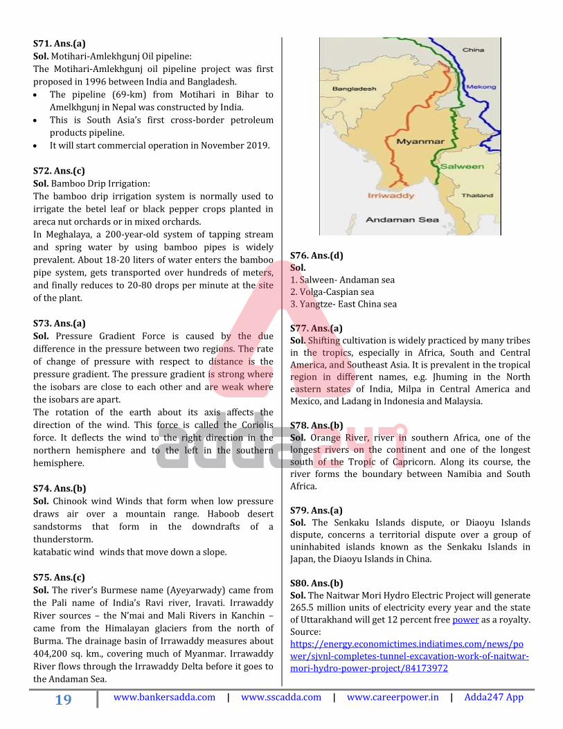
Sol. Motihari-Amlekhgunj Oil pipeline:
The Motihari-Amlekhgunj oil pipeline project was first
proposed in 1996 between India and Bangladesh.
• The pipeline (69-km) from Motihari in Bihar to
Amelkhgunj in Nepal was constructed by India.
• This is South Asia’s first cross-border petroleum
products pipeline.
• It will start commercial operation in November 2019.
S72. Ans.(c)
Sol. Bamboo Drip Irrigation:
The bamboo drip irrigation system is normally used to
irrigate the betel leaf or black pepper crops planted in
areca nut orchards or in mixed orchards.
In Meghalaya, a 200-year-old system of tapping stream
and spring water by using bamboo pipes is widely
prevalent. About 18-20 liters of water enters the bamboo
pipe system, gets transported over hundreds of meters,
and finally reduces to 20-80 drops per minute at the site
of the plant.
S73. Ans.(a)
Sol. Pressure Gradient Force is caused by the due
difference in the pressure between two regions. The rate
of change of pressure with respect to distance is the
pressure gradient. The pressure gradient is strong where
the isobars are close to each other and are weak where
the isobars are apart.
The rotation of the earth about its axis affects the
direction of the wind. This force is called the Coriolis
force. It deflects the wind to the right direction in the
northern hemisphere and to the left in the southern
hemisphere.
S74. Ans.(b)
Sol. Chinook wind Winds that form when low pressure
draws air over a mountain range. Haboob desert
sandstorms that form in the downdrafts of a
thunderstorm.
katabatic wind winds that move down a slope.
S75. Ans.(c)
Sol. The river’s Burmese name (Ayeyarwady) came from
the Pali name of India’s Ravi river, Iravati. Irrawaddy
River sources – the N’mai and Mali Rivers in Kanchin –
came from the Himalayan glaciers from the north of
Burma. The drainage basin of Irrawaddy measures about
404,200 sq. km., covering much of Myanmar. Irrawaddy
River flows through the Irrawaddy Delta before it goes to
the Andaman Sea.
S76. Ans.(d)
Sol. 1. Salween- Andaman sea 2. Volga-Caspian sea 3. Yangtze- East China sea
S77. Ans.(a) Sol. Shifting cultivation is widely practiced by many tribes
in the tropics, especially in Africa, South and Central America, and Southeast Asia. It is prevalent in the tropical region in different names, e.g. Jhuming in the North eastern states of India, Milpa in Central America and
Mexico, and Ladang in Indonesia and Malaysia.
S78. Ans.(b) Sol. Orange River, river in southern Africa, one of the longest rivers on the continent and one of the longest south of the Tropic of Capricorn. Along its course, the river forms the boundary between Namibia and South
Africa.
S79. Ans.(a)
Sol. The Senkaku Islands dispute, or Diaoyu Islands dispute, concerns a territorial dispute over a group of
uninhabited islands known as the Senkaku Islands in
Japan, the Diaoyu Islands in China.
S80. Ans.(b)
Sol. The Naitwar Mori Hydro Electric Project will generate 265.5 million units of electricity every year and the state
of Uttarakhand will get 12 percent free power as a royalty.
Source: https://energy.economictimes.indiatimes.com/news/po
wer/sjvnl-completes-tunnel-excavation-work-of-naitwar-
mori-hydro-power-project/84173972

20 www.bankersadda.com | www.sscadda.com | www.careerpower.in | Adda247 App
S81. Ans.(c)
Sol.
During the June solstice, places on the Arctic Circle
(latitude 66.56° north) will see the Sun just on the horizon
during midnight, and all places north of it will see the Sun
above the horizon for 24 hours. That is the midnight sun
or midsummer night sun or polar day. On the other hand,
places on the Antarctic Circle (latitude 66.56° south) will
see the Sun just on the horizon during midday, and all
places south of it will not see the Sun above the horizon at
any time of the day. That is the polar night. During the
December Solstice, the effects on both hemispheres are
just the opposite. This sees polar sea ice re-grow annually
due to lack of sunlight on the air above and surrounding
sea.
S82. Ans.(d)
Sol.
The subsolar point on a planet is the point at which its sun
is perceived to be directly overhead (at the zenith) that is,
where the sun's rays strike the planet exactly
perpendicular to its surface. It can also mean the point
closest to the sun on an astronomical object, even though
the sun might not be visible. To an observer on a planet
with an orientation and rotation similar to those of Earth,
the subsolar point will appear to move westward,
completing one circuit around the globe each day,
approximately moving along the equator.
The subsolar point contacts the Tropic of Cancer on the
June solstice and the Tropic of Capricorn on the December
solstice. The subsolar point crosses the Equator on the
March and September equinoxes.
S83. Ans.(a)
Sol. An equinox is an instant in time when the plane of
Earth's equator passes through the geometric center of
the Sun's disk. This occurs twice each year, around 20
March and 23 September. In other words, it is the
moment at which the center of the visible Sun is directly
above the equator.
In the Northern Hemisphere, the March equinox is called
the vernal or spring equinox while the September equinox
is called the autumnal or fall equinox. In the Southern
Hemisphere, the reverse is true. During the year,
equinoxes alternate with solstices. The dates of both
events slightly vary due to leap years and other factors
S84. Ans.(d)
Sol. Every planet in our solar system experiences
solstices. The timing and extent of solstices are largely
determined by the planet’s axial tilt, orbital eccentricity,
and distance from the sun. Orbital eccentricity essentially
determines the amount by which its orbit around another
body deviates from a perfect circle. Venus, the planet
closest to Earth, has a very small axial tilt, just 3°. Venus
experiences very little seasonal variation, and its solstices
are separated by about three months.
S85. Ans.(b)
Sol. Mizos practice what is known as ‘Jhum Cultivation.
They slash down the jungle, burn the trunks and leaves,
and cultivate the land. All their other activities revolve
around the jhum operations and their festivals are all
connected with such agriculture operations. Mim Kut
which takes place in August-September in the wake of
harvesting of the maize crop is celebrated with great
gaiety and merriment expressed through singing, dancing,
feasting, and drinking of homemade rice beer zu.
Pawl Kut is Harvest Festival – celebrated from December
to January. Again, a mood of thanksgiving is evident,
because the difficult task of titling and harvesting is over.

21 www.bankersadda.com | www.sscadda.com | www.careerpower.in | Adda247 App
S86. Ans.(a) Sol. Look at the map Only Odisha, Westbengal, Karnataka Tamilnadu, and Maharashtra have both the evergreen and tropical deciduous forest. Look at the Andhra Pradesh It is covered by an evergreen forest only
S87. Ans.(a) Sol. Trade winds are confined to the area near the equator, whereas Westerlies and Easterlies blow even beyond the sub-tropics. S88. Ans.(b) Sol. The trade winds are air currents closer to Earth’s surface that blow from east to west near the equator. The trade winds can be found about 30 degrees north and south of the equator. Right at the equator, there is almost no wind at all—an area sometimes called the doldrums. The Earth rotates as the air is moving, the winds in the Northern Hemisphere curve to the right and air in the Southern Hemisphere curves to the left because of the phenomenon called the Coriolis Effect and it’s why the trade winds blow toward the west in both the Northern Hemisphere and Southern Hemisphere.
S89. Ans.(c)
Sol. Earth's rotation causes the trade winds to curve
toward the west in the Northern Hemisphere and the east
in the Southern Hemisphere. The area of almost no wind
at the equator is called the doldrums
Right at the equator, there is almost no wind at all—an
area sometimes called the doldrums.
S90. Ans.(a)
Sol. Coastal lagoons form along gently sloping coasts
where barrier islands or reefs can develop off-shore, and
the sea level is rising relative to the land along the shore.
India has a vast coastline and the coast is very indented in
some states. Due to this, a number of lagoons and lakes
have formed.
Coastal lagoons do not form along steep or rocky coasts,
or if the range of tides is more than 4 meters. Due to the
gentle slope of the coast, coastal lagoons are shallow. A
relative drop in sea level may leave a lagoon largely dry,
while a rise in sea level may let the sea breach or destroy
barrier islands, and leave reefs too deep underwater to
protect the lagoon.
S91. Ans.(b)
Sol. The lithosphere is broken into a number of plates
known as the Lithospheric plates. The molten magma
inside the earth moves in a circular manner. These plates
move because of the movement of the molten magma
inside the earth. Lateral movements between lithospheric
plates create transform faults at the sites of plate slippage.
S92. Ans.(a)
Sol. The important tributaries of the Yamuna River are
Tons, Chambal, Hindon, Betwa, and Ken. Other small
tributaries of the Yamuna River include the Giri, Sind,
Uttangan, Sengar, and the Rind.

22 www.bankersadda.com | www.sscadda.com | www.careerpower.in | Adda247 App
S93. Ans.(d)
Sol.
1. Jawahar Sagar-Chambal
2. Tanakpur- Sarda(Uttarakhand)
3. Bargi-Narmada
4. Almati- Krishna
S94. Ans.(b)
Sol. Alfisols are moderately leached soils that have
relatively high native fertility. Alfisols are primarily found
in temperate humid and subhumid regions of the world.
The combination of a generally favorable climate and high
native fertility allows Alfisols to be very productive soils
for both agricultural and silvicultural use.
S95. Ans.(d)
Sol. The Vindhyas do not form a single range in the
proper geological sense: the hills collectively known as
the Vindhyas do not lie along an anticlinal or synclinal
ridge. The Vindhya range is actually a group of a
discontinuous chain of mountain ridges, hill ranges,
highlands, and plateau escarpments. The term "Vindhyas"
is defined by convention, and therefore, the exact
definition of the Vindhya range has varied at different
times in history.
Old Fold Mountains are characterized by having stopped
growing higher due to the cessation of upward thrust
caused by the stopping of movement of the tectonic plates
in the Earth's crust below them. In ancient times they
were extremely high but since have worn down almost
completely by millions of years of weathering. In contrast,
the Himalayas are continuously rising young fold
mountains of today.
S96. Ans.(c)
Sol. The line extends from the northernmost point of the
LOC (Line of Control) to Indira Col. The AGPL is
approximately 110 kilometres long. This line runs across
the edge of the Saltoro Ridge, which is a mountainous
plateau. The Indian soldiers hold on to the heights on the
ridge, preventing the Pakistani soldiers from climbing up
to the Saltoro Range heights.
S97. Ans.(c)
Sol. Both are correct
S98. Ans.(b)
Sol. A mid-ocean ridge (MOR) is a seafloor mountain
system formed by plate tectonics. It typically has a
depth of ~ 2,600 meters (8,500 ft) and rises about two
kilometers above the deepest portion of an ocean basin.
This feature is where seafloor spreading takes place along
a divergent plate boundary.
S99. Ans.(b)
Sol. The western region is drier as Monsoon winds
become moisture-less on reaching the western sides of
the sub-continent.
The elevation is not the reason, since the eastern
Himalayas has very high peaks up to nearly 7000 meters.
Moreover, at lower elevations, the Western ecoregion
grades into Himalayan subtropical pine forests. At higher
elevations, it grades into Western Himalayan subalpine
conifer forests as well as Northwestern Himalayan alpine
shrub and meadows and Western Himalayan alpine shrub
and meadows.

23 www.bankersadda.com | www.sscadda.com | www.careerpower.in | Adda247 App
S100. Ans.(a) Sol.
The nine-year-old war in Syria is currently raging in the northwestern province of Idlib, with rapidly escalating tensions between government forces of President Bashar al-Assad and the Turkish military. Assad has been pushing for weeks to recapture Idlib, which, along with parts of neighboring Hama, Latakia, and Aleppo, are the last remaining strongholds of the rebel opposition and other groups that have been attempting to overthrow Assad since 2011. Idlib skirts the two national highways and lies
between Aleppo in the north and Damascus in the south. Its proximity to the Turkish border makes Idlib strategically important to the Syrian government.