Tobermory, Northern Territory (Second Edition). 1:250 000 ...
65
NATIONAL GEOSCIENCE MAPPING ACCORD 1:250 000 Geological Map Series Explanatory Notes 2nd Edition TOBERMOREY SF 53-12 Northern Territory Geological Survey
-
Upload
khangminh22 -
Category
Documents
-
view
0 -
download
0
Transcript of Tobermory, Northern Territory (Second Edition). 1:250 000 ...

NATIONAL GEOSCIENCE MAPPING ACCORD
1:250 000Geological Map Series
Explanatory Notes2nd Edition
TOBERMOREY SF 53-12
NorthernTerritoryGeologicalSurvey

NORTHERN TERRITORY DEPARTMENT OF BUSINESS, INDUSTRY AND RESOURCE DEVELOPMENTNORTHERN TERRITORY GEOLOGICAL SURVEY
DEPARTMENT OF INDUSTRY, TOURISM AND RESOURCESGEOSCIENCE AUSTRALIA
Government Printer of the Northern Territory Darwin, October 2002
TOBERMOREY,NorthernTerritory(SecondEdition)
SheetSF53-12
1:250000 GEOLOGICAL MAP SERIESEXPLANATORYNOTES
PD KRUSE, AT BRAKEL, JN DUNSTER, and ML DUFFETT
NT
TOBERMOREYSF 53-12
QLD
TOBERMOREYALKEAALGAMBA
TARLTON MARQUA TOKO
SF 53-07 SF 53-08 SF 54-05
SF 54-09SF 53-11
SF 53-15 SF 53-16 SF 54-13
MOUNT WHELANHAY RIVERCREEK
HUCKITTA GLENORMISTON
RIVERSANDOVER
ILLOGWA
ELKEDRA URANDANGI
6253 6353 6453
6252 6352 6452

iiii
NORTHERN TERRITORY DEPARTMENT OF BUSINESS, INDUSTRY AND RESOURCE DEVELOPMENT
MINISTER: Hon Paul Henderson, MLA
CHIEF EXECUTIVE OFFICER: Peter Blake
NORTHERN TERRITORY GEOLOGICAL SURVEYDIRECTOR: Dr R Dennis Gee
BIBLIOGRAPHIC REFERENCE: Kruse PD, Brakel AT1, Dunster JN, and Duffett ML, 2002. Tobermorey, Northern Territory (Second Edition). 1:250 000 geological map series explanatory notes, SF 53-12. Northern Territory Geological Survey, Darwin and Geoscience Australia, Canberra (National Geoscience Mapping Accord).
(1:250 000 geological map series, ISSN 0814-7485)Bibliography
ISBN 0 7245 7049 7559.429
KEY WORDS: Geological mapping, Geophysical interpretation, Structural geology, Economic geology, Sedimentary geology, Stratigraphy, Northern Territory, Tobermorey, Palaeoproterozoic, Neoproterozoic, Cambrian, Ordovician, Jurassic, Cretaceous, Cenozoic, Arunta Province, Georgina Basin, Tarlton Fault, Marqua Monocline, Toomba Fault Zone, Mopunga Group, Keepera Group, Toko Group, Igneous intrusions.
For further information contact:Reference GeologistNorthern Territory Geological SurveyGPO Box 3000Darwin NT 0801Phone: +61 8 8999 5281Web site: http://www.dbird.nt.gov.au/ntgs
1 Formerly Australian Geological Survey Organisation (Geoscience Australia)
© Northern Territory Government 2002
Printed for the Northern Territory Geological Surveyby the Government Printer of the Northern Territory
DisclaimerThis information is provided on the understanding that the user agrees to release and indemnify the Northern Territory, the Commonwealth of Australia, companies who supplied and acquired the data, and their employees, agents and contractors, in respect of all liability for actions, claims, costs, expenses, loss, damage or injury, which may be suffered by them, or any other persons, arising from the use of the data, or as a consequence of any unlawful or negligent act or omission of the user.

ii iiiii
AbstrAct
TOBERMOREY1 includes portions of the Georgina Basin and Arunta Province. Outcrop of the Narwietooma Package of the Arunta Province is restricted to the southwestern corner and southern margin of TOBERMOREY. In the southwest, >1820 Ma migmatite (p_Cd) is widespread. Four recognised granite bodies intrude unit p_Cd. The Your Dam Metamorphics outcrop in the south-central map area; these are thought to have been metamorphosed in the period 1780-1720 Ma. Scattered Mount Tietkens Granite Complex intrudes near the southern sheet boundary. Limited geochronological data indicate an age of 1753 ± 7 Ma for one exposed granite. Granites penetrated in drillholes have yielded U-Pb SHRIMP zircon ages of 1846 ± 6 Ma, 1763 ± 4 Ma and 1749 ± 8 Ma.
Unmetamorphosed Georgina Basin sediments cover the bulk of the map area. Except near major faults, they are little deformed. A Neoproterozoic succession commences with deposits of both major Cryogenian glaciations; the Yardida Tillite and Black Stump Arkose correlate, respectively, with lower (Sturtian) and upper (Marinoan) glacial deposits of the Adelaide Rift. The dominantly marine Wonnadinna Dolostone, Gnallan-a-Gea Arkose, Elyuah Formation and Grant Bluff Formation succeed these units. These sediments were deposited initially in northwest-trending grabens controlled by major faults, such as the Tarlton Fault and Marqua Monocline-Toomba Fault Zone.
Cambrian deposition in TOBERMOREY commenced in the mid-Early Cambrian with the Red Heart Dolostone, a marine unit bearing calcimicrobial-archaeocyathan patch reefs. Two depositional sequences have been recognised in the Middle Cambrian. Sequence 1 is represented by the platformal marine Thorntonia Limestone. Sequence 2, which spans the remainder of the Middle Cambrian, is primarily Arthur Creek Formation. This unit includes a basal interval of anoxic, basinal pyritic-carbonaceous black shale, which constitutes a major potential petroleum source rock. The upper Arthur Creek Formation is of more typical aerobic carbonate deposited in normal marine waters. Quartzic dolostone and quartz sandstone of the Steamboat Sandstone complete sequence 2.
The Late Cambrian Arrinthrunga Formation is primarily peritidal. Cambro-Ordovician deposits consist of two principal depofacies: peritidally influenced, platformal marine carbonate rocks of the Ninmaroo Formation in the east, interfingering with terrigenous quartz-glauconite sandstone of the marine Tomahawk Formation in the west. The corridor of interfingering falls within TOBERMOREY.
A dominantly marine Early to Middle (to possibly Late) Ordovician succession is preserved in the Tarlton and Toko Ranges. From bottom to top, it consists of the Kelly Creek Formation, Coolibah Formation, Nora Formation, Carlo Sandstone, Mithaka Formation and Ethabuka Sandstone. This last formation may represent the initial pulse (Rodingan Movement) of the Alice Springs Orogeny.
The Early-Middle Devonian Cravens Peak beds may denote a second, mid-Devonian pulse (Pertnjara-Brewer Movements) of the Alice Springs Orogeny. The Orogeny culminated in the Carboniferous and was responsible for much of the present structure in the region.
Mesozoic (Jurassic-Cretaceous) quartz sandstone formerly blanketed the region, but is now confined to the southern map area as outliers of the Eromanga Basin.
Continental Cenozoic deposits indicate pedogenic and lacustrine (Austral Downs Limestone) and fluviatile (Poodyea Formation) environments.
The southern Georgina Basin is strongly prospective for petroleum, with excellent potential source rock and seal in the lower Arthur Creek Formation juxtaposed against potential reservoir dolostone in the underlying Thorntonia Limestone. The structurally complex southern basin margin has potential for Pb-Zn mineralisation and numerous occurrences have been identified. Diamonds are being actively sought in the region. In the Arunta Province, malachite has been recognised in the Mount Dobbie Granite and LPgc granite.
1 Names of 1:250 000 and 1:100 000 mapsheets are shown in large and small capital letters, respectively, eg TOBERMOREY, Tarlton. Note: A change in the name of the 1:250 000 mapsheet from Tobermory to Tobermorey was agreed by the Northern Territory and Auslig in 2002 following a query from Auslig. The incorrectly spelled First Edition mapsheet name was derived from the homestead name, which has always been known as Tobermorey (since being established in 1913). The name on the Second Edition mapsheet (released early 2003) was changed to agree with the feature name, but the hard-copy version of these notes was released prior to notification of the name change and used the original spelling. The revised name has been used throughout this 2008 CD ROM version, which is otherwise unchanged from the original 2002 text.
iviv
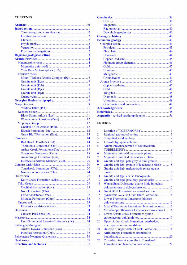
CONTENTS
Abstract ........................................................................... iiiIntroduction. ...................................................................... 1
Terminology and classification ................................... 2Location and access .................................................... 2Climate ........................................................................ 2Physiography ............................................................... 2Vegetation ................................................................... 2Previous investigations ............................................... 2
Regionalgeologicalsetting ............................................... 3AruntaProvince ................................................................ 4
Metamorphic rocks ......................................................... 4Migmatite unit (p–Cd) .................................................. 5Your Dam Metamorphics (p–Cy) ................................. 6
Intrusive rocks ................................................................. 6Mount Tietkens Granite Complex (LPg) ....................... 6Granite unit (LPga) ........................................................ 7Granite unit (LPgb) ....................................................... 7Granite unit (LPgc) ........................................................ 8Granite unit (LPgd) ....................................................... 8Quartz veins ................................................................ 8
GeorginaBasinstratigraphy ............................................ 9Neoproterozoic .................................................................... 9
Yardida Tillite (LPut)....................................................11Keepera Group ...............................................................11
Black Stump Arkose (LPus) .........................................11Wonnadinna Dolostone (LPuw) .................................. 12
Mopunga Group ............................................................ 12Gnallan-a-Gea Arkose (LPun) ..................................... 12Elyuah Formation (LPue) ............................................ 12Grant Bluff Formation (LPua) ..................................... 13
Cambrian ........................................................................... 14Red Heart Dolostone (–Cld) ....................................... 14Thorntonia Limestone (–Cmt) .................................... 15Arthur Creek Formation (–Cma) ................................ 17Steamboat Sandstone (–Cms) ..................................... 18Arrinthrunga Formation (–Cua) .................................. 19Eurowie Sandstone Member (–Cue) ........................... 20
Cambro-Ordovician .......................................................... 20Tomahawk Formation (–COt) ..................................... 20Ninmaroo Formation (–COn) ..................................... 24
Ordovician ......................................................................... 27Kelly Creek Formation (Olk) .................................... 27
Toko Group ................................................................... 29Coolibah Formation (Olc) ......................................... 29Nora Formation (Oln) ............................................... 31Carlo Sandstone (Omc) ............................................. 32Mithaka Formation (Omm) ....................................... 33
Ungrouped ..................................................................... 33Ethabuka Sandstone (Ome) ....................................... 33
Devonian ........................................................................... 34Cravens Peak beds (Dc) ............................................ 34
Mesozoic ........................................................................... 34Undifferentiated Jurassic-Cretaceous (JK) ............... 34
Palaeogene-Neogene ......................................................... 35Austral Downs Limestone (Cza) ............................... 35Poodyea Formation (Czp) ......................................... 36
Palaeogene-Neogene-Quaternary ..................................... 36Quaternary ......................................................................... 37Structureandtectonics. ................................................. 37
Geophysics ...................................................................... 38Gravity ...................................................................... 38Magnetics .................................................................. 39Radiometrics ............................................................. 40Downhole geophysics ............................................... 40
Geologicalhistory .......................................................... 40Economicgeology .......................................................... 43
Georgina Basin .............................................................. 43Petroleum .................................................................. 43Phosphate .................................................................. 44Diamonds .................................................................. 44Copper-lead-zinc ....................................................... 45Platinum group elements ........................................... 46Gold ........................................................................... 47Uranium .................................................................... 47Manganese ................................................................ 47Groundwater ............................................................. 47
Arunta Province ............................................................ 47Copper-lead-zinc ....................................................... 47Gold ........................................................................... 48Tungsten .................................................................... 48Diamonds .................................................................. 48Uranium .................................................................... 48Other metals and non-metals..................................... 48
Acknowledgments ........................................................... 48References ........................................................................ 48Appendix-revised stratigraphic units ............................. 56
FIGURES
1 Location of TOBERMOREY ..................................... 12 Regional geological setting ........................................ 33 Simplified solid geology ............................................. 44 Lithostratigraphic column .......................................... 55 Arunta Province terrane of southwestern TOBERMOREY ......................................................... 66 Migmatite unit p–Cd leucocratic phase ....................... 67 Migmatite unit p–Cd melanocratic phase..................... 78 Granite unit LP ga: pale grey to pink granite ................. 79 Granite unit LP gb: granite of leucocratic phase ........... 810 Granite unit LPgb: melanocratic phase quartz diorite .......................................................................... 811 Granite unit LPgc: coarse leucogranite ......................... 912 Granite unit LPgd: pale grey granodiorite .................... 913 Wonnadinna Dolostone: quartz-lithic intraclast dolopackstone to dolograinstone .............................. 1214 Grant Bluff Formation measured section ................. 1315 Synaeresis cracks in Grant Bluff Formation .............. 1416 Lower Thorntonia Limestone: bioclast dolowackestone ........................................................ 1517 Medial Thorntonia Limestone: bioclast coquina ...... 1618 Medial-upper Thorntonia Limestone erosive contact ......1619 Lower Arthur Creek Formation: pyritic- carbonaceous dololaminite ....................................... 1720 Upper Arthur Creek Formation: interbedded microsparstone and mudstone .................................. 1721 Outcrop of upper Arthur Creek Formation ............... 1822 Arrinthrunga Formation: stromatolite boundstone ................................................................ 2023 Cross-bed foreset azimuths in Tomahawk Formation and Ninmaroo Formation ........................ 21

iv viv
24 Tomahawk Formation: sublitharenite ....................... 2225 Tomahawk Formation partial measured section ....... 2326 Tomahawk Formation: deformation in quartz
sandstone .................................................................. 2327 Tomahawk Formation-Kelly Creek Formation measured section ...................................................... 2428 Ninmaroo Formation: stromatolite boundstone and bioclast-lithoclast grainstone ............................. 2529 Ninmaroo Formation: arthropod track in quartz sandstone ....................................................... 2530 Ninmaroo Formation: synaeresis cracks in dolomudstone ........................................................... 2631 Ninmaroo Formation: domical stromatolites ........... 2632 Ninmaroo Formation: ooid grainstone ..................... 2733 Measured section through Kelly Creek Formation, Nora Formation and Carlo Sandstone ...................... 2834 Kelly Creek Formation: granule conglomerate ........ 3035 Kelly Creek Formation: Cruziana and
Rusophycus ............................................................... 3036 Kelly Creek Formation: ?Gyrolithes ........................ 3037 Kelly Creek Formation: quartzic dolosparstone ....... 3138 Coolibah Formation: intraclast-bioclast grainstone-rudstone .................................................. 3139 Nora Formation: basal ferruginous echinoderm grainstone-rudstone .................................................. 32
40 Carlo Sandstone: arthropod scratch marks ............... 3341 Mithaka Formation: Rusophycus .............................. 3442 Austral Downs Limestone: silicified limestone ................................................................... 3543 Austral Downs Limestone: pedogenic alpha fabric .........................................................................3644 Austral Downs Limestone: pedogenic beta fabric .........................................................................3645 Schematic lithologs and downhole geophysical logs of TOBERMOREY drillholes ...................... 42-4346 Microdiamond and chromite grain locations in TOBERMOREY ....................................................... 4547 Lower Thorntonia Limestone: galena and
sphalerite in vug fill ................................................... 4648 Medial Thorntonia Limestone: sphalerite and platy organic matter in vug fill ................................... 46
TABLES
1 Pre-Quaternary lithostratigraphy of Georgina and Eromanga Basins .......................................... 10-112 Rock densities of lithostratigraphic units ................. 393 TOBERMOREY drillhole locations and available downhole geophysical data ...................................... 41

� �
135˚00' 139˚30'138˚00'136˚30'21˚00'
22˚00'
24˚00'
23˚00'
135˚00' 136˚30' 138˚00' 139˚30'
22˚00'
21˚00'
23˚00'
24˚00'
Que
ensl
and
Nor
ther
n T
errit
ory
0 25 50 100 km75
ArgadargadaSANDOVER
HIGHWAY
HIGHWAY
PLENTY HIGHW
AY
DONOHUE
URANDANGI MOUNT ISA
ROAD
Mount GuideGeorgina
SIMPSON DESERT
RIVER
Glenormiston
Linda Downs
RoxboroughDowns
Carandotta
Walgra
Tobermorey
Baikal
Jervois
Atula
MarquaHuckitta
Indiana
Lucy CreekArapunya
Ooratippra
HerbertDowns
AnnitowaPLENTY
RIVER
HAY
Lake Caroline
Creek
Marqua
m02-054.dgn
Ammaroo
RIVERSANDOVER
BUN
DEY
Derry Downs
Bybby
Creek
RIVER
GEO
RG
INA
Urandangi
MannersCreek
DownsTarlton
Downs
Major road Minor road Drainage Town, settlementHomestead
Figure 1 Location of TOBERMOREY
2 Subsequently renamed Australian Geological Survey Organisation (AGSO), now Geoscience Australia (GA).
IntroductIon
First Edition TOBERMOREY explanatory notes (Smith �965a) and map (published �966) were the result of fieldwork in 1958-1959 by the then Bureau of Mineral Resources (BMR)2, supplemented by stratigraphic drilling in �962 (Milligan �963) and �964 (Smith �972, Questa �994). The Geophysical Branch of BMR contributed road and helicopter gravity surveys in 1957-1961 (Barlow 1965, 1966), and an aeromagnetic survey of the map area in 1963-�964 (Wells et al �966).
The present Second Edition map incorporates portions of the existing BMR 1:100 000 Toko Preliminary Edition (Simpson et al 1979) and BMR-Geological Survey of Queensland (GSQ) 1:250 000 Hay River-Mount Whelan First Edition Special maps (Simpson et al 1985). Together, these account for one quarter of TOBERMOREY, including all of Toko and the southern half of Marqua. The remaining area was collaboratively remapped in 1999-2000 by Northern Territory Geological Survey (NTGS) geologists PD Kruse (TarlTon, Tobermorey, northern Marqua and eastern Alkea) and JN Dunster (Arunta Province in southwestern TarlTon), and AGSO geologist AT Brakel (Algamba and western Alkea). Colour aerial photographs at 1:50 000 scale provided the field base for this remapping.
PD Kruse wrote the bulk of these explanatory notes and acted as compiler. AT Brakel contributed to Cambro-Ordovician stratigraphy and Structure and tectonics from his field experience. JN Dunster wrote most of Economic geology, although PD Kruse prepared the section on Petroleum and contributed to Phosphate and Diamonds. ML Duffett wrote Geophysics other than the Downhole geophysics section. Groundwater was prepared using material contributed by Bob Read (Natural Resources Division, Department of Infrastructure, Planning and Environment, Alice Springs).
Cited locations in this publication are based on Map Grid of Australia zone 53 coordinates and the GDA94 map datum, and are deemed accurate to ± 50 m. Within the text, the Universal Grid Reference style is used as explained on the mapface (eg Niko Hill at MGA 745000E 7500000N is represented as QR450000). Full grid references are provided in tables. To convert from the AGD66 AMGs used on older maps, block shift all data 127 m to the east and �70 m to the north.
During Second Edition field mapping of TOBERMOREY, the United States Department of Defence ceased selective availability of its Global Positioning System (GPS) signal at midnight on 1 May 2000. In principle, civil users can now position themselves with a hand-held GPS receiver to within ± �0 m or better in ideal conditions (Crettenden 2000).
22
However, field experience during mapping was that the last two digits in both easting and northing could be unstable, and so quoted values for these digits in the present notes should not be relied upon.
Terminology and classification
Grainsize terminology follows Wentworth (�922). Sandstones are classified according to Folk (1974). Carbonate rock classification follows the revision of Wright (1992). The term quartzic, often used herein with regard to dolostones, indicates a significant but not dominant admixed detrital quartz component.
Location and access
TOBERMOREY is bounded by latitudes 22°00’S and 23°00’S, and longitudes 136°30’E and 138°00’E (Figure 1). This is a remote and sparsely populated area, with small Aboriginal communities at Warlpeyangrere and Urlampe, and station homesteads at Tarlton Downs, Marqua, Tobermorey and Manners Creek. Beef cattle grazing is the principal land use. The unsealed east-west Plenty Highway traverses the central map area and links Alice Springs, some 500 km to the west with Urandangi, Boulia and other centres in western Queensland to the east. Station tracks provide reasonable access, although the northwestern quadrant is virtually devoid of tracks and bores. Four-wheel drive access to the more rugged parts of the Toko Range can be difficult. Fuel and a campground are available at Tobermorey homestead. Fuel may also be obtained en route from Alice Springs at Jervois homestead. Elsewhere in the region, it is available at Alpurrurulam on the Sandover Highway (weekdays only), and at Urandangi, Boulia, Mt Isa and Camooweal in Queensland.
Climate
The climate is arid with median annual rainfall of 150-200 mm. Most falls in the summer months of October to March, but totals can vary greatly from year to year. Summers are hot, with mean maximum and minimum January temperatures of 36-39°C and 21-24°C, respectively. Winters are mild with mean maximum and minimum July temperatures of 21-24°C and 5-7°C respectively (Bureau of Meteorology 1988). The winter months of April to September are the most congenial for fieldwork.
Physiography
Tarlton Range in the southwest and Toko Range in the southeast of the map area are prominent plateau ranges consisting primarily of Ordovician rocks. Carbonate rocks in the upper Tomahawk Formation outcrop as prominent plateaux rimming the northern Tarlton Range. Lesser uplands are present in south-central TOBERMOREY, eg the Umberumbera Hills comprising the Ninmaroo Formation and Mesozoic rocks. The northern half of the map area is dominated by sand plains, particularly in the northwestern quadrant where the Tomahawk Formation is the source of much colluvial sand. This unit and the Ninmaroo Formation
in the northeast characteristically form low to moderate hills on the sand plains. There is an overall easterly fall in this northern area, so that the lowest elevation is around Tobermorey homestead. Flat sand plains also mask Arunta Province rocks in southwestern TOBERMOREY.
Drainage in the southwest is centred on the Hay River, which flows south-southeastward, parallel to the prevailing seif dune trend of the Simpson Desert. Drainage from the southern flank of the Toko Range enters the Field River, which likewise debouches into the Simpson Desert. Runoff from the northern flank of the Toko Range and adjacent areas to the north drains into the Georgina River system and ultimately into channel country in southwestern Queensland.
Vegetation
Two broad vegetation styles are recognised in TOBERMOREY (AUSLIG 1990). In both, the tallest stratum represents less than 10% of the total vegetation. In the area west of the Tarlton Range, the northwestern map area and the central Toko Range, tall open Acacia shrubland is developed on more sandy soils. Shrubs over 2 m high constitute the tallest stratum. These are dominantly Acacia, Eucalyptus, and some Hakea and Grevillea. Spinifex (especially Triodia pungens) is a common cover.
The remainder of the map area is of low open Acacia woodland. The tallest woodland stratum is typically less than �0 m high, of mixed desert acacias, eucalypts (such as Eucalyptus argillacea and E. terminalis) and, on more calcareous soils, gidgee (Acacia georginae). E. microtheca is characteristic of floodplains. The understorey is mainly of Acacia, Cassia and Carissa shrubs, or grasses such as Astrebla (Mitchell grass) and Dichanthium.
Previous investigations
Early geological investigations of the Georgina Basin, including TOBERMOREY, were summarised by Whitehouse (�936), who also commented on lithostratigraphy and expanded on an earlier initial biozonation (Whitehouse 1931). CT Madigan in 1935 was perhaps the first geologist to traverse TOBERMOREY (Madigan �937). Hossfeld (�954), in reviewing the geology of the Northern Territory, noted the presence of Ordovician rocks and fossils in the Tarlton and Toko Ranges. Noakes and Traves (1954) reviewed the geology of the Barkly region, of which TOBERMOREY is a part, and Noakes (1956) and Sprigg (1963) also dealt briefly with local geology. JN Casey (BMR) was apparently the first to record Cambrian fossils from the sheet area, while accompanying a CSIRO field party in 1954 (Casey and Gilbert-Tomlinson 1956).
The Georgina Basin was specifically surveyed by the then BMR and GSQ during 1957-1965. Within this programme, TOBERMOREY was systematically mapped in 1958-1959, resulting in the First Edition geological map (Smith and Vine �960, Smith et al �96�, Smith �965a). Smith (1972) summarised work in the Georgina Basin up to that date.
Concurrently, petroleum companies conducted initial investigations in the region from the late �950s. Mining

22 3
C
--
3
C
--
O
Cz
O
C
--
O
Cz
C--
2
C
--
2
C
--
3
Cz
C
--
2
C
--
3
O
C
--
2
C
--
2
O
C
--
3
C
--
O
C
--
1
Cz
Mz
PLg
MzPLg
PLg
PLg
PLg
PLgPLg
PLg PLg
PLg
PLg
PLgC
--
1
C
--
2 D
DPLg
O
C
--
O
PLg
C
--
3
Mz
PLg
PLg
PLg
PLg
C
--
3
C
--
3
CzC
--
2
C
--
3
O
C
--
OPLg C
--
1
O
C
--
3
C
--
2 Cz
D
Mz
C
--
3
PLg
D
PLuPLl
PLC
--
Palaeoproterozoic granite
ARUNTA PROVINCE, DAVENPORTPROVINCE, MOUNT ISA INLIER GEORGINA BASIN
Neoproterozoic
Lower Cambrian
Middle Cambrian
Upper Cambrian
Cenozoic
Devonian
Ordovician
Mesozoic
PLl
PLuPLu
PLu
PLl
PLl
PLu PLl
PLl
PLu
Mz
Mz
PLu
PLu PLu
D
PLg
O
PLC
--
PLC
--
PLl
C
--
O
Cambro-Ordovician
C
--
1
PLl
135˚00' 139˚30'138˚00'136˚30'21˚00'
22˚00'
24˚00'
23˚00'
135˚00' 139˚30 '
22˚00'
21˚00 '
23˚00 '
24˚00'136˚30' 138˚00'
m02-063.dgn
Neoproterozoic-Cambrianmetamorphic rocks
Palaeoproterozoic metamorphicrocks
Figure 2 Regional geological setting of TOBERMOREY
companies commenced metalliferous exploration in the early 1970s, and diamond exploration in the 1980s (see Economic geology).
The BMR pursued a fresh Georgina Basin project during the later 1970s and early 1980s (Druce 1974), including further drilling, selective remapping and directed research programmes.
regIonal geologIcal settIng
TOBERMOREY incorporates a significant portion of the southern Georgina Basin, as well as a small area of exposed basement metamorphic rocks and granites assigned to the Arunta Province (Figures 2, 3). This is consistent with extrapolation of the interpretation of Pietsch (2001) that indicates basement continuity with the >1820 Ma Arunta Province Narwietooma Package. The remaining basement in the northern two thirds of TOBERMOREY is regarded as being part of the subsurface Altjawarra craton of Myers et al (1996), referred to herein as the Altjawarra Domain. This domain is based on geophysical interpretations by Myers et al (1996) and Teasdale and Pryer (2002), who recognised a structurally distinct basement package
thought to be dominated by large mafic-intermediate intrusive bodies and younger non-magnetic granitoids. This region of thickened, stable crust with relatively low heat flow and low crustal temperatures underlies much of TOBERMOREY, SANDOVER RIVER, eastern HUCKITTA and northern HAY RIVER. In contrast with the Arunta Province to the south, the Altjawarra Domain resisted Proterozoic and Palaeozoic deformation and was only mildly reactivated during the Alice Springs Orogeny.
The adjacent, much younger Irindina Package occupies most of ILLOGWA CREEK and southern HUCKITTA and, from aeromagnetic interpretation (Ahmad 2002), extends eastward into west-central HAY RIVER, and thence further into southeastern HAY RIVER (Figure 2). Buick et al (2001a, 2001b) obtained SHRIMP U-Pb zircon ages from Irindina Package rocks on ALCOOTA and ALICE SPRINGS that suggest deposition in the late Neoproterozoic to early Cambrian. This package underwent granulite facies metamorphism during the Larapinta Event (Hand et al 1999) at 480-460 Ma (late Early and Middle Ordovician; Pietsch 2001, Scrimgeour and Raith 200�).
44
PLgb
PLgc
PLga
Oln
Omc
PLua
JK
JK
JK
JK
JK
JK
JK JK
JK
JKJK
JK
OlnOlcOlk
Oln
Omc
Omm
Oln
Olc
Omc
Olc
Czp
Omc
OmeOmm
OmcOln
Olk
Olk
Olk
PLua
PLunPLuw
PLgdPLg
PLg
PLus PLuw
PLus
PLut
PLusPLun
Olc
Olc
Omc
Olk
-
GEORGINA BASIN
Black Stump Arkose
m02-074.dgn
ARUNTA PROVINCE
Nora Formation
Your Dam Metamorphics
Yardida Tillite
Wonnadinna Dolostone
Gnallan-a-Gea Arkose
Grant Bluff Formation
Thorntonia Limestone
Arthur Creek Formation
Steamboat Sandstone
Arrinthrunga Formation
Tomahawk Formation
Ninmaroo Formation
Kelly Creek Formation
Coolibah Formation
Carlo Sandstone
Mithaka Formation
Ethabuka Sandstone
Cravens Peak beds
Austral Downs Limestone
Poodyea Formation
--
PLga
JK
PLgc
PLuw
C
--
ua
PLus
PLuw
Cza
CzaCza
Cza
Cza
Cza
Cza
Cza
C
--
ua
C
--
ua
C
--
maC
--
mt
C
--
ms
C
--
ua
C
--
ms
PLg
PLun
PLua
Omc
Omm
Ome
Cza
CzpOln
Olc
OlkPLgb
PLgd
C
--
mt
C
--
uaC
--
ma
migmatite
granite
granite
granite
granite
C
--
ma
Dc
PLut
Granite ComplexMount Tietkens
p Cd
p C
--
y
undifferentiatedJurassic-Cretaceous
Czp
Dc
C
--
OtC
--
OnC
--
Ot
C
--
Ot
C
--
Ot
C
--
Ot
C
--
On
C
--
On
C
--
On
C
--
On
C
--
OtOlk
C
-
On
C
--
On
C
--
Ot
22˚00’ 22˚00’
23˚00’23˚00’
136˚30’
136˚30’ 138˚00’
138˚00’
p C
--
d?
p C
--
d
p C
--
y
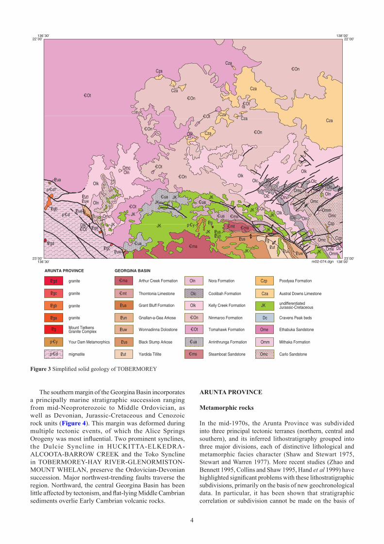
Figure 3 Simplified solid geology of TOBERMOREY
The southern margin of the Georgina Basin incorporates a principally marine stratigraphic succession ranging from mid-Neoproterozoic to Middle Ordovician, as well as Devonian, Jurassic-Cretaceous and Cenozoic rock units (Figure 4). This margin was deformed during multiple tectonic events, of which the Alice Springs Orogeny was most influential. Two prominent synclines, the Dulcie Syncline in HUCKITTA-ELKEDRA-ALCOOTA-BARROW CREEK and the Toko Syncline in TOBERMOREY-HAY RIVER-GLENORMISTON-MOUNT WHELAN, preserve the Ordovician-Devonian succession. Major northwest-trending faults traverse the region. Northward, the central Georgina Basin has been little affected by tectonism, and flat-lying Middle Cambrian sediments overlie Early Cambrian volcanic rocks.
arunta ProvInce
Metamorphic rocks
In the mid-1970s, the Arunta Province was subdivided into three principal tectonic terranes (northern, central and southern), and its inferred lithostratigraphy grouped into three major divisions, each of distinctive lithological and metamorphic facies character (Shaw and Stewart �975, Stewart and Warren �977). More recent studies (Zhao and Bennett �995, Collins and Shaw �995, Hand et al �999) have highlighted significant problems with these lithostratigraphic subdivisions, primarily on the basis of new geochronological data. In particular, it has been shown that stratigraphic correlation or subdivision cannot be made on the basis of

44 5
Figure 4 Lithostratigraphic column for TOBERMOREY. Wavy lines denote unconformities
metamorphic grade and deformation alone. Pietsch (2001) thereby proposed a stratotectonic subdivision of the province based on protolith assemblages, relationships, similar tectonic history and geochronology. His analysis did not extend east of �36°30’E, but it appears from current gravity and aeromagnetic data that his Narwietooma Package embraces all of the exposed Arunta Province in TOBERMOREY and extends southward into northwestern HAY RIVER (unit A5 of Ahmad 2000). This package comprises >1820 Ma rocks of mafic and felsic composition intercalated with pelitic and psammitic metasediments, the whole of which was metamorphosed to granulite facies in the period 1780-1720 Ma. In adjacent HUCKITTA (at least), coeval 1780-1760 Ma granites (Jervois Granite, Xanten Granite; unit g6 of Ahmad 2000) occur within the Narwietooma Package.
Migmatite unit (p–Cd)
This unnamed unit extends into the southwestern corner of TOBERMOREY from southeastern HUCKITTA, where it was first recognised, and continues southward into northernmost HAY RIVER. First Edition mapping interpreted it as possibly Archaean, but it is now regarded as more likely to be Palaeoproterozoic (Freeman 1986). It is bounded on the east by the Tarlton Fault and is therefore a component of the Jervois Block of Warren (1981: 5). Freeman (1986) described it as quartzofeldspathic gneiss, grading into biotite gneiss, with migmatite as concordant and discordant leucosomes in both. Feldspathic quartzite, schistose muscovite-bearing quartzite, schistose quartz-rich metasediment, biotite schist, layered magnetite-quartz rock, calc-silicate rock and megacrystic granitic gneiss are minor constituents in HUCKITTA.
As in HUCKITTA, most outcrops in TOBERMOREY are isolated exposures on extensive sand plains. The best outcrop is adjacent to the Tarlton Fault around PQ820680 to the south of Canyon Bore (Figure 5), where contiguous outcrop of leucocratic migmatite bears local rafts of black schistose amphibolite. Leucocratic rocks include deformed granodiorite and feldspar-quartz gneiss.
In thin section, granodiorite from PQ617828 comprises a plagioclase−quartz−K-feldspar mosaic ranging from coarsely to finely granular, with interstitial chlorite (at least some after biotite) and minor sericite. Plagioclase shows deformed twin lamellae and incipient sericitisation. Quartz shows strained extinction, especially in coarser crystals. Disseminated apatite and opaques are also present.
Plagioclase is much more sericitised in a feldspar-quartz gneiss from PQ568726 (Figure 6), in which it is intergrown with aggregates of quartz and microcline, with associated flaky biotite and muscovite. It forms relatively large crystals, with ragged margins, which are altered to sericite/clay and epidote with minor carbonate. Quartz, associated with microcline, constitutes a recrystallised, equigranular medium-grained mosaic with unit, undulose or semicomposite extinction of its components and showing a weak gneissic foliation.
The dark amphibolite (Figure 7) comprises a weakly foliated intergrowth of plagioclase laths and xenoblasts, and recrystallised prismatic hornblende, together with minor

66
Figure 5 View to north over Arunta Province terrane of southwestern TOBERMOREY: hill at left with surrounding foreground and middle ground is migmatite unit p–Cd; Keepera Ridges with Neoproterozoic succession on centre horizon; Tarlton Range with Ordovician succession prominent at right horizon; Tarlton Fault at base of range. TarlTon PQ828664, south of Canyon Bore
Figure 6 Migmatite unit p–Cd: feldspar-quartz gneiss of leucocratic phase. Scale bar = 2 mm. Photomicrograph C72822, crossed nicols; TarlTon PQ568726, near Tarlton Downs-Jervois boundary
aggregates of biotite and possibly retrograde muscovite. Plagioclase is variably altered to sericite, epidote and carbonate. Accessory, disseminated anhedral opaques are generally intergrown with hornblende or biotite. Foliation-parallel and crosscutting thin veins are of K-feldspar or quartz. These rocks are interpreted to represent basic igneous rocks, which have been metamorphosed to amphibolite grade.
Quartzitic rocks are also present, as at the peak of a prominent hill at PQ682747.
Your Dam Metamorphics (p–Cy)
This unit was proposed by Warren in Stewart et al (1980) for scattered outcrops of muscovite-feldspar-quartz granofels, schistose gneiss and schist in the vicinity of Your Dam in south-central TOBERMOREY. As mapped by Simpson et al (1985), outcrops are confined to lows between overlying Mesozoic rocks. These metasediments comprise variable proportions of muscovite, biotite, quartz, rare K-feldspar and accessory tourmaline (Warren 1981: 6). Warren postulated a depositional age of greater than 1800 Ma.
Intrusive rocks
Three granite units have been recognised in the TOBERMOREY-HAY RIVER region; these are the Mount Dobbie Granite, LPgt granite (both confined to HAY RIVER) and Mount Tietkens Granite Complex. Simpson et al (1985) implied that all three are approximately coeval. Four additional granite bodies (LPga to LPgd) were delineated during remapping in southwestern TOBERMOREY; these are described separately pending clarification of their genetic relationships. They were mapped as undifferentiated ?Palaeoproterozoic, dominantly coarse-grained muscovite granite by Smith (�965a).
Mount Tietkens Granite Complex (PLg )
The Mount Tietkens Granite Complex of Warren (in Stewart et al 1980; Teikens Granite Complex of Simpson et al 1985, Shergold 1985) is poorly defined. Its nominated reference area falls within a region mapped by Simpson et al (1985) as LPgt. Those authors do nevertheless map the complex: at 6 km south of Old Marqua and at Christmas Creek in the Marqua Monocline area, and much farther afield at the southern end of the Toomba

66 7
Figure 7 Migmatite unit p–Cd: amphibolite of melanocratic phase. Scale bar = 2 mm. Photomicrograph C72818, crossed nicols; TarlTon PQ547872, near Tarlton Downs-Jervois boundary
Figure 8 Granite unit LPga: pale grey to pink granite. Scale bar = 2 mm. Photomicrograph C72817, crossed nicols; TarlTon PQ828666, near Tarlton Downs-Jervois boundary
Fault in southwestern MOUNT WHELAN. The unit therefore appears to embrace all otherwise unassigned granite outcrops in the TOBERMOREY-HAY RIVER-MOUNT WHELAN region. Warren in Stewart et al (1980: 38) included within the unit an ‘older phase’ of medium even-grained muscovite-biotite leucocratic granite, and a ‘younger phase’ of porphyritic leucocratic granite, with associated tourmaline leucogranite and late-stage pegmatites. She quoted a K-Ar date on muscovite from an associated pegmatite of 1726 Ma, and Shergold (1985) a K-Ar date on an associated pegmatite at Christmas Creek of 1719 Ma. An intrusive age close to 1800 Ma was postulated (Warren in Stewart et al 1980).
In TOBERMOREY, possibly related granites have been penetrated in four drillholes. The closest to the mapped Mount Tietkens Granite Complex is BHD9 in the Marqua Monocline area, which intersected coarse, grey, feldspar-quartz-two mica granite from 537 m depth (McGeough and Shalley 1992). Grey feldspar-quartz-muscovite granite that was penetrated at 598 m depth in NTGS99/1, about 25 km to the west on Marqua Creek, has been dated by the SHRIMP U-Pb zircon method at 1846 ± 6 Ma (Andrew Cross, ANU, pers comm 2001). Granites intersected in Hacking 1 at 1222 m (Weste 1989) and Owen 2 at 1150 m depth (Kress 1991) have ages of 1749 ± 8 Ma and 1763 ± 4 Ma, respectively (A Cross, pers comm, 2002), and are tentatively included in the Mount Tietkens Granite Complex.
Granite unit (LPga)
This granite intrudes migmatite unit p–Cd, adjacent to the Tarlton Fault around PQ820680 to the south of Canyon Bore. It comprises medium-grained, pale grey to pink granite (Figure 8), which in thin section shows hypidiomorphic intergrowth of anhedral alkali feldspar (microcline) and quartz with subhedral plagioclase. Whereas microcline is relatively fresh, plagioclase is extensively altered to sericite, clay and minor epidote. Quartz exhibits both unit and undulose extinction. Biotite and muscovite occur as disseminated, randomly oriented flakes, and reddish-brown to black iron oxides as grains, aggregates and grain boundary and fracture linings. Apatite is present in trace amounts. Later-stage quartz ± feldspar veins of millimetre to decimetre scale probably relate to proximity to the Tarlton Fault.
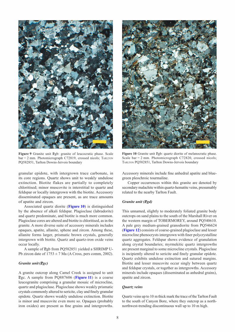
Granite unit (LPgb)
Granite unit LPgb forms isolated outcrops on sand plains around PQ580850 in the vicinity of Boundary Hill. Rock types are generally of undeformed medium-grained leucocratic (white) and more melanocratic phases (grey), altogether ranging from granite to quartz diorite. In thin section, granite from PQ582851 (Figure 9) consists of an equigranular intergrowth of anhedral microcline and quartz with weakly prismatic plagioclase. Plagioclase tends toward mild alteration to sericite, clay and finely
88
Figure 9 Granite unit LPgb: granite of leucocratic phase. Scale bar = 2 mm. Photomicrograph C72819, crossed nicols; TarlTon PQ582851, Tarlton Downs-Jervois boundary
Figure 10 Granite unit LPgb: quartz diorite of melanocratic phase. Scale bar = 2 mm. Photomicrograph C72820, crossed nicols; TarlTon PQ582851, Tarlton Downs-Jervois boundary
granular epidote, with intergrown trace carbonate, in its core regions. Quartz shows unit to weakly undulose extinction. Biotite flakes are partially to completely chloritised; minor muscovite is interstitial to quartz and feldspar or locally intergrown with the biotite. Accessory disseminated opaques are present, as are trace amounts of apatite and zircon.
Associated quartz diorite (Figure 10) is distinguished by the absence of alkali feldspar. Plagioclase (labradorite) and quartz predominate, and biotite is much more common. Plagioclase cores are altered and biotite is chloritised, as in the granite. A more diverse suite of accessory minerals includes opaques, apatite, allanite, sphene and zircon. Among these, allanite forms larger, prismatic brown crystals, generally intergrown with biotite. Quartz and quartz-iron oxide veins occur locally.
A sample of LPgb from PQ582851 yielded a SHRIMP U-Pb zircon date of 1753 ± 7 Ma (A Cross, pers comm, 2002).
Granite unit (LPgc)
A granite outcrop along Camel Creek is assigned to unit LPgc. A sample from PQ887606 (Figure 11) is a coarse leucogranite comprising a granular mosaic of microcline, quartz and plagioclase. Plagioclase shows weakly prismatic crystals commonly altered to sericite, clay and finely granular epidote. Quartz shows weakly undulose extinction. Biotite is minor and muscovite even more so. Opaques (probably iron oxides) are present as fine grains and intergrowths.
Accessory minerals include fine anhedral apatite and blue-green pleochroic tourmaline.
Copper occurrences within this granite are denoted by secondary malachite within quartz-hematite veins, presumably related to the nearby Tarlton Fault.
Granite unit (LPgd)
This unnamed, slightly to moderately foliated granite body outcrops on sand plains to the south of the Marshall River on the western margin of TOBERMOREY, around PQ540610. A pale grey medium-grained granodiorite from PQ546624 (Figure 12) consists of coarse-grained plagioclase and lesser microcline phenocrysts intergrown with finer polycrystalline quartz aggregates. Feldspar shows evidence of granulation along crystal boundaries; myrmekitic quartz intergrowths are present marginal to some microcline crystals. Plagioclase is incipiently altered to sericite and finely granular epidote. Quartz exhibits undulose extinction and sutured margins. Biotite and lesser muscovite occur singly between quartz and feldspar crystals, or together as intergrowths. Accessory minerals include opaques (disseminated as anhedral grains), apatite and zircon.
Quartz veins
Quartz veins up to 10 m thick mark the trace of the Tarlton Fault to the south of Canyon Bore, where they outcrop as a north-northwest-trending discontinuous wall up to 10 m high.

88 9
Figure 11 Granite unit LPgc: coarse leucogranite. Scale bar = 2 mm. Photomicrograph C72824, crossed nicols; TarlTon PQ887606, Camel Creek
Figure 12 Granite unit LPgd: pale grey granodiorite. Scale bar = 2 mm. Photomicrograph C72823, crossed nicols; TarlTon PQ546624, near Tarlton Downs-Jervois boundary
georgIna BasIn stratIgraPhy
neoproTerozoic
The Georgina Basin is a component of the formerly contiguous Centralian Superbasin (Walter et al �992, �995), together with the Savory, Officer, Amadeus and Ngalia Basins. Sedimentation in the Centralian Superbasin and Adelaide Rift commenced at about 800 Ma (Cryogenian; Zhao et al �994, Fanning et al 1986). Initial deposition in the southern Georgina Basin was in fault-bounded troughs, of which the Keepera and Adam Troughs (Walter 1980) are represented in TOBERMOREY (table 1).
Neoproterozoic rocks were conceptually excluded from the Georgina Basin (eg Smith �972) until their developmental continuity with Cambrian and younger rocks was recognised by Walter (1980) and Shergold and Druce (1980). Currently accepted lithostratigraphy is primarily that of Walter (1980), who revised and amplified the nomenclature of Smith (1964) and subdivided the Neoproterozoic succession into four hiatus-bound tectosomes [modified as sequences by Walter et al (�992) and supersequences by Walter et al (�994) and Walter et al (�995)]. Stidolph et al (1988) and Haines et al (�99�) recognised additional units in the southwestern Georgina Basin. The oldest supersequence, Supersequence � comprising the Yackah beds and Amesbury Quartzite, outcrops in adjacent HAY RIVER and HUCKITTA as well as further to the west, but not in TOBERMOREY.
Elements of the two immediately overlying supersequences ou tc rop in TOBERMOREY: Supersequence 2 (Yardida Tillite but not Mount Cornish Formation) and Supersequence 3 (Black Stump Arkose, Wonnadinna Dolostone, Gnallan-a-Gea Arkose, Elyuah Formation and Grant Bluff Formation, but not Oorabra Arkose, Sun Hill Arkose, Boko Formation, Elkera Formation, Central Mount Stuart Formation and Andagera Formation). Neither the Neoproterozoic nor the basal Cambrian constituents of Supersequence 4 (upper Central Mount Stuart Formation, possibly uppermost Elkera Formation; Mount Baldwin Formation, Adam Shale) are identified in TOBERMOREY.
The First Edition TOBERMOREY map and explanatory notes (Smith 1965a) included all pre-Grant Bluff Formation strata in the now defunct Field River beds of Smith (1963). Neoproterozoic rocks in the vicinity of the Marqua Monocline in southeastern TOBERMOREY (Adam Trough) have been revised and remapped on the Hay River-Mount Whelan Special sheet (Simpson et al 1985, Shergold 1985). Following Second Edition remapping along the Tarlton Fault, such rocks are now known to outcrop at three additional localities in southwestern TOBERMOREY (Keepera Trough); these include the Keepera Ridges and two unnamed hills, one near the Plenty Highway at PQ571924 and another at PQ949573 near Limestone Creek. All three localities are bounded by the Tarlton Fault and its offshoots.

�0�0
table 1 Pre-Quaternary lithostratigraphy of Georgina and Eromanga Basins in TOBERMOREY and environs
UNIT, MAP SYMBOL,MAX THICKNESS
LITHOLOGY DEPOSITIONALENVIRONMENT
BASAL CONTACT CHARACTERISTIC FEATURES
CENOZOICPoodyea Formation(Czp) 10 m
Cobble and boulderconglomerate, pebblysandstone
Fluviatile channel Unconformable on Oln,Omc, Omm, Ome, Dc
Low- to high-angle cross-beds
Austral DownsLimestone (Cza) 8 m
Limestone, silicified tochert and chalcedony
Terrestrial brackishlacustrine, pedogenic
Unconformable on_COn, Olk
Rhizoliths, alveolar texture, soilglaebules, circum- and intragranularcracks, brecciation; plateau-forming
MESOZOICUndifferentiatedJurassic-Cretaceous(JK) 30 m
Quartz sandstone, minormudstone andconglomerate
Terrestrial, cool watermarine
Unconformable on mostolder units
Cross-beds, ferruginisation, plantfossils; mesa-forming
DEVONIANCravens Peak beds (Dc)280 m
Calcareous sandstone andsiltstone, limestone, minorconglomerate; gradesupward into quartzsandstone andconglomerate
Shallow subtidalmarine, offshoresandbar, beach, non-marine braidedfluviatile
Unconformable onOmm, Ome
Fish and invertebrate fossils
ORDOVICIANEthabuka Sandstone(Ome) 1147 m
Quartzose andquartzofeldspathicsandstone, siltstone,claystone
High-energy barrier,lower-energy subtidalmarine
Conformable andgradational on Omm
Clay pellets, cross-laminations,ripples, load casts, current structures,invertebrate fossils, ichnofossils
Mithaka Formation(Omm) 156 m
Gypsiferous shale andsiltstone, calcareoussiltstone, quartz sandstone,glauconitic and micaceousquartz sandstone, minorcoquinite, granuleconglomerate
Low-energy lagoonalmarine
Conformable andgradational on Omc
Invertebrate fossils, conodonts,ichnofossils including enormousRusophycus
Carlo Sandstone (Omc)190 m
Quartzose sandstone,minor feldspathicsandstone
Littoral, high-energyshallow marine
Conformable andgradational on Oln
Basal clay pellet bed; currentstructures, thick cross-bed sets,ripples, ichnofossils; caps Tarlton andToko Ranges
Nora Formation (Oln)250 m
Micaceous and glauconiticsiltstone, claystone,sandstone, minordolostone; basal coquinite
Low-energy intertidalto shallow subtidalmarine, possiblybelow wave base
Conformable on Olk,Olc
Invertebrate fossils; recessive, formsscarp of Tarlton and Toko Ranges
Coolibah Formation(Olc) 110 m
Limestone, quartziclimestone, dolostone, marl,siltstone, basal sandstone
Intertidal to shallowsubtidal marine
Conformable on Olk Lenticular chert, silicified microbialmounds, stromatolites, invertebratefossils, conodonts
Kelly Creek Formation(Olk) 290 m
Quartzose and dolomiticquartz sandstone, siltstone,dolostone, partiallydolomitised limestone,minor conglomerate
Peritidal to opensubtidal marine
Conformable on _COt,_COn in TOBERMOREY;disconformable onkarstified _COn,Georgina Limestone inGLENORMISTON-MOUNT WHELAN
Current structures, mud pebble andcobble mould horizons, ripples, low-angle cross-beds, granule beds,stromatolites, invertebrate fossils,conodonts, ichnofossils; plateau- andmesa-forming
CAMBRO-ORDOVICIANNinmaroo Formation(_COn) 795 m
Limestone, dolostone,minor quartz sandstone
Subtidal open marine,restricted marine,peritidal
Disconformable on _Cua Synaeresis features, flat-pebbleconglomerate, cross-beds includingherringbone, stromatolites,invertebrate fossils, conodonts, joints;laterally interfingers with _COt
Tomahawk Formation(_COt) 190 m
Quartzose and glauconiticsandstone, minordolostone, limestone,dolomitic quartz sandstone,conglomerate
Subtidal open marine,restricted marine,littoral to sublittoral
Disconformable on _Cua Cross-beds, ripples, currentstructures, flat-pebble conglomerate,ichnofossils, invertebrate fossils,conodonts, mesoscale deformation ofsandstone beds; interfingers laterallywith _COn
CAMBRIANArrinthrungaFormation (_Cua) 975 m
Dolostone, limestone,minor quartz sandstone,siltstone, shale, marl,conglomerate
Peritidal, restrictedshallow subtidalmarine
Conformable on _Cma,_Cms
Stromatolites, thrombolites, nodularevaporites, gypsum crystals,fenestrae; local karst at top
Eurowie SandstoneMember (_Cue) 60 m
Quartz sandstone, quartzicdolostone
Intermittentlyemergent hypersalineshoreline
Transitional within _Cua Abundant halite hopper casts; ripples,cross-laminations, gypsum crystals

�0�0 ��
table 1 (continued)
Yardida Tillite (LPut)
The glacigene Yardida Tillite (Walter 1980) is correlated with the Sturtian glaciation in the Adelaide Rift (Preiss et al 1978). It comprises mainly green-grey diamictite, laminated siltstone and minor fine to very coarse (rarely pebbly) quartz sandstone and arkose. Locally, the formation culminates in a 100 m-thick interval of grey, laminated dolomitic shale containing lenticular dolostone, interpreted as a postglacial cap dolostone. The formation outcrops extensively in the Field River Anticline, which extends southeastward into HAY RIVER. Using data derived from this latter area, Walter (1980) constructed a composite type section, incorporating measured sections, drillholes and seismic traverses, to yield an estimated thickness of 2900 m. In the absence of exposed contacts, Walter inferred a disconformable relationship with the underlying Yackah beds; the contact with the overlying Black Stump Arkose is likewise disconformable.
Keepera group
Black Stump Arkose (LPus)
Red-brown to purple brown micaceous, fine to very coarse (to pebbly) arkose, sandstone and laminated micaceous mudstone of the Black Stump Arkose (Walter 1980) are correlated with the Marinoan glaciation in the Adelaide Rift. They are interpreted as proximal glacial outwash deposits resulting from rapid erosion and mass transport (Walter et al �995, Walter and Veevers �997). The composite type section of Walter (1980), which has an estimated minimum thickness of 700 m, is located in northeastern HAY RIVER. In TOBERMOREY, the unit is exposed to the south of the Marqua Monocline between Old Marqua and Boat Hill. At Boat Hill, it rests disconformably on the uppermost dolomitic shale of the Yardida Tillite (Walter 1980); elsewhere this interval may be absent. The upper boundary of the formation is gradational into the Wonnadinna Dolostone.
unIt, MaP syMBol, Max thIcKness
lIthology dePosItIonal envIronMent
Basal contact characterIstIc Features
steamboat sandstone(_Cms) 80 m
Quartzose and calcareous/dolomitic quartz sandstone, quartzic dolostone
High-energy marine barrier
Conformable on _Cma; possibly disconformable on Quita Formation in URANDANGI-GLENORMISTON
Some cross-beds
arthur creek Formation (_Cma) 457 m
Upper: dolostone, limestone Lower: foetid pyritic-carbonaceous black shale, laminated dolostone
Upper: open to restricted subtidal marine Lower: deeper anoxic marine
Disconformable on _Cmt Nodular evaporite, shredded to brecciated texture, invertebrate fossils, disseminated pyrite
thorntonia limestone(_Cmt) �03 m
Limestone, dolostone; medial pyritic-carbonaceous black shale interbeds; basal terrigenous sandstone, greywacke, mudstone
Open to restricted subtidal marine
Disconformable on _Cldor older units; nonconformable on LPg
Nodular chert, nodular evaporite, phosphate and glauconite lithoclasts, bitumen, disseminated pyrite, invertebrate fossils
red heart dolostone(_Cld) �9 m
Dolostone, minor quartzic dolostone, mudstone, conglomerate; basal dolomitic quartzofeldspathic sandstone
Subtidal marine Disconformable on Adam Shale, Mount Baldwin Formation or older units
Archaeocyathan-calcimicrobial patch reefs, invertebrate fossils, pyrite and rare galena, mesophase bitumen; Diplocraterion in basal sandstone; microkarstic upper surface
neoProteroZoIc grant Bluff Formation(LPua) ��70 m
Quartz sandstone/quartzite, glauconitic quartz sandstone, mudstone
Marine Conformable on LPun, PLLPue
Ripples, cross-beds, synaeresis features, mud pebble horizons; forms prominent strike ridges
elyuah Formation (LPue) 2�0 m
Mudstone, siltstone; thin basal sandstone or pebbly arkose
Marine Disconformable on LPuw, Oorabra Arkose
Interfingers with LPun
gnallan-a-gea arkose(LPun) �450 m
Pebbly arkose, sandstone, siltstone, shale
Marine Disconformable on LPuw Cross-stratification
Wonnadinna dolostone(LPuw) 460 m
Dolostone, quartzic dolostone
Intertidal, shallow to deep marine
Conformable and gradational on LPus
Oncoids, fenestrae, stromatolites, flat pebbles
Black stump arkose(LPus) 700+ m
Micaceous (to pebbly) arkose, sandstone, micaceous mudstone
Proximal glacial outwash
Disconformable on LPut
yardida tillite (LPut) 2900 m
Diamictite, siltstone, dolomitic shale, dolostone, minor quartz sandstone, arkose
Glaciogene, postglacial
Disconformable on Yackah beds
G:\Geological Survey\Publishing\Production\NTGS_250k_explan_notes_update\Updated_NTGS_250k_explan_notes\Tobermory\Tobermory_Archive\Tob_PM\Tob_Table1_p2.doc

�2�2
Figure 13 Wonnadinna Dolostone. Quartz-lithic intraclast dolopackstone to dolograinstone; brown tabular dolomudstone clasts at bottom. Scale bar = 2 mm. Photomicrograph C75142, crossed nicols; TarlTon PQ953575, near Blue Hills Bore
Wonnadinna Dolostone (LPuw)
Gradationally overlying the Black Stump Arkose is the Wonnadinna Dolostone (Wonnadinna Dolomite of Walter 1980), a unit of purple-red to yellow-brown and green-grey, locally quartzic dolostone, interbedded with more or less dolomitic arkose, siltstone and shale. The dolostone locally bears abundant oncoids, fenestrae and possible columnar stromatolites, and according to Walter et al (1995), is unlike correlative postglacial cap dolostones elsewhere. Domical and saucer-shaped stromatolites and flat pebbles are present in dolostone along the Marqua Monocline, to the northwest of Boat Hill (QQ711658). A bed in the Keepera Ridges (PQ782756) includes abundant flat dolomudstone pebbles and associated clots of galena.
The formation is 460 m thick in the composite type section in northeastern HAY RIVER and is at least 380 m near Boat Hill and in the Keepera Ridges in TOBERMOREY. In the type section, the lower boundary is at the base of the first prominent dolostone bed, 4.7 km north-northeast of Gnallan-a-Gea Bore (Walter 1980).
Correlative cap dolostones in adjacent Centralian basins were interpreted by Kennedy (1996) as deeper water deposits (below storm wave base) resulting from an anomalous flux of inorganic carbonate to the sea floor during postglacial transgression. An example from the uppermost Olympic Formation of the Amadeus Basin (Figure 5A of Kennedy 1996) shows millimetre-scale graded quartzic dolomudstone beds interleaved with fibrous cement and cut by subvertical neptunian fractures. A lithologically similar dolostone from an unnamed hill near Limestone Creek (southwestern TOBERMOREY) shows a tendency toward grading in thin section, wherein dolomudstone beds with ghost peloidal textures and admixed quartz silt and minor muscovite coarsen toward their bases via the addition of angular to subangular, medium silt- to fine sand-sized detrital quartz. Although bedding-parallel cement layers are absent, subvertical, possibly neptunian fractures are present, now infilled by ferruginous ferroan dolomite and gypsum. Tabular dolomudstone clasts from such rocks can be reworked into quartz-lithic intraclast dolopackstone to dolograinstone (Figure 13).
The Wonnadinna Dolostone may thus mark deeper water as well as intertidal to shallow subtidal deposition (fenestrae, oncoids).
Mopunga group
The term Mopunga Group was coined by Noakes (1956) without named constituent formations, and later redefined by Smith (1964) and Walter (1980).
Gnallan-a-Gea Arkose (LPun)
In TOBERMOREY the Gnallan-a-Gea Arkose (Walter 1980) outcrops in the Keepera Ridges and south of the Marqua Monocline, where Walter (op cit) measured thicknesses of 10 m and 40 m, respectively. It attains 345 m in the type section in the Field River Anticline (northeastern HAY RIVER), and at least 1450 m in the Bat Hills further south.
The formation comprises brown to grey, fine to very coarse pebbly arkose, sandstone, siltstone and shale. Cross-stratification is common in the arkose and sandstone. The lowest pebbly arkose or sandstone denotes the lower boundary with the underlying Wonnadinna Dolostone, which Walter (1980) inferred from regional correlations to be disconformable.
The Gnallan-a-Gea Arkose is gradational upward variously into the overlying Elyuah Formation or Grant Bluff Formation. At the northern end (PQ771763) of the prominent ridge of the Keepera Ridges to the east of Arthur Creek, the Grant Bluff Formation rests directly and conformably on metre-scale beds of orange-brown pebbly Gnallan-a-Gea Arkose; 1.3 km to the southeast along the same ridge, grey mudstone of the Elyuah Formation intervenes.
Elyuah Formation (LPue)
The Elyuah Formation (Smith 1964) was redefined by Walter (1980) to exclude the then constituent Oorabra Arkose Member (Smith 1964 after Joklik 1955), which he elevated to formation status. As redefined, the Elyuah Formation is predominantly of laminated shale and siltstone with a thin but persistent basal sandstone or pebbly arkose. The 36 m-thick type section of Smith’s (1964: 23-24) former ‘shale member’ is near the southeastern extremity of the Dulcie Range in HUCKITTA; Walter (1980) presented additional measured

�2�2 �3
metres250
PQ775749
200
150
100
50
PQ7717630
ARKOSE
GR
AN
T B
LUF
F F
OR
MA
TIO
N
FAULT
CLIFF: light grey medium-coarse
fine glauconitic quartz sandstone,thinly bedded
orange-brown pebbly arkose,thickly bedded
CLIFF: light grey fine quartzsandstone, weathering tored-brown, thinly bedded
light grey flat pebble conglomeratebed, 5 cm thick, weathering to red- brown
thickly bedded, planar-laminated to mm- to cm-scale rippled
sandstone
cream to light grey quartzite, thickly bedded
GNALLAN-A-GEA
light grey quartzite, mediumbedded
white coarse to granule quartz
m02-045.dgn
red/yellow-brown siltstone,weathering to dark brown, medium bed
55 225
28 230
42 230
22 265
40 225
synaeresis features
tabular intraclasts
cross-beds
ripples
PQ77875170 265
quartzite, thinly-thickly bedded
CLIFF: quartz sandstone, thinly to
Figure 14 Measured section through Grant Bluff Formation. Grid locations, and measured dips and dip azimuths are shown at left. TarlTon PQ771763 to PQ775749, Keepera Ridges
sections in the range 80-210 m thickness. In HUCKITTA the grey, green or red shale is commonly veneered by colluvium, so that the basal pebble conglomerate, of milky quartz and minor lithic pebbles in a quartz arenite matrix, is commonly the only outcropping portion of the formation (Freeman 1986).
The formation is likewise obscured in the Keepera Ridges on TOBERMOREY, where Walter (1980) measured a maximum thickness of 210 m. There, colluvium shed from the conformably overlying Grant Bluff Formation veneers a discontinuous northeast-facing scarp slope with limited exposure of Elyuah Formation. Perhaps the best outcrop is toward the southern end of the prominent ridge to the east of Arthur Creek, at PQ779754: a 23 m interval of laminated to thinly bedded grey mudstone and minor purple micaceous quartzic siltstone, with thin interbeds of grey to brown, very fine to fine quartz sandstone. Conversely, at the northern end of the same ridge, around PQ771763, the scarp slope is predominantly of orange-brown pebbly Gnallan-a-Gea Arkose and there are only short outcrop intervals of Elyuah-type thinly bedded grey mudstone. These observations collectively suggest interfingering between the two formations.
Grant Bluff Formation (Pua)
Walter (1980) revised the Grant Bluff Formation of Smith (�964) to exclude the recessive upper interval, which he named the Elkera Formation. The thus restricted Grant Bluff Formation is nevertheless widespread; it extends from ALCOOTA to HAY RIVER and ranges in thickness from 50-100+ m in HUCKITTA up to 1170 m in HAY RIVER. The unit outcrops as prominent strike ridges of distinctive laminated to medium undulose-bedded quartz sandstone/quartzite with micaceous partings; the sandstone is medium to coarse and has common centimetre-scale (rarely up to decimetre-scale), asymmetric and some symmetric ripples, small- to large-scale trough cross-beds and dewatering structures including synaeresis features (Freeman 1986). Feldspar grains are a local minor constituent, as is glauconite. Mud pebble and clay granule horizons are locally present. Jenkins et al (�992) recorded the ichnofossils Palaeophycus tubularis Hall and Planolites montanus Richter from the type section in the Elua Range (HUCKITTA); these simple horizontal trails are consistent with the terminal Neoproterozoic age assigned to the formation.
In TOBERMOREY, the Grant Bluff Formation outcrops in two small fault-bounded blocks at an unnamed hill 2 km north of the Plenty Highway at PQ571924, and as the characteristic prominent strike ridges in the Keepera Ridges. A nearly complete section to the east of Arthur Creek in the latter area, which is truncated at the top by an offshoot of the Tarlton Fault, is 248 m thick (Figure 14). As in the Elua Range, it comprises two boldly outcropping sandstone ridges separated by a medial, relatively recessive interval of interbedded, thinly bedded, glauconitic fine quartz sandstone and mudstone. Large-scale synaeresis cracks are prominent on bedding surfaces of the stratigraphically higher sandstone ridge
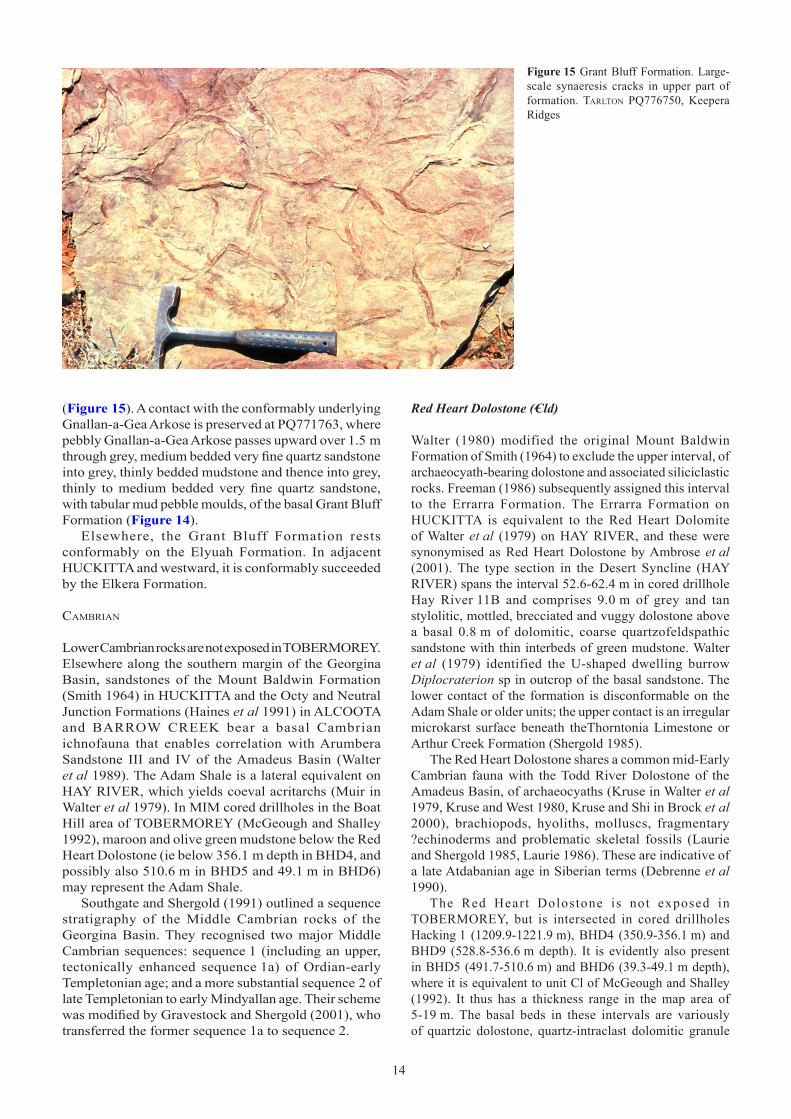
�4�4
Figure 15 Grant Bluff Formation. Large-scale synaeresis cracks in upper part of formation. TarlTon PQ776750, Keepera Ridges
(Figure 15). A contact with the conformably underlying Gnallan-a-Gea Arkose is preserved at PQ771763, where pebbly Gnallan-a-Gea Arkose passes upward over 1.5 m through grey, medium bedded very fine quartz sandstone into grey, thinly bedded mudstone and thence into grey, thinly to medium bedded very fine quartz sandstone, with tabular mud pebble moulds, of the basal Grant Bluff Formation (Figure 14).
Elsewhere, the Grant Bluff Formation rests conformably on the Elyuah Formation. In adjacent HUCKITTA and westward, it is conformably succeeded by the Elkera Formation.
cambrian
Lower Cambrian rocks are not exposed in TOBERMOREY. Elsewhere along the southern margin of the Georgina Basin, sandstones of the Mount Baldwin Formation (Smith 1964) in HUCKITTA and the Octy and Neutral Junction Formations (Haines et al �99�) in ALCOOTA and BARROW CREEK bear a basal Cambrian ichnofauna that enables correlation with Arumbera Sandstone III and IV of the Amadeus Basin (Walter et al 1989). The Adam Shale is a lateral equivalent on HAY RIVER, which yields coeval acritarchs (Muir in Walter et al 1979). In MIM cored drillholes in the Boat Hill area of TOBERMOREY (McGeough and Shalley �992), maroon and olive green mudstone below the Red Heart Dolostone (ie below 356.1 m depth in BHD4, and possibly also 510.6 m in BHD5 and 49.1 m in BHD6) may represent the Adam Shale.
Southgate and Shergold (�99�) outlined a sequence stratigraphy of the Middle Cambrian rocks of the Georgina Basin. They recognised two major Middle Cambrian sequences: sequence � (including an upper, tectonically enhanced sequence 1a) of Ordian-early Templetonian age; and a more substantial sequence 2 of late Templetonian to early Mindyallan age. Their scheme was modified by Gravestock and Shergold (2001), who transferred the former sequence �a to sequence 2.
Red Heart Dolostone (–Cld)
Walter (1980) modified the original Mount Baldwin Formation of Smith (�964) to exclude the upper interval, of archaeocyath-bearing dolostone and associated siliciclastic rocks. Freeman (1986) subsequently assigned this interval to the Errarra Formation. The Errarra Formation on HUCKITTA is equivalent to the Red Heart Dolomite of Walter et al (1979) on HAY RIVER, and these were synonymised as Red Heart Dolostone by Ambrose et al (2001). The type section in the Desert Syncline (HAY RIVER) spans the interval 52.6-62.4 m in cored drillhole Hay River ��B and comprises 9.0 m of grey and tan stylolitic, mottled, brecciated and vuggy dolostone above a basal 0.8 m of dolomitic, coarse quartzofeldspathic sandstone with thin interbeds of green mudstone. Walter et al (1979) identified the U-shaped dwelling burrow Diplocraterion sp in outcrop of the basal sandstone. The lower contact of the formation is disconformable on the Adam Shale or older units; the upper contact is an irregular microkarst surface beneath theThorntonia Limestone or Arthur Creek Formation (Shergold 1985).
The Red Heart Dolostone shares a common mid-Early Cambrian fauna with the Todd River Dolostone of the Amadeus Basin, of archaeocyaths (Kruse in Walter et al 1979, Kruse and West 1980, Kruse and Shi in Brock et al 2000), brachiopods, hyoliths, molluscs, fragmentary ?echinoderms and problematic skeletal fossils (Laurie and Shergold 1985, Laurie 1986). These are indicative of a late Atdabanian age in Siberian terms (Debrenne et al �990).
The Red Heart Dolostone is not exposed in TOBERMOREY, but is intersected in cored drillholes Hacking 1 (1209.9-1221.9 m), BHD4 (350.9-356.1 m) and BHD9 (528.8-536.6 m depth). It is evidently also present in BHD5 (491.7-510.6 m) and BHD6 (39.3-49.1 m depth), where it is equivalent to unit Cl of McGeough and Shalley (1992). It thus has a thickness range in the map area of 5-19 m. The basal beds in these intervals are variously of quartzic dolostone, quartz-intraclast dolomitic granule

�4�4 �5
Figure 16 Thorntonia Limestone. Bioclast dolowackestone of lower light grey interval. Pyrite (black) is disseminated and stylolite- and fracture-associated. Scale bar = 2 mm. Photomicrograph C72846, crossed nicols; 588.1 m depth in drillhole NTGS99/1; Marqua QQ470743
conglomerate, or marly mudstone with abundant admixed lithoclasts (including granite-derived quartz and feldspar in Hacking 1). In the overlying grey to pink dolostone, pyrite commonly (and galena rarely) fills vugs and lines fractures (see Economic geology).
Hydrocarbon-bearing fluid inclusions in the Red Heart Dolostone in drillhole Hay River 11A (HAY RIVER) have homogenisation temperatures of 174-225°C (Wilkins in Shergold 1979a, 1979b). Wilkins in Shergold (1979b) applied an unspecified pressure correction and calculated a minimum temperature of 250°C for crystal growth. The same samples also contain mesophase bitumen. This has been used as a palaeothermal indicator of 400-470°C (Taylor in Shergold 1979a, Shergold 1985) or >200°C (Chapman 200�). However, it may also form partly as a result of natural radioactivity. In contrast, migrated bitumens studied in the Arthur Creek Formation and Thorntonia Limestone in Owen 2 are considerably less mature. Several contain humic acid that only occurs in very immature bitumens. The most mature pyrobitumen has a reflectivity of 1.38-1.44% (Glikson in Kress 1991).
Thorntonia Limestone (–Cmt)
Lower Middle Cambrian strata in TOBERMOREY are exposed along the Marqua Monocline in the Boat Hill area (Simpson et al 1985). They were initially assigned to the Marqua beds (Smith and Vine �960, Smith �963), a provisional unit that included all Middle Cambrian rocks in the immediate region, and later to the Hay River Formation (Shergold in Walter et al �979). The type section of the latter is in cored drillholes Hay River 11, 11A and 11B in the Desert Syncline (HAY RIVER), where three constituent numbered ‘members’ were recognised. Shergold (1985) subsequently modified the formation concept to embrace a greater thickness of strata in three discrete packages, portrayed by Donnelly et al (1988) as an Ordian-age ‘Lower Hay River Formation’, an early Templetonian ‘Upper Hay River Formation Member 1’ and a Floran-Undillan ‘Upper Hay River Formation Member 2’. In the nomenclatural rationalisation of Ambrose et al (200�), the last unit was included as part of the Arthur Creek Formation (which see), whereas the first two were retained in the Thorntonia Limestone. The name Hay River Formation was abandoned.
The Thorntonia Limestone (Öpik 1956) is extensive around the eastern (Queensland) margin of the Georgina Basin and extends as far south as cored drillhole GSQ Mount Whelan 1 (Green and Balfe 1980) in MOUNT WHELAN. No type section has been designated, but a type area is implied in the Thorntonia area in CAMOOWEAL. Reference sections have been nominated by Shergold and Southgate (1986: 19), who also provided detailed regional descriptions. The formation includes grey limestone, partially dolomitised limestone and dolostone with chert nodules and minor phosphorite. It is richly fossiliferous, with a varied biota of trilobites including Redlichia, Xystridura, Pagetia, Peronopsis and questionable Onaraspis, brachiopods, hyoliths including Guduguwan hardmani, bradoriides, echinoderms, molluscs, chancelloriids, calcimicrobes and stromatolites, to which Shergold et al (1985) assigned an Ordian (early Middle Cambrian) age (Whitehouse
1939, 1941, Öpik 1968, 1970, 1975, Jell 1975, Shergold 1975b, 1981, Schmitt and Southgate 1982, Kruse 1990; sequence � of Southgate and Shergold �99�). A maximum 103 m thickness has been reported in Morstone 1 petroleum exploration well in CAMOOWEAL (Stewart and Hoyling �963). The formation has a gradational lower contact on the Colless Volcanics (Early Cambrian) or on a variously named basal terrigenous siliciclastic interval. Where these are absent, it rests unconformably on Proterozoic rocks (Shergold and Druce 1980).
In addition to the limited outcrop, the Thorntonia Limestone is entirely intersected in six TOBERMOREY cored drillholes. From east to west these are Owen 2 (1053.3-1150.2 m), BHD4 (301.9-350.9 m), BHD5 (456.0-491.7 m), BHD9 (484.9-528.8 m), Tobermorey 14 (85.3-109.5 m; Gibson 1984) and NTGS99/1 (554.7-598.4 m depth), giving a thickness range in the map area of 24-97 m. In these drillholes the unit rests disconformably on the Red Heart Dolostone or nonconformably on Palaeoproterozoic granite (see Mount Tietkens Granite Complex). A medial dark, siliciclastic mud-rich interval imparts a stratigraphically successive light-dark-light grey colouration to the carbonate portion of the formation and this is generally recognisable in drillholes across the southern Georgina Basin. All three intervals exhibit disseminated pyrite. A basal terrigenous interval is locally present (eg 5 m of dolomitic feldspathic greywacke with basal arkosic pebble conglomerate directly overlying granite in Owen 2).
�6�6
Figure 17 Thorntonia Limestone. Bioclast coquina of dark medial interval. Packstone of hyolith conchs and some opercula (mainly Guduguwan hardmani) at bottom. Wackestone of phosphatic hyolith steinkerns at top. Scale bar = 2 mm. Photomicrograph C72845, crossed nicols; 575.2 m depth in drillhole NTGS99/�; Marqua QQ470743
Figure 18 Thorntonia Limestone. Erosive contact between phosphatic and glauconitic, bioclast-intraclast-peloid dolograinstone of upper light grey interval (above) and marly dolomudstone of medial interval. Phosphatic grains in upper interval include originally phosphatic lingulate brachiopods (light brown) and phosphatised hyolith steinkerns (dark brown). Scale bar = 2 mm. Photomicrograph C72844, plane polarised light; 558.7 m depth in drillhole NTGS99/1; Marqua QQ470743
The lower light grey interval comprises planar- to nodular-bedded dolostone with ghost grainstone texture or admixed siliciclastic mud; bioclast (trilobite, brachiopod, echinoderm) dolowackestone to dolopackstone (Figure 16); brecciated dolostone including lithoclast dolopackstone; and basal quartzic (and locally glauconitic) dolostone with breccia of carbonate and granitic granules to pebbles. Some lithotypes are foetid, mottled, stylobedded or concretionary, and may enclose lithoclast conglomerate, bioclast coquina or nodular evaporite.
The darker medial interval embraces a similar suite of carbonate lithotypes including nodular anhydrite, but with common interbeds of foetid dark grey to black marl and pyritic carbonaceous mudstone. Also present are thin bioclast coquinas (Figure 17), intraformational conglomerates of reworked tabular dolomudstone, and tracts of black (phosphatic?) sand to granules, together with evidence of submarine hardground development, such as thin phosphatised crusts. Elevated Total Organic Carbon (TOC) values in this interval indicate source rock potential (see Petroleum). This and the underlying light grey interval of the Thorntonia Limestone become more siliciclastic southward, as is evident in drillholes Hay River ��, ��A and 11B (Shergold 1985).
The upper light grey interval equates with the ‘Upper Hay River Formation Member 1’ of Donnelly et al (1988). In the Marqua Monocline drillholes (Tobermorey 14,
NTGS99/1 and BHD holes) and in Hay River 11, 11A and 11B, it is a relatively thin (0.5-6.2 m) phosphatic and glauconitic bioclast intraclast peloid dolopackstone to dolograinstone that has an erosive lower contact on the medial interval (Figure 18). Bioclasts include coarse sand and granules of lingulate brachiopods, fragmentary trilobites (including Xystridura, Pagetia and Peronopsis), echinoderm ossicles (prone to phosphatisation), and hyoliths (dominantly Guduguwan hardmani) and their phosphatic steinkerns. A Templetonian age was attributed by Shergold (1985) and an early Templetonian age by Donnelly et al (1988). This unit is now a dolosparstone, with bitumen occluding intercrystal porosity, particularly toward the top of the formation, where a microkarstic surface is locally evident. In Owen 2, the upper interval is apparently much thicker (27 m) and contains additional, locally amalgamated black terrigenous silt laminations, pyritic carbonaceous dolostone intervals and thin, sand to granule intraclast-bioclast conglomerate.
Altogether, this upper light grey interval may correlate with the apparently coeval Bronco Stromatolith Bed (Southgate 1986), a distinctive, thin (1-30 cm) marker bed of limonite-stained, stratiform to low-domical stromatolites that directly overlies an irregular and indurated erosion surface at the top of the Thorntonia Limestone in

�6�6 �7
Figure 19 Arthur Creek Formation. Pyritic-carbonaceous dololaminite of lower interval. Laminations are highlighted by variations in proportions of organic matter and clays (dark) versus fine xenotopic dolomite spar, quartz silt and bedding-subparallel muscovite (light). Scale bar = 2 mm. Photomicrograph C72843, crossed nicols; 530.0 m depth in drillhole NTGS99/�; Marqua QQ470743
Figure 20 Arthur Creek Formation. Centimetre-scale sedimentary-boudinaged interbeds of lime mud (now pale microsparstone) and dolomitic-siliciclastic mudstone (dark) of upper interval. Rounded dolospar-filled areas in microsparstone are burrows. Scale bar = 2 mm. Photomicrograph C72851, crossed nicols; 835.6 m depth in drillhole Hacking 1; Marqua QQ054745
CAMOOWEAL. PN Southgate (quoted in Gravestock and Shergold 200�: �24) has most recently reinterpreted this bed as a product of submarine erosion. The present upper interval would then represent the former sequence �a of Southgate and Shergold (1991), since transferred by Gravestock and Shergold (200�) to sequence 2.
Arthur Creek Formation (–Cma)
Smith (1964) coined the Arthur Creek beds to encompass all strata between the Mount Baldwin Formation (then understood to include what is now the Red Heart Dolostone) and the Arrinthrunga Formation in HUCKITTA. Freeman (1986) revised this interval as the Arthur Creek Formation, using as type section two cored drillholes NTGS HUC� and NTGS HUC2; these gave a notional thickness of 417.6 m. However, comparison with more recent Pacific Oil and Gas drillholes casts some doubt on the claimed stratigraphic overlap of HUC� and HUC2. In addition, the interval immediately above 70.7 m depth in HUC2 is here regarded as Steamboat Sandstone. A replacement holostratotype section is therefore nominated here and spans the interval 103.2-554.7 m in cored drillhole NTGS99/� (see Appendix). This drillhole is one of the thickest available intersections of the formation
(45�.5 m), and also includes the immediately underlying and overlying formations (Thorntonia Limestone and Steamboat Sandstone, respectively). Altogether, the formation is disconformably underlain by Thorntonia Limestone or where this is absent, by Red Heart Dolostone. Exceptionally, it is nonconformable on Palaeoproterozoic granite in Randall 1 (HUCKITTA). The maximum known thickness of the Arthur Creek Formation (483+ m) is intersected in BHD9 in TOBERMOREY.
The Arthur Creek Formation replaces the former Sandover beds in ELKEDRA (Stidolph et al 1988), and in TOBERMOREY, the Marqua Formation and ‘Upper Hay River Formation Member 2’ of Donnelly et al (1988; Ambrose et al 200�). However, these two latter units do correspond to two informal subdivisions of the Arthur Creek Formation (cf Shergold 1985: 10-11); these are a lower interval of deeper water, foetid pyritic-carbonaceous black shale with planar to undulose dolostone laminations (anaerobic facies of Stidolph et al 1988); and an upper interval of paler carbonate exhibiting dolomudstone to dolograinstone textures (aerobic facies of Stidolph et al 1988). The transition is abrupt in NTGS99/1, in which the lower and upper intervals are respectively 272.� m and 179.4 m thick; elsewhere the transition may be gradational or interdigitating. Overall, the formation denotes an initial rapid

1818
Figure 21 Arthur Creek Formation. Centimetre-scale interbeds of calcimudstone (pale grey) and dolomitic-siliciclastic mudstone (brown) of upper interval. Compare with Figure 20. Toko QQ705664, Marqua Monocline north of Boat Hill
transgression and the onset of anoxic conditions, succeeded by gradual regression into more aerobic marine conditions above wave base.
The lower, black shale interval is readily oxidised and leached, and consequently is poorly exposed. In some areas, as for example flanking the Davenport Province in ELKEDRA, near-surface chertification leaves tabular rubble, in which the trilobite Xystridura is prominent (Plate 6 of Stidolph et al 1988). Pristine laminites in this interval (Figure 19), as intersected in cored drillholes, comprise millimetre-scale laminations highlighted by variations in the proportions of organic matter and clays (dark) versus fine xenotopic dolomite spar, quartz silt and bedding-subparallel muscovite (light). Grading within lamination couplets and the absence of bioturbation led Morris (1986) to interpret these rocks as anoxic rhythmites. Patchy early diagenetic carbonate forms remnant dolostone nodules within these otherwise burial-compressed laminites. The proportion of carbonate decreases toward the base of the formation, where foetid pyritic-carbonaceous black shale constitutes viable petroleum source rock (see Petroleum). Pelagic agnostine trilobites and benthic lingulate brachiopods and sponge spicules are locally present. Disseminated pyrite of microbial origin (Ferris 2000) occurs throughout the interval. Some pyrite replaces sponge spicules or occurs as epigenetic nodules and veinlets. Superimposed thin (centimetre-scale) granule to pebble intraclast, intraclast-bioclast and quartz sandstone beds, some with scoured bases, have been interpreted as turbidity current deposits (Morris 1986).
The upper, paler carbonate interval represents subtidal restricted marine shelf deposition above wave base. It is predominantly of light grey dolomicrosparstone and dolosparstone with recurring ghost grainstone textures, alternating with more or less nodular (sedimentary boudinaged) centimetre-scale calcimudstone-siliciclastic mudstone interbeds (Figure 20). Sedimentary and diagenetic features include admixed quartz silt to sand, wisps to thin interbeds of darker siliciclastic silt, bioturbation, stylobeds, disseminated and fracture-lining pyrite, nodular evaporite, and shredded to brecciated textures due to evaporite
dissolution and collapse. Bioclasts are common. The upper interval is also poorly exposed, but locally outcrops as light grey platy limestone or dolostone (Figure 21).
Common quartzic interbeds in more easterly drillholes, such as NTGS99/� and Owen 2, record intermittent terrigenous sand pulses that were presumably derived from a source further to the east. Quartz sand input peaks around the lower-upper transition in both drillholes. In Owen 2, the transition is marked by breccias of sand- to cobble-sized tabular dolostone in a darker grey siliciclastic matrix; these are interpreted as debris flows.
Altogether, the Arthur Creek Formation is richly fossiliferous and yields a variety of miomeran and polymeran trilobites, lingulate and calciate brachiopods, hyoliths, molluscs, echinoderms and sponge spicules. Trilobites indicate an age ranging from Templetonian (pre-Triplagnostus gibbus Zone; Laurie 2000a) up to the Boomerangian Lejopyge laevigata Zone, ie latest Middle or early Late Cambrian (Marqua Formation of Shergold 1985: 11; Shergold 1995, cf Geyer and Shergold 2000). The formation thus spans most of the Middle Cambrian and constitutes a large part of sequence 2 (Southgate and Shergold �99�).
Steamboat Sandstone (–Cms)
Smith (�972) and Shergold et al (1985) have summarised the Steamboat Sandstone (Noakes et al �959) of the URANDANGI-GLENORMISTON area. There, outcrop of the formation consists of 60-80 m thickness of calcareous sandstone and quartz sandstone with minor quartzic grainstone and dolostone, possibly disconformable on Quita Formation and undoubtedly conformable beneath Mungerebar Limestone. Agnostine and polymeran trilobites indicate an age within the terminal Middle Cambrian Lejopyge laevigata Zone, extending to the Middle-Late Cambrian passage Zone of Damesella torosa-Ascionepea janitrix (Shergold et al 1985).
Correlative fine quartz sandstone, which is exposed between the Arthur Creek and Arrinthrunga Formations in the vicinity of Eurolley Bore in eastern HUCKITTA, is taken to be a decalcified equivalent of quartzic dolostone

1818 �9
occurring at the same stratigraphic level in numerous southern Georgina Basin drillholes, and is thus assigned here to the Steamboat Sandstone.
The Steamboat Sandstone was formerly recognised in outcrop in the Marqua Monocline area of TOBERMOREY as unit –Cmm2 (Simpson et al 1985). This unit was stated by Shergold (1985) to be up to 60 m thick. It is also delineated in TOBERMOREY cored drillholes Hacking 1 (718.6-752.9 m), NTGS99/1 (86.4-103.2 m) and Owen 2 (643.5-692.7 m depth), giving a confirmed thickness range of 17-49 m. This interval comprises generally recrystallised grey dolostone with admixed quartz sand to granules, dolomitic granule intraclasts, darker siliciclastic mud wisps to interbeds, small-scale cross-beds and planar to wavy stylolites.
Arrinthrunga Formation (–Cua)
The Arrinthrunga Formation (Smith �964) is widespread across the southern Georgina Basin and extends from eastern BARROW CREEK eastward to TOBERMOREY, northern HAY RIVER and westernmost MOUNT WHELAN (Reynolds 1968). The Meeta beds (Smith 1972), formerly recognised in ELKEDRA, SANDOVER RIVER, FREW RIVER and AVON DOWNS, are synonymous (Kennard 1981). The Arrinthrunga Formation is primarily a peritidal unit; correlative marine sedimentary rocks from elsewhere in Queensland are referred to the Georgina Limestone, which laterally interfingers with it (see Shergold et al 1985: 14). The formation includes well bedded limestone and dolostone, and minor interbedded quartz sandstone, siltstone and shale. It attains 800-900 m thickness (maximum 975 m; Smith 1972: 104) in HUCKITTA. Quartz sandstone in the medial part of the formation is assigned to the Eurowie Sandstone Member (see below).
The nominated type section in the Elua Range in HUCKITTA (Smith 1964) was determined by Kennard (1980) to be structurally complex, with a faulted base and with additional medial portions faulted out, so that only about one third of the total interval is represented. Kennard (1980) therefore nominated a reference section GEO 802 in the nearby southern Dulcie Range area.
Due to its deposition in peritidal environments, the formation is very sparsely fossiliferous. Its stratigraphic position conformably and gradationally above the Arthur Creek Formation (or Steamboat Sandstone where present), and disconformably below the Tomahawk Formation or Ninmaroo Formation, brackets the unit within the Late, but not latest Cambrian. Among the rare trilobites, brachiopods, hyoliths and molluscs reported, the stratigraphically lowest appears to be a single trilobite pygidium from basal beds at Black Tank in the Marqua Monocline; this indicates an age close to the Middle-Late Cambrian boundary (Shergold 1985). The precise age of the uppermost beds of the Arrinthrunga Formation is uncertain, but the youngest fauna in the laterally interfingering Georgina Limestone provides a proxy upper age limit of Iverian (mid-Late Cambrian) Irvingella tropica Zone (Shergold in Green and Balfe 1980).
Beneath the Tomahawk Formation, the top of the Arrinthrunga Formation is an at least locally karstic erosion surface as is shown by an irregular topography infilled by
sediment of the overlying unit, plus associated pisoids and cavity-fill breccia. However, the disconformity is difficult to identify where overlain by the Ninmaroo Formation, as the mixed carbonate rock types above and below it are similar. In drillholes BMR 12 Cockroach and PAP Netting Fence 1, it is recognised at a marked change in downhole geophysical log characteristics (Kennard 1981: 5).
Kennard (1981) documented the following component rock types: microbial (‘algal’) (dolo)boundstone, including thrombolitic, columnar, columnar-domical and various laminated types; peloid (dolo)grainstone and lesser packstone and wackestone, including ripple cross-laminated peloid (dolo)grainstone; ooid (dolo)grainstone; minor flat-pebble conglomerate; minor calci/dolomudstone with variable terrigenous silt and clay content, as well as pseudomorphs of gypsum crystals and nodular evaporite; mixed mudstone (marl); mixed sandstone (quartzic lime/dolostone); and minor quartz sandstone (see Eurowie Sandstone Member below). These constitute the elements of eight discrete lithofacies, of which four dominate exposures along the Marqua Monocline in TOBERMOREY; these are, from base to top, the peloid grainstone, peloidal lime-mud, and intermixed laminated microbial (‘algal’) boundstone and microbial (‘algal’) mound lithofacies (Kennard 1981: fig 14). A basal cross-stratified peloid grainstone and dolostone unit mapped by Simpson et al (1985) coincides with the lowest, and perhaps also part or all of the next succeeding lithofacies of Kennard (1981); Shergold (1985: 14) observed that this mapped basal unit is overlain by a mainly microbial boundstone lithofacies. Two complete measured sections of the formation in this area are respectively 777 m and 914 m in thickness (Kennard 1980).
The basal beds of the formation are exposed in a north-south transect, 9 km to the east of Old Marqua homestead at QQ497729. There, scattered blue-grey thin-bedded calcimudstone and grey/brown nodular limestone of the uppermost Arthur Creek Formation are overlain by much more closely spaced limestone beds, including some Steamboat Sandstone (quartzic carbonate rocks), then basal Arrinthrunga Formation mainly of locally centimetre-scale cross-bedded ooid-peloid grainstone (peloid grainstone lithofacies). About 4 km east of Marqua homestead, the succeeding peloidal lime-mud lithofacies is represented by stylobedded peloidal dolomudstone at QQ392754.
Outcrops in the vicinity of Smiths Dam (QQ240830) illustrate a variety of lithofacies. At QQ242834, 500 m north of the bore, a 2 m-thick slope section exposes basal light grey, brown-mottled dolomicrobialite, which is succeeded by light grey grainstone, followed by intraclast wackestone at the top. A further 400 m to the north at QQ241839 (and also west of the bore at QQ180830; Figure 22), columnar stromatolites are well exposed on bedding planes. At QQ213828 to the west of the bore, microbial laminite with late-diagenetic siliceous nodules is exposed at the base of an isolated hill of Jurassic-Cretaceous quartz granule conglomerate and claystone.
The Arrinthrunga Formation was deposited on an extensive, very shallow, restricted carbonate platform, which was bordered in the west and north by an evaporitic, mixed carbonate-siliciclastic shoreline (Kennard 1981: 26).

2020
This platform was subjected to intermittent local emergence. The formation thus records a general shoaling from a more open subtidal setting (upper Arthur Creek Formation) through a probably low, yet wide seaward high-energy barrier (Steamboat Sandstone, ooid-peloid grainstone of the basal Arrinthrunga Formation in the Marqua Monocline area) into characteristically restricted, shallow subtidal to peritidal conditions. Hypersalinity on the platform limited grazing skeletal invertebrates and so permitted microbial mats to flourish, forming planar, wavy, domical and columnar stromatolites, according to depth and hydrodynamic conditions. Gypsum and nodular evaporites (anhydrite) precipitated in intertidal to supratidal flats. Siliciclastic mud to fine sand was shed onto the platform from the hinterland. Kennard (1981: 30) postulated a rapid sea-level rise in mid-Arrinthrunga time, leading to the wide establishment of the microbial mound lithofacies on the platform. Quartz sandstone and mixed ooid-quartz sandstone lithofacies are surmised to have migrated across the platform as shoaling resumed, culminating in intermittent emergence and the reestablishment of hypersalinity (Eurowie Sandstone Member). Stromatolites continued to propagate in areas bypassed by the terrigenous sediments. This cycle of sea-level rise and shoaling was repeated before regression exposed the platform and subjected its carbonate blanket to karstification.
Among drillholes in the region, the Arrinthrunga Formation is intersected in TOBERMOREY drillholes Hacking 1, NTGS99/1, Owen 2, Lucy Creek 1 and BMR 12 Cockroach. Of these, the thickest intersection is in Lucy Creek 1, which records a complete thickness of 715 m (Pemberton 1967). Hacking 1 preserves a 468 m cored interval of the lower and medial portions of the formation (including the Eurowie Sandstone Member). As in other drillhole intersections throughout the southern Georgina Basin, the formation in Hacking 1 is a compendium of thin lithotype intervals marking the geologically rapid lateral and vertical environmental shifts of a peritidal platform. These lithotypes include grey silty, mottled and stylonodular calcimudstone; intraclast and quartzic lime/dolostone; dark grey siliciclastic mudstone; and centimetre-scale interbeds of light grey calcimudstone and dark grey or green siliciclastic mudstone. Fenestrae, small-scale cross-beds, thin intraformational granule intraclast (including flat pebble) and lithoclast conglomerates, wavy microbial laminites and domical and columnar stromatolites are recurrent, as are nodular evaporites and disrupted, mottled and shredded evaporite dissolution textures. Coarser, bed-specific dolomitisation has rendered many intervals porous to vuggy.
Kennard (1981: 3) also confirmed the presence of the Arrinthrunga Formation in BMR 12 Cockroach and Lucy Creek 1 in TOBERMOREY. Eastward, the formation is recognised in PAP Netting Fence 1 (GLENORMISTON; Smith 1972: 108).
Eurowie Sandstone Member (–Cue)
Quartz sandstone and quartzic dolostone in the medial Arrinthrunga Formation in eastern HUCKITTA (Freeman 1986) and southeastern ELKEDRA (Stidolph et al 1988) are attributed to the Eurowie Sandstone Member (Smith �964). In HUCKITTA, this member is generally 40-60 m thick (Kennard 1981: 24). It includes rippled and cross-laminated quartz sandstone with abundant hopper casts after halite, and outcrops as medium to thick beds and lenses. Gypsum crystals and laminae, and nodules probably after anhydrite are also present, as are bevelled ripples, dolostone pebble clasts and parting and streaming lineations. An intermittently emergent hypersaline shoreline depositional environment is indicated.
Kennard (1981) reported the member in Lucy Creek 1 in TOBERMOREY, where it is 28 m thick. A 29 m thick, more or less quartzic dolostone with nodular evaporites in Hacking 1, in the interval 269.5-298.5 m depth, is also attributed to the Eurowie Sandstone Member.
cambro-ordovician
Tomahawk Formation (–COt)
The Tomahawk beds (Smith 1964) are here formalised as the Tomahawk Formation. The type section and lower boundary stratotype is nominated in cored drillhole NTGS ELK6 in ELKEDRA and a reference section and upper boundary stratotype is in the Tarlton Range in TOBERMOREY (see Appendix). This stratotype is preferred to the eastern Dulcie Range reference section X30 of Smith (1964: 48-49, 52),
Figure 22 Arrinthrunga Formation. Columnar stromatolite boundstone. Interstitial sediment between columns is very fine sand-sized quartz, fine to medium sand-sized ellipsoidal ?peloids (now microspar) and trace muscovite in what is now a calcite mosaic. Scale bar = 2 mm. Photomicrograph C75149, crossed nicols; Marqua QQ180830, near Dam A Marqua

2020 2�
Figure 23 Cross-bed foreset azimuths (corrected for tectonic tilt) in Tomahawk Formation and Ninmaroo Formation, western TOBERMOREY. Inner circle: directions from fine arenite; outer circle: directions from dolostone
because the basal contact with the Arrinthrunga Formation may be faulted there, and because it is now recognised that this section includes the Kelly Creek Formation in the upper part of the ‘Tomahawk beds’ interval (with the formation boundary within the 400-500’ span in his Fig 22). The Tomahawk Formation is thus dominantly a sandstone unit that contains minor siltstone interbeds, and at the top, thin carbonate intervals. A maximum recorded thickness of 225 m was measured in section X54 (Smith �972) in the western Dulcie Range (northwestern HUCKITTA), but the upper portion of this interval may represent the Kelly Creek Formation, by analogy with section X30. The true thickness may be in the order of 150-190 m; 149 m was intersected in cored drillhole NTGS ELK6.
The Tomahawk Formation is widespread in the southwestern Georgina Basin and interfingers laterally with the carbonate-rich Ninmaroo Formation in the southeast. This corridor of interfingering can be traced northward across central TOBERMOREY and into south-central SANDOVER RIVER. The Tomahawk Formation rests disconformably on the Arrinthrunga Formation and is overlain with apparent conformity by the Kelly Creek Formation. Trilobites and rostroconch molluscs in basal beds indicate an Iverian to Payntonian (medial Late Cambrian) age for initiation of the Tomahawk Formation (Casey and Gilbert-Tomlinson �956: 65, Jones et al 1971: 21, Pojeta et al �977). Conodonts provide an upper age range, given by Shergold and Druce (1980: 161) as the late Datsonian Cordylodus oklahomensis-C. lindstromi Zone. The Datsonian stage was then regarded as Early Ordovician, but is now assigned to the latest Cambrian (Shergold and Nicoll �992). The recently ratified global Cambrian-Ordovician boundary in Newfoundland is correlated with the base of the succeeding Warendian stage in Australia (Cooper et al 200�). Other fossil groups represented in the formation are brachiopods, hyoliths, pelecypods, gastropods, echinoderms and possible sponge spicules (Freeman 1986, Stidolph et al 1988), although none has been described.
In the Dulcie Range (HUCKITTA), Nicoll (1991b) noted the presence of the conodont Cordylodus caseyi, indicative of the late Warendian (Early Ordovician) Chosonodina herfurthi-Cordylodus angulatus Zone, and in succeeding beds, the younger conodont Ulrichodina deflexa, in an interval attributed to the uppermost Tomahawk beds, but these may well be Kelly Creek Formation. This assessment is supported by the report of Jones et al (�97�: 2�) of late Datsonian conodonts in the uppermost Tomahawk beds and Kelly Creek Formation in the Tarlton Range area. Conodonts Cordylodus proavus and ?Oneotodus gracilis, which indicate a Datsonian age, were identified from the newly remapped uppermost beds of the Tomahawk Formation in this latter area (Zhen Yongyi pers comm 2002). The Tomahawk Formation has thus yielded no fauna of confirmed Ordovician age, although an occurrence of putative Early Ordovician fossils was identified during Second Edition mapping (see below).
Sandstone dominates the Tomahawk Formation. Fresh sandstone preserved above �49 m depth in cored drillhole NTGS ELK6 is a locally centimetre-scale cross-bedded, dolomitic, glauconite-quartz sedarenite of detrital glauconite pellets (up to 30%), quartz sand and trace to accessory
zircon and tourmaline, with interstitial coarse dolomite mosaic cement. At the surface, the glauconite is readily leached to produce the weathered outcrops of friable, brown to red-brown quartz sandstone that are characteristic of the formation. These appear as well sorted, locally dolomitic, fine to medium (to coarse) quartz arenite and minor quartzwacke, subarkose and sublitharenite, plus thin interbeds of micaceous siltstone and shale. Subarkoses include plagioclase, microcline and perthitic feldspars (Freeman 1986).
The Tomahawk Formation dominates the northwestern quarter of TOBERMOREY, although outcrops are generally poor. There as elsewhere, the formation essentially comprises white to brown, thin to medium, well sorted, fine quartz arenite and minor granule and cobble conglomerate. Dolostone and minor dolomitic sandstone are interbedded in units 0.1-30+ m thick. Sandstone typically exhibits horizontal planar lamination, but cross-beds also occur (including solitary and festoon sets at centimetre and decimetre scales, and rare herringbone cross-beds). Ripples include symmetric oscillation and asymmetric linear and interference types. Synaeresis features are characteristic. Current markings (normally current lineation, less frequently small flute moulds and current bounce or skip marks) are present throughout the region, although not abundant. Wrinkle marks (runzel marks) are also widespread.
Seven foreset directions from sandstone cross-beds were measured which, when corrected for tectonic tilt, are scattered around a southeast-facing semicircle (Figure 23). Evidence of reversing tidal currents in the form of herringbone cross-beds is more common in the dolostone beds than in the sandstone. Other types of dolostone cross-bedding are more abundant, and include both planar
2222
Figure 24 Tomahawk Formation. Granule conglomerate sublitharenite of angular to subrounded, medium silt- to granule-sized quartz in groundmass of quartz, muscovite and iron oxides ± clays. Scale bar = 2 mm. Photomicrograph C75148, crossed nicols; Marqua QQ�669�3, near Southern Cross Bore
solitary and festoon types in centimetre- and decimetre-scale sets. They indicate palaeocurrents directed around the compass (Figure 23); northwest-southeast and east-west current trends include reversing tidal current pairs. A set of symmetric ripples in a dolostone bed at PR936063, which is 4 cm high and internally cross-laminated with foresets dipping in opposite directions, also indicates oscillating currents.
Tabular intraclast beds within sandstone, generally 4-15 cm thick, are minor. Intraclasts are preserved either as moulds or as the original fine sandstone clasts. They are well rounded in plan view and are generally about � cm across, but range up to 8 cm or more.
Most hills surficially or entirely consist of deeply weathered material from a zone underlying a former geomorphic surface. Thus ferruginised and silicified rock occur beneath overlying (or formerly overlying) ferricrete and silcrete, respectively; some small areas mapped as the Triassic Tarlton Formation on the First Edition map (Smith �965a) consist of such ferruginised rock. Manganese staining and encrustations up to centimetres thick are locally present.
Ichnofossils are common, especially on planar and rippled bedding surfaces. These are mainly horizontal traces of Planolites type, as well as Palaeophycus, Teichichnus, bilobed trails, Corophioides, Skolithos, Arenicolites or Diplocraterion, and arthropod traces such as Monomorphichnus, Diplichnites, Rusophycus and Cruziana (Stidolph et al 1988 and personal observations), collectively indicative of littoral to open marine conditions [Skolithos and Cruziana ichnofacies of Seilacher (�964)]. A distinctive coiled trace (?Gyrolithes) is evident in the marginal central-western map area and in the Tarlton Range area; a single specimen found at QR034289 northwest of Olivers Bore is probably the most easterly known occurrence. The rostroconch mollusc Cymatopegma semiplicatum, of mid-late Paytonian (Late Cambrian) age, was discovered at PR926420 during the present Second Edition mapping and identified by Laurie (2000b).
Upper levels of the formation contain poorly to moderately sorted, coarse quartz sandstone to granule and pebble conglomerate, interbedded with fine sandstone. Granules are variously rounded, whereas pebbles are consistently well rounded and usually of quartz, although a minority are of silicified fine quartz arenite. Coarser conglomerate is uncommon; however at PR167276 there are at least two beds, one with cobble and boulder clasts up to 35 cm in size, the other with a boulder, about � m long, of poorly sorted coarse sandstone. Rarely, conglomerates are steeply bidirectionally cross-bedded (eg high hill at QQ166913; Figure 24). Another notable occurrence, at PR941321, is characterised by subrectangular blocks of fine Tomahawk Formation arenite and well rounded cobbles and boulders of similar sandstone or quartz. Maximum clast size there is 0.7 m. The sandstone clasts have yielded the trilobite Lycophron sp, pelecypod Sthenodonta sp, indeterminate costate orthide brachiopods and indeterminate pseudoplanispiral gastropods of probable Early Ordovician age (Laurie, 2000b). Hence the deposit is younger than this.
Siltstone, with white mica common on bedding surfaces, becomes interbedded with sandstone in these upper levels of the formation as a minor constituent, generally as thin, white beds.
There are few sections of substantial thickness exposed in the region. The thickest measured, at PR557389 near the northwestern sheet margin, is only 23 m in thickness (Figure 25). Beds in this section, including a �5 cm dolostone band, can be recognised in a hill 40 km to the east-southeast at PR935287, testifying to the lateral extent of detailed stratigraphy.
Medium to thick beds of grey to yellow-brown limestone or coarsely recrystallised dolostone, which are included in the Tomahawk Formation, commonly bear relict peloids and ooids, admixed quartz sand, accessory glauconite and trace tourmaline. Medium-bedded carbonate flat-pebble conglomerate is extensive in the Dulcie Range area of HUCKITTA (Freeman 1986), and is known also in TOBERMOREY. Within the corridor of interfingering with the Ninmaroo Formation in central TOBERMOREY, where dolostone occupies all or most of a hill, it is mapped as Ninmaroo Formation (see below). West of this corridor, dolostone is depicted in Ninmaroo colour but included within the Tomahawk Formation.
Although these carbonate interbeds are typically flat-lying, associated sandstones tend to be structurally deformed at mesoscale (including kink folds; Freeman 1986). This deformation is widespread in HUCKITTA, ELKEDRA, SANDOVER RIVER and TOBERMOREY (Figure 26). Sandstone outcrop usually displays greatly varying dips, which can change significantly in magnitude and direction

2222 23
10
5
0
15
20
fine-grained quartz arenite
siltstone
dolostone
quartzic dolostone
partially dolomitised limestone
symmetric ripples
synaeresis features
intraclasts
horizontal planar lamination
ichnofossils
small flute moulds
LEGEND
m02-042.dgn
festoon crossbeds
metres
dolomitic quartz sandstone
Figure 25 Partial measured section in Tomahawk Formation, northwestern TOBERMOREY. Algamba PR557389, southwest of Lucy Creek No 15 Bore
Figure 26 Tomahawk Formation. Mesoscale deformation in quartz sandstone: view along axis of local synclinal fold. Marqua QR126085, Atnetye
within metres. This renders it difficult to obtain reliable regional dips. Folding can be broad enough to occupy a moderate-sized hill, but commonly occurs on metre and decimetre scales. In most cases, beds dip into a hill on all sides. A good illustration at PR744261, where in a small hill only metres wide, dips of �5° toward �55° occur in the north side, but change to �3° toward 3�0° on the south side over a distance of only 3 m. Freeman (1986) invoked subsurface cavernous solution of underlying carbonate rock (Arrinthrunga Formation) by groundwater, with consequent progressive subsidence of lithified sandstone, to account for this lithology-selective deformation. This would account for many instances of sandstone and dolostone in close lateral juxtaposition.
The uppermost Tomahawk Formation adjacent to the Tarlton Fault and on the eastern margin of the Tarlton Range is a series of prominent, thinly to thickly bedded, metre-scale grey limestone packages and intervening recessive marly mudstone to fine sandstone. A measured section through this interval is 32 m thick; the formation top is placed at the top of the uppermost prominent limestone bed (Figure 27). The interval has also been intersected beneath the northern Tarlton Range in cored drillhole BMR Grg �2 (Milligan �963). These limestones include more or less recrystallised, partially dolomitised ooid and ooid-intraclast grainstone (some with admixed glauconite sand, minor lime mud intraclasts and bioclasts), ooid-bioclast grainstone, quartzic-glauconitic-lithic limestone and intraclast-lithoclast limestone (including granule-sized flat pebbles). Some grainstones show

2424
10
0
20
30
40
50
60
70
PQ930670
PQ920682
metresK
ELL
Y C
RE
EK
FO
RM
AT
ION
TO
MA
HA
WK
FO
RM
AT
ION
weathering to maroon-brown
m02-046.dgn
flat pebble intraclasts
invertebrate fossils
ichnofossils
high-angle cross-beds
crossbeds
light grey fine-medium quartz sandstone: thinly to medium
brown
LEDGE: medium quartz sand-stone: thinly to medium bedded,
light grey/brown stronglydolomitised intraclast-?bioclast grainstone: glauconitic, thicklybedded
light grey-brown fine quartz
light grey coarse quartz sand-stone: medium bedded,
light grey intraclast limestone:
light grey intraclast limestone:
generally bedding-parallel
light grey ooid-intraclast grain-stone: thickly bedded, partially dolomitised
light grey, partially brown-dolomitised intraclast-lithoclast-
light grey fine quartz sand-stone; minor quartzic-lithiclimestone, marl
glauconitic limestone
light grey, partially dolomitised,coarsely recrystallised
light grey fine-medium quartzic-glauconitic-lithic limestonelight grey/brown patchilydolomitised ooid grainstone: glauconitic, calcimudstoneintraclasts, bioclasts
bedded, weathering to orange-
sandstone: thinly to medium
intraclast limestone, pebbles
bioclast limestone: glauconitic
bedded
bedding-parallel flat pebbles
bed of light grey flat pebble
Figure 27 Measured section through Tomahawk Formation-Kelly Creek Formation contact (reference section and upper boundary stratotype of Tomahawk Formation). TarlTon PQ930670 to PQ920682, near Lucky Bore, southern Tarlton Range
millimetre- to centimetre-scale high-angle cross-bedding. A distinctive cliff exposure in an indent at PQ913668 reveals laterally linked columnar stromatolites 0.8 m in height (relief >1:1) with a surrounding narrow apron of coarse crinoid-ossicle packstone or grainstone, all of which is encased in possibly microbially-bound ribbon lime mud. The column
tops are planed off by overlying cross-bedded crinoid grainstone.
Limestone beds in this uppermost Tomahawk Formation interval become selectively dolomitised adjacent to the Ninmaroo Formation to the northeast of Tarlton Range. This transition can be observed in a broad amphitheatre between Cockroach Creek and Whitewood Bore to the southeast. North of the Plenty Highway, this interval is totally dolomitised; these prominent beds are traceable westward at least to the mapsheet boundary.
The Tomahawk Formation represents the episodic shedding of terrigenous sand, possibly from exposed Arunta Province basement to the west, onto a broad marine platform, which was otherwise dominated by the correlative Ninmaroo Formation in the east. Deposition took place in littoral to sublittoral environments that extended a considerable distance offshore, within restricted to open marine waters that were moderately deep yet still subjected to storm wave action. Ichnofossil elements of the Skolithos ichnofacies may represent occupation by opportunistic species after high-energy events, with more diverse Cruziana ichnofacies taxa populating the sediments in less stressful low-energy interludes (Ekdale et al 1984). Widespread symmetric oscillation ripples probably formed near approximate storm wave base. The common cross-bedded units represent migrating straight and lunate megaripples, and together with other current indicators, record episodes of current activity that were occasionally strong enough to cause scouring. Intraclast-bearing layers and hummocky cross-strata mark rare instances of severe storm activity extending to the seabed. Rare herringbone cross-beds indicate that reversing tidal currents played a role in megaripple migration. The introduction of coarse sand and gravel up to boulder size in the upper Tomahawk Formation implies shallowing into turbulent conditions of the foreshore, as a result of progradation in response to uplift and erosion of the hinterland.
Ninmaroo Formation (–COn)
The Ninmaroo Limestones and Ninmaroo Series of Whitehouse (�936) were emended by Casey (�959) as the Ninmaroo Formation. The type section, which is 795 m thick, is at Black Mountain (BOULIA; Jones et al �97�) in the Burke River Structural Belt of the eastern Georgina Basin, where five formal members are recognised (Shergold and Druce 1980). These members are not identified in TOBERMOREY. Much work on conodont (Jones et al 1971, Druce and Jones 1971, Druce 1978, Druce et al 1982, Nicoll 1990, 1991a, Nicoll and Shergold 1991, Nicoll �992, Nicoll et al �992) and trilobite biostratigraphy (Shergold 1975a) has been conducted in the Burke River region, together with the documentation of rostroconch and polyplacophoran molluscs (Pojeta et al �977, Runnegar et al 1979). The age of the Ninmaroo Formation at Black Mountain is thus well constrained and ranges from the mid-Payntonian (medial Late Cambrian) Hispidodontus appressus Assemblage Zone up to the Warendian (earliest Early Ordovician) Chosonodina herfurthi/Cordylodus angulatus Assemblage Zone (Shergold and Nicoll �992). The conformably underlying Chatsworth Limestone is absent in TOBERMOREY, where the Ninmaroo Formation

2424 25
Figure 28 Ninmaroo Formation. Columnar stromatolite boundstone (at bottom) in grainstone of bioclasts (calciate brachiopods, echinoderm ossicles, hyoliths, trilobites), generally with micrite envelopes or Nuia-type radial coatings, together with quartz, glauconite and muscovite in a coarse calcite spar mosaic. Scale bar = 2 mm. Photomicrograph C75147, crossed nicols; Marqua QQ138972, near Beenleigh Bore
Figure 29 Ninmaroo Formation. Arthropod track and horizontal burrows or trails in quartz sandstone bed. Hand lens is 4.5 cm long. Marqua QQ342906, Umberumbera Hills
is considered to be disconformable on the Arrinthrunga Formation, although the contact is difficult to identify in the field (Kennard 1981: 5). In TOBERMOREY, a minimum 220 m (incomplete) has been intersected, but not cored, in drillhole Owen 2. Shorter intervals have been penetrated in cored drillholes BMR Grg �� (Milligan �963) and BMR �2 Cockroach (Smith 1967).
The Ninmaroo Formation comprises a range of ooid, peloid, bioclast, intraclast (including flat pebble conglomerate), microbial and mixed-lithology limestone and dolostone, and minor quartz sandstone. These were deposited on a broad epeiric platform under normal open marine to restricted and emergent evaporitic conditions (Radke 1980, 1981, in Druce et al 1982). The shoaling cycles of Radke (1980) have not been recognised in TOBERMOREY. Ninmaroo Formation rocks have been subjected to burial and uplift diagenesis, including widespread dolomitisation (Radke 1982)
The Ninmaroo Formation is extensive around the Toko Syncline in eastern and central TOBERMOREY, where it interfingers with the Tomahawk Formation to the west. The lateral facies change is well illustrated in hills around QR135298, about 6.5 km to the west-southwest of Desert Bore. There, the northern face of one hill is entirely of Tomahawk Formation, but the southern slope bears a lens
of Ninmaroo Formation dolostone. The northern slope of the next hill to the south is mostly of Ninmaroo Formation dolostone and dolomitic sandstone, but contains two tongues of Tomahawk Formation sandstone.
Clearly exposed Tomahawk-Ninmaroo contacts are rare. One distinctive exception is at QQ118887, to the east of the Tarlton Range, where brown medium quartz sandstone of the Tomahawk Formation immediately overlies yellow-brown, partially quartzic, small-scale cross-bedded Ninmaroo Formation dolostone. A 3-20 cm-thick, dark red-brown crust of silicified Ninmaroo Formation dolostone marks the contact. This crust can be traced laterally on an irregular surface, along which the crust varies in orientation from horizontal to near-vertical. Elsewhere (eg QQ220905), the contact may be stylolitic. At QQ524848, an incompletely exposed sandstone-dolostone contact zone has associated black chalcedonic-manganiferous crusts.
This corridor of interfingering can be traced from Tarlton Range northeastward and thence northwestward into southwestern SANDOVER RIVER. Minor occurrences of Tomahawk-type quartz sandstone to the east of this corridor are mapped as Ninmaroo Formation on the Second Edition TOBERMOREY map, but are depicted in Tomahawk Formation colour. Westward, where dolostones range up to 30 m or more in thickness within the Tomahawk Formation, the converse applies.
Component rock types in TOBERMOREY include grey to brown, more or less quartzic ooid, bioclast (especially echinoderm), peloid, lithoclast (quartzic, glauconitic) and

2626
Figure 30 Ninmaroo Formation. Synaeresis cracks in dolomudstone. Alkea QR�37�39, Atnetye
Figure 31 Ninmaroo Formation. Decimetre-scale domical stromatolites. Marqua QR120009, Tarlton Downs-Manners Creek boundary fence, 50 m south of Plenty Highway
intraclast (dolo)grainstone and minor calci/dolomudstone and dolomitic quartz sandstone in medium to thick beds. These contain laminated and bioclast horizons, flat pebble conglomerate, stylobeds, low-flow regime parallel bedding, low- to high-angle cross-beds (including bidirectional examples), domical and columnar stromatolites (Figure 28), occasional ichnofossils (Figure 29) and characteristic synaeresis features (Figure 30). Symmetric ripples are rare.
There are excellent exposures of decimetre-scale domical stromatolites along the Tarlton Downs-Manners Creek boundary fence, 50 m to the south of the Plenty Highway at QR�20009 (Figure 31), and of columnar to clavate forms, to the south of Centenary Bore at QQ084958. These are generally enclosed by moderate- to high-energy grainstone.
Flat pebble intraclast conglomerates are widespread, but minor. Typically of decimetre-scale thickness (2-40+ cm), they contain flat pebbles variously of calcimudstone, peloid grainstone, quartzic peloid grainstone, calcareous sandstone and quartz sandstone, commonly in a calcite or dolomite spar mosaic. These usually rounded tabular clasts range from less
than � cm up to �4 cm in diameter. Some beds have erosive bases, and occur above or between dolomitic sandstone beds, from which the tabular intraclasts were probably derived. Good examples occur in the side of a gully at QR�34295, 7 km to the west-southwest of Desert Bore; in cliff sections at QQ346906 in the Umberumbera Hills; and toward the base of a 0.5 m-thick bed on the western extremity of a prominent Ninmaroo Formation ridge at QQ392984.
This suite of sedimentary structures indicates deposition under variable energy conditions, punctuated by recurring high-energy episodes, and is consistent with the depositional models of Radke (1980).
Grey recrystallised sucrosic dolostones, some with ghost grainstone textures, are common. Such dolomitisation is due to burial diagenesis, producing dolosparstones, in which a moderate to coarse crystal mosaic obscures primary depositional textures. Some coarsely dolomitised lithotypes have experienced subsequent dedolomitisation (Figure 32).
Two dominant joint trends typify the Ninmaroo Formation in TOBERMOREY; in the south-central map area a west-

2626 27
Figure 32 Ninmaroo Formation. Condensed ooid grainstone. Ooids are partially to completely dolomitised to coarse euhedral mosaic. Partially dolomitised ooids locally preserve precursor radial and, especially toward outer surface, concentric structure. Dolomite rhombs within ooids are zoned and some zones are replaced by finer calcite mosaic (dedolomite). Ooids are enclosed in hypidiomorphic calcite spar mosaic with admixed angular to rounded, medium silt- to fine sand-sized quartz. Scale bar = 2 mm. Photomicrograph C75145, plane polarised light; Marqua QR0740�0, near Centenary Bore
the formation is 168 m thick. Southeastward in MOUNT WHELAN, Gausden (1980) reported that the formation thickens to 290 m in drillhole AOD Mirrica 1.
Druce (1976) and Shergold and Druce (1980) outlined a lithological succession within the formation: basal dolostone (30 m); medial fine dolomitic sandstone with coquinite interbeds (maximum �20 m); and upper, in part quartzic dolomitic limestone (30 m). However, the ‘basal’ dolostone is absent in the type section and, according to Radke (1981), this interval represents the uppermost Ninmaroo Formation.
The Kelly Creek Formation is thus a resistant unit with a lower portion dominantly of quartz sandstone, dolomitic quartz sandstone and siltstone, and an upper portion primarily of dolostone and partially dolomitised limestone. This broad bipartite subdivision is evident in the Gaphole Creek type section. This section commences with thin to medium, planar bedded, fine quartz sandstone that contains streaming lineations, mud pebble and cobble mould horizons, ripples, low-angle cross-beds, bioclast-bearing granule beds and rare ichnofossils including Diplichnites. The upper portion of the section is of thick grey-brown, locally cross-bedded dolostone.
The Kelly Creek Formation forms prominent hills and scarps within the Tarlton and Toko Ranges. This is well illustrated in the southeastern Tarlton Range, where the gently west-dipping Kelly Creek Formation forms a steep-sided dissected plateau. A sharp topographic break marks the boundary with the Tomahawk Formation below. Throughout TOBERMOREY, outcrops of the Kelly Creek Formation are topographically more prominent and much less deformed than lithologically similar quartz sandstone of the Tomahawk Formation.
According to Shergold and Druce (1980), the lower, dolomitic sandstone interval displays streaming and parting lineations, high-angle cross-beds, festoon cross-beds, shell banks and columnar stromatolites, which support an interpreted intertidal to supratidal depositional environment, although some shallow subtidal deposition cannot be excluded. Brachiopods and trilobites are rare in this unit; some trails are preserved in sandstone beds. A more diverse fauna of endoceratid nautiloids, gastropods and conodonts in the upper carbonate unit was taken as being suggestive of unrestricted, open marine environments.
A 92 m-thick composite section of the Kelly Creek Formation was measured in the southern Tarlton Range plateau (Figure 33). Basal beds are of thin to medium, light grey to brown, locally micaceous, fine to coarse calcareous quartz sandstone, some becoming intraclastic along strike, and interbedded medium to thick yellow-brown, glauconite-bearing intraclast-lithoclast-bioclast dolostone, some with flat pebble intraclast horizons and centimetre- to decimetre-scale high-angle or bidirectional to herringbone cross-beds. From about 25 m above the formation base, dolostone beds are few and thin- to medium-bedded quartz sandstone dominates. Here and elsewhere, this yellow-grey to maroon-brown sandstone bears lithic and glauconitic grains or flat pebbles, mud pebble mould horizons, and symmetric to asymmetric linear, linguoid and interference ripples. Lenticular granule quartz conglomerate is locally present in this sandstone interval (eg granule conglomerate with floating rounded-subrounded light grey quartzite and minor white quartz
northwesterly trend is dominant, whereas a southwesterly trend characterises the northeastern map area.
ordovician
Kelly Creek Formation (Olk)
In TOBERMOREY, the Kelly Creek Formation (Casey in Smith 1965a) outcrops around the Toko Range in the southeast, where it rests apparently conformably between the Ninmaroo Formation below and Coolibah Formation above (Shergold and Druce 1980: 163). It also occurs around the Tarlton Range in the southwest, where it is conformable on the Tomahawk Formation, but where the Coolibah Formation is absent. The Kelly Creek Formation is there succeeded conformably by the Nora Formation (Webby et al 1981: 29). Eastward, in MOUNT WHELAN (Reynolds 1968) and GLENORMISTON (Jones et al 1971), the basal contact is a disconformity on karstified Ninmaroo Formation and older Georgina Limestone. The formation is now also recognised in the upper part of the ‘Tomahawk beds’ interval in reference section X30 of Smith (1964: 48-49, 52), in the eastern Dulcie Range in HUCKITTA.
Casey (in Smith �965a) nominated a type section at Gaphole Creek in the Toko Range (TOBERMOREY), where

2828
KE
LLY
CR
EE
K F
OR
MA
TIO
N
100
0
PQ854652
10
20
PQ857659
30
40
50
60
70
80
90
PQ855660
NO
RA
FO
RM
AT
ION
CA
RLO
SA
ND
ST
ON
E
SUMMIT
mar
oon
Car
lo S
ands
tone
scr
ee: q
uart
z sa
ndst
one
with
str
eam
ing
linea
tion,
flu
te c
asts
, asy
mm
etric
rip
ples
, mud
peb
ble
mou
ld h
oriz
ons,
ichn
ofos
sils
:D
iplo
crat
erio
n, h
oriz
onta
l tra
ces
PQ876675
10
0
yellow-brown dolostone
PQ887675
0
10
20
quartz sandstone scree
quartz sandstone scree
PLATEAU EDGE:
quar
tz s
ands
tone
scr
ee: a
sym
met
ric r
ippl
es,
mud
peb
ble
mou
lds,
ichn
ofos
sils
incl
udin
gho
rizon
tal t
race
s, v
ertic
al b
urro
ws
Sko
litho
s, D
iplo
crat
erio
n
PQ901663
10
0
FORMATIONTOMAHAWK
scree
10
0PQ890670
quartz sandstone scree
LEGEND
m02-041.dgn
yellow-brown / grey interbeds ofdolostone and fine quartz sandstone
light grey quartz sandstone:thinly bedded, planar bedded
yellow-brown ?ooid dolograinstone
light yellow-brown fine quartzsandstone: friable, medium bedded, planar bedded
40
30
yellow-grey quartz sandstone:medium bedded, parallel bedded,weathering to maroon; ichnofossilsincluding sinuous horizontal traces,Diplocraterion
medium quartz sandstone: thicklybedded, planar bedded
yellow-brown dolomitic quartzsandstone: lithic, glauconitic, poorly
light yellow-brown fine quartzsandstone: thinly to medium bedded
yellow-brown dolostone:mainly parallel bedded,with minor cm-scalecross-bed lenses
light grey fine-mediumquartz sandstone: medium bedded, mainlyparallel bedded
grey medium quartz sandstone: weathering to yellow-brown,cross-beds highlighted by brown
scale setsdolostone grains, in cm- to dm-
yellow-brown dolomitic-lithic
bedded
-glauconitic fine-medium
grainstonelight grey ooid-intraclast
dark yellow-brown dolomiticquartz sandstone, dolostone
dark yellow-brown quartzic dolostonequartz sandstone: mediumbedded
yellow-brown fine quartz sandstone: thinly bedded
flat-pebble intraclasts
invertebrate fossils
cross-beds
ichnofossils
ripples
KE
LLY
CR
EE
K F
OR
MA
TIO
N
sorted
very thick bed (1.6m) of light
quartz sandstone: medium
light grey medium quartzsandstone: medium to thicklybedded, planar laminated tocm- to dm-scale cross-bedded, asymmetric ripples
yellow-brown quartzic dolo-stone: medium bedded
yellow-brown dolomiticquartz sandstone
light grey medium quartzsandstone: thickly bedded
quartzic dolostone
light yellow-grey mediumquartz sandstone: mediumbedded, friable; verticalburrows
white siliceous subplanarconcretions 6-7 cm thick
PLATEAU TOP:dark brown ferruginousbioclast-lithoclast dolostonewith gastropods
Figure 33 Composite measured section through Kelly Creek Formation, Nora Formation and Carlo Sandstone. Grid locations shown at left of each column. TarlTon PQ901663 to PQ855660, southern Tarlton Range

2828 29
pebbles to boulders up to 30 cm in size at QQ421980; Figure 34).
Ichnofossils include Diplocraterion, Diplichnites, Rusophycus (Figure 35), Cruziana and other arthropod scratch marks, sinuous horizontal trails including Planolites, Cochlichnus, pellet trails and bilobed trails, possible Skolithos, and a distinctive ?Gyrolithes (Figure 36), suggestive of intertidal to shallow subtidal depositional environments (Skolithos and Cruziana ichnofacies of Seilacher �964). Horizontal trails are especially abundant at the summit of a flat-topped hill at QR469125 on the western margin of the Toko Range. Sandstone beds thicken and become more dolomitic toward the top of the formation in the southern Tarlton Range measured section and are associated with interbeds of commonly cross-bedded quartzic dolostone.
Prominent outcrops in central TOBERMOREY, formerly mapped as the Triassic Tarlton Formation, are here remapped as Kelly Creek Formation, as confirmed by occurrences of the above ichnofossil fauna. These outcrops are now recognised as western outliers of the Toko Syncline succession.
The lower, siliciclastic portion of the Kelly Creek Formation is dissected to the north of the Tarlton Range and in the Toko Range, but a measure of topographic prominence is nevertheless maintained. The lower formation boundary is drawn at the base of prominent red-brown to yellow-brown quartz sandstone hills in both regions.
The dolomitic upper portion in the Toko Range was named by Radke and Duff (1980) as the Withillindarmna Dolostone Member, and mapped as a distinct unit by Simpson et al (1979). However, Shergold (1985) cited rapid lateral facies variation within the Kelly Creek Formation in discounting this unit, and it is not depicted by Simpson et al (1985). Thus, despite its distinctive joint pattern on aerial photographs of the Toko Range, the unit name is not used herein, although this and other dolostone intervals in the Kelly Creek Formation are distinguished on the present Second Edition map. In the Toko Range, this interval includes discrete medium to thick yellow-brown sucrosic dolostone (at least some after precursor dolograinstone), dolomudstone and dolomitic quartz sandstone beds, variously with intraformational pebble conglomerate, channels, microbial lamination and locally abundant horizontal and oblique burrows. These rock types are recognisable in the upper portion of the type section at Gaphole Creek.
Equivalent dolostone on the northern flank of the Tarlton Range is well exposed between the Plenty Highway and the Tarlton Range proper. It includes medium to thick, mid-grey dolostone, some with centimetre-scale cross-beds or horizons of silicified flat pebbles; quartzic dolosparstone (Figure 37); medium-grained glauconitic quartz sandstone, locally with quartz sandstone flat pebbles; partially dolomitised limestone with centimetre-scale high-angle cross-beds and synaeresis features; laminated lithic limestone; quartz-lithic ooid dolograinstone; and interbedded recessive marl with horizontal trails.
Jones et al (1971: 21) reported late Datsonian (now latest Cambrian) conodonts in the lower Kelly Creek Formation, immediately succeeded by an Arenig (Early Ordovician)
conodont fauna, and therefore postulated a hiatus within the formation spanning the Warendian stage as then conceived (ie earliest Ordovician sensu Shergold and Nicoll �992). This supposed intraformational hiatus is depicted in charts by Shergold et al (1976), Shergold and Druce (1980) and (questionably) Webby et al (1981), and is the basis of the intraformational Kelly Creek Movement of Webby (1978). However, Webby et al (1981) subsequently observed that no physical discontinuity has been demonstrated, and that while the relevant faunas remain undescribed, the nature and timing of the proposed break is in doubt. Indeed, Radke’s (1981) reassignment of the ‘basal dolostone’ interval of Shergold and Druce (1980) to the uppermost Ninmaroo Formation would appear to resolve this putative hiatus to the Ninmaroo-Kelly Creek boundary (Shergold 1985: 16). This was supported by Nicoll et al (1992), who identified the Kelly Creek Movement (their Kelly Creek Eustatic Event) as terminating deposition of the Ninmaroo Formation.
Druce (in Shergold 1979a) listed four successive conodont faunas in the Kelly Creek Formation. The oldest was assigned to the mid-Warendian Cordylodus rotundatus-C. angulatus Zone sensu Jones et al (�97�); this was succeeded by an earliest Arenigian Scolopodus sexplicatus Zone fauna and thence by two additional early Arenigian faunas. In contrast, Nicoll et al (�992) correlated their Kelly Creek Eustatic Movement at the base of the formation with the terminal Warendian.
toko group
Casey (in Smith 1963), Smith (1972) and Draper (1980b) have charted the nomenclatural history of the Toko Group. The group name is derived from the Toko Series of Whitehouse (1936), intended to encompass all Ordovician rocks (at that time unnamed) to the west of Boulia, Queensland. Following subdivision and naming of the succession, Casey (in Smith 1963) took the Toko Group to embrace the Kelly Creek Formation to the Mithaka Formation, inclusive. Subsequently, Casey (in Smith 1965a) excluded the Kelly Creek Formation. Draper (1980b) further modified the group to exclude the Coolibah Formation and include the Ethabuka Sandstone. Webby et al (1981) rejected Draper’s (1980b) proposals and retained the conception of Casey (in Smith �965a); their view is adopted herein.
Coolibah Formation (Olc)
The Coolibah Formation (Casey in Smith �965a) outcrops around the Toko Syncline in TOBERMOREY, HAY RIVER, GLENORMISTON and MOUNT WHELAN. It is generally considered to be absent in the Tarlton Range, although a 2 m-thick calcareous sandstone bed in the southern part of the range, to date and herein treated as basal Nora Formation, has yielded the distinctive Coolibah Formation gastropod Teiichispira cornucopiae (Gilbert-Tomlinson in Hill et al 1969, Gilbert-Tomlinson 1973, Shergold and Druce 1980: 163). The formation comprises grey and white limestone, quartzic limestone, dolostone and marl, and local chert lenses. It is conformable between the Kelly Creek Formation below (Shergold 1985: 17) and the Nora Formation above.

3030
Figure 34 Kelly Creek Formation. Intraformational granule conglomerate with floating rounded-subrounded light grey quartzite and minor white quartz pebbles to boulders. Scale bar = 2 mm. Photomicrograph C75133, crossed nicols; Marqua QQ421980, Umberumbera Hills
Figure 35 Kelly Creek Formation. Cruziana and Rusophycus on sole of medium quartz sandstone bed. Hand lens is 4.5 cm long. TarlTon PQ886658, Umberumbera Hills
Figure 36 Kelly Creek Formation. ?Gyrolithes on sole of medium quartz sandstone bed in ledge at 57 m level in measured section near Lucky Bore, southern Tarlton Range (see Figure 27). Hand lens is 4.5 cm long. TarlTon PQ920682

3030 3�
Casey (in Smith �965a) nominated a type section near Tobermorey No 8 Dam in southeastern TOBERMOREY, where he estimated a formation thickness of 53 m. However, Smith (1972) reported a thickness of 15 m in the type area, and Shergold et al (�976: 24) presented a type section of only 9 m thickness. The type section commences with silicified microbial mounds in conglomeratic limestone, overlain
by stromatolitic limestone and bioturbated calcimudstone interbedded with siltstone (Shergold et al �976: 25); fenestral limestone is also present. A section of similar thickness to the north at QQ765906 includes light grey peloid and nodular limestone and intraclast-bioclast grainstone (Figure 38) in recessive yellow-grey, thinly interbedded calcimudstone and marl. Elsewhere, Smith (1972: 127) listed thicknesses of 55 m at Gaphole Creek (TOBERMOREY), 36 m in drillhole Netting Fence 1 (GLENORMISTON) and 110 m in MOUNT WHELAN; Shergold (1985) reported 79 m in drillhole AOD Ethabuka 1 (MOUNT WHELAN) and 28 m in drillhole Mount Whelan 1 (MOUNT WHELAN; Green and Balfe 1980); and Gausden (1980) attributed 5� m in drillhole Mirrica � (MOUNT WHELAN). Citing drilling reports, Smith (1972: 127) and Shergold and Druce (1980: 163) additionally noted peloid grainstone, stylolitic limestone and micaceous, cherty and pyritic calcimudstone, together with basal sandstone, in drillholes Netting Fence � and Ethabuka 1. Green and Balfe (1980) reported the presence of bioclast grainstone to wackestone and a basal intraformational conglomerate in drillhole Mount Whelan 2 (MOUNT WHELAN).
The Coolibah Formation contains a varied fauna of nautiloids, gastropods, sponges, trilobites, rostroconch molluscs, pelecypods, brachiopods and conodonts (Gilbert-Tomlinson 1973, Pojeta and Gilbert-Tomlinson 1977, Wade 1977a). Conodonts have confirmed a middle to late Arenig age (Stait and Druce 1993).
The Coolibah Formation was deposited in a shallow marine environment, under shallow subtidal to intertidal, fluctuating energy conditions (Shergold et al �976).
Nora Formation (Oln)
In the Toko and Tarlton Ranges of TOBERMOREY, the Nora Formation (Casey in Smith �963) rests conformably on the Coolibah Formation and Kelly Creek Formation, respectively. In both areas the Nora Formation typically constitutes the scarp of the ranges, which are capped by the conformably overlying, resistant Carlo Sandstone. Westward, in Dulcie Range (HUCKITTA), the Nora Formation is eroded and is
Figure 37 Kelly Creek Formation. Quartzic dolosparstone of abundant, admixed, subangular to subrounded, very fine to medium sand-sized quartz and minor glauconite in coarse hypidiomorphic to idiomorphic dolomite spar. Scale bar = 2 mm. Photomicrograph C75�53, crossed nicols; TarlTon PR834009, northern Tarlton Range
Figure 38 Coolibah Formation. Intraclast bioclast grainstone-rudstone of intraclasts, echinoderm ossicles and trilobites in coarse calcite spar. Intraclasts include reworked calcimudstones and bioclast grainstones with trilobites, echinoderm ossicles, bryozoans (top centre) and pelecypods or ostracodes. Scale bar = 2 mm. Photomicrograph C75154, plane polarised light; Toko QQ765906, Bloodwood Creek

3232
Figure 39 Nora Format ion. Basal ferruginous echinoderm grainstone-rudstone bed with echinoderm plates and minor gastropods, nautiloids, trilobites and possible brachiopod fragments. Scale bar = 2 mm. Photomicrograph C75155, plane polarised light; Toko QQ765906, Bloodwood Creek
unconformably overlain by the Dulcie Sandstone (Devonian). Southward and eastward, it extends onto HAY RIVER, MOUNT WHELAN and GLENORMISTON.
Casey (in Smith �963) coined the formation name for an exposed 60-120 m-thick interval of recessive, thinly bedded olive, yellow, grey, brown and purple, micaceous and glauconitic siltstone, claystone, fine sandstone, minor dolostone and basal brown coquinite (Smith �965a, �972). A measured section of the formation in the southern Tarlton Range (Figure 33) is 42 m thick. Some clastic beds are rippled and cross-laminated (Shergold and Druce 1980). Casey (in Smith �963) nominated a type area on the western scarp of the Toko Range near Halfway Dam, in southeastern TOBERMOREY. In the subsurface, the formation thickens southeastward to �90 m in drillhole Mirrica � (Gausden 1980), 235 m in Mount Whelan 2 (Green and Balfe 1980), and according to Shergold (1985: 18), 250 m in Ethabuka 1 in MOUNT WHELAN. The formation is generally masked by Carlo Sandstone scree, and so is exposed only in steep gullies incising the scarp (eg at PQ839963 in the northern Tarlton Range). The lower part of the formation is richly fossiliferous, reportedly yielding nautiloids, brachiopods, pelecypods, trilobites, ostracodes, gastropods, rostroconchs, echinoderms, sponges, bryozoans, corals, fish remains, questionable foraminifers and ichnofossils of mid-late Arenig age. Aspects of the nautiloids have been described by Beard (in Hill et al �969) and Wade (�977a, �977b), conodonts by Nieper (in Hill et al �969), brachiopods by Telford (in Hill et al 1969), pelecypods by Pojeta and Gilbert-Tomlinson (1977), rostroconchs by Pojeta et al (1977) and trilobites by Fortey and Shergold (1984). The basal coquinite is a distinctive iron-enriched, dull mid-dark brown bioclast grainstone-rudstone bed, which is rich in echinoderm plates and gastropods (Figure 39). The upper portion of the formation has fewer body fossils, but does contain ichnofossils, including Diplocraterion, Diplichnites and horizontal trails, indicative of at least the Cruziana ichnofacies.
The predominantly fine grainsize of the Nora Formation implies deposition under low-energy conditions, but higher-energy episodes are indicated by included bioclast
grainstones. An intertidal to shallow subtidal marine depositional environment was deduced by Shergold et al (1976). More specifically, Shergold and Druce (1980) suggested an offshore bar environment for the basal coquinite, whereas Draper (1977) envisaged an offshore, below wave-base setting for the entire formation.
Carlo Sandstone (Omc)
The Carlo Sandstone (Casey in Smith �963) is a unit of resistant red-brown, well sorted, fine to medium quartz sandstone and minor feldspathic sandstone. Its medium to thick beds cap the Toko and Tarlton Ranges in TOBERMOREY, HAY RIVER, GLENORMISTON and MOUNT WHELAN. A prominent clay-pellet bed denotes the base of the formation. Casey (op cit) nominated a type area near Carlo homestead in MOUNT WHELAN (location in Draper 1977: fig 2) and estimated an exposed thickness of 75 m (90 m according to Smith �965b) in southwestern GLENORMISTON. A thickness of 22 m was measured in the southern Tarlton Range (Figure 33). The thickness increases southeastward to at least �50 m in MOUNT WHELAN (Smith 1972). In the subsurface, the formation attains 174 m in drillhole Ethabuka 1 (190 m according to Draper (1977), and 176 m in Mirrica 1 (Gausden 1980), both in MOUNT WHELAN. Lower and upper contacts are gradational and conformable, with the Nora Formation below and the Mithaka Formation above.
Current features, including streaming lineation, flute casts, thick cross-bed sets and ripples, are characteristic. Measured current directions in the Tarlton Range (Smith et al �96�) are predominantly from the southeast (see Smith 1972: 129-130). Measurements from the Toko Range (Draper 1977) gave similar results. Shergold et al (�976: 22) recognised a threefold subfacies division of the formation: the basal subfacies is characterised by a mixture of biogenic and sedimentary structures (thin to medium, fine quartzose sandstone bearing clay pellets); the medial subfacies is dominated by sedimentary structures (thinly to very thickly bedded, fine to medium sandstone with common ripples and cross-stratification);

3232 33
Figure 40 Carlo Sandstone. Arthropod scratch marks on sole of medium quartz sandstone bed. Pen is 13.5 cm long. TarlTon PQ839963, northern Tarlton Range
and the topmost is dominated by biogenic structures (mottled bioturbated, very fine to fine sandstone). Draper (�977) has provided extended descriptions of these. The basal subfacies caps the plateau tops of the Toko and Tarlton Ranges.
Body fossils are not common and are mainly found toward the base and top of the formation (Shergold et al 1976: 25, Draper 1977). Sparse nautiloids, brachiopods, rostroconchs, gastropods, pelecypods, conodonts and fish are suggestive of a Middle Ordovician (latest Arenig to Llanvirn) age (Öpik and Gilbert-Tomlinson in Smith 1972, Shergold et al 1976). In contrast, ichnofossils are abundant and diverse, and include Skolithos, Diplocraterion, Rhizocorallium, Arenicolites, Arthrophycus, Diplichnites, Dimorphichnus, Merostomichnites, Rusophycus, Cruziana and arthropod scratch marks (Figure 40), among others (Shergold et al 1976, Draper 1977). These are collectively representative of the Skolithos and Cruziana ichnofacies of Seilacher (�964).
The Carlo Sandstone denotes deposition in shallow littoral conditions in a shoaling or barrier island setting (Shergold et al 1976). Draper (1977) has outlined a high-energy barrier model, with component barrier island, flat and bay subfacies.
Mithaka Formation (Omm)
The Mithaka Formation (Casey in Smith 1963) comprises poorly exposed, thinly bedded, brown and grey gypsiferous siltstone and fine sandstone, white glauconitic and micaceous quartz sandstone, gypsiferous green shale, calcareous siltstone and minor coquinite and granule conglomerate. It gradationally and conformably overlies the Carlo Sandstone (Smith �972: �30). The formation is largely confined to the Toko Syncline in HAY RIVER, MOUNT WHELAN, GLENORMISTON and southeastern TOBERMOREY where, according to Smith (�965a), a maximum 60 m is exposed. The type area of Casey (in Smith 1963) is in southwestern GLENORMISTON. Small outliers up to 20 m thick (Smith 1972) surmount the Tarlton Range in southwestern TOBERMOREY. A
maximum thickness of 156 m was intersected in drillhole Mirrica 1 in MOUNT WHELAN (Gausden 1980). The Mithaka Formation is conformably overlain by the Ethabuka Sandstone.
The fauna of trilobites, ostracodes, nautiloids, gastropods, pelecypods, brachiopods, bryozoans, receptaculitaleans, sponges, conodonts, fish, chitinozoans, ichnofossils and probable echinoderms remains virtually undescribed, but is suggestive of a Middle Ordovician (Llanvirn) age (Shergold 1985). Pelecypods locally form shell banks in the lower part of the formation, and ichnofossils include Monocraterion, Arenicolites, Diplocraterion and Chondrites-like burrows (Draper �977), as well as Cruziana (Seilacher �970) and horizontal to oblique traces. These represent the Glossifungites, Skolithos and Cruziana ichnofacies of Seilacher (�964). Enormous Rusophycus, up to 30 cm in length (Figure 41), are associated with equally large asaphide trilobites (Draper 1980a).
Draper (1977) envisaged a low-energy marine lagoonal setting with limited tidal range, inshore of a barrier of Carlo Sandstone, for the Mithaka Formation
.ungrouped
Ethabuka Sandstone (Ome)
Draper (1980b) named the Ethabuka Sandstone for a thick sublabile to quartzose sandstone previously termed the Ethabuka beds (Mulready 1975) or attributed to the Devonian Cravens Peak beds (Reynolds 1968). The type section is in drillhole Ethabuka 1 (Mulready 1975) in MOUNT WHELAN, where according to Draper (1980b), the formation is 1147 m thick, resting conformably on the Mithaka Formation and unconformably overlain by the Jurassic Hooray Sandstone. In a fourfold subdivision of the formation, the two lower subunits (respectively 224 m and 200 m thick) are of very fine to fine sandstone with siltstone interbeds and rare pebbly layers; siltstone is more prevalent in the upper subunit. The two uppermost subunits (respectively 251 m and 472 m thick) are of fine

3434
to medium sandstone; the upper 128 m contains additional interbedded claystone.
Only the lowest subunit outcrops, as an escarpment around the junction of TOBERMOREY, GLENORMISTON and HAY RIVER within the axial Toko Syncline, with a maximum exposed thickness of 35 m (Shergold et al 1976). The thinly to medium-bedded sandstone bears clay pellets (locally as clay pellet conglomerate), cross-laminations, asymmetric linguoid and interference ripples, load casts, parting and streaming lineations, flute casts and other current structures, and minor phosphate pellet conglomerate and flaser bedding, together with the ichnofossils Rusophycus, Cruziana, burrows (including U-tubes) and trails (Draper 1980b). The undescribed fauna of pelecypods, trilobites, nautiloids, gastropods and brachiopods was assumed by Shergold (1985) to be Middle Ordovician (late Llanvirn).
In outcrop, the Ethabuka Sandstone is unconformably overlain by the Cravens Peak beds, or where these are absent, by Mesozoic sandstone.
Draper (1980b) drew attention to the similarity of the Ethabuka Sandstone with the lower Carlo Sandstone and invoked similar depositional conditions: a marine high-energy barrier, but with bioturbated intervals also indicating a lower-energy, subtidal environment. Haines et al (2001) viewed the Ethabuka Sandstone as representing an initial pulse (Rodingan Movement) of a protracted Alice Springs Orogeny.
devonian
Cravens Peak beds (Dc)
In their original concept, the Cravens Peak beds (Reynolds in Smith 1965a) included rocks since discriminated as the Ethabuka Sandstone, Cravens Peak beds proper and the Cenozoic Poodyea Formation (Draper 1980b: 472). The principal outcrop area lies in HAY RIVER, MOUNT WHELAN and GLENORMISTON, but outliers are present in the southeastern corner of TOBERMOREY, centred on
RQ0561. Revised, the Cravens Peak beds are 280 m thick and are of lower calcareous rocks (calcareous siltstone, calcareous sandstone, limestone and minor conglomerate) grading into upper sandstone and conglomerate.
The suggested intervening hiatus of Gilbert-Tomlinson (1968) has not been corroborated. Turner et al (1981) documented scales of the thelodont fish Turinia, ostracodes and eridostracans from the lower calcareous unit, and the placoderm Wuttagoonaspis from the upper unit, confirming an Early-Middle Devonian (Emsian-Eifelian) age (see also Young �996). Only the Wuttagoonaspis fauna is recorded from TOBERMOREY. These data enabled those authors to propose a shallowing depositional environment in the Cravens Peak beds from an initial shallow subtidal marine setting (stromatolites and marginal marine, stratigraphically lower fauna) upward via beach and offshore sandbar deposits (oncoids, phosphorite, lower fauna, high-angle tabular cross-beds) into a non-marine braided fluviatile environment (freshwater Wuttagoonaspis fauna) in upper beds.
Haines et al (2001) portrayed the Cravens Peak beds as synorogenic deposits generated by a mid-Devonian pulse (Pertnjara-Brewer Movements) of the Alice Springs Orogeny.
mesozoic
Undifferentiated Jurassic-Cretaceous (JK)
Mesa-forming quartz sandstone and minor mudstone and conglomerate overlying Arunta Province and Georgina Basin rock units in southern TOBERMOREY represent outliers of the Eromanga Basin. Outcrops range from leached white or pale orange-brown through to ferruginised dark maroon-brown, and are commonly variegated. Sandstone is planar to cross-bedded and locally contains lenticular granule conglomerate or scattered quartz and lithic pebbles and cobbles. Claystone may be ferruginised to maroon-purple or red-brown on outcrop crests, or leached white below.
Figure 41 Mithaka Formation. Enormous Rusophycus from base of formation. Toko QQ983584, Gaphole Creek

3434 35
Figure 42 Austral Downs Limestone. Cliffs of silicified limestone. Alkea QR292�20, near No 6 Bore Manners Creek
Most of these rocks were assigned to the Tarlton Formation (Condon and Smith �959) by Smith (�965a) and attributed a Triassic age on the basis of Triassic or Early Jurassic plant fossil determinations by White (1961). In addition, a few localities in southeastern TOBERMOREY were placed in the Cretaceous Longsight Sandstone.
Mond and Harrison (in Senior et al 1978) revised the lithostratigraphic nomenclature of the basin, subsuming both of the above units into the Hooray Sandstone (Hill and Denmead 1960). Gould (in Hill and Denmead 1960) deduced a Jurassic to Early Cretaceous age from additional plant fossils collected from the Tarlton Range. All Mesozoic rocks in TOBERMOREY would thus appear to belong to the Hooray Sandstone. Nevertheless, pending specific studies, these rocks are mapped herein as undifferentiated Jurassic-Cretaceous.
Prominent outcrops in central TOBERMOREY, formerly mapped as the Tarlton Formation, are here remapped as the Kelly Creek Formation, as confirmed by occurrences of ichnofossils of Ordovician aspect. These outcrops are now understood to be western outliers of the Toko Syncline succession.
palaeogene-neogene
Austral Downs Limestone (Cza)
Terrestrial lacustrine limestone within the Georgina River catchment, including HAY RIVER, TOBERMOREY, SANDOVER RIVER, AVON DOWNS and adjacent areas of Queensland, is assigned to the Austral Downs Limestone (Noakes and Traves 1954). This limestone is pale grey, but especially toward the top, is silicified to resistant, red-brown and white chert and chalcedony. Western Queensland outcrops were described by Paten (1964), who noted a similarity with modern spring deposits in that area. He further recognised brecciation within the limestone, and a basal reworked ferruginous interval which he took to indicate that the Austral Downs Limestone postdated a widespread Cenozoic ferruginisation episode (part of Czf herein) in the region. Whitehouse (�940) recognised pedogenic limestone
within the unit, whereas rare charophyte and other algal remains, plant tissue, ostracodes and foraminifers indicate brackish lacustrine conditions (Paten 1964). Lloyd (1968a) reported the foraminifer Ammonia beccarii from the Austral Downs Limestone, for which Lloyd (1968b) deduced a Miocene age. Grimes (1980) viewed the formation as having resulted from the damming of an ancestral Georgina River, regionally generating up to 35 m thickness of sediment. Smith (1965a) estimated a more modest thickness of 15 m in TOBERMOREY.
The Austral Downs Limestone forms prominent, extensive plateaux overlying the Ninmaroo Formation in central-eastern TOBERMOREY and outliers extend into the central map area. Plateaux are best developed around Tobermorey homestead, where marginal cliffs are 2-3 m high. Outliers may also be steep-sided plateaux (eg QR292120 near No 6 Bore Manners Creek, where there are cliffs of silicified limestone at least 7.5 m high; Figure 42) or much more subdued (eg QR203428 in western Alkea, where fragmental calcrete is capped by white to translucent chalcedony). One such outlier at QR52�5�2 is a bioclast wackestone with gastropods.
Palaeopedogenic features are common in the formation. These include rhizoliths, alveolar texture, and soil glaebules with circum- and intragranular cracks (see Esteban and Klappa 1983), collectively indicative of a subaerial calcrete origin. Both alpha fabrics (dominated by non-biogenic textures of dense micrite to microsparite) and beta fabrics (dominated by biogenic features) are known (Figures 43, 44; see Wright and Tucker 1991).
A basal contact is preserved at QR296�29, where the Austral Downs Limestone rests disconformably on Kelly Creek Formation. There, typical orange-brown medium quartz sandstone of the Kelly Creek Formation is patchily transformed to more ferruginous pisolitic ironstone upward, passing rapidly and unevenly into a 1.5 m-thick maroon-red ferruginous, fine to medium sandstone cap. This ferruginous sandstone bears coarse (1-2 cm), presumed vadose pisoids at its base, and sand-sized pisoids are scattered throughout, suggesting a palaeosol profile (cf Paten 1964). This profile is succeeded by interbedded, similar maroon ferruginous

3636
sandstone and white porous calcimudstone of the basal Austral Downs Limestone.
Poodyea Formation (Czp)
Sinuous outcrops of cobble and boulder conglomerate, cross-stratified conglomerate and pebbly sandstone in the southeastern corner of TOBERMOREY and in adjacent
GLENORMISTON and MOUNT WHELAN are referred to the Poodyea Formation (Radke et al 1983). Component clasts in conglomerate include quartzose sandstone derived from the Carlo Sandstone, vein quartz and quartzite. Trough cross-strata occur in medium- to large-scale sets. The unit outcrops within existing valleys or as low ridges and is restricted to the central Toko Syncline, where it rests unconformably on the Nora Formation, Carlo Sandstone, Mithaka Formation, Ethabuka Sandstone and Cravens Peak beds. It is considered to represent fluviatile channel deposits. The type area is at RQ004666 in TOBERMOREY, where the thickness is probably less than 10 m. A pre-Quaternary Cenozoic age is likely, as the formation is post-Devonian, is undisturbed by structures which have influenced erosional patterns of Mesozoic rocks, and is locally overlain by Quaternary cover.
palaeogene-neogene-quaTernary
Ferricrete and manganocrete (Czf)
Superficial, dark iron-rich (haematitic or goethitic) crusts up to several metres thick locally cap dolostone of the Ninmaroo Formation and especially, highly weathered sandstone of the Tomahawk Formation. Nodular and massive types are the most common, whereas encrustations and botryoidal textures are much less so. Where developed on Tomahawk Formation sandstone, relict textures and quartz sand grains may be preserved. Locally, it is partially silicified, or manganiferous up to the point of being more properly called manganocrete. It has a distinctive very dark photopattern, but not all such dark areas are ferricrete; some are ferruginous sandstone, and probably represent areas from which a former ferricrete cover has been stripped.
Silcrete (Czz)
Silcrete forms local replacement cappings atop Ninmaroo Formation dolostone and Tomahawk Formation fine quartz arenite. Some retain relict textures of the parent rock. In the region east of No 16 Bore Lucy Creek, silcrete is better developed than elsewhere, and distinctive yellow-brown, red,
Figure 43 Austral Downs Limestone. Pedogenic alpha fabric of soil glaebules with intra- and circumgranular cracks. Scale bar = 2 mm. Photomicrograph C75150, plane polarised light; Alkea QR334178, near Alkea Waterhole
Figure 44 Austral Downs Limestone. Pedogenic beta fabric of soil glaebules with intra- and circumgranular cracks, bound by abundant rhizoliths. Scale bar = 2 mm. Photomicrograph C75134, plane polarised light; Tobermorey QR924297, near Indeear Bore

3636 37
black and variegated varieties can co-occur in the same outcrops. Some of these have brecciated texture (eg hill beside Algamba Creek at QR103201). Locally, ferruginous and manganiferous types are present. At QR382272 in southern alkea, laminated silcrete incorporates tabular ironstone rubble.
Grimes (1980) recognised three episodes of ferricrete and silcrete development in adjacent western Queensland: Palaeocene, Oligocene and (post-Austral Downs Limestone) Mio-Pliocene.
Unconsolidated sand (Czs)
Unconsolidated colluvial sand and minor silt blankets much of TOBERMOREY. In the northwestern map area, it develops as deep drifts over parent Tomahawk Formation rocks.
quaTernary
Regolith (Cz)
This term embraces in situ weathering products and shallow skeletal soils, not otherwise categorised herein, which are directly derived from underlying shallow subcrop with little active transport. It is depicted on the mapface in the colour of the parent subcrop unit, with superimposed grey stipple.
Alluvium (Qa)
Alluvium of sand and minor gravel, silt and clay is deposited in the beds and banks of watercourses. Flat Qa floodplains are generally demarked from adjacent colluvial sand (Czs) by a break in slope. However in northwestern TOBERMOREY, alluvium consists of reddish quartz sand that is indistinguishable on the ground from wind-blown colluvial sand (Czs). In this area, one vertical exposure of alluvium in an eroded creek bank over 3 m high consists of essentially structureless sand and lamination is only locally discernible. Areas were mapped as alluvium where the photopattern indicated reworking of the sand by occasional flowing water. In floodout areas where floodwaters dissipate into a sheet, the boundary between Qa and Czs becomes arbitrary.
Claypans (Qp)
Clay accumulates in poorly drained depressions on floodplains and along relict drainage. Many are poorly vegetated, but a waterlogged minority supports denser vegetation.
structure and tectonIcs
The eastern Arunta Province has been shaped by three major tectonic events: the 1780-1730 Ma Strangways event, which resulted in high-grade metamorphism and granite intrusion; the 480-460 Ma deformation and granulite-grade metamorphism of the Larapinta Event (Hand et al �999); and the 400-300 Ma Alice Springs Orogeny (Mawby et al �999). In addition, an early Neoproterozoic extensional episode has probably influenced the adjacent Georgina Basin.
Along the southern Georgina Basin margin, pre-800 Ma tectonism (Zhao et al 1994) created northwest-trending grabens (including the Keepera and Adam Troughs in southwestern and southeastern TOBERMOREY, respectively) in which thick Neoproterozoic successions accumulated (Walter 1980).
Evidence for the Larapinta Event is from the Irindina Supracrustal Assemblage (ISA; Chan et al �990, Mawby et al 1999) around Harts Range in ALICE SPRINGS and ILLOGWA CREEK, and the extent of its effect on the Narwietooma Package in TOBERMOREY is not yet clear. The ISA may represent latest Neoproterozoic to early Cambrian deposition within a deep extensional sub-basin (Irindina sub-basin of Buick et al 200�a, 200�b) within the more extensive Centralian Superbasin, the former subsequently deformed and metamorphosed during the Larapinta Event. Alternatively the ISA may be an allochthonous thrust sheet emplaced over the basement.
Undisturbed and unmetamorphosed Ordovician sedimentary rocks northeast of the Tarlton Fault in the Georgina Basin proper are located on the Altjawarra Domain. This stable basement is surmised to have allowed these sedimentary rocks to accumulate and remain preserved in pristine condition, even while dramatic Ordovician tectonism was operative in the adjacent Irindina sub-basin.
The Alice Springs Orogeny, commencing around 450-440 Ma (Late Ordovician; Scrimgeour and Raith 200�, Haines et al 200�) was a compressional intraplate event which exhumed the Arunta Province from beneath a formerly continuous intracratonic Centralian Superbasin, now represented by the Georgina Basin and other basins. As a consequence, Arunta Province rocks have been thrust against Georgina Basin rocks. In addition, synorogenic sedimentation associated with the Late Ordovician event (Rodingan Movement) may be represented by the Ethabuka Sandstone (Haines et al 200�), although the precise age of this unit remains uncertain. These authors also relate the Cravens Peak beds to the mid-Devonian Pertnjara-Brewer Movement. The Alice Springs Orogeny was the last major tectonic episode in central Australia. It rejuvenated older faults and produced the present major structures of the region.
The southern Georgina Basin and adjacent Arunta Province have been subjected to extensive faulting with a dominant northwesterly trend. According to Smith (1972: 41), all the major northwesterly faults are normal faults, downthrown on the northeastern side, and locally with throws of more than 1000 m. For the Arunta Province of southwestern TOBERMOREY (Narwietooma Package of Pietsch (2001), this trend is evident in airborne magnetic data (see mapface).
Major faults in TOBERMOREY are the Tarlton Fault in the west and Toomba Fault Zone in the east. These affect Devonian but not Mesozoic rocks and so were last reactivated within that interval, most likely during the mid-Carboniferous (340-320 Ma) Mount Eclipse Movement (Haines et al 200�).
The Tarlton Fault denotes the contact between the Arunta Province and Georgina Basin terranes in TOBERMOREY. According to Warren (1981: 5), the Tarlton Fault was already active by 1700 Ma. It is exposed along the southeastern Tarlton Range southward of the Keepera Ridges, and further to the southeast is intermittently discernible as far as northern

3838
HAY RIVER. Georgina Basin rocks as low in the succession as the upper Tomahawk Formation are sharply upturned on the downthrown northeastern side. At PQ825699 near Canyon Bore, partially and completely dolomitised grey/brown and yellow-brown carbonate beds of the uppermost Tomahawk Formation dip vertically adjacent to the fault. Eastward toward the Tarlton Range, dips in overlying maroon sandstone of the Kelly Creek Formation become progressively less steep as they approach the flat-lying Nora Formation. The fault itself is concealed beneath alluvium adjacent to a fault-parallel creek; small outcrops of Arunta Province rocks are visible in the opposite bank. A similar situation obtains at PQ841669, but there the fault is marked by a prominent thick quartz vein. At PQ833685, a small anticline is developed in upper Tomahawk Formation limestone beds immediately adjacent to the fault. Warren (1981) interpreted tilted Mesozoic sandstone and an early Cenozoic ferruginous deep weathering profile near Junction Bore in southwestern TOBERMOREY as indicating a late movement on the Tarlton Fault during the Eocene-late Oligocene.
The Toomba Fault is about 200 km long and extends from TOBERMOREY through northeastern HAY RIVER into MOUNT WHELAN. It has affected rocks as young as Devonian. Seismic interpretation in MOUNT WHELAN by Harrison (1979, 1980) shows that the Toomba Fault is a high-angle reverse fault (Reynolds 1968) dipping to the southwest at 40-70° and with a vertical displacement of 6.5 km. Adjacent Palaeozoic rocks on the northeastern side are steeply upturned, overturned, or folded as monoclines and anticlines. In addition, right-lateral transcurrent displacement was up to 4 km. Harrison (1980) related these features to northerly compression in the Late Devonian or Early Carboniferous.
The Marqua Monocline is a northwesterly extension of the Toomba Fault Zone. Its southern limb is vertical while its northern is almost horizontal (Shergold 1985). Rock units ranging from the Black Stump Arkose to Ninmaroo Formation are affected.
The Toko Syncline, to the north of the Toomba Fault Zone in the southeastern map area, is a southeasterly plunging asymmetric syncline with steeper dips on its western limb. The syncline is traversed by an east-northeast fault set, complementary to the dominant northwesterly trend. These are normal faults, downthrown on their southeastern sides. Throws on these structures attain 60 m, but are generally less than 30 m (Smith �965a, �972).
Apart from mesoscale deformation in the Tomahawk Formation (which see), folding and faulting are much less evident in central and northern TOBERMOREY, away from the basin margin. Second Edition mapping did not substantiate most north- and northeast-trending fold axes depicted in the Tomahawk Formation on the First Edition map in central-western TOBERMOREY. However, two north-northeast-trending lineaments, located 8 km and 10.5 km to the southeast of No 20 Bore Lucy Creek, are interpreted as faults associated with folds. The western occurrence (PR647107) has the better outcrop, and consists of a long, low ridge. The lineament along the eastern side of this ridge, presumably a fault, is not exposed, but parallel to it on the west is the axis of a tight anticline. Dips on the eastern and western limbs
both range up to 50°, and dip reversal occurs within a distance of 30 m.
The Ninmaroo Formation in central and northern TOBERMOREY is characteristically jointed. In the central map area, joint sets trend west-northwest and roughly parallel fault trends to the south. In the northeastern map area, joint sets parallel the complementary east-northeast fault set in the Toko Syncline.
geoPhysIcs
NTGS airborne magnetic and radiometric surveys cover most of TOBERMOREY with north-south oriented flight lines spaced at 400 m (Elkedra 1999, Eromanga 2001) or 500 m (Huckitta East 1983). The Elkedra and Eromanga surveys were flown with a nominal terrain clearance of 60 m, whereas that of Huckitta East was 100 m. Semi-regional and radiometric data are not available for Tobermorey, but older BMR regional aeromagnetic data on 3200 m-spaced flight lines are available for this area. The two recent radiometric surveys have a nominal sampling interval of 70 m, using a 33 L crystal. Full details of NTGS surveys are accessible on the website http://www.dbird.nt.gov.au/ntgs/geophysics/airborne.html.
National reconnaissance gravity data at nominal 11 km station spacing are available for the whole of TOBERMOREY. These were acquired in a series of ground traverses and helicopter surveys between �957 and �96� (Barlow �966). This regional data set is supplemented by several company surveys, commencing with Alliance Petroleum Australia, who in 1963 performed a series of traverses on existing tracks at about 1.5 km spacing. Alliance also acquired more detailed data (0.8 km spacing) on semi-regular grids in the vicinity of the Tarlton and Toko Ranges (Alliance Petroleum Australia 1964). Subsequent gravity surveys were in generally northeast-oriented traverses with varying interline and intraline station spacing. Plenty River Mining Company occupied over 500 stations, mainly on Toko, on lines 5 km apart and 1 km station spacing (Plenty River Mining Company 1984). Pacific Oil and Gas surveyed several widely spaced traverses across TOBERMOREY (Pacific Oil and Gas 1991). Station spacing on these lines was mainly 1 km, with some segments at 5 km and one traverse near the Queensland border at 200 m (Preston 1988).
Early seismic work by BMR (Montecchi and Robertson �966) was not generally successful in obtaining useful reflection data. However, velocity information was obtained from refraction work in central TOBERMOREY (Chenon �966). The only modern seismic data acquired were four lines totalling 123 line km in southeastern TOBERMOREY, one of which (G89-303) passes close to drillhole Owen 2. This survey, conducted for Pacific Oil and Gas Ltd, was documented by Sweeney (�990).
Gravity
The gravity field of TOBERMOREY is relatively featureless in comparison with surrounding regions, with low-amplitude (less than 100 µm.s-2) anomalies and gentle gradients. As such, much of the map area has been

3838 39
table 2 Rock densities compiled from downhole logs and sample measurements of lithostratigraphic units intersected in drillholes (Hacking 1, Owen 2, BMR 12 Cockroach, Netting Fence 1) on or near TOBERMOREY; SG = specific gravity
designated the Tobermorey Gravity Shelf (Barlow �966). The total range of Bouguer anomalies is approximately 400 µm.s-2. Higher amplitude, steeper anomalies are confined to the edges of the map area, where the flanks of the Hay River Gravity Low and Field River Gravity Spur (Barlow �966) impinge respectively on the southwest and southeast of TOBERMOREY. These features are northwest- to north-northwest-trending regional structures. Otherwise, no pervasive structural trend is apparent in the gravity data.
The gravity low in the southwestern corner of TOBERMOREY is the northern edge of a larger feature, itself superimposed on the more extensive Hay River Gravity Low, extending onto HAY RIVER and ILLOGWA CREEK. This feature is nowhere expressed in outcrop, but is interpreted to be a granite pluton at depth. A magnetically quiet area coincident with the gravity low in northwestern HAY RIVER indicates possible subcrop of this granite. There is a negative Bouguer gravity contrast of approximately 200 µm.s-2 between this region and the northwest-trending belt of Palaeoproterozoic migmatite and granite to the southwest of the Tarlton Fault.
Bouguer gravity values diminish only slightly to the northeast of the Tarlton Fault, implying either little vertical displacement, or minimal overall density contrast between Georgina Basin sedimentary rocks and adjacent Arunta basement. Downhole density measurements suggest that the latter may be the case (table 2). Such relative decrease in Bouguer gravity to the northeast of the Tarlton Fault as does exist is probably due merely to the more porous siliciclastic portions of the succession.
The general similarity of density between basement and basin fill, together with the shallow dips of the sedimentary succession, suggest that much of the gravity signal is likely to be due to intrabasement lithological variation. Consequently, the curvilinear association of intense high and low Bouguer anomalies in northwestern TOBERMOREY is interpreted to result from a steeply dipping, thick mafic body concordantly within felsic igneous bodies and psammitic metasediments. However, the gravity high of the Field River Gravity Spur in southeastern TOBERMOREY is considered to arise at least in part from the thick carbonate succession in the Toko Syncline. An association between west-northwest-trending gravity highs and similar magnetic features in northern TOBERMOREY suggests that these represent west-northwest-striking basement with a mafic igneous component. The remaining gravity features on
TOBERMOREY are integrated responses from basement geology (particularly granitoid intrusions), basin shape and intrasedimentary compositional facies changes, and cannot be interpreted with confidence.
Magnetics
Most magnetic anomalies on TOBERMOREY range up to 500 nT in amplitude, both positive and negative, with isolated more intense features superimposed. Georgina Basin sedimentary rocks are almost totally non-magnetic; hence the observed magnetic signal is entirely from the basement interface and intrabasement units. The most pervasive magnetic trend is generally west-northwest and is exemplified by high-frequency anomalies in the southwest. Northwestern TOBERMOREY is exceptional in this regard, with indications of northeasterly-striking magnetic basement units. One of these corresponds to the intense gravity high discussed above. There are also some indications of deeper-seated north-south-trending magnetic sources.
The southwestern high-frequency anomalies are clearly associated with Arunta Province subcrop, though in detail most Arunta outcrops occur in areas of little or no magnetic signal. The anomalies are due to mafic metamorphic rocks of the Narwietooma Package, which do not outcrop. There may also be a magnetic signal from outcropping migmatite and granite, if magnetite is a significant accessory.
The Tarlton Fault is only expressed in the high frequency component of the magnetic data, with if anything a slight basinward rise in long-wavelength magnetic intensity across the fault. As with the gravity, this implies limited (less than 1 km) vertical displacement on the Tarlton Fault. There is some indication of continuity of magnetic source at depth across the fault.
Indications from drilling and previous basement modelling (Wells et al 1966, Teasdale and Pryer 2002) are that the Georgina Basin undulates around depths of 1 km through much of TOBERMOREY. Intersections with felsic igneous rocks at 1221.9 m, 1158.8 m and 1104.6 m depth in Hacking 1, Owen 2 and Lucy Creek 1, respectively, are broadly consistent with this interpretation. The lack of a gravity low coincident with the magnetic low in south-central TOBERMOREY suggests that the low may denote carbonate basin fill rather than a basement granitoid. Conversely, the magnetic high around QR500300 may represent elevated basement, as there is no correlatable
unit number ofreadings
Porosity (%) sg bulk wet (tm-3)
sg standard deviation
Mean depth (m)
Mean thickness (m)
ninmaroo Formation � 5.0 2.63 81.0 �42.0 arrinthrunga Formation 2900 8.5 2.6� 0.�� 387.9 582.4 hagen Member 1788 6.7 2.69 0.08 608.6 �67.3 steamboat sandstone 323 8.9 2.62 0.�� 668.1 49.2 arthur creek Formation 5454 3.9 2.67 0.04 894.6 267.2 thorntonia limestone 636 7.3 2.7� 0.05 1101.8 96.9 red heart dolostone 68 2.5 2.77 0.03 1216.8 �0.3 Palaeoproterozoic felsic
igneous rocks 118 3.8 2.66 0.03 �379.5 5.3
G:\Geological Survey\Publishing\Production\NTGS_250k_explan_notes_update\Updated_NTGS_250k_explan_notes\Tobermory\Tobermory_Archive\Tob_PM\Tob_Table2.doc

4040
gravity feature. Loss of high-frequency magnetic signal in northeastern TOBERMOREY is associated with decreasing Bouguer anomaly in that direction. This is also interpreted as an increase in basin thickness, with an increased proportion of siliciclastics in the subsurface relative to elsewhere in TOBERMOREY.
Radiometrics
Outcrops of Arunta Province rocks are generally too small for their radiometric response to be adequately resolved. The few larger outcrops appear to be of generally low total count in comparison to surrounding Cenozoic sediments, with some possible exceptions at PQ822680 and PQ558696. The various granitoids have variable total count signatures, with some evidence for at least two distinct types: one high, exemplified at PQ833668 (including LPga); and one low, notably on the western margin of TOBERMOREY (including LPgb).
The Grant Bluff Formation has a distinctly low response. The only other radiometric features of Neoproterozoic sediments are elevated patches in the Marqua Monocline, mainly manifested in the Th channel. The radiometric response reverts to uniformly low throughout the outcropping lower portion of the Palaeozoic Georgina Basin succession up to and including the Arrinthrunga Formation. The gamma peak observed in downhole logging (see Downhole geophysics), which is associated with carbonaceous shale in the basal Arthur Creek Formation, is not apparent in the airborne surveys, presumably because it is too thin or too recessive.
Areas of high total count on TOBERMOREY are associated with the Tomahawk, Ninmaroo and Kelly Creek Formations, but radiometric signatures within these units are highly variable. This reflects signal attenuation by overlying transported Cenozoic material. A proportion of the high K in the Tomahawk Formation is likely to be sourced from glauconite in sandstone, in addition to the contribution from K-bearing clay minerals in finer-grained rocks. The base of the Kelly Creek Formation is marked in many places by a band of high K. Patches of high K are also present elsewhere within the Kelly Creek Formation, but these are not clearly associated with stratigraphic horizons, except in one case on the northern limb of the Toko Syncline. Total count decreases toward the top of the Kelly Creek Formation.
Radiogenic elements appear to be almost absent from the Coolibah Formation, with little response in any channel. The overlying Nora Formation presents a sharp contrast, with elevated counts due to mica, glauconite and clay minerals. Within the Nora Formation, there is a sharp decrease in all channels northwest of a fault near the northwestern end of the Toko Range. The radiometric response of the Carlo Sandstone is more subdued, but there are isolated patches of high Th. The Mithaka Formation reverts to higher radiometric levels, with strong contributions from Th and U, possibly associated with component carbonate. This signature is obscured in some elongate darker areas that are associated with watercourses.
The radiometric response of the Austral Downs Limestone consists almost entirely of U, and is readily distinguished as such, although total count is not high. Most
other Cenozoic units in TOBERMOREY have variable, but low gamma signatures. In many areas these can be seen as subdued signatures of adjacent inliers, resulting from erosion and proximal dispersal. In northern and northeastern TOBERMOREY, these dispersal patterns have a distinct north-northwesterly trend, presumably imposed by prevailing wind directions. Another notable feature of the Cenozoic radiometric response in TOBERMOREY is the concentration of clays into watercourses on plains, resulting in clear delineation of Arthur Creek and the Hay and Marshall Rivers.
Downhole geophysics
Downhole geophysical data are avai lable for TOBERMOREY cored drillholes Hacking 1, NTGS99/1, BMR Tobermorey 14, Owen 2 and BMR 12 Cockroach. In addition, of eight MIM cored exploration drillholes in the Marqua Monocline area (McGeough and Shalley �992), three (BHD4, 5 and 9) are of sufficient length to provide stratigraphic overview. Lucy Creek 1 has downhole gamma and resistivity logs, but was not continuously cored. These drillholes variously sample the latest Cambrian down to the basement. BMR Tobermorey �5 (Simpson et al 1985) sampled Neoproterozoic rocks and is not considered here. Stratigraphic drillholes BMR Grg �� and Grg �2 (Milligan 1963) penetrated latest Cambrian to Ordovician rocks, but only a partial electric and gamma log record was obtained for Grg 11, and none at all for Grg 12. Drillhole locations in chronological order and their available downhole geophysical data are presented in table 3.
The Adam Shale is intersected in Tobermorey �4 (Figure 45; Gibson 1984) and possibly in BHD4 and 5; the disconformable contact with the overlying Red Heart Dolostone is clearly registered in the Tobermorey 14 gamma log. In this drillhole, other methods do not unequivocally distinguish the Adam Shale from a 4 m thickness of terrigenous pebble conglomerate and sandstone in the basal Red Heart Dolostone. This latter formation is intersected also in Hacking 1 (Weste 1989) and in the three BHD drillholes.
The Thorntonia Limestone is recognised in Tobermorey 14, NTGS99/1, Owen 2 (Kress 1991) and the three BHD drillholes.
Gamma values increase downsection toward the base of the Arthur Creek Formation in eight drillholes: Hacking 1, Owen 2, NTGS99/1, Tobermorey 14, BMR 12 Cockroach (Smith 1967) and the three BHD drillholes. This pattern provides a distinctive log signature enabling recognition of pyritic carbonaceous black shale in the basal Arthur Creek Formation, which is a potential petroleum source rock (see Petroleum).
geologIcal hIstory
The oldest securely dated geological event in TOBERMOREY is the 1846 ± 6 Ma granite intersected at the bottom of cored drillhole NTGS99/�. This granite is attributed to the Mount Tietkens Granite Complex, which is intruded into an evidently older eastern Arunta Province. Elsewhere in the eastern Arunta Province, in what is now southeastern
4040 4�
HUCKITTA and southwestern TOBERMOREY, felsic and minor mafic protoliths destined to become the migmatite unit p–Cd were emplaced and deposited, notionally prior to 1820 Ma. These Narwietooma Package rocks were metamorphosed to amphibolite facies during the period 1780–1720 Ma (Pietsch 2001). Unnamed granites LPga, LPgb, LPgc and LPgd intruded thereafter. According to Warren (1981), the Tarlton Fault was already active by 1700 Ma.
Tectonism prior to 800 Ma created northwest-trending grabens in which thick successions of the early Georgina Basin accumulated (Walter 1980, Zhao et al 1994). Initial deposition in TOBERMOREY was of glacigene diamictite and laminated siltstone of the Yardida Tillite. This unit is correlated with the 680–700 Ma Sturtian glaciation, the older of the two major glaciations in the Adelaide Rift (Preiss et al 1978, Walter and Veevers 1997). An intervening Rinkabeena Movement (Wells and Moss 1983) was followed by proximal glacial outwash deposits of the Black Stump Arkose, which are correlated with the younger (590–6�0 Ma), Marinoan glaciation in the Adelaide Rift (Walter et al �995, Walter and Veevers �997). Ensuing peritidal and possibly deeper water conditions generated fenestral and oncoidal carbonate sediments of the Wonnadinna Dolostone. A modest Toomba Movement (Walter 1980) intervened before marine deposition of the Gnallan-a-Gea Arkose, Elyuah Formation and Grant Bluff Formation.
Although deposition continued intermittently in the southwestern Georgina Basin during the terminal Neoproterozoic-earliest Cambrian transition, none is recorded in TOBERMOREY. The hiatus is due to the Huckitta Movement (Walter 1980), possibly representative of the more substantial Petermann Orogeny, which was centred on the Musgrave Block and southwestern Amadeus Basin. The first Cambrian marine transgression to affect the map area took place along the southern basin margin in the mid-Early Cambrian (Atdabanian stage in Siberian terms; Spizharskiy et al 1983). Marginal marine siliciclastic sediments with Diplocraterion preceded open marine carbonate shelf sedimentation, which included the development of calcimicrobial-archaeocyathan patch reefs (Walter et al 1979, Kruse and West 1980).
The initial Middle Cambrian marine transgression was more widespread and extended into the central and northern Georgina Basin. Ordian deposits of sequence �
(Southgate and Shergold �99�) commenced with marginal marine terrigenous siliciclastic deposition, which heralded the establishment of a broad carbonate platform facing open ocean to the present east, beyond the Tasman Line. The platform was subjected to brief episodes of anoxia, generating thin black shales among the dominant carbonate sediments of the Thorntonia Limestone.
The platform was at least locally exposed at the conclusion of Thorntonia Limestone deposition, resulting in local karstification of the sediment pile.
Renewed transgression marked the commencement of sequence 2 deposition (Southgate and Shergold �99�). In the southern Georgina Basin, this established a deeper, anoxic basinal regime (Arthur Creek Formation) from Templetonian time. Pyritic-carbonaceous black shale accumulated on the basin floor, in part due to slope-generated turbidity currents. The influence of open ocean waters facilitated the proliferation of agnostine trilobites, among other organisms. Continued aggradation through the remainder of the Middle Cambrian led to shallowing above wave base into a normal open marine platform setting. Agnostines declined in importance as other groups flourished. As the platform shallowed, nodular anhydrite grew displacively within sediment under evaporitic conditions.
Ensuing restricted marine to peritidal deposition on the platform (Arrinthrunga Formation) represents one or more distinct depositional sequences. An evaporitic, mixed carbonate-siliciclastic shoreline bordered the platform on the west and north (Kennard 1981), whereas the quartzic Steamboat Sandstone and ooid-peloid grainstone of the basal Arrinthrunga Formation formed a seaward high-energy barrier. Hypersalinity on the platform precipitated evaporites and permitted the expansion of microbial stromatolites and thrombolites before and during a postulated sea level rise (Kennard 1981). Renewed shoaling culminated in intermittent emergence and the reestablishment of hypersalinity (Eurowie Sandstone Member). This cycle was repeated before a final regression led to exposure and karstification of the platform in the mid-Late Cambrian (Iverian).
Marine platformal conditions were widely reestablished by the Payntonian and continued through the Early and Middle Ordovician. A broad marine carbonate platform in
table 3 TOBERMOREY drillholes in chronological order with locations and available downhole geophysical data (crosses). Resist = resistivity; SP = self potential; SPR = single point resistance
Hole name Easting (mE) Northing (mN) Gamma Resist SP SPR Sonic Density Neutron
Grg 11 744749 7528511 +Grg 12 688513 7494225Lucy Creek 1 669362 7522444 + +BMR 12 Cockroach 722299 7504233 + + + +Tobermorey 14 751475 7467466 + + + + +Tobermorey 15 747875 7467040Hacking 1 705381 7474502 + + + + + +Owen 2 802898 7523560 + + + + +BHD4 772678 7466471 + + +BHD5 770077 7466176 + + +BHD9 768919 7466820 + + +NTGS99/1 746996 7474345 + + +
G:\Geological Survey\Publishing\Production\NTGS_250k_explan_notes_update\Updated_NTGS_250k_explan_notes\Tobermory\Tobermory_Archive\Tob_PM\Tob_Table3.doc

4242
Figure 45 (this and page 43) Schematic lithologs and downhole geophysical logs of selected drillholes in TOBERMOREY
0
50
1150
1100
1150
1000
950
900
850
800
750
700
650
600
550
500
400
350
300
250
200
150
100
450
NIN
MA
RO
O F
MA
RR
INT
HR
UN
GA
FM
AR
TH
UR
CR
EE
K F
M
GRANITE
OWEN 2
API units
0 200
RESISTIVITY
700020
STEAMBOATSST
THORNTONIALST
m02-40a.dgn
DEPTH (m) GAMMAohm m mV
SONIC
401400
50
100
150
200
250
300
350
400
450
500
550
600
650
700
750
800
850
900
950
1000
1050
1100
AR
TH
UR
CR
EE
K F
M
GRANITE
STEAMBOATSST
AR
RIN
TH
RU
NG
A F
M
EUROWIE
1150
1200
AR
RIN
TH
RU
NG
A F
M
RESISTIVITY
50000
SELFPOTENTIAL
API units
0 250
HACKING 1
DEPTH (m) ohm m mV
0 140
GAMMA
SST MBR
RED HEART DST
JUR-CRETTOMAHAWK FM
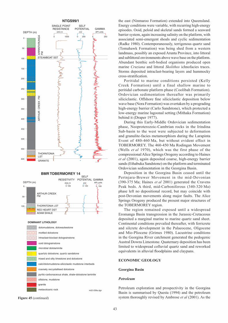
4242 43
the east (Ninmaroo Formation) extended into Queensland. Energy conditions were variable, with recurring high-energy episodes. Ooid, peloid and skeletal sands formed a seaward barrier system, again increasing salinity on the platform, with associated semi-emergent shoals and cyclic sedimentation (Radke 1980). Contemporaneously, terrigenous quartz sand (Tomahawk Formation) was being shed from a western landmass, possibly an exposed Arunta Province, into littoral and sublittoral environments above wave base on the platform. Abundant benthic soft-bodied organisms produced open marine Cruziana and littoral Skolithos ichnofacies traces. Storms deposited intraclast-bearing layers and hummocky cross-stratification.
Peritidal to marine conditions persisted (Kelly Creek Formation) until a final shallow marine to peritidal carbonate platform phase (Coolibah Formation). Ordovician sedimentation thereafter was primarily siliciclastic. Offshore fine siliciclastic deposition below wave base (Nora Formation) was overtaken by a prograding high-energy barrier (Carlo Sandstone), which protected a low-energy marine lagoonal setting (Mithaka Formation) behind it (Draper 1977).
During this Early-Middle Ordovician sedimentation phase, Neoproterozoic-Cambrian rocks in the Irindina Sub-basin to the west were subjected to deformation and granulite-facies metamorphism during the Larapinta Event of 480-460 Ma, but without evident effect in TOBERMOREY. The 460-450 Ma Rodingan Movement (Wells et al �970), which was the first phase of the compressional Alice Springs Orogeny according to Haines et al (2001), again deposited coarse, high-energy barrier sands (Ethabuka Sandstone) on the platform and terminated Ordovician sedimentation in the Georgina Basin.
Deposition in the Georgina Basin ceased until the Pertnjara-Brewer Movement in the mid-Devonian (390-375 Ma; Haines et al 200�) generated the Cravens Peak beds. A third, mid-Carboniferous (340-320 Ma) phase left no depositional record, but may coincide with post-Devonian movements along major faults. The Alice Springs Orogeny produced the present major structures of the TOBERMOREY region.
The region remained exposed until a widespread Eromanga Basin transgression in the Jurassic-Cretaceous deposited a marginal marine to marine quartz sand sheet. Continental conditions prevailed thereafter, with ferricrete and silcrete development in the Palaeocene, Oligocene and Mio-Pliocene (Grimes 1980). Lacustrine conditions in the Georgina River catchment generated the pedogenic Austral Downs Limestone. Quaternary deposition has been limited to widespread colluvial quartz sand and reworked equivalents in alluvial floodplains and claypans.
econoMIc geology
georgina Basin
Petroleum
Petroleum exploration and prospectivity in the Georgina Basin is summarised by Questa (�994) and the petroleum system thoroughly revised by Ambrose et al (200�). As the
m02-039a.dgn
AR
TH
UR
CR
EE
K F
M
THORNTONIALST
AR
RIN
TH
RU
NG
A
FM
15000
SELFPOTENTIAL
API units
0 250
DOMINANT LITHOLOGY
dolomudstone, dolowackestone
mottled dolostone
intraclast-bioclast dolograinstone
quartzic dolostone, quartz sandstone
mixed and silty limestone and dolostone
siltstone, mudstone
ooid dolograinstone
DEPTH (m)
STEAMBOAT SST
ohm m mV
0 200
GAMMARESISTANCE
GRANITE
granite
pyritic-carbonaceous shale, shale-dolostone laminite
coarsely recrystallised dolostone
calci/dolomudstone-siliciclastic mudstone interbeds
NTGS99/1SINGLE POINT
ADAM SHALE
THORNTONIA LST
ARTHUR CREEK
BMR TOBERMOREY 14
RESISTIVITYAPI units
0 1000 100
SELFPOTENTIAL
ohm m mV
0 120
GAMMA
RED HEART DST
FM
DEPTH (m)
metavolcanic rock
microbial dololaminite
0
50
100
150
200
250
300
350
400
450
550
600
500
0
50
100
Figure 45 (continued)

4444
system is of Cambrian-Ordovician age, it belongs to the Larapintine supersystem of Draper (2000).
Initial reconnaissance of Georgina Basin petroleum prospectivity was undertaken by BMR in the 1950s. Petroleum companies, including Frome-Broken Hill, Geosurveys of Australia, Alliance Petroleum Australia (Wilson 1963), French Petroleum, Australian Aquitaine Petroleum and Shell Development, reviewed aspects of the region in the late �950s to early �960s (Smith �965a). The first well drilled in the basin was Black Mountain 1 in Queensland, by Phillips-Sunray in 1962. Investigations continued throughout the eastern, southern and central regions during the early to mid-1960s. In TOBERMOREY, BMR drilled three stratigraphic holes [Grg 11, Grg 12 (Milligan 1963) and BMR 12 Cockroach (Smith 1967)] in the early 1960s. Lucy Creek 1 was drilled by Exoil in 1966 to evaluate a structural high in the west-central map area (Pemberton 1967).
The impact of this early exploration phase was to downgrade the perceived prospectivity of the entire basin, and exploration virtually ceased until the early 1980s. However, BMR and latterly NTGS continued to drill stratigraphic holes and acquire geophysical data. One notable exception to this interim malaise was the drilling of Ethabuka 1 in the Toko Syncline on MOUNT WHELAN by Alliance Oil Development Australia NL in 1974. This well yielded the only sizeable flow of hydrocarbons to date from the Georgina Basin: an estimated 7080 m3/day of dry gas from the Kelly Creek Formation (Radke and Duff 1980). Gravity surveys were conducted over the northern Toko Syncline for Plenty River Mining in 1982-1983, but no drilling took place.
A fresh phase of exploration in the southern Georgina Basin occurred during 1988-1991, as Pacific Oil and Gas (a subsidiary of CRA) took up permits over the Dulcie and Toko Synclines. During this period, the company acquired 675 line km of seismic data (four lines in TOBERMOREY) and drilled eight exploration/stratigraphic wells. Of these wells, Hacking 1 (1988; Weste 1989) and Owen 2 (1990; Kress 1991) are located in TOBERMOREY. Hacking 1 was sited on an interpreted structural high as a stratigraphic assessment of the source rock and reservoir potential of the Cambrian succession near the southern basin margin. Owen 2 was drilled for stratigraphic purposes and to test for potential early Cambrian siliciclastic reservoirs. Hydrocarbon shows were detected in both of these wells. Pyritic-carbonaceous black shale in the basal Arthur Creek Formation was identified as a world class source rock, attaining 40 m thickness in Hacking 1 (Questa 1994: 67). Total organic carbon (TOC) contents were found to be in the range 0.5-16%, but more commonly up to �0%.
Drillhole NTGS99/1 in south-central TOBERMOREY yielded TOC up to 2.9% from the Thorntonia Limestone and 3.4% from the lower Arthur Creek Formation. Middle Cambrian sediments were found to be marginally mature to overmature for oil generation, with maturity increasing southward. An estimated 40 billion tonnes of oil has been generated from Cambrian sedimentary rocks in the southern Georgina Basin (SIBGEO 1991, 1992). Potential reservoirs occur in the Coolibah Formation, Kelly Creek Formation, Arrinthrunga Formation, Chabalowe Formation (including Hagen Member), Steamboat Sandstone, upper Arthur Creek
Formation, Thorntonia Limestone and Mount Baldwin Formation (Questa 1994). Porosity in the carbonate rocks is due to secondary dissolution and dolomitisation. Of greatest relevance to TOBERMOREY is the stratigraphic juxtaposition of reservoir and source-seal in the succession from black shale-bearing medial Thorntonia Limestone, to porous and vuggy upper Thorntonia Limestone, to basal Arthur Creek Formation black shale (Ambrose et al 200�).
Phosphate
Biogenic accumulation accounts for widespread, but economically insignificant phosphate in Cambrian carbonates in TOBERMOREY. Shergold (1985: 24) reported 1-5% P2O5 from an accumulation of phosphatic-shelled lingulate brachiopods in the lower interval of the Thorntonia Limestone in cored drillhole Tobermorey �4. Biogenic phosphate grains (lingulate brachiopods and hyolith steinkerns) are also common in the medial and upper intervals in several TOBERMOREY drillholes.
The Middle Cambrian is locally phosphatic near Ammaroo in ELKEDRA and the best intercept is 0.9 m at 30% P2O5 at 26 m depth, attributed to the Arthur Creek Formation (Morrison 1968, Howard 1990). On this basis, Morrison (1968) recommended that the Marqua area of TOBERMOREY be considered prospective, but no work has been undertaken. The Nora Formation may also be prospective, if a sample from Gaphole Creek yielding 13% P2O5 is indicative (Smith �965a).
Following a drilling campaign at Wonarah in the central Georgina Basin, which delineated a resource estimate of 72 Mt at 23 % P2O5 (report to Australian Stock Exchange by AKD Ltd, 24 January 2002), Rio Tinto has recently undertaken regional phosphate exploration throughout the Georgina Basin, but there are no active tenements in TOBERMOREY.
Diamonds
TOBERMOREY was included in a regional diamond exploration program by CRAE (Colliver and Bubner 1987a, 1987b). Reconnaissance stream sediment sampling, aeromagnetic and radiometric data were used to focus the search. Ten picroilmenite and chromite grains were found in southwestern TOBERMOREY and a single microdiamond was reported from Shank Creek in the northeast (Allnutt 1986). Follow-up sampling failed to provide conclusive results (Colliver and Bubner 1987a, 1987b).
Recognition that basement similar to the eastern Siberian Platform (which hosts diamondiferous kimberlite) might underlie part of the Georgina Basin has led to a resurgence in diamond exploration. The model is based on the recognised existence of the Altjawarra Domain (sensu Myers et al �996), a region of thickened, stable crust with relatively low heat flow and low crustal temperatures, which underlies much of TOBERMOREY, SANDOVER RIVER and eastern HUCKITTA. Any diamondiferous kimberlite pipes younger than 500 Ma would be preserved in the overlying Georgina Basin sedimentary cover. As of March 2002, Elkedra Diamonds NL have pegged all but the southwestern corner of TOBERMOREY, as part of a regional search (Figure 46).

4444 45
Creek
Marqua
HIGHWAY
PLENTY
Creek
Manners
Hay
River
138˚00’136˚30’
138˚00’136˚30’
m02-075.dgn
0 50 km
23˚00 ’
22˚00 ’22˚00 ’
23˚00 ’
Diamond indicator mineralMicrodiamond occurrence
Figure 46 Locations of microdiamond and diamond indicator minerals in TOBERMOREY, overlaid on aeromagnetic image
Copper-lead-zinc
The structurally complex southwestern margin of the Georgina Basin in southern TOBERMOREY contains several Cambrian formations that are anomalous in Zn and Pb over kilometres of strike length. These have been the subjects of systematic company exploration for over 30 years.
Galena was first recognised in the Tomahawk Formation during government mapping. Smith and Vine (�960) and Smith (�965a) reported small quantities east of the southern end of the Tarlton Range, but no precise location was given. In the �970s, BMR palaeontologist J Sheldon found an isolated grain near Canyon Bore, Tarlton Range (pers comm reported in Nenke 1977a).
In the early 1970s, Fimiston Minerals established a Mississippi Valley-type (MVT) model for the Georgina Basin and targeted Upper Cambrian formations, particularly the Arrinthrunga Formation (Morris 1971, Keene and Morris �97�).
CRAE targeted two areas in TOBERMOREY for MVT mineralisation, based on geological similarity with the Turkey Creek/Box Hole prospect in HUCKITTA. Interpretation of aeromagnetic, reconnaissance soil, stream, rock and borewater data from northeast of Tarlton Downs homestead and between McCrae Bore and No 6 Bore in the north-central map area did not detect any anomalies of significance (Tham �97�).
Carpentaria Exploration undertook regional exploration for MVT mineralisation over the present structural margins of the Georgina Basin from 1976 to 1977 (Nenke 1977a, 1977b). Soil, stream sediment and rock chip samples were collected in the Dinner Creek-Marqua Creek area and from Centenary Bore to Christmas Bore (south-central TOBERMOREY). The highest Zn and Pb values in rock chips were attributed to Fe and Mn scavenging in the weathering profile, as no surface mineralisation could be found. Ferruginous lag assayed up to 1.31% Pb and 834 ppm Zn (Nenke 1977a). Elevated Zn in subsurface and unweathered carbonate was thought to be due to cation substitution in the dolomite lattice. The greatest anomaly of �.�5% Zn over 2 m, which was from channel chip samples of fresh rock in the Marqua area, became the Boat Hill prospect.
From 1981 to 1984, Agip Australia targeted MVT and stratabound base metal mineralisation (Agip 1982, 1983, 1984). Reconnaissance mapping, rock chip sampling and 15 drillholes demonstrated that Pb, Zn and Ag anomalism could be traced over a 10 km strike length in the vicinity of the Boat Hill prospect. The highest base metal values occur in close proximity to faults and the best drilling intercept was 0.5 m at �.9% Zn. A geophysical programme was planned, but Agip relinquished the area in 1984 when the company ceased all base metal exploration in Australia.
In 1991, MIM targeted low-angle reverse faults on the margin of the Georgina Basin for Pb and Zn (McGeough

4646
Figure 47 Thorntonia Limestone. Slabbed drillcore from lower light grey interval of formation showing galena and honey-coloured low-iron sphalerite as vug fill (centre). Scale bar = 1 cm. 526.3 m depth in drillhole MIM BHD9; Toko QQ689668
Figure 48 Thorntonia Limestone. Sphalerite (�) and platy organic matter (2) intimately interrelated in vug fill; medial darker grey interval of formation. Scale bar = 0.� mm. Polished thin section in reflected plane polarised light (from Croxford in McGeough 1992); 513.36 m depth in drillhole MIM BHD9; Toko QQ689668
1992, McGeough and Shalley 1992). Assays up to 1.8% Pb and 7090 ppm Zn in the Thorntonia Limestone in the Boat Hill area led MIM to conclude that mineralisation at the Boat Hill prospect is structurally controlled (McGeough �992). MIM recorded 17 200 m loop 16-channel SIROTEM traverses approximately 500 m apart across strike at the Boat Hill prospect. Of eight cored holes drilled, four tested conductive layers from the SIROTEM survey. Minor occurrences of
galena, sphalerite and pyrite in crystal clots up to 2 cm across were observed in the Thorntonia Limestone and Red Heart Dolostone in BHD4, 5 and 9 (Figure 47). Highest combined assays were 0.83% Pb, 2.24% Zn and 2 g/t Ag from 530.90-531.36 m depth in the Red Heart Dolostone in BHD9 (McGeough 1992). BHD9 has galena and minor sphalerite infilling fractures and along stylolites over 514.0-516.5 m depth in the medial Thorntonia Limestone and this interval averaged 941 ppm Pb and 0.54% Zn. Petrological descriptions and an assessment of paragenesis by Croxford (in McGeough 1992) were consistent with MVT mineralisation. Pyrite, sphalerite and hydrocarbons were the earliest phases and so are intimately interrelated (Figure 48). Galena was the last to form and filled the remaining space within vugs in saddle dolomite.
Reconnaissance stream sediment and rock chip sampling along the Toomba-Craigie Fault by CRAE failed to locate any significant base metal anomalies (Stegman 1991).
Cored stratigraphic drillhole NTGS99/� intersected visible galena and sphalerite in the Thorntonia Limestone. Quarter-metre composites of quarter core with visible galena returned assays of >2000 ppm Pb and the interval 585.75-586.0 m averaged 1.02% Zn. This significantly increases the area of Thorntonia Limestone in TOBERMOREY known to be anomalous in base metals.
Platinum group elements
Shergold (1985) reported 1.5 ppm Pt and 0.8 ppm Pd in shale from the medial interval of the Thorntonia Limestone in cored drillhole Hay River 11A in HAY RIVER. Based on these assays, Geopeko briefly held ground to explore for platinum group elements (PGEs) in Georgina Basin shales. The company reviewed BMR magnetic data and reprocessed some in-house airborne magnetic and radiometric data from 1978. After discussions with BMR, they concluded that the elevated PGEs reported by Shergold (1985) were analytically incorrect (Sherrington 1987).
Also encouraged by BMR assays and using a Zechstein model, Saracen Minerals targeted shales near the Boat Hill prospect. Nineteen shallow percussion holes totalling 550 m

4646 47
were drilled and 491 samples analysed for Pt and Pd. All were below 10 ppb Pt and 10 ppb Pd. The area was relinquished in 1988 (Virtue 1988).
MIM also analysed for PGEs in their BHD series of drillholes. None exceeded the 5 ppb Pt or 1 ppb Pd detection limits. This has downgraded prospectivity for PGEs in Georgina Basin shales within TOBERMOREY.
Gold
Shergold (1985) invoked a Carlin-style Au model for the southern Georgina Basin. Saracen and MIM included Au in their exploration of the Boat Hill area. In the former case, all assays were below the detection limit of 0.0� ppm Au (Virtue 1988) and in the latter, the highest value was 0.005 ppm (McGeough �992).
During the early 1990s, CRAE prospected the Toomba Fault Zone in HAY RIVER and TOBERMOREY for Au. Rock chip and stream sediment sampling were undertaken. Repeat bulk leach extractable gold (BLEG) sampling failed to return assays in excess of 0.6 ppb Au (Stegman �99�).
Uranium
Water from five bores in TOBERMOREY was analysed for U by CRAE. The highest level detected was 7 ppb U in Coles Bore (Tham �97�).
Geopeko targeted the basal Georgina Basin succession as part of a search for Proterozoic sediment-hosted U. The company flew a radiometric survey over northern HAY RIVER in 1979 and extrapolated the results into southern TOBERMOREY. Cenozoic cover was a major problem and the only anomalies detected were attributed to weak surficial concentrations. No further work was undertaken (Eupene �979).
Roll-front uranium was considered to be a secondary target in exploration of the Marqua area by Agip, but no significant occurrences were identified (Agip 1982, 1983).
Manganese
In late 2002, Elkedra Diamonds NL discovered numerous manganese occurrences during a regional diamond exploration program within Els 22529, 22534 and 22536 over western TOBERMOREY (Elkedra Diamonds 2002). Most of these appear to be surficial in origin. However, two (Lucy Creek 2 and Halfway Dam prospects) are interpreted as stratabound. At Lucy Creek 2 prospect (PR703222), a 1-2 m-thick Mn horizon outcrops over a strike length of 400 m (L Tompkins, Elkedra Diamonds, pers comm 2002) within dolomitic siltstone of the Tomahawk Formation. Initial rock chip samples gave encouraging assays containing high-grade manganese and low levels of iron, phosphorus, silica and alumina (eg D0066: 50.5% Mn, 0.44% Fe, 0.06% P, 6% SiO2 and 0.7�% Al2O3; Elkedra Diamonds 2002). A follow-up RAB drilling program was undertaken in October 2002.
Near Halfway Bore (QR020075) manganiferous material containing up to 42% Mn was excavated during construction of a small dam (L Tompkins, Elkedra Diamonds, pers comm
2002). The occurrence appears to be hosted in dolomitic quartz sandstone and dolostone at or near the base of the Kelly Creek Formation and is very similar in style to the outcrops at Lucy Creek 2. Elevated levels of trace metals (eg 2460 ppm Pb and 60 ppm As) from the latter prospect, replacement ore textures and close proximity to basement structures suggest a geothermal or low temperature hydrothermal ore genesis model, similar to the manganese deposits in the Renner Springs district, northern Tennant Inlier (Ferenczi 2001).
Surficial manganese occurrences are present in the Ninmaroo, Tomahawk and Kelly Creek Formations. Significant assay results have been reported from near Desert Bore (QR192326), where sampling by Eldekra Diamonds NL at CWN-90 (in Tomahawk Formation) and Loc44 (in Ninmaroo Formation) returned up to 42% Mn and 28.7% Mn, respectively. Minor manganiferous mineralisation was also encountered in the Ninmaroo and Kelly Creek Formations in the vicinity of Treacle Hill Waterhole (QQ491831) during NTGS Second Edition mapping.
Groundwater
Community and pastoral water supply in TOBERMOREY is almost entirely reliant on groundwater. Altogether, 204 bores (including stratigraphic and exploration drillholes) have been drilled in the sheet, with standing water levels in the range 34-71 m depth, total dissolved solids 417-20 100 mgL-1 and yields up to 6.3 Ls-1 (Read 2002). Bore yields are generally low, with most producing in the range 0.5-2 Ls-1; only a small minority (nine bores) exceed 4 Ls-1. Supplies suitable for stock (ie with total dissolved solids <5000 mgL-1) are widely available. However, only 2� bores yield potable water, ie with total dissolved solids <1000 mgL-1, NO3 <45 mgL-1 and F <1.5 mgL-1. About one third of bores meeting the first criterion have either excessive nitrate or fluoride.
The most prospective formations are the Arrinthrunga Formation and particularly the Ninmaroo Formation, which is widespread, thick, and yields stock supplies from moderate depths. The Kelly Creek Formation is a poor to moderate aquifer for stock supplies. Highly saline water (total dissolved solids �5 �00 mgL-1), from Tobermorey No 8 (RN 12836) in the Toko Syncline, suggests the local presence of evaporites in this unit. The Arthur Creek Formation has been little utilised, but does contain aquifers suitable for stock supplies, as also does the Carlo Sandstone in the Toko Syncline. Known aquifers in Jurassic-Cretaceous rocks are low yielding and limited to the Marshall River area in southwestern TOBERMOREY. A few bores draw moderate yields from unconsolidated Quaternary alluvium.
arunta Province
Copper-lead-zinc
Minor malachite (up to �660 ppm Cu) and galena were observed in quartz veins in the Mount Dobbie Granite during a helicopter reconnaissance by MIM exploration (McGeough �992).
Normandy Poseidon explored for Jervois-style copper, lead and zinc along Hay River into southwestern

4848
TOBERMOREY. Airborne and ground electromagnetic surveys and soil sampling were undertaken. Drilling of the most significant anomaly failed to locate mineralisation (Cozens �995).
Second Edition regional mapping by NTGS identified malachite and rare azurite in LPgc granite. Mineralisation in outcrop in the bed of Camel Creek at PQ887602 is associated with fractures, shear zones, quartz and ironstone veins. A representative ironstone sample contains 2388 ppm Cu, 2 ppb Au, 3 ppm Pb and 20 ppm Zn. After heavy rains in 1999-2000, malachite was visible in Camel Creek downstream to the Hay River junction but was not detected by Normandy Poseidon’s earlier survey. Roof pendants of similar age granites would be prospective throughout TOBERMOREY.
Gold
Ashcourt targeted the HAY RIVER-TOBERMOREY area for Au, considering it to be a similar geological setting to the Tanami region, but surrendered the licence due to an inability to raise joint venture capital (Griffiths 1998).
Normandy Poseidon included Au analyses in their soil sampling over airborne magnetic and EM anomalies in the Hay River survey. Only one sample of 0.0�0 ppm exceeded the 0.00� ppm detection limit (Cozens �995).
Tungsten
Local pastoralists have provided anecdotal accounts of minor scheelite occurrences in TOBERMOREY found in the �960s by ultraviolet (UV) prospecting. One such reported occurrence in the vicinity of PQ938553 could not be relocated during Second Edition regional mapping.
No significant W was detected during reconnaissance work along Hay River by Normandy Poseidon. Systematic soil sampling in the same area returned a maximum of �0 ppm W (Cozens �995).
Diamonds
BHP targeted magnetic anomalies under cover between the Marshall River and the Plenty Highway as potential kimberlites. Unfortunately, drilling intersected magnetite-bearing biotite schist and siltstone in the shallow subsurface (BHP 1984, 1985).
Uranium
Normandy Poseidon analysed for U in a reconnaissance surface geochemical survey along the Hay River from HAY RIVER into southwestern TOBERMOREY. Very few assays exceeded the 4 ppm detection limit (Cozens �995).
Other metals and non-metals
Ba, Co, Mn, Ni and P were included in assays of reconnaissance surface samples and systematic soil sampling over airborne magnetic and EM anomalies along Hay River in southwestern TOBERMOREY. Most samples were sourced from Arunta Province rocks and none was considered anomalous (Cozens �995).
acKnoWledgMents
The Arunta Province Stratigraphy text was prepared with reference to petrographic descriptions commissioned from Frank Radke (Amdel Limited, Adelaide). Ian Scrimgeour (NTGS, Darwin) commented on a draft version of the Arunta Province Stratigraphy. Bob Read (Natural Resources Division, Department of Infrastructure, Planning and Environment, Alice Springs) provided a contribution on groundwater. Phil Ferenczi (NTGS, Darwin) collated notes on manganese occurrences. Max Heggen (NTGS, Alice Springs) liaised with Aboriginal organisations and custodians regarding land access. The authors thank local landholders and Aboriginal custodians for access to their properties. Greg Ambrose (NTGS, Darwin) advised on aspects of petroleum geology and downhole geophysical logging, and Professor Barry Webby (Macquarie University, Sydney) on Ordovician correlations. Zhen Yongyi (Australian Museum, Sydney) identified a small conodont sample from the Tomahawk Formation. Peter Crispe, Chris Field, ‘Mac’ McClellan, Mick Crompton and Liam MacNally assisted in the field, with the able base support of Martin Cardona. Figures were prepared by Richard Jong and Gary Andrews. The manuscript was edited by Tim Munson and formatted by Stephen Cox.
reFerences
Agip, 1982. Tobermory and Hay River EL3142. Annual report on exploration 1981-82. Northern Territory Geological Survey, Open File Company Report CR1982-0376.
Agip, 1983. Tobermory and Hay River, EL3142. Annual report 9.11.82-8.11.83, area to be retained. Northern Territory Geological Survey, Open File Company Report CR1983-0328.
Agip, 1984. Tobermory and Hay River, EL3142. Final report, 9/11/83 to 8/11/84. Northern Territory Geological Survey, Open File Company Report CR1984-0191.
Ahmad M, 2000. Geological map of the Northern Territory, 1:2 500 000. Northern Territory Geological Survey, Darwin.
Ahmad M, 2002. Geological map of the Northern Territory, 1:2 500 000 (2002 Edition). Northern Territory Geological Survey, Darwin.
Alliance Petroleum Australia, 1964. Report for Tarlton Downs gravity survey. Northern Territory Geological Survey, Open File Petroleum Report PR1964-0005.
Allnutt S, 1986. Final report for the period to 30th July, ELs 4612-4617, 4625-4627. CRA Exploration Pty Ltd. Northern Territory Geological Survey, Open File Company Report CR1986-0288.
Ambrose GJ, Kruse PD and Putnam PE, 2001. Geology and hydrocarbon potential of the southern Georgina Basin, Australia. APPEA Journal 41, 139-163.

4848 49
AUSLIG (Australian Surveying and Land Information Group), �990. Atlas of Australian resources. Third series. Volume 6 Vegetation. Commonwealth Government Printer, Canberra.
Barlow BC, �965. Georgina Basin reconnaissance gravity survey, NT and Qld �959. Bureau of Mineral Resources, Australia, Record �965/96.
Barlow BC, �966. Georgina Basin reconnaissance gravity surveys using helicopters, Northern Territory and Queensland 1960-1961. Bureau of Mineral Resources, Australia, Record �966/�47.
BHP 1984. Exploration licence 4198, Marshall River, NT, final report June 1983-December 1984. BHP Exploration Department. Northern Territory Geological Survey, Open File Company Report CR1984-0121.
BHP 1985. Exploration licence 4527, Tarlton Range, NT, final report May 1984-December 1984. BHP Exploration Department. Northern Territory Geological Survey, Open File Company Report CR1985-0066.
Brock GA, Engelbretsen MJ, Jago JB, Kruse PD, Laurie JR, Shergold JH, Shi GR and Sorauf JE, 2000. Palaeobiogeographic affinities of Australian Cambrian faunas. Memoir of the Association of Australasian Palaeontologists 23, 1-61.
Buick IS, Miller JA, Williams IS, Hand M and Mawby J, 2001a. Deep holes in the Centralian Superbasin, SHRIMP zircon constraints on the depositional age of granulites in the eastern Arunta Block. Geological Society of Australia, Abstracts 64, 13-14.
Buick IS, Miller JA, Williams IS and Cartwright I, 2001b. Ordovician high-grade metamorphism of a newly recognised late Neoproterozoic terrane in the northern Harts Range, central Australia. Journal of Metamorphic Geology 19, 373-394.
Bureau of Meteorology, 1988. Climatic atlas of Australia. Commonwealth Government Printer, Canberra.
Casey JN, �959. New names in Queensland stratigraphy (part 5). Australian Oil and Gas Journal 5 (12), 31-36.
Casey JN and Gilbert-Tomlinson J, 1956. Cambrian geology of the Huckitta-Marqua region, Northern Territory. XX International Geological Congress, Mexico 2, 55-74. [Reprinted 1957 Bureau of Mineral Resources, Australia, Bulletin 49, 55-74].
Chan PA, Mikolajczak AS and Retter AJ, 1990. Quartz, Northern Territory. 1:100 000 geological map series, explanatory notes, 5951. Bureau of Mineral Resources, Australia, Canberra.
Chapman LH, 200�. New constraints on the thermal evolution of the Mount Isa mineralization system.
Abstracts, Geological Society of America Annual Meeting, Boston, Massachusetts, November 1-10, 2001. Session T23, Sediment-hosted lead-zinc deposits: roles of basin evolution, tectonics and geochemistry in ore genesis 1 (http://gsa.confex.com/gsa/2001AM/finalprogram/abstract_13273.htm).
Chenon C, 1966. Cockroach Waterhole area experimental seismic survey, Northern Territory �964. Bureau of Mineral Resources, Australia, Record �966/75.
Collins WJ and Shaw RD, 1995. Geochronological constraints on orogenic events in the Arunta Inlier: a review. Precambrian Research 71, 69-89.
Colliver IC and Bubner GJ, 1987a. EL4628 Warka, NT. Final report period ending 2�st July 1987. CRA Exploration Pty Ltd. Northern Territory Geological Survey, Open File Company Report CR1987-0206.
Colliver IC and Bubner GJ, 1987b. EL4629 Toko Range, NT. Final report period ending 2�st July 1987. CRA Exploration Pty Ltd. Northern Territory Geological Survey, Open File Company Report CR1987-0207.
Condon MA and Smith KG, 1959. Permian glacials in central Australia. Bureau of Mineral Resources, Australia, Record �959/29.
Cooper RA, Nowlan GS and Williams SH, 200�. Global Stratotype Section and Point for base of the Ordovician System. Episodes 24, 19-28.
Cozens GJ, �995. Final report on EL 6994 (Hay River) 09/11/90 to 28/10/94. Normandy Poseidon. Northern Territory Geological Survey, Open File Company Report CR1995-0249.
Crettenden P, 2000. GPS locations now more accurate. MESA Journal �9, 34.
Debrenne F, Rozanov A and Zhuravlev A, 1990. Regular Archaeocyaths. Morphology. Systematics. Biostratigraphy. Palaeoecology. Biological affinities. Cahiers de Paléontologie, Editions du CNRS, Paris.
Donnelly TH, Shergold JH and Southgate PN, 1988. Anomalous geochemical signals from phosphatic Middle Cambrian rocks in the southern Georgina Basin, Australia. Sedimentology 35, 549-570.
Draper JJ, 1977. Environment of deposition of the Carlo Sandstone, Georgina Basin, Queensland and Northern Territory. BMR Journal of Australian Geology and Geophysics 2, 97-110.
Draper JJ, 1980a. Rusophycus (Early Ordovician ichnofossil) from the Mithaka Formation, Georgina Basin. BMR Journal of Australian Geology and Geophysics 5, 57-61.
5050
Draper JJ, 1980b. Ethabuka Sandstone, a new Ordovician unit in the Georgina Basin, and a redefinition of the Toko Group. Queensland Government Mining Journal 81, 469-475.
Draper JJ, 2000. Petroleum supersystems in Queensland: a key to undiscovered petroleum resources. Queensland Oil and Gas July 2000, 42-47.
Druce EC, 1974. Georgina Basin project 1974-1980: a proposal. Bureau of Mineral Resources, Australia, Record �974/44.
Druce EC, 1976. Georgina Basin: in ‘Geological Branch summary of activities 1975’. Bureau of Mineral Resources, Australia, Report 194, 9-13.
Druce EC, 1978. Clavohamulus primitivus – a key North American conodont found in the Georgina Basin. BMR Journal of Australian Geology and Geophysics 3, 351-355.
Druce EC and Jones PJ, 1971. Cambro-Ordovician conodonts from the Burke River Structural Belt, Queensland. Bureau of Mineral Resources, Australia, Bulletin ��0.
Druce EC, Shergold JH and Radke BM, 1982. A reassessment of the Cambrian-Ordovician boundary section at Black Mountain, western Queensland, Australia: in Bassett MG and Dean WT (editors) The Cambrian-Ordovician boundary: sections, fossil distributions, and correlations. National Museum of Wales, Geological Series 3, Cardiff, 193-209.
Ekdale AA, Bromley RG and Pemberton SG, 1984. Ichnology: the use of trace fossils in sedimentology and stratigraphy. Society of Economic Paleontologists and Mineralogists, Tulsa.
Elkedra Diamonds, 2002. Progress report, Altjawarra Craton; manganese results. Press release to Australian Stock Exchange by Elkedra Diamonds NL, September 25, 2002.
Esteban M and Klappa CF, 1983. Subaerial exposure environment. American Association of Petroleum Geologists, Memoir 33, 1-54.
Eupene GS, �979. Final report, Field River area, ELs 1944, 1945, 1946, 1947. Geopeko Ltd. Northern Territory Geological Survey, Open File Company Report CR1979-0126.
Fanning CM, Ludwig KR, Forbes BG and Preiss WV, 1986. Single and multiple grain U-Pb zircon analyses for the early Adelaidean Rook Tuff, Willouran Ranges, South Australia. Geological Society of Australia, Abstracts 15, 71-72.
Ferenczi PA, 2001. Iron ore, manganese and bauxite deposits of the Northern Territory. Northern Territory Geological Survey, Report �3.
Ferris FG, 2000. Microbe-metal interactions in sediments: in Riding RE and Awramik SM (editors) Microbial sediments. Springer-Verlag, Berlin, Heidelberg, 121-126.
Folk RL, 1974. Petrology of sedimentary rocks. Hemphill’s, Austin.
Fortey RA and Shergold JH, 1984. Early Ordovician trilobites, Nora Formation, central Australia. Palaeontology 27, 315-366.
Freeman MJ, 1986. Huckitta, Northern Territory. 1:250 000 geological map series explanatory notes, SF53-11. Northern Territory Geological Survey, Darwin.
Gausden J, 1980. Mirrica No. 1 AP160P Queensland well completion report. Alliance Oil Development Australia NL. Queensland Department of Natural Resources and Mines, Open File Company Report 8295.
Geyer G and Shergold J, 2000. The quest for internationally recognized divisions of Cambrian time. Episodes 23, 188-195.
Gibson DL, 1984. Shallow stratigraphic drilling, Georgina Basin, 1978 and 1980. Bureau of Mineral Resources, Australia, Record 1984/33.
Gilbert-Tomlinson J, 1968. A new record of Bothriolepis in the Northern Territory of Australia. Bureau of Mineral Resources, Australia, Bulletin 80, 189-224.
Gilbert-Tomlinson J, 1973. The Lower Ordovician gastropod Teiichispira in northern Australia. Bureau of Mineral Resources, Australia, Bulletin 126, 65-88.
Gravestock DI and Shergold JH, 2001. Australian Early and Middle Cambrian sequence biostratigraphy with implications for species diversity and correlation: in Zhuravlev AYu and Riding R (editors) The ecology of the Cambrian radiation. Columbia University Press, New York, 107-136.
Green PM and Balfe PE, 1980. Stratigraphic drilling report – GSQ Mt Whelan � and 2. Queensland Government Mining Journal 81, 162-178.
Griffiths MR, 1998. Hay River NT EL9604 surrender report, May 1988. Ashcourt Corporation. Northern Territory Geological Survey, Open File Company Report CR1998-0670.
Grimes KG, 1980. The Tertiary geology of north Queensland, in Henderson RA and Stephenson PJ (editors) The geology and geophysics of northeastern Australia. Geological Society of Australia, Queensland Division, Brisbane, 329-347.
Haines PW, Bagas L, Wyche S, Simons B and Morris DG, �99�. Barrow Creek, Northern Territory. 1:250 000 geological map series explanatory notes, SF53-6. Northern Territory Geological Survey, Darwin.

5050 5�
Haines PW, Hand M and Sandiford M, 2001. Palaeozoic synorogenic sedimentation in central and northern Australia: a review of distribution and timing with implications for the evolution of intracontinental orogens. Australian Journal of Earth Sciences 48, 911-928.
Hand M, Mawby J, Kinny P and Foden, J, 1999. U-Pb ages from the Harts Range, central Australia: evidence for early-Ordovician extension and constraints on Carboniferous metamorphism. Journal of the Geological Society, London 156, 715-730.
Harrison PL, 1979. Recent seismic studies upgrade the petroleum prospects of the Toko Syncline, Georgina Basin. APPEA Journal 19, 30-42.
Harrison PL, 1980. The Toomba Fault and the western margin of the Toko Syncline, Georgina Basin, Queensland and Northern Territory. BMR Journal of Australian Geology and Geophysics 5, 201-214.
Hill D and Denmead AK (editors), 1960. ‘The geology of Queensland.’ Journal of the Geological Society of Australia 7.
Hill D, Playford G and Woods JT (editors), 1969. Ordovician and Silurian fossils of Queensland. Queensland Palaeontographical Society, Brisbane.
Hossfeld PS, 1954. Stratigraphy and structure of the Northern Territory of Australia. Transactions of the Royal Society of South Australia 77, 103-161.
Howard PF, 1990. The distribution of phosphatic facies in the Georgina, Wiso and Daly River Basins, Northern Australia: in Notholt AJG and Jarvis I (editors) ‘Phosphorite research and development.’ Geological Society Special Publication 52, 261-272.
Jell PA, 1975. Australian Middle Cambrian eodiscids with a review of the superfamily. Palaeontographica A �50, 1-97.
Jenkins RJF, McKirdy DM, Foster CB, O’Leary T and Pell SD, 1992. The record and stratigraphic implications of organic-walled microfossils from the Ediacaran (terminal Proterozoic) of South Australia. Geological Magazine �29, 401-410.
Joklik GF, 1955. The geology and mica-fields of the Harts Range, central Australia. Bureau of Mineral Resources, Australia, Bulletin 26.
Jones PJ, Shergold JH and Druce EC, 1971. Late Cambrian and Early Ordovician stages in western Queensland. Journal of the Geological Society of Australia 18, 1-32.
Keene JB and Morris DG, 1971. Report on a geological field trip to Tobermory-Tarlton Downs area, Northern Territory. Fimiston Minerals NL. Northern Territory Geological Survey, Open File Company Report CR1971-0035.
Kennard J, 1980. Stratigraphic field sections and drillhole logs of the Arrinthrunga Formation, Georgina Basin, central Australia. Bureau of Mineral Resources, Australia, Record 1980/75.
Kennard J, 1981. The Arrinthrunga Formation: Upper Cambrian epeiric carbonates in the Georgina Basin, central Australia. Bureau of Mineral Resources, Australia, Bulletin 2��.
Kennedy MJ, 1996. Stratigraphy, sedimentology, and isotopic geochemistry of Australian Neoproterozoic postglacial cap dolostones: deglaciation, d�3C excursions, and carbonate precipitation. Journal of Sedimentary Research 66, 1050-1064.
Kress AG, 1991. Owen No. 2 EP 13, Northern Territory well completion report. Pacific Oil and Gas Pty Ltd. Northern Territory Geological Survey, Open File Petroleum Report PR1992-0015.
Kruse PD, 1990. Cambrian palaeontology of the Daly Basin. Northern Territory Geological Survey, Report 7.
Kruse PD and West PW, 1980. Archaeocyatha of the Amadeus and Georgina Basins. BMR Journal of Australian Geology and Geophysics 5, 165-181.
Laurie JR, 1986. Phosphatic fauna of the Early Cambrian Todd River Dolomite, Amadeus Basin, central Australia. Alcheringa 10, 431-454.
Laurie JR, 2000a. Middle Cambrian biostratigraphy of the southern Georgina Basin, Northern Territory: preliminary results. Geological Society of Australia, Abstracts 6�, 54.
Laurie JR, 2000b. Macrofossils from the Tomahawk beds, Georgina Basin, Tobermory �:250 000 sheet area, Northern Territory. Australian Geological Survey Organisation, Professional Opinion 2000/34.
Laurie JR and Shergold JH, 1985. Phosphatic organisms and the correlation of Early Cambrian carbonate formations in central Australia. BMR Journal of Australian Geology and Geophysics 9, 83-89.
Lloyd AR, 1968a. Possible Miocene marine transgression in northern Australia. Bureau of Mineral Resources, Australia, Bulletin 80, 85-103.
Lloyd AR, 1968b. Outline of the Tertiary geology of northern Australia. Bureau of Mineral Resources, Australia, Bulletin 80, 105-132.
Madigan CT, �937. Additions to the geology of Central Australia: the region north of the MacDonnell Ranges and eastward from the telegraph line to the Queensland border. Australasian Association for the Advancement of Science, Report 23, 89.

5252
Mawby J, Hand M and Foden J, 1999. Sm-Nd evidence for high-grade Ordovician metamorphism in the Arunta Block, central Australia. Journal of Metamorphic Geology �7, 653-668.
McGeough M, �992. Exploration licence No 7299 “Tobermory” Northern Territory: Final report. MIM Exploration. Northern Territory Geological Survey, Open File Company Report CR1992-0506.
McGeough M and Shalley M, �992. Exploration licence No 7299 “Tobermory” NT. First annual report: year ended 3rd April, 1992. MIM Exploration Pty Ltd, Technical Report No �923. Northern Territory Geological Survey, Open File Company Report CR1992-0235.
Milligan EN, �963. The Bureau of Mineral Resources Georgina Basin core drilling programme. Bureau of Mineral Resources, Australia, Record 1963/86.
Montecchi P and Robertson CS, 1966. Southern Georgina Basin seismic survey, Northern Territory and Queensland �965. Bureau of Mineral Resources, Australia, Record 1966/28.
Morris DG, 1971. Summary of work carried out on AP2875 and AP3262 Tarlton Downs, NT. Sydney Geological and Geophysical Services Pty Ltd. Northern Territory Geological Survey, Open File Company Report CR1971-0129.
Morris DG, 1986. Stratigraphy, potential source rock and petroleum geochemistry of western Georgina Basin, Northern Territory. Northern Territory Geological Survey, Technical Report 1986-005.
Morrison ME, 1968. Progress report on phosphate exploration to October 31, 1968 Ammaroo, NT. Northern Territory Geological Survey, Open File Company Report CR1968-0051.
Mulready J, 1975. Well completion report, Ethabuka No. 1, ATP 160P, Queensland. Queensland Department of Natural Resources and Mines, Open File Company Report 5��9.
Myers JS, Shaw RD and Tyler IM, 1996. Tectonic evolution of Proterozoic Australia. Tectonics 15, 1431-1446.
Nenke J, 1977a. EL1229 “Tarlton Downs”, NT. Final report. Carpentaria Exploration Company. Northern Territory Geological Survey, Open File Company Report CR1977-0102.
Nenke J, 1977b. EL1228 “Marqua”, NT. Final report. Carpentaria Exploration Company. Northern Territory Geological Survey, Open File Company Report CR1977-0108.
Nicoll RS, �990. The genus Cordylodus and a latest Cambrian-earliest Ordovician conodont biostratigraphy. BMR Journal of Australian Geology and Geophysics ��, 529-558.
Nicoll RS, 1991a. Differentiation of Late Cambrian-Early Ordovician species of Cordylodus (Conodonta) with biapical basal cavities. BMR Journal of Australian Geology and Geophysics 12, 223-244.
Nicoll RS, �99�b. Conodont determinations in samples from the Pacific Oil and Gas exploration wells Ross No � and Todd No � and comparison with the conodont biostratigraphy of the Tomahawk beds at Huckitta, Dulcie Range, NT. Bureau of Mineral Resources, Australia, Professional Opinion OSPG 1991/008.
Nicoll RS, �992. Evolution of the conodont genus Cordylodus and the Cambrian-Ordovician boundary: in Webby BD and Laurie JR (editors) Global perspectives on Ordovician geology. Balkema, Rotterdam, 105-113.
Nicoll RS, Nielsen AT, Laurie JR and Shergold JH, 1992. Preliminary correlation of latest Cambrian to Early Ordovician sea level events in Australia and Scandinavia: in Webby BD and Laurie JR (editors) Global perspectives on Ordovician geology. Balkema, Rotterdam, 381-394.
Nicoll RS and Shergold JH, �99�. Revised Late Cambrian (pre-Payntonian-Datsonian) conodont biostratigraphy at Black Mountain, western Queensland, Australia. BMR Journal of Australian Geology and Geophysics �2, 93-118.
Noakes LC, 1956. Upper Proterozoic and sub-Cambrian rocks in Australia. XX International Geological Congress, Mexico 2, 213-238. [Reprinted 1957 Bureau of Mineral Resources, Australia, Bulletin 49, 213-238].
Noakes LC, Carter EK and Öpik AA, 1959. Urandangi – 4-mile geological series. Explanatory notes No 1. Second edition. Bureau of Mineral Resources, Australia.
Noakes LC and Traves DM, 1954. Outline of the geology of the Barkly region: in Christian CS (editor) ‘Survey of the Barkly region, Northern Territory and Queensland, 1947‑48.’ CSIRO Land Research Series 3, 34-41.
Öpik AA, 1956. Cambrian geology of Queensland. XX International Geological Congress, Mexico 2, 1-24. [Reprinted 1957 Bureau of Mineral Resources, Australia, Bulletin 49, 1-24].
Öpik AA, 1968. The Ordian stage of the Cambrian and its Australian Metadoxididae. Bureau of Mineral Resources, Australia, Bulletin 92, 133-168.
Öpik AA, 1970. Redlichia of the Ordian (Cambrian) of northern Australia and New South Wales. Bureau of Mineral Resources, Australia, Bulletin ��4.
Öpik AA, 1975. Templetonian and Ordian xystridurid trilobites of Australia. Bureau of Mineral Resources, Australia, Bulletin �2�.

5252 53
Pacific Oil and Gas, 1991. Logistic reports for gravity surveys conducted in the Amadeus Basin, Georgina Basin and McArthur Basin. Northern Territory Geological Survey, Open File Petroleum Report PR1991-0009.
Paten RJ, 1964. The Tertiary geology of the Boulia region, western Queensland. Bureau of Mineral Resources, Australia, Report 77.
Pemberton RL, 1967. Well completion report Lucy Creek No 1. Exoil Oil Company Pty Ltd. Northern Territory Geological Survey, Open File Petroleum Report PR1967-0007.
Pietsch BA, 2001. Towards an Arunta framework: in Northern Territory Geological Survey, 200�. Annual Geoscience Exploration Seminar (AGES 200�). Record of abstracts. Northern Territory Geological Survey, Record 2001-0006.
Plenty River Mining Company, 1984. Annual Report for the first year of tenure: OP232. Northern Territory Geological Survey, Open File Petroleum Report PR1984-0006.
Pojeta J Jr and Gilbert-Tomlinson J, 1977. Australian Ordovician pelecypod molluscs. Bureau of Mineral Resources, Australia, Bulletin �74.
Pojeta J Jr, Gilbert-Tomlinson J and Shergold JH, 1977. Cambrian and Ordovician rostroconch molluscs from northern Australia. Bureau of Mineral Resources, Australia, Bulletin �7�.
Preiss WV, Walter MR, Coats RP and Wells AT, 1978. Lithological correlations of Adelaidean glaciogenic rocks in parts of the Amadeus, Ngalia, and Georgina Basins. BMR Journal of Australian Geology and Geophysics 3, 43-53.
Preston JC, 1988. Progress report for year 1 ending 31 December 1987. Northern Territory Geological Survey, Open File Petroleum Report PR1988-0011.
Questa, �994. Georgina Basin. Northern Territory Geological Survey, Petroleum Basin Study. Questa Australia Pty Ltd. Northern Territory Geological Survey, Technical Report 1994-010.
Radke BM, 1980. Epeiric carbonate sedimentation of the Ninmaroo Formation (Upper Cambrian-Lower Ordovician), Georgina Basin. BMR Journal of Australian Geology and Geophysics 5, 183-200.
Radke BM, 1981. Lithostratigraphy of the Ninmaroo Formation (Upper Cambrian-Lower Ordovician), Georgina Basin, Queensland and Northern Territory. Bureau of Mineral Resources, Australia, Report 181; BMR Microform MF�53.
Radke BM, 1982. Late diagenetic history of the Ninmaroo Formation (Cambro-Ordovician), Georgina Basin, Queensland and Northern Territory. BMR Journal of Australian Geology and Geophysics 7, 231-254.
Radke BM and Duff P, 1980. A potential dolostone reservoir in the Georgina Basin: the Lower Ordovician Kelly Creek Formation. BMR Journal of Australian Geology and Geophysics 5, 160-163.
Radke BM, Simpson CJ and Draper JJ, 1983. The Poodyea Formation: a possible Tertiary fluvial unit in the Toko Syncline, Georgina Basin, Queensland and Northern Territory. BMR Journal of Australian Geology and Geophysics 8, 157-160.
Read RE, 2002. Note on groundwater in the Tobermory sheet. Natural Resources Division, Northern Territory Department of Infrastructure, Planning and Environment, unpublished report �4/2002.
Reynolds MA, 1968. Mount Whelan, Queensland. 1:250 000 geological series explanatory notes, SF54-13. Bureau of Mineral Resources, Australia, Canberra.
Runnegar B, Pojeta J Jr, Taylor ME and Collins D, 1979. New species of the Cambrian and Ordovician chitons Matthevia and Chelodes from Wisconsin and Queensland: evidence for the early history of polyplacophoran mollusks. Journal of Paleontology 53, 1374-1394.
Schmitt M and Southgate PN, 1982. A phosphatic stromatolite (Ilicta cf. composita Sidorov) from the Middle Cambrian, northern Australia. Alcheringa 6, 175-183.
Scrimgeour I and Raith JG, 2001. Tectonic and thermal events in the northeastern Arunta Province. Northern Territory Geological Survey, Report �2.
Seilacher A, �964. Biogenic sedimentary structures: in Imbrie J and Newell ND (editors) Approaches to palaeoecology. John Wiley, New York, 296-316.
Seilacher A, �970. Cruziana stratigraphy of “non-fossiliferous” Palaeozoic sandstones: in Crimes TP and Harper JC (editors) ‘Trace fossils.’ Geological Journal Special Issue 3. Seel House Press, Liverpool, 447-476.
Senior BR, Mond A and Harrison PL, 1978. Geology of the Eromanga Basin. Bureau of Mineral Resources, Australia, Bulletin �67.
Shaw RD and Stewart AJ, 1975. Arunta Block – regional geology: in Knight CL (editor) Economic geology of Australia and Papua New Guinea 1. Metals. Australasian Institute of Mining and Metallurgy, Parkville, 437-442.
Shergold JH, �975a. Late Cambrian and Early Ordovician trilobites from the Burke River Structural Belt, western Queensland, Australia. Bureau of Mineral Resources, Australia, Bulletin �53.

5454
Shergold JH, �975b. Biostratigraphical synopsis: eastern Georgina Basin. Bureau of Mineral Resources, Australia, Record �975/69.
Shergold JH, 1979a. Georgina Research. December quarter, 1978. Bureau of Mineral Resources, Australia, Record �979/�7.
Shergold JH, �979b. Georgina research, March quarter, �979. Bureau of Mineral Resources, Australia, Record �979/39.
Shergold JH, 1981. Palaeontological determinations of phosphatic samples from the Undilla and Riversleigh �:�00 000 sheet areas, Georgina Basin. Bureau of Mineral Resources, Australia, Professional Opinion 1981/21.
Shergold JH, 1985. Notes to accompany the Hay River-Mount Whelan Special �:250 000 geological sheet, southern Georgina Basin. Bureau of Mineral Resources, Australia, Report 25�.
Shergold JH, �995. Timescales �. Cambrian. Australian Phanerozoic timescales, biostratigraphic charts and explanatory notes. Second series. Australian Geological Survey Organisation, Record �995/30.
Shergold JH and Druce EC, 1980. Upper Proterozoic and Lower Palaeozoic rocks of the Georgina Basin: in Henderson RA and Stephenson PJ (editors) The geology and geophysics of northeastern Australia. Geological Society of Australia, Queensland Division, Brisbane, 149-174.
Shergold JH, Druce EC, Radke BM and Draper JJ, 1976. Cambrian and Ordovician stratigraphy of the eastern portion of the Georgina Basin, Queensland and eastern Northern Territory. XXV International Geological Congress, Sydney, Excursion Guide 4C.
Shergold JH, Jago JB, Cooper RA and Laurie JR, 1985. The Cambrian system in Australia, Antarctica and New Zealand. International Union of Geological Sciences, Publication �9.
Shergold JH and Nicoll RS, 1992. Revised Cambrian-Ordovician boundary biostratigraphy, Black Mountain, western Queensland: in Webby BD and Laurie JR (editors) Global perspectives on Ordovician geology. Balkema, Rotterdam, 81-92.
Shergold JH and Southgate PN, 1986. Middle Cambrian phosphatic and calcareous lithofacies along the eastern margin of the Georgina Basin, western Queensland. Australasian Sedimentologists Group, Field Guide Series 2. Geological Society of Australia, Sydney.
Sherrington GH, 1987. EL5054 “Tobermory”, NT final report. Peko-Wallsend Operations. Northern Territory Geological Survey, Open File Company Report CR1987-0229.
SIBGEO, 1991. Provision of engineering type work for the determination of the quality and maturity of source rocks in the Georgina Basin (4 volumes). Siberian Branch, USSR Academy of Sciences for Pacific Oil and Gas Pty Ltd. Northern Territory Geological Survey, Open File Petroleum Report PR1993-0006.
SIBGEO, 1992. Provision of engineering type work for the determination of the quality and maturity of source rocks in the Georgina Basin (4 volumes). Siberian Branch, USSR Academy of Sciences for Pacific Oil and Gas Pty Ltd. Northern Territory Geological Survey, Open File Petroleum Report PR1993-0002.
Simpson CJ, Kennard JM, Radke BM, Druce EC, West P and Green D (compilers), 1979. Toko, Northern Territory. 1:100 000 geological series. Preliminary edition. Bureau of Mineral Resources, Australia, Canberra.
Simpson CJ, Shergold JH, Radke BM, Walter MR, Wilford GE, Green D and Draper JJ (compilers), 1985. Geology of the Hay River-Mount Whelan area, southern Georgina Basin. First Edition 1:250 000 geological special. Bureau of Mineral Resources, Australia, Canberra and Geological Survey of Queensland, Brisbane.
Smith KG, 1963. Hay River, Northern Territory. 1:250 000 geological series explanatory notes, SF53-16. Bureau of Mineral Resources, Australia, Canberra.
Smith KG, 1964. Progress report on the geology of the Huckitta 1:250 000 sheet, Northern Territory. Bureau of Mineral Resources, Australia, Report 67.
Smith KG, 1965a. Tobermory, Northern Territory. 1:250 000 geological series explanatory notes, SF 53-12. Bureau of Mineral Resources, Australia, Canberra.
Smith KG, 1965b. Glenormiston, Queensland. 1:250 000 geological series explanatory notes, SF54-09. Bureau of Mineral Resources, Australia, Canberra.
Smith KG, 1967. Stratigraphic drilling in the Georgina Basin, Northern Territory. Bureau of Mineral Resources, Australia, Report �24.
Smith KG, 1972. Stratigraphy of the Georgina Basin. Bureau of Mineral Resources, Australia, Bulletin ���.
Smith KG and Vine RR, 1960. Summary of the geology of the Tobermory 4-mile geological sheet. Bureau of Mineral Resources, Australia, Record �960/7�.
Smith KG, Vine RR and Milligan EN, 1961. Revisions to stratigraphy of Hay River, Huckitta and Tobermory 4-mile sheets, Northern Territory. Bureau of Mineral Resources, Australia, Record �96�/65.
Southgate PN, 1986. The Gowers Formation and Bronco Stromatolith Bed, two new stratigraphic units in the Undilla portion of the Georgina Basin. Queensland Government Mining Journal, October, 407-411.

5454 55
Southgate PN and Shergold JH, 1991. Application of sequence stratigraphic concepts to Middle Cambrian phosphogenesis, Georgina Basin, Australia. BMR Journal of Australian Geology and Geophysics �2, 119-144.
Spizharskiy TN, Ergaliev GKh, Zhuravleva IT, Repina LN, Rozanov AYu and Chernysheva NE, 1983. Yarusnaya shkala kembriyskoy sistemy. [Stage scale of the Cambrian system]. Sovetskaya Geologiya 8, 57-72.
Sprigg RC, �963. Geology and petroleum prospects of the Simpson Desert. Transactions of the Royal Society of South Australia 86, 35-65.
Stait K and Druce EC, 1993. Conodonts from the Lower Ordovician Coolibah Formation, Georgina Basin, central Australia. BMR Journal of Australian Geology and Geophysics 13, 293-322.
Stegman CL, �99�. Toomba Range EL73��. Exploration report for the period 27/2/91 to 27/12/91, and final report. CRA Exploration Pty Ltd. Northern Territory Geological Survey, Open File Company Report CR1992-0122.
Stewart AJ, Shaw RD, Offe LA, Langworthy AP, Warren RG, Allen AR and Clarke DB, 1980. Stratigraphic definitions of named units in the Arunta Block, Northern Territory. Bureau of Mineral Resources, Australia, Report 2�6; BMR Microform MF�04.
Stewart AJ and Warren RG, �977. The mineral potential of the Arunta Block, central Australia. BMR Journal of Australian Geology and Geophysics 2, 21-34.
Stewart HWJ and Hoyling N, �963. Morstone No. �. Authority to Prospect 79 P – Queensland well completion report. Amalgamated Petroleum Exploration Pty Ltd. Queensland Department of Natural Resources and Mines, Open File Company Report ��73.
Stidolph PA, Bagas L, Donnellan N, Walley AM, Morris DG and Simons B, 1988. Elkedra, Northern Territory. 1:250 000 geological map series explanatory notes, SF53‑7. Northern Territory Geological Survey, Darwin.
Sweeney D, 1990. Georgina Basin 1989 seismic survey (Georgina River area). Northern Territory Geological Survey, Open File Petroleum Report PR1990-0085.
Teasdale J and Pryer LL, 2002. Georgina SEEBASE and GIS. SRK Consulting Services report to Northern Territory Geological Survey. Northern Territory Geological Survey, Record 2002-004.
Tham GHP, 1971. Lead/zinc search - Mt Hogarth Authority to Prospect 3183, NT. CRA Exploration. Northern Territory Geological Survey, Open File Company Report CR1971-0021.
Turner S, Jones PJ and Draper JJ, 1981. Early Devonian thelodonts (Agnatha) from the Toko Syncline, western Queensland, and a review of other Australian discoveries. BMR Journal of Australian Geology and Geophysics 6, 51-69.
Virtue RJ, 1988. EL5145 – Marqua, Saracen Minerals (operator). Report for �2 months 29 January to 28 January 1988. Northern Territory Geological Survey, Open File Company Report CR1988-0057.
Wade M, �977a. Georginidae, new family of actinoceratoid cephalopods, Middle Ordovician, Australia. Memoirs of the Queensland Museum 18, 1-15.
Wade M, �977b. The siphuncle in Georginidae and other Ordovician actinoceratoid cephalopods. Lethaia �0, 303-315.
Walter MR, 1980. Adelaidean and Early Cambrian stratigraphy of the southwestern Georgina Basin: correlation chart and explanatory notes. Bureau of Mineral Resources, Australia, Report 2�4; BMR Microform MF92.
Walter MR, Elphinstone R and Heys GR, 1989. Proterozoic and Early Cambrian trace fossils from the Amadeus and Georgina Basins, central Australia. Alcheringa �3, 209-256.
Walter MR, Grey K, Williams I and Calver CR, 1994. Stratigraphy of the Neoproterozoic to early Palaeozoic Savory Basin, Western Australia, and correlation with the Amadeus and Officer Basins. Australian Journal of Earth Sciences 41, 533-546.
Walter MR, Shergold JH, Muir MD and Kruse PD, 1979. Early Cambrian and latest Proterozoic stratigraphy, Desert Syncline, southern Georgina Basin. Journal of the Geological Society of Australia 26, 305-312.
Walter MR and Veevers JJ, �997. Australian Neoproterozoic palaeogeography, tectonics, and supercontinental connections. BMR Journal of Australian Geology and Geophysics 17, 73-92.
Walter MR, Veevers JJ, Calver CR and Grey K, 1995. Neoproterozoic stratigraphy of the Centralian Superbasin, Australia. Precambrian Research 73, 173-195.
Walter MR, Veevers JJ, Calver CR, Grey K and Hilyard D, 1992. The Proterozoic Centralian Superbasin: a frontier petroleum province. 1992 AAPG International Conference and Exhibition 77. [Reprinted 1992 American Association of Petroleum Geologists Bulletin 76, ��32].
Warren RG, 1981. Tectonic setting of the easternmost Arunta Block. Bureau of Mineral Resources, Australia, Report 22�; BMR Microform MF�54.

5656
Webby BD, 1978. History of the Ordovician continental platform and shelf margin of Australia. Journal of the Geological Society of Australia 25, 41-63.
Webby BD, VandenBerg AHM, Cooper RA, Banks MR, Burrett CF, Henderson RA, Clarkson PD, Hughes CP, Laurie J, Stait B, Thomson MRA and Webers GF, 1981. The Ordovician system in Australia, New Zealand and Antarctica. Correlation chart and explanatory notes. International Union of Geological Sciences, Publication 6.
Wells AT, Forman DJ, Ranford LC and Cook PJ, 1970. Geology of the Amadeus Basin, central Australia. Bureau of Mineral Resources, Australia, Bulletin �00.
Wells AT and Moss FJ, 1983. The Ngalia Basin, Northern Territory: stratigraphy and structure. Bureau of Mineral Resources, Australia, Bulletin 2�2.
Wells R, Milsom JS and Tipper DB, 1966. Georgina Basin aeromagnetic survey, Queensland and Northern Territory 1963-1964. Bureau of Mineral Resources, Australia, Record �966/�42.
Wentworth CK, 1922. A scale of grade and class terms for clastic sediments. Journal of Geology 30, 377-392.
Weste G, 1989. Hacking No 1 well completion report, EP 12, Georgina Basin, NT. Pacific Oil and Gas Pty Ltd. Northern Territory Geological Survey, Open File Petroleum Report PR1988-0079.
White ME, �96�. Mesozoic plant fossils from the Tarlton Range, Northern Territory. Bureau of Mineral Resources, Australia, Record �96�/32.
Whitehouse FW, 1931. Palaeontologist: in Annual report of the Under Secretary for Mines to the Honourable EA Atherton, MLA, Secretary for Mines, including the reports of the Wardens, Inspectors of Mines, Government Geologists, and other officers, for the year 1930. Government Printer, Brisbane, 141-142.
Whitehouse FW, 1936. The Cambrian faunas of north-eastern Australia. Part 1: stratigraphical outline. Part 2: Trilobita (Miomera). Memoirs of the Queensland Museum ��, 59-112.
Whitehouse FW, �939. The Cambrian faunas of northeastern Australia. Part 3: the polymerid trilobites (with supplement No �). Memoirs of the Queensland Museum ��, 179-282.
Whitehouse FW, �940. Studies in the late geological history of Queensland. University of Queensland, Department of Geology, Paper 2 (�).
Whitehouse FW, �94�. The Cambrian faunas of northeastern Australia. Part 4 – Early Cambrian echinoderms similar to the larval forms of Recent forms. Memoirs of the Queensland Museum 12, 1-28.
Wilson RB, 1963. The geology and oil prospects of OP63, Northern Territory. Alliance Petroleum Australia. Northern Territory Geological Survey, Open File Petroleum Report PR1963-0015.
Wright VP, 1992. A revised classification of limestones. Sedimentary Geology 76, 177-185.
Wright VP and Tucker ME, 1991. Calcretes: an introduction: in Wright VP and Tucker ME (editors) ‘Calcretes.’ International Association of Sedimentologists, Reprint Series Volume 2. Blackwell, Oxford, London, 1-22, 343-347.
Young GC, 1996. Devonian (Chart 4): in Young GC and Laurie JR (editors) An Australian Phanerozoic timescale. Oxford University Press, Melbourne, 96-109.
Zhao Jianxin and Bennett VC, 1995. SHRIMP U-Pb zircon geochronology of granites in the Arunta Inlier, central Australia: implications for Proterozoic crustal evolution. Precambrian Research 71, 17-43.
Zhao Jianxin, McCulloch MT and Korsch RJ, 1994. Characterisation of a plume-related ~800 Ma magmatic event and its implications for basin formation in central-southern Australia. Earth and Planetary Science Letters 121, 349-367.
aPPendIx - revised stratigraphic units
arthur creek Formation (emendation of existing definition)
Proposers: Freeman (1986: 57), after Smith (1964); amended by PD Kruse.
Derivation of name: After Arthur Creek in eastern HUCKITTA and southwestern TOBERMOREY.
Synonymy: Part of Sandover Beds of Öpik (1956); part of Arthur Creek Beds of Smith (1964); part of Marqua Beds of Smith (�972); Marqua Formation and upper Hay River Formation Member 2 of Shergold (1985); Upper Hay River Formation Member 2 of Donnelly et al (1988).
Distribution: Southern Georgina Basin, in HUCKITTA, TOBERMOREY and HAY RIVER; subsurface in SANDOVER RIVER and poss ib ly wes te rn Queensland.
Geomorphic expression: Generally poorly exposed.
Type section: Holostratotype section in interval 103.2-554.7 m depth in cored drillhole NTGS99/� (TOBERMOREY); core stored in NTGS Core Library, Alice Springs. Lower boundary at disconformable contact of foetid pyritic-carbonaceous black shale of basal Arthur Creek Formation with light grey bioclast dolograinstone of underlying Thorntonia Limestone. Upper boundary at sharp, apparently conformable transition between grey

5656 57
calci/dolomudstone-siliciclastic mudstone interbeds of uppermost Arthur Creek Formation and quartzic equivalents of overlying Steamboat Sandstone. Holostratotype replaces composite stratotype of Freeman (1986), due to doubts as to the latter’s completeness.
Reference sections: Composite section comprising cored drillholes NTGS HUC� and NTGS HUC2 in eastern HUCKITTA [former lectostratotype of Freeman (1986)]. Complete and contiguous intersections in cored drillholes Baldwin 1 in HUCKITTA (470.4-889.3 m depth), Hacking 1 in TOBERMOREY (752.9-1209.9 m depth) and Owen 2 in TOBERMOREY (692.7-1053.3 m depth).
Lithology: Lower interval of foetid pyritic-carbonaceous black shale, passing upward gradationally into planar to undulose foetid shale/dolostone laminite. Passes upward, abruptly to gradationally, into upper interval of paler grey dolomudstone to dolograinstone and calci/dolomudstone-siliciclastic mudstone interbeds, minor quartzic dolostone and dolostone-clast breccia.
Thickness: Maximum 457 m in Hacking 1; 452 m in NTGS99/� holostratotype, 4�9 m in Baldwin �, 36� m in Owen 2.
Structural attitude: Flat-lying to moderately dipping; subvertical adjacent to some faults.
Relationships and boundary criteria: Disconformable on Thorntonia Limestone (Öpik 1956), or where this is absent, Red Heart Dolostone (Walter et al �979); unconformable on older units. Lower boundary at sharp contact of light grey bioclast dolograinstone of underlying Thorntonia Limestone (or grey to orange-pink dolostone of Red Heart Dolostone) with foetid pyritic-carbonaceous black shale or paler dolostone of basal Arthur Creek Formation. Overlain with apparent conformity in eastern outcrop area by Steamboat Sandstone (Noakes et al �959); boundary at sharp transition from grey calci/dolomudstone-siliciclastic mudstone interbeds of uppermost Arthur Creek Formation with quartzic equivalents of Steamboat Sandstone. Overlain with apparent conformity in western outcrop area by Chabalowe Formation (Stidolph et al 1988); boundary at transition from light grey, marine carbonate rocks of upper Arthur Creek Formation into peritidal, grey evaporitic carbonate of Hagen Member of Chabalowe Formation. Where these two units are absent, overlain with apparent conformity by Arrinthrunga Formation.
Correlations: Beetle Creek Formation, Blazan Shale, Inca Formation, Age Creek Formation, Currant Bush Limestone, V-Creek Limestone and Mail Change Limestone in eastern Georgina Basin; Beetle Creek Formation, Inca Formation, Roaring Siltstone, lower Devoncourt Limestone in Burke River Structural Belt; Wonarah beds, Burton beds, Camooweal Dolostone, possibly Ranken Limestone in central Georgina Basin; Anthony Lagoon beds in western Georgina Basin (Shergold et al 1985).
Age and evidence: Middle Cambrian: Templetonian (pre-Triplagnostus gibbus Zone; Laurie 2000a) to Boomerangian Lejopyge laevigata Zone (Shergold 1985, �995), based on agnostine trilobites.
tomahawk Formation (formalisation of name)
Proposers: PD Kruse and AT Brakel, after Smith (1964).
Derivation of name: After Tomahawk Yard on northern flank of Dulcie Range, central HUCKITTA (Smith 1964: 47).
Synonymy: Lower part of Dulcie Sandstone of Joklik (1955); major portion of Tomahawk Beds of Smith (1964) excluding that above 400-500’ level in his reference section X30, now referred to Kelly Creek Formation.
Distribution: Flanks Dulcie Range in HUCKITTA, ELKEDRA, BARROW CREEK and ALCOOTA; extensive northward of Tarlton Range in eastern HUCKITTA, southeastern ELKEDRA, western TOBERMOREY and southwestern SANDOVER RIVER.
Geomorphic expression: Contiguous tracts of hilly country around Dulcie Range and near Tarlton Range in southwestern TOBERMOREY; isolated low to moderate hills and some prominent ridges in northwestern TOBERMOREY, eastern HUCKITTA, southeastern ELKEDRA and southwestern SANDOVER RIVER.
Type section: Interval 0-148.9 m depth in cored drillhole NTGS ELK6 (ELKEDRA); core stored in NTGS Core Library, Alice Springs. Lower boundary stratotype is at 148.9 m depth, where light grey dolostone of Arrinthrunga Formation is disconformably overlain by thin (2 dm) basal mudstone and succeeding quartz-glauconite sandstone of Tomahawk Formation. Type section is dominantly of quartz ± glauconite sandstone with minor recurring thin mudstone interbeds and occasional conglomerates of tabular sandstone and siltstone lithoclasts.
Reference section: Measured section on southeastern flank of Tarlton Range (TOBERMOREY): base at valley floor at PQ930670 commencing at base of lowest carbonate bed; top at summit of isolated hill at PQ920682 (Figure 27). Section 70 m thick, spanning upper carbonate interval of Tomahawk Formation to lower Kelly Creek Formation. Apparently conformable upper boundary stratotype of Tomahawk Formation is at 32 m from base of section and coincides with base of isolated hill.
Lithology: Quartz ± glauconite sandstone with minor beds of dolostone, mudstone and conglomerate; upper part of formation dominantly of limestone with lesser interbedded sandstone and marl.
Thickness: 148.9 m in type section (incomplete). Maximum recorded thickness 225 m in measured section X54 (Smith 1972) in western Dulcie Range (HUCKITTA), but this section may include part of Kelly Creek Formation. True thickness estimated at 150-190 m.
58
Structural attitude: Overall flat-lying in TOBERMOREY and adjacent areas; low to moderate dips in Dulcie Syncline. However, due to characteristic mesoscale deformation of sandstone, dip and strike may change significantly within metres. Freeman (1986) attributed this to subsurface cavernous solution of underlying carbonate rock (Arrinthrunga Formation) by groundwater and consequent progressive gravity subsidence. Conversely, carbonate beds are little affected; around Tarlton Range, limestone-dominant upper Tomahawk Formation is planar and gently dipping.
Relationships and boundary criteria: Disconformable on underlying Arrinthrunga Formation; lower boundary at abrupt change from dolostone to sandstone. Laterally interfingers with dolostone of Ninmaroo Formation along eastern margin in TOBERMOREY and SANDOVER RIVER. Conformable beneath Kelly Creek Formation; upper boundary at transition from limestone-dominant upper Tomahawk Formation to undeformed fine sandstone of Kelly Creek Formation. In Tarlton Range, this boundary coincides with clear topographic break from gently dipping bedding plane surface of uppermost Tomahawk
Formation to steep face of Kelly Creek Formation. In Dulcie Range, upper boundary coincides with transition from deformed sandstone and minor carbonate beds (Tomahawk Formation) into undeformed, moderately dipping fine quartz sandstone of Kelly Creek Formation [eg at NQ871991 in reference section X30 of Smith (1964), southeastern Dulcie Range].
Correlations: Lateral correlative of Ninmaroo Formation (Whitehouse �936, Casey �959) of eastern Georgina Basin.
Age and evidence: Late Cambrian (Iverian or Payntonian to probably late Datsonian Cordylodus prolindstromi Zone) based on trilobites and rostroconchs in basal beds (Casey and Gilbert-Tomlinson 1956: 65, Jones et al 1971: 21, Pojeta et al �977) and conodonts in uppermost beds (Shergold and Druce 1980: 161, Jones et al 1971: 21, Shergold and Nicoll 1992). Possible Early Ordovician suggested by trilobite Lycophron sp, pelecypod Sthenodonta sp, indeterminate costate orthide brachiopods and indeterminate pseudoplanispiral gastropods (Laurie 2000b).

MT POZIERES
NIKO HILL
16 Mile Yard
Pro
ofF
ence
Manners Creek
PLENTY HIGHWAY
PLENTY
HIGHWAY
KEEPERA
RIDGES
TarltonDowns
TAR
LTO
NR
AN
GE
Marqua
TOKO
RANGE
Ver
min
proo
ffe
nce
UMBERUMBERA HILLS
PLENTY
Tobermorey
Ver
min
ruins
HIGHWAY
GoreysBore
Clough Bore
NATHAN HILL
WARKA
TARLTON HILL
BOUNDARY HILL
BOAT HILL
MT BROWN
MT GUIDE
MT REINECKE
MT EWING
Warlpeyangrere
Urlampe
No. 26 BoreOil Bore
No. 20 Bore
Dam
No. 21 Bore
Sandy’s Dam
Grichies Bore
(U/S)
(U/S)
Little Dam
Goatyard Dam
Desert Bore
Ilfitinama Waterhole
Coles Bore
Burke & Wills Bore
Road Bore(Gov’t)
Scotties Bore
No 15 Bore
No 16 Bore
No 12 Bore
No 18 Bore
Agamba Bore
Last Hope Bore
Olivers Bore
Morgans Bore
Alkea Waterhole
Alliriqua Waterhole
Heartbreak Bore
Injerrabonna Waterhole
No 6 Bore
No 5 Bore
Sides Bore
McCrae Bore
Horse Creek
Neewaa Waterhole
Paddys Waterhole
Diviner Bore
No 3 BoreQuerinya Waterhole
Noonda Waterhole
Fell Bore
Chelcheta Waterhole
No 11 Bore
No 1 Bore
Chelch
eta
Cre
ek
Manners
Creek
Shank
Creek
Budgerigar Dam
Eelinja BoreNo 4 DamBlackfellow Hole
No 4 Bore
Noonda
Creek
Goatyard Bore
IllungnarraWaterhole
Indeear Bore
Riley Waterhole
Mostert HoleDam
Bluebush Bore
Mungra Bore
ApplepadDam
Moores MuddleDam
No 2 Bore
Swanson Dam
Anagoodya WaterholeNo 12 Boomerang Bore
Gintys Dam
No 3Bore
CreekMartha
Creek
No 2 Bore
Coolibah Waterhole
Cockatoo Bore
CentenaryBore
Bloodwood
Creek
CockroachCreek
Alg
amba
Cre
ek
Barcoo
Creek
BeantreeDam
Pin Up Bore
Mulga Bore
Canyon Bore
Lucky Bore
Jackawarra Dam
Lim
esto
ne
Creek
Camel
Creek
Bore
Cre
ek
HAY
RIVER
Beenleigh Bore
Cockroach Bore
Cockroach Waterhole
Southern Cross Bore
Mars Bore
Baxters Muddle Dam
Pump Waterhole
Shepley Bore
Six MileBore Bismarch Waterhole
Beetwood Bore
Black Tank Bore
Old Marqua Bore
Bat
tleC
reek
Peendenmurra
Creek
WatillindanamaDam
Blo
odw
ood
Cre
ek
Warka
Cre
ek
Heifer Waterhole
McGuinness Bore
No 8 Dam
Mulga
Creek
Dinner
Creek
CoolibahDam
Christmas Dam
Craigie DamMarqua
Creek
No 7 Bore
Nathan Dam
Mistake Bore
Melon Waterhole
West Bore
Kelly Creek Bore
Kelly
Creek
Alco
ora
Creek
McCull
ock
Cre
ek
Alcoora Spring
Charley SpringsDam
Thipanama WaterholeNora Waterhole
Creek
Halfway Dam
Burnt Well Bore
Numerous
small
claypans
Mithaka Waterhole
Pettigrew
Algamba
Creek
Creek
Lucy
Thingua
Creek
Manners
Creek
Creek
Hor
se
One
Tree
Creek
Creek
Ridge
pole
Marqua
Creek
RIVERMARSHALL
Breakfast
Creek
Kootam
injella
Creek
Imborditure
Creek
Mal
vina
Cre
ek
Gum
hole
Creek
Arthur
Cre
ek
Creek
Akad
oong
a
Alga
mba
Rankines Bore
West End Bore
G Dam
(abd)
Goat Yard Dam
Baxters Middle Dam
Breakfast Ck Dam
Gorries Bore
Thillindamin Dam
Turkey Bore
Halfway Bore
Akadeonga Dam
& Dam
Atnarpa Dam
Whitewood Bore
Morries Dam
No4 Bore
Camel Bore
Snake Tank
(abd)
Ribs Bore
EmbulkaWaterhole
Bore(pa)
Treacle Hill Waterhole
Kingarda Waterhole
Umberumbere Waterhole
Georges Muddle Dam
Junction Bore
bore
Smiths Dam
Red Heart Bore
ANATYEABORIGINALLAND TRUST
6 0000mE6 76 86 69 70 71 72 73 74 75 76 77 78 79 80
807978777675747372717069867666
674 0000mN
774
874
974
075
175
275
375
475
575
675
6
774
874
974
075
175
275
375
475
575
675
74
30
3
13
2
12
7
15 23 14
15
13
15
9
1
522
3
3
5
22
12124
4
6
5
132
1013
4
3 6
15
8
7
1
1
8
16 50
2040
6
32
2525
20
16
3
5
5
14
12
15
7
15
20
25
10 12
3
2
17
3
3
4
2
15
84
3
3
17
12
4
6
1611
6
2
2
7
40
8
8
30
80
3
80
812
40 75
10
3
35
25
70
15
4
12
7
q
q q
qqq
q,Fe-oxq
6
9
5
15
10 25
7
7
2
2
320
1
3
5
43
3
3
5
6
6
3
11 2
6 233
7
4
3
1 1
6
7
5
72
3
10
12
15
2
30
5565
75
10
20
2
3 3
2
50
38
3
3
1
3
3 10
15
6
5
5
1
4
2 31
2
3
280
70
6050
8
30 35
70
5
2
2
5
8
214
16
15
12
25
5
105
10
3015
4530
5
5 23
6
41
63
25
4
2
2
60
5
20
3
2
33
12
20
34
2
30
37 9
1
3
3
2
18
35
1
14
1
1
2
1
14
216
5
2
2
2
8
2
2
2
1
3 3
3
1
11
2
11
4
3
1
1
2
1
7155
5
5
3
30
1
15
5
3
10
6
6
23
2
5
5
2
13
33
11870
65
5
3
4
2
2
2
2
3
3
15
72 68
4
3
30
3
6
308
15
40
2
1
3
16
21
52
1
4
1
6
1
7
2
1
18
1
7
3
2
9
TARLTON
FAULT
TOKO
SYNCLINE
TOOMBA
FAULT
FIELD
RIVER
ANTICLINE
MONOCLINE
MONOCLINE
CRAIGIE
? ?
? ?
?
?
?
U D
UD
UD
UD
UD
MARQUA
LITHOSTRATIGRAPHIC LEGEND LITHOLOGY
DEVONIAN
CA
MB
RIA
N
Cravens Peak beds
Ethabuka Sandstone
Mithaka Formation
Coolibah Formation
Kelly Creek Formation
Arrinthrunga Formation
Steamboat Sandstone
Arthur Creek Formation
Red Heart Dolostone
Grant Bluff Formation
Elyuah Formation
Black Stump Arkose
Yardida Tillite
LO
WE
RM
IDD
LE
UP
PE
R
OR
DO
VIC
IAN
LO
WE
RM
IDD
LE
To
ko G
rou
p
undifferentiatedJurassic-Cretaceous
Gnallan-a-GeaArkose
Migmatite unit Your DamMetamorphics
PoodyeaFormation
Austral DownsLimestone
MES
OZO
ICN
EO
PR
OT
ER
OZ
OIC
CR
YO
GE
NIA
N
OROSIRIAN?
PA
LA
EO
ZO
ICC
EN
OZ
OIC
NEOGENEAND
PALAEOGENERegolith, skeletal shallow soils on bedrock
Quartz sandstone, minor mudstone and conglomerate
Quartzose and minor feldspathic sandstone
Dolostone, limestone, minor quartz sandstone, siltstone, shale, marl and conglomerate
Quartzose and calcareous/dolomitic quartz sandstone, quartzic dolostone
Quartz sandstone/quartzite, glauconitic quartz sandstone, mudstone
Pebbly arkose, sandstone, siltstone, shale
Dolostone, quartzic dolostone
Micaceous (to pebbly) arkose, sandstone, micaceous mudstone
Diamictite, siltstone, dolomitic shale, dolostone, minor quartz sandstone and arkose
QUATERNARY
Mount TietkensGranite Complex
Alluvium: sand, minor gravel, silt and clay Claypans, sheetwash: silt, clay
Unconsolidated colluvial sand, minor siltSilcrete: laminated, brecciatedFerricrete, manganocrete
Cobble and boulder conglomerate, pebbly sandstone
Limestone: cherty and chalcedonic
TomahawkFormation
NinmarooFormation
PA
LA
EO
-P
RO
TE
RO
ZO
IC
WARNING: Colours will fade with prolonged exposure to light.
NorthernTerritory
GovernmentDepartment of Business,Industry and Resource
Development
MARSHALLRIVER
ArthurCreek
KEEPERARIDGES B
Cockroach 1
T A R L T O N R A N G E C MarquaCreek
MulgaCreek
DinnerCreek
T O K O R A N G EGumhole
Creek
MannersCreek
PLENTYHIGHWAY
1000m
2000m
Owen 2BHD 9
DTOKO
SYNCLINEAXIS
CRAIGIEMONOCLINE
MARQUAMONOCLINE
FIELD RIVERANTICLINE
D
C
B
Yackah beds
Muscovite-feldspar-quartz granofels, schistose gneiss, schist
Grey to pink, medium biotite-muscovite graniteMedium leucogranite, grey biotite granite and quartz dioriteCoarse leucograniteGrey, medium biotite granodiorite, graniteMedium muscovite-biotite leucogranite, porphyritic leucogranite, tourmaline leucogranite, pegmatitePLg
PLgdPLgcPLgbPLga
Kee
per
aG
rou
pM
op
un
ga
Gro
up
20
20
Dolostone, limestone, minor quartz sandstone ( )
Thorntonia Limestone
Carlo Sandstone
Chertified dolostone, sandstone and siltstone (schematic sections only)
UNIVERSAL GRID REFERENCE
SAMPLE REFERENCE
GRID ZONE DESIGNATION:
SAMPLE POINT :
UNIVERSAL GRID REFERENCE
66
100 000 METRESQUARE IDENTIFICATION
7
2
65
53K
PR
PQ QQ
0 000 mE If reporting beyond 18° in any direction,prefix Grid Zone Designation, eg:
RR
RQ
QR
TO GIVE A STANDARD REFERENCE ONTHIS SHEET TO NEAREST 1 000 METRES
1 Read letters identifying 100 000 metre square in which the point lies:2 Locate first VERTICAL grid line to LEFT of point and read LARGE figures labelling the line either in the top or bottom margin, or on the line itself:3 Estimate tenths from grid line to point:4 Locate first HORIZONTAL grid line BELOW point and read LARGE figures labelling the line in either the left or right margin, or on the line itself:5 Estimate tenths from grid line to point:
53KQQ7265
QQ7265
70 08
750
BOAT HILL
LANDSAT IMAGE
Quartzose and quartzofeldspathic sandstone, minor siltstone and claystone
Micaceous and glauconitic siltstone, claystone, sandstone, minor dolostone; basal coquinite
Limestone, quartzic limestone, dolostone, marl, siltstone; basal sandstone
Quartzose and dolomitic quartz sandstone, siltstone, dolostone, partially dolomitised limestone,minor conglomerate
Dolostone, limestone; medial pyritic-carbonaceous black shale interbeds; basal terrigenous sandstone
Calcareous sandstone and siltstone, limestone, minor conglomerate; grades upward into quartzsandstone and conglomerate
Gypsiferous shale and siltstone, calcareous siltstone, quartz sandstone, glauconitic and micaceousquartz sandstone, minor coquinite and granule conglomerate
Quartzose and glauconitic sandstone, minor dolostone ( ), limestone, dolomitic quartz sandstoneand conglomerate; interbedded limestone or dolostone and marl at top
1999-200020012003 2003 1959-19601975-1978 1975-1978
A
1000m
2000m
A
?
?
?
?
?
?
0
-75
-75
-75
-100
-150
-200
-200
-150
-125
-175
-125
-300-275
-300
-250
-225
-250
-75
-100-50
-300
-150
-175
-200
-200-150
-175
-50 -125
-175
-225-200
-175-150
-275
-25
-125
-125
-150
Landsat (R,G,B = bands 7,4,2) image excerpt from Australian mosaic produced by ER Mapper and obtainable from www.earthetc.comK
Th U
5° 3
0'E
5° 4
5'
6° 0
0'
6° 1
5'
6° 3
0'
BOAT HILL
TARLTONFAULT
25 Kilometres
SCALE 1:250 000
5 0 5 10 15 20
Projection: Universal Transverse Mercator, Zone 53
Horizontal Datum: Geocentric Datum of Australia 1994 (GDA94)Grid Coordinates: Map Grid of Australia 1994 (MGA94)
010 10 20 30 40 50 km
SCALE 1:1 000 000
010 10 20 30 40 50 km
SCALE 1:1 000 000
010 10 20 30 40 50 km
SCALE 1:1 000 000
010 10 20 30 40 50 km
SCALE 1:1 000 000
OR
RT
IPA
-TH
UR
RA
42
km
NOAKES BORE 4km
LIN
DA
DO
WN
S 2
1 km
RELIABILITY DIAGRAM
GEOLOGICAL SYMBOLS TOPOGRAPHICAL SYMBOLS
Mudstone, siltstone; thin basal sandstone or pebbly arkose (Keepera Ridges only)
Dolostone, minor quartzic dolostone, mudstone and conglomerate; basal dolomitic quartzofeldspathicsandstone (schematic sections only)
PD Kruse, JN Dunster, NTGS; AT Brakel, GAPD Kruse, JN Dunster, NTGSIM Burgan, NTGSIM Burgan, NTGS JN Casey, KG Smith, PW Pritchard, RR Vine, DR Woolley, DJ Forman, BMR (now GA)EC Druce, PL Harrison, JM Kennard, PJ Kennewell, BM Radke, JH Shergold, CJ Simpson, MR Walter,RG Warren, BMR; JJ Draper, PM Green, GSQ; P West, ANUJM Kennard, CJ Simpson, BM Radke, P West, EC Druce, JH Shergold, MR Walter, JJ Draper,RG Warren, BMR
Linear histogram stretch with 99% limits applied to all channels.
RADIOMETRIC IMAGE
Pseudocolour image of Bouguer gravity calculated with reference density 2.67 tm , contour interval 25µm.s .-3 -2
0m
STATHERIAN
Nora Formation
Wonnadinna Dolostone
0m
?
BHD9
Cu
Pb-Zn
UD
NorthernTerritoryGeologicalSurvey
Upper: dolostone, limestone. Lower: foetid pyritic-carbonaceous black shale, laminated dolostone
MAGNETIC IMAGE GRAVITY IMAGE
Total magnetic intensity, reduced to pole, with illumination from 45° azimuth.
The Northern Territory Government does not warrant this map as definitive, nor free from error and does not accept liability for the loss caused by, or arising from reliance upon information provided herein. The information presented on this map is current to 1 December 2003. Future modifications may be made as new information becomes available. Produced by, and plot on demand created by, the Northern Territory Geological Survey, Cartographic Services, Department of Business, Industry and Resource Development, Darwin, Australia. Issued under the authority of the Minister for Business, Industry and Resource Development, the Honourable PAUL HENDERSON, MLA. Base map compiled by NTGS from 1:250 000-scale topographic data and LANDSAT 7 satellite imagery supplied by the National Mapping Division, Geoscience Australia, Department of Industry, Tourism and Resources. This map is accompanied by a text publication: Kruse PD, Brakel AT, Dunster JN and Duffett ML, 2002. Tobermory, Northern Territory (Second Edition). 1:250 000 geological map series explanatory notes, SF 53-12. Northern Territory Geological Survey, Darwin and Geoscience Australia, Canberra (National Geoscience Mapping Accord). It is recommended that this map be referred to as: Kruse PD, Brakel AT, Dunster JN and Duffett ML, 2003. Tobermorey, Northern Territory (Second Edition). 1:250 000 geological map, SF 53-12. Northern Territory Geological Survey, Darwin and Geoscience Australia, Canberra (National Geoscience Mapping Accord). DIGITAL DATA: Map data can be obtained from NTGS as hardcopy plots and digital files in MapInfo and MicroStation formats. Information on formats, release conditions, and costs are available from NTGS Sales Counter, 3rd floor Centrepoint Building, Darwin. Phone (08) 8999 6443, or visit the NTGS web site at www.dbird.nt.gov.au/ntgs.
BHD2BHD4
BHD5BHD9
BMR GRG 11 pa
BMR GRG 12 pa
Cockroach 1
Hacking 1
Lucy Creek 1
M13PD
M14PDM15PD
NTGS 99/1
Owen 1,2
BMR Tobermory 15BMR Tobermory 16
BMR Tobermory 13BMR Tobermory 14
CuCu
Mn
Pb-Zn
138°00'23°00'
22°00'138°00'
22°00'136°30'
23°00'
137°00'
137°00'
10' 20' 30'40'
50'
50'
30' 40'
10' 20'
50'
20'
10'
40'
50'
50'40'
20'
10'
40'
50'
136°30' 40'
30'
30'
Blue numbered lines are 10 000 metre intervals of the Map Zone 53. Grid values are shown in full only at the southwest
corner of the map
IGNORE the SMALLER figures of any grid number; these are for finding the full co-ordinates. Use ONLY the LARGER figures of the grid number; example:
Grid ofAustralia,
biotite schist, magnetite-quartz rock, calc-silicate rock, megacrystic granite gneiss, feldspar-quartzgneiss, deformed granodiorite
A Detailed mapping
B Airphoto interpretation
C GA published maps:
Hay River-Mount Whelan Area 1:250 000 and
Toko 1:100 000 Preliminary
Migmatite of leucocratic quartzofeldspathic gneiss, schistose mafic amphibolite, biotite gneiss;minor feldspathic quartzite, schistose muscovite-bearing quartzite, schistose quartz-rich metasediment,
Qa
Qa Qa
Qa
Qa
QaQa
Qa
Qa
--
COt
--
COtQa
CzsCzs
Czs
Czs
Czs
Qp
Qa
Qa
Qa
Czs
QaQp
Qp
Qa
Czs
CzsCzs
Qp
Czf
--
COt
--
COt
--
COt
--
COt
--
COt
Czs
--
COt
--
COt
JK
--
COn
--
COt
--
COt
--
COt
--
COt,Czs
Cz--
COt
Cz--
COt
--
COtCzs
--
COtCzs
Cz--
COt
--
COtCzs
--
COtCzs
--
COtCzs
--
COtCzs
Qp
--
COtCzs
Cz--
COt
Cz--
COt
--
COt,Czs
Cz--
COt--
COtd
--
COtd
--
COtd --
COtd
--
COtd
--
COt,Czs
--
COt,Czs
--
COt
--
COn
,Czs
--
COn
Czs
Qp ,Czs
--
COn
,Czs
--
COn
CzsCza
Cza
CzaCzs,
Cza Czs,
CzaCzs,
Cza
Czs
Czs
Cza
Cza CzaCzs,
CzaCzs,
CzaCzs,
CzaCzs,Czf
Olk
Olk
Olk
Omm Czs
JK
QaOmm
Czs
JK
Omm
--
COt,Czs
--
COt,Czs
--
COt,Czs
--
COt,Czs
--
COt,Czs
--
COt,Czs
--
COt,Czs
Czs
Czs
Czs
--
COtCzs
--
COtCzs
--
COtCzs
--
COtCzs
--
COt
--
COt
--
COtd
--
COtd --
COtd
--
COtd
--
COtd
--
COtd
--
COtd
--
COtd
--
COtd
--
COtd
Czs--
COtd
--
COtd Czs,
--
COtd Czs,
Czs
CzaCzs,
Cza
Cza
Cza
Cza
Cza
Cza
Cza
Cza
Cza
Cza
Cza
CzaCzs,
Cza
CzaCzs,
CzaCzs,
Cza Czs,
Cza Czs,
Cza
Cza
Cza
Cza
Czs
Qa
Cza Czs
Cza
CzaCzs,
CzaCzs,
CzaCzs,
CzaCzs,
Cza Czs,
CzaCza
Cza
Cza
CzaCzs,
CzaCzs,
Cza Czs,
Cza
Cza?
Cza
CzaCza
JK
JK
JKOmm
JK
JKOmm
JK
JK
JK
JK
JK
JK--
COt
JK--
COt
JK
JK
JK
JK
JK,Czs
JK
JK
JK
JK,
--
Cua
JK,Czs
JK,Czs
JK,Czs
JK--
COnJK
JK--
COn
JK
JK--
COn
JK
JK--
COn
JK--
COn
JK
JK--
COn
JK
JK
JK
JK
JK
JK
JK
JK
JK?
JK?JK?
JK?
JK?
JKOlc
--
Cma Cz--
Cma
--
Cma--
Cma
--
Cma
Qa
--
Cma --
Cma?
--
Cma
,Czs
--
COn ,Czs
--
COn
Czs
,Czs
--
COn
--
COn
--
COn
--
COn
Czs
CzsOlk
Czs
Czs,
--
COn
--
COn
Qa--
COn
Qa--
COn
CzOlk
CzOlk
CzOlk
CzOlk
Cz--
COn
Cz--
COn
Cz--
COn
Cz--
COn
Cz--
COn
Cz--
COn
Cz--
COn
Cz--
COn
Cz--
COn
Cz--
COn
Cz--
COn
Cz--
COn
Cz--
COn
Cz--
COn
Cz,Olk
--
COn
Cz--
COn
Cz--
COn
Cz--
COn
Cz--
COn --
COns
Cz
--
COns
CzCz--
COn
Cz--
COn
Cz--
COn
Cz--
COn
Cz--
COn
Cz--
COn
Cz--
COn
Cz--
COn
--
COn
--
COn
--
COn
--
COn
Czp
Czp
Czp
CzpCzp
CzsOmm
Omm
Cza Czs,
Qp
Qp
Qp
Qp
Qp
QpCz--
COn
Cz--
COn
--
COns
Cz--
COns
Cz--
COn
--
COn
CzsCza
CzsCza
Czf
Czf
Czf
Czf--
COt
Czf,CzsCzf
Czf,Czs
Czf
Czf
Czf
CzfCzf
Qa
Czf
--
Cdp--
Cdp
-
PLgb?
PLgb?PLgb
PLgb
Qp
--
Cdp
Qp
Qa
Qp
Qp
Qp
--
Cdp
Qp
QpQp
PLua
Qa
--
Cdp
PLga
CzfJK
Czf--
Cdp
JKCzz
PLgc
Czz Czz
Czz
Czz
Czz,
--
COt
Czz
Czz--
Cdp
Czz
Czz
Czz
Czf
Czz
Czz
Czz--
COt
Czf--
COt
JKCzz
Czz--
COt
PLut
JKCz
Qp
Qp
Qp
Qp
Qp
Qp
Qa
Qp
Qp
Qa
Qp
Qp
Qp
Qp
Qp
Qp
Qp
QpQa
Olk
Qp
Qp
Qp
QpQp
Qp
Qp
Qp
Qp
Qa
Qp
Qp
Qp
Qp
Czf--
COt
Czf--
COt
Czf--
COt
Czf--
COt
Czf
Czf
Czf Czf--
COt
Czf--
COt
--
COtCzs
Czf--
COt
Czf
Czf
Czf--
COt
Czf
--
COtCzs
Czf,
--
COt
Czf,Czs
Czf
Czf,
--
COt
Cz--
COt
Cz--
COt
--
COt,Czs
--
COt,Czf
--
COt
Cz--
COt
Cz--
COt
--
COt,Czs
--
COt,Czf
--
COt
--
COt,Czf
--
COt,CzfCz--
COt
--
COt,Czf
--
COt
Czf
Czf
--
COt
--
COt
Cz--
COt
Cz--
COt
Cz--
COt
--
COt,Czs
Cz--
COt
Cz--
COt
Cz--
COt
Cz--
COt
Cz--
COt
--
COtCzs--
COtCzs
Cz--
COt
Cz--
COtCz--
COt
Cz--
COt
--
COtCzs
--
COt,Czs
Cz--
COt
Cz--
COt--
COtCzs--
COt,Czs
Cz--
COt
Cz--
COt
Cz--
COt
Cz--
COt
Cz--
COt
Cz--
COt
Cz--
COtCz--
COt
Cz--
COt
--
COt,Czs
Cz--
COt
Cz--
COt
CzCza
CzCza
--
COns
Cz
--
COns
Cz
--
COns
Cz
Cz--
COn
--
COns
Cz--
COn
--
COns
--
COns
Cz
--
COt,Czs
--
COt,Czs
--
COt
--
COt,Czs
--
COt
--
COt,Czs
--
COt,Czs
--
COt,Czs
--
COt
--
COt,Czs
--
COt,Czs
--
COt,Czs
--
COt,Czf
--
COt,Czs
--
COt,Czs--
COt,Czs
--
COt,Czs
--
COtCzs
--
COt,Czs
--
COt,Czs
--
COt,Czs
--
COt
--
COt,Czs
--
COt,Czs
--
COt,Czs
--
COt,Czs
--
COt,Czs
--
COt,Czs
--
COt,Czs
--
COt
--
COt
--
COt,Czs
--
COt,Czs
--
COt,Czs
--
COt,Czs
--
COt,Czs
--
COt,Czs--
COt,Czs
--
COt,Czs
--
COt,Czs
--
COt,Czs
--
COt,Czs
--
COt,Czs
--
COt,Czs
--
COt,Czs
--
COt,Czs
--
COt,Czs
--
COt,Czs
--
COt,Czs
--
COt,Czs
--
COt,Czs
--
COt,Czs
--
COt,Czs
--
COt,Czs
--
COt,Czs
--
COt,Czs
--
COt,Czs
--
COt,Czs
,Czs
--
COn
--
COt,Czs
--
COt,Czs
--
COt,Czs
--
COtCzs
--
COtCzs
Czs
--
COtCzs
--
COtCzs
--
COtCzs
--
COtCzs
--
COtCzs
--
COtCzs
--
COtCzs
--
COtCzs
--
COtCzs
--
COtCzs
--
COtCzs
--
COtCzs
--
COtCzs
Czf--
COt
--
COnCzs
--
COnCzs
,Czs
--
COn
--
COnCzs
--
COnCzs
--
COnCzs
--
COnCzs
,Czs
--
COn
--
COnCzs
--
COnCzs
--
COnCzs
--
COnCzs
,Czs
--
COn
--
COnCzs
CzCza
CzCza
CzCza
Cza
CzCza
CzCza
CzCza
CzCza
CzCza
CzCza
CzCzaCz
Cza
CzCza Cz
Cza
--
COns
--
COns
--
COns
--
COns
Cz
--
COt
--
COn
--
COn
,Czs
--
COn
--
COt,
--
COn
--
COt,
--
COn
--
COt,
--
COn
--
COt,
--
COn
--
COt,
--
COn
--
COt,
--
COn
--
COt,
--
COn
--
COt
--
COt,
--
COn
--
COt,
--
COn
--
COt,
--
COn
,
--
COn
--
COt,
--
COn
--
COt
,
--
COn
--
COt
,
--
COn
--
COt
,
--
COn
--
COt
,
--
COn
--
COt
CzOlk
CzOlk
Czf
CzOlk
CzOlk
CzOlk
CzOlk
Cz--
COn
CzOlk
CzOlk
CzOlk
CzOlk
CzOlk
Cz--
COn
CzOlk
Olk,Czs
Olk,Czs
Olk,Czs
Olk,Czs
Olk,Czs
Olk,CzsOlk,Czs
Olk,Czs
Olk,Czs
Cz--
COn
Cz--
COn
Cz--
COn
Cz--
COn
,
--
COn Czf
,Czs
--
COn
,Czs
--
COn
,Czs
--
COn
,Czs
--
COn
,Czs
--
COn
,Czs
--
COn
--
COn
--
COn
,Czs
--
COn
,Czs
--
COn
--
COn
,Czs
--
COn
,Czs
--
COn
,Czs
--
COn
,Czs
--
COn
,Czs
--
COn
,Czs
--
COn
,Czs
--
COn
,Czs
--
COn
,Czs
--
COn
,Czs
--
COn
,Czs
--
COn
,Czs
--
COn
,Czs
--
COn
,Czs
--
COn
,Czs
--
COn
--
COns
,Czs
--
COn
,Czs
--
COn
,Czs
--
COn
,Czs
--
COn
,Czs
--
COn
,Czs
--
COn
,Czs
--
COn
--
COn
,Czs
--
COn,Czs
--
COn
,Czs
--
COn
,Czs
--
COn
,Czs
--
COn
,Czs
--
COn,Czs
--
COn
,Czs
--
COn
,Czs
--
COn
,
--
COn Qp
--
COns
--
COns
--
COns
--
COns
--
COns
Czf
Czf
Czf--
COt
Czf
Czf
Olk,Czf
Olk,Czf
Czf
Czf
Czf
Olk,Czf
Olk
Czf
Czf
Czf
Czf,Olk
Czf,Olk
Czf
Czf
Czf
Czf--
COt
Czf
Czf,CzzCzf
Czf
Czf
Czf
Czf,Czs
Czf
Czf
Czf
Czf
Czf
Czf
Czf
Czf
Czf,Czz
PLunPLus PLun,
PLus? CzPLus
CzPLus
PLutCz
PLutCz
PLutCz
PLutCz
PLutCz
?
PLutCz
--
Cma
PLutCz
?
PLg
PLg?
PLgd
Czf--
Cdp
Czf--
Cdp--
Cdp--
Cdp
--
Cdp --
Cdp
--
Cdp
--
Cdp
--
Cdp
--
Cyp
--
Cyp
--
Cyp
--
Cyp ?
--
Cyp
PLun
PLun
?PLun
?PLun
?PLun
?PLun
?PLun
?PLun
?PLun
PLus?
PLus?
PLus?
PLus?
PLus?
PLus?PLus PLus?
PLus? PLus?
PLus?
PLus?
PLus?PLus?
PLus
PLus
PLut
PLut
PLut
?PLut
PLuw
PLuw
?PLuw
Olk?Olk
Olk?
Olk
--
COnOlk
,CzsOlk
CzsOlk
,Czs
--
COt
,Czs
--
COt
,Czs
--
COt
,Czs
--
COt
Cz--
Cua
OmcOln
Omc
Omc
Omc
Omc
--
Cua
--
Cua
--
Cua --
Cua
--
Cua
--
Cua
--
Cua
--
Cua
--
Cua
Czs,
--
Cua
Czs,
--
Cua
Czs,
--
Cua
CzOln
CzOlc
Oln
Oln
Oln
Oln
Oln
Oln
Oln
Oln
OlnOln
Oln
Oln Oln
Oln
CzOlc
Omc
Omc
Omc
Omc
Omc
Ome
Ome
Ome
Omm
Dc?
Olc
Olc
Olc?
Olc
Olc
Olc
Olc
Olc
Olc
Olc
Olc
Olc
Olc
Olc?
JK--
COn
Czf--
COt
Czf--
COt
Czf--
COt
--
COnCza
--
COnCza
,Czs
--
COn
,Czs
--
COn
Czf
Czf
Czf
Czf
Czf
Czf
Czf
--
Cmt
--
Cmt--
Cmt
--
Cmt
Olk
Olk
OlkOlk
Olk
Olk
Olk
Olk
Olk
Olk
Olk
Olk
Olk
Olk
Olk
Olk
Olk
Olk
Olk
Olk
Olk
Olk
Olk
Olk
Olk
Olk
Olk Olk
Olk
Olk
Olk
OlkOlk
Olk
Olk
Olk
Olk
Olk
Olk Olk
Olk
Olk
Olk
Olk
Olk
--
COnOlk Olk
Olk
Qa--
COn
Olk
Olk
Olk
Olk
Olk
Olk
Olk
Olk
Olk
Olk
Olk
Olk
Olk
Olk
Olk,Czs
Olk,Czs
Czz
--
COt
,Czs
--
COn
--
COn
--
COn
--
COn
--
COn
--
COn
--
COn
--
COn
--
COn
--
COn
Qa
Qa
Qa
Qa
Qa
Qa
Qa
Olk,Czs
CzOlk
--
COt
,
--
COn Czz
--
COn
,
--
COn
--
COt
--
COn
Czz,
--
COt
,Czs
--
COt
Czs
--
CdpPLua,?
Cz?PLuw
CzzJK?
--
COt
CzsOlk
CzsOlkCzs
--
COnCzs
--
COn
--
COn
--
COt
--
COn
--
COn
--
COtCzs
--
COtCzs
--
COtCzs
--
COtCzs
,Czs
--
COn
--
COn
--
COt
,
--
COn
--
COt
--
COt--
COn
--
COt--
COn
--
Cms
--
Cms
--
Cms
?PLuw?,
--
Cua
,PLun PLue
TOBERMOREYNORTHERN TERRITORYAUSTRALIA 1:250 000 GEOLOGICAL SERIES SHEET SF 53-12
Qa
Qp
Cz
CzsCzzCzf
Cza
Czp
JK
Dc
Ome
Omm
Omc
Oln
Olc
Olk
--
COt
--
COn
--
Cua
--
Cms
--
Cma
--
Cmt
--
Cld
Qa Qp
Czs
Cz
Cza Czp
JK
Dc
Ome
Omm
Olc
Olk
--
COt
--
COn
--
Cua
--
Cms
--
Cma
--
Cld
--
Cdp
--
Cyp
--
COns
--
COns
--
COtd
OSECOND EDITION 2003
C NORTHERN TERRITORY GOVERNMENT 2003
SHEET SF 53-12
TOBERMOREY
INDEX TO ADJOINING MAPS135° 00' 136° 30' 138° 00'
24° 00'
23° 00'
MAGNETIC DECLINATIONBlue lines show magnetic declination for epoch 1995 derived from 1995
AGRF model. Annual change is 10.8" per year easterly at the centre of themap. Information is current for 1997.
139° 30'
Algamba6253
HUCKITTA
SF 53-11
URANDANGI
SF 54-05
21° 00'
22° 00'
TOBERMOREY SF 53-12GLENORMISTON
SF 54-09
ELKEDRA
SF 53-07
SANDOVER
RIVER
SF 53-08
ILLOGWA CREEK
SF 53-15
HAY RIVER
SF 53-16
Alkea6353
Tarlton6252
Marqua6352
Toko6452
MAP LOCALITY
NORTHERNTERRITORY
DARWIN
ALICE SPRINGS
--
Cua
--
Cms
--
Cld
--
COn--
COt
Omc JKOmc OlkJK
--
Cua
--
Cma
--
Cmt
--
COn
Olk
Olk CzaJK JK
PLue
PLgPLgdPLgcPLgbPLga
PLutPLut
PLusPLus
PLuw
PLun
PLue
PLuaPLua
PLun
PLus
PLut
PLun
--
Cmt Omc Oln OlcPLua PLun PLuw
--
Cdp PLut
PLus
--
Cms
PLlm1
PLlm2
PLl
PLuy
PLuy PLuy
--
Cyp
--
Cyp
--
Cyp
--
Cdp
--
Cdp
--
Cdp
PLuw
R Brescianini, Director, Northern Territory Geological Survey
Interpreted from geophysical data
Geology:Compiled:Design:Digital Cartography:First Edition Mapping Tobermory: Hay River-Mt Whelan: Toko:
--
COtd
--
Cmt
Omc
23° 00'138° 00'
138° 00'22° 00'
136° 30'22° 00'
23° 00'136° 30'
23° 00'138° 00'
138° 00'22° 00'
136° 30'22° 00'
23° 00'136° 30'
23° 00'138° 00'
138° 00'22° 00'
PLu
136° 30'22° 00'
23° 00'136° 30'
23° 00'138° 00'
138° 00'22° 00'
136° 30'22° 00'
23° 00'136° 30'
--
Cld
MOUNT WHELAN
SF 54-13
GEOLOGICAL LEGEND (schematic sections only)
Tober-morey6453
B
A
C
138° 00'136° 30'22° 00'
23° 00'
B
To convert from AGD66 to this map's coordinate system, GDA:INCREASE Eastings by 127 metres.INCREASE Northings by 170 metres.
INCREASE Longitude by 4.38 seconds.DECREASE Latitude by 5.31 seconds.
Highway
Secondary road
Vehicular track
Landing ground
Homestead
Building
Yard
Fence
Mountain / hill
Trigonometrical station
Windpump
Bore
Spring
Water tank / Earth dam
Waterhole
Aboriginal land boundary
Territory and state border
Oln
--
Cma
Olk
--
Cmt
PLl
PLl
PLl
PLlPLlm4
PLg
PLgPLg
PLl
PLg1
Granitoid intersected at the bottom of Owen 2 (bulk AMS 2.4x10-³ SI, density ~2.65 t/m³)
Czz Czf
Oln
PLuw
Weakly to non-magnetic granitoid of dioritic composition (density ~2.74 t/m³)
Non-magnetic granitoid of granodioritic composition (density ~2.73 t/m³)
Low density (~2.65 t/m³) non-magnetic granite
Highly magnetic mafic rocks interspersed with intermediate metamorphic rocks (bulk density ~2.85 t/m³, AMS 55x10-³ SI)PLlm2
PLgd
PLu and,PLus PLut PLuy
PLlm3
PLlm3
PLlm1
PLlm4 Mafic body (density ~2.98 t/m³, bulk AMS ~50x10-³ SI) similar to Attutra Metagabbro on HUCKITTA
Intermediate composition metamorphic basement with magnetic mafic intrusive component (bulk apparent magnetic susceptibility ~22x10-³ SI, density ~ 2.79 t/m³)
Undifferentiated non-magnetic metamorphic basement (density ~2.8 t/m³)
NOTE All basement bodies on the section with the exception of and are interpreted only. No timing relationships should be inferred from their order in the legend, which is entirely arbitrary.
--
CdpPLgdPLg,
Geological boundary
Fault, position accurate (U,D indicate relative movement; up,down)
Fault, position approximate
Fault, position concealed; inferred
Dyke or vein; q - quartz
Anticline, accurate; showing plunge
Anticline, concealed; showing plunge
Syncline, accurate; showing plunge
Syncline, approximate; concealed; showing plunge
Monocline, accurate
Monocline, approximate; concealed
Strike and dip of strata
Prevailing strike and dip of strata
Vertical strata
Horizontal strata
Strike and dip of overturned strata
PLg4
PLg3
PLg2
,PLg3
--
Cdp
--
Cdp --
Cdp
PLg1
PLg2
PLg4
PLg3
SCHEMATIC SECTION CDScale : V/H = 5
Vertical Datum: Australian Height Datum
SCHEMATIC SECTION ABScale : V/H = 5
Vertical Datum: Australian Height Datum
PLlm2Highly magnetic mafic rocks interspersed with a slightly greater proportion of intermediate metamorphic rocks compared with (bulk density ~2.82 t/m³, AMS 50x10-³ SI)
Strike and dip estimated from aerial photography:
Dip 0 to 5°
Dip 5 to 15°
Dip 15 to 45°
Dip > 45°
Trend line
Lineament
Joint
Macrofossil locality
Stromatolite locality
Ichnofossil locality
Drillhole with reference number (pa-position approximate)
Minor mineral occurrence, Cu - copper, Mn - Manganese
Prospect, Pb-Zn - lead-zinc
Fault, accurate
Fault, approximate