TNPA News - Tasmanian National Parks Association
16
TNPA NEWS TASMANIAN NATIONAL PARKS ASSOCIATION INC Newsletter No 11 Spring/Summer 2008 To identify, protect, conserve, present, and where appropriate, rehabilitate the area and to transmit that heritage to future generations in as good or better condition than at present. Overall objectives of the World Heritage Area Management Plan 1999 THANK YOU The TNPA Committee would like to thank the following people who have recently volunteered their time to assist the TNPA, or who have helped us in other ways, over the last six months. NPAC Annual Conference 2008 Tim Bond, Kevin Kiernan, Greg Hogg, Peter Mooney; and Julia Greenhill, Janet Henderson, Bec Johnson, Jon Nevill, and the School of Geography & Environmental Science (University of Tasmania) and the Tasmanian Parks & Wildlife Service. Public Lecture – Challenges for the Future of Tasmania’s and Australia’s National Parks Christine Goonrey, Mark Hovenden, Craig Johnson, Anne Reeves, the Henderson family, Chris Bell. Great Australian Bushwalk in Tasmania 2008 John Canon, Catherine Errey, Pam Fenerty, Rob Hill, Rebecca Johnston, Fred Koolhof, Lesley Nicklason, Robin Roberts TNPA Fundraisers Kevin Doran, Mark Nicholson, Rita Mendelson, Mountain Creek Outdoors, Plants of Tasmania, Chris Bell, Greg Buckman, Grant Dixon, the Henderson family, Liz & Ella Thomas TNPA News Production (this edition) Tasprint Pty Ltd, Bec Kurczok, Peter Brown, Claire Newman, Phill Pullinger, Bec Johnston, Jon Nevill Research & Secretarial Assistance to the TNPA Janet Henderson, Project Coordinator Other Support & Assistance Chris Bell, Rolande Browne, Greg Buckman, Bruce Chetwynd, Peter Cripps, Todd Dudley, Marcos Gogolin, Andrew Goodsell, Jess Feehley, Michael Foley, Richard Hale, Margie Jenkin, Steve Johnson, Cam Jones, Ted Mead, Jon Neville, Eleanor Patterson, Debbie Quarmby, Ray Thomas, Sustainable Living Tasmania. Anne McConnell (President 2007-08) It seems appropriate in the closing of 2008, to reflect on the extremely busy year that 2008 was for the TNPA. Indeed, it was a year of unprecedented activity, with the focus during the year being several ongoing park development issues and a number of new proposed developments that the TNPA has been lobbying against. We believe that each will have a significant adverse affect on the conservation values of Tasmania’s reserved land. It has also been a year of change, ranging from a new Federal Government in late 2007, a new Minister for Parks and changes to the department composition at State Government level, to a move in office location for the TNPA to the new Sustainable Living Tasmania and Tasmanian Conservation Trust offices at 191 Liverpool St. And it has also been a year of consolidation with the TNPA maintaining and slightly building its membership base, and the development of better administrative practices. We ran another Great Australian Bushwalk in Tasmania; we have been regularly represented at Environment Tasmania meetings thanks to our dedicated representatives, and have maintained our semi-regular meetings with the PWS agency head and the Minister. Through our fundraising and generous donations we have been able to consolidate our financial position, and to use these funds to again engage the services of a Project Coordinator on a one day a week basis - a huge boost to our ability to get things done. We have also done some new things. Through the enthusiasm of the Project Coordinator, the TNPA held a member’s ‘day out’ at Fortescue Bay, and we also hosted the National Parks Australia Council Annual Conference for the first time in Tasmania (see article on page 6). FROM THE PRESIDENT’S PEN: View south to Mt Pelion East and Mt Ossa from the historic Mole Creek Track. Photo: Anne McConnell
-
Upload
khangminh22 -
Category
Documents
-
view
3 -
download
0
Transcript of TNPA News - Tasmanian National Parks Association

TNPA NEWSTASMANIAN NATIONAL PARKS ASSOCIATION INC Newsletter No 11 Spring/Summer 2008
To identify, protect, conserve, present, and where appropriate, rehabilitate the area and to transmit that heritage to future generations in as good or better condition than at present.
Overall objectives of the World Heritage Area Management Plan 1999
THANK YOU
The TNPA Committee would like to thank the following
people who have recently volunteered their time to assist
the TNPA, or who have helped us in other ways, over the
last six months.
NPAC Annual Conference 2008 Tim Bond, Kevin
Kiernan, Greg Hogg, Peter Mooney; and Julia Greenhill,
Janet Henderson, Bec Johnson, Jon Nevill, and the School
of Geography & Environmental Science (University of
Tasmania) and the Tasmanian Parks & Wildlife Service.
Public Lecture – Challenges for the Future of
Tasmania’s and Australia’s National Parks Christine
Goonrey, Mark Hovenden, Craig Johnson, Anne Reeves,
the Henderson family, Chris Bell.
Great Australian Bushwalk in Tasmania 2008 John
Canon, Catherine Errey, Pam Fenerty, Rob Hill, Rebecca
Johnston, Fred Koolhof, Lesley Nicklason, Robin Roberts
TNPA Fundraisers Kevin Doran, Mark Nicholson, Rita
Mendelson, Mountain Creek Outdoors, Plants of Tasmania,
Chris Bell, Greg Buckman, Grant Dixon, the Henderson
family, Liz & Ella Thomas
TNPA News Production (this edition) Tasprint Pty Ltd,
Bec Kurczok, Peter Brown, Claire Newman, Phill Pullinger,
Bec Johnston, Jon Nevill
Research & Secretarial Assistance to the TNPA Janet
Henderson, Project Coordinator
Other Support & Assistance Chris Bell, Rolande Browne,
Greg Buckman, Bruce Chetwynd, Peter Cripps, Todd
Dudley, Marcos Gogolin, Andrew Goodsell, Jess Feehley,
Michael Foley, Richard Hale, Margie Jenkin, Steve Johnson,
Cam Jones, Ted Mead, Jon Neville, Eleanor Patterson,
Debbie Quarmby, Ray Thomas, Sustainable Living
Tasmania.
Anne McConnell (President 2007-08)
It seems appropriate in the closing of 2008, to reflect on the extremely busy year that
2008 was for the TNPA. Indeed, it was a year of unprecedented activity, with the focus during
the year being several ongoing park development issues and a number of new proposed
developments that the TNPA has been lobbying against. We believe that each will have a
significant adverse affect on the conservation values of Tasmania’s reserved land.
It has also been a year of change, ranging from a new Federal Government in late 2007, a
new Minister for Parks and changes to the department composition at State Government
level, to a move in office location for the TNPA to the new Sustainable Living Tasmania
and Tasmanian Conservation Trust offices at 191 Liverpool St.
And it has also been a year of consolidation with the TNPA maintaining and slightly building
its membership base, and the development of better administrative practices. We ran
another Great Australian Bushwalk in Tasmania; we have been regularly represented
at Environment Tasmania meetings thanks to our dedicated representatives, and have
maintained our semi-regular meetings with the PWS agency head and the Minister.
Through our fundraising and generous donations we have been able to consolidate
our financial position, and to use these funds to again engage the services of a Project
Coordinator on a one day a week basis - a huge boost to our ability to get things done.
We have also done some new things. Through the enthusiasm of the Project Coordinator,
the TNPA held a member’s ‘day out’ at Fortescue Bay, and we also hosted the National Parks
Australia Council Annual Conference for the first time in Tasmania (see article on page 6).
FROM THE PRESIDENT’S PEN:
View
sou
th to
Mt P
elion
East a
nd
Mt O
ssa fro
m th
e histo
ric Mo
le Creek Tra
ck. Ph
oto
: An
ne M
cCo
nn
ell

2 TNPA NEWS 11
CAMPAIGNING & ISSUES
Three Capes Proposed Track •
Crescent Bay – Remarkable Lodge Development •
Pumphouse Point Development - Mark 3 •
World Heritage Mission, March 2008 •
Cockle Creek East•
Windy Ridge new hut construction •
Development of policy on marine conservation (in progress)•
Development of policy on fire management (in progress)•
SUBMISSIONS & REPRESENTATIONS
The TNPA wrote numerous submissions and representation in 2007-8.
Those not already noted above include submissions in relation to –
Cox Bight proposed tin mining exploration lease at•
Bruny Bioregion Marine Protected Areas RPDC recommendations •
Cynthia Bay, Lake St Clair National Park proposed new •
developments
SW Tasmania Karst Management Plan (PWS) •
Tasmanian Planning Review (Dept of Justice)•
Tarkine tourism •
Development Application for the proposed reuse of a helipad for •
tourism at Strathgordon
Coles Bay Federal Hotels Resort Development Application •
Greens Alternative Budget•
the framework for managing Tasmanian reserved land (to Federal •
and State Ministers for Environment/Parks)
the handover of Crown Land via the CLAC process to PWS and •
the need for resourcing for PWS
limited funding for environmental NGOs•
EVENTS
The Buttongrass Ball 2008 (organised by the Folk Federation)•
TreadLightly Envirofest (TNPA display)•
Kevin Doran Slide Night•
Fortescue Bay Day Out•
Great Australian Bushwalk in Tasmania 2008•
NPAC Annual Conference 2008 (hosted by the TNPA)•
Public Lecture - Challenges for Managing Tasmanian and •
Australian National Parks (in conjunction with the NPAC Annual
Conference)
MEETINGS
TNPA met with a number of individuals and organisations over the year
to discuss issues related to the management of Tasmanian reserved
land. The main meetings in 2007-8 were with –
Michelle O’Byrne, Minister for Parks•
Will Hodgman, Liberal spokesperson for Environment and Parks•
Peg Putt, Greens spokesperson for Environment and Parks•
Peter Wright, advisor (Parks) to Peter Garrett, Federal Minister for •
the Environment
Greg Alomes, Chief Commissioner of RPDC, in relation to reserved •
land management and planning
Peter Mooney, Manager, PWS•
the Tasman Council, in relation to the proposed Three Capes Track •
development
ADMINISTRATION
The following were key actions and achievements in relation to the
administration of the TNPA –
regular TNPA Management Committee Meetings (with 10 •
meetings being held in 2007-8)
regular monthly ‘Administrative Meetings’ to review TNPA •
administration
review and improvement of our financial management•
fundraising - it is exciting to be able to say that we have been •
able to rely on funds from membership, fundraising and from a
number of generous donations over the year
producing TNPA News 10 & 11•
regular electronic monthly TNPA Communique.•
IN BRIEF THE TNPA IN 2008
The ‘biggest’ new thing the TNPA undertook in 2008 was appealing
to the Resource Management and Planning Appeal Tribunal (RMPAT)
against the approval by the Tasman Council of the Remarkable Lodge
development near Crescent Bay (see article on page 7). Although the
TNPA was not successful with the appeal, this undertaking has been a
major learning and growing experience for the TNPA.
Also new and exciting this year is the inclusive, consultative and
cooperative approach that has been taken by environmental NGOs on
a number of environmental issues, in particular marine conservation and
the World Heritage Mission.
Despite efforts, we still haven’t secured representation for the TNPA on
either the National Parks and Wildlife Advisory Council or the Tasmanian
Wilderness World Heritage Area Consultative Committee. This may reflect
our commitment to challenging the poor practices of government. I look
forward to the day the TNPA has a voice on these advisory committees,
and government welcomes constructive criticism rather than attempting
to marginalise those who offer an alternative, real conversation vision for
Tasmanian reserved land.
And what of 2009 and beyond? There are major challenges ahead for
the TNPA. Tourism development is being more aggressively promoted
and coordinated. The Bacon-Lennon-Bartlett Government pro-tourism
national parks policy continues to be ramped up. The proposed Three
Capes Walk is the largest and most inappropriate development yet.
Large, expensive and intrusive infrastructure continues to expand on the
Overland Track (see article on page 11). At the same time it is hard to get
traction on protected area management, as environmental management
appears to be ‘off the radar’ for our Federal and State politicians who
are pre-occupied with climate change and water issues (when not pre-
occupied with facilitating tourism opportunities in parks), and who, at
the State level, prefer to fund roads, football teams and concerts than
environmental conservation.
The TNPA has worked extremely hard during 2008 to protect Tasmania’s so-
called protected areas. It is hard to measure how effective we have been,
but it is critical that we do not lose heart, and that we keep speaking up
for conservation management, not exploitation, of Tasmania’s invaluable
and irreplaceable reserved land.
Finally, as retiring President, I would like to sincerely thank the raft of TNPA
members and individuals outside the TNPA for their assistance over the
last year. This support has been invaluable, enabling the TNPA to grow
and meet the challenges to Tasmania’s protected areas, and to operate
with a high level of professionalism and integrity.
TNPA NEWS 11 3
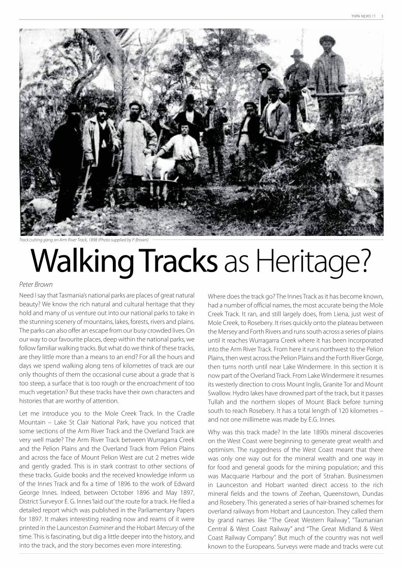
Peter Brown
Need I say that Tasmania’s national parks are places of great natural
beauty? We know the rich natural and cultural heritage that they
hold and many of us venture out into our national parks to take in
the stunning scenery of mountains, lakes, forests, rivers and plains.
The parks can also offer an escape from our busy crowded lives. On
our way to our favourite places, deep within the national parks, we
follow familiar walking tracks. But what do we think of these tracks,
are they little more than a means to an end? For all the hours and
days we spend walking along tens of kilometres of track are our
only thoughts of them the occasional curse about a grade that is
too steep, a surface that is too rough or the encroachment of too
much vegetation? But these tracks have their own characters and
histories that are worthy of attention.
Let me introduce you to the Mole Creek Track. In the Cradle
Mountain – Lake St Clair National Park, have you noticed that
some sections of the Arm River Track and the Overland Track are
very well made? The Arm River Track between Wurragarra Creek
and the Pelion Plains and the Overland Track from Pelion Plains
and across the face of Mount Pelion West are cut 2 metres wide
and gently graded. This is in stark contrast to other sections of
these tracks. Guide books and the received knowledge inform us
of the Innes Track and fix a time of 1896 to the work of Edward
George Innes. Indeed, between October 1896 and May 1897,
District Surveyor E. G. Innes ‘laid out’ the route for a track. He filed a
detailed report which was published in the Parliamentary Papers
for 1897. It makes interesting reading now and reams of it were
printed in the Launceston Examiner and the Hobart Mercury of the
time. This is fascinating, but dig a little deeper into the history, and
into the track, and the story becomes even more interesting.
Walking Tracks as Heritage?Where does the track go? The Innes Track as it has become known,
had a number of official names, the most accurate being the Mole
Creek Track. It ran, and still largely does, from Liena, just west of
Mole Creek, to Rosebery. It rises quickly onto the plateau between
the Mersey and Forth Rivers and runs south across a series of plains
until it reaches Wurragarra Creek where it has been incorporated
into the Arm River Track. From here it runs northwest to the Pelion
Plains, then west across the Pelion Plains and the Forth River Gorge,
then turns north until near Lake Windermere. In this section it is
now part of the Overland Track. From Lake Windermere it resumes
its westerly direction to cross Mount Inglis, Granite Tor and Mount
Swallow. Hydro lakes have drowned part of the track, but it passes
Tullah and the northern slopes of Mount Black before turning
south to reach Rosebery. It has a total length of 120 kilometres –
and not one millimetre was made by E.G. Innes.
Why was this track made? In the late 1890s mineral discoveries
on the West Coast were beginning to generate great wealth and
optimism. The ruggedness of the West Coast meant that there
was only one way out for the mineral wealth and one way in
for food and general goods for the mining population; and this
was Macquarie Harbour and the port of Strahan. Businessmen
in Launceston and Hobart wanted direct access to the rich
mineral fields and the towns of Zeehan, Queenstown, Dundas
and Rosebery. This generated a series of hair-brained schemes for
overland railways from Hobart and Launceston. They called them
by grand names like “The Great Western Railway”, “Tasmanian
Central & West Coast Railway” and “The Great Midland & West
Coast Railway Company”. But much of the country was not well
known to the Europeans. Surveys were made and tracks were cut
Track cutting gang on Arm River Track, 1898 (Photo supplied by P. Brown)

4 TNPA NEWS 11
to ‘open up’ the country. E. G. Innes had been sent into the South
West, in the winter of 1896, to find one route from the south. And
when he recovered, he was sent from the north to find another
route, which erroneously bears his name.
Innes surveyed a route for a track, called at the time ‘laying out’ a
track. He, or his party of five, did not make a track. What we see
today is the weathered and worn remains of the track made by
the Public Works Department in 1898 and 1899. Two teams, or
gangs, of day labourers worked from the Rosebery and Liena
ends of the track towards its centre. The gangs were of about 20
men, working in the open and sleeping in tents pitched at their
camps near to the end of the formed track. Each of these gangs
were made up of two groups, a small clearing team a few miles
in front of a main construction team, each with their own camp.
They were paid for the days they worked and when bad weather
stopped work they were not paid at all. But they still had to pay
for their rations which were packed by the government from the
nearest store, at either Chudleigh or Rosebery.
The Mole Creek Track, from Liena to Mt Swallow, near Tullah,
including those sections on the Arm River Track and the Overland
Track were built to a standard set by one man, Richard Broomhall,
the overseer of the eastern gang. Broomhall ranged across the
countryside. He fine-tuned the route of the track laid out by Innes,
and so worked in front of the first team. He supervised the men
who cleared the route of the track. And he supervised the larger
track-making gang which benched the track, made the culverts,
and laid the corduroy. Furthermore he travelled back to Mole
Creek and Chudleigh to oversee supplies and communicate
with his supervisor. Richard Broomhall was an experienced road
contractor and applied his skills to the construction of the Mole
Creek Track. Despite over 100 years of erosion by weather and
walkers, the design of the track is still apparent, and still effective
to a surprising degree.
There is little known about the way that these tracks were formed
and despite 100 years of decay and wear there is still much to be
found. My research into the Mole Creek Track led me to undertake
a series of small excavations along the Arm River Track. With
permission from the Parks and Wildlife Service and the assistance
of an archaeologist, I excavated sections of corduroy, culverts and
benching.
The benched track provided the biggest surprise. A short
section had been by-passed since the 1960s when the track
was re-opened for bushwalkers. When the surface vegetation
was cleared off it revealed a flat track surface largely unmarked
by the passing of 100 years. The drain on its inner edge was still
working as built and was directing water away from the track. The
drain was packed with rocks to slow the water flow and reduce
erosion. The condition of the track was in marked contrast to the
rest of the track where years of less sympathetic maintenance had
substantially changed the track.
The Arm River Track also contains a large number of small bridges,
called culverts by Broomhall, that cross small streams. Although
most were in poor condition, they clearly showed how they were
made. They were simply, but effectively, constructed of trees cut
nearby. Substantial log footings were cut into each bank to hold
the main support beams and then decking logs placed across
the main beams. These were held in place by fender logs placed
on the outer edge of the culvert. The timber decking was then
covered by about a foot of packed earth. None of these culverts
survive in good condition. They have either been washed away
by winter floods or have rotted in situ. However, there are enough
features remaining to show how they were made.
Sections of corduroy near Lake Ayr are still intact, but are hidden
by layers of vegetation. They provided relatively dry footings
through the swampy ground at the eastern end of the lake until
some boards were recently placed over them.
The Mole Creek Track, or if you still want to call it the Innes Track,
is still a good track and very well made. It owes its existence to the
great boom of mineral exploration on the West Coast in the 1890s
and for the next 100 years provided access to the Cradle Mountain
area for prospectors, cattle drovers, cattle, snarers, bushwalkers
and the occasional historian and archaeologist. The next time
you take the Arm River Track or the Overland Track, look down at
the track below your feet and consider Richard Broomhall and his
gang of Chudleigh farmers. You might even thank them for their
hard work.
The Arm River Track (former Mole Creek Track), 2007 (Photo supplied by P. Brown) The same location in 1898 (Photo supplied by P. Brown)

TNPA NEWS 11 5
Dr Phill Pullinger, Director, Environment Tasmania
Environment Tasmania was formed in 2004 with the specific role of
providing a representative umbrella body for Tasmanian conservation
groups, and was publicly launched in December 2006. During Environment
Tasmania’s set-up phase and for the first 12 months since its public launch
it operated as an entirely voluntary based organisation, and has grown
rapidly to now have a vibrant office based in Hobart that supports a
volunteer Director, three part-time staff members (office manager, policy
co-ordinator, marine campaigner) and a number of volunteers. The past
year in particular has been a very busy and successful year for Environment
Tasmania. Our key priorities over the past year have included building the
establishment and setting-up of the representative mechanisms and role of
Environment Tasmania, working directly on a range of key conservation and
environment priorities, and supporting our member groups [including the
TNPA – Ed] where we can in their important conservation and environment
work.
Environment Tasmania currently now has 25 member conservation groups
from across the island - collectively, this represents more than 5,000
Tasmanians. Environment Tasmania’s member groups work on a wide
range of conservation issues, including the protection of Tasmania’s forests,
coasts, marine environment, national parks and wildlife. They also work in
on the ground environment projects, private land conservation, sustainable
living, tackling global warming and much more. Environment Tasmania
has helped to facilitate cooperation and cohesion amongst Tasmanian
conservation groups over the past year by holding general meetings in
Pyengana, Lady Bay, the Panama Forest, and Hobart, along with regional
water and marine workshops. These forums are critically important for
working on and debating policy, networking, and building strategy and
cohesion amongst environment groups across the state.
In Environment Tasmania’s representative role we have represented our
member groups over the past year through government submission
processes and roundtables, including the Federal Environment Minister’s
National Environment Roundtable. We have also provided a voice
for Tasmanian conservation groups at the Mittagong Forum and at
conservation council roundtables, and provided a voice for Tasmanian
conservation groups more broadly to politicians and policy-makers,
industry and the broader community.
We have also worked hard in developing a research report into forest
conservation; hosted a range of climate change forums across the state;
set-up an ET marine conservation campaign; provided administrative
support to conservation experts in putting together a conservation paper;
set-up an Eco-toxicology research trust; worked with our member groups
on water, waste, GMO and other issues; launched a legal challenge in
relation to the pulp mill assessment; and set-up a monthly environment
groups E-Bulletin and a central website for Tasmanian conservation groups
at www.et.org.au.
Tasmania is one of the most beautiful islands on the face of the planet.
It is home to a unique marine environment, spectacular wilderness areas,
a remarkable coastline, forests & bushland, lagoons, grasslands and other
extraordinary landscape features. It is also home to an incredible diversity
of wildlife, many of which are threatened and found only in Tasmania.
Environment Tasmania aims to ensure that as Tasmanian environment
groups with different interests and concerns, we all work together in a
supportive, cohesive and cooperative manner to protect all of these unique
values.
The support and involvement of our member environment groups in
Environment Tasmania is crucially important and greatly appreciated – and
we greatly appreciate the involvement of the TNPA in the conservation
council’s work over the past year. We hope to continue to build upon our
representation and policy-development role with member groups such as
the TNPA over the coming year – and encourage interested TNPA delegates
to come along where you can to upcoming general meetings of the
conservation council, which in 2009 will be held on the 14th of March on the
Tasman Peninsula, 23rd of May in the Tarkine, 15th of August at Colebrook
and 28th of November at Binalong Bay. A big thanks and congratulations
to the hard work and dedication of the TNPA and its members in their
ongoing steadfast commitment to the long-term protection of Tasmania’s
outstanding National Parks & Reserves, and we wish you all a great break
over Summer!
ENVIRONMENT TASMANIA AN INTRODUCTION & RECENT HAPPENINGS
Tasmanian Tourism Advertising a Bit Behind the Times
On a recent trip out to Hobart Airport, TNPA Vice President Anne McConnell noticed
something a bit odd in the advertising panel near the Qantas baggage collection
carousel. It seems that Tasmanian tourism advertising is a bit behind the times with the
panel showing a beautiful colour photo of the now drowned Lake Pedder. We hope
visitors to Tasmania are not too confused trying to visit a place in a national park that has
been inaccessible (due to inundation) for over 35 years!
Do Tasmania’s national parks have so little left of scenic value that tourism advertising
has to resort to promoting sites that the government destroyed many years ago, or is
the government pretending Lake Pedder was never destroyed? But maybe we should be
more positive and see this as early indications from the Tasmanian government that Lake
Pedder will be restored soon as a national conservation icon.
Lake Pedder Promotion, Hobart Airport, 2008 [Photo: Anne McConnell]

6 TNPA NEWS 11
Anne McConnell
The National Parks Australia Council’s 2008 Annual Conference,
hosted by the TNPA, was held in Hobart over the weekend
of the 5th-7th September. This was the first time the Annual
Conference of Australia-wide national parks associations (NPAs)
has met in Tasmania. The 2008 Conference was the first to have
all NPAs represented, with nine interstate delegates and four local
delegates attending.
The National Parks Australia Council (NPAC) was formed in 1975 to
protect, promote and extend national parks systems in Australia.
It operates as the Australia-wide umbrella group for the various
state national parks associations, of which there are currently six.
The National Parks Australia Council provides a forum that co-
ordinates and promotes the collective views and policies of its
member groups. These member groups, including the Tasmanian
National Parks Association, are non-government organisations
which provide a link between the community, park policy makers
and other government. Individually, and collectively through the
NPAC, the groups work to identify and address issues concerning
the ongoing management of Tasmania’s reserve system and other
areas of high conservation status.
The main business of the Annual Conference was to discuss
new issues and common concerns regarding protected area
management in Australia. The Conference also operates as an AGM
for the Council. As well as NPAC business, briefings were provided
by Peter Mooney (Manager, PWS) on reserve management in
Tasmania, Tim Bond (Department of Environment, Water, Heritage
and the Arts, Canberra) on the National Reserve System, and Kevin
Kiernan (University of Tasmania) on geoheritage conservation. Key
concerns raised at the Conference included increased tourism
related development (and facilitation by government) in national
parks, the inadequacy of the present marine reserve system; and
the lack of funds for managing reserved land. These appear from
the Conference to be significant Australia-wide issues.
On the Sunday there was a well attended field trip to Recherche
Bay with information on the history and management of the
area being presented by Greg Hogg, Tom Baxter and myself. The
presentation was particularly focussed on the history and values
associated with the 1790s French Expeditions and the recent
conservation issues – the campaign to prevent the logging on
the northeast peninsula, and the proposed Marriner Cockle Creek
East Resort on the southern peninsula. The PWS kindly provided
free passes to the National Park for the day.
A Public Lecture, Challenges for Managing Tasmanian and Australian
National Parks, was also held in conjunction with the NPAC Annual
Conference. This TNPA-hosted, free public lecture was aimed at
publicising key future issues for the management of protected
areas in Australia. The lecture featured local experts Craig Johnson
and Mark Hovenden, both from the University of Tasmania, and
two of our interstate NPAC Conference participants, Anne Reeves
and Christine Goonrey. The speakers covered climate change
and vegetation management, marine conservation, bushfire
management and other big picture issues.
The TNPA is grateful to all those who assisted with the weekend,
including the School of Geography and Environmental Studies,
University of Tasmania, who provided an excellent venue for the
meeting, the Parks & Wildlife Service, Sonja Lenz who took the
meeting minutes, and Patsy Jones and Janet Henderson who
assisted in the overall organising of the weekend.
Photos: Above: Field Day to Recherche Bay on the NPAC Annual Conference weekend. Participants being briefed by Greg Hogg, historian and Lune River resident. [Photo: A. McConnell]
Top right: NPAC Conference being briefed on the National Reserve System by Tim Bond (DEWHA, Canberra). [Photo: A. McConnell]. Bottom right: Weary but happy participants at the
end of the NPAC Conference field day to Recherche Bay. [Photo: A. McConnell].
THE NATIONAL PARKS AUSTRALIA COUNCIL 2008 ANNUAL CONFERENCE
– HOSTED BY THE TNPA

TNPA NEWS 11 7
Robert Campbell
As detailed in TNPA News 10, the TNPA lodged an appeal with the
Resource Management and Planning Appeal Tribunal 5 May 2008
against the proposal by Miff Pty Ltd to build an eco-tourism lodge
on the headland behind Crescent Bay and adjacent to the Tasman
National Park. Although the TNPA was initially joined by Birds
Tasmania, Friends of Crescent Bay and another local resident, by
the time the appeal was heard in early August the TNPA remained
the only appellant.
The TNPA’s case before the Tribunal was based on seven Grounds
of Appeal. As detailed in the last Newsletter, the central tenant of
these Grounds was that the proposed development was contrary
to the intent of the Coastal Protection Zone to maintain the rural
character and high scenic quality of the coastal landscape. The
proposed buildings and infrastructure will be visible from within
the Tasman National Park and state reserves and from waters
within Maingon Bay, hence will detract from the natural values
for which the area is recognised and in the TNPA’s view is contrary
to the provisions of the Tasman Planning Scheme 1979 and the
State Coastal Policy 1991. The TNPA’s key Grounds of Appeal at the
hearing were that:
The development is contrary to the intent of the Coastal •
Protection Zone to maintain the rural character and high
scenic quality of the coastal landscape;
The development will not protect the natural environment •
and landscape character of the area. The development will
also compromise the landscape setting of, and heritage
values of the entrance to, the heritage listed Port Arthur site;
The proposed buildings and works do not harmonise with •
the environment of the area; and
Crescent Bay. Photo: Tracey Withers
CRESCENT BAY DEVELOPMENT TNPA LOSES APPEAL, BUT DEVELOPMENT STILL ON HOLD
Inadequate wastewater management will increase •
nutrient loads in local soils, contribute to the spread
of environmental weeds and potentially contaminate
groundwater supplies.
The TNPA also argued that the amenity of the area would not be
adequately protected by the permit conditions.
The Appeal was heard by the Tribunal over the three days 4-6
August and the TNPA engaged six expert witnesses to support
its case. Despite the considerable time and expense devoted
to presenting our case, the Tribunal delivered its decision on 4
September in favour of the respondents (Miff Pty Ltd and the
Tasman Council). Commenting on the decision, TNPA President
Anne McConnell said it was extremely disappointing the visual
impact concerns raised were not more fully considered, noting
that in her view the decision was a reflection of the inexperience
and undeveloped nature of assessment of landscape character
and quality, visual impacts and intrusiveness within planning in
Tasmania.
Immediately following the Tribunal decision, a number of articles
appeared in the Mercury based on comments made by Dick Smith
(of Miff Pty Ltd). While stating that the development would now
be put on hold given the downturn in the economy, Mr Smith also
warned other investors to keep clear of Tasmania until the State
changed its planning appeal laws. In reply to these comments
(and others), and to assist the discussion on the role of appeals
in the planning process within Tasmania, the TNPA would like to
clarify some points concerning this appeal:
Mr Smith would have been aware of the public opposition to, 1.
and the RPDC’s decision in 2005 to reject, a previous proposal to

8 TNPA NEWS 11
build a tourist development (albeit larger) on the same site.
Consistent with this previous decision, the development 2.
application (DA) lodged by Miff Pty Ltd was also initially rejected
by the Tasman Council in July 2007. Six substantive grounds were
cited for this decision. If Mr Smith’s wish that planning decisions
made by local government bodies should be final had been in
place then, his development would have been stopped then.
Instead he lodged an appeal.
Another DA (identical in most aspects to the first) was lodged 3.
by Miff Pty Ltd in March 2008 and, despite its earlier decision,
was approved by the Tasman Council in April. The reasons for the
reversal of the Council’s previous decision were not stated.
The Grounds of Appeal lodged by the TNPA were substantive, 4.
backed by a range of expert witnesses. Despite the claim made
by others (Mercury 6 September), and as outlined above, our
Grounds of Appeal did not state that the proposal should be
rejected simply because the development could be seen from
the adjacent Tasman National Park.
The DA states that construction would commence in Spring 5.
2009. This would seem to contradict Mr Smith’s claim that works
would have been finished by now (Sept 2008) had it not been
subject to appeals.
The TNPA obviously remains disappointed that its appeal
was unsuccessful. However, any claim that appeals should be
circumvented are unwarranted. Public input into the planning
process, which given the costs is not taken lightly, is designed to
improve outcomes and correct possibly inappropriate decisions
made at the local level. In this regard it is interesting to note the
2007 decision of the Appeal Tribunal in relation to a subdivision
proposal at Swanwick, that “the development application was so
deficient that the Council could not have reached any proper decision
in relation to the matter.”
The TNPA supports appropriate tourism based projects in Tasmania
and supports the regional benefits that flow from such projects.
However, we argue (as with the above proposal) that these same
benefits can be achieved by placement of such projects outside
protected and other sensitive areas. Such areas are a conservation
asset of unique significance and a resource for all Tasmanians.
Postscript:
Subsequent to this Appeal, Miff Pty Ltd has lodged an Order for
Costs against the TNPA. The TNPA understands that the planning
tribunal generally only awards costs against a party if an appeal
is seen as trivial or vexatious. The TNPA is strongly of the belief
that its appeal was substantive, lodged in good faith and was not
trivial or vexatious. A decision on costs is still pending.
The TNPA would like to extend its sincere thanks to the Environment
Defenders Office, especially Jessica Feehely and Roland Browne,
for their expert advice and dedication in assisting the TNPA with
this Appeal. The TNPA would also like to thank those members
and other individuals who made donations to support the costs
associated with the Appeal. As the Association is still considerably
out-of-pocket in relation to covering these costs, any further
donations would be greatly appreciated.
A new initiative, a social ‘Day Out’ for TNPA members, was organised
by Janet Henderson. The first ‘Day Out’ was to Fortescue Bay on the
Tasman Peninsula on Sunday 27th July. The day involved car pooling
from Hobart, a morning walk or paddle depending on personal
taste, and a late lunch BBQ. As well as being a social event, it was an
opportunity to talk about, and look at, an area to be affected by the
proposed Three Capes Walk development.
Around 20 people participated in the Fortescue Bay Day Out. After a
wet night and early morning the day turned out fine and sunny, if a
bit windy. Most participants chose to take the walk out to a lookout
point near Cape Hauy with fine sweeping views of Munro Bight and
its dramatic sea cliffs. It also gave us an opportunity to look at part of
the route and track conditions on the proposed Three Capes Walk.
A few hardy souls took to sea kayaks. All this activity was followed
by a BBQ, conversation, coffee and cake!
The Fortescue Bay Day Out was an excellent social day, informative,
and a good opportunity to celebrate the wonderful Tasman National
Park. The TNPA are hoping to make ‘Days Out’ a regular event.
TNPA Day Out to Fortescue
Bay, Tasman National Park
TNPA members and friends at Monument Lookout with great views to Cape Pillar
[Photo: A. McConnell].
TNPA members and friends relaxing back at Fortescue Bay after walking and paddling
[Photo: A. McConnell]
TNPA NEWS

TNPA NEWS 11 9
THE 2008 GREAT AUSTRALIAN
BUSHWALK IN TASMANIA
Bec Johnson
Well 2008 has seen another successful Great
Australian Bushwalk in Tasmania!
We had seven walks with a total of 112 participants (including leaders & kids.)
That’s a bit less than last year (9 walks with 168 people last year), but compares
well to the other States & Territories. NSW had 11 walks, Qld & SA had one each,
and the other states did not participate - so Tassie put on 7 of the 20 walks
around Australia! And the Tasmanian participants now know a little about the
TNPA.
The weather was pretty poor, but all groups coped well. I hear the Cathedral
Rock group had hail, and at lunchtime had rain on the summit (890m), but
they actually did stick to their route! (I had been betting they would opt for
something like the Pipeline Track - but they’re a tough bunch!). Likewise we at
Chauncy Vale had a thunderstorm and rain just as we stopped for lunch at Flat
Rock. And, on the Eastern Shore, Rob Hill’s group clocked 70 knot winds! The
Blue Tier walk alone had great weather (see below), and apparently 6 people
carpooled from Hobart to do the Saturday walk. The Wellington Wanderers
walk to Tarn Shelf had only four, and was the only group who had to change
their walk due to weather.
Thanks SO MUCH to all walk leaders, the TNPA really appreciates your help.
Both the Wellington Wanderers and the Friends of Blue Tier have been staunch
supporters of the GAB in Tasmania since the start - you have been invaluable.
Thanks to Janet, Anne and Pam for assistance with the media and advertising.
And John Cannon, your article in the Sunday Tasmanian draws at least half the
participants; thanks again. Last but not least, many thanks to Andrew Smith of
Wildcare Inc, for supporting the event.
[And TNPA’s huge thanks to Bec for being the coordinator for the 2008 GAB in
Tasmania – not to mention the previous couple of years. It is a pile of work getting
this event off the ground, this year made more complicated by the late support at
the national level – but through Bec’s hard work we all got there! Ed].
And from TNPA member Lesley Nicklason who led the Blue Tier Walk
Dear fellow Great Australian Bushwalkers!
We had a fantastic day on the slopes of the Blue Tier. Thirty 30 people turned
up for what just happened to be the only 5 hours of good weather for the last
2 weeks! Lucky us!
The walk up to Wyniford Weir is through some magnificent tall wet eucalypt
forest known as Emu Flat - all earmarked for clearfelling. Our lunch spot was
on the gorgeous Wyniford River which is under threat from a dam - one of 7
planned for the fragile rivers of northeast Tassie.
Love to see you all up here again some time for a walk!
Photos from top to bottom: GAB walkers on the beach at Cape Queen Elizabeth,
Bruny Island Photo: F. Koolhof. Blue Tier Walk, Wyniford Water Race [Photo: L.
Nicklason]. A brief stop at Chauncy Vale Photo: B. Johnson. Catharine Errey & Bruce
Wilson’s group basking in the sun on top of Cathedral Rock Photo: Catherine Errey.
10 TNPA NEWS 11
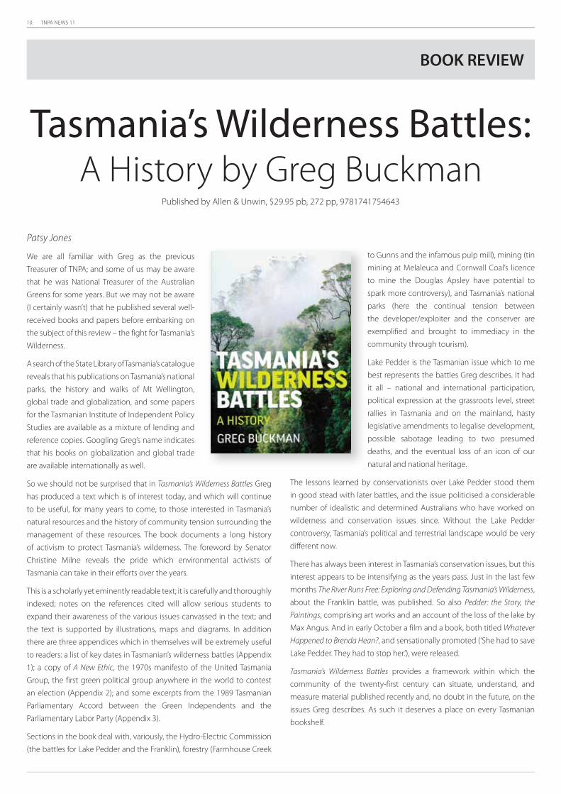
Patsy Jones
We are all familiar with Greg as the previous
Treasurer of TNPA; and some of us may be aware
that he was National Treasurer of the Australian
Greens for some years. But we may not be aware
(I certainly wasn’t) that he published several well-
received books and papers before embarking on
the subject of this review – the fight for Tasmania’s
Wilderness.
A search of the State Library of Tasmania’s catalogue
reveals that his publications on Tasmania’s national
parks, the history and walks of Mt Wellington,
global trade and globalization, and some papers
for the Tasmanian Institute of Independent Policy
Studies are available as a mixture of lending and
reference copies. Googling Greg’s name indicates
that his books on globalization and global trade
are available internationally as well.
So we should not be surprised that in Tasmania’s Wilderness Battles Greg
has produced a text which is of interest today, and which will continue
to be useful, for many years to come, to those interested in Tasmania’s
natural resources and the history of community tension surrounding the
management of these resources. The book documents a long history
of activism to protect Tasmania’s wilderness. The foreword by Senator
Christine Milne reveals the pride which environmental activists of
Tasmania can take in their efforts over the years.
This is a scholarly yet eminently readable text; it is carefully and thoroughly
indexed; notes on the references cited will allow serious students to
expand their awareness of the various issues canvassed in the text; and
the text is supported by illustrations, maps and diagrams. In addition
there are three appendices which in themselves will be extremely useful
to readers: a list of key dates in Tasmanian’s wilderness battles (Appendix
1); a copy of A New Ethic, the 1970s manifesto of the United Tasmania
Group, the first green political group anywhere in the world to contest
an election (Appendix 2); and some excerpts from the 1989 Tasmanian
Parliamentary Accord between the Green Independents and the
Parliamentary Labor Party (Appendix 3).
Sections in the book deal with, variously, the Hydro-Electric Commission
(the battles for Lake Pedder and the Franklin), forestry (Farmhouse Creek
to Gunns and the infamous pulp mill), mining (tin
mining at Melaleuca and Cornwall Coal’s licence
to mine the Douglas Apsley have potential to
spark more controversy), and Tasmania’s national
parks (here the continual tension between
the developer/exploiter and the conserver are
exemplified and brought to immediacy in the
community through tourism).
Lake Pedder is the Tasmanian issue which to me
best represents the battles Greg describes. It had
it all – national and international participation,
political expression at the grassroots level, street
rallies in Tasmania and on the mainland, hasty
legislative amendments to legalise development,
possible sabotage leading to two presumed
deaths, and the eventual loss of an icon of our
natural and national heritage.
The lessons learned by conservationists over Lake Pedder stood them
in good stead with later battles, and the issue politicised a considerable
number of idealistic and determined Australians who have worked on
wilderness and conservation issues since. Without the Lake Pedder
controversy, Tasmania’s political and terrestrial landscape would be very
different now.
There has always been interest in Tasmania’s conservation issues, but this
interest appears to be intensifying as the years pass. Just in the last few
months The River Runs Free: Exploring and Defending Tasmania’s Wilderness,
about the Franklin battle, was published. So also Pedder: the Story, the
Paintings, comprising art works and an account of the loss of the lake by
Max Angus. And in early October a film and a book, both titled Whatever
Happened to Brenda Hean?, and sensationally promoted (‘She had to save
Lake Pedder. They had to stop her.’), were released.
Tasmania’s Wilderness Battles provides a framework within which the
community of the twenty-first century can situate, understand, and
measure material published recently and, no doubt in the future, on the
issues Greg describes. As such it deserves a place on every Tasmanian
bookshelf.
Tasmania’s Wilderness Battles:A History by Greg Buckman
Published by Allen & Unwin, $29.95 pb, 272 pp, 9781741754643
BOOK REVIEW

TNPA NEWS 11 11
Pam Fenerty
TNPA remains firm in its resolve to oppose
the imposition on the Tasman National
Park of the Three Capes Walk with all its
associated paraphernalia. This proposal
is a massive and unprecedented national
park development by the current Labour
government (proposed in early 2007 at
a launch by the Premier at the time, Paul
Lennon).
Just remember the details - an artificially
manufactured 6 day/5 night walk with
overnight stays at 5 separate mini-villages
(euphemistically called “nodes”); each
mini-village complete with 60 bed public
lodge, 15 bed commercial lodge, rangers
hut, helipad, toilets, and possibly tent
camping. Even the government is not
going to promote this as a wilderness
walk in itself, but will be concentrating
on the natural beauty of the sea cliffs
and magnificent coastal vistas. This
proposal was not accompanied by an
environmental impact assessment, which makes TNPA wonder where
the priorities for our national parks lie in the eyes of the government -
for purposes of tourism or for conservation? The proposed Three Capes
Walk suggests the government is focusing on tourism, tourism, and
tourism.
The Tasman Coastal Trail is a 2/3 day walk in the area that is already in
existence, and anyone can get written information about this walk from
a free PWS walk brochure from Service Tasmania. Along with the 30 or
so day walks in the region, this is the overnight walk that TNPA is asking
the government to promote - instead of the proposed Three Capes
Walk. Effective use of these alternatives can be achieved with simple
infrastructure upgrades and will be infinitely better for the Tasman
National Park. Never before has there been so much camping gear on
the market, allowing us all to get out and experience nature at its best
and in relative comfort. Yet the government wants us to experience
national parks by staying in fancy, huge huts complete with gas stoves,
mattresses, and double rooms - to be booked ahead.
In February/March 2008 the TNPA asked supporters to send in
objections to the Director of PWS on the new draft Tasman National
Park Management Plan, which changes the existing plan to allow for the
Three Capes Walk. Some 240-250 representations were received by the
PWS. The vast majority were critical of the Three Capes Walk proposal,
many detailing why they opposed the proposed Walk. PWS considered
these objections and compiled responses which have been forwarded
to the RPDC for further review, as is the standard process.
In late 2008 the RPDC was awaiting the go ahead from the Minister,
Ms O’Byrne, to place the representations and the PWS response on a
public website, and to prepare its overall
response. It is anticipated that the RPDC
response, with recommendations, will be
completed by the end of January 2009
for consideration by the Minister. The
Minister then makes a recommendation
on what aspects of the draft management
plan will be adopted based on the advice
received. Given this is a government
initiated development proposal and the
implementation process to date, it seems
unlikely that the Minister will delay the
plan change approval. We can only hope
that with the current economic situation,
there will not be government funds
available for this highly questionable
development.
The TNPA understands that in the latter
part of 2008, the PWS contracted various
environmental impact assessments,
and that these are largely completed.
The results of the environmental impact
assessments do not yet appear to have
been publicly released. The PWS also
contracted a Sydney based group, Syneca Consulting, to undertake
an economic impact analysis. The consultant’s report, Economic
Impact Analysis for Three Capes Track Tasman National Park, was
completed in April 2008 [Note – when the TNPA initially asked the PWS
to see this document we were advised it was commercial-in-confidence;
we understand however that there has been a change of heart and the
document is available on the PWS website. Ed].
The Syneca report basically looks at the economic benefits, for Tasmania
as a whole as well as the Tasman Peninsula region, of the 10,000 walkers
per year on the fully operational proposed Three Capes Walk (which
won’t be operational until at least 2012 or beyond). Briefly, the benefits
suggested in the report include:
increased spending in the state of around $19.7 million per annum •
and 334.2 new jobs;
increased spending on Tasman Peninsula of around $3.1 million •
per annum with 70.4 new jobs; and
an increase of 4,532 bed nights per year on the Tasman Peninsula •
by the Three Capes Walk walkers staying longer (the number of
bed nights on the Tasman Peninsula for 06/07 were 113,400 per
year)1.
Although the Syneca report is a well researched and detailed report,
the economics depends entirely on the actual numbers of walkers
each year.These figures assume similar walker numbers as the Overland
KEEP THE CAPES WILDNO THREE CAPES WALK FOR THE TASMAN NATIONAL PARK
Munro Bight sea cliffs from Monument Lookout, Cape Pillar in the distance. Area
of proposed Three Capes Walk [Photo: A. McConnell]
1 And remember that although there will be an estimated 50,000 bed nights per year from the
10,000 Three Capes Walk walkers staying in the mini villages in the National Park when the
Walk is fully subscribed, this does not directly benefi t local Tasman Peninsula businesses.

12 TNPA NEWS 11
Jon Nevill
School of Government, University of Tasmania
(Contact - 0422 926 515)
In 1999 all Australian jurisdictions signed on to the National Representative
System of Marine Protected Areas (NRSMPA) framework. Thus all States,
including Tasmania, signalled a commitment to the creation of Marine
Protected Area (MPA) networks which would provide comprehensive,
adequate and representative protection for Australia’s marine ecosystems.
The principles on which the NRSMPA strategy was based, as well as planning
and management principles incorporated in Australia’s Oceans Policy 1998,
were sound. Today, 10 years on, there two important questions: (a) have
the principles been properly applied so far in the creation of existing MPA
networks, and (b) are the networks meeting their objectives in practice?
Australia’s eight State/Territory jurisdictions carry very considerable
responsibilities for natural resource management. They depend heavily on
the Australian (Commonwealth) Government for funds – thus providing
the Commonwealth with the leverage needed to encourage States in
meeting international obligations. If Tasmania was clearly not meeting its
obligations under the NRSMPA framework, would the Commonwealth use
this leverage? The answer to all of the above questions seems to be “no”.
In examining progress over the last decade, it is clear that the design
principles of the NRSMPA have been followed in some cases; in others
they have been abandoned. In considering whether protection has been
“comprehensive, adequate and representative” there are two key issues: the
use of zoning which provides effective protection, and the extent of habitat
representation within the regional network.
Queensland is Australia’s best example of the development of effective
MPA networks. The substantial Great Barrier Reef Marine Park (developed
principally by the Commonwealth Government) includes 33% no-take
zones, which provide effective protection for representative habitats.
The GBRMP occupies a very substantial portion of the continental shelf
adjacent to Queensland. Most habitat types within the Park are protected
to the 20% level (or better) by no-take zones. At the State level, the
Queensland Government has protected most Moreton Bay habitats at 9%
or better, with a total of nearly 16% of the Bay in no-take zones. In Western
Australia, the large Ningaloo Marine Park protects about 30% of its area in
no-take zones. Victoria also provides an example of effective protection of
representative habitat, although at a considerably smaller scale, and with
less comprehensive coverage of habitat types. Here about 5% of habitat
within State jurisdiction is zoned as no-take. Habitat maps are available
for the bulk of Victorian marine waters, with high-resolution mapping
within MPAs.
On the other hand, the progress made by the Tasmanian Government,
as well as the Commonwealth MPAs in the South East Region around
Tasmania, provide examples of ineffective protection. In the absence of
comprehensive habitat maps for this region, geomorphic province can be
used as a coarse biodiversity surrogate – the continental shelf for example
contains important habitats not found elsewhere. Commonwealth MPAs
include only 0.75% of the region’s shelf in no-take zones. No responsible
marine scientist would argue that this was anywhere near “adequate”.
Remaining MPAs are IUCN category VI, providing no effective protection
from fishing activities – a key threat in the region. At the State level, the
Tasmanian Government’s Bruny Bioregion MPA network (announced in
Track and similar visiting and spending behaviour. In the TNPA’s view
the matter is far from straightforward given that the Three Capes
Walk walker numbers may take time to reach the proposed levels
considering it is currently a little known walk, while the Overland Track
has international and national iconic status. It is also unclear how walker
interest will be shared between the two tracks. The Syneca report also
did not look at the economic advantages of existing alternative walks
(presumably not part of the brief ), for example the Tasman Coastal Trail.
Although not of great economic benefit now, these alternatives have
never been promoted by the slick, widespread advertising anticipated
for the Three Capes Walk. The TNPA contends these alternatives could
offer comparable advantages if marketed similarly.
The TNPA will continue to work on this issue in 2009. It has formed a
working group to provide a strong and measured opposition. We will
keep members posted on what will be happening, but current plans
include:
ongoing positive promotion of the alternative Tasman Coastal Trail •
and 30 walks;
letting the Tasman Council and local business owners know that •
there are alternatives that will be economically better for the
region as well as for the Tasman National Park;
lobbying members of parliament;•
modelling the appearance of the mini villages so the public can •
see disaster looming for the park;
photo/banner displays of the Tasman National Park;•
production of information brochures; and•
rallies.•
If you are interested in being involved in the Three Capes Walk Working
Group (3CW WG) or for further information and any assistance to TNPA
in form of volunteer assistance, funds, expertise or suggestions contact
the Working Group Coordinator Pam Fenerty (62503351) or Janet
Henderson, the TNPA Secretariat (0427 854 684).
Together we will
Keep the Capes Wild
MARINE PROTECTED
AREA NETWORKS IN AUSTRALIA:
TASMANIAN PROGRESS IN THE NATIONAL CONTEXT
TNPA NEWS 11 13
October 2008) is entirely category VI, and fishing activities continue within
the MPA network essentially unrestricted. This approach provides no
protection from one of the most important threats in the bioregion.
In the case of the Commonwealth’s South East Region, considering only
the area covered by the MPA network creates a misleading impression.
MPAs of all zones (in this case almost entirely two categories: IUCN class Ia
and VI) cover a substantial proportion of the region: ~5.5%. This seems like
a good outcome, until the detail is examined. Coverage of shelf habitats is
in fact far from ‘comprehensive, adequate and representative’.
Any national assessment must take into account the extent of effective
protection, and here no-take MPAs should be used as an indicator. Secondly,
the extent of representative habitat protection must be assessed. Future
habitat mapping programs will assist greatly in this regard.
Compliance is another critical factor, but compliance cannot be taken for
granted. Even in Australia, where fisheries are often perceived to be well-
managed, there is ample evidence not only of non-compliance, but of
cultures of non-compliance. For example, Poiner et al. (1998:s2) in a study
of prawn trawling in the Great Barrier Reef World Heritage Area reported:
“there has been a high level of illegal trawling in the Green Zone and
evidence that 40 to 50 boats regularly trawl the area. Misreporting of catch
has taken place with catches from inside the Green Zone being credited to
adjacent open areas.” This is not an example of one or two “bad apples” –
non-compliance on this scale is the result of a culture amongst commercial
fishermen that it is OK to break the law providing you don’t get caught.
Cultures of non-compliance will arise where absence of enforcement is
predictable.
Another issue is the Commonwealth-managed Collaborative Australian
Protected Area Database (CAPAD), which fails to provide important basic
information on Australia’s MPA network. Different States have used different
reporting formats within the CAPAD framework. Some States list every
MPA, while others list only MPAs grouped into State categories (eg: ‘marine
nature reserve’) which are terms which have no national meaning. Some
States list the IUCN categories of each MPA (which is useful) while others do
not. In terrestrial protected area reporting, some States list the bioregions
and subregions within protected areas (which is at least a start in reporting
surrogates for representation) however no State reports this information for
MPAs. The database is not updated regularly: the most recent marine data
in mid-2008 was for 2004. CAPAD is in urgent need of major improvement.
At the end of October 2008 Tasmania had 18 marine nature reserves and
research areas carrying some (often minor) fishing restrictions (Government
of Tasmania 2008). I wrote to David Llewellyn, the Minister for Primary
Industries and Water in October, asking:
the size of Tasmania’s marine and estuarine jurisdiction;•
within this jurisdiction, the areas of each major marine habitat type, •
and the areas of each type protected by no-take reserves; and
the classification of Tasmania’s marine protected areas under the •
internationally-recognised IUCN categories.
The Minister replied on 17 November 2008, in essence stating that he could
advise the names and locations of all marine nature reserves and research
areas, but past that the Tasmanian Government held no further information
on my questions other than that supplied by the RPDC website. While the
RPDC has published limited habitat maps through its marine bioregion
reports and its State of the Environment Report 2003 (the latest), it appears
that none of these three basic and important questions can be answered
by our State government. Marine conservation planning in Tasmania is a
sham – at both State and Commonwealth levels.
REFERENCES
Government of Tasmania (2008) Recreational sea fishing guide, Department
of Primary Industries and Water, Hobart.
Poiner, I, Glaister, J, Pitcher, R, Burridge, CY, Wassenberg, TJ, Gribble, N, Hill, BJ,
Blaber, SJM, Milton, DA, Brewer, DT & Ellis, N (1998) Environmental effects of
prawn trawling in the far northern section of the Great Barrier Reef: 1991–1996,
CSIRO, Cleveland Australia.
Jon Nevill
The Tasmanian Government recently announced their decision on
the RPDC’s final Bruny Bioregion Report. The Government will create a
small number of areas which they are calling “marine protected areas”
- in spite of offering these areas essentially no protection. Fishing
will continue in these areas much as it has in the past. In making this
decision, the Government is breaking the commitment it made in
1999 when it agreed to contribute to the development of a national
representative system of marine protected areas. These new “parks”
are not marine protected areas, and they are not based on good
scientific advice.
Australia’s marine ecosystems are under threat from a variety of
factors, including climate change, pollution, habitat damage and
alien species. However the most powerful threat is fishing - including
both commercial and recreational fishing activities.
The Bruny Bioregion contains important and in some cases unique
marine life. We could have established world-class no-take marine
sanctuaries, which could in time have become important tourist
attractions, in line with Tasmania’s “clean green” tourism promotion
theme.
The Tasmanian Government’s decision is a decision grounded on
cowardice and ignorance. Our politicians, and presumably their
advisors, do not understand the value of protecting biodiversity, in
spite of the obvious economic benefits of popular marine sanctuaries
around the world. Unfortunately, the State opposition has no better
attitude to these matters, and the Commonwealth, in spite of its
international commitments, appears unwilling to intervene through
budgetary programs.
The TNPA is in the process of developing a policy position statement
on marine protected areas. Members are invited to become involved
(if you would like to have input into this area of policy development
please contact Anne McConnell – [email protected]).
TNPA UPDATE
TASMANIAN MARINE PROTECTED AREAS

14 TNPA NEWS 11
The new Pelion Hut from the plains near the helipad [Photo: A. McConnell]
With the large scale accommodation infrastructure being built on the
Overland Track (at Pelion and at Windy Ridge) and with the village-
like accommodation ‘nodes’ proposed for the Three Capes Walk being
promoted by the State government, the TNPA Management Committee
felt it was time to go and check out one of these new national park
elephants. In late October, Committee members Anne McConnell and
Liz Thomas shouldered their packs (including a tent which we used!) and
headed off to walk into Pelion Hut via the Arm River Track. We thought
we’d give you a brief report on what we found.
Well what we found was one very large hut! And not only one very large
hut, but actually a bit of a village with two-storey toilet block with decking
and additional bins and a helipad, all connected by boardwalk. To the rear
we found a ‘group campsite’ – a large area of decking with a large central
table, more decking (presumably for tents), another toilet (disused),
and to the rear of this a PWS ranger’s hut and yet another helipad. All
this is connected by either the Overland Track or offshoot paths. This all
covers an area of about 150m x 70m on the southern edge of the Pelion
Plains (refer Figure 1). Also in the general Pelion area there is a Cradle
Huts commercial lodge and the old (early 1900s) Pelion Hut (not shown
in Figure 1).
This level of infrastructure development is of extreme concern to the
TNPA. Not only is the amount of infrastructure excessive in the Tasmanian
Wilderness World Heritage Area, it would appear that defunct structures
such as toilets and helipads are not being removed when they are no
longer being used, which is poor management, and the siting leaves
something to be desired.
TNPA NEWS
TNPA Pays a Visit to Pelion HutWe would also question the scale of the infrastructure. Given that the
maximum number of walkers per day in peak periods is 60 under the
permit system (34 independent walkers, 13 group walkers and 13 Cradle
Huts walkers), it is unclear why there is a hut that accommodates 48
people, a commercial hut that accommodates 12 (plus guides), a group
camping area that looks to accommodate around 16-20 people plus
additional tent sites? While some people walk in via the Arm River Track,
these walkers usually are self sufficient, independent walkers who carry
tents (at least in summer). Are the PWS positioning themselves to increase
the permitted number of walkers on the Overland Track, justifying it by
saying there is plenty of accommodation?
The hut itself is extremely large (c.25m x 13m) – the size of a standard
suburban single storey house, but with a high roof line. It is in fact not a hut
but lodge. It has been designed to accommodate 48 people comfortably
in six spacious 8 bunk rooms and a large eating area with benches that
can be divided into two. Hardly a wilderness experience when more than
half full. There are several water tanks and a collection of gas bottles out
the back, and we noted miscellaneous building materials and offcuts
underneath the building, all open to view. Also of real concern is the siting
of the hut and toilet on the woodlands- plains edge and the location of
the new helipad on the plains proper. All are highly visible from the plains
and the hut is clearly visible from the Old Pelion Hut almost 1 km to the
west. Although we did not walk up Mt Oakleigh, the hut must be highly
visible from this vantage point as well. The hut and toilet are also visible
from the Overland Track. We also question how long it will be until the
half submerged timber helipad will need to be replaced. Congratulations
to the PWS on its less than sensitive siting of the new hut.

TNPA NEWS 11 15
In the TNPA’s view, walker accommodation develop-
ments like that at Pelion are totally inappropriate for
national parks, particularly away from road heads
and particularly in a designated World Heritage Area
with wilderness values. The PWS should be ashamed
of its lack of sensitivity to the values of the Cradle
Mountain Lake St Clair National Park in allowing this
highly visible rambling accommodation ‘node’ to de-
velop (or is that ‘overdevelop’). And it seems Windy
Ridge is another similarly overdeveloped and intru-
sive accommodation location on the Overland Track
with its recent new walker’s hut and new ranger’s
hut. If Pelion is what is on offer for the proposed
Three Capes Walk (ie, for each of the 5 nodes), then
the TNPA is right to criticise the proposal as highly
inappropriate.
The PWS should instead be looking at sensitive
siting of accommodation and providing minimal
infrastructure with a minimum footprint in our
national parks. This would both save the environment
and save tax payers dollars. This is not difficult to do.
Huts should be seen as emergency accommodation
(after all Overland Track walkers are required to carry
a tent). Instead of building large accommodation
huts, smaller huts with multipurpose 2-tier sleeping
platforms (as in older New Zealand and Australian
huts) could be used to keep the size down. Improved
strategic planning would help provide the right
balance of hut versus tent based accommodation,
and might avoid building new ranger’s huts in places
where we understand they get very limited use (eg,
Windy Ridge).
Postscript:
Given the TNPA’s concerns about the increasing
development of the Overland Track, we will be looking
at the PWS plans for the Overland Track in early 2009
and making comment. If anyone is interested in being
involved in this issue, please contact Robert Campbell
via the TNPA Secretariat (see contact details rear page).
Figure 1 Main accommodation area at Pelion (the new infrastructure is at the bottom (N end) of the plan). Note
the size of the new hut (bottom LHS) compared to the previous hut (decking upper centre).. Sketch plan based on
October 2008 TNPA visit.
View east from Old Pelion Hut to the new Pelion Hut which is highly visible on the edge
of the Pelion Plains [Photo: A. McConnell]The new toilet for the new Pelion Hut, also on the edge of the Pelion Plains [Photo: A.
McConnell]
16 TNPA NEWS 11
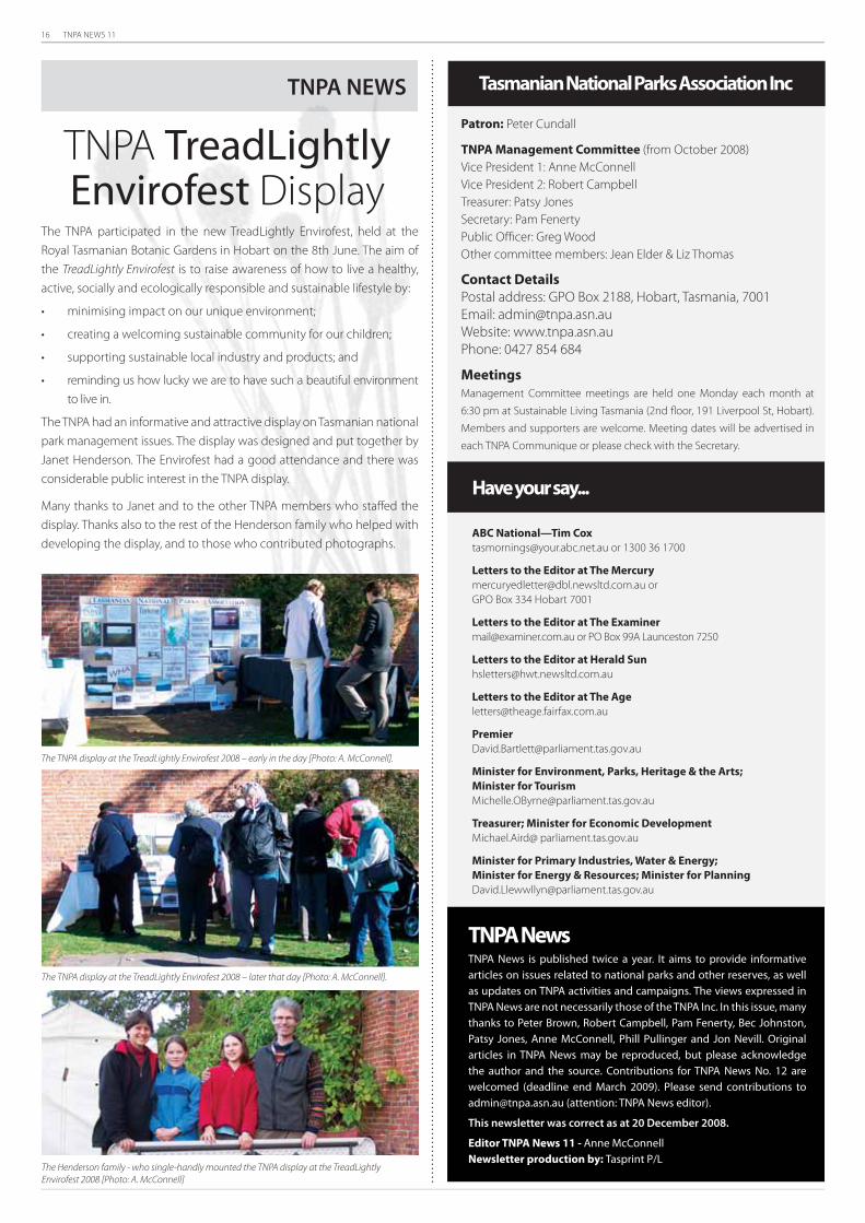
The TNPA display at the TreadLightly Envirofest 2008 – early in the day [Photo: A. McConnell].
The TNPA display at the TreadLightly Envirofest 2008 – later that day [Photo: A. McConnell].
The Henderson family - who single-handly mounted the TNPA display at the TreadLightly
Envirofest 2008 [Photo: A. McConnell]
Have your say...
ABC National—Tim Cox
[email protected] or 1300 36 1700
Letters to the Editor at The Mercury
GPO Box 334 Hobart 7001
Letters to the Editor at The Examiner
[email protected] or PO Box 99A Launceston 7250
Letters to the Editor at Herald Sun
Letters to the Editor at The Age
Premier
Minister for Environment, Parks, Heritage & the Arts;
Minister for Tourism
Treasurer; Minister for Economic Development
Michael.Aird@ parliament.tas.gov.au
Minister for Primary Industries, Water & Energy;
Minister for Energy & Resources; Minister for Planning
Patron: Peter Cundall
TNPA Management Committee (from October 2008)
Vice President 1: Anne McConnell
Vice President 2: Robert Campbell
Treasurer: Patsy Jones
Secretary: Pam Fenerty
Public Offi cer: Greg Wood
Other committee members: Jean Elder & Liz Thomas
Contact Details
Postal address: GPO Box 2188, Hobart, Tasmania, 7001
Email: [email protected]
Website: www.tnpa.asn.au
Phone: 0427 854 684
Meetings
Management Committee meetings are held one Monday each month at
6:30 pm at Sustainable Living Tasmania (2nd fl oor, 191 Liverpool St, Hobart).
Members and supporters are welcome. Meeting dates will be advertised in
each TNPA Communique or please check with the Secretary.
Tasmanian National Parks Association Inc
TNPA NewsTNPA News is published twice a year. It aims to provide informative articles on issues related to national parks and other reserves, as well as updates on TNPA activities and campaigns. The views expressed in TNPA News are not necessarily those of the TNPA Inc. In this issue, many thanks to Peter Brown, Robert Campbell, Pam Fenerty, Bec Johnston, Patsy Jones, Anne McConnell, Phill Pullinger and Jon Nevill. Original articles in TNPA News may be reproduced, but please acknowledge the author and the source. Contributions for TNPA News No. 12 are welcomed (deadline end March 2009). Please send contributions to [email protected] (attention: TNPA News editor).
This newsletter was correct as at 20 December 2008.
Editor TNPA News 11 - Anne McConnell Newsletter production by: Tasprint P/L
The TNPA participated in the new TreadLightly Envirofest, held at the
Royal Tasmanian Botanic Gardens in Hobart on the 8th June. The aim of
the TreadLightly Envirofest is to raise awareness of how to live a healthy,
active, socially and ecologically responsible and sustainable lifestyle by:
minimising impact on our unique environment;•
creating a welcoming sustainable community for our children;•
supporting sustainable local industry and products; and •
reminding us how lucky we are to have such a beautiful environment •
to live in.
The TNPA had an informative and attractive display on Tasmanian national
park management issues. The display was designed and put together by
Janet Henderson. The Envirofest had a good attendance and there was
considerable public interest in the TNPA display.
Many thanks to Janet and to the other TNPA members who staffed the
display. Thanks also to the rest of the Henderson family who helped with
developing the display, and to those who contributed photographs.
TNPA TreadLightly Envirofest Display
TNPA NEWS